Socio- Environmental Dynamics along the Historical Silk Road
535
Socio- Environmental Dynamics along the Historical Silk Road Liang Emlyn Yang · Hans-Rudolf Bork Xiuqi Fang · Steffen Mischke Editors
-
Upload
khangminh22 -
Category
Documents
-
view
1 -
download
0
Transcript of Socio- Environmental Dynamics along the Historical Silk Road

Socio-Environmental Dynamics along the Historical Silk Road
Liang Emlyn Yang · Hans-Rudolf Bork Xiuqi Fang · Steffen Mischke Editors

Socio-Environmental Dynamics along the HistoricalSilk Road

Liang Emlyn Yang • Hans-Rudolf Bork •
Xiuqi Fang • Steffen MischkeEditors
Socio-EnvironmentalDynamics alongthe Historical Silk Road

EditorsLiang Emlyn YangGraduate School “Human Developmentin Landscapes”Christian-Albrechts-Universität zu KielKiel, Schleswig-Holstein, Germany
Xiuqi FangFaculty of Geographical ScienceBeijing Normal UniversityBeijing, China
Hans-Rudolf BorkInstitut für ÖkosystemforschungChristian-Albrechts-Universität zu KielKiel, Schleswig-Holstein, Germany
Steffen MischkeFaculty of Earth SciencesUniversity of IcelandReykjavik, Iceland
ISBN 978-3-030-00727-0 ISBN 978-3-030-00728-7 (eBook)https://doi.org/10.1007/978-3-030-00728-7
Library of Congress Control Number: 2018960206
© The Editor(s) (if applicable) and The Author(s) 2019. This book is an open access publication.Open Access This book is licensed under the terms of the Creative Commons Attribution 4.0International License (http://creativecommons.org/licenses/by/4.0/), which permits use, sharing, adap-tation, distribution and reproduction in any medium or format, as long as you give appropriate credit tothe original author(s) and the source, provide a link to the Creative Commons license and indicate ifchanges were made.The images or other third party material in this book are included in the book’s Creative Commonslicense, unless indicated otherwise in a credit line to the material. If material is not included in the book’sCreative Commons license and your intended use is not permitted by statutory regulation or exceeds thepermitted use, you will need to obtain permission directly from the copyright holder.The use of general descriptive names, registered names, trademarks, service marks, etc. in this publi-cation does not imply, even in the absence of a specific statement, that such names are exempt from therelevant protective laws and regulations and therefore free for general use.The publisher, the authors and the editors are safe to assume that the advice and information in thisbook are believed to be true and accurate at the date of publication. Neither the publisher nor theauthors or the editors give a warranty, express or implied, with respect to the material contained herein orfor any errors or omissions that may have been made. The publisher remains neutral with regard tojurisdictional claims in published maps and institutional affiliations.
Cover illustration: NOAA, NCEI ETOPO1 Global Relief Model
This Springer imprint is published by the registered company Springer Nature Switzerland AGThe registered company address is: Gewerbestrasse 11, 6330 Cham, Switzerland

Foreword I
The Graduate School of Human Development in Landscapes at Kiel University isan advanced school engaged in studying and teaching interdisciplinarily theinteractive development of past human society and physical landscapes. Since itwas established 11 years ago, I have been involved many times in its projectreviews, advisory issues and have noticed its significant progress. A remarkableaspect is its young researchers who explore human development from variousperspectives, including the lead author of this book Dr. Yang who I was impressedby when I first heard him talk in November 2016 at the School. It is a promisingdirection that he and others have taken to investigate the adaptation and resilienceof human society (both successfully and unsuccessfully) in facing of the past cli-mate changes with the target to inform the present global climate problems.
This new book “Socio-Environmental Dynamics along the Historical Silk Road”continues this direction as well as other aspects of climate-related social–environ-mental changes, including landscape, water, disaster, population, empire, civiliza-tion, culture and heritage. It is often challenging to discuss on such large-scale andlong-term social development issues in one book. However, the concept Silk Roadis a natural framework for these topics and thus perfectly links the internationalcontributions to this book. Especially, several chapters in the book focused on theCentral Asia area with the ever existed Han Dynasty (Chap. 3), Sogdiana civi-lization (Chap. 9), Saljūq Empire (Chap. 13), Oxus civilization (Chap. 14), whichcollectively evidenced certain interactives between physical environment and socialsystems.
It has been widely agreed that human migration and cultural exchanges in theEurasia hinterland existed much earlier than the traditionally recognized start timeof the Silk Road around the end of third century BC. Culture is rooted in the localenvironment and associated living habits, but cultural change involves manyexternal factors, among which the exchange with others is a most significant one.The Scythians of the Eurasia steppe in seventh century BC was formed like this,where nomadic confederations developed either symbiotic or forced alliances with
v
agriculture peoples—in exchange for animal produce and military protection. Whilethe rise of the Silk Road networks subsequently facilitated those exchanges, theintegration and coexistence of cultures from the West and the East of the Eurasiacontinent performed more pronounced in Central Asia.
The editors and authors have made great efforts in putting together an importantbody of knowledge in this book. It is very important because it reveals partially thehistory of man as well as human development. We have to learn how culturesdeveloped in the past to understand why we have certain processes today. Learningfrom the past experience will help us understand these exchanges and integrationsat the systematic level. For instance, the current problem of climate change is not aproblem only of today, but was faced by many societies in the past. These societies’experiences and lessons, the development of unique social and cultural systems, thepower of religions, tolerance and intolerance to each other should never be for-gotten. Against this backdrop, the book includes state-of-the-art research onsocio-environmental dynamics, integrates knowledge on multiple aspects ofsocial-cultural exchanges, and highlights case studies on and references for humandevelopment. Today, more than ever, we need sharp research like this.
The book is a collaborative venture. The chapters provide an interdisciplinaryperspective and document emerging and innovative knowledge of the past envi-ronmental conditions and its links to social-culture development. Such knowledgebased on solid analysis of data, materials and proxies in the field is indispensable aswe move forward. We are still a long way from understanding the essentialmechanisms of the socio-environmental interactives in various scales and periods.This book is a welcome addition to the literature.
Berlin, GermanyJune 2018
Hermann ParzingerPresident, Professor Prussian Cultural
Heritage Foundation
vi Foreword I
Foreword II
The long history of human–environment interactions has attracted and is attractinga large number of investigations by international scholars, and it is also a majorresearch field that I and my research team explored for many years. Our studies inWestern China, Central Asia and other alpine Asian sub-regions have been focusingon the paleoclimate records of loess sections and lake sediments to reveal climatechanges in the late Quaternary, especially in the Holocene, in theWesterlies-dominated region. Exciting geo-archaeological studies revealed thelinkages between dramatic environmental changes in the past and prehistorichuman activities at regional scale. We have found that the cultural exchange wascertainly influenced by geographic setting and environmental changes, and theproliferation of crops and agricultural technologies along the prehistoric Silk Roadfrom the west promoted human adaptation and living at the Tibetan Plateau duringthe late Holocene. These findings initiated extensive discussions in the globalacademic community.
Recently, we are supporting and increasing integrative geoscientific research inthe Pan-Third Pole Region. One of the focal themes is the relationship between thecultural history and the environmental and climatic changes along the Silk Roadterritory, and the implications to the formation and development of contemporaryChina and the Eurasian societies. Five years ago, the Chinese President Xi Jinpingproposed “The Belt and Road Initiative” to strengthen economic ties and cooper-ation between China and neighbouring countries in Central and West Asia. Theinitiative is increasing development opportunities for the countries and the region ingeneral, and at the same time, brings major opportunities for scientific researchfocusing on this vast area. Traditionally, resources and environmental conditionsof the Pan-Third Pole Region are key constraints for the development of WestChina and the countries along the ancient Silk Road. Therefore, the studies of thehuman activities, environmental changes and the rise and fall of the Silk Roadcivilizations as well as their mutual relations at different historical stages in thePan-Third Pole Region are of urgent and great significance to understand thehuman–environment interactions in science, and to enhance the regionaleco-environment sustainability and socio-economic development in practice.
vii
I was excited to learn about the international workshop on the socio-environmental issues of the historical Silk Road area that was organized and con-ducted by the authors of this book in 2017. The theme of the workshop fits well withour research interests, and I am happy to see that some of my colleagues participatedin the workshop and contributed to the book. The lead author Dr. Yang has a similarresearch philosophy as I have: investigating the past social-climate relationshipswith a present geographical perspective. This may not be a perfect combination interms of scientific research, but it starts from the present social–environmentalchallenges and seeks answers from the complex historical experiences and lessons.This perspective often helps since the long human history has rich stories to tell butonly targeted researchers can comprehend the meaningful implications. I think this isone of the reasons why the workshop was very successful.
The publishing of this book “Socio-Environmental Dynamics along theHistorical Silk Road” is of cause the biggest success, in which the editors andauthors put great efforts and invested long time. It is a wise integration of expertisefrom different disciplines, including climatology (Dr. Yang), geo-archaeology(Prof. Bork), geography (Prof. Fang) and geology (Prof. Mischke), and additionaldisciplines represented by the authors of the chapters. Organizing contributionsfrom such various disciplines and integrating them into a thematic book is certainlychallenging, but the editors successfully framed them within a logic chain includinglandscape evolution, environmental disasters, climate impacts, social resilience andculture connections.
The chapters cover a broad research area, the historical Silk Road area in thehinterland of the Eurasia. It naturally involves the diversity of natural landscapesand environmental characteristics, while the diverse aspects are linked by oneessential factor: water. Water was related to agriculture development and populationgrowth during water-rich periods, but the scarcity of water also caused disasters thatforced social system changes as described in case studies in Parts II and III of thebook. However, human societies were not always transformed when climate andenvironmental stresses were faced. As the chapters in Part V indicate, social resi-lience existed (human–water relationships in Chap. 16) and human knowledge wasadvanced (Karez Systems in Chap. 17), so that those societies maintained theirfunctions and developed into the present. The exchange of goods, culture and ideasalong the Silk Road was an important power that promoted the mutual under-standing and peaceful coexistence of different groups of people, as well as sharingthe experience living with tough natural conditions.
The book is a further research step to answer the grand question “Why collapsedsome civilizations while others persisted?” from the perspective ofclimate/environment changes. Though it does not provide a clear answer (maybe,no clear answer may exist!), research in this direction will provide more casestudies and will improve our knowledge to inform a better strategy of socialdevelopment in this critical region. Especially in recent years, the revival andreconstruction of exchange pathways and trade routes between the East and Westof the Eurasia continent call for better understanding of the evolution rules ofcoupled social–environmental systems. This is the true value of studies such as
viii Foreword II

those presented in the book, reaching beyond academic research. From this point ofview, this book could not come at a better time.
The effort of the editors and authors demonstrated in achieving this book is agood sign that the “old” science is very alive and attractive to especially youngresearchers. I hope that this fresh body of knowledge captured hereinafter will reachan audience beyond the paleo-science communities and by doing so undoubtedlybecome useful to everyone in the broader environment and developmentcommunity.
Beijing, ChinaJuly 2018
Fahu ChenDirector, Professor
Institute of Tibetan Plateau ResearchAcademician of the Chinese Academy
of Sciences
Foreword II ix

Foreword III
Over the last decade, interdisciplinary efforts directed on past societies and theirenvironments are broadening our view on socio-environmental dynamics and haveopened exciting new perspectives on old archives. Among the key areas thatdemonstrated these dynamics in the past and therefore attracted intensive investi-gations in the recent are the northeast Mediterranean, Middle East, Central Asia andthe Eurasia Steppe, which are linked by the modern concept Silk Road.
The Silk Road is one of the oldest routes of international trade in the world. It isfirst reported to have been used during the Han Dynasty (206 BC–220 AD) inChina, but recent archaeological evidence indicates that trade managed by theancient steppe societies across the central Asian deserts began as early as 5000–6000 years ago. In several millennia, territory along the Silk Road has been both, ahome to ancient civilizations and a hot spot of environmental hazards. Therefore, itis a key region through which we may disentangle the interwoven forces oflong-term interaction between humans and the environment. Managing risks,maintaining livelihoods and promoting development were unavoidable tasks forlocal communities in the long past. Until now, however, there have been fewattempts to bring different archives together to form an integrated long-term nar-rative of the interactions between humans and the environment in the region.
In early 2017, Dr. Yang proposed the International Workshop “The Rise and Fall:Environmental Factors in the Socio-Cultural Changes of the Ancient Silk Road Area”and raised this specific and significant research question. The workshop broughttogether experts from 12 countries with 19 presentations and enabled to produce thisbook as a proceeding volume. The book “Socio-Environmental Dynamics along theHistorical Silk Road” is a manifestation of the research progress in the field and anachievement made by the four editors, more over 30 (co-)authors and over 50reviewers. Both the workshop and the book were sponsored by the Graduate SchoolHuman Development in Landscapes at Kiel University (GSC 208/2) and the PastGlobal Changes project (PAGES) and are considered among the most fruitful ini-tiatives by young researchers at the school and through the project.
xi
The GSHDL and Johanna Mestorf Academy (JMA) strive to promote interna-tional partnerships as a means of advancing education and research in the field of pastsocio-environment. The global theme of human development in their cultural andnatural environment is linked to the detection of cross-linkages between differentfactors: the influence of man on nature and vice versa. With this integrative back-ground, the GSHDL/JMA offers a favourable opportunity to understand the highlydynamic spatial–temporal processes that join interdisciplinary expertise in palaeo-climatic, palaeoecological, palaeodemographic, as well as cultural research. Thoughthe processes involved may be of global character and may apply to the entire humanhistory, case studies concentrate on the Holocene and mainly in Europe and adjacentregions. I think, this unique feature of the school contributes an important part to thesuccess of the workshop and book about the Silk Road.
In many cases, research questions arise in highly specialized fields, and progressis accompanied by increasing specialization and divergence of research fields.However, to gain an integrated understanding of the multifaceted phenomenon ofhuman development in an ever-changing environment, a multidisciplinary approachuniting the full width of philosophical, social and natural sciences is needed. Thebook using Silk Road as the geographical scope and inspirational concept andstriving to provide such a frame to address the human-environment interactions haswell handled this challenge and is absolutely successful.
Our new Cluster of Excellence ROOTS aims to explore archaeological andhistorical places in a diachronic perspective, covering a wide range ofsocio-environmental constellations, under the basic assumption that humans andenvironments deeply shaped each other, creating social, environmental and culturalconnectivities. As planned, the ROOTS programme will introduce new andlong-term research perspectives, expanding the existing broad interdisciplinaryexpertise and extending strengths to the central and eastern areas of the Eurasiacontinent. This book is certainly a pioneer effort in this large and foreseen vision.
I would like to express my gratitude and appreciation to the editors, authors,reviewers, workshop conveners and assistants, the GSHDL, PAGES and all thosewho have collaborated to support the workshop and the publication of this book.I trust that this book will provide a useful knowledge base and tool for futurestudents and researchers to comprehend the mounting challenges in humandevelopment and to explore innovative approaches to promote human–environ-mental harmonious and sustainability.
Kiel, GermanyJuly 2018
Johannes MüllerDirector, Professor
Graduate School “Human Development inLandscapes”, Institute of Prehistoric
and Protohistoric ArchaeologyKiel University
xii Foreword III

Acknowledgements
On behalf of the other editors, I wish to express our appreciation to the organiza-tions and individuals who contributed perspectives, ideas, contents and offeredsupport throughout the course of this book’s development. This book emerged as aresult of the International Workshop “The Rise and Fall: Environmental Factors inthe Socio-Cultural Changes of the Ancient Silk Road Area”, which was held at theKiel University during 27–28 September 2017. Both the workshop and the bookreceived joint financial resources from the Graduate School “Human Developmentin Landscape” (GSHDL) at Kiel University (GSC 208/2) and the Past GlobalChanges project (PAGES).
We thank the workshop Organizing Committee, particularly Prof. JosefWiesehöfer, Ms. Milinda Hoo, Mr. Faraz Nikpour Arani for all the help during theconference, and Dr. Silvia Balatti for early preparation of the workshop. Nineteenexperts from twelve countries participated to discuss the importance of the pastclimate–environment–society relationships at this workshop. We are also verygrateful to Prof. Johannes Müller for his welcoming words at the beginning of theworkshop. Full support by PD Dr. Mara Weinelt throughout the long process fromproposing the workshop to publishing the book is very much appreciated.
We would like to take this opportunity to thank all the chapter authors for theirimportant insights, hard work, prompt return of manuscript drafts and revisions, andcontinued eagerness to make sure our ideas reach a broader audience. Our appre-ciation is also extended to the 51 reviewers (a list is included in the book) who tooktime to read the chapters and made valuable and constructive comments to improvethe manuscripts, which guaranteed the high academic quality of the volume. Mr.Michael Spate, Mr. Stephen Pow and Dr. Rosalind Gillis provided their kind andfree support to the book by proofreading some of the manuscripts and individualchapters at critical times. Open Access publication of this book has been madepossible through financial supports from GSHDL and Dr. Bertil Mächtle’s group inHeidelberg, besides the book editors. Especially, contributions of forewords fromProf. Hermann Parzinger, Prof. Fahu Chen and Prof. Johannes Müller are notedwith great gratitude. Together with various interested and cooperating experts, they
xiii

contributed to the book’s success and helped to gain a high level of attention. Ourgratitude also goes out to the Springer editing and producing team, especiallyDr. Johanna Schwartz, Ms. Claudia Mannsperger, Ms. Dörthe Mennecke-Bühler,Ms. Sujitha Shree Duraisamy, and Mr. Boopalan Renu for making this publicationsuch an enjoyable process.
Personally, it has been my honour and pleasure to take the leadership in con-vening the workshop and editing the book. Working on these for one year and ahalf has been a very creative, inspiring and rewarding process. Writing and pub-lishing this book took a lot of effort and could not have been done without theco-editors of the book, Prof. Hans-Rudolf Bork, Prof. Xiuqi Fang and Prof. SteffenMischke. Personal thanks go to them for their valuable input and great contributionsin terms of science, organization, review, editing and time. I would further like toexpress my gratitude and appreciation to the GSHDL that hosts and supports myresearch initiative on the long-term socio-environmental interactions in China,Central Asia and South Asia, which is the very origin of both the workshop and thebook.
Kiel, Germany Dr. Liang Emlyn YangJuly 2018 Graduate School “Human Development in
Landscapes”, Institute of Prehistoric and ProtohistoricArchaeology, Kiel University
xiv Acknowledgements

Contents
Part I Introduction
1 On the Paleo-climatic/Environmental Impacts and Socio-CulturalSystem Resilience along the Historical Silk Road . . . . . . . . . . . . . 3Liang Emlyn Yang, Hans-Rudolf Bork, Xiuqi Fang, Steffen Mischke,Mara Weinelt and Josef Wiesehöfer
Part II Landscape Evolutions in the Human-Environment System
2 Evolution of Saline Lakes in the Guanzhong Basin Duringthe Past 2000 Years: Inferred from Historical Records . . . . . . . . 25Jie Fei, Hongming He, Liang Emlyn Yang, Xiaoqiang Li, Shuai Yangand Jie Zhou
3 Landscape Response to Climate and Human Impactin Western China During the Han Dynasty . . . . . . . . . . . . . . . . . 45Steffen Mischke, Chengjun Zhang, Chenglin Liu, Jiafu Zhang,Zhongping Lai and Hao Long
4 The Ili River Delta: Holocene Hydrogeological Evolutionand Human Colonization . . . . . . . . . . . . . . . . . . . . . . . . . . . . . . . 67Jean-Marc Deom, Renato Sala and Anne Laudisoit
5 Quantitative Evaluation of the Impact on Aral Sea Levelsby Anthropogenic Water Withdrawal and Syr Darya CourseDiversion During the Medieval Period (1.0–0.8 ka BP) . . . . . . . . . 95Renato Sala
6 Reconsidering Archaeological and Environmental Proxiesfor Long Term Human-Environment Interactionsin the Valley of Kashmir . . . . . . . . . . . . . . . . . . . . . . . . . . . . . . . . 123Michael Spate
xv

Part III Natural Disasters and Impacts in the Past Societies
7 Living with Earthquakes along the Silk Road . . . . . . . . . . . . . . . . 153Miklós Kázmér
8 Natural Disasters in the History of the Eastern Turk Empire . . . . 177Rustam Talgatovich Ganiev and Vladimir Vladimirovich Kukarskih
9 Dry and Humid Periods Reconstructed from Tree Ringsin the Former Territory of Sogdiana (Central Asia) and TheirSocio-economic Consequences over the Last Millennium . . . . . . . 195Magdalena Opała-Owczarek and Piotr Owczarek
10 A Drought Reconstruction from the Low-Elevation JuniperForest of Northwestern Kyrgyzstan since CE 1565 . . . . . . . . . . . . 215Feng Chen, Shulong Yu, Qing He, Bakytbek Ermenbaevand Rysbek Satylkanov
Part IV Climatic Factors in the Transitions of Social Systems
11 Social Impacts of Climate Change in Historical China . . . . . . . . . 231Xiuqi Fang, Yun Su, Zhudeng Wei and Jun Yin
12 Climate Change and the Rise of the Central Asian SilkRoads . . . . . . . . . . . . . . . . . . . . . . . . . . . . . . . . . . . . . . . . . . . . . . 247Daniel J. Hill
13 The Coming of the Barbarians: Can Climate Explainthe Saljūqs’ Advance? . . . . . . . . . . . . . . . . . . . . . . . . . . . . . . . . . . 261Yehoshua Frenkel
14 Climate Change and the Rise and Fall of the OxusCivilization in Southern Central Asia . . . . . . . . . . . . . . . . . . . . . . 275Élise Luneau
15 Climatic and Environmental Limiting Factors in the MongolEmpire’s Westward Expansion: Exploring Causes for theMongol Withdrawal from Hungary in 1242 . . . . . . . . . . . . . . . . . 301Stephen Pow
Part V Social Adaptation and Resilience to Environmental Stresses
16 Resilience of the Human-Water System at the Southern SilkRoad: A Case Study of the Northern Catchment of Erhai Lake,China (1382–1912) . . . . . . . . . . . . . . . . . . . . . . . . . . . . . . . . . . . . 325Anning Xu, Liang Emlyn Yang, Weibing Yangand Aubrey L. Hillman
xvi Contents
17 The Age and Origin of Karez Systems of Silk Road Oases aroundTurpan, Xinjiang, P.R. of China . . . . . . . . . . . . . . . . . . . . . . . . . . 359Bertil Mächtle, Stefan Hecht, Nicola Manke, Bernd Kromer,Susanne Lindauer, Cheng-Sen Li, Ying Li, Xiaofei Wangand Olaf Bubenzer
18 Water Supply and Ancient Society in the Lake Balkhash Basin:Runoff Variability along the Historical Silk Road . . . . . . . . . . . . . 379Irina P. Panyushkina, Mark G. Macklin, Willem H. J. Toonenand David M. Meko
19 Demographic Changes, Trade Routes, and the Formationof Anthropogenic Landscapes in the Middle Volga Regionin the Past 2500 Years . . . . . . . . . . . . . . . . . . . . . . . . . . . . . . . . . 411Leonid A. Vyazov, Ekaterina G. Ershova, Elena V. Ponomarenko,Konrad Gajewski, Mikhail S. Blinnikov and Ayrat G. Sitdikov
Part VI Social-Culture in Connection with the Environment
20 Routes Beyond Gandhara: Buddhist Rock Carvings in theContext of the Early Silk Roads . . . . . . . . . . . . . . . . . . . . . . . . . . 455Marike van Aerde
21 Steppe and Sown: Eurasianism, Soil and the Mappingof Bukhara in the Light of Soviet Ethnographic Accounts . . . . . . 481Susanne Marten-Finnis
22 A Karez System’s Dilemma: A Cultural Heritage on a Shelfor Still a Viable Technique for Water Resiliencyin Arid Regions . . . . . . . . . . . . . . . . . . . . . . . . . . . . . . . . . . . . . . . 507Shalamu Abudu, Zhuping Sheng, James Phillip King and So-Ra Ahn
Contents xvii

Major Contributing Authors
Abudu, Shalamu Chief Modeller at the New Mexico Interstate StreamCommission. He received his Ph.D. from New Mexico State University, USA. Hehas more than 20 years of research and industrial experience in the areas of irri-gation, hydrology, water resources engineering and Karez water supply systems inCentral Asia.
Bork, Hans-Rudolf Professor at the Institute for Ecosystem Research, KielUniversity, Kiel. He conducts integrative ecosystem and landscape research usinggeoarchaeological, pedological, hydrological and geomorphological methods. Hewas the former president of the German Society for Geography and a member of theGerman Academy of Sciences Leopoldina.
Bubenzer, Olaf Full Professor of Geomorphology, Soil Geography and QuaternaryResearch, Institute of Geography, Heidelberg University, Germany. Starting withresearch on European fluvial systems, he changed to dry lands (Africa, CentralAsia, Eastern Mediterranean, Chile), with special focus on aeolian processes andhuman–nature interactions on various temporal and spatial scales.
Chen, Feng Professor at the Institute of Desert Meteorology, China MeteorologyAdministration, China. As a geographer, Feng Chen studies tree rings and climatechange. He is currently investigating long-term climate change and water resources,in especially Western China and Central Asia.
Deom, Jean-Marc Researcher at the Laboratory of Geoarchaeology, Al-FarabiKazakh National University, Kazakhstan, specialized in the collection of historicaland ethnographical material, in the elaboration of database and cartography andcurrently involved in projects on ancient water use and cultural landscapes in aridzones.
Fang, Xiuqi Professor of Physical Geography at the Faculty of GeographicalScience, Beijing Normal University, China. His researches mainly focus onreconstruction of historical climate change and its social impacts, land use/coverchanges.
xix

Fei, Jie Associate Professor at the Institute of Chinese Historical Geography, FudanUniversity, China. His research interests include historical environmental changeand the scientific history of geography.
Frenkel, Yehoshua Emeritus Professor at the Department of Middle Eastern andIslamic Studies, University of Haifa, Israel. He investigates the Islamicate history inthe late Islamic middle period, and recently published on environmental history,political elite and slave-soldiers of the Mamlūk Sultanate, and Islam Religiontheory and practice.
Ganiev, Rustam Talgatovich Associate Professor, Director of Central AsiaResearch Center at the Ural Federal University (Ekaterinburg, Russia). Rustam iscurrently researching the nomads of Central Asia, the Turkic–Chinese relationsalong the Silk Road, climatic adaptation and palaeoclimate of Central Asia.
Daniel J. Hill Lecturer in the School of Earth and Environment, University ofLeeds, UK. As a palaeoclimate modeller, Daniel is interested in climate changesand its impacts on the whole Earth system over many timescales, from theMesozoic biosphere to human–environment interactions over the last few thousandyears.
Kazmer, Miklós Professor of palaeontology at Eötvös University, Budapest,Hungary. Trained as geologist, his interests range from carbonate microfossils topalaeoecology, basin evolution, palaeogeography and environmental history. He iscurrently investigating historical, archaeological and geological evidence of pastearthquakes along the southern margin of the Eurasian continent.
Luneau, Elise Researcher at the Eurasia Department of the German ArchaeologicalInstitute, Germany. She is archaeologist, currently investigating the evolution ofurban societies, the mobility of populations and the interactions between “nomadic”and “sedentary” peoples in southern Central Asia during the Bronze Age.
Mächtle, Bertil Senior Researcher at the Institute of Geography—Geomorphology,Soil Geography and Geoarchaeology Unit, Heidelberg University, Germany. Asgeomorphologist, he is currently working in the dry lands of Chile and CentralAsia, with special focus on interhemispheric palaeoclimatic mechanisms and itsregional impacts on environment and ancient cultures.
Marten-Finnis, Susanne Professor of applied linguistics at the University ofPortsmouth, UK, and a joint appointment at the Universities of Bremen, Germany.She studied Russian language and literature, and applied linguistics. Her researchinterests include Russian cultural production in western Europe, Eurasianism andurban heterotopias along the ancient Silk Road.
Mischke, Steffen Professor at Faculty of Earth Sciences of the University ofIceland, works on environmental change and Quaternary climate reconstructionsmainly based on lake sediments. He investigates ancient man–environment inter-actions together with archaeologists in the Near East and Central and East Asia.
xx Major Contributing Authors
Opala-Owczarek, Magdalena Assistant Professor at the Department ofClimatology, Faculty of Earth Sciences, University of Silesia in Katowice, Poland.She was trained as a geographer on climatology and palaeogeography. She iscurrently working on long-term climate change in Central Asia (Pamir region) andthe Arctic, using tree-ring proxies.
Owczarek, Piotr Assistant Professor at the Department of Physical Geography,University of Wroclaw, Poland. Trained as a geographer on palaeogeography andgeomorphology, Piotr is currently working on dendrogeomorphological applicationin the High Arctic, mass movement activity and their quantification and environ-mental changes in mountainous areas in Europe and Asia.
Panyuskina, Irina Research Associate Professor at the Laboratory of Tree-RingResearch, University of Arizona, USA. She investigates the role of environment inthe economic and sociocultural changes of Central Asia antiquity. Current researchfocuses on modelling run-off variability from tree rings and scaling climatic proxieswith archaeological data.
Ponomarenko, Elena Leading Researcher at the Kazan Federal University, Russia,and Adjunct Professor at the University of Ottawa, Canada. Elena is a soil scientistspecializing in the reconstruction of ecosystem dynamics and land use (EcosystemArchaeology).
Pow, Stephen Doctoral Candidate at the Department of Medieval Studies, CentralEuropean University, Budapest, Hungary. He is currently researching the causesof the Mongol withdrawal from Europe and Mongol–European relations in thethirteenth century. Recent projects including primary source translations andexploring the role of climate in the events.
Sala, Renato Senior Researcher, Co-director of the Laboratory of Geoarchaeology,Al-Farabi Kazakh National University, Kazakhstan. He is specialized in systemstheory and in the systematization of palaeoenvironmental, geoarchaeological andsocio-economical data. He is currently leading projects on palaeoclimatology,ancient water use and cultural landscapes in arid zones.
Spate, Michael Doctoral Candidate in the Department of Archaeology, Universityof Sydney, Australia. His research aims to reconstruct through environmentalrecords the development of agro-pastoralism during the prehistorical and earlyhistorical periods in the Valley of Kashmir.
Van Aerde, Marike is Byvanck Postdoctoral Fellow at the Faculty ofArchaeology, Leiden University, the Netherlands. She studies interregional cultureconnections and cultural heritage preservation from a bottom-up, archaeologicalperspective. She currently investigates the integral role of early Buddhist materialculture along the Silk Road networks in Central Asia.
Major Contributing Authors xxi
Vyazov, Leonid Leading Researcher and archaeologist at the Kazan FederalUniversity, Russia. He is currently working on landscape archaeology, populationdynamics and economic development of the Eastern European forest-steppe regionduring the Migration Period and is leading the International Archaeological Schoolannually held in Bolgar (Tatarstan, Russia).
Xu, Anning Ph.D. Candidate at the Center for Historical Geographical Studies,Fudan University, China. She is a historical geographer focusing on naturalgeography and religious geography. Her Ph.D. work investigates the evolvement ofwater environment and human–water relationship in the basin of Erhai Lake,Yunnan Province of China.
Yang, Liang Emlyn Postdoctoral Researcher at the Graduate School “HumanDevelopment in Landscapes”, Kiel University, Germany. Trained as a geographeron urbanization, climate adaptation and hazard risk reduction, Emlyn is currentlyinvestigating long-term climate forcing and social resilience, in especially China,Central/South Asia along the historical Silk Road.
Yang, Weibing Professor at the Center for Historical Geographical Studies, FudanUniversity, China. As a historical geographer, he is investigating the Chinese his-torical geography, historical environment and society, and the regional history inMing and Qing Dynasties (1368–1911).
xxii Major Contributing Authors
Reviewers
Bemmann, Jan Professor at the Institute of Prehistory and Early Archeology, BonnUniversity, Germany.
Bork, Hans-Rudolf Professor at the Institute for Ecosystem Research, KielUniversity, Kiel.
Boroffka, Nikolaus Senior researcher at the Deutsches Archäologisches Institut,Eurasia Department, Berlin, Germany.
Bräuning, Achim Professor for Physical Geography at the Institute of Geography,Friedrich-Alexander University Erlangen-Nürnberg, Germany.
Büntgen, Ulf Professor of Environmental Systems Analysis, Department ofGeography, University of Cambridge, UK. He studies the causes and consequencesof long-term changes in environmental systems.
Chang, Claudia Professor of Anthropology Emerita, Sweet Briar College; researchassociate, Institute for the Study of the Ancient World, New York University, USA.
Cordova, Carlos E. Professor at the Department of Geography, Oklahoma StateUniversity, Stillwater, Oklahoma, USA. He researches on Quaternary palaeoecol-ogy, pollen and phytoliths.
Djamali, Morteza Research Scientist (CR1) at French National Center forScientific Research (CNRS) and is working at the Mediterranean Institute forBiodiversity and Ecology (IMBE), in Aix-en-Provence, France.
Dong, Guanghui Professor at the School of Resources and Environment, LanzhouUniversity, China. He researches environmental archaeology and historical geog-raphy in West China.
Drake, Brandon Lee Vice-President of the Palaeoresearch Institute at Golden,Colorado, USA. He works on reconstructing palaeoclimate from isotopic records tounderstand human responses to climate change.
xxiii

Duan, Zhidan Diana Assistant Professor at the Department of History, BrighamYoung University, USA. She is a historian focusing on the border areas ofSouth-west China and Southeast Asia.
Eckmeier, Eileen Professor in Soil Geography, Department of Geography,Ludwig-Maximilians University München, Germany.
Fang, Xiuqi Professor in Physical Geography at the Faculty of GeographicalScience, Beijing Normal University, China.
Fei, Jie Associate Professor at the Institute of Chinese Historical Geography, FudanUniversity, China.
Filigenzi, Anna Lecturer at the University of Naples “L’Orientale”, director of theItalian Archaeological Mission in Afghanistan, member of the ItalianArchaeological Mission in Pakistan.
Florin, Moritz Researcher at the Department of Modern and Contemporary Historyat the Universität Erlangen-Nürnberg, Germany. His research focuses on the historyof eastern Europe.
Frenzel, Peter Group Leader for Palaeoenvironments and Micropalaeontology atthe Institute of Geosciences, Friedrich Schiller University at Jena, Germany.
Hautala, Roman Docent at the Faculty of Humanities, University of Oulu,Finland; senior research fellow of the Sh.Marjani Institute of History of TatarstanAcademy of Sciences, Kazan Russian Federation.
Izdebski, Adam Independent Max Planck Research Group Leader, MPI Science ofHuman History, Jena, Germany.
Kreutzmann, Hermann Chair of Human Geography and Director of the Center forDevelopment Studies, Department of Earth Sciences, Freie Universitaet Berlin,Germany.
Krivonogov, Sergey Leading Research Scientists at the Institute of Geology andMineralogy Siberian Branch of Russian Academy of Sciences, and at theNovosibirsk State University, Russia.
Lamberg-Karlovsky, Clifford Charles Stephen Phillips Professor of Archaeologyand Ethnology, Emeritus at Harvard Department of Anthropology, USA. Heresearches the urban process and exchange networks in West and Central Asia.
Lee, Harry F. Associate Professor at the Department of Geography and ResourceManagement, The Chinese University of Hong Kong, Hong Kong.
Li, Chao Research Scientist at Max Planck Institute for Meteorology, Hamburg,Germany.
Li, Jianyong Associate Professor at the State Key Laboratory of Loess andQuaternary Geology, Institute of Earth Environment, Chinese Academy ofSciences, China.
xxiv Reviewers
Mächtle, Bertil Senior Researcher at the Institute of Geography—Geomorphology,Soil Geography and Geoarchaeology Unit, Universität Heidelberg, Germany.
Micklin, Philip Emeritus Professor at the Department of Geography, WesternMichigan University, Kalamazoo, Michigan, USA.
Mischke, Steffen Professor at the Faculty of Earth Sciences of the University ofIceland in Reykjavík.
Napolskikh, Vladimir V. (Напольских Владимир Владимирович),Corresponding Member of the Russian Academy of Sciences, Professor of theChair for Culturology, Udmurt State University, Izhevsk, Russia.
Neelis, Jason Associate Professor of Religion and Culture at Wilfrid LaurierUniversity, Waterloo, Canada. He studies South Asian religions in historical,economic and material contexts.
Novenko, Elena Y. Senior Research Scientist at the Laboratory of EvolutionaryGeography, Institute of Geography at the Russia Academy of Sciences, Moscow,Russia.
Omidvar, Babak Associate Professor, Department of Environmental Engineering,Graduate Faculty of Environment, University of Tehran, Iran.
Panin, Andrei Professor at Geography Faculty, Lomonosov Moscow StateUniversity, and laboratory head at Institute of Geography, Russian Academy ofSciences.
Panyushkina, Irina Physical Geographer, Laboratory of Tree-Ring ResearchUniversity of Arizona, USA.
Paul, Jürgen Emeritus Professor at the Oriental Institute, Martin-Luther-UniversityHalle-Wittenberg, Germany. He is specialized in Arabic and Islamic studies.
Peacock, Andrew Professor at the School of History, University of St Andrews,UK. He researches and teaches medieval and early modern Middle Eastern andIslamic history.
Pow, Stephen Doctoral Candidate at the Department of Medieval Studies, CentralEuropean University, Budapest, Hungary. Main research topic is the causes for theMongol withdrawal from Europe in 1242.
Remini, Boualem Professor at the Department of Water Sciences, Blida University,Algeria.
Rouse, Lynne M. Postdoctoral Researcher at the Deutsches ArchäologischesInstitut, Eurasien-Abteilung, Berlin, Germany; Research Associate at WashingtonUniversity in St. Louis, Department of Anthropology, USA.
Rudenko, Olga Associate Professor at Ivan Turgenev Oryol State University,Oryol, Russian Federation.
Reviewers xxv

Spate, Michael Doctoral Candidate at the Department of Archaeology, Universityof Sydney, Australia.
Spengler III, Robert N. Laboratory Director in the Archaeology Department, MaxPlanck Institute for the Science of Human History, Jena, Germany.
Stashenkov, Dmitri Scientific Secretary at the Samara Regional Museum ofHistory and Local History. P.V. Alabin, Russia.
Stevens, Chris ERC Research Associate at the Institute of Archaeology, UniversityCollege London, UK. He focuses on environmental archaeology and archaeob-otanical analysis, sampling and processing.
Thomas, David C. Honorary Research Associate, Department of Archaeology andHistory, La Trobe University, Australia.
Tian, Fang Postdoc Researcher at the Alfred-Wegener-Institute for Polar andMarine Research, Potsdam, Germany. She works on Quaternary pollen analysis,quantitative environmental reconstruction using transfer functions.
Tülüveli, Güçlü Assoc. Prof. Dr. at Department of History, Middle East TechnicalUniversity, Turkey.
Wernicke, Jakob Researcher at the Research and Competence Center of the StateForest Service Thuringia, Germany.
Xiao, Dingmu Researcher at Heavy Rain and Drought-Flood Disasters in Plateauand Basin Key Laboratory of Sichuan Province, Chengdu, China.
Yang, Liang Emlyn Postdoctoral Researcher at the Graduate School “HumanDevelopment in Landscapes”, Kiel University, Germany.
Zhou, Qiong Professor at the Institute for Environmental History of South-westChina, Yunnan University, focusing especially on environmental and famine dis-asters in the past.
xxvi Reviewers

Part IIntroduction
Chapter 1On the Paleo-climatic/EnvironmentalImpacts and Socio-Cultural SystemResilience along the Historical Silk Road
Liang Emlyn Yang, Hans-Rudolf Bork, Xiuqi Fang, Steffen Mischke,Mara Weinelt and Josef Wiesehöfer
Abstract This chapter introduces, by literature reviews, the issue of the links andprocesses behind climate change, environmental change, and socio-culture changein the past at the ancient Silk Road region. Analyses of the changes of the socio-environment system in this area enhance our understanding on the regular patternsof coupled natural and social evolution, and is thus of important theoretical and prac-tical significance. We argue that the cross-cutting theme has been to reach beyondsimple explanations of environmental or human determinism, but social resilienceunder environmental impacts. Studies indicate both that climate conditions signif-icantly influence human socio-cultural systems and that the socio-culture systemsare certainly resilient to climate impacts. This chapter also summarizes the scope ofall chapters in this book by illustrating the specific topics, research areas, focusedperiods and their inner relationships. The conclusion further summarizes the recentresearch states on past socio-environmental dynamics and the findings achieved inthis book, as well as some outlooks.
Keywords Paleo-climate change · Environmental stresses · Natural hazardsSocial resilience · Socio-culture system · The Silk RoadL. E. Yang (B) ·M. WeineltGraduate School “Human Development in Landscape”, Christian-Albrecht-UniversitätKiel, Kiel, Germanye-mail: [email protected]
L. E. Yang ·M. WeineltInstitute of Prehistoric and Protohistoric Archaeology, Christian-Albrecht-UniversitätKiel, Kiel, Germany
H.-R. BorkInstitut für Ökosystemforschung, Christian-Albrecht-Universität Kiel, Kiel, Germany
X. FangFaculty of Geographical Science, Beijing Normal University, Beijing, China
S. MischkeFaculty of Earth Sciences, University of Iceland, Reykjavík, Iceland
J. WiesehöferInstitute of Classical Antiquities, Christian-Albrecht-Universität Kiel, Kiel, Germany
© The Author(s) 2019L. E. Yang et al. (eds.), Socio-Environmental Dynamics along the Historical Silk Road,https://doi.org/10.1007/978-3-030-00728-7_1
3
4 L. E. Yang et al.
1.1 Introduction
The Silk Road is a modern concept for an ancient network of trade routes thatfor centuries facilitated and intensified processes of cultural interaction and goodsexchange betweenWest China, Central Asia, theMiddle East, and theMediterranean(Elisseeff 2000). The term derives its name from the lucrative trade in Chinese silkcarried out along its length. The Silk Road flourishedwhen theHanDynasty exploredCentral Asia around 139 BC and thrived throughout Antiquity and far into MiddleAges under the Islamic and Mongol Empires. However, the Silk Road network alsooften covers other earlier or regional routes, e.g. the Persian Royal Road establishedduring the Achaemenid Empire (550–330 BCE) as well as the maritime connectionsbetween China and the West (Frankopan 2015) that are not involved in this chapterand the book.1 Though silk was certainly the major commodity, many other goodswere traded, and religions, syncretic philosophies, and various technologies, as wellas cultural influences, also spread along these networks.Trade and contacts on theSilkRoad played a significant role in shaping the societies and cultures of ancient China,as well as those of the Mongols, Iranians, Arabs, Mesopotamians, Syro-Anatolians,Greeks andRomans, opening long-distance political and economic relations betweenvarious peoples and cultures (Bentley 1993; Frankopan 2015).
Along the ancient Silk Road, empires, dynasties and the associated institutions,social structures, and economic systems changed for several reasons. There is increas-ing discussion that climate and environmental factors might have also played a sig-nificant role in fostering economic and socio-cultural changes along the Silk Road aswell as in a broader area (Zhang et al. 2011; Clarke et al. 2016). For instance, favor-able environmental conditions may have boosted agriculture and animal husbandry,thus increasing the availability of resources necessary to support a powerful empire,while adverse conditions may have undermined the level of production and the liv-ing conditions of human society or exacerbated social stresses which eventually mayhave led to severe crises or collapse of socio-culture systems (Yang et al. 2017).In fact, coherent patterns and synchronous events in history suggest certain linksbetween the social upheaval and climate forcing (Issar and Zohar 2004; Clarke et al.2016), and environmental factors have been claimed as multipliers that acceleratedsocio-culture changes in some cases (Zhang et al. 2005; Rosen 2007).
However, it is also argued that many analyses over-emphasized the determin-istic mechanisms (Gemenne et al. 2014). Research on climate change and socialconsequences primarily focuses on a few accessible regions, biasedly states the linksbetween both phenomena and cannot explain the absence of social crisis in the face ofclimate risks (Adams et al. 2018). Indeed, archive-based studies of socio-economicresponses to climate variability in colonial Mexico illustrate that vulnerability tochange can lead to improved understanding of risks and increased adaptive capacity(Endfield 2012). At the same time, the possibility that social transitions themselvesmay have been responses/resilience strategies to abrupt climate events has also been
1The term Silk Road in this chapter thereafter and in the whole book indicates the overland SilkRoads as illustrated in Fig. 1.1, if not otherwise stated.

1 On the Paleo-climatic/Environmental Impacts … 5
under exploration (Clarke et al. 2016). Studies also provided evidence that diverseethnics, religions, industries, business activities and physical environments supportedthe resilience of a port city development through long history along the North Coastof Java in Southeast Asia (Ariestadi et al. 2017). Increasingly in recent literature,studies on civilization resilience (Dunning et al. 2012), mountain resilience (Tinnerand Ammann 2005), coastal resilience (Adger et al. 2005), urban resilience (Ernst-son et al. 2010), community resilience (Gunderson 2010; Wilson 2014), etc., alsoindicated certain resilience capacities of human societies with various perspectivesfrom the past to present, and at the same time, emphasized the significance of under-standing resilience in a historical and holistic way.
Societal responses to external forces are nonlinear in nature (Leroy 2006), mean-ing that in the archaeological and historical records, any hypothesized direct linkagesbetween cultural transition and environmental forcing must be treated with caution.Purely environmental explanations of societal collapse, including climatic explana-tions, remain less than convincing and are still controversially discussed to make ageneral conclusion (Endfield 2012). Different societies might pursue different adap-tation strategies when faced with similar changes in climate, depending on existingenvironmental and cultural factors. Resilience and adaptation frameworks thereforehelp usmove away from deterministicmodels of human-environment interaction andbeyond existing causal models of climate-induced collapse (Brooks 2012). Bearingthis in mind, links between climatic, environmental, economic, societal and culturalchanges manifested themselves differently in different places and times and oftenremain unclear.
This chapter reviews, compiles and analyses published literature, environmentalproxies alongside archaeological records, and strives to illustrate the state-of-the-art in the field of socio-environmental interactions along the historical Silk Roadareas. The introduction also briefly discusses the scope of other chapters in thisbook by illustrating the specific topics, research areas, focused time periods andtheir inner relationships to each other. We aim to highlight the complexity of therelationships between climatic and socio-cultural changes, and therefore encouragefurther investigations, for instance, of the concept of climate resilience that links boththe climate impact and social response into one framework.
1.2 Paleo-climatic/Environmental Changes and Impactsalong the Historical Silk Road
1.2.1 The Physical Geography and EnvironmentalConditions
The overland Silk Road is often recognized as a combination of the Desert Silk Road,Steppe Silk Road and the Southern Silk Road (the Tea-Horse Road) and covers abroad region of theEurasian hinterland (Fig. 1.1). Themost significant environmentalcharacteristics of the region are dry sand deserts and Gobi (gravel desert), with

6 L. E. Yang et al.
Fig. 1.1 Map of the historical overland Silk Road areas with rough representation of the roadnetworks and node towns. Every number (chapter number in the book content) in the map indicatesthe main geographical location of the studies of a certain chapter in this book
highmountains including the Pamir, Tian-Shan, Karakoram andHindukush. Anotherlandscape characteristic of the region are the snow-fed rivers and oases that servedas major places for human activities.
Geographically, the eastern areas of the Tian-Shan Mountains, mainly in the con-temporary China, are complex with various local landscapes, including mountains,basins, deserts, Gobi, grasslands and oases (Yao et al. 2013). The Kunlun Mountainsand Qilian Mountains at the northern margin of the Tibetan Plateau supported thepredominant possibility for human exchanges along the foot hills in the east-westdirection. There are only two possible pathways to go across the Tian-Shan Moun-tains, one is the southern foot hill line that passes over the Pamir at its western end,and another is the northern foot hill line that is a much longer alternative. The west-ern side of the Tian-Shan Mountains represents typical grasslands in its north anddeserts in the south (Hu et al. 2014). The grasslands compose a part of the EurasiaSteppe together with the Eastern European grasslands, while the deserts connect tothe Iranian dry plateaus in the southwest. The Tarim River, Amu Darya, Syr Darya,and several lakes like the Lop Nur, Bosten, Balkhash and the Aral Sea form the maininland water bodies of the vast expanse of the drylands. Many oases fed by snowmelting from the surrounding mountains are the major human settlement areas andprovide stations for travelers. Due to the impacts of global climate warming andincreasing human demands, most of the water bodies were shrinking significantly(Sorg et al. 2012).
TheDesert Silk Road linkedwith the existing road networks in the Persian Plateauand further west-toward the Mesopotamia Basin and Anatolia (Frankopan 2015).The Persian Plateau and Anatolia are both surrounded by high arid mountains withsharp valleys. The central part of the Persian Plateau is a vast inland basin with drysalt marshes and deserts. The fertile Mesopotamia plain is surrounded by deserts,mountains and the Persian Gulf, where the Euphrates and Tigris Rivers flow almostin parallel from northwest to southeast and feed the alluvial plain (Fisher 2013).

1 On the Paleo-climatic/Environmental Impacts … 7
The Steppe Silk Roadwas formed at the north of theAral Sea, Caspian Sea and theBlack Sea, linkingmainly local nomad people. The steppe belt coverswide temperategrasslands, savannas, and shrublands, where the relatively few and mobile nomadpeople did not develop large human settlements in the ancient times, and thus thetrading roads were erratic (Christian 2000). The Southern Silk Road or “Tea-HorseRoad” is an ancientChinese commercial road network comparable to the traditionallyknown Silk Road (Forbe and Henley 2011). It is located in the Hengduan Mountainsand the Tibetan Plateau and includes the Yangtze River (Jinsha River), MinjiangRiver, Nujiang River, Lancang River (Mekong River) and the Yarlung Zangbo River.The road networks originated from the Sichuan Basin of the ancient Chinese Empireand the major tea producing areas in Yunnan, and extended to Lhasa in the TibetanPlateau and south to India across the Himalaya.
Generally, the natural environment at the historical SilkRoad areas is very difficultfor human living and traveling. The environmental conditions can be felt today andsomehowalso be imagined from ancient poems “yellow sands and dry grasses linkingthe land and sky”2 and traveling records “no flying birds, no walking animals, noliving grasses”.3
1.2.2 Paleo-climatic/Environmental Changes and SocialImpacts
Over the ~12 millennia period of the Holocene, the climate in arid Asia has fluc-tuated. It has experienced the early Holocene warming period (11700–8500 yearsBP (Before Present)), the mid-Holocene warm period (8500–3000 years BP), andthe late Holocene cooling and drought period (from 3000 years BP to present).Chen et al. (2008) confirmed that during the early Holocene most of the lakes in theregion experienced very low water levels or even dried out before ca 8000 years BP.The study based on loess grain-size changes of loess sediments in the Ili Basin byLi et al. (2011a) also recorded the warm and dry period of 11000–8000 years BP.
Small climate fluctuations in each large period are still relatively consistent. Sev-eral cold climate periods around 8200, 5000, 4200, 3100 and 600 years BP occurredin almost every sub-region (Mayewski et al. 2004), which generally showed sig-nificant continental and arid climatic characteristics in Central and West Asia. Asa result of paleo-environmental syntheses based on several types of proxy data,it is accepted that the mid-Holocene drought reached its peak between 3800 and3500 years BP (Arikan 2015). However, some humid periods occured in middleto late Holocene as evidenced by loess records in Xinjiang (Chen et al. 2016) andIran (Chen et al. 2017), which had a profound impact on the development of humancivilization in the inland dry areas in Asia.
2Cen Shen, Remember Duling at Jiuquan. .3ThebiographyofMaster Sanzang.TangDynasty. .
8 L. E. Yang et al.
Overall, the traditional Silk Road area has a distinctive semi-arid climate withhot, cloudless, dry summers and moist, relatively warm winters in the south and coldwinters with severe frosts in the north. Precipitation throughout most of the regionhas a spring maximum (Lioubimtseva and Henebry 2009). Records of stalagmitesfrom Kesang Cave demonstrate that precipitation history in the region exhibits aprocessional rhythm over most of the past 500,000 years (Cheng et al. 2012). Basedon the early-to-mid-Holocene reconstructions, the arid zones of Central Asia maybecome moister as a result of global warming, due to an expected southward shiftand probable intensification of the westerly cyclones (Lioubimtseva and Henebry2009). However, due to the very high uncertainty in such studies, it is important tofurther understand the mechanisms of precipitation changes and climate in general.
Oasis systems play a dominant role in supporting human activities in the aridAsia,but they are fragile to large-scale climate change and also human influences. Forinstance, the eco-environment of the oasis systems in the southern part of the TarimBasin has taken great changes during the recent 2000 years, which are characterizedby the evolution and desertification of oasis and led to many famous ancient citieshaving been abandoned (Zu et al. 2003; Liu et al. 2016). However, research based onanalyses of lake sediments from Lop Nur in the eastern Tarim Basin also shows thatthe LoulanKingdomdecline resulted from aman-made environmental disaster ratherthan from changing climate, because lakes in adjacent regions recorded rising levelsand relatively wet conditions during the same period (Mischke et al. 2017). Analyseson the distribution and evolution of oases show that environmental changes are partlydue to the aridization of climate before the 20th century but mainly attributed to thehuman activities in the 20th century.
The environments in the Silk Road areas are complex and diverse, and the climateis sensitive and variable. The development of regional cultures was deeply influencedby the natural environment and its evolution (McMichael 2012). Tree ring-basedreconstructions of European summer precipitation and temperature variability overthe past 2500years revealed human susceptibility to climate variability (Buntgen et al.2011). The direct manifestation of climate impacts may be in terms of its resourceutilization and economic shape of human society, while the extensive influences cancontribute to the development, migration, spreading and the rise and fall of cultures.Abrupt climate change events, such as the widespread droughts around 8200, 5200and 4200 years BP, are suggested to be the result of altered subtropical upper-levelflow over the eastern Mediterranean and Asia (Staubwasser and Weiss 2006).
In monsoonal Asia, drastic swings in moisture availability, notably megadroughtsassociated with monsoon failure, interacted with socio-political and technical insti-tutions to spur the disintegration of the 14th century Khmer Kingdom at Angkor(Hessl et al. 2017). The late 16th and early 17th century experienced a period ofdrought and the collapse of the Ming Dynasty in China, while most of the regionsacross Southeast Asia saw great unrest and rapid realignment during one of the mostextended periods of drought (Buckley et al. 2014). New paleo-proxy records andthe incorporation of historical documentation are expected to further improve theunderstanding of these disruptions in regional societies.

1 On the Paleo-climatic/Environmental Impacts … 9
Looking at the natural environment and cultural development of late Holoceneperiod in the Silk Road areas, we could see the following salient features:
• First, when the climate developed toward dry-cold or warm-humid, the vegetationbelt in Eurasia moved southward or northward accordingly (Li et al. 2011b; Zhaoet al. 2017; Dallmeyer et al. 2017). In most cases, the climate shifts drove peopleof different economic modes move to the south or north as well. As a result, aboundary line between agriculture (oasis regions) and pastoralism groups (steppeareas) was formed. In China, the line was stretched to a belt region approximatelyequivalent to the position of the Great Wall (Shi et al. 2017).
• Second, the north-south movement of human groups is often accompanied bywars and conflicts, especially between the agricultural and non-agricultural groups(Cosmo 2002; Zhang et al. 2007). As a result, cultures and blood was oftenexchanged between both regions.
• Third, the social development model associated with local environment was alsoformed over long periods of time, for example, the oasis agriculture mode and thesteppe pastoralism mode (Porter 2012). These modes were formed and developedrelatively slowly but were compatible with the harsh natural environment.
• Fourth, in several extreme climatic periods of the last 5000 years, the differentsocio-economic modes and their coping strategies have brought about distinctlydifferent results in terms of society, economy and culture that some successfullytransformed and some collapsed (Fang and Zhang 2017).
In general, the development level of culture and productivity in arid Asia waslimited during most of the Holocene period. However, human societies were alwayslearning to adapt to environmental changes and influences. Similar to results of Toland Wagner (2010) for Europe, the relationship between social conflicts and climatevaries weakens in the industrialized era, and is not robust to the details of climateconditions in many contemporary societies. It often seems that human beings werepassively adapting to nature, but essentially it might also be a process of continuouslearning and active response.
1.3 Socio-Cultural Dynamics and Resilience in a HistoricalPerspective
1.3.1 Socio-Cultural Features and Exchanges along the SilkRoad Areas
Cold mountains, dry deserts and seasonal grasslands composed the complex anddiverse landforms of most areas along the historical Silk Road, which are toughconditions for human activities in ancient times. However, our ancestors were notisolated by the unfavorable geographical conditions. There are often rivers flowingdown from the snow-capped mountains on the edge of the deserts, which irrigated

10 L. E. Yang et al.
oases and served as cradles of local socio-cultural development and exchange placesof different civilizations. The Silk Road connected these places and people andmajorcivilizations in the Eurasian continent, including the Confucian in Eastern Asian,Buddhism-Hinduism in Southern Asian, Islam civilization in Western Asian, andthe Greek-Roman civilization in Europe (Beckwith 2009). Its strategic and historicposition around the East-West axis and the major trading routes guaranteed a steadyinflux of ideas and conflicting notions of tribalism and traditionalism, and stimulateda variety of cultures such as the Buddhism, Mongols, Persians, Tatars, Russiansand Sarmatians (Liu 2010).
From the 2nd century BC to the 2nd century AD, four empires juxtaposed alongthe historical Silk Road from west to east. That is, the Roman Empire in Europe(30 BC–284 AD), the Parthian Empire in West Asia (247 BC–224 AD), the KushanEmpire inCentralAsia (30–375AD), and theHanDynasty of EastAsia (206BC–220AD). The four empires were in a period of prosperous states around the 1st year ADandwere actively expanding outward. Their pioneering efforts directly connected theEast and West worlds and enhanced the mutual exchanges and influences betweenthe four ancient civilizations of China, India, Persia and Greece (Beckwith 2009).Since then, the development of any civilization has not been carried out in isolation.
The ancient Silk Road contributed greatly to the cultural exchange between Chinaand the West. From the 2nd century BC to the 15th century AD, splendid culturesamong China, India, Greece, Persia and Rome were exchanged along this famoustrade route, making the route a great “Cultural Bridge” between Asia and Europe(Foltz 2010). Religion is of great importance inmost places, but this is especially truein the Silk Road areas where the culture cannot be separated from religious beliefsand practices. In the 1st century AD, Manicheism and Christianity penetrated fromthe Near East to Central Asia and further to China. Islamic doctrine might have beenbrought by warriors of Arabian caliphates in the 7th century but its distribution alongthe Silk Roadwas carried out peacefully. At the same time, the Silk Roadwas also theroute for Buddhist monks who went from India to Central Asia and China (e.g. themost knownmonks Zhu Shixing, Fa Xian, and Xuan Zang) (Liu 2010), as well as theroute for Christian doctrine dissemination. The most significant religion in the SilkRoad areas, by far, is Islam that dominants in the southern and western parts, whilethe northern steppe areas are more related to the Russian Orthodox Church (Foltz2010). The Southern Silk Road regions had a significantly different culture reflectinga mixture of Chinese Buddhism, Tibetan Buddhism and many local religions.
CentralAsiawas once the center ofmultiple nomadic empires and tribes, includingthe Scythians, Mongols and Turks. The invasions and migrations of nomads were animportant force in history that greatly affected all parts of Eurasia and also influencedthe traditions and cultures of many Silk Road sub-regions to the present day. A bigshock occurred from the 2nd century BC when the Xiongnu nomadic tribes raisedand moved from the east to west in the steppe (Wu 1983). This movement led to aseries of nomadic intrusions into the farming empires such as the Chinese Qin-HanDynasties, the Indian Kushan Empire and the Western Roman Empire. In the 13thcentury, another big wave of the impact of the nomadic world on the farming worldbroke out, when the Mongols and Turkic people attacked the whole region along the

1 On the Paleo-climatic/Environmental Impacts … 11
Silk Road from East Asia to Central Europe (Wu 1983). The interaction betweenfarming civilization and nomadic civilization was an important way to promote thedevelopment of civilization in Eurasia. So dynamicwere the steppes that vast empirescould rise and fall within a generation (Invictus 2006). In the modern era, with theultimate decline of nomadic cavalry and the rise of maritime trades, the nomadicEurasia gradually lost itsmilitary superiority to the surrounding farming civilizations.
The Silk Road was not only the source of goods but also information on theirmaking, i.e. technologies, in particular, the breeding of silkworms, silk spinning,paper making, printing with movable types, the making of gunpowder, porcelainsand lacquers, and the invention and use of the compass. Material culture exchangewas also underway on this long trade road (Liu 2010). A large number of productsof the West flowed into China, such as grapes, walnuts, carrots, peppers, spinach,cucumbers, pomegranates, medicinal materials, flavorings and jewelry. Also, alongwith spreading goods, cultural developments in the applied art, architecture, wallpainting, music and dances enriched the intercultural exchange along the Silk Road(Elisseeff 2000). The cultural exchange between China and the West offered mutualbenefits and achieved common progress, which greatly sped up the development ofthe Eurasia world.
1.3.2 Resilience of the Socio-Cultural Systems
Climatic change has certainly influenced socio-culture characters in the long(pre-)history of the Eurasian continent, while it can also be a factor of technologicalinnovations in order to compensate difficulties and to maintain a certain thresholdof vital yields for the whole population, such as moving to new ecological areasand adapting new irrigation or planting techniques (Clarke et al. 2016; Flohr et al.2016). Actually, the diversity of cultures, livelihoods, and political formations indi-cated that relationships between climate, ecosystems, and societies are non-linear,complex, and variable over time (Endfield 2012). Examples of human-environmentinteractions in the monsoonal and arid Central Asia suggested that societies haveadjusted to climate variability in diverse and (mal)adaptive ways over the last threemillennia (Hessl et al. 2017).
It has recently been emphasized that the concept of social resilience can be usefullydeployed in some historical contexts (Haldon and Rosen 2018). Among the fivepatterns of the impacts of climate change on civilization summarized by Fang andZhang (2017), only one is socio-cultural collapse while the other four are differenttypes of resilient continuous cultures and transformations of socio-cultural systems.It is a normal phenomenon in the Silk Road areas that a group of people (e.g. nomadictribes) migrate to another area after consuming the resources of one area. This kindof migration is not a manifestation of social system collapses. On the contrary, it isthe performance of the social system with resilience and adaptability.
History and archaeology have a well-established engagement with issues of pre-modern societal development and the interaction between physical and cultural envi-

12 L. E. Yang et al.
ronments; together, they offer a holistic view that can generate insights into the natureof cultural resilience and adaptation (Haldon et al. 2018). The so-called 9.2 and 8.2 kaevents were among the most pronounced and abrupt Holocene cold and arid eventsin the Northern Hemisphere and especially in Southwest Asia. However, a thoroughstudy did not show evidence for a simultaneous and widespread social collapse,large-scale site abandonment, or migration at the time of the events, instead, thereare indications for local adaptation (Flohr et al. 2016). This result could lead to theconclusion that early farming communities were somehow resilient to the abrupt,severe climate changes.
Modeling tools have the advantage to represent the process of human responsesunder climatic and environmental stresses. An agent-based model indicated thathighly interconnected social systems without mobility are less effective in adaptitionto climate impacts, while they jointly as a larger social unit can be more resilientthan the individuals (Rogers et al. 2012). The case analysis at Gordion in centralTurkey implicated temporal and spatialmismatches as a cause for local environmentaldegradation, and increasing extra economic pressures as an ultimate cause for theadoption of unsustainable land-use practices (Marston 2015). Integrated analyses ofpalaeoclimate proxies and model simulations also reveals the limited extent in whichclimate trends determine patterns of socio-economic activities in complex historicalsocieties (Xoplaki et al. 2018). These analyses suggest that a research approachwhichintegrates environmental archaeology with a resilience perspective has considerablepotential for explicating regional patterns of agricultural change and environmentaldegradation in the past.
Still, it is often unclear which characters a social system must have to be resilient.Peregrine (2017) examined 33 archaeologically known societies bracketing 22 catas-trophic climate-related disasters and concluded that societies allowing greater polit-ical participation appear to provide greater resilience to catastrophic climate-relateddisasters, which generally supports the predominant perspective in recent disasterresponse studies. Another opinion is that human societies gained increasing abili-ties and productivities to not only adapt but also “reform” the natural environmentsince the traditional farming technologies emerged from the 3rd–4th century BC inChina (The Warring States Period) (Han 2008). In other words, this also means thathuman impacts on the natural environment have significantly increased. For instance,many oasis grasslands were changed into farmlands when the Han Dynasty attachedXiongnu and opened the Desert Silk Road, which brought irreversible damages tothe natural desert-oasis environment.
Apparently, discussions of significant climate impacts on social systems so farhave focused on ancient agricultural and pastoral societies because these societiesare more sensitive to climatic and environmental conditions. On the contrast, veryfew studies discussed climate-society relationships after the Industrial Revolutionor in industrialized countries. A broad consensus is that technology and economicdevelopment can increase the resilience and resistance of human social systems andmitigate the negative impacts of climate change (Adger et al. 2009). As the corre-lation between climate and society is weakening and even negative, it appears thatglobal warming would not lead to an increase in social conflicts in warmer climates
1 On the Paleo-climatic/Environmental Impacts … 13
(Tol and Wagner 2010). It can be assumed that as long as the climate conditions donot undergo large-scale dramatic changes, the socio-cultural systems would unlikelybe completely destroyed at one time. Social and cultural characteristics (e.g. stabil-ity of core territory and the main ethnic groups) can thus still achieve cumulativedevelopment. However, in comparison with the topic of climate impacts on society,societal responses to climate changes have far less been explored. This is right thedirection that this chapter and the book are dedicated to.
1.4 Book Overview and Key Messages
1.4.1 Coverage of the Book
Independent studies on the natural environment and social development of the SilkRoad region began in the early 20th century. So far, the academic community hasbasically defined the routes network and the areas along the Silk Road, and built upa general understanding of the natural environment and social conditions. There arealso a number of studies investigating local specific human-environment relations.Despite this state of research, there is still a lack of comprehensive research focusingon the social and environmental development of the entire Silk Road area in its longpast. Therefore, the core purpose of this book is to discuss the socio-cultural changesthat took place in the Silk Road area where climate/environmental proxies indicaterapid and/or high amplitude changes and impacts.
The book has 22 chapters. Versions of most of the chapters were initially preparedfor the international workshop entitled “The Rise and Fall: Environmental Factors inthe Socio-Cultural Changes of the Ancient Silk Road Area”, which was convened atthe Kiel University during September 27–28, 2017. Each chapter has a specific topicfocusing on a specific geographical region, and as a whole the book covers mostof the overland Silk Road areas (Fig. 1.1). The chapters are divided into six partsbased on the related topics. An overview of each part and associated key messagesare provided below.
1.4.2 Key Messages from the Book
The first part of the book is this introduction paper (Chap. 1; Yang et al. 2019). It firstreviewed the state-of-the-art on socio-environmental dynamics in the historical SilkRoad areas and then introduced the scope of all chapters in this book by illustratingthe specific topics, research areas, focused time periods and their inner relationshipsto each other. The introduction further summarizes the findings achieved in thisbook, as well as some outlooks. The chapter also discusses some key concepts and

14 L. E. Yang et al.
definitions that are deemed useful for examining resilience and vulnerability froman archaeological perspective.
The second part includes five studies on landscape evolutions in the human-environment system (Chaps. 2–6). The concept of landscape has for quite a longtime been important to geo-scientists and environmental scientists in understand-ing human-environment systems, which is well reflected in the chapters about dry-ing lakes in western China (Fei et al. 2019; Mischke et al. 2019). In Central Asia,hydrogeological systems evidenced human colonization, and the impacts of waterextractions on tributaries of large river and lake systems are suspected as the maincauses of water level regressions in the Ili River Delta (Deom et al. 2019) and theAral Sea (Sala 2019). The chapter of Spate (2019) synthesized past archaeologicaland climate data in Kashmir and concluded that differentiated landscape patternsmay have resulted from long-term adjustment and reorganization as a response toclimate pressures.
Part III of the book consists of a series of four papers (Chaps. 7–10) that arearranged under the topic of natural disasters and impacts. The Silk Road areas overlapwell with the earthquake and mountain fault belt that runs from China to Italy,and thus many local earthquake-resistant techniques were developed in sub-regions(Kázmér 2019). The study on climate-related dryness, famine and diseases in theEastern Turkic Empire suggested that the climatic factor did have an impact on thehistorical processes that took place in the nomadic territories (Ganiev and Kukarskih2019). As we stated before, dryness is the major natural threat for most of the SilkRoad areas especially over the last millenniumwhen human activities have increaseddramatically (Opała-Owczarek and Owczarek 2019; Chen et al. 2019).
The book includes a major part investigating climate impacts on social sys-tems (Part IV, Chaps. 11–15). Analysis of global climate simulations over the last6000 years indicate that 10% more precipitation may have provided the climatolog-ical foundation for the golden era of Silk Road trades (Hill 2019). Even in adverseclimate conditions, social adaptation activities helped to avoid hardship and expandedthe capabilities for the continual development of the Chinese civilization (Fang et al.2019). In Central Asia and Western Asia, inferences of Turkic tribes’ migration inSaljuqs period reach beyond climatological determinism and provide more socio-political explanations (Frenkel 2019). And, Luneau (2019) argues that the presentdata do not support a drastic climate change during the first half of the 4th millen-nium BP as a responsible factor for the fall of the Oxus civilization. Pow (2019)also questions the climatic and environmental effects on the Mongol Empire’s with-drawal fromHungary in 1242. A commonmessage from these articles is that climateimpacts are recognized but not considered as a dominant factor in the developmentof social events.
The fifth part of the book includes four papers of social adaptation and resilienceto environmental stresses (Part V, Chaps. 16–19). Experience of extreme climateconditions can increase opportunities for learning and innovation, e.g. local peopledeveloped hydraulic systems of water-sediment separation at the mountainous Tea-Horse Road region that effectively mitigated flood hazards (Xu et al. 2019), andthe Karez system in the dry Asian regions is a great human creation that survives
1 On the Paleo-climatic/Environmental Impacts … 15
social development for thousands of years (Mächtle et al. 2019). The study fromPanyushkina et al. (2019) shows that Saka people of the IronAge employed extensiveravine agriculture on alluvial fans and that theywere able to apply simple flow controlstructures, which certainly reduced water constrains to agricultural expansion inthe Lake Balkhash Basin. The steppe landscape in the Middle Volga region wasalso transformed by cultivation, wood extraction, and the expansion of pastures androad networks in the past 2500 years (Vyazov et al. 2019). These examples fromthe past might help inform the degree to which societies can develop strategies todeal with environmental perturbations at different scales and highlight that socialbreakdown and collapse are not an inevitable result of transformation.
The last part of the book discusses three environment-related socio-cultural issues(Part VI, Chaps. 20–22). Studying early rock carvings in theKarakoramRanges gainsinsight into the roots and spread of earlyBuddhism in the extreme dry-cold-high envi-ronment (Aerde 2019). The chapter by Marten-Finnis (2019) reveals how ecologicalzones and their division into steppe and sown, nomadic and sedentary people, helpedRussian ethnographers to understand the heritage and urban neighborhood princi-ples of Bukhara. In addition, Abudu et al. (2019) review the Karez systems from theperspective of the cultural heritage, and argue that Karezes should be protected asindigenous human heritage and utilized to enhance water resilience under changingenvironments.
Overall, human societies have always been living with and adapting to a vari-able climate and environment. It is clear from studies in this book that climate hascertainly influenced human societies while societies have also shown increasingresilience and capability in coping with adverse climate impacts. The Silk Roadareas are richly endowed with information on human and environmental history,which makes it suitable for exploring interactions between climate, environmentand humans over a variety of time scales. As historians, archaeologists, geogra-phers, paleo-environmentalists and paleo-climatologists, we often seek to contributeto a better understanding of this complex topic. This book is an important step in thisdirection.
The concept of social resilience has gradually become an important topic in sci-entific communities (e.g. Climatology, Geography, Socio-ecology, Geoarchaeology,and Sustainability). In fact, increasingly sophisticated detection and attribution stud-ies already suggest that societies have largely persisted and developed continuouslyin hazard-prone areas and climate-change periods. Findings and discussions of chap-ters in this book make evident that many challenges remain which are connected toeven more complex questions for forthcoming research:
• Are there clear cases of social resilience to climate changes in the past societies?If so, what are the general environmental-socio-cultural patterns?
• What are the key factors and features for a social system to be resilient in face ofclimate variation? In other words, how can resilience be maintained in key sectors,e.g. agriculture, nomadism, livelihood, population and urbanization?
• How did social resilience change and evolve in response to climate changes?Whatare the scope, thresholds and tipping points for the dynamics of social resilience?
16 L. E. Yang et al.
• What can we learn from the experience and lessons of the past resilient and/or“un-resilient” societies? Are these learnings up-scalable to explanatory theories?
These are open questions that some chapters in this book addressed but whichwere not deeply investigated yet. In order to both forecast and adapt to future condi-tions we need to advance our understanding of interactions between cases of socio-cultural resilience to climate change in time and space, and to utilize the knowledgein supporting sustainable development at local, regional and global levels.
1.5 Summary and Outlook
The development of the Silk Road has supported a great leap of long-distance, large-amount cultural exchange across the Eurasian continent, and has had a profoundimpact on the overall development of human society. Studies on the rise and fall ofthe Silk Road have shown some principles of human-climate relationships. Climateconditions can lead to the abandonment of villages or castles but that does not nec-essarily mean a collapse of the human society. People are active and social systemsare able to migrate or adapt. Migration is not a manifestation of the collapse of thesocio-cultural system, on the contrary, it shows the resilience of the system.
Today, the Silk Road has become a road of friendship for economic and culturalexchanges between Asia, Europe, Africa and even further areas. The Silk Roadwas declared a World Heritage Site by UNESCO in 2014. China’s recent “Belt andRoute Initiative” further promotes attentions to the traditional Silk Road areas. Onthe one hand, the Silk Road has become a popular word through cinema, televisionand other popular media. On the other hand, however, the Silk Road has so farmajorly been discussed in politics and business themes from the East side (e.g.China’s business attempts) while its reception in sciences are less targeted. It remainsa challenge for research to overcome the chronological, regional, linguistic, anddisciplinary fragmentation of Silk Road research. However, the fact that the term is amodern construct, makes it a fruitful, organizational concept for the scholarship. Byconstructed definition, it could also allow and promote transnational, superregional,intercultural and interdisciplinary approaches to research and comprehension.
The Loulan Kingdom at Lop Nur region used to be an ancient country with animalhusbandry and oasis agriculture in the center of the Silk Road areas. Sima Qianwrote in his “Historical Records” (1st century BC) that “Loulan is rich of jade, reed,poplar trees and white grass. The people often move to where there are water andgrasslands”.4 However, whenXuanZang passed by this area in the TangDynasty (7thcentury AD) he saw only “remains of towns and castles, but no people anymore”.5
This tragic change happened with both impacts from natural environment changeand human activities. Research on the environmental changes, social development,
4Sima Qian, 91 BC. Historical Records. .5Xuan Zang (talk), Bian Ji (write), 646 AD. Great Tang Records on the Western Regions.
.
1 On the Paleo-climatic/Environmental Impacts … 17
the rise and fall process, and their interactions along the Silk Road can provideimportant historical experience and decision-making basis for regional sustainabledevelopment in present times, and is thus of theoretical and practical significance.
A growing network of multi-millennial, multi-proxy records from multiple sub-regions would help reveal climatic contexts for more important historic events whichemphasize the diversity of human-environment interactions. Future efforts in thisfieldwill need to account for the diversity of economic, political, and cultural featuresthat filter, dampen, and amplify the effects of climate change on society. This chapterand the book hold the concept of “taking history as a mirror”, and hope to promotemore studies on the evolution process of environmental-social interactions, in boththe Silk Road areas and other regions.
Acknowledgements This introduction chapter, as part of the book volume, emerged as a resultof a workshop at Kiel University, Germany in September 2017, addressing the socio-cultural-environmental changes of the ancient Silk Road areas. The workshop and the editing of the bookwere jointly supported by the Graduate School Human Development in Landscapes at the KielUniversity (GSC 208/2) and the Past Global Changes project (PAGES).
References
Abudu, S., Sheng, Z., King, J. P., & Ahn, S.-R. (2019). A Karez system’s dilemma: A culturalheritage on a shelf or still a viable technique for water resiliency in arid regions? In L. E. Yang,H.-R. Bork, X. Fang, & S. Mischke (Eds.), Socio-environmental dynamics along the historicalsilk road. Heidelberg, Germany: Springer-Nature Press.
Adams, C., Ide, T., Barnett, J., & Detges, A. (2018). Sampling bias in climate–Conflict research.Nature Climate Change, 8(3), 200–203. https://doi.org/10.1038/s41558-018-0068-2.
Adger, W. N., Dessai, S., Goulden, M., Hulme, M., Lorenzoni, I., Nelson, D., et al. (2009). Arethere social limits to adaptation to climate change? Climate Change, 93(3–4), 335–354.
Adger, W. N., Hughes, T. P., Folke, C., Carpenter, S. R., & Rockstrom, J. (2005). Social-ecologicalresilience to coastal disasters. Science, 309(5737), 1036–1039.
Aerde, M. V. (2019). Routes beyond Gandhara: Rethinking early Buddhist rock carvings: Bridgingcultural and environmental studies of the ancient Silk Roads. In L. E. Yang, H.-R. Bork, X. Fang,& S. Mischke (Eds.), Socio-environmental dynamics along the historical silk road. Heidelberg,Germany: Springer-Nature Press.
Ariestadi, D., Sudikno, A., Wulandari, L. D., & Surjono, S. (2017). Resilience of historical urbanmulti-ethnic settlement: Entrepreneurship and religiosity concept of Gresik city. In IOP Confer-ence Series: Earth and Environmental Science 99:012026.
Arikan, B. (2015). Modeling the paleoclimate (ca. 6000–3200 cal BP) in Eastern Anatolia: Themethod of macrophysical climate model and comparisons with proxy data. Journal of Archaeo-logical Science, 57, 158–167.
Beckwith, C. I. (2009). Empires of the Silk Road: A history of central Eurasia from the bronze ageto the present. Princeton: Princeton University Press. ISBN: 978-0-691-13589-2.
Bentley, J. H. (1993). Old world encounters: Cross-cultural contacts and exchanges in pre-moderntimes. Oxford, UK: Oxford University Press.
Brooks, N. (2012). Beyond collapse: Climate change and causality during the Middle Holoceneclimatic transition, 6400–5000 years before present. Geografisk Tidsskrift-Danish Journal ofGeography, 112(2), 93–104.

18 L. E. Yang et al.
Buckley, B. M., Fletcher, R., Wang, S. Y. S., Zottoli, B., & Pottier, C. (2014). Monsoon extremesand society over the past millennium on mainland Southeast Asia. Quaternary Science Reviews,95, 1–19.
Buntgen, U., Tegel, W., Nicolussi, K., McCormick, M., Frank, D., Trouet, V., et al. (2011). 2500years of European climate variability and human susceptibility. Science, 331(6017), 578–582.
Chen, F., An, C., Dong, G., & Zhang, D. (2017). Human activities, environmental changes, and riseand decline of silk road civilization in pan-third pole region. Proceedings of the Chinese Academyof Sciences, 32(9), 967–975.
Chen, F., Yu, S., He, Q., Ermenbaev, B., & Satylkanov, R. (2019). A drought reconstruction fromthe low-elevation juniper forest of Northwestern Kyrgyzstan since CE 1565. In L. E. Yang, H.-R.Bork, X. Fang, & S. Mischke (Eds.), Socio-environmental dynamics along the historical SilkRoad. Heidelberg, Germany: Springer-Nature Press.
Chen, F.H., Jia, J., Chen, J. H., Li, G.Q., Zhang,X. J., Xie, H. C., et al. (2016). A persistentHolocenewetting trend in arid central Asia, with wettest conditions in the late Holocene, revealed by multi-proxy analyses of loess-paleosol sequences in Xinjiang, China. Quaternary Science Reviews,146, 134–146.
Chen, F. H., Yu, Z. C., Yang, M. L., Ito, E., Wang, S. M., Madsen, D. B., et al. (2008). Holocenemoisture evolution in arid Central Asia and its out-of-phase relationship with Asian monsoonhistory. Quaternary Science Reviews, 27(3–4), 351–364.
Cheng, H., Zhang, P. Z., Spotl, C., Edwards, R. L., Cai, Y. J., Zhang, D. Z., et al. (2012). The climaticcyclicity in semiarid-arid Central Asia over the past 500,000 years.Geophysical Research Letters,39(1).
Christian, D. (2000). Silk Roads or Steppe Roads? The Silk Roads in world history. Journal ofWorld History, 11(1), 1–26.
Clarke, J., Brooks, N., Banning, E. B., Bar-Matthews, M., Campbell, S., Clare, L., et al. (2016). Cli-matic changes and social transformations in the Near East and North Africa during the ‘long’ 4thmillennium BC: A comparative study of environmental and archaeological evidence.QuaternaryScience Reviews, 136, 96–121.
Cosmo, N. D. (2002). Ancient China and its enemies: The rise of nomadic power in East Asianhistory. Cambridge: Cambridge University Press.
Dallmeyer, A., Claussen, M., Ni, J., Cao, X. Y., Wang, Y. B., Fischer, N., et al. (2017). Biomechanges in Asia since the mid-Holocene—An analysis of different transient earth system modelsimulations. Clim. Past, 13(2), 107–134.
Deom, J.-M., Sala, R., & Laudisoit, A. (2019). The Ili River Delta: Holocene hydrogeologicalevolution and evidence of Bronze Age colonization. In L. E. Yang, H.-R. Bork, X. Fang, &S. Mischke (Eds.), Socio-environmental dynamics along the historical Silk Road. Heidelberg,Germany: Springer-Nature Press.
Dunning, N. P., Beach, T. P., & Luzzadder-Beach, S. (2012). Kax and kol: Collapse and resiliencein lowland Maya civilization. Proceedings of the National Academy of Sciences of the UnitedStates of America, 109(10), 3652–3657.
Elisseeff, V. (2000). The Silk Roads: Highways of culture and commerce. UNESCO, integral studyof the Silk Roads: Roads of dialogue. New York: Berghahn Books.
Endfield, G. H. (2012). The resilience and adaptive capacity of social-environmental systems incolonial Mexico. Proceedings of the National Academy of Sciences of the United States of Amer-ica, 109(10), 3676–3681.
Ernstson, H., van der Leeuw, S. E., Redman, C. L., Meffert, D. J., Davis, G., Alfsen, C., et al.(2010). Urban transitions: On urban resilience and human-dominated ecosystems. Ambio, 39(8),531–545.
Fang, X., Su, Y., Wei, Z., & Yin, J. (2019). Social impacts of climate change in historical China. InL. E. Yang, H.-R. Bork, X. Fang, & S. Mischke (Eds.), Socio-environmental dynamics along thehistorical Silk Road. Heidelberg, Germany: Springer-Nature Press.
Fang, X., & Zhang, D. (2017). Patterns of the impacts of climate change on civilization. Advancesin Earth Science, 32(11), 1218–1225.

1 On the Paleo-climatic/Environmental Impacts … 19
Fei, J., He, H., Yang, L. E., Li, X., Yang, S., & Zhou, J. (2019). Evolution of Saline Lakes in theGuanzhong Basin during the past 2000 years inferred from historical records. In L. E. Yang,H.-R. Bork, X. Fang, & S. Mischke (Eds.), Socio-environmental dynamics along the historicalSilk Road. Heidelberg, Germany: Springer-Nature Press.
Fisher, W. B. (2013). The middle east: A physical. Routledge, London, UK: Social and RegionalGeography.
Flohr, P., Fleitmann, D., Matthews, R., Matthews, W., & Black, S. (2016). Evidence of resilience topast climate change in Southwest Asia: Early farming communities and the 9.2 and 8.2 ka events.Quaternary Science Reviews, 136, 23–39.
Foltz, R. (2010). Religions of the Silk Road: Premodern patterns of globalization. New York:Palgrave Macmillan.
Forbe, A., & Henley, D. (2011).China’s ancient Tea Horse Road. Cognoscenti Books, ChiangMai,Thailand.
Frankopan, P. (2015). The Silk Roads: A new history of the world. London: Bloomsbury Publishing.Frenkel, Y. (2018). The coming of the Barbarians—Can climate explain the Saljuq s’ advance? InL. E. Yang, H.-R. Bork, X. Fang, & S. Mischke (Eds.), Socio-environmental dynamics along thehistorical Silk Road. Heidelberg, Germany: Springer-Nature Press.
Ganiev, R. T., &Kukarskih, V. V. (2019). Natural disasters in the history of the Eastern Turk Empire.In L. E. Yang, H.-R. Bork, X. Fang, & S. Mischke (Eds.), Socio-environmental dynamics alongthe historical Silk Road. Heidelberg, Germany: Springer-Nature Press.
Gemenne, F., Barnett, J., Adger, W. N., & Dabelko, G. D. (2014). Climate and security: Evidence,emerging risks, and a new agenda. Climate Change, 123(1), 1–9.
Gunderson, L. (2010). Ecological and human community resilience in response to natural disasters.Ecology and Society, 15(2).
Haldon, J., Mordechai, L., Newfield, T. P., Chase, A. F., Izdebski, A., Guzowski, P., et al. (2018)History meets palaeoscience: Consilience and collaboration in studying past societal responsesto environmental change. Proceedings of the National Academy of Sciences of the United Statesof America, 115(13), 3210–3218. https://doi.org/10.1073/pnas.1716912115.
Haldon, J., & Rosen, A. (2018). Society and environment in the East Mediterranean ca 300–1800CE. Problems of resilience, adaptation and transformation. Introductory essay. Human Ecology,46(3), 275–290. https://doi.org/10.1007/s10745-018-9972-3.
Han, J. (2008). Natural environment and cultural development of Northwest China in the Pre-Qinperiods. Beijing: Cultural Relics Publishing House (in Chinese).
Hessl, A. E., Leland, C., Saladyga, T., & Byambasuren, O. (2017). Hydraulic cities, colonial catas-trophes, and nomadic empires: Human-environment interactions in Asia. In M. M. Amoroso, L.D. Daniels, P. J. Baker, & J. J. Camarero (Eds.), Dendroecology: Tree-ring analyses applied toecological studies (pp. 345–363). Cham: Springer International Publishing.
Hill, D. J. (2019). Climate change and the rise of the Central Asian Silk Roads. In L. E. Yang,H.-R. Bork, X. Fang, & S. Mischke (Eds.), Socio-environmental dynamics along the historicalSilk Road. Heidelberg, Germany: Springer-Nature Press.
Hu, R., Jiang, F.-Q., Ya-jun, W., Li, J.-L., Li, Y.-M., Ableki, A., et al. (2014). Arid ecological andgeographical conditions in five countries of Central Asia. Arid Zone Research, 31(1), 1–12.
Invictus, I. (2006). History of Central Asia—An overview. www.allempires.com. Accessed in June2018.
Issar, A. S., & Zohar, M. (2004). Climate change, environment and civilization in the Middle East.Berlin: Springer Science & Business Media.
Kázmér, M. (2019). Living with earthquakes along the Silk Road. In L. E. Yang, H.-R. Bork,X. Fang, & S. Mischke (Eds.), Socio-environmental dynamics along the historical Silk Road.Heidelberg, Germany: Springer-Nature Press.
Leroy, S. A. G. (2006). From natural hazard to environmental catastrophe: Past and present. Qua-ternary International, 158, 4–12.
20 L. E. Yang et al.
Li, C.-X., Song, Y.-G., Qian, L.-B., & Le-min, W. (2011a). History of climate change recorded bygrain size at the Zhaosu Loess section in the Central Asia since the Last Glacial Period. ActaSedimentologica Sinica, 29(6), 1170–1179.
Li, Q., Lu, H. Y., Zhu, L. P., Wu, N. Q., Wang, J. B., & Lu, X. M. (2011b). Pollen-inferred climatechanges and vertical shifts of alpine vegetation belts on the northern slope of the NyainqentanglhaMountains (central Tibetan Plateau) since 8.4 kyr BP. Holocene, 21(6), 939–950.
Lioubimtseva, E., & Henebry, G. M. (2009). Climate and environmental change in arid CentralAsia: Impacts, vulnerability, and adaptations. Journal of Arid Environments, 73(11), 963–977.
Liu, C. L., Zhang, J. F., Jiao, P. C., & Mischke, S. (2016). The Holocene history of Lop Nur and itspalaeoclimate implications. Quaternary Science Reviews, 148, 163–175.
Liu, X. (2010). The Silk Road in world history. Oxford, UK: Oxford University Press.Luneau, É. (2018). Climate change and the rise and fall of the Oxus civilization in Southern CentralAsia (ca. 2300–1400 BCE) In L. E. Yang, H.-R. Bork, X. Fang, & S. Mischke (Eds.), Socio-environmental dynamics along the historical Silk Road. Heidelberg, Germany: Springer-NaturePress.
Mächtle, B., Hecht, S., Manke, N., Kromer, B., Lindauer, S., Li, C.-S., et al. (2019). The age andorigin of Karez systems of Silk Road oases around Turpan, Xinjiang, P.R. of China. In L. E. Yang,H.-R. Bork, X. Fang, & S. Mischke (Eds.), Socio-environmental dynamics along the historicalSilk Road. Heidelberg, Germany: Springer-Nature Press.
Marston, J. M. (2015). Modeling resilience and sustainability in ancient agricultural systems. Jour-nal of Ethnobiology, 35(3), 585–605. https://doi.org/10.2993/etbi-35-03-585-605.1.
Marten-Finnis, S. (2019). Mapping Bukhara: Steppe and Sown—Heritage and the understandingof urban neighbourhood principles in the light of Soviet ethnographic enquiry. In L. E. Yang,H.-R. Bork, X. Fang, & S. Mischke (Eds.), Socio-environmental dynamics along the historicalSilk Road (pp. 1948–1976). Heidelberg, Germany: Springer-Nature Press.
Mayewski, P. A., Rohling, E. E., Stager, J. C., Karlen, W., Maasch, K. A., Meeker, L. D., et al.(2004). Holocene climate variability. Quaternary Research, 62(3), 243–255.
McMichael, A. J. (2012). Insights from past millennia into climatic impacts on human health andsurvival. Proceedings of the National Academy of Sciences of the United States of America,109(13), 4730–4737.
Mischke, S., Liu, C. L., Zhang, J. F., Zhang, C. J., Zhang, H., Jiao, P. C., et al. (2017). The world’searliest Aral-Sea type disaster: The decline of the Loulan Kingdom in the Tarim Basin. ScientificReports, 7.
Mischke, S., Zhang, C., Liu, C., Zhang, J., Lai, Z., & Long, H. (2019). Landscape response toclimate and human impact in western China during the Han Dynasty. In L. E. Yang, H.-R. Bork,X. Fang, & S. Mischke (Eds.), Socio-environmental dynamics along the historical Silk Road.Heidelberg, Germany: Springer-Nature Press.
Opała-Owczarek, M., & Owczarek, P. (2019). Dry and humid periods reconstructed from tree ringsin the former territory of Sogdiana (Central Asia) and their socio-economic consequences over thelast millennium. In L. E. Yang, H.-R. Bork, X. Fang, & S. Mischke (Eds.), Socio-environmentaldynamics along the historical Silk Road. Heidelberg, Germany: Springer-Nature Press.
Panyushkina, I. P., Macklin, M. G., Toonen, W. H. J., & Meko, D. M. (2019). Water supply andancient society in the Lake Balkhash Basin: Runoff variability along the historical Silk Road. InL. E. Yang, H.-R. Bork, X. Fang, & S. Mischke (Eds.), Socio-environmental dynamics along thehistorical Silk Road. Heidelberg, Germany: Springer-Nature Press.
Peregrine, P. N. (2017). Social resilience to climate-related disasters in ancient societies: A test oftwo hypotheses. Weather, Climate, and Society, 10(1), 145–161.
Porter, A. (2012). Mobile pastoralism and the formation of near eastern civilizations: Weavingtogether society. Cambridge: Cambridge University Press.
Pow, S. (2019). Climatic and environmental limiting factors in the Mongol Empire’s westwardexpansion: Exploring causes for the Mongol withdrawal from Hungary in 1242. In L. E. Yang,H.-R. Bork, X. Fang, & S. Mischke (Eds.), Socio-environmental dynamics along the historicalSilk Road. Heidelberg, Germany: Springer-Nature Press.
1 On the Paleo-climatic/Environmental Impacts … 21
Rogers, J. D., Nichols, T., Emmerich, T., Latek, M., & Cioffi-Revilla, C. (2012). Modeling scaleand variability in human-environmental interactions in inner Asia. Ecological Modelling, 241,5–14.
Rosen, A. M. (2007). Civilizing climate: Social responses to climate change in the ancient NearEast. Lanham, Maryland, USA: AltaMira Press.
Sala, R. (2019). Quantitative evaluation of the impact on Aral Sea levels by anthropogenic waterwithdrawal and Syrdarya course diversion during the Medieval Period (1.0–0.8 ka BP). In L.E. Yang, H.-R. Bork, X. Fang, & S. Mischke (Eds.), Socio-environmental dynamics along theHistorical Silk Road. Heidelberg, Germany: Springer-Nature Press.
Shi, W., Liu, Y., & Shi, X. (2017). Quantitative methods for detecting the impacts of climate changeon the fluctuation of farming-pastoral ecotone boundaries in northern China. Acta GeographicaSinica, 72(3):407–419. https://doi.org/10.11821/dlxb201703004.
Sorg, A., Bolch, T., Stoffel, M., Solomina, O., & Beniston, M. (2012). Climate change impacts onglaciers and runoff in Tian Shan (Central Asia). Nature Climate Change, 2(10), 725–731.
Spate, M. (2019). Reconsidering archaeological and environmental proxies for long term human-environment interactions in the Valley of Kashmir. In L. E. Yang, H.-R. Bork, X. Fang, & S.Mischke (Eds.), Socio-environmental dynamics along the historical Silk Road. Heidelberg, Ger-many: Springer-Nature Press.
Staubwasser, M., & Weiss, H. (2006). Holocene climate and cultural evolution in late prehistoric-early historic West Asia. Quaternary Research, 66(3), 372–387.
Tinner, W., & Ammann, B. (2005). Long-term responses of mountain ecosystems to environmentalchanges: Resilience, adjustment, and vulnerability. In: U. M. Huber, H. K. M. Bugmann, & M.A. Reasoner (Eds.), Global change and mountain regions: An overview of current knowledge(pp. 133–143). Netherlands, Dordrecht: Springer. https://doi.org/10.1007/1-4020-3508-x_14.
Tol, R. S. J., & Wagner, S. (2010). Climate change and violent conflict in Europe over the lastmillennium. Climate Change, 99(1–2), 65–79.
Vyazov, L. A., Ershova, E. G., Ponomarenko, E. V., Gajewski, K., Blinnikov, M. S., & Sitdikov, A.G. (2019). Demographic changes, trade routes, and the formation of anthropogenic landscapesin the Middle-Volga region in the first millennium AD. In L. E. Yang, H.-R. Bork, X. Fang, &S. Mischke (Eds.), Socio-environmental dynamics along the historical Silk Road. Heidelberg,Germany: Springer-Nature Press.
Wilson, G. A. (2014). Community resilience: Path dependency, lock-in effects and transitionalruptures. Journal of Environmental Planning and Management, 57(1), 1–26.
Wu,Y. (1983). The nomadicworld and farmingworld in theworld history. Social Science of Yunnan,1 (in Chinese).
Xoplaki, E., Luterbacher, J., Wagner, S., Zorita, E., Fleitmann, D., Preiser-Kapeller, J., et al. (2018).Modelling climate and societal resilience in the Eastern Mediterranean in the Last Millennium.Human Ecology, 46(3), 363–379.
Xu, A., Yang, L. E., Yang, W., & Hillman, A. L. (2019). Resilience of the human-water interrela-tionship at the Southern Silk Road: Evolution of the northern catchment of Erhai Lake, China(1382–1912). In L. E. Yang, H.-R. Bork, X. Fang, & S. Mischke (Eds.), Socio-environmentaldynamics along the historical Silk Road. Heidelberg, Germany: Springer-Nature Press.
Yang, L. E., Bork, H.-R., Fang, X., Mischke, S., Weinelt, M., &Wiesehöfer, J. (2019). On the paleo-climatic/environmental impacts and socio-cultural system resilience along the historical SilkRoad. In L. E. Yang, H.-R. Bork, X. Fang, & S. Mischke (Eds.), Socio-environmental dynamicsalong the historical Silk Road. Heidelberg, Germany: Springer-Nature Press.
Yang, L. E., Wiesehöfer, J., Bork, H.-R., & Hoo, M. (2017). The role of environment in the socio-cultural changes of the ancient Silk Road Area. Past Global Changes Magazine, 25(3), 165.
Yao, J.-Q., Yang, Q., Chen, Y.-N., Hu, W.-F., Liu, Z.-H., & Zhao, L. (2013). Climate change in aridareas of Northwest China in past 50 years and its effects on the local ecological environment.China Journal of Ecology, 32(5), 1283–1291.
Zhang, D., Jim, C., Lin, C., He, Y., & Lee, F. (2005). Climate change, social unrest and dynastictransition in Ancient China. Chinese Science Bulletin, 50(2), 137–144.

22 L. E. Yang et al.
Zhang, D. D., Lee, H. F., Wang, C., Li, B. S., Pei, Q., Zhang, J., et al. (2011). The causality analysisof climate change and large-scale human crisis. Proceedings of the National Academy of Sciencesof the United States of America, 108(42), 17296–17301.
Zhang, D. D., Zhang, J., Lee, H. F., & He, Y. Q. (2007). Climate change and war frequency inEastern China over the last millennium. Human Ecology, 35(4), 403–414.
Zhao, Y., Liu, Y. L., Guo, Z. T., Fang, K. Y., Li, Q., & Cao, X. Y. (2017). Abrupt vegetation shiftscaused by gradual climate changes in central Asia during the Holocene. Science China EarthSciences, 60(7), 1317–1327.
Zu, R., Gao, Q., Qu, J., & Qiang, M. (2003). Environmental changes of oases at southern marginof Tarim Basin. China Environmental Geology, 44(6), 639–644.
Open Access This chapter is licensed under the terms of the Creative Commons Attribution 4.0International License (http://creativecommons.org/licenses/by/4.0/), which permits use, sharing,adaptation, distribution and reproduction in any medium or format, as long as you give appropriatecredit to the original author(s) and the source, provide a link to the Creative Commons license andindicate if changes were made.
The images or other third party material in this chapter are included in the chapter’s CreativeCommons license, unless indicated otherwise in a credit line to the material. If material is notincluded in the chapter’s Creative Commons license and your intended use is not permitted bystatutory regulation or exceeds the permitted use, you will need to obtain permission directly fromthe copyright holder.

Part IILandscape Evolutions in theHuman-Environment System
Chapter 2Evolution of Saline Lakesin the Guanzhong Basin During the Past2000 Years: Inferred from HistoricalRecords
Jie Fei, Hongming He, Liang Emlyn Yang, Xiaoqiang Li, Shuai Yangand Jie Zhou
Abstract This study reconstructed the possible existence of saline lakes in theGuanzhong Basin during the past 2000 years. Using Chinese historical literature aswell as stone inscriptions, a total of five historical saline lake bodieswhich had existedin this region were documented: Lakes Yanchize, Xiluchi, Dongluchi, Zhuyanze andXiaoyanchi. Lakes Zhuyanze, Yanchize, Xiluchi, Dongluchi, and Xiaoyanchi desic-cated respectively at some point during 1076–1701 AD, 1584–1735 AD, 1666–1791AD, 1666–1791 AD, and 1712–1906 AD. The lakes in the west of this region pos-sibly desiccated relatively early, and the lakes in the east desiccated relatively late.Most of the lakes desiccated during a cold climate period. It seems that the dryperiod of the 15th–17th centuries overlapped with the periods that some of the lakesdesiccated. All the five lakes desiccated during periods of increased soil erosion.The main causes of the degradation and desiccation of Lakes Yanchize, Xiluchi andDongluchi were flood irrigation and silt sedimentation. The degradation and desic-cation of Lake Yanchize and Lakes Dongluchi and Xiluchi corresponded to periodsof population explosion when land was heavily cultivated in Fuping and PuchengCounties. The existence of historical saline lakes indicates that the remains of theSanmen Paleo-Lake existed in the Guanzhong Basin during the past 2000 years.
J. Fei (B) · S. YangInstitute of Chinese Historical Geography, Fudan University, Shanghai 200433, Chinae-mail: [email protected]
H. He · J. ZhouInstitute of Soil and Water Conservation, Chinese Academy of Sciences, Northwest A&FUniversity, Yangling Shaanxi 712100, China
L. E. YangGraduate School Human Development in Landscapes, Christian-Albrechts-Universität zu Kiel,Leibnizstraße 3, 24118 Kiel, Germany
X. LiInstitute of Vertebrate Paleontology and Paleoanthropology, Chinese Academy of Sciences,Beijing 100044, China
© The Author(s) 2019L. E. Yang et al. (eds.), Socio-Environmental Dynamics along the Historical Silk Road,https://doi.org/10.1007/978-3-030-00728-7_2
25
26 J. Fei et al.
Keywords Desiccation · Population density · Cultivated land ratioFlood irrigation · Silt sedimentation
2.1 Introduction
Analysis of the evolution, degradation and desiccation of saline lakes during thepast 2000 years will help us to better understand the geographical distribution andevolution of saline lakes. There are more than 1500 modern saline lakes in China(Zheng et al. 1993). Knowledge of the historical saline lakes is not as advanced asgeographical and historical value suggests it should be, since historical saline lakescontain information about local hydrology, regional environmental change and saltresources.
No saline lakes exist in the Guanzhong Basin in modern times (Williams 1991;Zheng et al. 1993; Wang and Dou 1998; Zheng et al. 2002). Here, the possible exis-tence of historical saline lakes in this region during the past 2000 years is examined.We deduce the dates of their desiccation, and discuss the relationship with environ-mental change and human activity.
2.2 Regional Setting
The Guanzhong Basin lies in the middle Shaanxi Province, China, and sometimes itis also referred to as the Weihe River Plain (Fig. 2.1). The Weihe River is the largesttributary of the Yellow River. The total length of the river is 818 km, and it flowsthrough theGuanzhongBasin fromwest to east. However, theWeiheRiver Plain doesnot correspond exactly to the Guanzhong Basin because there are several patches ofundrained depressions in the basin, and these depressions are exactly where salinelakes could exist.
This region is well known as a major cradle of ancient Chinese civilization. Xi’anand its vicinity formed the national capital city of China during the Western ZhouDynasty (1046–771 BC), Qin Dynasty (221–206 BC), Western Han Dynasty (206BC–25 AD), Sui Dynasty (581–618 AD) and Tang Dynasty (618–907 AD). Thisregion is tectonically a graben basin between the Loess Plateau and Qinling Moun-tain. The basin extends about 400 km from west to east, and about 30–80 km fromsouth to north. It occupies an area of 19,000 km2, and the altitude is 325–900 mabove sea level.
The climate in the region is mostly a semi-arid temperate East Asian monsoontype, with a few patches of sub-humid type in the southwest part. The annual meantemperature is 11–14 °C, and the monthly mean temperatures of January and Julyare −2 to −1 and 25 to 27 °C, respectively. The annual precipitation ranges from500–720 mm, and decreases from southwest to northeast (Liu and Guo 2008; Chenand Dong 2009). Although the distribution of saline lakes is related to precipitation,
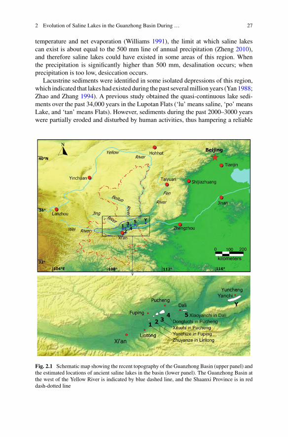
2 Evolution of Saline Lakes in the Guanzhong Basin During … 27
temperature and net evaporation (Williams 1991), the limit at which saline lakescan exist is about equal to the 500 mm line of annual precipitation (Zheng 2010),and therefore saline lakes could have existed in some areas of this region. Whenthe precipitation is significantly higher than 500 mm, desalination occurs; whenprecipitation is too low, desiccation occurs.
Lacustrine sediments were identified in some isolated depressions of this region,which indicated that lakes had existed during the past severalmillion years (Yan 1988;Zhao and Zhang 1994). A previous study obtained the quasi-continuous lake sedi-ments over the past 34,000 years in the Lupotan Flats (‘lu’ means saline, ‘po’ meansLake, and ‘tan’ means Flats). However, sediments during the past 2000–3000 yearswere partially eroded and disturbed by human activities, thus hampering a reliable
Fig. 2.1 Schematic map showing the recent topography of the Guanzhong Basin (upper panel) andthe estimated locations of ancient saline lakes in the basin (lower panel). The Guanzhong Basin atthe west of the Yellow River is indicated by blue dashed line, and the Shaanxi Province is in reddash-dotted line
28 J. Fei et al.
interpretation of the limnological information (Yan et al. 2016). Historical records,supplemented by archaeological evidence, are very reliable and effective.
2.3 Materials and Methods
Historical literature has been proven to be a critical source of information for gath-ering data on lake evolution during the past 2000 years (Brooks 1923; Dixey 1924;Nicholson 1999; Nicholson and Yin 2001; Fang 1993). The Guanzhong region iswell known for its long history of civilization and abundant archives of historicalliterature. For this study, we examined the Chinese historical literature as well asarchaeological materials (stone inscriptions), and investigated whether saline lakesexisted in this region during the past 2000 years.
Various kinds of historical literature were examined, and relevant records werefound in the historical local chronicles of the Fuping, Pucheng, Lintong and Dalicounties and cities, historical chronicles of Shaanxi Province, dynastic histories,historical geography books, and stone inscriptions.
The data of population and cultivated lands of the relevant counties are scatteredthrough the Chinese local historical chronicles. A systematic literature survey wasconducted, and those of the Fuping, Pucheng, Lintong and Chaoyi counties arecarefully examined. The population data were converted into population densitydata. With regard to the data of cultivated land, we employed a Cultivated LandRatio (CLR), which was defined as the ratio between the cultivated land area and thetotal land area.
2.4 Results
After an exhaustive literature survey, nearly a hundred records concerning salinelakes were discovered. A synthesis of these records pointed to the existence of fivehistorical saline lakes in the Guanzhong Basin, i.e. Lake Yanchize in Fuping County,Lakes Dongluchi andXiluchi in Pucheng County, Lake Zhuyanze in LintongCounty,and LakeXiaoyanchi in Dali County (former Chaoyi County, Fig. 2.1). The five lakeswill be discussed separately in the following sections.
2.4.1 Lake Yanchize in Fuping County
2.4.1.1 Prior to the 13th Century
Historical records on Lake Yanchize in Fuping County may be traced back to theNorthernWei Dynasty (386–534 AD). It was recorded in the History of the Northern
2 Evolution of Saline Lakes in the Guanzhong Basin During … 29
Wei Dynasty that, ‘there was a salt lake in the Pinyang County (modern FupingCounty. Wei 554).’
In the Yuanhe Reign Period General Geography (Li 813), it was recorded that,‘Lake Yanchize was located 25 li from the southeast of the administrative centre ofthe county (Fuping County). The circumference of the lake was 20 li.’ Because thecircumference was about 20 li (1 li ≈0.5 km), i.e. 10 km, the area of the lake isestimated to have been about 4–8 km2. Similar records were also found in the NewHistory of the Tang Dynasty (Song and Ouyang 1060), Chronicle of Chang’an (Song1076) and Revised Chronicle of Chang’an (Luo 1296).
The earliest record is that which recorded the history of the NorthernWei Dynasty(386–534 AD). The latest record is that in the Revised Chronicle of Chang’an, whichrecorded the history prior to 1296 AD. Based upon the above sources, we inferredthat Lake Yanchize was a saline lake with an area about 4–8 km2 between the late4th and 13th centuries.
2.4.1.2 14th–16th Centuries
Two records were found in the Chronicle of Fuping County (Liu and Sun 1584),
The Lupotan Flats, was also known as the Mingshuitan Flats (‘Mingshui’ means watercovered) and East Flats (Dongtan). The flats did not dry up in winter or summer, and thewater could be boiled for extracting salt (Liu and Sun 1584).
Lake Yanze (i.e. Yanchize) lies in the east of the county, and looked like a lake (Liu and Sun1584).
It may be inferred that Lake Yanze was still a saline lake during the 14th–16thcenturies. However, the name of the lake was changed from ze (lake) to tan (flat),which possibly indicated that the lake had become significantly reduced in size.
2.4.1.3 17th–18th Century
Two brief records were foundwithin two local chronicles which were printed in 1735and 1740 AD respectively.
(1) ‘The Lupotan Flats lay in the east of the county, and now it was silted up.’ (Liuand Shen 1735. As indicated by the reference, ‘now’ probably refers to the early18th century.)
(2) ‘The Lupotan Flats, also known as the Mingshuitan Flats and East Flats. It wasjust the ancient Yanchi of Pinyang County. Now it dried up.’ (Qiao 1740; Wuand Hu 1778; Fan and Liu 1891. As indicated by the references, ‘now’ probablyrefers to the early 18th century.)
In addition, two official reports of the Lupotan Flat were recorded in the DraftChronicle of Fuping County (Fan and Liu 1891),

30 J. Fei et al.
22nd Day, 7th month, 56th year, Qianlong Reign Period (21st Aug. 1791), the county headreported that ‘there was no saline lake in Fuping County. But there is Luopotan Flat in theeast of the county extending 6-7 li from east to west. The area is low and contains saline andalkali (that is, it contains NaCl and Na2SO4). When the weather is favourable, local peoplecollected the surface soil, put it into water, and boiled it to extract salt. The salt is brackish(because it contains Na2SO4). When it rained too much, the flat was covered by water.
16th day, 11th month, 56th year, Qianlong Reign Period (16th Dec. 1791), the county headreported that ‘the Lupotan Flat in our county was in all probability the Lake Yanchize in thechronicles… however, it dried up.
2.4.1.4 19th Century
An official investigation of the Lupotan Flats was conducted in the autumn of 1886AD.
The Lupotan Flat in our county was the ancient Yanze Lake, and extends from Fuping toPucheng. It was a saline land, local people took the saline soil after rains and boiled for Xiao(glauber’s salt, i.e. Sodium Sulfate Decahydrate).
The flats in Fuping County extended 3-4 li from east to west, and 2-3 li from north to south…The area was full of weeds and contained no saline waters, and the areas that still possessedsalt production extends to less than 1 square li (1 square li≈0.25 km2)… there were only fiveor six small ponds that were producing salt, other areas were wastelands and were overgrownwith weeds (Fan and Liu 1891).
According to the investigation, the flats in FupingCountywere dry by the late 19thcentury. In addition to the official report of the investigation, a few related materialswere recorded in the Draft Chronicle of Fuping County. In conclusion, the aboverecords indicate that Lake Yanchize in Fuping County (also known as the LupotanFlats) had desiccated at some point during 1584–1735 AD.
2.4.2 Lakes Dongluchi and Xiluchi in Pucheng County
Lakes Dongluchi and Xiluchi lay in the south of the Pucheng County. Here, ‘dong’means ‘east’, ‘xi’ means ‘west’, and ‘luchi’ means ‘salt lake’. Historical records onLakes Dongluchi and Xiluchi in Pucheng County are numerous and very detailed.
2.4.2.1 Prior to the 13th Century
As early as 2000 years ago, the History of the Western Han Dynasty (Ban et al.80) recorded that ‘Emperor Xuandi (reign in 91–49 BC) was trapped in Luzhong,Lianshao County… There was a salt lake in the Lianshao County, and it extendedover 10 li from north to south. The local people called it Luzhong.’ The LianshaoCounty during the Han Dynasty lay near the modern Lupotan Flats (Tan 1982), and

2 Evolution of Saline Lakes in the Guanzhong Basin During … 31
Lake Luzhong should be the possible predecessor of Lakes Dongluchi and Xiluchi,as well as the modern Lupotan Flats.
No relevant historical records are available concerning theThreeKingdomsPeriod(220–265 AD), but archaeological evidence has been identified. Archaeologicalresearch unearthed two official seals, one is ‘Lianshao Lu Xian Du Yin’ (Seal ofthe Lianshao Governor of Salt and Alkali Industries), and the other is ‘Lianshao LuDu Yin’ (Seal of the Lianshao Governor of Salt Industry) (Luo 1987). The sealssupport the idea that there was salt production during the Three Kingdoms Period,which thus possibly indicates the existence of one or more salt lakes in this region,as there are no salt mines or dry lake salt crusts in this region.
Detailed historical records become available again from the Tang Dynasty(618–907 AD). The Luchi Lakes (including the Dongluchi and Xiluchi lakes) ofFengxian County (modern Pucheng County) were recorded as one of the salt pro-duction places in the History of the Tang Dynasty (Liu 945), New History of theTang Dynasty (Song and Ouyang 1060) and the Collection of Material on the Livesof Emperors and Ministers (Wang 1013).
2.4.2.2 14th–17th Centuries
Detailed records are available concerning the Ming and Qing Dynasties (1368–1644AD, 1644–1911 AD). In the History of the Ming Dynasty (Zhang 1739), it wasrecorded that ‘there were Xiluchi in the west Pucheng County and Dongluchi in thesouth Pucheng County, and salt was produced previously.’
A poem titled ‘Bing qi ri ji (Sunshine on the ice covered salina)’ was recordedin the Continued Chronicle of Pucheng County (Wang and He 1714). The date ofthe poem was sometime during the Ming Dynasty. The poem probably refers to theXiluchi Lake or the Dongluchi Lake, as there were only two saline lakes in PuchengCounty. This poem indicated that saline lakes and salt production existed in PuchengCounty during the Ming Dynasty (1368–1644 AD).
Within the Chronicle of Pucheng (Deng and Li 1666), three records are identified:
(1) ‘There is a saline lake looking like a mirror in the south of the county.’(2) ‘East Luchi Lake lies 20 li to the south of the city centre of the county, and it
was also called Anfengtan Flats. Salt was formed naturally in the 12th yearof Dali Reign Period (777 AD). After that, salt production in the salt lake wasforbidden, but alkali production went on.’
(3) ‘West Luchi Lake lies 40 li to the southwest of the city centre of the county…it did not dry up even in droughts. The local people boiled the lake water andextracted salt. Recently, salt production was given up because of the high cost.’

32 J. Fei et al.
2.4.2.3 18th Century
In the Draft Chronicle of Fuping County, a detailed report on the Lupotan Flats,entitled Hui Kan Lu-po-tan Bin (Report of the joint investigation of the LupotanFlats), was provided (Fan and Liu 1891; Li and Wang 1905).
The Lupotan Flats included the former East Luchi, West Luchi, and Yanchizelakes. The report was based on an official investigation of the Lupotan Flats inautumn 1791 AD.
It was said that the Lupotan Flats extended 50-60 li from east to west. The East Flats extended5-6 li. The middle part of the Lupotan, extending 30-40 li, was a wasteland. The West Flatsextended about 10 li. The end part of the Lupotan, extending a little more than 1 li, wasovergrown with weeds. Apart from the middle and end sections, the flats extended a littlemore than 10 li. Ever since the Tang Dynasty, salt production left numerous deserted ponds,and saline water dried. There were salt production operations only in a few square li of theflat now.
We investigated the East Flats and learned that saline water existed in the middle of theEast Flats, and was surrounded by wheat fields…we criticized that they were producing saltillegally, and it was told that it was not salt but mirabilite. They told us that of the productsin the flats, 90% was mirabilite, and 10% was salt.
Then, we investigated the West Fats. They lie between Pucheng and Fuping counties, andmostly in Pucheng. We walked for two days, and saw no people, but only desert and weeds.The ponds were old and long abandoned.
According to this report, the East Flats, i.e. the former East Luchi Lake, desiccatedbefore 1791 AD; The West Flats, i.e. the former West Luchi Lake and the YanchizeLake, also completely desiccated. Inferring from the print dates of the literature, boththe East and West Flats probably desiccated during the years 1666–1791 AD.
2.4.2.4 Late 19th Century and Early 20th Century
Maps recorded the lakes of Pucheng County in the Shaanxi Provincial Atlas (Wei1899) and the New Chronicle of Pucheng County (Li and Wang 1905). The WestLuchi Lake was drawn as Lupotan (Saline Lake Flats) in these maps. A road wasdrawn in the Lupotan (Xiluchi Lake) in the map in the New Chronicle of PuchengCounty, thus providing evidence that the Xiluchi Lake probably desiccated around1890–1910.
An atlas was made in 1915 AD by the Japanese Territorial Geodesy Department(1938). According to the atlas, the west and middle areas of the Lupotan Flats weredry in 1915. The east part of the Lupotan Flats also desiccated except for severalponds scattered around the flats.
It may be inferred from these sources that the Lupotan Flats, including XiluchiLake, Dongluchi Lake and Yanchize Lake, desiccated earlier than the late 19th cen-tury and early 20th century. This is consistent with the above inference that the lakesdesiccated during the period 1666–1791 AD.

2 Evolution of Saline Lakes in the Guanzhong Basin During … 33
2.4.3 Lake Zhuyanze in Lintong County
Lake Zhuyanze lies in Lintong County. The earliest record of this lake was identifiedin the Yuanhe Reign Period General Geography. It was recorded that,
Lake Zhuyanze lies 15 li to the south of the Yueyang County. The lake’s water contains a lotof salt. People boiled the water and extracted salt during the Fuqin Period (350-394 AD).The circumference of the lake was 20 li. (Li 813)
A similar record was found in the Chronicle of Chang’an (Song 1076) which wascompiled in the late 11th century. The New History of the Tang Dyansty contains achapter that recorded the lakes that yielded salt, and Lake Zhuyanze was one of them.It was recorded that, ‘there was a Lake Zhuyanze in the Yueyang County.’ (ModernYueyang Town of Lintong County) (Song and Ouyang 1060) 600 years later, theChronicle of Lintong County repeated this record, and added one more sentence,‘the water in the Zouma village was salty now. A lake is supposed to have existedhere (Zhao 1701).’ Because the Chronicle of Chang’an was printed in 1076 AD, andthe Chronicle of Lintong County was printed in 1701 AD, the date of the desiccationof the lake should be sometime in the period 1076–1701 AD.
2.4.4 Lake Xiaoyanchi in Dali County
The earliest record of Lake Xiaoyanchi in Chaoyi County1 was found in the Historyof the Tang Dynasty which listed Lake Chaoyi Xiaochi as a salt production place(Liu, 945).
In the New History of the Tang Dynasty, it was recorded that ‘salt was manufac-tured in Lake Xiaochi, Chaoyi County’ (Song and Ouyang 1060). In the Chronicleof Tongzhou Prefecture (Zhang and Ma 1625), it was recorded that
‘Salt was produced in Lake Xiaoyanchi during the Tang Dynasty. Now, salt wasnot manufactured regularly, and the output was very limited.’
It was then recorded in the Continued Chronicle of Chaoyi County (printed in1712 AD. Wang 1712) that
The water of the area gathered in Lake Xiaoyanchi. It was extremely arid in this area. Byboiling the water, salt was extracted….When it was rainy, salt could not be produced… Thebasin extended more than 20 li, and the soil was saline. Crops could not grow, whereas wildgrass grew everywhere.
In addition, it was recorded in this chronicle that there was illegal salt produc-tion, whereas salt production was officially organized in the Wanli Reign Period(1573–1620 AD).
These records indicate that Lake Xiaoyanchi was still a salt lake in the early 18thcentury. However, in the Chronicle of the Chaoyi County, it was recorded that Lake
1Chaoyi County was merged into Dali County in 1958.
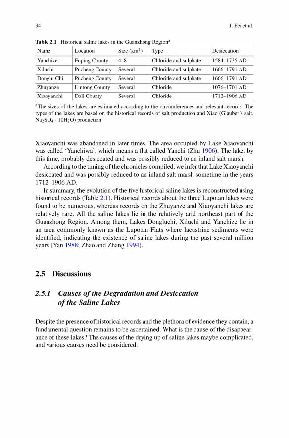
34 J. Fei et al.
Table 2.1 Historical saline lakes in the Guanzhong Regiona
Name Location Size (km2) Type Desiccation
Yanchize Fuping County 4–8 Chloride and sulphate 1584–1735 AD
Xiluchi Pucheng County Several Chloride and sulphate 1666–1791 AD
Donglu Chi Pucheng County Several Chloride and sulphate 1666–1791 AD
Zhuyanze Lintong County Several Chloride 1076–1701 AD
Xiaoyanchi Dali County Several Chloride 1712–1906 AD
aThe sizes of the lakes are estimated according to the circumferences and relevant records. Thetypes of the lakes are based on the historical records of salt production and Xiao (Glauber’s salt.Na2SO4 · 10H2O) production
Xiaoyanchi was abandoned in later times. The area occupied by Lake Xiaoyanchiwas called ‘Yanchiwa’, which means a flat called Yanchi (Zhu 1906). The lake, bythis time, probably desiccated and was possibly reduced to an inland salt marsh.
According to the timing of the chronicles compiled, we infer that LakeXiaoyanchidesiccated and was possibly reduced to an inland salt marsh sometime in the years1712–1906 AD.
In summary, the evolution of the five historical saline lakes is reconstructed usinghistorical records (Table 2.1). Historical records about the three Lupotan lakes werefound to be numerous, whereas records on the Zhuyanze and Xiaoyanchi lakes arerelatively rare. All the saline lakes lie in the relatively arid northeast part of theGuanzhong Region. Among them, Lakes Dongluchi, Xiluchi and Yanchize lie inan area commonly known as the Lupotan Flats where lacustrine sediments wereidentified, indicating the existence of saline lakes during the past several millionyears (Yan 1988; Zhao and Zhang 1994).
2.5 Discussions
2.5.1 Causes of the Degradation and Desiccationof the Saline Lakes
Despite the presence of historical records and the plethora of evidence they contain, afundamental question remains to be ascertained. What is the cause of the disappear-ance of these lakes? The causes of the drying up of saline lakes maybe complicated,and various causes need be considered.
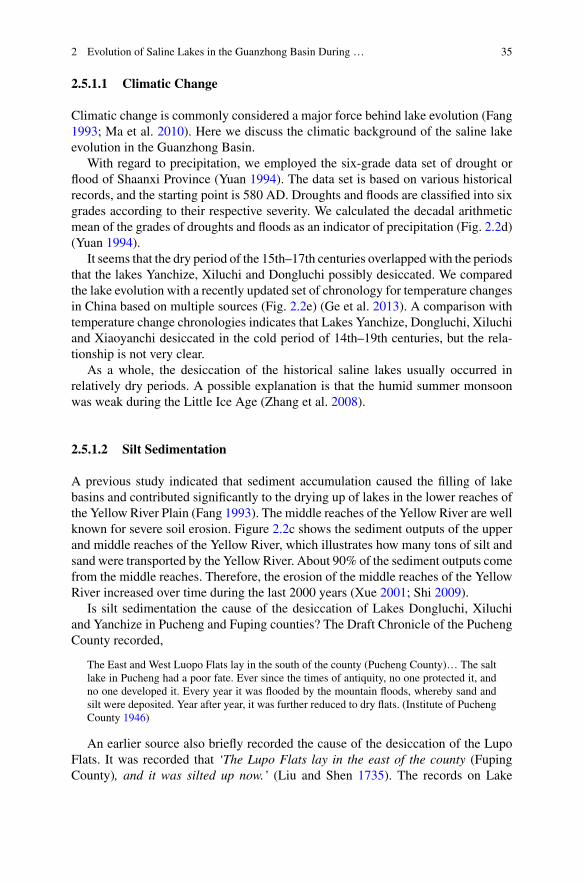
2 Evolution of Saline Lakes in the Guanzhong Basin During … 35
2.5.1.1 Climatic Change
Climatic change is commonly considered a major force behind lake evolution (Fang1993; Ma et al. 2010). Here we discuss the climatic background of the saline lakeevolution in the Guanzhong Basin.
With regard to precipitation, we employed the six-grade data set of drought orflood of Shaanxi Province (Yuan 1994). The data set is based on various historicalrecords, and the starting point is 580 AD. Droughts and floods are classified into sixgrades according to their respective severity. We calculated the decadal arithmeticmean of the grades of droughts and floods as an indicator of precipitation (Fig. 2.2d)(Yuan 1994).
It seems that the dry period of the 15th–17th centuries overlapped with the periodsthat the lakes Yanchize, Xiluchi and Dongluchi possibly desiccated. We comparedthe lake evolution with a recently updated set of chronology for temperature changesin China based on multiple sources (Fig. 2.2e) (Ge et al. 2013). A comparison withtemperature change chronologies indicates that Lakes Yanchize, Dongluchi, Xiluchiand Xiaoyanchi desiccated in the cold period of 14th–19th centuries, but the rela-tionship is not very clear.
As a whole, the desiccation of the historical saline lakes usually occurred inrelatively dry periods. A possible explanation is that the humid summer monsoonwas weak during the Little Ice Age (Zhang et al. 2008).
2.5.1.2 Silt Sedimentation
A previous study indicated that sediment accumulation caused the filling of lakebasins and contributed significantly to the drying up of lakes in the lower reaches ofthe Yellow River Plain (Fang 1993). The middle reaches of the Yellow River are wellknown for severe soil erosion. Figure 2.2c shows the sediment outputs of the upperand middle reaches of the Yellow River, which illustrates how many tons of silt andsand were transported by the Yellow River. About 90% of the sediment outputs comefrom the middle reaches. Therefore, the erosion of the middle reaches of the YellowRiver increased over time during the last 2000 years (Xue 2001; Shi 2009).
Is silt sedimentation the cause of the desiccation of Lakes Dongluchi, Xiluchiand Yanchize in Pucheng and Fuping counties? The Draft Chronicle of the PuchengCounty recorded,
The East and West Luopo Flats lay in the south of the county (Pucheng County)… The saltlake in Pucheng had a poor fate. Ever since the times of antiquity, no one protected it, andno one developed it. Every year it was flooded by the mountain floods, whereby sand andsilt were deposited. Year after year, it was further reduced to dry flats. (Institute of PuchengCounty 1946)
An earlier source also briefly recorded the cause of the desiccation of the LupoFlats. It was recorded that ‘The Lupo Flats lay in the east of the county (FupingCounty), and it was silted up now.’ (Liu and Shen 1735). The records on Lake
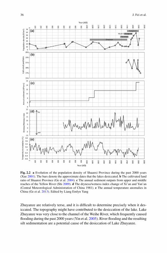
36 J. Fei et al.
Fig. 2.2 a Evolution of the population density of Shaanxi Province during the past 2000 years(Xue 2001). The bars denote the approximate dates that the lakes desiccated. b The cultivated landratio of Shaanxi Province (Ge et al. 2004). c The annual sediment outputs from upper and middlereaches of the Yellow River (Shi 2009). d The dryness/wetness index change of Xi’an and Yan’an(Central Meteorological Administration of China 1981). e The annual temperature anomalies inChina (Ge et al. 2013). Edited by Liang Emlyn Yang
Zhuyanze are relatively terse, and it is difficult to determine precisely when it des-iccated. The topography might have contributed to the desiccation of the lake. LakeZhuyanze was very close to the channel of theWeihe River, which frequently causedflooding during the past 2000 years (Yin et al. 2005). River flooding and the resultingsilt sedimentation are a potential cause of the desiccation of Lake Zhuyanze.
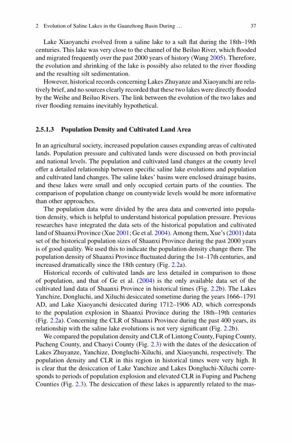
2 Evolution of Saline Lakes in the Guanzhong Basin During … 37
Lake Xiaoyanchi evolved from a saline lake to a salt flat during the 18th–19thcenturies. This lake was very close to the channel of the Beiluo River, which floodedand migrated frequently over the past 2000 years of history (Wang 2005). Therefore,the evolution and shrinking of the lake is possibly also related to the river floodingand the resulting silt sedimentation.
However, historical records concerning Lakes Zhuyanze and Xiaoyanchi are rela-tively brief, and no sources clearly recorded that these two lakeswere directly floodedby the Weihe and Beiluo Rivers. The link between the evolution of the two lakes andriver flooding remains inevitably hypothetical.
2.5.1.3 Population Density and Cultivated Land Area
In an agricultural society, increased population causes expanding areas of cultivatedlands. Population pressure and cultivated lands were discussed on both provincialand national levels. The population and cultivated land changes at the county leveloffer a detailed relationship between specific saline lake evolutions and populationand cultivated land changes. The saline lakes’ basins were enclosed drainage basins,and these lakes were small and only occupied certain parts of the counties. Thecomparison of population change on countywide levels would be more informativethan other approaches.
The population data were divided by the area data and converted into popula-tion density, which is helpful to understand historical population pressure. Previousresearches have integrated the data sets of the historical population and cultivatedland of Shaanxi Province (Xue 2001; Ge et al. 2004). Among them,Xue’s (2001) dataset of the historical population sizes of Shaanxi Province during the past 2000 yearsis of good quality. We used this to indicate the population density change there. Thepopulation density of Shaanxi Province fluctuated during the 1st–17th centuries, andincreased dramatically since the 18th century (Fig. 2.2a).
Historical records of cultivated lands are less detailed in comparison to thoseof population, and that of Ge et al. (2004) is the only available data set of thecultivated land data of Shaanxi Province in historical times (Fig. 2.2b). The LakesYanchize, Dongluchi, and Xiluchi desiccated sometime during the years 1666–1791AD, and Lake Xiaoyanchi desiccated during 1712–1906 AD, which correspondsto the population explosion in Shaanxi Province during the 18th–19th centuries(Fig. 2.2a). Concerning the CLR of Shaanxi Province during the past 400 years, itsrelationship with the saline lake evolutions is not very significant (Fig. 2.2b).
We compared the population density and CLR of Lintong County, Fuping County,Pucheng County, and Chaoyi County (Fig. 2.3) with the dates of the desiccation ofLakes Zhuyanze, Yanchize, Dongluchi-Xiluchi, and Xiaoyanchi, respectively. Thepopulation density and CLR in this region in historical times were very high. Itis clear that the desiccation of Lake Yanchize and Lakes Dongluchi-Xiluchi corre-sponds to periods of population explosion and elevated CLR in Fuping and PuchengCounties (Fig. 2.3). The desiccation of these lakes is apparently related to the mas-
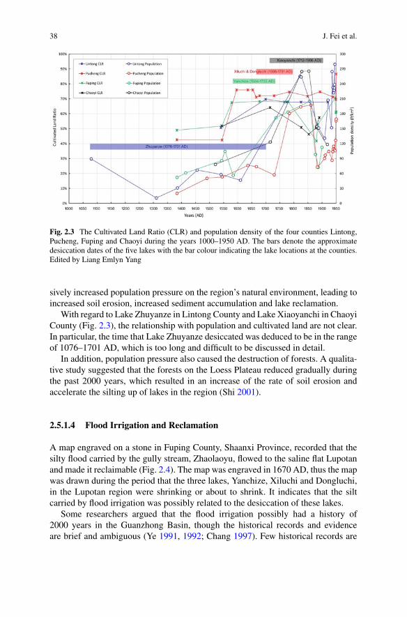
38 J. Fei et al.
Fig. 2.3 The Cultivated Land Ratio (CLR) and population density of the four counties Lintong,Pucheng, Fuping and Chaoyi during the years 1000–1950 AD. The bars denote the approximatedesiccation dates of the five lakes with the bar colour indicating the lake locations at the counties.Edited by Liang Emlyn Yang
sively increased population pressure on the region’s natural environment, leading toincreased soil erosion, increased sediment accumulation and lake reclamation.
With regard to Lake Zhuyanze in Lintong County and Lake Xiaoyanchi in ChaoyiCounty (Fig. 2.3), the relationship with population and cultivated land are not clear.In particular, the time that Lake Zhuyanze desiccated was deduced to be in the rangeof 1076–1701 AD, which is too long and difficult to be discussed in detail.
In addition, population pressure also caused the destruction of forests. A qualita-tive study suggested that the forests on the Loess Plateau reduced gradually duringthe past 2000 years, which resulted in an increase of the rate of soil erosion andaccelerate the silting up of lakes in the region (Shi 2001).
2.5.1.4 Flood Irrigation and Reclamation
A map engraved on a stone in Fuping County, Shaanxi Province, recorded that thesilty flood carried by the gully stream, Zhaolaoyu, flowed to the saline flat Lupotanand made it reclaimable (Fig. 2.4). The map was engraved in 1670 AD, thus the mapwas drawn during the period that the three lakes, Yanchize, Xiluchi and Dongluchi,in the Lupotan region were shrinking or about to shrink. It indicates that the siltcarried by flood irrigation was possibly related to the desiccation of these lakes.
Some researchers argued that the flood irrigation possibly had a history of2000 years in the Guanzhong Basin, though the historical records and evidenceare brief and ambiguous (Ye 1991, 1992; Chang 1997). Few historical records are

2 Evolution of Saline Lakes in the Guanzhong Basin During … 39
Fig. 2.4 Part of thegeographical map of Fuping(Fuping yuditu. Shen Qiqian,1670. The map was engravedon a stone, and the stone isarchived in the FupingCounty Library, ShaanxiProvince, China). The lettersA, B, C, D are added by theauthors. ‘A’ denotes the textthat reads ‘Lupotan (a salineflat)’. ‘B’ denotes the textthat reads ‘the silt carried bythe gully stream deposited inthe flat and made itreclaimable’. ‘C’ denotes thetext that reads ‘Zhaolaoyu (agully stream).’ ‘D’ denotesthe boundary betweenFuping and Pucheng counties
available concerning unambiguous description of flood irrigation, and no evidenceindicates that it was extensive and long-lasting in this region prior to theQingDynasty(1644–1912) (Ye 1991, 1992; Chang 1997).

40 J. Fei et al.
2.5.2 Relationship with the Sanmen Paleo-Lake
During the Pliocene (5.3–2.6 Ma BP) and Pleistocene (2.6–0.01 Ma BP) epochs,there was a large Sanmen Paleo-Lake in the modern plains of the Weihe and Fenherivers (Anderson 1923; Wang et al. 1999). The area of the Sanmen Palaeolake variedduring theQuaternary Period, and themaximumextentwas about equal to themodernplains.
Stratigraphical research indicates that it was most probably a saline lake whichwas drained about 0.15 Ma BP, when the mountain to the east of the lake was cutthrough by the paleo Yellow River, thus forming the modern Yellow River (Wanget al. 2001, 2004; Zhang et al. 2004; Liu et al. 2006; Jiang et al. 2007). The YellowRiver flowed through the modern Sanmenxia Gorge and eventually drained into thesea. The Sanmen Paleo-Lake shrank and resolved into several relatively small lakes.There is Lake Yuncheng Yanchi (Yuncheng Salt Lake), along with a few small salinelakes in the lower reaches of the Fenhe River, even in modern times, which comprisethe remains of the Sanmen Paleo-Lake.
Previous researchers suggested that the remains of the Sanmen Paleo-Lake hadexisted as several isolated saline lakes in the Guanzhong Basin during the PleistoceneEpoch (Yan 1988; Zhao and Zhang 1994) and early Holocene (Yan et al. 2016). Inparticular, lateQuaternary and earlyHolocene lacustrine sedimentswere identified inthe Lupotan region (Luopotan Flats), an isolated depression where Lakes Yanchize,Xiluchi and Dongluchi existed (Yan 1988; Zhao and Zhang 1994). Recent researchconfirmed the quasi-continuous existence of lake sediments in the Lupotan Flats, andthe paleolake possibly desiccated ca. 4600 years ago (Yan et al. 2016). The sedimentsduring the past 4600 years were disturbed by increasingly intense human activities,and the lake evolution history of this period remains uncertain.
Regarding Lake Zhuyanze in Lintong County and Lake Xiaoyanchi in modernDali County, there is no doubt that these regions were parts of the Sanmen Paleo-Lake before the middle Pleistocene, but no stratigraphical research has been doneconcerning the lake evolution in the late Pleistocene and the Holocene. Because lakeremains most probably exist, our inferences at least support the evidence for smallerremaining lakes of the Sanmen Paleo-Lake in historical times.
Our inference on the existence of historical saline lakes suggests that the remainsof the Sanmen Paleo-Lake still existed in the northeast part of the Guanzhong Basinduring the past 2000 years. This result improves the understanding of the temporaland spatial history of the Sanmen Paleo-Lake.

2 Evolution of Saline Lakes in the Guanzhong Basin During … 41
2.6 Conclusions
There are no saline lakes in the Guanzhong Basin in modern times. Using Chinesehistorical sources and archaeological materials, we inferred the existence of fivehistorical saline lakes in the region during the past 2000 years, i.e. Lakes Yanchize,Xiluchi, Dongluchi, Zhuyanze and Xiaoyanchi.
LakesZhuyanze,Yanchize,Xiluchi,Dongluchi, andXiaoyanchi desiccated some-time during 1076–1701 AD, 1584–1735 AD, 1666–1791 AD, 1666–1791 AD, and1712–1906 AD, respectively. Most of the lakes desiccated during cold climate con-ditions. The dry period of the 15th–17th centuries overlapped with the periods thatsome of the lakes desiccated. However, the relationship is not very clear.
The lakes in the west of this region possibly desiccated relatively early, and thelakes in the east desiccated relatively late, but the reasons remain unknown. All thefive lakes desiccated during periods of increased soil erosion. Flood irrigation and siltsedimentation were probably the main causes of the desiccation of Lakes Yanchize,Xiluchi and Dongluchi.
The desiccation of LakeYanchize and LakesDongluchi andXiluchi correspond toperiods of population explosion andmore land was cultivated in Fuping and PuchengCounties. Population pressure, increased levels of cultivated lands and soil erosionare the potential causes of the desiccation of these historical saline lakes.
Acknowledgements The helpful comments of Professors Koichi Muramatsu, Kazuyuki Tsurumaand Yongjian Hou are much appreciated. An earlier version of this research paper was included inthe 2017 Research Report of the Institute of International Research and Education of GakushuinUniversity (in Japanese). The research was supported by the Shanghai Municipal Philosophy andSocial Sciences Grant (No. 2017BLS003) and the National Natural Sciences Foundation of China(Grant No. 41672180).
References
Anderson, J. G. (1923). Essays on the cenozoic of Northern China. Memoirs of the GeologicalSurvey of China (Series A), 3, 1–93.
Brooks, C. E. P. (1923). Variations in the level of Lake George, Australia. Nature, 112, 918.Chang, S. (1997). New research on the area of flood irrigation of the irrigation Canal Zhengguoqu.
Journal of Chinese Historical Geography (Zhongguo Lishi Dili Luncong), 4, 189–194. (in Chi-nese).
Chen, T., & Dong, J. (2009). An analysis on characteristics of climatic changes in Guanzhong Plainin recent 49 year. Journal of Arid Land Resources and Environment, 23, 76–81. (in Chinese).
Dixey, F. (1924). Lake level in relation to rainfall and sunspots. Nature, 114, 659–661.Fang, J. (1993). Lake evolution during the last 3000 years in China and its implications for envi-ronmental change. Quaternary Research, 39, 175–185.
Ge, Q., Dai, J., He, F., Zheng, J., Man, Z., & Zhao, Y. (2004). Spatiotemporal dynamics of recla-mation and cultivation and its driving factors in parts of China during the last three centuries.Progress in Natural Science, 14, 605–613.
Ge, Q., Hao, Z., Zheng, J., & Shao, X. (2013). Temperature changes over the past 2000 yr in Chinaand comparison with the Northern Hemisphere. Climate of the Past, 9, 1153–1160.
42 J. Fei et al.
Jiang, F., Fu, J., & Wang, S. (2007). Formation of the Yellow River, inferred from loess-palaeosolsequence in Mangshan and lacustrine sediments in Sanmen Gorge, China. Quaternary Interna-tional, 175, 62–70.
Liu, J., & Guo, R. (2008). Analysis of the characteristics of the precipitation in the GuanzhongPlain. Yellow River, 30, 22–24. (in Chinese).
Liu, H. J., Xue, X. X., & Li, Y. X. (2006). Calculation on the paleosalinity of the ancient SanmenLake in theWeinan Area ofWeihe River Basin. Journal of Northwest University (Natural ScienceEdition), 36, 112–114. (in Chinese).
Luo, F. Y. (Ed.). (1987). Collection of Official seals during the Qin and Han Dynasties and theSouthern and Northern Dynasties. Beijing: Historical Relics Press. (in Chinese).
Ma, R., Duan, H., Hu, C., Feng, X., Li, A., Ju,W., et al. (2010). A half-century of changes in China’slakes: Global warming or human influence? Geophysical Research Letters, 37, L24106. https://doi.org/10.1029/2010gl045514.
Nicholson, S. E. (1999). Historical and modern fluctuations of lakes Tanganyika and Rukwa andtheir relationship to rainfall variability. Climatic Change, 41, 53–71.
Nicholson, S. E., & Yin, X. (2001). Rainfall conditions in equatorial East Africa during the 19thcentury as inferred from the record of Lake Victoria. Climatic Change, 48, 387–398.
Shi, N. H. (2001). Historical geography research of the Loess Plateau. Yellow River Water Con-servancy Press. (in Chinese).
Shi, C. X. (2009). Sedimentation in the lower reaches and sediment yield in the upper and mid-dle reaches of the Yellow River in the past 2600 years. Quaternary Sciences, 29, 116–125. (inChinese).
Tan, Q. (1982). The historical atlas of China (Vol. 2). Beijing: China Cartographic PublishingHouse. (in Chinese).
The General Office of the Japanese Territorial Geodesy Department. (1938). Topographical Atlasof China (1:50,000). Pages of Guanlu Town and Guanshan Town (in Japanese). The atlas wasdrawn in 1915 AD and was published in 1938 AD. A copy of the atlas was archived in the FudanUniversity Libraries.
Wang, Y. (2005). Physical environmental change in the basins of the Jing and Luo rivers. Beijing:Zhonghua Book Company (Zhonghua Shu Ju). (in Chinese).
Wang, S., & Dou, H. (1998). Encyclopaedia of the lakes in China (pp. 301–304). Beijing: SciencePress. (in Chinese).
Wang, S., Jiang, F., Wu, X., et al. (1999). A study on the age of Sanmen group in Sanmenxia area.Journal of Geomechanics, 5(4), 57–65. (in Chinese).
Wang, S. M., Wu, X. H., Zhang, Z. K., et al. (2001). Environmental evolution and the eastwardflowing of the Yellow River recorded by the sediments of the Paleo-Sanmen Lake. Sciences inChina (D), 31, 760–768. (in Chinese).
Wang, S. B., Jiang, F. C., Wu, X. H., et al. (2004). The connotation and significance of Sanmenformation. Quaternary Sciences, 24, 116–123. (in Chinese).
Williams, W. D. (1991). Chinese and Mongolian saline lakes: A limnological overview. Hydrobi-ologia, 210, 39–66.
Xue, P. (2001). Shaanxi historical population geography. Beijing: The people’s press. (in Chinese).Yan, Y. (1988). The environmental changes, exploitation and utilization of the Luyang Lake Basin.
Geology of Shaanxi, 6, 65–75. (in Chinese).Yan, Y., Zhou, J., He, Z., et al. (2016). Evolution of Luyang Lake since the last 34,000 years:Climatic changes and anthropogenic impacts. Quaternary International, 440, 90–98.
Ye, Y. (1991). From Zhengguoqu (Irrigation Canal Zhengguoqu) to Jinghuiqu (Irrigation CanalJinghuiqu). People’s Yellow River (Renmin Huanghe), 4, 66–70. (in Chinese).
Ye, Y. (1992). The past and present of the Zhaolaoyu flood irrigation area. Ancient and ModernAgriculture (Gujin Nongye), 1, 64–65. (in Chinese).
Yin, S., Huang, C., & Li, X. (2005). Historical drought and water disasters in the Weihe Plain.Journal of Geographical Sciences, 15, 97–105. (in Chinese).

2 Evolution of Saline Lakes in the Guanzhong Basin During … 43
Yuan, L. (1994). Northwest disasters history (Xibei zaihuang shi). Lanzhou: Gansu People’s Press(Gansu Renmin Chubanshe). (in Chinese).
Zhang, P., Cheng, H., Edwards, R. L., et al. (2008). A test of climate, sun, and culture relationshipsfrom an 1810-year Chinese cave record. Science, 322. https://doi.org/10.1126/science.1163965.
Zhang, Z., Wang, S., Yang, X., et al. (2004). Evidence of a geological event and environmentalchange in the catchment area of the Yellow River at 0.15Ma. Quaternary International, 117,35–40.
Zhao, S., &Zhang, F. (1994). On stratum lithology, saline-alkali mineral and formation environmentof Lu Bo Tan in Shaanxi. Journal of Northwest University of Architecture and Engineering, 3,12–19. (in Chinese).
Zheng, M., Tang, J., Liu, J., & Zhang, F. (1993). Chinese saline lakes. Hydrobiologia, 267, 23–36.Zheng, X. Y., et al. (2002). Encyclopaedia of the salt lakes in China (pp. 1–413). Beijing: SciencePress. (in Chinese).
Zheng, M. (2010). Salt lake resources and eco-environment in China. Acta Geologica Sinica, 84,1613–1622. (in Chinese).
Chinese Historical Documents
Ban, G., Ban, B., Ban, Z., Ma, X. (finished the book in 80 AD), Yan, S., et al. (added notes incirca 640 AD). (1962). History of the Western Han Dynasty (Han Shu), Vol. 8. Published by theZhonghua Book Company, Beijing, 1962. (in Chinese).
Deng, Y., & Li, F. (1666 AD). Chronicle of Pucheng (Pucheng Zhi), Vol. 1. (in Chinese).Fan, Z., & Liu, K. (1891). Draft chronicle of Fuping County (Fuping Xian Zhi Gao), Vols. 1, 4. (inChinese).
Institute of Pucheng County. (1946). Draft chronicle of the Pucheng County (Pucheng Xian ZhiGao), Vol. 2. (in Chinese).
Li, J. (813). Yuanhe Reign period general geography (Yuanhe Jun Xian Tu Zhi), Vol. 1. (in Chinese).Li, T., & Wang, X. (1905). New chronicle of Pucheng County (Pucheng Xian Xin Zhi), Vol. 1. (inChinese).
Liu, D., & Sun, P.-Y. (1584). Chronicle of Fuping County (Fuping Xian Zhi), Vols. 2, 8. (in Chinese).Liu, Y., & Shen, Q. (1735). General chronicle of Shaanxi Province (Shaanxi Tong Zhi), Vol. 9. (inChinese).
Liu, X. (945). History of the Tang Dyansty (Jiu Tang Shu), Vol. 48. It is an official chronicle of theTang Dynasty (618–907 A.D.). It totals 200 volumes. The compilation was carried out at imperialrequest. Beijing: Zhonghua Book Company (Zhonghua Shu Ju), 1975. (in Chinese).
Luo, T. (1296). Revised chronicle of Chang’an (Lei Bian Chang’an Zhi), Vol. 6. (in Chinese).Qiao, L. (1740). Chronicle of Fuping County. Vol. 2. (in Chinese).Song, M. (1076). Chronicle of Chang’an (Chang’an Zhi), Vol. 19. (in Chinese).Song, Q., & Ouyang, X. (1060). New history of the Tang Dyansty (Xin Tang Shu), Vol. 37. It is anofficial chronicle of the Tang Dynasty (618–907 A.D.). It totals 225 volumes. The compilationwas carried out at imperial request. Beijing: Zhonghua Book Company, 1975. (in Chinese).
Wang, Q. (1013). Collection of material on the lives of emperors and ministers (Ce Fu Yuan Gui),Vol. 494. It totals 1,000 volumes. The compilation was carried out at imperial request. Beijing:Zhonghua Book Company, 1960. (in Chinese).
Wang, Y., & He, F. (1714). Continued chronicle of Pucheng County (Pucheng Xian Xu Zhi). (inChinese).
Wang, Z.-A. (1712). Continued chronicle of Chaoyi County (Chaoyi Xian Xu Zhi), Vol. 1. (inChinese).
Wei, G. (1899). The Shaanxi Provincial Atlas (Shaanxi Quan Sheng Yu Di Tu). (in Chinese).Wei, S. (554). History of the Northern Wei Dynasty (Wei Shu), Vol. 106. (in Chinese).
44 J. Fei et al.
Wu, L., & Hu, W. (1778). Chronicle of Fuping County, Vol. 1. (in Chinese).Zhang, T. (1739). The History of the Ming Dynasty (Ming Shi), Vol. 30 (in Chinese). History of theMing Dynasty is the official history of the Ming Dynasty. (in Chinese).
Zhang, Y., Ma, P. (1625). Chronicle of Tongzhou prefecture (Tongzhou Zhi), Vol. 1. (in Chinese).Zhao, Y. (1701). Chronicle of Lintong County (Lintong Xian Zhi), Vol. 2. (in Chinese).Zhu, X. (1906). Chronicle of the Chaoyi County (Chaoyi Xian Xiang Tu Zhi). (in Chinese).
Open Access This chapter is licensed under the terms of the Creative Commons Attribution 4.0International License (http://creativecommons.org/licenses/by/4.0/), which permits use, sharing,adaptation, distribution and reproduction in any medium or format, as long as you give appropriatecredit to the original author(s) and the source, provide a link to the Creative Commons license andindicate if changes were made.
The images or other third party material in this chapter are included in the chapter’s CreativeCommons license, unless indicated otherwise in a credit line to the material. If material is notincluded in the chapter’s Creative Commons license and your intended use is not permitted bystatutory regulation or exceeds the permitted use, you will need to obtain permission directly fromthe copyright holder.

Chapter 3Landscape Response to Climateand Human Impact in Western ChinaDuring the Han Dynasty
Steffen Mischke, Chengjun Zhang, Chenglin Liu, Jiafu Zhang,Zhongping Lai and Hao Long
Abstract The Chinese empire experienced a large expansion to the arid regions inthe west during the Han Dynasty (206 BCE–220 CE). The Hexi Corridor, the YanqiBasin, the southeastern part of the Junggar Basin and the Tarim Basin became part ofthe empire. The expansion of the Han Dynasty was accompanied by the significantintensification of irrigation farming along rivers draining the Qilian, Tianshan andKunlun Mountains. Sedimentological and geochemical analyses and dating of lakesediments and shorelines revealed that four large lakes in the region experiencedfalling levels, or were almost or completely desiccating. The level of Zhuyeze Lakewas falling rapidly ca. 2100 years before present (a BP), and the accumulation oflake sediments was replaced by an alluvial fan setting in large parts of the basin.Lake Eastern Juyan desiccated ca. 1700 a BP. Lake Bosten experienced low levelsand increasing salinities at ca. 2200 a BP. Lake sediments in the Lop Nur region weremostly replaced by aeolian sands during a period of near-desiccation at 1800 a BP.In contrast, records from fifteen lakes farther in the west, north or south of the HanDynasty realm indicate relatively wet climate conditions ca. 2000 years ago. Thus,dramatic landscape changes including the near and complete desiccation of large
S. Mischke (B)Faculty of Earth Sciences, University of Iceland, 101 Reykjavík, Icelande-mail: [email protected]
C. ZhangSchool of Earth Sciences and Key Laboratory of Mineral Resources in Western China, LanzhouUniversity, Lanzhou 730000, China
C. LiuInstitute of Mineral Resources, Chinese Academy of Geological Sciences, Beijing 100037, China
J. ZhangMOE Laboratory for Earth Surface Processes, Department of Geography, College of Urban andEnvironmental Sciences, Peking University, Beijing 100871, China
Z. LaiInstitute of Marine Science, Shantou University, Shantou 515063, China
H. LongNanjing Institute of Geography and Limnology, Chinese Academy of Sciences (NIGLAS),Nanjing 210008, China
© The Author(s) 2019L. E. Yang et al. (eds.), Socio-Environmental Dynamics along the Historical Silk Road,https://doi.org/10.1007/978-3-030-00728-7_3
45
46 S. Mischke et al.
lakes in the arid western part of today’s China probably resulted from the withdrawalof water from tributaries during the Han Dynasty. These changes likely represent theearliest man-made environmental disasters comparable to the recent Aral-Sea crisis.
Keywords Central Asia · Xinjiang · Inner Mongolia · Gobi DesertLake desiccation
3.1 Introduction
The climate conditions in the Chinese section of the ancient Silk Road during theHanDynasty have not been addressed by many studies so far. Climate change researchusually focussed on longer time scales such as the Holocene, or on recent globalchange (Liu et al. 2008, 2015a; Tao et al. 2010; Yang and Liu 2014). The workon Holocene climate records is often motivated by the need to understand climate-controlled environmental change since the last ice age with special emphasis on therapidness and amplitude of environmental change during times of natural climatechanges without human impact but with comparable climatic controls of the Earth’sorbital parameters (Wünnemann et al. 2012; Fan et al. 2014). As a result, periods ofmaximum moisture and temperature of northwestern China have been proposed inthe early and middle Holocene (Liu et al. 2015a; Chen et al. 2016). However, the cli-mate and environmental conditions in northwesternChina specifically during theHanDynasty deserve more attention of the palaeoclimate community because the HanDynasty expansion of the Chinese empire had caused a large population migrationtowards the west accompanied by significant land use changes (Zhang et al. 2003,2011; Yang et al. 2006; Lü et al. 2009; Qin et al. 2012). A recent study by Mischkeet al. (2017) showed that water withdrawal from the tributaries of the large ancientLake Lop Nur in the eastern Tarim Basin for irrigation farming caused not only thenear-desiccation of the lake ca. 1800 years before present (a BP) but eventually alsothe abandonment of the LoulanKingdom upstream of LopNur. Thus, human impactson environments along the Silk Road apparently already reached a significant mag-nitude during or shortly after the Han Dynasty. We follow and extent the approach ofMischke et al. (2017) here by assessing and comparing the available palaeoenviron-ment and palaeoclimate records from northwestern China and surrounding regionswith special emphasis on the Han Dynasty period. Which environmental and cli-mate conditions can be inferred for northwestern China and surrounding regionsduring the Han Dynasty? Are there spatial differences in environmental and climateconditions, and if so, can these differences be linked to changes in westerlies or sum-mer monsoon precipitation? Alternatively, were spatial differences in environmentalconditions possibly caused by man?

3 Landscape Response to Climate and Human Impact in Western China … 47
3.2 Previous Research
The Holocene climate history of northwestern China and surrounding regions wasaddressed by relatively many studies in the last decades. Studies often focussed onthe Holocene “Climatic Optimum” in China, i.e. the identification of the warmestand wettest period of the Holocene (Zheng et al. 1998; An et al. 2000; Chen et al.2008). Ca 2–4 °C warmer conditions synchronously in different regions of Chinabetween 9000 and 6000 a BP were postulated by Zheng et al. (1998). In contrast, Anet al. (2000) suggested that warmest and wettest conditions culminated at 11,000,between 10,000 and 8000 or 10,000 and 7000, between 7000 and 5000, or at 3000 aBP in different regions of China. Highest lake levels along the eastern section of theSilk Road in the Hexi Corridor region occurred mostly between 10,000 and 7000 aBP. Chen et al. (2008) and Wang et al. (2010) argued that the arid regions of CentralAsia or the area influenced mainly by the East Asian Summer Monsoon experiencedwettest conditions during themiddleHolocenewhilst themore humid part influencedby the Indian Summer Monsoon received higher precipitation in the early Holocene.Relatively dry conditions during the early Holocene were also reported for locationsalong the ancient Silk Road in Xinjiang (Bosten Lake, Aibi Lake, Wulungu Lake,Balikun Lake) or further to the east in the Hexi Corridor of Gansu (Lake Zhuyeze;Liu et al. 2008; Tao et al. 2010; Zhang et al. 2010; Wang et al. 2013; Mischke et al.2016). The Han Dynasty climate was not specifically addressed in these studies.However, the lake records from Aibi, Wulungu and Balikun suggest relatively wetconditions ca. 2000 a BP whilst Lake Bosten and Lake Zhuyeze experienced fallinglake levels.
In contrast to studies of theHolocene climate conditions in northwesternChina andsurrounding areas in general, archaeological investigations of Han Dynasty sites innorthwestern China included discussions of the specific climate conditions as poten-tial drivers of oases evolution and abandonment during and after the Han Dynasty.For example, Qin et al. (2012) described that the Loulan Kingdom and intensivefarming in the eastern Tarim Basin was established during a climatically favourablewet period between 2100 and 1700 a BP and that its abandonment was apparently aresult of climatic aridification of the region afterwards. Similarly, the oasis Yuanshain the Keriya River region at the southern margin of the Tarim Basin was thrivingduring relatively wet climate conditions before 2200 a BP and eventually abandoned1600 a BP following a first avulsion of the Keriya River at 2200 a BP and a droughtat ca. 1900 a BP (Zhang et al. 2011). Zhou et al. (1994) also discussed the naturaldiversion of rivers, drier climate and social unrest as possible causes that may haveled to the decline of oases in the Keriya River region. Zhang et al. (2003) describedthat warm and wet climate conditions between 2800 and 1900 a BP led to signifi-cantly larger water resources in the Tarim Basin and flourishing desert oases whichwere abandoned due to deteriorating climate after 1800 a BP. Yang et al. (2006)reconstructed the extent of irrigated farmlands in the Tarim and Yanqi Basin (includ-ing Bosten Lake) during the Han Dynasty. They concluded that irrigation farmingwas widespread between 2200 and 1500 a BP and that changing climate probably

48 S. Mischke et al.
caused the termination of the oases in the Tarim Basin. Thus, climate deteriorationwas mostly assumed as the main cause of the decline of local kingdoms and desertoases along the ancient Silk Road between 1900 and 1500 a BP.
3.3 Discussion of Climate Records from NorthwesternChina and Surrounding Regions
3.3.1 Lake Records from the West
Three lake records were analyzed from the Pamir Mountains in the westernmost partof the discussed region: records from Sasikul, Karakul and Karakuli lakes (Figs. 3.1,3.2, Table 3.1). The records were obtained from alpine lakes at more than 3600 mabove sea level (asl) representing relatively small catchment areas. The δ18O val-ues of fine-grained carbonate from Sasikul Lake are generally high during the HanDynasty period but also high during the 300 a before (since the start of the record)and in the following centuries (Lei et al. 2014). Consequently, relatively dry con-ditions are inferred from the high δ18O values of the closed-basin lake. Relativelycomparable δ18O values of fine-grained carbonate were provided for the closed basinof Lake Karakul 150 km north of Sasikul Lake. Here, δ18O values are highest duringthe middle of the Han Dynasty but decreasing towards the end of the Han and lateron too (Mischke et al. 2010; Fig. 3.2). Increasingly wet conditions existed at LakeKarakul during the Han Dynasty and in the subsequent centuries. The study of Aich-ner et al. (2015) applied compound-specific stable isotope analysis to the sedimentsof Karakuli Lake which is 150 km to the southeast of Karakul Lake. The δD valuesfor terrestrial biomarkers decrease throughout the Han Dynasty and remain low inthe centuries afterwards, and increasingly wet conditions during the Han are inferredfrom Karakuli Lake too (Fig. 3.2).
Two lake records are available from the central Tianshan Mountains in the north-east of the Pamirs (Fig. 3.1). Son Kol Lake is an open-basin lake at 3016 m asl andIssyk-Kul is a closed basin lake at 1607 m asl. The catchment areas of both lakesare relatively small in comparison to the lake surface areas, representing relativelylocal conditions similar to the Pamir lakes (Savvaitova and Petr 1992). Lauterbachet al. (2014) used δ15N values of organic matter in lake sediments as proxy for wintersnowfall in the Son Kol Lake catchment. Increasing winter precipitation during andafter the Han Dynasty is inferred from the δ15N increase (Fig. 3.2). The low δD val-ues for a terrestrial biomarker (δDn-C29) during the Han Dynasty suggest wet climateconditions whilst decreasing δD values in the following centuries indicate diminish-ing summer precipitation. However, high winter precipitation during the centuriesfollowing the Han Dynasty probably maintained generally wet climate conditionsin the region. Stable oxygen isotope values for ostracod (micro-crustacean) shellsfrom Issyk-Kul Lake were highest before the beginning of the Han Dynasty andslightly lower afterwards (Ricketts et al. 2001; Fig. 3.2). The timing of the δ18O
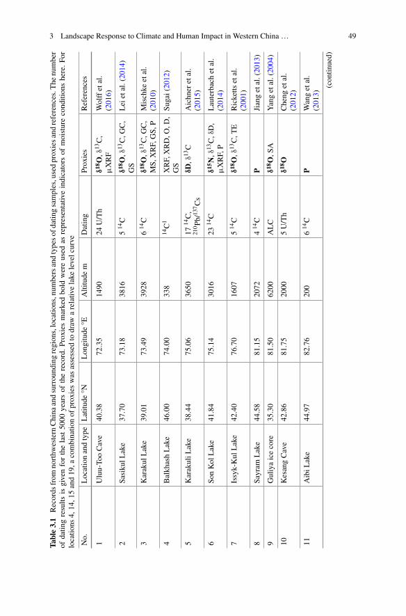
3 Landscape Response to Climate and Human Impact in Western China … 49
Table3.1
Records
from
northw
estern
China
andsurroundingregions,locatio
ns,num
bersandtypesof
datin
gsamples,usedproxiesandreferences.T
henumber
ofdatin
gresults
isgivenforthelast5000
yearsof
therecord.Proxiesmarkedbold
wereused
asrepresentativ
eindicators
ofmoistureconditionshere.Fo
rlocatio
ns4,
14,1
5and19,a
combinatio
nof
proxieswas
assessed
todraw
arelativ
elake
levelcurve
No.
Locationandtype
Latitu
de°N
Longitude
°EAltitude
mDating
Proxies
References
1Uluu-To
oCave
40.38
72.35
1490
24U/Th
δ18O,δ
13C,
μXRF
Wolffetal.
(2016)
2SasikulL
ake
37.70
73.18
3816
514C
δ18O,δ
13C,G
C,
GS
Leietal.(2014)
3Karakul
Lake
39.01
73.49
3928
614C
δ18O,δ
13C,G
C,
MS,
XRF,GS,
PMischke
etal.
(2010)
4Balkh
ashLake
46.00
74.00
338
14C1
XRF,XRD,O
,D,
GS
Sugai(2012)
5KarakuliL
ake
38.44
75.06
3650
1714C,
210Pb
/137Cs
δD,δ
13C
Aichn
eretal.
(2015)
6So
nKol
Lake
41.84
75.14
3016
2314C
δ15N,δ
13C,δD,
μXRF,P
Lauterbachetal.
(2014)
7Issyk-Kul
Lake
42.40
76.70
1607
514C
δ18O,δ
13C,T
ERicketts
etal.
(2001)
8Sa
yram
Lake
44.58
81.15
2072
414C
PJiangetal.(2013)
9Guliyaicecore
35.30
81.50
6200
ALC
δ18O,S
AYangetal.(2004)
10KesangCave
42.86
81.75
2000
5U/Th
δ18O
Cheng
etal.
(2012)
11AibiL
ake
44.97
82.76
200
614C
PWangetal.
(2013)
(contin
ued)
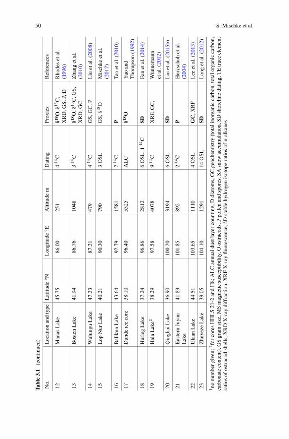
50 S. Mischke et al.
Table3.1
(contin
ued)
No.
Locationandtype
Latitu
de°N
Longitude
°EAltitude
mDating
Proxies
References
12Manas
Lake
45.75
86.00
251
414C
δ18O,δ
13C,
XRD,G
S,P,D
Rho
desetal.
(1996)
13BostenLake
41.94
86.76
1048
314C
δ18O,δ
13C,G
S,XRD,G
CZhang
etal.
(2010)
14Wulungu
Lake
47.23
87.21
479
414C
GS,
GC,P
Liu
etal.(2008)
15Lop
Nur
Lake
40.21
90.30
790
3OSL
GS,
δ18O
Mischke
etal.
(2017)
16Balikun
Lake
43.64
92.79
1581
714C
PTaoetal.(2010)
17Dunde
icecore
38.10
96.40
5325
ALC
δ18O
Yao
and
Thompson
(1992)
18HurlegLake
37.24
96.86
2812
6OSL
,114C
SDFanetal.(2014)
19HalaLake2
38.29
97.58
4078
914C
XRF,GC,
Wünnemann
etal.(2012)
20QinghaiLake
36.90
100.20
3194
6OSL
SDLiu
etal.(2015b)
21Eastern
Juyan
Lake
41.89
101.85
892
214C
PHerzschuh
etal.
(2004)
22Ulaan
Lake
44.51
103.65
1110
4OSL
GC,X
RF
Lee
etal.(2013)
23Zhuyeze
Lake
39.05
104.10
1291
14OSL
SDLon
getal.(2012)
1no
numbergiven;
2forcoresHHLS21-2
andH8;
ALCannualdustlayercountin
g,Ddiatom
s,GCgeochemistry(totalinorganiccarbon,totalorganiccarbon,
carbon
atecontent),G
Sgrainsize,M
Smagnetic
susceptib
ility,O
ostracod
s,Ppo
llenandspores,S
Asnow
accumulation,SD
shorelinedatin
g,TEtraceelem
ent
ratio
sof
ostracod
shells,X
RDX-ray
diffraction,
XRFX-ray
fluorescence,
δDstablehydrogen
isotoperatio
sof
n-alkanes

3 Landscape Response to Climate and Human Impact in Western China … 51
Fig. 3.1 Location of the reviewed climate records from northwestern China and surroundingregions. Extent of Qin Dynasty (light green and dotted line) and of Han Dynasty (green) empiresmarked. (References provided in Table 3.1)
Fig. 3.2 Lake records from the western section of the discussed region. Vertical grey bars at leftof records indicate calibrated 14C ages with 2σ error ranges. Duration of Han Dynasty marked byblue bar. (References and additional chronological information provided in Table 3.1)
record is not well constrained for the period of the Han Dynasty due to the absenceof radiocarbon data between about 3000 and 500 a BP but relatively low changes of

52 S. Mischke et al.
the sediment accumulation rate might be expected for a large and deep lake such asIssyk-Kul (Fig. 3.2). Interpolated sample ages between dated stratigraphic levels inthe obtained sediment core are probably relatively robust. However, the decrease ofδ18O values over the Han period probably represents a rising lake level which led tooverflow conditions and a lake level at least 16 m higher than present between 1400and 1200 a BP. Thus, increasingly wet conditions were inferred from the lakes SonKol and Issyk-Kul in the central Tianshan Mountains.
BalkhashLake in the northern foreland of theTianshanMountains lies at ca. 340masl. The closed-basin lake drains a large catchment area of 501,000 km2 includingthe northern ranges of the Tianshan Mountains and the Dzungarian Alatau (Chibaet al. 2016). Palaeoclimate signals from the lake are therefore expected to integratelocal peculiarities and should represent regional climate conditions. However, lateHolocene climate records from the lake presented in previous years often cover onlythe last 1000 or 1800 a BP and do not include the period of the Han Dynasty (Endoet al. 2010; Narama et al. 2010; Chiba et al. 2016). The rough assessment of relativelake level changes of Sugai (2012) includes two periods of low lake levels between2500 and 2000 a BP and 1300 and 1000 a BP (Fig. 3.2). Correspondingly, a low-lake-level period between 2500 and 1800 a BP was described by Akhmetyev et al.(2005). Relatively dry conditions existed in the catchment of Balkhash Lake duringthe early half of the Han period or the entire Han time, which subsequently gave wayto wetter conditions in the region.
3.3.2 Lake Records from the Central Region
One additional lake record is available from relatively high altitude in the easternTianshan Mountains. Pollen data were reported from Sayram Lake which is sur-rounded by steppe vegetation (Jiang et al. 2013). The setting of the lake with rela-tively dense vegetation in its vicinity and its moderate size (453 km2) suggest thatthe pollen record mostly represents local and regional vegetation. Pollen transportedover far distances contributed probably to a minor degree to the recorded assem-blages. The Artemisia/Chenopodiaceae (A/C) ratio was used as a moisture indicatorto discriminate between steppe (higher A/C ratios) and desert (lower A/C ratios) veg-etation (Jiang et al. 2013). The A/C ratio is increasing continuously from ca. 2500a BP to 800 a BP, and increasingly wetter conditions are inferred over the period ofthe Han Dynasty (Fig. 3.3).
Three lake records were presented for the Junggar Basin between the TianshanMountains in the south and the Altai Mountains in the north (Fig. 3.1). Aibi Lake is aclosed-basin lake in the southwestern part of the JunggarBasin 150kmeast of SayramLake. Pollen data from the desert environment of the lake probably represent regionalvegetation changes. The pollen concentration as a measure of vegetation density andtheA/C ratio increase from3600 to 1400 aBP (Wang et al. 2013). Increasingmoistureavailability is inferred for the Han Dynasty period in the Aibi Lake region (Fig. 3.3).Manas Lake 250 km further northeast of Aibi Lake was a terminal salt lake until the

3 Landscape Response to Climate and Human Impact in Western China … 53
1960s before the lake turned into a salt-covered playa as a result of the diversion ofthe entering Manas River for agricultural purposes (Rhodes et al. 1996). Lake andriver sediments were recovered in Holocene sediment cores from near the formerlake’s centre. Phases of lake formation regarded as wetter climate periods existedfrom 4500 to 2500 a BP and from 2000 to 1000 a BP. The δ18O values for carbonateincrease during the initial period of lake formation after 2000 a BP as a result of theevaporative enrichment in a stagnant water body. δ18O values from the river periodbefore the lake phase are not regarded as good climate proxy here because they likelyrepresent a mixed signal of detrital carbonate grains fromMesozoic limestones in theupper reaches of the Manas River, reworked carbonate from earlier deposited lakecarbonates in Manas Lake, and possibly authigenic carbonate formed in the slowly-flowing river. However, a transition from drier to wetter conditions is reflected duringthe Han Dynasty through the replacement of river sediments by lake sediments atabout 2000 a BP (Fig. 3.3). Wulungu Lake 180 km further northeast receives waterfrom the southern slopes of the Altai Mountains. A multiproxy record of grain size,geochemistry and pollen data from the terminal lake was used by Liu et al. (2008)to construct a lake level curve for the Holocene. The surroundings of the lake arecharacterized by desert vegetation and the pollen record is regarded to reflect regionalvegetation changes. The authors recorded a high lake level during the Han Dynastyand a change from desert steppe to steppe vegetation in the region (Fig. 3.3). Thus,relatively wet conditions were recorded for the northern part of the Junggar Basin.
A δ18O record of authigenic carbonate from Bosten Lake in the Yanqi Basinbetween the Junggar and Tarim basins was provided by Zhang et al. (2010). AlthoughKonqi River is the outflow of Bosten Lake, the lake probably behaves like a semi-closed lake due to the close location of the in- and outflows at its western margin(Mischke and Wünnemann 2006). As a result, a significant W-E oriented salinity
Fig. 3.3 Lake records from the central section of the discussed region. Vertical grey bars at leftof records indicate age data with 2σ error ranges. Duration of Han Dynasty marked by blue bar.(References and additional chronological information provided in Table 3.1)

54 S. Mischke et al.
gradient from 0.5 to 2.5‰ exists in the lake (Jin et al. 1990). The δ18O values rapidlyincrease at the beginning of the Han Dynasty as a result of a reduced inflow incomparison to evaporation. The δ18O values remain high during the Han period andin the subsequent two centuries (Fig. 3.3). Rapidly decreasing moisture availabilitywith a significantly reduced inflow to the lake in the early part of the Han Dynastyand dry conditions afterwards are suggested based on the Bosten Lake data.
Lop Nur Lake 350 km further to the southeast of Bosten Lake was a terminal lakebefore its desiccation in the late 1930s or early 1940s. The lake represented the baselevel for the Konqi and Tarim rivers. Stable isotope data of carbonate and grain-sizedata of detrital sediments from a dug section in the centre of the dry lake basin werediscussed by Mischke et al. (2017) who argued that a first period of massive aeoliansand deposition in the lake basin occurred 1800 a BP and caused the near-desiccationof the lake. A relative lake level curve based on the earlier presented data includestwo periods of rapid lake-level lowering before and at the end of the Han Dynasty(Fig. 3.3). Thus, diminishing moisture availability during the Han period is indicatedby the record from Lop Nur.
Another mountain foreland lake record was provided from Balikun Lake some430 km in the northeast of Lop Nur (Tao et al. 2010). The A/C ratios for a Holocenelake sediment core increase steadily over the Han Dynasty period with a minor droprecorded following the termination of the Han time (Fig. 3.3). However, A/C ratiosincrease from the middle Holocene at about 4000 a BP to the late Holocene at about1000 a BP, and relatively wet conditions are inferred for the Han Dynasty period.
3.3.3 Lake Records from the East
A lake record from the large Qaidam Basin between the Qilian Mountains in thenorth and the Kunlun Mountains in the south, and two records from intramontanebasins in the Qilian Mountains represent climate archives from relatively high alti-tude in the eastern part of the examined region. Hurleg Lake is an open-basin lake inthe eastern Qaidam Basin with a moderate catchment area of 12,600 km2 (Fan et al.2014). Shoreline deposits above the present lake level were dated using opticallystimulated luminescence (OSL) dating and used as proxies of higher lake levels dur-ing wetter periods. The proposed high lake-level period between ca. 2200 and 1400a BP suggests that the time of the Han Dynasty was a wetter period in comparisonto today’s conditions in the region (Fig. 3.4). Hala Lake 130 km to the northeastis a terminal lake which was studied as a climate archive in detail by Wünnemannet al. (2012). Their multi-proxy data were synthesized in a relative lake level curve(Fig. 3.4). Rising lake levels starting a few centuries before the beginning of theHan Dynasty and continuing a few centuries afterwards suggest increasingly wetconditions during the Han time. Qinghai Lake 270 km to the southeast of Hala Lakeis also a closed-basin lake (Fig. 3.1). OSL dating of shoreline deposits suggests thatrelatively low levels existed before the Han Dynasty, rising levels during the periodof the Han, and high levels at its end and in the subsequent centuries (Fig. 3.4; Liu
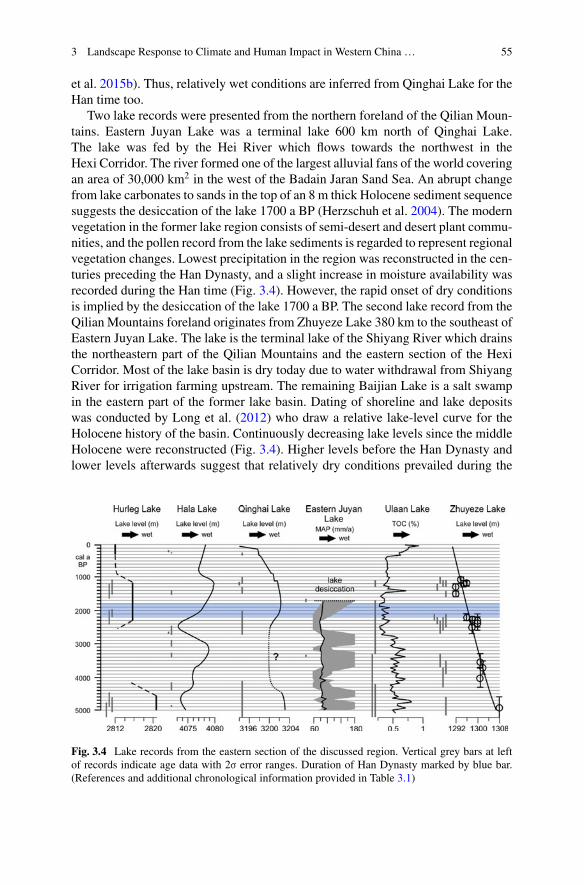
3 Landscape Response to Climate and Human Impact in Western China … 55
et al. 2015b). Thus, relatively wet conditions are inferred from Qinghai Lake for theHan time too.
Two lake records were presented from the northern foreland of the Qilian Moun-tains. Eastern Juyan Lake was a terminal lake 600 km north of Qinghai Lake.The lake was fed by the Hei River which flows towards the northwest in theHexi Corridor. The river formed one of the largest alluvial fans of the world coveringan area of 30,000 km2 in the west of the Badain Jaran Sand Sea. An abrupt changefrom lake carbonates to sands in the top of an 8 m thick Holocene sediment sequencesuggests the desiccation of the lake 1700 a BP (Herzschuh et al. 2004). The modernvegetation in the former lake region consists of semi-desert and desert plant commu-nities, and the pollen record from the lake sediments is regarded to represent regionalvegetation changes. Lowest precipitation in the region was reconstructed in the cen-turies preceding the Han Dynasty, and a slight increase in moisture availability wasrecorded during the Han time (Fig. 3.4). However, the rapid onset of dry conditionsis implied by the desiccation of the lake 1700 a BP. The second lake record from theQilian Mountains foreland originates from Zhuyeze Lake 380 km to the southeast ofEastern Juyan Lake. The lake is the terminal lake of the Shiyang River which drainsthe northeastern part of the Qilian Mountains and the eastern section of the HexiCorridor. Most of the lake basin is dry today due to water withdrawal from ShiyangRiver for irrigation farming upstream. The remaining Baijian Lake is a salt swampin the eastern part of the former lake basin. Dating of shoreline and lake depositswas conducted by Long et al. (2012) who draw a relative lake-level curve for theHolocene history of the basin. Continuously decreasing lake levels since the middleHolocene were reconstructed (Fig. 3.4). Higher levels before the Han Dynasty andlower levels afterwards suggest that relatively dry conditions prevailed during the
Fig. 3.4 Lake records from the eastern section of the discussed region. Vertical grey bars at leftof records indicate age data with 2σ error ranges. Duration of Han Dynasty marked by blue bar.(References and additional chronological information provided in Table 3.1)

56 S. Mischke et al.
Han time. The western part of the former lake basin (Qingtu Lake) fell dry 2100 aBP at the section location QTL02 investigated by Mischke et al. (2016).
Ulaan Lake is a terminal lake 600 km to the north of Zhuyeze Lake. The lake is drysince the mid 1990s until it was fed by the Ongin River from the southeastern rangesof the Khangai Mountains in central Mongolia. Total organic carbon (TOC) contentsof lake sediments of a Holocene core were used as proxy of summermonsoon precip-itation and warmer and moister climate by Lee et al. (2013). Before, during and afterthe Han Dynasty, very low TOC values indicate dry conditions and predominantlyaccumulation of detrital particles in the lake (Fig. 3.4). Thus, generally dry condi-tions were recorded at Ulaan Lake during the Han Dynasty. However, the obtainedOSL age data have large uncertainties and more studies are required to understandclimate conditions in southern Mongolia during the last millennia (Fig. 3.4).
3.3.4 Speleothem Records
Two speleothem records are available for the region, the Uluu-Too Cave record fromthe western Tianshan Mountains and the Kesang Cave record from the eastern partof the mountain range. Relatively low δ18O values for the speleothem record fromUluu-Too Cave during the Han Dynasty suggest relatively wet conditions (Wolffet al. 2016; Fig. 3.5). Higher values 200 a before the beginning of the Han time andalso soon afterwards indicate relatively dry conditions. The δ18O pattern is differentat Kesang Cave 800 km further to the northeast. The δ18O values are moderateduring the Han period with lower values indicating wetter conditions before andmostly higher values suggesting relatively dry conditions afterwards (Cheng et al.2012; Fig. 3.5). Thus, the two speleothem records from the Tianshan Mountains donot provide a consistent reconstruction of the climate conditions in the region. TheUluu-Too Cave record shows some similarities with the δD record from KarakuliLake which is 320 km to the southeast of the cave location. Low δ18O values of thecave carbonates and low δD values for terrestrial biomarkers from Karakuli Lakewere recorded at 3000 a BP or shortly before, at 2500 a BP and at the end of theHan Dynasty 1800 a BP (Aichner et al. 2015; Wolff et al. 2016; Figs. 3.2 and 3.5).Similarities with the closer Karakul Lake in Tajikistan (170 km in the southeast ofUluu-Too Cave) are less obvious. Sayram Lake is the closest lake record for KesangCave, but the wetness proxies from both sites show unrelated patterns apart frompossibly corresponding wet conditions inferred from Kesang Cave 600 a BP and atSayram Lake 800 a BP. There are significant altitudinal differences between the caveand lake locations, and it is not clear whether stable isotope or pollen records fromlakes reflecting catchment-wide climate conditions or regional vegetation changescan be easily comparedwithmore site-specific speleothem records. The δ18O recordsof the speleothems mainly reflect the stable isotope composition of precipitationabove the caves which is mainly determined by δ18O changes of water vapour inupstream regions and the pathways of air masses. Air mass trajectories for Uluu-Too Cave in 2014 show a large variability of moisture source areas ranging from
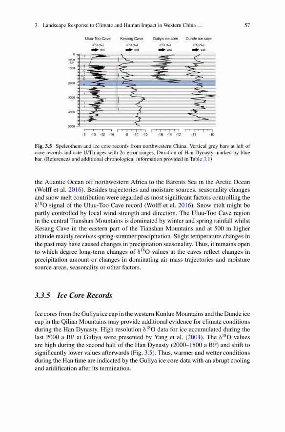
3 Landscape Response to Climate and Human Impact in Western China … 57
Fig. 3.5 Speleothem and ice core records from northwestern China. Vertical grey bars at left ofcave records indicate U/Th ages with 2σ error ranges. Duration of Han Dynasty marked by bluebar. (References and additional chronological information provided in Table 3.1)
the Atlantic Ocean off northwestern Africa to the Barents Sea in the Arctic Ocean(Wolff et al. 2016). Besides trajectories and moisture sources, seasonality changesand snow melt contribution were regarded as most significant factors controlling theδ18O signal of the Uluu-Too Cave record (Wolff et al. 2016). Snow melt might bepartly controlled by local wind strength and direction. The Uluu-Too Cave regionin the central Tianshan Mountains is dominated by winter and spring rainfall whilstKesang Cave in the eastern part of the Tianshan Mountains and at 500 m higheraltitude mainly receives spring-summer precipitation. Slight temperature changes inthe past may have caused changes in precipitation seasonality. Thus, it remains opento which degree long-term changes of δ18O values at the caves reflect changes inprecipitation amount or changes in dominating air mass trajectories and moisturesource areas, seasonality or other factors.
3.3.5 Ice Core Records
Ice cores from theGuliya ice cap in the western KunlunMountains and the Dunde icecap in the Qilian Mountains may provide additional evidence for climate conditionsduring the Han Dynasty. High resolution δ18O data for ice accumulated during thelast 2000 a BP at Guliya were presented by Yang et al. (2004). The δ18O valuesare high during the second half of the Han Dynasty (2000–1800 a BP) and shift tosignificantly lower values afterwards (Fig. 3.5). Thus, warmer and wetter conditionsduring the Han time are indicated by the Guliya ice core data with an abrupt coolingand aridification after its termination.
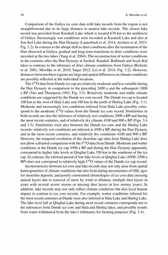
58 S. Mischke et al.
Comparison of the Guliya ice core data with lake records from the region is notstraightforward due to its large distance to nearest lake records. The closest lakerecord was provided from Karakuli Lake which is located 670 km to the northwestof Guliya. Increasingly wet conditions were recorded at Karakuli Lake and also atSon Kol Lake during the Han Dynasty (Lauterbach et al. 2014; Aichner et al. 2015;Fig. 3.2). In contrast to the abrupt shift to drier conditions after the termination of theHan observed at Guliya, gradual and long-term transitions to drier conditions wererecorded at the two lakes (Yang et al. 2004). The reconstruction of wetter conditionsin the centuries after the Han Dynasty at Sasikul, Karakul, Balkhash and Issyk-Kullakes is contrary to the inference of drier climate conditions from Guliya (Rickettset al. 2001; Mischke et al. 2010; Sugai 2012; Lei et al. 2014; Fig. 3.2). However,distances between these regions are large and spatial differences in climate conditionsare possibly reflected at the individual locations.
The δ18O data fromDunde ice cap are relatively moderate and less variable duringthe Han Dynasty in comparison to the preceding 2400 a and the subsequent 1800a BP (Yao and Thompson 1992; Fig. 3.5). Relatively moderate and stable climateconditions are suggested by the Dunde ice core record. The Dunde ice cap is located100 km to the west of Hala Lake and 100 km in the north of Hurleg Lake (Fig. 3.1).Moderate and increasingly wet conditions inferred from Hala Lake possibly corre-spond to the moderate δ18O values from the Dunde ice core record. Similarities inboth records are also the inference of relatively wet conditions 2900 a BP and duringthe most recent centuries, and of relatively dry climate 4100 and 900 a BP (Figs. 3.4and 3.5). Similarities exist also between the Dunde ice core and the Hurleg Lakerecords: relatively wet conditions are inferred at 4500 a BP, during the Han Dynastyand in the most recent centuries, and relatively dry conditions 4100 and 900 a BP.However, the temporal resolution of the shoreline age data from Hurleg Lake doesnot allow a detailed comparison with the δ18O data fromDunde.Moderate andwetterconditions at the Dunde ice cap 4500 a BP and during the Han Dynasty apparentlycorrespond to higher lake levels at Qinghai Lake 350 km to the southeast of the icecap. In contrast, the inferred period of low lake levels at Qinghai Lake (4500–2500 aBP) does not correspond to relatively high δ18O values of the Dunde ice cap record.
Inconsistencies between ice core and lake records may not only arise from spatialheterogeneities of climate conditions but also from dating uncertainties of OSL agesfor shoreline deposits, and poorly constrained chronologies of ice core data (missingannual layers due to removal of snow by wind or ablation, multiple dust layers inyears with several severe storms or missing dust layers in less stormy years). Inaddition, lake records may not only reflect climate conditions but also local humanimpact in contrast to ice core records. For example, wetter conditions inferred forthe most recent centuries at Dunde were also inferred at Hala Lake and Hurleg Lake.The lake-level fall at Qinghai Lake during most recent centuries corresponds not tothe inferences from Dunde ice core and Hala and Hurleg lakes, and possibly resultsfrom water withdrawal from the lake’s tributaries for farming purposes (Fig. 3.4).
3 Landscape Response to Climate and Human Impact in Western China … 59
3.4 Lake Records Which Indicate Significant DryingDuring or After the Han Dynasty
Themajority of the lake records indicate either increasingmoisture availability duringthe Han Dynasty (Balkhash, Karakuli, Son Kol, Issyk-Kul, Sayram, Aibi, Manas,Balikun and Hala lakes) or generally wet conditions (Wulungu, Hurleg and Qinghailakes; Figs. 3.2, 3.3 and 4). A significant decrease of moisture available and drierconditions during the Han period or shortly afterwards were recorded at Bosten, LopNur, Eastern Juyan and Zhuyeze lakes (Figs. 3.3 and 3.4). Generally dry conditionsduring the Han time and in the centuries before and afterwards were recorded at threelakes (Sasikul, Karakul and Ulaan lakes; Figs. 3.2 and 3.4).
Different types of evidence were provided for the four lakes which apparentlyexperienced distinctive reductions in moisture availability during the Han time orin the subsequent centuries. The desiccation of the Eastern Juyan Lake at 1700a BP is probably the most significant evidence for dramatic landscape change(Herzschuh et al. 2004). However, the record of predominantly aeolian sands inthe Lop Nur Lake region at 1800 a BP for the first time since sediments were accu-mulated in the investigated sequence at 9000 a BP is also strong evidence for asignificant decrease in moisture availability and the near desiccation of the lake(Mischke et al. 2017). δ18O values of lake carbonates increased by 4‰ at BostenLake between 2300 and 2100 a BP, and a major reduction in moisture availabilityand inflow was reconstructed (Zhang et al. 2010). Shoreline deposits higher beforethe Han Dynasty and ca. 4 m lower afterwards were recorded at Zhuyeze Lake (Longet al. 2012). Thus, the accumulated evidence for drier conditions at these lakes duringthe Han time and shortly afterwards is robust.
The four lakes are all located in the forelands of high mountain ranges. Thecatchment areas are generally large, ranging from>500,000 km2 for Lop Nur Laketo 41,600 km2 for Zhuyeze Lake (Long et al. 2012). Thus, the four lakes representrelatively large regions and do not reflect local hydrological peculiarities. Tributariesof the four lakes originate at high altitude in the Tianshan and Qilian Mountains. Themain tributaries of Bosten and Lop Nur Lake are the Kaidu, Konqi and Tarim riverswhich flow through the transitional belts between the mountains and the desertsin the basin centres which are mostly used for agriculture today. Similarly, mostof today’s intensively farmed fertile Hexi Corridor in the northern foreland of theQilian Mountains is drained by the tributaries of the Eastern Juyan (Hei River) andZhuyeze (Shiyang River) lakes. Thus, all four lakes are characterized by catchmentareas which include significant portions along the foot of large mountain rangesintensively used as farmlands today. Another characteristic in commonwith the lakesthat experienced a change to significantly drier conditions during the Han Dynastyor in the following centuries is that these lakes are situated within the area of theHan Dynasty expansion of the Chinese empire (Fig. 3.6). All other examined lakerecords originate from regions in the west, north or south of the Han Dynasty realm.
The spatial pattern of a change to significantly drier conditions during or shortlyafter the Han Dynasty at the four lakes and mostly increasingly wetter or generally
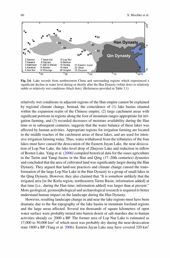
60 S. Mischke et al.
Fig. 3.6 Lake records from northwestern China and surrounding regions which experienced asignificant decline in water level during or shortly after the Han Dynasty (white dots) or relativelystable or relatively wet conditions (black dots). (References provided in Table 3.1)
relatively wet conditions in adjacent regions of the Han empire cannot be explainedby regional climate change. Instead, the coincidence of (1) lake basins situatedwithin the expansion realm of the Chinese empire, (2) large catchment areas withsignificant portions in regions along the foot of mountain ranges appropriate for irri-gation farming, and (3) recorded decreases of moisture availability during the Hantime or in subsequent centuries, suggests that the water balance of these lakes wasaffected by human activities. Appropriate regions for irrigation farming are locatedin the middle reaches of the catchment areas of these lakes, and are used for inten-sive irrigation farming today. Thus, water withdrawal from the tributaries of the fourlakes must have caused the desiccation of the Eastern Juyan Lake, the near desicca-tion of Lop Nur Lake, the lake-level drop of Zhuyeze Lake and reduction in inflowof Bosten Lake. Yang et al. (2006) compiled historical data for the oases agriculturein the Tarim and Yanqi basins in the Han and Qing (17–20th centuries) dynastiesand concluded that the area of cultivated land was significantly larger during the HanDynasty. They argued that land-use practices and climate change caused the trans-formation of the large Lop Nur Lake in the Han Dynasty to a group of small lakes inthe Qing Dynasty. However, they also claimed that “It is somehow unlikely that theirrigated area [in the Korla region, northeastern Tarim Basin; information added] atthat time [i.e., during the Han time; information added] was larger than at present.”More geological, geomorphological and archaeological research is required to betterunderstand human impact on the landscape during the Han Dynasty.
However, resulting landscape change in and near the lake regions must have beendramatic due to the flat topography of the lake basins in mountain foreland regionsand the large areas affected. Several ten thousands of square kilometres of openwater surface were probably turned into barren desert or salt marshes due to humanactivities already ca. 2000 a BP. The former area of Lop Nur Lake is estimated as17,000 to 50,000 km2 of which most was probably dry during the near-desiccationstate 1800 a BP (Yang et al. 2006). Eastern Juyan Lake may have covered 320 km2

3 Landscape Response to Climate and Human Impact in Western China … 61
before its desiccation (Hartmann et al. 2011). The drying of the western sub-basin ofZhuyeze Lake, the Qingtu Lake Basin, probably left some 500 km2 of previous lakearea dry. The areal changes of Bosten Lake are not inferred in a straightforward wayfrom the stable isotope data but the observed 1.5 m lake-level difference between theyears 1980 and 2000 caused a change of lake area by ca. 650 km2, which shows thata relatively minor lake level fall results in a significant lake area reduction (Wanget al. 2003). Thus, substantial areas were apparently turned into barren desert orsalt marshes in the four lake regions as a consequence of water withdrawal fromtributaries during the Han Dynasty and in the subsequent centuries.
Whilst regional changes of climate conditions are ruled out here as potentialdrivers of lake desiccation or lake-level decrease during and after the Han time,hydrological changes may have contributed to the desiccation of the Eastern JuyanLake. Active channels of the Hei River on its large alluvial fan in the north of the HexiCorridor may have become inactive due to the rapid filling of channels by fluvialsediments and formation of new channels, or due to blockage of active channels bydunes moving over the fan surface. Thus, the terminal Eastern Juyan Lake on thedistal margin of the fan is not only controlled by regional climate conditions anddischarge under natural conditions, and by water withdrawal upstream in the HexiCorridor, but also by channel avulsion processes in a flat-lying terrain. However,similar processes were probably negligible for the other three lake catchments.
Another yet ignored line of evidence for potential landscape change triggered byman during the Han Dynasty or in subsequent centuries is the change of land-usepractices and possible landscape degradation in or near the core region of the Chineseempire. For example, dramatic landscape change ca. 2000 a BP has been reportedfrom the Ulan Buh Desert in southwestern Inner Mongolia at the margin of the QinDynasty realm preceding the Han Dynasty (Li et al. 2015). Tectonic activity andclimate change were suggested as causes of aridification in the Ulan Buh Desertso far (Li et al. 2015). Further to the east and within the Qin Dynasty realm, sandmobilization and dune formation occurred apparently already as a result of a massivemigration of people and farming intensification in the Mu Us Desert region duringthe earlier half of the Han time, the Western Han (206 BCE–9 CE; Sun 2000). Here,man’s impact was clearly identified. Further in the southeastern part of the Mu UsDesert, studies by Li et al. (2011) and Liu and Lai (2012) implied a drastic changefrom long-term sediment accumulation to rapid incision of the Salawusu River by60 m since 2000 or 1750 a BP. Other rivers on the Chinese Loess Plateau have latePleistocene and older terraces, and apparently significantly lower erosion rates (Qiuet al. 2014). Thus, it remains open to which degree intensified land use or changingpractices during the prosperous Han Dynasty may have contributed to landscapechange in the core region of the Chinese Empire too.

62 S. Mischke et al.
3.5 Conclusions and Perspectives
The comparison of lake, speleothem and ice core records from northwestern Chinaand surrounding regions for the Han Dynasty period and subsequent centuries showsthat relatively wet climate conditions were mostly inferred for areas immediatelyto the west, north and south of the Han Empire realm. In contrast, the availablefour lake records from within the Han Empire region witnessed decreased moistureavailability and significant landscape change ranging from substantial decreases inlake level and open-water surface areas (Bosten and Zhuyeze lakes) to near (Lop NurLake) or complete desiccation (Eastern JuyanLake) of lake basins. The spatial patternof lake records indicating drier conditions during the Han time or shortly afterwardscannot be explained by climate change due to mostly wetter conditions inferredfrom nearby locations which are outside the Han Dynasty region. Thus, man-madeimpact on surface waters must already have reached an order of magnitude duringthe Han Dynasty which was sufficient to cause large-scale landscape change. Waterwithdrawal from the tributaries of the lakes for irrigation farming was most likelythe main driver of landscape deterioration downstream.
The timing of landscape response is not very consistent and partly not well con-strained for the four lake basins. Significant reductions in inflow are recorded atBosten and Lop Nur lakes as early as 2300 a BP and more significantly at Lop NurLake 1800 a BP whilst the desiccation of the Eastern Juyan Lake occurred 1700 aBP. The underlying radiocarbon and OSL chronologies are likely not precise dueto problematic materials used for dating (e.g., bulk organic matter for radiocarbondating potentially biased by lake-reservoir effects; Mischke et al. 2013) or uncertain-ties in post-depositional water content assessments for OSL dating. The lowering ofthe level of Zhuyeze Lake during the Han Dynasty is also not precisely constraineddue to the dating of higher shoreline deposits with ages preceding the Han time anddating of lower deposits formed after the Han Dynasty (Fig. 3.4). Thus, it remainsopen whether man exerted significant impacts on local hydrological systems alreadyas early as the beginning of the Han Dynasty or even before, or whether significantimpacts occurred only after the initial Han Dynasty expansion to the west. Betterconstrained chronological control is required to answer such questions in the future.
Our conclusion that man impacted the landscape already in a very significantway as early as the Han Dynasty clearly calls for an assessment using other lines ofevidence. Archaeological field evidence for intensive irrigation farming during theHan Dynasty such as remnants of artificial channels, dams and reservoirs, soils andfarmlands buried beneath aeolian sands, and ruins of desert oases from Han timescould be assessed in future studies in addition to the screening of written historicaldocuments. Detailed geological, geomorphological and archaeological studies arerequired to better understand early human impact on fragile landscapes in the aridand semi-arid regions of Central Asia.
Acknowledgements Funding was provided by China’s NSF projects (40830420, 41471003), theState key project (2003BA612A-06–15) of the Ministry of Science and Technology of China andthe German Research Foundation (DFG grant Mi 730/16-1). PAGES provided a travel grant to SM
3 Landscape Response to Climate and Human Impact in Western China … 63
for participation in the workshop “The Rise and Fall: Environmental Factors in the Socio-CulturalChanges of the Ancient Silk Road Area” in Kiel (Germany) in September 28–29, 2017.
References
Aichner, B., Feakins, S., Lee, J. E., Herzschuh, U., & Liu, X. (2015). High-resolution leaf waxcarbon and hydrogen isotopic record of the late Holocene paleoclimate in arid Central Asia.Climate of the Past, 11, 619–633.
Akhmetyev, M. A., Dodoniv, A. E., Somikova, M. V., Spasskaya, I. I., Kremenetsky, K. V., & Kli-manov, V. A. (2005) Kazakhstan and Central Asia (Plains and foothills). In A. A. Velichko, &V. P.Nechaev (Eds.), Cenozoic climatic and environmental changes in Russia (vol. 382, pp. 139–161).Geological Society of America Special Paper.
An, Z., Porter, S. C., Kutzbach, J. E., Wu, X., Wang, S., Liu, X., et al. (2000). AsynchronousHolocene optimum of the East Asian monsoon. Quaternary Science Reviews, 19, 743–762.
Chen, F., Yu, Z., Yang, M., Ito, E., Wang, S., Madsen, D. B., et al. (2008). Holocene moistureevolution in arid central Asia and its out-of-phase relationship with Asian monsoon history.Quaternary Science Reviews, 27, 351–364.
Cheng, H., Zhang, P. Z., Spötl, C., Edwards, R. L., Cai, Y. J., Zhang, D. Z., et al. (2012). The climaticcyclicity in semiarid-arid central Asia over the past 500,000 years. Geophysical Research Letters,39, L01705. https://doi.org/10.1029/2011GL050202.
Chen, F., Wu, D., Chen, J., Zhou, A., Yu, J., Shen, J., et al. (2016). Holocene moisture and EastAsian summer monsoon evolution in the northeastern Tibetan Plateau recorded by Lake Qinghaiand its environs: A review of conflicting proxies. Quaternary Science Reviews, 154, 111–129.
Chiba, T., Endo, K., Sugai, T., Haraguchi, T., Kondo, R., & Kubota, J. (2016). Reconstruction ofLake Balkhash levels and precipitation/evaporation changes during the last 2000 years from fossildiatom assemblages. Quaternary International, 397, 330–341.
Endo, K., Chiba, T., Sugai, T., Haraguchi, T., Yamazaki, H., Nakayama, H., Yoshinaga, Y., Miy-ata, K., Ogino, O., Arakawa, K., Nakao, Y., Komori, J., Kondo, Matsuoka, H., Aubekerov, B.Z., Sala, R., Deom, J.-M., Sohma, R., & Kubota, J. (2010). Reconstruction of lake level andpaleoenvironmental changes from a core from Balkhash Lake, Kazakhstan. In M. Watanabe,& J. Kubota (Eds.), Reconceptualizing cultural and environmental change in Central Asia: Anhistorical perspective on the future (pp. 93–104).
Fan, Q. S., Ma, H. Z., Wei, H. C., & An, F. Y. (2014). Holocene lake-level changes of Hurleg Lakeon northeastern Qinghai-Tibetan Plateau and possible forcing mechanism. The Holocene, 24,274–283.
Hartmann, K., Wünnemann, B., Hölz, S., Kraetschell, A., & Zhang, H. C. (2011). Neotectonicconstraints on Gaxun Nur inland basin in north-central China, derived from remote sensing,geomorphology and geophysical analyses. In R. Gloaguen, & L. Ratschbacher (Eds.), Growthand collapse of the Tibetan Plateau (vol. 353, pp. 221–233). Geological Society London SpecialPublications.
Herzschuh, U., Tarasov, P., Wünnemann, B., & Hartmann, K. (2004). Holocene vegetation andclimate of the Alashan Plateau, NW China, reconstructed from pollen data. Palaeogeography,Palaeoclimatology, Palaeoecology, 211, 1–17.
Jiang, Q. F., Ji, J. F., Shen, J., Matsumoto, R., Tong, G. B., Qian, P., et al. (2013). Holocenevegetational and climatic variation in westerly dominated areas of Central Asia inferred from theSayram Lake in northern Xinjiang, China. Science in China Earth Sciences, 56, 339–353.
Jin, X., Liu, H., Tu, Q., Zhang, Z., & Zhu, X. (Eds.). (1990). Eutrophication of lakes in China. InThe fourth international conference on the conservation and management of lakes, Hangzhou‘90 (652 pp). Chinese Research Academy of Environmental Sciences.
64 S. Mischke et al.
Lauterbach, S., Witt, R., Plessen, B., Dulski, P., Prasad, S., Mingram, J., et al. (2014). Climaticimprint of the mid-latitude westerlies in the central Tian Shan of Kyrgyzstan and teleconnectionsto North Atlantic climate variability during the last 6000 years. The Holocene, 24, 970–984.
Lee, M. K., Lee, Y. I., Lim, H. S., Lee, J. I., & Yoon, H. I. (2013). Late Pleistocene-Holocenerecords from Lake Ulaan, southern Mongolia: Implications for east Asian palaeomonsoonalclimate changes. Journal of Quaternary Science, 28, 370–378.
Lei, Y., Tian, L., Bird, B. W., Hou, J., Ding, L., Oimahmadov, I., et al. (2014). A 2540-year recordof moisture variations derived from lacustrine sediment (Sasikul Lake) on the Pamir Plateau. TheHolocene, 24, 761–770.
Li, S.-H., Sun, J., & Li, B. (2011). Holocene environmental changes in central Inner Mongoliarevealed by luminescence dating of sediments from the Sala Us River valley. The Holocene, 22,397–404.
Li, G., Jin, M., Chen, X., Wen, L., Zhang, J., Madsen, D., et al. (2015). Environmental changesin the Ulan Buh Desert, southern Inner Mongolia, China since the middle Pleistocene based onsedimentology, chronology and proxy indexes. Quaternary Science Reviews, 128, 69–80.
Liu, K., & Lai, Z. (2012). Chronology of Holocene sediments from the archaeological Salawususite in the Mu Us Desert in China and its palaeoenvironmental implications. Journal of AsianEarth Sciences, 45, 247–255.
Liu, X., Herzschuh, U., Shen, J., Jiang, Q., &Xiao, X. (2008). Holocene environmental and climaticchanges inferred from Wulungu Lake in northern Xinjiang, China. Quaternary Research, 70,412–425.
Liu, J., Chen, J., Zhang, X., Li, Y., Rao, Z., & Chen, F. (2015a). Holocene East Asian summermonsoon records in northernChina and their inconsistencywithChinese stalagmite δ18O records.Earth-Science Reviews, 148, 194–208.
Liu, X. J., Lai, Z., Madsen, D., & Zeng, F. (2015b). Last deglacial andHolocene lake level variationsof Qinghai Lake, north-eastern Qinghai-Tibetan Plateau. Journal of Quaternary Science, 30,245–257.
Long, H., Lai, Z., Fuchs, M., Zhang, J., & Li, Y. (2012). Timing of Late Quaternary palaeolakeevolution in Tengger Desert of northern China and its possible forcing mechanisms. Global andPlanetary Change, 92–93, 119–129.
Lü, H., Xia, X., Liu, J., Qin, X., Wang, F., Yidilisi, A., et al. (2009). A preliminary study ofchronology for a newly discovered ancient city and five archaeological sites in Lop Nor, China.Chinese Science Bulletin, 55, 63–71.
Mischke, S., & Wünnemann, B. (2006). The Holocene salinity history of Bosten Lake (Xinjiang,China) inferred from ostracod species assemblages and shell chemistry: Possible palaeoclimaticimplications. Quaternary International, 154–155, 100–112.
Mischke, S., Rajabov, I., Mustaeva, N., Zhang, C., Herzschuh, U., Boomer, I., et al. (2010). Modernhydrology and late Holocene history of Lake Karakul, eastern Pamirs (Tajikistan): A reconnais-sance study. Palaeogeography, Palaeoclimatology, Palaeoecology, 289, 10–24.
Mischke, S., Weynell, M., Zhang, C., & Wiechert, U. (2013). Spatial variability of 14C reservoireffects in Tibetan Plateau lakes. Quaternary International, 313–314, 147–155.
Mischke, S., Lai, Z., Long, H., & Tian, F. (2016). Holocene climate and landscape change in thenortheastern Tibetan Plateau foreland inferred from the Zhuyeze Lake record. The Holocene, 26,643–654.
Mischke, S., Liu, C., Zhang, J., Zhang, C., Zhang, H., Jiao, P., et al. (2017). The world’s earliestAral-Sea type disaster: the decline of the Loulan Kingdom in the Tarim Basin. Scientific Reports,7, 43102.
Narama, C., Kicengge, Kubota, J., Shatravin, V., Duishonakunov, M., Moholdt, G., & Abdrakhma-tov,K. (2010). The lake-level changes inCentralAsia during the last 1000years based onhistoricalmap. In M. Watanabe, & J. Kubota (Eds.), Reconceptualizing cultural and environmental changein Central Asia: An historical perspective on the future (pp. 11–27).

3 Landscape Response to Climate and Human Impact in Western China … 65
Qin, X., Liu, J., Jia, H., Lu, H., Xia, X., Zhou, L., et al. (2012). New evidence of agricultural activityand environmental change associatedwith the ancient Loulan kingdom, China, around 1500 yearsago. The Holocene, 22, 53–61.
Qiu,W.-L., Zhang, J.-F.,Wang, X.-Y., Guo, Y.-J., Zhuang,M.-G., Fu, X., et al. (2014). The evolutionof the ShiwangheRiver valley in response to theYellowRiver incision in theHukou area, Shaanxi,China. Geomorphology, 215, 34–44.
Rhodes, T. E., Gasse, F., Lin, R., Fontes, J.-C.,Wei,K., Bertrand, P., et al. (1996).ALate Pleistocene-Holocene lacustrine record from Lake Manas, Zunggar (northern Xinjiang, western China).Palaeogeography, Palaeoclimatology, Palaeoecology, 120, 105–121.
Ricketts, R. D., Johnson, T. C., Brown, E. T., Rasmussen, K. A., & Romanovsky, V. V. (2001).The Holocene paleolimnology of Lake Issyk-Kul, Kyrgyzstan: Trace element and stable isotopecomposition of ostracodes. Palaeogeography, Palaeoclimatology, Palaeoecology, 176, 207–227.
Savvaitova, K., & Petr, T. (1992). Lake Issyk-kul, Kirgizia. International Journal of Salt LakeResearch, 1, 21–46.
Sugai, T. (2012).Holocene climatic changes of theBalkhashLake region,Kazakhstan, reconstructedfrom high-resolution XRF scanning analyses of the lake sediments coupled with geomorphicinvestigations of the catchment area. Quaternary International, 279–280, 475.
Sun, J. (2000). Origin of eolian sand mobilization during the past 2300 years in the Mu Us Desert,China. Quaternary Research, 53, 78–88.
Tao, S. C., An, C. B., Chen, F. H., Tang, L. Y., Wang, Z. L., Lü, Y. B., et al. (2010). Pollen-inferredvegetation and environmental changes since 16.7 ka BP at Balikun Lake. Xinjiang. ChineseScience Bulletin, 55, 2449–2457.
Wang, R., Giese, E., &Gao, Q. (2003). Seespiegelschwankungen des Bosten-Sees (VRChina). Zen-trum für internationaleEntwicklungs- undUmweltforschung (ZEU)der Justus-Liebig-UniversitätGießen. Diskussionsbeiträge, 13, 1–38.
Wang, Y., Liu, X., & Herzschuh, U. (2010). Asynchronous evolution of the Indian and East Asiansummer monsoon indicated by Holocene moisture patterns in monsoonal central Asia. Earth-Science Reviews, 103, 135–153.
Wang, W., Feng, Z., Ran, M., & Zhang, C. (2013). Holocene climate and vegetation changesinferred from pollen records of Lake Aibi, northern Xinjiang, China: A potential contribution tounderstanding of Holocene climate pattern in East-central Asia. Quaternary International, 311,54–62.
Wolff, C., Plessen, B., Dudashvilli, A. S., Breitenbach, S. F. M., Cheng, H., Edwards, L. R., et al.(2016). Precipitation evolution of Central Asia during the last 5000 years. The Holocene, 27,142–154.
Wünnemann, B., Wagner, J., Zhang, Y., Yan, D., Wang, R., Shen, Y., et al. (2012). Implicationsof diverse sedimentation patterns in Hala Lake, Qinghai Province, China for reconstructing latequaternary climate. Journal of Paleolimnology, 48, 725–749.
Yang, X., & Liu, X. (2014). Drastic change in China’s lakes and reservoirs over the past decades.Scientific Reports, 4, 6041.
Yang, B., Braeuning, A., Shi, Y., & Chen, F. (2004). Evidence for a late Holocene warm and humidclimate period and environmental characteristics in the arid zones of northwest China during2.2~1.8 kyr B.P. Journal of Geophysical Research, 109, D02105.
Yang, X., Liu, Z., Zhang, F., White, P. D., & Wang, X. (2006). Hydrological changes and landdegradation in the southern and eastern Tarim Basin, Xinjiang, China. Land Degradation andDevelopment, 17, 381–392.
Yao, T., & Thompson, L. G. (1992). Trends and features of climatic changes in the past 5000 yearsrecorded by the Dunde ice core. Annals of Glaciology, 16, 21–24.
Zhang, H., Wu, J. W., Zheng, Q. H., & Yu, Y. J. (2003). A preliminary study of oasis evolution inthe Tarim basin, Xinjiang, China. Journal of Arid Environments, 55, 545–553.
Zhang, C., Feng, Z., Yang, Q., Gou, X., & Sun, F. (2010). Holocene environmental variationsrecorded by organic-related and carbonate-related proxies of the lacustrine sediments fromBostenLake, northwestern China. The Holocene, 20, 363–373.

66 S. Mischke et al.
Zhang, F., Wang, T., Yimit, H., Shi, Q., Ruan, Q., Sun, Z., et al. (2011). Hydrological changes andsettlement migrations in the Keriya River delta in central Tarim Basin ca. 2.7–1.6 ka BP: Inferredfrom 14C and OSL chronology. Science China Earth Sciences, 54, 1971–1980.
Zheng, Z., Yuan, B., & Petit-Maire, N. (1998). Paleoenvironments in China during the last glacialmaximum and the Holocene optimum. Episodes, 21, 152–158.
Zhou, X., Zhu, F., & Li, S. (1994). The formation and evolution of oasis in the Keriya River valley.Quaternary Sciences, 3, 249–255.
Open Access This chapter is licensed under the terms of the Creative Commons Attribution 4.0International License (http://creativecommons.org/licenses/by/4.0/), which permits use, sharing,adaptation, distribution and reproduction in any medium or format, as long as you give appropriatecredit to the original author(s) and the source, provide a link to the Creative Commons license andindicate if changes were made.
The images or other third party material in this chapter are included in the chapter’s CreativeCommons license, unless indicated otherwise in a credit line to the material. If material is notincluded in the chapter’s Creative Commons license and your intended use is not permitted bystatutory regulation or exceeds the permitted use, you will need to obtain permission directly fromthe copyright holder.

Chapter 4The Ili River Delta: HoloceneHydrogeological Evolution and HumanColonization
Jean-Marc Deom, Renato Sala and Anne Laudisoit
Abstract Extensive survey of paleocourses of the Ili delta discovered archaeologicalfindings that, chronologically attributed and systematized, allowed the historicalreconstruction of the human occupation of the delta. Until recently the colonizationwas believed to have begun only during medieval times. We argue it began much ear-lier at the start of the Bronze Age of Kazakhstan (second half of the III millenniumBC) under the impulse of new economical activities based on stockbreeding andbronze metallurgy. The basic method of research consisted in surveys, collection ofsurface finds and documentation of hydrogeological and climatic data. The correla-tion between the two types of information gives an idea of the factors that influencedthe distribution of habitats, mostly represented by winter camps. Their number andconcentration change by epoch, pointing to changes in both cultural proclivities andenvironmental factors. The understanding of the whole historical process requiresbackground knowledge of the hydrological history of the Ili delta, a complex systeminvolving active distributaries and intermittent or inactive paleo-courses, and show-ing the anticlockwise rotation of 5 successive deltas. Generally speaking, arid climatephases stabilize the delta, pluvial phases favor changes in various directions. Humancolonization concerned the two Holocene deltas preceding the modern one: relictterraces of the Uzunaral delta (8–4 ka BP) and terraces of mild active distributariesof the Bakanas delta (4000–250 BP), subject during the last 4000 years to complexgeomorphological and hydrological changes that, when reconstructed and correlatedwith the distribution of finds, explain the location of habitats and allow the mutualchronological attribution of geological and cultural deposits.
Keywords Ili river delta · Geological history · Holocene · Human colonizationSettlement pattern · Pastoralist-metallurgic transhumances
J.-M. Deom (B) · R. SalaLaboratory of Geoarchaeology, Al-Farabi Kazakh National University KazNU, 71 Av. Al-Farabi,050060 Almaty, Kazakhstane-mail: [email protected]
A. LaudisoitInstitute of Integrative Biology, University of Liverpool, Crown Street, Liverpool, UK
© The Author(s) 2019L. E. Yang et al. (eds.), Socio-Environmental Dynamics along the Historical Silk Road,https://doi.org/10.1007/978-3-030-00728-7_4
67

68 J.-M. Deom et al.
4.1 Introduction
The Silk Road is not just a system of transport routes but includes also a seriesof human communities distributed along a longitudinal geographic corridor acrossEurasia. In this sense, the Ili valley integrates both aspects: it constituted an importantsegment of east-west interregional itineraries as well as the historical habitat ofimportant human cultures. It is located at the junction between the transcontinentalroads of traders and the meridional Central Asian mountain corridor traveled bymobile pastoralists.
During the initial phase of activity of the classical Silk Road (II BC), the Ili valleywas a wealthy political center under the rule of the Saka tribes (Eastern Scythians).These peoples were practicing pastoral vertical transhumances, had amightymilitarypower and were managing a lucrative horse trade with adjacent settled civilizations.Their importance, attested not only by Chinese accounts but also by the densityand size of their funerary monuments (kurgans), which are among the largest inall Eurasia, witness the highly favorable ecological conditions of the region (Deomand Sala 2012; Gass 2016). The foothills of Semirechie enjoy a temperate climatewith regular precipitations coming from the Atlantic atmospheric circulation, wellwatered alluvial fans nourished by snowy peaks, large summer pastures in mountainsand, at few km of distance, winter camps in desert: all conditions providing goodpastoral resources using short vertical migrations.
This IronAge economical systemderived froma scheme alreadydeveloped duringthe Bronze Age1 and continued to the modern era. The residential pattern consistingofwinter camps in semi-desert and desert zones, spring and fall dwellings in foothills,and summer camps in mountains meadows has been extensively documented by theLaboratory of Geoarchaeology during more than 20 years of surveys of these threelandscape zones. Settlements and burial grounds of all historical periods occupy thesame loci in cultural layers overlapped or next to each other. Concerning the Ili delta,the fact that this territory has been used for millennia as a huge winter camp wasnot known until recently. Up to now the first and only recorded traces of humancolonization of the delta consists of a line of medieval forts marking a caravan road.
The present article communicates for the first time the history of the humancolonization of the Ili delta region. It begins with background knowledge aboutthe geography and geological history of the territory (part 1) and about the formerarchaeological studies and ethnographical reports concerning the cultural processesthat happened in the delta region and beyond its borders (part 2). Areas, methods andresults of the present research are expounded in part 3. Part 4 provides the prelimi-nary reconstruction of the complex interaction of natural and cultural processes thatcharacterized during the last 4500 years the area of the third and second last deltasof the Ili river.
1By Bronze Age and its partitions in early, middle, late and final, we refer to their establishment onthe Kazakhstan territory between 2800 and 800 BC.
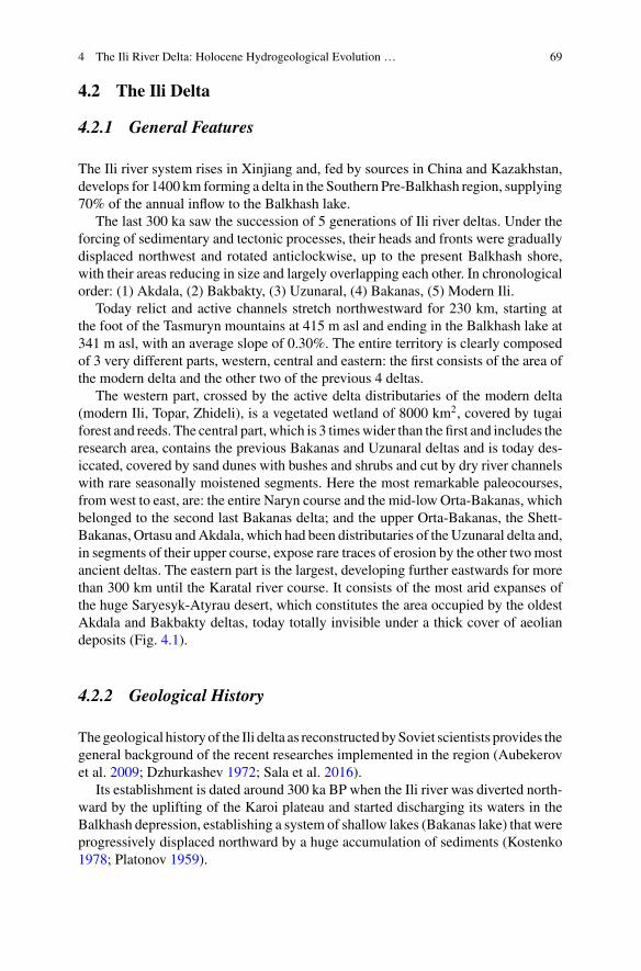
4 The Ili River Delta: Holocene Hydrogeological Evolution … 69
4.2 The Ili Delta
4.2.1 General Features
The Ili river system rises in Xinjiang and, fed by sources in China and Kazakhstan,develops for 1400 km forming a delta in the Southern Pre-Balkhash region, supplying70% of the annual inflow to the Balkhash lake.
The last 300 ka saw the succession of 5 generations of Ili river deltas. Under theforcing of sedimentary and tectonic processes, their heads and fronts were graduallydisplaced northwest and rotated anticlockwise, up to the present Balkhash shore,with their areas reducing in size and largely overlapping each other. In chronologicalorder: (1) Akdala, (2) Bakbakty, (3) Uzunaral, (4) Bakanas, (5) Modern Ili.
Today relict and active channels stretch northwestward for 230 km, starting atthe foot of the Tasmuryn mountains at 415 m asl and ending in the Balkhash lake at341 m asl, with an average slope of 0.30%. The entire territory is clearly composedof 3 very different parts, western, central and eastern: the first consists of the area ofthe modern delta and the other two of the previous 4 deltas.
The western part, crossed by the active delta distributaries of the modern delta(modern Ili, Topar, Zhideli), is a vegetated wetland of 8000 km2, covered by tugaiforest and reeds. The central part, which is 3 timeswider than the first and includes theresearch area, contains the previous Bakanas and Uzunaral deltas and is today des-iccated, covered by sand dunes with bushes and shrubs and cut by dry river channelswith rare seasonally moistened segments. Here the most remarkable paleocourses,from west to east, are: the entire Naryn course and the mid-low Orta-Bakanas, whichbelonged to the second last Bakanas delta; and the upper Orta-Bakanas, the Shett-Bakanas, Ortasu andAkdala, which had been distributaries of the Uzunaral delta and,in segments of their upper course, expose rare traces of erosion by the other twomostancient deltas. The eastern part is the largest, developing further eastwards for morethan 300 km until the Karatal river course. It consists of the most arid expanses ofthe huge Saryesyk-Atyrau desert, which constitutes the area occupied by the oldestAkdala and Bakbakty deltas, today totally invisible under a thick cover of aeoliandeposits (Fig. 4.1).
4.2.2 Geological History
Thegeological historyof the Ili delta as reconstructedbySoviet scientists provides thegeneral background of the recent researches implemented in the region (Aubekerovet al. 2009; Dzhurkashev 1972; Sala et al. 2016).
Its establishment is dated around 300 ka BP when the Ili river was diverted north-ward by the uplifting of the Karoi plateau and started discharging its waters in theBalkhash depression, establishing a system of shallow lakes (Bakanas lake) that wereprogressively displaced northward by a huge accumulation of sediments (Kostenko1978; Platonov 1959).
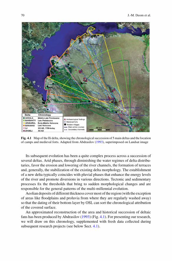
70 J.-M. Deom et al.
Fig. 4.1 Map of the Ili delta, showing the chronological succession of 5main deltas and the locationof camps and medieval forts. Adapted from Abdrasilov (1993), superimposed on Landsat image
Its subsequent evolution has been a quite complex process across a succession ofseveral deltas. Arid phases, through diminishing the water regimes of delta distribu-taries, favor the erosion and lowering of the river channels, the formation of terracesand, generally, the stabilization of the existing delta morphology. The establishmentof a new delta typically coincides with pluvial phases that enhance the energy levelsof the river and promote diversions in various directions. Tectonic and sedimentaryprocesses fix the thresholds that bring to sudden morphological changes and areresponsible for the general patterns of the multi-millennial evolution.
Aeolian deposits of different thickness covermost of the region (with the exceptionof areas like floodplains and proluvia from where they are regularly washed away)so that the dating of their bottom layer by OSL can sort the chronological attributionof the covered surface.
An approximated reconstruction of the area and historical succession of deltaicfans has been produced by Abdrasilov (1993) (Fig. 4.1). For presenting our research,we will draw on this chronology, supplemented with fresh data collected duringsubsequent research projects (see below Sect. 4.1).

4 The Ili River Delta: Holocene Hydrogeological Evolution … 71
The 300 ky long evolution of the Ili delta can be outlined in 5 phases, in chrono-logical order: (1) Akdala, (2) Bakbakty, (3) Uzunaral, (4) Bakanas, (5) Modern Ili.The heads of the first two deltas were located at the outlet from the mountains andfed by a river segment called Paleo-Ili running on the plain for 10–50 km. During theMiddle Holocene, the third delta was formed: the head displaced 30 km NW, its dis-tributaries slightly redirected anticlockwise, and their terminal sediments reachingthe line of the present Balkhash shore and building the Saryesik peninsula.
During the Late Holocene, northward and anticlockwise displacements acceler-ated and themodern Ili river course became established, bifurcating from thePaleo-Iliat the mountain outlet and running parallel southwest of it. At first it proceeded just50 km NW until the area of the Bakanas village where it formed the fourth delta,the Bakanas delta: smaller than the previous ones and discharging totally in theWestern Balkhash basin. During the last 700 years, the modern Ili opened its way50 km further NW where the head of the modern Ili delta—the smallest—is located(Fig. 4.1).
1. Akdala delta (second half of Middle Pleistocene, 300–18 ka BP) is the mostancient. It was a large delta with head at the first outlet from the mountains(Tasmuryn) and distributaries running to NNE and spanning from west of themodern Ili course to the Karatal river course. Today its remains are covered bysubsequent aeolian and alluvial sediments and are just barely detectable in thedelta head zone.2
2. Bakbakty delta (Late Pleistocene, 18–8 ka BP). Following the late-glacial reduc-tion of the Balkhash water surface and increased sedimentary processes, the Ilidelta migrated 40 km north in the form of the Bakbakty delta. Fed by the Paleo-Ilicourse, its head was in the Bakbakty region; its distributaries, tectonically forcedinto anticlockwise rotation, ran to NNW; its front, more advanced, dammed themiddle part of the Balkhash lake until 40 km south of the present shore.
3. Uzunaral delta (Early-Middle Holocene, 8–4 ka BP), also called Older Bakanasdelta, was formed with the first significant moistening of climate occurring atthe start of the Atlantic period. The delta head was displaced 30 km NW, halfway to the Bakanas village; its distributaries (Uzunaral, Ortasu) ran NNW, itsfinal deposits pushed the lake’s coast further north to the modern shores. In thatway the Saryesik peninsula has been formed, lying on 100 m thick sedimentsand separating the W and E Balkhash by the narrow and shallow Uzunaral strait,which is today 5 km wide and 5 m deep. An alternation of dry and pluvial phasesmarks the transition from the Middle to the Late Holocene, during which the Ilibranches cut new narrower beds and wandered to the west of the Uzunaral strait,where in a couple of millennia a new delta was formed.3
2Preliminary results of OSL dating of terraces located at the head of the Akdala, Uzunaral andBakanas deltas confirm the channel chronology given in the text and, in the case of Bakanasterraces, antecede the dating of diagnostic Bronze Age sherds. Anyhow, OSL dates are still understudy and the final results will be published by Japanese geologists (Sato et al. 2013; Shimizu et al.2012; Shimizu et al. 2015).3See note 2.

72 J.-M. Deom et al.
4. Bakanas delta (Late Holocene, 4–0.3 ka BP), also called Younger Bakanas, issuperposed to the wider Uzunaral delta, fed by a new parallel southern segmentof the Ili course (New-Ili) and of lesser extension. The head is now located30 km NW and all its distributaries, today desiccated, were redirected to the NWdischarging their waters in the Western Balkhash basin. According to the Sovietscientists who researched the soil stratigraphy and geomorphological profile ofthe Bakanas delta (Dzhurkashev 1972; Rybin 1955; Vyatkin 1948), in spite ofthe anticlockwise rotation of the delta system, the chronological sequence of themain branches of the Bakanas delta went from West to East, from Naryn (oldestand most eroded) to Orta-Bakanas and Shett-Bakanas (which takes active partin 3 successive deltas). Ruins of medieval towns and artificial canals attributedto the VIII–XIII centuries AD are aligned along the Shett-Bakanas and Ortasudistributaries,witnessing somepersisting activities of these easternmost courses.4
5. Ili delta (700–250 BP–now). The switching from the Bakanas to the modernIli delta happened very gradually during the XIII–XVIII centuries AD, a phaseof relative humidity that followed the intense aridity of the Medieval WarmPeriod (Chiba et al. 2016). At first, a transitional “Bakanas” distributary orientedto the west was activated; then the entire water flow became concentrated inthe Ili course that opened its way 50 km further NW towards Araltobe village,establishing here the head of the modern Ili delta. After a few centuries of doublecourse activity and reversals, the Bakanas delta died off completely betweenthe years 1733 and 1785 (Mushketov 1886).5 This last Ili delta has a much-reduced areal dimension beginning just 125 km far from the shore of the lake,and ramifies in few branches that chronologically succeeded each other fromwest to east: Topar, Iley, Zhideli.
4.3 Archaeological Data and Ethnographic AccountsConcerning the Southern Balkhash Territory
4.3.1 Archaeological Complex
The southern Balkhash region hosts monuments of all epochs, spanning from theLate Paleolithic to the modern periods (Deom et al. 2009). In particular, in the areasof the delta and in its immediate surroundings, archeological reports preceding thepresent communication documented the presence of the following monuments.
Late Paleolithic and Neolithic stone tools have been documented in 13 loci ofthe ancient shorelines of the Northern Balkhash and of the Ulken-Araltobe island(Dzhurkashev 1972), and on both sides of the Ili canyon upstream from the delta and
4See note 2.5According to the Russian geologist Mushketov, the Bakanas delta dried up between the years 1733and 1785 as on the Oirat maps preceding this period, the Ili river was drawn with a large branchreaching the Bakanas.
4 The Ili River Delta: Holocene Hydrogeological Evolution … 73
below the Kapchagai dam. No material clearly attributable to the Neolithic periodor earlier has been found in the delta (Coque et al. 2000). In the western terraces ofthe Karatal river finds of Neolithic potteries (which are rare in Semirechie), grindingstone and pestle, lithics (including microliths, blades, scrapers, borers) have beenreported (Arkheologicheskaya karta 1960); however, according to the description ofthe finds, these collections include also ornamented sherds and Bronze objects thatseem more related to the Early-Middle Bronze Age.
Bronze Age copper slag and potsherds have been found in all areas spoken above.These sites could belong to the earliest phase of the Bronze Age in the region.Ascribed to this phase are settlement layers dated to the Chalcolithic-Early Bronzein the foothills of the Tienshan, like the pit house floor found in the Talgar fan(3360–3100 cal. BC) (Macklin et al. 2015), and in the upland valleys of the Djungar-ian Alatau, like the cist burial in Tasbas (2832 and 2492 cal BC) (Doumani 2014).
Contra the formerly accepted view that in Semirechie the Bronze age started in theearly II millennium BC with the coming of Andronovo tribes from Central and EastKazakhstan, recent excavations in the Djungarian Alatau (Begash, Tasbas, Dali) anda new campaign of absolute dating of materials resumed from the Zailiski Alatau(Turgen, Kyzylbulak) pushes the chronology of the colonization of the region tothe XXV century BC, i.e. the Early Bronze Age (Frachetti et al. 2014; Gass andGoryachev 2016).
Petroglyphs starting from the Bronze Age are present above the delta head in thelast small mountain ranges of Kulanbasy and Tasmuryn. Typical Bronze Age cisttombs are found on the northern shore of the Balkhash and on the Tasaral island.
Iron Age kurgans are located on the terraces of the modern Ili course (Marikovskii1982) and along some paleo-channels at the south of Bakbakty village. No kurganshave been documented further downstream neither in the Bakanas delta.
The Medieval period is represented by 8 square forts (tortkuls) that have beenstudied during 4 expeditions (1962–1997) and dated between VIII–XIII centuriesAD, from south to north: Koktal 1 and 2, Boyauly, Aktam, Karkaraly, Agashayak,Karamergen and Barkhan (Akishev and Baipakov 1969; Baipakov and Groshev1993; Baipakov 1998; Baipakov et al. 2001). Karkaraly and Barkhan6 have beenbarely identified during 2 different expeditions just on the base of potsherds and slagaccumulation, and both lack dimension and precise location. The other 6 had beendocumented in plan and can be considered as real monuments: Koktal 1–2 and Boy-auly are now under rice fields or village houses; Aktam, Agashayak and Karamergenare still visible aligned along the Shet-Bakanas paleocourse (Fig. 4.1).
Around Aktam the ruins of ‘settled agrarian cultures’ were reported on the basisof numerous potsherds, dated at first to the VII–IX centuries AD and ascribed bylater publications to the X–XIII centuries AD. The presence of a copper meltingworkshop has been suspected on the basis of copper slag and fragments of coppervessels. Also SW and W of Aktam, near the Orta-Bakanas course, medieval houses
6Concerning Barkhan, a dense deposit of potsherds along a takyr, without visible structures, onlymakes the presence of ruined ‘houses’ suspect.
74 J.-M. Deom et al.
and other pottery and metallurgy workshops have been recorded, stretching for 7 kmalong the main and secondary canals.
In the surrounds of the 3 visible medieval forts, remains initially interpreted ascomplex irrigation networks consisting of one magistral canal and several secondarychannels, sometimes extending for few km till the banks of a main delta branches(fromAktam till Orta-Bakanas, fromAgashayak andKaramergen till Shett-Bakanas)have been reported as well as associated to irrigated agricultural fields with identifi-able planimetry, supposedly corresponding to the cultivation of ‘cucurbitaceae andvineyards’. In 1997 an expedition especially devoted to the pedological assessmentof phases of activity of the forts contradicted those hypotheses, revealing that fortswere built in a dry environment when no active channels were crossing the area andthat the ruins interpreted as ‘irrigation systems’ were just small aryks (water ditches)using natural paleochannels for bringing water till the forts.
Late Medieval (Ethnographic) period. During the Jungar khanate (1634–1745AD), the Oirat (Kalmyk) tribes intensively occupied Semirechie and the Ili delta,multiplying winter camps, organizing irrigated agriculture and building forts. Theyerected 3 walled garrisons in the estuary of the Zhideli branch, later partially erodedby floods, and others near the modern villages of Bakbakty and Bakanas. Mostprobably they also reused the 3 forts that are clearly visible along the Shett-Bakanas.
These data are supported by toponymic evidence. In the Zhidely estuary, a longstripe of sand dunes paralleling the river is called Ush-tam (meaning ‘3-mounds’or ‘3-forts’) and was previously called Ush-kalmak (meaning ‘3-Kalmyk’, i.e. Bas,Orta, Ayak, ‘Upper, Middle, Lower’) referring to 3 Kalmyk groups living in thearea (Erofeeva 2008). According to the pedologist M. Vyatkin, the ancient irrigatedfields found in areas with resurgent riverbeds (zabok) at the Bakanas delta headand in the middle Naryn course were initially built by Kalmyk tribes during themiddle of the XVIII century AD (Vyatkin 1948). Kalmyk peoples were also livingin the eastern parts of the delta, probably in the 3 medieval forts aligned along theShet-Bakanas course. In fact, until the end of the XIX century AD, the fort Aktamwas called Durtgut, which doesn’t have any meaning in Kazakh and might refer tothe ‘Torghuts’, a main Kalmyk tribe that settled in the Ili and then moved to theNW Caspian. The Russian geographer N. Palgov reported in 1930 that the Kazakhsconsidered the 3 ‘Aktam’ (referring in this case to Aktam, Karamergen plus Boyaulyor another fort north of it) as Kalmyk vestiges “haunted by ghosts” (Palgov 1932).
4.3.2 Ethnographic Accounts
Ethnographic accounts of Russian geographers provide important information on theland and water use within the delta during the XIX century and the start of the XXcentury.
Concerning ethnic distribution and land use, the driest parts of the delta (3/4 ofit) were available for common use, while the relatively moistened lands closer to theIli banks were belonging to Jalair tribes (Baigaly, Baichigir) from the Karatal valley.
4 The Ili River Delta: Holocene Hydrogeological Evolution … 75
Most of the Jalair clans were living all year round in the delta, though the richeststockbreeders would practice seasonal migration between the best winter camps inthe delta and summer pasture in the Djungarian Alatau (Aristov 1894; Vostrov andMukanov 1968), with horses and camels, because sensitive to mosquitoes, gnats andbotflies, all sent during summer to the highlands.
Concerning caravan routes across the delta, significant information was recordedby N. Palgov who carried out the population census of the region in 1930. Accordingto his account, there were several caravan roads linking the Ili delta to the lowerKaratal river, with raft ferries helping the cross of active delta branches. The mainroad, called Otrau-zhol (delta road) was following the right bank of the Ili rivertill modern Karoi village and then turning eastward along the southern shore of theBalkhash lake till the Karatal estuary. It was the most crowded due to the availabilityof water, it had several yurt villages regrouped around active wells. The secondmain road, shorter but much harder, called Tuya-kuduk-zhol (the road of the camelwell), crossed the Bakanas delta in its central part through the ruins of Aktam anda series of often saline wells in a depopulated corridor. These tracks were also usedfor transporting salt collected in the salt pans on the right bank of the lower Karatal:it was considered the best culinary salt of South Kazakhstan and sold by Kazakhherders in Ushtobe, 100 km upstream, at the price, in 1942, of 1 kg of salt for 1.5 kgof wheat floor (Miller 2014).
It is also recorded that 500 yurts of the Argyn tribe living on the northern shoresof the Balkhash lake were grazing in the Ili delta during winter by crossing the icedsurface of the lake (Rumyantsev 1913). As soon as ice melted in spring, fishingbecame an important activity, an expedient surely in use during all epochs.
4.4 Geoarchaeological Study and ChronologicalAttribution of the Human Occupation of the Ili Delta
4.4.1 Research Projects, Area and Methodology
4.4.1.1 Research Projects
The background of the present research started with the Japanese-Kazakh project(2007–2012), based on the cooperation of 3 institutions7 and dedicated to the recon-struction of the Holocene environmental changes in the Ili-Balkhash basin. Theproject implemented studies of the evolution of environmental and cultural aspectsof the Balkhash basin: climatic changes and lake water levels, shorelines, alluvialdeposits, river terraces and sand dunes, archaeological traces of land-water use,reading of Late Medieval historical accounts and Soviet documents concerning
7The 3 institutions are: Research Institute for Humanity and Nature (RIHN), Kyoto; Laboratory ofGeoarchaeology, Almaty; K.I. Satpaeva Institute of Geological Sciences, Almaty.

76 J.-M. Deom et al.
the territory, interviews about post-Soviet pastoral and agricultural activities in theregion, and geoarchaeological surveys with documentation and collection of surfacearchaeological material (Endo et al. 2012; Sala et al. 2016).
Geoarchaeological surveys were undertaken during 4 seasons (2008–2011) alongthe Balkhash lake shorelines, on the terraces of its tributary rivers (Ili, Lepsy), andin particular on terraces of Ili paleo-deltas. The fieldwork yielded the discovery ofan unexpectedly abundant surface material representing a wide chronological framefrom Eneolithic to modern times (Deom et al. 2012), giving impetus for furtherresearch.
Further work followed in 2011–2013 under the auspices of the British-KazakhWellcome Trust Project “Advances in the Prediction of Plague Outbreaks in CentralAsia”, aimed at studying the percolation of plague in gerbil population by mappingand analyzing their burrows in the area of the Ili delta (Wilschut et al. 2013). Togetherwith the biologist Anne Laudisoit surveying rodents’ colonies, we collected surfacearchaeological findings during 3 seasons.
4.4.1.2 Study Area
The survey areas represent the entire variety of desert habitats at varying distancesfrom the piedmont zone. The upper parts of the entire delta system deserved specialgeological analyses intended for interpreting the chronological succession of thedeltas. The Naryn paleocourse has been privileged as it represents the most relevantand longstanding active or intermittent course during the last 4000 years.
Geoarchaeological surveys focused on the river terraces distributed all along theentire course of the today dry Uzunaral and Bakanas paleodeltas (the area spokenas ‘central’ in Sect. 2.1), in particular: the terraces of the paleo-Ili and modern Iliriver segments upstream from all deltas; the heads of the Bakbakty, Uzunaral andBakanas deltas; the upper courses of the Akdala, Shett-Bakanas and Orta-Bakanaspaleodistributaries; and the entire upper, middle and lower course of theNaryn paleo-distributary.
As a whole, have been surveyed the terraces of 3 regions, focusing on 11 zones(Z-1-11) of 10×10 km (marked in Fig. 4.2 and listed in Tables 4.1 and 4.2), wherehas been detected a total of 70 clusters (areas of 200×200 m at mutual distanceof>200 m) including a total of 134 loci (areas of around 20×20 m characterized bya dense deposition of cultural objects).8
The eastern and northeastern borders of the Bakanas delta, at the location ofthe 4 medieval forts of Aktam, Agashayak, Karamergen and Barkhan, are not yetexplored and should be the object of future research. Four archaeological expeditionsdevoted to the studyof the forts and their hydraulic implementations have recorded thesurface occurrence of a large numbers of potsherds (exclusively medieval, VIII–XIII
8Concerning the repartition of the survey areas between the Japanese-Kazakh and British-Kazakhprojects, see Fig. 4.2. Regions, zones, clusters and loci are listed in Table 4.1. Of the total 134 loci,39 have been found under the first project, 95 under the second.

4 The Ili River Delta: Holocene Hydrogeological Evolution … 77
Fig. 4.2 Map of the researched territory. Red dots loci of cultural findings; green squaresmedieval forts; square red perimeters of 10×10 kmareas studied under the Wellcome Trustproject. Zones are marked by red numbers. Paleo and modern paleo delta heads marked in azure.(Soviet topo map L-43, scale 1:1 million)
centuries AD) scattered around the forts (sometimes within a radius of 7 km) andalso in northern areas closer to the Saryesyk peninsula (Baipakov et al. 2001).
4.4.1.3 Methodology
Methodological procedures have been chosen specifically for selecting surveyingareas, collecting and analyzing artifacts, fixing a data base and elaborating data bystatistical analyses.
Surveys Surveys were implemented through field walking for collection and GPSrecording of surface finds. They didn’t constitute a systematic grid-based survey
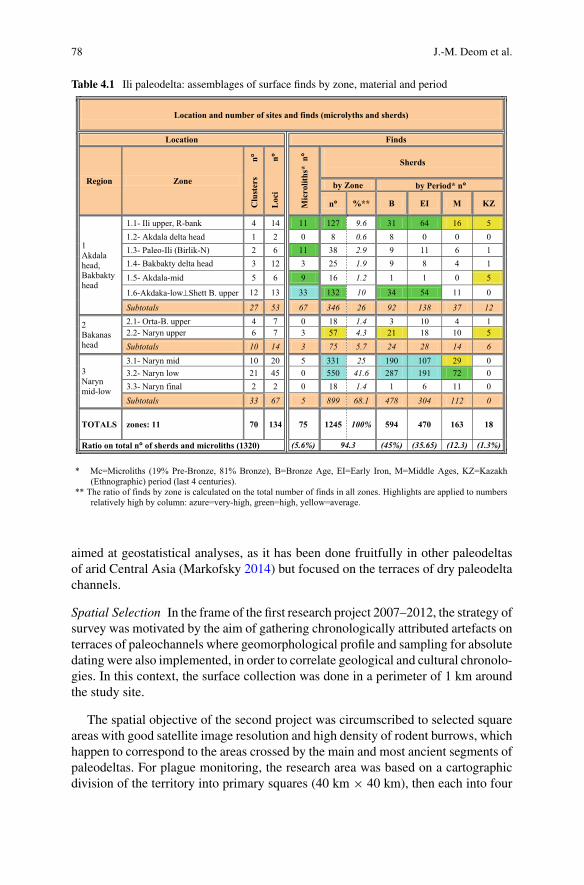
78 J.-M. Deom et al.
Table 4.1 Ili paleodelta: assemblages of surface finds by zone, material and period
aimed at geostatistical analyses, as it has been done fruitfully in other paleodeltasof arid Central Asia (Markofsky 2014) but focused on the terraces of dry paleodeltachannels.
Spatial Selection In the frame of the first research project 2007–2012, the strategy ofsurvey was motivated by the aim of gathering chronologically attributed artefacts onterraces of paleochannels where geomorphological profile and sampling for absolutedating were also implemented, in order to correlate geological and cultural chronolo-gies. In this context, the surface collection was done in a perimeter of 1 km aroundthe study site.
The spatial objective of the second project was circumscribed to selected squareareas with good satellite image resolution and high density of rodent burrows, whichhappen to correspond to the areas crossed by the main and most ancient segments ofpaleodeltas. For plague monitoring, the research area was based on a cartographicdivision of the territory into primary squares (40 km × 40 km), then each into four
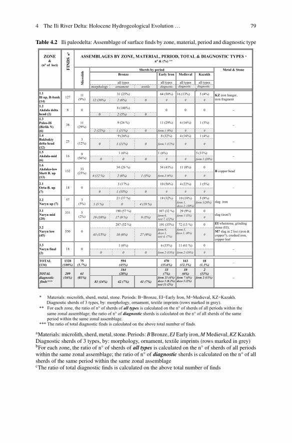
4 The Ili River Delta: Holocene Hydrogeological Evolution … 79
Table 4.2 Ili paleodelta: Assemblage of surface finds by zone, material, period and diagnostic type
aMaterials:microlith, sherd,metal, stone. Periods:BBronze,EI Early iron,M Medieval,KZ Kazakh.Diagnostic sherds of 3 types, by: morphology, ornament, textile imprints (rows marked in grey)bFor each zone, the ratio of n° of sherds of all types is calculated on the n° of sherds of all periodswithin the same zonal assemblage; the ratio of n° of diagnostic sherds is calculated on the n° of allsherds of the same period within the same zonal assemblagecThe ratio of total diagnostic finds is calculated on the above total number of finds
80 J.-M. Deom et al.
secondary squares (20 km × 20 km) and these into four sectors (10 km × 10 km),as described elsewhere (Wilschut et al. 2013). The study sites concerned randomlychosen 500 m × 500 m (25 ha) squares spread over 6 sectors (see Fig. 4.2) (Levicket al. 2015).
In the context of these sectors,within 3 seasons (autumn2011, summer and autumn2012, spring 2013), 2113 burrowweremapped andmost of the surface artefacts werecollected. Other finds were gathered when circulating on foot between close squares(within 10 km radius) and during a recognizance survey in the estuary of the Narynchannel. Visual contact with surface archaeological remains occurred predominantlyon the ledge of recently dug burrows, around takyr, between dunes, and along thebanks of dry paleodelta channels (Photo 4.1).
Collection and Count In each spot with single or multiple finds, the total or a repre-sentative amount of archaeological itemswas collected. Potsherds are by far themostabundant finds, so that in loci with numerous finds, the ones belonging to the samepot and similar sherds were discarded. Among other artefacts, microliths slag, metalsand stone tools were systematically collected. Surface finds visually contacted werephotographed, georeferenced and packed in labeled bags.
All data were recorded in a database, which includes several entries: exact loca-tion, geomorphological setting, amount and type of findings, preliminary chronolog-ical attribution, and assessment of buried condition (uplifted, deposited). Subsequentoffice work based on satellite images added new entries such as elevation and prox-imity to stream.
Loci and Terraces Most of the loci discovered during the surveys—86out of the total134 (64%)—are located on relict or active river terraces, allowing the chronologicalcorrelation between cultural and geological data sets. The spatial distribution ofthe loci corresponds to the orientation of the delta channels and of the dune ridgesassociated with them, both having, as the dominant wind in the delta, a NNW-SSEdirection.
They all consist of surface finds without stratigraphy and are not associated withvisible settlement structures or irrigated fields. Most of the surface scatters probablycorrespond to the original location of occupied sites, but many are located aroundtakyr depression as aggregation from surrounding dunes. Actually, it is almost impos-sible to distinguish surface and subsurface material being that most of the artefactsmight have moved with dune displacement and been uplifted by rodents.
The entire territory of the delta is densely populated by the great gerbil (Rhom-bomys opimus, carrier of endemic plague), which builds burrows with galleries usu-ally running 30–50 cmbelow the surfacewhile food and nest chambers can be built aslow as 5 m underground (average 2.5 m). By digging and cleaning, the rodents con-stantly excavate and eject to the surface ancient objects, stones, pebbles, vegetationdebris, bones and faeces. This is how most of the findings were spotted.
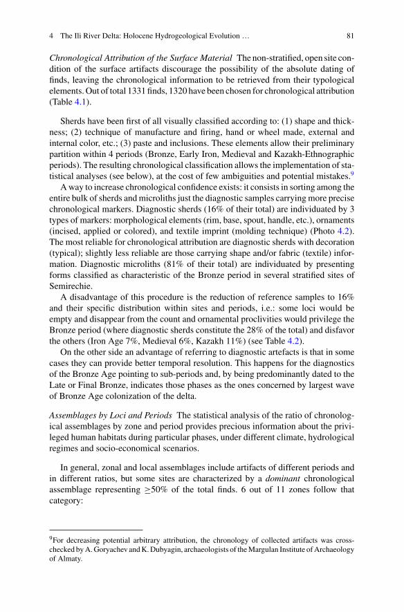
4 The Ili River Delta: Holocene Hydrogeological Evolution … 81
Chronological Attribution of the Surface Material Thenon-stratified, open site con-dition of the surface artifacts discourage the possibility of the absolute dating offinds, leaving the chronological information to be retrieved from their typologicalelements.Out of total 1331finds, 1320 have been chosen for chronological attribution(Table 4.1).
Sherds have been first of all visually classified according to: (1) shape and thick-ness; (2) technique of manufacture and firing, hand or wheel made, external andinternal color, etc.; (3) paste and inclusions. These elements allow their preliminarypartition within 4 periods (Bronze, Early Iron, Medieval and Kazakh-Ethnographicperiods). The resulting chronological classification allows the implementation of sta-tistical analyses (see below), at the cost of few ambiguities and potential mistakes.9
Away to increase chronological confidence exists: it consists in sorting among theentire bulk of sherds andmicroliths just the diagnostic samples carryingmore precisechronological markers. Diagnostic sherds (16% of their total) are individuated by 3types of markers: morphological elements (rim, base, spout, handle, etc.), ornaments(incised, applied or colored), and textile imprint (molding technique) (Photo 4.2).The most reliable for chronological attribution are diagnostic sherds with decoration(typical); slightly less reliable are those carrying shape and/or fabric (textile) infor-mation. Diagnostic microliths (81% of their total) are individuated by presentingforms classified as characteristic of the Bronze period in several stratified sites ofSemirechie.
A disadvantage of this procedure is the reduction of reference samples to 16%and their specific distribution within sites and periods, i.e.: some loci would beempty and disappear from the count and ornamental proclivities would privilege theBronze period (where diagnostic sherds constitute the 28% of the total) and disfavorthe others (Iron Age 7%, Medieval 6%, Kazakh 11%) (see Table 4.2).
On the other side an advantage of referring to diagnostic artefacts is that in somecases they can provide better temporal resolution. This happens for the diagnosticsof the Bronze Age pointing to sub-periods and, by being predominantly dated to theLate or Final Bronze, indicates those phases as the ones concerned by largest waveof Bronze Age colonization of the delta.
Assemblages by Loci and Periods The statistical analysis of the ratio of chronolog-ical assemblages by zone and period provides precious information about the privi-leged human habitats during particular phases, under different climate, hydrologicalregimes and socio-economical scenarios.
In general, zonal and local assemblages include artifacts of different periods andin different ratios, but some sites are characterized by a dominant chronologicalassemblage representing ≥50% of the total finds. 6 out of 11 zones follow thatcategory:
9For decreasing potential arbitrary attribution, the chronology of collected artifacts was cross-checked byA.Goryachev andK.Dubyagin, archaeologists of theMargulan Institute ofArchaeologyof Almaty.

82 J.-M. Deom et al.
Photo 4.1 View of loci with surface finds in 6 zones representative of the Ili paleo-delta system. aRight terrace of the modern Ili river (Z-1.1); b Akdala delta head (Z-1.2); c Paleo-Ili relict courseat Birlik-N (Z-1.3); d Bakbakty delta head (Z-1.4); e Bakanas delta head in the upper Orta Bakanas(Z-2.1); f surface sherd uplifted by great gerbil from burrow; g surface sherd at the border of takyrdepression; h dune ridge stretching NW-SE vegetated by saxaul trees in the Naryn branch (Z-3.1);i dry bed of the Naryn paleocourse seen from its western terrace (Z-3.1)

4 The Ili River Delta: Holocene Hydrogeological Evolution … 83
• the Bronze period assemblage is dominant by 100% in the Akdala delta head(Z-1.2), by 57% in mid-Naryn paleo-course (Z-3.1) and by 52% in low Naryn(Z-3.2).
• the Early Iron assemblage is dominant by 50% on the right bank of the upper Ilicourse (Z-1.1) and by 56% in the upper Orta Bakanas (Z-2.1).
• the Medieval assemblage is dominant in final Naryn (Z-3.3) (Table 4.2).
Quite interesting is the distribution of microliths, which can refer to the Pre-Bronze or Bronze periods. They are mainly found in the upper part of the deltasystem: the highest number of Pre-Bronze types (11) along the Upper-Ili course (Z-1.1); Bronze types in the Mid-Akadala (Z-1.5) where 9 pieces represent 59% of thelocal assemblage, and in the Low-Akadala (Z-1.6) where 33 pieces represent 25%.
4.4.2 Research Results
4.4.2.1 Spatial Distribution and Density of Finds
Concerning the number of cultural findings by region, the densest is by far the Naryn-mid-low region including almost half of the total documented loci and more thanhalf of all finds. In general the loci of the middle and lower delta system are moreconcentrated and include more finds than the loci at the delta heads.
4.4.2.2 Classification of Findings by Type, Area and Chronology
99% of all finds (1331) consist of potsherds [1245 (93.5%)] and stone tools(microliths) [75 (5.6%)]: together they count 1320 pieces providing the data base forstatistical analyses. The remaining 11 pieces (1%) consist of iron and copper slag(along theNaryn),metal objects (copper bead, copper leaf, iron hanger, crushed iron),and grinder and whetstone (probably Iron Age), adding some qualitative information(Fig. 4.3).
The chronology of the inventoried material spans from Eneolithic (turn of the IVto III millennium BC) to the ethnographic period (200 BP), evidencing the use ofthe full extent of the delta from the earliest periods. The most numerous are samplesattributed to the Bronze Age (45% of total finds), followed by Early Iron (36%),Medieval (12%), Ethnographic (1%). Tables 4.1 and 4.2 present the systematizationof all collected data by zone and period.
Microliths
Most of the lithic material consists of small cores, tools (blades, scrapers, notches,knives) and spalls made of chalcedony, agate, flint, jasper and fossil wood. Lack-ing laminar and geometrical forms typical of the Neolithic, they could be attributedto both the Eneolithic and Bronze periods, being that in Semirechie and CentralKazakhstan such items are commonly found in the cultural layers and surface sur-
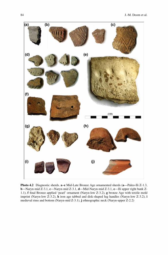
84 J.-M. Deom et al.
Photo 4.2 Diagnostic sherds. a–e Mid-Late Bronze Age ornamented sherds (a—Paleo-Ili Z-1.3,b—Naryn-mid Z-3.1, c—Naryn-mid Z-3.1, d—Mid-Naryn-mid Z-3.1, e—Ili upper right bank Z-1.1), f final Bronze applied ‘pearl’ ornament (Naryn-low Z-3.2), g bronze Age with textile moldimprint (Naryn-low Z-3.2), h iron age tabbed and disk-shaped lug handles (Naryn-low Z-3.2), imedieval rims and bottom (Naryn-mid Z-3.1), j ethnographic neck (Naryn-upper Z-2.2)
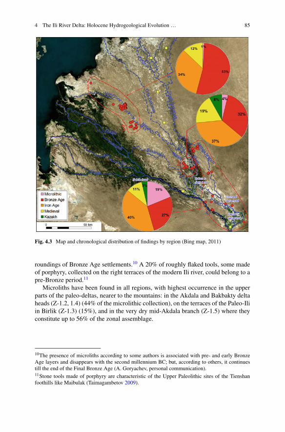
4 The Ili River Delta: Holocene Hydrogeological Evolution … 85
Fig. 4.3 Map and chronological distribution of findings by region (Bing map, 2011)
roundings of Bronze Age settlements.10 A 20% of roughly flaked tools, some madeof porphyry, collected on the right terraces of the modern Ili river, could belong to apre-Bronze period.11
Microliths have been found in all regions, with highest occurrence in the upperparts of the paleo-deltas, nearer to the mountains: in the Akdala and Bakbakty deltaheads (Z-1.2, 1.4) (44% of the microlithic collection), on the terraces of the Paleo-Iliin Birlik (Z-1.3) (15%), and in the very dry mid-Akdala branch (Z-1.5) where theyconstitute up to 56% of the zonal assemblage.
10The presence of microliths according to some authors is associated with pre- and early BronzeAge layers and disappears with the second millennium BC; but, according to others, it continuestill the end of the Final Bronze Age (A. Goryachev, personal communication).11Stone tools made of porphyry are characteristic of the Upper Paleolithic sites of the Tienshanfoothills like Maibulak (Taimagambetov 2009).
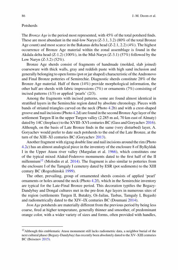
86 J.-M. Deom et al.
Potsherds
The Bronze Age is the period most represented, with 45% of the total potsherd finds.These are most abundant in the mid-low Naryn (Z-3.1, 3.2) (80% of the total BronzeAge count) and most scarce in the Bakanas delta head (Z-2.1, 2.2) (4%). The highestoccurrence of Bronze Age material within the zonal assemblage is found in theAkdala delta head (Z-1.2) (100%), in the Mid-Naryn (Z-3.1) (57%) followed by theLow Naryn (Z-3.2) (52%).
Bronze Age sherds consist of fragments of handmade (molded, slab joined)coarseware with thick walls, gray and reddish paste with high sand inclusion andgenerally belonging to open forms (pot or jar shaped) characteristic of theAndronovoand Final Bronze potteries of Semirechie. Diagnostic sherds constitute 28% of theBronze Age material. Half of them (14%) provide morphological information, theother half are sherds with fabric impressions (7%) or ornaments (7%) consisting ofincised patterns (1/3) or applied ‘pearls’ (2/3).
Among the fragments with incised patterns, some are found almost identical instratified layers in the Semirechie region dated by absolute chronology. Pieces withbands of striated triangles carved on the neck (Photo 4.2b) and with a crest-shapedgroove and nail incisions (Photo 4.2d) are found in the secondBronzeAge layer of thesettlement Turgen II in the upper Turgen valley (2.285 m asl, 70 km east of Almaty)dated by 14C (fireplace) to theXVIII–XVI centuries BC (Gass andGoryachev 2016).Although, on the basis of Late Bronze finds in the same (very disturbed) layer, A.Goryachev would prefer to date such potsherds to the end of the Late Bronze, at theturn of the XIII–XI centuries BC (Goryachev 2013).
Another fragment with zigzag double line and nail incisions around the rim (Photo4.2c) has an almost analogical piece in the inventory of the enclosure 8 of BylkyldakI in the Upper Atasu river valley (Margulan et al. 1966), which constitutes oneof the typical mixed Alakul-Federovo monuments dated to the first half of the IImillennium12 (Molodin et al. 2014). The fragment is also similar to potteries fromthe enclosure I of the Tamgaly I cemetery dated by ESR (pot sediments) to the XIIIcentury BC (Rogozhinskii 1999).
The other, prevailing, group of ornamented sherds consists of applied ‘pearl’ornaments or holes around the neck (Photo 4.2f), which in the Semirechie inventoryare typical for the Late-Final Bronze period. This decoration typifies the Begazy-Dandybay and Dongal cultures met in the pre-Iron Age layers in numerous sites ofthe region (settlements Turgen II, Butakty, Oi-Jailau, Tasbas, Tamgaly I, Begash)and radiometrically dated to the XIV–IX centuries BC (Doumani 2014).
Iron Age potsherds are materially different from the previous period by being lesscoarse, fired at higher temperature, generally thinner and smoother, of predominantorange color, with a wider variety of sizes and forms, often provided with handles,
12Although this emblematic Atasu monument still lacks radiometric data, a neighbor burial of thenext cultural phase (Begazy-Dandybay) has recently been absolutely dated to theXV–XIII centuriesBC (Beisenov 2015).

4 The Ili River Delta: Holocene Hydrogeological Evolution … 87
and with much rarer decoration. They are found in clusters together with the BronzeAge finds, witnessing continuity of habitats between the two periods.
Iron Age material is slightly less represented than Bronze Age material (36% ofthe total) and found in all zones. By number it is more abundant downstream, butin lesser number than Bronze Age and constituting 35% of all finds of the area;and then closer to delta heads [mainly on the Ili-upper right bank (Z-1.1) and in theupper Orta-Bakanas-upper (Z-2.1)] where it exceeds by number Bronze Age itemsconstituting respectively 51% and 56% of the zonal assemblage.13
Iron Age diagnostic sherds are characterized by more morphological features likehandles and spouts, quasi absence of ornament (single case of red slip ware), and bytextile imprints (11 out of 52 imprinted sherds).
Medieval potsherds are 4 times less abundant than Bronze Age material, althoughfound in all zones, with highest count in the low (44%) and middle Naryn (18%)(Z-3.2, 3.1) and the highest percentage of the zonal assemblage in the Naryn estuary(Z-3.3) (61%) and in the upperOrta Bakanas (Z-2.1) (56%). They are generally found(not always exposed by rodents) on the surface and borders of takyrs (claypan),pointing to new strategies of land and water use; and less on terraces of recentlydesiccated river branches.
The manufacture of Medieval potsherds carry information about sub-periods. Nopotsherds dated to the early Turkic period have been identified during our surveys.Characteristic pieces of the Karakhanid period (IX–XII centuries AD) may representthe only medieval demographic peak in the delta, contemporary with the buildingof a longitudinal network of forts along the Ortasu paleocourse. No trace of post-Mongol occupation has been found. The data quoted above may indicate that duringMedieval times habitation was concentrated between piedmonts and alpine pastures,with the delta mainly used as a way station on interregional roads.
Ethnographic (Late Medieval, last 4 centuries) Kalmyk and Kazakh materialsdated to the XVII–XIX centuries AD represent a small 1.4% of the finds, with thehighest percentage of the zonal assemblage in the Mid-Akdala (Z-1.5) (31%). Thiswas a pluvial period, when themain delta switched to its modern location and asmostprobably did human habitats, in areas still unexplored to the west of our researchpolygon.
Slag
Few samples of slag from iron and copper ore are found in 3 zones of the Bakanasdelta: at the delta head and in the middle and lower course of the Naryn distributary(Z-3.1, 3.2, 3.3). Slag and a smeltingworkshophave been recorded in the southeasternoutwalls of the medieval fort of Aktam and around the northernmost fort of Barkhan(Baipakov 1998).
13In the upper Orta-Bakanas (Z-2.1) have been collected just 10 pieces of Early Iron potsherds thatanyhow constitute the majority of the total 18 finds.
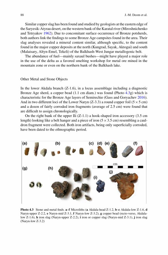
88 J.-M. Deom et al.
Similar copper slag has been found and studied by geologists at the eastern edge ofthe Saryesik-Atyrau desert, on thewestern bank of theKaratal river (Miroshnichenkoand Tetryakov 1962). Due to concomitant surface occurrence of Bronze potsherds,both authors link the findings to some Bronze Age campsites found in the area. Theirslag analyses revealed a mineral content similar, although specific, to the contentfound in the major copper deposits at the north (Kungrad, Sayak, Aktogai) and south(Malaisary, Altyn-Emel, Tekeli) of the Balkhash-West Jungar metallogenic belt.
The abundance of fuel—mainly saxaul bushes—might have played a major rolein the use of the delta as a favored smelting workshop for metal ore mined in themountain zone or even on the northern bank of the Balkhash lake.
Other Metal and Stone Objects
In the lower Akdala branch (Z-1.6), in a locus assemblage including a diagnosticBronze Age sherd, a copper bead (1.1 cm diam.) was found (Photo 4.3g) which ischaracteristic for the Bronze Age layers of Semirechie (Gass and Goryachev 2016).And in two different loci of the Lower Naryn (Z-3.3) a round copper foil (5×5 cm)and a dozen of fairly corroded iron fragments (average of 2.5 cm) were found thatare difficult to assign chronologically.
On the right bank of the upper Ili (Z-1.1) a hook-shaped iron accessory (3.5 cmlength) looking like a belt hanger and a piece of iron (5×3.5 cm) resembling a caul-dron fragment were collected. Both iron artifacts, being only superficially corroded,have been dated to the ethnographic period.
Photo 4.3 Stone and metal finds. a–f Microliths (a Akdala-head Z-1.2, b–c Akdala-low Z-1.6, dNaryn-upper Z-2.2, e Naryn-mid Z-3.1, f Naryn-low Z-3.2), g copper bead (recto-verso, Akdala-low Z-1.6), h iron slag (Naryn-upper Z-2.2), i iron or copper slag (Naryn-mid Z-3.1), j iron slag(Naryn-low Z-3.2)
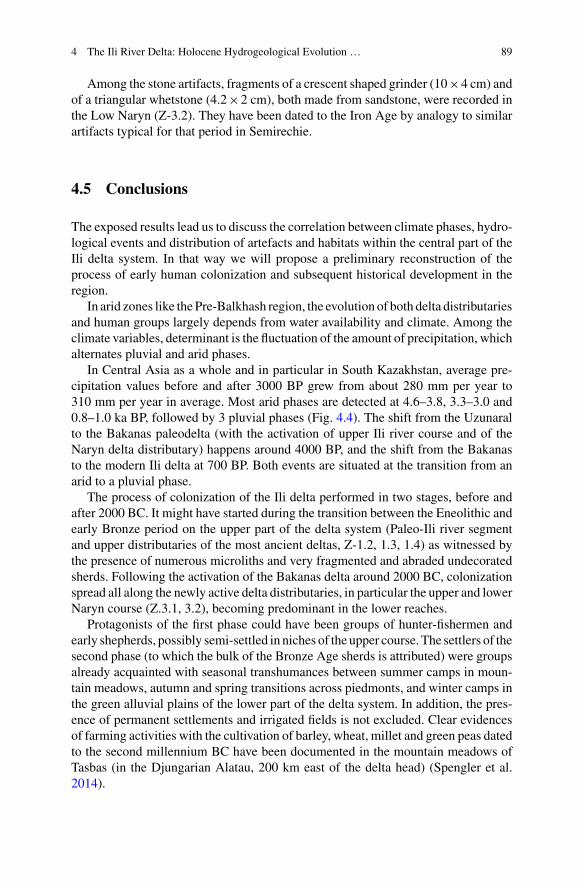
4 The Ili River Delta: Holocene Hydrogeological Evolution … 89
Among the stone artifacts, fragments of a crescent shaped grinder (10×4 cm) andof a triangular whetstone (4.2×2 cm), both made from sandstone, were recorded inthe Low Naryn (Z-3.2). They have been dated to the Iron Age by analogy to similarartifacts typical for that period in Semirechie.
4.5 Conclusions
The exposed results lead us to discuss the correlation between climate phases, hydro-logical events and distribution of artefacts and habitats within the central part of theIli delta system. In that way we will propose a preliminary reconstruction of theprocess of early human colonization and subsequent historical development in theregion.
In arid zones like the Pre-Balkhash region, the evolution of both delta distributariesand human groups largely depends from water availability and climate. Among theclimate variables, determinant is the fluctuation of the amount of precipitation, whichalternates pluvial and arid phases.
In Central Asia as a whole and in particular in South Kazakhstan, average pre-cipitation values before and after 3000 BP grew from about 280 mm per year to310 mm per year in average. Most arid phases are detected at 4.6–3.8, 3.3–3.0 and0.8–1.0 ka BP, followed by 3 pluvial phases (Fig. 4.4). The shift from the Uzunaralto the Bakanas paleodelta (with the activation of upper Ili river course and of theNaryn delta distributary) happens around 4000 BP, and the shift from the Bakanasto the modern Ili delta at 700 BP. Both events are situated at the transition from anarid to a pluvial phase.
The process of colonization of the Ili delta performed in two stages, before andafter 2000 BC. It might have started during the transition between the Eneolithic andearly Bronze period on the upper part of the delta system (Paleo-Ili river segmentand upper distributaries of the most ancient deltas, Z-1.2, 1.3, 1.4) as witnessed bythe presence of numerous microliths and very fragmented and abraded undecoratedsherds. Following the activation of the Bakanas delta around 2000 BC, colonizationspread all along the newly active delta distributaries, in particular the upper and lowerNaryn course (Z.3.1, 3.2), becoming predominant in the lower reaches.
Protagonists of the first phase could have been groups of hunter-fishermen andearly shepherds, possibly semi-settled in niches of the upper course. The settlers of thesecond phase (to which the bulk of the Bronze Age sherds is attributed) were groupsalready acquainted with seasonal transhumances between summer camps in moun-tain meadows, autumn and spring transitions across piedmonts, and winter camps inthe green alluvial plains of the lower part of the delta system. In addition, the pres-ence of permanent settlements and irrigated fields is not excluded. Clear evidencesof farming activities with the cultivation of barley, wheat, millet and green peas datedto the second millennium BC have been documented in the mountain meadows ofTasbas (in the Djungarian Alatau, 200 km east of the delta head) (Spengler et al.2014).

90 J.-M. Deom et al.
The finding of copper and bronze slag on the western terraces of the Karatal riverand around medieval habitats in the central part of the paleodelta testifies the dualactivity of such groups, as herder-miners exploiting the summer pastures and minesof the mountain zone and as shepherd-metallurgists using the winter grasses and fuelof the lower delta.
The Bronze Age as a whole (due to its length) and, in particular, the Naryn course(due to its long endurance as first active Bakanas distributary), shows the largestdensity of cultural remains and human habitats among all the periods and areasunder study.
Starting from the first half of the first millenniumBC until the turn of our era, thereis a rise in precipitation and river flow, and the pastoralist and metallurgist patternsof the former millennium adapt to new very mobile animal assemblages (sheep andhorse) and to iron ore. The number of surface artefacts attributed to that Early Ironperiod is slightly less than the preceding one and their distribution favors the upperregions of the deltas.
We are faced with difficulties explaining why from the start of our era until theMedieval Warm Period (MWP), the number of cultural remains suddenly drops to athird of the Iron Age, pointing to a diminution of human presence in the delta region,in particular in the upper reaches of the deltas. The causes can be variously attributedto economical or climatic factors, probably concomitant: the development in thepiedmont area of mixed-farming activities, allowing for demographic concentrationand a more settled way of life in these areas; or to climate conditions that reducedthe desert biomass or at the contrary and more probably, made it inaccessible byexcessive snow cover.
Fig. 4.4 Evolution of precipitation values (mm/year) in West Central Asia during the last 6 ka(Hill 2019)
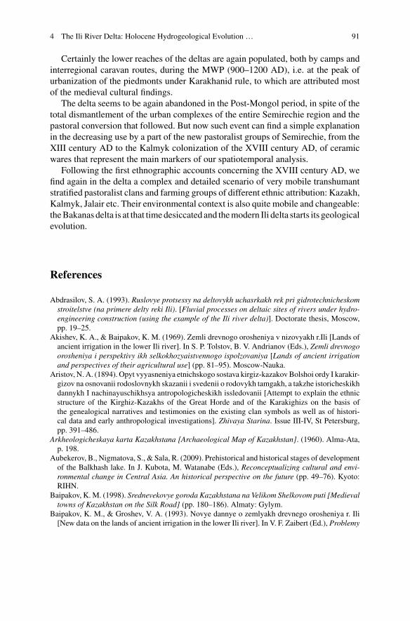
4 The Ili River Delta: Holocene Hydrogeological Evolution … 91
Certainly the lower reaches of the deltas are again populated, both by camps andinterregional caravan routes, during the MWP (900–1200 AD), i.e. at the peak ofurbanization of the piedmonts under Karakhanid rule, to which are attributed mostof the medieval cultural findings.
The delta seems to be again abandoned in the Post-Mongol period, in spite of thetotal dismantlement of the urban complexes of the entire Semirechie region and thepastoral conversion that followed. But now such event can find a simple explanationin the decreasing use by a part of the new pastoralist groups of Semirechie, from theXIII century AD to the Kalmyk colonization of the XVIII century AD, of ceramicwares that represent the main markers of our spatiotemporal analysis.
Following the first ethnographic accounts concerning the XVIII century AD, wefind again in the delta a complex and detailed scenario of very mobile transhumantstratified pastoralist clans and farming groups of different ethnic attribution: Kazakh,Kalmyk, Jalair etc. Their environmental context is also quite mobile and changeable:theBakanas delta is at that timedesiccated and themodern Ili delta starts its geologicalevolution.
References
Abdrasilov, S. A. (1993). Ruslovye protsessy na deltovykh uchasrkakh rek pri gidrotechnicheskomstroitelstve (na primere delty reki Ili). [Fluvial processes on deltaic sites of rivers under hydro-engineering construction (using the example of the Ili river delta)]. Doctorate thesis, Moscow,pp. 19–25.
Akishev, K. A., & Baipakov, K. M. (1969). Zemli drevnogo orosheniya v nizovyakh r.Ili [Lands ofancient irrigation in the lower Ili river]. In S. P. Tolstov, B. V. Andrianov (Eds.), Zemli drevnogoorosheniya i perspektivy ikh selkokhozyaistvennogo ispolzovaniya [Lands of ancient irrigationand perspectives of their agricultural use] (pp. 81–95). Moscow-Nauka.
Aristov, N. A. (1894). Opyt vyyasneniya etnichskogo sostava kirgiz-kazakovBolshoi ordy I karakir-gizov na osnovanii rodoslovnykh skazanii i svedenii o rodovykh tamgakh, a takzhe istoricheskikhdannykh I nachinayuschikhsya antropologicheskikh issledovanii [Attempt to explain the ethnicstructure of the Kirghiz-Kazakhs of the Great Horde and of the Karakighizs on the basis ofthe genealogical narratives and testimonies on the existing clan symbols as well as of histori-cal data and early anthropological investigations]. Zhivaya Starina. Issue III-IV, St Petersburg,pp. 391–486.
Arkheologicheskaya karta Kazakhstana [Archaeological Map of Kazakhstan]. (1960). Alma-Ata,p. 198.
Aubekerov, B., Nigmatova, S., & Sala, R. (2009). Prehistorical and historical stages of developmentof the Balkhash lake. In J. Kubota, M. Watanabe (Eds.), Reconceptualizing cultural and envi-ronmental change in Central Asia. An historical perspective on the future (pp. 49–76). Kyoto:RIHN.
Baipakov, K. M. (1998). Srednevekovye goroda Kazakhstana na Velikom Shelkovom puti [Medievaltowns of Kazakhstan on the Silk Road] (pp. 180–186). Almaty: Gylym.
Baipakov, K. M., & Groshev, V. A. (1993). Novye dannye o zemlyakh drevnego orosheniya r. Ili[New data on the lands of ancient irrigation in the lower Ili river]. In V. F. Zaibert (Ed.), Problemy
92 J.-M. Deom et al.
rekonstruktsii khozyaitsva i tekhnologii po dannym arkheologii [Problems of economical andtechnological reconstruction based on archaeological data] (pp. 32–42). Petropavlosk.
Baipakov, K., Efstiveev, B. C., Pachikin, K., & Savelieva, T. (2001). Ekologo-arkheologicheskieissledovaniya v yuzhnom Pribalkhshye (severo-vostochnoe Semirech’e) [Ecological-archaeological researches in the southern Pre-Balkhash, NE Semirechie]. Archaeology,Ethnography and anthropology of Eurasia, 2(6), 112–122.
Beisenov, A. Z. (2015). Pamyatniki verkhovev reki Atasu v TsentralnomKazakhstane [Monumentsof the upper riverAtasu inCentralKazakhstan].Vestnik Tomskogo gosudarstvennogo universiteta.Istoriya, 3(35), 111–122.
Chiba, T., Endo, K., Sugai, T., Haraguchi, T., Kondo, R., & Kubota, J. (2016). Reconstruction ofLake Balkhash levels and precipitation/evaporation changes during the last 2000 years from fossildiatom assemblages. Quaternary International, 397, 330–341. https://doi.org/10.1016/j.quaint.2015.08.009.
Coque, B., Debaine, F., & Hazemann, J. (2000). L’eau dans le désert du paléodelta de l’Ili (Suddu Lac Balkhash, Kazakhstan): bilan d’une reconnaissance géomorphologique et apport de latélédétection. Bulletin de l’Association de géographes français, 77e année, 2000–1 (mars). L’eaudans les milieux arides et semi-arides. La mondialisation de la distribution (pp. 3–9).
Deom, J.-M., & Sala, R. (2012). Geographical, paleoecological and sociopolitical factors of theareal distribution of the Saka kurgans of Semirechie. InProceedings of the international scientific-practical seminar “historic cultural heritage and modern culture” (pp. 28–34). Almaty: ServicePress.
Deom, J.-M., Sala, R., Aubekerov, B., & Nigmatova, S. (2009). Land and water use in the Ili-Balkhash basin from Paleolithic to Modern Times. In Kubota, J., & M. Watanabe (Eds.), Recon-ceptualizing cultural and environmental change in Central Asia. An historical perspective on thefuture (pp. 105–115). Kyoto: RIHN.
Deom, J.-M., Aubekerov, B., Sala, R., & Nigmatova, S. (2012). Quaternary evolution of the humanhabitats in the Ili-Balkhash region from paleolithic to modern times. In J. Kubota &M.Watanabe(Eds.), Toward a sustainable society in Central Asia: An historical perspective on the future(pp. 49–58). Kyoto: RIHN.
Doumani, P. (2014). Bronze age potters in regional context: Long-term development of ceramictechnology in the Eastern Eurasian steppe zone. Ph.D. thesis, Arts & Sciences Electronic Thesesand Dissertations, p. 336. Washington University in St. Louis.
Dzhurkashev, T. N. (1972). Antropogenovaya istoriya Balkhash-Alakolskoi vpadiny [The Quater-nary history of the Balkhash-Alakol depressions]. Alma-ata: Nauka.
Endo, K., Sugai, T., Haraguchi, T., et al. (2012). Lake level change and environmental evolutionduring the last 8000 years mainly based on Balkhash Lake cores in Kazakhstan, Central Eurasia.In J. Kubota, & M. Watanabe (Eds.), Toward a sustainable society in Central Asia: An historicalperspective on the future (pp. 35–48). Kyoto: RIHN.
Erofeeva, I. V. (2008). Anrakhaiskii treugolnik: istoriko-geograficheskii areal i khronika Velikogosrazheniya [The Anrakhai triangle: Historico-gegraphical area and chronicle of a great battle](pp. 287–288). Almaty: Daik-Press.
Frachetti, M., Maryashev, A. N., & Doumani, P. (2014). Poseleniya gornoi chasti Semirechya ivoprosy ekologii i khozyaistva vBronzovomveke [Settlements in themountain part of Semirechieand the ecological and economical questions of the Bronze Age]. News of the National Academyof Sciences of the Republic of Kazakhstan, Series of Social and Human Sciences, 5(97), 15–20.
Gass, A. (2016). Das Siebenstromland zwischen Bronze- und Früheisenzeit, Eine Regionalstudie.Mit Beiträgen von Jörg Faßbinder und Julia Gresky. Topoi Berlin Studies of the Ancient World28, Berlin, Boston: De Gruyter.
Gass, A., & Goryachev, A. A. (2016). K voprosu o tipologii i khronologii mogilnikov epokhibronzy v vysokogornoi zone Zailiiskogo Alatau [On the typology and chronology of Bronze Agecemeteries on mountainous area of the Trans-Ili Alatau]. Vestnik of NGU, Series History andPhilology, Archaeology and Ethnography, 15(5), 85–123.
4 The Ili River Delta: Holocene Hydrogeological Evolution … 93
Goryachev,A.A. (2013).Voprosy tipologii i khronologii poselenii epokhi bronzy sklonakhZailiiskiiAlatau [About the typology and chronology of the Bronze Age settlements in the slopes of theZailiiskii Alatau]. In A. Z. Beisenov (Ed.), Begazy-Dandybaevskaya kultura Stepnoi Evrazii(pp. 348–370). Almaty.
Hill, D. (2019). Climate change and the rise of the central Asian Silk Roads. In Socio-EnvironmentalDynamics along the Historical Silk Road (in this book).
Kostenko, N. N. (1978). Chetvertichnye otlozheniya Kazakhstana i prilegayoushykh territoriisoyuznikh respublik [Quaternary deposits of Kazakhstan and adjacent territories of the UnionRepublics], Moscow.
Levick, B., Laudisoit, A., Wilschut, L., Addink, E., Ageyev, V., Yeszhanov, A., et al. (2015).Theperfect burrow, but for what? Identifying local habitat conditions promoting the presence of thehost and vector species in the Kazakh Plague System. PLoS One, 10(9).
Macklin, M. G., Panyushkina, I. P., Toone, W. H. J., et al. (2015). The influence of Late Pleistocenegeomorphological inheritance and Holocene hydromorphic regimes on floodwater farming in theTalgar catchment, southeast Kazakhstan, Central Asia. Quaternary Science Reviews, 129, 85–95.
Margulan, A. K., Akishev, K. A., Kadirbaev, M. K., & Orazbaev, A. M. (1966). Drevnyaya Kul’turaTsentral’nogo Kazakhstana [The Ancient Culture of Central Kazakhstan] (p. 112). Almaty:Nauka.
Marikovskii, P. I. (1982). Tam, otkuda ushli reki [There, where water went away]. Moscow: Mysl.Markofsky, S. (2014). When survey goes east: Field survey methodologies and analytical frame-works in a Central Asian context. Journal of Archaeological Method and Theory, 21(4), 697–723.
Miller, G. (2014). O 66-ti godakh zhizni sovetskogo nemtsa v Sovetskom Soyuze. (1928–1994).Memuary i rasskazy o plokhikh i neskolko luchikh vremenakh [About 66 years of life of the SovietGermans in the Soviet Union. Memoirs and stories about bad and some better times] (p. 64).Rosenheim.
Miroshnichenko, L. A., & Tetryakov, V. G. (1962). Omedenosnykh shlakakh v peskakh Sary-Ishik-Otrau [About copper ore slag in the Sary-Ishik-Otrau desert]. Vestnik AN KazSSR, 8, 88–90.
Molodin, V. I., Epimakhov, A. V., Marchenko J. V. (2014). Radiouglerodnaya khronologiya epokhibronzy Urala i yuga Zapadnoi Sibiri: printsipy i podkhody, dostijeniya i problemy [Radiocar-bon chronology of the Urals and south of Western Siberia Bronze Age cultures: principles andapproaches, achievements and problems] Vestnik of NGU, Series History and Philology, Archae-ology and Ethnography, 13(3), 136–167.
Mushketov, I. V. (1886). Turkestan. Geologicheskoe i orograficheskoe opisanie po dannym, sobran-nym v puteshestviyakh c 1874 po 1881[Turkestan. Geological and orographical descriptions fromdata collected during travels between 1874 and 1881]. St Petersburg.
Palgov,N.N. (1932).CherezPribalkhashskie peski Sary-IshikOtrau [Across thePre-Balkhash sandsof the Sary-Ishik-Otrau desert]. Izvestiya Geograficheski obschestvo SSSR, 64(6), 480–498.
Platonov, L. I. (1959). O proiskhozhdenii Kapchagaiskogo usheliya na r.Ili [On the origins of theKapchagai gorge on the river Ili]. Almaty.
Rogozhinskii, A. N. (1999). Mogilniki epokhi bronzy urochischa Tamgaly [The Bronze Agecemetery of Tamgaly]. In Istoriya and arkheologiya Semirechya [History and Archaeology ofSemirechie] (p. 21). Almaty.
Rumyantsev P. P. (Ed.) (1913). Materialy po obsledovaniyu tuzemnogo i russkogostarozhil’cheskogo khozyaystva i zemlepol’zovaniya v Semirechenskoy oblasti. Tom 4. Vernen-skiy uyezd. Kirgizskoye khozeystvo. [Materials on the survey of native and old Russian economyand land use in the Semirechye region. Volume 4. Vernensky County. Kirgiz economy] Part 2. StPetersburg, pp.185 and 223.
Rybin, N. G. (1955). Sukhie rusla drevnei reki Ili—Bakanasy [Dry channels of the ancient riverIli—Bakanas]. Izvestiya Akademii Nauk Kazakhskoi SSR, seriya geologicheskaya, 19(157),152–161.
Sala, R., Deom, J.-M., Nigmatova, S., Endo, K., & Kubota, J. (2016). Soviet, recent and plannedstudies of the behavior of the Balkhash lake. News of the National Academy of Sciences ofKazakhstan, series of Geology and Technical sciences, 2(416), 76–86.
94 J.-M. Deom et al.
Sato, A., Sugai, T., Endo, K., Kondo, R., Shimizu, H., et al. (2013). The development of sand dunesaround Lake Balkhash and Ili delta in Southeast Kazakhstan (Poster presentation). In PAGESGOA 2013, 4th OSM (13–16th Feb), program and abstracts (pp. 190–191).
Shimizu, H., Sugai, T., Sato, A., Kondo, R., Endo, K., et al. (2012). Late Holocene fluvial landformchronology and paleo-climate in the middle basin of Ili River, Kazakhstan. In Japan GeoscienceUnion Meeting.
Shimizu, H., Sugai, T., Sato, A., & Endo, K. (2015). The age and evolution of fluvial landscapein the middle basin of Ili River, Kazakhstan. In Annual meeting of the association of Japanesegeographers. Spring 2015 (in Japanese).
Spengler, R., Frachetti, M., Doumani, P., Rouse, L., Cerasetti, B., Bullion, E., & Mar’yashev, A.(2014). Early agriculture and crop transmission among Bronze Age mobile pastoralists of centralEurasia. Proceedings of the Royal Society of London B: Biological Sciences, 281, 20133382.
Taimagambetov, J. K. (2009). Ob issledovanii stoyanok kamennogo veka v okrestyakh Almaty [Onthe research of Stone Age campsite around Almaty]. In S.A. Zhakishev (Ed.), Teoreticheskiei prakticheskie aspekty sotsialno-ekonomicheskogo i politicheskogo razvitiya Respubliki Kaza-khstan, Tsentralnoi Azii i stran SNG: sbornik materialov mezhdunarodnoi nauchno-prakticheskoikonferentsii (pp. 217–222). Almaty.
Vostrov, V. V., & Mukanov, M. S. (1968). Rodoplemennoi sostav i raselenie kazakhov (konets XIX-nachalo XX v.) [Tribal composition and distribution of the Kazakhs (end XIX-early XX AD)],Alma-Ata: Nauka.
Vyatkin, M. K. (1948). O geomorfologii i nekotorykh momentakh noveishei geologicheskoi istoriiyuzhnogo Probalkhashya [On the geomorphology and several moments of recent geologicalhistory of the southern Pre-Balkhash]. Vestnik ANKazSSR, 8(41), 3–16.
Wilschut, L. I., Laudisoit, A., et al. (2013). Mapping the distribution of the main host for plaguein a complex landscape in Kazakhstan: An object-based approach using SPOT-5 XS, Landsat 7ETM+, SRTMandmultiple RandomForests. International Journal of Applied Earth Observationand Geoinformation, 23, 81–94. https://doi.org/10.1016/j.jag.2012.11.007.
Open Access This chapter is licensed under the terms of the Creative Commons Attribution 4.0International License (http://creativecommons.org/licenses/by/4.0/), which permits use, sharing,adaptation, distribution and reproduction in any medium or format, as long as you give appropriatecredit to the original author(s) and the source, provide a link to the Creative Commons license andindicate if changes were made.
The images or other third party material in this chapter are included in the chapter’s CreativeCommons license, unless indicated otherwise in a credit line to the material. If material is notincluded in the chapter’s Creative Commons license and your intended use is not permitted bystatutory regulation or exceeds the permitted use, you will need to obtain permission directly fromthe copyright holder.

Chapter 5Quantitative Evaluation of the Impacton Aral Sea Levels by AnthropogenicWater Withdrawal and Syr DaryaCourse Diversion During the MedievalPeriod (1.0–0.8 ka BP)
Renato Sala
Abstract Paleo-climatic, environmental, archaeological studies and historicalaccounts concerning the behavior of the Aral Sea during the last 2000 years pointto a number of water level regressions similar or deeper than the modern one. Thisarticle is focused on the causes of such regressions, which are variously attributed toclimatic change, diversion of river courses and anthropogenic water withdrawal. Thefirst factor has been researched by several geo-specialists and its potential impacthas been preliminarily evaluated. The second factor has been considered only in thecase of the Amu Darya river. The third factor—water withdrawal for irrigation pur-poses—has been hypothesized, though never deserved specific analysis. The articleprovides a quantitative evaluation of the total hectares covered by the medieval urbansystems of the Syr Darya and Amu Darya river basins, and of the coefficient of wateruse per hectare of walled towns during the X-XII centuries AD. Estimates of annualvolumes of anthropogenic water withdrawal allow the investigation of the complexinteraction of the three factors above in determining the hydrological conditions ofthe Aral Sea. On the basis of the calculation of possible scenarios of water mass bal-ance, the occurrence of transmission losses by medieval diversions of the Syr Daryacourse has been suspected as the main cause of lake regressions, which is supportedby geological considerations, archaeological data and historical accounts.
Keywords Aral Sea · Lake water level change · Water subtractionMedieval urbanization · Syr Darya course diversion
R. Sala (B)Laboratory of Geoarchaeology, Al-Farabi Kazakh National University KazNU,71 Av. Al-Farabi, 050060 Almaty, Kazakhstane-mail: [email protected]
© The Author(s) 2019L. E. Yang et al. (eds.), Socio-Environmental Dynamics along the Historical Silk Road,https://doi.org/10.1007/978-3-030-00728-7_5
95
96 R. Sala
5.1 Introduction
Tectonic depression at themodernAral Sea andSarykamyshbasins formedduring theNeogene final stage of the Tethys paleo-ocean evolution. From theMiddle Pliocene tothe start of the Pleistocene the depressionwas filled up to +73ma.s.l. by theAkchagyland Apsheron transgressions of the Caspian Sea; and, during the Pleistocene, itentered a continental phase characterized by a local erosional river network andshallow saline lakes.1
The Aral Sea depression started hosting a small lake around 140 ka BP whenreached by the Syr Darya river, and a lake similar to the Aral Sea of year 1960(Aral-19602) only during the post-glacial period as soon as reached by both the SyrDarya and Amu Darya courses. The modern history of the Aral Sea begins withthe Holocene, always concerned by water level fluctuations of high amplitude, withregressions down to total disappearance and transgressions up to 54–56 m a.s.l.,3
forced by climate change and/or by diversion of river courses. Most significant areswitches of the Amu Darya course between the Aral Sea and Sarykamysh basins.(Berg 1908; Maev et al. 1983; Mamedov 1991; Micklin et al. 2014; Sects. 3 and 5)
Accordingly, the reconstruction of the multi-millennial behavior of the Aral Searequires the consideration of geological events (climate changes and deviations ofriver courses out of tectonic and sedimentary activity) happening in both the Aral Seaand Sarykamysh basins. Starting from VI century BC,4 must be kept into accountalso the anthropogenic water withdrawal from the Amu Darya and Syr Darya rivers(Fig. 5.1).
By the end of the article it will be clear that, in order to reconstruct the historicalevolution of the Aral Sea water volumes, such consideration must be extended to allthe existing and highly variable evapo-transpiration spots of the complex hydrologyof the Aral Sea basin, inclusive of lakes, lakelets, marshes and…irrigated fields.
5.2 Regressions of the Aral Sea During the Last 2000 Years
5.2.1 Modern Crisis and Parameters of the Aral Sea and ItsFeeding Syr Darya and Amu Darya Rivers
In 1960 the Aral Sea is characterized by high water level stand: an averagewater volume of 1083 km3, water surface 67,000 km2, evaporation 63 km3
1About the tectonic and sedimentary processes driving the geological history of the Aral Sea basin,see: Kes and Klyukanova (1999); Letolle and Mainguet (2003).2In this article, when considering the Aral Sea conditions in a specific year (for example year 1960),the lake will be shortly referred as Aral-1960.3This is the altitude of the divide between the Aral Sea and Sarykamysh basins.4In the present article, centuries will be referred by roman numerals (VI century BCVI BC) andyears by Arabic numerals (1890 year AD1890 AD).
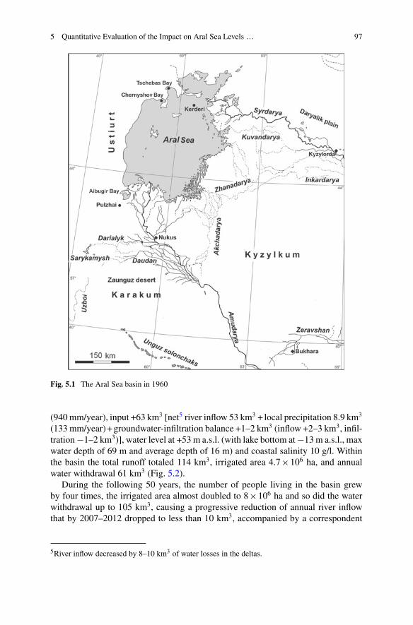
5 Quantitative Evaluation of the Impact on Aral Sea Levels … 97
Fig. 5.1 The Aral Sea basin in 1960
(940mm/year), input +63 km3 [net5 river inflow 53 km3 + local precipitation 8.9 km3
(133 mm/year)+groundwater-infiltration balance +1–2 km3 (inflow +2–3 km3, infil-tration−1–2 km3)], water level at +53 m a.s.l. (with lake bottom at−13 m a.s.l., maxwater depth of 69 m and average depth of 16 m) and coastal salinity 10 g/l. Withinthe basin the total runoff totaled 114 km3, irrigated area 4.7×10⁶ ha, and annualwater withdrawal 61 km3 (Fig. 5.2).
During the following 50 years, the number of people living in the basin grewby four times, the irrigated area almost doubled to 8×10⁶ ha and so did the waterwithdrawal up to 105 km3, causing a progressive reduction of annual river inflowthat by 2007–2012 dropped to less than 10 km3, accompanied by a correspondent
5River inflow decreased by 8–10 km3 of water losses in the deltas.
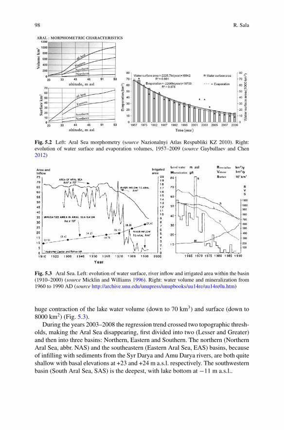
98 R. Sala
Fig. 5.2 Left: Aral Sea morphometry (source Nazionalnyi Atlas Respubliki KZ 2010). Right:evolution of water surface and evaporation volumes, 1957–2009 (source Gaybullaev and Chen2012)
Fig. 5.3 Aral Sea. Left: evolution of water surface, river inflow and irrigated area within the basin(1910–2000) (source Micklin and Williams 1996). Right: water volume and mineralization from1960 to 1990 AD (source http://archive.unu.edu/unupress/unupbooks/uu14re/uu14re0a.htm)
huge contraction of the lake water volume (down to 70 km3) and surface (down to8000 km2) (Fig. 5.3).
During the years 2003–2008 the regression trend crossed two topographic thresh-olds, making the Aral Sea disappearing, first divided into two (Lesser and Greater)and then into three basins: Northern, Eastern and Southern. The northern (NorthernAral Sea, abbr. NAS) and the southeastern (Eastern Aral Sea, EAS) basins, becauseof infilling with sediments from the Syr Darya and Amu Darya rivers, are both quiteshallow with basal elevations at +23 and +24 m a.s.l. respectively. The southwesternbasin (South Aral Sea, SAS) is the deepest, with lake bottom at −11 m a.s.l..
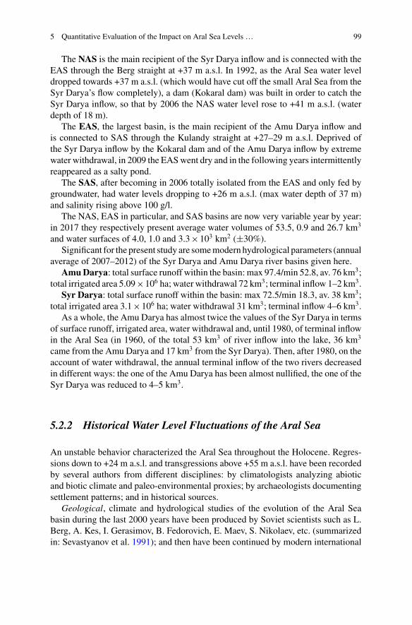
5 Quantitative Evaluation of the Impact on Aral Sea Levels … 99
The NAS is the main recipient of the Syr Darya inflow and is connected with theEAS through the Berg straight at +37 m a.s.l. In 1992, as the Aral Sea water leveldropped towards +37 m a.s.l. (which would have cut off the small Aral Sea from theSyr Darya’s flow completely), a dam (Kokaral dam) was built in order to catch theSyr Darya inflow, so that by 2006 the NAS water level rose to +41 m a.s.l. (waterdepth of 18 m).
The EAS, the largest basin, is the main recipient of the Amu Darya inflow andis connected to SAS through the Kulandy straight at +27–29 m a.s.l. Deprived ofthe Syr Darya inflow by the Kokaral dam and of the Amu Darya inflow by extremewater withdrawal, in 2009 the EASwent dry and in the following years intermittentlyreappeared as a salty pond.
The SAS, after becoming in 2006 totally isolated from the EAS and only fed bygroundwater, had water levels dropping to +26 m a.s.l. (max water depth of 37 m)and salinity rising above 100 g/l.
The NAS, EAS in particular, and SAS basins are now very variable year by year:in 2017 they respectively present average water volumes of 53.5, 0.9 and 26.7 km3
and water surfaces of 4.0, 1.0 and 3.3×10³ km2 (±30%).Significant for the present study are somemodern hydrological parameters (annual
average of 2007–2012) of the Syr Darya and Amu Darya river basins given here.Amu Darya: total surface runoff within the basin: max 97.4/min 52.8, av. 76 km3;
total irrigated area 5.09×10⁶ ha; water withdrawal 72 km3; terminal inflow 1–2 km3.Syr Darya: total surface runoff within the basin: max 72.5/min 18.3, av. 38 km3;
total irrigated area 3.1×10⁶ ha; water withdrawal 31 km3; terminal inflow 4–6 km3.As a whole, the Amu Darya has almost twice the values of the Syr Darya in terms
of surface runoff, irrigated area, water withdrawal and, until 1980, of terminal inflowin the Aral Sea (in 1960, of the total 53 km3 of river inflow into the lake, 36 km3
came from the Amu Darya and 17 km3 from the Syr Darya). Then, after 1980, on theaccount of water withdrawal, the annual terminal inflow of the two rivers decreasedin different ways: the one of the Amu Darya has been almost nullified, the one of theSyr Darya was reduced to 4–5 km3.
5.2.2 Historical Water Level Fluctuations of the Aral Sea
An unstable behavior characterized the Aral Sea throughout the Holocene. Regres-sions down to +24 m a.s.l. and transgressions above +55 m a.s.l. have been recordedby several authors from different disciplines: by climatologists analyzing abioticand biotic climate and paleo-environmental proxies; by archaeologists documentingsettlement patterns; and in historical sources.
Geological, climate and hydrological studies of the evolution of the Aral Seabasin during the last 2000 years have been produced by Soviet scientists such as L.Berg, A. Kes, I. Gerasimov, B. Fedorovich, E. Maev, S. Nikolaev, etc. (summarizedin: Sevastyanov et al. 1991); and then have been continued by modern international
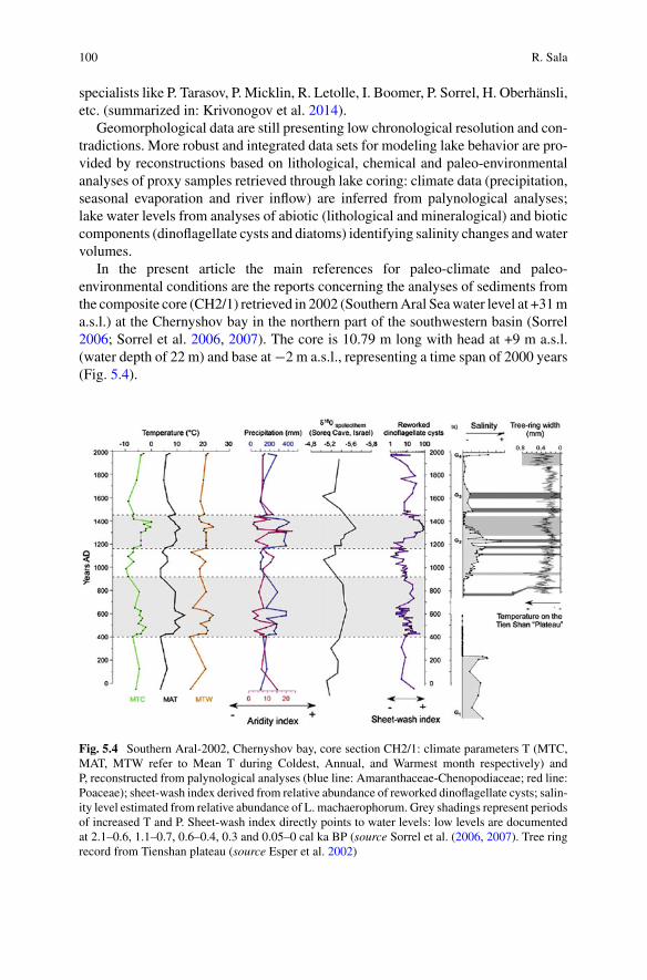
100 R. Sala
specialists like P. Tarasov, P. Micklin, R. Letolle, I. Boomer, P. Sorrel, H. Oberhänsli,etc. (summarized in: Krivonogov et al. 2014).
Geomorphological data are still presenting low chronological resolution and con-tradictions. More robust and integrated data sets for modeling lake behavior are pro-vided by reconstructions based on lithological, chemical and paleo-environmentalanalyses of proxy samples retrieved through lake coring: climate data (precipitation,seasonal evaporation and river inflow) are inferred from palynological analyses;lake water levels from analyses of abiotic (lithological and mineralogical) and bioticcomponents (dinoflagellate cysts and diatoms) identifying salinity changes andwatervolumes.
In the present article the main references for paleo-climate and paleo-environmental conditions are the reports concerning the analyses of sediments fromthe composite core (CH2/1) retrieved in 2002 (SouthernAral Seawater level at +31ma.s.l.) at the Chernyshov bay in the northern part of the southwestern basin (Sorrel2006; Sorrel et al. 2006, 2007). The core is 10.79 m long with head at +9 m a.s.l.(water depth of 22 m) and base at−2 m a.s.l., representing a time span of 2000 years(Fig. 5.4).
Fig. 5.4 Southern Aral-2002, Chernyshov bay, core section CH2/1: climate parameters T (MTC,MAT, MTW refer to Mean T during Coldest, Annual, and Warmest month respectively) andP, reconstructed from palynological analyses (blue line: Amaranthaceae-Chenopodiaceae; red line:Poaceae); sheet-wash index derived from relative abundance of reworked dinoflagellate cysts; salin-ity level estimated from relative abundance of L. machaerophorum. Grey shadings represent periodsof increased T and P. Sheet-wash index directly points to water levels: low levels are documentedat 2.1–0.6, 1.1–0.7, 0.6–0.4, 0.3 and 0.05–0 cal ka BP (source Sorrel et al. (2006, 2007). Tree ringrecord from Tienshan plateau (source Esper et al. 2002)
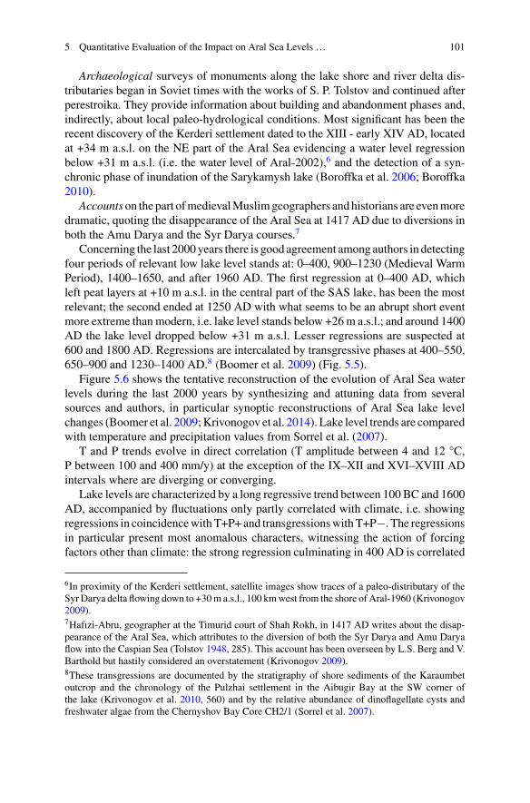
5 Quantitative Evaluation of the Impact on Aral Sea Levels … 101
Archaeological surveys of monuments along the lake shore and river delta dis-tributaries began in Soviet times with the works of S. P. Tolstov and continued afterperestroika. They provide information about building and abandonment phases and,indirectly, about local paleo-hydrological conditions. Most significant has been therecent discovery of the Kerderi settlement dated to the XIII - early XIV AD, locatedat +34 m a.s.l. on the NE part of the Aral Sea evidencing a water level regressionbelow +31 m a.s.l. (i.e. the water level of Aral-2002),6 and the detection of a syn-chronic phase of inundation of the Sarykamysh lake (Boroffka et al. 2006; Boroffka2010).
Accounts on the part ofmedievalMuslimgeographers andhistorians are evenmoredramatic, quoting the disappearance of the Aral Sea at 1417 AD due to diversions inboth the Amu Darya and the Syr Darya courses.7
Concerning the last 2000years there is good agreement among authors in detectingfour periods of relevant low lake level stands at: 0–400, 900–1230 (Medieval WarmPeriod), 1400–1650, and after 1960 AD. The first regression at 0–400 AD, whichleft peat layers at +10 m a.s.l. in the central part of the SAS lake, has been the mostrelevant; the second ended at 1250 AD with what seems to be an abrupt short eventmore extreme thanmodern, i.e. lake level stands below +26m a.s.l.; and around 1400AD the lake level dropped below +31 m a.s.l. Lesser regressions are suspected at600 and 1800 AD. Regressions are intercalated by transgressive phases at 400–550,650–900 and 1230–1400 AD.8 (Boomer et al. 2009) (Fig. 5.5).
Figure 5.6 shows the tentative reconstruction of the evolution of Aral Sea waterlevels during the last 2000 years by synthesizing and attuning data from severalsources and authors, in particular synoptic reconstructions of Aral Sea lake levelchanges (Boomer et al. 2009;Krivonogov et al. 2014). Lake level trends are comparedwith temperature and precipitation values from Sorrel et al. (2007).
T and P trends evolve in direct correlation (T amplitude between 4 and 12 °C,P between 100 and 400 mm/y) at the exception of the IX–XII and XVI–XVIII ADintervals where are diverging or converging.
Lake levels are characterized by a long regressive trend between 100 BC and 1600AD, accompanied by fluctuations only partly correlated with climate, i.e. showingregressions in coincidencewithT+P+and transgressionswithT+P−. The regressionsin particular present most anomalous characters, witnessing the action of forcingfactors other than climate: the strong regression culminating in 400 AD is correlated
6In proximity of the Kerderi settlement, satellite images show traces of a paleo-distributary of theSyr Darya delta flowing down to +30m a.s.l., 100 kmwest from the shore of Aral-1960 (Krivonogov2009).7Hafızi-Abru, geographer at the Timurid court of Shah Rokh, in 1417 AD writes about the disap-pearance of the Aral Sea, which attributes to the diversion of both the Syr Darya and Amu Daryaflow into the Caspian Sea (Tolstov 1948, 285). This account has been overseen by L.S. Berg and V.Barthold but hastily considered an overstatement (Krivonogov 2009).8These transgressions are documented by the stratigraphy of shore sediments of the Karaumbetoutcrop and the chronology of the Pulzhai settlement in the Aibugir Bay at the SW corner ofthe lake (Krivonogov et al. 2010, 560) and by the relative abundance of dinoflagellate cysts andfreshwater algae from the Chernyshov Bay Core CH2/1 (Sorrel et al. 2007).
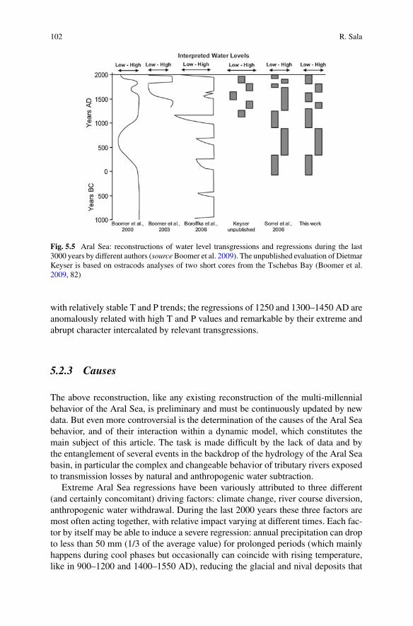
102 R. Sala
Fig. 5.5 Aral Sea: reconstructions of water level transgressions and regressions during the last3000 years by different authors (sourceBoomer et al. 2009). The unpublished evaluation of DietmarKeyser is based on ostracods analyses of two short cores from the Tschebas Bay (Boomer et al.2009, 82)
with relatively stable T and P trends; the regressions of 1250 and 1300–1450 AD areanomalously related with high T and P values and remarkable by their extreme andabrupt character intercalated by relevant transgressions.
5.2.3 Causes
The above reconstruction, like any existing reconstruction of the multi-millennialbehavior of the Aral Sea, is preliminary and must be continuously updated by newdata. But even more controversial is the determination of the causes of the Aral Seabehavior, and of their interaction within a dynamic model, which constitutes themain subject of this article. The task is made difficult by the lack of data and bythe entanglement of several events in the backdrop of the hydrology of the Aral Seabasin, in particular the complex and changeable behavior of tributary rivers exposedto transmission losses by natural and anthropogenic water subtraction.
Extreme Aral Sea regressions have been variously attributed to three different(and certainly concomitant) driving factors: climate change, river course diversion,anthropogenic water withdrawal. During the last 2000 years these three factors aremost often acting together, with relative impact varying at different times. Each fac-tor by itself may be able to induce a severe regression: annual precipitation can dropto less than 50 mm (1/3 of the average value) for prolonged periods (which mainlyhappens during cool phases but occasionally can coincide with rising temperature,like in 900–1200 and 1400–1550 AD), reducing the glacial and nival deposits that

5 Quantitative Evaluation of the Impact on Aral Sea Levels … 103
Fig. 5.6 Correlation of temperature, precipitation, lake water levels and phases of river coursediversion and anthropogenic water withdrawal during the last 2600 years. A, B, C, D classifyfour types of climate changes and their potential impact on lake levels. Marked bands: periods ofclimatically anomalous water level fluctuations. T and P trends adapted from Sorrel et al. (2007);Aral Sea water levels elaborated by R. Sala by synopsis of different sources
constitute the main source of the river runoff; the diversion of the Amu Darya coursecan be almost total, lowering the river inflow by more than 50%, and relevant diver-sions probably happen also in the Syr Darya (see below Sect. 5.2); the increasingwater withdrawal of the last 60 years has in itself been the determinant cause of themodern disappearance of the Aral Sea.
104 R. Sala
5.2.3.1 Climate Change to Very Arid Conditions
Climatologists and paleo-environmentalists who detected the severe Aral Sea regres-sions of the last 2000 years tend to underline their coincidence with negative NAOphases weakening westerly winds and precipitation (Sorrel et al. 2007; Hill 2017).Synchronous with these phases is the establishment of a series of events that alltogether point to global atmospheric teleconnections: palynological dry phases inthe Aral Sea region at 900–1150 and 1450–1550 AD; decreasing tree ring width inthe Tienshan and Pamirs ranges (sources of the almost totality of the rivers’ runoff)at 1250, 1400, 1500 AD (Fig. 5.4); similar water level fluctuations in other CentralAsian lakes like the Balkhash, Issykul, Bosten, etc. (Chen et al. 2008; Endo et al.2012); and drought in the Near East.
All the above cases seem related to low P values, but the forcing effect of coldphases must be also considered. The regression of the 1450–1650 AD coincides theLittle Ice Age when lower T values contributed to the decrease of river dischargesin two ways: by lessening atmospheric transport and precipitation and by enhancingice accumulation in the Tienshan and Pamir mountains (Krivonogov 2009).
5.2.3.2 River Course Diversion
Reconstructions based on archaeological studies and historical accounts tend toexplain the most extreme Aral Sea regressions by a diversion at the head of the AmuDarya delta to the west through the Daudan Darya and Darialyk (Kunya Darya)channels into the Sarykamysh basin. The channel cross-section at Daudan Daryaand Daryalyk could not carry more than 20–30 km3 per year, so that the diversionof the Amu Darya flow can never be total and a residual inflow would always reachthe southern part of the Aral Sea (Letolle et al. 2007).
The Sarykamysh basin covers an area of 11,000 km2 with the potential to accom-modate, between−38 and +54 m a.s.l., a max. water volume of 250 km3 (1/4 of AralSea at its max capacity at +54 m a.s.l.) exposed to annual evaporation of 11 km3. Incase the Sarykamysh lake water level would grow above +54 m a.s.l., its emissaryUzboi channel would be activated towards the Caspian Sea. The annual discharge ofthe Uzboi channel cannot be higher than 10 km3 so that the eventual water excesswould be diverted and dissipated in the dunes of the Zaunguz desert (northern part ofthe Karakum desert). Besides the Amu Darya diversion, geomorphological featuresindicate that the Uzboi would be activated also in case the Aral Sea would enter intoextreme transgressive conditions with water levels at +54–56 m a.s.l. and merge withthe Sarykamysh (Tolstov and Kes 1960; Kes and Klyukanova 1999; Letolle et al.2007).
A longstanding filling of the Sarykamysh lake and activity of the Uzboi channel isdocumented between 5000 and 2000BC by the presence of numerousNeolithic sites,after which, due to the damming of the Daryalyk channel for irrigation purposes,Uzboi water regimes started decreasing and ended around IV BC. In subsequent

5 Quantitative Evaluation of the Impact on Aral Sea Levels … 105
times, except for short abrupt events that left no geological or archaeological traces,9
the Uzboi was never reactivated and changed into a series of ponds that could host acaravan road but could not support the establishment of large agricultural settlements(Tolstov 1948, 295; Tolstov and Kes 1960).
Amu Darya diversions continued intermittently, filling incompletely theSarykamysh lake during III–I BC, IV–VIII AD and XIV–XV AD.10 After VIIIAD the lake never reached level stands above +8 m a.s.l. (Krivonogov et al. 2014,297), whereupon any further diversion of the Amu Darya course would have had justan abrupt and ephemeral character supporting average Sarykamysh lake stands andevaporation losses quite similar to modern.
The Amu Darya diversions of last 2000 years, which saw the anthropogenicembankment of the western distributaries of the Amu Darya delta, were necessarilyrelated to the destruction of dams by natural hazards or wars: undocumented flash-floods or earthquakes at 1208, 1389, 1405 AD (Melville 1980), the Hephtalite Hunsinvasion during 380–400 AD, the Mongol invasion at 1221 AD, the Timurid wars at1372–1388 AD.11
Besides the lower course of the Amu Darya, the middle and lower course of theSyr Darya are also characterized by a very unstable watershed where sedimentaryand/or technogenic factors can easily induce abrupt events of water diversion (seebelow Sect. 5.2). In the first half of the XIV AD the Arab geographer ibn Fadl Allahal-Omari (d. 1349) heard from oral sources that the “Seyhun (SyrDarya) flows amongreeds and sands below the city of Jend (on the Janadarya) at the distance of threedays travel and here it disappears”. (Barthold 1902, 55). As quoted above (note 7),also Hafizi-Abru in the early XV AD describes the Syr Darya delta (or at least itssouthern branches) merging with the Amu Darya, and both rivers avoiding the AralSea and flowing together to the Caspian Sea (Barthold 1902; Boroffka 2010). TheTimurid ruler Babur (1483–1530) in his ‘Memoirs’ speaks about the Djihun (SyrDarya) lost in sands far away downstream from the medieval town of Turkestan (seeSect. 5.2) (Babur 1530, 45; Crétaux et al. 2009, 285).
9The Persian geographer Hamdallah Kazwını in 1339 mentions the Amu Darya flowing via theUzboi to the Khazarian (Caspian) Sea (Tolstov 1948, 285); and in 1392 Zahır-ad-dın al Maraschıdescribes a trip taking place by ship up the Uzboi (Boroffka 2010, 292).10In 1417 AD Hafızi-Abru wrote about the disappearance of the Aral Sea (see note 7). In 1558 theEnglish merchant and traveler A. Jenkinson, while residing in Sellizure (Vazir) on the shores of theDaryalik channel, witnesses its progressive desiccation due to upstream anthropogenic implemen-tations: “the water that serveth all that country is drawn by ditches out of the river Oxus, unto thegreat destruction of the said river, for which cause it falleth not into the Caspian Sea (in reality theSarykamish lake) as it hath done in times past; and in short time all that land is like to be destroyedand to become a wilderness for want of water, when the river of Oxus shall fail” (Jenkinson 1558).Few years later, Abu al-Ghazi (1603–1663), khan of Khiva, reported that the Amu Darya was flow-ing to the southwest until the 1573 after which switched its course into the Aral Sea (Tolstov 1948,285; Boroffka 2010, 293).11All authors tend attributing the Amudaya diversion events of the last 2000 years to the destructionof technogenic dams built across main distributaries of the delta. Historical sources support thathypothesis (Barthold 1902). According to general Gloukhovsky (1893), between 1310 and 1575AD the dams and irrigation systems of the Amu Darya delta were disrupted at the point of divertingits main current into the Sarykamysh depression and further, through the Uzboi channel, into theCaspian Sea (Boroffka 2010).
106 R. Sala
5.2.3.3 Anthropogenic Water Subtraction by the Agro-IrrigationalUrban Complexes of the Amu Darya and Syr Darya Basins
Concerning the anthropogenic water subtraction by themedieval urban and irrigationsystems of the Syr Darya and Amu Darya basins, its possible impact is evident todayin the fact thatwaterwithdrawal for irrigation purposes has been by far themain causeof the present Aral Sea desiccation; and most of the authors quoted above suspectthat, from the III BC to the XXAD, it has always been a concomitant factor, togetherwith climate and river diversion, of Aral Sea water level fluctuations.12 Referring tohistorical-archaeological accounts, on the lower Amu Darya the presence of largeurban systems and irrigation practices have been documented initially between 300BC and 300 AD and then again between 600 and 1300 AD. Their presence on theSyr Darya is basically ignored.
If up to now water withdrawal has not been subject of scientific investigation andquantitative evaluation, this is due to three main reasons: absence of a database of theurban systems ofWest Central Asia, underestimation of their size and potential envi-ronmental impact, and lack of geoarchaeological field studies needed for elaboratingcoefficients of past water use.
This article tries to answer those questions and confronts the problem of the inter-active effect of the three casual factors spoken above on the evolution of Aral Seawater levels, focusing on the time span of the Medieval Warm period. Researchmethods are explained in Sect. 3, research results in Sect. 4. Eventually the quanti-tative evaluation of annual anthropogenic water subtraction is sorted out, allowing apreliminary reconstruction of the complex interaction of the three forcing factors indetermining the Aral Sea water levels during the Medieval Warm Period (Sect. 5).
5.3 Medieval Water Withdrawal: Research Methods
The quantitative evaluation of water withdrawal by the medieval agro-irrigationalurban complexes of the Syr Darya and Amu Darya basins and of its impact on AralSea water volumes is a difficult task, therefore the present study proceeds throughaverage estimates and extrapolations, leading to approximate and debatable results.The method itself is original, developing through three main steps: documentationof the size of the urban systems of the Aral Sea basin during a specific period(century); elaboration of a coefficient of water use per urban hectare in a specific
12“However, the degree of lake level lowering may have been amplified by humans responding tochanging environmental conditions. Irrigation systems were probably extended during periods ofmore arid conditions” (Sorrel et al. 2007). “Therefore a similar effect as the modern one, a majorregression of the Aral Sea caused byman, may be presumed especially towards the end of Antiquity,when long-term results of intensive irrigation took effect” (Boroffka 2010). “Irrigation activitieswere at a maximum between 300 BC and AD 300 (Classical Antiquity) and between AD 800 and1300 (Medieval Age) and after AD 1960” (Oberhänsli et al. 2007).

5 Quantitative Evaluation of the Impact on Aral Sea Levels … 107
region; calculation of the ratio of agro-urban annualwater subtraction from the virtualrunoff of the Syr Darya and Amu Darya rivers during the chosen period.
Modeling starts analyzing the agro-urban complexes of the Syr Darya basin(Sects. 4.1–4.3) and sorts out hydraulic coefficients concerning the region. Suchcoefficients are then extrapolated to the Amu Darya region, allowing the evalua-tion of the total impact of irrigational water withdrawal in the entire Aral Sea basin(Sect. 4.4). In Sect. 5 the insertion of those data within a simplified model of theAral Sea bathimetry and water balance provides the evaluation of the Aral Sea waterlevels under two different scenarios, i.e. two different values of terminal river inflow,in absence or in presence of river diversion. In detail:
a. Documentation of all the walled units of the urban systems of the Syr Daryabasin, with particular focus on their geographical location, size in hectares andchronological attribution of their occupation by century.
The database of thesemonuments has been elaborated by theLaboratory ofGeoar-chaeology of Almaty during several research seasons. It includes all the walled towns(and a few very large and visible villages) of the Syr Darya river valley, recorded inarchaeological reports and in the Svod Pamiadnikov Istorii i kulturi Respubliki Kaza-khstan.13 Small unwalled villages are omitted, by being in general badly explored,most often undetectable, and in any case covering a relatively small total area het-erogeneously in different urban regions.
b. Selection of a particular historical period and of a particular urban regionfor documenting the irrigation schemes (general structure, length and profile ofcanal distributaries) active in that region during that period.
As historical period, for this study has been selected the X century AD, due tofour convenient characters: (1) it is included within the recession phase of the IX-XII AD, which ends with the extreme low water stand of the early XIII AD; (2) itsclimate has been evaluated as similar to modern, though slightly cooler and drier,14
suggesting an estimate of precipitation and evaporation rates and virtual river runoffin the Aral Sea basin as 10% less than in modern times, i.e. 104 km3, 33 km3 inthe Syr Darya basin and 71 km3 in the Amu Darya15; (3) in the X AD, historicalrecords quote the Aral Sea as receiving the entire discharge of the Amu Darya river,
13A large part of the urban units has also been documented by aerial photography and explored byland surveys for filling entries of environmental character. A few tens of urban structures have beendiscovered anew.14The Sorrel reconstruction of Fig. 5.4 infers for the start of X AD average temperature values 3 °Ccooler and annual precipitation 40 mm lesser than modern, and T and P rising to modern conditionsby the end of the century and during the following XI and XII centuries. The time span falls withinthe so-called Medieval Warm Period, which apparently in Central Asia has not been exceptionallywarm.15Together with values of virtual river runoff, also values of terminal river inflow into the Aral Seawould be decreased by 10%. This is in agreement with measurements and dating (by archaeologicalfindings and few radiocarbon analyses) of re-deepened river channels in the foothill zone, imple-mented in Soviet times by E. D. Mamedov and G. N. Trofimov, suggesting for the XI AD a totalterminal river inflow in the Aral Sea of 49–50 km3 increasing in the following century to modern

108 R. Sala
which excludes anomalies attributable to Amu Darya course diversion and allowsinferences about diversions of the Syr Darya course; (4) and, most importantly, theX AD corresponds to the peak of urbanization in West Central Asia, which shows aplateau of homogeneous total urban area between the VI and XII AD.
As study polygon for hydraulic analyses has been selected the Otrar oasis, locatedon the Arys delta at its confluence with the middle Syr Darya (Fig. 5.10), for severalreasons: itsmonumental heritage has been object of several decades of archaeologicalstudy and chronological attribution; the oasis shows evidence of six generationsof clearly detectable irrigation schemes; and its environment has been object ofpalynological analyses and paleoclimate reconstruction.
c. Structural analysis of a significant irrigation scheme, evaluation of the totalvolume of annual water withdrawal through the use of specific agro-hydraulicmodels, and calculation of the coefficient of annual water use by occupied urbanhectare.
The hydraulic system under study, the Altyn irrigation scheme of the X–XIII AD,runs in the central part of the Otrar oasis and has been analyzed in the context ofthe project INTAS/2002-2005. The canals’ length, bed width, side slope, bed slopeand berm width have been measured in order to reconstruct trapezoidal canal crosssections and calculate their carrying capacity. These data have been simulated into ahydraulic model using the US Corps of Engineers River Analysis System softwareHEC-RAS 2009. CROPWAT software (UN-FAO) provided additional estimates ofwater requirements in mm/day based on consideration of crop type, effective rainfalland soil moisture deficit (Clarke et al. 2010).
d. Extrapolation of the Otrar water use coefficient to the whole agro-urbansystems of the Syr Darya, resulting in the evaluation of the total volume ofannual water withdrawal from the entire Syr Darya river basin.
e. Evaluation the virtual river runoff of the Syr Darya during the chosen periodon the basis of the climate esteems quoted at Sect. 3b, and calculation of the ratioof water withdrawal versus water runoff.
f. Extrapolation of the ratio of water withdrawal calculated for the Syr Daryato the water runoff of the Amu Darya basin, and evaluation of the total volumeof water withdrawal and residual runoff of both rivers.
The resulting values of water withdrawal are valid without significant error forthe X–XII AD. In fact the period under study is the X AD, the total area of the SyrDarya settlements between VI and XII AD is stable (±3.6%) (Fig. 5.8), and the OtrarAltyn irrigation scheme chosen for sorting out hydraulic coefficients has been activefrom X to XIII AD.16
regimes of 56.9 km3 (Trofimov 2003, Table 3). As a whole, these esteems point for the X–XII ADto an arid climate supporting nival-ice deposits and river discharges slightly lower than modern.16The values of medieval urbanization and correspondent water withdrawal given for the X–XIIAD start decreasing only from XIII AD when West Central Asia, following the Mongol invasion,entered a period of pastoralist conversion reducing agricultural activities and a longstanding coolingclimate phase lessening water requirements.
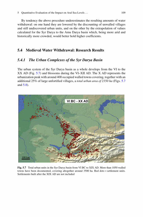
5 Quantitative Evaluation of the Impact on Aral Sea Levels … 109
By tendency the above procedure underestimates the resulting amounts of waterwithdrawal: on one hand they are lowered by the discounting of unwalled villagesand still undiscovered urban units, and on the other by the extrapolation of valuescalculated for the Syr Darya to the Amu Darya basin which, being more arid andhistorically more crowded, would better hold higher coefficients.
5.4 Medieval Water Withdrawal: Research Results
5.4.1 The Urban Complexes of the Syr Darya Basin
The urban system of the Syr Darya basin as a whole develops from the VI to theXX AD (Fig. 5.7) and blossoms during the VI–XII AD. The X AD represents theurbanization peak with around 400 occupied walled towns covering, together with anadditional 25% of large unfortified villages, a total urban area of 2350 ha (Figs. 5.7and 5.8).
Fig. 5.7 Total urban units in the Syr Darya basin from VI BC to XIX AD. More than 1050 walledtowns have been documented, covering altogether around 3500 ha. Red dots settlement units.Settlements built after the XIX AD are not included
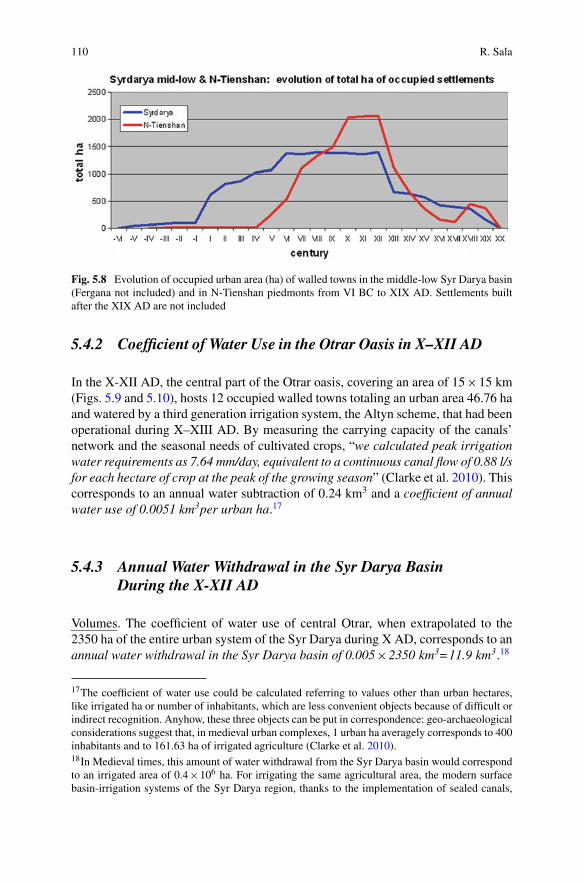
110 R. Sala
Fig. 5.8 Evolution of occupied urban area (ha) of walled towns in the middle-low Syr Darya basin(Fergana not included) and in N-Tienshan piedmonts from VI BC to XIX AD. Settlements builtafter the XIX AD are not included
5.4.2 Coefficient of Water Use in the Otrar Oasis in X–XII AD
In the X-XII AD, the central part of the Otrar oasis, covering an area of 15×15 km(Figs. 5.9 and 5.10), hosts 12 occupied walled towns totaling an urban area 46.76 haand watered by a third generation irrigation system, the Altyn scheme, that had beenoperational during X–XIII AD. By measuring the carrying capacity of the canals’network and the seasonal needs of cultivated crops, “we calculated peak irrigationwater requirements as 7.64 mm/day, equivalent to a continuous canal flow of 0.88 l/sfor each hectare of crop at the peak of the growing season” (Clarke et al. 2010). Thiscorresponds to an annual water subtraction of 0.24 km3 and a coefficient of annualwater use of 0.0051 km3per urban ha.17
5.4.3 Annual Water Withdrawal in the Syr Darya BasinDuring the X-XII AD
Volumes. The coefficient of water use of central Otrar, when extrapolated to the2350 ha of the entire urban system of the Syr Darya during X AD, corresponds to anannual water withdrawal in the Syr Darya basin of 0.005×2350 km3=11.9 km3.18
17The coefficient of water use could be calculated referring to values other than urban hectares,like irrigated ha or number of inhabitants, which are less convenient objects because of difficult orindirect recognition. Anyhow, these three objects can be put in correspondence: geo-archaeologicalconsiderations suggest that, in medieval urban complexes, 1 urban ha averagely corresponds to 400inhabitants and to 161.63 ha of irrigated agriculture (Clarke et al. 2010).18In Medieval times, this amount of water withdrawal from the Syr Darya basin would correspondto an irrigated area of 0.4×10⁶ ha. For irrigating the same agricultural area, the modern surfacebasin-irrigation systems of the Syr Darya region, thanks to the implementation of sealed canals,

5 Quantitative Evaluation of the Impact on Aral Sea Levels … 111
Fig. 5.9 Otrar oasis during the X century AD. Dots settlements: redoccupied; yellownewlybuilt after the start of the century; white just abandoned before the start of the century. Dots’ sizeis proportional to the areal dimension of the urban unit. Blue linescanals of the Altyn irrigationscheme (center) and, south and northwest of it, of its contemporary Shubara and Ak-Aryk schemes
Ratios. Supposing for the X–XII AD climatic conditions slightly cooler and drierthan modern and virtual river regimes 10% lower, the virtual annual surface runoffof the Syr Darya basin would be 33 km3 (see Sect. 3b), of which the annual waterwithdrawal of 11.9 km3represents the 11.9×100 : 33=36.0%.
5.4.4 Total Annual Water Withdrawal in the Syr Daryaand Amu Darya Basins During X–XII AD
Currently, a complete data base of the medieval settlements of the Amu Darya basinis not available. In order to evaluate the anthropogenic water withdrawal withinthis basin, the same ratio of water subtraction calculated for the Syr Darya has beenapplied to the virtual surface runoff of theAmuDarya (71 km3; see Sect. 2b), resultingin an annual water withdrawal from the Amu Darya basinof 36.0%×71=25.5 km3.
water drainage and return flow,would use only half of thewater volume calculated here forMedievaltimes.
112 R. Sala
Therefore, during the X AD the total annual water withdrawal from the entireAral Sea basin (Syr Darya+Amu Darya) would be 11.9+25.5=37.4 km3.19
A water withdrawal of 37.4 km3 represents around 1/3 of the total runoff of thetwo rivers (104 km3), leaving a total residual river flow of 66.6 km3, 45.5 km3 in theAmu Darya and 21.1 km3 in the Syr Darya. And it corresponds to around half of itsvalue in the 1960,20 the year that saw the last modern high stand of the lake (+53 ma.s.l.) before the following catastrophic recession.
5.5 Discussion
5.5.1 Controlling Factors of the Aral Sea Water BalanceDuring X-XII AD
The water mass balance equation of the Aral Sea, which is deprived of emissary, is afunction of few hydrological variables characteristic of the lake, expressed in watervolumes (km3/year):
f0: dV/dt Rt (vt − dt − at ) + Pt + Gt − Et
where V lake water volume, t time, R river inflow, P local precipitation,Ggroundwater-infiltration balance, E local evaporation. R is function of virtualrunoff (v), river course diversion (d) and anthropogenic annual water withdrawal(a). P, E and v depend strictly on climate. The equilibrium state, where the lakehydrological system is uniform throughout, corresponds to dV/dt=0.
For example, the water balance equation of Aral-1960 is:
f1 : Aral − 1960 R[v(114) − d(0) − a(61)] + P(9) + G(1) − E(63)
0 km3/year
Let’s work out the water balance equation of the Aral Sea at X AD (Aral-1000)in two steps, under two scenarios.
19In Medieval times, this amount of water withdrawal from both the Syr Darya and Amu Daryabasins would correspond to an irrigated area of 1.15×10⁶ ha (see note 17), against the 10×106
ha of the modern land under irrigation. During Classical Antiquity (IV BC–IV AD), according toTolstov and Andrianov (1968) and Gerasimov (1978), the network of canals detected in just theAmu Darya basin would ‘allow’ to irrigate more than 5×10⁶ ha (Oberhänsli et al. 2007, 177). Infact, the actual extent of yearly irrigated area was most probably 3–4 times lower (Tolstov 1948)and submitted to fallow cycles longer than modern, in that way approximating the evaluation ofirrigated land given above for the entire Aral basin during medieval times.20This double modern value of water withdrawal matches the fact that by 1960 the Soviet regimequadrupled the former medieval irrigated area of the Aral Sea basin from 1.2 to 4.7 million ha,introducing in the same time technical advances as sealed canals, drainage and return flow thatimproved the performance of the irrigation systems and halved the water requirements per ha.
5 Quantitative Evaluation of the Impact on Aral Sea Levels … 113
The two scenarios are similar in supposing the same climate and the same amountof water withdrawal as evaluated above. Climate conditions are slightly more aridthan modern,21 so that precipitation and evaporation rates in/from the lake and run-off values within the basin are evaluated as 10% lower than modern (Sect. 3b). Thevalue of annual anthropogenic water withdrawal (a) is 37.4 km3, as calculated inSect. 4.4. The two scenarios differ on values of terminal river inflow R, in absenceor in presence of water subtraction by river course diversion.
a. The first scenario considers the terminal river inflow as the residual flow ofSect. 4.4: R=v(104)−a(37.4)=66.6 km3 (45.5 from the Amu Darya and 21.1from the Syr Darya), i.e. without additional water subtraction by river diversion,i.e. d(0).
A river inflow of 66.6 km3 corresponds to hydrological parameters of Aral-1000higher than today, at the top of the lake’s bathymetric capacity: water volumes above1100 km3, water surface of 75600 km2, local evaporation volumes 75.6 km3, localprecipitation 8 km3, and lake level at +55 m a.s.l. Under this scenario the resultingwater balance equation for Aral-1000 would be the following:
f2 : Aral − 1000(1) R[v(104) − d(0) − a(37.4)] + P(8) + G(1) − E(75.6)
0 km3/year
The hydrological parameters related to this first scenario (a river inflow of66.6 km3) are in disagreement with the values suggested for the same period bythe paleo-environmental reconstructions quoted above: physico-chemical analysesof lake cores indicate for Aral-1000 higher salinity levels and lower water volumesthan for Aral-1960 (see Sect. 2.2, Figs. 5.4 and 5.5); and geomorphological surveysof relict channels suggest a much lower inflow of 49 km3 (see note 16).
b. The second scenario considers a river inflow into the Aral Sea of 49 km3 inagreement with the estimations of river inflow and lake water volumes suggestedby paleo-environmental studies. A river inflow of 49 km3 would correspond tolake water volumes of 820 km3, water surface of 57,000 km2, local evaporationvolumes of 58 km3, local precipitation of 7 km3, and lake-water level at +49 ma.s.l.
But in order that R= f (v−d−a)=49 km3, with values of climate (virtual riverrunoff) and anthropogenic water withdrawal set as the preconditions spoken above[v(104) and a(37.4)], an additional (104−37.4−49)17.6 km3 ofwater subtractionmust be attributed to a still undetected event of river diversion: d(17.6).
f3 : Aral − 1000(2) R[v(104) − d(17.6) − a(37.4)] + P(7) + G(1) − E(58)
0 km3/year
21For the start of XAD have been evaluated annual temperature values 3 °C cooler and precipitation40 mm lower than modern, and T and P trends rising to modern values by the end of the century(see Sect. 1.1, Fig. 5.4, note 14).
114 R. Sala
Being excluded switches of Amu Darya course (see Sect. 2.3.2), the additionalwater subtraction of 17.6 km3 must be attributed to some still undetected transmissionlosses along the poorly explored course of the Syr Darya river.
When analyzing this possibility, it has been noticed that the Syr Darya has hydro-logical parameters averaging half of the values of the AmuDarya but at the same timea much more meandering and undefined course, “frequently changing its bed, form-ing channels that often lose themselves in the sands, and overflowing its low banksat flood”,22 ending up in constituting a deltaic floodplain one-and-half times widerand potentially exposed to higher transport losses. Have also been found archaeo-logical data and historical accounts (quoted in Sect. 5.2) testifying the occurrence ofmedieval switches of the Syr Darya course relevant enough to divert the quasi total-ity of the 21.1 km3 residual flow of the river, matching in that way the hydrologicalscenario inferred by geo-environmental reconstructions and described by the waterbalance equation ƒ3.
5.5.2 Water Diversion Events Along the Syr Darya Course
Significant events of water diversion from the middle and low Syr Darya course dur-ing antiquity and, specifically, during medieval times are documented by geologicalstudies, archaeological data, and historical accounts.
Concerning geological studies, the susceptibility of the Syr Darya to switchesof river course into paleo-beds ending in neighboring depressions to now has beenunderestimated.Most exposed to diversions are four points of themiddle-low course:
• The first diversion occurs from the left bank at the exit of the Fergana valley,feeding the Arnasay lowland and, today, the man-made Aydar-Arnasay lake. Ithas become very relevant only in the last few decades after been enhanced bySoviet technogenic implementations.23
• The second occurs from the left bank of the Chardara river segment towardsthe sand dunes of the Kyzylkum desert where a relict delta 100 km long withfront 60 km wide is detectable. This diversion happened during the period underconsideration at a scale that seems to be of medium size.24
22See: Syr Darya, Encyclopedia Britannica 2011.23The Arnasay lowland, formerly a dry salt pan and ephemeral lake (Tokzan lake), in the 60iesstarted to be used as a flood control basin and grew into a lake with water surface of 3000 km2 andwater volume of 44 km3 (Aydar-Arnasay lake system). In that way an ‘unintentional byproduct ofSoviet planning’, by subtracting annually 10% of the Syr Darya water flow (3 km3), became one ofthe main causes of the subsequent shrinking of the Aral Sea. As a whole, the total water surface ofuseless Soviet evaporation basins amounts to 10,000 km2 (Ashirbekov and Zonn 2003, 16). Today,in spite of the fact that only 500 families inhabit the Aydar-Arnasay region, the restoration of theformer hydrological conditions is impeded by transboundary water conflicts.24Today the areas paralleling the left bank of the Chardara river segment are concerned by seasonalfloods totally harvested within irrigation schemes, so that the Chardara paleodelta itself is almostdesiccated. This was not the case between the IX and XII AD when some of its distributaries were
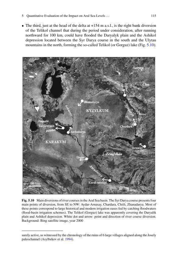
5 Quantitative Evaluation of the Impact on Aral Sea Levels … 115
• The third, just at the head of the delta at +154 m a.s.l., is the right bank diversionof the Telikol channel that during the period under consideration, after runningnorthward for 100 km, could have flooded the Daryalyk plain and the Ashikoldepression located between the Syr Darya course in the south and the Ulytaumountains in the north, forming the so-called Telikol (or Gorguz) lake (Fig. 5.10).
Fig. 5.10 Main diversions of river courses in theAral Sea basin. The SyrDarya course presents fourmain points of diversion, from SE to NW: Aydar-Arnasay, Chardara, Chiili, Zhanadarya. Most ofthese points correspond to large historical and modern irrigation oases fed by catching floodwaters(flood-basin irrigation schemes). The Telikol (Gorguz) lake was apparently covering the Daryalikplain and Ashikol depression. White dot and arrow: point and direction of river course diversion.Background: Bing satellite image, year 2000
surely active, as witnessed by the chronology of the ruins of 6 large villages aligned along the Joselypaleochannel (Asylbekov et al. 1994).
116 R. Sala
• The fourth and only diversion event clearly quoted by historical accounts (note 12)and considered by some authors (Barthold 1902; Boroffka 2010) is the diversionof the Zhanadarya delta distributary into the sands of the Kyzylkum desert. Theevent occurred together with the reactivation and re-colonization between XII andXVI AD of the formerly dry Zhanadarya course (Fig. 5.12) and is not related tothe period under study.
Most significant for the present discussion is the Telikol diversion, due to itschronology, size and location. TheTelikol is today an artificial canal, but the existenceof a past natural diversion is evidenced by relict paleo-distributaries 100–200 mwide diverging at Chiili from the Syr Darya right bank to the north for 100 kmuntil merging with the Sarysu and Chu river deltas. From there a multi-channel rivercourse established a large lacustrine system in the Daryalyk plain and the Ashikoldepression, and thenflowed out to thewest untilmergingwith the terminal segment ofthe northernmost distributary of the Syr Darya delta. “Finally, a curious observationcomes from the Memoirs of Sultan Babur (Babur 1530), a solid diary of events inCentral Asia at that time, who wrote “in my time, Djihun (Syr) was lost far awayin the sands”. This would imply that at least a good part of the Syr water did notfetch the Aral. In fact, at the NW of Kzyl Orda, exists a large area of about 50,000km2covered with gypsum and lake sediments, at the past junction of Syr Darya andthe Chu river (these lakes are shown on nineteenth century maps), which could haveevaporated most of the Syr Darya water. This does not seem to have been investigatedin detail, and could have consequences on reconstructions of the past of Aral Sea.”(Cretaux et al. 2009, 285).
Given the geomorphological characters of the plain, the Telikol water basincould only have been a system of lakelets, brackish ponds and evaporation flatand salt playas occasionally gathering into large basins, functionally similar to theSarykamysh, shallower but much larger by size and evaporation potential.25 Geo-logical studies concerning the region are scanty and up to now the full extent ofthe Telikol diversion and lake have not been geologically documented and chrono-logically attributed.
Better grounded are archaeological data. The head of the Syr Darya delta duringthe VIII-X AD sees the sudden development of the Chiili oasis, with the building of13 walled towns26 and a large agro-irrigational system covering around 44,000 ha
25The Syr Darya course diversion into the Daryalyk plain would have surely caused, if not alarge lake, in any case high transmission losses, which “are relatively low when flow is confinedto the primary channels, but increase at higher stages as lesser channels and the floodplain areactivated…exacerbated here by the exceptionally long distance and unusual multichannel form ofthe channel/floodplain system” (Knighton 1994, pp. 137–142).26The medieval walled towns of the Chiili oasis are in number of 13 and cover all together an areaof 44 ha. Signak, the largest (26 ha), is dated to the VI–XIX AD, 3 other towns to the VIII–XII AD,and 8 to the X–XIV AD. Eight additional large villages covering together around 10 ha appearedbetween the XIV–XVI AD. The Telikol channel has surely been active from the VIII until theXII–XIV AD, after which is documented an enhance regime of the Zhanadarya distributary and ofthe main course of the Syr Darya delta (Kerderi branch) in the context of low lake level stands(Krivonogov 2009).

5 Quantitative Evaluation of the Impact on Aral Sea Levels … 117
Fig. 5.11 Walled towns along the Syr Darya during VII (left) and X (right) AD. Dots towns:redoccupied; yellownewly built after the start of the century; white just abandoned beforethe start of the century
Fig. 5.12 Phases of urbanization along different distributaries of the Syr Darya delta. Two discon-tinuities in the urban development are detected at II BC and X AD (grey bands), both accompaniedby drying delta distributaries and peaking upstream urban development (source Sala 2012)
along the Telikol paleo-distributary and its diverging branches. Synchronous withthe urban development of the Chiili oasis is the progressive abandonment betweenthe VIII and X AD of the agro-urban structures of the lower Syr Darya delta,27
apparently as result of critical upstream water subtraction along the mid-Syr Daryacourse (Figs. 5.11 and 5.12).
27This process of urban contraction represents the last phase of the longstanding Jety-Asar cultureestablished in the II century BC along the Kuvandarya delta distributary.

118 R. Sala
Referring to historical accounts, the existence of a very large lake called Gorguzin what seems corresponding to the Daryalyk plain is quoted in the “Kitab Nuzhatal-Mushtaq” (‘Book of pleasant journeys’) of the medieval Muslim geographerMuhammad Al-Idrisi (1100–1165 AD): “the Gorguz lake…bigger than the AralSea.…similar to an ocean”.28 Even the words of the Timurid ruler Babur quoted inSects. 2.3.2 and 5.2 could refer to the Telikol diversion (Babur 1530, 45).
The presence of a lake (or of a system of lakes) named Telikol in correspondenceof the Daryalyk plain and Ashikol depression still figures in several maps of theXVIII–XIX centuries (Schraembl 1792; Pansner 1816; Von Humbold 1843).
Among the modern specialists supporting the establishment of a large lake in thatregion duringmedieval times are counted theEnglish orientalistMiller (1926) and theSoviet ethnographer Vaynberg (1999). B. Vaynberg, who during the 40ies and 50ieswas member of the Tolstov’s multidisciplinary expeditions involved in the ethno-archaeological study of the ancient civilizations of the Amu Darya and Syr Daryadeltas, says: “To the east of Kzyl-Orda there is an extensive takyr plain (Daryalyk-takyr) where, apparently, in antiquity and perhaps in the Middle Ages, there was alake into which flowed the Sarysu and Chu rivers and part of the Syr Darya runoff.It is possible that this was the same lake marked on ancient and medieval Chinesemaps andmentioned bymedievalMuslim travelers (Bichurin 1851, tome III, annexes;Agadzhanov 1969, p. 65 and further). The Inkardarya and the ancient Janadaryacourses, which have origin at the south of this region, did not flow into this lake,but undoubtedly into the Daryalyk-takyr “poured” a number of right bank paleo-distributaries clearly discernible in the Chiili region and dated by archaeologicalmaterial from the early Iron Age to the Middle Ages.” (Vaynberg 1999, pp. 52–57).
The Telikol diversion and the flooding of the Daryalyk-Ashikol evaporation basincould have subtracted, for few centuries around the turn of the I millennium, a largepart (17.6 km3) of the residual river stock of the Syr Darya (21.1 km3), in agreementwith the evaluated total annual river inflow into the Aral Sea of 49 km3 (3.5 km3
from the Syr Darya and 46.5 km3 from the Amu Darya).The “Telikol hypothesis” is certainly debatable but does raise a new significant
factor in the complex puzzle of the Aral Sea water levels: diversions of river coursealong the middle-low Syr Darya. In particular, it introduces a diversion event thatduring X–XII AD put in correspondence the evaluation of the anthropogenic waterwithdrawal of 36.54 km3 as calculated in Sect. 4.4 with the Aral Sea terminal riverinflow of 49 km3 and water level at +49 m a.s.l. inferred by paleo-environmentalanalyses (Sect. 2.2 and note 16).
28Such quotation has been resumed by two subsequent Muslim geographers, Ibn Kaldun(1332–1406) and Ibn Iyas (1448–1522). Ibn Kaldun is adding that the lake is fed from the north by“several streams originating from the Mrgar mountains” (Ulytau mountains?) (Agadjanov 1969,70).

5 Quantitative Evaluation of the Impact on Aral Sea Levels … 119
5.6 Conclusions
As conclusion it must to be admitted that, in modeling the interaction of the drivingfactors of the hydrological parameters of an internally draining basin located in anarid zone, the main difficulty encountered is that here rivers are flowing in wide flatfloodplains with discharges decreasing significantly downstream with high annualand centennial anomalies, so that the “…modeling of flow regimes requires data onthe spatial and temporal distribution of (natural and anthropogenic) transmissionlosses…due to infiltration to channel store and/or floodplain soils, evapotranspira-tion, and ponding in terminal storages, such as ephemeral pools, channels and otherwetlands…” (Costelloe et al. 2003).
References
Agadjanov, S. C. (1969). Ocherki isorii Oguzov i Turkmen Sredniy Asii IX-XIIIvv [Essais onhistory of Oguz and Turkmen of Central Asia in IX-XIII AD]. Ashrabad (in Russian).
Al-Idrisi, M. (1100–1165 AD). Kitab nuzhat al-mushtaq fi’khtiraq al-’afaq [The book of pleasantjourneys into faraway lands].
Ashirbekov, U., & Zonn, I. (Eds.). (2003). Aral: The history of dying sea. Dushanbe.Asylbekov, M., Akishev, K., Baipakov, K., et al. (Eds.). (1994). Svod pamiatnikov istorii i kulturiRespubliki Kazakhstana: Iuzhno Kazakhstanskaya Oblast [Encyclopedia of monuments of thehistory and culture of Kazakhstan: South Kazakhstan Province]. Almaty: Academy of Sciences.(in Russian).
Babur. (1530). Baburnama [Book of Babur]. Transl in French by Bacque-Grammont J.L. (1980).Babur Name. Pub. Orientalistes de France.
Barthold, V. (1902). Svedeniia ob Aral´skom more i nizov´iakh Amu-dar´i se drevneishikh vremendo XVII veka [Information on the Aral Sea and lowers of Amu Darya from ancient times tillXVII century]. Izv. Turkestanskago Otd. Imp. Rus. Geogr. Obshchestva 4, Tashkent. Reedited as:Sochinenya. Raboti po istoricheskoy geografii [Compilations. Works on historical geography),Moscow-Nauka 1965, 55 (in Russian).
Berg, L. S. (1908). The Aral Sea. St. Petersburg (in Russian).Boomer, I., Wünnemann, B., Mackay, A. W., et al. (2009). Advances in understanding the lateHolocene history of the Aral Sea. Quaternary International,194, 79–90.
Boroffka, N., Oberhänsli, H., Sorrel, P., Demory, F., Reinhardt, C., Wünnemann, B., et al. (2006).Archaeology and climate: Settlement and lake level changes at the Aral Sea. Geoarchaeology:An International Journal, 21(7).
Boroffka, N. (2010). Archaeology and its relevance to climate and water level changes: A review.In A. Kostianoy & A. Kosarev (Eds.), The Aral Sea environment. Heidelberg: Springer.
Chen, F., Yu, Z., Yang, M., Ito, E., Wang, S., Madsen, D. B., et al. (2008). Holocene moistureevolution in Arid Central Asia and its out-of-phase relationship with Asian monsoon history.Quaternary Science Reviews,27, 351–364.
Clarke, D., Andrews, P., Messeth, E., Sala, R., & Deom, J. M. (2010). Analysis of the hydraulicsof the irrigation canals of Otrar, Kazakhstan. Water Sci Technol: Water Supply WSTWS, 10(3).
Costelloe, J. F., Grayson, R. B., Argent, R. M., & McMahon, T. A. (2003). Modelling the flowregime of an arid zone floodplain river, Diamantina River, Australia. Environmental Modellingand Software,18(8–9), 693–703.
Crétaux, J. F., Létolle, R., & Calmant, S. (2009). Investigations on Aral Sea regressions frommirabilite deposits and remote sensing. Aquatic Geochemistry,15, 277–291.

120 R. Sala
Endo, K., Sugai, T., Haraguchi, T., et al. (2012). Lake level changes and environmental evolutionduring the last 8000 years based on Balkhash lake cores in Kazakhstan, Central Eurasia. InJ. Kubota & M. Watanabe (Eds.), Toward a sustainable society in Central Asia: An historicalperspective on the future. Kyoto: RIHN.
Esper, J., Cook, E. R., & Schweingruber, F. H. (2002). Low-frequency signals in long tree-ringchronologies for reconstructing past temperature variability. Science,295(5563), 2250–2253.
Gaybullaev, B., & Chen, S. C. (2012). Changes in water volume of the Aral Sea after 1960. AppliedWater Science,2, 285–291.
Gerasimov, I. P. (1978). Ancient rivers in the deserts of Soviet Central Asia. InW.C. Brice (Ed.), Theenvironmental history of the Near and Middle East since the Last Ice Age. London: Academic.
Gloukhovsky, A. I. (1893). The Passage of the water of the Amu-Darya by its old bed into theCaspian Sea. St Petersburg.
Hill, D. (2017). Climate Change and the rise of the Central Asian Silk Roads. PAGES InternationalWorkshop, Sept 28–29, 2017. Kiel (in this book).
Ibn Fadl-Allah Al-Omari. (d. 1349). Masalik al-Absar fi Mamalik al-Amsar [The Mongol Empire].German edition: Lech, K. (Ed.). (1668). Wiesbaden: Otto Arrassowitz.
Jenkinson, A. (1558).Explorations on the land route toChina, 1558-1560. In L. Jenott (Ed.). (2001).Available at: http://depts.washington.edu/silkroad/texts/jenkinson/bukhara.html.
Kes, A. S., & Klyukanova, I. A. (1999). Causes of Aral Sea level variations in the past. SovietGeography,25, 602–612.
Knighton, A. D. (1994). Flow transmission along an arid zone anastomosing river, Cooper Creek,Australia. Hydrological Processes,8, 137–154.
Krivonogov, S. K. (2009). Extent of the Aral Sea drop in the Middle Age. Doklady AkademiiNauk,428(1), 109–114.
Krivonogov, S. K., Kuzmin, Y. V., Burr, G. S., Gusskov, S. A., Khazin, L. B., Zhakov, E. Y., et al.(2010). Environmental changes of the Aral Sea (Central Asia) in the Holocene: Major trends.Radiocarbon,52(2), 555–568.
Krivonogov, S. K., Burr, G. S., Kuzmin, Y. V., Gusskov, S. A., Kurmanbaev, R. K., Kenshinbay,T. I., et al. (2014). The fluctuating Aral Sea: A multidisciplinary-based history of the last twothousand years. Gondwana Research,26, 284–300.
Letolle, R., & Mainguet, M. (2003). Histoire des rivieres d’Asie Centrale depuis deux millionsd’annees: certitudes et speculations. Cahiers d’Asie Centrale 11–12. IFEAC, Tashkent & Aix-en-Provence (in French).
Letolle, R., Micklin, P., Aladin, N., & Plotnikov, I. (2007). Uzboi and the Aral regressions: Ahydrological approach. Quaternary International,173–174, 125–136.
Maev, E. G., Maeva, S. A., Nikolaev, S. D. et al. (1983). Sequence of bottom deposits from thecentral part of the Aral Sea. In Paleogeography of the Caspian and Aral Sea in Cainozoic (vol.2, pp. 133–144). Izd. Mosk. Gos. Univ., Moscow (in Russian).
Mamedov, E. D. (1991). The history of the Amu Darya and Syr Darya and their breakthrough to theAral. In D. V. Sevastyanov, E. D. Mamedov, V. A. Rumyantsev (Eds.). History of Lakes Sevan,Issyk Kul, Balkhash, Zaysan and Aral (pp. 250–255). Leningrad: Nauka (in Russian).
Melville, C. (1980). Earthquakes in the history of Nishapur. Iran,18, 103–120.Micklin, P., & Williams, W. (Eds.). (1996). The Aral Sea basin. NATO ASI Series 12. Heidelberg:Springer.
Micklin, P., Aladin, N. V., & Plotnikov, I. (Eds.). (2014). The Aral Sea: The devastation and partialrehabilitation of a Great Lake. Heidelberg: Springer.
Miller, K. I. (1926). Mappae Arabicae 1. Stuttgard (in German).Oberhänsli, H., Boroffka, N., Sorrel, P., & Krivonogov, S. (2007). Climate variability during thepast 2,000 years and past economic and irrigation activities in the Aral Sea basin. Irrigation andDrainage Systems, 21, 167–183.
Pansner, L. I. (1816). Available at: http://www.angelfire.com/nb/russianmaps/cyrillic/Pansner_1816_Karta_casti_srednej_azii_72.jpg
5 Quantitative Evaluation of the Impact on Aral Sea Levels … 121
Sala, R. (2012). Medieval urbanization of Mid-Low Syr Darya and Northern Tienshan: Structure,development and environmental impact. In J.Kubota&M.Watanabe (Eds.),Toward a sustainablesociety in Central Asia: An historical perspective on the future (pp. 59–74). Kyoto: RIHN.
Schraembl, A. (1792). Available at: https://www.davidrumsey.com/luna/servlet/detail/RUMSEY~8~1~303970~90074355:95--Generalkarte-Russischen-Reichs-?sort=pub_list_no_initialsort%2Cpub_date%2Cpub_list_no%2Cseries_no&qvq=q:Schraembl%201792;sort:pub_list_no_initialsort%2Cpub_date%2Cpub_list_no%2Cseries_no;lc:RUMSEY~8~1&mi=0&trs=4#
Sevastyanov, D. V., Mamedov, E. D., & Rumyantsev, V. A. (Eds.). (1991). History of Lakes Sevan,Issyk Kul, Balkhash, Zaysan and Aral (pp. 246–249). Leningrad: Nauka (in Russian).
Sorrel, P. (2006a). The Aral Sea: A palaeoclimate archive. Dissertation. Available at: https://hal.archives-ouvertes.fr/tel-00088994.
Sorrel, P., Popescu, S. M., Head, M. J., Suc, J. P., Klotz, S., & Oberhänsli, H. (2006). Hydrographicdevelopment of the Aral Sea during the last 2000 years based on a quantitative analysis ofdinoflagellate cysts. Palaeogeography, Palaeoclimatology, Palaeoecology,234(2–4), 304–327.
Sorrel, P., Popescu, S. M., Klotz, S., Suc, J. P., & Oberhänsli, H. (2007). Climate variability in theAral Sea basin (Central Asia) during the late Holocene based on vegetation changes.QuaternaryResearch,67, 357–370.
Tolstov, S. P. (1948). Po sledam drevnekhorezmiıskoı tsivilizatsii, Moscow (in Russian). Englishedition: Barry-Lane,M. (Ed.). (2005).Following the tracks of the ancient Khorezmian civilization.Tashkent: UNESCO.
Tolstov, S. P., & Andrianov, B. V. (Eds.). (1968). Zemli drevnego orosheniya i problemy ikhkhozyaistvennogo izpolzovaniya [The lands of ancient irrigation and the problems of their eco-nomic use]. Nauka, 150(67), Moscow (in Russian).
Tolstov, S. P., & Kes, A. S. (Eds.). (1960). Nizov´ja Amu-Dar´i, Sarykamysh, Uzboi. Istorijaformirovanija I zaselenija [Lower Amu Darya, Sarykamish, Uzboi. History of formation andsettling]. Materialy Khorzemskoj Ekspeditsii 3, Akademii Nauk SSSR, Moscow (in Russian).
Trofimov, G. N. (2003). Paleoclimatic conditions, drain of the ancient rivers and water balance ofthe Aral in late Pleistocene and Holocene. In U. Ashirbekov & I. Zonn (Eds.). Aral: The historyof dying sea (pp. 59–72). Dushanbe.
Vaynberg, B. I. (1999). Etnografia Turana v drevnosti [Ethnography of Turan during antiquity].Moscow: Vostochnaya Literatura (in Russian).
Von Humbold, A. (1843). Available at: https://gallica.bnf.fr/ark:/12148/btv1b530881537/f1Item.zoom.
Open Access This chapter is licensed under the terms of the Creative Commons Attribution 4.0International License (http://creativecommons.org/licenses/by/4.0/), which permits use, sharing,adaptation, distribution and reproduction in any medium or format, as long as you give appropriatecredit to the original author(s) and the source, provide a link to the Creative Commons license andindicate if changes were made.
The images or other third party material in this chapter are included in the chapter’s CreativeCommons license, unless indicated otherwise in a credit line to the material. If material is notincluded in the chapter’s Creative Commons license and your intended use is not permitted bystatutory regulation or exceeds the permitted use, you will need to obtain permission directly fromthe copyright holder.

Chapter 6Reconsidering Archaeologicaland Environmental Proxies for LongTerm Human-Environment Interactionsin the Valley of Kashmir
Michael Spate
Abstract As response to climate change becomes an ever present issue, consid-erations of human-environment interactions in the past have moved beyond deter-ministic notions of climatically driven cycles of social expansion and collapse tomore complex examinations of anthropogenic effects upon environments, as wellas the transformative effects environmental change has upon human societies. Theentanglement between these processes may be explored through a number of theo-retical frameworks, including Niche Construction Theory (NCT) and other notionsof human resilience. The Valley of Kashmir in the northernmost region of SouthAsia presents an opportunity for examining a number of these processes. This paperaims to synthesise past archaeological and Holocene palaeoclimate data, as well asreview past interpretations of human responses to climate factors in Kashmir. Argu-ments are raised for new theoretical andmethodological approaches to understandinghuman-environment interactions in the valley, based on recent studies from Kashmirand adjacent regions. These approaches aim to address gaps in understanding arisingfrom poorly resolved environmental records or uncritical integration of archaeologi-cal and palaeoclimate data. Some early conclusionsmay be drawn as toways inwhichdifferentiated land use patterns across the valley and adjacent mountain zones wouldhave allowed for long term patterns of adjustment and reorganisation as a responseto climate pressures. New preliminary data that has the potential for exploring someof these processes in the valley is also presented.
Keywords Kashmir · Neolithic · Kushan · Climate change · HoloceneNiche construction theory (NCT)
M. Spate (B)Department of Archaeology, School of Philosophical and Historical Inquiry,University of Sydney, Sydney, Australiae-mail: [email protected]
© The Author(s) 2019L. E. Yang et al. (eds.), Socio-Environmental Dynamics along the Historical Silk Road,https://doi.org/10.1007/978-3-030-00728-7_6
123
124 M. Spate
6.1 Introduction
Situated at the intersection of the Tibetan Plateau, the Indian Subcontinent and Cen-tral Asia, the valley of Kashmir has long been considered a temperate, fertile basinbetween the often unpredictable monsoon driven environments to the south anddesert-steppe-mountain regions to the north and east. Due to political disturbanceswithin Kashmir since the 1980s, little archaeological or palaeoenvironmental field-work was undertaken for several decades. In recent years, some limited system-atic archaeological survey and excavation has taken place (Yatoo 2005, 2012; Mani2000), leading to publication of new palaeobotanical and archaeological data (Spateet al. 2017; Pokharia et al. 2017). Broader discussions of prehistoric crop dispersals(Stevens et al. 2016; D’Alpoim-Guedes et al. 2014) have situated Kashmir as a nodewithin regional system of agricultural exchange predating the development of thehistoric Silk Roads. Renewed interest in the Silk Road regions of China, Central andSouth Asia more generally have placed cultural and economic change into contextsof human-environment interaction, providing new frameworks against which we canconsider social and environmental change in Kashmir.
Drawing on a reappraisal of past archaeological and environmental data as well aspreliminary analysis of new fieldwork, the following discussion will examine theselong term cultural and environmental processes in the valley. Chronological focuswill be on the pre-, proto- and early historic periods in the valley, beginning withthe Neolithic ca. 3000 BCE, through to the Karkota Dynastic period ending ca. 900CE. This study begins with a review of the geography of the Kashmir Valley, aswell as currently available archaeological and Holocene climate data (Sect. 2). Pastinterpretive frameworks for human responses to environmental change are discussedin Sect. 3, followed by an examination of recent interpretive palaeoecological frame-works in adjacent regions of South and Central Asia and considerations of how theymay be applied to Kashmir. A concluding discussion raises potential new avenuesfor research in the valley.
6.2 Valley of Kashmir
6.2.1 Geographic and Climatic Context
The valley of Kashmir is an intermontane basin in theWestern Himalayas, the north-ernmost region of the Indian Subcontinent. Stretching roughly 140 km north-southand 40 km across its widest point, the valley is flanked on the eastern side by theGreater Himalaya and on the west by the Pir Panjal ranges. The valley floor generallysits between 1600 and 1800 m above sea level (ASL), with the peaks of the Pir Panjalrising to around 4500 m ASL and the Greater Himalaya maintaining a crestline ofaround 5000 m ASL.
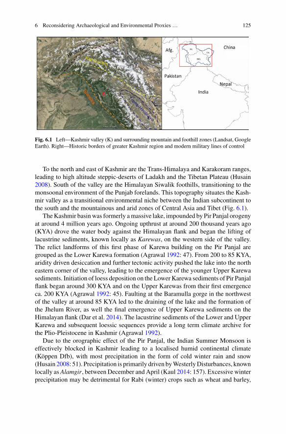
6 Reconsidering Archaeological and Environmental Proxies … 125
Fig. 6.1 Left—Kashmir valley (K) and surrounding mountain and foothill zones (Landsat, GoogleEarth). Right—Historic borders of greater Kashmir region and modern military lines of control
To the north and east of Kashmir are the Trans-Himalaya and Karakoram ranges,leading to high altitude steppic-deserts of Ladakh and the Tibetan Plateau (Husain2008). South of the valley are the Himalayan Siwalik foothills, transitioning to themonsoonal environment of the Punjab forelands. This topography situates the Kash-mir valley as a transitional environmental niche between the Indian subcontinent tothe south and the mountainous and arid zones of Central Asia and Tibet (Fig. 6.1).
TheKashmir basinwas formerly amassive lake, impounded by Pir Panjal orogenyat around 4 million years ago. Ongoing upthrust at around 200 thousand years ago(KYA) drove the water body against the Himalayan flank and began the lifting oflacustrine sediments, known locally as Karewas, on the western side of the valley.The relict landforms of this first phase of Karewa building on the Pir Panjal aregrouped as the Lower Karewa formation (Agrawal 1992: 47). From 200 to 85 KYA,aridity driven desiccation and further tectonic activity pushed the lake into the northeastern corner of the valley, leading to the emergence of the younger Upper Karewasediments. Initiation of loess deposition on the LowerKarewa sediments of Pir Panjalflank began around 300 KYA and on the Upper Karewas from their first emergenceca. 200 KYA (Agrawal 1992: 45). Faulting at the Baramulla gorge in the northwestof the valley at around 85 KYA led to the draining of the lake and the formation ofthe Jhelum River, as well the final emergence of Upper Karewa sediments on theHimalayan flank (Dar et al. 2014). The lacustrine sediments of the Lower and UpperKarewa and subsequent loessic sequences provide a long term climate archive forthe Plio-Pleistocene in Kashmir (Agrawal 1992).
Due to the orographic effect of the Pir Panjal, the Indian Summer Monsoon iseffectively blocked in Kashmir leading to a localised humid continental climate(Köppen Dfb), with most precipitation in the form of cold winter rain and snow(Husain 2008: 51). Precipitation is primarily driven byWesterlyDisturbances, knownlocally asAlamgir, between December and April (Kaul 2014: 157). Excessive winterprecipitation may be detrimental for Rabi (winter) crops such as wheat and barley,
126 M. Spate
though good spring snowmelt is crucial for irrigatedKharif (summer) rice agriculture(Husain 2008: 137–139). This bi-seasonal cultivation takes place across the valleyin various ecological and topographic niches, with rice typically on the valley floor,smaller fields of wheat and barley on the flanks, and in modern times maize beingthe dominant middle-high altitude crop of Gujjar nomadic pastoralists.
The distinction between the valley floor, middle and high altitude zones are keyfor examining variability in economic and cultural adaptations in Kashmir both inthe present day and in the past. The valley floor is an alluvial landscape comprisedof old and new alluvium, also categorised as river terrace and floodplain soils (Sidhuand Surya 2014: 7). These soils are rich in potassium, phosphorus, calcium and mag-nesium, and accumulation of nitrogen occurs in significant quantities allowing forhigh agricultural potential (Qazi 2005: 30). At the margins of the alluvial landscapeare flat topped Upper Karewa terraces, known locally as wudur, standing up to 60 min height (Husain 2008: 27). Archaeological survey (Yatoo 2012; Bandey 2009) hasindicated that Neolithic villages in Kashmir tended to cluster on wudur, likely asa means of mitigating flood risk. This alluvial landscape and associated tablelandsform a zone for intensive cultivation and settlement, extending into the mountainfoothills to an altitude of around 2200 m ASL (Kaul 2014: 56).
Between 2500 and 3500 m ASL are meadows known locally as marg or pathri(Singh 1963), situated within mountain forest belts at middle altitudes, as wellas above the timberline. Bhatt (1978) divides these into a high altitude type ca.3000–3500 m ASL, based on Hirpur clay formations and a lower type based on asilty substratum between 2400 and 3000mASL. Agrawal (1992) describes the lowermeadow landscapes as being built on the infilling of glacially ground basins and lakes,ideal for environmental coring. Both types of meadow are grazed by flocks of goatsand sheep as part of the annual migratory cycle of Gujjar-Bakharwal transhumantgroups in the region today (Casimir and Rao 1985).
The ecological diversity in the Kashmir Valley may allow us to conceive of thevalley as generally comprised of two ecotopes, being the valley floor and the mon-tane zone. Within these zones are a number of smaller transitional areas (Fig. 6.2),particularly between the forest and meadow communities in the montane zone. Morebroadly, we may consider the entire valley as a transitional ecotone, situated betweenthe high altitude desert of the Ladakh region, the desert and steppe regions of CentralAsia and the sub-tropical regions of the Siwaliks and Punjab to the south, at theinterface of Summer Monsoon and Westerly dominated climate zones. The interre-lations between various ecotopes and social and economic organisation are arguedas primary drivers of cultural and technological exchange in Bronze and Iron AgeCentral and South Asia (Frachetti 2012; Spengler et al. 2013; Stevens et al. 2016).
6.2.2 Archaeological and Historical Context
Early cultural development in Kashmir has primarily been understood through exca-vations of five pre and proto historic sites, whilst early historic (Kushan and Karkota)

6 Reconsidering Archaeological and Environmental Proxies … 127
Fig. 6.2 Transverse section across Kashmir valley depicting topographic variation and zonal dif-ferentiation. Mid altitude pastures Dodpathri and Pahalgammarked as is Pampore city on the valleyfloor. Major modern vegetation taxa from each zone is listed, economically important cultivars inbold
periods were also documented in Kashmiri and Chinese historical accounts. A gen-eral chronology of cultural changes is presented in Table 6.1.
Excavations at the sites of Burzahom, Gufkral and Kanispura (Fig. 6.3) in theeast, south and northwest of the valley have allowed for the development of anarchaeological sequence beginning with an Aceramic phase, followed by Early, Lateand Megalithic Neolithic periods (Possehl 2002; Sharma 2013; Mani 2000). Thoughonly a small number of absolute dates have been returned fromBurzahom andKanis-pura (Agrawal and Kharakwal 2002; Pokharia et al. 2017), a fuller sequence fromGufkral is available (Sharma 2013) and a stratified sequence of dates from a surveyedLate Neolithic pit at Qasim Bagh have recently been published (Spate et al. 2017).From these sources, a tentative internal chronology of Neolithic development in the
Table 6.1 General chronology of cultural phases and excavated sites in Kashmir (Agrawal 1992;Bandey 2009; Shali 2001; Spate et al. 2017; Yatoo 2012)
Period Date range Sites
Karkota 600–900 CE Semthan
Hunnic 300–600 CE Kanispura, Harwan
Kushan 1–300 CE Kanispura, Semthan, Harwan
Indo-Greek 200 BCE–1CE Semthan
NBPW 700–200 BCE Semthan
Megalithic 1500–700 BCE Burzahom, Gufkral, Semthan
Late Neolithic 2000–1500 BCE Burzahom, Gufkral, Qasim Bagh
Early Neolithic 2500–2000 BCE Burzahom, Gufkral, Kanispura
Aceramic Neolithic 3000–2500 BCE Kanispura, Gufkral

128 M. Spate
Fig. 6.3 Archaeological sites and environmental cores discussed in text. Sites: 1. Burzahom &Harwan; 2. Gufkral; 3. Kanispura; 4. Qasim Bagh; 5. Semthan. Cores: A. Toshmaidan; B. Hygam;C. Butapathri; D. Pari-Has (Basemap source: ESRI)
valley may be conceived as: Aceramic Neolithic 3000–2700 BCE; Early Neolithic2700–2000 BCE; Late Neolithic 2000–1500 BCE; Megalithic 1500–700 BCE.
Change in material culture through the Neolithic is relatively conservative, begin-ning with a ground stone lithic industry during the Aceramic (Pant et al. 1982), theuse of which continues throughout the cultural sequence. During the Late Neolithicpolished stone harvesters are introduced comparable to types from the YangshaoNeolithic of China, leading to speculation of cultural connections with North Asia(Possehl 2002). The ceramic sequence begins with coarse ware cooking pots duringthe Early Neolithic, with later introductions of fine and burnished wares. During theMegalithic, a gritty red ware is introduced (Yatoo 2012). Structural remains consistof subterranean rectangular dwellings with a timber superstructure in early periods,followed by rammed earth platform buildings during later phases (Sharma 2013).Throughout the Neolithic, large conical pits up to 3 m deep were dug, the use ofwhich is subject to ongoing debate (Conningham and Sutherland 1997; Young 2003;Bandey 2009).
Analysis of botanical (Lone et al. 1993; Spate et al. 2017; Pokharia et al. 2017)and faunal (Sharma 2013) remains seems to indicate the early economy during theNeolithic was based upon hunting and cultivation of winter barley and wheat. A latershift towards consumption of domestic animals and the introduction of rice andmillet
6 Reconsidering Archaeological and Environmental Proxies … 129
may be interpreted as a shift towards bi-seasonal cropping, and the development ofa herding economy.
Later cultural phases are represented at the site of Semthan in the southeast ofthe valley. Little excavation data has been formally published and most informa-tion is gleaned from annual reports (Thapar 1980; Mitra 1983) and a systematicbotanical study (Lone et al. 1993). The sequence begins with a phase comparableto the Megalithic (ca. 1500–700 BCE) at Burzahom and Gufkral (Semthan PhaseI), whilst subsequent phases represent the first changes in material culture linkingKashmir to the rise of Iron Age urbanism on the Indian Subcontinent. Phase II (ca.700–200 BCE) is analogous to the Northern Black Polished Ware (NBPW) cul-ture of South Asia, whilst Phase III (ca. 200 BC–1CE) represents an Indo-Greekperiod. The Kushan period is represented by Phase IV (1–300 CE), whilst Phase V(600–900 CE) is considered contemporary with the “prolific temple building” periodof the Hindu Karkota Dynasty (Mitra 1983: 23). The Kushan period is also evidentin temple and settlement remains at Kanispur (Mani 2000; Pokharia et al. 2017) andtemple structures at Harwan in Srinagar (Kak 1933). Post-Kushan period remains(ca. 300–600 CE) at Kanispura and Harwan have been interpreted as evidence ofincursion by Central Asian Hunnic nomads (Shali 2001).
Botanical macro remains from Semthan indicate a shift towards summer rice andmillet agriculture during all phases, and also sees the introduction of several SouthAsian summer pulses such as Vigna mungo, Vigna radiata, and Vigna acontifolia(Lone et al. 1993: 209–212). Lone et al. (1993) have argued that despite this broad-ening of the agricultural package, the thinness of the archaeological deposits of theNBPW and Indo-Greek phases, coupled with a declining diversity index of woodcharcoal at the site indicates some form of population collapse during this period.
It is unclearwhether theKushan period represents a population recovery followingcollapse as interpreted by Agrawal and Lone et al., or rather represents the first majorarchaeological evidence for social reorganisation and intensified urban settlement inKashmir. Excavation data from the pre and proto historic periods suggest evidence forboth economic diversity and horizontal social complexity, whilst the Kushan periodmay be the first instance of development of vertical complexity and state building inthe valley. These institutional changes would shift the opportunities and constraintsfor responses to climate or demographic pressure in the valley, processes that wouldhave continued through the Karkota period. Bamzai (1994) has also argued that theKarkota period was a time of major institutional realignment, with an expansion ofbureaucracy, intensification of public works including major irrigation systems andcentralisation of social responses to environmental calamity. This period also saw apolitical re-orientation towards China against the backdrop of the decline and fall ofthe Sassanian and Gupta Empires in Greater Iran and India.
130 M. Spate
6.2.3 Holocene Palaeoclimate
The earliest paleoclimate studies in Kashmir tended to focus on glacial cycles andPleistocene vegetation changes in Lower Karewa sediments (De Terre and Pater-son 1939). Holocene climate reconstruction was first undertaken by Singh (1963),producing a post-glacial vegetation sequence from a high altitude peat bog at Tosh-maidan in northwest Kashmir. Singh identifies 8 pollen zones and 9 stratigraphicsections, which were dated through later re-excavation and sampling of beddingplanes (Singh and Agrawal 1976). These dates have been recalibrated and presentedin Table 6.2 alongside Singh’s original phasing.
Singh (1963: 103) uses broad leaf/coniferous (B/C) ratios as an index of post-glacialwarming and cooling, finding correlation between the advance of broad leavedand thermophilic non arboreal taxa, most notably in Stages b, d and e. Despitethe return of Pinus dominance in Stage c, Singh interprets Stages a-e as a post-glacial amelioration with a climatic optimum during Stage e. Dating of this stageremains problematic due to poor correlation between the initial pollen study andlater resampling to date the column (Singh and Agrawal 1976). Vishnu-Mittre (1966;Vishnu-Mittre and Sharma 1966) has argued the three warm phases of Toshmaidanstages b, d and e correlatewith other past thermophilic vegetation stages in an undatedsequence at Haigam on the valley floor, positing a succession of post glacial warmingand cooling directly comparable with the European Blytt–Sernander pre-Boreal tosub-Atlantic phases.
Two high altitude pollen records from peat bogs at Butapathri-I and Butapathri-II (3000 m ASl) attempted to refine the chronology of the Toshmaidan sequence(Dodia 1983). The first record is argued to be evidence advance of broad leaf speciesover conifers from around 18,000–15,000 BP, indicating an early period of climaticamelioration following the last glacial maximum (Agrawal 1988). This broad leafadvance is also synchronous with strong formation of paleosols throughout the valley(Kusumgar et al. 1986). A warm wet phase at 18 Kya is indicated by δ13C ratiosfrom Paleosol 1 at Burzahom, where a ratio of −25.3% indicates strong dominanceof warm wet favouring C3 plants, which contrasts clearly with C4 dominance in theorganic fraction of earlier buried paleosols (Krishnamurthy et al. 1982). The recordat Butapathri-II gives a sequence dating back to ca. 12 K BP (Dodia 1983). Bothrecords seem to indicate the onset of thermophilic Juglans, Carpinus, and Corylusbroad leaved taxa at around 5000 BP, again roughly synchronous with the start ofthe Neolithic period. Reconstructing a well resolved chronology from these recordspresents some difficulty due to bulk organic dates being taken from samples upto 50 cm in length, and these records may best serve generally refining the cool-dry/warm-wet phases in the valley.
Later Holocene climatic records have been reconstructed through pollensequences from lower altitude lakes at Anchar and Horkasar (Dodia 1983; Agrawalet al. 1989), dating to 4000 BP and 1000 BP respectively (Agrawal et al. 1989).Anchar is characterised by the dominance of grasses interpreted as cereals in theNAP curve, with Pinus/broad leaf fluctuations in the arboreal pollens. An anti-
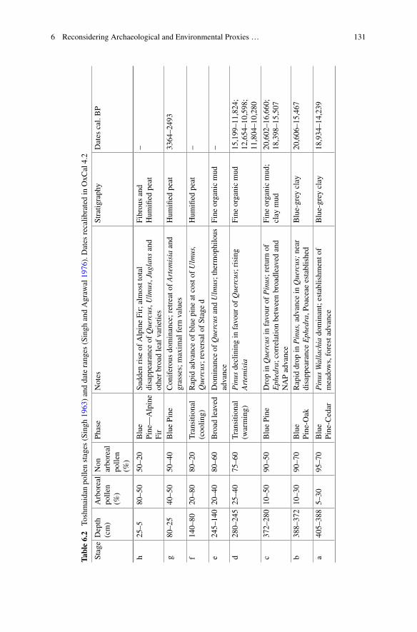
6 Reconsidering Archaeological and Environmental Proxies … 131
Table6.2
Toshmaidanpo
llenstages
(Singh
1963)anddateranges
(Singh
andAgraw
al1976).Dates
recalib
ratedin
OxC
al4.2
StageDepth
(cm)
Arboreal
polle
n(%
)
Non
arboreal
polle
n(%
)
Phase
Notes
Stratig
raphy
Dates
cal.BP
h25–5
80–50
50–20
Blue
Pine—
Alpine
Fir
Sudd
enrise
ofAlpineFir;almosttotal
disappearanceof
Quercus,U
lmus,Juglans
and
otherbroadleaf
varieties
Fibrousand
Hum
ified
peat
–
g80–25
40–50
50–40
BluePine
Coniferousdominance;retreatof
Artem
isia
and
grasses;maxim
alfern
values
Hum
ified
peat
3364–2493
f140–80
20–80
80–20
Transition
al(coolin
g)Rapid
advanceof
blue
pine
atcostof
Ulmus,
Quercus;reversalo
fStaged
Hum
ified
peat
–
e245–140
20–40
80–60
Broad
leaved
Dom
inance
ofQuercus
andUlmus;therm
ophilous
advance
Fine
organicmud
–
d280–245
25–40
75–60
Transition
al(w
arming)
Pinus
decliningin
favour
ofQuercus;rising
Artem
isia
Fine
organicmud
15,199–11,824;
12,654–10,598;
11,804–10,280
c372–280
10–50
90–50
BluePine
Dropin
Quercus
infavour
ofPinus;returnof
Ephedra;correlatio
nbetweenbroadleavedand
NAPadvance
Fine
organicmud;
clay
mud
20,602–16,660;
18,398–15,507
b388–372
10–30
90–70
Blue
Pine-O
akRapid
drop
inPinus,advance
inQuercus;near
disapp
earanceEphedra,P
oaceae
established
Blue-grey
clay
20,606–15,467
a405–388
5–30
95–70
Blue
Pine-C
edar
Pinus
Wallachia
dominant;establishm
ento
fmeadows,forestadvance
Blue-grey
clay
18,934–14,239
132 M. Spate
correlation between anthropogenic plants and aquatics suggests the reclamation offarming land at lake margins on the valley floor. A similar relation anti-correlationis found at 800 BP in the Horkasar core, which Agrawal et al. (1989) believe to beevidence for the beginning of intensive rice paddy cultivation. Fluctuations in anthro-pogenic crops against a background climate index based on B/C ratios may allowfor an understanding of ecological responses to climate change, however completedata sets from these records remain unpublished.
Agrawal (1988: 339) notes the early post glacial warming in Kashmir may becorrelated with pollen records from Nepal and Japan, and suggests the possibilityof a latitudinal climatic belt. As Agrawal (1988: 340) also describes an inversecorrelation between Kashmiri and lowland North Indian records, the orographiceffects of the Pir Panjal and Tibetan plateau on the paleoclimate of Kashmir maybe a dominant factor in influencing local and regional conditions. The regionallyout of synch climate proposed by Agrawal seems to be supported by comparison ofthe Kashmir records with pollen, isotopic and geochemical records from the Siwalikfoothills to the south (Trivedi and Chauhan 2009; Das et al. 2010) and the Trans-Himalayan and Ladakh regions to the northeast (Rawat et al. 2015; Leipe et al.2014; Demske et al. 2009). A comparison of shifts in climate between Kashmir andadjacent regions (Table 6.3) reflects more frequent onsets of optimal conditions andtransitional periods in the valley than the protracted cold dry desert conditions of theTrans-Himalaya or fluctuations in monsoonal periods of the Siwaliks.
The apparently regionally asynchronous climate shifts in Kashmir have allowedfor some scholars to conceptualise cultural change in the valley as driven by fluctu-ations between warm-wet and cool-dry cycles, treating the valley as a climaticallyoptimal ecological refuge between the steppe-desert and monsoonal systems of sur-rounding areas (Agrawal 1988, 1992; Shali 2001). In these schemes, the Neolithic,Kushan and Karkota periods map neatly onto warm wet periods (Table 6.3), inter-spersed with periods of cultural or societal degradation. Whilst these may be usefulinterpretations in a broad sense, they are complicated by the poorly resolved chronol-ogy of climatic records and gaps in knowledge of the economy, ecology and socialorganisation during large parts of these cultural phases. Taking into regard the vari-ability of environmental zones within the valley and what is known from archaeo-logical and palaeoclimatic records, we are presented with the opportunity to producean integrated model for understanding long term human-environment interaction inKashmir.
6.3 Human-Environment Interaction in Kashmir
6.3.1 Previous Studies
Early examinations of the interrelation between climate change and human activ-ity in Kashmir were raised by De Terre and Paterson (1939: 233–235), critiquing

6 Reconsidering Archaeological and Environmental Proxies … 133
the provenance of artefacts previously believed to be Palaeolithic and arguing thathuman habitation of the valley most likely became possible as a response to warmerconditions of the Holocene. In this interpretation, late Palaeolithic hunters colonisedthe valley in the pursuit of new game, before taking up agriculture. Despite raisingthese question,much of their workwas dedicated to glacial cycles and climate changeoperating at time scales longer than human occupation of the valley.
Subsequent studies drew upon the interpretation of anthropogenic markers inpollen records. Singh (1963) ascribes some changes in the Toshmaidan record todeforestation during the migration of Aryans and Indo-Greeks, grazing by CentralAsian pastoralists and large scale works during the Mughal period, however theimpacts and timing of these are not clearly articulated. Vishnu-Mittre (1966) hasargued that the pollen record from Toshmaidan provides little to no evidence forhuman impact on the environment, in contrast with the Hygam record with someindicators of agricultural intensification, based on fluctuations in the pollen curvesof cereal grasses and Plantago lanceolata. Vishnu-Mittre and Sharma (1966: 206)describe the Hygam records as having four anthropogenic phases: the commence-ment of agriculture; low level cultivation; intensification of agriculture; and decline.Notably, the decline corresponds with the end of Hygam pollen Stage e, markedby an increase in coniferous species interpreted as evidence for regional cooling.Vishnu-Mittre and Sharma argue that agricultural intensification corresponds with
Table 6.3 Comparative chronology of Kashmir climate and cultural phases with regional climateshifts (Kashmir records: Singh 1963; Dodia 1983; Agrawal 1992. Siwaliks: Trivedi and Chauhan2009; Das et al. 2010. Trans-Himalaya: Rawat et al. 2015; Leipe et al. 2014; Demske et al. 2009)
134 M. Spate
the Holocene optimum during the Neolithic period and subsequent contractions areagain evidence of a climate driven societal collapse. These interpretation are prob-lematised by the lack of absolute dates from the Hygam record.
TheKashmir Palaeoclimate Project (KPCP)was initiated in the early 1980s beforebeing interrupted by rising militancy in the valley. In addition to documenting thefirst securely dated Upper Palaeolithic in the valley at around 18 kya (Pant et al.1982), the project revised produced new chronological, palynological, isotopic andgeological data. A synthesis of these studies (Agrawal 1992) argued for expansionsof settlements and population expansion in the valley during warm wet periods ofthe Upper Palaeolithic, Neolithic, Kushan and Karkota periods, as evidenced by thespread of Neolithic villages, and later, monumental constructions throughout thevalley during climatic ameliorations. Agrawal (1992: 271) argues that settlementexpansion and population growth during these periods led to Malthusian pressuresprecipitating societal collapse when average temperatures declined by one to twodegrees during periods of cooling.
Drawing on historical accounts, and KPCP and archaeological datasets, Shali(2001) interpreted culture change in Kashmir as a unilinear sequence of culturaldevelopment, following Agrawal’s (1992) scheme of acceleration during optimalconditions and slowing during cold dry periods. Shali integrates some discussionof economic changes during these periods, attributing the expansion of agricultureand animal husbandry to ongoing increases in social complexity allowing for thedivision of labour and the importation of new crop species as part of regional tradeintensification. Shali (2001: 134) has also argued for regional climate change asa driver of migrating Central Asian tribes, forcing them into closer contact withKashmir due to themore favourable climate of the valley. These demographic influxesare argued to have contributed either to fragility of social structures during climaticdeteriorations (Shali 2001: 129), or accelerated technological and cultural changeand synthesis during optimal conditions (Shali 2001: 182).
The interpretive frameworks of the studies above are closely tied to notions ofenvironmentally driven societal collapses that have been subject to reappraisal inrecent archaeological literature (McAnany and Yoffee 2009; Faulseit 2015). Com-mon to collapse oriented studies are varying degrees of human-induced stresses onenvironments, or global and regional climate change as the primary forcing factorsof historical transformation (Middleton 2012). Yatoo (2012) has argued that inter-pretations such as this arise partly as the result of site-centric archaeological studiesin Kashmir and ad hoc correlation with often poorly resolved climate data, evidentin such assumptions as the presence of monumental construction during the Kushanand Karkota periods as periods of wealth and stability interspersed with periodsof climate driven hardship. Scott (2017) has argued that archaic states, rather thanpopulations as a whole, are particularly susceptible to climate change, and that theabsence of large archaeological monuments during periods previously interpreted tobe phases of “collapse”may simply be evidence for the breakdown of coercive forcesable to centralise labour for such large scale constructions. Yatoo’s (2012) landscapeoriented studies in northwest Kashmir may present early evidence for social reorgan-
6 Reconsidering Archaeological and Environmental Proxies … 135
isation, and dispersed and adaptive patterns of land use in the valley, though furtherarchaeological testing and excavation is required to better understand these changes.
Resilience to acute or protracted climate change in South Asia has been examinedthrough shifts in cropping pattern that allowed Indus Valley populations to cope withenvironmental diversity and stresses in prehistoric northern South Asia (Petrie et al.2017). Changes in water management, crop selection and settlement pattern haveopened new debate onto the ways that Harappan populations responded to climateepisodes such as the 4.2 k event, shifting discussions from one of collapse followingthe Mature Harappan period to reconsidering the post-urban Late Harappan as anadaptive settlement strategy rather thannecessarily a periodof collapse.Young (2003)hasmodelled long term economic and social adaptation acrossmultiple environmentsin the valleys and lowlands of northwest Pakistan. Drawing on botanical and faunalremains as well as environmental, archaeological and ethnographic evidence forshifting patterns of seasonal pastoral mobility, sedentism and cultivation, Youngargues for complex and shifting relationships between Bronze and Iron Age agro-pastoralists, their environment and adjacent regions of China, Kashmir and CentralAsia (Young 2003). These multi-proxy studies may provide the best avenue to buildmore robust new models of past human-environment relationships in Kashmir.
6.3.2 Kashmir as Ecological Niche
Based on the geography and climate ofKashmir described in Sect. 2,wemay considerthe valley to be an orographically circumscribed entity comprised of smaller ecolog-ical zones. Though the valley has long been culturally and ecologically enmeshedwith adjacent regions, the enclosing topography allows for well-defined spatial con-straints for testing hypotheses relating to human-environment interactions. We mayconsider Kashmir as a fertile and temperate niche, attractive for various forms of set-tlement, cultivation and resource exploitation (Agrawal 1992; Shali 2001; Bandey2009). Whilst these naturally occurring conditions may have been a factor in ini-tial settlement of the valley, anthropogenically induced environmental stresses andopportunities in the valley were likely major drivers of social change.
Niche Construction Theory (NCT) originates in evolutionary biology, emphasis-ing the ability of organisms to partially direct their own, and other species evolution-ary pathways through the modification of the dwelling niches in which they exist(Laland and O’Brien 2010). Laland and O’Brien (2010) have argued that due to thecapacity Homo sapiens have for intergenerational cultural and technological trans-fer, human niche construction is unique in its potency for directing the evolution ofhuman and other species. Examples of this may include the ways that dietary pat-terns relating to hunting and gathering, agriculture or pastoralismmay have impactedboth human genetic evolution in terms of the capacity to process starch or lactose,and the evolution of cultivated crops or domestic animals. As opposed to dichoto-mous relationships of co-evolutionary frameworks such as host-parasite, predator-prey, herbivore-plant, Laland and O’Brien (2010: 311–312) stress that NCT may

136 M. Spate
be conceived of as a broader network of indirect evolutionary linkages that may berecognisable archaeologically.
Responding to debates pushing for a global Anthropocene beginning in the 20thCentury, archaeologically focused scholars argue that human niche construction hasimpacted environments and species distribution globally since the Late Pleistocene(Boivin et al. 2016). Of four key phases of human niche construction identified byBoivin et al. (2016), two are particularly useful for examining human-environmentrelations in the Kashmir Valley, the first being the spread of agriculture and pastoral-ism, during which a number of domesticated plants and animals, alongside othercommensal species, dispersed across the globe. The second phase is the subsequentdevelopment of urbanism and elaboration of trade networks during which intensifiedpatterns of land usage, cultural exchange and overexploitation of resources beganto take place. Ellis et al. (2017) list several archaeologically and geologically vis-ible proxies of niche construction by agrarian societies, including anthrosols anddegraded soils, deforestation and permanent fields, all of which may be detected inKashmir.
In addition to detecting landscape modification by cultivators, Spengler (2014)has argued for NCT as an informative framework for understanding practices ofCentral Asian pastoral groups during the Bronze (ca. 2500–500 BC) and Iron Ages(500 BC–AD 500). Contra to past views that nomadic or transhumant pastoralistssimply inhabited ecological niches, Spengler argues for long term processes of inten-tional landscape modification as a cultural and economic strategy, visible throughenvironmental markers for deforestation and suppression of woody taxa in favourof herbaceous colonists associated with grazing, most commonly Chenopodiumspecies. Miehe et al. (2009) have also argued that this phenomenon is visible inchanges in the pollen spectrum in Tibet, where pollen and micro charcoal indicatorsfor mid-Holocene deforestation and grazing fluctuate independently of isotopic andgeochemical records displaying no evidence of pasturemanagement, tying intowiderdebates on the ways that economic adaptation may have allowed humans to colonisethe Tibetan Plateau. These case studies provide a method for detecting pastoralistniche construction in Kashmir.
6.3.3 Conceptualising Long Term Human-EnvironmentInteraction in Kashmir
The framework proposed in this paper aims to draw on multiple lines of archaeo-logical and environmental data to model both human responses to environmental orclimatic changes in the valley, and human modification of the valley itself. Basedupon differentiated geographical and topographical zones within Kashmir, long termhuman ecology may be characterised through shifting patterns of settlement, eco-nomic and cultural organisation across the alluvial valley floor (1600–1800 m ASL),Karewa tablelands and foothill zone (1800–2200 m ASL), mountain (2200–3000 m

6 Reconsidering Archaeological and Environmental Proxies … 137
Table 6.4 Framework for modelling local and regional scale human activities in Kashmir valley,including potential archaeological and environmental proxy evidence. Local scale dynamics arebridged across topographic zones by regionally controlling social, political and climatic factors
ASL) and alpine (3000–4000 m ASL) zones. Though certain activities in each ofthese zones may be geographically constrained, they do not operated as discrete unitsand are integrated into a dynamic, valley wide network (Table 6.4). Certain socialor environmental factors may influence these activities at local scales (Table 6.4,x-axis), whilst also being subject to shifting climatic, cultural or political dynamicsat regional or extra-regional scales (Table 6.4, y-axis). Regional factors may includebroad climate shifts as described by Singh (1963) andAgrawal (1992), the interactionof Kashmir with prehistoric networks of pastoral and agricultural exchange (Stevenset al. 2016), or cultural integration with prehistoric cultural complexes (Yatoo andBandey 2014) and later systems of imperial control (Shah 2013).
Modelling local scale dynamics across the valley requires consideration of theappropriateness of specific proxy evidence and the ways these datasets may be inter-preted to separate regional scale changes from local human-environment interac-tions. Such interpretation may be reasonably uncomplicated in the cases such aslong term studies of relatively stable archaeological features, though may becomemore problematic when trying to resolve small scale human activities in long termenvironmental archives.
6.3.3.1 Settlement Pattern
The first systematic field survey of settlement pattern in relation to ongoing socialprocess and environmental change in Kashmir was undertaken by Yatoo (2012) inthe Baramulla District in the northwest of the valley. Yatoo’s work aims to integratelong term settlement stability and change with other shifts in resource utilisation andcultural interactions. Despite the fact that the study examined only surface features,settlements seemed to vary topographically through time, andmulti-period sites werein the minority of those recorded (Yatoo 2012: 197). Yatoo’s data shows that during
138 M. Spate
the Neolithic period, settlements typically clustered on Karewa table tops abovethe Jhelum floodplain, around or above 1600 m ASL. All surveyed Neolithic siteswere within a single size category of 7500–9000 m2. In subsequent protohistoric andhistoric periods, there is a greater diversity of altitudinal distribution and settlementdensity. Yatoo attributes these changes to broadening resource utilisation, includingpaddy cultivation within the floodplain and grazing in mountain zones, as well asresponses to climatic shifts, such as fluctuation in river and lake levels on the valleyfloor.
Conningham and Sutherland (1997) and Young (2003) have also raised questionsof seasonal settlement pattern during the early Neolithic periods. Subterranean con-ical structures during this period were traditionally believed to be winter habitationpits (Bandey 2009). Reassessing these structures in the Kashmir and Swat Valleys,Conningham and Sutherland argue for food processing or other non-habitational usesof the pits, the nature of winter dwellings in the valleys. This has been explainedthrough the possibility of seasonal pastoralism and wholesale abandonment of set-tlements in the valley during winter (Conningham and Sutherland 1997: 32), perhapsas part of a seasonal pastoral migration. Seasonal mobility may be one explanationfor variation in settlement patterns that goes beyond growth and contraction settle-ment and climate cycles, as it may allow for some flexibility in response to climatepressures, from short term to long term scales. Despite the appeal of this model,there is yet little other evidence for wholesale movements of populations out of thevalley, and from the Neolithic onwards the seasonal growth cycles of certain cropswithin archaeobotanical assemblages suggests a tendency to year long occupation inthe valley.
6.3.3.2 Agricultural Adaptations
TheEarlyNeolithic botanical assemblage from four phases at Kanispura provides thefirst insights into agriculture in the valley. The oldest plant remains at the site are datedrelative to c. 2700 BC, with wheat and barley grains from a later phase directly datedc. 2200 BCE (Pokharia et al. 2017). The overall assemblage is dominated by barley(Hordeum vulgare) with smaller amounts of emmer wheat (Triticum dicoccum),compact wheat (T. cf. aestivum) and a large proportion of lentil (Lens culinaris).The composition of this assemblage is comparable to contemporary sites situated tothe west of Kashmir, including Sheri Khan Tarakai (Thomas and Cartwright 2010),Mehrgarh (Costantini 1981) as well as at southern Central Asian sites includingJeitun (Harris 2010) and Anau (Miller 1999). Costantini (2008) describes these earlyperiods of farming atMehrgarh as developingprior to specialisationof agriculture andselective cultivation of crops. This protracted transition to agriculture in South Asiaoccurs through shifting relationships between cultivation, sedentism and pastoralism(Murphy and Fuller 2016). Though there is not yet any recorded evidence for earlysedentism or cultivation at during the Aceramic phase at Kanispur, the presence ofstable settlement structures and agricultural crops at the slightly later dated GufkralAceramic (Sharma 2013) raises possibility for their discovery in the future.
6 Reconsidering Archaeological and Environmental Proxies … 139
The Aceramic period at Gufkral is also characterised by cultivation dominatedby barley, followed by smaller proportions of wheat, lentil and pea (Sharma 2013:103). During the Early Neolithic wheat becomes the dominant crop, and rice intro-duced during the Late Neolithic, becoming the primary crop by theMegalithic. Thesechanges in consumption patterns are comparable to the Neolithic botanical assem-blages from Burzahom, from the Early Neolithic onwards, though rice never comesto dominate the assemblage as at Gufkral (Lone et al. 1993). These developmentshave been interpreted as a shift from single season to bi-seasonal cultivation, with theemergence of rice as the dominant crop linked to more favourable summer growingconditions in Kashmir (Lone et al. 1993: 202–203). However, the diversity of botan-ical assemblages across sites in the valley seems to suggest at least some form oflocalised selection of crops. This may be reinforced through examination of stratifiedbotanical remains from a conical pit at Qasim Bagh (Spate et al. 2017), where wheatsdominated throughout the sequence dated ca. 2000–1400, with smaller proportionsof broomcorn millet (Panicum miliaceum) and lentil. Barley and rice are entirelyabsent from the assemblage.
Rice dominates the Megalithic and NBPW phases at Semthan, before a shiftto primarily barley and wheat during the Indo-Greek and Kushan periods (Loneet al. 1993). Barley and wheat together make up the largest proportion of cropsduring the Kushan period at Kanispur at nearly double the quantity of summer riceand millets (Pokharia et al. 2017). The returning dominance of winter wheat/barleymay be ascribed to their higher calorific returns (Bates et al. 2017), as well as theirsuitability to cooler-dry conditions following the Megalithic period. Due to a lack ofexcavation data, it is unclear whether there was a form of population collapse, thoughfragmentary evidence suggests some form of “Iron Age” social reorganisation tookplace in Kashmir and regionally following 1000 BC (Yatoo 2012: 287–289). Climateor population factors aside, these reorganisations may have led to shifting of patternsof labour, better suited to flexible forms of agro-pastoralism incorporating wheat andbarley, rather than the more centralised cultivation of rice on the valley floor.
Archaeobotanical remains frompre and early historic sites inKashmir give insightinto long term patterns of human adaptation to the ecology of the valley. The earlybarley and emmer wheat dominated phases at Kanispur and Gufkral may be evidenceof the initial importation into the valley of aridity tolerant forms of cultivation moresuited to the hilly northern regions of South Asia. Shifts towards wheat and ricecultivation may be driven by social or cultural factors as well as exploitation of themore fertile Jhelum alluvial soils and water availability in the valley. Proportionalrepresentation of botanical remains may be influenced by taphonomic and other pre-deposition factors, however the spatial and chronological variation of these remainsacross the valley allows some understanding of economic shifts as part of long termhuman-environment interaction in Kashmir.
140 M. Spate
6.3.3.3 Evidence for Pastoralism
Mortality patterns and species composition in faunal assemblages fromGufkral indi-cate an economy based on hunting of wild animals during the Aceramic Neolithicperiod, with domestic sheep and goats representing only 5% of the total assemblage(Sharma 2013). By the EarlyNeolithic, domestic caprids represent 26%of the animaleconomy, with domestic cattle making up a further 18%. These proportions increas-ing to 45 and 20% during the Late Neolithic. No faunal data has been publishedfrom either Burzahom or Kanispur, though preliminary reports indicate a significanthunting element at Burzahom during the Early Neolithic (Allchin and Allchin 1982:112). Changes in these assemblages suggest an increasingly important pastoral com-ponent to the economy of Kashmir, though this development has been little examinedother than Singh’s (1963) attribution of some past deforestation on the flanks of thevalley to Central Asian pastoralist groups.
With the exception of Singh’s comments, there has been little consideration ofthe past impacts of transhumant grazing in Kashmir. Recent studies in the moun-tainous zones of Central Asia have situated pastoral groups as drivers of prehistoriccrop exchange (Stevens et al. 2016; Spengler 2015), as well as pastoralist ecologicalpractices and routes as laying the basis of the historic Silk Road networks betweenChina, Central and South Asia (Frachetti et al. 2017). Stevens et al. (2016) haveconsidered Kashmir as an important node in the spread of Chinese technologies anddomesticates including stone fruits, millets and ground edged harvesters into north-ern South Asia, though the timing and mechanisms for this exchange are not yetarticulated. The recent discovery of broomcorn millets at Qasim Bagh (Spate et al.2017) seems to indicate that these exchanges likely took place through contact withpastoralist networks of exchange throughout Central and South Asia in the secondmillenniumBCE.Aswell as their importance in developing these exchangenetworks,long term and flexible land use patterns by pastoral groups in Central Asia maybeimportant tools for understanding patterns of human resilience and environmentaladaptation in the region (Spengler et al. 2013; Frachetti 2012). Due to the limitedsurvey and excavation that has taken place in Kashmir, particularly at middle alti-tudes, detecting the presence of past patterns of pastoralism may be best approachedthrough environmental records. Following the NCT concept for pastoralist modifi-cation of the landscape proposed by Spengler (2014), we may consider applicablemarkers for pastoralist modification of, and adaptation to, the Kashmir landscape inthe past.
Though there has been nomajor research into past pastoral environmental impactsin Kashmir, modern ethnographic (Casimir and Rao 1985) and ecological (Mir et al.2015; Ahmad et al. 2013; Dad and Khan 2010) studies have documented the impactof grazing of various intensities on vegetation communities distributed spatially andaltitudinally across Kashmir. Through participant observation of seasonally migrat-ing Bakharwal nomads, Casimir and Rao (1985) observe the cutting of corridorsthrough mature Pinus forests on the northern slopes on the Pir Panjal at the southernpass into Kashmir (2500 m ASL) and exploitation of Poa and Chrysopogon grasses,as well as of white clover (Trifolium repens) and intensive gathering of various Poly-
6 Reconsidering Archaeological and Environmental Proxies … 141
gonum, Chenopodium and Cerastium for both human and animal consumption. Thesuppression of Pinus stands assists in the propagation of these herbaceous taxa andmay be considered one form of ecological niche construction by pastoralist groups.Propagation of T. repens andPlantago species are also associated with pastoral activ-ity at the high altitude (3400mASL)meadowatChandanvari (Casimir andRao 1985:Table 3).
In pasturelands adjacent to the valley floor, near the modern city of Anantnag,Ahmad et al. (2013) analysed species composition at 12 sites subject to varyingintensities of grazing. At ungrazed sites, the grass Bothriochloa pertusa dominatedthe species composition, while at moderate and heavily grazed sites,Cynodon dacty-lon was the dominant grass species. As grazing intensity increased, the ImporanceValue Index (IVI) of these two grasses increase and a strong association between thetwo species was found at sites subject to overgrazing. At moderately grazed sites,Medicago lupilina is closely related to C. dactylon. Strong IVI values were alsoreported for Trifolium repens in relation to grazing, with evidence for colonisationby Plantago laceolata and P. majora at heavily grazed sites.
Mir et al. (2015) also recorded a strong correlation and dominance between B.pertusa and C. dactylon at three alpine pasture sites around Sonmarg in the eastof Kashmir. These grasses along with Poa annua, Stipa siberica and Sambucuswhightiana dominate IVI both before and after grazing at all three sites. Substantialto total declines in IVI of Rumex nepalensis and Rumex dentata after grazing at twoof the sites may indicate the palatability of these taxa as forage plants. Similar taxawere associated with grazing at several high altitude sites studied by Dad and Khan(2010). Dad and Khan also note the colonisation of abandoned grazing campsites bynitrophilious Rumex nepalensis. All studies recorded a marked reduction in overallherbaceous diversity correlated with grazing intensity.
The viability of these taxa for reconstructing past pastoral practises is compli-cated by a number of factors. Declining Pinus or other arboreal forest pollen maybe a proxy indicator of some form of land clearing, particularly if these changes canbe separated from climatic effects. Micro-charcoal influxes may also be an informa-tive indicator of forest clearing. Long range deposition of coniferous pollens mayalso have a masking effect on localised changes in forest communities. The pri-mary taxa associated with grazing intensification in the above studies are all grasseswhose pollens may not be separable from other species and may not be representa-tive of grazing induced changes in the landscape. Despite these problems, wholesaleadvance of grass species as the expense of forest taxa may be a general indicatorof pastoralist activities within the mountainous zones of Kashmir below the timberline. Of non-arboreal or grassland taxa, Trifolium and Medicago species associatedwith grazing are insect pollinated and not likely to be represented in environmentalarchives. Fluctuations in palatable Polygonum, Chenopodium species that may bepropagated by pastoral actions may be good indicators of past grazing. More suit-able may be wind pollinated Rumex species as these are closely related to grazingintensity in the above studies and are also early colonisers of grazed and disturbedland. Ruderal Plantago species may also be good indicators of gazing induced dis-
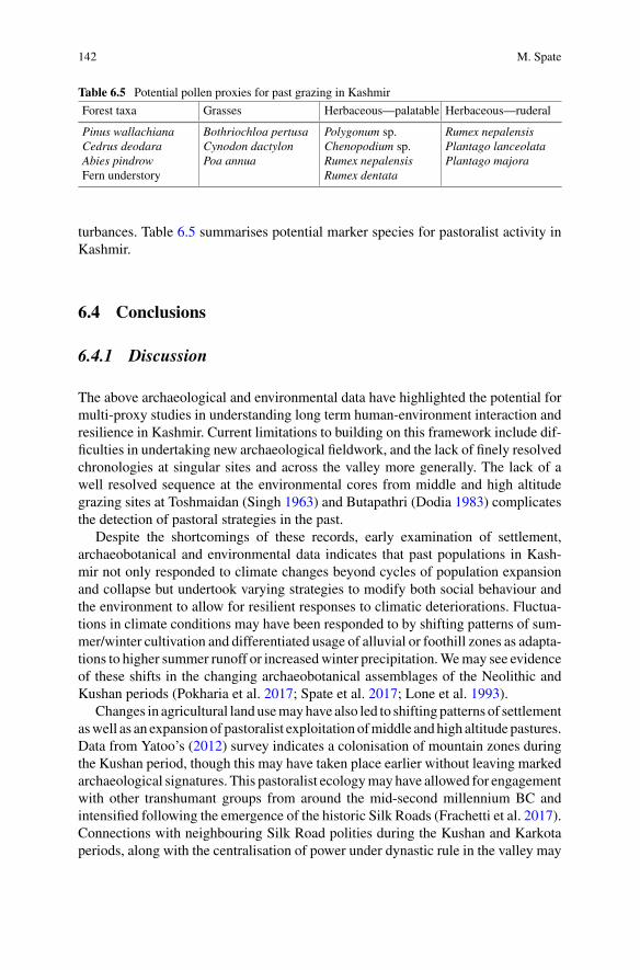
142 M. Spate
Table 6.5 Potential pollen proxies for past grazing in Kashmir
Forest taxa Grasses Herbaceous—palatable Herbaceous—ruderal
Pinus wallachianaCedrus deodaraAbies pindrowFern understory
Bothriochloa pertusaCynodon dactylonPoa annua
Polygonum sp.Chenopodium sp.Rumex nepalensisRumex dentata
Rumex nepalensisPlantago lanceolataPlantago majora
turbances. Table 6.5 summarises potential marker species for pastoralist activity inKashmir.
6.4 Conclusions
6.4.1 Discussion
The above archaeological and environmental data have highlighted the potential formulti-proxy studies in understanding long term human-environment interaction andresilience in Kashmir. Current limitations to building on this framework include dif-ficulties in undertaking new archaeological fieldwork, and the lack of finely resolvedchronologies at singular sites and across the valley more generally. The lack of awell resolved sequence at the environmental cores from middle and high altitudegrazing sites at Toshmaidan (Singh 1963) and Butapathri (Dodia 1983) complicatesthe detection of pastoral strategies in the past.
Despite the shortcomings of these records, early examination of settlement,archaeobotanical and environmental data indicates that past populations in Kash-mir not only responded to climate changes beyond cycles of population expansionand collapse but undertook varying strategies to modify both social behaviour andthe environment to allow for resilient responses to climatic deteriorations. Fluctua-tions in climate conditions may have been responded to by shifting patterns of sum-mer/winter cultivation and differentiated usage of alluvial or foothill zones as adapta-tions to higher summer runoff or increasedwinter precipitation.Wemay see evidenceof these shifts in the changing archaeobotanical assemblages of the Neolithic andKushan periods (Pokharia et al. 2017; Spate et al. 2017; Lone et al. 1993).
Changes in agricultural landusemayhave also led to shiftingpatterns of settlementaswell as an expansionof pastoralist exploitationofmiddle andhigh altitude pastures.Data from Yatoo’s (2012) survey indicates a colonisation of mountain zones duringthe Kushan period, though this may have taken place earlier without leaving markedarchaeological signatures. This pastoralist ecologymay have allowed for engagementwith other transhumant groups from around the mid-second millennium BC andintensified following the emergence of the historic Silk Roads (Frachetti et al. 2017).Connections with neighbouring Silk Road polities during the Kushan and Karkotaperiods, along with the centralisation of power under dynastic rule in the valley may
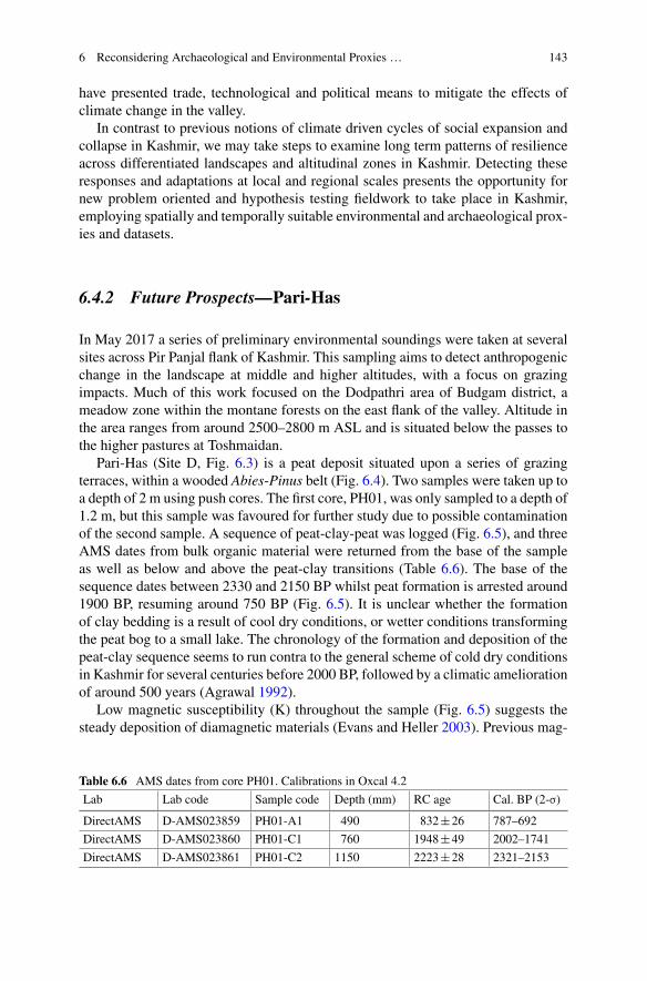
6 Reconsidering Archaeological and Environmental Proxies … 143
have presented trade, technological and political means to mitigate the effects ofclimate change in the valley.
In contrast to previous notions of climate driven cycles of social expansion andcollapse in Kashmir, we may take steps to examine long term patterns of resilienceacross differentiated landscapes and altitudinal zones in Kashmir. Detecting theseresponses and adaptations at local and regional scales presents the opportunity fornew problem oriented and hypothesis testing fieldwork to take place in Kashmir,employing spatially and temporally suitable environmental and archaeological prox-ies and datasets.
6.4.2 Future Prospects—Pari-Has
In May 2017 a series of preliminary environmental soundings were taken at severalsites across Pir Panjal flank of Kashmir. This sampling aims to detect anthropogenicchange in the landscape at middle and higher altitudes, with a focus on grazingimpacts. Much of this work focused on the Dodpathri area of Budgam district, ameadow zone within the montane forests on the east flank of the valley. Altitude inthe area ranges from around 2500–2800 m ASL and is situated below the passes tothe higher pastures at Toshmaidan.
Pari-Has (Site D, Fig. 6.3) is a peat deposit situated upon a series of grazingterraces, within a wooded Abies-Pinus belt (Fig. 6.4). Two samples were taken up toa depth of 2 m using push cores. The first core, PH01, was only sampled to a depth of1.2 m, but this sample was favoured for further study due to possible contaminationof the second sample. A sequence of peat-clay-peat was logged (Fig. 6.5), and threeAMS dates from bulk organic material were returned from the base of the sampleas well as below and above the peat-clay transitions (Table 6.6). The base of thesequence dates between 2330 and 2150 BP whilst peat formation is arrested around1900 BP, resuming around 750 BP (Fig. 6.5). It is unclear whether the formationof clay bedding is a result of cool dry conditions, or wetter conditions transformingthe peat bog to a small lake. The chronology of the formation and deposition of thepeat-clay sequence seems to run contra to the general scheme of cold dry conditionsin Kashmir for several centuries before 2000 BP, followed by a climatic ameliorationof around 500 years (Agrawal 1992).
Low magnetic susceptibility (K) throughout the sample (Fig. 6.5) suggests thesteady deposition of diamagnetic materials (Evans and Heller 2003). Previous mag-
Table 6.6 AMS dates from core PH01. Calibrations in Oxcal 4.2
Lab Lab code Sample code Depth (mm) RC age Cal. BP (2-σ)
DirectAMS D-AMS023859 PH01-A1 490 832±26 787–692
DirectAMS D-AMS023860 PH01-C1 760 1948±49 2002–1741
DirectAMS D-AMS023861 PH01-C2 1150 2223±28 2321–2153
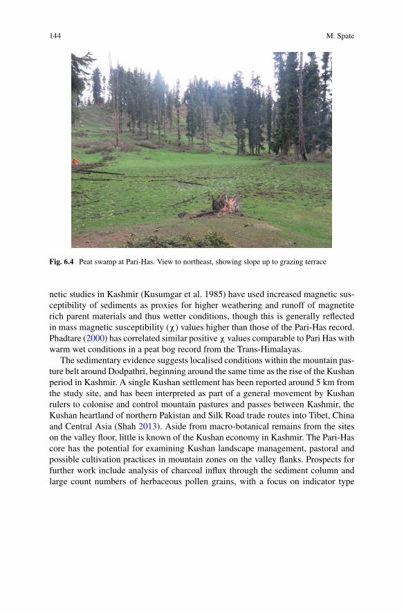
144 M. Spate
Fig. 6.4 Peat swamp at Pari-Has. View to northeast, showing slope up to grazing terrace
netic studies in Kashmir (Kusumgar et al. 1985) have used increased magnetic sus-ceptibility of sediments as proxies for higher weathering and runoff of magnetiterich parent materials and thus wetter conditions, though this is generally reflectedin mass magnetic susceptibility (χ) values higher than those of the Pari-Has record.Phadtare (2000) has correlated similar positiveχ values comparable to Pari Has withwarm wet conditions in a peat bog record from the Trans-Himalayas.
The sedimentary evidence suggests localised conditions within the mountain pas-ture belt around Dodpathri, beginning around the same time as the rise of the Kushanperiod in Kashmir. A single Kushan settlement has been reported around 5 km fromthe study site, and has been interpreted as part of a general movement by Kushanrulers to colonise and control mountain pastures and passes between Kashmir, theKushan heartland of northern Pakistan and Silk Road trade routes into Tibet, Chinaand Central Asia (Shah 2013). Aside from macro-botanical remains from the siteson the valley floor, little is known of the Kushan economy in Kashmir. The Pari-Hascore has the potential for examining Kushan landscape management, pastoral andpossible cultivation practices in mountain zones on the valley flanks. Prospects forfurther work include analysis of charcoal influx through the sediment column andlarge count numbers of herbaceous pollen grains, with a focus on indicator type
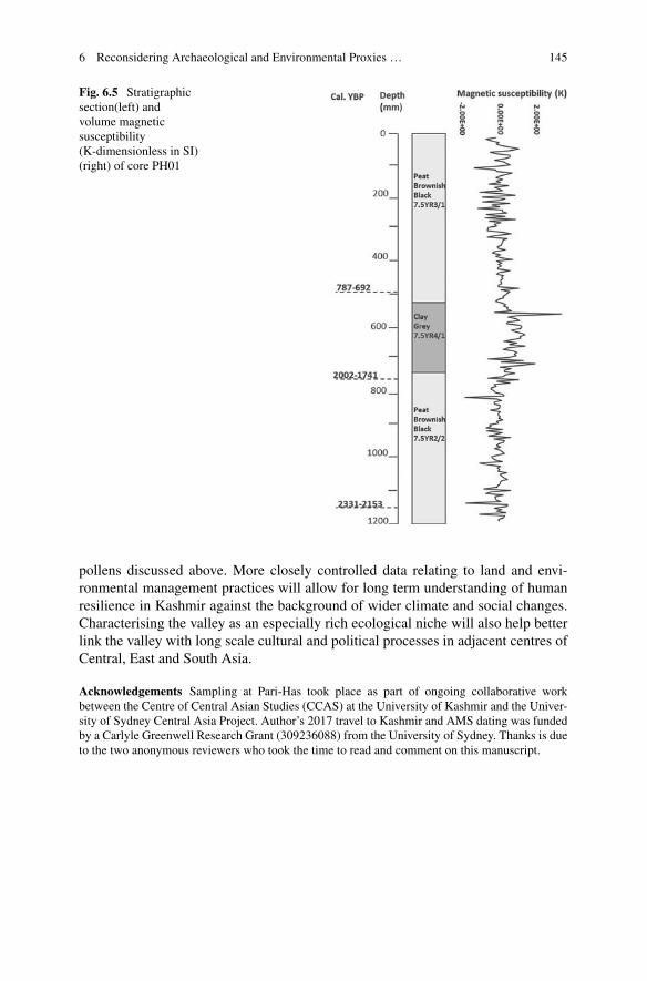
6 Reconsidering Archaeological and Environmental Proxies … 145
Fig. 6.5 Stratigraphicsection(left) andvolume magneticsusceptibility(K-dimensionless in SI)(right) of core PH01
pollens discussed above. More closely controlled data relating to land and envi-ronmental management practices will allow for long term understanding of humanresilience in Kashmir against the background of wider climate and social changes.Characterising the valley as an especially rich ecological niche will also help betterlink the valley with long scale cultural and political processes in adjacent centres ofCentral, East and South Asia.
Acknowledgements Sampling at Pari-Has took place as part of ongoing collaborative workbetween the Centre of Central Asian Studies (CCAS) at the University of Kashmir and the Univer-sity of Sydney Central Asia Project. Author’s 2017 travel to Kashmir and AMS dating was fundedby a Carlyle Greenwell Research Grant (309236088) from the University of Sydney. Thanks is dueto the two anonymous reviewers who took the time to read and comment on this manuscript.
146 M. Spate
References
Agrawal, D. P. (1988). Palaeoclimatic data from Kashmir: A synthesis and some correlations.Proceedings of the Indian National Science Academy, 54A(3), 333–342.
Agrawal, D. P. (1992). Man and environment in India through ages: An interdisciplinary study ofthe Indian quaternary with focus on north-west. New Delhi: Books & Books.
Agrawal, D. P., Dodia, R., Kusumgar, S., Nautiyal, V., & Seth, M. (1989). Late quaternary envi-ronmental and archaeological changes in Kashmir. In K. Frifelt & P. Sorsen (Eds.), South AsianArchaeology 1985 (pp. 271–276). London: Nordic Insitutue of Asian Studies.
Agrawal, D. P., & Kharakwal, J. S. (2002). South Asian prehistory: A multidisciplinary study. NewDelhi: Aryan Books International.
Ahmad, S., Dar, H. U., Dar, J. A., & Majeedi, Z. M. (2013). Impact of varying disturbances on thestructure and composition of grassland vegetation in Anantnag, Kashmir Himalayas.Proceedingsof the International Academy of Ecology and Environmental Sciences.
Allchin, B., &Allchin, R. (1982). The rise of civilization in India and Pakistan. London: CambridgeUniversity Press.
Bamzai, P. (1994). Culture and political history of Kashmir (Vol. I). New Delhi: MD Publications.Bandey, A. A. (2009). Prehistoric Kashmir: Archaeological history of Palaeolithic & Neolithiccultures. New Delhi: Dilpreet Publishing House.
Bates, J., Petrie, C. A., & Singh, R. N. (2018). Cereals, calories and change: Exploring approachesto quantification in Indus archaeobotany. Archaeological and Anthropological Sciences, 10(7),1703–1716.
Bhatt, D. K. (1978). Geological observations of the margs of Kashmir Valley, India. HimalayanGeology, 8, 769–783.
Boivin, N. L., Zeder, M. A., Fuller, D. Q., Crowther, A., Larson, G., Erlandson, J. M., et al. (2016).Ecological consequences of humanniche construction:Examining long-termanthropogenic shap-ing of global species distributions. Proceedings of the National Academy of Sciences, 113(23),6388–6396.
Casimir, M. J., & Rao, A. (1985). Vertical control in the western Himalaya: Some notes on thepastoral ecology of the nomadic Bakrwal of Jammu and Kashmir.Mountain Research and Devel-opment, 5(3), 221–232.
Conningham, R., & Sutherland, T. (1997). Dwellings or Granaries? The Pit Phenomenon of theKashmir-Swat Neolithic. Man and Environment, 22(2), 29–34.
Costantini, L. (1981). The beginning of agriculture in the Kachi Plain: The evidence of Mehrgarh.In South Asian Archaeology.
Costantini, L. (2008). The first farmers in Western Pakistan: the evidence of the Neolithic agropas-toral settlement of Mehrgarh. Pragdhara, 18, 167–178.
Dar, R. A., Romshoo, S. A., Chandra, R., & Ahmad, I. (2014). Tectono-geomorphic study of theKarewa Basin of Kashmir Valley. Journal of Asian Earth Sciences, 92, 143–156.
D’Alpoim-Guedes, J., Lu, H., Li, Y., Spengler, R. N., Wu, X., & Aldenderfer, M. S. (2014). Mov-ing agriculture onto the Tibetan plateau: The archaeobotanical evidence. Archaeological andAnthropological Sciences, 6(3), 255–269.
Dad, J. M., & Khan, A. B. (2010). Floristic composition of an alpine grassland in Bandipora,Kashmir. Grassland Science, 56(2), 87–94.
Das, B. K., Birgit-Gaye, &Malik, M. A. (2010). Biogeochemistry and paleoclimate variability dur-ing the Holocene: a record from Mansar Lake, Lesser Himalaya. Environmental Earth Sciences,61, 565–574. https://doi.org/10.1007/s12665-009-0366-0 .
De Terra, H., & Paterson, T. T. 2003 [1939]. The Ice Age in the Indian Subcontinent and AssociatedHuman Cultures: With Special Reference to Jammu, Kashmir, Ladakh, Sind, Liddar & Centraland Peninsular India. New Delhi: Aryan Books.
Demske, D., Tarasov, P. E., Wünnemann, B., & Riedel, F. (2009). Late glacial and Holocene veg-etation, Indian monsoon and westerly circulation in the Trans-Himalaya recorded in the lacus-

6 Reconsidering Archaeological and Environmental Proxies … 147
trine pollen sequence from Tso Kar, Ladakh, NW India. Palaeogeography, Palaeoclimatology,Palaeoecology, 279(3), 172–185.
Dodia, R. (1983). Palynological investigations on the Kashmir valley India (Unpublished Ph.D.thesis). Gujarat University, Ahmedabad.
Ellis, E.,Magliocca, N., Stevens, C., & Fuller, D. (2017). Evolving theAnthropocene: linkingmulti-level selection with long-term social–ecological change. Sustainability Science, 16(1), 119–128.
Evans, M., & Heller, F. (2003). Environmental magnetism: Principles and applications of enviro-magnetics (Vol. 86). Academic Press.
Faulseit, R. K. (Ed.). (2015). Beyond collapse: Archaeological perspectives on resilience, revital-ization, and transformation in complex societies. Carbondale: South Illinois University Press.
Frachetti, M. (2012). Multiregional emergence of mobile pastoralism and nonuniform institutionalcomplexity across Eurasia. Current Anthropology, 53(1), 2–38.
Frachetti, M., Smith, C. E., Traub, C. M., & Williams, T. (2017). Nomadic ecology shaped thehighland geography of Asia’s Silk Roads. Nature, 543(7644), 193–198.
Goldberg, P., & Macphail, R. (2006). Practical and theoretical geoarchaeology. Malden, MA,Oxford: Blackwell Publishing.
Harris, D. (2010). Origins of agriculture in Western Central Asia. Philadelphia: University ofPennsylvania Museum.
Husain, M. (2008). Systematic geography of Jammu and Kashmir. Jaipur: Rawat Publications.Kak, R. C. (1933). Ancient monuments of Kashmir. London: The Indian Society.Kaul, A. K. (2014). Studies in geography of Jammu and Kashmir. Jaipur: Rawat Publications.Krishnamurthy, R. V., DeNiro,M. J., & Pant, R. K. (1982). Isotope evidence for Pleistocene climaticchanges in Kashmir, India. Nature, 298(5875), 640–641.
Kusumgar, S., Agrawal, D. P., Juyal, N., & Sharma, P. (1986). Palaeosols within loess: Datingpalaeoclimatic events in Kashmir. Radiocarbon, 28(2a), 561–565.
Laland, K. N., & O’Brien, M. J. (2010). Niche construction theory and archaeology. Journal ofArchaeological Method and Theory, 17(4), 303–322.
Leipe, C., Demske, D., Tarasov, P. E., Wünnemann, B., Riedel, F., & Members, H. P. (2014).Potential of pollen and non-pollen palynomorph records from Tso Moriri (Trans-Himalaya, NWIndia) for reconstructing Holocene limnology and human–environmental interactions. Quater-nary International, 348, 113–129.
Lone, F. A., Khan, M., & Buth, G. M. (1993). Palaeoethnobotany Plants and Ancient Man inKashmir. Amsterdam: A.A. Balkema.
Mani, B. R. (2000). Excavations at Kanispur: 1998–99 (District Baramulla Kashmir). Journal ofInterdisciplinary Studies in History and Archaeology, 10, 1–21.
McAnany, P. A., & Yoffee, N. (Eds.). (2009). Questioning collapse: Human resilience, ecologicalvulnerability, and the aftermath of empire. Cambridge University Press.
Middleton, G. D. (2012). Nothing lasts forever: Environmental discourses on the collapse of pastsocieties. Journal of Archaeological Research, 20(3), 257–307.
Miehe, G., Miehe, S., Kaiser, K., Reudenbach, C., Behrendes, L., Duo, L., et al. (2009). How oldis pastoralism in Tibet? An ecological approach to the making of a Tibetan landscape. Palaeo-geography, Palaeoclimatology, Palaeoecology, 276(1), 130–147.
Miller, N. F. (1999). Agricultural development in western Central Asia in the Chalcolithic andBronze Ages. Vegetation History and Archaeobotany, 8(1), 13–19.
Mir, F. A., Bhat, G. A., Sheer, B. A., & Khan, A. G. (2015). Impacts of seasonal livestock grazingon plant community features: a case study on grazing pastures at Sonamarg area in KashmirHimalaya. Journal of Agricultural Sciences, 10(1).
Mitra, D. (Ed.). (1983). Indian archaeology 1980–81 a review (pp. 21–26). Calcutta: ArchaeologicalSurvey of India.
Murphy, C. A., & Fuller, D. Q. (2016). Production in India: South Asian entanglements of domes-tication. In A companion to South Asia in the past (p. 344).
Pant, R. K., Gaillard, C., Nautiyal, V., Gaur, G. S., & Shali, S. L. (1982). Some new lithic andceramic industries from Kashmir. Man and Environment, 6, 37–40.
148 M. Spate
Petrie, C.A., Singh,R.N., Bates, J.,Dixit,Y., French,C.A. I.,Hodell,D.A., et al. (2017).Adaptationto variable environments, resilience to climate change: Investigating in Indus Northwest India.Current Anthropology, 58(1),1–30.
Phadtare,N.R. (2000). Sharpdecrease in summermonsoon strength 4000–3500cal yrB.P. inCentralHigher Himalaya of India based on pollen evidence from alpine peat. Quaternary Research, 53,122–129.
Pokharia, A., Mani, B., Spate, M., Betts, A., Srivastava, A. (2017). Early Neolithic Agriculture(2700–2000 BC) and Kushan period developments (AD 100–300): Macrobotanical evidencefromKanispur inKashmir, India.VegetationHistory andArchaeobotany. https://doi.org/10.1007/s00334-017-0645-8.
Possehl, G. L. (2002). The Indus civilization: A contemporary perspective.Walnut Creek: AltaMira.Qazi, S. A. (2005). Systematic geography of Jammu and Kashmir. New Delhi: APH PublishingHouse.
Rawat, S., Gupta, A. K., Sangode, S. J., Srivastava, P., & Nainwal, H. C. (2015). Late Pleistocene-Holocene vegetation and Indian summer monsoon record from the Lahaul, Northwest Himalaya,India. Quaternary Science Reviews, 114, 167–181.
Scott, J. C. (2017). Against the grain: A deep history of the earliest states. New Haven & London:Yale University Press.
Shah, M. A. (2013). Early historic archaeology in Kashmir: An appraisal of the Kushan Period.Bulletin of the Deccan College Research Institute, 72, 213–224.
Shali, S. L. (2001). Settlement pattern in relation to climatic changes in Kashmir. New Delhi: OMPublications.
Sharma, A. K. (2013). Excavations at Gufkral (Jammu and Kashmir). New Delhi: B.R. PublishingHouse.
Sidhu, G. S., & Surya, J. N. (2014). Soils of North-Western Himalayan eco-system and their landuse, constraints, productivity potentials and future strategies. Agropedology, 24(01), 1–19.
Singh, G. (1963). A preliminary survey of post-glacial vegetation history in the Kashmir Valley.Paleobotanist, 12(1), 73–108.
Singh, G., & Agrawal, D. P. (1976). Radiocarbon evidence for early deglaciation in north-westernHimalaya, India. Nature, 260, 232.
Spate, M., Zhang, G., Yatoo, M., & Betts, A. (2017). New evidence for early 4th millennium BPagriculture in theWestern Himalayas: Qasim Bagh, Kashmir. Journal of Archaeological Science:Reports, 11, 568–577.
Spengler, R. N. (2014). Niche dwelling vs niche construction: Landscapemodification in the bronzeand iron ages of central Asia. Human Ecology, 42(6), 813–821.
Spengler, R. N. (2015). Agriculture in the Central Asian Bronze Age. Journal of World Prehistory,28(3), 215–253.
Spengler, R. N., Frachetti, M. D., & Fritz, G. J. (2013). Ecotopes and herd foraging practicesin the steppe/mountain ecotone of Central Asia during the Bronze and Iron Ages. Journal ofEthnobiology, 33(1), 125–147.
Stevens, C. J., Murphy, C., Roberts, R., Lucas, L., Silva, F., & Fuller, D. Q. (2016). Between Chinaand South Asia: A middle Asian corridor of crop dispersal and agricultural innovation in theBronze Age. The Holocene, 26(10), 1541–1555.
Thapar, B. K. (Ed.). (1980). Indian archaeology 1976–77: A review (pp. 19–75). Calcutta: Archae-ological Survey of India.
Thomas, K., & Cartwright, C. (2010). The bioarchaeological remains from Sheri Khan Tarakai:Environments, resources and subsistence. In C. Petrie (Ed.), Sheri Khan Tarakai and early villagelife on borderlands of northwest Pakistan (pp. 305–342). Oxford: Oxbow Books.
Trivedi, A., & Chauhan, M. S. (2009). Holocene vegetation and climate fluctuations in northwestHimalaya, based on pollen evidence from Surinsar Lake, Jammu region, India. Journal of theGeological Society of India, 74(3), 402–412.
Vishnu-Mittre. (1966). Some aspects of concerning pollen analytical investigations in the Kashmirvalley. The Palaeobotanist, 15, 157–175.
6 Reconsidering Archaeological and Environmental Proxies … 149
Vishnu-Mittre, K. S., & Sharma, B. D. (1966). Studies of postglacial vegetational history from theKasmir Valley 1. Haigam Lake. Palaeobotanist, 15, 185–212.
Yatoo, M. A. (2005). Archaeological Explorations of Sopore and Bandipora Tehsils in DistrictBaramulla Kashmir (Unpublished M.Phil. thesis). University of Kashmir, Srinagar.
Yatoo, M. A. (2012).Characterising material culture to determine setlement patterns in North WestKashmir (Unpublished Ph.D. thesis). University of Leicester.
Yatoo, M. A., & Bandey, A. A. (2014). Relations of Neolithic Kashmir with South and CentralAsia: A comparative analysis of material culture from new sites in Kashmir. Journal of CentralAsian Studies, 26, 37–46.
Young, R. (2003).Agriculture and pastoralism in the Late Bronze and Iron Age, NorthWest FrontierProvince, Pakistan. Oxford: BAR International Series.
Open Access This chapter is licensed under the terms of the Creative Commons Attribution 4.0International License (http://creativecommons.org/licenses/by/4.0/), which permits use, sharing,adaptation, distribution and reproduction in any medium or format, as long as you give appropriatecredit to the original author(s) and the source, provide a link to the Creative Commons license andindicate if changes were made.
The images or other third party material in this chapter are included in the chapter’s CreativeCommons license, unless indicated otherwise in a credit line to the material. If material is notincluded in the chapter’s Creative Commons license and your intended use is not permitted bystatutory regulation or exceeds the permitted use, you will need to obtain permission directly fromthe copyright holder.

Part IIINatural Disasters and Impacts
in the Past Societies

Chapter 7Living with Earthquakes along the SilkRoad
Miklós Kázmér
Abstract Earthquakes are among the most horrible events of nature due to unex-pected occurrence, for which no spiritual means are available for protection. Theonly way of preserving life and property is to prepare for the inevitable: applyingearthquake-resistant construction methods. Zones of damaging earthquakes alongthe Silk Road are reviewed for seismic hazard and to understand the ways localcivilizations coped with it during the past two thousand years. China and its widesphere of cultural influence certainly had earthquake-resistant architectural practice,as the high number of ancient buildings, especially high pagodas, prove. A briefreview of anti-seismic design and construction methods (applied both for woodenandmasonry buildings) is given, in the context of earthquake-prone zones ofNorthernChina.Muslim architects inWestern China and Central Asia used brick andmortar toconstruct earthquake-resistant structural systems. Ancient Greek architects in Ana-tolia and the Aegean applied steel clamps embedded in lead casing to hold togethercolumns and masonry walls during frequent earthquakes. Romans invented concreteand built all sizes of buildings as a single, non-flexible unit. Masonry, surroundingand decorating the concrete core of the wall, did not bear load. Concrete resistedminor shaking, yielding only to forces higher than fracture limits. Roman build-ing traditions survived the Dark Ages, and 12th century Crusader castles erected inearthquake-prone Syria survive until today in reasonably good condition. Usage ofearthquake-resistant technology depends on the perception of earthquake risks andon available financial resources. Earthquake-resistant construction practice is sig-nificantly more expensive than regular construction. Frequent earthquakes maintainsafe construction practices, like the timber-laced masonry tradition in the EasternMediterranean throughout 500 years of political and technological development.
Keywords Seismicity · Anti-seismic · Construction method · Masonry · TimberAdobe · China · Central Asia · Turkey · Syria · Greece · Italy
M. Kázmér (B)Department of Palaeontology & MTA-ELTE Geological, Geophysical and Space ScienceResearch Group, Eötvös University, Budapest, Hungarye-mail: [email protected]
© The Author(s) 2019L. E. Yang et al. (eds.), Socio-Environmental Dynamics along the Historical Silk Road,https://doi.org/10.1007/978-3-030-00728-7_7
153
154 M. Kázmér
7.1 Introduction
While seismicity of any area on earth can nowadays be easily measuredby instrumental seismology, the quantity, quality, and distribution of the seismographstations has been more or less sufficient for the purpose during the last 50 years only.Recurrence period of damaging earthquakes is often longer than this, even longerthan individual and social memory (Force 2008). To gain information about seismicevents one needs to study historical sources (Guidoboni 1993; Guidoboni and Ebel2009), archaeological evidence (Stiros and Jones 1996), and geological evidence(McCalpin 1996).
Archaeoseismology, the archaeological study of earthquakes is extremely usefulfor scientists assessing seismic hazards (Sintubin 2013). It is a treasure trove ofinformation about ancient societies. Perception of earthquakes, the risk a society canand will tolerate, the longevity and means of their social memory (Kázmér et al.2010), expertise of builders to construct buildings which can resist ground shaking,and technology transfer associated with these activities are relevant questions forhistorical and social sciences.
Another worthwhile direction of research is the role of external forcing factorson human evolution. Recent studies almost invariably focused on climate changeand climate-influenced change of vegetation (Maslin and Christensen 2010), whilemostly neglecting the effects of seismic and volcanic catastrophes (King and Bailey2010). An interesting idea of Force andMcFadgen (2010) states that there are thirteenNeolithic cultures which later developed into major civilizations (Roman, Etruscan,Corinthian, Mycenaen, Minoan, Tyre, Jerusalem, Niniveh, Ur-Uruk, Mesopotamian,Persian, Mohenjodaro, Aryan India, Memphis in Egypt, and Chinese). One can read-ily add the Aztec, Maya and Inca cultures along the seismic western margin of theAmericas. Putting these on a map of earthquakes it is striking to observe that all ofthem evolved in close proximity to faults and mountain ranges of high earthquakeactivity (Jackson 2006). In this study another set of sites is added, arranged along tec-tonically active zones along the northern margin of the Eurasian mountain range: thebelt of settlements and cultures collectively called the Silk Road (Lieu andMikkelsen2017).
There is long but somewhat meagre tradition of studying seismic hazard, risk,and resilience of societies along the Silk Road. Earthquakes are parts of nature andlife, and people have developed a connection with land throughout millennia (e.g. inIran: Ibrion et al. 2014; however, the 2003 Bam earthquake arrived to a communitynot believing it can happen: Parsizadeh et al. 2015). Knowledge of seismicity andthe methods used by local people to resist and survive destruction inflicted by naturalcalamities in general (Janku 2010) and by earthquakes in particular (Jusseret 2014;Rideaud and Helly 2017) are valuable contributions to the understanding how humansociety works.
Environmental history of the Silk Road has been studied intensively (see papersin the present volume), but earthquake hazard and risk, even when known to exist(Xu et al. 2010), were not systematically considered (Li et al. 2015). An exception is
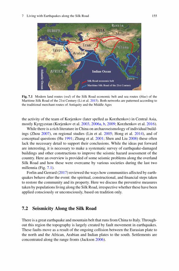
7 Living with Earthquakes along the Silk Road 155
Fig. 7.1 Modern land routes (red) of the Silk Road economic belt and sea routes (blue) of theMaritime Silk Road of the 21st Century (Li et al. 2015). Both networks are patterned according tothe traditional merchant routes of Antiquity and the Middle Ages
the activity of the team of Korjenkov (later spelled as Korzhenkov) in Central Asia,mostly Kyrgyzstan (Korjenkov et al. 2003, 2006a, b, 2009; Korzhenkov et al. 2016).
While there is a rich literature in China on archaeoseismology of individual build-ings (Zhou 2007), on regional studies (Lin et al. 2005; Hong et al. 2014), and ofconceptual questions (Hu 1991; Zhang et al. 2001; Shen and Liu 2008) these oftenlack the necessary detail to support their conclusions. While the ideas put forwardare interesting, it is necessary to make a systematic survey of earthquake-damagedbuildings and other constructions to improve the seismic hazard assessment of thecountry. Here an overview is provided of some seismic problems along the overlandSilk Road and how these were overcame by various societies during the last twomillennia (Fig. 7.1).
Forlin and Gerrard (2017) reviewed the ways how communities affected by earth-quakes behave after the event: the spiritual, constructional, and financial steps takento restore the community and its property. Here we discuss the preventive measurestaken by populations living along the Silk Road, irrespective whether these have beenapplied consciously or unconsciously, based on tradition only.
7.2 Seismicity Along the Silk Road
There is a great earthquake andmountain belt that runs fromChina to Italy. Through-out this region the topography is largely created by fault movement in earthquakes.These faults move as a result of the ongoing collision between the Eurasian plate tothe north and the African, Arabian and Indian plates to the south. Settlements areconcentrated along the range fronts (Jackson 2006).
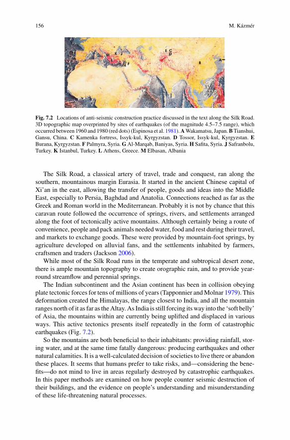
156 M. Kázmér
Fig. 7.2 Locations of anti-seismic construction practice discussed in the text along the Silk Road.3D topographic map overprinted by sites of earthquakes (of the magnitude 4.5–7.5 range), whichoccurred between 1960 and 1980 (red dots) (Espinosa et al. 1981).AWakamatsu, Japan.BTianshui,Gansu, China. C Kamenka fortress, Issyk-kul, Kyrgyzstan. D Tossor, Issyk-kul, Kyrgyzstan. EBurana, Kyrgyzstan. F Palmyra, Syria.GAl-Marqab, Baniyas, Syria.H Safita, Syria. J Safranbolu,Turkey. K Istanbul, Turkey. L Athens, Greece. M Elbasan, Albania
The Silk Road, a classical artery of travel, trade and conquest, ran along thesouthern, mountainous margin Eurasia. It started in the ancient Chinese capital ofXi’an in the east, allowing the transfer of people, goods and ideas into the MiddleEast, especially to Persia, Baghdad and Anatolia. Connections reached as far as theGreek and Roman world in the Mediterranean. Probably it is not by chance that thiscaravan route followed the occurrence of springs, rivers, and settlements arrangedalong the foot of tectonically active mountains. Although certainly being a route ofconvenience, people and pack animals neededwater, food and rest during their travel,and markets to exchange goods. These were provided by mountain-foot springs, byagriculture developed on alluvial fans, and the settlements inhabited by farmers,craftsmen and traders (Jackson 2006).
While most of the Silk Road runs in the temperate and subtropical desert zone,there is ample mountain topography to create orographic rain, and to provide year-round streamflow and perennial springs.
The Indian subcontinent and the Asian continent has been in collision obeyingplate tectonic forces for tens of millions of years (Tapponnier andMolnar 1979). Thisdeformation created the Himalayas, the range closest to India, and all the mountainranges north of it as far as theAltay.As India is still forcing itsway into the ‘soft belly’of Asia, the mountains within are currently being uplifted and displaced in variousways. This active tectonics presents itself repeatedly in the form of catastrophicearthquakes (Fig. 7.2).
So the mountains are both beneficial to their inhabitants: providing rainfall, stor-ing water, and at the same time fatally dangerous: producing earthquakes and othernatural calamities. It is a well-calculated decision of societies to live there or abandonthese places. It seems that humans prefer to take risks, and—considering the bene-fits—do not mind to live in areas regularly destroyed by catastrophic earthquakes.In this paper methods are examined on how people counter seismic destruction oftheir buildings, and the evidence on people’s understanding and misunderstandingof these life-threatening natural processes.

7 Living with Earthquakes along the Silk Road 157
7.3 Archeoseismology and Other Seismologies
The way we recognize and understand earthquakes is in tremendous change nowa-days. There are digital instruments worldwide to receive seismic signals globally,and internet-connected computers automatically calculate the place, depth, and mag-nitude of earthquakes. This has been going on for not more than twenty years. Beforethat individual seismometers have been recording earthquakes for up to a hundredyears. This is enough to understand the major seismic patterns of the earth, but notenough to be prepared for major earthquakes, especially in areas where these occurrarely.
The bigger an earthquake, the more rarely it occurs again at the same place. Thisrecurrence period is often longer than the period covered by data of seismographs.To understand seismicity of the pre-instrumental period one must refer to historicaldocuments: it is a scientific field called historical seismology (Guidoboni and Ebel2009). A few centuries, rarely millennia can be more or less covered by these data.Where historical records are missing, there might be evidence preserved in ancientmonuments. The way these were damaged by earthquakes is studied by archaeo-seismology (Stiros and Jones 1996). Earthquakes recurring beyond these millennialintervals are studied by paleoseismology, theoretically into millions of years of Earthhistory (McCalpin 1996).
Seismicity of the past has been studied in detail on both ends of the Silk Road.Japanese historical earthquake catalogues have been reviewed by Ishibashi (2004).In China there are multiple catalogues available (Academia Sinica 1956; Li 1960;for a modern treatment of philological depth see Walter 2016). There are two recentcatalogues in the Mediterranean region (Ambraseys 2009; Guidoboni and Comastri2005). Between them there is the area covered by the catalogue of Ambraseys andMelville (1982) on Persian earthquakes, and historical catalogue of Kondorskayaand Shebalin (1982) of earthquakes in the former Soviet Union. The latter coversmuch of the Central Asian sector of the Silk Road.
7.4 Construction Materials in Earthquake-ResistantTechniques
Materials used in permanent and semi-permanent construction varies according topurpose, availability, financial resources, cultural and climatic influences. Adobe,brick, wood, stone, concrete, and metal reinforcements are discussed below. Ourknowledge of past construction practices are limited by preservation: adobe is theworst, wood is second,whilemonumental stonemasonry andRoman concrete has thebest potential to be preserved for future generations and for the inquisitive eyes of theresearcher. Finances determine permanence of buildings, therefore rural constructionhas the least chance to survive, urban dwellings stand in the middle, and secularand religious monumental constructions are the best to resist destruction of passingmillennia.
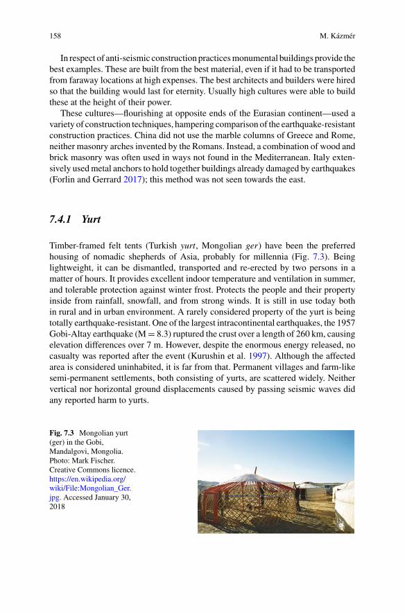
158 M. Kázmér
In respect of anti-seismic construction practicesmonumental buildings provide thebest examples. These are built from the best material, even if it had to be transportedfrom faraway locations at high expenses. The best architects and builders were hiredso that the building would last for eternity. Usually high cultures were able to buildthese at the height of their power.
These cultures—flourishing at opposite ends of the Eurasian continent—used avariety of construction techniques, hampering comparison of the earthquake-resistantconstruction practices. China did not use the marble columns of Greece and Rome,neither masonry arches invented by the Romans. Instead, a combination of wood andbrick masonry was often used in ways not found in the Mediterranean. Italy exten-sively usedmetal anchors to hold together buildings already damaged by earthquakes(Forlin and Gerrard 2017); this method was not seen towards the east.
7.4.1 Yurt
Timber-framed felt tents (Turkish yurt, Mongolian ger) have been the preferredhousing of nomadic shepherds of Asia, probably for millennia (Fig. 7.3). Beinglightweight, it can be dismantled, transported and re-erected by two persons in amatter of hours. It provides excellent indoor temperature and ventilation in summer,and tolerable protection against winter frost. Protects the people and their propertyinside from rainfall, snowfall, and from strong winds. It is still in use today bothin rural and in urban environment. A rarely considered property of the yurt is beingtotally earthquake-resistant. One of the largest intracontinental earthquakes, the 1957Gobi-Altay earthquake (M 8.3) ruptured the crust over a length of 260 km, causingelevation differences over 7 m. However, despite the enormous energy released, nocasualty was reported after the event (Kurushin et al. 1997). Although the affectedarea is considered uninhabited, it is far from that. Permanent villages and farm-likesemi-permanent settlements, both consisting of yurts, are scattered widely. Neithervertical nor horizontal ground displacements caused by passing seismic waves didany reported harm to yurts.
Fig. 7.3 Mongolian yurt(ger) in the Gobi,Mandalgovi, Mongolia.Photo: Mark Fischer.Creative Commons licence.https://en.wikipedia.org/wiki/File:Mongolian_Ger.jpg. Accessed January 30,2018

7 Living with Earthquakes along the Silk Road 159
7.4.2 Rammed Earth, Adobe
Rammed earth is an ancient construction technique. Clay, silt and sand are compactedand rammed into removable formwork (Figs. 7.4, 7.5, 7.6 and 7.7). The resultantwall and single-floor buildings constructed this way have good vertical load-bearingcapacity (Jaquin 2008). In case of frequent horizontal forces caused by earthquakesit is reinforced by hatil-style wooden boards (see under Wood-reinforced masonrybelow) (Ortega et al. 2014). It is excellent heat insulator both in winter and in sum-mer. Another advantage is that it can be built and restored cheaply. Rammed earthis a frequently used construction material in vernacular architecture. Monumentaland military architecture uses rammed earth and adobe brick buildings in CentralAsia (e.g. Chuy, Kyrgyzstan: Korjenkov et al. 2012; also in Bam, Iran: Zahrai andHeidarzadeh 2007).
Fig. 7.4 Aerial image of the earthworks of Medieval Kamenka fortress north of Issyk Kul, Kyr-gyzstan. The rhomb-shaped fortress, surrounded by towers, is cross-cut by an active fault (markedwith arrows), which caused 4 m left-lateral displacement during the M 8.2 Kemin earthquake in1911. Rammed earth walls survived with minor damage (Korjenkov et al. 2006a, Povolotskaya et al.2006)

160 M. Kázmér
Fig. 7.5 Northwestern wall of Medieval Kamenka fortress. In the front: trenched cross-sectionof rammed earth wall. Background: 4 m displacement caused by a the left-lateral fault activatedin the 1911 earthquake [Photo M. Kázmér, #1178 (Serial numbers of photographs refer to theArchaeoseismology Database (ADB), currently being built at Eötvös University, Budapest (Moroand Kázmér 2018)]
Fig. 7.6 Rammed earth wall of Tossor fortress (Lake Issyk Kul, Kyrgyzstan) as seen in excava-tion trench cross-cutting the buried wall. Layers are marked by horizontal scratches made by theexcavating archaeologist. Three ruptures dissect the wall. Trench is 2.5 m deep (Photo M. Kázmér,#1246). For details see Korzhenkov et al. (2016)
7.4.3 Wood
Wood is the ultimate earthquake-resistant construction material (Fig. 7.8). Its flexi-bility allows to accept moderate horizontal load. The relatively cheap constructionallows quick reconstruction in case of damage. In earthquake-prone Japan most ofthe traditional buildings, from the monumental to the vernacular, are made of wood.Therefore practically there is no way to do archaeoseismological studies, becauseevidence—even if only a few decades old—has not been preserved (Barnes 2010).If seismic destruction happens, it is always immediately repaired, at least during thepast 1500 years.
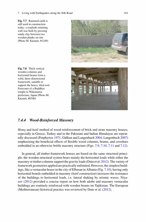
7 Living with Earthquakes along the Silk Road 161
Fig. 7.7 Rammed earth isstill used in constructiontoday: a roadside retainingwall was built by pressingsandy clay between twowooden planks on-site(Photo M. Kázmér, #1249)
Fig. 7.8 Thick verticalwooden columns andhorizontal beams form asolid, three-dimensionalframework, suitable tosupport the heavy, tiled roof.Forecourt of a Buddhisttemple in Wakamatsuprefecture, Japan (Photo M.Kázmér, #0700)
7.4.4 Wood-Reinforced Masonry
Hımıs and hatil method of wood reinforcement of brick and stone masonry houses,especially in Greece, Turkey and in the Pakistani and Indian Himalayas are repeat-edly discussed (Porphyrios 1971; Gülkan and Langenbach 2004; Langenbach 2007)emphasizing the beneficial effects of flexible wood columns, beams, and crossbarsembedded in an otherwise brittle masonry structure (Figs. 7.9, 7.10, 7.11 and 7.12).
In general, all timber-framework houses are based on the same structural princi-ple: the wooden structural system bears mainly the horizontal loads while either themasonry or timber columns support the gravity loads (Dutu et al. 2012). The variety offramework geometries applied are practically unlimited.However, the simplest build-ings, like a vernacular house in the city of Elbasan in Albania (Fig. 7.10), having onlyhorizontal boards embedded in masonry (hatil construction) increases the resistanceof the buildings to horizontal loads, i.e. lateral shaking by seismic waves. Niya-zov (2012) provided a concise report on how both adobe and masonry vernacularbuildings are routinely reinforced with wooden beams im Tajikistan. The European(Mediterranean) historical practice was reviewed by Dutu et al. (2012).
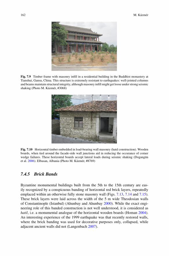
162 M. Kázmér
Fig. 7.9 Timber frame with masonry infill in a residential building in the Buddhist monastery atTianshui, Gansu, China. This structure is extremely resistant to earthquakes: well-jointed columnsand beamsmaintain structural integrity, althoughmasonry infillmight get loose under strong seismicshaking (Photo M. Kázmér, #3068)
Fig. 7.10 Horizontal timber embedded in load-bearing wall masonry (hatıl construction). Woodenboards, when tied around the facade-side wall junctions aid in reducing the occurance of cornerwedge failures. These horizontal boards accept lateral loads during seismic shaking (Dogangünet al. 2006). Elbasan, Albania (Photo M. Kázmér, #8769)
7.4.5 Brick Bands
Byzantine monumental buildings built from the 5th to the 15th century are eas-ily recognized by a conspicuous banding of horizontal red brick layers, repeatedlyemplaced within an otherwise fully stone masonry wall (Figs. 7.13, 7.14 and 7.15).These brick layers were laid across the width of the 5 m wide Theodosian wallsof Constantinople (Istanbul) (Ahunbay and Ahunbay 2000). While the exact engi-neering role of this banded construction is not well understood, it is considered ashatil, i.e. a monumental analogue of the horizontal wooden boards (Homan 2004).An interesting experience of the 1999 earthquake was that recently restored walls,where the brick banding was used for decorative purposes only, collapsed, whileadjacent ancient walls did not (Langenbach 2007).

7 Living with Earthquakes along the Silk Road 163
Fig. 7.11 Timber-laced masonry house in Safranbolu, Turkey (hımıs construction). Theground floor is unreinforced masonry, followed by two floors of intricate timber struc-ture. Note oblique timbers at corners, providing support against lateral shaking. Photo UgurBasak. Source https://commons.wikimedia.org/wiki/File:Safranbolu_traditional_house_1.jpg. Cre-ative Commons license. Accessed September 23, 2017
Fig. 7.12 Timber-framedhouse in Athens, Greece.This modernized housedisplays vertical columns,horizontal beams andX-shaped crossbars (PhotoM. Kázmér, #1399)
7.4.6 Metal Clamps, Bolts, Anchors and Chains
Iron ingots hold together carefully hewnmasonry of a seawall inHangzhouBay datedto the Ming and Qing dynasties (Wang et al. 2012). Whether this technology, well-known in Greek architecture of Antiquity, was widely applied in China is a matter offurther research. The use of cast iron—of as yet unknown metallurgical character-istics—would certainly raise eyebrows of any modern engineer. The Greeks neverused it; they used steel instead, surrounded by lead to protect rusting and to dampenthe eventual collision of metal and the embedding stone during earthquake (Stiros1995, 1996). Metal clamps and dowels were used in construction of the Parthenonin Athens, Greece (Fig. 7.16) and in the Baal temple of Palmyra, Syria (Figs. 7.17and 7.18). Elastic steel provided strength, while plastic lead casing absorbed minorshifts of blocks without fracturing rigid stone.

164 M. Kázmér
Fig. 7.13 Alternating layersof brick and stone masonry.Early 5th centuryTheodosian wall, Istanbul,Turkey. There are sevencourses of brick bands laid atintervals, running throughthe entire thickness of thewall (see Fig. 7.14)(Ahunbay and Ahunbay2000). The brick layers areconsidered to be antiseismicconstructions (Photo M.Kázmér, #0279)
Fig. 7.14 The brick layertraverses the full width of the5 m thick stone wall. Early5th century Theodosian wall,Istanbul, Turkey (Photo M.Kázmér, #0283)
There is a widely usedmethod in Italy to reinforce a buildingmoderately damagedby earthquake. Opposite walls are clamped together tightly by smith’s iron rods(anchors), often ending in decoratively shaped crossbars (Forlin and Gerrard 2017)(Fig. 7.19).
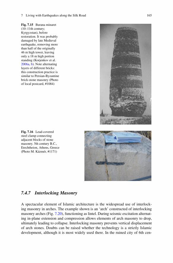
7 Living with Earthquakes along the Silk Road 165
Fig. 7.15 Burana minaret(10–11th century;Kyrgyzstan), beforerestoration. It was probablydamaged by late Medievalearthquake, removing morethan half of the originally46 m high tower, leavingonly a 18 m high portionstanding (Korjenkov et al.2006a, b). Note alternatinglayers of different bricks:this construction practice issimilar to Persian-Byzantinebrick-stone masonry (Photoof local postcard, #1084)
Fig. 7.16 Lead-coveredsteel clamp connectingadjacent blocks of stonemasonry. 5th century B.C.,Erechtheion, Athens, Greece(Photo M. Kázmér, #1171)
7.4.7 Interlocking Masonry
A spectacular element of Islamic architecture is the widespread use of interlock-ing masonry in arches. The example shown is an ‘arch’ constructed of interlockingmasonry arches (Fig. 7.20), functioning as lintel. During seismic excitation alternat-ing in-plane extension and compression allows elements of arch masonry to drop,ultimately leading to collapse. Interlocking masonry prevents vertical displacementof arch stones. Doubts can be raised whether the technology is a strictly Islamicdevelopment, although it is most widely used there. In the ruined city of 6th cen-

166 M. Kázmér
Fig. 7.17 Steel clamps,enclosed by lead wereinserted between adjacentmasonry blocks.Subsequently lead was‘recycled’ from the buildingby chiselling a wide openingto the clamp and melting thelead. 1st century A.D. Baaltemple, Palmyra, Syria(Photo M. Kázmér, #4245)
Fig. 7.18 Columns were setup with steel dowels inserted.Space around dowels wasfilled by molten lead,introduced via the narrowcanals leading to each dowelhole. 1st century A.D. Baaltemple, Palmyra, Syria(Photo M. Kázmér, #4255)
Fig. 7.19 Iron rodstraversing the buildingterminate in these crossbars.These hold together a housemoderately damaged byearthquake in Treviso, Italy(Photo M. Kázmér, #1902)
tury Zenobia (Halabiyya, Syria)—rebuilt at that time by the Byzantine emperorJustinian—there are lintels composed of interlocking masonry (Fig. 7.21). However,Crusader castles of 11–13th century along the Mediterranean coastal region do notuse this technique, despite being in close contact with Islamic culture.
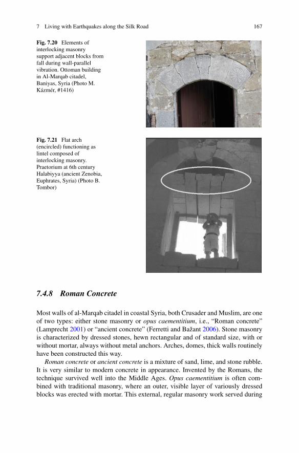
7 Living with Earthquakes along the Silk Road 167
Fig. 7.20 Elements ofinterlocking masonrysupport adjacent blocks fromfall during wall-parallelvibration. Ottoman buildingin Al-Marqab citadel,Baniyas, Syria (Photo M.Kázmér, #1416)
Fig. 7.21 Flat arch(encircled) functioning aslintel composed ofinterlocking masonry.Praetorium at 6th centuryHalabiyya (ancient Zenobia,Euphrates, Syria) (Photo B.Tombor)
7.4.8 Roman Concrete
Most walls of al-Marqab citadel in coastal Syria, both Crusader and Muslim, are oneof two types: either stone masonry or opus caementitium, i.e., “Roman concrete”(Lamprecht 2001) or “ancient concrete” (Ferretti and Bažant 2006). Stone masonryis characterized by dressed stones, hewn rectangular and of standard size, with orwithout mortar, always without metal anchors. Arches, domes, thick walls routinelyhave been constructed this way.
Roman concrete or ancient concrete is a mixture of sand, lime, and stone rubble.It is very similar to modern concrete in appearance. Invented by the Romans, thetechnique survived well into the Middle Ages. Opus caementitium is often com-bined with traditional masonry, where an outer, visible layer of variously dressedblocks was erected with mortar. This external, regular masonry work served during
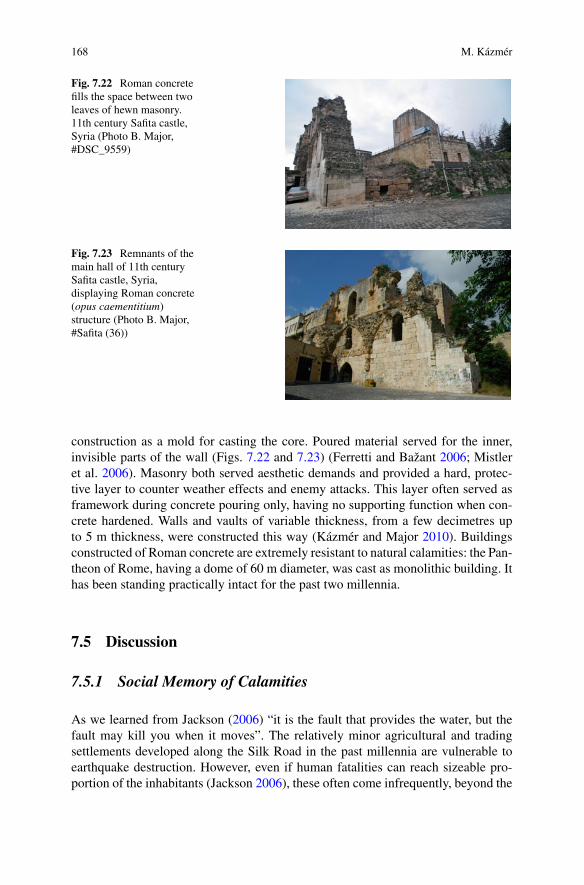
168 M. Kázmér
Fig. 7.22 Roman concretefills the space between twoleaves of hewn masonry.11th century Safita castle,Syria (Photo B. Major,#DSC_9559)
Fig. 7.23 Remnants of themain hall of 11th centurySafita castle, Syria,displaying Roman concrete(opus caementitium)structure (Photo B. Major,#Safita (36))
construction as a mold for casting the core. Poured material served for the inner,invisible parts of the wall (Figs. 7.22 and 7.23) (Ferretti and Bažant 2006; Mistleret al. 2006). Masonry both served aesthetic demands and provided a hard, protec-tive layer to counter weather effects and enemy attacks. This layer often served asframework during concrete pouring only, having no supporting function when con-crete hardened. Walls and vaults of variable thickness, from a few decimetres upto 5 m thickness, were constructed this way (Kázmér and Major 2010). Buildingsconstructed of Roman concrete are extremely resistant to natural calamities: the Pan-theon of Rome, having a dome of 60 m diameter, was cast as monolithic building. Ithas been standing practically intact for the past two millennia.
7.5 Discussion
7.5.1 Social Memory of Calamities
As we learned from Jackson (2006) “it is the fault that provides the water, but thefault may kill you when it moves”. The relatively minor agricultural and tradingsettlements developed along the Silk Road in the past millennia are vulnerable toearthquake destruction. However, even if human fatalities can reach sizeable pro-portion of the inhabitants (Jackson 2006), these often come infrequently, beyond the

7 Living with Earthquakes along the Silk Road 169
length of individual and social memory. There is very little research on the longevityof socialmemory;we can assesswith confidence that it probably lasts at least for threegenerations (from grandparents to grandchildren). Longer memory can be assuredif and where religious practice or taboo is associated. Repeat times of earthquakeson individual faults are likely to be measured in hundreds or thousands of years andthey are most unlikely to recur on a timescale relevant for human memory (Jackson2006).
One is ready to consider a natural calamity (in our case the earthquake) as rootcause of devastation and loss. As it has been recognized in social sciences sometime ago, a catastrophe is a trigger mechanism only, which releases a disaster thatwas waiting to occur, due to deep-rooted social causes (Degg and Homan 2005). Asimilarly high-magnitude earthquake which causes neither loss of life, nor materialdamage inMongolia (the Gobi-AltayMw8.1 earthquake in 1957), can cause fatalitieswell into the hundreds of thousands inChina (theTangshanM7.5 earthquake in 1977),not only because population density is so much higher in the latter, but because ofinappropriate construction methods.
7.5.2 Anti-seismic Construction Practices
Timber structures and timber-reinforced masonry and adobe structures have been inuse all along the Silk Road from China to the Mediterranean for millennia (Sempliciand Tampone no date). Whether their use is the result of parallel innovation or spreadof good practices either east orwest, is amatter of research in progress. Detailed studyon fitting of beams and columns, for example, might help to recognize independentor dependent development of life-saving construction practices.
Monumental buildings are the best for the study of anti-seismic constructionmethods. These, especially the religious buildings were created for eternity. The bestmaterial was used, even if transported from faraway location. The best workmanshipwas applied. From site selection to construction and to subsequent maintenanceprobably the best conditions existed.
Some construction methods are characteristic for certain civilizations only. E.g.marble and sandstone columns are typical for Greek and Roman monumental archi-tecture. These columns, especially if made of multiple drums, are kind of seis-moscopes, i.e. simple earthquake-sensing devices, being easily deformed by earth-quakes.AsChina did not use these stone columns, an important archaeoseismologicalevidence is inherently missing there.
170 M. Kázmér
7.5.3 Earthquake-Resistant Construction Without ApparentNeed
While Palmyra (Tadmor, Syria) is not particularly active seismically (Sbeinati et al.2005), the use of lead-enclosed metal dowels and clamps in the 2000 years oldNabatean Baal temple shows high knowledge of anti-seismic construction methods.We are aware of three Greeks, one of them an architect, who worked on the con-struction (Stoneman 1994). This construction method probably was developed inGreece, which is the seismically most active part of the Alpine-Himalayan mountainbelt (Tsapanos 2008). It is possible that architects of the era carried their experiencesfrom the homeland to faraway territories, transferring essential knowledge of earth-quake resistant construction, and routinely applied it to the monumental architecturethey created.
7.5.4 Traditional Good Practices and Modern Construction
One of the construction materials discussed invites an important remark. Wood-reinforced masonry is at least as good as modern steel-frame and reinforced concrete(RC) buildings, and the chance of survival for their inhabitants is often higher, asengineering studies of modern earthquakes show. The reason is not necessarily thatRC is inferior; it can be designed and produced to be earthquake-resistant. Theproblem is the uneducated, unregulated and uncontrolled construction industry in therapidly growing developing countries overlappingmajor seismic zonesworldwide. Inthis situation traditional construction practices of vernacular architecture are better,more reliable than the RC construction in need of sorely lacking construction skills(Langenbach 2015).
The importance of engineers’ understanding and appreciation of vernacular con-struction practices cannot be overestimated (Dixit et al. 2004). Portugal, since thetragic 1755 Lisbon earthquake, has been in the forefront of developing earthquake-resistant construction practices, contributing to the awareness of the local seismic cul-ture (Correia et al. 2014). There was even an European centre for studying traditionalanti-seismic practices based on archaeological approach (Helly 1995). Applicationof good practices learned from local seismic cultures would significantly reduce vul-nerabilty of communities living in earthquake-prone areas (Karababa and Guthrie2007).
Although experts agree that wooden framework buildings resist earthquakesvery well, the presence of ancient timber-framework buildings does not indicatean earthquake-prone area. Where wood is available, and local tradition and buildersare at hand, this construction method is widely applied (see the German and AustrianFachwerk construction) (Bostenaru Dan 2014).
7 Living with Earthquakes along the Silk Road 171
Systematic use or disuse of known earthquake-resistant techniques in any societydepends on the perception of earthquake risk and on available financial resources.Earthquake-resistant construction practice is significantly more expensive than regu-lar construction. Perception is influencedmostly by short individual and longer socialmemory. If earthquake recurrence time is longer than the preservation of social mem-ory, if damaging quakes fade into the past, societies commit the same constructionmistakes again and again. Longevity of the memory is possibly about one to threegenerations’ lifetime, i.e. less than 100 years. Events occurring less frequently can bereadily forgotten, and the risk of recurrence considered as negligible, not worth thecosts of safe construction practices. Frequent earthquakes maintain safe construc-tion practices, like the timber-laced masonry tradition in the Eastern Mediterraneanthroughout 500 years of political and technological development.
7.6 Conclusions
Archaeoseismology, the archaeological study of past earthquakes, is a treasure troveof information about the behaviour of ancient societies. Earthquakes are part of natureand life along the overland Silk Road between China and theMediterranean; peoplesdeveloped various methods to cope with the risk. Making buildings able to resist theshaking of the ground and knowing ways of quick reconstruction after destructiondepend on available material and knowledge of good construction practices.
Materials used in permanent and semi-permanent construction vary according topurpose, availability, financial resources, cultural and climatic influences. Mostlyadobe, brick, wood, stone, ancient concrete, and metal reinforcements were appliedfor earthquake-resistant construction.Rammed earth houses can be built and restoredquickly and cheaply.Wood is the ultimate earthquake-resistant constructionmaterial:it can resist seismic shaking and allowsquick reconstruction in case of damage.Wood-reinforced masonry provides flexible support to masonry buildings. Brick layerslaid within stone masonry walls provide additional flexibility during shaking.Metaldowels, clamps, bolts, anchors and chains provide minor but essential support ofstructures in case of moderate earthquakes. Interlocking masonry prevents verticaldisplacement of arch stones. Roman concrete, rubble cemented by lime and additivesis another excellent construction material for anti-seismic purposes. Our knowledgeof past construction practices are limited by preservation: adobe is the worst materialfor long-term survival, wood is second,whilemonumental stonemasonry andRomanconcrete has the best potential to be preserved for millennia.
Architects of the era carried their experience from the homeland to faraway territo-ries, transferring essential knowledge of earthquake resistant construction. They rou-tinely applied anti-seismic techniques even far away from seismically active faults.Application of good practices learned from local seismic cultures would significantlyreduce vulnerability of communities living in earthquake-prone areas. Knowledge ofseismicity and the local methods used to resist and survive destruction are valuablecontributions to understand how society works.
172 M. Kázmér
Acknowledgements The author is indebted to the following colleagues for help and advice duringfield work: Zeynep Ahunbay (Istanbul, Turkey), Keyan Fang (Fuzhou, China), Andrey Korzhenkov(Moscow, Russia), Balázs Major (Piliscsaba, Hungary), Ernest Moro (Padova, Italy), Oki Sugimoto(Tsukuba, Japan). Financial help of a CEEPUS scholarship to Tirana (Albania) and of the Syro-Hungarian Archaeological Mission (SHAM) is sincerely acknowledged. Two anonymous review-ers and the editors are gratefully acknowledged for their detailed comments, which significantlyimproved the manuscript. This is SHAM publication nr. 72.
References
Academia Sinica. (1956). Zhongguo Dizhen Zil-iao Nianbiao. Chronological Tables of Earthquake Data of China, 1–2.
Zhongguo Kexueyuan Dizhen GongzuoWeiyuanhui Lishizu Bianji. Chinese Academy of Science Working Committee on Earth-quake History Editing Team (Ed.).科学出版社出版 Kexue Chubanshe Chuban. Science Press,Beijing.
Ahunbay, M., & Ahunbay, Z. (2000). Recent work on the land walls of Istanbul: Tower 2 to Tower5. Dumbarton Oaks Papers, 54, 227–239.
Ambraseys, N. (2009). Earthquakes in the Mediterranean and the Middle East: A multidisciplinarystudy of seismicity up to 1900 (p. 968). Cambridge: Cambridge University Press.
Ambraseys, N., & Melville, C. P. (1982). A history of Persian earthquakes (p. 219). Cambridge:Cambridge University Press.
Barnes, G. L. (2010). Earthquake archaeology in Japan: An overview. In M. Sintubin, I. Stewart, T.M. Niemi, & E. Altunel, (Eds.) Ancient Earthquakes (pp. 81–96). Geological Society of AmericaSpecial Paper, 471.
Bostenaru Dan, M. (2014). Timber frame historic structures and the local seismic culture - Anargumentation. In M. Bostenaru Dan, J. Armas, & A. Goretti (Eds.), Earthquake hazard impactand urban planning (pp. 213–230). Berlin: Springer.
Correia,M.,Carlos,G.,Rocha, S., Lourenco, P.B.,Vasconcelos,G.,&Varum,H. (2014). Seismic-V:Vernacular seismic culture in Portugal. In M. Correia, G. Carlos, & S. Rocha (Eds.), Vernacularheritage and earthen architecture: Contributions for sustainable development (pp. 663–668).London: Taylor & Francis.
Degg, M., &Homan, J. (2005). Earthquake vulnerability in theMiddle East.Geography, 90, 54–66.Dixit, A. M., Parjuli, Y. K., & Guragain, R. (2004). Indigenous skills and practices of earthquakeresistant construction inNepal. In 13thWorld Conference on Earthquake EngineeringVancouver,B.C., Canada, August 1–6, 2004, Paper No. 2971, 6 p.
Dogangün, A., Tuluk, Ö. I., Livaoglu, R., & Acar, R. (2006). Traditional wooden buildings andtheir damages during earthquakes in Turkey. Engineering Failure Analysis, 13, 981–996.
Dutu, A., Gomes Ferreira, J., Guerreiro, L., Branco, F., & Goncalves, A. M. (2012). Technicalnote: Timbered masonry for earthquake resistance in Europe. Materiales de Construcción, 62,615–628.
Espinosa, A. F., Rinehart, W., & Tharp, M. (1981). Seismicity of the Earth 1960–1980. https://www.reddit.com/r/MapPorn/comments/55l5uh/seismicity_of_the_earth_19601980_2182_x_1200/. Accessed September 18, 2017.
Ferretti, D., & Bažant, Z. P. (2006). Stability of ancient masonry towers: Stress redistribution dueto drying, carbonation and creep. Cement and Concrete Research, 36, 1389–1398.
Force, E. R. (2008). Tectonic environments of ancient civilizations in the Eastern Hemisphere.Geoarchaeology, 23, 644–653.
7 Living with Earthquakes along the Silk Road 173
Force, E. R., & McFadgen, B. G. (2010). Tectonic environments of ancient civilizations: Oppor-tunities for archaeoseismological and anthropological studies. In M. Sintubin, I. Stewart, T. M.Niemi, & E. Altunel, (Eds.), Ancient Earthquakes (pp. 21–28). Geological Society of AmericaSpecial Paper, 471.
Forlin, P., & Gerrard, C. M. (2017). The archaeology of earthquakes: The application of adaptivecycles to seismically-affected communities in late medieval Europe. Quaternary International,446, 95–108.
Guidoboni, E. (1993). The contribution of historical records of earthquakes to the evaluation ofseismic hazard. Annali di Geofisica, 36, 201–215.
Guidoboni, E., & Comastri, A. (2005). Catalogue of Earthquakes and Tsunamis in the Mediter-ranean Area from the 11th to the 15th Century. Istituto Nazionale di Geofisica e Vulcanologia,Roma; Storia Geofisica Ambiente (INGV-SGA), Bologna, Italy, 1037 p.
Guidoboni, E., & Ebel, J. E. (2009). Earthquakes and tsunamis in the past. A guide to techniquesin historical seismology. Cambridge: Cambridge University Press.
Gülkan, P., & Langenbach, R. (2004). The earthquake resistance of traditional timber and masonrydwellings in Turkey. In 13th World Conference on Earthquake Engineering Vancouver, B.C.,Canada, August 1–6, 2004, Paper No. 2297, 15 p.
Helly, B. (1995). Local seismic cultures: A European research program for the protection of tradi-tional housing stock. Annali di Geofisica, 38, 791–794.
Homan, J. (2004). Seismic cultures: myth or reality? In Proceedings of the Second InternationalConference on Post-Disaster Reconstruction: Planning for Reconstruction, Coventry, U.K., April22–23 2004.
Hong, H., Shi, Y., Liu, T., Wang, H., & Zhan, X. (2014). Investigation and analysis of earthquakedamage to ancient buildings induced by Lushan earthquake. Earthquake Engineering and Engi-neering Dynamics, 2014, 147–155.
Hu, S. (1991). The earthquake-resistant properties of Chinese traditional architecture. EarthquakeSpectra, 7, 355–389.
Ibrion, M., Lein, H., Mokhtari, M., & Nadim, F. (2014). At the crossroad of nature and culturein Iran: The landscapes of risk and resilience of seismic space. International Proceedings ofEconomics Development and Research, 71, 38–44.
Ishibashi, K. (2004). Status of historical seismology in Japan. Annals of Geophysics, 47, 339–368.Jackson, J. (2006). Fatal attraction: Living with earthquakes, the growth of villages into megacities,and earthquake vulnerability in themodernworld.Philosophical Transactions of theRoyal SocietyA, 364, 1911–1925.
Janku, A. (2010). Towards a history of natural disasters in China: The case of Linfen County. TheMedieval History Journal, 10, 267–301.
Jaquin, P. A. (2008). Analysis of historic rammed earth construction (Ph.D. thesis). Durham Uni-versity, 242 p. Available at Durham E-Theses Online: http://etheses.dur.ac.uk/2169/. AccessedSeptember 25, 2017.
Jusseret, S. (2014). Earthquake archaeology: A future in ruins? Journal of Contemporary Archae-ology, 1, 277–286.
Karababa, F., & Guthrie, P. (2007). Vulnerability reduction through local seismic culture. In IEEETechnology and Society Magazine (pp. 30–41). February 2007.
Kázmér, M., & Major, B. (2010). Distinguishing damages of two earthquakes – archeoseismologyof a Crusader castle (Al-Marqab citadel, Syria). In Sintubin, M. Stewart, I., Niemi, T., & Altunel,E. (Eds.) Ancient Earthquakes (pp. 186–199). Geological Society of America Special Paper, 471.
Kázmér, M., Major, B., Hariyadi, A., Pramumijoyo, S., & Haryana, Y. D. (2010). Living withearthquakes – development and usage of earthquake-resistant construction methods in Europeanand Asian Antiquity. Geophysical Research Abstracts, 12, EGU2010-14244.
King, G. C. P., & Bailey, G. N. (2010). Dynamic landscapes and human evolution. InM. Sintubin, I.Stewart, T. M. Niemi, & E. Altunel, (Eds.), Ancient Earthquakes (pp. 1–19). Geological Societyof America Special Paper, 471.
174 M. Kázmér
Kondorskaya, N. V., & Shebalin, N. V. (1982). New catalog of strong earthquakes in the USSRfrom ancient times through 1977 (p. 608). Boulder, Colorado: World Data Center for Solid EarthGeophysics.
Korjenkov, A., Baipakov, K., Chang, C., Peshkov, Y., & Savelieva, T. (2003). Traces of ancientearthquakes in medieval cities along the Silk Road, northern Tien Shan and Dzhungaria. TurkishJournal of Earth Sciences, 12, 241–261.
Korjenkov, A. M., Arrowsmith, J. R., Crosby, C., Mamyrov, E., Orlova, L. A., Povolotskaya, I. E.,et al. (2006a). Seismogenic destruction of the Kamenka medieval fortress, northern Issyk-Kulregion, Tien-Shan, Kyrgyzstan. Journal of Seismology, 10, 431–442.
Korjenkov, A. M., Michajljow, W., Wetzel, H.-U., Abdybashaev, U., & Povolotskaya, I. E. (2006b).International Training Course “Seismology and Seismic Hazard Assessment”. Bishkek, 2006.Field Excursions Guidebook, Bishkek-Potsdam, 112 p.
Korjenkov, A.M., Tabaldiev, K. S., Bobrovskii, A. V., Bobrovskii, A. V.,Mamyrov, E.M.,&Orlova,L. A. (2009). A macroseismic study of the Taldi-Sai caravanserai in the Kara-Bura river valley(Talas Basin, Kyrgyzstan). Russian Geology and Geophysics, 50, 63–69.
Korjenkov,A.M.,Kolchenko,V.A.,Rott, P.G.,&Abdieva, S.V. (2012). Strongmedieval earthquakein the Chuy Basin, Kyrgyzstan. Geotectonics, 46, 313–314.
Korzhenkov, A.M., Kolchenko, V. A., Luzhanskii, D. V., Abdieva, S. V., Deev, E. V., Mazeika, J. V.,et al. (2016). Archaeoseismological studies and structural position of the medieval earthquakesin the south of the Issyk-Kul depression (Tien Shan). Izvestiya, Physics of the Solid Earth, 52,218–232.
Kurushin, R. A., Bayasgalan, A., Ölzybat, M., Entuvshin, B., Molnar, P., Bayarsayhan, Ch., et al.(1997). The surface rupture of the 1957 Gobi-Altay earthquake. Geological Society of AmericaSpecial Paper, 320, 1–145.
Lamprecht, H.-O. (2001). Opus caementitium—Bautechnik der Römer: Köln, Römisch-Germanisches Museum & Düsseldorf . Bau+Technik Verlag, 264 p.
Langenbach, R. (2007). From “opus craticium” to the “Chicago frame”: Earthquake-resistant tra-ditional construction. International Journal of Architectural Heritage, 1, 29–49.
Langenbach, R. (2015). The earthquake resistant vernacular architecture in the Himalayas. Seis-mic retrofitting. In M. Correia, P. B. Lourenço, & H. Varum (Eds.), Learning from VernacularArchitecture (pp. 83–92). London: Taylor & Francis.
Li, P., Qian, H., Howard, K. W. F., & Wu, J. (2015). Building a new and sustainable “Silk Roadeconomic belt”. Environmental Earth Science, 74, 7267–7270.
Li, S. (Ed.). (1960). Catalogue of Chinese Earthquakes. Beijing: Science Press. (1960).中国地震目录第1集,科学出版社,北京.
Lieu, S., &Mikkelsen, G. (Eds.). (2017). Between Rome and China: History, religions and materialculture of the silk road. Begijnhof: Silk Road Studies 18. Brepols.
Lin, J. S., Lin, Z. J., & Chen, J. F. (2005). The ancient great earthquake and earthquake-resistance ofthe ancient buildings (towers, temples, bridges) in Quanzhou city. World Information on Earth-quake Engineering, 21, 159–166.
Maslin, M. A., & Christensen, B. (2010). Tectonics, orbital forcing, global climate change, andhuman evolution in Africa: Introduction to the African paleoclimate special volume. Journal ofHuman Evolution, 53, 443–464.
McCalpin, J. P. (1996). Paleoseismology (p. 588). New York: Academic Press.Mistler, M., Butenweg, C., & Meskouris, K. (2006). Modelling methods of historic masonry build-ings under seismic excitation. Journal of Seismology, 10, 497–510.
Moro, E., Kázmér, M. (2018): Damage in ancient buildings - towards an archaeoseismologicaldatabase. In 9th International INQUAMeeting on Paleoseismology, Active Tectonics and Archeo-seismology (PATA), June 25–27, 2018, Possidi, Greece (in press).
Niyazov, J. (2012). Antiseismism in the traditional architecture of Tajikistan. In Proceedings ofthe International Conference on Complexity in Earthquake Dynamics (pp. 150–155). Tashkent:Turin Polytechnic University.

7 Living with Earthquakes along the Silk Road 175
Ortega, J., Vasconcelos, G., & Correia, M. (2014). An overview of seismic strengthening techniquestraditionally applied in vernacular architecture. In 9th International Masonry Conference 2014in Guimarães (pp. 1–12).
Parsizadeh, F., Ibrion, M., Mokhtari, M., Lein, H., & Nadim, F. (2015). Bam 2003 earthquakedisaster: On the earthquake risk perception, resilience and earthquake culture – cultural beliefsand cultural landscape ofQanats, gardens ofKhorma trees andArgh-eBam. International Journalof Disaster Risk Reduction, 14, 457–469.
Porphyrios,D. T.G. (1971). Traditional earthquake-resistant construction on aGreek island. Journalof the Society of Architecture Historians, 30, 31–39.
Povolotskaya, I. E., Korjenkov, A., Crosby, C., Mamyrov, E., Orlova, L., Tabaldiev, K., & Arrow-smith, R. (2006). A use of the archeoseismological method for revealing traces of strong earth-quakes, on example of the Kamenka medieval fortress, northern Issyk-Kul region, Tien Shan.In P. Kadyrbekova, & A, M. Korjenkov, (Eds.), Materials of the 1st International ConferenceHumboldt-Colleagues in Kyrgyzstan “Heritage of Alexander von Humboldt in the studies of themountain regions” (pp. 164–174). Bishkek: Ilim Press.
Rideaud, A., & Helly, B. (2017). Ancient buildings and seismic cultures: The cases in Armenia. In42nd International Commission on the History of Geological Sciences (INHIGEO) Symposium(p. 139), Yerevan, Armenia. Abstracts and Guidebook.
Sbeinati, M. R., Darawcheh, R., & Mouty, M. (2005). The historical earthquakes of Syria: Ananalysis of large and moderate earthquakes from 1365 B.C. to 1900 A.D. Annals of Geophysics,48, 347–435.
Semplici, M., & Tampone, G. (no date). Timber structures and architectures in Seism Proneareas included in the UNESCO world heritage list (progress report). http://citeseerx.ist.psu.edu/viewdoc/download?doi=10.1.1.542.3119&rep=rep1&type=pdf. Accessed March 6, 2018.
Shen, Z. G., & Liu, H. X. (2008). Exploration of philosophical thought in earthquake resistantstructure of Chinese ancient architecture. Beijing, China: Studies in Dialectics of Nature.
Sintubin, M. (2013). Archaeoseismology. In M. Beer, E. Patelli, I. Kouigioumtzoglou, & I. S.-K.Au. (Eds.), Encyclopedia of Earthquake Engineering (7 p., 18 figs.), Berlin: Springer.
Stiros, S. C. (1995). Archaeological evidence of antiseismic constructions in Antiquity. Annali diGeofisica, 38, 725–736.
Stiros, S. C. (1996). Identification of earthquakes from archaeological data: Methodology, criteria,and limitations. In S. C. Stiros, & R. E. Jones, (Eds.), Archaeoseismology (pp. 129–152). BritishSchool at Athens, Fitch Laboratory Occasional Paper 7.
Stiros, S. C., & Jones, R. E. (Eds.). (1996). Archaeoseismology. British School at Athens, FitchLaboratory Occasional Paper 7.
Stoneman, R. (1994). Palmyra and its empire: Zenobia’s revolt against Rome (p. 265). Ann Arbor,Michigan: University of Michigan Press.
Tapponnier, P., & Molnar, P. (1979). Active faulting and Cenozoic tectonics of the Tien Shan,Mongolia and Baykal regions. Journal of Geophysical Research, 84, 3425–3459.
Tsapanos, T. M. (2008). Seismicity and seismic hazard in Greece. In E. S. Huyebye (Ed.), Earth-quake monitoring and seismic hazard mitigation in Balkan countries (pp. 253–270). Dordrecht:Springer Science.
Walter, J. (2016). Erdbeben im antiken Mittelmeerraum und im frühen China. Eine vergleichendeAnalyse der gesellschaftlichen Konstruktion von Naturkatastrophen bis zum 3. Jahrhundert n.Chr(Ph.D. thesis). Fakultät für Geschichte, Kunst- und Orientwissenschaften der Universität Leipzig,184 p.
Wang, L., Xie, Y.,Wu, Y., Guo, Z., Cai, Y., Xu, Y., et al. (2012). Failuremechanism and conservationof the ancient seawall structure along Hangzhou Bay, China. Journal of Coastal Research, 28,1393–1403.
Xu, X., Yeats, R. S., & Yu, G. B. (2010). Five short historical earthquake surface ruptures nearthe Silk Road, Gansu Province, China. Bulletin of the Seismological Society of America, 100,541–561.
176 M. Kázmér
Zahrai, S. M., & Heidarzadeh, M. (2007). Destructive effects of the 2003 Bam earthquake onstructures. Asian Journal of Civil Engineering (Building and Housing), 8, 329–342.
Zhang, P. C., Zhao, H. T., Xue, J. Y., & Gao, D. F. (2001). Thoughts of earthquake resistance inChinese ancient buildings. World Information on Earthquake Engineering, 17, 1–6.
Zhou, Q. (2007). Study on the antiseismic constitution of Shen-Wu gate in the Palace Museum.Earthquake Resistant Engineering and Retrofitting, 29, 81–98.
Open Access This chapter is licensed under the terms of the Creative Commons Attribution 4.0International License (http://creativecommons.org/licenses/by/4.0/), which permits use, sharing,adaptation, distribution and reproduction in any medium or format, as long as you give appropriatecredit to the original author(s) and the source, provide a link to the Creative Commons license andindicate if changes were made.
The images or other third party material in this chapter are included in the chapter’s CreativeCommons license, unless indicated otherwise in a credit line to the material. If material is notincluded in the chapter’s Creative Commons license and your intended use is not permitted bystatutory regulation or exceeds the permitted use, you will need to obtain permission directly fromthe copyright holder.
Chapter 8Natural Disasters in the Historyof the Eastern Turk Empire
Rustam Talgatovich Ganiev and Vladimir Vladimirovich Kukarskih
Abstract This article analyzes the effect of climate extremes on the historical pro-cesses that took place (AD 536, 581, 601, 626 and 679) in the Eastern Turk Empire(AD 534–745) in Inner Asia. Climate extremes are sharp, strong and sometimesprotracted periods of cooling and drought caused by volcanic eruptions that in thiscase resulted in a negative effect on the economy of a nomadic society and wereoften accompanied by famine and illness. In fact, many of these natural catastrophescoincided with the Black Death pandemics among the Eastern Turks and the Chineseliving in the north of China. The Turk Empire can be split into several chronologicalperiods during which significant events that led to changes in the course of his-tory of the nomadic state took place: AD 534–545—the rise of the Turk Empire; AD581–583—the division of the Turk Empire into theWestern and the Eastern Empires;AD 601–603—the rise of Qimin Qaghan; AD 627–630—the Eastern Turks are con-quered by China; AD 679–687—the second rise of the Eastern Turk Empire. Theresearch shows that there is clearly-discernable interplay between important histori-cal events and climate extremes in the history of the Turk Empire. This interplay hasled us to the conclusion that the climatic factor did have an impact on the historicalprocesses that took place in the eastern part of Inner Asia, especially on the territorieswith a nomadic economy.
Keywords Turks (Tujue) · The Eastern Turk Empire · China · Climatic changeDendrochronology · Ice-core
R. T. Ganiev (B)Department of History of the Institute of Humanities and Arts,Ural Federal University Named After the First President of Russia Boris Yeltsin,51 Lenin St., Yekaterinburg 620000, Russian Federatione-mail: [email protected]
V. V. KukarskihInstitute of Plant and Animal Ecology, Ural Branch of the Russian Academy of Sciences,202/3 8 Marta St., Yekaterinburg 620144, Russian Federatione-mail: [email protected]
© The Author(s) 2019L. E. Yang et al. (eds.), Socio-Environmental Dynamics along the Historical Silk Road,https://doi.org/10.1007/978-3-030-00728-7_8
177
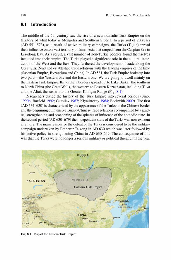
178 R. T. Ganiev and V. V. Kukarskih
8.1 Introduction
The middle of the 6th century saw the rise of a new nomadic Turk Empire on theterritory of what today is Mongolia and Southern Siberia. In a period of 20 years(AD 551–573), as a result of active military campaigns, the Turks (Tujue) spreadtheir influence onto a vast territory of Inner Asia that ranged from the Caspian Sea toLiaodong Bay. As a result, a vast number of non-Turkic peoples found themselvesincluded into their empire. The Turks played a significant role in the cultural inter-action of the West and the East. They furthered the development of trade along theGreat Silk Road and established trade relations with the leading empires of the time(Sasanian Empire, Byzantium and China). In AD 581, the Turk Empire broke up intotwo parts—the Western one and the Eastern one. We are going to dwell mainly onthe Eastern Turk Empire. Its northern borders spread out to Lake Baikal, the southernto North China (the Great Wall), the western to Eastern Kazakhstan, including Tuvaand the Altai, the eastern to the Greater Khingan Range (Fig. 8.1).
Researchers divide the history of the Turk Empire into several periods (Sinor1990b; Barfield 1992; Gumilev 1967; Klyashtorny 1964; Beckwith 2009). The first(AD 534–630) is characterized by the appearance of the Turks on the Chinese borderand the beginning of intensive Turkic-Chinese trade relations accompanied by a grad-ual strengthening and broadening of the spheres of influence of the nomadic state. Inthe second period (AD 630–679) the independent state of the Turks was non-existentanymore. The main reason for the defeat of the Turks is considered to be the militarycampaign undertaken by Emperor Taizong in AD 630 which was later followed byhis active policy in strengthening China in AD 630–649. The consequence of thiswas that the Turks were no longer a serious military or political threat until the year
Fig. 8.1 Map of the Eastern Turk Empire

8 Natural Disasters in the History of the Eastern Turk Empire 179
AD 679 when several uprisings occurred. The third and last period (AD 679–745) ischaracterized by the rise of the Eastern Turk Empire, which managed to restore itselfby undertaking several massive rebellions against the Chinese army in AD 679–685.
The Turk Empire continued to be China’smain rival up toAD745, that is, until thetime when the Uyghur Empire conquered both of them (AD 745–840) (Mackerras2000; Kamalov 2001). Therefore, the history of the Turk Empire consists of severalchronological stages during which periods important historical events took place:AD 534–545—the strengthening and appearance of the Turks on the internationalarena; AD 581–583—the division of the Turk Empire into its Western and Easternparts; AD 601–603—the weakening of the Western Turks and the strengthening theEastern Turks under the leadership of Qimin Qaghan; AD 627–630—the maximumweakening and subordination of the Turks to China; AD 679–685—the rebirth andconsequent strengthening of the Turk Empire.
Sinologists and turkologists have been trying to find reasons why all these eventstook place mainly by analyzing the regularity of development of socio-economic,military and political laws of the nomadic society and of China in Inner Asia (Kradin2014; Beckwith 2009). However, historians have practically never taken into con-sideration the effect produced by natural and climatic factors in the region understudy. The aim of this research is to show the importance of climatic cataclysms thatoccurred in Inner Asia during the period under consideration and the effect they hadon the key historical events in the Turk Empire.
8.2 Methods
Changes in climate and their effect on human society is one of the most pressingproblems for the world today and for science in particular (Fei et al. 2004; Zhanget al. 2007, 2010; Büntgen et al. 2011; Zhang et al. 2011; Ludlow et al. 2013; Hsianget al. 2013; Wei et al. 2015). Global warming and human susceptibility to it cannotbe taken lightly (Trenberth 2012).
In the recent period quite a number of works (Pederson et al. 2014; Büntgenet al. 2016; Di Cosmo et al. 2017; Putnam et al. 2016; Drobyshev 2014) have beendevoted to the problem of the influence of changes in climate on the culture of wholenations, those living in Inner Asia being among them. A number of researchershold to the opinion that climate changes could have led to grave consequences forthe nomadic peoples if they were accompanied by unfavorable socio-political andeconomic factors. In other words, climate extremes may have a negative influenceonly if they coincide with unfavorable socio-economic, political and demographicchanges within the nomadic society (Di Cosmo et al. 2017). This work is devotedto the influence of climate dynamics on the history of the Eastern Turk Empire. Ourresearch shows that in several cases changes in climate could, in fact, have exerteda crucial influence on the political and economic life of the Turks.
Medieval economy operated in a traditional way and was to a greater degree thannow dependent on climatic factors. One of the regions that were highly exposed tonatural cataclysms in the early Middle Ages was that of Inner Asia and the nomadswho lived there.

180 R. T. Ganiev and V. V. Kukarskih
Though nomadic societies were highly mobile, large-scale changes in ecologicalfactors (mainly climatic) must have, no doubt, told on the livestock that was the basisof nomadic culture (Sinor 1990a, b). This makes it possible for us to say that long-term temperature fluctuations and climate extremes in particular did have a globaleffect. Evidence of this can be found in the registered yearly tree-ring structures inall parts of the Northern Hemisphere.
It is also known that in the period of climate extremes the nomads practiced amutually agreed-upon consecutive grazing of cattle or changed their regional locationby moving along the steppes. However, in quite a number of cases, the Turks couldnot do this for the reason that the relations with their neighbors were not friendly atall, there being a fierce competitive struggle between the rival tribes for the borderingterritories.
Our research is based on tree-ring data (D’Arrigo et al. 2001; Hantemirov et al.2011; Myglan et al. 2012; Briffa et al. 2013) which makes it possible to determineclimate extremes to a higher degree of accuracy than the more general chronolog-ical results ice-core study gives (Clausen et al. 1997; Cole-Dai et al. 2000; Jianget al. 2012; Plummer et al. 2012; Jouzel 2013; Abbott et al. 2014). With the helpof documentary sources, we shall compare the political and socio-economic evi-dence of events that took place in the Turk Empire with the material received fromcontemporary climatological research.
Unfortunately, climate reconstructions for the period under examination are tooshort-term and inadequate as far as their quality is concerned (https://www.ncdc.noaa.gov/data-access/paleoclimatology-data/datasets). Global atmospheric circula-tions, mainly the NOA (North Atlantic Oscillation) and the AO (Arctic Oscillation)make it possible for us to refer to distant paleo-climatological sources to help under-stand the processes that took place on the territory of the Turk Empire. Similarteleconnections were described earlier in other works (Büntgen et al. 2016), thatis why we have analyzed oscillatory reconstructions for the Northern Hemispheretaken from other regions. Most of the information on the history of the Turk Empireis based on Chinese dynastic chronicles—Zhoushu, Beiqishu, Suishu, Jiutangshuand Xintangshu (Bichurin 1828, 1950; Liu 1958; Cen 1958; Ershisi shi 2012).
8.3 The Influence of Climate Extremes on the Historyof the Eastern Turk Empire in AD 536–685
8.3.1 Climate Extremes of AD 536–545
Turkic tribes are first mentioned in Chinese chronicles of AD 534 (Liu 1958), whichdescribe the appearance of the Turks on the border with China as buyers of Chinesegoods, but not as typical barbarians whose aim is to raid, as is often depicted inChinese sources.
8 Natural Disasters in the History of the Eastern Turk Empire 181
The Turks are next mentioned in the sources of AD 542. Only 8 years had passedbetween AD 534 and 542, but modern climatologists tell us that these 8 years werethe ones with the greatest climatic changes in the history of the medieval world. Asharp fall in the mean temperature took place in the Northern Hemisphere, one ofthe worst in the last 2000 years (Keys 2000).
Here is what the famous Byzantine historian, Procopius of Caesaria, wrote aboutthe events of AD 536–537: “One of the greatest wonders took place that year: thewhole year the sun shone like the moon, without rays, as if it was going to lose itspower. It did not shine clearly and brightly as before. Ever since then, there werewars among people, pestilence and other calamities that brought death with them”(Procopius 1998).
In AD 536–537, similar phenomena were noted in other regions: Ireland, China,Chile, Europe and Asia (Barash 1989). The Anglo-Saxon Chronicle in Britain alsosays: “AD 538. This year the sun was eclipsed, fourteen days before the calends ofMarch, from before morning until nine. A.D. 540. This year the sun was eclipsed onthe twelfth day before the calends of July; and the stars showed themselves full nighhalf an hour over nine” (Garmonsway 1972).
Today, the climatic anomalies of AD 536–545 have brought together a greatnumber of scientists who are studying this problem. Participants of The GreenlandIce Sheet Project (GISP) have studied samples of ice core from Greenland and theAntarctic (Jouzel 2013). They have discovered that ice samples of AD 536, 538, 539,541 and 543 from Greenland all have a very high content of sulfates (Baillie 2008;Abbott et al. 2014), which may point to their high content in the atmosphere at thattime and to the low temperatures of their formation (Larsen et al. 2008).
Dendrochronological data also indicate that the years AD 536, 537, 543 and 545were the ones with the coldest extremes (D’Arrigo et al. 2001; Hantemirov et al.2011; Myglan et al. 2012).
Volcanologists study samples of lava and traces of past explosive volcanic erup-tions. They analyze the chemical composition of mineral ores and the activity ofvolcanoes. Several volcanologists adhere to the opinion that the reason for such atemperature drop in AD 536–545 could have been the eruption of Krakatau on thePhilippines or Tavurvur in Papua New Guinea (Keys 2000; Southon et al. 2013;Churakova-Sidorova et al. 2014).
Other scientists think that the reason for the anomaly could have been a cometor an asteroid that hit the Earth (Rigby et al. 2004), but here arises the question ofwhere exactly it had happened. Dr. Dallas Abbott says that the Gulf of Carpentariain the north of Australia could have been one of the locations (Abbott et al. 2007).
Currently Dr. Dallas Abbott is working on a hypothesis that volcanic and cosmicreasons had caused the climate extremes of AD 536–545 (Abbott et al. 2014). Dr.Abbott thinks that it was the dramatic events of AD 536–545 that produced an overallcooling effect on the planet (in the Northern Hemisphere). Researchers have foundtraces of volcanic activity in Greenland ice cores, but a single eruption in AD 536would not have caused such an extreme change in climate. Dr. Dallas Abbott believesthat theremight have been a volcanic eruption alongwith a comet, but themain factorwas, most probably, a comet strike. As proof of this, samples of Greenland ice have

182 R. T. Ganiev and V. V. Kukarskih
shown contents of alien particles with Ni-rich material and Fe oxide-rich spherules,both of which are the characteristic signs of cosmic objects (Abbott et al. 2014).
The overall effects of cooling led to the great disasters that took place in theMiddle Ages. Moreover, a pandemic called the Plague of Justinian (Stavrakakis2015) struck at the very same time. It is the first historically known pandemic ofthe Black Death and it is remembered in history as the plague of the ByzantineEmperor Justinian I.More than 100million people perished as a result. The Plague ofJustinian originated in Egypt in AD 540–541. Then it was brought byMediterraneantrade routes to Constantinople, from there to all of Byzantium, then to the countriesof North Africa, Europe, Central and South Asia and Arabia. However, the latestgenetic studies show that the Plague of Justinian did not come from Africa—it camefrom Inner Asia (Wagner et al. 2014; Schmid et al. 2015). Rodents, such as marmots,gophers, rats and mice are the natural reservoirs of the plague, and consequentlymyriads of fleas, which live on rodents, are the carriers of the disease.
It is not accidental that after AD 534 Chinese sources do not mention any contactswith the Turks until AD 545. One of the possible reasons for this may be the declinein economic production and the decrease of population both in China and in the TurkEmpire. In addition to that, in the years AD 534–535, a civil war broke out in China,the result of which was the division of the Northern Wei Dynasty into the EasternWei Dynasty and the Western Wei Dynasty. Moreover, in the years AD 536–537,North China was hit by a famine that killed 80% of its population (Bichurin 1828;Durand 1960).
Unfortunately, written sources say nothing of the plagues that affected the Turksin that period, but taking into account the plague pandemic in the east of North Chinaand in the west of Byzantium, the Turks, who were located along the trading routesof the Great Silk Road, must have also suffered from the disease. As is known, priorto AD 630, that is before they began to have active relations with China, the Turks didnot bury their dead, they cremated them. This might be the reason why, in the periodfrom 543 to 551, the Turks were able not only to withstand all of nature’s trials, butemerge from them with minimal losses. The fact that the density of population atthe start of the formation of the powerful and huge Turk Empire was not too greatcould serve as an additional factor that helped them to survive. To note, the densityof population in North China at the time was considerable.
Let’s look at the main events of that period.In AD 534–545, there were four strongholds in the region: the Eastern Wei
Dynasty, the Western Wei Dynasty, the Rouran Empire, and the recently formedTurk Empire that had conquered the Rouran Empire, but remained in the shade,though it had already made itself known to the Chinese in AD 534 as a new andindependent political force (Liu 1958).
Both dynasties (the Western Wei and the Eastern Wei) rivaled with each other toestablish friendly contacts with the Rouran Empire by way of a marriage union. Thestruggle went on against the background of climatic anomalies and, as a result, therewas economic decline, so it can be well supposed that the Chinese had lost theirformer strength. The Rouran took advantage of the situation in China, but did nottake into account the internal situation in its own Empire. The Western Wei Dynasty
8 Natural Disasters in the History of the Eastern Turk Empire 183
turned to the Turks for help. Thus, in AD 545, a new center of political and militarypower appeared in the region, one in which the Turks began to play the leading role(Liu 1958).
A new stage in the rise of the Turks was their victory over the Tiele tribe in AD546. The Tiele were a threat to the dominance of the Rouran and the Turks took uponthemselves the task of protecting them. The final mistake that the Rouran Empiremade was their refusal to agree to a matrimonial union with the Turks, thus makingrelations between them hostile. After that, it took the Turks seven years to overcomethe climate extremes of AD 536–545, though later, in AD 552, they came to occupythe place of suzerain in the region.
This shows that the climatic extremes of AD 534–545 were the catalyst thataggravated the internal and external political struggle between the Chinese dynasties,a factor which led to a more serious situation than the one the nomads in the steppeswere in. The internal political strife in China inAD534–535 and the anomalies ofAD536–545 that aggravated China’s situation were the main reasons that led to changesin themilitary and political affairs in the region. China lost its strength when, in toughcompetition with the Tiele and the Rouran, the Turk Empire gained power. The Turkswere more successful due to the timely mobilization of their internal forces and theexcellent personal skills of their leaders.
8.3.2 Climate Extremes of AD 581–583
The united Turk Empire was not long in existence. After the death of the Turkicleader Taspar (Tobo) Qaghan in AD 581, internal strife began to ferment withinthe ruling circles of the Empire which in the end led to its collapse. In addition tothat, in AD 581, China, being already split prior to that, joined forces under the SuiDynasty (AD 581–618). The reforms that took place in China led to the fast growthof the economic and military strength of the Empire. Chinese sources inform us thatChina’s rise was accompanied by a most devastating famine in the steppes (Bichurin1950).
The Suishu chronicle writes: “Each winter they have thunder there, and the flamesof the lightning hit the Earth. The Tujue’s life depends on grass and water. Allthroughout the previous year there was no rain, no snow, their rivers have dried upand locusts have appeared; plants and trees have been totally destroyed by fire; halfthe population has died of hunger and disease. The place where they used to livebefore has become wasteland not fit for living. So they turned their steps to the southof the desert to try and brave it out … They suffered from famine, and couldn’t findfood for themselves, so they grinded bones to make flour out of them—and that’swhat they ate. Moreover, an epidemic broke out, and many of them died (Liu 1958).
Unfortunately, Chinese sources do not contain more detailed information aboutthe events of that period. But it can be understood that the climatic anomaly and itseffects on the common people of the Turk Empire, who were deprived of their meansof existence as a result of massive livestock loss in AD 581–583, brought the Turk

184 R. T. Ganiev and V. V. Kukarskih
Empire to a sudden social and political crisis and internal warfare, the result beingthat the Turk Empire finally split into the Eastern Empire and the Western Empire.
Natural anomalies of AD 581–583 have been confirmed by ice-core finds in theAntarctic and in Greenland and also by tree-ring data from North America andSouthern Siberia (Clausen et al. 1997; Cole-Dai et al. 2000; Salzer and Hughes2007; Gao et al. 2008; Jiang et al. 2012; Myglan et al. 2012; Plummer et al. 2012;Sigl et al. 2013, 2015). The studies of climatic extremes range from the years AD564 to 581. The clearer evidence comes from ice cores of the Southern Hemisphere,which makes it possible to confirm that the volcano was located somewhere in thatpart of the planet. However, we shall be able to get a fuller picture of natural extremesof AD 581–583 only after additional research.
8.3.3 Climatic Extremes of AD 599–601
After the collapse of the Turk Empire (AD 581–583), the Western and the EasternTurks were in a state of constant warfare with each other. The Sui Dynasty wasoriginally a neutral party in the conflict, but soon the Chinese set up and supporteda new political center in the southern part of the Eastern Turk Empire with QiminQaghan as their new leader. The new Turk Empire, supported by the Sui Dynasty,undertook a confrontation with the Eastern and the Western Turks, both of themuniting against it in the warfare that followed. However, in AD 603, Qimin Qaghandefeated them and united the whole territory of the Eastern Turk Empire underhis command. It is obvious that climate extremes played a significant role in theglorious victory and tremendous success of the young Qaghan. In AD 598–599,sources report about natural climatic events that were mistakenly taken for two largemilitary campaigns of Emperor Wen of the Sui dynasty against the Eastern Turks(Tulan Qaghan) “frequent disasters occur over their camps; a red rainbow in thenight, its light illuminating hundreds of miles all around; three days … there wasa bloody rain, the falling stars with a crash landing on the tents. Every night TulanQaghan was in fear, and imagined that it was the Sui army approaching!”. In AD601, the sources also report an interesting natural phenomenon that turned out to bea major volcanic eruption. A Chinese military commander reported to the Emperor:“When at night I went up onto the fortress tower, I saw a red mist 30 miles north ofthe desert; it looked like rain, it was hanging low over the land covering it. After that,I found a war guide book where it says that such a phenomenon is called “bloodyrain”, which means that the country is doomed! If we want to destroy the barbarians,now is the time!” (Liu 1958).
8.3.4 Climatic Extremes of AD 627–630
The next period of sharp unseasonal and protracted cooling that affected the EasternTurks were the years AD 627–630.
8 Natural Disasters in the History of the Eastern Turk Empire 185
The years AD 627–630 were marked by natural cataclysms on the territory ofthe Empire. Chinese sources give the following descriptions: “Every year they hadheavy snowfalls and snow lay thick on the ground. The cold and the famine broughtwith it a great loss of sheep, horses and men” (Liu 1958).
The Chinese chronicle Xintangshu says: “In spite of it being summer, the Tujueare having unseasonal frosts; five suns have risen at the same time, threemoons shoneas well; a red mist covered their pastures” (Liu 1958). This is what the Jiutangshuchronicle says about the situation of the Turks in AD 630: “The Tujue’s life dependsonly on sheep and horses. Now their animals are sick and lean and their people lookstarved. Besides, when they prepare their food in the tents it turns into blood. Thisis a dangerous foreboding!” (Liu 1958).
Scientists say that the large-scale cooling on the territory of Eurasia in AD627–630, evidence of which can be seen on tree-rings in Yamal, in North Amer-ica and in the north of Central and Eastern Siberia, was caused by large explosivevolcanic eruptions (Stothers 1999) and the parhelion. Fog and red sunsets describedin the sources are well-known indicators of such eruptions. We know from Europeanchronicles that, starting from October AD 626, for about 8 or 9 months, a dry mistcovered a vast territory including Ireland and the eastern Mediterranean (Ludlowet al. 2013). Unseasonal night frosts at the end of summer occurred in China (theTang Empire) in AD 627, which destroyed the harvest in several provinces. Similarevents occurred in China in AD 628–629 (Fei et al. 2007).
Economic hardships led to a destabilization of the political situation within theEmpire. In AD 627, the conquered tribes rebelled against the Turks and deposedthe henchman of the Turkic leader on their territory. Within the Empire, relationsbetween theRuler and his subjects also became strained. Sources say that the relationsbetween the Qaghan and his closest assistant were severed, the result being that thehigh official deserted to join the forces of the Chinese Emperor Taizong.
The economic situation put the Turks on the brink of survival and bared all theinternal contradictions within their community, the same thing happening in theEastern Turk Empire.
Sources say: “Xielikehanmobilized soldiers every year and invaded Chinese terri-tory so often that his people could not put up with these campaigns any longer. Therewas famine year after year. Taxes and payments were heavy, so more and more tribesleft him” (Liu 1958). Thus, an internal conflict began to grow within Turkic society;discontent grew, nobody trusted Xielikehan anymore, nor supported the policy hepursued.
The situation in the Empire became worse and many tribes, as the Chinese chron-iclers say, began to rely only upon themselves and refused to be under the commandof Xielikehan. Even the high officials closest to Xielikehan defected to Taizong. InAD 630, the Emperor’s army attacked Xielikehan. As a result, the latter fled to thenorth of the desert whereas his closest courtiers, the ones who held high posts in theEmpire, left him and joined the Tang Dynasty (Liu 1958).
Therefore, the defeat of Xielikehan’s army in AD 630 by Chinese forces was alogical solution to the situation that had formed within the Turkic community withthe climate extreme of AD 626 being the key to victory and not at all the skillful

186 R. T. Ganiev and V. V. Kukarskih
leadership of the Chinese Emperor Taizong of the TangDynasty, as many researchersmight think.
Chinese researchers who studied the volcanic eruption of AD 626 hold a similaropinion. They believe that the cooling affected all the territory of Inner Asia, aswell as the northern provinces of China, but the territory that suffered the most wasthe Eastern Turk Empire, whose nomadic economy could not withstand the sharpand protracted cooling (Fei et al. 2007; Di Cosmo et al. 2017). In conditions of aneconomic catastrophe which had put the Turks on the brink of survival, all internalconflicts came to the fore and the powers-that-be could not cope with the situation.
8.3.5 Climatic Extremes of AD 679–685
Several decades later, in the years AD 679–685, as a result of a number of rebellions,the Eastern Turk Empire restored its independence and managed to retain it till AD745. However, the conditions that developed in AD 679–685, as they are describedin Chinese sources, also point to a complicated natural and climatic situation in theregion.
TheXintangshu chronicle describes a curious eventwitnessed byChinese officialson the northern border of China. In the spring ofAD680 large flocks of desert pigeonsfell dead from the sky (Liu 1958).
What could have been the reason for such an unusual natural phenomenondescribed in the Chinese sources? It is well-known that birds are indicators of thestate the environment is in. The reason for this could have been both the globalchanges in the environment and the high content of volcanic dust in the layers of theatmosphere deposited there after a large explosive volcanic eruption.
In addition to that, in the years AD 681–682, Chinese sources repeatedly mentioncases of famine among the Eastern Turks. “Famine, snow, drought, locusts, disease,numerous dead bodies lying all around, people turning into cannibals, several yearsof crop failure and starvation” (Bichurin 1828).
In AD 685, the Chinese official Ts’ui Zhi-zhi in his report to the Chinese Emperordescribed the situation the nomads were in thus: “The Tujue … devour each other;they wander around, starved, and don’t know where to go”.
“Their numbers had already exceeded several tens of thousands of people. Theywere covered with a rash and had tumors, they were famished and did not resemblehuman beings at all; countless numbers of people died on the way. Prior to that, theNine Tribes (Toquz Oghuz) (those who inhabited the area to the north of the GreatChinese Wall) experienced a great drought that lasted for 3 years: all the pasturesare reddish with practically no grass growing on them, thus causing massive loss oflivestock. Those who came here are those who survived and were able to cross thedesert, but on the way here they lost their sheep and horses due to lack of food andwater. They had to hunt for field rats and eat the roots of grass; they killed each otherto get provision. I asked different people about it and all told me the same story. Bythe way, one of their old men told me that from the time the Nine Tribes (Toquz
8 Natural Disasters in the History of the Eastern Turk Empire 187
Oghuz) had come into existence, they had never experienced such a famine…” (Liu1958).
There is alsomention of “TheGreat Famine” in China inAD 687 (Bichurin 1828).Thus, Chinese chronicles state that many nomads were on the brink of death becauseof the heavy and protracted famine and disease in AD 682–687, though climateextremes were already mentioned in AD 680–681.
In AD 685, the Anglo-Saxon Chronicle in Britain also mentions climatic anoma-lies and their consequences: “A.D. 685. This year in Britain there was a bloody rain,and milk and butter were turned into blood” (Garmonsway 1972) and in AD 680the Mozarabic chronicle also writes “that Spain was laid waste in that year” (Wolf1999).
The period between AD 677 and AD 687 was also exceptionally arid in CentralEurope. West Germany went through a drought in AD 679, 680 and 681. As a result,there was crop failure and a severe famine, the year AD 681 being the worst (Barash1989). Thus, a vast geography (China, Spain, Germany and Britain) of climaticdeviations may well mean that there could have been a global catastrophe on theplanet at that time.
Anomalous climatic events of AD 680–685 are also confirmed by tree-ring datafrom North America, Europe, the Yamal and by ice-core results from the Antarcticand Greenland (Salzer and Hughes 2007; Gao et al. 2008; Plummer et al. 2012; Siglet al. 2013, 2015; McKee et al. 2015).
Let’s analyze the historical events of that period.Regardless of the failures, in AD 682, the buck was taken up by the new leader
of the Turks named Ashinagudulu who got together what was left of the Turks andcreated a 5000-strong army of mounted warriors. His first victory over the Chinesearmy took place in AD 682. In the years AD 683–685, under the leadership ofAshinagudulu, the Turks sacked quite a number of provinces and cities, killed a greatnumber of local Chinese officials, and occupied the territory of a weakened tribe ofnomads to the north of China. The said territory was practically a wasteland by thattime. By AD 685, the Turks had the strongest army in the region. Nobody couldwithstand their attacks, even China, though it did undertake several unsuccessfulattempts to defeat them.
Here we can trace a similarity with the events of AD 536–545. The Turks, asother nomads in the region, experienced all the hardships of life in the conditions ofclimatic cataclysms of AD 680–685. However, due to the predatory policy pursuedby the northern provinces of China in AD 682–685, the Turks, not without lossesof course, managed to overcome the heavy crisis, whereas the other nomadic tribesof Inner Asia were hit by the frost and died of starvation and disease, because theydid not have any external source of food supply. As a result, the Turks turned out tobe the strongest of all the other nomads in the region. Due to the successful militaryoperations of Ashinagudulu in AD 682–685, China lost its military supremacy andthe Turks had no need of China’s protection anymore, so they became independent.

188 R. T. Ganiev and V. V. Kukarskih
8.4 Conclusion
The material presented here demonstrates that there is a definite interplay betweenthe historical events and the climate extremes on the territory of Inner Asia, and thatthese events coincide with other climate anomalies in Europe and China.
It has been proved that such coincidences come parallel with the key eventsin the Turk Empire and with those in Northern China in the following years: AD535–545—the rise of theTurkEmpire;AD581–583—thedivisionof theTurkEmpireinto the Western and the Eastern Empires; AD 599–603—the strengthening of theEastern Turks under the leadership of Qimin Qaghan; AD 627–630—the collapse ofthe Turk Empire; in AD 679–685—the second rise of the Turk Empire (Table 8.1).
Most climatologists believe that the reason for such phenomena is a large explosivevolcanic eruption. It is quite possible that the center of the explosive volcanic eruptionin AD 626 was in the Northern Hemisphere, and in AD 536, 581, 679 in the SouthernHemisphere, whereas in AD 536 and in AD 679, the eruption was supposedly causedby the Tavurvur volcano (Gao et al. 2008; McKee et al. 2015; Sigl et al. 2015).
Inmost cases, the climate extremes that aremarked by tree-rings on fossils suggestthat the global changes in the climate took place on aworld-wide scale. The extremelysharp and protracted cooling on the territory to the east of Inner Asia affected thisregion more because it had a nomadic economy.
As is said in this thesis, it was the protracted droughts that led to the consequencesthat followed the natural catastrophes of this kind on the territory of the Turk Empireand in Northern China (AD 536, 581, 679). A case of an early and very long winterwith heavy snowfalls was also recorded in AD 627–630, right after the eruption of avolcano in AD 626.
The most difficult times for the Turks were the years AD 627–630, when theEmpire practically stopped existing due to massive loss of livestock and famine.
The droughts of AD 536, 581 and 679 turned out to be a serious trial for everyonein the region. Grazing vegetation dried up, forests and steppes blazed in fires.
However, Chinese sources tell us that during the droughts the Turks were in abetter position than the Chinese. It happened at the time when the Turks took overthe initiative from China to strengthen (in AD 545) and restore (in AD 682) theirstate. However, the drought led to serious consequences in China: the change ofdynasties (AD 581) and the An Lushan Rebellion in AD 754.
In order to give a correct evaluation of the influence of the climatic extremes andits effects such as droughts, protracted cold and snowy winters on the territory to theeast of Inner Asia, we must also take into account all the aspects of the political andsocio-economic life in the region, so as to be able to give a correct evaluation of itsinfluence on the Turkic and the Chinese population. The peculiar dynamics of thehistorical processes in that region were determined both by the climatic factors andby the complicated political situations.
Climate extremes were a prerequisite for changes in the military and politicalsphere in the region. They served as a background against which various socio-economic and political events developed. However, they were not only a threat to the
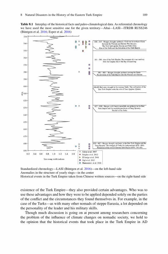
8 Natural Disasters in the History of the Eastern Turk Empire 189
Table 8.1 Interplay of the historical facts and paleo-climatological data. As referential chronologywe have used the most sensitive one for the given territory—Altai—LASI—ITRDB RUSS246(Büntgen et al. 2016; Esper et al. 2016)
Standardized chronology—LASI (Büntgen et al. 2016)—on the left-hand sideAnomalies in the structure of yearly rings—in the centerHistorical events in the Turk Empire taken from Chinese written sources—on the right-hand side
existence of the Turk Empire—they also provided certain advantages. Who was touse these advantages and how they were to be applied depended solely on the partiesof the conflict and the circumstances they found themselves in. For example, in thecase of the Turks—as with many other nomads of steppe Eurasia, a lot depended onthe personality of the leader and his military skills.
Though much discussion is going on at present among researchers concerningthe problem of the influence of climate changes on nomadic society, we hold tothe opinion that the historical events that took place in the Turk Empire in AD
190 R. T. Ganiev and V. V. Kukarskih
534–551 and in AD 679–687 developed in a line parallel to the unfavorable changesin climate which may be considered as an additional factor that led to changes inthe regional situation. Historical sources show that in the year AD 534 the Turkshad already become stronger—a fact that happened prior to the climate extremes,but the discontent of the Turks with Emperor Gaozong’s (AD 650–683) policy grewduring the whole period of his reign and it is this that led to the rebellion of AD679. Nevertheless, the sharp changes in the economic and political situation in theTurk Empire in AD 581–583, in AD 599–603 and in AD 627–630 totally coincidewith the extreme changes in climate in these periods, a fact that may be looked uponas indirect proof of the interplay of historical processes in the region with climatedynamics.
Acknowledgements I would like to thank Dr. Rashid Hantemirov (Yekaterinburg, Russia) for thehelpful and constructive comments and suggestions.
References
Abbott, D. H., Tester, E. W., Meyers, C. A., & Breger, D. (2007). Impact ejecta and megatsunamideposits from a historical impact into the Gulf of Carpentaria. Geological Society of AmericaAnnual Meeting, Denver, CO. Abstracts with Programs, 39, 312.
Abbott, D. H., Breger, D., Biscaye, P. E., Robert, A. J. (2014). Calendar-year dating of the GISP2 icecore from the early 6th century using historical, ion and particulate data. In G. Keller & A. Kerr(Eds.), Volcanism, impacts and mass extinctions: Causes and effects (pp. 411–420). GeologicalSociety of America Special Paper, 505.
Baillie, M. G. L. (2008). Proposed re-dating of the European ice core chronology by seven yearsprior to the 7th century AD. Geophysical Reseach Letters, 35, 15.
Barash, S. I. (1989). Istoriya neurozhayev i pogody v Yevrope [History of crop failure and weatherin Europe] (pp. 236). Leningrad, Russia: Gidrometeoizdat.
Barfield, T. J. (1992). The Perilous frontier: Nomadic empires and China. 221 BC to 1757 AD(p. 348). Cambridge, United Kingdom: Wiley.
Beckwith, C. I. (2009). Empires of the Silk Road: A history of Central Eurasia from the bronze ageto the present (p. 512). Princeton, USA: Princeton University Press.
Bichurin, N. Y. A. (1950). Sobraniye svedeniy o narodakh, obitavshikh v Sredney Azii v drevniyevremena [Collection of information about the peoples inhabiting Central Asia in ancient times](pp. 382). T. I. Moscow–Leningrad, Russia: Izd-vo AS USSR.
Bichurin, N. Y. A. (Iakinf). (1828). Letopis’ kitayskoy imperii, nazyvayemaya Yuy-p’khi tszy chzhitkhun-tszyan’ gan-mu. Razdelennaya na tri chasti, letopis’ drevnyuyu, srednyuyu i noveyshuyu.Per. s kit. I. Bichurina [Chronicle of the Chinese Empire Zizhi Tongjian ganmu] T. VIII, f. 7, op. 1,yed. khr. 8. Arkhiv vostokovedov Sankt-Peterburgskogo Instituta vostochnykh rukopisey RAN.
Briffa, K. R., Melvin, T. M., Osborn, T. J., Hantemirov, R. M., Kirdyanov, A. V., Mazepa, V. S.,et al. (2013). Reassessing the evidence for tree-growth and inferred temperature change duringthe Common Era in Yamalia, northwest Siberia. Quaternary Science Reviews, 72, 83–107.
Büntgen,U., Tegel,W.,Nicolussi,K.,McCormick,M., Frank,D., Trouet,V., et al. (2011). 2500yearsof European climate variability and human susceptibility. Science, 331(6017), 578–582.
Büntgen, U.,Myglan, V. S., Ljungqvist, F. C.,McCormick,M., Di Cosmo, N., Sigl,M., et al. (2016).Cooling and societal change during the late antique little ice age from 536 to around 660 AD.Nature Geoscience, 9(3), 231–236.
Cen, Z. (1958). Tujue jishi (p. 1136). Beijing: Zhonghua shuju.

8 Natural Disasters in the History of the Eastern Turk Empire 191
Churakova-Sidorova, O. V., Bryukhanova, M. V., Saurer, M., Boettger, T., Naurzbaev, M. M.,Myglan, V. S., et al. (2014). A cluster of stratospheric volcanic eruptions in the AD 530s recordedin Siberian tree rings. Global and Planetary Change, 122, 140–150.
Clausen, H. B., Hammer, C. U., Hvidberg, S., Dahl-Jensen, D., Steffensen, J. P., Kipfstuhl, J., et al.(1997).A comparison of the volcanic records over the past 4000 years from theGreenland IceCoreProject and Dye 3 Greenland ice cores. Journal Geophysical Research, 102(C12), 26707–26723.
Cole-Dai, J., Mosley-Thompson, E., Wight, S. P., & Thompson, L. G. (2000). A 4100-year recordof explosive volcanism from an East Antarctica ice core. Journal of Geophysical Research Atmo-spheres, 105(D19), 24431–24441.
D’Arrigo, R., Jacoby, G., Frank, D., Pederson, N., Cook, E., Buckley, B., et al. (2001). 1738 years ofMongolian temperature variability inferred from a tree-ring width chronology of Siberian pine.Geophysical Reseach Letters, 28(3), 543–546.
Di Cosmo, N., Oppenheimer, C., & Büntgen, U. (2017). Interplay of environmental and socio-political factors in the downfall of the Eastern Turk Empire in 630 CE.Climate Change, 145(3–4),383–395.
Drobyshev, Y. I. (2014). Chelovek i priroda v kochevykh obshchestvakh Tsentral’noy Azii [Man andnature in the nomadic societies of Central Asia] (p. 604). Moscow, Russia: IV RAS.
Durand, J. D. (1960). The population statistics of China, A.D. 2-1953.Population Studies: A Journalof Demography, 13(3), 209–256.
Ershisi shi. (2012). Beijing, China: Zhonghua shuju bian ji bu. http://www.weilishi.org/ershisishi.Accessed May 2, 2018.
Esper, J., Krusic, P. J., Ljungqvist, F. C., Luterbacher, J., Carrer, M., Cook, M., et al. (2016). Rank-ing of tree-ring based temperature reconstructions of the past millennium. Quaternary ScienceReviews, 145, 134–151.
Fei, J., Zhou, J., & An, Z. S. (2004). Temperature change in China over 618–959 AD: Based onhistorical records. Marine Geology and Quaternary Geology, 24(2), 109–118.
Fei, J., Zhou, J., & Hou, Y. (2007). Circa A.D. 626 volcanic eruption, climatic cooling, and thecollapse of the Eastern Turkic Empire. Climate Change, 81(3–4), 469–475.
Gao,C., Robock,A.,&Ammann,C. (2008).Volcanic forcing of climate over the past 1500 years:Animproved ice core-based index for climatemodels. Journal of Geophysical Research Atmospheres,113, 23.
Garmonsway, G. N. (1972). The Anglo-Saxon Chronicle (p. 371). London, United Kingdom: Every-man Press.
Gumilev, L. N. (1967). Drevniye tyurki [Ancient Turks] (pp. 504). Moscow, Russia: Nauka.Hantemirov, R. M., Gorlanova, L. A., Surkov, A. Y., & Shiyatov, S. G. (2011). Extreme climateevents onYamal for the last 4100 years according to dendrochronological data. Izvestiya AkademiiNauk. Seriya Geograficheskaya, 2, 89–102.
Hsiang, S. M., Burke, M., & Miguel, E. (2013). Quantifying the influence of climate on humanconflict. Science, 341(6151), 1235367.
Jiang, S., Cole-Dai, J., Li, Y., Ferris, D. G., Ma, H., An, C., et al. (2012). A detailed 2840 yearsrecord of explosive volcanism in a shallow ice core from Dome A, East Antarctica. Journal ofGlaciology, 58(207), 65–75.
Jouzel, J. (2013). A brief history of ice core science over the last 50 yr. Climate Past, 9, 2525–2547.Kamalov, A. (2001). The ancient Uyghurs in the 8–9 century (p. 216). Almaty, Kazakhstan: Nashmir.
Keys, D. P. (2000). Catastrophe: A quest for the origins of the modern world (p. 368). New-York,USA: Ballantine Books.
Klyashtorny, S. G. (1964). Drevnetyurkskiye runicheskiye pamyatniki kak istochnik po istorii Sred-ney Azii [Ancient Turkic runic monuments as a source on the history of Central Asia] (p. 214).Moscow, Russia: Nauka.
Kradin, N. N. (2014). Nomads of inner Asia in transition (p. 304). Moscow, Russia: URSS.Larsen, L. B., Vinther, B. M., Briffa, K. R., Melvin, T. M., Clausen, H. B., Jones, P. D., Siggaard-Andersen, M., Hammer, C. U., Eronen, M., Grudd, H., Gunnarson, B. E., Hantemirov, R. M.,
192 R. T. Ganiev and V. V. Kukarskih
Naurzbaev, M. M., Nicolussi, K. (2008). New ice core evidence for a volcanic cause of the A.D.536 dust veil. Geophysical Research Letters, 35(4).
Liu, M. T. (1958). Die chinesischen Nachrichten zur Geschichte der Ost-Turken (Tu-kue) [TheChinese news on the history of the Eastern Turks (Tu-kue)] (p. 831). Wiesbaden, Germany: OttoHarrassowitz Verlag.
Ludlow, F., Stine, A. R., Leahy, P., Murphy, E., Mayewski, P. A., Taylor, D., Killen, J., Baillie, M. G.L., Hennessy, M., Kiely, G. (2013). Medieval Irish chronicles reveal persistent volcanic forcingof severe winter cold events, 431-1649 CE. Environmental Research Letters, 8(2).
Mackerras, C. (2000). Uyghur-Tang Relations (744–840). Central Asian Survey, 19(2), 223–234.McKee, C. O., Baillie, M. G., Reimer, P. J. (2015). A revised age of ad 667–699 for the latest majoreruption at Rabaul. Bulletin of Volcanology, 77(7).
Myglan, V. S., Oidupaa, O. C., & Vaganov, E. A. (2012). A 2367-year tree-ring chronology for theAltai-Sayan region (Mongun-Taigamountainmassif).Archaeology, Ethnology and Anthropologyof Eurasia, 40(3), 76–83.
Pederson, N., Hessl, A. E., Baatarbileg, N., Anchukaitis, K. J., & Di Cosmo, N. (2014). Pluvials,droughts, the Mongol Empire, and modern Mongolia. Proceedings of the National Academy ofSciences of the United States of America, 111(12), 4375–4379.
Plummer, C. T., Curran, M. A. J., van Ommen, T. D., Rasmussen, S. O., Moy, A. D., Vance, T. R.,Clausen, H. B., Vinther, B.M.,Mayewski, P. A. (2012). An independently dated 2000-yr volcanicrecord from Law Dome, East Antarctica, including a new perspective on the dating of the 1450sCE eruption of Kuwae, Vanuatu. Clim. Past. https://doi.org/10.5194/cp-8-1929-2012.
Procopius, C. (1998). The Persian War. The Vandalic War. The Secret History (p. 541). Saint-Petersburg: Aleteya.
Putnam, A. E., Putnam, D. E., Andreu-Hayles, L., Cook, E. R., Palmer, J. G., Clark, E. H., et al.(2016). Little Ice Age wetting of interior Asian deserts and the rise of the Mongol Empire.Quaternary Science Reviews, 131, 33–50.
Rigby, E., Symonds, M., & Ward-Thompson, D. (2004). A comet impact in AD 536? Astronomyand Geophysics, 45(1), 23–26.
Salzer, M. W., & Hughes, M. K. (2007). Bristlecone pine tree rings and volcanic eruptions over thelast 5000 yr. Quaternary Research, 67, 57–68.
Schmid, B. V., Büntgen, U., Easterday, W. R., Ginzler, C., Walløe, L., Bramanti, B., et al. (2015).Climate-driven introduction of the Black Death and successive plague reintroductions intoEurope. Proceedings of the National Academy of Sciences of the United States of America,112(10), 3020–3025.
Sigl, M., McConnell, J. R., Layman, L., Maselli, O., McGwire, K., Pasteris, D., et al. (2013). Anew bipolar ice core record of volcanism from WAIS Divide and NEEM and implications forclimate forcing of the last 2000 years. Journal of Geophysical Research Atmospheres, 118(3),1151–1169.
Sigl, M., Winstrup, M., McConnell, J. R., Welten, K. C., Plunkett, G., Ludlow, F., et al. (2015).Timing and climate forcing of volcanic eruptions for the past 2,500 years. Nature, 523(7562),543–549.
Sinor, D. (1990a). The establishment and dissolution of the Türk empire: The Cambridge history ofearly inner Asia (pp. 285–316). Cambridge, United Kingdom and New York, USA: CambridgeUniversity Press.
Sinor, D. (Ed.). (1990b). The Cambridge history of early inner Asia (pp. 581). Cambridge, UnitedKingdom and New York, USA: Cambridge University Press.
Southon, J., Mohtadi, M., & De Pol-Holz, R. (2013). Planktonic foram dates from the IndonesianARC: Marine 14C reservoir ages and a mythical AD 535 eruption of Krakatau. Radiocarbon,55(2–3), 1164–1172.
Stavrakakis, N. (2015). The miraculous cures for diseases of Emperor Justinian I (482–565 AD).Archives of Hellenic Medicine, 32(2), 224–229.
Stothers, R. B. (1999). Volcanic dry fogs, climate cooling, and plague pandemics in Europe and theMiddle East. Climate Change, 42(4), 713–723.

8 Natural Disasters in the History of the Eastern Turk Empire 193
Trenberth, K. E. (2012). Framing the way to relate climate extremes to climate change. ClimateChange, 115(2), 283–290.
Wagner, D. M., Klunk, J., Harbeck, M., Devault, A., Waglechner, N., Sahl, J. W., et al. (2014).Yersinia pestis and the plague of Justinian 541–543 AD: A genomic analysis. Lancet. Infect. Dis,14(4), 319–326.
Wei, Z., Rosen, A. M., Fang, X., Su, Y., & Zhang, X. (2015). Macro-economic cycles related toclimate change in dynastic China. Quaternary Research, 83(1), 13–23.
Wolf, K. B. (1999). Conquerors and Chroniclers of Early Medieval Spain (p. 205). Liverpool,United Kingdom: Liverpool University Press.
Zhang, D. D., Brecke, P., Lee, H. F., He, Y., & Zhang, J. (2007). Global climate change, war, andpopulation decline in recent human history. Proceedings of the National Academy of Sciences ofthe United States of America, 104(49), 19214–19219.
Zhang, Z., Tian, H., Cazelles, B., Kausrud, K. L., Bräuning, A., Guo, F., et al. (2010). Periodicclimate cooling enhanced natural disasters and wars in China during AD 10–1900. Proceedingsof the Royal Society B: Biological Sciences, 277(1701), 3745–3753.
Zhang, D. D., Lee, H. F., Wang, C., Li, B., Pei, Q., Zhang, J., et al. (2011). The causality analysis ofclimate change and large-scale human crisis. Proceedings of the National Academy of Sciencesof the United States of America, 108(42), 17296–17301.
Open Access This chapter is licensed under the terms of the Creative Commons Attribution 4.0International License (http://creativecommons.org/licenses/by/4.0/), which permits use, sharing,adaptation, distribution and reproduction in any medium or format, as long as you give appropriatecredit to the original author(s) and the source, provide a link to the Creative Commons license andindicate if changes were made.
The images or other third party material in this chapter are included in the chapter’s CreativeCommons license, unless indicated otherwise in a credit line to the material. If material is notincluded in the chapter’s Creative Commons license and your intended use is not permitted bystatutory regulation or exceeds the permitted use, you will need to obtain permission directly fromthe copyright holder.
Chapter 9Dry and Humid Periods Reconstructedfrom Tree Rings in the Former Territoryof Sogdiana (Central Asia) and TheirSocio-economic Consequencesover the Last Millennium
Magdalena Opała-Owczarek and Piotr Owczarek
Abstract One of the richest societies along the Silk Road developed in Sogdiana,located in present-day Tajikistan, Uzbekistan, and Kyrgyzstan. This urban civilisa-tion reached its greatest prosperity during the golden age of the Silk Road (sixth toninth century ce). Rapid political and economic changes, accelerated by climaticvariations, were observed during last millennium in this region. The newly devel-oped tree-ring-based reconstruction of precipitation for the past millennium revealeda series of dry and wet stages. During the Medieval Climate Anomaly (MCA), twodry periods occurred (900–1000 and 1200–1250), interrupted by a phase of wet-ter conditions. Distinct dry periods occurred around 1510–1650, 1750–1850, and1920–1970, respectively. The juniper tree-ring record of moisture changes revealedthat major dry and pluvial episodes were consistent with those indicated by hydro-climatic proxy data from adjacent areas. These climate fluctuations have had long-and short term consequences for human history in the territory of former Sogdiana.
Keywords Arid Central Asia · Silk road · Precipitation reconstructionDendroclimatology · Social growth and decline
9.1 Introduction
Recently, there has been growing interest in the relationship between climate changeand its socio-economic consequences throughout human history. Abrupt climate
M. Opała-Owczarek (B)Department of Climatology, Faculty of Earth Sciences, University of Silesia in Katowice,Bedzinska 60, 41-200 Sosnowiec, Polande-mail: [email protected]
P. OwczarekDepartment of Physical Geography, Institute of Geography and Regional Development,University of Wroclaw, Pl. Uniwersytecki 1, 50-137 Wrocław, Poland
© The Author(s) 2019L. E. Yang et al. (eds.), Socio-Environmental Dynamics along the Historical Silk Road,https://doi.org/10.1007/978-3-030-00728-7_9
195

196 M. Opała-Owczarek and P. Owczarek
changes not only affect the dynamics of natural systems like glacial and geomor-phological processes (Solomina et al. 2016) or the distribution of vegetation zones(Klemm et al. 2016), but may also have long-lasting consequences for societies bycausing a rapid transformation of the prevailing hydrological regime (Boroffka et al.2006; Sorrel et al. 2007). Possible impacts of climate on human life, migration, agri-cultural production, and the growth and decline of societies have been extensivelystudied in recent years (Hodell et al. 1995; deMenocal 2001; Weiss and Bradley2001; Sidle et al. 2004; Buckley et al. 2010; Büntgen et al. 2011; Giosan et al. 2013;Latorre et al. 2016).
The consequences of climate fluctuations are particularly evident in arid andsemiarid areas, where ecosystem responses are very rapid. In the long history ofthe Silk Road, rich ancient societies developed in arid Central Asia under the influ-ence of favourable conditions in the natural environment, where access to waterand fertile soil were the most important factors (Owczarek et al. 2018). One of therichest societies along the Silk Road developed in Sogdiana, located in present-dayTajikistan, Uzbekistan, and Kyrgyzstan. This urban civilisation reached its greatestprosperity during the golden age of the Silk Road (sixth to ninth century ce) (Schafer1963; Litvinsky et al. 1996; de La Vaissière 2002; Marshak 2003; Owczarek et al.2018).Archaeological excavations indicate that this territory, crossed by severalmainbranches of the Silk Road, was a melting pot where Sogdian merchants met othersfrom a wide range of areas, from China to Byzantium (Marshak 2003). Sogdiana,one of the most advanced areas and the leader of all Transoxania, collapsed in eighthto ninth century (Grenet and de la Vaissière 2002; Marshak 2003). However, Sogdi-ana’s civilizational, economic and social achievements have been visible for manycenturies after its decline.
Despite its great significance, this territory, located between the Pamir Mountainsand the largemid-latitude desert systems, is relatively little known in terms of climateand socio-economic changes (Opała-Owczarek et al. 2018; Owczarek et al. 2018),in contrast to research showing links between climate and the rise and fall of empiressuch as the Mongolian (Pederson et al. 2014; Putnam et al. 2016) and Chinese (Fan2015; Wei et al. 2015; Yin et al. 2016; Li et al. 2017). Recently, Yadava et al. (2016)reconstructed drought periods and historic social upheavals and invasions of India.
The purpose of this paper is to analyse dry andwet periods over the lastmillenniumin the former territory of ancient Sogdiana on the basis of tree-ring data, with aparticular focus on the relationship between changes in precipitation and economicgrowth and decline.
9.2 Description of the Study Area
9.2.1 Regional Settings
Ancient Sogdiana was located in the upper part of the Aral Sea basin between twolarge Central Asian rivers, the Amu Darya (Oxus) in the south and the Syr Darya

9 Dry and Humid Periods Reconstructed from Tree … 197
Fig. 9.1 Location of the ancient Sogdiana on the background of political (ca. sixth century AD)and key physiographic units in Central Asia (modified after Abazov 2008)
(Jaxartes) in the north. It stretched from the Pamir Mountains in the east to theKyzylkum and Karakum deserts in the west (Abazov 2008) (Fig. 9.1). The axis ofthis territory is marked by the longitudinal Zeravshan River Valley, along whichthe most important towns of Sogdiana, namely Panjikent, Samarkand, and Bukhara,were situated (Owczarek et al. 2018) (Fig. 9.1). Today this area forms parts of Tajik-istan, easternUzbekistan, and south-westernKyrgyzstan. The area is characterised byextremely diverse relief. The eastern part includes the partly glaciated Pamir Moun-tains, where the average height of the main ridges reaches ca 6000 m a.s.l. (max.Ismail Somoni Peak, 7495 m a.s.l.). The Pamir-Alay Mountains, which form thetransition zone between the Pamir and Tien-Shan Mountains, cover the central andnorth-eastern part of the former territory of Sogdiana. They consist of three longitu-dinal mountain ridges: Gissar, Zeravshan, and Turkestan, which reach a maximumheight of 5600 m a.s.l. (Rahmonov et al. 2017a, b). These mountainous regions arecharacterised by a high level of seismicity, connected with their location in the vicin-ity of the Pamir Frontal Thrust system (Schurr et al. 2014; Owczarek et al. 2017).The western and south-western parts of the former Sogdiana territory include low-lands within the Central Asianmid-latitude desert system (Kyzylkum, Karakum) andtectonically conditioned mid-mountain basins (Afghan-Tajik Depression) (Fig. 9.1).
The tree-ring sampling sites are located in the central part of the Zeravshan Ridgein the Pamir-AlayMountains (Fig. 9.1). This area is drained by theUrech-Kshtut riversystem, which constitutes the left tributary of the Zeravshan River. The samples weretaken from two sites located in the Urech Valley at elevations between 2200–2900 ma.s.l (Fig. 9.2a). The upper part of the valley includes a high-mountain glacier basin;surrounded from the south by Chimtarga Peak (5489 m a.s.l) (Fig. 9.2b). Below thebasin, the Urech River flows through a deep U-shaped valley with alternating wide
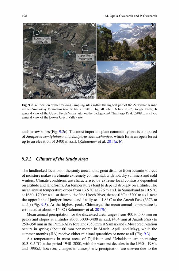
198 M. Opała-Owczarek and P. Owczarek
Fig. 9.2 a Location of the tree-ring sampling sites within the highest part of the Zeravshan Rangein the Pamir-Alay Mountains (on the basis of 2018 DigitalGlobe, 16 June 2017, Google Earth), bgeneral view of the Upper Urech Valley site, on the background Chimtarga Peak (5489 m a.s.l.); cgeneral view of the Lower Urech Valley site
and narrow zones (Fig. 9.2c). Themost important plant community here is composedof Juniperus semiglobosa and Juniperus seravschanica, which form an open forestup to an elevation of 3400 m a.s.l. (Rahmonov et al. 2017a, b).
9.2.2 Climate of the Study Area
The landlocked location of the study area and its great distance from oceanic sourcesof moisture makes its climate extremely continental, with hot, dry summers and coldwinters. Climate conditions are characterised by extreme local contrasts dependenton altitude and landforms. Air temperatures tend to depend strongly on altitude. Themean annual temperature drops from 13.5 °C at 726 m a.s.l. in Samarkand to 10.5 °Cat 1680–1700ma.s.l. at themouth of theUrechRiver, then to 0 °C at 3200ma.s.l. nearthe upper line of juniper forests, and finally to −1.8° C at the Anzob Pass (3373 ma.s.l.) (Fig. 9.3). At the highest peak, Chimtarga, the mean annual temperature isestimated at about −15 °C (Rahmonov et al. 2017b).
Mean annual precipitation for the discussed area ranges from 400 to 500 mm onpeaks and slopes at altitudes about 3000–3400 m a.s.l. (434 mm at Anzob Pass) to250–350mm in the Pamir-Alay foreland (353mm at Samarkand).Most precipitationoccurs in spring (about 60 mm per month in March, April, and May), while thesummer months (JJA) receive either minimal quantities or none at all (Fig. 9.3).
Air temperatures in most areas of Tajikistan and Uzbekistan are increasing(0.3–0.5 °C in the period 1940–2000, with the warmest decades in the 1930s, 1980sand 1990s); however, changes in atmospheric precipitation are uneven due to the
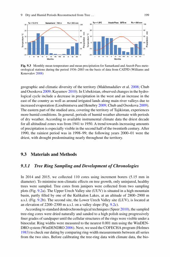
9 Dry and Humid Periods Reconstructed from Tree … 199
Fig. 9.3 Monthly mean temperature and mean precipitation for Samarkand and Anzob Pass mete-orological stations during the period 1936–2003 on the basis of data from CATPD (Williams andKonovalov 2008)
geographic and climatic diversity of the territory (Makhmadaliev et al. 2008; Chuband Ososkova 2009; Kayumov 2010). In Uzbekistan, observed changes in the hydro-logical cycle include a decrease in precipitation in the west and an increase in theeast of the country as well as around irrigated lands along main river valleys due toincreased evaporation (Lioubimtseva and Henebry 2009; Chub and Ososkova 2009).The eastern part of the studied area, covering the territory of Tajikistan, experiencesmore humid conditions. In general, periods of humid weather alternate with periodsof dry weather. According to available instrumental climate data the driest decadefor all altitudinal zones was from 1941 to 1950. A trend towards increasing amountsof precipitation is especially visible in the second half of the twentieth century. After1990, the rainiest period was in 1998–99; the following years 2000–01 were thedriest, with drought predominating nearly throughout the territory.
9.3 Materials and Methods
9.3.1 Tree Ring Sampling and Development of Chronologies
In 2014 and 2015, we collected 110 cores using increment borers (5.15 mm indiameter). To minimise non-climatic effects on tree growth, only uninjured, healthytrees were sampled. Tree cores from junipers were collected from two samplingplots (Fig. 9.2a). The Upper Urech Valley site (UUV) is situated in a high mountainbasin, partly filled by one of the Kulikalon Lakes, at an altitude of 2800–2900 ma.s.l. (Fig. 9.2b). The second site, the Lower Urech Valley site (LUV), is located atan elevation of 2200–2300 m a.s.l. on a valley slope (Fig. 9.2c).
According to standard dendrochronological techniques (Speer 2010), the sampledtree-ring cores were dried naturally and sanded to a high polish using progressivelyfiner grades of sandpaper until the cellular structures of the rings were visible under abinocular. Ring widths were measured to the nearest 0.001 mm using the WinDEN-DRO system (WinDENDRO 2006). Next, we used the COFECHA program (Holmes1983) to check our dating by comparing ring-width measurements between all seriesfrom the two sites. Before calibrating the tree-ring data with climate data, the bio-
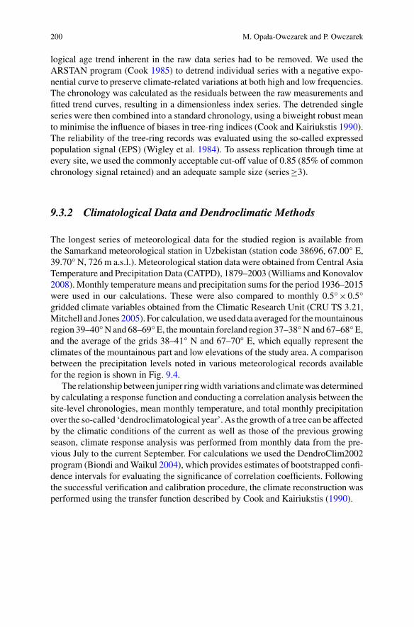
200 M. Opała-Owczarek and P. Owczarek
logical age trend inherent in the raw data series had to be removed. We used theARSTAN program (Cook 1985) to detrend individual series with a negative expo-nential curve to preserve climate-related variations at both high and low frequencies.The chronology was calculated as the residuals between the raw measurements andfitted trend curves, resulting in a dimensionless index series. The detrended singleseries were then combined into a standard chronology, using a biweight robust meanto minimise the influence of biases in tree-ring indices (Cook and Kairiukstis 1990).The reliability of the tree-ring records was evaluated using the so-called expressedpopulation signal (EPS) (Wigley et al. 1984). To assess replication through time atevery site, we used the commonly acceptable cut-off value of 0.85 (85% of commonchronology signal retained) and an adequate sample size (series≥3).
9.3.2 Climatological Data and Dendroclimatic Methods
The longest series of meteorological data for the studied region is available fromthe Samarkand meteorological station in Uzbekistan (station code 38696, 67.00° E,39.70° N, 726 m a.s.l.). Meteorological station data were obtained from Central AsiaTemperature and Precipitation Data (CATPD), 1879–2003 (Williams and Konovalov2008). Monthly temperature means and precipitation sums for the period 1936–2015were used in our calculations. These were also compared to monthly 0.5°×0.5°gridded climate variables obtained from the Climatic Research Unit (CRU TS 3.21,Mitchell and Jones 2005). For calculation,we used data averaged for themountainousregion 39–40°N and 68–69° E, themountain foreland region 37–38°N and 67–68° E,and the average of the grids 38–41° N and 67–70° E, which equally represent theclimates of the mountainous part and low elevations of the study area. A comparisonbetween the precipitation levels noted in various meteorological records availablefor the region is shown in Fig. 9.4.
The relationship between juniper ringwidth variations and climatewasdeterminedby calculating a response function and conducting a correlation analysis between thesite-level chronologies, mean monthly temperature, and total monthly precipitationover the so-called ‘dendroclimatological year’. As the growth of a tree can be affectedby the climatic conditions of the current as well as those of the previous growingseason, climate response analysis was performed from monthly data from the pre-vious July to the current September. For calculations we used the DendroClim2002program (Biondi andWaikul 2004), which provides estimates of bootstrapped confi-dence intervals for evaluating the significance of correlation coefficients. Followingthe successful verification and calibration procedure, the climate reconstruction wasperformed using the transfer function described by Cook and Kairiukstis (1990).
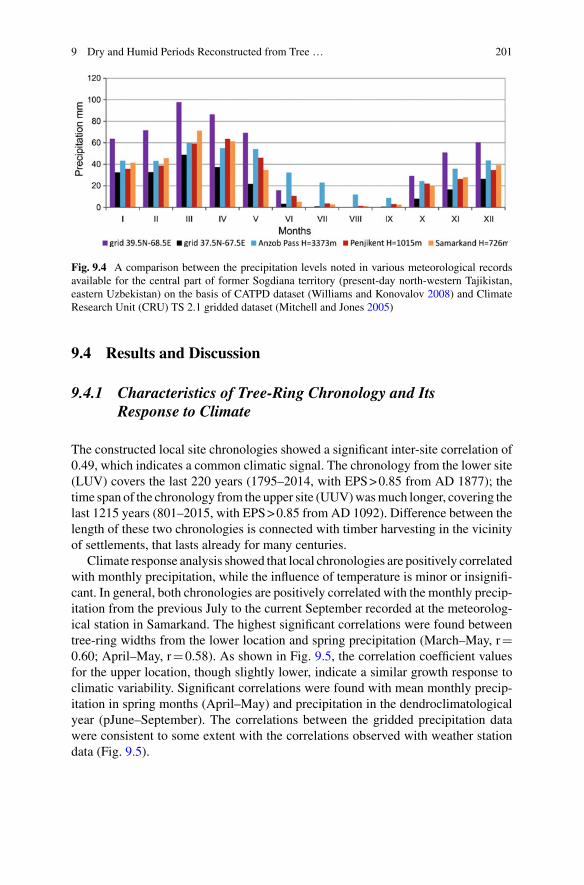
9 Dry and Humid Periods Reconstructed from Tree … 201
Fig. 9.4 A comparison between the precipitation levels noted in various meteorological recordsavailable for the central part of former Sogdiana territory (present-day north-western Tajikistan,eastern Uzbekistan) on the basis of CATPD dataset (Williams and Konovalov 2008) and ClimateResearch Unit (CRU) TS 2.1 gridded dataset (Mitchell and Jones 2005)
9.4 Results and Discussion
9.4.1 Characteristics of Tree-Ring Chronology and ItsResponse to Climate
The constructed local site chronologies showed a significant inter-site correlation of0.49, which indicates a common climatic signal. The chronology from the lower site(LUV) covers the last 220 years (1795–2014, with EPS>0.85 from AD 1877); thetime span of the chronology from the upper site (UUV)wasmuch longer, covering thelast 1215 years (801–2015, with EPS>0.85 from AD 1092). Difference between thelength of these two chronologies is connected with timber harvesting in the vicinityof settlements, that lasts already for many centuries.
Climate response analysis showed that local chronologies are positively correlatedwith monthly precipitation, while the influence of temperature is minor or insignifi-cant. In general, both chronologies are positively correlated with the monthly precip-itation from the previous July to the current September recorded at the meteorolog-ical station in Samarkand. The highest significant correlations were found betweentree-ring widths from the lower location and spring precipitation (March–May, r0.60; April–May, r0.58). As shown in Fig. 9.5, the correlation coefficient valuesfor the upper location, though slightly lower, indicate a similar growth response toclimatic variability. Significant correlations were found with mean monthly precip-itation in spring months (April–May) and precipitation in the dendroclimatologicalyear (pJune–September). The correlations between the gridded precipitation datawere consistent to some extent with the correlations observed with weather stationdata (Fig. 9.5).
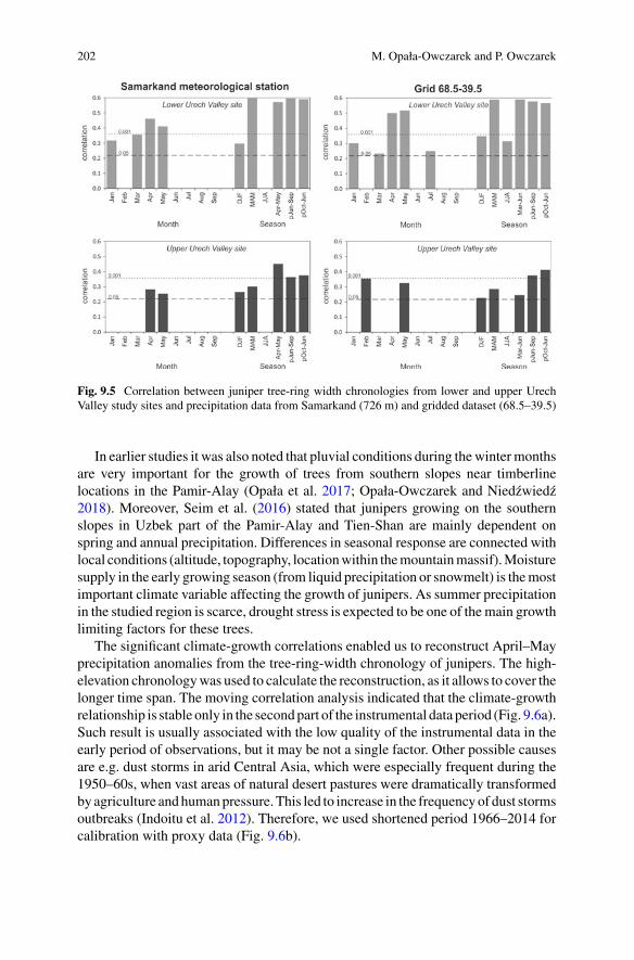
202 M. Opała-Owczarek and P. Owczarek
Fig. 9.5 Correlation between juniper tree-ring width chronologies from lower and upper UrechValley study sites and precipitation data from Samarkand (726 m) and gridded dataset (68.5–39.5)
In earlier studies it was also noted that pluvial conditions during thewintermonthsare very important for the growth of trees from southern slopes near timberlinelocations in the Pamir-Alay (Opała et al. 2017; Opała-Owczarek and Niedzwiedz2018). Moreover, Seim et al. (2016) stated that junipers growing on the southernslopes in Uzbek part of the Pamir-Alay and Tien-Shan are mainly dependent onspring and annual precipitation. Differences in seasonal response are connected withlocal conditions (altitude, topography, locationwithin themountainmassif).Moisturesupply in the early growing season (from liquid precipitation or snowmelt) is themostimportant climate variable affecting the growth of junipers. As summer precipitationin the studied region is scarce, drought stress is expected to be one of themain growthlimiting factors for these trees.
The significant climate-growth correlations enabled us to reconstruct April–Mayprecipitation anomalies from the tree-ring-width chronology of junipers. The high-elevation chronologywas used to calculate the reconstruction, as it allows to cover thelonger time span. The moving correlation analysis indicated that the climate-growthrelationship is stable only in the secondpart of the instrumental data period (Fig. 9.6a).Such result is usually associated with the low quality of the instrumental data in theearly period of observations, but it may be not a single factor. Other possible causesare e.g. dust storms in arid Central Asia, which were especially frequent during the1950–60s, when vast areas of natural desert pastures were dramatically transformedby agriculture andhumanpressure. This led to increase in the frequencyof dust stormsoutbreaks (Indoitu et al. 2012). Therefore, we used shortened period 1966–2014 forcalibration with proxy data (Fig. 9.6b).

9 Dry and Humid Periods Reconstructed from Tree … 203
Fig. 9.6 a Moving correlation function between April–May precipitation and the tree-ring widthindex from the upper site chronology considering an interval lengths of 25 years; b the relationbetween these variables over the period 1966–2014
The regression model accounts for 36% of the variance in the instrumental springprecipitation (April–May totals) over the calibration period from 1966–2014. Theresults of ca 30–40% of explained variance in the dendroclimatic reconstruction iswidely acceptable (e.g. Chen et al. 2015; Gou et al. 2015; Shah et al. 2018). We areaware that the dendroclimatic method of climate reconstruction is associated witha certain degree of uncertainty. However, standard methodology have been usedto assess whether the model has the ability to reconstruct the climate. The crosscalibration-verification tests for two split periods revealed that the model passes thestandard tests of reconstruction reliability (a positive reduction of error (RE) andcoefficient of efficiency (CE)). Because our calibration-verification sub-periods arerelatively short (1966–1990, 1990–2014), additional verification of spring precipita-tion reconstruction model was made using a grid dataset (Table 9.1). Finally, a linearregression model was developed to reconstruct April–May precipitation variationsback to 800 ce. The reconstruction of spring precipitation variability over the last1200 years presented in Fig. 9.7 revealed variations on an inter-annual to decadaland centennial scale.
9.4.2 Moisture Changes in the Last Millennium
The reconstructed climate history of the former territory of Sogdiana for the pastmillennium revealed a series of dry and wet stages. Referring to the time frame oftheMedievalClimateAnomaly (900–1300ce) and theLittle IceAge (1570–1900ce)described by Lamb (1965) andMatthews andBriffa (2005) some regional differencescan be observed. In the studied western Pamir-Alay region during the MedievalClimate Anomaly (MCA) two dry periods occurred, with a shift to wetter conditions

204 M. Opała-Owczarek and P. Owczarek
Table 9.1 Calibration and verification statistics for split (1966–1990, 1990–2014) and entire period(1990–2014) for the spring precipitation reconstruction model based on tree rings
Type ofdata
Samarkand station data Samarkandstation data
Grid dataa
Time period Calibration(1990–2014)
Verification(1966–1990)
Calibration(1966–1990)
Verification(1990–2014)
Calibration(1966–2014)
Verification(1966–2014)
r 0.65 0.62 0.62 0.64 0.60 0.56
R2 0.41 0.38 0.38 0.41 0.36 0.32
RE 0.41 0.42 0.21
CE 0.38 0.40 0.18
ST+/− 19/6 21/4 34/14
Explanations: r—correlation coefficient; R2—explained variance; RE reduction of error; CE coef-ficient of efficiency; ST sign testaFor independent verification data for grid (38–41° N and 67–70° E) was used
between them. The Little Ice Age (LIA) in this area was characterised by wetterconditions interrupted by a dry periodwith conditions closer to the average (Fig. 9.7).
According to new Pamir-Alay tree-ring data, dry periods prevailed in the fol-lowing time spans: 900–1000, 1200–1250, 1510–1650, 1750–1850, and 1920–1970(Fig. 9.7b). The first long period of arid climate conditions present in the tree-ring-based precipitation reconstruction started as early as 900 and lasted to ca 1000 ce.This drought is consistent with data from the Guliya ice cap (Thompson et al. 1995;Yao et al. 1996) and Badain Jaran Desert (Ma and Edmunds 2006), and is also inline with the modelled changes in rainfall anomalies of the ECHAM5 simulationof the arid Central Asia domain (Fallah et al. 2016). At the turn of the tenth andeleventh centuries, a shift to wetter conditions occurred. This period of two hundredyears is characterised by a high level of variability with a clear predominance ofabove-average precipitation. Increased rainfall in Central Asia in this period is evi-denced by low-resolution records, such as speleothem carbon isotope data, ostracodassemblages from lake sediments, and pollen concentration data (Chen et al. 2010).
At the beginning of the thirteenth century, a rapid transition to dry conditionsis observed. This period lasted only fifty years, but probably constituted the mostsevere drought in the entire analysed period. Low precipitation before ca 1250 wasconfirmed by many other natural proxies from arid Central Asia, e.g. Uluu Too Cave(Wolff et al. 2017). After a period of considerable higher precipitation from 1300to 1400, a homogeneous period of nearly 200 years, with values close to the long-term average, prevailed during the fifteenth century, becoming progressively drierduring the sixteenth century. The occurrence of low levels of precipitation and verydry conditions during this time is confirmed by historical reports from Afghanistan(Beveridge 1921, after Yadava et al. 2016). A rapid transition between dry and wetclimate conditions took place around 1650. The two most significant pluvial periodsin the Pamir-Alay tree-ring reconstruction, around the eleventh and twelfth and fromthe mid-seventeenth to mid-eighteenth centuries, are in accord with data on Pamir-Alay glacier fluctuations (Solomina et al. 2016). The evidence for a glacier advance

9 Dry and Humid Periods Reconstructed from Tree … 205
Fig. 9.7 a Tree-ring width chronology of Juniperus seravshanica from the lower Urech Valley(1795–2014) and Juniperus semiglobosa from the upper Urech Valley (801–2015). The solid anddashed lines represent the tree-ring index and sample depth, respectively. b Tree-ring-based recon-struction of precipitation variability during the past 1200 years with important historical periods forthe former territory of Sogdiana. The vertical red bands denote dry periods, which correlate withrapid political and economic changes
shortly after 985±115 ce was found via radiocarbon dating of shallow soil horizonbelow a fresh till at the Abramova Glacier (Zech et al. 2000). The youngest advancetook place at the end of the seventeenth century (ca 1690 ce) as dated by a 14Cage determined from a trunk of Juniperus turkestanica broken by an advance of theRaigorodskogo Glacier (Narama 2002). In the light of glaciological evidence, thesetwo advances were of similar magnitude, although the former was slightly larger.
The Pamir-Alay tree-ring reconstruction shows that LIA precipitation maximum(1650–1740) was followed by a long dry period, 1750–1840 (Fig. 9.7b). The first drysub-period, 1756–1768, known as the Strange Parallel Drought, is well documentedin different parts of Asia. Of the four well-documented historical droughts indicatedin the Monsoon Asia Drought Atlas (MADA, Cook et al. 2010), it was the onlymega-drought to occur in the studied area. At the end of the LIA, a pronounced wet

206 M. Opała-Owczarek and P. Owczarek
period took place around 1850–1910, followed by advances of the RaigorodskogoGlacier dated to 1908–1934 (Narama 2002).
The twentieth centurywas characterised by two opposing precipitation regimes. Apronounced drought was observed between ca 1920 and 1970. A significant changein precipitation variability is evident during the second half of the twentieth century.The recent wetting trend in Central Asia was captured by many moisture-sensitivetree-ring series, e.g. from north-western India (Yadav et al. 2017), northern Pakistan(Treydte et al. 2006) andKyrgyzstan (Chen et al. 2015; Zhang et al. 2015), as opposedto the case ofMongolia or ofNepal,where contemporary drought is evident (Pedersonet al. 2014; Panthi et al. 2017).
9.4.3 Socio-economic Changes During the Past Millennium
The oasis of Samarkand in the Middle Zeravshan Valley was the most importantpolitical and economic centre at the turn of the first and second millennium of thecommon era. Samarkand was the capital of ancient Sogdiana, which collapsed inthe eighth century; nevertheless, it maintained its importance in the following cen-turies. During this time, the area was in the possession of various tribes and dynasties(Fig. 9.7). Political changes, both negative and positive, in the former territory of thekingdom of Sogdiana, as reflected in the history of Samarkand, were often associ-ated with climate changes, i.e. the occurrence of alternate dry and humid periods(Owczarek et al. 2018).
Following the Arab conquest at the beginning of the eighth century, most ofthe former Sogdiana area fell into the orbit of Islamic influence (Grenet and dela Vaissière 2002; Marshak 2003; Ghafurov 2011). The period ca 800–900 wascharacterised by relatively warmer and wetter climate conditions. This is confirmednot only by tree-ring data but also by other proxy data from the Aral Sea basin andthe surrounding areas (Sorrel et al. 2006, 2007; Boomer et al. 2009). During this timeSamarkand and its surroundings became part of the Samanid Empire. This periodof prosperity was experienced not only in this area but along the entire Silk Road aswell. Public buildings and mosques were enlarged and the water supply ensured bymeans of ancient aqueducts, conduits, and irrigation canals (Ivanitskij and Inevatkina1999; Malatesta et al. 2012). Samarkand’s oases, with their famous peach gardens,experienced a golden age at the end of the Tang Dynasty (Schafer 1963). Despitethe tenth-century drought, the economy of Samarkand remained unaffected. Thiscannot be said of the nearby town of Panjikent, one of the most important citiesin ancient Sogdiana and along the Silk Road (Fig. 9.8) (Belenitskij et al. 1973).Although the Arab conquest in 722 did not cause its definitive collapse, Panjikentgradually lost its significance in comparison to Samarkand and Bukhara (Marshak2003).Aperiod of drought in the tenth centurywas one of the influences leading to theabandonment of ancient Panjikent and the town’s displacement to the lower terraceof the Zeravshan River, where water was more accessible (Fig. 9.8) (Owczarek et al.2018). The arid conditions during this time have also been clearly documented by

9 Dry and Humid Periods Reconstructed from Tree … 207
Fig. 9.8 a General view of the ruins of ancient Panjikent, partly destroyed during Arab conquestin AD 722 and completely abandoned in the 9th/10th century, b archaeological excavation withinthe area of ancient Panjikent (photographs were taken in July 2015 by the authors)
means of pollen analysis of sediments from the northern shore of the Aral Sea (Sorrelet al. 2007) and other palaeoclimatic records from arid Central Asia (Yang et al.2009). In the eleventh and twelfth centuries, in stable moisture climate conditions,the former Sogdiana area became part of the Karakhanid Khanate. This period wasmarked by continued development for Samarkand as a new administrative centre.Several buildings were erected, including a new palace in the citadel, a madrasa, and

208 M. Opała-Owczarek and P. Owczarek
caravansaries (Davidovich 1998). The Bibi-KhanymMosque was enlarged and, to agreat extent, rebuilt (Grenet and Rapin 1993; Paul 1993).
The tree-ring data from the first half of the thirteenth century documented strongarid conditions (Fig. 9.7). This dry period was also marked by the increasing salinityof theAral Sea (Sorrel et al. 2006), a high level of carbonate content in lake sediments(Chen et al. 2006), and falls in the levels of lakes in arid Central Asia (Boroffkaet al. 2006; Narama et al. 2010), and diminishing ice accumulation in Central Asianglaciers (Yang et al. 2009). This period wasmarked by drastic political and economicchanges in the area of formerSogdiana. In 1220, Samarkandwas seizedby the armyofChinggis Khaan and destroyed (Grenet and Rapin 1993). The huge losses sustainedby the working population and the decreasing availability of water in connectionwith the dry climate conditions were the main factors contributing to the decline ofSamarkand, as maintenance of the water supply required more skills and labour thanwere available (de Hartog 2006). The increasing humidity in the fourteenth centurycoincided with the rebuilding of Samarkand and re-establishment of its significance.In 1371, Timur established the city as his capital and renewed the irrigation system inthe Zeravshan River valley, which was used extensively for agriculture (Manz 1989).Traces of a high water level and flooding in this period, indicating a moister climate,were found in sediment from canals carrying water from the Zeravshan River tothe oases of Samarkand (Malatesta et al. 2012). The next arid interval, recorded ca1500–1600, was marked again by violent political changes in the former Sogdiana(Fig. 9.7).
In 1500, Timurid Samarkand was conquered by Muhammad Shaybani (Grenet2002; Mukminova and Mukhtarov 2003). The gradual decline in the importance ofthe Silk Road in the sixteenth century coincided with the prevailing arid conditionsand the loss of Samarkand position. The political centre of the former territory ofSogdiana moved to Bukhara, which became the capital of the Khanate (Mukminovaand Mukhtarov 2003). Sixteenth-century aridification was confirmed by an increasein salinity and changes of lake levels of the Aral Sea (Sorrel et al. 2006; Boomer et al.2009; Boroffka et al. 2006). The rapid increase in humidity in the second part of theseventeenth century was marked by flood sediments in the irrigation canals in theSamarkand oasis (Malatesta et al. 2012). During the period 1750–1850, a return toarid conditions was documented. The former territory of Sogdiana lost its economicimportance alongwith the collapse of trade on theSilkRoad.A rapid decline occurredin the second part of the eighteenth century,with the inroadsmade by theKazakhs anddynastic strife (Fig. 9.7). The Samarkand oasis was depopulated and the madrasaswere converted by nomads into winter stables (Grenet 2002). The wet period in thesecond part of the nineteenth century coincided with Russian expansion. In 1868,Samarkand was conquered by the Russians and the remainder of the area of theformer Sogdiana became an informal Russian protectorate (Fourniau and Poujolvc2005). The last aridification interval occurred in the middle of the twentieth century.This was a period of rapid socio-economic changes in the Soviet republics of CentralAsia. Arid conditions exerted a negative influence on increased human activity andunsustainable farming.
9 Dry and Humid Periods Reconstructed from Tree … 209
9.5 Conclusions
Our dendroclimatic reconstruction of changes in spring precipitation, which coversimportant climatic periods of the last millennium, including the drier Medieval Cli-mate Anomaly, the wetter Little Ice Age, and modern times, revealed a series of dryand wet stages. Despite our tree-ring data were collected from relatively limited area,the newly developed proxy record of moisture changes revealed that major dry andwet episodes over the past millennium were consistent with those indicated by otherhydroclimatic proxy data (such as speleothems, pollen data, glacier retreats or iceaccumulation, lake sediments or changes in lake levels) from adjacent areas.
In general, during dry periods, negative socio-economic changes were observed.Our palaeoclimatic data show drought during the tenth century, influencing the aban-donment of ancient Panjikent. The next dramatic decrease in precipitation took placein the first half of the thirteenth century. This period was marked by drastic polit-ical and economic changes in the former territory of Sogdiana, as Samarkand wasdestroyed by the army of Chinggis Khaan and additionally suffered from decreasingwater availability, leading to a decline in its importance. Severe drought conditionsalso occurred in the sixteenth century, contributing to a deterioration in living con-ditions which coincided with the decline of the importance of the Silk Road and,finally, the loss of Samarkand position. On the other hand, wetter climatic conditionsled to improvements in living conditions, followed by expansion and development,as was particularly evident in the eleventh, twelfth, fourteenth, and seventeenth cen-turies. A socio-economic perspective of wet conditions in the historic past revealsthe great vulnerability of societies in arid Central Asia to climate change. However,one should keep in mind that climate may trigger problems in a society, but does notnecessarily automatically lead to collapse of cultures.
Acknowledgements The authors wish to thank local people from Sughd Province and Rahmonovfamily for their hospitality. We are grateful to Oimahmad Rahmonov for logistic support and assis-tance in the field. We acknowledge Tadeusz Niedzwiedz for providing Samarkand meteorologicaldata. This study was performed within the scope of the research project no. 2013/09/B/ST10/00634“Comparison of thermal variability during the last millennium in the mountains of Central Asia andCentral Europe” funded by the Polish National Science Centre (NCN). P. Owczarek was financedby statutory founds of the University of Wroclaw.
References
Abazov,R. (2008).Palgrave concise historical atlas ofCentral Asia. NewYork: PalgraveMacmillanUS.
Belenitskij, A. M., Bentovich, I. B., & Bol’shakov, O. G. (1973). Srednevevovyı gorod Sredneı Azii(The medieval town in Central Asia). Leningrad: Nauka Press.
Beveridge, A. S. (1921). Babur-Nama (Memoirs of Babur) (Translated from the Original Turki Textof Zahiru’d-din Muhammad Babur Padshah Ghazi). Delhi: D. K. Fine Art Press Pvt. Ltd.
210 M. Opała-Owczarek and P. Owczarek
Biondi, F., & Waikul, K. (2004). DENDROCLIM2002: A C++program for statistical calibrationof climate signals in tree-ring chronologies. Computers & Geosciences, 30, 303–311.
Boomer, I., Wünnemann, B., Mackay, A. W., Austin, P., Sorrel, P., Reinhardt, C., et al. (2009).Advances in understanding the late Holocene history of the Aral Sea region. Quaternary Inter-national, 194, 79–90. https://doi.org/10.1016/j.quaint.2008.03.007.
Boroffka, N., Oberhänsli, H., Sorrel, P., Demory, F., Reinhardt, C., Wünnemann, B., et al. (2006).Archaeology and climate: Settlement and lake-level changes at the Aral Sea. Geoarchaeology,21, 721–734. https://doi.org/10.1002/gea.20135.
Buckley, B. M., Anchukaitis, K. J., Penny, D., Fletcher, R., Cook, E. R., Sano, M., et al. (2010).Climate as a contributing factor in the demise of Angkor, Cambodia. Proceedings of the NationalAcademy of Sciences, 107(15), 6748–6752. https://doi.org/10.1073/pnas.0910827107.
Büntgen, U., Tegel, W., Nicolussi, K., et al. (2011). 2500 years of European climate variability andhuman susceptibility. Science, 331(6017), 578–582.
Chen, F., He,Q., Bakytbek, E., Yu, S., &Zhang, R. (2015). Climatic signals in tree rings of Juniperusturkestanica in theGulchaRiver Basin (Kyrgyzstan), reveals the recentwetting trend of highAsia.Dendrobiology, 74, 35–42. https://doi.org/10.12657/denbio.074.004.
Chen, F. H., Chen, J. H., Holmes, J., Boomer, I., Austin, P., Gates, J. B., et al. (2010). Moisturechanges over the last millennium in arid central Asia: A review, synthesis and comparison withmonsoon region. Quaternary Science Reviews, 29, 1055–1068.
Chen, F., Huang, X., Zhang, J., Holmes, J. A., & Chen, J. (2006). Humid little ice age in arid centralAsia documented by Bosten lake, Xinjiang, China. Science in China Series D: Earth Sciences,49(12), 1280–1290.
Chub, V., & Ososkova, T. (2009). The second national communication of the republic of Uzbekistanunder the United Nations framework convention on climate change. Uzbekistan: Tashkent.
Cook, E. R. (1985).A time series approach to tree-ring standardization. Ph.D. Dissertation. Tucson,AZ, USA: University of Arizona.
Cook,E.R.,&Kairiukstis, L.A. (1990).Methodsof dendrochronology.Dordrecht, TheNetherlands:Kluwer Academic Publishers and International Institute for Applied System Analysis.
Cook, E. R., Anchukaitis, K. J., Buckley, B. M., D’Arrigo, R. D., Jacoby, G. C., & Wright, W.E. (2010). Asian monsoon failure and megadrought during the last millennium. Science, 328,486–489.
Davidovich, E. A. (1998). The Karakhanids. In M. S. Asimov & C. E. Bosworth (Eds.), Historyof civilizations of Central Asia volume IV, the age of achievement: A.D. 750 to the end of thefifteenth century. Multiple History Series, Paris: UNESCO Publishing.
de Hartog, L. (2006). Genghis Khan: Conqueror of the world. New York: Pauris Parke—PalgraveMcmillan Press.
de La Vaissière, E. (2002). Histoire des marchands sogdiens. Paris: Institut des Hautes EtudesChinoises, Collège de France.
deMenocal, P. B. (2001). Cultural responses to climate change during the Late Holocene. Science,292(5517), 667–673.
Fallah, F., Sodoudi, S., & Cubasch, U. (2016). Westerly jet stream and past millennium climatechange in Arid Central Asia simulated by COSMO-CLM model. Theoretical and Applied Cli-matology, 124, 1079–1088. https://doi.org/10.1007/s00704-015-1479-x.
Fan, K. W. (2015). Climate change and Chinese history: A review of trends, topics, and methods.WIREs Climate Change, 6, 225–238. https://doi.org/10.1002/wcc.331.
Fourniau, V., & Poujolvc, C. (2005). The states of Central Asia (second half of nineteenth centuryto early twentieth century). In M. K. Palat & A. Tabyshalieva (Eds.), History of civilizations ofCentral Asia volume V, towards the contemporary period: from the mid-nineteenth to the end ofthe twentieth century. Multiple History Series, Paris: UNESCO Publishing.
Ghafurov, B. (2011). Tajiks: Pre-ancient, ancient and medieval history. Dushanbe, Tajikistan: Min-istry of Culture of the Republic of Tajikistan, Irfon.
Giosan, L., Fuller, D. K., Nicoll, K., Flad, R. K., & Clift, P. D. (2013). Climates, landscapes, andcivilizations (p. 198). Geophysical Monograph Series: American Geophysical Union.

9 Dry and Humid Periods Reconstructed from Tree … 211
Gou, X., Gao, L., Deng, Y., Chen, F., Yang, M., & Still, C. (2015). An 850-year tree-ring-basedreconstruction of drought history in the western Qilian Mountains of northwestern China. Inter-national Journal of Climatology, 35, 3308–3319. https://doi.org/10.1002/joc.4208.
Grenet, F., & Rapin, C. (1993). De la Samarkand antique à la Samarkand islamique: continuitéset ruptures. In R. P. Gayraud (Ed.), Actes du Colloque International Archéologie Islamique duCaire. Paris: Institut Français D’archéologie Orientale.
Grenet, F. (2002). Samarqand: History and archeology. Encyclopedia Iranica online. Origi-nally Published: July 20, 2002 available at http://www.iranicaonline.org/articles/samarqand-i.Accessed on 16 Aug 2017.
Grenet, F., & de la Vaissière, E. (2002). The last days of Panjikent. Silk Road Art and Archaeology,8, 155–196.
Hodell, D. A., Curtis, J. H., & Brenner, M. (1995). Possible role of climate in the collapse of classicMaya civilization. Nature, 375, 391–394.
Holmes, R. L. (1983). Computer assisted quality control in tree-ring dating and measurement.Tree-Ring Bulletin, 43, 69–78.
Indoitu, R., Orlovsky, L., & Orlovsky, N. (2012). Dust storms in Central Asia: Spatial and temporalvariations. Journal of Arid Environments, 85, 62–70.
Ivanitskij, E. D., & Inevatkina, O. N. (1999). Periodizatsiya i etapy razvitiya vodosnabzheniyaAfrasiaba (Periods and stages of the development of the water-supply of Afrasiab). IstoriyaMaterial’noı Kul’tury Uzbekistana, 30, 96–103.
Kayumov, A. (2010).Glaciers resources of Tajikistan in condition of the climate change. Dushanbe,Tajikistan: StateAgency forHydrometeorologyofCommittee forEnvironmental Protection underthe Government of the Republic of Tajikistan.
Klemm, J., Herzschuh, U., & Pestryakova, L. A. (2016). Vegetation, climate and lake changes overthe last 7000 years at the boreal treeline in north-central Siberia. Quaternary Science Reviews,147, 422–434.
Lamb, H. H. (1965). The early medieval warm epoch and its sequel. Palaeogeography, Palaeocli-matology, Palaeoecology, 1, 13. https://doi.org/10.1016/0031-0182(65)90004-0.
Latorre, C., Wilmshurst, J. M., & von Gunten, L. (2016). Climate change and cultural evolution.Past Global Change Magazine, 24(2), 53–84.
Li, J., Dodson, J., Yan, H., Zhang, D. D., & Zong, Y. (2017). Quantifying climatic variabilityin monsoonal northern China over the last 2200 years and its role in driving Chinese dynasticchanges. Quaternary Science Reviews, 159, 35–46.
Lioubimtseva, E., & Henebry, G. M. (2009). Climate and environmental change in arid CentralAsia: Impacts, vulnerability, and adaptations. Journal of Arid Environments, 73(11), 963–977.
Litvinsky, B.A., Zhang, G., & Samghabadi, R.S. (Eds.). (1996). History of civilizations of CentralAsia Volume III, The crossroads of civilizations: A.D. 250 to 750. Multiple History Series, Paris:UNESCO Publishing.
Ma, J. Z., & Edmunds, W. M. (2006). Groundwater and lake evolution in the Badain Jaran desertecosystem, Inner Mongolia. Hydrogeology Journal, 14, 1231–1243.
Makhmadaliev, B., Kayumov, A., Novikov, V., Mustaeva, N., & Rajabov, I. (2008). The secondnational communication of the republic of Tajikistan under the United Nations framework con-vention on climate change. Tajikistan: Dushanbe.
Malatesta, L., Castelltort, S., Mantellini, S., Picotti, V., Hajdas, I., Simpson, G., et al. (2012). Datingthe irrigation system of the Samarkand Oasis: A geoarchaeological study. Radiocarbon, 54(1),91–105. https://doi.org/10.2458/azu_js_rc.v54i1.15839.
Manz, B. (1989). The rise and rule of Tamerlane. Cambridge: Cambridge University Press.Marshak, B. I. (2003). The archaeology of Sogdiana. The Silk Road, 1(2), 2–8.Matthews, J. A., & Briffa, K. R. (2005). The ‘Little Ice Age’: Reevaluation of an evolving concept.Geografiska Annaler, 87 A(1), 17–36.

212 M. Opała-Owczarek and P. Owczarek
Mitchell, T. D., & Jones, P. D. (2005). An improved method of constructing a database of monthlyclimate observations and associated high-resolution grids. International Journal of Climatology,25, 693–712.
Mukminova, R. G., &Mukhtarov, A. (2003). The Khanate (Emirate) of Bukhara. In A. Chahryar, I.Habib, & K. M. Baipakov (Eds.), History of civilizations of Central Asia volume V, developmentin contrast: From the sixteenth to the mid-nineteenth century. Multiple History Series, Paris:UNESCO Publishing.
Narama, C. (2002). Late Holocene variation of the Raigorodskogo Glacier and climate change inthe Pamir-Alai, central Asia. Catena, 48, 21–37.
Narama,C.,KicenggeKubota, J., Shatravin,V.,Duishonakunov,M.,Moholdt,G.,&Abdrakhmatov,K. (2010). The lake level changes in Central Asia during the last 1000 years based on historicalmap. InM.Watanabe& J.Kubota (Eds.),Reconceptualising cultural and environmental change inCentral Asia: an historical perspective on the future, Ili Project, Research Institute for Humanityand Nature, Kyoto, 11–27.
Opała, M., Niedzwiedz, T., Rahmonov, O., Owczarek, P., & Małarzewski, Ł. (2017). Towardsimproving the Central Asian dendrochronological network—new data from Tajikistan, Pamir-Alay. Dendrochronologia, 41, 10–23. https://doi.org/10.1016/j.dendro.2016.03.006.
Opała-Owczarek, M., & Niedzwiedz, T. (2018). Last 1100 years of precipitation variability inwestern Central Asia as revealed by tree-ring data from the Pamir-Alay. Quaternary Research,1–15. https://doi.org/10.1017/qua.2018.21.
Opała-Owczarek, M., Owczarek, P., Rahmonov, O., & Niedzwiedz, T. (2018). The first den-drochronological dating of timber fromTajikistan—potential for developing amillennial tree-ringrecord. Tree-Ring Research, 74(2), 50–62. https://doi.org/10.3959/1536-1098-74.1.50.
Owczarek, P., Opała-Owczarek, M., Rahmonov, O., & Mendecki, M. (2017). 100 years of earth-quakes in the Pamir region as recorded in juniper wood: A case study of Tajikistan. Journal ofAsian Earth Sciences, 138, 173–185. https://doi.org/10.1016/j.jseaes.2017.02.011.
Owczarek, P., Opała-Owczarek, M., Rahmonov, O., Razzokov, A., Jary, Z., & Niedzwiedz, T.(2018). Relationships between loess and the Silk Road reflected by environmental change andits implications for human societies in the area of ancient Panjikent, central Asia. QuaternaryResearch, 89(3), 691–701. https://doi.org/10.1017/qua.2017.69
Panthi, S., Bräuning, A., Zhou, Z. K., & Fan, Z. X. (2017). Tree rings reveal recent intensified springdrought in the central Himalaya. Nepal Global and Planetary Change, 157, 26–34.
Paul, J. (1993). The histories of Samarqand. Studia Iranica, 22, 69–92.Pederson, N., Hessl, A. E., Baatarbileg, N., Anchukaitis, K. J., & Di Cosmo, N. (2014). Pluvials,droughts, the Mongol Empire, and modern Mongolia. Proceedings of the National Academy ofSciences, 111(12), 4375–4379. https://doi.org/10.1073/pnas.1318677111.
Putnam, A. E., Putnam, D. E., Andreu-Hayles, L., Cook, E. R., Palmer, J. G., Clark, E. H., et al.(2016). Little Ice Age wetting of interior Asian deserts and the rise of the Mongol Empire.Quaternary Science Reviews, 131, 33–50.
Rahmonov, O., Rahmonov, M., Opała-Owczarek, M., Owczarek, P., Niedzwiedz, T., & Myga-Piatek, U. (2017a). Ecological and cultural importance of juniper ecosystem in the area of Zer-avshan valley (Tajikistan) on the background of environmental condition and anthropogenichazards. Geographia Polonica, 90, 441–461. https://doi.org/10.7163/GPol.0110.
Rahmonov, O., Szczypek, T., Niedzwiedz, T., Myga-Piatek, U., Rahmonov, M., & Snytko, V. A.(2017b). The human impact on the transformation of juniper forest landscape in the western partof the Pamir-Alay range (Tajikistan). Environmental Earth Sciences, 76, 324. https://doi.org/10.1007/s12665-017-6643-4.
Schafer, E. H. (1963). The golden peaches of samarkand: A study of T’ang exotics. Berkeley andLos Angeles, USA: University of California Press.
Schurr,B.,Ratschbacher,L., Sippl,C.,Gloaguen,R.,Yuan,X.,&Mechie, J. (2014). Seismotectonicsof the Pamir. Tectonics, 33, 1501–1518. https://doi.org/10.1002/2014TC003576.
9 Dry and Humid Periods Reconstructed from Tree … 213
Seim, A., Omurova, G., Azisov, E., Musuraliev, K., Aliev, K., Tulyaganov, T., et al. (2016). Climatechange increases drought stress of Juniper trees in the mountains of Central Asia. PLoS One,11(4), e0153888. https://doi.org/10.1371/journal.pone.0153888.
Shah, S. K., Pandey, U., & Mehrotra, N. (2018). Precipitation reconstruction for the Lidder Valley,Kashmir Himalaya using tree-rings of Cedrus deodara. International Journal of Climatology, 38,758–773. https://doi.org/10.1002/joc.5405.
Sidle, R. C., Taylor, D., Lu, X. X., Adger, W. N., Lowe, D. J., de Lange, W. P., et al. (2004).Interactions of natural hazards and society in Austral-Asia: Evidence in past and recent records.Quaternary International, 118(119), 181–203.
Solomina, O. N., Bradley, R. S., Jomelli, V., Geirsdottir, A., Kaufman, D. S., Koch, J., et al. (2016).Glacier fluctuations during the past 2000 years. Quaternary Science Reviews, 149, 61–90.
Sorrel, P., Popescu, S.-M., Head, M. J., Suc, J. P., Klotz, S., & Oberhänsli, H. (2006). Hydrographicdevelopment of the Aral Sea during the last 2000 years based on a quantitative analysis ofdinoflagellate cysts. Palaeogeography, Palaeoclimatology, Palaeoecology, 234, 304–327. https://doi.org/10.1016/j.palaeo.2005.10.012.
Sorrel, P., Popescu, S., Klotz, S., Suc, J., &Oberhänsli, H. (2007). Climate variability in the Aral Seabasin (Central Asia) during the late Holocene based on vegetation changes.Quaternary Research,67(3), 357–370. https://doi.org/10.1016/j.yqres.2006.11.006.
Speer, J. H. (2010). The fundamentals of tree-ring research. Tucson, AZ: University of ArizonaPress.
Thompson, L. G., Mosley-Thompson, E., Davis, M. E., Lin, P. E., Henderson, K. A., Cole-Dai, J.,et al. (1995). A 1000 year climate ice-core record from the Guliya ice cap, China: Its relationshipto global climate variability. Annals of Glaciology, 21, 175–181.
Treydte, K. S., Schleser, G. H., Helle, G., Frank, D. C., Winiger, M., Haug, G. H., et al. (2006). Thetwentieth century was the wettest period in northern Pakistan over the past millennium. Nature,440, 1179–1182. https://doi.org/10.1038/nature04743.
Wei, Z., Rosen, A. M., Fang, M., Su, Y., & Zhang, X. (2015). Macro-economic cycles related toclimate change in dynastic China. Quaternary Research, 83, 13–23.
Weiss, H., & Bradley, R. S. (2001). What drives societal collapse? Science, 291, 609–610.Wigley, T. M. L., Briffa, K. R., & Jones, P. D. (1984). On the average value of correlated time serieswith applications in dendroclimatology and hydrometeorology. Journal of Climate and AppliedMeteorology, 23(2), 201–213.
Williams, M. W., & Konovalov, V. G. (2008). Central Asia temperature and precipitation data,1879–2003. Boulder, Colorado: USA. NSIDC: National Snow and Ice Data Center. http://dx.doi.org/10.7265/N5NK3BZ8.
WinDENDRO. (2006). Manual. Regent Instrument INC, Quebec, Canada.Wolff, C., Plessen, B., Dudashvilli, A. S., Breitenbach, S. F. M., Cheng, H., Edwards, L. R., et al.(2017). Precipitation evolution of Central Asia during the last 5000 years. The Holocene, 27(1),142–154. https://doi.org/10.1177/0959683616652711.
Yadav, R. R., Gupta, A. K., Kotlia, B. S., Singh, V., Misra, K. G., Yadava, A. K., & Singh, A.K. (2017). Recent wetting and glacier expansion in the Northwest Himalaya and Karakoram.Scientific Reports, 7. https://doi.org/10.1038/s41598-017-06388-5.
Yadava, A. K., Bräuning, A., Singh, J., &Yadav, R. R. (2016). Boreal spring precipitation variabilityin cold arid western Himalaya during the last millennium and its relationship with hydrologicalrecords and human history. Quaternary Science Reviews, 144, 28–43.
Yang, B., Wang, J., Bräuning, A., Dong, Z., & Esper, J. (2009). Late Holocene climatic and envi-ronmental changes in arid central Asia. Quaternary International, 194, 68–78.
Yao, T. D., Thompson, L. G., Qin, D. H., Tian, L. D., Jiao, K. Q., Yang, Z. H., et al. (1996). Variationsin temperature and precipitation in the past 2000a on the Xizang (Tibet) Plateau-Guliya ice corerecord. Science in China, Series D, 39, 425–433.
Yin, J., Su, Y., & Fang, X. (2016). Climate change and social vicissitudes in China over the pasttwo millennia. Quaternary Research, 86, 133–143.
214 M. Opała-Owczarek and P. Owczarek
Zech, W., Glaser, B., Ni, A., Petrov, M., & Lemzin, I. (2000). Soil as indicators of the Pleistoceneand Holocene landscape history: Alay range (Kyrgyzstan). Quaternary International, 65(66),161–170.
Zhang, T., Zhang, R., Yuan, Y., Gao, Y., Wei, W., Diushen, M., et al. (2015). Reconstructed pre-cipitation on a centennial timescale from tree rings in the western Tien Shan Mountains, CentralAsia. Quaternary International, 358, 58–67.
Open Access This chapter is licensed under the terms of the Creative Commons Attribution 4.0International License (http://creativecommons.org/licenses/by/4.0/), which permits use, sharing,adaptation, distribution and reproduction in any medium or format, as long as you give appropriatecredit to the original author(s) and the source, provide a link to the Creative Commons license andindicate if changes were made.
The images or other third party material in this chapter are included in the chapter’s CreativeCommons license, unless indicated otherwise in a credit line to the material. If material is notincluded in the chapter’s Creative Commons license and your intended use is not permitted bystatutory regulation or exceeds the permitted use, you will need to obtain permission directly fromthe copyright holder.
Chapter 10A Drought Reconstructionfrom the Low-Elevation Juniper Forest ofNorthwestern Kyrgyzstan since CE 1565
Feng Chen, Shulong Yu, Qing He, Bakytbek Ermenbaevand Rysbek Satylkanov
Abstract Naryn River provides large amounts of water resource for Central Asiancountries. Thus, the severity and frequency of drought variation relate to runoff hasimportant influences on social and economic development of this region. In thisstudy, the new tree-ring width chronologies of juniper trees from the low-elevationsite of the western Tien Shan are used to reconstruct drought variation for northwest-ern Kyrgyzstan and place the short instrumental period (1950–2013) of Standard-ised Precipitation-Evapotranspiration Index (SPEI) in a long-term context. The SPEIreconstruction successfully reflects the dry and wet periods over the past 451 years,and captures a recent wetting trend that generally agrees with the drought reconstruc-tions for the spruce-dominated area.However, some differences between the tree-ringrecords from spruce-dominated and juniper-dominated areas reflect regional climatedifferences. The comparison between drought events in the SPEI reconstruction andhistorical event of Central Asia reveals drought variations have had profound influ-ences on some historical archives over the past several centuries. This study providesthe first long-term SPEI reconstruction and drought evaluation from the low-altitudearea of Central Asia, contributing to climate change issues in Central Asia.
Keywords Northwestern Kyrgyzstan · Tree rings · SPEI · Drought reconstructionCentral asia · Historical archives
F. Chen (B) · S. Yu · Q. HeKey Laboratory of Tree-ring Physical and Chemical Research of China MeteorologicalAdministration/Xinjiang Laboratory of Tree-ring Ecology, Institute of Desert Meteorology,Meteorological Administration, Urumqi 830002, Chinae-mail: [email protected]
B. Ermenbaev · R. SatylkanovTien-Shan Mountain Scientific Center, Institute of Water Problems and Hydro Power,National Academy of Sciences of the Kyrgyz Republic, 720033 Bishkek, Kyrgyzstan
© The Author(s) 2019L. E. Yang et al. (eds.), Socio-Environmental Dynamics along the Historical Silk Road,https://doi.org/10.1007/978-3-030-00728-7_10
215
216 F. Chen et al.
10.1 Introduction
Tree-ring width series have been applied to reconstruct regional- to large-scaledrought/precipitation variation over the pre-instrumental period in the drylands ofthe world (e.g. Cook et al. 2004; Gray et al. 2007; Neukom et al. 2010; Touchan et al.2011; Fang et al. 2010; Yang et al. 2014; Gou et al. 2015; Chen et al. 2015a). Mostof drought/precipitation reconstructions or related index value (e.g. runoff) fromCentral Asia are inferred from the Xinjiang province in China (Yuan et al. 2007;Zhang et al. 2013; Chen et al. 2014, 2015b), where drought events are common andthe socio-economic development is limited by scarce water resources. Despite thelarge impact of droughts on the socio-economic welfare of numerous Central Asiancountries, relatively little is known about the drought frequencies in these regions.Henceforth, the development of reliable, highly resolved moisture sensitive tree-ringchronologies certainly contributes to a more accurate assess of the recent climatechange in this region.
During the last three years, the situation have been changed greatly, and manynew moisture-sensitive tree-ring chronologies have been constructed (Chen et al.2013, 2016; Zhang et al. 2015; Seim et al. 2016a, b; Opała et al. 2017). Amongthese studies, spruce trees have provided the primary information source about pastdrought/precipitation variations of Central Asia (Chen et al. 2013, 2015a, b; Zhanget al. 2013, 2015, 2016). Although previous dendroclimatic studies revealed that thetree-ring width variations of juniper trees in Central Asia can record drought events,only a few studies carried out to develop precipitation/drought reconstructions fromjuniper tree-ring records (Esper et al. 2001; Chen et al. 2016; Seim et al. 2016a).
Here, we present a 451-year annual drought reconstruction for the low-elevationjuniper forest region near the Toktogul Reservoir in the western Tien Shan of north-western Kyrgyzstan. The reconstruction is based on a tree-ring width chronologydeveloped from long-living turkestan juniper (Juniperus turkistanica Kom.). Weused this drought reconstruction to examine interannual to decadal moisture varia-tions during the pre-instrumental period. Additionally, our reconstruction was com-pared to neighbouring drought reconstructions in order to unravel the spatio-temporalmoisture variability in Central Asia. Finally, using the drought records, we explorelinkages between drought variation and the historical events of Central Asia over thepast five centuries.
10.2 Data and Methods
10.2.1 Study Area
The sampling area (41° 34′N, 72° 32′E, 795–820 m a.s.l.) is situated within a 40 kmradius of the Toktogul dam near the Naryn River within the western Tien Shan range(Fig. 10.1). Turkestan juniper trees typically grow in an open canopy woodland
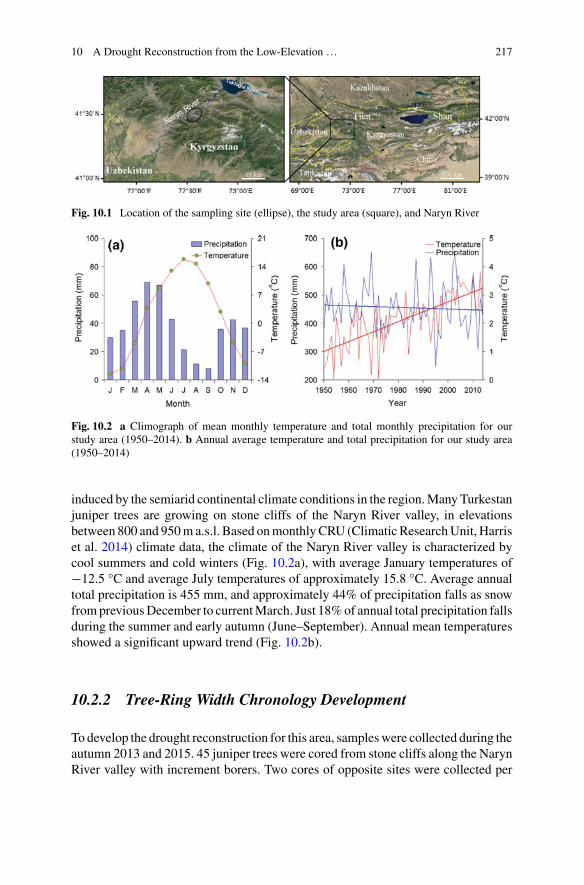
10 A Drought Reconstruction from the Low-Elevation … 217
Fig. 10.1 Location of the sampling site (ellipse), the study area (square), and Naryn River
Fig. 10.2 a Climograph of mean monthly temperature and total monthly precipitation for ourstudy area (1950–2014). b Annual average temperature and total precipitation for our study area(1950–2014)
induced by the semiarid continental climate conditions in the region.Many Turkestanjuniper trees are growing on stone cliffs of the Naryn River valley, in elevationsbetween 800 and 950m a.s.l. Based onmonthlyCRU (Climatic ResearchUnit, Harriset al. 2014) climate data, the climate of the Naryn River valley is characterized bycool summers and cold winters (Fig. 10.2a), with average January temperatures of−12.5 °C and average July temperatures of approximately 15.8 °C. Average annualtotal precipitation is 455 mm, and approximately 44% of precipitation falls as snowfrompreviousDecember to currentMarch. Just 18%of annual total precipitation fallsduring the summer and early autumn (June–September). Annual mean temperaturesshowed a significant upward trend (Fig. 10.2b).
10.2.2 Tree-Ring Width Chronology Development
To develop the drought reconstruction for this area, sampleswere collected during theautumn 2013 and 2015. 45 juniper trees were cored from stone cliffs along the NarynRiver valley with increment borers. Two cores of opposite sites were collected per

218 F. Chen et al.
tree, in order to copewith growth asymmetries. Aftermounted and sanded, the annualwidths of cores were measured with a TA Unislide Measurement System (VelmexInc., Bloomfield, New York) at 0.001 mm precision. The quality of cross-dating wasexaminedwith the computer soft COFECHA (Holmes 1983). After trends not relatedto climate change removed with the negative exponential curve, the detrended tree-ring series were used to develop the standard (STD) and residual (RES) chronologieswith the computer software ARSTAN (Cook 1985). Due to the sample size decreasesin the early period of the chronology, the expressed population signal (EPS > 0.85)was used to truncate the tree-ring width chronology due to a weaker coherence ofthe individual tree-ring width series (Wigley et al. 1984).
10.2.3 Statistical Analysis
Due to the lack of continuous observation data in this region, monthly CRU (Cli-matic Research Unit) average temperature, total precipitation (1950–2014, Har-ris et al. 2014) and Standardised Precipitation-Evapotranspiration Index (SPEI,Vicente-Serrano et al. 2010) gridded data (averaged over 41° 30′–43°N, 72–73°E)for 1950–2013 were used in this study. Based on these data we used Pearson’s corre-lation to unravel the climate sensitivity of our juniperus tree-ring width chronology.For that purpose, we consider the climate elements of the previous (‘p’) and current(‘c’) grwoing season (from previous July to current September).
Once the predictand with highest explanatory power was selected, the linearregression model was developed and applied for the reconstruction. SPEI data from1951–1981 were used for verification and from 1982–2010 for calibration. Verifica-tion statistics included the sign test (ST), coefficient of efficiency and the reductionof error (RE) (Cook and Kairiukstis 1990). In this study, the wet and dry periodswere determined if the 20-year low-pass values were lower or higher than the meanvalue from 1565 to 2015 continuously for more than 10 years. To demonstrate thegeographical representation of our drought reconstruction, we computed correlationsof our drought reconstruction with the SPEI dataset by the KNMI climate explorer(http://climexp.knmi.nl) for the common period (1951–2013). Toktogul Reservoir(41° 30′N, 72° 22′E, 700 m a.s.l.), located in the Jalal-Abad Province of Kyrgyzstan,is the largest of the reservoirs on the path of the Naryn River. It was created in 1976after construction work lasting 14 years on a dam to flood the Kementub Valley. Toestablish links of our drought reconstruction with water resource availability and therelated historical processes in Central Asia, correlations of our SPEI reconstructionwith the streamflow series of Naryn River from the hydrological station of ToktogulReservoir were conducted during the period 1951–1995. In addition, we used a super-posed epoch analysis (SEA, Haurwitz and Brier 1981) to determine the resilience ofjuniper growth under extreme dry climate conditions.

10 A Drought Reconstruction from the Low-Elevation … 219
10.3 Results
10.3.1 Tree-Ring Width Chronology Response to Climateand SPEI Reconstruction
The running EPS value is higher than 0.85 from 1565, indicating a significantcoherence among the individual tree-ring width time series during CE 1565–2015(Fig. 10.3). Thus, we use the chronologies spanning the period 1565–2015 to developthe SPEI reconstructions. The correlation analysis indicated the standard chronologywere positively correlated with monthly total rainfall in previous July, October andDecember, and current February–April, July–August at the 95% confidence level.The standard chronology was significantly linked with monthly mean temperature inprevious July–August, December–February, and current May, July at the 95% confi-dence level (Fig. 10.4). Higher positive correlations were found between the standardchronology and SPEI. Similar significant correlations were found between the resid-ual chronology and climate factors. After screened the relationship between season-ally averaged climate factor and the tree-ring chronologies, the standard chronologyand mean PJuly-CMay SPEI consistently showed the highest correlation (r = 0.64, p <0.01, n = 63). Meanwhile, high correlation (r = 0.70, p < 0.01, n = 63) between theresidual chronology and mean POctober-CSeptember SPEI was also revealed.
Fig. 10.3 The standard and residual chronologies (1484–2015), EPS and Rbar statistics

220 F. Chen et al.
Fig. 10.4 Correlations of the chronologieswith themonthly total precipitation, average temperatureand SPEI during the common period (1950–2014 and 1950–2013). The dotted lines representsignificant variables (p < 0.05)
Fig. 10.5 a Comparison of the observed and reconstructed PJuly-CMay SPEI for northwestern Kyr-gyzstan from 1951 to 2015. b Comparison of the observed and reconstructed POctober-CSeptemberSPEI for northwestern Kyrgyzstan from 1951 to 2015
Using the standard and residual chronologies as predictor, the linear regressionmodels (Y 0.89STD-0.786 and Y 1.069RES-0.963) were designed to develop themean July–May and POctober-CSeptember SPEI reconstructions. Figure 10.5 shows thatthe SPEI reconstructions simulate the actual SPEI series very well. The two SPEIreconstructions could explain 40.4 and 49.1% of the instrumental SPEI varianceover the calibration period from 1951 to 2013, respectively. Results of the splitcalibration-verification test showed that the values of RE and coefficient of efficiencywere positive), indicating the validity of our SPEI reconstructions (Table 10.1). Theresults of sign test were both significant at the 0.05 level. These results revealed thatthe two reconstruction models are suitable for the SPEI reconstruction. Based onthe standard and residual chronologies, we developed the two SPEI reconstructionsback to 1565. The reconstructions exhibited considerable fluctuations on annualand decadal scale. We used the standard version of the SPEI reconstruction in thefollowing analysis, which retains low and high-frequency signals.

10 A Drought Reconstruction from the Low-Elevation … 221
Table 10.1 Verification and calibration statistics for the drought reconstruction models of north-western Kyrgyzstan
Calibration(1982–2013)RES/STD
Verification(1951–1981)RES/STD
Calibration(1951–1981)RES/STD
Verification(1982–2013)RES/STD
r 0.74/0.59 0.71/0.68 0.71/0.68 0.74/0.59
r2 0.55/0.35 0.50/0.46 0.50/0.46 0.55/0.35
RE 0.47/0.45 0.50/0.34
Coefficient ofefficiency
0.45/0.43 0.49/0.31
Sign test (24+/7−)/(25+/6−) (25+/7−)/(24+/8−)Sign test of thefirst difference
(25+/5−)/(23+/7−) (24+/7−)/(25+/6−)
10.3.2 The Drought Characteristics of NorthwesternKyrgyzstan
The SEPI reconstruction provided the long-term background to evaluate regionaldrought variations over the past 451 years (Fig. 10.6). The SPEI reconstructionshowed that dry periods prevailed in the 1577–1586, 1598–1625, 1632–1651,1669–1678, 1695–1719, 1743–1753, 1772–1792, 1838–1851, 1870–1888,1911–1950 and 1971–1987. In contrast, the intervals the 1567–1576, 1587–1597,1652–1668, 1679–1694, 1720–1742, 1754–1771, 1793–1837, 1819–1837,1852–1869, 1889–1910, 1951–1970 and 1988–2015 were relatively wet. The10 most extreme dry/wet years and 10 wettest/driest decades in northwesternKyrgyzstan were summarized in Table 10.2. Spatial correlation analyses indicatedthat actual and reconstructed SPEI linked significantly with the gridded SPEI andexhibit similar patterns during the period 1951–2013, albeit the signal strength ofthe latter is relatively low (Fig. 10.7). Figure 10.8 shows the SEA results based onthe list of 10 most extreme dry years, and reveals a statistically significant (p < 0.01)reduction in SPEI is indicated happening in the same year as extreme events, andthe extreme dry events may be persisted for 5-years.
10.4 Discussion
10.4.1 Comparisons with Other Drought Reconstructions
The developed SPEI reconstructions shows strong annual and decadal coherencyto neighbouring moisture sensitive chronologies. A January–May Palmer DroughtSeverity Index (PDSI) reconstruction has been developed from the spruce-dominated
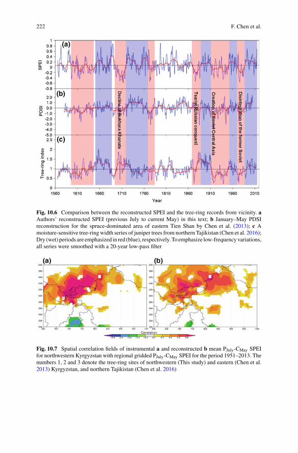
222 F. Chen et al.
Fig. 10.6 Comparison between the reconstructed SPEI and the tree-ring records from vicinity. aAuthors’ reconstructed SPEI (previous July to current May) in this text; b January–May PDSIreconstruction for the spruce-dominated area of eastern Tien Shan by Chen et al. (2013); c Amoisture-sensitive tree-ring width series of juniper trees from northern Tajikistan (Chen et al. 2016);Dry (wet) periods are emphasized in red (blue), respectively. To emphasize low-frequencyvariations,all series were smoothed with a 20-year low-pass filter
Fig. 10.7 Spatial correlation fields of instrumental a and reconstructed b mean PJuly-CMay SPEIfor northwestern Kyrgyzstan with regional gridded PJuly-CMay SPEI for the period 1951–2013. Thenumbers 1, 2 and 3 denote the tree-ring sites of northwestern (This study) and eastern (Chen et al.2013) Kyrgyzstan, and northern Tajikistan (Chen et al. 2016)

10 A Drought Reconstruction from the Low-Elevation … 223
Table 10.2 Rankings of the dry/wet years and periods for northwestern Kyrgyzstan
10 most extreme years 10 wettest and driest decades
Year Driest Year Wettest Year Driest Year Wettest
1713 −0.58 1797 0.91 1710 −0.27 1720 0.36
1976 −0.56 1690 0.87 1700 −0.23 1680 0.32
1773 −0.53 1689 0.87 1870 −0.18 1760 0.32
1706 −0.53 1573 0.83 1940 −0.15 1820 0.29
1876 −0.53 1824 0.80 1610 −0.14 1990 0.25
1711 −0.51 1686 0.78 1910 −0.10 1730 0.23
1775 −0.48 1663 0.77 1970 −0.08 1950 0.22
1975 −0.46 1760 0.77 1640 −0.07 2000 0.22
1597 −0.45 1724 0.76 1980 −0.07 1830 0.21
1939 −0.45 1691 0.71 1770 −0.07 1660 0.20
Fig. 10.8 Results ofsuperposed epoch analysis(SEA) testing the impact ofextreme dry years. The boldand dotted lines indicate the95 and 99% significancelevel, respectively
area of eastern Tien Shan, eastern Kyrgyzstan and China (Chen et al. 2013), and pro-vided a chance to validate our drought reconstruction.Correlation betweenChen et al.(2013) and this study, computed over the period 1580–2005 are 0.22 (p < 0.001), andincrease to 0.41 (p < 0.001) after 20-year smoothing, respectively. Our SPEI recon-struction shows high similarities with the drought series in eastern Tien Shan (Chenet al. 2013) (Fig. 10.7). The comparison reveal that regional dry conditions dur-ing 1598–1646, 1695–1719, 1774–1785, 1870–1888, 1911–1950 and 1971–1987,and wet conditions during 1651–1690, 1720–1773, 1889–1910, 1951–1970 and1988–2005 found in eastern and western Tien Shan, Kyrgyzstan. Some extremelydry events of the spruce-dominated area (e.g. 1774–1775, 1885–1886, 1917–1919,1974–1976) also found in the western Tien Shan.
Further west, the study showed that tree-ring widths of juniper trees of northernTajikistan were also sensitive to PAugust-CJuly drought variations (Chen et al. 2016).The period 1850 to 2005 appears to coincide with similar dry/wet periods in TienShan. In particular, juniper and spruce series both show a upward trend at the period1987–2015, suggesting a consistent wetting trend in Central Asia. However, some
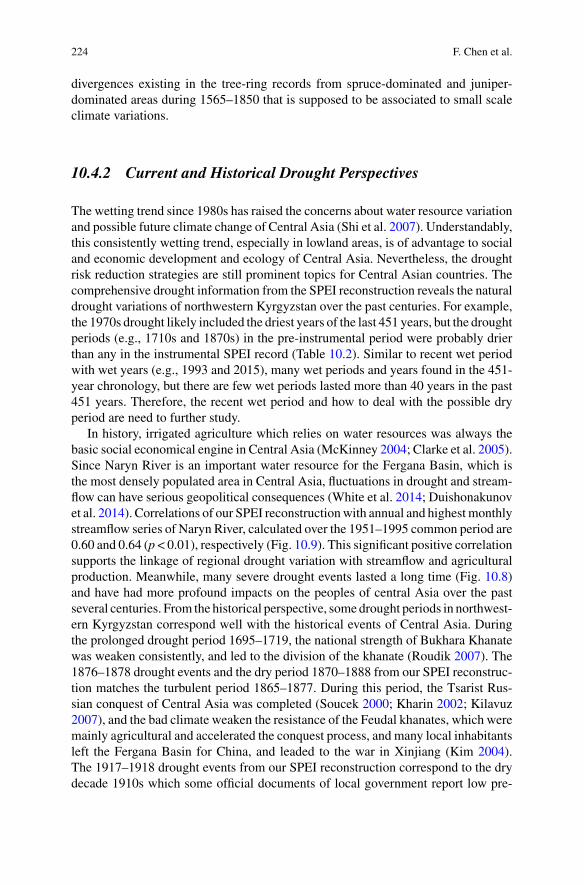
224 F. Chen et al.
divergences existing in the tree-ring records from spruce-dominated and juniper-dominated areas during 1565–1850 that is supposed to be associated to small scaleclimate variations.
10.4.2 Current and Historical Drought Perspectives
The wetting trend since 1980s has raised the concerns about water resource variationand possible future climate change of Central Asia (Shi et al. 2007). Understandably,this consistently wetting trend, especially in lowland areas, is of advantage to socialand economic development and ecology of Central Asia. Nevertheless, the droughtrisk reduction strategies are still prominent topics for Central Asian countries. Thecomprehensive drought information from the SPEI reconstruction reveals the naturaldrought variations of northwestern Kyrgyzstan over the past centuries. For example,the 1970s drought likely included the driest years of the last 451 years, but the droughtperiods (e.g., 1710s and 1870s) in the pre-instrumental period were probably drierthan any in the instrumental SPEI record (Table 10.2). Similar to recent wet periodwith wet years (e.g., 1993 and 2015), many wet periods and years found in the 451-year chronology, but there are few wet periods lasted more than 40 years in the past451 years. Therefore, the recent wet period and how to deal with the possible dryperiod are need to further study.
In history, irrigated agriculture which relies on water resources was always thebasic social economical engine in Central Asia (McKinney 2004; Clarke et al. 2005).Since Naryn River is an important water resource for the Fergana Basin, which isthe most densely populated area in Central Asia, fluctuations in drought and stream-flow can have serious geopolitical consequences (White et al. 2014; Duishonakunovet al. 2014). Correlations of our SPEI reconstructionwith annual and highestmonthlystreamflow series of Naryn River, calculated over the 1951–1995 common period are0.60 and 0.64 (p < 0.01), respectively (Fig. 10.9). This significant positive correlationsupports the linkage of regional drought variation with streamflow and agriculturalproduction. Meanwhile, many severe drought events lasted a long time (Fig. 10.8)and have had more profound impacts on the peoples of central Asia over the pastseveral centuries. From the historical perspective, some drought periods in northwest-ern Kyrgyzstan correspond well with the historical events of Central Asia. Duringthe prolonged drought period 1695–1719, the national strength of Bukhara Khanatewas weaken consistently, and led to the division of the khanate (Roudik 2007). The1876–1878 drought events and the dry period 1870–1888 from our SPEI reconstruc-tion matches the turbulent period 1865–1877. During this period, the Tsarist Rus-sian conquest of Central Asia was completed (Soucek 2000; Kharin 2002; Kilavuz2007), and the bad climate weaken the resistance of the Feudal khanates, which weremainly agricultural and accelerated the conquest process, and many local inhabitantsleft the Fergana Basin for China, and leaded to the war in Xinjiang (Kim 2004).The 1917–1918 drought events from our SPEI reconstruction correspond to the drydecade 1910s which some official documents of local government report low pre-
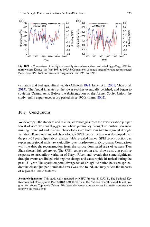
10 A Drought Reconstruction from the Low-Elevation … 225
Fig. 10.9 a Comparison of the highest monthly streamflow and reconstructed PJuly-CMay SPEI fornorthwestern Kyrgyzstan from 1951 to 1995. bComparison of annual streamflow and reconstructedPJuly-CMay SPEI for t northwestern Kyrgyzstan from 1951 to 1995
cipitation and bad agricultural yields (Allworth 1994; Esper et al. 2001; Chen et al.2013). The feudal khanates at the lower reaches eventually perished, and began tosovietize Central Asia. Before the disintegration of the former Soviet Union, thestudy region experienced a dry period since 1970s (Lamb 2002).
10.5 Conclusions
We developed the standard and residual chronologies from the low-elevation juniperforest of northwestern Kyrgyzstan, where previously drought reconstruction weremissing. Standard and residual chronologies are both sensitive to regional droughtvariation. Based on standard chronology, a SPEI reconstruction was developed overthe past 451 years. Spatial correlation fields revealed that our SPEI reconstruction canrepresent regional moisture variability over northwestern Kyrgyzstan. Comparisonwith the drought reconstruction from the spruce-dominated area of eastern TienShan shows high coherency. The SPEI reconstruction also shows a strong positiveresponse to streamflow variation of Naryn River, and reveals that some significantdrought events are linked with regime change and catastrophic historical during thepast 451 year. The spatiotemporal divergence of drought variation between spruce-dominated and juniper-dominated areas was also found, and may reflect the impactsof regional climate features.
Acknowledgements This study was supported by NSFC Project (41405081), The National KeyResearch and Development Plan (2018YFA0606400) and the National Ten Thousand Talent Pro-gram for Young Top-notch Talents. We thank the anonymous reviewers for useful comments toimprove the manuscript.
226 F. Chen et al.
References
Allworth, E. (1994). Central Asia, 130 years of Russian dominance: A historical overview. DukeUniversity Press.
Chen, F., Yuan, Y. J., Chen, F. H., Wei, W. S., Yu, S. L., Chen, X. J., et al. (2013). A 426-yeardrought history for Western Tian Shan, Central Asia inferred from tree-rings and its linkages tothe North Atlantic and Indo-West Pacific Oceans. Holocene, 23, 1095–1104.
Chen, F., Yuan, Y. J., Wei, W. S., Zhang, T. W., Shang, H. M., & Zhang, R. (2014). Precipitationreconstruction for the southern Altay Mountains (China) from tree rings of Siberian spruce,reveals recent wetting trend. Dendrochronologia, 32, 266–272.
Chen, F., Yuan, Y. J., Yu, S. L., Zhang, T. W., Shang, H. M., Zhang, R. B., et al. (2015a). A 225-yearlong drought reconstruction for east Xinjiang based on Siberia larch (Larix sibirica) tree-ringwidths: Reveals the recent dry trend of the eastern end of Tien Shan. Quaternary International,358, 42–47.
Chen, F., Yuan, Y. J., Wei, W. S., Yu, S. L., Zhang, T. W., Shang, H. M., et al. (2015b). Tree-ringrecorded hydroclimatic change in Tienshan mountains during the past 500 years. QuaternaryInternational, 358, 35–41.
Chen, F., Yu, S. L., He, Q., Zhang, R. B., Kobuliev, Z. V., &Mamadjonov, Y.M. (2016). Comparisonof drought signals in tree-ringwidth records of juniper trees fromCentral andWestAsia during thelast four centuries. Arabian Journal of Geosciences. https://doi.org/10.1007/s12517-015-2253-1.
Clarke, D., Sala, R., Deom, J. M., & Meseth, E. (2005). Reconstructing irrigation at Otrar Oasis,Kazakhstan, AD 800–1700. Irrigation and Drainage, 54, 375–388.
Cook, E. R. (1985). A time series analysis approach to tree-ring standardization. University ofArizona, Tucson [Ph.D. thesis].
Cook, E. R., Kairiukstis L. A. (1990). Methods of Dendrochronology: applications in the environ-mental sciences. Boston: Kluwer Academic Publishers.
Cook, E. R., Woodhouse, C. A., Eakin, C. M., Meko, D. M., & Stahle, D. W. (2004). Long-termaridity changes in the western United States. Science, 306, 1015–1018.
Duishonakunov, M., Imbery, S., Narama, C., Mohanty, A., & King, L. (2014). Recent glacierchanges and their impact on water resources in Chon and Kichi Naryn Catchments, KyrgyzRepublic. Water Science and Technology: Water Supply, 14(3), 444–452.
Esper, J., Treydte, K., Gärtner, H., & Neuwirth, B. (2001). A tree ring reconstruction of climaticextreme years since 1427 AD for Western Central Asia. Palaeobotanist, 50, 141–152.
Fang, K., Davi, N., Gou, X., Chen, F., Cook, E., Li, J., et al. (2010). Spatial drought reconstructionsfor central High Asia based on tree rings. Climate Dynamics, 35, 941–951.
Gou, X., Gao, L., Deng, Y., Chen, F., Yang, M., & Still, C. (2015). An 850-year tree-ring-basedreconstruction of drought history in the western Qilian Mountains of northwestern China. Inter-national Journal of Climatology, 35, 3308–3319.
Gray, S. T., Graumlich, L. J., & Betancourt, J. L. (2007). Annual precipitation in the Yellowstonenational park region since AD 1173. Quaternary Research, 68, 18–27.
Harris, I., Jones, P. D., Osborn, T. J., & Lister, D. H. (2014). Updated high-resolution grids ofmonthly climatic observations–the CRU TS3. 10 Dataset. International Journal of Climatology,34, 623–642.
Haurwitz, M. W., & Brier, G. W. (1981). A critique of the superposed epoch analysis method—Itsapplication to solar-weather relations.Monthly Weather Review, 109, 2074–2079.
Holmes, R. L. (1983). Computer-assisted quality control in tree-ring dating and measurement.Tree-Ring Bulletin, 44, 69–75.

10 A Drought Reconstruction from the Low-Elevation … 227
Kharin, N. (2002). Vegetation degradation in Central Asia under the impact of human activities.Springer Science & Business Media.
Kilavuz, I. T. (2007).Understanding violent conflict: A comparative study of Tajikistan and Uzbek-istan. Indiana University.
Kim, H. (2004). Holy war in China: The Muslim rebellion and state in Chinese Central Asia,1864–1877. Stanford University Press.
Lamb, H. H. (2002). Climate, history and the modern world. Routledge.McKinney, D. C. (2004). Cooperative management of transboundary water resources in CentralAsia. In The tracks of tamerlane: Central Asia’s path to the 21st century (pp. 187–220). Wash-ington, DC: National Defense University.
Neukom, R., Luterbacher, J., Villalba, R., Küttel, M., Frank, D., Jones, P. D., et al. (2010). Multi-centennial summer and winter precipitation variability in southern South America. GeophysicalResearch Letters, 37, L14708. https://doi.org/10.1029/2010GL043680.
Opała, M., Niedzwiedz, T., Rahmonov, O., Owczarek, P., & Małarzewski, Ł. (2017). Towardsimproving the Central Asian dendrochronological network—new data from Tajikistan, Pamir-Alay. Dendrochronologia, 41, 10–23.
Roudik, P. (2007). The history of the Central Asian republics. Greenwood Publishing Group.Seim, A., Tulyaganov, T., Omurova, G., Nikolyai, L., Botman, E., & Linderholm, H. W. (2016a).Dendroclimatological potential of three juniper species from the Turkestan range, northwesternPamir-Alay Mountains. Uzbekistan. Trees, 30(3), 733–748.
Seim,A., Omurova, G., Azisov, E.,Musuraliev, K., Aliev, K., Tulyaganov, T., et al. (2016b). Climatechange increases drought stress of Juniper trees in themountains ofCentralAsia.PLoSOne, 11(4),e0153888.
Shi, Y. F., Shen, Y. P., Kang, E. S., Li, D. L., Ding, Y. J., Zhang, G. W., et al. (2007). Recent andfuture climate change in northwest China. Climate Change, 80, 379–393.
Soucek, S. (2000). A history of inner Asia. Cambridge University Press.Touchan, R., Anchukaitis, K. J., Meko, D.M., Sabir, M., Attalah, S., &Aloui, A. (2011). Spatiotem-poral drought variability in northwestern Africa over the last nine centuries. Climate Dynamics,37, 237–252.
Vicente-Serrano, S. M., Beguería, S., López-Moreno, J. I., Angulo, M., & El Kenawy, A. (2010).A new global 0.5 gridded dataset (1901–2006) of a multiscalar drought index: Comparison withcurrent drought index datasets based on the Palmer Drought Severity Index. Journal of Hydrom-eteorology, 11, 1033–1043.
White, C. J., Tanton, T. W., & Rycroft, D. W. (2014). The impact of climate change on the waterresources of the AmuDarya basin in central Asia.Water ResourcesManagement, 28, 5267–5281.
Wigley, T. M., Briffa, K. R., & Jones, P. D. (1984). On the average value of correlated time series,with applications in dendroclimatology and hydrometeorology. Journal of Climate and AppliedMeteorology, 23, 201–213.
Yang, B., Qin, C.,Wang, J., He,M.,Melvin, T.M., Osborn, T. J., et al. (2014). A 3500-year tree-ringrecord of annual precipitation on the northeastern Tibetan Plateau. Proceedings of the NationalAcademy of Sciences, 111(8), 2903–2908.
Yuan, Y., Shao, X., Wei, W., Yu, S., Gong, Y., & Trouet, V. (2007). The potential to reconstructManasi River streamflow in the northern Tien ShanMountains (NWChina). Tree-Ring Research,63, 81–93.
Zhang, T. W., Yuan, Y. J., Liu, Y., Wei, W. S., Yu, S. L., Chen, F., et al. (2013). A tree-ring basedprecipitation reconstruction for the Baluntai region on the southern slope of the central Tien ShanMountains, China, since AD 1464. Quaternary International, 283, 55–62.
228 F. Chen et al.
Zhang, T., Zhang, R., Yuan, Y., Gao, Y., Wei, W., Diushen, M., et al. (2015). Reconstructed pre-cipitation on a centennial timescale from tree rings in the western Tien Shan Mountains, CentralAsia. Quaternary International, 358, 58–67.
Zhang, R. B., Yuan, Y. J., Gou, X. H., He, Q., Shang, H. M., Zhang, T. W., et al. (2016). Tree-ring-based moisture variability in western TianshanMountains since AD 1882 and its possible drivingmechanism. Agricultural and Forest Meteorology, 218, 267–276.
Open Access This chapter is licensed under the terms of the Creative Commons Attribution 4.0International License (http://creativecommons.org/licenses/by/4.0/), which permits use, sharing,adaptation, distribution and reproduction in any medium or format, as long as you give appropriatecredit to the original author(s) and the source, provide a link to the Creative Commons license andindicate if changes were made.
The images or other third party material in this chapter are included in the chapter’s CreativeCommons license, unless indicated otherwise in a credit line to the material. If material is notincluded in the chapter’s Creative Commons license and your intended use is not permitted bystatutory regulation or exceeds the permitted use, you will need to obtain permission directly fromthe copyright holder.

Part IVClimatic Factors in the Transitions
of Social Systems
Chapter 11Social Impacts of Climate Changein Historical China
Xiuqi Fang, Yun Su, Zhudeng Wei and Jun Yin
Abstract The social impact of past climate change is one of the key areas of studyrelating to global climate change, particularly its ability to provide valuable lessonsfor dealing with ongoing challenges of global climate change. Drawing on the abun-dant historical literature, many recent studies have examined the social impacts ofclimate change in China during the past 2000 years. This paper reviews the mainprogress of these studies in three parts. First, a concept model based on the foodsecurity in relation to global climate change has been constructed, which can thenbe used to interpret impact-response processes of climate change in the history ofChina. Second, we derive a methodology for quantifying the impact of historicalclimate change, drawing on a series of 4 key social and economic sequences at a10-year resolution. These have been reconstructed based on the semantic differen-tial method over the past 2000 years in China. Third, using a variety of statisticalanalyses, we update the understanding of climate impacts throughout the history ofChina. The overall impacts of climate were negative in the cold periods and positivein the warm periods, at decadal to centennial scales during Chinese history. However,the impacts seemed a mixed blessing both in the cold or warm periods. The social-economic development and population growth in warm periods would intensify thenatural resource shortage and disequilibria in the human-environment system, espe-cially when encountering abrupt climate changes. Adaptation to adverse climatechange could not only help people to avoid hardship whilst maximizing profits, butalso expanded the capabilities for the continual development of Chinese civilization.
X. Fang (B) · Y. SuFaculty of Geographical Science, Key Laboratory of Environment Change and Natural DisasterMOE, Beijing Normal University, Beijing 100875, Chinae-mail: [email protected]
Z. WeiSchool of Geographical Sciences, Nanjing University of Information Science and Technology,Nanjing 210044, China
J. YinKey Laboratory of Land Surface Pattern and Simulation, Institute of Geographic Sciences andNatural Resources Research, CAS, Beijing 100101, China
© The Author(s) 2019L. E. Yang et al. (eds.), Socio-Environmental Dynamics along the Historical Silk Road,https://doi.org/10.1007/978-3-030-00728-7_11
231

232 X. Fang et al.
Keywords Historical period · Climate change · Social impactProcess mechanism · China
11.1 Introduction
As the most active element in the natural environment, climate change has had wideand profound impacts on human society at multiple temporal and spatial scales,although it might not a determinative driving force. A growing number of cases fromall around the world have proved that climate change played an important role in therise and fall of regional civilizations, especially during the period before industrialrevolution (deMenocal 2001; Haug et al. 2003; Zhang et al. 2007; Büntgen et al.2011; Butzer 2012; Buckley et al. 2014).
The lessons learned from the past are valuable for current human populationsto improve our understanding of the impact of ongoing climate change, and socialadaptation to the challenge of future global change appropriately (IHOPE 2010).Studies on the impacts of past climate change worldwide can be summarized as fol-lows. First, climate change could lead to both positive or negative social changes,from production systems to social systems, such as harvest fluctuation, populationvariation and migration, economic fluctuation, social harmony and crisis, and dynas-tic transition, at multiple temporal and spatial scales (Büntgen et al. 2011; Tol et al.2010; Pederson et al. 2014; Zhang et al. 2007; Lee et al. 2008). Second, the way ofclimate change impacting society could be summarized through 5 general patterns(Fang et al. 2017), including periodic changes (Zhang et al. 2005; Lee et al. 2008),pulse (Pederson et al. 2014), adaptive transition (Willcox et al. 2009; Chen et al.2015), collapse (Weiss et al. 2001; Haug et al. 2003; Douglas et al. 2015), migrationand replacement (Büntgen et al. 2011, 2016; Kuper et al. 2006; Timmermann et al.2016). Third, there is a set of studies focusing on the impact mechanism of climatechange. A few attempts have been made under an idealized theoretical framework,for example the concept of social resilience for interpreting historical collapse assummarized from case studies (Butzer 2012), or a set of causal linkages relating cli-mate change to large-scale human crises in preindustrial Europe (1500–1800) basedon statistical analysis (Zhang et al. 2011). However, most of the above conclusionshave been derived from direct comparisons of historical climate change events andrelated social phenomena occurring during the same period. A more detailed under-standing of the processes and mechanisms of climate change impacts remain to beresearched quantitatively.
China is a country that has great potential for the research of impacts of pastclimate change. As an agriculture-oriented society under the Asia monsoon climateregime, the history of China has been strongly impacted by climate change. Althoughhistorical China varied its borders from dynasty to dynasty, its core social-economicclosely aligned with the major agricultural area throughout history. This geographicand temporal overlap allows for continuous comparison across the Chinese coreareas. There are abundant historical records spanning thousands of years that relate

11 Social Impacts of Climate Change in Historical China 233
the impacts of and adaption to climate change in China. These records provide oppor-tunity for studying the process and mechanism of the social impacts of past climatechange and human adaptation. Using the information from these historical litera-tures, a number of studies have examined the interaction mechanisms and processesof social impacts of historical climate change in China. This paper summarizes themain findings relating to the impacts of climate change in China during the past2000 years.
11.2 Concept Model: Impact-Response Processesof Climate Change Under the Framework of FoodSecurity
Agriculture was the foundation for ancient China, as such food security was notonly the material foundation for human survival, but also the base for maintainingthe economic development and the stabilization of social system. There is a generalconsensus that climate change has had a strong impact on historical agriculturalproduction in China (Ge 2011; Ge et al. 2014; Zhang et al. 2005, 2006).
To further understand the impact of climate change, recent studies use conceptsof vulnerability and food security in relation to Global Changes(GECFS) (Ericksen2008) to illustrate the impacts of, and responses to (impact-response processes) his-torical climate change in China. Corresponding to the concepts of food access, foodavailability and food utilization, the food security of historical China can be simpli-fied to three levels of security—food production, food supply and food consumption.In this system, the impact of climate change is most pronounced upon grain harvestin the food production subsystem. These impacts are then transferred further up tothe subsystems of economy, population and society (Fig. 11.1). However, due to thecomplexity of human society, the impact-response processes of climate and socialchange could not be attributed to a simple causality. The initial impact could be ampli-fied or suppressed in feedbacks, which processed within or between subsystems ofhuman society (such as cultivated land area, population, policy, and the surroundingneighbors, etc.) (Fang et al. 2015). Both the spontaneous behaviors of the people andthe policies and operations of governments played very important roles in all stepsof adjusting the responses to the impacts of climate change. But each adjustmenthad its limitation under the given historical condition. The impact of climate changecould be positive or negative. To a certain degree, even the negative impacts couldbe converted into new opportunity for development if right countermeasures weretaken.
(1) Food production security, is the fundamental aspect in ensuring an overall foodsecurity. The relationship between any given population and the productivity ofits land-use systems is dynamic and responsive not only to demographic forcingbut also to the social and economic processes regulating resource demand, landavailability, technology adoption and availability, environmental variation, and
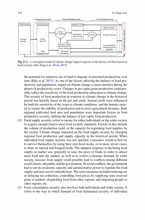
234 X. Fang et al.
Fig. 11.1 A conceptual model of climate change impact-response in the history of China based onfood security (after Fang et al. 2014a, 2015)
the potential for intensive use of land to degrade its potential productivity overtime (Ellis et al. 2013). As one of the factors affecting the balance of food pro-ductivity and population, impact of climate change is more sensitive during thephases of productivity crises. Changes in per capita grain production could pos-sibly reflect the sensitivity of the food production subsystem to climate change.The security of food production in response to climate change in the historicalperiod was initially based on the per unit yield. Annual yields were influencedby both the sensitivity of the crops to climate conditions, and the human capac-ity to ensure the stability of production and to resist agricultural disasters. Bothregional cultivated land area and population were important factors in foodproduction security, shifting the balance of per capita food production.
(2) Food supply security, refers to means for either individuals or the wider societyto acquire enough food to meet food security standards. Factors in this includethe volume of production yield, or the capacity for regulating food supplies bythe society. Climate change impacted on the food supply security by changingregional food production and supply capacity in the historical period. Whenindividual food supply security was not satisfied, consumers would at first tryto survive themselves by using their own food stocks, or in more severe cases,to draw on natural and foraged foods. The adaptive response to declining foodsupply in market was generally to raise the price of foods in order to attractmore food into the market, as well as to restrict consumer demand. In widersociety, insecure food supply could possibly lead to conflicts among differentsocial classes, the public and the government. To avoid conflicts, the governmenthad to use its economic capacity and administrative power to regulate the foodsupply and ease social contradictions. Themainmeasures included reducing taxor delaying tax collection, controlling food prices by supplying state reservedgrain to markets, dispatching food from other regions, and migrating people toother regions, etc.
(3) Food consumption security also involves both individuals and wider society. Itrefers to the way in which demand of food maintained security of individual
11 Social Impacts of Climate Change in Historical China 235
livelihood and social-economic development. If insecurity in the food supply ofindividuals threatened the security of individual’s food consumption, it wouldbecome a threat to survival, potentially resulting in a large number of faminevictims. The famines could develop into refugee flows, trigger social unrest,and even cause social instability or collapse. Under such situations, the mea-surements for regulating food consumption security taken by the governmentsgenerally included the following aspects: to relieve refugees in order to avoidenlarging the size of refugee populations; to encourage spontaneous or orga-nized migration to reduce population pressure in the region affected by climatechange; to maintain public security and social stability, and to avoid the feudaldynasty being endangered by enlarged unrests.
Under this framework of food security, the impact and response mechanisms ofclimate on society in historical China began with the direct impact of climate on theharvest, and then were transmitted in two basic routes. One was harvest—faminevictims—social instability for individual food security; the other was harvest—e-conomy—social stability for social food security (Fang et al. 2014a). Along theindividual food security transmission chain, the impacts were regulated by socialfood security, which was mainly through the regulation of economy to populationand social system.
11.3 Methodology: Quantifying Historical Socialand Economic Series Based on Semantic DifferentialOver the Past 2000 Years in China
Reconstructing social-economic series with the same temporal resolution, duration,and continuity as climate series is a precondition for studying the processes andmechanisms of the impacts of climate change in history. The key quantifiable vari-ables should be able to represent the subsystems of agriculture, population, economy,society, etc. The most difficult issue for the quantification is a lack of standardizedsocial-economic statistical data in historical China. Other data, such as population,farmland area, price and etc. are discontinuous throughout the past few thousandyears, except for the relatively continuous data of crop harvest in the Qing Dynasty.
On the other hand, China has abundant, continuous and high-resolution historicalliterature over the past 2000 years to record or describe the social-economic con-ditions. The Chinese words are rich in meaning. The semantic differential of thesewords is definite, and the meaning of the word is generally stable during the his-tory. Therefore the historical records could be used to reconstruct graded climaticseries (Zheng et al. 2006) and socio-economic series based on Semantic Differential.The two key methods for the reconstruction are gradation of literal description andnormalization of time resolution, respectively (Fig. 11.2) (Fang et al. 2014b).
The core of the Semantic Differential method is to convert the qualitative descrip-tion of the social-economic conditions during different historical periods into quanti-

236 X. Fang et al.
Fig. 11.2 Methodology forquantifying historical socialand economic series basedon Semantic Differential(Fang et al. 2014b)
tative grades. In thismethod, the properties of the objects are distinguished by bipolaradjectives (relativity and antonym), which are quantified by the adverbs of differentdegrees, such as extreme, very, somewhat, normal, etc. To construct the grading scaleby Semantic Differential, it is important to pay attention to whether the meaningsof the vocabularies are easily distinguished, and to consider the physical meaningsof the standard vocabularies corresponding to each level as much as possible. Thereare generally 4 steps that the literal descriptions are quantified to grades, althoughthe implementation for quantifying the literal descriptions to grades is varied basedon individual properties of the records. These steps are as follows: (1) collecting thedirect and indirect literal records on social and economic description; (2) confirmingthe standard of classified quantification against reconstruction indexes; (3) rankingthe grades of social-economic condition reflected in the historical documents, onthe basis of the classified quantification standard; (4) analyzing the rationality ofclassified results (Fang et al. 2014b).
Following is an example of the gradation of historical harvest (Su et al. 2014; Fanget al. 2014b). It is based on 2755 items of original descriptions regarding agriculturalyields garnered from the 25 chronicles on the dynastic histories of China namedTwenty-Four Histories and Qing History Draft,1 covering the period from WesternHan Dynasty (206 BC–AD 24) to the Qing Dynasty (AD 1645–1911). Detaileddescriptions on the steps and the uncertainties of the reconstruction are described inSu et al. (2014) and Yin et al. (2015).
The bipolar adjectives, such as “bumper” and “poor” in the records of harvest inhistorical Chinawere used to distinguish the good or bad variation on the annual grain
1 .
11 Social Impacts of Climate Change in Historical China 237
production relative to average grain yield (normal or common year). The superpo-sition of adverbs of degree, such as “very bumper/poor”, “near bumper/poor”, wereused to further distinguish the level of the harvest.
The key words describing crop harvest corresponded well to the quantified ten-point harvest system (10 points represent 100% of per capita harvest was met; witheach 1 point reduction correspondingwith a 10%diminishing of harvest) in historicalChina. This provides proof that such descriptions of harvest have clearly physicalmeanings to be used to identify annual crop harvest grades that could be selected asreference, and that standard words represent the different harvest grades. Referringto the standard words, the annual grain yield was divided into six levels from 1 to6 corresponding to the key words of “Very poor harvest”, “Poor harvest”, “Slightlypoor harvest”, “Normal harvest”, “Near bumper” and “Bumper”, respectively, basedon the semantic differential. By matching the descriptions on bumper or poor grainyields from historical documents to the key words, the annual harvest grade seriesis reconstructed, which is used to reconstruct a harvest index series for unifying thetime resolution later.
Several principles are given for the gradation of annual harvest records. (1)Records with their time-scale matching or higher than the resolution of the recon-structed series are used initially. (2) Records covering the whole country or the coreagricultural area of the country are prioritized as the main data source; then recordscovering local or marginal regions are used as auxiliary records, on the conditionof correcting their spatial representation to the national scale. (3) Direct evidencefrom the historical record are used first, following by the indirect evidence. Whendisagreement between records occurs, the position supported by the majority ofrecords is adopted. (4) In periods without any record spanning only 1 or 2 years,these are regarded as average years according to the basic principle that history usu-ally recorded unusual events rather than common events; if the no-record years areup to or more than 3 to 4 consecutive years, they are graded in reference to the majorhistorical events of the period.
Time-scale normalization is mainly used to solve the problems that time resolu-tions of original grade series are unequal or the series is discontinuous, by up-scalingor down-scaling the series. 10 years have been used as the basic time unit for up-scaling the annual resolution data or down-scaling the lower than decadal resolutiondata (Fang et al. 2014b).
The 10-year resolution harvest grade series of China in past 2000 years is anexample of time up-scaling (Fig. 11.3). The historical harvest records were recordedin annual resolution, but theywere discontinued in some years. To reconstruct a gradeseries of harvest in 10 years resolution, an up-scaling method was needed to convertannual resolution series into decadal resolution series. In our research, the annualharvest grade series had been converted to a decadal harvest index by calculatingdecadal average of the annual harvest grade with unequal weights. Then a harvestgrade series at 10 years resolution has been reconstructed by dividing the decadalharvest index value into 5 grades.
The 10-year resolution macroeconomy grade series of China in past 2000 years isan example of time down-scaling (Wei et al. 2015a; Fang et al. 2014b). The series was

238 X. Fang et al.
Fig. 11.3 Climate Change and socio-economic grade series during the past 2000 years in China. aWinter-half-year temperature anomaly with 30-year resolution during 210 BC-1910 AD in EasternChina (Ge 2011); b wet-dry index of Eastern China during 101-1910 AD (Zheng et al. 2006); c–f10-year resolution grade series of the grain harvest (Yin et al. 2015), macroeconomy (Wei et al.2015a), fiscal balance (Wei et al. 2014), social vicissitudes (Yin et al. 2016a), respectively, in thepast 2000 years in China, and the grade 1–5 represents the state from bad to good, respectively
reconstructed on the basis of 1091 records regarding the economic history of China,extracted from 25 books written by leading Chinese scholars and published in the lastthirty years. The time resolution of the historical records on the macroeconomy ofChina varied from annual scale to the empire-scale (usually 20–30 years) resolutionor even dynasty-scale (centennial scale) resolution. The 10-year resolution macroe-conomy grade series of China was reconstructed through the following steps. First,to identify the grade or changing trend from one grade to other one, according to eachhistorical record; then by integrating all data in different resolutions from annual tocentennial to divide relative low temporal resolution data into 10 years resolutionstep by step, using the differences of start/end year and temporal resolution amongthe records; and lastly re-sampling the grade data decade by decade.

11 Social Impacts of Climate Change in Historical China 239
Using the gradation methodology of semantic differential, 4 historical social-economic graded series of China in 10 years resolution over the past 2000 years,including harvest (Su et al. 2014; Yin et al. 2015), economy (Wei et al. 2015a, b),finance (Wei et al. 2014) and social vicissitudes (Yin et al. 2016a, b), have beenquantitatively reconstructed (Fig. 11.3). In addition, other series of famine index,peasant uprising frequency, and frequency of wars waged between nomadic andfarming groups of China in 10 years resolution over the past 2000 years were alsoreconstructed (Teng et al. 2014; Fang et al. 2015; Su et al. 2016).Detailed descriptionson the specific steps and the uncertainties for each reconstructed series are in the citedreferences.
The duration of the series mentioned above was from 210 BC to AD 1910 thatcovered the Western Han Dynasty (206 BC–AD 24) to the Qing Dynasty (AD1645–1911) of China. All the series could represent the social systemic changesin China as a whole over the past 2000 years, because they have a similar spatialcoverage and are mainly based on the historical records coming from the easternpart of China, which has long been the major agricultural area as well as the coresocial-economic area throughout the dynastic history of China. Using these series,and the winter half-year temperature series (Ge 2011) and wet-dry series (Zhenget al. 2006) in eastern China, which also covered the key farming region over the
Fig. 11.4 Historical expansion of the major agricultural area in the history of China and the regioncovered by the temperature series and the wet-dry series over the past 2000 years (Yin et al. 2015)

240 X. Fang et al.
past 2000 years (Fig. 11.4), the impacts of historical climate change on society ofChina could be quantitatively analyzed.
11.4 Scientific Understanding: The Macroscopic Rhythmof Climate and Social-Economic Changes
By analyzing the relationship between climate change and social-economic changesin China over the past 2000 years, the scientific understanding of general charac-teristics of the impacts of historical climate change on social-economy in China aresummarized in the following.
First, as many scholars have surmised (Hsu 1998; Lee et al. 2008; Zhang et al.2005, 2006; Ge 2011; Ge et al. 2014; Pei et al. 2014), the general characteristicsof the impacts of historical climate change were negative in the cold periods andpositive in the warm periods. On the centennial scale, the flourishing of economicand social health, population increase and territorial expansion generally occurredin the warm periods, with an inversion occurring during cold periods (Yin et al.2015, 2016b; Wei et al. 2014,2015a, b). Among the 34 dynastic prosperity periodsin the empirical China, 18 occurred in warm or relative warm periods, 26 of themoccurred when the climate changed from cold to warm. On the other hand, 11 ofthe14 dynastic transitions periods occurred in cold or relative cold periods (Yin et al.2016b). The primary driver of the above processes are regarded to bewarm conditionsgenerally benefitting agricultural development. The better harvest could provide thematerial foundation to accelerate social-economic development. The main impactof cold periods are to increase vulnerability of human systems, causing a capacitydecrease in social-economic system, limiting ability to respond to climate change orsocial-economic crisis.
Second, further to simple correlation of negative conditions in the cold periodsand positive in the warm periods, both the impacts of warm and cold climate seemeda mixed blessing from a view of social development. The social-economic develop-ment and population growth in warm periods increased the pressures on the naturalenvironment via resource utilization. For the agriculture-based society of empiricalChina, such a high pressure could lead to natural resource shortage and disequilib-ria in the human-environment system, and trigger social crisis when abrupt climatechange (such as cooling and precipitation decrease) occurred. Among the 9 highsocial risk periods indicated by the social-economic series over the past 2000 yearsin China, 8 were partially or wholly contemporary with the transition periods ofclimate from warm to cold (Ge et al. 2015; Yin et al. 2016b). During these periods,extreme climate events or disasters were likely to trigger social crises, some of whicheven became the trigger for social turbulence and dynastic collapse or replacement.The collapse of the Ming dynasty was a typical case. On one hand, climate changeturned to cold and dry at the late 16th century to early 17th century that causedthe crop yields decrease directly, resulting in a chronic food crisis in North China,
11 Social Impacts of Climate Change in Historical China 241
destroying the military farm system, and thus exacerbated fiscal deterioration. Onthe other hand, peasantry uprising in Shaanxi and Shanxi provinces were triggeredby the severe droughts which lasted more than 10 years (1627–1643 AD) in north-ern China (named “Chongzhen Drought”), the worst drought event in North Chinaover the past 500 years. The drought had also replenished the peasantry troops, andseverely disrupted the food supply for the government troops. The Ming Dynastyeventually collapsed in a peasant uprising (Zheng et al. 2014; Xiao et al. 2015).
Finally, successful adaptation could not only help populations to mitigate harmswhile also to expanding productivity, but also enhancing the capabilities for the con-tinual development ofChinese civilization. TheChinese people could choose suitablecountermeasures according to the temporal and regional differences in order to adaptto the impacts of climate change. For example, the warm climate of the “MedievalWarm Period” increased heat resources in most areas of China. To adapt to the warmclimate, the people expanded the crop planting boundary northward in the 10th–13thcentury, especially in the agriculture-pasture transitional zone in northern China andthe transitional area between the warm temperate zone and subtropical zone. Duringthe Medieval Warm Period, the Song dynasty (960–1279 AD) had to adapt to theregional differentiation of precipitation regimes, with conditions dry in the south andwet in the north of eastern China. As a response, rice planting areas were expandedto the Yellow River basin of northern China, while Champa rice plantation with ashorter growing season and a rice-wheat succession cropping system was developedin the Yangtze River basin of southern China. The rice-wheat succession croppingsystem, which was finally established in the South Song dynasty (1127–1279 AD)and has been used to the present day, is regarded as an important revolution ofcropping system in Chinese agricultural history that had a profound contribution tosustaining food security and socioeconomic development in China (Ge et al. 2015).Another example of adaptation was by the Qing Dynasty during the Little Ice Age(Fang et al. 2013; Xiao et al. 2015). With the exception of its earliest periods, theQing Dynasty was characterized by tense human-environment relationships for therapid population growth. Against this background, the Qing Dynasty responded andadapted to the impacts of climate change in many ways, including the introductionand expansion of some higher yield crops (such as corn, tuber crop), adjustment of thecropping system to fit the changed climate (such as adopting double cropping rice inthe Yangtze river basin during a period of climate warming in the early 18th century)(Atwell 2002; Ge 2011) and some other agricultural measures. In addition, socialchanges such as encouraging migration to marginal regions for reclamation tookplace. Taking a long time scale perspective, the migration and reclamation appearsto be driven by not only by population pressure and some political factors, but wasalso strongly impacted by climate change, especially extreme climate events. On theshort time scale, migrations were often the result of flood and drought disasters. Forexample, in themid to late 17th century, tens of thousands to hundreds of thousands ofpeople migrated spontaneously or were migrated by government to the areas beyondthe Great Wall, after almost every extreme drought or flood event occurred in NorthChina (Ye et al. 2012). Up to the 19th century, the capacity of Qing Dynasty in cop-ing with disasters was weakened significantly by fiscal crisis. The quarantine policy
242 X. Fang et al.
which isolated Hans and Manchus or Mongols with the Great Wall and the WillowPalisade was conditionally removed and eventually abolished by the Qing Dynasty.As a result, migration to Northeast China where was a vast territory with a sparsepopulation became the main way of dealing with the impacts of adverse climate andextreme climate disasters for the people in North China. These migrations not onlyreduced social risk in North China, but also promoted the development of NortheastChina (Fang et al. 2013; Xiao et al. 2013, 2015).
11.5 Conclusions and Prospects
Based on long-term and continuous historical literature, this paper summarizes themain impacts of climate change during the past 2000 years in China.
First, a concept model based on Food Security is given for studying the impact-response processes of climate change in the history of China. The food security-based concept model proposed in the present study is not only applicable to theancient China, but also to traditional societies relying greatly on agriculture or foodproduction in other areas.
Second, a methodology based on Semantic Differential has been developed forreconstructing and grading social and economic series over the past 2000 years inChina, permitting the impacts of historical climate change on Chinese society to bequantitatively analyzed.
Third, it has renewed scientific understanding of the impacts of climate change inthe history of China, with the impacts generally being negative in the cold periods andpositive in the warm periods but also mixed blessing, and a successful adaptation toclimate change should be considered according to temporal and regional differences.It is different from the traditional Malthusian population theory that positive checks(i.e. hunger, disease, and war, et al.) on population would appear since populationgrowth rate usually exceeded production growth rate (Malthus 1826). Climate changewould lead to the relative overpopulation by shrinking natural resource and thussuffered society from Malthusian trap, but on the other hand, human adaptationscould help the people to survive and to create new opportunities even under the badclimate conditions. This cognition of responses to climate change in history couldprovide valuable lessons for dealing with ongoing challenges of climate change.
Although the summary and review in this paper is mainly based on research inrecent years, the main conclusions align with the consensus of other scholars. Dueto limitations of this article length, we are not able to provide a more detailed dataanalysis, which are available in the cited references.
Because the impacts of historical climate change were highly related to the spe-cific situations of climate and socio-economic development, many gaps in researchon climate-human relationship in Chinese history remain. For instance, it may beproductive to investigate the synergetic features between climate change and socio-economic fluctuations based on those reconstructed time series; it would be helpfulto track the pathways of the transmission of the impacts from climate change to
11 Social Impacts of Climate Change in Historical China 243
ecological changes, agricultural production, population, economic fluctuation, andpolitical or cultural development for better understanding how active elements ofhuman agency (i.e. population, economy and policy, etc.) moderated the impact-response chain from a macro-history perspective; finally it is important to untanglethe influence of climate change from other factors on historical events.
Future studies on historical climate impacts should be focus on spatial and tempo-ral diversification, comprehensive regional analysis and comparison. Therefore it isnecessary to carry out more case studies with specific spatial-temporal scales, froma micro-history perspective. As a result, multidisciplinary integration will be a greathelp in promoting research on the impact of historical climate change.
Acknowledgements This work was supported by the National Natural Science Foundation ofChina (Grant No. 41371201), the Strategic Priority Research Program of the Chinese Academy ofSciences (XDA19040101), and the Major State Basic Research Development Program of China(973 Program) (Grant No. 2010CB950103).
References
Atwell, W. S. (2002). Time, money, and the weather: Ming China and the “Great Depression” ofthe mid-fifteenth century. The Journal of Asian Studies, 61, 83–113.
Buckley, B. M., Fletcher, R., Wang, S. Y. S., Zottoli, B., & Pottier, C. (2014). Monsoon extremesand society over the past millennium on mainland Southeast Asia. Quaternary Science Reviews,95, 1–19. https://doi.org/10.1016/j.quascirev.2014.04.022.
Büntgen,U., Tegel,W.,Nicolussi,K.,McCormick,M., Frank,D., Trouet,V., et al. (2011). 2500yearsof European climate variability and human susceptibility. Science, 331, 578–582.
Büntgen, U., Myglan, V. S., Ljungqvist, F. C., McCormick, M., Di Cosmo, N., Sigl, M., …,Kirdyanov A.V. et al. (2016). Cooling and societal change during the Late Antique Little IceAge from 536 to around 660 AD. Nature Geoscience, 9, 231–236.
Butzer, K. W. (2012). Collapse, environment, and society. Proceedings of the National Academy ofSciences of the United States of America, 109, 3632–3639.
Chen, F. H., & Dong, G. H. (2015). Agriculture facilitated permanent human occupation of theTibet Plateau after 3600 B.P. Science, 347, 248–250.
deMenocal, P. B. (2001). Cultural responses to climate change during the late Holocene. Science,292, 667–673. https://doi.org/10.1126/science.1059827.
Douglas, P. M., Pagani, M., Canuto, M. A., Brenner, M., Hodell, D. A., & Eglinton, T. I. (2015).Drought, agricultural adaptation, and sociopolitical collapse in the Maya Lowlands. Proceedingsof the National Academy of Sciences of the United States of America, 112(5), 607–5612.
Ellis, E. C., Kaplan, J. O., Fuller, D. Q., Vavrus, S., Goldewijk, K. K., & Verburg, P. H. (2013).Used planet: A global history. Proceedings of the National Academy of Sciences of the UnitedStates of America, 110, 7978–7985. https://doi.org/10.1073/pnas.1217241110.
Ericksen, P. J. (2008). Conceptualizing food systems for global environmental change research.Global Environmental Change, 18, 234–245.
Haug, G. H., Gunther, D., Peterson, L. C., Sigman, D. M., Hughen, K. A., & Aeschlimann, B.(2003). Climate and the collapse of Maya civilization. Science, 299, 1731–1735.
Fang, X. Q., Xiao, L. B., & Wei, Z. D. (2013). Social impacts of the climatic shift around the turnof the 19th century on the North China Plain. Science China Earth Sciences, 56, 1044–1058.
Fang, X. Q., Zheng, J. Y., &Ge, Q. S. (2014a). Historical climate change impact-response processesunder the framework of food security in China. Scientia Geographica Sinica, 34, 1291–1298.
Fang, X. Q., Su, Y., Yin, J., Wei, Z. D., Zheng, J. Y., & Luo, Y. H. (2014b). Methodology forquantifying social and economic series on the base of Semantic Differential to serve the researchon impacts of climate change. Quaternary Sciences, 34, 1204–1214.

244 X. Fang et al.
Fang, X. Q., Su, Y., Yin, J., & Teng, J. C. (2015). Transmission of climate change impacts fromtemperature change to grain harvests, famines and peasant uprisings in the historical China.Science China: Earth Sciences, 58, 1427–1439.
Fang, X. Q., & Zhang, D. Y. (2017). Patterns of the impacts of climate change on civilization.Advances in Earth Science, 32, 1218–1225.
Ge, Q. S. (2011). Climate Change through every Chinese dynasty. Beijing: Science Press.Ge, Q. S., Fang, X. Q., & Zheng, J. Y. (2014). Learning from the historical impacts of climaticchange in China. Advances in Earth Science, 29, 23–29.
Ge, Q. S., Zheng, J. Y., Fang, X. Q., Liu, J., Yang, B. (2015). Highlights of the research project onthe forcing and impacts of the warm periods in the past 2000 years. China Basic Science, 22–26.
Hsu, K. J. (1998). Sun, climate, hunger, and mass migration. Science in China Series D-EarthSciences, 41, 449–472.
IHOPE. (2010). Developing an integrated history and future of people on earth: Research plan(IGBP Report No. 59). Stockholm: IGBP Secretariat.
Kuper, R., & Kröpelin, S. (2006). Climate-controlled Holocene occupation in the Sahara: Motor ofAfrica’s evolution. Science, 313, 803–809.
Lee, H. F., Fok, L., & Zhang, D. D. (2008). Climatic change and Chinese population growthdynamics over the last millennium. Climatic Change, 88, 131–156.
Malthus, T. R. (1826). An essay on the principle of population, or a view of its past and presenteffects on human happiness; with an inquiry into our prospects respecting the future removal ormitigation of the evils which it occasions (6th ed.). London: John Murray.
Pei, Q., Zhang, D. D., Lee, H. F., & Li, G. (2014). Climate change and macro-economic cycles inpre-industrial Europe. PLoS ONE, 9, e88155. https://doi.org/10.1371/journal.pone.0088155.
Pederson, N., Hessl, A. E., Baatarbileg, N., Anchukaitis, K. J., & Di Cosmo, N. (2014). Pluvials,droughts, the Mongol Empire, and modern Mongolia. Proceedings of the National Academy ofSciences of the United States of America, 111, 4375–4379.
Su, Y., Fang, X. Q., & Yin, J. (2014). Impact of climate change on fluctuations of grain harvests inChina from the Western Han Dynasty to the Five Dynasties (206 BC–960 AD). Science China:Earth Sciences, 57, 1701–1712.
Su, Y., Liu, L., Fang, X. Q., &Ma, Y. N. (2016). The relationship between climate change and warswaged between nomadic and farming groups from theWestern Han Dynasty to the Tang Dynastyperiod. Climate of the Past Discussions, 12, 137–150.
Teng, J. C., Su, Y., & Fang, X. Q. (2014). The reconstruction and analysis of famine sequencefrom the Western Han to the Qing Dynansty (206BC~1911AD). Journal of Chinese HistoricalGeography, 29, 26–32.
Timmermann, A., & Friedrich, T. (2016). Late Pleistocene climate drivers of early humanmigration.Nature, 538, 91–95.
Tol, R. S. J., & Wagner, S. (2010). Climate change and violent conflict in Europe over the lastmillennium. Climatic Change, 99, 65–79.
Wei, Z., Fang, X., & Su, Y. (2014). Climate change and fiscal balance in China over the past twomillennia. The Holocene, 24, 1771–1784. https://doi.org/10.1177/0959683614551224.
Wei, Z., Rosen, A. M., Fang, X., Su, Y., & Zhang, X. (2015a). Macro-economic cycles related toclimate change in dynastic China. Quaternary Research, 83, 13–23.
Wei, Z., Fang, X., & Su, Y. (2015b). A preliminary analysis of economic fluctuations and climatechanges in China from BC 220 to AD 1910. Regional Environmental Change, 15, 1773–1785.
Weiss, H., & Bradley, R. S. (2001). Archaeology. what drives societal collapse? Science, 291,609–610. https://doi.org/10.1126/science.1058775.
Willcox, G., Buxo, R., & Herveux, L. (2009). Late Pleistocene and early Holocene climate and thebeginnings of cultivation in northern Syria. The Holocene, 19, 151–158.
Xiao, L. B., Fang, X. Q., & Ye, Y. (2013). Reclamation and revolt: Social responses in Eastern InnerMongolia to flood/drought-induced refugees from the North China Plain 1644-1911. Journal ofArid Environments, 88, 9–16.

11 Social Impacts of Climate Change in Historical China 245
Xiao, L. B., Fang,X.Q., Zheng, J. Y.,&Zhao,W.Y. (2015). Famine,migration andwar: Comparisonof climate change impacts and social responses in North China between the late Ming and lateQing dynasties. The Holocene, 25, 900–910.
Ye, Y., Fang, X., & Khan, M. A. U. (2012). Migration and reclamation in Northeast China inresponse to climatic disasters in North China over the past 300 years. Regional EnvironmentalChange, 12, 193–206. https://doi.org/10.1007/s10113-011-0245-6.
Yin, J., Su, Y., & Fang, X. (2015). Relationships between temperature change and grain harvestfluctuations in China from 210 BC to 1910 AD. Quaternary International, 355, 153–163.
Yin, J., Su, Y., & Fang, X. Q. (2016a). Climate change and social vicissitudes in China over thepast two millennia. Quaternary Research, 86, 133–143.
Yin, J., Fang, X. Q., & Su, Y. (2016b). Correlation between climate and grain harvest fluctuationsand the dynastic transitions and prosperity in China over the past two millennia. The Holocene,26, 1914–1923.
Zhang, D. D., Jim, C., Lin, C. S., He, Y. Q., & Lee, H. F. (2005). Climate change, social unrest anddynastic transition in ancient China. Chinese Science Bulletin, 50, 137–144.
Zhang, D. D., Brecke, P., Lee, H. F., He, Y.-Q., & Zhang, J. (2007). Global climate change, war, andpopulation decline in recent human history. Proceedings of the National Academy of Sciences ofthe United States of America, 104, 19214–19219. https://doi.org/10.1073/pnas.0703073104.
Zhang, D. D., Jim, C. Y., Lin, G. C. S., He, Y. Q., Wang, J. J., & Lee, H. F. (2006). Climatic change,wars and dynastic cycles in China over the last millennium. Climatic Change, 76, 459–477.
Zhang, D. D., Lee, H. F., Wang, C., Li, B. S., Pei, Q., Zhang, J., et al. (2011). The causality analysisof climate change and large-scale human crisis. Proceedings of the National Academy of Sciencesof the United States of America, 108, 17296–17301. https://doi.org/10.1073/pnas.1104268108.
Zheng, J. Y., Wang, W. C., Ge, Q. S., Man, Z. M., & Zhang, P. Y. (2006). Precipitation variabilityand extreme events in eastern China during the past 1500 years. Terrestrial, Atmospheric andOceanic Sciences, 17, 579–592.
Zheng, J., Xiao, L., Fang, X., Hao, Z., Ge, Q., & Li, B. (2014). How climate change impacted thecollapse of the Ming dynasty. Climatic Change, 127, 169–182.
Open Access This chapter is licensed under the terms of the Creative Commons Attribution 4.0International License (http://creativecommons.org/licenses/by/4.0/), which permits use, sharing,adaptation, distribution and reproduction in any medium or format, as long as you give appropriatecredit to the original author(s) and the source, provide a link to the Creative Commons license andindicate if changes were made.
The images or other third party material in this chapter are included in the chapter’s CreativeCommons license, unless indicated otherwise in a credit line to the material. If material is notincluded in the chapter’s Creative Commons license and your intended use is not permitted bystatutory regulation or exceeds the permitted use, you will need to obtain permission directly fromthe copyright holder.

Chapter 12Climate Change and the Riseof the Central Asian Silk Roads
Daniel J. Hill
Abstract Thefinal centuriesBCE (BeforeCommonEra) saw themain focus of tradebetween the Far East and Europe switch from the so called Northern Route across theAsian steppes to the classical silk roads. The cities across central Asia flourished andgrew in size and importance.While clearly therewere political, economic and culturaldrivers for these changes, there may also have been a role for changes in climate inthis relatively arid region of Asia. Analysis of a new ensemble of snapshot globalclimate model simulations, run every 250 years over the last 6000 years, allows us toassess the long term climatological changes seen across the central Asian arid regionthroughwhich the classical Silk Roads run.While the climate is comparatively stablethrough the Holocene, the fluctuations seen in these simulations match significantcultural developments in the region. From 1500 BCE the deterioration of climatefrom a transient precipitation peak, along with technological development and theimmigration of Aryan nomads, drove a shift towards urbanization and probablyirrigation, culminating in the founding of the major cities of Bukhara and Samarkandaround 700–500 BCE. Between 1000 and 250 BCE the modelled precipitation inthe central Asian arid region undergoes a transition towards wetter climates. Thechanges in the Western Disturbances, which is the key weather system for centralAsian precipitation, provides 10%more precipitation and the increased hydrologicalresources may provide the climatological foundation for the golden era of Silk Roadtrade.
Keywords Silk roads · Climate change · Climate model · 6000 yearsPrecipitation
D. J. Hill (B)School of Earth and Environment, University of Leeds, Leeds LS2 9JT, UKe-mail: [email protected]
© The Author(s) 2019L. E. Yang et al. (eds.), Socio-Environmental Dynamics along the Historical Silk Road,https://doi.org/10.1007/978-3-030-00728-7_12
247

248 D. J. Hill
12.1 Introduction
Climate has changed throughout the course of the human civilization (Mayewski et al.2004). The last 6000 years has seen significant climatic and precipitation changes,which have been well documented from both proxy records and modelling studies(Braconnot et al. 2004; Harrison et al. 2014). However, the relationship betweenthese broad-scale, long-term changes in climate and the local environmental impactsis little understood, despite the major disruptions to ancient civilizations across Asiaand Africa these have been implicated in (Butzer 2012). Across the world majorcivilizations have responded to climate change, from Africa (Welc andMarks 2014),Europe (Büntgen et al. 2011; Drake 2012), Asia (Staubwasser et al. 2003; Donget al. 2012), the New World (Kennett et al. 2012) and maybe even the colonizationof the Pacific Islands (Anderson et al. 2006). As well as driving civilization collapse,climate change could affect societal structures, polities and trade routes, particularlyin the Silk Road region, where a complex network of trading routes cross the centralAsian dry region.
CentralAsia has been continuously inhabited for thousands of years andwas hometo thriving late Bronze Age cultures, including the Oxus Civilization (Lamberg-Karlovsky 2013) and Sapalli culture (Kaniuth 2007). The city of Samarkand wasfounded around 600 BCE (Grenet 2002) and this may be associated with dryingof central Asia and the initiation of irrigation of the Samarkand Oasis (Malatestaet al. 2012). Although there is evidence for settlement in the region of Bokhara from3000 BCE, the city itself was founded around 500 BCE as part of the AchaemenidEmpire or first Persian Empire (LoMuzio 2009). Trade along the classical Silk Roadaccelerated greatly with the rise of the Han Dynasty in China in the second centuryBCE and continued, with only minor interruption during the rise and fall of empires,for almost 2000 years until the collapse of the Safavid Empire in the 1720s (Faroqhi1994).
Trade in precious materials, such as lapis lazuli, between the great civilizationsof the Bronze Age, shows evidence of 4th millennium BCE trade, at least in sectionsof the classical Silk Roads (Herrmann 1968). However, the main exchange of goods,technologies and culture across Eurasia seems to have accompanied the move tomobile pastoralism in the vast Eurasian steppe region (Christian 2000). Central Asiahosted a unique Bronze Age culture, the Oxus Civilization, with established contactswith surrounding cultures inMesopotamia and the IndusValley (Lamberg-Karlovsky2013) between roughly 2200 and 1700 BCE. Although the demise of central AsianBronzeAge cultures has not been extensively investigated, two hypotheses have beenput forward for the collapse of the Oxus Civilization. Firstly, reduced hydrologicalresources and the demise of the agricultural canal system (Salvatori 2008), suggestsa climatological driver for collapse. Whilst the second hypothesis, the increasinginfluence and hostile advance of pastoral nomads (Cattani 2008), suggests morecultural forces at work. Despite the interconnected nature of Bronze Age Eurasia,it was only after Chinese expansion in the second century BCE that a continuousconnection was established across Asia from China to the Mediterranean (McNeill

12 Climate Change and the Rise of the Central Asian Silk Roads 249
Fig. 12.1 Map of Central Asia, showing the biomes (Olson et al. 2001) and the older trade routeof the Northern or Steppe Route (blue) and Classical Silk Roads (red)
1998). This seems to have shifted the main route of trade across Eurasia from thesteppe to central Asian trade routes (Fig. 12.1), which in the late nineteenth centurywould become known as the Silk Roads (Christian 2000). This paper will investigatethe evolution of climate of central Asia over the last 6000 years, using a climatemodeland investigate its impact on the changing trade, cultural and settlement patterns alongthe Silk Roads of Central Asia.
12.2 Methods
12.2.1 Climate Model
The HadCM3 version of the UK Met Office’s Unified Model (Gordon et al. 2000),used in this study, is a fully coupled ocean-atmosphere General Circulation Model(GCM). It incorporates an atmospheric model with a resolution of 3.75°×2.5° with19 levels in a hybrid vertical coordinate and an ocean model of 1.25°×1.25° with20 levels (Cox 1984). Among the improvements in this version of the model are thesimulation of convection (Gregory et al. 1997), orographic drag (Milton and Wilson1996), the gravity wave drag scheme (Gregory et al. 1998) and themixed phase cloudparameterizations (Gregory andMorris 1996). The land surface scheme incorporatesthe TRIFFID Dynamic Global Vegetation Model (Cox 2001), which is run coupledto the HadCM3 climate model.
GCMs have a long history of simulating global climate and have shown greatskill in simulating modern day climate and palaeoclimatic change (Braconnot et al.

250 D. J. Hill
2012; McMahon et al. 2015). Asian climate is dominated by the monsoonal regimesoriginating in the tropical Indian and Pacific Oceans. HadCM3 has been shown toperform skilfully in reproducing these monsoons and climate across Asia (Innessand Slingo 2003; Turner et al. 2005). The HadCM3model has also been shown to beable to produce realistic representations of theWestern Disturbance weather systemsthat dominate rainfall totals in central Asia and simulate changes in weather patternsin line with other similar GCM models (Ridley et al. 2013). As is a common featureof modelled precipitation, different GCMs predict different sensitivity of regionalrainfall to increased greenhouse gas forcing, but the increases seen in future warmingscenarios from HadCM3 are at least in line with the observational record (Dash et al.2009).
12.2.2 Methodology
This study uses an ensemble of HadCM3 simulations covering the last 6000 years.This consists of 25 snapshot simulations, with boundary conditions appropriate toevery 250 years between 6000 years B.P. and 250 years ago, with a final simulationusing the full standard pre-industrial boundary conditions. Each of the simulationswas initialized from an existing pre-industrial simulation and run for 250 years toallow the model to respond to the altered greenhouse gas and orbital forcing. Clima-tological means were taken from the last 50 years of the simulations.
12.2.3 Boundary Conditions
These simulations incorporate greenhouse gases and orbital forcing changes overthe last 6000 years (Fig. 12.2), but otherwise the model boundary conditions arekept the same as standard HadCM3 pre-industrial simulations. Greenhouse gases aretaken from ice core measurements, carbon dioxide (Monnin et al. 2004) and nitrogendioxide (Flückiger et al. 2002) exclusively from the EPICA (European Project for IceCoring in Antarctica) Dome C Antarctic ice core. Methane is taken to be the meanof the EPICA and GRIP (Greenland Ice Core Project) ice cores (Blunier et al. 1995;Flückiger et al. 2002), as it is not well mixed in the atmosphere. Orbital parametersare calculated from the orbital solutions of Laskar et al. (2004).
12.3 Modelling Results
The central Asian region has undergone significant changes in precipitation over thelast 6000 years. This is reflected in this ensemble of HadCM3 simulations, where an18% increase inmean annual precipitation is seen across a broad swathe of the central
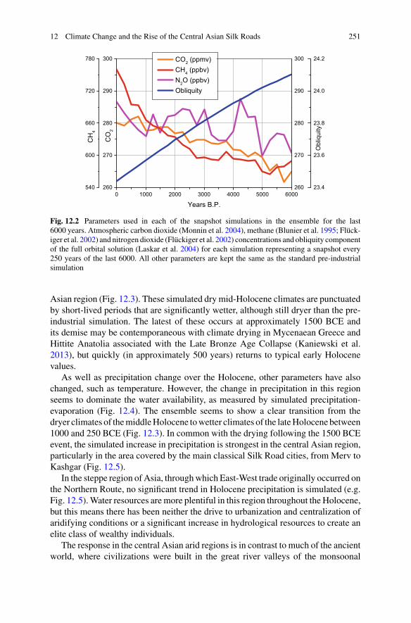
12 Climate Change and the Rise of the Central Asian Silk Roads 251
Fig. 12.2 Parameters used in each of the snapshot simulations in the ensemble for the last6000 years. Atmospheric carbon dioxide (Monnin et al. 2004), methane (Blunier et al. 1995; Flück-iger et al. 2002) and nitrogen dioxide (Flückiger et al. 2002) concentrations and obliquity componentof the full orbital solution (Laskar et al. 2004) for each simulation representing a snapshot every250 years of the last 6000. All other parameters are kept the same as the standard pre-industrialsimulation
Asian region (Fig. 12.3). These simulated dry mid-Holocene climates are punctuatedby short-lived periods that are significantly wetter, although still dryer than the pre-industrial simulation. The latest of these occurs at approximately 1500 BCE andits demise may be contemporaneous with climate drying in Mycenaean Greece andHittite Anatolia associated with the Late Bronze Age Collapse (Kaniewski et al.2013), but quickly (in approximately 500 years) returns to typical early Holocenevalues.
As well as precipitation change over the Holocene, other parameters have alsochanged, such as temperature. However, the change in precipitation in this regionseems to dominate the water availability, as measured by simulated precipitation-evaporation (Fig. 12.4). The ensemble seems to show a clear transition from thedryer climates of themiddleHolocene towetter climates of the lateHolocene between1000 and 250 BCE (Fig. 12.3). In common with the drying following the 1500 BCEevent, the simulated increase in precipitation is strongest in the central Asian region,particularly in the area covered by the main classical Silk Road cities, from Merv toKashgar (Fig. 12.5).
In the steppe region of Asia, throughwhich East-West trade originally occurred onthe Northern Route, no significant trend in Holocene precipitation is simulated (e.g.Fig. 12.5).Water resources aremore plentiful in this region throughout the Holocene,but this means there has been neither the drive to urbanization and centralization ofaridifying conditions or a significant increase in hydrological resources to create anelite class of wealthy individuals.
The response in the central Asian arid regions is in contrast to much of the ancientworld, where civilizations were built in the great river valleys of the monsoonal

252 D. J. Hill
Fig. 12.3 Average mean annual precipitation over the central Asian region (35°–45°N,56.25°–75°E) for each of the simulations for the last 6000 years. Shading shows the standarderror for the average, with the area over which precipitation is averaged shown in the inset map.Dashed horizontal lines show the mean of the simulations up to 3000 years B.P. and after 2250 yearsB.P
Fig. 12.4 Average mean annual precipitation (MAP; grey), precipitation minus evaporation (P-E; orange) and surface air temperature (SAT; magenta) over the central Asian region (35°–45°N,56.25°–75°E) for each of the simulations for the last 6000 years
regions (Macklin and Lewin 2015) and hence were susceptible to the reduction inmonsoons through the Holocene. Central Asian increases in rainfall are not linkedto the monsoonal rains, but rather are produced by changes in the winter West-ern Disturbance weather systems, which provide the bulk of the annual rainfall inthe region (Syed et al. 2006). Previous suggestions of the driving mechanisms of
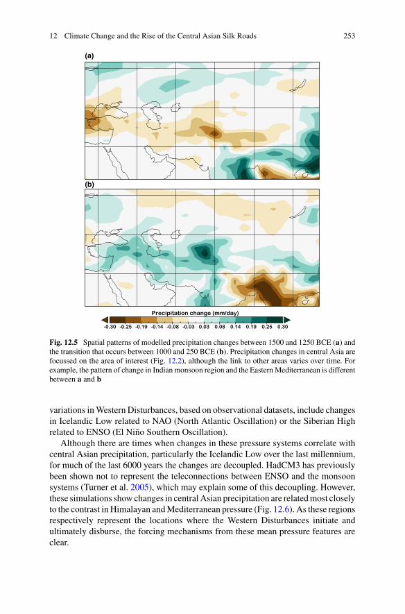
12 Climate Change and the Rise of the Central Asian Silk Roads 253
(a)
(b)
Fig. 12.5 Spatial patterns of modelled precipitation changes between 1500 and 1250 BCE (a) andthe transition that occurs between 1000 and 250 BCE (b). Precipitation changes in central Asia arefocussed on the area of interest (Fig. 12.2), although the link to other areas varies over time. Forexample, the pattern of change in Indian monsoon region and the EasternMediterranean is differentbetween a and b
variations inWestern Disturbances, based on observational datasets, include changesin Icelandic Low related to NAO (North Atlantic Oscillation) or the Siberian Highrelated to ENSO (El Niño Southern Oscillation).
Although there are times when changes in these pressure systems correlate withcentral Asian precipitation, particularly the Icelandic Low over the last millennium,for much of the last 6000 years the changes are decoupled. HadCM3 has previouslybeen shown not to represent the teleconnections between ENSO and the monsoonsystems (Turner et al. 2005), which may explain some of this decoupling. However,these simulations showchanges in centralAsian precipitation are relatedmost closelyto the contrast inHimalayan andMediterranean pressure (Fig. 12.6). As these regionsrespectively represent the locations where the Western Disturbances initiate andultimately disburse, the forcing mechanisms from these mean pressure features areclear.
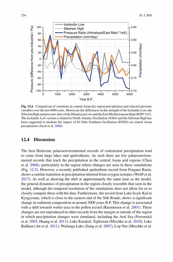
254 D. J. Hill
Fig. 12.6 Comparison of variations in central Asian dry region precipitation and selected pressurevariables over the last 6000 years. Shown are the differences in the strength of the Icelandic Low, theSiberianHigh andpressure ratio of theHimalayanLowand theEastMediterraneanHigh (H/M*1e5).The Icelandic Low system is related to North Atlantic Oscillation (NAO) and the Siberian High hasbeen suggested to mediate the impact of El Niño Southern Oscillation (ENSO) on central Asianprecipitation (Syed et al. 2006)
12.4 Discussion
The best Holocene palaeoenvironmental records of continental precipitation tendto come from large lakes and speleothems. As such there are few palaeoenviron-mental records that track the precipitation in the central Asian arid regions (Chenet al. 2008), particularly in the region where changes are seen in these simulations(Fig. 12.5). However, a recently published speleothem record from Fergana Basin,shows a similar transition in precipitation inferred from oxygen isotopes (Wolff et al.2017). As well as showing the shift at approximately the same time as the model,the general dynamics of precipitation in the region closely resemble that seen in themodel, although the temporal resolution of the simulations does not allow for us toclosely compare these with the data. Furthermore, the record from Lake Issyk-Kul inKyrgyzstan, which is close to the eastern end of the Silk Roads, shows a significantchange in sediment composition at around 3000 years B.P. This change is associatedwith a shift towards wetter taxa in the pollen record (Rasmussen et al. 2001). Thesechanges are not reproduced in other records from the margin or outside of the regionin which precipitation changes were simulated, including the Aral Sea (Ferronskiiet al. 2003; Huang et al. 2011), Lake Karakul, Tajikistan (Mischke et al. 2010), LakeBalikun (An et al. 2011), Wulunga Lake (Jiang et al. 2007), Lop Nur (Mischke et al.

12 Climate Change and the Rise of the Central Asian Silk Roads 255
2017), Lake Karakuli (Aichner et al. 2015), China or the Chinese Loess plateaux(Zhang et al. 2013).
There seem to be significant changes in precipitation in central Asia over theHolocene, which are linked to changes in the Western Disturbances, driven by varia-tions in the Himalayan Low—East Mediterranean High pressure contrast. Althoughsignificant changes in precipitation and P-E are simulated within this modellingframework, increased resolution in the atmosphere model, could greatly improve thesignal and spatial definition of the climatic changes. Moving to transient simulationof Holocene climate would give better temporal coverage, rather than relying onequilibrium climate response to snapshot climate forcing. This study has shown thechanges in regional climate associated with the largest forcing of Holocene climatechange, namely greenhouse gases and orbital forcing, but could be further extendedby incorporating changes in volcanic forcing (Kobashi et al. 2017), solar variability(Steinhilber et al. 2012) and Himalayan glacial coverage (Solomina 2015).
Although there remain many questions as to how ancient cultures responded toclimate changes, it appears that there are concurrent changes in Holocene climateand cultural developments in the region (Fig. 12.7). The period in which Late BronzeAge (LBA) cultures declined and the initial drive towards urbanisation are associatedwith climate deterioration from a short period of high precipitation around 1500BCE. While the current imprecise timings of the loss of the Bronze Age culturesand the climate changes mean that causal relationships cannot be tested, the factthat significant changes in precipitation are simulated during this interval (Fig. 12.7)adds weight to the suggestion that climate may be involved (Salvatori 2008). Themajor cities of Samarkand and Bukhara were founded in this period, while someof the other classical Silk Road cities were founded in the final centuries BCE. Adrying climate may have forced the founding of cities and initiation of large scaleirrigation (Malatesta et al. 2012), however, the increased hydrological resources mayhave ultimately allowed these cities to flourish and provide the backbone of the SilkRoad trade routes.
Although central Asia is particularly susceptible to changes in the extent that theWestern Disturbance weather systems penetrate into Asia, changes in other param-eters of these systems could have significant implications for other climate-humaninteractions across the Levant, Mesopotamia and into the Indian Subcontinent (Syedet al. 2006). Different regions and weather systems respond in different ways to thechanges in Holocene forcings. Each civilization has its own technological develop-ment and ways of utilizing hydrological resources and thus to really understand theconnection between societal adaptation and changing climate requires collaborationbetween palaeoclimate scientists and archaeologists.
12.5 Conclusions
Novel climate model simulations of the last 6000 years show significant shifts incentral Asian precipitation. Of particularly note is the transition to wetter climates
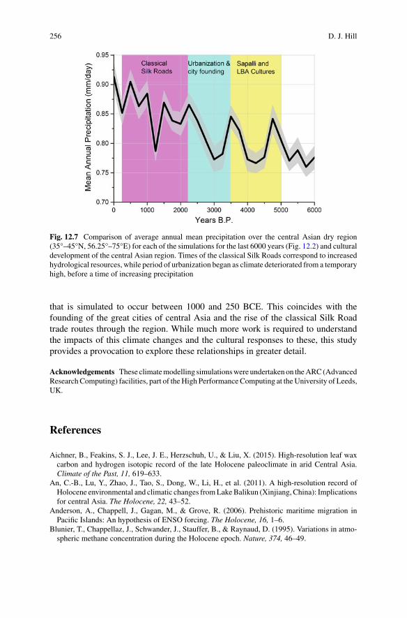
256 D. J. Hill
Fig. 12.7 Comparison of average annual mean precipitation over the central Asian dry region(35°–45°N, 56.25°–75°E) for each of the simulations for the last 6000 years (Fig. 12.2) and culturaldevelopment of the central Asian region. Times of the classical Silk Roads correspond to increasedhydrological resources, while period of urbanization began as climate deteriorated from a temporaryhigh, before a time of increasing precipitation
that is simulated to occur between 1000 and 250 BCE. This coincides with thefounding of the great cities of central Asia and the rise of the classical Silk Roadtrade routes through the region. While much more work is required to understandthe impacts of this climate changes and the cultural responses to these, this studyprovides a provocation to explore these relationships in greater detail.
Acknowledgements These climatemodelling simulationswere undertakenon theARC(AdvancedResearchComputing) facilities, part of theHigh PerformanceComputing at theUniversity of Leeds,UK.
References
Aichner, B., Feakins, S. J., Lee, J. E., Herzschuh, U., & Liu, X. (2015). High-resolution leaf waxcarbon and hydrogen isotopic record of the late Holocene paleoclimate in arid Central Asia.Climate of the Past, 11, 619–633.
An, C.-B., Lu, Y., Zhao, J., Tao, S., Dong, W., Li, H., et al. (2011). A high-resolution record ofHolocene environmental and climatic changes fromLakeBalikun (Xinjiang, China): Implicationsfor central Asia. The Holocene, 22, 43–52.
Anderson, A., Chappell, J., Gagan, M., & Grove, R. (2006). Prehistoric maritime migration inPacific Islands: An hypothesis of ENSO forcing. The Holocene, 16, 1–6.
Blunier, T., Chappellaz, J., Schwander, J., Stauffer, B., & Raynaud, D. (1995). Variations in atmo-spheric methane concentration during the Holocene epoch. Nature, 374, 46–49.
12 Climate Change and the Rise of the Central Asian Silk Roads 257
Braconnot P., Harrison, S. P., Joussaume, S., Hewitt, C. D., Kitoch, A., Kutzbach, J. E., Liu, Z., Otto-Bliesner, B., Syktus, J., & Weber, S. L. (2004). Evaluation of PMIP coupled ocean-atmospheresimulations of theMid-Holocene. In R.W. Battarbee, F. Gasse, C. E. Stickley (Eds.), Past climatevariability through Europe and Africa. Developments in paleoenvironmental research (vol. 6).Dordrecht: Springer.
Braconnot, P., Harrison, S. P., Kageyama, M., Bartlein, P. J., Masson-Delmotte, V., Abe-Ouchi, A.,et al. (2012). Evaluation of climate models using palaeoclimatic data. Nature Climate Change,2, 417–424.
Büntgen,U., Tegel,W.,Nicolussi,K.,McCormick,M., Frank,D., Trouet,V., et al. (2011). 2500yearsof European climate variability and hu, man susceptibility. Science, 331, 578–582.
Butzer, K. W. (2012). Collapse, environment and society. Proceedings of the National Academy ofSciences of the United States of America, 109, 3632–3639.
Cattani, M. (2008). The final phase of the bronze age and the “Andronovo Question in Margiana”.In S. Salvatori & M. Tosi (Eds.), The bronze age and early iron age in the Margiana Lowlands,BAR international series 1806 (pp. 133–148). Oxford: Archaeopress.
Chen, F., Yu, Z., Yang, M., Ito, E., Wang, S., Madsen, D. B., et al. (2008). Holocene moistureevolution in arid central Asia and its out-of-phase relationship with Asian monsoon history.Quaternary Science Reviews, 27, 351–364.
Christian, D. (2000). Silk roads or steppe roads? The silk roads in world history. Journal of WorldHistory, 11, 1–26.
Cox, M. D. (1984). A primitive equation, 3 dimensional model of the ocean. GFDL Ocean GroupTechnical Report 1, Princeton NJ, USA, p. 143.
Cox, P. (2001). Description of the TRIFFID dynamic global vegetation model. Hadley CentreTechnical Report 24. Bracknell, UK: UK Met Office.
Dash, S. K., Kulkarni, M. A., Mohanty, U. C., & Prasad, K. (2009). Changes in the characteristicsof rain events in India. Journal of Geophysical Research, 114, D10109. https://doi.org/10.1029/2008JD010572.
Dong, G., Jia, X., An, C., Chen, F., Zhao, Y., Tao, S., et al. (2012). Mid-Holocene climate changeand its effect on prehistoric cultural evolution in eastern Qinghai Province, China. QuaternaryResearch, 77, 23–30.
Drake, B. L. (2012). The influence of climatic change on the late bronze age collapse and the greekdark ages. Journal of Archaeological Science, 39, 1862–1870.
Faroqhi, S. (1994). Crisis and change, 1590–1699. In I. Halil, & D. Quataert (Eds.), An economicand social history of the ottoman empire, 1300–1914 (p. 505). Cambridge University Press.
Ferronskii, V. I., Polyakov, V. A., Brezgunov, V. S., Vlasova, L. S., Karpychev, Y. A., Bobkov, A. F.,et al. (2003). Variations in the hydrological regime of Kara-Bogaz-Gol Gulf, Lake Issyk-Kul andthe Aral Sea assessed based on data of bottom sediment studies. Water Resources, 30, 252–259.
Flückiger, J., Monnin, E., Stauffer, B., Schwander, J., & Stocker, T. F. (2002). High-resolutionHolocene N2O ice core record and its relationship with CH4 and CO2. Global BiogeochemicalCycles, 16, 1. https://doi.org/10.29/2001gb001417.
Gordon, C., Cooper, C., Senior, C. A., Banks, H., Gregory, J. M., Johns, T. C., et al. (2000). Thesimulation of SST, sea ice extents and ocean heat transports in a version of the Hadley Centrecoupled model without flux adjustments. Climate Dynamics, 16, 147–168.
Gregory, D., & Morris, D. (1996). The sensitivity of climate simulations to the specification ofmixed phase clouds. Climate Dynamics, 12, 641–651.
Gregory, D., Kershaw, R., & Inness, P. M. (1997). Parametrisation of momentum transport byconvection II: Test in a single column and general circulation model. Quarterly Journal of theRoyal Meteorological Society, 123, 1153–1183.
Gregory, D., Shutts, G. J., & Mitchell, J. R. (1998). A new gravity wave drag scheme incorporatinganisotropic orography and low level wave breaking: Impact upon the climate of the UK Mete-orological Office Unified Model. Quarterly Journal of the Royal Meteorological Society, 124,463–493.
Grenet, F. (2002). Samarkand I. History and Archeology. Encyclopaedia Iranica. Online edition.
258 D. J. Hill
Harrison, S. P., Bartlein, P. J., Brewer, S., Prentice, I. C., Boyd, M., Hessler, I., et al. (2014). Climatemodel benchmarking with glacial and mid-Holocene climates. Climate Dynamics, 43, 672–688.
Herrmann, G. (1968). Lapis Lazuli: The early phases of its trade. Iraq, 30, 21–57.Huang, X., Oberhänsli, H., von Suchodoletz, H., &Sorrel, P. (2011). Dust deposition in theAral Sea:Implications for changes in atmospheric circulation in central Asia during the past 2000 years.Quaternary Science Reviews, 30, 3661–3674.
Inness, P. M., & Slingo, J. M. (2003). Simulation of the Madden-Julian oscillation in a coupledgeneral circulation model. Part I: Comparison with observations and an atmosphere-only GCM.Journal of Climate, 16, 345–364.
Jiang, Q., Shen, J., Liu, X., Zhang, E., & Xiao, X. (2007). A high-resolution climatic change sinceHolocene inferred from multi-proxy of lake sediment in westerly area of China. Chinese ScienceBulletin, 52, 1970–1979.
Kaniewski, D., Van Campo, E., Guiot, J., Le Burel, S., Otto, T., & Baeteman, C. (2013). Environ-mental roots of the late bronze age crisis. PLoS ONE, 8(e71004), 17.
Kaniuth, K. (2007). The metallurgy of the late bronze age sapalli culture (southern Uzbekistan) andits implications for the ‘tin question’. Iranica Antiqua, 17, 23–40.
Kennett, D. J., Breitenbach, S. F. M., Aquino, V. V., Asmerom, Y., Awe, J., Baldini, J. U. L., et al.(2012). Development and disintegration of Maya political systems in response to climate change.Science, 338, 788–791.
Kobashi, T., Menviel, L., Jeltsch-Thömmes, A., Vinther, B. M., Box, J. E., Muscheler, R., Nakae-gawa, T., Pfister, P. L., Döring, M., Leuenberger, M., Wanner, H., & Ohmura, A. (2017). Volcanicinfluence on centennial tomillennial HoloceneGreenland temperature change. Scientific Reports,7, Article number: 1441.
Lamberg-Karlovsky, C. C. (2013). The oxus civilization. Cuadernos de Prehistoria y ArqueologiaUniveridad Autonoma de Madrid, 39, 21–63.
Laskar, J., Robutel, P., Joutel, F., Gastineau, M., Correia, A. C. M., & Levrard, B. (2004). A long-term numerical solution for the insolation quantities of the earth. Astronomy & Astrophysics, 428,261–285.
Lo Muzio, C. (2009). An archaeological outline of the Bukhara Oasis. Journal of Inner Asian Artand Archaeology, 4, 43–68.
Macklin, M. G., & Lewin, J. (2015). The rivers of civilization. Quaternary Science Reviews, 114,228–244.
Malatesta, L. C., Castelltort, S., Mantellini, S., Picotti, V., Hajdas, I., Simpson, G., et al. (2012).Dating the irrigation system of the Samarkand Oasis: A geoarchaeological study. Radiocarbon,54, 91–105.
Mayewski, P. A., Rohling, E. E., Stager, J. C., Karlén, W., Maasch, K. A., Meeker, L. D., et al.(2004). Holocene climate variability. Quaternary Research, 62, 243–255.
McMahon, T. A., Peel, M. C., & Karoly, D. J. (2015). Assessment of precipitation and temperaturedata fromCMIP3 global climatemodels for hydrological simulation.Hydrology and Earth SystemSciences, 19, 361–377.
McNeill, W. H. (1998). World history and the rise and fall of the West. Journal of World History,9, 215–236.
Milton, S. F., Wilson, C. A. (1996). The impact of parameterized subgrid-scale orographic forcingon systematic errors in a global NWP model. Monthly Weather Review, 124, 2023–2045.
Mischke, S., Rajabov, I., Mustaeva, N., Zhang, C., Herzschuh, U., Boomer, I., et al. (2010). Modernhydrology and late Holocene history of Lake Karakul, eastern Pamirs (Tajikistan): A reconnais-sance study. Palaeogeography, Palaeoclimatology, Palaeoecology, 289, 10–24.
Mischke, S., Liu, C., Zhang, J., Zhang, C., Zhang, H., Jiao, P., et al. (2017). The world’s oldest AralSea type disaster: The decline of the Loulan Kingdom in the Tarim Basin. Scientific Reports, 7,43102. https://doi.org/10.1038/srep43102.
Monnin, E., Steig, E. J., Siegenthaler, U., Kawamura, K., Schwander, J., Stauffer, B., et al. (2004).Evidence for substantial accumulation rate variability in Antarctica during the Holocene, through
12 Climate Change and the Rise of the Central Asian Silk Roads 259
synchronization of CO2 in the Taylor Dome, Dome C and DML ice cores. Earth and PlanetaryScience Letters, 224, 45–54.
Olson, D. M., Dinerstein, E., Wikramanayake, E. D., Burgess, N. D., Powell, G. V. D., Underwood,E. C., D’amico, J. A., Itoua, I., Strand, H. E.,Morrison, J. C., Loucks, C. J., Allnutt, T. F., Ricketts,T. H., Kura, Y., Lamoreux, J. F., Wettengel, W.W., Hedao, P., & Kassem, K. R. (2001). Terrestrialecoregions of the world: A new map of life on earth: A new global map of terrestrial ecoregionsprovides an innovative tool for conserving biodiversity. BioScience, 51, 933–938.
Rasmussen, K. A., Ricketts, R. D., Johnson, T. C., Romanovsky, V. V., & Grigina, O. M. (2001).An 8,000 year multi-proxy record from Lake Issyk-Kul, Kyrgyzstan. PAGES News, 9, 5–6.
Ridley, J., Wiltshire, A., &Mathison, C. (2013). More frequent occurrence of westerly disturbancesin Karakoram up to 2100. Science of the Total Environment, 468–469, S31–S35.
Salvatori, S. (2008). The Margiana settlement pattern from the middle bronze age to the Partian-Sasanian period: A contribution to the study of complexity. In S. Salvatori & M. Tosi (Eds.),The bronze age and early iron age in the Margiana Lowlands, BAR international series 1806(pp. 133–148). Oxford: Archaeopress.
Solomina, O. N., Bradley, R. S., Hodgson, D. A., Ivy-Ochs, S., Jomelli, V., Mackintosh, A. N., et al.(2015). Holocene glacier fluctuations. Quaternary Science Reviews, 111, 9–34.
Staubwasser, M., Sirocko, F., Grootes, P. M., & Segl, M. (2003). Climate change at the 4.2 kaBP termination of the Indus valley civilization and Holocene south Asian monsoon variability.Geophysical Research Letters¸ 30, 1425. https://doi.org/10.1029/2002gl016822.
Steinhilber, F., Abreu, J. A., Beer, J., Brunner, I., Christl, M., Fischer, H., et al. (2012). 9,400 yearsof cosmic radiation and solar activity from ice cores and tree rings. Proceedings of the NationalAcademy of Sciences of the United States of America, 109, 5967–5971.
Syed, F. S., Giorgi, F., Pal, J. S., & King, M. P. (2006). Effect of remote forcings on the winterprecipitation of central southwestAsia part 1:Observations.Theoretical and Applied Climatology,86, 147–160.
Turner, A. G., Inness, P.M., & Slingo, J.M. (2005). The role of the basic state in the ENSO-monsoonrelationship and implications for predictability. Quarterly Journal of the Royal MeteorologicalSociety, 131, 781–804.
Welc, F., & Marks, L. (2014). Climate change at the end of the Old Kingdom in Egypt around 4200BP: New geoarchaeological evidence. Quaternary International, 324, 124–133.
Wolff, C., Plessen, B., Dudashvilli, A. S., Breitenbach, S. F. M., Cheng, H., Edwards, L. R., et al.(2017). Precipitation evolution of Central Asia during the last 500 years. The Holocene, 27,142–154.
Zhang, W., Shi, Z., Chen, G., Liu, Y., Niu, J., Ming, Q., et al. (2013). Geochemical characteristicsand environmental significance of Talede loess-paleosol sequences of Ili Basin in Central Asia.Environmental Earth Sciences, 70, 2191–2202.
Open Access This chapter is licensed under the terms of the Creative Commons Attribution 4.0International License (http://creativecommons.org/licenses/by/4.0/), which permits use, sharing,adaptation, distribution and reproduction in any medium or format, as long as you give appropriatecredit to the original author(s) and the source, provide a link to the Creative Commons license andindicate if changes were made.
The images or other third party material in this chapter are included in the chapter’s CreativeCommons license, unless indicated otherwise in a credit line to the material. If material is notincluded in the chapter’s Creative Commons license and your intended use is not permitted bystatutory regulation or exceeds the permitted use, you will need to obtain permission directly fromthe copyright holder.

Chapter 13The Coming of the Barbarians: CanClimate Explain the Saljuqs’ Advance?
Yehoshua Frenkel
Abstract The present study reviews recent interpretations of Central Asia’s andNorthern Iran’s environmental and political history during the first half of the eleventhcentury. Namely, to cast light on the deficiencies in recent interpretations of TurkicVolkswanderung, and to advocate searching for political-social agents that wouldexplain the Eurasian Steppe’s history. In opposite to climatological reading of thoseyears regional history, it aims at advancing a call for a more nuanced paradigm ofthe coming of the Saljuqs.
Keywords Ghaznavids · Saljuqs · Bulliet · Ellenblum · Historiography ·MemoryEnvironmental history
In this study, I will focus on the assumed influence of nature on human history. Iwill not touch upon questions concerning interaction between human modes of pro-duction and the climate, which is a common topic in modern environmental studies.Ecological policy and environmental ethics will also not be touched upon here.
For the purposes of the current contribution, I will define environmental history asthe study of the effect of climate on society. Or, to use a more precise classification:the study of the consequences that freezingweather has on a certain region. I amusingweather and not climate because the sources do not provide climate data. Weather iswhat we sense outside on any particular day. Climate is the average of that weather.
A second introductory comment concerns the term “Silk Road” (Seidenstrassein German) used by the organizers of this conference and in the popular literature.The term is a conventional construct. It is not used in the geographical literature thatwas composed for the Abbasid Caliphate administration, nor by Muslim voyagerswho travelled across the Eurasian Steppe. Their accounts highlight the ethnic, envi-ronmental and cultural differences that separated the Central Islamic lands (i.e. Iranand the Fertile Crescent) from Central Asia. These literary sources are archives ofsocieties. They narrate not only on environment, fauna and flora, but also on religious
Y. Frenkel (B)Department of Middle Eastern & Islamic Studies, University of Haifa, Eshkol Tower,Office 1407, 199 Abba Khoushy Ave. Mount Carmel, 3498838 Haifa, Israele-mail: [email protected]
© The Author(s) 2019L. E. Yang et al. (eds.), Socio-Environmental Dynamics along the Historical Silk Road,https://doi.org/10.1007/978-3-030-00728-7_13
261

262 Y. Frenkel
knowledge and political events. Moreover, we do not have a clue to the geographicalterminology used by the nomads who roamed in the Steppe in the 11th century.
13.1 Introduction
Reports on natural hazards that have shaped mankind’s history, and the place thatthese catastrophes occupy in societies’ memories, are quite old. The biblical accountof the flood and Noah’s saving of his family and fauna in his ark is a well-knownexample of disasters that serve as a means to explain major changes in people andtheir societies.
Hegel opens his analysis of climate and ethnographywith the statement that natureshould neither be rated too high nor too low (Hegel 1914). The great philosopher’sremarks are not novel: their roots can be recognised in ancient geography. Similarinterpretations of human nature and its geography of origin can be detected inArabic-Islamic intellectual traditions. Ibn Khaldun’s theory of race qualities immediatelysprings tomind (Hall 2011; el-Hamel 2013).He advances the hypothesis that physicaland intellectual abilities and talents result from the climatological environment ofthe ethnic communities with which he was familiar. And we can add other namesof Arab scholars from the Middle Islamic period (1055–1517), who advocated thisvision of mankind. Certainly, contemporary scholars have moved away from thesedeterministic and racist visions of human societies.
Yet many modern scholars still search for an ecological interpretation as the keysolution to human history. These present-days geographers and historians investigatethe history of climate and nomadism in Central Asia.1 At the early years on the 20thcenturyEllsworthHuntington (1907) advanced the paradigmof “ThePulses ofAsia”,arguing that “pulsations of climate had served as a driving force history of Eurasia,impelling nomadic invaders to overrun the civilized nations that surround them”.
13.2 Ecological Frontiers
The border of the Eurasian Steppewas ethnic and ecological. The Caliphate importedfrom this vast territory a variety of goods. Muslim and other merchants traversed itin their travels to remote sedentary and nomadic civilizations, returning across theSteppe to the heartlands of the Islamic Caliphate they carried with them exotic mer-chandises. The data that excavations and artefacts provide supports the line that thenarrative sources tell. These texts present a picture of cross-border trans-civilizationmovements and influence.Moreover, archaeological findings fitwell the pre-SaljuqidArabic and Persian historiography of Eurasia (Frenkel 2015).
1For historian’s rejection of climatological paradigm and the re-emergence of environmental historysee Chappell (1970) and Brentjes (1986).
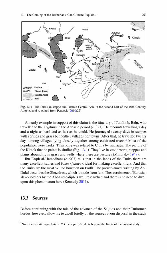
13 The Coming of the Barbarians: Can Climate Explain … 263
Fig. 13.1 The Eurasian steppe and Islamic Central Asia in the second half of the 10th Century.Adopted and re-edited from Peacock (2010:22)
An early example in support of this claim is the itinerary of Tamım b. Bah. r, whotravelled to the Uyghurs in the Abbasid period (c. 821). He recounts travelling a dayand a night as hard and as fast as he could. He journeyed twenty days in steppeswith springs and grass but neither villages nor towns. After that, he travelled twentydays among villages lying closely together among cultivated tracts.2 Most of thepopulation were Turks. Their king was related to China by marriage. The picture ofthe Kimak that he paints is similar (Fig. 13.1). They live in vast deserts, steppes andplains abounding in grass and wells where there are pastures (Minorsky 1948).
Ibn Faqıh al-Hamadhanı (c. 903) tells that in the lands of the Turks there aremany excellent sables and foxes (fennec), ideal for making excellent furs. And thatthe Turks are the most skilled bowmen on Earth. The pseudo-travel writing by AbuDulaf describes theGhuz dress, which ismade from furs. The recruitment of Eurasianslave-soldiers by the Abbasid caliph is well researched and there is no need to dwellupon this phenomenon here (Kennedy 2011).
13.3 Sources
Before continuing with the tale of the advance of the Saljuqs and their Turkomanhordes, however, allow me to dwell briefly on the sources at our disposal in the study
2Note the ecstatic equilibrium. Yet the topic of style is beyond the limits of the present study.
264 Y. Frenkel
of Eurasian and Iranian histories. Most of the narrative sources which we are usingto construct the story of the coming of the Turks were written in Arabic; yet somewere composed in Syriac, Armenian and Persian. The claim that no Arab chronicleris a contemporary of the coming of the Saljuqs will not surprise students of medievalWestern and Central Asia. The state of Persian sources differs only slightly.
Abu Abd Allah Muh. ammad b. Salama b. Jafar al-Qud. aı (d. 454/1062) endshis condensed chronology of Iraq in the year 1022 and moves on to tell the story ofEgypt (till 432/1040). Umar b. Muh. ammad al-Nasafı (461–537/1069–1142) wrotethe history of Samarqand’s scholars during their high days under the Great Saljuqs.
The two main Arabic histories of the early Saljuq Sultanate were composedin the late twelfth or early thirteenth century. Jamal al-Dın Abu al-Faraj Ibn al-Jawzı (510–597/1117–1201) was an active player in twelfth-century political andintellectual Baghdad and an observer of the declining Saljuq sultanate in Iranand Iraq (McAuliffe 1988). Izz al-Dın Alı b. Abı al-Karm Ibn al-Athır al-Jazırı(555–630/1160–1233) was a contemporary of Saladin. His voluminous universalhistory begins with the Creation and runs to 628/1231. In the sections on Eurasia,Iran and the Turks he uses earlier works that have not reached us. Inspired to write byhis sense of living at the turn of the ages, Matthew of Edessa (Matt’eos Urhayets’i,ca. 1070-ca. 1136), employed biblical verses to convey his perception of the Turks,(MacEvitt 2007) who he saw as agents of Satan (Czeglédy 1973).
Telling the story of the eleventh-century (1030–1071) Michael the Syrian(Mıchail Raba; fl. c. 1166–1199) depends on earlier sources. In interpreting thoseyears his point of departure is the Sacred Scriptures. Based on the words of theprophets he provides his audiences with biblical interpretations of the events thathis predecessors experienced. The deep demographic change that was caused by theadvance of the Turks is revealed by him as a fulfilment of ancient prophesies. Noword on climate catastrophe.
The mafriyana (maphrian, the deputy of the Syriac Church) Gregarious Yoh. ananBar Ibraya [Bar Hebraeus] (fl. c. 1226–1286) continued in his world-history, whichhe composed in Syriac and in a shorter Arabic version, the chronicle of Michaelthe Syrian (Mıchail Raba; Todt 1988; Morony 2000; Widell 2007). Despite usinga lost early Saljuqid source (the Book of King) his narrative is mainly political anddynastic and not adds a record of ecological history.
Turning to the Persian sources the history of the source material tells a similarstory. With the exception of the contemporary chronicle by Abu al-Fad. l Muh. ammadb. H. usayn al-Bayhaqi (c. 470/996–1077), no Persian source tells the story of theadvancing Saljuq in real time. Remarks on weather in these chronicles are limited.
The Ghaznavid historian Gardızı (wrote after 1041 AD), a valuable source for thehistory of the eleventh-century eastern Iranian world and Central Asia, reports con-cisely on events inKhorasan andTransoxiana, aswell as on the people of the EurasianSteppe (Czeglédy 1973). Gardızı narrates that the sultan responded favourably to thenomads’ request, which was mentioned previously, and issued a royal command per-mitting the Turkic groups to cross the Oxus andMughrab Rivers (416/1025–26). TheTurkmen moved to the desert (yaban) near the cities of Sarakhs, Faravah and Bavard(Abivard; Le Strange 1905; Fig. 13.1). Two years later, as is stated by Gardızı, the
13 The Coming of the Barbarians: Can Climate Explain … 265
people of these cities came to the Ghaznavid court and complained about damages(fasad) caused by the Turkmen (Gardızı 1928).
The picture of the past that the chroniclers have painted includes portrayals ofweather hazards and deadly epidemics (in 1010, 1031, 1040; Christensen 1993;Rassi 2017) combined with descriptions of soldiers’ looting (Ibn Funduq al-Bayhaqı1968).3 Yet, the information that the above-mentioned sources supply is far from anaccurate accumulation of meteorological data. At most, these sources inform theirreading audiences on farming and food shortage.
These sources, whether in Arabic or in Persian, do not report on the effects thefluctuating weather had on the nomadic tribes who roamed the Eurasian Steppe inthe last quarter of the tenth and first half of the eleventh century. Indeed, I was notable to trace in the narrative sources from these long years any sort of meteorologicalinformation about the Steppe. The chronicles report only on weather events. This nodoubt will be visible in the conclusions I deduce.
Nowhere in these narrative sources is climate blamed for the military-break downof a straining empire that failed to defend its territory against invading nomads.Famine should affect both parties, even if not equally. Moreover, nowhere is it saidthat the environmental conditions in Central Asia differed from the climate in Iranduring those days. I will return to these points below.
Indeed, irregularities in climate are recorded in past and modern periods More-over, as a whole, settlements in this region demonstrated resilience and recovery,despite famine, plague and massive deaths of humans and animals. The recoveryfrom climatological disasters is quick. Data from the Chronicle of Michael the Syr-ian (tran. Chabot 1905) suggest that climatic and agricultural disasters were verycommon in northern Syria and the Jazira in antiquity (Fig. 13.1). Hence, we shouldask: do these irregularities cause a permanent change? (Paul 2016).
In addition, the data furnished by these sources illuminates their vision of theirtime and place. They usedmainly political and anthropological reasoning.Al-Qud. aı,a contemporaneous historian, already mentioned above, summarizes the politicalsituation in Baghdad and the neighbouring lands during early days of the Abbasidcaliph al-Qadir (991–1031):
during this period (c. 1022) the political situation resembled the conditions [in Iran] inthe days of the Diadochi kings (muluk al-t.awaif ) who ruled in the days that followed theexecution of Darius [the third; 330 BC] by Alexander the Great, a period of disorder thatcontinued till the days of Ardashir the son of Babak (Papag) [208-241 AD] (al-Qud. aı).
13.4 The Coming of the Saljuqs
Following these condensed introductory remarks,we can turnnow to an interpretationof the coming of the steppe barbarian in the eleventh century. The collapse of Samanid
3The source of the account is presumably the author’s grandfather; the number of one thousandfighting horses, in addition to 200 elephants, seems unrealistic.
266 Y. Frenkel
rule removed a buffer separating the Eurasian Steppe and the Iranian Plateau. TheSaljuq house succeeded in mobilizing Eurasian pastoral-nomads and led them intothe Central Islamic lands. These two developments, one that took place deep in theEurasian Steppe and the other thatmaterialized on the gates of theCaliphate’s CentralAsia frontiers, seem to be the key explanations to the political transformation thathappened in Iran and Iraq in the mid eleventh century. They elucidate the massivepenetration of pastoralist nomads into the territory of a highly developed urbancivilization, which subsequently experienced several decades of crises and politicaldisorders.
According to the authorized Ghaznavid version of Turkmen history and the cross-ing of the Oxus by the Saljuqs, a group of their tribal commanders and chiefscame over the border. They complained about their sufferings at the hands of Turk-istan’s governors and asked the sultan Mah.mud’s permission to cross the Syr Darya(Jaxartes) River. Gardızı (d. c. 444/1053),4 who presumably was in the service of theGhaznavids at that time, inserts in his chronicle what he implies was the Turks’ oralappeal to the sultan:
We number 4,000 families.5 If the lord was to issue a royal patent and allow us to cross theRiver [Oxus] and settle in Khurasan, he would be relieved from worrying about us and them,for there would be plenty of space for us in his realm, since we are steppe (dasht) peopleand have extensive herds of sheep. Moreover, we would provide additional manpower forhis army.
The author, who devotedly guards the reputation of the Ghaznavid monarch,depicts Mah.mud as a generous patron. According to his description of events, aconversation then took place between the sultan (amır) Mah.mud and the governor ofT. us (Mashhad). The historian stages the governor as the critical voice who objectsto the coming of the Turks and who warns the sultan that he is committing a crucialmistake. In line with this version of history, the sultan regrets his initial agreement.Gardızı adds his personal conclusion: “this grave error (ghayyat; read ghiyyat) stillhas no satisfactory remedy.” These words seem to reflect the developments on theground, and indeed, as it was “predicted.” S. adr al-Dın al-H. usaynı, who composed theofficial Saljuq historiography (Husaynı 1933)6 and does not depart fundamentallyfrom this line, says:
The sultan died (in 422/1031), having by that time regretted his allowing the Turks (atrak),the followers of the sons of Saljuq, to settle in his realm.
Reports on the advance of the Saljuq brothers towards the Iranian Plateau, togetherwith accounts of skirmishes, contain also records of shortage and famine (Bosworth1963). It is said, to provide one example, that lack of fodder forced the Ghaznavid
4For a similar employment of negotiations between nomadic Turks and sedentary rulers see below.5The number 4000 (chehar hazar suwar maruf ) elite horsemen is a set number in Gardızı’s accountof the Turkmen.6A native of Khurasan, he echoes the views of the Saljuq dynasty branch that ruled over the IranianPlateau. This would explain the salient role he grants to Chaghrı Beg Dawud. Cf. the differentaccount by Ibn al-Athır 2003).

13 The Coming of the Barbarians: Can Climate Explain … 267
army to depart Khorasan and to regroup in the province of Jurjan. On the samepages, we read that for several years plowing and harvesting was not chronicled inthe province of Bayhaq (Fig. 13.1). At this historical junction a Saljuq army, led byCaghrı Beg Dawud (d. 452/1050), attacked and routed Subashı, the commander ofthe Ghaznavid expedition force (428/1037). Reinforcements from Ghazna arrivedand camped in the rural region near Bayhaq. It was winter, and the expedition forcecut down the Pistachio trees, using the wood to warm themselves. They also uprootedthe trees and sent the wood to Ghazna (Fig. 13.1). At the battlefield the Saljuqs wonthe day. Following their victory over the Ghaznavid army, the Saljuqs seized Marw(in 428/1037; Ibn Funduq al-Bayhaqı 1968).7
While the official Ghaznavid historiography paints the nomadic Turkeman asintruders and as a potential threat to the stability and prosperity of the sedentarycivilization, the Saljuqs’ narrative, on the other hand, offers a different interpreta-tion of events (Luther 2001; Morton 2004). Historians who served the ruling GreatSaljuqs portray the first generation of the family as a loyal force in the service ofsultan Yamın al-Dawla Mah.mud. Deeply terrified by the advance of Turkic nomadclans, the Ghaznavid sultan forced the enormous Qiniq tribe, which was led bythe chief (muqaddam; amır) Mıkaıl b. Saljuq, to cross the Oxus River and thuscreating a buffer zone that would separate between the sedentary population andthe nomads (Husaynı 1933). Acting in accordance with a common nomad practice,Mıkaıl approached Abu Sahl, the civil governor of Khurasan, and offered him gifts:“three horses, ten Bactrian camels and three hundred sheep.” After Mıkaıl’s death,the Turkic tribes agreed that his son Abu T. alib T. ughril (Toghril) Beg Muh.ammadwould replace him and would be their chief.
At this juncture in the narrative the sources do weave in an environmental thread.Taking advantage of harsh climatic conditions in Iran, the three Saljuq brotherswere ready to face the sultan Masud, the new Ghaznavid ruler. While the weightyGhaznavid army had been paralyzed by the climate, the Saljuqs could find shelter inneighbouring provinces. The dwellers of the Iranian cities applied to the Ghaznavidsultan and asked him to intervene and rescue them. Facing a formidable threat, thenomad Turkmen reacted by sending a message to the Ghaznavids: “We are [your]slaves (bandkan) and we are obedient.”8 The next months witnessed heavy fighting.Under the heavy military pressure, the Turkmen leaders agreed to renew the concordthat their chieftain had undertaken in the past.
Al-Ravandı narrates that Caghrı Beg and T. ughril Beg, the two leading Saljuqbrothers, their uncle Musá b. Saljuq nicknamed Yabghu-Kalın,9 their cousins, chiefsand the army commander assembled and concluded a pact agreeing to unite andprovide mutual assistance (yak-digar). “I heard”, says the historian, that:
T. ughril gave an arrow (tir used for casting lots; Turan 1955) to his brother [Chaghri] and toldhim to break it. He [Chaghri] could not reject the request, heeded [the command] and brokethe arrow. In this manner [T. ughril handed] two [additional arrows and Chaghri] broke them
7The report does not contain the weather account.8Cf. the similar wording “We are slaves and obedient to [the Sultan’s] commands” (Gardızı 1928).9The future al-Malik al-Adil of Herat (1043–56).
268 Y. Frenkel
jointly. Then he handed three [arrows] and [Chaghri] broke themwith considerable difficulty(dush-khwar). When the number [of the arrows] reached four it became impossible for him[Chaghri] to split the arrows. T. ughril said: “This is exactly a parallel (mithl) [or mathal,likeness or metaphor] to our manner (hamcunan). When we are apart every peon will bedetermined to break us. Yet if we are united, no man will defeat us. If disagreement comesbetween us we shall not conquer the world (jihan gushadan; John of Ephesus 1860; Dickens2004)10 and our rivals will be stronger, and kingship will slip from our hand. A verse: Iftwo brothers help and protect the back of each other the stony hard mountain is in their fist(Ravandi 1921).
13.5 Climatological Determinism?
The suggestion that migration and political changes in Western Asia resulted fromecological upheavals can be traced in old scientific works. On the eve of World WarOne, Carl H. Becker (d. 1933) argued:
The sudden surging of the Arabs was only apparently sudden… It was the last great Semiticmigration connected with the economic decline of Arabia with the decline of political power,the care of public waterworks, on which the prosperity of the land more or less depended,also suffered (Becker 1913).11
During recent years several scholars have addressed questions regarding climatechanges, large scale migration and political changes in central (Eurasia) and westernAsia (the Levant; Issar and Zohar 2007; Raphael 2013). Salient here are the publi-cations by Richard Bulliet and Ronnie Ellenblum. The second section of the presentcontribution provides a condensed report on the works of these two highly acclaimedhistorians. They were not the first historians that advanced the argument that inaddition to the human factors we should consider ecological reasoning (Brentjes1986). Conflicts over grasslands, weather fluctuations and migration constitute com-mon components in pastoral-nomads’ communities. And their leverage on Eurasiansociety, including violent struggles on resources, is a common historical reasoning(Peacock 2010:44–45).
Richard Bulliet claims that in the fifth/eleventh century the Iranian Plateau suf-fered severe contraction. “The engine that drove the agricultural decline and triggedthe initial Turkish migration was a pronounced chilling of the Iranian climate thatpersisted for more than a century”. Reiterating this argument, he says:
“Iran experienced a significant cold spell in the first half of the fourth/tenth century, followedby prolonged climatic cooling in the fifth/eleventh and early sixth/twelfth centuries… [A]certain impact of this cold (the Big Chill) involves the folk migration into north-eastern Iranof the Oghuz Turks” (Bulliet 2009; Mikhail 2016).
10The idea of world-domination is echoed in the account of Michel the Syrian. However, it couldbe a late invention. Michel quotes John of Ephesus (c. 507–586) who narrates an apocalyptic story.The king of the Turks says to Zemarchus, the Byzantine ambassador, that their tradition is that whenthey see an ambassador from the Romans enter their lands, all kingdoms will be dissolved and thewhole world will come to an end.11Becker served as a Prussia’s minister of culture.
13 The Coming of the Barbarians: Can Climate Explain … 269
Yet Bulliet is cautious and carefully states that weather stories in the chronicles donot constitute a trend. To make his point he turns to dendrochronology. An analysisof tree-ring thicknesses provides him with supportive evidence of the Big Chill in313/926 and 398/1007. Decades prior to the Saljuqs. Following an in-depth geo-graphical investigation, Bulliet deduces that the Turkmens who were camel herdersmoved from the Eurasian Steppe southwards, contrary to other Eurasian nomads,who were horse breeders and moved westwards. Yet this observation can be chal-lenged. The Persian source that describes the Turkmens as sarbanan (camel herders)also mentions ten thousand Turkish horsemen (siwar) who crossed over to Khorasan(Bayhaqı 2002).
Ronnie Ellenblum follows Bulliet’s historical interpretation. Inspecting a vastrange of narrative sources, he first criticizes historians who have used political expla-nations to elucidate the penetration of the Steppes’ barbarians into theCentral IslamicLands in the eleventh century. Next, he turns to the ecological reasons behind theTurks’ Wanderung. He interprets late sources, a point clarified above, as supportiveevidence of his thesis that lingering hunger causedmany Oghuz Turks who still dweltin the Trans-Oxonian regions to migrate south (in the 1030s; Ellenblum 2012).
13.6 A Revisionist Approach
It would be accurate to maintain that it is not rare to come across wide brash linespainting a historical picture that lacks sufficient details to discern a landscape ofthe past. Hence, I do not contest the interpretation that Central Asia and the IranianPlateau experienced natural hazards during the years studied here. Reports of naturalor catastrophic events, such as a devastating earthquake (in 444/1051)12 or a droughtthat causedhunger, popup even in a quick look at the narrative sources. The increasingnumber of raids (gharat) are said to have prevented the people of Bayhaq for sevenyears from slaughtering lambs outside the walls of the city’s fort (qas. ba). The localpopulation did not consume lamb during those seven years. The supply of eggs,cereals and fruit was also limited. Although during Friday prayer the name of theSaljuq sultan T. ughril Beg was called (Ibn Funduq al-Bayhaqı).13
Again, I am arguing that the sources do not provide decisive evidence to support ameteorological interpretation as the prime explanation of the massive human move-ment across the Steppes/Iranian frontier during the eleventh century. The impressioncreated by these accounts, briefly mentioned above, is that nomadic pressure andlawlessness combined with the governors’ strong hand are the prime cause of dis-ability and social unrest (Gardızı 1928). The chroniclers do not point their fingerstowards an environmental origin of the advance of the Saljuq Turks. It might be thecase that cold winters or long dry summers inflicted heavy pressures on the Eurasian
12The story of the people who fled the town and spent 40 days and nights in the desert is a literaryconstruct.13The number 7 is supposedly a literary device.
270 Y. Frenkel
nomads, yet the narrative sources do not refer to this as a source of destabilizationand Volkswanderung.
Those scholars that advance the climatological thesis should be asked, given theliving conditions in eleventh century Iran and Iraq, the countries that came imme-diately under direct Saljuq government, why are there no records of massive urbanmigration of populations that hoped to escape harsh climatic conditions? Moreover,why the weather-related thesis is not the leading hypothesis with regard to the migra-tion westward of the Pecheneg or the Mongol? In great similarity with the comingof the Saljuqs and their Turkmans’ followers also these Eurasian peoples wanderedin the Steppe and penetrated new lands ruled by powerful empires. Yet, the commoninterpretation of their history combines social, ideological and political explanationswith climatological accounts (Lamb 2011), and is not limited to precipitations, tem-peratures and pasturage (Jenkins 1974). Furthermore, “The occurrence of a climaticchange can never be a sufficient explanation for a migration that ensued. Societiesalways possess a range of other ways of coping with any challenges” (Mayer 2000).
To advance the thesis that bad winters drove the Turkomans across the Oxus Riverto Khurasan and the Iranian Plateau we cannot rely on literary narrative sources.The chronology of the historiography examined here leads me to argue that theclimatological thesis is basedon texts that preserve the collectivememory andpopularinterpretation of past events and not on solid longue durée recorders written in realtime.
Generalization should be based on painstaking gathering ofminute facts. Describ-ing massive social, cultural and political changes, modern historical studies quiteoften refer to climate fluctuations; or at least use environmental arguments as a par-tial component in explaining phenomena such as vast migration, collapse of oldregimes, etc. But at their disposal there are enough details to support an ecologicalthesis. In our case there are not.
Moreover, climatic conditions cannot be considered the sole causal factor inrespect of economic prosperity or decline, nor for political upheavals or nomadicincursions. The Byzantine historian Iohannis Skylitzes (c. 1040–1101), for example,narrates the following episode:
When the neighbouring peoples, Turks, Serbs, Croats and the rest of them, learnt of [theBulgars’ king] Symon’s death they immediatelymade plans to campaign against the Bulgars.The Bulgar nation was suffering a severe famine and a plague of locusts which was ravagingand depleting both the population and the crops, so the Bulgars were very fearful of anincursion by these other people (Skylitzes 2010).
Ibn Funduq al-Bayhaqı reports that in 432/1040-1 the Saljuqs, led by T. ughrïlBeg, “arrived at the borders of Khwarazm with a large army and countless khargahs,camels, horses and sheep” (Bayhaqı 2002). So, if weather was harsh how could theseherds survive freezing temperatures and hunger?
Much quoted is the saying by Mah.mud Kashgarı: “bassız börk bolms tatsıztürk bolmas (without a head there is no hat; without sedentary there can be nonomad ‘[There is no Turk [i.e. nomad] without a Tad(jik) [non-Turkish sedentary])”(Kashghari 1982) is another textual reference that supports my position. It casts light
13 The Coming of the Barbarians: Can Climate Explain … 271
on the symbiotic ethnic reality inCentralAsia.Noone claims that harshwinters testedthe resilience of the sedentary population of Transoxiana, who reacted by evacuatingtheir villages and towns and accompanied the Oghuz Turks to Iran (Fig. 13.1).
13.7 Conclusion
The chronicles and biographies that were scrutinized in this research call a morenuanced vision of the historical reality in Transoxiana and the Iranian Plateau. Thesources that we have at our disposal preserve the mid-twelfth and early thirteenth-century collective historical memory of urban classes governed by non-local armies,mostly by Turks, and who were surrounded by wandering Turkman tribes. Thesesources illuminate a long and deep political crisis, characterized by lack of order andstability. Chilly seasons and dwindling grasslands constituted significant componentsin the complex environment that surrounded the Turkic pastoral nomads.
Yet, in the interpretation of the historical developments at Islam’s Central Asiafrontiers additional constituents should be considered. To ascribe the Turkic tribes’migration from the Steppes to the Iranian Plateau at a period when this land sup-posedly witnessed natural hazards limits the historical explanation to climatologicaldeterminism. Given this, we should look to socio-political explanations to clarify thepenetration of the Saljuqs and their Eurasian hordes.
Hence, we need archives of nature, namely analysed data of changing climato-logical conditions in the medieval Eurasian Steppe, which will illuminate the lacunanot covered by the archives of society, written in Persian and Arabic. This deductioncan be compared to arguments advanced by scholars who have inspected the historyof Byzantine during the tenth-eleventh centuries (Preiser-Kapeller 2015).
References
Bayhaqı (996–1077),&Abu al-Fad. lMuh.ammad. (2002). InM.G.YaH. aqqi (Ed.),Ta’rıkh-i MasudıMashhad (Vol. 2, p. 445, 1048) [Bosworth, C. E., &Mohsen. (2011). The History of Beyhaqi vol.2: The History of Sultan Mas’ud of Ghazna, 1030–1041. Ilex Series, 133].
Becker, K. H. (1913). The expansion of the saracens–the east. In H. M. Gwatkin, & J. P. Whitney(Eds.),The Cambridge medieval history (Vol. 2, p. 331). Cambridge: CambridgeUniversity Press.
Bosworth, C. E. (1963). The Ghaznavids: Their empire in Afghanistan and Eastern Iran 994–1040.Edinburgh University Press (Reprinted New Delhi: Munshiram Manoharlal, 1992).
Brentjes, B. (1986). Nomadenwanderungen und Klimaschwankungen. Central Asiatic Journal,30(1–2), 7–21.
Bulliet, R. W. (2009). Cotton, climate and camels in early Islamic Iran: A moment in world history(Vol. 1, p. 69, 96, 101). New York: Columbia University Press.
Chappell, J. E., Jr. (1970). Climatic change reconsidered: Another look at “The Pulse of Asia”.Geographical Review, 60(3), 347–373.
Christensen, P. (1993). The decline of Iranshahr: Irrigation and environments in the history of theMiddle East, 500 B.C. to A.D. 1500 (p. 217). Copenhagen.
272 Y. Frenkel
Czeglédy, K. (1973). Gardizi on the history of Central Asia (746–780 A.D.). Acta OrientaliaAcademiae Scientiarum Hungaricae, 27(3), 257–267.
Dickens, M. (2004).Medieval Syriac historians’ perceptions of the Turks (p. 41). Thesis: Universityof Cambridge.
Ellenblum, R. (2012). The collapse of the Eastern Mediterranean: Climate change and the declineof the East, 950–1072 (pp. 61–87). Cambridge: Cambridge University Press.
Frenkel, Y. (2015). The Turkic peoples in medieval Arabic writings. London: Routledge.Gardızı (Gerdizi d. 1053), & Abu Sa‘id ‘Abd al-H. ayy b. Dahhak b. Mahmud. (1928). In M. Nazim(Ed.), Kitab zainu’l-akhbar (pp. 85–86, 89–90, 98, 106, 426). Berlin [Bosworth, C. E. (trans.).(2011). The ornament of histories: a history of the Eastern Islamic lands AD 650–1041: Theoriginal text of Abu Sa‘id ‘Abd al-Hayy Gardızı (pp. 95–96, 98–99, 104, 109). London: I.B.Tauris].
Hall, B. S. (2011). A history of race in Muslim West Africa, 1600–1960 (pp. 45–50). CambridgeUniversity Press.
Hamel, C. (2013). Black Morocco: A history of Slavery, Race, and Isla (Vol. 75). CambridgeUniversity Press.
Hegel, G. W. F. (1914). The philosophy of history (Vol. 83). London: Bell.Huntington, E. (1907). The pulse of Asia, a journey in Central Asia illustrating the geographic basis
of history (pp. 360–382). Boston: H. Mifflin.Husaynı (1180–1225), & S. adr al-Dın Abu al-H. asan Alı. (1933). InM. Iqbal (Ed.),Akhbar al-dawla
al-Saljuqiyya. Lahor (p. 2, 3, 12, 17). [Bosworth, C. E. (2011). The History of the Seljuq State:A translation with commentary of the ‘Akhbar al-dawla al-saljuqiyya’. London: Routledge].
Ibn al-Athır (1160–1233), & Izz al-Dın Alı b. Abı al-Karm Muh.ammad al-Jazirı. (2003). In al-Daqqaq (Ed.), al-Kamil fı al-tarıkh. Beirut: Dar al-Kutub al-Ilmiyya (Vol. 8, pp. 242–243) (AH432) [D. S. Richards (trans.). (2002). The annals of the Saljuq Turks (Routledge Curson), Vol.41].
Ibn Funduq al-Bayhaqı (1105–1169), & Z. ahır al-Dın Abu al-H. asan Alı. Tarıkh-i Bayhaq. (1968).Haydar-Abad: Dar al-maarif (pp. 465, 473, 475–476) [Yusuf al-Hadı (trans. 2004). TarıkhBayhaq. Damascus: Dar iqra. 466480-481, 486–487].
Issar, A. S., & Zohar, Mattanyah. (2007). Climate change—environment and history of the neareast. Berlin, Heidelberg: Springer.
Jenkins, G. (1974). A note on climatic cycles and the rise of Chinggis Khan.Central Asiatic Journal,18(4), 225–226.
John Bishop of Ephesus. (c. 507–588). Payne Smith R. (trans. 1860), The third part of the Eccle-siastical history of John Bishop of Ephesus (pp. 424–426). Oxford: Oxford University Press[Payne-Margoliouth, J. (1909). Ecclesiastical history of John Bishop of Ephesus (p. 83). Leiden:Brill (Syriac)].
Kashgharı [Kashgharlı] (1072–1094), & Mah.mud. (1982). In (trans. Robert Dankoff) Kitab Dıwanlughat al-turk [Compendium of the Turkic dialects] (vols. 1, 2, p. 273, 103). Harvard University.
Kennedy, H. (2011). The Armies of the Caliphs: Military and society in the Early Islamic State.London: Routledge.
Lamb,H.H. (2011).Climate: Present, past and future vol. 2: Climatic history and the future (p. 439).London: Routledge.
Le Strange, G. (1905). The lands of the Eastern Caliphate (Vol. 380, pp. 394–396). London.Luther, K.A. (2001). In C. E. Bosworth Richmond (Ed.),The history of the Seljuq Turks (pp. 39–40).Surrey, Curzon.
MacEvitt, C. (2007). The chronicle of Matthew of Edessa: Apocalypse, the first crusade, and theArmenian Diaspora. Dumbarton Oaks Papers, 61, 157–181.
McAuliffe, J. D. (1988). Ibn al-Jawzı’s Exegetical propaedeutic: Introduction and translation. Alif:Journal of Comparative Poetics, 8, 101–113.
Meyer, W. B. (2000). Climate and migration. In Andrew Bell-Fialkoff (Ed.), The role of migrationin the history of the Eurasian Steppe (p. 289). London: Macmillan.
13 The Coming of the Barbarians: Can Climate Explain … 273
Mıchail Raba (Michael the Great fl. 1166–1199). Chabot J. B. (trad. 1905), Chronique de Michelle Syrien, Patriarche Jacobite d’Antioche (1166–1199) (Vol. 3, pp. 159). Paris.
Mikhail, A. (2016). Climate and the chronology of Iranian history. Iranian Studies, 49(6), 964–965.Minorsky, V. (1948). Tamim ibn Bahr’s journey to the Uyghurs. BSOAS, 12, 275–305.Morony, M. G. (2000). Michael the Syrian as a source for economic history. Hugoye: Journal of
Syriac Studies, 3(2), 141–172.Morton, A. H. (2004). The Saljuqnama of Zahir al-Din Nishapuri (pp. 13–14). London: GibbMemorial Trust.
Paul, J. (2016). Nomads and Bukhara. A study in nomad migrations, pasture, and climate change(11th century CE), Der Islam, 93(2), 495–531.
Peacock, A. C. S. (2010). Early Seljuq history: A new interpretation. In the series: Hillenbrand, C.(Eds.), Routledge studies in the history of Iran and Turkey. London: Routledge.
Preiser-Kapeller, J. (2015). A collapse of the Eastern Mediterranean? New results and theories onthe interplay between climate and societies in Byzantium and the Near East, ca. 1000–1200 AD.Jahrbuch der Österreichischen Byzantinistik, 65, 195–242.
Qud. aı (d. 454/1062), & Abu Abd Allah Muh. ammad. (1995). Uyun al-marıf wa-funun akhbaral-khalaif (Vol. 552). Mecca: Jamiat Umm al-Qurá.
Raphael, S. K. (2013). Climate and political climate: Environmental disasters in the MedievalLevant. Leiden: Brill.
Rassi, J. (2017). Several natural disasters in theMiddleEast (at the beginning of the eleventh century)and their consequences. In G. J. Schenk (Ed.), Historical disaster experiences. A comparativeand transcultural survey between Asia and Europe (pp. 63–76). Heidelberg: Springer.
Ravandı, & Muh.ammad ibn Alı. (1921). In Muhammad Iqbal (Ed.), Rah. at al-s. udur wa áyat al-surúr [being a history of the Saljúqs] (Vol. 102). London: Luzac.
Skylitzes, J. (2010). A synopsis of Byzantine history 811–1057 (Vol. 215) (trans. John Wortley).Cambridge University Press.
Todt, S. R. (1988). Die syrische und die arabischeWeltgeschichte des Bar Hebraeus—ein Vergleich.Der Islam, 65, 60–80.
Turan, O. (1955). The ideal of world domination among the Medieval Turks. Studia Islamica, 4,78–79.
Widell, M. (2007). Historical evidence for climate instability and environmental catastrophes inNorthern Syria and the Jazira: The chronicle of Michael the Syrian. Environment and History,13(1), 47–70.
Open Access This chapter is licensed under the terms of the Creative Commons Attribution 4.0International License (http://creativecommons.org/licenses/by/4.0/), which permits use, sharing,adaptation, distribution and reproduction in any medium or format, as long as you give appropriatecredit to the original author(s) and the source, provide a link to the Creative Commons license andindicate if changes were made.
The images or other third party material in this chapter are included in the chapter’s CreativeCommons license, unless indicated otherwise in a credit line to the material. If material is notincluded in the chapter’s Creative Commons license and your intended use is not permitted bystatutory regulation or exceeds the permitted use, you will need to obtain permission directly fromthe copyright holder.
Chapter 14Climate Change and the Rise and Fallof the Oxus Civilization in SouthernCentral Asia
Élise Luneau
Abstract During the Final Bronze Age (around 3750/3700 BP), the proto-urbansedentary cultural entity in southern Central Asia—known as the Oxus civilizationor Bactria-Margiana Archaeological Complex—underwent major social transfor-mations in different field aspects leading to a deep cultural change in the middleof the 4th millennium BP. Among the different reasons suggested to explain thesesociocultural changes, the hypothesis of global climate change in Central Asia atthe beginning of the 4th millennium BP has been emphasized by different scholars.In this paper, I will examine current paleo-environmental data in relation with theclimate evolution during the Mid- and Late Holocene. A critical assessment of thehypothesis of climatic change in Central Asia at the beginning of the 4th millen-nium BP allows to stimulate the discussion anew. I argue that the present data do notsupport a drastic climate change during the first half of the 4th millennium BP as aresponsible factor for the fall of the Oxus civilization, although local environmentalmodifications should also not be underestimated and further investigated in a moreintegrated perspective of co-evolution of the ecological environment and the humansocieties.
Keywords Central Asia · Bronze age · Oxus civilization/BMACClimate variation · Sociocultural evolution · Collapse
14.1 Introduction
The issue concerning the variability of the climatic system, its impact onsociocultural changes and human action on climate is currently strongly debatedin view of the present-day situation of climate disruption. This topic causes contro-versy, which often derives from determinism—environmental or anthropic—and/or
É. Luneau (B)Eurasia Department, German Archaeological Institute, Im Dol 2-6, Haus II,14195 Berlin, Germanye-mail: [email protected]
© The Author(s) 2019L. E. Yang et al. (eds.), Socio-Environmental Dynamics along the Historical Silk Road,https://doi.org/10.1007/978-3-030-00728-7_14
275

276 É. Luneau
denials, although the co-evolution and co-adaptation of people and environment hasrecently been proposed (Dearing 2006; Holdaway et al. 2013; Kirch 2005; Moraleset al. 2009).
Numerous scholars put forward the idea that environmental modifications can bethe vector of change, or at least can act to develop and amplify internal tensionswithin society. Thereby, climatic causes are frequently assumed in the case of disap-pearance of past societies and cultural entities, revealing both the resilience and thevulnerability of complex societies to climate change (Dalfes et al. 1997; deMenocal2001), such as for instance, the Akkad Empire (Cullen et al. 2000; Kuzucuoglu andMarro 2007; Weiss 2017; Weiss and Courty 1993), the Indus civilization (Giosanaet al. 2012), the Maya civilization (Haug et al. 2003) or the Tiwanaku civilization(Binford et al. 1997). This is also true in case of the Oxus civilization, which occu-pied southern Central Asia and north-eastern Iran during the Bronze Age (Fig. 14.1)between the second half of the 5th and the middle of the 4th millennium BP.1 Somescholars have tried to explain this fall by considering “a disturbance of the equilib-rium in the eco-social system induced by the growing aridity of the climate and by theresultant decline in agroclimatic potential” (Dolukhanov 1981: 383). Climate vari-ation then is a crucial question for understanding the interplay of the environmentaland anthropic factors in the evolution of the Oxus civilization.
Fig. 14.1 Location of the Oxus civilization and of the mentioned palaeoclimatic records (in red)and geomorphological/geoarchaeological studies (in blue)
1The datations BP (Before Present) use the year 1950 as a reference point for “the present”.
14 Climate Change and the Rise and Fall of the Oxus Civilization … 277
The relation between climatic, environmental and societal change is not direct(Wilkinson 2003), and the impact of climate variation on human actions is far fromclarified (d’AlpoimGuedes et al. 2016). The crossing of the disciplines and approach-es—environmental studies with anthropology—enlightens the reciprocal interactionbetween Human and Environment, and offers to encompass the natural processes aswell as to highlight the constant adaptations of societies and environments. Climaticchange is a complex, multifaceted and multiscalar phenomenon, and, besides theextent of climatic change, the reaction of human societies is essential in order toelucidate the interaction between climate change and social evolution (Butzer 2012).
This article proposes a cross-over study of archaeological evidence and currentpalaeo-climatic data for a critical review of the hypothesis of climate variation assufficient to cause the sociocultural evolution of the southern Central Asian proto-urban culture at the end of the Bronze Age. It also examines the variability of theclimate cause-effect chain and of consequences of environmental changes.
14.2 Short Note on the Geography of Southern CentralAsia and Northern Iran
The territory of the Oxus civilization covers southern central Asia and north-easternIran, approximately between theAral Sea drainage basin and theDasht-eKavir deserton the Iranian plateau, mainly between the latitude 35° and 40° north (Fig. 14.1).
As one of the driest areas in the world, southern Central Asia is undergoing theinfluence of different climatic systems at different space and time scales, but presentlydominated by prevailing winds from the West, so-called ‘westerlies’ (Cheng et al.2012, 2016; Heinecke et al. 2016; Lauterbach et al. 2014; Wang et al. 2010). Itbelongs to the desert climatic zones, with a semi-arid to arid climate, characterizedby low rainfall from the end of fall to mid spring and by a maximum exposure to thesun and high temperatures the rest of the year (Mannig et al. 2013). 90% of this areareceives less than 400 mm of precipitation per year (De Pauw 2007; Fig. 14.2).
This fragile ecosystem is very sensitive to changes and depends greatly uponwaterresources (Gessner et al. 2013). The availability ofwater (more than the temperatures)has always been of crucial significance for the evolution of human settlement patterns,explaining the uneven population distribution and the relocation of sites throughouttime.
The highmountain system, such as the Pamir and Tian Shanwhich extend towardsthe West into the Mountains Alai or Turkestan slit along by long and narrow valleys,aswell asmediummountains such as theKopetDagh range delineatingTurkmenistanand Iran, are ofmajor importance in Central Asia, especially as headwaters of numer-ous rivers (for instance, Amu-Darya, Syr-Darya and their tributaries). The mountainranges present a stepped relief with different ecotopes (highlands, foothills, alluvialterraces and valley floors) allowing a diversity of economic strategies. The alpinezone or the high plains—such as theKhorasan landscape in northern Iran—aremostlycovered by steppe-like vegetation. The foothills watered by small mountain riversare covered bymontane and sub-alpine vegetation (pasture lands and forests). Below,
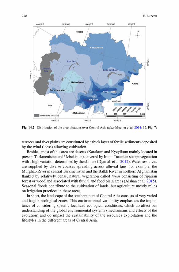
278 É. Luneau
Fig. 14.2 Distribution of the precipitations over Central Asia (after Mueller et al. 2014: 17, Fig. 7)
terraces and river plains are constituted by a thick layer of fertile sediments depositedby the wind (loess) allowing cultivation.
Besides, most of this area are deserts (Karakum and Kyzylkum mainly located inpresent Turkmenistan and Uzbekistan), covered by Irano-Turanian steppe vegetationwith a high variation determined by the climate (Djamali et al. 2012).Water resourcesare supplied by diverse courses spreading across alluvial fans: for example, theMurghab River in central Turkmenistan and the Balkh River in northern Afghanistanflanked by relatively dense, natural vegetation called tugai consisting of riparianforest or woodland associated with fluvial and food plain areas (Aishan et al. 2015).Seasonal floods contribute to the cultivation of lands, but agriculture mostly relieson irrigation practices in these areas.
In short, the landscape of the southern part of Central Asia consists of very variedand fragile ecological zones. This environmental variability emphasizes the impor-tance of considering specific localized ecological conditions, which do affect ourunderstanding of the global environmental systems (mechanisms and effects of theevolution) and do impact the sustainability of the resources exploitation and thelifestyles in the different areas of Central Asia.
14 Climate Change and the Rise and Fall of the Oxus Civilization … 279
14.3 The Oxus Civilization or Bactria-MargianaArchaeological Complex (BMAC)
Despite the aridity, southern Central Asia has a long history of sedentism based onagropastoral economy since the Neolithic, necessarily determined by water man-agement. Most of the population lived along the banks of rivers or in the mountainfoothills, which were better suited for agricultural use, while the climatic conditionsin themountainous areas were adequate for livestock breeding and dry agriculture. Inthe Bronze Age, the Oxus civilization developed between ca. 4250–3350 BP (Kohl2007; Francfort 2009; Lamberg-Karlovsky 2012; Lyonnet andDubova in press). Therise of the Oxus civilization is still unclear, and this ensemble is better known anddefined as the mature phase (ca. 4250–3750 BP), where a specific material culturepresents a large homogeneity over a vast territory in current northern Iran, south-eastern and central Turkmenistan, northern Afghanistan, southern Uzbekistan andsouthern Tajikistan (Fig. 14.1).
The Oxus civilization played a significant role in the system of exchange in Mid-dle Asia—sometimes called Middle Asian Interaction Sphere (Kohl 2007; Possehl2007)—for rawmaterial (gold, lapis lazuli, turquoise, alabaster, tin, etc.) and finisheditems. Specific objects related to this culture have also been recorded in neighboringareas (Zeravshan valley, Ferghana valley, Indo-Pakistani area, Gorgan plain, Arabianpeninsula, etc.). At that time, along with the long distance trade, the cultural entityexperienced increasing proto-urban development, social stratification, task special-ization, territorial expansion and homogenization. Populations lived in mudbricksor adobe houses in settlements of varying sizes. Monumental architecture, specificburial practices as well as prestige and luxury goods reflect a hierarchized society,possibly organized as proto-state. Numerous aspects linked to the exploitation of nat-ural resources need further research, but the populations practiced agropastoralismin a complex socioeconomic pattern with a rich and diversified agricultural produc-tion along with the husbandry of diverse animals. The productions in ceramic, metaland stone reveal an extraordinary handicraft related to the skills gained by specialistcraftsmen and the iconographic wealth exposing a singular symbolic system, con-nected with the Middle East but also locally rooted. Large questions are still open onthe language(s) spoken by the populations—indo-iranian, proto-tokarian, elamite orunknown—as well as on the religion associated with this culture without writing.
14.4 The Fall? Overview of the End of the Oxus Civilization
Fromc. 3750/3650BPonwards, theOxus civilization progressively underwentmajorsociocultural transformations (Table 14.1); the last cultural features related to itdisappeared around 3400/3350BPwith themanifestation of new significant changes,identified as the beginning of the Early Iron Age (Luneau 2014, in press). This longperiod of change has often been perceived as the collapse of the previous urbansystem.

280 É. Luneau
Table 14.1 Summary of the major transformations in different sociocultural areas of the Oxuscivilization during the Final Bronze Age (ca. 3750-3350 BP)
Transformations/evolutions
Settlement pattern • Abandonment and reduction in size of sites• But territorial expansion?
Material culture • Changes in the quantity of items and in the morphology• Higher variability in the morphology of the ceramic complex• Appearance of miniature metallic items• Higher portion of material related to the northern central Asiantraditions
• Less cultural homogeneization
Sociopoliticalorganization
• Disappearance of the monumental architecture• Disappearance of the previous social status markers
Exchanges andTrade
• Slackening of the interregional exchanges, with a possible change ofdirection of the trade
• Higher contacts with the mobile populations related to the“Andronovo” community
Ideology and beliefs • Diversification of the burial practices• Disappearance of the figurative expressions, especially mythological
Subsistenceeconomy
• Possible evolution of the subsistence economy towards a more pastoraland more mobile economy
Despite the lack of study on this period viewed as unattractive and the numerousgaps in the state of research, the available data provide nevertheless a solid basis forquestioning the evolutionary process of the southern central Asian society during thefirst half of the 4th millennium BP. These mutations are indeed complex and diverse,such as innovations or changes alongside the oldest traditions, and permanenciesalso coexisted with the previous period (Luneau 2014, 2015). The settlement patternshifted towards a reduction in the size of sites. The abandonment of sites is alsonoticeable, but this occurred parallel with the appearance of new sites and a possibleterritorial expansion. Changes are also obvious in the material culture, in the quantityof items discovered at the sites as well in their morphology. The ceramic productionwas affected by a higher variability. Technological processes seem globally simi-lar with a trend to less investment of time and skills in the production. Metallurgywas also affected by sociocultural changes, mainly concerning the size rather thanthe shape of the items and the greater presence of artefacts related to the “steppeBronze Age” cultures, as well as by the technological progression of the bronze met-allurgy. A less cultural homogeneity over the whole territory of the Oxus civilizationis also noticeable. Modifications are likewise clearly visible in the sociopoliticalorganization with the disappearance of social status markers, in connection with theslackening of the long-distance exchange networks. Trade appears to have beenmoreactive among themobile populations referred to as belonging to the “Andronovo Cul-tural Community” than with the Middle Eastern cultures, as was previously the case.This situation can be particularly explained by the greater presence and influenceof mobile populations in southern Central Asia (Cattani 2008; Cerasetti 2012; Fra-

14 Climate Change and the Rise and Fall of the Oxus Civilization … 281
chetti and Rouse 2012; Luneau 2017; P’jankova 1994; Vinogradova and Kuz’mina1996). The diversification of burial practices, correlated to the disappearance of thefigurative, especially mythological, expressions likely indicates a major shift in theideological and symbolic beliefs. The socioeconomic profile, as far as we know,seemed not to strongly change throughout the duration of the Oxus civilization. Irri-gation was maintained, and the plants exploited vary little, excepting for the possiblerise of the use of millet (see below). Herding also might have increased in relationto an increased exploitation of the highlands.
All in all, the long evolution, which occurred over 300 years at least, rather appearsas a (transitional) phase of a slow sociocultural reconfiguration at the roots to a lessurban, less concentrated, possibly less hierarchical society in the second half of the4th millennium BP (Early Iron Age).
14.5 The Environmental Hypothesis as Responsiblefor the Changes of the Oxus Civilization
Among the different explanations for these changes, the impact of climate has beenfrequently proposed, although opinions differ on climate changes in southern centralAsia.
Numerous scholars (Dolukhanov 1981, 1988; Gentelle 2001; Koshelenko et al.1994; Ljapin 1990; Mousavi 2008; Vinogradov and Mamedov 1974) assert that theclimatic conditions were more humid during the Mid-Holocene,2 between 8950 and3950 BP. A drastic drying of the climate then happened, around 3950/3750 BP,inducing important environmental changes and impacting human societies.
This phenomenon also emerged as an explanation for the fluctuations of thehydraulic system in the Murghab alluvial fan in central Turkmenistan, where thegeomorphological dynamicmay have determined the location of ancient settlements.The retraction of the alluvial fan with the desertification of the north-eastern distalpart of the channel networks over time has been observed (Cremaschi 1998). Thiswould have resulted from the progressive decrease of the Murghab River, on onehand, and the constant sand movement carried by the northern winds in the Karakumdesert, on another hand.
In consequence, the aridification process would have been modified the coursesof the rivers, depleted the water supply and reduced the agricultural land potential.It would have involved a demographical pressure, causing a reduction in populationdensity, thus leading to depopulation and a shift in settlement patterns. The hypothesiswas consolidated by the first results on the periodization of differentBronzeAge sites,which has now been proven to be incorrect. At that time, the chronological overviewsuggested the existence of non-contemporaneous independent groups of sites called‘oases’, whose successive occupation followed the retraction of the alluvial fan tothe South, downstream-upstream, with the desiccation of channels (Masimov 1981;Sarianidi 1981, 1990: 64). The distribution of the sites since the early phases of
2The Holocene is defined as the current geological period, which began approximately 11,700 yearsBP. It is commonly divided into three sub-periods (Walker et al. 2012): the Early Holocene(11,700–8200 BP), the Mid-Holocene (8200–4200 BP) and the Late Holocene (4200 BP–present)..
282 É. Luneau
Fig. 14.3 Location of the Murghab alluvian fan and schematic map of distribution of the archaeo-logical sites
the Bronze Age in the North until the Iron Age in the South (Fig. 14.3; Kohl 1984,Fig. 16a) has given proof of the impact of the environmental change, since settlementswould have moved in relation to water availability.
This hypothesis also provided an explanation for the arrival of the “Andronovo”populations from the North, who occupied lands largely abandoned by the localpopulations due to the decrease in irrigation and the advancing desert (Cattani et al.2008; Cerasetti 2012). All in all, a drying climate variation at the beginning of the 4thmillennium BP could have been responsible for the “collapse” of the urban systemof the Oxus civilization.
By contrast, other scholars (Cremaschi 1998; Gerasimov 1978; Khlopina 1972;Lewis 1966; Lisitsyna 1978, 1981) disagree on major environmental modificationsat the turn of the 5th and the 4th millennium BP. They assert that environmentaldynamics linked to water supplies were not limited to the question of climate andwaterfalls, but were the combination of several factors, such as geomorphologicaland geological events (Gerasimov 1978; Fouache et al. 2012).
Nevertheless, these previous assumptions are still based on few solid studies, notonly concerning climate evolution and the specific ecological system of southernCentral Asia, but also the duration of the settlements as well as water managementin prehistory. All these issues require more long-term field investigation.

14 Climate Change and the Rise and Fall of the Oxus Civilization … 283
14.6 The Palaeoclimate Data
Yet, the compilation of current data available on environmental changes alreadycontributes towards better tackling the issue of the evolution of the environment andits impact on human groups in southern Central Asia during the Bronze Age.
Palaeoclimate studies in Eurasia are increasing in number in recent years. Thesynthesis of palaeoclimate records in Arid Central Asia from the Caspian Sea bordersto Mongolia (Chen et al. 2008) reveals global tendencies, with a dry climate in theearlyHolocene (until ca. 8000BP), followed bymaximum-moisture conditions in theMid-Holocene (ca. 8000–4000 BP), before decreasingmoisture in the Late Holocene(4000 BP to the present day). Another synthesis of data from Central Asia (Wanget al. 2010) points at the differential evolution of the regions influenced or not by thetwo Asian Summer Monsoon sub-systems. In the Indian Summer Monsoon area, anincrease of moisture levels and temperatures has been identified at around 10,000until 8000BP (HoloceneOptimum), followed by drier and colder conditions until theLate Holocene. In the area outside of the present monsoon boundary, this decreaseappears around 7500 BP—although interrupted by a wet period between 5000 and2000 BP, whereas it appears by 6500 BP in the Indian Summer Monsoon area.However, the studies do not discuss potential abrupt changes during the differentphases of the Holocene.
In that regard, another examination of records on world distribution (Mayewskiet al. 2004) concludes several climate-change events during the Holocene, with rapidshifts marked by low latitude drought in 6000–5000, 4200–3800 and 3500–2500 BP,among others. Although no records correspond to Central Asia, a global aridificationseemed to occur around 4200/3750 BP, known as the 4.2 ka BP aridification event.This “megadrought brought a 30–50 percent reduction in precipitation and coolingacross the Mediterranean, west to east, and across West Asia, Central Asia, Africaand the western hemisphere, as expressed in marine, lake, speleothem, glacial core,and tree-ring records” (Weiss 2017: 13).
In central Asia, Palaeoclimate studies particularly investigated the relationshipsbetween the atmospheric circulation and high-mountain environments through alpineand subalpine lake records (Beer et al. 2007; Heinecke et al. 2016; Lauterbach et al.2014; Mischke et al. 2010; Ricketts et al. 2001). These studies infer the decrease ofthe influence of theMonsoon and the dominance of theWesterlies, bringing arid con-ditions during the second half of the Mid-Holocene to the present. At the lake IssykKul in Kyrghystan, Ricketts et al. (2001) identified a change in the climatic conditionof the basin around 6900 BP (transition from a fresh-water open-basin, well-mixedsystem to a closed-basin, more saline and relatively poorly mixed system) related toincreasing aridity and atmospheric changes, diagnosed as the strengthening of theSiberian High, or the weakening of the Southwest Asian Low (Indian monsoon). Thedevelopment of the Lake Karakul in Tajikistan marked by a reduction of the lake lev-els from6600BP suggests a similar aridification of the climate (Heinecke et al. 2016).Later, from4200 to 3500BP, a highwater level resulting froman intake from themelt-ing of glaciers, snow fields and frozen grounds indicates warm climatic conditions,

284 É. Luneau
whereas subsequently (3500–1600 BP), a rapid cooling and a lower water level hasbeen reconstructed (Mischke et al. 2010). In parallel, studies of palaeolimnologyhas reconstructed a cooling, a decrease of the water level and a glacier advanceconnected with precipitation surplus between 4200 and 3000 BP (Taft et al. 2014).Multi-proxy analyses at the lake Son Kol in Kyrgyzstan (Lauterbach et al. 2014)also confirm relatively wet climate conditions during the Mid-Holocene (betweenca. 6000 and 5000 BP), followed by a drying between 4950 and 3900 BP, a return tomore humid conditions around ca. 3900 BP, and then a moderate drying trend untilpresent times. Alternatively, the study of vegetation and lacustrine development atthe sub-alpine lake Kichikol in Kyrgyzstan (Beer et al. 2007) reveals a progressiveincrease in humidity with two stages of rise of thewater table at ca. 5000BP and 4000BP, which has also been interpreted as the weakening of the Central Asian High andIndian monsoon systems and the increase of westerly moisture transport from theMediterranean region. Around 4000 BP, contradictory events have been identified:the increase of water level (suggesting more rainfall or a high meltwater inflow),and the marked decrease in pollen of Juniperus. The authors suggest the diminu-tion of Juniperus forests, previously dense, may be related to other causes such aslocal effects of climatic changes. Later, from 4000 to 90 BP, climatic conditions aredescribed as rather stable.
Outside mountains area, the study related to the sea-level of the Caspian Sea atthe southeastern coast in Iran (Kakroodi et al. 2012) indicates a rapid rise of thewater level between around 5000 and 2300 BP, which does not call for a climaticaridification. Lastly, peripheral data from Kazakhstan at the southern border of west-ern Siberia (Kremenetski 1997; Kremenetski et al. 1997) show a drier continentalclimate in the area between around 4500 and 3600 BP, with certain stability in theperiod.
In short, beside the absence of clear abrupt dry episode at the beginning of the 4thmillennium BP, the recent studies demonstrate the spatial variability and complexityof the climate system in Central Asia,3 as well as the sensitivity of the environmentand the diversity of natural responses to climate change locally.
According to palynological studiesmade in theAral Sea (Sorrel et al. 2007) and thesimilarities between records from central Asia and from the Near East (Cheng et al.2012), central Asian climate can be viewed as integrated in the easternMediterraneansystem (Fouache et al. 2012, 2016). Palaeoclimatic data from this area may thus bealso broadlymeaningful of the conditions inCentralAsia. They indicate a progressiveincrease in aridity in the second half of the 5th millennium BP (Courty and Weiss1997; Kuzucuoglu 2007). Two periods of dryness have been recorded (4200–4100BP and 4050–3850 BP) separated by a half century more humid. This drying phaseseemed to stop around 3850 BP to be followed by a period of low humidity andrelatively stable between 3850 and 2950 BP. The study of the speleothems of the
3Mischke et al. (2010: 10) point at “significant spatial differences in Holocene climate historybetween specific regions […], and a complex Holocene climate heterogeneity within specific regions[…]. However, the number of Holocene climate records is still low in many regions of Central Asiaand not sufficient to allow discussion and comparison of regional patterns of climate history”.
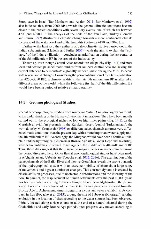
14 Climate Change and the Rise and Fall of the Oxus Civilization … 285
Soreq cave in Israel (Bar-Matthews and Ayalon 2011; Bar-Matthews et al. 1997)also indicates that, from 7000 BP onwards the general climatic conditions becamecloser to the present conditions with several dry events, one of which fits between4200 and 4050 BP. The analysis of the soils of the Van Lake, Turkey (Lemckeand Sturm 1997) illustrates a climatic change towards a more continental climate(decrease of the water level and of the humidity) between 4190 and 3040 BP.
Farther to the East also the synthesis of palaeoclimatic studies carried out in theIndian subcontinent (Madella and Fuller 2005)—with the aim to explain the “col-lapse” of the Indus civilization—concludes an aridification during the last centuriesof the 5th millennium BP in the area of the Indus valley.
To sum up, even thoughCentral Asian records are still patchy (Fig. 14.1) andmorelocal and detailed palaeoclimatic studies from southern central Asia are lacking, thecurrent data tend to demonstrate a globally wetter climate during the Mid-Holocenewith several rapid changes.Considering the periodof duration of theOxus civilization(ca. 4250–3350 BP), a climatic aridity in the late 5th millennium BP is attested indifferent areas of the world, while the following first half of the 4th millennium BPwould have been a period of relative climatic stability.
14.7 Geomorphological Studies
Recent geomorphological studies from southern Central Asia also largely contributeto the understanding of the Human-Environment interaction. They have been mostlycarried out in the ecological niches of low or high river plains (Fig. 14.1). In theMurghab alluvial fan presently in the Karakum desert (central Turkmenistan), thework done byM. Cremaschi (1998) on different palaeochannels assumes very differ-ent climatic conditions than the present day, with amore important water supply untilthe 4th millennium BP. Accordingly, the Murghab would have been a fertile alluvialplain and the hydrological system near Bronze Age sites (Gonur Depe and Takhirbaj)were active until the end of the Bronze Age, i.e. the middle of the 4th millennium BP.Thus, these data suggest that there were no major changes in water sources duringthe period discussed here. Other fluvial geomorphological studies have been madein Afghanistan and Uzbekistan (Fouache et al. 2012, 2016). The examination of thepalaeochannels of the Balkh River and the river Zerafshan reveals the strong dynamicof the hydrographical system with an extreme mobility of channels, a large rangeof movements and a great number of changes. This constant dynamic is created byclassic avulsion processes, due to neotectonic deformations and the intensity of theflow. In parallel, the displacement of human settlements over the past 10,000 yearshas been recorded according to these changes. In northern Afghanistan, the persis-tency of occupation northwest of the plain (Dashly area) has been observed from theBronze Age to Achaemenid times, suggesting a constant water availability. By con-trast, in Iran (Fouache et al. 2013), around the site of Sabzevar (Khorasan), anotherevolution in the location of sites according to the water sources has been observed.Initially located along a river course or at the end of a natural channel during theChalcolithic and early Bronze Age periods, sites progressively moved according to
286 É. Luneau
water availability, which suggests that water was less abundant. This evolution seemsto occur during the chronological range between 4450 and 3850 BP. Lastly, aroundthe Aral Sea, significant changes in moisture conditions have been reconstructedthrough the study of the water level from the archaeological data (Boroffka 2010;Boroffka et al. 2006). The authors reveal a shift in the course of the Amu-DaryaRiver and the rise of water in the Sea around 3950 BP without substantial change inthe next centuries.
In short, these environmental analyses carried out in Central Asia and northernIran mostly record a permanency in occupation patterns and water availability, orcoincide with those climatic data which identify a climate variation at the end of the5th millennium BP.
14.8 Discussion
14.8.1 A Present Lack of Correlation Betweenthe Environmental Data and the SocioculturalEvolution
All in all, the present palaeoenvironmental data, resulted from palaeoclimatic(Fig. 14.4) and geomorphological studies, do not allow us to correlate the progressivedisappearance of the Oxus civilization during the first half of the 4th millennium BPwith a climatic event.
These facts, however, do not mean that environmental dynamics did not con-tribute to the final evolution of the Oxus civilization. The study of climate historystill requires special attention and clarification.4 Climatic changes can be long-termphenomena, which may not be immediately noticeable. Consequences from morelocal changes must be evidenced as well (Wilkinson 2003). Climate phenomenamay be limited to specific, sometimes small, areas. Environmental effects of cli-matic changes can vary according to the degree of sensitivity of the geographicalarea and to the different hydrogeological contexts. The same event may not havethe same impact according to the microscales. Numerous issues need to be furtherinvestigated, such as the reaction of the different geographical features to climatechange or conversely the impact of changes in the ecological milieu on local/globalclimate (Dallmeyer and Claussen 2011; Heinecke et al. 2016).
Besides, the natural factors, in particular tectonic movements and cataclysmssuch as earthquakes, sea quakes, storms, etc., may also have played a significantrole in local disturbances (Fouache 2013). Although this area records a high level ofseismicity, until nowvery limited studies are involved inhighlighting suchdisruptions
4“The previous climate, as the most important agent influencing the alteration of all other partsof an environment, is the subject of many scientific disciplines, although the outcomes are, despitetremendous efforts, still somewhat unsatisfactory. The main reasons for this are: the complexity ofthe climate system as such, the regionality of the climate, the short history of its direct instrumentalmeasurement, the evaluation of the climatic parameters in relative terms (e.g. wetter, drier), thevarying sensitivities of the proxies, and the difficulties of their more precise dating” (Dreslerová2012: 43).

14 Climate Change and the Rise and Fall of the Oxus Civilization … 287
Fig. 14.4 Schematic graph of the records mentioning drier periods during the Mid- and LateHolocene in Central Asia and Middle East
(Berberian and Yeats 2001; Hollingsworth et al. 2010). However, if seismic activitymay potentially explained some abandonment of settlements, local destructions arelikely not sufficient to trigger a long-lasting sociocultural evolution, such as thetransformation of the Oxus civilization which mirrors a plurality of changes.
14.8.2 Resilience and Adaptations of the Populationsto Climate Variation
The impact of environmental changes differs according to the subsistence economy,the organisation of urban/rural relation, the settlement pattern and the size and type ofarchaeological sites, which are highly variable and for which correlations are still notclearly identified. Indeed, climatic change does not always imply a crisis situation.Cases of the independence of prehistoric societies when confronted with climaticconditions are known (Magny et al. 2008; Müller 2015). The difficulty of the studyis to correlate the climate scale with the human scale too. Climate changes are notbrutal phenomena, but rather an evolution, which suggests possibilities of adaptationto the events (Gregoricka 2016; McAnany and Yoffee 2009; Miller et al. 2011;Petrie et al. 2017). Populations often possess the capacity to adapt to changes, whichdepends upon the production system, the social organization and the interests of thedifferent social groups (Rosen 2007: 148–149; Sala 2014). “Social and technological

288 É. Luneau
resilience versus resistance to change can be critical factors in the ability of societiesto adapt to new environmental conditions. Resilience may vary between segmentsof society leading to greater resistance to change among those members of societyleading to greater resistance to change among those members of society who benefitfrom current conditions” (Rosen 2007: 173).
Broadly speaking, resilience to climaticmodifications can take several forms (Bin-ford et al. 1997; Rosen 1997, 2007; Sala 2014; Weniger 2012): (1) the move and/orthe dispersion of the population towards areas less affected by climatic modifications(new ecological areas); (2) an economic adaptation by a change in the economic strat-egy or by a technological adaptation to increase the production and/or the efficiencyof storage to minimize the risks of shortages. Climatic change can also be a factorof technological innovations in order to compensate difficulties and to maintain acertain threshold of vital yields for the whole population, such as the adaptation ofirrigation techniques or actions on cultivated plants (transformations of the plantsknown, new distribution of the different cultivated plants, etc.). Yet, during the FinalBronze Age in southern Central Asia, both phenomena occurred.
The movements of Bronze Age populations from North to South in the Murghabarea according to the retraction of the alluvial fan have been suggested (Hiebert 1994;Sarianidi 1981, 1990). First, climatic and archaeological data must correspond inorder to confirm such displacement was due to climatic reasons. Second, it should beacknowledged that, according to the proposed periodization, the populations wouldhave already moved since the beginning of the Bronze Age occupation in this area,attested in the north-western area around Kelleli (Masimov 1981), dated at least tothe Namazga IV period (ca. 4950–4450 BP). Especially considering the possibleconsequences of the 4.2 ka BP event, there is a priori no reason to suppose theinefficiency of the “displacement strategy” during the first half of the 4th millenniumBP, unless other factors occurred at the same time.
In any case, the one-time occupation of the sites in the Murghab has been defi-nitely rejected (Luneau 2014; Salvatori 1998, 2008). The long chronological rangeof different sites, such as Gonur Depe (Jungner 2007) or Adzhi Kui (Rossi-Osmida2007), whose occupation may have started at the end of the 6th/beginning of the5th millennium BP until the Final Bronze Age, is now well attested. The settlementpattern in theMurghab alluvial fan appears more complex than previously supposed,with a wider distribution of multi-period sites during the whole Bronze Age and abetter geographical stability of sites. The data suggest that “the settlement systemof Margiana during the Bronze Age had not been generated or conditioned by anenvironmental situation […], but by spatial rules connected to human group dynam-ics and by the structural complexity of the political and administrative forms of theterritory” (Salvatori 2008: 62). The effect of water availability for the duration ofBronze Age sites in the Murghab alluvial fan, and the systematic displacement ofsites (according to the water availability) during the Bronze Agemust still be demon-strated too, according to a detailed chronology in many areas. It is unlikely that a sitepersisted without a water supply in the vicinity, unless a larger more sophisticatedirrigation network was expanded, and this does not seem to be the case according tothe current data.

14 Climate Change and the Rise and Fall of the Oxus Civilization … 289
Another example of the dispersion of Final BronzeAge populations is the increasein sites dated to this period only in the foothills in Tajikistan (Vinogradova 2004),where the environmental conditions do not necessarily require supplementary waterintake. In Iran as well, Bronze Age populations adapted to the decrease in waterresources by changing location (Fouache et al. 2013).
This adaptation to new ecological conditions also demonstrates the capacity ofsocioeconomic transformation of society. A reorganization of the ratios agricultureand herding in a subsistence economy in favour of an increase of herding with “asupplementary exploitation of marginal areas by a lighter agro-pastoralism of steppetype, but without reducing nor the productive capacity, nor the demography of thesites related to the Oxus tradition”5 (Francfort and Lecomte 2002: 646) has also beensuggested. In southern Uzbekistan, for instance, the evolution observed at the end ofthe BronzeAge has been interpreted as an “adaptation to an environment in which thesole irrigated agriculture is not themost suitablemode of exploitation”6 (Stride 2004:280). The intensification of pastoralism would represent a real economic alternativerequired by the installation of populations in the foothills areas and the exploitationof diverse ecological areas which can be viewed as a flexible strategy. Along theKopet Dagh range as well, P.M. Dolukhanov (1981) interpreted the deposits of siltsbetween different layers at several sites as the result of repeatedmud flows implied bythe deforestation of the mountain slopes or by the increase of herding in the foothills.
Considering the improvement of farming practices, the current state of research onirrigation evokes the high dependency of BronzeAge populations upon the proximityof an active channel. Actual irrigated systems are still not proven in the different areasof the Oxus civilization. But in some regions, like in northern Afghanistan, eversince the Bronze Age populations succeeded in developing sophisticated techniquesof control and regulation of water, demonstrating direct actions on the environment.For instance, even though this is yet to be proven for the Bronze Age, in the Balkharea the former riverbeds abandoned during the successive defluviations were usedas irrigation canals, indicating high technological skills of the ancient population tocontrol the hydraulic flow (Fouache et al. 2012). Likewise, the study of the spatialrelationship of sites to water in the Murghab alluvial fan between the Late BronzeAge and the Early Iron Age (Rouse and Cerasetti 2015) indicates an increase of theaverage distance for the Early Iron Age sites in comparison to the Late/Final BronzeAge sites, which might be related to the use of more advanced hydraulic technologyin the second half of the 4th millennium BP.
5Original quotation: “une mise en exploitation complémentaire des zones marginales par un agro-pastoralisme plus léger de type steppique, mais sans que ne soient en rien diminuées ni la capacitéproductive ni la démographie des sites de la tradition de l’Oxus”.6Original quotation: “adaptation à un environnement dans lequel l’agriculture irriguée seule n’estpas le mode d’exploitation le mieux adapté”.
290 É. Luneau
Further, the possible intensification7 of the cultivation of millet in the area duringthe 4th millennium BP has been discussed, in particular regarding the connectionwith mobile populations and the exchanges over large distances in Eurasia (Milleret al. 2016; Spengler 2015). This plant is viewed as better adapted to dryness, andit may have been cultivated more with respect to an aridification. However, milletcultivation could also be linked to other reasons: the wish to increase the yields,an adaptation to the ecological environment of some specific sites, especially in thefoothills, an adaptation of the agricultural practices to a possible decrease in irri-gation, or a cultural choice influenced by other population groups, such as mobilepopulations coming from the North.8 In other areas, like in the Indus Civilization,millet could have been part of a strategy for the exploitation of new ecological areas,and it would have reduced the dependency on the winter cultures and ensured foodsupplements (Meadow 1993). These agricultural changes could have contributed tothe decline of the urban Harappan civilization, according to some scholars (Madellaand Fuller 2005). In the case of the Oxus civilization, it is possible, too, that changesof the agricultural strategies on a local scale towards a more diversified and extensiveagriculture may have contributed to social changes, implying a possible restructura-tion of the urban social system.
14.8.3 Convergence of Multiple Causes
These reflexions also go towards new perspectives of research that consider thesociocultural transformations of the Oxus civilization around 3750 BP. The hypoth-esis of a single cause, especially climatic, is likely not the most appropriate. Thesynchronism between long and one-time events, climatic and sociocultural, alwaysseems difficult to state and hazardous (Roberts et al. 2011). Sociocultural evolutionsare expected to be more complex than simplistic hypotheses; they can result frommultiple causes by the combination of different events, which are not necessarilysolely environmental (Butzer 2012; Butzer and Endfield 2012; Knapp and Manning2016). It should be reminded that changes at the end of the Bronze Age in southerncentral Asia did not only affect the settlement pattern and the subsistence economy,but also the ideology, the funeral strategy and the relations with neighbouring soci-eties. Populations of the Oxus civilization at that time were faced with importanttransformations related to interregional exchanges (Luneau 2016) and cohabitationwith mobile populations in the territory of the Oxus civilization (Cerasetti 2012;
7In archaeological literature the presence of millet is mentioned at several sites chronologicallydated prior to the Final Bronze Age in southern Central Asia, such as Shortughaï from the Period I,Level II (Francfort et al. 1989: 175–185), which is currently dated to the end of the 5th millenniumBP (Francfort 2016) or, possibly at Sapallitepe dated to the beginning of the 4th millennium BP(Askarov 1973: 133), and becoming more frequent in the latest levels dated to the Final BronzeAge, especially in campsites of mobile populations (3650–3450 BP).8Archaeobotanical studies recently put forward the role of mobile pastoralists in the dispersion ofcrops, particularly millet (Spengler et al. 2014).
14 Climate Change and the Rise and Fall of the Oxus Civilization … 291
Kuz’mina 2007; Luneau 2014, 2017; Rouse and Cerasetti 2018; Vinogradova andKuz’mina 1996). The understanding of the convergence of these events is a widertopic of research.
14.9 Conclusion
The palaeoclimatic data availablewith reference to theMid- to LateHolocene inCen-tral Asia indicate so far a general wetter climate than the preceding Early Holocenewith different events of rapid climate changes. In particular, the well-attested 4.2 kaBP aridification event may have been also effective in Central Asia, which suggeststhat the early period of the Oxus civilization was faced with an aridity, whereas thelast phase (ca. 3750–3350 BP) could have been a period of relative climatic sta-bility. The absence of a clear coincidence between specific climatic events and the“collapse” of the Oxus civilization can be inferred, as far as now.
On the contrary, the palaeoclimatic data raise questions about the consequencesof an aridification at the beginning of the Oxus civilization. How and to what degree?Was the rise of the Oxus civilization linked to water management (water availability,improvement of irrigation techniques, etc.)? The climate aridity in the area at the endof the 5th millennium BP asserts the ability of the populations to maintain a highagricultural and economic potential for the development of the society and particu-larly challenge on the nature and degree of dependence of the subsistence system onirrigated cultivation. The relationship between irrigation and the state as well as themodel of hydraulic societies as asserted by K.A. Wittfogel (1957) have been rightlycriticized (see Francfort et al. 1989; Stride et al. 2009 for instance) because of theexistence of complex societies without large-scale irrigation or conversely, the prac-tice of large-scale irrigations by small independent communities. Further research onthe link between water management and the development of the Oxus Civilizationwill be particularly relevant.
Indeed, the Human-Environment relationship in the past, as in the present, is acomplex process, which can have highly various impacts on both human society andecology in regard to the local situation. Environmental changes and events may notbe a factor of human innovation and cultural evolution (Roberts et al. 2016), justas they may also create significant vulnerability and disruptions in human actions(Manning et al. 2017).
Hence, the challenge relies upon the identification of the impacts of climate vari-ations on local natural resources, flora and fauna and of the societies that dependedupon this environment. “A key focus for understanding the impact of climate onhumans is now to create a record that reflects local climate at high temporal andspatial resolution across an entire landscape” (d’Alpoim Guedes et al. 2016: 3).Multi-scalar research is needed for increasing more precise archaeological recordson social shifts and on the Holocene climate variability in Central Asia, according toregional and micro-regional analyses and related to a robust and detailed chronology(Butzer 2012; Dearing 2006; Sala 2014). The temporal uncertainty does not allow

292 É. Luneau
us currently to provide an adequate temporal and spatial climatic reconstruction ofthe climate and constitutes a primary target for future research. The review of envi-ronmental studies on Central Asian prehistory also reveals that the fluvial dynamics,which can have different explanations, should not be the only field in study to considerthe human socio-spatial evolution. Different fields in research (geography, geology,anthropology, ecology, isotopes, etc.) must be exploited in order to make statementsabout the Holocene climate variability in Central Asia and the local impact on theenvironment and on human communities (settlement pattern and sociocultural trans-formations, coevolution of the fauna and the flora in specific environments, etc.).Simultaneously, anthropic factors are crucial for sociocultural mutations (whateverthe environmental conditions). The capacity of anthropogenic changes (deforesta-tion, desertification, salinization, woodland management, etc.) and of adaptation ofhuman groups, according to phenomena that are currently underestimated (such asflexible economic exploitation of different ecosystems, actions on plants and animals,etc.) is still a large field to explore in the human-environment dynamics in prehistoricCentral Asia. It is necessary to take the complexity of human interactions with theecosystem into account, as suggested by the niche construction approach (Spengler2014). The simulation of the interactions between social and natural forces throughmodelling (Butzer and Endfield 2012; Sala 2014) also provides now a major supportfor the understanding of the long-term socio-natural systems in Eurasia.
Acknowledgements I would like to express my gratitude to Professor Eric Fouache (UniversitySorbonne Abu Dhabi) for his remarks and suggestions for reading, and I also warmly thank theanonymous reviewers for their highly helpful and valuable comments.
References
Aishan, T., Halik, U., Kurban, A., Cyffka, B., Kuba, M., Betz, F., et al. (2015). Eco-morphologicalresponse of floodplain forests (Populus euphratica Oliv.) to water diversion in the lower TarimRiver, northwest China. Environmental Earth Science, 73(2), 533–545.
Askarov, A. A. (1973). Sapallitepa. Tashkent: Filiala Akademija Nauk.Bar-Matthews, M., & Ayalon, A. (2011). Mid-Holocene climate variations revealed by high-resolution speleothem records fromSoreq Cave, Israel and their correlationwith cultural changes.The Holocene, 21(1), 163–171.
Bar-Matthews, M., Ayalon, A., & Kaufman, A. (1997). Late quaternary paleoclimate in the East-ern Mediterranean region from stable isotope analysis of speleothems at Soreq Cave, Israel.Quaternary Research, 47(2), 155–168.
Beer, R., Heiri, O., & Tinner, W. (2007). Vegetation history, fire history and lake developmentrecorded for 6300 years by pollen, charcoal, loss on ignition and chironomids at a small lake insouthern Kyrgyzstan (Alay Range, Central Asia). The Holocene, 17(7), 977–985.
Berberian, M., & Yeats, R. S. (2001). Contribution of archaeological data to studies of earthquakehistory in the Iranian Plateau. Journal of Structural Geology, 23, 563–584.
Binford, M.W., Kolata, A. L., Brenner, M., Janusek, J. W., Seddon, M. T., Abbott, M., et al. (1997).Climate variation and the rise and fall of an Andean Civilization. Quaternary Research, 47,235–248.
Boroffka, N. (2010). Archaeology and its relevance to climate and water level changes: A review.In A. G. Kostianoy & A. N. Kosarev (Eds.), The aral sea environment (pp. 283–303). Berlin:Springer.
14 Climate Change and the Rise and Fall of the Oxus Civilization … 293
Boroffka, N., Oberhänsli, H., Sorrel, P., Demory, F., Reinhardt, C., Wünnemann, B., et al. (2006).Archaeology and climate: Settlement and lake-level changes at the Aral Sea. Geoarchaeology,21(7), 721–734.
Butzer, K. W. (2012). Collapse, environment, and society. PNAS, 109, 3632–3639.Butzer, K. W., & Endfield, G. H. (2012). Critical perspectives on historical collapse. PNAS, 109,3628–3631.
Cattani,M. (2008). The final phase of theBronzeAge and the “AndronovoQuestion” inMargiana. InS. Salvatori &M. Tosi (Eds.),The Bronze Age andEarly Iron Age in theMargiana lowlands. Factsand methodological proposals for a redefinition of the research strategies. The archaeologicalmap of the Murghab delta studies and reports (Vol. II, pp. 133–151). Oxford: Archaeopress.
Cattani, M., Cerasetti, B., Salvatori, S., & Tosi, M. (2008). The Murghab Delta in Central Asia1990–2001: The GIS from research source to a reasoning tool for the study of settlement changein long-term fluctuations. In S. Salvatori & M. Tosi (Eds.), The Bronze Age and Early Iron Agein the Margiana lowlands: Facts and methodological proposals for a redefinition of the researchstrategies: The archaeological map of the Murghab delta studies and reports (Vol. II, pp. 39–45).Oxford: Archaeopress.
Cerasetti, B. (2012).Remote sensing and surveyof theMurghab alluvial fan, southernTurkmenistan:The coexistence of nomadic herders and sedentary farmers in the late Bronze Age and early IronAge. In R. Matthews, & J. Curtis (eds.), Proceedings of the 7th International Congress on theArchaeology of the Ancient Near East, 12 April–16 April 2010 (Vol. 1, pp. 539–558). Wiesbaden:Harrassowitz Verlag.
Chen, F., Yu, Z., Yang, M., Ito, E., Wang, S., Madsen, D. B., et al. (2008). Holocene moistureevolution in arid central Asia and its out-of-phase relationship with Asian monsoon history.Quaternary Science Reviews, 27, 351–364.
Cheng, H., Zhang, P. Z., Spötl, C., Edwards, R. L., Cai, Y. J., Zhang, D. Z., et al. (2012). The climaticcyclicity in semiarid-arid central Asia over the past 500,000 years.Geophysical Research Letters,39.
Cheng, H., Spötl, C., Breitenbach, S. F. M., Sinha, A., Wassenburg, J. A., Jochum, K. P., et al.(2016). Climate variations of Central Asia on orbital to millennial timescales. Scientific Reports,6, 36975.
Courty, M.-A., & Weiss, H. (1997). The scenario of environmental degradation in the Tell LeilanRegionb, Ne Syria, during the late third Millenium abrupt climate change. In H. N. Dalfes,G. Kukla, & H. Weiss (Eds.), Third Millenium BC climate change and old world collapse(pp. 107–147). Berlin, Heidelberg: Springer.
Cremaschi, M. (1998). Palaeohydrography and middle holocene desertification in the NorthernFringe of the Murghab Delta. In A. Gubaev, G. A. Koshelenko, & M. Tosi (Eds.), The archae-ological map of the Murghab delta. Preliminary reports 1990–1995 (pp. 15-25). Roma: IstitutoItaliano per l’Africa e l’Oriente.
Cullen, H. M., de Menocal, P. B., Hemming, S., Hemming, G., Brown, F. H., Guiderson, T., et al.(2000). Climate change and the collapse of the Akkadian Empire: Evidence from the deep sea.Geology, 28(4), 379–382.
d’Alpoim Guedes, J. A., Crabtree, S. A., Bocinky, R. K., & Kohler, T. A. (2016). Twenty-firstcentury approaches to ancient problems: Climate and society. PNAS, 113(51), 14483–14491.
Dalfes, H. N., Kukla, G., & Weiss, H. (1997). Third Millenium BC climate change and old worldcollapse. Berlin, Heidelberg: Springer.
Dallmeyer, A., & Claussen, M. (2011). The influence of land cover change in the Asian monsoonregion on present-day and mid-Holocene climate. Biogeosciences, 8, 1499–1519.
De Pauw, E. (2007). Principal biomes of Central Asia. In R. Lal, M. Suleimenov, B. A. Stewart,D. O. Hansen, & P. Doraiswamy (Eds.), Climate change and terrestrial carbon sequestration inCentral Asia (pp. 3–24). London: Taylor&Francis.
Dearing, J. (2006). Climate-human-environment interactions: Resolving our past. Climate of thePast, 2(2), 187–203.
deMenocal, P. B. (2001). Cultural responses to climate change during the late holocene. Science,292, 667–673.
294 É. Luneau
Djamali, M., Brewer, S., Breckle, S. W., & Jackson, S. T. (2012). Climatic determinism in phyto-geographic regionalization: A test from the Irano-Turanian region, SW and Central Asia. Flora,207, 237–249.
Dolukhanov, P. M. (1981). The ecological prerequisites for early farming in Southern Turkmenia.In P. L. Kohl (Ed.), The Bronze Age Civilization of Central Asia. Recent Soviet Discoveries(pp. 359–385). New York: M.E. Shape.
Dolukhanov, P. M. (1988). Paléoécologie de l’Asie centrale aux Ages de la Pierre et du Bronze. InJ.-C. Gardin (Ed.), L’Asie centrale et ses rapports avec les civilisations orientales des origines àl’âge du Fer, Mémoires de la Mission Archéologique Française en Asie centrale (pp. 215–221).Paris: Editions de Boccard.
Dreslerová, D. (2012). Human response to potential robust climate change around 5500 cal BP in theTerritory of Bohemia (the Czech Republic). Interdisciplinaria Archaeologica Natural Sciencesin Archaeology, III, 1, 43–55.
Fouache, E. (2013). Using the geo-archaeological approach to explain past urban hazards. In D.Serre, B. Barroca, & R. Laganier (Eds.), Resilience and urban risk management (pp. 15–20).London: Taylor&Francis Group.
Fouache, E., Besenval, R., Cosandey, C., Coussot, C., Ghilardi, M., Huot, S., et al. (2012). Pale-ochannels of the Balkh river (northern Afghanistan) and human occupation since the Bronze Ageperiod. Journal of Archaeological Science, 39, 3415–3427.
Fouache, E., Francfort, H.-P., Cosandey, C., Adle, C., Bendezu-Sarmiento, J., & Vahdati, A. A.(2013). Les régions de Bam et de Sabzevar (Iran): une évolution dans l’implantation des sitesarchéologiques et dans la gestion des ressources en eau compatible avec l’hypothèse d’une aridi-fication croissante du climat entre 2500–1900 BC. In J. Bendezu-Sarmiento (Ed.), L’archéologiefrançaise en Asie centrale, Cahiers d’Asie centrale, 21–22 (pp. 559–572). Paris: Editions deBoccard.
Fouache, E., Rante, R., Mirzaakhmedov, D., Ragala, R., Dupays, M., Vella, C., et al. (2016). Therole of catastrophic floods generated by collapse of natural dams since the neolithic in theOases ofBukhara andQaraqöl: Preliminary results. International Journal ofGeohazards andEnvironment,2(3), 150–165.
Frachetti, M., & Rouse, L. M. (2012). Central Asia, the steppe and the Near East, 2500-1500BC. In D. Potts (Ed.), Companion to the Archaeology of the Near East (pp. 687–705). London:Blackwell.
Francfort, H.-P. (2009). L’âge du Bronze en Asie centrale. La civilisation de l’Oxus. Anthropologyof the Middle East, 4(1), 91–111.
Francfort, H.-P. (2016). How the twins met: Indus and Oxus Bronze Age civilizations in East-ern Bactria: Shortughaï revisited forty years later. In N. A. Dubova (Ed.), Trudy MargianskojArkheologicheskoj Ekspeditsii (pp. 461–475). Moskow: Starij Sad.
Francfort, H.-P., & Lecomte, O. (2002). Irrigation et société en Asie centrale des origines à l’époqueachéménide. Annales Histoire, Sciences Sociales, 57(3), 625–663.
Francfort, H.-P., Boisset, C., Buchet, L., Desse, J., Echallier, J.-C., Kermorvant, A., et al. (1989).Fouilles de Shortughaï: recherches sur l’Asie centrale protohistorique. Paris: Diffusion de Boc-card.
Gentelle, P. (2001). Irrigations antiques en Bactriane du nord: l’image de satellite, la prospectionarchéologique, les inférences historiques. In P. Leriche, C. Pidaev, M. Gelin, & K. Abdullaev(Eds.),LaBactriane au carrefour des routes et des civilisations d’Asie centrale. Termez et les villesde Bactriane-Tokharestan. Actes du colloque de Termez 1997 (pp. 163–172). Paris: Maisonneuve& Larose—IFEAC.
Gerasimov, I. P. (1978). Ancient rivers in the deserts of Soviet Central Asia. In W. C. Brice (Ed.),The environmental history of the near and middle east since the Last Ice Age (pp. 319–334).London: Academic Press.
Gessner, U., Naeimi, V., Klein, I., Kuenzer, C., Klein, D., & Dech, S. (2013). The relationshipbetween precipitation anomalies and satellite-derived vegetation activity in Central Asia. Globaland Planetary Change, 110(A), 74–87.
14 Climate Change and the Rise and Fall of the Oxus Civilization … 295
Giosana, L., Clift, P. D., Macklinc, M. G., Fuller, D. Q., Constantinescue, S., Durcanc, J. A., et al.(2012). Fluvial landscapes of the Harappan civilization. Proceedings of the National Academy ofSciences of the United States of America, 109(26), 1688–1694.
Gregoricka, L. A. (2016). Human response to climate change during the Umm an-Nar/Wadi Suqtransition in the United Arab Emirates. International Journal of Osteoarchaeology, 26, 211–220.
Haug, G. H., Ganthier, D., Peterson, L. C., Sigman, D. M., Hughen, Y. R., & Aeschlimann, B.(2003). Climate and the collapse of Maya Civilization. Science, 299, 1731–1735.
Heinecke, L., Mischke, S., Adler, K., Barth, A., Biskaborn, B.K., Plessen, B., et al. (2016). Latepleistocene to Holocene climate and limnological changes at Lake Karakul (Pamir Mountains,Tajikistan). Climate of the Past Discussions, https://doi.org/10.5194/cp-2016-34.
Hiebert, F. T. (1994). Origins of the Bronze Age Oasis Civilization in Central Asia. Cambridge:Peabody Museum of Archaeological and Ethnological Harvard University.
Holdaway, S. J., Douglass, S. J., & Fanning, P. C. (2013). A new ecological framework for under-standing human-environment interactions in Arid Australia. In D. Frankel, J. M. Webb, & S.Lawrence (Eds.), Archaeology in environment and technology: intersections and transforma-tions (pp. 51–68). London: Routledge.
Hollingsworth, J., Nazari, H., Ritz, J.-F., Salamati, R., Talebian, M., Bahroudi, A., et al. (2010).Active tectonics of the east Alborz mountains, NE Iran: Rupture of the left-lateral Astaneh faultsystem during the great 856 A.D. Qumis earthquake. Journal of Geophysical Research, 115,https://doi.org/10.1029/2009jb007185.
Jungner, H. (2007). Radiocarbon dating of samples from the Necropolis of Gonur in Turkmenistan.In V. I. Sarianidi (Ed.), Necropolis of Gonur (pp. 338–339). Athens: Kapon Editions.
Kakroodi, A. A., Kroonenberg, S. B., Hoogendoorn, R. M., Mohammd Khani, H., Yamani, M.,Ghassemi, M. R., et al. (2012). Rapid Holocene sea-level changes along the Iranian Caspiancoast. Quaternary International, 263, 93–103.
Khlopina, L. I. (1972). Southern Turkmenia in the Late Bronze Age. East and West, 22(3–4),199–214.
Kirch, P. V. (2005). Archaeology and global change: The holocene record. Annual Review of Envi-ronment and Resources, 30(1), 409–440.
Knapp, A. B., & Manning, S. W. (2016). Crisis in context: The end of the Late Bronze Age in theEastern Mediterranean. American Journal of Archaeology, 120(1), 99–149.
Kohl, P. L. (1984). Central Asia: Paleolithic beginnings to the Iron Age. Paris: Editions Recherchesur les Civilisations.
Kohl, P. L. (2007). The making of Bronze Age Eurasia. Cambridge: Cambridge University Press.Koshelenko, G. A., Gubaev, A., Gaibov, V. A., &Bader, A. (1994).Mervskij Oazis: dinamika sistemrasselenija i irrigatsii. Vestnik Drevnei Istorii, 4, 79–91.
Kremenetski, C. V. (1997). The Late Holocene environmental and climate shift in Russia andsurrounding lands. In H. N. Dalfes, G. Kukla, & H. Weiss (Eds.), Third Millenium BC climatechange and old world collapse (pp. 351–370). Berlin, Heidelberg: Springer.
Kremenetski, C. V., Tarasov, P. E., & Cherkinsky, A. E. (1997). Postglacial development of Kaza-khstan pine forests. Géographie physique et Quaternaire, 51(3), 391–404.
Kuz’mina, E. E. (2007). The origin of the Indo-Iranians. Leiden: Brill.Kuzucuoglu, C. (2007). Climatic and environmental trends during the Third Millennium B.C. inUpper Mesopotamia. In C. Kuzucuoglu, & C. Marro (Eds.), Sociétés humaines et changementclimatique à la fin du troisième millénaire: une crise a-t-elle eu lieu en Haute Mésopotamie?Actes du Colloque de Lyon, 5–8 décembre 2005 (pp. 459–480). Paris: De Boccard.
Kuzucuoglu, C., & Marro, C. (2007). Sociétés humaines et changement climatique à la fin dutroisième millénaire: une crise a-t-elle eu lieu en Haute Mésopotamie? Actes du colloque deLyon, 5–8 décembre 2005. Paris: De Boccard.
Lamberg-Karlovsky, C. C. (2012). The Oxus civilization (aka: the Bactria-Margiana archaeologicalcomplex). The Review of Archaeology, 30, 59–75.
Lauterbach, S., Witt, R., Plessen, B., Dulski, P., Prasad, S., Mingram, J., et al. (2014). Climaticimprint of the mid-latitudeWesterlies in the Central Tian Shan of Kyrgyzstan and teleconnectionsto North Atlantic climate variability during the last 6000 years. The Holocene, 24(8), 970–984.
Lemcke, G., & Sturm, M. (1997). δ18 O and trace element measurements as proxy for the recon-struction of climate changes at Lake Van (Turkey): Preliminary results. In H. N. Dalfes, G. Kukla,
296 É. Luneau
& H. Weiss (Eds.), Third Millennium B.C. climate change and old world collapse (pp. 653–678).Berlin, Heidelberg: Springer.
Lewis, R. A. (1966). Early irrigation in West Turkestan. Annals of the Association of the AmericanGeografers, 56(3), 467–491.
Lisitsyna, G. N. (1978). Stanovlenie i razvitie oroshaemogo zemledelija v juzhnoj Turkmenii.Moskow: Nauka.
Lisitsyna, G. N. (1981). The history of irrigation agriculture in southern Turkmenia. In P. L. Kohl(Ed.), The Bronze Age civilization in Central Asia. Recent discoveries (pp. 350–358). New York:M.E. Shape.
Ljapin, A. A. (1990). Paleogeografija del’ty Murgaba (bronzovij i zheleznij veka). ProblemyOsvoenija Pustyn’, 3, 57–65.
Luneau, É. (2014).Lafin de la civilisation de l’Oxus. Transformations et recompositions des sociétésde l’âge du Bronze final en Asie centrale méridionale. Paris: De Boccard.
Luneau, É. (2015). A new assessment of the end of the Oxus Civilization (Southern Central Asia,ca. 1750–1500/1400 BCE): Overview of the transformations of the society. In G. Affanni, C.Baccarin, L. Cordera, A. Di Michele & K. Gavagnin (Eds.), Broadening Horizons 4: Conferenceof young researchers working in the Ancient Near East, Egypt and Central Asia, University ofTorino, October 2011 (pp. 303–308). Oxford: British Archaeological Reports.
Luneau, É. (2016). The fall of the Oxus civilization and the role of exchanges with the neighboringsocieties during the first half of the second Millennium B.C. In V. Lefèvre, A. Didier, & B. Mutin(Eds.), South Asian Archaeology 2012, Man and environment in Prehistoric and ProtohistoricSouth Asia: New Perspectives (Vol. 1, pp. 169–183). Turnhout: Brepols.
Luneau, É. (2017). Transfers and interactions between North and South in Central Asia during theBronze Age. In F. Grenet, A. Vergati, J. Ebert, M.-K. Lang, & C. Jahoda (Eds.), Interaction inthe Himalayas and Central Asia, proceedings of the third international SEECHAC colloquium(pp. 13-27). Vienna: Austrian Academy of Sciences Press.
Luneau, É. (in press). The End of the Oxus Civilization. In B. Lyonnet & N. Dubova (Eds.), TheWorld of the Oxus Civilization. London: Routledge.
Lyonnet, B., & Dubova, N. (in press). The World of the Oxus Civilization. London: Routledge.Madella, M., & Fuller, D. Q. (2005). Palaeoecology and the Harappan Civilisation of South Asia:A reconsideration. Quaternary Science Reviews, 25(11–12), 1283–1301.
Magny, M., Gauthier, E., Vannière, B., & Peyron, O. (2008). Paleohydrological changes over thelast millenium recorded at Lake Joux in the Jura Moutains, Switzerland. The Holocene, 18(2),255–265.
Mannig, B., Müller, M., Starke, E., Merkenschlager, C., Mao, W., Zhi, X., et al. (2013). Dynamicaldownscaling of climate change in Central Asia. Global and Planetary Change, 110(A), 26–39.
Manning, J. G., Ludlow, F., Stine, A. R., Boos, W. R., Sigl, M., & Marlon, J. R. (2017). Volcanicsuppression of Nile summer flooding triggers revolt and constrains interstate conflict in ancientEgypt. Nature Communications, (p. 900).
Masimov, I. (1981). The study of the Bronze Age sites in the Lower Murghab. In P. L. Kohl (Ed.),The Bronze Age civilization in Central Asia. Recent discoveries (pp. 194–220). New York: M.E.Sharpe.
Mayewski, P. A., Rohling, E. E., Stager, J. C., Karlén, W., Maasch, K. A., Meeker, L. D., et al.(2004). Holocene climate variability. Quaternary Research, 62(3), 243–255.
McAnany, P. A., & Yoffee, N. (2009).Questionning collapse. Human resilience, ecological vulner-ability, and the aftermath of empire. Cambridge: Cambridge University Press.
Meadow, R. (1993). Continuity and change in the agriculture of the Greater Indus Valley. Interna-tional Association for the Study of the Cultures of Central Asia Information Bulletin, 19, 63–77.
Miller, N. F., Moore, K. M., & Ryan, K. (2011). Sustainable lifeways: Cultural persistence in anever-changing environment. Philadelphia: University of Pennsylvania Museum of Archaeologyand Anthropology.
Miller, N. F., Spengler, R. N., & Frachetti, M. (2016). Millet cultivation across Eurasia: Origins,spread and the influence of seasonal climate. The Holocene, 26(10), 1566–1575.
14 Climate Change and the Rise and Fall of the Oxus Civilization … 297
Mischke, S., Rajabov, I., Mustaeva, N., Zhang, C., Herzschuh, U., Boomer, I., et al. (2010). Modernhydrology and late Holocene history of Lake Karakul, Eastern Pamirs (Tajikistan): A reconnais-sance study. Palaeogeography, Palaeoclimatology, Palaeoecology, 289, 10–24.
Morales, M., Barberena, R., Belardi, J. B., Borrero, L., Cortegoso, V., Durán, V., et al. (2009).Reviewing human–environment interactions in arid regions of southern South America duringthe past 3000 years. Palaeogeography, Palaeoclimatology, Palaeoecology, 281(3–4), 283–295.
Mousavi, A. (2008). Late Bronze Age in North-Eastern Iran: an alternative approach to persistingproblems. Iran, XLVI , 105–120.
Mueller, L., Suleimenov, M., Karimov, A., Qadir, M., Saparov, A., Balgabayev, N., et al. (2014).Land and water resources of Central Asia, their utilisation and ecological status. In L. Mueller,A. Saparov, & G. Lischeid (Eds.), Novel measurement and assessment tools for monitoring andmanagement of land and water resources in agricultural landscapes of Central Asia (pp. 3–59).Heidelberg: Springer.
Müller, J. (2015). Crisis – what crisis? Innovation: Different approaches to climatic change around2200BC. InH.Meller,H.WolfgangArz, R. Jung,&R.Risch (Eds.), 2200BC–EinKlimasturz alsUrsache für denZerfall der altenWelt? 7.MitteldeutscherArchäologentag vom23. bis 26.Oktober2014 in Halle (Saale) (pp. 651–667). Haale: Landesamt für Denkmalpflege und ArchäologieSachsen-Anhalt.
P’jankova, L. T. (1994). Central Asia in the Bronze Age: Sedentary and nomadic cultures. Antiquity,68, 355–372.
Petrie, C. A., Singh, R. N., Bates, J., Dixit, Y., French, C. A. I., Hodell, D. A., et al. (2017).Adaptation to variable environments, resilience to climate change. Investigating land, water andsettlement in Indus Northwest India. Current Anthropology, 58.
Possehl, G. (2007). The Middle Asian interaction sphere. Trade and contact in the 3rd MilleniumBC. Expedition, 49(1), 40–42.
Ricketts, R. D., Johnson, T. C., Brown, E. T., Rasmussen, K. A., & Romanovsky, V. V. (2001).The Holocene paleolimnology of Lake Issyk-Kul, Kyrgyzstan: Trace element and stable iso-tope composition of ostracodes. Palaeogeography, Palaeoclimatology, Palaeoecology, 176(1),207–227.
Roberts, N., Eastwood,W. J., Kuzucuoglu, C., Fiorentino, G., & Caracuta, V. (2011). Climatic, veg-etation and cultural change in the eastern Mediterranean during the mid-Holocene environmentaltransition. The Holocene, 21(1), 147–162.
Roberts, P., Henshilwood, C. S., vanNiekerk, K. L., Keene, P., Gledhill, A., Reynard, J., et al. (2016).Climate, environment and early human innovation: Stable isotope and faunal proxy evidence fromarchaeological sites (98–59 ka) in the Southern Cape, South Africa. Plos One, 11(7), e0157408.
Rosen, A. M. (1997). Environmental change and human adaptational failure at the end of the earlyBronzeAge in the Southern Levant. InH.N.Dalfes, G.Kukla,&H.Weiss (Eds.),ThirdMilleniumBC climate change and old world collapse (pp. 25–38). Berlin, Heidelberg: Springer.
Rosen, A. M. (2007). Civilizing climate: Social responses to climate change in the ancient neareast. Plymouth: AltaMira Press.
Rossi-Osmida, G. (2007). Adzhi Kui Oasis. La citadella delle statuette. Venizia: Il Punto Edizioni.Rouse, L., &Cerasetti, B. (2015).Micro-dynamics andmacro-patterns: Exploring new archaeologi-cal data for the lateHolocenehuman-water relationship in theMurghab alluvial fan,Turkmenistan.Quaternary International, 437, 20–34.
Rouse, L., & Cerasetti, B. (2018). Mixing metaphors – sedentary-mobile interactions and local-global connections in prehistoric Turkmenistan. Antiquity, 92(363), 674–689.
Sala, R. (2014). Methodological problems concerning the correlation between plaeoclimatic andarchaeological data. In C.C. Lamberg-Karlovsky, B. Genito, & B. Cerasetti (Eds.), My Life islike the Summer Rose. Maurizio Tosi e l’Archeologia como modo di vivere. Papers in honourof Maurizio Tosi for his 70th birthday (pp. 677–684). Oxford: British Archaeological ReportsInternational Series 2690.
Salvatori, S. (1998). Margiana archaeological map: The Bronze Age settlement pattern. In A.Gubaev, G. A. Koshelenko, & M. Tosi (Eds.), The archaeological map of the Murghab delta.Preliminary reports 1990–1995 (pp. 57–65). Roma: Istituto Italiano per l’Africa e l’Oriente.
298 É. Luneau
Salvatori, S. (2008). The Margiana settlement pattern from the Middle Bronze Age to the Parthian-Sasanian: A contribution to the study of complexity. In S. Salvatori, &M. Tosi (Eds.), The BronzeAge and Early Iron Age in the Margiana Lowlands. Facts and Methodological Proposals for ARedefinition of the Research Strategies. The Archaeological Map of the Murghab Delta Studiesand Reports vol. II (pp. 57–74) Oxford: Archaeopress.
Sarianidi, V. I. (1981). Margiana in the Bronze Age. In P. L. Kohl (Ed.), The Bronze Age civilizationin Central Asia: Recent discoveries (pp. 165–193). New-York: M.E. Sharpe.
Sarianidi, V. I. (1990). Drevnosti strany Margush. Ashkhabad: Ylym.Sorrel, P., Popescu, S.-M., Klotz, S., Suc, J.-P., & Oberhansli, H. (2007). Climate variability in theAral Sea basin (Central Asia) during the late Holocene base on vegetation changes. QuaternaryResearch, 67, 357–370.
Spengler, R. (2014). Niche dwelling vs. niche construction: Landscape modification in the Bronzeand Iron Ages of Central Asia. Human Ecology, 42(6), 813–821.
Spengler, R. (2015). Agriculture in the Central Asian Bronze Age.World Prehistory, 28, 215–253.Spengler, R., Frachetti, M., Doumani, P., Rouse, L., Cerasetti, B., Bullion, E., & Mar’yashev, A.(2014). Early agriculture and crop transmission among Bronze Agemobile pastoralists of CentralEurasia. Proceedings of the Royal Society B, 281.
Stride, S. (2004). Géographie archéologique de la province du Surkhan Darya (Ouzbékistan dusud/Bactriane du nord) (Thèse de doctorat (unpublished)). Université Paris I, Paris.
Stride, S., Rondelli, B., & Mantellini, S. (2009). Canals versus horses: Political power in the oasisof Samarkand. World Archaeology, 41(1), 73–87.
Taft, L., Mischke, S., Wiechert, U., Leipe, C., Rajabov, I., & Riedel, F. (2014). Sclerochronologicaloxygen and carbon isotope ratios in Radix (Gastropoda) shells indicate changes of glacial melt-water flux and temperature since 4,200 cal yr BP at Lake Karakul, eastern Pamirs (Tajikistan).Journal of Paleolimnology.
Vinogradov,A.V.,&Mamedov,E.D. (1974). Landshaftno-klimaticheskie uslovija sredneaziatskikhpustyn’ v golotsene. Istorija Material’naja Kultury Uzbekistana, 11, 32–44.
Vinogradova, N.M. (2004). Jugo-zapadnyj Tadzhikistan v epokhu pozdnej bronzy. Moscow: InstitutVostokovedenija - Rossijskaja Akademija Nauk.
Vinogradova, N.M.&Kuz’mina, E. E. (1996). Contacts between the Steppe andAgricultural Tribesof Central Asia in the Bronze Age. In F. T. Hiebert, & N. Di Cosmo (Eds.), Between Lapis andJade. Ancient Cultures of Central Asia, Anthropology and Archaeology of Eurasia (pp. 29–54).New-York: Sharpe.
Walker, M. J. C., Berkelhammer, M., Björck, S., Cwynar, L. C., Fisher, D. A., Long, A. J., et al.(2012). Formal subdivision of theHolocene Series/Epoch: A discussion paper by aworking groupof INTIMATE (integration of ice-core, marine and terrestrial records) and the subcommissionon quaternary stratigraphy (international commission on stratigraphy). Journal of QuaternaryScience, 27(7), 649–659.
Wang, Y., Liu, X., & Herzschuh, U. (2010). Asynchronous evolution of the Indian and East AsianSummer Monsoon indicated by Holocene moisture patterns in monsoonal central Asia. Earth-Science Reviews, 103, 135–153.
Weiss, H. (2017). Megadrought and Collapse. New York: Oxford University Press.Weiss,H.,&Courty,M.-A. (1993). The genesis and collapse of theAkkadianEmpire: The accidentalrefraction of historical law. InM. Liverani (Ed.),Akkad the first world empire: Structure, ideology,traditions (pp. 131–155). Padova: Sargon.
Weninger, B. (2012). Réponse culturelle aux changements climatiques rapides de l’Holocène enMéditerranée orientale. In J.-F. Berger (Ed.), Des climats et des hommes (pp. 171–184). Paris:La Découverte.
Wilkinson, T. J. (2003). Archaeological landscapes of the near east. Tucson: The University ofArizona Press.
Wittfogel, K. (1957). Oriental despotism; a comparative study of total power. New York: RandomHouse.
14 Climate Change and the Rise and Fall of the Oxus Civilization … 299
Open Access This chapter is licensed under the terms of the Creative Commons Attribution 4.0International License (http://creativecommons.org/licenses/by/4.0/), which permits use, sharing,adaptation, distribution and reproduction in any medium or format, as long as you give appropriatecredit to the original author(s) and the source, provide a link to the Creative Commons license andindicate if changes were made.
The images or other third party material in this chapter are included in the chapter’s CreativeCommons license, unless indicated otherwise in a credit line to the material. If material is notincluded in the chapter’s Creative Commons license and your intended use is not permitted bystatutory regulation or exceeds the permitted use, you will need to obtain permission directly fromthe copyright holder.
Chapter 15Climatic and Environmental LimitingFactors in the Mongol Empire’sWestward Expansion: Exploring Causesfor the Mongol Withdrawalfrom Hungary in 1242
Stephen Pow
Abstract From its formation in the early years of the thirteenth century, theMongolEmpire expanded rapidly along the steppe belt and trade routes comprising the SilkRoad, forming partnerships with merchants and encouraging commerce, while alsosubjugating the resident nomadic and sedentary societies. In 1241–1242, theMongolsinvaded and occupied Hungary for a year before mysteriously withdrawing eastwardinto the steppes. Many theories have been offered for this event and why Hungary’sborder ended upmarking the westernmost terminus of theMongol Empire, includingmost recently Büntgen and Di Cosmo’s “environmental hypothesis” that short-termclimatic fluctuation and environmental factors played a decisive role. This paperemploys a comparative historical methodology to discuss three broad topics: thesuitability of the Kingdom of Hungary for long-term occupation by theMongols; therole that the climatic events of 1242 played in the famine that ravaged the kingdomafter the withdrawal; and the role that environmental factors could have played inMongol military setbacks and problems during the invasion. By doing so, this paperalso aims to address additional points newly raised by Büntgen and Di Cosmo in areply they made to an earlier article which questioned the enviromental hypothesis.
Keywords Mongol Empire · Mongol invasion of HungaryMongol invasion of Europe · Climate history · Steppe historyKingdom of Hungary
S. Pow (B)Medieval Studies, Central European University, Budapest Nador u. 9, 1051, Hungarye-mail: [email protected]
© The Author(s) 2019L. E. Yang et al. (eds.), Socio-Environmental Dynamics along the Historical Silk Road,https://doi.org/10.1007/978-3-030-00728-7_15
301

302 S. Pow
15.1 Introduction
15.1.1 Background
TheMongol invasion of Europe in 1241–1242, centered on Hungary, appears to havebeen part of a major operation aimed at the permanent occupation and conquest ofterritories. We cannot dismiss easily the “conquest” aspect of this massive westwarddrive and temporary occupation of Hungary when we consider a wide range of pri-mary sources which emphasize that such an intention existed, before and after theinvasion, including texts written in thirteenth-century Mongol imperial courts (DeRachewiltz 2015, 194; Boyle 1971, 108; Jahn 1977, 53). Moreover, other regionsinvaded during the Mongols’ larger overall campaign (1236–1244) were incorpo-rated into their Empire. These include the Bulgar state on the Volga, the Russianprincipalities, and the Cuman-Kipchak tribes based on the steppe belt north of theCaspian and Black Sea. As those conquests were taking place, another smaller Mon-gol forcewas pushingwestward, albeit on the southern side of the Caucasus, bringinginto submission states such as Cilician Armenia, and even invading Syria by 1244(Jackson 2005, 74–75). Thus, it is evident that the larger campaign which termi-nated in western Hungary and Croatia—also ruled by the king of Hungary in thethirteenth century—was one that resulted in permanent conquests and the expansionof the Mongol Empire. Yet, Hungary escaped the fate of its neighbors to the eastspecifically because the Mongol occupiers completely and suddenly pulled out ofEurope. This is surprising for several reasons. The first is that textual accounts of theinvasion of Hungary, whether from a European or Asian perspective, agree that it wasa highly destructive invasion; some add it resulted in huge amounts of plunder forthe withdrawing invaders (Bak and Rady 2010, 221; Boyle 1958, 271). Furthermore,the Mongols were victorious in the decisive Battle of Muhi in April 1241, whichlargely destroyed the Hungarian royal army, hindering the kingdom from offeringfurther unified resistance. Recent archaeological findings, such as coin-hoards andrural settlement sites with traces of destruction, which can be positively dated tothe invasion period (Fig. 15.1), bear witness to widespread destruction, particularlyon the Great Hungarian Plain (Vargha 2015; Laszlovszky 2012; Laszlovszky et al.2016). The invasion and occupation of Hungary reads like a litany of Mongol suc-cesses at the expense of the local populations and their leaders, which makes theMongol decision to abruptly withdraw thousands of kilometers eastward in 1242 allthe more mysterious to scholars. The Mongol Empire expanded over much of theAsian continent, subduing China, Korea, the Abbasid Caliphate, and the peoples ofInner Asia. Yet, no persuasive reason for the withdrawal from Hungary is actuallyfound in the source material, and the reasons for it are an ongoing topic of researchand speculation.

15 Climatic and Environmental Limiting Factors in the Mongol … 303
Fig. 15.1 Distribution of hoards found in Hungary connected to the invasion: trianglemixed coinand jewelry hoard; circlecoin hoard. Image courtesy of the Hungarian National Museum
15.1.2 State of the Art and Research Questions
Regarding this invasion andwithdrawal,many theories have been offered over the lastcentury though none has reached a consensus. A “single satisfying explanation” hasnot emerged in the literature, Greg S. Rogers noted over two decades ago (Rogers1996). His article was a seminal piece as it attempted to organize and categorizetheories for theMongol withdrawal in 1242, noting both the evidence for and againstthe various theories. He broadly defined four types of explanation for the withdrawal,which he termed: the “political” theory, the “geographical” theory, the “militaryweakness” theory, and the “gradual conquest” theory. The political theory, whichstill tends to be largely favored in literature, rests mainly on the testimony of Johnof Plano Carpini who visited Mongolia as a papal emissary a few years after thewithdrawal. He reported that the Mongols were essentially forced by custom to takepart in the election of a new khan in Mongolia, following the death of Ögödei Khanin December 1241. Yet, this seems unlikely because the Mongol leader Batu and hisforces did not actually return to Mongolia (Thackston 1999, 354). He instead basedhis moving court on the Volga River and established the Golden Horde withoutever returning for the new khan’s election. The geographical theory, first suggestedby Denis Sinor several decades ago, offered an alternative—the Mongols met withinsufficient pasturage on the Hungarian Plain to conduct their campaigns (Sinor1972). Joseph Fletcher disagreed with the underlying premise that the Mongolswould only try to permanently occupy locations that were geographically suitable
304 S. Pow
(Fletcher 1986), while other scholars, like Vernadsky, had argued previously thatHungary was an ideal location at the end of the steppe belt to serve as a base foroperations against Europe (Rogers 1996). The military weakness theory, holdingthat the Mongols were too weakened to continue their conquest, has some support inprimary sources but could be criticized in light of the fact that theMongols conqueredso many other great powers like the Jin Dynasty. Besides, nationalistic feeling coulddrive scholars to support it. Lastly, the theory of the “gradual conquest” held thatconquest in 1242 might not have been the intention. This explanation has provenharder to criticize, possibly because the Mongols were good at keeping intentionsand plans secret, even from the eager gaze of later historians. But a major problemwith it is that our best textual source on the Mongol invasion, that of a churchman,Rogerius, who was taken prisoner during the occupation, points out that theMongolsset up a highly effective administration in Hungary during their occupation. Rogeriuswas even taking part in the administrators’ regular meetings (Bak and Rady 2010,209). Creating a local government seems a rather surprising act to be undertaken bya raiding party during a punitive expedition.
As noted, while none of the past explanations for theMongol withdrawal has beenwholly persuasive, theories posited more recently continue at least basically alongthe same tracks outlined in the article of Rogers. Peter Jackson, taking a broader viewof the entire progress ofMongol-European relations from the early thirteenth centuryto the beginning of the fifteenth century, introduced an alarmingly complex pictureof their interactions, which hardly ended in 1242 (Jackson 2005). Hungarian schol-arship, as well, has not remained silent on the issue of the Mongol occupation, laterinvasions, and the significance and intentions behindMongol activities directed at theKingdom of Hungary (Nagy 2003). The work of Jeno Szucs, for instance, exploredthe short-term and long-term impacts of the Mongol attacks, noting that many devel-opments once thought to represent direct responses to the Mongols had precedents;the Mongol attacks acted more as catalysts for modernizing developments while thestartling recovery of the Kingdom of Hungary suggests the destruction inflicted dur-ing the first invasion of the Mongols was far from total (Szucs 1993). I offered myown theory, the only monograph-length study on this topic, several years ago; takinga comparative approachwith otherMongol conquests in diverse regions over the thir-teenth century, and the long-term character of Hungary’s interaction with Mongolsin the aftermath of the withdrawal, I concluded that it was likely strategic problems,or future military problems perceived by the Mongol leaders, which prompted thewithdrawal (Pow 2012). While this does not subscribe exactly to the “military weak-ness” theory as the evidence does not suggest the Mongols ever lost their capabilityto effectively wage war in Europe before or after 1242—I rather contend the Mongolleadership felt it was too costly or risky to advance or stay put—it still might best beplaced under that rubric.
Recently, Büntgen and Di Cosmo proposed a novel combination of paleoclimaticdata with documentary evidence to reach an explanation. The results of their findingsformed the basis of their “environmental hypothesis” which ascribes the Mongolwithdrawal in 1242 to “a general syndrome in which the effectiveness of nomadicarmies was constrained by a short-term, regional-scale climate fluctuation.” Withdendroclimatological evidence, they were able to reconstruct a weather situation in
15 Climatic and Environmental Limiting Factors in the Mongol … 305
Hungary, which saw above-average temperatures from 1238–1241 followed by asudden fluctuation to unusually cold and rainy conditions in early 1242. Owing inpart to landscape and soil conditions, “marshy terrain across the Hungarian plainmost likely reduced pastureland and decreased mobility” for the Mongols, bringingabout their withdrawal (Büntgen and Di Cosmo 2016).
The 2016 article attracted a great deal of international media attention soon afterits publication, with the findings being discussed in ordinary news stories and popu-lar scientific websites, often announcing the resolution of a centuries-old historicalmystery. Nicola Di Cosmo clarified that the climate may have been one of severalfactors at play; climate being the major driver behind the Mongol withdrawal didnot preclude other factors playing a role. Nonetheless, he compared the weather’srole in Batu’s campaign in Hungary with the Russian winter’s effect on Napoleon’sdisastrous campaign in 1812, asserting that to ignore it is “like saying the winter inRussia had no effect on Napoleon’s army” (Gearin 2016).
Scholars in Hungary from a variety of disciplines, including archaeology andlandscape ecology, raised questions regarding the environmental hypothesis, stem-ming from paleoclimatic, archaeological, and historical evidence of the invasion, andwe collaborated on a response (Pinke et al. 2017b). Büntgen and Di Cosmo’s investi-gation of the relationship between reconstructed weather patterns and documentaryevidence was justified; climate exerted important effects on steppe-based societiesand polities. Yet, the evidence could have led to an opposite conclusion than thatreached by the authors—namely, that there is little evidence that climate was a majorfactor in the Mongol decision to withdraw. Our paper focused on specific aspects oftheir arguments that are relevant for the larger questions we are looking at, regardingMongol involvement in the Eastern Europe region. We argued that above-averagerainfalls should have been beneficial for pasturage. Besides textual evidence, coinhoards suggest the greatest Mongol impact was in the low-lying Great HungarianPlain—where such evidence should be limited if flooding had seriously impededMongol mobility during their occupation (Nagy 2015; Székely 2014; Laszlovszkyet al. 2016). The historical documents from the time seem virtually silent on climateissues specifically working against the Mongols. When faced with the range of data,our article concluded that the Mongol withdrawal in 1242 likely was not primarilythe result of environmental and climatic drivers. Simultaneously to the publication ofour work, Büntgen and Di Cosmo published a further brief reply, offering responsesto five main arguments we made, while reiterating the importance of focusing on thevery specific set of data and circumstances pertaining to 1242 when assessing thewithdrawal (Büntgen and Di Cosmo 2017).
15.2 Methodology
15.2.1 A Comparative Historical Approach
Rather than being a simple response, point by point, to the reply of Büntgen andDi Cosmo, the intention here is to move to somewhat broader issues related to the

306 S. Pow
historiography of the Mongol invasion of Hungary, which have been highlighted inthese latest stages of the ongoing debate on the causes of the withdrawal. This doesnot represent a collaborative effort with specialists of various fields, but rather anindividual attempt to show what the particular problems with climatic explanationsare when a historian applies a broad comparative approach to the source material(Pow 2012). One of the advantages for a researcher of the Mongol Empire is thehuge range of sources, diffuse in both the sense of genre and the geographical andsocial contexts from which they emerged.
My approach then to addressing any issue pertaining to the Mongol Empire, andin this case the role of climatic and environmental problems in the withdrawal of1242, is not to squander the opportunity for a wide-ranging comparison of evidence,particularly textual evidence. If the report of a Chinese emissary (Olbricht and Pinks1980, 53), the account of a Persian governor in the service of the Mongols (Boyle1958, 92), and a Hungarian clergyman (Bak and Rady 2010, 213) match closely intheir description of the use of massed groups of local prisoners to besiege towns, forexample,we should see historicity in these accounts rather thanfinding another expla-nation for the parallels. Repeatedly, historians of this period can employ comparativeapproaches; we can see discussions of the same events from authors in societies thathad extremely limited contact with one another. Their common interface was withMongol rulers or invaders. Often accounts from the period can be confused or cur-sory, but the ability to view the same events from a variety of angles is somethingthat should be the envy of historians dealing with any other medieval topic. For aparticularly relevant example, we should consider the Battle of Muhi between theMongols and the Hungarians, in which we have a Chinese account based on Mongo-lian sources (the only such detailed medieval account of a battle in Europe), Persian,Hungarian, German accounts, etc. (Laszlovszky et al. 2016; Pow and Liao 2018).
In their reply article, Büntgen and Di Cosmo emphasize the importance of using“absolutely dated and spatially explicit natural archives and historical sources, whenlinking climate variability with human history” (Büntgen and Di Cosmo 2017). Theythen offer replies on five points we made: (1) We cited a letter in which Béla IVreported to the pope that his kingdom was ideally suited to the Mongols raising theirherds, but the authors responded that this would be only under normal conditions,quite unlike those in 1242; (2) We pointed out that precipitation was beneficialfor agricultural production in Hungary based on twentieth-century records, but theauthors suggested that applies to ordinary steppe conditions but not thirteenth-centuryHungary inwhich risingwater levelswould have reduced land suitable for occupationand agriculture; (3) We suggested the famine was largely manmade, but the authorsheld that (long-term) cold and wet conditions were found to contribute to famine inthe fourteenth century; (4) We pointed out that destruction was concentrated mostlyon theGreat Hungarian Plain, but the authors held that weather accounted for westernHungary escaping largely intact since it was invaded only in 1242; (5)We showed anEarly Modern depiction of Székesfehérvár to show that it was ordinarily surroundedby marshes, but the authors stated this was anachronistic and furthermore supportedthe view that marshes would have hindered the Mongols (Büntgen and Di Cosmo2017).
15 Climatic and Environmental Limiting Factors in the Mongol … 307
As is evident from the back-and-forth, the authors found our approach reliant onanachronistic data and failing to contextualize within the narrow framework of spring1242 in the Carpathian Basin with its short-term climate situation. Here, I want torestate that an advantage Mongol historiography offers by allowing comparison ofso many accounts is that we can use the broader context to make better sense ofshort-term events at the local level. In the following discussions, I would like tohighlight three broad topics. The first is the question of Hungary’s suitability forMongol occupation, which ultimately draws into focus point (1) of Büntgen and DiCosmo’s reply. The second discussion is focused on the famine experienced duringthe invasion and its aftermath, which raises issues pertaining to points (2) and (3).Finally, I discuss the topic of Mongol military capacity and the issue of resistance,fortifications etc., which highlights points (4) and (5) made by the authors in theirreply.
15.3 Discussions
15.3.1 The Question of Hungary’s “Suitability” Withinthe Mongol Empire: Before and After the Withdrawalof 1242
There are two realities ofHungary’s conditions,whichwould havemade its long-termincorporation into theMongol Empire during the thirteenth century unsurprising. Thefirst is that the Carpathian Basin, the region in which the Kingdom of Hungary wasestablished, is widely recognized as the westernmost extension of the long Eurasiansteppe belt, stretching like a highway all the way from Mongolia in the east. Indeed,the steppe did see the rapid movement and migration of nomadic or semi-nomadicpeoples along this highway, andHungary’s history before theMongol invasion atteststo no shortage of peoples such as the Huns, Avars, Pechenegs, and eventually theMagyars themselves who arrived in the ninth century and established their state inthe Carpathian Basin (Pinke et al. 2017b). As such, many groups of steppic originshad viewed the area as a suitable base to migrate, raise their herds, and wage warsof conquest or simple plundering on surrounding states. Thus, we might expect thatthe Mongols in the thirteenth century would have viewed it in a similar way.
The second reality of medieval Hungary’s conditions was that it lay on importanttrade routes, along which widespread international trade was carried out. Hungaryhad remained in the Middle Ages, after the arrival of the Magyars and the establish-ment of their kingdom, very much a country at the intersection of Turkic nomads,Byzantium, and the Latin West; not surprisingly, it had a highly heterogeneous pop-ulation (Berend 2001, 23). The kingdom hosted significant Jewish and Muslim pop-ulations whose merchants carried on a lively international trade between Europeand Asia in the leadup to the Mongol invasion. Recent archaeological research hasrevealed that a series of former Roman earthwork fortifications known as the Devil’sDykes (Ördög árok or Csörsz árka) began to function as a north-south trade route

308 S. Pow
with Muslim communities in the period of the Arpad Dynasty (1000–1301). This isevinced, for instance, by the even spacing of towns, which suggests major mercantileactivity. Products such as salt would have moved along this route from Transylva-nia to the waterways of the Balkans and Byzantium (Pinke et al. 2017a). Whenwe consider its active trade and political connections with Turkic nomads, Russianprincipalities, and Byzantium, along with its close links with theMiddle East—Mus-lim accounts describe Hungarian Muslim clerics who went to study in Aleppo, forinstance (Berend 2001, 238–239)—we can see that Hungary was very much tied intoa larger Eurasian network. Friar Julian for instance ultimately reached Magna Hun-garia on the Volga bymoving with merchants along eastern trade networks stretchingfromHungary (Göckenjan and Sweeney 1985, 75–77). From the tenth century, it waspart of this trade network and its direction of emphasis was both eastward towardKiev, a major center of international trade, and southward toward Constantinople;if not located on the routes that characterized the Silk Road per se, Hungary was atleast an important extension of periphery networks in the period leading up to theMongol invasion, though at that point Hungary’s trade focus was shifting westward(Szende 2011, 168–169). These networks continued to function as major trade routesacross East-Central Europe during Hungary’s post-invasion period of recovery andprosperity in the fourteenth and fifteenth centuries (Fig. 15.2).
This is meaningful because the Mongol Empire, since its inception in 1206, hadexpanded not simply along the steppe belt, but also along the trade routes that tra-ditionally, or perhaps out of modern fashion, are called the Silk Road. These routesshaped the empire’s functions, becoming arteries of communication vital for the cen-tral government in Mongolia to exercise control over disparate regions as the empiregrew. As such, we might view the Silk Road, along with the Eurasian steppe belt,as social and environmental conditions which made the Mongol nomads’ unprece-dented conquests possible. Chinggis Khan and his descendants had an establishedpattern of forming close partnerships with merchants who functioned in their empireas go-betweens and even spies (Allsen 1989).1 Merchants were some of the greatbeneficiaries from the conquests in the thirteenth century; we might think of MarcoPolo’s own storied career as a merchant simultaneously operating as an agent of theMongol administration. When the Mongols reached Europe in the early 1240s, itseems that Hungary, sitting at the nexus of trade routes between multiple regions(Szilágyi 2012, 77–95), would have fit well within the larger framework of theirempire.
Whether the Mongols were, as many scholars believe, really driven by a mandateset by Chinggis Khan for world conquest (Jackson 2006), or were simply motivatedby opportunism to seize areas suitable for the conditions of their nomadic lifestyleand which offered wealth they could accumulate from commerce along trade routes
1As Thomas Allsen notes, the Turkic term for merchants in the Mongol Empire, ortoG, means“partner.” Chinggis Khan had a very positive attitude to both commerce and merchants in hisempire. He was using them as messengers, go-betweens, and spies, in his very first moves towardimperial expansion beyond the steppes ofMongolia. An increasing appetite for luxury items comingfrom the empire’s frontiers only further intensified the role of merchants within it, along with theMongol government’s efforts to foster trade.

15 Climatic and Environmental Limiting Factors in the Mongol … 309
Fig. 15.2 Kraków and Buda in the road network of medieval Europe, in: On Common Path.Budapest and Kraków in theMiddle Ages. Ed. Judit Benda, Virág Kiss, Grazyna Lihonczak-Nurek,Károly Magyar. Budapest: BTM, 2016, pp. 31–37. Image courtesy of András Vadas
(Berend 2001, 35), the occupation of Hungary would appear to be the next logicalstep in their expansion after they arrived on its borders. If we see trade routes com-prising the so-called Silk Road and the Eurasian steppe belt as limiting factors to theMongol Empire’s expansion, Hungary still seems like it was suitable for a long-term

310 S. Pow
occupation. That is what makes the Mongols’ evacuation of the country in 1242, andtheir apparent lack of efforts to quickly return there,2 such a mystery.
If we consider that Hungary was suited for Mongol conquest and thus was occu-pied, there are a couple of observations related to general problems with the Bünt-gen and Di Cosmo’s premise. First, it is difficult to imagine that such a short-termfluctuation in climate as that in early 1242 could convince a highly successful andcampaign-hardened army to retreat. To subscribe to the “environmental hypothesis,”one must be of the belief that a few short months of unseasonable precipitation andlower than average temperatures were the deciding factor in driving off an army ofMongols that had successfully conquered, or was to conquer, the territory from theeastern edges of Asia to Hungary. It is hard to believe that the warriors capable ofconquering the steppes and forests fromMongolia to Hungary would have found thelatter’s climate and mud an insurmountable obstacle. That relates to a second point.TheMongols, and the other Inner Asian tribal groups they subjugated, emerged fromrugged regions prone to climatic extremes far worse than what might be expectedin the European continental climate of Hungary. Simply taken at face value, it isdifficult to accept—to paraphrase Fletcher when he criticized Sinor’s geographicaltheory—that people who had emerged from (and adapted a lifestyle to) such condi-tions, andwhowaged victoriouswars of conquest in the forest zone of Russia, the ricepaddies of Song China, and the deserts of the entire Middle East, decided to retreatfrom the Great Plain of Hungary because an unusually wet and cold early spring in1242 proved too much for them (Fletcher 1986). Several historians have argued thatecological factors did come into play in some Mongol withdrawals—for instance,they withdrew from Syria in 1244 and two contemporary Near Eastern authors men-tioned that theMongols’ horses’ hooves were damaged by the summer heat (Jackson2005, 74). John Masson Smith Jr. thoroughly analyzed several unsuccessful Mongolcampaigns in Syria and noted that logistical factors, such as the limited suppliesof pasturage and water, could have greatly constricted Mongol military operations(Smith 1984). So, there is evidence that ecological factors really did hamper the effec-tiveness of Mongol campaigns, but these failures seem related to long-term, ordinaryconditions of regions, like the deserts of Syria. Moreover, the Mongols seem to haveultimately adapted to conditions and subjugated many powerful adversaries, such asthe Song Chinese or the Abbasid Caliphate, in geographical regions that were hardlysuited to steppe modes of living and fighting. It is a trend that we acknowledge theirhigh adaptability in cases where they conquered, but in cases where they did notultimately succeed, the conclusion is often that this was predominantly because theMongols could not adapt to local ecological conditions.
Turning to Béla IV’s letter to the pope, discussed in point (1) of Büntgen andDi Cosmo’s reply and written a few years after the invasion, the king certainly wasnot of the mind that the Mongols deemed his country unsuitable for occupation. Hethought that the Mongols were going to return, and he was hearing reports of it fromhis spies and contacts to the east. Moreover, he was emphatic about the danger of the
2They did, however, invade Hungary in force again in 1285, an important detail which is neglectedin the environmental hypothesis.

15 Climatic and Environmental Limiting Factors in the Mongol … 311
Mongols occupying the country, in his words, “because they can settle their familiesand animals—in which they abound—marvelously well here, better than elsewhere”(Rosenwein 2013, 421). The authors in their reply stated that the Hungarian kingwas referring to normal conditions, rather than the short-term climate fluctuation of1242. A problem is that is not what the source records. Béla did not offer any nuanceto the circumstances in which the Mongols could settle.
Denis Sinor’s own earlier geographic theory for theMongolwithdrawal highlightsa danger related to any environmental explanation. The author is forced to overlooktextual evidence that challenges a theory or amend it to make it work when facedwith new data. In the original iteration of his theory Sinor recorded that the GreatHungarian Plain had an area of 100,000 km2, each horse needed 120 acres peryear (based on American horse breeding statistics), each Mongol soldier needed 3horses, and therefore Hungary could have accommodated at most 68,640 Mongoltroops (Sinor 1972). A few decades later, his calculation read as follows: The GreatHungarian Plain had 42,000 km2 of pasturage, each horse needed 25 acres per year,and thereforeHungary could support only 83,027Mongol troops because each soldierneeded 5 horses (Sinor 1999). It seems like what had priority in Sinor’s view wasthe theory and the data could be shifted around at will simply to keep the maximumnumber of Mongols low.
Büntgen and Di Cosmo offer something more convincing since their theory isbased on a reliable paleoclimatic model, rather than a mysteriously evolving cal-culation, but sometimes they follow Sinor’s track by making reaching inferences toconnect statements in the textual primary sources to what had been observed from thereconstructed year-by-year weather conditions. An especially noticeable example ofthis tendency is when the authors refer to Mongol activities and decisions during thesummer and fall of 1241 while they were occupying Hungary. They ordered servantsto provide shelter and fodder for their horses, did not burn crops, and kept peasantsalive with the command to take in the harvest. Even when the authors accede thatthe documentary sources are silent on any weather-related issues during that phaseof the invasion, they note, “These preparations are somehow indicative of an earlyonset of the fall/winter in 1241” (Büntgen and Di Cosmo 2016). Statements like thisleave one with the feeling that the documentary evidence is being forced to constructa narrative that emerged initially from paleoclimatic data.
Subscribing to any geographic or climatic theory requires the researcher to over-look what happened in the long-term aftermath of 1242. The Mongols regularlythreatened Hungary’s monarch with ultimatums to submit to their rule, and evenoffered him military alliances, in the years following their departure (Göckenjan1991, 61). Büntgen and Di Cosmo did not draw really any attention to this ongoingpattern of Mongol-Hungarian interactions in formulating their hypothesis for thewithdrawal. Furthermore, the Mongols did eventually launch a large-scale invasionof Hungary in 1285. Again, the motivations of theMongols and the scale of that inva-sion are uncertain and subject to debate. Nonetheless, we may conclude that it wasa much larger undertaking than the scant secondary literature on it would suggest.While English-language literature has not yet offered major studies on the so-calledSecond Mongol Invasion in 1285, two major Hungarian studies have explored these
312 S. Pow
important, if largely overlooked, events (Székely 1988; Szocs 2010). These worksoffer important perspectives from which to approach the question of what Mongolintentions were for Hungary in light of their return. Moreover, the source materialdoes indicate the Mongols suffered in 1285 from epidemics, serious weather issues,and ultimately famine in their disorganized retreat from Hungary. That the paltrysources for the 1285 campaign so persistently mention these issues, but the largerbody of sources on 1242 are utterly silent on any such difficulties suggests that theMongol forces did not experience such problems in the earlier campaign.
Hungary’s landscape and geography lent itself to nomadic incursions and occu-pations. This makes the fact that Hungary retained its autonomy more remarkablethan the Kingdom of Bohemia’s survival, for instance, or that of the principalitiesof Poland. As for Hungary’s other regional neighbors, such as Serbia, the King-dom of Bulgaria, and areas of present-day Romania, they actually were subjugatedby the Mongols to varying degrees and for different periods during the course ofthe thirteenth century (Vásáry 2005, 69–94).3 Though Büntgen and Di Cosmo doacknowledge that shortly after evacuating Hungary, the Mongols invaded and sub-jugated Bulgaria, they do not really mention the larger trend of Mongol conquestand interference in the Balkans throughout the remainder of the thirteenth century.In fact, they state, “Our paper shows that a possible reason why the Mongols whooccupied Russia under Batu and his successors did not make further attempts toexpand westward may have depended on the realization that local conditions wouldnot have supported a prolonged occupation” (Büntgen and Di Cosmo 2016).
15.3.2 The Issue of the 1242–1243 Famine in Hungaryand Its Causes
The famine that affected the Kingdom of Hungary during and after the Mongolinvasion is a frequently discussed topic among Hungarian researchers of the MiddleAges. Andrea Kiss, for instance, has looked at the topic and while she argued that theMongol invasionwas “verymuch responsible for the hunger,” she also speculated thatthe unusual cold of the winter of 1241–1242, coupled with abundant snow and ice,may have played a contributing role in the situation (Kiss 2000). As such, this couldsupport Büntgen and Di Cosmo’s hypothesis. On the other hand, József Laszlovszkyhas pointed out in a publication touching on economic history that the ecologicalsituation of medieval Hungary was such that famine occurred very rarely—whichwould suggest the famine in the 1240s was brought on by a truly exceptional setof circumstances, i.e. severe disruption caused by the invasion (Laszlovszky et al.2018). In any case, it should be noted that this famine has been already heavily studiedby generations of Hungarian scholars. The most recent conclusions by Andrea Kissare that during major and long-lasting climatic changes and many years of extreme
3Vásáry’s work offers a long and detailed summary of the continual Mongol conquests and inter-ference in the Balkans throughout the second half of the thirteenth century.

15 Climatic and Environmental Limiting Factors in the Mongol … 313
weather, famine occurred but very rarely in the whole country. Famines and foodshortage crises in Hungary were usually related to particular regions. There werevery few exceptional cases when such situations affected the whole kingdom (e.g.the mid-1310s, 1362, or 1364). But even in these periods different social groupswere affected in different ways and there were areas which were lightly or negligiblyaffected. It is also important to underline that the crisis periods were the same asthose faced in contemporary Western or Central European contexts—that is, peoplein other regions of Europe were experiencing the same famine (Kiss et al. 2016).
While the causes of the famine in 1242 remain an ongoing topic of debate, theissue has much significance for the question of the withdrawal, since much of thetextual evidence being used to support a climatic explanation relates to famine. Amajor component of Büntgen and Di Cosmo’s theory is their attempt to relate thefamine to a food crisis that the Mongol occupiers were experiencing. They arguethat the Mongol decision to feed their prisoners with less desirable parts of sheep,as recorded by their captive Rogerius, indicates that the Mongols themselves couldforesee the great famine that was to overtake Hungary. Deciding to feed prisonersonly parts of sheep, rather than the whole sheep they were receiving beforehand,could be motivated by a variety of factors, including a lost sense of the value orimportance of the prisoners. Indeed, Rogerius heard from informants that the sameprisoners would be subjected to a wholesale massacre (Bak and Rady 2010, 221).Moreover, Rogerius, who escaped captivity around that time, mentioned that thischange in the rations allotted to prisoners happened only after the Mongols beganwithdrawing from eastern Hungary into Cumania (Wallachia and/or Moldavia). So,it seems rather problematic to try to link the Mongol decision to feed prisoners lessgenerously with a recognition that famine was going to strike Hungary.
Famine did severely afflict the local Hungarian population, but textual sourcesmake it clear why this happened, and climate was not the primary driver. A contem-porary churchman stated that it happened because the peasants were forced duringthe invasion to abandon their crop fields for two growing seasons (Karbic et al. 2006,303). Naturally, if the farmers were unable to cultivate crops because they couldnot stay on their fields owing to the disruption and danger of the invasion, a seriousfamine was going to set in. Others had harvested some crops but only to supply themto the Mongols in 1241 (Bak and Rady 2010, 211).
What happened in Hungary in 1242 was hardly an isolated incident. Shortly afterthewithdrawal, aDominican emissarywas sent into theMongol Empire tomeet themwith letters from the pope. He passed through many regions that had been affectedrecently by invasions and eventually met with theMongols in Armenia. In his report,detailing Mongol methods of waging war, he stated, “In every country which theTartars destroy, famine always follows” (Richard 1965, 44). What his report wouldsuggest is that Mongol invasions consistently triggered famine in all the affectedareas, far beyond Hungary, and we can easily infer that this happened because it wasa larger strategy of theMongols. The famines they triggered were intentional—a sortof weapon to crush resistance. When we consider that testimony, it is very hard toentertain the notion that the starvation which affected Hungary’s people in 1242 wasthe result of a short-term fluctuation in climate. Kirakos of Gandzak, an Armenian
314 S. Pow
churchman taken prisoner, noted that the Mongols invaded in the summer whenthe harvest had not been reaped or gathered in the granaries. They came with theirlivestock and ate and trampled everything, so that when they left Armenia in thewinter the people had nothing to eat and died of starvation. However, Kirakos noted,that winter was “not severely cold, as at other times but as mild as one could wish”(Bedrosian 1986, 224). Here we see a close parallel to what happened in Hungary interms of famine, albeit without the cold weather.
If we need further proof, Juvaini describes instigating famine as a regular featureof steppe warfare against sedentary societies. Describing the actions of Küchlüg, aNaiman chieftain who fled fromChinggis Khan to the Qara Qitai and was attemptingto subjugate the famous Silk Road city of Kashgar, Juvaini noted, “Küchlüg, at everyharvest time, would send his troops to devour their crops and consume themwith fire.When for three or four years they had been prevented from gathering in their corn,and a great dearth had made its appearance, and the populace were distressed withfamine; they then submitted to his command” (Boyle 1958, 65). This type of warfarewas being practiced from the very beginning of the empire, even by refugees fleeingfromChinggis Khan. Changchun, a Chinese Daoist monk, passed through the formerKhwarazm Empire shortly after its conquest and described a society so broken downby famine and brigandage that the Mongol governor of Samarkand refused to residein the palace of the former shah (Waley 1931, 93). In their campaigns against Korea,the Mongols inflicted famine on the population to pressure the king to submit. Theking in turn complained to theMongol leadership in terms that sound rather familiar:“…several times you sent army leaders to censure [the people]. The people have noland to cultivate and in farming there was no time to harvest. Considering this land[had only] flowering grass, what could be produced? Thinking that we had no way ofoffering up tribute and to present it would be difficult, my fear was extreme” (Schultzand Kang 2014, 307). TheMongols inflicted such severe starvation on the populationthat finally they started killing their own government-appointed leaders or incitingMongols to attack certain fortresses. Ultimately the military governor of Korea wasoverthrown and assassinated, not long after he refused to open a granary. In the end,the king finally sent his son to the Mongol court to submit in 1259 by which time theMongols had seized the entire harvest, epidemics were breaking out, and starvationwas rampant (Schultz and Kang 2014, 369–377).
A comparative look at texts from different times and regions should lead us tothe conclusion that the famine that unfolded was intentionally brought about by theinvaders.As for theMongols’ animals and their pasturageneeds, the carrying capacityof the Great Hungarian Plain allowed for millions of animals, even during the LittleIce Age of the Early Modern era (Pinke et al. 2017b), so it is difficult to imagine thateven a large Mongol army would have faced a crisis with pasturage owing to short-term climate fluctuations. Büntgen and Di Cosmo did not always clearly distinguishif the food crisis was one afflicting the animals of theMongol occupiers or simply oneaffecting the agrarian-basedpopulace ofHungary.These are twoverydifferent things.Furthermore, it seems the authors supplied documentary evidence of a victual crisisfacing the latter group as evidence that the former group was experiencing somethingsimilar. It is problematic to link the accounts of widespread starvation of Hungary’s
15 Climatic and Environmental Limiting Factors in the Mongol … 315
sedentary, agrarian population to the issue of pasturage being limited by short-termclimate fluctuation of early 1242. The obvious problem with such a viewpoint is thatit is well known that the Mongols relied primarily on their herds of animals for food.So, the disruption of grain harvests would not have had the same effect on theMongoloccupiers as it had on the local peasantry. Büntgen and Di Cosmo, however, arguedthat not only did cold wet conditions in 1242 affect cultivated crop production, butthey limited pasturage in theGreat Plain, placing stresses on theMongols to feed theiranimals. The sources from a Hungarian context, and far beyond, leave us no doubtthat the famine was mostly a manmade and intentionally triggered phenomenon.
15.3.3 Local Resistance and the Possibility of DiminishedMilitary Capacity as a Result of Climate in 1242
There are primary source accounts ofmilitary problems that theMongols experiencedin 1242, and it is an important question towhat degree these were caused by awet andcold climate and its effect on soil, fortifications, pasturage etc. In point (4) of theirreply, Büntgen and Di Cosmo suggested a sort of dichotomy between the militarysuccesses experienced by the Mongols in 1241, and the setbacks they are recordedto have suffered, ostensibly because of climate, in 1242 (Büntgen and Di Cosmo2017). Nonetheless, their description of 1241 as a year flush with successes mightbe a bit of an oversimplification because the Mongols appear to have been preventedfrom crossing the Danube and pursuing the Hungarian king, Béla IV. In fact, the kingstated in his letter to the pope that his forces held off the Mongols from advancingfor ten months after the disaster at Muhi (Rosenwein 2013, 421). Furthermore, thebiography of Sübe’etei, the famous general who oversaw the invasion of Hungary,which is found in the Yuan Shi, states that the Mongol princes wanted to flee thecountry during or shortly after the battle of Muhi in April 1241 (Pow and Liao2018). They were only prevented from doing so by Sübe’etei shaming them. Allof this suggests that the level of resistance they were experiencing may have had ademoralizing effect on the Mongol commanders already a year before they in factwithdrew their forces.
Büntgen and Di Cosmo suggest that the difficulties the Mongols experienced tak-ing fortresses in 1242 had much to do with the swampy conditions they encountered,owing to the unique climate situation experienced at that time. This tends to reduc-tionism since it ignores some topographical differences (between the hilly west andflat east of Hungary for instance), and the archaeological issues related to fortifica-tions. In fact, an earlier study by Erik Fügedi demonstrated that the important factorsin the survival of fortresses during the invasion had to do with building materialsto a large degree; stone castles fared much better than wood and earthworks. How-ever, another key element, perhaps more important than building materials, was thestrategic situation of the fortress on a hilltop or island (Fügedi 1986, 45–48, 57–59).Those based on hilltops (Pannonhalma, Esztergom’s citadel, Klis fortress in Croatia),
316 S. Pow
or islands (Tihany, Trogir, Wroclaw) stand out for their successful resistance againstconcerted Mongol attacks. Particularly in Croatia where Béla IV had taken refuge,Mongol sieges mentioned in the sources usually ended abortively (Karbic et al. 2006,299–301). If conditions in the flatlands and plains were indeed swampy from heavyprecipitation, it is difficult to imagine that the outcome of Mongol sieges of hill-tops or offshore islands like Trogir were seriously altered by the short-term climatefluctuation in the winter and spring of 1241–1242. The Mongols probably experi-enced more or less ordinary conditions in those sieges, so the cause of unsuccessfuloutcomes should probably be attached to the strong strategic position and natural ormanmade defenses of these places rather than to weather. In response to Büntgen andDi Cosmo’s criticism in point (5) of their reply—that a sixteenth-century depiction ofSzékesfevehérvár is anachronistic—I contend that the image was chosen to highlightthe fact that many fortresses and towns were highly defensible in ordinary condi-tions. The eastern flatlands and plains, however, that should have been protected byswampy conditions in early 1242, according to Büntgen and Di Cosmo’s hypothesis,are the very areas that show the greatest signs of devastation and destruction at thehands of the invaders (Laszlovszky 2012). Moreover, new archaeological investi-gations in those same areas of the Great Hungarian Plain reveal a number of largeimprovised settlements fortified by ditches and earthworks, where people from thesurrounding area came for defense. In all cases, they show signs of being overrunand destroyed which suggests such improvised fortifications in the open plain weresimply not effective at resisting the Mongols (Laszlovszky et al. 2018). The findingsclosely parallel the account of Rogerius of the situation that unfolded at places likePereg, where people from seventy villages gathered and held out against Mongolonslaughts for a week before being overrun (Bak and Rady 2010, 213).
Previously, I looked at Mongol sieges of fortresses and urban centers in Russia,China,4 Korea, India, Persian, the Caucasus, etc. A wide geographical and chrono-logical framework was useful because it demonstrated that well-situated fortressesand those built of stone tended to perform well against Mongol assaults in differentgeographical regions (Pow 2012, 79–121). Thus, in making sense of failed Mongolassaults on fortresses, a comparative approach is useful, especially when we con-sider that descriptions of Mongol tactics for taking fortresses show distinct patterns,regardless of the geographical origin and societal context of the authors.
Returning to the issue of Hungary in 1242, we have documentary evidence that theunusually coolwinter conditionsworked to the advantage of theMongols in a decisiveway on at least one occasion. The unseasonable cold froze the Danube, an unusualoccurrence, which enabled the Mongols to at last cross over and continue theirconquests inwesternHungary. This important event also enabled them to resume theirpursuit of Béla IV who had been safely based in Croatia for roughly a year after thedefeat atMuhi. So, we are faced with statements in the sources that the evinced short-term climate situation worked against the Hungarians and to the strategic benefit of
4They did conquer China, but it took many decades and only was accomplished with the aid ofmany Chinese defectors and supporters. Furthermore, they had great difficulty with strategicallysituated Song fortresses (Pow 2012).

15 Climatic and Environmental Limiting Factors in the Mongol … 317
the Mongols. Using the same data with which Büntgen and Di Cosmo worked, otherauthors could hypothetically have reached a totally different interpretation, arguinginstead that short-term climate trends worked to facilitate the Mongol occupationof Hungary. Therefore, I continue to contend, as I did earlier (Pow 2012, 73), thatlocal resistance and a growing perception of a threatening and unresolvable militarysituation made the Mongol leadership decide to pull back in early 1242. As it was,however, they first moved into Bulgaria and apparently subjugated it on their wayout. While strategic issues were a primary driver in my view, we must certainly befacing a very complex set of circumstances and multi-causal drivers which promptedthe withdrawal, which is precisely why a single satisfying explanation has eludedresearchers.
15.4 Conclusions
In this paper, beyond simply rehashing some issues with Büntgen and Di Cosmo’s“environmental hypothesis,” I hope to have offered something novel in my discus-sions of broader topics. First, I have attempted to demonstrate the suitability of theKingdom of Hungary for incorporation into the Mongol Empire in the thirteenthcentury. By forming a segment of the same steppe belt from which the Mongols firstarose and crossing a series of international trade networks of the medieval period,its appeal to the Mongols as a potential subject state must have been obvious to theirleadership. In light of this, problems with Denis Sinor’s geographical theory and pre-viously undiscussed issueswithBüntgen andDiCosmo’s hypothesiswere raised. Forinstance, the viewpoint that a few months of unseasonable cold and above averageprecipitation convinced experienced Mongol leaders that the Carpathian Basin wasunsuitable for a long-term occupation ignores the larger context of their successfuland often overlooked conquests in the Balkans in subsequent years. This unfortunatetendency to isolate Hungary and the major invasion it suffered from the larger set ofongoing Mongol activity in southeastern Europe afterwards is probably detrimentalto our fuller understanding of why they invaded in the first place, what they hopedto accomplish, and of course the question of the withdrawal itself. Second, I havedemonstrated with a wide range of textual material that the Mongols used famine asa weapon against people they were trying to subjugate everywhere. When we com-bine that evidence with recent findings on medieval Hungary’s reaction to long-termclimate change, it seems that the famine of 1242 was largely manmade. Thus, theuse of textual accounts of famine to support a climate-centered explanation for thewithdrawal is untenable. Finally, this paper discussed the problem that strategicallysituated fortresses represented for theMongols in any geographical context and in anyclimate, which is why strategic sites were selected in the first place, and why the cas-tles that held out against the Mongols often had perennially strong natural defenses.The results of the discussions in this paper illustrate that a comparative analysis ofa broad range of data, particularly textual material, is an effective methodologicalapproach toward understanding even very specific events that occurred in theMongolEmpire’s history.
318 S. Pow
Büntgen and Di Cosmo’s argument for the 1242 withdrawal posits that the wetconditions in the winter and spring made the formerly favorable situation of theMongols suddenly problematic because soil wetness delayed the onset of vegeta-tion, while the muddy terrain interfered with their military capability. So, the authorsargue, the withdrawal in the spring took place in conditions of “(i) reduced mobil-ity and military effectiveness; (ii) reduced fodder for the horses; and (iii) reducedvictuals for the army.” We can group points (ii) and (iii) together, and state that theauthors hold that the wet weather had precipitated a crisis for the Mongols to feedthemselves and their animals. Point (i) holds that Mongol military operations, suchas sieges, were seriously impeded by this same weather situation (Büntgen and DiCosmo 2016). But when we look at these two distinct arguments in turn, we cansee the authors used some documentary evidence to support their hypothesis unper-suasively. Moreover, there is other available documentary evidence, not employedby the authors, which contradicts their viewpoint. The silence in Latin texts on anyweather-related phenomena driving off theMongols is curious, were it the case, sincethis would allow authors of a clerical background to assert that God had interferedwith nature to spare Christendom. Rather, nature aided the Mongols at key points.
Though I have outlined some criticisms of their theory, the authors’ project cer-tainly has been beneficial for scholarship. They used climate science to reconstructthe weather in Hungary during the invasion and in the lead-up to it. This reconstruc-tion sheds light on the conditions in the Kingdom of Hungary before the invasion andcan be explored in light of political and social conditions documented in the sources.Their work provides a confirmation of the accounts of an unusually cold winter in1241–1242 found in several sources, and their visual mapping of the withdrawalroutes is more in line with what the primary sources describe than one could findpreviously in monographs or maps depicting the campaign. Furthermore, Büntgenand Di Cosmo’s work was a necessary and useful attempt to explore the possibleconnections between climate and the Mongol withdrawal using the scientific meth-ods now available. For some readers, the takeaway from Büntgen and Di Cosmo’scollaborative paper is that it was a necessary and useful exercise to explore the effectsof the climate on the Mongol invasion of Hungary. What that exploration ultimatelysuggests, however, is that we should continue to seek additional causes, rather thanemphasizing short-term climate fluctuation, for the withdrawal in 1242. As a finalobservation, in their reply, Büntgen and Di Cosmo advised to avoid following deter-ministic and reductionist approaches to these issues (Büntgen andDi Cosmo 2017), apoint on which I fully agree. That is why I also aim at an approach that offers a multi-causal, complex interpretation of the events of the Mongol invasion and withdrawal,in which climate could have played a meaningful role.
Acknowledgements My sincere thanks to Liang E. Yang for organizing the PAGES-supportedconference, “TheRise and Fall: Environmental Factors in the Socio-Cultural Changes of theAncientSilk Road Area” held at Kiel University in September 2017. I also thank him for editing thevolume and for his patience and advice on this article. I express my gratitude to Zsolt Pinke, JózsefLaszlovszky, László Ferenczi, and Beatrix F. Romhányi for their careful feedback with the text.My thanks to Csaba Tóth of the Hungarian National Museum, Katalin Szende, András Vadas, andBalázs Nagy for their assistance with the figures.
15 Climatic and Environmental Limiting Factors in the Mongol … 319
References
Allsen, Thomas T. (1989). Mongolian Princes and their Merchant Partners, 1200-1260. Asia Major,2(2), 83–126.
Bak, J., & Rady, M. (trans.). (2010). Master Roger’s Epistle to the Sorrowful Lament upon theDestruction of the Kingdom of Hungary by the Tatars. Budapest: CEU Press.
Bedrosian, R. (trans.). (1986). Kirakos Gandzakets’i. History of the Armenians. NewYork: Sourcesof the Armenian Tradition.
Berend, Nora. (2001). At the Gates of Christendom. Cambridge: Cambridge University Press.Boyle, J. A. (trans.). (1958). Genghis Khan: The History of the World Conqueror by ‘Ala-ad-din
‘Ata-Malik Juvaini. Manchester, UK: Manchester University Press.Boyle, J. A. (trans.). (1971). The Successors of Genghis Khan. New York: Columbia UniversityPress.
Büntgen, U., &DiCosmo,N. (2016). Climatic and environmental aspects of theMongol withdrawalfrom Hungary in 1242 CE. Scientific Reports, https://doi.org/10.1038/srep25606.
Büntgen, U., & Di Cosmo, N. (2017). Reply to Climate of doubt: a re-evaluation of Büntgen and DiCosmo’s environmental hypothesis for theMongol withdrawal fromHungary, 1242CE. ScientificReports. https://doi.org/10.1038/s41598-017-12126-8.
Denis, S. (1999). The Mongols in the West. Journal of Asian History, 33(1), 1–44.De Rachewiltz, I. (2015). The Secret History of the Mongols: A Mongolian Epic Chronicle from
the Thirteenth Century, In: J. C. Street (Ed.), Madison: University of Wisconsin. Books andMonographs. Book 4.http://cedar.www.edu/cedarbooks/4.
Fletcher, J. (1986). The Mongols: Ecological and Social Perspectives. Harvard Journal of AsiaticStudies, 46, 11–50.
Fügedi, E. (1986). Castle and Society in Medieval Hungary (1000-1437). Budapest: AkadémiaiKiadó.
Gearin, C. (2016). Mongol hordes gave up on conquering Europe due to wet weather. New Scientist,May 26.
Göckenjan, H. (1991). Der Westfeldzug (1236-1242) aus mongolischer Sicht. In U. Schmilewski(ed.), Wahlstatt 1241: Beiträge zur Mongolenschlacht bei Liegntiz und zu ihre Nachwirkungen(pp. 35–76). Würzberg: Bergstadtverlag Wilhelm Gottlieb Korn.
Göckenjan, H., & Sweeney, J. R. (1985). Der Mongolensturm: Berichte von Augenzeugen undZeitgenossen 1235-1250. Graz: Verlag Styria.
Jackson, P. (2005). Mongols and the West. Harlow: Pearson.Jackson, P. (2006). World-conquest and Local Accommodation: Threat and Blandishment in Mon-gol Diplomacy. In History and Historiography of Post-Mongol Central Asia and the MiddleEast: Studies in Honor of John E. Woods. In:ed. J. Pfeiffer & S. A. Quinn, 11–15. Wiesbaden:Harrassowitz.
Jahn, Karl. (1977). Die Frankengeschichte des Rasid ad-Din. Vienna: Österreichische Akademieder Wissenschaften.
Karbic, D. et al. (trans.). (2006). Thomas of Spalato, History of the Bishops of Salona and Split.Budapest: CEU Press.
Kiss, A. (2000). Weather events during the first Tatar invasion in Hungary (1241-42). Acta Geo-graphica Universitatis Szegediensis, 37, 149–156.
Kiss,A., Piti, F.,&Sebok, F. (2016). 14. századi rossz termések, élelmiszerhiány, drágaság, (éh)ínség- és feltételezheto okaikMagyarországon. InMagyar gazdaságtörténeti évkönyv 2016, ed.GyörgyKövér, Ágnes Pogány, and Boglárka Weisz, 23–79. Budapest: Magyar Tudományos AkadémiaBölcsészettudományi Kutatóközpont.
Laszlovszky, J. (2012). Material Remains of the Mongolian Invasion in Hungary andDevelopment-Led Archaeology. Hungarian Archaeology E-Journal Spring, 1–3. http://www.hungarianarchaeology.hu/wp-content/uploads/2012/06/eng_LJ_material_remains_12T.pdf.

320 S. Pow
Laszlovszky, J., Pow, S., & Pusztai, T. (2016). Reconstructing the battle of Muhi and the Mon-gol invasion of Hungary in 1241: New Archaeological and Historical Approaches. HungarianArchaeology E-Journal Winter, 2016, 29–38.
Laszlovszky, J., Pow, S., Romhányi, B. F., Ferenczi, L., & Pinke, Z. (2018). Contextualizing theMongol Invasion of Hungary in 1241–42: Short- and Long-term Perspectives. Hungarian His-torical Review, 7(3), 419–450.
Nagy, B. (ed.). (2003). Tatárjárás. Nemzet és emlékezet [Mongol Invasion]. Budapest: Osiris.Nagy, B. (2015). Tatárjárás kori pénzleletek a Dél-Dunántúlról. In Fiatal Középkoros Régészek VI.
Konferenciájának Tanulmánykötete, ed. Csilla Szollosy and Krisztián Pokrovenszki, 277–285.Székesfehérvár: Szent István Király Múzeum.
Olbricht, P., & Pinks, E. (trans.). (1980). Meng-ta pei-lu und Hei-ta shih-lüeh: ChinesischeGesandtenberichte über die Frühen Mongolen 1221 und 1237. Wiesbaden: Harrassowitz.
Pinke, Z., Benö, D., Ferenczi, L. (2017a). A Csörsz árok és egy középkori út térbeli kapcsolata. InSpecimina Nova Dissertationum ex Instituto Historiae Antiquae et Archaeologicae UniversitatisQuinqueecclesiensis [forthcoming].
Pinke, Z., Ferenczi, L., Romhányi, B. F., Laszlovszky, J., & Pow, S. (2017b). Climate of doubt: are-evaluation of Büntgen and Di Cosmo’s environmental hypothesis for the Mongol withdrawalfromHungary, 1242 CE. Scientific Reports. https://doi.org/10.1038/s41598-017-12128-6. https://www.nature.com/articles/s41598-017-12128-6.
Pow, L. S. (2012). Deep Ditches and Well-Built Walls: A Reappraisal of the Mongol Withdrawalfrom Europe in 1242. Master’s Thesis. University of Calgary. http://theses.ucalgary.ca/handle/11023/232.
Pow, S., & Liao, J. (2018). Subutai: Sorting Fact from Fiction Surrounding the Mongol Empire’sGreatest General (With Translations of Subutai’s Two Biographies in the Yuan Shi). Journal ofChinese Military History, 7(1), 37–76.
Richard, J. (trans.). (1965). Simon of Saint-Quentin: Histoire des Tartares. Paris: Librairie orien-taliste Paul Geuthner.
Rogers, G. S. (1996). An Examination of Historians’ Explanations for theMongolWithdrawal fromCentral Europe. East European Quarterly, 30, 3–26.
Rosenwein, B. H. (ed.). (2013). Reading the Middle Ages: Sources from Europe, Byzantium, andthe Islamic World. Toronto: University of Toronto Press.
Schultz, E. J., & Kang, H. H. W. (2014). Koryosa Choryo II: Essentials of Korean History. Seoul:Jinmoondang Publishing Company.
Sinor, D. (1972). Horse and Pasture in Inner Asian History. Oriens Extremus, 19, 171–183.Smith Jr, J. M. (1984). Ayn Jalut: Mamluk Success or Mongol Failure?. Harvard Journal of Asiatic
Studies, 44, 307–345.Szende,K. (2011). Towns along theway:Changing patterns of long-distance trade and the urban net-work of medieval Hungary. In H. Houben & K. Toomaspoeg (Eds.), Towns and Communication.Volume 2: Communication between Towns (pp. 161–226). Lecce: Mario Congedo Editore.
Székely,G. (1988). Egy elfeledett rettegés: amásodik tatárjárás amagyar történeti hagyományokbanés az egyetemes összefüggésekben. Századok, 122, 52–88.
Székely,G. (2014). Tatárjárás és numizmatika–Egy történelmi katasztrófa pénzforgalmi aspektusai.In S. Rosta & G. V. Székely (eds.),“Carmen miserabile” A tatárjárás magyarországi emlékei.Tanulmányok Pálóczi Horváth András 70. születésnapja tiszteletére (pp. 331–344). Kecskemét:Kecskeméti Katona József Múzeum.
Szilágyi, M. (2012). Árpád Period Communication Networks: Road Systems in Western Trans-danubia. PhD thesis. Budapest: Central European University. http://goya.ceu.hu/record=b1164773~S0.
Szocs, T. (2010). Egy második ‘tatárjárás’? A tatár-magyar kapcsolatok a XIII. század másodikfelébe. Belvedere Meridionale, 22(3–4), 16–49.
Szucs, J. (1993).Az utolsó Árpádok [The Last Árpáds]. Budapest:MTATörténettudományi Intézete.Thackston, W. (1999). Rashiduddin Fazlullah’s Jami’u’tawarikh: Compendium of Chronicles (2nded.). Cambridge, MA: Harvard University Press.
15 Climatic and Environmental Limiting Factors in the Mongol … 321
Vargha, M. (2015). Hoards, Grave Goods, Jewellery: Objects in Hoards and in Burial Contextsduring the Mongol Invasion of Central Europe. Budapest: Archaeopress.
Vásáry, I. (2005). Cumans and Tatars. Cambridge: Cambridge University Press.Waley, A. (trans.). (1931). The Travels of an Alchemist: The Journey of the Taoist Ch’ang Ch’un
from China to the Hindukush at the Summons of Chingiz Khan. London: Routledge.
Open Access This chapter is licensed under the terms of the Creative Commons Attribution 4.0International License (http://creativecommons.org/licenses/by/4.0/), which permits use, sharing,adaptation, distribution and reproduction in any medium or format, as long as you give appropriatecredit to the original author(s) and the source, provide a link to the Creative Commons license andindicate if changes were made.
The images or other third party material in this chapter are included in the chapter’s CreativeCommons license, unless indicated otherwise in a credit line to the material. If material is notincluded in the chapter’s Creative Commons license and your intended use is not permitted bystatutory regulation or exceeds the permitted use, you will need to obtain permission directly fromthe copyright holder.

Part VSocial Adaptation and Resilience to
Environmental Stresses

Chapter 16Resilience of the Human-Water Systemat the Southern Silk Road: A Case Studyof the Northern Catchment of ErhaiLake, China (1382–1912)
Anning Xu, Liang Emlyn Yang, Weibing Yang and Aubrey L. Hillman
Abstract This study focuses on the northern catchment of Erhai Lake that lies in theheart of the ancient Southern Silk Road (the Tea-Horse Roads) in southwest China.The hydrologic environment of this region is complex and evolved under signifi-cant human impacts, especially after large populations migrated after 1382 underthe policy of military tillage. This led to increased pressures on the human-waterrelationship of this region but also stimulated social resilience to water stresses. Thispaper investigates the manner in which local people addressed the conflicts of utiliz-ing limited water for people, livestock and irrigation until 1912. The approaches ofstatistical analysis, spatial analysis and correlation analysis were adopted, and his-torical data on floods, water conservation projects, plants, and disease were collectedto support a detailed examination of the evolution of the human-water relationship inthe study area. The results indicate that: (1) the evolution of the hydrologic environ-ment, including the river system and the hydro-chemical environment, had a closecorrespondence with human activities; (2) local people constructed various waterconservation and engineering facilities and changed their farming structures to copewith water stresses, which partly contributed to the break out and spread of Schisto-somiasis japonica; (3) the resilience of the human-water relationship became weakeras the management of water projects diminished; (4) the sustainable developmentof the human-water relationship could be maintained through regular water man-agement and environmental governance. These findings emphasize the influences ofsocial policy and human activities on the resilience of the catchment and improveour understanding of resilience theory.
A. Xu (B) · W. YangCenter for Historical Geographical Studies of Fudan University, Shanghai, Chinae-mail: [email protected]
L. E. YangGraduate School of Human Development in Landscapes, Christian-Albrecht-Universität Kiel,Kiel, Germany
A. L. HillmanSchool of Geosciences, University of Louisiana at Lafayette, Lafayette, USA
© The Author(s) 2019L. E. Yang et al. (eds.), Socio-Environmental Dynamics along the Historical Silk Road,https://doi.org/10.1007/978-3-030-00728-7_16
325

326 A. Xu et al.
Keywords Human-water relationship · Water environmentAgriculture production · Resilience theory · Schistosomiasis japonicaErhai lake · The Tea-Horse Road · Southwest china
16.1 Introduction
Water, as a basic element of the environment, has a close relationship with humans.The human-water relationship occupies an extremely important position in the devel-opment of society. In its long history, China has been a country frequently and seri-ously affected by natural disasters such as floods and droughts (Liu and Yang 2012;Ji et al. 2015). Water governance strategies aimed at combating these disasters arelinked with political, social and economic developments in Chinese history. Therehave been many famous water management projects that made a contribution to suc-cessful water governance. For example, Dam Dujiangyan and Canal Lingqu werebuilt 2000 years ago and are still in use today (Wang et al. 2017). At the same time,the Chinese people have experienced several changes in understanding and utilizingwater, including fear, worship, control, and conservation (Wang 2009a, b). In thesehuman-water relationships, humans had made great achievements, created variouscultures and religions focused on water, developed water related habits, and createdrich water-related theories (Yuan 2014; Zhang and Wang 2014).
Here, the hydrologic environment refers to the formation, distribution and trans-formation of both water quantity and quality in the natural environment (Wu andZhang 2009). The hydrologic environment plays an essential role for humans to sur-vive and for society to develop. However, it has also been seriously disrupted byhuman activities (Harper and Snowden 2017) from the past to present. In the future,the human-water relationship will experience increased tension due to many chal-lenges such as population growth, increased urbanization, higher standards of living,and climate change (Ding et al. 2014a, b). Faced with these challenges, modern soci-ety has begun to rethink its water use activities and social development strategies,and reexamine the human-water relationship to emphasize the sustainable utilizationof water resources and the harmony between humans and water (Liu et al. 2012;UN-WWAP 2015). Understanding the evolution of this human-water-relationshipduring the historical period is therefore of significance for its current and futuremanagement planning.
This paper aims to understand the resilience and evolution of historical human-water relationships in the northern catchment of the Erhai Lake in southwest China.The focus is on key changes that reflect water impacts and social responses during theMing and Qing Dynasties (1382–1912 A.D.), in which a combination of qualitativeand quantitative approaches are adopted. It is expected that the findings from thisstudy can help understanding local human-water relationships in the past and theirimplications for future water governance at basin scale.

16 Resilience of the Human-Water System at the Southern Silk Road … 327
16.1.1 Relationships Between Human and Water in the LongHistorical Period
The concept of the human-water relationship has been a topic of research for manyyears (Turner II et al. 1990; Simmons et al. 2007). Recently it has become clear thatthe increase of population and the intensification of human activities are leading toincreased tension between humans andwater resources,which calls formacro controlto maintain a harmonious relationship (Lautze et al. 2005; Ding et al. 2014a, b).
Ji (1981) emphasized that the development of water conservation projects broughtabout a high level of agricultural production and prosperity to ancient China (before1860 AD). By analyzing the developmental processes and geographical distribu-tion of ancient water conservation projects, Ji put forward the concept of a “basiceconomic zone”. A basic economic region with superior agricultural production andwater conditionswas themain support of a centralized feudal Chinese dynasty, whichrelied closely on water. The main inland economic areas were usually the “basic eco-nomic zone” which the central dynasty relied on, including the lower Yellow Riverplain and the Yangtze River basin. Meanwhile, remote border areas were regionsin which the control of central feudal power was relatively weak, and the economicdevelopmentwas limited compared to themain inland economic areas. These regionsinclude the mountainous Yunnan area, during the Ming and Qing Dynasties.
Research has been done on the relationships between humans and water duringhistorical periods, with a large amount of focus on the Chinese heartland, of whichthe middle and lower Yellow River is an important basic economic zone. Tan (2000)suggested that soil erosion is directly related to vegetation coverage on the LoessPlateau and that the vegetation is dominated by the agricultural production of thepeople living there. Due to the varying types of land use in these areas during thehistorical period, the amount of sediment entering the Yellow River has changedsignificantly. After the Eastern Han Dynasty (25–220 A.D.), the development ofanimal husbandry in the Loess Plateau, especially in the Shanxi-Shaanxi Gorge andthe upper zone of Jing River, Wei River and Luo River, greatly reduced the amountof sediment transported downstream and resulted in long-term stability of the YellowRiver (Tan 2000).
Another basic economic area is south of the Yangtze River, which has also beenresearched extensively.Wang (2013) believed thatwater conservation technologyhada great impact on the water environment, which was reflected in social developmentlevels and resulted in the emergence of newwater conservation units. Further researchhas revealed the effects of culture and disease on the hydrologic environment. Wang(2015) found that as water space was divided into smaller sections, there were lesspoems that mentioned “girls picking lotus” while more mentioned “girls pickingwater chestnut”.
According to the division of main inland economic areas and remote border areasby Ji (1981), many studies focused on the former but relatively less on the later,and with no comparison of the two. In the late imperial periods of the Ming andQing Dynasties, both the main inland economic areas and the remote border regions
328 A. Xu et al.
experienced huge pressures with a surge in population. The land use mechanism inbasic economic zones crumbled under the weight of huge populations (Li 2006).With the rapid expansion over the border regions of China by Han culture duringthe Ming and Qing Dynasties, a significant influence was exerted on existing localsocieties and cultures, though how this influenced the basic land use and associatedwater management remains unclear. Basins within the mountains of these southwestborder areas are significant regions of grain production, making them critical regionsof study.
One such example is the Erhai catchment. Recent years have seen an increas-ing number of studies on the Erhai water environment, especially with regards towater quality problems during historical periods (Crook et al. 2008). Physical geo-graphic studies have been focused on the water quality of Erhai Lake, but over arelatively short-time span. Dearing et al. (2008) undertook a series of studies on thisarea and examined the mechanisms of sustainability in this area. Though fascinating,these studies are somewhat less systematic in their historical perspective, as histori-cal changes cannot merely be explained through data whilst neglecting the specificadjustments or processes of society.
Yang (2007) studied floods in the Erhai Basin by summarizing the character,causes, and solutions relating to flooding in ancient times. Even though research hasbeen done on this subject, the historical materials used were incomplete, and thereliability of these analyses depends highly on the integrity of the data. For example,the records of floods in The Veritable Records of the Qing (清实录) are far moreabundant than sources used in previous research. Consequently, the attempt by Yang(2007) to rebuild the historical database and to reconstruct the sequence of floods intime and space is very informative, but the theories and effects of river harnessingare still unclear.
Due to the limitations of existing studies, a detailed and rigorous study of theErhai Basin is necessary. This research on the human-water interrelationship in his-torical times would yield useful findings to help manage the water problems that stillbother local people now. This study would further broaden vision and enhance theunderstanding of the importance of solutions to hydrologic challenges for both thepresent and future.
16.1.2 Resilience Theory in Human-Water Relationships
Resilience originates from the Latin word ‘resilio’ (reback, silio to leap) Fromthe concept of mechanics, resilience is the ability of a material to deform and storepotential energy without breaking or becoming completely deformed (Pelleg 2012,27). Since the 1970s, the term resilience has been extended to encompass the ability ofa system to restore itself and to return to its initial state. Thedevelopment ofResilienceTheory over the last few decades has undergone three phases since Holling put itforth in the 1970s (Holling 1973): Engineering Resilience, Ecological Resilienceand Socio-ecological Resilience.
16 Resilience of the Human-Water System at the Southern Silk Road … 329
Specifically with regards to coastal complex systems, Klein et al. (1998) dividesresilience into three parts: (1) natural resilience, (2) ecological resilience and (3)socioeconomic resilience. This suggests that there is no initial or equilibrium state incoastal systems, and that coastal resilience maintains the ability to self-organize ina constantly changing hydrological and geomorphological environment. This abil-ity is derived from the dynamic processes of natural, ecological and socioeconomicconditions, and is limited by the maintenance of functions. Berkes (1998) furtheridentified four aspects of resilience research: (1) learning to coexist with changesand uncertainties; (2) fostering diversity for renewal; (3) integrating different cat-egories of knowledge; (4) creating opportunities for self-organization, restoration,and construction of a socio-ecological system.
According to Resilience Theory as described by Holling (2001), the adaptivecycle as a fundamental unit of dynamic change comprises a forward and backwardloop in four phases: exploitation, conservation, release and reorganization, whichmay provide the potential foundation to assess human-water system changes. Adgeret al. (2005) further put forward that restoring resilience is the ability of a systemto absorb periodic disturbances, such as hurricanes or floods, while maintainingits basic structure, process and functions. Adger et al. believe that the diversity ofmeans of livelihood, societal knowledge, and local emergency agencies can all beimportant resources to buffer extreme natural disasters and to recover from them.Accordingly, some ecologists believe that the resilience of an ecosystem will changeif disturbed, and cannot be fully restored to the state before interference (Sun et al.2007). Therefore, it is the aim of resilience researchers to find ways to enhance thesystem’s resilience by studying it, in order to avoid an undesirable state even if itmight be stable.
With particular focus on the Erhai Basin, Dearing (2008) adopted ResilienceTheory to compile a relatively complete temporal series of environmental evolutionand human activity over the past three millennia, with analysis of historical dataand sediment sequences from the basin. The results indicated that the resilienceand sustainability of the modern agricultural land system of the Erhai area dependson reducing the use of high altitude and steep slopes for grazing and cultivation.Unfortunately, this research had a coarse temporal resolution and didn’t make fulluse of available historical materials, leaving a need for further analysis.
Through the literature review above, we identified two shortcomings of existingresearch on the human-water system resilience: for one, the historical evolution of thehuman-water relationship in the Erhai catchment has not been studied systematically;second, the human-water relationship in history is far more complex than just an“adaptive cycle” and there are still many unknown interactions. Previous researchhas been mainly introductory in both interpretation and analysis. The lack of specifichistoric details has led to a deficiency in scientific rigor. For example, what role didanthropogenic disruption play in flooding process or as a triggering factor? These areessential problems that are necessary to be addressed in order to reveal the change inthe hydrological environment from a historical perspective. The aimof this article liesin analyzing the evolution of the human-water relationship in the Erhai catchment andimproving resilience theory when applied to research on human-water relationships.
330 A. Xu et al.
16.1.3 The Research Objectives and Materials
This paper introduces several innovations to address existing problems of pastresearch and addresses several new problems arising from this study. The studytakes the northern catchment of the Erhai Lake as a case study area that is of sig-nificance in terms of historical geography, water environment, anthropology, socialdevelopment and other aspects along the well-known Southern Silk Road, also calledthe Tea-Horse Road (details in Sect. 2). This research assumes ongoing change in thehydrologic environment of the case study area and aims to reveal the evolution of thewater system and determine which factors dominated, on the one hand, the change ofthe hydrologic environment, on the other hand, human activity and its influence. Thegoal of this study is to reveal the interactive dynamic of the human-water relationshipin the study area and to understand its resilience.
Specifically, this study utilizes historical profiles, including documentary,gazetteer, local chronicles and epigraphic records, and archaeological records ofhuman activity. Integration of these various data resources is supported by furtheranalysis including comparison, statistical modelling, and classification. Overall, thestudy contributes understandings of the following issues:
– What were the essential characteristics and changes of the water environmentin the northern catchment of Erhai Lake during the Ming and Qing Dynasties(1382–1912)?
– What were the interaction effects of the human-water system in this basin?– How did the resilient state of human-water systems evolve in this basin and howcould it be promoted?
16.2 The Southern Silk Road and the Erhai Basin
16.2.1 Introduction of the Southern Silk Road(the Tea-Horse Road)
The Silk Road is a modern concept for an ancient network of trade routes thatfor centuries facilitated and intensified processes of cultural interaction and goodsexchange between West China and its neighbors (Yang et al. 2017). It generallyincludes the Northern Silk Road (also called oasis Silk Road and desert Silk Road),Maritime Silk Road and the Southern Silk Road. Though the former two are moregenerally well-known, the Southwest Silk Road was the earliest one to come intobeing. The Southern Silk Road is often known as the “Ancient Tea and Horse Road”(茶马古道), also called “Road between Shu and Shendu (Ancient India)” (蜀-身毒道) (Fig. 16.1). It was partly formed during the Qin Dynasty (BC221–BC207) whenthe first Emperor Qin Shihuang conquered the region of Yunnan, about 200 yearsbefore the development of the traditional Northern Silk Road via Central Asia. It
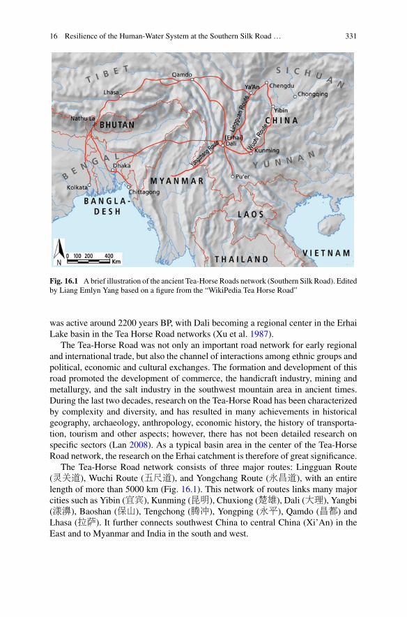
16 Resilience of the Human-Water System at the Southern Silk Road … 331
Fig. 16.1 Abrief illustration of the ancient Tea-Horse Roads network (Southern Silk Road). Editedby Liang Emlyn Yang based on a figure from the “WikiPedia Tea Horse Road”
was active around 2200 years BP, with Dali becoming a regional center in the ErhaiLake basin in the Tea Horse Road networks (Xu et al. 1987).
The Tea-Horse Road was not only an important road network for early regionaland international trade, but also the channel of interactions among ethnic groups andpolitical, economic and cultural exchanges. The formation and development of thisroad promoted the development of commerce, the handicraft industry, mining andmetallurgy, and the salt industry in the southwest mountain area in ancient times.During the last two decades, research on the Tea-Horse Road has been characterizedby complexity and diversity, and has resulted in many achievements in historicalgeography, archaeology, anthropology, economic history, the history of transporta-tion, tourism and other aspects; however, there has not been detailed research onspecific sectors (Lan 2008). As a typical basin area in the center of the Tea-HorseRoad network, the research on the Erhai catchment is therefore of great significance.
The Tea-Horse Road network consists of three major routes: Lingguan Route(灵关道), Wuchi Route (五尺道), and Yongchang Route (永昌道), with an entirelength of more than 5000 km (Fig. 16.1). This network of routes links many majorcities such as Yibin (宜宾), Kunming (昆明), Chuxiong (楚雄), Dali (大理), Yangbi(漾濞), Baoshan (保山), Tengchong (腾冲), Yongping (永平), Qamdo (昌都) andLhasa (拉萨). It further connects southwest China to central China (Xi’An) in theEast and to Myanmar and India in the south and west.

332 A. Xu et al.
For the past two thousand years, people of different ethnic groups including theZang (藏), Yi (彝), Naxi (纳西), Lisu (傈僳), Hani (哈尼), Jinuo (基诺), Qiang(羌), Pumi (普米), Bai (白), Nu (怒), Jingpo (景颇), A’chang (阿昌) connectedwith each other economically and culturally through the Tea-Horse Road. Along thedevelopment of the routes network, horse caravans (马帮) played a significant rolein transporting goods, such as tea, salt, cotton, gemstones, and opium.
Dali became a regional center of the Erhai Basin largely due to economic activityalong the Tea-Horse Road, sustaining a large immigrant population, as well as othercomplex social factors. Before the Ming Dynasty (1368–1644 AD), the populationin Dali and the Erhai Badin was limited and the social economical system was lessdeveloped. The evolution of the hydrologic environment in the northern catchmentof Erhai Lake was also slow. Beginning with the large number of Han Chinesemigrating into the area at the start of the Ming Dynasty, the local economy wasgradually developed. At the same time, these developments led to disturbance of thenatural environment, with rapid and obvious changes to the hydrologic environmentin the form of frequent floods and droughts. Because of this, the Miju River (弥苴河) was called “the Small Yellow River”.1
16.2.2 Erhai Lake at the Tea-Horse Road
The Erhai Basin is located in the central part of the Tea-Horse Road con-necting Sichuan, Yunnan and Myanmar (Fig. 16.1). Erhai (25°36′–25°58′N,100°05′–100°18′E) is China’s seventh largest lake with a surface area of 250 km2 atthe present time. It lies in an intermontane basin between the Tibet-Yunnan fold beltand the Yangtze para-platform (Zhang et al. 2000) (Fig. 16.2). It is about 1974 ma.s.l. (above sea level) with a combined lake and catchment area of ~2500 km2. Thelake basin is geologically dominated by Palaeozoic metamorphics (gneiss/graniteand marble) on the west side and Mesozoic basic volcanic and sedimentary rockson the east side (Lin 1982). The catchment of Erhai Lake is composed of four parts(Fig. 16.2) with the majority of discharge coming from the north, supplying morethan 59% of the 5.18×10⁸ m3 inflow annually.2
The north catchment is composed of the basins of Mici River, Fengyu River, andMiju River (A and B in Fig. 16.2) with continuous hills and deep river valleys. Theriver drops substantially from 2050 to 1987 m a.s.l. and empties into Erhai Lake witha rapidly aggrading delta at the Miju River mouth.
The basins A and B (Fig. 16.2) together are often called the Miju River basin,which is divided into upstream and downstream regions by the Putuo Gorge (蒲陀
1“The small Yellow River” is a quote from the local chronicles of Eryuan County (1996), whichmeans it was similar than the Yellow River with big floods, high sediment concentrations, and overground riverbed.2This data is quoted from Erhai Management Chronicles (2007), edited by Erhai Protection Admin-istration of Dali.
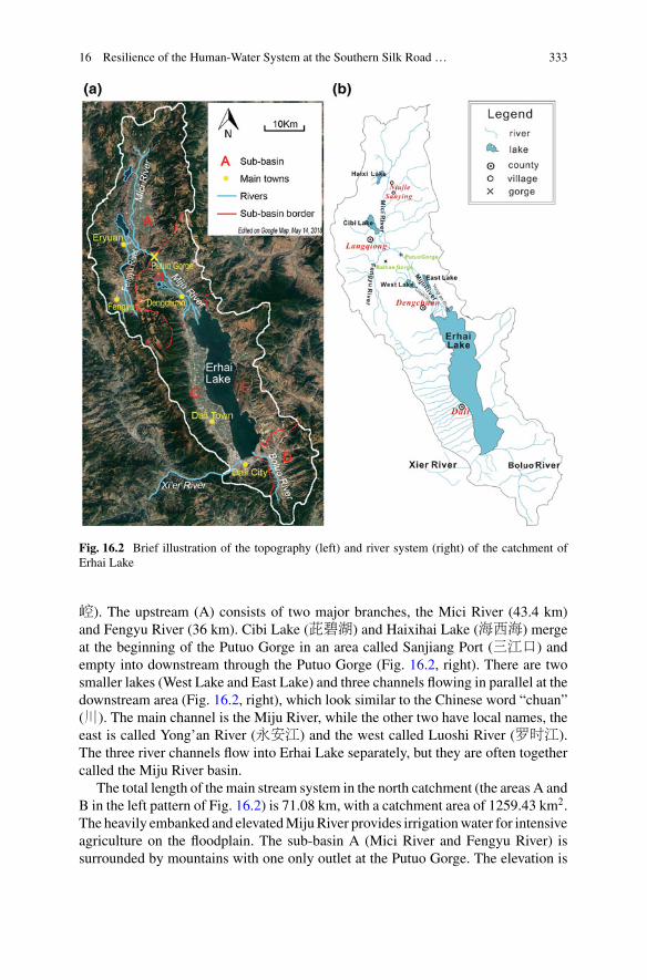
16 Resilience of the Human-Water System at the Southern Silk Road … 333
Fig. 16.2 Brief illustration of the topography (left) and river system (right) of the catchment ofErhai Lake
崆). The upstream (A) consists of two major branches, the Mici River (43.4 km)and Fengyu River (36 km). Cibi Lake (茈碧湖) and Haixihai Lake (海西海) mergeat the beginning of the Putuo Gorge in an area called Sanjiang Port (三江口) andempty into downstream through the Putuo Gorge (Fig. 16.2, right). There are twosmaller lakes (West Lake and East Lake) and three channels flowing in parallel at thedownstream area (Fig. 16.2, right), which look similar to the Chinese word “chuan”(川). The main channel is the Miju River, while the other two have local names, theeast is called Yong’an River (永安江) and the west called Luoshi River (罗时江).The three river channels flow into Erhai Lake separately, but they are often togethercalled the Miju River basin.
The total length of the main stream system in the north catchment (the areas A andB in the left pattern of Fig. 16.2) is 71.08 km, with a catchment area of 1259.43 km2.The heavily embanked and elevatedMijuRiver provides irrigationwater for intensiveagriculture on the floodplain. The sub-basin A (Mici River and Fengyu River) issurrounded by mountains with one only outlet at the Putuo Gorge. The elevation is

334 A. Xu et al.
much higher at the villages of Niujie (牛街) and Sanying (三营) at the north of MiciRiver, while it is lower in the Fengyu River basin in the south, between 2060 and2200 m a.s.l.. Both of them join with the Cibi Lake outlet (2055–2100 m a.s.l.) andflow via the Putuo Gorge to the mainstream Miju River. As the downstream region,the elevation of sub-basin B sits between 1965 and 1987 m a.s.l.. The population isdense and the fields are better fertilized in this sub-basin, which makes up more than70% of the whole county’s population and at the same time demands a larger amountof water for drinking and irrigation.
16.2.3 Social Economic Characteristics of the Erhai LakeBasin
Agricultural production is the dominant economic activity in the Erhai Lake basin,and the land use is mainly comprised of woodland, grassland and farmland, whichrespectively accounted for around 33.5, 35 and 24.1% of land coverage around theyear 2000 (Yang 2004).
In the 15th year of Hongwu in the Ming Dynasty (1382), the Army General, MuYing (沐英), was ordered to conquer Yunnan Province. He brought in 200 thousandgarrison troops and peasants (mainly people of Han ethnicity) to reclaim land andgrow food grain in the areas surrounding Dali and Erhai.3 The sudden influx of largenumbers of people made a great contribution to the economic development of thearea, but also brought considerable land pressure and people began to move up tothe mountainous areas.
For example, a village named after a leader, Dawa (大娃), was filled with immi-grants from Jiangsu and Jiangxi Province and settled close to the transportation lineand the center of the north catchment (Fig. 16.3). The native people of Bai ethnicitywho lived there since the Nanzhao (南诏) and Dali (大理) Periods (748–1254) hadto move to the surrounding higher hilly regions (Yang and Li 1996). In order to attainself-sufficiency in grain production with the natural growth of the population, themilitary population and their families made efforts to expand cultivation areas byreclaiming land from wasteland, slopes, and desolate marshes. Han villagers settleddensely at both sides of the Miju River where there was an abundance of water (Liu2013), which eventually developed into the present town Dengchuan (Fig. 16.3).
3Record of the Ming Dynasty《明实录》.
16 Resilience of the Human-Water System at the Southern Silk Road … 335
Fig. 16.3 The distribution of villages in north catchment of Erhai Lake in the Ming and QingDynasties. Re-edited by Anning Xu based on Liu (2013)
16.3 Human-Water System in the Northern Catchmentof the Erhai Lake
16.3.1 The Water Problem in the Northern Catchmentof Erhai Lake
As mentioned above, the hydrologic challenges in the northern catchment of ErhaiLake are mainly concentrated at the Miju River (sub-basin B in Fig. 16.2). TheMiju River is called “the Small Yellow River” for its high sediment load and pro-nounced fluctuations in seasonal precipitation. The surface runoff supplied throughprecipitation varies largely with the seasons, and is the main reason for floods in thesummer or autumn and droughts in springs. Additionally, this runoff contributes tothe deterioration of water quality (Wu et al. 2012). With continuous hills and deepriver valleys, the topography of the northern catchment changes greatly, leading tosubstantial elevation drops along the river from 2050 to 1987 m a.s.l. Consequently,the river empties into Erhai Lake at high velocity (ECC 1996). Under these circum-
336 A. Xu et al.
stances, the standing time of the water is short and rainfall is not stored for longperiods; therefore scarcity of rainfall may easily lead to droughts.
The population is dense and fields have been fertilized in this region since thelarge migration in 1382, resulting in high water demand for drinking and irrigationall the year round. Therefore, tension exists between the huge demand and the shortsupply ofwater formost of the time. In addition, population pressures have caused theincreased cultivation of unstable mountain surface soils on the slopes of the upstreamareas, which was detailed in the gazetteer.4 The result has been a massive increase insedimentation of the river. Additionally, the dykes in the downstream rose to a levelabove the farmland. When heavy rains occur and break the banks, this often resultsin floods.
Several scholars have done detailed research on the floods and droughts of thenorthern catchment of Erhai Lake (Yang 2007), but the materials used were notcomprehensive. By collecting historical materials in the Ming Dynasty and the QingDynasty (1382–1912), the present study built a database of floods (Table 16.1) anddroughts (Table 16.2). Particular attention was paid to a few key sites in the researcharea, includingLangqiong (浪穹) andDengchuan (邓川) as basic local administrativeregions of the Qing Dynasty.
Floods were so frequent in the north catchment that the records of floods are verycommon in historical archives. Torrential floods exerted a tremendous influence,the most serious one being in 1905 (the 31st year of Guangxu in the Qing Dynasty).According to the record, the flooded field area was up to 321 qing (顷) in Dengchuan,whilst the entire paddy field area was only 400 qing, leading to over 80% of thepaddy fields failing, a particularly rare situation in southwest China. Additionally,the bursting of banks leading to floods was also quite common. In 1691, the MijuRiver burst its banks and the chief of the prefecture, Liang Dalu, led the local peopleto plug the leaks. It seemed like a normal event in the record, with the area submergedby flood sediments being over 79 qing(顷); this means that a quarter of the paddyfield failed to grow rice. Additionally, the estuary was often blocked by sediments,resulting in poor drainage and overflowing lake conditions. For example, in 1694(the 33rd year of Kangxi in the Qing dynasty), there was a flood from the BaihanGorge (Fig. 16.3), which resulted in sand blocking the river and flooding of the fieldsand houses.
The climate of the northern catchment is mainly affected by the southwest sum-mer monsoon. Weak summer monsoons lead to a scarcity of precipitation and sub-sequently droughts. In early 20th century, droughts in Dengchuan lasted for yearsdue to a lack of precipitation. Additionally, delays in the timing of rainfall may alsocause droughts. In the May of 1747, the rice seedlings could not be planted becauseof the late arrival of rainfall in Dengchuan. In years when the strength of the mon-soon is highly variable, seasonal change may induce both droughts and floods withinthe same year. In 1859, it barely rained in the summer in Dengchuan, leading todrought. However, it rained too much in the autumn, which caused floods. Overall,the frequency of droughts was much lower than that of floods.
4Eryuan County Committee (ECC) (1996). Local Chronicles of Eryuan County.
16 Resilience of the Human-Water System at the Southern Silk Road … 337
Table16.1
Selected
recordsof
floodsin
thenorthern
catchm
ento
fErhaiLakeduring
theMingandQingDynasty
Tim
e(B
.C.)
Location
Originalrecordin
Chinese
documents
Materialresou
rces
inChinese
1501,A
ugust
浪穹
Langqiong
八月
“浪穹淫雨
,山崩水溢冲圮
,居民溺死百余人,公署文
案尽漂没
”Floodin
Augusto
fthelunarcalendar,over
hundredpeopleweredrow
ned
天启《滇志》卷三十一
“灾祥
”YunnanProvince
Gazetteersin
TianqiY
ears
1663,Julyand
August
EastL
ake,
Dengchuan
邓川七八月间红石泛滥
,倒灌东湖
,淹没田庐。Floo
din
July
&Augusto
fthelunarcalendar,inundated
thefield
andhouses
咸丰《邓川州志》a
(Xianfeng)
Dengchuan
Gazetters
1691
Dengchuan
“弥苴河决
,知州梁公大禄塞之。”Miju
River
burstits
bank
s;The
prefecture
chiefLiang
Dalulead
thelocal
peopleto
plug
theleaks
咸丰《邓川州志》
(Xianfeng)
Dengchuan
Gazetters
1693
BaihanGorge
ofLangqiong
白汉涧水发,沙石填河
,湖水横流
,冲田宅无算。Flood
from
BaihanGorge
andsand
blocktheriver
《浪穹县志略》
The
Langqiong
CountyGazetteers
1694
浪穹
,邓川
Langqiong,
Dengchuan
洱源
“白汉涧水发
,沙石坝河湖水横流
,冲田宅无算。”
Floodfrom
BaihanGorge,sandblocktheriverandflo
oded
thefield
andhouses
《浪穹县志略》
The
Langqiong
CountyGazetteers
1732
浪穹
Langqiong
浪穹县羽河等处。筑堤四十余丈。但补苴一时。急宜委勘
加修。Build
dam
ofYuriverin
Langqiong
fortheflo
od清世宗实录
The
Recordof
ShizongEmperorin
Qing
Dynasty
1749
邓川
Dengchuan
除云南邓川州、水冲沙压民屯田地额赋米、二十二石
有奇。银、二十五两有奇。
Exempted
from
taxatio
nof
affected
peoplein
floods
《清高宗实录》
The
Recordof
Gaozong
Emperorin
QingDynasty (contin
ued)

338 A. Xu et al.
Table16.1
(contin
ued)
Tim
e(B
.C.)
Location
Originalrecordin
Chinese
documents
Materialresou
rces
inChinese
1760
Fengyu
River
夏秋之间
,每淤塞倒漾
,淹浸田庐。The
water
subm
erged
thefield
andhouses
insummer
andautumn
清世宗实录
The
Recordof
ShizongEmperorin
Qing
Dynasty
1782,F
ebruary邓川
Dengchuan
弥苴河
…河高湖低。遇夏秋潦发
,青不涧、九龙涧等处
之水
,会冲入河。河水宣洩不及
,回流入湖,附近粮田俱被
淹没。The
field
wereflo
oded
insummer
andautumnalong
theMiju
River
清高宗实录
The
Recordof
Gaozong
Emperorin
Qing
Dynasty
1801
Miju
River
atsheGorge,N
ing
Lake
浪穹之宁东、宁南、宁北各村田亩
,均被冲淹。The
field
oneast,south
andnorthof
NingLakewereflo
oded
inLangqiong
咸丰《邓川州志》卷五
“灾祥志
”(X
ianfeng)The
Dengchu
anGazetters
1806,Jum
eLangqiong
奏报查明浪穹县被水田亩情形
,请分别赈抚事。Report
andfin
doutthe
situationof
fieldsweresubm
erged
《军机处全宗》
Recordof
Military
AircraftD
epartm
ent
1808
浪穹
Langqiong
嘉庆十三年灾益甚
,南北城垣尽圮
,请赈
,除田赋五百余
石。The
flood
wereso
seriousthatrequesth
elp
道光《浪穹县志》(D
aoguang)
The
Langqiong
County
Gazetteers
1859,July
Dengchuan
邓川淫雨经旬
,淹没禾苗无算。
The
field
wereflo
oded
countless
afterrain
formonthsin
Dengchuan
新纂云南通志
The
New
YunnanProvince
Gazetteers
1906,M
arch
邓川
Dengchuan
豁免云南邓川州属上年被水地方银米。
The
taxof
Denghcuan
wereexem
pted
becauseof
theflo
od清德宗实录
The
Recordof
DezongEmperorin
Qing
Dynasty
a Hou
Yunqing,(Xianfeng)
Dengchuan
Gazetters,reprint
byChengwen
Press,1976
bQing(顷
)isaunitof
area
thatequalsto
6.67
ha

16 Resilience of the Human-Water System at the Southern Silk Road … 339
Table 16.2 Selected records of droughts in the northern catchment of Erhai Lake
Time (B.C.) Locations Original record in Chinesedocuments
Material resources
1606浪穹 Langqiong 是岁洱源旱甚,南水浸沟,不
能注下。Heavy drought inEryuan
康熙浪穹县志 (Kangxi)TheLangqiong County Gazetteers
1665洱源Langqiong 大旱heavy drought 洱源县志 The Eryuan County
Gazetteers
1692, springto summer 洱源 Langqiong 康熙三十一年,自春月不雨至
夏五月不雨,民益惶惶。It hasno rain from spring to summer
康熙大理府志 (Kangxi)theDali Prefecture Gazetteers
1747, fromMay 洱源、邓川
Dengchuan雨泽愆期,秧苗不能全栽。TheRice seedling cannot plantbecause of the late of the rain
张允随奏稿 The memorial tothe throne from Zhang Yunsui
1792,summer 邓川Dengchuan 壬子 (1792年)之夏,邓 (川)境
乏雨 it was lack of rain insummer of Dengchuan
咸丰邓川州志 (Xianfeng)TheDengchuan Gazetteers
1817,autumn 浪穹Langqiong 夏雨雪,秋大旱,民复饥。It
was drought in autumn道光浪穹县志 (Daoguang)The Langqiong CountyGazetteers
1837,summer 邓川Dengchuan 邓川夏旱。Drought in summer
of Dengchuan咸丰邓川州志 (Xianfeng)TheDengchuan Gazetteers
1859,summer 邓川Dengchuan 邓川夏旱,秋淫雨。Drought in
summer but flood in autumn ofDengchuan
云南通志 Yunnan ProvinceGazetteers
1893,summer 邓川Dengchuan 邓川夏大旱。Drought in
summer of Dengchuan柿坪记述 Description ofShiping
1905邓川Dengchuan 邓川等州“大旱连年,赤地千
里”。Drought for years inDengchuan
云南通志荒政草稿 YunnanProvince Gazetteers
Floods occurred 41 times upstream (sub-basin A in the left pattern of Fig. 16.2)and 58 times downstream (sub-streamB) of theMiju River basin during theMing andQing Dynasties (1382–1912), as summarized from available records. When dividingthe collected flood events into different periods according to Yang (2007), therewere 20 downstream floods before the channel diversion of the Fengyu River duringthe period 1659–1760 as the first phase, while only 9 floods occurred upstreamduring the same time frame. In the second phase (~1760–1860), a period of onehundred years after the twenty-fifth year of Qianlong in the Qing Dynasty (1760),the frequency of upstream and downstream floods were similar—20 and 21 timesrespectively. This finding differs from the previous opinion of Yang (2007), that thefloods in Langqiong were more frequent than in Dengchuan. During the third phase
340 A. Xu et al.
(1851–1912), the number of upstreamfloodswas 12while the number of downstreamfloodswas 17, showing that the floods inDengchuanwere actuallymore frequent thanin Langqiong. These results are roughly consistent with previous findings, except forthe second phase. Although the outbreaks of drought were less frequent than floods,the occurrence of droughts downstream were more often than that in the upstreamarea; therefore, we conclude that the droughts in Dengchuan were more serious thanin Langqiong.
As floods in this area are far more serious than droughts, the following sectionswill focus on the causes of and local responses to the floods.
16.3.1.1 Climate Impacts
The northern catchment of Erhai Lake has a typical humid monsoon climate that isoften found in the north subtropical Yunnan Plateau where there is a clear distinctionbetween dry winters and wet summers. The average annual rainfall is 742.4 mmand 90% falls from May to October. Runoff into Erhai is mostly made up of thisrainfall. Relative humidity averages around 66%with an average annual temperatureof 15.1 °C and an annual sunshine duration of 2354 h. In addition, the microscaleclimate within the basin varies with topography and altitude.5
Huang et al. (2014) found that the main synoptic systems giving rise to heavyrainfall in the Erhai Basin were shear line, Bay of Bengal storms, a low vortex, aconvergence zone of two high-pressure south branching troughs, and a westboundlow-pressure typhoon. These meteorological features often facilitate rain storms.Combined with previous research on the summer monsoon and the rainy season inthe Yunnan Province during the Qing Dynasty (Yang et al. 2006), analysis indicatesthat there were obvious inter-annual and inter-decadal fluctuations of the startingdate of rainy seasons in Yunnan, as well as long-term fluctuations on the decadal andcentennial scale. The monsoon arrived earlier in the beginning of the 18th century,later in the 19th century and earlier again in the 20th century (Huang et al. 2014). Thevariability of the summer monsoon therefore leads to great changes in precipitationand thus brings floods and droughts.
16.3.1.2 Topographic Factors
Some scholars believe that the location of burst banks and collapses are not random(Yang 2007). The location of such events shifted downstream, which was closelyrelated to the evolution of sedimentation in downstream areas. According to histor-ical records, burst river banks were not the only reason for the severe flooding inDengchuan. There were 7 burst banks in 61 years (1851–1911), with 21 recordedfloods, indicating that burst banks were not an inevitable cause of the floods.
5Eryuan County Committee (ECC) (1996). Local Chronicles of Eryuan County.
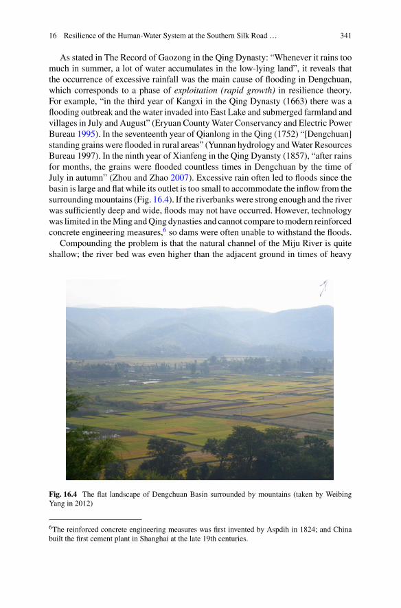
16 Resilience of the Human-Water System at the Southern Silk Road … 341
As stated in The Record of Gaozong in the Qing Dynasty: “Whenever it rains toomuch in summer, a lot of water accumulates in the low-lying land”, it reveals thatthe occurrence of excessive rainfall was the main cause of flooding in Dengchuan,which corresponds to a phase of exploitation (rapid growth) in resilience theory.For example, “in the third year of Kangxi in the Qing Dynasty (1663) there was aflooding outbreak and the water invaded into East Lake and submerged farmland andvillages in July and August” (Eryuan CountyWater Conservancy and Electric PowerBureau 1995). In the seventeenth year of Qianlong in the Qing (1752) “[Dengchuan]standing grains were flooded in rural areas” (Yunnan hydrology andWater ResourcesBureau 1997). In the ninth year of Xianfeng in the Qing Dyansty (1857), “after rainsfor months, the grains were flooded countless times in Dengchuan by the time ofJuly in autumn” (Zhou and Zhao 2007). Excessive rain often led to floods since thebasin is large and flat while its outlet is too small to accommodate the inflow from thesurroundingmountains (Fig. 16.4). If the riverbanks were strong enough and the riverwas sufficiently deep and wide, floods may not have occurred. However, technologywas limited in theMing andQing dynasties and cannot compare tomodern reinforcedconcrete engineering measures,6 so dams were often unable to withstand the floods.
Compounding the problem is that the natural channel of the Miju River is quiteshallow; the river bed was even higher than the adjacent ground in times of heavy
Fig. 16.4 The flat landscape of Dengchuan Basin surrounded by mountains (taken by WeibingYang in 2012)
6The reinforced concrete engineering measures was first invented by Aspdih in 1824; and Chinabuilt the first cement plant in Shanghai at the late 19th centuries.
342 A. Xu et al.
sediment flow. The breaching of the dyke can therefore hardly be avoided as thechannel cannot accommodate even slightly excessive runoff. Dengchuan used to bean area of “swamp and shallow lake beach” before the time when the riverbanks ofthe Miju River were built by Deng Danzhao (邓赕诏) in the year 649 and beforeLuo’s brothers excavation of the Luoshi River in the year 785.7
The dykes were built to prevent the river from brimming over, but the channelwas relatively fixed by these dykes after being constantly repaired and renovatedfor hundreds of years (the conservation phase of resilience theory). When it rainedexcessively and there was inadequate drainage, “the water would backflow into thelake and the grain nearby would all be submerged” (the record of Gaozong Emperorin Qing Dynasty) (the release phase of resilience theory). Excessive sediment depo-sition exacerbated the already serious problem of flooding.
16.3.1.3 Characteristics of the Water System at the Cibi Lake
The Cibi lake basin is naturally shallow and has a low capacity to adjust to waterlevels in both cases of drought andflood.This has beendocumented inmanyhistoricalmaterials. In 1762 (the 27th year of Qianlong in the Qing Dynasty), the governor ofYunnan Province, Liu Zao (刘藻), wrote the reason and response to the flood in thememorials to the emperors8:
The water from Cibi Lake (also called Ning Lake), Feng Yu River and Mici River inLangqiong County joins with other inflows at the point of Sanjiang Port, and drains down-stream in Dengchuan through Putuo Gorge with sands and sediment. When it comes tosummer and fall, the river would be blocked and water overflowed, flooding lands and vil-lages. The crib and pile were arranged from the east bank at the Old Dam located at the northend of the gorge, in order to block sand and stones from rushing into the river. But both thedam body and dam crest are only five feet high and thick, which is difficult to withstand theflood challenge. The dam should be built in the size of twelve feet in height and ten feetthick, while the foot of the dam should be thicker than three feet. In addition to the old earthdam of 903.5 zhangt(丈), a new dam was added spanning 5768.5 zhang(丈) in all. As forthe west riverbank where the Creek of Baihan Gorge flow into river, the sands should beexcavated to build the dam.
The floods of Eryuan were mainly caused by the water rising in Cibi Lake. Asearly as in 1692, it was recorded in the local chronicles that once in water of theBaihan Gorge (Fig. 16.3) rose, sand filled the river, resulting in the floods and thesubmergence of countless fields and houses (Zhou 1976). In 1765, as the water roseand flowed out of Cibi Lake, the northern, southern and eastern walls of the cityEryuan were washed away by the water. In 1801 (the Sixth Year of Jiaqing (嘉庆)in the Qing Dynasty), “The Ning Lake is so shallow in Langqiong County (Eryuan)that there is dredging of mud from the lake bed every year, so whenever it rains
7Local records of river and lakes in Eryuan County (1994). P91.8Memorials to the Qianlong Emperor of Qing Dynasty. Reprint by Palace Museum in Taipei Pressin 1982.
16 Resilience of the Human-Water System at the Southern Silk Road … 343
heavily, the eastern, northern, southern villages would be flooded”.9 In June of 1805,“villages and fields near the lake were flooded, where water cannot drain out.”10 Thiskind of flood situation was so frequently seen in local chronicles that we concludethat the fundamental cause of the flood lies in its shallow lake basin, which restrictswater storage capacity.
16.3.1.4 Sediment Deposition
The accretion of lake sediment reduced lake water storage and also deposited siltresulting in river blockage, which led to dam bursts and floods. It has beenmentionedabove that because the basin of Cibi Lake is relative shallow, small increases inprecipitation could raise the water level and lead to floods. In 1760 (the twenty-fifthyear of Qianlong in the Qing Dynasty), the Fengyu River was diverted into CibiLake. Although the floods subsided gradually in the short term, sediment broughtby the Feng Yu River was deposited in the lake, reducing the basal depth of CibiLake, leading to reduced water storage, increasing the risk of flooding. Floods atupstream areas brought serious problems to the silted up riverbed in Sanjiang Portand Putuo Gorge, restricting the stream flows. Thus, whenever the Sanjiang Port areawas blocked, the local government would put efforts to dredge it, so that the waterblockage was addressed immediately.
Yang (2007) attributed the major cause of floods in the north catchment (sub-basin A in Fig. 16.2) to the development of the sensitive area of the Fengyu Rivercatchment. He believed that the floods of the Fengyu River and Cibi Lake werepreviously infrequent and that floods only occurred when the Sanjiang Port wassilted up by sediment from the Baihan Gorge after the 25th year of Qianlong (1760).A comprehensive analysis of data in this study (in Table 16.1) also shows that thefrequency of floods increased from 1760 to 1850 (the end year of Daoguang inQing Dynasty), supporting Yang’s view. It is also found that floods subsided againafter the years of Xianfeng (1861). We could detect a full resilience loop duringthe process above, but cannot not attribute the reorganization process to naturalfunctions, but rather to governing activities. The deposition of sediment in riversand lakes increased the risk of flooding and exacerbated the risk of dyke break. Bydredging the sediment, the drainagewas improved, themoisture storage capacity wasincreased and the floods were alleviated to a certain degree, which can be identifiedas reorganization.
An infilling of lake floor leads to a decrease of lake water storage, and, of course,reduces the regulating function of the lake. In dry seasons, drought can be easilytriggered if precipitation is insufficient. For instance, “In the 31th year of Kangxi inQing (1692), it barely rained from spring to summer [in Eryuan] and aroused the
9The Dengchuan Gazetteers during the Xianfeng periods of Qing Dynasty.10Historical materials of floods and droughts in Yunnan Province.
344 A. Xu et al.
public panic”.11 Without adequate water reserves in rivers and lakes, people wereunable to irrigate farmland.
16.3.2 Human Impacts on the Human-Water System
To address flooding issues, the local people made great efforts to construct waterprojects, which had remarkable but inconsistent effects. The increased need formain-tenance led to the restructuring of parts of the system of government and the livesof the local people. Specific principles, ideas and characteristics of flood controland river planning and harnessing in Dengchuan are presented according to data,experiences and lessons recorded in various archives.
16.3.2.1 Watercourse and Dams
Due to the frequent and serious flood impacts along the Miju River, especially in thelower reaches where the channel is shallow and riverbed accumulated over ground,local people have developed various measures to address the problem. Most signifi-cant solutions were water conservation projects (Table 16.3). In 1732 (the 10th yearof Yongzheng in the Qing Dynasty), the governor of YunGui and Guangxi, E’Ertai (鄂尔泰), reported to the Emperor Yongzheng and proposed six suggestions for waterconservancy projects in the Erhai Lake catchment. His report “Suggestions on theConstruction of Water Conservancy” included a specific proposal on “embankmentand dredging engineering of the Fengyu River in Langqiong County”. The Ministryof Works immediately replied “it is appropriate to build an embankment of 40 feetfor the Fengyu and other rivers in Langqiong County quickly”.12 However, the dykeswere only a temporary measure and the effect was not as expected.
In addition to reinforcing dykes and excavating sediments in the river, local peopletried to open up new channels. For example, in 1782 (the 47th year of Qianlong inQing Dynasty), the Governor of Yunnan Province, Liu Bingtian (刘秉恬), presenteda memorandum to the Emperor regarding the flood problems in the Miju River basinat Dengchuan County.13 The problem was that the riverbed was high while the EastLake was low, and that when it rained in the summer, a flash flood in the upperreaches could expand into a more general river flood. If the water could not drainout effectively, it would flow back to the lake and flood the surrounding fields. Thelocal officers and inhabitants advocated donations to build a dam at the end of EastLake and construct a new channel to drain out the water directly into the Erhai Lake.A few years after the new causeway was built and a stone watergate was established
11(Kangxi) Local chronicles of Dali prefecture.12Memorial to the Emperor by E’Ertai.13The Record of Gaozong Emperor in Qing Dynasty.
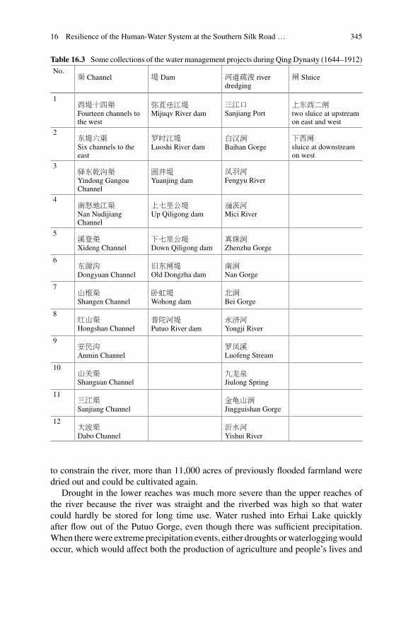
16 Resilience of the Human-Water System at the Southern Silk Road … 345
Table 16.3 Some collections of the water management projects during Qing Dynasty (1644–1912)
No.渠 Channel 堤 Dam 河道疏浚 river
dredging闸 Sluice
1西堤十四渠Fourteen channels tothe west
弥苴佉江堤Mijuqv River dam
三江口Sanjiang Port
上东西二闸two sluice at upstreamon east and west
2东堤六渠Six channels to theeast
罗时江堤Luoshi River dam
白汉涧Baihan Gorge
下西闸sluice at downstreamon west
3驿东乾沟渠Yindong GangouChannel
圆井堤Yuanjing dam
凤羽河Fengyu River
4南怒地江渠Nan NudijiangChannel
上七里公堤Up Qiligong dam
瀰茨河Mici River
5溪登渠Xideng Channel
下七里公堤Down Qiligong dam
真珠涧Zhenzhu Gorge
6东源沟Dongyuan Channel
旧东闸堤Old Dongzha dam
南涧Nan Gorge
7山根渠Shangen Channel
卧虹堤Wohong dam
北涧Bei Gorge
8红山渠Hongshan Channel
普陀河堤Putuo River dam
永济河Yongji River
9安民沟Anmin Channel
罗凤溪Luofeng Stream
10山关渠Shanguan Channel
九龙泉Jiulong Spring
11三江渠Sanjiang Channel
金龟山涧Jingguishan Gorge
12大波渠Dabo Channel
沂水河Yishui River
to constrain the river, more than 11,000 acres of previously flooded farmland weredried out and could be cultivated again.
Drought in the lower reaches was much more severe than the upper reaches ofthe river because the river was straight and the riverbed was high so that watercould hardly be stored for long time use. Water rushed into Erhai Lake quicklyafter flow out of the Putuo Gorge, even though there was sufficient precipitation.When therewere extreme precipitation events, either droughts orwaterloggingwouldoccur, which would affect both the production of agriculture and people’s lives and
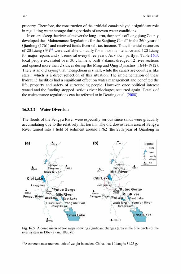
346 A. Xu et al.
property. Therefore, the construction of the artificial canals played a significant rolein regulating water storage during periods of uneven water conditions.
In order to keep the river calm over the long-term, the people of LangqiongCountydeveloped the “Maintenance Regulations for the Sanjiang Canal” in the 26th year ofQianlong (1761) and received funds from salt-tax income. Thus, financial resourcesof 20 Liang (两)14 were available annually for minor maintenance and 120 Liangfor major repairs and silt removal every three years. As shown partly in Table 16.3,local people excavated over 30 channels, built 8 dams, dredged 12 river sectionsand opened more than 2 sluices during the Ming and Qing Dynasties (1644–1912).There is an old saying that “Dengchuan is small, while the canals are countless likestars”, which is a direct reflection of this situation. The implementation of thesehydraulic facilities had a significant effect on water management and benefited thelife, property and safety of surrounding people. However, once political interestwaned and the funding stopped, serious river blockages occurred again. Details ofthe maintenance regulations can be referred to in Dearing et al. (2008).
16.3.2.2 Water Diversion
The floods of the Fengyu River were especially serious since sands were graduallyaccumulating due to the relatively flat terrain. The old downstream area of FengyuRiver turned into a field of sediment around 1762 (the 27th year of Qianlong in
Fig. 16.5 A comparison of two maps showing significant changes (area in the blue circle) of theriver system in 1368 (a) and 1820 (b)
14A concrete measurement unit of weight in ancient China, that 1 Liang is 31.25 g.
16 Resilience of the Human-Water System at the Southern Silk Road … 347
Qing Dynasty) when local people reached a consensus to divert water, as it wasmore efficient to excavate new artificial canals rather than clean up the silted streamsections. The outlet of Fengyu River was diverted northwards to the Cibi Lake andthe floods at the old outlet area subsided (Fig. 16.5). From local people’s point ofview, if the riverbank of Fengyu River were thick and high enough, there would be noflooding of the river or stresses relating to annual maintenance. These maintenancesincluded repairing the dam regularly, dredging sediment, and guiding the water intothe lake. However, the effect was not as expected due to the natural constraints ofthe river terrain and limited engineering capacities. As a result, the river still brokeits banks and flooded vast areas when the water rushed down from upstream everyautumn.
Another technique to harness the river was to maintain the overflow channelscreated by flooding. For example, local people allowed a diversion channel out ofBaihan Gorge, which guided the northern ravine flow down from the mountain tothe mainstream of Fengyu River. Although this reduced the flood damage around theoriginal riverbanks, it increased sediment delivery to the Fengyu River.
16.3.2.3 Separation of Sand from Water
In response to the difficulties mentioned above, a new idea was to separate the sandandwater to control soil erosion at the source and prevent sediment influx to the river.The representative governors of this new river-training approach were Lin Zhonglin(林中麟) and ChenWei (陈炜) who used to be the chancellors of Langqiong County.As early as in 1753 (the 18th year of Qianlong in Qing Dynasty), Chancellor Linadvocated for building a dry dam of stone at the mouth of Baihan Gorge, which hadthe effect of separating sands and water, and mitigated flooding within a few years.However, during three days of heavy rain in June 1808, the dry dam collapsed into thedue to years of disrepair. Under these circumstances, the new chancellor Chen tookover. He realized that the old systems didn’t discharge water with enough energy, andconsequently the flow was too slow to move sand. He decided to reconstruct the drydam one hundred feet high and two feet wide and also lengthened it from the foot ofthe mountain to the southwest. They made use of the uncultivated lands to settle thesands from river dredging. A drought bank was also built around the dam for about ahundred Zhang (丈15), and hundreds of willows with strong root-nets were plantedbehind to strengthen the bank. Water was released at the end of the bank while mudand sand were deposited inside the dam to prevent river siltation.
It is no wonder that the local people all praised “the construction plan [which] wasvery good for controlling the river,whichwas no longer harmful formany years there-after”.16 However, with sediment accumulation over time, the risk of dyke breachingincreased, indicating that the need for the establishment of maintenance regulations.The changes correspond to the release phase in the resilience theory introduced by
15A traditional measurement unit of length in China, 1 Zhang (丈) equals to 3.33 m.16(Daoguang) The Langqiong County Gazetteers”.
348 A. Xu et al.
Holling (2001) that a process loses its former tight organization. It is particularlyworth mentioning that this approach was so effective that it was continuously usedand maintained for centuries until the present. Due to the building of a recent sandfactory in 1980s to intercept sediment upstream at Baihan Gorge, the sediment loadand suspended sediment entering the estuary has decreased in both wet and dry sea-sons. Since then, the permanent goal of mitigating river floods has been certainlyattained, and the frequency of flooding has been properly controlled.
16.4 Impacts of the Water Environment Changes
16.4.1 Impacts on Waterways
The evolution of the hydrological system is a basic aspect of the water environmentchange in the north catchment of Erhai Lake. It includes two factors: one is themovement and change of the river channel and the other is the contraction of thewater surface area, both of which changed dramatically during the Ming and QingDynasties.
River changes were mainly concentrated in the upstream reaches of the MiciRiver and Fengyu River. In the seventeenth century, both the Mici and Feng YuRivers flowed around the county town of Eryuan, and did not run into Cibi Lake.The Mici River flowed along the east coast of the lake, while the Fengyu Riverflowed south of the town along the foothills. TheMici and Fengyu Rivers entered theconfluence at Sanjiang Port and flowed into the Dengchuan basin through the PutuoGorge (Fig. 16.5, left). In 1760 (the 25th year of Qianlong in Qing Dynasty), theembankment of Fengyu River broke at Nanshan village, resulting in diversion of theriver towardMajiaying; consequently, a new river channel had to be built. Since then,the Fengyu River has flowed northeast, passing by Majiaying, Langqiong CountyTown, then into Cibi Lake at E’dun village. In addition, numerous artificial canalswere excavated for irrigation, as shown in Table 16.3, which greatly changed theappearance of Miju River system.
The other aspect of the river system change is the contraction and expansion ofwater surface area of Cibi Lake, demonstrating that great changes have taken placemany times (Deng et al. 1995). Through analysis of raw historical data and previousstudies, this study has also found that there were four phases in this process over thepast three hundred years.
• The first phase is during the earlyHongwu years of theMingDynasty (1382–1398)when the Cibi Lake was relatively large with an area of almost 20 km2. This wasevidenced in “The Travels Journal of Xu Xiake” (徐霞客游记).
• The second phase is during the Hongwu years of the Ming Dynasty (1398) tothe Kangxi years of the Qing Dynasty (1654–1722). During this period, the lake’sinflow stagnated and the water level gradually decreased. The surface of Cibi Lake
16 Resilience of the Human-Water System at the Southern Silk Road … 349
was about 14.2 km2 and remained stable at about 2055.20 m a.s.l.17 At that time,the terms “outer sea” were locally used to represent the large and shallow southpart while “inner sea” was commonly known for the small and deep north part.18
• The third phase began in the Jiaqing years of the Qing Dynasty (1760–1820).The transition into the third phase was mainly caused by continuous flood-ing. The frequent floods from 1803 to 1808 caused the lake surface to rise.The silt in the lower reaches blocked the river and impeded drainage, which alsoresulted in the continued expansion of the lake area and increased floods, caus-ing disasters in an extensive area for decades. These high lake levels persistedfor a long period of time, until the 1870s at least, and the area of the lake mayeven have been much larger than the area when Xu Xiake visited in the first stage(Deng et al. 1995; Geng 2015).
• In the fourth phase during the Guangxu years of the Qing Dynasty (1871–1908),the water in the southeast region of Cibi Lake retreated again and the area was justless than 8 km2 until the middle of 20th century (Deng et al. 1995).
The diversion, storage and siltation situations in different sections of the MijuRiver system reflected changes of the hydrological and hydro-chemical environmentsin the past. These changes further influenced other aspects of local environment andsociety, including the changes in land use pattern and the spread of waterbornediseases.
16.4.2 Impacts on Land Use
The Dengchuan basin in the northern catchment of Erhai Lake is one of the basiceconomic regions of the Yunnan province, with the average altitude at around 1900ma.s.l. The runoff area recently contributes to 44% of the total area and 70% of thepopulation in Eryuan County. Crop differentiation in this area shows vertical zonalityacross the varied topography. As mentioned above, soil erosion has become a seriousissue and the vegetation in the mountains has declined over the past six centuriesdue to increases in human populations and intensified agricultural activities. Areasof natural mountainous vegetation declined to 54% in the middle of the 1950s andlower to 28.6% by the end of the 20th century (Eryuan County Committee 1996).According to the research by Dearing et al. (2008), terrace technology has allowedfor the continuous development of this region over the long-term, even under severewater stressed conditions.
Mitigating flood waters and opening up vegetative lands into farmland is nota modern creation. As early as the Tang Dynasty (around the year 785), the Luobrothers donated fields and money to construct a channel along the west foothills,changing the outlet of theWest Lake from theMijuRiver to the Erhai Lake.19 For over
17River and lake chronicles in Eryuan County,1995.18River and lake chronicles in Eryuan County,1995.19(Xianfeng) The Gazetters of Dengchuan.
350 A. Xu et al.
1200 years the local inhabitants have benefitted from these changes, and accordinglynamed the river as Luoshi River.
According to previous research on the farming by garrison troops in the MingDynasty (Wang 2009a, b), the land they reclaimedwasmainly abandoned, rather thanin already cultivated lands. The land configuration of three rivers with two lakes (theEast and West Lakes) in Dengchuan basin enables the basin to maintain an abundantsource ofwater in the long-term.Liu (2013) found that the indigenous groupswhohadsettled there earlierweremainly living in the piedmont areawith higher terrain aroundthe basin, while the garrison troops of theHan People concentratedmainly in the low-lying areas of the central basin.Although the low area of the basin iswide andflatwithfertile soil, it was not an ideal area for cultivation because of frequent flood disasters atboth sides of theMijuRiver. Since theMingDynasty, the settlement of garrison troopsin the center of the Dengchuan basin has brought hydraulic engineering technologiesto control floods, drain water and reclaim farmlands near the East and West Lakes.
In 1781 (the 46th year of Qianlong in the Qing Dynasty), an engineering approachwas put forward by Gao Shanggui (高上桂), a successful candidate in the highestimperial examinations who was born in Dengchuan. Gao received support from thechief of Dengchuan prefecture and opened up a new channel known as the Yong’anRiver (Fig. 16.2, right), that diverted the East Lake directly to the Erhai Lake (insteadof drainage into the Miju River). This artificial channel (Yong’an River) helped dryout more than 11,200 acres fields for crop planting.20 The whole basin thereafterbecame a rich land of breeding fish and rice on the plateau, and Gao’s contributionwas rewarded by the Qianlong Emperor.
The low-lyingDengchuan basin is still an important region today, with its 160,629acres of cultivated land, of which 98,815 acres are paddy fields, accounting for thevastmajority ofEryuanCounty.21 In the historical period, the land here has undergoneanthropogenic transformation that greatly changed the local water and soil features.The migration of large populations in the Ming Dynasty led to tense water conflicts.The local people had to reclaim parts of lake coasts and river beaches for farmland.They also excavated some river channels to not only reduce flooding but also todrain lake water for farming the margins. This had many consequences including thetransformation of crop planting structures, as aquatic farming and aquaculture in thenewly exposed shallow swamp areas were developed. In the 1980s, there were 2870acres of aquatic crops, 2340 acres of lake margins and marsh ponds for fishing, and3790 acres of shallow water for rice and fish farming.22
20(Xianfeng) The Gazetters of Dengchuan.21Eryuan County Committee (ECC) (1996). Local Chronicles of Eryuan County.22See Footnote 21.
16 Resilience of the Human-Water System at the Southern Silk Road … 351
16.4.3 Impacts on Waterborne Disease SchistosomiasisJaponica
The Miju River Basin has experienced several epidemics of Schistosomiasis japon-ica in its history. Outbreaks of this waterborne disease did not happen frequently,but its impacts are broad and deadly. Schistosomiasis japonica is usually associatedwith sewage-contamination or inadequately treated water. As existing studies haveindicated, the water-environmental condition, climatic characteristics and associ-ated biological conditions in the Miju River basin provide a beneficial habitat forOncomelania hupensis (Yang 2004), a particular type of snail hosting Schistosomajaponicum. The density, quantity and spatial distribution of Oncomelania hupensiscorresponds closely with that of Schistosoma japonicum.
The five conditions necessary for the spread of schistosomiasis are host popula-tions, feces with eggs, snails, water contamination by feces and human contact withcontaminated water (Ma et al. 2011). The entry of a large number of immigrantsled to a changes in the water chemistry through increased influxes of human andlivestock wastes, and thus provided ideal conditions for Schistosomiasis. Provisionof safe water and sanitation is critical to reduce the outbreak of Schistosomiasisjaponica, cholera and other waterborne diseases.
The breeding environment, and consequently the largest area of habitat for thesnail is a shallow water zone with slow flow, while other common habitats are grass-lands and ponds. The proportion of snails in ponds is decreasing while the proportionof snails in grasslands is on the rise. A possible reason for this trend may be that thegrassland proportion of land area in the basin is the largest. The epidemic of schis-tosomiasis in Eryuan County is closely related to floods in the historical period (Hu2014). In the process of fighting against floods and droughts, such as the constructionof water management projects, harnessing river courses, the construction of bur-rockand the excavation of canals and ditches, the change in the hydrologic environmentled to a change in schistosomiasis prevalence.
The excavation of water ditches helped to reduce flood hazards and alleviatepressure on the main channel, yet at the same time, water velocity slowed. The waterin ditches was stored for irrigation and improved for water availability in dry seasonsor years. On the other hand, the ditch provided suitable habitat for the oncomelaniasnails. A large number of channels were excavated in a crisscross pattern throughoutthe whole basin, again increasing the habitat area for oncomelania.
In the chorography of Eryuan County (1996), the epidemic history of schistoso-miasis is as recorded:
In the Tongzhi years of the Qing Dynasty (1862–1874), in Eryuan County, there were “tim-panists” and “Shau Kei swelling”, “hematochezia” and “dry shake disease” among the doc-tors of traditional Chinese medicine and the general public, which showed similar symptomsto advanced schistosomiasis ascites. At the beginning of the 1960s, an old farmer from thethird battalion of the Yongsheng commune brigade, named Dai Qiyou (66 years old), saidthat his father saw a patient of “Shau Kei expansion” whose stomach was badly swollen likea Xiaoqi (a basket for washing rice) at the age of 20 when he moved into the Sanying basin,
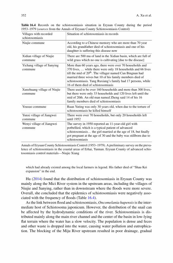
352 A. Xu et al.
Table 16.4 Records on the schistosomiasis situation in Eryuan County during the period1953–1979 (sources from the Annals of Eryuan County Schistosomiasis Control)
Villages with recordedschistosomiasis
Situation of schistosomiasis in records
Niujie commune According to a Chinese memory who are more than 70 yearold, his grandfather died of schistosomiasis and one of hisdaughter is suffering this disease now
Xidian village of Niujiecommune
There are 500 mu of land in the Xidian basin, which are full ofwild grass which no one is cultivating [due to the disease]
Yichang village of Sanyingcommune
More than 60 years ago, there were over 70 households and370 lives, … while there were only 18 households and 66 livestill the mid of 20th. The villager named Cun Bingnan hadmarried three wives but 10 of his family members died ofschistosomiasis. Yang Ruxiang’s family had 17 persons, while16 of them died of schistosomiasis
Xunzhuang village of Niujiecommune
There used to be over 160 households and more than 300 lives,but there were only 33 households and 120 lives left until themid of 20th. An old man named Zheng said 14 of his 16family members died of schistosomiasis
Yousuo commune Ruan Yuting was only 30 years old, when due to the torture ofschistosomiasis he killed himself
Yunxi village of Jiangweicommune
There were over 70 households, but only 20 households leftuntil 1952
Wenyi village of Jiangweicommune
The survey in 1950 reported an 11-year-old girl withpotbellied, which is a typical patient of advancedschistosomiasis… the girl married at the age of 18, but finallygot pregnant at the age of 30 and the baby was stillborn due toschistosomiasis
Annals of Eryuan County Schistosomiasis Control (1953–1979). A preliminary survey on the preva-lence of schistosomiasis in the coastal areas of Erhai, Yunnan. Eryuan County of advanced schis-tosomiasis control materials—Niujie Xiang
which had already existed among the local farmers in legend. His father died of “Shau Keiexpansion” in the end.
Hu (2014) found that the distribution of schistosomiasis in Eryuan County wasmainly along the Mici River system in the upstream areas, including the villages ofNiujie and Sanying, rather than in downstream where the floods were more severe.Overall, she concluded that the epidemics of schistosomiasis were negatively asso-ciated with the frequency of floods (Table 16.4).
As the link between flood and schistosomiasis,Oncomelania hupensis is the inter-mediate host of Schistosoma japonicum. However, the distribution of the snail canbe affected by the hydrodynamic conditions of the river. Schistosomiasis is dis-tributed mainly along the main river channel and the center of the basin in low-lyingflat terrain where the water has a slow velocity. The population is dense and fecesand other waste is dropped into the water, causing water pollution and eutrophica-tion. The blocking of the Miju River upstream resulted in poor drainage, gradual

16 Resilience of the Human-Water System at the Southern Silk Road … 353
sediment deposition, and slow flow, all of which formed an environment suitable forsnail breeding and the outbreak of schistosomiasis in the basin. In contrast, locationswhere the river course was dredged and the sediment was frequently cleaned up, theoccurrence of Schistosomiasis japonica was infrequent because the snail could notsurvive and thus the transmission of the disease was more difficult.
16.5 Resilience Theory of the Human-Water Relationship
The existence of different development stages could be represented by distinct andrelative steady states of adaptive cycle, as indicated in the resilience theory of Holling(2001). From 1482 to 1912, we can identify stages where floods were relatively seri-ous, then diminished in severity by variouswater controlmeasures. This can certainlybe explained as following an evolutionary cycle of the human-water relationship,including exploitation (increasing floods), conservation (control measures), release(slack management) and re-organization (redevelopment of agriculture), but withouta clear division of the four phases.
Due to the difference of topography and development degrees in sub-regions ofthe north catchment of the Erhai Lake, the four stage of resilience theory are notsynchronous. As for the Baihan Gorge stream, the evolution was somewhat extreme.The water system of the stream collapsed when the dam burst into the stream andblocked the channel. The stream diverted toward west and flow into Fengyu River,a channel which was maintained thereafter. In this case, the former Baihan Gorgestream changed completely and could not evolve into the re-organization stage asstated in adaptive cycle of the resilience theory.
In the case of the Fengyu River, resilience theory can be applied appropriatelyto the sediment deposition and river diversion. The water velocity dropped quicklywhen the river flowed to Eryuan County and thus sediment accumulated gradually inthe riverbed. The continuous deposition of silt resulted in a dam collapse, and peoplediverted the river directly into Cibi Lake in the 25th year of Qianlong in the QingDynasty (1760). After the excavation of this newly diverted channel, the floods ofFengyu River gradually subsided. Though the diverted channel sediments no longerentered the Sanjiang Port, they continued to silt up in the new channels and in theCibi Lake. However, after a period of accumulation the siltation affected the waterstorage capacity of the Cibi Lake, especially during rainy seasons, leading to regularoverflowing of the lake. Thus, we argue that the evolution of Fengyu River and itswater environment was consistent with the four stages of the adaptive cycle in theresilience theory.
The situation ofMiju River was far more divergent from the description of changein resilience theory. The naturalMiju River flowed randomly with changing channels(no main stream) before the Ming Dynasty (1368–1744). Following the settlementof military migrants, the random channels were controlled and riverbanks were con-structed gradually. Over time, local people opened up many sluices and branch chan-nels in order to both irrigate farmlands and separate floodwater. A dense river network
354 A. Xu et al.
was formed in Dengchuan basin, thus the flow accessibility and water controllingcapacity was greatly improved. We can identify the stages of exploitation (naturallyfrequent floods) and conservation (channel constructions) in the water governancehistory of Miju River, though these didn’t develop into the release stage (slack man-agement) and re-organization stage with the continuous maintenance measures.
For the upstream Mici River, the water environment with deep and broad riverchannels that rarely lead to floods, gave rise to a rich environment for human activity.However, the stable river environment benefited the breeding of Oncomelania Snailsthat induce schistosomiasis. As described above, local people along the Mici Riversuffered serious Schistosomiasis japonica outbreaks for over six centuries due to thelack of knowledge regarding the links between river environment and the disease.The disease was better controlled only when research provided allowed for targetedcountermeasures from the 1960s. The process over six centuries corresponds well tothe stages of exploitation (naturally increasing disease conditions), release (diseaseoutbreaks) and conservation (knowledge and counter measures), but the relationshipbetween human disease and water environment probably won’t evolve into the re-organization or subsequent release stages due to the development of local knowledgeregarding prevention of infection.
From the case analysis of these sub-basins, we argue that the adaptive cycles ofresilience theory may not be general or universal regarding human-water relation-ships in the studied area. Especially in a socio-ecosystem where humans can graspthe systemic principles and develop appropriate management capacities by learningand practicing, resilience of the system can be continuously improved in a positivetrend.
16.6 Summaries and Outlooks
16.6.1 Summaries on the Human-Water Relationshipsin the Study Area
It is undeniable that the water environment in the northern basin of Erhai either dete-riorated or improved as a response to human activities. Large numbers immigrantsgreatly changed the hydrologic environment, not only through the construction andexcavation of dams, banks and canals, but also through hydro-chemical pathways.Human activities and water management measures changed the drainage system andland use structure, and also changed the hydro-chemical environment to some extent,resulting in the outbreak and spread of typical waterborne disease.
The results of this research indicate that the evolution of the hydrologic envi-ronment, including the river system and the hydro-chemical environment had aclose interaction with human activities during the last six centuries. Local peopleconstructed various water engineering and conservation projects, and also changedtheir farming structures to cope with water stresses, which partly contributed tothe outbreak and spread of Schistosomiasis japonica. In addition, the study revealsthat resilience of the human-water interrelationship weakened under lax or mis-

16 Resilience of the Human-Water System at the Southern Silk Road … 355
management of water engineering projects. The sustainable development of thehuman-water relationship in the Erhai Lake basin could be maintained by regu-lar water management and environmental governance, which is of high relevance fordecision making on water management in the present day.
16.6.2 Human Impacts on Evolution of Resilienceof Human-Water System
Through the discussions above, it can be found that the hydrologic environmentin the northern catchment of Erhai Lake fits in generally with parts of the adap-tive cycle in resilience theory described by Holling (2001). After a large numberof immigrants moved in, the water environment was subject to a period of rapiddevelopment. Meanwhile, the development of the region also brought about a sharpdeterioration of the environment and associated water disasters, which was called aserious ecological crisis in theMing andQingDynasties (Zhou 2015). However, witha large number of water management projects, favorable environmental conditionswere gradually restored andmaintained. In some cases, these projects diminished andcoping measures proved to be ineffective, leading to a new loop of the deteriorationof the human-water system.
There are certainly some inconsistencies identified in our study. According toresilience theory (Holling 2001), the adaptive cycle as a fundamental unit of adynamic process is comprised of a forward and backward loop with four phases,however, we cannot identify complete cycles in the sub-basin cases of Erhai Lake.A lack of consideration of social processes and man-made adjustment may lead todeviations. The evolution process of the human-water system did not necessarilyfollow this cycle of four phases, and if so, they could likely also occur at the sametime rather than being distinct or defined separately.
In our Erhai Lake case study, these four phases were largely effected by humanactivities and could be modulated to a certain degree with front-loops or even back-loops. In other words, without human activities, such as water conservation works,the adaptive cycle of resiliencemay not finish a complete circle but instead Remain inan undesirable situation. Therefore, the evolution of resilience theory may need to befurther articulated by considering the factors of human activities when it is applied toa long-term human-environment evolution process. Humans are not often ineffectualin response to the degradation of the natural environment particularly if we developa set of effective measures and follow an appropriate management framework.
16.6.3 Outlooks
There are many aspects related to hydrologic challenges that are worth looking intodeeper, including the limitations of administrative maintenance and the adjustmentby local people in their cooperation during the construction of river projects. The
356 A. Xu et al.
mechanism of river engineering projects and expertise in the Erhai Lake basin haslasted for 530 years, from 1382 when the military migrants settled into 1912 whenthe Republic of China was established, which formed a mature institutionalizationof maintenance. In this period, the human-water relationship has undergone sev-eral cycles, while river training and water management measures have mitigatedthe magnitude of negative impacts. However, the construction and management ofengineering projects deteriorate in correspondence with lax governance and man-agement for some sub-periods. Thus, it is necessary to raise awareness among bothdecision makers and local inhabitants that a resilient and sustainable human-waterrelationship requires continuous concern and effort.
In addition, folk religion has been deeply influenced by hydrologic challengesin the Erhai basin. Such influences in this region has resulted in a specific “waterculture” where the Dragon King became one of three deities worshipped by the localpeople. These folk religious beliefs have been important through history and areclosely related to the daily life and national consciousness of the local Bai people.It would be interesting and meaningful to investigate this cultural perspective ofhuman-water relationships in the tradition of the Bai people. Such research couldbe informative to the broader concerns on human-environment interactions underpresent global changes and local governance, and to broader areas in themountainousregions China and South Asia.
References
Adger, W. N., Hughes, T. P., & Folke, C. (2005). Social-ecological resilience to coastal disasters.Science, 309, 1036–1039.
Berkes, F., & Seixas, C. S. (2005). Building resilience in jagoon social-ecological systems: A locallevel perspective. Ecosystems, 8, 967–974.
Crook, D., Elvin, M., Jones, R., Ji, S., Foster, G., & Dearing, J. (2008). The history of irrigation andwater control in China’S Erhai catchment: Mitigation and adaptation to environmental change.In: E. Wiegandt (Eds.). Mountains: Sources of Water, Sources of Knowledge. Advances in GlobalChange Research (Vol. 31).
Dearing, J. A. (2008). Landscape change and resilience theory: A paleo-environmental assessmentfrom Yunnan, SW China. The Holocene, 18(1), 117–127.
Dearing, J. A., Jones, R. T., Shen, J., Yang, X., Boyle, J. F., Foster, G. C., et al. (2008). Usingmultiple archives to understand past and present climate-human-environment interactions: Thelake Erhai catchment, Yunnan Province, China. Journal of Paleolimnology, 40(1), 3–31.
Deng, H., Zhu, J. H., &Li, X. F. (1995). The research on the change of Cibi Lake for recent 300 yearsbased on Xu xiake’s travel. Geographical Research, 1, 36–43.
Ding, Y., Tang, D., Dai, H., & Wei, Y. (2014). Human-water harmony index: A new approach toassess the human water relationship. Water Resources Management, 28(4), 1061–1077.
Ding, Y. F., Tang, D. S., Dai, H. C., & Wie, Y. H. (2014). Human-water harmony index: Anew approach to assess the human water relationship. Water Resources Management, 28(4),1061–1077.
Eryuan County Committee (ECC). (1996). Local Chronicles of Eryuan County.Eryuan County Water Conservancy and Electric Power Bureau (ECWCEPB). (1995). Eryuan
County Rivers and Lakes Collection.Geng, J. (2015). The evolution of lotus community inCibi Lake and the change ofwater environmentin Ming and Qing Dynasties. Journal of Guizhou Education University, 31(10), 6–14.
Harper, C.,&Snowden,M. (2017). Environment and society:Human perspectives on environmentalissues. Taylor & Francis, 466.
16 Resilience of the Human-Water System at the Southern Silk Road … 357
Holling, C. S. (1973). Resilience and stability of ecological systems. Annual Review of Ecologyand Systematics, 4, 1–23.
Holling, C. S. (2001). Understanding the complex of economic, ecological and social system.Ecosystems, 4, 390–405.
Hu,Q. (2014).The epidemic history of schistosomiasis—A case study of Eryuan county and WeishanCounty. Master’s thesis of Shanghai Jiao Tong University.
Huang, H. J., Li, Q. H., & Gao, Y. Z. (2014). Analysis on influence system of regional heavy rainfalland its circulation characteristics in Dali.Plateau and Mountain Meteorology Research, 3, 45–50.
Ji, C. D. (1981). The basic economic zone in Chinese history and the development of water conser-vancy. China Social Sciences Press.
Ji, Y. H., Zhou, G. S., Wang, S. D., & Wang, L. X. (2015). Increase in flood and drought disastersduring 1500–2000 in Southwest China. Natural Hazards, 77(3), 1853–1861.
Klein, R. J. T., Smith, M. J., & Goosen, H. (1998). Resilience and vulnerability: Coastal dynamicsor dutch dikes? The Geographical Journal, 164, 159–268.
Lan, Y. (2008). Reflections on the research status of the Southern Silk Road. Forum on ChineseCulture, 2, 44–45.
Lander, B., Mostern, R., Sun, J. H., Xiong, Y. B., & Lu, X. Q. (2017). A conversation on the study ofwater in environmental history. Journal of Zhejiang University (Humanities and Social Science),3, 47–57.
Lautze, J., Reeves, M., & Vega, R. (2005). Water allocation, climate change, and sustainable peace:The Israeli proposal. Water International, 30, 197–209.
Li, B. Z. (2006). Agricultural development in the Yangzi Delta,1620–1850. Houndmills, England:The Macmillan Press Ltd.; New York, USA: St. Martin’s Press, Inc.
Li, S. Q., Huang, Y. Z. (1998). Kangxi “Dali’s history”. Republished by Beijing Library Press.Lin, J. Y. (1982). Study on the geology and petro-chemistry of Permian basalts, Ehenghai-Erhaidistrict,Yunnan.Bulletin of the Chengdu Institute of Geology and Mineral Resources, The ChineseAcademy of Geological Sciences, 49–59.
Liu, C. M., Wang, Y., Shao, M. G., & Hou, X. Y. (2012). Water science and technology in China:A Roadmap to 2050. Springer Science & Business Media, 22.
Liu, L. P. (2013). National governance in Erhai Area and the identity to Bai People in Ming andQing Dynasties. Fudan University.
Liu, Y., & Yang, Y. (2012). Spatial distribution of major natural disasters of China in historicalperiod. Acta Geographica Sinica, 67(3), 291–300.
Ma, W., Liao, W. G., & Feng, S. X. (2011). Hydrology influence mechanism and risk assessmentmethod of schistosomiasis transmission. China Water Conservancy and Hydropower Press.
Palace Museum in Taipei. (1982). Memorials to the throne in Qianlong of Qing dynasty. PalaceMuseum in Taibei Press.
Pelleg, J. (2012). Mechanical properties of materials. Technology & Engineering, 634.Simmons, B., Woog, R., Dimitrov, V. (2007). Living on the edge: A complexity-informed explo-ration of the human–water relationship. World Futures, 63(3–4), 275–285.
Sun, J., Wang, J., & Yang, X. J. (2007). An overview on the resilience of social-ecological systems.Acta Ecologica Sinica, 27(12), 5371–5381.
Tan, Q. X. (2000). Reasons of long term safety of the Yellow River after the Eastern Han Dynasty.Collection of Changshui (长水集) (pp. 481–517), Hebei Education Press.
Turner II, B. L., Clark, W. C., Kates, R. W., Mathews, J. T., Richards, J. F., & Meyer, W. B. (1990).The earth as transformed by human action: Global and regional changes in the biosphere overthe past 300 years (p. 713). Cambridge University Press.
UnitedNationsWorldWater Assessment Program (UN-WWAP). (2015). The United Nations WorldWater Development Report 2015: Water for a sustainable World. Paris: UNESCO.
Wang, J. G. (2013). Water ecology and the society of the south of the Yangtze River (9–20 century).Peking University Press.
Wang, J. G. (2015). The Change of Water Environment in Jiangnan and the literati style change inhistory—Centering the analysis of the poetry on the girls pick water-chestnuts. Folklore Studies,5, 125–135.

358 A. Xu et al.
Wang, J. H., Wei, Y. P., Jiang, S., Zhao, Y., Zhou, Y. Y., Xiao, W. H. (2017). Understanding thehuman-water relationship in China during 722 B.C.-1911 A.D. from a contradiction and co-evolutionary perspective. Water Resources Management, 31(3), 929–943.
Wang, P. J. (2009). Some thoughts on the Chinese traditional culture of water. China WaterResources, 11.
Wang, Y. Q. (2009). Farming by garrison troops in Ming Dynasty. Zhong Hua Book Company,194.Wu, B., Qin, J., Wang, Q., Gao, T., & Liu, Z. L. (2012). The variation in the water quality along theMiju River on the North Bank of Lake Erhai. Journal of Yuxi Normal University, 28, 26–29.
Wu, J. C., & Zhang, J. F. (2009). The water environmental chemistry (p. 259). China Water PowerPress.
Xu, Z., Wang, Q. H., Duan, D. Z. (1987). Southern Silk Road. Yunnan National Press.Yang, G. G., Li, W. Y. (1996). Chronicles of Eryuan County. Kunming: Yunnan People’s Press.Yang, H. G. (2004). The land chronicles of the Dali Bai Autonomous Prefecture.Yang, L. E., Wiesehöfer, J., Bork, H. R., Hoo, M. (2017). The role of environment in the socio-cultural changes of the Ancient Silk Road Area. Past Global Changes Magazine, 25(3), 165.
Yang, Y. D. (2007). Human-land relationship and environmental changes in small and mediumriver basins: The research on the flood of Miju River in Qing Dynasty (pp. 28–53). Shanghai JiaoTong University press.
Yang, Y. D., Man, Z. M., & Zheng, J. Y. (2006). Reconstruction of series in later or earlier startingdate of rainy season in Yunnan Province and Evolvement of Summer Monsoon in Qing Period.Acta Geographica Sinica, 7, 705–712.
Yuan, B. (2014). A historical investigation of water culture in modern China. Master’s thesis of theShandong Normal University.
Zhang, J. Y., & Wang, X. J. (2014). Knowledge and reflections on the construction of aquaticecological civilization. China Water Conservancy, 7, 1–4.
Zhang, Z. K., Wu, R. J., Zhu, Y. X., Pan, H. X., Wu, Y. H., Xia, W. L., et al. (2000). Lacustrinerecords of human activities in the catchment of Erhai Lake, Yunnan Province. Acta GeographicaSinica, 55(1), 66–74.
Zhou, H. (1976). Local Chronicle of Langqiong County. Republished by Taipei County dome,written press.
Zhou, Q. (2015). Research on ecological frontier in the view of environmental history. Thinking,41(2), 85–96.
Zhou, Z. Y., Zhao, S. M. (2007). The new compilation compilation of Yunnan Tongzhi, volumeeighteen “weather test”. Yunnan People’s Press.
Open Access This chapter is licensed under the terms of the Creative Commons Attribution 4.0International License (http://creativecommons.org/licenses/by/4.0/), which permits use, sharing,adaptation, distribution and reproduction in any medium or format, as long as you give appropriatecredit to the original author(s) and the source, provide a link to the Creative Commons license andindicate if changes were made.
The images or other third party material in this chapter are included in the chapter’s CreativeCommons license, unless indicated otherwise in a credit line to the material. If material is notincluded in the chapter’s Creative Commons license and your intended use is not permitted bystatutory regulation or exceeds the permitted use, you will need to obtain permission directly fromthe copyright holder.
Chapter 17The Age and Origin of Karez Systemsof Silk Road Oases around Turpan,Xinjiang, P.R. of China
Bertil Mächtle, Stefan Hecht, Nicola Manke, Bernd Kromer,Susanne Lindauer, Cheng-Sen Li, Ying Li, Xiaofei Wang and Olaf Bubenzer
Abstract Age and origin of ancient famous Karez water systems in the oases ofthe Turpan Basin are open questions in geoarchaeological and historical research.Four hypotheses exist: (a) invention during Han dynasty more than 2000 years ago,(b) transfer of technology from Persian Qanat’s more than 3000 years ago, (c) inde-pendent invention of local Uyghur people in the 15th century, and (d) late inventionduring the Chinese Qing dynasty (19th century). Our study dates, for the first time,8 Karez systems by 14C from plants buried during the formation of Karez mounds,and interviews in order to record oral tradition. We found that the oldest investigatedKarez systems originated in the Uyghurian Huihe dynasty (790–1755 AD), whichcoincides with the oral tradition. A second phase may have occurred during lateHuihe/Qing dynasty (after 1755 AD), which may explain why information and theUygurian term „Kan er jing“ went down in historic Chinese records. In conclusion,hypothesis (d) that oldest Karez systems were built during Qing dynasty has to berejected because they are at least 600 years old. Instead, during the 3rd Chineseexpansion in the 19th century AD the Karez system expanded and got maintenance.A review of regional palaeoclimatic proxies suggests that the origin and the mainte-nance of the Karez systems took place rather inmore humid periods than inmore aridones. However, more research is needed on other Karez systems to test the pendinghypotheses of a much older age.
Keywords Karez origin · 14C dating · Oral history · Silk roadsClimatic fluctuations · Turpan Basin
B. Mächtle · S. Hecht · N. Manke · Y. Li · O. Bubenzer (B)Institute of Geography, Universität Heidelberg—Heidelberg Center for the Environment HCE,Im Neuenheimer Feld 348, 69120 Heidelberg, Germanye-mail: [email protected]
B. Kromer · S. LindauerCurt-Engelhorn-Zentrum für Archäometrie, 68159 Mannheim, Germany
C.-S. LiChinese Academy of Sciences, Institute of Botany, Beijing 100093, People’s Republic of China
X. WangAdministration of Cultural Heritage of Turpan, Xinjiang, People’s Republic of China
© The Author(s) 2019L. E. Yang et al. (eds.), Socio-Environmental Dynamics along the Historical Silk Road,https://doi.org/10.1007/978-3-030-00728-7_17
359
360 B. Mächtle et al.
17.1 Introduction
The Karez systems of Turpan (Xinjiang province, NW China) are one of the mostextensive agglomerations of ancient subterranean tunnel-wells in the world (English1968), and demonstrate an impressive version of ancientwater harvesting technology.In Iran, these systems are known as Qanat (which is an Arabic term, English 1968)or Kariz (which is a Persian term), and in northern Africa as Fuqara. Similar systemsare known from Mexico from Spanish times (galerias; Kortum 2004). All in all,such systems are known from more than 34 countries in the world (see Fattahi 2015and references therein). Many local terms exist in different regions of the world(for a full list, see Salih 2006 and for a discussion of the history see Briant 2001).Located typically in arid environments, with annual rainfall between 100–300 mm(Lightfoot 1997), this sustainable technology gives access to buried water resourcesby conveying groundwater by gravity to the surface, feeding large oases during thepast and documenting the technological potential of our ancestors~2500–3000 yrs.BP, when the first Qanat systems have been invented probably in the surroundings ofTehran or somewhere in Persia (Kobori 1973; Lightfoot 1997). Some ancient capitalswere based on Qanat irrigation, e.g. Palmyra (Kobori 1973).
However, the exact dating of the origin of these systems is difficult. Fattahi et al.(2011) dated Miam Qanat in NE Iran by Optical Stimulated Luminescence (OSL),but due to a minimal number of samples the age estimation remains doubtful. If thefirst dating is correct, the oldest known Karez dates further back to 3600–4300 yrs.BP.AlsoBailiff et al. (2015) didOSLonQanat systems inAragon, Spain, constructedin the 15th century.
It is still under debate how and when the technology was transferred further to theMahgreb in the west and along the Silk Roads to Afghanistan, Kazakhstan (Reminiet al. 2014) and to the Turpan oases in the east. The latter is “still a big theme to beresolved” (Kobori 1973). Additionally it remains unclear if there was a single centerof innovation or if the systems were developed independently at different placesinstead (Fattahi 2015).
Chinese scholars assume that the technology was developed independently inmainland China and was brought to Turpan during the first period of Chinese controlover the area during the Han dynasty (220 BC–206 AD), which is why Karez rankamong the three “Great Ancient Chinese Works”. This hypothesis predicates on thedescription of irrigation in the Turpan oases in Chinese literature. However, in 984AD the Chinese ambassador Wang Yande travelled to Turpan but he gave no hint tothe existence of Karez during this time (Trombert 2008). The author of the ChinesecompendiumNongzheng quanshu ( , 1639 AD), Xu Guangqi, a water expert,also did not mention the Karez system, hence why Trombert (2008) assumes thatthey were absent during this time.
Furthermore, neither the term Karez or the chinese Kan er jing nor a descrip-tion of specific gravity-fed underground channels can be found before the Qingdynasty. According to a critical study and interpretation ofChinese historical sources,Trombert (2008) dates the Karez of Turpan to the early 19th century. This is close to
17 The Age and Origin of Karez Systems of Silk Road Oases … 361
Huntington (1907), who assumed a Persian origin and dated the invention to Turpanto~1780 AD. In Chinese history, the Karez are referred to as “The underground greatwall” as part of the three great construction projects in ancient China (along with theGreat Wall and the Beijing-Hangzhou Grand Canal; Abudu et al. 2011).
Therefore, due to ambiguous historical sources, a precise and representativenumeric dating of the Karez systems is needed, in order to identify the period offirst construction and the subsequent dynamics of Karez use in the Turpan Basin.Four hypotheses exist (Trombert 2008):
(a) The Karez came to Turpan by technology transfer along the Silk Roads, whichenabled exchange at least since the Han dynasty;
(b) The Han brought the technology from mainland China 3000 yrs. ago;(c) The first Karez have been built during Uyghur reign;(d) Karez did not exist in the Turpan Basin before Tang dynasty (640–790 AD),
most likely they are not older than 200 years.
The aim of the study at hand is to date a set of Karez systems in the Turpan Basinby the use of radiocarbon dating, which is, for distinct times, more accurate thanOSL and which was not done before on Qanat/Karez. We use a sampling strategyadapted to theKarez building andmaintenance technique, and, bywayof comparison,information given by local farmers (oral tradition). Our study is the first step to testsome of the hypotheses listed above. After more intense research, questions about thetrigger of Karez invention can be asked, e.g. if the systems had strategic functions tosupport the control points along this part of the Silk Roads or if climatic fluctuationsforced the people to harvest additional water.
17.2 Study Area
The study area is located in the hyperarid Turpan Depression, with the Aiding salinelake (or Aydingkol, 42° 39′ N/89° 16′ E) in its center (Bubenzer et al. 2016), thethird lowest continental point on earth (154 below sea level). The city of Turpan issituated about 20 km northwest of the lake (Wang and Wu 2003; Fig. 17.1). TheTurpan Basin has a complex polycyclic sedimentary history since the Late Permian,in which more than 7000 m of clastic sediments are accumulated (Shao et al. 1999).Because the northern part of the basin was uplifted in the Late Jurassic, the BodgaShan as part of the Tianshan Mountains provides the main sediment source since theEarly Cretaceous. From the Middle Triassic to the early Tertiary, subsidence tookplace (Shao et al. 1999). With regard to the Karez systems, the thick fanglomeratesof the Piedmont between Bogda Shan and Aiding Lake provide the main aquifers(Fig. 17.2). Due to the complex tectonic picture, surface water and groundwater onits way into the basin follow multiple paths (Halik et al. 2009). The mean annualprecipitation in Turpan is 16.6 mm, whereas the Bogda Shan (5455 m a.s.l., Bertrand2010) receives between 150 and 600 mm of rainfall (Chen et al. 2013). The BogdaShan is the “water tower” for the region. There, spring to early summer rainfalls
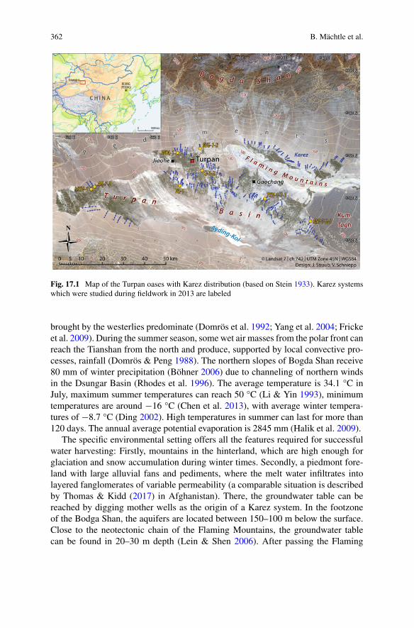
362 B. Mächtle et al.
Fig. 17.1 Map of the Turpan oases with Karez distribution (based on Stein 1933). Karez systemswhich were studied during fieldwork in 2013 are labeled
brought by the westerlies predominate (Domrös et al. 1992; Yang et al. 2004; Frickeet al. 2009). During the summer season, some wet air masses from the polar front canreach the Tianshan from the north and produce, supported by local convective pro-cesses, rainfall (Domrös & Peng 1988). The northern slopes of Bogda Shan receive80 mm of winter precipitation (Böhner 2006) due to channeling of northern windsin the Dsungar Basin (Rhodes et al. 1996). The average temperature is 34.1 °C inJuly, maximum summer temperatures can reach 50 °C (Li & Yin 1993), minimumtemperatures are around −16 °C (Chen et al. 2013), with average winter tempera-tures of −8.7 °C (Ding 2002). High temperatures in summer can last for more than120 days. The annual average potential evaporation is 2845 mm (Halik et al. 2009).
The specific environmental setting offers all the features required for successfulwater harvesting: Firstly, mountains in the hinterland, which are high enough forglaciation and snow accumulation during winter times. Secondly, a piedmont fore-land with large alluvial fans and pediments, where the melt water infiltrates intolayered fanglomerates of variable permeability (a comparable situation is describedby Thomas & Kidd (2017) in Afghanistan). There, the groundwater table can bereached by digging mother wells as the origin of a Karez system. In the footzoneof the Bodga Shan, the aquifers are located between 150–100 m below the surface.Close to the neotectonic chain of the Flaming Mountains, the groundwater tablecan be found in 20–30 m depth (Lein & Shen 2006). After passing the Flaming
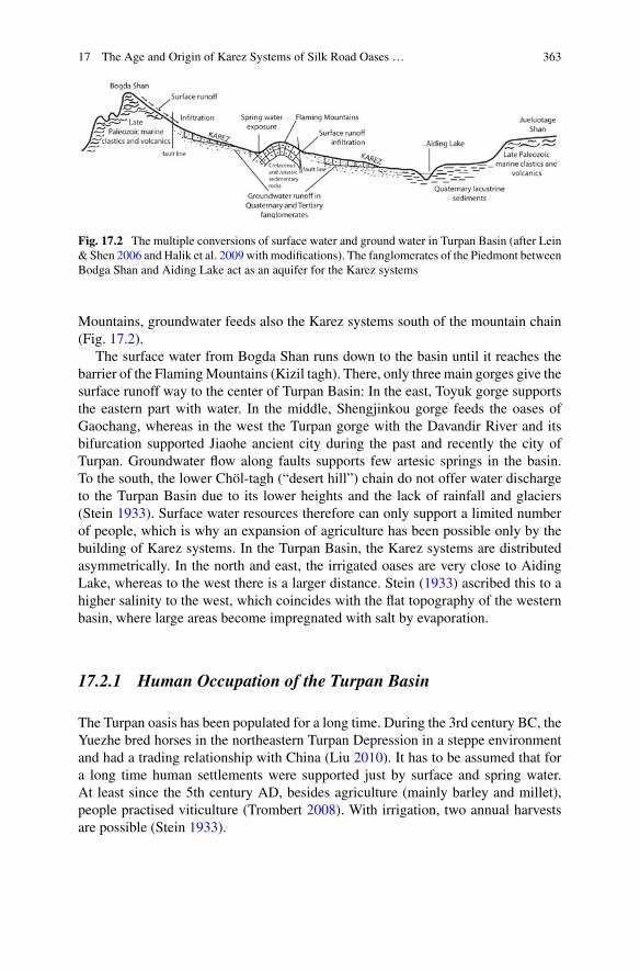
17 The Age and Origin of Karez Systems of Silk Road Oases … 363
Fig. 17.2 The multiple conversions of surface water and ground water in Turpan Basin (after Lein& Shen 2006 and Halik et al. 2009 with modifications). The fanglomerates of the Piedmont betweenBodga Shan and Aiding Lake act as an aquifer for the Karez systems
Mountains, groundwater feeds also the Karez systems south of the mountain chain(Fig. 17.2).
The surface water from Bogda Shan runs down to the basin until it reaches thebarrier of the FlamingMountains (Kizil tagh). There, only three main gorges give thesurface runoff way to the center of Turpan Basin: In the east, Toyuk gorge supportsthe eastern part with water. In the middle, Shengjinkou gorge feeds the oases ofGaochang, whereas in the west the Turpan gorge with the Davandir River and itsbifurcation supported Jiaohe ancient city during the past and recently the city ofTurpan. Groundwater flow along faults supports few artesic springs in the basin.To the south, the lower Chöl-tagh (“desert hill”) chain do not offer water dischargeto the Turpan Basin due to its lower heights and the lack of rainfall and glaciers(Stein 1933). Surface water resources therefore can only support a limited numberof people, which is why an expansion of agriculture has been possible only by thebuilding of Karez systems. In the Turpan Basin, the Karez systems are distributedasymmetrically. In the north and east, the irrigated oases are very close to AidingLake, whereas to the west there is a larger distance. Stein (1933) ascribed this to ahigher salinity to the west, which coincides with the flat topography of the westernbasin, where large areas become impregnated with salt by evaporation.
17.2.1 Human Occupation of the Turpan Basin
The Turpan oasis has been populated for a long time. During the 3rd century BC, theYuezhe bred horses in the northeastern Turpan Depression in a steppe environmentand had a trading relationship with China (Liu 2010). It has to be assumed that fora long time human settlements were supported just by surface and spring water.At least since the 5th century AD, besides agriculture (mainly barley and millet),people practised viticulture (Trombert 2008). With irrigation, two annual harvestsare possible (Stein 1933).

364 B. Mächtle et al.
To support the ancient city of Jiaohe (“between the rivers”) with water, peopledug wells probably before the first century BC. During the reoccupation by the Hanin 61 AD, numerous wells existed (Bertrand 2010). The majority of wells was dugbetween the 5th century and the end of Tang dynasty (Li 1999). During the Han andTang dynasties, trade flourished along the Silk Roads (Liu 2010).
In order to use the Turpan oases as a hub for the Silk Roads, more water wasneeded. Higher water availability may have been experienced during a more humidpast or achieved due to the building ofKarez systems. The development of the Turpanoases was controlled by the two capitals: (1) Jiaohe (Fig. 17.1), located on a 30 mhigh isolated plateau in the middle of the Davandir River. This city was dependenton tapping groundwater from deep wells (Li 1999). Its decline was probably relatedto decreasing runoff in the Davandir River and a lowering of the groundwater table.(2) Gaochang, where the situation is somewhat different, as the city is supported onthe one hand also by surface water, and on the other hand by Karez systems. Jiaoheand Gaochang existed at least since the beginning of the Han dynasty and lasted untilthe 15th/16th century. During the independent Gaochang Kindom (500–640 AD), anopen air channel system was built around Gaochang (Bertrand 2010 and referencestherein). If the abandonment of these important cities was triggered by changingrunoff of the rivers, palaeoclimatic information is required (see below).
17.2.2 The Karez Systems of the Turpan Basin
In contrast to the general description of the Qanat systems that tap water in alluvialdeposits (Cressey 1958), there is a greater variety in the Turpan Basin with regardto petrography, topography and hydrogeology (Laureano 2012). The Karez systemshave different sources. Firstly, they tap the groundwater flow of large alluvial fans,secondly aquifers on the thick piedmont fanglomerates and thirdly the water fromshallow groundwater resources, which are located along faults within the basin closeto the FlamingMountains. The latter sources offer the best water with lowest salinity(Chen et al. 2013).
With regard to their distribution, the Karez systems of Turpan are extraordinary.They had a length of more than 5000 km in total until the 18th century (English1968). In the 1950s, 1300 Karez systems with a length of 4000 km were in use (Sunet al. 2009). Due to the favorable hydrological conditions, the quality of its water ishigh and meets today´s requirements of China sanitary standard for drinking waterwithout treatment (Abudu et al. 2011). Therefore, high quality crops can be producedcompared to the use of local groundwater (Cenesta 2003 inAbudu et al. 2011). As theKarez supply year-round water, during winter times the fields are watered to leachout the salts, which were accumulated in the summer season (Abudu et al. 2011).
In recent decades, the sustainable system of gravity-driven utilization of waterin the Turpan Basin has been threatened by groundwater drawdown due to thewidespread use of less labor-intensive deep-well pumps. Between 1996 and 2006,pumping led to a lowering of the groundwater table in the village of Hope (south of
17 The Age and Origin of Karez Systems of Silk Road Oases … 365
Turpan district) from 20 to 33 m below the surface (Lein & Shen 2006). As moreand more Karez systems run dry, Lein & Shen (2006) expected a collapse of the lastsystems between 2015 and 2025. The number of systems declined from 1084 in theyear 1949 to 446 in the year 2000 (Turpan District Water Conservancy Bureau 2001,in Lein & Shen 2006). By 2009, the number had declined to 400 (Sun et al. 2009),which is a fall by 63% since 1949, whereas the number of deep wells increased from500 in 1988 to more than 5000 in 2003 (Abudu et al. 2011). Water discharge out ofthe Karez systems in the year 2003 was about 170 million m3, enough to support8800 ha of farmland. However, in 1950 the discharge amounted to 700 million m3,with 24.000 ha of farmland (Sun et al. 2009). Therefore, it is highly recommendedto restore and protect the Karez systems, as a sustainable way of water harvesting, inarid lands worldwide because it enlarges the resilience of agricultural systems duringyears of extreme droughts and lacking surface water.
17.2.3 Environmental Conditions During the Quaternary
They have been controlled by climatic fluctuations. Thus, water availability changedmarkedly during the past. For example, Aiding Lake covered an area of about3.000 km2 during the last glaciation, and still covered 152 km2 during the rainyseason in 1949 (Gao &Wu 2004; Yu et al. 2001). The colder conditions of the Pleis-tocene enhanced westerlies and moisture support to this region, whereas during theHolocene, drought increased markedly due to a northward position of the westerliesand higher evaporation, coupled with an enhancement of the Asian summermonsoonsystem (An et al. 2012). Climatic fluctuations also occurred during the Holocene dueto the anti-phase relationship between monsoons and westerlies (Bubenzer et al.2016). Ran & Feng (2013) state the Holocene moisture optimum for Xinjiang wasfrom 4–0 ka, due to increasing sea surface temperatures (SST) and evaporation in theNorth Atlantic region, coupled with intensified westerlies which brought moisturefar inland into central Asia. In addition, weaker summer monsoons due to weakersummer insolation decreased the propagation of dry air masses from the south. TheTian Shan is an important climatic divide and separates an arid-steppe climate inthe north from an arid-desert climate in the south, including the Turpan Depression.With regard to the late Holocene climate of the Turpan basin detailed information islacking. Furthermore, it is difficult to extrapolate palaeoclimatic information fromabroad geoarchives, as the mountain chains in this region lead to a strong climaticdiversity due to synoptic effects (Wolff et al. 2016). The western part of Central Asiafrom Kabul to Bishkek receives winter rainfall, whereas in the eastern part, e.g. theTian Shan and the Tarim Basin, summer rainfall prevails (Sorg et al. 2012).
However, in the Tsungar Basin, located north of the Bogda Shan, sediments inLake Manas indicate two late Holocene lacustrine episodes between 3.5–2.5 and(with a weaker wet pulse) 2.0–1.0 ka cal BP (Rhodes et al. 1996). From the Guliyaice core (western Kunlun Shan), Shi et al. (1999) reconstructed a rapid decreasein temperatures and precipitation at the end of the warm and humid Han dynasty
366 B. Mächtle et al.
250–280 AD, lasting until 970 AD. The medieval warm period between 970–1200AD was moderate and dry. From 1220 AD onwards, temperatures and precipitationincreased until around 1510 AD. During the Little Ice Age (LIA), the variabilityof climate increased, with strong cold-warm fluctuations. The years 1520–1530 ADwere very cold and wet, the 1600s were temperate, although the second half ofthis century was colder. The 1700s were warmer and wet, the period 1800–1910AD colder again (Shi et al. 1999). Liu et al. (2010) reconstructed moisture changesduring the last millennium by silty-clayey sediments in the hyperarid Tarim Basinand further paleoclimate archives of the region. They concluded that the region wasless arid during the LIA from 1490 to 1890 AD, in sync with an increase of westerlymoisture support to the region, whereas until 1490 and after 1890 AD the regionreceived less moisture. Around 1560 and 1625 AD, two clay layers indicate thepeaks of humidity. An increase in humidity is also indicated by an increase in iceaccumulation from the Guliya ice core (Yao et al. 1996) between 1550–1830 AD.Until the 5th century, the oases at the southern margin of the Taklamakan, Nixa,Miran and to the east Loulan, located at the margin of the former Lop-Nor, werepart of the flourishing kingdom of Kroania (Bertrand 2010). Loulan was abandoneddue to shrinking Tarim drainage. At the northern fringe of the Tarim Basin, theoases of Caohu, Tarim, Luntai and Yuli were also abandoned due to drought (Berque2005). During the 18th century, a massive expansion of Karez systems occurred inthe Turpan Basin. Bertrand (2010) suggests this was an adaption to climatic change.
17.3 Materials and Methods
For the study at hand, 8 Karez systems along the northern rim of the Turpan Basinwere investigated (see Fig. 17.1). They were selected after extensive interviews andthe study of archaeological reports, which indicate they constitute the oldest systemsstill in use.
Karez systems were constructed by digging short vertical shafts into the loosefanglomerates or alluvial fans in the foreland of dryland mountains. In general,these piedmont surfaces are distinctly inclined. At first, the constructors explore forgroundwater proximal to the mountains by digging a so-called “mother well”. Aftersuccess, the Karez shafts are dug, beginning at the final (English 1968). Proceedingupslope, further shafts are built and connected by a gently sloped underground chan-nel, draining the water to the outlet in the oasis (see Fig. 17.2) (“telemai”, which isan Uyghur term, Lein & Shen 2006). The length of the Karez in the Turpan basinvaries from three to 50 km (Sun et al. 2009). The distance between the shafts is about20-30 m close to the outlet and increases to 30–70 m to the mother well in the oasis.There, some shafts are more than 100 m deep (Lein & Shen 2006). It takes up toeight years to build a Karez system (Sun et al. 2008). In comparison, the Qanats inIran have mean lengths of about 4.2 km (Kortum 2004), with a maximum of 120 km(Zarach Qanat, Molle et al. 2004), and vertical shafts of up to 150 m deep (English1968). Most likely, the shortest Karez systems, and the shafts close to the basin, are
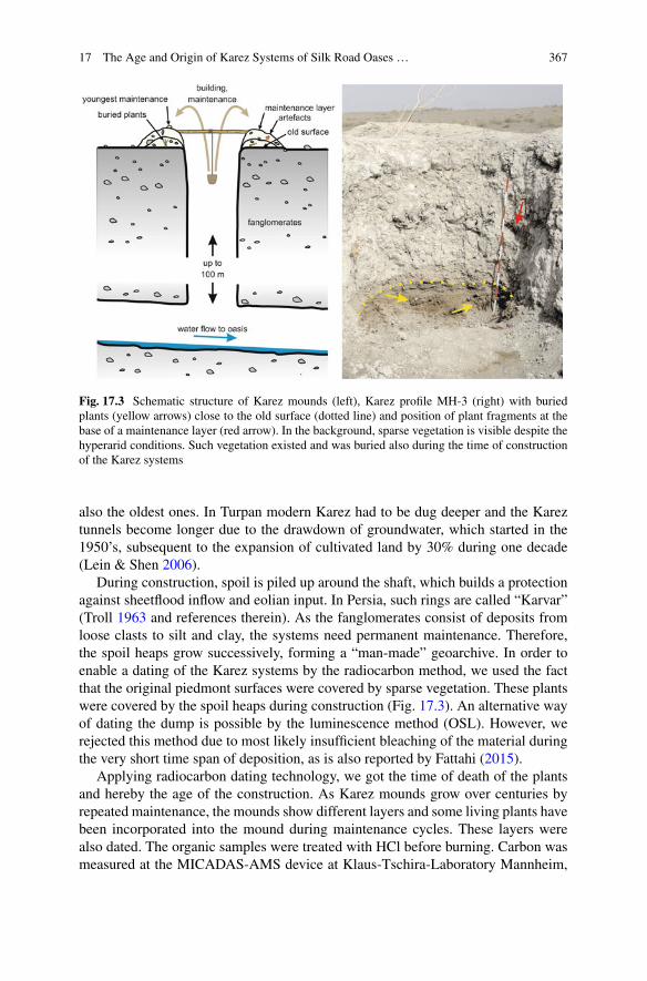
17 The Age and Origin of Karez Systems of Silk Road Oases … 367
Fig. 17.3 Schematic structure of Karez mounds (left), Karez profile MH-3 (right) with buriedplants (yellow arrows) close to the old surface (dotted line) and position of plant fragments at thebase of a maintenance layer (red arrow). In the background, sparse vegetation is visible despite thehyperarid conditions. Such vegetation existed and was buried also during the time of constructionof the Karez systems
also the oldest ones. In Turpan modern Karez had to be dug deeper and the Kareztunnels become longer due to the drawdown of groundwater, which started in the1950’s, subsequent to the expansion of cultivated land by 30% during one decade(Lein & Shen 2006).
During construction, spoil is piled up around the shaft, which builds a protectionagainst sheetflood inflow and eolian input. In Persia, such rings are called “Karvar”(Troll 1963 and references therein). As the fanglomerates consist of deposits fromloose clasts to silt and clay, the systems need permanent maintenance. Therefore,the spoil heaps grow successively, forming a “man-made” geoarchive. In order toenable a dating of the Karez systems by the radiocarbon method, we used the factthat the original piedmont surfaces were covered by sparse vegetation. These plantswere covered by the spoil heaps during construction (Fig. 17.3). An alternative wayof dating the dump is possible by the luminescence method (OSL). However, werejected this method due to most likely insufficient bleaching of the material duringthe very short time span of deposition, as is also reported by Fattahi (2015).
Applying radiocarbon dating technology, we got the time of death of the plantsand hereby the age of the construction. As Karez mounds grow over centuries byrepeated maintenance, the mounds show different layers and some living plants havebeen incorporated into the mound during maintenance cycles. These layers werealso dated. The organic samples were treated with HCl before burning. Carbon wasmeasured at the MICADAS-AMS device at Klaus-Tschira-Laboratory Mannheim,

368 B. Mächtle et al.
Germany. The ages are given in cal years AD (1 σ), calibrated with INTCAL2013(Reimer et al. 2013) and SwissCal 1.0 (L. Wacker, ETH Zürich) and normalized toδ13C −25.
17.4 Results
Local people report that some Karez systems have been working since at least the15th century AD. Based on such oral information/tradition, 16 test pits were selected,which revealed the typical stratigraphy of spoil heaps (comp. Fattahi 2015; for adetailed description see appendix). A heterogeneous mixture of spoil covers theoriginal, vegetated surface. Grain sizes may vary from coarse gravels to sand andsilt. The new surfaces were probably vegetated again. After a maintenance of thesystem the next sediment layer was deposited. Thus, several periods of spoil heapgrowth can be distinguished.
Table 17.1 presents the results of radiocarbon dating. Interestingly, three resultscorrelate well, the others less so with information provided by oral tradition. Wefound that the oldest investigated Karez systems originated in the early 15th century,and that there was a period of maintenance and construction of new systems duringthe last 300 yrs. More detailed age determination is not possible for the latter perioddue to the limitations of the radiocarbon method (14C plateau) (e.g. Bronk Ramsey2006).
Numeric datings and oral tradition correlate well for 3 of 10 Karez, 2 of 10 wereolder and 5 of 10 younger than expected from oral tradition. Tongqi Karez was saidhaving been of service around 1450 AD, which was confirmed by our 14C results(1421–1437 AD, 1 σ). In addition, construction material found at Dataogou Karez(DTG-1) date to nearly the same age (1410–1426). Mahao 2 Karez was installedat least 1550 AD according to the oral history, but dated older (1416–1435 AD and1497–1631AD, respectively).MierzhamouKarez is older (1532–1643AD) than oraltradition (1732 AD). Dataogou Karez (1650–1950 AD), Mahao 1 Karez (1700–1954AD, by oral tradition thought to be 1550 AD), and Ahong Karez (1654–1795 AD,most likely 1751, as oral tradition suggests) date to the expansion period. A Hulufruit incorporated in the sediments dates a maintenance phase of Mahao 3 Karez to1678–1951 AD. Tuyuhu Karez dated to 1681–1937 and 1698–1953, respectively, incontrast to oral tradition (1588 AD).
The results show that a number of Karez mounds have to be studied to find theoldest systems. SomeKarezmoundsmay be younger in an old systemdue to commoncollapse of older ones and the subsequent construction of a bypass, or the digging of ayounger mother well after groundwater drawdown. Therefore, we suggest samplingat least 3 mounds in a Karez system and a careful selection of the sites.

17 The Age and Origin of Karez Systems of Silk Road Oases … 369
Table 17.1 Radiocarbon age (cal AD, 1σ) and oral tradition of studied Karez systems
Karez name Sampledescription
Age range calAD (buildingphase)
Age range calAD(maintenancephase)
Oral tradition
Dataogou DTG-1,maintenance layer
plant remnants 1694–1952
Dataogou DTG-1, buildingrubbish
straw(construction)
1410–1426
Datagou DTG-2 from 1stbuilding phase
plant remnants 1650–1950
Tongqi TQ-1, old surface plant remnants 1421–1437 1450 out ofservice
Mahao MH-1 above/fromsurface
plant remnants 1700–1954 1550
Mahao MH-2, old surface plant remnants 1416–1435 1550
Mahao MH-3, old surface plant remnants 1497–1631 1550
Mahao MH-3, maintenancelayer
hulu fruit 1678–1951
Mierzhamou MZM-1, from1st building phase
plant remnants 1524–1643 1732
Mierzhamou MZM-1,maintenance layer
wood 1651–1950
Ahong AH-1, old surface plant remnants 1654–1795 1751
Ahong AH-2, old surface plant remnants 1681–1952
Qiong Q-1, old surface plant remnants modern
Qiong Q-2, old surface plant remnants 1683–1952
Tuyuhu TYH-1, old surface plant remnants 1681–1937 1588
Tuyuhu TYH-2, old surface plant needles 1698–1953 1682–1953 1588
Tuyuhu TYH-2,maintenance layer
plant remnants 1682–1952 1588
Tuyuhu TYH-3, old surface plant remnants 1691–1923 1588
Wudaolin WDL-1, 1stbuilding phase
plant remnants 1686–1952
Wudaolin WDL-1,maintenance layer
plant remnants 1893–1905

370 B. Mächtle et al.
17.5 Discussion
Our results show that the oldest investigated Karez systems in the Turpan Basin wereconstructed during the Uyghur reign and reactivated during the Qing dynasty. At thistime,we have no evidence of olderKarez systems.During theTang dynasty (640–790AD), a large irrigation system, fed by the seasonal runoff of the Xinxing Gorge, wasarranged around the city of Gaochang (Fig. 17.1). Some Chinese scholars assign theinnovation of Karez from Afghanistan to the period 640–790 AD, the second periodof Chinese reign in this region, but Trombert (2008) judges that clearly abovegroundchannels existed. They were described in detail in several documents, but there isno hint to Karez systems. The Tang period was more humid with increased surfacerunoff, whichmight have been sufficient to support the Turpan oases. Similarly, Stein(1933, 238) concludes climatic fluctuations prompted the construction of Karez, as“…the economic importance of Turpan was quite as great, if not greater, duringancient and medieval times, when we must assume that its oases depended wholly onirrigation from surface drainage”. Despite the medieval age of the Karez systems,the occurrence of large settlements points to higher water availability at that time(Huntington 1907), most likely from surface runoff or increased spring discharge.
In the 15th/16th century, the abandonment of Jiaohe (Fig. 17.1) and Gaochang,both supported by a certain degree by surface water, may be the result of increaseddrought. Our study shows that age determinations of Karez systems merely based onhistorical records, can be misleading. The Qing expansion to the Turpan area startedin 1755 AD, and the oases have been converted to military agricultural settlements(Trombert 2008). Hening, the Chinese governor, reports one single Karez system, butQi Yunshi, a Chinese traveler, only reported surface irrigation. Therefore, Trombert(2008) concluded that just a few Karez systems existed during this time.
Overall, due to our oldest radiocarbon datings to the Huihe period, the Karezsystems of Turpan have obviously an age of at least 600 years. Therefore, hypothesisd) of Trombert (2008) that still working Karez were built during Qing dynasty for thefirst time, has to be rejected. Instead, during the 3rd Chinese expansion in the 19thcent. AD, the Karez system expanded and underwent maintenance. The fact that theChinese transcribed the Uygur word Karez/Kariz to ka’er (Trombert 2008) points toan adaption of both the technique and the terminus.
Although our results so far date the origin of the studied Karez system to Uyghurtimes, an innovation of systems during the first (Han dynasty, 206 BC–220 AD) orthe second (Tang dynasty, 640–790 AD) expansion period is conceivable. From theTaklamakan, early connections to mainland China, India, Pakistan and central Asiansteppe regions are known, e.g. from Kunlun Shan and Tian Shan (Debaine-Francfortet al. 2010), which allowed technology transfer along the “Proto Silk Roads”.
It is hard to decide if climate triggered Karez activity in the Turpan Basin. Fattahi(2015) hypothesized that people in Iran have been forced to dig channels deeperduring more arid periods due to groundwater drawdown, which led to an increaseof the spoil heaps. Thus, in addition to the normal maintenance activities, spoillayers shall give the chance to date periods of drought. In contrast, we hypothesize

17 The Age and Origin of Karez Systems of Silk Road Oases … 371
that a lowering of the groundwater table would lead to an extension of the Karezgallery further to the mountains, where the groundwater can be reached easily bydigging a new mother well. Alternatively, a growth of the spoil heaps may also betriggered by a more humid period, when desiccated Karez could be reactivated (andcleaned) due to a higher groundwater level. In comparison to the regional climateproxies and with regard to our dating results we conclude more humid rather thanarid conditions occurred during the construction and maintenance of the investigatedKarez systems. At theKesangCave, located at the northernmargin of the central TianShan colder conditions were indicated (see D in Fig. 17.4). The Tarim Basin showedgenerally wetter conditions (B in Fig. 17.4), which possibly triggered (re)activationof the systems due to increasing groundwater resources. If this holds true, a southerlytrajectory of thewesterlies and their intensification led to increasedmoisture transportto the Turpan Basin. As this hypotheses has yet to be tested by further palaeoclimaticinformation, we suggest the use of independent proxies in order to estimate changesin precipitation and to keep in mind changes in natural resources as a possible triggerof Karez system construction in the Turpan Basin.
17.6 Conclusions
The study at hand demonstrates that the presented approach of sampling and datingburied plant remains at the shafts of Karez systems, combined with interviews inorder to record indigenous knowledge, is successfully applicable for determiningtheir origin and subsequent maintenance periods. Our results show that the oldestinvestigated Karez systems in the Turpan Basin were firstly constructed during theUyghur reign in the early 15th century and reactivated during the Qing dynastyafter around 1750 AD. According to the local population, the last new Karez sys-tems, which constitute a sustainable way of water harvesting, were built in the early1990s. Today, around 400 Karez systems are still in use. However, they are highlyendangered due to groundwater lowering after drilling of modern deep wells.
Although the number of Karez systems studied by our Sino-German group isnot enough for a clear result, the sampled systems and ages may point to a spatiallimitation of early Karez innovation to the eastern part of the basin. There is anopen question if the Karez innovation or expansion was due to political and militaryreasons or due to changes in water availability. From our results and the regionalpalaeoclimatic context, the periods of innovation and maintenance seem to fit wellto short humid periods in eastern Central Asia at the Guliya ice core (Shi et al. 1999)and colder conditions at Kesang cave (Cai et al. 2017). Therefore, climatic factorsmay have triggered the boom periods along the Silk Roads and supported trade alongthe pathway crossing the Turpan Basin. We hypothesize that rapid demand of waterand food during flourishing times of the Silk Roads trade forced the people to activateadditional water resources by constructing Karez systems.

372 B. Mächtle et al.
Fig. 17.4 Karez ages compared to climate proxies. a The Northern Hemisphere temperaturerecord (after Liu et al. 2010, based on Moberg et al. 2005); b Carbon isotope variations of plantleaves/remains preserved in the Tarim Basin in aeolian sediments over time (running average val-ues) and indication of two layers of silty clay deposits in a sequence at the end of the Tarim River,N 39° 47’ , E 88° 23’ (after Liu et al. 2010); c Ice accumulation from Guliya ice core (westernKunlun Shan, Yao et al. 1996); d Oxygen isotope record (δ18O) from the Kesang Cave stalagmite(Tekesi Country, Xinjiang Autonomous Region of China, N 42° 52’ , E 81° 45’ ,~2070 m a.s.l.)(after Cai et al. 2017), higher negative values indicate lower temperatures; e Carbonate percentagerecord from Bosten Lake, ca. N 87° 15’ , E 42°05’ (after Liu et al. 2010, based on Chen et al.2006), high carbonate contents correlate to lower lake levels and more arid climate. The dating ofKarez expansion may coincide with the transition to colder conditions at Kesang Cave (C), whichgives hints at probably more humid conditions during these periods

17 The Age and Origin of Karez Systems of Silk Road Oases … 373
Assuming the applicability of the same climatic mechanisms, we may postulatethat the oases of the Turpan Basin along this section of the Silk Roads receivedenough surface water during Han and Tang dynasty, which enabled an exchangealong the Silk Roads, but also made the activation of additional water resourcesby Karez systems unnecessary. Finally, we may assume that knowledge about thisPersian technique also existed during Han dynasty in the Turpan Basin.
17.7 Outlook
The selection of Karez systems, studied by our group, focused on still workingsystems. Therefore, the question about the oldest Karez systems cannot be answeredfinally. In order to get a more precise dating of later maintenance periods, which maybe a result of cultural dynamics along the Silk Roads and/or hydro-climatic changes,more research is needed. For example, 210Pb-dating is suggested for identifyingmaintenance period younger than 200 years. Cross-dating with 14C will decreasethe possible age range. The next steps of the research will focus on old abandonedsystems, identified by remote sensing and geomorphologicalmethods in combinationwith archaeological work and interviews. Following this approach, we may finallyanswer the question about the origin of the Karez systems in the Turpan Basin,which are of great importance for the Chinese history, and were set on the tentativelist to receive the UNESCO World Heritage status. This will help to protect thesetraditional and sustainable systems, which also represent great technical and socialachievements, for future generations.
Acknowledgements This project was funded by the Administration of Cultural Heritage of Tur-pan and the Initiative for Excellence, Universität Heidelberg, by the program “Strengthening Inter-national Exchange: Mobility in International Research Collaborations”. We greatfully thank ananonymous reviewer for helpful comments and for suggestions to assist the paper’s English.
Appendix
Recent description of the studied Karez (cp. XUARBCH 2011):

374 B. Mächtle et al.
Karez Name Location
Tongqi Karez (TQ) Tongqi Karez is located in Zhuangzi village, 0.4 km west ofthe Aidinghu village.
Qiong Karez (Q) Qiong Karez is located in Huoyilakanerzi village. This Karezis layed out in south-north direction, with a total length of3660 m and 92 shafts. According to oral tradition, this systemwas installed in 1200. Its historical maximum discharge was in1955.
Wudaolin Karez (WDL) Wudaolin Karez is also known as Datou Karez, located inShanghu village and 2 km southeast of the village committee.
Mahao Karez (MH) Mahao Karez is also known as Shakale Karez, located 1 kmnortheast of Tuotekanerzi village. Mahao Karez is arranged ineast-west direction, with a total length of 2540 m and 155shafts. The average depth is about 20 m. The historicalmaximum discharge was in 1980. According to the record ofKarez, Mahao Karez has a history of about 450 years. Theflow of water has plummeted since 1998.
(continued)
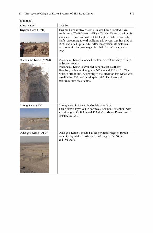
17 The Age and Origin of Karez Systems of Silk Road Oases … 375
(continued)
Karez Name Location
Tuyuhu Karez (TYH) Tuyuhu Karez is also known as Kawa Karez, located 2 kmnorthwest of Zerifukanerzi village. Tuyuhu Karez is laid out insouth-north direction, with a total length of 3900 m and 247shafts. According to oral tradition, this system was installed in1588, and dried up in 1642. After reactivation, its historicalmaximum discharge emerged in 1965. It dried up again in1995.
Mierzhamu Karez (MZM) Mierzhamu Karez is located 0.7 km east of Guolebuyi villagein Toksun county.Mierzhamu Karez is arranged in northwest-southeastdirection, with a total length of 2653 m and 112 shafts. ThisKarez is still in use. According to oral tradition this Karez wasinstalled in 1732, and dried up in 1985. The historicalmaximum flow was in 2000.
Ahong Karez (AH) Ahong Karez is located in Guolebuyi village.This Karez is layed out in northwest-southeast direction, witha total length of 4595 m and 123 shafts. Ahong Karez wasinstalled in 1752.
Dataogou Karez (DTG) Dataogou Karez is located at the northern fringe of Turpanmunicipality with an estimated total length of~1500 mand~50 shafts.

376 B. Mächtle et al.
References
Abudu, S., Cevik, S. Y., Bawazir, S., King, J. P., & Chunliang, C. (2011). Vitality of ancient karezsystems in arid lands: a case study in Turpan region of China. Water History, 3, 225–231.
An, Z., Colman, S. M., Zhou, W., Li, X., Brown, E. T., Jull, A. J. T., et al. (2012). Interplay betweenthe Westerlies and Asian monsoon recorded in Lake Quinghai sediments since 32 ka. ScientificReports, 2, 619. https://doi.org/10.1038/srep00619.
Bailiff, L.K., Gerrard, C.M., Gutierrez, A., Snape-Kennedy, L.M., & Wilkinson, K.N. (2015).Luminescence dating of irrigation systems: application to a qanat in Aragon, Spain. QuaternaryGeochronology, 14(B), 459.
Berque, A. (2005). Sans le Tarim. Espace Géographique 2005/3 (tome 34), 277–280.Bertrand, A. (2010). The hydraulic systems in Turfan (Xinjiang). The Silk Road, 8, 27–41.Böhner, J. (2006). General climatic controls and topoclimatic variations in Central and High Asia.
Boreas, 35(2), 279–295.Briant, P. (Ed.) (2001). Irrigation et drainage dans l’antiquité: qanats et canalisations souterrainesen Iran, en Égypte et en Grèce ; séminaire tenu au Collège de France (Vol. 2, 190 p). Paris: ThotmÉd.
Bronk Ramsey, C. (2006). New approaches to constructing age models: OxCal4. Pages News,14(3),14–15.
Bubenzer, O., Hecht, S., Li, C.-S., Li, X., Li, Y., Mächtle, B., et al. (2016). Late Pleistocene (MIS2)environmental changes and palaeoclimatic dynamics around Aiding Lake in the Turpan Basin,Xinjiang province, NW-China. Zeitschrift für Geomorphologie, Suppl., 60(1), 5–27. https://doi.org/10.1127/zfg_suppl/2015/S-00194.
Cai, Y., Chiang, J. C. H., Breitenbach, S. F. M., Tan, L., Cheng, H., Lawrence Edwards, R., et al.(2017). Holocene moisture changes in western China, Central Asia, inferred from stalagmites.Quaternary Science Reviews, 158, 15–28.
Chen, F., Huang, X., Zhang, J., Homes, J.A. & Chen, J. (2006). Humid Little Ice Age in arid centralAsia documented by Bosten Lake, Xinjinag, China. Science in China, Series D. Earth Sciences,49/12, 1280–1290.
Chen, L., Wang, G.C., Hu, F.S., Wang, Y.J. & Liu, L. (2013). Groundwater hydrochemistry andisotope geochemistry in the Turpan Basin, northwestern China. Journal of Arid Land. https://doi.org/10.1007/s40333-013-02249-9.
Cressey, G. B. (1958). Qanats, Karez and Foggaras. Geographical Review, 48(1), 27–44.Debaine-Francfort, C., Debaine, F., & Idriss, A. (2010). The Taklamakan Oases: An EnvironmentalEvolution ShownTroughGeoarchaeology. In: Schneier-Madanes, G.&M.F. Courel (Eds.),Waterand sustainability in Arid Regions (pp. 181–202). Springer.
Ding, C. L. (2002). Study of Formation Mechanism of Natural Anhydrous Sodium Sulfate in LakeAiding. Sea-lake Salt and Chemical Industry, 31(6), 4–7. (in Chinese).
Domrös, M., & Peng, G. (1988). The climate of China. 360 p.Berlin, Heidelberg:Springer.Domrös, M., Peng, G., & Zhang, S. (1992). The Characteristic of the Desert Climate at Turpan,China. Erdkunde, 46, 217–223.
English, P. W. (1968). The origin and spread of Qanats in the Old World. Proceedings of theAmerican Philosophical Society, 12(3), 170–181.
Fattahi, M. (2015). OSL dating of the Miam Qanat (Kariz) system in NE Iran. Journal of Archael-ogical Science, 59, 54–63.
Fattahi, M., Aquazadeh, A., Walker, R.T., Talebian, M., loan, R.A., Khatib, M.M. (2011). Investi-gation on the potential of OSL for dating Qanat in the Dasht-e Bayaz region of north-eastern Iranusing the SAR protocol for quartz. Journal of Seismology and Earthquake Engineering, 138 (2),65–75.
Fricke, K., Sterr, T., Bubenzer, O., & Eitel, B. (2009). The oasis as a Megacity: Urumqi’s FastUrbanization in a Semiarid Environment. Die Erde, 140(4), 449–463.
Gao, F. S., & Wu, X. Y. (2004). The countermeasure analysis of evolution of main environmentalfactors and sustainable development in Turpan Basin. Turpan Technology, 01, 22–23.

17 The Age and Origin of Karez Systems of Silk Road Oases … 377
Halik, A., Jalalidin, A., & Bian, Z. F. (2009). Discussion on the water resources and their rationaldevelopment and utilization in Turpan Basin. System Sciences and Comprehensive Studies inAgriculture, 25(3), 355–360. (in Chinese).
Huntington, E. (1907). The depression of Turfan, Central Asia. Geographical Journal, 30(3),254–273.
Kobori, I. (1973). Some notes on diffusion of Qanat. Orient, 9, 43–66.Kortum, G. (2004). Die Qanat-Bewässerung auf dem Hochland von Iran und ihre Ausbreitung überdie Erde. In U. Hübner & A. Richter (Eds.), Wasser - Lebensmittel, Kulturgut, politische Waffe:historische und zeitgenössische Probleme und Perspektiven in asiatischen und afrikanischenGesellschaften (pp. 165–198).
Laureano, P. (2012). Water catchment tunnels: qanat, foggara, falaj. An ecosystem vision. IWASpecialized Conference on Water and Wastewater, Technologies in Ancient Civilizations, Istanbul,Turkey, 22–24 March 2012, 1-13.
Lein, H., & Shen, Y. (2006). The disappearance of the Karez of Turfan. Acta Geographica Trond-heim, Series A, 15, 1–17.
Li, X. (1999). . “Jiaohe guchengjing diancha baogao” [The examina-tion of the wells of Jiaohe city]. In Y. Xie (Ed.) Jiaohe Gucheng Baohu Yu Yanjiu
[Préservation and Research of the Ancient Ruins of Jiaohe], Urumqi,1999 (pp. 308–17).
Li, X., & Yin, J. Y. (1993). The Arid-hot environmental characteristics in Turpan Basin. Arid LandGeography, 16(2), 63–69. (in Chinese).
Lightfoot, D. R. (1997). The origin and diffusion of Qanats in Arabia: New evidence from thenorthern and southern Peninsula. The Geographical Journal, 166(3), 215–226.
Liu, W., Liu, Z., An, Z., Wang, X., & Chang, H. (2010). Wet climate during the’Little Ice Age’in the arid Tarim Basin, northwestern China. Holocene, 21(3), 409–416. https://doi.org/10.1177/0959683610378881.
Liu, X. (2010). The silk road in world history. 154 p. Oxford University Press.Moberg, A., Sonechkin, D. M., Holmgren, K., Datsenko, N. M., & Karlén, W. (2005). Highlyvariable Northern Hemisphere temperatures reconstructed from low- and high-resolution proxydata. Nature, 433, 613–617.
Molle, F.,Mamanpoush, A., &Miranzadeh,M. (2004).Robbing Yadullah’s water to irrigate Saeid’sgarden: hydrology and water rights in a village of central Iran. Research Reports: Vol. 80, 43 p.Colombo, Sri Lanka: International Water Management Institute.
Ran, M., & Feng, Z. (2013). Holocene moisture variations across China and driving mechanisms:A synthesis of climatic records. Quaternary International, 313–314, 179–193. https://doi.org/10.1016/j.quaint.2013.09.034.
Reimer, P. J., Bard, E., Bayliss, A., Beck, J. W., Blackwell, P. G., Bronk Ramsey, C., et al. (2013).Selection and treatment of data for radiocarbon calibration: An update to the international cali-bration (INTCAL) criteria. Radiocarbon, 55(4), 1923–1945.
Remini, B., Kechad, R. & Achour, B. (2014). The collecting of groundwater by the Qanats: AMillenium technique decaying. Larhyss Journal, No. 20, 259–277.
Rhodes, T. E., Gasse, F., Lin, R., Fontes, J. C.,Wei, K., Bertrand, P., et al. (1996). A late pleistocene-Holocene lacustrine record from Lake Manas, Zunggar (northern Xinjiang, western China).Palaeogeography, Palaeoclimatology, Palaeoecology, 120(1), 105–121.
Salih, A. (2006). Qanats a unique groundwater management tool in arid regions: the case of BamRegion in Iran. In International symposium on groundwater sustainability (ISGWAS) (pp. 79–87).
Shao, L., Stattegger, K., Li, W., & Haupt, B. J. (1999). Depositional style and subsidence historyof the Turpan Basin (NW China). Sedimentary Geology, 128, 155–169.
Shi, Y., Yao, T., &Yang, B. (1999). Decadal climatic variations recorded inGuliya ice core and com-parison with the historical documentary data from East China during the last 2000 years. Sciencein China Series D: Earth Sciences, Suppl., 42(1), 91–100. https://doi.org/10.1007/BF02878857.
Stein, A. (1933). Note on a map of the Turfan Basin. The Geographical Journal, 82(3), 236–246.
378 B. Mächtle et al.
Sorg, A., Bolch, T., Stoffel, M., Solomina, O., & Beniston, M. (2012). Climate change impacts onglaciers and runoff in Tien Shan (central Asia). Nature Climate Change, 2, 725–731.
Sun, Q., Tao, W., Kobori, I., & Liang, L. (2008). Karez in the Turpan Region of China. In Z. Adeel,B. Schuster, H. Bigas, (Eds.), What makes traditional technologies tick? A review of traditionalapproaches for water management in drylands (pp. 57–64). UNU Desertification Series No. 8.
Sun, Q., Wang, T., Kobori, I., & Liang, L. (2009). Karez in the Turpan region of China. In Z. Adeel,B. Schuster, H. Bigas (Eds.), Seeing traditional technologies in a new light - using traditionalapproaches for water management in drylands (pp. 12–14). The United Nations World WaterDevelopment Report 3.
Thomas, D. C., & Kidd, F. J. (2017). On the margins: enduring pre-modern water managementstrategies in and around the registan desert, Afghanistan. Journal of Field Archaeology, 42(1),29–42. https://doi.org/10.1080/00934690.2016.1262188.
Troll, C. (1963). Qanat-Bewässerung in der Alten und Neuen Welt. Mitteilungen der Österreichis-chen Geographischen Gesellschaft, 105(3), 313–330.
Trombert, É. (2008). The Karez concept in ancient Chinese sources.- Myth or reality? T’oung Pao,94, 115-150.
Wang, Y. J., & Wu, S. F. (2003). Environmental change over the Aydingkol Lake region in TurpanBasin. Journal of Glaciology and Geocryology, 25(2), 229–231.
Wolff, C., Plessen, B., Dudashvili, A., Breitenbach, S.F.M., Cheng, H., Edwards, L., & Strecker,M., 2016. Precipitation evolution of Central Asia during the last 5000 years. Holocene, 1–13.https://doi.org/10.1177/0959683616652711.
XUARBCH(XinjiangUygurAutonomousRegionBureauofCulturalHeritage) (2011).The integra-tion of the 3rd national cultural relics census in Xinjiang Uygur Autonomous Region—Xinjiangkan-er-jing (in Chinese). Beijing : Science Press Ltd.
Yang, B., Shi, Y. F., Bräuning, A., & Wang, J. X. (2004). Evidence for a Warm-humid Climate inArid Northwestern China During 40–30 ka BP. Quaternary Science Reviews, 23, 2537–2548.
Yao, T. D., Thompson, L. G., Qin, D. H., Tian, L., Jiao, K., & Yang, Z. (1996). Variations intemperature and precipitation in the past 2000a on the Xizang (Tibet) Plateau: Guliya ice corerecords. Science in China (Series B), 39(4), 425–433.
Yu, G., Harrison, S. P., & Xue, B. (2001). Lake Status Records From China: Data Base Documen-tation. 243 p, MPI-BGC: Jena, Tech Rep 4.
Open Access This chapter is licensed under the terms of the Creative Commons Attribution 4.0International License (http://creativecommons.org/licenses/by/4.0/), which permits use, sharing,adaptation, distribution and reproduction in any medium or format, as long as you give appropriatecredit to the original author(s) and the source, provide a link to the Creative Commons license andindicate if changes were made.
The images or other third party material in this chapter are included in the chapter’s CreativeCommons license, unless indicated otherwise in a credit line to the material. If material is notincluded in the chapter’s Creative Commons license and your intended use is not permitted bystatutory regulation or exceeds the permitted use, you will need to obtain permission directly fromthe copyright holder.

Chapter 18Water Supply and Ancient Societyin the Lake Balkhash Basin: RunoffVariability along the Historical Silk Road
Irina P. Panyushkina, Mark G. Macklin, Willem H. J. Toonenand David M. Meko
Abstract Expansion of agricultural practices from the Fertile Crescent to Chinaduring the mid and late Holocene are believed to have shaped the early networkof Silk Road routes and possibly regulated the dynamics of trade and exchange inthe urban oases along the Silk Road throughout its existence. While the impactsof climate change on the Silk Road are more or less documented for the medievalperiod, they remain poorly understood for early history of the Silk Road, especiallyin Central Asia. We analyze hydroclimatic proxies derived from fluvial stratigraphy,geochronology, and tree-ring records that acted on various time scales in the LakeBalkhash Basin to learn how changes in water supply could have influenced theearly farmers in the Semirechye region of southern Kazakhstan. Our approach aimsto identify short-term and long-term variability of regional runoff and to compare thehydrological data with cultural dynamics coupled with the archaeological settlementpattern and agricultural production. The reconstructed runoff variability underscorethe contribution of winter precipitation driven by the interaction between the Arcticoscillation and the Siberian High-Pressure System, to Central Asian river discharge.We show that Saka people of the Iron Age employed extensive ravine agricultureon the alluvial fans of the Tian Shan piedmont, where floodwater farming peakedbetween 400 BC and 200 BC. The early Silk Road farmers on the alluvial fansfavored periods of reduced flood flows, river stability and glacier retreat in the Tian
I. P. Panyushkina (B) · D. M. MekoLaboratory of Tree-Ring Research, University of Arizona,1215 E. Lowell St., Tucson, AZ 85721, USAe-mail: [email protected]
M. G. MacklinSchool of Geography and Lincoln Centre for Water and Planetary Health, University of Lincoln,Lincoln LN6 7TS, United Kingdom
M. G. MacklinInnovative River Solutions, Institute of Agriculture and Environment, Massey University, PrivateBag 11 222, Palmerston North 4222, New Zealand
W. H. J. ToonenDept. Geography and Earth Sciences, Aberystwyth University, Llandinam Bldg, Penglais,Aberystwyth SY23 3DB, United Kingdom
© The Author(s) 2019L. E. Yang et al. (eds.), Socio-Environmental Dynamics along the Historical Silk Road,https://doi.org/10.1007/978-3-030-00728-7_18
379

380 I. P. Panyushkina et al.
Shan Mountains. Moreover, they were able to apply simple flow control structuresto lead water across the fan surface. It is very unlikely that changes in water supplyever significantly constricted agricultural expansion in this region.
Keywords Central asia · Ili river · Water resources · Silk road archaeologySaka agriculture · Dendrochronology · Fluvial geomorphology · Siberian high
18.1 Introduction
Human-environmental interactions are extremely complex, and can be obscured notonly by the dynamic complexity of the climate systembut also by the diversity in soci-etal response and human adaptation to changing landscape (Adger et al. 2013). Soci-etal response to climate change greatly varies and relies in part on a particular level ofcultural sophistication and economic development that can seldom bemeasured. Therole of climate change on the landscape andwater resources throughout the prehistoryof Central Asia has been researched with multi-disciplinary approaches for a longtime. Yet the progress in unveiling physical mechanisms linking socio-economicalchange to the environment and climate change has been limited (Koryakova and Epi-makhov 2007; Kuzmina 2007; Giosan et al. 2012; Macklin and Lewin 2015). Alongthe historical Silk Road the timeframe of ancient trade and technological exchangebetween the west and the east is reaching back in time from the medieval period tothe Bronze Age (4500 years ago) (Frank and Thompson 2005; Frachetti et al. 2017).However it is not evident how the landscape itself could have facilitated the earlydevelopment and sustainability of historical Silk Road networks.
It is reasonable to suspect that understanding water resource availability wouldlead to a comprehensive model explaining surplus accumulation and populationgrowth at particular nodes of the ancient trading networks in the arid lands of CentralAsia.Herewedescribe an approach that synthesize hydroclimatic variabilitymodeledwith fluvial geomorphology and dendrochronology to understand the fluctuations ofwater supply for agriculture in agropastoralist communities of Bronze Age and IronAge occupying the Tian Shan piedmonts. We hypothesize that fertile alluvial fanscould have engaged the ancient population in a pursuit of agriculturewhile themobilepastoral economy of the time encouraged exchange with neighboring people.
In this chapter we outline two case studies in the Lake Balkhash Basin exploringvariations of local and regional hydrology of the past. The first case study addresseslong-term variability of runoff to link Holocene river dynamics, climate change andfloodwater farming on the Talgar alluvial fan of Tian Shan piedmont (Macklin et al.2015). The second deals withmodeling short-term river discharge from tree rings andexplores the atmospheric circulation drivers in the runoff fluctuations (Panyushkinaet al. 2018). The technical details on methods and datasets used in this chapter couldbe found in aforementioned publications. Although, the second case study consid-ers the last few centuries only, it identifies the key climatic drivers of hydrologicalvariability that most likely regulated the fluctuation of regional water resources in
18 Water Supply and Ancient Society in the Lake Balkhash Basin … 381
the ancient times. We note that the scarcity of archeological data and hydro-proxiesgreatly limits our understanding of the impacts of water supply on the ancient agri-cultural communities. This work is currently most comprehensive assemblage ofmeasured and absolutely dated information approximating the changes of hydrolog-ical regime in the region. To familiarize the readers with the historical backgroundof this Central Asian region we describe briefly the geography and ancient society ofLake Balkhash Basin. The discussion is mainly focused on social impacts of runofffluctuations and adaptations of farming populations to hydrological changes.
18.2 Ancient Society of the Lake Balkhash Basin
18.2.1 Historical Region of Semirechye in the Lake BalkhashBasin
The study is located in the Semirechye (Land of Seven Rivers) of Central Asia alsocalled Zhitasu by Kazakhs that geographically corresponds to the Lake BalkhashBasin (Fig. 18.1). This closed basin in Inner Eurasia is comparable in area(413,000 km2) to the neighboring Aral-Caspian and Tarim basins. Most regionalrivers have headwaters in China and Kyrgyzstan, and flow from south to norththrough Kazakhstan. Annual runoff of the Lake Balkhash Basin is 0.26–0.36 km3/y(Mamatkanov et al. 2006; Kuzmichenok 2009).
Glacier and snowmeltwater with high flows betweenMay and September, and thehighest peaks in July and August dominate the hydrological regime of the watershed(Fig. 18.2). While the glacier share of runoff is estimated to range from ca. 10 to40%, there is large uncertainty in estimation of glacial area and glacier volume ofthe hundred small glaciers in the basin (Sorg et al. 2012; Farinotti et al. 2015).
The Ili River (length 1439 km, catchment area 140,000 km2), formed by theconfluence of the Tekes and Kunges rivers in Xinjiang, China, is the largest riverin the basin (Fig. 18.1 insert). The main tributaries of the Ili River that drain theZailiyskiyAlatauRange, and theTianShanMountains inKazakhstan, are theCharyn,Keskelen, Talgar, Turgen and Chilik Rivers. The delta of the Ili River runs throughthe Sary Aka and TaukumDeserts, and forms vast areas of wetlands, sand dunes, andmarshes before reaching the southeastern shoreline of Lake Balkhash. The tributarycatchments contain nearly one hundred small glaciers, whose areas range from 4 to26%of the area of thewatershed, andwhich contribute from 17% (Keskelen River) to56% (Talgar River) of the summer runoff (Vilesov and Uvarov 2001). The total areaof these small glaciers is presently ca. 253 km2 (Konovalov and Pimankina 2016).The average discharge of the Ili is about 480 m3/s per year. The highest dischargepeak is in July ca. 770 m3/s and the lowest flow in January is ca. 230 m3/s (Fig. 18.2).The tributaries have multi-faceted alluvial fans (Fig. 18.1), 15–25 km wide and up to20 km long, withmultiple lobes decreasing in elevation fromwest to east (Akiyanova1998).
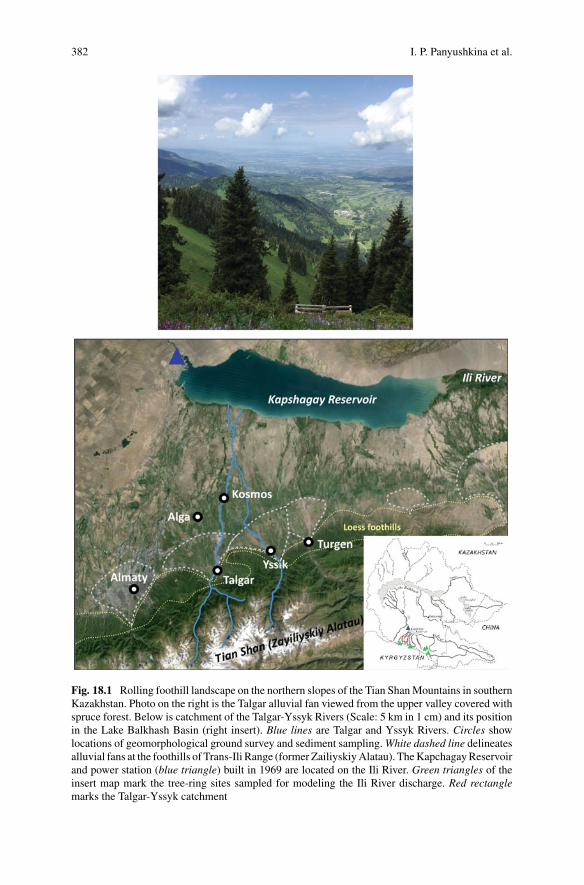
382 I. P. Panyushkina et al.
Fig. 18.1 Rolling foothill landscape on the northern slopes of the Tian ShanMountains in southernKazakhstan. Photo on the right is the Talgar alluvial fan viewed from the upper valley covered withspruce forest. Below is catchment of the Talgar-Yssyk Rivers (Scale: 5 km in 1 cm) and its positionin the Lake Balkhash Basin (right insert). Blue lines are Talgar and Yssyk Rivers. Circles showlocations of geomorphological ground survey and sediment sampling.White dashed line delineatesalluvial fans at the foothills of Trans-Ili Range (former ZailiyskiyAlatau). TheKapchagayReservoirand power station (blue triangle) built in 1969 are located on the Ili River. Green triangles of theinsert map mark the tree-ring sites sampled for modeling the Ili River discharge. Red rectanglemarks the Talgar-Yssyk catchment

18 Water Supply and Ancient Society in the Lake Balkhash Basin … 383
Fig. 18.2 Annual regime of precipitation and river flow in the study area. Top plot is monthlyprecipitation for the instrumental interval 1936–2014 at weather station Almaty (43° 23′ N, 76° 93′E, 895 m asl) located in the Malaya Almatinka River Valley adjacent to the Talgar River catchment.The station represents precipitation variation in the Lake Balkhash Basin (Zhou et al. 2017). Bottomplot is monthly hydrograph of Ili River discharge as recorded at the U. Kapchagay gauge (44° 13′ N,76° 98′ E, 428 m asl) for the instrumental period 1936–1985 (Fig. 18.1). Precipitation and dischargein individual months are displayed as box plots with a horizontal line at the median, a box over theinterquartile range, and plus signs at values more than 1.5 times the interquartile range above orbelow the box. If there are no such outliers, the bracket marks the data extremes
Analysis of instrumental data covering the last 70 years indicates that runoff in thisregion has not changed significantly or has declined only slightly (1–2%) over theperiod 1940–2005while regional temperature has awarming trend (Aizen et al. 1996;Konovalov and Pimankina 2016). Themeasured contribution of glaciermelt has beendecreasing, while snowmelt significantly increased over 1940–1991 (Konovalov andPimankina 2016). Glacier mass-balance modeling estimates an 18–27% decrease inthe glacier area across the Tian Shan since 1961 (Farinotti et al. 2015). Precipitationover the larger region of Central Asian drainages is decreasing (Lammers et al.2001; Bothe et al. 2012). Ili River runoff has been permanently altered since 1970by construction of the Kapchagay Dam and Reservoir (Fig. 18.1). The dam wascompleted in 1969 and the reservoir filled over the next 20 years.
384 I. P. Panyushkina et al.
18.2.2 Socio-Cultural History of Semirechye During the LateHolocene
The Bronze Age World System on the Eurasian steppe is often characterized as theprecursor for the Silk Road (Christian 1994; Frank and Thompson 2005; Frachettiet al. 2017). The Bronze Age (BA) of the Semirechye was represented by a smallpopulation of Andronovo people (2500–1400 BC) in the upland valleys and foothillsof the Dzhungarskiy Alatau and Zailiyskiy Alatau Ranges. The Andronovo peoplewere primarily pastoralists, who negotiated trade in surplus livestock and metalgoods along mountain corridors (Frachetti 2012). Later, during the Iron Age (800BC–AD 200, IA), the foothill alluvial fans supported mixed farming and herding,but not yet mobile pastoralism (Akishev 1969; Chang et al. 2003). Archaeologicaldata suggest multiple scenarios for the shift in economic strategies from transhumantpastoralism to settled agro-pastoralism that took place at the transition from the LateBA to IA (Chang et al. 2003; Frachetti 2012; Spengler et al. 2013; Chang 2018): (1)upland mountain valleys served refuges for mobile pastoralism that persisted despitea climate change to cooler and drier conditions in the first millenniumBC; (2) groupsof sedentary agro-pastoralists moved into fertile lowland regions and combined bothmobile pastoralism and small-scale agriculture during the IA; and (3) throughoutboth BA and IA periods, the population facilitated upland transhumant pastoralismand lowland agro-pastoralism. The most recent archaeological framework in theSemirechye favors a diversified and highly intensified economy (scenario #3) thatemerged by the Late BA, and during which the agricultural pursuits on the alluvialfans led to exchange of surplus grain throughout Central Asia (Spengler et al. 2017).
Historical evolution of the IA in the Semirechye climaxes into military confed-eracies of the Saka (Asian Scythians) and later Wusun, which had highly complexproduction from farming and herding to metalworking, and intensive trade with theneighboring agrarian kingdoms of Bactria and Parthia (DiCosmo 1999). Furtheradaptation of Late IA population to the warming medieval times served as the eco-nomic backbone for the social development of hierarchically arranged principalitiesin the region by c. AD 600 (Baipakov 2008).
The medieval history of the Semirechye involved several Turkic Khaganates1 pri-mary occupied the Ili River basin and the Tian Shan foothills. At this time the cultureand economy of urban oases reached their peak, being imbedded into the Silk Roadnetworks. Farming and irrigation played an important role in the economic develop-ment of the region (Groshev 1985; Oberhänsli et al. 2007; Baipakov 2008). The lastKhaganate, called the Kara Khanid (10th–11th century), introduced Islam, whichblended organically into the well-developed urban environments of the Semirechye.
The conquest of theKaraKhanid by theMongolEmpire (afterAD1206) destroyedthe urban centers, reduced the population and dramatically changed the social orderin the region. The regional economy fell into stagnation, and agricultural production
1Khaganate, alternatively spelled as Khanate, is a political entity of Central Asian tribes ruled byKhagan or Khan. This is an equivalent to tribal chiefdom, principality or kingdom.
18 Water Supply and Ancient Society in the Lake Balkhash Basin … 385
halted while the mobility of pastoralists increased. Along with the crash in techno-logical growth and cultural diffusion, the Silk Road network fragmented (Christian1998). The Kazakh Khanate (AD 1465–1731) unified nomadic people ruled by mul-tiple tribal alliances branched out from the Jochi Khan (the eldest son of GenghisKhan) clan. There are no historical data documenting the agricultural production inthe Semirechye during this time. Winter camps of herders occupied the low reachesof rivers draining the area south of Balkhash Lake where freshwater springs wereabundant (Krasnov 1887; Baipakov 2008). The fertile alluvial fans of the Tian Shanfoothills served as the transit corridor between the lowlandwinter camps and summercamps in the upland meadows. The modern era started with Russian colonization ofthe Semirechye (Eastern Turkistan) after 1867.With colonization came revived farm-ing and gardening practices, development of new irrigation lands, and westernization(including sedentarization) of the nomadic population.
18.3 Long-Term Variability of Runoff in the SemirechyeDerived from Fluvial Geomorphology and Its Relationto Ancient Farming
The case study by Macklin et al. (2015) demonstrated how changes in water supplycould have impacted early farmers that occupied the Talgar alluvial fan in the Ili RiverBasin. Environmental proxies of runoff in Central Asia are limited and their temporalresolution is irregular, so instead, a long-term and absolutely dated fluvial chronologyof a small catchment was used to investigate centennial andmulti-centennial variabil-ity of water supply and its impact on the society. The long-term variability of runoffwas approximated on the Talgar River catchment where a Kazakh-American archae-ological team lead by Prof. Claudia Chang (Sweet Briar College, VA) conductedarchaeological excavations and surveys over the past 25 years focusing on sedentarysettlements (Chang2018). Linkingfluvial terracing to long-termchanges inwater andsediment supply, a chronology of Holocene major aggradation and incision episodeswas established. These were dated with radiocarbon (14C) and Optically StimulatedLuminescence (OSL). The chronology was compared with other regional hydrocli-matic records, and the river dynamics are linked to climate change. This allowedevaluating the impact of runoff variability on water supply for floodwater farming.
18.3.1 Settings of Fluvial Geomorphology Studyon the Talgar Alluvial Fan
The Talgar River (length c. 120 km, drainage area c. 440 km2) is located in the IliRiver catchment anddrains theTrans-Ili (formerZayliyskyAlatau)Range (Fig. 18.1).Topographic maps prior the construction of the Kapchagai reservoir (1969) showthe Talgar River splitting into a series of distributary channels that drained into anenclosed wetland, not connecting directly with the Ili river except possibly during
386 I. P. Panyushkina et al.
floods. Annual precipitation at the apex of the fan is 755 mm with spring (major)and autumn (minor) peaks, rising to 900 mm (Aubekerov and Gorbunov 1999) at thehigher elevation of the Mount Talgar (5020 m asl), the highest point in the Talgarcatchment.
Field data on river terrace sedimentology, stratigraphy and geochronology werecollected along a 35-km transect stretching from the apex of the Talgar fan down-stream to the Talgar River confluence with the Yssyk River (Figs. 18.1 and 18.3).Geomorphological mapping was carried out using satellite imagery (Shuttle RadarTopography Mission: SRTM), topographic maps, and ground survey. OSL and 14Cdating of fluvial units was undertaken at three 1-km long reaches: 1) apex of the fancentered on the medieval town of Talkhar (43°16′ N, 77°13′ E), 2) Kosmos (43°30′N, 77°15′ E) and 3) Talgar-Yssyk confluence (43°35′ N, 77°17′ E) (Fig. 18.1). Theages reported herein use (1) calibrated 14C years before present (AD 1950), which wedenote as ‘cal AD’ and ‘cal BC’, and (2) annum unit with error or age range denotedwith “ka” (thousands years ago) for OSL dates. In some cases, cross-referencingOSL and 14C dates with archaeological and historical periods results in denoting thecalendar time with AD or BC datum.
18.3.2 River Terraces, Stratigraphy and Geochronologyin the Talgar Catchment
At the upper Talgar River valley, four terraces are found at c. 13.5 m (T1), 9.5 m(T2), 4 m (T3), and 2.5 m (T4) above the current river-bed (Fig. 18.4). The medievaltown of Talgar (alternative spelling Talkhar), occupied from 9th to the 13th centuriesAD, is located on the surface of T1 (Fig. 18.4). The buried soil contains 9–13thcentury AD ceramics as well as abundant bones and charcoal associated with theKara Khanids (Figs. 18.3c and 18.5). The age of this soil is about cal AD 890–1040,which is consistent with the historical dating of Talgar. These deposits above that soilrelate to a major period of flooding and channel aggradation that buried the medievalsettlement around cal AD 1680–1940 (Macklin et al. 2015).
Downstream reach Kosmos is located 30 km from the fan apex (Fig. 18.1), wherethe valley width is about 300 m (Fig. 18.3d). The present river runs in a 100 mwide meander channel belt, has a high-sinuosity channel and is confined within riverterraces of Holocene age 2–7 m (Fig. 18.4). Four major terraces are evident at c.7 m (T1), 6 m (T2), 3 m (T3), and 2 m (T4) m above the present river level andcan be traced fragmentally for 15 km northwards towards the Kapchagay Reservoirand 10 km upstream. A well-developed soil was formed in the IA between 2880 and2490 cal BC and c. 2440 (±450) BC (Fig. 18.4f). A second palaeosol is dated tocal AD 1460–1640. Confluence with the Yssyk River (Figs. 18.1 and 18.4) reckonsthree terraces (T1—11 m, T2—8 m, and T3—3.5 m), while the Yssyk River hasonly two major terraces (Y1—11 m and Y2—5 m). The ages of the buried soil atthe Talgar-Yssyk confluence is dated to cal. AD 1320–1450 at T3 and from cal AD1300–1400 to 1450–1630 at Y2 (Fig. 18.4).

18 Water Supply and Ancient Society in the Lake Balkhash Basin … 387
Fig. 18.3 Collection of field data on river terrace: a Typical box-shaped valley on the alluvial fansurface, with fine-grained deposits on the valley floor (a′). b Exposure of Terrace 1 in the fan apexreach. cTerrace 3 in the fan apex reachwith a buried soil, ceramics, hearth, andfloodunits at the topofthe section.dTheTalgarRiver valley in theKosmos reach. eSection ofTerrace 1 in theKosmos reachshowing glaciofluvial deposits, cross-bedded fluvial sands, flat-bedded fluvial sands, and fluviallyredeposited calcified aeolian silts. f Section of Terrace 2 Kosmos reach showing Holocene channel-fill deposits, and a well-developed paleosoil capped by fine-grained fluvial sediments containingreworked loess. g Section of Terrace 4 in the Kosmos reach showing 19th century AD coarse grainedflood units. h Incision in the alluvial fan surface caused by recent flow diversion of the Tsegankatributary
Morpho-stratigraphic relationships between Talgar fan and valley terraces, anddating estimates (Table 1, Macklin et al. 2015) provide the reconstruction of achronology of river aggradation and down-cutting for the last c. 20,000 years

388 I. P. Panyushkina et al.
Fig. 18.4 Sketch of river terrace stratigraphy, sedimentology and geochronology of Talgar-Yssykcatchment (tributary of Ili River) reconstructed for the last c. 20,000 years (reproduced fromMacklinet al. 2015). Stratigraphic cross-profiles of the apex reach near medieval Talgar town, the Kosmosand Talgar -Issyk confluence reaches show the terrace sequences (T1…T4), terrace height and keydates. Direction of profiles is from the west (W) to the east (E)
(Fig. 18.4). The most recent T1 with evidence of human occupation records channelaggradation from c. 17,400 to 17,000 cal BC until c. 6420 BC (±770) BC, fol-lowed by a 3000 year long hiatus and then renewed overbank sedimentation after3360–3100 cal BC (BA).
T3 is contemporaneous toY2 in theYssykValley.River entrenchment in theTalgarcatchment (and formation of T2) began c. 2880–2490 cal BC with valley floor fillingre-commencing sometime before c. 910 (±520) BC (Kosmos reach, Fig. 18.4) andcontinuing until c. 500 (±220) BC (Talgar-Yssyk confluence reach, Fig. 18.4). Awell-developed buried soil within T3 and Y2 is dated to cal AD 890–1040 in the
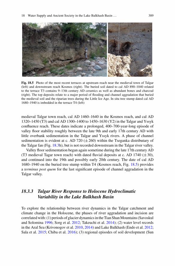
18 Water Supply and Ancient Society in the Lake Balkhash Basin … 389
Fig. 18.5 Photo of the most recent terraces at upstream reach near the medieval town of Talgar(left) and downstream reach Kosmos (right). The buried soil dated to cal AD 890–1040 relatedto the terrace T3 contains 9–13th century AD ceramics as well as abundant bones and charcoal(right). The top deposits relate to a major period of flooding and channel aggradation that buriedthe medieval soil and the riparian trees during the Little Ice Age. In situ tree stump dated cal AD1680–1940 is imbedded in the terrace T4 (left)
medieval Talgar town reach, cal AD 1460–1640 in the Kosmos reach, and cal AD1320–1450 (T3) and cal AD 1300–1400 to 1450–1630 (Y2) in the Talgar and Yssykconfluence reach. These dates indicate a prolonged, 400–700-year-long episode ofvalley floor stability roughly between the late 9th and early 17th century AD withlittle overbank sedimentation in the Talgar and Yssyk rivers. A phase of channelsedimentation is evident at c. AD 720 (±260) within the Tseganka distributary ofthe Talgar fan (Fig. 18.3h), but is not recorded downstream in the Talgar river valley.
Valley floor sedimentation began again sometime during the late 17th century AD(T3 medieval Tagar town reach) with dated fluvial deposits at c. AD 1740 (±30),and continued into the 19th and possibly early 20th century. The date of cal AD1680–1940 on the buried tree stump within T4 (Kosmos reach, Fig. 18.5) providesa terminus post quem for the last significant episode of channel aggradation in theTalgar valley.
18.3.3 Talgar River Response to Holocene HydroclimaticVariability in the Lake Balkhash Basin
To explore the relationship between river dynamics in the Talgar catchment andclimate change in the Holocene, the phases of river aggradation and incision arecorrelatedwith: (1) periods of glacier dynamics in theTianShanMountains (Savoskuland Solomina 1996; Sorg et al. 2012; Takeuchi et al. 2014); (2) water level recordsin the Aral Sea (Krivonogov et al. 2010, 2014) and Lake Balkhash (Endo et al. 2012;Sala et al. 2015; Chiba et al. 2016); (3) regional episodes of soil development (Sun
390 I. P. Panyushkina et al.
2002; Solomina and Alverson 2004; Blättermann et al. 2012); and (4) strength of theSiberian High Pressure System (SH) (Meeker and Mayewski 2002; Mayewski et al.2004). Although there are quite a wide range of proxy climate records available forthe Lake Balkhash Basin, only water levels in the Aral Sea and glacier advances inthe Tian Shan span the entire Holocene and have centennial-scale time resolution.
We compare the river dynamics with a multi-millennium record of the SH indexinferred by K+ fluctuations in the GISP2 ice core that represent long-term variabilityof seasonal atmospheric circulation in Asia (Meeker andMayewski 2002; Mayewskiet al. 2004). The primary source of moisture for runoff in the region is cold seasonprecipitation and spring storms embedded in the mid-latitude westerlies, with somecontributions from the higher latitudes (Lydolf 1977). The annual and seasonal dis-tribution of runoff in Central Asia is impacted bymodulations of the prevailing hemi-spheric circulation lead by climate change (Cohen et al. 2001; Jeong et al. 2011). Inwinter, Central Asia is under the influence of the SH, a cold-season anticyclone overMongolia that forms in response to radiative cooling of the air above snow-coveredEurasia in October and remains until April (Lydolf 1977). During a strong SH theregion west of and outside the SH source area (Mongolia) experiences high cyclonicactivity, and fall and spring storms deliver excess precipitation. The variability ofSH intensity and its teleconnections have been linked to large changes in patterns ofsnow in the fall, heavy snowfall events, severe cold-surge outbreaks and frequencyof spring storms over Inner Eurasia (Panagiotopoulos et al. 2005; Jeong et al. 2011).Short-term variability of the SH index has been reconstructed with Eurasian tree-ringrecords for the last 400 years (D’Arrigo et al. 2005). This SH record links to recentclimatic fluctuations and will be applied to the runoff variation in next section.
Figure 18.6 summarizes the response of Talgar runoff to climate change duringthe Holocene. Early Holocene river aggradation up to c. 6420 (±770) BC coincideswith a high-stand in Lake Balkhash (Endo et al. 2012; Sala et al. 2015) and renewedglaciation in the Tian Shan mountains between c. 12,500 and 8000 (Takeuchi et al.2014). The first major phase of Holocene channel entrenchment in Talgar River (c.6420–4130 BC) likely onsets shortly after 6420 (±770) BC and has counterparts infalling water levels of Lake Balkhash, including an abrupt drop at 6200 cal BC (Salaet al. 2015), and significant glacier shrinkage at 6000 cal BC with very low rates ofice accumulation until 4220–3970 cal BC (Takeuchi et al. 2014). A major regressionin the Aral Sea is also recorded between 5050–4650 cal BC (Krivonogov et al. 2014).Early-middle Holocene river incision in the Talgar valley appears to be a responseto a warming climate and higher temperatures under a weaker SH between c. 6000and 4000 cal BC (Fig. 18.6).
Renewed channel and floodplain aggradation occurred in the Talgar valleybetween 4130 (±760) and 2880–2490 cal BC coinciding with cooler conditionsand glacier expansion in the Tian Shan (Takeuchi et al. 2014), a period of strongSH (Mayewski et al. 2004), and high water levels in the Aral Sea (Krivonogov et al.2014) and Lake Balkhash (Endo et al. 2012; Sala et al. 2015; Chiba et al. 2016).
The second and most prominent phase of Holocene river down-cutting occurredin the Talgar catchment shortly after 2880–2490 cal BC and before 910 (±520)BC. Similar to the early-middle Holocene entrenchment phase, it coincided with a

18 Water Supply and Ancient Society in the Lake Balkhash Basin … 391
Fig. 18.6 Correlation of Holocene Talgar river entrenchment (pink), aggradation (blue) and soilformation (grey) with regional hydroclimatic proxies: a long-term variability of Siberian High(Mayewski et al. 2004), b fluctuation of Lake Balkhash and c Aral Sea levels (Krivonogov et al.2010, 2014; Endo et al. 2012; Sala et al. 2015; Chiba et al. 2016), d Tian Shan glacial advances(Savoskul and Solomina 1996; Aubekerov and Gorbunov 1999), e soil formation in Central Asia(Sun 2002; Solomina and Alverson 2004; Blättermann et al. 2012), and f cultural periodization(Andro.Andronovo community complex of BA). Dated periods of floodwater farming on theTalgar fan in the Iron Age and medieval periods are shown in black. Phases are depicted withbars and shorter known episodes with a dot. Yellow and blue denote, respectively, strong and weakSiberian High, or low and high water levels in the lakes, or warm and cold intervals (d)
shift to a drier and probably warmer (weaker SH) climate. This is recorded by apronounced dry interval between c. 3000 and 1950 cal BC in Lake Son Kol, CentralKyrgyzstan (Lauterbach et al. 2014), a regression in the Aral Sea between c. 2250and 1250 cal BC (Krivonogov et al. 2014) and a major period of local and regionalsoil development (Sun 2002; Solomina and Alverson 2004; Blättermann et al. 2012).
New river aggradation took place in the Talgar valley between 910 (±520) and500 (±220) BC with valley floor refilling sometime earlier. This aggradation phasecoincides with a strong SH, glacier advances in the Tian Shan Mountains and highwater levels in theAral Sea (Fig. 18.6).With the exception of a sedimentation episodein the Tseganka distributary on the Talgar fan at c. AD 720 (±260), which coincidedwith brief high-stands of the Aral Sea cal AD 500–600 and cal AD 850–950 as wellas glacier re-advance in the Tian Shan, the period between c. 500 BC and c. AD1740 was one of reduced geomorphic activity in the Talgar catchment. It coincidedwith a weakening of the SH between the second half of the 1st millennium BCand the end of the 14th century AD, as well as with major regressions in the AralSea between 150 cal BC–cal AD 600–650 and again between cal AD 850–950 and1600–1700 (Krivonogov et al. 2010, 2014). Extensive floodplain soil developmentbetween cal AD 1300–1640 indicates significantly reduced flooding and relativelydry conditions. It also coincides with a major regression of the Aral Sea documentedin the late medieval period (Yang et al. 2014; Krivonogov et al. 2010, 2014). The lastphase of river aggradation in the Talgar catchment is dated to c. AD 1740 (±30),and may have continued until the early 20th century. It matches high-water levels inthe Aral Sea until a drop to modern levels since AD 1960 and a stronger SH.
Overall, Holocene river dynamics in the Talgar catchment have been controlledby fluctuations in regional hydroclimate and by glaciation in the Tian Shan Moun-tains. Phases of Late Pleistocene and Holocene channel aggradation and floodplainsedimentation in the Talgar River at c. 17,400–6420, 4130–2880 and 910–500 calBC, and between the mid-18th and early 20th centuries correspond with periods

392 I. P. Panyushkina et al.
of cooler and wetter climate as reflected by high-water levels in the Aral Sea andLake Balkhash, glacier advances in the Tian Shan and a stronger SH (Fig. 18.6).River entrenchment between these dates, and soil development between c. 2880 and2490 cal BC and cal AD 1300–1640, correlate with low-water levels in the Aral Seaand Lake Balkhash, and glacier retreat associated with a warmer and drier climate.
18.3.4 Influence of Holocene Hydrological Regimeson Floodwater Farming in the Semirechye
The earliest Late Eneolithic/Early BA site in the Talgar valley is a pit house dated to c.3360–3100 cal BC within T1 in the Kosmos reach (Fig. 18.4). Occupation coincideswith river aggradation and cooler conditions, as recorded by a strong SH and highwater-levels in the Aral Sea (Fig. 18.6). On the basis of a single house no widerarchaeological inferences can be drawn other than that similar age settlements maybe concealed below alluvium elsewhere at the fan. The preservation of this house,and its position on an upstanding floodplain surface reflect a period of relatively rapidbut low energy sedimentation.
Dated mid BA or Andronovo sites are recorded in the upland headwaters of theTalgar (Panyushkina et al. 2010), but no sites of this age have so far been identifiedon the Talgar fan (Fig. 18.1). The Andronovo period c. 1800–1550 cal BCwas a timeof channel incision and occurred under regionally dry and warm climatic conditionsas shown by a major regression in the Aral Sea and a weaker SH (Fig. 18.6).
IA settlement and floodwater farming on the Talgar fan and along the Talgar Riverare 14C dated at three settlements to between 760 cal BC and cal AD 10 with nearly62% of the dates on archaeological charcoal falling in the period of 400–200 calBC (Chang 2008). This period of intense floodwater farming, the most significantbefore the modern period, immediately follows a major phase of aggradation alongthe Talgar River at c. 910–500 BC that coincides precisely with a strong SH, glacieradvances in theTian ShanMountains and highwater levels of theAral Sea (Fig. 18.6).
This period of late extensive IA settlement and floodwater farming occurs during aperiod of stable channel bed levels in the Talgar River, a weakening SH at 500 cal BCand a major regression in the Aral Sea at c. 150 cal BC (Fig. 18.6). The apogee of IAagriculture on the Talgar fan is also bracketed between twomajor glacier advances inthe Tian Shan Mountains that ended at c. 500 cal BC and began again around 50 calBC. Taken together these records indicate a period of warm climate in the late IAwith reduced river flow from c. 150 cal BC as evidenced by a fall of the Aral Seawater level. Nevertheless, given the elevation of the Tian ShanMountains, late springand early summer glacier and snow melt floods, would have still produced adequatewater for irrigation on the Talgar fan, as can be seen today with glacier shrinkageunder a warming climate.
18 Water Supply and Ancient Society in the Lake Balkhash Basin … 393
18.4 Short-Term Variability of Runoff from Tree Rings
The linkage between short-term climatic variability, mainly forced by the SH, andCentral Asian runoff can be explored at high precision with annually resolved tree-ring proxy of river flow in recent past. The decadal and annual variability reflectsthe scale of runoff fluctuation that might have affected past farming communities, inaddition to long-term variability as reflected in river dynamics, by changes in watersupply from one year to another. Networks of tree-ring records for the Semirechyehave been developed in the Tian Shan Mountains since the early 1970s, but recordlengths are limited to the last 600 years (Borscheva 1988; Panyushkina et al. 2010;Chen et al. 2016). Below we focus on a recent study of tree-ring reconstruction ofIli River discharge for the interval 1779–2015 (Panyushkina et al. 2018), and use itto address the potential impact of short-term variability of runoff on water supply oneconomic development in the region on the time scale of last few centuries - with adiscussion of potential impacts of similar variability on prehistoric people.
18.4.1 Climatic Signals in Annual Variation of SpruceTree-Ring Widths
Picea schrenkiana (Fisch. andC.A.Mey.), or Schrenk’s spruce, is awidely distributedconifer specie in themountain forests of CentralAsia, which tree rings form a suitableclimatic proxy for the hydroclimatic modeling in the Lake Balkhash Basin. The tree-ring studies suggest that spruce growth in the Tian Shan Mountains is limited byboth temperature and precipitation (Borscheva 1988;Wang et al. 2005; Solomina andMaksimova 2010). Trees growing under moisture stress at low and high elevations,andunder temperature stress at the upper tree-line are foundwithin the elevation range1700–2750 m asl. Cold-season temperature and summer drought generally limit thegrowth of winter-dormant conifers. Radial growth rate is high in March–May anddeclines in summer following the July-August dry period (Wang et al. 2005). Awarmspring and early snowmelt favor an early onset of the growth season and a high rateof tree-ring growth (Kozhevnikova 1982; Wang et al. 2005). High precipitation inthe previous fall and winter recharges soil moisture, which along with snowmelt canhelp trees cope with summer drought, but deep snowpack can also negatively impactgrowth by shortening the growing season (Kozhevnikova 1982; Borscheva 1988).
The moisture signal in annual rings of Schrenk’s spruce has been discussed inrelation with previous fall-winter precipitation, and has been successfully used inreconstruction of precipitation, Palmer Drought Severity Index (PDSI), water bal-ance and streamflow (Yuan et al. 2007; Solomina and Maksimova 2010; Kono-valov and Maksimova 2012; Chen et al. 2015, 2016; Zhang et al. 2017a, b). Inrecent years, a tree-ring team lead by Dr. Feng Chen has produced an array oftree-ring reconstructions from the Lake Balkhash watershed describing in detail the
394 I. P. Panyushkina et al.
spatial-temporal pattern of moisture variability of the last 200–300 years (Chen et al.2017a; Zhang et al. 2017b).
Air temperature over the last few centuries has surged upward, in agreementwith the transition from the Little Ice Age to the modern warming. Warming hasbeen noticeably faster in winter and spring than in summer. Reconstructed decadalvariability of moisture can differ greatly between the tree-ring studies depending onthe season of reconstruction and location. For example, precipitation reconstructedfor the previous July to current April shows low variance for extended periods of timesince 1560 and identifies decadal droughts centered at 1660s, 1710s, 1770s, 1900s,and 1980s (Chen et al. 2017a, b). Reconstructed January-May PDSI highlights ninemulti-decadal droughts since 1580 (Cheng et al. 2014). Reconstructed July-Juneprecipitation since 1474 points out eight different intervals of multidecadal droughtwith on average a frequency of one-two dry periods per century (Zhang et al. 2013).Even though the growing number of tree-ring studies leads to better synchrony ofthe modeled hydrological patterns across Central Asia in general an interpretation ofwater supply impact on past agricultural production taken place at a small catchmentwould be critically dependent on specific runoff reconstruction closely related to thelocality of archaeological data.
18.4.2 High-Frequency Variability of Ili River DischargeDerived from Tree Rings
Figure 18.7 shows the tree-ring reconstruction of Ili River annual discharge for the last235years publishedbyPanyushkina et al. (2018). This publicationpresents the detailsof spruce tree-ring chronologies and the reconstructing model. Here we discuss onlythe decadal and interannual variability of tree-ring reconstructed discharge of theIli River for the recent centuries. The record has relatively frequent periods of lowflow lasting 25–30 years, and shorter periods of high flow lasting 10–15 years. Flowwas low in 1825–1850, 1865–1885, 1916–1938 and 1975–2000; flow was generallyhigh in 1793–1809, 1850–1857, 1886–1909, 1952–1962 and 2001–2013 (Fig. 18.7).Thirteen runoff events outside the±2σ interval around the mean (316–594 m3/s)are found in reconstructed record. Individual years of extremely low flow are 1871,1879, 1846, 1788, 1829 and 1933; years of extremely high flow are 1799, 1851, 2005,1856, 1808, 1960 and 1816. The driest year is 1871, with a discharge (239 m3/s) onlyhalf the historical average (460 m3/s). The wettest year is 1799, with a discharge of728 m3/s (+58% of historical average).
The spatial correlation field of gridded self-calibrated Palmer Drought SeverityIndex (scPDSI) with reconstructed Ili River discharge suggests that dry and wethydrological conditions are similar across the entire Lake Balkhash Basin and LakeIssyk Kul Basin (Fig. 18.8). Great similarity of runoff anomalies and trends in thesetwo adjacent basins has also been demonstrated with meteorological and hydrologi-cal data (Aizen et al. 1997). Decadal variability of reconstructed Ili discharge agrees
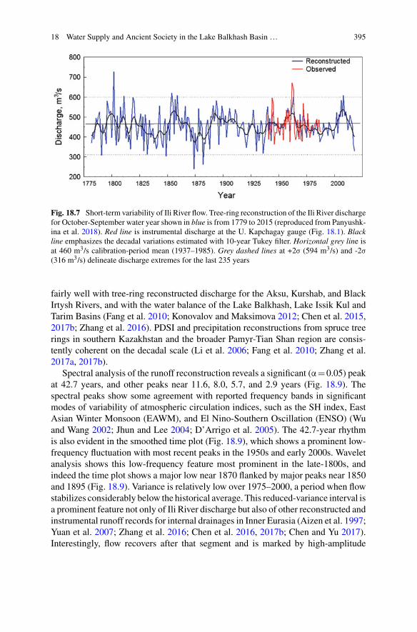
18 Water Supply and Ancient Society in the Lake Balkhash Basin … 395
Fig. 18.7 Short-term variability of Ili River flow. Tree-ring reconstruction of the Ili River dischargefor October-September water year shown in blue is from 1779 to 2015 (reproduced from Panyushk-ina et al. 2018). Red line is instrumental discharge at the U. Kapchagay gauge (Fig. 18.1). Blackline emphasizes the decadal variations estimated with 10-year Tukey filter. Horizontal grey line isat 460 m3/s calibration-period mean (1937–1985). Grey dashed lines at +2σ (594 m3/s) and -2σ(316 m3/s) delineate discharge extremes for the last 235 years
fairly well with tree-ring reconstructed discharge for the Aksu, Kurshab, and BlackIrtysh Rivers, and with the water balance of the Lake Balkhash, Lake Issik Kul andTarim Basins (Fang et al. 2010; Konovalov and Maksimova 2012; Chen et al. 2015,2017b; Zhang et al. 2016). PDSI and precipitation reconstructions from spruce treerings in southern Kazakhstan and the broader Pamyr-Tian Shan region are consis-tently coherent on the decadal scale (Li et al. 2006; Fang et al. 2010; Zhang et al.2017a, 2017b).
Spectral analysis of the runoff reconstruction reveals a significant (α0.05) peakat 42.7 years, and other peaks near 11.6, 8.0, 5.7, and 2.9 years (Fig. 18.9). Thespectral peaks show some agreement with reported frequency bands in significantmodes of variability of atmospheric circulation indices, such as the SH index, EastAsian Winter Monsoon (EAWM), and El Nino-Southern Oscillation (ENSO) (Wuand Wang 2002; Jhun and Lee 2004; D’Arrigo et al. 2005). The 42.7-year rhythmis also evident in the smoothed time plot (Fig. 18.9), which shows a prominent low-frequency fluctuation with most recent peaks in the 1950s and early 2000s. Waveletanalysis shows this low-frequency feature most prominent in the late-1800s, andindeed the time plot shows a major low near 1870 flanked by major peaks near 1850and 1895 (Fig. 18.9). Variance is relatively low over 1975–2000, a period when flowstabilizes considerably below the historical average. This reduced-variance interval isa prominent feature not only of Ili River discharge but also of other reconstructed andinstrumental runoff records for internal drainages in Inner Eurasia (Aizen et al. 1997;Yuan et al. 2007; Zhang et al. 2016; Chen et al. 2016, 2017b; Chen and Yu 2017).Interestingly, flow recovers after that segment and is marked by high-amplitude
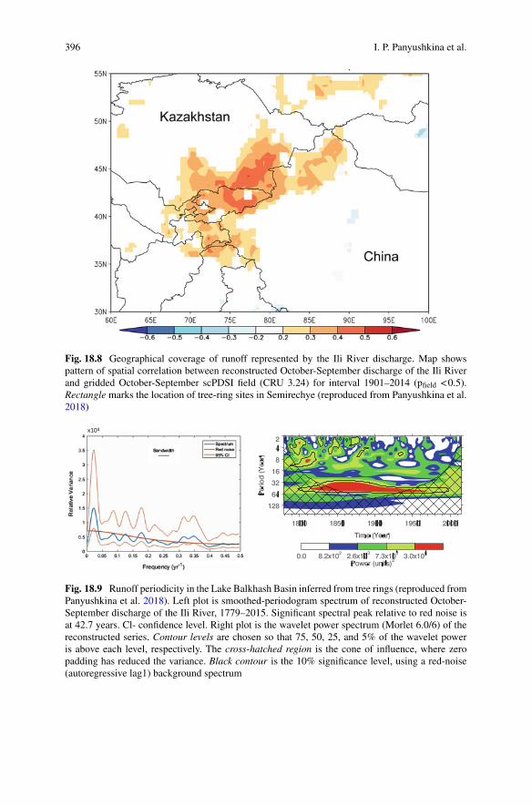
396 I. P. Panyushkina et al.
Fig. 18.8 Geographical coverage of runoff represented by the Ili River discharge. Map showspattern of spatial correlation between reconstructed October-September discharge of the Ili Riverand gridded October-September scPDSI field (CRU 3.24) for interval 1901–2014 (pfield <0.5).Rectangle marks the location of tree-ring sites in Semirechye (reproduced from Panyushkina et al.2018)
x104
Fig. 18.9 Runoff periodicity in the Lake Balkhash Basin inferred from tree rings (reproduced fromPanyushkina et al. 2018). Left plot is smoothed-periodogram spectrum of reconstructed October-September discharge of the Ili River, 1779–2015. Significant spectral peak relative to red noise isat 42.7 years. Cl- confidence level. Right plot is the wavelet power spectrum (Morlet 6.0/6) of thereconstructed series. Contour levels are chosen so that 75, 50, 25, and 5% of the wavelet poweris above each level, respectively. The cross-hatched region is the cone of influence, where zeropadding has reduced the variance. Black contour is the 10% significance level, using a red-noise(autoregressive lag1) background spectrum

18 Water Supply and Ancient Society in the Lake Balkhash Basin … 397
swings, in which the smoothed curve reaches a peak in the early 2000s and a low atthe end of the record more extreme than any since the late 1800s (Fig. 18.7).
18.4.3 Linking Ili River Discharge to Climate Change
The physical mechanisms behind runoff changes in Central Asia are not yet wellunderstood. Temperature appears less important as a forcing factor than previouslythought (Lammers et al. 2001). Changes in Central Asian instrumental runoff havebeen reported to be consistent with the decline of snowpack since 1940 (Aizenet al. 1997). Greater snowpack over broader Eurasia results in positive anomalies ofinstrumental runoff for the largest Siberian Rivers with headwaters in Central Asia(Shiklomanov et al. 2013). The Ili River discharge reconstruction underscores theimportance of winter precipitation above summer drought.
Surface pressure over the Ili River basin is positively correlated with surface pres-sure over the broader geographical region of the seasonally strong SH during theOctober-February season of snow accumulation (Panyushkina et al. 2018). Anoma-lous strength and positioning of the SH likely moderates snow delivery to the IliBasin through steering of storms and winter moisture delivery. Spring moisture aswell is important to the river flow (Fig. 18.2), and its conveyance would also beinfluenced by anomalies in westerly flow (Cohen et al. 2014). This suggests that theSH should contribute to the interannual variability of runoff. A test of this hypoth-esis with cross-wavelet analysis of tree-ring reconstructed river discharge and SHindex (D’Arrigo et al. 2005) fails however, to indicate consistent coherency throughtime at any band of wavelengths (Panyushkina et al. 2018). Significant coherencyis found only at high frequencies (e.g., periods less than 4 years) and then only forsome isolated times in the 19th and 20th centuries. Furthermore, where coherency issignificant, the phase is opposite; meaning high flow is linked to weak SH. In-phasecoherence does appear only near wavelength 30–40 for one episode around the late1900s.
The link between SH intensity and interannual runoff variability in the LakeBalkhash Basin appears to be complex and may be entangled with Arctic forcingof north-south linkages of atmospheric circulation features in Inner Eurasia (Cohenet al. 2001, 2014). A reconstruction of the latitudinal position of theNorthAtlantic jetin August from the European tree-ring network explained an exceptional number ofextreme weather events like floods and heatwaves in the mid latitudes over the recentdecades (Trouet et al. 2018). The finding of an increase in variability of meridionalsways of the polar jet could be similarly important for the region considered in thisstudy. Since Arctic thermodynamic amplification can reinforce regional geopotentialheight patterns, we assume that the late 20th century Arctic warming impacts thehydroclimatic extremes and interannual climatic variability in the study region.
December extremes in the Arctic Oscillation (AO) have been more variable inthe past decade than at any other time since the mid-20th century (Overland andWang 2016; Francis et al. 2017). Generally, large positive values of the AO indicate

398 I. P. Panyushkina et al.
Fig. 18.10 Composite maps of the 20th Century Reanalysis data of January-February surfacepressure for a normal condition for interval 1981–2010, b anomaly low-flow interval of 1975–2000,and c anomaly high-flow interval of 2001–2013 reconstructed Ili River discharge (reproduced fromPanyushkina et al. 2018)
zonal flow and large negative values suggest increased meridional circulation thatbrings cold air advection into the mid latitude inland (Thompson andWallace 1998).Comparison of reconstructed runoff variations with 500 hPa geopotential height andsurface pressure anomalies over Eurasia, and with primary teleconnection modes ofEurasia upper air circulation indicates that the natural runoff variability (extremes,decadal trends and spectral properties) are linked to the interaction of Arctic aircirculation with the SH intensity and negative phase of North Atlantic Oscillation(NAO). The Ili River discharge correlates negatively with the spring Polar/EurasianPattern index (−0.32, p < 0.05) and with winter AO (−0.34, p < 0.05). Our estimatedassociations are consistent with a weaker circumpolar vortex during the increasedflows. The development of the strong SH has been associated with an enhanced EastAsian winter monsoon (Jhun and Lee 2004; Panagiotopoulos et al. 2005), which sug-gests an evenmore complex relationship of runoff to the atmospheric teleconnectionsduring the warming trends.
In some intervals, the teleconnections of SH surge the impact on the runoff. Theannual discharge correlates significantly and negativelywithDecember-February SHindex for 1950–2014 (−0.32, p<0.05), and the correlation is driven by few extremeyears. The SH is normally centered over Mongolia, to the east of the study area(Fig. 18.10a). A shorter period of generally low recent flows (1975–2000) coincidedwith a weakening of the SH and a shift of the high pressure southward to the TibetPlateau. (Figure 18.10b). A subsequent decadal period of generally high Ili Riverdischarge (2001–2013) coincided with increased SH intensity and a shift in theposition of the winter surface high toward Western Siberia (Fig. 18.10c).
Clearly, these recent and short time associations are consistent with a positivecorrelation between the runoff and strength of the SH. In recent decades, therefore,different mechanisms of SH influence on Ili River flow may operate at high frequen-cies less then 1 year. The resolution of the reconstruction does not allow examinationof summer and winter discharge independently or finer periodicity. A side of thisambiguity, snow cover has profound implications for runoff variability in the LakeBalkhash Basin, which is directed by the interaction of SH and AO.
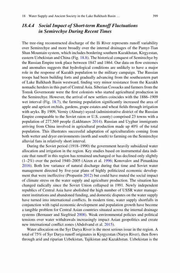
18 Water Supply and Ancient Society in the Lake Balkhash Basin … 399
18.4.4 Social Impact of Short-term Runoff Fluctuationsin Semirechye During Recent Times
The tree-ring reconstructed discharge of the Ili River represents runoff variabilityover Semirechye and more broadly over the internal drainages of the Pamyr-TianShan Mountain system, which includes bordering southern Kazakhstan, Kirgyzstan,eastern Uzbekistan and China (Fig. 18.8). The historical conquest of Semirechye bythe Russian Empire took place between 1847 and 1864. Our data on flow extremesand anomalies suggests that hydrological conditions are unlikely to have a majorrole in the response of Kazakh population to the military campaign. The Russiantroops had been building forts and gradually advancing from the southeastern partof Lake Balkhash Basin westward, finding very minor resistance from the Kazakhnomadic herders in this part of Central Asia. Siberian Cossacks and farmers from theTomsk Governorate were the first colonists who started agricultural production inthe Semirechye. However, the arrival of new settlers coincides with the 1886–1909wet interval (Fig. 18.7), the farming population significantly increased the area ofapple and apricot orchids, gardens, grape estates and wheat fields through irrigationwith aryks. By 1909, Verniy (Almaty) uyezd (administrative district of the RussianEmpire comparable to the Soviet raion or U.S. county) comprised 23 towns with apopulation of 277,569 people (Lukhtanov 2014). Russian and Uyghur immigrantsarriving from China involved in agricultural production made up 40% of the totalpopulation. This illustrates successful adaptation of agriculturalists coming fromboth wetter and dryer environments (north and south) to farming on the Semirechyealluvial fans in relatively short interval.
During the Soviet period (1918–1990) the government heavily subsidized waterallocation and irrigation in the region. Key studies based on instrumental data indi-cate that runoff in this region has remained unchanged or has declined only slightly(1–2%) over the period 1940–2005 (Aizen et al. 1996; Konovalov and Pimankina2016). Both low variance of natural discharge during that time and Soviet watermanagement directed by five-year plans of highly politicized economic develop-ment that were ineffective (Propastin 2012) but could have muted the social impactof climate stress on the water supply and agriculture production. The situation haschanged radically since the Soviet Union collapsed in 1991. Newly independentrepublics of Central Asia have abolished the high number of USSR water manage-ment institutions and abandoned funding, and domestic disputes on the water supplyhave turned into international conflicts. In modern time, water supply shortfalls inconjunction with rapid economic development and population growth have becomea tangible problem for Central Asian countries situated across the internal drainagesystems (Bernauer and Siegfried 2008). Weak environmental policies and politicaltensions over water withdrawals increasingly impact Asian geopolitics and createnew international conflict zones (Abdolvand et al. 2015).
Water allocation on the Syr Darya River is the most serious issue in the region. Atotal of 75% of Syr Darya runoff originates in Kyrgyzstan (Naryn River), then flowsthrough arid and riparian Uzbekistan, Tajikistan and Kazakhstan. Uzbekistan is the

400 I. P. Panyushkina et al.
major hydrocarbon and irrigation user that formerly controlled the electric powerproduction on the Syr Darya. Around 90% of the Syr Darya annual flow is regulatedby reservoirs that are used for irrigated agriculture (Bernauer and Siegfried 2008).The fragile balance was broken when Kyrgyzstan changed the operation mode of theToktogul reservoir from irrigation to electric power production, and started construc-tion of new power stations. Thus, Uzbekistan and Kazakhstan located downstream,face the most severe water security risks whereas upstream Kyrgyzstan is in almosttotal physical control of the catchment’s runoff.
The Ili River catchment has been the second hotspot of water conflicts in theregion since 1999 (Propastin 2012). The mean annual runoff of Balkhash Lake Basinis about 27.8 km3, 41% (or 11.7 km3) of which originates in China. Unparalleledeconomic boom and development in Xinjiang Province, China, challenges the inter-national balance in water allocation and creates uncertainty in the water supply ofKazakhstan. The irrigation area of the Ili River catchment in Kazakhstan (346,000 hafor the Akdala area in the Ili River Delta in 2000) is continually declining, while theChinese government develops 15 water reservoirs on the Ili River’s upstream tribu-taries (Tekes, Kashe and Kunes) to extend the irrigated area by 450,000 ha. This willincrease the annual water consumption of Ili water by Xinjiang Province by 5 km3/y.Under various scenarios, the forecasted discharge of the Ili River could be reducedfrom 15 km3/y to 6-10 km3/y (Propastin 2012). This would impair the water supplyfor the Akdala irrigated land and for the largest power station in the region at theKapchagay reservoir, which has already experienced severe water shortages in therecent decade similar to those of the low flow interval since 2003 (Figs. 18.1 and18.7). The tree-ring reconstructed discharge shows the changes in spatial–temporaldomains of runoff variability before the last 60–70 years of instrumental observa-tions, and provides a historical background of natural runoff variability for modelingthe socioeconomic response to water stress. The sharp decline of the Ili River flowafter 2003 is comparable to the onset of pronounced drought 1865–1885 (Fig. 18.7),however the social implications of water supply impact on the society are not alike.In modern times, a prolonged climatically-driven period of drought greatly enhancedthe water stress in the region as a larger volume of water has been allocated in Chinadue to high rate of economic and population growth, and putting more stress on theremaining flow in the Ili River basin.
18.5 Linking Runoff Variations and Agriculture Alongthe Historic Silk Road in the Semirechye
The geomorphological reconstruction provides evidence for how the IA population(Saka) used the water of the Talgar River for farming.With limited evidence for earlyfarming in the Bronze and Iron Ages but more detail for the Late IA we can concludethat floodwater farming on the Talgar fan reached its height in the Late IA (400 BCto AD 1); high population density attested from more than 70 settlement sites and
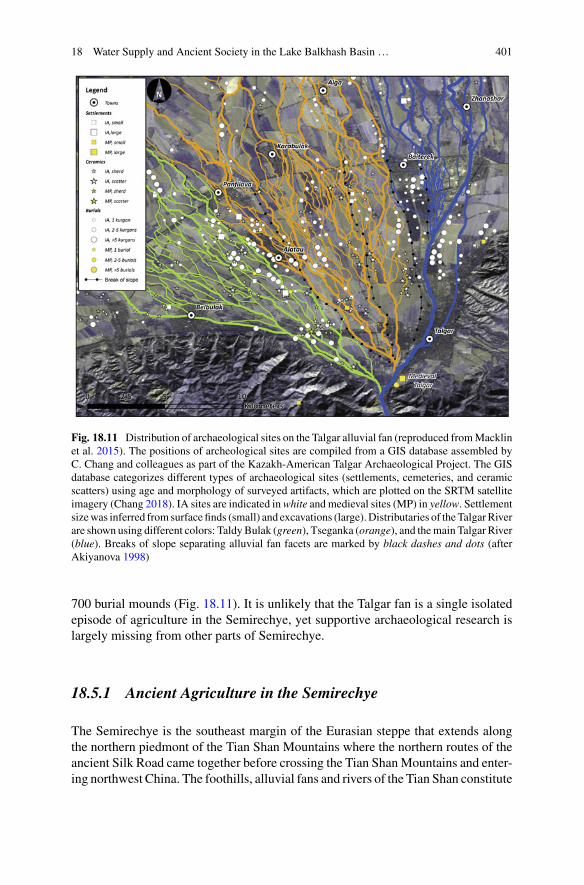
18 Water Supply and Ancient Society in the Lake Balkhash Basin … 401
Fig. 18.11 Distribution of archaeological sites on the Talgar alluvial fan (reproduced fromMacklinet al. 2015). The positions of archeological sites are compiled from a GIS database assembled byC. Chang and colleagues as part of the Kazakh-American Talgar Archaeological Project. The GISdatabase categorizes different types of archaeological sites (settlements, cemeteries, and ceramicscatters) using age and morphology of surveyed artifacts, which are plotted on the SRTM satelliteimagery (Chang 2018). IA sites are indicated inwhite andmedieval sites (MP) in yellow. Settlementsizewas inferred from surface finds (small) and excavations (large).Distributaries of theTalgarRiverare shown using different colors: TaldyBulak (green), Tseganka (orange), and themain Talgar River(blue). Breaks of slope separating alluvial fan facets are marked by black dashes and dots (afterAkiyanova 1998)
700 burial mounds (Fig. 18.11). It is unlikely that the Talgar fan is a single isolatedepisode of agriculture in the Semirechye, yet supportive archaeological research islargely missing from other parts of Semirechye.
18.5.1 Ancient Agriculture in the Semirechye
The Semirechye is the southeast margin of the Eurasian steppe that extends alongthe northern piedmont of the Tian Shan Mountains where the northern routes of theancient Silk Road came together before crossing the Tian ShanMountains and enter-ing northwest China. The foothills, alluvial fans and rivers of the Tian Shan constitute

402 I. P. Panyushkina et al.
near ideal environments for floodwater farming (Lewis 1966), with spring-summerfloods generated by melting glaciers and snow providing a reliable source of waterfor irrigation. Floodwater farming is still practiced today in southern Kazakhstan andthere is good evidence that in themedieval and prehistoric periods it was an importantlocus for irrigation agriculture (Groshev 1985; Itina and Yablonskiy 1997).
Eurasian archaeology holds a long-standing debate concerning the developmentof farming systems in the Eurasian steppes. Traditionally Central Asia, including theSemirechye region, is referred as a pastoral realm during the BA-IA with a shift ca.800 BC toward a highlymobile pastoralism, followed bymedieval nomadism (Chris-tian 1994; Kuzmina 2007; Spengler et al. 2017). As early as 1990s the debates onthe mobility development in Eurasia have been pointing to climate change. Christian(1998) describes a mixed farming-herding strategy during the BA (c. 2500–1100 calBC) under warm and wet conditions with a shift to a horse riding pastoral econ-omy in the Early IA (c. 800 cal BC) coinciding with a cold and dry climate, anddeforestation.
However, recently a large body of archaeological evidence from environmentallyspecialized studies challenges the traditional nomad-centered system in the ancienteconomy model of Central Asia (Chang 2012; Macklin et al. 2015; Spengler 2015;Frachetti et al. 2017). Achaeobotanical studies at the Talgar alluvial fan stronglysuggest that the IA farmers cultivated free-threshing wheat and hulled barley (long-season grain crops), broomcorn, foxtail millet, grapes and apples (Rosen et al. 2000,Spengler et al. 2017). Spengler et al. (2014) demonstrate that a similar assemblageof crops was grown across Central Asia from the Tian Shan to Himalaya duringthe second millennium BC (BA), and argue (Spengler et al. 2017) that hulled-large-grained forms replaced by the first millennium BC the compact-naked forms ofbarley dominated in the BA. This revolutionizes our understanding of the spread ofancient farming in Central Asia, and breaks the traditional dogma on the CentralAsian economy during the BA-IA. It is clear that in Central Asia regional agricultureand sedentary communities existed since the Late BA.
18.5.2 Agricultural Water Management on the TalgarAlluvial Fan During the Iron Age
Figure 18.11 shows the density of archaeological sites across the Talgar alluvialfan (Macklin et al. 2015). The most-studied Iron Age settlements on the Talgar fanlies along the Taldy Bulak and Tseganka distributary stream networks (green lines)located in the middle reaches of these systems, 5–10 km downstream of the fan apex(Figs. 18.1 and 18.11). Largest settlements, burial sites, and concentrations of surfacefinds, are preferentially located along a series of distributaries, many of which musthave been engineered in order to enable water diversion onto adjacent terraces.
It appears that the key to floodwater farming during the Late IA, similar to modernirrigation, was the control and management of water flow from the Tseganka and

18 Water Supply and Ancient Society in the Lake Balkhash Basin … 403
Taldy Bulak channel systems. For the current Taldy Bulak, stream water is stilldiverted by a simple stretch dam and lateral outlet at the apex of the alluvial fan.The force of flow from the main river ‘pushes’ water into a low-gradient distributarychannel, which allows bringing the flow up onto the higher terrace at downstreamlocations. IA farmers could also have very well used this simple technique. Notably,the levels of the Talgar River bed during the Early IA were c. 2 m higher thannow, such decreasing the difference in gradient between action river channel andengineered distributary. The study of fine alluvial sediments infilling the floor of theTseganka channel (Macklin et al. 2015 and Fig. 18.3a′) show that flow was not highenough to naturally maintain these distributaries as perennial or seasonal channels.Hence, water supply was depending on engineered channel networks and sufficientdischarge to make the upstream bifurcation function.
The bifurcation node of the Taldy Bulak system is roughly 1 km upstream and 5mabove the level where the Tseganka channel leaves the present day Talgar River. IAfarmers must therefore have constructed flow control structures to lead water acrossthe fan surface. Careful management of these systems would have been requiredto ensure that water flow down the Tseganka and Taldy Bulak channels was nottoo large to cause channel incision, making it difficult and eventually impossible todirect flow into smaller irrigation canals that would have fed fields on the higherfan surface. Indeed, in the Soviet period this is exactly what happened through theinadvertent leakage of flow from concrete irrigation canals. Figure 18.3h shows anexample of the Tseganka channel, which locally incised 6 m into fine-grained loess-derived sediments after artificial redirection of flow. Large floods in these distributarysystems have always been a significant hazard to floodwater farming because of thehighly erodible nature of their channel banks and regional substrate.
18.5.3 Hydrology of the Tian Shan Piedmont and WaterSupply for Ancient Farming
In Semirechye, and probably in Tarim Basin, the southern Tian Shan and Pamirpiedmont, high river flow and the maximum potential for water resources to supportfloodwater farming in both prehistoric and historical times have been associated withcold and wet conditions and glacier expansion (Sect. 5.1). However, the developmentof extensive Late IA settlement and rapid growth of population in the Talgar area,supported at least in part by floodwater farming, occurred during a phase of relativelywarm and dry climate associated with a period of channel stability. This wouldsuggest that hydroclimate and hydrology, at least locally, were not a constraint to theestablishment of IA farming on the Talgar fan, nor were they the only factors in itsdemise. The key to the success of the Late IA (and medieval) agriculturists appearsinstead to have been a period of moderate main channel river flows confined withina Late Pleistocene age alluvial fan that as a consequence of having small, partially
404 I. P. Panyushkina et al.
entrenched distributary channels was naturally configured to facilitate floodwaterfarming.
We, therefore, do not need to evoke hydroclimate change as the proximate causefor this relatively short-lived (c. 400years) period ofLate IAfloodwater farming in theTalgar region. Insteadwe should develop explanatorymodels that emphasize the skillof these IA societies in choosing and exploiting particular river environments andhydromorphic regimes that facilitated successful and long-lived farming practices(Macklin and Lewin 2015).
Nevertheless, considering the large Ili, Syr Darya, and Amu Darya dryland riversdownstream of, and fed by, the Tian Shan and Pamir piedmont, conjecture mightsuggest that wet Holocene neoglacial periods with higher river flowwould have beenmore conducive to floodplain irrigation agriculturists. This may explain the greatexpansion of irrigation in the region during the first half of the 1st millennium BC asoriginally noted byLewis (1966) nearly 50years ago.New research onHolocene riverdynamics, underpinned by robust geochronologies is urgently required on CentralAsia’s main rivers—the Syr Darya, and Amu Darya—in order to evaluate long-termsociety-river environment interactions.
18.6 Conclusions
We demonstrated a novel approach integrating fluvial geomorphology and tree-ringstudies to explore the relationship between natural variability of runoff and its impacton ancient society. The approach links diverse spatial scales (small river catchmentsand regional watersheds) and temporal scales (centennial, decadal and inter-annual)of proxies for hydrological variability to explore the relationship between economyand settlement pattern of ancient societies, and climate change. The relative contribu-tion of each method is skewed in this study because the tree-ring records do not over-lap the emphasis of archaeological data. Nevertheless, the tree-rings provide valuableinsight into a potentialmechanism linking variability of recent and past runoff inCen-tral Asia to large-scale atmospheric circulation. The interaction between a warmingor cooling Arctic and intensity of the Siberian High surface-pressure system could bea key to unlock that mechanism. The tree-ring reconstructed hydrological extremesprovide new information on the length and frequency of droughts and wet episodesin the endorheric basins of Central Asia that may be applied to help decipher strongsocioeconomic impacts identified in the post-history of Silk Road.
The new proposed model for use of water by the IA farmers brings into thelight many scattered archaeological shreds of evidence related to plant cultivation onthe alluvial fans of Pamir-Tian Shan piedmont. We did not anticipate synthesizingthese shreds of evidence, yet the reconstruction of river dynamics in the Tian Shanpiedmont prompts us to challenge the dogmatic concept of Central Asian nomadsprevalent in Inner Eurasian archaeology till now. Previously unknown correspon-dence of agricultural expansion c. 400–200 BC with a period of reduced flood flows,river stability and glacier retreat in the Tian Shan Mountains explains the strategy
18 Water Supply and Ancient Society in the Lake Balkhash Basin … 405
of Late IA agriculturists for exploitation of moderate flows within an alluvial fanenvironment to facilitate transfer of water through a series of partially entrencheddistributary channels. Holocene climate change was therefore not a proximate causefor the development and demise of this relatively short-lived (c. 400 years) period ofIA farming.
River dynamics in the Tian Shan piedmont are, however, strongly coupled withregional hydroclimatic fluctuations, and they have likely acted locally as ‘push’ and‘pull’ factors for riparian agriculturists in both upstream and downstream directions.Future geoarchaeological research in the region needs to expand downstream fromthe Tian Shan piedmont into the Ili, Syr Darya, and Amu Darya rivers, as it islikely that these exotic and dryland systems will have human-river environmentaldependencies comparable to those of ancient river civilizations in Mesopotamia andthe Indus Valley (Giosan et al. 2012; Macklin and Lewin 2015).
Acknowledgements This work was supported by U.S. National Science Foundation BCS award#1122359 to I.P. Panyushkina, and British Council Program’s Newton-al Farabi Institutional Linksaward #172727191 to M.G. Macklin.
References
Abdolvand, B., Mez, L., Winter, K., Mirsaeedi-Globner, S., Schütt, B., Rost, K. T., et al. (2015).The dimension of water in Central Asia: Security concerns and the long road of capacity building.Environmental Earth Science, 73(2), 897–912.
Adger, W. N., Barnett, J., Brown, K., Marshall, N., & O’Brien, K. (2013). Cultural dimensions ofclimate change impacts and adaptation. Nature Climate Change, 3, 112–117. https://doi.org/10.1038/nclimate1666.
Aizen, V. B., Aizen, E. M., & Melack, J. M. (1996). Precipitation, melt and runoff in the northernTien Shan. Journal of Hydrology, 186, 229–251.
Aizen, V. B., Aizen, A. M., Melack, J. M., & Dozier, J. (1997). Climatic and hydrologic changesin the Tien Shan, Central Asia. Journal of American Meteorological Society, 10, 1393–1404.
Akishev,K.A. (1969). Zimovki poseleniya I zhilsha drevnihUsunei (Winter settlement and dwellingof the ancient Wusun). Izvestia Akademii Nauk KazSSR, 1, 29–47.
Akiyanova, F. J. (1998).Geomorphological map of Talgar River fluvial fan. Scale 1:25000. Almaty:KAZ Institute of Geography.
Aubekerov, B., & Gorbunov, A. (1999). Quaternary permafrost and mountain glaciation in Kaza-khstan. Permafrost and Periglacial Processes, 10, 65–80.
Baipakov, K. M. (2008). Gorod i step’ v drevnosti: Osledost’ i zemledelniye i Sakov i UsuneiZhetisu (City and steppe in ancient times: Settlement and farming of the Saka and Wusun inSemirechye). Izvestia of National Academy of Science, Republic of Kazakhstan, 1(254), 3–25.
Bernauer, T., & Siegfried, T. (2008). Compliance and performance in International water agree-ments: The case of the Naryn/Syr Darya basin. Global Governance, 14, 479–501.
Blättermann, M., Frechen, M., Gass, A., Hoelzmann, P., Parzinger, H., & Schütt, B. (2012). LateHolocene landscape reconstruction in the Land of Seven Rivers, Kazakhstan. Quaternary Inter-national, 251, 42–51.
Borscheva, N. M. (1988). Limiting factors of Schrenk’s spruce radial growth. In: Ecological studiesin Northern Kirgizstan (pp. 15–22). Frunze: Tian Shan Mountain Research Station Press.

406 I. P. Panyushkina et al.
Bothe, O., Fraedrich, K., & Zhu, X. (2012). Precipitation climate of Central Asia and the large-scaleatmospheric circulation. Theoretical and Applied Climatology, 108(3–4), 345–354.
Chang, C. (2008). Mobility and sedentism of the Iron Age agropastoralists of southeast Kazakhstan.In H. Barnard & W. Wendrich (Eds.), The archaeology of mobility (pp. 329–342). Los Angeles:Cotsen Institute of Archaeology, University of California.
Chang, C. (2012). Lines of power: Equality or hierarchy among the Iron Age Agro-pastoralists ofSoutheastern Kazakhstan. In C. W. Hartley, G. B. Yazicioglu, & A. T. Smith (Eds.), The archae-ology of power and politics in Eurasia: Regimes and revolutions (pp. 122–142). Cambridge:Cambridge University Press.
Chang, C. (2018). Rethinking prehistoric Central Asia. Shepherds, farmers, and nomads.Abingdon& New York: Routledge, 978-1-138-73708-2.
Chang, C., Benecke, N., Grigoriev, F. P., Rosen, A. M., & Tourtellotte, P. A. (2003). Eurasian IronAge settlements and chronology in Southeastern Kazakhstan. Antiquity, 77(196), 298–312.
Chen, F., He, Q., Bakytbek, E., Yu, S., & Zhang, R. (2017a). Reconstruction of along streamflowrecord using tree rings in the upper Kurshab River (Pamir-Alai Mountains) and its application towater resources management. International Journal of Water Resources and Development, 33(2),976–986.
Chen, F., He, Q., Ermenbaev, B., Yu, S.-L., & Zhang, R. (2015). Climatic signals in tree rings ofJuniperus turkestanica in the Gulcha River Basin (Kyrgyzstan) reveals the recent wetting trendof high Asia. Dendrobiology, 74, 33–40.
Chen, F., &Yu, S. (2017). Tree-ring indicators of rainfall and streamflow for the Ili-Balkhash Basin,Central Asia since CE 1560. Paleogeography, Paleoclimatology, Paleoecology, 482(15), 48–56.
Chen, F., Yuan, Y., Davi, N., & Zhang, T. (2016). Upper Irtysh River flow since AD 1500 asreconstructed by tree rings, reveals the hydroclimatic signal of inner Asia. Climate Change, 139,https://doi.org/10.1007/s10584-016-1814-y.
Chen, F., Yuan, Y., & Yu, S. (2017b). Tree-ring indicators of rainfall and streamflow for the Ili-Balkhash Basin, Central Asia since CE 1560. Paleogeography, Paleoclimatology, Paleoecology,482(15), 48–56.
Cheng, F., Yuan, Y.-J., Chen, F.-H., Wei, W.-S., Yu, S.-L., Chen, X.-J., et al. (2014). A 426-yeardrought history for Western Tian Shan, Central Asia, inferred from tree rings and linkages to theNorth Atlantic and Indo-West Pacific Oceans. The Holocene, 23(98), 1095–1104. https://doi.org/10.1177/0959683613483614.
Chiba, T., Endo, K., Sugai, T., Haraguchi, T., Kondo, R., & Kubota, J. (2016). Reconstruction ofLake Balkhash levels and precipitation/evaporation changes during the last 2000 years from fossildiatom assemblages. Quaternary International, 397, 330–341. https://doi.org/10.1016/j.quaint.2015.08.009.
Christian, D. (1994). Inner Eurasia as a unit of World History. Journal of World History, 5(2),173–211.
Christian, D. (1998). History of Russia, Central Asia and Mongolia, Volume 1. Inner Eurasia fromPrehistory to the Mongol Empire. Oxford: Blackwell.
Cohen, J., Saito, K., & Entekhabi, D. (2001). The role of the Siberian High in Northern Hemisphereclimate variability. Geophysical Research Letters, 28, 299–302.
Cohen, J., Screen, A., Furtado, J. C., Barlow,M.,Whittleston, D., Coumou, D., Francis, J., Dethloff,K., Entekhabi, D., Overland, J., & Jones, J. (2014). Recent Arctic amplification and extreme mid-latitude weather. Nature Geoscience, 7, 627–637. https://doi.org/10.1038/ngeo2234.
D’Arrigo, R., Jacoby, G. J., Wilson, R., & Panagiotopoulos, F. (2005). A reconstructed SiberianHigh index since A.D. 1599 from Eurasian and North American tree rings.Geophysical ResearchLetters, 32, L05705.
Di Cosmo, N. (1999). State formation and periodization in Inner Asian history. Journal of WorldHistory, 10(1), 1–40.

18 Water Supply and Ancient Society in the Lake Balkhash Basin … 407
Endo, K., Sugai, T., HaragucIli, T., Chiba, T., Kondo, R., Nakao, Y., Nakayama, Y., Suzuki, S., Sil-imizu, I., Sato, A., Montani, I., Yamasaki, I., Matsuoka, H., YosIlinaga, Y., Miyata, K., Minami,Y., Komori, J., Hara, Y., Nakamura, A., Kubo, N., Sohma, I., Deom, J.-M., Sala, R., Nigmatova,S. A., & Aubekerov, B. Z. (2012). Lake level change and environmental evolution during thelast 8000 years mainly based on Balkhash Lake cores in Central Eurasia. InWorkshop Proceed-ings Towards a Sustainable Society in Central Asia: An Historical Perspective on the Future(pp. 77–92). Kyoto-RIHN.
Fang,K.,Davi,N.,Gou,X., Chen, F., Cook, E.R., Li, J., et al. (2010). Spatial drought reconstructionsfor central High Asia based on tree rings. Climate Dynamics, 35(6), 941–951.
Farinotti, D., Longuevergne, L., Moholdt, G., Duethmann, D., Molg, T., Bolch, T., et al. (2015).Substantial glacier mass loss in the Tien Shan over the past 50 years. Nature Geoscience, 8,716–722. https://doi.org/10.1038/ngeo2513.
Frachetti, M. D. (2012). Multiregional emergence of mobile pastoralism and nonuniform institu-tional complexity across Eurasia. Current Anthropology, 53(1), 2–38.
Frachetti, M. D., Smith, C. E., Traub, C. M., & Williams, T. (2017). Nomadic ecology shaped thehighland geography of Asia’s silk roads. Nature, 543(7644), 193–198.
Francis, J. A., Vavrus, S. J.,&Cohen, J. (2017).AmplifiedArcticwarming andmid-latitudeweather:newperspectives on emerging connections.WIREsClimateChange, 8(5). https://doi.org/10.1002/wcc.474.
Frank, A. G., & Thompson, W. R. (2005). Afro-Eurasian Bronze Age economic expansion andcontraction revisited. Journal of World History, 16(2), 115–172.
Giosan, L., Clift, P. D., Macklin, M. G., Fuller, D. Q., Constantinescu, S., Durcan, J. A., et al.(2012). Fluvial landscapes of the Harappan civilization. PNAS, 109(26), E1688–E1694.
Groshev, V. A. (1985). Irrigation of the Southern Kazakhstan in the Medieval times (Irrigatsiayujnogo Kazakhstana v srednie veka). Kazakh SSR, Almaty: Nauka.
Itina, M. A., & Yablonskiy, L. T. (1997). Saka of the Low Syr Darya (Saki nijney Syr-Daryi).Moscow: Rosspen.
Jeong, J.-H., Ou, T., Linderholm, H. W., Kim, B.-M., Kim, S.-J., Kug, J.-S., et al. (2011). Recentrecovery of the Siberian High intensity. Journal of Geophysical Research, 116, D23102.
Jhun, J.-G., & Lee, E.-J. (2004). A new East Asian winter monsoon index and associated charac-teristics of the winter monsoon. Journal of Climate, 17, 711–726.
Konovalov, V. G., & Maksimova, O. E. (2012). Reconstruction and forecast of water balance in theNaryn River from tree rings. Ice and Snow, 3(119), 87–98.
Konovalov, V. G., & Pimankina, N. V. (2016). Spatial-temporal variability of water balance com-ponents in the north of Zailiisky Alatau Range. Ice and Snow, 56(4), 453–471.
Koryakova, L. N., & Epimakhov, A. V. (2007). The Urals and Western Siberia in the Bronze andIron Ages. (408 p.),Cambridge, U.K.: Cambridge University Press.
Kozhevnikova, N. D. (1982). Biology and ecology of Tien-Shan Spruce. Frunze: ILIM.Krasnov, A. N. (1887). Essay on the life of the Kyrgyz in Semirechye. Newsletters of the ImperialRussian Geographical Society, XXIII. S. Petersburg.
Krivonogov, S. K., Burr, G. S., Kuzmin, Y. V., Gusskov, S. A., Kurmanbaev, R. K., Kenshinbay,T. I., et al. (2014). The fluctuating Aral Sea: A multidisciplinary-based history of the last twothousand years. Gondwana Research, 26, 284–300.
Krivonogov, S. K., Kuzmin, Y. V., Burr, G. S., Gusskov, S. A., Khazin, L. B., Zhakov, E. Y., et al.(2010). Environmental changes of the Aral Sea (Central Asia) in the Holocene: Major trends.Radiocarbon, 52(2–3), 555–568.
Kuzmichenok, V. (2009). Monitoring of water, snow and glacial resources of Kyrgyzstan. Assess-ment of Snow, Glacier and Water Resources in Asia, 8, 84–99.
Kuzmina, E. E. (2007). The prehistory of the Silk Road. V.H. Mair (Ed.). Philadelphia: Universityof Pennsylvania Press.
Lammers, R. B., Shiklomanov, A. I., Vorosmarty, C. J., Fekete, B. M., & Peterson, B. J. (2001).Assessment of contemporaryArctic river runoff basedonobservational discharge records. Journalof Geophysical Research, 106(D4), 3321–3334.
408 I. P. Panyushkina et al.
Lauterbach, S., Witt, R., Plessen, B., Dulski, P., Prasad, S., Mingram, J., et al. (2014). Climaticimprint of the mid-latitudeWesterlies in the Central Tian Shan of Kyrgyzstan and teleconnectionsto North Atlantic climate variability during the last 6000 years. The Holocene, 24(8), 970–984.
Lewis, R. A. (1966). Early irrigation in West Turkestan. Annals of the Association of AmericanGeographers, 56(3), 467–491.
Li, J., Gou, X., Cook, E. R., & Chen, F. (2006). Tree-ring based drought reconstruction for thecentral Tien Shan area in northwest China. Geophysical Research Letters, 33(7). doi: https://doi.org/10.1029/2006gl025803.
Lukhtanov,A. (2014).Verniy city and SemirechyeOblast (GorodVerniy I SemirechenskayaOblast).(380 p.), Almaty.
Lydolf, P. E. (1977). Climates of the Soviet Union. Oxford: Elsevier.Macklin, M. G., & Lewin, J. (2015). The rivers of civilization. Quaternary Science Reviews, 114,228–244. https://doi.org/10.1016/j.quascirev.2015.02.044.
Macklin, M. G., Panyushkina, I. P., Toonen, W. H. J., Chang, C., Tourtellotte, P. A., Duller, G.A., et al. (2015). The influence of Late Pleistocene geomorphological inheritance and Holocenehydromorphic regimes on floodwater farming in the Talgar catchment, Southeast Kazakhstan,Central Asia. Quaternary Science Reviews, 129, 85–95.
Mamatkanov, D.M., Bazhanova, L. V., &Romanovsky, V.V. (2006).Water resources of Kyrgyzstan.Bishkek: NASK, Water Problems and Hydropower.
Mayewski, P. A., Rohling, E. E., Stager, J. C., Karlén, W., Maasch, K. A., Meeker, L. D., et al.(2004). Holocene climate variability. Quaternary Research, 62, 243–255.
Meeker, L. D., & Mayewski, P. A. (2002). A 1400-year high-resolution record of atmosphericcirculation over the North Atlantic and Asia. The Holocene, 12, 257–266.
Oberhänsli, H., Boroffka, N., & Sorrel, P. (2007). Climate variability during the past 2,000 years andpast economic and irrigation activities in the Aral Sea basin. Irrigation and Drainage Systems,21(3–4), 167–183.
Overland, J. E., & Wang, M. (2016). Recent extreme Arctic temperatures are due to a split Polarvortex. Journal of Climate, https://doi.org/10.1175/jcli-d-16-0320.1.
Panagiotopoulos, F., Shahgedanova, M., Hannachi, A., & Stephenson, D. (2005). Observed trendsand teleconnections of the Siberian High. Journal of Climate, 18, 1411–1422.
Panyushkina, I. P., Chang, C., Clemens, A., & Bykov, N. (2010). First tree-ring chronology fromAndronovo archaeological timbers of Bronze Age in Central Asia. Dendrochronologia, 28(1),13–21.
Panyushkina, I. P., Meko, D. M., Macklin, M. G., Toonen, W. H. J., Mukhamedeiv, M. M., Kono-valov, V. G., Ashikbaev, N. Z., & Sagitov, A. O. (2018). Runoff variations in Lake BalkhashBasin, Central Asia, 1779 to 2015, inferred from tree rings. Climate Dynamics. https://doi.org/10.1007/s00382-018-4072-z.
Propastin, P. (2012). Problems of water resources management in the drainage basin of LakeBalkhash with respect to political development. In Leal Filho, W. (Ed.), Increasing consumptionof water resources in China in book climate change and the sustainable use of water resources(pp. 449–461). Berlin: Springer.
Rosen, A. M., Chang, C., & Grigoriev, F. P. (2000). Paleoenvironments and economy of the IronAge Saka-Wusun agro-pastoralists in southeastern Kazakhstan. Antiquity, 74, 611–623.
Sala, R., Deom, J. M., Nigmatova, S., Endo. K., & Kubota, J. (2015). Soviet, recent and futurestudies of the Balkhash Lake level. In Izvestya NAN RK (Proceedings of the National Academyof Sciences of the Republic of Kazakhstan, Geological series).
Savoskul, O. S., & Solomina, O. N. (1996). Late Holocene glacier variations in the frontal and innerranges of the Tien Shan, central Asia. The Holocene, 6(1), 25–35.
Shiklomanov, A., Lammers, R. B., Lettenmaier, D. P., Polischuk, Y. M., Savichev, O. G., Smith L.C.,&Chernokulsky,A.V. (2013). Hydrological changes: historical analysis, contemporary status,and future projections. In P.Y. Groisman & G. Gutman (Eds.) Regional environmental changesin siberia and their global consequences (pp. 111–154). Springer, Environmental Science andEngineering.

18 Water Supply and Ancient Society in the Lake Balkhash Basin … 409
Solomina, O., & Alverson, K. (2004). High latitude Eurasian paleoenvironments: Introduction andsynthesis. Palaeogeography, Palaeoclimatology, Palaeoecology, 209, 1–18.
Solomina, O. N., & Maksimova, O. E. (2010). Dendroclimatic studies in the Tian Shan Mountainsas the source of climate variability. Proceedings Russian Academy of Sciences, GeographicalSeries, 6, 54–66.
Sorg, A., Bolch, T., Stoffel, M., Solomina, O., & Beniston, M. (2012). Climate change impacts onglaciers and runoff in Tien Shan (Central Asia). Nature Climate Change. https://doi.org/10.1038/nclimate1592.
Spengler, R. N., III. (2015). Agriculture in the central asian bronze age. Journal of World Prehistory,28(3), 215–253.
Spengler, R. N., III, Chang, C., & Tourtellotte, P. A. (2013). Agricultural production in the Cen-tral Asian mountains; Tuzusai, Kazakhstan (450-150 BC). Journal of Field Archaeology, 38(1),68–85.
Spengler, R. N., III, Frachetti, M. D., Doumani, P. N., Rouse, L. M., Cerasetti, B., Bullion, E., et al.(2014). Early agriculture and crop transmission among Bronze Agemobile pastoralists of CentralEurasia. Proceedings of the Royal Society B: Biological Sciences, 281, 20133382.
Spengler, R. N., III, Miller, N. F., Neef, R., Tourtellotte, P. A., & Chang, C. (2017). Linkingagriculture and exchange to social developments of the Central Asian Iron Age. Journal ofAnthropological Archaeology, 48, 295–308.
Sun, J. (2002). Source regions and formation of the loess sediments in the High Mountain Regionsof Northwestern China. Quaternary Research, 58, 341–351.
Takeuchi, N., Fujita, K., Aizen, V. B., Narama, C., Yokoyama, Y., Okamoto, S., et al. (2014). Thedisappearance of glaciers in the Tien Shan Mountains in Central Asia at the end of Pleistocene.Quaternary Science Reviews, 103, 26–33.
Thompson, D. W. J., & Wallace, J. M. (1998). The Arctic oscillation signature in the wintertimegeopotential height and temperature fields. Geophysical Research Letters, 25(9): 1297–1300,https://doi.org/10.1029/98GL00950.
Trouet, V., Babst, F., & Meko, M. (2018). Recent enhanced high-summer North Atlantic Jet vari-ability emerges from three-century context. Nature Communications, 9(180). https://doi.org/10.1038/s41467-017-02699-3.
Vilesov, E. N., & Uvarov, V. N. (2001). Evolution of Glaciation in the Zailiyskiy Alatau during the20th Century (In Russian). Almaty: Kazakh State University.
Wang, T., Ren, H., & Ma, K. (2005). Climatic signals in tree ring of Picea schrenkiana along analtitudinal gradient in the central Tian-ShanMountains, Northwestern China. Trees, 19, 735–741.
Wu, B.,&Wang, J. (2002).WinterArcticOscillation, SiberianHigh and east Asianwintermonsoon.Geophysical Research Letters, 29(19), 1897. https://doi.org/10.1029/2002gl015373.
Yang, B., Qin, C., Wang, J., He, M., Melvin, T. M., Osborn, T. J., & Briffa, K. B. (2014). A 3,500-year tree-ring record of annual precipitation on the northeastern Tibetan Plateau, PNAS. https://doi.org/10.1073/pnas.1319238111.
Yuan, Y., Shao, X., Wei, W., Yu, S., Gong, Y., & Trouet, V. (2007). The potential to reconstructManasi River streamflow in the Northern Tien ShanMountains (NWChina). Tree-Ring Research,63(2), 81–93.
Zhang, R., Shang, H., Yu, S., He, Q., Yuan, Y., Bolatov, K., & Mambetov, B. T. (2017b). Tree-ring-based precipitation reconstruction in southern Kazakhstan, reveals drought variability sinceA.D. 1770. International Journal of Climatology, 37(2), 741–750.
Zhang, R., Yuan, Y., Gou, X., Yang, Q., Wei, W., Yu, S., et al. (2016). Streamflow variability for theAksu River on the southern slopes of the Tian Shan inferred from tree ring records. QuaternaryResearch, 85(3), 371–379. https://doi.org/10.1016/j.yqres.2016.03.001.
Zhang, T.-W., Yuan, Y.-J., Liu, Y., Wei, W.-S., Yu, W.-S., Chen, F., et al. (2013). A tree-ring basedprecipitation reconstruction for the Baluntai region on the southern slope of the central Tien ShanMountains, China, since A.D. 1464. Quaternary International, 284, 55–62. https://doi.org/10.1016/j.quaint.2012.03.037.
410 I. P. Panyushkina et al.
Zhang, R., Zhang, T., Kelgenbayaev, N., Qing, H., Maisupova, B., Mambetov, B., et al. (2017a).A 189-year tree-ring record of drought for the Dzungarian Alatau, arid Central Asia. Journal ofAsian Earth Science, 148, 305–314. https://doi.org/10.1016/j.jseaes.2017.05.003.
Zhou, H., Aizen, E., & Aizen, V. (2017). Constructing a long-term monthly climate data set incentral Asia. International Journal of Climatology, https://doi.org/10.1002/joc.5259.
Open Access This chapter is licensed under the terms of the Creative Commons Attribution 4.0International License (http://creativecommons.org/licenses/by/4.0/), which permits use, sharing,adaptation, distribution and reproduction in any medium or format, as long as you give appropriatecredit to the original author(s) and the source, provide a link to the Creative Commons license andindicate if changes were made.
The images or other third party material in this chapter are included in the chapter’s CreativeCommons license, unless indicated otherwise in a credit line to the material. If material is notincluded in the chapter’s Creative Commons license and your intended use is not permitted bystatutory regulation or exceeds the permitted use, you will need to obtain permission directly fromthe copyright holder.

Chapter 19Demographic Changes, Trade Routes,and the Formation of AnthropogenicLandscapes in the Middle Volga Regionin the Past 2500 Years
Leonid A. Vyazov, Ekaterina G. Ershova, Elena V. Ponomarenko,Konrad Gajewski, Mikhail S. Blinnikov and Ayrat G. Sitdikov
Abstract The development of landscapes of the central part of the Middle-Volgaregion in the last 2500 years was a discontinuous process of the explosive growth ofpopulation and landutilization alternatingwith stages of depopulation anddesolation.The periods of depopulation and transitions of cultures occurred at similar times toclimate changes. Some cultures were associated with distinct climatic episodes, suchas the association of the Dark Ages Cold Period with Hun, post Hun, Heraldic, andKhasarian times, and the Medival Warm Period with the time of Volga Bulgaria. Acombinationof archaeological andpaleoecological analyses allowedus to reconstructa sequence of landscape and land use changes in relation to the historical developmentof the region. The first millennium CE was a time of major changes in population,agricultural technologies, social structure, and settlement patterns in the forest-steppezone. TheMiddleVolga region underwent a transition from a non-populated, mainly-forested landscape of first centuries CE to a highly deforested agricultural landscapeof the Volga Bulgarian state by the 11th century CE. Within several centuries, thelandscape was transformed by shifting cultivation, wood and ore extraction, and theformation and expansion of pastures and road networks. The process of deforestationin the region was facilitated by the relatively warm climates of the Medieval WarmPeriod.
L. A. Vyazov · E. G. Ershova · E. V. Ponomarenko (B) · A. G. SitdikovArcheometry Center of Excellence, Kazan Federal University, 18 Kremlevskaya Str., Kazan 420008, Russiae-mail: [email protected]
E. G. ErshovaDepartment of Biology, Moscow State University, Leninskie Gory 1-12, Moscow 119991,Russia
E. V. Ponomarenko · K. GajewskiDepartment of Geography, Environment and Geomatics, University of Ottawa, Ottawa, ONK1N6N5, Canada
M. S. BlinnikovGeography and Planning Department, School of Public Affairs, St. Cloud State University,St Cloud, MN 56301-4498, USA
© The Author(s) 2019L. E. Yang et al. (eds.), Socio-Environmental Dynamics along the Historical Silk Road,https://doi.org/10.1007/978-3-030-00728-7_19
411
412 L. A. Vyazov et al.
Keywords Middle Volga · Archaeology · Population dynamics · Trade routesLand use history · Palynology · Paleoclimatology · Russia · HoloceneLittle ice age ·Medieval warm period · Dark ages cold periodRoman warm period
19.1 Introduction
In this paper, we provide an overview of the human-environment interactions in theMiddle Volga region of Russia during the past 2500 years. Few results of the archae-ological research in the region have been published in English, and we thereforepresent a first summary of the historical and archeological data that have been accu-mulated over the past century. An important part of this work is a map-based analysisof population dynamics that is linked with a discussion of the trade and landscapedevelopment in the region. As the vegetation history and ecosystem dynamics ofMiddle Volga are poorly understood, we present new paleoecological data obtainedfrom soil profiles and show how these record land use changes over the time period.Finally, we synthesize human and environmental history of the area, and show thepotential for future work.
19.1.1 Study Area
The Middle Volga (Srednee Povolzhye) is an informal region centered on the middleportion of the Volga River Basin near the confluence of the Volga and Kama rivers(Fig. 19.1). In a narrow sense, it includes four regions of the Russian Federation:Republic of Tatarstan, Penza, Ulyanovsk, and Samara. In some classifications, MariEl Republic, Chuvash Republic, and Saratov Region are also included.
The Middle Volga forms a part of the Middle Russian Province of the East Euro-pean (Russian) Plain between latitudes of 53° and 56°N and longitudes of 45° and52°E. Elevations range from 150 m above sea level in the east to 250 m above sealevel west of the Volga River. The Volga River bisects the region flowing mainlyfrom west to east in the northern part and north to south in the southern part, withthe city of Kazan located north of the sharp bend. For about 650 km the Volga River,along with the Kama River in its lower reaches, forms part of the massive Kuybyshevreservoir (built in 1957) with an area of 5900 km2.
The bedrock geology is predominately Paleozoic, Mesozoic and Cenozoic rockscovering the ancient crystalline pre-Cambrian Russian Platform below. Much of theupland area east of theVolga River is underlain byUpper Permian sedimentary rocks,with river valleys and lowlands south of the Kama River underlain by Pliocene rocks.West and south of the Volga River is mostly Jurassic and Cretaceous bedrock.
The most recent, late Valdai glaciation (ca. 21–18 ka; 1000 years before present)did not reach the region, with themain terminalmoraines stretching across theNizhni
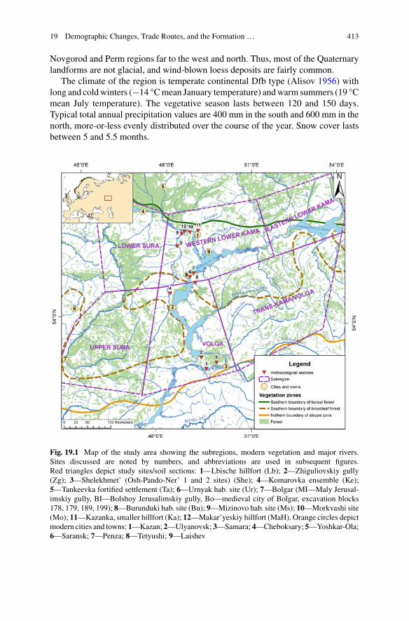
19 Demographic Changes, Trade Routes, and the Formation … 413
Novgorod and Perm regions far to the west and north. Thus, most of the Quaternarylandforms are not glacial, and wind-blown loess deposits are fairly common.
The climate of the region is temperate continental Dfb type (Alisov 1956) withlong and coldwinters (−14 °Cmean January temperature) andwarm summers (19 °Cmean July temperature). The vegetative season lasts between 120 and 150 days.Typical total annual precipitation values are 400 mm in the south and 600 mm in thenorth, more-or-less evenly distributed over the course of the year. Snow cover lastsbetween 5 and 5.5 months.
Fig. 19.1 Map of the study area showing the subregions, modern vegetation and major rivers.Sites discussed are noted by numbers, and abbreviations are used in subsequent figures.Red triangles depict study sites/soil sections: 1—Lbische hillfort (Lb); 2—Zhiguliovskiy gully(Zg); 3—Shelekhmet’ (Osh-Pando-Ner’ 1 and 2 sites) (She); 4—Komarovka ensemble (Ke);5—Tankeevka fortified settlement (Ta); 6—Urnyak hab. site (Ur); 7—Bolgar (MI—Maly Jerusal-imskiy gully, BI—Bolshoy Jerusalimskiy gully, Bo—medieval city of Bolgar, excavation blocks178, 179, 189, 199); 8—Burunduki hab. site (Bu); 9—Mizinovo hab. site (Ms); 10—Morkvashi site(Mo); 11—Kazanka, smaller hillfort (Ka); 12—Makar’yeskiy hillfort (MaH). Orange circles depictmodern cities and towns: 1—Kazan; 2—Ulyanovsk; 3—Samara; 4—Cheboksary; 5—Yoshkar-Ola;6—Saransk; 7—Penza; 8—Tetyushi; 9—Laishev
414 L. A. Vyazov et al.
The Volga-Kama river system is an ancient waterway with deep, well-developedvalleys featuring multiple (commonly three to four) terraces of late Pleistocene tomid-Holocene age. The lower terraces are now mainly covered by the reservoir. Athick mantle of alluvial deposits covers the banks, and in the uplands, loess depositscommonly form steep river bluffs along the valley sides.
The region spans the transition from southern taiga to steppe (Fig. 19.1). A con-tinuous forest is present only in the northern part of the study area. In the central andsouthern part of the region, the forest is preserved only on sandy soils not suitablefor modern agriculture and in areas distant from water sources.
North of the Volga River, spruce (Picea abies) is found, while south of the KamaRiver it occurs only in plantations. The southern limit of its natural distribution todayclosely tracks the +20 °C July isotherm. Pine-dominated forests are widespread andfound as far south as southern Tatarstan. They tend to grow on sandy soils and arepyrogenic in origin. Old-growth pine forests, sometimes with a proportion of oak,are found in Ulyanovsk Region on the right bank of the Volga River and north of theSamara Luka region on the left bank. There are also many scattered pine plantations,mostly<60 years of age.
Mixed forests with spruce, fir, oak, lime, and elm are found in the extreme north ofthe area The most common deciduous trees in the primary forests are oak (Quercusrobur), small-leaf lime (Tilia cordata), maple (Acer platanoides), ash (Fraxinus) andtwo species of elm (Ulmus). Scotch pine (Pinus sylvestris), aspen (Populus) and twospecies of birch (Betula) grow in the secondary forests. Local forest communitiesoccur on the floodplains (willows and alders) and in the steppe ravines (prunes, wildcherry). Oak forests and oak-lime forests are the two most important and presum-ably ancient forest types in the region. Some oak forests are found on highlands,while others may occur along the rivers on high terraces. Oak is temperature-limitedtowards the east, where lime replaces it as the dominant broadleaf tree.
The steppe in the region is mainly of the meadow variety with a diverse and com-mon forb community consisting of species from the Rosaceae, Caryophyllaceae,Fabaceae and Asteraceae families and with needlegrass (Stipa spp.) and bunchgrassfescue (Festuca valesiaca, F. pseudovina). Steppes are found locally in small frag-ments in southernmost Tatarstan and in parts of the Samara and Ulyanovsk regions,although little steppe survives, as much has been transformed into farmlands. Whileover 50% of the region is under cultivation today, the remainder is fallow or pasture-land (25%), forest (20%), water and settlements.
In the southern taiga, game is plentiful (brown bear, roe and common deer, moose,wild boar, beaver, capercaillie) and wolf and lynx can still be found. In the steppe,red fox and badger are important, and there are many rodent and shrew species aswell. Both the Volga and the Kama river valleys are important migratory corridors forbirds. Many of these animals played a major role in the diet of early agriculturalistsin the region.
In the past 30 years, much farmland was abandoned and progressively reclaimedby forest. Birch, maple, and elm are the dominant tree species growing on formerfarmlands and pastures, and pine is a common pioneer species of the previously
19 Demographic Changes, Trade Routes, and the Formation … 415
overgrazed slopes. The recolonization by tree and shrub vegetation is especiallynoticeable in floodplain meadows that were traditionally in high demand for haying.
19.1.2 Human History of the Area: The Sourcesof Information
19.1.2.1 Written Sources
The first written descriptions of Middle Volga landscapes and environment appearedin the 9th to 10th centuries CE. The most important original description of MiddleVolga that was written by an eye-witness and survived until our time was “Risala”, or“The Journey to the Country of Bulgarians” by Ibn Fadlan, a secretary of the BagdadEmbassy (Journey of Ibn-Fadlan 2016).
19.1.2.2 Archaeological Records
Archaeological research in the Middle Volga region began over 100 years ago. Inthe initial stage from the end of 19th century to the beginning of 20th century, themost significant archaeological sites of the region were found and the basic typologyof archaeological materials was developed. The first maps of archaeological siteswere created, and some interesting sites, mainly burials, were excavated. From mid-20th century onward, research focused on the development of the chronological andethnocultural interpretation of findings. Archaeological cultures were determined ascomplexes of typologically similar sites and artifacts found within a specific areaover a certain time period.
A more intensive program of archaeological research between 1950 and 1980 CEproduced a large body of data which allowed for the reconstruction of the culturaldynamics in the region. Attempts were made to reconstruct the ethnicity and sub-sistence of the archaeological cultures. In recent decades, the development of newmethods of paleoecological analysis has opened opportunities for the reconstructionof human-environment-subsistence interactions.
19.1.3 Environmental History of the Area
Most palynological data for the forest-steppe zone of European Russia have beenobtained from bogs and archaeological sites (Serebryannaya 1976; Klimanov andSerebryannaya 1986; Spiridonova 1991), however the age of the layers was eitherunknown or derived from archaeological seriation. In the entireMiddle Volga region,only one systematic palynological study was done in a peat bog, however, it was notradiocarbon dated and was based on small pollen counts (Blagoveshenskaya 2009).Radiocarbon-dated palynological spectra were obtained for peat bogs only in the

416 L. A. Vyazov et al.
western portion of the forest-steppe zone to thewest of theMiddle Volga, in the upperDon, Orel, and Kursk regions (Novenko and Olchev 2015; Novenko and Volkova2015; Novenko et al. 2009, 2011, 2015, 2016). These studies revealed the followingenvironmental phases:
1. 7000–4800 cal year BP: Forest-steppewas the dominant vegetation in the region.The pollen spectra contained 10–55% arboreal pollen (AP), represented mainlyby Pinus with a proportion of Quercus and Tilia. Xerophytic/steppe taxa (e.g.,Ephedra) were present. A short-term cooling and increase in moisture werereconstructed for the time period between 6750 and 6500 cal year BP. The firstevidence of pastures was found in pollen of Neolithic layers and Bronze Agelayers contained evidence for both grazing/pastures and crop production.
2. 4800–1700 cal year BP: Between 4800 and 3700 cal year BP, the forest marginmoved southwards, Picea became an ubiquitous component of the pollen spectraand broadleaf taxa increased in abundance. An increase in AP between 3700 and1700 cal year BP was attributed to climate cooling. Despite this general trend,some sites experienced fire-triggered deforestation during this period.
3. Between 1700 and 1300 cal year BP and from 900 to 700 cal year BP: Fire-triggered deforestationwas recorded in the area, presumably due to land clearancefor agriculture. During the periods between 1300 and 950 and 600–500 cal yearBP, elevated AP indicates an increase in forested area.
The area north-west of Samara Luka (Fig. 19.1) was almost entirely forested(pollen was mainly Quercus) in the mid-Holocene, between 6000 and 4500 cal yearBP (Blagoveshenskaya 2009). In the early Subboreal, ~4500–3200 cal year BP,Betula and Alnus pollen became more abundant, while oak pollen declined. Theproportion of arboreal pollen decreased towards the end of the period. The Subat-lantic, ~2500–700 cal year BP, was marked by an increase in Pinus pollen. This timeperiod was associated with the transition to the Iron Age and spread of agricultural-ism in the region. Finally, pollen spectra attributed to the last 2500 years have lowproportions of AP, characteristic of the forest-steppe transition zone.
19.2 Methods
19.2.1 Archaeology
The archaeological data were analyzed at several scales. At the macro-level weanalyzed the degree of the development of the territory based on the locations ofarchaeological sites of Middle Volga published in regional archaeological maps(Archaeological Map of Tatarstan 1981–1990; Burov 1977; History of Samara VolgaRegion 2000; Archaeological Map of the Chuvash Republic 2013–2015). Sites wereordinated into cultural areas (groups of the archaeological cultures), archaeologicalcultures and cultural types, and the chronological frame was based on recent publi-cations. In most cases the ages of archaeological sites were determined by relative
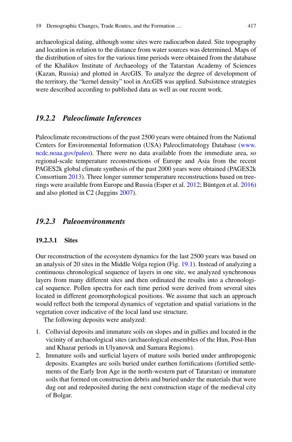
19 Demographic Changes, Trade Routes, and the Formation … 417
archaeological dating, although some sites were radiocarbon dated. Site topographyand location in relation to the distance from water sources was determined. Maps ofthe distribution of sites for the various time periods were obtained from the databaseof the Khalikov Institute of Archaeology of the Tatarstan Academy of Sciences(Kazan, Russia) and plotted in ArcGIS. To analyze the degree of development ofthe territory, the “kernel density” tool in ArcGIS was applied. Subsistence strategieswere described according to published data as well as our recent work.
19.2.2 Paleoclimate Inferences
Paleoclimate reconstructions of the past 2500 years were obtained from the NationalCenters for Environmental Information (USA) Paleoclimatology Database (www.ncdc.noaa.gov/paleo). There were no data available from the immediate area, soregional-scale temperature reconstructions of Europe and Asia from the recentPAGES2k global climate synthesis of the past 2000 years were obtained (PAGES2kConsortium 2013). Three longer summer temperature reconstructions based on tree-rings were available from Europe and Russia (Esper et al. 2012; Büntgen et al. 2016)and also plotted in C2 (Juggins 2007).
19.2.3 Paleoenvironments
19.2.3.1 Sites
Our reconstruction of the ecosystem dynamics for the last 2500 years was based onan analysis of 20 sites in the Middle Volga region (Fig. 19.1). Instead of analyzing acontinuous chronological sequence of layers in one site, we analyzed synchronouslayers from many different sites and then ordinated the results into a chronologi-cal sequence. Pollen spectra for each time period were derived from several siteslocated in different geomorphological positions. We assume that such an approachwould reflect both the temporal dynamics of vegetation and spatial variations in thevegetation cover indicative of the local land use structure.
The following deposits were analyzed:
1. Colluvial deposits and immature soils on slopes and in gullies and located in thevicinity of archaeological sites (archaeological ensembles of the Hun, Post-Hunand Khazar periods in Ulyanovsk and Samara Regions).
2. Immature soils and surficial layers of mature soils buried under anthropogenicdeposits. Examples are soils buried under earthen fortifications (fortified settle-ments of the Early Iron Age in the north-western part of Tatarstan) or immaturesoils that formed on construction debris and buried under the materials that weredug out and redeposited during the next construction stage of the medieval cityof Bolgar.

418 L. A. Vyazov et al.
3. Tree uprooting structures dividing occupational layers of subsequent periods(Hun/post-Hun/Khazar/pre-Mongolian).
In most cases, several layers of different ages were analyzed in each site, varyingfrom two layers in upland sites to 15 in gullies. Occupational layers of habitation siteswere generally avoided, as these could be strongly affected by the input of pollenfrom anthropogenic materials. Layers were synchronized with archaeological cul-tures based on the presence of diagnostic archaeological artifacts, using radiocarbondating of charcoal from the layers, or both.
19.2.3.2 Soil Pollen Analysis
Samples were processed by acidification with 10% HCl, boiling in 10% KOH, andcentrifugingwith heavy liquid (sodium polytungstate) (DeVernal et al. 2010). Count-ing was done on a light microscope with a magnification of 400–1000x, and 250–300grains were identified per sample. The percentages of pollen taxa were calculated onthe basis of total pollen, and the percentage of spores was based on the total numberof pollen and spores. A principal components analysis of the more common pollentaxa (mean> 1% or maximum value> 5%) was performed on the correlation matrixto summarize the pollen assemblages.
19.2.3.3 Dating of Layers
The age of selected layers was determined by AMS radiocarbon dating of charcoal.The layers associated with human occupation commonly contain charcoal, more-over, the presence of charcoal is often considered as evidence of human occupation.Archaeological dates were obtained for layers that had a clear cultural affiliation.Not every layer was radiocarbon dated; for some layers in colluvial sequences anapproximate age was estimated using the age of a basal layer and calculated accu-mulation rates. Some undated layers were placed in a chronological order accordingto their stratigraphic position between radiocarbon-dated layers.
19.3 Results
19.3.1 Outline of the Cultural Dynamics of the Middle VolgaRegion
The cultural and economic history of the region can be summarized into elevenperiods prior to the modern times (Fig. 19.2).
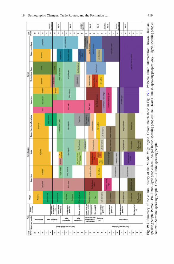
19 Demographic Changes, Trade Routes, and the Formation … 419
Fig.19.2
Summaryof
thecultu
ralhistoryof
theMiddleVolga
region.Colorsmatch
thosein
Fig.
19.3.Probable
ethnic
interpretatio
n:Brown—
Iranian-
speaking
people;Purple—
Pre-Finno-Ugricpeople;R
ed—Volga
Finnish-speaking
people;B
lue—
Kam
aFinnish-speaking
people;G
rey—
Ugric-speakingpeople;
Yellow—Slavonic-speakingpeople;G
reen—Turkic-speaking
people
420 L. A. Vyazov et al.
19.3.1.1 Scythian Period, 8th–4th Century BCE
From the 8th to 4th century BCE, the banks of the Volga and Kama rivers wereinhabited by several groups of people belonging to the cultures of the Ananyinoarea (Fig. 19.3, Map 1). There are at least 200 sites of the Ananyino cultures inthe region, located within the forested areas. The Ananyino peoples lived in well-protected bluff forts surrounded by open settlements situated several kilometers apart,on both high and low banks of the largest rivers (Orudzhov 2017). Their subsistenceis poorly known but they were undoubtedly pastoralists who used the surroundingforests for hog grazing. There is no clear evidence of agriculturalism (Petrenko 2009;Kuz’minykh and Chizhevsky 2009).
From the 8th to 4th century BCE, the steppes were populated by nomadic Sauro-matian people. The northern boundary of the nomadic territories followed a line fromUlyanovsk to the middle reaches of the Bolshoi Cheremshan River and from thereto the town of Ufa (Myshkin and Skarbovenko 2000). During the next stage, therewas a prolonged depopulation of the Middle Volga region.
19.3.1.2 Early-Sarmatian Period, 4th–2nd Century BCE
The late stage of the cultures of the Ananyino area is dated to the 4th to 2nd centuryBCE (Chizhevsky 2017), synchronous with theEarly Sarmatian culture of the steppezone of Eastern Europe. At this stage, Ananyino sites were more numerous on themiddle Kama River and in the forest-steppe of the Volga region. The disappearanceof the cultures of the Ananyino area was followed by a decrease in population and agradual cultural differentiation of the Middle Volga region. Some groups of peopleprobably lived only at the northern periphery, while the central part was depopulated,except for solitary settlements and hillforts of Gorodets culture in the Volga Rivervalley (Matveeva 2000a).
The Sauromatian culture in Volga-Urals steppe was replaced by the Prokhorovkaculture of the 4th–2nd century BCE. The Early Sarmatian culture spread northwardof the Kama River (Chizhevsky 2017) through both cultural contacts and also aphysical movement of nomadic peoples.
19.3.1.3 Mid-Sarmatian Period, 1st Century BCE—2nd Century CE
Repopulation of the region began in the first centuries CE when two groups ofpeople moved into the broadleaf forest zone (Fig. 19.3, Map 2). In the north-west,sites of Andreevka-Piseraly type appeared (Myasnikov 2013) that played a majorrole in the formation of Middle Volga Finnish ethnicity, beginning with the Old-Mordovian culture. Andreevka-Piseraly archaeological sites are distinctive burialsof foreign military groups as well as fortified and non-fortified habitation sites. Thehabitation sites usually have thin occupational layers poor in artifacts, indicatingbrief occupations. The land-use system and subsistence have not been studied.
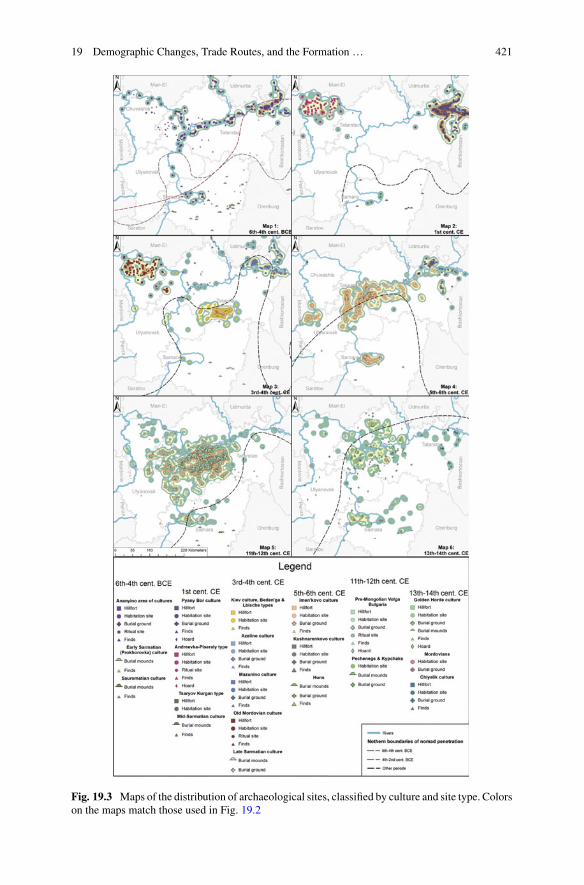
19 Demographic Changes, Trade Routes, and the Formation … 421
Fig. 19.3 Maps of the distribution of archaeological sites, classified by culture and site type. Colorson the maps match those used in Fig. 19.2
422 L. A. Vyazov et al.
The Pyany Bor culture expanded into territories north of the Kama and east ofthe Volga rivers between the 2nd century BCE (shortly before the Mid-Sarmationperiod) and 2nd century CE (Ageev 1992). Pyany Bor sites were most dense in thelower reaches of Belaya River and adjacent areas of the lower Kama River, wheremore than 300 habitation and 40 burial sites have been found (Fig. 19.3, Map 2). Thesubsistence system is interpreted based on site locations.Pyany Bor siteswere locatedon high terraces of rivers with wide floodplains, or occasionally in the floodplains,which may indicate the importance of fishing. Subsistence was presumably basedon swidden cultivation and complemented by hunting and pastoralism, focused onhorse and cattle livestock (Bugrov et al. 2011).
In the southern and southwestern parts of the region, a few groups of migrantsfrom the southwest (probably from the Don River area), had appeared by this time.The sites of these small sedentary groups, called Tsaryov Kurgan type, are locatedon high hills in the forest-steppe (Stashenkov 2003; Volkova 2017). Only short-term,solitary archaeological sites have been found, with few artefacts in their occupationallayers. Therefore, the Middle Volga region remained largely depopulated until the3rd century CE. The marginal groups of people inhabiting small areas along rivershad non-specialized multi-faceted subsistence and their impact on the environmentat this time period could not have been extensive.
Finally, nomadic groups of the Middle-Sarmatian culture were advancing north-wards in the steppes, on the left bank of Volga River, penetrating up to the mouth ofthe Bolshoy Cheremshan River. Middle-Sarmatian artefacts were also found in sev-eral habitation sites in the Samara Luka region (Fig. 19.1) and to the south (Myshkinand Skarbovenko 2000; Matveeva 2003). The movement of nomadic groups into theforest-steppe region was more pronounced in the Early Sarmatian time, from 4thto 2nd century BCE, as the number of the archaeological sites attributed to nomadsof the Middle-Sarmatian time was noticeably smaller (Myshkin and Skarbovenko2000). It is not yet clear whether the absence of archaeological sites (and popula-tion) in the Middle Volga region at the turn of the eras was caused by hostilitiesamong various groups or some other, perhaps environmental factors. However, thedepopulation of the area set the stage for intensive exploration of the landscape bynewcomers immediately prior to and during the Migration Period.
19.3.1.4 Late-Sarmatian Period, Middle of the 2nd to the Endof the 4th Century CE
After a long period of depopulation, a new wave of migration to the Middle Volgaregion began at the end of 2nd to the beginning of the 3rd century CE. Both the localpopulation that lived at the periphery of the region and new migrants from remoteareaswere part of this process (Fig. 19.3,Map 3). In the SuraRiver basin, new culturaltraditions were developed by descendants of the Andreevka-Piseraly people. Theyleft sites of the Sitdimirkino-Tautovo type in the southern part of Chuvashia, and canbe considered as the earliest population of the Old-Mordovian culture (Myasnikov2013). Numerous, but small and poorly fortified hillforts and settlements in the 1st to2nd quarters of the first millennium CE were located along small streams or ravines

19 Demographic Changes, Trade Routes, and the Formation … 423
(Fig. 19.3, Map 2). Tools associated with farming or cattle breeding are unknown,and the economic system is poorly understood.
At the same time, the western part of the Lower Kama region was inhabited bya small but widespread population of the Azelino culture (Gening 1963), who werethe descendants of the Pyany Bor cultural tradition (Fig. 19.3, Map 3). The locationof the Azelino sites along the large rivers indicates that they migrated from east towest/southwest, eventually crossing the Volga and Kama rivers. Not more than 50archaeological sites of Azelino Culture are concentrated within the territory of theVolga-Vyatka interfluve. Most are burial grounds; habitation sites have not beensufficiently surveyed (Leschinskaya 2014). Among the findings that characterize thesubsistence of the population are many specialized hunting arrowheads, knives forapiculture, skeletons of riding horses (imported from the steppe zone), and skeletonsof dogs found in burials.Azelino population subsistencewas largely focused on forestresources.
A new group of nomads, termed Late Sarmatians, spread into the steppe zoneof Eastern Europe in the 2nd to 4th centuries CE. This population also occupiedthe left bank of the Volga River; burial grounds were found in the Trans-Volga andTrans-Kama regions (Myshkin and Skarbovenko 2000).
Another population appeared in the forest-steppe zone. One of the groups is themost eastern type of the Kiev culture of the second quarter of the first millenniumCE. The oldest sites of this culture appeared in the Trans-Volga area as early as thebeginning of the 3rd centuryCE (Stashenkov 2005). At the same time or slightly later,they also appeared in the valleys of the Sura (Vyazov et al. 2016) and Volga rivers(Vyazov and Semykin 2016). About 140 unfortified sites attributed to this culturalgroup are located on the low banks and first terraces of small rivers. The settlementswere generally several hectares in size, forming long chains of sites spaced 1–2 kmapart. Osteological remains indicate that they relied on animal husbandry with arelatively important role of small cattle breeding and with a much smaller proportionof meat provided by hunting (Stashenkov 2005). The role of agriculture has notbeen sufficiently studied, but they did not have soil tillage implements suitable forploughing. It is possible that settlements of this population were very short-lived.
A distinct cultural complex of so-called Lbische type appeared in 3rd to 4thcentury CE in the Samara Luka as a result of migration of sedentary groups fromthe south and southwest (Stashenkov 2010a). The Lbische people led an isolatedlife in two large, well-protected hillforts. The absence of wild animal bones in thesesites (Petrenko 2011) indicates that they used only domestic cattle as the source ofmeat. Both the Kiev and Lbische people used small iron sickles that first appearedin the middle Dnieper region among forest-steppe Scythian-influenced cultures andultimately spread throughout the East-European forest-steppe. The new populationof the forest-steppe zone interacted with the Late Sarmatians, whose burials wherefound in Kiev and Lbische sites (Stashenkov 2005; Matveeva 2000b).
The penetration of the new groups of people into the region did not lead to thedisappearance of other cultural traditions. Sites of the Azelino culture became evenmore numerous and wide-spread, appearing on both banks of the Volga River andin Trans-Kama area (Bugrov 1998). In the eastern part of the lower reaches of the

424 L. A. Vyazov et al.
Kama, a new culture of Mazunino (Ostanina 1997) developed from the Pyany Borculture in the 3rd century CE. The subsistence of the Mazunino population followedPyany Bor traditions of multi-faceted forest utilization with a major role for huntingand gathering. Over 420Mazunino sites are known and this is a significant increase incomparison to their predecessors. New types of tools, including sickles and narrow-blade iron axes, appeared in their tool set. The distribution of sickles may reflect themigrations of Kiev and Lbische people, whereas the appearance of narrow-bladedaxes resulted from cultural contacts with the population of the Oka basin. Mazuninosites were commonly hillforts (“palisaded homesteads”) of under one hectare in sizeand located in small river valleys, unlike the Pyany Bor sites associated with widefloodplains (Ostanina 1997). A scattering of pottery shards, common around thehillforts, is usually interpreted as the occupational layers of settlements but can alsobe associated with agricultural activities. However, evidence for farming is scarceand based on solitary finds of charred cereals. Grinding stones are interpreted as toolsfor processing crops, which would indicate that the population either produced ortraded small amounts of cereals. Osteological remains suggest that hunting playeda major role in their subsistence and apiculture knives emphasize the importance ofthe forests in the economy.
A similar economic system was formed at the opposite edge of the region, in theSura Basin. Two versions of Old Mordovian culture appeared in the 3rd century CE(Grishakov 2017), located in lower (Myasnikov 2013) and upper reaches of the SuraRiver (Grishakov 2000). They are considered to be predecessors of the medievalMordovian population. Therefore, in the 3rd to 4th centuries CE, the landscapes oftheMiddle Volga region were populated and transformed by groups of migrants fromthe southwest. The exploration and utilization of the landscape began initially in theforest-steppe, clustered along river valleys. The areas in the vicinity of rivers weredotted by dozens of short-lived settlements located within one to three km from eachother.
19.3.1.5 Hunnic Period, from the End of the 4th to the End of the 5thCentury CE
The Hunnic invasion triggered a period of significant cultural transformation. In thelate 4th to early 5th centuries CE the entire Eastern European culture was reshapedas cultural relations were destroyed and the vectors of contacts and interactionschanged. The Middle Volga region also underwent significant cultural change.
The archaeological remains that are attributed to Huns and related nomads in thesteppe zone are solitary burials and findings of (ritual?) bronze cauldrons (Zasetskaya1994). The northern boundary of their distribution runs along a line from the sourceof Sura River to the middle reaches of the Bolshoy Cheremshan River and furtherto the east (Polivanov 1890; Stashenkov 2007; Bogachev 2000). Several groups ofwell-armed people moved across the Kama River from the southwest (Gening 1976).The changes triggered by the Hun invasion of the steppes occurred also in the forest-steppe zone and in the southern parts of the forest zone, where the Hunnic time wasthe period of the greatest cultural diversity.

19 Demographic Changes, Trade Routes, and the Formation … 425
In addition to the existingKiev andLbische population, twomore groups of peopleappeared in the forest-steppe at this time. Short-livedvillages and fortified settlementsof the Beden’ga-Mizinovo type are found on the west bank of the Volga and in theSviyaga River valley. The material culture of this type could originate from the OldMordovian andKiev culturewith some admixture of traits characteristic ofOkaBasinFinnish groups. Iron oreminingwas an important part of the economy, predominantlysurface deposits in the Volga-Sviyaga interfluves (Vyazov and Semykin 2016).
The second and more numerous group of sites are from the early stage of theImen’kovo culture (Stashenkov 2010b), which appeared along the Volga River andin themiddle reaches of the SuraRiver at the beginning of theHunnic times (Fig. 19.3,Map 4). The source area for this migration is still unknown (Matveeva 2004). In theearly stages, sites of this culture were represented solely by unfortified settlementsof one to two hectares confined to the terraces and banks of oxbow lakes (Vya-zov 2007). The abundance of fish bones in the sites indicated that fishing was animportant part of the Imen’kovo subsistence. Hunting in the forests was apparentlyas important as raising livestock, as reflected by a high proportion of wild speciesbones (Petrenko 2011). The large thickness of the occupational layers, which includean abundant and diverse set of household items, and the diversity of archaeologicalfeatures (e.g., various pits) unequivocally point to the long-term functioning of theImen’kovo habitation sites. The high density of dwellings suggests large numbers ofinhabitants in the settlements. Numerous finds of sickles and dolomitic millstonesused for the manual grinding of cereals in the earliest sites of this culture attest tothe importance of agriculture (Matveeva 2004). The Imen’kovo people were agricul-turalists who developed an economic system more efficient than that of any othercultural groups of Hunnic times in the region.
The Imen’kovo people are believed to be the first truly sedentary inhabitants of theregion (Matveeva 2004). The high-efficiency land use system played an importantrole in the rapid expansion of the Imen’kovo population throughout theMiddle Volgain the 5th century, which occurred alongside the disappearance of other cultures ortheir displacement from the region.
19.3.1.6 Post-Hunnic Period, End of the 5th to the Middle of the 6thCentury CE
The boundary between the Hunnnic and post-Hunnic periods in the Middle Volgaregion is tentative due to the lack of radiocarbon-dated burials and stratified habitationsites. According to our recent radiocarbon datings, it could be set somewhere betweenthe middle of the 5th and the beginning of the 6th centuries CE. The general trendsof the regional development that started by the end of the Hunnic time continuedduring the later period.
By the end of the Hunnic period, the Imen’kovo population was the largest in theregion and one of the largest cultural entities of Eastern Europe. By the beginningof the 6th century, the Imen’kovo population occupied the entire forest-steppe zoneof the region, while other cultural entities were either forced out of this territory or

426 L. A. Vyazov et al.
assimilated. The Imen’kovo culture reached its maximum extent in the post-Hunnictimes, with over 500 sites, including about 100 hillforts. These are located in the Suraregion, in the Sviyaga Valley as well as on the both banks of the Volga and LowerKama rivers.
During the 5th century, unfortified settlements on the low river terraces ceased toexist and the Imen’kovo population expanded to the high banks of rivers and gulliedareas of the upper river terraces. The settlements became spatially structured, withnumerous small settlements (“suburbs”) clustered around a much larger settlementor a well-protected hillfort (Vyazov 2007) (Fig. 19.3, Map 4).
The change in settlement structure was accompanied by a change in the tool set.The most important example is the appearance of small iron ploughshares, which aremore numerous in the sites of Imen’kovo culture than in other cultural formations ofEastern Europe of this time (Vyazov 2008). Larger and more effective sickles andnumerous finds of millstones attest to large scale grain production. Finally, narrow-bladed axes with socketed heads are frequently found (Vyazov 2012).
The Imen’kovo population caused a significant alteration of the landscapes of theMiddle Volga region by the second half of the 5th century. Along with land clearancefor habitation sites and agriculture, activities related to mining and processing of ironcould have played an important role in changing the landscape.
The agricultural tool set of the Imen’kovo culture is only found in the MiddleVolga region, although some components appear in the cultures of the surroundingareas. For example, millstones were found in Mazunino sites, and a short scytheof the late Imen’kovo type was found in one of the late Azelino burials. However,the small number of these findings indicates that the other cultures only borrowedsome tools from Imen’kovo, but this was not linked with significant changes in theirsubsistence.
Nomadic artifacts of post-Hunnic times are limited to areas south and east ofthe Imen’kovo territory, in Trans-Volga on the border between the forest-steppe andsteppe zones. The single burial (Bogachev 2000) and some accidental finds associatedwith elite groups of nomads were discovered in the Ulyanovsk part of the MiddleVolga region, dated either to the first half or mid-6th century CE (Zasetskaya et al.2007). Apparently, the steppe population of this time was not numerous.
19.3.1.7 “Heraldic Type Belt Sets” Period, Middle of the 6th to the Endof the 7th Century CE
In the middle of the 6th century, a new migration wave reached the steppe region.It was forced by aggressive Turkic campaigns, which led to the establishment ofthe Turkic Khaganate. After the Turkic military elite fashion, a new style of beltsets decoration, with belt plates shaped as a heraldic shield, spread over the steppezone of Eurasia. While the Turkic Khaganate itself did not strongly influence thecultural processes in Eastern Europe, this fashion became popular in the steppe andforest-steppe, from Byzantium to the Altai Mountains, and gave its name to the time
19 Demographic Changes, Trade Routes, and the Formation … 427
period. In the Middle Volga region, this period was a time of asynchronous declineof the Imen’kovo culture followed by depopulation of the region.
The reasons behind this process are not fully understood. The latest of theImen’kovo sites are dated to the first half of the 7th century in most regions eastof the Volga. On the right bank of Volga River and on the banks of the Sura River,Imen’kovo sites survived until the middle of the 7th century and perhaps until thebeginning of the 8th century (Vyazov et al. 2016). Another very late group of theImen’kovo population appeared in the eastern part of the LowerKama region (Gening1977; Ostanina 2002).
Several groups of newcomers replaced the Imen’kovo population. In the east-ern part of Trans-Volga, a new population of the Kushnarenkovo culture (Kazakov1981), spread in the second half of the 6th century (Fig. 19.3, Map 4). For the firstdecades, the Kushnarenkovo people lived in contact with the Imen’kovo populationfrom the southern bank of the Kama River to the Samara Luka region, as shown byfinds of Kushnarenkovo potsherds in Imen’kovo dwellings. After the collapse of theImen’kovo culture, the Kushnarenkovo people remained in the Middle Volga regionsouth of the Kama River. The subsistence system of this population is unknown.The presence of very thin occupational layers of the Kushnarenkovo habitation sitesis consistent with a relatively mobile, semi-nomadic lifestyle. Descendants of theKushnarenkovo population are considered to be ancestors of the Hungarians.
To the west of the Kushnarenkovo cultural area, on the left bank of the Volga, sev-eral very rich burials of the nomadic aristocracy were found. A set of finds called the“Burakovo hoard” and another discovery in the vicinity of Ulyanovsk (Mukhamet-shina 1999; Gismatulin 2006) include golden belt attachments dated to the middleof the 7th century CE, probably originating from a destroyed burial. Another groupof nomads appeared at the same time or a little later on the right bank of Volga, asindicated by the Shilovka burial mounds (Bagautdinov et al. 1998).
19.3.1.8 Khazar Period, from the End of the 7th to the Middleof the 10th Century CE
The collapse of the Imen’kovo culture was followed by a depopulation of the MiddleVolga region in the second half of the 7th century CE. Occupational sites are recordedonly in the periphery of the region. To the west, there was a group of sedentarypopulations in the Sura River valley, including sites of the Early Mordovian cultureand the latest settlements of the Imen’kovo culture. To the east, the Verkhniy Utchanand Kushnarenkovo cultures occupied the eastern part of the Lower Kama region.
By the end of the 7th century, a recolonization of the Middle Volga began. Thisprocess continued until at least the second quarter of the 10th century. This period iscalled the Early Bulgarian time, and corresponds to theKhazar time in the archeologyof Eastern Europe. It can be divided into several stages.
The first stage (~690–750 CE) was initiated by nomads of Turkic (Khazarian andBulgarian) origin (so called Novinki type): their burial mounds appeared along theVolga, in Samara Luka, and near Ulyanovsk (Matveeva 1998; Bagautdinov et al.
428 L. A. Vyazov et al.
1998). Small groups of sedentary people, practicing different burial rites and prob-ably of different origin, also appeared in the Volga valley, occupying areas near thenomads as revealed in the Zhiguli archaeological complex in the Samara Luka area(Ponomarenko et al. 2015).
The second stage (~750–850 CE) was influenced by the defeat of the KhazarKhaganate by Arab forces in 737 CE. In 740–750 CE the area of the Saltov culturebecame the source of a new wave of migration to the Middle Volga region (Kazakov1992). The burial grounds of the 8th to 9th centuries were distributed along bothbanks of the Volga River valley.
At the end of the 8th century, a new group of people appeared in Trans-Volga.Descendants of the Kushnarenkovo culture, recognized as early Hungarians, movedthrough theMiddle Volga along their migration to the Danube (Kazakov 1992). Theirlargest burial ground, dated from the end of the 8th to the first half of the 9th century,was located far to the north of Samara River.
The number of occupation sites increased and the cultural traits of the sedentarypopulation of the region became more diverse in the 8th century CE. The newcomersmoved from the Don basin (Slavonic and Turkic-speaking populations of the SaltovCulture) to west of the Sura river (inhabitated by Mordovians) and Middle Kamaregion (populated by people of the Nevolino culture). The occupation sites of thefirst two stages, from the end of the 7th to the middle of the 9th centuries, have com-paratively thin occupational layers poor with finds (Stashenkov 2010c), consistentwith temporary camps. Most of the occupation sites were situated on high terracesof the Volga and on the banks of second-order ravines, within 10 km from the river.Many sites were associated with iron ore extraction and iron smelting (Vyazov andSemykin 2016). The newcomers of the Saltov culture were agriculturalists who usedards with iron ploughshares as a plowing tool (Khuzin 2011).
The third stage of migrations to the Middle Volga during the time period from850 to 910 CE was associated with the decision of the Khazarian rulers to convert toJudaism (Khuzin 2011).As a result, the 9th centurywas a period ofmixingof differentcultural groups in the Middle Volga region. The most numerous were migrants withSaltov cultural traditions (mainly of Turkic origins) and Finnish newcomers fromtheMiddle Kama. Archaeological sites include burial grounds and settlements alongthe Volga and also in the Trans-Volga region, around the future city of Bilyar. Bothgroups were comparatively numerous, for example, the Tankeevka burial groundcontained more than 5000 graves (Khalikova and Kazakov 1977). The territories tothe north of Kama remained unpopulated. The total number of sites increased, atleast some were used as year-round settlements and some were fortified (Semykinand Matveeva 2010).
The end of the 9th to the beginning of the 10th centuries was the beginning of theVolga Trade Route, connecting the Caspian Sea and Middle East with the Baltic Seaand with the Middle and Upper Kama region, rich with furs. The beginning of theintensive trade is indicated by numerous dirhams andweights found in archaeologicalsites within the Kama floodplain. Several dirhams from the beginning of the 10thcentury were also found in the Maly Yerusalimskiy gully site, which is thought to be
19 Demographic Changes, Trade Routes, and the Formation … 429
the earliest Bulgarian medieval settlement in the city of Bolgar itself (Khuzin 2011).A Viking presence is also recorded in several sites (Izmaylov 2006).
The peripheral areas remained comparatively poorly populated during the entireKhazarian Period. In the Upper Sura region, only a dozen Early Mordovian siteshave been found in a small forested rugged lowland (Belorybkin 2003). The LowerSura was inhabited by a small group of Early Mari people (Archaeological map ofChuvashia 2013–2015) and the eastern part of the Middle Volga region remainedalmost totally depopulated except for the Verkniy Utchan group of about 30 sites ofthe 6th to the 9th centuries (Goldina and Chernykh 2011).
Thus, the repopulation of the region in the 7th through the 10th centuries advancedfrom south to north, with areas along theVolga the first to be developed. The locationsof the burial grounds and settlements of the 8th through 9th centuries coincide withthe route of the Ibn-Fadlan voyage of 920 CE (Journey of Ibn-Fadlan 2016). In the9th and early 10th centuries, the banks of the Volga were cleared of forest to satisfythe needs of pastures and communication routes. The peripheral areas remainedpopulated during the entire time period, although the marginal groups of peoples didnot play a significant role in the process of repopulation.
19.3.1.9 Pre-Mongolian Period, Middle of the 10th to the Middleof the 13th Century CE
No later than the second quarter of the 10th century, the number of habitation sites intheMiddle Volga region began to grow explosively, reaching at least several hundredby the beginning of the 11th century (Fakhrutdinov 1975) and exceeding 1500 bythe 12th century. About 15% of the sites were fortified. Economic development tookplace on the banks of both the major rivers as well as in the 3rd to 4th order tributaries(Fig. 19.3, Map 5). For the first time, the watershed areas were cleared of forest andused for agriculture. The most populated areas were the valley of the Volga River andthe part of Trans-Volga territory south of the Kama River, while Cis-Kama remainedpoorly developed. A separate group of 30 sites of Pre-Mongolian Volga Bulgarianculture appeared in the southern part of the Upper Sura region, andmay be connectedwith activity on the trade route from Bolgar to Kiev (Belorybkin 2003).
Large fortified towns, including Bilyar, Bolgar, and Suvar, occupied areas up toseveral hundred hectares and were surrounded by dozens of satellite settlements,typical for medieval urban agglomerations (Khuzin 2006). The economy of Pre-Mongolian Volga Bulgaria was based primarily on crop production using ploughsequipped with wide plowshares and coulters. This highly-efficient type of plough(saban) was capable of cutting and overturning the upper layer of loamy soils. Alarge number of millstones for hand rotary mills were found in the Volga-Bulgariansites, indicating high yields and large quantities of cereals. Finds of iron shovel bladespoint to the development of horticulture and vegetable gardening (Khalikov 2006).
Osteological data from Pre-Mongolian settlements reflect significant changes inthe structure of meat consumption, and possibly in the composition of the herds(Petrenko 2006). There was a noticeable increase in the proportion of small cattle,
430 L. A. Vyazov et al.
implying an increase in the size of open pasture available for goat and sheep grazing.Hunting and especially fishing still played a role in providing the population withprotein.
There is extensive data related to the craftsmanship and industries of the VolgaBulgaria economy, which included products made of ferrous and non-ferrous metals,bones, glass, and pottery. The spatial distribution of artifacts reflects the developmentof highly specialized production of artisan goods in urban centers and itsmarketing tothe countryside. This is evidenced by pottery and blacksmith workshops, craftsman’sbrands on pottery, and in the high quality of the products. This process certainly hadto be accompanied by the development of communication routes and the spread ofboth local and long-distance trade.
In summary, Pre-Mongolian Volga Bulgaria was a society with a highly devel-oped and multi-faceted economy. The rapid agricultural development of the region,reflected by an explosive increase in the number of settlements, provided the popu-lation with food. Towns played an important role in the economy, being centers ofcraftsmanship and trade. The wide distribution of urban artisan products in the ruralareas and the large number of imported products in rural areas are typical for a highlydeveloped territory with extensive communication networks.
19.3.1.10 Golden Horde Period, from the Second Half of 13th Centuryto the 1440s
The Mongolian invasion of 1236 CE brought major changes to the cultural anddemographicmap of the region.Many settlementswere demolished, and themajorityof large urban settlements never recovered. The catastrophic results of theMongolianinvasion were recorded as fire layers with numerous human remains. The GoldenHorde Period in Middle Volga is divided into an the early period (second half ofthe 13th century to the first half of the 14th century) when they reached the apogee ofpolitical and economic power, followed by a period of civil wars and gradual declinefrom the middle of the 14th century to the 1440s CE.
The Mongolian invasion resulted in the formation of a new political and govern-mental system in Eastern Europe. The Middle Volga area was a part of the north-western province of the Mongolian Empire called the Ulus of Jochi. Following theinvasion, the majority of the settlements in the forest-steppe and the upper reachesof the Sura simply disappeared (Belorybkin 2003). In Trans-Volga, the number ofsites greatly decreased, with sites almost disappearing in the basin of the BolshoiCheremshan (Archaeological map of Tatarstan 1990, vol. 6). In Samara Luka, theinvasion caused a change in the spatial distribution of settlements (Kochkina 2016)and the arrival of first wave of Mordovian and Russian colonists, probably as a resultof the Golden Horde state relocation policy (Stashenkov 2016). The Volga, fromBolgar to the Usa River was desolated (Burov 1977) while the population of thenorthern part of the former Volga Bulgarian state was less severely affected or elserecovered more successfully. Several agglomerations of settlements appeared on thebanks of Volga and Kama rivers (Rudenko 2016), the most significant being about
19 Demographic Changes, Trade Routes, and the Formation … 431
50 settlements centered on the city of Bolgar, which became the capital of the Ulusof Jochi from the 1240s to1260s (Izmaylov 2009a). The first coins of the Jochideswere minted here and its status is attested by the monumental stone architecture ofthat period (Rudenko 2016). Thus, in 13th through 14th centuries, the areas alongthe Volga and Kama rivers were densely populated. In the early Golden Horde periodthe population shifted northwards, exploring the western part of the lower Kama areaand including the areas north of the Kama River. The total number of the habitationsites of the Golden Horde period in the region is about 400 (Fakhrutdinov 1975).
The economy of theGoldenHorde townswas based on crafts and trades. Althoughthe agriculture of this period has not been extensively studied, an increase in the sizeof settlements and the adoption of more advanced tillage implements may indicate anincrease in productivity (Mardanshina 2008). The local population preferred to gettheir meat supply buying livestock from steppe nomads rather than breeding themlocally (Yavorskaya and Antipina 2016).
The settlements of this period became strongly clustered and agglomerated. Dur-ing the second half of the 13th to the first half of the 14th centuries, towns and citiesflourished along the Volga River valley, from the Caspian Sea to the mouth of theKama River. The largest cities, such as Kazan, Bolgar, andMuranka site on the VolgaRiver and Juketau on the Kama River were associated with the Volga trade route. Thenumber of urban centers decreased, but their size grew and it is possible that eachcenter marked a separate principality within the Ulus of Jochi. These changes in thespatial structure of settlements could have engendered a large heterogeneity in land-scape utilization. The suburbs that provided the citizens with agricultural productionwere used more intensely than in the Pre-Mongolian period, while the remote areascould have been either under-utilized or abandoned (Fig. 19.3, Map 6).
At the beginning of the second half of the 14th century, the Golden Horde entereda long crisis that ended with the disintegration and collapse of the empire a centurylater. The crisis could have been caused by ecological, economic or political factors,or perhaps by the Black Death pandemics. The pandemics of 1346 and 1364 CEcaused a potentially long-lasting decrease in the urban population. The maximaldecrease in a population affected by the plague is reached approximately 140 yearsafter the pandemics (Shamiloglu 2009), so this could account for the depopulationof the region at the end of the 15th to the beginning of the 16th centuries.
There is indirect evidence for a climatic cause for the destabilization. In the sec-ond half of 14th century, winter settlements and burial grounds of nomadic peoplesappeared on the southern bank of Kama River. At the same time, nomadic burialsappeared in necropolises of sedentary populations, both in cities and villages, as farnorth as the northern bank of the Kama River (Rudenko 2013). In the second half ofthe 15th century, artifacts belonging to Nogai nomads appeared in Bilyar (Sitdikov2016). The northward movement of nomads along with the historical descriptions ofdroughts (Izmaylov 2009b) attest to climatic changes in the region.
In the 1360s CE, civil war broke in the Ulus of Jochi, providing opportunitiesfor invaders from Russian lands. Evidence of military intrusions includes numerousmoney hoards, with 70% of the hoards of the Golden Horde Period in Tatarstan dated

432 L. A. Vyazov et al.
to the second half of the 14th century (Sitdikov 2016). Some studies documentedmassacres of the local population (Kochkina 2012).
The late Golden Horde Period was associated with major changes in the spatialdistribution and ethnicity of the population of Middle Volga. During the crisis, thepopulation shifted further northward, to the right bank of the Kama River and aban-doned the traditional trade centers. Following the depopulation of Trans-Kama andTrans-Volga, the territory north of Kama River became the most densely populated.The centre of economic life shifted from Bolgar to the areas of Kazan and Arskfortresses that became the heart of the Kazan Khanate.
19.3.1.11 Post Golden Horde Period
The period of the Kazan Khanate from the 1430s to the 1550s is the least-researchedperiod in Middle Volga. Most of the available data, both archaeological and histor-ical, come from the northern part of the region. The most densely populated areaswere located north of Volga and Kama and include Cheremis (the medieval name ofthe Mari people), Chuvash, and Tatars. The southern boundary of their distributionfollowed the Kama River to its mouth in the west (Sitdikov 2016), with no perma-nent population south of this line. In Trans-Volga and Trans-Kama, a small sedentarypopulation was concentrated around Bolgar and Bilyar, the largest urban agglomer-ations now transformed into religious centers. In the 1530s, the Kazan Khans gavethe Trans-Volga lands to rulers of Nogai Horde.
The southern part of the region was populated in the late 15th to 16th centuriesby nomads of the Nogai Horde. Their summer migration routes covered the entireterritory from the Samara River to the Kama River. The Nogai arrived in MiddleVolga in the spring, following the left bank of the Volga River. The migration routesof nomads on the right bank of the Volga is unknown, but it is plausible that they usedthe same routes as the Bulgarians during their migration to Middle Volga. The closeproximity of Nogai precluded the development of agriculture in the region and noevidence of permanent settlements of this period has been found, although writtensources mention fisheries in Samara Luka starting from the 1520s (Dubman 2012).
In the second half of the 16th century, Kazan was conquered by the army ofMuscovy, and the Kazan Khanate became a part of the Muscovy State Territory.The new government begun the construction of forts Svyazhsk (1551), Cheboksary(1555), Laishev (1557), Tetyushi (1578), Samara and Ufa (1586) at major fords ofthe Kama and Volga Rivers. The forts became the military and administrative centersof the region that protected the newly annexed lands from Nogai, and from the 1570onwards, from the Cossaks. As a result, a sedentary population gradually establishedin the territories south of Kama River.
19 Demographic Changes, Trade Routes, and the Formation … 433
19.3.1.12 Summary
During the last 2500 years, the development of theMiddle Volga region was spatiallyand chronologically heterogeneous. The first episode of depopulation occurred in thelast centuries BCE, and was marked by the disappearance of Ananyino sites in theforest zone and a decrease in the Sarmatian population of the steppe zone. The seconddepopulation took place in 7th to 8th centuries, following the cessation of Imen’kovooccupation, and the third occurred during the time of the Kazan Khanate.
On the other hand, the subsistence and lifestyle of people living at the peripheryof the Middle Volga region, in the forests along Sura River north of Kama River, andespecially in the lower reaches of the Belaya River was more conservative, sustain-able, and continuous. The anthropogenic transformation of forest landscapes wasslower and more gradual than in the forest-steppe zone; large urban agglomerationsdid not appear until Late-Medieval time, and the population never increased as greatlyas in the forest-steppe and steppe zones. It appears that the population utilizing mul-tifaceted forest resources since the Ananyino times was more resilient to variousunfavorable circumstances, resulting in a more continuous presence of peoples inthe periphery of the region during the times of depopulation and abandonment.
19.3.2 Trade Networks in the Middle Volga Region
Trade as an exchange of goods for money or its equivalent appeared in Middle Volgaonly in theMiddleAges. However, the importance of the earlier, non-monetary formsof exchange of goods and ideas was crucial to the development of local societies.The main vectors of the cultural and trade connections were already defined by thebeginning of the 1st millennium CE (Fig. 19.4).
Until the 7th century BCE, most cultural novelties came into the region fromthe Caucasus and Scythian territories. Later, trade connections shifted eastwards,predominantly to the territories of the nomadic Sauromatian, and later the Sarmatianpopulations (Kuz’minykh andChizhevsky 2009). In the 5th to the 3rd centuries BCE,trade goods were imported to Middle Volga from the east. The source areas of thelong-distance trade in the time of the Ananyino group of cultures were the regionsof the Achaemenids Empire: the Eastern Mediterranean, Egypt, Iranian Plateau, andcountries of the Persian Gulf (Ivanov 1997).
With the formation of the northern branch of the Great Silk Route (GSR) in the1st century CE, the territories of Middle Volga and Cis-Kama functioned as one ofthe corridors that connected North-Eastern Europe and the countries participatingin transcontinental trade along the GSR. From this time onwards, imports into theforest zone of Eastern Europe through nomadic intermediaries noticeably increased.The sources of imports changed as well; among the trade goods were artifacts fromthe Far East as well as Roman artifacts and coins. Imported goods circulated in thenorth-western and north-eastern periphery of the region among the peoples of thePyany Bor culture and in contemporaneous sites of Andreevka-Pyseraly type. The
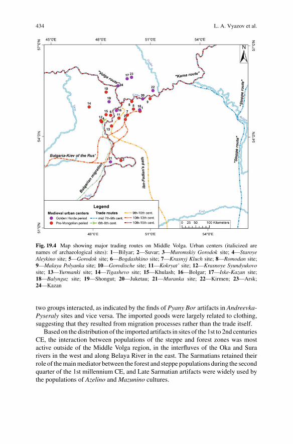
434 L. A. Vyazov et al.
Fig. 19.4 Map showing major trading routes on Middle Volga. Urban centers (italicized arenames of archaeological sites): 1—Bilyar; 2—Suvar; 3—Muromskiy Gorodok site; 4—StaroyeAleykino site; 5—Gorodok site; 6—Bogdashkino site; 7—Krasnyj Kluch site; 8—Romodan site;9—Malaya Polyanka site; 10—Gorodische site; 11—Kokryat’ site; 12—Krasnoye Syundyukovosite; 13—Yurmanki site; 14—Tigashevo site; 15—Khulash; 16—Bolgar; 17—Iske-Kazan site;18—Balynguz site; 19—Shongut; 20—Juketau; 21—Muranka site; 22—Kirmen; 23—Arsk;24—Kazan
two groups interacted, as indicated by the finds of Pyany Bor artifacts in Andreevka-Pyseraly sites and vice versa. The imported goods were largely related to clothing,suggesting that they resulted from migration processes rather than the trade itself.
Based on the distribution of the imported artifacts in sites of the 1st to 2nd centuriesCE, the interaction between populations of the steppe and forest zones was mostactive outside of the Middle Volga region, in the interfluves of the Oka and Surarivers in the west and along Belaya River in the east. The Sarmatians retained theirrole of themainmediator between the forest and steppe populations during the secondquarter of the 1st millennium CE, and Late Sarmatian artifacts were widely used bythe populations of Azelino and Mazunino cultures.
19 Demographic Changes, Trade Routes, and the Formation … 435
The appearance of peoples of the Kiev culture in the Middle Volga in the 3rdto 4th centuries CE marks the formation of a new intercultural communication thatconnected Middle Volga with the Don region, the left bank of Dnieper River, andpossibly evenwith regions furtherwest. This route approximately follows themodernsouthern boundary of the forest-steppe zone. Important agricultural innovations,coins from the Bosporus and Rome, andmetal ingots used by local people for jewelrymaking were transported to Middle Volga along this route.
The trade networks underwent major changes in Hunnic times, when the amountof imports greatly decreased. The decrease in southern imports was possibly causedby a decline in the steppe population of theVolga-Ural region due to their involvementin the Hunnic military efforts. At that time, the forest-steppe route that connectedMiddle Volga region with the Don and Dnieper basins disappeared.
In the 6th century CE, the population of Imen’kovo established some connectionswith the Cis-Caucasus and Northern Caucasus regions. Sassanid drachmas are foundin three sites, one in Samara Luka and two on the northern bank of Kama River. Thecontext indicates that they were used as raw material for metal working. It is unclearwhether the coins were transported along terrestrial or water routes, but the routeswere definitely tied to the Volga River, as indicated by other finds of Byzantine andSassanid coins of the 6th century CE. The erection of fortresses of Imen’kovo cultureoccurred within the narrow time period from the end of the 5th to the 6th centuryCE. Their location on high banks of large rivers and the form of their structuressuggest that their main function was protection from riverside. The finds of camelbones in several Imen’kovo fortresses are suggested to be consistent with terrestrialtrade routes.
In the middle of the 7th century CE, the Belaya River valley became the maintrade route connecting the steppes with the densely populated areas along the Kama.Sassanid andByzantine coins and toreutic objects accumulated inKhwarezm,CentralAsia, after Arabian conquests were distributed in large numbers along this route.Historical descriptions indicate another route along the western bank of the VolgaRiver that was used for movement by various groups of peoples.
Not later than by 9th century, a caravan trade route from Khwarezm to the MiddleVolga was established. This route connected the Ustyurt Plateau with the left bank ofthe Volga River near present-day Samara, and continued north along the left bank ofthe Volga and up its interfluves with the KamaRiver, forming a large loop to the west.The distribution of archaeological sites of this time is associated with this route, andmost places where the route crossed Volga tributaries contain Early Bulgarian burialgrounds. In the early 10th century, Samanid dirhams were brought from MiddleVolga to Northern Europe by this route. The establishment of the trade route thatconnected Middle Volga with Khwarezm, bypassing the Lower Volga region andthe Khazarian Khanate, provided the Bulgarian rulers with independence from theKhazarian Khanate. The formation of a new political union in Middle Volga shiftedVolga-Kaspian trade routes. Prior to the 10th century CE, most goods travelled fromthe Upper Volga to the Oka, then to the Don, and finally to the Lower Volga rivers. Inthe 10th century, the main trade route shifted to the Middle Volga region, as reflected

436 L. A. Vyazov et al.
in the finds of Scandinavian objects in archaeological sites of the end of 9th throughthe 10th centuries on the Middle Volga (Valeev 2010).
The development of towns and urban craftsmanship in the Middle Volga led tothe export of artisan objects from Volga Bulgaria to the Russian Principalities (Rus’)along the Volga waterway. The growing trade resulted in the establishment of anew terrestrial trade route that connected the towns of Volga Bulgaria with Rus’.The trade networks established in the 10th through 11th centuries continued untilthe Mongolian invasion of the 13th century, with the most extensive trade activityalong the Volga route between the 10th century and the first half of the 12th century(Motsya and Khalikov 1997). MostWestern and Northern European imports reachedthe territory of Volga Bulgaria during this period while considerable quantitates ofBulgarian goods were also transported north along Volga River (Valeev 2010).
Beginning in the second half of the 11th century, a series of military conflictsoccurred between Russian and Bulgarian dukes (in 1088, 1107 and 1120 CE), mark-ing the increasing Russian influence in the north-western periphery of Bulgarianlands. After 1160 CE, the growing power of the Vladimir-Suzdal’ principality ledto a new series of conflicts between 1164 and 1220 CE (Izmaylov 2006). The Rus’-Bulgarian confrontation coincided with the decline of the Volga trade transit asBulgarian imports could not pass the borders of the Vladimir-Suzdal’ principality(Poluboyarinova 2006).
These conflicts were probably one of the factors that led to the development of anew terrestrial trade route that connected Volga Bulgaria with the southern part ofRus’ in the 12th to the 13th centuries. The historical descriptions of thisMiddle Volgaroute are supported by archaeological finds of Old-Russian artifacts along the route(Motsya and Khalikov 1997), although the exact location of this route is disputed(Belorybkin 2003;Viskalin 1992;Gismatulin 2014). It is possible that several parallelroutes were in operation at the same time. A new group of archaeological sites witha material culture closely resembling that of Pre-Mongolian Volga-Bulgaria firstappeared in the upper reaches of the Sura River in the 10th century, and flourished inthe 12th to 13th century, probably in associationwith this new trade route (Belorybkin2003).
Despite the decreasing trade with Northern and Western Europe, the Volga routeretained its importance as themajor transit of furs to the Islamic countries. The sourceareas of fur were lands along mid- to upper reaches of the Kama River (Belavin200). The main trading partner of Volga Bulgaria on the Lower Volga was the city ofSuksin, which acted as mediator in the trade between the Middle Volga population,Iran and the Trans-Caucasus (Vasil’yev 2015). Trade activities along the Kama wereaccompanied by expansion of Volga Bulgaria (Belavin 2000).
The Mongolian conquest radically changed the system of East-European tradecommunications, due to the disappearance of major trade centers and the desolationof entire regions. However, during the reign of the Golden Horde the vast area ofthe empire was governed by strong leaders who maintained routes in strict order andconsidered trade as the basis of state wealth. Importantly, the Middle Volga regionwas chosen as the centre of the Ulus of Jochi, with the first capital of the GoldenHorde khans in Bolgar.
19 Demographic Changes, Trade Routes, and the Formation … 437
Golden Horde trade peaked in the second half of the 13th to the first half ofthe 14th centuries. The largest cities, craft centers and urban agglomerations werelocated along the Volga River, which was the main trade route, and by the 13thcentury, Bolgar had become the main transit city on the route (Yemanov 1995).Archaeological evidence of intensive trade includes numerous finds of importedgoods and coins. The beginning of 14th century is marked by the growth of citiesalong the lower reaches of Volga River, reflecting a shift of the trade centers to thisregion (Nedashkovsky 2009). Trade declined following the crises, pandemics, andcivil war that began in the 1360s. Numerous coin hoards were buried during thesetimes of change.
The attempts of the Tokhtamysh government to stabilize the situation in the 1380sCE were unsuccessful, and the invasion by Tamerlan in 1395–1396 CE further deep-ened the economic crisis. After a series of military conflicts with the dukes ofMuskovy in the second quarter of 15th century, the role of the regional trade centerwas relegated to Kazan. From this time on, the economy of the region was graduallyincorporated into the sphere of the strengthening Muscovy State that became themajor trade partner of Kazan.
In summary, the dynamics of trade networks on the Middle Volga depended onpolitical influences, the density of population, and degree of territorial developmentalong the trade routes.
19.3.3 Climate History of the Past Two Millennia
Over the past few thousand years, there has been a long-term cooling in north-ern hemisphere continental regions, later interrupted by the recent warming, whichgoes by the general term “neoglaciation”. This cooling is seen in the majority ofpaleoclimate records (PAGES2k Consortium 2013), although it tends to be underes-timated if only tree-ring records are included (Esper et al. 2012). Superimposed onthis neoglacial cooling are shorter-term variations in temperature that can last severalhundred years, with transitions of up to several hundred years between them. Becausethese periods are superimposed on the long-term cooling trend, the variability tendsto increase over time (Gajewski 1987; Viau et al. 2006).
Shorter-termvariations seem to be frequently forced by volcanic activity (Büntgenet al. 2016; Sigl et al. 2015; Stoffel et al. 2015) or solar variability, but overall,the causes are not entirely understood. Several studies note that intense volcaniceruptions can cause reduced temperatures globally that last for a few years (Büntgenet al. 2016; Sigl et al. 2015; Stoffel et al. 2015). Determining the impacts of these onhuman activities is dependent on a very precise chronology.
The climate of the past two millennia can be divided into five general periods ofalternating cool and warm climates (e.g., PAGES2k Consortium 2013; Büntgen et al.2016; Helama et al. 2017b). These were not uniformly cold or warm and furthermoretemperature is only one component of the climate. However, long-term changes intemperature are associated with changes in the atmospheric general circulation, so aprotracted period of warm or cool temperatures would be associated with changes in

438 L. A. Vyazov et al.
-500
-300
-100
100
300
500
700
900
1100
1300
1500
1700
1900
-2 0 2oC
Europe
-2 -1 0 1
Asia
-2 0 2
Scand
-2 0 2
Alps
-4 -2 0
Altai
-16 -8W/m2
NH volcano forcing
Year
CE
June-August Temperature Anomalies
Map 1
Map 2
Map 4
Map 3
Map 5
Map 6
ClimatePeriod
Depopulation
Depopulation
Depopulation
LandUse
Swidden
Pasture/Field
Permanent Fields
Permanent FieldsAgro
savann
Swidden
-a
CulturalPeriod
PostGolden Hord
Golden Hord
Pre-Mo golia
hazaria
Post Hun
Early Sarmatia
Scythian
old n Hor e
Golde Ho dr e
P er -Mongolian
H. B. S.
Khazarian
HunLate
Sarmatiane
SarmatianMiddl
m t an
Swidden
Relocation
LittleIceAge
MedievalWarmPeriod
RomanWarmPeriod
AgesCold
Period
Dark
Fig. 19.5 Several paleoclimate reconstructions relevant to the Middle Volga region. Sources forthe series are: (a) Europe and (b) Asia standardized June-July-August temperatures from PAGES2kConsortium (2013). Grey is annual values and black lines are 30-year means. (c) JJA temperaturesanomalies (with respect to AD 1951-1980) from tree ring densities from Scandinavia (Esper et al.2012). Grey line indicates annual values and black line is an 11-year running mean. JJA temperatureanomalies based on normalized tree-ring width series from (d) Alps and (e) Altai mountains (Bünt-gen et al. 2016); shown are the 40-year spline fits to the data. (f) Northern Hemisphere volcaniceruptions (Sigl et al. 2015); units are estimated forcing in Wm−2. Summary of the (g) climate, (h)land use and (i) cultural periods as discussed in the text. H.B.S is Heraldic Belt Set. The time of themaps in Fig. 19.3 is shown in (j)
pressure patterns, thereby affecting precipitation and other climate variables as well.The periods are not distinct and the transition between these periods can be of shortor long duration (Fig. 19.5).
1. Roman Warm Period (1–300 CE) (Ljungqvist 2010; Esper et al. 2012;McCormick et al. 2012). Esper et al. (2012) consider this period to be warmerthan present in Scandinavia, as it was superimposed on a long-term cooling. Theextent and intensity of this period are not as well-known as subsequent periods.
2. Dark Ages Cold Period (410–775 CE) (Helama et al. 2017b). The Dark AgesCold Period was associated with the migration period by Helama et al. (2017b).It was generally cool and frequently relatively wet. The typical span of thisperiod in various records is 370 years, with coldest temperatures around 625 CE.Büntgen et al. (2016) consider the period between 536–660 CE as an extensive,volcanically-caused cold period, although Helama et al. (2017a) question itsextent. Many studies have shown societal impacts of the climate at this time(Büntgen et al. 2016).

19 Demographic Changes, Trade Routes, and the Formation … 439
3. Medieval Warm Period (850–1200 CE) (PAGES2k Consortium 2013). Thisperiod is generally considered warm, although with considerable variability,especially between regions. As with the subsequent Little Ice Age, peak periodsof warm or cool temperatures tend to vary spatially.
4. Little Ice Age (1450–1850 CE) (PAGES2k Consortium 2013) This is probablythe best defined and consistently-seen climate episode. There are several times ofmore-or-less cool conditions, for example, the 1600s-1850 CE are general cold.
5. Modern Period (1850 CE -present). The modern period is characterized by thehuman-caused global warming.
19.3.4 Land Use and Vegetation History of the Region
19.3.4.1 Pollen Record
The vegetation dynamics in the region during the last 2500 years can be divided intotwomajor periods: a predominantly forested landscape prior to 12th centuryCE and amosaic of openhabitats andpatches of forests, composedmainly of early successionaland light-demanding taxa (pine and birch) from 12th century CE onwards (Fig. 19.5).The boundary between the two lies at the end of the Pre-Mongolian Period. Althoughthe proportion of taxa associated with open habitats increased during the MedievalWarm Period, the threshold change occurred ca 200 years later (Fig. 19.6). Majortransitions in the vegetation cover coincided with changes in both the populationdensity and settlements pattern, allowing for an assumption that these changes werecorrelated. Therefore, more subtle changes of the pollen spectra within each of thetwo time periods can be interpreted as result of changes in the land-use structure.
19.3.4.2 Principal Component Analysis
A principal components analysis of the pollen data summarizes the pollen assem-blages and permits the division of the data into zones (Fig. 19.7). The pollen taxaform four distinct groups of variables with highly correlated groups of taxa that canbe interpreted as associations caused by different land use types. Types 1 and 4 arewell-defined, while differences between the types 2 and 3 are less distinct, consistentwith the interconnectedness of these land-use types.
• Type 1 (swidden) includes tree pollen such as Betula, Tilia, and shrubs such asAlnus and Corylus. These taxa were more abundant in older sections. AlthoughPinus, a species commonly associated with fires is absent, the presence of shrubsand Onagraceae pollen (Chamerion, fireweed) indicates the presence of fires dur-ing this time, associated with swidden agriculture. This combination is consistentwith the managed burning of the forest in the form of slash-and-burn cultivation.
• Type 2 (pasture) includes non-arboreal pollen (NAP) of meadow taxa indicative ofpastures and abandoned farmlands, such as Poaceae,Brassicaceae, andAsteraceae.These spectra become more abundant in the recent past and indicate the presenceof pastures.

440 L. A. Vyazov et al.
Mi-1
Bi-1
Bo1
-1B
o1-2
Bi-2
Mo-
1M
i-2M
o-2
Bi-3
Bi-4
Mo-
4M
o-6
Bi-5
Bi-6
Bi-7
Bi-8
Sv-
1B
o2-1
Bu-
1B
u-2
Bu-
3
Bi-9
Bo1
-3B
o1-4
Bo1
-5B
o3-1
Bo3
-2B
o1-6
Bo1
-7B
i-10
Bi-1
1B
i-12
Bi-1
3B
o4-1
Bo4
-2Ta
-1B
o4-4
Bo4
-3B
o1-8
Bo1
-9M
I-1M
I-2
Mi-3
Sh-
1S
h-2
Sh-
3B
o3-3
Bo3
-4B
o3-5
Bo3
-6B
o4-7
Bo4
-8B
o4-1
0B
o4-1
1B
o4-1
2B
o4-1
3B
o4-1
4B
o4-1
5U
r-1
Ur-
2U
r-3
Bo3
-7B
o4-1
6B
o3-8
Bo3
-9B
o3-1
0B
o3-1
1B
o3-1
2M
aH-1
Mi-4
MI-3
Lb-1
Lb-2
Lb-3
Bo2
-3M
aH-2
MaH
-3K
a-1
Ka-
2
MI-4
Sh-
4
2040
6080
Pinus
20
Picea
2040
6080
100
Betula
2040
60
Tilia
20
Poaceae
2040
Cerealia
20
Fagopyrum
Centaurea
20
Asteraceae
2040
Onagraceae20
40
Artemisia
20
Chenopodiaceae
20
Polygonum aviculare
20
Fabaceae
Plantago
Rumex
Ambrosia
Cul
ture
s
Rus
sian
s
Gol
den
Hord
e cu
lture
Volg
a Bu
lgar
ia
Bron
ze a
ge
Ana
n'in
o ar
ea o
f cul
ture
s
Late
Sar
mat
ians
Bed
en'g
a-M
izino
vo ty
pe/K
iev
cultu
re
Hung
aria
ns
Imen
'kovo
cul
ture
1700
AD
1500
AD
1280
AD
900
AD
600
AD
400
AD
300
AD
20
Fig.19.6
Pollenassemblages
from
soilprofi
lesof
thestudyregion.S
amplecodeson
theleftreferto
sitelocatio
nsin
Fig.
19.1

19 Demographic Changes, Trade Routes, and the Formation … 441
-2.0 -1.0 0.0 1.0 2.0-2.0
-1.0
0.0
1.0
2.0
Component 1 (22.1%)
Com
pone
nt 2
(14.
5%)
PinusPicea
Betula Alnus
TiliaCorylus
Poaceae
Cerealia
Fagopyrum
Apiaceae
Asteraceae
Onagraceae
Asteraceae subfCichorioideae
Artemisia
Centaurea cyanus
Chenopodiaceae
Polygonum aviculare-type
Fabaceae
Brassicaceae
MS-1Bi-1 Bo1-1Bo1-2 Bi-2Mo-1 MS-2Mo-2 Bi-3Bi-4 Mo-4Mo-6 Bi-5Bi-6 Bi-7Bi-8 Sv-1Bo2-1 Bu-1Bu-2 Bu-3Bi-9 Bo1-3Bo1-4 Bo1-5Bo3-1 Bo3-2Bo1-6 Bo1-7Bi-10 Bi-11Bi-12 Bi-13Bo4-1 Bo4-2Ta-1 Bo4-4Bo4-3 Bo1-8Bo1-9 MI-1MI-2 MS-3Bo3-3 Bo3-4Bo3-5 Bo3-6Bo4-7 Bo4-8Bo4-10 Bo4-11Bo4-12 Bo4-13Bo4-14 Bo4-15Ur-1 Ur-2Ur-3 Bo3-7Bo4-16 Bo3-8Bo3-9 Bo3-10Bo3-11 Bo3-12MaH-1 MS-4MS-3 Lb-1Lb-2 Lb-3Bo2-3 MaH-2MaH-3 Ka-1Ka-2 MI-4
Sam
ple
Cod
e
IV
III
I
IIb
IIa
0 1 2
Comp 1
0 1 2
Comp 2
0 1 2
Comp 3
0 1 2
Comp 4
160-300
Zone cal yr BP
330-480
580-670
520-540330-530
1300-1330
980-1150960-1050
1420-15401420-1530
1420-15201360-1530
1530-1560
1500-1520
1940-19901620-1700
1620-1700
2490-27002520-27202340-2350
1580-1690 1570-1620
Agro-savannah
Permanent Fields
Pastures
Swiddens
Fig. 19.7 Principal components analysis of the pollen data in Fig. 19.6. Zones are based on majortransitions in the component scores. The first component explains 22.1% of the variance, the second14.5%, the third 10.2% and the fourth 7.9%. Correlated groups of taxa and their interpretation (seetext) are indicated by dotted rectangles
• Type 3 (permanent fields) includes cultivars and their weeds, some of which cangrow in both functioning and abandoned farmlands. Pollen includes Cerealia andFagopyrum (taxa characteristic of permanent fields), andChenopodiaceae (weeds).

442 L. A. Vyazov et al.
These were important in the recent past and also during the time of zone IIb(Fig. 19.7).
• Type 4 (agro-savannah) includes taxa associated with soil compaction and roads(Polygonum aviuculare) as well as coniferous trees (Picea and Pinus) along withFabaceae. This group is highly loaded on the second component, and is mostabundant in the more recent assemblages. The dominance of coniferous taxa istypical of landscapes with extensive herbivory, such as the long-term utilizationof forest pastures and selective extraction of deciduous trees for firewood. Arbo-real pollen (AP) was dominated by the pollen of pine that could, however, betransported from hundreds of kilometers away. The open landscape with patchesof grazed/selectively logged forest was similar to type 3, but presumably had agreater proportion of forested patches.
Apparently, the combination of taxa does not mean that these plants grew in thesame habitats, it reflects their co-existence in the landscape. For example, road net-works (Polygonum aviculare), pastures/meadows (Fabaceae), and secondary conif-erous forests (Pinus, Picea) appear simultaneously and their appearance is not inde-pendent (they are correlated).
19.4 Discussion
The development of the landscapes of the central part of the Middle Volga region inthe last 2500 years was a discontinuous process of the explosive growth of populationand land utilization alternating with stages of depopulation and desolation. Periodsof depopulation or major changes in settlement locations seem to occur at similartimes as climate changes (Fig. 19.5). Some cultures were associated with distinctclimatic episodes, such as association of the Dark Ages Cold Period with the Hun,Post Hun, Heraldic, and Khazarian times, and the Medieval Warm Period with thetime of Volga Bulgaria.
Depopulations of the area were associated with the transitions between culturesand alsowith transitions between the climate regimes. However, this does not explainthe complexity of interactions between the peoples and the environment. The sub-sistence and land use strategies changed through time, and the landscape changedaccordingly. The settlements and land use were concentrated along rivers until 10thcentury and from this time onward, watersheds were included in the pattern of agri-cultural utilization.
The land use signatures are reflected in palynological spectra as specific combi-nations of plant taxa associated with the times of occupation by the population ofcertain archaeological cultures (Fig. 19.7). The boundaries between palynologicalzones generally coincide with the chronological boundaries between archaeologicalcultures (Fig. 19.5). The major archaeological time periods have distinct palynologi-cal signatures, suggesting that changes in land use can be associated with the variouscultures.Moreover, major changes in vegetation occurred rapidly, within one to three

19 Demographic Changes, Trade Routes, and the Formation … 443
centuries, so it may be possible to use the forest cover composition as a chronologicaltool in archaeological studies. Furthermore, not only combinations of taxa, but alsosome indicator taxa have a clear chronological affiliation. For example, Onagraceaepollen are prominent only between 1700 and 1300 cal year BP (Beden’ga-Mizinovotype and Imen’kovo culture) and Picea pollen appeared in the pollen spectra at lev-els exceeding 1% only towards the end of the Pre-Mongolian time, in the 1200s.Fagopyrum is predominantly associated with the most recent 500-year period.
Swidden pollen spectra are associatedwith the occupation of the area by the peopleof the Beden’ga–Mizinovo type, the Imen’kovo culture and by the early Bulgarians.Episodes of land clearance using swidden techniques apparently also occurred in thebeginning of the Russian colonization. A combination of taxa similar to the swiddengroup was recorded for the Ananyino occupations, but Onagraceae and Cerealia(marker components of slash-and-burn cultivation) were absent; more sites need tobe analyzed for definitive conclusions.
During the Pre-Mongolian Period, the combinations of pollen taxa/land use typeschanged from swidden to pasture and further to agro-savannah in less than 300 years.Swidden techniques were applied to clear the forested landscape in the beginning ofcolonization and, shortly thereafter, permanent fields and pastures were establishedon the cleared lands.
Pasture land use was prominent during the Golden Horde time,~580–670 cal yearBP, alternating with fields and farmlands. During the pasture phase, the diversityof the local vegetation cover was maximal, with the percentage of arboreal pollenfluctuating from near-zero to almost 100% at various times and locations.
Agro-savannah is associatedwith the period of theRussian colonization.However,fields, pastures, farmland and agro-savannah pollen spectra alternated during thelast 500 years, reflecting changes in the intensity of the anthropogenic impact. Thepercentage of arboreal pollen indicating forest cover was higher in the beginningof the Russian colonization, in the 1500s to the 1700s, and in the recent decadesfollowing the collapse of the Soviet Union and communal farming. Several peaksof birch pollen within the last 500 years marked the short-term abandonment ofagricultural lands during times of social instabilities.
The formation of the anthropogenic landscape occurred in the Pre-MongolianVolga Bulgaria time, during the 11th through the mid-13th centuries. The beginningof this period coincided with the Medieval Warm Period that perhaps facilitated theprocess of deforestation in the region. At this time, an agricultural landscape of anearly modern appearance was shaped, with stable/well-defined boundaries betweenfields and forests, permanent fields, and road networks.
Acknowledgements Ayrat Sitdikov is supported by a grant of the Russian Foundation for BasicResearch, project 17-46-160812 “Natural and anthropogenic landscapes of Trans-Kama region inMiddle Ages”. K. Gajewski is supported by a Discovery Grant from the Natural Sciences andEngineering Research Council of Canada.

444 L. A. Vyazov et al.
References
In English/French
Büntgen, U., Myglan, V., Ljungqvist, F., et al. (2016). Cooling and societal change during the lateantique little ice age from 536 to around 660 AD. Nature Geoscience, 9, 231–236. https://doi.org/10.1038/ngeo2652.
Chizhevsky, A. A. (2017). Monuments of the late Ananyino cultural and historical region (Pamyat-niki pozdnego perioda Ananinskoy kulturno-istoricheskoy oblasti // Arkheologiya Evraziyskikhstepey. N 4). Archaeology of the Eurasian Steppes, 4, 196–256.
De Vernal, A., Henry, M., & Bilodeau, G. (2010). Micropaleontological preparation techniquesand analyses. Les Cahiers du GEOTOP 3. http://www.geotop.ca/.
Esper, J., Frank, D., Timonen, M., et al. (2012). Orbital forcing of tree-ring data. Nature ClimateChange, 2, 862–866. https://doi.org/10.1038/nclimate1589.
Gajewski, K. (1987). Climatic impacts on the vegetation of eastern North America for the past 2000years. Vegetatio, 68, 179–190.
Helama, S., Jones, P., & Briffa, K. (2017a). Limited late antique cooling. Nature Geoscience, 10,242–243. https://doi.org/10.1038/ngeo2926.
Helama, S., Jones, P., &Briffa, K. (2017b). Dark ages cold period: A literature review and directionsfor future research. Holocene, 27, 1600–1606.
Juggins, S. (2007). C2. Software for ecological and palaeoecological data analysis and visualiza-tion. Version 1.5. http://www.staff.ncl.ac.uk/stephen.juggins. Last accessed 13 Feb 2018.
Khalikova, E. A., & Kazakov, E. P. (1977). Le cimetiere de Tankeevka. Les anciens Hongrois et lesethnies voisines a l’Est. Studia Archaeologica, 6, 7–221.
Kochkina, A. F. (2012). Malaya Ryazan’ 2 settlement is a Russian village on the Samara Luka. In:Middle Volga region in the context of the Russian medieval history. Conference proceedings onthe crossroads of cultures (from the end of the 13th cent to the 16th cent). (Maloryazanskoye II sel-ishche—russkiy poselok zolotoordynskogo vremeni na Samarskoy Luke // Sredneye Povolzh’yev kontekste srednevekovoy rossiyskoy istorii: na perekrestke kul’tur (konets XIII–XVI v.): mate-rialy nauchno-prakticheskoy konferentsii). Samara: Ofort.
Ljungqvist, F. C. (2010). A new reconstruction of temperature variability in the extra-tropicalnorthern hemisphere during the last two millennia. Geografiska Annaler A, 92, 339–351. https://doi.org/10.1111/j.1468-0459.2010.00399.x.
Matveeva, G. I. (1998). The sites of the Lbische type are the early stage of Imenkov culture. In:Cultures of the Eurasian steppes of the second half of the 1st millennium AD: chronological issues(Pamyatniki lbishchenskogo tipa–ranniy etap imen’kovskoy kul’tury // Kul’tury yevraziyskikhstepey vtoroy poloviny 1 tysyacheletiya n. e.: voprosy khronologii) (pp. 87–97). Samara.
McCormick, M., Büntgen, U., Cane, M., et al. (2012). Climate change during and after the RomanEmpire: Reconstructing the past from scientific and historical evidence. Journal of Interdisci-plinary History, 43, 169–220.
Novenko, E., Tsyganov, A., Rudenko, O., et al. (2016). Mid- and late-Holocene vegetation history,climate and human impact in thewesternMid-RussianUpland: Newdata and a regional synthesis.Biodiversity and Conservation, 25, 2453–2472.
Novenko, E., &Volkova, E.M. (2015). Themiddle and late Holocene vegetation and climate historyof the forest-steppe ecotone area in the central part of European Russia. Geographical Review ofJapan Series B, 87, 1–8.
Novenko, E., & Olchev, A. (2015). Early Holocene vegetation and climate dynamics in the centralpart of the East European Plain (Russia). Quaternary International, 388, 12–22.
Novenko, E., Tsyganov, A., Volkova, E., et al. (2015). TheHolocene palaeoenvironmental history ofcentral EuropeanRussia reconstructed frompollen, plantmacrofossil and testate amoeba analysesof the Klukva peatland, Tula region. Quaternary Research, 83, 459–468.

19 Demographic Changes, Trade Routes, and the Formation … 445
Novenko, E., Volkova, E. M., Glasko, M. P., et al. (2011). Palaeoecological evidence for the mid-dle and late Holocene vegetation, climate and land use in the upper Don River basin (Russia).Vegetation History and Archaeobotany, 21, 337–352.
Novenko, E., Glasko, M., & Burova, O. (2009). Landscape-and-climate dynamics and land use inLate Holocene forest-steppe ecotone of East European Plain (upper Don River Basin case study).Quaternary International, 203, 113–119.
PAGES2k Consortium. (2013). Continental-scale temperature variability during the past two mil-lennia. Nature Geoscience, 6, 339–346. https://doi.org/10.1038/ngeo1797.
Sigl,M.,Winstrup,M.,McConnell, J., et al. (2015). Timing and climate forcing of volcanic eruptionsfor the past 2500 years. Nature, 523, 543–549.
Stoffel, M., Khodri, M., Corona, C., et al. (2015). Estimates of volcanic-induced cooling in theNorthern Hemisphere over the past 1500 years. Nature Geoscience, 8, 784–788.
Viau, A., Gajewski, K., Sawada, M., et al. (2006). Millennial-scale temperature variations in NorthAmerica during the Holocene. Journal of Geophysical Research—Atmospheres, 111, D09102.https://doi.org/10.1029/2005jd006031.
In Russian
Ageev, B. B. (1992). Pyany Bor culture (P’yanoborskaya kul’tura). Ufa: Bashkirskiy nauchnyytsentr Ural’skogo otdeleniya Rossiyskoy akademii nauk.
Alisov, B. P. (1956). Climate of USSR (Klimat SSSR). Moscow: Moscow University.Archaeological map of Tatarstan. (1981–1990). (ed. by A.Kh. Khalikov and P.N. Starostin) (Vol.1–6) (Arkheologicheskaya karta Tatarstana. Toma 1-6). AcademiyaNauk SSSR, Kazanskiy filial,Kazan, Moscow.
Archaeological map of the Chuvash Republic. (2013–2015). (E. P. Mikhailov & N. S. Berezina(Eds.)) (Vol. 1–3) (E. P. Mikhailov & N. S. Berezina, etc (Eds.)) (Arkheologicheskaya karta Chu-vashskoy Respubliki. Avtory-sostaviteli: Ye.P. Mikhaylov, N. S. Berezina i dr.). Chuvashskoyeknizhnoe izdatelstvo, Cheboksary.
Bagautdinov, R. S., Bogachev, A. V., & Zubov, S. E. (1998). Pre-Bulgarians in the Mid-Volga (atthe beginnings of the history of the Volga-Kama Tatars (Prabolgary na Srednej Volge: u istokovistorii tatar Volgo-Kam’ya). Samara.
Belavin, A. M. (2000). Kama trade route (Kamskiy torgovyy put’) Izdatel’stvo Permskogo peduni-versiteta. Perm.
Belorybkin, G. N. (2003). Western part of the Volga region during the Middle Ages (ZapadnoyePovolzh’ye v sredniye veka) Izdatel’stvo PGPU. Penza.
Blagoveshenskaya, N. V. (2009). Dynamics of the vegetation cover of central part of theVolga Upland in the Holocene (Dinamika rastitel’nogo pokrova tsentral’noi chasti Privolzhskoivozvyshennosti v golotsene). Ul’yanovsk.
Bogachev, A. V. (2000). Antiquities of the nomads of the Hunnic and post-Hunnic time peri-ods (5th–6th centuries CE). In History of the Samara Volga region from the prehistory tothe recent time (Vol. 3, pp. 135–154). The Early Iron Age and the Middle Ages (Drevnostikochevnikov gunnskogo i postgunnskogo vremeni (V-VI veka n.e.) // Istoriya SamarskogoPovolzh’ya s drevneyshikh vremen do nashikh dney. Ranniy zheleznyy vek i srednevekov’ye.).Nauka, Moscow.
Bugrov, D. G. (1998). Sites of the Azelino Culture in the Trans-Kama region. In: Bolgar and theproblems of the historical development of the Western part of the Trans-Kama region. 60 yearsof the archaeological study: the results and the prospects. Abstracts (Pamyatniki azelinskoykul’tury v Zakam’ye // Bolgar i problemy istoricheskogo razvitiya Zapadnogo Zakam’ya. 60let arkheologicheskogo izucheniya: itogi i perspektivy. Tezisy nauch. konferentsii) (pp. 18–19).Bolgar.
Bugrov, D. G., Linkina, L. I., Melnikov, L. V., & Nikolaeva, K. V. (2011). On the issue of landuse of the Pyany Bor Culture population (based on the comprehensive study of the Toiguzino2 hillfort) (K voprosu o zemlepol’zovaniya naseleniya p’yanoborskoj kul’tury (po materialam
446 L. A. Vyazov et al.
kompleksnogo issledovaniya Tojguzinskogo II gorodishcha // Arkheologiya i estestvennye naukiTatarstana. Kniga 4). In Archeology and sciences of Tatarstan (Vol. 4, pp. 225–244). Kazan.
Burov, G. M. (1977). Archaeological map of the Ulyanovsk region (Arheologicheskaya kartaUl’yanovskoj oblasti). Simferopol.
Dubman, E. L. (2012). South-West of the European Russia. Part 1. Volga frontier in the mid of16th–17th cent (Yugo-Vostok Yevropeyskoy Rossii. Chast’ I. Povolzhskiy frontir v seredineXVI-XVII vv. Ocherki istorii). Samara, Samarskiy universitet.
Fakhrutdinov, R. G. (1975). Archaeological sites of the Volga-Kama Bulgaria and its terri-tory (Arkheologicheskiye pamyatniki Volzhsko-Kamskoy Bolgarii i yeye territoriya). Kazan:Tatarskoye knizhnoye izdatel’stvo.
Gening, V. F. (1963). Azelino Culture of the 3rd–5th cc. Essays on the History of the Vyatka Kraiduring the Migration period. Issues of the archeology of the Urals (Vol. 5) (Azelinskaya kul’turaIII-V vv. Ocherki istorii Vyatskogo kraya v epokhu pereseleniya narodov // Voprosy arkheologiiUrala. Vyp.5). Izhevsk, Sverdlovsk.
Gening, V. F. (1976). The Turaevo necropolis of the 5th century CE (burials of warlords). In Fromthe history in the Volga and Kama regions (Turayevskiy mogil’nik V v. n.e. (zakhoroneniyevoyenachal’nikov) // Iz istorii Volgo-Kam’ya). Kazan.
Gening, V. F. (1977). The sites near Kushnarenkovo village on the Belaya River (6th–7th centuriesCE) // Studies on the archeology of the Southern Urals (Pamyatniki u s. Kushnarenkovo na r.Beloy (VI–VII vv. n. e.) // Issledovaniya po arkheologii Yuzhnogo Urala) (pp. 90–136). Ufa.
Gismatulin, M. R. (2006). A find of the early medieval belt tip in Ulyanovsk. In: Proceedings of theThird Scientific Conference, Dedicated to the Scientist and Local Historian S.L. Sytin (Nakhodkav Ul’yanovske rannesrednevekovogo nakonechnika poyasa // Materialy tret’yey nauchnoy kon-ferentsii, posvyashchonnoy uchonomu i krayevedu S.L. Sytinu) Izdatel’stvo “Korporatsiyatekhnologiy prodvizheniya” (pp. 202–206). Ulyanovsk.
Gismatulin, M. R. (2014). Setttlement of Sengiley in the Volga trade route system (Sengileevskoyeposeleniye v sisteme Volzhskogo torgovogo puti // Vestnik SamGU. 2014. 9 (120)). SamaraState University herald, 9(120), 73–77.
Goldina, R. D., & Chernykh, E. M. (2011). Archaeological map of the Karakulinskiy district ofthe Udmurtian Republic. Contributions and investigations of the Kama-Vyatka archaeologicalexpedition (Vol. 18) (Arkheologicheskaya karta Karakulinskogo rayona Udmurtskoy Respubliki.Materialy i issledovaniya Kamsko-Vyatskoy arkheologicheskoy ekspeditsii. T.18). Izhevsk.
Grishakov, V. V. (2000). On the early stage of the Penza burial grounds. In The Volga Finns and theirneighbors during the Middle Ages (Problems of chronology and ethnic history) (O ranney stadiipenzenskikh mogil’nikov // Povolzhskiye finny i ikh sosedi v epokhu srednevekov’ya (problemykhronologii i etnicheskoy istorii)) (pp. 8–15). Saransk.
Grishakov, V. V. (2017). Themain trends of the genesis of the archaeological cultures in the territoryof the Mordovia in the Early Iron Age and during the initial stage of the Migration period(Osnovnyye tendentsii genezisa arkheologicheskikh kul’tur na territorii Mordovskogo kraya vrannem zheleznom veke i na nachal’nom etape velikogo pereseleniya narodov // Istoricheskiye,filosofskiye, politicheskiye i yuridicheskiye nauki, kul’turologiya i iskusstvovedeniye. Voprosyteorii i praktiki.—2017— 2 (76)). History, philosophy, politics and law, culturology and arthistory. Theoretical and Practical Issues, 2(76), 68–74 (Saransk).
History of the Samara Volga region from the prehistory to the recent time. (2000). Vol. 3: The earlyiron age and the middle ages. Nauka, Moscow.
Ivanov, A. G. (1997).Ethnic and cultural relations of the Cheptsa River valley population during theMiddle Ages: From the end of the 5th cent to the first half of the 13th cent (Etnokul’turnyye i eko-nomicheskiye svyazi naseleniya basseyna r.Cheptsy v epokhu srednevekov’ya: konets V—per-vaya polovina XIII v.). Udmurtskiy institut istorii, yazyka b literatury UrO RAN, Izhevsk.
Izmaylov, I. L. (2006). The establishment of the Bulgarian State. In History of the Tatars from theancient times. 7 volumes. Volume 2. The Volga Bulgaria and the Great Steppe (Obrazovaniye Bul-garskogo gosudarstva // Istoriya tatar s drevneyshikh vremen. V 7-i tomakh. Tom 2. VolzhskayaBulgariya i Velikaya Step’) (pp. 124–131). RukhIL, Kazan.
Izmaylov, I. L. (2009a). Ulus of Bolgar: Bulgar and other emirates. In History of the Tatars from theancient times. 7 volumes. Volume 3. Ulus of Jochi (Golden Horde). 13th-mid-15th cc. (Bulgarskiy
19 Demographic Changes, Trade Routes, and the Formation … 447
ulus: Bulgar i drugiye emiraty// Istoriya tatar s drevneyshikh vremen. V 7-i tomakh. Tom 3. Tom3. Ulus Juchi (Zolotaya Orda). XIII-seredina XV vv.) (pp. 448–469). RukhIL, Kazan.
Izmaylov, I. L. (2009b). Ecological disasters. In History of the Tatars from the ancient times. 7 vol-umes. Volume 3. Ulus of Jochi (Golden Horde). 13th-mid-15th cc. (Ekologicheskiye kataklizmy// Istoriya tatar s drevneyshikh vremen. V 7-i tomakh. Tom 3. Tom 3. Ulus Juchi (Zolotaya Orda).XIII-seredina XV vv.) (pp. 682–686). RukhIL, Kazan.
Journey of Ibn-Fadlan. (2016). Volga Route from Baghdad to Bolgar. Exhibition catalogue (Putesh-estvie Ibn Fadlana: Volzhskij put’ ot Bagdada do Bolgara. Katalog vystavki). Moscow.
Kazakov, Y. P. (1981). Sites of the Kushnarenkovo culture in the lower Kama region. In On thehistorical sites in the valleys of the Kama and Belaya rivers (Kushnarenkovskiye pamyatnikiNizhnegoPrikam’ya //Ob istoricheskikh pamyatnikakhpodolinamKamy iBeloy) (pp. 115–135).Kazan.
Kazakov, Y. P. (1992). The culture of the early Volga Bulgaria (Kul’tura ranneyVolzhskoyBolgarii).Nauka, Moscow.
Khalikov, N. A. (2006). Rural economy. Agriculture. In History of Tatars from the ancient times. 7volumes. Volume 2. The Volga Bulgaria and the Great Steppe (Selskoye khozyaystvo i promysly.Zemledeliye // Istoriya tatar s drevneyshikh vremen. V 7-i tomakh. Tom 2. Volzhskaya Bulgariyai Velikaya Step’) (pp. 236–240). RukhIL, Kazan.
Khuzin, F. S. (2006). Bulgarian cities and the issues of their origin. In History of Tatars from theancient times. 7 volumes. Volume 2. Volga Bulgaria and the Great Steppe (Bulgarskiye gorodai problemy ikh proiskhozhdeniya // Istoriya tatar s drevneyshikh vremen. V 7-i tomakh. Tom 2.Volzhskaya Bulgariya i Velikaya Step’) (pp. 152–163). RukhIL, Kazan.
Khuzin, F. S. (2011). On the time of the sedentarisation of the Volga Bulgarians. In Studies on theBulgaian and Tatarian archeology (O vremeni vozniknoveniya osedlosti u volzhskikh bulgar //Issledovaniya po Bulgaro-Tatarskoy arkheologii) (pp. 29–42). OOO Foliant, Kazan.
Klimanov,V.A.,&Serebraynnaya, T.A. (1986).Changes in the vegetation and climate in theCentralUpland during theHolocene (Izmeneniya rastitel’nosti i klimata na Srednerusskoi vozvyshennostiv golotsene). Izvestiya AN SSSR. Seriya Geograficheskaya, 1, 26–37.
Kochkina, A. F. (2016). On the spatial system in the right bank of the Volga in the Samara regionduring the Golden Horde period. In Dialogue between the urban and the steppe cultures in theEurasian area. Historical geography of the Golden Horde. Proceedings of the Seventh Interna-tional Conference in Memory of G.A. Fedorov-Davydov (Kkharakteristike prostranstvennoy orga-nizatsii sistemy rasseleniya v pravoberezh’ye Samarskogo Povolzh’ya v zolotoordynskiy period// Dialog gorodskoy i stepnoy kul’tur na Yevraziyskom prostranstve. Istoricheskaya geografiyaZolotoy Ordy»Materialy Sed’moy Mezhdunarodnoy konferentsii, posvyashchonnoy pamyati G.A. Fodorova-Davydova) (166–170). Kazan, Yalta, Chisinau.
Kuz’minykh, S. V., & Chizhevsky, A. A. (2009). Foreword. At the beginning of the archeologyof the Volga and Kama regions (To the 150th anniversary of the discovery of the Ananyinoburial ground). Series “Archeology of the Eurasian steppes.” (Predisloviye // U istokov arkhe-ologii Volgo-Kam’ya (K 150-letiyu otkrytiya Anan’inskogo mogil’nika). Seriya«Arkheologiyayevraziyskikh stepey» . Vyp. 8) (Vol. 8, pp. 4–5). Almedia, Yelabuga.
Leschinskaya, N. A. (2014). Vyatka Krai during the Pyany Bor period (based on the funerarysites of the 1st-5th centuries AD). Contributions and studies of the Kama-Vyatka archaeologicalexpedition (Vyatskiy kray v p’yanoborskuyu epokhu (pomaterialam pogrebal’nykh pamyatnikovI–V vv. n.e.). Materialy i issledovaniya Kamsko-Vyatskoy arkheologicheskoy ekspeditsii. T.27.)(Vol. 27). Izhevsk.
Mardanshina, E. M. (2008). Tillage implements of Volga Bulgarians in 10th-13th cent AD. On theissue of the agricultural techniques. Ph.D. thesis (Zemledel’cheskiye orudiya volzhskikh bulgar10–13 vv. (k probleme svoyeobraziya zemledeliya). Kazan.
Matveeva, G. I. (1997). Burial mounds of the Early Bulgarians on Samara Luka (Mogil’niki rannihbolgar na Samarskoj Luke). Samara: Samarskiy Universitet.
Matveeva, G. I. (2000a). The sites of the sedentary tribes of the forest zone of the Samara Volgaregion (Belaya Gora and Gorodets Cultures). In History of the Samara Volga region from the
448 L. A. Vyazov et al.
prehistory to the recent time. Vol. 3: The Early Iron Age and the Middle Ages (Pamyatnikiosedlykh plemen lesnoy zony Samarskogo Povolzh’ya (belogorskaya i gorodetskaya kul’tury) //Istoriya Samarskogo Povolzh’ya s drevneyshikh vremen do nashikh dney. Ranniy zheleznyy veki srednevekov’ye) (pp. 82–93). Nauka, Moscow.
Matveeva, G. I. (2000b). The sites of the initial stage of the Migration period (the 2nd—the 4th centCE). In History of the Samara Volga region from the prehistory to the recent time. Vol. 3: TheEarly Iron Age and the Middle Ages (Pamyatniki nachala epokhi velikogo pereseleniya narodov(II-IV vv. n.e.) // Istoriya Samarskogo Povolzh’ya s drevnejshih vremen do nashih dnej. Rannijzheleznyj vek i srednevekov’e) (pp. 94–105). Nauka, Moscow.
Matveeva, G. I. (2003). On the question of the Lbische hillfort chronology. In The contact areas ofEurasia on the turn of the epochs (K voprosu o khronologii gorodishcha Lbishche // Kontaktnyezony Evrazii na rubezhe ehpoh) (pp. 90–93). Samara.
Matveeva, G. I. (2004). The Middle Volga region in the 4th–7th centuries: the Imen’kovo culture.Textbook (Srednee Povolzh’e v IV-VII vv.: imen’kov-skaya kul’tura. Uchebnoe posobie). Samara.
Motsya, A. P., Khalikov, A. K. (1997). Bulgar—Kiev. Ways, connections, destinies (Bulgar—Kiyev.Puti, svyazi, sud’by). Institut arkheologii Akademii nauk Ukrainy, Kiev; Akademiya naukRespubliki Tatarstan, Kazan.
Mukhametshina, A. S. (1999). Kominternovskiy Kurgan. Issues of the interpretation. In Bolgarand studies of the antiquities of the Urals and the Volga regions. To the 100th anniversaryof A.P. Smirnov. Abstracts (Kominternovskiy kurgan. Problemy atributsii // Bolgar i problemyizucheniya drevnostey Uralo- Povolzh’ya. 100-letiye A.P. Smirnova. Tezisy nauchnoy konfer-entsii). BGIAMZ, Bolgar.
Myasnikov, N. S. (2013). Ethno-cultural processes in the Chuvashia part of the Volga regionin the 1st–8th centuries AD according the archaeological records. Scientific reports. Issue 13(Etnokul’turnyye protsessy v Chuvashskom Povolzh’ye v 1- 8 vv n.e v svete arkheologicheskikhdannykh. Nauchnyye doklady CHGIGN. Vyp. 13). ChGIIGN, Cheboksary.
Myshkin, V. N., Skarbovenko, V. A. (2000). Nomads of the Samara Volga region in the earlyIron Age. In History of the Samara Volga region from ancient times to the present. Early IronAge and the Middle Ages (Kochevniki Samarskogo Povolzh’ya v rannem zheleznom veke. //Istoriya Samarskogo Povolzh’ya s drevneyshikh vremen do nashikh dney. Ranniy zheleznyy veki srednevekov’ye) (pp. 9–82). Moscow.
Nedashkovsky, L. F. (2009). International and internal trade. InHistory of the Tatars from the ancienttimes. 7 volumes. Volume 3.Ulus of Jochi (GoldenHorde). 13th-mid-15th cc. (Mezhdunarodnayai vnutrennyaya torgovlya // Istoriya tatar s drevneyshikh vremen. V 7-i tomakh. Tom 3. Tom 3.Ulus Juchi (Zolotaya Orda). XIII-seredina XV vv.) (pp. 277–287). RukhIL, Kazan.
Orudzhov, E. I. (2017). Spatial systemof the population of theAnanyino area of cultures in the basinsof the rivers Vyatka and Vetluga Rivers (Sistema rasseleniya nositelej anan’inskoj kul’turno-istoricheskoj oblasti v bassejne rek Vyatka i Vetluga // Povolzhskaya arkheologiya. 2017. N 3).Volga River Region Archaeology, 3(21), 117–140.
Ostanina, T. I. (1997). The population of the Middle Kama region in the 3rd–5th centuries (Nase-lenie Srednego Prikam’ya v III-V vv). Udmurtskiy institut istorii, yazyka i literatury UrO RAN,Izhevsk.
Ostanina, T. I. (2002). Kuziebaevo hillfort of the 4th, 5th and 7th centuries. Catalogue of thearchaeological collection (Kuzebaevskoe gorodishche IV-V, VII vv. Katalog arheologicheskojkollekcii). Izhevsk.
Petrenko, A. G. (2011). Human-nature interactions in the Middle Volga and Cis-Urals in the earlyMiddle Ages. In Archeology and sciences of Tatarstan. Vol. 4. Commemoration of Aida Grig-orievna Petrenko, Ph.D. (Vzaimodeystviye cheloveka i prirody na territorii Srednego Povolzh’ya iPredural’ya v epokhu rannego srednevekov’ya // Arkheologiya i yestestvennyye nauki Tatarstana.Kniga 4. Posvyashchayetsya pamyati doktora biologicheskikh naukAidyGrigor’yevny Petrenko)(pp. 17–43). Sh. Marjani Institute of History of the Academy of Sciences of the Republic ofTatarstan, Kazan.

19 Demographic Changes, Trade Routes, and the Formation … 449
Petrenko, A. G. (2009). Co-influence of climatic and anthropogenic factors on the economy ofthe population of the Middle Volga and Cis-Urals in the Late Bronze Age—Early Iron Age. InAt the beginning of the archeology of the Volga and Kama regions (To the 150th anniversaryof the discovery of the Ananyino burial ground). Series “Archeology of the Eurasian steppes.”(Vol. 8) (Vzaimovliyaniye prirodno-klimaticheskikh i antropogennykh faktorov na izmeneniyetipov vedeniya khozyaystva v epokhu pozdney bronzy—rannego zheleza u naseleniya Sred-nego Povolzh’ya i Predural’ya // U istokov arkheologii Volgo-Kam’ya (k 150-letiyu otkrytiyaAnan’inskogo mogil’nika)) (pp. 160–169). Almedia, Elabuga.
Petrenko, A. G. (2006). Rural economy. Animal breeding. In History of Tatars from the ancienttimes. 7 volumes. Volume 2. The Volga Bulgaria and the Great Steppe (Selskoye khozyaystvoi promysly. Zhivotnovodstvo // Istoriya tatar s drevneyshikh vremen. V 7-i tomakh. Tom 2.Volzhskaya Bulgariya i Velikaya Step’) (pp. 240–246). RukhIL, Kazan.
Polivanov, V. N. (1890). A note on the origin of a copper vessel from the Sengileevsky Uyezdof the Simbirsk province. In Proceedings of the Seventh Archaeological Congress in Yaroslavl,1887 (Vol. 1, p. 39) (Zametka o proiskhozhdenii mednogo sosuda iz Sengileyevskogo uyezdaSimbirskoy gubernii // Trudy sed’mogo arkheologicheskogo s”yezda v Yaroslavle, 1887. Tom1). Moscow.
Poluboyarinova, M. D. (2006). The road from Bulgar to Kiev. Trade relations with Kievan Rus’ andthe Old-Russian principalities. In History of the Tatars from ancient times. 7 volumes. Volume 2.Volga Bulgaria and the Great Steppe (Put’ iz Bulgara v Kiyev. Torgovyye svyazi s KiyevskoyRus’yu i drevnerusskimi knyazhestvami // Istoriya tatar s drevneyshikh vremen. V 7-i tomakh.Tom 2. Volzhskaya Bulgariya i Velikaya Step’) (pp. 316–326). RukhIL, Kazan.
Ponomarenko, E. V., Ponomarenko, D. S., Stashenkov, D. A., &Kochkina, A. F. (2015). Approachesto reconstructing patterns of human occupation from soil features and charcoal (Podkhody krekonstruktsii dinamiki zaseleniya territorii po pochvennym priznakam // Povolzhskaya arkhe-ologiya. 1. 2015.) Volga River Regional Archaeology, 1(11), 126–160.
Rudenko, K. A. (2016). Bulgarian Ulus of the Golden Horde: Historical geography. In Dialoguebetween the urban and the steppe cultures in the Eurasian area. Historical geography of theGolden Horde. Proceedings of the Seventh International Conference in Memory of G.A. Fedorov-Davydov (Bulgarskiy ulus Zolotoy Ordy: istoricheskaya geografiya // Dialog gorodskoy i step-noy kul’tur na Yevraziyskom prostranstve. Istoricheskaya geografiya Zolotoy Ordy»MaterialySed’moy Mezhdunarodnoy konferentsii, posvyashchonnoy pamyati G. A. Fodorova-Davydova)(pp. 131–134). Kazan, Yalta, Chisinau.
Rudenko, K. A. (2013). Nomads in the Ulus of Bulgar of the Golden Horde (according to archeol-ogy) (Kochevniki v Bulgarskom Uluse Zolotoy Ordy (po dannym arkheologii) // Povolzhskayaarkheologiya 2 (4)). Volga River Region Archaeology, 2(4), 189–211.
Semykin, Y. A. (1996). On the issue of the early Bulgarian settlements in the Middle Volga region.In Cultures of the Eurasian steppes of the second half of the 1st millennium CE. Proceedingsof the International Archaeological Conference. November 14–17, 1995 (K voprosu o pose-leniyakh rannikh bolgar v SrednemPovolzh’ye // Kul’tury yevraziyskikh stepey vtoroy poloviny Itysyacheletiya n.e. Materialy Mezhdunarodnoy arkheologicheskoy konferentsii. 14–17 noyabrya1995 g. Samara. Samarskiy oblastnoy istoriko-krayevedcheskiy muzey im. P.V.Alabina, Samara)(pp. 66–83). Samara: Alabin Samara Regional Museum of Local Lore.
Semykin, Y. A., & Matveeva, G. I. (2010). Land use and economy of the early medieval populationof the Novaya Sloboda archaeological ensamble in the Sengileevsky district of the UlyanovskRegion. In Notes on the local studies of the Alabin Samara Regional Local Lore Museum. Vol.15. 40 years of the Middle Volga archaeological expedition (Osvoyeniye prirodnykh resursov,stanovleniye i razvitiye khozyaystva u rannesrednevekovogo naseleniya Novoslobodskoy gruppypamyatnikov v Sengileyevskom rayone Ul’yanovskoy oblasti // Kraevedcheskie zapiski SOIKMimeni P.V. Alabina. Vol. 15. 40 let Srednevolzhskoj arheologicheskoj ehkspedicii) (pp. 243–255).Samara.
Serebryannaya, T. A. (1976). Forest-steppe interactions in the Central Russian Upland in theHolocene (according paleobotanical and radiocarbon data) (Vzaimootnosheniya lesa i stepi naSrednerusskoy vozvyshennosti v golocene (po paleobotanicheskim i radiouglerodnym dannym).Istoriya biogeozenosov SSSR v golotsene) (pp. 159–166). Nauka, Moscow.

450 L. A. Vyazov et al.
Shamiloglu, U. (2009). The Black Death and its consequences. In History of the Tatars from ancientTimes. 7 volumes. Volume 3. Ulus of Jochi (The Golden Horde). 8th–15th centuries (Chernayasmert’ i yeyo posledstviya // Istoriya tatar s drevneyshikh vremen. V 7-i tomakh. Tom 3. Tom 3.Ulus Juchi (Zolotaya Orda). XIII-seredina XV vv.) (pp. 686–691). RukhIL, Kazan.
Sitdikov, A. G. (2016). Historical geography of the Middle Volga region: The second half of the14th—First half of the 15th century. In Dialogue between the urban and the steppe culturesin the Eurasian area. Historical geography of the Golden Horde. Proceedings of the SeventhInternational Conference in Memory of G.A. Fedorov-Davydov (Istoricheskaya geografiya Sred-nego Povolzh’ya: vtoraya polovina XIV—pervaya polovina XV v. // Dialog gorodskoy i step-noy kul’tur na Yevraziyskom prostranstve. Istoricheskaya geografiya Zolotoy Ordy»MaterialySed’moyMezhdunarodnoy konferentsii, posvyashchonnoy pamyati G. A. Fyodorova-Davydova)(pp. 135–141). Kazan; Yalta; Chisinau.
Spiridonova, E. A. (1991). The evolution of the vegetation cover of Don basin in the Upper Pleis-tocene and Holocene (Evolyutsiya rastitel’nogo pokrova basseina Dona v verkhnem pleistot-sene—golotsene). Moscow.
Stashenkov, D. A. (2003). Tsaryov Kurgan. Catalogue of the archaeological collection (Tsarevkurgan. Katalog arkheologicheskoy kollektsii). Samara.
Stashenkov, D. A. (2016). Kuz’kinsky burial ground of the Mordovian people of the end of the13th–14th century: New data on the population of the Samara Volga region in the Golden Hordeperiod. In Dialogue between urban and steppe cultures in the Eurasian space. Historical geog-raphy of the Golden Horde. Materials of the Seventh International Conference dedicated tothe memory of GA Fedorov-Davydov (Kuz’kinskiy mordovskiy mogil’nik kontsa XIII–XIV v.:novyye materialy o naselenii Samarskogo Povolzh’ya v epokhu Zolotoy Ordy // Dialog gorod-skoy i stepnoy kul’tur na Yevraziyskom prostranstve. Istoricheskaya geografiya Zolotoy Ordy.Materialy Sed’moy Mezhdunarodnoy konferentsii, posvyashchonnoy pamyati G. A. Fodorova-Davydova) (pp. 201–204). Kazan, Yalta, Chisinau.
Stashenkov, D. A. (2010a). On the chronological correlation between the Lbische type and the earlysites of the Imen’kovo Culture (O hronologicheskom sootnoshenii pamyatnikov lbishchenskogotipa i rannih pamyatnikov imen’kovskoj kul’tury. Izvestiya Samarskogo nauchnogo centra Rossi-jskoj akademii nauk. Vol. 12. 6–1). Announcements of the Samara Scientific Center of theRussian Academy of Sciences, 12(6–1), 272–275.
Stashenkov, D. A. (2010b). On the early date of the Imen’kovo Culture. InNotes on the local studiesof the Alabin Samara Regional Local Lore Museum. Vol. 15. 40 years of the Middle Volga archae-ological expedition (O rannej date imen’kovskoj kul’tury // Kraevedcheskie zapiski SOIKMimeni P.V. Alabina. Vol. 15. 40 let Srednevolzhskoj arheologicheskoj ehkspedicii) (pp. 118–120).Samara.
Stashenkov, D. A. (2010c). On the groups of settlements of the Khazar period in the Samara andSimbirsk part of the Volga region. In Cultures of the Eurasian steppes of the second half ofthe 1st millennium AD (issues of interethnic contacts and intercultural interaction) (O gruppakhposeleniy khazarskoy epokhi v Samaro-Simbirskom Povolzh’ye // Kul’tury yevraziyskikh stepeyvtoroy poloviny I tysyacheletiya n.e. (voprosy mezhetnicheskikh kontaktov i mezhkul’turnogovzaimodeystviya)) (pp. 118–127). Ofort, Samara.
Stashenkov, D. A. (2007). Ethno-cultural landscape of the Samara Volga region at the beginning ofthe Migration period. In Medieval archeology of the Eurasian steppes. Proceedings of the Con-stituent Meeting of the International Congress. Vol. I (Etnokul’turnaya situatsiya v SamarskomPovolzh’ye v nachale epokhi Velikogo Pereseleniya narodov // Srednevekovaya arkheologiyayevraziyskikh stepey. Materialy Uchreditel’nogo s”yezda Mezhdunarodnogo kongressa. T. I)(pp. 75–81). Institute of History of the Academy of Sciences of the Republic of Tatarstan. Kazan.
Stashenkov, D. A. (2005). The sedentary population of the Samara Volga region forest-steppe in the1st–5th centuries AD. Series “The Early Slavic world”. Issue 7 (Osedloe naselenie Samarskogolesostepnogo Povolzh’ya v I-V vekah n.eh. Seriya “Ranneslavyanskiy mir”. Vypusk 7). Nauka,Moscow.

19 Demographic Changes, Trade Routes, and the Formation … 451
Valeev, R. M. (2010). Trade between Volga Bulgaria and northern and western Europe in the pre-Mongolian period (9th-early 13th century) (Torgovlya Volzhskoy Bulgarii i severnoy i zapad-noy Yevropoy v domongol’skiy period (9-nachalo 13 veka) // Vestnik Novosibirskogo gosu-darstvennogo universiteta. Seriya: Istoriya. Filologiya. T. 10.—Vyp. 3). Bulletin of NovosibirskState University. Series: History. Philology, 10(3), 175–182.
Vasil’yev, D. V. (2015). The city and the region of Saksin according to the new archaeological data(Gorod i oblast’ Saksin v svete novykh dannykh arkheologii // Povolzhskaya arkheologiya. 2(12)). Volga River Region Archaeology, 2(12), 189–267.
Viskalin, A. V. (1992). Samara version of the Volga river crossing on the Bolgar-Kiev route. In Theroad from Bolgar to Kiev (Samarskiy variant perepravy cherez Volgu na puti iz Kiyeva v Bulgar// Put’ iz Bulgara v Kiyev) (pp. 40–46). Institut yazyka, literatury i istorii im. G. Ibragimova,Kazan.
Volkova, E. V. (2017). Manchikha hillfort—The Early Iron Age site on Samara Luka. In TheBronze Age and the early Iron Age. Proceedings of the 3rd International Conference “TheAnanyino World: The Cultural Space, Networks, Traditions, and Innovations’. Cultures of theEurasian Steppes. Issue 4 (Gorodishche manchikha—pamyatnik zheleznogo veka na SamarskoyLuke epokha bronzy i ranniy zheleznyy vek. Materialy III mezhdunarodnoy nauchnoy kon-ferentsii «Anan’inskiy mir: kul’turnoye prostranstvo, svyazi, traditsii i novatsii»Arkheologiyayevraziyskikh stepey. 4) (pp. 7–16). Kazan.
Vyazov, L. A. (2007). Spatial system of the Imen’kovo Culture tribes in the underhill part of SamaraLuka // Samara region in the history of Russia. Vol. 3. Materials of the interregional scientificconference dedicated to the 120th anniversary of the foundation of the Samara Regional Museumof Local History. P.V. Alabina Samara, December 15–16, 2006 (Sistema rasseleniya plemenimen’kovskoy kul’tury v podgornoy chasti Samarskoy Luki // Samarskiy kray v istorii Rossii.Vyp. 3.Materialymezhregional’noy nauchnoy konferentsii, posvyashchennoy 120-letiyu so dnyaosnovaniya Samarskogo oblastnogo istoriko-krayevedcheskogomuzeya im. P.V.Alabina Samara,15-16 dekabrya 2006 g.) (pp. 55–69) Samara.
Vyazov, L. A. (2008). On the origins of the Imen’kovo Culture tillage tools. In: Actual issues of theVolga and Urals regions ( Proishozhdenie pahotnyh orudiy imen’kovskoy kultury // Aktualnyievoprosyi arheologii Urala i Povolzhya) (pp. 320–342). Samara.
Vyazov, L. A. (2012). On the origins of the Imen’kovo Culture axes. In Actual issuess of the Volgaregion archeology (O proiskhozhdenii toporov imen’kovskoy kul’tury // Aktual’nyye voprosyarkheologii Povolzh’ya) (pp. 43–53). Kazan.
Vyazov, L. A., Grishakov, V. V., & Myasnikov, N. S. (2016). The features of the ceramic com-plexes from the sites of the Migration period in the Middle Sura region (Osobennosti keramich-eskikh kompleksov pamyatnikov Srednego Posur’ya epokhi Velikogo pereseleniya narodov //Voyadzher: mir i chelovek: teoreticheskiy i nauchno-metodicheskiy zhurnal. 6) (pp. 66–111).Voyager: the World and Man: A Theoretical and Scientific Methodological Journal, 6, SamaraState Technical University.
Vyazov, L. A., & Semykin, Y. A. (2016). Hillfort and settlement Novaya Beden’ga: The Migra-tion period in Ulyanovsk Cis-Volga region. Series “Archaeology of Simbirsk-Ulyanovsk region”(Vol. 1) (Gorodishche i selishche Novaya Beden’ga: epokha Velikogo pereseleniya narodov vUl’yanovskom Predvolzh’ye. Seriya«Arkheologiya Simbirskogo-Ul’yanovskogo Povolzh’ya» .Vypusk 1). Ulyanovsk: Karamzin Research Institute of History and Culture.
Yavorskaya, L. V., & Antipina, E. E. (2016). The geography and subsistence of Golden Horde citiesas reconstructed from the archaeo-osteological data. InThe dialogue between the urban and steppecultures in the Eurasian space (Geografiya i osobennosti zhizneobespecheniya gorodov ZolotoyOrdy po arkheozoologicheskim dannym // Dialog gorodskoy i stepnoy kul’tur na Yevraziyskomprostranstve. Istoricheskaya geografiya ZolotoyOrdy.Materialy Sed’moyMezhdunarodnoy kon-ferentsii, posvyashchonnoy pamyati G. A. Fodorova-Davydova) (pp. 204–207). Kazan, Yalta,Chisinau.
452 L. A. Vyazov et al.
Yemanov, A. G. (1995). North and south in the history of commerce: On the data from Kafa of the13th—15th centuries (Sever i yug v istorii kommertsii: na materialakh Kafy XIII-XV vv). Tyumen:Rutra.
Zasetskaya, I. P. (1994). The culture of the Southern Russian steppes in the Hun time period (theend of the 4th–the 5th cent) [Kul’tura kochevnikov yuzhnorusskikh stepey v gunnskuyu epokhu(konets IV—V vv.)]. Ellips, Saint-Petersburg.
Zasetskaya, I. P., Kazanskiy, M. M., Ahmedov, I. R., & Minasyan, R. S. (2007). Morskoj Chulek.The elite burials in the Azov lowlands and the significance in the history of North Black Sea tribesduring the post-Huns epoch (Morskoj Chulek. Pogrebeniya znati iz Priazov’ya i ih mesto v istoriiplemyon Severnogo Prichernomor’ya v postgunnskuyu ehpohu. Izdatel’stvo Gos. Ehrmitazha,Saint-Petersburg.
Open Access This chapter is licensed under the terms of the Creative Commons Attribution 4.0International License (http://creativecommons.org/licenses/by/4.0/), which permits use, sharing,adaptation, distribution and reproduction in any medium or format, as long as you give appropriatecredit to the original author(s) and the source, provide a link to the Creative Commons license andindicate if changes were made.
The images or other third party material in this chapter are included in the chapter’s CreativeCommons license, unless indicated otherwise in a credit line to the material. If material is notincluded in the chapter’s Creative Commons license and your intended use is not permitted bystatutory regulation or exceeds the permitted use, you will need to obtain permission directly fromthe copyright holder.

Part VISocial-Culture in Connection
with the Environment
Chapter 20Routes Beyond Gandhara: BuddhistRock Carvings in the Contextof the Early Silk Roads
Marike van Aerde
Abstract This chapter presents the first results and interpretations of a selecteddataset of rock carvings from the Karakorum mountains. The research is focusedon early Buddhist carvings and their spread and role within networks of the earlySilk Roads in Central Asia from the 2nd–1st century BCE. The rock carvings andtheir archaeological context are studied to gain insight into routes from Gandharathrough the Karakorum range. The first part presents the general aims and relevance.The second and third parts describe the analysis and interpretation of the Karakorumdataset, followed by the main points of discussion and conclusions to incite futureinvestigations.
Keywords Silk Roads · Buddhism · Rock carvings · Karakorum · GandharaDynamic networks
20.1 Introduction
Concepts that have proven useful in ordering things easily achieve such
authority over us that we forget their origins and accept them as unalterable
givens. The path of scientific progress is often made impassable by such errors.
—Albert Einstein1
As early as 1916, Albert Einstein remarked on a pressing epistemological issuestill faced by scholars and scientists today: the methodological necessity to createcategorised concepts in order to study reality, paired with our subsequent tendency
1A. Einstein (1916), Physikalische Zeitschrift 17, 101: ‘Begriffe, welche sich bei der Ordnung derDinge als nützlich erwiesen haben, erlangen über uns leicht eine solche Autorität, dass wir ihresirdischen Ursprungs vergessen und sie als unabänderliche Gegebenheiten hinnehmen. Der Weg deswissenschaftlichen Fortschritts wird durch solche Irrtümer oft für längere Zeit ungangbar gemacht’.
M. van Aerde (B)Faculty of Archaeology, Leiden University, Einsteinweg 2, 2333 CC Leiden, The Netherlandse-mail: [email protected]
© The Author(s) 2019L. E. Yang et al. (eds.), Socio-Environmental Dynamics along the Historical Silk Road,https://doi.org/10.1007/978-3-030-00728-7_20
455

456 M. V. Aerde
to come to regard those predetermined categories as truths. The initial 19th/20th-century campaigns of Gandharan archaeology (modern-day Afghanistan to northernIndia and Pakistan, cf. Foucher 1905; Cunningham 1871; Marshall 1975) were oftenmarked by this tendency, as evident from John Marshall’s own words upon startinghis campaign at the site of Taxila: ‘At that time I was a youngman, fresh from archae-ological excavations in Greece and filled with enthusiasm for anything Greek, and inthat far-off corner of the Punjab it seemed as if I had lighted of a sudden on a bit ofGreece itself’ (Marshall 1975, xv). In particular, connections were sought betweenBuddhist material culture and the Hellenistic presence. The earliest-known anthro-pomorphic depictions of the Buddha originate from the Gandhara region, and thesestatues were particularly noted for their ‘Greek’ or ‘Hellenistic’ style. These initialcampaigns focused on the ‘Greek’ style of Buddhist sculptures and reliefs, generallywith the intent to demonstrate that the arrival of Hellenistic settlers in Gandhara,especially in the form of the Indo-Greek kingdoms (one of the first founders wasMenander I in 130–131 BCE), became a ‘superior filter’ for the local Buddhist cul-ture (Bussagli 1984, 161–165). This approach resulted in the stylistic category andethic-cultural container of ‘Greco-Buddhist art’, which was usually subdivided bymeans of multiple sub-categories, e.g., ‘proto-Hellenic Buddhist art’ or ‘barbaricAfghan style’, in order to keep fitting the diversity of finds fromGandharan sites intothis preconceived Greco-Buddhist container (Marshall 1975 II, 520–521).
Since themid-20th century, new archaeological, historical and epigraphical inves-tigation have added important new insights into the complexity of both Gandharanand early Buddhist archaeology, especially pertaining specific sites and contextswithin the Gandhara region and the remarkable diversity of intercultural materialculture encountered there (Faccenna 1980; Bussagli 1996; Behrendt 2007; Board-man 2015; Facenna and Taddei 1993; Verardi and Filigenzi 2003; Mairs 2014). Inorder to continue this trend, it is imperative to keep challenging the more traditionalculture-container categorisations that once marked this field. The present chapterendeavours to do this by focusing on the relatively neglected dataset of early Bud-dhist rock carvings from the Karakorum mountain range between Gandhara and theTarim Basin (Xinjiang, China). These carvings appear to (literally) take early Bud-dhist iconography and architectural styles, many of which specifically known fromGandhara, beyond that region. In doing so, the analysis works towards new archaeo-logical evidence for specific mountain routes as part of the Silk Roads networks fromthe 2nd–1st century BCE onwards. By focusing on Buddhist carvings specifically,the role of Buddhism within this dynamic network is put central.
This contribution presents the first results of the investigation, and as such aims tofunction as a basis for the continuation and expansion of research into the Karakorumrock carvings datasets. The methodology uses a bottom-up approach to the dataand bases subsequent findings and discussion on the results of the data analysis.In doing so, this study also addresses the issue of compartmentalisation that hasremained long rooted in the methodological division between cultural studies andarchaeological contexts that also include environmental factors. These are crucialespecially for the dynamic archaeological record of the early Silk Roads networks.Frequently, interpretations of these early routes have followed narratives of a linear
20 Routes Beyond Gandhara: Buddhist Rock Carvings in the Context … 457
trade networks (referring to an ancient ‘Silk Road’, indicating a singular route) thatstretched between two main dominant powers, the Roman Empire in the West andthe Imperial Chinese Dynasties in the East, even though these two powers neveractually, physically connected.2 The only way to go beyond such dualist approachesto ancient Silk Roads archaeology, is to study the archaeological evidence of theseearly networks by focusing on the places in between—of which the Karakorummountain routes may be a prime example and valuable source of information.
In order to achieve this, this study adopts a change of perspective for Gandharanarchaeology in specific. Traditionally, studies predetermined or newly devised certain(cultural and/or ethnic) ‘containers’ to organise the data and thus enable interpre-tations from a top-down approach. In contrast, this research approaches the diversedata as variables of the dynamic networks of the ancient Silk Roads and hence basesany hypotheses and interpretations on the patterns and/or insights that these variablesmay reveal when studied empirically and within the scope of both their archaeolog-ical and environmental contexts. The analysis pertains to the iconography as wellas carving methods of the relevant rock carvings, their archaeological contexts, andtheir distribution as part of the physical environment of the Karakorum mountainswhere they were encountered. For the latter, analysis of recent satellite footage hasbeen used.
The second section provides a literature review of the Karakorum rock carvings,concerning their documentation and preliminary interpretations up until now. Thethird section presents the analysis results and discusses them, interpreting the carv-ings in terms of (1) their Buddhist iconography in comparison to early GandharanBuddhist material culture, and (2) the significance of these carvings for reconstruct-ing routes through the Karakorum mountains based on empirical evidence. The finalsection pertains the conclusion and explores next steps for continuing the research.
20.2 Early Buddhist Archaeology and the KarakorumRock Carvings
The Karakorum mountain range borders modern-day India, Pakistan and China(Fig. 20.1). It includes the Gilgit-Baltistan region in Pakistan, the Ladakh regionin India, and the south-western Xinjiang region of China, and is part of the western
2Despite the fact that no direct contact was ever made between Han China and Rome, the Hanelite in particular was very interested in luxury products from the West and in particular from theRoman Empire (the discovery of an apparently Roman tapestry at Loulan in the Taklamakan desertexcavated among Han silks suggests such a trade in Roman goods; Liu 2010, 18–19; Yu 1967), anda similar interest in Rome is recorded in several sections of the Hou Hanshu, the Book of the LaterHan (for a recent translation and study of its implications for Silk Road studies, see Hill 2009). TheHan even sent an envoy, Gan Ying, to learn more about the Romans, but he never arrived due tointerceptions (most likely by Parthians) at the Red Sea (See: Beckwith 2009, 78–92; Liu 2010, 19;and most recently Poo et al. 2017). See also Miller (2014, 1–43) and Miller and Brosseder (2017,470–487) for arguments against a dualist East–West approach in Silk Roads archaeology.

458 M. V. Aerde
Fig. 20.1 Area of the Karakorum Mountains investigated as indicated in the square. Satellitefootage NASA 2014
edge of the Himalayas along with the Hindu Kush range bordering Pakistan andAfghanistan in the West. From 1979 onwards, the Karakorum Highway (also knownas the China–Pakistan Friendship Highway) has increased mobility between Pak-istan and western China, and this likewise enabled accessibility to remoter mountainregions for archaeological campaigns. The presence of ancient rock carvings andepigraphy in the Karakorummountains (then also known as the eastern Hindu Kush)was first noted by Hungarian adventurer Karl Eugen in 1884, who remarked on Bud-dhist carvings in the Baltistan area, and by Pakistani explorer GhulamMuhammed in1907, who visited the lower region of Diamer (Jettmar 1989; Fussman and Jettmar1994; Hauptmann 2009). But no systematic or scholarly documentation occurreduntil the early twentieth century; between 1900 and 1944 Aurel Stein studied a con-cise but at that time unique sample of carvings (Stein 1944, 5–24). But only from1979 onwards larger-scale explorations and documentations were possible becauseof the Karakorum Highway, and these campaigns have yielded a substantial data setof carvings.3
3As documented in the Materien zur Archaologie der Nordgebiete Pakistanscatalogues (MANP)catalogues, Band 1–11, edited by Gérard Fussman, Karl Jettmar, Ditte König et al. between 1989and 1994, and more recently re-edited and published by Harald Hauptmann from 2003 to 2011,as part of the Heidelberg Academy. For the research described in this paper, I was able to accessMANP Band 1, 2, 6–11.

20 Routes Beyond Gandhara: Buddhist Rock Carvings in the Context … 459
Initiated byKarl Jettmar, these campaigns were overseen by the GermanResearchCouncil and subsequently by the Heidelberg Academy. The long-running projectentitled ‘Rock Carvings and inscriptions along the Karakorum Highway’ was initi-ated in 1983 as collaboration between the Department of Archaeology of Gilgit andthe Heidelberg Academy.4 From 1989 until 2013, Harald Hauptmann has overseenthe continuing documentation of rocks carvings as well as the excavation of archae-ological sites in these mountain range, especially in the Gilgit-Baltistan region.5
Hauptmann confirms that the connections between Gandhara and the Silk Roadsbeyond the Hindu Kush and Karakorum mountain ranges, such as indicated by theKarakorum data since 1979, have been often neglected by more interpretative schol-arship so far and represent ‘ein ebenso altes wie dringendes Forschungsdesiderat’.6
Unfortunately, recent plans for rescue excavations before the planned constructionof the Diamer-Basha dam, not far west of the Chilas area along the Indus River,have been restricted: as confirmed by Hauptmann, the construction of this dam willinundate an estimate of at least 37,051 carvings on 5928 boulders or rock faces.7
In addition, the region including the field stations at Chilas, Thalpan and Oshibathas become less accessible since 2013 due to increasing political unrest (which hasalready led to ancient carvings being vandalised, partially removed or destroyed inthe region) and the likewise increased planning of corporate building projects follow-ing the Diamer-Basha dam; moreover, a lack of centrally organised research fundingin Pakistan has made large-scale projects difficult at present, despite the presence ofavailable expertise and many sites and data left to explore and document.8
However, the documented Karakorum rock carving data so far is substantial andgive us a significant amount of material to work with at present. Hauptmann is cur-rently preparing a synthesis of the archaeology and early history of the Upper IndusRegion in overview, which will help future studies to connect sites as well as applywider frameworks for interpretation. The available documentation from the Karako-rum field stations so far has been thoroughly collected, yet due to the general lack ofattention paid to these data by studies that consider wider historical contexts of theregion, especially those concerning Silk Roads contexts and connections with Gand-hara, there remains a lack of in-depth interpretative studies that incorporate these datasets. This paper looks at a selection of these data as primary sources (Sects. 3.2–4) toarrive at new insights not only into the mountain passes themselves and the diversity
4As documented and discussed in: Jettmar (1985, 1989, 1993), Fussman (1994), Bennmann andKönig (1994), Fussman and Bandini-König (1997), Bandini-König (2003, 2005, 2007, 2009, 2011,2013), Hauptmann (2009).5This included the re-editing of MANP vol. 1–11, as well as additional (incl. forthcoming) publica-tions (Hauptmann 2009). Informationwas shared in personal communicationwith Prof. Hauptmannin Heidelberg, 2017.6Cited from personal communication with Prof. Hauptmann.7Cited in Pakistani newspaper Dawn (article by S. Yusuf, May 18, 2011) and from personal com-munication with Prof. Hauptmann.8The above-cited InternationalConference on theArchaeologicalHeritage of Pakistan:Challenges,Potential and the Way Forward (20–22 October 2017, Lahore), is one initiative of the Pakistan’sHigher Education Commission to tackle inherent issues.
460 M. V. Aerde
of people that travelled through them, but also into these Karakorum routes as part ofwider ancient Silk Road trade patterns. A selection of the data is necessary becauseof the great number as well as the remarkable diversity encountered in these rockcarvings: apart from the many textual inscriptions (in languages varying from earlyKharosthi to Chinese and with topics, when discernible, ranging from early Buddhistepigraphy to caravan travel notes),9 there are carvings depicting wild animals andnatural environments recognisable from the surrounding mountains (generally iden-tified as prehistorical carvings),10 decorativemotifs that have generally been groupedtogether as belonging to ‘Eurasian nomadic cultures’,11 decorative/symbolic Persianmotifs,12 and scenes of human life in the mountains (especially depicting travel-ling caravans and hunters with dogs, generally included in either the prehistoric ornomadic groupings).13 But perhaps the most visually striking type of carvings in thedata set and containing the largest-sized imagery discovered in these mountains sofar, is Buddhist imagery.
The two prominent themes encountered in these Buddhist carvings are (1) archi-tecture of traditional early Buddhist stupa monuments, and (2) anthropomorphicdepictures of the Buddha with scenes from his life and followers. Despite the thor-ough documentation of these carvings in the Heidelberg Academy publications,contextual interpretations beyond the mountain sites have been limited beyond thestudies of scholars directly involved with the project. Between 1989 and 1994, threevolumes of Antiquities of Northern Pakistan (ANP) were published as part of the‘Rock Carvings and Inscriptions along the Karakorum Highway’ project, edited byKarl Jettmar andGérard Fussman,which contain in-depth analysis of the documenteddata,mainly concerning textual interpretations and determination of different carvingtypes and chronologies as based on the available sources and the scholars’ hypothe-ses (ANPVol. 1–3: Jettmar 1989, 1993; Fussmann and Jettmar 1994). In their studiesof the Karakorum carvings, Fussman as well as Oskar von Hinüber focused on theearly Buddhist period, but predominantly concerning documentation of Kharosthiand Brahmi inscriptions that accompanied a variety of carvings (not necessarily Bud-dhist imagery, in fact) in order to reconstruct the often only partially preserved textsin terms of their content and translation to determine names and historical contextsas mentioned in these inscriptions, with some additional suggestions concerning the
9Relevant catalogue descriptions in: Bennmann and König (1994, 19–34), Fussman and Bandini-König (1997, 58–72), Bandini-König (2003, 91–103; 2005, 95–104; 2011, 102–103; 2013,269–301).10Relevant catalogue descriptions in: Bennmann and Konig (1994, 35–142), Fussman and Bandini-König (1997, 20–29); Bandini-König (2003, 103–172; 2005, 17–214; 2007, 19–251; 2009, 15–242;2011, 21–257; 2013, 21–236).11Relevant catalogue descriptions same as above: different genres are identified in the cataloguedescriptions, but not ordered accordingly, except in: Fussman and Bandini-König (1997, 7–20,30–57).12Relevant catalogue descriptions same as above, except in: Fussman and bandini-König (1997,36–53).13Relevant catalogue descriptions same as above, except in: Fussman and Bandini-König 1997,7–20, 29–30.
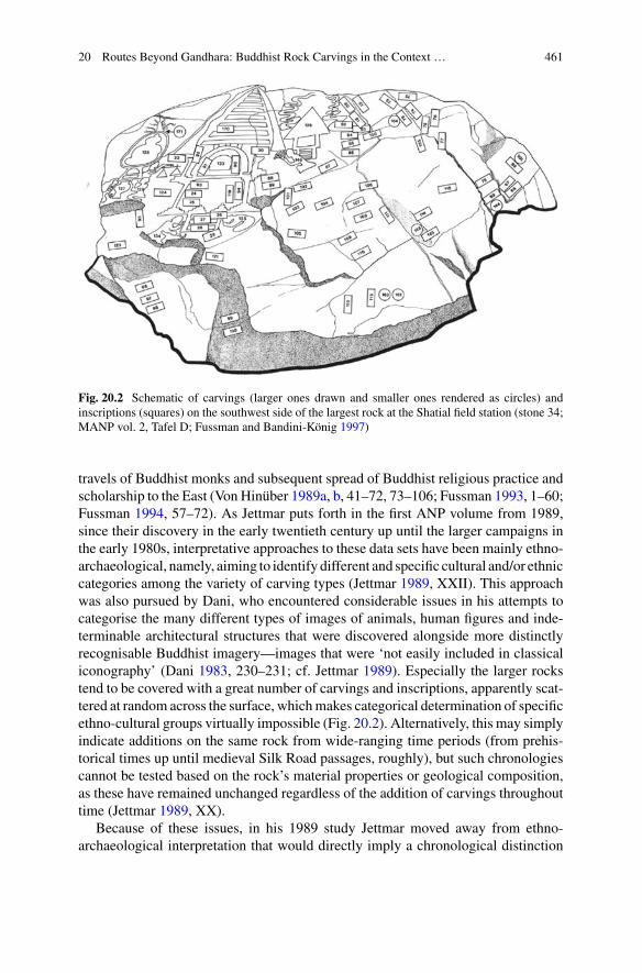
20 Routes Beyond Gandhara: Buddhist Rock Carvings in the Context … 461
Fig. 20.2 Schematic of carvings (larger ones drawn and smaller ones rendered as circles) andinscriptions (squares) on the southwest side of the largest rock at the Shatial field station (stone 34;MANP vol. 2, Tafel D; Fussman and Bandini-König 1997)
travels of Buddhist monks and subsequent spread of Buddhist religious practice andscholarship to the East (Von Hinüber 1989a, b, 41–72, 73–106; Fussman 1993, 1–60;Fussman 1994, 57–72). As Jettmar puts forth in the first ANP volume from 1989,since their discovery in the early twentieth century up until the larger campaigns inthe early 1980s, interpretative approaches to these data sets have been mainly ethno-archaeological, namely, aiming to identify different and specific cultural and/or ethniccategories among the variety of carving types (Jettmar 1989, XXII). This approachwas also pursued by Dani, who encountered considerable issues in his attempts tocategorise the many different types of images of animals, human figures and inde-terminable architectural structures that were discovered alongside more distinctlyrecognisable Buddhist imagery—images that were ‘not easily included in classicaliconography’ (Dani 1983, 230–231; cf. Jettmar 1989). Especially the larger rockstend to be covered with a great number of carvings and inscriptions, apparently scat-tered at random across the surface, whichmakes categorical determination of specificethno-cultural groups virtually impossible (Fig. 20.2). Alternatively, this may simplyindicate additions on the same rock from wide-ranging time periods (from prehis-torical times up until medieval Silk Road passages, roughly), but such chronologiescannot be tested based on the rock’s material properties or geological composition,as these have remained unchanged regardless of the addition of carvings throughouttime (Jettmar 1989, XX).
Because of these issues, in his 1989 study Jettmar moved away from ethno-archaeological interpretation that would directly imply a chronological distinction

462 M. V. Aerde
between Buddhist and non-Buddhist carvings; instead, his spatial-oriented approachconsiders the carvings as grouped together within bigger but still specific, containedmountain sites—for example, he suggests that there may have been a holy Buddhistsite and festival tradition near the Thalpan field station to account for the many stupacarvings discovered there, but he also notes that this interpretation is speculativeand not supported by textual sources or additional data (Jettmar 1989, XX–XXI).Other studies in this volume present detailed analyses of specific Karakorum carv-ing types and interpretations of local contexts, thus providing an important basisfor wider interpretative investigation14—however, no substantial scholarly contribu-tions from outside the Heidelberg and Gilgit project appear to have taken that nextstep as yet. The 1994–2007Materialien zur Archaologie der Nordgebiete Pakistans(MANP) publications of the Oshibat, Shatial, and Thalpan field stations, supervisedby Hauptmann as part of the Heidelberg Academy project, focus on providing adetailed documentation of the great diversity of carving types encountered, withoutnecessarily attempting to identify specific categories or cultural groups as part of thedocumentation method.15
This thorough level of documentation is very helpful towards attempting a moreinterpretative overview, such as this paper aims to do concerning early Buddhistimagery encountered among the documented carvings. In the second ANP volume,Fussman presents an initial study that compares Karakorum carving from the Chi-las field station depicting anthropomorphic figures of the Buddha to bronze Buddhafigurines found in the Kashmiri mountain valleys in the Karakorum range, as wellas to content from the Sanskrit Hatun inscription in the Ishkoman valley near Gilgit-Baltistan (and recognises several coinciding motifs in the description and depictionof the Buddha, respectively; Fussman 1993, 1–60). In the third ANP volume, Fuss-man focuses on hypothetical carving methods used by the craftsmen and carvers thatcreated the more elaborate Buddhist carvings in the Chilas-Thalpan region, suggest-ing the use of predetermined sketches, diagrams, and decorative patterns that weremeticulously applied to these carvings to make sure they adhered to Buddhist styleand iconography, such as encountered traditionally in the earliest-known Buddhistmaterial culture of Gandhara, as well as being still recognisable in later-dated Bud-dhist art and architecture encountered at Tibetan holy sites (Fussman 1994, 57–72).His focus remains on the style and execution of the Karakorum carvings, however,and does not raise further questions regarding the possible spread and/or technicalcriteria of Buddhist art and architecture beyond the Karakorum region, or indeedthe possible significance of Gandhara in these material culture connections. Also inthe third ANP volume, Monique Maillard and Robert Jera-Bezard present a briefstudy that compares the style and iconography of Chilas-Thalpan stupa carvings
14Including additional studies on Chinese epigraphy, different animal species recorded in the rockcarvings, and linguistic interpretations/translations: Jettmar (1989, 1993); Fussman and Jettmar(1994).15Apart fromMANPVol. 2 (Felsbildstation Shatial, Fussman andBandini-König 1997), which doescategorize its documentation according different carving types, the other MANP catalogues offera full overview of stones with lists of carvings as they were encountered, thus without separatingcategories or applying further interpretations.

20 Routes Beyond Gandhara: Buddhist Rock Carvings in the Context … 463
to early stupa architecture and miniatures known from various Gandhara sites andmuseums, including Swat and Peshawar, and early Buddhist wall paintings fromXinjiang (Maillard and Jera-Bezard 1994, 173–200). Here, too, the focus remains onthe detailed documentation of individual objects, providing a good basis for furtherstudy; but also this premise has so far hardly been taken on board by subsequentscholarship.16
The next section provides an analysis of the presently investigated data from theThalpan, Oshibat and Shatial field stations. First, the data are presented in tables anddistribution graphs. The first part of analysis considers the occurrence and appearanceof the documented Buddhist carvings in detail and in the context of Gandharanarchaeology (3.1). Next, the distribution of the documented carvings are analysed inthe context of the Karakorum routes in terms of related environmental factors andconnections with the wider region (3.2).
20.3 Karakorum Data: The Thalpan, Oshibat and ShatialField Stations
The MANP documentation of the Thalpan-Chilas, Thalpan external, Shatial, andOshibat field stations provide numbers of the stones studied, but not the number ofindividual carvings encountered (many stones containmultiple and often very diversetypes of carvings); as a result, the total number of Karakorum carvings documentedat this point remains by necessity an estimate. For the purpose of this study, the exactnumber of stones investigated has been taken as basic premise, and only the exactnumber of individual Buddhist carvings in the available documentation has beencounted (hence, the individual carvings containing prehistoric, nomadic, animalisticor other types remain at this point uncounted). The statistical data pertaining thestones and exact number of carvings in question are represented in the tables anddiagrams below. For the practical purpose ofmy initial analysis only (i.e. not intendedas interpretative guideline), the types of Buddhist carvings in the data set have herebeen divided into (1)Buddhafigures, (2) stupas, (3)worshippers, and the sub-divisionrepresenting (4) combinations of Buddha figures and stupas. Further descriptions,analysis, and interpretation of the data follow after the graph (Fig. 20.3).
16Two follow-up studies are an article on stupa architecture by Bruneau (2007, 63–75) and a 2008publication by Volker Thewalt, which presents a selected catalogue of notable stupa and relatedBuddhist architecture depicted in the Chilas andOshibat field stations, offering detailed descriptionsbut no further interpretative overview or analyses of any wider contextual implications of the datalisted (Thewalt 2008).
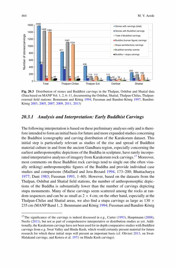
464 M. V. Aerde
0
200
400
600
800
1000
1200
1400
1600
Total Thalpan-Chilas Thalpan Ext. Oshibat Shatial
1556
811
408
113
224
453
318
55 1862
1406
1087
11440
165
55 490 0 6
1380
1024
11239
156
20 14 2 1 349 46
0 0 2
Num
ber o
f sto
nes/
carv
ings
Stones with carvings (total)
Stones with Buddhist carvings
Total of Buddhist carvings
Buddha (human figure) carvings
Stupa (architecture) carvings
Buddhist worship scenes
Buddha + stupa carvings
Fig. 20.3 Distribution of stones and Buddhist carvings in the Thalpan, Oshibat and Shatial data(Data based onMANPVol. 1, 2, 6–11, documenting the Oshibat, Shatial, Thalpan-Chilas, Thalpan-external field stations: Bennmann and König 1994; Fussman and Bandini-König 1997; Bandini-König 2003, 2005, 2007, 2009, 2011, 2013)
20.3.1 Analysis and Interpretation: Early Buddhist Carvings
The following interpretation is based on these preliminary analyses only and is there-fore intended to form an initial basis for future andmore expanded studies concerningthe Buddhist iconography and carving distribution of the Karakorum dataset. Thisinitial step is particularly relevant as studies of the rise and spread of Buddhistmaterial culture in and from the ancient Gandhara region, especially concerning theearliest anthropomorphic depictions of the Buddha in sculpture, have rarely incorpo-rated interpretative analyses of imagery fromKarakorum rock carvings.17 Moreover,most comments on these Buddhist rock carvings tend to single out (the often visu-ally striking) anthropomorphic figures of the Buddha and provide individual casestudies and comparisons (Maillard and Jera-Bezard 1994, 173–200; Bhattacharya1977; Dani 1983; Fussman 1993, 1–60). However, based on the datasets from theThalpan, Oshibat and Shatial field stations, the number of anthropomorphic depic-tions of the Buddha is substantially lower than the number of carvings depictingstupa monuments. Many of these carvings seem scattered among the rocks at ran-dom sequences and can be as small as 2× 4 cm; on the other hand, especially at theThalpan-Chilas and Shatial areas, we also find a stupa carvings as large as 130 ×235 cm (MANPBand 1, 2: Bennmann and König 1994; Fussman and Bandini-König
17The significance of the carvings is indeed discussed in e.g., Carter (1993), Hauptmann (2008),Neelis (2011), but not as part of comprehensive interpretative or distribution studies as yet. Addi-tionally, the Karakorum carvings have not been used for in-depth comparative studies with Buddhistcarvings from e.g. Swat Valley and Hindu Kush, which would certainly present material for futureresearch for which these initial steps will present an important basis (cf. Olivieri 2013, on Swat-Malakand carvings, and Kotera et al. 1971 on Hindu Kush carvings).

20 Routes Beyond Gandhara: Buddhist Rock Carvings in the Context … 465
Fig. 20.4 Comparison of stupa architecture. Left: Thalpan-Chilas, stone 30:1, Tafel III a (Bandini-König 2003). Centre: schist reliquary stupa (centre), 83 cm height, from Gandhara, possibly Taxila,1st–2nd century CE (Carlton Rochell Asian Art Gallery, private collection, New York). Right:Thalpan-Chilas, schematic of stone 41:3, Tafel 25 (Bandini-König 2003)
1997; and Band 6, 7: Bandini-König 2003, 2005). The amount of architectural detailof especially these larger carvings is noteworthy: Maillard and Jera-Bezard makecomparisons with motifs and depictions of stupa architecture excavated at Gandharasites in Swat and Peshawar as well as with the famous Buddhist wall paintings atDunhuang (Maillard and Jera-Bezard 1994, 176–181). In fact, most comparisonsconsider architecture and imagery from the 3rd–4th century CE onwards; however,when we look at some of the earliest-known stupa architecture from Gandhara (i.e.,Sirkap, Taxila), the direct parallels are no less striking (see Fig. 20.4; cf. Van Aerde2018, 203–229).
Chronology for the Karakorum carvings tends to rely on stylistic features as wellas surrounding epigraphical carvings that generally focus on such later periods; butthe actual features of the depicted stupas in these data sets in fact suggest a chronologyfor Buddhist carvings from as early as the late 1st century BCE-early 1st century CEonwards. Possible parallels of stupa architecture depictions in rock carving from theWestern Hindu Kush mountains (the region of Afghanistan generally referred to asBactria in the antiquity) were discovered by a Japanese campaign in the 1970s, butthey do not currently survive in situ; however, the surviving documentation of thesecarvings depict stupas that directly resemble those encountered in the Karakorumcarvings at the Thalpan and Shatial stations (see Fig. 20.5), which likewise hints at apresence of Buddhist imagery in rock carvings in the mountain ranges surroundingGandhara from the Bactrian and early Kushan eras onwards from ca. late 1st centuryBCE—early 1st century CE (Kotera et al. 1971, 40, Fig. 38; cf. Klimburg-Salter1989, 150).
Due to this unfortunate lack of documentation from the Hindu Kush range, thereis a danger that more prominent attention for the better-documented Karakorum

466 M. V. Aerde
Fig. 20.5 Left: schematic of stupa carving at Bamiyan, western Hindu Kush, Afghanistan (Koteraet al. 1971, Fig. 38, pp. 40). Right: Schematic of stupa carving at Shatial field station, Karakorum,Pakistan (stone 164:7, Tafel 28, Fussman and Bandini-König 1997)
carvings would lead to an unbalanced interpretation of carving distributions (andsubsequent mountain route reconstructions in the region) in favour of the easternmountain ranges. Yet, while keeping in mind that at least hypothetically we shouldinclude the western Hindu Kush range in wider considerations of Gandhara’s con-nectedness, it is equally important to focus in-depth on the Karakorum data sets now,as they seem likely to be the only available data at least in the foreseeable future.
One of the most important points that emerges from the Karakorum data, is thefact that the documented Buddha figures do not appear to be individual depictionsof certain Buddhist scenes –the examples from this dataset, to be precise, appear toperhaps depict anthropomorphic sculptures of the Buddha, including statue basesand architectural contexts; to be more exact, nearly all images of the Buddha fromthe Thalpan, Shatial and Oshibat stations are images of Buddhist sculptures thatwere part of or position directly besides stupa architecture. This would mean thatcomparisons between these carvings and actual stupa architecture (indeed mainlyfrom Gandhara) are much more correct in perspective than comparisons with wallpaintings that visualise Buddhist narrative scenes (such as known from Xinjiangcaves). Regrettably, most Buddhist sculptures and reliefs from Gandhara sites wereremoved upon excavation in the 19th and early 20th century, but some excavationreports still allow us to reconstruct larger monuments at least in part, and in some (but
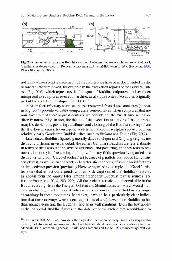
20 Routes Beyond Gandhara: Buddhist Rock Carvings in the Context … 467
Fig. 20.6 Schematics of in situ Buddhist sculptural elements of stupa architecture at Butkara I,Gandhara, as documented by Domenico Faccenna and the IsMEO team in 1956 (Faccenna 1980,Plates XIV and XXXVI)
notmany) cases sculptural elements of the architecture have been documented in situ,before they were removed, for example in the excavation reports of the Butkara I site(see Fig. 20.6), which represents the find spots of Buddha sculptures that have beeninterpreted as sculptures re-used in architectural stupa context (A) and as originallypart of the architectural stupa context (B).18
Also smaller, reliquary stupa sculptures recovered from these same sites (as seenin Fig. 20.4) provide valuable comparative sources. Even when sculptures that arenow taken out of their original contexts are considered, the visual similarities aredirectly noteworthy: in fact, the details of the execution and style of the anthropo-morphic depictions, posturing, attributes and clothing of the Buddha carvings fromthe Karakorum data sets correspond acutely with those of sculptures recovered fromrelatively early Gandharan Buddhist sites, such as Butkara and Taxila (Fig. 20.7).
Later-dated Buddhist figures, generally dated to Gupta and Xinjiang origins, aredistinctly different in visual detail; the earlier Gandhara Buddhas are less elaboratein terms of their amount and style of attributes, and posturing, and they tend to fea-ture a distinct style of rendering clothing with many folds (previously regarded as adistinct criterion of ‘Greco-Buddhist’ art because of parallels with robed Hellenisticsculptures), as well as an apparently characteristic rendering of serene facial featuresand reflective expression (previously likewise regarded as example of a ‘Greek’ artis-tic filter) that in fact corresponds with early descriptions of the Buddha’s featuresas known from the Jataka tales, among other early Buddhist textual sources (seefurther Van Aerde 2018, 203–229). All these characteristics are recognisable in theBuddha carvings from the Thalpan, Oshibat and Shatial datasets—whichwould indi-cate another argument for a relatively earlier commence of these Buddhist carvings’chronology in these mountains. Moreover, it would be a particularly clear indica-tion that these carvings were indeed depictions of sculptures of the Buddha, ratherthan images depicting the Buddha’s life as in wall paintings. Even the few appar-ently individual Buddha figures in the data set show such direct resemblance to
18Faccenna (1980, Vol. 1–5) provide a thorough documentation of early Gandharan stupa archi-tecture, including in situ anthropomorphic Buddhist sculptural elements. See also descriptions in:Marshall (1975) (concerning Sirkap, Taxila) and Faccenna and Taddei 1993 (concerning Swat val-ley).
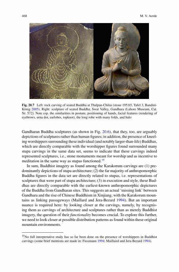
468 M. V. Aerde
Fig. 20.7 Left: rock carving of seated Buddha at Thalpan-Chilas (stone 195:65, Tafel 3, Bandini-König 2005). Right: sculpture of seated Buddha, Swat Valley, Gandhara (Lahore Museum, Cat.Nr. 572). Note esp. the similarities in posture, positioning of hands, facial features (rendering ofeyebrows, urna dot, earlobes, topknot), the long robe with many folds, and halo
Gandharan Buddha sculptures (as shown in Fig. 20.6), that they, too, are arguablydepictions of sculptures rather than human figures; in addition, the presence of kneel-ingworshippers surrounding these individual (and notably larger-than-life) Buddhas,which are directly comparable with the worshipper figures found surrounded manystupa carvings in the same data set, seems to indicate that these carvings indeedrepresented sculptures, i.e., stone monuments meant for worship and as incentive tomeditation in the same way as stupas functioned.19
In sum, Buddhist imagery as found among the Karakorum carvings are (1) pre-dominantly depictions of stupa architecture; (2) the far majority of anthropomorphicBuddha figures in the data set are directly related to stupas, i.e. representations ofsculptures that were part of stupa architecture; (3) in execution and style, these Bud-dhas are directly comparable with the earliest-known anthropomorphic depicturesof the Buddha from Gandharan sites. This suggests an actual ‘missing link’ betweenGandhara and the rise of Chinese Buddhism in Xinjiang, with the Karakorummoun-tains as linking passageways (Maillard and Jera-Bezard 1994). But an importantnuance is required here: by looking closer at the carvings, namely, by recognis-ing them as carvings of architecture and sculptures rather than as merely Buddhistimagery, the question of their functionality becomes crucial. To explore this further,we need to look closer at possible distribution patterns as found within these originalmountain environments.
19No full interpretative study has so far been done on the presence of worshippers in Buddhistcarvings (some brief mentions are made in: Fussmann 1994; Maillaird and Jera-Bezard 1994).
20 Routes Beyond Gandhara: Buddhist Rock Carvings in the Context … 469
20.3.2 Discussion: Distribution of Carvingsin the Karakorum Mountains
When considering the documented data, as presented in Fig. 20.3, the main point ofinterest seems the fact that stupas are the most numerous type of Buddhist carvingencountered by far; these data sets contain over a thousand stupas, but only fifty-fiverecorded anthropomorphic images of the Buddha. Depictions of Buddha are rela-tively rare in the dataset—though it is noteworthy that the recorded Buddhas in thedata set tend to larger in size than themajority of recorded stupa carvings (the averagefor stupas is around 30–40 cm in height, with the exceptions being often triple in sizebut much fewer in number, whereas the average for Buddha carvings appears to bearound 70–80 cm in height). Another noteworthy aspect is the fact that relatively fewstones among the total documented stones feature Buddhist carvings, whereas thenumber of individual Buddhist carvings is much higher, respectively. However, mostBuddhist carvings have been found grouped on single stones; i.e., multiple carvingsappearing on the same stone, which are generally also the larger stones documentedat the relevant field stations.20 Another point of interest here is the fact that 49 outof the 55 documented Buddhas are clearly part of stupa carvings or placed in theirdirect vicinity, and all these combinations seem to feature surrounding carvings ofworshippers, too. This would again confirm that these anthropomorphic Buddhaswere indeed depictions of sculptures (either free-standing statues such as found atGandhara Buddhist sanctuaries or architecturally incorporated into the stupa struc-tures), as suggested in the section above, and not Buddhist narrative scenes that wouldbe more comparable to wall paintings. Their role as part of stupa depictions seemsindeed important for understanding their functionality; it would explain, for one, whythe recorded Buddhist images were carved together on a fewer number of specificstones, and most likely with additions and alterations added over time on these samestones. In other words, these carvings should not be regarded as separate images,but as components of what appear to have been visualisations in the rock of physicalstupa monuments, many of them very similar to those known from early Buddhistsites in Gandhara. As such, the function of these Buddhist carving groups may nothave been so different from the function of Gandhara stupa architecture, if indeedat all. As visual monuments for worship and reflection, according to early Buddhistpractices, these carving groups will have been much more effective in a recognis-able group upon certain recognisable stones along the routes taken by Karakorumtravellers, as opposed to having them scattered around on multiple rocks across thearea. Moreover, the particular resemblance to early Buddhist architecture and sculp-ture from Gandhara does not necessarily imply that these carvings need all be of arelatively early dating; especially the larger and most detailed stupas and Buddhasare carved deeply in the rocks, which may indicate that the carvings were initiatedin those early times, roughly around the early 1st century CE, and that the carv-ings were elaborated, deepened, even intentionally maintained (as a physical stupa
20Especially Fussman and Bandini-König (1997) and Bandini-König (2003, 2005) offer for docu-mentation and reconstruction drawings of such large stones and carving groups.

470 M. V. Aerde
monument would be) throughout the passage of time as part of worship by Buddhistpractitioners that continued to pass them in the mountains ranges—perhaps as partof intentionally religious caravans, maybe simply as merchant travellers seeking topractice their religion along their trade routes through these mountains.21 This bringsin mind Fussmanns suggestion that the larger stupas were carved according to spe-cific (most likely Gandharan) templates; but perhaps this is only true for the originallayer of their carvings, which indeed is so directly comparable to Gandharan stupasand Buddhas that it would suggest the hand of certain craftsmen with knowledge ofthese sculptures and architecture. However, these carvings may subsequently havebeen maintained throughout many subsequent centuries by passing caravans instead,for example, by means of deepening the existing carvings, and perhaps also alteredand expanded with worshipping figures and animal figures, of which most appearless directly recognisable in style and execution.
It also brings to mind Jettmar’s suggestion of a possible Buddhist sanctuary atthe Thalpan location; the spike in numbers of stupas and related Buddha depictionsin the Thalpan-Chilas data sets would seem to support this option (Jettmar 1993,XX–XXI). Hauptmann has also noted that 5th-century Chinese pilgrims mentionedtravelling to Buddhist sanctuaries near a specific ‘trade emporium’ they refer to as‘Talilo’, and suggests this may have referenced Thalpan—especially since this partof the Karakorum Indus indeed appears to have functioned as passage to and fromprominent Gandharan cities such as Taxila (by then under Kushan administration),the Kashmir valley, and ultimately Xinjiang in the east, with the number and scope oftraffic roads with checkpoints and possibly even forts continuously expanding alongthese routes throughout the first five centuries CE (Hauptmann 2009, 8–9). However,there are no currently known archaeological or textual sources that would supportthe former presence of such a larger Buddhist sanctuary (which would have includedarchitecture and physical monuments, according to the above-mentioned Chinesesources) at the Thalpan area, or indeed remains of a large-scale trade emporium.22
This current lack of evidence might have been solved by more extensive excavationsin the area, but especially due to the building of the Diamer-Basha dam, this doesno longer seem feasible in the near future. Yet, hypothetically, the mere possibilityof a physical ‘Gandharan-type’ early Buddhist sanctuary outside of Gandhara issomething that traditional Gandharan scholarship never considered and thereforenever looked for—but it is also something that the distinct presence, execution, anddetailed style of the Karakorum stupa and Buddha rock carvings in this area certainlyseem to make more plausible to at least consider.
21As initially noted by Fussmann (1994), and subsequently also remarked upon by Neelis (2014a,b, 45–64). This would be an interesting and possibly important topic for future research.22A trade post or traffic station may have been built out of wood and other less durable material(e.g., textiles), but objects such as coins, pottery etc. may be expected to remain. It is also areasonable deduction that such a Buddhist sanctuary would have featured more than only rockcarvings. Excavations near the Diamer-dam site may have givenmore insight into this, but they havenow become impossible. Apart from gathering more as yet undocumented carvings throughout theregion, other excavations projects may have given us more indications of this sanctuary hypothesis;unfortunately, also such plans do not seem feasible in the near future.

20 Routes Beyond Gandhara: Buddhist Rock Carvings in the Context … 471
Fig. 20.8 Recent satellite image of the area between Shatial (west) andThalpan-Chilas (east), alongthe flow of the Indus. All main field stations where rock carvings have been discovered between1979 and 2013 have been marked: Shatial, Harban, Diamer-Basha, Khanbari, Thor, Minar-Gah,Oshibat, Hodar, Chilas and Thalpan (GoogleEarth 2017)
On the other hand, it is no less important to closely consider the natural environ-ment of the relevant valley in our interpretations and hypotheses.23 When we returnto the documented data, we can in fact observe an increase in the number of stupasdocumented at the Shatial field station that is quite similar to the increase noted atThalpan-Chilas; that is, the number of recorded stones with Buddhist carvings out-side the Thalpan banks is relatively smaller overall, yet the similar pattern (i.e., thespike in stupas) is still noteworthy, especially in context with the data from Oshibat,which is in fact much closer in vicinity to Thalpan than Shatial (see Fig. 20.8).24
Other than the still unsupported hypothesis of a physical Buddhist sanctuary, thesestupa spikes at Shatial and Thalpan may instead, or at least also be connected to thefact that both locations are near remarkably sharp bends in the Indus (namely, flow-ing southwards from Shatial, down towards the slopes of Gandhara, and northwardsfrom Thalpan, up towards the Gilgit-Baltistan region). These specific locations mayhave indicatedmore important stations along the route, marking the significant bendsthey announced; perhaps they functioned as notable road stations where mountain
23Similar hypotheses concerning waystations have already been advanced by Stein (1944), Jettmar(1985). In addition, possible parallels could be sought with data from the Hindu Kush mountainrange for future research (cf. Neelis 2014a, b, 3–17).24The Heidelberg Academy team charted several more clusters of carvings (but not all currentlyavailable in MANP) along the Indus riverbanks in the valley passage reaching from Shatial in thewest to Thalpan in the east, but so far these do not appear to have been as numerous in terms ofspecific Buddhist carvings nor do they seem to have been grouped together like at Thalpan or, inlesser degree, Shatial.
472 M. V. Aerde
caravans could stay overnight, hence allowing travellers more time for worship andreflection such as the stupa andBuddha carvings appear to have accommodates—per-haps, indeed, that may have been their original functionality, to accommodate theneeds of those passing by the more important road stations. And as a result, withthe increasing centuries and the similar increase in Buddhist followers in the region,these initial carved early Buddhist, ‘Gandharan’ stupas may indeed have developedinto larger-scale religious sanctuaries known as far asmidlandChina, in the samewayas that the road stations may have developed into emporia that became known acrossthe region. This is of course directly relevant for challenging the compartmentalisedtendencies of Gandharan Buddhist archaeology, in proving the opposite. As it is, thearchaeological and textual sources available at this point seem only to support theseearly Buddhist origins of the carvings as well as their apparent connection with thestructure of the natural environment of the Karakorum Indus; in specific, the river’sflow and bends along the mountain valleys and the way the travellers’ route appearedto have followed it. Therefore, concerning the tradition division between cultural andenvironmental approaches, this indeed suggests the necessity of an interdisciplinarybridge between the two.
While hypothetical reconstructions of sanctuaries along the river are difficult froman archaeological perspective at this point, reconstructions of the route itself aremore feasible, especially when taking the environment as part of the consideration.This is where the approach of archaeological data as variables comes into playmore concretely and can indeed become a tool to work with; the consideration of(complex and hence unpredictable) variables instead of predetermined categoriessimply does not allows for a separation of archaeological, contextual, environmental,textual sources, etc.On the contrary, all these aspects are variables of both the physicalregion and thewider process of connections and interactions under examination here.Even when some variables by necessity remain hypothetical (such as the possibilityof a larger sanctuary at Thalpan), the incentive for that hypothesis (i.e., the notablespike in stupa carvings recorded) is yet another variable in itself,which in turn appearsclosely connected, indeed even a result of the structure of the surrounding naturalenvironment (i.e., the fact that Thalpan was located at one of the most major bendsof the Karakorum Indus). In effect, none of these aspects and/or data can nor shouldbe studied in separation. Similarly, the direct similarities in style and execution ofthe depicted stupas and Buddha sculptures in the studied data sets should not merelybe ‘singled out’ as a topic of study, thus suggesting a linear line of cause and effect;instead, when we consider the Gandharan origins of these carvings are yet anothervariable in a dynamic process of interregional interactions, it becomes clear thatwe cannot denominate a single ‘function’ or ‘intention’ to them, as such. Whereasthese early Buddhist carvings may have originally been intended as opportunitiesfor worship for travellers passing through the mountains, they appear to have alsocome to function as landmarks at certain prominent changes in the environmentand help travellers navigate their routes, and as a result these Buddhist images werespread not only alongside a more deliberately religious expansion of early Buddhismfrom Gandhara to the east (such as traditionally derived from textual sources) butalso as additional incentive to as well as constituent of that ever-expanding process.
20 Routes Beyond Gandhara: Buddhist Rock Carvings in the Context … 473
In other words, the appearance and subsequent increase in early Buddhist imageryalong the Karakorum routes, especially when we keep in mind above-mentionedcomparisons in style and content with both early Gandhara sites and the earliestBuddhist depictions in Xinjiang and Gansu, appears to have been a dynamic anddistinctly non-linear variable in what is still mainly considered a linear line of cause-and-effect: Buddhism being carried to China. Whereas the original intention of theearliest Karakorum stupa carvings may have simply been to offer Buddhist travellersa place for worship along their passage, the unintended effect of these carvingsseems to have been to increasingly raise awareness of and interest in Buddhismin regions east of Gandhara—moreover, the possible presence of larger, famousBuddhist sanctuaries at these same landmarks along the Karakorum route in the 5thcentury will have been another originally unintended result of that same dynamicand ongoing process. Such non-linear variables can only be charted in hypothetical(phase space) models, as mentioned in the introduction; however, the considerationof these variables, as opposed to a compartmentalised approach, also allows us tohypothetically chart the physical route(s) in more detail.
One of the main variables involved here is one that appears relatively fixed, orat least logically deducible: namely, the fact that the distribution of rock carvingsfollows the flow of the Indus River. The convenience, even necessity of proximity towater while traversing these mountains, combined with the lower, more accessiblegrounds of the river valleys, would make the river’s flow the most sensible route tofollow for any travellers, either in larger caravans or not. As far as these data setshave recorded, no rock carvings have been discovered higher up the surroundingmountain slopes, which also suggest an absence of travellers there (again the mostsensible, practical option). The structure of the natural environment is the mostdetermining variable in this case, directly affecting people’s choices for the routesthey travelled—and in consequence likewise affecting their choices of where to carvetheir stupas along the way (for hypothetical route, see Fig. 20.9).
Ideally, the next stepwould now be to documentmore data from along theKarako-rum Indus. Up until recently, explorations and studies have been conducted up untilthe Gilgit and Gilgit-Baltistan areas, in a northern upwards direction from the Thal-pan field stations; unfortunately, no catalogues or very thorough documentation ofcarvings have yet been possible. Earlier this year, German scholars Horst GeerkenandAnnette Bräker published amemoir of their travels around theGilgit area up until1998, featuring several photographs and reports of rock carvings that very stronglyresemble those so far documented byMANP, including early Buddhist stupa imagery(see Fig. 20.10a), but also carvings that more closely resemble Buddhist depictionsfrom Chinese paintings of the much later Tang Dynasty, 618–907 CE (Fig. 20.9b;Geerken and Bräker 2017, 224–225).
The latter presents yet another possible argument for the increasing role that Bud-dhist carvings and perhaps indeed sanctuaries came to play along these mountainroutes since the first appearance of early carvings of Gandharan-type stupas; it isnoteworthy, too, that most if not all Buddhist depictions as now documented in thelower Indus Karakorum valleys, from Shatial to Thapan, directly resemble muchearlier Buddhist depictions from Gandhara. For example, if a famous Buddhist sanc-tuary near Thalpan was known by the 5th century, perhaps such later styles would

474 M. V. Aerde
Fig. 20.9 Hypothetical ancient route through the Karakorum mountain range (GoogleEarth 2017)
Fig. 20.10 a Stupa rock carvings recorded near Gilgit (Geerken and Bräker 2017, Ill. 132, pp. 225).b Buddha rock carving near Gilgit, (Geerken and Bräker 2017, Ill. 33.2, pp. 48)
also be expected here. This may be an indication that such a sanctuary may be soughtcloser to Gilgit, and the upper flow of the Indus, after all. In either case, it does show acontinuation of Buddhist carvings along this river-guided route. And hypothetically,if the above-mentioned variables are likewise considered for the as yet undocumentedranges of the mountains (i.e., accessibility of the natural environment, continuationof human presence and passage, religious needs of Buddhist travellers), we can plot
20 Routes Beyond Gandhara: Buddhist Rock Carvings in the Context … 475
the most likely routes that would from as early as the late 1st century BCE onwardsto have been actively traversed arteries allowing travellers and trade caravans backand forth through these mountains. As such, these routes physically allowed accessfrom the Gandhara region in the west to the Xinjiang region of China in the east,and vice versa, thus connecting important nodes in the increasingly expanding SilkRoads networks, especially following the Han Dynasty’s opening of the Jade Gatefor trade across the Tarim Basin and the Kushan administration’s expansion of tradenetworks in Gandhara in the 1st century BCE. And the Karakorum rock carvings, asrecorded so far, provide us actual evidence of these important connections.
In order to achieve a more empirical reconstruction of these routes (building onthe hypothesis proposed in Fig. 20.9), a continuing documentation of rock carvingsis needed along the Karakorum Indus, going beyond the Gilgit region up until thefirst ranges of the Tarim Basin in the northeast. As reported by scholars and explorersalike who have visited these parts, a great number of carvings remain unrecordedand most likely many more still undiscovered across these parts; moreover, addi-tional excavations would help reveal new archaeological data concerning the tradeposts and sanctuaries that came to mark these important Silk Roads routes. But asmentioned above, due to increasing issues in the region at present, mainly dam con-structions and political unrest, such campaigns seem unlikely to be possible in thenear future. An additional, but no less worrying factor is the effect of climate changein these mountains; recent data predicts such a significant rise of temperatures in theHimalayas, including the upper plateaus of the Hindu Kush and Karakorum ranges,that many glaciers are expected to melt within the next several decades (most recentdata: Cogley 2017, 166–167). This is of course a primary concern for the waterresources of Central Asia, but it is also a direct threat to any archaeological remains,including rocks carvings, in these regions, which will either be destroyed or madeinaccessible due to excessive melt water and shifting glaciers. In addition to theseproblematic modern variables in the region, modern technology does allow differentways of access; satellite imagery and drones may become the best available tools tokeep studying this region in the near future. For that reason, further in-depth analysisof the so-far documented data from the Karakorum Indus valleys is important fora variety of interdisciplinary studies, among which archaeology and environmentalscience.
20.4 Conclusions
This contribution explored the results of a preliminary interpretative study of this par-ticular Karakorum rock carvings dataset, in order to form a basis for future researchthat uses these data within the wider frame of studying the dynamics of early SilkRoads networks. The results constitute the following main points.
(1) Concerning the functionality of the documented Buddhist carvings: the depic-tions in this dataset can be interpreted as visual representations of physicalearly Buddhist architecture and anthropomorphic sculpture that closely resem-ble architecture and sculpture encountered in Gandhara from the 1st centuryBCE onwards. As such, especially the numerous stupa carvings, may have
476 M. V. Aerde
functioned as religious monuments for travellers to enable their worship andmeditation according to their Buddhist practices. This could subsequently raisefurther theoretical considerations concerning the meaning and/or intention ofsuch religious monuments: namely, were they simply material monuments ofreligion, or should we regard them as material monuments that are simultane-ously cases of ‘lived religion’?25 In addition, multiple Buddhist carvings col-lected on certain large stones appear to have also functioned as landmarks alongthe main routes undertaken by travellers and caravans through these mountains,with apparent higher numbers appearing at notable changes in the flow of theIndus River along these routes.
(2) The data subsequently present insight into the direction of the routes throughthese mountains. Especially many stupa carvings followed the main route alongthe Indus river directly, even if their function as physical landmarks may havenot been their initially intended function (as opposed to religious function fortravellers); this connection to the natural environment, which determined thebest mountain routes, allows us to hypothesise the continuation of these routesbeyond the documented data that is currently available; namely, the stupa carv-ings can be considered important variables in the development of these traderoutes between Gandhara and the Tarim Basin. Moreover, as a result of boththeir religious functionality and visibility as landmarks, these cravings may addevidence or at least arguments for the presence of larger Buddhist sanctuariesand trade emporia along these same routes over time (so far unexcavated).
(3) The dataset also provides insights concerning Gandhara itself—in terms of itsearlyBuddhist archaeology aswell as thewider connectedness of the region. Thestupas and especially depictions of the Buddha closely resemble architectureand sculpture from early Buddhist Gandharan sites, such as Taxila and Butkara,in terms of style, execution/manufacture, attributes, and architectural features.This suggests not only that Buddhist carvings would have begun to appear inthe Karakorum range from the late 1st century BCE onwards, but also providesevidence that Gandharan Buddhist material culture reached well beyond theGandhara region already since its earliest appearance. The data so far suggesta process of connectedness: at the same time that the earliest anthropomorphicdepictions of the Buddha become prominent in Gandhara, featuring certainHellenistic features and sculpting techniques as variables contributing to thatdevelopment, those images also became variables in the interregional exchangeenabled by the increasingly dynamic traffic of the Silk Roads. This traffic andexchange became especially important in Gandhara from the 1st century BCE,with the opening of the Jade Gate by the Han Dynasty and subsequently bythe Kushan focus on trade networks in and from Gandhara. Initial 19th-centuryGandharan scholarship considered Gandharan Buddhist art as a unique (andinherently Hellenistic) category, and as such distinct from Buddhist art thatdeveloped in East Asia later. The Karakorum carvings strongly underline thefault in these traditional studies bymeans of empirical evidence, which supports
25An interesting parallel here may be recent studies of ‘lived religion’ concerning Ancient Romanreligious monuments, such as presented by Jörg Rüpke (2016).

20 Routes Beyond Gandhara: Buddhist Rock Carvings in the Context … 477
the important trend of both Buddhist and Silk Roads scholarshipmoving beyondsuch predetermined interpretations.
(4) Subsequently, these data have implications for studies of the spread of Bud-dhism, as well. Unlike the focus of textual sources concerning missions bymonks to spread the religion, we here find an at least simultaneous process of aseemingly non-intentional spread of Buddhist stupas from Gandhara through-out the Karakorum range, most likely all the way northeast to the Xinjiangand Gansu areas in Western China—where the subsequent earliest Buddhistimagery are known from the Duanhuang caves. The Karakorum carvings maypresent an empirical ‘missing link’ between the Gandhara and these Chinesesites. The most interesting feature here appears to be the unintentionality—-namely, the fact that the Karakorum stupa carvings that would originally havebeen intended for practical use for Buddhist travellers may indeed have incitedsuch an increased accessibility to Buddhist imagery and content that they subse-quently also increased awider interest in the religion, hence also increasing callsfor Buddhist monks to travel east to fulfil these new religious interests. Ratherthan distinct or contradictory, these seem to have been simultaneous processes.An interesting example is put forth by Lars Fogelin in his recent overview ofBuddhist archaeology throughout the Indian peninsula, demonstrating that thearchaeological data frequently paint a picture of reality that notably defers fromhistorical narratives that are based on textual sources.26 When stepping awayfrom fixed compartmentalised perspectives, such contradictions instead seem toindicate the occurrence of dynamic processes that did not necessarily excludeone another at all, but coexisted and indeed influenced each other in flexible andunpredictable (at least often unintentional) ways. This, in turn, may indicatea certain level of ‘agency’ of early Buddhist imagery, in the sense that theireffect seems to go well beyond the original intentions with which they werecreated. This, too, would be interesting to pursue in future research. This con-tribution’s exploration of how multiple variables continuously influenced thefunctionality, subsequent effects (intended and unintended), and developmentsof the Karakorum Buddhist carvings is merely one example of dynamic inter-actions that happened along and were made possible because of these mountainroutes.
Whereas preconceived concepts and categories have often ‘proven useful in order-ing things’, to return to the words of Albert Einstein, we should bewary of tendenciesto compartmentalise, as that can truly make ‘the path of scientific progress impass-able’ (Einstein 1916; see note 2). As this preliminary study of Buddhist carvings
26One interesting example of this pertaining specifically to the interpretation of archaeological data,is Fogelin’s presentation of a case where textual sources have suggested the rise of early Buddhistmonasteries as much later than the tradition of ascetic, travellingmonks, whereas the archaeologicalevidence points at a much earlier rise of monasteries that would have coincided with the ascetic tra-ditions (it appears that the contemporary texts and scriptures highlighted the importance of asceticsbecause of a scholarly and religious interest in the tradition, which subsequently led modern schol-ars to consider this literary/religious choice of reference as empirical and chronological evidence,thereby ignoring any contradicting archaeological evidence). See: Fogelin (2015, 14–15; 111–120;158–169).
478 M. V. Aerde
hopes to have shown, this particular dataset strongly indicates that the KarakorumMountains were not quite so impassable in either empirical or theoretical sense.
Acknowledgements This researchproject and its output are supportedby theByvanckPostdoctoralFellowship, Leiden University. The author wishes to thank the organizers of The Rise and Fall:Environmental Factors in the Socio-Cultural Changes of the Ancient Silk Road Area workshopin Kiel 2017, in particular Dr. Liang Emlyn Yang, for inviting my contribution. I am indebtedto Prof. Harald Hauptmann for sharing his substantial knowledge and insights concerning theKarakorum rock carvings and assisting me greatly in acquiring the documentation and rapportsfrom the Heidelberg Academy campaigns. My thanks are also due to Dr. Bryan Miller for sharinghis ideas and putting me in touch with Hauptmann. I am grateful to Prof. Miguel John Versluys forhis support and valuable advice, and to Milinda Hoo, Suzan van de Velde, and Lennart Kruijer fortheir feedback. Gratitude is due to my peer reviewers for notifying important points of correctionin the first draft of this contribution.
References
Bandini-König, D. (2003). Die Felsbildstation Thalpan I: Kataloge Chilas-Brücke und Thalpan(Steine 1–30), Bearbeituing der Inschriften durch Gerard Fussman et al. (Herausgegeben von H.Hauptmann), Band 6. Mainz: MANP.
Bandini-König, D. (2005).Die Felsbildstation Thalpan II: Katalog Thalpan (Steine 31–195), Bear-beituing der Inschriften durch Oskar von Hinüber und Thomas O. Höllmann (Herausgegebenvon H. Hauptmann), Band 7. Mainz: MANP.
Bandini-König, D. (2007). Die Felsbildstation Thalpan III: Katalog Thalpan (Steine196–450),Bearbeituing der Inschriften von Gérard Fussman, Oskar von Hinüber, Nicholas Sims-Williams (Herausgegeben von H. Hauptmann), Band 8. Mainz: MANP.
Bandini-König, D. (2009). Die Felsbildstation Thalpan IV: Katalog Thalpan (Steine 451–811),Bearbeituing der Inschriften durch Philip T. Denwood et al. (Herausgegeben vonH. Hauptmann),Band 9. Mainz: MANP.
Bandini-König, D. (2011). Die Felsbildstation Thalpan V: Kataloge Ziyarat, Thakot, Khomar Das,Gichoi Das, Dardarbati Das, Bearbeituing der Inschriften von Gérard Fussman, Oskar vonHinüber, Nicholas Sims-Williams (Herausgegeben von H. Hauptmann), Band 10. Mainz: MANP.
Bandini-König, D. (2013). Die Felsbildstation Thalpan VI: Kataloge Ba Das, Ba Das Ost, Gali,Gukona, Mostar Nala, Ke Ges, Ame Ges und Drang Da, Bearbeituing der Inschriften durchGérardFussman,Oskar vonHinüber undNicholas Sims-Williams (Herausgegeben vonH.Haupt-mann), Band 11. Mainz: MANP.
Beckwith, C. (2009). Empires of the Silk Road: A history of Central Asia from the bronze age to thepresent. Princeton: Princeton University Press.
Behrendt, K. (2007). The art of Gandhara in the metropolitan museum of art. NewYork:Metropoli-tan Museum of Art Publications.
Bennmann, M., & König, D. (1994). Die Felsbildstation Oshibat, mit Beiträgen von Gerard Fuss-man, Oskar von Hinüber und Nicolas Sims-Williams (Herausgegeben von H. Hauptmann), Band1.Mainz: MANP.
Bhattacharya, C. (1977). Art of Central Asia (with special reference to wooden objects from the SilkRoute). Delhi: Agam Prakashan Publishers.
Boardman, J. (2015). The greeks in Asia. London: Thames & Hudson.Bruneau, L. (2007). L’architecture bouddhique dans la vallée du Haut Indus (Pakistan): un essai detypologie des représentations rupestres de stupa. Arts Asiatiques, 62, 63–75.
Bussagli, M. (1996) L’art du Gandhara. Paris.
20 Routes Beyond Gandhara: Buddhist Rock Carvings in the Context … 479
Carter, M. (1993). Petroglyphs at Chilas II: Evidence for a pre-iconic phase of Buddhist art inGandhara. South Asian Archæology, 1991, 349–366.
Cogley, J. G. (2017). The future of Asia’s glaciers. Nature, 549, 166–167.Cunningham, A. (1871). The ancient geography of India: The Buddhist period, including the cam-paigns of Alexander, and the travels of Hwen-Thsang. Cambridge: Cambridge University Press.
Dani, A. H. (1983). Chilas, the city of Nanga Parvat (Dyamar). Islamabad: University of IslamabadPress.
Faccenna, D. (1980). Butkara I (Swat, Pakistan) 1956, Excavation Reports. IsMEO, 1–5.Faccenna, D., & Taddei, M. (1993). Memoirs and reports, Istituto Italiano per il Medio ed EstremoOriente. IsMEO, 43, 1–4.
Fogelin, L. (2015).An archaeological history of Indian Buddhism. Oxford: OxfordUniversity Press.Foucher, A. (1905). L’Art Gréco-Bouddhique du Gandhara. Paris: Paul Geuthner.Fussman, G. (1993). Chilas, Hatun et les bronzes Bouddhiques du Cachemire. Antiquities of North-ern Pakistan, Reports and Studies, 2, 1–60.
Fussman, G. (1994). Chilas-Thalpan et l’art du Tibet. Antiquities of Northern Pakistan, Reports andStudies, 3, 57–72.
Fussman, G., & Bandini-König, D. (1997). Die Felsbildstation Shatial, mit Beiträgen von Oskarvon Hinüber, Thomas O. Höllmann, Karl Jettmar und Nicolas Sims-Williams (Herausgegebenvon H. Hauptmann), Band 2. Mainz: MANP.
Fussman, G., & Jettmar, K. (1994). Antiquities of Northern Pakistan, reports and studies 3. Mainz:Verlag Philip von Zabern.
Geerken H. H., & Bräker, A. (2017). The Karakoram highway and the Hunza Valley 1998 (ondemand).
Hauptmann, H. (2008). Rock art in the upper Indus region. In C. Luczanits (Ed.), Gandhara, theBuddhist heritage of Pakistan: Legends, monasteries, and paradise (pp. 352–357). Mainz: Phillipv. Zabern.
Hauptmann, H. (2009). Felsbilder und Ischriften am Karakorum Highway. Heidelberg: HeidelbergAcademy.
Hill, J. E. (2009). Through the jade gate to Rome: A study of the Silk Routes during the late HanDynasty & annotated translation of the Chronicles of the Western Regions in the Hou Hanshu.Queensland: Create Space Independent Publishing.
Jettmar, K. (1985). Zwischen Gandhara und den Seidenstrassen, Felsbilder am Karakorum High-way: Entdeckungen Deutsch-Pakistanischer Expeditionen 1979–1984. Mainz: Verlag Philip vonZabern.
Jettmar, K. (1989). Antiquities of Northern Pakistan, reports and studies 1. Mainz: Verlag Philipvon Zabern.
Jettmar, K. (1993). Antiquities of Northern Pakistan, Reports and Studies 2. Mainz: Verlag Philipvon Zabern.
Klimburg-Salter, D. (1989). The kingdom of Bamiyan: Buddhist art and culture in the Hindu Kush.Naples/Rome: Istituto Universitario Orientale.
Kotera, T., Maeda, K., & Miyaji, A. (1971). Bamiyan: Report of survey in 1969. Nagoya: NagoyaUniversity Press.
Liu, X. (2010). The Silk Road in world history. Oxford: Oxford University Press.Maillard, M. & Jera-Bezard, R. (1994). Les stupas de Kuberavahana à Chilas et Thalpan. In G.Fussman,&K. Jettmar (Eds.),Antiquities ofNorthernPakistan, reports and studies (pp. 173–200),3.
Mairs, R. (2014). The Hellenistic Far East: Archaeology, Language, and Identity in Greek CentralAsia. Berkeley.
Marshall, J. H. (1975). Taxila: An illustrated account of archaeological excavations carried out atTaxila under the orders of the Government of India between the years 1913 and 1934. Cambridge:Cambridge University Press.
Miller, B. K. (2014). ‘Xiongnu ‘kings’ and the political order of the steppe empire. Journal of theEconomic and Social History of the Orient, 57, 1–43.
480 M. V. Aerde
Miller, B. K., & Brosseder, U. (2017). Global dynamics in local processes of Iron Age Inner Asia. InT. Hodos, et al. (Eds.), The Routledge handbook of archaeology and globalization (pp. 470–487).Oxford: Routledge.
Neelis, J. (2011). Early Buddhist transmission and trade networks: Mobility and exchange withinand beyond the northwestern borderlands of South Asia (Dynamics in the history of religion).Leiden: Brill.
Neelis, J. (2014a). Networks for long-distance transmission of Buddhism in South Asian TransitZones. In T. Sen (Ed.), Buddhism across Asia: Networks of material, intellectual and culturalexchange (pp. 3–17). Singapore: Institute for Southeast Asian Studies.
Neelis, J. (2014b). Localizing the Buddha’s presence at wayside shrines in Northern Pakistan.In P. Wick & V. Rabens (Eds.), Religions and trade: Religious formation, transformation andcross-cultural exchange between east and west (pp. 45–64). Leiden: Brill.
Olivieri, L. N. (2013). Rock shelters of the Swat-Malakand from the bronze age to Buddhism.Materials for a tentative reconstruction of the religious and cultural stratigraphy of ancientswat. Berlin: Freie Universität.
Poo, M. C., Drake, H. A., & Raphals, L. (2017). Old society, new belief: Religious transformationof Rome and China ca. 1st–6th centuries. Oxford: Oxford University Press.
Rüpke, J. (2016).On Roman religion: Lived religion and the individual in ancient Rome. NewYork:Cornell University Press.
Stein, M. A. (1944). Archaeological notes from the Hindu Kush region. Journal of the Royal AsiaticSociety of Great Britain and Ireland, 1, 5–24.
Thewalt, V. (2008). Stupas und verwandte Bauwerke in Felsbildern der Stationen Chilas I, ChilasII und Oshibat am Indus (Nordpakistan). Heidelberg: Heidelberg Academy.
Van Aerde, M. E. J. J. (2018). Revisiting Taxila: A new approach to the Greco-Buddhist archaeo-logical record. Journal of Ancient West & East, 17, 203–229.
Verardi, G., & Filigenzi, A. (2003). Maurizio Taddei on Gandhara, collected articles. Naples:Università degli studi di Napoli L’Orientale.
Von Hinüber, O. (1989). Brahmi inscriptions on the history and culture of the Upper Indus Valley.In K. Jettmar (Ed.), Antiquities of Northern Pakistan, Reports and Studies (pp. 41–72), 1.
Von Hinüber, O. (1989). Buddhistische Inschriften aus dem Tal des Oberen Indus. In K. Jettmar(Ed.), Antiquities of Northern Pakistan, Reports and Studies (pp. 73–106), 1.
Yu, Y. (1967). Trade and expansion in Han China. Berkeley: University of California Press.Yusuf, S. (2011). Threatened rock carvings of Pakistan. Dawn,May 18 (digital issue: https://www.dawn.com/news/629659/basha-dam-threatens-thousands-of-ancient-rock-carvings).
Open Access This chapter is licensed under the terms of the Creative Commons Attribution 4.0International License (http://creativecommons.org/licenses/by/4.0/), which permits use, sharing,adaptation, distribution and reproduction in any medium or format, as long as you give appropriatecredit to the original author(s) and the source, provide a link to the Creative Commons license andindicate if changes were made.
The images or other third party material in this chapter are included in the chapter’s CreativeCommons license, unless indicated otherwise in a credit line to the material. If material is notincluded in the chapter’s Creative Commons license and your intended use is not permitted bystatutory regulation or exceeds the permitted use, you will need to obtain permission directly fromthe copyright holder.
Chapter 21Steppe and Sown: Eurasianism, Soiland the Mapping of Bukhara in the Lightof Soviet Ethnographic Accounts
Susanne Marten-Finnis
Abstract This chapter reveals how ecological zones and their division into steppeand sown, nomadic and sedentary people, helped Russian ethnographers to under-stand the heritage and urban neighbourhood principles of Bukhara. It charts thelaunch and significance of ethnographic enquiry into this former oasis city within thecontext of Eurasianism, and illuminates the notion of soil inRussian thought, togetherwith the central role it played in the study of the interrelationship between envi-ronmental factors and socio-cultural changes. The evidence will be used to presentethnographic accounts as a way of transferring knowledge between Asia and Europe,and argue in favour of a flexible approach negotiating between nature and culture, andas a process of hybridization, whereby cultures come together and, by learning fromeach other, create a pathway towards Eurasian integration and global intellectualinteraction.
Keywords Eurasianism · Notion of soil ·Mapping BukharaEthnographic accounts · Sukhareva · Heritage · Cosmopolitan citizenshipKnowledge transfer between Asia and Europe
21.1 Introduction
A few years ago, the Silk Road concept was rejuvenated by the Central Asian states,notably Kazakhstan, and Belarus, when they formulated plans for a regional eco-nomic partnershipwith Russia, which led to the foundation of the Eurasian EconomicUnion. Those countries possess three precious things: space, geographical proxim-ity to economic centres—Europe, China and the Arabian Gulf—and vast reserves ofenergy and other natural resources that their neighbouring markets—Europe to thewest and China to the east—are keen to share. These are highly motivating factorsfor the promotion of knowledge transfer between Asia and Europe.
S. Marten-Finnis (B)School of Languages and Applied Linguistics, University of Portsmouth, Portsmouth, UKe-mail: [email protected]
© The Author(s) 2019L. E. Yang et al. (eds.), Socio-Environmental Dynamics along the Historical Silk Road,https://doi.org/10.1007/978-3-030-00728-7_21
481

482 S. Marten-Finnis
Underpinning their moves towards Eurasian integration is the concept of‘Eurasianism’, a school of thought arguing that Russia is uniquely qualified to bridgethe gap between Asia and Europe, Orient and Occident. Eurasianism built a case forthe geographical unity of Russia-Eurasia, drawing on evidence from research intoecological zones grouped into the four geographical categories tundra, forest, steppeand dessert.
Today, the renewed discussion of Eurasian integration provides us with the oppor-tunity to revisit the school of Eurasianism and, along with it, some aspects thatdeserve further scholarly attention, namely the embedding of these geographicalcategories within the Europe-Russia-Asia juxtaposition and the impact they had onsocio-cultural change.
These are the strands of this chapter, which in its first part, will shed light onEurasianism as a school of thought, and the legacy of Russian Orientalist scholar-ship among Soviet-trained ethnographers. Significant in the present context is theirconcept of mapping a new area on the basis of the four ecological zones tundra,forest, steppe and dessert, in particular the division into steppe and sown, nomadicand sedentary societies. What is the relevance of this concept for the study of theinterrelationship between environmental factors and social change? And what rolemight it play in today’s renewed discussion on Eurasian integration?
These questions will be discussed on the basis of original ethnographic accountson Bukhara assembled during the years 1948 to 1976, and on the basis of the earliestreported observations indicating the Russian interest in this former oasis city, pub-lished byRussian civil servants and government emissaries inmemoranda, brochuresand periodicals. Drawing upon this rich and long-neglected body of knowledge,the second part will highlight the role of Bukhara in the historical Silk Road andin modernizing Imperial Russia. This will be a point of departure to elucidate, inthe third part, the pioneering contribution of Soviet-trained ethnographers, of OlgaSukhareva in particular, and their systematic enquiry into the “mores of the land”[npavy zemli]. This is a key concept in Russian ethnographic enquiry, whichmeansthe study of cultural and behavioural habits, normally pertaining not just to a placeor region and its inhabitants, but also to a particular era, i.e. comprising geography,history and sociology—heterogeneous fields of research to cross both the humani-ties and social sciences. In today’s research landscape, it might be at home under theumbrella of Area Studies.
The aim of this chapter is to demonstrate how this concept helped to under-stand Bukhara’s neighbourhood principles and heritage, and how the city positioneditself between steppe and sown, human development and environment. The evidencewill be used to present ethnographic accounts as a way of transferring knowledgebetween Asia and Europe, and argue in favour of a flexible approach negotiatingbetween nature and culture, and as a process of hybridization, whereby culturescome together and, by learning from each other, create a pathway towards globalintellectual interaction.
21 Steppe and Sown: Eurasianism, Soil and the Mapping of Bukhara … 483
21.1.1 Eurasianism Versus Europeanism: The Notion of Soilin Russian Thought
Ethnographic expeditions enjoyed government patronage in both Imperial and SovietRussia. Their reports were a valuable source of knowledge about the empire’s remoteareas and its population. Their importance thus increased in the aftermath of imperialexpansion in the last third of the nineteenth century, as the knowledge they minedhelped to administer the newly acquired lands, the Caucasus, Central Asia and theMiddle Volga region: a huge oriental space that Russia needed to reconcile withthe cultural historical space the Russian nation had called its own to date (Bassin1991). One way of coping with this task was to collect data about these lands andits subjects, almost entirely Muslims, mapping the area and completing fragmentarycharts by way of ethnographic enquiry.
Russian politicians and intellectuals agreed that, as a civilized empire, Russia hadthe duty to unravel the complex and poorly understood customs of its subjects in orderto grasp their ways of life and beliefs. As a result, the role of ethnographers, linguistsand geographers rose to prominence during the Era of the Great Reforms initiatedunder the reign of Tsar Alexander II (1855–1881). During this period, ethnogra-phy turned out to be the principal science in the Russian Modernization project ofTurkistan.
A few years ago, the Silk Road concept was rejuvenated and led to the foundationof the Eurasian Economic Union, and suddenly the concepts of Russian Oriental-ist scholars, specifically those of ethnographers, were back in focus (Kamp 2010;Stronski 2011; Tolz 2011; Huhn 2016; Sartori 2016). Of particular relevance inthis respect is their view that Russia formed a continental bridge between Asia andEurope. This significance of soil in Russian thought goes back to the concept thatthe earth’s land surface is divided into discrete territorial massifs, which originatedwith ancient Greek geographers who first identified the three continents of Europe,Asia and Africa as natural geographical entities (Bassin 1991).
As cartographic accuracy improved, more and more interpretations of geograph-ical space were articulated in Russia. Among the variety of contrasting geopoliticalself-images Russia invented for herself as a particular geographical entity stretchingbetween Asia and Europe, the notion of soil kept its relevance. This was in con-trast to Europe whose geographical realm since the fourteenth century was increas-ingly identified with the spirituality of Christendom, and a civilization whose ideolo-gies claimed cultural and political exclusiveness and, ultimately, superiority (Bassin1991).
21.1.2 The Scythian Theme
The notion of soil and the understanding of Russia as a land-based empire bridgingthe two continental entities, Asia and Europe, with nomajor body of water separatingthem—is central to the concept of Eurasianism. While pre-Petrine Russia remained
484 S. Marten-Finnis
largely untouched by the dogma of European superiority, the reign of Tsar Peter theGreat saw the emergence of two rather contradictory viewpoints. On the one hand,Peter acknowledged an orientation towards European values and the unconditionalpre-eminence of European civilization. On the other hand, the expeditions he sentout to southern Siberia in order to explore the area in search of natural resourcesand new trade routes, unearthed the existence of the Scythians, a pastoral peoplewho populated the grassy steppe of Eurasia over 2500 years ago. The discovery oftheir lifestyle in the 1720s, and the more accurate maps led to greater interest in thegeography and history of the peoples populating Russia-Eurasia and subsequently, toa new identity framework. With the exploration of the vast region stretching betweennorthern China and the Black Sea, the identification with the Scythians and the ideaof Russia-Eurasia as a third continent, entered Russian consciousness. As a result,modernizing Imperial Russia saw an increasing number of intellectuals looking toAsia rather than Europe, for self-identification.
As a School of thought, however, Eurasianism was formally established only in1921 byRussian emigrants in Berlin, i.e. outside Russia, yet as an identity frameworkforeseen to include the entirety of Russian society (Riasanovsky 1967). The verve ofEurasianism displayed the profile of its founders’ professional expertise1 (Savitskyet al. 1921). In their manifesto, they created an original interaction between geopol-itics, economy, philosophy and history, and generated a positive discourse aboutthe Orient. Based on the argument that Russia was closer to Asia than to Europe,Eurasianists advocated a concept that saw the economic future of Russia in the com-prehension of its continental nature and in the appreciation to this nature with all itsregional variety and considerable natural resources, rather than in what they called“the aping of the oceanic policy of the western colonial powers” (Laruelle 2007). Itwas the enormous Eurasian plain stretching between the two continents that qual-ified Russia to bridge the gap between Orient and Occident, they argued. In theirview, the decisive significance of Russia’s ethnic and cultural complexity lay not inthe interaction between nations, but between steppe and forest societies inhabitingRussia-Eurasia, and thus in the major and organic contribution of the eastern peoplesto Russian culture (Halperin 1983).
This attitude, prevalent in Russian thought long before the formation of Eurasian-ism in 1921, had also influenced the approach of Russian scholars to study Oriental-ism, i.e. its individual aspects, its aesthetic assumptions, religious quests, intellectualpriorities and political entanglements and their interrelationships. Their contributionwill be considered here in the light of what they shared with the Eurasianists, ratherthan in the light of debates surrounding the contribution of Russian Orientalist schol-ars to the historiography of Central Asia, or their position within the wider field ofpower in Imperial or Soviet Russia.
With the Eurasianists, Russian Orientalist scholars shared two things: the positivediscourse about theOrient and the supremacy of geographical over ideological space,
1The economist N. S. Savitsky (1895–1968), the ethnographer and linguist N. S. Trubetskoi(1890–1938), the musicologist and art critic P. P. Suvchinsky (1892–1985), and the historian andtheologian G. V. Florovsky (1893–1979).
21 Steppe and Sown: Eurasianism, Soil and the Mapping of Bukhara … 485
i.e. understanding socio-cultural changes while prioritizing territorial and environ-mental factors over ideology. The significance of this approach to mapping a newarea increased as early as following the competition for supremacy in Central Asiabetween the British and the Russians, known as “The Great Game”, and the subse-quent Russian advance into the territories of the ancient Silk Road in the 1860s.
21.1.3 The Legacy of Russian Orientalist Scholarship:A Transcultural Perspective
Not surprisingly, the decades to come saw the rise of Oriental Studies in RussianUniversities. First influenced by the impact of nationalism on European scholarship,Russian Orientalists, in particular those of the Rozen School,2 eventually turnedfrom their western orientation and developed their own approach to reconcilingnational aspirations and imperial governance within the Russian context, rather thanreproducing the agenda of their Western European peers (Tolz 2011, 13–19). This isall the more remarkable as none of the Rozen disciples was ethnic Russian; and itwas perhaps this very condition that enabled them to look at the oriental heritage ofRussia’s new subject nationalities with a transcultural perspective.
These scholars argued in favour of forging a multi-ethnic community (Jersild1997, 101; Yaroshevski 1997, 61, 65–72), based on the principles of civic national-ism in the sense of social integration and shared political values and responsibilitiesamong Russians and non-Russians despite linguistic, cultural and religious differ-ences. Their pathway to citizen-building foresaw cultural and political integrationthrough educational projects shared with the subject nationalities in the eastern andsouthern borderlands, with the aim of fostering among the country’s entire popula-tion a sense of community and unity. This was to be achieved through political andspiritual fusion built on common, state-derived (Russian) civic norms and sharedbetween Russians and indigenous people (Tolz 2011, 13–19).
Not only did their recommendation differ from the ways of national communitybuilding pursued by the maritime powers Britain and France, whose remote Muslimlands could be reached only by sea. It also articulated a pathway towards integratingethnic minorities with their emerging nationalisms, into the imperial structures thatwould have a significant impact on Soviet nationalities policies during the 1920s(Hirsch 2005).
The educational projects scholars put forward entailed a regulated transfer ofknowledge that was based on teaching the native population in textbooks specificallydeveloped in their own languages, about their local histories and heritage. This way,they claimed, the latter would first develop an ethno-cultural awareness of their own
2Referring to the disciples of Viktor Romanivich Rozen (1864–1908), Professor of Arabic atthe Faculty of Oriental Languages at St. Petersburg University: they include Vasilii V. Barthold(1869–1930), Nikolai Ia. Marr (1864–1934), Sergei F. Oldenburg (1863–1934) and Fedor I.Shcherbatskoi (1866–1942).
486 S. Marten-Finnis
fatherlands [malenka podina], which would eventually bring them closer to theRussian motherland [bolxa podina]. In other words, minorities were not simplyabsorbed into the Russian Empire, but become more knowledgeable of their ownhistories and heritage. An appreciation of their own ethno-cultural particularitieswould raise the awareness of their heritage and subsequently foster awareness andloyalty to all-Russian concerns bringing them into a better position to contribute topan-Russian activities.
However, Eurasianism, as an alternative to Bolshevik rule, did not leave the realmsof Russian Emigration; and the concepts of citizen-building advocated by Russianpre-revolutionary Orientalist scholars were largely neglected by tsarist politicians.Nevertheless, the notion of soil and the positive discourse they had created about theOrient, in particular their recommendations about furthering Eurasian integrationby transferring knowledge via ethnographic enquiry, was put into practice by theirSoviet successors (Tolz 2011, 3). Under Soviet conditions, their pathway to citizen-building, foresaw the training of indigenous people for information, administrationand ethnographic research in order to learn about Russia’s remote periphery, andadapt government instructions and services to local culture, with the overall aimto facilitate integration rather than breed separation. A consequence of this policy,was the initiation, as early as in 1918, of the Turkestan Institute of Oriental Studies,intended to bring scholars from Russia’s European centre to Central Asia in order totrain experts of heritage, history and languages from among the indigenous popula-tion. In order to facilitate this policy, the Department of Practice (ppaktiqeckiotdel) was established in 1923 (Biulleten Sredne-Aziatskogo GosudarstvennogoUniversiteta 1924; Sirazhdinov 1970).
21.1.4 The Steppe and Sown Dichotomy
Another concept that remained popular among those who studied the social historyof Central Asia referred to the symbiotic relationship between the steppe and thesown—between the domestic lifestyle of the settled people in the oasis cities and thenomadic lifestyle in areas where severer climatic conditions made civilization morefragile.
According to this concept, Central Asian history is defined largely by the dynam-ics of nomadic-sedentary relations often hostile, even violent, but always mutuallyinterdependent (Foltz 1999, 23–24). Pastoral peoples would provide raw materials,e.g. wool or leather from the steppes, to be processed by the technologies of theoasis-dwellers, who would offer manufactured goods in return. On a different level,nomads would often attack and plunder the settled folk. They might then eitherwithdraw to the steppes or, seduced by civilisation, remain and become assimilated(Grousset 1970).
From this outset, Tsarist administrators in Turkestan had established that religiousritual manifested itself mainly through the rituals of everyday life among the settledpeople, which was why Islam had gained a firmer stance in the Central Asian cities

21 Steppe and Sown: Eurasianism, Soil and the Mapping of Bukhara … 487
than among the nomads of the steppe region. In their view, townspeople thereforerequired more attention, as their fervent piety was linked to the backwardness andisolation of Central Asia, to which Russian social policies had to bring modernityby strengthening secular practices and eliminating undesirable manifestations ofreligious fanaticism (Brower 1997).
Another motivation for the division of ethnographic enquiry into steppe and sownwas the fact that it corresponded to peoples’ self-perception even until after the Bol-sheviks had launched the process of citizen-building. When ethnographers started toaffix to the people of Turkistan and the steppe national labels such as Kazakh, Kirgizor Uzbek, people were hesitant to apply them to themselves. While the nomadicelement was exclusively Turkic being made up of Kazakhs, Turkmens and to aminor extent Kirgiz, the sedentary peoples included both Iranian (Tajiks) and Turkic(Uzbeks, Karakalpaks etc.) elements. Yet, individuals would tend to think of them-selves as members of a (nomadic) tribe or a (city) clan rather than as belonging toa whole people (Schuyler 1966, XIII–XIV). Questioned about their national affilia-tion many Bukharans would respond that they “used to be Tajiks but now they hadbecome Uzbek”, with further variations between female and male parts of a fam-ily, and a tendency of the former to see themselves as Tadjik, and the latter feelingpredominantly Uzbek (Sukhareva 1966, 122).
It was on this basis—citizen-building, indigenization and prioritization of urbanover rural studies—that theBolshevik government launched the programmeof ethno-graphic enquiry into the inner structure of Bukhara’s residential neighbourhoods,their workforce, social composition and ethnogenesis (Sukhareva 1966, 21). In theprocess of working towards this target, however, it turned out that the division intosteppe and sown could not be maintained and the study of the region’s rural settle-ments (Sovremennyi kishlak 1926) was prioritized over the study of urban neigh-bourhoods (Sukhareva 1966, 15).
Only in 1948, the leading Soviet Orientalist scholar Ilia P. Petrushevskii, at thetime heading the Oriental Department of the University of Leningrad, recorded thatdespite long-lasting efforts, the historical study of the Central Asian city was one ofthe thinnest chapters in Russian Orientalist historiography (Petrushevskii 1948, 85).The history of Bukhara in particular had been grossly neglected, he argued, and itsrecording was by then overdue. According to Petrushevskii, the mapping of Bukharawould need to embrace the city’s historical topography at the crossroad of ancienttrade routes and the impact of population influx on the ethnic composition of thisdiverse urban community and the variety of goods they produced. Such an approach,he suggested, should then be a point of departure for a close examination of individualneighbourhoods, the professional realms of their residents, their interaction, heritageand religious rituals (Petrushevskii 1948, 85).
It is with a view to this heritage and the entanglements between steppe and sown,ethnogenesis and occupation, that the mapping of Bukhara will be discussed inthe second part of this chapter. The particular role Bukhara occupied in the Sovietconstruction of ethno-national territories and identities, and the politics and histori-ography of Islam in the region (Khalid 2007, 2015) will not be considered here.

488 S. Marten-Finnis
21.2 Mapping Bukhara
Alongwith Petrushevskii’s plea came the proposal to widen the scope of research andstudy the rise of the city in all its facets, including its heritage: its material culture,local artisanship and preserved customs on the basis of testimonies and personalaccounts (Jakobovsky 1951, 3–4). It was recommended that, due to the dearth ofwritten records, interviews with Bukhara’s residents should be conducted by Soviet-trained, indigenous scholars of ethnography whose command of local languages andcustoms would qualify them as the best protagonists of a knowledge transfer fromtheir native homelands, to the centre in Moscow (Barthold 1927; Shishkin 1936,1943; Umniakov 1923).
Reports on testimonies and personal encounters could be the result of short-termassignments commissioned to government emissaries, in which case they would takethe form of well-qualifiedmemoranda. They could also appear as a piece of scholarlywork that relied on systematic academic enquiry, assembled over an extended periodof time by scholars who reviewed a city’s history, geography, ethnography and soci-ology. The latter are under scrutiny here. Composed by Soviet-guided indigenousethnographers, many of them female, they reflect the privileged access they weregranted to the city’s individual neighbourhoods, in particular the inner courtyards,which were exclusively the domain of women. Their meticulously logged reportsare the topic of this subchapter, which will introduce the launch and significance ofSoviet ethnographic enquiry into Bukhara, discuss its prior observations, and providea periodization.
21.2.1 The Role of Bukhara in the Historical Silk Road:A Network Topology
What was it that attracted Soviet ethnographers to Bukhara in particular? Tracingthe links to its past was the best way, Soviet ethnographers argued, to understand thestructure of the oriental city, its neighbourhoods with their traditions, heritage andthe behaviour of its residents (Rabinovich and Shmeleva 1981).
The city of Bukhara stands out as a centre of trade, scholarship, religion andMuslim culture, and as part of the backbone of the ancient trade networks stretchingfrom Northwest China through Central Asia, the Middle East as far west as Rome.In that respect, the term Silk Road, coined in retrospect is grossly misleading, asthe concept of a road is usually associated with movement along a line. However,the system under discussion here has a network topology—an arrangement of nodestogether with their connecting lines that enabled the exchange of commodities andtransmission of knowledge between Asia and Europe.
Bukhara appears as an active node in this network—a node in the sense of apermeable construct of civilization, rather than a closed entity. Situated in the irrigatedarea between the Amu Darya and Syr Darya rivers, formerly known as Transoxania
21 Steppe and Sown: Eurasianism, Soil and the Mapping of Bukhara … 489
and corresponding roughly to modern-day Uzbekistan, it is usually referred to as aformer oasis city. But again, this term is misleading, because the boundaries betweenthe city and the surrounding steppe, or between nomadic and sedentary societies weremuch more permeable than the rhetoric suggests, as described in Sect. 1.4 on thedichotomy between steppe and sown.
Bukhara thus emergedwithin a network ofmobile relations stretching between theMuslim and the Christian worlds, and as a place whose dynamics were conditionedby different modes of interaction between steppe and sown, nomadic and sedentarysocieties, material culture and technology. This condition, together with the influx ofmigrants from other urban centres, largely determined the structure of the city andits neighbourhoods. The concept of ‘neighbourhood’ is indeed key to understandingthe dynamics of Bukhara as discussed in the following.
21.2.2 Understanding Urban Neighbourhood Principles
In the European understanding, ‘neighbourhood’ relates to a number of houses inthe city, grouped around a square. The square is surrounded by streets that form theboundary between neighbourhoods. The houses on each side of a street thus belongto different neighbourhoods. This is in contrast to the traditional Central Asian citywhere a street forms the core of a neighbourhood and unifies the people living onboth sides of it, rather than separating them. A neighbourhood may also includesmall side-walks and cul de sacs branching off from the main street (Sukhareva1966, 40–41). Neighbourhood boundaries were thus formed by the back walls ofhouses and their courtyards. Gates sealed the main street; their closure overnightcould turn a neighbourhood into a real fortress (Sukhareva 1966, 16–17, 38). Suchseclusiveness was both functional and necessary as it protected inhabitants fromunrest, menace, robbery and other dangers of the surrounding steppe. This systemof defence, through street gates rather than city walls, is typical for many CentralAsian cities including Bukhara, and was maintained up to the early twentieth century(Barthold 1966, 157).Hence, it is the courtyards and gates that are themost distinctivefeatures in the neighbourhood of an oriental city, rather than an open square.
With regard to their social composition, neighbourhoods might be inhabited bycompact colonies of tribal groups having arrived in Bukhara from one and the sameplace. Or, they could emerge as a concentration of manufacturer or artisan guilds.Representatives of these guilds formed the majority and lived among other sociallayers of a local population, such as merchants, clergy, nobility or the descendantsof slaves. Frequently, the emergence of local craftsmanship was linked to the arrivalof a certain ethnic group.
While Europeans may perceive such cohabitation of the well-to-do and the lessprivileged as unusual, it worked out much to the advantage of the local population asit neither affected the estate system nor the class privileges. Quite the opposite: well-to-do families profited from the indigent people in their neighbourhood, as they could

490 S. Marten-Finnis
always source from them servants, messengers, porters or tailors at short notice, forcasual labour (Sukhareva 1966, 18–19).
Starting from this observation, ethnographers concluded that the study of theentanglements between occupation, ethnic composition and the growth of the cityin terms of neighbourhoods and population density must form the departure to theirenquiry. The testimonies they based their enquiry on covered the late nineteenth andearly twentieth centuries. Although during this period Bukhara had remained underthe rule of the Emir, it was kept in the focus of Russian observation until it wasbesieged by the Red Army in 1920. The task of mapping the city and integrating itsMuslim population were thus left to the Soviet government. Hence, the period of theaccounts under discussion roughly coincides with the decades between the Russianarrival in Turkestan in the 1860s and 1920.
Outstanding among these testimonies were those compiled in the accounts ofSukhareva who analysed the memoranda of imperial government envoys and pre-vious ethnographic expeditions and eventually completed the abortive ethnographiccharts of her predecessors in pre- and post-revolutionary Russia. The reasons forthis extended research stretching over more than three generations of scholars weremanifold, as were the obstacles they encountered to be outlined in the followingperiodization.
21.2.3 Towards a Historical Topography: KnowledgeTransfer and Periodization
The Russian interest in Bukhara, the city the Russians considered its most impor-tant economic and political stronghold, had started well before the annexation ofTurkestan in the 1860s. Fuelled by “The Great Game”, an animation of relationswith Bukhara began in the early nineteenth century (Sukhareva 1966, 5).
The term “animation” [oivlenie] points to a changing pattern of knowledgetransfer between Russia’s European centre and her Central Asian periphery. Knowl-edge transfer is used here in the sense of social practice, referring to how people fromdifferent cultures interact, what languages they use, and whether their interaction isspontaneous or planned. The periodization suggested below will help to differentiatebetween these different modes of interaction. Referring to the Russian observationson Bukhara, four stages of knowledge transfer can be identified.
Stage I (1800–1839): Random observations by travellers
The random observations of merchant-travellers, pilgrims and prisoners at the begin-ning of the nineteenth century were the point of departure for a more focused knowl-edge transfer. Important in this respect is the role as a mediator between East andWest that Russia had taken on for herself, with the aim of contributing to both popularenlightenment and scholarship in the countries ofWestern Europe. In 1820, the letterof Jakovlev, a Russian envoy, points out:
21 Steppe and Sown: Eurasianism, Soil and the Mapping of Bukhara … 491
The fact that Russia has, for more than a century, been in touch with Bukhara, Khiva andTashkent has made foreigners demand from us information about these cities, and rightlyso. They require comprehensive knowledge from us separating solid facts from rumours,[…] interesting news about the mores of the lands. This is why we have to do our best toenlighten our fellow citizens about the historical and geographical facts in this part of theworld. Who – if not us Russians – would inform European scholarship about present-dayBukhara? (Jakovlev 1824, 50–52)
Stage 2 (1840–1867): Regulated observations inspired by the search for new markets
During the second stage, coinciding roughly with the second third of the nineteenthcentury, Russia needed to develop commerce with Central Asia, and had a particularinterest in the trading of silk fabrics, cotton and dyestuffs (A.P. [sic] 1825). That iswhy this period saw a more active and deliberate transfer of cultural and politicalknowledge delivered by trained civil servants, military specialists, diplomats andgovernment emissaries. Their observations are documented in a rich body of sources,nearly all of them in Russian. They include newspaper articles issued particularly inthe Orenburg region, and essays for periodicals.3 Their authors were either Russianprofessionals or foreigners in Russian service. The few Western publications onCentral Asia include the writings ofMeiendorff (1820) in French, Eversmann (1823)in German, and Burnes (1842) in English.
Stage 3 (1868–1920): Disciplined observations related to citizen-building
The third stage—the period following the annexation of Turkestan saw the dispatchof elite emissaries of the tsarist government to the southern periphery, mostly to thecities of Tashkent and Samarkand. These cities lay within the annexed territories,while Bukhara remained under the rule of the Emir. Surrounded as it was, however,by the Governorate General of Turkestan, which constantly expanded, it remainedin the focus of Russian politics and influence (Khalid 2000), and became a Russianprotectorate in 1873.
During the decades to come, the building of national communities occurredalongside the building of commercial relations with Central Asia. Economic ambi-tions had to give way to political concerns, of which the policy of citizen-building[gpadanctvennoct], i.e. the integration of Russians and non-Russians into a uni-fied community of staunchly Russian citizens, was the principle element.
Stage 4 (after 1920): Systematic ethnographic research as academic enquiry
A systematic ethnographic enquiry into Bukhara started only under Soviet rule in1923–24, with a preliminary statistical record on the former Khanate of Bukharawhere a census had so far not been conducted. This rough estimate revealed 180,000residents in Bukhara, compared to an estimated number of 251,800 in 1913–14(Bukhara v gosudarstvennom khoziaistvennom plane 1923). According to the 1926census, there were 11,901 homes in Bukhara inhabited by 13,491 families, with
3Journals include Sovremennik, Otechestvennye Zapiski, Vestnik Evropy, Severnaia Pchela, Azi-atskii Vestnik, Sibirskii Vestnik, Aziatskii Zhurnal.
492 S. Marten-Finnis
the total number of residents amounting to 46,706, of which 41,839 were native(Materialy vsesoiuznoi perepisi 1927).
The years 1922–28 saw the restoration of the irrigation system in the region, andthe return to the pre-revolutionary policy of exclusively growing cotton on irrigatedland. The subsequent period of the first Five-Year plan (1928–32) foresaw the indus-trialization of the Bukhara region, with a particular focus on cotton production. Thisincluded “a speedy inclusion of women into the production process” (Iusupov 1930,47–49). The plan’s directives were chiefly targeted at the female reserve army oflabour. Campaigns against religious practice (Kamp 2010), above all against wear-ing the veil, alternated with the attempted promotion of women into leading positions(Iusupov 1930, 47–49). Literacy campaigns and the provision of medical care wereto keep women away from the mullahs.
Thereafter, the mapping of Bukhara was interrupted (Grenet 2013–14, 2015) andonly returned to in the late 1930s by the ethnographer, linguist and archeologistMikhail S. Andreev (1873–1948). The testimonies of elderly Bukharan citizens “asthe living carriers of the tradition” (Sukhareva 1966, 19), he suggested, would shedlight on their roots, occupations, domestic environment andneighbourhoodprinciplesand enable scholars to study the historical topography of a city that had retainedmany characteristic features from antiquity and medieval times (Sukhareva 1966,20). However, the field research he had set up in 1940 under the patronage of theCentral Asian State University ended prematurely after just one season, as no fundswere available to complete the evaluation of their findings (Sukhareva 1966, 20) dueto the Great Patriotic War. As a result, the study of Bukhara had to be shelved for athird time, until 1948 when it was restarted following Petrushevskii’s call.
21.3 Ethnographic Enquiry as Systematic Research
21.3.1 The Emergence of Sukharava
As a result of Petrushevskii’s call, the material gathered by Andreev and his teamwas unearthed, and handed over in trust to Olga A. Sukhareva (Fig. 21.1) who turnsout to be the first heir to his broadly conceived collective fieldwork (Sukhareva 1966,19).
As one of the first graduates (1925) from the Turkestan Institute of OrientalStudies, and with a Ph.D. on Islam in Uzbekistan (Sukhareva 1960), she qualifies asa classic representative of the policy of indigenization. The outcomes of her researchincluded a historical study of the cities in the Khanate of Bukhara (Sukhareva 1958)and a comprehensive survey on Bukhara’s craft-oriented industries on the basis of ameticulously composed description of the city’s distinct neighbourhoods (Sukhareva1962). Based on those works, she submitted a social history of Bukhara’s individualneighbourhoods together with the interaction of their agents (Sukhareva 1966), inwhich she concentrated on the division of labour across-neighbourhoods and along

21 Steppe and Sown: Eurasianism, Soil and the Mapping of Bukhara … 493
Fig. 21.1 Olga A. Sukhareva, 1903–1983 (Sukhareva 1969, back cover)
the lines of gender in both amateur and professional practice (Sukhareva 1976). In herlater works, she linked the historical topography of neighbourhoods to the history andarrival of their residents with a particular focus on the changing perception of womenin the oriental city (Sukhareva 1969, 1979). Her achievements were commemoratedin a publication launched in 2006 on the occasion of her centenary in 2003 (Abshinand Bushkov 2006). The main source of her findings were the testimonies gainedfrom questionnaires and interviews with Bukharan residents.
As someonewhogrewup in theirmidst she spoke their language.Tracing their pastenabled her to scrutinize the entanglements between ethnic composition, occupationand the arrival of certain groups in a particular neighbourhood, and thus to expose thegrowth of the city, both in terms of geographical expansion and population density.
By 1947when Sukhareva launched her enquiry, the division into small neighbour-hoods hadbeen replacedby16 larger administrative unites (domoyppavleni).Nev-ertheless, she could trace individual neighbourhoods on the basis of their architecture(Sukhareva 1976, 11), including dwellings, cemeteries and sanctuaries, together withthe ethnic and social composition of its residents: merchants and craftsmen, nativeand resettled people (Sukhareva 1962, 113). Among them were Turkmens, Arabs,Farsi, both Muslim and Jewish—a colourful mix of people of multiple origins whofound themselves living in proximity to each other. Their testimonies, Sukharevamaintained, were the most appropriate, if not the only, avenue to understanding thecomplexity of urban neighbourhood principles and the heterogeneity of residentswhose cosmopolitan heritage forms the underlying theme in all her accounts.
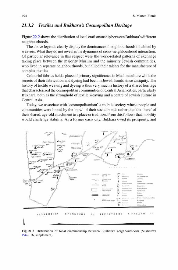
494 S. Marten-Finnis
21.3.2 Textiles and Bukhara’s Cosmopolitan Heritage
Figure 22.2 shows the distribution of local craftsmanship betweenBukhara’s differentneighbourhoods.
The above legends clearly display the dominance of neighbourhoods inhabited byweavers.What they do not reveal is the dynamics of cross-neighbourhood interaction.Of particular relevance in this respect were the work-related patterns of exchangetaking place between the majority Muslim and the minority Jewish communities,who lived in separate neighbourhoods, but allied their talents for the manufacture ofcomplex textiles.
Colourful fabrics held a place of primary significance inMuslim culture while thesecrets of their fabrication and dyeing had been in Jewish hands since antiquity. Thehistory of textile weaving and dyeing is thus very much a history of a shared heritagethat characterized the cosmopolitan communities of Central Asian cities, particularlyBukhara, both as the stronghold of textile weaving and a centre of Jewish culture inCentral Asia.
Today, we associate with ‘cosmopolitanism’ a mobile society whose people andcommunities were linked by the ‘now’ of their social bonds rather than the ‘here’ oftheir shared, age-old attachment to a place or tradition. From this follows thatmobilitywould challenge stability. As a former oasis city, Bukhara owed its prosperity, and
Fig. 21.2 Distribution of local craftsmanship between Bukhara’s neighbourhoods (Sukhareva1962, 16, supplement)
21 Steppe and Sown: Eurasianism, Soil and the Mapping of Bukhara … 495
perhaps its very existence, to the mobility along the Silk Road. Although the SilkRoad had been declining in importance for over 400 years when Sukhareva’s sourceswere active, mobility related to trade and textiles (Jacoby 2004)—both intrinsicallylinked to Muslim and Jewish cultures—was still a dominant factor in professionallife after the Russian arrival in Turkestan, which even gave it a boost.
The place of Jewish dyers and textile merchants within the silk trade and theirinfluence upon it were disproportionate to their relatively small numbers. Jewishdressmakers were the first to bring sewing machines to Bukhara to distribute themamong the local Muslim population (Sukhareva 1962, 76–77). Moreover, Jews heldthe monopoly of the dying of silk and cotton yarn and cloths because of their accessto rare and precious dyestuffs and techniques (Krauze 1872).
21.3.3 The Jewish Presence in Bukhara
The Jewish presence in Central Asia goes back to the times of the Silk Road (Foltz1998). From the advent of Islam in the seventh century, Jewish traders known asRadanites held a privileged status within the topology of trade networks stretchingbetween Asia and Europe. Their intermediacy allowed them to move freely betweenMuslim and Christian worlds, and their activities spanned the Carolingian Empire,the Islamic World, the Chinese Empire and the Kingdom of the Khazars (Fischel1952). In the ninth century, the Persian geographer Ibn Khurdadbih described theRadanites as
… merchants (who) speak Arabic, Persian, Roman (Greek), the language of the Franks,Andalusians, and Slavs. They journey from west to east, partly on land, partly by sea. Theytransport from the west eunuchs, female and male slaves, silk, castor, marten and other furs,and swords. (Rabinowitz 1948, 51)
As alleged non-believers, Jews were not allowed to marry Muslims. They wereexcluded from living in the Guzars,4 the Muslim neighbourhoods, in order to pre-vent private interaction with the Muslim population (Loewenthal 1961). Instead,they had been allocated areas at the margins of the city, the so-called Slobodas orMakhallias—terms that the people of Bukhara, Samarkand and other Central Asiancities associate with isolated quarters (Kantor 1929, 9), similar to the Jewish Shtetlin Eastern Europe, where Jews lived separated from other residents.
The close-guarded knowledge of dying methods referred in particular to indigoand kirmiz dyes (Fitz Gibbon and Hale 1997, 182), both greatly appreciated by theArabs and in the rest of the Islamic world (Butler Greenfield 2005, 19; Kurdian1941). Russians envoys registered these conditions as early as during the reign ofPeter I. In 1724, Florio Beneveni, Russian ambassador to the Emirate of Bukharafrom 1718–25, reported to the Russian Ministry of Foreign Affairs:
In this Bukhara land, there is a special type of tree with worms located in a steppe. Anexpensive dye of kermez, called coushenina [cochineal] in German, can be derived from this
4Guzar is an Urdu word, it means “a pass, a living, a road”.

496 S. Marten-Finnis
tree. This dye costs eight roubles a pound in Russia. There is plenty of this dye in Bukhara.The Bukharians [sic], however, do not know the secret of manufacturing this dye. They onlycollect worms and sell a lot of them to the Jews. And the Jews use those worms to producethe dye. (Beneveni 1986, 85)
Figure 21.3 is an illustration of what Beneveni described in his report.Nevertheless, the Bukhara government was neither able nor willing to protect
the Jewish community against day-to-day harassment, including refined methodsof provocation aimed at forced conversion, which represented an imminent danger(Sukhareva 1966, 172). Jews were frequently charged with capital crimes and couldonly escape death by abjuring their faith (Amitin-Shapiro 1931, 15–36). These con-
Fig. 21.3 Cochineal parasites feeding onmoisture and nutrients from the fruit-bearing prickly pearcactus (genus Opuntid), native to tropical and subtropicalMexico and South America (Phipps 2010)
21 Steppe and Sown: Eurasianism, Soil and the Mapping of Bukhara … 497
verts were known asMuslim-Jews orChala.5 Theywere forced to leave their quartersand cut off all their family links to live in allocated areas. The Chala communitieshave been described as the most miserable and tragic of all residents in the Khanate(Babakhanov 1951).
A variety of other crafts existed in Bukhara, many of them in the hands of familyworkshops (kustari) (Sukhareva 1962, 16–30) that produced fabrics for export to besold in Samarkand (Grebenky 1873; Sukhareva 1981). However, not all these craftscan be discussed here in detail.
21.3.4 Mobility Versus Stability: Suzani Expressinga Distinct Sense of Place
Having shed some light on the male-dominated mobility that was a feature ofBukhara’s textile-making and trading, the remainder of this sub-chapter will bedevoted to the stability associatedwith an exclusively female product: suzani—the artof embroidery. As distinctly urban creations, suzani embroideries mirror the femaleattachment to a place and a tradition of the settled communities in the oasis cities.
Suzani are the most widespread form of household decoration in Bukhara,although the name is applied to all Central Asian embroideries. Suzanimeans needle-work. The term is derived from suzan—the Tajik word for needle (Sukhareva 2013,5). Suzani-making was the provenance of amateur-artisans working for pleasurerather than profit. According to Sukhareva, it was a typically female way of artisticexpression.Women, she argued,were able to reveal their creative abilitiesmore freelythan men, whose artistic expressions were generally influenced by their training ascraftsmen or in skilled trades and this training would tend to restrict their choice offorms (Sukhareva 1983; Chepelvetskaia and Sukhareva 1991, 75–81).
Suzani embroideries decorated tapestries, bed and bolster covers—the most pre-cious items in the dowry to be used for the nuptial bed (Cootner 1986). They repre-sented fashion and tradition of a place, labour and luxury thereby giving the bride areassuring memento of her family. Their patterns displayed abstraction from nature,cult or magical meanings that were conveyed by love of ornament, emphatic colourand vigorous line, or from wellbeing, fertility and abundance in a garden, as demon-strated in Fig. 21.4 (Nauchno-issledovatel’skii institute iskusstvoznaniia UzbekskoiSSR 1955, 89–104).
They could also evoke more dramatic associations with apotropaic images thatwere understood as protecting oasis inhabitants from the threats in their environment:the surrounding steppe. Some of their images have become widely known, as forexample the kalamafur or bodom motifs (Fig. 21.5). Kalamfur refers to the paprikapepper, bodom—to the almond.
Both were thought to afford protection due to their pepperiness and bitternessrespectively. They decorated the carpets of vulnerable people, such as pregnant
5Tajik for ‘neither-nor’. Name applied to Bukhara Jews forced to convert to Islam.
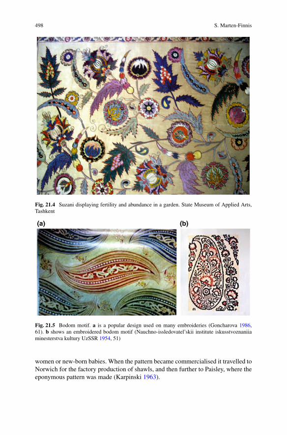
498 S. Marten-Finnis
Fig. 21.4 Suzani displaying fertility and abundance in a garden. State Museum of Applied Arts,Tashkent
Fig. 21.5 Bodom motif. a is a popular design used on many embroideries (Goncharova 1986,61). b shows an embroidered bodom motif (Nauchno-issledovatel’skii institute iskusstvoznaniiaminesterstva kultury UzSSR 1954, 51)
women or new-born babies. When the pattern became commercialised it travelled toNorwich for the factory production of shawls, and then further to Paisley, where theeponymous pattern was made (Karpinski 1963).
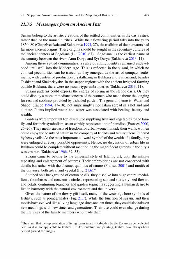
21 Steppe and Sown: Eurasianism, Soil and the Mapping of Bukhara … 499
21.3.5 Messengers from an Ancient Past
Suzani belong to the artistic creations of the settled communities in the oasis cities,rather than of the nomadic tribes. While their flowering period falls into the years1850–80 (Chepelvetskaia and Sukhareva 1991, 27), the tradition of their creators hadfar more ancient origins. These origins should be sought in the sedentary cultures ofthe ancient centers of Sogdiana (Liu 2010, 67). “Sogdiana” is the earliest name ofthe country between the rivers Amu Darya and Syr Darya (Sukhareva 2013, 11).
Among these settled communities, a sense of ethnic identity remained undevel-oped until well into the Modern Age. This is reflected in the suzani, in which noethnical peculiarities can be traced, as they emerged as the art of compact settle-ments, with centres of production crystallizing in Bukhara and Samarkand, besidesTashkent and Shakhrisyabz. In the steppe regions with the ancient irrigated farmingoutside Bukhara, there were no suzani-type embroideries (Sukhareva 2013, 11).
Suzani patterns could express the energy of spring in the steppe oasis. Or theycould display a more immediate concern of the women who made them: the longingfor rest and coolness provided by a shaded garden. The general theme is ‘Water andShade’ (Taube 1994, 17–18), not surprisingly since Islam spread in a hot and aridclimate. Plants implied water, and water was associated with healing, beauty andwealth.
Gardens were important for leisure, for supplying fruit and vegetables to the fam-ily, and for their symbolism, as an earthly representation of paradise (Franses 2000,25–26). They meant an oasis of freedom for urban women; inside their walls, womencould enjoy the beauty of nature in the company of friends and family unencumberedby heavy veils. As the most important outward symbol of the wealth of a family, theywere enlarged at every possible opportunity. Hence, no discussion of urban life inBukhara could be complete without mentioning the magnificent gardens in the city’swestern part (Sukhareva 1966, 32–33).
Suzani came to belong to the universal style of Islamic art, with the infiniterepeating and enlargement of patterns. Their embroideries are not concerned withdetails but rather with the abstract qualities of nature (Franses 2001) and motifs ofthe universe, both astral and vegetal (Fig. 21.6).6
Stitched on a background of cotton or silk, they dissolve into huge central medal-lions, rhombuses and concentric circles, representing sun and stars, stylized flowersand petals, continuing branches and garden segments suggesting a human desire tolive in harmony with the natural environment and the universe.
Given the nature of the dowry gift itself, many of the weavings bore symbols offertility, such as pomegranates (Fig. 21.7). While the function of suzani, and theirmotifs have evolved like a living language since ancient times, they could also take onnew meanings with new times and generations. Their use could even change duringthe lifetimes of the family members who made them.
6The claim that the representation of living forms in art is forbidden by the Koran can be neglectedhere, as it is not applicable to textiles. Unlike sculpture and painting, textiles have always beenneutral ground for images.
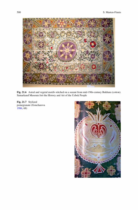
500 S. Marten-Finnis
Fig. 21.6 Astral and vegetal motifs stitched on a suzani from mid-19th-century Bukhara (cotton).Samarkand Museum fort the History and Art of the Uzbek People
Fig. 21.7 Stylizedpomegranate (Goncharova1986, 68)
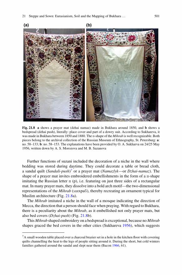
21 Steppe and Sown: Eurasianism, Soil and the Mapping of Bukhara … 501
Fig. 21.8 a shows a prayer mat (dzhai namaz) made in Bukhara around 1850, and b shows abedspread (dzhai push), literally: place cover and part of a dowry suit. According to Sukhareva, itwasmade in Bukhara between 1850 and 1880. The p-shape of theMihrab is well recognizable. Bothpieces belong to the archival collection of the Russian Museum of Ethnography, St. Petersburg: a:no. 58–133; b: no. 58–153. The explanations have been provided by O. A. Sukharva on 24/25 May1956, written down by A. S. Morozova and M. B. Sazanova
Further functions of suzani included the decoration of a niche in the wall wherebedding was stored during daytime. They could decorate a table or bread cloth,a sandal quilt (Sandali-push)7 or a prayer mat (Namazlyk—or Dzhai-namaz). Theshape of a prayer mat invites embroidered embellishments in the form of a p-shapeimitating the Russian letter p (p), i.e. featuring on just three sides of a rectangularmat. In many prayer mats, they dissolve into a bold arch motif—the two-dimensionalrepresentations of the Mihrab (mixpab), thereby recreating an ornament typical forMuslim architecture (Fig. 21.8a).
The Mihrab imitated a niche in the wall of a mosque indicating the direction ofMecca, the direction that a person should face when praying.With regard to Bukhara,there is a peculiarity about the Mihrab, as it embellished not only prayer mats, butalso bed covers (Dzhai-push) (Fig. 21.8b).
ThisMihrab shaped embroidery on a bedspread is exceptional, because noMihrabshapes graced the bed covers in the other cities (Sukhareva 1956), which suggests
7A small wooden table placed over a charcoal brazier set in a hole in the kitchen floor with coveringquilts channelling the heat to the legs of people sitting around it. During the short, but cold wintersfamilies gathered around the sandal and slept near them (Bacon 1966, 61).
502 S. Marten-Finnis
that theMuslim traditionwas deeper rooted amongBukharans than among the settledcommunities of Sakhrizabs, Samarkand and Tashkent.
21.4 Conclusion
What is the relevance of the ethnographic accounts on Bukhara under discussion inthis chapter for our understanding of the interrelationship between environmentalfactors and socio-cultural changes in the area around the ancient Silk Road? Whatrole might they play in today’s renewed discussion on Eurasian integration? And towhat extent can they serve as a guideline to global intellectual interaction?
Firstly, the ethnographic accounts expose an approach that distinguished betweenthe domestic lifestyle of the settled people in the oasis cities and the nomadiclifestyle in areas where severer climatic conditions made civilization more fragile.The accounts discussed here unravel the various layers of Bukhara’s cosmopolitanheritage. In their way of juxtaposing mobility and stability, they reveal that thisheritage was conditioned by the city’s geopolitical situation through time, a sharedMuslim-Jewish history of textile weaving and dyeing, and the division of labouralong lines of gender linked to amateur and professional practice.
Secondly, said accounts relied on testimonies, reported observations and schol-arship. In their confrontation of lived knowledge conveyed linearly by generationsof residents, with the systemized knowledge of academic enquiry mined verticallyto deepen insights, the transcultural perspective of the local agents who assembledthem turned out to be a crucial factor.
Thirdly, these accounts of human agency appear as discursive events. Theway theywere assembled and presented demonstrates that knowledge was acquired as an actof cooperation, in which the will to understand and to communicate was considereda prerequisite for dialogue, appreciation, academic reorientation and joint action.
The momentum of such knowledge acquisition and transfer was related to thespeed and permanence of its flow via the continental bridge. This points to thenotion of soil and its significance in the school of Eurasianism; it is still relevantto our understanding of knowledge flowing between Asia and Europe, and hencefor the Eurasian integration project as an intensified process of cultural interactionbetween Asia and Europe. Advancing this project implies a change of perspective,and a flexible approach that allows agents to negotiate between soft and hard skills,cultural theory and local practice, between the history of ideas and the history ofgeographical space. This balancing act is as significant today as it was during thetimes of the ancient Silk Road.
Acknowledgements My research for this article was enabled by a visiting fellowship providedduring the academic year 2014/15 by the cluster of excellence “Asia andEurope in aGlobal Context”at the University of Heidelberg. I am also grateful to the University of Portsmouth for sabbaticalleave enabling me to complete the work.
21 Steppe and Sown: Eurasianism, Soil and the Mapping of Bukhara … 503
References
Abshin, S. N., & Bushkov, V. I. (2006). Sredneaziatskii etnograficheskii sbornik. K 100-letiiu sodnia rozhdeniia Olgi Aleksandrovny Sukharavoi [Collected works on ethnographic research inCentral Asia. On the occasion of the 100th anniversary of O. A. Sukhareva. Vypusk V.]. Moskva:Nauka.
Amitin-Shapiro, Z. L. (1931). Ocherki pravogo byta sredne-aziatskikh evreev [Remarks on legalmatters of Jews in Central Asia]. Tashkent, Samarkand: Uzbek State Publishing House.
Babakhanov, I. M. (1951). K voprosu o proiskhozhdenii gruppy evreev-musul’man v Bukhare.Sovetskaia Etnografiia, 3, 162–163.
Bacon, E. E. (1966). Central Asians under Russian rule. A study in culture change. Ithaka, NewYork: Cornell University Press.
Barthold, V. V. (1927). Istoriia kul’turnoi zhizni Turkestana [A cultural history of Turkestan].Leningrad.
Barthold, V. V. (1966). Sochineniia [Works] (Vol. VI, p. 157). Moskva.Bassin, M. (1991). Russia between Europe and Asia: The ideological construction of geographicalspace. Slavic Review, 50(1), 1–17.
Beneveni, F. (1986). Reports and letters (1724). In N. A. Halfin (Ed.), Poslannik Petra i na Vostoke[Peter’s the great envoy to the East]. Moskva: Nauka.
Biulleten Sredne-Aziatskogo Gosudarstvennogo Universiteta [Bulletin of the Central Asian StateUniversity]. (1924). 7, 45.
Brower, D. (1997). Islam and ethnicity. Russian Colonial Policy in Turkestan. In D. R. Brower & E.J. Lazzerini (Eds.),Russia’s orient. Imperial borderlands and peoples, 1700–1917 (pp. 115–135).Bloomington: Indiana University Press.
Bukhara v gosudarstvennom khoziaistvennom plane na 1923 i 1924 gg. [Bukhara in the stateeconomic plan of the years 1923 and 24]. (1923). Staraia Bukhara, 54, table 10.
Burnes, A. (1842). Travels into Bokhara [sic]. London: John Murray.Butler Greenfield, A. (2005). A perfect red. Empire, espionage and the quest for the colour of desire.London: Harper College Publisher.
Chepelvetskaia, G. L., & Sukhareva, O. A. (1991). Susani Usbekistans. Ein Beitrag zur Technik,Ornamentik und Symbolik der usbekischen Seidenstickerei. Hamburg: Reinhold Schletzer Verlag.
Cootner, C. M. (1986). Gardens of paradise, history and technique. Hali. The International Journalof Oriental Carpets and Textiles, 30, 46–48.
Eversmann, E. (1823). Reise von Orenburg nach Buchara. Berlin: Verlag von E.H.G. Christiani.Fischel, W. J. (1952). The Jewish merchants, called radanites. Jewish Quarterly Review (NewSeries), 42, 321–325.
Fitz Gibbon, K., & Hale, A. (1997). Central Asian Jews and the silk trade. In K. F. Gibbon & A.Hale (Eds.), Splendid silks of Central Asian Ikat (pp. 172–192). London: The Guido GoldmanCollection.
Foltz, R. (1998). Judaism and the silk route. The History Teacher, 32(1), 9–16.Foltz, R. C. (1999). Religions of the silk road. Overland trade and cultural exchange from antiquity
to the fifteenth century. New York: St. Martin’s Press.Franses, M. (2000). The great embroideries of Bukhara. London: Textile Art Publications.Franses, M. (2001). Flower power. Hali, 115, 93–98.Goncharova, P. A. (1986). Zolotoshveinoe iskusstvo Bukhary [The art of gold embroidery inBukhara]. Tashkent: Izdatel’stvo literatury i iskusstva im. Gafura Guliama.
Grebenky, N. F. (1873). Remeslennaja deiatelnost’ tadzhikov Zeravshanskogo okruga [Tajik artisanactivities in the Zeravshansky region]. Turkestanskii Sbornik (St. Petersburg), 52, 511–514.
Grenet, F. (2013–14). Histoire et cultures de l’Asie central préislamique. Annuaire du Collège deFrance. Résumés.
Grenet, F. (2015, November 18). Personal communication and discussion of paper at the FourthInternational SEECHAC Colloquium on “Religious Revivals and Artistic Renaissance in CentralAsia and the Himalayan Region—Past and Present”, University of Heidelberg, November 16–18.

504 S. Marten-Finnis
Grousset, R. (1970).The empire of the steppes (p. ix). NewBrunswick,NewYork:RugersUniversityPress.
Halperin, C. J. (1983). George Vernadsky, Eurasianism, the Mongols, and Russia. Slavic Review,43(3), 477–493.
Hirsch, F. (2005). Empire of nations: Ethnographic knowledge and the making of the Soviet Union.Ithaka: Cornel University Press.
Huhn, U. (2016). Die Wiedergeburt der Ethnologie aus dem Geist des Atheismus. Zur Erforschungdes „zeitgenössischen Sektierertums“ im Rahmen von Chrušcevs antireligiöser Kampagne.Jahrbücher für Geschichte Osteuropas, 64(2), 260–298.
Iusupov, U. (1930). Vystuplenie na VII. Sredneaziatskom kraevom soveshchanii po rabote sredizhenshchin sostoialas, 26 dekabria 1929 goda-2 ianvaria 1930 goda [Speech given at the 7thCentral Asian advisory meeting on activities to be carried out among women, 26 December 1929to 2 January 1930]. Orden trudovogo znamenii institut istorii partii pri TsK KP Uzbekistana –Filial instituta marksizma-leninizma pri TsK KPSS [Launched by the historical institute of thecentral ctee of the communist party of Uzbekistan – branch of the institute of Marxism-Leninismat the central committee of the CPSU. Izbrannye Trudy. I [Selected works] Tashkent: AkademiiaNauk Uzbekskoi SSR.
Jacoby, D. (2004). Silk economics and cross-cultural artistic interaction: Byzantium, the Muslimworld, and the Christian west. Dumbarton Oaks Papers, 58, 197–240.
Jakobovsky, A. I. (1951). Glavnye voprosy izucheniia istorii goroda Srednei Azii [Main aspects forthe historical study of the historical city]. Trudy Tadzh. Filiala SSSR (Dushanbe), 29(3/4).
Jakovlev, P. (1824). Zamechaniia na fakty. Nekotorye svedeniia o Bukhare, napechatanyi v “Otech-estvennykh Zapiskakh” 1821 g. Sibirskii Vestnik, St. Petersburg.
Jersild, A. L. (1997). From savagery to citizenship: Caucasian Mountaineers and Muslims in theRussian Empire. In D. R. Brower & E. J. Lazzerini (Eds.), Russia’s orient. Imperial borderlandsand peoples, 1700–1917. Bloomington: Indiana University Press.
Kamp, M. (2010). Where did the Mullahs go? Oral histories from rural Uzbekistan. Die Welt desIslams, 50, 503–531.
Kantor, L. M. (1929). Tuzemnye evrei v Uzbekistane [Indigenous Jews of Uzbekistan]. Tashkent:Uzbek State Publishing House.
Karpinski, C. (1963). Kashmir to Paisley. The Metropolitan Museum of Art Bulletin (New Series),22(3), 116–123.
Khalid, A. (2000). Society and politics in Bukhara, 1868–1920. Central Asian Survey, 19(3/4),367–396.
Khalid, A. (2007). Islam after communism: Religion and politics in Central Asia. Berkeley: Uni-versity of California Press.
Khalid, A. (2015). Making Uzbekistan. Nation, empire, and revolution in the early USSR (p. 270).London: Cornell University Press.
Krauze, I. (1872). Zametki o meditsinskikh i nekotorykh rasteniiakh v Srednei Azii [Remarks onmedical and other plants in Central Asia]. Russkii Turkestan. Stati po etnografii, tekhnike, sel-skomu khoziaistva i estestvennoi istorii [Russian Turkestan. Articles on ethnography, technology,agriculture and natural history], Vypusk 2 (pp. 262–273). Moskva: Universitetskaia Typografiia.
Kurdian, H. (1941). Kirmiz. Journal of the American Oriental Society, 61(2), 105–107.Laruelle,M. (2007). The orient in Russian thought at the turn of the century. InD. Shlapentokh (Ed.),
Russia between East and West. Scholarly debates on eurasianism (pp. 9–37). Leiden, Boston:Brill.
Liu, X. (2010). The silk road in world history. Oxford: Oxford University Press.Loewenthal, R. (1961). Les Juifs de Boukhara. Cahiers du Monde Russes et Soviétique, 2(1),104–108.
Materialy vsesoiuznoi perepisi 1926 goda [Data on the comprehensive Soviet census of the year1926]. (1927). Samarkand, 41.
Meiendorff, C. (1840). Journey of the Russian mission from Orenburg to Bokhara [sic]. (C.Monteith,Trans.). Madras Engineers, Madras: Spectator press (first published in 1820).

21 Steppe and Sown: Eurasianism, Soil and the Mapping of Bukhara … 505
Nauchno-issledovatel’skii institut iskusstvoznaniiaminesterstva kulturyUzSSR [Scientific researchinstitute for art historical studies at the ministry of culture of the UzSSR]. (1954).Narodnoe deko-rativnoe iskusstvo Sovetskogo Uzbekistana [Thedecorative art of the people inSovietUzbekistan].Tashkent: Izdatel’stvo akademii nauk Uzbekskoi SSR.
Nauchno-issledovatel’skii institute iskusstvoznaniia Uzbekskoi SSR. (1955). Narodnoe dekorativ-noe iskusstvo sovetskogo Uzbekistana [The decorative art of the people in Soviet Uzbekistan].Moskva: State Publishing House.
P. [sic]. (1825). Noveishee opisanie Velikoi Bukhari. Zhiteli Bukhari, ikh promyshlennost’ i torgov-lia [Latest description of Greater Bukhara. The people of Bukhara, their trades and industries].Aziatskii Vestnik (Izdatel’stvo Nauka i Iskusstva), 304–317.
Petrushevskii, I. P. (1948). Gorodskaia znat v gosudarstve Khulaguidov. Sovetskoe Vostokovedenie.V. Moskva.
Phipps, E. (2010). Cochineal red: The art history of a color. The Metropolitan Museum of ArtBulletin (New Series), 67(3), 4–48.
Rabinovich,M.G.,&Shmeleva,M.N. (1981).K etnograficheskomu izucheniiu goroda. Programmaetnograficheskogo izucheniia gorodov [About the ethnographic study of cities. Programme ofethnographic research about the city]. Sovetskaia Etnografiia, 3, 23–44.
Rabinowitz, L. (1948). Jewish merchant adventurers: A study of the radanites. London: Goldston.Riasanovsky, N. V. (1967). The emergence of Eurasianism. California Slavic Studies, 4, 39–72.Sartori, P. (2016). Visions of justice: Sharı’a and cultural change in Russian Central Asia. Leiden:Brill.
Savitsky, N. S., Trubetskoi, N. S., Suvchinsky, P. P., & Florovsky, G. V. (1921). Iskhod k vostoku(Exodus to the East). Sofia: Rossiisko-bolgarskoe knigoizdatel’stvo.
Schreider, A. (1921). Unsere Aufgaben [mission statement]. Znamia – Standarte. Zeitschrift fürLiteratur, Politik und Kunst, 1, 1.
Schuyler, E. (1966). Turkistan [sic]. Notes of a journey in Russian Turkistan, Kokand, Bukhara andKuldja bye (edited with an introduction by G. Wheeler) (p. XIII). London: Routledge & KeganPaul.
Shishkin, V. A. (1936). Arkhitekturnye pamiatniki Bukhary [Architectural monuments of Bukhara].Tashkent.
Shishkin, V. A. (1943). Goroda Uzbekistana [The cities of Uzbekistan]. Tashkent.Sirazhdinov, S. (1970). Taschkentskii Gosudarstvenyi Universitet im. V.I. Lenina [Tashkent StateUniversity‚V.I. Lenin].Ocherki [Remarks] (Tashkent:Gosudarstvennoe izdatel’stvo), 34–35(44),310–312.
Sovremennyi kishlak Srednei Azii [The Modern Kishlak of Central Asia]. (1926). Sotsialno-ekonomicheskii ocherk, IV Vabkentskaia volost’, Tashkent.
Stronski, P. (2011). Forging a Soviet City, 1930-1966. Pittsburgh: University of Pittsburgh Press.Sukhareva,O.A. (1956). Information provided on item58-153of the suzani collection in theRussianMuseum of Ethnography, St. Petersburg, on 24 and 25 May, written down by A.S. Morozova &M.B. Sazanova.
Sukhareva, O. A. (1958). K istorii gorodov Bukharskogo khanstva (Istoricheskie ocherki) [Thehistorical cities in the Khanate of Bukhara. Historical essays]. Tashkent: Izdatel’stvo AkademiiNauk Uzbekskoi SSR.
Sukharev, O.A. (1960). Islam v Uzbekistane [Islam inUzbekistan]. Tashkent: Izdatel’stvoAkademiiNauk Uzbekskoi SSR.
Sukhareva, O. A. (1962). Posdnefeodal’nyi gorod Bukhara kontsa 19-nachala 20 veka. Remeslen-naia promyshlennost’ [Bukhara—The post-feudal city during the late 19th and early 20th cen-turies. Artisan-industries]. Tashkent: Izdatel’stvoAkademiiaNaukUzbekskoi SSR, Institut Istoriii Arkheologii.
Sukhareva, O. A. (1966). Bukhara XIX - nachalo XX v. Posdnefeodal’ny gorod i ego naselenie[Bukhara during the 19th and early 20th centuries. The post-feudal city and its population].Moskva: Izdatel’stvo Nauka.

506 S. Marten-Finnis
Sukhareva, O. A. (1969). Suzani. Sredneaziatskaia dekorativnaia vyshevka [Suzani. Central Asiandecorative embroideries] Moskva: Izdatel’skaia firma ‘Vostochnaia literatura” RAN (an Englishtranslation appeared in 2011 under the title: Suzani. Central Asian decorative embroidery. Inter-national Institute for Central Asian Studies, Samarkand State United Historical-Architectural andArt Museum. Tashkent: publisher unknown).
Sukhareva, A. O. (1976). Kvartal’naia obshchina posdnefeodal’nogo goroda Bukhary (v sviazis istoriei kvartalov) [Understanding Urban Neighbourhood Principles in Post-Feudal Bukhara(Linked to the History of Neighbourhoods)]. Moskva: Izdatel’stvo Nauka.
Sukhareva, O. A. (1979). Kostium narodov Srednei Azii.Istoriko-etnograficheskie ocherki [Thecostume of the peoples in Central Asia. Essays on history and ethnography]. Akademiia NaukSSSR, Institut Etnografii im. N.N. Miklukho-Maklaia. Moskva: Izdatel’stvo Nauka.
Sukhareva, A. O. (1981). O tkatskikh remeslakh v Samarkande [On the weaving industries ofSamarqand]. In Akademiia Nauk Tadzh. SSR, Institut istorii im. A. Donisha (Ed.), Istoriia ietnografiia narodov Srednei Azii (pp. 25–37). Dushanbe: Donish.
Sukhareva, O. A. (1983). Ornament dekorativnykh vyshivok i ego sviaz’ s narodnymi predstavleni-iami i verovaniiami [Folklore, imaginations and beliefs in the ornaments of decorative embroi-deries]. Sovetskaia Etnografiia (Moskva), 6, 67–79.
Sukhareva, O. A. (2013). Suzani. Central Asian decorative embroidery. Tashkent: InternationalInstitute for Central Asian Studies, Samarkand State United Historical-Architectural and ArtMuseum.
Taube, J. (1994). Suzani. A textile art from Central Asia. With an introduction and text to thecollection by Ignazio Vok. Munich: Edition Vok.
Tolz, V. (2005). Orientalism, nationalism and ethnic diversity in late Imperial Russia. The HistoricalJournal, 48(1), 127–150.
Tolz, V. (2011). Russia’s own orient. The politics of identity and oriental studies in the late Imperialand Early Soviet periods. Oxford: Oxford University Press.
Umniakov, I. I. (1923). K voprosu ob istoricheskoi topografii Bukhary [About the historical topogra-phy of Bukhara]. Sbornik Turkestanskogo Vostochnogo instituta v chest A. E. Shmidta. Tashkent.
Yaroshevski, D. (1997). Empire and citizenship. In D. R. Brower & E. J. Lazzerini (Eds.), Russia’sorient. Imperial borderlands and peoples, 1700–1917 (pp. 61, 65–72). Bloomington: IndianaUniversity Press.
Open Access This chapter is licensed under the terms of the Creative Commons Attribution 4.0International License (http://creativecommons.org/licenses/by/4.0/), which permits use, sharing,adaptation, distribution and reproduction in any medium or format, as long as you give appropriatecredit to the original author(s) and the source, provide a link to the Creative Commons license andindicate if changes were made.
The images or other third party material in this chapter are included in the chapter’s CreativeCommons license, unless indicated otherwise in a credit line to the material. If material is notincluded in the chapter’s Creative Commons license and your intended use is not permitted bystatutory regulation or exceeds the permitted use, you will need to obtain permission directly fromthe copyright holder.

Chapter 22A Karez System’s Dilemma: A CulturalHeritage on a Shelf or Still a ViableTechnique for Water Resiliency in AridRegions
Shalamu Abudu, Zhuping Sheng, James Phillip King and So-Ra Ahn
Abstract Karez system is considered as the global human heritage since it is notonly a traditional water supply system of exploiting groundwater, but also it reflectsthe culture, socio-economy, and history of the ancient civilizations that had utilizedthem for thousands of years in arid and semi-arid regions of the world. However,with the explosive population growth and rapid development of pumping technologyin the last century, the karezes dried up or were abandoned as pumping wells lowerthe groundwater table. This poses a dilemma to policy makers whether to facilitatelarge-scale utilization of pumping well technology over karez system and treat karezas a cultural heritage which is non-functional for food production, or to keep usingand preserving the karez system as a sustainable way of groundwater managementas part of the integrated water supply systems in the arid regions. In this paper, wereviewed the historical, socio-economic, and cultural importance of karezes in thearid regions. We also discussed the distribution of karezes in the world, their uniquegeographical characteristics, technological advantages and limitations. We observedthat the karez system is not only economically robust over the long term, but also aviable water supply technique for irrigation and domestic uses. The karezes shouldbe protected as indigenous human heritage, and at the same time, they can be utilizedas a sustainable way of water resources management in the arid regions to enhancewater resiliency under changing environment.
Keywords Karez system · Groundwater · Sustainable · Arid regionCultural heritage · Viable technique · Pumping well
S. Abudu (B) · Z. Sheng · S.-R. AhnTexas A&M AgriLife Research Center at El Paso, Texas A&M University System, 1380 A&MCircle, El Paso TX 79927, USAe-mail: [email protected]
J. P. KingCivil Engineering Department, New Mexico State University, MSC 3C, Box 30001, Las CrucesNM 88003, USA
© The Author(s) 2019L. E. Yang et al. (eds.), Socio-Environmental Dynamics along the Historical Silk Road,https://doi.org/10.1007/978-3-030-00728-7_22
507
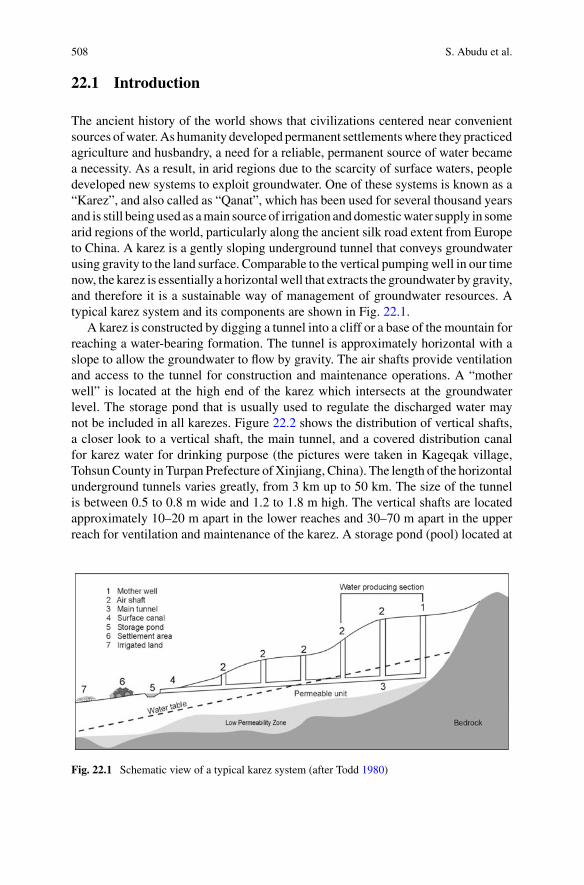
508 S. Abudu et al.
22.1 Introduction
The ancient history of the world shows that civilizations centered near convenientsources ofwater. As humanity developed permanent settlementswhere they practicedagriculture and husbandry, a need for a reliable, permanent source of water becamea necessity. As a result, in arid regions due to the scarcity of surface waters, peopledeveloped new systems to exploit groundwater. One of these systems is known as a“Karez”, and also called as “Qanat”, which has been used for several thousand yearsand is still being used as amain source of irrigation anddomesticwater supply in somearid regions of the world, particularly along the ancient silk road extent from Europeto China. A karez is a gently sloping underground tunnel that conveys groundwaterusing gravity to the land surface. Comparable to the vertical pumpingwell in our timenow, the karez is essentially a horizontalwell that extracts the groundwater by gravity,and therefore it is a sustainable way of management of groundwater resources. Atypical karez system and its components are shown in Fig. 22.1.
A karez is constructed by digging a tunnel into a cliff or a base of the mountain forreaching a water-bearing formation. The tunnel is approximately horizontal with aslope to allow the groundwater to flow by gravity. The air shafts provide ventilationand access to the tunnel for construction and maintenance operations. A “motherwell” is located at the high end of the karez which intersects at the groundwaterlevel. The storage pond that is usually used to regulate the discharged water maynot be included in all karezes. Figure 22.2 shows the distribution of vertical shafts,a closer look to a vertical shaft, the main tunnel, and a covered distribution canalfor karez water for drinking purpose (the pictures were taken in Kageqak village,TohsunCounty in Turpan Prefecture ofXinjiang, China). The length of the horizontalunderground tunnels varies greatly, from 3 km up to 50 km. The size of the tunnelis between 0.5 to 0.8 m wide and 1.2 to 1.8 m high. The vertical shafts are locatedapproximately 10–20 m apart in the lower reaches and 30–70 m apart in the upperreach for ventilation and maintenance of the karez. A storage pond (pool) located at
Fig. 22.1 Schematic view of a typical karez system (after Todd 1980)
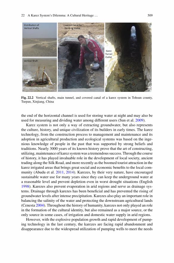
22 A Karez System’s Dilemma: A Cultural Heritage … 509
Fig. 22.2 Vertical shafts, main tunnel, and covered canal of a karez system in Tohsun county,Turpan, Xinjiang, China
the end of the horizontal channel is used for storing water at night and may also beused for measuring and dividing water among different users (Sun et al. 2009).
Karez system is not only a way of extracting groundwater, but also representsthe culture, history, and unique civilization of its builders in early times. The kareztechnology, from the construction process to management and maintenance and itsadoption in agricultural production and ecological systems was based on the inge-nious knowledge of people in the past that was supported by strong beliefs andtraditions. Nearly 3000 years of its known history prove that the art of constructing,utilizing,maintenance of karez systemwas a tremendous success. Through the courseof history, it has played invaluable role in the development of local society, ancienttrading along the Silk Road, and more recently as the boomed tourist attraction in thekarez irrigated areas that brings great social and economic benefits to the local com-munity (Abudu et al. 2011, 2014). Karezes, by their very nature, have encouragedsustainable water use for many years since they can keep the underground water ata reasonable level and prevent depletion even in worst drought situations (English1998). Karezes also prevent evaporation in arid regions and serve as drainage sys-tems. Drainage through karezes has been beneficial and has prevented the rising ofgroundwater levels after intense precipitation. Karezes also play an important role inbalancing the salinity of the water and protecting the downstream agricultural lands(Cenesta 2004). Throughout the history of humanity, karezes not only played an rolein the formation of the cultural identity, but also remained as a major source, or theonly source in some cases, of irrigation and domestic water supply in arid regions.
However, with the explosive population growth and rapid development of pump-ing technology in the last century, the karezes are facing rapid abandonment anddisappearance due to the widespread utilization of pumping wells to meet the needs

510 S. Abudu et al.
of increased food production. This traditional water supply technique for irrigationand domestic water supply for human society that has proved viable for hundredsor even thousands of years are disappearing like endangered species. The main rea-sons for abandonment are, but not limited to, the introduction and widespread useof electric and diesel-pumping wells, agricultural expansion, growing demands ofdomestic and industrial water use, the difficulty of karez construction and mainte-nance operations (Beaumont 1989). Even though the current use of karezes is gettinglimited due to the improvements in technology that allows the use of pumping wellsand high-power pumps, karezes are still being considered as one of the main waysof procuring water for irrigation and agricultural development in rural areas of coun-tries along the Silk Road, such as Turkey, Syria, Jordan, Iran, Pakistan, Afghanistan,Uzbekistan, and China. With its known long history, the karez not only is a sustain-able way of using groundwater, but also is a unique system illustrating the use ofingenious knowledge and wisdom in the sustainable management of land, water, andagricultural biodiversity (English 1998; Abudu et al. 2011; Manuel et al. 2017).
It is obvious that there are ongoing dilemma and arguments for policy makersand water managers on preserving karez system as cultural heritage which is non-functional for irrigation and domestic water supply, or continuing to use and preservethe karezes as a sustainable way of groundwater management in agricultural produc-tion as a portion of the integratedwater supply systems in the arid regions. To illustratethe different perspectives, the authors reviewed the historical, socio-economic, andcultural importance of karezes in the arid regions. We summarized the distributionof karezes in the world, their unique geographical characteristics, inter-connectionswith the arid environment, contributions to agricultural biodiversity, and sustain-ability. The discussions throughout the paper were supported by the review of theliterature regarding the karezes in worldwide, particularly in China. Some exampleswere illustrated based on the author’s research and working experience in the TurpanRegion, Xinjiang Uyghur Autonomous Region, China to support the perspectivesthat were sketched in the paper. Finally, some recommendations were proposed forproper utilization and preservation of karezes in the arid regions of the world.
22.2 Distrubution of Karezes and GeographicalCharacteristics
22.2.1 Distribution of Karezes in the World
Karez is a traditional irrigation system that built in the arid and semi-arid regions ofthe world. Many factors should be considered in constructing such a system, such asa climate, topography, hydrology, geology, and geographical characteristics of theregions (Abudu et al. 2011; Remini et al. 2014; Goes et al. 2017). Previous researchon the distribution of karezes indicates that they can be found in over 30 countries inthe world (Baboli and Labaf 2000; Motiee et al. 2006; Mostafaeipour 2010; Remini

22 A Karez System’s Dilemma: A Cultural Heritage … 511
Fig. 22.3 Distribution of karezes in the world. Reproduced from Mostafaeipour (2010)
and Kechad 2012; Rozi and Azizi 2016). The distribution of karezes by country isshown in Fig. 22.3 based on the literature (Mustafa and Usman 2007; Hussain et al.2008;Wilkinson et al. 2012; Taghavi-Jeloudar et al. 2013; Remini and Kechad 2012;Abudu et al. 2014; Goes et al. 2017; Remini and Achour 2017). Their geographicalextent has been documented from Western China to as far west as North Africa andSpain, and some parts of South America.
As can be seen from Fig. 22.3, three main regions were identified. They are (1)Silk Road regions, along the ancient Silk Road that connected Euro-Asian continent,spreading over the western region of China, Afghanistan, Pakistan, Iran, Iraq, Syria,Armenia, and Turkey. (2) Arabian Peninsula and Northern African Region, includingcountries such as Saudi Arabia, Oman, Yemen, United Arab Emirates, Egypt, Libya,Algeria, Morocco. (3) All other sporadic distributed arid and semi-arid regions, suchas southern part of Spain and Mexico, and in Southern America Peru and Chile. TheArabs brought the karez (qanat) idea into Spain, and the Spanish brought it to theNewWorld. Karez-like water-collecting tunnels are present in Los Angeles and elsewherein Southern California. These countries are in the arid and semi-arid regions of theworld, where characterized by an arid climate and limited surface water resources.Hence, the development of oasis-based societies in these regions is closely linked tothe extraction of groundwater to meet agricultural and domestic water demands. Thisis the primary reason and motivation why karezes had been developed and utilizedin this part of the world for thousands of years.
Based on the previous research and rehabilitation reports on the karezes (Baboliand Labaf 2000; Motiee et al. 2006; Abdin 2006; Mostafaeipour 2010), it was con-cluded that the highest number of karezes are built in the Silk Road countries. Thelargest numbers of karezes are in Iran, which has about 36,888 active systems with atotal discharge of about 7 billion cubic meters of groundwater and account for 11%of annual aquifer discharge in the country (Estaji and Raith 2016). In the east endof Silk Road, there were over 1784 karezes with 5272 km underground channels in
512 S. Abudu et al.
Xinjiang,Western China based on 2003 survey data. Unfortunately, only 614 karezesare still flowing in 2003 at a total discharge of 9.58 cubic meters per second (or 302million cubic meters per year), irrigating 11,500 ha of land (Wang et al. 2008). Manykarezes are still being used in Afghanistan, Pakistan, and other countries along theancient Silk Road (Hussain et al. 2008; Rozi and Azizi 2016). In the Arabian Penin-sula and Northern African Region, there are still considerable karezes are in use(Motiee et al. 2006). According to a report on the distribution of karezes in northernAfrica (Mostafaeipour 2010), there are about 200 karezes that are still in use in theTafilaft area of Morocco, about 600 karezes are in use in the Garamantes area nearJarma, Libya. The total length of karezes in Algeria is estimated to be thousands ofkilometers. There are also many karezes that are still in use in the Arab world withabout 4200 that are still operational out of 11,500 in sixteen Arab countries (Rem-ini and Kechad 2012). The existence of sporadically distributed karezes in Mexico,Peru, Chile in southern America, in some European countries such as Spain, Cyprusis also documented in the literature (Motiee et al. 2006; Mostafaeipour 2010).
22.2.2 Geographical Characteristics and Features
Most of the karezeswere constructed in semi-arid regions receiving less than 400mmof annual precipitation. Lightfoot (1996) states that karezes are found in abundancein the regions that have a great discrepancy between precipitation and evapotranspi-ration (ET). For example, the Turpan Depression, Xinjiang, China, has a continentaland extreme arid climate with average summer temperatures reaching 38 °C, haslow annual precipitation (9–25 mm), well below the potential evaporation (about3000 mm). Such climate conditions make the Turpan oasis an ideal place for devel-oping karez irrigation system (Haakon and Shen 2006). Besides annual precipitationand ET, other factors must be considered for the existence of karezes in differentareas such as topography, hydrology, geology, and the agricultural activity nearby.A typical karez system consists of a group of wells and a roughly horizontal tunnelintersecting with the wells located on a very gentle slope that enables drainage ofgroundwater by gravity. These gentle slope areas are mainly bounded by mountainsand hills with mountain-front recharge zones to provide the water supply for thekarez. Alluvial fans or synclinal rock structures at the base of mountains and hillsform shallow aquifers that present favorable construction sites for karezes. Simi-larly, margins of large stream channels coming out of the mountains are the placesalong which shallow aquifers occur. These aquifers are the natural environmentswherein karezes were developed. The combination of shallower aquifers with hightransmissivity provides the best conditions for building karezes (Lightfoot 1996).
For example, the hydrologic setting in Turpan region presents a perfect exampleof such favorable conditions for karezes. In Turpan region, the surface water andgroundwater are supplied from the glacier and snowmelts of northern and westernTianshan Mountains. As the rivers flow from the mountains, most of the water seepsinto the Gobi Desert that has thick sediments of gross texture materials. At the

22 A Karez System’s Dilemma: A Cultural Heritage … 513
northern Gobi Desert, the depth of groundwater table declines from 100 to 150 m inpiedmont to 20 to 30 m near the Flaming Mountain area. Except for certain gorgesthat water can pass through, the Flaming Mountain mainly acts as an obstructionfor both the surface water and groundwater flows. After the flows leave the FlamingMountain, part of the water recharges the shallow aquifer and becomes the watersource for the karez in the south Flaming Mountain area. As there is a natural slopefrom the foothills at 900 m above sea level towards the deepest part of the TurpanBasin at 161 m below sea level, the topography of the area is favorable for thissophisticated irrigation system (Rozi and Azizi 2016). Thus, the unique combinationof a desert climate, abundance of groundwater and suitable topographic conditionsin the region provided ideal conditions for the development of the karez system inthe Turpan Depression (Nuridin 2008).
Geology is another important factor for site selection of karezes. For example, inmost of the steppe and desert regions of Jordan and Syria, deposits of silica such asquartz, chert, and flint often form impervious layers beneath the permeable calciumcarbonate formations that are closer to the surface. In early ages, water-bearing stratawere exploited to build karezes, by excavatingmost of the channels through solid bedsof limestone or other calcium carbonate formations. In most of Syria, limestone andchalk aquifers are relatively shallow from a few meters to tens of meters deep, whichrepresents favorable conditions for karez construction compared to the volcanic rockformations. Even though volcanic soils of the banks are better for agriculture thanlimestone soils, karezes were never dug through basalt zones due to the difficulty ofexcavating karezes through these stronger rock units (Lightfoot 1996). High tectonicactivity zones do not provide favorable conditions for the karezes since the tunnels,and vertical shafts of karezes are not reinforced, they are susceptible to damage fromnatural events, such as earthquakes.
22.3 Historical, Cultural and Socio-economic Significance
22.3.1 Historical and Cultural Significance
Karezes had existed for several thousand years in the arid regions of the world. Insome parts of theworld, they had long become away of life, a part of the cultural iden-tity. They can be considered as a global heritage by their unique history, that reflectsthe social and cultural background of communities that relied on them for a living.Besides their cultural value, their contribution to water conservation and continuityof life in arid and semi-arid climates make this environmental-friendly method animportant means of extracting groundwater. Many karezes can be used for severalcenturies through proper maintenance and operation. For example, the complicatedkarez system in the Xinjiang Uyghur Autonomous Region of China is considered asone of the three great construction projects in ancient China, along with the GreatWall and the Beijing-HangzhouGrand Canal (Rozi andAzizi 2016). They aremainly

514 S. Abudu et al.
distributed in Turpan and Kumul districts in Xinjiang Uyghur Autonomous Region,where Turpan District is known as the location of large numbers of karezes. The totallength of these karezes would exceed 5000 km if they linked together. Hence, thesystem has also been called “the underground Great Wall” (Abudu et al. 2011).
In the past, the social arrangement in karez-based communities had been directlyrelated to the karez system (Bonine 1989). The importance and value of people werejudged according to their ownership rights to the amount of water from the karez,which also created a social hierarchy among them. The household location used tobe a good indicator of the social or economic status of its residents. For example, inIran, the residents of more eminent households of landlords, merchants, and religiousleaders were in the upper section of the karez-based settlement areas where the wateris clean and plentiful (Bonine 1989; English 1998). In karez-based communities,water rights and distribution of water were directly related to rules of ownership.Since each region had its unique ownership and management rules, the water rightsand distribution schemes varied from one place to another in the past. However, thecommon tendency of communities was to use karez water cautiously, that helped thistraditional system last hundreds of yearswithout harming the ecological balance. Thesimple, yet effective, water distribution systemwas dependent on the share owned byeach farmer. In other words, the amount of water was determined by the land rightsthat the landowner owned. The rule was that each landowner or farmer could onlycultivate the area of land that he was able to irrigate with his share of water. Thisrule had brought a balance between water rights and the area to be cultivated. Oncethe water rights were fairly addressed, the descendants of the owners could dividetheir land in agreement according to inheritance laws. Emigrated people lost theirrights to irrigation water unless they returned and claimed them back. This rule didnot apply if the land was sold to somebody else (Wessels and Hoogeveen 2002).
Karezes have created strong cohesion among people owing to the traditions andbeliefs attached to them (Goes et al. 2017). Religious beliefs and cultural traditionsalso helped the karezes to be protected and handed down from the past as a legacy.For instance, karezes were given genders depending on their nature. Ceremoniesthat resemble actual wedding events were performed between subtle, gentle karezes(female) and gushed, spurting karezes (male) as a ritual. These ceremonies usuallytook place when there is a dried up “mother well.” Some of the rituals are still beingfollowed to some degree in the rural settlements and villages of Iran (Cenesta 2004).In Turpan region of China, the local people see karezes as the part of their history andcultural identity. The local people treat the karez builders as local heroes, braving thedesert and bringing life to a village (Nuridin 2008). The difficulty in construction, theclean water and eco-friendly feature of karezes are the main topic for local Uyghursongs and other cultural celebrations in the local community (Nuridin 2014).
22 A Karez System’s Dilemma: A Cultural Heritage … 515
22.3.2 Socio-economic Importance
Karezes not only had a deep root in the life of people andwere a strong part of culturalidentity but also were an important part of the continuous development of the localeconomy and agricultural production. According to a report by the Cenesta (2004),about nine billion cubic meters of karez water is still being used for agriculturalproduction in Iran. Hence, the restoration and maintenance of karezes can be a veryeffective strategy in food production there. Karezes remain one of the main sourcesof irrigation water in the Turpan region of western China. Despite a large decrease inthe number of karezes used in the Turpan region, karezes are still contributing to theirrigation of more than 30% of agricultural land. More than 50,000 households and100,000 livestock benefit from the karez system as a drinking water source (Nuridin2008).Without the karez system, the landscape in the regionwould be desert (Haakonand Shen 2006; Sun et al. 2009).
Thousands of karezes were built by governments, local investors, even farmersin the arid regions throughout history, and they are diffused into every corner ofmany arid regions that are suitable for karez construction. However, with the intro-duction of well technology, construction of new karezes seems impossible due to thetime, intensive and skillful labors, and cost of construction. Compared to the cost ofpumping well drilling, the expenditure for the construction of a karez may be 8–9times more than that of a well (Cenesta 2004). However, considering the lifespanof both, karezes are more economical since their service life can be more than tentimes that of a well through proper maintenance. According to the cost and benefitcomparison reported by the Cenesta (2004), the level of income of a farmer from akarez is 30% more than that from a well, and it has been shown that a karez is moreeconomical in the long-term for agricultural and environmental purposes. Karezeshave other economic advantages besides their use in irrigation and as a source fordomestic water use. Due to their historical and cultural value, karezes can be a goodattraction for tourists when combined with other cultural aspects that are unique tospecific regions. For example, karezes are one of the most important tourist spots inthe Turpan region of China with an annual contribution of 20 million Yuan (about2.5 million U.S. dollars) to the local economy (Nuridin 2014; Pei et al. 2008).
22.4 Advantages and Limitations of the Karez Technology
22.4.1 Karez System Ensures Diversified Ecosystems
The main function of a karez system is to provide irrigation water for agriculture. Acultivation system in karez-irrigated agriculture is based on the principle of makingthe best use of limited water. To prevent karez water from being wasted, a collectivesystem of cultivation needs to be followed by the farmers. The selected crops needto be diverse and complement each other in terms of water requirements. In addi-
516 S. Abudu et al.
tion, the seasonality of crops helps make maximum use of available water resourcesthroughout the year and thus sustains the livelihood of farmers all year long. Hence, asustainable cultivation system is practiced under karez-irrigated agriculture, that con-siders the crop types and seasonality to achieve multiple purposes of water saving, aswell as improving soil texture and quality (Cenesta 2004). In this way, karez-irrigatedareas have formed their unique collective system of agricultural management.
The diversity of crops is one of the main features of the karez-based agriculturalsystem in arid areas. Karezes are not only used for the irrigation of agricultural cropsbut also used for large numbers of orchards and community and private gardens.The idea of making good use of karez water has resulted in a wide diversity of croptypes. For example, in the Iranian plateau, the traditional orchards have always beendependent on karezes, especially those thatwere closer to karezes or nearer to villages(Cenesta 2004). The villagers use the karez water to irrigate a community garden togrow crops such as onions, cucumbers, tomatoes, and other vegetables. The gardenalso contains fruit trees such asmulberry, fig, and pomegranate. These perennial cropsdepend on the reliable supply of the karez for sustainable production. Moreover, theygrow irrigated barley to provide feed for their sheep. Besides the irrigation of thegarden, the karez water was also used to irrigate small-scale private plots for growingvegetables and herbs (Wessels and Hoogeveen 2002).
Karezes have provided a refuge for freshwater fishes for thousands of years inIran. The good karez water quality and hydraulic features of the karez waters areinfluential in sustaining the diversity of the aquatic life. Since it is a covered system,water in a karez has a temperature that is not subject to extreme changes, unlikethe surface waters. Also, shade within the karez provides protection against preda-tion on adults, young and egg stages of freshwater fish species (Coad 2017). In theGolestan National Park in Iran, the karezes provide water to wildlife. This park is alivingmuseum incorporating various plants and animals including diversemammals,birds, reptiles, amphibious and aquatic species. Due to its favorable conditions, thepark has been registered as an important world wildlife habitat by international orga-nizations. Besides the natural waterfalls and springs in the park, the Mirza Baylookarez provides significant amount of water to wildlife and the green landscape of theMuseum of Wildlife in the park’s territory (Coad 2017).
The karez systemhas created favorable growing conditions for a variety of species,including high value crops, fruits, and trees and other plants in an area where is sup-posed to beGobiDesert, barren or very sparsely vegetated. Under karezwater supply,the agricultural production and ecosystems and their coexistence are still well main-tained in some well-preserved karez-irrigated areas in the Turpan Oasis of China.The key to crop diversity in the region is attributed to the traditional knowledge ofthe karez system management, which links irrigation water distribution to agricul-tural management, ensuring continuous biodiversity conservation and managementaccording to indigenous knowledge of local people in food production throughoutthe history. The karez system becomes an important part of the ecosystem in theoasis. Karez itself is a unique ecosystem, which not only provides water for nativevegetation in the oasis, but also plays an important role for the survival of wild lives

22 A Karez System’s Dilemma: A Cultural Heritage … 517
by providing habitats through underground tunnels, shafts, and pools (Zhao et al.2009).
22.4.2 Karez System Maintains Good Water Quality
Karezes have usually been the main source of good quality domestic water supplyfor the people, livestock, and wildlife in karez-based communities. There is a closerelationship between the quality of karez water and the topography of the region.The groundwater available farther from the mountains is more likely to be poorerin quality due to varying recharge zones or probable point and non-point sourcecontamination. Closer to the mountains, the quality of groundwater is better as itsquantity. It is known that the excess sedimentation and silting are the main threatsto the sustainability of a karez unless the maintenance is performed periodically toclean up the tunnels from the sediment accumulated by the falling material throughthe air shafts. Since karez water travels a long distance under the ground very slowly,silt and clay particles tend to settle along the tunnel before the water reaches to thestorage pool, which makes the karez water free from suspended particles and betterfor drinking.
It is not possible to prevent sedimentation and to silt completely along the maintunnel. Hence, maintenance and cleaning operations are vital and must be performedon a regular basis to keep karezes viable. Haeri (2003) states that the recharge throughkarezes keeps the salinity level of the soil under control since the fresh water istransferred frommountain plateaus to the lower plains that have saltier soils. A studyperformed by Cenesta (2004) reported that the karez water has positive effects oncrop quality. The experience in Iran showed that crops irrigated with karez waterwere usually of better quality than crops irrigated with local groundwater. In Turpanregion, karez water is also used as a drinking water supply due to its high quality.According to Nuridin (2014), all the karez water in the region meets requirements ofChina Sanitary Standard for Drinking Water (People’s Republic of China NationalStandard 1985). Table 22.1 showswater quality parameters of a typical karez (MehimHaji Karez) in Turpan sampled on June 27, 2006. As indicated in Table 22.1, most themeasured water quality parameters were significantly below themaximum allowablelimits or were in the desirable range.
22.4.3 Limitations
As illustrated in the previous sections, the karezes have many advantages such asenergy efficient, less evaporation, eco-friendly, and have strong historical, cultural,and other social values. However, as with any other water management system, thekarez system has its disadvantages, notably the challenge to make it an efficientand effective alternative in a modern society that increasingly overwhelmed by new

518 S. Abudu et al.
Table 22.1 Measured water quality parameters in Mehim Haji Karez in Turpan, China
Parameters Units Measured values Desirable range/maximumvalues
Color Hazen units 0 5
Odor – No odor Unobjectionable
Taste – No taste Agreeable
Turbidity NTU <3 5
pH value – 8.0 6.5–8.5
Total hardness (as CaCO3) mg/l 91.9 300
Iron mg/l <0.03 0.3
Chlorides mg/l 12.5 250
Dissolved solids mg/l 204 500
Copper mg/l <0.01 0.05
Manganese mg/l 0.02 0.1
Sulphate mg/l 44.4 200
Nitrate mg/l 20 50
Fluoride mg/l 0.22 1.0
Mercury mg/l 0.0001 0.001
Cadmium mg/l 0.01 0.01
Arsenic mg/l 0.007 0.05
Cyanide mg/l <0.004 0.05
Lead mg/l 0.01 0.05
Zinc mg/l <0.04 5
Chromium mg/l 0.004 0.05
Reprinted from Nuridin (2008)
technologies and rocketed population growth (Khan et al. 2015). Karezes are usuallyunable to provide enough water for large-scale agricultural and human consumption(Qureshi 2002). This limits the capacity of the karezes to be only alternative andlimited water supply for extensive agriculture. In addition, the karez system requirescontinuous cleaning to prevent silting and collapse. Its maintenance is thus a labor-intensive activity, which can be both difficult and dangerous (Hussain et al. 2008).Karezes require maintenance every year to keep karezes perform well. Karez exca-vation and maintenance are a hard-low-income job; sometimes there is a risk of lifeloss for the excavation and maintenance workers. This is one of the main factors thatresult in karez disappearance in the modern society.
The introduction of modern construction technologies in karez construction andmaintenance is still a challenging issue.Although themodern technologies and devel-opments can be utilized in karezmaintenance operations up to some extent for safety,it may still be limited to the larger karezes rather than very small communities relyingon karez water due to some financial and traditional concerns. Some socio-economic
22 A Karez System’s Dilemma: A Cultural Heritage … 519
factors are also less favorable for the utilization of karezes in modern society. Forexample, the urbanization process has accelerated, new generations prefer to workin the urban environment and have lost interest in traditional karez-based farming.Many karezes have been left without maintenance for a long time, and as a result,they have collapsed, malfunctioned, or eventually been abandoned as the flow ratesdecreased, and eventually, they have been abandoned. With the abandonment ofkarezes, the indigenous knowledge and community cooperation critical for karezpreservation have also irreversibly disappeared, and more karezes have collapsedor dried up. This vicious cycle has been revolved very fast in the last decades withthe widespread application of modern deep well technology in the karez-irrigatedregions of the world. As a result, karezes that flourished for thousands of years havebeen disappearing at an alarming rate worldwide.
22.5 Dillemma—Cultural Relics or Viable Technology?
22.5.1 Karez System Versus Pumping Wells
The primary difference between the karez system and pumping well is the means ofextracting groundwater. As we discussed earlier, the karez system does not requireexternal energy to extract groundwater, the rate of flowofwater in a karez is controlledby the level of the water table. The extraction of groundwater flow is restricted natu-rally, limits the human intervention on the groundwater exploitation, which ensuresits sustainability and renewable resource. Pumping well, on the other hand, requiresexternal energy to extract groundwater, it may extract groundwater based on demandregardless of recharge rate of the aquifer, and enables maximum intervention ofhuman impacts if there are no strict and effective policy or law enforcement, thatcan lead to unsustainable groundwater resources due to overexploitation. In addi-tion, to be sustainable-friendly, the karez system is energy-efficient as compared topumping wells. As a karez uses the force of gravity for groundwater extraction, thereis virtually no need for electric power, diesel, pump spare-parts or oil products forlubrication leading to cost recovery and significant energy savings. When comparedwith diesel motor-equipped pumping wells, karezes also contribute to the reductionof greenhouses gases emissions (Nasiri and Mafakheri 2015). Properly maintainedkarezes could have a significantly longer lifespan than modern pumps/wells. Pumpsandwells have a lifespan of about 20 yearswhile karezes have been known to functionfor centuries (Qureshi 2002).
The advantages and drawbacks of both karezes and pumping wells are a relativeconcept. Sometimes limitations can be advantageous depending on the problem.English (1998) stated that the self-limiting features of karezes that make them asustainable technology could, however, be their biggest drawback, particularly whenthey are compared with the range of deep well technologies available today. Hence,in the areas where karezes still exist, the coexistence of karezes and pumping wells is

520 S. Abudu et al.
a challenging and complex issue. In some areas, pumping wells can also be utilizedwith no interference with karez; but in some areas, pumping wells destroy karezes.From the sustainability management point of view, the karez system has superiorityover pumping wells that can naturally ensure the sustainability of the groundwaterutilization. The ability of pumping wells to withdraw water more than an aquifer’srecharge rate makes this modern technology very attractive for the short term. As aresult, however, groundwater is becoming a non-renewable resource in areas wherepumping wells are used due to lack of strictly sustainable management strategiesor policies/regulations are not in place. From the point of meeting growing waterdemands, karezesmaybe considered as an insufficient sourceofwater. In arid regions,increasing water demands resulted from the rapid population growth and agriculturalexpansion needs cannot be fulfilled bykarezes anymore (English 1998). The pumpingwells may facilitate the growing water demands of the population but may not be ina sustainable way. The pumping wells must be employed by establishing restrictedextraction policies and regulations to sustain groundwater uses.
22.5.2 The Dilemma
These disadvantages of karez system, particularly the incapable of meeting the needsof the fastest growing population nowadays, resulted in the replacement of thisancient technology by the more productive pumping well technology for agricul-tural production and domestic needs. However, the pumping well technology hasbeen used for about a half century. Although the use of well technology for ground-water exploitation has made a substantial contribution to the food production inarid regions over the decades, the rapid development of pumping wells has led tothe overexploitation of groundwater resources and associated water quality prob-lems. Eventually, the overexploitation of groundwater may pose a major threat tothe environment, health, and food security. However, in the modern society, with theincreased population and economic globalization, the farmers tend to shift to cashcrops and of large-scale agricultural production, which, in fact, inhibit the use oflimited karez water and consequently contributes the abandonment of the karezes.Therefore, governments and other investors in the karez-irrigated areas have aban-doned these traditional, sustainable but less productive systems in favor of modern,more productive pumping well systems that contribute rapid and irreversible draw-downs in groundwater reservoirs (Beaumont 1989; English 1998).
In some regions of theworld, policymaker andwatermanagers no longer perceivekarezes as the water management techniques/tools but rather treat them as a culturalheritage that is a non-functional system for water supply, and in turn, use themas a tourist destination and historical and cultural research sites. For example, inthe Turpan region of China, the part of the management of karez system has beenassigned to Bureau of Cultural Relics at different governmental levels instead ofkeeping the karez systemmanagement in theWater Resources Management Bureau.Similar trends are observed in the other regions of theworldwhere karezes exist, such
22 A Karez System’s Dilemma: A Cultural Heritage … 521
as in Iran. This is an example of the indication of seeing karezes as a cultural relic asopposed to treating them as a functional water supply system that can contribute tothe food production and domestic water supply for humans and livestock. This is theforemost dilemma for the policymakers in the karez irrigated area to preserve karezesas cultural heritage which is non-functional for irrigation and domestic water supply,or to keep using and preserving the karezes as a sustainable way of groundwatermanagement in agricultural production as a portion of the integrated water supplysystems in the arid regions.
22.5.3 Recommendations
From the sustainability perspective, many researchers argued that karezes should notonly be considered as an indigenous human heritage but also, they are contribut-ing to sustainable management of groundwater (Abdin 2006; Nasiri and Mafakheri2015; Manuel et al. 2017). In most cases, the karez system is not only a hydraulicengineering structure to extract groundwater for both domestic uses and agriculturalproduction, but also an integration of the history, culture, and unique knowledge ofits builders (Cui et al. 2012). Even though the increasing number of pumping wellshave resulted in permanent depletion of aquifers in some areas, the karezes can stillbe viable alternative means of water supply for irrigation and domestic water use inthe arid and semi-arid regions. Some researchers (Nasiri andMafakheri 2015; Abuduet al. 2011) advocate that karezes should still be used for irrigation in arid regions, asit may further improve the performance of this water supply system in its long andlow maintenance service life in combination with the modern technology and toolfor construction, maintenance, and management.
At present, the overexploitation of groundwater is becoming a global issue thatposes a major threat to the environment, water quality, food security, and sustainabledevelopment. We believe that proper utilization of karezes as a part of integratedwater supply systems in the arid regions where the karezes exist can be one ofthe most efficient ways to ensure sustainable exploitation of the groundwater andenhance the resiliency of water supply under changing environment such as climatechange, frequent drought, land use change and increasingly water demand by rapidpopulation growth. The government and local communities should join efforts topreserve and restore this ancient water supply system. There are successful storiesin China’s Turpan region and other parts of the world, such as Syria, Iran and Omanabout rehabilitation of karezes through the local people participation in the state-ledpreservation and development programs where customary norms and values presentwithin local water culture can coexist with laws and policies promoted by the govern-ment (Wessels 2008; Hussain et al. 2008; Abudu et al. 2011; Nuridin 2014; MiddleEast Institute 2014; Rozi and Azizi 2016). These success stories of the restorationof karezes should be shared among researchers, engineers, water managers in karez-irrigated regions of the world through various media platforms to develop confidencein the continued utilization of karezes and to raise the awareness of policy makers
522 S. Abudu et al.
seeing karezes as a viable tool in securing sustainable food production and harmoniccommunity development.
We recommend following measures and strategies in addressing the dilemmabetween the preservation as cultural relics and development as a sustainable wateruse technique: (1) Raise the awareness and knowledge of the policy makers andwater managers in utilizing the integrated water resources management approachand tools by accepting the concepts of conservation, sustainability, environmentalresponsibility, and most importantly preserving cultural identity of local people thatattached to the karezes for thousands of years. (2) Encourage and convince them thatkarez system restoration is not only economically feasible but also environmentallysustainable. Previous and ongoing research and engineering projects concluded thatkarez system restoration may increase the quantity and improve the quality of thekarez water. In addition, it can help developing eco-tourism, provide income forthe local community and most importantly can contribute to social cohesion andunity among its users. (3) To integrate the karez irrigation system in the holisticwater resources management approach in the arid and semi-arid region with kareztradition, following measures can be recommended for the policy makers and watermanagers: First, combining karezes with modern irrigation techniques would bebeneficial in terms of meeting the growing water demands and would also extendthe life of karezes. Second, due to their historical and cultural values, encouragingkarez tourism in some karez regions would provide alternative income for the localsand governments. Finally, the establishment of comprehensive local databases onkarez usage and maintenance of those databases by local governments would helpimprove understanding of these systems and keep them as a reliable source of waterfor irrigation and household use in arid regions.
22.6 Conclusions
Karez system is the traditional approach of exploiting groundwater, that also reflectsthe culture and history of the ancient civilizations that had utilized them for thou-sands of years. They have provided water for domestic consumption and agricultureand maintained a unique oasis ecosystem in the desert. They can enhance social andcultural diversity and may be considered as a global heritage. The advantages ofkarezes such as their ability to prevent evaporation losses, good water quality, andavailability of water all year long make them attractive for the small communities inrural areas. They are also environmentally friendly systems that are still being utilizedfor irrigation and domestic water supply in many arid and semi-arid regions of theworld. However, with the rapid population growth and changing environment, in theregions with karez tradition, pumping wells have been widely preferred on the lastcentury for uncontrolled, unsustainable extraction of groundwater resources over themore sustainable karez water supply system. Protection and preservation of existingkarezes was, in general, never a consideration in formulating groundwater use plans,laws, and regulations. As a result, karezes have been abandoned and been disap-
22 A Karez System’s Dilemma: A Cultural Heritage … 523
pearing rapidly within the past few decades. The overexploitation of groundwater,the introduction of pumping well technologies due to increasing demands and nat-ural disasters are among the factors that accelerate the abandonment of the karezes.Furthermore, socio-economic changes in the communities significantly affect theconstruction, maintenance and eventually existence of karezes.
There is a dilemma for the policy makers in the karez irrigated arid and semi-aridregions on whether preserving karezes as cultural heritage which is non-functionalfor irrigation and supply, or continuing to use and preserve the karezes as a sustain-able way of groundwater management in agricultural production as a portion of theintegrated water supply systems in the arid regions. In that sense, we reviewed thedistribution, geographical characteristics, historical, cultural, and socio-economicimportance of karezes in the arid regions of the world. The successful karez restora-tion projects and efforts around the world provided us insights and confidence inpreserving karezes as a practical water supply system to continue to serve for foodproduction and community development in karez-irrigated regions. Increasing theawareness of policy makers is very important in reinvigorating karezes and theircontinued operation in the local community. The karezes should be protected as agreat human heritage, and at the same time should be utilized as viable technologyand tools that combine the concepts of conservation, sustainability, environmentalresponsibility, and most importantly preserving the cultural identity of local peoplethat attached to the karezes for thousands of years. They can be incorporated as aninseparable component of the integrated water resources management approach inthe karez-irrigated arid regions to enhance water resiliency under climate change,frequent drought, land use change and rapid population growth.
References
Abdin, S. (2006, January 24–27). Karezes a unique groundwater management tool in arid regions:The case of bam region in Iran. In International symposium on groundwater sustainability (ISG-WAS). Alicante, Spain.
Abudu, S., Cevik, S. Y., Bawazir, A., King, J. P., &Cui, C. (2011). Vitality of Ancient Karez systemsin arid lands: A case study in Turpan Region of China. Water History, 3(3), 213–225.
Abudu, S., Sheng, Z., Cui, C., &Guan, D. (2014, January 18). The karez system in China’s XinjiangRegion. In J. Calabrese (Ed.), Harvesting water and harnessing cooperation: Qanat systems inthe Middle East and Asia, Middle East-Asia Project (MAP), available at http://www.mei.edu/content/harvesting-water-and-harnessing-cooperation-qanat-systems-middle-east-and-asia.
Baboli, Y. M., & Labaf, K. M. (2000). The role of qanat in kariz civilization. In Proceedings of anInternational Conference in Qanats (Vol. I). Yazd, Iran: Water Company of Yazd.
Beaumont, P. (1989). The karez: A means of water provision from groundwater sources. In P.Beaumont, M. E. Bonine, & K.McLachlan (Eds.),Karez, Kariz, and Khattara: Traditional watersystems in the Middle East and North Africa (pp. 13–31). Whitstable Litho Ltd: Cambridgeshire.
Bonine,M. E. (1989). Karezes, field systems, andmorphology: Retangularity on the Iranian Plateau.In P. Beaumont, M. E. Bonine, & K. McLachlan (Eds.), Karez, Kariz, and Khattara: Traditionalwater systems in the Middle East and North Africa (pp. 35–57). Whitstable Litho Ltd: Cam-bridgeshire.
524 S. Abudu et al.
Center for Sustainable Development and Environment (CENESTA). (2004). Qanat irrigation sys-tems: An ancient water distribution system allowing specialized and diverse cropping in desertregions of Iran. Tehran: CENESTA and FAO.
Coad, B. W. (2017). Freshwater fishes of Iran-introduction. Revised on Junuary 20, 2017. Assessedonline on March 9, 2018 at http://www.briancoad.com/species%20accounts/introduction%20new.htm.
Cui, C., Abudu, S., King, J. P., & Sheng, Z. (2012). Sustainability of ancient Karez systems inarid lands: A case study in Turpan Region of China. In Proceedings of World Environmental andWater Resources Conference, ASCE, Albuquerque, NM (pp. 161–170), May 20–24, 2012.
English, P. W. (1998). Karezes and Lifeworlds in Iranian Plateau Villages. Yale Forestry and Envi-ronmental Science Bulletin, 103, 187–205.
Estaji, H., & Raith, K. (2016). The role of Qanat and irrigation networks in the process of cityformation and evolution in the central Plateau of Iran, the Case of Sabzevar. In F. F. Arefian & S.H. I. Moeini (Eds.), Urban Change in Iran, The Urban Book Series.
Goes, B. J. M., Parajuli, U. N., Haq, M., & Wardlaw, R. (2017). Karez (qanat) irrigation in theHelmandRiverBasin,Afghanistan:Avanishing indigenous legacy.Hydrogeology Journal, 25(2),269–286. https://doi.org/10.1007/s10040-016-1490-z.
Haakon, L., & Shen, Y. (2006). The disappearance of The Karez of Turpan. Report from the project‘Harvest from the wasteland. Land, people and water management reforms in the dry lands ofXinjiang.’ Acta Geographica, Series A, No. 15.
Haeri, M. R. (2003). Kariz (Karez): An eternal friendly system for harvesting groundwater.Assessed online on March 8, 2018 at http://unfccc.int/files/meetings/workshops/other_meetings/application/pdf/121103_iran.pdf.
Hussain, I., Abu-Rizaiza, O. S., Habib, M. A., & Ashfaq, M. (2008). Revitalizing a traditionaldryland water supply system: The Karezes in Afghanistan, Iran, Pakistan and the Kingdom ofSaudi Arabia. Water International, 33(3), 333–349.
Khan, M. J., Pacha, G., Khattak, M. S., & Oad, R. (2015). Water distribution of traditional Karezirrigation systems in Afghanistan. Irrigation and Drainage, 64, 169–179.
Lightfoot, D. R. (1996). Syrian karez romani: History, ecology, abandonment. Journal of AridEnvironments, 33, 321–336.
Manuel, M., Lightfoot, D., & Fattahi, M. (2017). The sustainability of ancient water control tech-niques in Iran: An overview. Water History. https://doi.org/10.1007/s12685-017-0200-7.
Middle East Institute. (2014). Harvesting water and harnessing cooperation: Karez Systems inthe Middle East and Asia. Assessed online on January 18, 2018 at http://www.mei.edu/content/harvesting-water-and-harnessing-cooperation-karez-systems-middle-east-andasia.
Mostafaeipour, A. (2010). Historical background, productivity, and technical issues of qanats.WaterHistory, 2, 61–80.
Motiee, H., McBean, E., Semsar, A., Gharabaghi, B., & Ghomashchi, V. (2006). Assessment of thecontributions of traditional qanats in sustainable water resources management. Water ResourcesDevelopment, 22(4), 575–588.
Mustafa, D., & Usman, M. Q. (2007). Transition from karez to tube well irrigation: develop-ment, modernization, and social capital in Balochistan, Pakistan. World Development, 35(10),1796–1813.
Nasiri, F., & Mafakheri, M. S. (2015). Qanat water supply systems: A revisit of sustainabilityperspectives. Environmental System Research, 4, 13.
Nuridin, G. (2008). Underground water project in Xinjiang—Karez systems. Urumqi, China: Xin-jiang People’s Press.
Nuridin, G. (2014). Protection and sustainable utilization of water resources in Xinjiang karezes.Water Resources Protection, 24(5), 94–98.
Pei, J. S., Wang, X., Ainiwaer, K., & Xie, L. (2008). Engineering measures for protection andutilization of the Karez in Turpan Basin of Xinjiang. Arid Land Geography, 31(5), 737–742.
People’s Republic of China National Standard. (1985). China sanitary standard for drinking water(GB5749-1985). UDC, 613, 3.
22 A Karez System’s Dilemma: A Cultural Heritage … 525
Qureshi, A. S. (2002).Water resources management in Afghanistan: The issues and options. WaterPolicy Paper 49. Lahore: International Water Management Institute, Pakistan Program.
Remini, B., & Achour, B. (2017). The Foggara of Moghrar (Algeria): An irrigation system millen-nium. Journal of Water Science & Environmental technologies, 01, 111–116.
Remini, B., & Kechad, R. (2012). The foggara in the Arab world. Journal of Geographia Technica,1, 1–7.
Remini, B., Kechad, R., & Achour, B. (2014). The collecting of groundwater by the qanats: Amillennium technique decaying. Larhyss Journal, 20, 259–277.
Rozi, S., & Azizi, E. (2016). Preliminary analysis of Karez damage causes and prevention counter-measures. China Rural Water and Hydropower, 11, 1–5.
Sun, Q., Wang, T., Kobori, I., & Liang, L. (2009). Karez in the Turpan region of China. In H.Bigas, Z. Adeel, & B. Schuster (Eds.), Seeing traditional technologies in a new light—Usingtraditional approaches for water management in Drylands (pp. 12–14). United Nations UniversityInternational Network on Water, Environment, and Health (UNU-INWEH).
Taghavi-Jeloudar, M., Han, M., Davoudi, M., & Kim, M. (2013). Review of ancient wisdom ofqanat, and suggestions for futurewatermanagement.EnvironmentalEngineeringResearch, 18(2),57–63.
Todd, D. K. (1980). Groundwater hydrology (2nd ed.). New York: Wiley.Wang, Y., Zhou, J., & Guo, X. (2008). Present situation and its development of the Karez well inthe Xinjiang. Ground Water, 30(6), 49–52.
Wessels, J. (2008). Collective action for rehabilitation of traditional water tunnel systems (Qanats)in Syria. Amsterdam: Amsterdam University Press.
Wessels, J., &Hoogeveen, R. J. A. (2002). Renovation ofKarezes in Syria. SustainablemanagementofMarginal Drylands, application of indigenous knowledge for Coastal Drylands. InProceedingsof a Joint UNU-UNESCO-ICARDA International Workshop (pp. 1–13). Alexandria, Egypt, ISBN92-808-8011-X.
Wilkinson, T. J., Boucharlat, R., Ertsen, M. W., Gillmore, G., Kennet, D., Magee, P., et al. (2012).From human niche construction to imperial power: Long-termtrends in ancient Iranian watersystems.Water History, 4, 155–176.
Zhao, L., Song, H., Zhao, Y., & Liu, B. (2009). The importance of Turpan karezes and its protection.Journal of Economics of Water Resources, 27(5), 14–16.
Open Access This chapter is licensed under the terms of the Creative Commons Attribution 4.0International License (http://creativecommons.org/licenses/by/4.0/), which permits use, sharing,adaptation, distribution and reproduction in any medium or format, as long as you give appropriatecredit to the original author(s) and the source, provide a link to the Creative Commons license andindicate if changes were made.
The images or other third party material in this chapter are included in the chapter’s CreativeCommons license, unless indicated otherwise in a credit line to the material. If material is notincluded in the chapter’s Creative Commons license and your intended use is not permitted bystatutory regulation or exceeds the permitted use, you will need to obtain permission directly fromthe copyright holder.