ANI/WG/2017/1/06 - Annex - Handbook on Statistics of Milk ...
Upload
khangminh22Category
view
0download
0
246 Introduction to Rurol Settlements
18. Paul Vidal de la Blache: principles of Human Geography,New york, 1962, p.238.
19. J. Bruhnhes: "Human Geography',, New york, p. 76.
20. E. Ahmad: "Rural House lVR"s,', Blhar, physical Economic and Regional
Geography, Ranchi University, 1965, p. 27g.21. K.H Buschman: "settrsments and Habitations in India',, Geographical Revien,
of India, Vol. XVI, t954, p. 19.
22 S'D. Prasad: Report on Housing and Estabrishmenrs in Gazee,er oJIndia, Bihar,Vol. IV, Part IVA, 1961, p.498.
23 Asok Mitra: "House Types in India", Iilustrated l{eekly of India, November,t968, p. 26
15.
SOCIAL MORPHOLOGY ANI)SPATIO.FUNCTIONAL
ORGANTZATION OF RURAL SPACE
Location shows the pignificance of settlements where as morphologyis guided by its site. Hence, the study of siting conditions or ruiatsettlements is an essential aspect of social and physical morphology.In order to plan our rural settlements the study of their moiphologyand physical setting is prerequisite as it indicates the level una n"ioof planning, regrouping and relocation of villages, wherever it isnecessary. The morphological character is governed by physical andcultural parameters and it affects the internal process of growth ofsettlements, layout of streets and other structures includi,g spacingof building and material growth of rural settlements. The iayoutmeans external and internal (Ahmad, 1962) form of settlements whichdepend upon the physical and cultural conditions (Singh, 1955) ofthe landscape and society (prasad, lg73). In case oi unplannedcommunity the morphological growth is haphazard and the placingof houses is irregular. on the other hand, planned communities havewell developed houses, material growth is perfect, lanes are widerand houses are always arranged in a row or based on some planningprinciples. The morphological character and the main thoroughfaresof rural settlements are the indicators of development and thefunctions ofa place.
The shape of village is the product of its site and the ailiedinternal morphological pattern which is governed by its thoroughfaresleading to principal central place ofthe region and the nearby linearwater bodies. In case of shifting courses of the river the villiges arebuilt away from the water bodies but in case of permanent channelsthey are builtjust on the side ofthe river, so as to fetch water easilyfor ordinary household purposes.
248 Introduction to Rural Settlements
So far as the social morphology and functional organization ofrural settlements are concerned, the spatial change of residentialactivity inside the village continues to be dominated by theconcentration of the largest residential establishments in the ChaukArea (CA). Throughout the rest part of the village there seems to be
a rather haphazard arrangement ofresidential areas grouped togetherin'tolas of different castes. Thus the village community as an
integrated living whole "consistq of a collection of unitq, all arangedto form a soCIial strueftrer,,[.e., a got of sodibl relatioirsl''(Singh, 1972).
The village morpholqgy inpludet girqqped p{an, general buildof settlementq. and.social morphology. These features,varJ{ in space
on local, regioiial itrd national level in closd conrtection li,ith theircultural advancement and functional space. The ground plan denotes
the layout includihg length and breadth of streets, the arrangementof house in$idE the'iompound of a household andthe location of maincultural features as temple, mosque, fort, headmans residence, walls,moats, market place, gardens, etc. The build of the villageencompasses architecdural style, length.breadth, height, general
conditions of street froht.of houses, eavesline or any otherrtonumcntal styles,of the past, [n these aspicts,.$nound plan and builtup area are the permanent feature of the land-scape. The thirdcomponent, social morphology includes functional and social space
articulation of the village Communities of soical life is the guidingfactor of the former two characteristics of rural settlementmorphology.
In the built up area of a settlement, land is intensively used. Thisbecomes the noUal point for a serving community which covers'thesurrounding space. Morphology of settlement is the expression ofthose two norms of the systern, which can be divided into four basicparts: (a) homogeneous pan (field/,houses), (b) the central part (builtup arealshop) (c) the circulatory part (roads/lanes) and (d) the specialpart (any unit of distirtction) (Doxiadis, 7968:: 27-28). Theseconstituent parts of a'settloment are closely associated with threedimensions of settlement morphology, i.€., height, lehgth and width,and since settlernent cannot exist without their function and people,
that cahnot be separated by temporal dimension.
The Pur,pose of Study atld Tools of Analysis
This study aims to investigate the existing morphological
Social Morphologt and Spatio-Functional Organization ... 249
characteristics of rural settlements in the region including the analysis
of various patterns of unconsciously planned settlements, orientation
of inaln throughfares of settlements and hinterland organization of aservice centre, measurement of circularity"or shape index in various
patterns of settlements and ultimately a detailed discussion of Jajmani
system and spatial organization of rural settlements. Thus the present
study resolves to highlight the basic structure of rural settlement
*orihology of the present while inheriting the 'effect of past culturaland physical processes. These procedses are continuously mouldingand transforming the morphological patterns of rural settlements in
dlfferent time and space.
So far as the technique of analysis is concerned one French
writer M. Sorre has taken social groupings as "techniques of social
life" and its impact is quite visible in rural settldrnent morphology.In analysing the impact of functionand development of rural settlement
and social space in the grdrirthit htrs'been said that
"Functioirs is an analogy betwCen socialrlife and ic life'r (Singh,
lg72).:The rural settlementrih0rphologi can Ue best analysed withthe help of rural communities as "it consists of a collection of units,
;ii;;c.d ;; fil a social'structure and their interrelations in terms
of sociai contiguity." Social'morpholbly discusses the prevailingsocial' structures in terms of theii similarities and variations. The
other point is the procesS offunctioning such a structure and the,third
is its role in evolving the present village morphology in temporaldimensions.
The concept of social space is closely related with thebehavioural relations of man in a particular teritorial space and its
repurcussionsrare highly felt on residential patterns, streets, siting and
location of public buildings and other dominant cultural landscape
of rural settlements, etc. The territorial space' in rural settlements is
comprised of family living, socio-eionomlc life and caste grouping.
Hence, in the following section three aspects have been'analysedunder three sub-heads.
,]Review of Literature
Regarding social morphology of rural settlements two papers
appeared dealing with the settlement patterns of the Malers of the
Rajmahal Hills and the habitations of Maitais in 'Man'in India' an
old Anthropological Journal of Bihar, but the authors (Sarkar, 1933:
156-158 and Sin$h, 1933: 165-188) have almost neglected the
250 Introduction to Rural Settlements Social Morphology and Spatio-Functional Organization... 251
living. The structure and process of family formation-one unitseparate from the other invites the formation of a settlement inconfiguration together. Not even a single person in a village livesoutside the family which is almost impossible in most cases. Hence,the prevalence of family living with considerable distance from onefamily to other helps in the formation of village streets. Theprevalence of this system helps in maintaining ihe social and familydistance at least in terms of territorial distance of even the peopleof same caste, clan, income group and other forms of cuttuiataffiliations.
So far as the distance from one family to another is cor.eernedin between the houses of the same caste the interdwelling distanceis lesser in comparison with the house of other .urt"r. As forexample, in Rahuaman village of Saharsa distiict inter-familyaverage distance is 14 metres in case of Rajput, l0 metres amongYadava's and only 7 metres among Brahmin,s- Similarly, in AkbarpurPitaujhia of warisnagar anchal average inter-family distance is justfive metres. In Kharsam village the average distance betwlenChamar's house is one metre, Dhobi's house is one metre, Kurmi,shouse is 3 metres.
Soc io- Econom ic B ehqv iour al Model
It is quite often said that social and economic conditions are highlycorrelated. Generally people of backward community and low socialstrata give rise to poor economic situation whereas higher social orderas rich persons. In such a situation the poor families have low roofedand phus house constructed on the side ofnarrow lanes where as therich persons have high roofed burnt brick and tile house constructedon the side of wider lanes v,ell above the reach of flood water.
In North Bihar it has been found that various socio-economicstatus of the inhabitants of rural settlements have differential modeof settlement morphology both in its outer shape and internal pattern.Irig. l5.l highlights the social behaviour for economic reasons,rnorphological pattern and spatial organization of rural settlementsof North Bihar as a conceptual model. In social and ecorromicbehaviour generally the flow of income and food are directed towardsbackward people from the higher castes. On the other hand, the flowof labour force and nearness is shown fi'om backward and menialslo the so-called upper castes people of the hierarchy of castes andwidth of road have significant relationship as dominant castes people
societal aspects of the interrar arrangement of househords of thevillage. Their study is limired only to thi nature and physicar structureof houses. A brief discussion about tribal settrem.ni putt..n, are arsoavailable in triba! monographs of India, but even they do not seemto be significant. Among sociologists w-hile studying about Tanjore
.village in Sourh India, Beteitti 6SAe:+t) ,uiA tiat the peoptebelonging to the same caste live together, no matter they are rich orpoor or low in other sense. In analysing the social aspect of settlementpattern, chatterjee and Das (1964) observed that the linear settlementand close housing are basica[y rerated with the .tun ,otiauriiy.'tnan study of the settlements of the Middle Gangetic valley Singh(1955) reports that the existing settrement is irifluenced by .urt.prejudice. Karan (1967) finds that compact settlement in Bhutan isdetermined by sociar and cultural faciors and the superstitious beiiefsamong the Hindu Nepari settlers, but he deals with the locationaraspects only, not the internal arrangement of rurar dwelrings. It hasalso been found that religion, cran tles and the caste system (sharma,1967, 104) play a very significant rote in rh" i;;;;;-;;h;i;;yof rural settlements. Manderbaum (1972:339) also observes that',thelavgyt of a vitlage generaily reflects something of its social si;;;;r.;,,Mukherjee (1968:20) maintains that village morphology ,,bear theimpression of caste distance". Similarry, u6ort tt" .r.uir"rtr"n,"noof West Bengal, Sharma (1960) urr..i, that the housing pattern isnot affected by cultural varues or the ideas of sociar pollition. thusit can be said that "Social segregation is almost a social reality,especially in the case of agrarian society. The untouchables have iolive at a resp&table distance from their more fortunate brethren who,becaus-e of their higher social status, have been enjoying ..r,ui,special privileges through the ages. The notion oi impririty andpollution has segregated the viilage community into several socialpockets or tolas on the basis of ciste at spatial level (Singh, J.p.,1977).
Family Distance Model
A^view of the morphology of the entire rural society gives an ideaof settlement as a living whore, consisting of various to-ias separatedby wider lanes. Each tola consists of housing units of variou;i;fi*"and castes. There is a respectable distance in- between two householdsand families. It is, thus, apparent that family living is prevalent inalmost all parts of North Bihar besides community una
"tun soridaritv
252 lntroduction to Rural Settlements
of the village live on spacious roads or footpaths, while narrow lanes
have close relationship with backrvards and untouchables' The spatial
organization of rural settlements gives a clearcut view that with the
increasing gap between the rich and the poor, Brahmins and Domes,
the segregation of habitation site set apart with considerable distance
and this helps in the formation of particular morphological pattern.
' It has been found that compact settlements have complexmorphological pattern but dispersed and smaller villages have simple
morphology with houses arranged in one line on the side of simple
structure settlements are represented by single lane hamlets whilecomplex structures are repres€nted by multiple lanes or widerthoroughfares. The characteristic features ofroads show the areas offunctional specialization of a settlement (Table l5.l)
Social Morphologt and Spatio'Functional Organization "' 253
R AHii iltJPUT
.//i,uems'zfcmpeNTER '(xumman trt,nmlaR,-J I
An analytical view is presented below (Table 15.2) which shows
the relationship of village morphology with types and patterns oflgrowth, population size and caste structure of rural settlements as
generalised conceptual view of North Bihar.
TABLE 15. I : Morphological Pattern and Functional Specialization of Ruial settlement$
in North Bihar
Morphological Patternand Mode
Functional Specialization
MU SHAR
SADH
Chauk
Brick Paved or WiderMetalled Sad
Narrow Unpaved Road
Footpath
Water Place, Meoting grounds, Panchayat Place
under baniyan trees or shopping centre in case ofcentral places.
Main thoroughfare of the large village orcommercial areas of the market
Main thoroughfare of smaller village orareas ofcentral places
General bye-lanes ofthe village and areas ofslurnand economically poor in a c€ntral place
Caste Segregation Model
In search of social space of a rural settlement in North Bihar itquite evident that caste segregation is an important factor in the
morphology of a rural settlement. Generally different caste
try to settle separately according to the traditional beliefs and
the point of view of certain variations in sanitation, location of ma
USLI$ A YADAY
DOM
]il.ORPHOLOGICALPATTE R N
vruulcr oRGANlzATlOll
'OnclDxouTrrc urlTs
and female apartments, purdah system among women anFIG. t5.l: Impact of Social Behaviour on Village Morphology
254
untouchability to Harijans.
Introduction to Rural Settlements
TABLE 15.2 : Socio-ecortomic Effect on Morphology of Rura[ Settlements inNorth Bihar
But after Independence (1947) these social attributes arechanging and a sort of loosening is seen in the primitive castesregulationg along with the mitigating effects in between economicallywell off and poor pe4sants. Som.e duthors (Singh 1972, Sharma 1966)have highly noted the dominance of Brahmin in a village but it isl-
tiue Only in case of Brahmin settlements. NoWadays, in othersettle.ments,: the level of incirme is the'important factot in giving thecentral location of a particular caste of people. It is[not the matterthat who is the dominant caste. i
There are some people,who criticise the prevalence of castesystem in Indiarbut one has to accept it that "without t}re rigid castesystern it is doubtful:that Hindu Civilizatlon would hpve survived theattacks of .the more aggressive cultures :Whioh lmi'lpntea themselvesin India in thp rlffil peri-o"{:,T,[re ciste'sy$teui for al'i itr defects, gavea degree of security in an insecure world. Hence, India is a countrywhich had been a rnuseutrn of r1$9s and peofilo'of diverse bgliefs andtraditions" (Sharma, 1966). In this way the mafutteinance of respectivedistance betveen people of differeht castes give rise to varyingmorphologic,ai characteristips "sf, rirral settleme-nts.
Elements ofSettlement
Relationship of Village Morpholbgy' with OtherElements of Rural Settlements
Morphology
Types
GrowthPattern, :'
PopulationSi2e
Caste -
Age
Poverty
SimpleMorphology'
Semi-Splinkled
No HaphazardGror.lth l
SmalI Size
Single Caste
Modem
Nl
Simple butComplexityEnteringinto it
Semi-
9014pactHaphaurdGroMh'Begins
Medium Size
Caste Com-plexityEntering
Medieval
Nr
ComplexMorphology
Compact
CompleteHaphazordGrowth
Bigggl Size
Multipie'Caste
Village
Ancient
Nr
Social Morphologlt and Spatio-Functionol Organization ... 255
z.\\
El.,
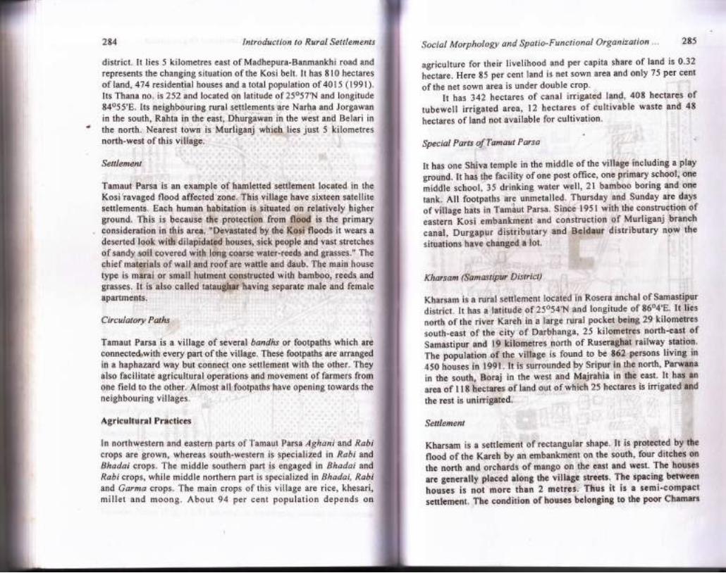
FIG. 15.2: Kharsam: Spatial Organization of Extraction of Mud tbr the Materialof Wall and Caste Segregation l99l
Figure 15.2 shows that in Kharsam village kurmi, barbar,brahmin, teli, dhanuk, dhobi and chamar are living in separate units.Although kurmi is a dominant caste of the village still functionallythe same is divided into so many smaller units.
In Table 15.3 the residential location and morphologicalcharacter is given for certain rural settlements of North Bihar.
On the basis of above studies the following generalizations have
been drawn:
l. The multiple caste village gives a complex morphologicalgrowth, while"simple morphology is the produst of semi-sprinkled type rural settlements or of smaller hamlets.
2. The newer seftlements with multiple castes giye scaftbred pattern
of settlements of different sub-lanes where grouping of houses
develops on the basis ofcastes.3. The complexity of village morphology gives an idea that the
village is old and the minor caste people reside on different bye-
,:-r,l- _-l[I-JK : KumiG - Goodess
B - BffbarT-Teli.D - PhanukDl - DhobiC - Chamar
BR - Brthmin
\\ I," /-
256 Introduction to Rural Settlements
lanes, while on the main thoroughfares the people ofpredominant caste reside.
4. The addition of bye-lanes in the village is mainly due toencoming of new caste people in the village, creation of newsite at the side of old site for resettlemeht, etc.
. 5' The hierarchy of castes and the width of road have significantrelationship as Brahmin, Rajput or any other dominant castesof that particular village live on spacious road or footpath, whilenarrow lanes have close relationship with untouchables like
Social Morphologlt and Spatio-Functional Organization... 257
TABLE 15.3: Caste Segregation and Morphological Attributes of Rural SettlementsKharsam (Rosera Block)
Name of Residentialthe Caste Location
in theVillage
Condition Alignment Nature of, Sanitationoflanes ofHabitation Skyline oflanes
ofHouse
Dome, Mochi and Paswan.Dandaka o
/:=\IE_J_lIr-.--rEI'ur-lt-tD I\0Effr=El\-_l
_ Napdyavarta
Brahmin
Kurmis
Teli
Hazam
Dhobi
Dhanuk
CentralPart
MostParts
CentralPart
South-CentralPan
NorthWestemPart
Centraland NorthWestemPart
NorthWestemPart
FIigh-FIigh
Medium
Medium-Low
Medium
Low
Medium
Dirty
Clean
Dirty
Dirty
WideNanow
Wide
Wide East-West
Narrow East- LowWest
Brahmin Most Wiie North- HiCh DirtyParts South
East-West
East-West
East-West
North-South
Square
. Hanshi (Biraul Block)
Chaturmukha(After - R. L. Singh)
- Ditch ,CTank T. Temple gCircumambulatory passage
. FIG, l5.l: Aryan Settlements
Hazam
Tatma
Teli
Badhai
Malah
NorthernPart
NorthemPart
Eastemand WestemMargin
Eastemand WestemMargin
Eastern
and WestemMargin
EasternPart
Squarb
Square
Square
Square
Square
Square
Low
Medium
Medium
Dirty
Dirty
Dirty
Dirty
Dirty
Dirty
o
Karmuka
Low
Contd.
258
Yadav WesternPart
Kumhar NorthemPart
. Chamar Northem
Rajput SouthernPart
Brahmin North-WesternPart
Yadav Eastem
Dusadh NorthCentral Part
Chamar Western i
PartAlongRoad ,
Introduction to Rural Set
Dirty
Narrow Square Medium Dirty
Narrow Square- Medium Dirty
Narrow Haphazard Low DirtySettlement'
Rahuaman (Kehrra Block)
Wide Circular High
Wide Aligned HiCh. on the Medium
side ofLane
Brahmin Most Wideparts
East-Wpst Medium CleanAlong Road
East- Low CleanWest
Wide North- Low DirtySouthtzrst-South
Khanpur (Rosera Block)
Social Morpholog,t and Spatio-Functional Organization... ZSg
The author had an opportunity to observe thousands of ruralsettlements in North Bihar and did not find even a single where thepeople of different castes do not maintain spatial distance. Thissegregative tendency is quite apparent in almost all rural settlementsof the region
Environmental Control
The physical factors affecting form of the rural settlements are theconfiguration of site, rivers, ponds, wells, slope and elevation of landsuch as plains, uplands, valleys, watertable and waterlogged areas,etc. All these variables are of paramount importance in ihe growthof village under certain physical environment. Among cultural iactorshistorical events, patterns ofroads and lanes, field patterns, religiousinstitutions, i.e., mosque, templds, place of Goddess and villagedeities, eic., are intimately related to the structure of the village.Insecurity in the past and the present social make-up of the villigeare other'significant factors in thb developmertt of village patternsand their internal'morphology. Morphologically, the condition ofvillages in North Bihar is haphazard with narrow turning-twistinglanes and irregular pile of buildings so that only a rough estimateabout the village pattern can be made.
The village pathways and cart-tracks are skeletbn of the internallayout of the village. The buildings represenr the flesh of the body,and determine the form and shape. The nucleus of the villagedevelops at the most accessible place from where, if possible, thesurrounding agricultural land can be easily observed (Duggal, S.L.:l96l). The study of morphology of villages refers chiefly to theclustered settlements, as only the congregation of a number ofdwellings and arrangement of associated lanes can give rise todifferent village patterns. Villages with semi-sprinkled and sprinkledsettlements can only be analysed roughly.
Layout of Ancient Communities
The region having a long history since Prehistoric times and variedphysical and cultural conditions, 'is marked by several patterns ofvillagei. In each lihysiographic region the physical elements havedifferently affected the village forms and so is the case with cultural
North- HiChSouth
veryClean
CleanClean
Wide
Narrow
East-
West
Kurmi
Malah
Chamar
Dome
Mushei
Halwai
MlUdleEastcm
Central
North-West
South-Westem
SouthWest
Wide
Narrow
Wide
Wide
Narrow
North-South
East-West
Haphazard
Medium
Medium
Narrow East- Medium CleanWest
East-
West
NorthSouth
MiddlePart
Difty
veryDirty
veryDirty
Clean
veryLow
verylowMedium
and social elements also. e
260 Introduction to Rural Settlements Social Morphologt and Spatio-Functional Organization "' 261
their houses. Even areas inhabited temporarily were fenced with
bamboos. The village wall had four large gates facing the main road'
ArA; iui, gut" oi the village there wasrplanted a sacred pipal or
Lnrrvu, irr" ih"r" the presiJing der.ty of the village was supposed
todwell(Louis,Renou:op'cit')'Thehistoricalrecordsalsoshowthatinancienttimesthehierarchyofvillagepatternwaswell-planned'while at present it is the result of natural growth'
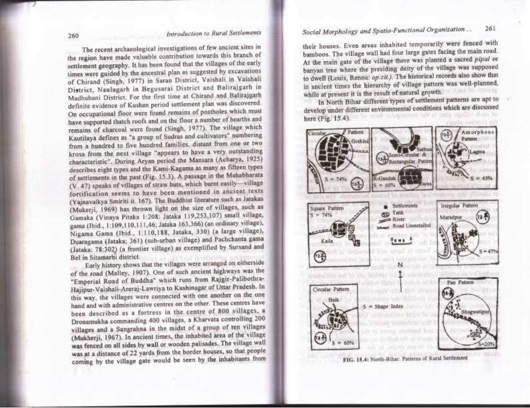
InNorthtsihardiffer.enttypesofsettlementpatternsareapttodevelop under different environmental conditions which are diseussed
nere 1fig. ts.+;.
1i Settlements .
@ I-k1F lllv0i:s Road Unmetalled
".I " -?
Therecentarchaeologicalinvestigationsoffewancientsitesinthe region have made valuable contribution towalgs this branch of
settlerient geography. tt has been found that the villages ofthe early
times wereluiaed Uy the ancestral plan as sqggested by excavation-s
of ChirandlSingh, 1977) in Saran Districi, Vaishali in Vaishali
Dictrict, Naulagarh in Begusarai District and Balirajgarh in
MadhubaniDistrict.ForthefirsttimeatChirandandBalirajgarhdefinite evidence of Kushan period settlement plan was discovered'
On occupational floor were found remains of postholes-which must
have supported thatch roofs and on the floor a number of-hearths.and
remains tf charcoal were found (Singh, 1977)' The village rvhich
Kautilaya defines as "a group of Sudras and cultivators" numbering
from a hundred to five hundred families, distant from one or two
f-.u ftorn the next village "appears to have a very-outst"llligtharacteristic". During Aryan peripd the Mansara (Acharya' 1925)
describes eight types and the Kami-Kagama as many as-fiftcen types
of settlemen-ts in ihe past (Fig. 15.3). A passage in the Mahablyta(V . 47) speaks of villages of itraw huts, which burnt easily-village
iortification seems to have been mentioned in ancient texts
ivajnu"artva Smiriti ii. 167). The Buddhist literature such as Jatakas
ittutcerji, igOq) h"t thrown light on the size of villages' such as
burut u (Vinaya Pitaka l:208: Jataka 119,253,107) small village'
gama (Ibid., t :i09, t 10,1 I 1,46; Jataka 163,366) (an ordinary village)'
frigurnu Gama (lbid., l:l10,188, Jataka, 330) (a large village)'
Oiaragama,|Jataka; 361) (sub.urban village) and Pachchanta gama
(lii"iZ,l't',iOZS (a frontier village) as exemplified by Sursand and
Bel in Sitamarhi district.Early history shows that the villages were arranged on eitherside
of the road (Malley, 1907). One of such ancient highways was the
,,Emperial ioaa o1 Buddha" which runs from Rajgir-Palibothra-
rtaiipur.vaishali-Areraj-LawriyatoKushinagarofUttarPradesh.[nthi-s way, the villages *.." .onn".ted with one another on the one
tranO and with administrative centres on the other. These centres have
been described as a fortress in the centre of 800 villages' a
Dronamukha commanding 400 villages, a Kharvata controlling 200
villages and a Sangrahna in the midst of a group of 1e1 villages
(Mufherji, 1967).In ancient times, the inhabited area. of the village
wasfencedonallsidesbywallorwoodenpalisades.Thevillagewallwas at a distance of22yards from the border houses, so that people
coming by the village late would be seen by the inhabitants from
N
S = Shape Index
t**:r" ($Pattem
-.-@Kaila
@
Circular Pattem
Baik
FIG. 15.4: North'Bihar: Patterns of Rural Settlement
262 Introduction to Rural Settlements
Rectangular Pattern
ln most parts of North Bihar rectangular layoirt is the commonmorphological pattern of rural settlements. Such plans are also foundin China, Japan, Italy, Egypt and Argentine pampa where agriculturalpractice along river embankments is largely responsible for thegrowth of such a pattern. Rectangular village plan also becorne acommon feature in ancient period which is quite evident from thesettlement plans of Mansara Shilpashastra (Havel, 1959). The causeof such village plan is the rectangular form of cultivated fields inthe riverine plains.
The concentration ofsquare and rectangular buildings producesrectangular plans for the rural settlenFnts. The rectangular alignmentof houses along road with thoir main axis from Nortli to South andEast to West are generally designed in order to get maximum sunlightand fresh air. In areas of compact settlements rectangular qnd squarepieces of land give rise to.residential pattern which producesrectangular ground plan. In nlpfEated settlements this tendency seemsto be of a higher degree, but in semi-sprinkled it is not an easy taskto identifu this geometrical pattern of human habitation. The size ofthe settlement is governed by the size and shape of the ground planas well as ecological limitations in the construction of a particulartype of house. The expanding nature of settlements hampers thegrowth of this sefflement pattem mostly on fringe of the settlement.The commanding factor of this pattern is the parallel street patternof rural settlements and the rectangular formation of field pattern.Lilhaul in Dharbhanga, Sarea in Saran and Muradpur in Samastipurdistricts are examples of rectangular plan of rural settlements.
Hollow rectangular is the external form of settlement which ismarked by an unbuilt open space in the central site of the settlement.It is commonly observed in zones of strife where the centrar site wasoccupied by old mounds but the superstitious beliefs andunauspicious happenings prohibit the construction of buildings onsuch sites, and hence the unoccupied central part resulted into ahollow rectangular plan of rural settlements. Other features whichhelp in the formation of this settlement pattern are temples, mosques,tanks, big banyan tree and bamboo grove in the central part of thevillage. On vacant open space in the hollow square generally peasantsassemble, tether cattle or thresh crops. In the srtrmmer season theshady trees help in the get-to-gether of farmers with their odd
Social Morphologt and Spatio-Functional Organization... 263
functions of string making, cot weaving, etc. Whereas the winterevening is marked by the gathering of people around a fire burningplace (Ghura) where the village folk exchange talks of agriculturalsituation, prevailing weather conditions and short stories. In most ofthe rurban communities weekly or bi-weekly markets are held. Matterin Samastipur, Sonar in Sitamarhi and Pokharbhinda in Madhubanidistricts are examples of hollow rectangular settlements.
The Square Pattern
The square and rectangular patterns of rural settlements are in mostcases complementary to each other. This is the product of restrictiveand attractive forces of the environment. This pattern is associated
with the crossings of cart tracks of roads. At present the location oforchard, tank and road around the village forced the village todevelop in square form. The four square unit at the junction of cross
roads are occupied by people of four castes. The best examples ofsquare pattern are village Santhi in Saran and Gulma in Saharsa
districts.The hollow square pattern is associated with a hollow space
amidst the centre of the village. This unbuilt space is caused by the
presence of a square tank, a temple, mosque, garden or pasture land.
One of the best examples of hollow square is Ranjodha village inBhagalpur district.
Hollow Square Yillage
The hollow square pattern is again similar to the square pattern, witha hollow space in the centre of the village. Similar to hollowrectangular settlements, the unbuilt space is caused by the presence
of a square tank, a temple, mosque, garden or pasture. One of the
best examples of hollow square pattern in Ranjodha village inBhagalpur district. Here the villagers have dug-out the earth fromthe middle of the village to build the plinth of their houses. This has
resulted in a ditch full of water located in the centre of the village.
Linear Village Pattern
The linear pattern is recognized by the arrangement of house alonga line or a series of lines. The settlement is prolonged in one direction
Introduction ta Rural Settlementi
' terrace also show a similar influence. So far as ihe culturalare concerned roads either metalled or unmetalled, have
water body. In flood affected areas this pattern occurs along rioxbow lakes or old channels. Here the linear cluster usually becr
264
and restricted in another due to certain physical feat.ures" Thoccurrence of this pattern is associated with the flood affectedand the proximity of a river. Whenever, the site is a narrow stripbetween two streams flowing very close together the villageelongated. Clusters situated on a bank marking the edge of an alluvi
Social Morphologt and Spatio-Functional Organization "' 265
accessibility to the nearest sweet water well' Sarea village in Saran
districtisthebestexampleofthispattern.Thisvillageislocatednearthe river Gandaki'
Circular or Semi-Circular Village Pattern
The circular village pattern may have several variations' which
caused by an attempt io build a maximum number of houses at one
site. The houses may be concentrated for the purpose ofdefence' or
built around the mansion of the local Zamindar or around a well' It
,*f utro be necessitated by a desire to have a higher site for-building
frrpot"t. In North Sihar this pattern is not the heritage of the past
but this is due to the natural giowth of village according to shape of
the ground plan. Sometimes i semi-circular plan may develop on the
"r"r]""n, shape of a'rneander' The settlements of horse shoe pattern
devetop in the sharp bend of rneanders or roads' ^At some places
hollow-circular pattern also develops due to open space amidst the
central site of the settlement.
The;best exarnple of circular pattern is village Gofhini -in-
Saran
district which has'developed in between bend of the Gandak river
on the West and an unmeialled road on the East' Other examples are
"iirug" Baik in Darbhanga district and pokhra in saran district. The
villaie Sarea in Saran iistrict is a fine example of semi-circular
putt"in on the arcuate bend ofthe Gandaki river'
String Patlern
The string pattern village is found in the districts of Saharsa' Katihar
and purnea in North Blhar. such linear rural settlements develop in
one line atong the bank ofa river or road' In this pattern houses grow
in a single line in order to have an easy approach frol- the road or
tt "
*utJ, body. In flood affected riverine tracts of Katihar' Saharsa
and Purnea where the river bluffs are suitable for settlement' the
houses are built in a single line on the upper crest' Hence' this pattern
is associated with the rile growing area where houses are constructed
on river embankments orlart-tracks' There are two examples like
Tamua in the district of Sahara along a tributary of the river Kosi
and Maniakha in district Bhagalpur on the bluffs of the Ghogha
rivulets. Sometimes a settlemeni may consist of more than one 'string'
dependingonthenumberofchannelsordistributariestraversingfromthe centril site of the settlement as seen in the Kosi belt'
importance in the elongation of a village. In case the road is recentbuilt and the village has no marketing centre the settlementmight be different. But if there is a market it is invariably s
along the road, and the settlement is hecessarily elongated. Svillages are known as strassendorf (Street village), For exampPhulwaria in Raghopur Diara of Vaishali district is anvillage along the river Ganga and only one cart tract passesthe village. Village Laukaha in Madhubani district lying alonmetalled road also shows elongation but at some places thehas been disturbed by the open spaces and the construction ofbuildings by the'side of the main site. Majrahia in Rusera blockSamastipur district is a good example of this pattern along a
abnormally elonlated along the higher river banks in the Kosiplains.
Grid lron Patternfr
Grid iron or the chessboard plan denotes a "right angled meshstreets with or without central rectangular market place" (Dicki1924). Hence chessboard plan is the feature of Some largeand square villages. In such large settlements two stcorresponding with the four gates of the village wide enough tothe passage of bullock-carts cut each other at right angles. Aother subsidiary lanes run parallel to the main lanes, in orderprovide access to other housbs of the village. The four walls ofdwellings run in cardinal directions so that the grid plan is raredisturbed. Generally the village is divided into tolas accordingdifferent castes and each grid may be occupied by one caste.pattern also helps the poor peasants to take drinking water fromcentrally located well. In this case each intersection of lanes maymasonry well and building the house is of primary consideration
266
Star Pattern
Introduction to Rural Settlements
when the circular settrement extends in several directions arong thefootpaths and roads, the vilrage assumes star shape. It is common inthe flood prone area where elevated sites ur" .*",'o. ;;;;;';.",where the newer settrement project along the cart-tracks, whichradiate'from the central vilrage. There is a crearcut zone of suchsettlements in the Tarai regionof Sitamarhi and in eurt Cf,urpuiu,district, The occurrence of such settlements arso takes ptur. *iitrtrr"construction of new dwellings on the fringe of circular unO ,qour"shaped rural settlements.
Haphazard Pattern
It is a common form of larger virages than compact settrements. Inthis pattern houses are huddled in iriegurar fashion without i;ilb;lrgany definite plan. The larger vilragei generary consist of severaltolas with different farms- when iom[ired together these ao notprovide any definite pattern. This paitern is not possibre in thedispersed settlements where dwellings are scattered in the wholevillage without any definite street. vllrage Haraje in saran districtis an.example of this pattern. This villagefs located crose to the riverGandak along a cart track. The influJnce of these two led to theemergence of irregular pattern.
Double-Nucleation{t
In base two settlements develop at a single site it is calred ,doubre-dorfer'(Ahmad, 1962). In rural ,..u, u rinor stream is often thecause of such a pattern. Sometimes a mound, a road, a tank or a rivermay result in the development of twin settlements situated oneitherside ofit. It is also caused by the construction ofnew rfrop, utthe railway station. Though the disiance may be one or two kilometresfrom the parent vilrage. In North Bihar such v,rage pattern is rounaon the river banks' because in such praces there is a stiuggle for waterfrolllge and higher site on the levee. The best examples are Khanpurand Narhan in Samastipur district. These settrements have u .i*it",sites on the bank of river purain and the Burhi Gandak."rp;";i;;t.
Social Morphologt and Spatio-Functional Organization... 267
Radial Pattern
The convergence of several and the increasing dimension of housestowards periphery of the village is the cuase of the growth of radialpattern. It also depends on the concentric growth of dwellings henceit is known as cobweb pattern. The influence of a sweet water wellor the village shops in the centre of the village also.causes radiatingpattern of lanes. Village Baheri in Darbhanga district is a fineexample of this pattern. Here from the central site of this settlementroads are radiating on all directions, which develop into the form ofa radial pattern.
Amorphous Pattern
In case the village lanes are dotted with tiny harnlets all being smallrectangles linked with the central site by footpaths, becausedispersion of houses will result such an irregular fashion of pilingof houses which is known as amorphous pattorn, which leads to ascattering of dwellings over the entire area. The amorphous patternof rural settlements are found in Saran and Champaran districts andthe whole of diara belt along the Ganga, but is more common in theKosi flood prone area in the east. Excellent examples of such villagesare Gaura, Rampur, Jagdishpur and Sahebganj in Vaishali district inthe diara of the river Ganga. Parhuka in Patna district is an exampleof S shape where the growth pattern is fully controlled by physicalconditions of pynes and lowlands of paddy fields surrounding thevillage. In this village the burial place of Mohammedans and a tankare placed in such a manner that the villagers have forced to buildtheir houses in a typical double arcuate form leading to thedevelopment of sigmatic pattern.
Orientation of Main Thoroughfares of Rural Settlements
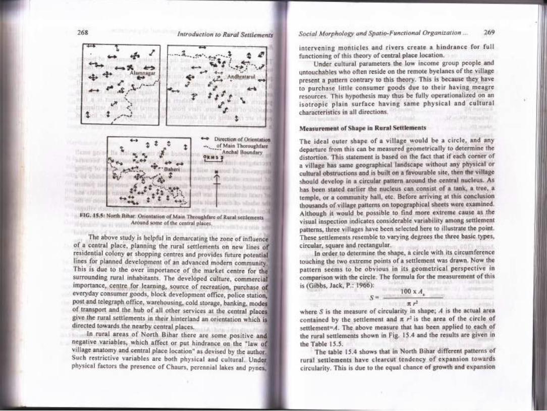
A detailed study of hundreds of rural settlements in North Biharsuggests that the main thoroughfare of each and every rural settlementis oriented towards the nearby central places. For example, Baheri,Andhratharhi and Alamnagar are central places of Darbhanga,Madhubani and Saharsa districts respectively around which almostall rural settlements have unmetalled roads which led towards thesecentral places. A short list of such rural settlements is as follows:(Fig. I5.5)
-tIeL) <.+$ QS s ,,
o''glutu:
H ar 6,,.I.-r'----p t:,
\ar',.L 9 -"-,,'
268 Social Morphology und Spatio'Functional Organization... 269
intervening monticles and rivers create a hindrance for fullfunctioning ofthis theory ofcentral place location.
Under cultural parameters the low income group people andqntouchables who often reside on the remote byelanes of the villagepresent a pattern contrary to this theory' This is because they have
to purchase little consumer goods due to their having meagre
."ror."... This hypothesis may thus be fully operationalized on an
isotropic plain surface having same physical and culturalcharacteristics in all directions.
Measurement of Shape in Rural Settlements
The ideal outer shape of a village would be a circle, and any
departure from this can be measured geometrically to determine the
diitortion. This statement is based on the fact that if each corner ofa village has same geographical landscape without any physical or
cultural obstructions and is built on a favourable site, then the village
should develop in a Qircular pattern around the central nucleus. As
has been stated earlier the nucleu$ can consist of a tank, a tree., a
temple, or a community hall, etc. Before arriving at this conclusionthousands of village patterns on topographical shqets were examined.
Although it would be possible to find more extreme cause as the
visual inspection indicates considerable variability among settlement
patterns, three villages have been selected here to illustrate the point.
These settlements resemble to varying degrees the three basic types,
circular, square and rectangular'In order to determine the shape, a circle with its circumference
touching the two extreme points of a settlement was drawn' Now the
pattern seems to be obvious in its geometrical perspective incomparison with the circle. The formula for the measurement of this
is idibbs, Jack, P.: tgOb):l00xl
fi12where S is the measure of circularity in shape; ,{ is the actual area
contained by the settlement and n r2 is the area of the circle ofsettlement:1. The above measure that has been applied to each ofthe rural settlements shown in Fig. 15-4 and the results are given in
the Table 15.5.The table 15.4 shows that in North Bihar different patterns of
rural settlements have clearcut tendency of expansion towardscircularity. This is due to the equal chance of growth and expansion
Introduction to Rural Settlementi
-...--of Main ThoroughfareAnchal Boundarv
i 1jl
FIG.'15.5: North Bihar: orientation of Main Throughfare of Rural settlementsAround some ofthe central places.
The above study is helpful in demarcating the zone of influerof a central place, planning the rural settlerients on new linesresidential.colony or shopping centres and provides future potelines for planned development of an advanced modern commuThis is due to the over importance of the market centre for th
s Direction.of
surrounding rural inhabitants. The developed culture, commercimportance, centre for learningr source of recreation, purchase
I
everyday consumer goods, block development office, police statpost and telegraph office, warehousing, cold storage, banking, mr
,In rural areas of North Bihar there are some positive inegative variables, which affect or put hindrance on the "lawvillage anatomy and central place location" as devised by theSuch restrictive variables are both physical and cultural. U
s=of transport and the hub of all other services at the centralgive the rural settlements in their hinterland an orientation whichdirected towards the nearby central places.
physical factors the presence of Chaurs, perennial lakes and
270
TABLE I5.4: Orientation of Main Thoroush.fare of Rural Seftlements Around Some ofthe Central places of North Eihar
Social Morphology and Spatio-Functional Organization... 27 I
(100 metres) will give clearcut view of shape of a settlement whereasthe sight of settlement from 50 metres height may hightight theinternal morphology of a settlement.
The circularity values of shape are mathematically independentof the size of the entities and comparisons are also facilitated by thefact that the measure has an absolute maximum varue of 100 peicentand for all practical purposes, a fixed minimupr of 0.0 per cent.
The values not only expresses the degree ofcircularity in shapebut also provides a clue to the type of geometrical figure *t,ictr mostclosely resembles the settlement in question. Although no hard andfast rule can be applied, it appears that as the S value decreases thesettlement tends to resemble first with a circular pattern, then star,square, rectangular and in the end an enlongated shape in the ordermentioned.
The geometric shape of a village appears to have somerelationship with its compactness. The degree of differentiation incompactness of a village pattern helps in regional planning, becauseproblems of housing and highways become more acute ai we tendto move from compact to amorphous patterns. The hierarchy of ruralsettlements according to shape ani size shows the intensity ofcompactness or scattering of settlements in a region with a definiteset of environment.
Jajmani System
The village cornmunities though segregated castewise but interlinkedthrough internal service dependency; disorganized under the bannerof castism and rigging poverty but there is unity among them in socialties. Inspite of these the wide socio-cultural differ'ences and gap basedon the conception of population would not be there if there had beenno Jajmani system. The Jajmani system (Wiser, 1936) has been amajor factor operating as an integrating and cohesive force in ruralsettlements, as it is based on symbiotic relationship between variouscasres residing in the village. It plays a vital role in the maintenanceof socio-economic patterns in the village. Hence village institutionis the centre for economic and ritual mutuality and inter-dependenceof various castes (Singh, 1973). Lewis (1965) observes thai',it doesnot operate like an open market economy, and the ties between theJajmani and the Kamin are not like those of employer and theemployee in a capitalist system, though undoubtedly the importance
Introduction to Rural Settlements
Around
AlamnagarAround Baheri Around
AndhratharhiLadma EW
Nathua NS, WE
Saparda EW
Kunjauri WE
Hariharpur NW to SE
Ahaon SN
Parail EW
Kishanpur SN
Bargaon NS to WE
Sanoti Chak EWHaru Dumra EW
Baghauni EW
Kharsam NS
Parsa NS
Daihara NS
Murli NS
Bara EW
Enai EW
Sahru EW
Sarhila NS
Boran EW
Khanpur EW
Katharia WE
Dhamaura
Bikramsher EW
Satghara NS
Rahikpur NS
Mahnahi AGonauli EW
Dhagiari EW
Rajanpur AGangdwar EW
MadnaEWSource:.CompiledbytheAuthorThrougttFi"talnu,,tig"t-
ffJrflffi:ions having some attracliu" u,l repulsive forces acring
-. ft" out". shape ofa settlement can be best adjudged from theouter space through airphotographs and remote sensing. This can alsobe best visuarized through.b-irdlr .r;;;;;. In this situation a sightof settlement from aeroplane ,uV f,.lp ln tne identification ofcompactness of one settrement *itn tr," oir,"i. A sight from mediumheight (r00 metres) may herp in trre iaeniirication of compactnessof one settrement with the'ottrer. l sigrrt from medium heightTABLE t5.5: M.rrrl", of the Degree.of 9,l.rrr, ,rli. Shape of Somc RuralSettlement Pattems in North Bihar
Some oftheSettlements
Area of Circlein Square
metres
Area of -
settlement inSquare metres
% Circularirys
No. ofHouscs
Lagma
Muradpur
Baik
Bhagwatipur
Oothini
Sarea
Kaila
2,85,908
4,32,479
1,62,862
6,07,525
7,3t,924
2,85,908
1,27,070
t,32,139
2,04"395
97,852
t,70,292
5,40,655
t,69,966
90,649
46
47
60
28
75
60
72
105
217
t05
ll5742
tt2tl6
Source : Calculated by thiluUror
272 Introduction to Rural SettlementsSocial Marphologr and Spatia-Fanctional Organizction.-" 273
of money is increasing gradually with the passage of time."In village Kharsam the perpetuation of traditional occupation
indicates the existence of the jajmani system. The economic systemof the village is still based on functional specialization andinterdependence of different castes. Agriculture, for instance, isprimarily the task of the Kurmi, but all other cistes both high andlow cu[ivate Iand if they have any, besides doing their traditionalwork. Oil crushing, hair dressing, cloth washing, drum beating andshoe making still remain the works of teli, barber, dhobi and chamarrespectively. Tradition has assigned to each caste a definite positionin the community structure, and this leads to specific economic andritual function which is the staple source of livelihood of that caste.Almost all castes of Kharsam village hold a major occupation inwhich they have monopoly from the beginning. eithough accordingto traditional callings there is nothing to debar them from acceptingother occupations of mobility. During agricultural seasons, whenthere is a heavy demand on limited labour supply, the Kurmi andBhumihar castes persuade the artisan castes to work on their fieldstogether with womenfolk on daily wages. This sort of socio-economicsystem keeps lower castes in constant touch with upper castes andalso untouchables with the peasants.
A closer study ofthe economic system and its consequent handsof mutual obligation and expectation of the village divulge dhesemajor kinds of economic dealings within the framework of castesystem which have definite repurcussions on the spatial organizationand morphology of rural settlementp in North Bihar.
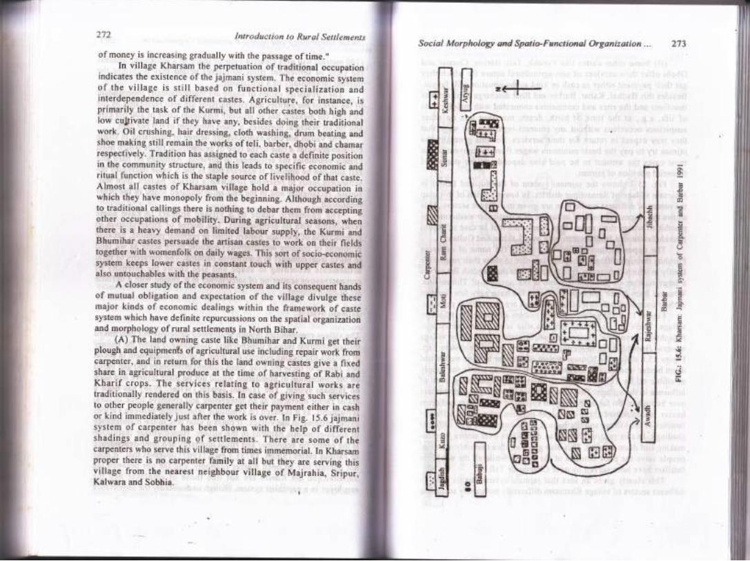
(A) The land owning caste like Bhumihar and Kurmi get theirplough and equipments of agricultural use including repair work fromcarpenter, and in return for this the land owning castis give a fixedshare in agricultural produce at the time of harvesting of RaUi anaKharif crops. The.services relating tq agricultural works aretraditionally rendered on this basis. In case of giving such servicesto other people generally carpenter get their payment either in cashor kind immediately just after the work is over. In Fig. 15.6 jajmanisystem of carpenter has been shown with the help of aifierentshadings and grouping of settlements. There are some of thecarpenters who serve this village from times immemorial. In Kharsamproper there is no carpenter family at all but they are serving thisvillage from the nearest neighbour village of Majrahia, Sripur,Kalwara and Sobhia.
z<-*--
o'o\
G3€
c0
(g
aoq6(J
o
o
.co!!FE.=
c0-;jG
G
v\ora
b
,H
"rH;H''dt t
WHNNNqffiN
274 I ntro duct i o n t o R.ur al Set t lements
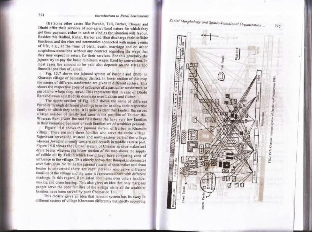
(B) Some other castes like purohit, Teli, Barber, Chamar andDhobi offer their services of non-agricultural nature for which theyget their payment either in cash or kind as the situation will favour.Besides this Badhai, Kahar, Barber and Bhat discharge their definitefunctions and the rites and ceremonies connected with major eventsof life, e.9., at the time of birth, death, marriage and on otherauspiciour occasions without any contract regarding the wage thatthey may expect in return for their services. For this generally thejajman try to pay the basic minimum wages fixed by convention" Inmost cases the amount to be paid also depends on the status andfinancidl position of jajman.
Fig. 15.7 shows the jajmani system of purohit and Dhobi inKharsam village of Samastipur district. In lower section of this mapthe names of different washermen are given in different sectors. Thisshows the respective zone of influence of a particular washerman orpurohit to whom ihey se1ve. This represents thut in case of DhobiRamkhelawan and Budhah dominatp over Lakhan and Gultan.
The upper'section of Fig. 15.7 shows the name of dif.ferentPurohits through different shadings in order to show their respectivefamily in which they serve. It is quite evident that Jagdish Jha servesa large number of family and same is the positionlf thitnar lha.Whereas Ram Jiwah Jha and Baldshwar Jha have very few familiesin their command but most of such families are of wealthier peasants.
Figure 15.6 shows the jajmani sysrem of Barber in khars,rmvillage. There are only three families who serve the entire village.Rajeshwar serves'the western and north-eastern partrof the, villagewhereas Jiwachh in south-western and Awadh in middle eastern part.Figure I5.8 shows the jdjmani system of Chamar as shoe-maker anddrum beater whereas the lower section of the map shows the supplyof edible oil by Teli :in whtch two oilmen have competing zone ofinfluence in the village. This clearly $howp that nu,nf.itu. a-oiir"r"tover Satrughan. So far as thejajmani system ofshoe-maker and drumbeater is concerned there are eight persons who serve differentfamilies of the village and the ru,n" ir rlpresented hete witrr differentshadings. In this regard, Ram Jatan dominates over others in shoe-rnaking and drum beating. This also gives an idea that onty marginalpeople serve the poor families of the village while all the wealihierfamilies have been served by poor Chamar or Teli. l
This clearly gives an idea that jajmani system has its sway indifferent sectors ofvillage Kharasam differently but strictly according
Social Morphotogy and Spatio-Functional Organization
.=
-oF
@
275
-*h
5l
o\
d
o
9
o
o
v)
6
'a
u,F.V,
!.
G
o2
Introduction to Rural Settlements
o\o\.i
.o?
aG6tsFGF I\
goaJ6
sh
==e
th -Evala
(,I
276
o
Social Morphologt and Spatio-Functional Organization "' 277
to the economic gains of both peasants and the labourers. Thus spatial
variations of jajmani system have definitely shaped the social
morphology of settlements not only to village Kharsam but almost
all rural settlements of North Bihar.(C) In case the services under jajmani systems are performed
for the landless owning people or lower income group poof people,
they instead either give their traditional services or pal in kind.
Sometimes such services are performed between two or more castes
on barter system also.The above description shows how the different castes of
Kharsam ritually and economically inter-linked and inter-dependent.
Sp at i o- Func t i o n a I O r ganiz at i on of Rur al S p ac e
The spatio-functional organization of the countryside moving around
agricultural operations and ranching of livestock which have close
aifiliations with the settlements, farms and the occupational structure
of inhabitants.In Ndrth Bihar the spatio-functional organization of rural
settlements reveal that houses are constructed at one site which form
a village. The surrounding space is occupied by agricultural fields,
gardens and pasturelands. The central site of the settlement is
ionnected with the neighbouring village through unmetalled road or
footpath. Hence, the spatio-functional space of the countryside in
North Bihar may be generalized into;
l. Each village has a central site and satellite settlement located
at some distance.
2. The Central site of the settlement has village lanes which
connect one household with the other. Finally, these lanes have
opening towards the agricultural fields and the neighbouring
villages.3. Each village consists ofrectangular or square shaped fields in
the surrounding sPace.
4. The special parts of the vitlage are temple, school, rural health
centre, block development office, thana, shops, panchayat
bhawan, graveyard, cremation ground, tank, etc.
In North Bihar the.occupational structure of rural population
sugrysts the spatio-functional organization of rural settlements in
278 Introduclion to Rural Settlements
general. The census of India 199 l recorded the foilowing categoriesofoccupational structure ofthe people fo this region.
l. Cultivation,2. Agricultural labourers,3. Livestock, forestry, fishing, hunting, plantation, orchards and+ allied activities,4. Mining and quarrying,5. Household industry, manufacturing and repairing,6. Construction,7. Trade and commerce,8. Transport, storage and communication, and9. Other professional services.
The spatio-functionar organization of sorne of the ruralsettlements are given below in order to highGh;ih;-";;r,generalizations.
Laukahi
Laukahi is a rural settrempnt rocated in Laukahi anchar of Madhubanidistrict. It lies r9 kirometres north-east of Nirmari *il*"y ,i"tior.Its revenue thana number is 37 and it has an area of 264.26-hectares,In l99l this village had 393 occupied residentiar houses and2,207population. Its neighbouring rural settlements are Kakahia and Jhauriin the south, Singrahi in the west, Jamsar and Mahadeo.utr, in-ri"east and Atri in the north.
Settlement
In Laukahi l6 hectares of land is occupied by residential houses.Houses are systematically built on both iia"r or unmetalled road inwestern upland plains of the vilage. originaily the peopre had settledon the north-western parr of the viilige but wiih the growth ofpopulation this settlement expands in the south-western upland tract.The newly constructed goveinment offices such as the Kosi lrojectOffice, Block Development Office, etc., are found on the soutliernsection' At the same time the hutments of poor vilragers are foundon the embankment of the tank.
The chief material of wall of the house is mud due to highadhesive quality of the soil. The houses are also constructed wi;h
Social Morphologt and Spatio-Functional Organization .. 279
burnt brick and grass leaves. In Laukahi 70 per cent houses are ofmud wall, 7 per cent burnt brick and the rest 23 per cent are of strawand bamboos.
Generally, the peasants of Laukahi have two compartments intheir houses. One compartment is known Ls dngan which is meantfor kitchen, bed room, store, ladies apartment and the other is knownas bathan for livestock and dalan for guests and male rnembers. Inmost cases joint family system is preferred in comparison withsolitary family living. The rich families of the village have separateroorns for different purposes, i.e., kitchen, bed room, etc. But thepoor villagers have to accommodate in a small hutment.
Villagers of Laukahi used to take bath in the neighbouring tank.They also wash their utensils and other domestic materials in the tank.Generally ladies bring water for drinking purposes from theneighbouring tube-wells, wells and pond.
The peoptre are hospitable to others: In the night after takingsupper they go to their neighbours to smoke (Hukka or Biri). Theyseat in a circular fashion arround a fire place called Ghura in localdialect especially rduring the winter season. They talk onmiscellaneous topics.
Roads and Lanes
The internal morphology of Laukahi is complex one due to zig-zagIanes and insanitary village circulatory path. The main roads of thevillage connect all the tanks located in the north, east and south-westof the settlement. On the central site of the village all the lanesconverge to form a chauk area where some shops are located besidesresidential houses. From this chauk the lanes again bifurcate into theeastern and western side of the village. In the middle part ofagricultural fields the pastureland of Laukahi is located which is alsoused as road for agricultural operations in all seasons.
In Laukahi about l0 hectares of land is engaged in road andfootpath. There is a District Board road which passes from Mahadeo-math in the east to Laukahi in the west. This is an unmetalled roadbut motorable in dry season. During rainy season the road is filledwith water and mud and this makes difficult even for cycle to move.Somewhere, the road lies below the level of agricultural fields whiphcreate problems for villagers in general and passers-by in particular.
The cart-tracks in the village pass from north to south. people
280 Inlroduction to Rural Settlements
have settled on both sides ofthe track. They lead to all directions inthe village. The tracks are so narow that it is difficult for the twoway bullock-cart to cross each other. There are three main footpathswhich have a breadth of one to two metr€s. Eac-h of them passesthrough the cultivable land. These footpaths are called bandh in localdialect. These have been rnade by the village to check and regulatethe rain water as during rainy season water rushes from the north"rnhigher slopes to the south.
Agricultural Land
The field pattern in Laukahi is of rectangular and square in shape.Small plots of land are found on the eastern side of settlement fringewhere kitchen garden finds place. In northern side of the village plotsof land are larger in size but it is medium in the southern side. Theentire village is a single crop rice land but in some pockets khesari,wheat and onion are also raised. The agricultural plots are dividedinto different pieces separated by the bandh and road. Although themain occupation of the villager is cultivation but that is not aprofitable business now, due to rising prices of diesel and fertilizerand relatively low production and continuously increasing numberof people in each family.
Special Parts of Laukahi
The special parts of Iraukahi includes Shivji temple located in theeastern side of tank ndhr H.E. School, graveyard Iocated in the eastof the pasture land amidst agricultural fields and the other featuresare as follows.
The people of Laukahi have organized a library in 1951. Thegovernment of Bihar deserves thanks for giving aid to the library. Itis situated in the middle of the village. The library has a good numberof novels, story books and course books. There is a lower primaryschool situated on the embankment of the pond. The high school wasestablished in 1948. Through the western side of this school there isa main way to enter into the village. The H.E. school has a campusof 2 hectares of land. It has three boys hostels and a good puccabuilding.
There is a night shool where mostly poor illiterate wage earnersget education in adult education programme. There is also a drama
Social Morphologt and Spatio-Functional Organization... 281
society in this village organized by youngmen in 1947 when ourcountry achieved independence. Later on it is renamed as'AzadDrama Club' which had played several charity show and given moneyto the defence fund of India. There is also a sadachar samitee in thevillage which was established in 1966. Its function is to curb thecorrupt practices of villagers as welI as officials of the BlockDevelopment Office by means of maintaining watch against the blackmarketeers and bribe takers.
Laukahi thana has been established in 1964 in the northern sideof H.E. School. It has a building in one hectare of land located justby the side of the main road. Laukahi Block Development Office wasestablished in 1956 on the southern side of the District Board road.Related to this some residential quarters have established over 20hectares of land. The Kosi Project Office was constructed for thewestern canal system of the Kosi river. [t is situated on the westernside of the District Board road covering one hectare of land.
At present in shallow ditches of the village only fish, makhanna,.
singarhara and purainipatta, etc., are extracted by the villagers. These
ditches also serve the purpose of washing livestock of the village.For the planned development of this village the provision of
metalled road, electricity, deepening of tanks and ditches for rearingfish and the provision of underground sewage and drains are highlyneeded.
Mas hrakh (S aran D is t ict)
Mashrakh is a large rural settlement situated on th€ bank of Ghogaririver in Mashrakh anchal of Saran District. Its revenue thana no. is
139, latitude 2607 N and longitude 84048 E. It has an area of 1257 .34
hectares including 1084 residential houses, 1343 households and9197 persons in l99l.It is irregular in shape and the neighbouringrural settlements are Chakrihara Mathia and Deuria in the north'Govindpur in the east, Ghoghian in th,e west and Katalpur andHanumanganj in the south.
Settlement
Mashrakh is a compact rural settlement. It is fast developing into a
service centre for the surrounding rural space. The settlement area
consists of l6 different units in which people of various castes reside,e.g., Rajput, Kanu, Muslim, Koeri, Teli, Brahmin etc. The chief
282 Introduction to Rurql Settlements
material of wall is mud and burnt brick, while the material of roof istile and RCC. This is due to urban influence of this settlement-Mashrakh has 400 shops of different types.
Circulatory Path
T'he internal pattern of village lanes are quite haphazard in which thd,main road runs from Kajapatti Railway Station in the north to Chapra32 kilometres in the south. Another road comes from Ta,ipur in thesouth-west and ultimately terminates on the Mashrakh railway station.,Mashrakh is a rural settlement of transformation stage whose marketarea expands towards railway station along the main road. The marketarea which lies just west of railway station has a very simpldcirculatory path,which runs from north to south. Saturday and Sundayare nnarket days when a big gathering can be observed ori a[*,circulatory paths of the village.
Land Use and Agricultural Practices,1
Agricglture and trade and commerce are the main occupations of thepeople of this village. Mashrakh has 750 hectares of, unirrigated,cultivable land, 70 hectares of irrigated land, 258 hectares ofculturable wasteland and 137 hectares of land not available forcultivation. The soil is fertile and is suitable for the raising of wheat,maize, paddy, gram, pulses, oilseeds and vegetables.
In north-western part of Mashrakh mixed farming is practised,in western parf bhadai and rabi crops are raised whereas southernpart is meant for Aghani and Rabi, and central part for Bhadai andrvegetables. Cultivable wastelands are found in the south and northof Mashrakh railway station. i
Mashrakh has a Post Office, public call telephone centre, besides 3primary schools, 3 middle schools, one high school and one ruralhealth centre. The people drink water from well and tubewell. It has;
also electricity connection besides one sugar mill.
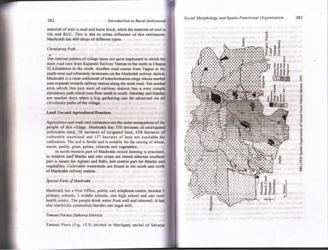
Tamaut Parasa (Saharsa District)
Tamaut Parsa (Fig. 15.9) located in Murliganj anchal of Saharsa
Social Morphology and Spatio-Functional Orgonization ... 283
o6
d6L5M =.O
-d:L.J 6 o.=>uc0n
E.f
.- .- .- .l
e std 1
E-+EE E<dEE C
I;{IffiN
?.-! t 'rE'v =.:: Id
= = al
.306 H€ el'E tr 90.= 6l=
G =
O <I>65i5 r-loJ
+.'+'"+++-+,.i++++.+{.++'+,+.++
'.+++.+.i*+.++
asE E
1", Eo
gifEEtGNEtr
o\o\
d
dG
a/7
o
od-
6o-
=Gd
F
oo6N
oO
(!
6oU)g\Vt
al*
G
60
l]
.(+
il-kff.ffltll$fiffifi.it.\dfti.tiiiiki-fiXl:llr,ll++a++++++**t*ll.f+t***t*+**i
tfurr:':i*
Trfr:;h
tillflrfr${itl}rirrj
1J'r-++'+-F+
:Nrf+ tf.i. FIit-rlt
***+Nr\(*l-li\+**\ +***";
:111f1;i
ii,lrirlrir
i;iilii:lllll:ill
iiiiiiiiffi
iiiilil;lliliiilir
ilr!r1
284 Introduction to Rural Settlements
district. It lies 5 kilometres east of Madhepura-Banmankhi road andrepresents the changing situation ofthe Kosi belt. It has 810 hectaresofland,474 residential houses and a total population of40l5 (1991).Its Thana no. is 252 and located on latitude of 25o57'N and longitude84055'E. Its neighbouring rural settlements are Narha and Jorgawanin the south, Rahta in the east, Dhurgawan in the west and Belari inthe north. Nearest town is Murliganj whiah lies just 5 kilometresnorth-west of this village.
Settlement
Tamaut Parsa is an example of hamletted settlement located in theKosirravaged flood affected zone. This village have sixteen satellitesettlements. Each human habitation is situated on relatively higherground. This is because the protection from ftood is the primaryconsideration in this area. "Devastated by the Kosi*floods it wears adeserted look with dilapidatEd houses, sick people and vast stretchesof sandy soil covered with ldhg coarse water-reeds and grasses." Thechief matsrials of wall and roof are wattle and daub. The main housetype is marai or small hutrnent cqnstructed with bamboo, reeds andgrasses. It is also called tataughnr'having separate male and femaleapartments.
Circulatory Paths
Tamaut Parsa is a village of several bandhs or footpaths which areconnectedrwith every part ofthe village. These footpaths are arrangedin a haphazard way but connect one settlement with the other. Theyalso facilitate agricultural operations and movement of farmers frornone field to the other. Almost all footpaths have opening towards theneighbouring villages.
Agricultural Practices
In northwestern and eastern parts ofTamaut Parsa Aghani and Rabicrops are grown, whereas south-western is specialized in Rabi andBhadai crops. The middle southern part is engaged in Bhadai andRabi crops, while middle northern part is specialized in Bhadai, Rabiand Garma crops. The main crops of this village are rice, khesari,millet and moong. About 94 per cent population depends on
Social Morphologt and Spatio-Functional Organization "' 285
agriculture for their livelihood and per capita share of land is 0.32
hectare. Here 85 per cent land is net sown area and only 75 per cent
ofthe net sown area is under double crop.
It has 342 hectares of canal irrigated land, 408 hectares oftubewell irrigated area, 12 hectares of cultivable waste and 48
hectares of land not available for cultivation'
Special Parts ofTamdut Parsa
It has one shiva temple in the middle of the village including a play
ground. It has the facility of one post office, one primary school, one
iriaat" school, 35 drinking water well, 2l bamboo boring and one
tank. All footpaths a're unmetalled. Thursday and sunday are days
of village hats in Tamlut Parsa. Since l95l with the construction ofeaster;Kosi embankment and construction of Murliganj branch
canal, Durgapur distributary and Beldaur distributary now the
situations have changed a lot.
Kharsam (SamastiPur Disttict)
Kharsam is a rural settlement located in Rosera anchal of Samastipur
district. It has a latitude of 25o54'N and longitude of 86o4'E. It lies
north of the river Kareh in a large rural pocket being 29 kilometres
south-east of the city of Darbhanga, 25 kilometres north-east ofSamastipur and 19 kilometres north of Ruseraghat railway station.
The poiulation of the village is found to be 862 persons living in
450 houses in 1991. It is surrounded by sripur in the north, Parwana
in the south, Boraj in the west and Majrahia in thb east. It has an
area of I l8 hectares of land out of which 25 hectares is irigated'lund
the rest is unirrigated.
Settlement
Kharsam is a settlement of rectangular shape. It is protected by the
flood of the Kareh by an embankment on the south, four ditches on
the north and orchards of mango on the east and west. The houses
are generally placed along the village streets, The spacing between
houses is not more than 2 metres. Thus it is a semi-compact
settlement. The condition of houses belonging to the Poor chamars
286 Social Morpho'logt and Spatio-Functional Organization ... 287Introduction to Rural Settlements
@rffiE/'++-
;1 od
oo
L'trH
00
YaQO\9^EGo>iil 6.dgo0(go26Ed_
.=o7>d
d
v
ia
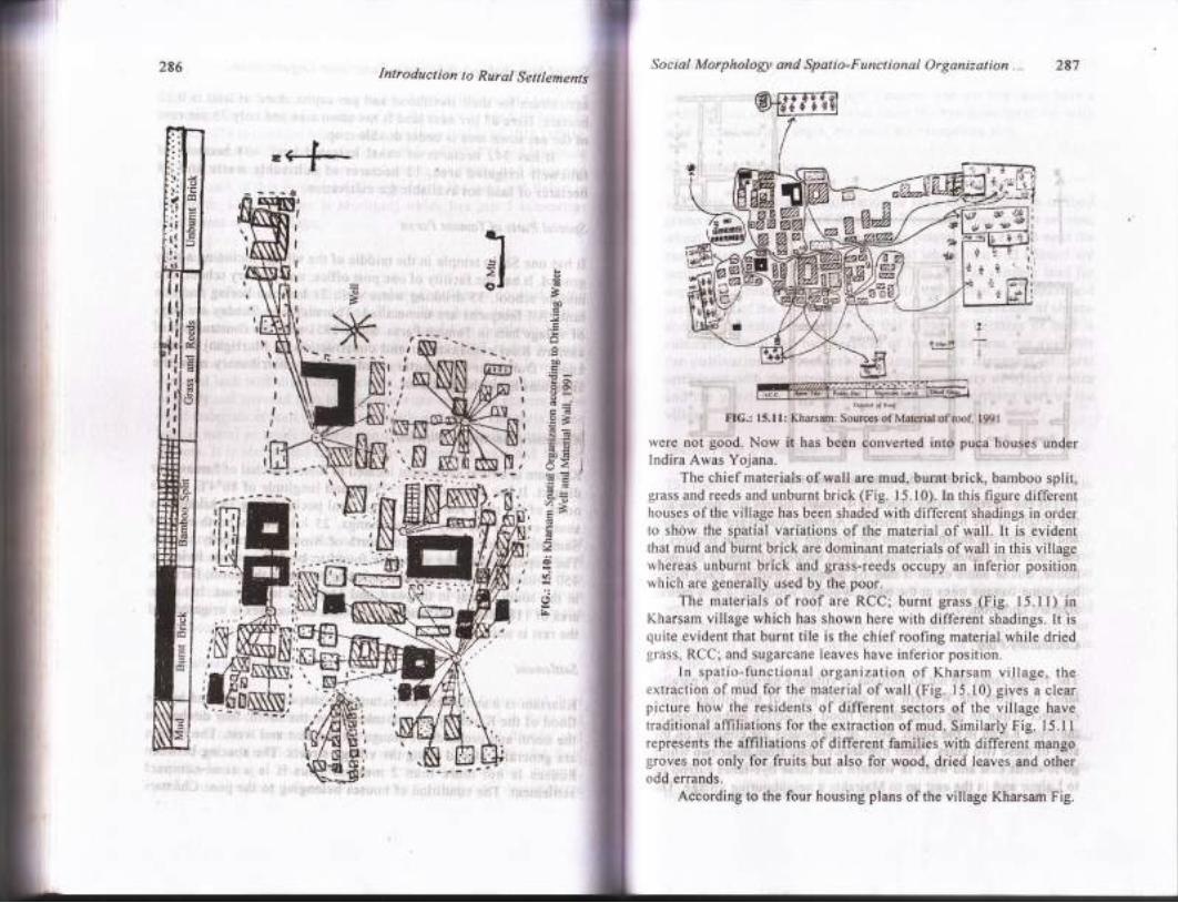
F]IG.: l5.lI: Kharsam: Sources of Material of rool lg9l
were not good. Now it has been converted into puca houses underIndira Awas Yojana.
The chief materials of wall are mud, burnt brick, bamboo split,grass and reeds and unburnt brick (Fig. 15.10). In this figure differenthouses ofthe village has been shaded with different shadings in ordelto show the spatial variations of the material of wall. lt is evidentthat mud and burnt brick are dominant materials of wall in this villagewhereas unburnt brick and grass-reeds occupy an inferior positionwhich are generally used by the poor.
The materials of roof are RCC; burnt grass (Fig. t5.l l) inKharsam village which has shown here with different shadings. It isquite evident that burnt tile is the chief roofing material while driedgrass, RCC; and sugarcane leaves have inferior position.
ln spatio-functional organization of Kharsam village, theextraction of mud for the material of wall (Fig. 15.10) gives a clearpicture how the residents of different sectors of the village havetraditional affiliations for the extraction of mud. Similarly Fig. 15.11represents the affiliations of different families with different mangogroves not only for fruits but also for wood, dried leaves and otherodd errands.
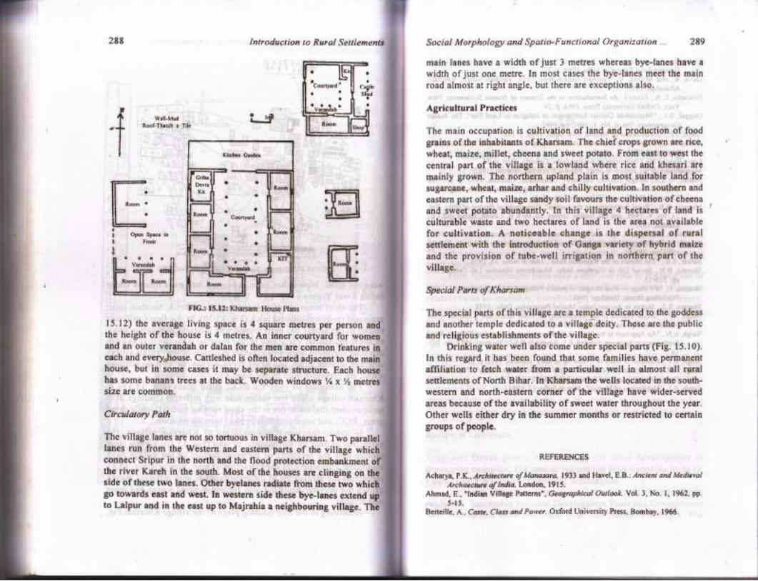
According to the four housing plans of the village Kharsam Fig.
ai*Q &
288
'f
Introduetian to Rural Settl Social Morphologt and Spatio-Functional Organization... 289
main lanes have a width of just 3 metres whereas bye-lanes have a
width of just one metre. In most cases the bye-lanes meet the mainroad almost at right angle, but there are exceptions also. ,
Agricultural Practices
The main occupation is cultivation of land and production of foodgrains of the inhabitants of Kharsam. The chief crops grown are rice,wheat, maize, millet, cheena and sWeet potato. From east to west the
central part of the village is a lowland where rice and khesari are
mainly grown. The northern upland plain is most suitable land forsugarcane, wheat, main, arhar and chilly cultivation. In southern and
eastern part ofthe village sandy soil favours the cultivation ofcheenaand sweet potato abundantly. In this village 4 hectares of land is
culturable waste and two hectares of land is the area not availablefor cultivation. A noticeable change 'is the dispersal of ruralsettl€ment with the introduction of Gartga variety of hybrid maizeand the provision of tube-well irrigation in northern part of the
Speciat Parts of Kharsam
The special parts of this village are a temple dedicated to the goddess
and another temple dedicated to a villagri deity. These are the publicand religious establishments of the village.
Drinking water well alsb come under special parts (Fig. 15.10).In this regard it has been found that some families have permanentaffiliation'to fetch water from a particular well in almost all ruralsettlements of North Bihar.:In l(harsam the wells locatod in the south-western and north-eastern corner of the village have wider-servedareas because of the availability of sweet water throughout the year.Other wells either dry in the summer months or restricted to certaingroups ofpeople.
REFERENCES
Acharya, P.K.,Architecture olManasara, 1933 and Havcl, E.B.: Ancient and MedicvalAtchitecture ol India, London, 1915.
Ahmad, 8., 'lndian Village Patterns", Geographical Outlook, Vol. 3, No. l, 1962, pp.
5-l 5.Berteillc, A., Caste, Class and Potsee Oxford University Press, Bombay. 1966.
Wall-MudRoof-Th&tch a Tih
t_g
FIG,: 15.12: Kharsam: House Plans
Ir:.ll "... .ll .lL__I opcn sprr.I FrcotI.t
15.12) the average living space is 4 square metres per personthe height of the house is 4 metres. An inner courtyard for womenand an outer verandah or dalan for the men are common t'eatures iileach and every,rhouse. Cattleshed is often located adjacent to thehouse, but in some cases it may be separate structure. Each hou#has some banana trees at the back. Wooden windows % x % metresslze are common.
Circulatory Path
The village lanes are not so tortuous in village Kharsam. Two parallellanes run from the Western and eastern parts of the village whichconnect Sripur in the north and the flood protection embankmentthe river Kareh in the south. Most of the houses are clinging onside of these two lanes. Other byelanes radiate from these twogo towafds east and west. In western side these bye-lanes extend Wto Lalpur and in the east up to Majrahia a neighbouring village. Tlli
Copyright © 2022 FDOKUMEN