Site of Mallaby's Soap Factory – A029 - NSW Government
106
Site of Mallaby’s Soap Factory – A029 Date Created: 13/02/2004 Pam Watson © New England Archaeology Site S01 Date Modified: 7/06/2010 Type of Site: Archaeological Group: Manufacturing and Processing Category: Factory/plant Local Govt. Area: Armidale Dumaresq Location Armidale Address/Location: 179 Dumaresq Street LDPNo: Lot 1 DP 1057304 MallabySoapFactory1965Plan MallabysSoap-Aerial43-62283 Detail from the 1965 Plan of Armidale. The zone boundary appears to run throught the building labelled 'Soap Factory'. Detail from the 1943 Aerial 62203 (north is at the top), showing the outline of the building, There seems to be an ordered garden between the factory and Mallaby's old house to the north. (UNEHC). Description: The footprint of a building against and overlapping the northern boundary of the allotment near Markham St, appears on the 1965 plan. History: Lewis Markham was producing soap and candles from tallow during 1856-7 (Wilson 1991: 87; Gilbert: 87). In 1886 George Mallaby and his son John, operated a neat and compact soap factory on the original cultivation allotment 88 along Dumaresq Street. They produced a range of products and won a bronze medal for Champion Cleanser bar soap at the Chicago Exposition in 1893. Their Pumice Soap and Carbolic Pumice Soap was popular as far afield as Tenterfield and Barraba. Machinery included a 12 hp Tangye engine and multi-tubular boiler, a large soap pan of 3 tons capacity, numerous small pans, the latest types of soap coolers and accessories. The best tallow was used to produce 1000 lbs of soap a day (c. 500kg). In 1905 the business was praised as efficient (Armidale Argus 25 November). The factory was still in operation in 1913 and John Mallaby's Golden Bar Soap, Champion Cleaner and Pumice Sand Soap was still available for 'people who are particular' in 1928 (Gilbert 1982: 95), but it is not known when the factory closed and the building was demolished. Mallaby’s house still stands in the next but one allotment along at 87 Markham St (Burke 2000: 8). Significance: Local. The site has the potential to yield archaeological information relating to early local industry in the 19th and early 20thC. The factory is representative of a period when regional self-sufficiency in basic industries operated (similar to the regional cordial industrial) and locally produced products contributed significantly to economic life and employment. It meets Criteria A and E Condition: The site was built upon by New England Toyota in 2003. The land was raised above flood level and a concrete slab laid for the building. The new building is set back from the boundaries and the remaining area covered with car parking. The footprint of the soap factory lies beneath the western end of the car park hugging the NW corner of the block, well away from the new building. Such construction may have left the subsurface remains undisturbed. The adjacent allotment to the north has a post-war weatherboard house on it.
-
Upload
khangminh22 -
Category
Documents
-
view
0 -
download
0
Transcript of Site of Mallaby's Soap Factory – A029 - NSW Government

Site of Mallaby’s Soap Factory – A029
Date Created: 13/02/2004 Pam Watson © New England Archaeology Site S01 Date Modified: 7/06/2010
Type of Site: Archaeological
Group: Manufacturing and Processing
Category: Factory/plant
Local Govt. Area: Armidale Dumaresq
Location Armidale
Address/Location: 179 Dumaresq Street
LDPNo: Lot 1 DP 1057304
MallabySoapFactory1965Plan MallabysSoap-Aerial43-62283
Detail from the 1965 Plan of Armidale. The zone boundary appears to run throught the building
labelled 'Soap Factory'.
Detail from the 1943 Aerial 62203 (north is at the top), showing the outline of the building, There seems to be an ordered garden between the factory and Mallaby's old house to the north.
(UNEHC).
Description:
The footprint of a building against and overlapping the northern boundary of the allotment near Markham St, appears on the 1965 plan.
History:
Lewis Markham was producing soap and candles from tallow during 1856-7 (Wilson 1991: 87; Gilbert: 87). In 1886 George Mallaby and his son John, operated a neat and compact soap factory on the original cultivation allotment 88 along Dumaresq Street. They produced a range of products and won a bronze medal for Champion Cleanser bar soap at the Chicago Exposition in 1893. Their Pumice Soap and Carbolic Pumice Soap was popular as far afield as Tenterfield and Barraba. Machinery included a 12 hp Tangye engine and multi-tubular boiler, a large soap pan of 3 tons capacity, numerous small pans, the latest types of soap coolers and accessories. The best tallow was used to produce 1000 lbs of soap a day (c. 500kg). In 1905 the business was praised as efficient (Armidale Argus 25 November).
The factory was still in operation in 1913 and John Mallaby's Golden Bar Soap, Champion Cleaner and Pumice Sand Soap was still available for 'people who are particular' in 1928 (Gilbert 1982: 95), but it is not known when the factory closed and the building was demolished. Mallaby’s house still stands in the next but one allotment along at 87 Markham St (Burke 2000: 8).
Significance:
Local. The site has the potential to yield archaeological information relating to early local industry in the 19th and early 20thC. The factory is representative of a period when regional self-sufficiency in basic industries operated (similar to the regional cordial industrial) and locally produced products contributed significantly to economic life and employment. It meets Criteria A and E
Condition:
The site was built upon by New England Toyota in 2003. The land was raised above flood level and a concrete slab laid for the building. The new building is set back from the boundaries and the remaining area covered with car parking. The footprint of the soap factory lies beneath the western end of the car park hugging the NW corner of the block, well away from the new building. Such construction may have left the subsurface remains undisturbed. The adjacent allotment to the north has a post-war weatherboard house on it.

Site of Mallaby’s Soap Factory – A029
Date Created: 13/02/2004 Pam Watson © New England Archaeology Site S01 Date Modified: 7/06/2010
Archaeological Potential:
Moderate
Recommendation:
Schedule for listing
Investigations Required:
Archaeological assessment and monitoring of any subsurface redevelopment in the north western area of the allotment.
REFERENCES AND RELATED RECORDS:
Local Government Area:
Armidale Dumaresq
Maps:
1965 City of Armidale Plan
People:
Mallaby, George
Theme(s):
Industry
Labour
Publications, Theses, Reports:
Burke, Heather, An Assessment of the Inadequacies of the Historical Archaeological Component of the 1991 Armidale Heritage Study: A Submission To the Armidale Dumaresq Council, 2000.
Wilson, Graham, and Jean Cooper, From Jessie Street West. Armidale and District Historical Society Journal 34: 85-100., 1991.

Site of Old Burial Ground – A036
Date Created: 19/02/2004 Pam Watson © New England Archaeology Site S07 Date Modified: 7/06/2010
Type of Site: Archaeological
Group: Cemeteries and Burial Sites
Category: Cemetery/Graveyard/Burial Ground
Local Govt. Area: Armidale Dumaresq
Location Armidale
Address/Location: 142-152 Faulkner Street
LDPNo: Lot 1146 DP 821025
Lot 3 Sec 30 DP 758032
OldBurialGround.jpg OldBurialGround-2010.jpg
Detail from the 1867 Ratings Map (UNEHC) View south west of the Old Burial Ground in the playground of Armidale City Public School (Pam
Watson 2010)
Description:
No images located apart from the 1867 location plan
History:
The old cemetery was situated in the Public Reserve on Faulkner Street, near the corner with Brown Street.It appears on the 1849 Galloway plan, and had headstones dating back to 1845, but it was probably in use earlier than this. Even in 1849 reservations about its unsuitability, being so close to town, were expressed (letter from Galloway to Mitchell, 20/12/1849). When plans were being discussed in the 1850s for the construction of a school on the adjacent piece of land it was suggested that the cemetery should be moved. In 1859 this was officially approved. Nevertheless the graveyard was apparently used into the mid-1860s, from which time denominational areas of the new cemetery in Memorial Avenue were successively dedicated. It apparently had become very crowded by 1860 (complaints in the Armidale Express 14 & 21/7/1860) and became dilapidated and uncared for. In 1895 the old burial ground of half an acre facing Faulkner St was resumed and added to the National School grounds, with monuments and 41 bodies being transferred to the cemetery on South Hill. The Government was supposed to have offered to pay at least a proportion of the expense incurred by the removal of the bodies from one cemetery to another, but very little money was actually claimed. By the body count alone, it is clear that the majority of bodies were not disinterred. During World War II when the local population feared a Japanese invasion, slit trenches were dug in the playground north of the Girls Department for shelter. Apparently numerous human bones were encountered, suggesting the translocation of the cemetery was less than rigorous. Again, on the demolition of the Girls Department in 1964, storm water lines to the new building passed through graves at a depth of about 3 feet (Hague 2005: 72-82; Gilbert 1982: 178; Oxford: 3).
Significance:
Local. Rare. The site is significant as the location of the first cemetery in Armidale and reflects the early layout of the town (Criteria A and F). Although there are no surviving surface features, the removal of graves to the new cemetery does not seem to have been exhaustive. Not all graves may have been well marked. There is a good probability that further human remains may be located if the grounds are further excavated, providing skeletal and societal information on the early population of the town (Criterion E).

Site of Old Burial Ground – A036
Date Created: 19/02/2004 Pam Watson © New England Archaeology Site S07 Date Modified: 7/06/2010
Condition:
The site is within the grounds of Armidale City Public Primary School, in an open play area containing play equipment.
Archaeological Potential:
High
Recommendation:
Schedule for listing
Investigations Required:
Archaeological assessment is required before any subsurface excavations, followed by testing and monitoring of excavation works. Any remains encountered should be archaeologically excavated.
REFERENCES AND RELATED RECORDS:
Local Government Area:
Armidale Dumaresq
Maps:
1867 Ratings Map of Armidale
People:
N/A
Theme(s):
Local: Formative Period
Death
Publications, Theses, Reports:
Gilbert, Lionel, An Armidale Album. Glimpses of Armidale's History and Development In Word, Sketch and Photograph. New England Art Museum Association, Armidale, 1982.
Hague, Marjorie J, Armidale's Old Burial ground, in the Armidale and District Historical Society Journal, vol.48, 2005
Oxford, H.W. (Ed.), Armidale 1863-1938: 75th Anniversary of the Municipality. Pogonoski Pty Ltd Printers, Newcastle, 1938.
Site of Trim’s Bridge – A048
Date Created: 19/02/2004 Pam Watson © New England Archaeology Site S08 Date Modified: 7/06/2010
Type of Site: Archaeological
Group: Transport - Road
Category: Road Bridge
Local Govt. Area: Armidale Dumaresq
Location Armidale
Address/Location: 82 Marsh Street
LDPNo: Lot 4 DP 11311397
Lot 701 DP 94054
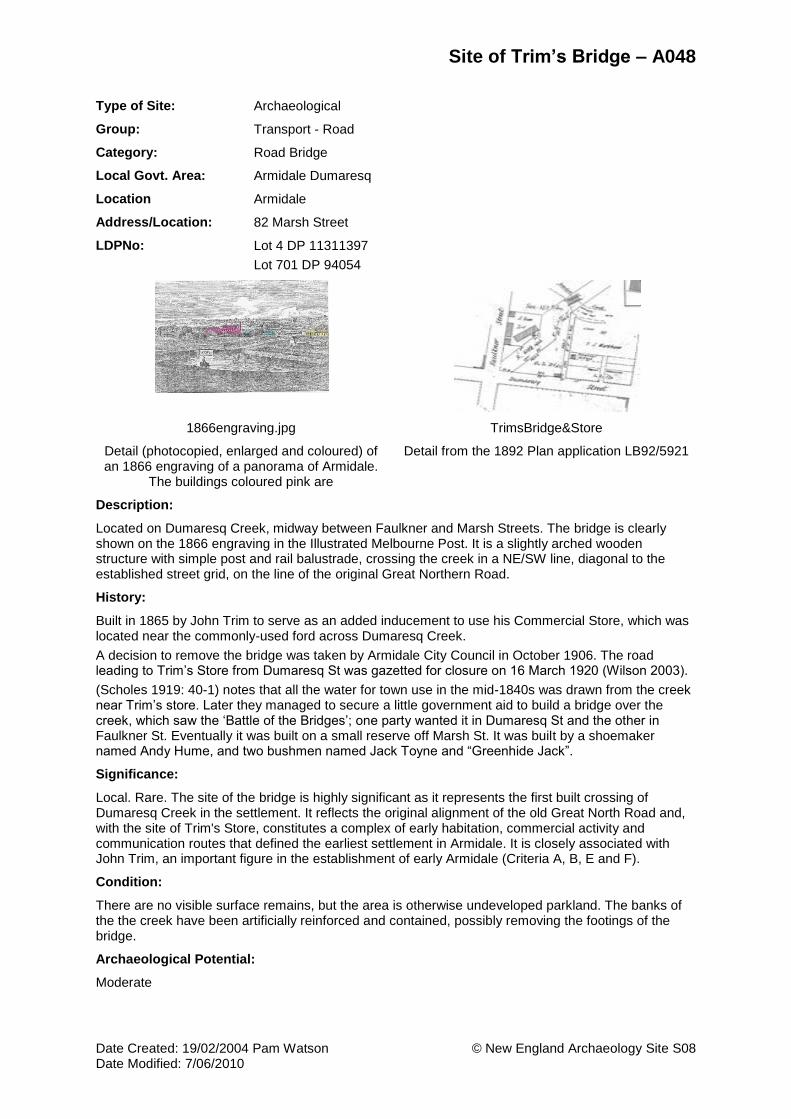
1866engraving.jpg TrimsBridge&Store
Detail (photocopied, enlarged and coloured) of an 1866 engraving of a panorama of Armidale.
The buildings coloured pink are
Detail from the 1892 Plan application LB92/5921
Description:
Located on Dumaresq Creek, midway between Faulkner and Marsh Streets. The bridge is clearly shown on the 1866 engraving in the Illustrated Melbourne Post. It is a slightly arched wooden structure with simple post and rail balustrade, crossing the creek in a NE/SW line, diagonal to the established street grid, on the line of the original Great Northern Road.
History:
Built in 1865 by John Trim to serve as an added inducement to use his Commercial Store, which was located near the commonly-used ford across Dumaresq Creek.
A decision to remove the bridge was taken by Armidale City Council in October 1906. The road leading to Trim’s Store from Dumaresq St was gazetted for closure on 16 March 1920 (Wilson 2003).
(Scholes 1919: 40-1) notes that all the water for town use in the mid-1840s was drawn from the creek near Trim’s store. Later they managed to secure a little government aid to build a bridge over the creek, which saw the ‘Battle of the Bridges’; one party wanted it in Dumaresq St and the other in Faulkner St. Eventually it was built on a small reserve off Marsh St. It was built by a shoemaker named Andy Hume, and two bushmen named Jack Toyne and “Greenhide Jack”.
Significance:
Local. Rare. The site of the bridge is highly significant as it represents the first built crossing of Dumaresq Creek in the settlement. It reflects the original alignment of the old Great North Road and, with the site of Trim's Store, constitutes a complex of early habitation, commercial activity and communication routes that defined the earliest settlement in Armidale. It is closely associated with John Trim, an important figure in the establishment of early Armidale (Criteria A, B, E and F).
Condition:
There are no visible surface remains, but the area is otherwise undeveloped parkland. The banks of the the creek have been artificially reinforced and contained, possibly removing the footings of the bridge.
Archaeological Potential:
Moderate

Site of Trim’s Bridge – A048
Date Created: 19/02/2004 Pam Watson © New England Archaeology Site S08 Date Modified: 7/06/2010
Recommendation:
Schedule for listing
Investigations Required:
Archaeological assessment and monitoring of any subsurface development works in the area of the bridge. If any remnants of the early bridge survive they should be preserved and interpreted for the public as highly significant heritage items.
REFERENCES AND RELATED RECORDS:
Local Government Area:
Armidale Dumaresq
Images:
1866 Panorama of Armidale
Maps:
Location layer on AMPA GIS
People:
Trim, John 1813 to 1892
Theme(s):
Local: Formative Period
Transport
Publications, Theses, Reports:
Scholes, J., Early Recollections of Armidale (New South Wales), The Royal Australian Historical Society Journal and Proceedings, V (1), 1919
Walker, R.B., Old New England. A History of the Northern Tablelands of New South Wales, 1818-1900. Sydney University Press; Methuen, London, 1966.
Wilson, Graham, Archaeology Sites In Armidale. Unpublished Notes Prepared For Pam Watson., 2003.

Site of Pearson’s Flour Mill – A054
Date Created: 26/02/2004 Pam Watson © New England Archaeology Site S15 Date Modified: 7/06/2010
Type of Site: Archaeological
Group: Manufacturing and Processing
Category: Mill (Grain) - Wheat
Local Govt. Area: Armidale Dumaresq
Location Armidale
Address/Location: 122 Niagara Street
124 Niagara Street
126 Niagara Street
128 Niagara Street
130 Niagara Street
LDPNo: Lot 5 DP 38151
Lot 4 DP 38151
Lot 3 DP 38151
Lot 2 DP 38151
Lot 1 DP 38151
PearsonsMillArea1965.jpg PearsonsMillSite-Aerial43-62283
Location of the mill on the 1965 Plan of Armidale, the area labelled RP 1151
Detail from the 1943 Aerial photograph of Armidale, 62283 (UNEHC). The area of the site
is marked in red and is unoccupied.
Description:
No images of the mill have been located. A description of Pearson's new roller flour mill appears in the Armidale Express (5/11/1895, pp.4-5): 'The building, which has a frontage to Rusden Street, is a two-storied one, the two machinery rooms being 32 feet by 22 feet, one on each floor. The engine room is 22 feet by 14 feet, and there is an office and verandah along the front of the premises. ..... There is a saw bench erected near the engine room for cutting firewood and pumping gear is being erected for drawing water from an adjacent well to supply the building.'
The West End Church of St Mary's, built in 1896 (at 286 Rusden Street), is described as lying between Pearson’s Flour Mill and the railway (AE 27/3/1896, p.4 col.7; Gilbert 1982: 150). However Wilson places it at what is now 134 Niagara Street, slightly further south from Rusden Street (south of McLennan Street) and next to the railway line (Wilson 1991: 87, 95 (map)). The latter site was consumed by petroleum terminals which dominated the area near the railway. Given the address and the described location with St Mary's Church being between the mill and the railway line, it would seem the mill was probably located in the area north of McLennan St and south of Rusden St, with Niagara Street on its eastern flank.
History:
Robert A. Pearson’s New Roller Flour Mill was opened in 1895 (AE 5/11/95 p.4; Walker 1966: 5) and was in full working order soon afterwards (AE: 21 January 1896). The latest improved 'Simon' Roller system was installed by Henry Simon 'well-known engineer of Manchester and Sydney'. Pearson made further improvements to the mill in June 1903 when he installed a new steam plant imported from Marshall and Sons of Gainsborough, England. It was one 'of the independent type, 20 hp compound, with 9 inch and 14 inch cylinders fitted with automatic gear and a long fabricator, enabling a continuous day and night run for a week' (AE 12/6/1903 p.5). The boiler was built by Heine and Co. of Sydney and installed by a leading engineer. The mill's capacity increased to three sacks per hour. By 1904 there were only two mills left in Armidale, Pearson's and Richardson's. The Armidale Express felt that there should be no need for bakers or anyone else in Armidale to look elsewhere for superior flour and no need for farmers to send their wheat away to be ground (AE 30/9/1904). But despite the success of his mill, Pearson sold his mill and its one and a half acres of land in 1907 and moved to

Site of Pearson’s Flour Mill – A054
Date Created: 26/02/2004 Pam Watson © New England Archaeology Site S15 Date Modified: 7/06/2010
Tamworth apparently to extend his milling interests. He established another mill there around 1913. He managed that business until ill-health forced him to relinquish control, and subsequently farmed at Nemingha. He died at his home in West Tamworth in 1938, aged 73 years. (Wilson 2003)
Robert A. Pearson was the son of Henry Pearson (died 1898?) and the grandson of Richard and Mary Pearson, who arrived in Australia from Ireland on the Cadet in 1841 with their sons Robert (snr), Henry and Richard. They were soon farming in New England, and took up subdivisions west of Armidale, working the land for almost 50 years at Violet Dale, Violet Hill and Woodpark (Ferry 1999: 61).
Significance:
Local. The mill was the last of one of six such facilities erected and operating at different times between 1846 and 1907, none of which survive. It represents the last attempt to keep a local flour milling industry alive in Armidale. It meets Criteria A and E.
Condition:
Nothing survives of the mill. A series of five houses have been built on the block, facing Niagara Street, post-1943 when the aerial photo shows the block as empty.
Archaeological Potential:
Low. Some evidence of the industry, structural features and related deposits, may survive in the backyards of the later 20th century housing.
Recommendation:
Schedule for listing
Investigations Required:
Archaeological assessment and monitoring of any subsurface developments in the yards of the houses.
REFERENCES AND RELATED RECORDS:
Local Government Area:
Armidale Dumaresq
Maps:
Location layer on AMPA GIS
People:
N/A
Theme(s):
Industry
Industry - Flour Milling
Publications, Theses, Reports:
Armidale Express (AE).
Ferry, John, Colonial Armidale. University of Queensland Press, St Lucia., 1999.
Walker, R.B., Flour Milling In New England, Armidale and District Historical Society Journal and Proceedings 9: 3-8, ?.
Wilson, Graham, and Jean Cooper, From Jessie Street West. Armidale and District Historical Society Journal 34: 85-100., 1991.

Site of Trim’s Chaff Factory and Sawmill – A063
Date Created: 26/02/2004 Pam Watson © New England Archaeology Site S16 Date Modified: 7/06/2010
Type of Site: Archaeological
Group: Manufacturing and Processing
Category: Factory/plant
Local Govt. Area: Armidale Dumaresq
Location Armidale
Address/Location: 1/230-234 Rusden Street
2/230-234 Rusden Street
3/230-234 Rusden Street
4/230-234 Rusden Street
5/230-234 Rusden Street
6/230-234 Rusden Street
LDPNo: Lot 1 SP 75032
Lot 2 SP 75032
Lot 3 SP 75032
Lot 4 SP 75032
Lot 5 SP 75032
Lot 6 SP 75032
TrimsWestend1900 TrimFactory-ASHD_02
1900 Panorama detail of John Joseph Trims West end store and chaff factory (UNEHC).
Detail from the 1933 Sewer Plan, No.2, showing the West End store and adjacent factory.
Description:
A large square gable-roofed weatherboard shed with a skillion extension stood to the west of Trim & Co.'s 'West End' store (1991 AHS Built Heritage Item 43; see the 1900 panorama image) and the block dog-legged through to a wide north frontage onto Rusden St (1933 Sewer Plan ASHD-02). On the north side of the shed there was a large underground tank. Another rectangular weatherboard shed stood against the western boundary.
History:
John Joseph Trim (son of John Trim) expanded his general store (S6) to include a steam chaff factory and a sawmill which reached through the block to Rusden St. It was a supplier of chaff to the Light Horse regiments when they camped at the Armidale Showground. (Wilson 1991: 88). The structure appears on the 1933 plan but is later demolished and superseded by a house (added to this plan) some time after 1965, as the footprint is still on the 1965 plan.
Significance:
Local. The site is representative of local industry associated with store keeping and is one of the numerous business interests run by the enterprising Trim family who were significant figures in the 19thC development of Armidale.
Condition:
The Rusden St frontage has recently been excavated in preparation for a six-villa development, removing the subsurface features. The rear of the store and the immediate area to the west now contains housing covering most ground space.
Archaeological Potential:
None
Recommendation:
The site should be listed despite recent removal of its archaeological potential, as it contributes to the group record of the Trim family businesses. The mapping location and archival history should be

Site of Trim’s Chaff Factory and Sawmill – A063
Date Created: 26/02/2004 Pam Watson © New England Archaeology Site S16 Date Modified: 7/06/2010
retained as part of the documentation of Armidale's
Investigations Required:
None.
REFERENCES AND RELATED RECORDS:
Local Government Area:
Armidale Dumaresq
Images:
1900 Panorama of Armidale
Maps:
1933 Armidale Sewerage, House Details (ASHD)
1965 City of Armidale Plan
People:
Trim, John
Theme(s):
Industry
Publications, Theses, Reports:
Wilson, Graham, and Jean Cooper, From Jessie Street West. Armidale and District Historical Society Journal 34: 85-100., 1991.

Site of Child’s Brickworks – A043
Date Created: 26/02/2004 Pam Watson © New England Archaeology Site S18 Date Modified: 7/06/2010
Type of Site: Archaeological
Group: Manufacturing and Processing
Category: Kiln Brick/brickworks
Local Govt. Area: Armidale Dumaresq
Location Armidale
Address/Location: 60 Madgwick Drive
LDPNo: Lot 1 DP 73498
1849ChildsBricks ChildsBrickworks-Aerial43-62283-a
View NNW to the early. brick making area, located mid-ground, to left of track (the
undeveloped extension of Martin Street).
1943 aerial view to the north of the location of the early brickworks (1943 aerial photos of
Armidale).
Description:
The Galloway maps of 1848 and 1849 show a brick-makers located NW of the settlement, now in university park lands south of and close to Dumaresq Creek, west of Martin St and north of Claude Street (see map in Burke 1999: 58-9, Fig. 3.6). No description of these facilities has been found and the area is currently undeveloped grass pasture.
History:
The Galloway maps of 1848 and 1849 show a brick-maker located north west of the settlement (Burke 1999: 59, Fig. 3.6). Early brick makers included James Stevens and William Lilly and John Smith (the latter two killed by lightning in 1848) (Gilbert 1982: 82). In 1856 a notice in the Armidale Express announced that a hospital was to be built and that bricks were required for it. These were very scarce at the time and the building did not commence until almost a year later (AE 2/5/1856; Oxford: 4). Brickworks operated by Richard Child had functioned in the town in the early 1860s (Kass 1991: 16). It is uncertain whether the Child operations were conducted at the 1840s site. Further documentary research is required.
Significance:
Local. Rare. The earliest recorded brick-making area in Armidale lies in a location that has remained undeveloped. As documentary evidence is limited, any archaeological remains would provide vital information for the heritage record. It meets Criteria A and E.
Condition:
Undeveloped park land. No visible features on the surface, but no history of disturbance.
Archaeological Potential:
High
Recommendation:
Schedule for listing
Investigations Required:
Detailed archaeological assessment required before redevelopment.

Site of Child’s Brickworks – A043
Date Created: 26/02/2004 Pam Watson © New England Archaeology Site S18 Date Modified: 7/06/2010
REFERENCES AND RELATED RECORDS:
Local Government Area:
Armidale Dumaresq
Images:
Location of Child’s Brickworks 1849
Maps:
Location layer on AMPA GIS
People:
Child, Richard
Theme(s):
Local: Formative Period
Local: Early brickworks
Industry
Publications, Theses, Reports:
Armidale Express (AE).
Burke, Heather, An Assessment of the Inadequacies of the Historical Archaeological Component of the 1991 Armidale Heritage Study: A Submission To the Armidale Dumaresq Council, 2000.
Gilbert, Lionel, An Armidale Album. Glimpses of Armidale's History and Development In Word, Sketch and Photograph. New England Art Museum Association, Armidale, 1982.
Kass, Terry, Thematic History of Armidale. Report prepared for Perumal Murphy Pty Ltd on behalf of Amridale City Council, 1991
Site of First Hospital – A026
Date Created: 3/03/2004 Pam Watson © New England Archaeology Site S20 Date Modified: 7/06/2010
Type of Site: Archaeological
Group: Health Services
Category: Hospital
Local Govt. Area: Armidale Dumaresq
Location Armidale
Address/Location: 118 Dumaresq Street
83-85 Faulkner Street
LDPNo: Lot 32 DP 1031471
Lot 1 DP 744695
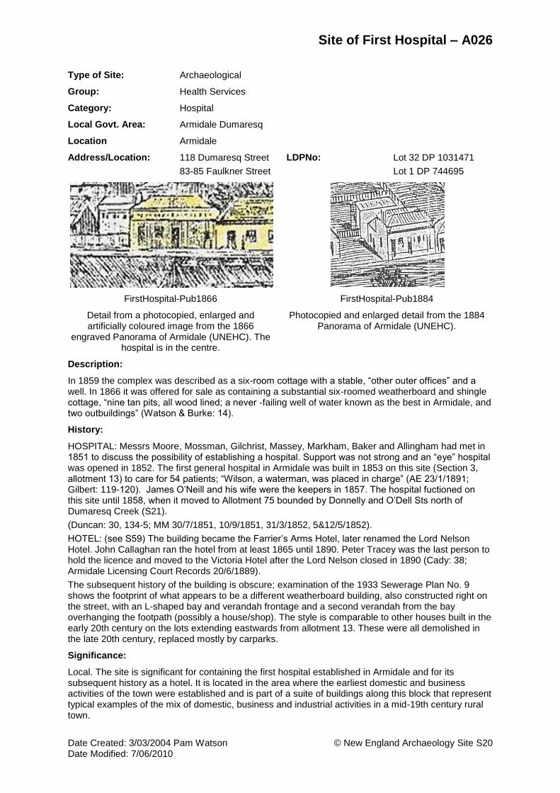
FirstHospital-Pub1866 FirstHospital-Pub1884
Detail from a photocopied, enlarged and artificially coloured image from the 1866
engraved Panorama of Armidale (UNEHC). The hospital is in the centre.
Photocopied and enlarged detail from the 1884 Panorama of Armidale (UNEHC).
Description:
In 1859 the complex was described as a six-room cottage with a stable, “other outer offices” and a well. In 1866 it was offered for sale as containing a substantial six-roomed weatherboard and shingle cottage, “nine tan pits, all wood lined; a never -failing well of water known as the best in Armidale, and two outbuildings” (Watson & Burke: 14).
History:
HOSPITAL: Messrs Moore, Mossman, Gilchrist, Massey, Markham, Baker and Allingham had met in 1851 to discuss the possibility of establishing a hospital. Support was not strong and an “eye” hospital was opened in 1852. The first general hospital in Armidale was built in 1853 on this site (Section 3, allotment 13) to care for 54 patients; “Wilson, a waterman, was placed in charge” (AE 23/1/1891; Gilbert: 119-120). James O’Neill and his wife were the keepers in 1857. The hospital fuctioned on this site until 1858, when it moved to Allotment 75 bounded by Donnelly and O’Dell Sts north of Dumaresq Creek (S21).
(Duncan: 30, 134-5; MM 30/7/1851, 10/9/1851, 31/3/1852, 5&12/5/1852).
HOTEL: (see S59) The building became the Farrier’s Arms Hotel, later renamed the Lord Nelson Hotel. John Callaghan ran the hotel from at least 1865 until 1890. Peter Tracey was the last person to hold the licence and moved to the Victoria Hotel after the Lord Nelson closed in 1890 (Cady: 38; Armidale Licensing Court Records 20/6/1889).
The subsequent history of the building is obscure; examination of the 1933 Sewerage Plan No. 9 shows the footprint of what appears to be a different weatherboard building, also constructed right on the street, with an L-shaped bay and verandah frontage and a second verandah from the bay overhanging the footpath (possibly a house/shop). The style is comparable to other houses built in the early 20th century on the lots extending eastwards from allotment 13. These were all demolished in the late 20th century, replaced mostly by carparks.
Significance:
Local. The site is significant for containing the first hospital established in Armidale and for its subsequent history as a hotel. It is located in the area where the earliest domestic and business activities of the town were established and is part of a suite of buildings along this block that represent typical examples of the mix of domestic, business and industrial activities in a mid-19th century rural town.

Site of First Hospital – A026
Date Created: 3/03/2004 Pam Watson © New England Archaeology Site S20 Date Modified: 7/06/2010
Condition:
Any remains would be subsurface. Currently the western two thirds of the lot comprises Burton’s Saddlery at the south end, and a bitumen carpark at the north end. The eastern third is a sealed road and parking area for the Coles complex. Pre-2003 it was a sealed road into the carparking zone at the rear of buildings fronting onto Beardy Street. The saddlery building and the carpark have been cut down into the ground towards the south in order to flatten the site. This may have removed subsurface remains in the south. The north and eastern sides have been occupied by a 20thC weatherboard shop/house. Hence the site has been considerably disturbed since the demolition of the earliest building.
Archaeological Potential:
Low
Recommendation:
Schedule for listing
Investigations Required:
Archaeological assessment and monitoring of any redevelopment works involving below ground excavations.
REFERENCES AND RELATED RECORDS:
Local Government Area:
Armidale Dumaresq
Images:
1866 Panorama of Armidale
First Hospital – Callaghan’s Hotel
Maps:
1867 Ratings Map of Armidale
People:
N/A
Theme(s):
Local: Formative Period
Health
Publications, Theses, Reports:
Armidale Express (AE).
Cady, Bruce, 'We Never Had To Go Far For A Drink: Pubs In Armidale', Armidale and District Historical Society Journal and Proceedings, 34, 1991: 29-46., 1991.
Cambell, Janice, A History of Armidale and New England Hospital 1853-1946, University of New England, Armidale, 1960
Duncan, R, Armidale: Economic and Social Development, 1839-1871. University of New England College, Armidale, 1951.
Gilbert, Lionel, An Armidale Album. Glimpses of Armidale's History and Development In Word, Sketch and Photograph. New England Art Museum Association, Armidale, 1982.
Maitland Mercury (MM), ,
Watson, Pamela, & Burke, Heather, Report on the Historical Archaeology of Armidale Project, 2000: The Coles Eastend Development Site. For RIB Grant, School of Human and Environmental Studies, University of New England, 2000

Site of Second Hospital – A024
Date Created: 4/03/2004 Pam Watson © New England Archaeology Site S21 Date Modified: 7/06/2010
Type of Site: Archaeological
Group: Health Services
Category: Hospital
Local Govt. Area: Armidale Dumaresq
Location Armidale
Address/Location: 210-218 Donnelly Street
LDPNo: Lot 11 DP 786271
Tuck-Moses-2Hospital.jpg
Footprint of the Second Hospital in Armidale. Detail from the 1867 Ratings Map of Armidale (UNEHC).
Description:
No images have been located. The footprint on the 1867 Ratings Map shows a U-shaped building close to the Donnelly St frontage with short wings extending south, on a long thin block stretching down to the creek. The hospital was described as 'a plain and unpretending but useful building with five wards, dispensary and outbuildings, forming the residence of the superintendent and his family. '.... the hospital and garden present a neat, scrupulously clean, and attractive appearance, and some recent additions bear evidence of mechanical ingenuity.' (ATCJ 23/9/1871, p.408, quoted in Gilbert: 257).
History:
In 1856 a notice announced that a hospital was to be built (to replace the first hospital, see S20) and that bricks were required for it. These were very scarce at the time and the building did not commence until almost a year later (Oxford: 4; AE 2/5/1856). Land allotment 75 north of Dumaresq Creek was chosen. By April 1858 it had been completed and enclosed with a three rail fence. Hospital committee members comprised clergymen and businessmen, and were expected to visit the hospital at least once a week to see how patients were faring and whether the organisation was running smoothly. There were considerable complaints about cleanliness as well as patient behaviour but these seem to have been sorted out by 1871 (Gilbert1982: 120-122).
Armidale hospital became the medical centre for the entire pastoral district, the annual number of patients increasing irregularly from 34 in 1858 to 88 in 1871 (AE 18/4/1857; Duncan: 134). However a new hospital was considered desirable and in 1877, land allotment no. 46 on the old Great North Road (the site of the current hospital) was dedicated for hospital purposes, and opened in 1883.The old hospital remained as the infectious diseases hospital until 1911 (Wilson 1991: 92).
Significance:
Local. The site has historical and social importance (Criteria A and D) although its potential to provide physical evidence has probably been eliminated (not meeting Criterion E).
Condition:
The building has been demolished and the site recently built over by an extensive complex of small independent single-storey housing units which cover adjacent allotments to the east as well.
Archaeological Potential:
None

Site of Second Hospital – A024
Date Created: 4/03/2004 Pam Watson © New England Archaeology Site S21 Date Modified: 7/06/2010
Recommendation:
The site should be listed for historical and social interests, although its archaeological potential has probably been removed. Retain the mapping location and archival history as part of the documentation of Armidale's heritage.
Investigations Required:
None.
REFERENCES AND RELATED RECORDS:
Local Government Area:
Armidale Dumaresq
Maps:
1867 Ratings Map of Armidale
People:
N/A
Theme(s):
Local: Formative Period
Health
Publications, Theses, Reports:
Cambell, Janice, A History of Armidale and New England Hospital 1853-1946, University of New England, Armidale, 1960
Duncan, R., Armidale : Economic and Social Development, 1839-1871. University of New England College, Armidale, 1951.
Gilbert, Lionel, An Armidale Album. Glimpses of Armidale's History and Development In Word, Sketch and Photograph. New England Art Museum Association, Armidale, 1982.
Wilson, Graham, and Jean Cooper, From Jessie Street West. Armidale and District Historical Society Journal 34: 85-100., 1991.

Site of Police Residential Complex: Residence, Barracks & Stables – A034
Date Created: 4/03/2004 Pam Watson © New England Archaeology Site S22 Date Modified: 7/06/2010
Type of Site: Archaeological
Group: Law Enforcement
Category: Police Station
Local Govt. Area: Armidale Dumaresq
Location Armidale
Address/Location: 142-152 Faulkner Street
LDPNo: Lots 6 Sec 30 DP 758032
Lot 9 Sec 30 DP 758032
PoliceBarracks1910-UNEHC PoliceResidence1875-UNEHC
Police Barracks 1910 (UNEHC) Police Superintendent's Residence 1875 (UNEHC)
Description:
There are three main structures in this complex:
1) The Police Superintendent’s residence (photo, Gilbert 1982: 75): the building faces north with jutting wings at either end of a central rectangular core with a north-facing verandah. Two more wings extend south to the rear.It is built of brick with stone foundations and a slate roof.
2) The Barracks was a rectangular brick structure with central north-facing verandah and a central wing extending south to the rear, roofed originally by shingles. It consisted of six rooms divided into two apartments each with a sitting room and two bedrooms each. These rooms were located at the ends of the building with a divided wall and central chimney (AE 13/7/1872).
3) The stables are also of brick, laid in English Bond, on stone foundations of huge granite blocks. The plan is rectangular with an upper loft storey for fodder some 89 ft long, and a single-storey skillion space to the north. The roof was originally of shingles, later of corrugated iron. Each of the internal stalls had a saddle tree (Wilson, draft ms due 2011). A well is located north west of the north west corner of the stables (1933 Plan no. 26)
The 1933 Sewer Plan ASHD-26 shows the buildings and later school footprints overlapping. The residence is west of the barracks and the stables are some distance to the north of the barracks. Photographic views of the residence and barracks appear to be facing south with the front of the buildings facing the view to the north.
History:
The original police barracks and stables are shown on the 1867 plan in the old Commissioners Paddock in what is now Macdonald Park. In 1872 a contract for a new police barracks and stables was let to Edmund Lonsdale (Gilbert 1982: 70-71, 75) to be sited on the south west quarter of the block bounded by Mann, Dangar, Brown and Faulkner Streets. The northern end of the block was taken up by the new National School (see S24). Mr Lonsdale's tender was for £1,900 for the barracks. The public school, situated on the northern and eastern sections of the block, wanted to acquire more land for their expanding facilities and gradually police land was taken over, despite their resistance. In 1928 the three buildings and a horse yard were still retained by the police, with the residence housing the Police Inspector and one constable (AE 21/7/1928).
The stables stood for some 90 years, and there was concerted action to try and save them from demolition in the early 1960s, when the public school wished to expand its area. However no funding

Site of Police Residential Complex: Residence, Barracks & Stables – A034
Date Created: 4/03/2004 Pam Watson © New England Archaeology Site S22 Date Modified: 7/06/2010
was forthcoming and they were finally demolished in 1963. In 1980, when extensions were added to the Demonstration School library, part of the remains of the barracks and stables were unearthed. The excavations revealed well preserved wood blocks about a metre underground from the floor of the stables. Due to the lack of heritage legislation and process at this time, no archaeological investigation was undertaken (Wilson, draft ms due 2011).
Significance:
Local. The complex of police residence, barracks and stables has important historical associations with the development of institutions of law and order in the growing town of Armidale in the late 19th and early 20th centuries (Criterion A). The site has archaeological research potential (Criterion E).
Condition:
The site is partly covered by the buildings of Armidale City Public School, previously known as the Demonstration School. But the current buildings are set back from both frontages and subsurface remains may survive in the landscaped areas towards the South and in the open ground between the current buildings (see 1980 discoveries noted in the History).
Archaeological Potential:
Moderate. Remnants of these buildings and related deposits may survive in the spaces between the current buildings (see Condition and History relating to 1980 finds).
Recommendation:
Schedule for listing
Investigations Required:
Any subsurface development in the location of the original buildings requires an archaeological assessment and monitoring of excavations.
REFERENCES AND RELATED RECORDS:
Local Government Area:
Armidale Dumaresq
Images:
Police Barracks
Police Residence 1875
Maps:
1933 Armidale Sewerage, House Details (ASHD)
People:
N/A
Theme(s):
Law and order
Publications, Theses, Reports:
Gilbert, Lionel, An Armidale Album. Glimpses of Armidale's History and Development In Word, Sketch and Photograph. New England Art Museum Association, Armidale, 1982.
Kass, Terry, Thematic History of Armidale. Report prepared for Perumal Murphy Pty Ltd on behalf of Amridale City Council, 1991
Wilson, Graham, History of Armidale City Council. Unpublished report prepared for Armidale Dumaresq Council, n.d.

Site of Gaol – A053
Date Created: 4/03/2004 Pam Watson © New England Archaeology Site S23 Date Modified: 7/06/2010
Type of Site: Archaeological
Group: Law Enforcement
Category: Gaol
Local Govt. Area: Armidale Dumaresq
Location Armidale
Address/Location: 122-132 Mossman Street
LDPNo: Lot 78 DP 905545
Gaol1884 Gaol-interiorYard.jpg
Detail from the 1884 Panorama of Armidale (UNEHC)
Description:
Sketch plan and photos (Gilbert 1982: 72-73; Gilbert 1980: figs 71-72); description in 1871 (p.257) : The gaol is in two stories, with a handsome front in stone, on 8 acres of land, fenced with a four-rail fence with attractive gates. There are 12 cells. It is 36 feet square, badly planned, without store room and little domestic accommodation for the resident gaoler. The cells are lined with wood , and are 10 x 6 feet in size. The outer fence is of wood. Gilbert (1980: 62) describes the English bond brickwork of the solid walls, and the granite blocks serving as lintels and as supports for door-hinges and locks. A single storey female block was attached to the south end of the two storey male cell block.
The location on the 1867 Ratings map places the complex on the eastern side of the (whole street) block, just north of the middle. Comparison with the location of the College building shown on the 1933 Sewerage plan (No. 34), suggests that part of the foundations or other subsurface remains may lie under landscaped grounds or under the eastern interior courtyard and may have escaped obliteration.
History:
The earliest lock-up was on Beardy Street, opposite the court house (the site of the current post office). It appears on the 1849 Galloway plan and was a basic and small structure, inadequate for the needs of a growing town.
A more substantial facility was required. This was built by Everett and Stephens for £2318, beginning in January 1861 and opened in July 1863, with Samuel Caldwell as gaoler and his wife as matron. The four acres of the grounds were not fenced until this was requested in 1865. Caldwell also complained at this time that the ceiling over the gaolers’ sitting room was already falling down.
Between 1863 and 1898, some 4685 prisoners were committed to Armidale Gaol. The facility was also used as an asylum for the insane. Six executions were carried out at the gaol, conducted on a scaffold erected over a whitewashed brick-lined pit, seven or eight feet deep on the western side of the gaol near the exercise yard. This enabled the gallows to be kept unobtrusively below the level of the walls.
In 1871 Armidale was described as the receiving gaol for prisoners from a dozen police courts, from Tenterfield, Casino, Grafton, Glen Innes, Inverell, Bundarra, Uralla, Walcha, Lismore, Ballina, Ashford and another ... having a gaoler and four warders (ATCJ, spring 1871, “Jottings by the Way”, quoted in Gilbert 1982: 257).
It was disestablished in July 1920 as being too small for other than local needs, and having problems of maintenance. Between 1920 and 1924 the gaol residence was used as police quarters. The buildings were demolished in 1929 to make way for the new Teacher’s College. Some 450,000 of the

Site of Gaol – A053
Date Created: 4/03/2004 Pam Watson © New England Archaeology Site S23 Date Modified: 7/06/2010
old gaol bricks were used below ground level in the new foundations where some may still be seen. (Gilbert 1982: 71-77).
Significance:
Local. Rare. The site is significant as the first (and most) substantial gaol facility to be constructed in the town, dominating a prominent location of continuing importance to the city and its aesthetics. No structure of equivalent size and capacity replaced this facility. It meets Criteria A, E and F.
Condition:
Built over by the large two storey brick structure of Armidale Teachers College (now Newling campus of UNE). This structure has large internal courtyard areas which may have preserved subsurface remains of the gaol, such as the underground tank shown on the plan.
Archaeological Potential:
Moderate
Recommendation:
The site is scheduled in the1991 Heritage Study (Items 159, 160 and L50) as a built structure under its second built phase of occupation: the former Armidale Teachers College (now the Newling campus of UNE). No mention is made of its former history. This
Investigations Required:
Archaeological assessment and monitoring of any development that impacts below ground areas in the courtyard spaces and immediate grounds of the current building.
REFERENCES AND RELATED RECORDS:
Local Government Area:
Armidale Dumaresq
Images:
1884 Panorama of the City
Maps:
1849 Galloway Plan
1867 Ratings Map of Armidale
People:
Caldwell, Samuel
Theme(s):
Local: Formative Period
Law and order
Publications, Theses, Reports:
Gilbert, L., New England from Old Photographs. John Ferguson, Sydney, 1980
Gilbert, Lionel, An Armidale Album. Glimpses of Armidale's History and Development In Word, Sketch and Photograph. New England Art Museum Association, Armidale, 1982.

Site of National School Site of Superior Public School - Girls Department – A035
Date Created: 5/03/2004 Pam Watson © New England Archaeology Site S24 Date Modified: 7/06/2010
Type of Site: Archaeological
Group: Education
Category: School - State
Local Govt. Area: Armidale Dumaresq
Location Armidale
Address/Location: 142-152 Faulkner Street
LDPNo: Lot 1 Sec 30 DP 758032
Lot 2 Sec 30 DP 758032
Lot 5 Sec 30 DP 758032
National_School NationalSchool-c1870
Detail from the 1884 Panorama of Armidale (UNEHC)
The National School c.1870. Taken from Gilbert 1982:170
Description:
The site contained three major school buildings of interest, taking up most of the street block apart from the south west quadrant (see S22).
1) In the north west corner was the original 1865 National school building, a single storey of brick structure laid in English bond, with a gabled slate roof and decorative barge-boards, built to a broadly square plan with a central front verandah and a short bay protruding on the eastern front. A separate rectangular kitchen building at the rear was connected by a walkway to the main building (Gilbert p.170; 1933 Sewer Plan No. 26). The dimensions of the two school rooms were 60 ft by 18 ft, and 40ft by 18 ft, with boarded ceilings and ventilation throughout. Dormitory accommodation for 15 boarders was situated overhead. (ATCJ 23/9/1871, p.408, with an engraved image; quoted in Gilbert 1982: 257). There was a detached kitchen and laundry structure at the rear. A well is located west of the kitchen.
2) The 1884 building in the central north area (later the Boys and Infants Department) was of similar materials and Victorian design, two-storeyed, built to an H-shaped plan (evident in the 1884 Panorama and the 1933 plan). There is a (underground?) tank in the centre rear.
3) The 1897 building in the south eastern area (the Girls Department) was a solid square two storey structure with an offset entrance and a slate roof. It faced onto Faulkner Street.
See 1933 and 1965 plans for additional footprints.
The remainder of the block, which contained the old Police Barracks, Stables and Residential quarters (see S22) was eventually resumed as part of the Armidale Demonstration School in the 1960s.
History:
The National School initially opened in the private residence that had been occupied by Mr J. Robinson in Marsh St, on July 8th 1861. A dedicated school site was donated by Richard Hargrave, two acres on the corner of Brown and Dangar Streets. It was built by the voluntary subscriptions of residents in Armidale and supplemented by two thirds by the government. The non-denominational school opened in May 1865 with 18 pupils and by 1866 there were 61 pupils enrolled. Other denominational schools were also operating at this time. The first teacher committed suicide in April 1866. In 1871 it was referred to as the Public School; there was a head teacher, a teacher, an assistant, and two pupil teachers, with 220 students enrolled (Gilbert 1982: 173-9, 257).
In 1884 the school moved to a new adjacent building which also faced Brown St and two years later,

Site of National School Site of Superior Public School - Girls Department – A035
Date Created: 5/03/2004 Pam Watson © New England Archaeology Site S24 Date Modified: 7/06/2010
the older building on the corner was converted into a teacher’s residence. The residence was renovated in 1927, but by 1936 it required more extensive work to bring it up to standard and it was demolished in 1938 (Wilson, draft for 2011).
The school was reclassified in 1886 as a Superior Public School. In 1895 the “Old Burial Ground” of half an acre fronting Faulkner St was resumed and added to the school’s grounds (monuments and remains were transferred to the South Hill cemetery; see S7)). In 1897, a separate Girls' department was constructed facing Faulkner St, near the Mann St corner (Gilbert 1982: 178). This building was demolished in 1964 to make way for a car park for the newly established Demonstration School. The old Boys department was also demolished and left vacant as a grassed playground (Wilson, draft for 2011).
Neal Addison who was at the school in the 1970s-80s, reported that there were problems with soil sinking in certain places, thought to be the site of the old wells, which had been filled in but continue to contribute to sinkage (Graham Wilson, pers.com. 12/10).
Significance:
Local. Rare. The site contained the first purpose-built 'National' or public school in Armidale. The school expanded over the years with the addition of more buildings. The buildings were substantial and two endured for roughly three quarters of a century. Armidale became renowned as a centre for public and private education, a cultural and economic asset that is highly valued today, with prominent secondary and tertiary educational institutions, as well as a Museum of Education, shaping the unique character of the city. The site is particularly significant for its archaeological research potential (Criterion E) and for its importance in the course or pattern of the town's cultural history (Criterion A).
Condition:
The site of the 1867 and 1884 school buildings is now an open grassed playground of Armidale City Public School, with some tree plantings in the NW corner and along the fence fronting Brown Street. The site of the 1897 building was replaced by a car park. Subsurface remains in these locations may therefore be relatively undisturbed.
Archaeological Potential:
High
Recommendation:
Schedule for listing
Investigations Required:
Archaeological assessment is required prior to any subsurface development of the area.
REFERENCES AND RELATED RECORDS:
Local Government Area:
Armidale Dumaresq
Images:
1884 Panorama of the City
National School, about 1870
Maps:
1933 Armidale Sewerage, House Details (ASHD)
1965 City of Armidale Plan
People:
N/A
Theme(s):
Local: Formative Period
Education

Site of National School Site of Superior Public School - Girls Department – A035
Date Created: 5/03/2004 Pam Watson © New England Archaeology Site S24 Date Modified: 7/06/2010
Publications, Theses, Reports:
Gilbert, Lionel, An Armidale Album. Glimpses of Armidale's History and Development In Word, Sketch and Photograph. New England Art Museum Association, Armidale, 1982.
Wilson, Graham, 'A History of Armidale City Public School'. Unpublished draft manuscript in preparation for publication in 2011, 2011.


Site of Roman Catholic Chapel – A042
Date Created: 8/03/2004 Pam Watson © New England Archaeology Site S25 Date Modified: 7/06/2010
Type of Site: Archaeological
Group: Religion
Category: Chapel
Local Govt. Area: Armidale Dumaresq
Location Armidale
Address/Location: 39 Kirkwood Street
LDPNo: Lot 4 DP 522525
RCchapel1848 RCChapel-1867Plan.jpg
1848 sketch of Roman Catholic Chapel, (Gilbert 1982: 151)
Detail from the 1867 Ratings Map, street names annotated (PW). The chapel overlaps into the
planned extension of Chapel Street.
Description:
The chapel is believed to have stood where the vestibule of O'Connor Catholic College (formerly De La Salle College) now stands. It was not very large, 25' X 18' (8m x 6m), about the size of an average living room in a modern house, and cruciform in plan. It faced eastward on to a road running north south (http://www.arm.catholic.edu.au/about/history/armidale/diocese.htm; Gilbert: 151, with sketch; Oxford: 3; Ferry 1999: 173: 1849 plan).The building apparently didn't age well: 'Neither is the present Romish chapel beyond the racecourse anything to boast of, for it looks as if it would soon expire by effluxion of time', (ATCJ 23/9/1871 (p. 408) quoted in Gilbert 1982: 257).
A presbytery was constructed to the west of the chapel, and the chapel was enlarged by the addition of a portico.
History:
In August 1848 a very modest weatherboard chapel was erected to the east of the town; for more than 20 years it was the focal point for the Catholics of Armidale and it's surrounds. The chapel was built on private land, belonging to Patrick Kennedy (the present Kennedy Street runs parallel and immediately west of Chapel Street), and adjoined land owned by John Donnelly, both of these being Catholic settlers in the area. It seems very likely that a third prominent Catholic, Joseph Daly, was involved in the construction of the chapel. Daly was the overseer of Tilbuster Station, but had previously been active in the Maitland parish. This is the same Joseph Daly who later donated 10 acres adjacent to the chapel for use by Father Tim McCarthy, the first resident priest of Armidale; and who later still donated the land, or the funds to buy the land, upon which the present Cathedral now stands. The chapel was probably built under the guidance of Dean John Lynch of Maitland. Dean Lynch incorporated the settlement into his pastoral district. It is said that he visited Armidale two or three times but the records are sketchy. He had already caused to be built a chain of chapels and churches up through the Hunter Valley, and it would have been most unusual and out of character if he had not acted the same way in Armidale, the most distant part of his pastoral district.
(http://www.arm.catholic.edu.au/about/history/armidale/diocese.htm )
Unfortunately a small part of the building projected onto one of the proposed streets on Galloway’s street plan surveyed in 1848. The affected street was named ‘Chapel’ Street and the encroachment existed until a new church was built in February 1872; Chapel Street terminated just before it bisected the chapel. The main driveway into O’Connor School corresponds to this section of Chapel St.
In 1853 Father Tim McCarthy was appointed to missionary duty in New England with headquarters in Armidale. He performed sacred offices in the small wooden church. Growth over the next 10 years

Site of Roman Catholic Chapel – A042
Date Created: 8/03/2004 Pam Watson © New England Archaeology Site S25 Date Modified: 7/06/2010
was spectacular; a presbytery was constructed to the west of the chapel. The chapel was enlarged by the addition of a portico. Rev Dean Lynch, Father Tim's successor also lived in the presbytery, named "Florence Court", as did the first bishop the Most Reverend Dr O'Mahoney. Although the chapel was very small, it served the growing Armidale community for more than 20 years until the first Cathedral was opened in 1872 (Oxford: 3).
Significance:
Local. The chapel is significant as the first house of worship constructed in Armidale for the Roman Catholic community; a modest beginning that culminated in a magnificent cathedral in the centre of town. It is also the first structure on a site that developed into a grand education complex for that community. It has historic and social significance, meeting Criteria A and D.
Condition:
Now covered by the main entrance building of O’Connor Catholic College, formerly De La Salle College.
Archaeological Potential:
Low. There may be remnants of archaeological deposits relating to this formative period in the parking/road/garden area immediately south and west of the main O'Connor building.
Recommendation:
Schedule for listing
Investigations Required:
Archaeological assessment and monitoring of any subsurface excavation in the defined area.
REFERENCES AND RELATED RECORDS:
Local Government Area:
Armidale Dumaresq
Images:
Roman Catholic Chapel, sketch 1840s
Maps:
1849 Galloway Plan
1867 Ratings Map of Armidale
People:
N/A
Theme(s):
Local: Formative Period
Religion
Publications, Theses, Reports:
Ferry, John, Colonial Armidale. University of Queensland Press, St Lucia, 1999.
Gilbert, Lionel, An Armidale Album. Glimpses of Armidale's History and Development In Word, Sketch and Photograph. New England Art Museum Association, Armidale, 1982.
Oxford, H.W. (Ed.), Armidale 1863-1938: 75th Anniversary of the Municipality. Pogonoski Pty Ltd Printers, Newcastle, 1938.

Site of First Presbyterian Church– A045
Date Created: 8/03/2004 Pam Watson © New England Archaeology Site S27 Date Modified: 7/06/2010
Type of Site: Archaeological
Group: Religion
Category: Church
Local Govt. Area: Armidale Dumaresq
Location Armidale
Address/Location: 68 Marsh Street
LDPNo: Lot 1 DP 660683
Presbyterian_Church_1860 Presbyterian_Church_and_Manse
View north to the church, 1860 (UNEHC) View north west to the church and manse, 1872 (UNEHC: also in Gilbert 1982:156)
Description:
The church was a plain lofty building of brick, of oblong form, with a frontage to the south, facing the centre of the town (AE 15/1/1859). It had 9 lancet windows, a porch and a vestry, a pulpit, pews and doors of red cedar. (Gilbert: 27 (photo), 155, 156 (photo)).
History:
The church was opened on January 9th, 1859 by Rev Thomas Johnstone, who became the fixed pastor in 1857 until he retired in 1903.
In 1866 a manse (S71) was built beside the church, but the Presbyterian centre of worship was on the “wrong side of the creek” from the other ecclesiastical centres. So in 1881 Johnstone laid the foundation of a new church, virtually in the centre of town in Faulkner St, to be called St Paul’s. It was opened in 1882.
Significance:
Local. The site contains one of the earliest churches built in Armidale (preceded by the Anglican and Roman Catholic) none of which survive. The site has remained undisturbed since structural demolition and therefore has high research potential. The site is also significant as relocation of this facility reflects changing perceptions and rationale behind the policies of town development.
Condition:
The land has remained undeveloped, suggesting a high probability of survival of subsurface remains. The frontage to the south (Kirkwood St) contains three Californian bungalow houses (103-107). A long driveway beside 107A leads north to the landlocked area.
Archaeological Potential:
High
Recommendation:
Schedule for listing

Site of First Presbyterian Church– A045
Date Created: 8/03/2004 Pam Watson © New England Archaeology Site S27 Date Modified: 7/06/2010
Investigations Required:
Detailed archaeological assessment required prior to any development.
REFERENCES AND RELATED RECORDS:
Local Government Area:
Armidale Dumaresq
Images:
First Presbyterian Church 1860
Presbyterian Church and Mause, 1860
Maps:
1867 Ratings Map of Armidale
People:
Johnstone, Rev
Theme(s):
Local: Formative Period
Religion
Publications, Theses, Reports:
Gilbert, Lionel, An Armidale Album. Glimpses of Armidale's History and Development In Word, Sketch and Photograph. New England Art Museum Association, Armidale, 1982.

Site of Trim’s Cottages – A033
Date Created: 10/03/2004 Pam Watson © New England Archaeology Site S28 Date Modified: 7/06/2010
Type of Site: Archaeological
Group: Residential buildings (private)
Category: Cottage
Local Govt. Area: Armidale Dumaresq
Location Armidale
Address/Location: 129 Faulkner Street
129LI Dumaresq Street
LDPNo: Lot 34 DP 1031471
Lot 8 DP 365499
Trims_Cottages1900-d 1860sDetail
Detail from the 1900 photographic panorama of Armidale (Armidale Folk Museum)
Detail from the 1860s photographic panorama of Armidale (Armidale folk Museum, negative copy
of glass negative)
Description:
The collection of buildings comprises eight small wooden cottages and three substantial sheds arranged around the periphery of the block facing Faulkner and Dumaresq Streets (on the north west corner). They have high hipped roofs and at least one roof appears to be of bark with timber frame. By 1920 only two of the houses remain.
Images: Gilbert 1982: front endpaper (left midway) c.1865, back endpaper c.1920, midway; 1884 Panorama; 1860s photo panorama, 1867 Ratings Map, 1900 photo panorama.
History:
These cottages were built by one of the most prominent early citizens and businessmen, John Trim. They appear in the earliest photos. He was the original grantee of the land in 1849 (cultivation allotment 32) and operated one of the first stores in Armidale, across Faulkner Street from the cottages (see S6). Arriving in Australia as a convict, he became a mayor of Armidale and expanded his family businesses (see S16) with remarkable acumen and success.
See also Gilbert: 83-85, Ferry 1999 (Index: many entries).
Significance:
Local. These cottages are associated with the early developmental phase of the town, reflecting the location of more economically modest housing in the flood-prone creek zone, which was later dedicated to parkland. They are also associated with a prominent personality in the town’s early history. Other than landscaping, the area has not been developed (meeting Criteria A, B and E).
Condition:
The Civic Park area of Creeklands covers most of the area apart from the allotment right on the corner, recently developed as the Judith Wright Memorial Garden. Most of the latter work involved the build-up of garden beds rather than excavation. Subsurface remains in the whole area may be largely undisturbed.
Archaeological Potential:
High

Site of Trim’s Cottages – A033
Date Created: 10/03/2004 Pam Watson © New England Archaeology Site S28 Date Modified: 7/06/2010
Recommendation:
Schedule for listing
Investigations Required:
Archaeological assessment and monitoring of any subsurface development in the area.
REFERENCES AND RELATED RECORDS:
Local Government Area:
Armidale Dumaresq
Images:
1860s photo detail showing panorama of Armidale
1884 Panorama of the City
1900 Panorama of Armidale
1900 Photographic Panorama
Maps:
1867 Ratings Map of Armidale
People:
Trim, John 1813 to 1892
Theme(s):
Local: Formative Period
Housing
Publications, Theses, Reports:
Burke, Heather, An Assessment of the Inadequacies of the Historical Archaeological Component of the 1991 Armidale Heritage Study: A Submission To the Armidale Dumaresq Council, 2000.
Ferry, John, Colonial Armidale. University of Queensland Press, St Lucia., 1999.
Gilbert, Lionel, An Armidale Album. Glimpses of Armidale's History and Development In Word, Sketch and Photograph. New England Art Museum Association, Armidale, 1982.

Site of Tysoe’s Tannery – A025
Date Created: 10/03/2004 Pam Watson © New England Archaeology Site S29 Date Modified: 7/06/2010
Type of Site: Archaeological
Group: Manufacturing and Processing
Category: Tannery
Local Govt. Area: Armidale Dumaresq
Location Armidale
Address/Location: 90 Dumaresq Street
96 Taylor Street
LDPNo: Pt Lot 1 DP 1125255
Pt Lot 1 DP 1125255
Moore-Tysoe-Victoria-1867Plan
Detail of Section 12 in the 1867 Ratings Map of Armidale (with street annotations added). Tysoe's Tannery footprints are towards the top right. Moore's Flour Mill (S31) and the Victoria Hotel
(previously the Assize Hotel, S58) are also shown.
Description:
Located in the area of the current Armidale Bowling Club car park - Section 12 Allotment 16. The 1867 footprint is an L-shaped structure located at the middle of the elongated allotment. The location of the tanning pits is unknown.
History:
The tannery was established in 1866 (Burke : 9). In the Council Rate Book of 1878 it was listed as a tannery, owned by James Tysoe and occupied by B.A. Moses, but after 1880-1 it is recorded as a house owned by Tysoe (listing for Section 12, allotment 16). Barnett Moses had also established his own tannery in Tancredi Street (see S11).
Duncan (1951: 49f) collected mentions of the tannery in the Armidale Express, as follows: 25/5/1861 - a tannery was established; 17/12/64 - the tannery owner was insolvent; 29/7/1866 - there was one tannery with another contemplated; 9/2/1867 - in 1866 the second tannery materialised (presumably this is Tysoe’s); 1/2/1868 - a boot and shoe manufactory opened; 19/11/1870 - another boot manufactory opened. It is also recorded that Charles Zeitler began a tannery in 1864 (AE 30/1/1864, p.4); in 1894 Page and Pearson advertised their Kelvin Grove Tannery (AE 19/1/1894, p. 8) (Wilson 1991: 89).
Significance:
Local. The site was the location of one of the early industries of Armidale and any archaeological remains would inform on the nature of this tanning industry as well as providing important socio-economic and other domestic information for the period. It meets Criteria A and E.
Condition:
The first Bowling Club house was built at the NW front of this allotment (1933 Sewer Plan ASHD-11), not overlying the earlier building. However the current club house is roughly over the area where the tannery building may have been, but this is uncertain.
Archaeological Potential:
Moderate. Although the main building seems to have been covered by the bowling club house, some building remnants, tanning pits and other sub-surface features may survive in the car park and greens

Site of Tysoe’s Tannery – A025
Date Created: 10/03/2004 Pam Watson © New England Archaeology Site S29 Date Modified: 7/06/2010
areas.
Recommendation:
Schedule for listing
Investigations Required:
Archaeological assessment and monitoring of any subsurface development of the car park and greens area.
REFERENCES AND RELATED RECORDS:
Local Government Area:
Armidale Dumaresq
Maps:
1867 Ratings Map of Armidale
People:
Tysoe, James
Theme(s):
Local: Formative Period
Industry
Publications, Theses, Reports:
Armidale City Council, Rate Book , 1878-83
Burke, Heather, An Assessment of the Inadequacies of the Historical Archaeological Component of the 1991 Armidale Heritage Study: A Submission To the Armidale Dumaresq Council, 2000.
Duncan, R., Armidale : Economic and Social Development, 1839-1871. University of New England College, Armidale, 1951.

Site of New England Flour Mill – A028
Date Created: 15/03/2004 Pam Watson © New England Archaeology Site S30 Date Modified: 7/06/2010
Type of Site: Archaeological
Group: Manufacturing and Processing
Category: Mill (Grain) - wheat
Local Govt. Area: Armidale Dumaresq
Location Armidale
Address/Location: 137 Dumaresq Street
LDPNo: Lot B DP 157581
Lot 22 DP 869146
NewEnglandFlourmill1884 NewEnglandFlourMill-UNEHC1310
View SW of the mill from the rear. Detail from the 1884 Panorama of Armidale (UNEHC)
View NE of the mill, no date, but after Richardson acquired it (UNEHC P1310)
Description:
The ‘Company’s Mill’ is a substantial three storey building with a fine engine of 20 hp driving three pairs of stones, two silk dressers, smut machine, and elevators complete (ATCJ 30/9/1871, p.426; Gilbert 1982: 258). It was built of uncoursed basalt, with the foundation walls three feet wide and the supporting columns and crossbeams of strong stringy bark, all covered by a ridged iron roof. It housed seventeen tons of boilers and machinery which were hauled to Armidale by four bullock teams. It was described during its construction as having basement dimensions of "70x24 feet. In the front will be a covered platform 11 1/2 feet wide and about 45 feet long. At either end of the platform extending to the ends of the main building are two rooms to be used as offices. The engine room, which is spacious, is in the west end of the quadrangle outside of which is yet to be built the boiler house which will be constructed of light material. The remaining space of the edifice both in the ground storey and that above is left unpartitioned, to be used as working room and as the repository of stock. Immediately under the roof is another immense apartment lighted by a window in each gable and covering the entire building lengthwise, its width being 18 feet...." (AE 13/1/1866 p.3; Ferry 1999: 64; Gilbert 1982: 95: photo. Note: This is wrongly labeled here as the Moore/Richardson mill).
There are a number of annexes on the west and north sides of the main structure, including a large chimney (with the boiler house), and a separate auxilliary building further to the west on the site of the bowling green (no. 1).
The mill was located on the current site of the Armidale Ex-Services Clubhouse, where some of the stones from the old building are preserved within the clubhouse. The western outbuilding was where the current No. 1 bowling green is located (Watson 2010).
History:
A first expression of interest by local farmers in forming a joint stock company to establish another flour mill was made in late 1863 (AE 7/11/1863). In 1865 the Trustees of the newly formed New England Flour Company (Edward Baker, George Faint and John McLennan), obtained the land for the princely sum of £10. They represented a number of local farmers who had established a consortium to build their own flour mill in response to a simmering argument between wheat farmers and the three existing millers in town (Messrs Allingham, McLean and Moore), over the quality of the wheat and flour and perceptions of price fixing. The New England Flour Mill began work in 1867 (AE 2/3/1867) but was not profitable and was offered for sale by auction in 1869. In 1871 it was leased to John Cooper (AE 16/12/1871) and in 1874 sold for £3,800 to H.G. Mallam and partners (AC 9/7/1874; Walker 1966: 5). In 1879 John Richardson and James Salmon purchased the mill for £3,700 and

Site of New England Flour Mill – A028
Date Created: 15/03/2004 Pam Watson © New England Archaeology Site S30 Date Modified: 7/06/2010
Richardson bought Salmon out in 1881. Thereafter it was known as Richardson’s Mill. John Richardson was a prominent merchant in town, having bought John Moore’s store in 1872 in the centre of town and establishing a retail dynasty that continues until today. He also acquired Moore's flour mill (see S31). The link between milling and retailing was continued. However flour milling was a problematic industry in the New England district for various reasons. Mills were established to meet local needs, but also it seems with an eye to making profits through exports to surrounding regions. The quality and price of the New England product was undercut by better quality flour manufactured in Adelaide and available at a cheaper price. Once the railway reached Armidale in 1883, the effect was exacerbated. Efficiency and quality of production required the costly installation of steel roller technology to replace grindstones, which many small mills could not afford. Richardson upgraded to steel rollers and remained in business longer than many of his competitors. Nevertheless, the production costs in the Tablelands remained higher than other areas. The mill was still at work in 1891 but eventually closed and the building was reportedly re-used as a skating rink and dance palace. By the time the Legion of Ex-Servicemen and Women acquired the building in 1949 it was derelict (Watson 2010: 6-8). See also AE 13/11/2002 p.10: John Farrell’s article on milling.
Significance:
Local. The mill was one of six such facilities erected and operating at different times between 1846 and 1907, none of which survive. The establishment of the mill, its changing fortunes and limited operating life reflect the nature of the flour milling industry in the town and the surrounding region, and the struggle of local people to accommodate the physical capabilities of the land they were developing and the realities of their geographical and economic context.
The archaeological remains in this area may include subsurface structural features and related cultural deposits which will contribute to our understanding of early construction techniques and materials, and the socio-economic conditions and lifestyle of the times. One of the early town's most notable businessmen and civic figures, John Richardson, owned the mill during its later life. Information may be gained relating to the major historic themes of developing local and regional economies, (specifically concerning the flour milling industry in the New England region), developing a township, (with patterns of land tenure, and location of urban-industrial functions) and association with prominent local individuals. The site meets Criteria A, B and E.
Condition:
The old mill building was initially used by the Ex-Services Club as its clubhouse. This had been successively re-modelled and extended in numerous stages over time. Most of the original walls were evidently knocked down during this process; however some of the original walls may be encased within the core structure, but they are no longer visible.
Archaeological Potential:
The site has moderate archaeological potential: the footings of the chimney and western outbuilding and related cultural deposits may survive beneath the bowling green facing Dumaresq Street.
Recommendation:
Schedule for listing
Investigations Required:
An archaeological assessment has been undertaken for a proposed development in 2010, which did not receive planning approval at this stage (see Watson 2010). Any further proposal for development of the area of the site would require a revised archaeological assessment in light of the new proposal. Any development surface clearance should be monitored and the ground tested for archaeological remains. If features and deposits are identified, they should be archaeologically excavated and consideration given to incorporating any substantial surviving features into an interpretive display for the public.
REFERENCES AND RELATED RECORDS:
Local Government Area:
Armidale Dumaresq
Maps:
1867 Ratings Map of Armidale

Site of New England Flour Mill – A028
Date Created: 15/03/2004 Pam Watson © New England Archaeology Site S30 Date Modified: 7/06/2010
People:
Moore, John 1828
Theme(s):
Local: Formative Period
Industry
Publications, Theses, Reports:
Armidale Express (AE).
Ferry, John, Colonial Armidale. University of Queensland Press, St Lucia., 1999.
Gilbert, Lionel, An Armidale Album. Glimpses of Armidale's History and Development In Word, Sketch and Photograph. New England Art Museum Association, Armidale, 1982.
Walker, R.B., Flour Milling In New England, Armidale and District Historical Society Journal and Proceedings 9: 3-8, ?.
Watson, P.M., The Armidale Ex-Services Memorial Club Motel Development. Archaeological Assessment and Research Design, May 2010
Report prepared for the NSW Heritage Branch of the Department of Planning in application for an Excavations Permit Exception under Section 139 (4) of the NSW Heritage Act 1977, on behalf of the Armidale Ex-Services Memorial Club, 2010.


Site of Moore / Richardson’s Flour Mill– A011
Date Created: 15/03/2004 Pam Watson © New England Archaeology Site S31 Date Modified: 7/06/2010
Type of Site: Archaeological
Group: Manufacturing and Processing
Category: Mill (Grain) - wheat
Local Govt. Area: Armidale Dumaresq
Location Armidale
Address/Location: 91 Beardy Street
LDPNo: Lot 1 DP 1044207
MooresMill1884 MooresMill1884-2
Detail from the 1884 Panorama of Armidale (UNEHC)
Detail from the 1884 Panorama of Armidale (UNEHC)
Description:
Located on old Section 12, allotment 8 (1878 Armidale Rate Book; 1867 Ratings Map).
A notice of sale in 1864 describes the building as ' substantially of brick, two storeys. Engine and machinery nearly new, made by Hornsby & Sons, to order. Engine is 14 hp, driving two pairs of four-feet stones, with smutting, dressing and hoisting gear complete....There is a splendid well of water on the premises. (AE: 6 Feb 1864 For sale notice, continuing in the newspaper periodically until 14 May 1864).
The 1884 panorama shows a full frontal picture in the border, and a partial rear view in the main scape: the main body of the building is rectangular with a gabled roof, a single storey skillion extension to the northern side and a verandah along the southern side, with a tall chimney on the western side. Another outbuilding lies to the north east.
History:
In 1862, John Moore, in partnership with Joseph and Robert Scholes, built a flour mill in connection with their store (as other storekeepers liked to do, such as James McLean and George Allingham). In 1864 their partnership was dissolved and Moore became sole proprietor of the mill and store (AE 10/9/1864). He sold out to John Richardson in 1872 and left Armidale for the new tin fields (Walker 1966: 5).
A description of the mill is written in 1871 in the Australian Town and Country Journal (23 & 30/9/1871, pp. 408 & 426): 'Of the four flour mills, this is the only one which has been kept continually going for some time past, because of insufficient supply of local grain (some Adelaide flour has found its way to Armidale). Moore is about to spend £700 on additions. Two pairs of stones are driven by a table-engine of 18 hp capable of working up to 20 hp, with a boiler of similar power. Moore bought 48,000 bushels of wheat in 1870, but only 18,000 in 1871 (Gilbert 1982: 258).
(Note: the photo in Gilbert 1982, p.95 is wrongly captioned - the mill depicted is not John Moore's old mill, but the New England Flour mill; John Richardson had an interest in both of these mills).
See also AE 13/11/2002 p.10: John Farrell’s article on milling.
Significance:
Local. The site has historical significance (Criterion A), and research potential to yield information that will contribute to an understanding of the early cultural history of Armidale (Criterion E).
The mill was one of six such facilities erected and operating at different times between 1846 and 1907, none of which survive. The flour milling industry was short-lived in the New England region, and their remnants are rare (Criterion F).The establishment of the mill, its changing fortunes and limited operating life reflect the nature of the flour milling industry in the town and the surrounding region, and

Site of Moore / Richardson’s Flour Mill– A011
Date Created: 15/03/2004 Pam Watson © New England Archaeology Site S31 Date Modified: 7/06/2010
the struggle of local people to accommodate the physical capabilities of the land they were developing with the realities of their geographical and economic context.
The archaeological remains in this site may include subsurface structural features and related cultural deposits which will contribute to our understanding of early construction techniques and materials, and the socio-economic conditions and lifestyle of the times. Information may be gained relating to the major historic themes of developing local and regional economies, (specifically concerning the flour milling industry in the New England region), developing a township, (with patterns of land tenure, and location of urban-industrial functions) and association with prominent local individuals (John Moore and John Richardson, Criterion B).
Condition:
The site has been built over by a house on the Beardy St frontage, long used as the home of The Armidale Club. This building covers the site of the mill building (compare the mill footprint on the 1867 plan with the house footprint on the 1933 plan ASHD#11). Behind the building is a bitumen car park covering the entire block.
Archaeological Potential:
Low in the area defined by the current building, moderate in the area of the car park behind.
The rear of the mill contained a number of annexes and outbuildings (see image 2), and presumably the well (mentioned in the 1864 description). There is a good
Recommendation:
Schedule for listing
Investigations Required:
Archaeological assessment and monitoring of any sub-surface development behind the current building.
REFERENCES AND RELATED RECORDS:
Local Government Area:
Armidale Dumaresq
Images:
1884 Panorama of the City
First Hospital – Callaghan’s Hotel
Maps:
1867 Ratings Map of Armidale
1933 Armidale Sewerage, House Details (ASHD)
People:
Moore, John 1828
Richardson, John
Scholes, Joseph
Theme(s):
Local: Formative Period
Local: Railway town
Industry
Publications, Theses, Reports:
Armidale Express (AE).
Duncan, R., Armidale : Economic and Social Development, 1839-1871. University of New England College, Armidale, 1951.
University of New England College, Armidale, 1951.
Ferry, John, Colonial Armidale. University of Queensland Press, St Lucia., 1999.
Gilbert, Lionel, An Armidale Album. Glimpses of Armidale's History and Development In Word, Sketch

Site of Moore / Richardson’s Flour Mill– A011
Date Created: 15/03/2004 Pam Watson © New England Archaeology Site S31 Date Modified: 7/06/2010
and Photograph. New England Art Museum Association, Armidale, 1982.
Walker, R.B., Flour Milling In New England, Armidale and District Historical Society Journal and Proceedings 9: 3-8, ?.


Site of Brookstead fellmongery and woolwashing works– A039
Date Created: 15/03/2004 Pam Watson © New England Archaeology Site S33 Date Modified: 7/06/2010
Type of Site: Archaeological
Group: Manufacturing and Processing
Category: Fellmongery
Local Govt. Area: Armidale Dumaresq
Location Armidale
Address/Location: ‘Eathorpe', 650 Grafton Road
LDPNo: Lot 171 DP 1123716
Brookstead-site2a Brookstead-Aerial43-62206
View north towards the site of the fellmongery, on the level to the right of the creek. (Pam
Watson 2010)
1943 Aerial photo of Armidale (Run 27, 62206). The dark rectangle south of the (old line of the) Grafton road is the hedged field presumed to be the site. Anomalies in the ground are apparent
here in the image. (UNEHC)
Description:
The site is located five kms east of town, on the east bank of Commissioner’s Waters, south of the Grafton Road.
‘On a deep permanent pool, no less than 60 feet deep, out of which water is pumped and flows by a flume to the tanks. 1200 skins are treated daily, passing through the various stages of first being stacked in the roof of the long shed, whence they are removed to the soak tank, and thence to the drain stage. From this pass to the sweat house, pulling shed and washpool, after which the wall is spread out on the drying ground. Then it is gathered and sorted in the press room, and finally pressed and baled, the bales being branded “M.G. Brookstead”. The average result is currently two bales a day.’ (Quoted in Gilbert 1982: 259, from ATCJ 30/9/1871, p. 426).
The site is thought to be in the area enclosed by the hawthorn hedge in the 1943 aerial photo, being roughly 45 x 50 metres. The photo shows some anomalies on the surface, suggesting structural remains.
History:
The abattoirs, fellmongery and wool washing works was established by Mathew Garthwaite in c.1869, on the property he named 'Brookstead'. In 1871 the Australian Town and Country Journal reported that 'a considerable amount of building and work has been done, and a considerable sum of money expended in sheds, tanks, fluming and machinery.'(ATCJ 30 September 1871, p. 426; Kass 1991: 16; Gilbert 1982: 259). In 1884 the business and property was advertised for sale and the Brookstead Estate was described as consisting of 'over 1000 acres freehold, substantially enclosed and subdivided into numerous grazing, cultivation and lucerne paddocks, permanently and abundantly watered.' (AE 11 & 18 January 1884). Possibly the weatherboard homestead located south of the works was built by then (further research is required on this). In 1928 the property, together with 'Eathorpe' across the creek, was bought by Mr Chisolm, and both homesteads were occupied by the family. Eventually 'Brookstead' was renamed 'Eathorpe' and the original 'Eathorpe' Federation-period house was demolished. A son, Robert Chisolm, recalls that the paddock by the creek was fenced by hawthorne (clearly shown in the 1943 aerial photo) and contained pieces of metal and other materials in the ground, although he had no knowledge of the previous function of that land. The paddock had been subject to ploughing (Robert Chisolm, pers.com. November 2010).

Site of Brookstead fellmongery and woolwashing works– A039
Date Created: 15/03/2004 Pam Watson © New England Archaeology Site S33 Date Modified: 7/06/2010
Significance:
Local. Rare. Evidence for such a facility is poorly recorded in the area, although it formed a vital part of a major industry which characterises the New England region, that of wool production. The main repository of information is archaeological, as no visible infrastructure survives. It meets Criteria A and E.
Condition:
Part of a grazing paddock edged by trees on the eastern and southern sides, with some central trees (mostly elms) between the entry road to 'Eathorpe' and the creek of Commissioner's Waters to the west. The area is visible on the 1943 Aerial 62206 as a distinct rectangular enclosure bounded by a hawthorne hedge. Field survey was undertaken when vegetation was thick and high, with poor ground visibility. Little could be discerned apart from some sheets of corrugated iron, and a distinct 'level' above the lower level of the creek bank.
Archaeological Potential:
High
Recommendation:
Schedule for listing
Investigations Required:
Detailed archaeological assessment required before redevelopment.
REFERENCES AND RELATED RECORDS:
Local Government Area:
Armidale Dumaresq
Maps:
Location layer on AMPA GIS
People:
N/A
Theme(s):
Pastoralism
Industry
Publications, Theses, Reports:
Gilbert, Lionel, An Armidale Album. Glimpses of Armidale's History and Development In Word, Sketch and Photograph. New England Art Museum Association, Armidale, 1982.
Kass, Terry, Thematic History of Armidale. Report prepared for Perumal Murphy Pty Ltd on behalf of Amridale City Council, 1991

Site of Solomons' Photographic Studios & Well– A017
Date Created: 15/03/2004 Pam Watson © New England Archaeology Site S34 Date Modified: 7/06/2010
Type of Site: Archaeological
Group: Manufacturing and Processing
Category: Photographic Studio
Local Govt. Area: Armidale Dumaresq
Location Armidale
Address/Location: 123 Beardy Street
127 Beardy Street
LDPNo: Lot 11 DP 586855
Lot 6 DP 580595
SolomonsWell-1 SolomonsStudios
A view of the site of the well, looking south (Pam Watson 2004)
Artists impression of Solomon's Studio 1892 (Gilbert 1982:234)
Description:
For images of Solomons' Studio see Gilbert 1982: 234, 241. A plan of the original studio is found in the Sewer map of 1933 (ASHD-09). The well is not shown here (this is not rare) although the well next door at No. 119 appears on the boundary.
The current building is an architecturally undistinguished structure of the late 1950s, occupying the southern half of the allotment. It had been built to replace an earlier weatherboard and tin building containing Solomons' Photographic Studio. The original building included a uniquely designed studio with skylights and glass wall for optimal natural lighting, dating back at least to 1882. It would have been of considerable historic and aesthetic interest, but there is little likelihood of any remains surviving the current building phase on the site. The original well in the backyard at the rear (north half) of the lot apparently survived this redevelopment.
History:
Henry B. Solomons (born 1849) had set up a photographic studio in Beardy Street Armidale at least by 1882. He was described in the Maitland Mercury as a "photographic artist" and "one of the leading photographers in New South Wales" . His photographs of Armidale provide a significant record of the developing town. Henry was the eldest son of Benjamin Solomons, a Jewish convict transported to Australia in 1829 for pickpocketing two silk handkerchiefs in London. Benjamin was assigned to Hannibal Macarthur of Camden and, on gaining his freedom, worked in various jobs in the Hunter Valley, at one time becoming a warder at East Maitland gaol. He married Sarah Chidley Rotton in 1847 and eventually they followed their two eldest sons to Armidale, where Benjamin died in 1879 and Sarah in 1890. Another son, George Albert (born 1861), became a photographer in Tamworth, establishing a business in 1888.
In 1886/7 Henry transferred the Beardy Street studio to his brother Walter David Solomons (born 1859 in Maitland) and set up another studio in Falconer (Faulkner) Street, opposite the Lands Office. The Beardy Street business continued to flourish and much of Armidale and district's heritage is permanently recorded thanks to prolific production from this studio. A surprisingly modern-looking structure of galvanised iron with glass panels in the roof and a glass wall opening onto a whitewashed courtyard, the studio was attached to a modest shopfront of weatherboard, iron and brick (Fig. 4). Apparently another and even larger business was set up in the nearby gold mining town of Hillgrove, a hive of activity from 1886 until the First World War but now a series of paddocks. Walter David was

Site of Solomons' Photographic Studios & Well– A017
Date Created: 15/03/2004 Pam Watson © New England Archaeology Site S34 Date Modified: 7/06/2010
a prominent citizen in Armidale, and was mayor in 1911 and 1912. He had five children (three boys and two girls) of which two sons died in infancy. The surviving son was the firstborn (in 1882) Walter Charles, who took over the business in the 1920s and eventually incorporated his two sons, Peter (1918-1991) and John (b. 1923). John Solomons is still alive and living in Armidale in the house in which he was born. The photographic studio was finally closed in 1972 and the brothers had an antique business on the premises until 1992. The Armidale Solomons had cousins in Tamworth who also ran a photographic business. Bert Solomons Studio in Tamworth operated from the early 1900s to the 1980s and one of his sons became Solicitor-General for NSW, Sir Adrian Solomons .
Solomons Photographic Studios represents a dynasty of photography in Armidale and the region, recording much of the district's history: buildings, events, its prominent personalities as well as its ordinary citizens. While some of the glass negatives from the early period survive, much has been lost. At the time of the rebuilding in the late 1950s, the studio had to temporarily relocate and there was nowhere to store the bulky archived negatives. Some were given to local historian Lionel Gilbert, who deposited them in the Armidale Teachers College archives (now transferred to the University of New England Archives and Heritage Centre) . A few others found their way to the Armidale Folk Museum or are in private hands. However it is well known from many oral sources that a great number were simply thrown down the well (Watson 2002).
Significance:
Local. The well is significant because it is the last surviving structural remnant of a business that was integrally important to the evolution of Armidale, recording through its photographic work the physical and social history of the town and its inhabitants. The Solomons family itself constitutes an important component of regional social history, with a wide-ranging dynastic contribution to the region's photographic profession, over three generations and three towns. The well is a known repository of discarded rubbish from the business, notably a quantity of archived glass negatives. Given the fragile nature of emulsion on glass negatives, their survival even in a fractured condition is unlikely. However it is important that the possibility of survival is investigated. More to the point, the physical structure of wells and their variety of content are an exceptionally rich source of archaeological information in their own right.
As an item of functional utility, the well represents a defunct system of colonial water supply, common in the 19th century but hitherto unrecorded and destroyed as the town changed and developed. The evolution of water systems in regional towns is a story in itself, reflecting economic, scientific, political and social processes. Wells have been constructed in a variety of designs; the technical documentation of such an example would provide the first step in investigating the aesthetic and functional determinants of general well construction and their relation to topography and geomorphology.
There is further research potential in sediment analysis from the well deposits, documenting pollution through time, ecological changes and the (possible) chemistry of preservation.
The site meets Criteria A, B, C and E.
Condition:
Presumably the well and its contents are intact. The well is in the centre of a flat backyard, some metres north of the building. The exact location is unknown from any surviving plan. Oral testimony (of John Solomons, the last surviving family member) places it approximately a few metres northwest of the old fruit tree against the west fence. The yard was never paved; the well had been covered with timber planks and a gravel surface placed over it and the yard. Apparently a slump would occur over time in the area of the well, and more gravel would be placed over it to level the ground. It has been used as a car park in recent years. A courtyard development in 2010 did not disturb the area of the well and has enclosed the grounds up to the line of the tree visible in image 1.
Archaeological Potential:
High
Recommendation:
Schedule for listing
Investigations Required:
Review of previous archaeological assessment and monitoring of any subsurface development in the area of the well. If the well is to be affected it should be fully excavated and recorded archaeologically.

Site of Solomons' Photographic Studios & Well– A017
Date Created: 15/03/2004 Pam Watson © New England Archaeology Site S34 Date Modified: 7/06/2010
REFERENCES AND RELATED RECORDS:
Local Government Area:
Armidale Dumaresq
Maps:
1933 Armidale Sewerage, House Details (ASHD)
Location layer on AMPA GIS
People:
Solomons, Henry
Theme(s):
Utilities - Early water systems
Publications, Theses, Reports:
Gilbert, Lionel, An Armidale Album. Glimpses of Armidale's History and Development In Word, Sketch and Photograph. New England Art Museum Association, Armidale, 1982.
Watson, Pamela, Solomon's Well, Armidale, NSW. Archaeological Assessment and Research Design prepared for an Application to the NSW Heritage Office for an Excavation Permit S140. Unpublished Report, 2002


Site of Borland’s Cordial Factory – A059
Date Created: 22/03/2004 Pam Watson © New England Archaeology Site S35 Date Modified: 7/06/2010
Type of Site: Archaeological
Group: Manufacturing and Processing
Category: Factory/plant
Local Govt. Area: Armidale Dumaresq
Location Armidale
Address/Location: 169 Rusden Street
LDPNo: Lot Y DP 162463
BorlandsCordials.jpg BorlandsCordialsPlan-ASHD_06
Details from the 1900 Panorama of Armidale (UNEHC)
Cordial factory in faded footprint above left. 1933 Sewer Plan ASHD#6
Description:
A large rectangular building situated halfway down the allotment; the plan is faintly visible beneath a later smaller structure on 1933 Sewer plan ASHD-06 and the footprints are shown on the 1965 plan. A shed lies at the rear of the lot.
The building was weatherboard, as were most of the buildings of this period in Armidale, as hardwood was in ready supply from the extensive forests east of the town. It had a wooden floor in front and cement floor at the back where the washtubs were. It was just a big shed, cold in winter. Just behind the factory was a very deep well with a wooden cover over it. ("Logans of Armidale" p.14 - see History)
History:
G.R. Borland established a factory, first in Dangar Street and then at 167 Rusden Street, about 1875. This was sold to Charles Simmons in 1912 and later to William Logan from Hillgrove, who operated the business from 1917 to 1949. Borland’s Sons opened another factory at 271 Beardy St in 1913 (see S36 Ryan's Cordials; see also S9 Jenkin's Cordials), (Wilson 1991: 87).
William Logan (1865-1949) had bought the Hillgrove Aerated Water Co. (established in 1897) from James Maddox in 1904. He bought the Rusden Street Armidale factory in 1917 and operated it for 32 years until his death. He used well water which was of renowned mineral quality and had a famous recipe for lemonade and ginger beer. He was down the bottom of the well repairing pumping machinery when the winch fell on him. Although he apparently recovered from this, he later collapsed and died (AE 28/5/1918; "Logan of Armidale" in Australian Antique Bottle Collector 3, No. 1, 1986: 13-16; no author acknowledged).
Logan's Cordials finally closed in 1958.
Significance:
Local. Representative of a once thriving local industry when regional production provided many essential supplies (meeting Criteria A and E).
Condition:
Partially built over by the Armidale Motor Registry building, but the current areas of the driveway and northern car park could retain sub-surface features and deposits relating to the factory buildings.
Archaeological Potential:
Moderate. Part of the building and almost certainly the well was situated in the north eastern area

Site of Borland’s Cordial Factory – A059
Date Created: 22/03/2004 Pam Watson © New England Archaeology Site S35 Date Modified: 7/06/2010
outside the disturbed zone of the current building, being driveway and car parking areas.
Recommendation:
Schedule for listing
Investigations Required:
Archaeological assessment and monitoring of any sub-surface development in the driveways and rear car park.
REFERENCES AND RELATED RECORDS:
Local Government Area:
Armidale Dumaresq
Images:
1900 Panorama of Armidale
Maps:
1933 Armidale Sewerage, House Details (ASHD)
1965 City of Armidale Plan
People:
Borland, G
Theme(s):
Local: Cordial Manufacturing
Industry
Publications, Theses, Reports:
Wilson, Graham, and Jean Cooper, From Jessie Street West. Armidale and District Historical Society Journal 34: 85-100., 1991.

Site of Nott’s Timber Mill & Joinery– A003
Date Created: 22/03/2004 Pam Watson © New England Archaeology Site S37 Date Modified: 7/06/2010
Type of Site: Archaeological
Group: Forestry and Timber Industry
Category: Sawmill
Local Govt. Area: Armidale Dumaresq
Location Armidale
Address/Location: 124-126 Allingham Street
1/182 Rusden Street
2/182 Rusden Street
LDPNo: Lot 28 DP 755353
Lot 1 SP 84763
Lot 2 SP 84763
Notts1949-UNEHC-A9071 NottsSawmill-1910--N.jpg
Nott's Timber mill & joinery 1949 - UNEHRC-A9071. View south west.
View of Nott's sawmill in 1910 (Cady collection - ALC03-2 UNEHC)
Description:
The complex comprised a large timber shed with corrugated iron roof covering NE quadrant of the block, with a tall brick chimney located mid-west in the NW quadrant, and three rectangular weatherboard sheds distributed along the length of the western boundary.
In 1900 Nott erected extensive additions of an office and workshop '85 ft. by 40 ft in the clear' (AE 27/11/1900, p.5). In 1913 he added 'additional accommodation of 125 ft by 85 ft valued at 1200 pounds' (AE 22/1/1913, p.3).
1933(#5) & 1965 plans: footprint.
History:
George Frederick Nott erected a £1000 sawmill in his joinery works in 1898, extending it in 1900 (AE 27/11/1900, p.5). In 1905 he purchased a 200 hp plant from the Eleanora mine at Hillgrove and a 225 hp boiler from the English Hornsby Co. Woodworking machinery was also purchased, intended for door and sash making for the wholesale trade (AE 9/9/1905, p.4). The brick chimney was built in 1906 and became a noted Armidale landmark. Further extensions and upgrades occurred over time into World War 1. Nott took over Palmer’s brickyards in 1901 (now known as the Armidale Steam and Pottery Works, see S17) and in 1913 he took over Trim’s West End timber and joinery works, including the Styx River hardwood mills (Wilson 1991: 96-99).
George Nott was a builder who erected some of the most prominent buildings in Armidale, including the Roman Catholic Cathedral of St Mary and St Joseph in 1911-12, St Patricks Orphanage in 1919-21, the Masonic Hall in Faulkner Street in 1924. His own imposing house, 'Strathlea' at 137 Mann Street was recently a nursing home, now for sale.
Significance:
Local. The site is significant as an example of local industrial endeavour during the first half of the twentieth century. The owner was an important figure who left his mark in the major buildings he constructed in the town and the industries he controlled. It meets Criteria A, B and E.
Condition:
All the above surface remains have been removed.The site has now been redeveloped with a large rectangular block of shops located on the northern half of the block containing a Retravision store, set back from and facing Rusden Street, with a car park on the street frontage. The rear half of the

Site of Nott’s Timber Mill & Joinery– A003
Date Created: 22/03/2004 Pam Watson © New England Archaeology Site S37 Date Modified: 7/06/2010
original block is fenced off and remains undeveloped.
Archaeological Potential:
Low. The main structural area of the site has been redeveloped in recent years without any archaeological assessment; any subsurface relics which may have survived have probably been destroyed. The undeveloped southern half of the block may contain remnant archaeological deposits disassociated from structural features.
Recommendation:
Schedule for listing
Investigations Required:
Any development of the fallow land behind should be archaeologically assessed and subsurface work should be archaeologically monitored.
REFERENCES AND RELATED RECORDS:
Local Government Area:
Armidale Dumaresq
Images:
Nott’s Timber Mill and Joinery
Maps:
1965 City of Armidale Plan
People:
Nott, George
Theme(s):
Industry
Publications, Theses, Reports:
Wilson, Graham, and Jean Cooper, From Jessie Street West. Armidale and District Historical Society Journal 34: 85-100., 1991.

Site of Olympic Hall – A040
Date Created: 24/03/2004 Pam Watson © New England Archaeology Site S39 Date Modified: 7/06/2010
Type of Site: Archaeological
Group: Community Facilities
Category: Hall Public
Local Govt. Area: Armidale Dumaresq
Location Armidale
Address/Location: 117A Jessie Street
LDPNo: Lot 3 DP 532766
Olympic Theatre demolition-AE2767-67 Olympic Theatre demolition-AE2805-67a
View SE of the demolition of the Olympic Hall 1967. (UNEHC, Armidale Express collection
A2767-67).
View NE of the Olympic Hall demolition, 1967. (UNEHC, Armidale Express collection A2805-
67).
Description:
A large rectangular brick hall situated right on the street frontage it presented a plastered neo-classical facade of engaged columns, niches and pediments. Cameron's 1895 renovations added a large supper room, a lodge room and ladies rooms to the vestibule. The Jessie Street frontage of the supper room was fitted with large plate glass windows so that it could be converted to a shop at a later stage. A five roomed brick cottage was erected next door to the north, to accommodate a caretaker.
1933/1965 plans.
History:
The building was erected in 1892 as the Protestant Hall. It was designed for friendly society work, in particular for the Orange Lodge, and was used as well for the Foresters, the Grand United Oddfellows and the Manchester Unity Oddfellows, although they had a hall of their own (Armidale Express 31/8/1964, p.3). The foundation stones were laid by John Moore (AE 27/11/1891 p.4). The brickmaker William Palmer bought it from the Orangemen in September 1894 and renamed it the Olympic Hall. The builder F. Cameron extensively renovated and improved the building. Palmer hired it for meetings and performances. The arrival of Edison's Theatre with its 'Cinematographe' was demonstrated in the hall in March 1897 (Gilbert 1982: 221; Wilson 2003; Lamb 2005: 35-6).
The Sydney Morning Herald mentions the hall in 1906 as the site of a 'smoke concert' for 'Regimental-Sergeant Fraser of the local squadron of Light Horse, who has been selected to proceed to England as the representative of the instructional staff of the Commonwealth for twelve months training.... He was presented with a travelling toilet case and a gladstone travelling bag' (Friday 29 June, p.4).
From 1908 the hall was used for technical classes and teaching bookkeeping and typewriting. In 1930 it was resumed by the State Government for technical college purposes (when local man David Drummond was Minister for Public Instruction), providing adult education until the new Technical College was opened in Beardy Street in 1962 (Piddington 1989: 3; Wilson 2003). This was interrupted after World War II, when the Teachers College secured the use of the hall, along with the neighbouring Minto Building (after it ceased operations as a hotel), for staff and student accommodation until 1955 when they moved to Newling House on the corner of Taylor and Mann Streets (Hamel 2005: 2). The Armidale Theatre Club tried to obtain the building in the early 1960s, but numerous attempts were blocked by the Council. When they tried to buy it at a scheduled auction in 1964, the auction was unexpectedly canceled and the hall was sold privately, to a Tamworth baker, L. Patat. The bakery was shortlived and the building was vacant when it was demolished in 1967 to make way for the carpark for a new Woolworths supermarket. At the same time the caretaker's

Site of Olympic Hall – A040
Date Created: 24/03/2004 Pam Watson © New England Archaeology Site S39 Date Modified: 7/06/2010
residence was also demolished (Lamb op. cit.; Wilson 2003; Armidale Express 11/12/1967 photos of the demolition).
Significance:
Local. The site is socially significant as an important centre for 19th - early 20th century community gatherings and endeavours (Criterion D). The lack of structural development on the site increases its potential for archaeological research (Criterion E).
Condition:
Building demolished to make way for the (old) Woolworths' car park - potential subsurface survival of footings and associated deposits.
Archaeological Potential:
High
Recommendation:
Schedule for listing
Investigations Required:
Archaeological assessment and monitoring of any subsurface development.
REFERENCES AND RELATED RECORDS:
Local Government Area:
Armidale Dumaresq
Maps:
1933 Armidale Sewerage, House Details (ASHD)
1965 City of Armidale Plan
People:
N/A
Theme(s):
Cultural sites
Publications, Theses, Reports:
Gilbert, Lionel, An Armidale Album. Glimpses of Armidale's History and Development In Word, Sketch and Photograph. New England Art Museum Association, Armidale, 1982.
Hamel, Joseph, 'Memories of Armidale's Side Streets', Armidale and District Historical Society Journal vol.48, 2005
Lamb, Judith, 'From Armidale Amateurs to Playhouse', Armidale and District Historical Society Journal vol.48, 2005
Piddington, Lloyd, Armidale in Times Past, in Armidale and District Historical Society Journal, vol.32, 1989
Wilson, Graham, Archaeology Sites In Armidale. Unpublished Notes Prepared For Pam Watson., 2003.

Site of Allingham’s Store / Rose Inn – A020
Date Created: 26/03/2004 Pam Watson © New England Archaeology Site S40 Date Modified: 7/06/2010
Type of Site: Archaeological
Group: Retail and Wholesale
Category: Shop
Local Govt. Area: Armidale Dumaresq
Location Armidale
Address/Location: 250 Beardy Street
LDPNo: Lot 1 DP 1088861
AllinghamsStore-Inn1884 AllinghamsStore-Mill-SportsmansArms-1873
The abutting hip roofed section and the double gable roofed section are clearly visible in this
detail from the 1884 Panorama of Armidale, as is the set-back from Beardy Street (UNEHC)
Detail from the 1873 photographic panorama of Armidale. The inn/store are on the left,
Allingham's mill is on the right. (UNEHC).
Description:
The Inn was located partly on the site of what used to be the Park View Service Station, now demolished. The footprint of an ‘inn’ at this location is shown on the 1846 Gorman plan (NSWSR 1211) and the 1849 plan showing Galloway’s grid (Ferry 1999: Map 10.1). Another footprint is on the 1867 map, labelled as 'Union Store'; however they don’t strictly match in placement or orientation. The earliest footprint is a single rectangle parallel to the line of what became Beardy Street, the second one is at a 45 degree angle to the street with an abutting square to the south west, and the latest one is again aligned to the street grid (although there is an angular projection to the west) with further additions to the footprint. Additional building probably occurred and aligned with the new grid. All the footprints are set back from the Beardy St frontage, closer to the present Coucon Lane. The image in the 1884 panorama clearly shows this. It is unclear whether the Inn is within the same building as Allingham's Store or whether the two existed side by side. Descriptive information is lacking and all the images are very small (from 1873, 1884 and pre-1912 panoramas), but there appears to be two adjoining buildings, a rectangular section with hip roof to the east, and a double gabled building on the west side, with a northern verandah running the entire length of the construction.
History:
The Rose Inn and Allingham's store were possibly opened together by Edward Allingham. Joseph Scholes recalls that in 1847 Edward Allingham was one of the principal storekeepers as well as an innkeeper (Scholes 1919: 39). The Rose Inn opened in 1846 (as shown on the 1846 Gorman map). It is recorded later on the 16/4/1850 that a license was approved for Edward Allingham at the Rose Inn (four other licenses were issued at the same time). The name was changed to the Daniel O’Connell Inn in 1855 until 1857. In 1858 George Allingham opened the new Daniel O’Connell Inn (S56) further up Beardy Street towards Jessie St, suggesting that the old inn no longer functioned (Cady: 35-36; Gilbert: 80, 216; Oxford: 2-3). The Inn was mentioned in the Maitland Mercury a number of times, in connection with the awarding of a publican's license to Edward Allingham (--- 1850), referring to a meeting held there regarding the establishment of a Presbyterian ministry in Armidale (28/5/1851, p.3), and as being the address of George Allingham (11/2/1852, p.3 col.6). The footprint on the 1867 Ratings map is annotated as the 'Union Store', suggesting that the retail operations were still functioning at that date.
Significance:
Local. The site is rare as it represents remains from the earliest stage of Armidale’s development. The inn forms part of a network of early accommodation and drinking houses that were important within early Armidale society and the store was linked with production at the flour mill on the opposite street corner (see S3). The site is associated with the major pioneering figures of Edward and George Allingham (meeting Criteria A, B, E, F).

Site of Allingham’s Store / Rose Inn – A020
Date Created: 26/03/2004 Pam Watson © New England Archaeology Site S40 Date Modified: 7/06/2010
Condition:
The 1943 aerial shows a structure on the Beardy Street frontage with the rear area towards Coucon Lane undeveloped. The Park View Shell Service Station was on the Beardy Street frontage, north of the site of the historic structures. The pumps for the station extend back to Coucon Lane and are flanked to the east by a long brick and metal building, taking up that side of the block. Some subsurface remains may survive on the corner frontages with Allingham St / Coucon Lane. In 2010 it appears the site is being redeveloped without attention to its archaeological significance. The site is cyclone-fenced and bulldozed flat with apparent introduced fill levelling the ground. The depth of bulldozer excavation is unknown.
Archaeological Potential:
Moderate. Remains may survive in the area towards Coucon Lane, which has been less disturbed by later developments.
Recommendation:
Schedule for listing
Investigations Required:
Archaeological assessment is required before redevelopment. Archaeological monitoring of any subsurface work must be undertaken.
REFERENCES AND RELATED RECORDS:
Local Government Area:
Armidale Dumaresq
Maps:
1849 Galloway Plan
1867 Ratings Map of Armidale
People:
Allingham, Edward 1792 to 1869
Allingham, George 1829
Theme(s):
Local: Formative Period
Commerce
Commerce - hotels
Leisure
Publications, Theses, Reports:
Cady, Bruce, We Never Had To Go Far For A Drink: Pubs In Armidale, Armidale and District Historical Society Journal and Proceedings, 34, 1991: 29-46., 1991.
Ferry, John, Colonial Armidale. University of Queensland Press, St Lucia., 1999.
Gilbert, Lionel, An Armidale Album. Glimpses of Armidale's History and Development In Word, Sketch and Photograph. New England Art Museum Association, Armidale, 1982.
Oxford, H.W. (Ed.), Armidale 1863-1938: 75th Anniversary of the Municipality. Pogonoski Pty Ltd Printers, Newcastle, 1938.
Scholes, J., Early Recollections of Armidale (New South Wales), The Royal Australian Historical Society Journal and Proceedings, V (1), 1919

Site of First Anglican Church – A056
Date Created: 26/03/2004 Pam Watson © New England Archaeology Site S41 Date Modified: 7/06/2010
Type of Site: Archaeological
Group: Religion
Category: Church
Local Govt. Area: Armidale Dumaresq
Location Armidale
Address/Location: 122 Rusden Street
LDPNo: Lot 100 DP 869687
FirstAnglicanChurch-1873 FirstAnglicanChurch1875.jpg
Detail from the 1873 photographic Panorama of Armidale (UNEHC)
The early church is to the left, awaiting demolition after the opening of the new Anglican
cathedral on the right (Gilbert 1882: 149).
Description:
The first church stood nearer to Rusden Street than the present cathedral, built of brick and timber (Oxford: 3). It is pictured in Gilbert (1982: 149) awaiting demolition in 1875, offset north and east of the new cathedral. The building is a simple rectangular brick and timber structure with protruding square apse and pitched roof.
History:
The Bishop of Australia, William Broughton, visited Armidale in 1845 and selected a site for a church to named St Peter’s, leaving plans and instructions for a brick structure. Henry Tingcombe was ordained as deacon in 1846 and sent to preside over Armidale as the first resident clergyman. The church was under construction in 1847, but it was poorly implemented and the walls fell down when the roof was reached. But by May 1850 another building, well constructed of brick and timber was completed and consecrated by Bishop Tyrrell. Later it was decided to build a larger church as a cathedral and the then Bishop Turner engaged the renowned architect John Horbury Hunt. The foundation stone was laid in 1873 and the structure completed in 1875. The original church was demolished soon afterwards. (Gilbert: 142-150).
Significance:
Local. The site contains one of the earliest churches built in Armidale (preceded by the Roman Catholic chapel (S25) in 1848). It is associated with significant figures in the ecclesiastical history of Armidale.
Condition:
Demolished. The area occupied by the first church is now part of the landscaped grounds of the cathedral and has not been built over. Below ground footings and related features and deposits may well survive here.
Archaeological Potential:
Moderate - High
Recommendation:
Schedule for listing as an archaeological site; the site also contains the current Anglican cathedral which is listed in the built heritage register of the AHS1991 as item 164 (and L32).

Site of First Anglican Church – A056
Date Created: 26/03/2004 Pam Watson © New England Archaeology Site S41 Date Modified: 7/06/2010
Investigations Required:
Detailed archaeological assessment prior to any proposed below-ground disturbance of the grounds north east of the cathedral.
REFERENCES AND RELATED RECORDS:
Local Government Area:
Armidale Dumaresq
Maps:
1849 Galloway Plan
1867 Ratings Map of Armidale
People:
Tingcombe, Henry
Theme(s):
Local: Formative Period
Religion
Publications, Theses, Reports:
Gilbert, Lionel, An Armidale Album. Glimpses of Armidale's History and Development In Word, Sketch and Photograph. New England Art Museum Association, Armidale, 1982.
Oxford, H.W. (Ed.), Armidale 1863-1938: 75th Anniversary of the Municipality. Pogonoski Pty Ltd Printers, Newcastle, 1938.

Site of Saint George’s Church – A044
Date Created: 26/03/2004 Pam Watson © New England Archaeology Site S42 Date Modified: 7/06/2010
Type of Site: Archaeological
Group: Religion
Category: Church
Local Govt. Area: Armidale Dumaresq
Location Armidale
Address/Location: 15-23 Mann Street
LDPNo: Lot 225 DP 755808
StGeorgesChurch--NE-a
View to the north east of the entrance gates to St George's Church, with empty paddock beyond (Pam Watson 2010)
Description:
The site is an open grassed area containing metal gates at the corner entrance, bearing the name of the church. They are set in basalt stone walls forming entrance wings; perimeter pine trees formed part of the original setting. The basalt came from Dangarsleigh.
History:
The church was dismantled and brought in by truck from the old mining village of Hillgrove. It was placed on the property of Meadowfield, in east Armidale, given to the Anglican parish by The Armidale School (TAS) Council and was dedicated in October 1957. In the early morning of Sunday 23rd of October 1966 it was set alight by a vandal and was totally consumed by fire. All the records of old Hillgrove and memorials dedicated to members of the Hillgrove and district community were destroyed.
Moves had been made to establish a Church of England in Hillgrove in 1889, a clergyman was sought, and in September 1891 it was decided to build a church. The building, located on the corner of Stella and Isabella Streets in Hillgrove, was designed by Armidale architect J.T. French, and was built by Martin and Dean. With the decline of mining and the town, the church fell into disrepair in the 1920s (Wilson 2003).
Significance:
Local. The site has social significance as an interesting example of religious and built heritage developments in the town, under Criterion D.
Condition:
The building no longer exists and the pine trees have recently been chopped down; the ground is open pasture, undisturbed by later development.
Archaeological Potential:
Low. The building was brought in from elsewhere, and any subsurface constructed foundations would be relatively minimal and date to the 1950s. The gates have value as a physical monument to the social history of the area.
Recommendation:
Schedule for listing as a site of social significance. The gates should continue to be preserved as a physical memorial to its existence and the social story inherent in the location.

Site of Saint George’s Church – A044
Date Created: 26/03/2004 Pam Watson © New England Archaeology Site S42 Date Modified: 7/06/2010
Investigations Required:
Further historical research and location of images.
REFERENCES AND RELATED RECORDS:
Local Government Area:
Armidale Dumaresq
Maps:
Location layer on AMPA GIS
People:
N/A
Theme(s):
Religion
Publications, Theses, Reports:
Wilson, Graham, Archaeology Sites In Armidale. Unpublished Notes Prepared For Pam Watson., 2003.

Site of Public Well – A031
Date Created: 26/03/2004 Pam Watson © New England Archaeology Site S43 Date Modified: 7/06/2010
Type of Site: Archaeological
Group: Utilities - Water
Category: Well
Local Govt. Area: Armidale Dumaresq
Location Armidale
Address/Location: 96-98 Faulkner Street
LDPNo: Lot 6 Sec 2 DP 758032
Well-MooreSt1900 Well-MooreSt1884
Public Well, cnr Faulkner and Moore Streets, detail from photo panorama of Armidale in 1900, negative copy of glass negative, Armidale Folk
Museum.
Public Well, cnr Faulkner & Moore Streets, detail from 1884 panorama of Armidale (UNEHC)
Description:
The well is on the site of the police station cottage (retained as part of the new police station complex), formerly the south east corner of the area reserved as a Market Square. It is depicted in the 1884 Panorama of Armidale where little can be seen of the well itself apart from its round opening; possibly an above-ground windlass is depicted on the right. The Market Reserve is totally undeveloped except for the well which is fenced on the north and west sides, and open to the south and east on the corner of Moore and Faulkner Streets.
History:
The well was built as a public facility in 1877. The creek was the principal source of water in the earliest years. However the more convenient tapping of natural spring water readily available beneath the surface soon meant that a well was sunk whenever a building was erected (Oxford 1938: 2). The subterranean water flows north from "South Hill" towards the creek and was easily tapped as far up as Barney Street. A public town well was sunk in the south east corner of the square reserved for a Market in Section 2 (see 1866 Cadastral Plan of Armidale).
While trying to find a more adequate water supply for the town, a proposal to sink a town well was put to the town council in 1869, but it didn’t actually proceed until 1876. The market square was fenced and a pump was procured. By September 1877 the well had been dug down to 67 feet in rock and was completed in October, when it contained 42 feet of water. The pump seemed to cause repeated problems requiring repairs and even a new well was proposed in 1882, to be placed in the north west corner of Market Square. However hard blue bedrock was encountered and the venture was a failure. The old well continued to be used although the pump was still a problem and it was recommended that a windlass, rope and bucket be provided instead (council meeting of October 1883; Wilson n.d. ‘Water and Sewerage’, pp.1-2, Armidale Council History).
The discovery by Snow in England in 1848 that diseases such as cholera and typhoid were water-borne in faecal matter led to a growing awareness that water supplies could be contaminated by human waste, especially from underground cess pits seeping into the water table and affecting the supplies to wells (Minutes of Evidence. Water Supply for Armidale, in Vote and Proceedings of the NSW Legislative Assembly 1892-3: 865ff, paragraphs 647-8). With the coming of the railway in 1883, above- and below-ground water tanks were readily brought in and wells went out of use. In 1897 the construction of Dumaresq dam was completed and reticulated water was introduced to Armidale. Wells had become repositories of rubbish and were disregarded.

Site of Public Well – A031
Date Created: 26/03/2004 Pam Watson © New England Archaeology Site S43 Date Modified: 7/06/2010
Significance:
Local, Rare. This is a unique instance of a public well in Armidale and represents the early period of water utilities in the town. The technology of its construction would be of great interest. Wells usually contain a wealth of artefacts and information that can be chronologically specific in sequence as well as providing a sealed deposit uncontaminated by later materials. It meets Criteria A, C, E and F.
Condition:
The present police station was built in 1901-2 on the site of the well, although the well is located in the open yard area rather than further back beneath the building itself. The 1900 photo is therefore one of the latest images of the site, after which it was presumably filled. The subsurface structure and its contents are possibly intact and relatively undisturbed.
Archaeological Potential:
High. As the principle structure is subterranean and was probably filled and sealed c.1901, its contents and subsurface structure may be intact.
Recommendation:
Schedule for listing
Investigations Required:
Archaeological assessment and monitoring of initial works required before any subsurface redevelopment in the front yard.
REFERENCES AND RELATED RECORDS:
Local Government Area:
Armidale Dumaresq
Images:
1884 Panorama of the City
Public Well, Market Reserve, Moore Street
Public Well, Market Square, Moore Street
Maps:
Location layer on AMPA GIS
People:
N/A
Theme(s):
Local: Formative Period
Publications, Theses, Reports:
NSW Legislative Assembly, Minutes of Evidence. Water Supply for Armidale, in Vote and Proceedings of the NSW Legislative Assembly 1892-3: 865-Xxx, Paragraphs 647-8, 1892-3.
Oxford, H.W. (Ed.), Armidale 1863-1938: 75th Anniversary of the Municipality. Pogonoski Pty Ltd Printers, Newcastle, 1938.
Wilson, Graham, History of Armidale City Council. Unpublished report prepared for Armidale Dumaresq Council, n.d.

Site of Electricity Station – A060
Date Created: 21/05/2004 Pam Watson © New England Archaeology Site S45 Date Modified: 7/06/2010
Type of Site: Archaeological
Group: Utilities - Electricity
Category: Electricity generator
Local Govt. Area: Armidale Dumaresq
Location Armidale
Address/Location: 175 Rusden Street Area extends into road reserve
LDPNo: Lot 1 DP 999194
ElectricityPlant1922a ElectricityStation-1933_06.jpg
Photo from Gilbert 1982:127 (Solomons Studios)
Description:
A rectangular weatherboard building with a gabled iron roof. It had a 6-tin fly wheel and a 100hp Ruston Hornby suction gas engine. Photo in Gilbert 1982: 127; footprint: Sewer Map ASHD-06 & 1965 Plan .
History:
Electricity arrived in 1922 and the first generating plant was established here (Wilson 1991: 94).
H.A Marshall, a Sydney electrical engineer, was the moving force behind the City of Armidale Electric Supply Company Ltd., which constructed the power house within one year, at a cost of £14,000. Electricity supply later came under the control of Council until 1948 when the New England County Council was formed (Gilbert: 127-8).
Significance:
Local. The sub-surface remains of this building will probably add little to current documentary knowledge of this facility and the level of technology it represents. However surviving remains should be recorded. It meets Criteria A and E.
Condition:
The building has been demolished but the land remains undeveloped. The ground is now vacant land, retained by a brick wall on the west street frontage and the south, so that the ground stands at a higher level than the footpath (up to half a metre). There is a high probability that sub-surface footings of the building survive.
Archaeological Potential:
Low
Recommendation:
Schedule for listing
Investigations Required:
Archaeological assessment and monitoring of subsurface development in the location.
REFERENCES AND RELATED RECORDS:
Local Government Area:
Armidale Dumaresq

Site of Electricity Station – A060
Date Created: 21/05/2004 Pam Watson © New England Archaeology Site S45 Date Modified: 7/06/2010
Maps:
1933 Armidale Sewerage, House Details (ASHD)
1965 City of Armidale Plan
People:
Marshall, H A
Theme(s):
Utilities
Utilities - Early electrical facilities
Publications, Theses, Reports:
Gilbert, Lionel, An Armidale Album. Glimpses of Armidale's History and Development In Word, Sketch and Photograph. New England Art Museum Association, Armidale, 1982.
Wilson, Graham, and Jean Cooper, From Jessie Street West. Armidale and District Historical Society Journal 34: 85-100., 1991.

Site of Traveller’s Rest Hotel (1) – A030
Date Created: 24/05/2004 Pam Watson © New England Archaeology Site S48 Date Modified: 7/06/2010
Type of Site: Archaeological
Group: Transient Accommodation
Category: Hotel
Local Govt. Area: Armidale Dumaresq
Location Armidale
Address/Location: 74 Faulkner Street
1/76 Faulkner Street
2/76 Faulkner Street
3/76 Faulkner Street
4/76 Faulkner Street
Area extends into Faulkner Street road reserve
LDPNo: Lot 5 DP 630416
Lot 1 SP 41082
Lot 2 SP 41082
Lot 3 SP 41082
Lot 4 SP 41082
Traveller'sRest-1867Plan.jpg
Detail from the 1867 Ratings Map, with the inn circled in red (UNEHC)
Description:
The hotel was located near the top of the rise on the western side of Faulkner St, half way between Kirkwood and Donnelly Streets, on the north side of Dumaresq Creek. The position would have been obvious to travellers coming north from Saumarez or Gostwyck, past the Commissioner’s headquarters in what is now Macdonald Park.
Possibly the earliest photograph of Armidale, taken looking north east (Gilbert 1982: 27), shows a long rectangular building facing south with surrounding verandah and hip roof. This seems to be in the position showing the location of an L-shaped inn on the 1847 plan, with the Presbyterian church to the east. The Inn lies at an angle to the street grid established in 1849 and slightly overlaps into the street; more on the line of the original route to the north after crossing Dumaresq Creek.
History:
On 1 July 1843 Ralph George Martin, an employee of William Dumaresq at his Hunter Valley property of 'St Aubins', was sent to establish an inn at Armidale, on the southern edge of Captain Dumaresq's 'Tilbuster' run. Martin was licensed to retail liquor here. This was the first hotel in Armidale and the only hotel built north of Dumaresq Creek. It remained here for only six years, closing in 1849. It was renamed 'Sion House' in the 1850s and ceased to be a public house, although it stood for many years. The footprint still appears on the 1867 ratings map, but it overlaps into the street. Martin moved south of the creek and set up the Armidale Inn, while the name the 'Traveller's Rest' was taken by another hostelry on the south side (see S62), (Atkinson 1987: 8-9; Cady 1991: 32; Gilbert 1982: 216).
Maps: Galloway’s 1848 and 1849 ; 1867 Ratings map.
Significance:
Local. Rare. The site is historically important as it was the first inn to be established in Armidale and was one of the earliest buildings in the settlement (meeting Criteria A and F). It is associated with one of the significant figures in early Armidale, Ralph Martin, who went on to establish the Armidale Inn (S49), the second inn in Armidale (meeting Criterion B).
Condition:

Site of Traveller’s Rest Hotel (1) – A030
Date Created: 24/05/2004 Pam Watson © New England Archaeology Site S48 Date Modified: 7/06/2010
The site is now covered by housing and a road. The degree of disturbance is unknown.
Archaeological Potential:
Moderate
Recommendation:
Schedule for listing
Investigations Required:
Archaeological assessment and monitoring of subsurface excavations in the location.
REFERENCES AND RELATED RECORDS:
Local Government Area:
Armidale Dumaresq
Maps:
1849 Galloway Plan
People:
Martin, Ralph
Theme(s):
Local: Formative Period
Commerce - hotels
Publications, Theses, Reports:
Atkinson, Alan, 'The Creation of Armidale', in Armidale and District Historical Society Journal Vol 30, 1987
Cady, Bruce, We Never Had To Go Far For A Drink: Pubs In Armidale, Armidale and District Historical Society Journal and Proceedings, 34, 1991: 29-46., 1991.
Gilbert, Lionel, An Armidale Album. Glimpses of Armidale's History and Development In Word, Sketch and Photograph. New England Art Museum Association, Armidale, 1982.
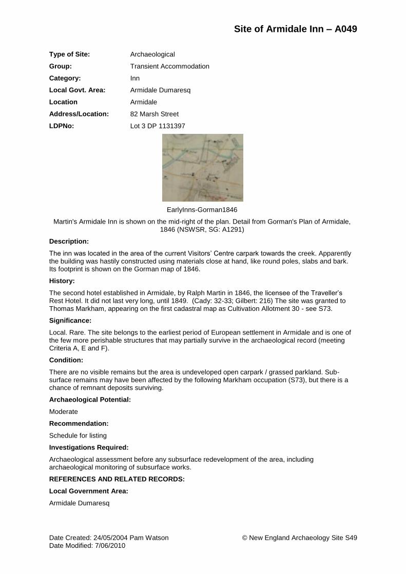
Site of Armidale Inn – A049
Date Created: 24/05/2004 Pam Watson © New England Archaeology Site S49 Date Modified: 7/06/2010
Type of Site: Archaeological
Group: Transient Accommodation
Category: Inn
Local Govt. Area: Armidale Dumaresq
Location Armidale
Address/Location: 82 Marsh Street
LDPNo: Lot 3 DP 1131397
EarlyInns-Gorman1846
Martin's Armidale Inn is shown on the mid-right of the plan. Detail from Gorman's Plan of Armidale, 1846 (NSWSR, SG: A1291)
Description:
The inn was located in the area of the current Visitors’ Centre carpark towards the creek. Apparently the building was hastily constructed using materials close at hand, like round poles, slabs and bark. Its footprint is shown on the Gorman map of 1846.
History:
The second hotel established in Armidale, by Ralph Martin in 1846, the licensee of the Traveller’s Rest Hotel. It did not last very long, until 1849. (Cady: 32-33; Gilbert: 216) The site was granted to Thomas Markham, appearing on the first cadastral map as Cultivation Allotment 30 - see S73.
Significance:
Local. Rare. The site belongs to the earliest period of European settlement in Armidale and is one of the few more perishable structures that may partially survive in the archaeological record (meeting Criteria A, E and F).
Condition:
There are no visible remains but the area is undeveloped open carpark / grassed parkland. Sub-surface remains may have been affected by the following Markham occupation (S73), but there is a chance of remnant deposits surviving.
Archaeological Potential:
Moderate
Recommendation:
Schedule for listing
Investigations Required:
Archaeological assessment before any subsurface redevelopment of the area, including archaeological monitoring of subsurface works.
REFERENCES AND RELATED RECORDS:
Local Government Area:
Armidale Dumaresq

Site of Armidale Inn – A049
Date Created: 24/05/2004 Pam Watson © New England Archaeology Site S49 Date Modified: 7/06/2010
Maps:
1849 Galloway Plan
People:
Markham, Thomas
Martin, Ralph
Theme(s):
Local: Formative Period
Commerce - hotels
Leisure
Publications, Theses, Reports:
Cady, Bruce, We Never Had To Go Far For A Drink: Pubs In Armidale, Armidale and District Historical Society Journal and Proceedings, 34, 1991: 29-46., 1991.
Gilbert, Lionel, An Armidale Album. Glimpses of Armidale's History and Development In Word, Sketch and Photograph. New England Art Museum Association, Armidale, 1982.

Site of Abattoir –Wongalea – A038
Date Created: 24/05/2004 Pam Watson © New England Archaeology Site S51 Date Modified: 7/06/2010
Type of Site: Archaeological
Group: Manufacturing and Processing
Category: Abattoir / Meat Processing
Local Govt. Area: Armidale Dumaresq
Location Armidale
Address/Location: 475 Grafton Road
LDPNo: Lot 1 DP 777437
Abattoir-475GraftonRd Abattoir-475GraftonRd2
View north east of abattoir (Pam Watson 2010) Interior view of machinery base and floor drain, to right (Pam Watson 2010)
Description:
The building is sited on a hill top, visible to the north from the Grafton Road. The walls survive to roof level although the roof has gone. It has a stubby L-shaped plan, oriented north-south, with a parallel passage wall on the western side. The walls are thick, built of ironstone boulders with smaller stones and mortar infill, edged in blue brick at the quoins and wall ends. The interior walls and floor are thickly plastered with concrete which curves around the corners. A drain runs along the floor to the exterior. Heavy log beams form the roof support and internal uprights against the walls. Planed wooden lintels are set within the walls above the doorways and as support for the cross-beam logs. Heavy metal fittings (bolts and hooks) are set in the beams and walls. A raised square concrete base with corner bolts may be the base for a winch.
History:
Nothing is known about this building.
Significance:
Local. The building is of unusual construction and impressively crafted. It represents a local small scale industry of meat processing that no longer functions in this way. It meets Criteria A, C and E.
Condition:
The building is in ruins but survives to roof height. Otherwise the structure is very solid and is in good condition.
Archaeological Potential:
Moderate
Recommendation:
Schedule for listing
Investigations Required:

Site of Abattoir –Wongalea – A038
Date Created: 24/05/2004 Pam Watson © New England Archaeology Site S51 Date Modified: 7/06/2010
Further historical research is required, to ascertain its date, who built it, how long it functioned, and why it is sited on a hill rather than close to water as with most abattoirs?
REFERENCES AND RELATED RECORDS:
Local Government Area:
Armidale Dumaresq
Maps:
Location layer on AMPA GIS
People:
N/A
Theme(s):
Pastoralism
Industry
Publications, Theses, Reports:
Nil

Site of Railway cistern – A032
Date Created: 24/05/2004 Pam Watson © New England Archaeology Site S52 Date Modified: 7/06/2010
Type of Site: Archaeological
Group: Utilities - Water
Category: Well
Local Govt. Area: Armidale Dumaresq
Location Armidale
Address/Location: 92 Markham Street
LDPNo: Lot 20 DP 245363
RailwayCistern_MarkhamSt-site
View to NE of area of cistern, likely location circled (Pam Watson 2010)
Description:
The following information is from Peter Chambers, curator of the Armidale Folk Museum (pers.com. December 2010). The cistern is located some 12-15 metres west of Markham Street near the south bank of Dumaresq Creek at the Markham Street bridge. It is assumed to be a large round structure (dimensions unknown), built of brick, and possibly plastered with cement. Water would have filtered through the sediment and bricks to fill the cistern. It was covered by a large circular steel lid, roughly three metres in diameter. The lid is possibly divided into halves for ease of opening. Mr Chambers last saw this feature around 1995. A pump house would have existed for pumping the water from the cistern to a pipe running up Markham Street. The cistern and pump house were standard railway constructions, and a comparable set of features survives in Narrabri, on the banks of the Namoi River (last viewed by PC in 2007). The pump would have been powered first of all by steam, then oil, then electricity. The top of the Narrabri cistern has a round coping visible above the surface and is now lined with concrete.
History:
The cistern was built in 1882 to supply water for the Locomotive Shed at the newly-arrived railway, and was in operation until 1896 when Dumaresq Dam was opened to supply reticulated water to Armidale. A pipe from the cistern to the railway shed ran up Markham Street and was still there until about 1980. A pump house was associated with the cistern, to bring the water uphill to the locomotive shed. Armidale had a lot of trouble with its water supply in dry periods and the Dumaresq Dam did not suffice. At various times, the Council records show that they considered bringing the old well back into the system, eg in May 1919 and in March 1923. Another pumping plant was installed in 1923, but this was considered not to be taking the fullest advantage of the well (Armidale Express 30 May 1923).
In 1924 a concrete reservoir with an open top and a 300,000 gallon capacity, was built on the grounds of Armidale High School to augment the water needed by the railway. It was decommissioned in the 1960s-70s and is no longer there, but a similar facility survives at Werris Creek. (Peter Chambers, pers.com. 12/10; Wilson nd. Council History - Water and Sewerage (no page number)).
Significance:
Local. Rare. The railway cistern is an interesting and outlying component of the railway infrastructure, an important facility in the development of the town, in the documentation of transport systems and in the evolution and technology of water utilities. Wells tend to serve as a repository for rubbish and accidental discards through time, containing important information on past phases of society and economy. It meets Criteria A, C, E and F.

Site of Railway cistern – A032
Date Created: 24/05/2004 Pam Watson © New England Archaeology Site S52 Date Modified: 7/06/2010
Condition:
It is now covered over by a gravel parking area north of the R &V Furniture shed, and the metal cover is not visible. Presumably the cistern is intact. No evidence of the pump house survives.
Archaeological Potential:
High
Recommendation:
Schedule for listing
Investigations Required:
Archaeological assessment, monitoring and full recording of this feature if any subsurface development of the area is undertaken.
REFERENCES AND RELATED RECORDS:
Local Government Area:
Armidale Dumaresq
Maps:
1867 Ratings Map of Armidale
People:
N/A
Theme(s):
Local: railway town
Utilities - early water systems
Publications, Theses, Reports:
Wilson, Graham, History of Armidale City Council. Unpublished report prepared for Armidale Dumaresq Council, n.d.

Site of Domed Beehive cistern – A018
Date Created: 24/05/2004 Pam Watson © New England Archaeology Site S53 Date Modified: 7/06/2010
Type of Site: Archaeological
Group: Utilities - Water
Category: Well
Local Govt. Area: Armidale Dumaresq
Location Armidale
Address/Location: 236 Beardy Street
LDPNo: Lot 2 DP 163622
Domed_Beehive_cistern2-MunHingRestaurant.jpg
DomedCistern2-MunHing.jpg
Brick cistern exposed by excavations for building construction, 1977 (Bruce Cady collection,
ALB10, UNEHC).
Detail from the 1933 Sewer plan no. 6, showing location of the well at the south west corner of
the allotment (North is to the left).
Description:
Built of brick, the well is a bulging grenade shape (like a beehive). Its shape is unusually visible in the photographic image, as it was exposed in the excavation for the construction of what is now the Mun Hing restaurant, in 1977. The well was not destroyed and it is preserved in a corner of the basement car park of the current building. Compare the domed well in 237 Rusden Street (S10; also AHS 1991: A13).
History:
The specific history of this site is not researched. Domed brick cisterns became a standard form of well after 1860, associated with the development of reasonably priced small hand pumps which removed the need for fully open wells.
Significance:
Local. Representative. The well is an almost intact example of a type of well used in Armidale in the 19th C. It meets Criteria C, E and G.
Condition:
Apparently intact, although not sighted by the writer.
Archaeological Potential:
High
Recommendation:
Schedule for listing
Investigations Required:
Archaeological assessment and monitoring if development works threaten the integrity of the item.
REFERENCES AND RELATED RECORDS:
Local Government Area:
Armidale Dumaresq

Site of Domed Beehive cistern – A018
Date Created: 24/05/2004 Pam Watson © New England Archaeology Site S53 Date Modified: 7/06/2010
Maps:
1849 Galloway Plan
People:
N/A
Theme(s):
Utilities - early water systems
Publications, Theses, Reports:
Nil

Site of Commissioner's Waters Inn – A037
Date Created: 24/05/2004 Pam Watson © New England Archaeology Site S54 Date Modified: 7/06/2010
Type of Site: Archaeological
Group: Transient Accommodation
Category: Hotel
Local Govt. Area: Armidale Dumaresq
Location Armidale
Address/Location: Grafton Road, west of Commissioners Waters
LDPNo: Lot 7021 DP 1071561
CommissionersWatersInn CommissionersWatersInn-site2a
View SW of the inn / house from the old line of the Grafton Road. The current road, (aka the
Waterfall Way), runs behind (south of) the house. (Photo c.1950s, from T. Schaeffer).
View SSE of the site, showing the pine tree which grew at the rear of the inn, the original
road in the foreground, now part of the Travelling Stock Route, and the new road (with car) in the
background (Pam Watson 2010)
Description:
The building is a rectangular wide-fronted weatherboard house with a verandah along its length, facing north. The roof is gabled, of corrugated iron. One chimney is placed off-centre eastwards, the other is on the western end. The residence consisted of seven bedrooms, a huge dining room and a kitchen with a large double stove (information from Judy McKinnon who lived in the front part of the house during the war years). A pit toilet was located at the rear of the house to the east, near the old pine tree (still standing) and was considered a long walk from the building. The house is visible in the 1943 aerial photo (Armidale 62206).
Local resident Graham Chisolm (from Brookstead/Eathorpe) recalls that the western chimney was struck by lightning around 1940; hence its stumpy appearance in the photograph.
The current road was re-routed in 1984 when the new concrete bridge was built; the road curves south just before the site, moving through the southern part of the block. The site of the inn and its associated trees, is now between the old road (still apparent, and part of the TSR) and the new road. The house was long gone before the road changed.
History:
Portion 573, Parish of Armidale, County of Sandon, was bought by Ann Lewis for 50 pounds, in 1862 (Land Title col.106, Folio 156). With her husband William, she built a wine shanty. The business was unlicensed for the 14 years they owned it, which was not particularly unusual at the time. William Lewis died in 1872 and Ann continued the business until 1877 when she sold it to George Cherry. He applied for a wine license (AE 9/2/1877, p.6). Ann still owned the land, but died in 1878 without leaving a will; her eldest son George inherited the land. In 1879 he sold it to his brother-in-law, John Bower, who held a Colonial Wine License from 1882-1887. In 1888 he was granted a Conditional Publicans' License. Regulations for a full license required stabling and food for horses, bedrooms and dining room for guests, as well as a taproom and parlours. A light was to shine from sundown to sunrise so the hotel could be easily found. This was achieved and he was granted the full license in January of the next year. His last license expired in January 1894, so it is presumed the hotel was closed after this. It seems strange, as the Hillgrove gold mines were flourishing and a lot of traffic would have passed by the door. The license was transferred to the Cowley(?) Hotel in South Guyra, near the Railway Station.
Bower mortgaged the land to the City Bank of Sydney in 1895 and the bank sold it Alexander Hay in 1900. The Hay family owned the land and residence until 1942. They named the house 'Luncarty',

Site of Commissioner's Waters Inn – A037
Date Created: 24/05/2004 Pam Watson © New England Archaeology Site S54 Date Modified: 7/06/2010
apparently after the town or area in England from where the senior Hays had emigrated to Australia. The wine shop, dining room and possibly the accommodation facilities were revived by the Hays, to service the passing traffic, particularly the drovers and later, drivers, who were transporting stock. A Travelling Stock Route lay opposite the inn, and the stock would be yarded for the night, and their keepers would adjourn to the inn for refreshment and possibly a bed.
Apparently the building was eventually moved to Armidale as a club house for the Aboriginal Rugby League team. Some time later it burnt down.
There are no council records of ownership from 1947 to the 1980s. In 1989 J.W. and L.G. Watson bought the block from a Mr David.
(Information from notes compiled by a member (unnamed) of the Lewis family, and supplied to the Armidale Folk Museum by Timone Schaeffer, 2010).
Significance:
Local. Records of country wine shanties are limited, as many of the addresses were not recorded. The site is important for the potential information it contains on this kind of facility, and meets Criteria A, E and G.
Condition:
The site is open pasture with exotic trees on the western side and the original pine tree to the south, where the pit toilet was located and a depression was noted. The area was heavily vegetated when surveyed, and no further evidence of occupation was visible
Archaeological Potential:
High
Recommendation:
Schedule for listing
Investigations Required:
Archaeological assessment, monitoring and possible excavation of subsurface features if the site is to be developed.
REFERENCES AND RELATED RECORDS:
Local Government Area:
Armidale Dumaresq
Maps:
Location layer on AMPA GIS
People:
N/A
Theme(s):
Commerce - hotels
Publications, Theses, Reports:
Cady, Bruce, We Never Had To Go Far For A Drink: Pubs In Armidale, Armidale and District Historical Society Journal and Proceedings, 34, 1991: 29-46., 1991.
Gilbert, Lionel, An Armidale Album. Glimpses of Armidale's History and Development In Word, Sketch and Photograph. New England Art Museum Association, Armidale, 1982.

Site of Crown Inn – A055
Date Created: 24/05/2004 Pam Watson © New England Archaeology Site S55 Date Modified: 7/06/2010
Type of Site: Archaeological
Group: Transient Accommodation
Category: Inn
Local Govt. Area: Armidale Dumaresq
Location Armidale
Address/Location: 102-104 Rusden Street
LDPNo: Lot 1 DP 567726
StKilda84detail.jpg StKilda1860s
The old St Kilda Hotel in 1884, from the 1884 Panorama of Armidale (UNEHC).
View SE to the St Kilda Hotel, with the Oddfellows Hall to the right. Detail from an 1860s
photographic panorama of Armidale, Armidale Folk Museum.
Description:
Advertised with ‘extensive paddocks’ in 1858.
It seems to be the same site as the Tysoe house in the 1849 map (slightly offset). It is uncertain whether it began life as a single or double-storey building, but it was the latter in the 1860s. The images show an impressive Victorian brick building with double storey verandahs on three sides, and a hipped slate roof. It is unclear at this stage of research whether the whole structure was destroyed in the fire or whether elements were incorporated within the new building in the early 20th century.
History:
It was opened as the Crown Hotel by Joseph Scholes in 1854. By the end of 1856 Scholes had added a ‘Wholesale Wine and Spirit Store’ at the rear - perhaps Armidale’s first bottle shop. It later became the Freemason’s Hotel, and was being run by James Tysoe (a prominent Freemason and council alderman) in 1865. The 1860s photograph shows a two-storey structure, which seems a little grand for the 1850s - possible the structure was expanded upwards by Tysoe. It was taken over by Mrs Brady in 1871 as the St Kilda Hotel. At one time the building was used as a school, another time closed, and it burnt down early this century. It was replaced by the current St Kilda Hotel which has been listed as built heritage in the 1991 AHS (Item 127), (Cady 1991: 35-36; Gilbert 1982: 216).
Significance:
Local. Representative of a group of early hotels belonging to the formative period of the town, and associated with a number of prominent early identities (Scholes and Tysoe).
Condition:
Rebuilt as the current St Kilda Hotel.
Archaeological Potential:
Moderate
Recommendation:
Scheduled; listed in 1991 AHS (built, #127).
Investigations Required:
Archaeological assessment required if the exterior grounds are to be redeveloped involving below

Site of Crown Inn – A055
Date Created: 24/05/2004 Pam Watson © New England Archaeology Site S55 Date Modified: 7/06/2010
ground disturbance, or if the fabric of the building is to be substantially altered.
REFERENCES AND RELATED RECORDS:
Local Government Area:
Armidale Dumaresq
Images:
1884 Panorama of the City
St Kilda Hotel
Maps:
1867 Ratings Map of Armidale
1933 Armidale Sewerage, House Details (ASHD)
1965 City of Armidale Plan
People:
Scholes, Joseph
Tysoe, James
Theme(s):
Local: Formative Period
Commerce - hotels
Leisure
Publications, Theses, Reports:
Cady, Bruce, We Never Had To Go Far For A Drink: Pubs In Armidale, Armidale and District Historical Society Journal and Proceedings, 34, 1991: 29-46., 1991.
Gilbert, Lionel, An Armidale Album. Glimpses of Armidale's History and Development In Word, Sketch and Photograph. New England Art Museum Association, Armidale, 1982.
Hague, Marjorie J, Armidale's Old Burial ground, in the Armidale and District Historical Society Journal, vol.48, 2005

Site of Daniel O’Connell Inn (2) – A019
Date Created: 24/05/2004 Pam Watson © New England Archaeology Site S56 Date Modified: 7/06/2010
Type of Site: Archaeological
Group: Transient Accommodation
Category: Inn
Local Govt. Area: Armidale Dumaresq
Location Armidale
Address/Location: 236 Beardy Street
120 Jessie Street
LDPNo: Lot 2 DP 163622
Lot 2 DP 1130225
DanielOConnell-2.jpg DanielOConnell2-pre1912
Detail from 1884 Panorama of Armidale (UNEHC)
Detail from the pre-1912 panorama of Armidale (Armidale Folk Museum Collection)
Description:
Next to the Mun Hing Restaurant (the first licensed restaurant in Armidale, 1965). Built of stone, situated ‘between the Steam Mills and more central parts of town’. The 1884 panorama shows a single storey rectangular building with front verandah, and a second rectangular structure behind. The 1933 sewerage plan (No. 6) shows only a rectangular stone structure right on the street frontage, with front verandah and weatherboard addition along the western side, no rear building, a well outside the SW corner of the building and a weatherboard outhouse in the mid-centre of the back yard.
History:
Opened by George Robert Allingham in 1858, it was built to replace the old Daniel O’Connell Inn (1), formerly the Rose Inn (see S51). It traded until 1896. Probably the opening of the Criterion (Caledonian) as one of the new railway hotels in 1881 assisted its demise. (Cady 1991: 36, 74; Gilbert 1982: 216-218).
Significance:
Local. Representative of a group of early hotels belonging to the formative period of the town, and associated with a prominent early identity, George Allingham (meeting Criteria A, B, E and G).
Condition:
As shown on plan ASHD-06, the building was demolished and was subsequently overlaid by a large square building well set back from the street (c. 8 metres); most of the earlier building therefore lies north of the later structure. The current structure functions as a warehouse / storage building, built of brick at the front with galvanised iron behind. The front area is paved car parking with a driveway beside it, leading to a small back yard. The potential survival of sub-surface remains of the old inn in the front area is high, given the minor disturbance here.
Archaeological Potential:
High
Recommendation:
Schedule for listing
Investigations Required:
Archaeological assessment and monitoring required if the exterior grounds are to be redeveloped

Site of Daniel O’Connell Inn (2) – A019
Date Created: 24/05/2004 Pam Watson © New England Archaeology Site S56 Date Modified: 7/06/2010
involving below ground disturbance.
REFERENCES AND RELATED RECORDS:
Local Government Area:
Armidale Dumaresq
Images:
Daniel O’Connell Inn
Maps:
1933 Armidale Sewerage, House Details (ASHD)
Daniel O'Connell Inn plan 1933
People:
Allingham, George 1829
Theme(s):
Local: Formative Period
Commerce - hotels
Leisure
Publications, Theses, Reports:
Cady, Bruce, We Never Had To Go Far For A Drink: Pubs In Armidale, Armidale and District Historical Society Journal and Proceedings, 34, 1991: 29-46., 1991.
Gilbert, Lionel, An Armidale Album. Glimpses of Armidale's History and Development In Word, Sketch and Photograph. New England Art Museum Association, Armidale, 1982.

Site of Gold Digger’s Arms – A051
Date Created: 24/05/2004 Pam Watson © New England Archaeology Site S57 Date Modified: 7/06/2010
Type of Site: Archaeological
Group: Transient Accommodation
Category: Inn
Local Govt. Area: Armidale Dumaresq
Location Armidale
Known as: Site of Gold Digger’s Arms
Site of White Horse
Site of Tattersalls Hotel
Site of Australian Hotel
Address/Location: 145 Marsh Street
LDPNo: Lot C DP 159153
GoldDiggersArms GoldDiggersArms-1867Plan.jpg
View NE of the hotel. Photo from Gilbert 1982: 216, labelled the 'White Horse Hotel'.
Detail from the 1867 Ratings Map of the footprint of the Gold Diggers Arms (UNEHC).
Description:
On the corner where the ‘Cahill Court’ block of flats now stands. A typical brick Georgian style single-storey corner hotel with verandah frontages and deep hipped roof, shingled. The main entrance is in the splayed corner. The verandah is directly on the street frontages.
Photo Gilbert 1982: 216.
History:
The hotel was opened by William Millis in 1856. It became the Golden Fleece later that year, run by John Parker, (Gilbert: 216) and became Tattersall’s Hotel (1) in 1878, then the White Horse Hotel (1879-1897), and the Australian Hotel (1897-1912). It closed as a hotel in 1912 and became a boarding house.
(Cady: 36). [Note: some dates conflict with the table of dates on p.42]
Significance:
Local. The site is significant as part of a group of early hotels belonging to the formative period of the town and continuing into the early 20th C. Any archeological remains could provide an important sequence of social and economic information on 19th C Armidale. It meets Criteria A, E and G.
Condition:
Demolished. The 1965 city map shows the lot as vacant. The present building is set about six metres back from the (southern) Barney Street frontage and at least four metres in from the (western) Marsh Street frontage. There is considerable potential for subsurface remains of the original building, which was close to both frontages, and associated deposits to survive in this open lawn area.
Archaeological Potential:
Moderate-high
Recommendation:
Schedule for listing

Site of Gold Digger’s Arms – A051
Date Created: 24/05/2004 Pam Watson © New England Archaeology Site S57 Date Modified: 7/06/2010
Investigations Required:
Archaeological assessment required prior to redevelopment involving major subsurface disturbance of the open area corner strip of the lot.
REFERENCES AND RELATED RECORDS:
Local Government Area:
Armidale Dumaresq
Images:
White Horse Hotel
Maps:
1867 Ratings Map of Armidale
1965 City of Armidale Plan
People:
Millis, William
Parker, John
Theme(s):
Local: Formative Period
Leisure
Publications, Theses, Reports:
Cady, Bruce, We Never Had To Go Far For A Drink: Pubs In Armidale, Armidale and District Historical Society Journal and Proceedings, 34, 1991: 29-46., 1991.
Gilbert, Lionel, An Armidale Album. Glimpses of Armidale's History and Development In Word, Sketch and Photograph. New England Art Museum Association, Armidale, 1982.

Site of Assize Hotel – A007
Date Created: 24/05/2004 Pam Watson © New England Archaeology Site S58 Date Modified: 7/06/2010
Type of Site: Archaeological
Group: Transient Accommodation
Category: Hotel
Local Govt. Area: Armidale Dumaresq
Location Armidale
Address/Location: 105 Beardy Street
107 Beardy Street
LDPNo: Lot 1 DP 570805
Lot 1 Sec 12 DP 758032
Assize-rear1954.jpg Assize Hotel-ASHD_11
Detail of rear of old Assize Hotel from a 1954 aerial photo of Armidale, view SW (courtesy of
Philip Hanna).
Detail from 1933 Sewer plan ASHD #11 - showing the footprint of the 'New England
Boarding House', formerly the Assize Hotel.
Description:
Located next to the current Royal Hotel, it is shown as the ‘New England Boarding House’ on the 1933 Armidale Sewerage plan (ASHD-11). The building footprint covers the front third of the lot, with other structures behind, including a well. A view of the rear of the building is found in a low aerial photo of 1954 (Rear of Assize Hotel).
History:
Opened by Martin Franey in 1856 (1855-1860), it became the Victoria (1860-1909) and later the Langham Hotel (1909-1928), before it lost its licence in 1927, to become a boarding house and later CWA House, a hostel for young working ladies (Cady: 36).
Significance:
Local. The site has important historical associations as part of the network of early hotels and later, community accommodation facilities operating in the town, including association with the activities of the Country Women's Association. Archaeological remains of back-yard activities and related structures may survive behind the current building, representative of phases of occupation dating back to the mid-1850s (meeting Criteria A, D and E).
Condition:
It has been demolished and built over by a single-storey brick office building located right on the street frontage.
Archaeological Potential:
Moderate
Recommendation:
Schedule for listing.
Investigations Required:
Archaeological assessment and monitoring of any sub-surface development behind the current building.

Site of Assize Hotel – A007
Date Created: 24/05/2004 Pam Watson © New England Archaeology Site S58 Date Modified: 7/06/2010
REFERENCES AND RELATED RECORDS:
Local Government Area:
Armidale Dumaresq
Images:
Rear of Assize Hotel
Maps:
1867 Ratings Map of Armidale
1933 Armidale Sewerage, House Details (ASHD)
People:
Franey, Michael
Theme(s):
Local: Formative Period
Leisure
Publications, Theses, Reports:
Cady, Bruce, We Never Had To Go Far For A Drink: Pubs In Armidale, Armidale and District Historical Society Journal and Proceedings, 34, 1991: 29-46., 1991.
Gilbert, Lionel, An Armidale Album. Glimpses of Armidale's History and Development In Word, Sketch and Photograph. New England Art Museum Association, Armidale, 1982.

Site of Farrier’s Arms Hotel – A027
Date Created: 24/05/2004 Pam Watson © New England Archaeology Site S59 Date Modified: 7/06/2010
Type of Site: Archaeological
Group: Transient Accommodation
Category: Hotel
Local Govt. Area: Armidale Dumaresq
Location Armidale
Address/Location: 118 Dumaresq Street
83-85 Faulkner Street
LDPNo: Lot 32 DP 1031471
Lot 1 DP 744695
FirstHospital-Pub1884
Black and white enlarged photocopied detail from the 1884 Panorama of Armidale (UNEHC).
Description:
In 1859 the complex was described as a six-room cottage with a stable, “other outer offices” and a well. In 1866 it was offered for sale as containing a substantial six-roomed weatherboard and shingle cottage, “nine tan pits, all wood lined; a never -failing well of water known as the best in Armidale, and two outbuildings” (Watson & Burke: 14).
History:
Formerly the first hospital in Armidale, the building was licensed as the Farrier’s Arms Hotel in 1858. It was later called the Lord Nelson Hotel. John Callaghan ran the hotel from at least 1865 until 1890. The last person to hold the license was Peter Tracey in 1890 when he moved to the Victoria Hotel (Cady 1991: 38; Gilbert 1982: 216).
Significance:
Local. The site contained one of the early hotels of Armidale, spanning the second half of the 19th century. It is representative of the smaller modest hotels that were scattered across the early town. It is located in the area where the earliest domestic and business activities of the town were established and belongs to a suite of buildings along the street, some of which are archaeologically documented, representing a mix of domestic, business and industrial activities. It meets Criteria A, E and G.
Condition:
See S20 First Hospital. Any remains would be subsurface and the site has been disturbed.
Archaeological Potential:
Low
Recommendation:
Schedule for listing
Investigations Required:
Archaeological assessment and monitoring of any redevelopment involving subsurface excavations

Site of Farrier’s Arms Hotel – A027
Date Created: 24/05/2004 Pam Watson © New England Archaeology Site S59 Date Modified: 7/06/2010
REFERENCES AND RELATED RECORDS:
Local Government Area:
Armidale Dumaresq
Maps:
Location layer on AMPA GIS
People:
Callaghan, John
Tracey, Peter
Theme(s):
Commerce - hotels
Leisure
Publications, Theses, Reports:
Cady, Bruce, We Never Had To Go Far For A Drink: Pubs In Armidale, Armidale and District Historical Society Journal and Proceedings, 34, 1991: 29-46., 1991.
Gilbert, Lionel, An Armidale Album. Glimpses of Armidale's History and Development In Word, Sketch and Photograph. New England Art Museum Association, Armidale, 1982.

Site of Plough Inn – A062
Date Created: 24/05/2004 Pam Watson © New England Archaeology Site S60 Date Modified: 7/06/2010
Type of Site: Archaeological
Group: Transient Accommodation
Category: Inn
Local Govt. Area: Armidale Dumaresq
Location Armidale
Address/Location: 202 Rusden Street
204 Rusden Street
LDPNo: Lot 2 DP 22210
Lot 3 DP 22210
PloughInn1872-UNEHC PloughInn-1867Plan.jpg
The Plough Inn 1872, view SE (UNEHC)
Description:
An L-shaped single storey building with verandah frontages to both streets, slate roof, situated right on both street frontages. Photo (Gilbert 1982: 210). Footprint: 1867 plan.
History:
The inn was opened by James Gordon in 1860 and traded until 1893. As one of the oldest hotels, built when the Rocky River gold fields were at their height, it was affected by the building of new and grand hotels to accommodate the different needs generated by the advent of the railway (Cady: 38, 44).
Significance:
Local. The site is important as it may contain archaeology of the second half of the nineteenth century, containing rare evidence of an older style, more basic type of hotel that did not survive in the developing urban landscape (meeting Criteria A, E and F).
Condition:
The site is now occupied by a post-war 1950s (?) weatherboard house with a large backyard and a five metre set-back from the north and western frontages. The site was waste ground in the 1943 aerial photo. Subsurface remains could survive in the open landscaped areas.
Archaeological Potential:
Moderate
Recommendation:
Schedule for listing
Investigations Required:
Any subsurface development of the garden areas should be subject to archaeological assessment including monitoring of any excavations undertaken.

Site of Plough Inn – A062
Date Created: 24/05/2004 Pam Watson © New England Archaeology Site S60 Date Modified: 7/06/2010
REFERENCES AND RELATED RECORDS:
Local Government Area:
Armidale Dumaresq
Images:
Plough Inn 1872
Maps:
1867 Ratings Map of Armidale
People:
N/A
Theme(s):
Local: Formative Period
Commerce - hotels
Leisure
Publications, Theses, Reports:
Cady, Bruce, We Never Had To Go Far For A Drink: Pubs In Armidale, Armidale and District Historical Society Journal and Proceedings, 34, 1991: 29-46., 1991.
Gilbert, Lionel, An Armidale Album. Glimpses of Armidale's History and Development In Word, Sketch and Photograph. New England Art Museum Association, Armidale, 1982.

Site of Sportsman’s Arms – A061
Date Created: 24/05/2004 Pam Watson © New England Archaeology Site S61 Date Modified: 7/06/2010
Type of Site: Archaeological
Group: Transient Accommodation
Category: Inn
Local Govt. Area: Armidale Dumaresq
Location Armidale
Address/Location: 191 Rusden Street
LDPNo: Lot 2 DP 1026380
SportsmansArms1884 AllinghamsCorner-Plan1867a
Detail from 1884 Panorama of Armidale (UNEHC)
Detail from the 1867 Ratings Map, north is at the top. The hotel footprint is on the SW corner of the
intersection
Description:
The 1867 plan shows a U-shaped building on this site, with a separate structure at the rear south, presumably a kitchen. The 1873 panorama (viewing towards the SW) show an apparently single-storeyed building to the south of Allingham's mill, with no verandahs. In the 1884 panorama it appears as a more substantial hip-roofed building with a verandah running around the eastern and northern sides, and two dormer windows facing north, indicating room(s) in the roof, and a chimney on the south eastern end where the kitchen would be.
History:
Opened in 1870 by George Morrow, its name was changed to the Royal Exchange Hotel by George Foran; it continued to operate until 1912.
(Cady 1991: 38; Gilbert 1982: 216)
Significance:
Local. The site is important as representing one of the early, simpler hotels in the developing town of the later 19th C (Criterion A). It appears not to have been disturbed by superseding structures and may contain considerable archaeological information (Criterion E).
Condition:
There is no building on the site in the 1933 plan, nor in the 1943 aerial (although a building is shown in the adjacent allotment to the west). The land is currently vacant lawn in the grounds of the TAFE college and the adjacent building has been removed.
Archaeological Potential:
High
Recommendation:
Schedule for listing
Investigations Required:
Archaeological assessment and monitoring of any subsurface development of the site.

Site of Sportsman’s Arms – A061
Date Created: 24/05/2004 Pam Watson © New England Archaeology Site S61 Date Modified: 7/06/2010
REFERENCES AND RELATED RECORDS:
Local Government Area:
Armidale Dumaresq
Images:
1884 Panorama of the City
Maps:
1867 Ratings Map of Armidale
People:
Foran, George
Morrow, George
Theme(s):
Commerce - hotels
Leisure
Publications, Theses, Reports:
Cady, Bruce, We Never Had To Go Far For A Drink: Pubs In Armidale, Armidale and District Historical Society Journal and Proceedings, 34, 1991: 29-46., 1991.
Gilbert, Lionel, An Armidale Album. Glimpses of Armidale's History and Development In Word, Sketch and Photograph. New England Art Museum Association, Armidale, 1982.

Site of Traveller’s Rest Hotel (2) – A016
Date Created: 25/05/2004 Pam Watson © New England Archaeology Site S62 Date Modified: 7/06/2010
Type of Site: Archaeological
Group: Transient Accommodation
Category: Hotel
Local Govt. Area: Armidale Dumaresq
Location Armidale
Address/Location: 109 Beardy Street
LDPNo: Lot 1 DP 782200
TravellersRest21954
Detail from a 1954 aerial view of Armidale, view SW (courtesy of Philip Hanna)
Description:
The building still exists, being rectangular in plan with a ridge roof and two chimneys at either end in the central roof area; the 1884 image provides a rear view only - there is a possible rear section with a hip roof, or this could be a separate building. A 1954 aerial view from the rear shows the same chimneys (suggesting the building survives) but the roof has been remodelled as an overall skillion roof rising to a pedimented gable facade, with a wide verandah on the east side.
History:
The hotel opened in 1874, lasting until 1881. Years later Timothy Haren tried to reopen it; apparently when he was refused, he turned it into a baker’s shop (Cady 1991: 38).
Significance:
Local. The building survives as one of the late 19th century hotels that evolved through numerous functions (meeting Criteria A and E).
Condition:
The building has been substantially remodelled. It now houses a Pet Shop business.
Archaeological Potential:
Low to moderate
Recommendation:
Schedule for listing
Investigations Required:
The building should be archaeologically examined as a standing structure to determine if any elements of its original design and use survive.
REFERENCES AND RELATED RECORDS:
Local Government Area:
Armidale Dumaresq
Maps:
Location layer on AMPA GIS
People:

Site of Traveller’s Rest Hotel (2) – A016
Date Created: 25/05/2004 Pam Watson © New England Archaeology Site S62 Date Modified: 7/06/2010
N/A
Theme(s):
Commerce - hotels
Leisure
Publications, Theses, Reports:
Cady, Bruce, We Never Had To Go Far For A Drink: Pubs In Armidale, Armidale and District Historical Society Journal and Proceedings, 34, 1991: 29-46., 1991.

Site of Commercial Hotel – A058
Date Created: 25/05/2004 Pam Watson © New England Archaeology Site S63 Date Modified: 7/06/2010
Type of Site: Archaeological
Group: Transient Accommodation
Category: Hotel
Local Govt. Area: Armidale Dumaresq
Location Armidale
Address/Location: 160 Rusden Street
162 Rusden Street
Area extends into road reserve
LDPNo: Lot 101 DP 1103862
Lot 9 DP 825227
CommercialHotel-84 CommercialHotel_33plan
Detail from the 1884 Panorama of Armidale (UNEHC)
1933 ASHD-06 detail showing the shop/house, shop and hotel (from. Rusden St to left, Jessie St
above.
Description:
The hotel appears as an enlarged border detail in the 1884 Panorama as well as on the main scape. It shows a large two-storey building, seemingly of weatherboard, with two-storey verandah on the northern front and hipped roof, standing flush with the footpath. The rear section has a separate hip roof .
The 1933 Sewerage plan (ASHD-06) shows a long rectangular building of weatherboard with verandah over the footpath, suggesting that the original building has survived to this time. This appears to be a different building to that shown on the later 1965 City plan footprint.
History:
Section 22, allotment 11 (a large corner lot) was divided into three parts: a shop + house, a shop and a hotel; the latter two were owned by John Harper and the hotel was operated in 1878-1881 by John Smoker and in 1882-4 by Mr McMillan (1878-1884 Armidale Council Rate Book). The hotel functioned from 1875 -1896. It closed two years after the Central Hotel, now the Minto building, opened diagonally opposite in 1894 (1991 AHS Item 122).
Significance:
Local. Representative of a late Victorian country hotel type. Although the site has been subject to overall building disturbance, the extent of subsurface disturbance is uncertain; there may be remnant deposits and features of the earlier phase of occupation, meeting Criterion E.
Condition:
Now covered by the more recent structure of the St Vincent de Paul’s building, a brick-fronted structure with large metal shed body, covering the whole of the site.

Site of Commercial Hotel – A058
Date Created: 25/05/2004 Pam Watson © New England Archaeology Site S63 Date Modified: 7/06/2010
Archaeological Potential:
Low. The area is disturbed.
Recommendation:
Schedule for listing.
Investigations Required:
Archaeological assessment and monitoring of any subsurface redevelopment of the site.
REFERENCES AND RELATED RECORDS:
Local Government Area:
Armidale Dumaresq
Images:
1884 Panorama of the City
Maps:
1933 Armidale Sewerage, House Details (ASHD)
Commercial Hotel, detail from 1933 Armidale Map
People:
Harper, John
Smoker, John
Theme(s):
Commerce - hotels
Leisure
Publications, Theses, Reports:
Cady, Bruce, We Never Had To Go Far For A Drink: Pubs In Armidale, Armidale and District Historical Society Journal and Proceedings, 34, 1991: 29-46., 1991.

Site of Great Northern Hotel – A057
Date Created: 25/05/2004 Pam Watson © New England Archaeology Site S64 Date Modified: 7/06/2010
Type of Site: Archaeological
Group: Transient Accommodation
Category: Hotel
Local Govt. Area: Armidale Dumaresq
Location Armidale
Address/Location: 156 Rusden Street
LDPNo: Lot 14 Sec 7 DP 758032
GreatNorthern1884-d GreatNorthern-1867Plan.jpg
Detail from 1884 Panorama of Armidale (UNEHC)
Footprint of the structure
Description:
The hotel was located where St Mary’s School now stands, but the latter is set back from the street front. The Council Rate book for 1878-1884 divides the allotment (7/14) into A and B, a shop and a house (flanked by undeveloped land to the east). The 1884 panorama shows two structures: a double ridge-roof building (to the east) with front verandah, and a hipped roof building (to the west) with front verandah, both right on the street frontages.
History:
Franklin Jackes established his West End Store and house on Section 7, allotment 14 by 1864. The double footprint appears on the 1867 map. For a time the building operated as the Great Northern Hotel (Wilson 1991: 87-8), opening in 1881 to cater for the expanding needs of the railway trade. It traded as the Crown Hotel (2 ) from 1888-1892, when it burnt down (Cady: 39, 44).
Significance:
Local. Significant as representative of evolving business activities in the growing town and the impact of the arrival of the railway on socio-economic development. It meets Criteria A and E.
Condition:
Demolished. The current school building is set back some 5 metres from the north street frontage (Rusden St) and some 2 metres from the western frontage (Jessie St). A brick retaining wall bounds this open front area, raising the surface level to more than one metre above the footpath on the north. There is a reasonable chance that below ground footings and other features may survive in this open area which has undergone only minor disturbance.
Archaeological Potential:
Moderate
Recommendation:
Schedule for listing
Investigations Required:
Detailed archaeological assessment if the open areas on the street frontages are to be redeveloped involving below ground disturbance.

Site of Great Northern Hotel – A057
Date Created: 25/05/2004 Pam Watson © New England Archaeology Site S64 Date Modified: 7/06/2010
REFERENCES AND RELATED RECORDS:
Local Government Area:
Armidale Dumaresq
Images:
1884 Panorama of the City
Maps:
1867 Ratings Map of Armidale
People:
Jackes, Franklin to 1884
Theme(s):
Local: Railway town
Commerce - Hotels
Leisure
Publications, Theses, Reports:
Cady, Bruce, We Never Had To Go Far For A Drink: Pubs In Armidale, Armidale and District Historical Society Journal and Proceedings, 34, 1991: 29-46., 1991.
Wilson, Graham, and Jean Cooper, From Jessie Street West. Armidale and District Historical Society Journal 34: 85-100., 1991.

Site of Star Hotel – A022
Date Created: 25/05/2004 Pam Watson © New England Archaeology Site S66 Date Modified: 7/06/2010
Type of Site: Archaeological
Group: Transient Accommodation
Category: Hotel
Local Govt. Area: Armidale Dumaresq
Location Armidale
Address/Location: 102 Butler Street
LDPNo: Lot 27 DP 855958
StarHotel-CityBrewery-1884
Detail from the 1884 panorama, view SW (UNEHC). The hotel is circled, to the south west
of the Brewery
Description:
No description located. The rear end of it emerges from behind the City Brewery in the 1884 panorama.
History:
The hotel opened as the Star Hotel in 1880, changing its name to the West End Hotel in 1895 and operated until 1899. It was nicely sited across the road from the City Brewery. An alternative route into town from the south (after following the line of the Old North Road across the front of the hospital) was to go along Butler St, beside the park, to meet the Inverell Road (which became Beardy St). (Cady: 39, 45).
The timber Federation house that replaced it was built in 1902-3 and is listed in the AHS 1991 study as Item 41.
Significance:
Local. The site represents one of the simpler hotels in the western zone of the developing town of the later 19th C (Criterion A).The site is disturbed but may contain archaeological resources informing on the society and lifestyle of late 19th century Armidale, meeting Criterion E.
Condition:
The site now contains a large timber Federation bungalow which takes up most of the block. At the rear (western end) of the current (expanded) allotment is a timber barn with stabling fittings and loft from the 19th C, once belonging to the rear of 275 Beardy Street and acquired by the current owner of 102 Butler St. The owner reports finding historic artefacts (metal, glass and pottery) when digging the garden.
Archaeological Potential:
Low. There may be remnant fragmented archaeological resources in the grounds of the current house.
Recommendation:
Schedule for listing
Investigations Required:
Archaeological assessment and monitoring of significant subsurface redevelopment in the grounds of the current house.

Site of Star Hotel – A022
Date Created: 25/05/2004 Pam Watson © New England Archaeology Site S66 Date Modified: 7/06/2010
REFERENCES AND RELATED RECORDS:
Local Government Area:
Armidale Dumaresq
Maps:
Location layer on AMPA GIS
People:
N/A
Theme(s):
Commerce - hotels
Leisure
Publications, Theses, Reports:
Cady, Bruce, We Never Had To Go Far For A Drink: Pubs In Armidale, Armidale and District Historical Society Journal and Proceedings, 34, 1991: 29-46., 1991.

Site of First Presbyterian Manse – A046
Date Created: 25/05/2004 Pam Watson © New England Archaeology Site S71 Date Modified: 7/06/2010
Type of Site: Archaeological
Group: Religion
Category: House
Local Govt. Area: Armidale Dumaresq
Location Armidale
Address/Location: 70 Marsh Street
LDPNo: Lot 1 DP 37827
Presbyterian_Church_and_Manse PresbyterianManse1949.jpg
View north west to the church and manse, 1872 (UNEHC; also in Gilbert 1982: 156).
View North up Marsh street in the floods of 1949. The old Manse is visible at top left (Cady -
ALB56, UNEHC).
Description:
Hip roof on standard Georgian rectangular structure with verandah.
History:
The church was opened on January 9th, 1859 by Rev Thomas Johnstone, who became the fixed pastor in 1857 until he retired in 1903.
In 1866 a manse was built beside the church, but the Presbyterian centre of worship was on the “wrong side of the creek” from the other ecclesiastical centres. So in 1881 Johnstone laid the foundation of a new church, virtually in the centre of town in Faulkner St, to be called St Paul’s. It was opened in 1882.
Significance:
Local. The site is significant as part of an early ecclesiastical grouping important in the formative period of the town. Relocation of this facility reflects changing perceptions and rationale behind the policies of town development.
Condition:
Demolished. The Marsh street frontage now contains a Californian bungalow house, probably set more to the east than the Manse. Subsurface remains and associated deposits of the Manse may survive in the back yard area.
Archaeological Potential:
Moderate
Recommendation:
Schedule for listing
Investigations Required:
Detailed archaeological assessment required prior to any development that would significantly impact below ground in the back yard area.

Site of First Presbyterian Manse – A046
Date Created: 25/05/2004 Pam Watson © New England Archaeology Site S71 Date Modified: 7/06/2010
REFERENCES AND RELATED RECORDS:
Local Government Area:
Armidale Dumaresq
Images:
Presbyterian Church and Manse 1860
Maps:
1867 Ratings Map of Armidale
People:
Johnstone, Rev
Theme(s):
Local: Formative Period
Religion
Publications, Theses, Reports:
Gilbert, Lionel, An Armidale Album. Glimpses of Armidale's History and Development In Word, Sketch and Photograph. New England Art Museum Association, Armidale, 1982.

Site of Roman Catholic Old Cathedral – A023
Date Created: 25/05/2004 Pam Watson © New England Archaeology Site S72 Date Modified: 7/06/2010
Type of Site: Archaeological
Group: Religion
Category: Church
Local Govt. Area: Armidale Dumaresq
Location Armidale
Address/Location: 130-136 Dangar Street
LDPNo: Lot 15 DP 1048143
RC-oldCathedral-3a RC-oldCathedral-4-1900a
Postcard view W of the old Roman Catholic cathedral (UNEHC).
Detail from the 1900 panorama of Armidale (UNEHC).
Description:
Located on the north west corner of Dangar and Barney Streets, the site lies adjacent to the current cathedral which co-existed with the old cathedral for a short time (photo in Gilbert 1980: No.67; Gilbert 1982: 152). It was built of brick and timber with slate roof. The interior was described on its opening as having 'an elegant and even gorgeous aspect', and the building 'noble .... an ornament to the rising City of Armidale' (Gilbert 1982: 153).
The first Cathedral, St Mary's was erected on land donated by Joseph Daly at the corner of Dangar and Barney Streets and opened on Friday, 2 February 1872, feast of The Purification. This cathedral stood on the site until completion and opening of the new St Mary and St Joseph's Cathedral, alongside it in October 1912. Demolition then occurred and materials were utilised in the construction of anew parochial school. The decorative base supporting the statue of St Peter located in the present cathedral grounds, which oversees Bishop Doody's grave, is a remnant from the first cathedral, which stood on this site ( http://www.arm.catholic.edu.au/about/history/armidale/diocese.htm).
History:
The foundation stone was laid in 1870 by Dean Lynch, and the building was completed in 1872, serving its purpose for some 40 years (Gilbert 1982: 152-154).
Significance:
Local. The site is significant for containing the first Roman Catholic Cathedral in the growing ‘City’ of Armidale in the late 19
th and early 20
th centuries. It is important for its historic significance and
associations, social significance and archaeological research potential (meeting Criteria A, B, D and E).
Condition:
The building was demolished in 1912 and the area has been maintained as landscaped grounds with large tree plantings on the perimeter and some within the site. Subsurface foundations and related archaeological deposits may survive within this regime.
Archaeological Potential:
High
Recommendation:
Schedule for listing

Site of Roman Catholic Old Cathedral – A023
Date Created: 25/05/2004 Pam Watson © New England Archaeology Site S72 Date Modified: 7/06/2010
Investigations Required:
Archaeological assessment and monitoring of any subsurface developments in this area.
REFERENCES AND RELATED RECORDS:
Local Government Area:
Armidale Dumaresq
Maps:
Location layer on AMPA GIS
People:
N/A
Theme(s):
Religion
Publications, Theses, Reports:
Gilbert, L., New England from Old Photographs. John Ferguson, Sydney, 1980
Gilbert, Lionel, An Armidale Album. Glimpses of Armidale's History and Development In Word, Sketch and Photograph. New England Art Museum Association, Armidale, 1982.

Site of Markham's House – A047
Date Created: 26/06/2004 Pam Watson © New England Archaeology Site S73 Date Modified: 7/06/2010
Type of Site: Archaeological
Group: Residential buildings (private)
Category: House
Local Govt. Area: Armidale Dumaresq
Location Armidale
Address/Location: 82 Marsh Street
LDPNo: Lot 3 DP 1131397
1860s-MarkhamHouse 1866engraving
Detail from photographic panorama of Armidale, 1860s (Armidale Folk Museum)
Detail (photocopied, enlarged and coloured) of an 1866 engraving of a panorama of Armidale.
Markham's buildings appear in front of the buildings coloured pink (McLean’s cottage and mill). Trim's Bridge (S8) is in the mid-ground.
(UNEHC).
Description:
The site extended from Dumaresq Street to the creek. It included an 11-roomed cottage, a six-stalled stable with loft capable of containing two tons of hay, a shed capable of containing a hundred bales of wool, and other offices of every description ‘fit for an inn upon a large scale’. The roofs are shingled, there was a well in the yard and a garden stocked with fruit trees (For Sale advertisement in AE 6/6/1857; Burke: 9).
Images : 1860s photo-panorama (AFM); 1866 engraving (Illustrated Melbourne Post): show a cottage with a hipped roof and verandah to west (at least), two chimneys at N and S, and two buildings to the NE, as well as numerous trees. The footprint appears on the 1867 Ratings Map.
History:
Dr Thomas Markham’s house and outbuildings existed in the area previously occupied by the Armidale Inn (S49, closed in 1849), from at least 1857. Markham was the original grantee of the land after it was surveyed and subdivided in 1849. He was the first doctor in Armidale, arriving in 1848, and was appointed medical officer to the aborigines (Gilbert 1982: 30,119).
Significance:
Local. The site is rare and has historic significance, historic associations and processes research potential (meeting Criteria A, B, E and F). The site belongs to the earliest decades of Armidale’s residential development, containing a substantial residence and associated buildings belonging to Dr Thomas Markham, the first doctor in Armidale. It is located in an area that may retain undisturbed pockets of archaeological resources.
Condition:
There are no visible remains. The site is located in the area of the Visitor’s Centre, surrounded by bitumen car parks and grassed parkland. Some sub-surface deposits or features may survive in the unbuilt areas.
Archaeological Potential:
Moderate

Site of Markham's House – A047
Date Created: 26/06/2004 Pam Watson © New England Archaeology Site S73 Date Modified: 7/06/2010
Recommendation:
Schedule for listing.
Investigations Required:
Archaeological assessment required before any redevelopment involving subsurface disturbance.
REFERENCES AND RELATED RECORDS:
Local Government Area:
Armidale Dumaresq
Images:
1860s photo detail showing Dumaresq / Faulkner Streets
1866 Panorama of Armidale
Maps:
1867 Ratings Map of Armidale
People:
Markham, Thomas
Theme(s):
Housing
Publications, Theses, Reports:
Armidale Express (AE).
Burke, Heather, An Assessment of the Inadequacies of the Historical Archaeological Component of the 1991 Armidale Heritage Study: A Submission To the Armidale Dumaresq Council, 2000.
Gilbert, Lionel, An Armidale Album. Glimpses of Armidale's History and Development In Word, Sketch and Photograph. New England Art Museum Association, Armidale, 1982.
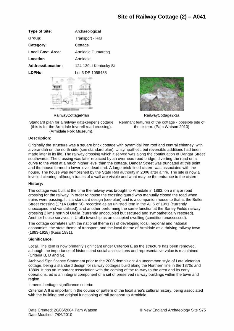
Site of Railway Cottage (2) – A041
Date Created: 26/06/2004 Pam Watson © New England Archaeology Site S75 Date Modified: 7/06/2010
Type of Site: Archaeological
Group: Transport - Rail
Category: Cottage
Local Govt. Area: Armidale Dumaresq
Location Armidale
Address/Location: 124-130LI Kentucky St
LDPNo: Lot 3 DP 1055438
RailwayCottagePlan RailwayCottage2-3a
Standard plan for a railway gatekeeper's cottage (this is for the Armidale Inverell road crossing).
(Armidale Folk Museum).
Remnant features of the cottage - possible site of the cistern. (Pam Watson 2010)
Description:
Originally the structure was a square brick cottage with pyramidal iron roof and central chimney, with a verandah on the north side (see standard plan). Unsympathetic but reversible additions had been made later in its life. The railway crossing which it served was along the continuation of Dangar Street southwards. The crossing was later replaced by an overhead road bridge, diverting the road on a curve to the west at a much higher level than the cottage. Dangar Street was truncated at this point and the house formed a lower level dead end. A large brick-lined cistern was associated with the house. The house was demolished by the State Rail authority in 2006 after a fire. The site is now a levelled clearing, although traces of a wall are visible and what may be the entrance to the cistern.
History:
The cottage was built at the time the railway was brought to Armidale in 1883, on a major road crossing for the railway, in order to house the crossing guard who manually closed the road when trains were passing. It is a standard design (see plan) and is a companion house to that at the Butler Street crossing (171A Butler St), recorded as an unlisted item in the AHS of 1991 (currently unoccupied and vandalised), and another performing the same function at the Barley Fields railway crossing 2 kms north of Uralla (currently unoccupied but secured and sympathetically restored). Another house survives in Uralla township as an occupied dwelling (condition unassessed).
The cottage correlates with the national theme (3) of developing local, regional and national economies, the state theme of transport, and the local theme of Armidale as a thriving railway town (1883-1928) (Kass 1991).
Significance:
Local. The item is now primarily significant under Criterion E as the structure has been removed, although the importance of historic and social associations and representative value is maintained (Criteria B, D and G).
Archived Significance Statement prior to the 2006 demolition: An uncommon style of Late Victorian cottage, being a standard design for railway cottages build along the Northern line in the 1870s and 1880s. It has an important association with the coming of the railway to the area and its early operations, ad is an integral component of a set of preserved railway buildings within the town and region.
It meets heritage significance criteria:
Criterion A It is important in the course or pattern of the local area's cultural history, being associated with the building and original functioning of rail transport to Armidale.

Site of Railway Cottage (2) – A041
Date Created: 26/06/2004 Pam Watson © New England Archaeology Site S75 Date Modified: 7/06/2010
Criterion B: the item has a special associated with a group of persons of importance in the cultural history of the local area, being the home and functioning vase of railway crossing guards when the crossings were manually operated, prior to the construction of the bypassing overhead bridge.
Criterion C: the item is important in demonstrating aesthetic characteristics in the local area, being distinctive in style, demonstrating a particular plan and fabric utilised by the NSW Railways for this class of cottage.
Criterion D: The item has a special association with a particular group, namely railway crossing guards.
Criterion E: The item has the potential to yield archaeological information in surrounding subsurface deposits and within the original fabric of the structure.
Criterion G: The item is important in demonstrating the principle characteristics of a class of NSW’s cultural places, being part of a group which collectively illustrates a representative type and has attributes typical of a particular way of life that has now disappeared.
Condition:
It was occupied in 2004 but was not in a good state of repair. In 2005 it was unoccupied and subsequently burnt by fire. Much of the lightweight additions to the central brick structure were damaged by the fire but the essential core and fabric of the original structure survived. However the building was subsequently bulldozed by the Railway authorities in 2006.
Archaeological Potential:
Moderate. Although the house has been destroyed, the surrounding yard may be less disturbed; the cistern and its contents are probably intact. Archaeological deposits relating to the dedicated function and other activities within the building may survive.
Recommendation:
Schedule for listing
Investigations Required:
Archaeological assessment and testing should be undertaken prior to any development of the site.
REFERENCES AND RELATED RECORDS:
Local Government Area:
Armidale Dumaresq
Maps:
Location layer on AMPA GIS
People:
N/A
Theme(s):
Transport
Publications, Theses, Reports:
Kass, Terry, Thematic History of Armidale. Report prepared for Perumal Murphy Pty Ltd on behalf of Amridale City Council, 1991
Perumal Murphy Pty Ltd (PM), Armidale Heritage Study. Report prepared for Armidale City Council, 1991

Site of McLean's Corner Archaeological Excavation – A050
Date Created: 26/05/2010 Pam Watson © New England Archaeology Site S77 Date Modified: 7/06/2010
Type of Site: Archaeological
Group: Manufacturing and Processing
Category: Mill (Grain) - Wheat, house, shop
Local Govt. Area: Armidale Dumaresq
Location Armidale
Address/Location: 90-96 Marsh Street
LDPNo: Lot 1 DP 1110413
McLeans84.gif BrowningsStore
Detail from the 1884 Panorama, reworked by Pam Watson (2002).
Browning’s Store 1920a
Description:
McLean’s Corner at the SW junction of Marsh and Dumaresq Streets consisted of three brick buildings owned by James McLean, running along along Dumaresq St (from W to E):
History:
This is the site of James McLean’s flour mill, store and dwelling, built in the mid-1850s and later, on Section 3 allotment 9. McLean bought the land as an original grantee of the Crowns Grant of 20/12/1849, for an auction price of £18. McLean was an indentured immigrant from Scotland, arriving in Australia in 1843 at the age of 20. He came to Armidale in 1847 and soon set up retail trading as he was recorded operating a branch store at the Rocky River goldfields in 1854. In 1853 he took over management of Kirkwood's flour mill (see S12) with his brother John. It is uncertain when he actually built his own dwelling-cum-store on his Dumaresq Street land, but it may have preceded his new flour mill which was built in 1858.
Significance:
Local. The site has historic and representative significance (Criteria A and G). The archaeological remains of this site revealed a typical example of the medium-scale general store operating in regional towns such as Armidale during the 19th and early 20th centuries (McLean’s, later Browning's store), and its associated domestic house. McLean’s flour mill is an example of one of a number of these facilities that flourished for a period in Armidale, none of which survive. The rise and decline of flour milling in the region is an integral part of the socio-economic evolution of Armidale (Ferry 1999: 59, 64).
Condition:
The site is now built over by a Coles Supermarket complex, the East End Mall. Part of the site was excavated in 2001-2, exposing the footings of the three buildings along Dumaresq Street. An interpretive window display of a preserved sample of the archaeology is on the southwest corner of Dumaresq and Marsh Streets. The basalt foundation walls were in good condition where exposed in soundings. The unexcavated areas almost certainly contained undisturbed continuations of these walls. Clearly stratified occupation layers survived, showing mid-20thC demolition phasing containing material and artefacts of 100 years previously, sub-floor occupation deposits and construction deposits (foundation trenches and fill) cut into pre-occupation strata. A well was encountered by a

Site of McLean's Corner Archaeological Excavation – A050
Date Created: 26/05/2010 Pam Watson © New England Archaeology Site S77 Date Modified: 7/06/2010
bulldozer during demolition clearance south of the archaeological excavation zone, behind the mill. Some of its contents were salvaged although the structure itself was destroyed without record.
Archaeological Potential:
None
Recommendation:
Maintain the interpretive window display as a record of the site and its significance. Retain mapping location and archival history in the Council records as part of the documentation of Armidale’s Heritage.
Investigations Required:
None
REFERENCES AND RELATED RECORDS:
Local Government Area:
Armidale Dumaresq
Maps:
1867 Ratings Map of Armidale
1933 Armidale Sewerage, House Details (ASHD)
People:
Browning, James
McLean, James
Theme(s):
Local: Formative Period
Industry
Commerce
Townships
Publications, Theses, Reports:
Burke, Heather, Meaning and Ideology in Historical Archaeology. Style, Social Identity, and Capitalism in an Australian Town. Kluwer Academic / Plenum Publishers, New York, London, 1999
Cady, Bruce, We Never Had To Go Far For A Drink: Pubs In Armidale, Armidale and District Historical Society Journal and Proceedings, 34, 1991: 29-46., 1991.
Duncan, R., Armidale : Economic and Social Development, 1839-1871. University of New England College, Armidale, 1951.
Ferry, John, Colonial Armidale. University of Queensland Press, St Lucia., 1999.
Gilbert, Lionel, An Armidale Album. Glimpses of Armidale's History and Development In Word, Sketch and Photograph. New England Art Museum Association, Armidale, 1982.
Watson, Pamela, & Burke, Heather, Report on the Historical Archaeology of Armidale Project, 2000: The Coles Eastend Development Site. For RIB Grant, School of Human and Environmental Studies, University of New England, 2000