
SHILLONG CITY - NDM India
84
REVIEW OF EARLY WARNING SYSTEM SHILLONG CITY
-
Upload
khangminh22 -
Category
Documents
-
view
1 -
download
0
Transcript of SHILLONG CITY - NDM India

REVIEW OF EARLY WARNING SYSTEM
SHILLONG CITY

Review of Early Warning Systems in Indian Cities: Shillong

Review of Early Warning Systems in Indian Cities: Shillong
No part of this publication may be reproduced or copied in any form without written permission.July 2017
Supported by: USAID-GoI-UNDP Partnership Project. Edited by: Dr. Umamaheshwaran Rajasekar and Lalit Dashora Authors: Dr. Umamaheshwaran Rajasekar, Lalit Dashora Team Composition: Dr. Umamaheshwaran Rajasekar (Team Leader & Risk Resilience & Institutional Expert), Dr. V. Geethalakshmi (Co-Team Leader & Hydro Meteorologist), Mr. Lalit Kumar Dashora (Early Warning Expert), Mr. G. K. Bhat (Advisor Hydro Geologist), Mr. Ajay Kumar Katuri (Urban planning and disaster management expert), Ms. Soumita Chakraborty (Disaster Management Specialist / Senior Researcher)Graphics and Design by: Vishal Mehta and Mansi Shah
ACKNOWLEDGEMENTS
This work was conducted under the USAID-GoI-UNDP Partnership Project on ‘Developing Resilient Cities through Risk Reduction in the context of Disaster and Climate Change’ and Dharamshala City under the RBAP funds for Dharamshala Smart City Limited (DSCL)
TARU team would like to thank Smt. Ibashisha Mawlong, MCS, Joint Secretary, Revenue & Disaster Management, Mr. Arun Sahdeo, UNDP and Ms. Abha Mishra, UNDP for their guidance and support during review process.
TARU would like to extend our deepest appreciation to all key informants/stakeholders who participated in the review process. TARU is grateful for the significant contribution provided by the Shillong Municipal Board (SMB), Meghalaya Basin Development Authority (MBDA), Meghalaya Urban Development Agency (MUDA), Deputy Commissioner Office – East Khasi Hills District, District Disaster Management Authority, Fire and Emergency Services Department, Office of Chief District Medical Officer, Office of Director Tourism Development, Technical Agencies - Indian Meteorological Department (IMD) at Shillong, Geological Survey of India (GSI) at Shillong, Central Water Commisison (CWC) at Shillong, NESAC at Umiam and experts from other technical agencies and disaster management agencies at the national, state, district and city levels.
The review process involved a number of consultation meetings and a workshop in the city. The support of the city government, state and central government departments/institutions is highly appreciated. Specifically, we would like to highlight the support and in-depth engagement of Mr. S. Bordoloi, Consultant (MSDMA), District Disaster Management Officer (DDMO) from Deputy Commissioner Office and City Project Officer.
A word of special thanks to United Nations Development Programme (India) for their fruitful partnership throughout the implementation of the review process, for their valuable support in coordinating the activities as well as in organizing city missions, and for stakeholder consultations and city workshops.
The findings of the review have been shared and reviewed by the key stakeholders, including the Local Government and their valuable inputs have been incorporated in the final report.
The report takes into account the End-to-End Early Warning System approach of the Regional Integrated Multi-Hazard Early Warning System. This report has been prepared by a six member team with experience in areas of disaster risk management, the hazard risk assessment, early warning system design and climate risk management.


Review of Early Warning Systems in Indian Cities: Shillong
EXECUTIVE SUMMARY
India is highly diverse in terms of geography and climate and so are its cities. Cities are exposed to earthquakes, tsunamis, landslides, heavy precipitation, floods, heat waves, cyclone and severe winds, public health risks among others. Past disasters have shown significant impact on city economy and on key sectors (such as transport, energy, water and sanitation, trade and commerce). It is expected that due to climate variability and climate change, the frequency and intensity of the hydro-meteorological hazards will see an increase in future. This, combined with poor reservoir management practices, especially in cities located downstream the reservoirs, may put the lives of citizens and city assets at risk.
This situation leads to advancements in observation and monitoring, mathematical modelling, computing capabilities, communication technology and conduct of scientific risk assessment have allowed technical and disaster management agencies to disseminate timely and accurate warnings and move people and assets from the harm’s way. One example of this is the case of Cyclone Phailin, where accurate forecast was made by the Indian Meteorological Department (Cyclone Warning Division) and timely dissemination of warnings to at-risk communities was done by the Orissa State and the District Agencies. Another example is the case of public health. Systemic collection of registered cases and observation of diseases in the city of Surat have led to the provision of timely information on potential outbreaks. Advance information on potential outbreaks leads to identification of additional measures to be stepped up by the local government to reduce the risk of diseases such as malaria, dengue, cholera, filariasis, among others.
This review is commissioned by UNDP under Contract (2016/232), and is an initiative under USAID-GoI-UNDP Partnership Project on ‘Developing Resilient Cities through Risk Reduction in the context of Disaster and Climate Change’ and Dharamshala City under the RBAP funds for Dharamshala Smart City Limited (DSCL).
The review investigates the condition of EWS governance, requirements of EWS users, core services provided by technical and disaster management agencies, coordination mechanism between technical and disaster management agencies and finally the issues centred on service delivery and feedback in three cities (Cuttack, Dharamshala and Shillong). The report provides firsthand guidance as well as the steps for development of EWS from the city level to the urban local body (ULB), disaster management institutions, technical agencies involved in design and implementation of early warning systems for geological hazards, hydro-meteorological hazards and public health risks.
Methodology of Review
The assessment for three cities (Cuttack, Dharamshala and Shillong) involved a systematic flow of understanding the EWS governance at the national, state, district and city levels; institutional mechanism and their roles within the elements of EWS; delivery of products and services by technical and disaster management agencies, as well as their coordination mechanism/operational cooperation; reviewing the existing EWS mechanism in cities; role of agencies in EWS and their integration in the disaster management institutional framework (City Disaster Management Plan); discussing with stakeholders the needs in
EWS and gaps thereof, capacities of institutions (technical agencies) engaged in EWS, the operational cooperation of technical agencies with the emergency departments/functionaries at the district and city levels (emergency management structure and response capabilities), current status and future needs of observation and monitoring capabilities, data management systems; seeking information on pre-computed assessment of risks for various intensity of hazards (risk assessment), hazard analysis and prediction capabilities (threat assessment/potential impact assessment), warning formulation/issuing of guidance and potential outlook/provision of actionable early warning information/warning products, decision making, generation of tailored risk information and dissemination of risk information to at-risk communities or hot-spot locations (risk communication), information technology and telecommunication capabilities, preparation of response options, institution/emergency responders and community response.
The assessment was based on the information obtained through a set of processes.
• Design of the review framework by the Review Team,
• A checklist and questionnaire prepared by the Review Team for obtaining information from technical and disaster management agencies,
• Mission to select cities to understand the EWS environment,
• Development of Criteria Development Matrix taking into consideration all the key elements of end-to-end EWS,
• Information collected through stakeholder consultations/meetings, workshops in respective cities, discussions with programme focal point in cities, meeting with key experts,

Review of Early Warning Systems in Indian Cities: Shillong
• Exchange and mid-term feedback from UNDP programme team,
• Development of policy brief, where key recommendations cited are discussed for endorsement at the policy level,
• Workshop with city stakeholders, sharing of results,
• Final report and presentation.
Key Observations and Recommendations
Based on the development stage indicators for all the six components (1. EWS governance – national, state and city level institutional framework, 2. User needs, 3. Operational components of EWS, 4. Products and services across the warning chain, 5. Coordination mechanism, 6. Service delivery and feedback loops), the report provides the summary for each city highlighting the current status. The Criteria Development Matrix (CDM) also outlines the reason for selecting the development stage indicators. Specific recommendations are presented together and this will lead to the development of policy brief. The overall analysis of this review revealed that in Shillong city:
• Shillong city is located in Seismic Zone – V, which is highly vulnerable to earthquakes. During 1897 the district was severely affected by an 8.7 magnitude earthquake which resulted in untold miseries. The earthquake of 8.5 magnitude which occurred in 1950 also caused loss of human lives and properties. The city experiences several low to medium intensity earthquakes regularly.
• Apart from earthquakes, it is affected by a number of landslides, storms, flash floods, fire accidents and other kinds of hazards.
• It is widely realized that city institutions including SMB are being rather response-centric instead of being the ones that take preventive measures. The technical capacity in understanding DRR, risk assessment and EWS need to be strengthened at the ULB level.
• During EWS review, City level Hazard Risk and Vulnerability Assessment (HRVA) was in process for Cuttack city. City level hazard and vulnerability mapping capabilities need to be enhanced on priority basis. A long-term perspective on capacity development should be envisaged.
• EWS development is crucial for sustainable development and building resilience of the city. It is therefore important to develop an EWS framework and strengthen strategies across all levels to ensure better coordination efforts for functional EWS at the city level. This must be seen as opportunity to strengthen network among institutions, foster partnerships and build the capacities of all keys stakeholders.
• EWS framework must be made as a functional component of the DM Plan process (national/state/district/city). The framework must foster areas of cooperation in data sharing and impact forecasting.
• There is a common challenge in the interpretation of the forecast products with is provided by technical agencies such as IMD. Technical agencies involved in providing warning have to evolve in providing information that can either be used by a wide pool of users or create products based on user needs.
• Technical agencies/scientific institutions must also enhance the capability to deliver timely warnings with sufficient respite time so that they support DRR functions at the city level.
• The role of technical agencies in warning formulation is increasingly being recognized. It
is therefore important to strengthen institutional coordination mechanism between technical and disaster management agencies at all levels.
• City government/ULB has to make significant investments towards development of EWS and associated mechanisms such as a functional EOC. The current level of preparedness and resource allocation is not sufficient to kick-start any activity around EWS.
• City has to make location specific (cities along rivers) Standard Operating Procedure (SOP) for Urban Flooding based on Standard Operating Procedure (SOP) for Urban Flooding released by Ministry of Urban Development (May 2017).

Review of Early Warning Systems in Indian Cities: Shillong
CONTENT
ACKNOWLEDGEMENTS
EXECUTIVE SUMMARY
ABBREVIATIONS
GLOSSARY
LIST OF ICONS
1. INTRODUCTION 1
2. METHODOLOGY OF REVIEW 6
3. CRITERIA DEVELOPMENT MATRIX AND DEVELOPMENT STAGE INDICATORS FOR EWS 9
4. UNDERSTANDING EWS AND KEY FRAMEWORKS FOR GEOLOGICAL HAZARDS, HYDRO- METEOROLOGICAL HAZARDS AND PUBLIC HEALTH RISKS 17
4.1 EWS Framework for Earthquake Hazard 18
4.2 EWS Framework for Tsunami Hazard 19
4.3 EWS Framework for Landslide Hazard 21
4.4 EWS Framework for Tropical Cyclone 22
4.5 EWS Framework for Floods 25
4.6 EWS Framework for Heat Wave Condition 27
4.7 EWS Framework for Public Health Risks 29

Review of Early Warning Systems in Indian Cities: Shillong
5. REVIEW OF EWS IN SHILLONG 31
5.1 GENERAL CITY INFORMATION 31
5.2 BACKGROUND ON HAZARD RISK 31
5.3 BRIEF VULNERABILITY PROFILE 34
5.4 INSTITUTIONAL FRAMEWORK 34
5.5 INDICATORS OF THE EXISTING CONDITION OF EWS 37
5.6 SUMMARY 42
6. CITY LEVEL EARLY WARNING SYSTEM OPTIONS FOR SHILLONG 44
7. CASE STUDIES AND BEST PRACTICES 61
REFERENCES 66
CREDITS 68

Review of Early Warning Systems in Indian Cities: Shillong
LIST OF FIGURES
Figure 1: Cities selected for review of EWS 2013-14 and 2016-17 2
Figure 2: Highlighting overlay of decision points over standard emergency phase and the weather event decision phase 3
Figure 3: Key elements in end-to-end EWS 4
Figure 4: Study framework schematic showing the links of stakeholders across the development model of EWS 8
Figure 5: Evolution of an hazard event in four stages 17
Figure 6: Global earthquake hazard map showing the regions operating active earthquake early warning systems 18
Figure 7: SOP diagram of tsunami early warning centre 21
Figure 8: Cyclone warning organization structure 24
Figure 9: Flood forecasting stations in India 26
Figure 10: Heat Index OF (OC) 28
Figure 11: Satellite Image and basic information: Shillong 30
Figure 12: Preparedness of EWS indicators for Shillong 43
Figure 13: Resilient Option Framework 44

Review of Early Warning Systems in Indian Cities: Shillong
LIST OF TABLES
Table 1: Criteria development matrix: Criteria and indicators of the condition of ews in cities 9
Table 2: Bulletin types, threat status & action points for tsunami warning alert and watch 20
Table 3: Damage expected & actions from low pressure area to super cyclonic storm 23
Table 4: Criteria development matrix: Indicators of existing condition of EWS in Shillong 37

Review of Early Warning Systems in Indian Cities: Shillong
ABBREVIATIONS
ACWC Area Cyclone Warning CentreBSNL Bhart Sanchar Nigam LimitedCBO Community Based OrganizationCDM Criteria Development MatrixCDMO Chief District Medical OfficerCDP City Development PlanCDPO Child Development Project OfficerCESU Central Electricity Supply UtilityCWC Central Water CommissionCFO Chief Fire OfficerCMO Chief Medical OfficerCWC Central Water CommissionDDMA District Disaster Management AuthorityDDMP District Disaster Management Plan DM Disaster ManagementDRR Disaster Risk ReductionEOC Emergency Operation CentreESF Emergency Support FunctionEWS Early Warning SystemGIS Geographical Information SystemsGOI Government of IndiaGSI Geological Survey of IndiaIC Incident CommanderIDSP Integrated Disease Surveillance ProgrammeIMD India Meteorological DepartmentIRS Incident Response SystemIT Information TechnologyMBDA Meghalaya Basin Development Authority M&E Monitoring and EvaluationMHA Ministry of Home AffairsMUDA Meghalaya Urban Development Agency MSDMA Meghalaya State Disaster Management AuthorityHRVA Hazard Risk and Vulnerability AssessmentMSK Medvedev-Sponheuer–Karnik Intensity ScaleNDMA National Disaster Management AuthorityNESAC North East Space Application Center NGO Non-Governmental OrganizationPAS Public Address System
RFP Request for ProposalRIMES Regional Integrated Multi-Hazard Early Warning System for Africa and AsiaRSMC Regional Specialized Meteorological CentreRTSMN Real Time Seismic Monitoring NetworkSEOC State Emergency Operations CentreSMS Short Messaging ServiceSOP Standard Operating ProceduresSP Superitendent of PoliceSRC State Resource CenterULB Urban Local BodyUNDP United Nations Development ProgrammeUSAID United States Agency for International Development

Review of Early Warning Systems in Indian Cities: Shillong
GLOSSARY
CapacityThe combination of all the strengths, attributes and resources available within a community, society or organization that can be used to achieve agreed goals
Climate change The Inter-governmental Panel on Climate Change (IPCC) defines climate change as: “a change in the state of the climate that can be identified (e.g., by using statistical tests) by changes in the mean and/or the variability of its properties, and that persists for an extended period, typically decades or longer. Climate change may be due to natural internal processes or external forcings, or to persistent anthropogenic changes in the composition of the atmosphere or in land use”
Disaster A serious disruption of the functioning of a community or a society involving widespread human, material, economic or environmental losses and impacts, which exceeds the ability of the affected community or society to cope using its own resources
Disaster risk reductionThe concept and practice of reducing disaster risks through systematic efforts to analyse and manage the causal factors of disasters, including through reduced exposure to hazards, lessened vulnerability of people and property, wise management of land and the environment, and improved preparedness for adverse events
Early warning system The set of capacities needed to generate and disseminate timely and meaningful warning information to enable individuals, communities and organizations threatened by a hazard to prepare and to act appropriately and in sufficient time to reduce the possibility of harm or loss
Forecast Definite statement or statistical estimate of the likely occurrence of a future event or conditions for a specific area
Geological hazardGeological process or phenomenon that may cause loss of life, injury or other health impacts, property damage, loss of livelihoods and services, social and economic disruption, or environmental damage
HazardA dangerous phenomenon, substance, human activity or condition that may cause loss of life, injury or other health impacts, property damage, loss of livelihoods and services, social and economic disruption, or environmental damage
Hydro-meteorological hazardProcess or phenomenon of atmospheric, hydrological or oceanographic nature that may cause loss of life, injury or other health impacts, property damage, loss of livelihoods and services, social and economic disruption, or environmental damage
Natural hazardNatural process or phenomenon that may cause loss of life, injury or other health impacts, property damage, loss of livelihoods and services, social and economic disruption, or environmental damage
Preparedness The knowledge and capacities developed by governments, professional response and recovery organizations, communities and individuals to effectively anticipate, respond to, and recover from, the impacts of likely, imminent or current hazard events or conditions
Prevention The outright avoidance of adverse impacts of hazards and related disasters
Response The provision of emergency services and public assistance during or immediately after a disaster in order to save lives, reduce health impacts, ensure public safety and meet the basic subsistence needs of the people affected
Risk The combination of the probability of an event and its negative consequences
Risk assessment A methodology to determine the nature and extent of risk by analysing potential hazards and evaluating existing conditions of vulnerability that together could potentially harm exposed people, property, services, livelihoods and the environment on which they depend

Review of Early Warning Systems in Indian Cities: Shillong
Risk management The systematic approach and practice of managing uncertainty to minimize potential harm and loss
Vulnerability The characteristics and circumstances of a community, system or asset that make it susceptible to the damaging effects of a hazard
Source: 2009, UNISDR Terminology on Disaster Risk Reduction

Review of Early Warning Systems in Indian Cities: Shillong
LIST OF ICONS
Background informartion on Review of EWS in 3 cities in India under the ongoing intitatve of Climate Risk Management in Urban Areas through Disaster Preparedness and Mitigation project by UNDP.
Methodology/Systematic approach adopted to assess the existing EWS and emergency communication netwrok in 3 cities across India.
The Criteria Development Matrix indicates the possibility of thinking 5 stages of development and helps to review each criterion built around 6 components of the development model of EWS.
General city information like location, climate, demographics, landuse, administration, etc. helps to understand the city and its development of Disaster Management Plan.
Hazard Risk like geo-physical, hydro-meteorological and public health are studied for each city, which would help in reviewing of EWS and later in development of Disaster Management Plan.
The city and its infrastructure are vulnerable to incidences of both geo-physical & hydro-meteorological events. Such event is likely to affect the livellhood of population in addition to economic loss.
Study of Institutional Framework for a city helps to understand the coordination mechanism among various stakeholders, during the time of disaster.
Summary of all the criteria of all 6 components of study framework and discussed in brief.
Observation and Monitoring
Data Analysis
Prediction
Risk Assessment
Potential Impact Assessment
Warning Formulation
Dissemination to communities at risk
Preparation of Response
Community Response
Earthquake
Tsunami
Landslide
Cyclone
Flood
Heatwave
Public health risk

1
Review of Early Warning Systems in Indian Cities: Shillong
Sendai Framework for Disaster Risk Reduction, 2015-2030 (Sendai Framework is the successor instrument to the Hyogo Framework for Action, 2005-2015: Building the Resilience of Nations and Communities to Disasters) has also led to a paradigm shift in disaster risk management from a post-disaster response to a comprehensive and strategic approach in disaster risk management encompassing preparedness and prevention strategies. It aims for the substantial reduction of disaster risk and losses in lives, livelihoods and health and in the economic, physical, social, cultural and environmental assets of persons, businesses, communities and countries. The seventh goal (g) of Sendai framework stresses substantially increase the availability of and access to multi-hazard early warning systems and disaster risk information and assessments to the people by 2030.
Hazards of different origin and intensity have caused significant loss of lives and economic damages in past few years. The damages are showing a growing trend, and increase in climate variability and climate change can tip of many existing mechanisms of managing risk. A closer look into the nature of the hazard events clearly indicates the role of the technical agencies (national/regional/state/city) and the disaster management agencies (at the national/state/district/city/village) in early warning as critical. The increasing factor of risk in today’s society underlines the need for enhanced cooperation from a wide spectrum of stakeholders in effective risk reduction and emergency response.
At country level, there is a growing reliance upon
EWS as more people and assets are being exposed to the hazards. This calls for functional EWS (most effective for events that take time to normally develop, such as tropical cyclone) or Alert Systems (most effective for events that start immediately, such as earthquake) that have applicability for most hazards. In 2013, Government of Orissa agencies evacuated more than half million people in advance of tropical cyclone (Phailin, Category: Very Severe Cyclonic Storm) thereby reducing fatalities to a fraction (loss of human life - 21) when compared to the fatalities (loss of human life - 9887) from a tropical cyclone (Paradip Cyclone, Category: Super Cyclonic Storm) in the same region 14 years previously.
This study is a review of existing Early Warning Sytem in the city and not hazard, vulnerability and risk assessment (HVRA).
Early Warning Systems (EWS) are well recognized as a critical life-saving tool for Hydro-meteorological Hazard (such as Floods, Cyclone, Droughts), and other hazards as well. According to WMO, the recorded economic losses linked to extreme hydro-meteorological events have increased nearly 50 times over the past five decades, but the global loss of life has decreased significantly, by a factor of about 10, thus saving millions of lives over this period. This has been attributed to better monitoring and forecasting of hydro-meteorological hazards and more effective emergency preparedness. A systematic approach towards managing risk through an established early warning system (EWS) can minimize loss of lives and adverse economic impact. EWS backed with effective institutional arrangements can predict hazards in a timely and effective manner, thereby empowering decision makers and communities at risk.
Advancement in observation and monitoring, mathematical modelling, computing capabilities, communication technology and conduct of scientific risk assessment have allowed technical and disaster management agencies to timely disseminate accurate warnings and move people and assets from the harm’s way. In the case of Cyclone Phailin, accurate forecast by the Indian Meteorological Department (Cyclone Warning Division) and timely dissemination of warnings to at-risk communities by the Orissa State and the District Agencies made this possible.
The other example is in the case of Public Health such as systemic collection of registered cases and observations of diseases in the city of Surat has led to the provision of timely information regarding potential outbreaks. Advance information of potential outbreaks leads to identification of additional measures to be stepped up by the local government to reduce the risk of diseases such as malaria, dengue, cholera, filariasis, among others.
Warning dissemination and staging response actions are as important as accurate forecasting and determining potential impact. Any weak link in the elements of EWS (even in case of previous well performing system) will result in under-performance or its failure. Hence evaluation of EWS is important. The evaluation of the system effectiveness can be done during the event, post-event or during the lean period. This review of EWS for all the three cities is done during the lean period. In most cases the cities haven’t formally put in place a functional EWS. While it is important to have technical competence around a range of elements (forecasting, prediction, impact assessment), discussions with stakeholders emphasize that EWS is more organizational and institutional process which works to reduce loss.
1. INTRODUCTION

2
Review of Early Warning Systems in Indian Cities: Shillong
The methodology adopted in the study has roots to EWS elements defined by RIMES (2008) and the criteria-development concept by Parker (1999).
The review investigates into the condition of EWS governance, requirements of EWS users, core services provided by technical and disaster management agencies, coordination mechanism between technical and disaster management agencies and finally on issues centered around service delivery and feedback.
The purpose of this report is to provide guidance to the city government, disaster management institutions and technical agencies involved in design and implementation of early warning systems for geological hazards, hydro-meteorological hazards & public health risks. This study aims to assess the existing EWS in three cities (Refer Figure 1) through:
• Review of the technical design/structure and efficacy of existing early warning system, assessment of early warning agencies, communications networks, protocols for issue of warning, and transmission to the people, assessment of how the residents of the city access the information and how they act upon it.
• Review of the technologies involved in the early warning system network design, technical specifications, up-time performance standards, connectivity and integration with all the important facilities and installations, emergency services, and the disaster management system in the city.
• Review of the mode of collecting information related to hazard events, monitoring, and transmitting it to other agencies, particularly the municipal government and district
Navi Mumbai
Vishakapatnam
Bhubaneshwar
Dhramshala
Shillong
Cuttack
Madurai
Trivandrum
Gangtok
Shimla
I N D I A
Figure 1: Cities selected for review of EWS 2013-14 and 2016-17
N
2013-142016-17

3
Review of Early Warning Systems in Indian Cities: Shillong
administration.• Review of the mode and reach of the
warning especially last mile connectivity and dissemination plan through mass media, print and audio-visual.
• Review the messages disseminated through the EWS: on timeliness, appropriateness, accuracy, and simplicity parameters.
• Review of the service support for maintaining the EWS on a regular basis and ensuring hundred percent uptime.
This report reviews the institutional mechanism and the decision making across the development model of EWS and its components. This report considers the use of Criteria Development Matrix (tool for review) to assess the level of development and present the findings for three urban centres. Specifically, it focuses on the geological hazard, hydro-meteorological hazard and public health risk warning system, their current status, and capabilities and supporting disaster risk reduction.
Hazards specific EWS options for individual city are presented at the end of the city review sections for ready reference.
Background
Early warning in the usual context means some form of, either written or verbal indication of, an impending hazard. Early warning in the disaster context implies the means by which a potential danger is detected or forecast and an alert issued. In this report, the following definition has been taken into consideration: ‘The provision of timely and effective information, through identifying institutions, that allows individuals exposed to the hazard to take action to avoid or reduce their risk and prepare for an effective response.’ ISDR 2004.
Over the last decade, India has incorporated disaster-reduction policies in its national, social and economic development plans to establish effective preparedness measures and improve the response capacities. The value of timely and effective warnings in averting losses and protecting resources/development assets becomes apparent. Urban centres are exposed to greater risk due to severe exposure of elements at risk (Mumbai Floods 2005, Surat Floods 2006). Some of the recent events show the rising trend in the number of people being affected by disasters, especially in the urban areas.
Warning represents an added value and function in the overall disaster risk management/disaster risk reduction framework. There are three main
abilities that constitute the basis of early warning.
• The first is technical capability to identify a potential risk or the likelihood of occurrence of a hazardous phenomenon, which threatens a vulnerable population.
• The second ability is that of identifying accurately the vulnerability of a population to whom a warning has to be directed,
• The third ability, which requires considerable social and cultural awareness, is the communication of information to specific recipients about the threat in sufficient time and with sufficient clarity so that they can take action to avert negative consequences.
Warning systems are only as good as their weakest link. They can, and frequently do, fail in
Figure 2: Highlighting overlay of decision points over standard emergency phase and the weather event decision phase
Identification of increased potential for
event
Decision that event is likely or
imminentDecision to
activate warning
Decision to deactivate threatening
phenomenon doesn’t exist
Review and Feedback
Ongoing preparedness and planning
Increased readiness and stockpilling of
resources
Event specific preparation,
based on hazard intensity
Emergency operations
(Warning communication, Evacuation, S&R among others)
Post disaster/Post event recovery
Ongoing preparedness and planning
Time Dimension
Preparedness and Mitigation
Standard Emergency Phase
Preparedness and MitigationResponse Recovery
Decision making
Action points
STANDARD WEATHER EVENT DECISION PHASE

4
Review of Early Warning Systems in Indian Cities: Shillong
both developing and developed countries for a range of reasons. There are significant decision points for the scientific/technical agencies and the disaster management agencies. These decision points coincide with the phases of the disaster management/emergency management decision stages as shown in Figure 2 (Hydro-meteorological event with sufficient lead time). A range of factors influence the hazard event phase and the emergency phase. They include:
• Lack of standardized EWS framework, which is understood by both technical and disaster management agencies.
• Non-availability of warning information products and services at different temporal and spatial scales, and provision of same information content for various sectors/stakeholders.
• Warning message not being aligned in terms of societal impacts, risk assessment not being undertaken and potential impact assessment being based on either individual understanding or on past experience and being non-scientific.
• Lack of systemization steps for emergency response based on event severity.
• Warning content unable to facilitate appropriate and timely decision actions at least to those people who are most immediately at risk or are under the influence of the hazard.
An effective early warning system links technical agencies that generate warning information with disaster management/emergency management institutions and finally with communities/people at risk. The end-to-end early warning system (RIMES, 2008) involves the following elements (Figure 3 shows the link between these elements):
1. Observation and monitoring
Observation /Monitoring
Data Analysis
Prediction Risk Assessment
Potential Impact Assessement
Warning Formulation
Preparation of Response
Community Response
Dissemination to communities at risk
Figure 3: Key elements in end-to-end EWS

5
Review of Early Warning Systems in Indian Cities: Shillong
2. Data processing and analysis3. Prediction and forecasting4. Risk assessment5. Potential impact assessment6. Warning formulation7. Dissemination to communities at risk (until the last mile)8. Preparation of response options9. Community response, which is shaped by: a. Resourced and practiced emergency response plans b. Risk awareness c. Mitigation programmes10. Receiving user feedback11. System adjustment/improvement

6
Review of Early Warning Systems in Indian Cities: Shillong
2. UNDERSTANDING EWS AND KEY FRAMEWORKS FOR GEOLOGICAL HAZARDS, HYDRO-METEOROLOGICAL HAZARDS AND PUBLIC HEALTH RISKS
Every type of hazard has its own dynamics. The duration of the phenomenon will vary for hazard type and the event type (small or big). There are various stages associated with the development of the event (Figure 5). Broadly, the stages can be categorized as follows:• Embryonic stage can be linked to the manifestation of those conditions that may give rise to these events or as the events begin to emerge; preliminary phase of the event.• Growth stage is when the event gradually evolves in terms of its magnitude or area of influence.• Mature stage would represent the event as being capable of provoking a disaster in a particular geographic location; event triggers impacts and effects on communities and regions near its path.• Decaying stage that indicates when the event loses its strength and is dissipating.
In the context of early warning, the time lapse between the embryonic and the mature stage is determinant to the capacity of issuing warnings. If this time lapse is large enough, hierarchical phases could be identified allowing for the establishment of several alert or warning levels.
For example, in case of a tropical cyclone in the Indian Ocean, the disturbance that gives rise to the event and subsequent shaping up is considered as embryonic stage. The growth stage would then encompass those processes related to evaporation of water from the ocean and the convective processes within the atmosphere that begin to take shape, such tropical cyclone. In the
Figure 4: Evolution of an hazard event in four stagesEm
bryo
nic
Stag
e
Gro
wth
Sta
ge
Mat
ure
Stag
e
Dec
ayin
g St
age
Time
Source: Villagrán de León, J. C., Pruessner, I., and H. Breedlove (2013). Alert and Warning Frameworks in the Context of Early Warning Systems. A Comparative Review. Intersections No. 12. Bonn: United Nations University Institute for Environment and Human Security.

7
Review of Early Warning Systems in Indian Cities: Shillong
mature stage, one could see the cyclone as fully manifested in terms of its typical characteristics such as very low barometric pressure, high wind speeds, storm surges and precipitation. Finally, as the cyclone makes landfall, it begins to weaken to the point that it ceases to exist once it is fully inside large landmasses. In this context, meteorologists use a variety of instruments to track the four stages of events. A combination of measurements and computing allows the IMD Cyclone Warning Division to be able to follow the path and the dynamics of such events, leading to forecasts of trajectories and places where such cyclone may make landfall. The disaster management agencies take actions based on the information provided by the technical agencies and follow the Standard Operating Procedure as outlined in the Disaster Management Plan.
Earthquake occurs due to plate tectonic activity. The India sub-continent has a history of devastating earthquakes. Some regions of the country are more risk prone than others. As per the seismic hazard zoning map of India, India is broadly divided into four zones. Zone V is very high damage risk zone (Intensity IX and above on MSK scale); Zone IV is high damage risk zone (Intensity VIII on MSK scale), Zone III is moderate damage risk zone (Intensity VII on MSK scale) and Zone II is low damage risk zone (Intensity VI or less on MSK scale). About 59 per cent of the geographical region of the country falls under Zones III, IV and V.
Studies indicate the possibility of earthquakes of severe intensity in some parts of the country. Given the high vulnerability of the country to
Figure 5: Global earthquake hazard map showing the regions operating active earthquake early warning systems
2.1 EWS Framework for Earthquake Hazard
Note: labelled in blue. The regions developing early warning systems are labelled in green Source: http://www.elarms.org/front/eewGlobal.php Last accessed on 18 April 2014

8
Review of Early Warning Systems in Indian Cities: Shillong
damaging earthquakes, there is no functional EWS for earthquake hazard. The growth stage of an earthquake may span across centuries, whereas the phenomenon of ground shaking lasts for seconds to a few minutes. Once the event takes place, the main shock is followed by aftershocks. In some cases, the large earthquake may be preceded by foreshocks. Earthquakes below the ocean bed can trigger tsunami, and on land they can trigger landslides, mudslides, avalanche and rock fall.
Earthquake EWS takes advantage of the rapid availability of earthquake information to quantify the hazard associated with an earthquake and issue a prediction of impending ground motion prior to the arrival of the strong waves in populated areas. Earthquake EWS is a combination of instrumentation, methodology and software designed to analyse and warn the populated areas or sensitive installations. Japan, Taiwan, Mexico, Romania and Turkey currently operate Earthquake EWS, while California (California Integrated Seismic Network, CISN), Iceland, Switzerland, Italy, Greece, Egypt and India are either in the development or testing phase of Earthquake EWS. Figure 6 shows the status of countries where Earthquake EWS is operational.
India Meteorological Department (IMD) is the nodal agency of Government of India responsible for monitoring seismic activity in and around the country. The operational task of the department is to quickly estimate the earthquake source parameters immediately on occurrence of an earthquake and disseminate the information to all the user agencies including the concerned state and central government agencies responsible for carrying out relief and rehabilitation measures. Information relating to under-sea earthquakes
capable of generating tsunamis on the Indian coastal regions is also disseminated to all concerned user agencies, including the Indian National Centre for Ocean Information Services (INCOIS), Hyderabad, for issue of tsunami related messages and warnings. Earthquake information is transmitted to various user agencies, including public information channels, press, media etc. using different modes of communication, such as SMS, fax, email and is also posted on IMD’s website (www.imd.gov.in).
India Meteorological Department also maintains a countrywide National Seismological Network (NSN), consisting of a total of 82 seismological stations, spread over the entire length and breadth of the country. This includes: (a) 16-station VSAT based digital seismic telemetry system around National Capital Territory (NCT) of Delhi, (b) 20-station VSAT based Real Time Seismic Monitoring Network in the north-eastern region of the country and (c) 17-station Real Time Seismic Monitoring Network (RTSMN) to monitor and report large magnitude under-sea earthquakes capable of generating tsunamis on the Indian coastal regions. The remaining stations are of standalone/analogue types. A Control Room is in operation on a 24X7 basis, at IMD Headquarters (Seismology) in New Delhi, with state-of-art facilities for data collection, processing and dissemination of information to the concerned user agencies.
Tsunamis are triggered by undersea earthquakes; landslides which reach seas or oceans and underwater landslides; volcanic eruptions and
dome collapse and meteorites. It is important to note that all earthquakes do not cause tsunamis. The tsunami EWS gathered much attention in India largely because of the consequence of the Indian Ocean tsunami of 26 December 2004. Underwater mass movements get triggered by any of the factors mentioned above. The growth of the phenomenon takes place in the sea and it heads straight to the coastline impacting as tsunami waves. Rise in the sea level and impact of tsunami may last for several hours, and there can be several waves associated with a tsunami event.
In the aftermath of the Great Sumatra earthquake of 26 December 2004, the Ministry of Earth Sciences has set up an Indian Tsunami Early Warning Centre at the Indian National Centre for Ocean Information Services (INCOIS), Hyderabad. The centre is mandated to provide advance warnings on tsunamis that are likely to affect the coastal areas of the country. As a part of this, a 17-station Real Time Seismic Monitoring Network (RTSMN) has been set up by India Meteorological Department.
The network is capable of monitoring and reporting, in least possible time, the occurrence of earthquakes capable of generating tsunamis that are likely to affect the Indian coastal regions. Data from the 17 broadband seismic field stations are transmitted simultaneously in real time through VSAT communication facilities to the Central Receiving Stations (CRSs) located at IMD, New Delhi, and INCOIS, Hyderabad, for processing and interpretation.
The CRSs are equipped with state-of-art computing hardware, communication, data processing, visualization and dissemination facilities. For providing better azimuthal coverage for detecting earthquakes with potential to cause tsunamis, the
2.2 EWS Framework for Tsunami Hazard

9
Review of Early Warning Systems in Indian Cities: Shillong
RTSMN system has been configured to include about 100 global stations of IRIS (a consortium of Incorporated Research Institutions in Seismology), whose data are available freely through the internet. Information on earthquake is disseminated through various communication channels to all the concerned user agencies in a fully automated mode. Based on the earthquake information provided by the RTSMN and other ocean-related observations/analysis, INCOIS evaluates the potential of the undersea earthquakes to cause tsunami and issues necessary warnings/alerts as per the situation.
The National Tsunami Early Warning Centre at INCOIS is operational since October 2007 and has been issuing accurate tsunami warnings for all undersea earthquakes of ≥ 6.5 M as shown in figure 7. The ITEWS comprises a real time network of seismic stations, Bottom Pressure Recorders (BPR), tide gauges and 24X7 operational tsunami warning centre to detect the potential of earthquakes to cause tsunami, to monitor tsunamis and to provide timely advice to vulnerable community by means of latest communication methods with back-end support of a pre-run scenario database and Decision Support System (DSS). Table 2 presents the bulletin types issued by the ITEWC with the timelines.
However, as local conditions would cause a wide variation in tsunami wave action, the ALL CLEAR determination is made by the local authorities.Actions Based on Threat Status (WARNING/ALERT/WATCH) is given in the table 2.
Bulletin Type Information Time of Issue (Earthquake origin time as T0 minutes)
Type I
Preliminary EQ parameters and LAND/NO THREAT information based on EQ location, magnitude and depth
T0+20Preliminary EQ parameters and qualitative potential of earthquake to cause tsunami, based on EQ location, magnitude and depth
Type II
Preliminary EQ parameters and NO THREAT information from model scenarios
T0+30Preliminary EQ parameters and quantitative tsunami threat (WARNING/ALERT/WATCH) information from model scenarios
Type II Supplementary - xx
Revised EQ parameters and quantitative tsunami threat (WARN-ING/ALERT/WATCH) information from model scenarios – if revised EQ parameters are available much before the real time water level observations are reported
As and when revised earth-quake parameters are available or after earthquake lapsed Time + 60 min
Type IIIRevised EQ parameters and quantitative tsunami threat (WARN-ING/ALERT/WATCH) information from model scenarios and real time water level observations indicating tsunami generation
As and when the first real time water level observation is available
Type III Supplementary -xx
Revised EQ parameters and quantitative tsunami threat (WARN-ING/ALERT/WATCH) information from model scenarios and real time water level observations indicating tsunami generation threat PASSED information for individual zones
Hourly update/as and when he subsequent real time water level observations are avail-able
Final Bulletin
Issued when water levels from multiple gauges confirm that no significant tsunami was generated
120 minutes after a significant tsunami passes the last Indian threat zone
Source: IETWC User Guide Ver. 2, Indian National Centre for Ocean Information Services, June 2011
Threat Status Actions to be taken Dissemination to
WARNINGPublic should be advised to move inland towards higher grounds. Vessels should move into deep ocean
MoES, MHA, NDMA, NCMC, NDRF bat-talions, SEOC, DEOC, public, media
ALERTPublic should be advised to avoid visiting beaches and low-lying coastal areas Vessels should move into deep ocean
MoES, MHA, NDMA, NCMC, NDRF bat-talions, SEOC, DEOC, public, media
WATCH No immediate action is required MoES, MHA MoES, MHA, MEDIA, NCMC, NDRF battalions, SEOC, DEOC
THREAT PASSED All clear determination to be made by the local authorities
MoES, MHA, NDMA, NCMC, NDRF bat-talions, SEOC, DEOC, public, media
Table 1: Bulletin types, threat status & action points for tsunami warning alert and watch

10
Review of Early Warning Systems in Indian Cities: Shillong
The term ‘landslide’ describes a wide variety of processes that result in the downward and outward movement of slope-forming materials, including rock, soil, artificial fill or a combination of these. The materials may move by falling, toppling, sliding, spreading or flowing (USGS). Landslide causes can be classified into four categories:
• Geological causes: These include weak, weathered, sheared or fissured materials, adversely-oriented structural discontinuities (faults, unconformity, etc.), and contrasts in permeability and stiffness.
• Morphological causes: These include tectonic or volcanic uplift, glacial rebound, fluvial, glacial or wave erosion of slope toe, or vegetation removal (by forest fire, drought).
• Physical causes : These include intense rainfall, rapid snow melt; earthquakes, volcanic eruptions, thawing and weathering (freeze and thaw or shrink and swell).
• Anthropogenic causes : These include excavation of the slope or its toe, loading of the slope or its crest, deforestation, irrigation, mining, artificial vibration and water leakage from utilities.
Landslide, a frequently occurring natural hazard in the hilly terrains of India, is a predominant activity during the monsoon period from July to September and after the snowfall from January to March. Strong earthquakes also trigger landslides, particularly in regions marked by critically disposed and unstable slopes. On a rough estimate, nearly 15 per cent of India’s landmass or 0.49 million sq km area is prone to landslides. This includes 0.098 million sq km of
Figure 6: SOP diagram of tsunami early warning centre
Earthquake
Mag≥ 6.5Depth < 100km
Ocean
Real-time Water-level Observations BRPs / TIde gauges
Pre-run Model Scenario Database
ETA ≤ 60 mins
EWA(M)
EWA(M)
EWA(M)
Threat Status
WARNING
WARNING
ALERT
ALERT
WATCH
WATCH
ALERT
WATCH
Threat Status
ETA ≥ 60 mins
> 2
0.5 to 2
0.2 to 0.5
> 2
0.5 to 2
0.2 to 0.5
> 2
0.5 - 2
0.2 to 0.5
No Significant Changes Threat Passed
Estimated Threat Status
Threat Status EWA
(M)
WARNING
ALERT
> 0.5
0.2 to 0.5
Upgraded Threat Status
Threat Status
WATCH
NO significant changes in water level
Significant changes in water level
T0
B1: T0+ 20min
B2: T0+ 30min
B2: Supple: As and when revised EQ para available
B3: As and when first real time observation becomes available
B3: Supple: As and when more real time observation becomes available
FINAL: No significant changein WL (or) last excedance of threat threshold at last India Coast + 120min
2.3 EWS Framework for Landslide Hazard
Source: http://www.tsunami.incois.gov.in/ITEWS/dss_sop.jsp (Last accessed on 18 April 2014)

11
Review of Early Warning Systems in Indian Cities: Shillong
the north-eastern region, comprising the Arakan Yoma ranges, and 0.392 million sq km of parts of the Himalayas, Nilgiris, Ranchi Plateau, and Eastern and Western Ghats. As many as 20 states of India are affected by different degrees of landslides. Of these, the states of Sikkim and Mizoram have been assessed to be falling under very high to severe hazard classes. Most of the districts in the states of Jammu and Kashmir, Himachal Pradesh, Uttarakhand, Arunachal Pradesh, Nagaland and Manipur come under high to very high landslide hazard classes. In the peninsular region, the hilly tracts of states like Karnataka, Andhra Pradesh, Tamil Nadu, Maharashtra, Goa, Madhya Pradesh and Kerala constitute low to moderate hazard prone zones.
Slope saturation by water is the common trigger of landslides, generated through processes such as intense rainfall, snowmelt, changes in groundwater levels, and water level changes along coastlines, earth dams and the banks of lakes, reservoirs, canals and rivers. Landslides and floods are closely allied because both are related to precipitation, runoff and the saturation of ground by water. In addition, debris flows and mudflows usually occur in small, steep stream channels and often are mistaken for floods; in fact, these two events often occur simultaneously in the same area. Building on the fact that some landslides are triggered by intense rainfall, institutions establish the saturation threshold and develop landslide EWS. The presence of extreme weather conditions is used as an indicator to issue warning or to change the levels of warning in the systems, which make use of various threshold levels.
The study of landslide hazard is carried out by the Geological Survey of India (GSI), and can be divided into two broad categories:
1. Pre-disaster Studies: Identification of vulnerable slopes through landslide hazard zonation (LHZ) mapping on various scales or studying the critical slopes individually and determining their status as far as their stability is concerned.
2. Post-disaster Studies: Detailed analysis of landslides that have occurred, determine the causes responsible for failure and suggest treatment measures required to stabilize the slopes.
Landslide EWS is not undertaken at the moment by GSI or by other agencies in the country.
A tropical cyclone is a rotational low pressure system in the tropics when the central pressure falls by 5 to 6 hPa from the surroundings and the maximum sustained wind speed reaches 34 knots (about 62 kmph). It is a vast violent whirl of 150 to 800 km, spiralling around a centre and progressing along the surface of the sea at a rate of 300 to 500 km a day. The word cyclone has been derived from the Greek word cyclos, which means ‘coiling of a snake’. These events are controlled by the interaction between the atmosphere and the oceans in tropical waters. The stages of the cyclone take from a few days to few weeks. During the mature stage, the tropical cyclone may vary its characteristics in terms of wind speed and pressure based on the interaction. On hitting the land, the system weakens and dissipates. Over the last two decades, there has been significant improvement in the capacities of the institutions to monitor, forecast and warn populations in advance
of the cyclone hitting the land. World Meteorological Organization has set up five Regional Specialized Meteorological Centres (RSMC) in Miami, Tokyo, New Delhi, La Réunion and Nadi.
Based on wind speed over the oceanic area, IMD has classified the low pressure systems into the following categories, from low pressure area to super cyclonic storm:
Cyclone Warning Organization Structure in IndiaRSMC – Tropical Cyclones, New Delhi with effect from 1 July 1988 has been assigned the responsibility of issuing Tropical Weather Outlooks and Tropical Cyclone Advisories for the benefit of the countries in the WMO/ESCAP Panel region bordering the Bay of Bengal and the Arabian Sea, namely, Bangladesh, Maldives, Myanmar, Oman, Pakistan, Sri Lanka and Thailand. The main activities of RSMC, New Delhi, are listed below.
• Round-the-clock watch over the entire North Indian Ocean
• Analysis and processing of global meteorological data for diagnostic and prediction purposes
• Detection, tracking and prediction of cyclonic storms in the Bay of Bengal and the Arabian Sea
• Running of numerical models for tropical cyclone track and intensity prediction
• Issue of Tropical Weather Outlook once daily (at 0600 UTC) and an additional outlook at 1700 UTC in the event of a depression, which is likely to intensify into a cyclonic storm
• Issue of cyclone advisories to the Panel countries eight times a day
• Issue of storm surge advisories• Implementation of Regional Cyclone
2.4 EWS Framework for Tropi-cal Cyclone

12
Review of Early Warning Systems in Indian Cities: Shillong
Operational Plan of WMO/ESCAP Panel• Collection, processing and archival of all data
pertaining to cyclonic storms, viz., wind, storm surge, pressure, rainfall, satellite information etc.
• Exchange of composite data and bulletins pertaining to cyclonic storms with Panel countries
• Preparation of comprehensive reports on each cyclonic storm
• Continued research on storm surge, track and intensity prediction techniques
Cyclone Warning DivisionCyclone Warning Directorate – located with RSMC – Tropical Cyclones, New Delhi, was established in 1990 in the Office of the Director General of Meteorology, New Delhi – to co-ordinate and supervise the cyclone warning work in the country in totality. The mission of this division is to improve the cyclone warning activity in the country and to improve links between early warning system of cyclone and disaster management.
The broad functions of the Cyclone Warning Division and RSMC – Tropical Cyclones, New Delhi are as follows: • Round-the-clock watch over the entire North Indian Ocean• Analysis and processing of global meteorological data for diagnostic and prediction purposes• Detection, tracking and prediction of cyclonic storms in the Bay of Bengal and the Arabian Sea• Issue of numbered Cyclone Warning Bulletins to AIR, Doordarshan and other TV channels and print media for wider coverage• Interaction with disaster management agencies and providing critical information for emergency support services• Coordination with government & other agencies
System Intensity Damage Expected Suggested ActionLow Pressure Area(Not exceeding 17 kts or less than 31 kmph)
-- --
Depression(17–27 kts or 31–51 kmph)
-- --
Deep Depression(28–33 kts or 52–61 kmph)
Minor damage to loose and unsecured structures
Fishermen advised not to venture into the open seas
Cyclonic Storm(34–47 kts or 62–87 kmph)
Damage to thatched huts. Breaking of tree branches causing minor damage to power and communication lines
Total suspension of fishing operations
Severe Cyclonic Storm(48–63 kts or 88–117 kmph)
Extensive damage to thatched roofs and huts. Minor damage to power and communication lines due to uprooting of large avenue trees. Flooding of escape routes
Total suspension of fishing operations. Coastal hutment dwellers to be moved to safer places. People in the affected areas to remain indoors
Very Severe Cyclonic Storm(64–90 kts or 118–167 kmph)
Extensive damage to kutcha houses. Partial disruption of power and commu-nication lines. Minor disruption of road and rail traffic. Potential threat from flying debris. Flooding of escape routes
Total suspension of fishing operations. Mobilize evacuation from coastal areas. Judicious regulation of rail and road traffic. People in affected areas to remain indoors
Very Severe Cyclonic Storm(91–119 kts or 168–221 kmph)
Extensive damage to kutcha houses. Some damage to old buildings. Large-scale disruption of power and commu-nication lines. Disruption of rail and road traffic due to extensive flooding. Potential threat from flying debris
Total suspension of fishing operations. Extensive evacuation from coastal areas. Diversion or suspension of rail and road traffic. People in affected areas to remain indoors
Super Cyclone(120 kts or more, or 222 kmph or more)
Extensive structural damage to residen-tial and industrial buildings. Total disrup-tion of communication and power supply. Extensive damage to bridges causing large-scale disruption of rail and road traffic. Large-scale flooding and inunda-tion of sea water. Air full of flying debris
Total suspension of fishing operations. Large-scale evacuation of coastal popu-lation. Total suspension of rail and road traffic in vulnerable areas. People in the affected areas to remain indoors
Reference/Source: Forecasters Guide, India Meteorological Department, 2008
Table 2: Damage expected & actions from low pressure area to super cyclonic storm

13
Review of Early Warning Systems in Indian Cities: Shillong
at HQ level on all matters relating to cyclonic storms• Collection, processing and archival of all data
pertaining to cyclonic storms, viz., wind, storm surge, pressure, rainfall, satellite information etc.
• Preparation of comprehensive reports on each cyclonic storm
• Collection of all types of information on individual cyclonic storms from State Governments, cyclone warning centres and other agencies.
• Continued research on storm surge, track and intensity prediction techniques.
Area Cyclone Warning Centres (ACWCs)/Cyclone Warning Centres (CWCs) With the establishment of additional centres at Bhubaneshwar and Visakhapatnam, the Storm Warning Centres at Kolkata, Chennai and Mumbai were named as Area Cyclone Warning Centres (ACWC) and the Storm Warning Centres at Visakhapatnam, Bhubaneshwar and Ahmedabad as Cyclone Warning Centres (CWC). CWCs Visakhapatnam, Bhubaneshwar and Ahmedabad function under the control of the ACWCs – Chennai, Kolkata and Mumbai respectively.
Meteorological Centre (MC), Hyderabad, liaises between CWC Visakhapatnam and Andhra Pradesh government officials; warnings issued by CWC Visakhapatnam are sent to MC Hyderabad also for briefing the Andhra Pradesh government officials at the state capital.
The present organizational structure for cyclone warnings is a three-tier one, with the ACWCs/CWCs actually performing the operational work of issuing the bulletins and warnings to the various user interests, while the Cyclone Warnings (Directorate)
Figure 7: Cyclone warning organization structure
Vishakapatnam
I N D I A
N
New Delhi
Ahmedabad
Mumbai
Pune
Bhubaneshwar
Kolkotta
Chennai
DDGM (Cyclone Warning)
DDGM (Weather Forecasting)
ACWs (Area Cyclone Warning Centers)
CWCs (Cyclone Warning Centers)
Source: http://www.imd.gov.in/section/nhac/dynamic/cwo.pdf

14
Review of Early Warning Systems in Indian Cities: Shillong
New Delhi and the Deputy Director General of Meteorology (Weather Forecasting), through Weather Central, Pune, coordinate and guide the work of the ACWCs/CWCs, exercise supervision over their work and take necessary measures for continued improvement and efficiency of the storm warning systems of the country as a whole. The ultimate responsibility of carrying on storm warning work, however, rests with the ACWCs and CWCs. The ACWCs/CWCs maintain round-the-clock watch.
Bulletins and Warnings Issued by ACWCs and CWCsThe following is the list of bulletins and warnings issued by the ACWCs and CWCs for their respective areas of responsibility:
• Weather and sea bulletins - for shipping on the high seas and (issued by ACWCs Mumbai and Kolkata only) -for ships plying in coastal waters
• Bulletins for Indian Navy (issued by ACWCs Mumbai and Kolkata only)
• Bulletins for departmental exchanges (issued by ACWCs Mumbai, Kolkata and Chennai)
• Port warnings
• Fisheries warnings
• Pre-cyclone watch and post landfall outlook (issued by Cyclone Warning Division)
• Bulletins for the AIR
• CWDS bulletins
• Warnings for registered/designated users
• Bulletins for the press
• Aviation warnings (issued by concerned aviation meteorological offices)
Floods are triggered by heavy rainfall and due to systems such as the cyclone. In some cases, the event can manifest quickly as in flash floods, and in some cases, it can last for days to manifest itself as in very large basins. The fact that most floods are preceded by heavy rainfall, which leads to increasing runoff in the basis and subsequent rise in the level of rivers, the phenomenon allows for EWS to be designed and operated. In addition, if there is a reservoir located upstream, the rule book can incorporate EWS into the operational procedure of the reservoir (flood control).
The EWS for floods can be positioned as a centralized system (managed by agencies like the Central Water Commission) or can be decentralized in the case of a particular city or community-operated EWS.
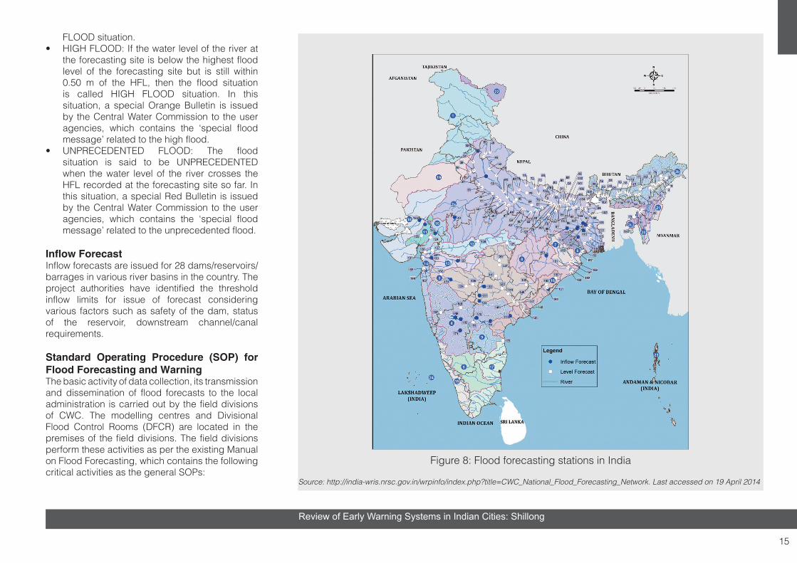
Flood Forecasting & Warning OrganizationIn the year 1958, CWC commenced the flood forecasting service in a small way by establishing flood forecasting unit for issuing water level forecasts of the Yamuna for the National Capital, Delhi. On the recommendation of various committees/panels, a Flood Forecast and Warning Organization was set up in CWC in 1969 to establish forecasting sites on inter-state rivers
at various flood prone places in the country. The National Flood Forecasting and Warning Network of Central Water Commission, comprises 175 flood forecasting sites, including 28 inflow forecasting sites in flood season (Figure 9).
Central Water Commission, through its 20 flood forecasting divisions, issues forecasts to the various user agencies, which include civil/engineering agencies of the State/Central Governments such as irrigation/revenue/railways/public undertakings and Dam/Barrage Authorities/District Magistrates/Sub-divisional Officers besides the Defence Authorities involved in the flood loss mitigation work. During the flood season, the Honourable Minister of Water Resources, Government of India, the Chairman and the Member (River Management) of Central Water Commission are apprised of the latest flood situations in the above river basins in the country.
Classification of Various Flood SituationsThe Central Water Commission has categorized various flood situations for monitoring the floods in the country though its flood forecasting network, into the following four categories, depending upon the severity of floods, based on flood magnitudes.
Level Forecast• LOW FLOOD: The river is said to be in LOW
FLOOD situation at any flood forecasting site when the water level of the river touches or crosses the warning level, but remains below the danger level of the forecasting site.
• MODERATE FLOOD: If the water level of the river touches or crosses its danger level, but remains 0.50 m below the highest flood level of the site (commonly known as HFL) then the flood situation is called the MODERATE
2.5 EWS Framework for Floods
15
Review of Early Warning Systems in Indian Cities: Shillong
FLOOD situation.• HIGH FLOOD: If the water level of the river at
the forecasting site is below the highest flood level of the forecasting site but is still within 0.50 m of the HFL, then the flood situation is called HIGH FLOOD situation. In this situation, a special Orange Bulletin is issued by the Central Water Commission to the user agencies, which contains the ‘special flood message’ related to the high flood.
• UNPRECEDENTED FLOOD: The flood situation is said to be UNPRECEDENTED when the water level of the river crosses the HFL recorded at the forecasting site so far. In this situation, a special Red Bulletin is issued by the Central Water Commission to the user agencies, which contains the ‘special flood message’ related to the unprecedented flood.
Inflow ForecastInflow forecasts are issued for 28 dams/reservoirs/barrages in various river basins in the country. The project authorities have identified the threshold inflow limits for issue of forecast considering various factors such as safety of the dam, status of the reservoir, downstream channel/canal requirements.
Standard Operating Procedure (SOP) for Flood Forecasting and WarningThe basic activity of data collection, its transmission and dissemination of flood forecasts to the local administration is carried out by the field divisions of CWC. The modelling centres and Divisional Flood Control Rooms (DFCR) are located in the premises of the field divisions. The field divisions perform these activities as per the existing Manual on Flood Forecasting, which contains the following critical activities as the general SOPs:
Figure 8: Flood forecasting stations in India
Source: http://india-wris.nrsc.gov.in/wrpinfo/index.php?title=CWC_National_Flood_Forecasting_Network. Last accessed on 19 April 2014

16
Review of Early Warning Systems in Indian Cities: Shillong
1. Nomination of Nodal Officers of CWC for interaction with the Nodal Officers of the concerned State Governments before monsoon every year
2. Gearing up of flood forecasting network before monsoon every year
3. Operation of Divisional Flood Control Room during monsoon every year
4. Operation of Central Flood Control Room (CFCR) during monsoon every year
5. Issue of flood forecasts to designated officer of the concerned state and transmission thereof through FAX/telephone/email/through special messengers during monsoon every year
6. Sending flood alerts through SMS on mobile phones to the concerned officers of State/Central Government during high and unprecedented flood situations as per Standard Operating procedure (SOP) for issuing alerts and electronic messaging in the event of disaster situations issued by National Disaster Management Division, Ministry of Home Affairs, vide letter No: 31-32/2003-NDM-III/II dated 10 April 2006, made effective from 24 April 2006.
For the purpose of dissemination of alerts to PMO/Cabinet Secretariat, a uniform system has been devised by categorizing each type of alert in stages – Yellow, Orange and Red.
Standard Operating Procedure (SOP) for Urban FloodingUnderstanding the repercussion of urban flooding and the actions to be taken to mitigate the disaster, Standard Operating Procedure (SOP) for Urban Flooding was released by Ministry of Urban Development. Government of India in May 2017.
Urban Flooding SOP prepared, in such a manner that it guides, the specific actions required to be undertaken by various departments and agencies in a city/town and also organizations under the district administration as well as State Government for responding to urban flooding/disaster of any magnitude.
In order to check the risk of urban flooding. it is suggested that each city should have their Flood mitigation plans (floodplain, river basin, surface water, etc.) strongly embedded within the overall land use policy and master planning of a city. A prompt, well-coordinated and effective response mounted in the aftermath of urban floods not only minimizes casualties and loss of property but also facilitates early recovery. The Standard Operating Procedures (SOP) covers the following three phases of disaster management for effective and efficient response to urban flooding:
Pre-Monsoon Phase:Preparedness: Planning for Disaster Reduction
During Monsoon Phase:Early WarningEffective Response and ManagementRelief planning and execution
Post-Monsoon Phase:Restoration and Re-habilitation
The SOP also includes geographic location and physiographic conditions of cities, which needs to be taken care of while developing the city specific SOP. It is also suggested that each city /ULB to establish Emergency Operations Centre (EOC) which will be under Control of District Commissioner/ District Magistrate / Municipal
Commissioner.
The EOCs/Control Rooms (EOC/CR) at the city will be the brain & nerve for coordination and management of all emergencies. EOC may be located either in Municipal corporation office or at a suitable safe location. The EOC will be the lead agency of the city for Disaster preparedness/Rescue/Relief / Restoration and Rehabilitation functions.
Key Functions of EOC: • Coordination with line agencies• Policy Making and plan preparation including
action plans as per SOP• Direction and Monitoring of Operations
Management.• Information gathering and record keeping• Preparation of web enabled resource inventory
under India Disaster Resource Network (IDRN).• Public Information and Citizen updation• Resource Management• Reporting
Heat wave conditions develop over major parts of the country during the mid-season, which often persist until the monsoon advances over the region. Heat wave need not be considered till the maximum temperature of a station reaches at least 40 °C for plains and at least 30 OC for hilly regions. The specifications for declaring the heat/cold wave conditions have been revised three times by IMD so far, viz., in 1978, 1989 and last in 2002. The revised criteria are prevalent with effect from 1 March 2002, along with some additional circulars on comfort index-based temperature forecast,
2.6 EWS Framework for Heat Wave Condition

17
Review of Early Warning Systems in Indian Cities: Shillong
Relative Humidity (%)Temp. 40 45 50 55 60 65 70 75 80 85 90 95 100
110 (43)
136 (58)
108 (42)
130 (54)
137 (58)
106 (41)
124 (51)
130 (54)
137 (58)
104 (40)
119 (48)
124 (51)
134 (55)
137 (58)
102 (39)
114 (46)
119 (48)
124 (51)
130 (54)
137 (58)
100 (38)
109 (43)
114 (46)
118 (48)
124 (51)
129 (54)
136 (58)
98 (37)
105 (41)
109 (43)
113 (45)
117 (47)
123 (51)
128 (53)
134 (57)
96 (36)
101 (38)
104 (40)
108 (42)
112 (44)
116 (47)
121 (49)
126 (52)
132 (56)
94 (34)
97 (36)
100 (38)
103 (39)
106 (41)
110 (43)
114 (46)
119 (48)
124 (51)
129 (54)
136 (58)
92 (33)
94 (34)
96 (36)
99 (37)
101 (38)
106 (41)
108 (42)
112 (44)
116 (47)
121 (49)
126 (52)
131 (55)
90 (32)
91 (33)
93 (34)
95 (35)
97 (36)
100 (38)
103 (39)
106 (41)
109 (43)
113 (45)
117 (47)
122 (50)
127 (53)
132 (56)
88 (31)
88 (31)
89 (32)
91 (33)
93 (34)
95 (35)
98 (37)
100 (38)
103 (39)
106 (41)
110 (43)
113 (45)
117 (47)
121 (49)
86 (30)
86 (29)
87 (31)
88 (31)
89 (32)
91 (33)
93 (34)
95 (35)
97 (36)
100 (38)
102 (39)
106 (41)
108 (42)
112 (44)
84 (29)
83 (28)
84 (29)
85 (29)
86 (30)
88 (31)
89 (32)
90 (32)
92 (33)
94 (34)
96 (36)
98 (37)
100 (38)
103 (39)
82 (28)
81 (27)
82 (28)
83 (28)
84 (29)
84 (29)
86 (29)
86 (30)
88 (31)
89 (32)
90 (32)
91 (33)
93 (34)
95 (35)
80 (27)
80 (27)
80 (27)
81 (27)
81 (27)
82 (28)
82 (28)
83 (28)
84 (29)
84 (29)
85 (29)
86 (30)
86 (30)
87 (31)
Uncomfortable hot day/night
Uncomfortable sultry day/night
Highly uncomfortable day/night
Highly uncomfortable sultry day/night
Figure 9: Heat Index OF (OC)Source: Forecasting Guide, IMD (2008)
Category Heat IndexPossible Heat
disorders for people in high risk groups
Extreme Danger
130OF (54OC) or higher
Heat stroke or sunstroke likely
Danger 105-129OF41-54OC
Sunstroke, muscle cramps and/or heat exhaustion likely. Heat-stroke possible with pro-longed exposure and/or physical activity
Extreme Caution
90-105OF32-41OC
Sunstroke, muscle cramps and/or heat exhaustion possible with prolonged exposure and/or physical activity
Caution 80-90OF27-32OC
Fatigue possible with prolonged exposure and/or physical activity

18
Review of Early Warning Systems in Indian Cities: Shillong
description of 24-hour temperature tendency etc. When the actual maximum temperature remains 45 OC or more, irrespective of normal maximum temperature, heat wave should be declared.
Hot Day – In the northern plains of the country, dust in suspension occurs for several days, bringing the minimum temperature much higher than normal and keeping the maximum temperature around or slightly above normal. Sometimes, increase in humidity also adds to this discomfort. Nights do not get cool and become uncomfortable. To cover this situation, hot day concept has been introduced. Whenever the maximum temperature remains 40OC or more and minimum temperature is 5OC or more above normal, it may be defined as Hot Day, provided it does not satisfy the heat wave criteria given above. Criteria for describing Hot Day for coastal stations are different. When the maximum temperature departure is 5OC or more from normal, Hot Day may be described irrespective of the threshold value of 40OC. If the threshold value of 40OC is reached, Heat Wave may be declared. When a station satisfies both the Heat Wave and Hot Day criteria, then Heat Wave should be given higher priority and be declared.
Hot Wind – Hot wind reduces moisture causing dehydration, and prolonged exposure may prove to be fatal. The phenomenon of Loo (heat wave) over the plains of northwest India is very well-known. It is also described in the weather bulletins and appropriate warnings are issued.
Comfort Index – As per the recommendation of Annual Monsoon Review Meeting, 2004 (Kolkata, January 2004), it has been decided to replace the mere descriptions of maximum and minimum temperatures in weather reports and daily weather summaries by suitable comfort index, based on
temperature and humidity as described below with reference to issuance of local forecast at forecasting centres. The recommendations cited are as follows:1. Present procedure of issuing local forecast for meteorological parameters, including heat and cold waves, is to continue.
2. In addition to the above forecast, supplementary forecast based on human discomfort utilizing the Heat Index (HI) may be introduced on a trial basis for one year.
3. The HI is to be calculated based on the forecast of maximum temperature and that of relative humidity. Suggested criteria and terminology for issuing human discomfort information are given below. For day time, the criteria will be considered only when the departure of maximum temperature is above 2oC.
4. Regarding discomfort due to low temperatures during winter season, the present criteria using the wind chill index may continue.
5. The use of issuing discomfort forecast will be reviewed after one year based on the feedback from users.
Integrated Disease Surveillance Project (IDSP) was launched in November 2004 to detect and respond to disease outbreaks quickly. The programme continues in the 12th Plan under NRHM.
Surveillance units have been established in all states/districts (SSU/DSU). Central Surveillance Unit (CSU) has been established and integrated with the National Centre for Disease Control, Delhi.
Training of state/district surveillance teams and Rapid Response Teams (RRT) has been completed for all 35 states/UTs.
IT network connecting 776 sites in States/District HQ and premier institutes has been established with the help of National Informatics Centre (NIC) and Indian Space Research Organization (ISRO) for data entry, training, video conferencing and outbreak discussion.
Under the project, weekly disease surveillance data on epidemic prone disease are being collected from reporting units such as sub-centres, primary health centres, community health centres, hospitals, including government and private sector hospitals, and medical colleges. The data are being collected on ‘S’ syndromic, ‘P’ probable and ‘L’ laboratory formats using standard case definitions. Presently, more than 90 per cent districts report such weekly data through email/portal (www.idsp.nic.in). The weekly data are analysed by SSU/DSU for disease trends. Whenever there is rising trend of illnesses, it is investigated by the RRT to diagnose and control the outbreak.
States/districts have been asked to notify the outbreaks immediately to the system. On an average, 30 to 40 outbreaks are reported every week by the states. About 553 outbreaks were reported and responded to by the states in 2008, 799 outbreaks in 2009, 990 in 2010, 1675 outbreaks in 2011, 1584 outbreaks in 2012, 1964 outbreaks in 2013 and 67 outbreaks in 2014 have been reported till 26 January 2014.
2.7 EWS Framework for Public Health Risks

19
Review of Early Warning Systems in Indian Cities: Shillong
Media scanning and verification cell was established under IDSP in July 2008. It detects and shares media alerts with the concerned states/districts for verification and response. A total of 2595 media alerts were reported from July 2008 to January 2014. Majority of alerts were related to diarrhoeal diseases, food poisoning and vector-borne diseases.
A 24X7 call centre was established in February 2008 to receive disease alerts on a toll free telephone number (1075). The information received is provided to the states/districts surveillance units for investigation and response. The call centre was extensively used during H1N1 influenza pandemic in 2009 and dengue outbreak in Delhi in 2010. About 2,77,395 lakh calls have been received from the beginning till 30 June 2012, out of which 35,866 calls were related to influenza A H1N1. From November 2012, a total of 57,855 calls were received till January 2014, out of which 1605 calls were related to H1N1.
About 50 district laboratories are being identified and strengthened for diagnosis of epidemic-prone diseases. These labs are being supported by a contractual microbiologist to manage the laboratory. About 29 states (42 labs) have completed the procurement. In addition, a network of 12 laboratories has been developed for influenza surveillance in the country. In nine states, a referral lab network has been established by utilizing the existing 65 functional labs in medical colleges and various other major centres in the states and linking them with adjoining districts for providing diagnostic services for epidemic-prone diseases during outbreaks. Based on the experience gained, the plan will be implemented in the remaining 26 states/UTs. A total of 23 medical college labs,
identified in Bihar, Assam, Odisha, Tripura, Kerala, Haryana, Jammu & Kashmir and Manipur, have been added to the network during 2012–13 to provide support in the adjoining districts.
Considering the non-availability of health professionals in the field of epidemiology, microbiology and entomology at district and state levels, MOHFW has approved the recruitment of trained professionals under NRHM to strengthen the disease surveillance and response system by placing one epidemiologist each at state/district headquarters, and one microbiologist and entomologist each at the state headquarters.

20
Review of Early Warning Systems in Indian Cities: Shillong
A systematic process was adopted by the Review A systematic process was adopted by the Review Team to assess the EWS, particularly with respect to the systems for geological, hydro-meteorological and public health risks in all the three cities.
The assessment involved a systematic flow of understanding the EWS governance at the national, state, district and city levels; institutional mechanism and their roles within the elements of EWS, delivery of products and services by technical and disaster management agencies, as well as their coordination mechanism/operational cooperation; reviewing of existing mechanism of EWS in cities; role of agencies in EWS and their integration in the disaster management institutional framework (City Disaster Management Plan); discussing with stakeholders the gaps and needs in the EWS, capacities of institutions (technical agencies) engaged in EWS, operational cooperation of technical agencies with the emergency departments/functionaries at the district and city levels (emergency management structure and response capabilities), current status and future needs of observation and monitoring capabilities, data management systems; seeking information on pre-computed assessment of risks for various intensity of hazards (risk assessment), hazard analysis and prediction capabilities (threat assessment/potential impact assessment), warning formulation/issuing of guidance and potential outlook/provision of actionable early warning information/warning products, decision making, generation of tailored risk information and dissemination of risk information to at-risk communities or hot-spot locations (risk
communication), information technology and telecommunication capabilities, preparation of response options, institution/emergency responders and community response.
The assessment was based on the information obtained through a set of processes. They are as follows:
• Design of the review framework by the Review Team
• A checklist and questionnaire prepared by the Review Team for obtaining information from technical and disaster management agencies
• Mission to select cities to understand the EWS environment
• Development of Criteria Development Matrix taking into consideration all the key elements of End-to-End EWS (Figure 3)
• Information collected through stakeholder consultations/meetings, workshops in respective cities, discussions with programme focal point in cities, meeting with key experts
• Exchange and mid-term feedback from UNDP programme team
• Development of Policy Brief, where key recommendations cited are discussed for endorsement at the policy level
• Workshop with city stakeholders, sharing of results
• Final report and presentation
The review includes key criteria as indicated in RFP for following key components:
1. TECHINCAL DESIGN / STRUCTURE AND EFFICACY OF EXISTING EWS: Assessment of early warning agencies, communication networks, protocols for issue of warning and transmission to the people. The review should
also assess how the residents of the city access the information and how they act upon it.
2. TECHNOLOGIES INVOLVED IN EWS: Review the network design, technical specifications, up-time performance standards, connectivity and integration with all the important facilities and installations, emergency services, and the DM system in the city.
3. MODE OF COLLECTING HAZARD RELATED INFORMATION (Geological hazards, hydrometeorological hazards and disease risks): Review the mode of collecting information related to hazard events, monitoring, and transmitting it to other agencies, particularly the municipal government and district administration.
4. WARNING OUTREACH AND LAST MILE CONNECTIVITY: Review the mode and reach of the warning especially last mile connectivity and dissemination plan through mass media, print and audio-visual medium.
5. MESSAGE CONTENT AND APPROPRIATENESS: Review the messages disseminated through the EWS: on timeliness, appropriateness, accuracy, and simplicity parameters.
6. SERVICE SUPPORT AND SYSTEM MAINTENANCE: Review the service support for maintaining the EWS on a regular basis and ensuring 100 percent uptime.
The schematic diagram (Figure 4) is an illustration of institutional mechanism and decision making around the key warning chain elements. Numbers 1 to 6 in the schematic highlight the core components for evaluating the warning system provided by the technical agencies (national/state/city) to the DM agencies and other DRR stakeholders. The description of the core components and the
3. METHODOLOGY OF REVIEW

21
Review of Early Warning Systems in Indian Cities: Shillong
evaluation principles are summarized below:
1. EWS GOVERNANCE: National, State and City Level Institutional Framework: EWS is underpinned by ministry/department/technical institutions providing operational nowcast/forecasts, products and services to a wide range of users/community. EWS in India is underpinned by legislation (DM Act 2005, State Disaster Management Act, State Disaster Management Policy) and institutional framework that clearly define the roles and responsibilities of various stakeholders among the key warning chain elements. Emphasis under this component was given towards understanding of the organizational coordination and cooperation mechanism (decision making and feedback across key warning elements), and allocation of resources at the city level (functional EOC, risk assessment, human resource capacity).
2. USER NEEDS: The users in the city are spread across government agencies (district DM authority, city DM authority/local authority, emergency services, first responders); communities at risk; general public; NGOs/CBOs; urban service providers (government and private: line departments such as water supply, storm water drainage, drainage, sanitation, health, transportation, energy, law and order); various sectors of the economy including business establishments, trade and commerce; and the media. The requirements and needs of EWS products and services vary among different users.
3. OPERATIONAL COMPONENTS OF EWS: The tasks of the technical agencies and disaster management agencies include developing products and offering a range of services across the warning chain elements. Observation, monitoring, prediction analysis and operational forecasting are
core capacities to be exhibited by the technical agencies. The technical agencies rely on a range of supporting functions such as data gathering, data analysis, IT and telecommunication services and product development through qualified and trained staff. The prediction/operational forecast of hazard onset and hazard intensity are to be further translated into the potential impact assessment at the city level and the surrounding regions. In case of the city having a reservoir/dam located upstream, regional forecast needs to further take into account the opening of the reservoir gates and subsequent inundation scenarios for emergency release.
Risk assessment, risk communication and preparedness for emergency response/evacuation are the responsibilities of the local government/DM stakeholders (as identified in the City DM Plan). Guidelines and procedures typically follow the Standard Operating Procedure (SOP) as outlined in the City DM Plan. A sufficient number of qualified and trained staff undertakes the response functions through designated Emergency Support Functions (ESF). The nerve centre of operations during emergency is the City Emergency Operation Centre (EOC equipped with tools for decision support), which functions as the main hub for all emergency functions during the onset of hazard and during the impact, and shall remain operational until the threat phenomenon subsides. Organizational coordination and cooperation mechanism between ESFs are essential for effective delivery of early warning produced/generated by technical agencies.
City-level product development includes outputs derived from risk assessment studies, tailored risk information generated for the event, relevant information technology and telecommunication
services for outreach and capability to handle emergency response.
4. PRODUCTS AND SERVICES ACROSS THE WARNING CHAIN: A wide range of products and services aid in decision making. While technical agencies undertake hazard monitoring, detection, analysis, prediction and forecasting (issue advisories to key stakeholders for initiating decisions), risk information will have to be tailored to the requirements of the city and communities at risk.
5. COORDINATION MECHANISM: A large number of institutions are involved in the warning chain elements. Each institution plays an essential role and there is a need for synergy and collaboration between forecasting (warning, data exchange through hydro-meteorological services, climate services, public health etc.) and DM agencies. It is important to analyse if there are any specific provisions of expertise by the technical agencies to the DM stakeholders that could support or enhance decision making.
6. SERVICE DELIVERY AND FEEDBACK LOOPS: While technical agencies issue the forecast and related warning, DM agencies have to understand the user needs and ensure effective and timely delivery of the services (overarching capacities in quality management system is essential for service delivery across functions). Feedback mechanism across the warning element chain helps in improving delivery/quality of product and services over time.
The elements of EWS and components have been integrated into the development of Criteria Development Matrix (CDM).

Review of Early Warning Systems in Indian Cities
EWS Governance
National, Regional & State Technical Agenceis
National, State, District & City DM Agenceis
Hydro-meteoro-logical Services
Ocean Services Public Health SDMA / State EOC
DDMA / City DM Authority
City EOC / Emergency Responders
EWS Core ServicesTechnical Services Disaster Management
Operational Components
Products and Services
Operational Components
Products and Services
* Observation & Monitoring
* Prediction
* Operational NowCasting
* Forecasting
* Continued Analysis
* Data Analysis
* Advisories, Warning & other forecast products
*Specific Analysis & Technical advice
* Risk Assessment
* Potential Impact Assessment
* Tailored risk information
* ESF
* SOP
* Risk communication
* Risk Assessment
* Generation of Tailored risk communication at timescale
* Emergency Response
* Evacuation
* Data Management Systems* Information Technology and Telecommunication Services* Decision Support Systems* Qualified and Trained Human Resources
City EWS users
District DM Authority
City DM Authority
Municipal Corporation
Emergency Services/ESF
First Responders
Communities at risk
General Public
NGOs/CBOs
Business establishment
Trade and Commerce
Media
Urban Service providers
Water supply & Drainage
Sanitation
Public Health
Transportation
Energy
Law and Order
Service Delivery
and Feedback
Loops
Component 1 Component 2 Component 3 Component 4 Component 5 Component 6
1
3 4
6
2
Coordination Mechanism5
Figure 10: Study framework schematic showing the links of stakeholders across the development model of EWS Note:Various components analysed are numbered (as in the text) in the schematic

23
Review of Early Warning Systems in Indian Cities: Shillong
The review of EWS employs a range of criteria across six components and subsequent assessment to arrive at the level of development. Based on the past research and studies, the study has adopted the Criteria Development Matrix to review EWS in three cities. The Criteria Development Matrix indicates the possibility of considering five stages of development for each criterion built around the six components of the development model of EWS. The Criteria Development Matrix will indicate the progress as basic (Stage 1 development, which is
characterized as rudimentary) to the most advanced (Stage 5 development, which is characterized as current state-of-art and is judged to have reached the fully developed stage containing no major shortcomings). Stages 2, 3 and 4 are characterized as intermediate stages of development. Each of the disaster warnings (hydro-meteorological services, ocean services, climate services and public health services) will be assessed against each criterion and each development stage shall produce a profile indicating the overall stage of development (thereby highlighting gaps and perspective paths for improvement). The level of development stage is based on existing conditions and this can be modified based on the signs of improvement
4. CRITERIA DEVELOPMENT MATRIX AND DEVELOPMENT STAGE INDICATORS FOR EWS
towards a robust EWS at the city level. Subsequent criteria may be added on in further studies or comprehensive EWS audit exercise.
Criteria Development Matrix has been developed through several rounds of discussions by the review team and is in close alignment to the context of EWS development in India. Table 1 highlights six components identified for the review. It defines 35 criteria and details the development stage for each of the criteria. In the review for each city, specific comments/remarks are highlighted for selection of the development stage for each criterion. An overall score indicates the performance of EWS in the city.
S. NO.
COMPONENT 1 EWS GOVERNANCE - CITY LEVEL INSTITUTIONAL FRAMEWORK
CRITERIADEVELOPMENT STAGE INDICATORS
1 2 3 4 5
1.1
State legislation for EWS framework includes local authority (Urban Local Body) as an integral part (document, control to the ULB)
Not envisagedNeed is realized, changes in legislation are in process
In place, but not implemented
In place, partially implemented
In place and implemented
1.2Institutional mechanism for Local Authority (ULB) is an integral part of EWS framework (document, mandate, implementation)
Not envisaged
Need is realized, changes in institutional mechanism are being brought about
In place, but mandate remains unclear
In place, but partially implemented
In place and implemented
1.3ULB accorded with the authority to disseminate warnings (mandate, SOP, implementation)
Not envisaged
Mandate does not exist but informal dissemination happens
Mandate exists for dissemination with no SOP in place
Mandate and SOPs in place, implementation not effective
Mandate and SOP in place with effective implementation
1.4
Extent of preparedness and prevention actions evident among state technical and disaster management agencies (relevant department DM Plan at state, SOPs, link from state to city)
Select departments have DM Plan, but it is not implemented
All departments have DM Plan, partially implemented
All departments have DM Plan and SOP in place and implemented, but not integrated across
All departments have DM Plan, SOP in place, implemented and integrated across state departments
All departments have DM Plan, SOP in place, implemented, integrated across state departments and with links to the city
Table 3: Criteria development matrix: Criteria and indicators of the condition of ews in cities

Review of Early Warning Systems in Indian Cities
S. NO.
COMPONENT 2 USER NEEDS
CRITERIADEVELOPMENT STAGE INDICATORS
1 2 3 4 5
2.1 Hotspots identified for potential hazard impact (identified, mapped and updated) Hotspots not identified
Hotspots vaguely identified through past incidence records, not demarcated
Hotspots identified and mapped across city for selected hazards
Hotspots identified and mapped across the city for all hazards, not updated at regular intervals
Hotspots identified and zone of demarcation updated on regular intervals
2.2 Outreach practice (dissemination of warning)
No formal practice for any hazard
Only for select hazards to key government institutions and media
All hazards to key government institutions and media
All government institutions, media, community based organizations
Last mile connectivity established (End-to-End), specific information to select vulnerable communities
2.3Timely dissemination of warnings to vulnerable groups (residing in slums, high risk prone areas)
No specific warning for vulnerable groups exists in the city
Dissemination of warning exists to some extent
Dissemination of warning exists for select hazards, but with limited respite time
Dissemination of warning exists for all hazards, but with limited respite time
Dissemination of warning exists, with sufficient respite time
2.4 Arrangement for night-time warning (limited to floods, landslides, cyclones,tsunamis)
No specific arrangement for warning in night time
Recognition of the need, planning in progress
Night-time warning is recognized and arrangements reflect this, scope for considerable improvement in dissemination/ outreach
Night-time warning dissemination and outreach established
Warning dissemination tested through conduct of emergency night-time drills/event
2.5 Media engagement in dissemination of warning
Limited coverage, media collects information from respective agencies, shortcomings in communication
Limited coverage of information from respective agencies, technical information presented as received from agencies, shortcomings in communication, problem recognized but not addressed
Media collects and disseminates information, shortcomings are being addressed through collaboration with agencies
Media collects information from technical agencies, timely dissemination of warning to citizens in an understandable format (authenticated value addition)
Standardized content with graphical/iconic representation, near real time updates, citing possible impacts
2.6
Content of warning to general public by local government (ULB) (graphical representation and behavioural content for taking actions at individual/household and community levels)
Limited informationAdequate information for select hazards, but with no behavioural content
Adequate information for relevant hazards, but with no behavioural content
Warning information with graphical, factual representation and general behavioural content at city level
Warning information with graphical, factual representation at ward level and contextual behavioural information provided

Review of Early Warning Systems in Indian Cities
S. NO.
COMPONENT 3 OPERATIONAL COMPONENTS OF EWS
CRITERIADEVELOPMENT STAGE INDICATORS
1 2 3 4 5TECHNICAL AGENCIES
3.1Risk assessment and integration with potential impact assessment (identification, mapping, integration)
Risk assessment does not exist
Risk prone areas identified based on historical data, past disasters and other qualitative information in the form of institutional memory and tabular records
Risk assessment undertaken with technical information and demarcates risk prone administrative units, risk assessment products available in the form of maps and quantitative information
Risk assessment (hazard maps, vulnerability and risk maps) available on GIS platform but not updated periodically and not fully integrated with prediction component to derive potential impact assessment and stage response
Risk assessment updated periodically (available on GIS platform) and fully integrated with prediction component to derive potential impact assessment and stage focused response
3.2.1Warning mechanism for geophysical hazards: Earthquake, Landslide and Tsunami
Warning mechanism does not exist
Warning exists with no consistency in warning message and inadequate respite time
Consistency in warning message with inadequate respite time
Consistency in warning message with adequate respite time
Advanced warning protocol with adequate respite time (with multiple relay and deactivation process)
3.2.2
Warning mechanism for hydrometeorlogical hazards: Cyclone, Severe Winds, Stormsurge, Heatwave, Coldwave, Snow, Extreme Rainfall, Fluvial Flood and Pluvial Flood
Warning mechanism does not exist
Warning exists with no consistency in warning message and inadequate respite time
Consistency in warning message with inadequate respite time
Consistency in warning message with adequate respite time
Advanced warning protocol with adequate respite time (with multiple relay and deactivation process)
3.2.3
Warning mechanism for public health risks: Vector borne diseases, Water borne diseases and other communicable diseases
Advisory does not exist
General advisory exists with no indication of areas and vulnerable groups
Advisory exists for vulnerable groups with no demarcation of areas
Demarcation of areas based on active and passive surveillance with time delay, no involvement of private stakeholders
Near real time warning, protocol established, active and passive surveillance along with involvement of private stakeholders
3.3.1Availability of technology to nowcast/forecast of geophysical hazards by technical agencies
High dependency on national agencies for observation, monitoring and forecasting
Has sufficient technology to observe, monitor and nowcast/forecast at regional level, with high dependency on technology available at regional centres
Has sufficient technology to observe, monitor and nowcast/forecast at district level
Has sufficient technology to observe, monitor and nowcast/forecast at city level
Has sufficient technology to observe, monitor and nowcast/forecast at community level/hotspots

26
Review of Early Warning Systems in Indian Cities: Shillong
S. NO.
COMPONENT 3 OPERATIONAL COMPONENTS OF EWS
CRITERIADEVELOPMENT STAGE INDICATORS
1 2 3 4 5
3.3.2
Availability of technology in nowcast/forecast of hydro-meteorological hazards by technical agencies
High dependency on national agencies for observation, monitoring and forecasting
Has sufficient technology to observe, monitor and nowcast/forecast at regional level, with high dependency on technology available at regional centres
Has sufficient technology to observe, monitor and nowcast/forecast at district level
Has sufficient technology to observe, monitor and nowcast/forecast at city level
Has sufficient technology to observe, monitor and nowcast/forecast at community level/hotspots
3.3.3
Disease surveillance system(surveillance coverage, collection method, analysis)
Surveillance exists at district level using paper-based forms; analysis undertaken at district level
Surveillance exists at city level within government hospitals using paper-based forms; analysis undertaken at city level
Surveillance exists at city level within government hospitals, private hospitals and all clinics; using paper-based forms; analysis undertaken at city level
Surveillance exists at city level within government hospitals, private hospitals and all clinics; using computerized data collection; analysis and mapping undertaken at community level
Detailed surveillance is carried out on a near real time basis, disease forecast information is made available for decision making
3.4
Uncertainty in forecast and warning: Geophysical hazards, Hydro-meteorological hazards and Public health risks
Forecast/warning does not exist
Forecast exists with high uncertainty, and no warning exists
Forecast exists with high uncertainty, followed by incomprehensible warning
Warning based on forecast exists, with medium degree of uncertainty
Warning based on forecast exists, with low degree of uncertainty
DISASTER MANGEMENT AGENCY / LOCAL AUTHORITY (ULB)
3.5 Budget allocation by the local authority for EWS
Budget head doesn’t exist
Budget head doesn’t exist, currently being spent from miscellaneous heads
Need for DM budget head realized, plan to incorporate budget for Disaster Management
Budget exists for DM, no specific budget head exists for EWS
Budget exists for DM, specific sub-head for EWS exists
3.6 Data availability for operations of EWS
Data available with different agencies in multiple formats, not collated or aggregated, qualitative information available
Data is collated from different departments, partial digitization undertaken but not updated regularly; currently not in usable format
Data is collated and updated regularly, limited quality assurance and quality control, temporal data available, spatial data not available, data is of limited use
Data is collated and updated regularly, quality assurance and quality control, temporal and spatial data available, data available in limited usable format
Standardized spatial and temporal data are collated and updated regularly for city EWS, single window system exists for data updation and dissemination, data available in usable format

27
Review of Early Warning Systems in Indian Cities: Shillong
S. NO.
COMPONENT 3 OPERATIONAL COMPONENTS OF EWS
CRITERIADEVELOPMENT STAGE INDICATORS
1 2 3 4 5
3.7 Staffing and capacity within local authority for operation and maintenance of EWS
No dedicated staff for EWS
Staff deputed on need basis, not specifically trained for operating EWS
Manpower hired on short-term basis, limited training and capacity building provided
Staff assigned for EWS but with multiple responsibility (other than EWS), limited training and capacity building provided
Dedicated specialized staff assigned for city EWS, training and capacity building of staff conducted at regular intervals
3.8 Use of modern technology to disseminate warnings
Generic media – newspapers, local cable channel and radio
In addition to generic media, public addressal system (PAS) in place, but limited to siren
In addition to generic media, PAS in place, but limited to siren and digital display at select locations
Fixed and vehicle mounted PAS, digital/electronic display screen at select locations, mobile (SMS), web, community radio
State-of-art alert and warning system, dedicated channel, online dissemination system
3.9 Redundancy (multi-mode) in communication networks None
Recognition of need, no special arrangements made
Recognition of the need and development in process
Warning system reflects the arrangement, partially developed, but scope for considerable improvement
Well-developed redundancy in communication network
3.10City Emergency Operations Centre (EOC) for housing information related to hazard, vulnerability and risk
EOC does not exist
EOC is activated on a need basis, no information on hazard/vulnerability and risk
Need for permanent EOC recognized by ULB, and development in progress
EOC established with limited technical and human resource support, and has information on hazard/vulnerability and risk
EOC established with adequate technical and human resources (manned 24X7), SOP for EOC, systems exist to provide risk information and disseminate it to stakeholders for preparedness and response on near real time basis

28
Review of Early Warning Systems in Indian Cities: Shillong
S. NO.
COMPONENT 4 PRODUCTS AND SERVICES ACROSS THE WARNING CHAIN
CRITERIADEVELOPMENT STAGE INDICATORS
1 2 3 4 5
4.1 Degree of local details incorporated in warnings
Only generalized warnings from technical agencies
Generalized warnings from technical agencies, need for incorporation of local details is recognized, system under development
City level macro details are incorporated within warnings
Ward details (including hot spots) are incorporated within warnings
Sub-ward/locality/community details incorporated in warnings (including ward, hotspots); measures cited to take action
4.2 Raising awareness about warnings at city level
No efforts are being made to sensitize citizens
Efforts are made to raise public awareness on frequent hazards, need basis
Awareness programmes on frequent hazards and their risks are conducted on regular/seasonal intervals, special population needs are also not addressed and programme not evaluated
Comprehensive programmes on all hazards and their risks are conducted on regular basis, special population needs addressed, but programme not evaluated
Comprehensive programmes on all hazards and their risks are conducted to raise the level of public awareness, programme regularly evaluated and strengthened
4.3
Ability of technical agencies and disaster management institutions to cater to early warning products and services to user specific requirements
User need assessment not undertaken
User need assessment undertaken, products identified
Products generated for select hazards catering to selected users
Products generated for select hazards catering to selected users, details available to take actions
Products generated for all hazards catering to all users, and details available to take actions
4.4 Risk communication Risk assessment does not exist, hence no communication
Risk not assessed in local context, information generated by technical agencies are transferred and published/disseminated
Risk is assessed in local context and communicated to select stakeholders
Risk communication including preparedness measures are communicated to stakeholders, dissemination is not robust (last mile connectivity is not ensured)
Well-established risk communication mechanism enables stakeholders to manage risk, dissemination is robust (last mile connectivity is ensured)

29
Review of Early Warning Systems in Indian Cities: Shillong
S. NO.
COMPONENT 5 COORDINATION MECHANISM
CRITERIADEVELOPMENT STAGE INDICATORS
1 2 3 4 5
5.1Extent of coordination between technical agencies and disaster management agencies
Communication is limited to select agencies
Communication with all agencies exist, coordination does not exist
Communication with all agencies exist, limited coordination exists
Coordination mechanism ensures agencies respond to specific needs
Coordination ensures collective decision making
5.2Extent of links between disaster management agencies and service providers
No formal links exist, service providers depend on information hosted on public domain
Formal links do not exist, select service providers are informed during the onset of an event
Formal links become active only prior to/during an event
Formal links become active periodically in anticipation of an event, one way communication initiated from disaster management agency
Formal links become active periodically in anticipation of an event, two way communication established to ensure business continuity, co-benefit achieved
5.3 Extent of links between media and disaster management agencies
Media depend on information hosted on public domain
Limited information is provided to media
Collaboration and reflection of warning information in the media products are evident
Active collaboration exists, understanding of warnings are reinforced through discussions, no value addition
Well-developed links exist, seamless flow of information, value addition to warning is evident

30
Review of Early Warning Systems in Indian Cities: Shillong
S. NO.
COMPONENT 6 SERVICE DELIVERY AND FEEDBACK LOOPS
CRITERIADEVELOPMENT STAGE INDICATORS
1 2 3 4 5
6.1 User community's knowledge of early warning system and its effectiveness
ULB does not have clear understanding of existing early warning systems
ULB is aware of early warnings, but does not initiate action
ULB and service providers are aware of warnings, but impacts are not clear to initiate or coordinate action
ULB and service providers are knowledgeable of warnings and are able to take coordinated action
ULB, service providers and citizens are knowledgeable of warnings and are able to take informed actions
6.2 Extent to which the warning mechanism allows for feedback from affected area
No feedback mechanism exists
Problem recognized and mechanism under development
Feedback mechanism exists, but does not include all stakeholders
Feedback mechanism includes all stakeholders, but is not robust
Feedback mechanism functions in near real time
6.3 Level of reflection and learning evident within local authority
Post event reflection is done, but no change is evident
Post event reflection is done and change is evident in mode of communication
Post event reflection is done and change is evident in communication and response mechanism
Assessment undertaken, change evident in monitoring/forecasting/warning and subsequent increase in respite time
Along with increased respite time there is change in guidelines and standard operating procedures
6.4 Monitoring, evaluation and targets for improvement of EWS
No formal procedure to monitor the EWS performance is in place
Need realized, M&E process is under development
Monitoring of select EWS components are in place, improvement needed
M&E process is in place, not undertaken at regular intervals
M&E process is in place and is being carried out regularly, targets for improvements are outlined

31
Review of Early Warning Systems in Indian Cities: Shillong
Figure11: Satellite Image and basic information: Shillong

32
Review of Early Warning Systems in Indian Cities: Shillong
Shillong City is situated at 25° 57’N - 91° 88’E in state of Meghalaya in North East part of India. Shillong City is the state capital of Meghalaya and district headquarter of East Khsi Hills. It is situated at an average altitude of 4,908 feet (1,496 m) above sea level, with the highest point being Shillong Peak at 6,449 feet (1,966 m). It is on the Shillong Plateau, the only major uplifted structure in the northern Indian shield. The city lies in the centre of the plateau and is surrounded by hills, three of which are revered in Khasi tradition:
• Lum Sohpetbneng, • Lum Diengiei, and • Lum Shillong
As per 2011 India census, Shillong City urban/metropolitan population is 354,325 of which 176,591 are males and 177,734 are females. Males constitute 46% of the population and females 54%. Average literacy rate of 86%, higher than the national average of 63.5%: male literacy is 85%, and female literacy is 92.34%. 13% of the population is under 6 years of age.
The climate of entire Meghalaya varies with the altitude. The climate of Khasi and Jaintia Hills is uniquely pleasant and bracing. It is neither too warm in summer nor too cold in winter, but over the plains of Garo Hills, the climate is warm and humid, except in winter. True to its name, the Meghalaya sky seldom remains free of clouds.
East Khasi hills district is covered under the Agro-climatic Region- Meghalaya-Mikir Region. A part of the district falls under the Temperate Sub-Alpine zone, and other part in the Mild Tropical Hill Zones. As per the classification scheme of National Bureau of Soil Survey and Land Use Planning (NBSS&LUP), the East Khasi Hills district falls under Warm Perhumid Agro-eco Sub Region. The climate of East Khasi Hills varies according to elevation and exposure. The Central Highlands with elevation of 1500 metres and above have a temperate climate; Places at lower elevations are warm and humid. Rainfall also varies from place to place. Places on the southern escarpment, facing the south-west monsoons (viz. Pynursla- Cherrapunji- Mawsynram) receive an average of over 9000-11000mm of rain annually. This region experiences a short water deficit of about 50-130mm during post monsoon.
The soils of district are light to heavy in texture. They range from acidic to soils rich in organic matter but poor in phosphorous. Potash content varies from medium to high. Red soils are commonly found in the central and sub-montane regions while black and red loam occurs in the low-lying hills.
The climate of the Shillong city ranges from temperate in the plateau region to the warmer tropical and subtropical pockets on the Northern and Southern regions. Weather conditions remains pleasant in Shillong throughout the year, with summer temperature varies from 23° C (73° F) and winters: The temperature varies from 4° C (39 °F). The average annual rainfall is about 1,150 mm.
Shillong city is prone to multiple hazards including both; geological and hydro-meteorological such as earthquake, landslide, hailstorm, wind storms, floods, forest fire etc. The Meghalaya state witnessed a major earthquake in 1897 and a number of subsequent earthquakes thereafter. Floods, fire, landslides and storm damages are recurrent phenomena. It is therefore clear that the city is in need of a Multi Hazard Risk and Vulnerability Assessment to guide all aspects of disaster management (including pre-disaster preparedness, post-disaster, response, short and medium-term physical reconstruction social rehabilitation and long-term disaster mitigation) in City of Shillong.
Like the other states in north-east India, Meghalaya also located in high earthquake prone zone (Zone V). This poses a high risk to the Shillong city, in view of increasing population and steady urbanization. Shillong was severely affected in the great historical Assam earthquake of 1897 (Mw 8.3) and Assam-Tibet earthquake of 1950 (Mw 8.6). The source of 1897 earthquake was on the northern edge of Shillong plateau which damaged all the stone houses in Shillong and most of the wooden built structures.
Incessant rainfall during the months of May to September causes much difficulty for the people of Shillong. Rainfall triggers landslide at places and causes water-logging in the low-lying areas of the city. Main problem is faced by the commuters as hilly roads become dangerous during heavy down-pour. Hailstorms are also common during monsoon, damaging various buildings. Flash
5. REVIEW OF EWS IN SHILLONG
5.1 GENERAL CITY INFORMATION
5.2 BACKGROUND ON HAZARD RISK

33
Review of Early Warning Systems in Indian Cities: Shillong
floods are reported every year. The Umshyrpi and the Umkhra rivers are the main rivers flowing through Shillong which merge and form Umiam river. The level of these rivers reach danger mark during heavy rainfall. Jhumm cultivation or shifting cultivation practice also increases the vulnerability to landslide in the region.
Geophysical Hazard
Shillong City situated on the “Shillong Massif”. This is a block-like structure that has not undergone much folding or faulting as compared to the surrounding areas. The main threats to the city come from faults bounding the massif with the surrounding areas. The northern part of the massif has several faults, among the newly identified Oldham Fault that is believed responsible for the 1897 earthquake. The southern boundary is marked by the east-west trending Dauki Fault, along the Bangladesh border. Moderate earthquakes have occurred in this state but the most significant of all was the Great Assam earthquake of 1897. Centered across the state border in Assam, much of Meghalaya was severely jolted especially Shillong.
According to earthquake zonation, City of Shillong lines in earthquake Zone V. Since the earthquake database of whole north-east including Meghalaya state is require more detailed information, especially with regards to earthquakes prior to the historical period (before 1800 A.D.), these zones offer a rough guide of the earthquake hazard in any particular region and need to be regularly updated.
Shillong Massif a massive blow of rock within an orogenic belt, generally more rigid than the surrounding rocks, and commonly composed of crystalline basement or younger plutons are
known as massif. Rigid rock masses of the Shillong plateau are known as the Shillong Massif. The larger portion of the Plateau comprises of Archaean gneisses intruded by coarse pink granites. In the north, the gneisses and the granites are uncovered, but southwards they are concealed beneath Cretaceous (144 to 66 million years ago) and Tertiary deposits (66 to 2 million years ago) and a Mesozoic trap (245 to 66 million years ago). Light grey coloured older gneisses are usually fine grained and distinctly banded. They are mainly composed of feldspar, quartz and biotite. Mylliem granites consisting of large, porphyritic, flesh coloured microcline with subordinate acid plagioclase and orthoclase, quartz, biotite and hornblende; which are exposed over an area of nearly 50 Sq. Km.
Shillong Plateau: Historic & Recent Earth-quakes and Damages
Shillong Plateau is highly prone to seismic activity. A large number of earthquakes have already occurred in the faults surrounding the Shillong Plateau in the past. Information about the extent of damage caused in the Shillong Plateau by the past earthquakes since the 1869 Cachar earthquake is available. However, there is very little to no information available about the strength of shaking of the earthquakes that had occurred prior to the Cachar earthquake. Only historical and archaeological records shed some light upon the occurrence of earthquakes in and around the Shillong Plateau in terms of the damages to the structures of those times.
1869 Cachar Earthquake: Almost entire northeastern region was shaken on the afternoon of 10th Jan 1869 by an earthquake of magnitude 7.5. The earthquake had originated 9.4
km north of Kumbhirgram, Assam having epicenter at latitude 25°50’00”N and longitude 93°00’00”E6. The rupture area of the earthquake is located within the Kopili fault7. This earthquake caused a wide spread damage extending from Dibrugarh in the north, to Manipur in the east, Patna in the west and Kolkata in the south.
1897 Assam Earthquake:On 12th June 1897, the Shillong Plateau and its neighboring areas were hit by an intraplate earthquake. Estimated magnitude of this earthquake as per experts was Mw 8.1. This earthquake was powerful enough to cause damage to the buildings even in Kolkata and could trigger seiches in Myanmar. The shaking due to this earthquake was felt at several places across the Indian subcontinent. The earthquake had occurred at the peak of the monsoon season which had increased the number of sand vents and liquefied sites and also caused flooding and landslides at several places throughout the Assam valley. In Cherrapunji, which is just 50 km away from Shillong town, similar damages to the houses, roads and tombstones had occurred and 500 to 600 people died mainly due to landslides.
1923 Meghalaya Earthquake: Another earthquake occurred on the morning of 9th of September 1923. The magnitude (Ms) of this event was 7.1 and is known as 1923 Meghalaya earthquake. Later studies suggested that the epicenter of this earthquake was located towards the southern edge of the Shillong Plateau at latitude 25° 25’ 00” N and longitude 91° 00’ 00” E on the Dauki fault6. Very limited information about this earthquake is available. It shook the southern part of Meghalaya, also the north of Meghalaya at Sivasagar and Borjuli in Assam and Nagrakata in West Bengal. In the south the

34
Review of Early Warning Systems in Indian Cities: Shillong
ground shaking was felt across Srimangal, Barisal, Chittagong, Midnapore and Narayanganj. Also, heavy damages were reported in Mymensingh in Bangladesh, Cherrapunji and Guwahati in India.
1930 Dhubri Earthquake: On 2nd July 1930, an earthquake of magnitude (Ms 7.1) shook the northeast part of the country with its origin near Dhubri, Assam. The shock due to the earthquake had lasted for three to five minutes and a roaring sound was heard just before the earthquake. The epicenter of this earthquake was located 3.9km NNW of Dabigiri, Meghalaya at latitude 25° 5’ 00” N and longitude 90° 0’ 00” E. The area affected by this earthquake was spread over approximately 80,0000km2 from Dibrugarh and Manipur in the east, Kolkata in the south, Patna in the west and Nepal, Bhutan and Sikkim in the north. The Dhubri fault on the western boundary of the Shillong Plateau is the source of this earthquake. Goalpara and Guwahati in Assam were shaken by an intensity of VII and Cherrapunji and Shillong in the Shillong Plateau were shaken by an intensity of VI on the Rossi Forel scale.
1943 Assam Earthquake: Continuing the seismic experience of the past, the area in close proximity to the Shillong Plateau was again hit by an earthquake (Ms = 7.2) on 23rd of October 1943. The epicenter of this earthquake was located at latitude 26°0’00”N and 93°0’00”E which is 13.6 km east of Hojai in Assam. The source fault of this earthquake is the Kopili fault which had previously caused the 1869 Cachar earthquake and was highlighted to be seismically active in the present times as well by Kayal et al. and Kayal et al. Very little information is available about the 1943 Assam earthquake. The only information is of the intense shaking brought by the earthquake that woke up people in the night and the report
of a rumbling noise. Fissures and unevenness of the ground, falling of trees and damaged buildings due to the earthquake were also reported.
2009 Assam Earthquake: In recent times, on 19th August 2009, an earthquake of magnitude Mw 5.1 was recorded on the Kopili fault. The epicenter for this earthquake was located at latitude 26°56’00”N and longitude 92°48’00”E and the focal depth was approximately 10km. The fault had undergone a right lateral strike slip movement as per Kayal et al. On 21st September 2009, another earthquake of magnitude Mw 6.3 located approximately 100km north of the 19th August 2009 earthquake was felt in Bhutan and along the same Kopili fault. This earthquake had similar focal depth and focal mechanism as that of 19th August 2009 earthquake. Kayal et al. suggested that the 19th August earthquake in the Assam valley must have been the foreshock of the Bhutan earthquake.
Landslide:Landslide is another dominant hazard in Shillong, especially in the populated hill slopes in and around the hill sections of transport. The principal factors that are responsible for triggering landslide hazard are - heavy and prolonged rainfall, destabilization of hill slopes by removal of soil and vegetation cover for settlement and infrastructure development or due to deforestation, impact of earthquake tremors, and increased land-use pressure. The increased frequency of occurrence of massive cloudbursts (localized systems of intensely powerful rainfall events of limited duration) followed by flash floods and large landslides are some of the alarming hazards faced by Shillong. A detailed landslide susceptibility considering lithology, geology, soil profile (depth, texture, composition, etc.), triggering factors (as mentioned above) need to
be carried out.
Landslides are caused by a number of reasons like geology, climate and human activity. Vulnerability is increased due to Jhumming Practices in the state. Apart from earthquake and landslides, Shillong also faces frequent flash floods, urban/forest fires. A detailed hazard analysis of these hazards need to be carried out and forwarded to risk calculations.
Hydro-Meteorological Hazards
In Shillong city flashfloods are triggered by high intensity rainfall particularly along topographic lows around rivers. The problem has been aggravated by an overall reduction in river capacity and competence mostly due to human interference. Localities like Polo ground and Pynthorumkhrah are highly vulnerable to flash floods every year. Deforestation in the catchment areas of all the major rivers is very pronounced which has led to high sediment dispersal into the rivers. Extensive quarrying of the Shillong Group of rocks as building blocks and stone chips or sand mining mostly along step slopes bordering rivers has perceptibly silted up the river beds. Of the two main streams Wah Umkhrah and Umshirpi that drains through Shillong Master Plan Area, Wah Umkhrah has a larger catchment area and forms a floodplain. The Wah Umkhrah valley is deep and narrow in its upper reaches, which abruptly becomes wider and forms the floodplain in Pologround area. Recurring flash floods have been recorded mainly in this part of the valley. The load carrying capacity of the stream is also greatly reduced by rampant encroachment of the narrow valley right down to the channel itself. The flood hazard in this part is expected to grow further because of ongoing accelerated destruction of forest in the catchment area of Wah Umkhrah to accommodate

35
Review of Early Warning Systems in Indian Cities: Shillong
the ever-increasing demand for settlement areas. In the absence of integrated drainage and sewage system the domestic sewage is being discharged directly to the streams in the congested areas like Bara Bazar, Police Bazar, Garikhana, Laban and Mawprem, where the stream gets loaded with sewage and garbage resulting in decrease of the water carrying capacity of Wah Umkhrah. Records show that during recent past flashflood along Wah Umkhrah submerged the areas viz., Pynthorumkhrah, Polo, Mawlai-Nongpdeng, Lawmali, 4th and 5th Furlong, Nongmynsong and Pannaw near Lumparing thereby resulting in damage of many houses.
Building vulnerability of Shillong city is comparatively high. It is seen that Assam type houses that once the identity of the Shillong city have gradually disappeared only to be replaced by concrete buildings thereby increasing the risk. Shillong has long history of common practice to build such residential buildings. Such traditional constructions performed quite well during the ground shaking. Most major old buildings in Shillong are made of stone such technology.
Another major problem in Shillong city and neighboring sub-urban areas is absence of adequate drainage system which is posing problems of water logging and flooding, causing landslip and soil erosion. This situation is aggravated by indiscriminate and uncontrolled development activities add to the problem causing obstruction of drains and encroachment on rain flow path.
List of key agencies currently involved in the process of issuing early warning and coordinating response before and during the events, their roles and current functioning based on the available plans and conducted interviews are described below.
India Meteorology Department (IMD):
The India Meteorological Department (IMD), also referred to as the Met Department, is an agency of the Ministry of Earth Sciences of the Government of India. It is the principal agency responsible for meteorological observations, weather forecasting and seismology. It has met office in Shillong with Regional Meteorological Center in Guwahati. IMD established Polarimetric Doppler Weather Radar (DWR) installed at Cherrapunjee. The DWR has been designed and developed by Radar Development Area, ISRO Telemetry Tracking and Command Network (ISTRAC), ISRO and manufactured by Bharat Electronics Limited (BEL), Bengaluru. This is in validation and calibration mode.
DWR provides advance information, enhancing the lead-time so essential for saving lives and property, in the event of natural disaster associated with severe weather. Though the conventional radars are able to track and predict cyclones, the DWR provides detailed information on storm’s internal wind flow and structure. The severity of the weather systems can thus be quantitatively estimated more accurately than ever before and more precise advance warnings can be generated for saving human lives and property. The polarimetric
capability of the Radar will significantly improve the accuracy of rainfall estimation leading to accurate and timely flash flood warnings.
The DWR, being the first S-band (operating at 2.7 - 2.9 GHz) dual polarimetric Doppler Weather Radar can detect Weather phenomenon upto 500 km. This system installed at a place that receives the highest rainfall in Planet Earth, shall open up tremendous research opportunities in the areas of monsoon dynamics, Cloud Physics, impact of orography in precipitation process, precipitation characterisation, thunderstorm and hailstorm genesis and evolution, etc. The data from the DWR is also expected to support a host of operational programmers of IMD and NESAC/ISRO. The near real time precipitation estimates from the DWR shall improve the Flood Early Warning System (FLEWS), being developed by NESAC for NE states. It will also enable IMD and NESAC to take up operational activities on thunderstorm now-casting and hail now-casting for NE states.
North Eastern Space Applications Centre (NESAC) was established as a joint initiative of Department of Space (DOS) and the North-Eastern Council (NEC) in year 2000. Since June, 2008 NESAC is functioning from its new office complex located at Umiam (Barapani) near Shillong, Meghalaya State. NESAC is responsible for following activities:
Remote Sensing (RS) and Geographical Information System (GIS): NESAC has got the state-of-art facilities for image processing, information extraction from satellite images, photogrammetry workstations for terrain analysis, DGPS for collecting high precision GCPs, high quality printers and plotters and archive of reference maps, digital data and imageries of the region. As on date, complete coverage of LISS III
5.4 INSTITUTIONAL FRAMEWORK
5.3 BRIEF VULNERABILITY PROFILE

36
Review of Early Warning Systems in Indian Cities: Shillong
sensor images of entire north east is available. In addition, large data from sensors like LISS IV (Multi-spectral), Cartosat-1, and few samples of Cartosat-II, Radarsat, Envisat, etc are also available. A regional node of National Resources Data Base (NRDB) has been established.
Satellite Communication: NESAC has got the State-of-the art satellite communication facilitates to support various developmental programs of NE States. The facilities available are: Satcom studio for content generation and broadcasting of developmental programs, Village Resource Centre(VRC) expert node for disseminating information to farmers in the far-flung areas of NER, a Satellite Interactive Terminal (SIT) under EDUSAT program, etc. NESAC is networked with other ISRO/DOS Centres through ISRONET for video conferencing and data transfer activities. NESAC has various equipment’s like satellite phones (Type-D terminals), transportable WLL-VSAT system, etc. for providing audio-video link and data transfer during emergency and for conducting various training and awareness programmes.
Space science and atmospheric research: NESAC has a network of eighty Automatic Weather Stations (AWS) spread over entire north eastern region, a Multi Wavelength Radiometer (MWR) and seven channel Aethalometer to measure the aerosol optical depth (AOD) and atmospheric black carbon (BC), Dr. Pisharoty Sonde (GPS based) launching station with hydrogen gas filled balloons and SODAR (Sound Detection And Ranging) to conduct atmospheric research.
Central Water Commission (Brahmaputra and Barak Basin Organization):
Brahmaputra and Barak Basin Organization (B&BBO), of CWC is based at Shillong. B&BBO, Shillong is responsible for;
• Observation of hydrological and hydro-meteorological data and flood forecasting of rivers in the North-Eastern States and in North West Bengal and rivers common to India and Bhutan
• Surveys, investigations and preparation of DPR of water resources development projects in North-Eastern States
• Monitoring of schemes under general monitoring, Centrally Sponsored Accelerated Irrigation Benefit Programme (AIBP), Command Area Development (CAD) Programme and restoration of water bodies and
• Appraisal of medium irrigation projects in the North-Eastern States.
Meghalaya State Disaster Management Authority (MSDMA):
The State Disaster Management Authority was established in the State under the Chairmanship of the Chief Minister with 8 other members under section 14 of the Disaster Management Act,2005 by a Government notification dated 26th June, 2008. It is the apex body for disaster management in the State. The State Executive Committee headed by the Chief Secretary with 4 other Secretaries as members was also set up to assist the State Disaster Management Authority in the performance of its functions. The State Disaster Management Authority, has set up the State Disaster Management Secretariat in 2011 which is located in the Office of the Director of Land
Records and Surveys, Lower Lachumere, Shillong. The day to day functioning of the SDMA is looked after by the Executive Officer of the Secretariat who is assisted by the Nodal Officer.
Framing of Disaster Management Policy and the preparation of the State Disaster Management Plan, reviewing the preparedness, prevention, mitigation and capacity building measures in the State.
Implementation of the preparedness, prevention, mitigation and capacity building programmes in the State. The Disaster Risk Reduction Project funded by the UNDP which focuses on the awareness programmes, capacity building, strengthening of the disaster management institutions are being implemented in the three districts of East Khasi Hills, West Garo Hills and Jaintia Hills, while the Urban Risk Reduction Programme is being implemented in the capital city Shillong through the DDMA, East Khasi Hills. Besides, various awareness and capacity building programmes under the State Plan and the National Disaster Management Authority National School Safety Programme and the Capacity Building Programme under the 13th Finance Commission are also being implemented through the DDMA, East Khasi Hills. State Disaster Response Fund is available for management of disasters in the State. An advance amount from the fund is made available to the Deputy Commissioners to meet any emergency arising out of disasters.
East Khasi Hills District Disaster Manage-ment Authority (DDMA):
The District Disaster Management Authority has been set-up for the better management of disasters in the District under the Chairmanship of the Deputy Commissioner of East Khasi Hills District and Chief

37
Review of Early Warning Systems in Indian Cities: Shillong
Executive Member of the District Council as Co-Chairmen with 5 District Officials as members. DDMA acts as the planning, coordinating and implementing body for DM in the District and take all measures for the purposes of DM in accordance with the Guidelines laid down by the NDMA and MSDMA. The DDMA prepared the DDMP and continuously monitoring the implementation of the National Policy, the State Policy, the National Plan and the State Plan. The DDMA also ensuring that the Guidelines for prevention, mitigation, preparedness and response measures laid down by NDMA and SDMA are followed by all Departments of the State Government and the Local Authorities in the District.
District Medical and Health Officer (DMHO):
The District Medical and Health Officer (DMHO) is the head of health department in East Khasi Hills District. The office of the DMHO is responsible for overseeing the health-related activities including disease surveillance programme activities within the district. The District Medical and Health Officer and the Additional District Medical and Health Officer also act as the District Registrar and the Additional District Registrar for births and deaths. DMHO identified Rapid Response Team (RRT) for any emergency like situation in the district. DMHP also involve in IEC activities on maintenance of health and sanitation in district.

38
Review of Early Warning Systems in Indian Cities: Shillong
S. NO.
COMPONENT 1 EWS GOVERNANCE - CITY LEVEL INSTITUTIONAL FRAMEWORK
CRITERIADEVELOPMENT STAGE
INDICATORS REMARKS1 2 3 4 5
1.1
State legislation for EWS framework includes local authority (urban local body) as an integral part (document, control ULB)
State DM plan is prepared; this document was undergoing the approval process at the time of this review. The State DM Policy (2013) highlights the roles of Chief Executive Officer (CEO) of Shillong Municipal Board (SMB) under District Crisis Management Group.
1.2Institutional mechanism for local authority (ULB) is an integral part of EWS framework (document, mandate, implementation)
Need for ULB being part of the EWS is envisaged. But majority of the city's urban area are either managed by the Durbars and does not come under the purview of SMB. The institutional mechanism to make EWS an integral part of this mandate requires more detailed stakeholder consultation before finalizing the SOP and implementation plan.
1.3ULB accorded with the authority to dis-seminate warnings (mandate, SOP, imple-mentation)
ULB is not accorded with the authority to disseminate hazard warnings; however, municipality realizes the need. No specific mandate exists for disseminating of warning.
1.4
Extent of preparedness and prevention actions evident among state technical and disaster management agencies (relevant department DM Plan at state, SOPs, link from state to city)
MSDMA and other state agencies, such as MBDA are at advanced level in preparedness and prevention actions. This was not reflective of all the departments at the city level.
5.5 INDICATORS OF THE EXISTING CONDITION OF EWS Table 4: Criteria development matrix: Indicators of existing condition of EWS in Shillong

39
Review of Early Warning Systems in Indian Cities: Shillong
S. NO.
COMPONENT 2 USER NEEDS
CRITERIADEVELOPMENT STAGE
INDICATORS REMARKS1 2 3 4 5
2.1 Hotspots identified for potential hazard impact (identified, mapped and updated)
Institutional memory of hotspots (such as Polo Ground) exists based on historical events, further supported by limited field checks during heavy rainfall (for floods and water logging)
2.2 Outreach practice (dissemination of warn-ing) Forecast bulletins are provided by IMD to East Khasi Hills District Office and local media.
2.3Timely dissemination of warnings to vulnerable groups (residing in slums, high risk prone areas)
Warning is disseminated for select hazards including extreme rainfall through East Khasi Hills District Office and traditional institutions.
2.4Arrangement for night time warning (limited to floods, landslides, cyclones, tsunamis)
No specific arrangements are in place for night-time warning.
2.5 Media engagement in dissemination of warning
Media (print and electronic) is engaged in dissemination of warning. IMD also invites media in this process.
2.6
Content of warning to general public by local government (ULB) (graphic rep-resentation and behavioural content for taking actions at individual/household and community levels)
Local government (ULB) is not involved in warning dissemination. Content of hydro-meteorolog-ical hazards is provided by IMD. District Medical and Health Officer of East Khasi Hills District (Health Department, Government of Meghalaya) currently provides health recommendations during monsoon months.

40
Review of Early Warning Systems in Indian Cities: Shillong
S. NO.
COMPONENT 3 OPERATIONAL COMPONENTS OF EWS
CRITERIADEVELOPMENT STAGE
INDICATORS REMARKS1 2 3 4 5
TECHNICAL AGENCIES
3.1Risk assessment and integration with po-tential impact assessment (identification, mapping, integration)
Risk prone areas identified, such as Polo Ground based on historical data, past events and other qualitative information in the form of institutional memory and tabular records. The HVRA for the city was underway during review.
3.2.1 Warning mechanism for geophysical haz-ards (earthquake and landslide)
No warning currently is in place for earthquake and landslide. However, the Geological Survey of India (GSI) installed Integrated Seismic-Geodetic Observatory in Agartala (Tripura state), which will be able to study earthquake data in real time.
3.2.2
Warning mechanism for hydro-meteorological hazards (cyclone, severe winds, heat wave, cold wave, extreme rainfall, fluvial flooding, pluvial flooding)
IMD Met Centre at Shillong is well-equipped with latest instruments. Forecasts and warning are provided by this centre to East Khasi Hills District administration. This information is not currently used by stakeholders for taking action. The reasons vary for inability to access, deciphering of information, contextualization of information.
3.2.3 Advisory mechanism for public health risks (vector-borne and water-borne diseases)
District Medical and Health Officer of East Khasi Hills District (Health Department, Government of Meghalaya) currently issues health advisory through out year and especially during monsoon months.
3.3.1Availability of technology to nowcast/forecast geophysical hazards by technical agencies
No warning mechanism established for geo-physical hazards; however, the Geological Survey of India (GSI) installed Integrated Seismo-Geodetic Observatory in Agartala (Tripura state), which will be able to study earthquake data in real time.
3.3.2Availability of technology in nowcast/fore-cast of hydro-meteorological hazards by technical agencies
For hydro-meteorological hazards, IMD and NESAC installed Polarimetric Doppler Weather Radar at Cherrapunji near Shillong. This is first indigenously developed Polarimetric Doppler Weather Radar (DWR) by BEL. The near real time precipitation estimates from the DWR will improve the Flood Early Warning. It will also enable IMD and NESAC to take up operational activities on thun-derstorm now-casting and hail now-casting for NE states.
3.3.3 Disease surveillance system (surveillance coverage, collection method, analysis)
Monitoring of health information at city level is being carried out by District Medical and Health Officer of Health Department, Government of Meghalaya. Local authority has their own health department; however, its roles and responsibilities are limited to providing safe sanitation across the city.
3.4 Uncertainty in forecast and warning (hydro-met, public health)
Monitoring of health information at city level is being carried out by District Medical and Health Officer of Health Department, Government of Meghalaya. Local authority has their own health department; however, its roles and responsibilities are limited to providing safe sanitation across the city.
3.5 Budget allocation by the local authority for EWS
There is no EWS and disaster management activities within local authority, hence no separate budget for same. There is no resource allocation in the municipal budget for EWS.

41
Review of Early Warning Systems in Indian Cities: Shillong
S. NO.
COMPONENT 3 OPERATIONAL COMPONENTS OF EWS
CRITERIADEVELOPMENT STAGE
INDICATORS REMARKS1 2 3 4 5
DISASTER MANAGEMENT AGENCY / LOCAL AUTHORITY (ULB)
3.6 Data availability for operations of EWS There is no EWS and disaster management activities within local authority, hence no separate budget for same. There is no resource allocation in the municipal budget for EWS.
3.7 Staffing and capacity within local authority for operation and maintenance of EWS
There is no EWS and disaster management activities within local authority, hence no designated staff for same.
3.8 Use of modern technology to disseminate warning (hydro-met, public health)
Apart from vehicle mounted PAS (Public Address System) within city and district, dissemination agencies uses satellite phones, normal phones, Email, SMS and Facsimile. There are also digital displays at select locations within the city which are yet to be used for disseminating warning information
3.9 Redundancy (multi-mode) in communica-tion networks
Apart from vehicle mounted PAS (Public Address System) within city and district, dissemination agencies uses satellite phones, normal phones, Email, SMS and Facsimile. There are also digital displays at select locations within the city which are yet to be used for disseminating warning information
3.10City Emergency Operations Centre (EOC) for housing data of hazard, vulnerability and risk
The city did not have separate EOC addressing the city needs; however, city is benefited by state EOC, which is based in Shillong city. The current set-up of state EOC is operational throughout the year and is manned with additional human resources during monsoon period under supervi-sion of MSDMA. Hazard risk and vulnerability assessment for the Shillong city was ongoing dur-ing the time of this review.
S. NO.
COMPONENT 4 PRODUCTS AND SERVICES ACROSS THE WARNING CHAIN
CRITERIADEVELOPMENT STAGE
INDICATORS REMARKS1 2 3 4 5
4.1 Degree of local details incorporated in warnings Limited local details incorporated in warnings, partially operational for rainfall.
4.2 Raisng awarenss about warnings at city level
Awareness and sensitization programs are being conducted for the geo-physical hazards. Some of the training products were made available during our discussions. The mock drills are con-ducted at least once every year but the level of participation is low
4.3
Ability of technical agencies and disaster management institutions to cater their early warning products and services to user-specific requirements
User needs are realized based on the experiences of select department within the administration, but no systematic assessment is currently in place.
4.4 Risk communication Hazard risk and vulnerability assessment for the Shillong city was ongoing during the time of this review.

42
Review of Early Warning Systems in Indian Cities: Shillong
S. NO.
COMPONENT 5 COORDINATION MECHANISM
CRITERIADEVELOPMENT STAGE
INDICATORS REMARKS1 2 3 4 5
5.1Extent of coordination between techni-cal agencies and disaster management agencies
Formal coordination mechanism does not exist in the city. But, informal links exist amongst limited agencies and office of District Collectorate. During discussion, IMD, Shillong had expressed its willingness to coordinate with the District office.
5.2 Extent of links between disaster manage-ment agencies and service providers
Informal link is evident in some of the line departments. There is a large scope to formalize this process.
5.3 Extent of links between media and disaster management agencies
Limited information related to hazard early warning is provided to newspapers and local news cable. Local media convert this information in Khasi language
S. NO.
COMPONENT 6 SERVICE DELIVERY AND FEEDBACK LOOPS
CRITERIADEVELOPMENT STAGE
INDICATORS REMARKS1 2 3 4 5
6.1 The knowledge of user community of early warning system and its effectiveness
Only East Khasi District is aware of select early warnings, but impact is not made clear to initiate action by service providing agencies, such as Shillong Municipal Board (SMB) and many line departments.
6.2 Extent to which the warning mechanism allows for feedback from the affected area
Formal feedback mechanism does not exist within local authority; however, it reflects within East Khasi District office set-up.
6.3 Level of reflection and learning evident within local authority
Reflection and learning was evident within selected stakeholders. Need to strengthen the communication is realised across all stakeholders.
6.4 Monitoring, evaluation and targets for improvement of EWS Performance monitoring mechanism involving all stakeholders is yet to be conceptualized.

43
Review of Early Warning Systems in Indian Cities: Shillong
Being a state capital and also a district headquarter city, Shillong is highly benefitted from national, state and district level disaster management institutions such as MSDMA and East Khai Hills District Administration Office. State Emergency Operation Center (SEOC) is based in Lower Lachumiere area in Shillong. SEOC is well equipped with warning equipment’s and connected with East Khasi Hills District District Emergency Operation Center (DEOC).
Polarimetric Doppler Weather Radar (DWR) at Cherrapunjee for weather warnings to Meghalaya, Mizoram and Tripura region installed by India Meteorological Department (IMD) in association with North East Space Application Center (NESAC). The DWR has been designed and developed by Radar Development Area, ISRO Telemetry Tracking and Command Network (ISTRAC), ISRO and manufactured by Bharat Electronics Limited (BEL), Bengaluru.
The Doppler Weather Radar (DWR) will provide advance information, enhancing the lead-time so essential for saving lives and property, in the event of natural disaster associated with severe weather. Though the conventional radars are able to track and predict cyclones, the DWR will provide detailed information on storm’s internal wind flow and structure. The severity of the weather systems will thus be quantitatively estimated more accurately than ever before and more precise advance warnings can be generated for saving human lives and property. The polarimetric capability of the Radar will significantly improve the accuracy of rainfall estimation leading to
5.6 SUMMARYaccurate and timely flash flood warnings. The DWR, being the first S-band (operating at 2.7 - 2.9 GHz) dual polarimetric Doppler Weather Radar can detect Weather phenomenon upto 500 km. This system installed at a place that receives the highest rainfall in Planet Earth, shall open up tremendous research opportunities in the areas of monsoon dynamics, Cloud Physics, impact of orography in precipitation process, precipitation characterization, thunderstorm and hailstorm genesis and evolution, etc. The data from the DWR is also expected to support a host of operational programmers of IMD and NESAC/ISRO. The near real time precipitation estimates from the DWR shall improve the Flood Early Warning System (FLEWS), being developed by NESAC for NE states. It will also enable IMD and NESAC to take up operational activities on thunderstorm now-casting and hail now-casting for NE states.
East Khasi Hills District have District Emergency Operation Center (DEOC) is connected with the SEOC in the upstream which further connects to NEOC and other EOCs in the downstream including other field offices during emergencies. EOC has been set up in the office of the DC with requisite facilities. Updated District Disaster Management Plan (DDMP) is available at DEOC with maps.
Currently, Shillong Municipal Board (SMB) plays a very limited role in disaster management activities in city. Within Shillong city, jurisdiction area of SMB is also very limited. However, as per East Khasi Hills District DM Plan, The Chief Executive Officer (CEO) of SMB is part of District Crisis Management Group (DCMG). The responsibilities of the DCMG is to preparae the District Crisis Management Plan, to ensure maintenance of law and order during the crisis, to coordinate with the other sub-groups, to ensure timely supply of relief and issue of guidance
and direction to set up the control room during the period of crisis.
It is important at this stage to note that EWS in the Shillong City needs to be upgraded significantly to meet the larger objective of reducing fatalities and protecting infrastructure/assets from future events. It is recognized globally that an operational EWS has the potential of minimizing loss and contributing to sustainable development and building resilience. While technology is available for establishing the robust communication system for EWS, it is the institutional foundation and the networking arrangements which have to be deep rooted for meeting the desired objectives of the system. All the key elements of the system have to be functional and it is important to review them annually by targeting for different scenarios and measuring performance.
This report provides insights to issues that need to be addressed for an operational EWS, defines the criteria and measures the development stage indicators for the present situation. The results of this review provide a status and the need to be aware of key design considerations for improvement of existing EWS, as well as for design and implementation of new EWS. It is envisaged that city landscape will have to tailor solutions for public safety, and EWS will be designed and developed on various platforms. It is important to keep these systems people-centric and subsequently build risk knowledge among the stakeholders for success of this system. Criteria Development Matrix can be used as a tool for further review. As EWS systems develop in the city, robust EWS audit mechanism can be rolled in the future to measure system efficiency.

44
Review of Early Warning Systems in Indian Cities: Shillong
Component 1: Governance
Component 2: User Needs
Component 3: Operational Components
Component 4: Products and Services
Component 5: Coordination Mechanism
Component 6: Service Delivery & Feedback loop
LEGEND:
Development Stage Indicators
lvl. 5
lv
l. 4
lvl. 3
lvl. 2
lvl. 1
State legislations for ULB to be part of EWS Fram
eworkInstitutioinal m
echanism for ULB to be part of EW
S framework
ULB
acco
rded
with
the
auth
ority
to d
issem
inat
e wa
rnin
gs
Prep
ared
ness
and
pre
vent
ion a
ction
s am
ong
disa
ster m
anag
emen
t age
ncies
Hotspo
ts ide
ntifie
d for
pote
ntial
haza
rd im
pact
Outrea
ch prac
tice:
forec
astin
g and diss
emina
tion o
f warn
ing
Timely disse
mination of warnings to
vulnerable groups
Night time warning and response by disaster management agenceis
Media engagement in dissemination of warning
Content of warning to general public by ULB
Risk and Impact AssessmentWarning mechanisms for various hazards and public health risks
Use of technology for various hazards by technical agenciesUncertainty in forecast and warning
Budget allocation by ULB for EWS
Data availability for operations of EWS
Staffing & capacity within ULB for operations and maintenance of EWS
Use of technology to disseminate warnings for hazards by ULB
Redundancy in communications networks
City emergency operations centre for hazard, vulnerability and risk info
Degree of local details incorporated in warnings
Awareness arising about wranings at city levelAbilit
y of
dis
aste
r man
agem
ent a
genc
ies
to c
ater
EW
S pr
oduc
t & s
ervi
ces
Risk
com
mun
icatio
nExten
t of li
nkag
es be
twee
n tec
hnica
l and
disa
ster m
anag
emen
t age
ncies
Extent of linkages between disaster management agencies and service providers
Extent of linkages between media and disaster management agencies
User community knowledge of various EWS and its effectiveness
Extent to which the EWS allows for confirmation & feedback from affected area
Level of reflection and learning evident within local authority
Performance of EWS monitored and targets for improvement
Figure 12: Preparedness of EWS indicators for Shillong
Little Progress/ Major concerns
Partial Progress/ Minor concerns
Good Progress/ On track
Preparedness Level

45
Review of Early Warning Systems in Indian Cities: Shillong
6. CITY LEVEL EARLY WARNING SYSTEM OPTIONS FOR SHILLONG
City level multi hazard early warning system options are the initiatives which can help local and provincial and national agencies in staying well-prepared to cope with disasters, if the city or district administration incorporated them as a part of their future plans. These actions can act as road maps for city and district level decision makers.
• Increasing the disaster-facing capacity/ preparedness: Disaster management plan with risk reduction plans, disaster preparedness and mitigation actions for post-disaster situation.
• Robust infrastructure for risk reduction: Infrastructure development considering the risk factors of natural and manmade disasters.
• Comprehensive coordinated institutional system: Capacity building at the institutional level for comprehensive and well-coordinated administration during emergency situations.
• Community-level awareness and participation: Risk awareness programmes at the community-level and warning systems for better communication.
Recommendations
EWS Governance – City level institutional framework• The Shillong Municipal Board is currently
mandated with the management of solid waste and sewage. Given this limited role ULB should be given a platform to work in tandem with the district disaster management department to collect and disseminate risk information.
• Majority of the city’s urban area are either managed by the Durbars and does not come
under the purview of SMB. A detailed need assessment of various stakeholders working within the city has to be done to inform the institutional process / mechanism. This should be carried out in tandem with the preparation of the Standard operational procedures.
• In addition to the State DM plan and the State DM Policy (2013) preparation of operational procedures for various departments / institutions working within the city will help in implementation of the stated legislation. This process has to be led by the Chief Executive Officer (CEO) of Shillong Municipal Board (SMB) with the support of the District Crisis Management Group to create larger ownership.
User Needs• User need assessment should be undertaken
to identify the early warning products and services which could be implemented on short term, medium term and long-term basis.
• Content of hydro-meteorological hazards are provided by IMD. District Medical and Health Officer of East Khasi Hills District (Health Department, Government of Meghalaya) currently provides health recommendations during monsoon months. City administration is currently not involved in warning dissemination, instead they should be empowered to coordinate with these technical agencies directly.
• A detailed mapping of hot spots should be carried using GIS. This information should be updated on a regular basis as and when a new event occurs within the city. Since the district disaster management department already has a functional GIS portal, multiple agencies can be given the responsibility of collecting/ updating information which are relevant to
their domain and the same can be compiled at the district level.
• Forecast bulletins are currently being provided by IMD to East Khasi Hills District Office and local media. The same information can be made available to all the key government departments and public institutions like schools and hospitals. In addition, the government agency especially IMD can be requested to provide training to select individuals from these institutions on a regular basis (once every 6 months) on how to interpret the warning information. Over time the same mechanism can be replicated at the community level by training the Durbars.
• Night time warning is needed especially for key hazards such as extreme rainfall and landslide. The disaster management department should support the city in preparing a brief document identifying the immediate and long term needs and provide a robust mechanism for successful procurement / implementation of the same.
Products and Services across the warning chain• Need for collaboration was felt by all
institutions. Consistency in warning message with adequate respite time is needed for Hydro-meteorological hazards. Currently some of the stakeholders are not able to understand and interpret the warning provided by some of the technical agency. This has led to delayed response. In order to overcome this, the state or district disaster management authority can provide a platform for collaboration across multiple agencies working within the city. They should also ensure that all nodal persons from key departments meet quarterly to discuss the progress of coordinated actions.
• Sub-ward / Locality / Community details should

46
Review of Early Warning Systems in Indian Cities: Shillong
be incorporated within the warning (including ward, hotspots)
• Comprehensive programme on all hazards and their risks are conducted to raise the level of public awareness. This programme should be regularly evaluated and further strengthened based on the respondents feedback.
Operational Components of EWS• Data are available with different agencies
in various formats, such as IMD, CWC, GSI etc. A central resource repository should be created for collecting and collating the data. This system can be designed in the lines of state disaster resource network but should be informed using GIS to ensure the locational information of resources are captured to ensure timely decision making.
• Hazard Vulnerability and Risk Assessment (HRVA) should be carried out for the state in general and city in specific. This information should be made available on GIS platform and should be fully integrated with prediction component to derive potential impact assessment and stage focused response for various agencies.
• Warning mechanism for landslide should be developed and deployed at critical locations where either the frequency of occurrence is high or the vulnerability of population is high.
• Monitoring of health information at city level is being carried out by District Medical and Health Officer of Health Department, Government of Meghalaya. Local authority has their own health department; however, its roles and responsibilities are limited to providing safe sanitation across the city.
• Near real time warning of key health issues especially for vector borne and water borne diseases should be carried out using both
active and passive surveillance. All active surveillance information should be collected using digital interfaces with geo-tagging facility. All passive surveillance carried out at the hospitals and laboratories should be interconnected. Further all the institutions should be mandated to provide this information through web or mobile portal on a daily basis rather than on a weekly basis. Involvement of private institutions should be made mandatory so that there is comprehensive information is available on the health of the citizens. This has to be initiated by the health department in coordination with other all other allied departments.
• For hydro-meteorological hazards, IMD and NESAC installed Polarimetric Doppler Weather Radar at Cherrapunji near Shillong. This is first indigenously developed Polarimetric Doppler Weather Radar (DWR) by BEL. The near real-time precipitation estimates from the DWR will improve the Flood Early Warning. It will also enable IMD and NESAC to take up operational activities on thunderstorm now-casting and hail now-casting for NE states. The city should have a Memorandum of understanding with NESAC to receive this information on a real-time basis. In addition, the city agencies can also request NESAC to support them in interpreting and contextualization of the information
• There is no EWS and disaster management activities within local authority, hence no separate budget for same. There is no resource allocation in the municipal budget for EWS, this is mainly due to their existing constrain. The city should at least allocate 1 to 5% of the annual budget to disaster management activities which are related to their mandate.
• Apart from vehicle mounted PAS (Public Address System) within city and district,
dissemination agencies use satellite phones, normal phones, Email, SMS and Facsimile. There are also digital displays at select locations within the city which are yet to be used for disseminating warning information. These systems can be linked to a central database where real time information of key risks can be provided in addition to weather.
Service delivery and feedback loops• ULB, service providers and citizens should
be provided awareness on the risks and subsequent warning to take informed actions
• Feedback mechanism should be existing across all stakeholders.
• Monitoring and evaluation process should be in place and carried out regularly, targets for improvements should be outlined and discussed within the quarterly joint stakeholder meetings.
Coordination mechanism• Formal coordination mechanism is needed
across all the state and city level departments. Currently there exists informal links amongst limited agencies and office of District Collector. During discussion, IMD, Shillong had expressed its willingness to coordinate with the District office. Such well-developed linkages will ensure seamless flow of information, value addition to warning could be made possible.
The actions are at different scales, broadly divided at regional and city levels and are described with the objectives, scoping, timeline, the importance of disaster risk preparedness and similar current actions and the line departments for the actions. Regional actions can be implemented as a common practice for all three towns whereas the city-level

47
Review of Early Warning Systems in Indian Cities: Shillong
projects are dedicated to the specific issues and needs of the towns. City-specific risk resilient actions are indicated along with the priorities that need to be addressed along with their respective action descriptions.
Resilient Options
Community Awareness & Participation
Robust Infrastructure
National level
State level
City level
Preparedness for Risk Reduction
Comprehensive Institutional Setup
sec
tor c
ircle
scale
circ
le
Figure 13: Resilient Option Framework

48
Review of Early Warning Systems in Indian Cities: Shillong
Action: 1 Multi Hazard Early Warning System Framework
Sector Preparedness for Risk Reduction Objective To have a district/city-level ordinance to address and mainstream hydro-meteorological, geo-physical and climate change risk in the
overall development and sector/department operations (especially around critical services).Timeline 2017-2018Brief • To include disaster risk management/ mitigation in all upcoming plans, projects and programmes.
• Maintenance – repair and renovation of the critical infrastructure.• Climate variability and risk is increasing day-by-day as the frequency of extreme events has high degree of impact among the growing
population. Infrastructure development should be in such a way that there is minimum damage physically and there exists continuity of critical services in events of disaster.
• Capacity building at the institutional level should include skills building for better responsiveness during emergency situations.
Owner Shillong Municipal Board Deputy Commissioner, East Khasi Hills
Supporter Meghalaya State Disaster Management AuthorityUrban Development Department of MeghalayaMeghalaya Urban Development Authority
Current Scenario Urban and infrastructure development and expansion of the towns is haphazard. Meghalaya Urban Development Authority has framed the Meghalaya Building Bye Laws and these laws are meant for regulating new constructions in the city. Roads and bridges do not have constant safeguard mechanisms such as grabbing walls or retaining walls. Basic amenities, such as water supply and electricity supply, are unplanned, which may be dysfunctional in post-disaster situations. There is very limited scope of disaster management in the planning and development practices.
Benefits • City level institutions and development will consider the disaster management and EWS aspect, which will lead to a resilient urban system with higher capacity to cope with sudden, natural or manmade disasters.

49
Review of Early Warning Systems in Indian Cities: Shillong
Action: 2 Landslide Alert System: Wireless Sensor Network Based Near Real-Time Landslide Monitoring System
Sector Preparedness for Risk Reduction Objective To establish a Landslide Alert System with two-way public–government communication system for landslide monitoring and response.Timeline 2017–2018Brief • SMS-based reporting system from citizens on landslides will help the nodal agencies respond in time.
• Mapping and preparing landslide catalogue (including date, time, scale of the event, reported damage, etc.) will help in understanding the problem better and also in identifying possible remedial measures.
• Providing warning and advisory to citizens who pass through certain risk prone areas.• Provide information to citizens and tourists on road blocks and estimated time of response to help them plan/inform their travel.
Owner Shillong Municipal Board Deputy Commissioner, East Khasi Hills
Supporter Meghalaya State Disaster Management AuthorityGeological Survey of IndiaNorth East Space Application Center
Current Scenario Landslides lead to heavy casualties, damage of properties and also long traffic jams along the roads. In most cases, people are not aware of the estimated response time leading to uncertainty. Some of the commuters do wait along the landslide risk-prone areas which could lead to further damage. There currently exists no warning or communication system with respect to landslides.
Benefits • Less number of casualties, reduced damage to properties, • Less traffic jams in events of landslides, improved travel time,• Better communication system across different nodal agencies for effective response,• Increased citizen participation and increased risk awareness among citizens,

50
Review of Early Warning Systems in Indian Cities: Shillong
Action: 3 SMS Based Advisories and Alert System for Tourists
Sector Community Awareness and Participation Objective To make tourists informed of risk-prone areas and actions to be taken in events of disaster. Timeline 2017–2018Brief • Basic disaster profile of the region through the tourism department to make outsiders aware.
• Helpline numbers of emergency services and contact numbers of respective personnel for coordination and information.• Basic risk and preparedness information (healthcare and first aid) for tourists. This should include critical roads and places on the
tourism maps to help generate awareness of possible risks• Prepare a ‘Dos and Don’ts’ list for emergency situations, especially in the forest areas and in events of extreme weather.
Owner Shillong Municipal Board Tourism Department, Government of Meghalaya
Supporter Meghalaya State Disaster Management Authority Deputy Commissioner, East Khasi Hills
Current Scenario Tourists need to be well-informed, since they are more vulnerable as outsiders. The tourism department is active, but it does not have limited awareness of disaster preparedness.
Benefits • Better coordination between tourism department and disaster management cell. • Enhanced risk awareness and preparedness among the tourists.• Increases safety and security to tourists and lowers their impact in events of disaster.

51
Review of Early Warning Systems in Indian Cities: Shillong
Action: 4 Guidelines for Restricted or No-development Zones in the City
Sector Preparedness for Risk Reduction | Awareness & Capacity BuildingObjective To involve the communities in the city development process and include them in the vulnerability assessment process.
Timeline 2017-2020Brief • Community-level feedback for new development plans can help in addressing some of the local and regional issues.
• Developmental needs and challenges can be sourced from residents through the use of mobile and web platforms to increase reach using limited resources.
• Demand assessment of infrastructure development can create ownership among the community.• Involving academic institutions, especially schools and colleges through city development workshops can enhance the city resilience
plan.• Awareness of building norms at the community level can help in promoting safe buildings
Owner Shillong Municipal Board Meghalaya Urban Development Authority
Supporter Meghalaya State Disaster Management AuthorityDeputy Commissioner, East Khasi Hills
Current Scenario There is currently no coordination between the administrative departments and the community in issues pertaining to new development strategies and plans.
Benefits • Citizens will be aware of the upcoming development and services.• Citizens will have knowledge of the roles and responsibilities of different administrative and service providing departments. • Development will be based on the need of the people taking into consideration their shocks and stress.• Increased ownership among the community towards public infrastructure.

52
Review of Early Warning Systems in Indian Cities: Shillong
Action: 5 Provision for Night Time Disaster Warning
Sector Preparedness for Risk Reduction Objective To establish night time disaster warning and response system.Timeline 2017–2018Brief • On-site trained night staff for all critical institutions such as hospital, police, emergency control room, DC office and fire safety
department.• Well-maintained street lights, preferably alternative backup plan of power supply to cater to interruptions during emergency situations.• Light reflective road infrastructures and signage.• Night time patrolling and ranging especially for forest fire vulnerable areas.• Siren or alarm system with speakers located at critical assembly points to communicate to people.• Toll free helpline numbers for emergency situations, alert notifications and developing an anytime responsive system.
Owner Shillong Municipal Board Deputy Commissioner, East Khasi Hills
Supporter Meghalaya State Disaster Management AuthorityPolice Department Department of Fire and Emergency ServicesOffice of District Medical and Health Officer
Current Scenario There is no rescue plan available for night time warning and rescue. Signages are absent within the cities. There exists no public-address system or search and rescue equipment for night time operations. Currently, the condition of street lights is well-maintained in the main town areas, such as market areas. The outer areas and newly-developed areas need to have better lights and plans for night time rescue. Many of the institutions also do not back up power supply.
Benefits • Easy operational rescue plan for night time emergency management.• Better coordination with community. • Increase the response time of first responders.
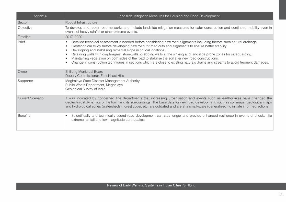
53
Review of Early Warning Systems in Indian Cities: Shillong
Action: 6 Landslide Mitigation Measures for Housing and Road Development
Sector Robust Infrastructure Objective To develop and repair road networks and include landslide mitigation measures for safer construction and continued mobility even in
events of heavy rainfall or other extreme events.Timeline 2017–2020 Brief • Detailed technical assessment is needed before considering new road alignments including factors such natural drainage.
• Geotechnical study before developing new road for road cuts and alignments to ensure better stability.• Developing and stabilising remedial slope in critical locations.• Retaining walls with diaphragms, stonewalls, grabbing walls at the sinking and landslide prone zones for safeguarding.• Maintaining vegetation on both sides of the road to stabilise the soil after new road constructions. • Change in construction techniques in sections which are close to existing naturals drains and streams to avoid frequent damages.
Owner Shillong Municipal Board Deputy Commissioner, East Khasi Hills
Supporter Meghalaya State Disaster Management AuthorityPublic Works Department, MeghalayaGeological Survey of India
Current Scenario It was indicated by concerned line departments that increasing urbanisation and events such as earthquakes have changed the geotechnical dynamics of the town and its surroundings. The base data for new road development, such as soil maps, geological maps and hydrological zones (watersheds), forest cover, etc. are outdated and are at a small-scale (generalised) to initiate informed actions.
Benefits • Scientifically and technically sound road development can stay longer and provide enhanced resilience in events of shocks like extreme rainfall and low magnitude earthquakes.

54
Review of Early Warning Systems in Indian Cities: Shillong
Action: 7 City Level Fire Safety and Evacuation Plan
Sector Preparedness for Risk Reduction Objective To develop better fire safety plan for hilly towns and neighbouring forest region.Timeline 2017–2018Brief • Mark forest fire prone areas which are adjacent to settlements.
• Check critical locations that have power lines and gas storage station and may require relocation or better mitigation mechanisms.• Establish and mark existing and new water resources for the fire department, according to vulnerable areas.• Mark the shortest routes to the vulnerable areas for fast response.• Take precautionary measures at the potential forest fire prone areas, such as making barren ramps in forests to control forest fires.• Train forest rangers to respond to fire incidences.• Acquire more suitable equipment and emergency vehicles, such as bikes, for the fire safety department to cater to the hilly towns.• Equip forest department personnel to manage forest fires better.
Owner Shillong Municipal Board Deputy Commissioner, East Khasi Hills
Supporter Meghalaya State Disaster Management AuthorityDepartment of Fire and Emergency Services
Current Scenario Due to Geo-climatic conditions, Dharamshala and Shillong Cities need to develop and have better fire safety plan and also need to review their existing capacities, such as type of firefighting equipment’s/vehicles, accessibility in highly vulnerable areas, trained human resources.
Benefits • Fast response in fire emergency situations to decrease damages and loss.

55
Review of Early Warning Systems in Indian Cities: Shillong
Action: 8 Fire Safety Plan- Community Level Awareness
Sector Community Awareness and ParticipationObjective To have better fire safety and rescue services as per the situation of the hilly town and forest area.
Timeline 2017-2018Brief • Awareness of fire safety at the community level – focusing on day-to-day life precautions at the household level.
• Water storages at different locations for fast rescue operations.• Communication helpline number for fire emergency.• Regular mock drills and street demonstrations for community-level preparedness for fire emergencies.• Special training and capacity building at commercial areas as they are more vulnerable to possible financial damages/losses, besides
having limited space for mobility.
Owner Shillong Municipal Board Deputy Commissioner, East Khasi Hills
Supporter Meghalaya State Disaster Management AuthorityDepartment of Fire and Emergency ServicesNGOs
Current Scenario Many of the fire incidences recorded are caused by manmade activities and lack of awareness among the citizens. Urban fire cases lead to forest-fire incidences and vice versa, which are not easy to manage with low level of fire safety services.
Benefits • The action will increase awareness on how to reduce fire incidences.• It will also increase awareness among the community, who can in turn act as first responders to control fire. • Indigenous methods for fire management can be developed at the community level.• It will reduce the burden of fire department, in case of an emergency.

56
Review of Early Warning Systems in Indian Cities: Shillong
Action: 9 Institutional Quick Response Practice (QRP)
Sector Comprehensive Institutional Set-upObjective To have an emergency response plan with easy-to-refer maps, predefined routes and tasks for the line departments to reduce the
response time during disasters.Timeline 2017-2018Brief • For easy and fast communication and networking among the line departments at town-level, such as WhatsApp groups, monthly
meetings need to be initiated.• To have easy-to-use maps/ atlas with important amenities, services, open spaces, shortest routes, helipad, hospital, police stations.• To ensure uniform response action plan for cross-departmental coordination and better clarity of roles and responsibility.• To establish control rooms in safe locations for managing emergency situations and providing communication to the state and national
teams, if needed.• To establish an emergency cell with assigned nodal persons in all departments composed of trained response and rescue staff.
Owner Shillong Municipal Board Deputy Commissioner, East Khasi Hills
Supporter Meghalaya State Disaster Management Authority
Current Scenario Currently, all the departments are dependent on the DC office for instruction in an emergency situation. There is no interdepartmental coordination and action plan for response and rescue.
Benefits • Better preparedness leads to lesser response time.• Pre-planned rescue operation will lead to less calamities and financial loss, and will also help the town get back to its normal state
faster.

57
Review of Early Warning Systems in Indian Cities: Shillong
Action: 10 Inter-departmental Ordinance for Standard Operating Procedure (SOP)
Sector Comprehensive Institutional Set-upObjective To have a resolution for highlighting the required legislative framework which can aid in the operational process by creating a platform for
aligning all key departments at the district level.Timeline 2017-2018Brief • The interdepartmental ordinance will increase the coordination between the various departments, which will provide clarity for the
departmental scope of work. • In emergency situations, it is very important to have defined roles and responsibilities.• The meet can be intended to assign roles and responsibilities of all agencies and develop Standard Operating Procedures (SOPs)
and interoperability mechanism.• The resolution will also provide further clarity on community reach and coordinated engagement for different government plans and
programmes. • The ordinance can be managed by the DC office within each district headquarters. • The meet should have a representative from the state administration, so that the upcoming state-level plans and programmes can be
discussed from the disaster management perspective comprehensively.
Owner Shillong Municipal Board Deputy Commissioner, East Khasi Hills
Supporter Meghalaya State Disaster Management Authority
Current Scenario All the line departments have very limited interaction regarding disaster risk management. One good practice for the same is pre-monsoon activity meet in all the district headquarters.
Benefits • Clarity of roles and responsibility across departments with respect to disaster management• Faster response in emergency situations with clear understanding of available resources• Wider reach by including awareness in the existing programme

58
Review of Early Warning Systems in Indian Cities: Shillong
Action: 11 Community Level Risk Awareness Programme
Sector Community Awareness and Participation Objective To build response capability by integrating and empowering/ training the local communities and citizens.Timeline 2017-2018Brief • To make communities aware of disaster risks and vulnerability.
• Basic training for risk mitigation at the household level. The awareness programme should have first aid measures and other adaptation measures, such as insurances, financial security, health etc.
• To make community aware of the structural measures which are mandatory for their buildings. • To make different departments aware of their roles during emergency situations.• To have a disaster management section in the secondary level education curriculum.
Owner Shillong Municipal Board Deputy Commissioner, East Khasi Hills
Supporter Meghalaya State Disaster Management Authority,NGOs
Current Scenario People are not aware of the structural measures at community level/ household level. Building licencing is also not monitored well. Awareness on the importance of insuring properties is limited.
Benefits • Awareness on vulnerability from risks, available services and processes to seek help from the respective administrative departments• Awareness of basic precautionary measures in events of disaster • Basic understanding of mitigation techniques and risk management for building long-term resilience.
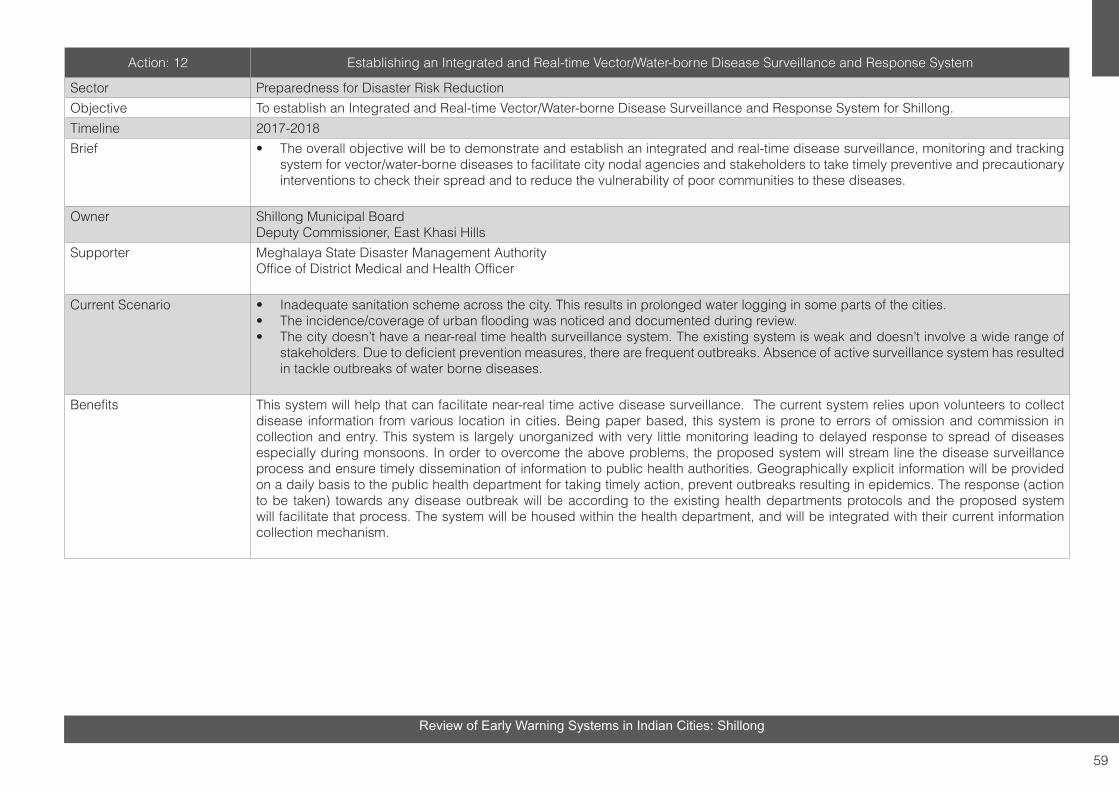
59
Review of Early Warning Systems in Indian Cities: Shillong
Action: 12 Establishing an Integrated and Real-time Vector/Water-borne Disease Surveillance and Response System
Sector Preparedness for Disaster Risk ReductionObjective To establish an Integrated and Real-time Vector/Water-borne Disease Surveillance and Response System for Shillong.Timeline 2017-2018Brief • The overall objective will be to demonstrate and establish an integrated and real-time disease surveillance, monitoring and tracking
system for vector/water-borne diseases to facilitate city nodal agencies and stakeholders to take timely preventive and precautionary interventions to check their spread and to reduce the vulnerability of poor communities to these diseases.
Owner Shillong Municipal Board Deputy Commissioner, East Khasi Hills
Supporter Meghalaya State Disaster Management AuthorityOffice of District Medical and Health Officer
Current Scenario • Inadequate sanitation scheme across the city. This results in prolonged water logging in some parts of the cities.• The incidence/coverage of urban flooding was noticed and documented during review. • The city doesn’t have a near-real time health surveillance system. The existing system is weak and doesn’t involve a wide range of
stakeholders. Due to deficient prevention measures, there are frequent outbreaks. Absence of active surveillance system has resulted in tackle outbreaks of water borne diseases.
Benefits This system will help that can facilitate near-real time active disease surveillance. The current system relies upon volunteers to collect disease information from various location in cities. Being paper based, this system is prone to errors of omission and commission in collection and entry. This system is largely unorganized with very little monitoring leading to delayed response to spread of diseases especially during monsoons. In order to overcome the above problems, the proposed system will stream line the disease surveillance process and ensure timely dissemination of information to public health authorities. Geographically explicit information will be provided on a daily basis to the public health department for taking timely action, prevent outbreaks resulting in epidemics. The response (action to be taken) towards any disease outbreak will be according to the existing health departments protocols and the proposed system will facilitate that process. The system will be housed within the health department, and will be integrated with their current information collection mechanism.

60
Review of Early Warning Systems in Indian Cities: Shillong
SUMMARY
It is important at this stage to note that EWS in the Shillong city needs to be upgraded significantly to meet the larger objective of reducing fatalities and protecting infrastructure/assets from future events. It is recognized globally that an operational EWS has the potential of minimizing loss and contributing to sustainable development and building resilience. While technology is available for establishing the robust communication system for EWS, it is the institutional foundation and the networking arrangements which have to be deep rooted for meeting the desired objectives of the system. All the key elements of the system have to be functional and it is important to review them annually by targeting for different scenarios and measuring performance.
This report provides insights to issues that need to be addressed for an operational EWS, defines the criteria and measures the development stage indicators for the present situation. The results of this review provide a status and the need to be aware of key design considerations for improvement of existing EWS, as well as for design and implementation of new EWS. It is envisaged that city landscape will have to tailor solutions for public safety, and EWS will be designed and developed on various platforms. It is important to keep these systems people-centric and subsequently build risk knowledge among the stakeholders for success of this system. Criteria Development Matrix can be used as a tool for further review. As EWS systems develop in the city, robust EWS audit mechanism can be rolled in the future to measure system efficiency.

61
Review of Early Warning Systems in Indian Cities: Shillong
7. CASE STUDIES AND BEST PRACTICES IN INDIA AND SOUTH-EAST ASIA
SURAT
Project title: End-to-End Early Warning System for Ukai and Local FloodsLocation & Country: Surat, IndiaHazard type: FloodsPeriod of Implementation: 2011–2015Stakeholders: Surat Municipal CorporationSurat Climate Change Trust; India Meteorological Department; TARU Leading Edge
Description:The flood frequency in the Tapi river catchment has increased significantly over the past two decades. The floods in Surat city, located on the Tapi basin, occur due to extreme rainfall events in the Upper and Middle Tapi basin and khadi (tidal creek) floods. Under the Asian Cities Climate Change Resilience Network initiative, an end to end Early Warning System was developed for Surat city. The system aimed at reducing the intensity of floods and ensuing damages in Surat city. It incorporated principles to enable improved reservoir operations to minimize peak floods and established systems to assist institutions and community to handle flood emergencies. The key components in the system include: developing management framework for EWS; establishment of Surat Climate Change Trust and Technical Committee, climate change informed hydrological and hydraulic modelling, early warning and disaster management system, integration with City Disaster Management Plan, information and support for the poor and sustainability arrangements. The establishment of the warning system includes the installation of weather systems, data transfer mechanism from
catchment to reservoir to city, development of weather and flow prediction models, improvement of existing flood preparedness and action plans.
Surat Inundation MapSource: Taru, 2013
Contact: Surat Climate Change Trust, Muglisara, Main Road, Surat – 395003 Gujarat, Indiawww.sccctrust.inReference:Asian Cities Climate Change Resilience Network, www.acccrn.org
Project title: Urban Services Monitoring SystemFacility: Surat Municipal CorporationLocation & Country: Surat, Gujarat, IndiaHazard type: Disease OutbreakPeriod of Implementation: Since 2011Stakeholders: Surat Municipal Corporation, Health Department
Description:High density, lack of safe water supply and its location on a river side, combined with high temperatures and humidity, changing rainfall patterns, rapid urban growth and industrial development make Surat highly conducive to vector-borne and water-borne diseases. Real
time structured data collection from different health institutions, including Urban Health Centres (UHCs), government and private hospitals, laboratories and private practitioners and its efficient analysis were the key challenges faced by Health Department, Surat Municipal Corporation. To overcome the above challenge, short message service (SMS)-enabled integrated Urban Services Monitoring System (UrSMS) was conceptualized and developed for the Surat Municipal Corporation.
This system brings resilience to disease monitoring framework by providing timely information on the quality of water supplied from distribution stations and occurrence including outbreak of diseases within Surat. The near real time data collection and analysis is currently helping the health department predict disease outbreaks based on number/distribution of cases across the city and enables them take prompt action to prevent further spreading. The system provides better visualisation of data and integration with ongoing government programmes/schemes. So far, the system has been able to significantly reduce the number of patients affected by malaria, dengue and leptospirosis.
Contact:Surat Municipal Corporation; www.suratmunicipal.gov.in; http://surat.ursms.net/cms/home.aspx

62
Review of Early Warning Systems in Indian Cities: Shillong
rainfall intensity and flood forecasting in 650 km2 of the east bank area, which will enable BMA staffs to forecast flood condition three to six hours in advance.
FCC serves people with flood forecasting news and flood protection and solution. Several communication channels are used to inform people and communities (radio broadcasting, traffic billboards and BMA’s website). DDS has weather monitoring system (http://dds.bangkok.go.th/wms/); surveillance radar rain images; flood monitoring system; water measurement system/canal overflow; SCADA system; and plan to prevent and resolve flooding, among others.
Project title: Real-time water level monitoring Stations
Source: http://weather.bangkok.go.th/water
Bangkok has over 250 real-time water level stations, and not all stations are found working fulltime. This indicates that redundancy needs to be built up. Graphical information is available for working stations as shown in Figure below.
BANGKOK
Project title: Bangkok Early warning systemFacility: Flood Control Centre Location & Country: Bangkok, ThailandHazard type: FloodPeriod of Implementation: Since 2000Stakeholders:Department of Drainage and Sewerage, Bangkok Metropolitan Ad-ministration, Thai Meteorological Department, Department of Disaster Prevention and Mitigation, Traffic Control Centre, Royal Irrigation
Source: Taru, 2013
Description:Bangkok Metropolitan Administration has set up Flood Control Centre (FCC). FCC supervises the hydrological conditions linking directly with the radar of Meteorology Department and of BMA. FCC has been serving as a decision-making tool for the Department of Drainage and Sewerage (DDS) flood protection teams for accurate and immediate directive to solve flood problems effectively. Monitoring stations monitor real time data of rainfall, water levels, pumps operation, water gates operation and water quality that are installed. In addition, the department is implementing a flood forecasting programme aiming at forecasting
Water level monitoring station visualization
The Bangkok’s flood models are being upgraded to provide nowcasting outputs to manage the floods better.
Contact: BMA City Hall, Dindaeng, Bangkok, Thailand 10400http://dds.bangkok.go.th;http://www.bangkok.go.th
Reference:http://www.unisdr.org/campaign/resilientcities/cities/view/28

63
Review of Early Warning Systems in Indian Cities: Shillong
MUMBAI
Project title: Mumbai Flood Warning System
Source: Screen-print from http://dm.mcgm.gov.in/auto-weather-stations
Facility: Disaster Control RoomLocation & Country: Mumbai, IndiaHazard type: FloodPeriod of Implementation: 2014Stakeholders: Municipal Corporation of Greater Mumbai; Disaster Management DepartmentIIT – B
Description:Mumbai, located on Arabian Sea coast, has an average elevation of 10 m to 15 m above the mean sea level and parts of the city are built on reclaimed land. Flooding in Mumbai occurs primarily due to heavy rainfall. Heavy rainfall accompanied by high tide and/or storm surge lead to inundation of low lying areas. The terrain of Mumbai has some similarity with Kolkata, but a significant proportion of the area has higher slopes and rest is nearly flat. To develop the flood resilience of the city, Municipal Corporation of Greater Mumbai (MCGM) has installed 60 automatic rain gauges at 58 locations. Currently 54 of the 60 rain gauges transmit rainfall
data to the Disaster Control Room of MCGM every 15 minutes. IIT Mumbai provides technical support for disseminating daily information on local rain, temperature and other related weather information. Many of the rain gauges have been installed at government buildings and Fire Brigade stations as they are safe locations and they are the first responders for disasters and are on 24-hour alert. The rain gauges also produce an audible alarm if the rainfall intensity exceeds 10 mm in 15 mins. Dedicated helpline number is present. There seems to be no real-time water level monitoring system. This gap can restrict coordination of real time action on ground as well as flood model validation. Over last decade, almost every year, the flood events and dame is reported along with jamming of traffic and breakdown of railway system. However, despite having a functional EWS system, the urban flood of August 29th and 30th, 2017 wreaked havoc in Mumbai.
Contact: Disaster Management Unit & CCRS DepartmentMunicipal Corporation of Greater Mumbai2nd Floor, Annex Building,Mahapalika Marg, C.S.T. Mumbai 400001http://dm.mcgm.gov.in
Reference:http://dm.mcgm.gov.in/auto-weather-stations
BENGALURU
Project title: Bangaluru Varuna Mitra website
Source: Screen-print from Bengaluru Varuna Mitra Website
Facility: Bengaluru Varuna MitraLocation & Country:Bengaluru, Karnataka, IndiaHazard type:FloodPeriod of Implementation:2015Stakeholders: Karnataka State Natural Disaster Monitoring Centre; HSc, Bengaluru; ITRA
Description:Bengaluru is located at an altitude of 920m above sea level and 100 km away from the Kaveri River. It receives about 900 mm of rainfall annually and records about 60 rainy days per year. The key concern in Bengaluru is rainfall induced flooding. To mitigate the urban flood risk in Bengaluru city, the Karnataka State Natural Disaster Monitoring Centre (KSNDMC) has taken up a pilot project to monitor and address flood vulnerability. The system consists of 100 GPRS enabled Telemetric Rain Ganges and 08 Weather Stations spread over 800 Sq. Km area. A hydrological model has been developed to dynamically issue flood alerts. Using DEM and data on low lying areas, catchments, storm water drains and settlement patterns, 174 flood-prone areas spread across the city have been identified. Alerts to civic authorities like

64
Review of Early Warning Systems in Indian Cities: Shillong
Bruhat Bangalore Mahanagara Palike (BBMP), Bangalore Electricity Supply Company Ltd. (BESCOM), Bangalore Metropolitan Transport Corporation (BMTC), Bangalore Metro Rail Corporation Limited (BMRCL), Traffic Police, Civil Defense, Disaster Management unit and the public are issued through SMS, WhatsApp, Twitter and Facebook. A dedicated public domain website, Bengaluru Varuna Mitra, is developed to provide information on rainfall forecasts, flood forecasts, flood warnings and flood prone localities. It also gives insight on urban floods, flood mitigation measures, do’s and don’ts and stores archival records of historic flood events in the city. It has an interactive feedback mechanism for the public to upload images and texts regarding flood events in the city. The Varunamitra helpline, set up in 2011, operates 24x7 round the year to provide weather related information which include rainfall forecast, pattern etc. up to two days in advance. Further enhancement of the system aims at developing dynamic models to understand the behavior of rainwater and developing Google Maps like app and web interface with navigation feature to notify citizens of alternate routes to avoid inundated areas.
Contact:Karnataka State Natural Disaster Monitoring Centre, KSNDMC Campus, Major Sandeep Unnikrishnan Road, Near Attur Layout, Yelahanka Bangalore - 560 064, Karnatakahttp://www.bengaluruvarunamitra.info
Reference:http://www.bengaluruvarunamitra.info, h t tps : / /www.ksndmc.o rg /PDF /KSNDMC_ACTIVITIES.pdf
ASSAMProject title: Assam FLEWS
Source: http://darpg.gov.in/Facility: FLEWSLocation & Country: Lakhimpur, Barpeta, Dhemaji, Baksa, Goalpara, Nalbari, Cachar, Karimganj, Dhubri, Morigaon, Sonitpur, Sivsagar, Darrang and Hailakandi districts of Assam, IndiaHazard type: FloodPeriod of Implementation: Since 2009Stakeholders: North Eastern Space Application System; IMD; CWC; North Eastern Electric Power Corporation Limited Brahmaputra Board; Assam Water Resources Department; ASDMA
DescriptionFlood is an annual event in Assam. With more than 40% land surface of Assam flood prone, the primary concern in Assam is riverine flooding in Brahmaputra and Barak River and their tributaries. The Flood Early Warning System (FLEWS) implemented by North Eastern Space Application System (NESAC) in Assam is developed to provide location specific early warnings. Flood alerts are generated based on analysis of river discharge, current river level and synoptic-scale
weather report. The location specificity helps the administration in taking appropriate precautions. Initially the FLEWS were developed for two districts in a pilot mode. The project now covers 14 districts of Assam. The key strategy of the FLEWS is to create an environment of participation and involvement among all stakeholders to generate an actionable product for flood management. The key functions of the FLEWS include: Issuance of flood early warning of possible flood situation mentioning the magnitude (severity), location (revenue circle/group or cluster of villages) and probable time (within 12-24 hours range) with a 7-18 hours lead time; Issuance of high rainfall warning with location and time; Providing pre and post monsoon status of embankment in various flood prone rivers; Development of methodology for rainfall prediction utilizing on satellite based weather monitoring and numerical weather prediction models supported by ground data; Development of river specific rainfall runoff models; Development of inundation simulation for flood plain zonation. Special funds are earmarked for the effective operationalization of the FLEWS. The flood alerts are disseminated to the community through revenue circle officers and Gaon buras (village elders).
Contact:North Eastern Space Applications Centre (NESAC) Department of Space, Government of India; Umiam -793103 (Meghalaya); http://www.nesac.gov.in/
Reference:http://www.sac.gov.in/SACSITE/SAC-Flyers/m e n u - l i n k s / s o c i e t y / 1 1 . 4 % 2 0 F L O O D % 2 0EARLY%20WARNING%20SYSTEM%20NER.pdf, http://darpg.gov.in/sites/default/files/70.%20Flood%20Early%20Warning%20SystemFLEWS-Documentation-Final.pdf

65
Review of Early Warning Systems in Indian Cities: Shillong
LESSONS FROM EXISTING SYSTEMS
The existing early warning systems across the subcontinent shows quite high diversity, depending upon the extent of risk, availability of technical resources and priority laid by the local administration. The warnings are mostly based on expert opinion and often not informed by real-time status data or high-resolution flood models. The type of warnings provided and media used is highly variable across different regions/cities.
There is good system for regional warnings, but context specific assessment of risk and development of appropriate warning is a challenge. While decisions can be taken based on few parameters are monitored in some areas, more granular information is necessary for urban early warning systems. The case of multiple disaster events in India show that it is difficult to provide early warning with sufficient lead time in urban areas, without sufficient event database and real-time monitoring and modelling even in moderate slope environments with well-defined natural drainage system.

66
Review of Early Warning Systems in Indian Cities: Shillong
REFERENCES
Arbind K Sinha and Shirish U Avrani (1984), The disaster warning process: A study of the 1981Gujarat cyclone. Disasters1/1984
Analysis of the 2006 WMO Disaster Risk Reduction Country-level Survey
David Rodgers & Vladimir Tsirkunov GFDRR (2011), Implementing Hazard Early Warning Systems
Dennis Parker - Flood Hazard Research Centre, Middlesex University (2000), Criteria for Evaluating the Condition of a Tropical Cyclone Warning System, Disasters, 1999, 23(3): 193-216
District Disaster Management Plan, North Khasi Hills District (Meghalaya)
Forecasters Guide (2008), India Meteorological Department
Future Proofing Indian Cities, Draft Urban Diagnostic for Madurai, prepared by ATKINS India, CDKN, IIHS, UCL Oct 2013)
Guidelines for Preparation of Action Plan (2016) – Prevention and Management of Heat-Wave, NDMA
Indian Space Research Organization (ISRO), http://www.isro.gov.in/indigenously-developed-polarimetric-doppler-weather-radar-cherrapunjee-dedicated-to-nation-honble
Jaiswal, K. S., and Sinha, R. (2007). Probabilistic seismic hazard estimation of Peninsular India. Bulletin of the Seismological Society of America, 70, 1337–1356.
Jaiswal R. K. and B. K. Rastogi, (2006). Tsunami-genic sources in the Indian Ocean, 6th Asian Seismological Commission (ASC) General Assembly – 2006, Symposium on Earthquake and Tsunami Disaster Preparedness and Mitigation, (Abstract Id O019, Session: Subduction Zone, Seismology and Tsunami), November 7-10, 2006 Bangkok, Thailand, pp 84-85
Kar, Anil Kumar (2011), Flood Estimation and Forecasting in Mahanadi River Basin Using Soft Computing Techniques, URI: http://hdl.handle.net/123456789/548.
Kristie L. Ebi and Jordana K Schmier (2005), A Stich in Time: Improving Public Health Early Warning Systems for Extreme Weather Events, Epidemiology Reviews Vol 27, 2005. DOI: 10.1093/epirev/mxi006
Meghalaya State Disaster Management Rules (2010), SDMA, Meghalaya,

67
Review of Early Warning Systems in Indian Cities: Shillong
National Guidelines for the Management of Cyclones (2010), NDMA, New Delhi
National Disaster Management Guidelines: Management of Tsunamis (2010), NDMA, New Delhi
National Disaster Management Information and Communication System (2012), NDMA, New Delhi
National Disaster Management Guidelines Management of Floods (2008), NDMA, New Delhi
National Disaster Management Guidelines Management of Urban Floods (2008), NDMA, New Delhi
Report on Training Programme on Incident Response System (IRS) (2016), SDMA, Meghalaya and DDMA, East Khasi Hills District,
State Policy on Disaster Management (2013), SDMA, Department of Revenue and Disaster Management, Meghalaya
Strengthening Multi-Hazard Early Warning Systems and Risk Assessment in the western Balkans and Turkey, Assessment of Capacities, Gaps and Needs. World Meteorological Organization (2012),
S. K. Sengupta, J. D. Bales, R. Jubach, A. C. Scott, and M. D. Kane (2008), “Flood Forecasting and Inundation Mapping in the Mahanadi River Basin: A Collaborative Effort between India and the United States”. URL: https://orissafloods.files.wordpress.com/2008/09/mahanadi.pdf
Villagrán de León, J. C., Pruessner, I., and H. Breedlove (2013). Alert and Warning Frameworks in the Context of Early Warning Systems. A Comparative Review. Intersections No. 12. Bonn: United Nations University Institute for Environment and Human Security.
Wurman, G., R. M. Allen, and P. Lombard (2007), Toward earthquake early warning in northern California, J. Geophys. Res., 112, B08311, doi:10.1029/2006JB004830

68
Review of Early Warning Systems in Indian Cities: Shillong
CREDITS
1. Smt. Ibashisha Mawlong, MCS, Joint Secretary, Revenue & Disaster Management Department, Additional Secretariat, Shillong, Meghalaya,
2. Shri S. Bordoloi, Consultant, Meghalaya State Disaster Management Authority, Directorate of Land Records, Lower Lachumiere, Shillong, Meghalaya,
3. Smt. K. Wanniang, District Project Officer, District Emergency Operation Center, Deputy Commissioner Office, Shillong, Meghalaya,
4. Smt. I. Mazaw, MCS, Additional Deputy Commissioner, East Khasi Hills District,
5. Shri T. Shylla, Shift Officer, State Emergency Operation Center, Lower Lachumiere, Shillong, Meghalaya,
6. Shri B. S. Sohliya, MCS, Chief Executive Officer, Shillong Municipal Board, Bishop Cotton Road, Shillong, Meghalaya,
7. Shri. B. Dutta, Director, Urban Development Department, Raitong Building, Secretariat Hill, Shillong, Meghalaya,
8. Shri P. F. Tariang, PRO and Tourism Officer, Tourism Department, Lower Lachumiere, Shillong, Meghalaya,
9. Shri Ajit Kumar, Superintending Engineer, Brahmaputra & Barak Basin, Central Water Commission, ‘Rebekka Ville’, Near Barak Point, Temple Road,
Lower Lachumiere, Shillong, Meghalaya,
10. Shri R. Sohkhlet, Town Planning Officer, Meghalaya Urban Development Agency, Police Bazar, Shillong, Meghalaya,
11. Shri E. Kharmalki, MCS, Joint Secretary, Urban Development Department, Shillong, Meghalaya,
12. Shri. P. L. N. Raju, Director, North East Space Application Center, Umiam, Meghalaya,
13. Dr. B. D. R. Tiwari, IAS, Secretary, Planning Department, Additional Secretariat, Room No. 403, Shillong, Meghalaya,
14. Dr. K. K. Sharma, Scientist - F, North East Space Application Center, Umiam, Meghalaya,
15. Shri S. S. Kundu, Scientist - E,North East Space Application Center, Umiam, Meghalaya,
16. Shri R. Pariang, Senior Meteorologist, India Meteorological Department, 3rd Mile, Upper Shillong, Shillong, Meghalaya,
17. Shri A. C. Lyngdoh, Director (over Tel-con), India Meteorological Department, 3rd Mile, Upper Shillong, Shillong, Meghalaya,
18. Shri Amarjit Singh, Additional Director General, GSI, North Eastern Region, GSI Complex, ‘Shyla’, Nongrim Hills, Shillong, Meghalaya,
19. Dr. Tapan Pal, Director, GSI, North Eastern Region, GSI Complex, ‘Shyla’, Nongrim Hills, Shillong, Meghalaya,
20. Shri Haish Kumar, Senior Geologist, GSI, North Eastern Region, GSI Complex, ‘Shyla’, Nongrim Hills, Shillong, Meghalaya,
21. Shri Senthil Kumar, Junior Geologist, GSI, North Eastern Region, GSI Complex, ‘Shyla’, Nongrim Hills, Shillong, Meghalaya,
22. Smt. R. C. Sohkhlet, Director, Tourism Department, 3rd Secretariat Nokrek Building, Lower Lachumiere, Shillong, Meghalaya,
23. Smt. Mary Sangama, MPS, Superintendent of Police, Department of Fire and Emergency Services, Near Fire Station, Moti Nagar, Nongthymmai, Shillong,
Meghalaya,
24. Dr. Smti. S. A. Lyngdoh, Medical Officer - Nodal Officer - II DM, Office of the District Medical and Health Officer, East Khasi Hills, Shillong, Meghalaya,

69
Review of Early Warning Systems in Indian Cities: Shillong
25. Dr. Apurba, Medical Officer, Office of the District Medical and Health Officer, East Khasi Hills, Shillong, Meghalaya,
26. Dr. R. R. Marak, Medical Officer - Nodal Officer - I DM (over Tel-con),Office of the District Medical and Health Officer, East Khasi Hills, Shillong, Meghalaya,
27. Shri James, Data Manager, IDSP Cell, Office of the District Medical and Health Officer, East Khasi Hills, Shillong, Meghalaya,
28. Shri Gyan Ranjan Mati, Project Scientist, Polarimetric Doppler Weather Radar, Cherrapunji, Meghalaya,
29. Shri. L. Shabong, Officer on Special Duty, Meghalaya Basin Development Authority, Bishop Cotton Road, Shillong, Meghalaya