Settlement, Territory, and the Political Landscape of Late Bronze Age Polities in the Northern...
19
7 Settlement, Territory, and the Political Landscape of Late Bronze Age Polities in the Northern Levant Jesse Casana University of Arkansas ABSTRACT By bringing together analysis of cuneiform texts and archaeological settlement data, I offer new perspectives on the spatial and territorial dimensions of polities in the northern Levant during the mid to late second millennium B.C.E. Settlement data suggest that a highly nucleated pattern of occupation at tell sites remained dominant and remarkably stable throughout the period, perhaps driven by hierarchically organized systems of land rights. In contrast, historical data show a complex and dynamic tapestry of changing territorial institutions, moving from a system of fragmented, spatially discontinuous polities in the earlier second millennium to one characterized by increasingly territorial states in later centuries. Results show how rapidly notions of territoriality might have changed in the past and highlight the fundamental importance of studies that integrate archaeological and historical data in efforts to understand the spatiality of ancient states. [Near East, Amuq, settlement, Hittites, Amorites] I n their introductory chapter to the present volume, VanValkenburgh and Osborne rightly emphasize that many historically documented societies held ideas regard- ing the relationship between power and space very differ- ent from that which is dominant in our “post-Westphalian world.” Following Monica Smith (2005), they argue against a blobs-on-a-map approach to understanding the spatiality of ancient polities. Archaeologists’ past failure to deconstruct notions of political territoriality might largely be attributed to the experience of living in the contemporary world, where territorial states serve as the dominant, default model for the institution and maintenance of political authority. Pos- session of sovereign and clearly defined territory is in fact a mandated prerequisite for statehood in several international treaties, including the Montevideo Convention, which cod- ified rights and responsibilities of states in the Americas in 1933, and as in the work of the European Union’s Badinter Arbitration Committee that, in 1991, addressed the issue of whether newly formed Baltic states could be recognized. According to the generally accepted principles of in- ternational law outlined in such treaties, ethnic groups or other communities that lack ownership of sovereign terri- tory, even those such as the Kurds who have a strong, unified sense of cultural identity and a geographically distinct home- land (Romano 2006), are not considered viable state actors. On the other hand, tiny places such as Tuvalu or Monaco are entitled to all the rights and privileges of large states, from membership in the United Nations to fielding Olympic teams. Since the 1960s, when a gang of discontented rad- icals declared the independence of a new micro-state they called Sealand, located on an abandoned gunnery platform in the North Sea, many other groups have attempted similar stunts of micro-nationry in an effort to exploit the territorial basis for political autonomy (Ryan et al. 2006). Scholars have begun to speculate what might happen in the near fu- ture when the Maldives or other small atoll-based states lose the entirety of their territory to rising sea levels (Rayfuse 2009; Schmidle 2009; Yamamoto and Esteban 2010). Will ARCHEOLOGICAL PAPERS OF THE AMERICAN ANTHROPOLOGICAL ASSOCIATION, Vol. 22, Issue 1, pp. 107–125, ISSN 1551-823X, online ISSN 1551-8248. C 2013 by the American Anthropological Association. All rights reserved. DOI: 10.1111/apaa.12006.
Transcript of Settlement, Territory, and the Political Landscape of Late Bronze Age Polities in the Northern...
7
Settlement, Territory, and the PoliticalLandscape of Late Bronze Age Polities in the
Northern Levant
Jesse CasanaUniversity of Arkansas
ABSTRACTBy bringing together analysis of cuneiform texts and archaeological settlement data, I offer new perspectives
on the spatial and territorial dimensions of polities in the northern Levant during the mid to late second millenniumB.C.E. Settlement data suggest that a highly nucleated pattern of occupation at tell sites remained dominant andremarkably stable throughout the period, perhaps driven by hierarchically organized systems of land rights. Incontrast, historical data show a complex and dynamic tapestry of changing territorial institutions, moving froma system of fragmented, spatially discontinuous polities in the earlier second millennium to one characterized byincreasingly territorial states in later centuries. Results show how rapidly notions of territoriality might have changedin the past and highlight the fundamental importance of studies that integrate archaeological and historical data inefforts to understand the spatiality of ancient states. [Near East, Amuq, settlement, Hittites, Amorites]
I n their introductory chapter to the present volume,VanValkenburgh and Osborne rightly emphasize that
many historically documented societies held ideas regard-ing the relationship between power and space very differ-ent from that which is dominant in our “post-Westphalianworld.” Following Monica Smith (2005), they argue againsta blobs-on-a-map approach to understanding the spatiality ofancient polities. Archaeologists’ past failure to deconstructnotions of political territoriality might largely be attributedto the experience of living in the contemporary world, whereterritorial states serve as the dominant, default model forthe institution and maintenance of political authority. Pos-session of sovereign and clearly defined territory is in fact amandated prerequisite for statehood in several internationaltreaties, including the Montevideo Convention, which cod-ified rights and responsibilities of states in the Americas in1933, and as in the work of the European Union’s BadinterArbitration Committee that, in 1991, addressed the issue ofwhether newly formed Baltic states could be recognized.
According to the generally accepted principles of in-ternational law outlined in such treaties, ethnic groups orother communities that lack ownership of sovereign terri-tory, even those such as the Kurds who have a strong, unifiedsense of cultural identity and a geographically distinct home-land (Romano 2006), are not considered viable state actors.On the other hand, tiny places such as Tuvalu or Monacoare entitled to all the rights and privileges of large states,from membership in the United Nations to fielding Olympicteams. Since the 1960s, when a gang of discontented rad-icals declared the independence of a new micro-state theycalled Sealand, located on an abandoned gunnery platformin the North Sea, many other groups have attempted similarstunts of micro-nationry in an effort to exploit the territorialbasis for political autonomy (Ryan et al. 2006). Scholarshave begun to speculate what might happen in the near fu-ture when the Maldives or other small atoll-based states losethe entirety of their territory to rising sea levels (Rayfuse2009; Schmidle 2009; Yamamoto and Esteban 2010). Will
ARCHEOLOGICAL PAPERS OF THE AMERICAN ANTHROPOLOGICAL ASSOCIATION, Vol. 22, Issue 1, pp. 107–125, ISSN 1551-823X,online ISSN 1551-8248. C© 2013 by the American Anthropological Association. All rights reserved. DOI: 10.1111/apaa.12006.
108 Jesse Casana
the displaced residents be allowed to continue using theirpassports should their efforts to purchase a new homelandfail? In the post-Westphalian world, possession of territorymakes or breaks a state.
The current global dominance of the territorial statemodel is largely a product of European colonial expansionfrom the 16th to 19th centuries during which the world wascarved up among the European powers, often in ways thatbore little resemblance to older geographies of ethnicity,language, or culture. Yet once these borders were in place,residents of the states that emerged from colonies quicklycame to see themselves as nations, reifying the intersectionof political sovereignty, cultural identity, and demarcatedterritory as the globally dominant and uncontestable modelof political power (Anderson 1983). In the span of a singlegeneration, the world was transformed into a place wherenation-states seemed a natural, even inevitable, reality.
An important lesson for archaeologists to draw fromthe astonishing success of nation-building projects duringthe past century is that notions of territoriality are as fluidas they are diverse. It may be true, as VanValkenburgh andOsborne (this volume) argue, that conceptions of territori-ality are cross-culturally idiosyncratic, but these ideas canalso change very rapidly over time. In the same way, ancientcommunities undoubtedly held diverse ideas about territory,but these notions may also have changed diachronically—and more rapidly than archaeological data can resolve. On itsown, without historic or ethnographic insights into the cul-tural practices that produced it, the archaeological record istherefore a difficult point of entry into a discussion of territo-riality in ancient states, as has been well demonstrated for theClassic Maya (Martin and Grube 2000; Smith 2003:chapter3).
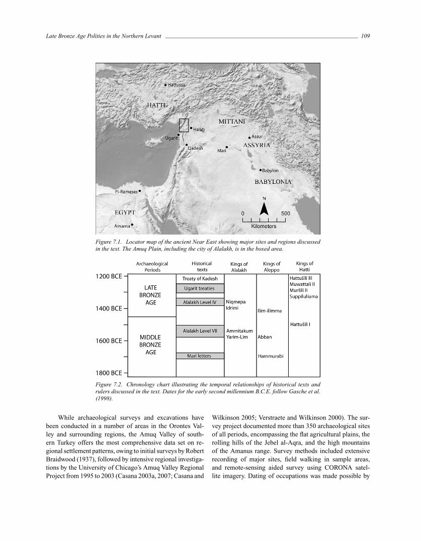
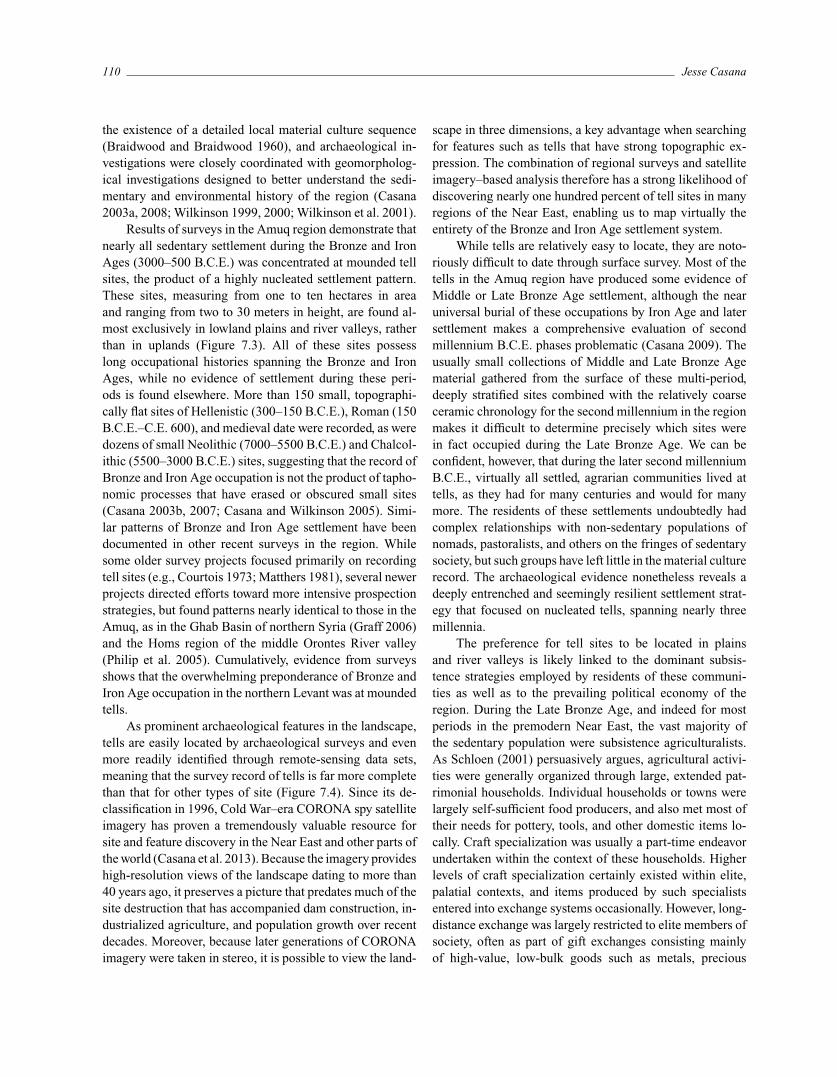
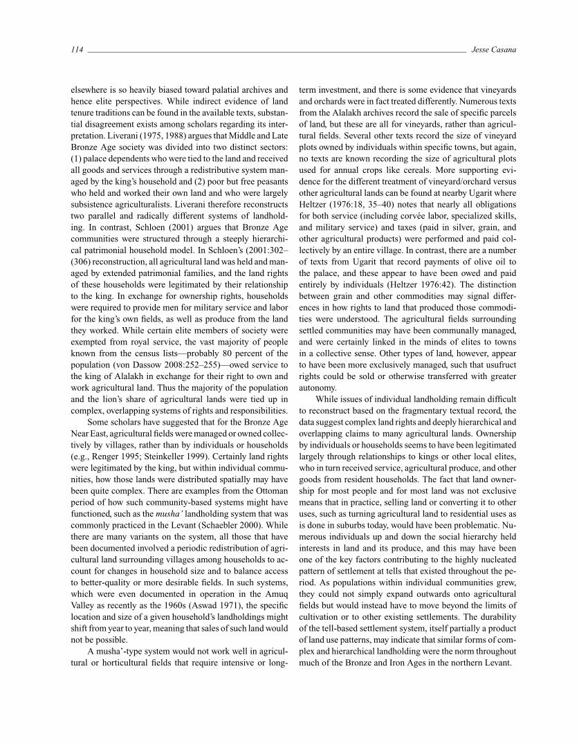
In this chapter, I present an analysis of archaeologicalsettlement data and related historical texts from the northernLevant (Figure 7.1) illustrating changing notions of territo-riality during the Middle and Late Bronze Ages (2000–1200B.C.E.; Figure 7.2). At this time, the region was the site ofnearly constant conflict and negotiation, both among localkings and among powerful but distant empires. A detailedknowledge of settlement history combined with a rich, localhistoric record offers unique possibilities for exploring therelationship between political power and territory.
During the second millennium B.C.E., several major po-litical and military powers emerged in the Near East, includ-ing the Hittites in central Anatolia, New Kingdom Egypt inthe Nile Valley, and Mitanni in northern Mesopotamia. Eachof these empires sought to expand its political dominance ofsurrounding states and peoples through aggressive, targetedmilitary campaigns. The northern Levant was the regionwhere the interests of all three powers overlapped, leading
to several centuries of combat, negotiation, and shifting al-liances. Yet the region was also home to local kingdoms,which from the early second millennium B.C.E. had beendominated by rulers of the Amorite ethnicity, a group thatmany scholars believe began as nomadic pastoralists (e.g.,Buccellati 1997; Lonnqvist 2009; Nichols and Weber 2006).
Below, I first present an overview of the settlementhistory of the region, and then highlight major differencesin how political territoriality was manifested in the north-ern Levant through the centuries of the mid to late secondmillennium B.C.E., from the level of individual communi-ties, through small kingdoms, to large empires. As will beshown, the polities that ruled this region seem to have heldideas about the relationship between territory and politicalpower that were competing and contradictory, overlappingand abutting one another in uncomfortable ways, resulting ina complex, dynamic tapestry of territorial institutions. At thesame time, archaeological survey data reveal an exceedinglystable settlement system, one characterized by persistent oc-cupation of the same tell-based sites over many centuries.The stark contrasts between historic and archaeological datasets that this study outlines offer a useful model and a warn-ing for caution in studies of ancient territorial institutions.
Archaeological Evidence for SettlementSystems
The northern Levant (a region that broadly encompassessouthern Turkey, western Syria, and northern Lebanon)forms the northwestern portion of the Fertile Crescent andpossesses an extraordinarily long history of sedentary, agrar-ian occupation dating back more than ten thousand years.The region is characterized by a narrow coastal plain thatgives way to a lofty series of mountains including the JebelAnsariyah in Syria and the Amanus in Turkey, rising tonearly two thousand meters above sea level. The OrontesRiver and its tributaries flow on the eastern side of themountains, and this area is one of the most agriculturallyproductive in the Middle East today. As the northern ex-tent of the Great Rift Valley, running up the Levantine lit-toral from the Arabian Plate, the valley is bounded on theeast by a lower series of limestone-dominated hills. A rainshadow effect caused by the coastal mountains results in asteep drop-off in precipitation as one moves inland from theMediterranean, with rainfall exceeding 1,800 millimetersper year on the coastal plains but averaging less than 200millimeters per year only 150 kilometers inland. The richagricultural lands, well watered by both rivers and rainfall,form one of the prime areas for settlement in the MiddleEast.
Late Bronze Age Polities in the Northern Levant 109
Figure 7.1. Locator map of the ancient Near East showing major sites and regions discussedin the text. The Amuq Plain, including the city of Alalakh, is in the boxed area.
Figure 7.2. Chronology chart illustrating the temporal relationships of historical texts andrulers discussed in the text. Dates for the early second millennium B.C.E. follow Gasche et al.(1998).
While archaeological surveys and excavations havebeen conducted in a number of areas in the Orontes Val-ley and surrounding regions, the Amuq Valley of south-ern Turkey offers the most comprehensive data set on re-gional settlement patterns, owing to initial surveys by RobertBraidwood (1937), followed by intensive regional investiga-tions by the University of Chicago’s Amuq Valley RegionalProject from 1995 to 2003 (Casana 2003a, 2007; Casana and
Wilkinson 2005; Verstraete and Wilkinson 2000). The sur-vey project documented more than 350 archaeological sitesof all periods, encompassing the flat agricultural plains, therolling hills of the Jebel al-Aqra, and the high mountainsof the Amanus range. Survey methods included extensiverecording of major sites, field walking in sample areas,and remote-sensing aided survey using CORONA satel-lite imagery. Dating of occupations was made possible by
110 Jesse Casana
the existence of a detailed local material culture sequence(Braidwood and Braidwood 1960), and archaeological in-vestigations were closely coordinated with geomorpholog-ical investigations designed to better understand the sedi-mentary and environmental history of the region (Casana2003a, 2008; Wilkinson 1999, 2000; Wilkinson et al. 2001).
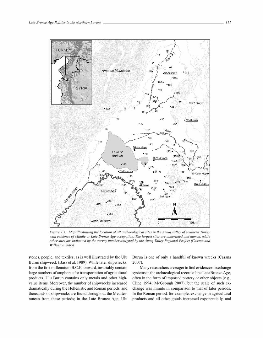
Results of surveys in the Amuq region demonstrate thatnearly all sedentary settlement during the Bronze and IronAges (3000–500 B.C.E.) was concentrated at mounded tellsites, the product of a highly nucleated settlement pattern.These sites, measuring from one to ten hectares in areaand ranging from two to 30 meters in height, are found al-most exclusively in lowland plains and river valleys, ratherthan in uplands (Figure 7.3). All of these sites possesslong occupational histories spanning the Bronze and IronAges, while no evidence of settlement during these peri-ods is found elsewhere. More than 150 small, topographi-cally flat sites of Hellenistic (300–150 B.C.E.), Roman (150B.C.E.–C.E. 600), and medieval date were recorded, as weredozens of small Neolithic (7000–5500 B.C.E.) and Chalcol-ithic (5500–3000 B.C.E.) sites, suggesting that the record ofBronze and Iron Age occupation is not the product of tapho-nomic processes that have erased or obscured small sites(Casana 2003b, 2007; Casana and Wilkinson 2005). Simi-lar patterns of Bronze and Iron Age settlement have beendocumented in other recent surveys in the region. Whilesome older survey projects focused primarily on recordingtell sites (e.g., Courtois 1973; Matthers 1981), several newerprojects directed efforts toward more intensive prospectionstrategies, but found patterns nearly identical to those in theAmuq, as in the Ghab Basin of northern Syria (Graff 2006)and the Homs region of the middle Orontes River valley(Philip et al. 2005). Cumulatively, evidence from surveysshows that the overwhelming preponderance of Bronze andIron Age occupation in the northern Levant was at moundedtells.
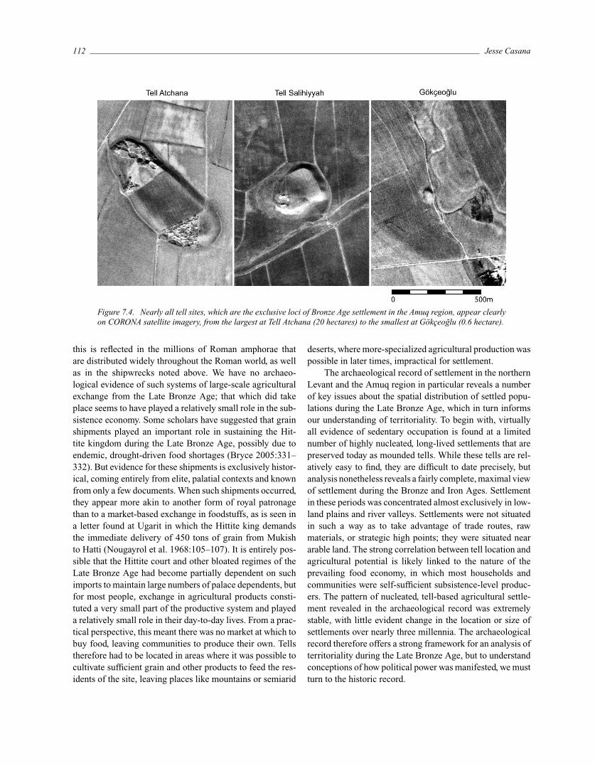
As prominent archaeological features in the landscape,tells are easily located by archaeological surveys and evenmore readily identified through remote-sensing data sets,meaning that the survey record of tells is far more completethan that for other types of site (Figure 7.4). Since its de-classification in 1996, Cold War–era CORONA spy satelliteimagery has proven a tremendously valuable resource forsite and feature discovery in the Near East and other parts ofthe world (Casana et al. 2013). Because the imagery provideshigh-resolution views of the landscape dating to more than40 years ago, it preserves a picture that predates much of thesite destruction that has accompanied dam construction, in-dustrialized agriculture, and population growth over recentdecades. Moreover, because later generations of CORONAimagery were taken in stereo, it is possible to view the land-
scape in three dimensions, a key advantage when searchingfor features such as tells that have strong topographic ex-pression. The combination of regional surveys and satelliteimagery–based analysis therefore has a strong likelihood ofdiscovering nearly one hundred percent of tell sites in manyregions of the Near East, enabling us to map virtually theentirety of the Bronze and Iron Age settlement system.
While tells are relatively easy to locate, they are noto-riously difficult to date through surface survey. Most of thetells in the Amuq region have produced some evidence ofMiddle or Late Bronze Age settlement, although the nearuniversal burial of these occupations by Iron Age and latersettlement makes a comprehensive evaluation of secondmillennium B.C.E. phases problematic (Casana 2009). Theusually small collections of Middle and Late Bronze Agematerial gathered from the surface of these multi-period,deeply stratified sites combined with the relatively coarseceramic chronology for the second millennium in the regionmakes it difficult to determine precisely which sites werein fact occupied during the Late Bronze Age. We can beconfident, however, that during the later second millenniumB.C.E., virtually all settled, agrarian communities lived attells, as they had for many centuries and would for manymore. The residents of these settlements undoubtedly hadcomplex relationships with non-sedentary populations ofnomads, pastoralists, and others on the fringes of sedentarysociety, but such groups have left little in the material culturerecord. The archaeological evidence nonetheless reveals adeeply entrenched and seemingly resilient settlement strat-egy that focused on nucleated tells, spanning nearly threemillennia.
The preference for tell sites to be located in plainsand river valleys is likely linked to the dominant subsis-tence strategies employed by residents of these communi-ties as well as to the prevailing political economy of theregion. During the Late Bronze Age, and indeed for mostperiods in the premodern Near East, the vast majority ofthe sedentary population were subsistence agriculturalists.As Schloen (2001) persuasively argues, agricultural activi-ties were generally organized through large, extended pat-rimonial households. Individual households or towns werelargely self-sufficient food producers, and also met most oftheir needs for pottery, tools, and other domestic items lo-cally. Craft specialization was usually a part-time endeavorundertaken within the context of these households. Higherlevels of craft specialization certainly existed within elite,palatial contexts, and items produced by such specialistsentered into exchange systems occasionally. However, long-distance exchange was largely restricted to elite members ofsociety, often as part of gift exchanges consisting mainlyof high-value, low-bulk goods such as metals, precious
Late Bronze Age Polities in the Northern Levant 111
Figure 7.3. Map illustrating the location of all archaeological sites in the Amuq Valley of southern Turkeywith evidence of Middle or Late Bronze Age occupation. The largest sites are underlined and named, whileother sites are indicated by the survey number assigned by the Amuq Valley Regional Project (Casana andWilkinson 2005).
stones, people, and textiles, as is well illustrated by the UluBurun shipwreck (Bass et al. 1989). While later shipwrecks,from the first millennium B.C.E. onward, invariably containlarge numbers of amphorae for transportation of agriculturalproducts, Ulu Burun contains only metals and other high-value items. Moreover, the number of shipwrecks increaseddramatically during the Hellenistic and Roman periods, andthousands of shipwrecks are found throughout the Mediter-ranean from these periods; in the Late Bronze Age, Ulu
Burun is one of only a handful of known wrecks (Casana2007).
Many researchers are eager to find evidence of exchangesystems in the archaeological record of the Late Bronze Age,often in the form of imported pottery or other objects (e.g.,Cline 1994; McGeough 2007), but the scale of such ex-change was minute in comparison to that of later periods.In the Roman period, for example, exchange in agriculturalproducts and all other goods increased exponentially, and
112 Jesse Casana
Figure 7.4. Nearly all tell sites, which are the exclusive loci of Bronze Age settlement in the Amuq region, appear clearlyon CORONA satellite imagery, from the largest at Tell Atchana (20 hectares) to the smallest at Gokceoglu (0.6 hectare).
this is reflected in the millions of Roman amphorae thatare distributed widely throughout the Roman world, as wellas in the shipwrecks noted above. We have no archaeo-logical evidence of such systems of large-scale agriculturalexchange from the Late Bronze Age; that which did takeplace seems to have played a relatively small role in the sub-sistence economy. Some scholars have suggested that grainshipments played an important role in sustaining the Hit-tite kingdom during the Late Bronze Age, possibly due toendemic, drought-driven food shortages (Bryce 2005:331–332). But evidence for these shipments is exclusively histor-ical, coming entirely from elite, palatial contexts and knownfrom only a few documents. When such shipments occurred,they appear more akin to another form of royal patronagethan to a market-based exchange in foodstuffs, as is seen ina letter found at Ugarit in which the Hittite king demandsthe immediate delivery of 450 tons of grain from Mukishto Hatti (Nougayrol et al. 1968:105–107). It is entirely pos-sible that the Hittite court and other bloated regimes of theLate Bronze Age had become partially dependent on suchimports to maintain large numbers of palace dependents, butfor most people, exchange in agricultural products consti-tuted a very small part of the productive system and playeda relatively small role in their day-to-day lives. From a prac-tical perspective, this meant there was no market at which tobuy food, leaving communities to produce their own. Tellstherefore had to be located in areas where it was possible tocultivate sufficient grain and other products to feed the res-idents of the site, leaving places like mountains or semiarid
deserts, where more-specialized agricultural production waspossible in later times, impractical for settlement.
The archaeological record of settlement in the northernLevant and the Amuq region in particular reveals a numberof key issues about the spatial distribution of settled popu-lations during the Late Bronze Age, which in turn informsour understanding of territoriality. To begin with, virtuallyall evidence of sedentary occupation is found at a limitednumber of highly nucleated, long-lived settlements that arepreserved today as mounded tells. While these tells are rel-atively easy to find, they are difficult to date precisely, butanalysis nonetheless reveals a fairly complete, maximal viewof settlement during the Bronze and Iron Ages. Settlementin these periods was concentrated almost exclusively in low-land plains and river valleys. Settlements were not situatedin such a way as to take advantage of trade routes, rawmaterials, or strategic high points; they were situated neararable land. The strong correlation between tell location andagricultural potential is likely linked to the nature of theprevailing food economy, in which most households andcommunities were self-sufficient subsistence-level produc-ers. The pattern of nucleated, tell-based agricultural settle-ment revealed in the archaeological record was extremelystable, with little evident change in the location or size ofsettlements over nearly three millennia. The archaeologicalrecord therefore offers a strong framework for an analysis ofterritoriality during the Late Bronze Age, but to understandconceptions of how political power was manifested, we mustturn to the historic record.
Late Bronze Age Polities in the Northern Levant 113
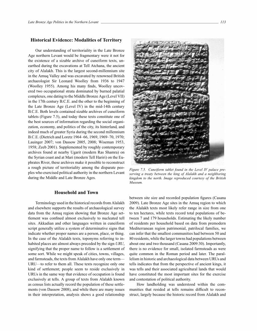
Historical Evidence: Modalities of Territory
Our understanding of territoriality in the Late BronzeAge northern Levant would be fragmentary were it not forthe existence of a sizable archive of cuneiform texts, un-earthed during the excavations at Tell Atchana, the ancientcity of Alalakh. This is the largest second-millennium sitein the Amuq Valley and was excavated by renowned Britisharchaeologist Sir Leonard Woolley from 1936 to 1947(Woolley 1955). Among his many finds, Woolley uncov-ered two occupational strata dominated by burned palatialcomplexes, one dating to the Middle Bronze Age (Level VII)in the 17th century B.C.E. and the other to the beginning ofthe Late Bronze Age (Level IV) in the mid-14th centuryB.C.E. Both levels contained sizable archives of cuneiformtablets (Figure 7.5), and today these texts constitute one ofthe best sources of information regarding the social organi-zation, economy, and politics of the city, its hinterland, andindeed much of greater Syria during the second millenniumB.C.E. (Dietrich and Loretz 1964–66, 1969, 1969–70, 1970;Lauinger 2007; von Dassow 2005, 2008; Wiseman 1953,1958; Zeeb 2001). Supplemented by roughly contemporaryarchives found at nearby Ugarit (modern Ras Shamra) onthe Syrian coast and at Mari (modern Tell Hariri) on the Eu-phrates River, these archives make it possible to reconstructa rough picture of territoriality among the disparate peo-ples who exercised political authority in the northern Levantduring the Middle and Late Bronze Ages.
Household and Town
Terminology used in the historical records from Alalakhand elsewhere supports the results of archaeological surveydata from the Amuq region showing that Bronze Age set-tlement was confined almost exclusively to nucleated tellsites. Akkadian and other languages written in cuneiformscript generally utilize a system of determinative signs thatindicate whether proper names are a person, place, or thing.In the case of the Alalakh texts, toponyms referring to in-habited places are almost always preceded by the sign URU,signifying that the proper name to follow is a settlement ofsome sort. While we might speak of cities, towns, villages,and farmsteads, the texts from Alalakh have only one term—URU—to refer to them all. These texts recognize only onekind of settlement; people seem to reside exclusively inURUs in the same way that evidence of occupation is foundexclusively at tells. A group of texts from Alalakh knownas census lists actually record the population of these settle-ments (von Dassow 2008), and while there are many issuesin their interpretation, analysis shows a good relationship
Figure 7.5. Cuneiform tablet found in the Level IV palace pre-serving a treaty between the king of Alalakh and a neighboringkingdom to the north. Image reproduced courtesy of the BritishMuseum.
between site size and recorded population figures (Casana2009). Late Bronze Age sites in the Amuq region to whichthe Alalakh texts most likely refer range in size from oneto ten hectares, while texts record total populations of be-tween 7 and 179 households. Estimating the likely numberof residents per household based on data from premodernMediterranean region patrimonial, patrilocal families, wecan infer that the smallest communities had between 50 and80 residents, while the larger towns had populations betweenabout one and two thousand (Casana 2009:30). Importantly,there is no evidence for small, isolated farmsteads as werequite common in the Roman period and later. The paral-lelism in historic and archaeological data between URUs andtells indicates that from the perspective of ancient kings, itwas tells and their associated agricultural lands that wouldhave constituted the most important sites for the exerciseand contestation of political authority.
How landholding was understood within the com-munities that resided at tells remains difficult to recon-struct, largely because the historic record from Alalakh and
114 Jesse Casana
elsewhere is so heavily biased toward palatial archives andhence elite perspectives. While indirect evidence of landtenure traditions can be found in the available texts, substan-tial disagreement exists among scholars regarding its inter-pretation. Liverani (1975, 1988) argues that Middle and LateBronze Age society was divided into two distinct sectors:(1) palace dependents who were tied to the land and receivedall goods and services through a redistributive system man-aged by the king’s household and (2) poor but free peasantswho held and worked their own land and who were largelysubsistence agriculturalists. Liverani therefore reconstructstwo parallel and radically different systems of landhold-ing. In contrast, Schloen (2001) argues that Bronze Agecommunities were structured through a steeply hierarchi-cal patrimonial household model. In Schloen’s (2001:302–(306) reconstruction, all agricultural land was held and man-aged by extended patrimonial families, and the land rightsof these households were legitimated by their relationshipto the king. In exchange for ownership rights, householdswere required to provide men for military service and laborfor the king’s own fields, as well as produce from the landthey worked. While certain elite members of society wereexempted from royal service, the vast majority of peopleknown from the census lists—probably 80 percent of thepopulation (von Dassow 2008:252–255)—owed service tothe king of Alalakh in exchange for their right to own andwork agricultural land. Thus the majority of the populationand the lion’s share of agricultural lands were tied up incomplex, overlapping systems of rights and responsibilities.
Some scholars have suggested that for the Bronze AgeNear East, agricultural fields were managed or owned collec-tively by villages, rather than by individuals or households(e.g., Renger 1995; Steinkeller 1999). Certainly land rightswere legitimated by the king, but within individual commu-nities, how those lands were distributed spatially may havebeen quite complex. There are examples from the Ottomanperiod of how such community-based systems might havefunctioned, such as the musha’ landholding system that wascommonly practiced in the Levant (Schaebler 2000). Whilethere are many variants on the system, all those that havebeen documented involved a periodic redistribution of agri-cultural land surrounding villages among households to ac-count for changes in household size and to balance accessto better-quality or more desirable fields. In such systems,which were even documented in operation in the AmuqValley as recently as the 1960s (Aswad 1971), the specificlocation and size of a given household’s landholdings mightshift from year to year, meaning that sales of such land wouldnot be possible.
A musha’-type system would not work well in agricul-tural or horticultural fields that require intensive or long-
term investment, and there is some evidence that vineyardsand orchards were in fact treated differently. Numerous textsfrom the Alalakh archives record the sale of specific parcelsof land, but these are all for vineyards, rather than agricul-tural fields. Several other texts record the size of vineyardplots owned by individuals within specific towns, but again,no texts are known recording the size of agricultural plotsused for annual crops like cereals. More supporting evi-dence for the different treatment of vineyard/orchard versusother agricultural lands can be found at nearby Ugarit whereHeltzer (1976:18, 35–40) notes that nearly all obligationsfor both service (including corvee labor, specialized skills,and military service) and taxes (paid in silver, grain, andother agricultural products) were performed and paid col-lectively by an entire village. In contrast, there are a numberof texts from Ugarit that record payments of olive oil tothe palace, and these appear to have been owed and paidentirely by individuals (Heltzer 1976:42). The distinctionbetween grain and other commodities may signal differ-ences in how rights to land that produced those commodi-ties were understood. The agricultural fields surroundingsettled communities may have been communally managed,and were certainly linked in the minds of elites to townsin a collective sense. Other types of land, however, appearto have been more exclusively managed, such that usufructrights could be sold or otherwise transferred with greaterautonomy.
While issues of individual landholding remain difficultto reconstruct based on the fragmentary textual record, thedata suggest complex land rights and deeply hierarchical andoverlapping claims to many agricultural lands. Ownershipby individuals or households seems to have been legitimatedlargely through relationships to kings or other local elites,who in turn received service, agricultural produce, and othergoods from resident households. The fact that land owner-ship for most people and for most land was not exclusivemeans that in practice, selling land or converting it to otheruses, such as turning agricultural land to residential uses asis done in suburbs today, would have been problematic. Nu-merous individuals up and down the social hierarchy heldinterests in land and its produce, and this may have beenone of the key factors contributing to the highly nucleatedpattern of settlement at tells that existed throughout the pe-riod. As populations within individual communities grew,they could not simply expand outwards onto agriculturalfields but would instead have to move beyond the limits ofcultivation or to other existing settlements. The durabilityof the tell-based settlement system, itself partially a productof land use patterns, may indicate that similar forms of com-plex and hierarchical landholding were the norm throughoutmuch of the Bronze and Iron Ages in the northern Levant.
Late Bronze Age Polities in the Northern Levant 115
Petty Kingdoms, Fragmented States
Like landholding traditions, political power during theMiddle and Late Bronze Ages seems to have been highlyhierarchical and spatially fragmented. Political entities thatoccupy a relatively small area administered from a singleurban center are often conceived of as city-states, and somescholars suggest a bipartite distinction between these smallpolities versus territorial states that extend political powerover large areas (e.g., Trigger 2003:92–119). Evidence fromthe Bronze Age Near East makes it clear that such a distinc-tion is largely inappropriate, particularly among the Amoriterulers and petty kingdoms of mid-second-millennium B.C.E.Syria. It may never be possible to reconstruct a complete orcoherent historic narrative of territoriality in this period, buta few well-documented vignettes illustrate the complexityof ownership and territory that existed in the region.
The earliest known mention of Alalakh (known as Alah-tum at the time) is in a series of cuneiform letters dating tothe early 17th century B.C.E. that were recovered from thepalace at Mari (Tell Hariri) on the Euphrates River, col-lected and published by Durand (2002). The letters providethe extraordinary details of a negotiation for the transfer of“ownership” of Alalakh from the king of Aleppo to the kingof Mari. It appears that the king of Mari wanted to acquiresome holdings in western Syria in order to provide more reli-able supplies of oil, wine, and other products, and so he senthis courtier to handle the negotiations. This courtier wrotenumerous letters back to the king regarding details of thetransfer. There are many convoluted machinations evidentin the correspondence, but it seems that the king of Aleppowas preparing to give Alalakh to the king of Mari in a kindof Maussian royal gift exchange. One letter from the king ofMari’s agent provides a summary of key issues. The letteropens with his description of the announcement by an agentfrom Aleppo to the citizenry of Alalakh that the transfer wasabout to take place:
Hammurabi’s [king of Aleppo] servant, Yasmah-Addu, gathered the citizens of Alahtum and YasmahAddu reiterated the orders of his lord, telling them,“My lord Hammurabi has given to Zimri-Lim [king ofMari] the town Alahtum, its fields and its vineyards,and the olive groves stretching from Alahtum’s limits.From Alahtum must leave the wedutum [probably anelite class], maskanu [another landowning class], theluDIRIG.GA [a class of uncertain designation], and who-ever holds or works land in Alahtum.” [Durand 2002:FM7 36]
The agent of Aleppo goes on to announce that other formerlydisplaced residents of Alalakh should return to the city.
Presumably, the transfer of ownership from Aleppo toMari meant that elite classes whose landholdings were legit-imated through Aleppo’s possession of the town no longerwould hold those lands, as they would instead be givento elites who were subordinate to the king of Mari. Thiscould not have been good news for the landowning classesat Alalakh. Indeed, it was precisely this disenfranchisementthat led to problems with the deal because it so happenedthat the king of Aleppo’s own mother held land in Alalakhand would have lost rights to it. This conflict led in turn to aseries of negotiations in which the king of Mari tried to pur-chase the city, rather than receiving it as a gift, an offer thatwas resolutely declined by the king of Aleppo. His refusalunderscores the fact that these transfers of ownership, whileoften involving an exchange of prestige goods such as silver,were not strictly economic but instead part of a system ofroyal gift exchange that created and reinforced the incestu-ous webs of dependency and domination that characterizedMiddle and Late Bronze Age politics.
The Alalakh/Alahtum exchange recorded in the Mariletters shows that owning towns was largely about beingable to reap the benefits of agricultural produce from theirassociated lands and to retain service obligations from theresidents. In the same letter quoted above, the agent fromMari conducted careful measurements of all the fields, or-chards, and vineyards held by the city to be sure these re-sources were accurately represented (Durand 2002:FM 736:20–27). The affair also offers a compelling insight intothe mechanics of the fairly common practice of town-swapsin the second millennium, as well as some of the reasonsthe practice might have been desirable. Similar transfers areknown from the Alalakh texts, being best attested in theMiddle Bronze Age archive. Two texts from Alalakh (AT 1and AT 456) discuss the transfer of ownership of Alalakhand its territory about 150 years after the negotiations knownfrom Mari.1 This time, a king named Abban acceded to thethrone of Aleppo, while his subordinate younger brotherYarim-Lim was given a territory located somewhere on thefar eastern edge of the realm, probably in the EuphratesValley (Zeeb 1998:834). Following a series of rebellions,the cities owned by the younger brother were destroyed,and, in compensation, the king of Aleppo gave Alalakh andall its towns to his brother Yarim-Lim, who then movedthere and founded a new dynasty of kings, all subservientto their patrimonial overlords (and direct relatives) atAleppo.
Once Yarim-Lim took possession of Alalakh and thetowns in its territory, he and his successors seem to haveregarded them as personal possessions like any other, as iswell illustrated by a text recording the will of Yarim-Lim’sson and successor, Ammitaku:
116 Jesse Casana
Ammitaku, man of Alalakh, while alive, in the pres-ence of Yarim-Lim [Abban’s successor as king of Halab]the king, his lord, has bequeathed his house, his pos-sessions, his cities, his fields, and whatever is his . . . toHammurabi, his son. [Wiseman 1953:AT 6]
Significantly, the Alalakh texts demonstrate that thepractice of buying, selling, and gifting of entire towns wasnot an activity that was the sole prerogative of royal per-sons. For instance, another text (AT 52) records the kingof Alalakh’s purchase of the town of Iburia from a non-royal woman and her son, for the price of 1,000 mina ofsilver, 1,000 measures of barley, 1,000 measures of emmer,6 pots of wine, and 10 pots of oil. Other texts (e.g., AT53, AT 54) record similar exchanges of entire towns be-tween the king and individuals. It seems strange that theking, who is in some sense the “owner” of all the towns inhis realm already, would engage in a purchase agreementfor those same towns. These types of exchanges could eventake place entirely between non-royal individuals, as shownin a text that records the purchase of a number of villagesby a man named Irpada from a variety of other non-royalpersons (Wiseman 1953:AT 56 and AT 57). These transac-tions make it clear that ownership of towns by elites hadnumerous dimensions, ranging from the allegiance of res-idents to the products of agricultural fields. Owning thesetowns was not, however, constitutive of political authority asit could be easily divested or transferred by the king himselfor exchanged among his subjects.
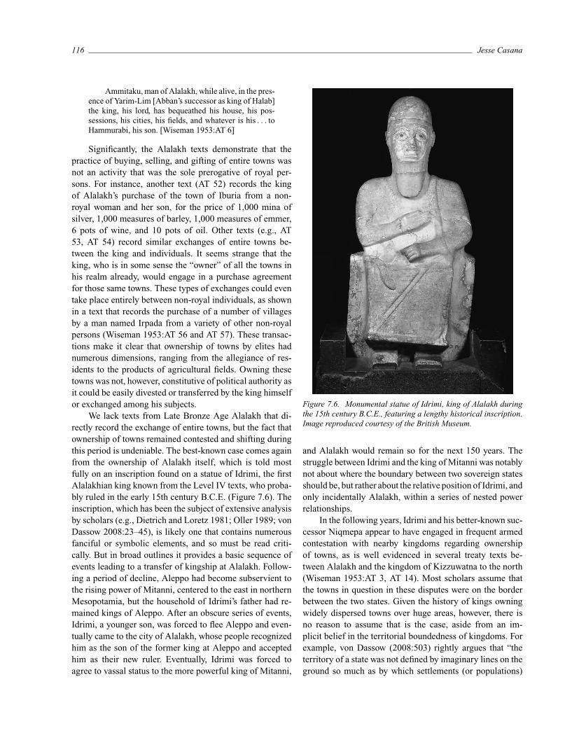
We lack texts from Late Bronze Age Alalakh that di-rectly record the exchange of entire towns, but the fact thatownership of towns remained contested and shifting duringthis period is undeniable. The best-known case comes againfrom the ownership of Alalakh itself, which is told mostfully on an inscription found on a statue of Idrimi, the firstAlalakhian king known from the Level IV texts, who proba-bly ruled in the early 15th century B.C.E. (Figure 7.6). Theinscription, which has been the subject of extensive analysisby scholars (e.g., Dietrich and Loretz 1981; Oller 1989; vonDassow 2008:23–45), is likely one that contains numerousfanciful or symbolic elements, and so must be read criti-cally. But in broad outlines it provides a basic sequence ofevents leading to a transfer of kingship at Alalakh. Follow-ing a period of decline, Aleppo had become subservient tothe rising power of Mitanni, centered to the east in northernMesopotamia, but the household of Idrimi’s father had re-mained kings of Aleppo. After an obscure series of events,Idrimi, a younger son, was forced to flee Aleppo and even-tually came to the city of Alalakh, whose people recognizedhim as the son of the former king at Aleppo and acceptedhim as their new ruler. Eventually, Idrimi was forced toagree to vassal status to the more powerful king of Mitanni,
Figure 7.6. Monumental statue of Idrimi, king of Alalakh duringthe 15th century B.C.E., featuring a lengthy historical inscription.Image reproduced courtesy of the British Museum.
and Alalakh would remain so for the next 150 years. Thestruggle between Idrimi and the king of Mitanni was notablynot about where the boundary between two sovereign statesshould be, but rather about the relative position of Idrimi, andonly incidentally Alalakh, within a series of nested powerrelationships.
In the following years, Idrimi and his better-known suc-cessor Niqmepa appear to have engaged in frequent armedcontestation with nearby kingdoms regarding ownershipof towns, as is well evidenced in several treaty texts be-tween Alalakh and the kingdom of Kizzuwatna to the north(Wiseman 1953:AT 3, AT 14). Most scholars assume thatthe towns in question in these disputes were on the borderbetween the two states. Given the history of kings owningwidely dispersed towns over huge areas, however, there isno reason to assume that is the case, aside from an im-plicit belief in the territorial boundedness of kingdoms. Forexample, von Dassow (2008:503) rightly argues that “theterritory of a state was not defined by imaginary lines on theground so much as by which settlements (or populations)
Late Bronze Age Polities in the Northern Levant 117
were subject to that state,” yet she then still produces a mapillustrating the territory of Alalakh as a contiguous, neatlybounded entity (von Dassow 2008: figure 2).
My own previous analysis of political geography duringthe Late Bronze Age in the kingdom of Alalakh comparesthe total number of Late Bronze Age sites recorded by theAmuq Valley Regional Survey with the number of toponymsfor places known to have been under the dominion of Alalakhfrom the Level IV texts (Casana 2009). Analysis shows thatwithin the Amuq Plain and its adjacent regions, an area thatmost scholars believe to have been the home territory ofAlalakh, there were no more than 120–130 potential loca-tions for Late Bronze Age settlement. Meanwhile, in theLevel IV archive there are at least 168 towns that can defini-tively be shown to have been under the suzerainty of theking of Alalakh, by virtue of their having been recorded incensus lists, troop rosters, or other direct forms of domi-nance. Moreover, the archive from Alalakh is a fragmentaryone (von Dassow 2005), with over half of the toponyms ap-pearing only once (Niedorf 1998), so we must assume thata large portion of town names are not recorded.
We could conclude based on the disparity between thenumber of towns owned by the king of Alalakh and thenumber of potential sites for those towns in the Amuq re-gion that the kingdom was much larger than is commonlythought. Based on an analysis of ancient and modern to-ponyms, Astour (1963, 1969) concluded that the king ofAlalakh actually ruled an immense region, stretching fromthe Mediterranean to the Euphrates. However, most of As-tour’s toponymic identifications have been shown to be in-accurate (Casana 2009). Von Dassow (2008:54–56) arguesthat the king of Alalakh during the period of the Level IVtexts was not only the king of the Amuq region but also ofat least three other lands referred to in the texts as Zahle,Aame, and Niya. While possible, the suggestion does littleto elucidate the extent of the king’s holdings, as we have noclear indication of the size or location of these lands. Analternative answer to the disconnect between the large num-ber of historically documented towns owned by the king ofAlalakh and the much smaller number of potential sites forthose towns is that the king’s holding included many townsthat were not in the immediate region of the Amuq Plain.If this were the case, then the spatially fragmented holdingsthat appear so prominently in the texts of the Middle BronzeAge may have continued to dominate the political map ofsubsequent centuries.
Liverani (2001:46–56) argues for precisely this concep-tion of borders during the Late Bronze Age, suggesting thatpolities, great or small, were not defined territorially. Hemaintains instead that ownership of cities or land was aboutcontrol of resources and revenue; it was about demarcating to
whom towns and villages would send tribute, taxes, or labor.He suggests that Late Bronze Age settlements were essen-tially oases, and that in the absence of maps, the “boundaryis not viewed as a geometrical line delimiting surfaces, butrather as a watershed of inhabited sites facing one or anothercatchment area, centered on one or another royal palace”(Liverani 2001:53). Even in very densely occupied areas,such as the rich Orontes River valley, boundaries betweendominant royal holdings were probably discontinuous, withvarious towns aligned with one king or the other. In sparselyoccupied mountains and deserts, ownership, in the sensethat we understand it today, was largely irrelevant. Withoutpeople or produce, there would be nothing to possess.
All of the above cases highlight the fact that throughoutthe Middle and Late Bronze Ages, polities in the north-ern Levant were far from territorially fixed entities. Theywere, on the contrary, highly spatially fragmented and sub-ject to frequent politically motivated realignments. The actof holding lands in more distant places could serve as akind of safety net in the face of environmental and politi-cal risk, similar in some respects to the vertical archipelagomodel proposed by Murra (1985) for the Andes region. Ina given year, agricultural produce might be more reliablein one region than in another while upheaval or militaryinvasion could make parts of a kingdom dangerous or un-stable, but refuge could be found far away. Fundamentally,the region seems to have been ruled by an incestuous groupof Amorite elites, most of whom were related to one an-other through marriage or patrimony, all the way from theMediterranean to southern Mesopotamia. These rulers en-gaged in seemingly endless convoluted negotiations regard-ing possession of towns and agricultural lands in a mannerreminiscent of European royalty. The census lists at Alalakhshow a regime desperately trying to maintain control overits holdings by counting people, measuring fields, and tal-lying resources, but they did so without the technologiesor traditions of administration that are commonplace today.Given these limitations, even the kings of Alalakh must havestruggled to understand the nature and extent of their ownpossessions; mapping them today from a single fragmentaryarchive seems all but impossible.
Distant Empires and Great Kings
At a broader geographical scale, the political historyof the northern Levant during the Late Bronze Age istypically characterized as an ongoing territorial conflictamong the Mitannian, Hittite, and Egyptian empires (e.g.,Klengel 1992; Roaf 1990:132–148). As we have seen al-ready, the relationship between Mitanni and western Syria
118 Jesse Casana
was complex, involving frequently renegotiated power re-lationships between kings of Mitanni and rulers of smallstates such as Alalakh, who sometimes sought to achieveparity status with larger powers and other times acceptedvassalage. Yet even when they reluctantly agreed to sub-servient positions with regional powers, vassal kings foughtwith one another incessantly to gain control of towns and toachieve more dominant social status. It was into this frac-tious local political landscape that the Egyptian and Hittitekings entered in the 15th century B.C.E.
As with most ancient polities, the Hittite and Egyp-tian presence in the Levant is typically portrayed by modernscholars as shifting territorial blobs, expanding outwardsfrom central Anatolia and the Nile Valley, respectively (e.g.,Liverani 2001:x–xi; Roaf 1990:134, 139). In their earlystages, both Hittite and Egyptian incursions into Syria seemto have been essentially looting raids, aimed at destroyingcities and hauling off their valuables, animals, and popu-lace. As early as 1499 B.C.E.,2 the Hittite king Hattusili Iinvaded Syria and Mesopotamia, and in his annals claimsto have destroyed Alalakh (Heinz 1992:194–195; Klengel1992:80–83) as well as Babylon. However, there is no evi-dence that the Hittites instituted any lasting imperial controlover the region during the following centuries. Similarly, theEgyptian Pharaoh Thutmose III led a campaign into Syriaand claims to have reached Carchemish and crossed theEuphrates River, but little evidence of Egyptian presenceis found in the northern Levant (Akkermans and Schwartz2003:351–358). In the later second millennium B.C.E., bothpowers exerted more overt imperial influence in the areaand came into increasingly direct conflict with one anotherregarding control of the region’s towns and kingdoms. Theeventual Hittite dominance of the northern Levant broughta radically different concept of political territoriality to theregion—one that was also at odds with the Egyptians’ ide-ology of conquest and control.
In contrast to the discontiguous territoriality of Amor-ite states in Syria and northern Mesopotamia, Hittite rulersseem to have had more bounded and contiguous territorialideals when it came to political power. While their earli-est raids may have been aimed at simply recovering booty,by the 14th century B.C.E., Hittite kings made overt ef-forts to establish territorial control in the northern Levant.Their concern for borders is probably best evidenced in thenumerous Hittite treaty texts found in the Hittite capitalof Hattussa/Bogazkoy, such as a bronze tablet that recordsan agreement between the Hittite king Tudhaliyah IV andthe king of Tarhuntassa, a region in southern Turkey (Hess1994:125–127; Otten 1988). These documents provide de-tailed descriptions of the lands under the control of the Hittiteking, carefully demarcating them from neighboring king-
doms using lists of towns, rivers, and mountains. Similartreaty texts have been found at Ugarit on the Syrian coast,a city that had become a vassal to the Hittites earlier thanAlalakh and other kingdoms of northern Syria. Following theHittite king Suppiluliuma’s invasion of Syria in the 14th cen-tury B.C.E., during which he defeated a coalition of kingsfrom Alalakh and elsewhere, the king of Ugarit’s loyaltywas rewarded with the control of towns and lands formerlyheld by the vanquished kingdoms (Astour 1969; Dietrichand Loretz 1964–66–66; Hess 1994:128–130).3 While thetreaty texts are fragmentary, they provide a list of morethan 50 towns, mountains, and bodies of water that for-merly belonged to the king of Alalakh but were transferredto Ugarit. Nougayrol (1956:10–15) interprets this listing ofplace names as a series forming a line, proceeding fromeast to west, and thus constituting a formal border betweenthe two states. In his detailed study of Ugaritic toponomy,Van Soldt (2005:1–4, 51–71) concurs that the treaty textsdo actually indicate a line reflecting a territory based almostexclusively on the north Syrian coast.
Three other texts from Ugarit similarly demarcate own-ership of towns and territory between Ugarit and its south-ern neighbor, Siyannou, located near modern Jebleh in thedensely occupied coastal plain. Hess (1994:129–130) sug-gests that the language employed in these texts supports theinterpretation that they describe real, continuous borders,evident in the use of the Akkadian terms a-du and qa-du ap-pearing between toponyms as a preposition meaning “up to”or “as far as,” as in “a-di meMES hu-un-du-ra-si” (RS 17.62,lines 2–3), translated as “as far as the waters of Hundurasi.”The use of such terminology may thus imply that these textsare actually describing a line, in which place names simplyserve as points of reference along it.
The treaty texts from the Hittite realm, especially duringthe 13th century B.C.E., articulate a deeper concern forpolities’ territorial integrity than was found in other culturaltraditions of the Bronze Age Near East. These notions ofterritory may be reflected in the archaeological record ofthe Hittite kingdom, particularly along their northern borderwith the Kashka tribes. The Kashka, known only throughHittite texts, were a constant source of fear and irritation toHittite control north of their capital. Regional archaeologicalinvestigations have now documented lines of Hittite forts,spaced evenly across the landscape in an apparent attempt todemarcate a border (Glatz 2009; Glatz and Matthews 2005)in a manner reminiscent of Roman forts along Hadrian’sWall in northern England or along their eastern frontierwith Persia in the Arabian Desert. Similar lines of forts canbe found to the south of the Hittite heartland in the borderregion of the lands known as Tarhuntassa (Dincol et al.2000).
Late Bronze Age Polities in the Northern Levant 119
How the Hittites’ evident concern for borders wouldhave mapped onto existing territorial fragmentation in thenorthern Levant is difficult to imagine but must have gener-ated many tensions and controversies, as did their relationswith the pharaohs of New Kingdom Egypt. Particularly dur-ing the early and mid-second millennium B.C.E., Egyptiansadhered to an ideology that would have rendered all polit-ical boundaries an existential impossibility. As argued byLiverani (2001), Bell (2007:99–100), and others, the Egyp-tian worldview positioned Egyptians not only as superior toother peoples—be they Asiatics, Nubians, or Libu—but asvirtually a different species. The pharaoh was a living deity,the son of the sun god and a mortal woman, and the NileValley was the center of the universe, an island of civilitywith lands surrounding it filled with chaos. The inhabitantsof these border areas were more akin to animals than to resi-dents of states on equal footing with Egypt, making any kindof negotiation quite problematic from the Egyptian perspec-tive. It made no more sense to negotiate with foreigners thanit did to negotiate with a herd of gazelle. The pharaoh alreadyhad absolute dominion over all the lands of the world, andthus territorial expansion was not only unnecessary but alsototally incongruous with Egyptian metaphysics. Egypt’s ac-tivities in the Levant are perhaps better framed as attemptsto bring order and civilization to chaotic lands that wereand could only be conceived of as part of the pharaoh’srealm.
The ever-widening encounters that Egyptian rulers hadwith other kings over the course of the mid-second millen-nium B.C.E. must have created an uncomfortable tensionbetween their ideology of political power and the realityof their conflicts with other Great Kings (Bell 2007; Kemp2006:247–248, 281–292). By the end of the Late BronzeAge, there seems to have been at least some reconceptu-alization of their relationships with other states, perhapsmost clearly emphasized in the famous parity treaty withthe Hittites, known variously as the Treaty of Eternal Peaceor the Treaty of Kadesh. Relations between the Hittites andEgyptians had grown increasingly hostile from the mid-14thcentury B.C.E., culminating with the titanic clash of theirarmies, led by Muwattali and Rameses II, respectively, atthe city of Kadesh in 1274 B.C.E.
This event, well known from numerous Egyptian ac-counts, is generally conceived as a territorial dispute; mostscholars see the heart of the tension between the two pow-ers as revolving around the fealty of petty kingdoms inthe Levant and Syria (e.g., Bryce 2005:221–230; Klengel2002). Certainly the city of Kadesh, probably located at TellNebi Mend on the Orontes River near the modern Syrian–Lebanese border,4 seems to have been of some strategic im-portance in the later second millennium B.C.E. and to have
changed allegiance between Hittite and Egyptian rulers nu-merous times over the Late Bronze Age. Thus it would beeasy to see the entire conflict as a struggle over the demar-cation of a border between the two powers. Yet the treatythat more or less resolved overt militaristic hostility be-tween the Hittites and Egyptians, concluded in 1259 B.C.E.and preserved in cuneiform copies found in the Hittite cap-ital of Hattussa and in Egyptian hieroglyphic translationsof Rameses II (Beckman 1999; Edel 1997), makes almostno mention of territory or borders. The lengthy treaty es-tablishes a whole series of agreements and conditions be-tween the two kings including promises not to fight one an-other, to honor the rightful succession of heirs, to interveneagainst usurpers, to extradite persons seeking refuge, and toforge a lasting peace, but nothing about boundaries. Whileeach power promises not to invade the lands of the other,where these lands are specifically located is never spelledout—not even for Kadesh itself. The absence of border de-scriptions or even town ownership in this and other similartreaties is undoubtedly because these documents were pri-marily agreements between individuals, not states, and weresimply another aspect of the maneuvering and brinksman-ship that characterized geopolitics of the Late Bronze Age(Bryce 2006; Klengel 2002; Surenhagen 2006). In this andin all cases from the Bronze Age Near East, political powerwas fundamentally about personal relationships, not aboutterritory.
Conclusion
Following Adam T. Smith’s (2003), Monica Smith’s(2005), and others’ critiques of the models archaeologistshave previously employed when considering territory in an-cient states, this chapter has sought to explore the emergent,dynamic, and often contradictory ways in which politicalpower was spatially manifested during the Late Bronze Agein the northern Levant. The combination of detailed archae-ological survey data and a rich historical record from theregion offers a rare glimpse into the complexity of theseproblems. Far from the materialist notions of territorial-ity that are common in archaeological literature, the casestudies presented herein reveal widely divergent and histor-ically contingent relationships between expressions of po-litical authority and control of territory. Available textualdata do not permit more than a brief snapshot of differ-ent times and places over several centuries, but these datademonstrate a large variance among the examples discussed,from the fragmented states of Amorite kingdoms, to thedelineated borders found in Hittite treaties, to the Egyp-tian pharaoh’s outright dismissal of other polities. These
120 Jesse Casana
contrasting ideas of territoriality are in part cultural, withdifferent communities concurrently maintaining distinct tra-ditions synchronously. However, there is also evidence forsignificant changes in territorial understandings over the midto late second millennium B.C.E., seen, for example, in theshift in attitudes among pharaohs from the time of Thut-mose III to that of Rameses II toward increasing acceptanceof other peer-kings or in the apparent waning of spatiallyfragmented holdings that characterized the Amorite king-doms of the earlier second millennium. Thus, the historicalrecord reveals both synchronous variability and diachronicchange in the dominant territorial attitudes of politicalpowers.
While such varying modalities of territoriality are evi-dent in the textual record, archaeological data reveal almostnone of this geographic or temporal variability, but insteadshow a pattern of settlement that was resoundingly stable.It is truly remarkable that throughout the centuries of thesecond millennium B.C.E., and indeed across much of theBronze and Iron Ages, the location and size of most townsand cities remained largely unchanged. This resiliency sug-gests that the most important rules governing settlementdecision-making were not linked to whatever distant kingwas imagining himself as ruler, but rather to local traditionsof land tenure, the dominant subsistence strategies employedby communities, the ways in which exchange in agriculturalproducts was managed, and other similarly durable social in-stitutions. The region would eventually witness a profoundtransformation in settlement organization, but not until thelater centuries of the first millennium B.C.E., when many ofthe long-lived tells of the Bronze and Iron Ages were aban-doned and large numbers of small, dispersed sites spreadthroughout the plains and uplands (Casana 2007; Casanaand Wilkinson 2005). The dramatic restructuring of the set-tled landscape that occurred during the Hellenistic and Ro-man periods is likely evidence of a fundamental shift in thebasic rules governing settlement and land use practices thatdominated previous millennia. Our data may thus indicatethat political ideologies of territory need not play much ofa role in determining the spatial organization of settlementsystems.
The rather stark contrast that this essay has drawn outbetween the durability of settlement systems on the one handand the volatility of political territorial notions on the othershould offer a note of warning to archaeological studies thatseek to define territoriality based on settlement data in theabsence of ancient texts or direct ethnographic data. Despitethe huge diversity in territorial traditions evident from thehistorical record of the northern Levant, virtually none of itis visible in the material culture record. Were it not for thetextual data available in this case study, the conclusions we
would reach based on analysis of settlement patterns alonewould sorely misunderstand the complexity and dynamismof the situation. This problem is closely related to the long-standing question of how we might identify material corre-lates of political power. Numerous studies have highlightedthe difficulties in the identification of empires, even whenwell-attested historically, in the archaeological record (e.g.,Morrison and Lycett 1994; Parker 2003; Schreiber 2001;Sinopoli 1994; Smith and Montiel 2001). Territoriality couldbe viewed as one, largely ideological, component of ancientempires or other political forms, and thus something thatis quite difficult to recognize in the material record. Inno-vative studies such as Glatz’s (2009) analysis of the HittiteEmpire, which evaluates many overlapping lines of mate-rial and textual evidence within a framework that considersboth the imperial aims of kings and the agency of conqueredcommunities, offer one possible way forward.
On the other side of the coin, strictly historicist analy-ses that consider the textual record superior to more mun-dane forms of archaeological evidence are likely to over-state the effect that changing modes of political power hadon individual communities and the way in which settlementwas structured. While integrated analyses of both historicaland archaeological evidence, like that undertaken here, havelong been advocated by anthropologists (e.g., Adams 1988),such studies remain relatively rare. Yet only by engagingfully with diverse data sets from across these disciplinescan we hope to understand both ideological expressions ofpolitical power and their manifestations within a physicallandscape.
Notes
1. Originally published by Wiseman (1953, 1958), butsee von Dassow (2008:13–14) for a discussion of more re-cent literature on the texts. Text numbers follow Wiseman’soriginal system.
2. The absolute chronology of the second millenniumB.C.E. in the Near East and Mediterranean remains the sub-ject of ongoing dispute among specialists. I rely here onthe chronology proposed by Gasche and coauthors (1998),sometimes referred to as the “Ultra Low” chronology, be-cause it fits best with current knowledge of both archaeo-logical and historical data. Von Dassow (2008:xx) agrees.
3. Two copies of one treaty, written during the reignof Suppiluliuma, cede towns to Ugarit (RS 17.340 andRS 17.369A; Nougayrol 1956:48–52). Four texts from thereign of Mursili II, Suppiluliuma’s successor, reaffirm thetreaty (RS 17.237, RS 17.62, RS 17.339A, and RS 17.366;Nougayrol 1956:63–70).
Late Bronze Age Polities in the Northern Levant 121
4. The location of Qadesh/Kadesh at Tell Nebi Mendwas made originally by Claude Conder in 1881 and was fullyarticulated based on historical evidence by James HenryBreasted (1903). While the location remains generally ac-cepted (Avalos 1992; Murnane 2001), some scholars offerdissenting views (e.g., Nibbi 2004; Tubb 2007).
References
Adams, Robert McC.1988 Contexts of Civilizational Collapse: A
Mesopotamian View. In The Collapse ofAncient States and Civilizations. Norman Yoffeeand George L. Cowgill, eds. Pp. 20–43. Tucson:University of Arizona Press.
Akkermans, Peter M. M. G., and Glenn M. Schwartz2003 The Archaeology of Syria: From Complex Hunter-
Gatherers to Early Urban Societies (c. 16000–300BC). Cambridge: Cambridge University Press.
Anderson, Benedict R.1983 Imagined Communities: Reflections on the Origin
and Spread of Nationalism. London: Verso.
Astour, Michael C.1963 Place-Names from the Kingdom of Alalah in the
North Syrian List of Thutmose III: A Study inHistorical Topography. Journal of Near EasternStudies 22:220–240.
1969 The Partition of the Confederacy of Mukis-Nuðasse-Nii by Suppiluliuma: A Study in PoliticalGeography of the Amarna Age. Orientalia38:381–414.
Aswad, Barbara C.1971 Property Control and Social Strategies in Settlers
in a Middle Eastern Plain. AnthropologicalPapers, 44. Ann Arbor: Museum of Anthropology,University of Michigan.
Avalos, Hector1992 Kadesh-on-the-Orontes. In Anchor Bible Dictio-
nary, Vol. 4. David Noel Freedman, ed. Pp. 3–4.New York: Doubleday.
Bass, George F., Cemal Pulak, Dominique Collon, and JamesWeinstein
1989 The Bronze Age Shipwreck at Ulu Burun: 1986Campaign. American Journal of Archaeology93:1–29.
Beckman, Gary1999 Hittite Diplomatic Texts. 2nd edition. Writings
from the Ancient World, 7. Atlanta: Scholars.
Bell, Lanny2007 Conflict and Reconciliation in the Ancient Middle
East: The Clash of Egyptian and Hittite Chariotsin Syria and World’s First Peace Treaty between“Superpowers.” In War and Peace in the AncientWorld. Kurt A. Raafluab, ed. Pp. 98–120. Oxford:Wiley-Blackwell.
Braidwood, Robert J.1937 Mounds in the Plain of Antioch: An Archaeo-
logical Survey. Oriental Institute Publication 48.Chicago: Oriental Institute Press.
Braidwood, Robert J., and L. S. Braidwood1960 Excavations in the Plain of Antioch, vol. 1: The
Earlier Assemblages, Phases A–J. OrientalInstitute Publications 61. Chicago: OrientalInstitute.
Breasted, James Henry1903 The Battle of Kadesh: A Study in the Earliest
Known Military Strategy. Chicago: University ofChicago Press.
Bryce, Trevor2005 The Kingdom of the Hittites. New edition. Oxford:
Oxford University Press.2006 The “Eternal Treaty” from the Hittite Perspective.
British Museum Studies on Ancient Egypt andSudan 6:1–11.
Buccellati, Giorgio1997 Amorites. In The Oxford Encyclopedia of Archae-
ology in the Near East, Vol. 1. Eric M. Meyers, ed.Pp. 107–111. New York: Oxford University Press.
Casana, Jesse2003a From Alalakh to Antioch: Settlement, Land Use,
and Environmental Change in the Amuq Valley ofSouthern Turkey. Ph.D. dissertation, Departmentof Near Eastern Languages and Civilizations,University of Chicago.
2003b The Archaeological Landscape of Late RomanAntioch. In Culture and Society in Later RomanAntioch: Papers from a Colloquium, London, 15thDecember 2001. Isabell Sandwell and Janet A. R.Huskinson, eds. Pp. 102–125. Oxford: Oxbow.
122 Jesse Casana
2007 Structural Transformations in Settlement Systemsof the Northern Levant. American Journal ofArchaeology 111:195–221.
2008 Mediterranean Valleys Revisited: Linking SoilErosion, Land Use, and Climate Variability in theNorthern Levant. Geomorphology 101:429–442.
2009 Alalakh and the Archaeological Landscape ofMukish: The Political Geography and Populationof a Late Bronze Age Kingdom. Bulletin of theAmerican Schools of Oriental Research 353:7–37.
Casana, Jesse, Jackson Cothren, and Tuna Kalayci2013 Swords into Ploughshares: Archaeological Ap-
plications of CORONA Satellite Imageryin the Near East. Internet Archaeology 32.http://intarch.ac.uk/journal/issue32/2/toc.html.
Casana, Jesse, and Tony J. Wilkinson2005 Settlement and Landscapes in the Amuq Region.
In The Amuq Valley Regional Projects, vol. 1:Surveys in the Plain of Antioch and Orontes Delta,Turkey, 1995–2002. Oriental Institute Publication131. Kutlu A. Yener, ed. Pp. 25–65. Chicago:Oriental Institute of the University of Chicago.
Cline, Eric1994 Sailing the Wine-Dark Sea: International Trade and
the Late Bronze Age Aegean. BAR InternationalSeries, 591. Oxford: Tempus Reparatum.
Courtois, J.-C.1973 Prospection archaeologique dans la Moyenne
Vallee de l’Oronte. Syria 50:53–99.
Dietrich, Manfried, and Oswald Loretz1964–66 Der Vertrag zwischen Suppiluliuma und
Niqmandu: Eine philologische und kulturhis-torische Studie. Welt des Orients 3:206–245.
1969 Die soziale Struktur von Alalah und Ugarit (V):Die Weingarten des Gebietes von Alalah im 15.Jahrhundert. Ugarit-Forschungen 1:37–64.
1969–70 Die soziale Struktur von Alalah und Ugarit (II):Die sozialen Gruppen hupse-name, haniahhe-eku,ehele-suzubu, und marjanne nach Texten ausAlalah IV. Welt des Orients 5:57–93.
1970 Die soziale Struktur von Alalah und Ugarit (IV):Die E = bıtu-Listen aus Alalah IV als Quelle furdie Erforschung der gesellschaftlichen Schich-tung von Alalah im 15. Jh.v.Chr. Zeitschrift furAssyriologie und vorderasiatische Archaologie60:88–123.
1981 Die Inschrift des Konigs Idrimi von Alalah. Ugarit-Forschungen 13:201–269.
Dincol, Ali M., Jak Yakar, Belkis Dincol, and Avia Taffet2000 The Borders of the Appanage Kingdom of
Tarhuntassa: A Geographical and ArchaeologicalAssessment. Anatolica 26:1–29.
Durand, Jean-Marie2002 Le culte d’Addu d’Alep et l’affaire d’Alahtum.
Florilegium marianum 7. Memoires de N.A.B.U.8. Paris: SEPOA.
Edel, Elmar1997 Der Vertrag zwischen Ramses II von Agypten
und Hattusili III von Hatti. Berlin: DeutschenOrient-Gesellschaft.
Gasche, H., J. A. Armstrong, S. W. Cole, and V. G.Gurzadyan
1998 Dating the Fall of Babylon: A Reappraisal of Sec-ond Millennium Chronology. Ghent: University ofGhent and Oriental Institute at the University ofChicago.
Glatz, Claudia2009 Empire as Network: Spheres of Material Inter-
action in Late Bronze Age Anatolia. Journal ofAnthropological Archaeology 28:127–141.
Glatz, Claudia, and Roger Matthews2005 Anthropology of a Frontier Zone: Hittite-Kaska
Relations in Late Bronze Age North-CentralAnatolia. Bulletin of the American Schools ofOriental Research 339:47–65.
Graff, Sarah R.2006 Economy and Society: An Archaeological Recon-
struction of the Political and Informal Economy ofNorthwestern Syria in the Third Millennium BC.Ph.D. dissertation, Department of Anthropology,University of Chicago.
Heinz, Marlies1992 Tell Atchana/Alalakh. Die Schichten VII–XVII.
AOAT 41. Kevelaer, Neukirchen-Vluyn: VerlagButzon und Bercker.
Heltzer, Michael1976 The Rural Community in Ancient Ugarit. Wies-
baden: Dr. Ludwig Reichert.
Late Bronze Age Polities in the Northern Levant 123
Hess, Richard S.1994 Late Bronze Age and Biblical Boundary Descrip-
tions of the West Semitic World. Ugarit and theBible 11:123–138.
Kemp, Barry J.2006 Ancient Egypt: Anatomy of a Civilization. 2nd
edition. New York: Routledge.
Klengel, Horst1992 Syria 3000–300 B.C.: A Handbook of Political
History. Berlin: Akademie Verlag.2002 From War to Eternal Peace: Ramesses II and Khat-
tushili III. CSMS Bulletin 37:49–56.
Lauinger, Jacob2007 Archival Practices at Old Babylonian/Middle
Bronze Age Alalakh (Level VII). Ph.D. disserta-tion, Department of Near Eastern Languages andCivilizations, University of Chicago.
Liverani, Mario1975 Communautes de villages et palais royal dans le
Syrie du IIeme millenaire. Journal of the Economicand Social History of the Orient 18:146–164.
1988 Antico Oriente: storia, societa, economia. Rome:Laterza.
2001 International Relations in the Ancient Near East,1600–1100 BC: Studies in Diplomacy. New York:Palgrave Macmillan.
Lonnqvist, Minna2009 Jebel Bishri in Syria and the Role of Nomadism in
the End of the Early Bronze Age. In The Levant inTransition: Proceedings of a Conference Held atthe British Museum on 20–21 April 2004. Peter J.Parr, ed. Pp. 49–55. Leeds: Maney.
Martin, Simon, and Nikolai Grube2000 Chronicle of the Maya Kings and Queens: De-
ciphering the Dynasties of the Ancient Maya.London: Thames and Hudson.
Matthers, John, ed.1981 The River Qoueiq, Northern Syria, and Its Catch-
ment: Studies Arising from the Tell Rifa’at Survey1977–79. BAR International Series, 98. Oxford:British Archaeological Reports.
McGeough, Kevin2007 Exchange Relationships at Ugarit. Ancient Near
Eastern Studies Supplement Series, 26. Leuven:Peeters.
Morrison, Kathleen D., and Mark Lycett1994 Central Power, Centralised Authority? Ideolog-
ical Claims and Archaeological Patterns. AsianPerspectives 33:327–350.
Murnane, William J.2001 Kadesh. In The Oxford Encyclopedia of Ancient
Egypt, Vol. 1. Donald B. Redford, ed. Pp. 219–221.New York: Oxford University Press.
Murra, John V.1985 Limits and Limitations of the “Vertical
Archipelago” in the Andes. In Andean Ecol-ogy and Civilization. M. I. Shozo and M. C.Shimada, eds. Pp. 15–20. Tokyo: University ofTokyo Press.
Nibbi, Alessandra2004 The Location of Qadesh: Persisting Difficulties.
Discussion in Egyptology 58:71–79.
Nichols, John J., and Jill A. Weber2006 Amorites, Onagers, and Social Reorganization
in Middle Bronze Age Syria. In After Col-lapse: The Regeneration of Complex Societies.Glenn M. Schwartz and John J. Nichols, eds.Pp. 38–57. Tucson: University of ArizonaPress.
Niedorf, Christian1998 Die toponyme der texte aus Alalah IV. Ugarit-
Forschungen 30:515–568.
Nougayrol, Jean1956 Le palais royal d’Ugarit, vol. 4: Textes accadiens
des archives sud. Mission de Ras Shamra 9. Paris:Imprimerie Nationale.
Nougayrol, J., E. Laroche, C. Virolleaud, and C. F.-A.Schaeffer
1968 Ugaritica V. Mission de Ras Shamra 16. Paris:Imprimerie Nationale.
Oller, Gary Howard1989 The Inscription of Idrimi: A Pseudo-
Autobiography? In DUMU-E2-DUB-BA: Studiesin Honor of Ake W. Sjoberg. H. Behrens, D. Lod-ing, and M. Roth, eds. Pp. 411–417. Occasional
124 Jesse Casana
Publications of the Samuel Noah Kramer Fund,11. Philadelphia: University Museum.
Otten, H.1988 Die Bronzetafel aus Bogazkoy: Ein Staatsvertrag
Tuthalijas IV. Studien zu den Bogazkoy-Texten,Beiheft 1. Wiesbaden: Harrassowitz.
Parker, Bradley J.2003 Archaeological Manifestations of Empire: As-
syria’s Imprint on Southeastern Anatolia.American Journal of Archaeology 107:525–557.
Philip, G., F. Jabour, A. Beck, M. Bshesh, J. Grove, A. Kirk,and A. Millard
2005 Settlement and Landscape Development in theHoms Region, Syria: Report on Work Undertakenduring 2001–2003. Levant 37:21–42.
Rayfuse, R.2009 W(h)ither Tuvalu? International Law and Disap-
pearing States. University of New South WalesFaculty of Law Research Series, 9. Berkeley:Berkeley Electronic Press.
Renger, Johannes M.1995 Institutional, Communal and Individual Owner-
ship or Possession of Arable Land in AncientMesopotamia from the End of the Fourth to theEnd of the First Millennium B.C. Chicago-KentLaw Review 71:269–319.
Roaf, Michael1990 The Cultural Atlas of Mesopotamia and the An-
cient Near East. New York: Facts on File.
Romano, David2006 The Kurdish Nationalist Movement: Opportunity,
Mobilization and Identity. Cambridge: CambridgeUniversity Press.
Ryan, John, George Dunford, and Simon Sellars2006 Micronations: The Lonely Planet Guide to Home-
Made Nations. London: Lonely Planet.
Schaebler, Brigitte2000 Practising Musha: Common Lands and the Com-
mon Good in Southern Syria under the Ottomansand the French. In New Perspectives on Propertyand Land in the Middle East. Roger Owen and
Martin P. Bunton, eds. Pp. 251–309. Cambridge,MA: Harvard University Press.
Schloen, David2001 The House of the Father as Fact and Symbol:
Patrimonialism in Ugarit and the Ancient NearEast. Winona Lake, IN: Eisenbrauns.
Schmidle, Nicholas2009 Wanted: A New Home for My Country. New York
Times Magazine, May 31: 16.
Schreiber, Katharina J.2001 The Wari Empire of Middle Horizon Peru: The
Epistemological Challenge of Documentingan Empire without Documentary Evidence. InEmpires: Perspectives from Archaeology and His-tory. Susan Alcock, Terence D’Altroy, KathleenMorrison, and Carla Sinopoli, eds. Pp. 70–92.Cambridge: Cambridge University Press.
Sinopoli, Carla M.1994 The Archaeology of Empires. Annual Review of
Anthropology 23:159–180.
Smith, Adam T.2003 The Political Landscape: Constellations of Author-
ity in Early Complex Polities. Berkeley: Universityof California Press.
Smith, Michael E., and Lisa Montiel2001 The Archaeological Study of Empires and Imperi-
alism in Pre-Hispanic Central Mexico. Journal ofAnthropological Archaeology 20:245–284.
Smith, Monica L.2005 Networks, Territories, and the Cartography of
Ancient States. Annals of the Association ofAmerican Geographers 95(4):832–849.
Steinkeller, Piotr1999 Land-Tenure Conditions in Third Millennium
Babylonia: The Problem of Regional Variation. InUrbanization and Land Ownership in the AncientNear East. M. Hudson and B. Levine, eds. Pp.289–330. Cambridge, MA: Peabody Museum ofArchaeology and Ethnology, Harvard University.
Surenhagen, Dietrich2006 Forerunners of the Hattusili-Ramesses Treaty.
Late Bronze Age Polities in the Northern Levant 125
British Museum Studies on Ancient Egypt andSudan 6:59–67.
Trigger, Bruce2003 Understanding Early Civilizations: A Comparative
Study. New York: Cambridge University Press.
Tubb, Jonathan N.2007 The Identification of Qadesh. Bulletin of the
Anglo-Israel Archaeological Society 25:207.
Van Soldt, Wilfred H.2005 The Topography of the City-State of Ugarit. Alter
Orient und Altes Testament 324. Munster: Ugarit.
Verstraete, Jan, and Tony J. Wilkinson2000 The Amuq Regional Archaeological Survey. In
The Amuq Valley Regional Project, 1995–1998.K. Aslihan Yener, Christopher Edens, Timothy P.Harrison, J. Verstraete, and Tony J. Wilkinson.Pp. 179–192. American Journal of Archaeology104:163–220.
von Dassow, Eva M.2005 Archives of Alalah IV in Archaeological Context.
Bulletin of the American Schools of OrientalResearch 338:1–69.
2008 State and Society in the Late Bronze Age: Alalahunder the Mittani Empire. Studies on the Civiliza-tion and Culture of Nuzi and the Hurrians, 17.Bethesda, MD: CDL.
Wilkinson, Tony J.1999 Holocene Valley Fills of Southern Turkey and
Northwestern Syria: Recent GeoarchaeologicalContributions. Quaternary Science Reviews18:555–571.
2000 Geoarchaeology of the Amuq Plain. In The AmuqValley Regional Project, 1995–1998. K. AslihanYener, Christopher Edens, Timothy P. Harrison, J.Verstraete, and Tony J. Wilkinson. Pp. 168–179.American Journal of Archaeology 104:163–220.
Wilkinson, Tony J., E. Friedman, E. Alp, and A. Stampfl2001 The Geoarchaeology of a Lake Basin: Spatial
and Chronological Patterning of Sedimentationin the Amuq Plain, Turkey. In Recherchesarcheometriques. M. Fortin, ed. Pp. 211–226.Cahiers d’archeologie du CELAT, 10. Quebec:CELAT, Universite Laval.
Wiseman, D. J.1953 The Alalakh Tablets. London: British Institute of
Archaeology at Ankara.1958 Abban and Alalah. Journal of Cuneiform Studies
12:124–129.
Woolley, C. Leonard1955 Alalakh: An Account of the Excavations at Tell
Atchana in the Hatay, 1937–1949. London: TheSociety of Antiquaries of London.
Yamamoto, Lilian, and Miguel Esteban2010 Vanishing Island States and Sovereignty.
Ocean and Coastal Management Journal 53(1):1–9.
Zeeb, Frank1998 Die Orstnamen und Geographischen Bezeichnun-
gen der Texte aus Alalah VII. Ugarit-Forschungen30:829–886.
2001 Die Palastwirtschaft in Altsyrien: nach denspataltbabylonischen Getreidelieferlisten ausAlalah (Schicht VII). Munster: Ugarit.