Sensor-Based Prototype of a Smart Assistant for Visually ...
24
Citation: S , ipos , , E.; Ciuciu, C.; Ivanciu, L. Sensor-Based Prototype of a Smart Assistant for Visually Impaired People—Preliminary Results. Sensors 2022, 22, 4271. https://doi.org/10.3390/s22114271 Academic Editors: Marco Leo and Anil Anthony Bharath Received: 28 April 2022 Accepted: 30 May 2022 Published: 3 June 2022 Publisher’s Note: MDPI stays neutral with regard to jurisdictional claims in published maps and institutional affil- iations. Copyright: © 2022 by the authors. Licensee MDPI, Basel, Switzerland. This article is an open access article distributed under the terms and conditions of the Creative Commons Attribution (CC BY) license (https:// creativecommons.org/licenses/by/ 4.0/). sensors Article Sensor-Based Prototype of a Smart Assistant for Visually Impaired People—Preliminary Results Emilia S , ipos , *, Cosmin Ciuciu and Laura Ivanciu Bases of Electronics Department, Technical University of Cluj-Napoca, 400027 Cluj-Napoca, Romania; [email protected] (C.C.); [email protected] (L.I.) * Correspondence: [email protected] Abstract: People with visual impairment are the second largest affected category with limited access to assistive products. A complete, portable, and affordable smart assistant for helping visually impaired people to navigate indoors, outdoors, and interact with the environment is presented in this paper. The prototype of the smart assistant consists of a smart cane and a central unit; communication between user and the assistant is carried out through voice messages, making the system suitable for any user, regardless of their IT skills. The assistant is equipped with GPS, electronic compass, Wi-Fi, ultrasonic sensors, an optical sensor, and an RFID reader, to help the user navigate safely. Navigation functionalities work offline, which is especially important in areas where Internet coverage is weak or missing altogether. Physical condition monitoring, medication, shopping, and weather information, facilitate the interaction between the user and the environment, supporting daily activities. The proposed system uses different components for navigation, provides independent navigation systems for indoors and outdoors, both day and night, regardless of weather conditions. Preliminary tests provide encouraging results, indicating that the prototype has the potential to help visually impaired people to achieve a high level of independence in daily activities. Keywords: smart assistant; visually impaired; navigation; obstacle detection; route recommendation; intelligent sensors; daily activities 1. Introduction At the end of 2021, an estimated over 2 billion people have near or distance vision impairment. Vision impairment affects people of all ages and poses an enormous global financial burden with the annual global costs of productivity losses. For low- and middle- income regions, the prevalence of distance vision impairment is four times higher than in high-income regions [1]. Vision loss is associated with low income, reduced quality of life, concurrent medical issues, and mental health problems [2]. Visually impaired people are affected not only at a medical level, but also at economical and psychological levels. The health and well-being of a visually impaired individual and their family can be improved by means of assistive technologies, which also bring broader socioeconomic benefits [3]. Visually impaired people are the second largest affected category with no access to assistive products—more than 200 million people. Daily struggles of visually impaired people are (and not limited to): lack of abil- ity to identify and interact with the environment, difficulty in outdoor navigation and dependence on others (family/friends) for purchasing groceries and goods. For a visually impaired person, unassisted traveling requires two levels of navigation: micro-navigation and macro-navigation [4]. Macro-navigation is the ability of the user to know their current location, orientation, and to have information about the route to follow to reach the destination. Micro-navigation involves the user’s ability to identify possible obstacles along the route such as pedestrian crossings, building walls, transparent doors or other obstacles that may interfere with the user. Sensors 2022, 22, 4271. https://doi.org/10.3390/s22114271 https://www.mdpi.com/journal/sensors
-
Upload
khangminh22 -
Category
Documents
-
view
3 -
download
0
Transcript of Sensor-Based Prototype of a Smart Assistant for Visually ...

Citation: S, ipos, , E.; Ciuciu, C.;
Ivanciu, L. Sensor-Based Prototype of
a Smart Assistant for Visually
Impaired People—Preliminary
Results. Sensors 2022, 22, 4271.
https://doi.org/10.3390/s22114271
Academic Editors: Marco Leo and
Anil Anthony Bharath
Received: 28 April 2022
Accepted: 30 May 2022
Published: 3 June 2022
Publisher’s Note: MDPI stays neutral
with regard to jurisdictional claims in
published maps and institutional affil-
iations.
Copyright: © 2022 by the authors.
Licensee MDPI, Basel, Switzerland.
This article is an open access article
distributed under the terms and
conditions of the Creative Commons
Attribution (CC BY) license (https://
creativecommons.org/licenses/by/
4.0/).
sensors
Article
Sensor-Based Prototype of a Smart Assistant for VisuallyImpaired People—Preliminary ResultsEmilia S, ipos, *, Cosmin Ciuciu and Laura Ivanciu
Bases of Electronics Department, Technical University of Cluj-Napoca, 400027 Cluj-Napoca, Romania;[email protected] (C.C.); [email protected] (L.I.)* Correspondence: [email protected]
Abstract: People with visual impairment are the second largest affected category with limited accessto assistive products. A complete, portable, and affordable smart assistant for helping visuallyimpaired people to navigate indoors, outdoors, and interact with the environment is presented in thispaper. The prototype of the smart assistant consists of a smart cane and a central unit; communicationbetween user and the assistant is carried out through voice messages, making the system suitable forany user, regardless of their IT skills. The assistant is equipped with GPS, electronic compass, Wi-Fi,ultrasonic sensors, an optical sensor, and an RFID reader, to help the user navigate safely. Navigationfunctionalities work offline, which is especially important in areas where Internet coverage is weak ormissing altogether. Physical condition monitoring, medication, shopping, and weather information,facilitate the interaction between the user and the environment, supporting daily activities. Theproposed system uses different components for navigation, provides independent navigation systemsfor indoors and outdoors, both day and night, regardless of weather conditions. Preliminary testsprovide encouraging results, indicating that the prototype has the potential to help visually impairedpeople to achieve a high level of independence in daily activities.
Keywords: smart assistant; visually impaired; navigation; obstacle detection; route recommendation;intelligent sensors; daily activities
1. Introduction
At the end of 2021, an estimated over 2 billion people have near or distance visionimpairment. Vision impairment affects people of all ages and poses an enormous globalfinancial burden with the annual global costs of productivity losses. For low- and middle-income regions, the prevalence of distance vision impairment is four times higher than inhigh-income regions [1]. Vision loss is associated with low income, reduced quality of life,concurrent medical issues, and mental health problems [2]. Visually impaired people areaffected not only at a medical level, but also at economical and psychological levels.
The health and well-being of a visually impaired individual and their family can beimproved by means of assistive technologies, which also bring broader socioeconomicbenefits [3]. Visually impaired people are the second largest affected category with noaccess to assistive products—more than 200 million people.
Daily struggles of visually impaired people are (and not limited to): lack of abil-ity to identify and interact with the environment, difficulty in outdoor navigation anddependence on others (family/friends) for purchasing groceries and goods.
For a visually impaired person, unassisted traveling requires two levels of navigation:micro-navigation and macro-navigation [4]. Macro-navigation is the ability of the user toknow their current location, orientation, and to have information about the route to followto reach the destination. Micro-navigation involves the user’s ability to identify possibleobstacles along the route such as pedestrian crossings, building walls, transparent doors orother obstacles that may interfere with the user.
Sensors 2022, 22, 4271. https://doi.org/10.3390/s22114271 https://www.mdpi.com/journal/sensors

Sensors 2022, 22, 4271 2 of 24
The classic ways of assisting visually impaired people in outdoor navigation are awhite cane, a guide dog, and a human assistant. The white cane is cheap and providesvaluable information only about obstacles in front of the user [5]. For safe and correctnavigation, the user should know the route perfectly, as well as the position of everycrosswalk. A guide dog improves the user’s navigation skills and the ability to handlemore difficult situations but this solution is pricey and it can take a while before the requestfor a trained dog is granted. The third option, having a human assistant by the visuallyimpaired person’s side, is the closest one can get to living a normal life. However, thissolution comes with the highest price, and the personal life of the human assistant is alsosignificantly impacted.
New ways of assisting visually impaired people, in both indoor and outdoor navi-gation, are a direct consequence of the decrease in size of electronic components. Small,non-invasive devices are being prototyped, with varying complexity and functionality.Three main directions are being followed: (1) using sensors to detect obstacles basicallyin front of the user [6], (2) using cameras for vision-based assistance [7,8], and (3) usingradio frequency identification (RFID) [9]. Smart guiding systems are continuously evolving;however, only few of them address both outdoor and indoor navigation [6,7], and theirproper and complete use remains low.
1.1. Related Work
Paper [10] proposes a system that guides visually impaired people in indoor environ-ments, such as commercial centers, hospitals, and markets. It requires expensive equipmentplaced in the areas of interest, ultra-wideband sensors, a database to store spatial infor-mation about the places, a server, a Wi-Fi network, and a smartphone. A deep neuralnetwork is used to identify the user’s location inside a big building. The user activates theapplication using a vocal command. The application requires an active Internet connection,since it accesses remote resources (cloud).
An augmented white cane is proposed in [11] as part of a prototype of a micro-navigation system that helps the visually impaired to move in indoor environments. Thesystem identifies the position of a person and calculates the velocity and direction oftheir movements. Using this information, the system determines the user’s trajectory,locates possible obstacles on that route, and offers navigation information to the user. Thesystem consists of an augmented white cane with infrared lights, two infrared cameras,a smartphone and a computer running a software application, which makes the systemnot portable.
An application was proposed in [12] to help the blind navigate safely in indoorenvironments such schools, libraries, and shopping malls, based on four main units:navigation, obstacle detection, destination detection and voice command modules. Thesystem depends on computer vision, image processing and pixel manipulation, which arehigh consumers of computing resources.
Detection of the human skeleton was used to locate people and recommend a saferoute for visually impaired pedestrians in [13]. The system consists of RFID cards, anRFID reader, an active Internet connection, a monocular camera, and a smartphone. Theuser has an RFID reader attached to his ankle; this reader interprets tags positioned underthe sidewalk. The location of the user is found by combining the information sent byRFID cards and GPS coordinates. The system was tested in laboratory conditions, withsimple scenarios. When the system was used outdoors, where the illuminance changes, theaccuracy of object detection and safe route recommendation was reduced.
A system that incorporates a YOLO CNN (You Only Look Once Convolutional NeuralNetwork) to detect, track and recognize, in real time, static and dynamic obstacles encoun-tered during outdoor navigation was proposed in [14]. YOLO recognizes cars, bicycles, andpedestrians, but telephone poles, fences, stairs, and trash cans are only detected as objects.The system requires a new generation smartphone, a laptop equipped with a performant

Sensors 2022, 22, 4271 3 of 24
video card, a pair of wireless headphones and Internet connection. As a drawback, thesystem does not propose an alternative route to avoid identified obstacles.
In [15] a wearable navigation support system for blind and visually impaired peoplewas proposed. The system has four ultrasonic sensors placed at eye level, three on a pair ofglasses and one sensor at the right wrist, an Arduino board, and a Beagle Bone Black board.Distances measured using the sensors are the inputs of a logic fuzzy system. The systemdoesn’t offer localization or other guidance features.
A navigation smart stick based on an ultrasonic sensor, smoke gas sensor, Rx/Txmodule, Wi-Fi module, GPS module, Buzzer module, and Text-To-Speech synthesis modulewas described in [16]. The prototype is rudimentarily built and is based exclusively on theGPS module for outdoor navigation.
The solution proposed in [6] contains sensors to detect objects in proximity andworks with pre-recorded messages that help users avoid obstacles. When the devicedetects an obstacle, the user is informed through an audio message. Unfortunately, withpre-recorded messages, the amount of information transmitted to the user is limited.Recommendation of the fastest and safest route to arrive at a given point in the indoorenvironment is provided in [17]. The system consists of a smart cane with ultrasonicsensors, camera and accelerometer. The route recommendation depends on the connectionwith the cloud service.
However, the visually impaired need more than just travel aids for daily activities.Interaction with the environment, such as medication alerts or shopping, is also important.
A mobile application designed to help visually impaired users with their medicationis proposed in [18]. The application has five functions: searching for medicinal information,a medication adherence aid and timer, a map directing users to drug stores, a medicationhistory to record individual medication history, and creating the user’s personal medicinaldatabase. After testing, the functions requiring users to input information were provennot to be suitable for visually impaired people. Moreover, voiceover and voice recognitionfunctions were problematic due to pronunciation and the need for IT skills. Users’ abilityto use the application depended on their background, IT skills, and experience in usingsmart technology.
A system designed to assist the visually impaired in shopping activities was proposedin [19]. Guidance in a shopping environment is based on a smart cart, equipped withsensors for detecting obstacles and with an Internet connection. The system offers listcreation, information about discounts, shopping history, the direction of exits from thestore. The user must create an account in a mobile application, wait for confirmation, andbe sure that the store has an available smart cart.
Helping the visually impaired in selecting and matching clothing items is achievedin [20]. Clothes are identified using NFC (Near Field Communication) technology, andtheir characteristics are uploaded into a web platform. The platform recommends clothescombinations and color palettes.An emergency alert option in systems designed for thevisually impaired is found in [21–27].
The main components used in developing such systems are inertial sensors (gyroscopeand accelerometers), GPS, ultrasonic sensors, radar, a standalone camera or smartphonecamera, and RFID tags and readers. Usually, these components are attached to an ordinarycane, thus transforming it into an augmented cane. When it comes to features, the mostimportant are indoor and outdoor operation, day and night operation, portability, andemergency alert activation. In addition, route recommendation and condition monitoringare available, in a few systems: route recommendation in [13,17,28–30], and conditionmonitoring in [17,27,31].
While video processing using a camera is often employed in systems that providereliable day navigation, problems occur in low-light conditions (night). In terms of resourceconsumption and computational effort, this solution is highly demanding, since processingthe video stream must be done in almost real time.

Sensors 2022, 22, 4271 4 of 24
On-chip radar boards can be used in extreme outdoor conditions, providing accuratelocation measurements. The drawback is the high price of these components, startingfrom $300.
Inertial and ultrasonic sensors, GPS, and RFID are most commonly employed in devel-oping assistive systems for the visually impaired, due to affordable prices and reasonablelocation accuracy. The majority of the studied solutions combine GPS and ultrasonic sen-sors, and only [16] combines GPS, ultrasonic sensors, and RFID. Only a few smart guidingsystems address both outdoor and indoor navigation, and their proper and complete useremains low. Moreover, a complex electronic assistant designed to also support visuallyimpaired people in daily activities, together with navigation assistance, has not yet beenbuilt, to the best of our knowledge.
A summary of components and features for some representative electronic travel aidsystems, including the proposed solution, for the visually impaired is presented in Table 1.
Table 1. Summary of components and features of representative electronic travel assistants forvisually impaired persons.
Reference Inertial GPS Ultrasonic Radar Cam/Phone RFID Cane Indoor Outdoor Day, Night Portable Alert
Proposed√ √ √ √ √ √ √ √ √ √
Anandan [7]√ √ √ √ √
Saaid [9]√ √ √ √ √
Mahida [10]√ √ √
Guerrero [11]√ √
Kajiwara [13]√ √ √ √ √
Tapu [14]√ √
Bouteraa [15]√ √ √ √ √
Saquib [16]√ √ √ √ √ √ √ √
Messaoudi [17]√ √ √ √ √ √
Sahoo [21]√ √ √ √ √ √
Rizvi [22]√ √ √ √ √ √ √
Castillo [23]√ √ √ √
Maulana [24]√ √ √ √ √ √ √
Shahrizan [25]√ √ √ √ √
Kumar [26]√ √ √ √ √ √ √
Romadhon [27]√ √ √ √ √ √
Uddin [28]√ √ √
Kammoun [29]√ √ √ √
Slade [30]√ √ √ √ √ √ √ √ √
Jardak [31]√ √ √ √ √
Long [32]√ √ √ √ √ √
Cardillo [33]√ √ √ √ √ √
When it comes to pricing, not all papers in Table 1. provide the cost of the proposedsystem. Based on [30], the minimum price for a cane equipped with sensors is $200, whilea complete assistive system can cost as much as $6000.
1.2. Motivation
Obstacle avoidance, navigation, and orientation, as well as the design of accessibleenvironments are key elements of modern smart assistants [34]. This paper addresses allthree aspects, and presents the prototype of a complete, portable, and affordable smartassistant for helping visually impaired people to navigate indoors and outdoors and interactwith the environment.
An ideal assistant for visually impaired people should borrow from the aforemen-tioned three classic solutions (white cane, trained dog, and personal human assistant) andshould be able to: help users inside or outside of buildings, guide users in a pedestrianwalk, detect all obstacles and inform the user, have non-stop availability, have a positiveeffect on the user’s self-esteem, reduce dependence on other people, and be affordable.
The goals of the proposed smart electronic assistant are:
• To help the person in outdoor and indoor environments, daytime and nighttime;

Sensors 2022, 22, 4271 5 of 24
• To detect obstacles and suggest alternative routes for avoiding them;• To provide directions in a new environment (city/building);• To assist the person in shopping activities;• To send basic medical information to authorized personnel (physician/nurse);• To be usable by any visually impaired person, regardless of their IT skills and proficiency;• To be available to the user non-stop.
1.3. Contributions
The major contributions can be categorized into localization and distance measuring,communication between user and smart assistant, and supporting daily activities.
Localization and distance measuring is achieved by:
• A sensor-based mechanism for localization, consisting of electronic compass, GPS,ultrasonic sensor, RFID reader and tags;
• An algorithm for measuring the traveled distance, using a wheel equipped with a highreflection index (trigger) and optical sensor TCRT5000;
• Separate indoor and outdoor navigation systems;• Day and night navigation, regardless of weather conditions;• Non-stop availability, even in absence of Internet connection;• Communication between user and smart assistant is facilitated by:• Easy interaction through voice commands, using Rhasspy Voice Assistant;• Voice command recognition without an Internet connection.
Integrating navigation modes and daily activities supporting functions (physicalcondition, medication, shopping, weather information) in a single system is a key elementof improving the interaction between visually impaired people and the environment.
The remainder of the paper is organized as follows: the materials and methods used inimplementing the proposed system are described in Section 2. Section 3 shows the resultsand finally, Section 4 concludes the paper, discusses the advantages and limitations, andpoints out a series of future developments.
2. Materials and Methods
The smart assistant has two hardware parts: the central unit and the smart cane, aspresented in Figure 1. The core of the central unit is a Raspberry Pi 3B+ minicomputer,which controls a GPS Adafruit Ultimate module, a gyroscope (electronic compass), anESP8266-01 module with a serial-to-USB convertor, an audio card (sound processor) withan USB interface, a push button, a microphone, and a speaker. The central unit is suppliedby an external battery. The electronic components of the smart cane are a Wemos D1 minidevelopment board, two ultrasonic sensors, an RFID reader, an TCRT5000 reflective opticalsensor and a portable battery.
Figure 1. Hardware parts of the smart assistant: the central unit and the smart cane.

Sensors 2022, 22, 4271 6 of 24
On the other hand, the software components handle the communication between smartassistant and user: voice messages containing commands and instructions are transmitted,received, and interpreted.
2.1. Modules of the Central Unit
The electronic part of the central unit is based on a GPS module and an electroniccompass, as shown in Figure 2.
Figure 2. Central unit hardware components: (1) external soundboard with USB interface;(2) ESP8266-01 Wi-Fi module with a serial-to-USB converter; (3) speaker; (4) microphone; (5) GPSAdafruit Ultimate module; (6) electronic compass; (7) Raspberry Pi model 3B+ minicomputer (6), and(8) push button.
2.1.1. GPS Module
A study of the characteristics of the GPS module was conducted, and two GPS moduleswhere selected for further investigation: the Adafruit Ultimate and the NEO-6.
The GPS Adafruit Ultimate module can track up to 22 satellites on 66 channels. Usingits internal antenna, it has 1–10 Hz updates and a low current draw, 20 mA. Due to theultra-low drop-out 3.3 V regulator, it can be supplied with (3.3, 5) VDC. The internal flashmemory can store about 16 h of data and provides accuracies of 1.8 m for position and0.1 m/s for velocity [35]. The Adafruit Ultimate module is used also in [22,23,36], to findthe location of blind people.
The GPS NEO-6 module is ideal for battery-operated mobile devices with cost andspace constraints. The update rate is 1–5 Hz, it can track up to 22 satellites on 50 channels,and provides accuracies of 2.5 m for horizontal position and 0.1 m/s for velocity. Thesupply voltage is (2.7, 3.6) V, and activating the power-saving mode results in low powerconsumption, by turning the module off [37]. The NEO-6 is used in [24–27] for locationmonitoring for blind people.
The messages received from the GPS modules are strings of numbers and letters, codedusing the MNEA (National Marine Electronics Association) protocol. The informationregarding time, latitude, and longitude is extracted from the GPS messages and used foroutdoor navigation. Both GPS modules were tested in similar conditions to decide which issuitable for the proposed system. The update frequency rate of the GPS signal is between 1and 2 Hz. A preset route was chosen to be walked, in the same day, and under the sameweather conditions, for both modules. This route was also used in testing the final systemfor outdoor navigation. Based on the GPS values stored in a database, the map was updatedwith the values provided by the modules.
Using a sampling algorithm, ten locations were extracted from the database, andthrough the Google MyMaps app, all ten points were positioned at the exact location. Theaverage deviation between reference GPS values and the values provided by both modules

Sensors 2022, 22, 4271 7 of 24
was computed. The measured deviation was 6.7 m for both modules which decreased to1.5 m after an external antenna was attached to the modules. For the Adafruit module, themaximum measured deviation was 13 m, whereas for the NEO-6 module, the maximumdeviation was 14 m. Based on these measurements, the GPS Adafruit Ultimate modulewas selected. A map with the GPS values obtained from the Adafruit Ultimate module ispresented in Figure 3.
Figure 3. GPS locations provided by Adafruit Ultimate module.
2.1.2. Compass Module HMC5883L
The HMC5883L is a triple-axis magnetometer compass module that communicates viathe I2C interface. The compass module contains an integrated 12-bit analog-to-digital con-verter and can be supplied with either 3.3 V or 5 V, for use with 3 V or 5 V microcontrollers.The accuracy of the module is 1–2 degrees [38].
The magnetic field value on each of the three axes (X, Y, Z) is stored into an internal16-bit memory. Data read by the HMC5883L is converted, in order to obtain the differencebetween the angle defined by the user orientation and the north–south poles direction.
Since the north geographic pole and the north magnetic pole are not the same, theangle for direction used by the smart electronic assistant needs to be calibrated, using themagnetic declination:
angle = arctg(
HyHx
)+ declination,
if angle > 2× π then angle = angle − 2× πif angle < 0 then angle = angle + 2× π
(1)
where Hy and Hx represent the magnetic field values on the X and Y axes.To identify the user orientation, only X and Y axes were used, as seen above. Then,
the angle is converted to degrees.The HMC5883L module was used in [39] to build a cane for the blind, and in [40] to im-
plement a substitute vision system, that uses visible light communication and geomagnetism.
2.1.3. Wi-Fi Module ESP8266
The ESP8266 is a highly integrated Wi-Fi module, with a compact design and reliableperformance in the Internet of Things industry; it can perform either as a standaloneapplication or as a slave to a host microcontroller unit. The internal processor of theESP8266 achieves ultra-low power consumption and reaches a maximum clock speed of160 MHz. ESP8266 uses external SPI flash to store user programs and supports up to 16 MBmemory capacity [41].
The module has a compact design, requires minimal external circuitry, and can beinterfaced with external sensors and other devices. Many applications [16,42,43] use theESP 8266 module in wearable electronics and smart canes for blind people.

Sensors 2022, 22, 4271 8 of 24
2.2. Smart Cane
The smart cane consists of an extendable stick, a rubber wheel, and a case to protectthe electronic components (Figure 4a). The case was designed and printed with a 3D printerto protect the hardware components from external factors such as dust, mud, slush, etc.The wheel is a durable one and faces all indoor and outdoor challenges. The dimensionsof the case are 12 × 12 × 10 cm3., and it weighs 285 g, including battery, wheel, and cane.A 1.5-m extendable stick is attached to the case, to safely handle the case and the wheel.Compared to a regular cane, the smart cane brings minimal changes in terms of size andhandling, meaning it can be used right away, without additional training.
Figure 4. Prototype of the smart cane: (a) External view. (b) Electronic components: (1) Wemosboard, (2) ultrasonic sensor, (3) rubber wheel, (4) optical sensor, (5) RFID reader, (6) battery. (c) Circuitdiagram: (1) Wemos D1 mini module, (2) HC-SR04 ultrasonic sensors from the left side, (3) HC-SR04ultrasonic sensors from the right side, (4) MRC522 RFID reader, (5) TCRT5000e reflective opticalsensor, (6) 5 V portable power bank.
The electronic components inside the case (Figure 4b) are: (1) Wemos D1 mini devel-opment board, (2) two ultrasonic sensors, (4) TCRT5000 reflective optical sensor, (5) RFIDreader, and (6) battery.

Sensors 2022, 22, 4271 9 of 24
The circuit diagram, showing the connections between the electronic componentsin the case, is shown in Figure 4c. The diagram was created in Fritzing, an open-sourcehardware that fosters a creative ecosystem to document electronic prototypes and layout professional PCBs [44]. The hardware components are: (1) Wemos D1 mini module;(2) HC-SR04 ultrasonic sensors from the left; (3) HC-SR04 ultrasonic sensors from theright, (4) MRC522 RFID reader; (5) TCRT5000e reflective optical sensor; (6) 5 V portablepower bank.
2.2.1. Ultrasonic Sensor HC-SR04
HC-SR04 is a distance sensor with 5 V supply and provides 2 cm to 400 cm of non-contact measurement functionality, with a ranging accuracy of up to 3 mm [45].
Figure 5 illustrates the transmission and reception of signals between the smart canewith its two ultrasonic sensors, and an obstacle detected by the left ultrasonic sensor.
Figure 5. HC-S04 ultrasonic sensor from smart cane—sending and receiving signals: Ts—sendingtime, Tr—receiving time.
The sensor includes an ultrasonic transmitter, a receiver and a control circuit. Thedistance (d) is directly proportional to the time interval between sending the trigger signaland receiving the echo signal, as computed with Equation (2):
d =c× (Ts + Tr)
2(2)
where c is the speed of sound, Ts is the sending time and Tr is the receiving time. The signaltravels from the smart cane to the obstacle in Ts and back in Tr, thus double the distancebetween smart cane and obstacle is travelled.
Being a small and cheap sensor, HC-SR04 is often used in applications for blind people,as in almost all previously mentioned papers.
2.2.2. Reflective Optical Sensor TCRT5000
The TCRT5000 is an infrared sensor, consisting of an infrared emitter and a phototran-sistor, in a leaded package, with 5 V operating voltage [46]. The sensor emits infrared lightand waits for an echo. An object is detected when the echo signal is not received.
To the best of our knowledge, the TCRT5000 has never been used in navigation toolsfor visually impaired people.

Sensors 2022, 22, 4271 10 of 24
2.2.3. RFID Reader MFRC522
An RFID card must be scanned by an RFID reader, in order to identify the informationstored on it. The MFRC522 RFID reader is used for contactless communication, and itcontains analog circuitry to demodulate and decode responses. The supply voltage is 2.5 Vto 3.3 V. An internal self-test capability and programmable input/output pins are othercharacteristics for which MFRC522 was chosen as a component of the smart assistant.
The typical operating distance is a maximum 50 mm, depending on the antennasize and tuning. Data transfers up to 10 Mbit/s are achievable and the baud rate ofcommunication is up to 848 kBd. The MFRC522 supports direct interfacing of hosts usingserial peripheral interface (SPI), I2C-bus, or serial UART interfaces [47].
MRFC522 was used in [12,48] to build indoor navigation systems and in [49] toimplement a tactile device for people with communication disabilities.
In indoor conditions, the smart electronic assistant works based on RFID cards placedat different locations on the hallway floor and in front of doors. For this reason, the RFIDreader is attached to the bottom part of the smart cane, facing downward.
2.3. Communication between User and Smart Assistant
The software part relies on the artificial intelligent Rhasspy Voice Assistant, as wellas Python code, and is in charge of the communication between the user and the smartassistant. Rhasspy is an open source, fully offline set of voice assistant services for manyhuman languages [50]. It has a series of a hotkeys for activating the voice recognitionmechanism, out of which the Snowboy hotkey is used in the proposed smart assistant.Rhasspy is permanently active in the smart assistant and is independent from the Pythoncode. Rhasspy is the intermediary between the user and the Python code: Rhasspy receivesaudio signals from the user, converts them to Python commands, then answers back tothe user by means of audio signals. Communication between Rhasspy and Python isachieved through the message queueing telemetry transport (MQTT) protocol. MQTT islightweight and efficient, offers bi-directional communications (between device and cloud),offers reliable message delivery, and uses modern authentication protocols [51].
2.4. Measuring the Traveled Distance
Measuring the traveled distance is the way the smart cane keeps track of how much ofthe proposed route has already been covered. The distance is measured by the TCRT5000optical sensor, placed on the wheel, which detects the number of wheel spins, based on ahigh reflection index. The algorithm used for distance measuring is as follows:
• When the user starts moving, the wheel begins to spin;• The IR sensor detects the spinning and the microcontroller starts counting the spins;• Data is sent to the central unit, once every 500 ms;• The central unit converts the number of spins to distance.
The wheel, equipped with the high reflection index trigger, is shown in Figure 6a.The distance is computed considering the diameter of the wheel and the number of spinsdetected by the reflective sensor:
Distance = π × D× P, (3)
where D = diameter of the wheel and P = number of the impulses transmitted by thereflective sensor.
The larger the wheel diameter, the greater the distance traveled during a single spin.For example, for a wheel with 8 cm diameter, the distance corresponding to a spin is25.1 cm.
The measured distance can have an error from 0 cm to the distance corresponding to afull spin, depending on the initial position of the trigger. Both situations are depicted inFigure 6b. The maximum error appears when the trigger passes the IR sensor when theuser starts moving. Considering the previous example, the maximum error is 25 cm.

Sensors 2022, 22, 4271 11 of 24
Figure 6. Measuring the distance: (a) spinning wheel: (1) trigger, (2) circumference of the wheel,(3) counter; (b) minimum error is 0 cm when the trigger is about to be in front of the IR sensor,maximum error is 25 cm when the trigger is directly in front of the IR sensor.
2.5. Communication between Electronic Components
To communicate with the GPS and electronic compass modules, the Raspberry Piminicomputer uses serial and I2C ports. Two types of signals are received, converted to aspecific format and analyzed by the smart electronic assistant: audio signals and data.
The audio card (Figure 1) receives the signal captured by the microphone, convertsit into a digital signal and transmits it to the Raspberry Pi development board. Theaudio card also performs the backward conversion, from digital to audio signal, sent tothe headphones.
Communication between the central unit and the smart cane is based on a server-clientmodel. The ESP8266 is used as an access point and the Wemos D1 board as a slave. Whenthe Wemos D1 transmits data collected through the smart cane, the Wi-Fi module convertsthe signal and saves the data. The central unit is supplied from an external portablepower source.
2.6. Navigation
In order to guide a visually impaired person from point A to point B, two levels ofnavigation must be available: macro-navigation, to compute the shortest distance, andmicro-navigation, to detect and avoid obstacles. For the proposed smart assistant, thesetasks are achieved by two working modes, Navigation mode and Obstacle mode. WhileNavigation mode computes the shortest path between current location and destination, andguides the user along the way, Obstacle mode identifies obstacles that are in the way andprevents the user from bumping into objects (e.g., furniture) or other people, thus ensuringa completely safe journey. Both modes use vocal commands to inform and guide the user.
2.6.1. Macro-Navigation
The macro-navigation criterion is fulfilled by using Dijkstra’s algorithm, in Naviga-tion mode. The user can travel completely safely along various checkpoints placed on acustomized map. The map is customized online using Google My Maps, according to theuser’s needs. Checkpoints, or markers, represent major locations, such as public institu-tions, hospitals, train and public transport stations, restaurants, shopping centers, andother intermediate locations considered important for the user. In addition to the markersin these locations, crossroads from which more than one route can be followed must alsobe marked.
The smart assistant takes into account blind peoples’ needs when the customized mapis created. Map customization means setting the checkpoints in Google My Maps anddefining paths between checkpoints that are accessible to the visually impaired. Thus, whenthe shortest path between the current location and the destination is computed, Dijkstra’salgorithm works only with edges that represent accessible paths. The current location isfirst identified by the GPS module; then, the smart assistant verifies which checkpoint

Sensors 2022, 22, 4271 12 of 24
from the database is the closest to the current location. The shortest path between currentlocation and nearest checkpoint is computed using Dijkstra’s algorithm.
Dijkstra’s algorithm finds the shortest path between two nodes in a graph. A compari-son between Dijkstra’s algorithm and four other popular pathfinding algorithms, in the IoTcontext of smart buildings for visually impaired people, can be found in [52]. The studyin [52] was conducted only in simulation and only for indoor environments. Dijkstra’salgorithm is also used in [28,53] in a guidance system.
In Navigation mode, the nodes in Dijkstra’s algorithm are the GPS locations (the previ-ously set checkpoints) from the database. The paths that connect all nodes are biased withthe physical distance between GPS points. The output from Dijkstra’s algorithm provides avector with nodes in the order to be traveled to reach the desired destination, through theshortest path between the current and desired locations.
The distance between two points is computed using equation (4), as follows:
∆ϕ = ϕ2 − ϕ1∆γ = β2 − β1
a = sin (∆ϕ2 )
2+ cos(ϕ1)× cos(ϕ2)× sin (∆γ
2 )2
distance = 2× R× arctg(√
a√1−a
)
(4)
where
• ϕ1 is the latitude of the current location, expressed in radians;• ϕ2 is the latitude of the next point, expressed in radians;• β1 is the longitude of the current location, expressed in radians;• β2 is the longitude of the next point location, expressed in radians;• R = 6371 km is the radius of the Earth.
If the user has to change directions (rotate) in order to get to the next intermediatepoint, the rotation angle, expressed in degrees, is computed using Equation (5)
Y = cos(∆γ) + cos(ϕ2)X = cos(ϕ1)× cos(ϕ2)− sin(ϕ1)× cos(ϕ2)× cos(∆γ)
Radius = arctg(XY )
degree = Radius×180π
(5)
where ∆γ is the difference between β2 and β1.The smart assistant, set to Navigation mode, computes the route to be followed and
the distance to be walked, so as to arrive at the nearest point on the map, and furtheron, to the final destination. The user is guided by means of vocal commands, containingboth direction and angle instructions, such as: “Go forward 45 m”, “Rotate right with45 degrees”, “Rotate left with 30 degrees”.
The decision to rotate left or right depends on the angle, as shown in Figure 7. Threescenarios are considered: angle negative, angle positive but less than 180 degrees, andpositive and more than 180 degrees (reflex angle). The smart assistant transmits the vocalmessages to the user.
At every checkpoint on the map (GPS location from the database), the smart assistantinforms the user about the new route to be followed (direction and angle). While trav-eling, the location of the user is permanently monitored; if the deviation from the mapis greater than 10 degrees, the user is informed. A vocal message notifies the user aboutupcoming crosswalks.

Sensors 2022, 22, 4271 13 of 24
Figure 7. Diagram to set direction.
2.6.2. Micro-Navigation
The Obstacle mode of the smart assistant is designed to fulfill the micro-navigationcriterion, that is to identify and inform the user about obstacles in their way. In outdoornavigation, the smart assistant detects obstacles such as borders, benches, other persons,lighting poles, or facades of buildings, and informs the user when they should changedirection and/or angle. In indoor navigation, obstacles are pieces of furniture, walls, otherpersons, stairs, doors, and other objects inside buildings.
The two ultrasonic sensors placed on the smart cane are responsible for obstacledetection. For both sensors, the central axis is rotated 45 degrees, due to the fact that whenpeople are moving in one direction and encounter an obstacle in their path, they tend toturn left or right, at angles from 40 to 50 degrees.
The smart assistant in Obstacle mode informs the user if the distance to the detectedobstacle is less than a threshold, set to 40 cm, and tells them what to do, as shown inFigure 8. This particular value was chosen based on two considerations: (1) minimumwidth of a typical hallway (1 m), (2) safe reaction time after obstacle detection. For valuesabove 40 cm, the sensors continuously detect the walls as obstacles, on both sides of thecane, directing the user from one wall to the other. For values below 40 cm, there isn’tenough time for the user to react.

Sensors 2022, 22, 4271 14 of 24
Figure 8. Diagram to detect obstacles.
3. Results
The prototype of the smart assistant contains the smart cane, the central unit, andheadphones and microphone, as shown in Figure 9.
The functionalities of the proposed smart assistant are Navigation mode, Inside mode,Obstacle mode, Emergency alert, Weather info, Market list, Physical condition, Date and time,Medication schedule and Bus alert. All functionalities are activated/inactivated by theuser through vocal commands/messages (Table 2), which are recognized and interpretedby Rhasspy.

Sensors 2022, 22, 4271 15 of 24
Figure 9. Smart assistant components: (1) smart cane, (2) central unit, (3) headphones and microphone.
Table 2. Smart assistant functionalities, commands to activate/deactivate and options.
Functionalities Commands Options
Inside mode Inside modeEnableDisable
Obstacle mode Obstacle modeEnableDisable
Navigation mode Set destination to . . . Marker 1, 2, . . . , nStop
Market list mode
Add (1 . . . 100) . . . to the list Item 1, 2, . . . , 7 . . .Delete last element
Send the listRead the list
Alert modeAlert
Send emailSend emergency email
Time Time pleasePhysical condition Physical condition please
Medication List of medication for . . . pleaseMorning
NoonEvening
Weather Weather please
The accuracy of correctly identifying different vocal commands was tested in severalscenarios (Table 3), for a normal male voice (50 to 60 dB), where “1” represents correctidentification and “0” represents incorrect identification of the vocal command. Tests wereperformed indoors, with gradually increasing background noise by adjusting the volumeof the noise source (repetitive low and high frequency sounds). The chosen levels werebetween 20 dB and 80 dB, with five tests for each level. Up to 50 dB noise, all commandswere correctly identified. Once the noise increased above 50 dB, the environment wasconsidered noisy, and the accuracy gradually dropped to 60%, for more than 75 dB noise.

Sensors 2022, 22, 4271 16 of 24
Table 3. Test cases for voice message recognition.
No. Noise Level [dB] Test 1 Test 2 Test 3 Test 4 Test 5 Accuracy [%]
1 20 1 1 1 1 1 1002 40 1 1 1 1 1 1003 50 1 1 1 1 1 1004 60 1 0 1 1 1 805 70 1 1 0 1 1 806 >75 1 1 0 0 1 60
3.1. Navigation Mode
In Navigation mode, the smart assistant guides the user from the current location to thedestination, ensuring user safety throughout the journey. Navigation mode is designed towork offline, without the need for an Internet connection, which is especially important inareas where Internet coverage is weak or missing altogether.
Prior to using Navigation mode, the database containing the checkpoints is createdusing the Google My Maps application. A satellite-based map was used to insert markers ascheckpoints. Every marker has a specific ID, but a name and a description can also be added.The name can be close to the actual name/purpose of the location, but not necessarily,since Navigation mode uses the IDs provided by the satellite maps. After all markers areplaced, the entire structure is exported as an .xml file that contains names, descriptions andGPS coordinates of all markers. Next, a .csv file is saved, containing information about themarkers organized as “ID, Latitude, Longitude, Description”. The markers represent thenodes used in Dijkstra’s algorithm and the edges are the lines between markers.
Dijkstra’s algorithm works only with edges that represent accessible paths, the redlines in Figure 10a.
Figure 10. Navigation mode real scenario: (a) numbered markers and possible routes using Google MyMaps; (b) testing Navigation mode, 1—starting point: 2, 3—change direction points: 4—destination point.
The user can choose a destination from a predefined list. To activate a destination, theuser voices a command, in the form of:
• “Set destination to . . . ” followed by the desired destination, or• “I want to go to . . . ” followed by the desired destination.
Navigation mode was tested for various locations. In Figure 10b, location 1 is theinitial location of the user, and location 4 represents the nearest bus station. To activateNavigation mode, the user states the intention: “Set destination to bus station“. Navigationmode identifies the current location, computes the shortest path to be followed by the userand determines the intermediate points between the current location and the destination.
Sensors 2022, 22, 4271 17 of 24
First, the distance between point 1 and point 2 and the orientation of the user arecomputed; the user is informed about the direction and the distance (in meters) fromcurrent location to point 2. When the user arrives at point 2, Navigation mode computesthe rotation angle (denoted A in Figure 10) and the distance to point 3; this information iscommunicated to the user as “Rotate right with 45 degrees” and “Go forward 45 m”. Inpoint 3, Navigation mode updates the user’s location and communicates the new rotationangle (angle B) and the distance to the bus station. The messages transmitted to the user is“Rotate left with 30 degrees” and “Go forward 10 m”. When the user finally gets to the busstation, the message is “Congratulations, you reached your destination!”.
3.2. Obstacle Mode
To activate/deactivate Obstacle mode, the user says “Obstacle mode enable” or “Obsta-cle mode disable”.
In Obstacle mode, the smart cane and the central unit communicate by means of awireless connection. Data is transmitted with a 50 Hz frequency Wemos developmentboard, located at the tip of the smart cane, and the ESP8266-01 module, located in thecentral unit.
The information sent by the smart cane is organized as: “distanceLeft, DistanceRight,StepCounter, RFIDtext”. DistanceLeft and DistanceRight are the distances measured by thetwo ultrasonic sensors, StepCounter shows the number of wheel spins and RFIDtext is apossible text reading from RFID cards, if the smart cane detects any. The threshold forobstacles is 40 cm. The reason for choosing this value is that the necessary time to measurethe distance and transmit an audio message to the user is approximatively 1 s, meanwhile,the user approaches at a distance of 20 cm from the obstacle.
Considering that the distance between the user and the smart cane wheel is approxi-matively 1.5 m, the smart assistant detects obstacles at 1.5–2 m away from the user.
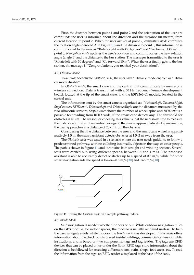
The Obstacle mode was tested in a scenario where the user needs guidance to follow apredetermined pathway, without colliding into walls, objects in the way, or other people.The path is shown in Figure 11, and it contains both straight and winding sections. Severaltests were carried out, using different speeds, between 0.4 and 1 m/s. The proposedassistant is able to accurately detect obstacles up to a speed of 0.8 m/s, while for othersmart navigation aids the speed is lower—0.5 m/s [30] and 0.65 m/s [10].
Figure 11. Testing the Obstacle mode on a sample pathway, indoor.
3.3. Inside Mode
Safe navigation is needed whether indoors or out. While outdoor navigation relieson the GPS module, for indoor spaces, the module is usually rendered useless. To helpthe user navigate safely while indoors, the Inside mode was developed. Inside mode offersinformation about the check points placed inside buildings, commercial centers or publicinstitutions, and is based on two components: tags and tag reader. The tags are RFIDdevices that can be placed on or under the floor. RFID tags store information about thedirection to be followed for accessing different rooms, stairs, shops, food areas, etc. To readthe information from the tags, an RFID reader was placed at the base of the cane.

Sensors 2022, 22, 4271 18 of 24
The Inside mode was tested under real conditions, in the scenario from Figure 12a. Thered square represents the RFID tags placed under the floor in the lobby at the entrance of abuilding. All RFID cards are oriented towards the north pole. When the user is orientedtowards the food court, the smart cane scans RFID tag and the message “Food court isforward, Pharmacy is to the right, Market is to the left” is transmitted to the user.
Figure 12. Testing the Inside mode: (a) the lobby at the entrance of a building; (b) testing the accuracyof the reading according to the distance between components - RFID tag (1), RFID reader (2), distancebetween RFID tag and reader (3); (c) testing the accuracy of the reading according to the alignmentbetween the coils of the RFID tag and reader—centers of the coils are perfectly aligned (Case 1), centreof the tag coil barely intersects the coil of the reader (Case 2), unaligned coils (Case 3).
The format of the data read from the RFID tag is “Food_area_nn/Market_ee/Pharmacy_ww/#”. The values “nn”, “ee”, and “ww” represent the orientation, with respect to thenorth pole, as in N, S, E, W, NE, NW, SE, or SW. When the user scans an RFID tag, Insidemode compares the user orientation with the location’s orientation and updates the user inreal time. To transmit the cardinal point to the user, directions as “Front”, “Left”, “Right”,“Backward”, “Front-left”, “Front-right”, “Backward-right”, and “Backward-left” are used.Every direction has a range of approximately 45 degrees.
An accurate reading of RFID cards can only be achieved if the distance between tagand tag reader is relatively small. The RFID reader was placed on the tip, facing downward(Figure 12b). The distance between tag and reader was increased from 20 mm to 36 mm,which resulted in a dramatic decrease in accuracy (Table 4).

Sensors 2022, 22, 4271 19 of 24
Table 4. Test cases for distance between RFID tag and reader.
Case No. Tag to Reader Distance [mm] Accuracy
1 20 99%2 26 96%3 31 90%4 33 40%5 36 2%
Each RFID tag, as well as the RFID reader, contain coils, and the alignment betweenthe coil of the tag and the one inside the reader also influences the accuracy of the reading.Three possible alignments of tag and reader are shown in Figure 12c. For case 1, the tag coiland the reader coils are neatly aligned, and the accuracy of the reading is 100%, in 15 tests.If the tag coil and reader coil are unaligned, the accuracy drops to 74% (case 2—barelyaligned) or even 13% (case 3—unaligned coils).
Lastly, the speed of the movement can have an effect on the accuracy of detectingRFID tags. For speeds between 0.4 and 0.8 m/s, the accuracy was 100%, provided that thecoils were aligned, as shown in Figure 12c, case 1.
To activate/deactivate Inside mode, the user says “Inside mode enable” or “Insidemode disable”.
3.4. Emergency Alert
The Emergency alert functionality is available only when the smart assistant is con-nected to the Internet. It has two working scenarios: Alert and Notification. When theassistant receives the “Alert” voice command from the user, it transmits an emergencyemail to authorized personnel, such as their physician or to emergency services (police, firedepartment).
The Notification scenario is activated through the vocal message “Send a message to . . . ”.Any contact from the contact list is a possible recipient of the email message. An email issent to the nominated contact, informing them that the user wishes to have a conversationin the near future.
3.5. Weather Info
When the user wants to have an outdoor walk, the Weather info functionality providesweather related news and updates. Activation of this functionality starts with the vocalcommand: “Weather, please”. The user is informed about atmospheric conditions, such asoutside temperature, humidity, rain appearance, etc. Weather info doesn’t work offline. Ifthe Internet connection is poor or unavailable, the smart cane user will hear the message “Ican’t receive data from server”.
3.6. Market Mode
With the help of simple vocal commands like “Add 3 kilos of banana to the list”, theuser can create a shopping list. The list can be sent by the smart assistant through themessage “Send the market list”, to a friend or to a company specialized in food delivery.The entire list can also be used when groceries are purchased directly, as opposed tobeing ordered.
To add groceries on the list, the user utters a voice message such as “Add 2 L of milkto the list”. The quantity is a float positive number, the measurement unit can be kilos,liters, pieces; the product can be one of seven that are so far included in the smart assistant:tomato, banana, apple, mango, milk, eggs, and sugar. More products can be added, basedon the user’s needs and preferences.
To eliminate the last added position, the user simply says “Delete last element”.

Sensors 2022, 22, 4271 20 of 24
3.7. Physical Condition
The Physical condition functionality was designed to inform people about their physicalcondition. With the "Health please" or "Physical condition please" vocal commands, theuser is given information about the walked distance, the number of steps and the numberof burned kilocalories.
To compute these values, Equation (6) is used, for a 1.8 m tall user.
1 step = 82 cm,1320 steps = 1 km,1 Kcal = 48 steps. (6)
3.8. Medication Schedule
Medication schedule is designed to help visually impaired people with memory prob-lems. Continuous alert and Event info are parts of this functionality.
Continuous alert has three predefined hours at which the user is notified, through somesound alerts, to take their medication: 9.00, 14.00 and 20.00. The sound alerts remain activeuntil the user confirms taking the medication.
Event info informs the user regarding the medication that is scheduled for differentmoments of the day. Using a vocal command as “List of drugs for” followed by the momentof the day “morning”, “noon”, or “evening”, the user obtains the medication list associatedwith that particular moment, or no medication, if there is none to be taken.
3.9. Bus Station Alert
Bus station alert is a helpful functionality when the user travels by bus, for long or shortdistances. When the user gets on the bus, they need to inform the smart assistant about thebus station they plan to get off at. The bus station can be any point from the personalizeddatabase. Using the GPS module, the location of the user is updated in real time. Whenthe distance between the bus station and the user is less than 300 m, the smart assistantinforms the user to be prepared to get off the bus.
The message delivered to the user is “In X meters is the bus station Y”, where X is lessthan 300 and Y is the bus station set as destination.
3.10. Time and Date
Time and date is the simplest functionality of the smart assistant. Using vocal commandsas “Time now” and “Date now”, the user is informed about current hour and current date.
All functionalities of the smart assistant were implemented in order to achieve theproposed goals. Testing the system in real conditions proved that the prototype helps theperson in outdoor and indoor environments (day and night), detects obstacles and suggestsalternative routes, provides directions in a new environment, assists the person in shoppingactivities, informs authorized personnel regarding medical status, does not require IT skillsand proficiency, and is available to the user non-stop.
4. Discussion and Conclusions
Advances in technology can significantly improve the life quality of visually impairedpersons. Modern navigation and orientation techniques, along with obstacle recognitionand avoidance means are nowadays integrated into small, portable devices that become areal help in daily activities.
The navigation functionalities of the proposed smart assistant were tested in indoorand outdoor controlled environments, under various conditions. To prevent possibleincidents or injuries in this prototype phase, two volunteers, blindfolded people, tested allfunctionalities of the system. Their feedback was collected by means of a survey, as follows:
• How do you evaluate the communication with the smart assistant? (1 to 5)• How do you evaluate the quality of the vocal messages? (1 to 5)• How do you evaluate the Weather/Alert/Market/Inside/Obstacle Mode functional-
ity? (1 to 5)• Do you think the smart assistant is helpful for the visually impaired? (1 to 5)

Sensors 2022, 22, 4271 21 of 24
• Does the smart assistant increase the user’s independence in daily activities and tasks?(1 to 5)
• Does using the smart assistant improve the overall mental state? (1 to 5)
The average value of the answers was 4.25 points, showing that the smart assistantcan be a solution that provides significant help to visually impaired people, even if there isstill room for improvement, in some areas.
The survey included a final question regarding the price people would be willing topay for such a system, with three options: under $500, between $500 and $1000, and over$1000. Respondents chose the first two options. The analysis of similar smart assistantsystems in [30] reveals that the minimum price for a cane equipped with sensors is $200,while a complete assistive system can cost as much as $6000. The cheapest solution, whichprovides obstacle avoidance, indoor and outdoor navigation and object recognition ispriced at $400.
For the proposed smart assistant, the total cost of the materials is less than $200; $144for the components in the central unit (Raspberry Pi 3B, GPS module, electronic compass,ESP8266 module, audio card, microphone, speaker, and printed PCB) and $51 for thesmart cane (Wemos D1 Mini, battery, distance sensors, RFID reader, reflexive sensor, 3Dprinted case, and wheel). While the final price may be higher, due to mass production anddistribution costs, the proposed system is still more affordable than similar solutions, andprovides more functionalities.
Tests showed that, in order to design an accessible environment for the visuallyimpaired, RFID tags should be placed above the floorboards, so that the distance betweenRFID tags and the reader is as small as possible. When the tags are below the floorboards, adistance greater than 30 mm results in poor detection (40% or lower accuracy). To ensureaccurate readings, it is recommended that the diameter of the coil on the RFID tags matchesthat of the RFID reader.
When moving on a predefined pathway containing obstacles that were either fixed(typical urban objects) or moving (other pedestrians), 95% of obstacles were correctlyidentified by the lateral sensors of the smart cane. The remaining 5% were those positionsin front of the cane, and they are detected by moving the cane, as if it were a regular one.
Since the smart cane is equipped with ultrasonic sensors on each side, obstacles areidentified without needing to sweep the cane. The user is thus able to move faster, indoorsand out. Considering the length of the smart cane (1.5 m) and the maximum distance fromwhich an obstacle can be detected (40 cm), the total distance between user and obstacle isapproximately 2 m, ensuring the safety of the user.
The dimensions of the smart assistant render it portable, easily carried inside a purse orbackpack, or even as a bracelet. The central unit is supplied from an ordinary power bank,requiring 5 W/h, while the average energy consumption of the smart cane is 250 mW/h,from a battery. The main functionalities are designed to work offline. The interactionbetween user and smart assistant is achieved via simple vocal commands, making itsuitable for any user, regardless of their IT skills and proficiency. It provides highly reliablenavigation and guidance and ensures the user’s safety. Moreover, the functionalitiesregarding physical condition, medication, shopping activities, and weather informationfacilitate interaction between the user and the environment.
The proposed system shows its limitations when the user comes across a traffic lightwithout sound alerts, or on uneven roads, where potholes that are lateral with respect to thesmart cane cannot be detected. The system is not yet able to automatically take into accountchanges in accessibility, with regular updates of the customized map being required.
Future developments of this prototype may include increasing the processing capabil-ities, adding a webcam and optimizing its energy consumption so that common images(e.g., traffic lights) are easily recognized, adding more vocal commands, extending thegrocery list, and testing the of system by visually impaired people.

Sensors 2022, 22, 4271 22 of 24
The prototype can help visually impaired people to achieve a high level of indepen-dence in daily activities, which, in the long term, can have a positive effect on their qualityof life.
Author Contributions: Conceptualization, E.S, . and C.C.; methodology, E.S, .; software, C.C.; vali-dation, E.S, ., C.C. and L.I.; writing—original draft preparation, E.S, . and C.C.; writing—review andediting, L.I. All authors have read and agreed to the published version of the manuscript.
Funding: This research received no external funding.
Institutional Review Board Statement: Not applicable.
Informed Consent Statement: Informed consent was obtained from all subjects involved in the study.
Data Availability Statement: Not applicable.
Conflicts of Interest: The authors declare no conflict of interest.
References1. World Health Organization. Visual Impairment and Blindness. Available online: https://www.who.int/en/news-room/fact-
sheets/detail/blindness-and-visual-impairment (accessed on 24 April 2022).2. Demmin, D.L.; Silverstein, S.M. Visual impairment and mental health: Unmet needs and treatment options. Clin. Ophthalmol.
2020, 14, 4229–4251. [CrossRef] [PubMed]3. World Health Organization. Assistive Technology. Available online: https://www.who.int/news-room/fact-sheets/detail/
assistive-technology (accessed on 24 April 2022).4. Elmannai, W.; Elleithy, K. Sensor-based assistive devices for visually-impaired people: Current status, challenges, and future
directions. Sensors 2017, 17, 565. [CrossRef] [PubMed]5. Reyes Leiva, K.M.; Jaén-Vargas, M.; Codina, B.; Serrano Olmedo, J.J. Inertial measurement unit sensors in assistive technologies
for visually impaired people, a review. Sensors 2021, 21, 4767. [CrossRef] [PubMed]6. Akram, S.; Mahmood, A.; Ullah, I.; Mujtabah, M.T.; Yasin, A.B.; Butt, A.R.; Shafique, M.; Manzoor, S. Construction and analysis of
a novel wearable assistive device for a visually impaired person. Appl. Bionics Biomech. 2020, 2020, 6153128. [CrossRef]7. Anandan, M.; Manikandan, M.; Karthick, T. Advanced indoor and outdoor navigation system for blind people using raspberry—
Pi. J. Internet Technol. 2020, 21, 183–195.8. Gurari, D.; Li, Q.; Lin, C.; Zhao, Y.; Guo, A.; Stangl, A.; Bigham, P.J. A Dataset for Recognizing the Presence and Purpose of
Private Visual Information in Images Taken by Blind People. In Proceedings of the IEEE/CVF Conference on Computer Visionand Pattern Recognition, Long Beach, CA, USA, 16–20 June 2019; pp. 939–948.
9. Saaid, M.F.; Ismail, I.; Noor, M.Z.H. Radio Frequency Identification Walking Stick (RFIWS): A Device for the Blind. In Proceedingsof the 5th International Colloquium on Signal Processing & Its Applications, Kuala Lumpur, Malaysia, 6–8 March 2009; pp.250–253. [CrossRef]
10. Mahida, P.; Shahrestani, S.; Cheung, H. Deep learning-based positioning of visually impaired people in indoor environments.Sensors 2020, 20, 6238. [CrossRef]
11. Guerrero, L.A.; Vasquez, F.; Ochoa, S.F. An indoor navigation system for the visually impaired. Sensors 2012, 12, 8236–8258.[CrossRef]
12. Chaurasia, M.A.; Rasool, S.; Afroze, M.; Jalal, S.A.; Zareen, R.; Fatima, U.; Begum, S.; Ahmed, M.M.; Baig, M.H.; Aziz, A.Automated Navigation System with Indoor Assistance for Blind. In Contactless Healthcare Facilitation and Commodity DeliveryManagement During COVID 19 Pandemic. Advanced Technologies and Societal Change; Chaurasia, M.A., Mozar, S., Eds.; Springer:Singapore, 2022; pp. 119–128. [CrossRef]
13. Kajiwara, Y.; Kimura, H. Object identification and safe route recommendation based on human flow for the visually impaired.Sensors 2019, 19, 5343. [CrossRef]
14. Tapu, R.; Mocanu, B.; Zaharia, T. DEEP-SEE: Joint object detection, tracking and recognition with application to visually impairednavigational assistance. Sensors 2017, 17, 2473. [CrossRef]
15. Bouteraa, Y. Design and development of a wearable assistive device integrating a fuzzy decision support system for blind andvisually impaired people. Micromachines 2021, 12, 1082. [CrossRef]
16. Saquib, Z.; Murari, V.; Bhargav, S.N. BlinDar: An Invisible Eye for the Blind People Making Life Easy for the Blind withInternet of Things (IoT). In Proceedings of the 2nd IEEE International Conference on Recent Trends in Electronics, Information &Communication Technology (RTEICT), Bangalore, India, 19–20 May 2017; Volume 2017, pp. 71–75. [CrossRef]
17. Messaoudi, M.D.; Menelas, B.-A.J.; Mcheick, H. Autonomous smart white cane navigation system for indoor usage. Technologies2020, 8, 37. [CrossRef]
18. Nimmolrat, A.; Khuwuthyakorn, P.; Wientong, P.; Thinnukool, O. Pharmaceutical mobile application for visually-impairedpeople in Thailand: Development and implementation. BMC Med. Inform. Decis. Mak. 2021, 21, 217. [CrossRef] [PubMed]

Sensors 2022, 22, 4271 23 of 24
19. Periša, M.; Perakovic, D.; Cvitic, I. Innovative ecosystem for informing visual impaired person in smart shopping environment:InnIoTShop. Wireless Netw. 2022, 28, 469–479. [CrossRef]
20. Rocha, D.; Carvalho, V.; Gonçalves, J.; Azevedo, F.; Oliveira, E. Development of an automatic combination system of clothingparts for blind people: MyEyes. Sens. Transducers 2018, 219, 26–33.
21. Sahoo, N.; Lin, H.-W.; Chang, Y.-H. Design and implementation of a walking stick aid for visually challenged people. Sensors2019, 19, 130. [CrossRef]
22. Rizvi, S.T.H.; Asif, M.J.; Ashfaq, H. Visual Impairment Aid Using Haptic and Sound Feedback. In Proceedings of the InternationalConference on Communication, Computing and Digital Systems (C-CODE), Islamabad, Pakistan, 8–9 March 2017; pp. 175–178.[CrossRef]
23. Castillo Guerrero, J.; Quezada-V, C.; Chacon-Troya, D. Design and Implementation of an Intelligent Cane, with Proximity Sensors,GPS Localization and GSM Feedback. In Proceedings of the IEEE Canadian Conference on Electrical & Computer Engineering(CCECE), Quebec, QC, Canada, 13–16 May 2018; pp. 1–4. [CrossRef]
24. Maulana, P.; Darusalam, U.; Nathasia, N.D. Road guides and special location monitoring for blind people using ultrasonic sensorsand microcontroller-based GPS modules. J. Mantik 2020, 3, 444–450.
25. Shahrizan, N.A.; Sanudin, R. Smart blind walking stick. Evol. Electr. Electron. Eng. 2021, 2, 156–163.26. Kumar, N.A.; Haris Thangal, Y.; Sunitha Beevi, K. IoT Enabled Navigation System for Blind. In Proceedings of the IEEE R10
Humanitarian Technology Conference (R10-HTC)(47129), Depok, Indonesia, 12–14 November 2019; pp. 186–189. [CrossRef]27. Romadhon, A.S.; Husein, A.K. Smart stick for the blind using Arduino. J. Phys. Conf. Ser. 2020, 1569, 032088. [CrossRef]28. Uddin, M.A.; Suny, A.H. Shortest Path Finding and Obstacle Detection for Visually Impaired People Using Smart Phone. In
Proceedings of the International Conference on Electrical Engineering and Information Communication Technology (ICEEICT),Savar, Bangladesh, 21–23 May 2015; pp. 1–4. [CrossRef]
29. Kammoun, S.; Dramas, F.; Oriolaand, B.; Jouffrais, C. Route Selection Algorithm for Blind Pedestrian. In Proceedings of theInternational Conference on Control, Automation and Systems (ICCAS), Gyeonggi-do, Korea, 27–30 October 2010; pp. 2223–2228.[CrossRef]
30. Slade, P.; Tambe, A.; Kochenderfer, M.J. Multimodal sensing and intuitive steering assistance improve navigation and mobilityfor people with impaired vision. Sci. Robot. 2021, 6, eabg6594. [CrossRef]
31. Jardak, S.; Alouini, M.; Kiuru, T.; Metso, M.; Ahmed, S. Compact mmWave FMCW radar: Implementation and performanceanalysis. IEEE Aerosp. Electron. Syst. Mag. 2019, 34, 36–44. [CrossRef]
32. Long, N.; Wang, K.; Cheng, R.; Hu, W.; Yang, K. Low power millimeter wave radar system for the visually impaired. J. Eng. 2019,19, 6034–6038. [CrossRef]
33. Cardillo, E.; Changzhi, L.; Caddemi, A. Millimeter-wave radar cane: A blind people aid with moving human recognitioncapabilities. IEEE J. Electromagn. RF Microw. Med. Biol. 2022, 6, 204–211. [CrossRef]
34. Hersh, M.; Johnson, M.A. Assistive Technology for Visually Impaired and Blind People; Springer: London, UK, 2008. [CrossRef]35. Adafruit Ultimate GPS. Available online: https://learn.adafruit.com/adafruit-ultimate-gps (accessed on 27 April 2022).36. Gupta, S.; Sharma, I.; Tiwari, A.; Chitranshi, G. Advanced Guide Cane for the Visually Impaired People. In Proceedings of the
1st International Conference on Next Generation Computing Technologies (NGCT), Dehradun, India, 4–5 September 2015; pp.452–455. [CrossRef]
37. Neo 6 GPS Module. Available online: https://www.u-blox.com/sites/default/files/products/documents/NEO-6_DataSheet_%28GPS.G6-HW-09005%29.pdf (accessed on 27 April 2022).
38. Compass Module. Available online: https://www.adafruit.com/product/1746 (accessed on 27 April 2022).39. Asrin, A.; Hapsari, G.I.; Mutiara, G.A. Development of Qibla Direction Cane for Blind Using Interactive Voice Command. In
Proceedings of the 6th International Conference on Information and Communication Technology (ICoICT), Bandung, Indonesia,3–5 May 2018; pp. 216–221. [CrossRef]
40. Jayakody, J.A.D.C.A.; Murray, I.; Hermann, J.S, .; Lokuliyana, S.; Dunuwila, V. Intelligent Vision Impaired Indoor NavigationUsing Visible Light Communication. In Technological Trends in Improved Mobility of the Visually Impaired. EAI/Springer Innovations inCommunication and Computing; Paiva, S., Ed.; Springer: Cham, Swizerland, 2019. [CrossRef]
41. Wi-fi Module. Available online: https://www.espressif.com/sites/default/files/documentation/0a-esp8266ex_datasheet_en.pdf(accessed on 27 April 2022).
42. Barathi Kanna, S.; Ganesh Kumar, T.R.; Niranjan, C.; Prashanth, S.; Rolant Gini, J.; Harikumar, M.E. Low-Cost Smart NavigationSystem for the Blind. In Proceedings of the 7th International Conference on Advanced Computing and Communication Systems(ICACCS), Coimbatore, India, 19–20 March 2021; pp. 466–471. [CrossRef]
43. Roy, M.; Shah, P. Internet of Things (IoT) Enabled Smart Navigation Aid for Visually Impaired. In Advanced Information Networkingand Applications. AINA 2022. Lecture Notes in Networks and Systems; Barolli, L., Hussain, F., Enokido, T., Eds.; Springer: Cham,Switzerland, 2022; Volume 451. [CrossRef]
44. Fritzing. Available online: https://fritzing.org (accessed on 27 April 2022).45. Ultrasonic Sensor. Available online: https://components101.com/sites/default/files/component_datasheet/HCSR04%20
Datasheet.pdf (accessed on 27 April 2022).46. Optical Sensor. Available online: https://www.vishay.com/docs/83760/tcrt5000.pdf (accessed on 27 April 2022).47. RFID Reader. Available online: https://www.nxp.com/docs/en/data-sheet/MFRC522.pdf (accessed on 27 April 2022).

Sensors 2022, 22, 4271 24 of 24
48. Mishra, G.; Ahluwalia, U.; Praharaj, K.; Prasad, S. RF and RFID Based Object Identification and Navigation System for theVisually Impaired. In Proceedings of the 32nd International Conference on VLSI Design and 18th International Conference onEmbedded Systems (VLSID), Delhi, India, 5–9 January 2019; pp. 533–534. [CrossRef]
49. Barrios, D.; Groom, T.; George, K. Design and Implementation of an RFID Based Tactile Communication Device. In Proceedingsof the IEEE 12th Annual Ubiquitous Computing, Electronics & Mobile Communication Conference (UEMCON), New York, NY,USA, 1–4 December 2021; pp. 0896–0900. [CrossRef]
50. Rhasspy Voice Assistant. Available online: https://rhasspy.readthedocs.io/en/v2.4.20/ (accessed on 27 April 2022).51. MQTT. Available online: https://mqtt.org/ (accessed on 27 April 2022).52. Mahida, P.T.; Shahrestani, S.; Cheung, H. Comparision of Pathfinding Algorithms for Visually Impaired People in IoT Based
Smart Buildings. In Proceedings of the 28th International Telecommunication Networks and Applications Conference (ITNAC),Sydney, Australia, 21–23 November 2018; pp. 1–3. [CrossRef]
53. Wu, H.; Marshall, A.; Yu, W. Path Planning and Following Algorithms in an Indoor Navigation Model for Visually Impaired. InProceedings of the 2nd International Conference on Internet Monitoring and Protection (ICIMP 2007), San Jose, CA, USA, 1–5July 2007; p. 38. [CrossRef]