"Save the Stumps!: Or How I Stopped Worrying and Learned to Love the Logging Landscape"
58
"Save the Stumps!: Or How I Stopped Worrying and Learned to Love the Logging Landscape" CHRISTOPHER W. MERRITT Christopher W. Merritt, Ph.D. Utah State History, 300 Rio Grande Street, Salt Lake City, Utah, U.S.A., 84 DO NOT CITE IN ANY CONTEXT WITHOUT PERMISSION OF THE AUTHOR Abstract: Cultural landscapes formed through the intensive and environmentally destructive process of logging litter all the forested, or past forested, regions of the world. Unlike the mining or farming landscapes, areas shaped through logging activity rarely encounter the same level of critical analysis by researchers, or in many cases, even formal documentation by archaeologists or landscape historians. As logging landscapes were shaped from, within, and by organic materials, the byproducts of this cultural activity are rarely preserved past one or two generations. On the North Slope of the Uinta Mountains in extreme 1
-
Upload
independent -
Category
Documents
-
view
0 -
download
0
Transcript of "Save the Stumps!: Or How I Stopped Worrying and Learned to Love the Logging Landscape"
"Save the Stumps!: Or How I Stopped Worrying andLearned to Love the Logging Landscape"
CHRISTOPHER W. MERRITT
Christopher W. Merritt, Ph.D. Utah State History, 300 Rio Grande Street, Salt Lake City, Utah, U.S.A., 84
DO NOT CITE IN ANY CONTEXT WITHOUT PERMISSION OF THE AUTHOR
Abstract: Cultural landscapes formed through the intensive and environmentally destructive process of logging litter all the forested, or past forested, regions of the world. Unlike the mining or farming landscapes, areas shaped through logging activity rarely encounter the same level of critical analysis by researchers, or in many cases, even formal documentation by archaeologists or landscape historians. As logging landscapes were shaped from, within,and by organic materials, the byproducts of this cultural activity are rarely preserved past one or two generations. On the North Slope of the Uinta Mountains in extreme
1
northeastern Utah, the unique cultural landscape formed by the production of railroad cross ties between 1867 and the 1930s, offers glimpses into past cultural behavior but provides an opportunity to establish robust reference conditions for pre-settlement forests. Current archaeological site definitions or survey methodology does not allow for the identification, recordation, or even preservation of the byproducts of past logging activity. These landscapes full of stumps, slash piles, ephemeral roads, and abandoned logging products can help not only archaeologists and historians understand the landscape, but a proposed synergy of disciplines including ecologists, silviculturalists, and others can help to break down academic boundaries and provide useful information for understanding this cultural landscape and its broader implications.
The stump is a platform of blond wood in the gray winter. It is nearly level with the snow that covers the little garden around it. It is a door into the underground of old summers, but if I bend down to it, I am lost in crags and buttes of a harsh landscape that goes on forever. When snow melts the wood darkens into the ground; rain and thawed snow move deeply into the stump, backwards along the disused tunnels.
---Donald Hall, “Stump”, Old and New Poems (1990).
IntroductionWhile there is significant body of literature detailing waysin which to identify, record, relate, report, and mitigate the detritus of the extractive industries encountered on the
2

landscape, the leavings of renewable resource exploitation remains understudied and overlooked. Acts of mining, quarrying, and other non-renewable resource extraction leavepermanent and clearly identifiable scars upon the cultural and natural landscape, through shafts, adits, prospects, tailings, and other variety of wastes associated with that primary activity. Land managers, private archaeological contractors, and members of the public share a common ability to easily identify the byproducts of non-renewable extraction. The byproducts of a renewable resource extraction, however, are far more subtle, and thus so much more easily ignored or overlooked by professional and publicalike.
Logging and timber management, whether small-scale cottage industry completed with axe and pickaroon, or capital and labor-intensive machinery-driven operations, leaves just as much physical indicators as non-renewable industries, thoughin many cases are organic in nature. While many of the sitesassociated with logging are easily identifiable, such as camps, cabins, equipment pads, and main roads, the actual waste byproduct of logging activity remains more enigmatic. Stumps, slash, sawdust, waste logs, abandoned products, are just a few of the tangible organic remains that exist well after historic or modern logging ends. Byproducts of past logging activity also exist in the physical, living landscape of the forest as it exists today. Past timber activity shapes the current stands seen by visitors to wild areas, though many fail to comprehend the legacy of these broad cultural and environmental processes.
Archaeologists employed by land managing agencies, such as the United States Forest Service, Bureau of Land Management,and National Park Service have an inherent and widely accepted perspective on what constitutes archaeological and historical sites upon the landscape. These rubrics rarely include the byproducts of logging and timber management activities as encountered in the forested, or once-forested,areas of the United States. Whereas a hillside full of
3

shallow, narrow mineral prospect pits, clearly a physical reminder of human activity scraping the earth for precious minerals would be recorded as a site almost universally, dozens, hundreds, or even thousands of acres of stumps logged over a century ago would never be identified, recorded, or much more egregiously, mitigated for, in project proposals.
All wild areas, whether managed by a federal agency or private party, are resultant of centuries of multi-scalar human and ecological processes working in concert. Thus, thecultural landscape is not a palimpsest, a layering of past activities, but rather a single continuous organic accumulation of past human and natural activities operating on every scale of analysis. Logging and timber management activities, whether in the 1700s, or 2000s, shaped, or continue to shape the current physical landscape encounteredby humans. But these human activities do not only possess the opportunity to study past humans through traditional historical or archaeological frames, but the byproducts can allow researchers a broader story of forest dynamics and structure through careful reconstruction of past environments, a truly historical ecology only available through interdisciplinary means.
This paper establishes known types of cultural logging and timber management byproducts largely ignored by the current crop of archaeologists and land managers through a case study of the North Slope of the Uinta Mountains, a east-westtrending mountain range on the Utah and Wyoming state line. Since the 1860s, these mountains witnessed an influx of loggers to supply the needs of the burgeoning railroad system in the American West, but also active forest management activities since establishment of the United States Forest Service in 1905. Archaeologists conducting field surveys for proposed new logging and prescribed burn projects (Flanigan and Green 2010; Handley and Flanigan 2013), encountered a landscape full of non-sites according to current definitions. Stumps, abandoned products, girdled
4
trees, and sawdust piles cover the federal lands for tens ofthousands of acres, but only sites of human occupation require full documentation and recording. Proposed is a newapproach to similar projects, poised atop interdisciplinary lines, bringing together all strands of academic and scientific discourse into a holistic perspective on the ecology of a cultural landscape without sites.
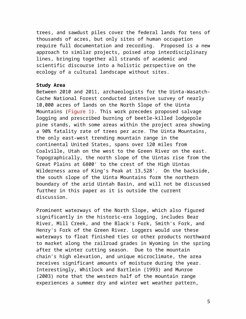
Study AreaBetween 2010 and 2011, archaeologists for the Uinta-Wasatch-Cache National Forest conducted intensive survey of nearly 10,000 acres of lands on the North Slope of the Uinta Mountains (Figure 1). This work precedes proposed salvage logging and prescribed burning of beetle-killed lodgepole pine stands, with some areas within the project area showinga 90% fatality rate of trees per acre. The Uinta Mountains, the only east-west trending mountain range in the continental United States, spans over 120 miles from Coalville, Utah on the west to the Green River on the east. Topographically, the north slope of the Uintas rise from theGreat Plains at 6800' to the crest of the High Uintas Wilderness area of King’s Peak at 13,528'. On the backside,the south slope of the Uinta Mountains form the northern boundary of the arid Uintah Basin, and will not be discussedfurther in this paper as it is outside the current discussion.
Prominent waterways of the North Slope, which also figured significantly in the historic-era logging, includes Bear River, Mill Creek, and the Black's Fork, Smith's Fork, and Henry's Fork of the Green River. Loggers would use these waterways to float finished ties or other products northwardto market along the railroad grades in Wyoming in the springafter the winter cutting season. Due to the mountain chain's high elevation, and unique microclimate, the area receives significant amounts of moisture during the year. Interestingly, Whitlock and Bartlein (1993) and Munroe (2003) note that the western half of the mountain range experiences a summer dry and winter wet weather pattern,
5
while the eastern half is completely opposite. Regardless, rain coupled with spring and early summer snowmelt provides a heavy flow for all the drainages flowing into Wyoming. This moisture-laden landscape provides ample opportunity forthe growth of some of Utah's most significant timber reserves, with stands of lodgepole, aspen, spruce, and even a few ponderosa. By far, lodgepole pine dominates the UintaMountains vegetation regime, comprising the majority of the available timber. It is this abundant renewable resource, lodgepole pine that first brought Euroamericans to the NorthSlope in the years leading up to completion of the nation's first transcontinental railroad.
History of Logging and Timber Management
Early to Bust
The history of logging on the North Slope of the Uinta Mountains began in the mid-19th century with establishment of Fort Bridger, on the Black’s Fork River in modern-day Wyoming. It is unclear when the first sawmill and formal logging activity initiated, but by the mid-1850s there was at least one sawmill operating for the post, using logs acquired from the Uintas. Members of the LDS Church torched the sawmill at Fort Bridger before the advance of U.S. Army troops in 1857 (Bigler and Bagley 2011:55). Judge W.A. Carter received the sutler contract with the U.S. Army afterthey secured Fort Bridger from the Church of Jesus Christ ofLatter-day Saints. During the latter 1860s, Carter established a large sawmill operation on the Smith’s Fork ofthe Green River in the area’s now contained by the Uinta-Wasatch-Cache National Forest. Attempts by Judge W.A. Carterto create the Fort Bridger and Uinta Mountain Railroad spur from the Union Pacific into the rich timber lands reached the U.S. Congress in the 1870s, but failed due to capital and political support (Hayden 1872:54)
While the rich timber supplied the small community and military post at Fort Bridger, the advance of the railroad
6

in the 1860s signaled a change in the economic scale of logging in the region. In order to supply the needs of the Union Pacific Railroad, which required approximately 2,640 wooden cross ties per mile of track with 350 replacement ties per mile per year (Olsen 1971:12), hundreds of workers entered the mountains of Wyoming, Colorado, and Utah. Logging occurred largely throughout the winter from the 1860s to 1930s due to the relative ease of moving logs and ties on ice and snow by sled. Loggers would pile the productalong the North Slope’s many streams and rivers, and during the spring snowmelt they would push them into the rivers andfloat them to market downstream in Wyoming. Tie floats werea common occurrence on the many tributaries of the Green River in Wyoming throughout the 19th and 20th centuries, withover 300,000 ties perhaps floated in one large drive (Loff 1922:12).
Partners Levi Carter and General Isaac Coe received most of the initial contracts to supply wood products to the quicklysprawling Union Pacific Railroad in 1866. Coe & Carter sold ties to the Union Pacific for $1.00 to $1.30 while only paying between 35-60 cents from producers (Thybony 1985:60).The high profit margins during the initial construction phase of the Union Pacific Railroad between 1866 and 1869 helped to cement their position as a central player in the tie-cutting business in Wyoming, Utah, and Colorado. When the Union Pacific company created the subsidiary Rocky Mountain Coal Company in 1875 to develop the rich coal deposits along the railroad grades in Wyoming, the market greatly expanded for mine props and ties for narrow gauge rail (Thybony 1985:62). By the late 1860s and early 1870s Coe and Carter established at least two sawmill operations on the North Slope of the Uinta Mountains on Muddy Creek andBlack’s Fork.
While Coe & Carter played a significant role in the logging development of the North Slope, perhaps one of the most impressive feats was accomplished by the Hilliard Flume and Lumber Company. Operating on the Bear River drainage,
7

paralleling the modern Mirror Lake Highway between Kamas, UTand Evanston, WY, the Hilliard Flume and Lumber Company constructed a 30-mile elevated flume with six additional miles of the Howe feeder flume between 1872 and 1875. These flumes brought timber from the headwaters of the Bear River to the loading docks at the town of Hilliard, in Wyoming (Colton 1967:205-206; Ayres 1978).
According to Thybony et al. (1985:63), the partnership of Coe & Carter ended in 1884. A reformation of the company under the name Coe & Coe continued to cut timber in Wyoming and likely Utah into the 1890s. Declining railroad construction and maintenance coupled with the collapse of the national economy in the early 1890s, led to the cancellation of Union Pacific’s contracts for tie-cutting in1895. Over the next several years, tie hacking appeared to disappear from the North Slope, though small operations likely continued limited operations on the Bear, Black’s Fork and Smith’s Fork Rivers.
Standard TimberWith a resurgent Union Pacific Railroad increasing its trackmileage and widening grades to accommodate more modern locomotives, the late 1890s and early 1900s witnessed a significant increase in demand for cross-ties. As Olsen (1971:4) notes, the railroads required about one-fifth of United States’ timber harvest, as “[t]he largest single use was for crossties, but they also used large amounts of bridge timber and piling and a variety of other timber products, in car construction and repair, maintenance of telegraph lines, snow fences, tunnels, wharves, buildings, and platforms.” Brown (1919:263) notes that demand for ties increased from 64 million per annum in 1890 to upwards of 145 million by 1919.
The successful lawsuits against Coe & Carter timber poachingin the 1870s illustrated a growing concern towards management and control of timber lands in the 19th and early20th century. Establishment of Federal Forest Reserves in
8
the 1890s, and the formal institution of the United States Forest Service in 1905, signaled a change to the way timber companies extracted this renewable resource from the Uintas.Where once Coe & Carter and other contractors of the type could operate with little oversight from federal agencies incharge of public land now controlled the acreage, charged a fee, and even determined the types, quantities, and form of trees selected for timber harvest.
The North Slope of the Uinta Mountains, between the Bear andGreen Rivers, was variably part of the Wasatch, Uinta and Ashley National Forests between 1905 and the 1920s. Most of the western portion of the North Slope was the Uinta National Forest from 1905 until 1914, while most of the eastern portion was the Ashley National Forest or on the Fort Bridger Military Reservation. Timber cutting efforts on federal lands now fell under the authority of the United States Forest Service, which initiated significant restrictions in the amount and process of timber cutting as noted in this 1914 description of logging on the North Slopeof the Uintas:
There are very few regulations governing the chopper on the private lands, and the object is toreap the greatest possible benefit at the present time without regard to the future. In the government timber, however, the cut-over land mustbe left in a condition to secure growth in time tocome. This is accomplished by marking all the trees to be cut (blazing the side of the tree witha hatchet and stamping it with a U.S. hammer) according to forestry principles. Only a short stump must be left, every tree utilized as far up in the tops as practicable, and the resulting brush lopped and piled for burning. This latter provision is necessary to reduce the fire danger and also to limit the liability of the spreading tree diseases. (Ogden Standard Examiner, March 21, 1914:10)
9

In addition to monitoring logging directly, the Forest Service also monitored the number of ties cut, stamping themwith a “US” die hammer, so that the federal government wouldreceive the correct amount of royalties for the timber cutting (King 1991:80-81).
In 1912, the Standard Timber Company, incorporated in Lincoln, Nebraska in 1913, set up a base of operations for tie-cutting in Evanston, Wyoming. After 1912, this company dominated the logging industry of the North Slope well into the 1930s and even early 1940s. The owner of the newly formed company, D.M. Wilt, operated an earlier logging operation known for timber poaching in Colorado (Ayres 1996 179-180). Using his contacts from his earlier venture, Wilt and the Standard Timber Company signed a contract in 1912 tosupply the Union Pacific Railroad with 6-7 million ties within nine years (Baker and Hauge 1913:1).
Using significant amounts of capital, Wilt orchestrated formalized and highly planned arrangements of cutting areas,with central commissaries near main roads and waterways, a network of satellite camps established in the timber, and a regimented system of waterway development to allow for floating of ties on the drainages of Mill Creek, Black’s Fork and Smith’s Fork. Standard Timber Company’s first development was a large, one and a half story log commissarywith support structures, near the confluence of Mill and MacKenzie Creek, just east of Bear River (Baker and Hauge 1913:1, 40-41). From this central point, over 150 loggers ventured into the rich lodgepole stands, establishing camps and strip roads in seven sections of lands owned by the Union Pacific Railroad, granted to them in the 1860s (Baker and Hauge 1913:55). On these lands Standard Timber Company paid no royalties to the United States Forest Service, whichallowed for higher profit margins. As desired timber types declined on these private land parcels, Standard Timber acquired contracts to log on federal lands for a fee.
10
While logging operations continued near Mill Creek, StandardTimber Company established additional commissaries on the Black’s Fork by 1914, and Steel Creek (near Smith’s Fork) about 1920 or 1921 (Ogden Standard Examiner, March 21, 1914:10;Salt Lake Telegram, October 15, 1920:17; Salt Lake Telegram, July 19, 1921:2). By 1921, the Standard Timber Company cut approximately 47 to 81 million board feet of timber from theMill Creek, Black’s Fork, and Smith’s Fork drainages. This timber cutting provided hundreds of jobs to seasonal and permanent workers, while also significantly increasing the revenues of the United States Forest Service. As with the rest of the nation, the Great Depression slowed timber cutting on the National Forests, with only one recorded large tie floating occurring on Smith’s Fork in 1935 (Salt Lake Telegram, May 27, 1935:3).
ModernIn the late 1930s, tie-cutting continued but employed the use of modern gasoline-powered machinery and vehicles to facilitate the operations. Until the introduction of gasoline powered chainsaws, automobiles, and sawmills, all tie cutting occurring on the North Slope was done by hand with axe and saw. In 1938, a Forest Service newsletter highlighted that at Standard Timber Company’s new camp near La Barge, Wyoming, six portable sawmills “are now active in sawing ties, in addition to 105 men hewing ties” signaling an end to the era where hand-hewing dominated the tie trade of Wyoming and Utah (USFS January 5, 1938:3).
Use of automobiles allowed for year-round logging, which also significantly altered the seasonal pattern of logging in the region. In his autobiography, Isaac E. Smith (1979:47-48) noted that the new timber sales on Smith’s Forkin the late 1930s and early 1940s, “was well opened up with roads built by the Forest Service and strip roads left by the tie hacks,” which facilitated the use of trucks and “[o]ur 1 ½ ton trucks were driven along the strip roads and loaded by hand,” replacing the horse-driven sleds of the previous eras. Truck-logging also precluded the necessity of
11
a large labor force actually living in the woods, instead all the work could be accomplished through commuting from nearby towns or, if necessary, establishment of a bunkhouse at a centralized sawmill. Adoption of these new techniques led to problems with dealing with snow, including curtailingof logging operations during heavy snow periods as in 1948 (Salt Lake Telegram December 7, 1948:28).
Logging continued on a large-scale through the 1980s and early 1990s on the North Slope, utilizing modern techniques of truck-logging. In addition, instead of selectively cutting certain sized trees, most of the techniques after the 1940s focused more on clear-cutting techniques for use in large sawmills and pulp mills. This was a radical departure from the earlier selective logging techniques of the tie-hack era. Aerial photographs today illustrate the lasting legacy of the late 20th century clear-cuts on the North Slope, but provide yet another anthropogenic event that helped to shape the landscape.
Non-Sites (stumps, girdled trees, etc.) and their Implications
When encountering a historic logging landscape, archaeologists generally focus their attention on the most salient of the cultural features, namely camps, trash dumps,equipment pads, and isolated finds of material culture. Less studied and analyzed components of the historic logginglandscape include stumps, slash and waste, abandoned products, and minor logging roads. Active forest management, largely after the creation of the United States Forest Service, National Park Service, Bureau of Land Management, or any number of private, state, and local agencies, creates an additional type of signature upon the cultural landscape. Timber management programs such as pinebeetle treatments, prescribed burning, and habitat improvement leave clear physical reminders of these past
12
activities through girdled trees, peeled trees, prescribed burning, windrows, and slash piles, among others.
Logging ActivityLogging activity, as defined in this section, is a reflection of targeted extraction of timber for markets either in their natural state (logs), or in value-added products (railroad ties, milled lumber, etc.). Anthropogenic modification of the forested landscape existedbefore arrival of Euro-Americans through systematic use of fire, and peeling of bark for food sources. In addition, Native Peoples likely conducted some logging activity in theUintas and exploited the dense stands of lodgepole pine for firewood, housing material, and other economic activities. Remains of this activity are likely a rare discovery on the North Slope, and thus focus centers on the post-1840s exploitation of timber in the region. As discussed earlier, physical reminders of past logging activity includes stumps,slash and waste, abandoned products, and roads. These are individually discussed below.
StumpsAs stumps are the most common type of overlooked class of cultural byproduct in a logging landscape, it requires a longer discussion. Stumps were not always an overlooked facet of the landscape, as Schwantes (1996:200) notes in thePacific Northwest, “[t]ree stumps symbolized prosperity…because felling trees was often associated with activities that connoted growth and progress.” No more a symbol of growth and progress is the spread of the railroad through the American continent, supplied by tens of millions of wooden cross ties and resulting stump. In other cases, stumps represented an obstacle hindering agricultural growth, with farmers expending human, animal, and blasting power to extract these reminders of a once-thriving forest (Schwantes 1996:212).
Regardless of tree species exploited by historic logging events, the most common type of waste feature are stumps of
13
varying size and shape. Each stump, when viewed as an artifact, holds evidence of historic ecological conditions and past cultural practices. Ecologically, a stump and/or series of stumps, provides information on the stand type, density, and health of the forest at the time of resource ofexploitation. Stumps, through a detailed analysis, can alsodemonstrate the type of cutting technology used by historic actors, whether axe, saw, or chainsaw, or a mixture of two or more. When viewed through an anthropological lens, the stumps themselves are the direct result of a selective resource strategy by humans. Understanding the types of trees targeted by historic logging activity has implicationsfor understanding economic constructions, optimal foraging, and a variety of other research domains. For instance, discussion of cutting on Mill Creek noted that, “[i]t is expected that this area will be cut over again in from thirty to fifty years, as the present mode of cutting removes but from forty to fifty trees per acre as a maximum and generally leaves about 300 or 400 trees of smaller size”(Ogden Standard Examiner, December 18, 1915:2).
Examples of potential cultural and environmental data from the North Slope of the Uinta Mountains and other logging landscapes include the seasonality of harvest determined from stump height, trees targeted by loggers over time by identification and Diameter at Breast Height (DBH) measurements, and stand density. As discussed earlier, tie hackers in the Uinta Mountains focused most of their loggingactivity during the fall and winter months to allow for efficient use of the spring runoff for floating of products to market. Snowfall in the Uinta Mountains reaches several feet in depth in many areas historically exploited by loggers, thus the detritus of timber harvest activity reflects the extreme weather conditions confronted. Measuring the stump from modern ground surface to cutting plane can reflect the seasonality of the harvest, with high-cut stumps (those measuring over 4’ from the ground surface)reflect winter logging. Loggers rarely exhausted the energyto excavate great amounts of snow away from trees before
14

harvest. Instead they focused on selective cutting of treesthat provided the desired amount of product above snow level. Thus, in several areas exploited during the 1920s-1930s timber harvest near Smith’s Fork, archaeologists discovered large stands of high-cut stumps, clear indicationof the seasonality of logging activity (Figure 2).
Selective plot samples of stump landscapes can also determine the types of trees targeted by logging activity, and allow for the reconstruction of the historic forest stand at the time of cutting. This allows for the possibility of direct comparison to current conditions for understanding ecological impacts of historic logging. As discussed later, silivicultural research on historic stumps is providing significant data on ecological and cultural processes affecting the modern environment.
Most significantly, stumps fields are rarely, if ever, recorded as archaeological sites, or determined eligible forthe National Register of Historic Places. Archaeologists survey through tens of thousands of acres of culturally modified landscapes full of features, artifacts, and ecofacts, but fail to identify the significance to understanding human history through stumps. A major departure from this pattern is the listing of the Barney Flat Railroad Logging landscape in Arizona on the NRHP. The Barney Flat area comprises “290 ponderosa pine stumps interspersed with about 44 live ponderosa pine trees” (Cleeland 1995:2). According to Cleeland (1995:5), the “logging landscape is a remarkable remnant of early railroadlogging and a visible reminder of how human activity can drastically affect ecosystems.” Continuing, Cleeland (1995:6) details that the stump field is eligible for the NRHP under Criteria A, for association with significant events, for evidence of pre-settlement forest conditions, indicator of early timber practices, and as a physical reminder of the “profound effect that human can have on microclimates, and therefore the landscape”. While the Coconino and Kaibab National Forests in Arizona recognized
15
the significance of these stump fields in the 1990s, no other examples exist of sites on the NRHP relating to this site type.
Slash and Waste Similar to stumpage, slash and partially completed, but abandoned, products are common features of a logging landscape. In a mining landscape, corollaries to this category of logging detritus would include tailings, waste rock piles, and unprocessed ore. Loggers faced a significantamount of waste on a daily basis, as all components of a tree were not suitable for sale directly (tree limbs) or as a finished product (narrow tops of tree, or imperfections), through clearing roads or equipment pads of unsuitable trees(size or species), or waste from milling (sawdust, wood chips). All these different types of debris entered the archaeological and ecological record through intentional abandonment, as it was not economically viable to save, consumer, or sell these resources. Small components of cutting waste, such as tree limbs, likely did not survive into the archaeological record given their small size and exposure to rapid environmental degradation. When piles of debris reached suitable depth to prevent decomposition, their signatures remain on the cultural landscape.
Using the example of the North Slope of the Uintas, archaeologists identified these intentional byproducts of logging activity specifically unfinished/abandoned products,small diameter trees, and sawdust piles. Due to the unique logging culture and practice surrounding tie hacking, loggers focused their attention largely to trees that would provide a high-priced railroad tie, measuring 7" on the face, and 8' in length. During surveys, crews identified several abandoned ties within the last stages of completion.These ties showed evidence of peeling, hewing, and partial bucking, but still attached to an unformed portion of the tree. In nearly all cases, these incomplete ties were near the top of the tree, and abandoned due to the lack of a sufficient diameter to create a 7" face.
16

As noted earlier, the tie hacker focused on trees between 8"and 10" in DBH, which would equate, hopefully, to two first-rate railroad ties per tree. Forest Service standards required that tie hacks working the 1920s and 1930s for Standard Timber Company used all felled trees to an 8” top (King 1991:66). In the cases of these abandoned products, the tie hacker recovered only half of their effort, producing one successful tie. This was a costly error to the tie hacker, as the effort to cut down a tree, only to abandon a product so near completion, resulted in the loss of income. If this became a pattern, then the logger's daily wages would shrink, making this barely economically viable career choice even that much more difficult.
Small diameter trees and stumps comprise a second type of archaeologically visible logging waste identified in the Uintas. Tie hackers focused on a specific type of tree (8-10" DBH), with larger diameters (>10") taken potentially forlogs or for cordwood. Thus, loggers fell trees below 8" DBHusually as part of clearing activity for roads, building platforms, equipment pads, or product preparation (hewing) areas, and could also relate to firewood collection near camps or settlements. Location of these small diameter stumps, in relation to other ephemeral or constructed cultural features can help determine the factor resulting intheir removal. Location of small diameter trees amidst the larger diameter trees suggest that they likely resulted fromclearing for easier felling of targeted trees, or for creation of strip roads and loading banks. Thus, indirectly these waste stumps can indicate a subsidiary activity of tiehacking on the North Slope. Obviously in other areas of the world, and in different time periods even in the Uintas, logged small diameter trees might reflect other economic activities and not waste, but for this case study they best fit in this category.
Finally, sawdust and wood chip piles reflect a third and final type of ephemeral logging waste cultural features in
17
the Uintas. Outside the few sawmills operated by Coe and Carter in the 1860s and 1870s, most of the timber industry of the project area centered on human cutting, hewing, and bucking. Tie hackers did not use significant amounts of mechanical equipment powered by water, steam, or fossil fuels until the first half of the 20th century. Introductionof gasoline-powered sawmills, and the concomitant diesel-trucks in the 1930s, ushered in a transition of logging technology, organization, and more important for this analysis, waste product. Instead of hewing and bucking tieswith a broadax and cross-cut saw, loggers could focus on cutting logs and shipping them limb-less to a mobile, and gasoline-powered sawmill for shaping. This technological innovation revolutionized tie hacking, and coupled with a slackened demand for railroad and mining ties during the Great Depression, led to the near-complete mechanization of the practice by World War 2.
Due to the reliance on following an exhaustible resource, loggers employed portable sawmills, which could be moved from location to location as suitable trees became scarce within a patch. Unlike tie hacking, which left small waste shavings and wood chips scattered rather uniformly and thinly across thousands of acres, portable sawmills concentrated this waste into large piles in centralized locations. UWCNF archaeologists currently identify 18 portable sawmill piles on the North Slope of the Uintas, helping to reconstruct the cultural landscape of resource exploitation without any need for the equipment or the protective structure. Unfortunately, no one has yet undertaken a detailed analysis of material culture found in association with these sawdust and wood chip piles that could shed light on movement patterns of equipment over time. Piles of associated fuel cans and other industrial waste could accompany sawdust or woodchip piles, though rarely.
Abandoned Finished Products
18

In an industry reliant almost universally on a pay scale based upon piecework, the loss or abandonment of finished timber products is an incongruous and an unfortunate component of the material culture of the logging landscape. Loss of finished product, with the maximum amount of value-added labor already invested, would reflect the direct loss on an individual(s) production for hours or days. As noted in the 1913 Standard Timber Company report, it is clear thattie hacking was not a lucrative enterprise at the best of times or highest production.
Before discussion of the types of abandoned finished products, it is critical to understand the reasons behind these losses. In most cases, the finished timber products discovered on the North Slope of the Uintas, likely reflect simple loss not intentional abandonment. Given that logging activity occurred largely during the snowy months, it is possible that winter snows covered stacks of finished products before they could be hauled to loading or banking areas. Seasonal floating of timber products during the high-water spring months would undoubtedly lead to the loss of quantities of finished products through beaching, overflows,or partial destruction. Other reasons for loss of products could include death of the tie hacker before haulage, dismissal of tie hackers for fraudulent behavior as some Missouri tie hacks on the North Slope were during the 1930s (King 1991:), or perhaps through intentional abandonment dueto poor pay, working conditions, or market conditions.
While not restricted to the Uinta Mountains, the most commontypes of abandoned finished products include whole logs, cordwood, and ties or props. As seen in the Great Lakes, recovery of submerged lost hardwood logs from the region’s logging heyday has become a major industry in of itself during the last few decades. Cordwood is similarly a commonproduct found by archaeologists, generally in conjunction with domestic features. The loss of ties and props is restricted to regions where this type of logging
19
predominated such as the mountain ranges throughout Utah, Wyoming, Colorado, Oklahoma, and Missouri.
Specifically, on the North Slope, tie hackers would take a select number of trees for lumber mills in Evanston or GreenRiver based on quotas set by the various companies, or demands within the marketplace. These appear to be the least common type of abandoned product in the project area, and the most difficult to identify. Logs prepared for market are difficult to distinguish from other types of deadfall within the woods, except for the lack of tree limbs, and the presence of a axe or saw-cut base. Whole logsdid not capture the same amount of profit return as a properly prepared railroad ties, thus on the North Slope, tie hackers focused on productions of these value-added products.
Another major demand of communities downstream of the North Slope, was the need for a constant flow of cordwood to fuel not only domestic stoves, but industrial boilers. Southern Wyoming, with the exception of the small overlapping timber stands of the Uinta Mountains, was bereft of a locally abundant supply of woody fuels. Before arrival of the railroad and the rise in population, homesteaders could supply their own needs from the local area or through directed acquisition of trees from the mountains. The transcontinental railroad brought not only the need for woodto supply the largely steam-powered locomotives, but also the growing population and industry. A large charcoal-making operation, established at the railroad stations of Hilliard and Piedmont, Wyoming, relied on cordwood floated down from the Uinta Mountains to supply the Union Pacific’s trains and the burgeoning mining industry of Utah (Colton 1967:206-207). Besides as export products, researchers identify cordwood near abandoned tie hacker camps, probably a result of domestic supplies that were not utilized before workers moved on to a new location. Archaeologist James Ayres, located a 200’ long stack of cordwood near a
20

tributary of Mill Creek, seemingly still waiting for a floatto market.
Abandoned railroad ties and props pepper the landscape of the Uinta Mountains. In most cases, these ties appear to have been of first-rate quality and their reason for abandonment remains unclear. There does seem to be an age-grading and spatial distribution of tie abandonment, with the majority of these products discovered in areas exploitedby the Standard Timber Company period 1910s to 1920s. In most cases, abandoned ties are found in stacks, thus createdafter the tie hacker completed a strip, but before the hauler loaded them onto a sled for delivery to banking grounds. Surveyors find other tie stacks near the major creeks, suggesting that simple forgetfulness resulted in theloss of these products. Possibly these ties could reflect intentional abandonment of substandard quality cuttings, though historical records are clear that rejection of unsuitable ties occurred at the extraction point downstream in Wyoming, not in the mountains.
RoadsThe most important feature of the logging landscape was the construction of road systems, both major and minor, to move timber resources to market and supply the loggers (Figure 3). Unlike mining landscapes with a limited number of roadsfocused on a spatially restricted resource extraction zones,loggers create a braided and elaborate systems of roads for haulage, stripping, and general transportation. These roads posses various levels of visibility on the current landscape, owing to factors including construction style, overgrowth, and modern usage. In some logging districts around the world, loggers constructed elaborate systems of railroads to move goods into and out of the extraction zones(e.g. Adams 1961; Gove 2006; King 2003; Casler et al. 1972),though not in the Uintas. Logging in the Uintas relied on simple roads, cut from the earth that both organized and reflected the extraction of timber resources in the mountains.
21
An apt analogy for the road system of the logging landscape of the North Slope, is that of a tree. The main transportation routes serve as the trunk bringing needed supplies into and out of the logging region. Haulage roads idealized as branches distributing these supplies into the furthermost reaches of the logging landscape, and also bringing products back to the trunk. Finally, at the furthest extent of this tree, the strip roads reflect leaves, whereas they do most of the gathering. The North Slope’s logging operation mirrored others around the United States, as this description from the Upper Peninsula of Michigan, with several main roads, cutting “[t]hrough the heart of every logging operation…about twenty yards wide,” with smaller secondary roads, “much narrower about eight to ten feet wide” (Karapinski 1989:68). It appears that the main roads of the North Slope measured significantly less inwidth than many of the Midwestern roads, owing to the predominant product exploited, logs versus railroad ties, respectively. All components of this system are dependent upon each other, and failure of one part of the system affects all others. For example, in 1920, heavy snow forced the close of both transportation and haulage roads on the North Slope, but tie hackers continued to log until suppliesran so short that relief parties on snowshoes were dispatched (Salt Lake Telegram, April 23 1920:25).
The most infrequent type of road encountered on the North Slope, are those that lead into and out of the logging landscape. Major transportation routes within the project area followed the Mill Creek, Black’s Fork, and Smith’s Forkdrainages, with a east-west trending main road connecting points in-between. Due the reliance on seasonal floating ofproducts, these main arteries carried largely supplies and personnel. A twice-weekly stage ran from Evanston, Wyoming to the Standard Timber Commissary at Mill Creek, with a higher frequency of traffic bringing the hundreds of tie hackers both food and equipment on freight wagons. Currently, most of these main arteries still serve the same
22
basic service, the Uintah and Summit County and National Forest road systems incorporated these routes long ago. Nowadays, loggers are the minority of travelers with greateramounts of tourists, recreationalists, and federal workers using corridors now over 150 years old. In most places there is no physical remnant of these old roads, as over a century of maintenance, construction, and widening has significantly altered their appearance, but the corridor remains the same.
Haulage roads branch from the main transportation routes, and connect the scattered satellite logging camps to commissaries, and thereby, the larger world. Similar to the main transportation corridors, the majority of traffic on these roads would have been movement of supplies and people.Haulers commonly used these corridors to move ties, cordwood, and logs to banking grounds near the main waterways or into ponds created by splash dams. As in the main routes, these medium transportation routes commonly exist as unimproved or barely maintained system roads of theNational Forest. Archie Murchie, a Forest Service employee working on the North Slope in the 1930s noted that "they [timber companies] would try to build it [haul road] throughthe center of the area, and they'd lay off strips of timber roughly at right angles" (King 1991:65). In several areas, on the relatively few roads not re-used by modern transportation, physical remnants of corduroy and bridges still exist in these secondary road corridors.
At the end of the haulage roads exist small, barely 8’-10’ wide strip roads that systematically cross-cut timber standswith roughly 100’ to 400' spacing between dependent upon thequality and quantity of timber (King 1991:65). In reality, this is the start of the system, as the primary logging activity occurs between these strip roads. These roads, if could be called such, were normally cut during the winter, with haulers removing small trees and branches to clear a space for running of a wagon, or more commonly, a sled. A round-turn, or looped end, was a common feature of strip
23
roads on the North Slope to allow for easy movement of horse-drawn sleds (King 1991:65-66). In regards to linear mileage, loggers on the North Slope cut hundreds of miles more strip roads than other corridors, due to the necessity of covering an entire timber stand. Remarkably, archaeologists commonly encounter the remains of these striproads, by barely visible areas of cleared vegetation in neatly ordered parallel rows. Once archaeologists orient oneor two strip roads, it becomes easier to locate additional ones through visual appraisal of subtle clearings of trees and a rough spacing of 100’ between.
Archaeologically, roads continue to be an amorphous topic ofofficial recordation, with a great variation in the requirements for meeting federal or state site definitions. In some cases, features of a road, such as corduroy or bridges, are recorded as archaeological sites, but rarely isthe entirety of the intact travel route. For instance, the State of Wyoming determines that archaeologists only record unnamed roads as isolates, with limited documentation (WYSHPO 2012). On the North Slope, this definition seems atodd with the significant role these roads played in the transport of goods, services, and people on a local, regional, and national level. In Utah, the Bureau of Land Management requires more roads need recordation than in Wyoming but agencies rarely apply these stipulations consistently. As it stands, the United States Forest Service has no official site definitions in Utah, leading tosomewhat variable site recording standards. Due to the modern disturbance of the primary transportation roads, there is rarely any effort to cross-check their current corridors against available historical documents. Moreover,this leads to a critical question on whether the corridor orthe actual physical remains of the road-bed are more important for management. Also, is continued use of these transportation corridors really an adverse impact, or in reality the continuation of its historic function and theme?
24
Roads on the North Slope of the Uinta Mountains reflect the paths into and out of the logging landscape. Western historian and geographer William Cronon (1992), best illuminates the role of roads in his discussion of the Alaskan copper mining town of Kennecott. Roads existed as more than merely a transportation corridor of goods, people,and commodities, they were an integral linkage between international, national, and local systems of markets and resources. Definition of the logging road system, from historical, archaeological, and theoretical positions can fuller illuminate these interconnections.
Forest Management Activity
Another anthropogenic force shaping the cultural landscape of the Uinta Mountains, is active federal forest management since the last few years of the 19th century. Federal management of timber resources in the Uintas began with passage of the 1897 organic act, and the subsequent designation of the Uintah Forest Reserve that same year. Management actions focused on creating a forest shaped to maximize efficiency and yield of the renewable resource. As noted in the historical section, the United States Forest Service shaped logging activity after 1905, by structuring the location, types, sizes, and amount of forest resources exploited by the various logging companies operating on the North Slope. Other forested areas nationwide went through asimilar pattern from nearly free and open exploitation to a more structured and bounded activity, largely the result of the cultural shift towards a conservation ethic.
Besides structuring logging activity itself, the United States Forest Service conducted intensive management activities to protect this renewable resource from outbreaksof pests, such as the Mountain Pine Beetle. Girdling, peeling, chaining, and pushing of healthy and/or infected trees to prevent epidemic-like spread of insects deeply shapes the cultural landscape of the Uintas. Little is known about early management activities on the forests of
25
northern Utah before the 1960s, and the physical remnants ofthese practices can help further understand the shaping of the modern forest. Other forested landscapes around the world will reflect different management strategies and activities, such as directed thinning of forests or prescribed burns. There is no evidence of either activity occurring on the North Slope during the historic period. Regardless of management technique employed to control the pine beetle epidemic, Forest Service studies highlight the relative failure of these efforts to effectively control outbreaks throughout the modern period while only limiting the spread in the short-term (Klein et al. 1970:4-5; USDA 2011), though some techniques show promise at limiting loss (Cahill 1978).
Girdled & Peeled TreesWhile foresters quickly recognized the adverse impact of pine beetles to harvestable timber during the 1910s, effortsto control these impacts remained variable in method and effectiveness. The North Slope contains two distinct cultural tree modification resulting from timber management activity related to pine beetle control efforts. Particularly, the use of a broad axe to cut deep scars into the circumference of trees at approximately breast height (girdling), or the peeling of bark from standing and fallen trees. Of the two techniques, peeling was the most prevalentas it was used alone to kill brood trees but also used in conjunction with application of fire and pesticides. Girdling, as encountered on the North Slope, was a common technique only in the 1930s.
Misapprehension of the ways pine beetles infected new standsled to the girdling of large diameter (>12” dbh) lodgepole and ponderosa pine trees on the North Slope of the Uinta Mountains during the 1930s. As noted earlier, tie hacking operations focused on trees within a narrow range of DBH, particularly 8-10”. In 1933-1935, the Forest Service promoted the girdling of large diameter trees in uninfected stands to prevent the spread of pine beetles into these
26
areas (CITATION??). Hand crews contracted by the Forest Service, and tie hackers themselves, used a broad axe to girdle the circumference these trees. Effective girdling prevented the flow of nutrients from the root system to the main part of the tree, killing it within a season. During this period, it was thought that pine beetles targeted large, mature lodgepole and ponderosa pines during initial colonization of a new area. Thus, the thought continued, that elimination of these mature trees would prevent spread.Current understanding of pine beetle ecology indicates that they target a wide variety of trees, and girdling large diameter trees does not prevent spread into uninfected areas.
During the 2010 and 2011 field seasons, archaeologists encountered both standing and collapsed girdled trees in theUpper Smith’s Fork and Steel Creek areas of the central Uintas (Figure 4). Without the historical documentation provided by the entomologists at the Rocky Mountain ResearchStation in Ogden, Utah, the rationale for this activity would have been unclear to researchers and managers. Documentation of the extent and location of this treatment activity is vague, with the physical reminders of girdled trees the only evidence to understand this management activity. Crews documented the presence or absence of girdled trees within selected stands, with this activity clustering in an area near the Steel Creek Commissary, but also remote stands to the east and south. Peeled trees represent a second type of tree modification encountered on the North Slope, now mostly fallen. This is the most common type of pine beetle control efforts in the area, as it was used in conjunction with both sprayed accelerants and pesticides. From the 1910s through the 1970s, Forest Service crews, contractors, and volunteers, would peel the bark off infected brood trees, exposing the larvae to the air, spray its length with kerosene or gasoline and use a flamethrower system to ignite the tree. Asimilar management technique would simply peel the bark and douse the tree with a deadly dose of pesticide. The
27
pesticide, and exposure to the harsh winter weather of the Uintas, would kill most of the larval stage pine beetles before their hatch the following summer. As this technique is more intensive and destructive than the girdling completed in the 1930s, peeled trees are a rarer facet of the cultural landscape of the North Slope. Archaeologists did identify peeled trees in the Black’s Fork, Smith’s Fork,and Henry’s Fork areas.
Pushover/ChainingDuring the 1960s, the Forest Service instituted another means proposed to control the spread of voracious insect species on the North Slope. While pushover is peculiar to the Wasatch National Forest, now the Uinta-Wasatch-Cache National Forest, chaining and windrowing is a common landscape legacy throughout the forested reaches of the United States. Chaining and windrowing could result from a myriad of management purposes ranging from wildlife habitat improvement to stipulations of logging contracts, while pushover is distinctly an insect pest control regimen.
Operation Pushover, as the United States Forest Service designated it in 1960, was a radical attempt at stopping a widespread Mountain Pine Beetle epidemic from spreading to nearby stands. According to Forest Service reports, pine beetle infestations eliminated a full year’s allowable logging cut in the Uinta Mountains during 1959, valued at over $150 million during that year (Iverson 1960:1). To stop further losses at this epic scale, the Wasatch NationalForest planned and executed the most intensive management activity ever attempted to thwart further spread. Forestersidentified several hundred acres infected with broods of Mountain Pine Beetles, between the Smith’s Fork and Black’s Fork rivers on the North Slope of the Uinta Mountains. The Regional Forester hoped that the aggressive chaining, piling, and burning of the trees as part of Operation Pushover, would result in the neutralization of the next hatch of Mountain Pine Beetle larvae.
28
Previously attempted techniques, such as girdling, peeling, and individual burning, required a significantly more intensive use of labor and capital to accomplish the same end result as the judicious use of heavy equipment. The Forest Service accomplished the pushover by using a 150’ steel chain connected to a tandem of heavy tracked bulldozers. Bulldozers would pull the chain through the forest knocking down, or pushing over, both dead and live trees. These same bulldozers would then push all the logs and debris into windrows around the perimeter of a cutting section, with hand crews subsequently lighting these stacks on fire. Some estimates suggest that pushover cost the Forest Service, and thus the American public, one-fifth of the outlay for spray applications of insecticide or accelerants in a similarly sized area (Alexander 1987:203). Due to worry over negative public reaction to such an intensive and destructive method, the Forest Service never attempted again a project similar to Operation Pushover, andended the effort in 1961.
Lasting physical reminders of Operation Pushover exist in areas treated by the project. Now 52 years after its inception, these physical reminders could be classified as historical sites as defined by the National Historic Preservation Act and the National Register of Historic Places. Windrows, berms, piled burned stumps and branches, and roads reflect the most aggressive treatment of pine beetle infestations in the Uinta Mountains. Most of the cultural features ring the pushover treatment parcels, with large (approximately 3’ tall) berms near roads and drainages. Burned stumps and logs exist within, and on top of, these large berms but are also scattered throughout the parcels even half a century later. From the patterns of berming, researchers can identify the directionality of the chaining action. In addition, recreationists and forest mangers alike use a network of roads listed on signs and maps as the ”Pushover Trail” without any discussion of this early 1960s management effort. Forest Service personnel andcontractors developed these roads, some possibly following
29
historical logging routes. Operation Pushover is immortalized in a photographic essay report produced by the Regional Forester in 1960, creating a lasting record of thisintensive forest management activity (Iverson et al. 1960).
Interdisciplinary ApproachBeyond the historical interest in past logging and forest management activity and the requirements of cultural resource legal frameworks, the identification, recording, and scientific study of these organic residues of human activity on the North Slope of the Uinta Mountains are significant to a broad range of disciplines. As mentioned earlier, current frameworks for identification and interpretation of these features does not exist within the archaeological community managing these resources. Proposed here is a new framework, based in historical ecology that will allow for a better understanding of the processes of environmental change and anthropogenic modifications on a landscape scale. An applied historical ecology framework will not only provide land managers better information to manage the current forest through explication of past conditions and modifications, but also increase the perceived relevance of archaeological and heritage sectors of federal agencies.
As noted by Swetnam et al. (1999:1189), historical ecology is “the use of historical knowledge in the management of ecosystems.” The methods and tools of historical ecology encompass all facets of paleoenvironment and documentary land use histories to create a holistic picture of past environments. Applied historical ecology is an outgrowth ofthis academic framework, to use this acquired knowledge to reconstruct past reference conditions in order to better manage the current environment. Already, Munroe (2003) demonstrated the applicability of the Uinta Mountains for historical ecology goals by rephotographing landscapes in the 2000s, first photographed by the Hayden Expedition in the early 1870s. Munroe (2003:496) was able to determine thechanges in forest dynamics since the Little Ice Age through
30
“significant changes in treeline elevation, timberline forest density, and the area of valley-floor meadows,” through this rephotography effort.
As in the case of Munroe (2003), several substantial studiesdocumenting the changes to stream and river channels throughhistoric logging activity on the North Slope (Carson 2006, 2007) have failed to coordinate any efforts with the cultural resource management staff of the National Forest. The seasonal drives of cross ties down the mountain streams of rivers altered the shape, structure, and fishery carryingcapacity of these areas. For instance, Schmal and Wesche (1989:189) identified that Douglas Creek, located on the Medicine-Bow National Forest in Wyoming still reflect this legacy of tie drives. They note that “the steepr, more armored…channel types were more resistant to tie-drive effects…” while “lower-gradient meadow reaches, however, were found to be 1.2 to 3.6 times wider than anticipated with minimal bank development, cover, pool quality, and habitat diversity” (Schmal and Wesche 1989:189). Carson (2006) documented the effects of historic logging and dam building on alluvial deposits specifically along the West Fork of the Black’s Fork River. His research illustrated that constriction of the channel through a splash dam created a situation where there was less overbank flooding, and thus less alluvial sedimentation, below these historic features constructed by the tie hacks. This change of sedimentation pattering has a direct effect on the ecological health of the area. Carson’s (2006) analysis, however, suffers from a lack of refined particularities regarding logging history and exploitation strategies that could have been provided through cooperation with archaeologists and historians.
Given the requirements of the National Historic PreservationAct (NHPA) and the nature of cultural resources, archaeologists are commonly the most field-based of all resource specialists within environmental compliance. Biologists, botanists, foresters, and ecologists spend
31

significant amounts of time either in the field or consulting standard reference texts on the project area through the National Environmental Policy Act. A synergy of these sometimes-disparate research and/or management, and even legal, concerns will provide a more holistic view of the anthropogenic landscape. Thus, a synergistic framework, historical ecology, will allow for research, management, andpotential mitigation, of the impacts of a proposed undertaking. In many cases individual practitioners outside archaeology or heritage managers, already initiated researchprograms that directly grapple with cultural concepts in historic logging landscapes. As noted by cultural anthropologist Frances Hayashida:
[T]he combination of different lines of evidence leads to more robust interpretations of landscape histories, although there are relatively few areasfor which all potential sources of information have been examined. Communication among researchers collecting different types of information—ecologists and archaeologists for example—is often limited because of traditional disciplinary boundaries in universities, funding sources, and academic literatures. (Hayashida 2005:47):
The rich cultural landscape of the Uinta Mountains offers both heritage and natural resource managers an opportunity to meet on common shared goals using the organic detritus ofpast logging or forest management activity. For instance, a thorough and systematic summary of current knowledge on the biogeography of the Uinta Mountains by Shaw and Long (2007:626) identified that the largest single data gap for the study area is the “current condition of the forest and historical processes and events that created it.” It is this current data gap that an interdisciplinary team of researchers, in concert with judiciously used NHPA-based mitigation requirements, could fill through study of the non-sites littering the Uinta-Wasatch-Cache National Forest.
32
Stumps for example, both modern and historic in creation, can still offer significant data on a variety of silvicultural, ecological, and archaeological contexts. As aproxy for human activity, stumps can indicate the varied cultural valuation for tree species over time and space, theintensity of exploitation, changes in harvesting techniques and methods, ethnic or socio-economic background of loggers,and the overall role of local, regional, and national trendsin society, politics, and economics in the logging landscape. As noted earlier, archaeologists and historians with the United States Forest Service nominated the Barney Flat Logging Landscape in Arizona to the NRHP as the stumps reflected the significant changes to a microenvironment through human action. Clear-cutting of the ponderosa pine atBarney Flat created a cold sink of air that precluded regeneration of the stand even nearly 100 years later (Cleeland 1995:7).
While these research domains are of interest to the historian or archaeologist, some scholars are using these decaying stumps for regional analyses of climate change, andthe ecological impacts of historic and modern logging. Taylor (2004:1903), notes that federal and state land managers “use information on forest conditions at the time of Euro-American settlement as a reference point for understanding how ecosystems have changed and for guiding resource management.” The critical part of such a research regime is establishing the reference conditions at the time of Euroamerican settlement. In several case studies (Abella and Denton 2009; Taylor 2004, 2007; Moore et al. 2004; Thompson et al. 2006; Rouvinen et al. 2005; Storaunet 2005; Fule et al. 1997), historic stumps are playing are a centralrole in reconstructing the pre-settlement conditions of forests in the United States and Scandinavia. As noted by Taylor (2007:17), most forested landscapes in the United States, and worldwide, have a physical legacy of past logging activity.
33
In the American Southwest, Moore et al. (2004) completed a multi-year study with geographers and foresters on comparingthe historic and modern forest structure of the Ponderosa Pine. Similar to the North Slope of the Uintas, these forests underwent selective logging to supply construction of railroads (Moore et al. 2004:170). Researchers determined that they could reconstruct pre-settlement conditions of the forest by analyzing both living ponderosa pines and their remnants (stumps and stump holes). Accordingto the results of the project, the overall density of the sample areas significantly increased in density since pre-settlement, providing a higher susceptibility to wildfire and pine beetle epidemics (Moore et al. 2004:174).
A similar project in Ontario, Canada, attempted to reconstruct pre-settlement conditions of a now-protected natural reserve through analysis of White Pine stumps. After establishing a suitable sampling strategy of three 8-hectare plots, Thompson et al (2006) measured the diameter of all stumps and mapped their locations within sampling transects. Researchers measured all living white pine trees in a nearby area subjected to historic logging activity. Thompson et al.’s (2006:65, 69) results illustrate that evenafter 100 years since end of selective logging, the largest living tree was 92cm DBH, while the largest stump was 117cm.In addition, the number of white pines has declined by over 40% from most stands between pre-settlement and current.
In Finland and Norway, researchers are using stumps to determine the naturalness of forests and to highlight the impact of different logging techniques on forest dynamics (Storaunet et al. 2005; Rouvinen et al. 2005). Human impact on forest succession and degree of naturalness (pre-settlement conditions), are represented in the careful reconstruction of forest stands from stumps (Rouvinen et al.2005:23). A result of the analysis also determined that historic stumps clustered near both current and historic roads of varied visibility (Rouvinen 2005:26). This pattern recognition could be tested on the north slope to test its
34

viability as a pattern, but also provide a proxy for locating historic strip roads that might not be visible today. Similar to the established patterns of logging on thenorth slope, timber harvest in Finland and Norway transitioned from selective harvest in the 18th and 19th century, to intense clear-cutting efforts in the mid-20th century (Storaurnet 2005:430). Both types of harvesting techniques have implications for forest composition and structure, where clear-cutting created blocks of land regenerating at the time, where selective logging continued to create some variation in age-stand structure within a forest. Similar to Finland and Norway, Shaw and Long (2007:623) determined that, “[p]ioneer-era and subsequent logging has also influenced the age-class distribution of stands, primarily in the lower zones. This effect is particularly apparent in the Pinus contorta zone on the north slope.”
Besides simply the structural and composition structure of aforest like those above, stump research can also provide some quantification potential for reconstruction of the amount of harvested timber and the productivity of these stands in historic periods. The United States Forest Serviceestablished a protocol to determine the relation of stump diameter to a tree’s diameter at breast height, which allowsfor a measure to determine the volume of timber harvested (Horn and Keller 1957). In the early 1950s, foresters measured over 2700 hardwood stump diameters in Indiana, Illinois, Kentucky, and Ohio in order to determine the relation to breast-height (Quigley 1954:1. This offered a proxy for the amount of harvested timber in a selected area,in lieu of pre-logging survey cruises. They determined that this process does not provide detailed information on the types of products, but it is a cheaper process than a pre-logging inventory, provides detailed information on the sizeand species of cut trees, and tallies of acreage cut and volume per acre. (Quigley 1954:5)
35
Finally, a interdisciplinary research project on stumps and living trees could also provide better refinement of heritage and archaeological understanding of the history of the north slope. A dendrochonology of the North Slope couldbe used to quickly and accurately date the stacks of abandoned ties to better understand the movement of tie hackers across the North Slope. Once a chronology has been established, archaeologists could take limited core samples of historic cabins, splash dams, or abandoned products to determine the exact period of a site’s construction, a refinement in chronology that is not possible currently. Core samples from living trees or large, well-preserved stumps were used by Taylor (2004) to reconstruct the logginghistory of the Lake Tahoe area. Identification of fire scarsin these dendrochronological samples also helped to reconstruct the fire regime for the area, and how it has changed over time. Perhaps one of the least understood ecological processes on the North Slope is the nature of thefire regime, both in frequency and intensity.
Archie Creek Case StudyOn a small historic cutting area near Archie Creek, located west of Smith’s Fork in the Uinta Mountains, archaeologists conducted a limited test sampling of trees in 2011. Forest Service Ranger Archie Murchie’s diary indicated loggers fromMissouri and Oklahoma logged this particular landform in sometime between 1934 and 1936. During pedestrian survey for a logging sale, archaeologists identified two isolated whiskey bottles dating to around this same period tucked beneath a small stump. As two bottles are below the threshold for an archaeological site in Utah, even though there are hundreds of cross-cut saw cut stumps, the area didnot receive any further official documentation. Archaeologists for the Forest Service, however, felt that this precise known date of logging activity provided an opportunity to initiate some research into forest structure at that period.
36

In this simple, and by no means scientific, experiment, crews recorded the spatial coordinates of 89 stumps by use of a backpack antenna and sub-meter accurate Trimble GeoXM Global Positioning Unit. Crews also documented the diameterat stump height (DSH), height of stump above ground surface,and the type of tree exploited. Covering only approximately two acres, the study identified that the preferred species was indeed Lodgepole Pine, measuring between 8” and 10” DSH (Figures 5 and 6). It is interesting however, that even thetallest stump within the sample area, 63”, measured only 8.5” DSH (Figure 7). This might actually provide a counter-perspective on the correlation of high-cut stumps to winter logging, as it appears that loggers might have cut higher stumps to acquire the needed diameter regardless of snow levels. This is a pattern warranting further research.
Spatial analysis of the stump locations does suggest that the forest was potentially slightly denser in the historic period, with a relatively uniform age structure. As noted earlier, this was in no way a scientific experiment but could lead to more intensive research regimens by archaeologists and silviculturalists. Smaller diameter stumps within the sample could reflect clearing for strip roads or for secondary selection for cordwood or use in cutting activities as saw horses, etc. In addition, crews also could easily determine the difference between historically created stumps versus modern firewood collection by the patterns of cutting left by axe, saw, and chainsaw.
Future DirectionsAs detailed in the previous section, the methods and questions for a historical ecology approach to the North Slope using the organic waste of past logging activity already exists. All that is required is a collaboration of scholars, researchers, and managers that would each bring a different perspective and expertise to the table. This does not even include a necessary discussion of how the modification of stream channels through timber floating on
37

the North Slope shaped and altered the current hydrographic nature of the area’s rivers. A coordinated effort could linkall branches of a federal agencies resources department, include university researchers, and even provide another means of incorporating the public into the project planning and execution. A historical ecology research regime, anywhere in the United States, will help to shape public policy and management while helping to preserve or at least conserve the organic remains of past logging activity.
A collaborative historical ecology approach will bring archaeology from largely a reactive discipline, seen as perpetually road blocking projects, to an active and engagedpartner in landscape analyses and management. Already Karaminski (1985) has shown the need for the incorporation of historians into the cultural resource management of logging landscapes, now its time to incorporate a dialogue amongst many disciplines. Archaeology will provide a unique perspective to the goals of federal and state agencies, and environmental protection and advocacy groups to more effectively and ecologically responsible management activities. Understanding the historical disturbances and dynamics of a contemporary forest will help to better managethese areas for the future. In the current frame of reference for anthropologists and archaeologists, the organic remains of the logging landscape as noted earlier israrely recorded, and even less so, studied and mitigated in front of proposed projects. Wildfires, modern timber sales, understory clearing, and a variety of other federally sponsored or permitted projects are destroying wholesale sections of this natural landscape without first undergoing research.
It is proposed that 1) federal and state archaeologists attempt to document the organic remains of the logging landscape when encountered, and 2) mitigate the proposed adverse effects to this landscape through interdisciplinary,articulated and forward-thinking research programs. Documentation of such an expansive landscape does pose
38

significant problems for land managers with limited personnel and budget. In most states, archaeologists conductnearly 100% sample surveys of areas affected by a proposed undertaking. Coupling this survey with simple identificationand notation of location of intact stumps, will allow for the creation of a pre-project sampling strategy to recover some information from these areas. Historical documentation will sometimes provide the era of logging in an area, but identification and analysis of material culture, the classicpurview of an archaeologist, can help refine these dates.
In the best of situations such a research program would be undertaken without a development project driving its completion. This is not a realistic view of the way under-staffed and under-budgeted federal or state agencies currently operate. Thus, the best method for employing a historical ecology research framework is at the project planning level in compliance with the NHPA and NEPA process.For too many years the organic residue of a historic logginglandscape has been ignored during project implementation, and in most cases, stumps, abandoned products, and waste areoverlooked as a cultural resource that warrants mitigation from federal undertakings. Mitigation efforts could be a means of beginning to undertake this research program withinthe current confines of the governmental regulatory framework. It would also be worthwhile for future generations to preserve areas of unique or exemplary logginglandscapes comprised of these organic remains of stumps, slash, and sawdust that are perhaps devoid of more traditionally recorded cultural features. This has been donein Arizona with the Barney Flat Railroad Logging Landscape.
For the North Slope the stumps, abandoned products, and the legacy of forest management activities such as Operation Pushover, have significant stores to tell about forest structure and composition and the effects of human activity in shaping the current landscape. Other impacts of historic logging activity also include intentional and unintentional modification of stream and river channels to allow for the
39
seasonal floating of finished ties and other logging products. In reality the North Slope of the Uintas, and manyother “natural” areas of the American West have witnessed industrial scale logging and the echoing ring of axes, leading to a permanent alteration of these landscapes.
ConclusionsAll the materials described in this report are fragile and constantly degrading portions of logging and industrial cultural landscapes. Failure to recover information from these perishable resources will result in the loss of critical information that can enlighten patterns in history,archaeology, and the ecology of the North Slope. An interdisciplinary project will promote the goals of the federal agency’s land management policy, create better ecological knowledge of forest health conditions, preserve some information from the cultural logging landscape, and engage the public on the ground level with an interesting and tactile intersection of social and natural sciences. Every day that proceeds without some research action lessensthe amount of surviving data for researchers to use. In addition, in many cases different departments within an agency are working on similar issues with little or no coordination. A research framework bringing every specialistto the table will have a better product, and ultimately lower the overall cost to a particular division or department.
Stumps, in particular, serve as the critical juncture between archaeological method and ecological and environmental reconstruction. Stumps also possess a deeper meaning in American Society, perhaps not as salient today asthose writers and artists witnessing the wholesale denution of the North American forests in the 19th century by unchecked and uncontrolled logging. As described by Cikovsky (1979), American artists used stumps to convey allegorical, monumentality, and even educational lessons in oil paintings and lithographs in the 19th century. He notesthat “at the same time that the stump affirmed
40
civilizations’ conquest of nature, its connotations of death-of violent death-were a constant reminder that this conquest was brutal and final, and that the wilderness that civilization destroyed could never be restored” (Cikovsky 1979: 626). Through truly inter-disciplinary and unique research, stumps, slash piles, and other logging waste can help to at least identify the wilderness encountered by historical agents, but perhaps can serve as proxy data for laying a path towards environmental reconstruction.
BibliographyAbella, Scott R. and Charles W. Denton2009 Spatial variation in reference conditions: Historical tree density and patternon a Pinus ponderosa landscape. Canadian Journal of Forest Research, 39:2391-2403.
Adams, Kramer A. 1961 Logging Railroads of the West. Superior Publishing Company: Superior, NE.
Athearn, Robert1976 Union Pacific Country. University of Nebraska Press: Lincoln, NE.
Alexander, Thomas G. 1987 “The Rise of Multiple-Use Management in the Intermountain West: A History of Region 4 of the Forest Service. United States Department of Agriculture, United States Forest Service, FS-399, Government Printing Office, Washington, D.C.
Ayres, James E. 1978 Howe Flume Historic District, National Register of Historic Places Nomination. On File, National Register of Historic Places, Washington, D.C..
41
1996 Standard Timber Company Logging Camps on the Mill CreekDrainage, Uinta Mountains, Utah. Proceedings of the Society for California Archaeology, 9:179-182.
Bigler, David L., and Will Bagley2011 The Mormon Rebellion: America’s First Civil War, 1857-1858. University of Oklahoma Press: Norman, OK.
Brainard, 1889 Brainard’s Legal Precedents in Land and Mining Cases. Brainard Publishing, Washington, D.C.
Brown, Nelson, C. 1919 Forest Products, Their Manufacture and Use. John Wiley & Sons, Inc., New York, NY.
Cahill, Donn1978 Cutting Strategies as Control Measures of the Mountain Pine Beetle in the Lodgepole Pine in Colorado. In Theory and Practice of Mountain Pine Beetle Management in Lodgepole Pine Forests Symposium, A.A. Berryman, G.D. Amman, and R.W. Stark, eds, pp-188-191. Forest, Wildlife and Range Experiment Station, University of Idaho: Moscow, ID.
Casler, Walter, Thomas T. Taber, and Benjamin F. Kline1972 Logging Railroad Era of Lumbering in Pennsylvania. Lycoming Printing Company: Williamsport, PA.
Carson, Eric C. 2007 Temporal and Seasonal Trends in Streamflow in the UintaMountains, Northeastern Utah, and Relation to Climatic Fluctuations. Arctic, Antarctic, and Alpine Research, 39(4):521-528.
2006 Hydrologic modeling of flood conveyance and impacts of historic overbank sedimentation on West Fork Black’s Fork, Uinta Mountains, northeastern Utah, USA. Geomorphology 75:368-383.
Cikovsky, Nicolai
42
1979 “The Ravages of the Axe”: The Meaning of the Tree Stumpin Nineteenth-Century American Art. The Art Bulletin, 61(4):611-626.
Cleeland, Teri A. 1995 Barney Flat Historic Railroad Logging Landscape, Coconino County, Arizona. Nomination to the National Register of Historic Places, Washington D.C.
Colton, L.J.1967 Early Day Timber Cutting Along the Upper Bear River. Utah Historical Quarterly, 35(3):202-207.
Cronon, William,1992 Kennecott Journey: The Paths Out of Town. In Under An Open Sky: Rethinking America’s Western Past, W. Cronon, G. Miles, andJ. Gitlin, eds, pp. 28-51. W.W. Norton & Company: New York, NY.
Flanigan, Tom and Rachelle Green2010 Black’s Fork Vegetation Treatment and Prescribed Burn (U-09-FS-0118). Wasatch-Cache National Forest, United StatesForest Service, Salt Lake City, UT.
Gove, Bill2006 Logging Railroads of the Adirondacks. Syracuse University Press: Syracuse, NY.
Hall, Donald1990 Old and New Poems. Houghton Mifflin Company: New York, NY.
Handley, Rachelle and Tom Flanigan2013 Smith’s Fork Timber Salvage (U-12-FS-0831). Uinta-Wasatch-Cache National Forest, United States Forest Service,Salt Lake City, UT.
Hayashida, Frances M.
43
2005 Archaeology, Ecological History, and Conservation. Annual Review of Anthropology, 34:43-65.
Hayden, Ferdinand V. 1872 Annual Report of the United States Geological Survey of the Territories. Volume 4. Government Printing Office: Washington, D.C.
Horn, Arthur G. and Richard C. Keller1957 Tree Diameter at Breast Height in Relation to Stump Diameter by Species Group. Lake States Forest Experiment Station Technical Notes, No. 507, St. Paul, MN: USDA, Forest Service.
1960 Wasatch Mountain Pine Beetle Control. Wasatch Cache National Forest, United States Department of Agriculture, United States Forest Service, Ogden, UT.
Jones, W.A. 1873 Executive Documents, Report of the Chief Engineer. Volume 2, Houseof Representatives. Government Printing Office, Washington, D.C.
Karamanski, Theodore J.1989 Deep Woods Frontier: A History of Logging in Northern Michigan. WayneState University Press: Detroit, MI.
1985 Logging, History, and the National Forests: A Case Study of Cultural Resource Management. The Public Historian, 7(2):26-40.
King, Frank A. 2003 Minnesota Logging Railroads. University of Minnesota Press: Minneapolis, MN. Iverson, Floyd, Joel Frykman, and Felix Koziol.
King, R.T.1991 The Free Life of a Ranger: Archie Murchie in the U.S. Forest Service, 1929-1965. University of Nevada Press: Reno, NV.
Klein, William H. and Alfred C. Tegethoff
44

1970 Forest Insect and Disease Conditions in the Intermountain States During 1969. Branch of Forest Insect and Disease Prevention and Control, Division of Timber Management, Region Four, United States Forest Service, United States Department of Agriculture, Ogden, UT.
Loff, George1922 Tie Driving in Wyoming. American Association of Railroad Tie Producers, Cross-Tie Bulletin 3(2):8.
Moore, Margaret M., David W. Huffman, Peter Z. Fule, W. Wallace Covington, and Joseph E. Crouse. 2004 Comparison of Historical and Contemporary Forest Structure and Composition on Permanent Plots in SouthwesternPonderosa Pine Forests. Forest Science 50(2):162-176.
Munroe, Jeffrey S. 2003 Estimates of Little Ice Age Climate Inferred Through Historical Re-Photography, Northern Uinta Mountains, U.S.A. Artic, Antarctic, and Alpine Research 35(4):489-498.
Ogden Standard Examiner1914 Cutting Ties for Union Pacific Railroad. March 21, 1914, page 10.
Olsen, Sherry1971 The Depletion Myth: A History of Railroad Use of Timber. Harvard University Press, Harvard, MA.
Quigley, Kenneth L. 1954 Estimating Volume from Stump Measurements. Central States Forest Experiment Station, Technical Paper No. 142, Columbus, OH: USDA Forest Service.
Rouvinen, Seepo, Anne Rautiainen, and Jari Kouki2005 A relation between historical forest use and current dead woody material in a boreal protected old-growth forest in Finland. Silva Fennica, 39(1):21-36.
45
Salt Lake Telegram, 1920 Lumbering Camp on Wyoming Line Short of Supplies. April23, 1920, page 25.
1920 Water Too Low to Float Logs. October 15, 1920, page 17
1921 Lumbering in State to Be Given Boost. July 19, 1921, page 2.
1935 Largest Utah Timber Drive Gets Under Way. May 27, 1935,page 3.
1948 Heavy Snows in Forest Cut Logging work. December 7, 1948, page 28.
Schmal, Robert and Thomas Wesche1989 Historical Implications of the Railroad Crosstie Industry on Riparian and Stream Habitat in the Central RockyMountains. In Practical Approaches to Riparian Resource Management: An Educational Workshop, pp. 189, R.E. Gresswell, B.A. Barton, andJ.L. Kershner (eds). United States Department of Interior, Bureau of Land Management, Billings, MT.
Schwantes, Carlos A.1996 The Pacific Northwest: An Interpretive History. University of Nebraska Press: Lincoln, NE.
Shaw, John D. and James N. Long2007 Forest Ecology and Biogeography of the Uinta Mountains,U.S.A. Arctic, Antarctic, and Alpine Research, 39(4):614-628.
Shearer, Frederick E., editor1879 Pacific Tourist: An Illustrated Guide to the Pacific Railroad, California, and Pleasure Resorts across the Continent. Adams and Bishop Publishers: New York, NY.
Swetnam, Thomas W., Craig D. Allen, and Julio L. Betancourt1999 Applied Historical Ecology: Using the Past to Manage for the Future. Ecological Applications, 9(4):1189-1206.
46
Storaunet, Ken Olaf, Jorund Rolstad, Ivar Gjerde, and VegardS. Gundersen2005 Historical Logging, Productivity, and Structural Characteristics of Boreal Coniferous Forests in Norway. Silva Fennica, 39(3):429-442.
Taylor, Alan H. 2007 Forest Changes Since Euro-American Settlement and Ecosystem Restoration in the Lake Tahoe Basin, USA. USDA Forest Service General Technical Report, PSW-GTR-203,
2004 Identifying Forest Reference Conditions on Early Cut-Over Lands, Lake Tahoe Basin, USA. Ecological Applications 14(6):1903-1920.
Thomas, E.A., J.A. Riner, Charles Ielson Potter, and WilliamE. Mullen1879 Wyoming Reports: Cases Decided in the Supreme Court of Wyoming, Volume I. A.L. Bancroft and Company: San Francisco, CA.
Thompson, Ian D., Julie H. Simard, and Rodger D. Titman2006 Historical Changes in White Pine (Pinus strobus L.) Density in Algonquin Park, Ontario, During the 19th Century.Natural Areas Journal, 26(1):61-71.
Thybony, Scott, Robert G. Rosenberg, and Elizabeth Mullett Rosenberg1985 The Medicine Bows: Wyoming’s Mountain Country. Caxton Press: Caldwell, ID.
Toponce, Katie1923 Reminiscences of Alexander Toponce, Pioneer. Century PrintingCo.: Salt Lake City, UT.
United States Department of Agriculture (USDA)2011 Review of the Forest Service Response: The Bark Beetle Outbreak in Northern Colorado and Southern Wyoming. United States Department of Agriculture, United States Forest Service, Rocky Mountain
47
Region Two, Rocky Mountain Research Station, Fort Collins, CO.
United States Forest Service1938 “Office Visitors”. Daily News of Intermountain Region. January 5, 1938. United States Department of Agriculture, Region 4 Headquarters: Ogden, UT.
Whitlock, C., and Bartlein, P. J., 1993 Spatial variations of Holocene climatic change in the Yellowstone region. Quaternary Research, 39: 231–238.
Wyoming State Historic Preservation Office (WYSHPO)2012 Wyoming Resource Definitions and Recording Guidelines. Online at: http://wyoshpo.state.wy.us/pdf/ResourceDefinitionsandReportingGuidelinesFinal.pdf. Wyoming State Historic Preservation Office: Cheyenne, WY.
48

Figure 1: Map displaying the location of study area, red denoting the approximate historical boundary of the North Slope Tie Hack Industry.
49
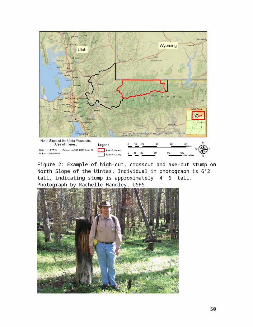
Figure 2: Example of high-cut, crosscut and axe-cut stump onNorth Slope of the Uintas. Individual in photograph is 6’2” tall, indicating stump is approximately 4’ 6” tall. Photograph by Rachelle Handley, USFS.
50

Figure 3: Map of roads, camp locations, and creek courses inthe Mill Creek drainage of the western North Slope area of the Uinta Mountains from 1913 (Baker and Hauge 1913).
51
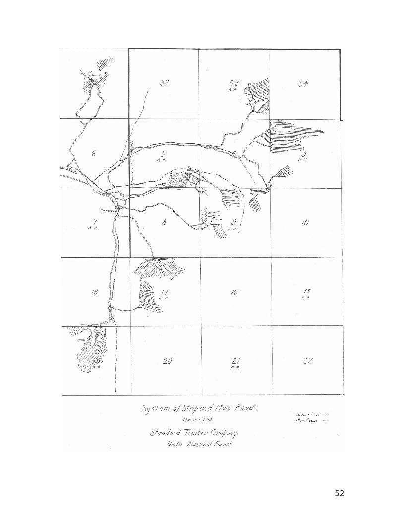
52
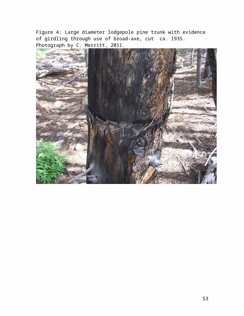
Figure 4: Large diameter lodgepole pine trunk with evidence of girdling through use of broad-axe, cut ca. 1935. Photograph by C. Merritt, 2011.
53

Figure 5: Sample lodgepole pine stand in Archie Creek Drainage, North Slope of Uintas. Plot of stumps displaying graduated symbols for Diameter at Stump Height (DSH).
54
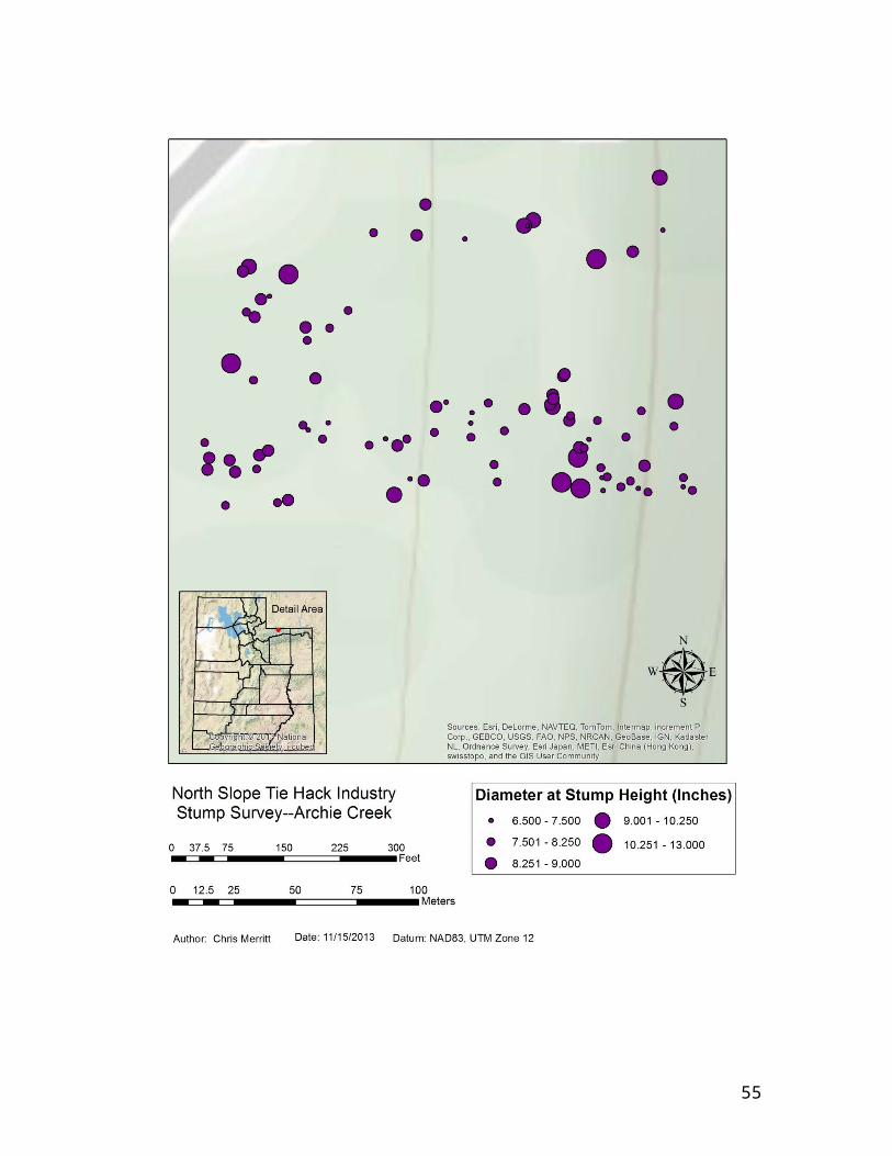
55

Figure 6: Sample lodgepole pine stand in Archie Creek Drainage, North Slope of Uintas. Plot of stumps displaying graduated symbols for height of stump.
56
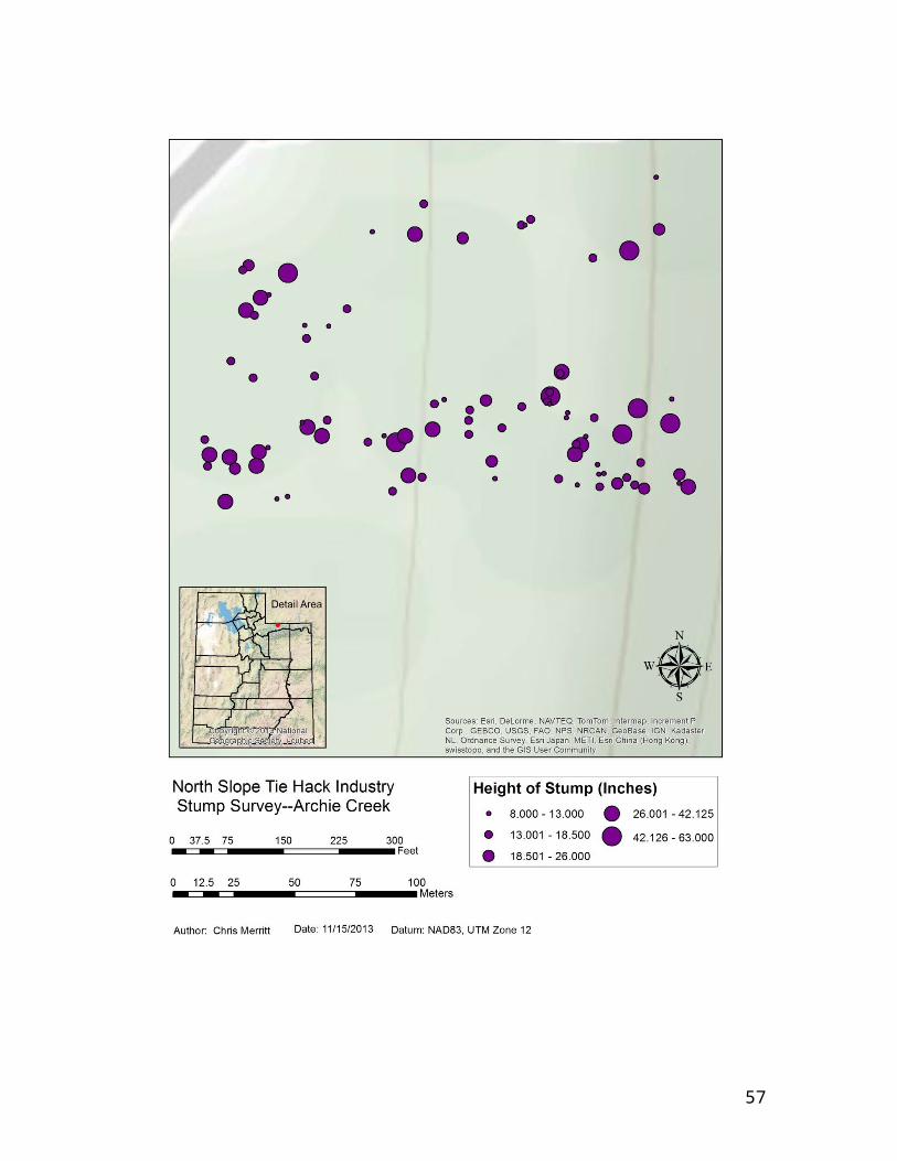
57
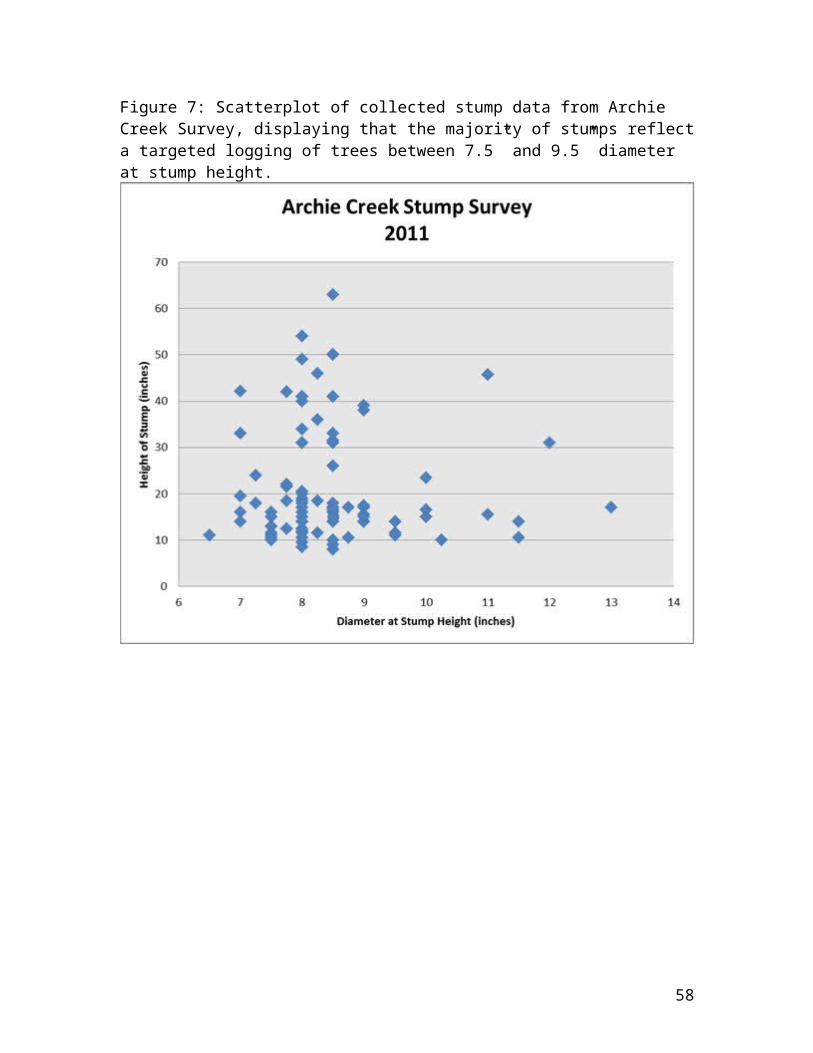
Figure 7: Scatterplot of collected stump data from Archie Creek Survey, displaying that the majority of stumps reflecta targeted logging of trees between 7.5” and 9.5” diameter at stump height.
58


![[short piece] E-1, or how I learned to stop worrying about the two-state solution](https://static.fdokumen.com/doc/165x107/631e26e256cbbb4750056966/short-piece-e-1-or-how-i-learned-to-stop-worrying-about-the-two-state-solution.jpg)