sava and drina rivers corridors integrated development project
96
SAVA AND DRINA RIVERS CORRIDORS INTEGRATED DEVELOPMENT PROJECT ENVIRONMENTAL AND SOCIAL MANAGEMENT FRAMEWORK FOR BOSNIA AND HERZEGOVINA February 2020 Public Disclosure Authorized Public Disclosure Authorized Public Disclosure Authorized Public Disclosure Authorized
-
Upload
khangminh22 -
Category
Documents
-
view
0 -
download
0
Transcript of sava and drina rivers corridors integrated development project
SAVA AND DRINA RIVERS CORRIDORS INTEGRATED
DEVELOPMENT PROJECT
ENVIRONMENTAL AND SOCIAL
MANAGEMENT FRAMEWORK FOR BOSNIA AND
HERZEGOVINA
February 2020
Pub
lic D
iscl
osur
e A
utho
rized
Pub
lic D
iscl
osur
e A
utho
rized
Pub
lic D
iscl
osur
e A
utho
rized
Pub
lic D
iscl
osur
e A
utho
rized
SAVA AND DRINA RIVERS CORRIDORS INTEGRATED DEVELOPMENT PROGRAM ESMF BIH
i
Table of Contents
1 EXECUTIVE SUMMARY.............................................................................................................................1
2 INTRODUCTION .......................................................................................................................................5
2.1 Brief Project Description .......................................................................................................................... 5
2.1.1 Objectives ....................................................................................................................................... 5
2.1.2 Components .................................................................................................................................... 5
2.1.3 Implementation Arrangements ...................................................................................................... 6
2.1.4 Timeline and Budget ....................................................................................................................... 7
2.2 Objectives of this Environmental and Social Management Framework .................................................. 7
2.3 Basic Information About the Country ...................................................................................................... 8
3 BASELINE ENVIRONMENTAL CHARACTERISTICS OF THE PROJECT AREA ..................................................9
3.1 Drina River Basin ...................................................................................................................................... 9
3.1.1 Geographic, Topographic and Geological Characterization............................................................ 9
3.1.2 Climate .......................................................................................................................................... 10
3.1.3 Climate Change ............................................................................................................................. 11
3.1.4 Water Quality................................................................................................................................ 12
3.1.5 Biodiversity and Protected Areas ................................................................................................. 14
3.1.6 Cultural and Historical Heritage .................................................................................................... 17
3.2 Sava River Basin ...................................................................................................................................... 18
3.2.1 Geographic, Topographic and Geological Characterization.......................................................... 18
3.2.2 Climate .......................................................................................................................................... 19
3.2.3 Climate Change ............................................................................................................................. 19
3.2.4 Water Quality................................................................................................................................ 20
3.2.5 Biodiversity and Protected Areas ................................................................................................. 22
3.2.6 Cultural and Historical Heritage .................................................................................................... 27
4 BASELINE SOCIO-ECONOMIC CHARACTERISTICS OF THE PROJECT AREA ................................................ 28
4.1 Demography ........................................................................................................................................... 28
4.1.1 Demography in the Drina Basin .................................................................................................... 28
4.1.2 Demography in the Sava Basin ..................................................................................................... 28
4.2 Rural and Urban Areas ........................................................................................................................... 29
4.2.1 Rural and Urban Areas in the Drina Basin..................................................................................... 29
4.2.2 Rural and Urban Areas in the Sava Basin ...................................................................................... 29
4.3 Key Economic Indicators ........................................................................................................................ 29
4.4 Local Economy of the Project Area ........................................................................................................ 30
4.4.1 Local Economy of the Drina Basin ................................................................................................. 30
SAVA AND DRINA RIVERS CORRIDORS INTEGRATED DEVELOPMENT PROGRAM ESMF BIH
ii
4.4.2 Local Economy of the Sava Basin .................................................................................................. 30
4.5 Impacts of Climate Change and Water Pollution on Local Economy ..................................................... 30
4.6 Employment ........................................................................................................................................... 31
4.6.1 Employment in the DRB ................................................................................................................ 32
4.6.2 Employment in Sava Basin Area ................................................................................................... 33
4.7 Poverty ................................................................................................................................................... 33
4.8 Labor Conditions .................................................................................................................................... 33
5 LEGAL FRAMEWORK .............................................................................................................................. 35
5.1 The World Bank Requirements .............................................................................................................. 35
5.1.1 The World Bank Environmental and Social Framework (2016) .................................................... 35
5.1.2 Other Applicable Criteria and Guidelines ..................................................................................... 40
5.2 Overview of Environmental and Social Requirements in BiH................................................................. 40
5.2.1 Environmental Assessment Procedure ......................................................................................... 40
5.2.2 Waste Management Regulations.................................................................................................. 44
5.2.3 Water Management Regulations .................................................................................................. 45
5.2.4 Construction Regulations .............................................................................................................. 47
5.2.5 Regulations on Working Conditions ............................................................................................. 48
6 INSTITUTIONAL STRUCTURE .................................................................................................................. 50
6.1 BiH Level Institutions .............................................................................................................................. 50
6.2 FBiH Level Institutions ............................................................................................................................ 50
6.3 RS Level Institutions ............................................................................................................................... 51
6.4 BD Level Institutions ............................................................................................................................... 52
7 ENVIRONMENTAL AND SOCIAL ASSESSMENT OF THE SUBPROJECTS ..................................................... 53
7.1 ESSs Relevant to the Program ................................................................................................................ 53
7.2 Preliminary Identification of Potential E&S Impacts with Proposed Mitigation Measures ................... 54
7.3 Environmental and Social Requirements ............................................................................................... 61
7.4 Environmental and Social Screening Process (Step-by-Step) ................................................................. 62
7.5 Labor Management ................................................................................................................................ 64
7.6 Monitoring and Reporting ...................................................................................................................... 64
7.7 Demining of the Right Bank of the Sava River ........................................................................................ 65
8 PUBLIC CONSULTATIONS PROCESS ........................................................................................................ 69
ANNEXES ....................................................................................................................................................... 70
A. Sites of Cultural and Historical Heritage in Municipalities of the DRB ................................................... 71
B. Sites of Cultural and Historical Heritage in Municipalities of the BiH .................................................... 73
C. Overview of Cantonal Ministries Responsible for Water Management and Environmental Issues ...... 74

SAVA AND DRINA RIVERS CORRIDORS INTEGRATED DEVELOPMENT PROGRAM ESMF BIH
iii
D. Generic Environmental and Social Management Plan for the Project ................................................... 75
E. Indicative outline of ESIA ........................................................................................................................ 80
F. Indicative outline of site-specific ESMP.................................................................................................. 82
G. Minutes from the public consultations .................................................................................................. 85
SAVA AND DRINA RIVERS CORRIDORS INTEGRATED DEVELOPMENT PROGRAM ESMF BIH
iv
List of Tables
Table 1: Frequency of Surface Water Quality Testing at Selected Reference Stations in BiH ............................... 12
Table 2: Protected areas within DRB in BiH .......................................................................................................... 16
Table 3: Potential Natura 2000 sites in the DRB in BiH ........................................................................................ 17
Table 4: The status of wastewater treatment plants construction in BiH ............................................................ 20
Table 5: Frequency of Sava River Surface Water Quality Testing at Selected Reference Stations in BiH ............. 21
Table 6: List of Natura 2000 habitat types occurring along the Sava River .......................................................... 24
Table 7: List of animal species of great importance for the entire European Union............................................. 24
Table 8: Protected areas along Sava River in BiH (RS) .......................................................................................... 25
Table 9: BiH population in 2013, and 2017 estimates .......................................................................................... 28
Table 10:Key Economic Indicators in BiH in 2015, 2016, 2017 and 2018 ............................................................. 29
Table 11: Number of employed persons, by gender, and employment rate by age groups in BIH in 2016 and
2017 ...................................................................................................................................................................... 32
Table 12: Employment by Sectors in BiH in 2017 .................................................................................................. 32
Table 13: Unemployment Rate in BiH in 2016 and 2017 ...................................................................................... 32
Table 14: Share of Inactive Population in BiH in 2016 and 2017 .......................................................................... 32
Table 15: Poverty and Inequity Indicators in BiH, 2011 and 2015 ........................................................................ 33
Table16: Waste Generated by the Activities Potentially Included by the Project – FBiH ...................................... 44
Table 17: Waste from the Activities Potentially Covered by the Project – RS ....................................................... 45
Table 18: Waste from the Activities Potentially Covered by the Project – BD BiH ................................................ 45
Table 19: FBiH level institutions responsible for water management and environmental issues relevant for this
Project ................................................................................................................................................................... 50
Table 20: RS level institutions responsible for water management and environmental issues relevant for this
Project ................................................................................................................................................................... 51
Table 21: BD BiH level institutions responsible for water management and environmental issues relevant for
this Project ............................................................................................................................................................ 52
Table 22: ESSs considered relevant for the SDIP at the time of the Program appraisal ....................................... 53
Table 23: Description of project components ....................................................................................................... 54
Table 24: Preliminary identification of environmental and social impacts of proposed subprojects ................... 57
Table 25: Environmental and social requirements for the Phase I of the Program .............................................. 61
SAVA AND DRINA RIVERS CORRIDORS INTEGRATED DEVELOPMENT PROGRAM ESMF BIH
v
List of Figures
Figure 1: Geographical map of BiH ......................................................................................................................... 8
Figure 2: Drina River Basin in BiH ........................................................................................................................... 9
Figure 3: The geotectonic position of central part of Balkan Peninsula between Moesia plate and Adriatic Sea 10
Figure 4: Average concentrations of BOD5, ammonia, phosphate and nitrate in Drina River ............................. 13
Figure 5: Protected areas in the Drina River Basin in BiH ..................................................................................... 16
Figure 6: Sava River Basin in BiH........................................................................................................................... 18
Figure 7: Average concentrations of BOD5, ammonia, phosphate and nitrate in Sava River ............................... 22
Figure 8: Protected areas in the Sava River Basin in BiH ...................................................................................... 26
Figure 9: Assessing Due Diligence on Subprojects ................................................................................................ 62
SAVA AND DRINA RIVERS CORRIDORS INTEGRATED DEVELOPMENT PROGRAM ESMF BIH
vi
Abbreviations
a.s.l. Above sea level
BD Brcko District
BiH Bosnia and Herzegovina
BOD Biological Oxygen Demand
DSPPA Department of Spatial Planning and Property Affairs of Brcko District
DRB Drina River Basin
E&S Environmental and Social
EEA European Environmental Agency
EIA Environmental Impact Assessment
EHSG World Bank Group Environmental, Health and Safety Guidelines
ESCP Environmental and Social Commitment Plan
ESMF Environmental and Social Management Framework
ESMAP Energy Sector Management Assistance Program
ESMP Environmental and Social Management Plan
ESSs Environmental and Social Standards
FAO Food and Agriculture Organization
FBiH Federation of Bosnia and Herzegovina
FMET Federal Ministry of Environment and Tourism
GEF Global Environment Facility
ICPDR The International Commission for the Protection of the Danube River
LMP Labor Management Procedure
OP Operational Procedure
O&M Operation and Maintenance
PE Population Equivalent
PIU Project Implementation Unit
RP Resettlement Plan
RPF Resettlement Process Framework
RS Republika Srpska
SCCF Special Climate Change Fund
SEA Strategic Environmental Assessment
SESA Strategic Environmental and Social Assessment
SFRY Socialist Federal Republic of Yugoslavia
SRB Sava River Basin
MoFTER Ministry of Foreign Trade and Economic Relations
MPPCEE Ministry of Physical Planning, Civil Engineering and Ecology
SDIP Sava and Drina Rivers Corridors Integrated Development Program
SAVA AND DRINA RIVERS CORRIDORS INTEGRATED DEVELOPMENT PROGRAM ESMF BIH
1
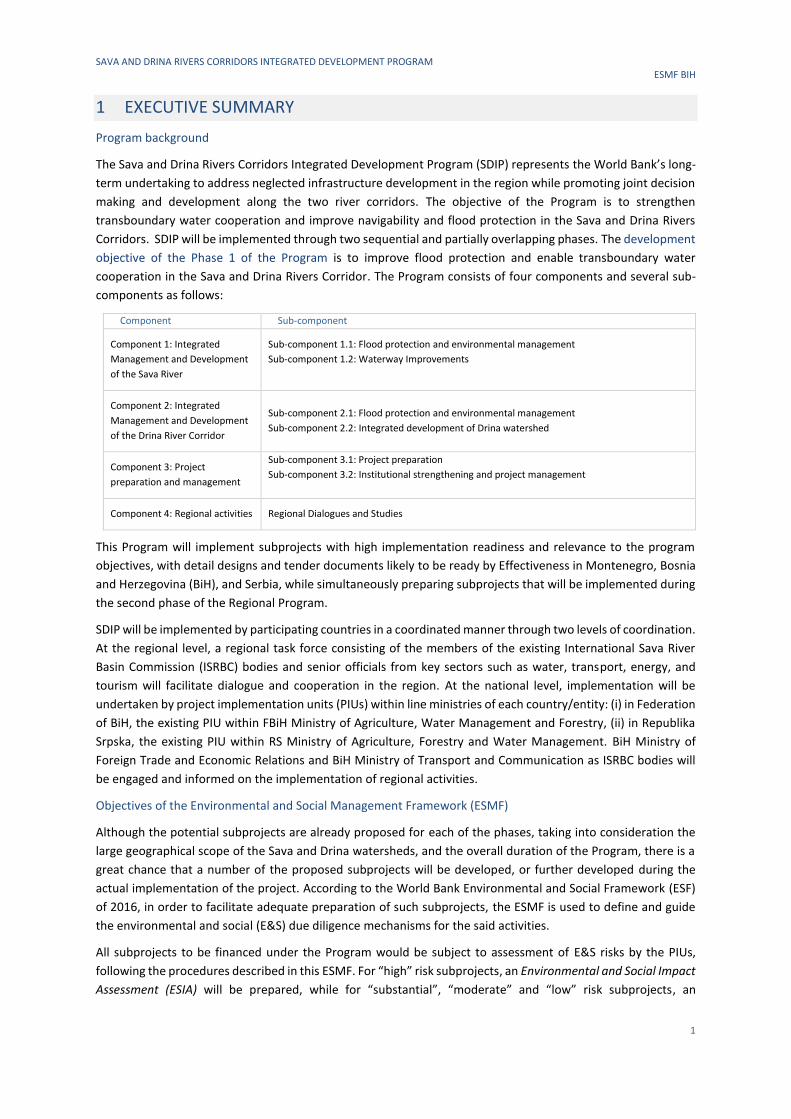
1 EXECUTIVE SUMMARY
Program background
The Sava and Drina Rivers Corridors Integrated Development Program (SDIP) represents the World Bank’s long-
term undertaking to address neglected infrastructure development in the region while promoting joint decision
making and development along the two river corridors. The objective of the Program is to strengthen
transboundary water cooperation and improve navigability and flood protection in the Sava and Drina Rivers
Corridors. SDIP will be implemented through two sequential and partially overlapping phases. The development
objective of the Phase 1 of the Program is to improve flood protection and enable transboundary water
cooperation in the Sava and Drina Rivers Corridor. The Program consists of four components and several sub-
components as follows:
Component Sub-component
Component 1: Integrated
Management and Development
of the Sava River
Sub-component 1.1: Flood protection and environmental management
Sub-component 1.2: Waterway Improvements
Component 2: Integrated
Management and Development
of the Drina River Corridor
Sub-component 2.1: Flood protection and environmental management
Sub-component 2.2: Integrated development of Drina watershed
Component 3: Project
preparation and management
Sub-component 3.1: Project preparation
Sub-component 3.2: Institutional strengthening and project management
Component 4: Regional activities Regional Dialogues and Studies
This Program will implement subprojects with high implementation readiness and relevance to the program
objectives, with detail designs and tender documents likely to be ready by Effectiveness in Montenegro, Bosnia
and Herzegovina (BiH), and Serbia, while simultaneously preparing subprojects that will be implemented during
the second phase of the Regional Program.
SDIP will be implemented by participating countries in a coordinated manner through two levels of coordination.
At the regional level, a regional task force consisting of the members of the existing International Sava River
Basin Commission (ISRBC) bodies and senior officials from key sectors such as water, transport, energy, and
tourism will facilitate dialogue and cooperation in the region. At the national level, implementation will be
undertaken by project implementation units (PIUs) within line ministries of each country/entity: (i) in Federation
of BiH, the existing PIU within FBiH Ministry of Agriculture, Water Management and Forestry, (ii) in Republika
Srpska, the existing PIU within RS Ministry of Agriculture, Forestry and Water Management. BiH Ministry of
Foreign Trade and Economic Relations and BiH Ministry of Transport and Communication as ISRBC bodies will
be engaged and informed on the implementation of regional activities.
Objectives of the Environmental and Social Management Framework (ESMF)
Although the potential subprojects are already proposed for each of the phases, taking into consideration the
large geographical scope of the Sava and Drina watersheds, and the overall duration of the Program, there is a
great chance that a number of the proposed subprojects will be developed, or further developed during the
actual implementation of the project. According to the World Bank Environmental and Social Framework (ESF)
of 2016, in order to facilitate adequate preparation of such subprojects, the ESMF is used to define and guide
the environmental and social (E&S) due diligence mechanisms for the said activities.
All subprojects to be financed under the Program would be subject to assessment of E&S risks by the PIUs,
following the procedures described in this ESMF. For “high” risk subprojects, an Environmental and Social Impact
Assessment (ESIA) will be prepared, while for “substantial”, “moderate” and “low” risk subprojects, an
SAVA AND DRINA RIVERS CORRIDORS INTEGRATED DEVELOPMENT PROGRAM ESMF BIH
2
assessment will be carried out in line with the FBiH, RS and BD environmental laws (depending on the subproject
location) and will include preparation of a site-specific Environmental and Social Management Plan, all in line
with this ESMF and the provisions set forth under the World Bank ESS1 and ESF. The other relevant ESSs and
OPs are:
ESS/OP
ESS1 Assessment and Management of Environmental and Social Risks and Impacts
ESS2 Labor and Working Conditions
ESS3 Resource Efficiency and Pollution Prevention and Management
ESS4 Community Health and Safety
ESS5 Land Acquisition, Restrictions on Land Use and Involuntary Resettlement
ESS6 Biodiversity Conservation and Sustainable Management of Living Natural Resources
ESS8 Cultural Heritage
OP 7.50 Projects on international waterways
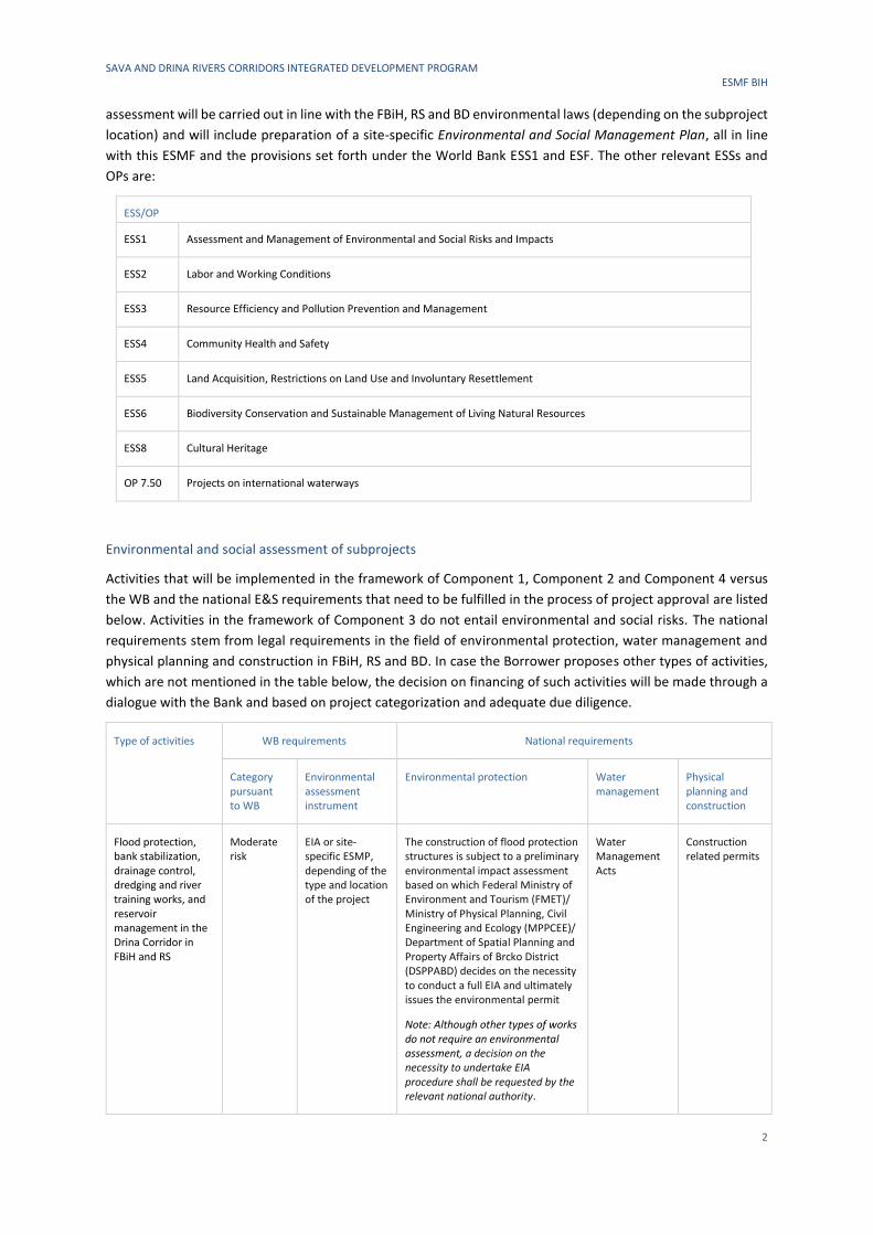
Environmental and social assessment of subprojects
Activities that will be implemented in the framework of Component 1, Component 2 and Component 4 versus
the WB and the national E&S requirements that need to be fulfilled in the process of project approval are listed
below. Activities in the framework of Component 3 do not entail environmental and social risks. The national
requirements stem from legal requirements in the field of environmental protection, water management and
physical planning and construction in FBiH, RS and BD. In case the Borrower proposes other types of activities,
which are not mentioned in the table below, the decision on financing of such activities will be made through a
dialogue with the Bank and based on project categorization and adequate due diligence.
Type of activities WB requirements National requirements
Category pursuant to WB
Environmental assessment instrument
Environmental protection Water management
Physical planning and construction
Flood protection, bank stabilization, drainage control, dredging and river training works, and reservoir management in the Drina Corridor in FBiH and RS
Moderate risk
EIA or site-specific ESMP, depending of the type and location of the project
The construction of flood protection structures is subject to a preliminary environmental impact assessment based on which Federal Ministry of Environment and Tourism (FMET)/ Ministry of Physical Planning, Civil Engineering and Ecology (MPPCEE)/ Department of Spatial Planning and Property Affairs of Brcko District (DSPPABD) decides on the necessity to conduct a full EIA and ultimately issues the environmental permit
Note: Although other types of works do not require an environmental assessment, a decision on the necessity to undertake EIA procedure shall be requested by the relevant national authority.
Water Management Acts
Construction related permits
SAVA AND DRINA RIVERS CORRIDORS INTEGRATED DEVELOPMENT PROGRAM ESMF BIH
3
Type of activities WB requirements National requirements
Category pursuant to WB
Environmental assessment instrument
Environmental protection Water management
Physical planning and construction
Nursery production, reforestation, arboretum establishment
Low risk Generic ESMP given in Annex to this ESMF.
- - -
Demining activities along the Sava Right bank within BiH
Substantial risk
Site-specific ESMP
- - -
Development of regional studies for the Sava river basin
Low risk Strategic Environmental and Social Assessment
Strategic Environmental Assessment - -
For future implementation of the sub-components and related subprojects, the following steps concerning the
E&S assessment process should be undertaken:
Step 1. Confirm the preliminary determined project risk and carry out an E&S assessment in line the WB
requirements
Type of activities Action to be taken Result of the action
Flood protection, bank stabilization, drainage control, dredging and river training works, and reservoir management in the Drina Corridor in FBiH and RS
Prepare an ESIA or site-specific ESMP (depending on the categorization and the requirements of the local permitting process) and follow guidance on disclosure and consultations. In the ESIA or site-specific ESMP, include sections related to all applicable ESSs.
WB requirements on E&S impacts mitigation and monitoring included in the tender dossier.
Nursery production, reforestation, arboretum establishment
Assess impacts against the generic ESMP given in this ESMF and follow guidance on disclosure and consultations.
WB requirements on E&S impacts mitigation and monitoring included in the tender dossier.
Demining activities along the Sava Right bank within BiH
Develop site-specific ESMP and follow guidance on disclosure and consultations. In the site-specific ESMP, include sections related to all applicable ESSs.
WB requirements on E&S impacts mitigation and monitoring included in the tender dossier.
Development of regional studies for Sava river basin
Prepare Strategic Environmental and Social Assessment (SESA) for each study considering the full range of environmental and social risks and impacts incorporated in ESS1 through 10.
Improved regional studies based on the conclusions from SESA.
Step 2. Carry out an environmental assessment in line with FBiH, RS or BD requirements
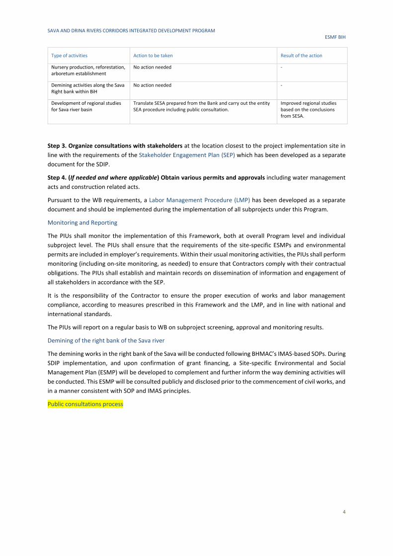
Type of activities Action to be taken Result of the action
Flood protection structures In FBiH and BD, prepare a Request for environmental permit and submit it to FMET or DSPPA BD, depending on the project location. Based on the Request, the responsible institution will decide on the necessity to conduct a full EIA in case of which an EIA study will be requested. The responsible institution will issue the environmental permit based on the Request or full EIA study, whichever is required by the procedure. In RS, prepare an Application for preliminary EIA and submit it to RS MPPCEE. Based on the Application, the ministry will decide on the necessity to conduct a full EIA in case of which an EIA study will be requested. The responsible institution will issue the environmental permit based on the Request or full EIA study, whichever is required by the procedure.
Obtained environmental permit
SAVA AND DRINA RIVERS CORRIDORS INTEGRATED DEVELOPMENT PROGRAM ESMF BIH
4
Type of activities Action to be taken Result of the action
Nursery production, reforestation, arboretum establishment
No action needed -
Demining activities along the Sava Right bank within BiH
No action needed -
Development of regional studies for Sava river basin
Translate SESA prepared from the Bank and carry out the entity SEA procedure including public consultation.
Improved regional studies based on the conclusions from SESA.
Step 3. Organize consultations with stakeholders at the location closest to the project implementation site in
line with the requirements of the Stakeholder Engagement Plan (SEP) which has been developed as a separate
document for the SDIP.
Step 4. (If needed and where applicable) Obtain various permits and approvals including water management
acts and construction related acts.
Pursuant to the WB requirements, a Labor Management Procedure (LMP) has been developed as a separate
document and should be implemented during the implementation of all subprojects under this Program.
Monitoring and Reporting
The PIUs shall monitor the implementation of this Framework, both at overall Program level and individual
subproject level. The PIUs shall ensure that the requirements of the site-specific ESMPs and environmental
permits are included in employer’s requirements. Within their usual monitoring activities, the PIUs shall perform
monitoring (including on-site monitoring, as needed) to ensure that Contractors comply with their contractual
obligations. The PIUs shall establish and maintain records on dissemination of information and engagement of
all stakeholders in accordance with the SEP.
It is the responsibility of the Contractor to ensure the proper execution of works and labor management
compliance, according to measures prescribed in this Framework and the LMP, and in line with national and
international standards.
The PIUs will report on a regular basis to WB on subproject screening, approval and monitoring results.
Demining of the right bank of the Sava river
The demining works in the right bank of the Sava will be conducted following BHMAC’s IMAS-based SOPs. During
SDIP implementation, and upon confirmation of grant financing, a Site-specific Environmental and Social
Management Plan (ESMP) will be developed to complement and further inform the way demining activities will
be conducted. This ESMP will be consulted publicly and disclosed prior to the commencement of civil works, and
in a manner consistent with SOP and IMAS principles.
Public consultations process
SAVA AND DRINA RIVERS CORRIDORS INTEGRATED DEVELOPMENT PROGRAM ESMF BIH
5
2 INTRODUCTION
2.1 Brief Project Description
2.1.1 Objectives
The Higher-level Objective of the Sava and Drina Rivers Corridors Integrated Development Program (SDIP) is to
strengthen transboundary water cooperation and improve navigability and flood protection in the Sava and
Drina Rivers Corridors.
The Development Objective of the SDIP (Phase 1 of the Program) is to improve flood protection and enable
transboundary water cooperation in the Sava and Drina Rivers Corridors.
2.1.2 Components
This project will implement subprojects with high implementation readiness and relevance to the program
objectives, with detail designs and tender documents likely ready by Effectiveness in Montenegro, Bosnia and
Herzegovina (BiH) and Serbia, while simultaneously preparing subprojects that will be implemented during the
second phase of the Regional Program. The project consists of three components as described below:
Component 1: Integrated Management and Development of the Sava River Corridor
Sub-component 1.1: Flood protection, environmental management and climate change adaptation. This sub-
component will finance construction and rehabilitation of embankments at selected priority areas along the
Sava River Corridor as well as nature-based solutions to re-vitalize selected protected areas of ecological
significance to the Western Balkans. Upgraded flood protection capacity (at or above 1 in 100-year event) also
enhance climate adaptation capacity of protected areas.
Sub-component 1.2: Waterway improvements. Under this sub-component, grant financing will be mobilized to
finance demining activities along the Sava’s right bank within BiH, as a pre-requisite to the execution of civil
works—planned for Phase II of the program—to increase the navigational capacity of the Sava river. The
preparatory documentation for these Phase II works (engineering designs, environmental and social safeguards
instruments, expected climate change impacts on navigability, bidding documents) will also be finalized during
the project. The project-supported demining efforts are also an operational pre-requisite to the planned
improvements to Sava river ports under Phase II. Demining activities are proposed as a no-regret investment
that will help unlock the river’s economic potential for generations to come.
Component 2: Integrated Management and Development of the Drina River Corridor
Sub-component 2.1: Flood protection and environmental management. This sub-component will finance
infrastructure works (for example, flood protection in Gorazde City, FBiH), studies, surveys, consultations and
preparation of detailed design of interventions related to the management of environmental assets (the
protection of local ecosystems that act as carbon sinks) along the Drina Corridor. The on-going GEF-SCCF-
financed Drina River Basin Management project as well as the ESMAP technical assistance, are conducting
studies that will identify the additional actions needed for flood protection, bank stabilization, drainage and river
training works, and reservoir management in the Drina Corridor. Upgraded flood protection capacity (at or
above 1 in 100-year event) also enhance climate adaptation capacity of protected areas.
Sub-component 2.2: Integrated development of Drina watershed. This sub-component will finance improved
watershed management in the Lim and Grncar River basins of Montenegro, as well as works related to flood
protection, drainage and irrigation measures within the Lim River Basin (a tributary of the Drina River) to
mitigate flood risks and promote sustainable use of natural resources. These measures include: river bank
stabilization; river training works; flood protection embankments and dykes. The detailed designs of these
SAVA AND DRINA RIVERS CORRIDORS INTEGRATED DEVELOPMENT PROGRAM ESMF BIH
6
investments are under preparation through the ongoing GEF-SCCF project. This sub-component will further
finance the preparation of selected priority investments in line with the project development objective.
Component 3: Project preparation and management
Sub-component 3.1: Project preparation. This sub-component will finance preparation of project
documentation for phase II of the program, including environmental and social assessments.
Sub-component 3.2: Institutional strengthening and project management. This sub-component will finance
activities to increase institutional capacity and inter-sectoral coordination in the participating countries to
ensure more efficient decision making and program management at regional level. This sub-component will
promote joint action and decision making in river basin management and flood risk management among riparian
countries, thus enhance the climate adaptation capacity of the region.
Component 4: Regional activities
This component will support policy dialogue, consultations, preparation of plans and studies, and investments
to strengthen the nexus between water services and connectivity with the regional development and economic
cooperation objectives of the Sava and Drina Corridor. Examples include the Sava River Basin Management Plan
and Hydrological assessments, Climate Change Adaptation Strategy for the Sava River Basin, planning and
development of tourism in the Sava and Drina Rivers corridors including the designing of Master Plans for
Nautical tourism and Ecotourism. River Basin Management Plans and Hydrological assessments will ultimately
support integrated water resources management, thereby indirectly increasing the resilience of riparian
countries to climate change; requested GEF funding will co-finance measures related to river basin planning and
management, flood monitoring network, institutional capacity building, and studies that inform or prepare
future investments. An advocacy and communication plan will be prepared and implemented to promote
regional cooperation. Regional studies (i.e., hydrological, sediment, climate changes adaptation, etc.) in the Sava
and Drina Rivers Corridors will improve the understanding of the Basin’s unique characteristics and
opportunities to boost regional cooperation and integrated management.
2.1.3 Implementation Arrangements
SDIP will be implemented through a sequential and simultaneous multiphase programmatic approach with five
participating countries: Serbia, BiH, Montenegro, Croatia, and Slovenia. Slovenia will be the only non-borrowing
program beneficiary; it will participate in the regional studies, regional dialogue, capacity building tools, and
related activities under Component 3. Subprojects will be implemented at national level and will have
cumulative regional benefits.
SDIP will be implemented by participating countries in a coordinated manner through two levels of coordination.
At the regional level, a regional committee consisting of the existing ISRBC members and senior officials from
key sectors such as water, transport, energy and tourism will facilitate dialogue and cooperation in the region.
This committee will also provide strategic oversight and guidance for the implementation of regional activities
in addition to national subprojects, ensuring stronger dialogue, integration and knowledge sharing. During
implementation, other sectors will be coopted as and when the need arises.
At the national level, implementation will be undertaken by PIUs within line ministries of each country/entity.
In each country/entity, PIUs will be established comprising of the required technical and managerial expertise
to support project implementation. In the Federation of BiH (FBiH), the existing PIU within FBiH Ministry of
Agriculture, Water Management and Forestry will be responsible for implementation of the activities in FBiH.
The Federal Ministry of Transport and Communications, the Water Agency Sava and other institutions
responsible for particular sectors (navigation, flood protection, tourism) will provide technical support. In
Republika Srpska (RS), the existing PIU within the RS Ministry of Agriculture, Forestry and Water Management
will implement the project, and technical support will be provided by the Ministry of Transport and
SAVA AND DRINA RIVERS CORRIDORS INTEGRATED DEVELOPMENT PROGRAM ESMF BIH
7
Communications, Ministry of Spatial Planning, Construction and Ecology, the Water Agency and other relevant
institutions. In BD, a new PIU will be established for project implementation.
2.1.4 Timeline and Budget
The program will be implemented over a period of 10 years, organized in two phases. Phase I will focus on flood
protection and river basin management activities in the Sava and Drina River Corridors. Phase II will build on
Phase I and strengthen river port connectivity and environmental management. Countries will proceed to Phase
II based on the readiness of jointly identified priority interventions prepared during Phase I. The estimated
program cost for both phases is US$338 million.
2.2 Objectives of this Environmental and Social Management Framework
According to the World Bank (WB) Environmental and Social Framework of 2016 (ESF) (described in more detail
in the Legal Framework section of this document), the Environmental and Social Management Framework
(ESMF) is an instrument that examines the risks and impacts when a project consists of a program and/or
series of subprojects, and the risks and impacts cannot be determined until the program or subproject details
have been identified.
Although the potential subprojects have already been proposed for each of the phases, taking into consideration
the large geographical scope of the Sava and Drina watersheds, and the overall duration of the Program, there
is a great chance that a number of proposed subprojects will be developed, or further developed during the
actual implementation of the project. In order to facilitate the adequate preparation of such subprojects, the
ESMF is used to define and guide the environmental and social (E&S) due diligence mechanisms for the said
activities.
The ESMF establishes principles, rule and procedures for assessment of E&S risks and impacts. It includes
measures and plans for reduction, mitigation and/or compensation of negative risks and impacts, rules for
estimating and budgeting costs of such measures, as well as information on the agency or agencies responsible
for addressing project risks and impacts, including information on such body’s capacity to manage E&S risks and
impacts. It also includes adequate information on the area where a subproject is expected to be implemented,
including any potential E&S vulnerability of such area; as well as information on the potential impacts and
mitigation measures which could be implemented.
This ESMF has been prepared with the aim to ensure:
▪ project compliance with all relevant local polices and legislation, as well as WB requirements, and
therefore
▪ adequate mitigation of all potentially adverse E&S impacts of the Program.
This document provides a detailed description of the procedures related to assessment, management and
monitoring of E&S risks and impacts of the subprojects. All subprojects to be financed under the Program will
be subject to an assessment of E&S risks by the PIUs, following the procedures described in this Framework. For
“high” risk subprojects, an Environmental and Social Impact Assessment (ESIA) will be developed, while for
“substantial”, “moderate” and “low” risk subprojects, an assessment will be carried out in line with the FBIH, RS
and BD environmental laws (depending on the subproject location) and will include preparation of a site-specific
Environmental and Social Management Plan (ESMP), all in line with this ESMF and provisions set forth under the
World Bank ESS1 and ESF.
SAVA AND DRINA RIVERS CORRIDORS INTEGRATED DEVELOPMENT PROGRAM ESMF BIH
8
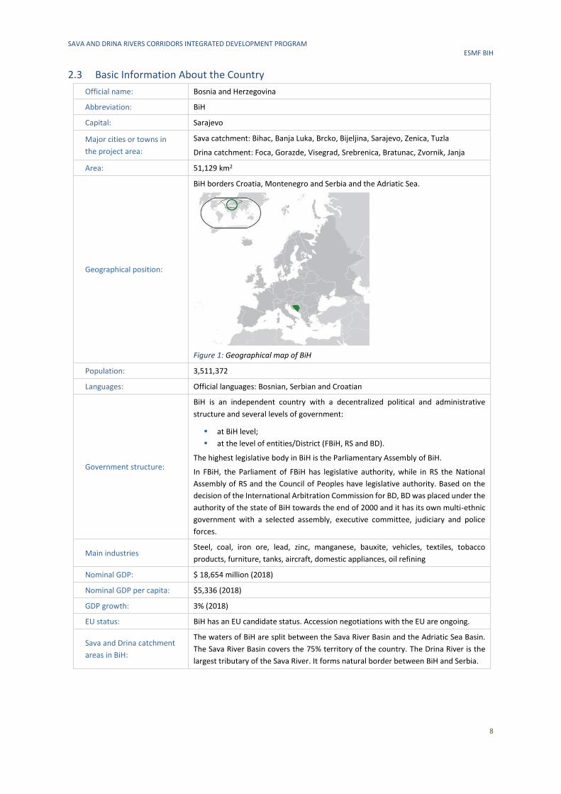
2.3 Basic Information About the Country
Official name: Bosnia and Herzegovina
Abbreviation: BiH
Capital: Sarajevo
Major cities or towns in
the project area:
Sava catchment: Bihac, Banja Luka, Brcko, Bijeljina, Sarajevo, Zenica, Tuzla
Drina catchment: Foca, Gorazde, Visegrad, Srebrenica, Bratunac, Zvornik, Janja
Area: 51,129 km2
Geographical position:
BiH borders Croatia, Montenegro and Serbia and the Adriatic Sea.
Figure 1: Geographical map of BiH
Population: 3,511,372
Languages: Official languages: Bosnian, Serbian and Croatian
Government structure:
BiH is an independent country with a decentralized political and administrative
structure and several levels of government:
▪ at BiH level;
▪ at the level of entities/District (FBiH, RS and BD).
The highest legislative body in BiH is the Parliamentary Assembly of BiH.
In FBiH, the Parliament of FBiH has legislative authority, while in RS the National
Assembly of RS and the Council of Peoples have legislative authority. Based on the
decision of the International Arbitration Commission for BD, BD was placed under the
authority of the state of BiH towards the end of 2000 and it has its own multi-ethnic
government with a selected assembly, executive committee, judiciary and police
forces.
Main industries Steel, coal, iron ore, lead, zinc, manganese, bauxite, vehicles, textiles, tobacco
products, furniture, tanks, aircraft, domestic appliances, oil refining
Nominal GDP: $ 18,654 million (2018)
Nominal GDP per capita: $5,336 (2018)
GDP growth: 3% (2018)
EU status: BiH has an EU candidate status. Accession negotiations with the EU are ongoing.
Sava and Drina catchment
areas in BiH:
The waters of BiH are split between the Sava River Basin and the Adriatic Sea Basin.
The Sava River Basin covers the 75% territory of the country. The Drina River is the
largest tributary of the Sava River. It forms natural border between BiH and Serbia.
SAVA AND DRINA RIVERS CORRIDORS INTEGRATED DEVELOPMENT PROGRAM ESMF BIH
9
3 BASELINE ENVIRONMENTAL CHARACTERISTICS OF THE PROJECT AREA
3.1 Drina River Basin
3.1.1 Geographic, Topographic and Geological Characterization
The Drina River is 346 km long and is the largest tributary of the Sava River Basin (SRB), which in turn is the
largest tributary by volume of water of the Danube River Basin that drains into the Black Sea. The Drina River
Basin (DRB) has a surface area of 19,680 km2 and spreads over the territory of principally three riparian states:
BiH, Montenegro and Republic of Serbia. In addition, Albania accounts for a very small part of the DRB (<1%)
and is not included within the scope of this project.
The Drina River originates between the slopes of the Maglic and Pivska planina mountains, between the villages
of Scepan Polje (in Montenegro) and Hum (in Bosnia and Herzegovina). The Drina River rises at the joining of the
Tara River and Piva River near the town of Scepan Polje. The largest and the most water-abundant tributary in
BiH is the Lim River.
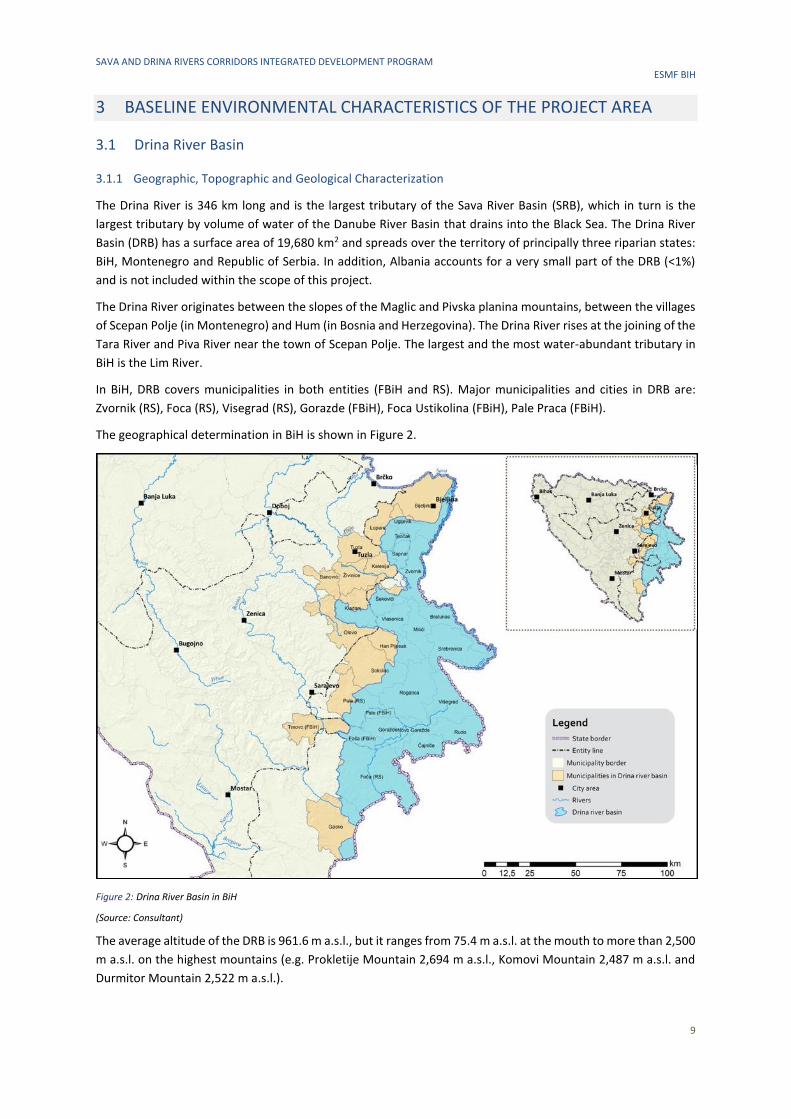
In BiH, DRB covers municipalities in both entities (FBiH and RS). Major municipalities and cities in DRB are:
Zvornik (RS), Foca (RS), Visegrad (RS), Gorazde (FBiH), Foca Ustikolina (FBiH), Pale Praca (FBiH).
The geographical determination in BiH is shown in Figure 2.
Figure 2: Drina River Basin in BiH
(Source: Consultant)
The average altitude of the DRB is 961.6 m a.s.l., but it ranges from 75.4 m a.s.l. at the mouth to more than 2,500
m a.s.l. on the highest mountains (e.g. Prokletije Mountain 2,694 m a.s.l., Komovi Mountain 2,487 m a.s.l. and
Durmitor Mountain 2,522 m a.s.l.).
SAVA AND DRINA RIVERS CORRIDORS INTEGRATED DEVELOPMENT PROGRAM ESMF BIH
10
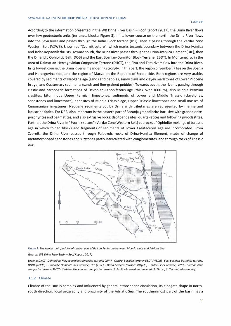
According to the information presented in the WB Drina River Basin – Roof Report (2017), the Drina River flows
over few geotectonic units (terranes, blocks; Figure 3). In its lower course on the north, the Drina River flows
into the Sava River and passes through the Jadar Block terrane (JBT). Then it passes through the Vardar Zone
Western Belt (VZWB), known as “Zvornik suture”, which marks tectonic boundary between the Drina-Ivanjica
and Jadar-Kopaonik thrusts. Toward south, the Drina River passes through the Drina-Ivanjica Element (DIE), then
the Dinaridic Ophiolitic Belt (DOB) and the East Bosnian-Durmitor Block Terrane (EBDT). In Montenegro, in the
area of Dalmatian-Herzegovinian Composite Terrane (DHCT), the Piva and Tara rivers flow into the Drina River.
In its lowest course, the Drina River is meandering strongly. In this part, the region of Semberija lies on the Bosnia
and Herzegovina side, and the region of Macva on the Republic of Serbia side. Both regions are very arable,
covered by sediments of Neogene age (sands and pebbles, sandy clays and clayey marlstones of Lower Pliocene
in age) and Quaternary sediments (sands and fine-grained pebbles). Towards south, the river is passing through
clastic and carbonatic formations of Devonian-Caboniferous age (thick over 1000 m), also Middle Permian
clastites, bituminous Upper Permian limestones, sediments of Lower and Middle Triassic (claystones,
sandstones and limestones), andesites of Middle Triassic age, Upper Triassic limestones and small masses of
Cenomanian limestones. Neogene sediments cut by Drina with tributaries are represented by marine and
lacustrine facies. For DRB, also important is the eastern part of Boranja granodiorite intrusive with granodiorite-
porphyrites and pegmatites, and also extrusive rocks: dacitoandesites, quartz-latites and following pyroclastites.
Further, the Drina River in "Zvornik suture" (Vardar Zone Western Belt) cut rocks of Ophiolite melange of Jurassic
age in which folded blocks and fragments of sediments of Lower Creataceous age are incorporated. From
Zvornik, the Drina River passes through Paleozoic rocks of Drina-Ivanjica Element, made of change of
metamorphosed sandstones and siltstones partly intercalated with conglomerates, and through rocks of Triassic
age.
Figure 3: The geotectonic position of central part of Balkan Peninsula between Moesia plate and Adriatic Sea
(Source: WB Drina River Basin – Roof Report, 2017)
Legend: DHCT - Dalmatian-Herzegovinian composite terrane; CBMT - Central Bosnian terrane; EBDT (=IBDB) - East Bosnian-Durmitor terrane;
DOBT (=DOP) - Dinaridic Ophiolite Belt terrane; DIT (=DIE) - Drina-Ivanjica terrane; JBT(=JB) - Jadar Block terrane; VZCT - Vardar Zone
composite terrane; SMCT - Serbian-Macedonian composite terrane. 1. Fault, observed and covered; 2. Thrust; 3. Tectonized boundary.
3.1.2 Climate
Climate of the DRB is complex and influenced by general atmospheric circulation, its elongate shape in north-
south direction, local orography and proximity of the Adriatic Sea. The southernmost part of the basin has a
SAVA AND DRINA RIVERS CORRIDORS INTEGRATED DEVELOPMENT PROGRAM ESMF BIH
11
Mediterranean and a maritime temperate and humid climate according to the Köppen climate classification.
Moderately cold and humid continental climate can be found at the altitudes above 1,000 m. Mediterranean
influence, although mild, can be found in the upper part of the basin, up to Foca. From that point downstream
a temperate continental climate prevails with warm summers and moderately cold winters.
Generally, from south to north, along the altitude decline, accumulated annual precipitation also decreases,
from about 2,100 mm measured in Kolasin on average to 820 mm in Loznica. In the same direction, mean annual
temperature increases from 4.6 °C in Zabljak to 11 °C in Loznica. Seasonal distribution of precipitation differs
throughout the DRB. Northern parts receive the most rain in the late spring, mainly in May and June, while
winter is dry with the lowest precipitation in February. Due to the influence of the Mediterranean climate in the
southern parts, maximum rain falls in the late autumn and the minimum during the summer months. The
warmest month is July and the coldest is January.
Relative humidity in the DRB is rather uniform and is at its lowest in the period June-August and the highest in
the December-January period. Snow cover significantly impacts the Drina River water regime due to large
amounts of water accumulated in it, with the highest flows recorded in springtime, in April and May.
Snow depth in some sections of the lower middle part of the DRB can be as high as 1.20 m (corresponding to a
maximum of 200 mm of water) with frequent snow-drifts and in upper sections it can even exceed 5 m.
Fogs constitute a characteristic feature of the Drina River valley and can occur throughout the year but are most
frequent in spring and autumn. Complex local topography in the upper course of Drina River significantly affects
and modifies wind direction and speed. Despite this, strong winds are quite rare and are generally of low
intensity.
3.1.3 Climate Change
According to the climate change impact analysis presented in the 2017 WB Drina River Basin – Roof Report, the
temperature over the entire DRB in all seasons during two considered future periods (2011-2040 and 2041-
2070) will increase. The increase in the ensemble median mean annual temperature ranges from 1.1 °C to 1.4
°C under RCP1 4.5 and 8.5 respectively in the near future (2011-2040) and from 2.0 °C to 2.7 °C in the distant
future (2041-2070) with respect to the reference period 1961-1990. The largest heating is projected for summer
season under both scenarios and in both future periods, and also for winter season in distant future under RCP
8.5 (especially in the Republic of Serbia part of DRB). The smallest increase is expected in autumn for near future,
and in spring for distant future.
Winter precipitation is expected to increase, while summer precipitation is expected to decrease. Spring
precipitation shows small decrease in both periods, while autumn precipitation tends to increase first and then
decrease in distant future. The largest projected change is the decrease of about 30% in summer precipitation
in distant future.
The expected changes in the hydrologic regimes (mean annual flow) of the Drina River, as well as its major
tributaries Piva, Tara, Cehotina, Lim and Uvac, are ranging from -12% to +15% in the near future (2011-2041)
relative to the baseline period 1961-1990. In the winter season changes range from +7% to +64% while in the
spring season, which is characterized by the greatest flows in DRB, a reduction of up to 22% is expected. The
summer flows are reduced up to - 35%. The changes in the autumn season in the near future range from -19%
to +12% in accordance with changes in the climate drivers. Low annual flows of 10% and 90% exceedance
probabilities are expected to change by -9% to +5% and by -15% to +10% in the near and distant future periods,
respectively, relative to the baseline period 1961-1990. High annual flows of 10% and 90% exceedance
1 A Representative Concentration Pathway (RCP) is a greenhouse gas concentration (not emissions) trajectory adopted by the IPCC for its
fifth Assessment Report (AR5) in 2014.
SAVA AND DRINA RIVERS CORRIDORS INTEGRATED DEVELOPMENT PROGRAM ESMF BIH
12
probabilities are expected to change in the range from -7% to +22% and from -21% to 20% in the near and distant
future periods, respectively.
More significant changes in runoff can be expected in the distant future, from -18% to +13% on annual scale.
The winter runoff is expected to increase by up to 87%, while the spring runoff is expected to decrease by up to
35%. A significant decrease in runoff can be expected during the summer season according to all climate
scenarios, ranging from -18% to -49%. During the autumn season, a decrease in runoff is expected by up to 40%.
The trends and changes in mean values of precipitation, evapotranspiration, and discharges in this basin are well
documented and indicate that climate change is expected to cause more intense flood and drought episodes,
both in terms of scope and duration. Main floods in the DRB in 2010 were caused by the extreme precipitation
in Montenegro’s and Serbia’s part of river basins. Flow rate of the Drina river, at the confluence to the Sava river,
was over 4000 m3/s what is the highest flow recorded in the last 50 years. The recurrence period of the Sava
river flow downstream the confluence with Drina, almost reached 100 years (6000 m3/s). The more details on
economic impact of these floods is given in Chapter 4.5.
3.1.4 Water Quality
Based on information taken from the river basin management documents2, DRB consists of 265 water bodies:
233 in RS and 32 in FBiH. Out of these, 109 water bodies (47%) are not classified as having good or high status
according to the Water Framework Directive (2000/60/European Parliament and Council). Moderate ecological
status and poor chemical status were determined on the section of the Drina River downstream from Zvornik,
while poor chemical status was determined upstream and downstream from City of Gorazde all the way down
to Visegrad municipality.
The main identified pressures include organic and nutrient pollution from anthropological activities (mainly
municipal and industrial wastewater, waste dumpsites and agricultural activities) along with hydro-
morphological alterations which also affect the environmental status of water bodies. The only urban
wastewater treatment plant in the DRB is located in the city of Bijeljina, located just before the Drina river
empties into the Sava river. The capacity of the plant is 40.000 PE. Other settlements located in the DRB
discharge their wastewater without any treatment. Despite the indication of low concentrations of heavy metals
in the Drina River, increased values have recently been noted due to antimony mines and the exploration of,
among other things, gravel and quartz sand.
There are 4 monitoring stations located on the Drina River, two in FBiH (downstream from Gorazde and in
Vitkovici settlement) and two in RS (Foca and Badanovci settlement). The frequency of surface water quality
testing at selected reference stations is presented in the following table.
Table 1: Frequency of Surface Water Quality Testing at Selected Reference Stations in BiH
Water body
code/TNMN code
Watercourse name
Measuring site position/Entity
Number of tests
2013 2014 2015 2016 2017
Black Sea Basin-Danube Sub-basin, Sava-Drina River
RS_DR_1/BA10 Drina/Badanovci, Pavlovica bridge/RS 12 12 12 12 10
BA_DR_5 Drina/downstream of Gorazde/FBiH 4 4 - 4 4
BA_DR_6 Drina/Vitkovici/FBiH 4 4 - 4 4
RS_DR_7/BA9 Drina/Foca/RS 4 12 12 12 10
Total 24 32 24 32 28
(Source: Sava River Basin District Agency, Adriatic Sea River Basin District Agency, Public Enterprise” Vode Srpske”)
2 The Sava River Basin Management Plan in FBiH (2016-2021), Sava River Basin District Agency, Sarajevo, November, 2016; Sava River Basin Management Plan in RS (2017-2021), Public Institution "Vode Srpske", November, 2017
SAVA AND DRINA RIVERS CORRIDORS INTEGRATED DEVELOPMENT PROGRAM ESMF BIH
13
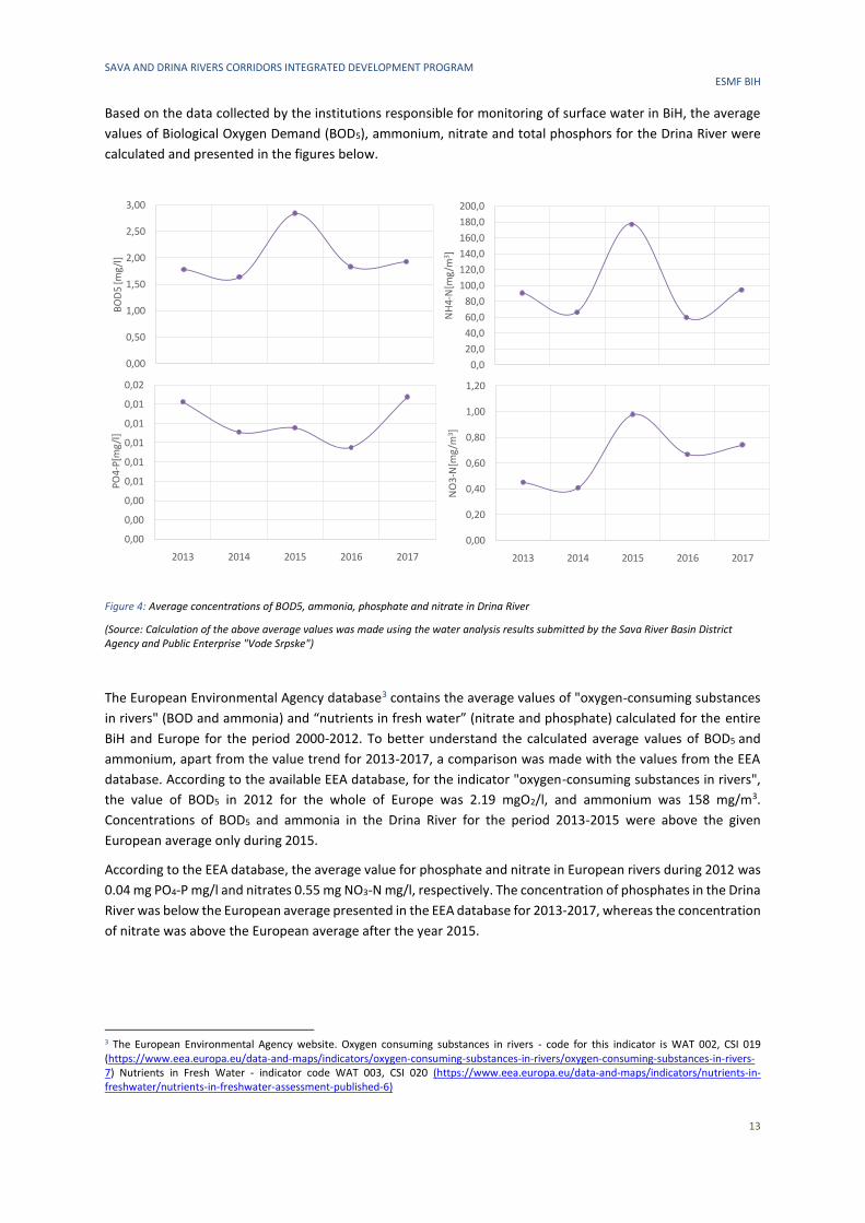
Based on the data collected by the institutions responsible for monitoring of surface water in BiH, the average
values of Biological Oxygen Demand (BOD5), ammonium, nitrate and total phosphors for the Drina River were
calculated and presented in the figures below.
Figure 4: Average concentrations of BOD5, ammonia, phosphate and nitrate in Drina River
(Source: Calculation of the above average values was made using the water analysis results submitted by the Sava River Basin District Agency and Public Enterprise "Vode Srpske")
The European Environmental Agency database3 contains the average values of "oxygen-consuming substances
in rivers" (BOD and ammonia) and “nutrients in fresh water” (nitrate and phosphate) calculated for the entire
BiH and Europe for the period 2000-2012. To better understand the calculated average values of BOD5 and
ammonium, apart from the value trend for 2013-2017, a comparison was made with the values from the EEA
database. According to the available EEA database, for the indicator "oxygen-consuming substances in rivers",
the value of BOD5 in 2012 for the whole of Europe was 2.19 mgO2/l, and ammonium was 158 mg/m3.
Concentrations of BOD5 and ammonia in the Drina River for the period 2013-2015 were above the given
European average only during 2015.
According to the EEA database, the average value for phosphate and nitrate in European rivers during 2012 was
0.04 mg PO4-P mg/l and nitrates 0.55 mg NO3-N mg/l, respectively. The concentration of phosphates in the Drina
River was below the European average presented in the EEA database for 2013-2017, whereas the concentration
of nitrate was above the European average after the year 2015.
3 The European Environmental Agency website. Oxygen consuming substances in rivers - code for this indicator is WAT 002, CSI 019 (https://www.eea.europa.eu/data-and-maps/indicators/oxygen-consuming-substances-in-rivers/oxygen-consuming-substances-in-rivers-7) Nutrients in Fresh Water - indicator code WAT 003, CSI 020 (https://www.eea.europa.eu/data-and-maps/indicators/nutrients-in-freshwater/nutrients-in-freshwater-assessment-published-6)
0,00
0,50
1,00
1,50
2,00
2,50
3,00
2013 2014 2015 2016 2017
BO
D5
[mg/
l]
0,0
20,0
40,0
60,0
80,0
100,0
120,0
140,0
160,0
180,0
200,0
2013 2014 2015 2016 2017
NH
4-N
[mg
/m3]
0,00
0,00
0,00
0,01
0,01
0,01
0,01
0,01
0,02
2013 2014 2015 2016 2017
PO
4-P
[mg
/l]
0,00
0,20
0,40
0,60
0,80
1,00
1,20
2013 2014 2015 2016 2017
NO
3-N
[mg
/m3 ]
SAVA AND DRINA RIVERS CORRIDORS INTEGRATED DEVELOPMENT PROGRAM ESMF BIH
14
3.1.5 Biodiversity and Protected Areas
The DRB is characterized by a high level of biodiversity and it hosts a variety of habitats, from mountains and
glaciers, to canyons, forest, meadows, wetlands and underground rivers. Many endemic and threatened species
have been discovered in this region. Based on information presented in the “Assessment of the water-food-
energy ecosystems nexus and benefits of transboundary cooperation in the Drina River Basin”, this region is still
considered as one of the last ‘untouched’ river basins in Europe. Despite this fact, biodiversity is considered to
be threatened although a paucity of precise data on flora and fauna populations in the DRB makes it difficult to
quantify this phenomenon.
The unique development patterns of both hygrophilous and hydrophilous plant and animal communities is the
result of specific geogenesis, pedogenesis and syngenesis in the ecosystems of riverside. In DRB, many refugia
of tertiary flora, fauna and vegetation are recognized. During the Ice Age these glacial refugia were a shelter for
many plant and animal species and are now considered as centers of genetic, species and ecosystem diversity.
Flora
Based on the report “Support to water resources management in the DRB for BiH”, the largest part of the DRB
belongs to the area of European, mainly deciduous forest, but unlike typical forests in this category, has the
character of European mixed forests. Due to specific climatic and other environmental conditions, there are a
large number of Mediterranean and sub Mediterranean species in some parts.
According to the “Natura 2000 Sites for BiH” report, the lower parts of the DRB are characterized mostly by
deciduous forests, including tree species like the Turkey oak (Quercus cerris), the hop hornbeam (Ostrya
carpinifolia), the oriental hornbeam (Carpinus orientalis) and the manna ash (Fraxinus ornus). In the valley of
the Drina River, there are small stands of alluvial forest with dominant species being the black alder (Alnus
glutinosa) and white willow (Salix alba).
The wetland vegetation is found in the lower course of the Drina River with hygrophylous woods and shrubs of
willow, alder, purple and marsh willow. Wetlands play a critical role in maintaining many natural cycles and
supporting a wide range of biodiversity. They purify and replenish water, serve as a natural sponge against
flooding and drought, protect coastlines and help fight climate change.
In the middle and upper watercourse of Drina River, at lower altitudes, the dominant forests are acidophilous
community Luzulo-Fagetum with the dominant species European beech (Fagus sylvatica) and white woodrush
(Luzula luzuloides). At higher altitudes, the forests are characterized by fragments of communities of European
beech (Fagus sylvatica), silver fir (Abies alba) and spruce (Picea abies) species. In the middle course of the Drina
River thermophilous deciduous forests are found. The dominant species in this forest are thermophilous oaks
(Quercus cerris and Q. petraea or Q. frainetto).
Highly valuable habitats of black pine on the limestone are found in the canyons of Drina river. In the rock
crevices of canyon black pine builds few endemo-relict communities. According to the “First National Report of
BiH for the UN Convention on Biological Diversity“, the uniqueness of biodiversity of the Drina River is reflected
through occurrence of polydominat communities, with over 50 tree species. One of the most famous
polydominant communities is Aceri-Tilietum mixtum (Stefanovic, 1979).
This area is inhabited by populations of many stenoendemic and endemic species. The most famous endemic
species located in BiH along the Drina River is Picea omorika (Pancic) Purk. The Picea omorika population is still
decreasing in BiH (IUNCN status: near threatened) and conservation actions are needed.
According to the “First National Report of BiH for the UN Convention on Biological Diversity“, other examples of
plants in tertiary refugia of the DRB are: Daphne malyana, Saxifraga rocheliana, Centaurea incompta, Dianthus
kitaibelii, Cerastium lanatum, Centaurea derventana, Aquilegia grata, Amphoricarpus autariatus, Valeriana
braun-blanquetii, Campanula balcanica, Adenophora liliifolia, Cirsium wettsteinii, Cicerbita pancicii,
Melampyrum hoermanianum, Teucrium arduini, Iris bosniaca, etc.
SAVA AND DRINA RIVERS CORRIDORS INTEGRATED DEVELOPMENT PROGRAM ESMF BIH
15
Significant species in the economic sense along the riverside are wild cherry, apple tree, common plum tree,
rock cherry, European mountain ash, raspberry, black berry, walnut tree.
Fauna
Due to a high variety of habitats, the DRB in BiH has a large variety of fauna, including fish, birds, amphibians,
mammals and insects.
Based on the “Support to water resources management in the DRB for BiH” report, the most important fish
species in the region is the Danube Salmon (Hucho hucho), whose migration routes are interrupted by dams,
and whose populations are showing a disrupted structure, whilst the overall population size has decreased
significantly. It should be noted that the Danube Salmon is one of the most endangered European fish species
(IUCN Red List) and endemic for the Danube drainage. The Drina River is a very important habitat for this species.
Other fish species along the Drina River are rainbow trout (Oncorhynchus mykiss), grayling (Thymalus thymalus),
brown trout (Salmo labrax), the European mudminnow (Umbra krameri (found only in Gromizelj)), Arctic char
(Salvelinus alpinus), etc.
It is important to emphasize that great number of endemic forms and tertiary relicts is found among insects
(Psychodidae, Ephemeroptera, Plecoptera, Trichoptera, Orthoptera, Rhopalocera).
During the field research on “Morphometrics characters of Astacus astacus L. (Astacidae) from the Praca River”,
European crayfish (Astacus astacus) was found in a dense population in the waters of the DRB (in the form of
river and lake populations). According to the Red List of Fauna of FBiH, it is under threat and has a vulnerable
status.
There are at least 230 bird species in the DRB. According to information presented in the “Support to water
resources management in the DRB for BiH“ report, many charismatic birds are observed, such as the Golden
eagle (Aquila chrysaetos), the short-toed snake eagle (Circaetus gallicus), the peregrine falcon (Falco peregrinus),
the Black grouse (Tetrao urogallus), the Griffon vulture (Gyps fulvus), the Eurasian woodcock (Scolopax
rusticola). It is also important to mention the Rock partridge (Alectoris greaca), the only Balkan endemic bird
species which is declining throughout the region. However, knowledge of birds in DRB is not equal throughout
the basin and can be improved drastically in some parts of the area, especially in protected areas along country
borders. There are no distinctive migratory corridors for birds in the entire DRB. At times, raptors from the
genera Circus can be observed in numbers of up to 100 individuals on a daily passage (observed in Lim canyon
during the last decade) but such sightings are not regular and do not occur as a rule. In addition, important
center of bird diversity are found on the lakes of the Drina River (Perucac).
The Drina River has been confirmed as a corridor for the migration of bats. Especially important species are
Barbastella barbastellus and Myotis bechsteinii, as they represent indicators for the quality of forest habitats
and both are very abundant in the forests of the DRB.
Forests of the upper catchment of the DRB in BiH are a natural habitat for animal species, such as the Brown
bear (Ursus arctos), the Eurasian wolf (Canis lupus), the chamois (Rupicapra rupicapra), the wild cat (Felis
silvestris), and along the rivers of the region, the European otter (Lutra lutra). These animal species have a rare
and endangered status. Lack of continuous monitoring is an important issue in terms of their conservation. In
particular, the Drina River canyon and its tributaries are permanent habitats of the Eurasian Brown bear,
hibernating in the canyon caves. Canyon crags are the permanent habitats of the chamois. There are also more
common species of mammals such as the fox, the marten, the badger, the wild boar, the deer, and the rabbit.
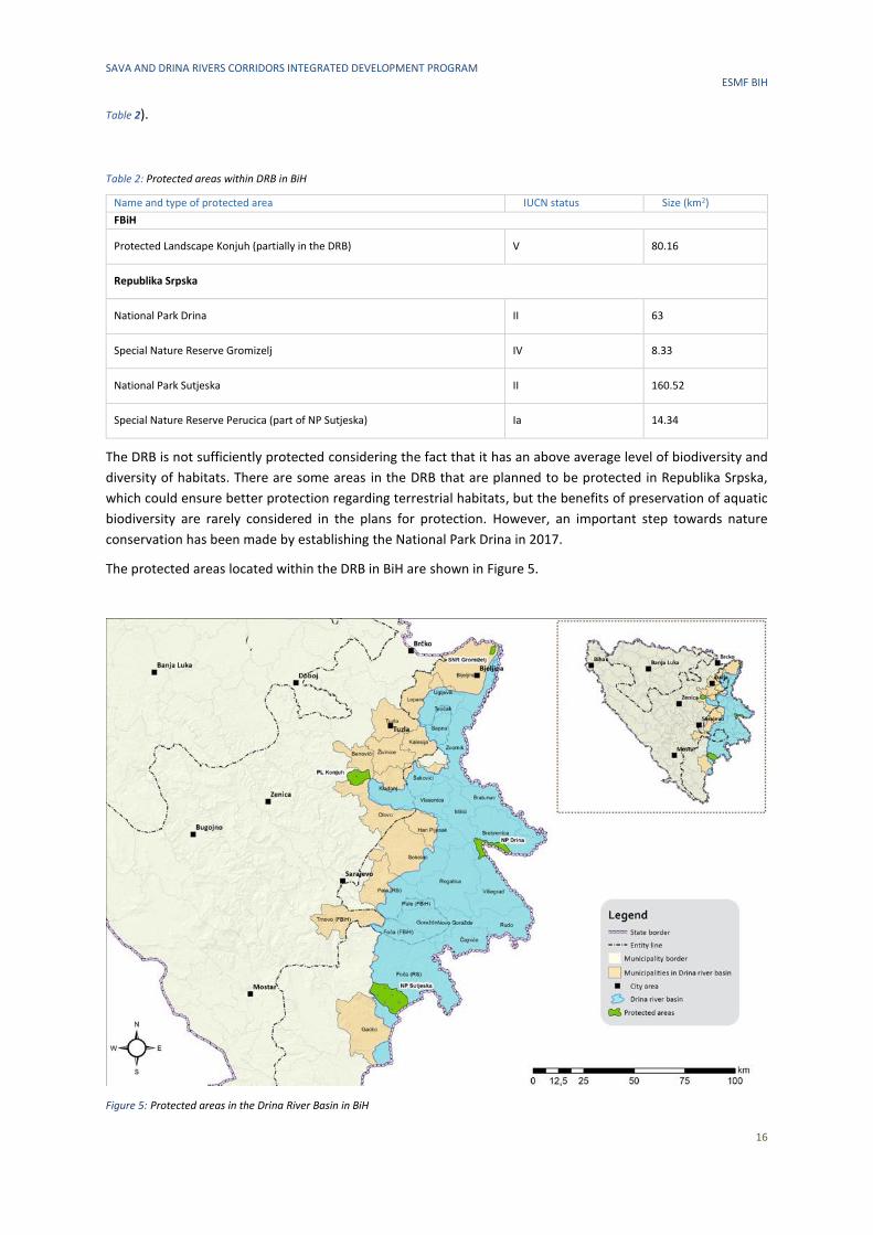
Protected areas
The protected areas in BiH cover less than 3% of the country’s territory, which is far below the European average.
Within the DRB in BiH, there are four protected areas in RS and one in FBiH (
SAVA AND DRINA RIVERS CORRIDORS INTEGRATED DEVELOPMENT PROGRAM ESMF BIH
16
Table 2).
Table 2: Protected areas within DRB in BiH
Name and type of protected area IUCN status Size (km2)
FBiH
Protected Landscape Konjuh (partially in the DRB) V 80.16
Republika Srpska
National Park Drina II 63
Special Nature Reserve Gromizelj IV 8.33
National Park Sutjeska II 160.52
Special Nature Reserve Perucica (part of NP Sutjeska) Ia 14.34
The DRB is not sufficiently protected considering the fact that it has an above average level of biodiversity and
diversity of habitats. There are some areas in the DRB that are planned to be protected in Republika Srpska,
which could ensure better protection regarding terrestrial habitats, but the benefits of preservation of aquatic
biodiversity are rarely considered in the plans for protection. However, an important step towards nature
conservation has been made by establishing the National Park Drina in 2017.
The protected areas located within the DRB in BiH are shown in Figure 5.
Figure 5: Protected areas in the Drina River Basin in BiH
SAVA AND DRINA RIVERS CORRIDORS INTEGRATED DEVELOPMENT PROGRAM ESMF BIH
17
(Source: Consultant)
Potential Natura 2000 sites
Taking into consideration that BiH is aiming to become a part of EU, the country has to implement the Natura
2000 network according to the Habitat Directive (92/43/EEC) and to the Bird Directive (79/409/EEC). The only
data on species and habitats existing in BiH from Annex I and II of the EU Habitat Directive were published in
2011 (Natura 2000 project in BiH, 2011). Even though distribution maps for all species of interest have been
produced, the borders of future Natura 2000 sites have not yet been proposed in BiH.
The table below shows the types of habitats of European importance that are identified as potential Natura
2000 sites along the Drina River.
Table 3: Potential Natura 2000 sites in the DRB in BiH
Code Name
3240 Alpine rivers and their ligneous vegetation with Salix eleagnos
3270 Rivers with muddy banks with Chenopodion rubri p.p. and Bidention p.p. vegetation
*8160 Medio-European calcareous scree of hill and montane levels
*9180 Tilio-Acerion forests of slopes, screes and ravines (Aceri-Tilietum “mixtum” is present specifically in the canyon of Drina
River)
91M0 Pannonian-Balkanic turkey oak-sessile oak forests
* According to the Habitat Directive, it is a priority habitat type
3.1.6 Cultural and Historical Heritage
The DRB has been inhabited for many millennia, and evidence of charcoal burning can be seen in some of the
caves that are interspersed along the Drina River valley. The cultural and historical capital of the DRB is
heterogeneous, including cultural goods created in a wide range, from prehistoric and ancient to medieval,
Ottoman and modern times. They were created, because of its geographical position, by participation in four
major civilization of Europe: Mediterranean, Central European, Byzantine and Oriental-Islamic4.
The DRB hosts many cultural and historical monuments and sites (bridges, necropolis with tombstones, old
towns, mosques, churches etc.) which testify to the rich historical and cultural heritage of its municipalities.
There are 70 sites in RS and eight in FBiH, but it is to be noted that this is just an indicative number. Annex A
contains the list of the sites.
It is important to mention the Mehmed Paša Sokolović Bridge on Drina River in Višegrad, the last work of one of
the world’s greatest architects, Mimar Sinan. The bridge was inscribed in the World Cultural Heritage List -
UNESCO. In the region of Central Podrinje, there are numerous medieval necropolises of the tombstones (so
called stećak), unique monuments in the world, of which two were inscribed in the UNESCO World Cultural
Heritage list. The “Roman City of Municipium Malvesiatium” at today’s Skelani on the Drina River is one of the
most important ancient sites in Bosnia and Herzegovina. The area includes the remains of the city hall, thermal
baths, palaces, two early-Christian basilicas and brickyards. Along with them, there are a number of important
Roman monuments, including numerous inscriptions in commemoration on local dignitaries, as well as altars
4 World Bank (2007). Drina River Basin – Roof Report
SAVA AND DRINA RIVERS CORRIDORS INTEGRATED DEVELOPMENT PROGRAM ESMF BIH
18
revealing the legacy of the legions that were located there, some of which (such Legion Gemina) were among
the Emperor’s elite forces5.
3.2 Sava River Basin
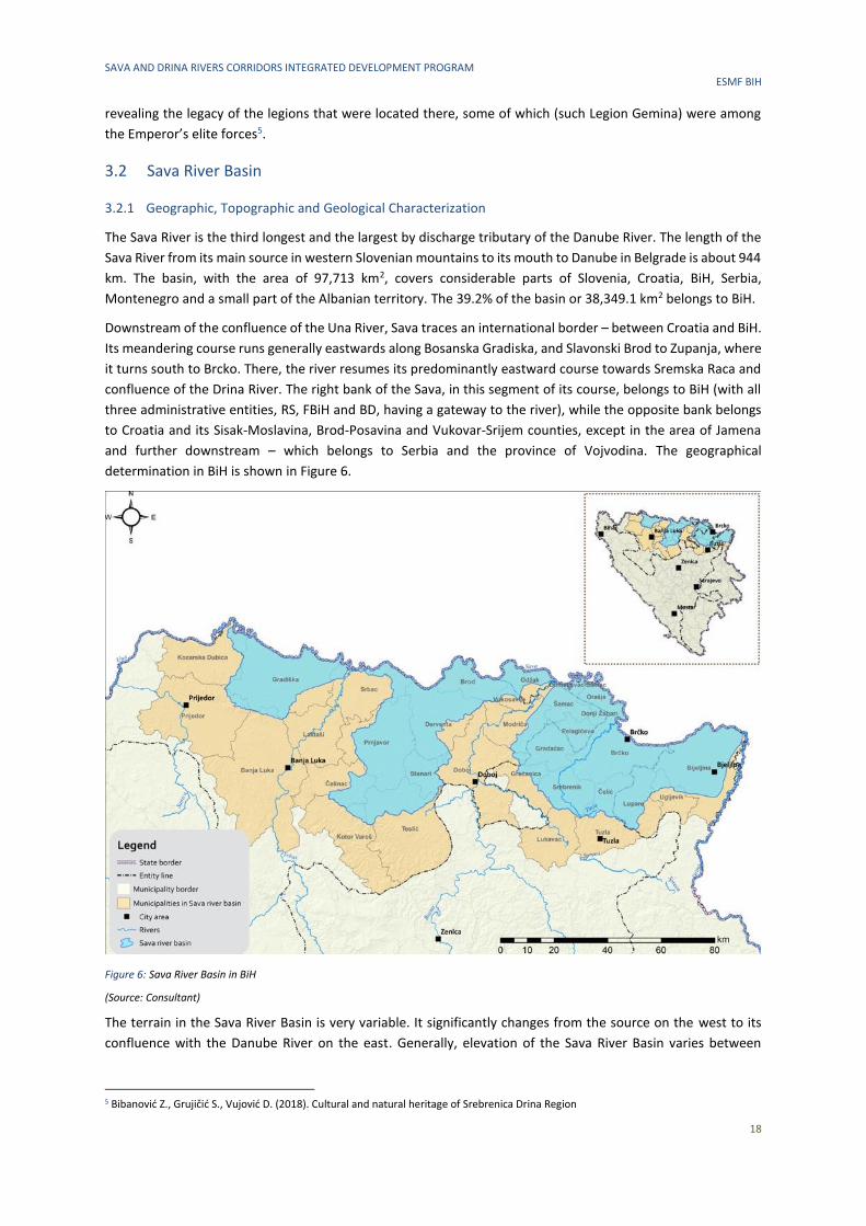
3.2.1 Geographic, Topographic and Geological Characterization
The Sava River is the third longest and the largest by discharge tributary of the Danube River. The length of the
Sava River from its main source in western Slovenian mountains to its mouth to Danube in Belgrade is about 944
km. The basin, with the area of 97,713 km2, covers considerable parts of Slovenia, Croatia, BiH, Serbia,
Montenegro and a small part of the Albanian territory. The 39.2% of the basin or 38,349.1 km2 belongs to BiH.
Downstream of the confluence of the Una River, Sava traces an international border – between Croatia and BiH.
Its meandering course runs generally eastwards along Bosanska Gradiska, and Slavonski Brod to Zupanja, where
it turns south to Brcko. There, the river resumes its predominantly eastward course towards Sremska Raca and
confluence of the Drina River. The right bank of the Sava, in this segment of its course, belongs to BiH (with all
three administrative entities, RS, FBiH and BD, having a gateway to the river), while the opposite bank belongs
to Croatia and its Sisak-Moslavina, Brod-Posavina and Vukovar-Srijem counties, except in the area of Jamena
and further downstream – which belongs to Serbia and the province of Vojvodina. The geographical
determination in BiH is shown in Figure 6.
Figure 6: Sava River Basin in BiH
(Source: Consultant)
The terrain in the Sava River Basin is very variable. It significantly changes from the source on the west to its
confluence with the Danube River on the east. Generally, elevation of the Sava River Basin varies between
5 Bibanović Z., Grujičić S., Vujović D. (2018). Cultural and natural heritage of Srebrenica Drina Region
SAVA AND DRINA RIVERS CORRIDORS INTEGRATED DEVELOPMENT PROGRAM ESMF BIH
19
approx. 71 m a.s.l. at the mouth of the Sava River in Belgrade (Serbia) and 2,864 m a.s.l. (Triglav, Slovenian Alps).
Mean elevation of the basin is 545 m a.s.l. According to FAO classification, the dominant slope in the basin is
moderately steep. Mean value of slope in the Sava River Basin is 15.8 %. In the downstream parts of the basin
there is a remarkable distinction in landscape of the northern part (the left bank) and southern part of the basin
(the right bank). The areas drained by right tributaries in the middle section of the Sava watercourse are rugged.
In spite of ruggedness, rocks and soils in central Bosnia are less vulnerable to erosion, and the terrain is
characterized by green and often forested plateaus. In the north, lowland areas (of variable width) suitable for
agricultural activities extend along the Sava River and lower parts of its tributaries. The middle and lower part
of the Sava River drainage area is characterized by flat plains and low mountains. This area is part of Pannonian
Plain, a low-lying, fertile, agricultural region.
The course of the Sava River runs through several diverse geological units and orographic regions. The lower
course of is located in the Pannonian Basin – first reached by the Sava River in the Krsko Basin on the western
rim of the Pannonian Basin. The Pannonian Basin took shape through Miocenian thinning and subsidence of
crust structures formed during Late Paleozoic Variscan orogeny. The processes also led to the formation of a
stratovolcanic chain in the basin 17–12 Mya (million years ago) and intensified subsidence observed until 5 Mya
as well as flood basalts about 7.5 Mya. Contemporary uplift of the Carpathian Mountains prevented water
flowing to the Black Sea, and the Pannonian Sea formed in the basin. Sediments were transported to the basin
from uplifting Carpathian and Dinaric mountains, with particularly deep fluvial sediments being deposited in the
Pleistocene during the uplift of the Transdanubian Mountains. A subduction zone formed in the present-day
Sava River valley, and approximately 4,000 m (13,000 feet) deep sediments were deposited in the Slavonia-
Syrmia depression and 5,500 m (18,000 feet) in the Sava depression.[93] The results of those processes are large
plains in the Sava River valley and the Kupa River valley. The plains are interspersed by the horst and graben
structures, believed to have broken the Pannonian Sea surface as islands,[94] which became watershed between
Drava and Sava River basins extending along Ivanscica–Kalnik–Bilogora–Papuk mountain chain.6
3.2.2 Climate
A moderate continental climate dominates in the right tributaries’ catchment areas within BiH, while a moderate
continental (mid-European) climate primarily features in the left tributaries’ catchment areas that belong to the
Pannonian Basin. The winter can be severe with abundant snowfalls, while the summer is hot and long. Average
annual air temperature for the entire SRB was estimated to be approx. 9.5○ C. Mean monthly temperature in
January falls to approx. -1.5○ C, whilst in July it can reach 20oC. The precipitation amount and its annual
distribution are fairly variable within the basin. The average annual rainfall over the SRB is estimated to be
approximately 1,100 mm. The average evapotranspiration for the whole catchment area is approx. 530
mm/year.
3.2.3 Climate Change
According to the background paper on climate change for the SRB7, the temperature in the BiH part of the SRB
is projected to increase from 0.7 to 1.6°C per 1°C of global increase. The largest temperature increases would
occur in summer, and in inland areas. The second largest increase would occur in the autumn (2-3°C
everywhere). Spring temperatures could rise by approximately 2°C and winter and spring temperatures could
rise by less than 2°C. Average maximal daily temperature is expected to raise more than average minimal daily
temperature.
6 Wikipedia. Sava. (30.09.2019) Retrieved from https://en.wikipedia.org/wiki/Sava#cite_note-FOOTNOTEPlacer2008207-81 7 Sava River Basin Management Plan Background Paper No. 10 Climate change and RBM planning (March 2013)
http://www.savacommission.org/dms/docs/dokumenti/srbmp_micro_web/backgroundpapers_approved/no_10_background_paper_clim
ate_change_and_rbm_planning_.pdf
SAVA AND DRINA RIVERS CORRIDORS INTEGRATED DEVELOPMENT PROGRAM ESMF BIH
20
During the winter period (December-February), precipitation will increase. The rainfall may also be heavier. In
summer the climate will be noticeably drier. Reduction in rainfall will be especially noticeable in summer (June-
August) during the period 2031-2060 when already small amounts of rainfall could be halved. This means that
the part of BiH will be affected by the reduction of the precipitation. Potential evapotranspiration (PET) is a more
stable parameter than precipitation. The annual average PET is about 725 mm.
The current climate change projections for the SRB8 foresee a rise of flood peaks of up to 8%, while droughts,
which are particularly unfavorable to navigation, are anticipated to become more frequent.
The SRB already experienced two extreme floods in 2010 and 2014 which demonstrated its vulnerability to
extreme weather events caused by climate change. More details on economic impact of these floods is given in
Chapter 4.5.
3.2.4 Water Quality
Based on the information taken from the river basin management documents9, the basin consists of 108 water
bodies: 72 in RS, and 36 in FBiH and BD. Out of these, 100 water bodies (92%) are not classified as having good
or high status according to Water Framework Directive (2000/60/European Parliament and Council). Moderate
ecological status and bad chemical status were determined on the section of the Sava River downstream from
confluence of Una River, while poor total status and bad chemical status were determined on the section of the
river in the area of town Orasje and Brcko.
The main identified pressures are organic and nutrient pollution from anthropological activities discharged from
Vrbas and Bosna tributaries. Both river basins are highly populated and without proper management of
municipal and industrial discharges along their courses. Only few municipalities in the basin have operational
wastewater treatment plan, while several other municipalities are in preparations for design or construction. An
overview of the situation is given in Table 4.
Table 4: The status of wastewater treatment plants construction in BiH (Source: Sava River Basin District Agency, Adriatic Sea River Basin District Agency, JU ”Vode Srpske”)
City/ Municipality Capacity
(PE)
Treatment level Status
Sarajevo 600,000 II Operational. WWTP Sarajevo is designed for II degree, with the
possibility of achieving the III degree of processing (in the next
phase). The trial operation period of the plant started in May 2016.
The plant officially started operating on 22 May 2017.
Živinice 25,000 III Operational. The plant officially started operating in March 2015.
Srebrenik 12,000 II Operational. Operational since 2002.
Bihac 55,000 III Operational. The trial operation period of the plant started in 2017.
WWTP Bihać should officially start its operations in 2018.
Trnovo 5,000 II Operational. Operational since 2009.
Zepce 10,000 II Operational. The plant is operational since 2007, but the existing
plant was reconstructed in 2013.
Odzak 10,000 II Operational. PPOV in Odžak built in 2011, in July 2012 a drain
collector from WWTP to the Bosna River was constructed.
Gradacac 30,000 II Operational. WWTP of the Gradačac City was built in 1982. It was
designed and built for a capacity of 30,000 ES. In 1998, parts of the
plant damaged by war were reconstructed. The last reconstruction
8 Schwarz, U. 2016. Sava White Book. The River Sava: Threats and Restoration Potential. Radolfzell/Wien: EuroNatur/Riverwatch. 9 Sava River Basin Management Plan in FBiH (2016-2021), Sava River Basin District Agency, Sarajevo, November, 2016, Sava River Basin Management Plan in RS (2017-2021), Public Institution "Vode Srpske", November, 2017
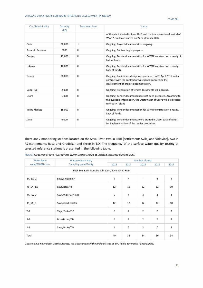
SAVA AND DRINA RIVERS CORRIDORS INTEGRATED DEVELOPMENT PROGRAM ESMF BIH
21
City/ Municipality Capacity
(PE)
Treatment level Status
of the plant started in June 2016 and the trial operational period of
WWTP Gradačac started on 27 September 2017.
Cazin 30,000 II Ongoing. Project documentation ongoing.
Bosanski Petrovac 5000 II Ongoing. Contracting in progress.
Orasje 12,000 II Ongoing. Tender documentation for WWTP construction is ready. A
lack of funds.
Lukavac 16,000 II Ongoing. Tender documentation for WWTP construction is ready.
Lack of funds.
Tesanj 30,000 II Ongoing. Preliminary design was prepared on 28 April 2017 and a
contract with the contractor was signed concerning the
development of project documentation.
Doboj Jug 2,000 II Ongoing. Preparation of tender documents still ongoing.
Usora 1,000 II Ongoing. Tender documents have not been prepared. According to
the available information, the wastewater of Usora will be directed
to WWTP Tešanj.
Velika Kladusa 15,000 II Ongoing. Tender documentation for WWTP construction is ready.
Lack of funds.
Jajce 6,000 II Ongoing. Tender documents were drafted in 2016. Lack of funds
for implementation of the tender procedure.
There are 7 monitoring stations located on the Sava River, two in FBiH (settlements Svilaj and Vidovice), two in
RS (settlements Raca and Gradiska) and three in BD. The frequency of the surface water quality testing at
selected reference stations is presented in the following table.
Table 5: Frequency of Sava River Surface Water Quality Testing at Selected Reference Stations in BiH
Water body
code/TNMN code
Watercourse name/
Sampling point/Entity
Number of tests
2013 2014 2015 2016 2017
Black Sea Basin-Danube Sub-basin, Sava- Drina River
BA_SA_1 Sava/Svilaj/FBiH 4 4 - 4 4
RS_SA_1A Sava/Raca/RS 12 12 12 12 10
BA_SA_2 Sava/Vidovice/FBiH 6 4 4 4 4
RS_SA_3 Sava/Gradiska/RS 12 12 12 12 10
T-1 Tinja/Brcko/DB 2 2 2 2 2
B-1 Brka/Brcko/DB 2 2 2 2 2
S-1 Sava/Brcko/DB 2 2 2 / 2
Total 40 38 34 36 34
(Source: Sava River Basin District Agency, the Government of the Brcko District of BiH, Public Enterprise ”Vode Srpske)
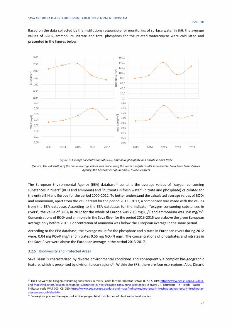
SAVA AND DRINA RIVERS CORRIDORS INTEGRATED DEVELOPMENT PROGRAM ESMF BIH
22
Based on the data collected by the institutions responsible for monitoring of surface water in BiH, the average
values of BOD5, ammonium, nitrate and total phosphors for the related watercourse were calculated and
presented in the figures below.
Figure 7: Average concentrations of BOD5, ammonia, phosphate and nitrate in Sava River
(Source: The calculation of the above average values was made using the water analysis results submitted by Sava River Basin District Agency, the Government of BD and JU "Vode Srpske")
The European Environmental Agency (EEA) database10 contains the average values of "oxygen-consuming
substances in rivers" (BOD and ammonia) and “nutrients in fresh water” (nitrate and phosphate) calculated for
the entire BiH and Europe for the period 2000-2012. To better understand the calculated average values of BOD5
and ammonium, apart from the value trend for the period 2013 - 2017, a comparison was made with the values
from the EEA database. According to the EEA database, for the indicator "oxygen-consuming substances in
rivers", the value of BOD5 in 2012 for the whole of Europe was 2.19 mgO2 /l, and ammonium was 158 mg/m3.
Concentrations of BOD5 and ammonia in the Sava River for the period 2013-2015 were above the given European
average only before 2015. Concentration of ammonia was below the European average in the same period.
According to the EEA database, the average value for the phosphate and nitrate in European rivers during 2012
were: 0.04 mg PO4-P mg/l and nitrates 0.55 mg NO3-N mg/l. The concentrations of phosphates and nitrates in
the Sava River were above the European average in the period 2013-2017.
3.2.5 Biodiversity and Protected Areas
Sava Basin is characterized by diverse environmental conditions and consequently a complex bio-geographic
feature, which is presented by division to eco-regions11. Within the SRB, there are four eco-regions: Alps, Dinaric
10 The EEA website. Oxygen consuming substances in rivers - code for this indicator is WAT 002, CSI 019 (https://www.eea.europa.eu/data-and-maps/indicators/oxygen-consuming-substances-in-rivers/oxygen-consuming-substances-in-rivers-7) Nutrients in Fresh Water - indicator code WAT 003, CSI 020 (https://www.eea.europa.eu/data-and-maps/indicators/nutrients-in-freshwater/nutrients-in-freshwater-assessment-published-6) 11 Eco-regions present the regions of similar geographical distribution of plant and animal species
0,00
0,50
1,00
1,50
2,00
2,50
3,00
2013 2014 2015 2016 2017
BO
D5
[mg/
l]
0,0
20,0
40,0
60,0
80,0
100,0
120,0
140,0
160,0
2013 2014 2015 2016 2017
NH
4-N
[mg
/m3]
0,00
0,01
0,02
0,03
0,04
0,05
0,06
0,07
2013 2014 2015 2016 2017
PO4
-P[m
g/l]
0,00
0,20
0,40
0,60
0,80
1,00
1,20
1,40
1,60
2013 2014 2015 2016 2017
NO
3-N
[mg/
m3 ]
SAVA AND DRINA RIVERS CORRIDORS INTEGRATED DEVELOPMENT PROGRAM ESMF BIH
23
western Balkan, Hellenic western Balkan and Hungarian lowlands12. According to the Second Sava River Basin
Analysis Report13, all parts of BiH in the SRB belong to eco-region 5. Concerning the altitude, area of BiH is
situated in between 90 m a.s.l. in the area of Posavina and Semberija and over 2.100 m a.s.l. on high mountains
of the southeast and northwestern part. Fertile plains are mostly situated in the valleys of the Sava, Bosna, Drina,
Vrbas and Una Rivers and the outstanding ones are Posavina, Semberija, Lijevce polje, etc.
Based on the United Nations World Water Development Report14 the SRB is of great significance due to its
outstanding biological and landscape diversity. It hosts the largest complexes of lowland forests as well as largest
alluvial floodplain wetland site in the Danube basin. The vast lowland and alluvial forests serve multiple functions
and are of economic significance: they provide valuable timber, store a significant amount of carbon and prevent
soil erosion. Unfortunately, wetlands are among the most threatened ecosystems, owing mainly to ongoing
drainage, conversion, pollution, and over-exploitation of their resources.
Lack of environmental infrastructure and institutional mechanisms for addressing transboundary impacts is
causing serious environmental concerns in the basin15.
Flora
According to the Strategic Environmental Impact Study conducted within the Interreg IPA Cross-border
Cooperation Program Croatia-BiH-Montenegro 2014-2020, phytocoenosis distribution is analogue to that
described for Croatia, while the major tree species are common fir, Norway spruce, Scots pine, black pine,
common beach, various oak species and a smaller amount of noble broadleaves (maples, chestnut, walnut, crab
apple, European pear, cherries, lindens and elms) and various fruit trees.
Based on geomorphological units, the Sava River has three sections: upper, middle and lower Sava. Middle and
lower Sava sections are situated in BiH. Study prepared as part of the Save the Blue Heart of Europe campaign
and the project “Fostering the Protection of the Sava River and its Floodplains – SavaParks” acknowledge that
these sections are very rich in aquatic vegetation. Swampy vegetation is widespread and richly developed in
side-channels, smaller tributaries, and particularly in oxbows and backwaters. Frequently occurring protected
species in the morphological floodplain include floating water moss (Salvinia natans), water caltrop (Trapa
natans), water soldier (Stratiotes aloides) and fringed water-lily (Nymphoides peltata). The littoral zone of the
river, consisting of bars and banks, is colonized by annual pioneer species like the mudwort (Limosella aquatica).
The woody vegetation consists of riparian gallery forests of willows and white and black poplars (Populus alba
and Populus nigra). Low-lying and frequently flooded forests are characterized by narrow-leafed ash (Fraxinus
angustifolia) and – on small elevated stands – oak (Quercus robur) with European white elm (Ulmus laevis). Black
alder woods (Alnus glutinosa) can be found in depressions and fringes of the floodplain. An occurring specific
flood-tolerant wet grassland type known as Cnidion meadows/pastures may be partially natural, shaped by large
herbivores16.
More detailed data on wetland forest ecosystems are given within the “First National Report of BiH for the
Convention on Biodiversity” listing ten ecosystems developed along the Sava riverbanks17:
12 International Sava River Basin Commission in cooperation with the Parties to the Framework Agreement on the Sava River Basin (2009).
First Sava River Basin Analysis, Zagreb 13 International Sava River Basin Commission in cooperation with the Parties to the Framework Agreement on the Sava River Basin (2016).
Second Sava River Basin Analysis, Zagreb 14 WWAP (UN World Water Assessment Programme)/UN-Water (2018): The UN World Water Development Report (2018). Nature-Based
Solutions for Water. Paris, UNESCO 15 Blumenfeld, S., Lu, C., Christophersen, T. and Coates, D. (2009). Water, Wetlands and Forests. A Review of Ecological, Economic and Policy
Linkages. Secretariat of the Convention on Biological Diversity and Secretariat of the Ramsar Convention on Wetlands, Montreal and Gland.
CBD Technical Series No. 47 16 Schwarz, U. (2016). Sava White Book. The River Sava: Threats and Restoration Potential. Radolfzell/Wien: EuroNatur/Riverwatch 17 Federal Ministry of Environment and Tourism (2008). BiH – Land of Diversity, First national Report of BiH for the Convention on Biodiversity,
Sarajevo
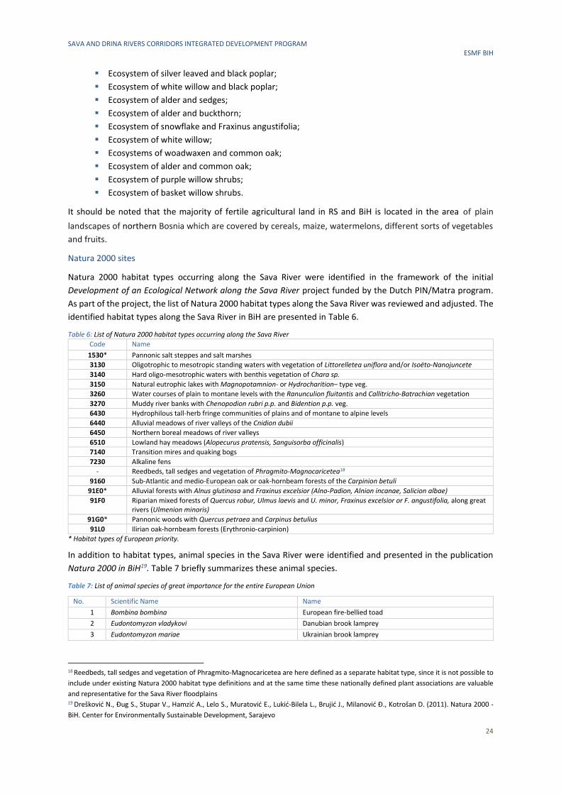
SAVA AND DRINA RIVERS CORRIDORS INTEGRATED DEVELOPMENT PROGRAM ESMF BIH
24
▪ Ecosystem of silver leaved and black poplar;
▪ Ecosystem of white willow and black poplar;
▪ Ecosystem of alder and sedges;
▪ Ecosystem of alder and buckthorn;
▪ Ecosystem of snowflake and Fraxinus angustifolia;
▪ Ecosystem of white willow;
▪ Ecosystems of woadwaxen and common oak;
▪ Ecosystem of alder and common oak;
▪ Ecosystem of purple willow shrubs;
▪ Ecosystem of basket willow shrubs.
It should be noted that the majority of fertile agricultural land in RS and BiH is located in the area of plain
landscapes of northern Bosnia which are covered by cereals, maize, watermelons, different sorts of vegetables
and fruits.
Natura 2000 sites
Natura 2000 habitat types occurring along the Sava River were identified in the framework of the initial
Development of an Ecological Network along the Sava River project funded by the Dutch PIN/Matra program.
As part of the project, the list of Natura 2000 habitat types along the Sava River was reviewed and adjusted. The
identified habitat types along the Sava River in BiH are presented in Table 6.
Table 6: List of Natura 2000 habitat types occurring along the Sava River
Code Name
1530* Pannonic salt steppes and salt marshes
3130 Oligotrophic to mesotropic standing waters with vegetation of Littorelletea uniflora and/or Isoëto-Nanojuncete
3140 Hard oligo-mesotrophic waters with benthis vegetation of Chara sp.
3150 Natural eutrophic lakes with Magnopotamnion- or Hydrocharition– type veg.
3260 Water courses of plain to montane levels with the Ranunculion fluitantis and Callitricho-Batrachian vegetation
3270 Muddy river banks with Chenopodion rubri p.p. and Bidention p.p. veg.
6430 Hydrophilous tall-herb fringe communities of plains and of montane to alpine levels
6440 Alluvial meadows of river valleys of the Cnidion dubii
6450 Northern boreal meadows of river valleys
6510 Lowland hay meadows (Alopecurus pratensis, Sanguisorba officinalis)
7140 Transition mires and quaking bogs
7230 Alkaline fens
- Reedbeds, tall sedges and vegetation of Phragmito-Magnocaricetea18
9160 Sub-Atlantic and medio-European oak or oak-hornbeam forests of the Carpinion betuli
91E0* Alluvial forests with Alnus glutinosa and Fraxinus excelsior (Alno-Padion, Alnion incanae, Salicion albae)
91F0
Riparian mixed forests of Quercus robur, Ulmus laevis and U. minor, Fraxinus excelsior or F. angustifolia, along great rivers (Ulmenion minoris)
91G0* Pannonic woods with Quercus petraea and Carpinus betulius
91L0 Ilirian oak-hornbeam forests (Erythronio-carpinion)
* Habitat types of European priority.
In addition to habitat types, animal species in the Sava River were identified and presented in the publication
Natura 2000 in BiH19. Table 7 briefly summarizes these animal species.
Table 7: List of animal species of great importance for the entire European Union
No. Scientific Name Name
1 Bombina bombina European fire-bellied toad
2 Eudontomyzon vladykovi Danubian brook lamprey
3 Eudontomyzon mariae Ukrainian brook lamprey
18 Reedbeds, tall sedges and vegetation of Phragmito-Magnocaricetea are here defined as a separate habitat type, since it is not possible to
include under existing Natura 2000 habitat type definitions and at the same time these nationally defined plant associations are valuable
and representative for the Sava River floodplains 19 Drešković N., Đug S., Stupar V., Hamzić A., Lelo S., Muratović E., Lukić-Bilela L., Brujić J., Milanović Đ., Kotrošan D. (2011). Natura 2000 -
BiH. Center for Environmentally Sustainable Development, Sarajevo
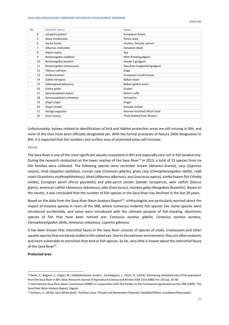
SAVA AND DRINA RIVERS CORRIDORS INTEGRATED DEVELOPMENT PROGRAM ESMF BIH
25
No. Scientific Name Name
4 Lampetra planeri Europaean brook
5 Alosa immaculata Pontic shad
6 Hucho hucho Huchen, Danube salmon
7 Alburnus chalcoides Danubian bleak
8 Aspius aspius Asp
9 Romanogobio vladikovi Whit-finned gudgeon
10 Romanogobio kesslerii Kessler’s gudgeon
11 Romanogobio uranoscopus Danubian longbarbel gudgeon
12 Pelecus cultratus Ziege
13 Umbra krameri Europaean mudminnow,
14 Cobitis elengata Balkan loach
15 Sabanejewia balcanica Balkan golden loach
16 Cottus gobio Sculpin
17 Gymnocephalus baloni Balon’s ruffe
18 Gymnocephalus schraetser Schraetzer
19 Zingel zingel Zingel
20 Zingel streber Danube streber
21 Vertigo angustior Narrow-mouthed Whorl Snail
22 Unio crassus Thick Shelled River Mussel
Unfortunately, bylaws related to identification of bird and habitat protection areas are still missing in BiH, and
none of the sites have been officially designated yet. With the formal processes of Natura 2000 designation in
BiH, it is expected that the numbers and surface area of protected areas will increase.
Fauna
The Sava River is one of the most significant aquatic ecosystem in BiH and especially very rich in fish biodiversity.
During the research conducted on the lower reaches of the Sava River20 in 2013, a total of 15 species from six
fish families were collected. The following species were recorded: bream (Abramis brama), carp (Cyprinus
carpio), chub (Squalius cephalus), crucian carp (Carassius gibelio), grass carp (Ctenopharyngodon idella), rudd
roach (Scardinius erythrophthalmus), bleak (Alburnus alburnus), asp (Leuciscus aspius), vimba bream fish (Vimba
vimba), European perch (Perca gluviatilis) and pike-perch zander (Sander lucioperca), wels catfish (Silurus
glanis), american catfish (Ameiurus nebulosus), pike (Esox lucius), monkey goby (Neogobius fluviatilis). Based on
the results, it was concluded that the number of fish species in the Sava River has declined in the last 20 years.
Based on the data from the Sava River Basin Analysis Report21, ichthyologists are particularly worried about the
impact of invasive species in rivers of the SRB, where numerous endemic fish species live. Some species were
introduced accidentally, and some were introduced with the ultimate purpose of fish-stocking. Alochtonic
species of fish that have been noticed are: Carassius auratus gibelio, Carassius auratus auratus,
Ctenopharyngodon idella, Ameiurus nebulosus, Lepomis gibossus.
It has been known that interstitial fauna in the Sava River consists of species of snails, crustaceans and other
aquatic species that are barely visible to the naked eye. Due to the extreme environment, they are often endemic
and more vulnerable to extinction than bird or fish species. So far, very little is known about the interstitial fauna
of the Sava River22.
Protected area
20 Nedić, Z., Begović, S., Dogan, M., Hadžiahmetovic Jurida E., Ferizbegovic, J., Terzic, R., (2014). Decreasing of biodiversity of fish population
from the Sava River in BiH, Basic Research Journal of Agricultural Science and Review ISSN 2315-6880 Vol. 3(5) pp. 35-40 21 International Sava River Basin Commission (ISRBC) in cooperation with the Parties to the Framework Agreement on the SRB (2009). The
Sava River Basin Analysis Report, Zagreb 22 Schwarz, U. (2016). Sava White Book. The River Sava: Threats and Restoration Potential. Radolfzell/Wien: EuroNatur/Riverwatch.
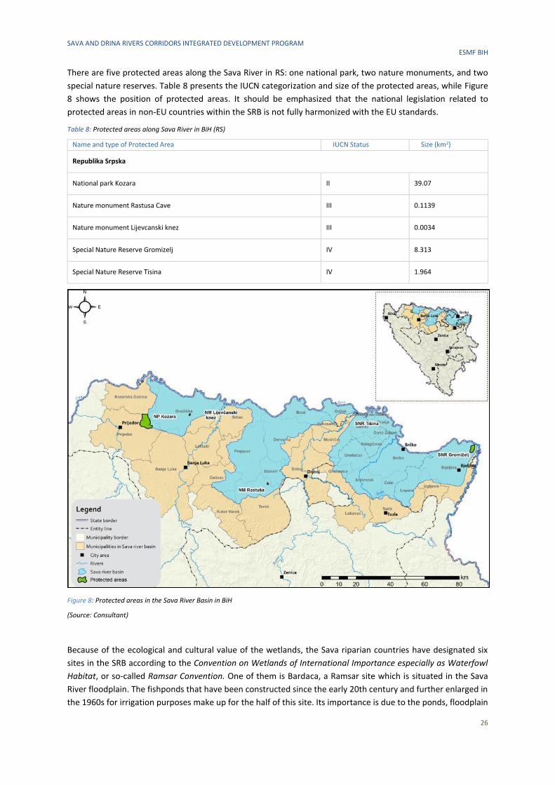
SAVA AND DRINA RIVERS CORRIDORS INTEGRATED DEVELOPMENT PROGRAM ESMF BIH
26
There are five protected areas along the Sava River in RS: one national park, two nature monuments, and two
special nature reserves. Table 8 presents the IUCN categorization and size of the protected areas, while Figure
8 shows the position of protected areas. It should be emphasized that the national legislation related to
protected areas in non-EU countries within the SRB is not fully harmonized with the EU standards.
Table 8: Protected areas along Sava River in BiH (RS)
Name and type of Protected Area IUCN Status Size (km2)
Republika Srpska
National park Kozara II 39.07
Nature monument Rastusa Cave III 0.1139
Nature monument Lijevcanski knez III 0.0034
Special Nature Reserve Gromizelj IV 8.313
Special Nature Reserve Tisina IV 1.964
Figure 8: Protected areas in the Sava River Basin in BiH
(Source: Consultant)
Because of the ecological and cultural value of the wetlands, the Sava riparian countries have designated six
sites in the SRB according to the Convention on Wetlands of International Importance especially as Waterfowl
Habitat, or so-called Ramsar Convention. One of them is Bardaca, a Ramsar site which is situated in the Sava
River floodplain. The fishponds that have been constructed since the early 20th century and further enlarged in
the 1960s for irrigation purposes make up for the half of this site. Its importance is due to the ponds, floodplain

SAVA AND DRINA RIVERS CORRIDORS INTEGRATED DEVELOPMENT PROGRAM ESMF BIH
27
forest, meadow and swamp areas that support a range of endangered species, especially birds that use it as a
stopover site. It is rich in fish fauna (Gymnocephalus schraetzer, Zingel streber) and contains a large range of
amphibians such as Salamandra salamandra, Rana dalmatina, and the pond tortoise Emys orbicularis. There has
been an interruption in the hydrological regime due to the construction of channels, pump stations, and the
damming of nearby streams. Presently, pressures to this site are from permanent, intensive agricultural
practices such as intensive pasturing and the unwise use of fertilizers and pesticides23.
3.2.6 Cultural and Historical Heritage
The SRB area is known to be rich in cultural and historical monuments that have remained until the present day.
Cultural and historical sites and monument include old fortress, mosques, churches, prehistoric settlement, old
towns, museums and other sites and structures having archaeological, historical, architectural, religious
significance, as well as natural sites with cultural values. Annex B lists cultural and historical sites and monuments
of municipalities along the SRB. According to the List of National Monuments of BiH24, there are 22 sites in RS,
14 in FBiH and 10 in BD BiH.
The cultural and historical values are widely recognized by the tourism boards of the municipalities in the SRB.
Historically, the River Sava and most if its tributaries are sensitive to flooding which can have possible negative
consequences on cultural and historical heritage.
23 International Sava River Basin Commission (ISRBC) in cooperation with the Parties to the Framework Agreement on the SRB (2009). The
Sava River Basin Analysis Report, Zagreb 24 Commission to Preserve National Monuments of BiH, List of National Monuments of BiH [accessed on: 21 October 2019]
SAVA AND DRINA RIVERS CORRIDORS INTEGRATED DEVELOPMENT PROGRAM ESMF BIH
28
4 BASELINE SOCIO-ECONOMIC CHARACTERISTICS OF THE PROJECT AREA
4.1 Demography
According to the official results of the 2013 Census, the total population of Bosnia and Herzegovina was
3,531,159 (Table 9). RS accounts for 35% of population, FBiH around 63% and BD around 2%.
Table 9: BiH population in 2013, and 2017 estimates
Population 2013 2017 (estimate)
FBiH 2,219,220 2,201,193
RS 1,228,423 1,153,017
BD 83,516 83,243
Total 3,531,159 3,437,453
4.1.1 Demography in the Drina Basin
The DRB in FBiH covers twelve municipalities: Gorazde, Pale-Praca (FBiH), Foca-Ustikolina (FBiH), Kladanj, Sapna,
Teocak, Zivinice, Banovici, Kalesija, Tuzla, Olovo and Trnovo. The total number of inhabitants in the part of the
DRB that belongs to FBiH is 58,120 inhabitants (2013 Census).
19 municipalities are located on the territory of DRB in Republika Srpska: Bijeljina, Bratunac, Cajnice, Foca,
Gacko, Han Pijesak, Lopare, Milici, Novo Gorazde, Pale, Rogatica, Rudo, Sekovici, Sokolac, Srebrenica, Ugljevik,
Visegrad, Vlasenica and Zvornik. The total number of inhabitants in RS (in the DRB part) is 371,461 inhabitants
(2013 Census).
The population density in RS is 51 inhabitants/km2, while in FBiH it is 59 inhabitants/km2. The Municipality
Teocak has the highest population density in BiH and in the whole DRB, with 262 inhabitants/km2, and the lowest
density is in the municipalities of Han Pijesak, Foca (FBiH and RS), Pale (FBiH), Rogatica, Sokolac and Cajnice,
with less than 20 inhabitants/km2.
According to the presented demographic profile in the DRB, this Project will have a positive social impact on
about 429,581 people living in 31 municipalities and cities in BiH (which represent 39% of total population of
the DRB). The Project will contribute to social welfare of the local population by supporting activities to prevent
and deal with climate change-related disasters, notably floods and droughts.
4.1.2 Demography in the Sava Basin
The SRB in FBiH covers nine municipalities: Domaljevac-Samac, Orasje, Odzak, Gradacac, Gracanica, Lukavac,
Srebrenik, Celic and Tuzla. The total number of inhabitants in the part of SRB that belongs to FBiH is 333, 692
inhabitants (2013 Census).
The SRB in RS covers twenty-two municipalities: Kozarska Dubica, Prijedor, Gradiska, Banja Luka, Laktasi, Celinac,
Kotor Varos, Srbac, Teslic, Prnjavor, Stanari, Derventa, Doboj, Brod, Modrica, Vukosavlje, Samac, Donji Zabar,
Pelagicevo, Lopare, Ugljevik and Bijeljina. The total number of inhabitants in the part of SRB that belongs to RS
is 827,886 inhabitants (2013 Census).
In addition to the aforementioned municipalities in FBiH and RS, the SRB covers Brcko District (BD) with its
83,516 inhabitants.
The population density in SRB in RS is 82.33 inhabitants/km2, while in FBiH it is 192 inhabitants/km2. The City of
Tuzla has the highest population density in SRB area in BiH, with 377.48 inhabitants/km2, and the lowest density
is in the municipalities of Kotor Varo (36.21 inhabitants/km2), Srbac (38.89 inhabitants/km2), Stanari (42.17
inhabitants/km2), Pelagicevo (42.62 inhabitants/km2) and Celinac (42.95 inhabitants/km2).
According to the presented demographic profile in the SRB, this Project will have a positive social impact on
about 1,245,094 people living in 31 municipalities and BD BiH.
SAVA AND DRINA RIVERS CORRIDORS INTEGRATED DEVELOPMENT PROGRAM ESMF BIH
29
4.2 Rural and Urban Areas
The urban and rural parts of BiH are considerably different. The urban parts include major cities: Sarajevo, Banja
Luka, Tuzla, Zenica, Mostar and Bijeljina, whereas the rest of the country is mainly rural. The average level of
urbanization in RS and FBiH is 37%, while the differences at municipal level are significantly higher.
4.2.1 Rural and Urban Areas in the Drina Basin
A greater share of urban population compared to rural population is a characteristic of municipalities of Foca
(62%), Pale (62%), Han Pijesak (53%) in RS, and Gorazde (57%) in FBiH. The Drina River in its upper and middle
part of the basin flows mainly through rural areas. This project will therefore have a great positive impact on the
development of rural areas compared to urban, in terms of creating new opportunities and safe business
environment for rural development and ecotourism.
4.2.2 Rural and Urban Areas in the Sava Basin
In FBiH and RS, the Sava River flows mainly through rural areas. According to data from the 2013 Census, some
municipalities are completely rural areas. Municipalities with 100% of rural population in RS are Vukosavlje,
Donji Zabar and Pelagicevo in RS, while in FBiH these are Domaljevac-Samac and Celic. Other municipalities with
a high rate of rural population are Srbac and Lopare in RS with 84.1% of rural population, and Srebrenik in FBiH
with 83.1% of rural population.
A greater share of urban population compared to rural population is a characteristic of the City of Banja Luka in
RS with 75.1% of urban population and the City of Tuzla in FBiH with 67.1% of urban population. In other
municipalities of FBiH and RS within the SRB, the rate of urban population is between 15.9% and 49%. In BD, the
share of urban population compared to rural population is 54.5%.
4.3 Key Economic Indicators
The key economic indicators for BiH are presented in Table 10.
Table 10:Key Economic Indicators in BiH in 2015, 2016, 2017 and 2018
2015 2016 2017 2018
Nominal GDP (in BAM million) 29,665 30,977 31,862 33,408
Nominal growth rate (in %) 4.6 4.4 3.1 -
Real growth rate (in %) 3.8 3.3 3.0 3.6
GDP per capita
(in BAM)
8,432 8,805 9,057 9,556
Average net wage (in BAM) 830 838 851 878
CPI (Consumer Price Index) -1.0% -1.1% 1.3% -
Source of 2018 data: BiH Central Bank, BiH Statistics Agency
According to the Central Bank’s 2018 Annual Report, industrial production growth in the real sector slowed
down in 2018 compared to the previous year. A significant decrease of production was reported in the
manufacturing industry, whereas the electric power, gas, steam and air conditioning sectors reported growth.
The construction sector reported stagnation due to a slowdown in infrastructure construction.
The trade sector has been significantly growing for all types of trading activities. The trends of general prices,
measured by the Consumption Price Index, showed an increased inflation pressure in 2018, caused mainly by
increased external prices (oil). At the same time, local prices, measured by a GDP deflator, are in the inflation
zone. The labor market, according to administrative data and the 2018 Labor Force Survey data, reports a
significantly reduced number of unemployed persons and increased number of employed persons, with
increased demographic changes. Nominal net wages report strong growth, with somewhat slower growth of
real net wages.

SAVA AND DRINA RIVERS CORRIDORS INTEGRATED DEVELOPMENT PROGRAM ESMF BIH
30
4.4 Local Economy of the Project Area
4.4.1 Local Economy of the Drina Basin
In the northern part of the DRB in BiH, local economy is based on trade, manufacturing and agriculture. In this
part of the DRB, there are significant areas of farming land where cultivation of cereals and vegetables is the
dominant activity. The same applies to livestock production which has recently focused on specialized types of
production (milk, meat) in order to improve production and incomes. As far as other municipalities are
concerned, the local economy is based on the electric power industry (Ugljevik), mining (Milici), energy industry,
forestry and agricultural production within small farms. An important and secure source of income is
employment in public administrations and in private companies. The development of tourism is partially related
to the Drina River, but does not represent a substantial source of income, except for the Municipality of Foca
where additional income is generated within the NP Sutjeska. The only significant fish farm in RS is on the Krupica
River, near Foca. There are some natural fish farms and reservoirs in "Visegrad" (890 ha), "Bajina Basta" (1,030
ha) and "Zvornik" (1,380 ha), where about 25-35 kg/ha of fish is estimated to be available. Gravel extraction
from the riverbed of the Drina River is an economic activity regulated by the state but the data on quantities of
excavated sediments are unavailable, although this type of activity is a significant source of income for small
private companies.
4.4.2 Local Economy of the Sava Basin
In the SRB in BiH, same as for the DRB, the local economy is mainly based on agriculture, trade and
manufacturing. The main agriculture activities are cultivation of vegetables and cereals, and farming for milk
and meat production. Milk production is well developed in Gracanica and Gradacac.
The local economy in SRB is also characterized by electric power and energy industry as well as mining industry.
Coal in RS is being exploited at three locations: Gacko (lignite), Ugljevik (brown) and Stanari (lignite). All these
locations are within SRB area. Gacko and Ugljevik produce coal for the needs of thermal power plants (TPP) in
RS (98% of placements) and consumer goods. Near the Stanari site, where coal is produced for TPP (sale in FBiH,
45% of placements) and for general consumption, the Stanari TPP was built with an installed capacity of 300
MW. In addition to TPP Stanari, TPPs are also located in Tuzla and Ugljevik. These TPPs together with the
chemical industry located in Lukavac represent the main polluters in SRB area.
The Port of Brcko, the Port of Samac and the dock of Oil Refinery in Brod represent the key infrastructure on the
Sava River corridor in BiH. Another refinery for motor oil is located in Modrica.
BD is not only characterized by its port which has an important role in the local economy, but also by its favorable
geographical position and good natural conditions for the development of agricultural production, both livestock
and fruit and arable crops, which influenced the development of the food industry. Agricultural land accounts
for 35,282 ha, or 71.52% of total BD area. More than half of the total agricultural area is land of higher rating,
located mostly along the banks of the Sava River and in the southwestern part of BD. The most important food
processing plant is “Bimal”, the only producer of edible oil in BiH. In addition, there are several successful
businesses that handle the processing and storage of cereals.
4.5 Impacts of Climate Change and Water Pollution on Local Economy
The floods negatively affected a large part of the population and land mass, especially in BiH. The two main flood
events occurred in 2010 and 2014.
At the beginning of January 2010, floods were recorded on the Una, Sana, Vrbas and Bosna river with the
recurrence period ranging from 5 to 100 years. 2,514 households with 6,317 inhabitants were endangered in
FBiH, while evacuation of 836 persons was carried out. Over 140,100 hectares of land were flooded out of which
approx. 91,360 hectares were agricultural land/surfaces. In RS 3,473 households were endangered and 956
families evacuated. About 100,649 hectares of land were flooded, 48 houses destroyed and 1,513 structures
SAVA AND DRINA RIVERS CORRIDORS INTEGRATED DEVELOPMENT PROGRAM ESMF BIH
31
damaged. Moreover, 15 bridges were destroyed, and 40 bridges damaged in the country. Excessive saturation
by water caused 1261 landslides in FBiH, and 156 landslides in RS. The damage to land, structures, equipment,
cultural goods and other properties exceeded USD 56 million in FBiH, and USD 29 million in RS25.
At the end of May 2014, 25 people died, about 90,000 people were evacuated and around 1 million people (or
one quarter of the total population) were directly affected by the floods. In the flooded areas and areas affected
by landslides, 14,415 residential buildings were damaged, while 1,030 residential buildings were demolished. In
addition, the total flooded surface was 30,478 ha of agricultural land26. Significant damage was inflicted on the
transport infrastructure (roads, bridges and railways). The assessment of flood damage in BiH in 2014 amounted
to about 15% of GDP – damages (9.3%) and losses (5.6%). The hardest hit economic sectors were agriculture,
transport and productive activities27. The Sava River waterway corridor infrastructure was also damaged. Heavy
sedimentation in certain areas together with a lack of maintenance of the river bed has led to a reduction in the
width and depth of the fairway (navigable channel)28.
In the DRB, there are problems related to the protection of water resources from pollution due to the discharge
of wastewater and solid waste. It has been observed that there is a lack of facilities for treating wastewater
before it is released into surface water. This applies to urban and rural areas, as well as more isolated industrial
plants. The use of water for water supply, irrigation, etc. is not very significant in view of the considerable Drina
water resources, except in the lower flow. The main impacts due to climate change (floods) and pollution can
have negative impacts on agricultural production and cause damages to local farmers, as well as to fish farmers.
Impacts from flooding can negatively affect the gravel extraction industry located at the riverbed of the Drina
River which represent a significant source of income for small private companies.
In the SRB area, water resources are used for agricultural activities. Agricultural activities in this area can be
negatively affected by the climate change effects such as floods and landslides and also negatively impact the
food industry which is based on agricultural activities. The SRB area is characterized by the energy and chemical
industry which are a source of additional pollution. The power generation industry, which is one of the economic
sectors present on the SRB area, is not at high risk from floods. During the 2014 flooding, there were several
issues due to the problems in electricity transmission, however there were no issues related to electricity
generation in the SRB area. None of the TPPs suffered direct damage during the flooding, but coal supply to TPP
Tuzla was halved as a consequence of flooding at the „Sikulje‟ mine. Other mines in the country provided an
alternative supply to TPP Tuzla29. Economic activities which are based on fluvial transport can be negatively
affected in case of flooding, and this is relevant for the Port of Brcko and the Port of Samac.
4.6 Employment According to the 2017 Social Inclusion Report30, the main characteristic of the labor force in BiH in the last decade
has been a high rate of inactivity and unemployment, particularly long-term unemployment.
According to the 2017 Labor Force Survey conducted by the BiH Statistics Agency, the number of employed
persons in BiH grew compared to the previous year (Table 11). The youth (age 15-24) employment rate is still
very low.
25 ICPDR (2010). 2010 Floods in the Danube river basin-brief overview of key events and lessons learned 26 University of Nis (2016). Report on natural disasters in the Western Balkans, prepared in the framework of the EC funded project
“Development of master curricula for natural disasters risk management in Western Balkan countries” 27 BiH Floods. (2014) Recovery Needs Assessment, Ministry of Foreign Affairs of the Grand Duchy of Luxembourg, the EU, UN, WB, and the
Global Facility for Disaster Reduction and Recovery 28 Transport Sector Review: BiH - the road to Europe. Annex 5. Inland waterways transport -realizing the potential, May 2010, WB 29 Ibid. 30 2017 Annual Report, Council of Ministers (Economic Planning Directorate), December 2018

SAVA AND DRINA RIVERS CORRIDORS INTEGRATED DEVELOPMENT PROGRAM ESMF BIH
32
Table 11: Number of employed persons, by gender, and employment rate by age groups in BIH in 2016 and 2017
2016 2017
Number of employed persons 801,000 816,000
Share of male/female 513,000/228,000 509,000/307,000
Employment rate of age group 15-24 13.8% 17.6%
Share of male/female 36,000/15,000 42,000/18,000
Employment rate of age group 25-49 54.1% 58.1%
Share of male/female 295,00/173,000 281,000/180,000
Source: BiH Statistics Agency
The majority of employed people work in the service sector (Table 12).
Table 12: Employment by Sectors in BiH in 2017
Employment sector Employment rate
Agriculture 18.9%
Industry 29.5%
Services 51.6%
Source: BiH Statistics Agency
In 2017, there were 211,000 unemployed persons with a decreasing trend compared to the previous year. The
number of persons registered with the Employment Bureau has also been decreasing (Table 13). In terms of
gender, there are more unemployed women. The highest share of unemployed persons are people unemployed
longer than one year. People with completed secondary school account for the highest share of unemployed
persons, i.e. 73.4%.
Table 13: Unemployment Rate in BiH in 2016 and 2017
2016 2017
General unemployment rate 25.4% 20.5%
Female unemployment rate 30% 23.1%
Male unemployment rate 22.5% 18.9%
Number of person registered with the Employment Bureau 537,568 510,022
Source: BIH Statistics Agency
The large difference between surveyed unemployment and unemployment registered by Employment Bureaus
indicates the presence of grey economy.
BIH is also still characterized by high share of inactive population (Table 14).
Table 14: Share of Inactive Population in BIH in 2016 and 2017
2015 2016 2017
Inactive population 1,443,000 1,415,000 1,381,000
Source: BiH Statistics Agency
Women accounted for 60.2% and men for 39.8% of the total inactive population in 2017. In terms of education,
the highest share of inactive population was with completed primary school or less (743,000 persons), followed
by those with secondary school (573,000 persons) and four or two years of university education (65,000
persons).
4.6.1 Employment in the DRB
According to the data from the Census 2013, in the area of DRB which belongs to RS, the Municipality of Bratunac
has the highest employment rate (46.03%) as opposed to the lowest employment rate in the Municipality of
Sekovici (24.72%). In the area of DRB which belongs to FBiH, the Municipality of Gorazde has the highest
employment rate (38.75%), while the lowest employment rate is in the Municipality of Teocak (23.57%).
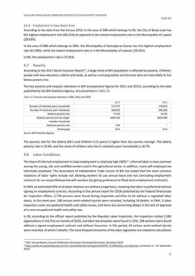
SAVA AND DRINA RIVERS CORRIDORS INTEGRATED DEVELOPMENT PROGRAM ESMF BIH
33
4.6.2 Employment in Sava Basin Area
According to the data from the Census 2013, in the area of SRB which belongs to RS, the City of Banja Luka has
the highest employment rate (40.21%) as opposed to the lowest employment rate in the Municipality of Lopare
(28.63%).
In the area of SRB which belongs to FBiH, the Municipality of Domaljevac-Samac has the highest employment
rate (41.08%), while the lowest employment rate is in the Municipality of Lukavac (29.31%).
In BD, the employment rate is 31.91%.
4.7 Poverty According to the 2017 Social Inclusion Report31, a large share of BiH population is affected by poverty. Children,
people with low education, elderly and weak, as well as rural population are the ones who are most likely to live
below poverty line.
The key poverty and inequity indicators in BIH (comparative figures for 2011 and 2015), according to the data
published by the BiH Statistics Agency, are presented in Table 15.
Table 15: Poverty and Inequity Indicators in BiH, 2011 and 2015
2011 2015
Number of relatively poor households 177,277 170,619
Number of relatively poor individuals 566,025 505,816
Relative poverty rate 17.9% 16.9%
Relative poverty line for single-
member household
BAM 416 BAM 389
Absolute poverty rate 15% -
Poverty gap 25.2 24.6
Source: BiH Statistics Agency
The poverty rate for the elderly (65+) and children (<15 years) is higher than the country average. The elderly
poverty rate is 19.6%, and the share of children who live in relatively poor households is 18.7%.
4.8 Labor Conditions
The share of informal employment in total employment is relatively high (30%)32. Informal labor is most common
among the young, old, and unskilled workers and in the agricultural sector. In addition, many self-employed are
informally employed. The Association of Independent Trade Unions of BiH has stated that the most common
violations of labor rights include not allowing workers to use annual leave and not concluding employment
contracts for an unspecified period with workers (by giving preference to fixed-term employment contracts).
In FBiH, an estimated 20% of all labor relations are without a legal basis, meaning that labor is performed without
signing an employment contract. According to the annual report for 2018 published by the Federal Directorate
for Inspection Affairs, 2,728 persons were found during inspection activities to be without a regulated labor
status. In the same year, 168 serious work-related injuries were recorded, including 14 deaths. In FBiH, ¼ labor
inspectors cover occupational health and safety issues, and there are concerning delays in the lack of approval
of a new occupational health and safety law.
In RS, according to the official report published by the Republic Labor Inspection, the Inspection visited 2,589
organizations in the first six months of 2019, and labor law breaches were found in 32%. 198 workers were found
without a signed employment contract and without insurance. In this period, 42 serious work-related injuries
were recorded, of which 5 deaths. The most frequent breaches of the labor legislation are related to calculations
31 2017 Annual Report, Council of Ministers (Economic Planning Directorate), December 2018 32https://www.ilo.org/budapest/countries-covered/bosnia-herzegovina/WCMS_471903/lang--en/index.htm [accessed on: 30 September 2019]

SAVA AND DRINA RIVERS CORRIDORS INTEGRATED DEVELOPMENT PROGRAM ESMF BIH
34
and payments of wages and compensations, termination of employment, working hours, lack of employment
contracts, and holidays and leave. Under-declaration of wages or envelop wages are widespread, particularly in
construction and sectors with a lot of cash use (hospitality, logistics, retail). Labor inspectorates are
understaffed, and the sanctions they issue are not dissuasive due to low fines and delays in delivering court
decisions.
In BD, the reports of the Inspectorate of BD are not publicly available.
SAVA AND DRINA RIVERS CORRIDORS INTEGRATED DEVELOPMENT PROGRAM ESMF BIH
35
5 LEGAL FRAMEWORK
5.1 The World Bank Requirements
5.1.1 The World Bank Environmental and Social Framework (2016)
World Bank Environmental and Social Framework
WB’s Environmental and Social Framework (2016)33 became effective in October 2018. The Framework sets out
the Bank’s commitment to sustainable development, through a Bank Policy and a set of Environmental and
Social Standards that are designed to support Borrowers’ projects, with the aim of ending extreme poverty and
promoting shared prosperity. The Bank’s Framework consists of three parts:
Risk Classification
The Bank classifies all projects into one of four classifications:
▪ High risk
▪ Substantial risk
▪ Moderate risk
▪ Low risk.
In determining appropriate risk classification, the Bank takes into account relevant issues such as:
▪ Type, location, sensitivity and scale of the project,
▪ Nature and magnitude of potential environmental and social risks and impacts,
▪ The capacity and commitment of the Borrower (including any other entity responsible for the
implementation of the project) to manage the E&S risks and impacts in a manner consistent with the
ESSs.
Other areas of risk may also be relevant to the delivery of E&S mitigation measures and outcomes, depending
on the specific project and the context in which it is being developed. These could include legal and institutional
33 Available in English at: http://pubdocs.worldbank.org/en/837721522762050108/Environmental-and-Social-Framework.pdf
A Vision for Sustainable
Development, which sets out the Bank's
aspirations regarding environmental and social sustainability
The World Bank Environmental
and Social Policy for Investment
Project Financing, which
sets out the mandatory
requirements that apply to the
Bank
TheEnvironmental
and Social Standards,
which set out the mandatory requirements
that apply to the Borrower and
projects
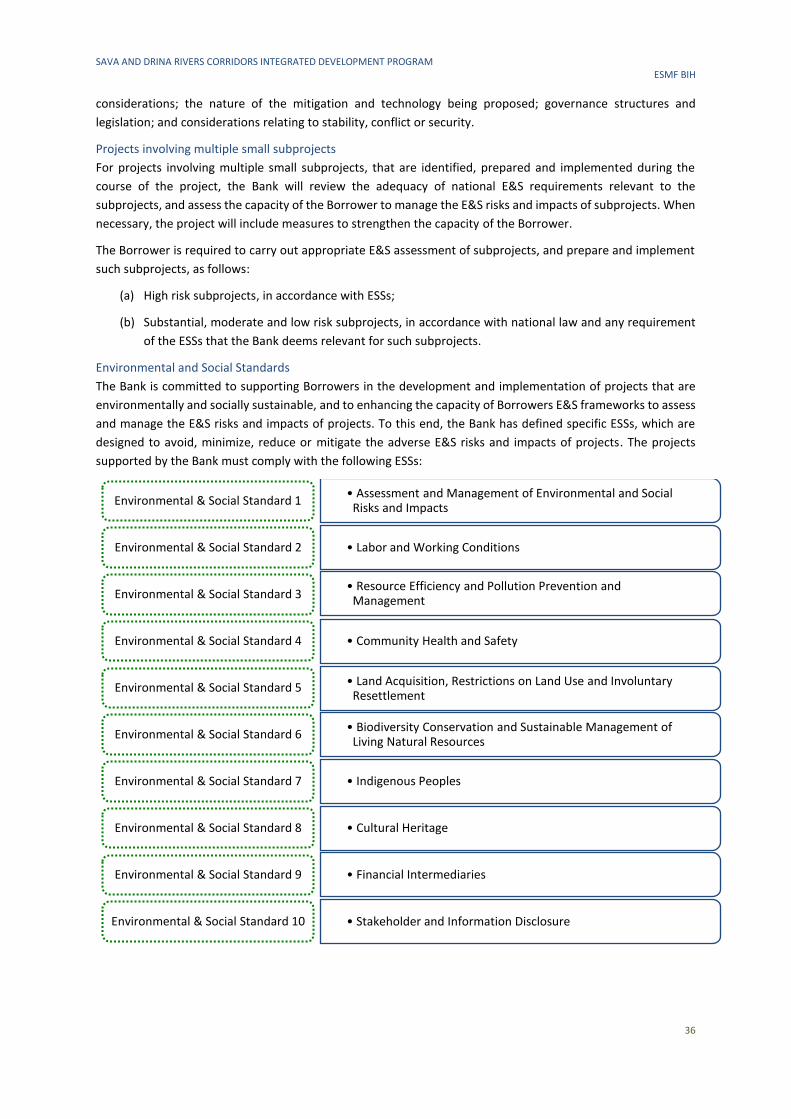
SAVA AND DRINA RIVERS CORRIDORS INTEGRATED DEVELOPMENT PROGRAM ESMF BIH
36
considerations; the nature of the mitigation and technology being proposed; governance structures and
legislation; and considerations relating to stability, conflict or security.
Projects involving multiple small subprojects
For projects involving multiple small subprojects, that are identified, prepared and implemented during the
course of the project, the Bank will review the adequacy of national E&S requirements relevant to the
subprojects, and assess the capacity of the Borrower to manage the E&S risks and impacts of subprojects. When
necessary, the project will include measures to strengthen the capacity of the Borrower.
The Borrower is required to carry out appropriate E&S assessment of subprojects, and prepare and implement
such subprojects, as follows:
(a) High risk subprojects, in accordance with ESSs;
(b) Substantial, moderate and low risk subprojects, in accordance with national law and any requirement
of the ESSs that the Bank deems relevant for such subprojects.
Environmental and Social Standards
The Bank is committed to supporting Borrowers in the development and implementation of projects that are
environmentally and socially sustainable, and to enhancing the capacity of Borrowers E&S frameworks to assess
and manage the E&S risks and impacts of projects. To this end, the Bank has defined specific ESSs, which are
designed to avoid, minimize, reduce or mitigate the adverse E&S risks and impacts of projects. The projects
supported by the Bank must comply with the following ESSs:
• Assessment and Management of Environmental and Social Risks and Impacts
Environmental & Social Standard 1
• Labor and Working ConditionsEnvironmental & Social Standard 2
• Resource Efficiency and Pollution Prevention and Management
Environmental & Social Standard 3
• Community Health and SafetyEnvironmental & Social Standard 4
• Land Acquisition, Restrictions on Land Use and Involuntary Resettlement
Environmental & Social Standard 5
• Biodiversity Conservation and Sustainable Management of Living Natural Resources
Environmental & Social Standard 6
• Indigenous PeoplesEnvironmental & Social Standard 7
• Cultural Heritage Environmental & Social Standard 8
• Financial IntermediariesEnvironmental & Social Standard 9
• Stakeholder and Information Disclosure Environmental & Social Standard 10
SAVA AND DRINA RIVERS CORRIDORS INTEGRATED DEVELOPMENT PROGRAM ESMF BIH
37
These ESSs are accompanied by non-binding Guidelines, Best Practice Notes, Templates and Checklists34.
Standards applicable to this Project are described in more details below.
Environmental and Social Standard 1 – Assessment and Management of E&S Risks and Impacts is
applied to all projects supported by the Bank through Investment Project Financing. The objective is to
identify, evaluate and manage E&S risks and impacts associated with each stage of project, in order to
achieve E&S outcomes consistent with Bank requirements.
ESS1 is also applied to all Associated Facilities/Activities which must meet ESSs requirements to the extent that
the Borrower has control or influence over such Associated Facilities/Activities.35
Within ESS1, the Borrower is obliged to:
▪ Conduct an E&S assessment of the propose project, including stakeholder engagement,
▪ Undertake stakeholder engagement and disclose appropriate information in accordance with ESS10,
▪ Develop an Environmental and Social Commitment Plan (ESCP) and implement all measures and actions
set out in the legal agreement including the ESCP,
▪ Conduct monitoring and reporting on the environmental and social performance of the project against
the ESSs.
The environmental and social assessment will be proportionate to the risks and impacts of the project and will
assess in an integrated way all relevant direct, indirect and cumulative E&S risks and impacts throughout project
life cycle, including those specifically identified in the ESS2-10. The E&S assessment process shall apply
mitigation hierarchy according to which: (a) risks and adverse impacts needs to be anticipated and to the extent
possible avoided, while positive impacts and benefits for the community and physical environment need to be
maximized, (b) where avoidance is not possible, minimize or reduce risks and impacts to acceptable levels; (c)
residual adverse impacts and risks need to be removed or mitigated to the acceptable level; (d) where significant
residual impacts remain, compensate where technically and financially feasible.
For projects which involve a set of subprojects, identified, prepared and implemented during the Project,
environmental and social assessment is carried out using the instrument of Environmental and Social
Management Framework (ESMF). The ESMF sets out the principles, rules, guidelines and procedures to assess
the environmental and social risks and impacts of any future subprojects.
Environmental and Social Standard 2 – Labor and Working Conditions regulates working conditions,
and scope of its application depends on type of employment relations between the Borrower and
project workers. The term “project worker” is related to:
a) people employed or engaged directly by the Borrower (including the project proponent and the project
implementing agencies) to work specifically in relation to the project (direct workers);
b) people employed or engaged through third parties to perform work related to core functions of the
project, regardless of location (contracted workers); (c) people employed or engaged by the Borrower’s
primary suppliers (primary supply workers); and (d) people employed or engaged in providing
community labor (community workers).
34 Available in English at: http://www.worldbank.org/en/projects-operations/environmental-and-social-framework/brief/environmental-and-social-framework-resources#guidancenotes 35 The term “Associated Facilities” means facilities or activities that are not funded as part of the project and are: (a) directly and significantly related to the project; (b) carried out, or planned to be carried out, contemporaneously with the project; and (c) necessary for the project to be viable and would not have been constructed, expanded or conducted if the project did not exist. For a facility or an activity to be defines as associated facility, all three criteria must be fulfilled.
SAVA AND DRINA RIVERS CORRIDORS INTEGRATED DEVELOPMENT PROGRAM ESMF BIH
38
ESS2 objectives are:
▪ To promote safety and health at work
▪ To promote the fair treatment, nondiscrimination and equal opportunity of project workers.
▪ To protect project workers, including vulnerable workers such as women, persons with disabilities,
children (of working age, in accordance with this ESS) and migrant workers, contracted workers,
community workers and primary supply workers.
▪ To prevent the use of all forms of forced labor and child labor
▪ To support the principles of freedom of association and collective bargaining of project workers in a
manner consistent with national law.
▪ To provide project workers with accessible means to raise workplace concerns.
Environmental and Social Standard 3 - Resource Efficiency and Pollution Prevention and Management
sets out the requirements to address resource efficiency and pollution prevention and management
throughout the project life cycle consistent with Good International Industrial Practice. Applicability of
this EES is established during environmental and social assessment.
The Borrower shall be obliged to apply technically and financially feasible measures to improve efficient
consumption of energy, water and raw material, as well as other resources. Such measures shall integrate
cleaner production principles into the product design and production processes in order to conserve raw
material, energy, water and other resources.
Besides, the Borrower will avoid the release of pollutants or, when avoidance is not feasible, minimize and
control the concentration and mass flow of their release using the performance levels and measures specified
in national law or the World Bank Group Environmental, Health and Safety Guidelines36, whichever is most
stringent. This applies to the release of pollutants to air, water and land due to routine, non-routine, and
accidental circumstances, and with the potential for local, regional, and transboundary impacts.
Pollution prevention and management includes management of:
▪ Air pollution
▪ Hazardous and non-hazardous waste
▪ Chemicals and hazardous material
▪ Pesticides
Environmental and Social Standard 4 – Community Health and Safety addresses the health, safety, and
security risks and impacts on project-affected communities and the corresponding responsibility of
Borrowers to avoid or minimize such risks and impacts, with particular attention to people who,
because of their particular circumstances, may be vulnerable.
Objectives of ESS4 are the following:
▪ To anticipate and avoid adverse impacts on the health and safety of project-affected communities
during the project life cycle from both routine and non-routine circumstances.
▪ To promote quality and safety, and considerations relating to climate change, in the design and
construction of infrastructure, including dams.
▪ To avoid or minimize community exposure to project-related traffic and road safety risks, dis-eases and
hazardous materials.
▪ To have in place effective measures to address emergency events.
36 World Bank Group Environmental, Health and Safety Guidelines (EHSG), available at: https://www.ifc.org/wps/wcm/connect/Topics_Ext_Content/IFC_External_Corporate_Site/Sustainability-At-IFC/Policies-Standards/EHS-Guidelines/
SAVA AND DRINA RIVERS CORRIDORS INTEGRATED DEVELOPMENT PROGRAM ESMF BIH
39
▪ To ensure that the safeguarding of personnel and property is carried out in a manner that avoids or
minimizes risks to the project-affected communities.
Environmental and Social Standard 5 – Land Acquisition, Restriction on Land Use and Involuntarily
Resettlement is applicable to this project. A Resettlement Policy Framework has been developed and
any subproject involving land acquisition and involuntary resettlement, regardless of whether physical
relocation is present, will develop a Resettlement Plan as per the RPF and this will be approved by the World
Bank and disclosed in-country. The screening process will screen for all the subprojects which may involve
involuntary land acquisition.
Environmental and Social Standard 6 – Biodiversity Conservation and Sustainable Management of Living
Natural Resources is applicable to all projects that potentially affect biodiversity or habitats, either
positively or negatively, directly or indirectly, or that depend upon biodiversity for their success It is also
applied to projects that involve primary production and/or harvesting of living natural resources37.
The Borrower is obliged to avoid adverse impacts on bio-diversity and habitats. When avoidance of adverse
impacts is not possible, the Borrower will implement measures to minimize adverse impacts and restore
biodiversity in accordance with the mitigation hierarchy provided in ESS1 and with the requirements of this ESS.
Where significant risks and adverse impacts on biodiversity have been identified, the Borrower will develop and
implement a Biodiversity Management Plan38.
Environmental and Social Standard 7 – Indigenous Peoples is not applicable to this Project given the
fact that in Bosnia and Herzegovina, there are no any social or cultural groups of specific characteristics
defined in ESS7.
Environmental and Social Standard 8 – Cultural Heritage sets out general provisions on risks and
impacts to cultural heritage from project activities. Objective of ESS 8 are the following:
▪ To promote the equitable sharing of benefits from the use of cultural heritage.
▪ To address cultural heritage as an integral aspect of sustainable development.
▪ To promote meaningful consultation with stake-holders regarding cultural heritage.
▪ To protect cultural heritage from the adverse impacts of project activities and support its preservation.
The requirements of this ESS8 will apply to all projects that are likely to have risks or impacts on cultural heritage.
This will include a project which:
a) Involves excavations, demolition, movement of earth, flooding or other changes in the physical
environment;
b) Is located within a legally protected area or a legally defined buffer zone
c) Is located in, or in the vicinity of, a recognized cultural heritage site
d) Is specifically designed to support the conservation, management and use of cultural heritage.
Environmental and Social Standard 9 – Financial Intermediaries is not applicable to this Project.
Environmental and Social Standard 10 – Stakeholder Engagement and Information Disclosure
recognizes the importance of open and transparent engagement between the Borrower and project
stakeholders as an essential element of good international practice. Effective stakeholder engagement
37 Harvesting of living natural resources, such as fish and all other types of aquatic and terrestrial organisms and timber, refers to productive activities that include extraction of these resources from natural and modified ecosystems and habitats. 38 Depending on the nature and the scale of the risks and impacts, to address cultural heritage as an integral aspect of sustainable development the project, the Biodiversity Management Plan may be a stand-alone document or it may be included as part of the Environmental and Social Commitment Plan prepared under ESS1.
SAVA AND DRINA RIVERS CORRIDORS INTEGRATED DEVELOPMENT PROGRAM ESMF BIH
40
can improve the environmental and social sustainability of projects, enhance project acceptance, and make a
significant contribution to successful project design and implementation.
ESS10 objectives are the following:
▪ To establish a systematic approach for stakeholder engagement that will help Borrowers identify
stakeholders and build and maintain a constructive relationship with them, in particular project-
affected parties
▪ To assess the level of stakeholder interest and support for the project and to enable stake-holders’
views to be taken into account in project design and environmental and social performance.
▪ To promote and provide means for effective and inclusive engagement with project-affected par-ties
throughout the project life cycle on issues that could potentially affect them
▪ To ensure that appropriate project information on environmental and social risks and impacts is
disclosed to stakeholders in a timely, understandable, accessible and appropriate manner and format.
▪ To provide project-affected parties with accessible and inclusive means to raise issues and grievances,
and allow Borrowers to respond to and manage such grievances.
5.1.2 Other Applicable Criteria and Guidelines
OP 7.50 – Projects on international waterways applies to various international waterways, such as: any river,
lake, canal or similar water body that forms the border between two units; any river or surface water body that
flows through two or more countries; any tributary or other surface water body that is a component of any
waterway and any creek, bay, gorge or canal connecting two or more countries. Or, if within one state, that is
recognized as a necessary communication canal between the open sea and other states and any river that flows
into such waters. Required action involves respecting the notification procedure. The project details attached to
the notification letter usually relies on environmental impact assessment and/or environmental assessment, to
make determination that the Bank financed Project will not cause damage to riparian countries. For the purposes
of this project the activities will be communicated to the riparians through The International Commission for the
Protection of the Danube River (ICPDR), upon request of the borrower countries, as noted in the session of the
Sava River Commission.
5.2 Overview of Environmental and Social Requirements in BiH
5.2.1 Environmental Assessment Procedure
Environmental Assessment Procedure in FBiH
Responsibility for the Environmental Impact Assessment (EIA) procedure in FBiH is shared between the
Federation and Cantonal Ministries responsible for the environment (for the list of cantonal ministries
responsible for environmental issues, please refer to Annex C). In FBiH, the procedure for issuing Environmental
Permits is prescribed by:
▪ the Law on Environmental Protection39,
▪ the Regulation on Plants and Facilities Subject to EIA, and Plants and Facilities which May Be
Constructed and Commissioned Only If They Have an Environmental Permit40 (the FBiH Regulation).
The FBiH Regulation specifies the following:
▪ Plants and facilities subject to EIA,
▪ Plants and facilities for which the Federal Ministry of Environment and Tourism (FMET) determines
whether an EIA must be conducted, as well as
39 Official Gazette of FBiH, No. 33/03 and 38/09 40 Official Gazette of FBiH, No. 19/04
SAVA AND DRINA RIVERS CORRIDORS INTEGRATED DEVELOPMENT PROGRAM ESMF BIH
41
▪ Plant and facilities which do not need an EIA, and for which the Federal Ministry issues the
Environmental Permit.
For plants and facilities subject to an EIA the assessment procedure begins by submitting an Environmental
Impact Assessment Study (EIA Study) to FMET. FMET publicly disclosed the EIA Study through its website,
informs and invites the general public to public consultation, and appoints an expert committee to evaluate the
EIA Study. After completion of the public consultation process and evaluation by the expert committee, FMET
issues a Decision on Approval or Rejection of the EIA Study. In case of approval, FMET issues a Decision on
Granting of the Environmental Permit. In case of rejection, the procedure is terminated.
For plants and facilities for which FMET determines whether they need an EIA the procedure begins by
development and submission of an Application for Obtaining an Environmental Permit. FMET forwards the
Application accompanied by supporting documentation to the responsible authorities and interested
stakeholders to obtain their opinions. When considering the Application, FMET takes into account the following
criteria:
▪ Project characteristics (size, relations with other facilities, use of natural resources, waste generation,
risk of accidents…),
▪ Project location and sensitivity of adjacent geographic area which is likely to be affected by the project
(current use of land, availability, quality and regeneration capacity of natural resources, absorption
capacity of surrounding nature: wetland, coastal zone, protected area, etc.),
▪ Characteristics of potential impacts (scope of impact, trans-boundary nature of impact, magnitude and
complexity, likelihood, duration, frequency and reversibility).
In case the project site is within a zone under any type of protection regime as regulated by the Law on Waters
(water protection zone) or Law on Nature Protection, then the assessment is mandatory in order to check
compliance of the proposed activities with protection regimes and potential impacts.
If it is established, based on the Environmental Permit and the attached evidence, that there is no need for an
EIA Study, FMET issues a Decision on Granting the Environmental Permit. Otherwise, it issues a Conclusion on
the Need to Develop an EIA Study. The EIA Study development involves mandatory public consultations, and the
study is evaluated by a technical committee.
For plants and facilities which do not need an EIA, and for which FMET issues an Environmental Permit, the
environmental permitting procedure begins by submitting to FMET an Application for Obtaining an
Environmental Permit, and FMET is obliged to issue the Permit within 120 days.
For projects, plants and facilities which can be constructed and commissioned only if they have an Environmental
Permit, and which fall under Cantonal level responsibility based on their capacity and size, it is necessary to
prepare an Application for Obtaining an Environmental Permit. The Application is submitted to the responsible
Cantonal Ministry of Environment, which is obliged to disclose the Application on its website, and to forward
copies of the Application to interested stakeholders for suggestions and comments in order to ensure public
participation. The Environmental Permit is issued based on the Application.
Environmental Assessment Procedure in RS
In RS, the procedure for issuing an Environmental Permit and the Environmental Impact Assessment (EIA)
procedure is prescribed by:
▪ the Law on Environmental Protection41,
▪ the Regulation on Projects Subject to EIA and Criteria for Determining if EIA is Needed and Its Scope42
(hereinafter: the RS Regulation on EIA)
41 Official Gazette of RS, No. 71/12 and 79/15 42 Official Gazette of RS, No. 124/12
SAVA AND DRINA RIVERS CORRIDORS INTEGRATED DEVELOPMENT PROGRAM ESMF BIH
42
▪ the Regulation on Plants and Facilities that May be Constructed and Operated Only with a Valid
Environmental Permit43 (the RS Regulation on permitting).
The RS Regulations on EIA defines projects for which an EIA is mandatory, projects for which the RS Ministry of
Physical Planning, Civil Engineering and Ecology (RS MPPCEE) determines whether an EIA is needed, and the
criteria based on which RS MPPCEE determines in individual cases whether EIA is needed and the scope of EIA.
The RS Regulation on permitting defines projects for which EIA is not needed but environmental permit is
mandatory.
The EIA procedure is conducted in two phases:
1. Preliminary EIA procedure, determining:
a) whether an assessment is needed,
b) the scope of the assessment, in case it is needed.
2. EIA procedure
The preliminary EIA procedure is launched by the Application submitted by the applicant to RS MPPCEE, which
is obliged to forward a copy of the Application to and enable review of the accompanying documentation by the
following entities: administrative authority responsible for construction in the local self-governance units in
which the project would be implemented44; administrative authorities and organizations responsible for
environmental protection, authorities and organizations which may be affected significantly by the project45,
FBiH and BD or another country’s authority responsible of environment, in case of a project with significant
environmental impacts in FBiH, DB or another country. Such authorities are entitled to provide their opinions
within 30 days after receiving a copy of the Application in written form.
RS MPPCEE shall decide on the Application by issuing a Decision which:
(i) Establishes the applicant’s obligation to conduct an EIA and develop an EIA Study and
(ii) Defines the tentative scope and content of the study or
(iii) Establishes that an EIA and study are not necessary.
RS MPPCEE decides on the need to conduct an impact assessment for projects bases on the following criteria
specified in the RS Regulation:
▪ Project characteristics (project size, cumulative impact with other projects, use of natural resources,
waste generation, adverse environmental effects);
▪ Risk of accidents given the materials used and technology applied;
▪ Project location and sensitivity of the local environment which may be affected by the projects,
particularly in terms of:
- Existing use of land
- Relative availability, quality and regeneration capacity of natural resources in the area, and
- Absorption capacity of the nature, with particular attention to wetlands, costal and water protection
zones, karst areas, mountain and forest areas, areas of rare and endangered flora and fauna,
protected nature areas and national parks, monuments of nature and protected landscape, areas
where environment quality standards have been exceeded by existing facilities and activities, areas
with high density of population, landscape of historical, cultural and archeological importance;
43Official Gazette of RS, No. 124/12 44 In case the RS Ministry is responsible for issuing Site Requirements. 45 Authorities responsible for nature protection, authorities responsible of protection of cultural and historical and natural heritage, authorities responsible of agriculture, forestry, water management, authorities responsible of plant protection and other interested authorities.
SAVA AND DRINA RIVERS CORRIDORS INTEGRATED DEVELOPMENT PROGRAM ESMF BIH
43
▪ Characteristics of the potential impact (scope of impact (particularly in terms of geographic area and
population density), likelihood, duration, frequency, complexity, intensity and reversibility of the
impact).
When determining the scope of the impact assessment, the RS MPPCEE takes into account, for each individual
case, the following factors: site description, presentation of the environment, project description, description of
potential impacts, specification and description of mitigation measures, reduction and/or elimination of
environmental impact, specification and description of impact monitoring measures and activities, description
of the considered alternatives and reason of choosing particular alternative, description of potential
environmental impact in FBiH, BD or another country, as well as their inter-relations.
Within 15 days upon sending to the applicant the Decision which determines an obligation to conducts the
assessment and the scope of the assessment, RS MPPCEE shall forward the Decision to other responsible
authorities and post it on its website or RS Government website for a period of 30 days.
EIA Procedure. After receiving the Decision on the obligation to conduct the EIA, the applicant shall be obliged
to submit to the authorized legal entity a request for developing the EIA Study. Within 15 days upon receiving
the Application for Approval of the EIA Study (including the EIA Study), RS MPPCEE shall be obliged to forward a
copy of the Application to other responsible authorities, which shall provide their written opinions on both the
Application and particularly on the study, within 30 days. The EIA procedure also includes an obligation to carry
out public consultations, as well as an audit of the study which should verify the technical quality of the Study.
RS MPPCEE shall issue the Decision on Approval of the EIA Study within 60 days upon receipt of the final version
of the study.
Environmental permitting procedure. For the facilities that do not require an EIA, RS MPPCEE issues
Environmental Permit on the basis of the Application for Environmental Permit and Proofs submitted with the
Application. RS MPPCEE shall notify the public and the relevant stakeholders about the content of the
Application in one of the daily newspapers in the RS. In case of transboundary issues, the Application will also
be sent to the concerned entity, Brcko District or other country. The public may submit a written opinion on the
application and the supporting documentation within 30 days from the date of publishing of the notification. RS
MPPCEE shall issue a Decision on the Issuance of Environmental Permit or Decision on Rejecting the Application
within 60 days following the receipt of the complete application for environmental permit. Environmental
permit is valid for five years.
Environmental Assessment Procedure in BD
In BD, the Department of Spatial Planning and Property Affairs is responsible for the EIA procedure and for
issuing Environmental Permits. The environmental permitting procedure in BD is regulated by:
▪ The Law on Environmental Protection46,
▪ The Regulation on Facilities Subject to Obligatory Environmental Impact Assessment and Facilities
Which May be Constructed and Operated Only with a Valid Environmental Permit47.
The Regulation specifies the following:
▪ Plants and facilities subject to EIA,
▪ Plants and facilities for which the Department of Spatial Planning and Property Affairs of Brcko District
(DSPPA BD) determines whether an EIA must be conducted, as well as
▪ Plant and facilities which do not need an EIA, and for which the DSPPA BD issues the Environmental
Permit.
EIA can be carried out in two phases: Preliminary EIA procedure and EIA procedure.
46 Official Gazette of BD BiH, No. 24/04, 01/05, 19/07, 09/09 47 Official Gazette of BD BiH, No. 30/06
SAVA AND DRINA RIVERS CORRIDORS INTEGRATED DEVELOPMENT PROGRAM ESMF BIH
44
For plants and facilities subject to an EIA, the assessment procedure begins by submitting an Environmental
Impact Assessment Study (EIA Study) to DSPPA BD. After the Investor submits the EIA Study to the DSPPA BD,
the Department makes the EIA Study available to the public, allowing 30 days for receiving comments. The
Department of Spatial Planning and Property Affairs is obliged to organize a public hearing as near as possible
to the subproject location, and to invite the public to consultations. After completion of the public consultation
and after the EIA Study is evaluated and all the relevant comments received form interested parties
incorporated, the DSPPA BD approves the EIA Study within 30 days from EIA Study receipt and issues the
Environmental Permit (within 30 days following the approval of the EIA Study). DSPPA BD issues the
Environmental Permit within 60 days from EIA Study receipt. Environmental permits are valid for five years.
For plants and facilities for which DSPPA BD determines whether they need an EIA, the assessment procedure
begins by submitting the Request for a Preliminary EIA to DSPPA BD. This Department submits the Request to
interested parties to give their opinions and comments. The deadline for submission of opinions and comments
is 30 days after receipt of the request. The investor and the public are informed about the Preliminary EIA. DSPPA
BD, based on the Preliminary EIA brings the Decision on preparation and content of the EIA Study. If the DSPPA
BD decides that the EIA Study is necessary the investor shall, within six months from the date of receipt of this
Decision, prepare the EIA Study by an authorized institution and submit it to the DSPPA BD for assessment. If
the DSPPA BD decides that there is no need for an EIA Study, this Department issues a Decision on Granting the
Environmental Permit
For plants and facilities which do not need an EIA, and for which DSPPA BD issues an Environmental Permit, the
environmental permitting procedure begins by submitting to DSPPA BD the Request for Obtaining an
Environmental Permit. The Request shall be publicly disclosed through the media. Opinions from public may be
given no later than 30 days from the date of Request disclosure. DSPPA BD is obliged to issue the Permit within
60 days.
5.2.2 Waste Management Regulations
Waste Management Regulations in FBiH
In FBiH, pursuant to the Law on Waste Management48, the Environmental Permit Application must be
accompanied by a Waste Management Plan. The Plan contains the following:
▪ Documentation on the waste generated by the company (origin, type of waste pursuant to waste
classification list, composition, volume),
▪ Measures to be taken to limit waste generation, particularly in case of hazardous waste,
▪ Separation of waste, particularly separation of hazardous waste from other types of waste and from
recyclables,
▪ Waste disposal practices,
▪ Waste treatment and/or disposal methods.
The Regulation on Waste Categories with Lists49 defines waste categories by activities. Some waste categories
which may be generated as a result of activities potentially included in this Project are provided below.
Table16: Waste Generated by the Activities Potentially Included by the Project – FBiH
Activity from which the Waste Originates Regulation Code
Construction waste and demolition waste 17 00 00
Municipal waste and similar waste from industrial facilities and small craft, including
separately collected fractions
20 00 00
48 Official Gazette of FBiH, No. 33/03, 72/09 and 92/17 49 Official Gazette of FBiH, No. 9/05
SAVA AND DRINA RIVERS CORRIDORS INTEGRATED DEVELOPMENT PROGRAM ESMF BIH
45
Waste Management Regulations in RS
In RS, pursuant to the Law on Waste Management50, all the subject to obtaining an Environmental Permit must
prepare and adopt a Waste Management Plan, which should include:
▪ Documentation on waste generated during plant operating process, as well as on waste used in the
plant or disposed by the plant (type, composition and volume of waste),
▪ Measures taken in order to reduce waste, particularly hazardous waste generation,
▪ Procedures and manner of separation of various types of waste, particularly hazardous waste and
recyclable waste, in order to reduce volume of waste for final disposal, and
▪ Manner of storage, treatment and disposal of waste.
Categories of waste which may be generated as a result of the activities potentially covered by this Project,
pursuant to the Regulation on Waste Categories, Testing and Classification51 are specified below.
Table 17: Waste from the Activities Potentially Covered by the Project – RS
Activity from which the Waste Originates Regulation Code
Construction waste and demolition waste 17 00 00
Municipal waste and similar waste from industrial facilities and small craft, including
separately collected fractions
20 00 00
Waste Management Regulations in BD
In BD, pursuant to the Law on Waste Management52, a Waste Management Plan has to be enclosed to the
Request for the Environmental Permit. The Plan contains the following:
▪ Documentation on waste generated by the company, the return of which is made in the company or
whose disposal is carried out by the company (type, composition and quantity of waste),
▪ Measures to be taken to limit waste generation, particularly in case of hazardous waste,
▪ Separation of waste, especially separation of hazardous and other types of waste from the waste to be
reused,
▪ Landfilling of waste,
▪ Manner of storage, treatment and disposal of waste.
Categories of waste which may be generated as a result of the activities potentially covered by this Project,
pursuant to the Regulation on Waste Categories with Lists53, are specified below.
Table 18: Waste from the Activities Potentially Covered by the Project – BD BiH
Activity from which the Waste Originates Regulation Code
Construction waste and demolition waste 17 00 00
Municipal waste and similar waste from industrial facilities and small craft, including
separately collected fractions
20 00 00
5.2.3 Water Management Regulations
Water Management in FBiH and RS
In FBiH, the Law on Water54 and, in RS, the Law on Water of RS55 prescribe that in case of a project which includes
e.g. construction of flood protection facilities, as well as any other activity which may affect volume and quality
of water, the following water management acts must be obtained:
50 Official Gazette of RS, No. 111/13, 106/15 and 16/18 51 Official Gazette of RS, No. 19/15 and 79/18 52 Official Gazette of BD BiH, No. 04/25, 1/05, 19/07, 02/08 and 09/09 53 Official Gazette of BD BiH, No 32/06 54 Official Gazette of FBiH, No. 70/06 55 Official Gazette of RS, No. 50/06, 92/09, 121/12 and 74/17
SAVA AND DRINA RIVERS CORRIDORS INTEGRATED DEVELOPMENT PROGRAM ESMF BIH
46
▪ In FBiH, Preliminary Water Approval, and in RS, Water Guidelines, which prescribe the terms and
conditions under which the responsible Ministry will allow use of water (issued in the stage of Urban
Permit and Site Requirements in FBiH and RS, respectively).
▪ Water Approval (in FBiH and RS) which confirms that the documentation attached to the Application
for Water Approval is in compliance with the Preliminary Water Approval and Water Guidelines in
FBiH and RS respectively, water regulations and planning documents (issued before the Construction
Permit in FBiH and RS).
▪ Water Permit (in FBiH and RS) which confirms that all the requirements set in the Water Approval are
met (issued before the Use Permit in FBiH and RS). The Water Permit defines purpose, terms and
conditions of water use, facility and plant operating regime, terms and conditions of wastewater
discharge, terms and condition of solid waste and liquid waste disposal and other terms and
conditions. It also defines the applicant’s obligations related to wastewater measurement,
measurement frequency, quality control and records keeping on used water, as well as obligations
related to water fees accounting and payment.
In FBiH, water documentation is issued pursuant to the Regulation on Content, Form, Terms and Conditions and
Manner of Issuance and Keeping of Water Documentation56. In RS, development of a regulation on water
documentation issuance is underway.
The entity laws on water foresee that the Environmental Permit is issued based on the previously obtained
Preliminary Water Approval/Water Guidelines. It is thus ensured that the environmental ministry can integrate
in the Environmental Permit any water protection-related recommendations and measures.
In FBiH, the Sava River Water Agency, the Adriatic Sea Water Agency and Cantonal Ministries are responsible
for issuing water documentation (for the list of cantonal ministries responsible for water issues, please refer to
Annex C). In RS, water documentation is issued by Public Institution “Vode Srpske” and local self-governance
units.
Water Management in BD
Water permitting procedure in BD is regulated by:
▪ The Law on Water Protection of BD BiH57 and
▪ The Law on Water of RS58.
The Law on Water Protection of BD regulates the issuance of the Water Protection Consent (WPC), while the
Water Management Consent (WMC) and Water Management Permit (WMP) are regulated by the old Law on
Water of RS.
The WPC is issued in case of water use. Construction of ports is listed among the activities which require a WPC.
The WPC has to be attached to the application for the Environmental Permit, Construction Permit, WMP and
other permits as regulated by other laws. The WPC contains measures for maintaining the conditions for
reproduction of plants and animal species, maintaining appropriate conditions of aquatic ecosystems and
species and preservation of the good water status. It is issued by the Department of Agriculture, Forestry and
Water Management of BD BiH and is valid for 15 years, with a possibility of extension.
The WMC has to be issued for the construction of new and reconstruction of existing facilities and plants which
can change or affect the established water regime. It has to be obtained before obtaining the Construction
Permit as it has to be submitted within the application for the Construction Permit. The WMC is issued by the
Department of Agriculture, Forestry and Water Management of BD, and contains the conditions and measures
56 Official Gazette of FBiH, No. 06/08, 57/09 and 72/09 57 Official Gazette of BD, No. 25/04, 01/05 and 19/07 58 Official Gazette of RS, No. 10/98 and 51/01
SAVA AND DRINA RIVERS CORRIDORS INTEGRATED DEVELOPMENT PROGRAM ESMF BIH
47
that have to be implemented by the investor in order to minimize and eliminate the negative impacts caused by
the construction or reconstruction of facilities and plants. It is valid for a period between one and two years.
The WMP defines the purpose, method and terms of water use, operation facilities and equipment, the manner
and conditions of wastewater discharges, the manner and conditions for the disposal of solid and liquid waste
and other conditions. It has to be issued for all facilities and plant for which a WMC has been issued. The WMP
confirms that the conditions defined by the WMC are fulfilled. It is issued by the Department of Agriculture,
Forestry and Water Management and is valid for a limited time not longer than 10 years.
5.2.4 Construction Regulations
Construction Regulations in FBiH
In FBiH, construction is governed by the following legislation:
▪ The Law on Physical Planning and Land Use at FBiH level59
▪ Cantonal Laws on Physical Planning and Construction.
Pursuant to the Federation and Cantonal regulations on physical planning and construction, in order to construct
facilities, it is necessary to obtain an Urban Permit, Construction Permit and Use Permit. Depending on the type
of construction, these permits are issued by the Federal Ministry of Spatial Planning, the Cantonal Ministries
relevant for spatial planning, or by the local self-government units (Cities or Municipalities).
The Decree on Construction Site Organization, Mandatory Documentation on Construction Site and
Construction Work Participants60 specifies the documents that must be kept at construction sites, including a
Construction Site Organization Plan (CSOP). The CSOP contains the following:
▪ Description of preparatory works and site arrangements works during and after construction works,
▪ Description of technological scheme,
▪ Management Plan on Safety (composed of Occupational Safety Management Plan and Fire Fighting
and Explosion Management Plan),
▪ Environmental Management Plan during construction works.
The CSOP must be developed by the Contractor for construction works prior to the commencement of
construction works. It has to be controlled and signed by the Supervisory Authority which is the legal entity
responsible for the overall supervision of construction works, as stipulated by the above-mentioned Decree. The
Plan should correspond to the requirements, safety measures and obligations contained in the Environmental
Permit or environmental requirements laid down in the approval process for the construction.
Construction Regulations in RS
In RS, pursuant to the Law on Physical Planning and Construction61, for design and construction of buildings it is
necessary to obtain Site Requirements, Construction Permit and Use Permit. Depending on the type of
construction, these permits are issued by the RS MPPCEE or by the local self-government units (Cities or
Municipalities).
The mentioned Law specifies the documents that must be kept at construction sites, including a Construction
Site Organization Scheme. The Scheme includes a Safety Plan developed by the Contractor.
Construction Regulations in BD
In BD, pursuant to the Law on Spatial Planning and Construction of BD62, it is necessary to obtain a Location
Permit, Construction Permit and Use Permit for construction of facilities and buildings. Location Permits are
59 Official Gazette of FBiH, No. 2/06, 72/07, 32/08, 4/10, 13/10, 45/10 60 Official Gazette of FBiH, No. 48/09, 75/09, 93/12, 74/13, 89/14, 99/14, 53/15 and 101/15 61 Official Gazette of RS, No. 40/13, 106/15, 3/16, 84/19 62 Official Gazette of BD BiH, No. 29/08, 18/17, 48/18 and 54/18
SAVA AND DRINA RIVERS CORRIDORS INTEGRATED DEVELOPMENT PROGRAM ESMF BIH
48
issued by the Department of Spatial Planning and Property Affairs, whereas the Construction and Use Permits
are issued by the Department for Public Safety.
The mentioned specifies the documents that must be kept at construction sites, including a Construction Site
Organization Scheme.
5.2.5 Regulations on Working Conditions
Labor legislation and safety at work are regulated at FBiH, RS and BD BiH level by the following regulations:
Federation of Bosnia and Herzegovina
FBiH Labor Law63 Regulates conclusion of employment contract, working hours, salary, work contract termination, right and
obligations under employment contracts and collective bargaining. The Law, inter alia, treats rights of
worker and employer to enter employment contract, rights of minor and female workers, safety and
health at work. Provisions of this Law are harmonized with ILO Conventions on forced work,
discrimination, child work, equal pay, freedom of association, freedom of organization and collective
bargaining.
SRBiH Law on Safety
at Work64 (applied in
FBiH)
Regulates safety at work measures which include measures which directly ensure safety at work,
measures related to working conditions and measures related to special protection of workers, rights,
obligations and responsibilities of organization, employer and worker, records, inspection surveillance and
penalty provisions.
Republika Srpska
RS Labor Law65 Governs employment relations, rights, obligations and responsibilities under employment contract,
conclusion of employment contract, working hours, breaks and leave, general protection of workers,
salaries, allowances and other receipts, employment contract termination, protection of workers’ rights,
as well as organization of workers and employers.
RS Law on Safety at
Work66
Prescribes safety and health at work as an activity of general interest, responsibility of implementation
and improvement of safety and health at work, rights, obligations, responsibilities and preventive
measures.
Brcko District
Labor Law of BD67 Regulates the issues of labor and employment, employment contracts, including working hours, salaries,
termination of employment, and rights and obligations arising from employment as the general regime of
working relationships.
Law on Safety and
Health of Workers at
Work68
Regulates measures to encourage improvements of occupational safety and health, determines the
persons responsible for the implementation and improvement of occupational health and safety (OHS),
their rights, obligations and responsibilities, preventive measures, and other issues related to OHS.
The key provisions of the labor laws in FBiH, RS and BD BiH are as follows:
▪ Employment contracts can be concluded as open ended or fix-term, part-time, for temporary and
occasional work, as well as for work outside of the employer’s premises. The laws prescribe the detail
terms and condition and duration of such contracts.
▪ The laws prohibit discrimination in terms of employment requirements and selection of candidates,
education, training and professional development, promotion and employment contract termination.
Pregnancy and maternity leave cannot be a reason not to hire a woman or extend her employment
contract.
▪ The laws prescribe the minimum employment age of 18 for concluding an employment contract, with
exception of allowing persons between 15 and 18, with the consent of their legal custodians and
63 Official Gazette of FBiH, No. 26/16 and 89/18 64 Official Gazette of SRBiH, No. 22/90 65 Official Gazette of RS, No. 1/16 and 66/18 66 Official Gazette of RS, No. 1/08, 13/10 67 Official Gazette of BD BiH, 19/06 – consolidated text, amendments: No. 19/07, 25/08, 20/13, 31/14, 01/15 68 Official Gazette of BD BiH, No. 20/13
SAVA AND DRINA RIVERS CORRIDORS INTEGRATED DEVELOPMENT PROGRAM ESMF BIH
49
based on a medical certificate issued by health facility, and provided that the given job does not
endanger the minor’s health, moral and education.
▪ Employers are required to register workers for pension and disability, health and unemployment
insurance.
▪ Workers are entitled to a salary and salary compensation during absence from work, as well as to
working conditions which ensure safety and protection of their life and health at work.
▪ Full time work is, as a rule, 40 hours a week. Overtime work is allowed in FBiH, RS and BD in the
duration of maximum 8, 10 and 12 hours a week, respectively.
▪ Workers are entitled to an increased salary for overtime, night work and work during holidays.
▪ The laws define in detail breaks from work to which workers are entitled (breaks during working
hours, daily, weekly and annual leave).
▪ All laws foresee that a worker who believes that the employer violated any of his/her employment-
related rights can request from the employer to provide him/her with such right. The RS Law
prescribes that the employer is obliged to respond to such request within 30 days, while the FBiH and
BD Laws do not specify a deadline. All the laws envisage a mechanism of amicable dispute resolution
as well as lodging court suits69.
The key provisions of the legislation on occupational health and safety (OHS) in FBiH, RS and BD are as follows:
▪ Employers are obliged to ensure OHS and provide the necessary means to implement and improve
OHS, as well as to organize OHS training for workers,
▪ Workers must be provided with a working environment, assets for work and personal protection
equipment that do not endanger the safety or health of workers and other persons,
▪ Workers are obliged to use personal protection equipment and comply with other instructions related
to safety at work.
69 According to the survey published on the website of the Initiative for Monitoring European Integrations in BiH, average duration of employment-related disputes in BiH is 313 days (source: Initiative for Monitoring European Integrations in BIH) http://eu-monitoring.ba/trajanje-sudskih-postupaka-u-antidiskriminacijskim-predmetima/#_ftn7 [accessed on: September 29, 2019]. Although, pursuant to both FBiH and RS Litigation Procedure Law, employment-related disputes are considered to be of urgent nature, they last several years and have negative implications on economic position of both parties.
SAVA AND DRINA RIVERS CORRIDORS INTEGRATED DEVELOPMENT PROGRAM ESMF BIH
50
6 INSTITUTIONAL STRUCTURE
6.1 BiH Level Institutions
According to the Dayton Agreement, issues such as foreign policy, foreign trade policy and customs policy fall
within the area of competence of BiH institutions. All governmental functions and authorities that are not
expressly assigned to the institutions of BiH, are those of the entities/District. This includes water management,
environmental protection, agriculture, land and forestry. However, the national level does have some
competences in the fields related to implementation of international treaties, environmental protection and
water management.
At the state level, the Ministry of Foreign Trade and Economic Relations (MoFTER) is responsible for, among
others, tasks and duties falling within the competence of BiH which are related to definition of policy, basic
principles, coordination of activities and harmonization of plans of entity-level authorities and institutions on
the international level in the areas of agriculture, energy, environmental protection, development and use of
natural resources and tourism. In relation to water management, the Water Resources Department within
MoFTER contributes, through regional and international cooperation, as well as cooperation with entity
institutions, to better management and use of water resources in BiH and wider.
BiH is a signatory to several conventions and protocols in this area, among which are the Convention on the
Protection and Sustainable Use of the Danube River and the Framework Agreement on the Sava River Basin,
with a number of related protocols. The Water Resources Department is actively involved in the implementation
of the mentioned agreements. In addition, this Department participates in the implementation of a number of
projects in the country as well as at the regional level, which contribute to the sustainable management of water
resources in BiH.
6.2 FBiH Level Institutions
Pursuant to the FBiH Constitution70, water management and environmental protection policy is under the joint
responsibility of FBiH and cantons. Table 19 provides an overview of institutions and their responsibilities
relevant for this Project. (For the list of cantonal ministries responsible for water management and
environmental issues, please refer to Annex C).
Table 19: FBiH level institutions responsible for water management and environmental issues relevant for this Project
Institution Responsibilities
Federal Ministry of Agriculture,
Water Management and Forestry
(FMAWMF)
Performs administrative, professional and other tasks in the field of water management,
management of the basins among which are: preparation of strategies and development
policies for water management, water management facilities and public water properties,
proposing development documents for the integrated water management, preparation
of legislation and regulations and institutional arrangement in the field of water
management within the competence of FBiH, coordination of monitoring activities in
water resources, implementation of development projects and cooperation with water
management institutions and other institutions, carrying out concession granting
procedures within the competence of the Ministry in this field, carrying out activities
related to international contracts, agreements, conventions and protocols in water
management.
Water Agencies in FBiH (Sava
River Watershed Agency)
Organize hydrological monitoring and water quality monitoring, monitoring of ecological
status of surface waters, monitoring of ground water quality. They prepare reports on the
status of water quality and recommend measures necessary for achievement of goals
related to water protection of waters, regulation of waters, protection from adverse
effects of waters, and use of waters. They issue water-related acts and order measures
which entities must observe in the periods of validity of these acts. They establish and
manage the water information system.
70 Official Gazette of FBiH, No. 1/94, 13/97, 16/02, 22/02, 52/02, 63/03, 9/04, 20/04, 33/04, 71/05, 72/05 and 88/08.
SAVA AND DRINA RIVERS CORRIDORS INTEGRATED DEVELOPMENT PROGRAM ESMF BIH
51
Institution Responsibilities
Federal Ministry of Environment
and Tourism (FMET)
Performs administrative, professional and other tasks within the competence of FBiH
related to air, water and soil protection; drafting environmental strategy and policy,
standards for air, water and soil quality, environmental monitoring and control of air,
water and soil. The Ministry is also responsible for issuance of Environmental Permits at
FBiH level.
Federal Ministry of Transport and
Communications
Performs administrative, professional and other tasks within the competence of FBiH
related to transport and communications which include, among others, river and lake
traffic. It monitors the state of development and the safety of water-navigation and
combined transport, initiate and cooperate in the development of development plans and
maintenance programs in individual forms of transport, initiates the achievement of
international treaties, conventions, agreements and other acts, participates in the
drafting of legislation and by-laws in the field of transport.
Federal Ministry of Spatial
Planning
Responsible for spatial planning and land use at FBiH level, long-term plans for
exploitation of natural resources and protection of national monuments and areas of
exceptional natural, architectural and cultural and historical importance. Also responsible
for issuing Urban Consents, Construction Permits, and Use Permits at FBiH level.
6.3 RS Level Institutions
The Constitution of RS71 defines that the RS level authorities organize and provide environmental protection.
Table 20 provides an overview of institutions responsible for environmental protection in RS.
Table 20: RS level institutions responsible for water management and environmental issues relevant for this Project
Institution Responsibilities
Ministry of Agriculture, Forestry and
Water Management of RS
Administrative, professional and other tasks in the field of water management,
management of two river basins (Sava River Basin and Trebisnjica River Basin). This
Ministry is responsible for development and adoption of plans in water management
sector, balance water, enforcement of protection from harmful water, determining
conditions and issuing water permits, implementation and organization of quality control
of water, monitoring, hydro melioration, establishment and maintenance of information
systems, keeping registers; preparation of strategies, programs, monitoring and
coordination of the work of other organizations in the field of water management and
other activities determined by law.
Public Institution “Vode Srpske“ Organizes hydrological monitoring and water quality monitoring, monitoring of the
ecological status of surface waters, monitoring of ground water quality. Prepares reports
on the status of water quality and recommends measures necessary for achievement of
goals related to water protection of waters, regulation of waters, protection from adverse
effects of waters, and use of waters. Issues water-related acts and orders measures which
entities must observe in the period of validity of these acts. Establishes and manages the
water information system.
Ministry of Spatial Planning, Civil
Engineering and Ecology of RS
Integral planning and spatial planning, implementation of the Spatial Plan of RS, approval
of spatial plans of local self-government units and special areas, urban and regulatory
plans, integral protection and promotion of the environment and nature in general,
research, planning and management through environmental measures, protection of the
ozone layer, monitoring of climate change, comprehensive protection of goods of general
interest, natural resources, natural and cultural heritage, issuance of Environmental
Permit,
Ministry of Transport and
Communications of RS
Performs administrative, professional and other tasks within the competence of RS
related to transport and communications which include, among others river and lake
traffic, safety of river and lake traffic, arrangement of waterways, navigable vessels and
their registration, water infrastructure (ports, docks, moorings, etc.), issuance of
certificates on the ability to operate a boat, issuance of traffic approvals and permits for
ship navigation, combined traffic and transshipment services.
71 Official Gazette of RS, No. 21/92 – revised text, 28/94, 8/96, 13/96, 15/96, 16/96, 21/96, 21/02, 26/02, 30/02, 31/02, 69/02, 31/03, 98/03,
115/05 and 117/05.
SAVA AND DRINA RIVERS CORRIDORS INTEGRATED DEVELOPMENT PROGRAM ESMF BIH
52
6.4 BD Level Institutions
BD is a single administrative unit of local self-government existing under the sovereignty of BiH. It is distinct from
the entities and has the status of an autonomous territory with its own sources of revenue. Legislative power is
vested in the BD Assembly, and the executive power with the Government (which consists of the Mayor, Deputy
Mayor, Government Chief Coordinator and the Heads of Departments). The BD Statute72 defines that the
competences of BD in the field of water management and environmental protection are delegated to the
Department of Agriculture, Forestry and Water Management and Department for Spatial Planning and Property
Affairs within the BD Government. In addition to these two Departments, other Departments within the BD
Government and the Harbor Master of BD are relevant for this Project. Table 21 provides an overview of
institutions responsible for environmental protection in BD.
Table 21: BD BiH level institutions responsible for water management and environmental issues relevant for this Project
Institution Responsibilities
Department for Agriculture,
Forestry and Water Management
Administrative, professional and other tasks in field of water management, among which,
preparation of water management strategies and development policies, tasks related to
facilities and public water resources (in the field of water use, water protection and
protection against harmful effects of water) and monitoring of water status, development
of documents for integrated water management (River Basin Management, Programs of
Measures, Flood Defense Plans, Water Pollution Plans, Contingency Plans and Other
Documents under Applicable Legislation) and monitoring the implementation of these
documents, preparation of laws and other regulations in the field of water management,
monitoring of water resources and preparation of information in the field of water
management, issuance of concessions and Water Protection Permits, Water
Management Consents and Permits.
Department of Spatial Planning and
Property Affairs
Performs tasks related to environmental protection, issues Environmental Permits in
accordance with the provisions of the Law on Environmental Protection and other
environmental legislation. This Department is responsible for development of spatial
planning documents, issuance of urban approvals, protection of cultural, historical and
natural heritage for the issuance of zoning permits and establishing procedures for the
list of protected buildings.
Department of Public Safety Administrative, professional and other tasks in the field of planning of fire protection,
protection from accidents and other disasters, civil defense, protection and rescue from
natural and other disasters, surveillance and information and physical-technical security
of facilities. This Department is responsible for the issuance of Construction Permit, Use
Permit, Technical and Work Consents, issuance of authorization according to the Law on
Spatial Planning and Construction, and authorization to perform transport for own needs.
Harbor Master of BD
(established as an organizational
unit within the Department of
Public Works according to the Law
on Inland Navigation of Brcko
District73 )
Performs administrative, professional, technical and other activities on navigable
waterways related to the registration of ships and floating facilities, issuance of ship
documents and books, deciding upon the ability for navigation of certain vessels and
floating structures, maintenance of order in the port and winter shelter, marina, ferry
crossing, bathing and other parts of the waters and shores of inland waterways,
hydrological security of navigation on inland waterways, search and rescue of passengers
and goods on inland waterways, issuing supplementary documents for navigation
planning.
72 Official Gazette of BD BiH, 17/08 and 39/09 73 Official Gazette of BD BiH, No. 28/08, 19/10
SAVA AND DRINA RIVERS CORRIDORS INTEGRATED DEVELOPMENT PROGRAM ESMF BIH
53
7 ENVIRONMENTAL AND SOCIAL ASSESSMENT OF THE SUBPROJECTS
7.1 ESSs Relevant to the Program
Following is an overview of the WB E&S standards considered applicable to the SDIP and a brief explanation of
their relevance.
Table 22: ESSs considered relevant for the SDIP at the time of the Program appraisal
ESS Relevance to the SDIP
ESS1 Assessment and Management of
E&S Risks and Impacts
This standard guides the preparation of E&S instruments including those that have
been prepared for SDIP: (i) ESMF, (ii) SEP, (iii) RPF (iv) LMP and appropriate risk
assessment for individual activities implemented under the project.
ESS2 Labor and Working Conditions This standard guides the creation of sound worker-management relationships. The
primary labor risk is the risk of informal work. The risks of unpaid and underpaid
work, work overload, poor terms and conditions of engagement, lack of
occupational health and safety measures, and denied access to social security,
pension or health insurance are associated with informal work. Labor Screening and
Compliance Checklist, and Monitoring and Evaluation procedures have been
developed to be included as mandatory in the tender documentation providing
compliance of third parties i.e. different contractors to the ESS2 requirements.
ESS3 Resource Efficiency and Pollution
Prevention and Management
This standard sets out the requirements to address resource efficiency and
pollution prevention and management throughout the project life cycle.
Considering that most of the activities involve construction works, the major risk is
that Contractors will not be aware of best practices to avoid or minimize pollution
from project activities or avoid or minimize adverse impacts on human health and
the environment. The site-specific ESMP will guide contractors to implement
adequate pollution prevention and management measures.
ESS4 Community Health and Safety This ESS sets out the requirements to avoid or minimize community exposure to
project-related traffic and road safety risks, diseases and hazardous materials and
to have in place effective measure to address emergency events. The works
anticipated in this project will be carried out mostly in remote or publicly restricted
areas and will not employ use or generation of hazardous substances and waste.
The main risk associated with the project is related to workers health and safety
that is addressed by ESS2.
ESS5 Land Acquisition, Restrictions on
Land Use and Involuntary
Resettlement
This ESS guides the procedures to avoid or implement involuntary resettlement and
economic displacement with least possible impacts. The SDIP involves the
possibility of land acquisition and economic displacement. To minimize the risk, an
appropriate RPF has been developed at the project level, while a site-specific RAP
will be developed where needed. The main risk is associated with appropriate
implementation of the RPF.
ESS6 Biodiversity Conservation and
Sustainable Management of Living
Natural Resources
The project area is the whole country, which includes several nationally and
internationally recognized natural and critical habitats, protected areas, wetlands
and Ramsar sites as well as hundreds of locally designated nature sites. The
activities will be assessed for relevant risks, and the mitigation hierarchy will be
applied. Development of site-specific ESMPs will be considered as part of screening
and approval procedure. Environmental screening will ensure that no activities with
potential negative impacts are eligible for funding in natural or critical habitats. In
case of activities to be funded by the project and to be implemented in modified
habitats, the project-level will present requirements to avoid or minimize the
respective impacts on biodiversity and implement mitigation measures as
appropriate.
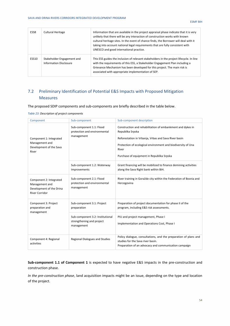
SAVA AND DRINA RIVERS CORRIDORS INTEGRATED DEVELOPMENT PROGRAM ESMF BIH
54
ESS8 Cultural Heritage Information that are available in the project appraisal phase indicate that it is very
unlikely that there will be any interaction of construction works with known
cultural heritage sites. In the event of chance finds, the Borrower will deal with it
taking into account national legal requirements that are fully consistent with
UNESCO and good international practice.
ESS10 Stakeholder Engagement and
Information Disclosure
This ESS guides the inclusion of relevant stakeholders in the project lifecycle. In line
with the requirements of this ESS, a Stakeholder Engagement Plan including a
Grievance Mechanism has been developed for this project. The main risk is
associated with appropriate implementation of SEP.
7.2 Preliminary Identification of Potential E&S Impacts with Proposed Mitigation
Measures
The proposed SDIP components and sub-components are briefly described in the table below.
Table 23: Description of project components
Component Sub-component Sub-component description
Component 1: Integrated
Management and
Development of the Sava
River
Sub-component 1.1: Flood
protection and environmental
management
Construction and rehabilitation of embankment and dykes in
Republika Srpska
Reforestation in Vrbanja, Vrbas and Sava River basin
Protection of ecological environment and biodiversity of Una
River
Purchase of equipment in Republika Srpska
Sub-component 1.2: Waterway
Improvements
Grant financing will be mobilized to finance demining activities
along the Sava Right bank within BiH.
Component 2: Integrated
Management and
Development of the Drina
River Corridor
Sub-component 2.1: Flood
protection and environmental
management
River training in Goražde city within the Federation of Bosnia and
Herzegovina
Component 3: Project
preparation and
management
Sub-component 3.1: Project
preparation
Preparation of project documentation for phase II of the
program, including E&S risk assessments.
Sub-component 3.2: Institutional
strengthening and project
management
PIU and project management, Phase I
Implementation and Operations Cost, Phase I
Component 4: Regional
activities
Regional Dialogues and Studies Policy dialogue, consultations, and the preparation of plans and
studies for the Sava river basin.
Preparation of an advocacy and communication campaign
Sub-component 1.1 of Component 1 is expected to have negative E&S impacts in the pre-construction and
construction phase.
In the pre-construction phase, land acquisition impacts might be an issue, depending on the type and location
of the project.
SAVA AND DRINA RIVERS CORRIDORS INTEGRATED DEVELOPMENT PROGRAM ESMF BIH
55
In the construction phase, the common environmental impacts that can be expected on air, water, soil quality
and biodiversity from activities under sub-component 1.1. are those resulting from construction works and
generation of construction and demolition waste. The breach of nationally allowed concentration of pollutants
into the air, soil or water as are not expected as the works will be implemented with best practices and in
accordance with legislative requirements, adjoined with the defined mitigation measures prescribed (where
needed) by the ESMP/ESIA to be developed for each subproject prior to its implementation. The development
and implementation of the site-specific ESMP will minimize and prevent the identified negative impacts, through
a set of specific environmental mitigation and monitoring requirements to be followed by the contractor and/or
responsible parties during implementation.
Sub-component 1.2 concerning demining operations have a potential to damage the environment, not only
because of the short-term effects caused by demolition activities, but long-term effects that may be caused by
contamination of soil and water systems, removal of vegetation, disruption to watercourses or changes to soil
structure. Demining operations may also damage the natural habitats of insects and wildlife and affect areas of
historical or cultural significance. The development and implementation of a site-specific ESMP will help
minimize and prevent the identified negative impacts.
In the implementation phase, the projects are expected to bring positive E&S benefits in terms of protection
from flood but also through demining, reforestation and protection of ecological environment and biodiversity.
Sub-component 2.1. under Component 2 is also expected to have negative E&S impacts in the pre-construction
and construction phase.
In the pre-construction phase, land acquisition impacts might be an issue.
In the construction phase, impacts on society and the environment are a direct consequence of human presence
and construction/reconstruction/dragging works at locations, such as putting embankments and gabions as
flood prevention measures, stabilization of the landslides, riverbed cleaning and regulation in river, etc. Pollution
that occurs in the phase of reconstruction, rehabilitation and/or repair are local, temporary in their scope and
limited in intensity, although they can cause consequences if breakdowns occur. However, a significant impact
on the environment and local population is not expected. The breach of nationally allowed concentrations of
pollutants into the air, soil or water are not expected as the works will be implemented with best practices and
in accordance with legislation requirements, adjoined with defined mitigation measures prescribed (where
needed) by the ESMP/EIA to be developed for each subproject prior to its implementation. The implementation
of the ESMP will minimize and prevent the identified negative impacts, through a set of specific environmental
mitigation and monitoring requirements to be followed by the contractor and/or responsible parties (for
example, municipalities, water association, etc.) during implementation and operation.
Sub-components 3.1 and 3.2 of Component 3 are not expected to have negative impacts on the environment,
since this phase involves the preparation of conceptual or main design of works to be implemented, as well as
plans and studies, and institutional capacity building activities. Impacts in terms of land acquisition during this
phase are also not expected. The overall impacts are considered very positive as the objective of the SDIP is to
enhance regional economic integration and growth by strengthening capacity for integrated river basin
management and development. Therefore, Component 3 is excluded from further assessment in this document.
Sub-components 4.1 of Component 4 involves preparation of regional studies such as river basin management
plan, climate change adaptation strategy and like. The preparation of these studies requires a systematic
examination of environmental and social risks and impacts, and issues, associated with a policy, plan or pro-
gram, typically at the national level. Therefore, the impacts of these studies will be assessed in parallel with the
studies preparation.
An overview of initial E&S assessment of Components 1, 2 and 4 with preliminary mitigation measures and
monitoring requirements is presented in Table 24. The initial assessment is given at a general (“generic”) level
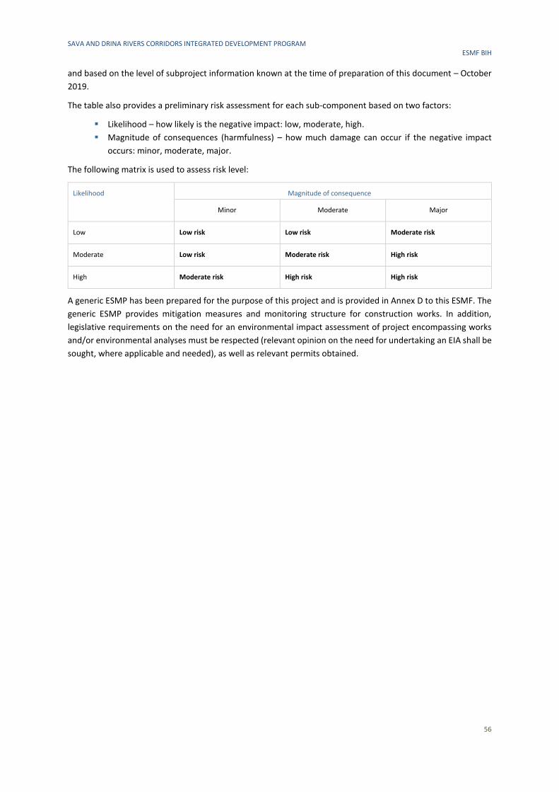
SAVA AND DRINA RIVERS CORRIDORS INTEGRATED DEVELOPMENT PROGRAM ESMF BIH
56
and based on the level of subproject information known at the time of preparation of this document – October
2019.
The table also provides a preliminary risk assessment for each sub-component based on two factors:
▪ Likelihood – how likely is the negative impact: low, moderate, high.
▪ Magnitude of consequences (harmfulness) – how much damage can occur if the negative impact
occurs: minor, moderate, major.
The following matrix is used to assess risk level:
Likelihood Magnitude of consequence
Minor Moderate Major
Low Low risk Low risk Moderate risk
Moderate Low risk Moderate risk High risk
High Moderate risk High risk High risk
A generic ESMP has been prepared for the purpose of this project and is provided in Annex D to this ESMF. The
generic ESMP provides mitigation measures and monitoring structure for construction works. In addition,
legislative requirements on the need for an environmental impact assessment of project encompassing works
and/or environmental analyses must be respected (relevant opinion on the need for undertaking an EIA shall be
sought, where applicable and needed), as well as relevant permits obtained.
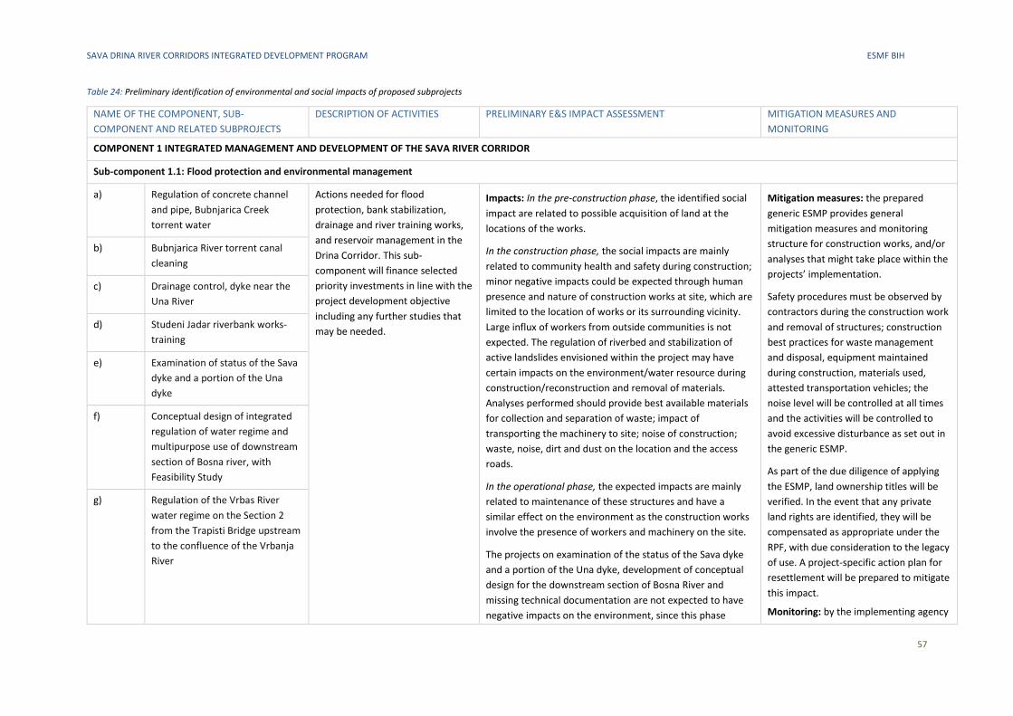
SAVA DRINA RIVER CORRIDORS INTEGRATED DEVELOPMENT PROGRAM ESMF BIH
57
Table 24: Preliminary identification of environmental and social impacts of proposed subprojects
NAME OF THE COMPONENT, SUB-
COMPONENT AND RELATED SUBPROJECTS
DESCRIPTION OF ACTIVITIES PRELIMINARY E&S IMPACT ASSESSMENT
MITIGATION MEASURES AND
MONITORING
COMPONENT 1 INTEGRATED MANAGEMENT AND DEVELOPMENT OF THE SAVA RIVER CORRIDOR
Sub-component 1.1: Flood protection and environmental management
a) Regulation of concrete channel
and pipe, Bubnjarica Creek
torrent water
Actions needed for flood
protection, bank stabilization,
drainage and river training works,
and reservoir management in the
Drina Corridor. This sub-
component will finance selected
priority investments in line with the
project development objective
including any further studies that
may be needed.
Impacts: In the pre-construction phase, the identified social
impact are related to possible acquisition of land at the
locations of the works.
In the construction phase, the social impacts are mainly
related to community health and safety during construction;
minor negative impacts could be expected through human
presence and nature of construction works at site, which are
limited to the location of works or its surrounding vicinity.
Large influx of workers from outside communities is not
expected. The regulation of riverbed and stabilization of
active landslides envisioned within the project may have
certain impacts on the environment/water resource during
construction/reconstruction and removal of materials.
Analyses performed should provide best available materials
for collection and separation of waste; impact of
transporting the machinery to site; noise of construction;
waste, noise, dirt and dust on the location and the access
roads.
In the operational phase, the expected impacts are mainly
related to maintenance of these structures and have a
similar effect on the environment as the construction works
involve the presence of workers and machinery on the site.
The projects on examination of the status of the Sava dyke
and a portion of the Una dyke, development of conceptual
design for the downstream section of Bosna River and
missing technical documentation are not expected to have
negative impacts on the environment, since this phase
Mitigation measures: the prepared
generic ESMP provides general
mitigation measures and monitoring
structure for construction works, and/or
analyses that might take place within the
projects’ implementation.
Safety procedures must be observed by
contractors during the construction work
and removal of structures; construction
best practices for waste management
and disposal, equipment maintained
during construction, materials used,
attested transportation vehicles; the
noise level will be controlled at all times
and the activities will be controlled to
avoid excessive disturbance as set out in
the generic ESMP.
As part of the due diligence of applying
the ESMP, land ownership titles will be
verified. In the event that any private
land rights are identified, they will be
compensated as appropriate under the
RPF, with due consideration to the legacy
of use. A project-specific action plan for
resettlement will be prepared to mitigate
this impact.
Monitoring: by the implementing agency
b) Bubnjarica River torrent canal
cleaning
c) Drainage control, dyke near the
Una River
d) Studeni Jadar riverbank works-
training
e) Examination of status of the Sava
dyke and a portion of the Una
dyke
f) Conceptual design of integrated
regulation of water regime and
multipurpose use of downstream
section of Bosna river, with
Feasibility Study
g) Regulation of the Vrbas River
water regime on the Section 2
from the Trapisti Bridge upstream
to the confluence of the Vrbanja
River
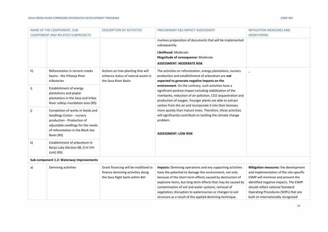
SAVA DRINA RIVER CORRIDORS INTEGRATED DEVELOPMENT PROGRAM ESMF BIH
58
NAME OF THE COMPONENT, SUB-
COMPONENT AND RELATED SUBPROJECTS
DESCRIPTION OF ACTIVITIES PRELIMINARY E&S IMPACT ASSESSMENT
MITIGATION MEASURES AND
MONITORING
involves preparation of documents that will be implemented
subsequently.
Likelihood: Moderate
Magnitude of consequence: Moderate
ASSESSMENT: MODERATE RISK
h) Reforestation in torrent creeks
basins - the Vrbanja River
tributaries
Actions on tree planting that will
enhance status of natural assets in
the Sava River Basin.
The activities on reforestation, energy plantations, nursery
production and establishment of arboretum are not
expected to generate negative impacts on the
environment. On the contrary, such activities have a
significant positive impact including stabilization of the
riverbanks, reduction of air pollution, CO2 sequestration and
production of oxygen. Younger plants are able to extract
carbon from the air and incorporate it into their biomass
more quickly than mature trees. Therefore, these activities
will significantly contribute to tackling the climate change
problem.
ASSESSMENT: LOW RISK
-
i) Establishment of energy
plantations and poplar
plantations in the Sava and Vrbas
River valleys inundation area (RS)
j) Completion of works in Seeds and
Seedlings Center - nursery
production - Production of
adjustable seedlings for the needs
of reforestation in the Black Sea
Basin (RS)
k) Establishment of arboretum in
Banja Luka (Section 68, Crni Vrh
Unit) (RS)
Sub-component 1.2: Waterway Improvements
a) Demining activities Grant financing will be mobilized to
finance demining activities along
the Sava Right bank within BiH
Impacts: Demining operations and any supporting activities
have the potential to damage the environment, not only
because of the short-term effects caused by destruction of
explosive items, but long-term effects that may be caused by
contamination of soil and water systems, removal of
vegetation, disruption to watercourses or changes to soil
structure as a result of the applied demining technique.
Mitigation measures: the development
and implementation of the site-specific
ESMP will minimize and prevent the
identified negative impacts. The ESMP
should reflect national Standard
Operating Procedures (SOPs) that are
built on internationally recognized
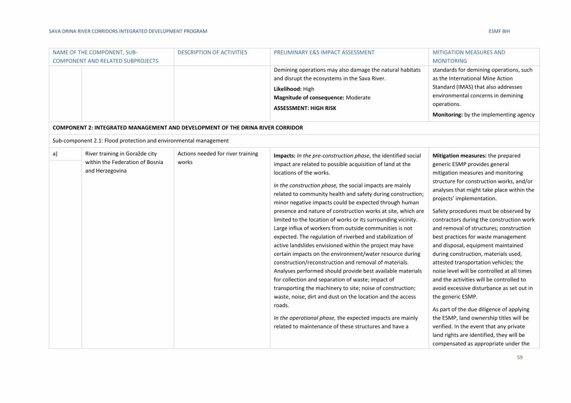
SAVA DRINA RIVER CORRIDORS INTEGRATED DEVELOPMENT PROGRAM ESMF BIH
59
NAME OF THE COMPONENT, SUB-
COMPONENT AND RELATED SUBPROJECTS
DESCRIPTION OF ACTIVITIES PRELIMINARY E&S IMPACT ASSESSMENT
MITIGATION MEASURES AND
MONITORING
Demining operations may also damage the natural habitats
and disrupt the ecosystems in the Sava River.
Likelihood: High
Magnitude of consequence: Moderate
ASSESSMENT: HIGH RISK
standards for demining operations, such
as the International Mine Action
Standard (IMAS) that also addresses
environmental concerns in demining
operations.
Monitoring: by the implementing agency
COMPONENT 2: INTEGRATED MANAGEMENT AND DEVELOPMENT OF THE DRINA RIVER CORRIDOR
Sub-component 2.1: Flood protection and environmental management
a) River training in Goražde city
within the Federation of Bosnia
and Herzegovina
Actions needed for river training
works Impacts: In the pre-construction phase, the identified social
impact are related to possible acquisition of land at the
locations of the works.
In the construction phase, the social impacts are mainly
related to community health and safety during construction;
minor negative impacts could be expected through human
presence and nature of construction works at site, which are
limited to the location of works or its surrounding vicinity.
Large influx of workers from outside communities is not
expected. The regulation of riverbed and stabilization of
active landslides envisioned within the project may have
certain impacts on the environment/water resource during
construction/reconstruction and removal of materials.
Analyses performed should provide best available materials
for collection and separation of waste; impact of
transporting the machinery to site; noise of construction;
waste, noise, dirt and dust on the location and the access
roads.
In the operational phase, the expected impacts are mainly
related to maintenance of these structures and have a
Mitigation measures: the prepared
generic ESMP provides general
mitigation measures and monitoring
structure for construction works, and/or
analyses that might take place within the
projects’ implementation.
Safety procedures must be observed by
contractors during the construction work
and removal of structures; construction
best practices for waste management
and disposal, equipment maintained
during construction, materials used,
attested transportation vehicles; the
noise level will be controlled at all times
and the activities will be controlled to
avoid excessive disturbance as set out in
the generic ESMP.
As part of the due diligence of applying
the ESMP, land ownership titles will be
verified. In the event that any private
land rights are identified, they will be
compensated as appropriate under the
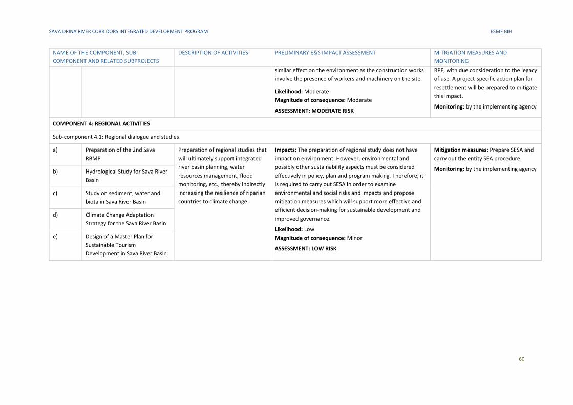
SAVA DRINA RIVER CORRIDORS INTEGRATED DEVELOPMENT PROGRAM ESMF BIH
60
NAME OF THE COMPONENT, SUB-
COMPONENT AND RELATED SUBPROJECTS
DESCRIPTION OF ACTIVITIES PRELIMINARY E&S IMPACT ASSESSMENT
MITIGATION MEASURES AND
MONITORING
similar effect on the environment as the construction works
involve the presence of workers and machinery on the site.
Likelihood: Moderate
Magnitude of consequence: Moderate
ASSESSMENT: MODERATE RISK
RPF, with due consideration to the legacy
of use. A project-specific action plan for
resettlement will be prepared to mitigate
this impact.
Monitoring: by the implementing agency
COMPONENT 4: REGIONAL ACTIVITIES
Sub-component 4.1: Regional dialogue and studies
a) Preparation of the 2nd Sava
RBMP
Preparation of regional studies that
will ultimately support integrated
river basin planning, water
resources management, flood
monitoring, etc., thereby indirectly
increasing the resilience of riparian
countries to climate change.
Impacts: The preparation of regional study does not have
impact on environment. However, environmental and
possibly other sustainability aspects must be considered
effectively in policy, plan and program making. Therefore, it
is required to carry out SESA in order to examine
environmental and social risks and impacts and propose
mitigation measures which will support more effective and
efficient decision-making for sustainable development and
improved governance.
Likelihood: Low
Magnitude of consequence: Minor
ASSESSMENT: LOW RISK
Mitigation measures: Prepare SESA and
carry out the entity SEA procedure.
Monitoring: by the implementing agency b) Hydrological Study for Sava River
Basin
c) Study on sediment, water and
biota in Sava River Basin
d) Climate Change Adaptation
Strategy for the Sava River Basin
e) Design of a Master Plan for
Sustainable Tourism
Development in Sava River Basin
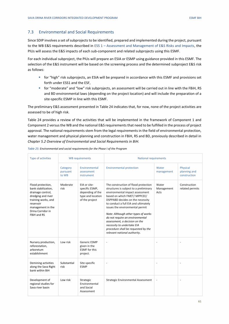
SAVA DRINA RIVER CORRIDORS INTEGRATED DEVELOPMENT PROGRAM ESMF BIH
61
7.3 Environmental and Social Requirements
Since SDIP involves a set of subprojects to be identified, prepared and implemented during the project, pursuant
to the WB E&S requirements described in ESS 1 – Assessment and Management of E&S Risks and Impacts, the
PIUs will assess the E&S impacts of each sub-component and related subprojects using this ESMF.
For each individual subproject, the PIUs will prepare an ESIA or ESMP using guidance provided in this ESMF. The
selection of the E&S instrument will be based on the screening process and the determined subproject E&S risk
as follows:
▪ for “high” risk subprojects, an ESIA will be prepared in accordance with this ESMF and provisions set
forth under ESS1 and the ESF,
▪ for “moderate” and “low” risk subprojects, an assessment will be carried out in line with the FBiH, RS
and BD environmental laws (depending on the project location) and will include the preparation of a
site-specific ESMP in line with this ESMF.
The preliminary E&S assessment presented in Table 24 indicates that, for now, none of the project activities are
assessed to be of high risk.
Table 24 provides a review of the activities that will be implemented in the framework of Component 1 and
Component 2 versus the WB and the national E&S requirements that need to be fulfilled in the process of project
approval. The national requirements stem from the legal requirements in the field of environmental protection,
water management and physical planning and construction in FBiH, RS and BD, previously described in detail in
Chapter 5.2 Overview of Environmental and Social Requirements in BiH.
Table 25: Environmental and social requirements for the Phase I of the Program
Type of activities WB requirements National requirements
Category pursuant to WB
Environmental assessment instrument
Environmental protection Water management
Physical planning and construction
Flood protection, bank stabilization, drainage control, dredging and river training works, and reservoir management in the Drina Corridor in FBiH and RS
Moderate risk
EIA or site-specific ESMP, depending of the type and location of the project
The construction of flood protection structures is subject to a preliminary environmental impact assessment based on which FMET/ MPPCEE/ DSPPABD decides on the necessity to conduct a full EIA and ultimately issues the environmental permit
Note: Although other types of works do not require an environmental assessment, a decision on the necessity to undertake EIA procedure shall be requested by the relevant national authority.
Water Management Acts
Construction related permits
Nursery production, reforestation, arboretum establishment
Low risk Generic ESMP given in the ESMF for this project.
- - -
Demining activities along the Sava Right bank within BiH
Substantial risk
Site-specific ESMP
- - -
Development of regional studies for Sava river basin
Low risk Strategic Environmental and Social Assessment
Strategic Environmental Assessment - -
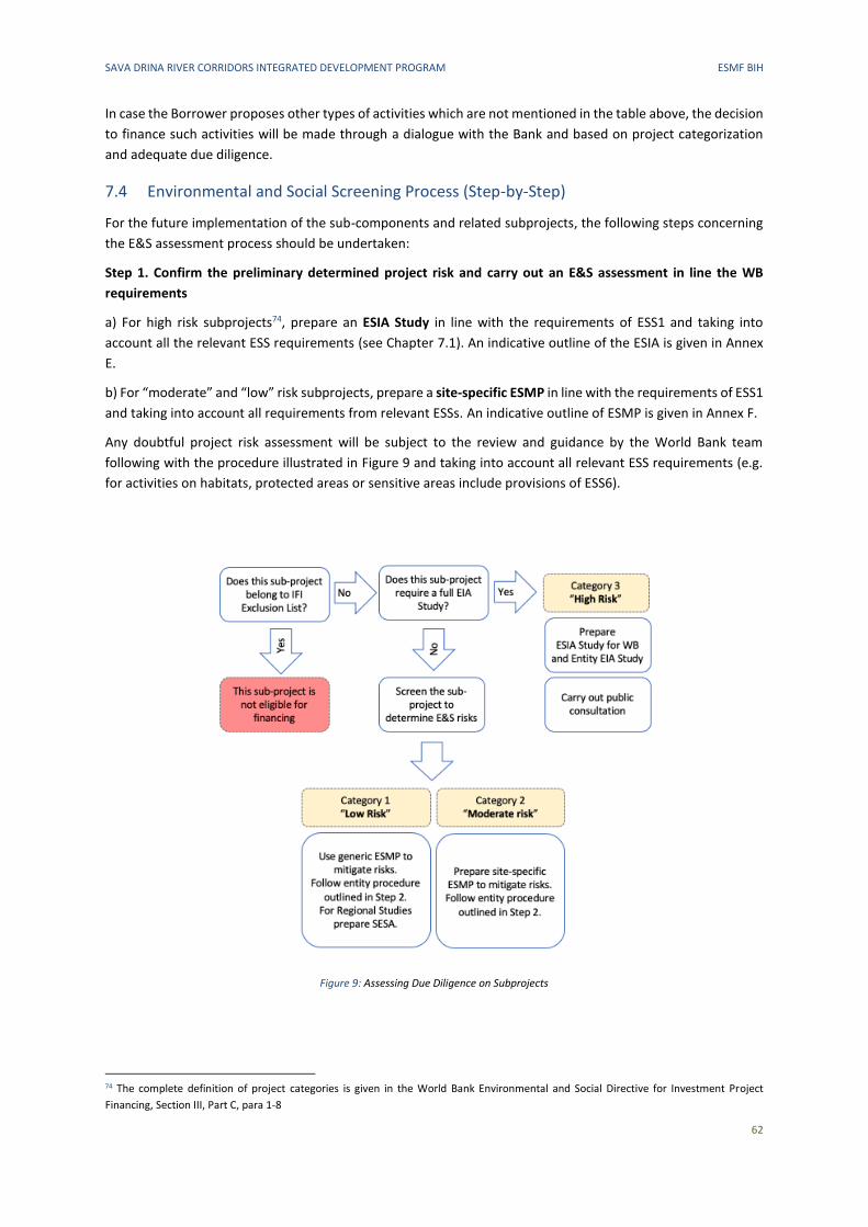
SAVA DRINA RIVER CORRIDORS INTEGRATED DEVELOPMENT PROGRAM ESMF BIH
62
In case the Borrower proposes other types of activities which are not mentioned in the table above, the decision
to finance such activities will be made through a dialogue with the Bank and based on project categorization
and adequate due diligence.
7.4 Environmental and Social Screening Process (Step-by-Step)
For the future implementation of the sub-components and related subprojects, the following steps concerning
the E&S assessment process should be undertaken:
Step 1. Confirm the preliminary determined project risk and carry out an E&S assessment in line the WB
requirements
a) For high risk subprojects74, prepare an ESIA Study in line with the requirements of ESS1 and taking into
account all the relevant ESS requirements (see Chapter 7.1). An indicative outline of the ESIA is given in Annex
E.
b) For “moderate” and “low” risk subprojects, prepare a site-specific ESMP in line with the requirements of ESS1
and taking into account all requirements from relevant ESSs. An indicative outline of ESMP is given in Annex F.
Any doubtful project risk assessment will be subject to the review and guidance by the World Bank team
following with the procedure illustrated in Figure 9 and taking into account all relevant ESS requirements (e.g.
for activities on habitats, protected areas or sensitive areas include provisions of ESS6).
Figure 9: Assessing Due Diligence on Subprojects
74 The complete definition of project categories is given in the World Bank Environmental and Social Directive for Investment Project
Financing, Section III, Part C, para 1-8
SAVA DRINA RIVER CORRIDORS INTEGRATED DEVELOPMENT PROGRAM ESMF BIH
63
According to the preliminary risk assessment, the following actions will be taken:
Type of activities Action to be taken Result of the action
Flood protection, bank stabilization, drainage control, dredging and river training works, and reservoir management in the Drina Corridor in FBiH and RS
Prepare an ESIA or site-specific ESMP (depending on the categorization and the requirements of the local permitting process) and follow guidance on disclosure and consultations. In the ESIA or site-specific ESMP, include sections related to all applicable ESSs.
WB requirements on E&S impacts mitigation and monitoring included in the tender dossier.
Nursery production, reforestation, arboretum establishment
Assess impacts against the generic ESMP given in this ESMF and follow guidance on disclosure and consultations.
WB requirements on E&S impacts mitigation and monitoring included in the tender dossier.
Demining activities along the Sava Right bank within BiH
Develop site-specific ESMP and follow guidance on disclosure and consultations. In the site-specific ESMP, include sections related to all applicable ESSs.
WB requirements on E&S impacts mitigation and monitoring included in the tender dossier.
Development of regional studies for Sava river basin
Prepare Strategic Environmental and Social Assessment (SESA) for each study considering the full range of environmental and social risks and impacts incorporated in ESS1 through 10
Improved regional studies based on the conclusions from the SESA.
Additionally, PIUs will be required to:
▪ in case of any land acquisition issues identified, prepare a site-specific Resettlement Plan in line with
the guidance given in the Resettlement Framework developed for the SDIP project,
▪ implement the developed Labor Management Procedure, and update it as necessary,
▪ undertake stakeholder engagement and disclose appropriate information in accordance with the
Stakeholder Engagement Plan developed for the SDIP project,
▪ conduct monitoring and reporting on the E&S performance of the SDIP project against the program-
specific ESMF, RPF, SEP and LMP.
Step 2. Carry out an environmental assessment in line with the FBiH, RS or BD requirements
For the activities listed in the table below, carry out an environmental assessment in FBIH, RS or BD, depending
on the subproject location, as explained in Chapter 5.2.1 Environmental Assessment Procedure.
If the assessment indicates that a subproject is high risk and requires the development of an ESIA according to
WB standards (Step 1), the WB ESIA study can be used in the entity/BD EIA procedure.
For subprojects for which the Bank requires the development of a site-specific ESMP, the ESMP requirements
shall be integrated in the environmental documentation submitted to responsible authorities.
Type of activities Action to be taken Result of the action
Flood protection structures In FBiH and BD, prepare a Request for environmental permit and submit it to FMET or DSPPA BD, depending on the project location. Based on the Request, the responsible institution will decide on the necessity to conduct a full EIA in case of which an EIA study will be requested. The responsible institution will issue the environmental permit based on the Request or full EIA study, whichever is required by the procedure. In RS, prepare an Application for preliminary EIA and submit it to RS MPPCEE. Based on the Application, the ministry will decide on the necessity to conduct a full EIA in case of which an EIA study will be requested. The responsible institution will issue the environmental permit based on the Request or full EIA study, whichever is required by the procedure.
Obtained environmental permit

SAVA DRINA RIVER CORRIDORS INTEGRATED DEVELOPMENT PROGRAM ESMF BIH
64
Type of activities Action to be taken Result of the action
Nursery production, reforestation, arboretum establishment
No action needed -
Demining activities along the Sava Right bank within BiH
No action needed -
Development of regional studies for Sava river basin
Translate SESA prepared from the Bank and carry out the entity SEA procedure including public consultation.
Improved regional studies based on the conclusions from the SESA.
Step 3. Organize consultations with stakeholders at the location closest to the project implementation site in
line with the requirements of the SEP developed for the SDIP. If the subprojects require the development of a
nationally required and regulated EIA, such process also includes public involvement, public hearings and a
publicly disclosed study in the manner prescribed by the legislation of each entity/BD (comments on public
document recorded and responses provided by the institution/organization responsible for preparing the EIA).
Ensure such public consultations are also in line with the requirements of WB and the SEP. For certain activities,
a decision on the necessity to undertake an EIA procedure shall be requested by the relevant national authority.
Step 4. (If needed and where applicable) Obtain various permits and approvals
▪ Water Management Acts in line with the requirements of the Water Law as described in Chapter
5.2.3,
▪ Construction related acts in line with the requirements of the construction regulations as described
in Chapter 5.2.4.
7.5 Labor Management
The labor categorization within projects financed by the WB is described in Chapter 5.1 The World Bank
Requirements. According to such categorization, project workers include:
▪ Direct workers (Entity Ministries’ staff involved in the project (civil servants) and external consultants
for E&S issues, to be hired for Project purposes)
▪ Contracted workers (workers of companies which would provide services under Project Component 1,
such as cleaning up of an solid waste dump site in Brcko District, revitalization of protected areas,
construction and rehabilitation of embankments at selected priority areas along the Sava River
Corridor, acquisition of equipment for the rehabilitation and expansion of cargo and vessel handling
infrastructure, rehabilitation of embankments for flood protection, dredging, etc.).
Contractors (companies which would provide services) would be required to comply with the current
legislation on labor and safety at work and to the requirements prescribed in this Framework.
Pursuant to WB requirements, a Labor Management Procedure has been developed as a separate document.
The procedure aims to ensure fair treatment of workers and provision of safe and healthy working conditions.
Contractors’ labor management compliance with local legislation requirements related to labor and safety at
work would be monitored based as described in Chapter 7.6 Monitoring and Reporting. In case any irregularities
are identified based on such reports or the project grievance redress mechanism, PIUs would notify the
responsible Labor Inspection.
7.6 Monitoring and Reporting
The PIUs shall monitor the implementation of this Framework, both at overall Program level and individual
subproject level. The PIUs shall ensure that the requirements of the site-specific ESMPs and environmental
permit are included in employer’s requirements. Within their usual monitoring activities, PIUs will perform
SAVA DRINA RIVER CORRIDORS INTEGRATED DEVELOPMENT PROGRAM ESMF BIH
65
monitoring (including on-site monitoring, as needed) to ensure that Contractors comply with their contractual
obligations.
It is the responsibility of the Contractor to ensure the proper execution of works, according to prescribed
measures and in line with national and international standards. Therefore, the Contractor should appoint a
person responsible for environment protection (B.Sc. environmental engineering) with adequate experience to
be responsible for the implementation of all environment protection requirements and ESMP implementation.
The appointed person shall ensure compliance with environmental standards and is responsible for
environmental protection according to the ESMP, in line with clearly defined tasks and responsibilities, which
include, among others: works are executed in line with good construction practices, waste is adequately
managed at the construction site, environmental protection issues are communicated with the supervising body
and the local community. The works are supervised by the nominated supervising body, which controls that the
activities are taken in line with the environmental management plan. Preparation of site-specific ESMPs for
priority investments will be undertaken by qualified staff. They will also be responsible for the initial
environmental screening documents, checklists and other environmentally related documentation during the
Program execution. In each PIU, a dedicated environmental specialist will be in charge of this process, as well as
environmental monitoring and reporting. Details of these arrangements will be fully specified in the Project
Operational Manual.
Contractors’ labor management compliance with local legislation requirements related to labor and safety at
work would be monitored based on the basis of Reports on Compliance of Conditions of Work with the ESS 2,
which the contractors shall submit to the PIUs and Supervision Consultant (external consultant) on a semi-annual
basis. The format of the report is provided in LMP’s Annex.
The PIUs shall establish and maintain records on information and engagement of all stakeholders in accordance
with the SEP.
The PIUs will report on regular basis to WB on subproject screening, approval and monitoring results.
7.7 Demining of the Right Bank of the Sava River
Background
The 1992-1995 conflict related to the breakup of Yugoslavia left BiH with considerable mine contamination.
Since 1996, a concerted effort by BiH’s Demining Commission, the Bosnia and Herzegovina Mine Action Center
(BHMAC), and other governmental and non-governmental agencies and organizations, with sustained financial
and technical support from donors, international organizations, and international technical operators with
demining expertise, has led to the identification and destruction of nearly 66,000 anti-personnel mines, more
than 8,500 anti-tank mines, and nearly 60,000 pieces of unexploded ordnance (UXO) through painstaking work
of technical surveying and land clearance. Most of the technical guidance and coordination that underpinned
this effort was provided by BHMAC as BiH’s lead technical agency for demining. This organization is directly
under the Demining Commission of BiH of the Ministry of Civil Affairs of BiH and evolved from the United Nations
Mine Action Center UNMAC, based on the law regulating mining from 2002. BHMAC is the only authorized body
that maintains the database of all areas with the risk of landmines, provides technical and safety standards,
accredits companies for demining, and does all tasks related to overseeing mining activities. BHMAC has its
headquarters in Sarajevo and two entity offices: Office BHMAC Sarajevo and Office BHMAC Banja Luka, along
with eight regional offices. These offices conduct the coordination of eight regional offices operations, focused
on planning, surveys and quality assurance/quality control.
As of 2003, BHMAC developed and adopted Standing Operational Procedures for Humanitarian Demining (SOP)
to ensure that all mine action in BiH was conducted in a safe, efficient, and technically robust manner, in
accordance with all applicable national laws and consistent with BiH’s international obligations regarding
demining. BHMAC’s SOPs are consistent with the International Mine Action Standards (IMAS), which are the
SAVA DRINA RIVER CORRIDORS INTEGRATED DEVELOPMENT PROGRAM ESMF BIH
66
standards applicable to all mine action operations conducted by the United Nations (UN), as initially endorsed
by the UN Inter-Agency Coordination Group on Mine Action in 2001.
Despite these accomplishments, the magnitude of the challenge is such that mine contamination persists in BiH
to this day, nearly 25 years after the end of conflict—as a result of which BiH is the most heavily mined country
in Europe. According to BHMAC, as of 2018, there was a total suspected mined area of 1,018 km2, or
approximately 2.1% of BiH’s territorial extension. This area comprises 8,525 suspected micro-locations that may
hold an estimated 79,000 mines/unexploded ordnance (UXO). Some 15% of the population of BiH is estimated
to be at risk of exposure to micro-locations contaminated with mines.
Rationale for demining of the right bank of Sava River
The deployment of mines in BiH territory was carried out primarily along jurisdiction demarcation lines, one of
the most visible of which being the banks of the Sava River, a shared natural resource which today marks an
important portion of the border between BiH and Croatia (as well as, though to a much smaller extent of river
km, a portion of the border between BiH and Serbia). The right bank of the Sava river, within BiH, remains
exposed to the risk of mines—this being a major reason why economic development of this river has been
minimal since the end of the regional conflict in the 1990s. The presence of mines and UXO on the right bank of
the Sava River within BiH is not only a threat to individuals or communities that may be exposed to or come
close to those locations, but also a de facto barrier and impediment to infrastructure investments and economic
activity in and linked to the Sava River—a major natural resource of significant socioeconomic and ecological
potential at the national and regional level—on both sides of the border (the left bank of the river, in Croatian
territory, has since been cleared of mines to a great extent75).
In light of the socioeconomic and ecological significance of the Sava River (as elaborated on in Chapters 3 and 4
on the baseline characteristics of the area), there has been a longstanding interest in removing mines and UXO
from the Sava’s right bank in BiH (including demining and UXO removal in a highly selective manner in the Sava
river fairway). Demining is also a prerequisite for civil works execution in the key waterway sections to be
improved later in the program.
It is in this context that SDIP proposes the mobilization of grant funding to demine the right bank of the Sava
river in BiH, thereby effectively unlocking the river to investments and myriad economic activities linked to the
river for decades to come, including key navigation and port expansion investments proposed under SDIP’s
Phase II.
The estimated cost of demining of the Sava River right bank is 8.2M Euros and will take about 10 to 16 months
to complete.
Preparatory activities
The demining needs of the right bank of the Sava river have been mapped. BHMAC has already produced detailed engineering designs for the demining activities, which will need to be updated prior to commencement of civil works. For purposes of updating, BHMAC plans to use drones and site visits to ascertain the actual situation. It is expected that these investigations will take approx. 1 month. According to BHMAC76, there are 144 identified sites, covering an area of 9.9 million m2 along the Sava River bank right that need to be demined. These sites are located in 10 municipalities:
• Odžak
• Brčko
• Domaljevac Šamac
75 The demining of the left bank has not been completed, as there is still fear of new floods which could lead to the moving of mines from
the right bank in BiH to the left bank in Croatia. Therefore, the demining of the left bank will be fully completed after (or in parallel) to the
demining of the right bank. 76 Information provided in January 2019
• Orašje
• Kozarska Dubica
• Gradiška
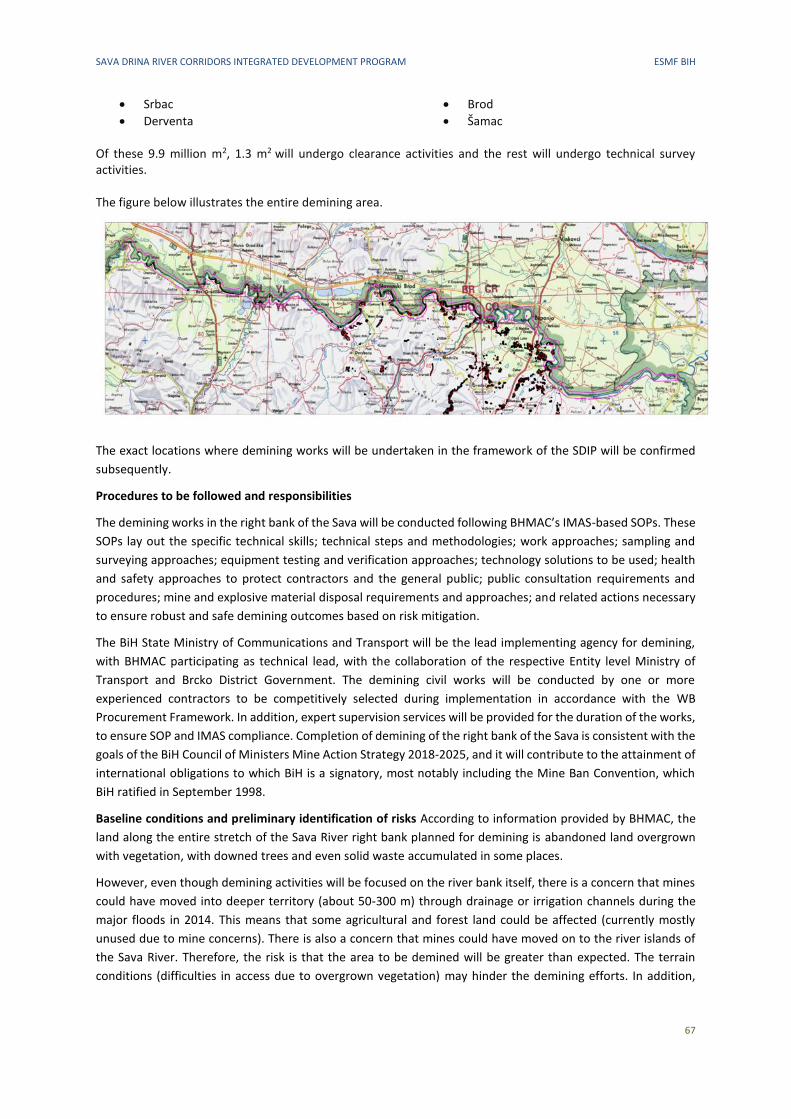
SAVA DRINA RIVER CORRIDORS INTEGRATED DEVELOPMENT PROGRAM ESMF BIH
67
• Srbac
• Derventa
• Brod
• Šamac Of these 9.9 million m2, 1.3 m2 will undergo clearance activities and the rest will undergo technical survey activities. The figure below illustrates the entire demining area.
The exact locations where demining works will be undertaken in the framework of the SDIP will be confirmed
subsequently.
Procedures to be followed and responsibilities
The demining works in the right bank of the Sava will be conducted following BHMAC’s IMAS-based SOPs. These
SOPs lay out the specific technical skills; technical steps and methodologies; work approaches; sampling and
surveying approaches; equipment testing and verification approaches; technology solutions to be used; health
and safety approaches to protect contractors and the general public; public consultation requirements and
procedures; mine and explosive material disposal requirements and approaches; and related actions necessary
to ensure robust and safe demining outcomes based on risk mitigation.
The BiH State Ministry of Communications and Transport will be the lead implementing agency for demining,
with BHMAC participating as technical lead, with the collaboration of the respective Entity level Ministry of
Transport and Brcko District Government. The demining civil works will be conducted by one or more
experienced contractors to be competitively selected during implementation in accordance with the WB
Procurement Framework. In addition, expert supervision services will be provided for the duration of the works,
to ensure SOP and IMAS compliance. Completion of demining of the right bank of the Sava is consistent with the
goals of the BiH Council of Ministers Mine Action Strategy 2018-2025, and it will contribute to the attainment of
international obligations to which BiH is a signatory, most notably including the Mine Ban Convention, which
BiH ratified in September 1998.
Baseline conditions and preliminary identification of risks According to information provided by BHMAC, the
land along the entire stretch of the Sava River right bank planned for demining is abandoned land overgrown
with vegetation, with downed trees and even solid waste accumulated in some places.
However, even though demining activities will be focused on the river bank itself, there is a concern that mines
could have moved into deeper territory (about 50-300 m) through drainage or irrigation channels during the
major floods in 2014. This means that some agricultural and forest land could be affected (currently mostly
unused due to mine concerns). There is also a concern that mines could have moved on to the river islands of
the Sava River. Therefore, the risk is that the area to be demined will be greater than expected. The terrain
conditions (difficulties in access due to overgrown vegetation) may hinder the demining efforts. In addition,
SAVA DRINA RIVER CORRIDORS INTEGRATED DEVELOPMENT PROGRAM ESMF BIH
68
more complex operations in the river itself may be needed, such as underwater diving at certain locations, e.g.
around river islands, bridges, etc.
Land ownership is a mix of public and private land – the river bank is publicly owned, whereas the potentially
affected agricultural and forest land into which the mines could have moved is private land – but is estimated at
only 2-3% or even less of the entire land stretch.
A formal risk assessment has not been carried by BHMAC to date. Specific risks will be identified during the
phase of developing a site-specific ESMP (see below).
Site-specific ESMP
During SDIP implementation, and upon confirmation of grant financing, a Site-specific Environmental and Social
Management Plan (ESMP) will be developed to complement and further inform the way demining activities will
be conducted. This ESMP will be consulted publicly and disclosed prior to the commencement of civil works, and
in a manner consistent with SOP and IMAS principles.
The ESMP is expected to set forth the requirements to be followed by contractors and project implementing
agencies regarding such key actions as establishing security zones around expected demining areas; marking
demining areas; developing demining works according to established security, safety, and technical protocols
(SOPs and IMAS); providing full personal protection, including insurance provision, for all demining personnel,
and deploying protections for local populations deemed exposed to the demining zones (if any); and ensuring
awareness and the sharing of information about the demining works, with proper disclosure of plans and
timelines, appropriate signage and warnings, expected rules and behaviors by contractors and personnel, and
recommendations to local communities. As part of the ESMP process, BHMAC will update existing surveys and
mappings of mined areas to more accurately estimate the current and up-to-date extent and nature of the
demining need, the likely social and environmental disruption that demining activities may cause, and the key
measures to mitigate this disruption. As part of the public disclosure and outreach, the ESMP will also highlight
the overall positive impact that demining is expected to have, by de-risking and re-opening up the currently
affected areas along the Sava river right bank for not only economic but also ecological activity.
The ESMP will be prepared in line with approved ToRs once the demining locations are finalized. The ESMP preparation and review process is also be reflected in the ESCP.
SAVA DRINA RIVER CORRIDORS INTEGRATED DEVELOPMENT PROGRAM ESMF BIH
69
8 PUBLIC CONSULTATIONS PROCESS
The WB standard on Stakeholder Engagement and Information Disclosure 10 (“ESS10“) recognizes the
importance of open and transparent engagement between the Borrower and project stakeholders as an
essential element of good international practice. Effective stakeholder engagement can improve the E&S
sustainability of projects, enhance project acceptance, and make a significant contribution to successful project
design and implementation.
Pursuant to the World Bank requirements, stakeholder engagement is an inclusive process implemented
throughout project life-cycle, and it is most effective if launched at early stage of project development.
Engagement should begin as early as possible at project preparation, as timely identification of and consultation
with the stakeholders enable views and opinions of these groups to be taken into account in the project design
and implementation.
In line with these requirements, the set of documents that will guide the further E&S due diligence during sub-
project implementation based on the 2018 WB E&S Framework including:
▪ the Environmental and Social Management Framework (ESMF)
▪ the Environmental and Social Commitment Plan (ESCP)
▪ the Stakeholder Engagement Plan (SEP)
▪ the Resettlement Policy Framework (RPF) and
▪ the Labor Management Plan (LMP)
was disclosed to the public on December 31, 2019 through the website of the Ministry of Agriculture and Rural
Development (link: http://www.vladars.net/sr-SP-
Cyrl/Vlada/Ministarstva/mps/Pages/default.aspx#collapsible1 under the link „Јединица за координацију
пољопривредних пројеката -набавке“).
On January 22, 2020, the PIU announced that the public hearing took place on January 29, 2020 in the City of
Banja Luka. The invitations were sent to 20 local self-governments in the Sava and Drina River Basins (Banja
Luka, Prijedor, Kostajnica, Milići, Doboj, Laktaši, Bijeljina, Šamac, Zvornik, Višegrad, Foča, Šamac, Modriča,
Kozarska Dubica, Derventa, Gradiška, Čelinac, Brod, Kotor Varoš, Novi Grad). 10 local self-governments officially
confirmed the receipt of the invitation and their participation. They also published documents on their
webpages.
The minutes from the public hearing with an accompanying list of participants and photographs is included in
Annex G.
This ESMF has been updated to include the outcomes of the public consultation process.
SAVA DRINA RIVER CORRIDORS INTEGRATED DEVELOPMENT PROGRAM ESMF BIH
70
ANNEXES
A Sites of Cultural and Historical Heritage in Municipalities of the DRB
B Sites of Cultural and Historical Heritage in Municipalities of the
C Overview of Cantonal Ministries Responsible for Water Management and Environmental Issues
D Generic Environmental and Social Management Plan for the Project
E Indicative outline of ESIA
F Indicative outline of site-specific ESMP
G Minutes from the public consultations
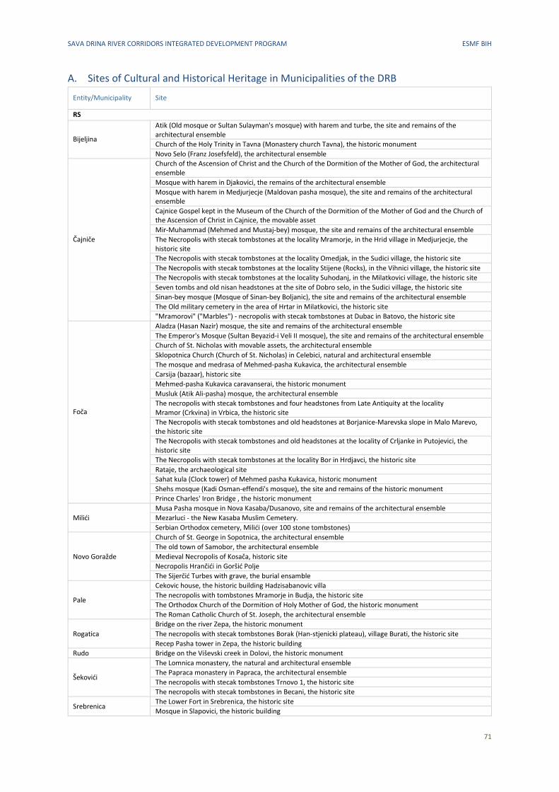
SAVA DRINA RIVER CORRIDORS INTEGRATED DEVELOPMENT PROGRAM ESMF BIH
71
A. Sites of Cultural and Historical Heritage in Municipalities of the DRB
Entity/Municipality Site
RS
Bijeljina
Atik (Old mosque or Sultan Sulayman's mosque) with harem and turbe, the site and remains of the architectural ensemble
Church of the Holy Trinity in Tavna (Monastery church Tavna), the historic monument
Novo Selo (Franz Josefsfeld), the architectural ensemble
Čajniče
Church of the Ascension of Christ and the Church of the Dormition of the Mother of God, the architectural ensemble
Mosque with harem in Djakovici, the remains of the architectural ensemble
Mosque with harem in Medjurjecje (Maldovan pasha mosque), the site and remains of the architectural ensemble
Cajnice Gospel kept in the Museum of the Church of the Dormition of the Mother of God and the Church of the Ascension of Christ in Cajnice, the movable asset
Mir‐Muhammad (Mehmed and Mustaj‐bey) mosque, the site and remains of the architectural ensemble
The Necropolis with stecak tombstones at the locality Mramorje, in the Hrid village in Medjurjecje, the historic site
The Necropolis with stecak tombstones at the locality Omedjak, in the Sudici village, the historic site
The Necropolis with stecak tombstones at the locality Stijene (Rocks), in the Vihnici village, the historic site
The Necropolis with stecak tombstones at the locality Suhodanj, in the Milatkovici village, the historic site
Seven tombs and old nisan headstones at the site of Dobro selo, in the Sudici village, the historic site
Sinan‐bey mosque (Mosque of Sinan‐bey Boljanic), the site and remains of the architectural ensemble
The Old military cemetery in the area of Hrtar in Milatkovici, the historic site
"Mramorovi" ("Marbles") ‐ necropolis with stecak tombstones at Dubac in Batovo, the historic site
Foča
Aladza (Hasan Nazir) mosque, the site and remains of the architectural ensemble
The Emperor's Mosque (Sultan Beyazid‐i Veli II mosque), the site and remains of the architectural ensemble
Church of St. Nicholas with movable assets, the architectural ensemble
Sklopotnica Church (Church of St. Nicholas) in Celebici, natural and architectural ensemble
The mosque and medrasa of Mehmed‐pasha Kukavica, the architectural ensemble
Carsija (bazaar), historic site
Mehmed‐pasha Kukavica caravanserai, the historic monument
Musluk (Atik Ali‐pasha) mosque, the architectural ensemble
The necropolis with stecak tombstones and four headstones from Late Antiquity at the locality Mramor (Crkvina) in Vrbica, the historic site
The Necropolis with stecak tombstones and old headstones at Borjanice‐Marevska slope in Malo Marevo, the historic site
The Necropolis with stecak tombstones and old headstones at the locality of Crljanke in Putojevici, the historic site
The Necropolis with stecak tombstones at the locality Bor in Hrdjavci, the historic site
Rataje, the archaeological site
Sahat kula (Clock tower) of Mehmed pasha Kukavica, historic monument
Shehs mosque (Kadi Osman‐effendi's mosque), the site and remains of the historic monument
Prince Charles' Iron Bridge , the historic monument
Milići
Musa Pasha mosque in Nova Kasaba/Dusanovo, site and remains of the architectural ensemble
Mezarluci - the New Kasaba Muslim Cemetery.
Serbian Orthodox cemetery, Milići (over 100 stone tombstones)
Novo Goražde
Church of St. George in Sopotnica, the architectural ensemble
The old town of Samobor, the architectural ensemble
Medieval Necropolis of Kosača, historic site
Necropolis Hrančići in Goršić Polje
The Sijerčić Turbes with grave, the burial ensamble
Pale
Cekovic house, the historic building Hadzisabanovic villa
The necropolis with tombstones Mramorje in Budja, the historic site
The Orthodox Church of the Dormition of Holy Mother of God, the historic monument
The Roman Catholic Church of St. Joseph, the architectural ensemble
Rogatica
Bridge on the river Zepa, the historic monument
The necropolis with stecak tombstones Borak (Han‐stjenicki plateau), village Burati, the historic site
Recep Pasha tower in Zepa, the historic building
Rudo Bridge on the Viševski creek in Dolovi, the historic monument
Šekovići
The Lomnica monastery, the natural and architectural ensemble
The Papraca monastery in Papraca, the architectural ensemble
The necropolis with stecak tombstones Trnovo 1, the historic site
The necropolis with stecak tombstones in Becani, the historic site
Srebrenica The Lower Fort in Srebrenica, the historic site
Mosque in Slapovici, the historic building
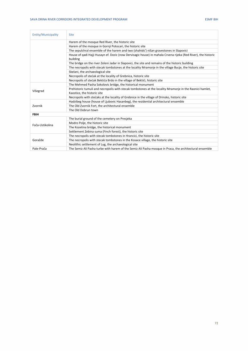
SAVA DRINA RIVER CORRIDORS INTEGRATED DEVELOPMENT PROGRAM ESMF BIH
72
Entity/Municipality Site
Harem of the mosque Red River, the historic site
Harem of the mosque in Gornji Potocari, the historic site
The sepulchral ensemble of the harem and two (shahids’) nišan gravestones in Slapovici
House of qadi Hajji Husayn ef. Dozic (now Dervisagic house) in mahala Crvena rijeka (Red River), the historic building
The bridge on the river Zeleni Jadar in Slapovici, the site and remains of the historic building
The necropolis with stecak tombstones at the locality Mramorje in the village Bucje, the historic site
Skelani, the archaeological site
Necropolis of stećak at the locality of Grebnica, historic site
Necropolis of stećak Bektića Brdo in the village of Bektići, historic site
Višegrad
The Mehmed Pasha Sokolovic bridge, the historical monument
Prehistoric tumuli and necropolis with stecak tombstones at the locality Mramorje in the Raonici hamlet, Kaostice, the historic site
Necropolis with stećaks at the locality of Grebnice in the village of Drinsko, historic site
Zvornik
Hadzibeg house (house of Ljubovic Hasanbeg), the residential architectural ensemble
The Old Zvornik Fort, the architectural ensemble
The Old Dobrun town
FBiH
Foča‐Ustikolina
The burial ground of the cemetery on Presjeka
Modro Polje, the historic site
The Kozetina bridge, the historical monument
Settlement Zebina suma (Finch forest), the historic site
Goražde
The necropolis with stecak tombstones in Hrancici, the historic site
The necropolis with stecak tombstones in the Kosace village, the historic site
Neolithic settlement of Lug, the archaeological site
Pale‐Prača The Semiz Ali Pasha turbe with harem of the Semiz Ali Pasha mosque in Praca, the architectural ensemble
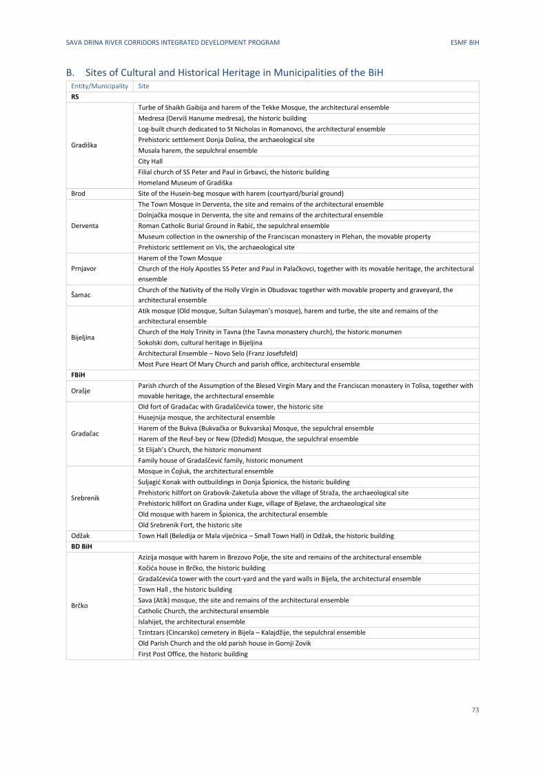
SAVA DRINA RIVER CORRIDORS INTEGRATED DEVELOPMENT PROGRAM ESMF BIH
73
B. Sites of Cultural and Historical Heritage in Municipalities of the BiH Entity/Municipality Site
RS
Gradiška
Turbe of Shaikh Gaibija and harem of the Tekke Mosque, the architectural ensemble
Medresa (Derviš Hanume medresa), the historic building
Log-built church dedicated to St Nicholas in Romanovci, the architectural ensemble
Prehistoric settlement Donja Dolina, the archaeological site
Musala harem, the sepulchral ensemble
City Hall
Filial church of SS Peter and Paul in Grbavci, the historic building
Homeland Museum of Gradiška
Brod Site of the Husein-beg mosque with harem (courtyard/burial ground)
Derventa
The Town Mosque in Derventa, the site and remains of the architectural ensemble
Dolnjačka mosque in Derventa, the site and remains of the architectural ensemble
Roman Catholic Burial Ground in Rabić, the sepulchral ensemble
Museum collection in the ownership of the Franciscan monastery in Plehan, the movable property
Prehistoric settlement on Vis, the archaeological site
Prnjavor
Harem of the Town Mosque
Church of the Holy Apostles SS Peter and Paul in Palačkovci, together with its movable heritage, the architectural
ensemble
Šamac Church of the Nativity of the Holly Virgin in Obudovac together with movable property and graveyard, the
architectural ensemble
Bijeljina
Atik mosque (Old mosque, Sultan Sulayman’s mosque), harem and turbe, the site and remains of the
architectural ensemble
Church of the Holy Trinity in Tavna (the Tavna monastery church), the historic monumen
Sokolski dom, cultural heritage in Bijeljina
Architectural Ensemble – Novo Selo (Franz Josefsfeld)
Most Pure Heart Of Mary Church and parish office, architectural ensemble
FBiH
Orašje Parish church of the Assumption of the Blesed Virgin Mary and the Franciscan monastery in Tolisa, together with
movable heritage, the architectural ensemble
Gradačac
Old fort of Gradačac with Gradaščevića tower, the historic site
Husejnija mosque, the architectural ensemble
Harem of the Bukva (Bukvačka or Bukvarska) Mosque, the sepulchral ensemble
Harem of the Reuf-bey or New (Džedid) Mosque, the sepulchral ensemble
St Elijah’s Church, the historic monument
Family house of Gradaščević family, historic monument
Srebrenik
Mosque in Ćojluk, the architectural ensemble
Suljagić Konak with outbuildings in Donja Špionica, the historic building
Prehistoric hillfort on Grabovik-Zaketuša above the village of Straža, the archaeological site
Prehistoric hillfort on Gradina under Kuge, village of Bjelave, the archaeological site
Old mosque with harem in Špionica, the architectural ensemble
Old Srebrenik Fort, the historic site
Odžak Town Hall (Beledija or Mala vijećnica – Small Town Hall) in Odžak, the historic building
BD BiH
Brčko
Azizija mosque with harem in Brezovo Polje, the site and remains of the architectural ensemble
Kočića house in Brčko, the historic building
Gradašćevića tower with the court-yard and the yard walls in Bijela, the architectural ensemble
Town Hall , the historic building
Sava (Atik) mosque, the site and remains of the architectural ensemble
Catholic Church, the architectural ensemble
Islahijet, the architectural ensemble
Tzintzars (Cincarsko) cemetery in Bijela – Kalajdžije, the sepulchral ensemble
Old Parish Church and the old parish house in Gornji Zovik
First Post Office, the historic building
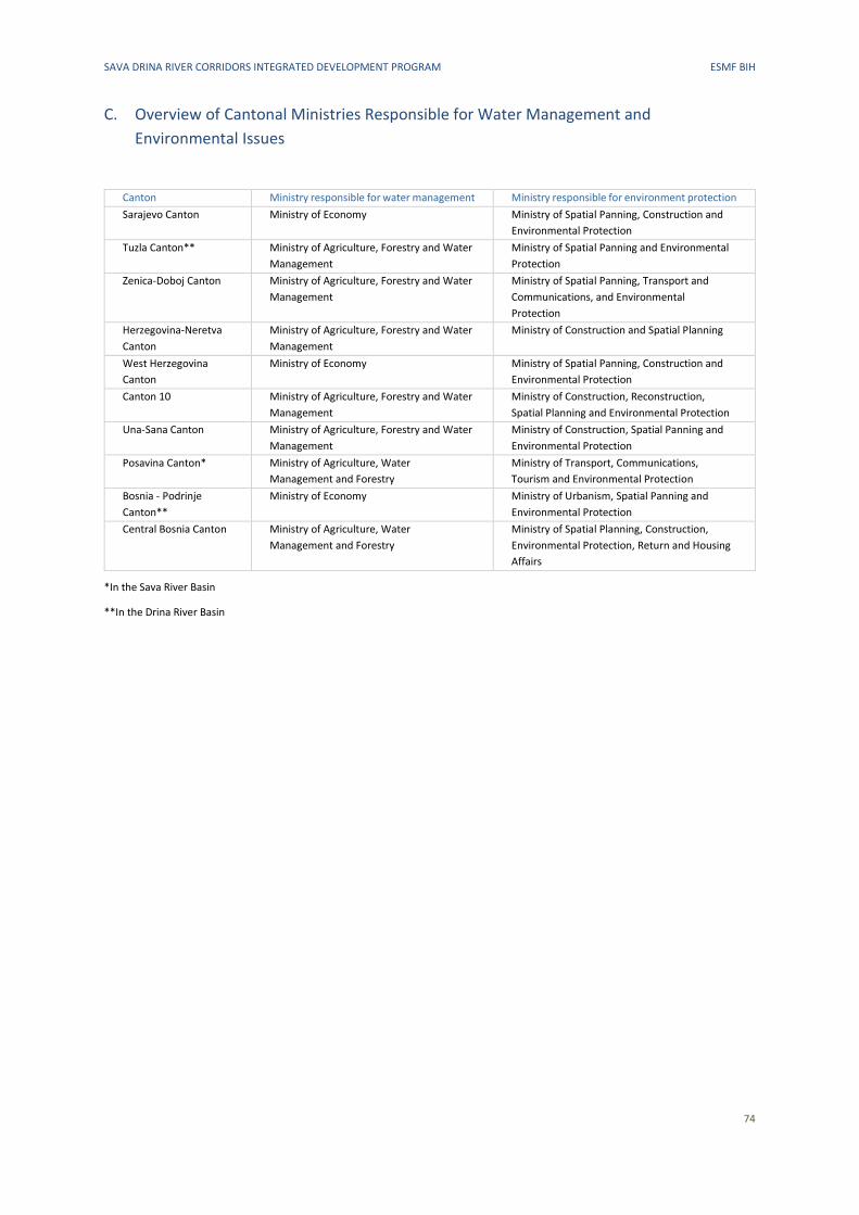
SAVA DRINA RIVER CORRIDORS INTEGRATED DEVELOPMENT PROGRAM ESMF BIH
74
C. Overview of Cantonal Ministries Responsible for Water Management and
Environmental Issues
Canton Ministry responsible for water management Ministry responsible for environment protection
Sarajevo Canton Ministry of Economy Ministry of Spatial Panning, Construction and
Environmental Protection
Tuzla Canton** Ministry of Agriculture, Forestry and Water
Management
Ministry of Spatial Panning and Environmental
Protection
Zenica-Doboj Canton Ministry of Agriculture, Forestry and Water
Management
Ministry of Spatial Panning, Transport and
Communications, and Environmental
Protection
Herzegovina-Neretva
Canton
Ministry of Agriculture, Forestry and Water
Management
Ministry of Construction and Spatial Planning
West Herzegovina
Canton
Ministry of Economy Ministry of Spatial Panning, Construction and
Environmental Protection
Canton 10 Ministry of Agriculture, Forestry and Water
Management
Ministry of Construction, Reconstruction,
Spatial Planning and Environmental Protection
Una-Sana Canton Ministry of Agriculture, Forestry and Water
Management
Ministry of Construction, Spatial Panning and
Environmental Protection
Posavina Canton* Ministry of Agriculture, Water
Management and Forestry
Ministry of Transport, Communications,
Tourism and Environmental Protection
Bosnia - Podrinje
Canton**
Ministry of Economy Ministry of Urbanism, Spatial Panning and
Environmental Protection
Central Bosnia Canton Ministry of Agriculture, Water
Management and Forestry
Ministry of Spatial Planning, Construction,
Environmental Protection, Return and Housing
Affairs
*In the Sava River Basin
**In the Drina River Basin
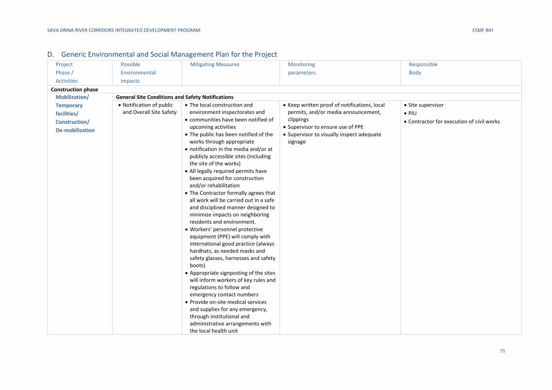
SAVA DRINA RIVER CORRIDORS INTEGRATED DEVELOPMENT PROGRAM ESMF BIH
75
D. Generic Environmental and Social Management Plan for the Project Project
Phase /
Activities
Possible
Environmental
Impacts
Mitigating Measures Monitoring
parameters
Responsible
Body
Construction phase
Mobilization/
Temporary
facilities/
Construction/
De-mobilization
General Site Conditions and Safety Notifications
• Notification of public and Overall Site Safety
• The local construction and environment inspectorates and
• communities have been notified of upcoming activities
• The public has been notified of the works through appropriate
• notification in the media and/or at publicly accessible sites (including the site of the works)
• All legally required permits have been acquired for construction and/or rehabilitation
• The Contractor formally agrees that all work will be carried out in a safe and disciplined manner designed to minimize impacts on neighboring residents and environment.
• Workers’ personnel protective equipment (PPE) will comply with international good practice (always hardhats, as needed masks and safety glasses, harnesses and safety boots)
• Appropriate signposting of the sites will inform workers of key rules and regulations to follow and emergency contact numbers
• Provide on-site medical services and supplies for any emergency, through institutional and administrative arrangements with the local health unit
• Keep written proof of notifications, local permits, and/or media announcement, clippings
• Supervisor to ensure use of PPE
• Supervisor to visually inspect adequate signage
• Site supervisor
• PIU
• Contractor for execution of civil works
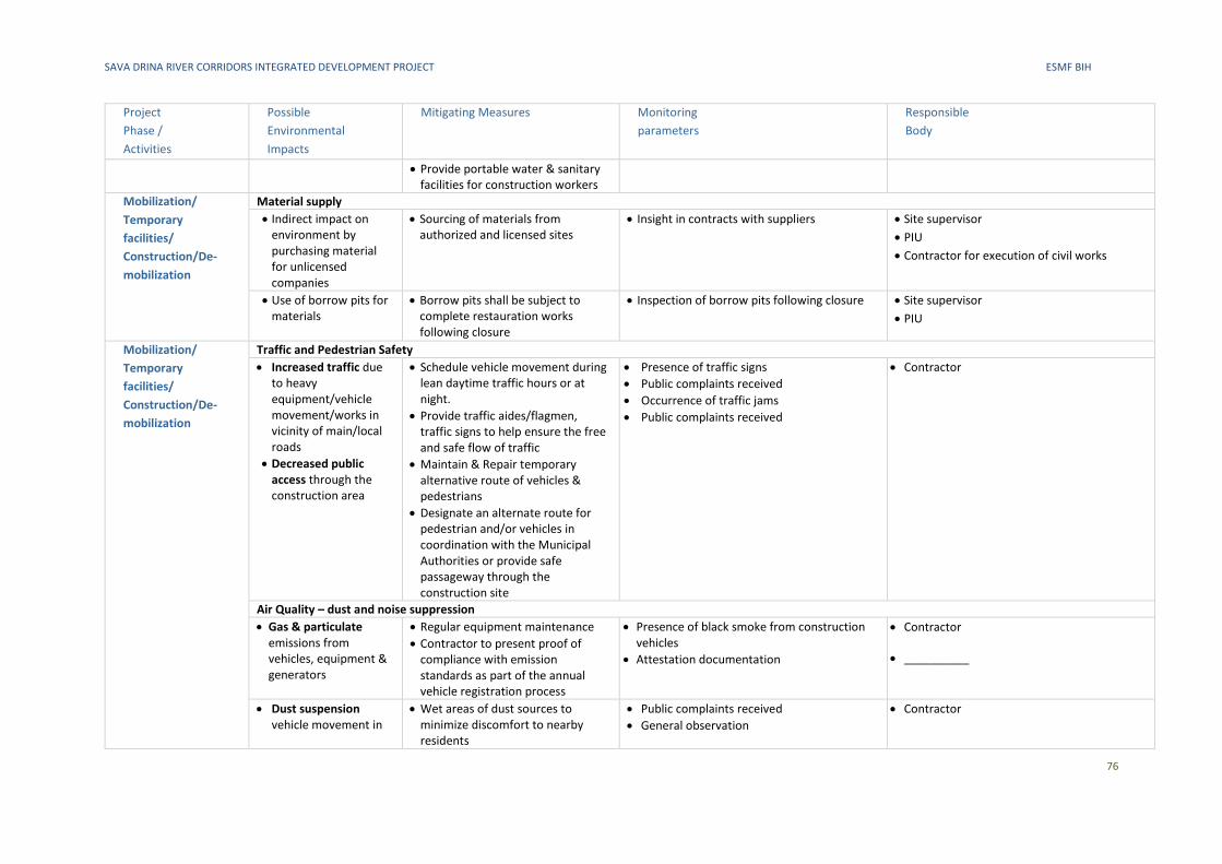
SAVA DRINA RIVER CORRIDORS INTEGRATED DEVELOPMENT PROJECT ESMF BIH
76
Project
Phase /
Activities
Possible
Environmental
Impacts
Mitigating Measures Monitoring
parameters
Responsible
Body
• Provide portable water & sanitary facilities for construction workers
Mobilization/
Temporary
facilities/
Construction/De-
mobilization
Material supply
• Indirect impact on environment by purchasing material for unlicensed companies
• Sourcing of materials from authorized and licensed sites
• Insight in contracts with suppliers • Site supervisor
• PIU
• Contractor for execution of civil works
• Use of borrow pits for materials
• Borrow pits shall be subject to complete restauration works following closure
• Inspection of borrow pits following closure • Site supervisor
• PIU
Mobilization/
Temporary
facilities/
Construction/De-
mobilization
Traffic and Pedestrian Safety
• Increased traffic due to heavy equipment/vehicle movement/works in vicinity of main/local roads
• Decreased public access through the construction area
• Schedule vehicle movement during lean daytime traffic hours or at night.
• Provide traffic aides/flagmen, traffic signs to help ensure the free and safe flow of traffic
• Maintain & Repair temporary alternative route of vehicles & pedestrians
• Designate an alternate route for pedestrian and/or vehicles in coordination with the Municipal Authorities or provide safe passageway through the construction site
• Presence of traffic signs
• Public complaints received
• Occurrence of traffic jams
• Public complaints received
• Contractor
Air Quality – dust and noise suppression
• Gas & particulate emissions from vehicles, equipment & generators
• Regular equipment maintenance
• Contractor to present proof of compliance with emission standards as part of the annual vehicle registration process
• Presence of black smoke from construction vehicles
• Attestation documentation
• Contractor
• __________
• Dust suspension vehicle movement in
• Wet areas of dust sources to minimize discomfort to nearby residents
• Public complaints received
• General observation
• Contractor
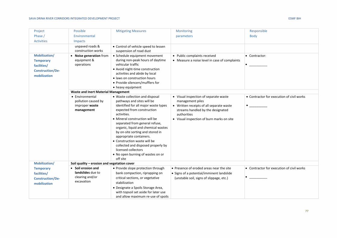
SAVA DRINA RIVER CORRIDORS INTEGRATED DEVELOPMENT PROJECT ESMF BIH
77
Project
Phase /
Activities
Possible
Environmental
Impacts
Mitigating Measures Monitoring
parameters
Responsible
Body
unpaved roads & construction works
• Control of vehicle speed to lessen suspension of road dust
Mobilization/
Temporary
facilities/
Construction/De-
mobilization
• Noise generation from equipment & operations
• Schedule equipment movement during non-peak hours of daytime vehicular traffic
• Avoid night-time construction activities and abide by local
• laws on construction hours
• Provide silencers/mufflers for
• heavy equipment
• Public complaints received
• Measure a noise level in case of complaints
• Contractor:
• __________
Waste and Inert Material Management
• Environmental pollution caused by improper waste management
• Waste collection and disposal pathways and sites will be identified for all major waste types expected from construction activities.
• Mineral construction will be separated from general refuse, organic, liquid and chemical wastes by on-site sorting and stored in appropriate containers.
• Construction waste will be collected and disposed properly by licensed collectors
• No open burning of wastes on or off site
• Visual inspection of separate waste management piles
• Written receipts of all separate waste streams handled by the designated authorities
• Visual inspection of burn marks on site
• Contractor for execution of civil works
• __________
Mobilization/
Temporary
facilities/
Construction/De-
mobilization
Soil quality – erosion and vegetation cover
• Soil erosion and landslides due to clearing and/or excavation
• Provide slope protection through
bank compaction, riprapping on
critical sections, or vegetative
stabilization
• Designate a Spoils Storage Area, with topsoil set aside for later use and allow maximum re-use of spoils
• Presence of eroded areas near the site
• Signs of a potential/imminent landslide
(unstable soil, signs of slippage, etc.)
• Contractor for execution of civil works
• __________
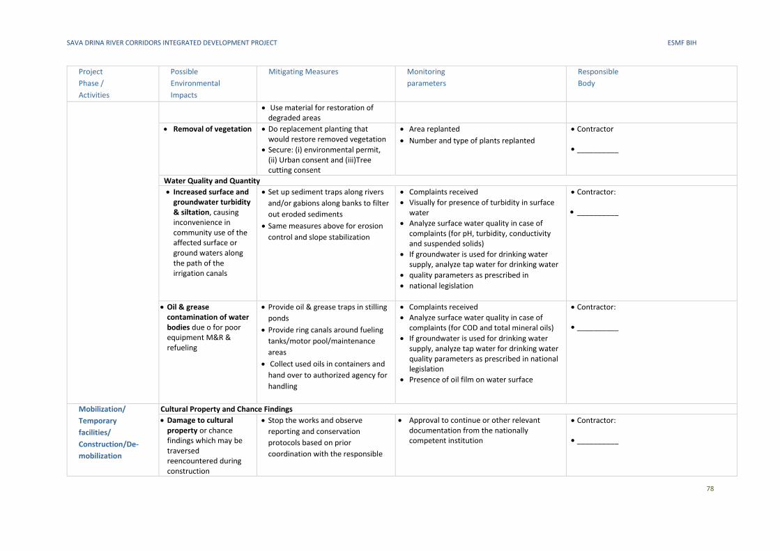
SAVA DRINA RIVER CORRIDORS INTEGRATED DEVELOPMENT PROJECT ESMF BIH
78
Project
Phase /
Activities
Possible
Environmental
Impacts
Mitigating Measures Monitoring
parameters
Responsible
Body
• Use material for restoration of degraded areas
• Removal of vegetation • Do replacement planting that would restore removed vegetation
• Secure: (i) environmental permit, (ii) Urban consent and (iii)Tree cutting consent
• Area replanted
• Number and type of plants replanted
• Contractor
• __________
Water Quality and Quantity
• Increased surface and groundwater turbidity & siltation, causing inconvenience in community use of the affected surface or ground waters along the path of the irrigation canals
• Set up sediment traps along rivers
and/or gabions along banks to filter
out eroded sediments
• Same measures above for erosion
control and slope stabilization
• Complaints received
• Visually for presence of turbidity in surface water
• Analyze surface water quality in case of complaints (for pH, turbidity, conductivity and suspended solids)
• If groundwater is used for drinking water supply, analyze tap water for drinking water
• quality parameters as prescribed in
• national legislation
• Contractor:
• __________
• Oil & grease contamination of water bodies due o for poor equipment M&R & refueling
• Provide oil & grease traps in stilling
ponds
• Provide ring canals around fueling
tanks/motor pool/maintenance
areas
• Collect used oils in containers and
hand over to authorized agency for
handling
• Complaints received
• Analyze surface water quality in case of complaints (for COD and total mineral oils)
• If groundwater is used for drinking water supply, analyze tap water for drinking water quality parameters as prescribed in national legislation
• Presence of oil film on water surface
• Contractor:
• __________
Mobilization/
Temporary
facilities/
Construction/De-
mobilization
Cultural Property and Chance Findings
• Damage to cultural property or chance findings which may be traversed reencountered during construction
• Stop the works and observe
reporting and conservation
protocols based on prior
coordination with the responsible
• Approval to continue or other relevant documentation from the nationally competent institution
• Contractor:
• __________
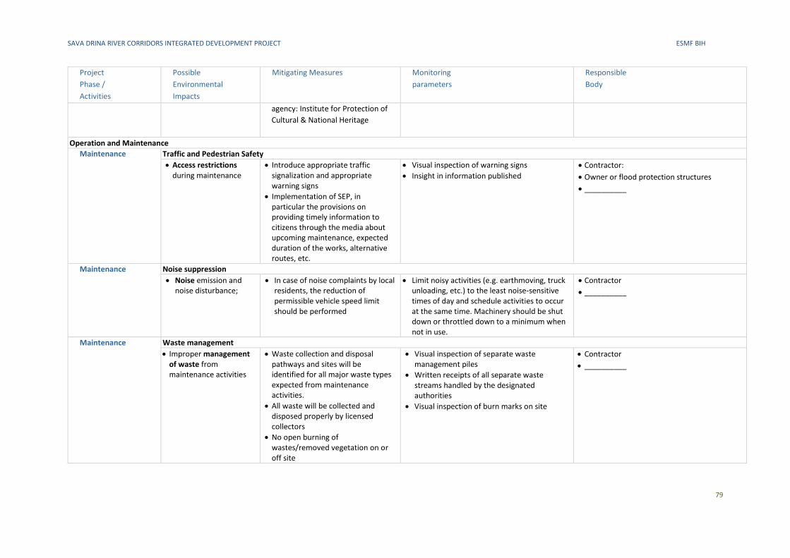
SAVA DRINA RIVER CORRIDORS INTEGRATED DEVELOPMENT PROJECT ESMF BIH
79
Project
Phase /
Activities
Possible
Environmental
Impacts
Mitigating Measures Monitoring
parameters
Responsible
Body
agency: Institute for Protection of
Cultural & National Heritage
Operation and Maintenance
Maintenance Traffic and Pedestrian Safety
• Access restrictions during maintenance
• Introduce appropriate traffic signalization and appropriate warning signs
• Implementation of SEP, in particular the provisions on providing timely information to citizens through the media about upcoming maintenance, expected duration of the works, alternative routes, etc.
• Visual inspection of warning signs
• Insight in information published
• Contractor:
• Owner or flood protection structures
• __________
Maintenance Noise suppression
• Noise emission and noise disturbance;
• In case of noise complaints by local residents, the reduction of permissible vehicle speed limit should be performed
• Limit noisy activities (e.g. earthmoving, truck unloading, etc.) to the least noise-sensitive times of day and schedule activities to occur at the same time. Machinery should be shut down or throttled down to a minimum when not in use.
• Contractor
• __________
Maintenance Waste management
• Improper management of waste from maintenance activities
• Waste collection and disposal pathways and sites will be identified for all major waste types expected from maintenance activities.
• All waste will be collected and disposed properly by licensed collectors
• No open burning of wastes/removed vegetation on or off site
• Visual inspection of separate waste management piles
• Written receipts of all separate waste streams handled by the designated authorities
• Visual inspection of burn marks on site
• Contractor
• __________
SAVA DRINA RIVER CORRIDORS INTEGRATED DEVELOPMENT PROGRAM ESMF BIH
80
E. Indicative outline of ESIA
(a) Executive Summary
▪ Concisely discusses significant findings and recommended actions.
(b) Legal and Institutional Framework
▪ Analyzes the legal and institutional framework for the project, within which the environmental and
social assessment is carried out, including the issues set out in ESS1, paragraph 2677.
▪ Compares the Borrower’s existing environmental and social framework and the ESSs and identifies
the gaps between them.
▪ Identifies and assesses the environmental and social requirements of any co-financiers.
(c) Project Description
▪ Concisely describes the proposed project and its geographic, environmental, social, and temporal
context, including any offsite investments that may be required (e.g., dedicated pipelines, access
roads, power supply, water supply, housing, and raw material and product storage facilities), as well
as the project’s primary suppliers.
▪ Through consideration of the details of the project, indicates the need for any plan to meet the
requirements of ESS1 through 10.
▪ Includes a map of sufficient detail, showing the project site and the area that may be affected by the
project’s direct, indirect, and cumulative impacts.
(d) Baseline Data
▪ Sets out in detail the baseline data that is relevant to decisions about project location, design,
operation, or mitigation measures. This should include a discussion of the accuracy, reliability, and
sources of the data as well as information about dates surrounding project identification, planning
and implementation.
▪ Identifies and estimates the extent and quality of available data, key data gaps, and uncertainties
associated with predictions.
▪ Based on current information, assesses the scope of the area to be studied and describes relevant
physical, biological, and socioeconomic conditions, including any changes anticipated before the
project commences.
▪ Takes into account current and proposed development activities within the project area but not
directly connected to the project.
(e) Environmental and Social Risks and Impacts
▪ Takes into account all relevant environmental and social risks and impacts of the project. This will
include the environmental and social risks and impacts specifically identified in ESS2–8, and any other
environmental and social risks and impacts arising as a consequence of the specific nature and context
of the project, including the risks and impacts identified in ESS1, paragraph 28.
(f) Mitigation Measures
▪ Identifies mitigation measures and significant residual negative impacts that cannot be mitigated and,
to the extent possible, assesses the acceptability of those residual negative impacts. Identifies
77 ESS1, paragraph 26, states that the environmental and social assessment takes into account in an appropriate manner all issues relevant
to the project, including: (a) the country’s applicable policy framework, national laws and regulations, and institutional capabilities (including
implementation) relating to environment and social issues; variations in country conditions and project context; country environmental or
social studies; national environmental or social action plans; and obligations of the country directly applicable to the project under relevant
international treaties and agreements; (b) applicable requirements under the ESSs; and (c) the EHSGs, and other relevant GIIP.
SAVA DRINA RIVER CORRIDORS INTEGRATED DEVELOPMENT PROGRAM ESMF BIH
81
differentiated measures so that adverse impacts do not fall disproportionately on the disadvantaged
or vulnerable.
▪ Assesses the feasibility of mitigating the environmental and social impacts; the capital and recurrent
costs of proposed mitigation measures, and their suitability under local conditions; and the
institutional, training, and monitoring requirements for the proposed mitigation measures.
▪ Specifies issues that do not require further attention, providing the basis for this determination.
(g) Analysis of Alternatives
▪ Systematically compares feasible alternatives to the proposed project site, technology, design, and
operation—including the “without project” situation—in terms of their potential environmental and
social impacts.
▪ Assesses the alternatives’ feasibility of mitigating the environmental and social impacts; the capital
and recurrent costs of alternative mitigation measures, and their suitability under local conditions;
and the institutional, training, and monitoring requirements for the alternative mitigation measures.
▪ For each of the alternatives, quantifies the environmental and social impacts to the extent possible,
and attaches economic values where feasible.
(h) Design Measures
▪ Sets out the basis for selecting the particular project design proposed and specifies the applicable
EHSGs or if the EHSGs are determined to be inapplicable, justifies recommended emission levels and
approaches to pollution prevention and abatement that are consistent with GIIP (if applicable).
(i) Key Measures and Actions for the Environmental and Social Commitment Plan (ESCP)
▪ Summarizes key measures and actions and the timeframe required for the project to meet the
requirements of the ESSs. This will be used in developing the Environmental and Social Commitment
Plan (ESCP).
(j) Appendices
▪ List of the individuals or organizations that prepared or contributed to the environmental and social
assessment.
▪ References—setting out the written materials both published and unpublished, that have been used.
▪ Record of meetings, consultations and surveys with stakeholders, including those with affected
people and other interested parties. The record specifies the means of such stakeholder engagement
that were used to obtain the views of affected people and other interested parties.
▪ Tables presenting the relevant data referred to or summarized in the main text.
▪ List of associated reports or plans.
SAVA DRINA RIVER CORRIDORS INTEGRATED DEVELOPMENT PROGRAM ESMF BIH
82
F. Indicative outline of site-specific ESMP
The content of the site-specific ESMP will include the following:
(a) Mitigation
▪ The ESMP identifies measures and actions in accordance with the mitigation hierarchy that reduce
potentially adverse environmental and social impacts to acceptable levels. The plan will include
compensatory measures, if applicable. Specifically, the ESMP:
i) identifies and summarizes all anticipated adverse environmental and social impacts (including
those involving indigenous people or involuntary resettlement);
ii) describes—with technical details—each mitigation measure, including the type of impact to
which it relates and the conditions under which it is required (e.g., continuously or in the event of
contingencies), together with designs, equipment descriptions, and operating procedures, as
appropriate;
iii) estimates any potential environmental and social impacts of these measures; and takes into
account, and is consistent with, other mitigation plans required for the project (e.g., for
involuntary resettlement, indigenous peoples, or cultural heritage).
(b) Monitoring
▪ The ESMP identifies monitoring objectives and specifies the type of monitoring, with linkages to the
impacts assessed in the environmental and social assessment and the mitigation measures described
in the ESMP. Specifically, the monitoring section of the ESMP provides (a) a specific description, and
technical details, of monitoring measures, including the parameters to be measured, methods to be
used, sampling locations, frequency of measurements, detection limits (where appropriate), and
definition of thresholds that will signal the need for corrective actions; and (b) monitoring and
reporting procedures to (i) ensure early detection of conditions that necessitate particular mitigation
measures, and (ii) furnish information on the progress and results of mitigation.
(c) Capacity Development and Training
▪ To support timely and effective implementation of environmental and social project components and
mitigation measures, the ESMP draws on the environmental and social assessment of the existence,
role, and capability of responsible parties on site or at the agency and ministry level.
▪ Specifically, the ESMP provides a specific description of institutional arrangements, identifying which
party is responsible for carrying out the mitigation and monitoring measures (e.g., for operation,
supervision, enforcement, monitoring of implementation, remedial action, financing, reporting, and
staff training).
▪ To strengthen environmental and social management capability in the agencies responsible for
implementation, the ESMP recommends the establishment or expansion of the parties responsible,
the training of staff and any additional measures that may be necessary to support implementation
of mitigation measures and any other recommendations of the environmental and social assessment.
(d) Implementation Schedule and Cost Estimates
▪ For all three aspects (mitigation, monitoring, and capacity development), the ESMP provides (a) an
implementation schedule for measures that must be carried out as part of the project, showing
phasing and coordination with overall project implementation plans; and (b) the capital and recurrent
cost estimates and sources of funds for implementing the ESMP. These figures are also integrated
into the total project cost tables.
(e) Integration of ESMP with Project
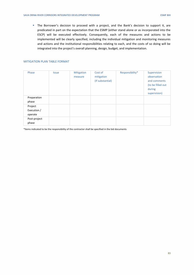
SAVA DRINA RIVER CORRIDORS INTEGRATED DEVELOPMENT PROGRAM ESMF BIH
83
▪ The Borrower’s decision to proceed with a project, and the Bank’s decision to support it, are
predicated in part on the expectation that the ESMP (either stand alone or as incorporated into the
ESCP) will be executed effectively. Consequently, each of the measures and actions to be
implemented will be clearly specified, including the individual mitigation and monitoring measures
and actions and the institutional responsibilities relating to each, and the costs of so doing will be
integrated into the project’s overall planning, design, budget, and implementation.
MITIGATION PLAN TABLE FORMAT
Phase Issue Mitigation
measure
Cost of
mitigation
(If substantial)
Responsibility* Supervision
observation
and comments
(to be filled out
during
supervision)
Preparation
phase
Project
Execution /
operate
Post-project
phase
*Items indicated to be the responsibility of the contractor shall be specified in the bid documents
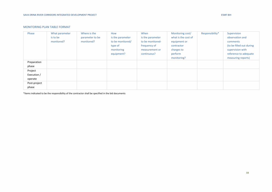
SAVA DRINA RIVER CORRIDORS INTEGRATED DEVELOPMENT PROJECT ESMF BIH
84
MONITORING PLAN TABLE FORMAT
Phase What parameter
is to be
monitored?
Where is the
parameter to be
monitored?
How
is the parameter
to be monitored/
type of
monitoring
equipment?
When
is the parameter
to be monitored-
frequency of
measurement or
continuous?
Monitoring cost/
what is the cost of
equipment or
contractor
charges to
perform
monitoring?
Responsibility* Supervision
observation and
comments
(to be filled out during
supervision with
reference to adequate
measuring reports)
Preparation
phase
Project
Execution /
operate
Post-project
phase
*Items indicated to be the responsibility of the contractor shall be specified in the bid documents
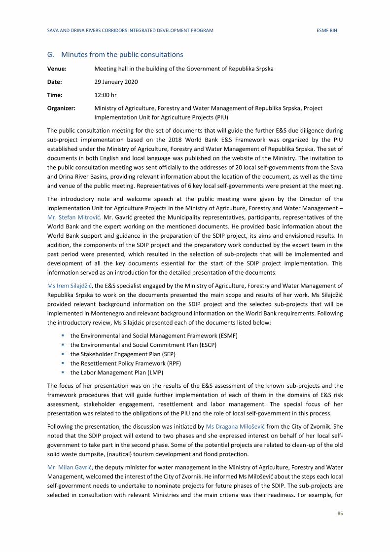
SAVA AND DRINA RIVERS CORRIDORS INTEGRATED DEVELOPMENT PROGRAM ESMF BIH
85
G. Minutes from the public consultations
Venue: Meeting hall in the building of the Government of Republika Srpska
Date: 29 January 2020
Time: 12:00 hr
Organizer: Ministry of Agriculture, Forestry and Water Management of Republika Srpska, Project
Implementation Unit for Agriculture Projects (PIU)
The public consultation meeting for the set of documents that will guide the further E&S due diligence during
sub-project implementation based on the 2018 World Bank E&S Framework was organized by the PIU
established under the Ministry of Agriculture, Forestry and Water Management of Republika Srpska. The set of
documents in both English and local language was published on the website of the Ministry. The invitation to
the public consultation meeting was sent officially to the addresses of 20 local self-governments from the Sava
and Drina River Basins, providing relevant information about the location of the document, as well as the time
and venue of the public meeting. Representatives of 6 key local self-governments were present at the meeting.
The introductory note and welcome speech at the public meeting were given by the Director of the
Implementation Unit for Agriculture Projects in the Ministry of Agriculture, Forestry and Water Management –
Mr. Stefan Mitrović. Mr. Gavrić greeted the Municipality representatives, participants, representatives of the
World Bank and the expert working on the mentioned documents. He provided basic information about the
World Bank support and guidance in the preparation of the SDIP project, its aims and envisioned results. In
addition, the components of the SDIP project and the preparatory work conducted by the expert team in the
past period were presented, which resulted in the selection of sub-projects that will be implemented and
development of all the key documents essential for the start of the SDIP project implementation. This
information served as an introduction for the detailed presentation of the documents.
Ms Irem Silajdžić, the E&S specialist engaged by the Ministry of Agriculture, Forestry and Water Management of
Republika Srpska to work on the documents presented the main scope and results of her work. Ms Silajdžić
provided relevant background information on the SDIP project and the selected sub-projects that will be
implemented in Montenegro and relevant background information on the World Bank requirements. Following
the introductory review, Ms Silajdzic presented each of the documents listed below:
▪ the Environmental and Social Management Framework (ESMF)
▪ the Environmental and Social Commitment Plan (ESCP)
▪ the Stakeholder Engagement Plan (SEP)
▪ the Resettlement Policy Framework (RPF)
▪ the Labor Management Plan (LMP)
The focus of her presentation was on the results of the E&S assessment of the known sub-projects and the
framework procedures that will guide further implementation of each of them in the domains of E&S risk
assessment, stakeholder engagement, resettlement and labor management. The special focus of her
presentation was related to the obligations of the PIU and the role of local self-government in this process.
Following the presentation, the discussion was initiated by Ms Dragana Milošević from the City of Zvornik. She
noted that the SDIP project will extend to two phases and she expressed interest on behalf of her local self-
government to take part in the second phase. Some of the potential projects are related to clean-up of the old
solid waste dumpsite, (nautical) tourism development and flood protection.
Mr. Milan Gavrić, the deputy minister for water management in the Ministry of Agriculture, Forestry and Water
Management, welcomed the interest of the City of Zvornik. He informed Ms Milošević about the steps each local
self-government needs to undertake to nominate projects for future phases of the SDIP. The sub-projects are
selected in consultation with relevant Ministries and the main criteria was their readiness. For example, for
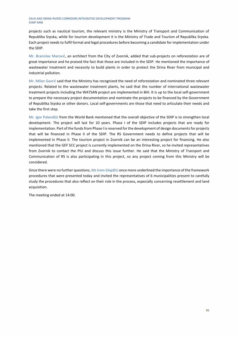
SAVA AND DRINA RIVERS CORRIDORS INTEGRATED DEVELOPMENT PROGRAM ESMF MNE
86
projects such as nautical tourism, the relevant ministry is the Ministry of Transport and Communication of
Republika Srpska, while for tourism development it is the Ministry of Trade and Tourism of Republika Srpska.
Each project needs to fulfil formal and legal procedures before becoming a candidate for implementation under
the SDIP.
Mr. Branislav Marović, an architect from the City of Zvornik, added that sub-projects on reforestation are of
great importance and he praised the fact that those are included in the SDIP. He mentioned the importance of
wastewater treatment and necessity to build plants in order to protect the Drina River from municipal and
industrial pollution.
Mr. Milan Gavrić said that the Ministry has recognized the need of reforestation and nominated three relevant
projects. Related to the wastewater treatment plants, he said that the number of international wastewater
treatment projects including the WATSAN project are implemented in BiH. It is up to the local self-government
to prepare the necessary project documentation and nominate the projects to be financed by the Government
of Republika Srpska or other donors. Local self-governments are those that need to articulate their needs and
take the first step.
Mr. Igor Palandžić from the World Bank mentioned that the overall objective of the SDIP is to strengthen local
development. The project will last for 10 years. Phase I of the SDIP includes projects that are ready for
implementation. Part of the funds from Phase I is reserved for the development of design documents for projects
that will be financed in Phase II of the SDIP. The RS Government needs to define projects that will be
implemented in Phase II. The tourism project in Zvornik can be an interesting project for financing. He also
mentioned that the GEF SCC project is currently implemented on the Drina River, so he invited representatives
from Zvornik to contact the PIU and discuss this issue further. He said that the Ministry of Transport and
Communication of RS is also participating in this project, so any project coming from this Ministry will be
considered.
Since there were no further questions, Ms Irem Silajdžić once more underlined the importance of the framework
procedures that were presented today and invited the representatives of 6 municipalities present to carefully
study the procedures that also reflect on their role in the process, especially concerning resettlement and land
acquisition.
The meeting ended at 14:00.
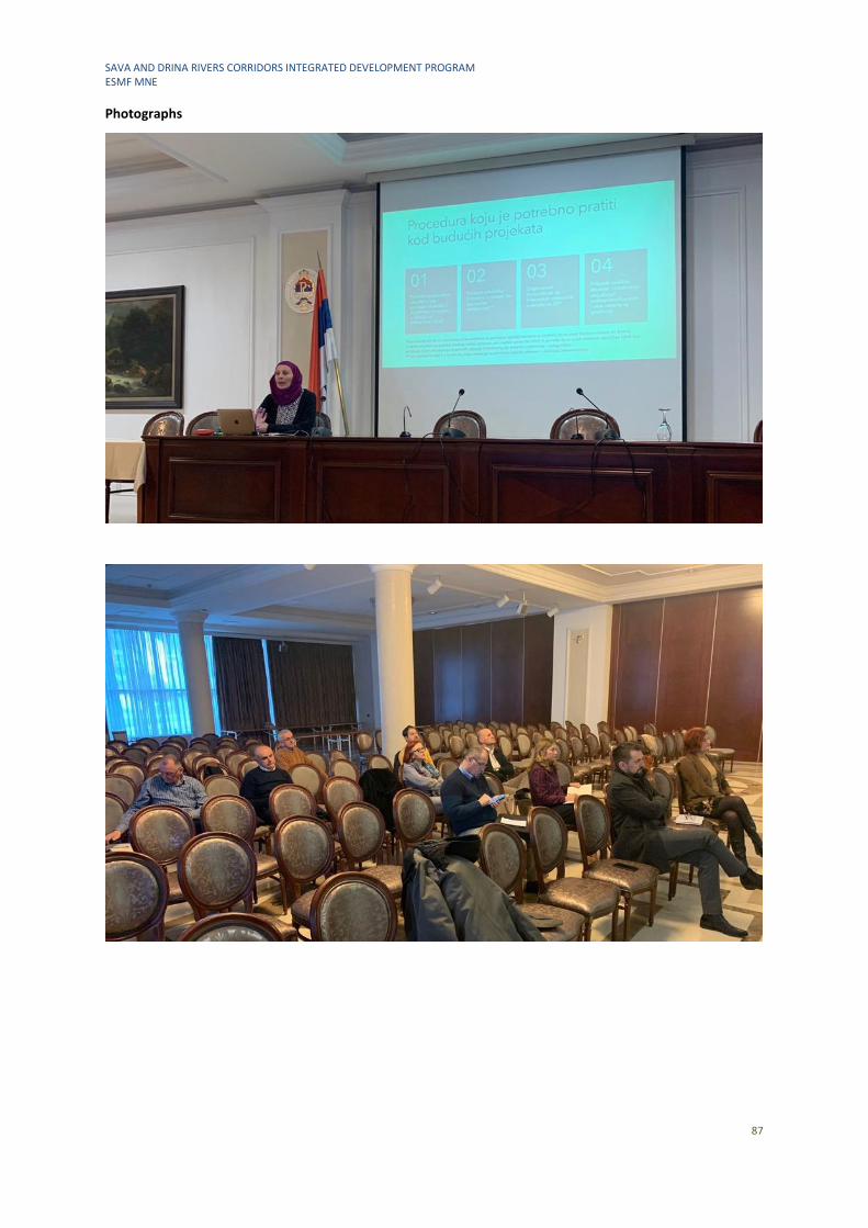
SAVA AND DRINA RIVERS CORRIDORS INTEGRATED DEVELOPMENT PROGRAM ESMF MNE
87
Photographs
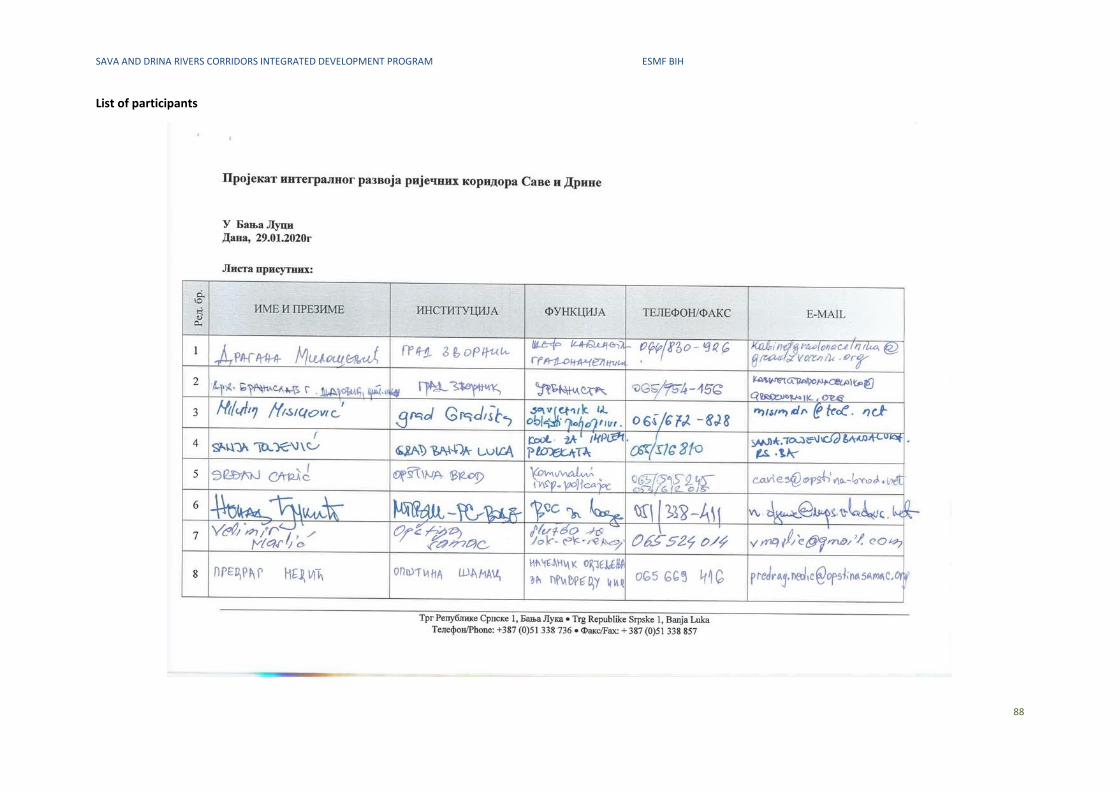
SAVA AND DRINA RIVERS CORRIDORS INTEGRATED DEVELOPMENT PROGRAM ESMF BIH
88
List of participants
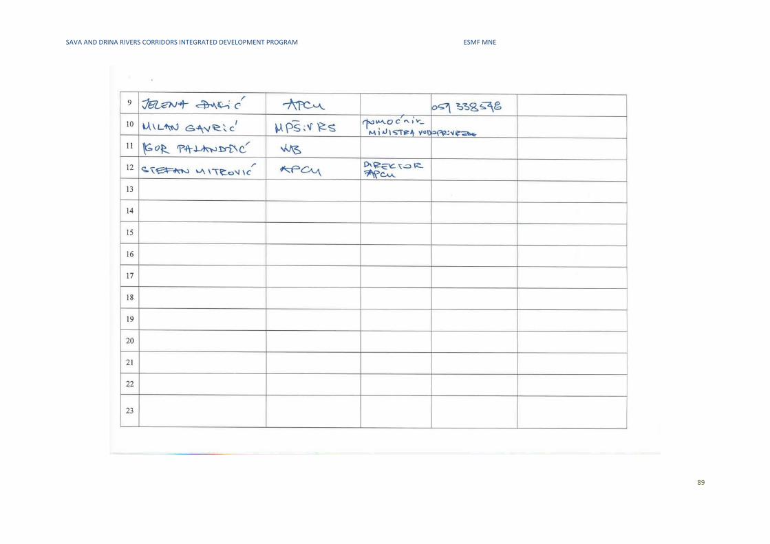
SAVA AND DRINA RIVERS CORRIDORS INTEGRATED DEVELOPMENT PROGRAM ESMF MNE
89