Salmon Conservation Plan Status and Trends - Snohomish ...
96
SNOHOMISH RIVER BASIN SALMON CONSERVATION PLAN STATUS AND TRENDS DECEMBER 2019
-
Upload
khangminh22 -
Category
Documents
-
view
0 -
download
0
Transcript of Salmon Conservation Plan Status and Trends - Snohomish ...
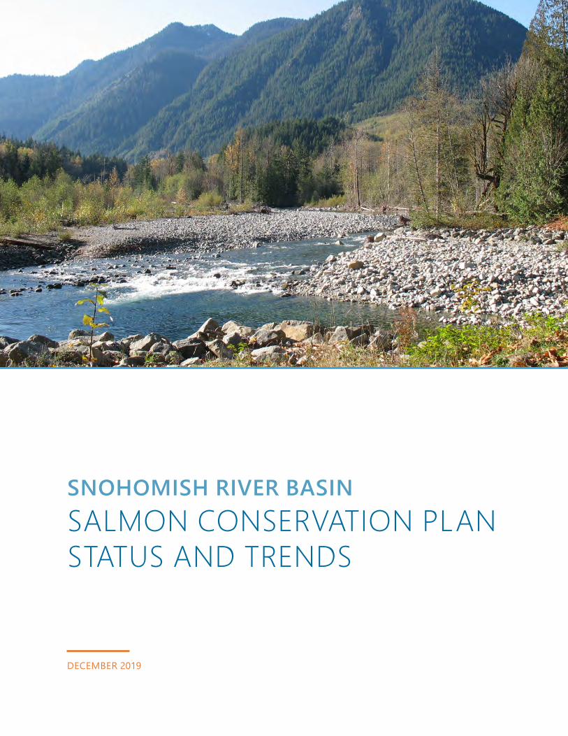
SNOHOMISH RIVER BASINSALMON CONSERVATION PLAN STATUS AND TRENDS
DECEMBER 2019

Introduction 1Status Update 3
Snohomish Basin 3
Salmon Plan Overview 7
Implementation Progress 10
Status and Trends 18Salmon in the Basin 18
Chinook Salmon 19
Coho Salmon 22
Steelhead 24
Bull Trout 26
Chum Salmon 27
Factors Affecting Survival of Salmon Species 29
Basin Trends 32
Salmon Plan Implementation 46Habitat Restoration Progress 48
Restoration Funding 67
Habitat and Hydrology Protection Observations 70
Monitoring and Adaptive Management 76
Updating the Basin-Wide Vision for Recovery 77Considerations for a Changing Future 78
Restoration Opportunities and Challenges 82
Integration of Habitat, Harvest, and Hatchery Actions Within the Basin 86
Multi-Objective Planning 88
Updating Our Salmon Plan 90
Credits and Acknowledgments 93
CONTENTS

1
INTRODUCTION
1 Snohomish Basin Salmon Recovery Forum, 2005. Snohomish River Basin Salmon Conservation Plan. Snohomish County Department of Public Works, Surface Water Management Division. June 2005.
Since 1994 — 5 years before the Endangered Species Act (ESA) listing of Chinook salmon — partner organizations in the Snohomish Basin have been coordinating salmon recovery efforts to improve salmon stock numbers.In 2005, the Snohomish Basin Salmon Recovery Forum (Forum) adopted the Snohomish River Basin Salmon Conservation Plan1 (Salmon Plan), defining a multi-salmon strategy for the Snohomish Basin that emphasizes two ESA-listed species, Chinook salmon and bull trout, and the non-listed coho salmon. These species are used as proxies for other Basin salmon to help prevent future listings. The Salmon Plan, developed by the 41-member Forum, incorporates habitat, harvest, and hatchery management actions to bring the listed wild stocks back to healthy, harvestable levels.

Introduction
2
The Salmon Plan is based on historical records, best available science, and social and economic conditions. It recognizes the importance of using adaptive management (incorporating new data to increase the chance of success), information about successes and failures, and new opportunities provided by the changing context in the Snohomish Basin. Since 2005, there have been many site-scale successes on restoration projects in the Basin’s mainstems, tributaries, estuary, and nearshore. However, many environmental indicators continue to decline. The intent of this report is to provide a touchpoint for implementation, context for how the Basin and region are changing, and strategic ideas for the next steps of salmon recovery.
Photo Credit: Roger Tabor (U.S. Fish and Wildlife Service)
Introduction
3
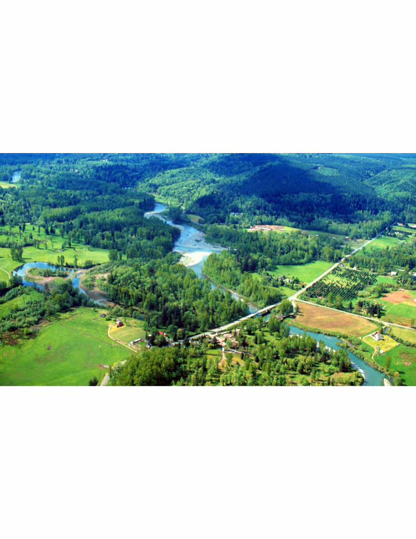
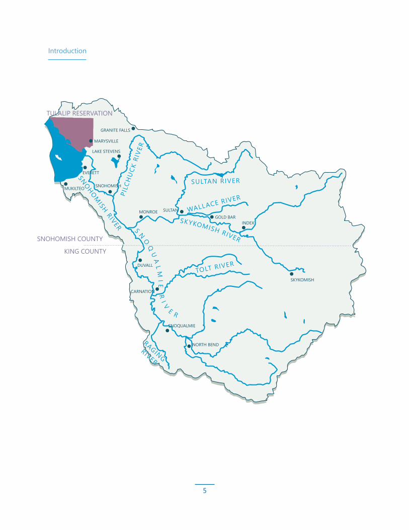
Snohomish BasinThe Snohomish Basin is the second largest river system in the Puget Sound and is crucial to Puget Sound salmon populations and the ecosystems and industries they support. The Basin is one of the primary producers of anadromous salmon in the region. Of the nine salmon species in the Basin, three are currently protected under the ESA — Chinook salmon, steelhead, and bull trout. Chinook salmon populations in the watershed include Skykomish River and Snoqualmie River Chinook salmon. The watershed also contains five populations of steelhead and four populations of bull trout.
The Snohomish River is unique in its complex geologic and cultural history, as well as its proximity to the rapidly growing population centers in the Puget Sound region. It bridges an ecological continuum, from the rural wilderness of the Cascade Range to the low-lying cities — offering an example of the complex and often destructive relationship between humans and vital natural resources. This location and the Snohomish Basin’s hydrologic pattern as a mixed rain-snow-influenced watershed also makes it particularly vulnerable to climate change.
Status UpdateTo ensure the continued stewardship of the Salmon Plan and the species it strives to protect, it is essential that we periodically reflect on progress, challenges, and new directions. This report addresses the following key questions about the status of Salmon Plan goals and the watershed:
• Did efforts conducted since 2005 to implement the Salmon Plan accomplish the 10-year habitat restoration targets?
• What is the balance of habitat gains relative to losses in the watershed?
• What are the recent trends in the watershed for salmon, habitat, and human populations? How do those trends affect our actions?
• What progress has been made to fill the key data gaps identified in the Salmon Plan?
• What is working and what planning and implementation changes should the Forum consider to adaptively manage the Salmon Plan and guide success in the next 10 years of Salmon Plan implementation?

Introduction
4
Two main tributaries divide the Snohomish River: the Snoqualmie River, which originates in the alpine lakes of the Cascade Range and drains the southeastern portion of the watershed east of Seattle, and the Skykomish River, which originates deep in the Cascade Range and flows west. The distinct characteristics of the tributary areas create different challenges for salmon recovery and resource and land use management in each river valley area.
The Skykomish River is in an eroding river valley, where gravels and coarse glacial sediments were deposited by glaciers during the last glaciation. The Skykomish River valley is defined by its steeper gradient and meandering nature with many sediment-rich reaches and gravel bars. In the lower Skykomish River, before the confluence with the Snoqualmie River, the river is less confined. Over time, erosion and sediment transport formed a broad floodplain. Periodic flooding also influenced the topography, helping develop the soils that gave rise to riparian habitats and meadows.
The Snoqualmie River watershed includes two distinct geomorphic areas: the Puget Lowland and the Middle Cascade Range.1 The Middle Cascade Range includes the high-elevation, steep-topography area above Snoqualmie Falls. Three forks of the Snoqualmie River flow from the lower slopes of the Cascade Range. Approximately 2 miles downstream from where the forks merge, the river plummets over Snoqualmie Falls (a natural barrier to anadromous salmon), and the topography transitions to a flat, alluvial, valley bottom called the Puget Lowland.2 Below the falls, the lower Snoqualmie River Valley is characterized by a broad, valley-wide floodplain with several higher-gradient tributaries that flow into the meandering mainstem. Due to its low gradient and geomorphology, the Snoqualmie River historically migrated across the floodplain as a single channel through lateral channel migration (eroding the banks), instead of creating highly braided reaches, as seen in the Tolt River or Skykomish River. The Snoqualmie River is in an aggrading river valley, filled with finer sediments from earlier glaciations. It is defined by its lower-gradient incised channel, with natural levees of fine sediment deposited by frequent floods.
1 Montgomery, D.R., S. Bolton, D. Booth, and L. Wall, editors, 2003. Restoration of Puget Sound Rivers. Seattle: University of Washington Press.
2 Bethel, J., 2004. An Overview of the Geology and Geomorphology of the Snoqualmie River Watershed. Prepared for King County Water and Land Resources Division, Snoqualmie Watershed Team.
Introduction
5
SNOHOMISH COUNTY
KING COUNTY
SNOHOMISH RIVER
SKYKOMISH RIVER
SULTAN RIVER
PILC
HU
CK R
IVER
TOLT RIVER
WALLACE RIVER
RAGINGRIVER
S NO
QU
AL
MI E
R
I V
E R
MARYSVILLE
GRANITE FALLS
LAKE STEVENS
EVERETT
MUKILTEO SNOHOMISH
MONROE SULTANGOLD BAR
INDEX
SKYKOMISH
DUVALL
CARNATION
SNOQUALMIE
NORTH BEND
TULALIP RESERVATION

Introduction
6
Basin History and Land UsesSince time immemorial, native peoples hunted, gathered, and fished throughout the watershed. When Euro-American settlers began to populate the Puget Sound region, ancestors of the Tulalip Tribes signed a treaty with the federal government. This treaty ceded millions of acres of land, but also retained the Tribes’ inherent rights of self-governance and self-determination as well as rights to fish in their usual and accustomed grounds and hunt and gather on all open and unclaimed lands. One of the consequences of the treaty, and the Tulalip Tribes’ subsequent move to the reservation, was the disruption of their usual movements to follow food sources and natural resources that have always been the basis of their lives and culture. The rights retained by the treaty have been upheld by numerous court decisions, which made tribes co-managers of salmon resources with the State of Washington.
As lands were ceded to the government, settlers claimed and cleared land for multiple uses throughout the watershed, including development near industrial and population centers, logging in the uplands, and farming in the estuary and low-elevation river valleys. Since westward expansion, a rich agrarian culture developed in the valleys of the Snohomish River. Agriculture is an important facet of local economies and vital to a robust local food market. However, the extensive alteration of floodplain habitats associated with land conversion throughout the last century is in large part responsible for the loss of salmon habitat, which significantly contributes to salmon population decline.
Today, the rapidly growing population and economy in the Seattle area and north toward Everett and Marysville is spilling into the Snohomish Basin as people look for places to live and work. These development pressures are major threats to both salmon and the river system as well as agriculture. Salmon recovery and agriculture have similar interests in stewarding the land and preventing urbanization. Multi-benefit projects that help farming communities and salmon populations are a central focus of salmon recovery work.
Important land uses throughout the Basin include forestry, urban, residential, light industrial, infrastructure (roads, railroads, gas, water, and power lines), recreation, agriculture, and mining. Private and federal forest lands and Federal Wilderness Areas constitute almost 75% of the Basin.

Introduction
7
Salmon Plan OverviewStrategyThe 2005 Salmon Plan defines a science-based, strategic approach to the recovery of threatened salmon populations over a 50-year period and identifies 10-year benchmarks for habitat restoration actions. The two-pronged strategy for the first 10 years of implementation included the following:
• Improve habitat quantity and quality in the nearshore, estuary, and mainstem rivers
• Minimize habitat losses and make habitat gains through restoration in the rest of the Basin
Like many of the areas in the Puget Sound region, the Snohomish Basin has sufficient high-quality spawning habitat to support returning adults. However, juvenile rearing is severely limited due to disconnected floodplains and degraded estuary and nearshore habitats. This disconnection and degradation restricts the quality and quantity of habitat available for juvenile fish refuge and foraging. The Salmon Plan focuses on restoring and protecting the natural processes that create and maintain floodplain features and support salmon throughout their life cycles.

Introduction
8
The Four Hs:1. Habitat: Manage
habitat elements through restoration and protection strategies to improve spawning success, survival, and population productivity
2. Harvest: Manage harvest so spawning numbers are sufficient to use available habitat and rebuild populations
3. Hatchery: Use integrated best management practices to avoid genetic introgression and limit effects on the fitness of wild populations
4. Hydropower: Manage dams and reservoirs to provide adequate and safe flows for fish downstream
Population Goals and Management ActionsThe Salmon Plan emphasizes an approach to recovering salmon populations that balances management actions in the four “Hs”: habitat, harvest, hatchery, and hydropower. Because the outcome of recovery efforts depends on the combined effect of each of the Hs, they should be evaluated collectively rather than independently.
Escapement, outmigration, and productivity are key factors in understanding population goals. The goals defined in the Salmon Plan include escapements required for a sustainable, harvestable population. Escapement, or the number of fish that return to spawn as adults, is a basic metric of fish population health. Escapement is dependent on productivity, which is the number of offspring that return to spawn per parent. Productivity is affected by many factors, especially freshwater and marine habitat quality. It is also affected by predation and harvest. Escapement goals are dependent on productivity because when productivity is low, more spawning fish are required to sustain a healthy population. The recovery goal for Snohomish Basin Chinook salmon is 14,000 fish if habitats support high productivity or 64,000 fish if habitats support low productivity. Based on these recovery goals, Snohomish Basin Chinook salmon are well below the target for a recovered population (6,119 fish in 2017).

Introduction
9
Escapement
Escapement is the number of adult fish that escape harvest and return to spawn in the river. Escapement is based on survey observations of spawning fish and redds and is a direct measure of population health. Salmon are subject to many conditions throughout their lives, from small streams to the Pacific Ocean, and escapement can be highly variable.
Outmigration
The number of juvenile fish that travel downstream on their way to the ocean (outmigration) is another important measurement of salmon populations.
Traps in the Skykomish and Snoqualmie rivers provide data on the number of each species of fish that move through the rivers, which helps estimate how many juvenile Chinook and coho salmon outmigrate during the spring. These numbers are used in models that predict run size for planning fishery harvests.
Productivity
Productivity estimates the success of spawning fish producing viable offspring. It is an important indicator of population health and measures how well habitats support the population. Productivity is determined by dividing the number of offspring that return to spawn by the number of adults that produced them. A productivity of 1 is considered a replacement level and indicates a stable population, while a productivity of less than 1 indicates a declining population and greater than 1 indicates a growing population.
Chinook salmon redds in the Skykomish RiverThe lighter color is the redds, where fish have fanned out the gravel with their tails to create nests for eggs.
Screw trap installed and operated by Tulalip Tribes to monitor fish
The central hypothesis of the Salmon Plan is that restoring the necessary salmon habitat will increase productivity and populations to a condition where they can be delisted from the ESA. The role of fishery management in the Salmon Plan is based on the premise that harvest can be limited to a rate that will not impede recovery as long as other actions (habitat protection, habitat restoration, and hatchery management) are also implemented and integrated to promote recovery. Hydropower has a minor impact on salmon in the Basin. While important for populations in the Sultan and Tolt rivers, it is a minor driver for the greater Snohomish Basin populations.
Introduction
10
Implementation ProgressSince the Salmon Plan was adopted, the salmon recovery effort has had notable successes — made possible by partnerships and efforts from all levels of government, special purpose districts, non-governmental organizations, and private citizens. Together, we have secured resources to address key gaps in the plan, implemented large-scale projects, overcome challenges, and found new ways to promote salmon recovery objectives. This section highlights the implementation progress relative to habitat, harvest, hatchery, and hydropower (the four Hs). The Salmon Plan is a living document that will evolve as new science and approaches are developed, new partners emerge, and new opportunities or challenges arise.
Habitat ProgressThere have been many moments of celebration for habitat management actions, like the breaching of the levee at Snohomish County’s Smith Island site in 2018, which allowed salmon to access 378 acres of tidal estuary for the first time in more than a century, and witnessing juvenile salmon find refuge from the fast river flows on the footprint of the former levee as part of the Lower Tolt River Floodplain Reconnection Project. In conjunction with our partners’ efforts, many landowners have undertaken voluntary restoration efforts on their residential properties and farms, demonstrating the depth of community commitment to protecting and restoring our environment for the benefit of fish, wildlife, and people.

Introduction
11
Progress Relative to 10-Year Goals (Set in 2005)
Notes:a. Total shown does not include tidal marsh restored for mitigation. Inclusion of mitigation acreage would bring the total to
1,319.5 acres.b. An additional 360 acres will be restored with the completion of the Blue Heron Slough mitigation project in 2021.c. Total shown includes Snohomish County Conservation Reserve Enhancement Program and progress through 2018. Note this
progress total does not account for riparian habitat losses (refer to the discussion on page 37).d. Total accounts for constructed in-river mainstem log jams. It does not include floodplain log jams or wood structures used as bank stabilization or mitigation. The total does account for change over time (i.e., log jams that did not persist were removed from the total). Additional information on wood in rivers is on page 40.
Nearshore Beaches and Shoreline
Estuary: Tidal Marsh
Mainstem Primary RestorationRestored Edge Habitat
Restored Riparian Habitat
Restored Off-Channel Habitat
Large Woody Debris
Intact 2005
Intact 2005: 8.4 miles
Intact 2005: 1,483 acres Target: 1,237 acres
Intact 2005: 236 miles Target: 10.4 miles
Target: At least 1 mileRestored: 1.42 miles
Restored: 1,099.6 acresa,b
Restored: 2.02 miles
Intact 2005: 5,991 acres Target: 256 acres
Intact 2005: 350 acres Target: 167 acres
Target: 41 new log jams
Restored: 332 acresc
Restored: 13.72 acres
Restored: 46 log jamsd
10-Year Target Total Restored

Introduction
12
Estuary Restoration SuccessesThe Snohomish Estuary has the largest restoration footprint in the Puget Sound region and provides access to crucial nursery habitat for young salmon. The restoration work in the estuary involved years of dedication, patience, and creativity by many partners while navigating differing perspectives about how the estuary would change to support multiple interests.
“We know that to recover salmon in Puget Sound, we must succeed in the Snohomish Basin.”
— Snohomish Basin Salmon Recovery Forum

Introduction
13
Snohomish Basin Protection Plan AdoptionThe 2015 Snohomish Basin Protection Plan served as an update to the Salmon Plan and as planning guidance for greater protection of hydrology and salmon habitat. The Snohomish Basin Protection Plan developed strategies to build watershed and ecosystem resilience in the face of growing populations and changing climatic conditions.
The Snohomish Basin Protection Plan identified important strategies to protect hydrology and examined new and existing tools. By protecting hydrologic processes, the Snohomish Basin Protection Plan aims to protect habitat quality, quantity, and diversity for fish and wildlife. Protecting hydrology will also support quality of life for those who live and work in the Basin, help ameliorate flood risks, and ensure the availability of water for multiple uses into the future.
Mainstem ImplementationOver the last 10 years, Snoqualmie River system partners have shifted development of restoration projects from an opportunistic approach to a focused and strategic one. In 2009, King County, with participation from the Snoqualmie Watershed Forum, evaluated a key Chinook salmon spawning area: a 2-mile length of the Snoqualmie River from Fall City to Patterson Creek that was disconnected from its floodplain by revetments along both banks, a common constraint on habitat conditions in the Basin.
By evaluating this reach for constraints on habitat-forming processes and restoration needs, King County was able to assess the feasibility of several projects that would reconnect the river to its floodplain. This helped the county develop strategies to engage landowners, conceptual designs for four projects, and funding strategies. Completing the feasibility report allowed King County to stay focused and committed to restoring habitat in a critical area for salmon. The first project was completed in 2014, and two more are currently in design.
Introduction
14
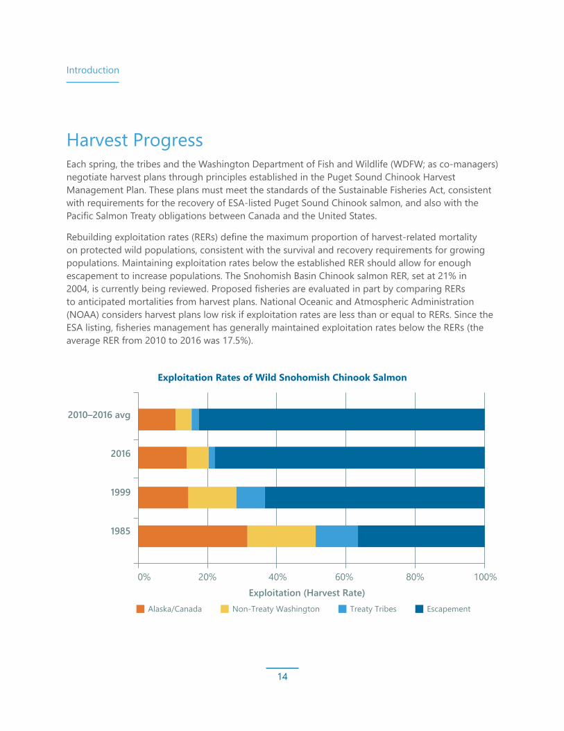
Harvest ProgressEach spring, the tribes and the Washington Department of Fish and Wildlife (WDFW; as co-managers) negotiate harvest plans through principles established in the Puget Sound Chinook Harvest Management Plan. These plans must meet the standards of the Sustainable Fisheries Act, consistent with requirements for the recovery of ESA-listed Puget Sound Chinook salmon, and also with the Pacific Salmon Treaty obligations between Canada and the United States.
Rebuilding exploitation rates (RERs) define the maximum proportion of harvest-related mortality on protected wild populations, consistent with the survival and recovery requirements for growing populations. Maintaining exploitation rates below the established RER should allow for enough escapement to increase populations. The Snohomish Basin Chinook salmon RER, set at 21% in 2004, is currently being reviewed. Proposed fisheries are evaluated in part by comparing RERs to anticipated mortalities from harvest plans. National Oceanic and Atmospheric Administration (NOAA) considers harvest plans low risk if exploitation rates are less than or equal to RERs. Since the ESA listing, fisheries management has generally maintained exploitation rates below the RERs (the average RER from 2010 to 2016 was 17.5%).
Exploitation Rates of Wild Snohomish Chinook Salmon
0% 20% 40% 60% 80% 100%
1985
1999
2016
2010–2016 avg
Alaska/Canada
Exploitation (Harvest Rate)Non-Treaty Washington Treaty Tribes Escapement
Introduction
15
Hatchery ProgressHatcheries provide a harvestable surplus of Chinook salmon in the Snohomish Basin. Since the Salmon Plan was adopted, our understanding of the genetic and ecological risks of hatcheries has greatly improved, and hatchery operations have adjusted to limit risks to the wild population. While the Snoqualmie Chinook salmon population spawns naturally, the Skykomish population is supplemented by a hatchery at Wallace River intended to produce fish for harvest. These hatchery fish are managed as an integrated population, with the hatchery population produced from natural-origin adults trapped at the Sunset Falls and Wallace River Hatchery facilities. Integrated broodstock programs diminish genetic divergence between hatchery and wild fish. Per NOAA Fisheries and the Bureau of Indian Affairs,1 the average hatchery-origin fraction of naturally spawning Skykomish River Chinook salmon between 2006 and 2014 (27.8%) decreased by nearly half compared to the average between 1997 and 2001 (49.9%). This number (27.8%) is inflated by the large proportion of hatchery-origin fish spawning in the Wallace River near the hatchery. The proportion of hatchery-origin spawners in the rest of the Skykomish River is 19%. The hatchery-origin fraction of the naturally spawning Snoqualmie River Chinook salmon population has largely remained consistent. A moderate increase was observed in recent years,2 which can be attributed to poor returns of natural-origin spawners, as the number of hatchery-origin spawners declined by 6.0% for the 2005 to 2014 period relative to the 1997 to 2001 period.
1 NOAA Fisheries and Bureau of Indian Affairs, 2017. Final Endangered Species Act (ESA) Section 7(a)(2) Biological Opinion and Magnuson Stevens Fishery Conservation and Management Act Essential Fish Habitat (EFH) Consultation. National Marine Fisheries Service (NMFS) Evaluation of Six Hatchery and Genetic Management Plans for Snohomish River Basin Salmon under Limit 6 of the Endangered Species Act Section 4(d) Rule. NMFS Consultation Number: WCR-2012-00841.
2 Tulalip Tribes, 2012. Bernie Kai-Kai Gobin Salmon Hatchery “Tulalip Hatchery” Subyearling Summer Chinook Salmon. Hatchery and Genetic Management Plan. December 20, 2012.

Introduction
16
The key management actions described in the Salmon Plan to address potential risks of hatchery and harvest actions that affect species recovery have been improved and refined as follows:
Risk Improvements/Refinements to Management Actions
1 – Migration delay and blocking effects at hatchery weirs
• Improved weir management
• Implementation of upstream passage and trapping protocols
2 – Removal effects of natural‑origin fish
• Selective harvest focused on hatchery returns
• Strict protocols in the Hatchery and Genetic Management Plans and Terms and Conditions in the NOAA Fisheries’ Biological Opinion reduce adverse effects on spatial distribution and population abundance
• Refinements to account for the interacting effects of habitat, hatchery, and harvest actions on population status, as expressed by viable salmon population parameters, to determine the phase of recovery and associated management actions
3, 4, and 5 – Amplification and transmittal of infectious pathogens, food resource competition, and predation
• Monitored under the Terms and Conditions in the NOAA Fisheries’ Biological Opinion; no significant new findings or improvements in monitoring methods
6 – Potential for decreased genetic diversity and fitness through hatchery adult straying and interbreeding with wild fish
• Improvements in monitoring infrastructure and capacity, and refinements in monitoring methodology to address genetic risks posed by hatchery-origin Chinook salmon, including:
- Greatly improved stock assessment through increased marking, sample collections, laboratory sample analysis, quality assurance/quality control, and database management
- Development of new stock assessment tools
- Refinements to the broodstock collection protocol

Introduction
17
Hydropower ProgressThere are 10 hydroelectric projects in the Snohomish Basin, only two of which have water storage. The remainder are run-of-the-river projects, with four built around waterfalls with short bypass reaches. The Jackson Hydroelectric Project is the only dam system where most of the bypass reach is salmon habitat. The other projects are above natural fish migration barriers. The City of Seattle owns the other water storage dam. The South Fork Tolt Hydroelectric Project releases most river flow from the reservoir via the Tolt Dam. However, additional water that is not being diverted for drinking water (for people in the greater Seattle area) is released from the Tolt hydroelectric facility downstream of a falls, primarily in the winter/early spring months. Since 2005, three new run-of-the-river projects were added to the Basin. These projects are designed to pass gravel and support hydrologic processes.
Since the adoption of the Salmon Plan, the Jackson Hydroelectric Project went through Federal Energy Regulatory Commission (FERC) relicensing. From the relicensing process, numerous mitigation and adaptive management approaches were identified and have since been implemented. Approaches include opening off-channel habitat in the Sultan River, diversion dam modification for fish passage, landslide clearing to allow increased access for salmon in upper reaches, and a water temperature control system that allows modifications to the withdrawal facility to provide more temperature-specific withdrawals (i.e., water temperature withdrawals that are optimized for salmon survival and incubation in the upper reach below the dam). The South Fork Tolt Hydroelectric Project has FERC license provisions for the protection, mitigation, and restoration of salmon and the South Fork Tolt River. Beginning in 2004, water temperature during the summer and early fall have been managed to meet water quality standards by releasing water from multiple intakes at different depths in the reservoir.
Hatchery programs in the Snohomish Basin are operated by WDFW and the Tulalip Tribes under best management practices described in the Hatchery and Genetic Management Plans (HGMPs) updated in 2012 and 2013 and permitted by NOAA Fisheries in 2017. These programs focus on providing fish for harvest and addressing potential adverse ecological, genetic, and demographic impacts that could affect the viability of the ESA-listed natural-origin fish populations and impede recovery efforts.
There has been considerable evolution of regional hatchery management practices since the 2005 Salmon Plan, and improved methods continue to address potential risks to ESA-listed fish in the Basin. After reviewing the status of the listed populations in the context of the Proposed Actions in the HGMPs and implementing the hatchery actions, the 2017 NOAA Fisheries Biological Opinion determined the Proposed Actions in the HGMPs are not likely to jeopardize ESA-listed Chinook salmon or steelhead or destroy or adversely modify their critical habitats.

18
STATUS AND TRENDS Salmon in the Basin Nine salmon species are found in the Snohomish River system, including ESA‑listed Chinook salmon, steelhead, and bull trout. Coho salmon are listed as a species of concern, and continued downward trends could lead to their listing in the future. Salmon recovery efforts in the Snohomish River primarily focus on Chinook salmon, as directed by the 2005 Salmon Plan. While the Salmon Plan was created to recover Chinook salmon, it is a multi-species plan developed with the understanding that, while different species have different habitat needs, actions that benefit one or two species can also help others. For instance, recovery actions proposed in the Salmon Plan for the benefit of Chinook and coho salmon will also have direct benefits for steelhead, which were listed 2 years after the Salmon Plan was adopted.

Status and Trends
19
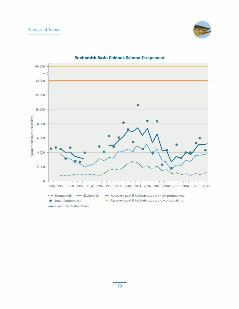
Chinook SalmonOncorhynchus tshawytschaChinook salmon were listed as threatened in 1999 after decades of overharvest and habitat degradation. The Snohomish Basin system is primarily fed by the Skykomish and Snoqualmie rivers, which each have distinct geologic history and geomorphology. Two populations of Chinook salmon have adapted to conditions in the Skykomish and Snoqualmie rivers, though the Skykomish River population is larger. Since its ESA listing, the Snohomish Basin Chinook salmon population has fluctuated. After peaking at approximately 10,000 in 2004, escapements fell to pre-ESA-listing levels (around 4,000) and bottomed out in 2011 (1,883). Since 2011, the numbers are trending slightly better: 2017 had the best escapement since 2008 (6,119), though the estimate for 2018 was 4,210. Most of the Snohomish River escapement increases over the last 7 years can be attributed to the Skykomish River population.
Skykomish RiverThe Skykomish River’s cobble-rich geomorphology and ample spawning habitat support the majority of Chinook salmon in the Snohomish Basin. Many large tributaries also support portions of the Skykomish River Chinook salmon population. A significant portion of the population pass above Sunset Falls, a natural anadromous barrier on the South Fork that historically prevented spawning
above it. A trap-and-haul facility, operated since 1958, allows fish to use the large amount of high-quality spawning and rearing habitat above the falls. This passage program is critical to the Skykomish River population — in low escapement years, most of the returning Chinook salmon in the Skykomish system spawn above the falls.
Snoqualmie RiverThe Snoqualmie River Chinook salmon population is smaller than the Skykomish River population, partly due to spawning habitat limitations. A facility was considered but deemed not practical due to high juvenile mortality during downstream migration. The Snoqualmie River is also distinct from the Skykomish River as a low-gradient aggrading river valley. Sediment deposition is providing the best mainstem Chinook salmon spawning habitat.
The best spawning habitats for Chinook salmon in the Snoqualmie River are primarily concentrated at the confluence and lower reaches of the Tolt and Raging rivers and along the mainstem Snoqualmie River downstream of these tributaries. Snoqualmie River Chinook salmon escapement has increased in recent years, but fell again in 2018 to only 1,162 fish.
Status and Trends
20
Snohomish Basin Chinook Salmon Escapement
12,000
14,000
64,000
10,000
Esc
apem
ent (
num
ber o
f fish
)
8,000
6,000
4,000
2,000
01986 1988 1990 1992 1994 1996 1998 2000 2002 2004 2006 2008 2010 2012 2014 2016
SnoqualmieTotal (Snohomish)
Skykomish
3-year Geometric Mean
Recovery goal if habitats support high productivity Recovery goal if habitats support low productivity
2018

Status and Trends
21
Snohomish Basin Chinook Salmon Productivity
Brood Year
0
0.5
1.0
2.5
2.0
1.5
1995
1997
2000
2002
2004
2006
2008
2010
2012
Skykomish Snoqualmie Produc�vity of 1 indicates a replacement level/stable popula�on
Productivity numbers are only available through 2012 because all age classes (1-5) must be calculated to determine productivity of any brood year.
Prod
uctiv
ity
ProductivityThe Salmon Plan’s central hypothesis is that improving the quality and quantity of Chinook salmon habitat will increase the productivity of populations so they can grow to recovery levels. A measure of reproductive success, productivity in the Snohomish Basin is limited mainly by rearing habitat in the estuary and mainstem. For that reason, during the first 10 years of Salmon Plan implementation, we prioritized restoring rearing habitat for juvenile Chinook salmon, particularly the estuary. Declines in Chinook salmon populations after 2008 have been a source of concern. These poor returns were the result of poor survival in the offspring of relatively robust returns in the early to mid-2000s. Escapements then bottomed out in 2011. The offspring of the limited spawning population of 2009 and 2011 had improved survival and returned in larger numbers than their parents, resulting in productivity
estimates slightly better than 1, indicating a growing population. Though escapements have increased in recent years, Chinook salmon population increases have been tepid at best, resulting in a population size that is roughly the same as it was in the early 1990s, which led to its ESA listing.
Habitat should be able to support higher productivity of these modest returns, and several major restoration projects in the estuary should widen the bottleneck for survival as reconnected intertidal land continues to develop into productive marsh habitat. Continued restoration of these limiting habitats will help to bring productivity above 1 (replacement level), and populations should continue to increase. However, Chinook salmon spend most of their lives in marine ecosystems, and marine survival has been a limiting factor as well.

Status and Trends
22
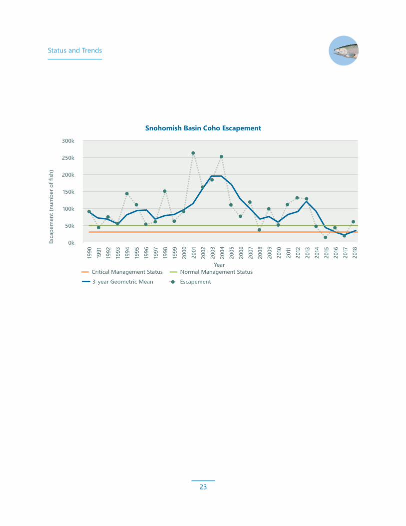
Coho SalmonOncorhynchus kisutchThe Snohomish Basin is crucial habitat for coho salmon in Puget Sound. In some years, 25% to 50% of coho in the Puget Sound are from the Snohomish Basin. Since 2014, there have been persistent very poor escapements, and the 2015 and 2017 escapements were the worst on record. Low escapements are not unusual in highly variable populations, but the persistent and severe low escapements are unprecedented and very concerning. These poor escapements resulted in a 3-year geometric mean less than 31,000 (refer to the figure at right), triggering a critical management protocol. The stock now has a rebuilding plan to bring the stock back to “normal” status (above 50,000). The co-managers are planning fisheries more conservatively to limit exploitation of Snohomish coho salmon. Coho salmon were listed as a Species of Concern under the ESA in 1995, which highlights the need for research and stewardship, but does not afford them federal protection by the ESA.
Coho salmon are agile swimmers and jumpers and reach into the smaller tributaries and ponds to spawn and rear. Juvenile coho salmon spend a full year in streams before migrating out to the
Puget Sound, so they are susceptible to actions that disconnect floodplains, fill wetlands, and disconnect or degrade habitat. Many streams and rivers in the Snohomish Basin, as well as nearshore and estuary habitats, are important for coho salmon.
Habitat pressures in the lowland streams where coho salmon spawn and rear are increasing as more people move into the areas coho salmon inhabit. Recent research from NOAA Fisheries and state and local partners has shown adult coho salmon to be susceptible to urban runoff syndrome, and they can die within a few hours of being exposed to unfiltered runoff, especially from heavily traveled roads. There is great interest in protecting coho salmon and improving their habitat to prevent future ESA listings. The recovery strategy assumes that actions that benefit Chinook salmon will also benefit coho salmon and other species.
Status and Trends
23
Snohomish Basin Coho Escapement
300k
Esca
pem
ent (
num
ber o
f fish
)
250k
200k
150k
50k
Critical Management Status3-year Geometric Mean Escapement
0k
100k
1998
1996
1997
1994
1995
1993
1992
1991
1999
2000
2001
2002
2003
2004
2005
2006
2007
2008
2009
2010
2011
2012
2013
2014
2015
2016
2017
YearNormal Management Status
1990
2018

Status and Trends
24
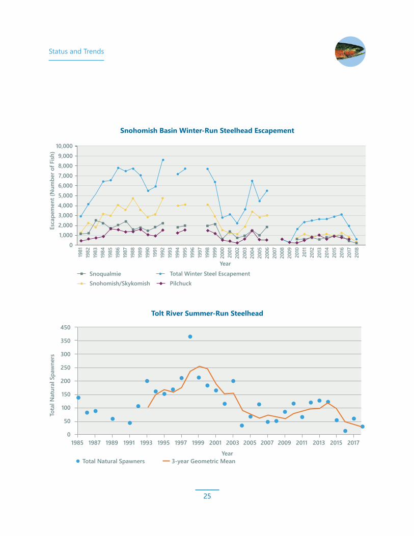
SteelheadOncorhynchus mykissSteelhead were listed as threatened in 2007 under the ESA because of declining numbers in the Puget Sound region due to habitat loss and overfishing. Steelhead need diverse habitat and are vulnerable to habitat loss and damage, including clearing of trees and log jams from riverbanks and channels, hardening of shorelines, low summer flows, and filling of wetlands.
The Snohomish Basin has two summer runs of wild steelhead: Tolt and North Fork Skykomish. Steelhead enter freshwater from May to October and spawn several months to a year later; they need deep pools for holding until they are ready to spawn. Summer run steelhead spawn in upper reaches of tributaries with steep gradients.
There are three winter runs of wild steelhead: Pilchuck, Snohomish/Skykomish, and Snoqualmie. These fish enter freshwater between November and May and usually spawn within 3 to 12 weeks. The Snoqualmie River winter-run steelhead spawn along the Tolt, Raging, and Snoqualmie rivers. These young steelhead disperse widely and rear in pools and
along stream banks where they find protection beneath wood and vegetation. Warmer waters can keep them from migrating downstream to the Puget Sound.
Since the early 2000s, both winter- and summer-run steelhead populations in the Snoqualmie River have declined. Though harvest and hatchery practices have been altered based on new information, and habitat improvement projects are opening up streams and estuaries, habitat declines continue. NOAA is leading the effort to produce a Puget Sound steelhead recovery plan by 2020. Early marine survival is emerging as a limiting factor. Sources of funding for steelhead projects have not been identified.
Status and Trends
25
Tolt River Summer-Run Steelhead
1985 1987 1989 1991 1993 1995 1997 1999 2001 2003 2005 2007 2009 2011 2013 2015 2017
Total Natural Spawners 3-year Geometric MeanYear
0
50
100
150
200
250
300
350
450
Tota
l Nat
ural
Spa
wne
rs
Snohomish Basin Winter-Run Steelhead Escapement
1,0002,0003,0004,0005,0006,0007,0008,0009,000
10,000
0
Esca
pem
ent (
Num
ber o
f Fish
)
Total Winter Steel EscapementSnohomish/Skykomish PilchuckSnoqualmie
1981
1982
1983
1984
1985
1986
1987
1988
1989
1990
1991
1992
1993
1994
1995
1996
1997
1998
1999
2000
2001
2002
2003
2004
2005
2006
2007
2008
2009
2010
2011
2012
2013
2014
2015
2016
2017
2018
Year

Status and Trends
26
Bull TroutSalvelinus confluentusBull trout in the Snohomish Basin exhibit three different life history types: anadromous types migrate from spawning grounds to and from marine waters, fluvial types remain in freshwater but migrate from natal streams to larger rivers and back, and resident types remain in natal streams their entire life. Because of their broad range of habitat needs for spawning, rearing, foraging, and migration, bull trout are susceptible to many of the same limiting factors as other salmon. In particular, their need for cold water, clean gravels for spawning, and access to headwater tributaries makes them particularly vulnerable to negative effects of climate change, headwater land use, and artificial migration barriers.
Along with Chinook salmon, bull trout were listed as threatened under the ESA in 1999 and are included in the multi-species focus of the Salmon Plan. The U.S. Fish and Wildlife Service (USFWS) is leading bull trout recovery efforts. At the time of Salmon Plan adoption, the USFWS recovery plan was in draft form and remained draft until 2015.
In the Final Recovery Plan for Bull Trout1 and the regionally focused Implementation Plan,²
USFWS outlines threats to bull trout and lists local recovery actions to address them. In addition to implementing many recommended actions in the Salmon Plan, USFWS highlights the need to reduce impacts from recreational mining and to continue the WDFW trap-and-haul operations on the South Fork Skykomish River to maintain spatial distribution above Sunset Falls. The Final Recovery Plan for Bull Trout does not set a target for abundance, but instead uses the determination of demographic stability of populations within a recovery unit to initiate the delisting process.
In 2008, a 5-year review³ estimated bull trout abundance in the Snohomish and Skykomish rivers core area as between 1,000 and 2,500 individuals, which, in the short term, was likely increasing. WDFW collects data on bull trout in the Skykomish River by enumerating adults at the South Fork Skykomish trap-and-haul facility and through spawner surveys on the North Fork Skykomish and its major tributaries. While these statistics give fisheries managers some sense of trends in bull trout spawner abundance and spatial distribution, they do not represent a total population value for the Snohomish Basin.
1 USFWS (U.S. Fish and Wildlife Service), 2015. Final Recovery Plan for the Coterminous United States Population of Bull Trout (Salvelinus confluentus). Portland, Oregon.
2 USFWS, 2015. Coastal Recovery Unit Implementation Plan for Bull Trout (Salvelinus confluentus). Portland, Oregon, and Lacey, Washington.
3 USFWS, 2008. Bull Trout (Salvelinus confluentus) 5-Year Review: Summary and Evaluation. Portland, Oregon.

Status and Trends
27
Chum SalmonOncorhynchus ketaChum salmon are a large species with a unique life history. It is the last species to spawn, entering rivers in November and December and spawning through December. Chum salmon emerge from the gravel around March as free-swimming smolts and, unlike most salmon species, migrate directly to marine waters without rearing.
Chum salmon typically spawn in off-channel habitat, side channels, and tributaries. They prefer to dig their redds (egg nests) in slow-moving water in areas with large, mobile gravels activated at high flows that have significant well-oxygenated upwelling/hyporheic flow. Their spawning timing makes them particularly susceptible to flooding.
Habitat and spawning preferences require unique considerations for habitat restoration opportunities. Restoration that targets chum will have multiple benefits because chum salmon habitat is often good rearing habitat for other species, particularly in juvenile phases. However, restoration and reconnection of side channel and off-channel habitat is challenging because land conversion has claimed many of these habitats, they present difficult engineering challenges, and the natural processes that create them are inhibited.
Chum salmon are currently experiencing persistent very low escapements for more than a decade, without any signs of improvement. Unless chum salmon rebound soon, they may be at risk of extinction and could be ESA listed.
Year
0
20,000
40,000
100,000
80,000
60,000
120,000
140,000
160,000
180,000
200,000
2002
2003
2004
2005
2006
2007
2008
2009
2010
2011
2012
2013
2014
2015
2016
2017
2018
Even Year Goal
Odd Year Goal
Escapement
3 Year Geometric Mean
Esca
pem
ent (
num
ber o
f fish
)
Snohomish River Chum Escapement
Status and Trends
28
Emerging Species of ConcernSince the Salmon Plan was adopted, there have been very low returns for numerous salmon species.
In 2015, coho salmon numbers across Puget Sound were at an all-time low of approximately 13,000 — a 95% decrease compared to the highest recorded escapement in 2001 (262,000). In 2017, only around 18,000 coho salmon returned to the Snohomish Basin. Continued poor returns have triggered a conservative management protocol.
Nearly 2 million pink salmon returned in 2013: the second highest escapement on record. In 2017, the run size was roughly 3% of the run observed in 2013 but near the long-term average. The pink salmon population can be highly variable, and recent declines are not yet indicative of a concerning pattern.
Chum salmon populations plummeted 95% after 2006 and dropped 80% again in 2015 (to 1.7% of the 2006 run). These persistent poor escapements are unprecedented and indicative of a concerning pattern.
Though the numbers can be highly variable, these species returned in much higher numbers in recent history. As we move forward with implementation of the Salmon Plan, a more dedicated, multi-species approach may be even more important than initially considered. The Salmon Plan has been developed under the approach of preventing other future ESA listings of salmon.
Status and Trends
29
Factors Affecting Survival of Salmon SpeciesSalmon are distributed over a massive geographic area during their lifespans — from the Cascade Range to the central Pacific Ocean. Because salmon survival is affected by many environmental variables, this discussion highlights some of the most important factors.
Most regional salmon recovery efforts involve restoring freshwater salmon habitat, particularly rearing habitat. Salmon need cool, clean water in proper quantities to adequately spawn in gravels and develop eggs to maturity. These processes typically occur during fall and winter, when flooding is more common. After salmon hatch, they typically spend between a few months to a full year growing in freshwater and estuarine environments. Research suggests that the size of juvenile Chinook salmon is a very strong predictor of survival in the marine environment. We want to ensure juveniles survive early development and mature to large sizes to improve their chance of survival in marine conditions. Freshwater rearing habitats are vital to this development and include complex mainstem habitat, connected floodplains and tributaries, and estuarine marshes and wetlands. Historical diking and
draining activities, along with other land alterations like wetland filling, diminished juvenile rearing habitats; a lack of these habitats now presents the primary limitation to survival. Much of our work focuses on expanding and restoring the types of habitat that support juvenile salmon growth and survival, especially in the estuary.
Once juvenile salmon smolt and migrate to Puget Sound, they spend time continuing to grow in nearshore marine habitats where they can find suitable food and cover to avoid predation. When they develop to a sufficient size, they move to deeper marine waters and the greater Pacific Ocean, where, depending on the species, they spend between 1 and 4 years feeding and growing to sexual maturity. The periodic variation in ocean cycles correlates with population patterns, availability and quality of food, competition, and predation. These correlations are not yet well understood. And while it is not clear how or if climate change is currently affecting salmon ocean life stages, we do know that marine conditions are a driver of survival.

Status and Trends
30
Once fish reach maturity, they migrate back toward their river of origin to spawn. During this migration, they are targeted by many commercial, recreational, and tribal fisheries as well as other predation pressures. If fish can escape capture — and if environmental conditions such as temperature and flows are adequate — they will swim up the rivers and tributaries to spawning grounds where the cycle begins anew.
Human development and land use changes are the central focus of salmon recovery work. Humans directly affect the freshwater habitats salmon depend on. Loss of habitat is the central reason salmon are struggling to survive. Climate change is another. While it is difficult to directly measure the effects, and doing so takes many decades, climate change has significant impacts on the factors affecting salmon survival in all their environments and at all life stages.
Bull trout in the Skykomish River (Photo Credit: Brett Gaddis)

Status and Trends
31
0
9,000
64,000
2000 2018
0
200,000
2000 2018
0
130,000
2000 2018
0
3,000,000
2000 2017
0
0
6,000
1200
2000 2018
2000 2018
Well below recoverytarget of 64,000
5 years of low returns
12 years of low returns
2017 – Lowest on record
Downturn in 2017-2018
Partial surveys - preliminary data. At risk due to warming.*
Incompletesurvey
Estimates from Washington Department of Fish and Wildlife and Tulalip Tribes 2018, unpublished data for Snohomish Basin*This graph does not represent a population estimate; it is an estimate from the WDFW South Fork Skykomish trap and haul facility only.
Threatened Species of Concern
ESA Threat Level Species 2018 Spawners Status
Chinook
4,210
1,252
Estimate:196 NF Skykomish10 SF Skykomish
57,363
5,862
0(only spawns in odd years)
Coho
Chum
Pink
Steelhead
Bull Trout

Status and Trends
32
Basin TrendsPopulation Growth and Land Use Primary land uses within the Snohomish River Basin are forestry, farming, and urban and rural residential development. Forest lands, many of which are in a protected status, cover approximately 70% of the watershed. Roughly 50% of these lands are in federal ownership. Agricultural lands comprise about 5% of the watershed. Some of the richest agricultural soils remaining in western Washington are found near the Snohomish, Skykomish, and Snoqualmie rivers. Farming is, therefore, a major land use along the mainstem rivers, the estuary, and some of the lowland tributaries. Rural residential and urban areas make up a large percentage of the watershed’s land base. In the lower Basin, more than 90% of the original floodplain wetlands have been drained, filled, or channeled to accommodate farming or development.1
The Basin includes some of the fastest growing areas in the Puget Sound region, with a projected population growth rate of 36.9% between 2010 and 2035. By 2035, population and employment in the Basin are forecasted to increase by approximately 141,180 residents and 111,331 jobs, respectively.2, 3 Most of this growth will occur in the western, incorporated portion of the watershed. The Basin is divided almost evenly between King and Snohomish counties. Incorporated areas within the watershed include the cities of Everett, Mukilteo, Marysville, portions of Arlington and Granite Falls, Snohomish, Lake Stevens, Monroe, Sultan, Gold Bar, and Index in Snohomish County; and Duvall, Skykomish, Carnation, North Bend, Snoqualmie, and portions of Sammamish in King County.
1 Snohomish-Stillaguamish Local Integrating Organization, 2017. Final Ecosystem Recovery Plan. 2 Snohomish County – MAZ 2010 Base Year and 20935 Alternative 1 Projections for the 2015 Plan Update.3 King County – Census Tract 2010 and 2035 Population/FAZ 2010 and 2035 Employment from PSRC Land Use Targets Maintenance
Release, April 14, 2014.

Status and Trends
33
Floodplain ConnectivityRiver floodplains are integral in shaping physical and hydrologic characteristics important for salmon survival. Salmon are present in Snohomish Basin rivers throughout the year in different life stages, from developing eggs to growing fry to spawning adults. When rivers have low flows in summer or flood flows in the fall and winter, intact floodplains can help ameliorate these flows as well as provide shade and shelter for salmon. The Salmon Plan specifically notes the importance of off-channel features in floodplains, such as side-channels, oxbow ponds, and sloughs that form through rivers’ natural hydrologic processes. Off-channel features are important for rearing salmon to find refuge from main channel flows during floods, and they increase the amount of essential edge habitat that provides juvenile salmon with food sources and protection from predators. Even in the absence of off-channel habitat, connected floodplains benefit salmon by allowing flood flows to spread out and temper main channel
high-flow velocities that cause erosion and may scour salmon redds in river gravels.
When people clear vegetation and develop floodplains, the natural processes that create and maintain floodplain features are disrupted. Levees, bank armoring, flow control and drainage devices, and some road crossings constrain rivers and prevent salmon access to off-channel habitats or the mainstem. These structures also prevent the formation of new habitat by limiting natural channel migration and off-channel development.
A Tool for Connecting Floodplains: Levee Setbacks
Removing levees on riverbanks and rebuilding them at a distance from the river channel allows the river to meander in a more natural manner and reconnect with its historical floodplain and channel migration area. At high-water (flood) events, reconnecting the river with its historical floodplain slows the water and gives the river room to spread out. These types of projects reduce flood hazards like erosion and flooding for homes and infrastructure downstream, while providing refuge and improved habitat for fish.

Status and Trends
34
Protection of intact and connected floodplains and the restoration of those that are degraded and disconnected are primary floodplain strategies of the Salmon Plan. While the Salmon Plan sets 10-year targets for the amount of newly created or reconnected off-channel habitat, there is currently no target for the area of connected floodplain. Since the Salmon Plan’s adoption, progress has been made toward floodplain restoration objectives, but gains are largely behind schedule. Through restoration projects on the Snoqualmie River that removed floodplain constraints, 337 acres of floodplain have been reconnected. On the Snohomish River mainstem, in the vicinity of Thomas’ Eddy, the Moga Back Channel Connection project has actively increased floodplain connection. Across the river at Bob Heirman Wildlife Park, unrepaired levee breaches have improved floodplain connection and Basin partners are exploring opportunities to further enhance floodplain connection. To date, no significant floodplain connection improvements have been achieved on the Skykomish River.
S N OH
OM
I SH
R I VE
R
SKYKOMISH RIVER
TOLT RIVER
S NO
QU
AL
MI E
RI V
E R
Bob Heirman Wildlife ParkAnalyzing feasibility of removal or breaching of the existing dike to return 350 acres to floodplain function.
Moga Back Channel Connection ProjectExcavated 0.71 mile of relict side channel, connecting existing wetlands, for a total of 3.5 acres of instream habitat and flood storage.
Status and Trends
35
Bank ArmoringLong-term human development of river floodplains is often made possible by constructing levees and bank armoring that hold riverbanks in place and restrict rivers to a fixed, and often unnaturally straight, path. While these bank modifications allow floodplain uses that would not normally be possible under natural conditions, they affect river processes that are crucial to building and maintaining salmon habitat. In natural, unaltered floodplains — such as the historical condition of the Snohomish, Skykomish, and Snoqualmie river valleys — a river’s path changes over time. Rivers meander back and forth across floodplains, eroding banks, drawing in trees, and transporting and depositing sediment and wood.
The movement of sediment and wood provides key elements of healthy salmon habitat, such as the following:
• Gravels of adequate size and condition for spawning
• Regularly spaced, deep pools for areas where adult salmon can rest during migration
• Complex edge habitats suitable for juveniles to safely forage for food as they grow and migrate downstream
In addition to limiting channel movement and habitat creation, modified banks also often simplify river habitat. Long rock revetments can restrict the river on one bank or the other and create long, deep pools suitable for adult holding. But these pools are often poor habitat for juvenile salmon because they lack cover that would provide foraging and shelter from predation in more natural pool conditions. Therefore, juveniles are more likely to use natural bank edges than edges covered by angular rock.
The Salmon Plan identifies restoring natural edge conditions as a priority action along mainstem river reaches. While the amount of natural edge was the performance metric chosen in the Salmon Plan for tracking over time, a more straightforward metric is the area of modified banks in the Snohomish Basin. As bank restoration continues, a smaller percentage of banks are expected to be armored along the mainstem rivers. The graphic on the next page summarizes monitoring from a subset of mainstem reaches, which shows that while three of the monitored reaches have seen significant reductions in the percentage of armored banks due to restoration actions, most remain virtually unchanged. One reach has had an increase in bank armoring.
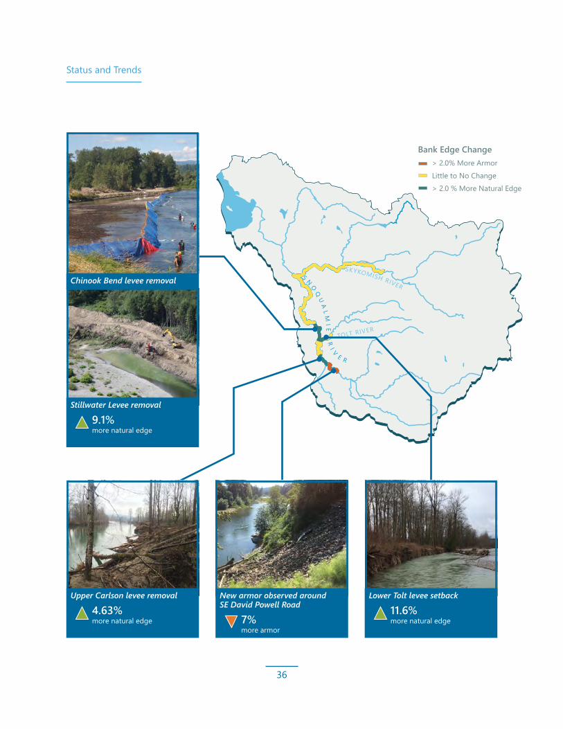
Status and Trends
36
SKYKOMISH RIVER
TOLT RIVER
S NO
QU
AL
MI E
RI V
E R
> 2.0% More ArmorLittle to No Change> 2.0 % More Natural Edge
Bank Edge Change
Stillwater Levee removal
9.1% more natural edge
Chinook Bend levee removal
Lower Tolt levee setback
11.6% more natural edge
New armor observed around SE David Powell Road
7% more armor
Upper Carlson levee removal
4.63% more natural edge

Status and Trends
37
Riparian and Forest Cover Riparian forest is an essential element of freshwater habitat for salmon. Forests and trees near rivers and streams provide shade, organic material, nutrient inputs, and large woody debris (LWD) that create geomorphic processes vital to complex salmon habitat formation.
Many restoration efforts involve gaining riparian habitat by replanting and restoring forests next to rivers. There are a variety of regulations designed to protect riparian forests, but these can be ineffective, and small losses in riparian forests accumulate into major losses at large scales. It is difficult to track habitat loss, but small losses continue to occur. Collectively, small losses in riparian forests can accumulate into major losses at large scales. It is difficult to track habitat loss, especially the accumulation of small losses across the watershed and over the time scale considered in this report. Tools are limited, and continued investment in high-resolution remote sensing is required to properly track changing habitat conditions.
There are currently two accessible remote sensing tools available to assess habitat losses on a large scale: NOAA’s Coastal Change Analysis Program dataset,1 and WDFW’s High Resolution Change Detection (HRCD) program.2 The NOAA dataset is based on landsat data and has a relatively low resolution, at 30 square
meters. These low-resolution data suggest forest lost in the Basin between 2006 and 2016 included 30 acres lost to development and 45 acres converted to cultivation; however, 30 acres of grassland and 407 acres of scrub-shrub were converted to riparian forest. Some loss of riparian forest is not bad, such as forest that erodes as rivers migrate, a natural process that benefits salmon habitat. The subtle nuances and large scale of land use data make interpretation difficult, and the lack of accuracy limits conclusions.
Until recently, NOAA’s dataset was the best tool available for assessing habitat losses over large spatial and temporal scales. WDFW’s HRCD program is based on imagery from the National Agriculture Imagery Program, which has a resolution of 1 meter. This dataset now spans 2006 to 2015 and gives a far more detailed and accurate picture of land use change, though it only classifies changes and agents of change, not land cover per se. Furthermore, due to omission errors, the estimates are likely conservative.
The HRCD program dataset suggests that between 2006 and 2015, roughly 642 acres of forest within 150-foot buffers was lost due to human activity. By far the largest portion of this loss occurred in forestry, which has complicated
1 NOAA (National Oceanic and Atmospheric Administration), Office for Coastal Management. “2006–2016.” Coastal Change Analysis Program (C-CAP) Regional Land Cover. Available at: www.coast.noaa.gov/ccapftp.
2 WDFW (Washington Department of Fish and Wildlife), 2019. High Resolution Change Detection 2006-2015. Dr. Ken Pierce Habitat Science Division. Available at: http://www.pshrcd.com.

Status and Trends
38
Development: 4% (30 acres)Cultivation: 6% (45 acres)
Grassland: 39% (304 acres)
Scrub-shrub: 34% (270 acres)
Shore/bare land/water: 17% (136 acres)
Data from NOAA Coastal Change Analysis Program
and variable regulatory protections, and this analysis did not determine protected forest loss due to forestry practices. However, some large sections of riparian forest were plantations on the valley floor that were harvested to the banks. These tree removals were classified as forestry but are not subject to forest practices and are treated as agriculture lands. When forestry change is removed, development and tree removal accounted for 178 acres of forest loss within 150-foot buffers. Tree removal was responsible for 159 acres of riparian forest loss, and development accounted for 19 acres of forest loss. Furthermore, 31 acres were permanently converted to impervious surface.
Due to low resolution of the NOAA Coastal Change Analysis Program data, there is significant error associated with assigning land use at riparian buffer scales. Continued improvement and investment in refining the HRCD high-resolution, remote-sensing data will increase the power of this tool. Improving the accuracy of other geographic data, especially small stream hydrography, is also important.
Forested Land Conversions (2006 to 2016) within 150‑Foot Buffers of Fish‑Bearing Streams
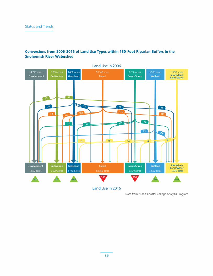
Status and Trends
39
Land Use in 2006
Land Use in 2016
Development4,710 acres 3,890 acres 1,480 acres 53,140 acres 6,910 acres 5,530 acres 11,790 acres
Cultivation Grassland Forest Scrub/Shrub Wetland Shore/Bare Land/Water
Development Cultivation Grassland Forest Scrub/Shrub Wetland Shore/Bare Land/Water
25
20 70
81 407
25
14 18
39
1822
30 45304 136
14
270
6714
18
33
4,850 acres 3,900 acres 1,740 acres 52,810 acres 6,730 acres 5,620 acres 11,930 acres
21
140 10 260330 180
90 140
Data from NOAA Coastal Change Analysis Program
Conversions from 2006‑2016 of Land Use Types within 150‑Foot Riparian Buffers in the Snohomish River Watershed

Status and Trends
40
Wood in RiversIn Snohomish Basin rivers and streams, wood is essential for the creation and maintenance of salmon habitat. Often referred to as LWD or accumulated wood jams, the amount of wood in a river reach greatly influences the quality, and often influences the quantity, of habitat available to salmon. Wood also increases storage in aquifers and groundwater exchange, which lowers temperatures. A single large tree with a mass of roots that falls into a river may disrupt river flow and cause the river to scour a pool deep enough for adult salmon to rest on the journey upstream. The downstream tail of the pool may contain scoured gravels suitable for spawning. This same wood may provide cover for juvenile salmon to forage while hiding from predators.
Wood that accumulates into large jams can have similar effects at a greater scale and may even alter the path of the river, spreading flow into side channels that create a mosaic of diverse terrestrial and aquatic habitats. Since Europeans settled the Snohomish Basin, human activities (logging for lumber and fuel, clearing for agriculture and development, and removing wood from rivers to facilitate river transportation) have dramatically reduced the amount and size of wood in rivers and
streams. This sustained lack of all wood and specifically lack of LWD from mature trees — or “key pieces” — is a primary contributing factor to the historical decline in the formation of stabile wood jams that create quality salmon habitat. The long-term solution to this deficit is to protect riparian forests and restore them to a level that approximates pre-settlement conditions wherever possible. This is a long-term prospect, requiring decades to centuries for newly planted riparian trees to reach a size that can significantly contribute LWD and jams to the Basin’s rivers.
To fill the gap between present conditions and a future with intact riparian forests, salmon recovery efforts have focused on shorter-term fixes to the wood deficit. Wood treatments called engineered log jams are frequently included in restoration projects to restore some of the functions provided by wood. Floodplain flood fencing, an alternative to building large engineered log jams, has also been used experimentally in the Snohomish Basin.
Few engineered log jams have been constructed since the Salmon Plan was adopted, but field surveys and remote sensing can show the overall trends for wood in rivers. Field surveys

Status and Trends
41
Mainstem River Segment 2002 2004 2007 2015 2017 ChangeSnohomish 9 27 18
SkykomishAbove Sultan 77 119 42
Below Sultan 35 40 5Pilchuck 52 64 12Sultan 8 21 13
SnoqualmieAbove Tolt 10 31 21Below Tolt 11 55 44
Tolt 13 52 39Total 215 409 194
1 Beechie, T., M. Liermann, M. Pollock, S. Baker, and J. Davies, 2006. “Channel Pattern and River Floodplain Dynamics in Forested Mountain River Systems.” Geomorphology 78:141–152.
2 Gregory, S., K. Boyer, A. Gurnell, editors, 2003. The Ecology and Management of Wood in World Rivers. American Fisheries Society Symposium 37.
3 Latterell, J., and R. Naiman, 2007. “Sources and Dynamics of Large Logs in a Temperate Floodplain River.” Ecological Applications 1127–1141.
4 Pess, G., M. Liermann, M. McHenry, R. Peters, and T. Bennett, 2012. “Juvenile Salmon Response to the Placement of Engineered Log Jams (ELJs) in the Elwha River, Washington State, USA.” River Research and Applications 28:872–881.
5 Roni, P., K. Hanson, and T. Beechie, 2008. “Global Review of the Physical and Biological Effectiveness of Stream Habitat Rehabilitation Techniques.” North American Journal of Fisheries Management 28:856–890.
6 Roni, P., T. Beechie, G. Pess, and K. Hanson, 2014. “Wood Placement in River Restoration: Fact, Fiction and Future Direction.” Canadian Journal of Fisheries and Aquatic Sciences 72(3):466–478.
yield information on wood quantity and characteristics, while remote sensing (rapid, multi-year aerial photograph assessments) can estimate the change in jam abundance over large areas. A recent compilation of data from field surveys and aerial photograph interpretation found that the number of mainstem jams has increased in many parts of the Basin since the Salmon Plan’s adoption. Continued monitoring will determine whether these new jams are stable and resilient to future floods or if a scarcity of key pieces causes jams to be short-lived and transitory in nature.
For supporting scientific documentation, see Beechie et al. 2006,¹ Gregory et al. 2003,² Latterell and Naiman 2007,³ Pess et al. 2012,⁴ Roni et al. 2008,⁵ and Roni et al. 2014.⁶
In‑River Wood Jam Observations in Selected Mainstem Rivers
Note: Total accounts for all in-river mainstem log jams, both constructed and naturally formed. It does not include floodplain log jams or wood structures used as bank stabilization or mitigation.

Status and Trends
42
Innovative Wood Treatment
The Salmon Plan calls for an increase in LWD in the Basin’s mainstem reaches. Traditionally, this would result in construction of large engineered log jams, built to resist high river flows and persist for decades. While engineered log jams yield salmon habitat benefits and are used in many projects, they are often expensive to design, permit, and build — which can limit the number of jams constructed over time.
In some mainstem projects, an innovative and experimental approach to placing wood offers a less costly and more flexible treatment than traditional engineered log jams while providing some of the same function. “Flood fences” or more generically “vertical wood arrays” are tree trunks placed vertically into floodplain soils or an active riverbed to mimic floodplain trees or natural instream wood structures, increase roughness, and obstruct river flow. These arrays have been placed in a variety of locations to achieve different habitat objectives. Floodplain installations protect riparian plantings and capture wood that would normally be transported away from the river. Instream arrays catch smaller wood to form in-channel jams, grow gravel bars, or protect vegetated islands, leading to increased channel complexity. While results are varied and still preliminary, vertical wood arrays are showing promise as an alternative to traditional jams in some situations. Monitoring of vertical wood arrays will continue, and lessons learned will be applied to future installation techniques. There is currently no Salmon Plan target for the number of arrays installed, so a formal implementation metric should be established to track progress over time.

Status and Trends
43
Climate ChangeOne of the most pressing concerns affecting salmon recovery in the Snohomish Basin is how climate change exacerbates unfavorable environmental conditions. Climate change science has been the focus of intense global and regional research for several decades. The message is clear: we must prepare for the current and future impacts of a changing climate and incorporate what we know about climate change into salmon recovery actions.
Climate change will likely affect the salmon recovery strategy in the Snohomish Basin. Impact predictions vary, and impact magnitudes are uncertain; however, it is predicted that regional precipitation patterns will shift toward warmer and wetter fall, winter, and spring conditions, with year-to-year variations. Floods are likely to be more intense and more frequent. Warmer, more rain-dominated, wetter winters are predicted to cause earlier and faster snowmelt in the mountains. Less snow and early disappearance of the snow pack can intensify drought-like, summer low-flow conditions in watersheds where precipitation is currently snow dominated. Increased average air temperatures will increase water temperatures in rivers and the ocean. Sea level rise, food web alteration, and ocean acidification will affect nearshore and estuary areas. It is expected that conditions that are considered to be the upper range of current year-to-year variability will become more common. Some of these climate change impacts are already occurring. These impacts, as well as others yet to be measured, are expected to affect all life stages of Pacific salmon, as illustrated on the following page.
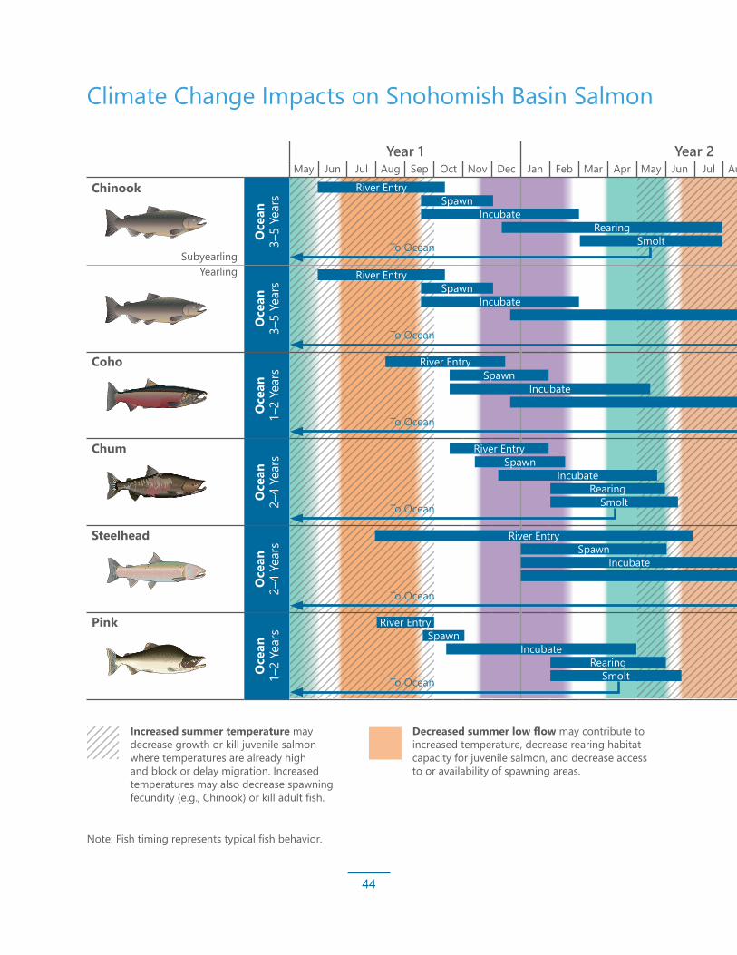
Status and Trends
44
Year 1 Year 2 Year 3 Year 4May Jun Jul Aug Sep Oct Nov Dec Jan Feb Mar Apr May Jun Jul Aug Sep Oct Nov Dec Jan Feb Mar Apr May Jun Jul Aug Sep Oct Nov Dec Jan Feb Mar Apr May Jun
Chinook
Oce
an
3–5
Year
sO
cean
3–
5 Ye
ars
Coho
Oce
an
1–2
Year
s
Chum
Oce
an
2–4
Year
s
Steelhead
Oce
an
2–4
Year
s
Pink
Oce
an
1–2
Year
s
Climate Change Impacts on Snohomish Basin Salmon
SubyearlingYearling
River Entry
River Entry
River Entry
River Entry
River Entry
River Entry
Spawn
Spawn
Spawn
Spawn
Spawn
Spawn
Incubate
Incubate
Incubate
Incubate
Incubate
Incubate
Rearing
Rearing
Rearing
Smolt
Smolt
Smolt
Increased summer temperature may decrease growth or kill juvenile salmon where temperatures are already high and block or delay migration. Increased temperatures may also decrease spawning fecundity (e.g., Chinook) or kill adult fish.
Decreased summer low flow may contribute to increased temperature, decrease rearing habitat capacity for juvenile salmon, and decrease access to or availability of spawning areas.
To Ocean
To Ocean
To Ocean
To Ocean
To Ocean
To Ocean
Note: Fish timing represents typical fish behavior.
Rearing
Rearing
Rearing

Status and Trends
45
Year 1 Year 2 Year 3 Year 4May Jun Jul Aug Sep Oct Nov Dec Jan Feb Mar Apr May Jun Jul Aug Sep Oct Nov Dec Jan Feb Mar Apr May Jun Jul Aug Sep Oct Nov Dec Jan Feb Mar Apr May Jun
Chinook
Oce
an
3–5
Year
sO
cean
3–
5 Ye
ars
Coho
Oce
an
1–2
Year
s
Chum
Oce
an
2–4
Year
s
Steelhead
Oce
an
2–4
Year
s
Pink
Oce
an
1–2
Year
s
Climate Change Impacts on Snohomish Basin Salmon
Incubate
Source: Adapted by King County from Beechie, T., H. Imaki, J. Greene, A. Wade, H. Wu, G. Pess, P. Roni, J. Kimball, J. Stanford, P. Kiffney, and N. Mantua, 2012. “Restoring Salmon Habitat for a Changing Climate.” River Research and Applications 29:939–960.
To Ocean
1–2 year Rearing SmoltRearing
Rearing
Rearing
Smolt
Smolt
Smolt
Increased winter floods may increase scour of eggs, or increase mortality of rearing juveniles where flood refugia are not available, and displace juveniles to less desirable habitats.
Loss of spring snowmelt may decrease or eliminate spawning opportunities for steelhead, may alter survival of eggs or emergent fry for other salmon species, cause early dewatering of off-channel and side-channel habitats, and reduce connectivity to the floodplain.

46
SALMON PLAN IMPLEMENTATIONIn 2005, the Forum adopted 10-year targets to guide critical Chinook salmon habitat restoration.The 10-year targets in the Salmon Plan represent milestones toward much larger and longer-term restoration goals. These targets were based on the need for significant and rapid gains in salmon habitat. However, for these gains to achieve full effect, losses must be avoided. We have no established process to track degradation rates and losses in habitat that happen concurrently with restoration progress, though some progress has been made in adaptive management since 2005, including projects like phase 1 of the Snohomish Basin Monitoring and Adaptive Management framework. The Salmon Plan assumes the existing protection mechanisms would be sufficient to maintain existing habitat so restoration would achieve gains and, eventually, recovery. Some work has been done to assess this assumption. It is clear that habitat loss is occurring, but the amount is uncertain and the cause is often unclear; identifying adaptations to increase the effectiveness of protection is limited by these ambiguities. It is important to reassess our targets

Salmon Plan Implementation
47
to ensure they adequately represent the gains needed and appropriately account for continuing habitat loss. For example, we appear to be on target for acres of riparian habitat restored, but losses in the riparian area must be considered when assessing our goals.
Despite this, the Snohomish Basin has experienced some great successes since 2005. Large and small projects have been implemented on both private and public lands. We have also encountered some unexpected challenges. The following pages discuss some case studies since adoption of the Salmon Plan, with more details about the progress of habitat restoration, protection, and monitoring and adaptive management in the remainder of this section.

Salmon Plan Implementation
48
Observation: Full Function Takes TimeEcosystem functions are restored slowly as project sites adjust to changed conditions and the landscape is reformed by seasonal river flows and tidal inundations.
For example, trees planted now could take 80 to 100 years to mature into a fully functioning riparian forest that provides wood inputs to the system, food for fish to eat, and shading to keep water temperatures at the ideal level. While some restoration metrics may be on target, these restoration sites are likely not yet performing at their maximum potential. Restoration sites need time to grow and mature; stewardship and monitoring are needed to support healthy vegetation and assess site habitat function. In some cases, projects may need to be adaptively managed to achieve their full habitat potential.
Fortunately, monitoring results at project sites like Qwuloolt and Smith Island in the estuary and the Upper Carlson floodplain restoration site on the Snoqualmie River have shown that, despite the current sub-optimal habitat, fish are responding to and using the newly restored habitat soon after restoration.
Installation of engineered log jams by Snohomish County on a slough of the lower Skykomish River
Habitat Restoration ProgressRestoration efforts have made progress toward the 10-year goals since 2005, but a process was not designed to track rates of additional degradation. (Note degradation is discussed in the previous “Status and Trends” section.) The 10-year targets for habitat restoration in the Salmon Plan represent milestones toward much larger and longer-term restoration needs. The Salmon Plan categorizes the 62 sub-basins in the Snohomish River Basin and the nearshore area into 12 strategy groups based on their location, habitat conditions, and current and potential salmon use. Habitat improvement targets are organized by nearshore, estuary, mainstem, and other sub-basin strategy groups, as discussed in the following sub-sections.

Salmon Plan Implementation
49
Nearshore Sub-Basin Strategy Group Snapshot from 2005 Salmon Plan
Life History Stages: Migration and rearing
Chinook Salmon, Bull Trout, and Coho Salmon Use (current or potential): High
Condition of Watershed Processes: Moderately degraded
Recovery Need: Substantial improvement
Nearshore
Nearshore RestorationNearshore habitats include eelgrass, kelp beds, and forage fish use areas. Approximately 70% of the nearshore area in the Basin has significant modifications that have resulted in loss of habitat critical to salmon at various life stages. The most significant impacts to the nearshore have been from the railroad and shoreline armoring designed to protect coastal homes. The recovery focus of the Salmon Plan is on habitat and process restoration, edge habitat, sediment delivery from feeder bluffs, and riparian planting. The priority strategies for nearshore habitat restoration include restoring shoreline conditions and sediment processes; enhancing riparian conditions; protecting undeveloped shoreline and low-gradient areas; retaining forest cover; and preventing further fill or dredging within the photic zone (the surface layer that receives sunlight).
Since adoption of the Salmon Plan, new studies have been conducted in Puget Sound and the Basin shoreline areas that furthers our understanding of the nearshore habitat’s role in salmon recovery. This work includes evaluations of impacts of bulkheads on forage fish habitat; forage fish use and distribution; a study of Chinook salmon rearing in non-natal coastal streams in the Whidbey Basin1; a prioritization of small coastal streams for daylighting; as well as the projected effects of sea level rise, sediment transport, and wave modeling on coastal areas.2
1 Beamer, E., W. Zackey, D. Marks, D. Teel, D. Kuligowski, and R. Henderson, 2013. Juvenile Chinook Salmon Rearing in Small Non-Natal Streams Draining into the Whidbey Basin. Skagit River System Cooperative, LaConner, Washington.
2 National Research Council, 2012. Sea Level Rise for the Coast of California, Oregon, and Washington. Committee on Sea Level Rise in California, Oregon, and Washington; Board of Earth Sciences and Resources; Ocean Studies Board; Division on Earth and Life Sciences.
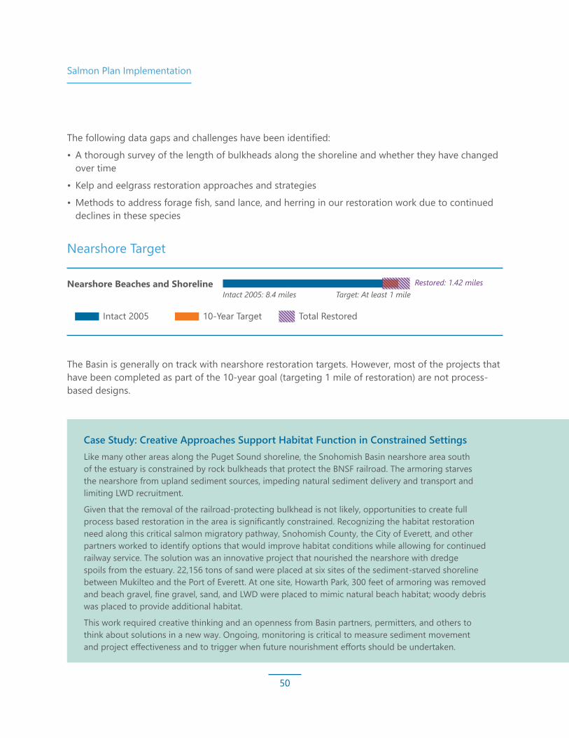
Salmon Plan Implementation
50
Nearshore Target
The Basin is generally on track with nearshore restoration targets. However, most of the projects that have been completed as part of the 10-year goal (targeting 1 mile of restoration) are not process-based designs.
Case Study: Creative Approaches Support Habitat Function in Constrained Settings Like many other areas along the Puget Sound shoreline, the Snohomish Basin nearshore area south of the estuary is constrained by rock bulkheads that protect the BNSF railroad. The armoring starves the nearshore from upland sediment sources, impeding natural sediment delivery and transport and limiting LWD recruitment.
Given that the removal of the railroad-protecting bulkhead is not likely, opportunities to create full process based restoration in the area is significantly constrained. Recognizing the habitat restoration need along this critical salmon migratory pathway, Snohomish County, the City of Everett, and other partners worked to identify options that would improve habitat conditions while allowing for continued railway service. The solution was an innovative project that nourished the nearshore with dredge spoils from the estuary. 22,156 tons of sand were placed at six sites of the sediment-starved shoreline between Mukilteo and the Port of Everett. At one site, Howarth Park, 300 feet of armoring was removed and beach gravel, fine gravel, sand, and LWD were placed to mimic natural beach habitat; woody debris was placed to provide additional habitat.
This work required creative thinking and an openness from Basin partners, permitters, and others to think about solutions in a new way. Ongoing, monitoring is critical to measure sediment movement and project effectiveness and to trigger when future nourishment efforts should be undertaken.
The following data gaps and challenges have been identified:
• A thorough survey of the length of bulkheads along the shoreline and whether they have changed over time
• Kelp and eelgrass restoration approaches and strategies
• Methods to address forage fish, sand lance, and herring in our restoration work due to continued declines in these species
Nearshore Beaches and Shoreline
Estuary: Tidal Marsh
Mainstem Primary RestorationRestored Edge Habitat
Restored Riparian Habitat
Restored Off-Channel Habitat
Large Woody Debris
Intact 2005
Intact 2005: 8.4 miles
Intact 2005: 1,483 acres Target: 1,237 acres
Intact 2005: 236 miles Target: 10.4 miles
Target: At least 1 mileRestored: 1.42 miles
Restored: 1,025.6 acresa,b
Restored: 2.02 miles
Intact 2005: 5,991 acres Target: 256 acres
Intact 2005: 350 acres Target: 167 acres
Target: 41 new log jams
Restored: 332 acresc
Restored: 13.72 acres
Restored: 46 log jamsd
10-Year Target Total Restored
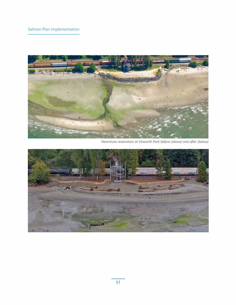
Salmon Plan Implementation
51
Nearshore restoration at Howarth Park before (above) and after (below)

Salmon Plan Implementation
52
Estuary RestorationThe estuary provides Chinook salmon and other salmon unique and critical habitat for rearing, migration, and transitioning between fresh and saltwater. More than 85% of the historical estuary marshlands in the Basin have been lost. This fragmentation has depressed salmon population performance and created a rearing bottleneck for young salmon. Restoration of the estuary wetlands is critical, including reconnection to off-channel habitats, improvements in fish passage and tidal exchange, restoration of shoreline conditions, and riparian enhancement. In addition, preventing further degradation through the protection of existing, functioning wetlands, and those with a high potential to be restored to tidal function, is critical to salmon recovery success.
Since the adoption of the Salmon Plan, new information has been developed to better understand fish use in the estuary¹ as well as information on restoration project performance, estuary salinity and connectivity, sedimentation rates, and projections of sea level rise in the estuary. This information points toward a need for additional connected habitat in the upper estuary zones. Basin partners will need to continue to work together to identify a path for advancing these projects.
Estuary Sub-Basin Strategy Group Snapshot from 2005 Salmon Plan
Life History Stages: Migration, rearing, smoltification
Chinook Salmon, Bull Trout, and Coho Salmon Use (current or potential): High
Condition of Watershed Processes: Degraded
Recovery Need: Substantial improvement
Snohomish Estuary
1 Hall, J., T. Khangaonkar, C. Rice, J. Chamberlin, T. Zackey, F. Leonetti, M. Rustay, K. Fresh, A. Kagley, and M. Rowse, 2018. “Characterization of Salinity and Temperature Patterns in a Large River Delta to Support Tidal Wetland Habitat Restoration.” Northwest Science 92:36–52.

Salmon Plan Implementation
53
Notes:a. Total shown does not include tidal marsh restored for mitigation. Inclusion of mitigation acreage would bring the total to
1,319.5 acres.b. An additional 360 acres will be restored with the completion of the Blue Heron Slough mitigation project in 2021.
Smith Island, Snohomish River Estuary, 2018 (photo credit to Whitney Hassett – Geodesy)
Estuary Target
The Forum set an ambitious 10-year target of 1,237 acres of estuary restoration, with the recognition that it would be the first of a series of goals to recover salmon. The Snohomish Estuary has seen large gains since adoption of the Salmon Plan. To date, it has the most restored area of any estuary in Puget Sound. The focus of restoration has been in the lower estuary area, creating a contiguous area that will connect multiple projects. It takes time for estuary restoration projects to reach peak performance to support juvenile Chinook salmon. Vegetation needs to re-establish, tides need to carve out channels, and sediment needs to shift and rebuild. At this point, we have just begun to restart processes that will continue for many years. It is a significant accomplishment to have reached the current state of restoration in the estuary. This work was more complex, expensive, and time consuming than was likely assumed in 2005. The following table and map summarize progress in the estuary, including both restoration and mitigation.
Nearshore Beaches and Shoreline
Estuary: Tidal Marsh
Mainstem Primary RestorationRestored Edge Habitat
Restored Riparian Habitat
Restored Off-Channel Habitat
Large Woody Debris
Intact 2005
Intact 2005: 8.4 miles
Intact 2005: 1,483 acres Target: 1,237 acres
Intact 2005: 236 miles Target: 10.4 miles
Target: At least 1 mileRestored: 1.42 miles
Restored: 1,099.6 acresa,b
Restored: 2.02 miles
Intact 2005: 5,991 acres Target: 256 acres
Intact 2005: 350 acres Target: 167 acres
Target: 41 new log jams
Restored: 332 acresc
Restored: 13.72 acres
Restored: 46 log jamsd
10-Year Target Total Restored
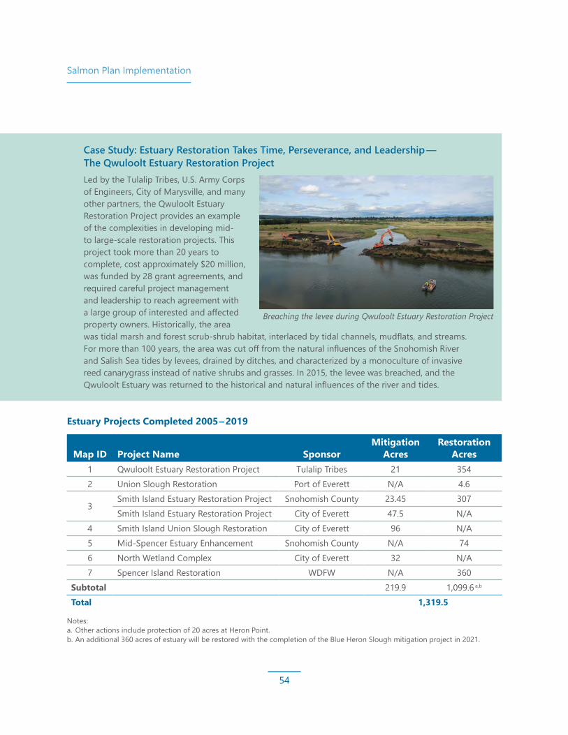
Salmon Plan Implementation
54
Notes: a. Other actions include protection of 20 acres at Heron Point. b. An additional 360 acres of estuary will be restored with the completion of the Blue Heron Slough mitigation project in 2021.
Case Study: Estuary Restoration Takes Time, Perseverance, and Leadership — The Qwuloolt Estuary Restoration Project Led by the Tulalip Tribes, U.S. Army Corps of Engineers, City of Marysville, and many other partners, the Qwuloolt Estuary Restoration Project provides an example of the complexities in developing mid- to large-scale restoration projects. This project took more than 20 years to complete, cost approximately $20 million, was funded by 28 grant agreements, and required careful project management and leadership to reach agreement with a large group of interested and affected property owners. Historically, the area was tidal marsh and forest scrub-shrub habitat, interlaced by tidal channels, mudflats, and streams. For more than 100 years, the area was cut off from the natural influences of the Snohomish River and Salish Sea tides by levees, drained by ditches, and characterized by a monoculture of invasive reed canarygrass instead of native shrubs and grasses. In 2015, the levee was breached, and the Qwuloolt Estuary was returned to the historical and natural influences of the river and tides.
Breaching the levee during Qwuloolt Estuary Restoration Project
Map ID Project Name SponsorMitigation
AcresRestoration
Acres1 Qwuloolt Estuary Restoration Project Tulalip Tribes 21 3542 Union Slough Restoration Port of Everett N/A 4.6
3Smith Island Estuary Restoration Project Snohomish County 23.45 307Smith Island Estuary Restoration Project City of Everett 47.5 N/A
4 Smith Island Union Slough Restoration City of Everett 96 N/A5 Mid-Spencer Estuary Enhancement Snohomish County N/A 746 North Wetland Complex City of Everett 32 N/A7 Spencer Island Restoration WDFW N/A 360
Subtotal 219.9 1,099.6 a,b
Total 1,319.5
Estuary Projects Completed 2005 – 2019

Salmon Plan Implementation
55
Estuary and Nearshore Restoration Sites
?¿
A
SteamboatSlough
Ebey Slou gh
Snoh
omis
hRive
r
Union Slough
N0 1 20.5
Miles0 1.5 30.75
Kilometers
ProtectedRivers & Streams
Restoration Complete
Restoration Project in Process
Restoration Complete, Possible Additional Enhancements
Potential Future Restoration Focus
1
2
3 5
4
7
6
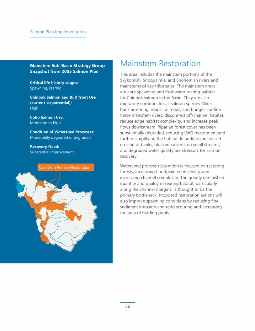
Salmon Plan Implementation
56
Mainstem RestorationThis area includes the mainstem portions of the Skykomish, Snoqualmie, and Snohomish rivers and mainstems of key tributaries. The mainstem areas are core spawning and freshwater rearing habitat for Chinook salmon in the Basin. They are also migratory corridors for all salmon species. Dikes, bank armoring, roads, railroads, and bridges confine these mainstem rivers, disconnect off-channel habitat, reduce edge habitat complexity, and increase peak flows downstream. Riparian forest cover has been substantially degraded, reducing LWD recruitment and further simplifying the habitat. In addition, increased erosion of banks, blocked culverts on small streams, and degraded water quality are stressors for salmon recovery.
Watershed process restoration is focused on restoring forests, increasing floodplain connectivity, and increasing channel complexity. The greatly diminished quantity and quality of rearing habitat, particularly along the channel margins, is thought to be the primary bottleneck. Proposed restoration actions will also improve spawning conditions by reducing fine sediment intrusion and redd scouring and increasing the area of holding pools.
Mainstem Sub‑Basin Strategy Group Snapshot from 2005 Salmon Plan
Critical life history stages: Spawning, rearing
Chinook Salmon and Bull Trout Use (current or potential): High
Coho Salmon Use: Moderate to high
Condition of Watershed Processes: Moderately degraded or degraded
Recovery Need: Substantial improvement
Mainstem Primary Restoration

Salmon Plan Implementation
57
Restoration of the mainstem sub-basin areas aims to accomplish the following goals:
• Remove human-made instream barriers along or adjacent to priority reaches
• Reconnect off-channel habitats
• Restore shoreline conditions and hydrologic and sediment processes for peak and base flow
• Enhance riparian habitat
• Protect focus reaches to prevent further degradation
• Maintain hydrologic and sediment processes through acquisitions, incentives, and regulations to protect wetlands, minimize increases in impervious surfaces, retain forest cover, and prevent urban sprawl
In the mainstem, priorities include restoring riparian, edge, and off-channel habitat, and placing LWD where appropriate to support rearing of juvenile Chinook salmon and other species. These priority targets are discussed in sections on the following pages.
Case Study: Achieving Mainstem Restoration by Setting Expectations and Implementing a Vision — The Fall City Reach-Scale PlanAssessments completed in the Basin help set the stage for work and conditions needed to advance salmon recovery. The Snoqualmie Fall City Reach Restoration Assessment identified the most important areas for Chinook salmon recovery projects and set forth a strategic approach that maximizes gains for fish while respecting other needs in the region.
Completing the feasibility assessment has allowed King County to set expectations in a critical area for salmon habitat and resulted in focused implementation. The upper Carlson floodplain restoration project on the Snoqualmie River was completed in 2014, and two more levee setback projects are in the pre-design stage.
Case Study: Acquisition Works — Tolt San Souci NeighborhoodIn many areas of the Snohomish Basin, development has resulted in structures becoming vulnerable to repetitive flooding losses. Over the past 10 years, King County and Seattle Public Utilities have worked with the Tolt San Souci neighborhood to provide fair market value acquisition of properties that are at high risk of flooding and are in critical Chinook salmon habitat. Acquisitions have reduced the risk to personal property and provide undisturbed spawning areas for Chinook salmon, and flood and land managers are now able to take a more hands-off approach.
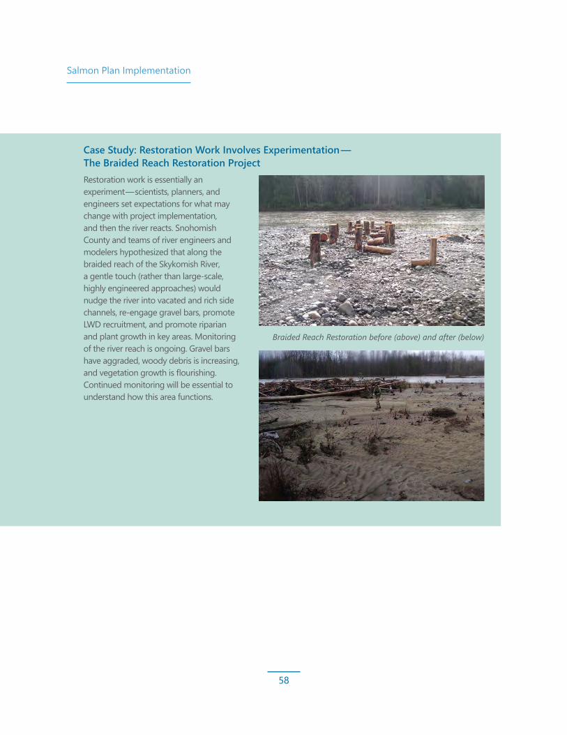
Salmon Plan Implementation
58
Case Study: Restoration Work Involves Experimentation — The Braided Reach Restoration ProjectRestoration work is essentially an experiment — scientists, planners, and engineers set expectations for what may change with project implementation, and then the river reacts. Snohomish County and teams of river engineers and modelers hypothesized that along the braided reach of the Skykomish River, a gentle touch (rather than large-scale, highly engineered approaches) would nudge the river into vacated and rich side channels, re-engage gravel bars, promote LWD recruitment, and promote riparian and plant growth in key areas. Monitoring of the river reach is ongoing. Gravel bars have aggraded, woody debris is increasing, and vegetation growth is flourishing. Continued monitoring will be essential to understand how this area functions.
Braided Reach Restoration before (above) and after (below)
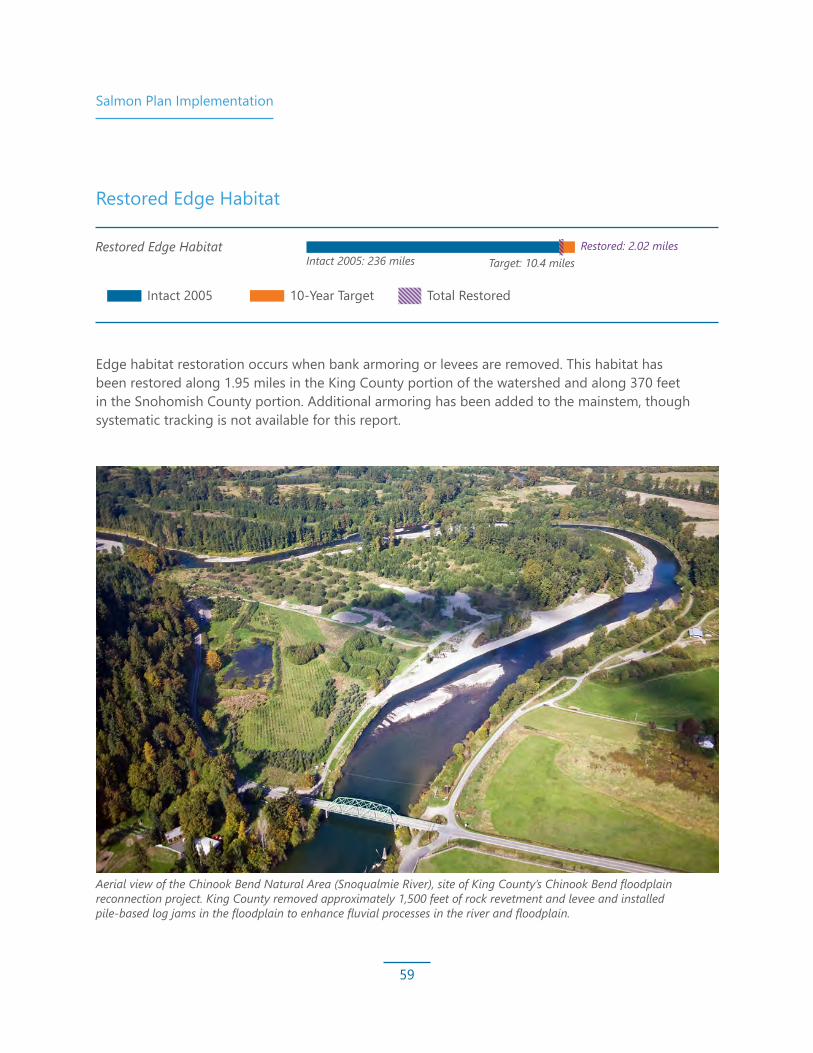
Salmon Plan Implementation
59
Edge habitat restoration occurs when bank armoring or levees are removed. This habitat has been restored along 1.95 miles in the King County portion of the watershed and along 370 feet in the Snohomish County portion. Additional armoring has been added to the mainstem, though systematic tracking is not available for this report.
Aerial view of the Chinook Bend Natural Area (Snoqualmie River), site of King County’s Chinook Bend floodplain reconnection project. King County removed approximately 1,500 feet of rock revetment and levee and installed pile-based log jams in the floodplain to enhance fluvial processes in the river and floodplain.
Nearshore Beaches and Shoreline
Estuary: Tidal Marsh
Mainstem Primary RestorationRestored Edge Habitat
Restored Riparian Habitat
Restored Off-Channel Habitat
Large Woody Debris
Intact 2005
Intact 2005: 8.4 miles
Intact 2005: 1,483 acres Target: 1,237 acres
Intact 2005: 236 miles Target: 10.4 miles
Target: At least 1 mileRestored: 1.42 miles
Restored: 1,025.6 acresa,b
Restored: 2.02 miles
Intact 2005: 5,991 acres Target: 256 acres
Intact 2005: 350 acres Target: 167 acres
Target: 41 new log jams
Restored: 332 acresc
Restored: 13.72 acres
Restored: 46 log jamsd
10-Year Target Total Restored
Restored Edge Habitat

Salmon Plan Implementation
60
Restored Riparian Habitat Target
Gains in riparian habitat are generally achieved through replanted and restored forests next to rivers. Though on-the-ground riparian restoration acreage targets in the Basin have been met, most of the plantings conducted within the last 10 years do not meet the 150-foot riparian width guideline. Additionally, though some benefits are realized quickly, it takes at least 80 years for the full suite of ecological functions to begin to be meaningfully restored. Full restoration occurs over centuries, emphasizing the need to protect intact habitat.
Riparian restoration is one target where gains have been offset by losses (refer to the riparian status information on page 37 for more information). Some of these changes are beneficial, such as the river moving into an area and creating more diverse woody habitat for fish. However, changes such as anthropogenic tree clearing are detrimental to the overall health of the system for fish. Though there are meaningful regulations in place to protect these areas, there are still demonstrated losses occurring throughout the Basin.
As we move forward, it is important to recognize the expanding need to plant riparian areas, especially as we face new emerging threats associated with climate change, such as rising water temperatures and invasive species concerns. An emerging threat since the adoption of the
Salmon Plan is the pervasive spread of invasive species, including knotweed, which are likely having negative ecological impacts in riparian areas. As we continue into the next years of recovery, new targets will need to account for losses, increased protection of existing buffers, and the potential for a greater buffer extent into the future.
Nearshore Beaches and Shoreline
Estuary: Tidal Marsh
Mainstem Primary RestorationRestored Edge Habitat
Restored Riparian Habitat
Restored Off-Channel Habitat
Large Woody Debris
Intact 2005
Intact 2005: 8.4 miles
Intact 2005: 1,483 acres Target: 1,237 acres
Intact 2005: 236 miles Target: 10.4 miles
Target: At least 1 mileRestored: 1.42 miles
Restored: 1,025.6 acresa,b
Restored: 2.02 miles
Intact 2005: 5,991 acres Target: 256 acres
Intact 2005: 350 acres Target: 167 acres
Target: 41 new log jams
Restored: 332 acresc
Restored: 13.72 acres
Restored: 46 log jamsd
10-Year Target Total Restored
Note:Total shown includes Snohomish County Conservation Reserve Enhancement Program and progress through 2018. Note this progress total does not account for riparian habitat losses (refer to the discussion on page 37).
Nearshore Beaches and Shoreline
Estuary: Tidal Marsh
Mainstem Primary RestorationRestored Edge Habitat
Restored Riparian Habitat
Restored Off-Channel Habitat
Large Woody Debris
Intact 2005
Intact 2005: 8.4 miles
Intact 2005: 1,483 acres Target: 1,237 acres
Intact 2005: 236 miles Target: 10.4 miles
Target: At least 1 mileRestored: 1.42 miles
Restored: 1,025.6 acresa,b
Restored: 2.02 miles
Intact 2005: 5,991 acres Target: 256 acres
Intact 2005: 350 acres Target: 167 acres
Target: 41 new log jams
Restored: 332 acres
Restored: 13.72 acres
Restored: 46 log jams
10-Year Target Total Restored

Salmon Plan Implementation
61
Restored Off-Channel Habitat Target
Off-channel habitats are side channels, sloughs, and wetlands connected to the mainstem rivers and estuaries, even if only seasonally. These habitats are important to salmon because they provide areas for juvenile fish to rear with safety from predators, have reduced competition for space and food, and stay away from high winter flows. Measuring off-channel habitat is difficult in the Basin as off-channel habitat is engaged differently in the two major river basins. The Snoqualmie River floods like a bathtub, and the entire 2-mile-wide valley bottom can be considered off-channel habitat at certain flood flows. While fish may be able to get into those off-channel areas during a flood event, they may not be able to get back into the Snoqualmie River because much of the habitat is disconnected from the mainstem except during floods. The Skykomish River, however, tends to have off-channel habitats closer to the mainstem that, when present, maintain a more direct connection to the river.
Proper tracking of off-channel habitat would require measuring flow to understand when and how often a particular feature is engaged. It is important to consider how easily fish can access habitat and return to the mainstem when necessary. Because the conditions by which off-channel habitats are engaged are considerably different in the Snoqualmie and Skykomish river systems, determining a single off-channel habitat measurement is challenging.
The Snohomish Basin Salmon Recovery Technical Committee has considered stepping away from measuring off-channel habitat, due to the complexity of defining the habitat, and instead measuring floodplain connectivity to represent the amount of area restoration projects open up for habitat-forming processes, including off-channel habitat. Appropriate measurements are still under consideration.
Nearshore Beaches and Shoreline
Estuary: Tidal Marsh
Mainstem Primary RestorationRestored Edge Habitat
Restored Riparian Habitat
Restored Off-Channel Habitat
Large Woody Debris
Intact 2005
Intact 2005: 8.4 miles
Intact 2005: 1,483 acres Target: 1,237 acres
Intact 2005: 236 miles Target: 10.4 miles
Target: At least 1 mileRestored: 1.42 miles
Restored: 1,025.6 acresa,b
Restored: 2.02 miles
Intact 2005: 5,991 acres Target: 256 acres
Intact 2005: 350 acres Target: 167 acres
Target: 41 new log jams
Restored: 332 acresc
Restored: 13.72 acres
Restored: 46 log jamsd
10-Year Target Total Restored
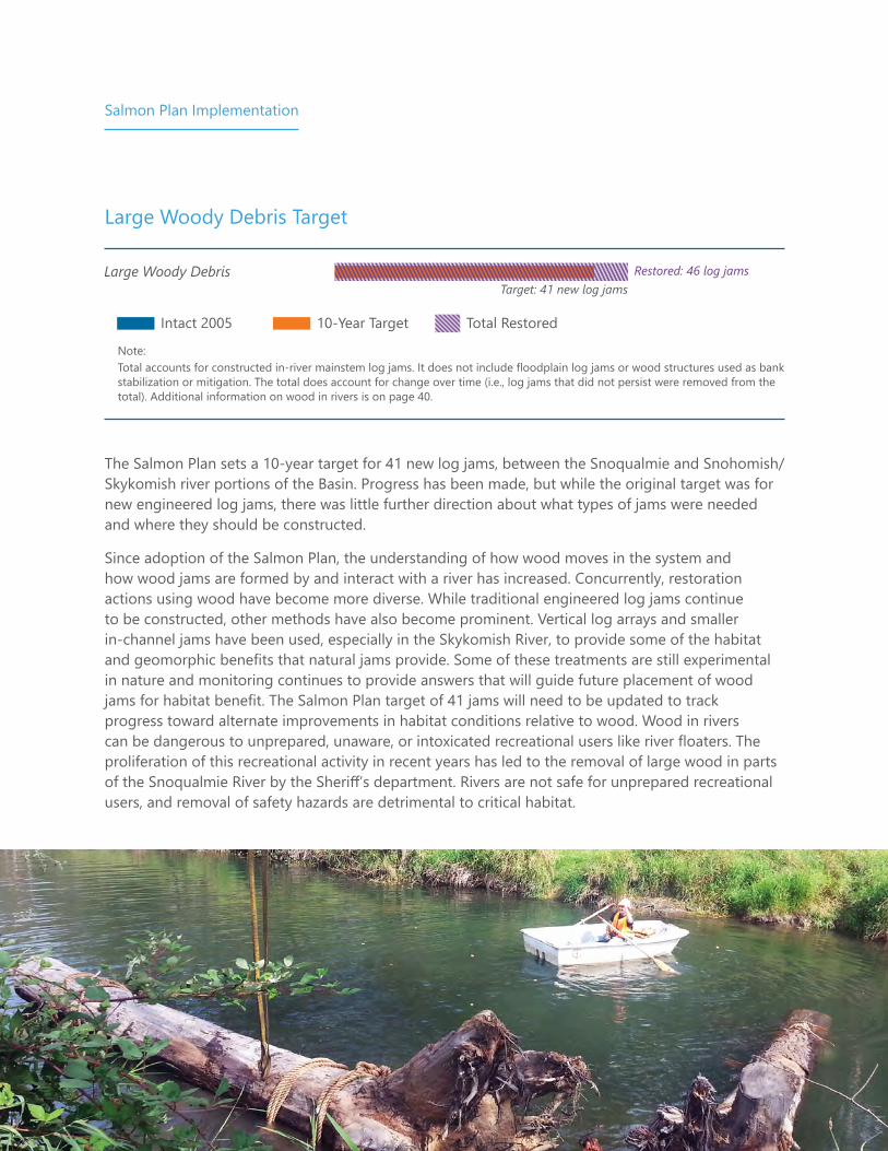
Salmon Plan Implementation
62
Large Woody Debris Target
The Salmon Plan sets a 10-year target for 41 new log jams, between the Snoqualmie and Snohomish/Skykomish river portions of the Basin. Progress has been made, but while the original target was for new engineered log jams, there was little further direction about what types of jams were needed and where they should be constructed.
Since adoption of the Salmon Plan, the understanding of how wood moves in the system and how wood jams are formed by and interact with a river has increased. Concurrently, restoration actions using wood have become more diverse. While traditional engineered log jams continue to be constructed, other methods have also become prominent. Vertical log arrays and smaller in-channel jams have been used, especially in the Skykomish River, to provide some of the habitat and geomorphic benefits that natural jams provide. Some of these treatments are still experimental in nature and monitoring continues to provide answers that will guide future placement of wood jams for habitat benefit. The Salmon Plan target of 41 jams will need to be updated to track progress toward alternate improvements in habitat conditions relative to wood. Wood in rivers can be dangerous to unprepared, unaware, or intoxicated recreational users like river floaters. The proliferation of this recreational activity in recent years has led to the removal of large wood in parts of the Snoqualmie River by the Sheriff’s department. Rivers are not safe for unprepared recreational users, and removal of safety hazards are detrimental to critical habitat.
Nearshore Beaches and Shoreline
Estuary: Tidal Marsh
Mainstem Primary RestorationRestored Edge Habitat
Restored Riparian Habitat
Restored Off-Channel Habitat
Large Woody Debris
Intact 2005
Intact 2005: 8.4 miles
Intact 2005: 1,483 acres Target: 1,237 acres
Intact 2005: 236 miles Target: 10.4 miles
Target: At least 1 mileRestored: 1.42 miles
Restored: 1,025.6 acresa,b
Restored: 2.02 miles
Intact 2005: 5,991 acres Target: 256 acres
Intact 2005: 350 acres Target: 167 acres
Target: 41 new log jams
Restored: 332 acresc
Restored: 13.72 acres
Restored: 46 log jamsd
10-Year Target Total Restored
Note:Total accounts for constructed in-river mainstem log jams. It does not include floodplain log jams or wood structures used as bank stabilization or mitigation. The total does account for change over time (i.e., log jams that did not persist were removed from the total). Additional information on wood in rivers is on page 40.
Nearshore Beaches and Shoreline
Estuary: Tidal Marsh
Mainstem Primary RestorationRestored Edge Habitat
Restored Riparian Habitat
Restored Off-Channel Habitat
Large Woody Debris
Intact 2005
Intact 2005: 8.4 miles
Intact 2005: 1,483 acres Target: 1,237 acres
Intact 2005: 236 miles Target: 10.4 miles
Target: At least 1 mileRestored: 1.42 miles
Restored: 1,025.6 acresa,b
Restored: 2.02 miles
Intact 2005: 5,991 acres Target: 256 acres
Intact 2005: 350 acres Target: 167 acres
Target: 41 new log jams
Restored: 332 acres
Restored: 13.72 acres
Restored: 46 log jams
10-Year Target Total Restored

Salmon Plan Implementation
63
Other Sub-Basin Strategy GroupsRiparian Forest and Off-Channel Habitat RestorationMainstem secondary restoration areas, rural streams, and urban streams each have unique restoration targets, including 50- and 10-year targets. Riparian forests in rural streams have had some significant gains above those set in the Salmon Plan. This is in large part due to the partnerships formed in the Woods Creek drainage area that spans both primary and secondary categories. New temperature data and the results from a Total Maximum Daily Load study directed focus on riparian planting in the Woods Creek drainage. Land cover assessments identified a goal of 45 acres planted to achieve 80% cover along the mainstem. In addition, the emerging concerns about the threat of climate change on temperature pointed to the need for contiguous buffers along the stream channel. The decision to focus work in the Woods Creek drainage was developed due to the proximity to urbanizing areas and the potential to restore a full watershed process, and locations for restoration were focused by a detailed assessment that provided riparian and instream wood targets specific for this sub-basin.
Urban forests have seen some limited replanting, but these areas are also some of those at the greatest risk for deforestation in the Basin and are also already highly degraded. There has been no off-channel habitat formation/reconnection work completed with a strictly restoration focus. However, work has been completed in some areas with mitigation funding, which is not currently counted toward the restoration goals.
In general, the Salmon Plan is a long-term recovery vision that projects the habitat gains needed over 50 years to achieve our overall salmon population goals. In a few select sub-basin strategy groups, 50-year habitat gains were identified for Riparian Forest acres and Off-Channel Habitat acres. The Salmon Plan is intended to be adaptively managed with updates to recovery strategies and habitat goals as new science and information is incorporated.
Sub-Basin Strategy Group
Mainstem Secondary
Rural Streams Primary
Rural Stream Secondary
Urban Streams
Riparian Forests (acres)
Target 6 13 Not identified 75Restored 0 62.3 20.3* 21
Off-Channel Habitat (acres)
Target Not identified 10 41 Not identifiedRestored 0 0 0 0
Note:* Numbers may be higher because all of Woods Creek was rolled into Rural Streams Primary due to data limitations.

Salmon Plan Implementation
64
Restored Riparian
Basin Location Acres Gained
King County
Snoqualmie Mainstem 179.36Other Snoqualmie Sub-basins 26.3Snoqualmie Rural Streams Primary 20.1Snoqualmie Upper watershed 76.47King County Total 302.23
Snohomish County
Skykomish 34.5Woods Creek 44.0Pilchuck 9.4Snohomish 54.0Urban Streams 21.4Conservation Reserve Enhancement Program (CREP) 68.98Snohomish County Total 163.3 (232.28 with CREP)
Total Basin-Wide 534.51
Sub-Basin Strategy Group GoalsRiparian Restoration
(acres)Restoration with CREP
(acres)Mainstem Primary 256 acres 277.3 332.7Rural Streams 66.3 73.1Mainstem Secondary 6 acres 4.91Urban Streams 75 acres 21.4
Observation: Partnerships Between Organizations Lead to Greater Restoration Outcomes: Woods Creek PartnershipIn the Woods Creek drainage area, the Snohomish Conservation District, Adopt a Stream Foundation, Sound Salmon Solutions, Wild Fish Conservancy, and Snohomish County have worked together to leverage each other’s work to support riparian plantings, wood placement, and culvert replacements in public and private areas. This partnership draws on the strengths of each organization and maximizes the impact with every dollar invested.

Salmon Plan Implementation
65
The total riparian planting area in the Snohomish Basin is approximately 535 acres, with 232.28 acres on the Snohomish County side of the watershed (includes Conservation Reserve Enhancement Program [CREP]) and 302.23 acres on the King County side. These impressive numbers move us toward restoration targets for mainstem and rural stream primary areas but fall short for mainstem secondary areas and urban streams.
Additional observations include the following:
• Due to land availability constraints and lack of willingness, many plantings have not been 150 feet deep, despite the recommendation in the Salmon Plan.
• Unpublished data from the Snoqualmie Valley suggests that attention to maintenance may increase long-term viability of plantings, though survival rates of plantings are unknown. CREP plantings are monitored for the life of the contract (typically more than 15 years), and maintenance and monitoring are completed where needed. But maintenance at most other sites is underfunded, and survival of tree and shrub species is unknown typically after the first 3 years.
• It takes at least 80 years for a riparian forest to mature to provide most of the habitat benefits (e.g., LWD into the river, shading, insects). Even then, the composition of tree species may still be early successional (e.g., cottonwood and alder), not yet meeting the ideal habitat conditions that mixed conifer forests provide. Areas that were planted during this reporting period are not yet fulfilling full ecological function; thus, habitat protection should be prioritized over restoration.
• Invasive species presence in the Basin is assumed to be growing despite ongoing efforts, and thus the overall health of the riparian area is continuing to diminish. Headway has been made, but additional effort is needed. Important riparian species are being outcompeted and outpaced by other species.

Salmon Plan Implementation
66
Snoqualmie Skykomish/Snohomish
Landowner Acres
Roads Improved
(miles)
Fish Passage Barriers
Assessed/Remaining Acres
Roads Improved
(miles)
Fish Passage Barriers
Assessed/Remaining
State 51,843 363 29/3 85,000 650 85/0City N/A N/A N/A 3,200 16 2/1Private 101,171 965 64/0 31,724 240 57/0Totals 153,014 1,328 93/3 119,924 906 144/1
Road Maintenance and Abandonment Plan ObservationsDeveloped as part of the Forests and Fish Law in 2001, the Road Maintenance and Abandonment Plan (RMAP) process required large forest landowners (who own more than 5,000 acres in Washington) to improve and maintain all forest roads to the standards outlined in the Forest and Fish Washington Administrative Code 222-24-051 by the end of 2016 (or 2021 if granted an approved extension). These standards include improving road systems that deliver sediment to typed waters, disconnecting ditch water from typed water, improving hydrologic connectivity by minimizing the interruption of surface water drainage, and, most importantly, removing fish passage barriers.
The following table shows the status of road improvements and fish passage barrier assessment. Three landowners requested RMAP extensions, one of which has since completed their RMAP obligations; the other two have only four fish passage barriers that need to be assessed in the watershed.
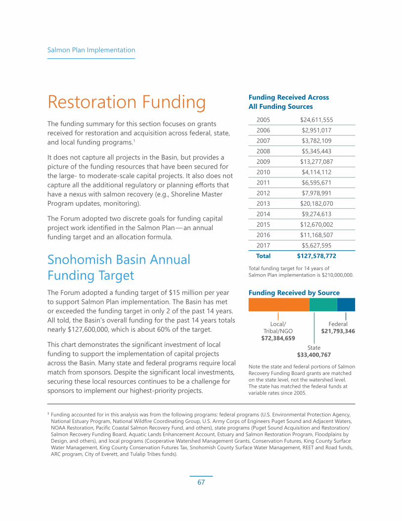
Salmon Plan Implementation
67
Restoration FundingThe funding summary for this section focuses on grants received for restoration and acquisition across federal, state, and local funding programs.1
It does not capture all projects in the Basin, but provides a picture of the funding resources that have been secured for the large- to moderate-scale capital projects. It also does not capture all the additional regulatory or planning efforts that have a nexus with salmon recovery (e.g., Shoreline Master Program updates, monitoring).
The Forum adopted two discrete goals for funding capital project work identified in the Salmon Plan — an annual funding target and an allocation formula.
Snohomish Basin Annual Funding TargetThe Forum adopted a funding target of $15 million per year to support Salmon Plan implementation. The Basin has met or exceeded the funding target in only 2 of the past 14 years. All told, the Basin’s overall funding for the past 14 years totals nearly $127,600,000, which is about 60% of the target.
This chart demonstrates the significant investment of local funding to support the implementation of capital projects across the Basin. Many state and federal programs require local match from sponsors. Despite the significant local investments, securing these local resources continues to be a challenge for sponsors to implement our highest-priority projects.
Funding Received Across All Funding Sources
2005 $24,611,555 2006 $2,951,017 2007 $3,782,109 2008 $5,345,443 2009 $13,277,087 2010 $4,114,112 2011 $6,595,671 2012 $7,978,991 2013 $20,182,070 2014 $9,274,613 2015 $12,670,002 2016 $11,168,507 2017 $5,627,595 Total $127,578,772
1 Funding accounted for in this analysis was from the following programs: federal programs (U.S. Environmental Protection Agency, National Estuary Program, National Wildfire Coordinating Group, U.S. Army Corps of Engineers Puget Sound and Adjacent Waters, NOAA Restoration, Pacific Coastal Salmon Recovery Fund, and others), state programs (Puget Sound Acquisition and Restoration/Salmon Recovery Funding Board, Aquatic Lands Enhancement Account, Estuary and Salmon Restoration Program, Floodplains by Design, and others), and local programs (Cooperative Watershed Management Grants, Conservation Futures, King County Surface Water Management, King County Conservation Futures Tax, Snohomish County Surface Water Management, REET and Road funds, ARC program, City of Everett, and Tulalip Tribes funds).
Federal $21,793,346
State $33,400,767
Local/ Tribal/NGO
$72,384,659
Total funding target for 14 years of Salmon Plan implementation is $210,000,000.
Note the state and federal portions of Salmon Recovery Funding Board grants are matched on the state level, not the watershed level. The state has matched the federal funds at variable rates since 2005.
Funding Received by Source

Salmon Plan Implementation
68
Funding Allocation FormulaThe Forum also defined a target formula for allocating funding. This allocation formula was developed to ensure that resources were being applied across the watershed in a manner that would support the full breadth of watershed restoration actions identified in the Salmon Plan. The Salmon Plan specifies 80% of funding should go toward Salmon Plan implementation in the mainstem, estuary, and nearshore habitat areas; 15% to rural streams primary areas; and 5% toward headwater areas.
Every year, the Basin receives a “direct allocation” from the Salmon Recovery Funding Board to facilitate restoration and acquisition projects. These Basin direct allocation funds are directed to projects each year per decision of the Forum.
The Basin funding allocation summary chart below depicts only those funds that are allocated per decision of the Forum. Funds secured by sponsors through other federal, state, and local grant programs are not included.
Source: Pacific Coastal Salmon Recovery Fund, Salmon Recovery Funding Board, and Puget Sound Acquisition and Restoration
Snohomish Basin Funding Allocation Summary
0102030405060708090
100
Estaury/Mainstem/Nearshore
Rural Streams Primary Headwaters
% A
LLO
CATE
D
WATERSHED GEOGRAPHY
$15.1M
15% Goal5% Goal$34,000
80% Goal
Nearshore($0.95M)
Mainstem($9.59M)
Estuary($5.44M)
$2.01M

Salmon Plan Implementation
69
Complexity of the Funding Landscape — Leveraging What We ReceiveThe Basin’s direct allocation totals $18M over the past 14 year years, well below the funding target of $15M per year. However, project sponsors have been remarkably successful at leveraging the direct allocation funding to secure significant funding resources from other grant programs to support Salmon Plan implementation. For every dollar the Forum allocates to a project, sponsors have been able to utilize those funds to leverage additional dollars.
Despite efforts of sponsors and the incredible work to leverage Pacific Coastal Salmon Recovery Fund, Salmon Recovery Funding Board, and Puget Sound Acquisition and Restoration dollars, the Basin continues to be below our funding target. This slows implementation progress and extends the period of time that it will take to recover salmon in the Basin.
Basin Watershed Allocation Funding *
Leveraged Funding ** Total
Percent Funded by Non‑Forum
Controlled Funds
Allocation: Leveraged Funding
(in dollars)Nearshore $952,003 $1,490,000 $2,442,003 61% $1 : $1.57Estuary $5,443,127 $35,557,522 $41,000,649 87% $1 : $6.53Mainstem $9,593,123 $27,408,035 $37,001,158 74% $1 : $2.86Rural Streams/Tributaries $2,089,725 $10,911,679 $13,001,404 84% $1 : $5.22
Headwaters $33,997 $31,397,479 $31,431,476 99.89% $1 : $923.54Basin-Wide — $2,458,229 $2,458,229 100% n/aTotal $18,111,975 $109,222,944 $127,334,919
Notes:* These funds are distributed per decision of the Forum. Source: Pacific Coastal Salmon Recovery Fund, Salmon Recovery Funding
Board, and Puget Sound Acquisition and Restoration** Source: Additional federal, state, and local investments

Salmon Plan Implementation
70
Habitat and Hydrology Protection ObservationsBuilding restoration projects is only part of meeting the need for salmon recovery. Protecting existing habitat and water resources is also fundamental. When NOAA Fisheries adopted the Salmon Plan in 2007, they found it complied with the ESA but had gaps in key areas, including adaptive management, monitoring, and habitat protection. At the same time, the Puget Sound tribes and other stakeholders were increasingly concerned about the slow implementation and uncertain efficacy of habitat protection measures included in the Puget Sound Salmon Recovery Plan. In 2009, Snohomish County, King County, and the Tulalip Tribes set out to address the habitat protection gap by creating the Snohomish Basin Protection Plan, with funding provided to Snohomish County by the U.S. Environmental Protection Agency.
The primary goal of the Snohomish Basin Protection Plan was to identify protection strategies to prevent the degradation of hydrologic processes that support salmon or salmon habitat. The plan focused on Basin hydrology for two reasons:1. The Snohomish Basin contains some of
the most rapidly developing areas in the Puget Sound region. Development impacts can cause or exacerbate poor water quality, loss of wetlands and riparian forests, altered hydrologic processes, and degraded shorelines.
2. Scientists predict1 climate change will reduce snowpack by 40% to 60% over the next 50 years, increase the magnitude of peak flows, reduce spawning flows, lengthen the duration of persistent low flows, and raise stream temperatures. These changes to hydrology will be a severe burden on water resources, threatening salmon populations as well as working farms and forests.
Since 2005, there have been many site-scale successes on restoration projects in the mainstems, estuaries, and tributaries. However, many environmental indicators continue to decline, likely due to little-understood cumulative effects that need to be addressed through protection at the landscape scale. Consequently, the Snohomish Basin Protection Plan focused on protecting the Basin’s existing water resources and the watershed processes that support them. The Snohomish Basin Protection Plan identified geographical areas important to protecting hydrology, detailed possible improvements, and included near- and longer-term strategies to protect hydrologic processes that support salmon habitat, farms, and forests.
This section summarizes the protection strategy recommendations in the Snohomish Basin Protection Plan and provides an assessment of progress on implementation of actions identified in the plan since its adoption in 2015.
1 Mauger, G., J. Casola, H. Morgan, R. Strauch, B. Jones, B. Curry, T. Busch Isaksen, L. Whitely Binder, M. Krosby, and A. Snover, 2015. State of Knowledge: Climate Change in Puget Sound. Report prepared for the Puget Sound Partnership and the National Oceanic and Atmospheric Administration. Climate Impacts Group, University of Washington.
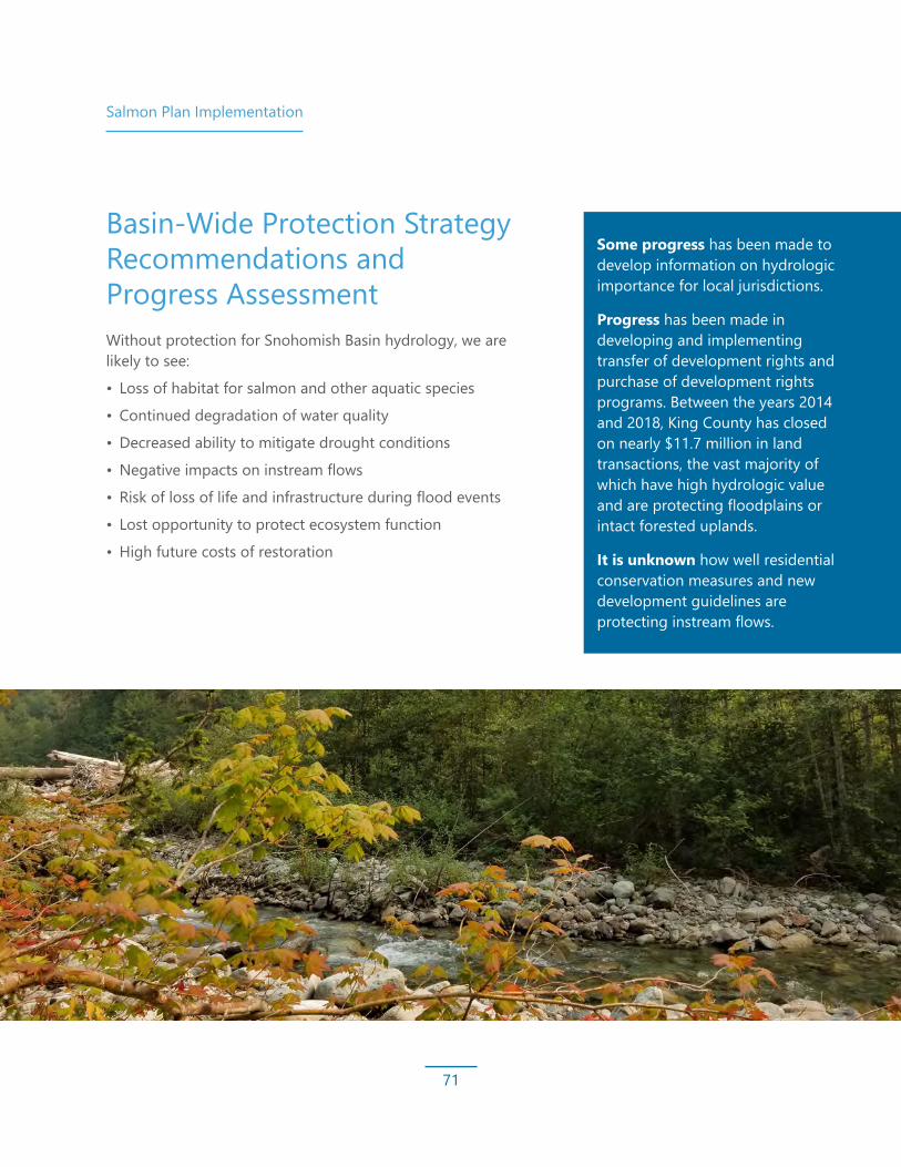
Salmon Plan Implementation
71
Some progress has been made to develop information on hydrologic importance for local jurisdictions.
Progress has been made in developing and implementing transfer of development rights and purchase of development rights programs. Between the years 2014 and 2018, King County has closed on nearly $11.7 million in land transactions, the vast majority of which have high hydrologic value and are protecting floodplains or intact forested uplands.
It is unknown how well residential conservation measures and new development guidelines are protecting instream flows.
Basin-Wide Protection Strategy Recommendations and Progress AssessmentWithout protection for Snohomish Basin hydrology, we are likely to see:
• Loss of habitat for salmon and other aquatic species
• Continued degradation of water quality
• Decreased ability to mitigate drought conditions
• Negative impacts on instream flows
• Risk of loss of life and infrastructure during flood events
• Lost opportunity to protect ecosystem function
• High future costs of restoration

Salmon Plan Implementation
72
Urban Protection Strategy Recommendations and Progress Assessment
Some progress has been made to augment practices to meet National Pollutant Discharge Elimination System requirements with low-impact development, green infrastructure, and to improve tree ordinances and other relevant codes that require planting in urban areas.
When considering hydrology, people often do not think about the role of urban areas, but these areas are expected to absorb large numbers of people moving into both King and Snohomish counties. What is done in urban areas to help address stormwater, where roads are built, and how well communities are protected from changes in hydrology (too much water from flooding or not enough water) matters to the overall ecosystem health.
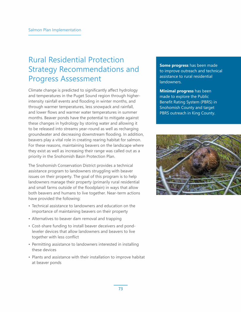
Salmon Plan Implementation
73
Rural Residential Protection Strategy Recommendations and Progress Assessment
Some progress has been made to improve outreach and technical assistance to rural residential landowners.
Minimal progress has been made to explore the Public Benefit Rating System (PBRS) in Snohomish County and target PBRS outreach in King County.
Climate change is predicted to significantly affect hydrology and temperatures in the Puget Sound region through higher-intensity rainfall events and flooding in winter months, and through warmer temperatures, less snowpack and rainfall, and lower flows and warmer water temperatures in summer months. Beaver ponds have the potential to mitigate against these changes in hydrology by storing water and allowing it to be released into streams year-round as well as recharging groundwater and decreasing downstream flooding. In addition, beavers play a vital role in creating rearing habitat for salmon. For these reasons, maintaining beavers on the landscape where they exist as well as increasing their range was called out as a priority in the Snohomish Basin Protection Plan.
The Snohomish Conservation District provides a technical assistance program to landowners struggling with beaver issues on their property. The goal of this program is to help landowners manage their property (primarily rural residential and small farms outside of the floodplain) in ways that allow both beavers and humans to live together. Near-term actions have provided the following:
• Technical assistance to landowners and education on the importance of maintaining beavers on their property
• Alternatives to beaver dam removal and trapping
• Cost-share funding to install beaver deceivers and pond-leveler devices that allow landowners and beavers to live together with less conflict
• Permitting assistance to landowners interested in installing these devices
• Plants and assistance with their installation to improve habitat at beaver ponds
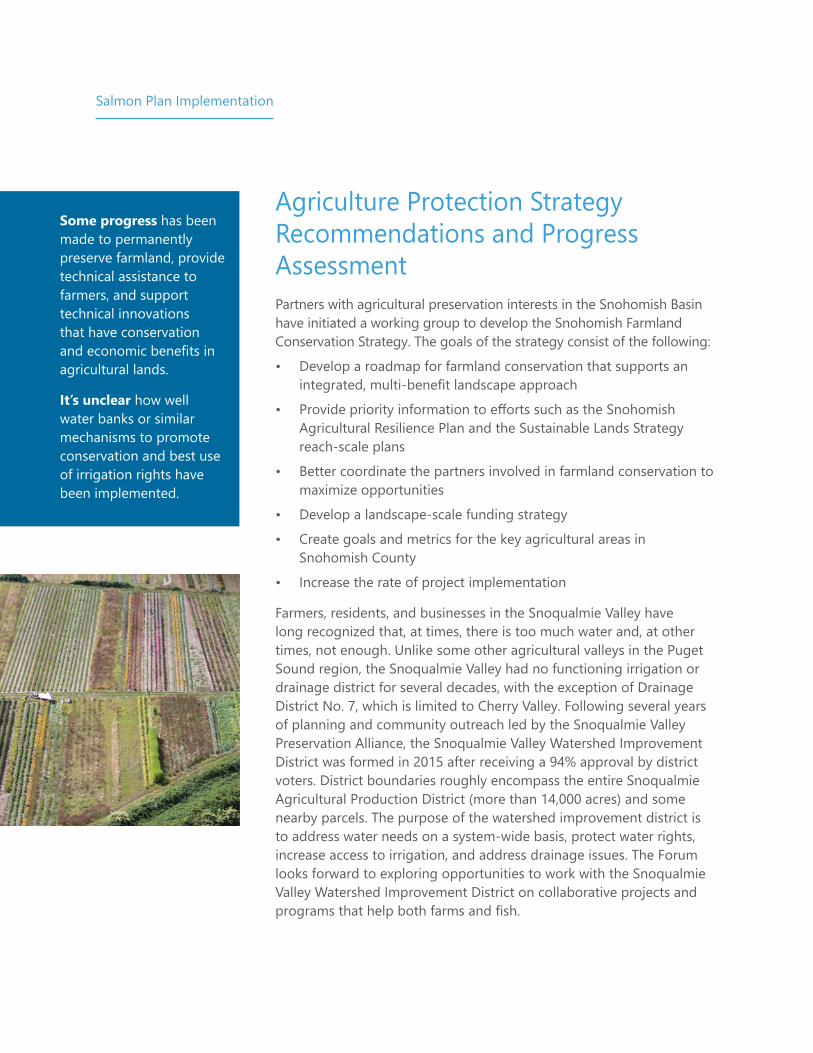
Salmon Plan Implementation
Agriculture Protection Strategy Recommendations and Progress Assessment
Some progress has been made to permanently preserve farmland, provide technical assistance to farmers, and support technical innovations that have conservation and economic benefits in agricultural lands.
It’s unclear how well water banks or similar mechanisms to promote conservation and best use of irrigation rights have been implemented.
Partners with agricultural preservation interests in the Snohomish Basin have initiated a working group to develop the Snohomish Farmland Conservation Strategy. The goals of the strategy consist of the following:
• Develop a roadmap for farmland conservation that supports an integrated, multi-benefit landscape approach
• Provide priority information to efforts such as the Snohomish Agricultural Resilience Plan and the Sustainable Lands Strategy reach-scale plans
• Better coordinate the partners involved in farmland conservation to maximize opportunities
• Develop a landscape-scale funding strategy
• Create goals and metrics for the key agricultural areas in Snohomish County
• Increase the rate of project implementation
Farmers, residents, and businesses in the Snoqualmie Valley have long recognized that, at times, there is too much water and, at other times, not enough. Unlike some other agricultural valleys in the Puget Sound region, the Snoqualmie Valley had no functioning irrigation or drainage district for several decades, with the exception of Drainage District No. 7, which is limited to Cherry Valley. Following several years of planning and community outreach led by the Snoqualmie Valley Preservation Alliance, the Snoqualmie Valley Watershed Improvement District was formed in 2015 after receiving a 94% approval by district voters. District boundaries roughly encompass the entire Snoqualmie Agricultural Production District (more than 14,000 acres) and some nearby parcels. The purpose of the watershed improvement district is to address water needs on a system-wide basis, protect water rights, increase access to irrigation, and address drainage issues. The Forum looks forward to exploring opportunities to work with the Snoqualmie Valley Watershed Improvement District on collaborative projects and programs that help both farms and fish.

Salmon Plan Implementation
75
Forestry Protection Strategy Recommendations and Progress Assessment
Some progress has been made to permanently conserve working forestland and expand water typing efforts in the Basin.
Limited progress has been made to expand outreach to small forest landowners, though some outreach is currently being conducted.
It is unknown how comprehensive high-resolution LiDAR data collection and sharing efforts are for the entire Basin.
Although the Washington State Department of Natural Resources water type maps are a protective tool in theory, these maps are often inaccurate, compromising the effectiveness of planning decisions and regulations intended to protect sensitive, hydrologically important areas across the Snohomish Basin. If state and local jurisdictions use inaccurate maps, logging and development may occur in potentially sensitive areas. Streams and wetlands that are unmapped or inaccurately mapped may include areas critical to preserving the hydrology of the Basin. Water typing is a critical piece of salmon recovery and a challenging piece to implement; training and funding are necessary. Success in the next decade will require that Snohomish Basin streams are typed appropriately by organizations and jurisdictions with water typing expertise and funding is available to begin improving water typing in the Basin’s most sensitive catchments.
Photo Credit: Wild Fish Conservancy
Salmon Plan Implementation
76
Monitoring and Adaptive Management The 2005 Salmon Plan was developed using knowledge available at the time about Basin conditions and salmon recovery science, while recognizing political and socioeconomic constraints. Because knowledge, conditions, and constraints change over time, the hypotheses and recommendations of the Salmon Plan are meant to be methodically assessed and adapted as new information becomes available. One key ingredient of this adaptive management process is the monitoring of watershed-wide and instream habitat conditions, salmon indicators, and changes in habitat and population trends as Salmon Plan recommendations are implemented.
Since the Salmon Plan’s adoption, ample local and regional efforts have gone into identifying appropriate metrics and methods to monitor Salmon Plan effectiveness and the status and trends of habitat conditions in the Basin. A formal Basin-wide monitoring plan has not been finalized and presented to the Forum for adoption;
however, following monitoring recommendations in Salmon Plan appendices, coordination between Basin partners has led to an agreed-upon list of fish and habitat indicators. These indicators will guide data collection as part of programmatic or opportunistic monitoring efforts performed by partner agencies and tribes, ensuring that data are comparable between programs and across jurisdictional boundaries. Status and trends data reported in this report represent a subset of the monitoring data that have been collected.
Future steps for Basin monitoring include adopting the official list of fish and habitat metrics and establishing a data collection schedule to help Basin partners plan and budget for monitoring work. See Appendix O of the Salmon Plan for details on the status and trends monitoring recommendations.
Coordinated Monitoring in the Estuary
Collaborative monitoring between NOAA Fisheries, the Tulalip Tribes, Snohomish County, and other partners has been underway since the early 2000s. Monitoring work in the estuary has been intensive, both at the level of individual projects and as an estuary-wide, coordinated effort. Project-level work is intended to be coordinated with and embedded in the larger estuary-wide context. The intent of the monitoring work is to help address the following data gaps:
• Determining whether Chinook salmon are estuary-limited
• Refining the acreage of specific habitat needed for Chinook salmon and other species to achieve recovery or avoid ESA listing and identifying target locations that require restoration
• Analyzing the results of completed estuary restoration projects (alone and in combination) and identifying key attributes of success
• Increasing understanding of how future restoration projects are built and maintained

77
UPDATING THE BASIN-WIDE VISION
FOR RECOVERY While progress has been made implementing the Salmon Plan, conditions continue to change, and new science informs more effectively focused efforts toward measurable improvements in habitat and fish populations.Our efforts moving forward will account for new information about climate change and other risk factors. At the same time, there is an urgent need to increase the pace of recovery, and there are emerging opportunities to work together with people of different interests to implement multi-objective projects and develop new sources of funding. This section looks forward to the future of Salmon Plan implementation: updating habitat targets, considerations for a changing future, H-integration approaches, multi-objective planning contexts, and updated restoration and protection strategies.

Updating the Basin-Wide Vision for Recovery
78
Considerations for a Changing FuturePlanning for Climate Change and Increased Watershed Resiliency It will be imperative for salmon recovery specialists and agencies to participate in planning efforts — such as transportation corridors, infrastructure renewal and improvements, growth management, and watershed planning — to ensure salmon recovery and other climate change concerns are comprehensively addressed and to allow creative problem solving that will benefit all needs in the changing Basin headwaters, floodplain, nearshore, and estuary environments.
Along with large-scale strategies at a global, national, and state level to reduce impacts from climate change, work must also be done at the Basin level to build resilience to changing conditions. Salmon recovery, restoration, and protection actions must amplify the species’ natural ability to adapt. To give salmon the best chance of survival, we must continue implementing the Salmon Plan strategy of restoring and protecting diverse and varied habitat types.
In 2017, the Technical Committee adopted the WRIA 7 Climate Change Impacts to Salmon Issue Paper,¹ which highlights the best available science about climate change and the ways salmon and habitat in the Snohomish Basin
will be impacted, and it identifies key recommendations for restoration priorities to build resilience for salmon and the larger Snohomish Basin ecosystem.
HydrologyThe Snohomish Basin will see more winter precipitation falling as rain and less as snow, a decrease in summer precipitation, and an increase in winter storm intensity. These changes will lead to higher winter flows and lower summer flows, potentially shifting the timing of salmon life cycle transitions, increasing the potential for the scouring and smothering of redds, and increasing the number of migration barriers due to extreme low and/or high flows and loss of thermal and/or flood refugia. Example actions that will improve resilience to changes in hydrology include the following:
• Implement innovative projects to dampen the impacts of shifting hydrology, such as increasing water storage to offset high flows and providing water at low flows (i.e., beaver introduction).
• Remove and fix barriers like culverts and floodgates to ensure access to tributaries, connect oxbows, and protect pools to restore low flow refugia and reconnect local hydrology.
• Restore areas that provide flood storage and slow water during flood events by reconnecting the floodplain.
1 https://snohomishcountywa.gov/DocumentCenter/View/41032/2_2_2017_WRIA-7-Climate-Change-Impacts-on-Salmon_Final_Draft
Updating the Basin-Wide Vision for Recovery
79
TemperatureAs air temperatures are expected to increase, water temperatures will be affected, especially during periods of low flow. Warmer water temperatures in fresh, estuarine, and marine waters can cause lethal and sub-lethal effects for salmon. Example actions that will improve resilience to changes in temperature include the following:
• Identify, protect, and enhance processes and habitats that provide cool water. Protect cool headwater streams. Locate groundwater sources and seeps and protect natural processes that create critical habitats like wetlands, tidal flats, marshes, and estuaries to help ensure that water can be stored, recharged, and delivered at a moderated pace and temperature.
• Protect and restore Snohomish Basin tributaries, which are cooler than the mainstem rivers and can provide salmon with cold water refugia.
• Increase the rate of planting and protection of riparian buffers to increase shading and help stabilize instream temperatures.
• Work with dam operators to use reservoirs to help ameliorate temperature impacts, especially during low flow periods.
StormwaterWith predicted increases in heavy rainfall events in fall and winter, stormwater runoff will increase pollutant discharge into rivers and streams and, ultimately, the Puget Sound. Pesticides, heavy metals, bacteria, motor oils, and other pollutants already significantly contribute to stormwater pollution in our region. Stormwater impacts to salmon are varied, causing both lethal and sub-lethal conditions, in particular for coho salmon. Example key actions include the following:
• Study and prioritize areas that need stormwater retrofits and accelerate those actions.
• Implement green stormwater infrastructure that slows conveyance and increases storage, such as bioswales, rain gardens, and replacement of impervious surfaces with plantings and/or pervious surfaces.
• Monitor land use changes, particularly tree removal and new development, to quantify and mitigate for impacts to temperature.

Updating the Basin-Wide Vision for Recovery
80
SedimentationSedimentation of our rivers and streams is expected to increase in the future, especially in winter, when heavy rains and less snow will leave more soil exposed and increase landslide potential. The anticipated higher levels of suspended solids are expected to impact salmon by burying redds after spawning, inhibiting oxygen intake by salmon by decreasing dissolved oxygen or smothering their gills, and contributing to potential chronic sub-lethal and behavioral effects, such as reducing foraging capabilities, interfering with migration cues, and contributing to stunted growth, increased stress, and lowered disease resistance. Example actions to address sedimentation include the following:
• Restore and protect riparian buffers to minimize erosion and reduce sediment and toxin load.
• Set back levees and remove other infrastructure in aggrading reaches to allow natural channel migration/avulsion and limit increases in flood-exacerbating bed elevations.
• Identify landslide-prone slopes and implement hydrologic protections that decrease the likelihood of mass-wasting events.
Sea Level RiseProjected sea level rise is anticipated to cause undeveloped nearshore systems, beaches, and coastal marsh shorelines to migrate inland. Current estuary habitats will become nearshore, and the estuary boundaries will move farther inland. In the Snohomish Basin, where many of our nearshore areas are armored, natural migration inland is restricted and beach habitats are likely to become degraded and disappear, becoming nonfunctional for juvenile salmon and the two primary beach-spawning forage fish (Pacific sand lance and surf smelt). The Basin is likely to lose critical salt marsh, mud flats, and transition marsh, particularly in the lower areas of the estuary, shifting the ranges of habitat used by salmon. Example key actions include the following:
• Identify how habitat boundaries, such as floodplains, nearshore, and estuaries, are changing. Work with partners to understand the vulnerability of estuary infrastructure under sea level rise, including levees and drainage, transportation corridors, and wastewater facilities.
• Protect marine and freshwater shorelines at risk of being armored as climate change exacerbates impacts. Improve consistency and effectiveness of regulatory protections, especially in all unarmored marine areas.
• Protect land that will be inundated by increased flooding and sea level rise.
• Remove existing infrastructure and encourage soft armoring to allow shoreline migration and bluff erosion.

Updating the Basin-Wide Vision for Recovery
81
1 The Nature Conservancy and the Climate impacts Group, 2016. Adapting to Change: Climate Impacts and Innovation in Puget Sound. Edited by J. Morse, J. Israel, L. Whitely Binder, G. Mauger, and A.K. Snover. The Nature Conservancy, Seattle, Washington.
2 Mauger, G.S., J.H. Casola, H.A. Morgan, R.L. Strauch, B. Jones, B. Curry, T.M. Busch Isaksen, L. Whitely Binder, M.B. Krosby, and A.K. Snover, 2015. State of Knowledge: Climate Change in Puget Sound. Report prepared for the Puget Sound Partnership and the National Oceanic and Atmospheric Administration. Climate Impacts Group, University of Washington, Seattle. doi: 10.7915/CIG93777D.
Ocean AcidificationOcean acidification is projected to increase 150% to 200% by 2100 based on current carbon dioxide emission scenarios.¹ Warmer air temperatures will likely cause sea surface temperatures to increase as well.² Together, these factors are anticipated to have a wide range of impacts on the ocean and the entire Puget Sound marine ecosystem. Ocean acidification is expected to reduce the availability of crab larvae and other calcium-based (shell) planktonic organisms that are important food sources for salmon during their smolt and ocean life cycle phases. Key actions within the watershed that can contribute to reducing the impacts of ocean acidification include those that promote carbon uptake, such as the restoration of eelgrass beds and tidal marshes.
The Snohomish Basin is on pace to meet some of the restoration goals, but it is apparent that accelerating restoration and protection work is necessary to speed up recovery.
First juvenile Chinook salmon documented inside the Smith Island restoration area

Updating the Basin-Wide Vision for Recovery
82
Restoration Opportunities and ChallengesCapacity and Funding ChallengesDespite the investment of millions of dollars, salmon continue to struggle. Part of the reason is that restoration actions take time to become fully functioning. When restoration projects are built, it can take several years for rivers to create the habitats necessary to support salmon. The cost of restoration work is dramatically increasing, as is the cost of acquiring lands for protection or restoration because an increasing population is inflating the cost of property in the region.
Project costs are increasingSome of the “easier” restoration opportunities have been implemented over the past 10 years, but the remaining areas targeted for work are more complex. Additionally, construction costs are rising, the costs of land and materials are increasing, and there is increasing competition for land. Design costs are going up as more complex projects require additional analysis and increased communication and coordination.
Capacity is needed for planning, design, engagement, and other key stagesMany funding sources prefer to fund the construction phase of projects, and it is challenging to find funding that can support a robust project development approach that uses extensive public engagement and outreach.
Few non-local funding sources support operating costs, preferring instead to fund capital projects on the ground. But it takes planners, acquisition experts, outreach specialists, engineers, biologists, ecologists, and many other professionals to move projects from concept to implementation. King County has been able to use some county-generated funding for these functions and has thus found it easier to provide match and leverage construction funds, though it is still underfunded. Other sponsors lack similar funding resources, and the costs of project development are difficult to sustain. This lack of capacity has greatly curtailed our ability to carry out the restoration that needs to be done.
Updating the Basin-Wide Vision for Recovery
83
Funding is hard to come by for long-term maintenance, monitoring, and adaptive managementMaintenance is critical for efforts such as riparian planting. We may be on track to meet the targets, but some plantings are not fully functioning because of lack of maintenance. Monitoring and adaptive management would also support increased advancements, especially for larger projects, and better understanding of progress. However, few sources of funding exist to support long-term maintenance, monitoring, and adaptive management of completed projects.
Funding programs misalign with goals or timing for restoration projectsGrant programs have different interests, and salmon recovery objectives do not always match up with the grant objectives to result in successfully targeting priority restoration actions. Sponsors feel pressure to shoehorn their project proposal into different forms, increasing pressure on the limited capacity for developing grant applications, which can result in applications that do not compete well for funding. Once an applicant is successful, it can take upwards of 12 months to receive the funding to administer the work for the project. The timeline can, at times, be too long for landowners, who would like to see action, repair, and solutions to their problems much more quickly.
The project list far outpaces annual funding acquired and the funding targetsThe 2019 4-year work plan is a mechanism by which the Basin can identify priority projects for current and future funding. Currently, the list holds $183,575,000 in costs for restoration projects (roughly $45 million per year), far exceeding the annual funding goal of $15 million per year. More projects need to be completed, project costs are increasing, and the pace that projects move off the list is greatly slowed.
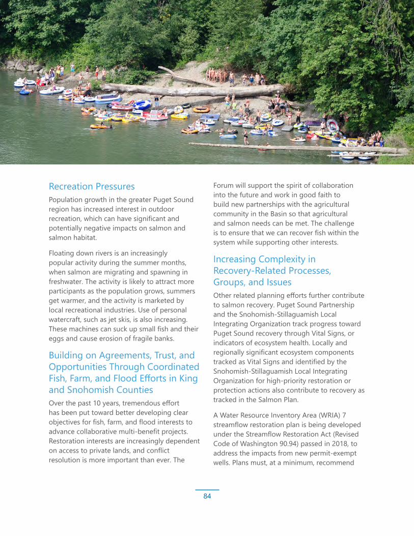
Updating the Basin-Wide Vision for Recovery
84
Recreation PressuresPopulation growth in the greater Puget Sound region has increased interest in outdoor recreation, which can have significant and potentially negative impacts on salmon and salmon habitat.
Floating down rivers is an increasingly popular activity during the summer months, when salmon are migrating and spawning in freshwater. The activity is likely to attract more participants as the population grows, summers get warmer, and the activity is marketed by local recreational industries. Use of personal watercraft, such as jet skis, is also increasing. These machines can suck up small fish and their eggs and cause erosion of fragile banks.
Building on Agreements, Trust, and Opportunities Through Coordinated Fish, Farm, and Flood Efforts in King and Snohomish CountiesOver the past 10 years, tremendous effort has been put toward better developing clear objectives for fish, farm, and flood interests to advance collaborative multi-benefit projects. Restoration interests are increasingly dependent on access to private lands, and conflict resolution is more important than ever. The
Forum will support the spirit of collaboration into the future and work in good faith to build new partnerships with the agricultural community in the Basin so that agricultural and salmon needs can be met. The challenge is to ensure that we can recover fish within the system while supporting other interests.
Increasing Complexity in Recovery-Related Processes, Groups, and IssuesOther related planning efforts further contribute to salmon recovery. Puget Sound Partnership and the Snohomish-Stillaguamish Local Integrating Organization track progress toward Puget Sound recovery through Vital Signs, or indicators of ecosystem health. Locally and regionally significant ecosystem components tracked as Vital Signs and identified by the Snohomish-Stillaguamish Local Integrating Organization for high-priority restoration or protection actions also contribute to recovery as tracked in the Salmon Plan.
A Water Resource Inventory Area (WRIA) 7 streamflow restoration plan is being developed under the Streamflow Restoration Act (Revised Code of Washington 90.94) passed in 2018, to address the impacts from new permit-exempt wells. Plans must, at a minimum, recommend

Updating the Basin-Wide Vision for Recovery
85
actions to offset the potential consumptive impacts of new, rural, domestic water use on protected rivers and streams.
Moving forward, retaining attention and focus on salmon recovery objectives will be crucial. Coordination of more regional planning processes and groups can tax the limited capacity of sponsors and staff. Learning how to efficiently communicate salmon recovery priorities and integrate them into other processes is challenging.
New Species ListingsSouthern Resident Killer WhalesThe fate of the southern resident killer whale population in Puget Sound is an increasing concern. Recovery planning for that species has identified the lack of prey availability (primarily wild Chinook salmon) as one of the three leading causes of their population decline. Salmon are a keystone species, which many other endangered species depend upon. The Southern Resident Killer Whale Recovery Task Force presented recommendations to the governor in November 2018, resulting in a legislative package of investments intended to increase the population to 84 orcas over the
next decade. The proposed package includes actions intended to increase the abundance of Chinook salmon. The connection between salmon and killer whales will hopefully provide renewed commitment to restoring Chinook salmon in all watersheds.
Puget Sound SteelheadSteelhead were listed as threatened in 2007 under the ESA because of declining numbers in Puget Sound due to habitat loss and overfishing. The Forum assumes that the Salmon Plan strategy works to address the needs of salmon in the Basin using Chinook, coho, and bull trout as proxy species. A key goal is to prevent further ESA listings while improving conditions for these populations. The State of Washington will need to continue its work in support of salmon to replace culverts and other barriers that block fish passage. Culvert replacement will benefit all species but is expected to have the most significant benefits for coho and steelhead, which tend to spawn in tributary systems. Though addressed through the Salmon Plan, coho projects have not been implemented to date, likely due to limited available funding.
Updating the Basin-Wide Vision for Recovery
86
Integration of Habitat, Harvest, and Hatchery Actions Within the BasinThe Puget Sound Salmon Recovery Plan,¹ the federal supplement to this plan,² and the Salmon Plan all emphasize that recovery of Chinook salmon populations will require integrated management of the four Hs that comprise the full suite of salmon management considerations. The outcome of salmon recovery efforts depends on the combined and cumulative effect of habitat, harvest, and hatchery management. The effectiveness of actions in any of these areas cannot be evaluated independently of actions in others. Hydropower is the H that is of less concern in the Snohomish Basin because of the limited scale and impact of hydropower on recovery of Chinook salmon populations in the Basin, though hydropower operations in the Tolt and Sultan river watersheds are still important local considerations, especially for subpopulations and other species like steelhead and bull trout. It is not expected that there will be any major changes to how any of the hydroelectric projects operate during the next 10 years, except for the Tolt River Project run by the City of Seattle. This project will start the FERC relicensing process in the early 2020s. During the relicensing process,
there will likely be opportunities to implement changes in stream flow management and identify stream enhancement and mitigation requirements.
The principals of H-integration management described in the Salmon Plan remain relevant and under further refinement. Chinook salmon recovery in the Snohomish Basin now includes a strategic habitat restoration program, a harvest management plan, a hatchery management plan, and a protection plan. However, there has been little coordinated integration of the Hs into a single strategy. To address this gap, a new H-integration framework was developed that outlines a suite of management actions in the respective Hs based on different phases of recovery.³
1 Shared Strategy Development Committee, 2007. Puget Sound Salmon Recovery Plan.2 NOAA Fisheries, 2007. Final Supplement to the Shared Strategy’s Puget Sound Salmon Recovery Plan.3 Rawson, K., and M. Crewson, 2017. Snohomish Chinook Recovery Plan: Phases of Recovery and Integrated Adaptive Management
Strategy, Draft - May 26, 2017. Tulalip Tribes Natural Resources Department.
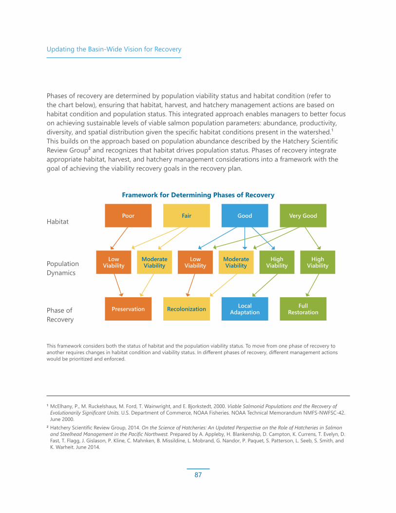
Updating the Basin-Wide Vision for Recovery
87
Habitat
Population Dynamics
Phase of Recovery
1 McElhany, P., M. Ruckelshaus, M. Ford, T. Wainwright, and E. Bjorkstedt, 2000. Viable Salmonid Populations and the Recovery of Evolutionarily Significant Units. U.S. Department of Commerce, NOAA Fisheries. NOAA Technical Memorandum NMFS-NWFSC-42. June 2000.
2 Hatchery Scientific Review Group, 2014. On the Science of Hatcheries: An Updated Perspective on the Role of Hatcheries in Salmon and Steelhead Management in the Pacific Northwest. Prepared by A. Appleby, H. Blankenship, D. Campton, K. Currens, T. Evelyn, D. Fast, T. Flagg, J. Gislason, P. Kline, C. Mahnken, B. Missildine, L. Mobrand, G. Nandor, P. Paquet, S. Patterson, L. Seeb, S. Smith, and K. Warheit. June 2014.
Poor
Preservation
Fair
Recolonization
Good
Local Adaptation
Very Good
Full Restoration
This framework considers both the status of habitat and the population viability status. To move from one phase of recovery to another requires changes in habitat condition and viability status. In different phases of recovery, different management actions would be prioritized and enforced.
Framework for Determining Phases of Recovery
Phases of recovery are determined by population viability status and habitat condition (refer to the chart below), ensuring that habitat, harvest, and hatchery management actions are based on habitat condition and population status. This integrated approach enables managers to better focus on achieving sustainable levels of viable salmon population parameters: abundance, productivity, diversity, and spatial distribution given the specific habitat conditions present in the watershed.¹ This builds on the approach based on population abundance described by the Hatchery Scientific Review Group² and recognizes that habitat drives population status. Phases of recovery integrate appropriate habitat, harvest, and hatchery management considerations into a framework with the goal of achieving the viability recovery goals in the recovery plan.
Low Viability
Low Viability
High Viability
Moderate Viability
Moderate Viability
High Viability

Updating the Basin-Wide Vision for Recovery
88
Snoqualmie Fish, Farm, and FloodIn 2013, pursuant to County Comprehensive Plan Policy R-650, King County convened the Snoqualmie Fish, Farm, and Flood Advisory Committee (Advisory Committee) to inform the county of the most important priorities and how balance might be attained among these interests.
Following an intensive 3.5-year process, the Advisory Committee reached an agreement in 2017 that explicitly coupled progress going forward between the highest priority actions for
farms and fish. The agreement linked progress on large-scale floodplain habitat restoration projects with specific milestones in the development of a comprehensive agricultural drainage program. The agreement also called for enhanced community engagement related to large capital project development and an array of actions to reduce flood risks for farms and other residents in the Snoqualmie Valley. These capital projects in the near term are focused on levee setback projects in the Snoqualmie Valley at Fall City Reach, a priority reach for Chinook salmon spawning and rearing. To implement this work moving forward, the recommendations also called for continuing work through the formation of the following three task forces:
• The Riparian Buffer Task Force has a goal of developing science-based, context-specific riparian buffer planting recommendations for variable width buffers in the Snoqualmie Valley Agricultural Production District.
Multi-Objective PlanningThere are multiple priorities in Basin floodplains, including: 1) fertile land for farmers; 2) strong riparian and floodplain functions for fish and wildlife; and 3) places for floodwaters to go that do not jeopardize critical infrastructure and the safety of people. Limited space in the floodplain and numerous pressures on its resources, paired with the salmon recovery community falling behind in our implementation goals, has resulted in increased interest in multi-objective planning. Finding the right balance among fish, farm, and flood risk management priorities
is both a challenge and opportunity because resolving tension will benefit all three interests. Integrated floodplain management is a new way of creating a path forward.
Significant effort has been put toward developing shared goals and understanding, building relationships, and launching multi-benefit initiatives over the past 10 years —though the approach to balancing these objectives is slightly different in the King County and Snohomish County areas of the watershed.
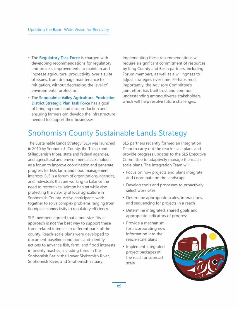
Updating the Basin-Wide Vision for Recovery
89
• The Regulatory Task Force is charged with developing recommendations for regulatory and process improvements to maintain and increase agricultural productivity over a suite of issues, from drainage maintenance to mitigation, without decreasing the level of environmental protection.
• The Snoqualmie Valley Agricultural Production District Strategic Plan Task Force has a goal of bringing more land into production and ensuring farmers can develop the infrastructure needed to support their businesses.
Implementing these recommendations will require a significant commitment of resources by King County and Basin partners, including Forum members, as well as a willingness to adjust strategies over time. Perhaps most importantly, the Advisory Committee’s joint effort has built trust and common understanding among diverse stakeholders, which will help resolve future challenges.
Snohomish County Sustainable Lands Strategy The Sustainable Lands Strategy (SLS) was launched in 2010 by Snohomish County, the Tulalip and Stillaguamish tribes, state and federal agencies, and agricultural and environmental stakeholders as a forum to improve coordination and generate progress for fish, farm, and flood management interests. SLS is a forum of organizations, agencies, and individuals that are working to balance the need to restore vital salmon habitat while also protecting the viability of local agriculture in Snohomish County. Active participants work together to solve complex problems ranging from floodplain connectivity to regulatory efficiency.
SLS members agreed that a one-size-fits-all approach is not the best way to support these three related interests in different parts of the county. Reach-scale plans were developed to document baseline conditions and identify actions to advance fish, farm, and flood interests in priority reaches, including three in the Snohomish Basin: the Lower Skykomish River, Snohomish River, and Snohomish Estuary.
SLS partners recently formed an Integration Team to carry out the reach-scale plans and provide progress updates to the SLS Executive Committee to adaptively manage the reach-scale plans. The Integration Team will:
• Focus on how projects and plans integrate and coordinate on the landscape
• Develop tools and processes to proactively select work sites
• Determine appropriate scales, interactions, and sequencing for projects in a reach
• Determine integrated, shared goals and appropriate indicators of progress
• Provide a mechanism for incorporating new information into the reach-scale plans
• Implement integrated project packages at the reach or subreach scale

Updating the Basin-Wide Vision for Recovery
90
Updating Our Salmon PlanThis section outlines recommended steps and considerations to incorporate as Forum members, partners, and staff work to update restoration and protection strategies and continue to adaptively manage and implement the Salmon Plan.
Update Habitat Restoration Targets to Reflect Lessons Learned from Our Implementation Progress to DateAs Forum partners reflect on the implementation of the Salmon Plan and progress in meeting the 10-year habitat restoration goals set in 2005, we note that substantial progress has been made in some areas of the watershed, such as riparian corridors and the estuary. But we are significantly lagging in our progress toward goals in other areas, such as in our mainstem targets in both the Snoqualmie and Skykomish river systems. Circumstances contributing to the unbalanced attainment of restoration targets include lack of funding, capacity, and landowner willingness to implement projects on private property. The Forum and its partners must assess the limitations and opportunities in this implementation reality and consider whether there should be an increased focus of implementation in areas where targets are lagging when setting the next set of restoration targets.
Update Recovery Strategies to Incorporate New ScienceSince the release of the Salmon Plan, new science has improved our understanding of habitat conditions and the areas salmon use. We have gained a better understanding of many different ecosystem components and continue to learn more as new relevant science is presented. There are a number of relevant new studies focused on the watershed, including, but not limited to, the role of the nearshore ecosystem, the changing climate conditions that will affect our watershed, how yearling Chinook salmon use the Snoqualmie River mainstem, and the importance of available habitat at different salinities in the estuary. The Forum and its partners must assess the existing recovery strategies in the context of new science and consider updating strategies where needed.
Consider New Recovery Strategies and ActionsSince the Salmon Plan was adopted in 2005, Basin partners have identified a number of areas where new science and lessons learned from implementation warrant consideration of new strategies.
• Water quality — Key studies indicate with increased urgency the threat toxins pose to salmon survival. The Snohomish Estuary has been identified as a hot spot for polybrominated diphenyl ethers (PBDEs), which may affect salmon susceptibility to disease and marine survival. Stormwater has been found to have deleterious impacts on coho salmon, leading to mortality before they

Updating the Basin-Wide Vision for Recovery
91
are able to spawn. While science continues to delve into the source and impacts of toxins, Forum partners must consider strategies to identify and control sources of toxic contaminants that impair or result in mortalities in fish, including point and non-point sources.
• Riparian health — The presence of invasive species contributes to persistent degradation of riparian conditions. Forum partners should consider developing a comprehensive invasive species and riparian health strategy across sub-basins to improve riparian conditions, protect habitat restoration investments, and minimize invasive species reinfestation of restored areas. Forum partners should also assess the effectiveness of regulatory protection measures and voluntary and cooperative programs and consider revising recovery strategies if needed.
• Species in decline — Recognizing the declining population numbers of coho and chum salmon, and with federal efforts to develop a Puget Sound Steelhead Recovery Plan well underway, Forum partners must consider our role in investigating the coho and chum salmon declines and developing strategies to support the recovery and rebuilding of coho salmon, chum salmon, and steelhead stocks.
Develop Updated Funding Strategies and New Funding Sources to Increase the Pace of RecoveryWhile there have been some encouraging developments in the funding of capital projects in recent years, funding to implement restoration and protection strategies is inadequate. The availability of funding for restoration and protection in Snohomish and King counties is a striking contrast. King County, with flood control districts, the King County Land Conservation Initiative, and Real Estate Excise Tax funding that supports the Conservation Futures program, has significantly more local funding available for project implementation than the Snohomish County portion of the watershed. Forum partners must assess the success of local funding initiatives and approaches and advocate for expansion, where appropriate, to all areas of the watershed.
Strengthen Measures to Protect Watershed Hydrology and HabitatThe Snohomish Basin Protection Plan details critical implementation priorities to protect functioning habitat and hydrology in the Basin. With the continued pressures of development, the Forum and partners should accelerate implementation of Snohomish Basin Protection Plan priorities to protect hydrology, maximizing salmon protection while allowing opportunities for individuals and jurisdictions. Partner engagement is crucial in Basin-wide initiatives, such as the Department of Ecology’s Watershed Restoration Enhancement Committee, and implementation of protection measures at the local level, such as the Duvall Watershed Plan.

Updating the Basin-Wide Vision for Recovery
92
Evaluate the Impacts of Recreational Uses and Develop Policy Recommendations and Education/Outreach MessagesAs recreation pressures increase, the Forum and partners should consider evaluating the impacts of recreation and support the development of policies and education and outreach efforts that promote safe recreation in dynamic river environments that do not negatively impact salmon habitat.
Consider Restoration Risks and Liabilities As restoration actions become more complex in a dynamic environment, the issues of risk and liabilities become more pronounced. For instance, placing LWD in rivers is important for salmon, but can put recreational river users at risk. King County has developed an approach to managing wood in rivers and notifying the public about dangers on the river. The Forum and partners will need to consider how to support restoration efforts in a dynamic landscape when managing risk is an important consideration.
Develop New and Innovative Project Ideas and Adaptively Manage Restoration Sites to Ensure that Benefits Are Maximized over TimeAs Forum partners reflect on implementation experiences, we have identified areas where new approaches to implementation and project-level adaptive management are needed. Forum partners should consider implementing projects that may not be long-term and processed-based, but could provide immediate short-term habitat gains while longer-term, process-based projects are developed and implemented. Forum partners should also evaluate project performance and build in project implementation funding to support adaptive management of projects if needed.
Strategically Engage in Planning Processes that Support or Impact Salmon RecoveryMulti-objective planning processes and ecosystem protection and recovery-related processes create opportunities to further salmon recovery goals but can tax the limited capacity of Forum members, partners, and staff. Forum members and staff must consider how to strategically and efficiently communicate salmon recovery priorities and integrate them into other processes. Furthermore, Forum members must consider how to sustain or increase the capacity needed to effectively engage in these processes.

93
CREDITS AND ACKNOWLEDGMENTS
We would like to thank the many dedicated participants in the Snohomish River Basin who have worked to create a culture of collaboration and learning and who have patiently contributed and waited as this report has evolved and finally come to fruition.
Salmon recovery work would not be possible without the contributions of local, state, tribal, and federal agencies; non-profit organizations; funding partners; and, of course, the volunteers who make salmon recovery a reality on the ground.
We would like to acknowledge the monumental efforts of our project sponsors who work tirelessly to identify and implement projects with willing landowners.
Special thanks and consideration for the contributing authors of this document including:
• Tulalip Tribes Natural Resources Treaty Rights Office: Morgan Ruff and Colin Wahl
• Snohomish County Surface Water Management: Gretchen Glaub and Mike Rustay
• King County/Snoqualmie Watershed Forum Staff: Elissa Ostergaard and Beth LeDoux
• Snohomish Basin Salmon Recovery Forum, Policy Development Committee, and Technical Committee members who provided review and comment
We recognize and give special thanks to the significant contributions of those who were foundational to our local salmon recovery effort who are no longer with us. We thank you for your service.
Funding for this report was provided from the Puget Sound Acquisition and Restoration fund, Snohomish County Surface Water Management, and the Tulalip Tribes.