Computer-based model for flood evacuation emergency planning
1/Health in Emergencies and Disasters Volume 1, Number 1 (August 2013)
Analysis and Modeling of Safety Parameters for Selection of
Optimal Routes in Emergency Evacuation after an Earthquake:
Case of 13th Aban Neighborhood in Tehran
Sajad, Ganjehi1. Babak,Omidvar
2. Bahram, Malekmohammadi
3. Khadijeh,
Norouzi Khatire4
Introduction: Earthquakes are imminent threats to urban areas of Iran,
especially Tehran. They can cause extensive destructions and lead to heavy
casualties. One of the most important aspects of disaster management after
earthquake is the rapid transfer of casualties to emergency shelters. To
expedite emergency evacuation process the optimal safe path method
should be considered. To examine the safety of road networks and to
determine the most optimal route at pre-earthquake phase, a series of
parameters should be taken into account.
Methods : In this study, we employed a multi-criteria decision-making
approach to determine and evaluate the effective safety parameters for
selection of optimal routes in emergency evacuation after an earthquake.
Results: The relationship between the parameters was analyzed and the
effect of each parameter was listed. A process model was described and a
case study was implemented in the 13th Aban neighborhood (Tehran’s 20th
municipal district). Then, an optimal path to safe places in an emergency
evacuation after an earthquake in the 13th Aban neighborhood was
selected.
Conclusion: Analytic hierarchy process (AHP), as the main model, was
employed. Each parameter of the model was described. Also, the
capabilities of GIS software such as layer coverage were used.
Keywords: Earthquake, emergency evacuation, Analytic Hierarchy
Process (AHP), crisis management, optimization, 13th Aban neighborhood
of Tehran
1 - M.Sc. Natural Disaster Management, University of Tehran, Tehran, Iran -E mail: [email protected]
2 -Associate Professor, Faculty of Environment, University of Tehran, Tehran, Iran
3 -Assistant Professor, Faculty of Environment, University of Tehran, Tehran, Iran
4 -M.Sc. Natural Disaster Management, University of Tehran, Tehran, Iran
2 / Health in Emergencies and Disasters Number 1 (August 2013)
Introduction More than 50 percent of the world population lives in large cities while
occupying less that 3 percent the earth. High density of population, assets,
infrastructures, and productive and service resources are the causes of
metropolitans’ vulnerability against the disasters. Natural disasters
(especially earthquake) which are mostly hidden and potential for incurring
damages threaten all cities worldwide [1]. In a short span of time,
earthquake can leave extensive damages and fatalities. What makes a
tragedy out of this phenomenon is lack of prevention of its effects and
preparation for having proper responses. During the last century, more than
one thousands earthquakes have occurred in seventy countries in the world
killing more than 1.35 million persons and leaving a huge amount of losses.
80 percent of the damages caused by theses earthquakes belong to six
countries one which is Iran. Location of Iran on Alp–Himalaya earthquake
belt zone has made earthquake one of the most damaging disasters in Iran,
in a way that among the 153 devastating earthquakes occurred in the world,
17.6 percent of them have hit Iran [2]. Such events have always brought
about environmental changes and considerable damages. Iranian cities have
more or less structural vulnerability, as the statistics show that more than 90
percent of Iranian cities are vulnerable against an earthquake with the
magnitude of 5.5 [3]. Among the Iranian cities, the city of Tehran based on
the macro-seismic maps is located on the earthquake belt, with 15
dangerous earthquake faults, exposing it more than other cities to the
danger of earthquake. Among these faults, the fault of the north of Tehran
and the fault of south of Rey have the potential for an earthquake larger
than magnitude 7 measured on Richter scale [4].
Tehran has not experienced any powerful earthquake since 1830 [5]. As the
statistical studies reveals, it takes a period of 150 years for such a powerful
earthquake to reoccur. Considering such a fact, the experts suggest that the
occurrence of such powerful earthquake is very likely [6].
Increase of security and safety, decrease of death toll and financial losses of
the citizens against the earthquake hazard are among the main aims and
measures of the city crisis management. Setting up and optimizing an
effective evacuation network with high level of tolerance for emergency
evacuation of the devastated area at the shortest possible time are among
the vital parts of pre-earthquake phase in crisis management. The
metropolitan city of Tehran having more than 700 Sq. M. and the
population of more than 8 million (more than 11 million at day) needs a set
of predesigned plans and programs for prevention aimed at vulnerability
risk reduction and finally an effective crisis management. Cities are prone

3/Health in Emergencies and Disasters Volume 1, Number 1 (August 2013)
to natural disasters in different ways most of which (specially the
earthquake) cannot be prevented. Therefore, the crisis manager and
administrators should devise optimum strategies for evacuation, rescue and
support at different areas. For this purpose, safe evacuation routes for
emergency evacuation should be identified in the devastated areas and the
required measures should be taken for their optimization. Among plans
designed for pre-earthquake emergency evacuation in urban areas are
identification of city locations, in-the-cities paths and safe areas for
emergency accommodation, and most crucially, identification and
optimization of the emergency exit paths and registration of these
information on the maps to be used by the crisis management headquarter
[7 and 8].
Based on its geographical location, construction, faults around the city,
history of devastating earthquakes around it, and other technological and
geological factors the danger of earthquake in Tehran is high. A glance at
the history of Iran earthquakes reveals that the city of Tehran, previously
known as Rey, has been devastated many times by earthquake. Despite
Tehran’s active earthquake zone and registration of many small
earthquakes around it, no devastating earthquake has occurred recently,
signifying accumulation of energy which can lead to a devastating
earthquake [9], while the city safety paths have not been yet established and
no safety emergency evacuation network has been identified.
13th Aban neighborhood at Tehran’s 20th municipal district, due to its
socioeconomic and cultural features has a notable variety and is definitely
one of Tehran’s districts of tourism and pilgrimage where a huge
population of the city refer to everyday. It has many paths directed to the
city main highways. Thus, considering its special features, this area can be
a suitable sample for evaluating the city streets and safety parameters for
emergency evacuation.
Literature review
Following studies related to our subject can be mentioned: Sherali and
Carter (1991), housing site selection model and preparing algorithm for
planning evacuation in the status of flood and storm [10]; Sattayhatewa and
Ran (1999) presented a model for traffic dynamic management for
evacuation of nuclear power stations. Considering the fact that all human
are likely to be confused at time of emergency and loss their control and
tranquility, they pointed that at this situation they compete for having a
safety paths for exit. Thus, the roads may not be used effectively [11]; Cova
and Johnson (2006) by examining emergency evacuation parts in and
around the city, and the risk of following fire in the wake of earthquake,
4 / Health in Emergencies and Disasters Number 1 (August 2013)
presented a model for dynamic simulation based on behavior [12]. In their
study on location distribution for emergency evacuation and support
coordination for crisis management, Yi and Ozdamar presented a model for
direction, positioning, logistical coordination for resources, and evacuation
operation for crisis stricken areas so as to improve level of services
provision, quick access to stricken districts and temporarily positioning the
ambulances centers in an appropriate location [13]. Yueming, XIAO Deyun
(2008) provided a model and algorithm for emergency evacuation based on
traffic in the city roads [14]. Sargolzaee and his colleagues (2002)
examined the past earthquakes and found that the high level of death toll
was owing to improper rescue operation [15]. Omidvar and his colleagues
(2012) regarded intercity transportation network as the main factor
affecting the crisis management in urban districts at the time of events and
stated that applying for using the available paths will be at the most
possible level at emergency situation due to the crisis [8].
Nowadays, with the development of different methods of constructing
transportation routes, the routing problem is more complex than the past.
Accordingly, the researchers are always seeking to find the best solution to
the problem. But in the meantime, the city issue of emergency evacuation
has been less dealt with. On the other hand, the standard indexes and
parameters have not yet been defined for determining the need for the
proper evacuation at emergency and relief stage. Due to the nature of
earthquake-prone location of Iran on one hand, and existence of the
metropolitans in Iran which have vulnerable structures and infrastructures
against the earthquake, the call for addressing this issue is more and more
required.
Methods:
This study is conducted on indexing, modeling and analysis of the
relationship between the parameters of safety and determining the paths for
emergency evacuation in 13th Aban neighborhood at Tehran’s 20th
municipal district. To this end, the Analytical Hierarchy Process (AHP) has
been used as the basic model. Therefore, based on undertaken literature
study, analyzing the acquired data, and previous study’s results, a
questionnaire has been prepared and submitted to the experts to be used for
effective assessments of the parameters in transportation network. For
evaluation and assessment of the judgments, Expert Choice software was
used, and the techniques and capabilities for analysis available in the GIS,
such as overlapping of the data layers has been employed as a supportive
tool. The total flowchart of the process for determining the path appropriate
for emergency routes has been shown in Figure 1.
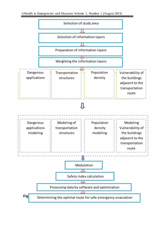
5/Health in Emergencies and Disasters Volume 1, Number 1 (August 2013)
Figure 1 Total flowchart of the process for determining the optimal
safe emergency routes
Vulnerability of
the buildings
adjacent to the
transportation
route
Population
density
Transportation
structures
Dangerous
applications
Modeling
Vulnerability of
the buildings
adjacent to the
transportation
route
Population
density
modeling
Modeling of
transportation
structures
Dangerous
applications
modeling
Selection of study area
Selection of information layers
Preparation of information layers
Weighting the information layers
Determining the optimal route for safe emergency evacuation
Processing data by software and optimization
Safety index calculation
Modulation
6 / Health in Emergencies and Disasters Number 1 (August 2013)
Defining the district of study
The case of our study is located on a plain on the southern corners of
Tochal mountains, which has been residential for many years. The Zone is
the Ancient Rey, an old area in Tehran, which is now located at Tehran’s
20th municipal district. It is 23 square kilometers within the Tehran’s
Municipality limit and 153 square kilometers outside it. Tehran’s 20th
municipal district is located at south of Tehran. From the north it is
attached to districts 15, 16 and 19, from the south to the city of Qom, from
the east to Pakdasht and Varamin and to Islamshahr and Zarandiyeh and
Robatkarim from the west. Of major physical characteristics of the district
20 which can be referred to is its location at the south of Tehran, while it
encompasses some of the main trans-regional administrative services of
Tehran. The existence of such notable historical and religious places as the
holy shrine of Imam Abdolazim (P. B. U. H.) has given attraction to the
district. Its position for creating landscape of city is also prominent in a
way that it is now considered as a main factor for ensuring the landscape
integrity of Tehran. Having a population of over 91500 families,
comprising of 5 internal districts and 2 external district and 21 districts has
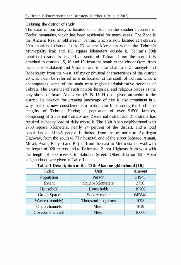
resulted in heavy load of daily trip to it. The 13th Aban neighborhood with
2750 square kilometers, nearly 24 percent of the district, and a total
population of 31,945 people is limited from the of north to Azadegan
Highway, from the south to 7Tir hospital, end of the street Sahraee, Amani,
Molaii, Arabi, Enayati and Rajaie, from the east to Metro station wall with
the length of 320 meters and to Behesht-e Zahra Highway from west with
the length of 500 meters to Sahraee Street. Other data on 13th Aban
neighborhood are given in Table 1.
Table 1 Description of the 13th Aban neighborhood [16]
Amount Unit Index
31945 Person Population
2750 Square kilometers Extent
19700 Households Household
645848 Square meter Green Space
1098 Thousand kilograms Waste (monthly)
1619 Meter Open channels
16000 Meter Covered channels
7/Health in Emergencies and Disasters Volume 1, Number 1 (August 2013)
Vulnerability of the 13th Aban neighborhood against earthquake According to its place in Iran earthquake map, Tehran is exposed to risk of
earthquake. In spite of this fact, according to studies by consultants of Iran
and the Agency for International Cooperation of Japan (JICA) and the
Center for Earthquake and Environmental Studies of Tehran, approximately
480,000 buildings in Tehran will received severe damages and about 220
billion dollars is estimated as the coast of damages in case of a strong
earthquake. Damages incurred to the district 11, 12, 16 to 20 will be very
high, about 80 percent. The 13th Aban neighborhood at Tehran’s 20th
municipal district has approximately 0.01 percent of worn buildings which
is about 0.04 percent of the district and 0.02 percent of Tehran old
structures. Thus, some parts of the 13th Aban neighborhood are more
vulnerable in the event of earthquake. The extent of the damages likely to
be inflicted on the population of the area in comparison with the whole
district and city of Tehran, based on the plan for operational scenario is
presented in Table 2, and a view of the streets to be studied in the network
is shown in the Figure 2.
Table 2 the extent of the devastations and damages inflicted on the
population of 13th Aban neighborhood compared to Tehran [16]
With respect to
the city of
Tehran (%)
With
respect to
whole
district 20
(%)
In the
neighborhood
(No. of people)
Status
0.6 10 217 Number of deaths
0.4 6 303
The number of
casualties requiring
hospitalization
0.6 10 2130 The number of
casualties outpatient
0.4 9 22239 Number of DPs

8 / Health in Emergencies and Disasters Number 1 (August 2013)
Figure 2 13th Aban street networks [17]
Based on the available studies, in case of an earthquake, the buildings in the
north east of 13th Aban neighborhood will face high damages. The level of
structural damages, based on the scenario, comparing to the whole district
and Tehran, is shown in Table 3.
Table 3 structural damages in the area comparing to the whole district and
Tehran [16]
Status In the
neighborhood (to
the people)
With respect
to the whole
district (%)
With
respect to
the city of
Tehran (%)
Heavy structural
damage to the area 990 5.8 0.4
Moderate structural
damage to the area 565 6.1 0.3
Partial Structural
damage to the area 608 5.8 0.3
About 290 underground river channels (ghanat) in the northern area and
102 ones in the southern area of the district are distributed. In total there are
392 ghanats in the area which increase the level of vulnerability of the area
9/Health in Emergencies and Disasters Volume 1, Number 1 (August 2013)
to the earthquakes. All these specifications call for preparing
comprehensive plans for identifying the paths and ways for emergency
evacuation at the time of earthquake, since as earthquake occurs, in
accordance with the increase in demand for using the road network, the
efficiency of network will drop down. Therefore, lack of identification of
the optimal emergency evacuation routs and unsafe or blocked paths
certainly lead to the prolongation of rescue operation, evacuation of the
devastated areas, heavy traffic load, inefficiency of rescue staff, and
increase of damages and fatalities. But for identifying and determining the
safe and optimal paths based on the safety index, we should find effective
parameters on the safety of the routs with their degree of importance.
Using Analytic Hierarchy Process in assessment and determining the
effective parameters on the safety of routs of rescue operation
The technique of Analytic Hierarchy Process (AHP) is used in our study
since it is simple, flexible, using both qualitative and quantitative criteria,
and is able to analyze consistency in desirable and optimum judgments.
[18].
AHP starts with identification and prioritizing of elements of decision-
making. These elements comprise of four levels of objectives, indexes,
parameters, and possible alternatives used in prioritization. The
identification process of the elements and the relation between them results
in a structure called the hierarchical structure. Conversion of the subject of
study to a hierarchical structure is the most important part of AHP [19].
In the present study, for determining the effective safety parameters in
selection of safe and optimum path for emergency evacuation, a
questionnaire based on AHP is prepared and submitted to the rescue
experts, crisis managers, urban planners, civil engineers, experts of
earthquake and related fields. The experts have been asked to specify the
parameters affecting the emergency evacuation based on their importance.
According to yielded results from the experts’ suggestions, the influencing
parameters on determining the safety of emergency evacuation paths are
placed in group four. The final results are shown in the table 4.
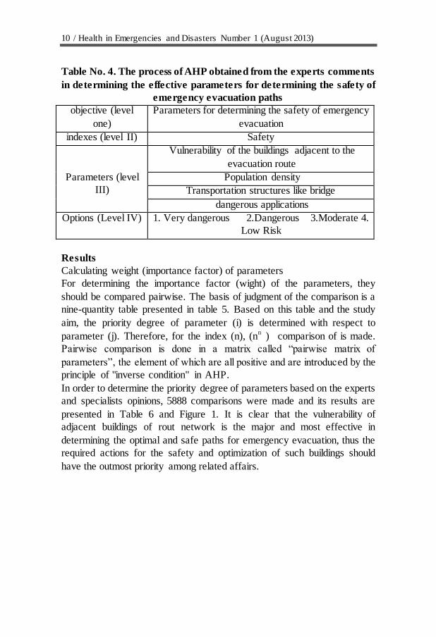
10 / Health in Emergencies and Disasters Number 1 (August 2013)
Table No. 4. The process of AHP obtained from the experts comments
in determining the effective parameters for determining the safety of
emergency evacuation paths
objective (level
one)
Parameters for determining the safety of emergency
evacuation
indexes (level II) Safety
Parameters (level
III)
Vulnerability of the buildings adjacent to the
evacuation route
Population density
Transportation structures like bridge
dangerous applications
Options (Level IV) 1. Very dangerous 2.Dangerous 3.Moderate 4.
Low Risk
Results
Calculating weight (importance factor) of parameters
For determining the importance factor (wight) of the parameters, they
should be compared pairwise. The basis of judgment of the comparison is a
nine-quantity table presented in table 5. Based on this table and the study
aim, the priority degree of parameter (i) is determined with respect to
parameter (j). Therefore, for the index (n), (nn ) comparison of is made.
Pairwise comparison is done in a matrix called “pairwise matrix of
parameters”, the element of which are all positive and are introduced by the
principle of "inverse condition" in AHP.
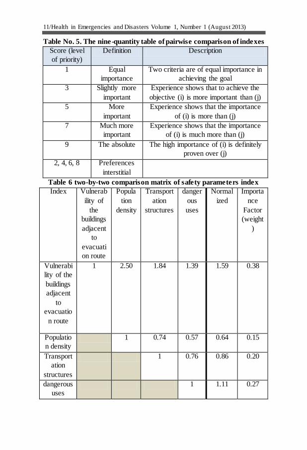
In order to determine the priority degree of parameters based on the experts
and specialists opinions, 5888 comparisons were made and its results are
presented in Table 6 and Figure 1. It is clear that the vulnerability of
adjacent buildings of rout network is the major and most effective in
determining the optimal and safe paths for emergency evacuation, thus the
required actions for the safety and optimization of such buildings should
have the outmost priority among related affairs.
11/Health in Emergencies and Disasters Volume 1, Number 1 (August 2013)
Table No. 5. The nine-quantity table of pairwise comparison of indexes
Score (level
of priority)
Definition Description
1 Equal
importance
Two criteria are of equal importance in
achieving the goal
3 Slightly more
important
Experience shows that to achieve the
objective (i) is more important than (j)
5 More
important
Experience shows that the importance
of (i) is more than (j)
7 Much more
important
Experience shows that the importance
of (i) is much more than (j)
9 The absolute The high importance of (i) is definitely
proven over (j)
2, 4, 6, 8 Preferences
interstitial
Table 6 two-by-two comparison matrix of safety parameters index
Index Vulnerab
ility of
the
buildings
adjacent
to
evacuati
on route
Popula
tion
density
Transport
ation
structures
danger
ous
uses
Normal
ized
Importa
nce
Factor
(weight
)
Vulnerabi
lity of the
buildings
adjacent
to
evacuatio
n route
1 2.50 1.84 1.39 1.59 0.38
Populatio
n density
1 0.74 0.57 0.64 0.15
Transport
ation
structures
1 0.76 0.86 0.20
dangerous
uses
1 1.11 0.27
12 / Health in Emergencies and Disasters Number 1 (August 2013)
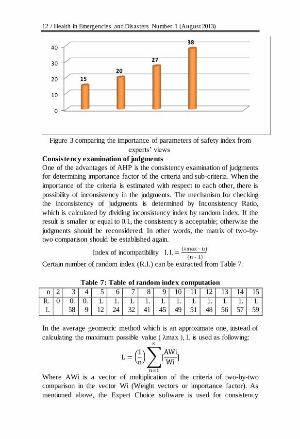
Figure 3 comparing the importance of parameters of safety index from
experts’ views
Consistency examination of judgments
One of the advantages of AHP is the consistency examination of judgments
for determining importance factor of the criteria and sub-criteria. When the
importance of the criteria is estimated with respect to each other, there is
possibility of inconsistency in the judgments. The mechanism for checking
the inconsistency of judgments is determined by Inconsistency Ratio,
which is calculated by dividing inconsistency index by random index. If the
result is smaller or equal to 0.1, the consistency is acceptable; otherwise the
judgments should be reconsidered. In other words, the matrix of two-by-
two comparison should be established again.
–
– Index of incompatibility
Certain number of random index (R.I.) can be extracted from Table 7.
Table 7: Table of random index computation
15 14 13 12 11 10 9 8 7 6 5 4 3 2 n
1.
59
1.
57
1.
56
1.
48
1.
51
1.
49
1.
45
1.
41
1.
32
1.
24
1.
12
0.
9
0.
58
0 R.
I.
In the average geometric method which is an approximate one, instead of
calculating the maximum possible value ( max ), L is used as following:
(
)∑
Where AWi is a vector of multiplication of the criteria of two-by-two
comparison in the vector Wi (Weight vectors or importance factor). As
mentioned above, the Expert Choice software is used for consistency
0
10
20
30
40
15
20
27
38
13/Health in Emergencies and Disasters Volume 1, Number 1 (August 2013)
Judgments determination. The index for judgment consistency; as CR =
0.00307 which is less than 0.1.
Modeling the parameters for safety index The proposed model for assessment and implementation of safety index in
this research includes examining the status of the adjacent buildings and
roads and assessment of their vulnerability, the effect of hazardous
applications in the area, checking the status of transportation structures, and
population density. Modeling of each these parameters is shown in the
figures 3, 4, 5 and 6.
In this level, the maps related to each indexes are analyzed by GIS
software, the value of all maps are calculated in the matrix. Then, the
calculated matrixes are put at the software written by research team which
is based on the algorithm of the shortest path . After that, according to the
supposed destination (which in our study is the intersection of Andisheh
and Northern Sahara) the software will find the most optimal rout from all
other intersections and paths.
Fig 3 Method for estimation of the hazardous applications and its modeling
Extraction
of data
related to
transportati
on
structures
Allocation of
transportati
on
structures in
the path of
the district
Estimating
the indexes
effects of
transportat
ion
structures
in
determinin
g of safety
Determinin
g the
optimal
path based
on the
effects of
transportat
ion
structures
Identificati
on and
extraction
of layer for
dangerous
uses in the
region
Determinatio
n of
separating
region with
various
distances for
each
dangerous
uses in the
region
Estimating
the effects of
dangerous
applications
parameters in
determination
of path safety
Determining
optimal
path based
on the
effects of
dangerous
applications
14 / Health in Emergencies and Disasters Number 1 (August 2013)
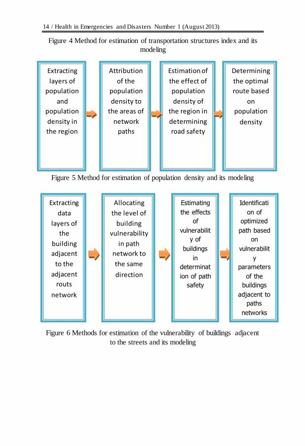
Figure 4 Method for estimation of transportation structures index and its
modeling
Figure 5 Method for estimation of population density and its modeling
Figure 6 Methods for estimation of the vulnerability of buildings adjacent
to the streets and its modeling
Extracting
layers of
population
and
population
density in
the region
Attribution
of the
population
density to
the areas of
network
paths
Estimation of
the effect of
population
density of
the region in
determining
road safety
Determining
the optimal
route based
on
population
density
Extracting
data
layers of
the
building
adjacent
to the
adjacent
routs
network
Allocating
the level of
building
vulnerability
in path
network to
the same
direction
Estimating
the effects
of
vulnerabilit
y of
buildings
in
determinat
ion of path
safety
Identificati
on of
optimized
path based
on
vulnerabilit
y
parameters
of the
buildings
adjacent to
paths
networks
15/Health in Emergencies and Disasters Volume 1, Number 1 (August 2013)
Discussion and conclusion By analyzing and assessing the effective parameters in safety of the paths
for emergency evacuation in 13th Aban neighborhood by using AHP and
considering the indexes of this study, many points can be mentioned, but
the most important of them are:
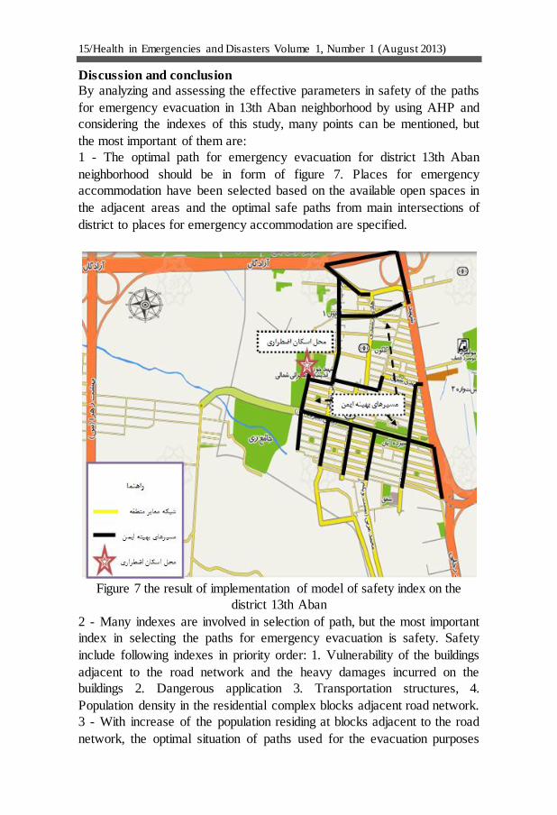
1 - The optimal path for emergency evacuation for district 13th Aban
neighborhood should be in form of figure 7. Places for emergency
accommodation have been selected based on the available open spaces in
the adjacent areas and the optimal safe paths from main intersections of
district to places for emergency accommodation are specified.
Figure 7 the result of implementation of model of safety index on the
district 13th Aban
2 - Many indexes are involved in selection of path, but the most important
index in selecting the paths for emergency evacuation is safety. Safety
include following indexes in priority order: 1. Vulnerability of the buildings
adjacent to the road network and the heavy damages incurred on the
buildings 2. Dangerous application 3. Transportation structures, 4.
Population density in the residential complex blocks adjacent road network.
3 - With increase of the population residing at blocks adjacent to the road
network, the optimal situation of paths used for the evacuation purposes
16 / Health in Emergencies and Disasters Number 1 (August 2013)
drops down. In other words, the administrative paths which have more
population are less suitable for optimizing process.
4 – Existence of bridges and tunnels on the emergency evacuation paths
can be dangerous or even very dangerous. Therefore, no bridge should be
constructed on the paths or at least the safety of buildings and its
retrofitting should be properly observed.
Refrences:
1. Shakiba A, "Crisis", Encyclopedia of urban and rural management, Organization
for Municipalities and villages administration; 2008.
2. Taleb M., "Methods for Selection of Species Living in Rural Houses", Bonyad-e
Maskane Enghelab-e Eslami; 2001.
3. Pour-Mohammadi Mohammad Reza and Ali Mosayebzadeh, "Vulnerability Of
Iran Cities at Earthquake and Role of Neighborhood Help in Relief Operation", Gography
and Develeopment Maganzine, No. 12; 2009.
4. Jahanpeyma Mohammad Hossein, "A Study on Release of Lack of Certainty and
Its Role in Preparing Maps for Earthquake Vulnerability in the City of Tehran by Location
Information Systems", MA thesis, University of Tehran, Faculty for Surveying; 2005.
5. Samadi Alinia, Hadith, "Preparing the Map for Tehran City Vulnerability by
Means of Computation Theory", MA Thesis, Civil Engieering, University of Tehran;2009.
6. "Earthquake and Environmental Research Center", Tehran Japan International
Cooperation Agency (JICA), Final report on Tehran's seismic zonation project; 2001.
7. Ganjehi S. Omidvar, B. And Norouzi Khatiri, Kh, "Position and Importance of
Determination of Emergency Evacuation Paths Toward the Temporary Accommodation
Centers from The Viewpoint of Crises Management", second conference on crisis
management in construction, under groud constructions and vital paths, Esfahan; 2012.
8. Omidvar, B. Ganjehi, S. Norouzi Khatiri, Kh. And Mozafari, A, The Role of
urban transportation routes in earthquake risk reduction management of Metropolitans. Case
study: District No.20 of Tehran. International Conference "Urban change in Iran", 8-9
November 2012 University College Landon; 2012.
9. Hosseini, M. and Fathi H, On the Relationship of Urban and Regional Planning
with Earthquake Risk Management: Tehran Case Study, Proceedings of the 5th Int’l
Conference on Seismology and Earthquake Eng. (SEE-5), IIEES, Tehran, Iran, 13-16 May
2007.
10. Sherali H, D, Carter T, B, A location-allocation model and algorithm for
evacuation planning underhurricane flood conditions, Transportation Research, Part B,
Vol.25 B, No 6 ,PP. 439-452; 1991.
11. Sattayhatewa P. Ran B., Developing a dynamic traffic management model for
nuclear power plant evacuation, TRB. Annual Meeting July 29; 1999.
12. Cova, T J, Johnson J P, Microsimulation of neighborhood evacuations in the
urban-wildland inter face, Center for Natural and Technological Hazards, Department of
Geography, University of Utah, Tune; 2002.
13. Yi, W. and Ozdamar, L, A Dynamic Logistics Coordination Model for Evacuation
and Support in Disaster Response Activities, European Journal of Operational Research,
Article in Press; 2006.
14. Chen Yueming, XIAO Deyun, Emergency Evacuation Model and Algorithms.
Journal of Transportation systems engineering and information technology; 2008.

17/Health in Emergencies and Disasters Volume 1, Number 1 (August 2013)
15. Srgolzaee, "Determination of Closed Paths in Earthquake in Mashahd" Quarterly,
7th year, No. 14; 2010.
16. Ganjehi S., "Determination of Path for Relief and Emergency Evacuation for
Devastated Regions to the Safety Region after Earthquake" – a case study, 13 Aban District
Tehran, MA Thesis, Faculty of Environment, University of Tehran; 2011.
17. http://map.tehran.ir/fa.
18. Lee, Colin, Models in Planning. Oxford: Pergamon Press; 1973.
19. Bowen, William M, AHP: Multiple Criteria Evaluation, in Klosterman, R. et al
(Eds), Spreadsheet Models for Urban and Regional Analysis, New Brunswick: Center for
Urban Policy Research; 1993.
Copyright © 2022 FDOKUMEN