Saharan dust deposits on La Palma (Canary Islands, Spain).
22
This article is published in: Catena (2012) Volume 103, 44-52 doi:10.1016/j.catena.2011.07.005
-
Upload
uni-leipzig1 -
Category
Documents
-
view
0 -
download
0
Transcript of Saharan dust deposits on La Palma (Canary Islands, Spain).

This article is published in:
Catena (2012)
Volume 103, 44-52
doi:10.1016/j.catena.2011.07.005

The influence of Saharan dust deposits on La Palma soil properties (Canary Islands, Spain) Hans von Suchodoletza,*, Bruno Glaserb, Timothy Thrippletonc, Tanja Broderc, Ulrich Zangc, Rafael Eigenmannc, Benjamin Koppc, Martin Reichertc, Zöller Ludwigc a University of Leipzig/Germany, Institute of Geography, Johannisallee 19a, D-04103 Leipzig, Germany b Martin-Luther University Halle-Wittenberg, Soil Biogeochemistry, von-Senckendorff-Platz 3, D-06120 Halle, Germany c University of Bayreuth/Germany, Department of Geosciences, Universitätsstrasse 30, D-95440 Bayreuth, Germany * corresponding author abstract: The significance of Saharan dust deposits for ecosystems has been demonstrated in several studies, showing its influence on pedogenesis and soil chemical and physical parameters by the addition of nutrient elements. This contribution is especially important for volcanic soils poor in plant-available phosphorous as those of the island of La Palma (Canary Islands, Spain). Thus, this study investigates the spatial distribution of Saharan dust on the island, and determines its influence on soil properties and thus on the ecosystem of the island. Since silt-sized quartz is not autochthonously formed on the island, it served as a reliable indicator for Saharan dust. Quartz was identified and quantified using X-ray diffractometry. The influence of Saharan dust additions on soil properties was assessed by texture analyses and analyses of plant-available phosphorous, an element strongly limiting plant-growth on the island due to its fixation in the structure of amorphous volcanic clay. A luff–lee-effect revealed significant influence on dust distribution, whereas small geomorphologic structures as hollows and mounds hardly influenced the dust distribution pattern. A positive correlation of quartz content with the proportion of the grain size fraction 0.5–10 µm demonstrates an influence on soil physical properties, apparently influencing available water capacity. Furthermore, our data suggest an increasing content of plant-available phosphorous with a rising amount of Saharan dust in the soils. Thus, the input of Saharan dust influences soil fertility of La Palma and is an important factor regarding the fragility of the La Palma ecosystems. 1. Introduction The Saharan desert is the largest dust source in the world, contributing between 260 and 700 Mio.t/a (Wright, 2001). This material is transported by eolian processes towards the surrounding areas, whereof the largest part (30–50%) is transported towards the Atlantic Ocean, even reaching North and South America (Goudie and Middleton, 2001; Prospero and Lamb, 2003). In the downwind areas, the suspended material strongly influences ecosystems such as soils (Jahn, 1995; McTainsh and Strong, 2007; Muhs et al., 1990), biocenoses (e.g. South American forests; Boy and Wilcke, 2008; Koren et al., 2006) or oceans (Fung et al., 2000; Jickells et al., 2005) by the supply of nutrients. Furthermore, dust has considerable effects on the global or regional climates (Kerr, 2007; Sassen et al., 2003) as well as on human health (Grigoropoulos et al., 2009; Monteil, 2008). La Palma is the westernmost and one of the youngest islands of the volcanic Canary Island archipelago, having emerged above sea level since the Early Pleistocene (Carracedo et al., 1998). The quite recent volcanic origin of the island causes a high presence of young volcanogenic non-crystalline aluminum and iron clays such as allophane or imogolite in its soils. These minerals strongly sorb plant-available phosphorous in their structure (Alvarado and Buol, 1985; Kirchhof et al., 2008), leading to a deficiency of this macronutrient so that plant growth on these soils is partly limited as can be seen in chlorotic needles of Pinus canariensis trees. The island is located at the northern fringe of the Saharan dust plume over the North Atlantic Ocean and receives Saharan dust throughout the year. Dust input is mainly realized by two different pathways: During winter, dust is entrained by “Calima” winds, low-level continental African trade winds (Harmattan) deflected towards the northwest by Atlantic cyclones (Criado and Dorta, 2003). During summer, dust is transported to the latitude of the Canary Islands by the northern branch of the high altitude Saharan Air Layer (SAL). Here, the material is either directly deposited in the higher parts of the island or is transported north of the archipelago, where it sinks into the lower atmosphere so that it can be transported towards the island via the Northeast Trade wind (Bozzano et al., 2002; Koopmann, 1981). Although Goudie and Middleton (2001) demonstrate that the Bodélé depression in the Republic of Chad is the major source of Saharan dust, dust affecting the Canary Islands mostly originates from an area directly upwind of the Canary Islands in northwest Africa, comprising the Western Sahara and parts of Mauritania, Algeria and Morocco (Alonso-Pérez, 2007).Most important minerals in Saharan dust arriving at Gran

Canaria are quartz (42%), calcite (30%), feldspar (11%) and dolomite (8%) (Menéndez et al., 2007). The general dominance of quartz is confirmed by the compilation of Goudie and Middleton (2001) for dust from several sites in North Africa and Southern Europe. Furthermore, the latter study reports some phosphorous contained in Saharan dust, also confirmed by the study of Guieu et al. (2002). The recent dust deposition rate on La Palma is difficult to define: Prospero (1996) estimates an annual rate of 16 g/m² for the Canary Islands, but this estimate is associated with uncertainties. Direct measurements in Gran Canaria suggest an annual deposition rate between 17 and 79 g/m² depending on altitude, thus pointing to somewhat higher values (Menéndez et al., 2007). However, due to the more western and thus more remote location from the Sahara of La Palma compared to Gran Canaria (Fig. 1), values for La Palma are probably somewhat lower than those for Gran Canaria. This paper focuses on the spatial pattern and mechanisms of dust accumulation at La Palma, as well as on the impact of Saharan dust on local soils and ecosystems: In order to account for the accentuated and rugged topography of the island and to identify main ways of dust deposition, we investigate dust accumulation in local soils as a function of exposition and of small topographic structures. Comparing these measurements with meteorological data of dust-bringing periods, we could identify main dust-bringing winds and general mechanisms of dust deposition on the island. Furthermore, we demonstrate that Saharan dust influences properties of local soils as water retention characteristics by a change of soil grain size distributions, and the amount of plant-available phosphorous. In difference to the widely used approach of directly collecting dust samples after deposition and investigating their geochemical properties (e.g. Drees et al., 1992; Guieu et al., 2002), we measured soil characteristics that offers the opportunity to investigate the long-term-effect of dust accumulation on actual soil properties and thus on the ecosystems on the island. Measurements of Saharan dust in the soils are based on the fact that in most parts of the island quartz is absent in the silica subsaturated basaltic rocks (Rothe, 1996), so that the presence of this mineral could be used as a quantitative indicator for Saharan dust in soils (Mizota and Matsuhisa, 1995). 2. Study area The island of La Palma is the northwesternmost island of the Canarian archipelago, located in a distance of about 400 km from the African continent. It covers an area of 708 km², extending about 40 km from north to south (Fig. 1). First subaerial volcanism started about 2 Ma ago in the north of the island, latermoving to the south in accordance with an assumed hot spot origin of the Canary Islands (Carracedo et al., 1998). Thus, the northern Caldera Taburiente volcano comprising the highest point of the island (2426 m) originates from the Early to Middle Pleistocene, whereas the Cumbre ridge to the south was formed from the Middle Pleistocene until the Holocene. The last eruptive phase continued uninterruptedly from 125 ka ago until today (last eruption 1971), and is only found at the Cumbre Vieja ridge in the southernmost part of the island. The geology of the island is dominated by basic volcanic rocks, although there is a shift towards increasingly intermediate rocks within the young southern Cumbre ridge (Carracedo, et al. 2001). Furthermore, in the lowest part of the Caldera Taburiente volcano a part of the so-called “basal compex” of the island is outcropped, also containing some quartz-bearing diorites (Rothe, 1996). Due to recent volcanic activity, the topography is characterized by steep slopes dissected by numerous valleys and barrancos of different magnitudes. The distribution of soils depends on the kind of underlying volcanic material as well as on the degree of soil formation: Due to longer pedogenesis, the slopes of the older Caldera Taburiente volcano in the north are mostly covered with Umbrisols, Cambisols, Luvisols and Vertisols, representing advanced stages of weathering of volcanic material. In difference, the slopes of the younger Cumbre ridge in the south are mostly covered with Andosols indicating a shorter period of soil formation. Independent from the geomorphologic situation, areas dominated by outcropping volcanic rocks or by Late Holocene lapilli are covered with Leptosols and Regosols (Morales-Matos and Pérez-González, 2000) (Fig. 2). The climate of La Palma is semiarid to semi-humid with a maritime character. Year-round, the island is located in the zone of the marine northeast trade winds, occasionally interrupted only during winter by northwestern cyclones bringing precipitation to the island, or by eastern Saharan air in connection with dust-bearing “Calima”-winds (Rothe, 1996). Precipitation values rise from < 300 mm at the west coast up to 1100 mm at the highest areas around 2400m altitude. Due to the Northeast Trade wind blowing against the eastern side of the Caldera Taburiente volcano and the north–south stretching Cumbre ridge, a “sea of clouds” is formed here from 1200 to 1600 m altitude, causing foggy
conditions and bringing more precipitation to the eastern side of the island. Annual temperatures at sea level are about 20°C, falling to about 8°C at the summits of the Caldera Taburiente volcano. The vegetation of the island belongs to the Macronesian floristic association, characterized by a high proportion of endemic species. Following the climatic altitudinal trend, the vegetation is organized in altitudinal zones: It starts with the lowest infracanarian stage up to 750 m (coastal and succulent plants as e.g. Euphorbia canariensis), an intermediate meso- and thermocanarian stage between 750 and 2000 m (forests of Laurus azorica and P. canariensis), and ends in the supracanarian stage dominated by species of Spartocytisus supranubiu (Kunkel, 1993). 3. Material and methods 3.1. Sampling sites In order to assure that all quartz found within the investigated soils are of allochthonous origin, four different types of eruptive rocks representative for the parental rock material of the sampled soils were taken from the Cumbre ridge to analyze their quartz content (for locations, see Fig. 1). We investigated 24 sites from the Cumbre ridge, characterized by Leptosols, Regosols, Andosols and Umbrisols. The sites are distributed over the ridge with respect to comparability in terms of altitude (700 and 1150m asl.), exposition (eastern and western slope) and geomorphologic structure (hollow/mound) (for locations, see Figs. 1 and 2, Table 1). From these soils, we sampled about 100 g of material from the middle of A-horizons that were generally 10–20 cm thick and easily recognized in the field by their specific dark color for investigations of grain size, quartz and plant-available phosphorous. Furthermore, we sampled the same amount of material from the upper 1 cm of these soils, in order to reduce the error of analyses by compiling measured data of both depths from one site. In order to investigate the effect of erosion on deposited Saharan dust, 12 sites at two different altitudes (500 and 1700 m) were sampled in the same way as at the Cumbre ridge at the large-scale erosional structure “Barranco del Río”, a V-shaped valley with several tributary valleys. This barranco is located at the eastern slope of the island west of Santa Cruz, a region characterized by Umbrisols, Leptosols, Cambisols and Luvisols (for locations, see Figs. 1 and 2, Table 1). Likewise, we differentiated between full molds (ridges) and hollow molds (barrancos) in this large erosional structure. 3.2. Methods Analyses of soil and rock samples were carried out in the laboratories of the Geosciences Department of the University of Bayreuth, Germany. All soil samples were oven-dried at 40°C for 48 h and sieved < 2 mm in order to remove the coarse soil skeleton, roots and plants. Rock samples were crushed in a jaw breaker prior to further treatment. 3.2.1. X-ray diffraction analyses X-ray diffraction analyses were used to determine the quartz content of the samples. Prior to the analyses, the material was ground in a mortar to obtain homogenous fine grain size distributions. Measurements were carried out using a Siemens D5000 X-ray diffractometer, operating with a CoKα-cathode (40 kV, 40 mA) and applying an interference filter with a step width of 0.1 mm. Measurement parameters were 30s/point with a step width of 0.01°2θ. The measurement angle range for peak quantification was from 28 to 32°2θ. Furthermore, we also measured the angle range from 22 to 26°2θ in order to be sure that the measured peak was unambiguously quartz. Analysis of the diffractograms was carried out using the DOS-program DIFFRAC-AT 3.3. We used the standard addition method (Connolly, 2010; Harris, 2003) for the quantification of quartz from the diffractograms. For this purpose, defined quantities of technical fine-grained quartz (Merck) were added to an exemplary sample, and after measurement the areas of the identified quartz peak (24.1°2θ) were determined from the diffractograms in order to construct a standard addition line. Due to a reparation of the XRD-machine, quartz contents of A-horizons were measured using a standard addition line based on the formula y = 0.1701 x + 0.17 (R2 = 0.986), whereas after reparation of the machine quartz contents from the upper 1 cm were calculated using a standard addition line based on the formula y = 3.21 x + 3.05 (R2=0.828). 3.2.2. Grain size analyses

For grain size analyses, about 3 g of material was weighed and subsequently heated with 5 ml of water and 5 ml of 30% H2O2 for 2 h at 95°C, in order to destroy organic matter. Since there was no carbonate detected in the field, samples were not treated with HCl for a destruction of carbonate. After washing in deionized water, 5% sodium hexametaphosphate was added, and the suspension was shaken for 2 days in order to disperse clay. Subsequently, the material was wet sieved. The fraction >63 µm was dried and weighed, and the grain size of the fraction <63 µm was measured with laser analysis using a Malvern Mastersizer 2000. The percentage of the dust grain size fraction measured with laser analysis was subsequently recalculated using the weight proportion of the fractions >63 µm/<63 µm, in order to obtain its percentage in the total sample. Unfortunately, we do not have recent dust samples from La Palma so that we had to derive dust grain size from samples collected in Gran Canaria, that were also measured using laser analysis. Dust grain sizes at Gran Canaria show a grain size maximum between 10 and 100 µm with a mode of 46 µm (Menéndez et al., 2007). However, numerous aggregates in the dust significantly modify the modal grain size at Gran Canaria. Thus, after their mechanic destruction prior to grain size analysis, the main dust grain size peak is between 1 and 12 µm (Menéndez et al., 2009a). In difference to recently deposited Saharan dust soils at La Palma contain no carbonate, indicating a certain degree of weathering. This weathering certainly destroyed originally deposited Saharan dust aggregates during pedogenesis so that soil dust grain size distributions should correspond to those from Gran Canaria after destruction of aggregates. Furthermore, the larger distance of La Palma from the Saharan desert compared to Gran Canaria (200 km; Fig. 1) causes a further sedimentation of coarser particles during eolian transport so that a general increase of finer particles during the transport from Gran Canaria to La Palma should be observed. Thus, we assume a mean dust grain size of 0.5–10 µm in the soils of La Palma. 3.2.3. Analysis of plant-available phosphorous 2.5 g of sieved soil material (<2 mm) was used to determine the content of plant-available nutrient phosphorous, using the Mehlich III-extraction method (extraction solution 0.2 N acetic acid, 0.25 N ammonium nitrate, 0.015 N ammonium fluoride, 0.13 N nitric acid, 0.001 MEDTA; Burt, 2004; Mehlich, 1984). The extracted solution was measured using an Inductively Coupled Plasma Optical Emission Spectrometer (ICP-OES, Varian, Vista-Pro radial) within 72 h after extraction. 3.2.4. Analysis of atmospheric dust load and corresponding meteorological situations In order to identify frequency, intensity and wind direction of dust-bearing events on La Palma throughout an annual cycle, we analyzed all days with atmospheric dust load in the area of La Palma in 2006 with respect to dust concentration and wind direction. Daily dust load at the latitude of La Palma during dust events was determined semi-quantitatively from atmospheric aerosol concentration at 500 and 1700 m asl. using the DREAM-dust model of the Barcelona Supercomputing Center (www.bsc.es/projects/earthscience/DREAM/). For this, the mean of dust concentration at the latitude of La Palma in the corresponding height was estimated from dust concentration-maps created by the DREAM-model for every day. Corresponding wind directions at 500 and 1700m asl. during dust events were determined using the HYSPLIT model of the Air Resources Laboratory (http://ready.arl.noaa.gov/HYSPLIT.php), in order to get information about the direction of the approaching dust-loaded air flow. 4. Results 4.1. X-ray analyses X-ray analyses of soil samples show a distinctive peak at 24.1°2θ, attributed to quartz by the standard addition method. Quartz contents in the soil samples (mean of A-horizon and upper 1 cm) varied between 0.18 and 2.60% (Table 1). In difference, analyses of rock samples from the Cumbre ridge did not show the quartz peak in any of these samples. 4.2. Grain size analyses During grain size analyses, the proportion of the fraction 2000 - 63 µm in the A-horizons determined by sieving varied between 8.5 and 81.3%. Grain size analyses of the sieved fraction b63 µm using laser diffraction generally yielded a bimodal distribution, with a first peak at ca. 0.4 µm and a second

peak between 7 and 20 µm (Fig. 3). The dust grain size fraction 0.5–10 µm showed a proportion between 7.3 and 54.6% in the total sample material of the A-horizons (Table 1). 4.3. Analyses of plant-available phosphorous Analyses of plant-available phosphorous using the Mehlich III-method showed that the values of plant-available P varied between 2.7 and 127.9 mg/kg, with a mean of 28 mg/kg for all samples (mean of A-horizon and upper 1 cm) (Table 1). 4.4. Analyses of the situation of dust load and corresponding wind direction Analyses of the situation of dust load and corresponding wind direction from the DREAM and HYSPLIT models were done for 357 days during 2006, since for 9 days (2 in January, 1 in March, 4 in May, 2 in June) no data were available. Of 105 days with dust load found in the atmosphere of La Palma only two recorded wet deposition, whereas for the other days exclusively dry deposition was found. Generally, much more dust is transported at low (500 m) than at high (1700 m altitude) towards the island. During October, no days with dust load were recorded at all. Most days with atmospheric dust load in the area of La Palma occurred during the summer months (July and August), but with rather low absolute dust concentrations. In difference, the number of days with dust load was lower during November and December, but with higher dust concentration in the atmosphere. Thus, highest absolute dust deposition of the year takes place during these winter months (Fig. 4). Regarding annual dust concentration in the atmosphere of La Palma, differentiated to altitude and wind direction, the highest concentration is recorded on the eastern side of the island at an altitude of 500 m, and the lowest at the same altitude at the western side. Intermediate concentrations are found at 1700 m altitude, with somewhat higher values at the eastern side of the island (Fig. 5). 5. Discussion 5.1. Origin, distribution and pathways of Saharan dust During XRD analyses of four different rock samples from the region south of the Caldera Taburiente, no quartz was detected at all. Such rocks are the parent material of the investigated soils. Quartz-bearing diorite as part of the so-called “basal-complex” is exclusively outcropped at some sites at the bottom of the Caldera Taburiente. Since due to the steep topography the bottom of the Caldera is completely shielded from the wind field of the island (cf. Fig. 1), we are absolutely sure that a transport of such material to the sampling sites is impossible. Thus, it can be presumed that all quartz found in the soils of the study region must have an exclusively eolian origin so that this mineral can be used as a tracer of Saharan dust (Mizota and Matsuhisa, 1995). A comparison of quartz (Saharan dust) contents in soil samples east and west of the Cumbre mountain ridge at different altitudes reveals a clear spatial pattern (Fig. 5): Samples from the western side of the island show higher mean quartz contents than the ones from the eastern side of the island. Furthermore, in spite of quite large errors of the analyses the distribution of quartz is apparently differentiated between the altitudes: At the eastern slope, quartz concentrations in the soil material tend to be higher at 1150 m than at 700 m where lowest values of the whole island are detected. In difference, quartz values tend to be lower at 1.150 m than at 700 m at the western slope, with highest values of the whole island found at 700 m (Fig. 5). This finding is in an apparent contrast to the results of the analysis of atmospheric dust load and corresponding meteorological situations, which show that most dust is brought by winds from eastern directions towards the island. Furthermore, when looking at different altitudes the eastern air flow transports more dust at low (500 m) than at high altitude (1700 m), whereas the pattern is inverse for the western air flow where lowest values are transported at 500 m (Fig. 5). However, this apparent contradiction could be explained by a luff–lee-effect at the Cumbre mountain ridge: Fig. 6 shows that the most extreme difference in quartz deposition values in the soils (high in the west, low in the east) is found at the two southernmost sites of the Cumbre ridge. This points to a luff–lee effect for dust-loaded winds blowing around the southern tip of the island from east to west, the direction in which most of the dust-loaded air is transported towards La Palma (oral communication José María Fernández-Palacios, Universidad´de La Laguna de Tenerife). After having passed the southern tip of the island, the reduced velocity of the airflow allows the air to move northwards causing decompression, and dust particles are settled at the soil surface of the western Cumbre ridge. Thus, generally higher quartz values are found at the western than at the eastern side of

the ridge (Figs. 5, 6). Whether the unequal distribution of quartz in the soils of the western and eastern side of the Cumbre ridge is also affected by a luff–lee effect of dust-loaded air blowing directly over the Cumbre ridge is not recognizable from the spatial distribution of our data (Fig. 6). However, the studies of Goossens (1988, 2006) show that an assumed luff-lee effect for air blowing over an obstacle, with strong dust deposition in the lee, could not be generated during physical models. Thus, such an effect is not very likely to occur, so that the unequal quartz distribution between the eastern and the western slope of La Palma is probably mainly caused by dust-loaded air coming from the east, flowing around the southern tip of the island as described above. Regarding the deposition of quartz (Saharan dust) differentiated between hollow and mound structures along the Cumbre ridge, there seems to be a slightly higher deposition at the mounds than in adjacent hollow structures at the eastern side (Fig. 7). Although this difference is quite small and due to the large error bars rather uncertain, we suppose that this could show slightly stronger erosion in hollows compared with mounds: Whereas hollows are connected with the discharge network of the slopes, transport capacity at elevated mounds is too low to transport particles to the discharge network. This effect could also account for the results from the Barranco del Río: Whereas elevated ridges show higher quartz deposition at 1700 m than at 500 m and thus confirm the general altitudinal pattern observed at the Cumbre ridge (cf. Fig. 5), quartz values in barrancos at 500 m are much higher than in those located at 1700 m and those of adjacent ridges (Fig. 7, inset). This demonstrates a transport of fine dust material eroded from higher positions towards barranco structures at 500 m, where dust material that was collected in quite large catchment areas could accumulate. In difference, due to their position disconnected from the larger discharge network ridge positions are not affected by these large-scale relocation effects. At 1700 m, catchment areas and thus discharge are apparently too small to mobilize a significant amount of material towards barranco structures. These results indicate that the redeposition and accumulation of a significant amount of Saharan dust is only observable in very large erosional structures such as the Barranco del Río, whereas at most slopes relocation is generally very weak. An explanation for the quite good protection of Saharan dust against erosion could be trapping of dust-borne material in the porous structure of volcanic tephra and lapilli of different size often found in the young soils of La Palma, an effect also observed in Lanzarote (cf. Menéndez et al., 2009a). Moreover, porous volcanic material generally protects the underlying soil from erosion, an effect also used by farmers on Lanzarote by covering soils with an artificial layer of lapilli (“enarenado artificial”) (Rodríguez-Rodríguez et al., 1993). 5.2. Impact of Saharan-dust deposition on soil properties The influence of Saharan dust input on soil texture is illustrated in Fig. 8, showing the comparison between quartz content and the percentage of the dust fraction 0.5–10 µm in the total soil sample. Both parameters show a positive logarithmic correlation with R2 = 0.33 (Fig. 8). Thus, at least a part of the clay and fine silt grain size fraction (0.5–10 µm) can be explained by the input of Saharan dust. Although volcanic ash soils do generally show good water retention (e.g. Shoji et al., 1991), especially for coarse-grained soils developed on lapilli material partly found in La Palma the input of dust material apparently positively influences soil texture and thus water retention. A lower limit of around 40 mg/kg for phosphorus availability was determined for many plants (Pagel et al., 1982). This indicates that most (78%) of investigated soils (with a mean content of 28 mg/kg for all soils) are generally deficient in their phosphorous supply (cf. Table 1), so that this element might act as a main limiting factor for plant growth and nutrition. This could possibly explain the observation of chlorotic needles of P. canariensis trees at several places of the island. The generally low content of plant-available phosphorous can be explained by its fixation through allophanes or imogolites that prevail in young volcanic soils (e.g. Alvarado and Buol, 1985; Kirchhof et al., 2008). Individual values of plant-available phosphorous strongly fluctuate, typical for the Mehlich III method when applied to soils with low absolute values (Zhang et al., 2009). Thus, we counterbalanced this effect by the formation of twelve groups of investigation sites (each containing three sites with similar topographic and geomorphologic attributes). Doing so, we found a positive correlation (R2 = 0.36) between Saharan dust deposition (quartz content) and plant-available P in the soils (Fig. 9, inset). This suggests that Saharan dust could have an effect on local ecosystems by the supply of the macro-nutrient phosphorous to the soils, probably not directly bound to volcanic clay as in the case of volcanogenic phosphorous. Instead, at least a part of dust-borne phosphorous remains easily plant-available. Such an effect is obviously confirmed by the results of a comparison of quartz and

phosphorous contents of investigated sites from both sides of the Cumbre ridge (Fig. 9): In spite of the strong variation of the values of plant-available phosphorous between individual sites, when grouping all sites from the western and all sites from the eastern slope of the Cumbre ridge into one group, respectively, the spatial differentiation in quartz contents between the eastern and western parts of the island appear to be observable for this element, too. Thus, it seems that the luff-lee-effect of Saharan dust deposition is reflected here, leading to overall higher available phosphorus contents at the western than at the eastern slope of the Cumbre ridge. Total phosphorous amounts of < 0.1% were found in dust collected over the Mediterranean Sea and were present in an inorganic form, largely associated with iron oxyhydroxides coated on clay minerals and quartz particles (Guieu et al., 2002). Also Goudie and Middleton report about 0.2% P2O5 in dust samples from North Africa and southern Europe. Likewise, phosphorous is known from dust samples taken west from the Saharan desert (SAMUM-project, oral communication K. Kandler, 2010), and own measurements of a recent dust sample from Gran Canaria yield an amount of 0.46% of that element (unpublished results). The larger amount of phosphorous in dust collected at the Canary Islands compared to dust samples originating from the Mediterranean area could be explained by different pathways of the dust clouds: In difference to dust transported to the Mediterranean area, between the main sources of dust arriving at the Canary Islands are the Western Sahara and Southern Morocco (Alonso-Pérez, 2007) where large phosphorous open cast mines are found (Net Resources International, www.mining-technology.com/projects/benguearir). There, phosphorous-containing material can easily be mobilized from the open stockpiles in the arid to semiarid climate, and thus be incorporated into Saharan dust clouds arriving at the Canary Islands. Here, the permanent input of phosphorous-containing dust material not bound to amorphous volcanogenic clay constitutes a continuous source of plant-available phosphorous in the soils, and thus improves the conditions for plant-growth. 6. Conclusions During this study we could demonstrate, that similar to other Canary Islands that are located closer to the African continent (Lanzarote, Gran Canaria and Tenerife; Kis and Schweitzer, 2010; Menéndez et al., 2009b; Suchodoletz et al., 2009) a significant amount of Saharan dust is also deposited in soils of La Palma, the island of the archipelago that is most distant fromthe Saharan desert. Although most dust is transported from eastern directions towards La Palma, due to a luff–lee effect most material is deposited on the western slope of the investigated Cumbre ridge. Probably due to a general high porosity of the soils, apart from large erosional structures a relocation of deposited Saharan dust material is hardly observable. The input of Saharan dust causes a part of the increase of the grain size fraction 0.5-10 µm in the soils, thereby possibly improving water retention of coarse-grained volcanic soils that are often found on the island. Furthermore, our data suggest that Saharan dust is apparently responsible for an increased amount of plant-available phosphorous, an element deficient in local volcanic soils due to its retention by amorphous volcanic clay as e.g. allophane (Alvarado and Buol, 1985; Kirchhof et al., 2008). Therefore, it can be concluded that the deposition of Saharan dust on La Palma is a factor for the ecosystems of the island that cannot be neglected. Although difficult to differentiate from other processes (local precipitation regimes), this input is assumed to have an effect on biodiversity as species distribution and community composition. Although further investigations are needed, these investigations demonstrate that the landscape of La Palma has to be regarded as fragile. This is due to the fact that local soils are sensitive to the external input of Saharan dust, so that changes of its quantity and quality (linked with a change of the provenance area of dust-brining winds) could have significant consequences for soil properties and consequently the insular ecosystem. Acknowledgments The authors would like to express their sincere gratitude to Prof. Dr. Carl Beierkuhnlein and Prof. Dr. Anke Jentsch (both University of Bayreuth) for organizing the field work on La Palma. Furthermore, we thank Juliane Brust (IOW Warnemünde) and Konrad Kandler (SAMUM, University of Darmstadt) for very fruitful discussions at the EGU General Assembly 2010 in Vienna, and two anonymous reviewers for critical comments on the manuscript. References

− Alonso-Pérez, S. (2007): Caracterización de las intrusiones de polvo africano en Canarias. PhD-thesis. University of La Laguna de Tenerife. 278 pp.
− Alvarado, A. & S.W. Buol (1985): Field estimation of phosphate retention by andepts. Soil Science Society of America Journal 49, 911–914.
− Boy, J. & W. Wilcke (2008): Tropical Andean forest derives calcium and magnesium from Saharan dust. Global Biogeochemical Cycles 22. doi:10.1029/2007 GB002960.
− Bozzano, G., Kuhlmann, H. & B. Alonso (2002): Storminess control over African dust input to the Moroccan Atlantic margin (NW Africa) at the time of maxima boreal summer insolation: a record of the last 220 kyr. Palaeogeography, Palaeoclimatology, Palaeoecology 183, 155–168.
− Burt, R. (2004): Soil Survey laboratory methods manual. Soil Survey Investigation Report 42, 246–249.
− Carracedo, J.C., Day, S., Guillou, H., Rodríguez-Badiola, E., Canas, J.A. & F.J. Pérez-Torrado (1998): Hotspot volcanism close to a passive continental margin: the Canary Islands. Geological Magazine 135, 591–604.
− Carracedo, J.C., Badiola, E.R., Guillou, H., de la Nuez, J. & F.J. Pérez-Torrado, F.J. (2001): Geology and volcanology of La Palma and El Hierro, Western Canaries. Estudios Geológicos 57, 175–273.
− Connolly, J.R. (2010): Introduction Quantitative X-ray Diffraction Methods. EPS400-001, Introduction to X-ray Powder Diffraction. http://epswww.unm.edu/xrd/xrdclass/09-Quant-intro.pdf.
− Criado, C. & P. Dorta (2003): An unusual ‘blood rain’ over the Canary Islands (Spain). The storm of January 1999. Journal of Arid Environments 55, 765–783.
− Drees, L.R., Manu, A. & L.P. Wilding (1992): Characteristics of aeolian dusts in Niger, West Africa. Geoderma 59, 213–233.
− Fung, I.Y., Meyn, S.K., Tegen, I., Doney, S.C., John, J.G. & J.K.B. Bishop (2000): Iron supply and demand in the upper ocean. Global Biogeochemical Cycles 14, 281–295.
− Goossens, D. (1988): The effect of surface curvature on the deposition of loess: a physical model. Catena 15, 179–194.
− Goossens, D. (2006): Aeolian deposition of dust over hills: the effect of dust grain size on the deposition pattern. Earth Surface Processes and Landforms 31, 762–776.
− Goudie, A.S. & N.J. Middleton (2001): Saharan dust storms: nature and consequences. Earth-Science Reviews 56, 179–204.
− Grigoropoulos, K.N., Nastos, P.T. & G. Ferentinos (2009): Spatial distribution of PM1 and PM10 during Saharan dust episodes in Athens, Greece. Advances in Science and Research 3, 59–62.
− Guieu, C., Loye-Pilot, M.-D., Ridame, C. & C. Thomas (2002): Chemical characterization of the Saharan dust end-member: some biogeochemical implications for the western Mediterranean Sea. Journal of Geophysical Research 107, D 15. doi:10.1029/2001JD000582.
− Harris, D.C. (2003): Quantitative Chemical Analysis, 6th Edition. W.H. Freeman, New York. − Jahn, R. (1995): Ausmaß äolischer Einträge in circumsaharischen Böden und ihre
Auswirkungen auf Bodenentwicklung und Standortseigenschaften. State doctorate thesis, Stuttgart-Hohenheim. 175 pp.
− Jickells, T.D., An, Z.S., Andersen, K.K., Baker, A.R., Bergametti, G., Brooks, N., Cao, J.J., Boyd, P.W., Duce, R.A., Hunter, K.A., Kawahata, H., Kubilay, N., laRoche, J., Liss, P.S., Mahowald, N., Prospero, J.M., Ridgwell, A.J., Tegen, I. & R. Torres (2005): Global iron connections between desert dust, ocean biochemistry, and climate. Science 308, 67–71.
− Kerr, R.A., 2007. A dose of dust that quieted an entire hurricane season. Science 315, 1351. − Kirchhof, G., Ramakrishna, A. & J.S. Bailey (2008): An evaluation of Colwell-P as a measure
of plant-available phosphorus in soils of volcanic and non-volcanic origins in the highlands of Papua New Guinea. Soil Use and Management 24, 331–336.
− Kis, E. & F. Schweitzer (2010): Dust accumulation and loess formation under the oceanic semiarid climate of Tenerife, Canary Islands. Hungarian Geographical Bulletin 59, 207–230.
− Koopmann, B. (1981): Sedimentation von Saharastaub im subtropischen Nordatlantik während der letzten 25 000 Jahre. Meteor Forschungsergebnisse C/35, 23–59.
− Koren, I., Kaufman, Y.J., Washington, R., Todd, M.C., Rudich, Y., Martins, J.V. & D. Rosenfeld (2006): The Bodélé depression: a single spot in the Sahara that provides most of the mineral dust to the Amazon forest. Environmental Research Letters 1. doi:10.1088/1748-9326/1/1/014005.
− Kunkel, G. (1993): Die Kanarischen Inseln und ihre Pflanzenwelt. Edition Fischer, Stuttgart, Jena. 230 pp.
− McTainsh, G. & C. Strong (2007): The role of aeolian dust in ecosystems. Geomorphology 89, 39–54.
− Mehlich, A. (1984): Mehlich 3 soil test extractant: a modification of Mehlich 2 extractant. Communications of Soil Science and Plant Analysis 15, 1409–1416.
− Menéndez, I., Diaz-Hernandez, J.L., Mangas, J., Alsonso, I. & P.-J. Sanchez-Soto (2007): Airborne dust accumulation and soil development in the North-East sector of Gran Canaria (Canary Islands, Spain). Journal of Arid Environments 71, 57–81.
− Menéndez, I., Derbyshire, E., Engelbrecht, J., von Suchodoletz, H., Zöller, L.,Dorta, P., Carillo, T. & F. Rodríguez de Castro (2009a): Saharan dust and the aerosols on the Canary Islands: past and present. In: Cheng, M., Liu,W. (Eds.), Airborne Particulates. Novapublishers, Hauppauge NY, pp. 39–80.
− Menéndez, I., Cabrera, L., Sánchez-Pérez, I., Mangas, J. & I. Alonso (2009b): Characterisation of two fluvio-lacustrine loessoid deposits on the island of Gran Canaria, Canary Islands. Quaternary International 196, 36–43.
− Mizota, C. & Y. Matsuhisa (1995): Isotopic evidence for the eolian origin of quartz andmica in soils developed on volcanic materials in the Canary Archipelago. Geoderma 66, 313–320.
− Monteil, M.A. (2008): Saharan dust clouds and human health in the English-speaking Caribbean: what we know and don't know. Environmental Geochemistry and Health 30, 339–343.
− Morales-Matos, G. & R. Pérez-González (2000): Gran Atlas Temático de Canarias. Editorial Interinsular Canaria, Santa Cruz de Tenerife, Spain.
− Muhs, D., Bush, C.A., Stewart, K.C., Rowland, T.R. & R.C. Crittenden (1990): Geochemical evidence of Saharan dust parent material for soils developed on Quaternary limestones of Caribbean and western Atlantic islands. Quaternary Research 33, 157–177.
− Pagel, H., Enzmann, J. & H. Mutschner (1982): Pflanzennährstoffe in tropischen Böden – ihre Bestimmung und Bewertung. VEB Deutscher Landwirtschaftsverlag, Berlin. 272 pp.
− Prospero, J.M. (1996): Saharan dust transport over the North Atlantic Ocean and Mediterranean: an overview. In: Guerzoni, S., Chester, R. (Eds.), The Impact of Desert Dust across the Mediterranean, pp. 133–151.
− Prospero, J.M. & P.J. Lamb (2003): African droughts and dust transport to the Caribbean: climate change implications. Science 302, 1024–1027.
− Rodríguez-Rodríguez, A., González-Soto, M.C., Hernández-Hernández, L.A., Jiménez-Mendoza, C.C., Ortega-González, M.J., Padrón-Padrón, P.A., Torres-Cabrera, J.M. & G.E. Vargas-Chávez (1993): Assessment of soil degradation in the Canary Islands (Spain). Land Degradation and Rehabilitation 4, 11–20.
− Rothe, P. (1996): Kanarische Inseln: Lanzarote, Fuerteventura, Gran Canaria, Tenerife, Gomera, La Palma, Hierro. Sammlung Geologischer Führer Band 81. 2. Auflage. Gebr. Borntraeger, Berlin-Stuttgart.
− Sassen, K., deMott, P.J., Prospero, J.M. & M.R. Poellot (2003): Saharan dust storms and indirect aerosol effects on clouds: CRYSTAL-FACE results. Geophysical Research Letters 30/12. doi:10.1029/2003GL017371.
− Shoji, S., Nanzyo, M. & R. Dahlgren (1991): Volcanic ash soils. Genesis, properties and utilization. Developments in Soil Science 21. Elsevier. 288 pp.
− Suchodoletz, H. von, Kühn, P., Hambach, U., Dietze, M., Zöller, L. & D. Faust (2009): Loess-like and palaeosol sediments from Lanzarote (Canary Islands/Spain) - indicators of palaeoenvironmental change during the Late Quaternary. Palaeogeography, Palaeoclimatology, Palaeoecology 278, 71–87.

− Wright, J. (2001): Making loess-sized quartz silt: data from laboratory simulations and implications for sediment transport pathways and the formation of “desert” loess deposits associated with the Sahara. Quaternary International 76/77, 7–19.
− Zhang, H., Kaiuki, S., Schroder, J.L., Payton, M.E. & C. Focht (2009): Interlaboratory validation of the Mehlich 3 method for extraction of plant-available phosphorus. Journal of AOAC International 92, 91–102.
Web references
− Air Resources Laboratory (HYSPLIT model), 2010. 28.05. http://ready.arl.noaa.gov/HYSPLIT.php.
− Barcelona Supercomputing Center, 2010. 28.05. www.bsc.es/projects/earthscience/DREAM. − NASA-Earth Observatory, 2010. 28.05. www.earthobservatory.nasa.gov. − Net Resources International, 2010. 28.05. www.mining-technology.com/projects/benguearir.

Tables Table 1 Characteristics of sampling-sites at La Palma with data of the content of the dust grain size 0.5–10 µm, quartz and phosphorous. Geographical coordinates are given as UTM-values. site name* longitude latitude altitude (m) exposition (°) inclination (°) dust grain size 5 - 10 µm
(%)** quartz (%)***
plant-available P (mg/kg)***
Cumbre ridge, western slope
2H2W 220881 3156196 774 300 10 11.5 1.19 27.3 2H3W 219524 3162214 806 250 10 16.9 0.61 17.3 2H4W 219550 3171054 774 320 5 37.7 1.52 8.8 2M2W 220852 3156145 797 300 20 25.0 1.52 43.8 2M3W 219471 3162248 802 280 7 13.5 0.34 3.8 2M4W 219576 3171091 776 300 5 39.7 1.66 7.6 4H1W 223147 3170392 1028 320 30 34.7 1.17 25.1 4H2W 223262 3170543 1139 320 22 35.0 1.02 35.1 4H3W 223315 3170607 1149 300 25 33.3 0.74 53.2 4M1W 223175 3170485 1157 310 37 34.3 1.36 24.4 4M2W 223271 3170565 1146 310 30 32.3 0.64 28.8 4M3W 223304 3170639 1150 300 30 32.8 0.83 46.4
Cumbre ridge, eastern slope
2H1E 226449 3170056 674 130 5 32.4 0.85 2.9 2H2E 227397 3167532 679 130 7 22.6 0.73 13.1 2H4E 221937 3155500 734 140 5 7.3 0.18 8.8 2M1E 226565 3170293 695 140 25 34.5 1.51 3.7 2M2E 227632 3167470 733 140 25 16.7 0.53 54.4 2M4E 222003 3155566 740 140 17 15.2 0.22 8.1 4H1E 223629 3169570 1150 60 30 36.4 0.64 12.9 4H2E 223667 3169783 1150 110 33 54.6 1.14 9.9 4H3E 223712 3169863 1150 140 35 36.3 0.90 17.9 4M1E 223768 3169741 1150 130 35 35.0 0.90 23.2 4M2E 223708 3169853 1150 130 42 22.3 0.84 7.2 4M3E 223979 3169886 1150 170 15 34.1 0.63 32.5
Barranco del Río
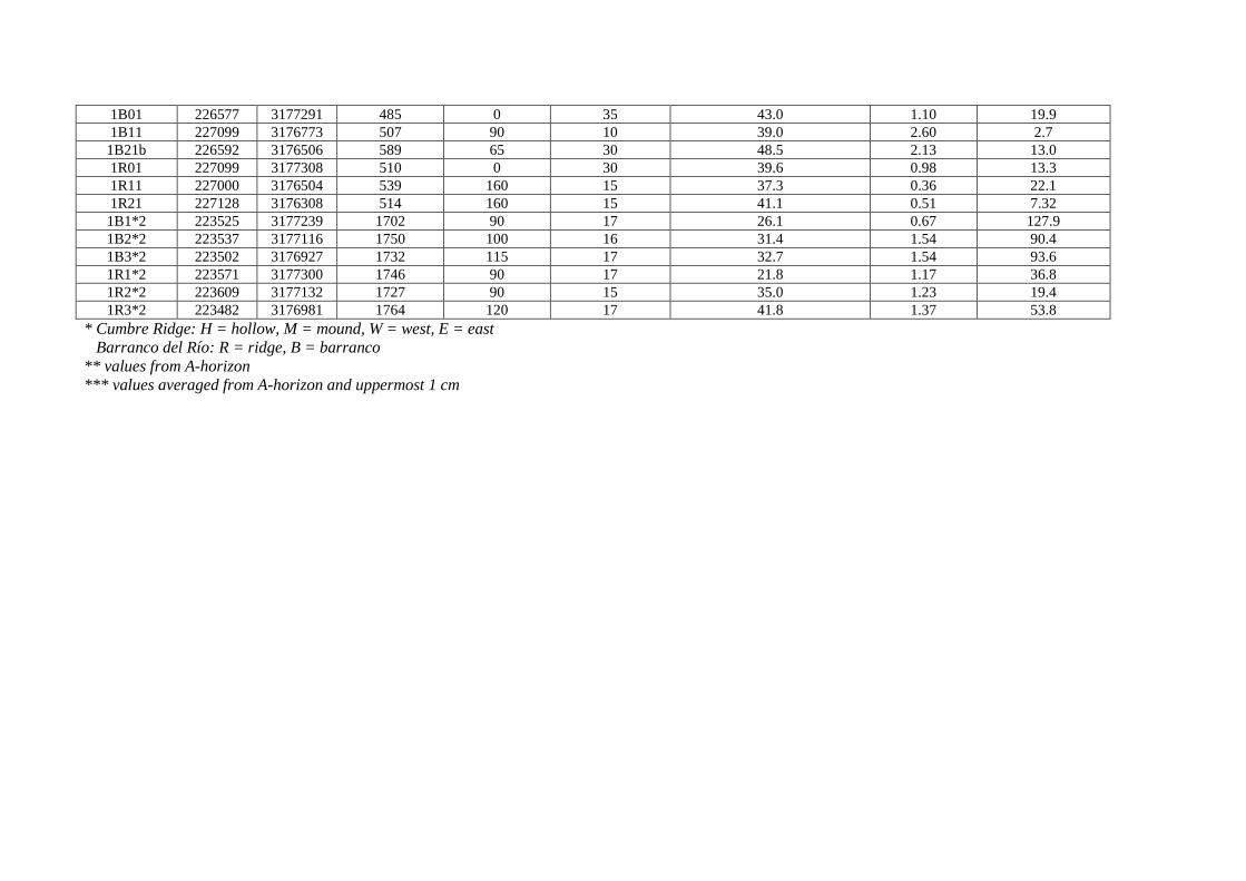
1B01 226577 3177291 485 0 35 43.0 1.10 19.9 1B11 227099 3176773 507 90 10 39.0 2.60 2.7 1B21b 226592 3176506 589 65 30 48.5 2.13 13.0 1R01 227099 3177308 510 0 30 39.6 0.98 13.3 1R11 227000 3176504 539 160 15 37.3 0.36 22.1 1R21 227128 3176308 514 160 15 41.1 0.51 7.32 1B1*2 223525 3177239 1702 90 17 26.1 0.67 127.9 1B2*2 223537 3177116 1750 100 16 31.4 1.54 90.4 1B3*2 223502 3176927 1732 115 17 32.7 1.54 93.6 1R1*2 223571 3177300 1746 90 17 21.8 1.17 36.8 1R2*2 223609 3177132 1727 90 15 35.0 1.23 19.4 1R3*2 223482 3176981 1764 120 17 41.8 1.37 53.8
* Cumbre Ridge: H = hollow, M = mound, W = west, E = east Barranco del Río: R = ridge, B = barranco ** values from A-horizon *** values averaged from A-horizon and uppermost 1 cm

Figures Figure 1 Location of the Canary Islands, influenced by Saharan dust (light haze over the ocean) (NASA-Earth Observatory, www.earthobservatory.nasa.gov). The islands of La Palma and Gran Canaria are highlighted. Inset: Soil and rock sampling sites at La Palma in relation to topography. Where sampling sites are located very close to each other, only one symbol is used. For detailed labeling of the sites see Fig. 2. The outcropping of the “basal complex” at the bottom of the Caldera Taburiente, containing some quartz-bearing diorites, is shown with hatching (after Rothe, 1996).

Figure 2 Distribution of main soils at La Palma (FAO-classification), simplified after the map of Morales-Matos and Pérez-González (2000). Sampling sites are marked with white rectangles. Where these sites are located very close to each other, only one symbol with the labels of all included sites is used. Information about the meaning of the names of sampling sites can be found in the caption of Table 1.

Figure 3 Typical laser-grain size distribution of a sieved sample < 63 µm. The assumed dust grain size fraction 0.5–10 µm is marked in gray.

Figure 4 Dust load in the atmosphere of La Palma during the months of 2006 in low (500 m) and high (1700 m) altitude, not differentiated to exposition. For 9 days (2 in January, 1 in March, 4 in May, 2 in June) no data were available.

Figure 5 Saharan dust (quartz) deposition on the slopes of the Cumbre ridge and dust concentration in the air flow from eastern and western directions (based on an evaluation of data from HYSPLIT and DREAM model). The error bars of quartz values in the soils are based on standard errors.

Figure 6 Sketch of the luff–lee effect as a possible mechanism of dust deposition at the Cumbre ridge of La Palma. Quartz values at several sites are indicated with gray rectangles. From very nearby investigated plots that correspond to one site symbol (cf. Fig. 2) quartz values were averaged.

Figure 7 Quartz (Saharan dust) deposition in hollows and at mounds at the western and eastern slope of the Cumbre ridge. Inset: Quartz deposition on ridges and barrancos at two altitudes in the Barranco del Río at the eastern side of the island (for location, see Fig. 1). The error bars of quartz values in the soils are based on standard errors.

Figure 8 Comparison between dust grain size 0.5–10 µm and quartz content (both % of total sample). A logarithmic regression was applied, yielding a coefficient of determination of 0.33.

Figure 9 Quartz compared with plant-available phosphorous on the western and eastern slopes of the Cumbre ridge. The error bars of quartz and phosphorous values in the soils are based on standard errors. Inset: Comparison between quartz and plant-available P using Pearson's correlation, yielding a coefficient of determination of 0.36. In order to counterbalance strongly fluctuating individual phosphorous values, generally obtained by the Mehlich III method when applied to soils with low amounts of plant-available P (Zhang et al. 2009), twelve groups each containing three sites with similar topographic and geomorphologic attributes (exposition, altitude, geomorphic form) were formed for this correlation. Mean values and standard errors for every group are given.