S. Campana, G. Bianchi, G. A. Fichera, L. Lai, M. Sordini, 2012, 3d recording and total archaeology:...
19
3D Recording and Total Archaeology: From Landscapes to Historical Buildings by S. Campana, G. Bianchi, G. A. Fichera, L. Lai, M. Sordini Reprinted from International Journal of Heritage in the Digital Era volume 1 number 3 2012
Transcript of S. Campana, G. Bianchi, G. A. Fichera, L. Lai, M. Sordini, 2012, 3d recording and total archaeology:...

3D Recording and Total Archaeology:From Landscapes to HistoricalBuildingsbyS. Campana, G. Bianchi, G. A. Fichera, L. Lai, M. Sordini
Reprinted from
International Journal ofHeritage in the Digital Eravolume 1 number 3 2012

443
3D Recording and TotalArchaeology: FromLandscapes to HistoricalBuildingsS. Campanaa, M. Sordinia, G. Bianchib, G. A.Ficherab, L. LaicaLAP&T, Landscape Archaeology and Remote Sensing Laboratory,University of Siena [email protected]
bLAAUM Archaeology of the Architecture and Medieval TownLaboratory, University of Siena [email protected]
cPh.D of Science and Technology for Archaeology and CulturalHeritage, University of Ferrara [email protected]
volume 1 number 3 2012International Journal of Heritage in the Digital Era

444
3D Recording and Total Archaeology:From Landscapes to Historical BuildingsS. Campana, G. Bianchi, G. A. Fichera, L. Lai, M. Sordini
ABSTRACT:
The paper presents the experience and in particular two case studies
of 3D recording undertaken by two laboratories of the University of
Siena, Italy (LAP&T and LAAUM). The case studies focus respectively
on landscape and on historical building recording. The paper
describes the first step in a new approach to the documentation and
interpretation of the archaeological record, discussing and
emphasising the need to collect and analyse 3D documentation at
different scales of detail: from artefact to landscape. As first result, this
approach should improve the documentation of cultural contexts
and therefore increase the opportunity to achieve archaeological
understanding. The first part of the paper describes the contribution of
LiDAR data in landscape analysis, underlining the importance of very
accurate DTMs in geomorphological analysis and their influence on
landscape archaeology. The geographical background is southern
Tuscany and the Po Valley in northern Italy. At a completely different
scale of detail the final part of the paper presents the results of the
laser scanning and stratigraphical analysis of an historical building in
southern Tuscany.
Key words: 3D modelling, Landscape Archaeology, LiDAR, Remote
Sensing, Architecture, Building Stratigraphy, Laser Scanner.
1. Introduction
Since many years the Department of Archaeology of the University of Siena has focused onthe archaeological study of Tuscan landscape (about 22,000 sqkm), moving progressively toan approach that nowadays could be defined as total archaeology (Darvill, 2002). The lateProf. Riccardo Francovich started collecting data on the landscape of Tuscany in the early

4453D Recording and Total Archaeology: From Landscapes to Historical Buildings
1970s, mainly through a systematic programme of field-walking surveyand archaeological excavation, along with the collection ofinformation from written sources, the examination of historical airphotographs and the stratigraphic analysis of historical buildings andmedieval towns (Francovich 2006). As a result of about thirty years ofwork in the Tuscan landscape it has proved possible to assemble ahuge database of information (about 25,000 sites), but,notwithstanding this, a large amount of essential evidence hasremained effectively undetectable, making it impossible to answerimportant archaeological questions within the confines of thismethodological approach (Campana, Francovich, 2006). Some yearsago we identified at least three contributory factors. Firstly, the natureof the landscape itself, with its clay soils, large areas of forestry,intensive agricultural exploitation and distinctive morphologicalpatterns. Secondly, the peculiarity of the material culture, constantlychanging over time and with related difficulties caused bypostdepositional processes. As last - but not least - the definition andrange of the evidence in terms of artefacts but also ecofacts andenvironmental factors.
It is important to emphasise here that the main aim of theUniversity’s research is to discern and describe historical patterns andto develop and improve the archaeological interpretation of sites andlandscapes. In pursuit of this the Department has moved progressivelyfrom a ‘thematic’ approach to a more ‘global’ consideration ofhistorical processes and archaeological interpretation.
In essence this has meant switching from a site-based approach toa ‘landscape’ perspective: in the study of castles, for instance, this hasbrought into play the consideration of related field systems,communication routes, production centres and cemeteries as well asgeomorphology, palaeo-environmental factors and archaeo-zoologyetc. A central tenet of this new methodology has been the need toview the context as an organic system, developing over time ratherthan as something that can be related, as in many previousapproaches, to specific themes, time-periods or site types such ascastles, Roman villas, oppida and so on. We feel that this broaderperspective on the past will enable us to describe historical patterns ina more nuanced, balanced and representative way. Nowadays,through the use of field-walking survey and other research methods,our maps and therefore our archaeological models have becomemore and more rich in features that were previously invisible. While thishas allowed us to close some gaps in our basic data we have realizedthat the cultural context on which we are working hides a newchallenge, beneath our very our eyes – landscapes, historicalbuildings, monuments, stratigraphic layers, artefacts, finds and so on

are still documented and then interpreted as if they existed only in twodimension!
This is clearly a paradox. Paul Cezanne said “all living things havevolume”. We maintain that this concept applies with equal force inarchaeological research and particularly in the archaeological studyof material culture. It has long been acknowledged that all productsof human activity, whether objects, structures or landscapes, can bedescribed in three spatial dimensions (and of course in theirdevelopment through the time). The third dimension has been fromlong time recognized as a substantial component in the description ofthe archaeological features but often through symbolicrepresentations, avoiding the opportunity to get accurate metricmeasurement and therefore any accurate representation of volume.The problem is closely associated with the instruments and forms ofgraphic documentation available in the past: maps, plans andexcavation photographs etc. The hypothesis that underpins our currentapproach is the need to use new technologies in the recording andrepresentation of archaeological entities, from large-scale landscapesto the smallest individual find. To build 3D models and to develop 3Dinformation systems will help us to expand our archaeological thinkingfrom 2D (sometime 21/2D) to 3D, expanding our analytical capabilitiesand therefore helping us towards a better understanding of thecomplexity of archaeological contexts.
2. LiDAR
LiDAR (Light Detection and Ranging) measures the relative height ofthe ground surface and features such as trees and buildings acrosslarge areas of landscape with a resolution and accuracy hithertounattainable except through labour-intensive field survey orphotogrametry. It provides, for the first time, highly detailed andaccurate digital 3D models of the land surface at metre and submetreresolution. LiDAR operates by using a pulsed laser beam which can bescanned e.g., from side to side, as the aircraft flies over the surveyarea, using the time of flight that between 20,000 and 100,000 pulsesper second take to return to the aircraft so as to build an accurate,high-resolution model of the ground surface and the features upon it.LiDAR was conceived in the 1960s for submarine detection and earlymodels were used successfully in the early 1970s in the US, Canadaand Australia. The possibility of using the technique for archaeologicalrecording was first recognised in the United States thanks to pioneeringresearch in the vicinity of the Arenal Volcano in Costa Rica under theleadership of Tom Sever. In an archaeological study in 1984 Sever andhis colleagues used LiDAR, TIMS (Thermal Infrared Materials), syntheticaperture radar and colour infrared photography to detect pathways
446 S. Campana, M. Sordini, G. Bianchi, G. A. Fichera, L. Lai

of prehistoric settlers, documenting trade routes and movementbetween settlements (Sheets, Sever, 1991). In Europe the potential ofLiDAR applications in archaeology was first discussed at a workshop inLeszno, Poland, in November 2000. This related to a survey coveringthe River Wharfe in Yorkshire which revealed evidence for theearthwork survival of a Roman fort that had previously been thought tohave been completely levelled by ploughing (Holden et al., 2002). Afew years later, at Gent University in Belgium, Robert Bewley, thenHead of English Heritage’s Aerial Survey Unit, argued that “… theintroduction of LiDAR is probably the most significant development forarchaeological remote sensing since the invention of photography”(Bewley, 2005). In the following years LiDAR applications have beendeveloped widely around Europe and particularly in the UK, Austria,France, Germany, Norway and Italy. Currently the principaladvantage of LiDAR survey for archaeologists is its capacity to providea high-resolution digital elevation model (DEM) of the landscape thatcan reveal microtopography which is virtually indistinguishable atground level because of erosion by ploughing. Techniques have beendeveloped for the digital removal of ‘modern’ elements such as treesand buildings so as to produce a digital terrain model (DTM) of theactual ground surface, complete with any remaining topographicaltraces of past human activity. An extremely important characteristic ofLiDAR is its ability to penetrate woodland or forest and so to revealfeatures that are not distinguishable through traditional prospectionmethods or that are difficult to reach for ground-based survey (as, forinstance, in work at Leitha Mountain, Austria, described in Doneus,Briese, 2006). There have been other notable applications at Elverum inNorway (Risbøl et al., 2006), Rastatt in Germany (Sittler, Schellberg,2006), in the Stonehenge landscape and at other locations in the UK(Bewley et al., 2005; Devereux et al., 2005) and, returning to America,at Caracol in Belize (Weishampel et al., 2010).
In 2005, through a Culture 2000 project of the European Union,entitled European Landscapes: past, present and future, the Universityof Siena took its first steps in LiDAR data acquisition, processing andinterpretation for four sample areas in the provinces of Siena andGrosseto. This was made possible through the good services ofcolleagues in England at the Natural Environment Research Counciland the Unit for Landscape Modelling at the University of Cambridge.The results were processed in the Department of Geography at DurhamUniversity (UK) under the supervision of Prof. Daniel Donoghue and Dr.Nikolaos Galiatsatos. Success was achieved in one of the case studies,aimed at penetrating the tree canopy so as to record underlyingarchaeological features long protected from plough-erosion or otherhuman activity by woodland cover (Figure 1). We saw this success as
4473D Recording and Total Archaeology: From Landscapes to Historical Buildings
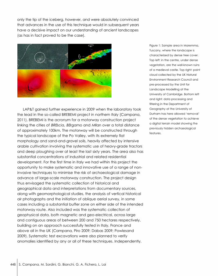
only the tip of the iceberg, however, and were absolutely convincedthat advances in the use of this technique would in subsequent yearshave a decisive impact on our understanding of ancient landscapes(as has in fact proved to be the case).
LAP&T gained further experience in 2009 when the laboratory tookthe lead in the so-called BREBEMI project in northern Italy (Campana,2011). BREBEMI is the acronym for a motorway construction projectlinking the cities of BREscia, BErgamo and MIlan over a total distanceof approximately 100km. The motorway will be constructed throughthe typical landscape of the Po Valley, with its extremely flatmorphology and sand-and-gravel soils, heavily affected by intensivearable cultivation involving the systematic use of heavy-grade tractorsand deep ploughing over at least the last sixty years. The area also hassubstantial concentrations of industrial and related residentialdevelopment. For the first time in Italy we had within this project theopportunity to make systematic and innovative use of a range of non-invasive techniques to minimise the risk of archaeological damage inadvance of large-scale motorway construction. The project designthus envisaged the systematic collection of historical andgeographical data and interpretations from documentary sources,along with geomorphological studies, the analysis of vertical historicalair photographs and the initiation of oblique aerial survey, in somecases including a substantial buffer zone on either side of the intendedmotorway route. Also included was the systematic collection ofgeophysical data, both magnetic and geo-electrical, across largeand contiguous areas of between 200 and 750 hectares respectively,building on an approach successfully tested in Italy, France andabove all in the UK (Campana, Piro 2009; Dabas 2009; Powlesand2009). Systematic test excavations were also planned to verifyanomalies identified by any or all of these techniques. Independently,
Figure 1: Sample area in Maremma,
Tuscany, where the landscape is
characterized by dense tree cover.
Top left: in the centre, under dense
vegetation, are the well-known ruins
of a medieval castle. Top right: point
cloud collected by the UK Natural
Environment Research Council and
pre-processed by the Unit for
Landscape Modelling at the
University of Cambridge. Bottom left
and right: data processing and
filtering in the Department of
Geography at the University of
Durham has here allowed ‘removal’
of the dense vegetation to achieve
a digital terrain model showing the
previously hidden archaeological
features.
448 S. Campana, M. Sordini, G. Bianchi, G. A. Fichera, L. Lai

the regional Superintendency designed a pattern of random testtrenches amounting to a 5% sample of the motorway corridor.
The project also involved the capture 150sq.km of LiDAR data at aresolution of 4 points per square metre, covering the full length of themotorway corridor along with a 1km buffer zone on either side. Asnoted earlier, the morphology of the area is to all intents and purposescompletely flat and the land-use devoted for the most part tointensive cereal and maize production. The collection of LiDAR datawas essentially aimed at identifying barely perceptible ridges,elevated areas and depressions, many of them perhaps related toformer water courses. The first stage of data processing, to create abasic digital terrain model, was carried out by CGR of Parma, thesurvey company that undertook the initial data capture. The secondstep involved a collaboration between LAP&T and Prof. DominicPowlesland in the UK, using his own visualization software, LidarViewer.This software is a unit of Gsys software developed by Prof. Powlesland –Landscape Reasearch Center to enable the processing, analysis,management, and presentation of LiDAR data. Gsys has beendeveloped for applications in archaeological research and itsfunctions are designed for specific archaeological purposes(Powlesland et al., 2010). High resolution LiDAR datasets revealed somenoise in the resulting DTM and DSM: the subsequent surfaces were infact affected by noise that reduced the readability of topographicevidence. The next step of data processing was the implementation ofan algorithm to reduce the ruffle and to smooth the surfaces: this wasachieved with the aid of the Gsys software designed by Prof.Powlesland and used for archaeological visualization andinterpretation within the project. The smoothing algorithm was carefullyapplied to DTM and DSM in order to find the best compromisebetween accuracy and readability of the archaeological evidences.Next, the datasets have been visualized using LidarViewer (Gsys) thatallows the user to envisage the dataset, exaggerating the z (height)readings to empathize the micro-morphology of the recordedsurfaces. The light source can be moved in height and position withrespect to the surface in an interactive way in order to find the bestsetting to emphasize the micro-topography. Furthermore, Gsysprovides the user with a tool to intersect the DTM with a theoreticalplan parallel to the sea level so as to emphasize depressions, ridgesand other elevated areas. This approach allowed the identification of509 potentially significant features, consisting of 173 depressions,mainly interpretable as palaeo-river channels on the basis of their size,continuity and sinuous shape, along with 336 ridges or ‘elevated’areas, at least some of them interpretable as fluvial ridges. Theinformation currently available shows a clear tendency for known
4493D Recording and Total Archaeology: From Landscapes to Historical Buildings

archaeological ‘sites’ to occupy fluvial ridges and other ‘elevated’areas within the plain. This is not to imply, of course, that these 366raised areas correspond to a similar number of archaeological sites,only that these areas have a higher potential for the recovery oftraces of past human activity (Figure 2).
Considering that our experience with LiDAR is still in progress – weare currently working on a very large LiDAR data sample in theprovince of Grosseto, in Tuscany – we believe it is possible to recognizealso in the Italian context that LiDAR technique, if properly applied,could prove revolutionary in its impact on the process of
450 S. Campana, M. Sordini, G. Bianchi, G. A. Fichera, L. Lai
Figure 2: top, paleo-river channels;
bottom, elevated areas.

archaeological mapping by making it possible to record the previouslyhidden archaeological resource within woodland areas as well as inapparently levelled landscapes like those of the Po Valley. Infavourable circumstances it may even be possible to uncover whole‘fossil’ landscapes beneath present-day vegetation cove. This couldhave a dramatic impact on opportunities for archaeological andlandscape conservation and management, as well as on scientificinvestigation of settlement dynamics in various phases of history andprehistory. Nevertheless, a degree of caution is needed.Mediterranean woodland areas are covered by very densevegetation and should be also considered that the production of DTMusing LiDAR technology is a complex process which involves numerousassumptions and decisions throughout the workflow of projectpreparation, data acquisition and subsequent analysis. To achieve asecure interpretation the archaeologist has to consider andunderstand the meaning of meta-information about the original pointdensity, the time of flight, the instrumentation used, the type of aerialplatform and the DTM-generation procedure etc (Doneus, Briese,2011).
3. TLS Data for Architectural Analysis
From the perspective of the authors, the prime aim in the 3Ddocumentation of historical buildings is the improve the understandingof the historical buildings or of the monuments and generally speakingto advance the archaeological knowledge. In this process a key role isplayed by the methodologies of Archaeology of Architecture, alongwith laser scanning and photogrammetric techniques. This kind ofanalysis makes it possible to read the stratigraphy of the building(phases of construction, destruction and transformation) and then torecognize aesthetic choices and external influences, as well as toreconstruct the character of the construction-yard, the choice ofworkers, their degree of technical specialization and their country orplace of origin. The case study we present in this occasion was aimedat testing the usefulness and effectiveness of these approaches incomparison with traditional methodologies (2D mapping), as well asverifying the dataquality and the additional information that could beobtained through photorealistic 3D modelling. A further objective wasto estimate the possibility of standardizing the methodology of reliefrecording.
Over the past thirty years Archaeology of Architecture orArchitectural Archaeology has formalized its role as an historicaldiscipline, developing and applying specific methods of investigationto the analysis of historical buildings: from the ruins of farmhouses orabandoned castles, to complex urban architectural structures. The
4513D Recording and Total Archaeology: From Landscapes to Historical Buildings

initial goals of the discipline are concerned with identifying andinterpreting phases and transformations within the monument,analysing the dynamics of archaeological contexts through thedetermination of the building’s structural phases and throughcharacterization of the building techniques that are discernible withinthe structure. The application of the stratigraphic method to the studyof walls constituted a key step in development of the discipline,establishing that masonry is the result of a series of constructive anddestructive actions (Stratigraphic Wall Units), that, as in horizontalarchaeological layers, are connected to one another through a directphysical relationship and a related temporal relationships of anteriority,posteriority and contemporaneity. At the same time sophisticated andextremely effective methods have been developed for the analysis of'finds' contained within the vertical stratigraphy. In fact, these finds arefunctional to understand the formal (articulation plan, development ofthe high, etc.) and the technological aspects of the artefacts(identification of the production cycle, building-yard organizationetc..). A considerable degree of maturity has been reached in thediscipline, allowing some experienced researchers to go beyond theformal and technological analysis of the building elements to beginrelating the construction process to economic history and to localpolitical or social contexts.
In this development the pioneering work of the Ligurian researchgroup coordinated by Tiziano Mannoni (Mannoni, 1976) has beenfollowed in Lombardy by work on secular and religious buildings inboth rural and urban contexts under the leadership of Gian PietroBrogiolo (Brogiolo, 1984), and later by a number of studies in Lazio (DeMinicis, 1997). The Tuscan research team of the Department ofArchaeology and History of Arts at the University of Siena has alsocontributed to the growth of the discipline, developing methods ofanalysis as well as undertaking the interpretation of individual buildingsand of historic towns studied in their entirety (Parenti, 1992; QuiròsCastillo, 1999; Bianchi, 2007). The development of interdisciplinaryrelationships with studies such as science and social anthropology hasled to a progressive strengthening of the proposition that changes inarchitectural and settlement patterns correspond to specific mindsets,to a complex interaction of social, political and economic practicesthat are reflected in the techniques and typologies in which differentsettlements was made. The development of the concept of thestratigraphy of walls could not leave out a total analysis of thehistorical context, thus following the “archaeology of context”(Francovich, Bianchi 2003). This looks upon a single building or an entiretown centre as the source for a range of information not only about
452 S. Campana, M. Sordini, G. Bianchi, G. A. Fichera, L. Lai

the building itself but also about society, economy and forms of powerrelative to the context in which the construction is located.
The study which we illustrate below shows how the traditions ofarchaeological research can form the basis for the study of animportant building that has not previously been subjected toarchaeological analysis. At the same time it demonstrates the way inwhich “traditional” archaeological approach can be enriched by theapplication on new methods in the verification and integration of theacquired data and in the scientific dissemination of the results.
The case study concerns the Romanesque church of Sant’Alberto,situated on mount Montalceto in the territory of Asciano (Siena, Italy)(Figure 3). The church has a single nave, an eastern apse and agabled west façade. The roof has recently been restored according toa hypothetical reconstruction of the original design. The interior andexterior walls are made of unplastered ashlar masonry, with regularcourses of squared sandstone and limestone blocks. On some of theinternal walls there are areas of plaster that prevent a completeexamination of the wall’s stratigraphy. There is little information indocumentary sources about the history of the church. The oldestdocument quotes a papal degree of Alexander IIIrd, dated 1178,which confirms the jurisdiction of the pievano (priest) of Asciano in thechurch of Sant’Alberto.
Figure 3: The church of Sant'Alberto,
Asciano (Siena, Italy).
Figure 4: Representation of church of
Sant'Alberto, from point cloud to
textured model.
4533D Recording and Total Archaeology: From Landscapes to Historical Buildings

Both the interior and exterior of the building were surveyed using aterrestrial laser scanner. High-resolution digital images were alsoacquired as part of the recording process. The resulting data providedthe basis for the archaeological analysis and interpretation outlinedbelow (Figure 4). As a final step the data from the study, including thethree-dimensional photorealistic model created from the laser dataand photographic images, were imported into a GIS environment. Thelaser scanning surveying of the church was realized using the Time ofFlight (TOF) scanner Leica Scanstation I, from 12 stations and with anaverage geometric resolution of 5 mm. The scans were processedaccording to the pipeline: cleaning (Figure 5), alignment, meshgeneration and editing, geometric simplification, and finally texturing.
This last steps was facilitated through use of the high resolutionimages to permit the creation of a three-dimensional photorealisticmodel. Exposure and brightness were balanced in each of themerged images so as to eliminate discontinuity. High Dynamic Range(HDR) is a photographic technique which consists of taking multiplepictures of the same scene with different exposures, the wide rangeand balanced brightness attainable by merging the multiple imagesallowing the recording of all intensities of light and shade. In our case,for each piece of wall, we took a series of five photographs atdifferent exposures, with the lens set to a fixed focus and with thecamera mounted on a tripod. The merged HDR images were thenapplied to the relevant portions of wall so as to ‘texture’ the 3D model.To map the images in to the 3D model we used Technodigit 3DReshaper software. This tool allows the user to project images in to 3Dmodel using the reference point method: position, orientation and theoptical parameters of the camera are determined with 3-5 pointcouple; each point couple consist of one point on image and onepoint on 3D model, selected by a click on each dataset.
The 3D photorealistic model was then used to make geometricalmeasurements, to correlate surfaces with volumes, to subdivide thebuilding into structural phases, to relate interior and exterior walls to
454 S. Campana, M. Sordini, G. Bianchi, G. A. Fichera, L. Lai
Figure 5: Point cloud cleaning with Leica Cyclone 6.0.

one another and to extrapolate all the graphic tables supportingscientific research through the principles of Archaeology of theArchitecture. Concurrently with the laser survey we collectedinformation through the direct examination of the masonry. Finally, inthe GIS environment we created a GeoDatabase into which weimported both the data related to each of the three identifiedstructural phases and all of the files containing the texturinginformation (Figure 6).
We stored the attributes obtained from the archaeological study inseparate layers so as to make it possible to query each layer of groupof layers in order to identify the material and technique ofconstruction, to present photographic information and to‘disassemble’ or ‘reassemble’ the building in terms of structural phases.Thanks to the wall-analysis and other observations and measurementstaken from the 3D model it proved possible to:
• recognize three phases of building construction; • propose a relative chronology;• formulate hypotheses about the origin and degree of
specialization of the workers and the origin of the constructionmaterials.
As a result we can affirm that, within a substantial homogeneity ofdesign and chronology, the construction of the church was carried outthrough joining together successive blocks of masonry, the pausesbetween the three episodes of work being clearly legible in the wallssurfaces. The first phase saw the construction of the apse and parts ofthe north and south walls, extending along the nave to just beyond
Figure 6: Visualization of three
structural phases and data entry in
GIS environment.
4553D Recording and Total Archaeology: From Landscapes to Historical Buildings

the two lateral doorways. The second phase consisted of a block ofmasonry in both in the north and south walls, including two internalsemicolumns. The third and last phase involved completion of the twoside walls and construction of the west façade. Both in the north andsouth elevations we can note the different construction material in thefirst phase in comparison with the second; we can see a change inthe size of the ashlar blocks and a clear line of caesura that indicatesa temporary suspension of the building work. Tiziano Mannoni andAnna Boato define such caesuras through the term “giunti d'attesa” or“morse d'attesa”, this last term encompassing the idea both of amomentary pause and a subsequent continuation of the building work(Mannoni, Boato, 2002; Boato, 2008). Close observation of the wallsallows us to distinguish numerous L-shaped ashlar blocks that werecreated in the building yard and then placed in the wall so as to‘clamp’ the next phase of construction to the existing walls and toreconcile the non-matching horizontal courses.
In conclusion, it is possible to affirm that, as usually happens in theconstruction of a church, the building process started at the apse,using sandstone blocks (Phase 1). Then, for some unknown reason, thework was momentarily interrupted and subsequently restarted with theuse of a different building material (limestone) that for a periodbecame the only stone available (Phase 2). Finally, there arrived in thebuilding yard a new stock of sandstone and the workers completedthe church in the original technique (Phase 3).
The caesuras were important markers in the identification of thethree phases. The contribution of the methodologies of Archaeologyof Architecture, and the experience of the researchers, werefundamental in distinguishing the precise constructional processes.
These are characteristic of the medieval period, widely seen inecclesiastical buildings but sometimes reflected in a very similar way inbuilding destined for secular use.
As far as chronology is concerned it is difficult to recognize in thearchitectural elements the early dating indicated by the writtensources. The side portals with segmental arches recall common motifsin the architecture of Pisa, widely present also in the Romanesquechurches of Siena. In general the typology and structuralcharacteristics of the walls seem to point to the beginning of the XIIIcentury rather to the later part of the XIIth or even earlier as suggestedby the key documentary source.
Close to the south wall there were found four small ceramicfragments: two sherds of “graffita” pottery, a fragment of archaicmajolica and a piece of glazed pottery. The research described herehas resulted in a preliminary understanding of the church ofSant’Alberto. However, both the scientific analysis and the historical
456 S. Campana, M. Sordini, G. Bianchi, G. A. Fichera, L. Lai

study could well be expanded and the geographic databaseconstantly updated while awaiting the development of new GIS toolsfor the analysis and examination of 3D data. Indeed this present stageof investigation has been carried out with the express intention offacilitating future uses and further investigation.
4. Conclusions and Next Developments
As we argued in the introduction, this paper describes only the firststep of our a new approach to archaeological research.
Indeed, at this stage, our contribution demonstrates mainly theimpact and some potentiality of 3D surveying and modeling usingmultiple geomatics tools in landscape analysis and on the analysis ofhistorical buildings. This is only a small part of the general picture,missing archaeological excavation, finds but also improving 3Darchaeological prospection methods and the development of 3Dvirtual environment aimed to integrate archaeological features indeep association with their physical and cultural context exploringrelationships across a different scale of detail moving from landscapeto find.
We are currently focusing our work on both side, 3D data collectionon archaeological excavation (involving TLS methods and UAVphotogrammetry) and find as well the development of an “open-space” environment within which it is possible in every moment tomeasure and compare historical evidence, stratigraphical relationshipand other datasets but also where is possible to improve and upgradethe record in the future on the basis of new field work or post-processing. This approach should, therefore, allow us to achieve:
• overcoming space and time sharing complex “objects” withother experts all around the world;
• the demonstration (firstly addressed to archaeologists) that digitalreconstruction is a complex exercise and projective interpretationand also is much more than a graphic reconstruction, is asimulation, that allows exploration of three-dimensional modelperspectives through endless investigations and non-invasivedocumentation;
• virtual reconstruction and simulation scenarios address tospecialist as to the general public developing new tool to sharebut also preserve the memory of cultural heritage;
• development of 3D archaeological thinking.
4573D Recording and Total Archaeology: From Landscapes to Historical Buildings

References/or Selected BibliographyBennett, R. Welham, K., Hill, R.A., Ford, A., 2011. Making the most of airborne
remote sensing techniques for archaeological survey and interpretation, D.C Cowley (Ed.): Remote Sensing for Archaeological Heritage ManagementEAC Occasional Paper 5, Reykjavík Iceland 25-27 March 2010, Brussel 2011,p. 99-106.
Bewley, R.H., 2005. Aerial Archaeology. The first century. Bourgeois J., MeganckM. (Eds.), Aerial Photography and Archaeology 2003. A century ofinformation, Academia Press, Ghent, pp.15-30.
Bewley, R.H., Crutchley, S., Shell, C., 2005. New light on an ancient landscape:LiDAR survey in the Stonehenge World Heritage Site. Antiquity, 79 (305), pp.636-647.
Bianchi, G., 2007. Tecniche costruttive e forme di potere nella Toscana sud-occidentale (secoli VIII-XIV), Arqueología de la Arquitectura, 4 (2005), pp.47-60.
Boato, A., 2008. L'archeologia in architettura. Misurazioni, stratigrafie, datazioni,restauro, Marsilio, Venezia.
Brogiolo, G. P., 1984. Archeologia urbana in Lombardia, Panini, Modena.
Campana, S., Francovich, R., 2006. Seeing the Unseen. Buried ArchaeologicalLandscapes in Tuscany, Taylor & Francis, The Netherlands, pp.67-76.
Campana, S., Sordini M., Remondino F., 2008. Integration of geomaticstechniques for the digital documentation of heritage areas, R. Lasaponara,N. Masini (Ed.): 1st Intenational EARSeL Workshop Advances in RemoteSensing for Archaeology and Cultural Heritage Management, CNR –National Research Council Roma 30 September – 4 October 2008, AracneRoma 2008, pp. 309-312.
Campana, S., Sordini M., Rizzi A., 2009. 3D modeling of a Romanesque church inTuscany: archaeological aims and geomatics tecniques, Journal ofPhotogrammetry and Remote Sensing (ISPRS), vol. XXXVIII.
Campana, S., Piro, S., 2009. Seeing the Unseen. Geophysics and LandscapeArchaeology. Proceeding of the XVth International Summer School, Taylor &Francis, London.
Campana, S., 2011. Total Archaeology to reduce the need for RescueArchaeology: The BREBEMI project (Italy), D. C Cowley (Ed.): RemoteSensing for Archaeological Heritage Management EAC Occasional Paper 5,Reykjavík Iceland 25-27 March 2010, Brussels 2011, pp. 33-41.
Dabas, M., 2009. Theory and practice of the new fast electrical imaging systemARP©, S. Campana, S. Piro (Eds.): Seeing the Unseen, Geophysics andLandscape Archaeology. Proceeding of the XVth International SummerSchool, Taylor & Francis London 2009, pp.105-126.
Darvill, T., 2002. The Concise Oxford Dictionary of Archaeology, Oxford UniversityPress, Oxford.
Devereux, B.J., Amable, G.S., Crow, P., Cliff, A.D., 2005. The potential of airbornelidar for detection of archaeological features under woodland canopies.Antiquity, 79 (305), pp. 648-660.
De Minicis, E., 1997. Archeologia del costruito nel Lazio, Archeologiadell'Architettura, II, pp. 167-173.
458 S. Campana, M. Sordini, G. Bianchi, G. A. Fichera, L. Lai

Doneus, M., Briese, C., 2006. Full-waveform airborne laser scanning as a tool forarchaeological reconnaissance. S. Campana, M. Forte (Eds.): From Spaceto Place. 2nd International Conference on Remote Sensing in Archaeology,CNR – National Research Council Roma 4-7 December 2006, BAR Oxford2006, pp.99-105.
Doneus, M., Briese, C., 2011. Airborne Laser Scanning in forested areas –Potential and limitations of an archaeological prospection technique. D. CCowley (Ed.): Remote Sensing for Archaeological Heritage ManagementEAC Occasional Paper 5, Reykjavík Iceland 25-27 March 2010, Brussel 2011,pp. 59-76.
Francovich, R., Bianchi, G., 2003. L’archeologia dell’elevato come archeologia,Arqueología de la Arquitectura, 1 (2002), pp. 101-111.
Francovich, R., 2006. Archeologia e Territorio. Detti T. (Ed.), La terra dei Musei.Paesaggio, arte, storia del paesaggio senese, Giunti Editore, Florence, pp.12-39.
Holden, N., Horne, P., Bewley, R.H., 2002. High-Resolution Digital AirborneMapping and Archaeology. R. H. Bewley, W. Raczkowski, (Eds.), AerialArchaeology. Developing Future Practice, IOS Press, Amsterdam, pp. 173-180.
Mannoni, T., 1976. L'analisi delle tecniche murarie in Liguria, F. Giunta (Ed.): Attidel Colloquio Internazionale di Archeologia Medioevale, Palermo, pp. 291-300.
Mannoni, T., Boato, A., 2002. Archeologia e storia del cantiere di costruzione,Arqueología de la Arquitectura, 1 (2002), pp. 39-53.
Parenti, R., 1992. Fonti materiali e lettura stratigrafica di un centro urbano: irisultati di una sperimentazione "non tradizionale", Archeologiadell'Architettura, XIX, pp. 7-62.
Powlesland, D., 2009. Why bother? Large scale geomagnetic survey and thequest for "Real Archaeology", S. Campana, S. Piro (Eds): Seeing the Unseen,Geophysics and Landscape Archaeology. Proceeding of the XVthInternational Summer School, Taylor & Francis London 2009, pp.167-182.
Powlesland, D., May, K., Rackham, J., Tipper J., Excavations in Heslerton: DigITapproaches to Digital Recording, Internet Archaeology 27,http://intarch.ac.uk/journal/issue27/2/toc.html.
Quiròs Castillo, J. A, 1999. La Valdinievole nel Medioevo. “Incastellamento” earcheologia del potere nei secoli X-XII, ETS, Pisa.
Remondino, F., El-Hakim, S., 2006. Image-based 3D modelling: a review.Photogrammetric Record, 21(115): 269-291.
Risbøl, O., Gjertsen, A. K., Skare, K., 2006. Airborne laser scanner of culturalremains in forest: some preliminary results from Norwegian project. S.Campana, M. Forte (Eds.): From Space to Place. 2nd InternationalConference on Remote Sensing in Archaeology, CNR – National ResearchCouncil Roma 4-7 December 2006, BAR Oxford 2006, pp. 107-112.
Sheets, P., Sever, T., 1991. Prehistoric Footpaths in Costa Rica: Transportationand Communication in a Tropical Rainforest. C. D. Trombold (Ed.), AncientRoad Networks and Settlement Hierarchies in the New World, CambridgeUniversity Press, Cambridge.
Shaw, R., Corns, A., 2011. High Resolution LiDAR specifically for archaeology: arewe fully exploiting this valuable resource?, D. C Cowley (Ed.): RemoteSensing for Archaeological Heritage Management EAC Occasional Paper 5,Reykjavík Iceland 25-27 March 2010, Brussel 2011, pp. 77-86.
4593D Recording and Total Archaeology: From Landscapes to Historical Buildings

Sittler, B., Schellberg, S., 2006. The potential of LIDAR in assessing elements ofcultural heritage hidden under forest or overgrown by vegetation:Possibilities and limits in detecting microrelief structures for archaeologicalsurveys. S. Campana, M. Forte (Eds.): From Space to Place. 2ndInternational Conference on Remote Sensing in Archaeology, CNR –National Research Council Roma 4-7 December 2006, BAR Oxford 2006, pp.117-122.
Weishampel, J.F., Chase, A.F., Chase, D.Z., Drake, J.B., Shrestha, R.L., Slatton,K.C., Awe, J.J., Hightower, J., Angelo, J., 2010. Remote sensing of ancientMaya land use features at Caracol, Belize related to tropical rainforeststructure. S. Campana, M. Forte, C. Liuzza (Eds.): Space, Time, Place: 3rdInternational Conference on Remote Sensing in Archaeology, TiruchirappalliTamil Nadu India17-21 August 2009, BAR Oxford, pp. 45-52.
Acknowledgements and Appendix
First of all the authors owe a huge debt of gratitude to the lateProfessor Riccardo Francovich, of the University of Siena, who gave usthe cultural background and the intellectual vigour to face newchallenges.
Special thanks are also due to a very good friend and brilliantcolleague who have followed, processed and helped so much of thewriters research work since early stage, Dr. Fabio Remondino (FBK –Trento); as ever, he helped us with constructive criticism andcomments.
Sincere thanks are also due to the team of the Laboratory ofLandscape Archaeology and Remote Sensing at the University ofSiena: Francesco Brogi, Cristina Felici, Francesco Pericci, LorenzoMarasco and Barbara Frezza. Finally, heartfelt thanks also go to ChrisMusson, who, as ever, helped with constructive criticism andcomments during the preparation of this paper and revising the Englishtext.
460 S. Campana, M. Sordini, G. Bianchi, G. A. Fichera, L. Lai