RTD-181 - State Water Resources Control Board
129
State of California The Natural Resources Agency DEPARTMENT OF WATER RESOURCES South Central Region Office San Joaquin Valley Drainage Monitoring Program 2011 - 2012 Region Report September 2015 John Laird Edmund G. Brown Jr. Mark Cowin Secretary for Natural Resources Governor Director The Natural Resources Agency State of California Department of Water Resources
-
Upload
khangminh22 -
Category
Documents
-
view
0 -
download
0
Transcript of RTD-181 - State Water Resources Control Board
State of California The Natural Resources Agency
DEPARTMENT OF WATER RESOURCES South Central Region Office
San Joaquin Valley Drainage Monitoring Program
2011 - 2012
Region Report
September 2015
John Laird Edmund G. Brown Jr. Mark Cowin Secretary for Natural Resources Governor Director The Natural Resources Agency State of California Department of Water Resources
RTD-181
San Joaquin Valley Drainage Monitoring Program 2011-12
If you need this report in alternate format, call the Equal Opportunity and Management Investigations Office at (916) 653-6952 or TDD (916) 653-6934.
San Joaquin Valley Drainage Monitoring Program 2011-12
iii
Foreword
This report shares valuable information about agricultural drainage water in order to increase the understanding of its potential impacts and improve its management in the San Joaquin Valley (SJV).
The Drainage Monitoring Program is a cooperative effort of State, federal, and local agencies. Program staff collect, assemble, review, evaluate, and disseminate data on both the quality of drainage water as well as the depth of shallow groundwater in the SJV. Fifty-five drainage sump systems are monitored for flow, sodium, sulfate, total dissolved solids, selenium, and other constituents. Staff also combine the Department of Water Resources' (DWR's) data with data from five other agencies for this report.
DWR used depth information, gathered from approximately 1,300 shallow groundwater wells, to draw Present and Potential Drainage Problem Areas Maps for the period from 2011 through 2012. These maps show over one million acres of potentially impacted lands. Data provided by several agencies, including the Buena Vista Water Storage District, Central California Irrigation District, Kern County Water Agency, Panoche Water and Drainage District, San Luis Canal Company, Westlands Water District, and DWR was combined to create the maps.
DWR also drew electrical conductivity (EC) maps from ECs measured in about 950 of those wells for the years 2011 and 2012. All of the maps help inform managers of potential drainage problems in their areas due to encroachment of shallow groundwater. The number of agencies participating is a reflection of the significance of drainage problems in the SJV and the potential impacts.
This report focuses on two years of data collection and compilation for the calendar years 2011 through 2012, with a special focus on historical nitrates and selenium. In addition, pesticide and nutrient data have been added to this report for your use.
Over the years, this report has been published and distributed. All of the collected drainage data and related information will be made available on our website or upon request a copy of this report will be mailed. Please contact staff with your questions or needs.
Kevin Faulkenberry, Chief South Central Region Office
San Joaquin Valley Drainage Monitoring Program 2011-12
iv
San Joaquin Valley Drainage Monitoring Program 2011-12
v
Contents Foreword .................................................................................................................................... iii Symbols and Abbreviations ........................................................................................................ ix Metric Conversion .................................................................................................................... xi Introduction ................................................................................................................................ 1 The Drainage Problem ............................................................................................................... 2 Drainage Problem Areas ............................................................................................................ 3 2011-2012 Drainage Monitoring Program ................................................................................... 7 Flows ........................................................................................................................................15 Mineral and Trace Element Constituent Concentrations ............................................................ 17
Selenium ........................................................................................................................... 26 Nitrates .....................................................................................................................................29
Pesticides ............................................................................................................................33-35
Nutrients ................................................................................................................................... 36 DWR’s Future Monitoring Program ............................................................................................ 37 Selected References ........................................................................................................... 38-39
Tables Table 1 Acreages of Present and Potential Drainage Problems, 1991 through 2012 ............. 4-5 Table 2 Drainage Monitoring Stations, 2011 ............................................................................ 7 Table 3 Drainage Monitoring Stations, 2012 ............................................................................ 8 Table 4 Subsurface Drain Flows in acre-feet, 2011 ................................................................15 Table 5 Subsurface Drain Flows in acre-feet, 2012 ................................................................16 Table 6 2011 Summary of Minerals and Trace Elements in Northern Area Drains ..................18 Table 7 2011 Summary of Minerals and Trace Elements in Central Area Drains .....................19 Table 8 2011 Summary of Minerals and Trace Elements in Southern Area Drains ............ 20-21 Table 9 2012 Summary of Minerals and Trace Elements in Northern Area Drains ...................22 Table 10 2012 Summary of Minerals and Trace Elements in Central Area Drains ................... 23 Table 11 2012 Summary of Minerals and Trace Elements in Southern Area Drains .......... 24-25 Table 12 Selenium in Northern Subsurface Drains, 2010-2012 ................................................ 27 Table 13 Selenium in Central Subsurface Drains, 1986-2012 .................................................27 Table 14 Selenium in Southern Subsurface Drains, 1986-2012 ............................................... 28 Table 15 Nitrates in Northern Subsurface Drains, 1970-1974, 2010-2012 ................................ 30 Table 16 Nitrates in Central Subsurface Drains, 1959-2012 .................................................... 30 Table 17 Nitrates in Southern Subsurface Drains,1966-2012 .............................................. 31-32
San Joaquin Valley Drainage Monitoring Program 2011-12
vi
Tables (continued) Table 18 Pesticide Drainage Monitoring Stations, 2011 ........................................................... 33 Table 19 Pesticide Values Detected in Drainage Monitoring Stations, 2011 ............................. 34 Table 20 Detected Pesticide Compounds with Public Agency Standards, 2011 ....................... 35 Table 21 Nutrients Detected in Subsurface Drains, 2011 ........................................................ 36
Figures Figure 1 Depth to Water Acreage Trends of Drainage Impaired Lands ..................................... 6 Figure 2 Overview of Sampling Area Locations ........................................................................ 9 Figure 3 Northern Area Drain Locations .................................................................................. 10 Figure 4 Central Area Drain Locations .................................................................................... 11 Figure 5 Southern Area Drain Locations, Lemoore/Corcoran ................................................... 12 Figure 6 Southern Area Drain Locations, Lost Hills/Semitropic ................................................ 13 Figure 7 Southern Area Drain Locations, Kern Lakebed .......................................................... 14 Figure 8 Present and Potential Drainage Problem Areas, SJV 2011.....................................115Figure 9 Present and Potential Drainage Problem Areas, SJV 2012 .....................................116Figure 10 Aerial Distribution of Electrical Conductivity in Shallow Groundwater, 2011 ............117Figure 11 Aerial Distribution of Electrical Conductivity in Shallow Groundwater, 2012 ............118
Appendices Appendix A Depth to Water Acreage Trends of Drainage Impaired Lands, 1991-2012 .........40-44 Appendix B Selenium Trends in Central & Southern Tile Drains through 2012 .................... 45-49 Appendix C Nitrate Trends in Central & Southern Tile Drains through 2012 .........................50-55 Appendix D Mineral Analyses of Northern Area Drains, 2011-2012 .................................... 56-62 Appendix E Electrical Conductivity, pH, & Trace Elements in Northern Area Drains, 2011-2012 ............................................................................................................................. ................. 63-68 Appendix F Mineral Analyses of Central Area Drains, 2011-2012 ........................................69-82 Appendix G Electrical Conductivity, pH, & Trace Elements in Central Area Drains, 2011-2012
........................................................................................................................................ 83-900Appendix H Mineral Analyses of Southern Area Drains, 2011-2012 ..................................91-10Appendix I Electrical Conductivity, pH, & Trace Elements in Southern Area Drains, 2011-2012
........................................................................................................................................ 103-1110Appendix J Pesticides in Area Drains, 2011 .................................................................. 112-114

San Joaquin Valley Drainage Monitoring Program 2011-12
vii
San Joaquin Valley Drainage Monitoring Program 2011-12
viii
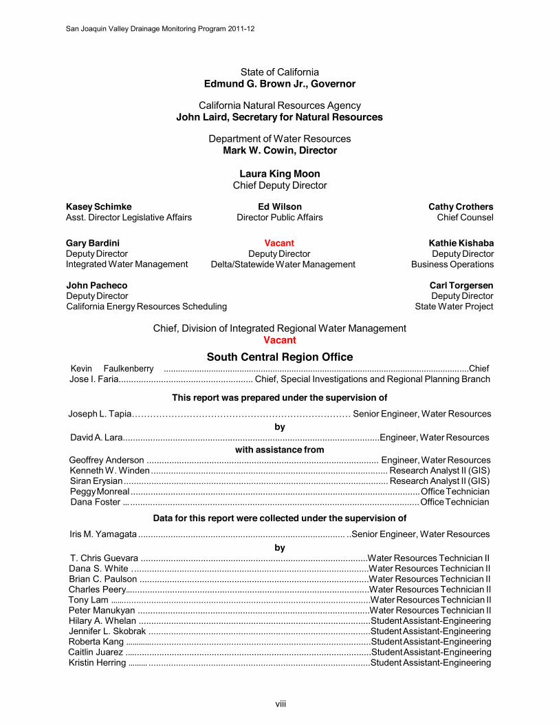
State of California Edmund G. Brown Jr., Governor
California Natural Resources Agency John Laird, Secretary for Natural Resources
Department of Water Resources Mark W. Cowin, Director
Laura King Moon Chief Deputy Director
Kasey Schimke Asst. Director Legislative Affairs
Ed Wilson Director Public Affairs
Cathy Crothers Chief Counsel
Gary Bardini Deputy Director Integrated Water Management
Vacant Deputy Director
Delta/Statewide Water Management
Kathie Kishaba Deputy Director
Business Operations
John Pacheco Carl Torgersen Deputy Director Deputy Director California Energy Resources Scheduling State Water Project
Chief, Division of Integrated Regional Water Management Vacant
South Central Region Office Kevin Faulkenberry .................................................................................................................................Chief Jose I. Faria...................................................... Chief, Special Investigations and Regional Planning Branch
This report was prepared under the supervision of Joseph L. Tapia……………………………………………………………… Senior Engineer, Water Resources
by David A. Lara.......................................................................................................Engineer, Water Resources
with assistance from Geoffrey Anderson ............................................................................................. Engineer, Water Resources Kenneth W. Winden ............................................................................................... Research Analyst II (GIS) Siran Erysian .......................................................................................................... Research Analyst II (GIS) Peggy Monreal .................................................................................................................... Office Technician Dana Foster … .................................................................................................................... Office Technician
Data for this report were collected under the supervision of Iris M. Yamagata ................................................................................... ..Senior Engineer, Water Resources
by T. Chris Guevara ...........................................................................................Water Resources Technician II
Dana S. White . ..............................................................................................Water Resources Technician II Brian C. Paulson ............................................................................................Water Resources Technician II Charles Peery…...............................................................................................Water Resources Technician II Tony Lam ……...................................................................................................Water Resources Technician II Peter Manukyan .............................................................................................Water Resources Technician II Hilary A. Whelan .............................................................................................Student Assistant-Engineering Jennifer L. Skobrak .........................................................................................Student Assistant-Engineering Roberta Kang …………........................................................................................Student Assistant-Engineering Caitlin Juarez .…...............................................................................................Student Assistant-Engineering Kristin Herring ……… .........................................................................................Student Assistant-Engineering
San Joaquin Valley Drainage Monitoring Program 2011-12
ix
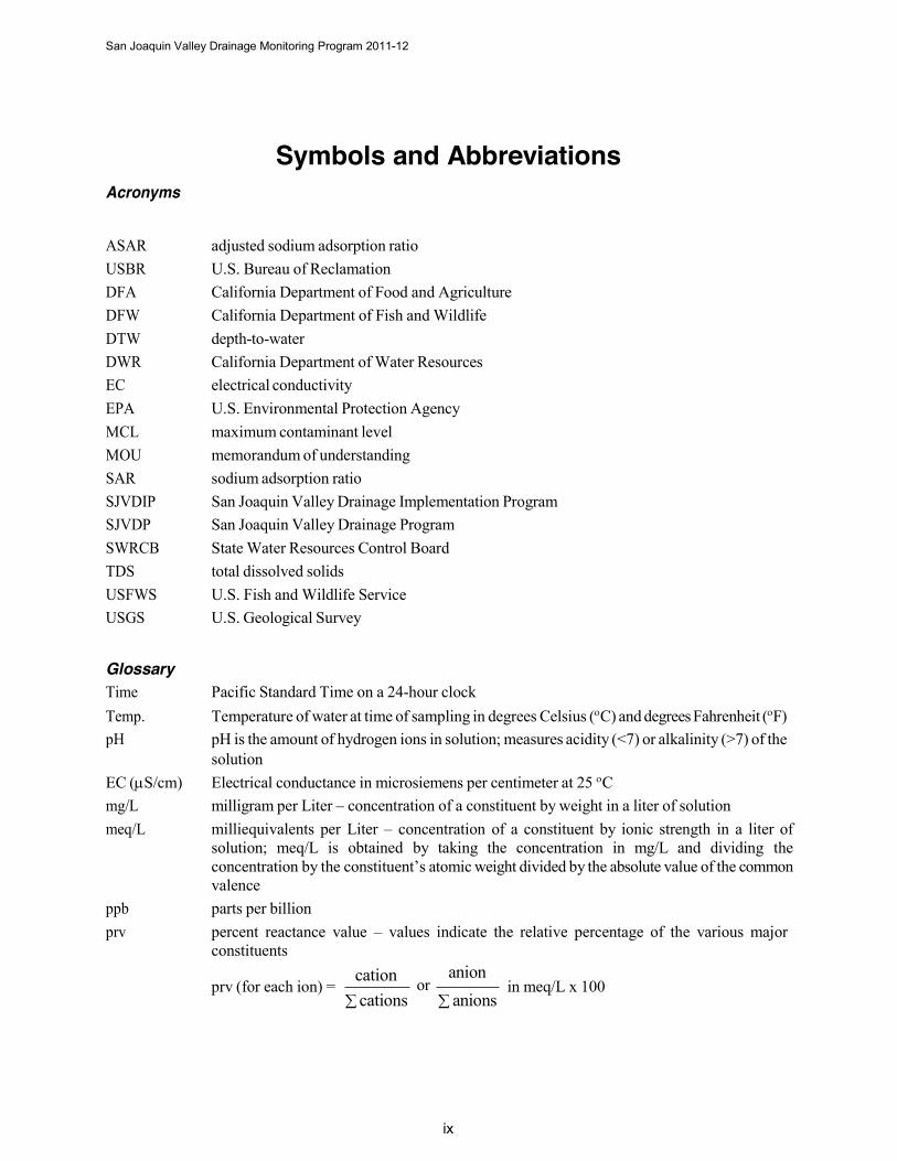
Acronyms
Symbols and Abbreviations
ASAR adjusted sodium adsorption ratio USBR U.S. Bureau of Reclamation DFA California Department of Food and Agriculture DFW California Department of Fish and Wildlife DTW depth-to-water DWR California Department of Water Resources EC electrical conductivity EPA U.S. Environmental Protection Agency MCL maximum contaminant level MOU memorandum of understanding SAR sodium adsorption ratio SJVDIP San Joaquin Valley Drainage Implementation Program SJVDP San Joaquin Valley Drainage Program SWRCB State Water Resources Control Board TDS total dissolved solids USFWS U.S. Fish and Wildlife Service USGS U.S. Geological Survey
Glossary Time Pacific Standard Time on a 24-hour clock Temp. Temperature of water at time of sampling in degrees Celsius (C) and degrees Fahrenheit (F) pH pH is the amount of hydrogen ions in solution; measures acidity (<7) or alkalinity (>7) of the
solution EC (S/cm) Electrical conductance in microsiemens per centimeter at 25 C mg/L milligram per Liter – concentration of a constituent by weight in a liter of solution meq/L milliequivalents per Liter – concentration of a constituent by ionic strength in a liter of
solution; meq/L is obtained by taking the concentration in mg/L and dividing the concentration by the constituent’s atomic weight divided by the absolute value of the common valence
ppb parts per billion prv percent reactance value – values indicate the relative percentage of the various major
constituents
prv (for each ion) = cation
cations anion
or anions
in meq/L x 100
San Joaquin Valley Drainage Monitoring Program 2011-12
x
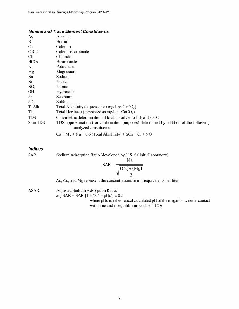
Mineral and Trace Element Constituents As Arsenic B Boron Ca Calcium CaCO3 Calcium Carbonate Cl Chloride HCO3 Bicarbonate K Potassium Mg Magnesium Na Sodium Ni Nickel NO3 Nitrate OH Hydroxide Se Selenium SO4 Sulfate T. Alk Total Alkalinity (expressed as mg/L as CaCO3) TH Total Hardness (expressed as mg/L as CaCO3) TDS Gravimetric determination of total dissolved solids at 180 C Sum TDS TDS approximation (for confirmation purposes) determined by addition of the following
analyzed constituents: Ca + Mg + Na + 0.6 (Total Alkalinity) + SO4 + Cl + NO3
Indices SAR Sodium Adsorption Ratio (developed by U.S. Salinity Laboratory)
Na SAR =
Na, Ca, and Mg represent the concentrations in milliequivalents per liter
ASAR Adjusted Sodium Adsorption Ratio: adj SAR = SAR [1 + (8.4 – pHc)] x 0.5
where pHc is a theoretical calculated pH of the irrigation water in contact with lime and in equilibrium with soil CO2
2
San Joaquin Valley Drainage Monitoring Program 2011-12
xi
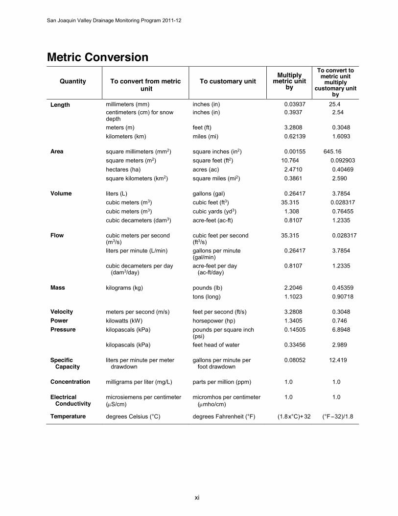
Metric Conversion
Quantity To convert from metric unit
To customary unit Multiply
metric unit by
To convert to metric unit
multiply customary unit
by Length millimeters (mm) inches (in) 0.03937 25.4
centimeters (cm) for snow depth
inches (in) 0.3937 2.54
meters (m) feet (ft) 3.2808 0.3048 kilometers (km) miles (mi) 0.62139 1.6093
Area square millimeters (mm2) square inches (in2) 0.00155 645.16 square meters (m2) square feet (ft2) 10.764 0.092903 hectares (ha) acres (ac) 2.4710 0.40469 square kilometers (km2) square miles (mi2) 0.3861 2.590
Volume liters (L) gallons (gal) 0.26417 3.7854 cubic meters (m3) cubic feet (ft3) 35.315 0.028317 cubic meters (m3) cubic yards (yd3) 1.308 0.76455 cubic decameters (dam3) acre-feet (ac-ft) 0.8107 1.2335
Flow cubic meters per second (m3/s)
cubic feet per second (ft3/s)
35.315 0.028317
liters per minute (L/min) gallons per minute (gal/min)
0.26417 3.7854
cubic decameters per day (dam3/day)
acre-feet per day (ac-ft/day)
0.8107 1.2335
Mass kilograms (kg) pounds (lb) 2.2046 0.45359 tons (long) 1.1023 0.90718
Velocity meters per second (m/s) feet per second (ft/s) 3.2808 0.3048 Power kilowatts (kW) horsepower (hp) 1.3405 0.746 Pressure kilopascals (kPa) pounds per square inch
(psi) 0.14505 6.8948
kilopascals (kPa) feet head of water 0.33456 2.989
Specific Capacity
liters per minute per meter drawdown
gallons per minute per foot drawdown
0.08052 12.419
Concentration milligrams per liter (mg/L) parts per million (ppm) 1.0 1.0
Electrical Conductivity
microsiemens per centimeter (S/cm)
micromhos per centimeter (mho/cm)
1.0 1.0
Temperature degrees Celsius (°C) degrees Fahrenheit (°F) (1.8 x°C)+ 32 (°F-- 32)/1.8
San Joaquin Valley Drainage Monitoring Program 2011-12
1
Introduction In 1959, the California Department of Water Resources (DWR) began monitoring agricultural drainage water in the San Joaquin Valley. Initial monitoring efforts from 1959 to 1963 focused on mineral analyses. In 1963, the monitoring program became part of the San Joaquin Drainage Investigation and included analyses for pesticides in both surface and subsurface drainage waters. From 1966 to 1969, intensive nutrient sampling became a part of the investigation.
Although the San Joaquin Drainage Investigation ended in 1970, DWR continued the monitoring as a separate departmental activity until 1975 when DWR, the U.S. Bureau of Reclamation (USBR), and the State Water Resources Control Board (SWRCB) formed the San Joaquin Valley Interagency Drainage Program. The program continued until 1979 when monitoring resumed as a separate activity under its Agricultural Drainage Program.
The discovery in 1983 of migratory bird deaths and deformities linked to high selenium levels in drainage water at Kesterson Reservoir focused national attention on drainage of the San Luis Drain and drainage- related problems. This discovery resulted in an interagency drainage study.
The following year, U.S. Secretary of the Interior William Patrick Clark and Governor of California George Deukmejian established the San Joaquin Valley Drainage Program (SJVDP). It was created to investigate and identify solutions to drainage problems. Cooperating agencies were DWR, California Department of Fish and Game (DFG), U.S. Fish and Wildlife Service (USFWS), U.S. Geological Survey (USGS), and the U.S. Bureau of Reclamation (USBR). The SJVDP developed a comprehensive study titled A Management Plan for Agricultural Subsurface Drainage and Related Problems on the Westside San Joaquin Valley, also known as the Rainbow Report (September 1990). It summarized the results of subsurface agricultural drainage problems and presented a plan for managing drainage problems.
In 1991, federal and State agencies initiated the San Joaquin Valley Drainage Implementation Program (SJVDIP) to pick up where SJVDP left off. Four federal agencies (Natural Resources Conservation Service, USFWS, USGS, and the USBR) and four State agencies (DFG, DWR, Department of Food and Agriculture, and SWRCB) signed a memorandum of understanding (MOU) and released an implementation strategy in December 1991. They agreed to work together and identify specific tasks associated with responsible parties, seek needed funding and authority, and set schedules for implementing all components of the SJVDP's 1990 Rainbow Report.
All the agencies involved recognized that the success of the program depended on local districts and irrigators to effectively manage drainage. Because drainage is a regional problem, federal and State agencies continue to coordinate efforts. DWR continuously evaluates and modifies its drainage monitoring program so that it meets the needs of the implementation strategy.
San Joaquin Valley Drainage Monitoring Program 2011-12
2
The Drainage Problem The San Joaquin Valley, one of the world’s most productive agricultural regions, is experiencing mounting problems with the management and disposal of agricultural drainage water.
The drainage problem is an outgrowth of imported water, naturally saline soils, and the valley’s distinctive geological makeup which prevents effective natural drainage in certain areas. Soils on the western side of the valley come from the marine sediments that make up the Coast Range. These soils, high in salts and trace elements, are similar to those that occur in the ocean. Also, just below the surface of much of the valley's soil, is a shallow clay layer that obstructs vertical movement of irrigation water. As salts and minerals from surface soils are leached into the shallow groundwater, the water table rises to within a few feet of the surface and into the root zone. Unless this water is removed, crops growing in these soils eventually die.
In the late 1940s, farmers began installing subsurface drains in fields with drainage problems. By 1965, 330 miles of subsurface drains and 750 miles of open ditch drains operated in the valley, delivering drainage water to evaporation ponds and other discharge sites. With this drainage network in operation, the main problem became how to manage and dispose of the salty drainage water.
The original plan was to construct a master drain (the San Luis Drain) to collect the water and route it out of the valley into the Sacramento-San Joaquin River Delta. By 1973, an 87-mile-long section of the San Luis Drain was receiving irrigation runoff and discharging into Kesterson Reservoir. The plan was to extend the drain north to a discharge site in the Delta. Kesterson Reservoir was intended to regulate discharges going to the Delta and provide a wetland habitat. However, the San Luis Drain was never completed, and drainage accumulated at Kesterson Reservoir.
In 1982, federal studies reported high selenium levels in fish taken from Kesterson Reservoir. In 1983, federal-State studies determined that the bioaccumulation of selenium was causing deformities in embryos of waterfowl nesting at the reservoir. In 1985, the U.S. Department of the Interior ordered a halt to drainage water discharges into the San Luis Drain and Kesterson Reservoir, even though irrigation water deliveries to west side agricultural lands continued.
Today, practices of disposing and managing drainage water are being scrutinized for their effects on the environment. Management practices such as source control, drainage reuse, groundwater management, integrated on-farm drainage management, and others identified in the Rainbow Report are being used. Monitoring of shallow groundwater and agricultural drainage water is integral to assist in the evaluation of the effectiveness of these management practices.
San Joaquin Valley Drainage Monitoring Program 2011-12
3
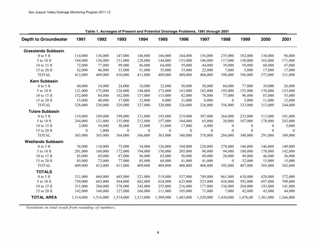
Drainage Problem Areas The San Joaquin Valley is a rich agricultural region that encompasses large areas with high water tables. Irrigation practices, cropping patterns, seepage from unlined ditches or ponds, soil type, geology, and other factors influence the elevations of these water tables. The poor natural drainage conditions, coupled with rising groundwater levels and increasing soil salinity, have meant that various soils could no longer produce crops, and some farms in the problem area have been abandoned.
In this report, “present problem area” is defined as a location where the water table is within 5 feet of the ground surface at any time during the year. A "potential problem area" indicates the water table is between 5 and 20 feet below the surface. Present and potential drainage problem areas are determined by the use of ArcGIS software within specific intervals as found in DWR's annual "Present and Potential Drainage Problem Area" maps for 2011 and 2012, Figures 8 and 9, respectively. In addition, Electrical Conductivity (EC) maps are presented for 2011 and 2012, Figures 10 and 11, respectively. Beginning with the 1991 map, DWR drew study-area boundaries that encompassed these problem areas.
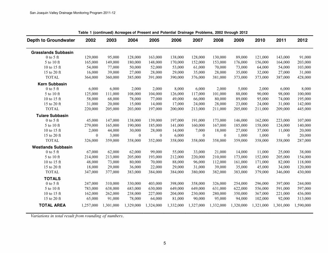
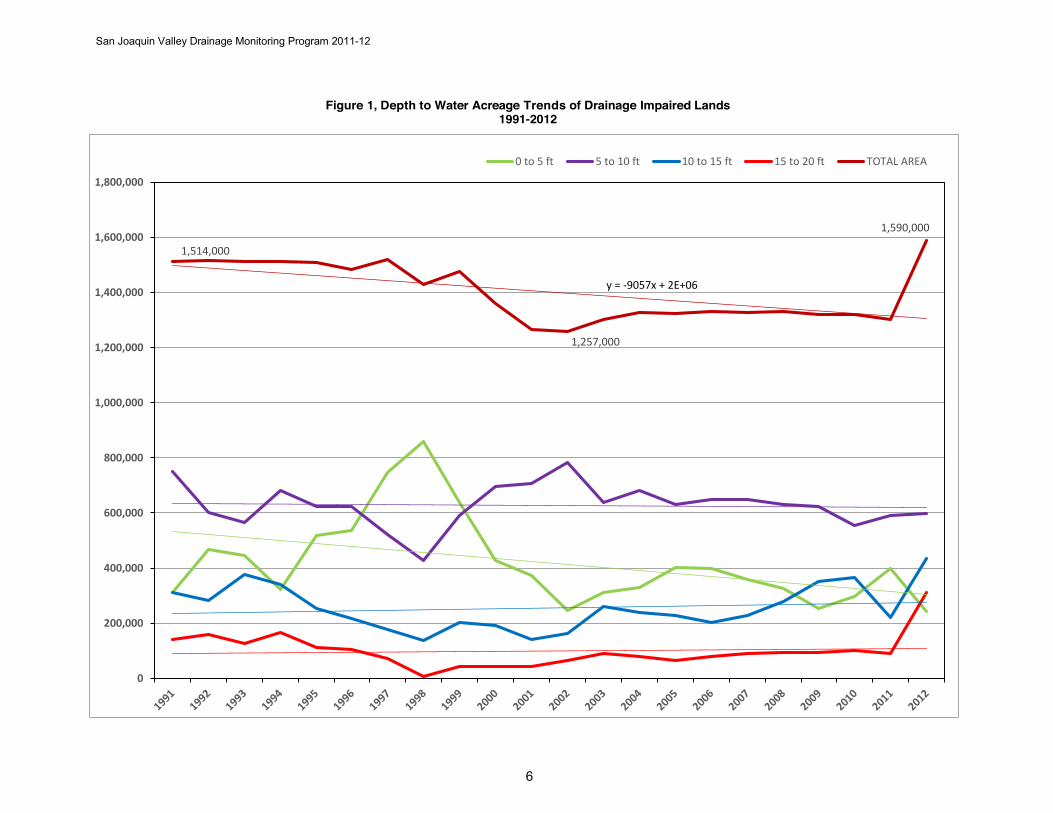
Beginning in 1994, DWR established and published standard methods for collecting data for environmental measurement projects (DWR Quality Assurance Technical Document 2). This document specifies methods for the preparation, collection, handling, preservation, and transportation of samples and calibration of instruments. These methods were used to measure water levels in a network of monitoring wells in the study-area boundaries and in the interpretation of the data to establish acreage areas of the particular depth-to-water (DTW) intervals. The maps display an overview of the respective depth-to-water intervals, as well as the boundaries of study for Grasslands, Westlands, Tulare, and Kern subbasins. Table 1, Acreage of Present and Potential Drainage Problems, lists the acreages with drainage problems in the study area for 1991 through 2012. These acreage trends are graphed in Figure 1. Further focus on the individual subbasins can be found in Appendix A.
San Joaquin Valley Drainage Monitoring Program 2011-12
Table 1. Acreages of Present and Potential Drainage Problems, 1991 through 2001
4
Depth to Groundwater 1991 1992 1993 1994 1995 1996 1997 1998 1999 2000 2001
Grasslands Subbasin 0 to 5 ft 114,000 136,000 147,000 146,000 166,000 164,000 156,000 235,000 182,000 130,000 96,000 5 to 10 ft 184,000 150,000 131,000 128,000 144,000 153,000 186,000 117,000 150,000 165,000 171,000
10 to 15 ft 72,000 77,000 99,000 86,000 64,000 59,000 44,000 39,000 59,000 60,000 47,000 15 to 20 ft 42,000 46,000 33,000 51,000 35,000 33,000 22,000 7,000 5,000 17,000 17,000 TOTAL 412,000 409,000 410,000 411,000 409,000 409,000 408,000 398,000 396,000 372,000 331,000
Kern Subbasin 0 to 5 ft 40,000 34,000 24,000 10,000 32,000 50,000 58,000 84,000 77,000 39,000 26,000 5 to 10 ft 121,000 172,000 126,000 148,000 173,000 163,000 182,000 195,000 155,000 176,000 153,000
10 to 15 ft 152,000 84,000 162,000 137,000 115,000 82,000 78,000 77,000 96,000 87,000 53,000 15 to 20 ft 15,000 40,000 17,000 32,000 8,000 31,000 8,000 0 5,000 11,000 12,000 TOTAL 328,000 330,000 329,000 327,000 328,000 326,000 326,000 356,000 333,000 313,000 244,000
Tulare Subbasin 0 to 5 ft 119,000 189,000 199,000 131,000 195,000 219,000 307,000 264,000 233,000 113,000 101,000 5 to 10 ft 244,000 121,000 135,000 212,000 157,000 104,000 65,000 20,000 107,000 178,000 243,000
10 to 15 ft 2,000 54,000 30,000 23,000 11,000 17,000 6,000 0 0 0 5,000 15 to 20 ft 0 1,000 0 0 0 0 0 0 0 0 0 TOTAL 365,000 365,000 364,000 366,000 363,000 340,000 378,000 284,000 340,000 291,000 349,000
Westlands Subbasin 0 to 5 ft 38,000 110,000 75,000 34,000 126,000 104,000 228,000 278,000 146,000 146,000 149,000 5 to 10 ft 201,000 160,000 172,000 194,000 150,000 205,000 90,000 94,000 180,000 178,000 142,000
10 to 15 ft 85,000 69,000 87,000 96,000 65,000 58,000 49,000 20,000 49,000 46,000 36,000 15 to 20 ft 85,000 73,000 77,000 85,000 68,000 41,000 41,000 0 32,000 15,000 15,000 TOTAL 409,000 412,000 411,000 409,000 409,000 408,000 408,000 392,000 407,000 385,000 342,000
TOTALS 0 to 5 ft 311,000 469,000 445,000 321,000 519,000 537,000 749,000 861,000 638,000 428,000 372,000 5 to 10 ft 750,000 603,000 564,000 682,000 624,000 625,000 523,000 426,000 592,000 697,000 709,000
10 to 15 ft 311,000 284,000 378,000 342,000 255,000 216,000 177,000 136,000 204,000 193,000 141,000 15 to 20 ft 142,000 160,000 127,000 168,000 111,000 105,000 71,000 7,000 42,000 43,000 44,000
TOTAL AREA 1,514,000 1,516,000 1,514,000 1,513,000 1,509,000 1,483,000 1,520,000 1,430,000 1,476,00 1,361,000 1,266,000
Variations in total result from rounding of numbers.
5
San Joaquin Valley Drainage Monitoring Program 2011-12
Table 1 (continued) Acreages of Present and Potential Drainage Problems, 2002 through 2012
Depth to Groundwater 2002 2003 2004 2005 2006 2007 2008 2009 2010 2011 2012
Grasslands Subbasin 0 to 5 ft 129,000 95,000 128,000 163,000 138,000 128,000 130,000 89,000 121,000 143,000 91,000
5 to 10 ft 165,000 149,000 180,000 148,000 170,000 152,000 153,000 176,000 156,000 164,000 203,000 10 to 15 ft 54,000 77,000 50,000 52,000 53,000 61,000 70,000 73,000 64,000 54,000 103,000 15 to 20 ft 16,000 39,000 27,000 28,000 29,000 35,000 28,000 35,000 32,000 27,000 31,000 TOTAL 364,000 360,000 385,000 391,000 390,000 376,000 381,000 373,000 373,000 387,000 428,000
Kern Subbasin 0 to 5 ft 6,000 6,000 2,000 2,000 8,000 6,000 2,000 5,000 2,000 6,000 8,000
5 to 10 ft 125,000 111,000 108,000 104,000 126,000 117,000 101,000 88,000 90,000 98,000 100,000 10 to 15 ft 58,000 68,000 78,000 77,000 49,000 66,000 80,000 89,000 95,000 74,000 195,000 15 to 20 ft 31,000 20,000 15,000 14,000 17,000 24,000 28,000 23,000 24,000 31,000 142,000 TOTAL 220,000 205,000 203,000 197,000 200,000 213,000 211,000 205,000 211,000 209,000 445,000
Tulare Subbasin 0 to 5 ft 45,000 147,000 138,000 139,000 197,000 191,000 173,000 146,000 162,000 223,000 107,000
5 to 10 ft 279,000 165,000 190,000 185,000 141,000 160,000 167,000 185,000 158,000 124,000 140,000 10 to 15 ft 2,000 44,000 30,000 28,000 14,000 7,000 18,000 27,000 37,000 11,000 20,000 15 to 20 ft 0 3,000 0 0 6,000 0 0 1,000 1,000 0 20,000 TOTAL 326,000 359,000 358,000 352,000 358,000 358,000 358,000 359,000 358,000 358,000 287,000
Westlands Subbasin 0 to 5 ft 67,000 62,000 62,000 99,000 55,000 33,000 21,000 14,000 11,000 25,000 38,000
5 to 10 ft 214,000 213,000 205,000 193,000 212,000 220,000 210,000 173,000 152,000 205,000 154,000 10 to 15 ft 48,000 73,000 80,000 70,000 88,000 96,000 112,000 161,000 171,000 82,000 118,000 15 to 20 ft 18,000 29,000 36,000 22,000 29,000 31,000 39,000 35,000 45,000 34,000 120,000 TOTAL 347,000 377,000 383,000 384,000 384,000 380,000 382,000 383,000 379,000 346,000 430,000
TOTALS 0 to 5 ft 247,000 310,000 330,000 403,000 398,000 358,000 326,000 254,000 296,000 397,000 244,000
5 to 10 ft 783,000 638,000 683,000 630,000 649,000 649,000 631,000 622,000 556,000 591,000 597,000 10 to 15 ft 162,000 262,000 238,000 227,000 204,000 230,000 280,000 350,000 367,000 221,000 436,000 15 to 20 ft 65,000 91,000 78,000 64,000 81,000 90,000 95,000 94,000 102,000 92,000 313,000
TOTAL AREA 1,257,000 1,301,000 1,329,000 1,324,000 1,332,000 1,327,000 1,332,000 1,320,000 1,321,000 1,301,000 1,590,000
Variations in total result from rounding of numbers.
San Joaquin Valley Drainage Monitoring Program 2011-12
6
Figure 1, Depth to Water Acreage Trends of Drainage Impaired Lands 1991-2012
1,514,000
1,257,000
1,590,000
y = -9057x + 2E+06
0
200,000
400,000
600,000
800,000
1,000,000
1,200,000
1,400,000
1,600,000
1,800,000
0 to 5 ft 5 to 10 ft 10 to 15 ft 15 to 20 ft TOTAL AREA

San Joaquin Valley Drainage Monitoring Program 2011-12
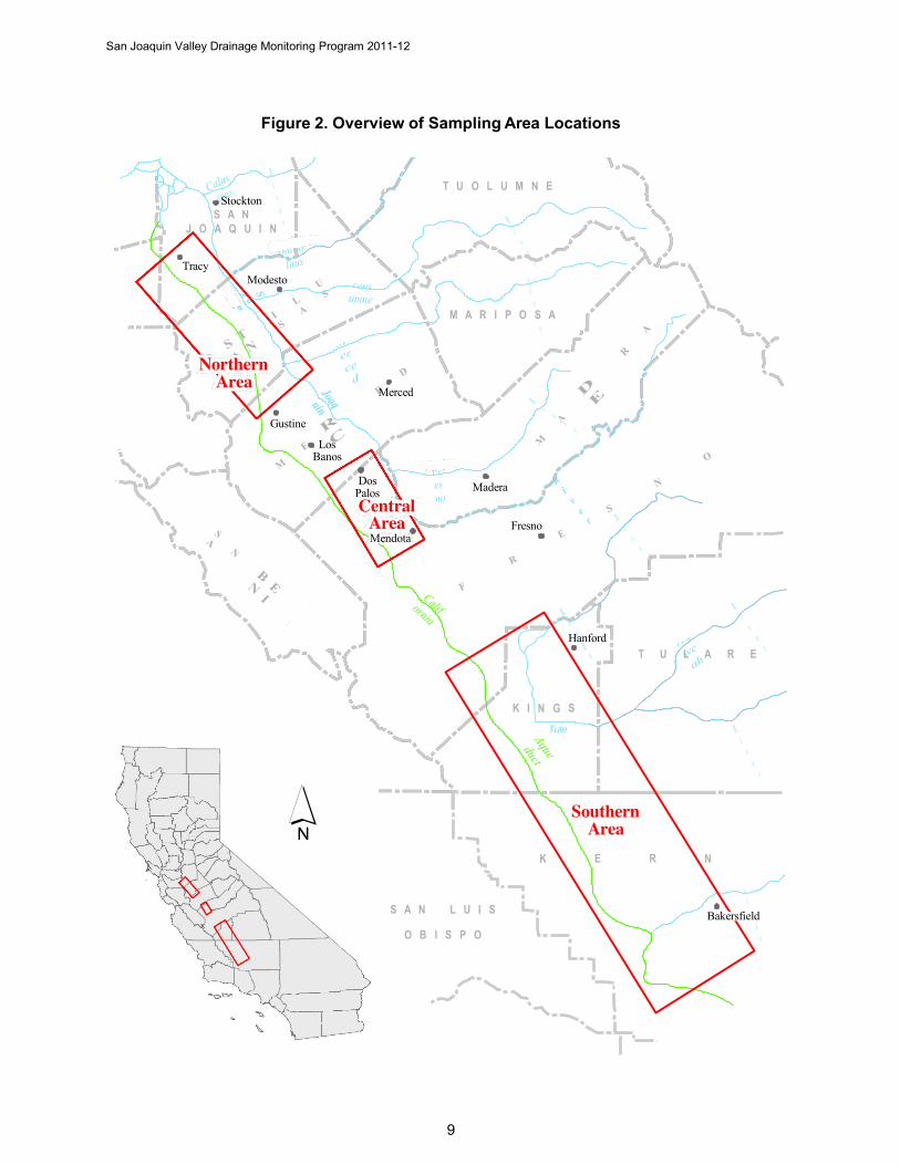
2011-2012 Drainage Monitoring Program DWR’s San Joaquin Valley drainage-monitoring for 2011 through 2012 consisted of collecting water samples from as many as 49 drainage sumps. Figure 2 (shown on page 9) provides an overview of the sampling area locations with boundaries representing the Northern, Central, and Southern areas.
The Northern Area, once monitored by USBR, is now a part of DWR’s monitoring program. Beginning in 2010, preliminary investigative monitoring began with one surface and seventeen subsurface tile drains. As Northern locations and data are reviewed, only candidate sumps with continuing data and easy access will be included into the program.
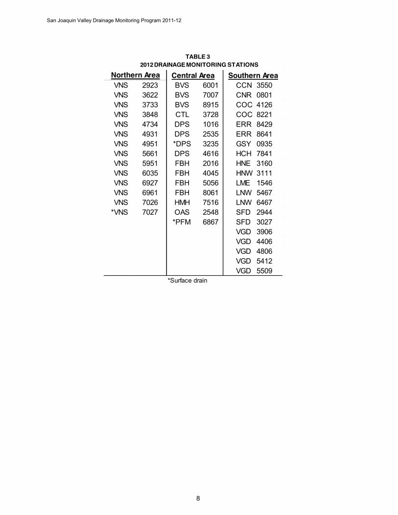
The data presented includes all stations monitored, as shown in Tables 2 through 3, for the years 2011 through 2012, respectively. An overview of the monitoring stations are presented in Figures 2 through 7 (shown on pages 9 through 14), respectively.
TABLE 2 2011 DRAINAGE MONITORING STATIONS
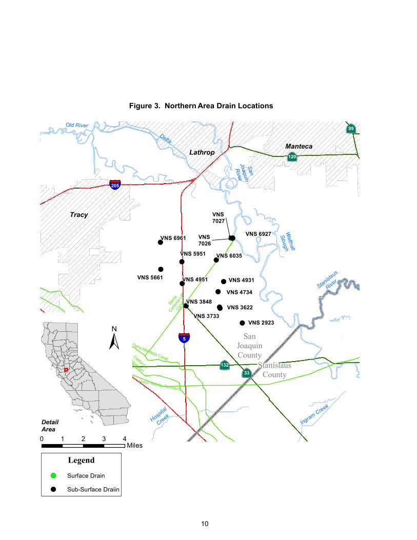
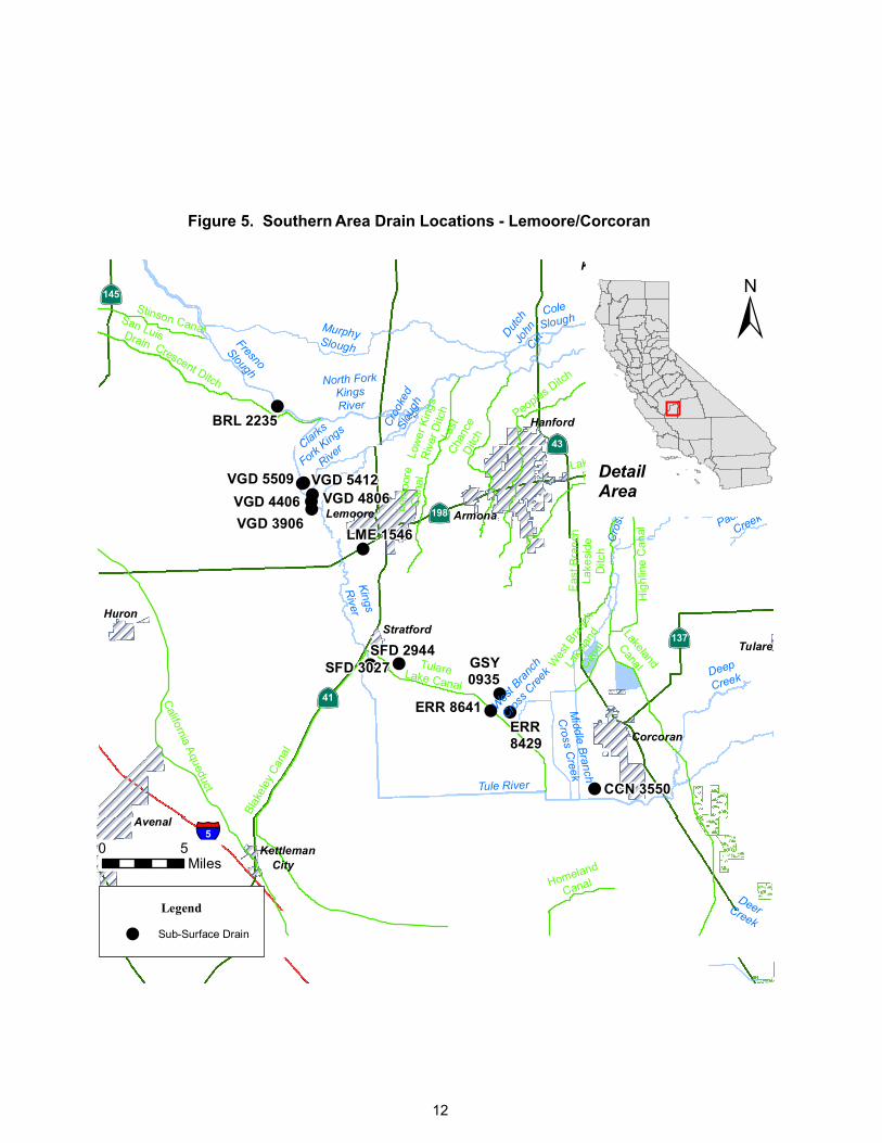
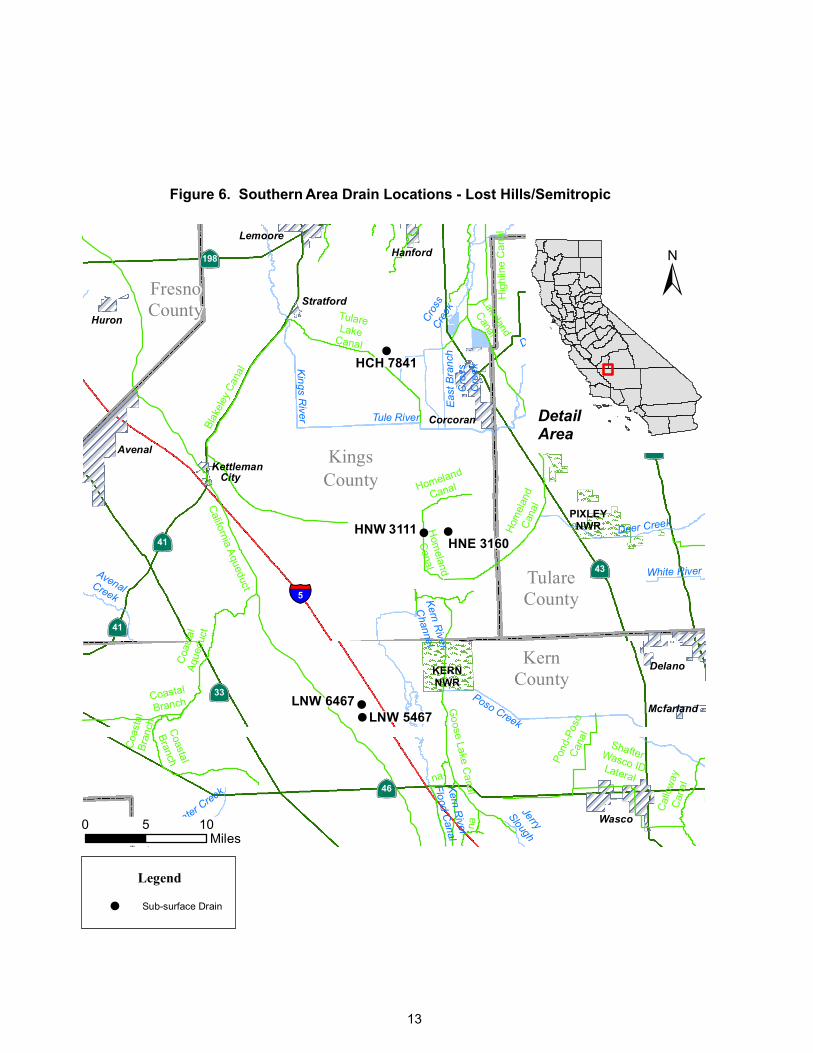
Northern Area Central Area Southern Area VNS 2923 BVS 6001 BRL 2235 VNS 3733 BVS 7007 CCN 3550 VNS 4734 BVS 7402 CNR 0801 VNS 4931 BVS 8003 COC 4126 VNS 4951 CTL 3728 COC 8221 VNS 5661 DPS 1016 ERR 8429 VNS 6035 DPS 1367 ERR 8641 VNS 6927 DPS 2535 GSY 0935 VNS 6961 *DPS 3235 HCH 7841 VNS 7026 DPS 3465 LNW 5467 *VNS 7027 DPS 4616 LNW 6467
FBH 2016 VGD 3906 FBH 4045 VGD 4406 FBH 5056 VGD 4806 FBH 8061 VGD 5412 HMH 7516 VGD 5509 OAS 0364 OAS 2548 *Surface drain
7
San Joaquin Valley Drainage Monitoring Program 2011-12
8
TABLE 3 2012 DRAINAGE MONITORING STATIONS
Central AreaVNS 2923 BVS 6001 CCN 3550VNS 3622 BVS 7007 CNR 0801VNS 3733 BVS 8915 COC 4126VNS 3848 CTL 3728 COC 8221VNS 4734 DPS 1016 ERR 8429VNS 4931 DPS 2535 ERR 8641VNS 4951 *DPS 3235 GSY 0935VNS 5661 DPS 4616 HCH 7841VNS 5951 FBH 2016 HNE 3160VNS 6035 FBH 4045 HNW 3111VNS 6927 FBH 5056 LME 1546VNS 6961 FBH 8061 LNW 5467VNS 7026 HMH 7516 LNW 6467
*VNS 7027 OAS 2548 SFD 2944*PFM 6867 SFD 3027
VGD 3906VGD 4406VGD 4806VGD 5412VGD 5509
*Surface drain
Northern Area Southern Area
San Joaquin Valley Drainage Monitoring Program 2011-12
9
Figure 2. Overview of Sampling Area Locations
T U O L U M N E Stockton
S A N J O A Q U I N
Tracy Modesto
M A R I P O S A
Northern Area
Merced
Gustine
Los Banos
Dos Palos Central
Area Mendota
Madera
Fresno
Hanford T U L A R E
K I N G Tule
S
´ K
Southern Area
E R N
S A N L U I S Bakersfield O B I S P O
!(4
444
444
4 444
44
StanislausCounty
SanJoaquinCounty
VNS7027
VNS 6961
VNS 6035VNS 5951
VNS 5661 VNS 4931VNS 4951
VNS 4734VNS 3848
VNS 3733VNS 3622
VNS 2923
VNS 6927VNS7026
·|}ÿ99
·|}ÿ33·|}ÿ132
·|}ÿ120
§̈¦205
§̈¦5
§̈¦580
Delta Mendota CanalCalifornia
Aqueduct
Bant
aCar
bona
Lift
Canal
Hetch Hetchy Aqueduct
Walthall
Slough
Ingram Creek
Stanislaus
River
Hospita
l
Creek
San
Joaquin
River
Old River
Delta
Tracy
LathropManteca
Legend
!( Surface Drain
4 Sub-Surface Draiin
0 1 2 3 4Miles
Figure . ort ern Area Drain Locations
Detail
Area
±
10
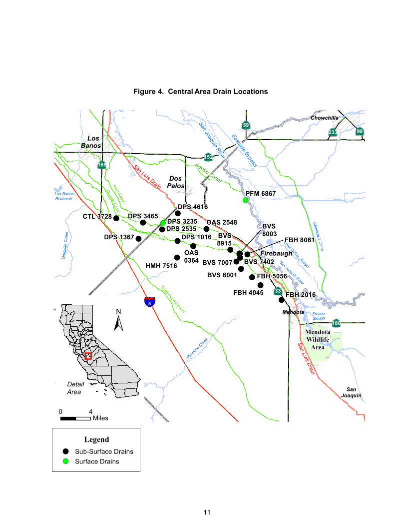
Figure 4. Central Area Drain Locations
44
4
44
44
444
4
4
4
44
!(
!(
444
California AqueductDelta Mendota Canal
San Luis Drain
San Luis Drain
Arroyo Canal
Main Canal
Eastside Bypass
Chow
chilla Canal
San Joaquin River
Outside Canal
Lone Willow Slough
San Joaquin River
Little
Panoc
he
Creek
Panoc
he C
reek
Orti
galit
a C
reek
LittlePanocheReservoir
Los BanosReservoir
Mendota
Wildlife
Area
FresnoSlough
!
BVS 6001
BVS 7007
CTL 3728
DPS 1016DPS 2535
FBH 2016FBH 4045
FBH 8061BVS8915
HMH 7516
DPS 4616
FBH 5056
OAS 2548
BVS 7402OAS0364
PFM 6867
DPS 3235BVS8003DPS 1367
DPS 3465
·|}ÿ99·|}ÿ59
·|}ÿ233
·|}ÿ165·|}ÿ152
·|}ÿ180
·|}ÿ33
§̈¦5
Mendota
Firebaugh
San
Joaquin
Chowchilla
Los
Banos
Dos
Palos
Legend
4 Sub-Surface Drains!( Surface Drains
0 4Miles
DetailArea
±
11
4
444
44444
4
4 4
4·|}ÿ198
·|}ÿ99
·|}ÿ33
·|}ÿ145
·|}ÿ43
·|}ÿ137
·|}ÿ41
§̈¦5
Peoples Ditch
Blak
eley
Can
al
Homeland
Canal
Wes
t Bra
nch
Lake
land
Canal
Stinson CanalCrescent Ditch
Lakeside
Ditch
Last
Chan
ceDi
tch
Lakeland
Canal
Low
er K
ings
Riv
er D
itch
Hig
hlin
e C
anal
Lem
oore
Can
al
TulareLake Canal
Eas
t Bra
nch
Lake
side
Ditc
h
California Aqueduct
San LuisDrain
Wes
t Bra
nch
Cross C
reek
Fresno
Slough
Kings
River
Cro
ss C
reek
Tule River
Mill Creek
DeerCreek
East
Bran
ch
Cros
s Cre
ek
MurphySlough
Middle Branch
Cross C
reek
Packwood
Creek
Croo
ked
Slou
gh
Dutch
John
Cut
Deep
Creek
Clarks
Fork King
s
River
St.JohnsRiver
North ForkKingsRiver
ColeSlough
Huron
Kingsburg
Lemoore
Avenal
Corcoran
Hanford
Armona
Kettleman
City
Stratford
Visalia
Tulare
CCN 3550
ERR8429
ERR 8641
GSY0935
VGD 4406VGD 5412VGD 5509
VGD 4806
BRL 2235
SFD 2944SFD 3027
LME 1546
Legend
4 Sub-Surface Drain
Figure . Sout ern Area Drain Locations Lemoore Corcoran
0 5Miles
±
Detail
Area
12
VGD 3906
!
!!
! !
KernCounty
FresnoCounty
KingsCounty
TulareCounty
·|}ÿ41
·|}ÿ137
·|}ÿ198
·|}ÿ190
·|}ÿ33
·|}ÿ41
·|}ÿ43
·|}ÿ46
·|}ÿ99
§̈¦5
Hom
eland
Canal
Blak
eley
Can
al
Homeland
Canal
na
Goose Lake C
anal
Hig
hlin
e C
anal
Cal
low
ayC
anal
Coa
stal
Aque
duct
Lakeland
Canal
Lakeland
Canal
Coastal
Branch
na
California Aqueduct
Coastal
Branch
Hom
elan
dCa
nal
TulareLake
Canal
Coa
stal
Bran
ch
Pond
-Pos
oCa
nal
Tular
eCan
al
ShafterWasco IDLateral
Deer CreekK
ings River
Cros
sCr
eek
Kern River
Channel
Tule River
Jerry
SloughInsid
e
Creek
Elk
Bayou
Bitterwater C
reek
Kern River
Flood Canal
AvenalCreek
Eas
t Bra
nch
Cro
ssC
reek
White River
Deep
Creek SouthBranch
Tule River
Poso Creek
Huron
Lemoore
Avenal
Corcoran
Hanford
Kettleman
City
Stratford
Wasco
Mcfarland
Delano
Visalia
Tulare
PIXLEYNWR
KERNNWR
HCH 7841
LNW 5467LNW 6467
HNW 3111HNE 3160
Legend
! Sub-surface Drain
Figure . Sout ern Area Drain Locations Lost ills Semitropic
0 105Miles
±
Detail
Area
13
!(
!(
!(
CNR 0801
COC 4126
COC 8221
·|}ÿ99
·|}ÿ166
·|}ÿ43
·|}ÿ178
·|}ÿ204·|}ÿ184
·|}ÿ33
·|}ÿ58
·|}ÿ65
·|}ÿ58·|}ÿ58
·|}ÿ223
·|}ÿ184
·|}ÿ119§̈¦5
Kern R
iver
Bitte
r Cre
ek
GooseLake
Slough
Sandy Creek
Kern River
Bypass
Channel
Kern
River Flood Canal
TejonCreek
Jerry Slough
Poso Creek
Bitte
rwat
erCr
eek
Buena Vista Creek
San
Em
igdi
oC
reek
Tecuya Creek
Salt
Creek
Wasco
Maricopa
Arvin
Shafter
Taft
Bakersfield
Legend
(! Sub-surface Drain
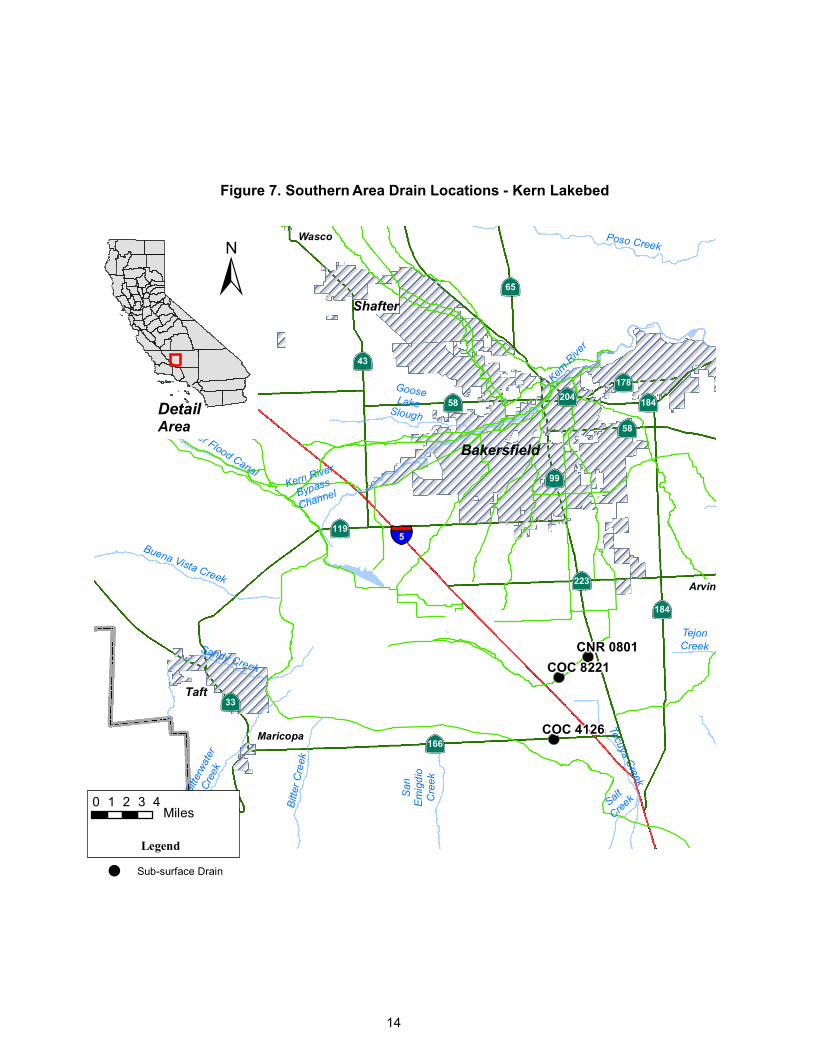
Figure . Sout ern Area Drain Locations ern La e e
0 1 2 3 4Miles
14
Detail
Area
±
San Joaquin Valley Drainage Monitoring Program 2011-12
15
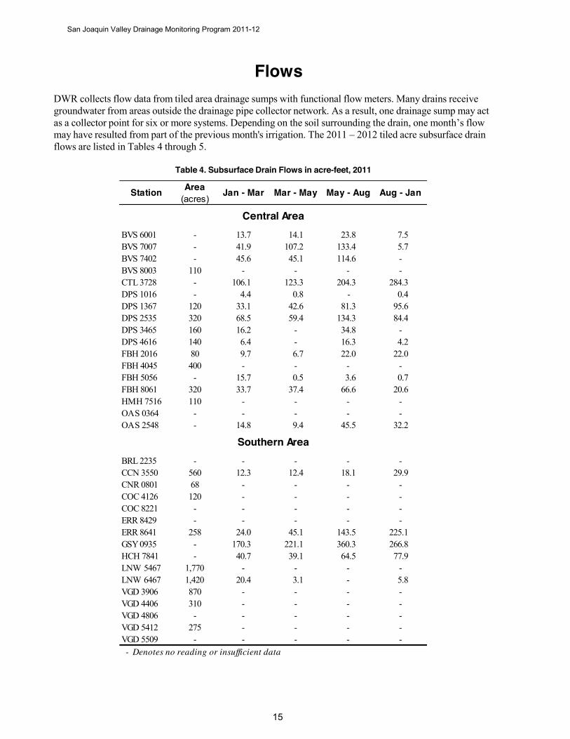
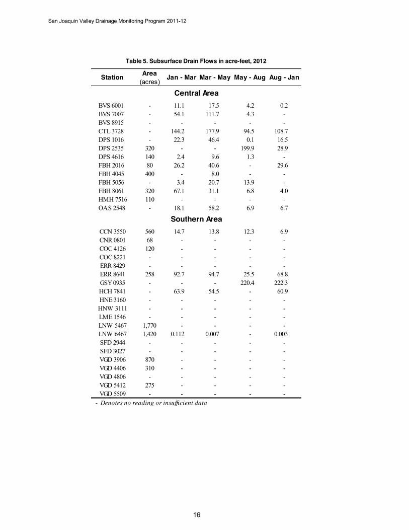
Flows DWR collects flow data from tiled area drainage sumps with functional flow meters. Many drains receive groundwater from areas outside the drainage pipe collector network. As a result, one drainage sump may act as a collector point for six or more systems. Depending on the soil surrounding the drain, one month’s flow may have resulted from part of the previous month's irrigation. The 2011 – 2012 tiled acre subsurface drain flows are listed in Tables 4 through 5.
Table 4. Subsurface Drain Flows in acre-feet, 2011
Area(acres)
BVS 6001 - 13.7 14.1 23.8 7.5BVS 7007 - 41.9 107.2 133.4 5.7BVS 7402 - 45.6 45.1 114.6 -BVS 8003 110 - - - -CTL 3728 - 106.1 123.3 204.3 284.3DPS 1016 - 4.4 0.8 - 0.4DPS 1367 120 33.1 42.6 81.3 95.6DPS 2535 320 68.5 59.4 134.3 84.4DPS 3465 160 16.2 - 34.8 -DPS 4616 140 6.4 - 16.3 4.2FBH 2016 80 9.7 6.7 22.0 22.0FBH 4045 400 - - - -FBH 5056 - 15.7 0.5 3.6 0.7FBH 8061 320 33.7 37.4 66.6 20.6HMH 7516 110 - - - -OAS 0364 - - - - -OAS 2548 - 14.8 9.4 45.5 32.2
BRL 2235 - - - - -CCN 3550 560 12.3 12.4 18.1 29.9CNR 0801 68 - - - -COC 4126 120 - - - -COC 8221 - - - - -ERR 8429 - - - - -ERR 8641 258 24.0 45.1 143.5 225.1GSY 0935 - 170.3 221.1 360.3 266.8HCH 7841 - 40.7 39.1 64.5 77.9LNW 5467 1,770 - - - -LNW 6467 1,420 20.4 3.1 - 5.8VGD 3906 870 - - - -VGD 4406 310 - - - -VGD 4806 - - - - -VGD 5412 275 - - - -VGD 5509 - - - - - - Denotes no reading or insufficient data
Central Area
Southern Area
Station Jan - Mar Mar - May May - Aug Aug - Jan
San Joaquin Valley Drainage Monitoring Program 2011-12
16
Table 5. Subsurface Drain Flows in acre-feet, 2012
Area(acres)
BVS 6001 - 11.1 17.5 4.2 0.2BVS 7007 - 54.1 111.7 4.3 -BVS 8915 - - - - -CTL 3728 - 144.2 177.9 94.5 108.7DPS 1016 - 22.3 46.4 0.1 16.5DPS 2535 320 - - 199.9 28.9DPS 4616 140 2.4 9.6 1.3 -FBH 2016 80 26.2 40.6 - 29.6FBH 4045 400 - 8.0 - -FBH 5056 - 3.4 20.7 13.9 -FBH 8061 320 67.1 31.1 6.8 4.0HMH 7516 110 - - - -OAS 2548 - 18.1 58.2 6.9 6.7
CCN 3550 560 14.7 13.8 12.3 6.9CNR 0801 68 - - - -COC 4126 120 - - - -COC 8221 - - - - -ERR 8429 - - - - -ERR 8641 258 92.7 94.7 25.5 68.8GSY 0935 - - - 220.4 222.3HCH 7841 - 63.9 54.5 - 60.9HNE 3160 - - - - -HNW 3111 - - - - -LME 1546 - - - - -LNW 5467 1,770 - - - -LNW 6467 1,420 0.112 0.007 - 0.003SFD 2944 - - - - -SFD 3027 - - - - -VGD 3906 870 - - - -VGD 4406 310 - - - -VGD 4806 - - - - -VGD 5412 275 - - - -VGD 5509 - - - - -
- Denotes no reading or insufficient data
Southern Area
Central Area
Station Jan - Mar Mar - May May - Aug Aug - Jan
San Joaquin Valley Drainage Monitoring Program 2011-12
1
Mineral Constituent and Trace Element Concentrations
This report provides a summary of the analyzed constituents analyzed in Tables 6 through 11 (pages 18–25) for the Northern, Central, and Southern Area drains, respectively. The Southern Area mineral constituents are divided into three sub-areas: Lemoore-Corcoran, Lost Hills-Semitropic, and Kern Lakebed. A complete list of minerals and trace element results for each station is given in Appendices D through I. DWR monitored only arsenic, barium, boron, molybdenum, and selenium trace elements for this report.
The report presents two averages: arithmetic average and geometric mean. The arithmetic average is the average of all data obtained for the given period, whereas, the geometric mean (extensively used by regulatory agencies) gives an average of central tendency that is less influenced by spiked values in the data. This report evaluates detection-only analyses. Detection limits reported with a "<" sign are not used to calculate averages.
This report also includes the 2011 and 2012 Areal Distribution of Shallow Groundwater and Electrical Conductivity Maps (Figures 8 through 11). The maps display an overview of the shallow groundwater conductivity within the respective subbasin study areas.
We used the sodium adsorption ratio (SAR) as an index to evaluate infiltration problems. It is a ratio of calcium and magnesium to sodium for soil extracts and irrigation water and is used to express the relative activity of sodium ions in exchange reactions in the soil. When sodium exceeds calcium by a ratio of 3:1 or greater, severe water infiltration problems occur because of the soil's structural makeup. The soil particles that plug and seal pores are dispersed through the soil column. The adjusted SAR (ASAR) is a refinement of the SAR and is no longer recommended by Oster and Rhoades (1977), Oster and Schroer (1979), and Suarez (1981), who conclude the procedure over-predicts the sodium hazard. They suggest the method be further adjusted by a 0.5 factor to evaluate more correctly the effects of bicarbonate on calcium precipitation (adj SAR x 0.5). This report presents the ASAR without further adjustment for those who prefer the given data and want to follow up on the recommended studies.
Low salinity water, water below 500 µS/cm, can cause infiltration problems in much the same manner as a high ASAR water affects the soil column. Low salinity water leaches minerals and salts from the soil, reducing the soil’s structural integrity and causing soil dispersion. The finer dispersed soil particles fill many of the soil pores, plugging and sealing the pores, and preventing the irrigation water from passing through the soil column. Soil crusting and crop emergence problems often result (Ayers and Wescott, 1985).
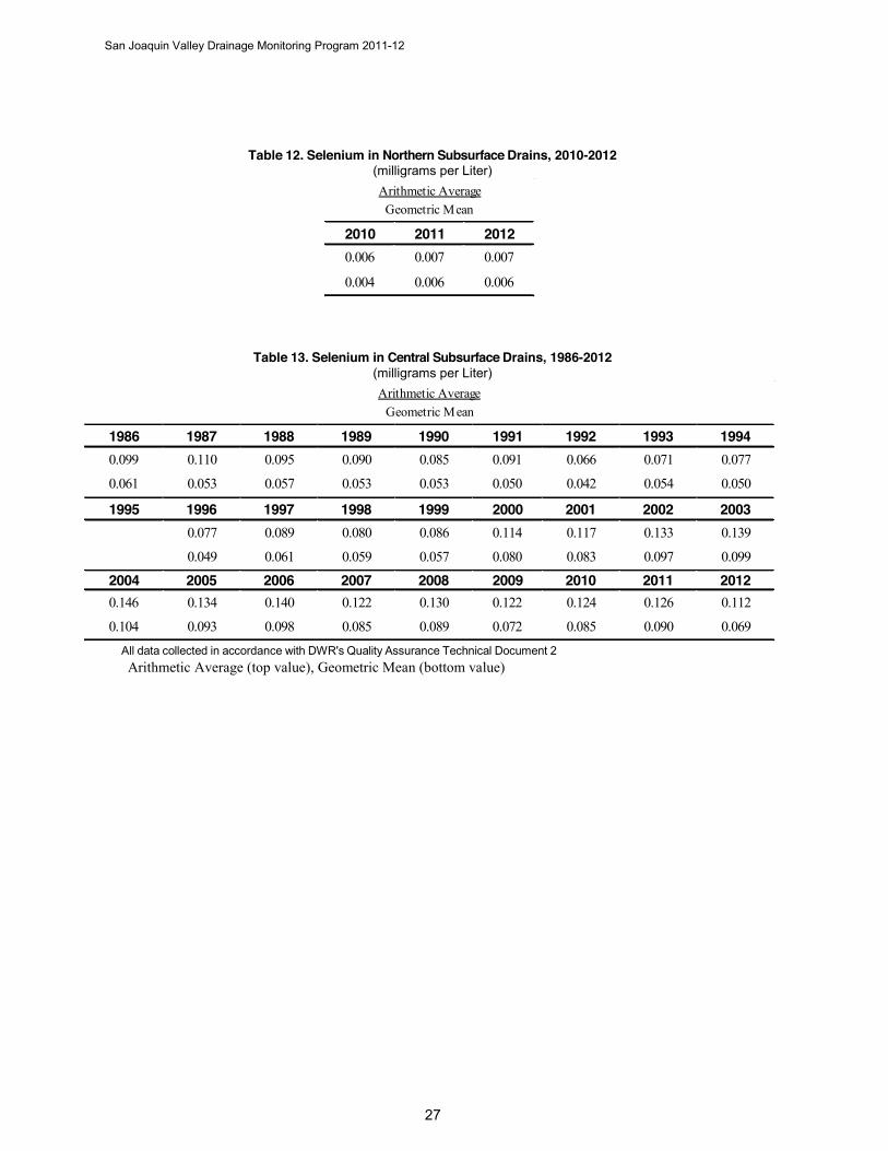
This report presents historical selenium data and trends. Selenium averages for the Northern, Central, and Southern Areas are presented in Tables 12-14 (pages 27-28).
San Joaquin Valley Drainage Monitoring Program 2011-12
18
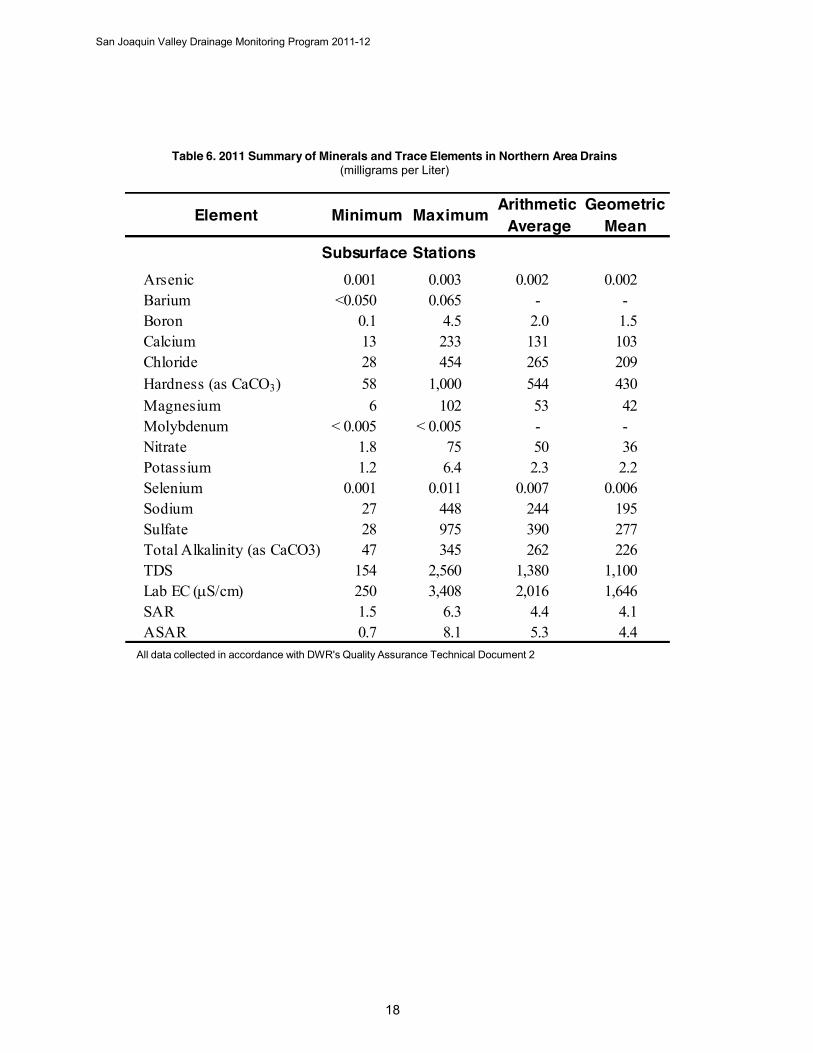
Table 6. 2011 Summary of Minerals and Trace Elements in Northern Area Drains (milligrams per Liter)
All data collected in accordance with DWR's Quality Assurance Technical Document 2
Arithmetic Geometric Average Mean
Arsenic 0.001 0.003 0.002 0.002Barium <0.050 0.065 - -Boron 0.1 4.5 2.0 1.5Calcium 13 233 131 103Chloride 28 454 265 209Hardness (as CaCO3) 58 1,000 544 430Magnesium 6 102 53 42Molybdenum < 0.005 < 0.005 - -Nitrate 1.8 75 50 36Potassium 1.2 6.4 2.3 2.2Selenium 0.001 0.011 0.007 0.006Sodium 27 448 244 195Sulfate 28 975 390 277Total Alkalinity (as CaCO3) 47 345 262 226TDS 154 2,560 1,380 1,100Lab EC (S/cm) 250 3,408 2,016 1,646SAR 1.5 6.3 4.4 4.1ASAR 0.7 8.1 5.3 4.4
Minimum MaximumElement
Subsurface Stations

San Joaquin Valley Drainage Monitoring Program 2011-12
Table 7. 2011 Summary of Minerals and Trace Elements in Central Area Drains (milligrams per Liter)
All data collected in accordance with DWR's Quality Assurance Technical Document 2
Arithmetic Geometric Average Mean
Arsenic 0.003 < 0.020 0.006 0.005Barium < 0.050 < 1.0 - -Boron 1.6 79.7 12.3 9.3Calcium 211 671 408 396Chloride 133 2,680 716 606Hardness (as CaCO3) 705 3,870 1,747 1,657Magnesium 43 623 176 154Molybdenum < 0.025 0.336 0.094 0.077Nitrate 1.6 225 98 78Potassium 1.0 7.2 3.5 3.2Selenium 0.005 0.314 0.126 0.090Sodium 148 3,950 1,073 890Sulfate 689 8,880 2,650 2,321Total Alkalinity (as CaCO3) 115 480 214 206TDS 1,430 16,770 5,428 4,877Lab EC (S/cm) 1,872 18,210 6,531 5,990SAR 2.4 32.7 10.7 9.5ASAR 3.2 45.7 14.2 12.4
Element Minimum Maximum
Subsurface Stations
San Joaquin Valley Drainage Monitoring Program 2011-12
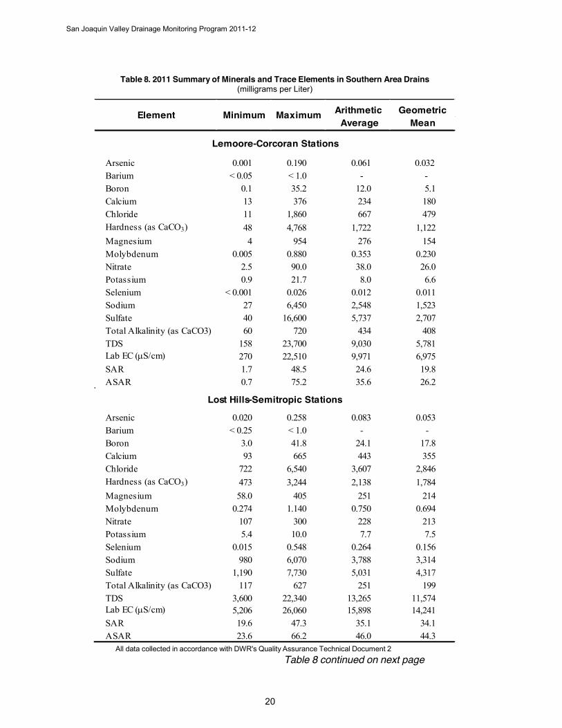
Table 8. 2011 Summary of Minerals and Trace Elements in Southern Area Drains (milligrams per Liter)
All data collected in accordance with DWR's Quality Assurance Technical Document 2 Table 8 continued on next page
Arithmetic Geometric Average Mean
Arsenic 0.001 0.190 0.061 0.032Barium < 0.05 < 1.0 - -Boron 0.1 35.2 12.0 5.1Calcium 13 376 234 180Chloride 11 1,860 667 479Hardness (as CaCO3) 48 4,768 1,722 1,122Magnesium 4 954 276 154Molybdenum 0.005 0.880 0.353 0.230Nitrate 2.5 90.0 38.0 26.0Potassium 0.9 21.7 8.0 6.6Selenium < 0.001 0.026 0.012 0.011Sodium 27 6,450 2,548 1,523Sulfate 40 16,600 5,737 2,707Total Alkalinity (as CaCO3) 60 720 434 408TDS 158 23,700 9,030 5,781Lab EC (S/cm) 270 22,510 9,971 6,975SAR 1.7 48.5 24.6 19.8ASAR 0.7 75.2 35.6 26.2
Arsenic 0.020 0.258 0.083 0.053Barium < 0.25 < 1.0 - -Boron 3.0 41.8 24.1 17.8Calcium 93 665 443 355Chloride 722 6,540 3,607 2,846Hardness (as CaCO3) 473 3,244 2,138 1,784Magnesium 58.0 405 251 214Molybdenum 0.274 1.140 0.750 0.694Nitrate 107 300 228 213Potassium 5.4 10.0 7.7 7.5Selenium 0.015 0.548 0.264 0.156Sodium 980 6,070 3,788 3,314Sulfate 1,190 7,730 5,031 4,317Total Alkalinity (as CaCO3) 117 627 251 199TDS 3,600 22,340 13,265 11,574Lab EC (S/cm) 5,206 26,060 15,898 14,241SAR 19.6 47.3 35.1 34.1ASAR 23.6 66.2 46.0 44.3
Lost Hills-Semitropic Stations
Element Minimum Maximum
Lemoore-Corcoran Stations
San Joaquin Valley Drainage Monitoring Program 2011-12
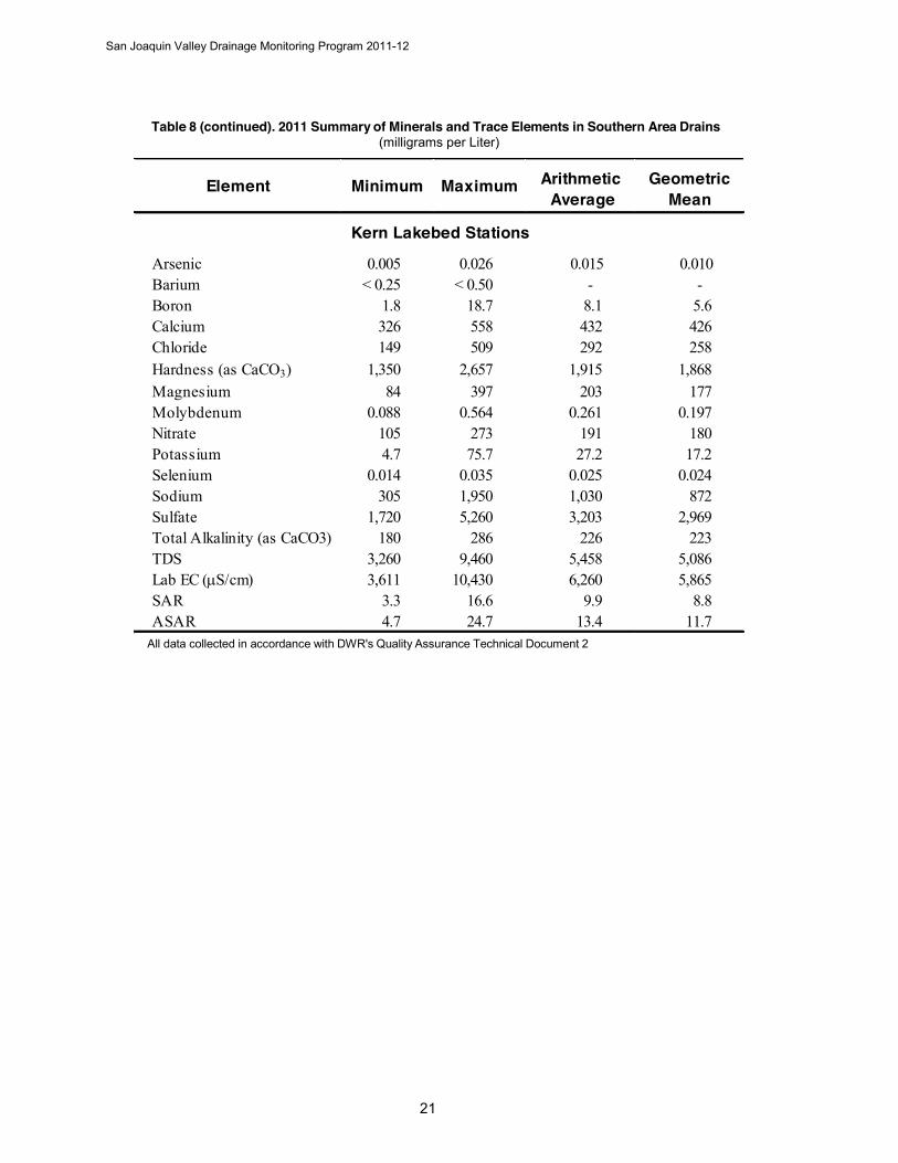
Table 8 (continued). 2011 Summary of Minerals and Trace Elements in Southern Area Drains (milligrams per Liter)
All data collected in accordance with DWR's Quality Assurance Technical Document 2
Arithmetic Geometric Average Mean
Arsenic 0.005 0.026 0.015 0.010Barium < 0.25 < 0.50 - -Boron 1.8 18.7 8.1 5.6Calcium 326 558 432 426Chloride 149 509 292 258Hardness (as CaCO3) 1,350 2,657 1,915 1,868Magnesium 84 397 203 177Molybdenum 0.088 0.564 0.261 0.197Nitrate 105 273 191 180Potassium 4.7 75.7 27.2 17.2Selenium 0.014 0.035 0.025 0.024Sodium 305 1,950 1,030 872Sulfate 1,720 5,260 3,203 2,969Total Alkalinity (as CaCO3) 180 286 226 223TDS 3,260 9,460 5,458 5,086Lab EC (S/cm) 3,611 10,430 6,260 5,865SAR 3.3 16.6 9.9 8.8ASAR 4.7 24.7 13.4 11.7
Element Minimum Maximum
Kern Lakebed Stations
San Joaquin Valley Drainage Monitoring Program 2011-12
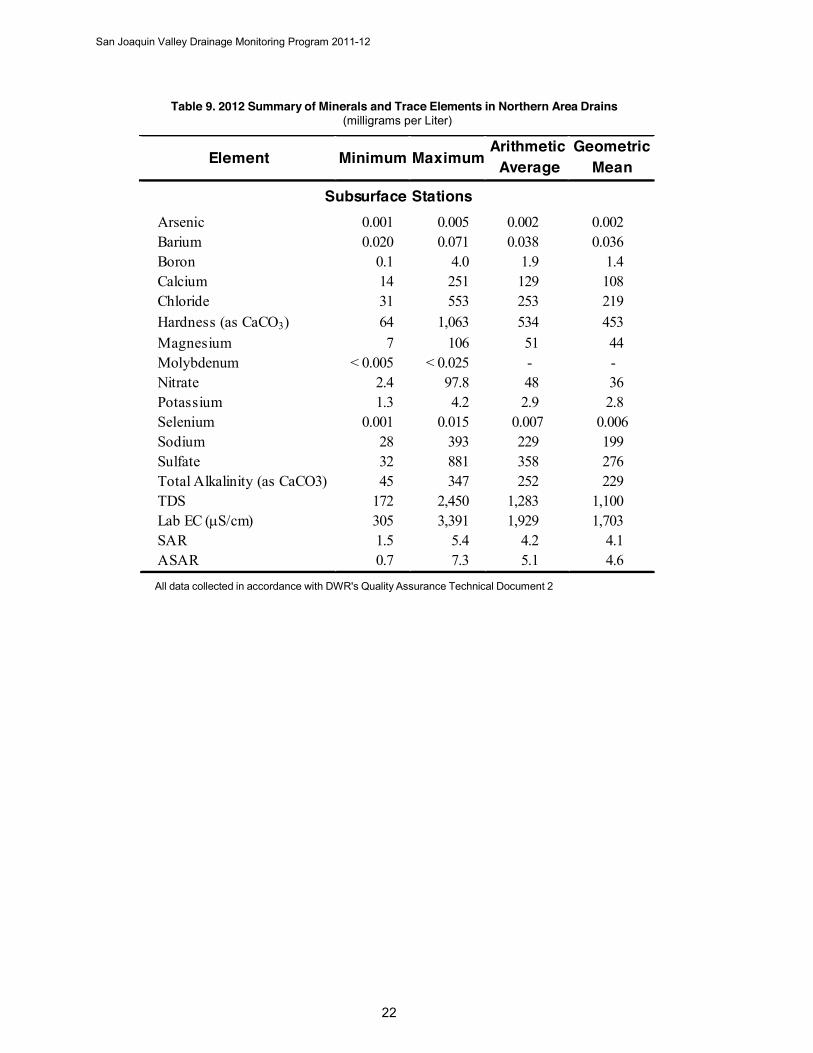
Table 9. 2012 Summary of Minerals and Trace Elements in Northern Area Drains (milligrams per Liter)
All data collected in accordance with DWR's Quality Assurance Technical Document 2
Arithmetic Geometric Average Mean
Arsenic 0.001 0.005 0.002 0.002Barium 0.020 0.071 0.038 0.036Boron 0.1 4.0 1.9 1.4Calcium 14 251 129 108Chloride 31 553 253 219Hardness (as CaCO3) 64 1,063 534 453Magnesium 7 106 51 44Molybdenum < 0.005 < 0.025 - -Nitrate 2.4 97.8 48 36Potassium 1.3 4.2 2.9 2.8Selenium 0.001 0.015 0.007 0.006Sodium 28 393 229 199Sulfate 32 881 358 276Total Alkalinity (as CaCO3) 45 347 252 229TDS 172 2,450 1,283 1,100Lab EC (S/cm) 305 3,391 1,929 1,703SAR 1.5 5.4 4.2 4.1ASAR 0.7 7.3 5.1 4.6
Element Minimum Maximum
Subsurface Stations
San Joaquin Valley Drainage Monitoring Program 2011-12
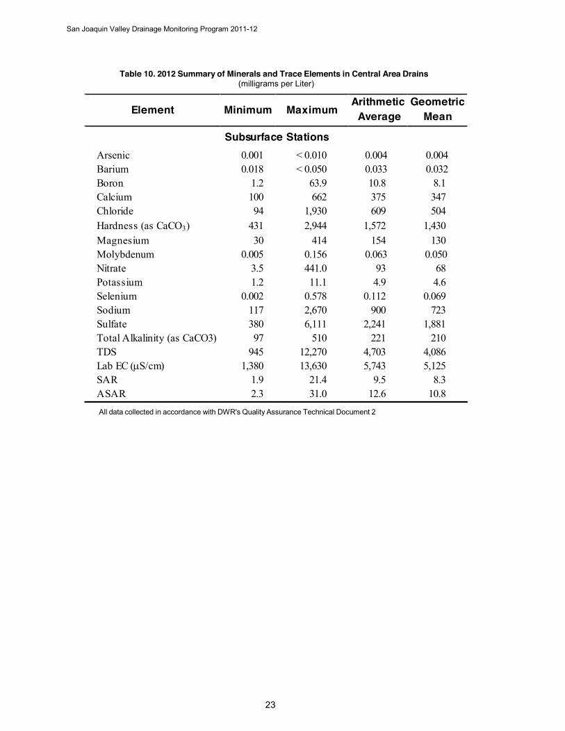
Table 10. 2012 Summary of Minerals and Trace Elements in Central Area Drains (milligrams per Liter)
All data collected in accordance with DWR's Quality Assurance Technical Document 2
Arithmetic Geometric Average Mean
Arsenic 0.001 < 0.010 0.004 0.004Barium 0.018 < 0.050 0.033 0.032Boron 1.2 63.9 10.8 8.1Calcium 100 662 375 347Chloride 94 1,930 609 504Hardness (as CaCO3) 431 2,944 1,572 1,430Magnesium 30 414 154 130Molybdenum 0.005 0.156 0.063 0.050Nitrate 3.5 441.0 93 68Potassium 1.2 11.1 4.9 4.6Selenium 0.002 0.578 0.112 0.069Sodium 117 2,670 900 723Sulfate 380 6,111 2,241 1,881Total Alkalinity (as CaCO3) 97 510 221 210TDS 945 12,270 4,703 4,086Lab EC (S/cm) 1,380 13,630 5,743 5,125SAR 1.9 21.4 9.5 8.3ASAR 2.3 31.0 12.6 10.8
Element Minimum Maximum
Subsurface Stations

San Joaquin Valley Drainage Monitoring Program 2011-12
Table 11. 2012 Summary of Minerals and Trace Elements in Southern Area Drains (milligrams per Liter)
All data collected in accordance with DWR's Quality Assurance Technical Document 2Table 11 continued on next page
Arithmetic Geometric Average Mean
Arsenic 0.003 0.228 0.058 0.033Barium 0.017 < 0.100 0.034 0.032Boron 0.2 34.7 10.2 4.7Calcium 20 415 225 180Chloride 15 1,620 563 404Hardness (as CaCO3) 68 3,682 1,483 1,053Magnesium 4.0 703.0 224.4 137.6Molybdenum 0.011 0.885 0.327 0.218Nitrate 0.6 101.0 43.2 31.8Potassium 2.0 27.0 10.0 8.1Selenium < 0.001 0.037 0.012 0.009Sodium 47 5,500 2,111 1,349Sulfate 97 12,300 4,567 2,506Total Alkalinity (as CaCO3) 40 733 434 397TDS 25 19,620 8,043 5,045Lab EC (S/cm) 420 20,480 9,229 6,752SAR 2.5 45.2 22.2 18.1ASAR 1.1 70.1 32.3 24.3
Arsenic 0.020 0.235 0.101 0.071Barium < 0.025 < 0.100 0.032 0.031Boron 2.8 45.0 20.4 11.8Calcium 62 692 352 247Chloride 640 8,280 3,189 2,019Hardness (as CaCO3) 355 3,944 1,882 1,359Magnesium 49 538 244 178Molybdenum 0.311 1.220 0.771 0.714Nitrate 61 317 186 162Potassium 4.0 28.3 14.2 11.9Selenium 0.013 0.530 0.183 0.075Sodium 931 6,910 3,256 2,583Sulfate 1,100 6,980 3,983 3,186Total Alkalinity (as CaCO3) 111 560 332 276TDS 3,190 23,720 11,817 9,150Lab EC (S/cm) 4,853 29,210 14,877 12,101SAR 21.5 49.8 31.8 30.5ASAR 25.8 69.7 42.3 40.4
Lost Hills-Semitropic Stations
Element Minimum Maximum
Lemoore-Corcoran Stations
San Joaquin Valley Drainage Monitoring Program 2011-12
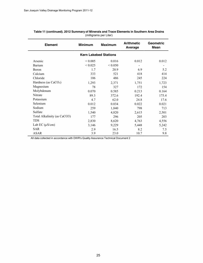
Table 11 (continued). 2012 Summary of Minerals and Trace Elements in Southern Area Drains (milligrams per Liter)
Element Minimum Maximum Arithmetic Geometric Average Mean
Kern Lakebed Stations
< 0.005 0.016 0.012 0.012 < 0.025 < 0.050 - -
1.7 20.9 6.9 5.2 333 521 418 414 106 486 245 224
1,293 2,371 1,751 1,723 78 327 172 154
0.070 0.585 0.213 0.164 89.3 372.6 192.4 175.4
4.7 62.0 24.8 17.6 0.012 0.034 0.022 0.021
259 1,840 798 713 1,540 4,820 2,615 2,501
177 296 205 203 2,830 8,620 4,763 4,556 3,146 9,229 5,448 5,242
2.9 16.5 8.2 7.5
Arsenic Barium Boron Calcium Chloride Hardness (as CaCO3) Magnesium Molybdenum Nitrate Potassium Selenium Sodium Sulfate Total Alkalinity (as CaCO3) TDS Lab EC (S/cm) SAR ASAR 3.9 23.0 10.7 9.8
All data collected in accordance with DWR's Quality Assurance Technical Document 2

San Joaquin Valley Drainage Monitoring Program 2011-12
Selenium Selenium is a naturally-occurring, nonmetallic chemical element that accumulates in drainage water when selenium-enriched salts leach from the soil into the shallow groundwater. Water-quality problems associated with selenium are most likely to occur in the San Joaquin Valley where soils are formed of sediments from marine sedimentary rocks of the Coast Range. The occurrence of Coast Range sediments and the highest selenium concentrations are clearly linked throughout the Valley. Three areas of the western valley have the highest soil selenium concentrations:
The alluvial fans near Panoche and Cantua Creeks in the central western valley An area west of the town of Lost Hills The Buena Vista Lake Bed area
High concentrations of selenium occur in subsurface drain water from some agricultural lands near, but not necessarily within, all three areas.
Selenium concentrations in samples collected from the Northern Area subsurface drains ranged from 0.001 to 0.015 mg/L during 2010-2012. The highest concentrations were found in samples collected from station VNS 4734, with selenium values ranging from 0.010 mg/L to 0.015 mg/L.
Selenium concentrations in samples collected from the Central Area subsurface drains ranged from 0.005 to 0.578 mg/L during 2010-2012. The highest concentrations were found in samples collected from central station BVS 7007, with selenium values ranging from 0.220 mg/L to 0.578 mg/L. In addition, high concentration values of 0.158 mg/L to 0.346 mg/L were found in samples collected from central station FBH 2016.
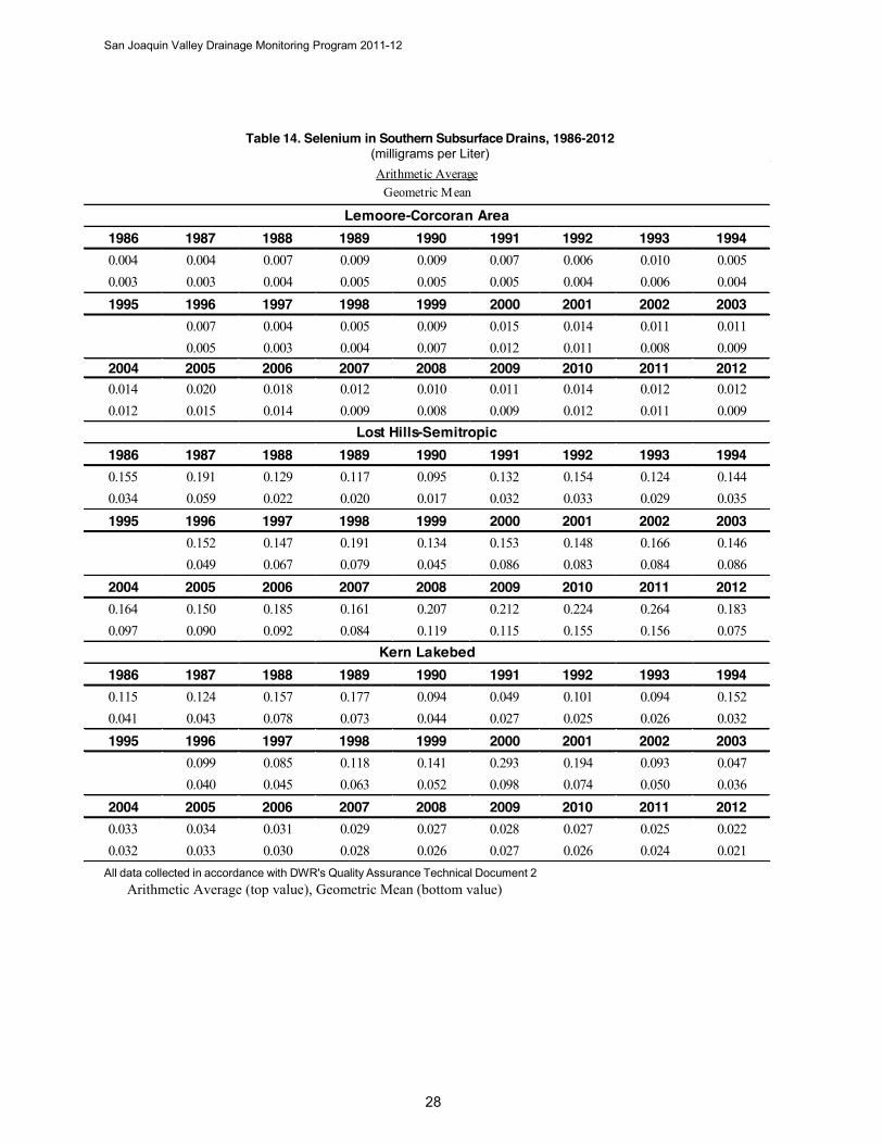
The concentration levels of selenium in the Southern Area subsurface drains ranged from 0.002 to 0.548 mg/L during 2010-2012. The highest selenium concentrations were found in samples collected from Lost Hills-Semitropic station LNW 6467, with selenium values ranging from 0.348 mg/L to 0.548 mg/L. Another Lost Hills-Semitropic station, LNW 5467, recorded high values ranging from 0.236 mg/L to 0.305 mg/L.
Historical averages are listed in Tables 12-14 (pages 27-28). Graphical trend analyses for selenium within the Central and Southern Areas are presented in Appendix B.
San Joaquin Valley Drainage Monitoring Program 2011-12
Table 12. Selenium in Northern Subsurface Drains, 2010-2012 (milligrams per Liter)
Table 13. Selenium in Central Subsurface Drains, 1986-2012 (milligrams per Liter)
All data collected in accordance with DWR's Quality Assurance Technical Document 2 Arithmetic Average (top value), Geometric Mean (bottom value)
2010 2011 20120.006 0.007 0.007
0.004 0.006 0.006
Arithmetic AverageGeometric Mean
1986 1987 1988 1989 1990 1991 1992 1993 19940.099 0.110 0.095 0.090 0.085 0.091 0.066 0.071 0.077
0.061 0.053 0.057 0.053 0.053 0.050 0.042 0.054 0.050
1995 1996 1997 1998 1999 2000 2001 2002 20030.077 0.089 0.080 0.086 0.114 0.117 0.133 0.139
0.049 0.061 0.059 0.057 0.080 0.083 0.097 0.099
2004 2005 2006 2007 2008 2009 2010 2011 20120.146 0.134 0.140 0.122 0.130 0.122 0.124 0.126 0.112
0.104 0.093 0.098 0.085 0.089 0.072 0.085 0.090 0.069
Arithmetic AverageGeometric Mean
San Joaquin Valley Drainage Monitoring Program 2011-12
Table 14. Selenium in Southern Subsurface Drains, 1986-2012 (milligrams per Liter)
All data collected in accordance with DWR's Quality Assurance Technical Document 2 Arithmetic Average (top value), Geometric Mean (bottom value)
1986 1987 1988 1989 1990 1991 1992 1993 19940.004 0.004 0.007 0.009 0.009 0.007 0.006 0.010 0.0050.003 0.003 0.004 0.005 0.005 0.005 0.004 0.006 0.0041995 1996 1997 1998 1999 2000 2001 2002 2003
0.007 0.004 0.005 0.009 0.015 0.014 0.011 0.0110.005 0.003 0.004 0.007 0.012 0.011 0.008 0.009
2004 2005 2006 2007 2008 2009 2010 2011 20120.014 0.020 0.018 0.012 0.010 0.011 0.014 0.012 0.0120.012 0.015 0.014 0.009 0.008 0.009 0.012 0.011 0.009
1986 1987 1988 1989 1990 1991 1992 1993 19940.155 0.191 0.129 0.117 0.095 0.132 0.154 0.124 0.1440.034 0.059 0.022 0.020 0.017 0.032 0.033 0.029 0.0351995 1996 1997 1998 1999 2000 2001 2002 2003
0.152 0.147 0.191 0.134 0.153 0.148 0.166 0.1460.049 0.067 0.079 0.045 0.086 0.083 0.084 0.086
2004 2005 2006 2007 2008 2009 2010 2011 20120.164 0.150 0.185 0.161 0.207 0.212 0.224 0.264 0.1830.097 0.090 0.092 0.084 0.119 0.115 0.155 0.156 0.075
1986 1987 1988 1989 1990 1991 1992 1993 19940.115 0.124 0.157 0.177 0.094 0.049 0.101 0.094 0.1520.041 0.043 0.078 0.073 0.044 0.027 0.025 0.026 0.0321995 1996 1997 1998 1999 2000 2001 2002 2003
0.099 0.085 0.118 0.141 0.293 0.194 0.093 0.0470.040 0.045 0.063 0.052 0.098 0.074 0.050 0.036
2004 2005 2006 2007 2008 2009 2010 2011 20120.033 0.034 0.031 0.029 0.027 0.028 0.027 0.025 0.0220.032 0.033 0.030 0.028 0.026 0.027 0.026 0.024 0.021
Lost Hills-Semitropic
Kern Lakebed
Arithmetic AverageGeometric Mean
Lemoore-Corcoran Area
San Joaquin Valley Drainage Monitoring Program 2011-12
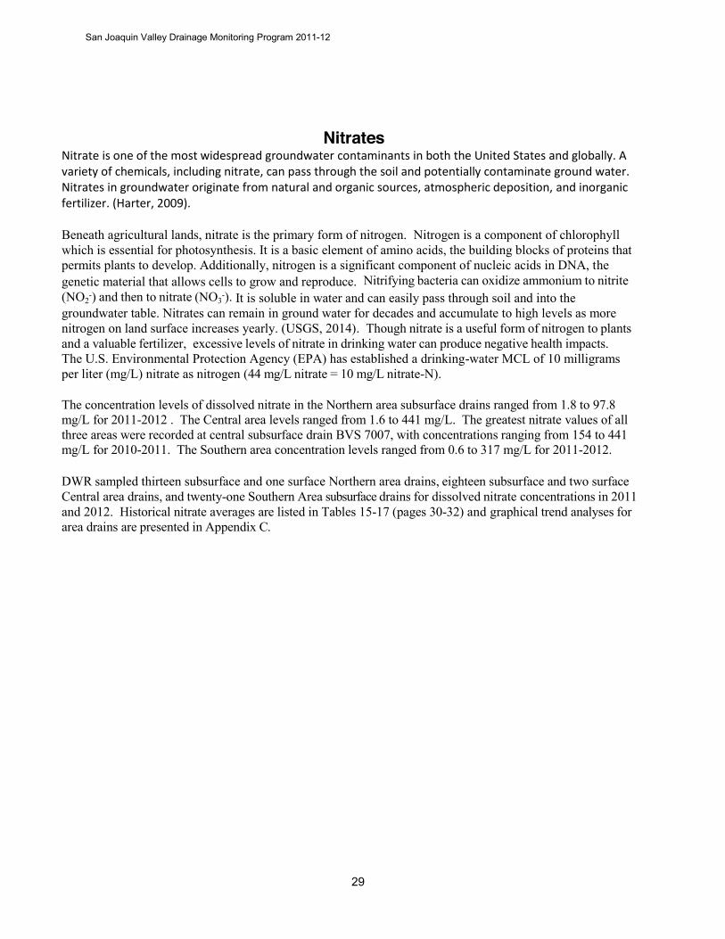
Nitrates Nitrate is one of the most widespread groundwater contaminants in both the United States and globally. A variety of chemicals, including nitrate, can pass through the soil and potentially contaminate ground water. Nitrates in groundwater originate from natural and organic sources, atmospheric deposition, and inorganic fertilizer. (Harter, 2009).
Beneath agricultural lands, nitrate is the primary form of nitrogen. Nitrogen is a component of chlorophyll which is essential for photosynthesis. It is a basic element of amino acids, the building blocks of proteins that permits plants to develop. Additionally, nitrogen is a significant component of nucleic acids in DNA, the genetic material that allows cells to grow and reproduce. Nitrifying bacteria can oxidize ammonium to nitrite (NO2
-) and then to nitrate (NO3-). It is soluble in water and can easily pass through soil and into the
groundwater table. Nitrates can remain in ground water for decades and accumulate to high levels as more nitrogen on land surface increases yearly. (USGS, 2014). Though nitrate is a useful form of nitrogen to plants and a valuable fertilizer, excessive levels of nitrate in drinking water can produce negative health impacts. The U.S. Environmental Protection Agency (EPA) has established a drinking-water MCL of 10 milligrams per liter (mg/L) nitrate as nitrogen (44 mg/L nitrate = 10 mg/L nitrate-N).
The concentration levels of dissolved nitrate in the Northern area subsurface drains ranged from 1.8 to 97.8 mg/L for 2011-2012 . The Central area levels ranged from 1.6 to 441 mg/L. The greatest nitrate values of all three areas were recorded at central subsurface drain BVS 7007, with concentrations ranging from 154 to 441 mg/L for 2010-2011. The Southern area concentration levels ranged from 0.6 to 317 mg/L for 2011-2012.
DWR sampled thirteen subsurface and one surface Northern area drains, eighteen subsurface and two surface Central area drains, and twenty-one Southern Area subsurface drains for dissolved nitrate concentrations in 2011 and 2012. Historical nitrate averages are listed in Tables 15-17 (pages 30-32) and graphical trend analyses for area drains are presented in Appendix C.
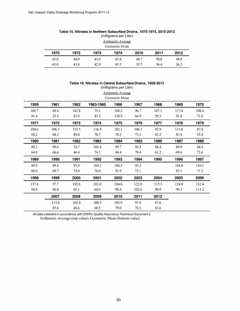
San Joaquin Valley Drainage Monitoring Program 2011-12
Table 15. Nitrates in Northern Subsurface Drains, 1970-1974, 2010-2012 (milligrams per Liter)
Table 16. Nitrates in Central Subsurface Drains, 1959-2012 (milligrams per Liter)
All data collected in accordance with DWR's Quality Assurance Technical Document 2 Arithmetic Average (top value), Geometric Mean (bottom value)
1970 1972 1973 1974 2010 2011 201243.0 44.0 43.0 43.8 48.7 50.0 48.043.0 43.8 42.9 43.5 35.7 36.4 36.2
Arithmetic AverageGeometric Mean
1959 1961 1962 1963-1965 1966 1967 1968 1969 1970168.7 68.6 142.8 73.1 168.2 96.7 107.1 117.4 108.491.4 25.5 83.9 43.5 130.9 64.9 59.5 91.0 71.0
1971 1972 1973 1974 1975 1976 1977 1978 1979104.6 106.1 123.5 116.9 102.1 108.3 92.9 113.0 87.968.2 68.3 89.0 78.7 70.3 73.5 63.2 87.4 55.4
1980 1981 1982 1983 1984 1985 1986 1987 198889.2 89.4 74.7 105.4 89.7 95.5 88.4 89.9 94.464.0 66.6 46.4 74.1 68.4 78.4 61.2 69.6 73.6
1989 1990 1991 1992 1993 1994 1995 1996 199789.9 89.8 93.8 104.2 100.5 95.2 104.0 110.168.6 69.7 74.0 76.0 81.9 72.1 83.1 71.2
1998 1999 2000 2001 2002 2003 2004 2005 2006137.4 97.7 102.8 101.0 104.6 123.8 115.3 124.0 132.484.8 66.0 65.1 64.6 90.4 102.6 90.9 99.3 113.2
2007 2008 2009 2010 2011 2012113.8 102.4 100.5 105.9 97.9 87.685.6 68.6 68.5 79.0 78.2 62.6
Arithmetic AverageGeometric Mean
San Joaquin Valley Drainage Monitoring Program 2011-12
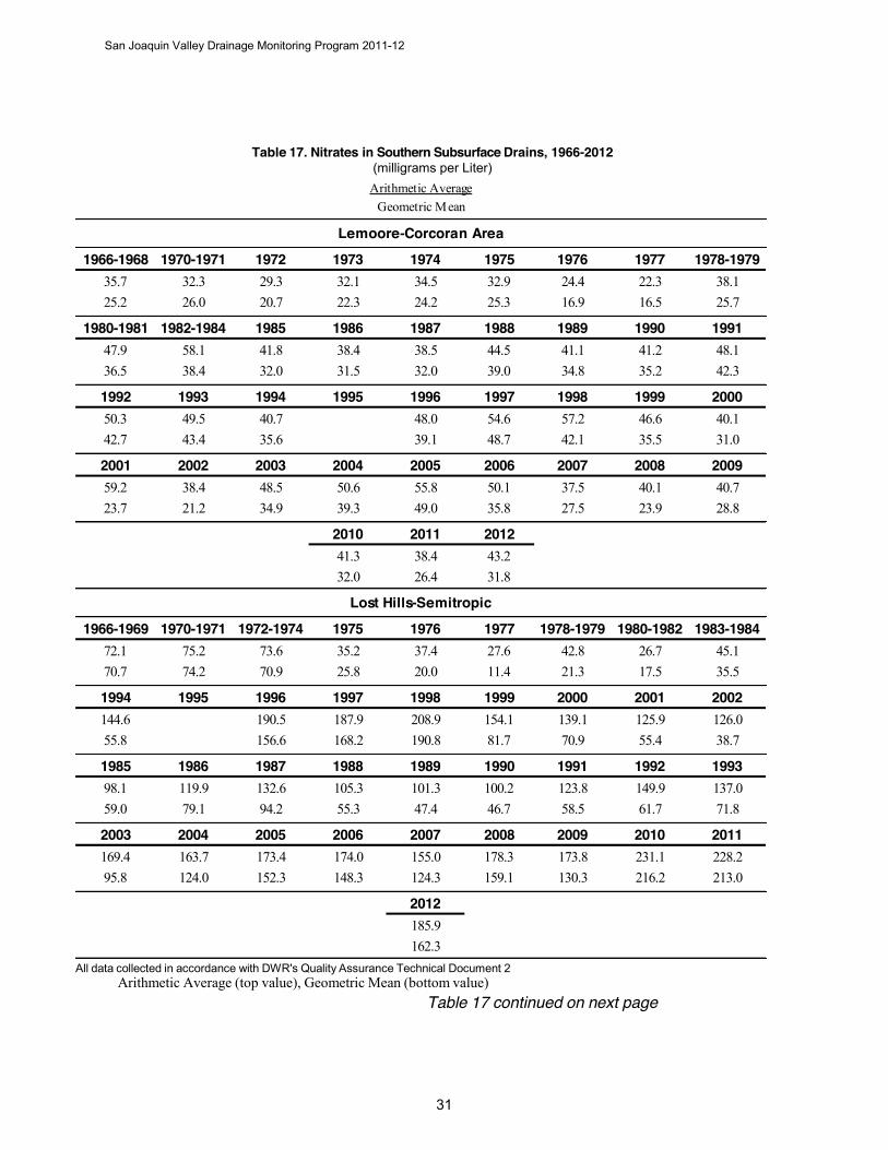
Table 17. Nitrates in Southern Subsurface Drains, 1966-2012 (milligrams per Liter)
All data collected in accordance with DWR's Quality Assurance Technical Document 2 Arithmetic Average (top value), Geometric Mean (bottom value)
Table 17 continued on next page
1966-1968 1970-1971 1972 1973 1974 1975 1976 1977 1978-197935.7 32.3 29.3 32.1 34.5 32.9 24.4 22.3 38.125.2 26.0 20.7 22.3 24.2 25.3 16.9 16.5 25.7
1980-1981 1982-1984 1985 1986 1987 1988 1989 1990 199147.9 58.1 41.8 38.4 38.5 44.5 41.1 41.2 48.136.5 38.4 32.0 31.5 32.0 39.0 34.8 35.2 42.3
1992 1993 1994 1995 1996 1997 1998 1999 200050.3 49.5 40.7 48.0 54.6 57.2 46.6 40.142.7 43.4 35.6 39.1 48.7 42.1 35.5 31.0
2001 2002 2003 2004 2005 2006 2007 2008 200959.2 38.4 48.5 50.6 55.8 50.1 37.5 40.1 40.723.7 21.2 34.9 39.3 49.0 35.8 27.5 23.9 28.8
2010 2011 201241.3 38.4 43.232.0 26.4 31.8
1966-1969 1970-1971 1972-1974 1975 1976 1977 1978-1979 1980-1982 1983-198472.1 75.2 73.6 35.2 37.4 27.6 42.8 26.7 45.170.7 74.2 70.9 25.8 20.0 11.4 21.3 17.5 35.5
1994 1995 1996 1997 1998 1999 2000 2001 2002144.6 190.5 187.9 208.9 154.1 139.1 125.9 126.055.8 156.6 168.2 190.8 81.7 70.9 55.4 38.7
1985 1986 1987 1988 1989 1990 1991 1992 199398.1 119.9 132.6 105.3 101.3 100.2 123.8 149.9 137.059.0 79.1 94.2 55.3 47.4 46.7 58.5 61.7 71.8
2003 2004 2005 2006 2007 2008 2009 2010 2011169.4 163.7 173.4 174.0 155.0 178.3 173.8 231.1 228.295.8 124.0 152.3 148.3 124.3 159.1 130.3 216.2 213.0
2012185.9162.3
Lost Hills-Semitropic
Lemoore-Corcoran Area
Arithmetic AverageGeometric Mean

San Joaquin Valley Drainage Monitoring Program 2011-12
Table 17 (continued). Nitrates in Southern Subsurface Drains, 1966-2012 (milligrams per Liter)
All data collected in accordance with DWR's Quality Assurance Technical Document 2 Arithmetic Average (top value), Geometric Mean (bottom value)
1966-1969 1970-1975 1976-1979 1985 1986 1987 1988 1989 19905.1 9.5 5.9 125.5 198.4 189.2 230.5 186.4 165.04.0 8.2 4.9 104.6 135.6 110.5 162.9 142.4 104.3
1991 1992 1993 1994 1995 1996 1997 1998 1999191.1 198.3 192.2 201.2 260.5 239.8 199.1 215.3143.9 102.0 110.1 99.9 232.7 202.3 152.7 175.6
2000 2001 2002 2003 2004 2005 2006 2007 2008276.5 254.9 166.7 218.3 201.4 210.0 209.7 237.9 215.1268.0 245.2 150.0 202.7 190.3 196.5 196.4 221.2 200.7
2009 2010 2011 2012190.3 188.6 190.8 192.4176.9 176.9 180.2 175.4
Kern Lakebed
Arithmetic AverageGeometric Mean
San Joaquin Valley Drainage Monitoring Program 2011-12
Pesticides Pesticide is a generic term for compounds used as fungicides, herbicides, insecticides, nematocides, acaracides, and rodenticides. In this report, the term “pesticide” also includes transformation products and other agriculturally related organic compounds, such as, pesticide by-products or additives. For example, aldicarb sulfoxide is a degradation product of aldicarb. Pesticides do not occur naturally in the environment. The application of pesticides on agricultural crops and right-of-ways results in the presence of pesticides in drainage water.
DWR began monitoring for pesticides in 1963. Samples were collected from San Joaquin Valley tile drains (8 locations), surface drains (13 locations), surface waters (26 locations), and bay and ocean waters (10 locations). We analyzed the samples for 15 organochlorine pesticides. At the time, DDT and its metabolites (DDE and DDD) were the pesticides detected at the highest frequency. The higher concentrations of pesticides were found in surface drains and surface waters. Over time, the sampling locations, as well as the pesticides, that we analyzed (organophosphorus pesticides were added) had changed. Because pesticide concentrations in agricultural drainage were low or often not detected, DWR stopped monitoring in 1986.
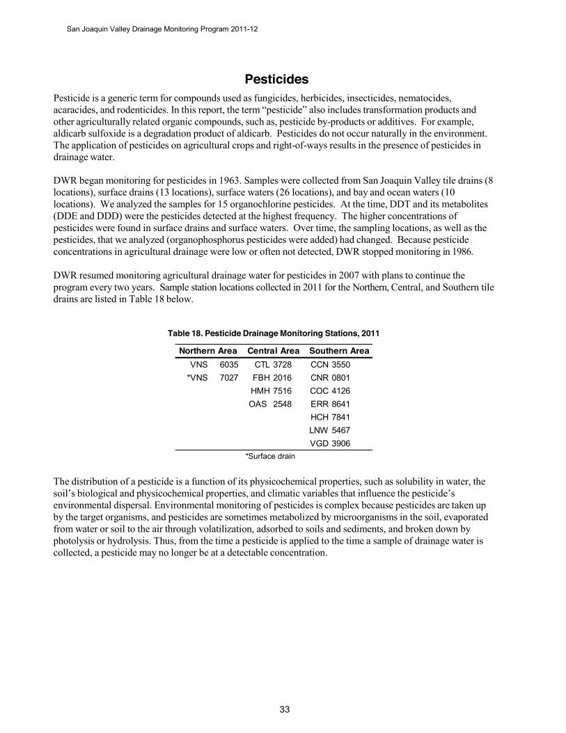
DWR resumed monitoring agricultural drainage water for pesticides in 2007 with plans to continue the program every two years. Sample station locations collected in 2011 for the Northern, Central, and Southern tile drains are listed in Table 18 below.
Table 18. Pesticide Drainage Monitoring Stations, 2011
The distribution of a pesticide is a function of its physicochemical properties, such as solubility in water, the soil’s biological and physicochemical properties, and climatic variables that influence the pesticide’s environmental dispersal. Environmental monitoring of pesticides is complex because pesticides are taken up by the target organisms, and pesticides are sometimes metabolized by microorganisms in the soil, evaporated from water or soil to the air through volatilization, adsorbed to soils and sediments, and broken down by photolysis or hydrolysis. Thus, from the time a pesticide is applied to the time a sample of drainage water is collected, a pesticide may no longer be at a detectable concentration.
VNS 6035 CTL 3728 CCN 3550*VNS 7027 FBH 2016 CNR 0801
HMH 7516 COC 4126 OAS 2548 ERR 8641
HCH 7841 LNW 5467 VGD 3906
* Surface drain
Northern Area Central Area Southern Area
San Joaquin Valley Drainage Monitoring Program 2011-12
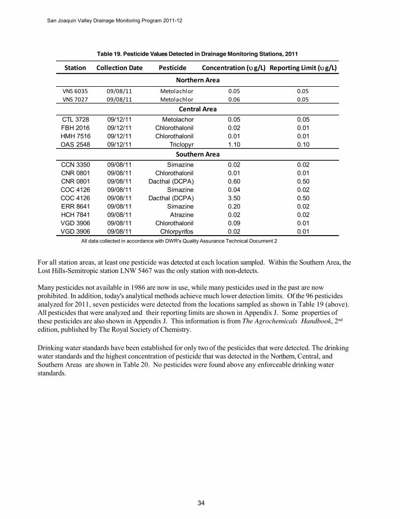
Table 19. Pesticide Values Detected in Drainage Monitoring Stations, 2011
All data collected in accordance with DWR's Quality Assurance Technical Document 2
For all station areas, at least one pesticide was detected at each location sampled. Within the Southern Area, the Lost Hills-Semitropic station LNW 5467 was the only station with non-detects.
Many pesticides not available in 1986 are now in use, while many pesticides used in the past are now prohibited. In addition, today's analytical methods achieve much lower detection limits. Of the 96 pesticides analyzed for 2011, seven pesticides were detected from the locations sampled as shown in Table 19 (above). All pesticides that were analyzed and their reporting limits are shown in Appendix J. Some properties of these pesticides are also shown in Appendix J. This information is from The Agrochemicals Handbook, 2nd
edition, published by The Royal Society of Chemistry.
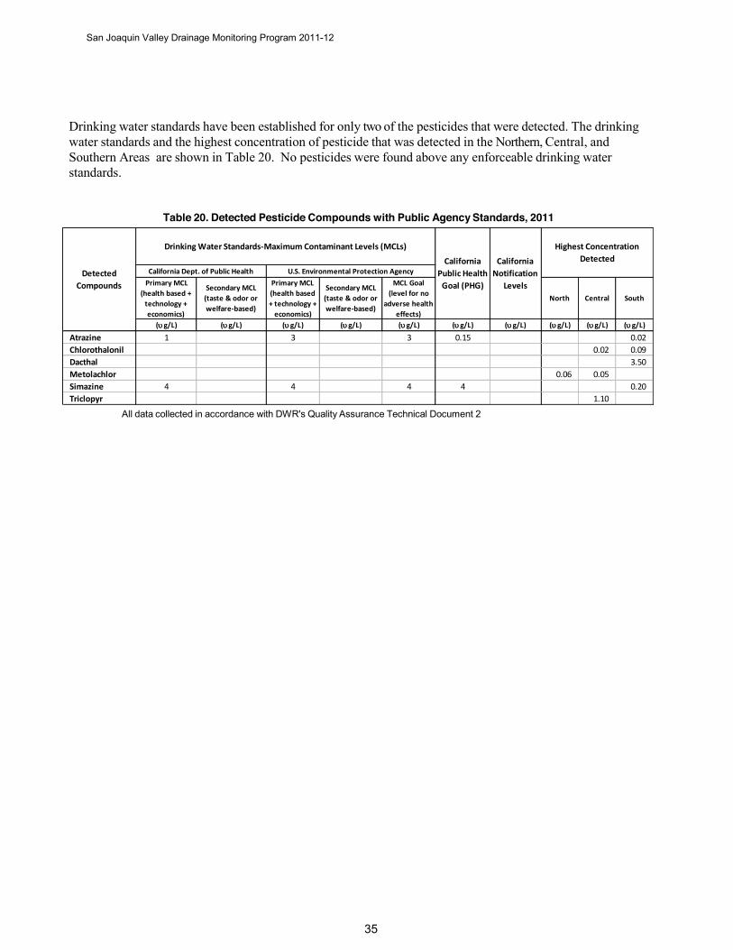
Drinking water standards have been established for only two of the pesticides that were detected. The drinking water standards and the highest concentration of pesticide that was detected in the Northern, Central, and Southern Areas are shown in Table 20. No pesticides were found above any enforceable drinking water standards.
Station Collection Date Pesticide Concentration (ug/L) Reporting Limit (ug/L)
VNS 6035 09/08/11 Metolachlor 0.05 0.05VNS 7027 09/08/11 Metolachlor 0.06 0.05
CTL 3728 09/12/11 Metolachor 0.05 0.05FBH 2016 09/12/11 Chlorothalonil 0.02 0.01HMH 7516 09/12/11 Chlorothalonil 0.01 0.01OAS 2548 09/12/11 Triclopyr 1.10 0.10
CCN 3350 09/08/11 Simazine 0.02 0.02CNR 0801 09/08/11 Chlorothalonil 0.01 0.01CNR 0801 09/08/11 Dacthal (DCPA) 0.60 0.50COC 4126 09/08/11 Simazine 0.04 0.02COC 4126 09/08/11 Dacthal (DCPA) 3.50 0.50ERR 8641 09/08/11 Simazine 0.20 0.02HCH 7841 09/08/11 Atrazine 0.02 0.02VGD 3906 09/08/11 Chlorothalonil 0.09 0.01VGD 3906 09/08/11 Chlorpyrifos 0.02 0.01
Southern Area
Central Area
Northern Area
San Joaquin Valley Drainage Monitoring Program 2011-12
Drinking water standards have been established for only two of the pesticides that were detected. The drinking water standards and the highest concentration of pesticide that was detected in the Northern, Central, and Southern Areas are shown in Table 20. No pesticides were found above any enforceable drinking water standards.
Table 20. Detected Pesticide Compounds with Public Agency Standards, 2011
All data collected in accordance with DWR's Quality Assurance Technical Document 2
Primary MCL (health based +
technology + economics)
Secondary MCL (taste & odor or welfare-based)
Primary MCL (health based + technology +
economics)
Secondary MCL (taste & odor or welfare-based)
MCL Goal (level for no
adverse health effects)
North Central South
(ug/L) (ug/L) (ug/L) (ug/L) (ug/L) (ug/L) (ug/L) (ug/L) (ug/L) (ug/L)
Atrazine 1 3 3 0.15 0.02Chlorothalonil 0.02 0.09Dacthal 3.50Metolachlor 0.06 0.05Simazine 4 4 4 4 0.20Triclopyr 1.10
Detected Compounds
Drinking Water Standards-Maximum Contaminant Levels (MCLs)
California Dept. of Public Health U.S. Environmental Protection AgencyCalifornia
Public Health Goal (PHG)
California Notification
Levels
Highest Concentration Detected
San Joaquin Valley Drainage Monitoring Program 2011-12
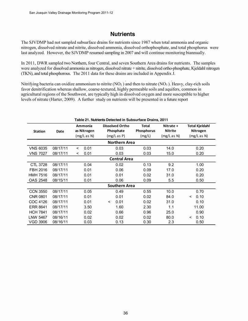
Nutrients The SJVDMP had not sampled subsurface drains for nutrients since 1987 when total ammonia and organic nitrogen, dissolved nitrate and nitrite, dissolved ammonia, dissolved orthophosphate, and total phosphorus were last analyzed. However, the SJVDMP resumed sampling in 2007 and will continue monitoring biannually.
In 2011, DWR sampled two Northern, four Central, and seven Southern Area drains for nutrients. The samples were analyzed for dissolved ammonia as nitrogen, dissolved nitrate + nitrite, dissolved ortho-phosphate, Kjeldahl nitrogen (TKN), and total phosphorous. The 2011 data for these drains are included in Appendix J.
- - Nitrifying bacteria can oxidize ammonium to nitrite (NO2 ) and then to nitrate (NO3 ). Heavy, clay-rich soils favor denitrification whereas shallow, coarse-textured, highly permeable soils and aquifers, common in agricultural regions of the Southwest, are typically high in dissolved oxygen and more susceptible to higher levels of nitrate (Harter, 2009). A further study on nutrients will be presented in a future report
Table 21. Nutrients Detected in Subsurface Drains, 2011 Nitrate +
Nitrite(mg/L as N)
VNS 6035 08/17/11 < 0.01 0.03 0.03 14.0 0.20VNS 7027 08/17/11 < 0.01 0.03 0.03 15.0 0.20
CTL 3728 08/17/11 0.04 0.02 0.13 9.2 1.00FBH 2016 08/17/11 0.01 0.06 0.09 17.0 0.20HMH 7516 08/17/11 0.01 0.01 0.02 31.0 0.20OAS 2548 08/15/11 0.01 0.06 0.09 5.5 0.50
CCN 3550 08/17/11 0.05 0.49 0.55 10.0 0.70CNR 0801 08/17/11 0.01 0.01 0.02 84.0 < 0.10COC 4126 08/17/11 0.01 < 0.01 0.02 31.0 0.10ERR 8641 08/17/11 3.50 1.60 2.30 1.1 11.00HCH 7841 08/17/11 0.02 0.66 0.96 25.0 0.90LNW 5467 08/16/11 0.02 0.02 0.02 80.0 < 0.10VGD 3906 08/16/11 0.03 0.13 0.30 2.3 0.50
(mg/L)as Nitrogen Phosphate Phosphorus Nitrogen
(mg/L as N)
Central Area
Southern Area
Northern Area
Station DateAmmonia Dissolved Ortho Total Total Kjeldahl
(mg/L as N) (mg/L as P)
San Joaquin Valley Drainage Monitoring Program 2011-12
DWR’s Future Monitoring Program
Plans are being formulated to modify and upgrade activities of DWR’s ongoing monitoring program. This work involves cooperation and participation from water and drainage districts and from willing growers. Protocols to collect data from the various districts are being refined so that data can be obtained and evaluated in a timely manner. Plans are being made to solicit regulatory agencies for appropriate drainage data that can be included in future drainage monitoring program reports.
DWR’s Agricultural Drainage web portal is located at http://www.water.ca.gov/drainage. The site presents various information to data, drainage and monitoring, and various projects the Region has participated in. Additional web pages are being developed to present monitoring data at this website.
Drainage monitoring reports, maps, and project reports are currently available at http://www.water.ca.gov/publications/browse.cfm?display=topic&pub=120,6839 . This report will also be posted at this address.
San Joaquin Valley Drainage Monitoring Program 2011-12
Selected References Ayers, R.S. and D.W. Westcot. 1985. Water Quality for Agriculture. Food and Agriculture Organization of the United Nations. Rome, Italy.
Barshad, I. 1948. Molybdenum Content of Pasture Plants in Relation to Toxicity to Cattle. Soil Science. 66:187- 195.
Carrow, R.N. and R.R. Duncan. 1998. Salt-Affected Turfgrass Sites. Ann Arbor Press.
California Department of Water Resources, Division of Planning. 1978. Introduction to Water Quality Course Manual. Sacramento, California.
California Department of Water Resources, Quality Assurance Technical Document 2. 1994. Sampling Manual for Environmental Measurement Projects. Sacramento, California. Field Analyses, Chapter 7.
California Fertilizer Association. 1985. Western Fertilizer Handbook, 7th Edition. Sacramento, California. Table 2-3.
California Regional Water Quality Control Board, Central Valley Region. 1989. The Designated Level Methodology for Waste Classification and Cleanup Level Determination. Sacramento, California.
Carrow, R.N., D.V. Waddington, and P.E. Reike. 2001. Turfgrass Soil Fertility and Chemical Problems: Assessment and Management. Ann Arbor Press. Pages 227-232.
Doorenbos, J. and W.O. Pruitt. 1977. Guidelines for Predicting Crop Water Requirements. Food and Agriculture Organization of the United Nations.
Douglas Hartley and Hamish Kidd, Royal Society of Chemistry. 1987. The Agrochemicals Handbook, 2nd
Edition. Royal Society of Chemistry Information Services, Nottingham, U.K.
FAO Corporate Document Repository. Water Quality for Agriculture. http://www.fao.org/docrep/003/t0234e/T0234E05.htm
Grattan, Stephen R. Irrigation Water Salinity and Crop Production. Publication 8066. University of California, Davis Agriculture and Natural Resources. http://anrcatalog.ucdavis.edu
Harter, Thomas. University of California, Davis. Nitrates in Groundwater, Agricultural Impacts on Groundwater Nitrate. Southwest Hydrology, July/August 2009.
Hem, John D. 1970. Study and Interpretation of the Chemical Characteristics of Natural Water. U.S. Government Printing Office, Washington, DC.
Reddy K.J., L.C. Munn, and L. Wang. 1997. Chemistry and mineralogy of molybdenum in soils. In: Gupta U.C., ed. Molybdenum in Agriculture. Cambridge: Cambridge University Press
San Joaquin Valley Interagency Drainage Program. 1979. Agricultural Drainage and Salt Management in the San Joaquin Valley, Final Report. Fresno, California.
San Joaquin Valley Drainage Monitoring Program 2011-12
San Joaquin Valley Drainage Program. 1990. A Management Plan for Agricultural Subsurface Drainage and Related Problems on the Westside San Joaquin Valley. Sacramento, California. Addison-Wesley Publishing, Canada.
Tchobanoglous, George and Edward D. Schroeder, University of California at Davis. 1985. Water Quality- Characteristics-Modeling-Modification. Addison-Wesley Publishing, Canada.
The Agrochemicals Handbook, 2nd edition. Royal Society of Chemistry.
The Challenges of Arsenic in Agriculture & the Environment. Arsenic in Water, Agriculture, and the Environment. http://arsenic.tamu.edu/about/course/mod1/notes/p1.htm
University of California, SJVDIP. January 2000. Final Report-Evaluation of the 1990 Drainage Management Plan for the Westside San Joaquin Valley, California. Prepared by SJVDIP and the University of California Ad Hoc Coordination Committee
U.S. Bureau of Reclamation, et al. 1991. A Strategy for Implementation of the Management Plan for Agricultural Subsurface Drainage and Related Problems on the Westside San Joaquin Valley. A joint effort by the U.S. Bureau of Reclamation, Fish and Wildlife Service, Soil Conservation Service, and Geological Survey; and the California Department of Water Resources, Department of Fish and Game, Department of Food and Agriculture, and State Water Resources Control Board.
U.S. Environmental Protection Agency. September 2004. Guidelines for Water Reuse, EPA/625/R-04/108; Table 2-7, page 25.
U.S. Environmental Protection Agency. Arsenic in Drinking Water, Basic Information. http://www.epa.gov
U.S. Geological Survey. 1993. Water-Quality Data for Shallow Wells in the Western and Southern Tulare Basin, San Joaquin Valley, California, May to August 1989. Open-file Report 92-655. Sacramento, California.
Utah State University Foundation. 1969. Characteristics and Pollution Problems of Irrigation Return Flow. Robert S. Kerr Water Research Center, Ada, Oklahoma.
San Joaquin Valley Drainage Monitoring Program 2011-12
Appendix A Depth to Water Acreage Trends of
Drainage Impaired Lands 1991-2012
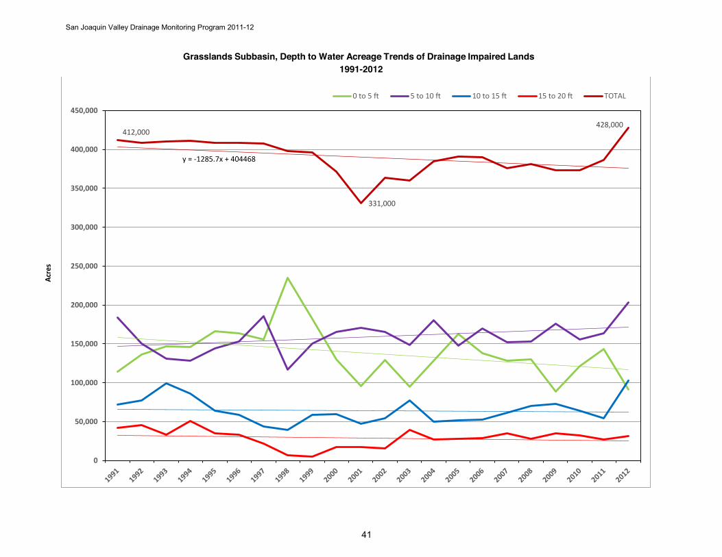
San Joaquin Valley Drainage Monitoring Program 2011-12
Grasslands Subbasin, Depth to Water Acreage Trends of Drainage Impaired Lands 1991-2012
412,000
331,000
428,000
y = -1285.7x + 404468
0
50,000
100,000
150,000
200,000
250,000
300,000
350,000
400,000
450,000
0 to 5 ft 5 to 10 ft 10 to 15 ft 15 to 20 ft TOTAL
Acre
s
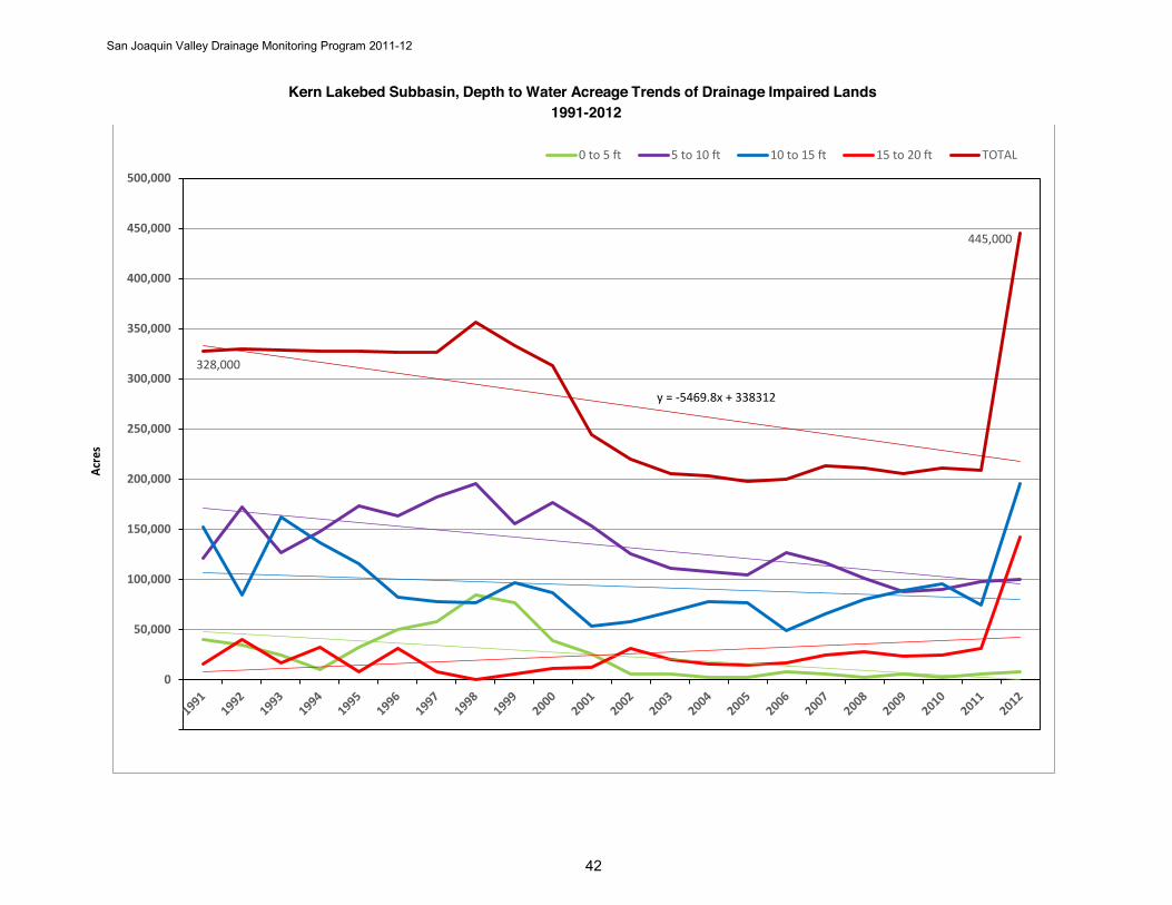
San Joaquin Valley Drainage Monitoring Program 2011-12
Kern Lakebed Subbasin, Depth to Water Acreage Trends of Drainage Impaired Lands 1991-2012
328,000
445,000
y = -5469.8x + 338312
0
50,000
100,000
150,000
200,000
250,000
300,000
350,000
400,000
450,000
500,000
0 to 5 ft 5 to 10 ft 10 to 15 ft 15 to 20 ft TOTAL
Acre
s
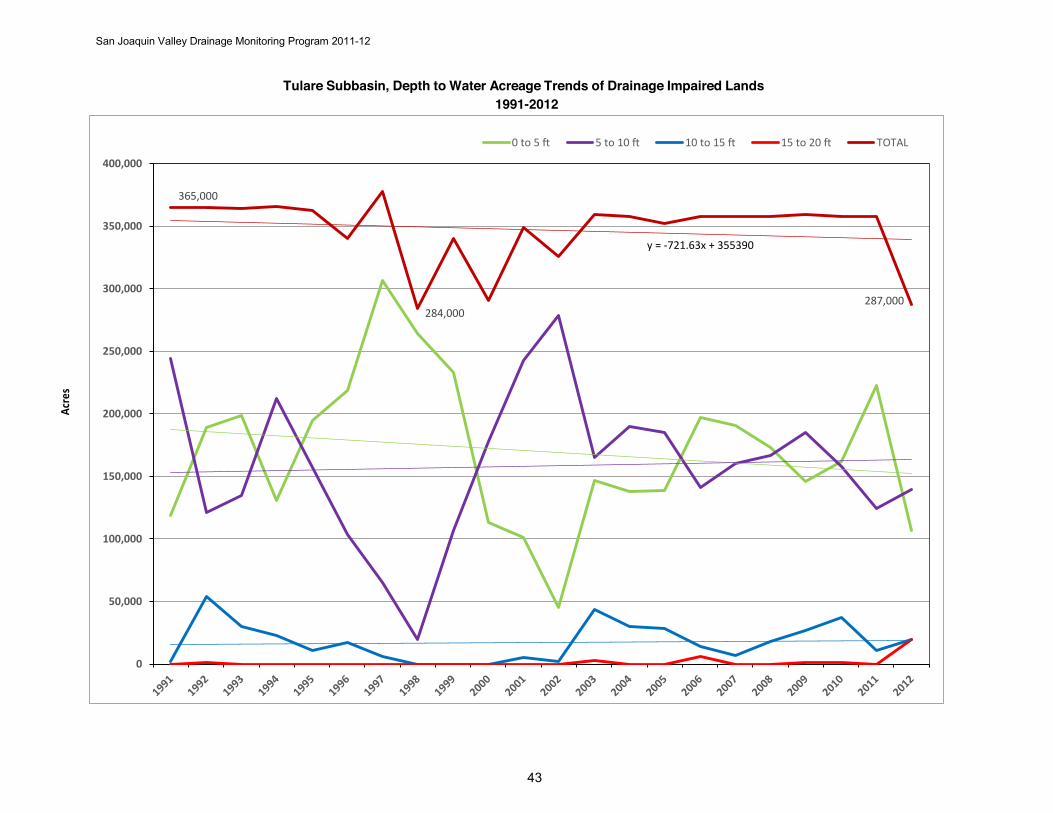
San Joaquin Valley Drainage Monitoring Program 2011-12
Tulare Subbasin, Depth to Water Acreage Trends of Drainage Impaired Lands 1991-2012
365,000
284,000287,000
y = -721.63x + 355390
0
50,000
100,000
150,000
200,000
250,000
300,000
350,000
400,000
0 to 5 ft 5 to 10 ft 10 to 15 ft 15 to 20 ft TOTAL
Acre
s
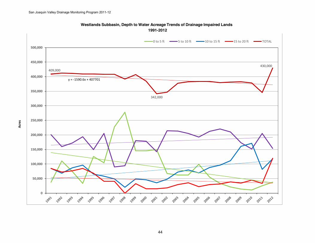
San Joaquin Valley Drainage Monitoring Program 2011-12
Westlands Subbasin, Depth to Water Acreage Trends of Drainage Impaired Lands 1991-2012
409,000
342,000
430,000
y = -1590.6x + 407701
0
50,000
100,000
150,000
200,000
250,000
300,000
350,000
400,000
450,000
500,000
0 to 5 ft 5 to 10 ft 10 to 15 ft 15 to 20 ft TOTAL
Acre
s
San Joaquin Valley Drainage Monitoring Program 2011-12
Appendix B Selenium Trends in Central & Southern
Tile Drains through 2012
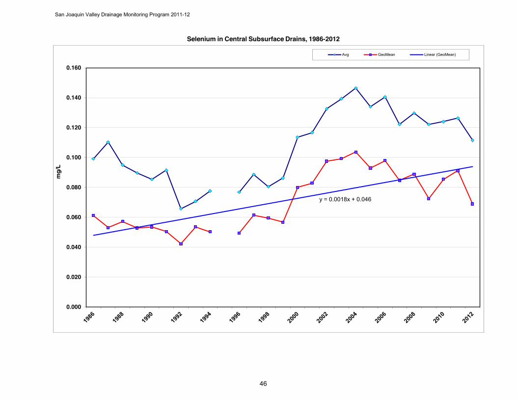
San Joaquin Valley Drainage Monitoring Program 2011-12
Selenium in Central Subsurface Drains, 1986-2012
y = 0.0018x + 0.046
0.000
0.020
0.040
0.060
0.080
0.100
0.120
0.140
0.160m
g/L
Avg GeoMean Linear (GeoMean)
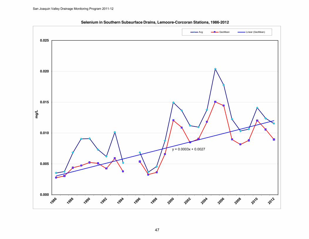
San Joaquin Valley Drainage Monitoring Program 2011-12
Selenium in Southern Subsurface Drains, Lemoore-Corcoran Stations, 1986-2012
y = 0.0003x + 0.0027
0.000
0.005
0.010
0.015
0.020
0.025m
g/L
Avg GeoMean Linear (GeoMean)

San Joaquin Valley Drainage Monitoring Program 2011-12
Selenium in Southern Subsurface Drains, Lost Hills-Semitropic Stations, 1986-2012
y = 0.0042x + 0.012
0.000
0.050
0.100
0.150
0.200
0.250
0.300m
g/L
Avg GeoMean Linear (GeoMean)
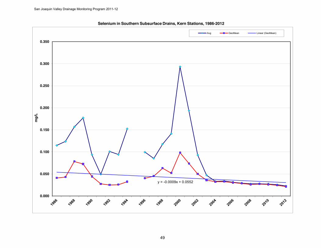
San Joaquin Valley Drainage Monitoring Program 2011-12
Selenium in Southern Subsurface Drains, Kern Stations, 1986-2012
y = -0.0009x + 0.0552
0.000
0.050
0.100
0.150
0.200
0.250
0.300
0.350m
g/L
Avg GeoMean Linear (GeoMean)
San Joaquin Valley Drainage Monitoring Program 2011-12
Appendix C Nitrate Trends in Northern, Central, & Southern
Tile Drains through 2012
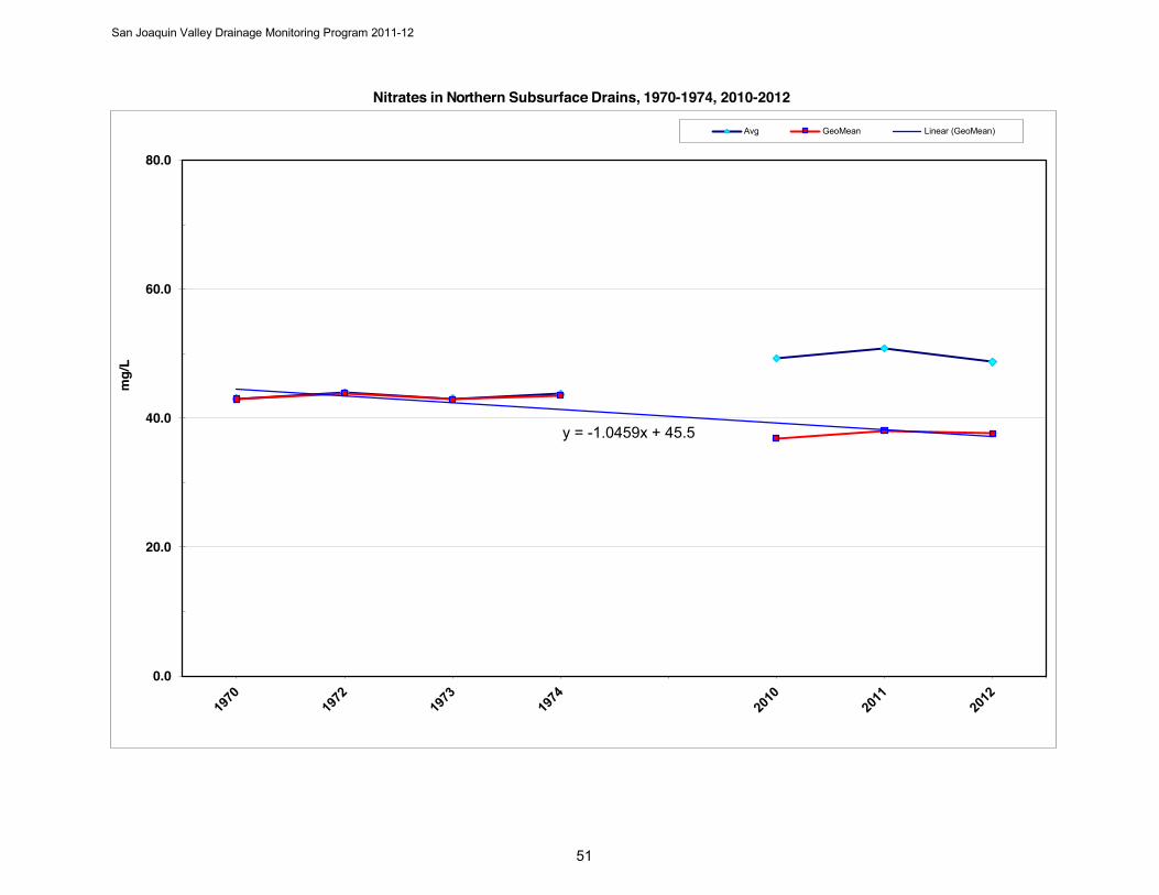
San Joaquin Valley Drainage Monitoring Program 2011-12
Nitrates in Northern Subsurface Drains, 1970-1974, 2010-2012
y = -1.0459x + 45.5
0.0
20.0
40.0
60.0
80.0
mg/
LAvg GeoMean Linear (GeoMean)
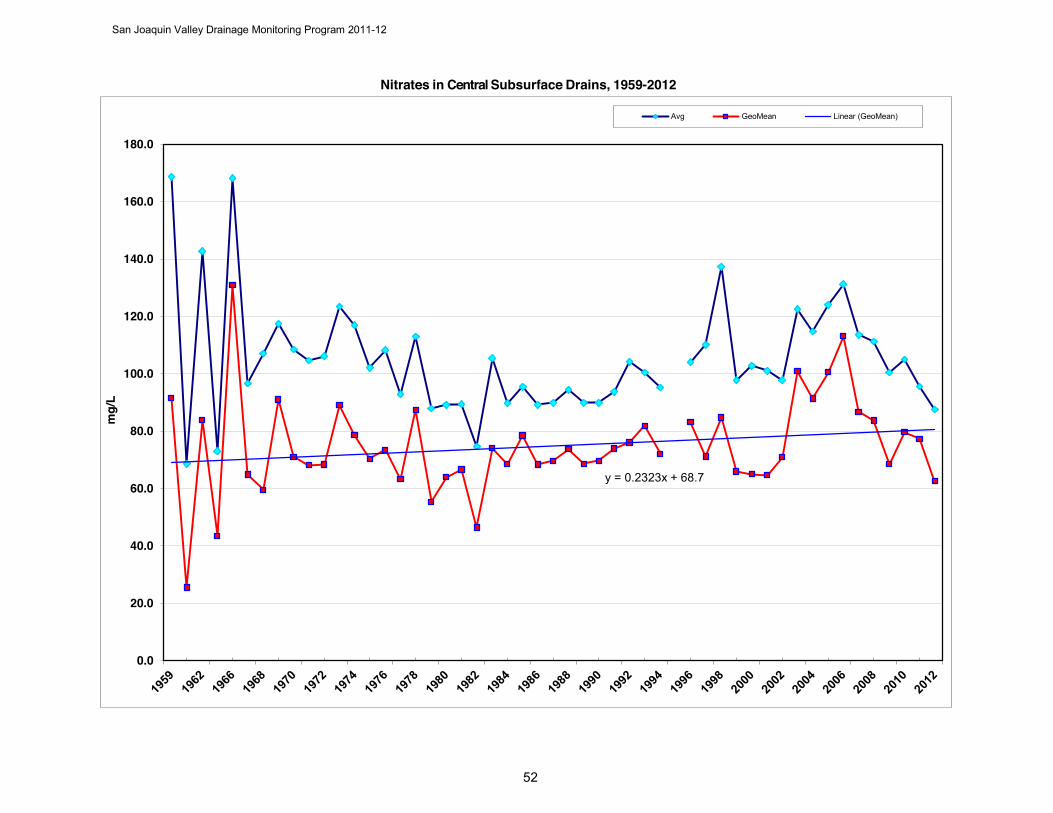
San Joaquin Valley Drainage Monitoring Program 2011-12
Nitrates in Central Subsurface Drains, 1959-2012
y = 0.2323x + 68.7
0.0
20.0
40.0
60.0
80.0
100.0
120.0
140.0
160.0
180.0
mg/
LAvg GeoMean Linear (GeoMean)
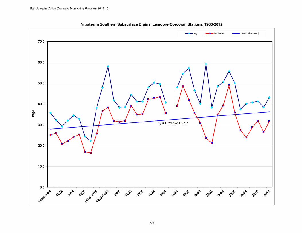
San Joaquin Valley Drainage Monitoring Program 2011-12
Nitrates in Southern Subsurface Drains, Lemoore-Corcoran Stations, 1966-2012
y = 0.2176x + 27.7
0.0
10.0
20.0
30.0
40.0
50.0
60.0
70.0
mg/
LAvg GeoMean Linear (GeoMean)
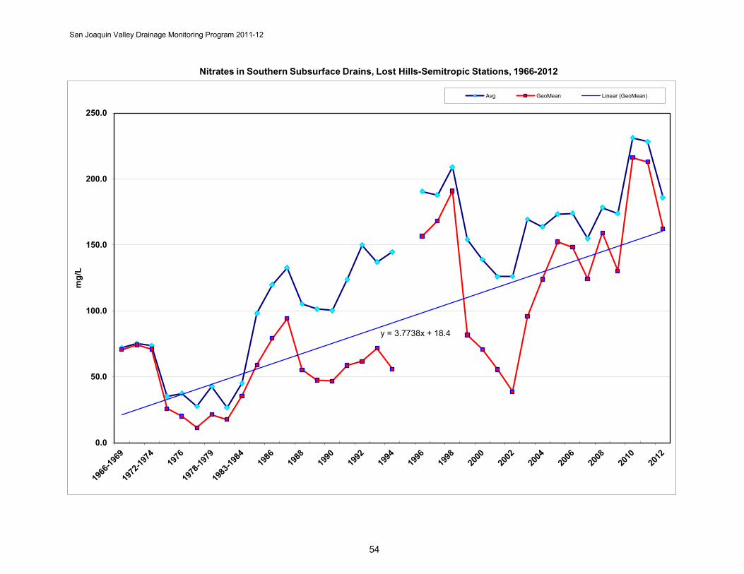
San Joaquin Valley Drainage Monitoring Program 2011-12
Nitrates in Southern Subsurface Drains, Lost Hills-Semitropic Stations, 1966-2012
y = 3.7738x + 18.4
0.0
50.0
100.0
150.0
200.0
250.0
mg/
L
Avg GeoMean Linear (GeoMean)
54
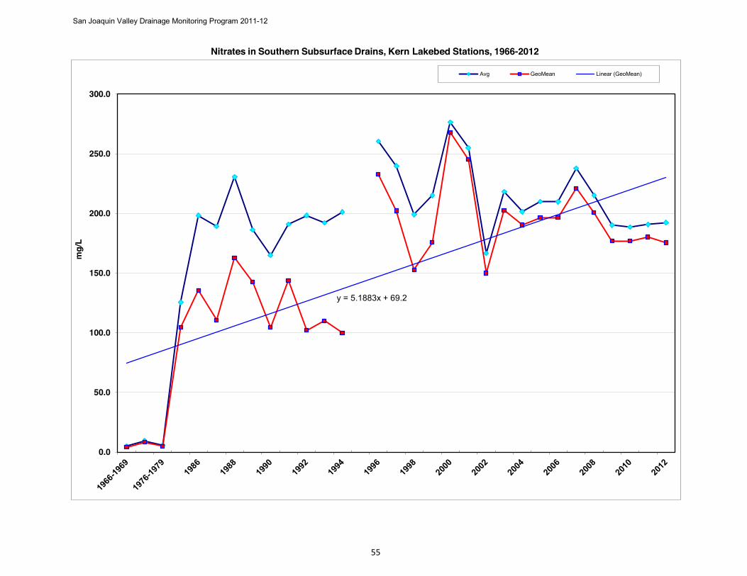
San Joaquin Valley Drainage Monitoring Program 2011-12
55
Nitrates in Southern Subsurface Drains, Kern Lakebed Stations, 1966-2012
y = 5.1883x + 69.2
0.0
50.0
100.0
150.0
200.0
250.0
300.0
mg/
LAvg GeoMean Linear (GeoMean)

San Joaquin Valley Drainage Monitoring Program 2011-12
56
Appendix D Mineral Analyses of Northern Area Drains
2011-2012
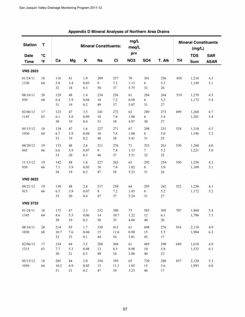
Station
DateTime
T
Ca Mg Na NO3
Mineral Constituents:mg/L
meq/L
°C °F Cl SO4 T. Alk
prv
K
Mineral Constituents(mg/L)
TDSSumTH
SARASAR
Appendix D Mineral Analyses of Northern Area Drains
VNS 2923
116 415.8 9 1.1364 3.4
209 7001/24/111330
18 2577.2 6
32 18 505.1
370.051.9
0.3
4.34581,149 5.1
5.75 32 26
301 256 1,210
129 486.4 10 0.9868 3.9
234 6108/16/11930
20 2567.2 6
31 19 495.2
370.041.4
0.2
4.55191,172 5.4
5.07 31 27
284 264 1,270
123 476.1 10 1.0063 3.8
241 6202/06/121145
17 2727.6 6
30 19 515.4
380.093.5
0.4
4.74991,201 5.4
4.97 30 27
289 273 1,260
134 476.7 10 1.0864 3.9
227 6705/15/121030
18 2717.6 6
33 19 485.0
380.041.6
0.2
4.35281,196 5.2
5.41 31 25
298 251 1,310
133 486.6 9 1.1566 3.9
211 7108/20/12845
19 2767.8 7
33 20 465.2
370.072.6
0.3
4.05301,221 5.0
5.51 32 25
323 261 1,260
142 487.1 10 1.0266 3.9
227 6311/13/12930
19 2637.4 6
34 19 475.0
380.051.8
0.2
4.25501,189 5.1
5.23 31 26
292 254 1,250
VNS 3622
130 486.5 9 1.0366 3.9
217 6408/21/12915
19 2587.2 6
33 20 475.2
370.072.8
0.4
4.15221,172 5.2
5.24 31 27
295 262 1,250
VNS 3733
173 678.6 14 1.2264 5.5
332 7501/24/111345
18 38010.7 12
30 19 506.1
350.062.3
0.2
5.47071,796 7.1
4.04 40 20
583 305 1,860
214 9310.7 15 0.9868 7.6
338 6108/16/111030
20 41311.6 15
32 23 445.5
360.041.7
0.1
4.99161,984 6.3
3.01 45 17
698 276 2,110
154 647.7 13 0.9863 5.3
288 6102/06/121215
17 3048.5 10
30 21 495.8
340.083.2
0.3
4.96491,533 6.1
3.88 40 23
485 290 1,610
205 8410.2 15 1.0564 6.9
354 6505/15/121050
18 39511.1 15
31 21 475.6
340.052.0
0.2
5.38571,993 6.8
3.23 46 17
720 280 2,120
San Joaquin Valley Drainage Monitoring Program 2011-12
5

Station
DateTime
T
Ca Mg Na NO3
Mineral Constituents:mg/L
meq/L
°C °F Cl SO4 T. Alk
prv
K
Mineral Constituents(mg/L)
TDSSumTH
SARASAR
Appendix D Mineral Analyses of Northern Area Drains
215 9210.7 13 0.9868 7.6
309 6108/20/12945
20 44712.6 14
34 24 426.0
370.083.2
0.3
4.49161,989 5.8
2.90 42 18
682 300 2,010
146 567.3 11 0.7061 4.6
247 4411/13/12950
16 2727.6 8
32 20 474.9
360.083.1
0.4
4.45941,310 5.1
3.27 38 23
393 249 1,380
VNS 3848
37 201.8 3 0.0873 1.6
77 508/20/121145
23 982.8 2
27 24 482.3
400.104.0
1.5
2.5175399 2.2
1.18 26 33
88 116 431
VNS 4734
233 9411.6 19 0.9063 7.7
448 5601/24/111149
17 45412.8 20
30 20 505.3
320.083.0
0.2
6.39692,423 8.1
2.28 52 13
975 267 2,560
232 10211.6 18 0.8068 8.4
404 5008/16/111115
20 42912.1 18
31 22 475.2
340.062.3
0.2
5.61,0002,221 7.2
2.25 49 15
844 264 2,330
226 9111.3 16 0.8661 7.5
371 5402/06/121235
16 38810.9 18
32 21 465.3
310.093.6
0.3
5.39412,141 6.8
2.49 51 15
847 268 2,230
210 8510.5 15 0.8464 7.0
346 5205/15/121112
18 3509.8 17
32 21 464.7
300.062.3
0.2
5.18732,008 6.4
2.60 53 15
820 238 2,120
251 10612.5 17 0.8466 8.7
391 5208/20/121015
19 55315.5 18
33 23 445.1
390.114.2
0.3
5.21,0632,390 7.0
2.10 46 13
878 259 2,450
237 10111.8 17 0.9066 8.3
393 5611/13/121010
19 42912.1 18
32 22 465.2
330.062.4
0.2
5.41,0082,257 7.3
2.47 50 14
881 263 2,370
VNS 4931
166 698.3 14 1.0763 5.7
318 6701/24/111136
17 38510.8 11
30 20 505.7
380.062.3
0.2
5.26991,714 6.5
3.74 39 20
535 286 1,810
189 799.4 14 0.9068 6.5
324 5608/16/111215
20 37410.5 12
31 22 475.2
360.051.8
0.2
5.07971,778 6.5
3.12 43 18
598 260 1,900
San Joaquin Valley Drainage Monitoring Program 2011-12
58
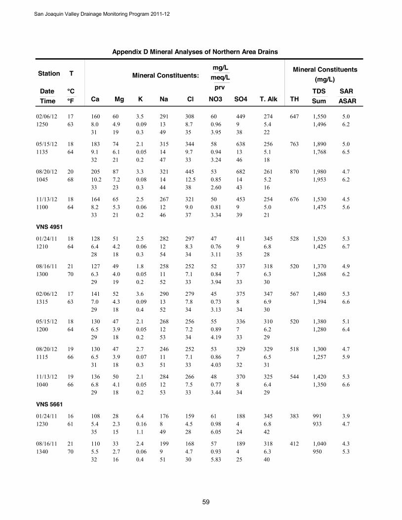
Station
DateTime
T
Ca Mg Na NO3
Mineral Constituents:mg/L
meq/L
°C °F Cl SO4 T. Alk
prv
K
Mineral Constituents(mg/L)
TDSSumTH
SARASAR
Appendix D Mineral Analyses of Northern Area Drains
160 608.0 13 0.9663 4.9
291 6002/06/121250
17 3088.7 9
31 19 495.4
350.093.5
0.3
5.06471,496 6.2
3.95 38 22
449 274 1,550
183 749.1 14 0.9464 6.1
315 5805/15/121135
18 3449.7 13
32 21 475.1
330.052.1
0.2
5.07631,768 6.5
3.24 46 18
638 256 1,890
205 8710.2 14 0.8568 7.2
321 5308/20/121045
20 44512.5 14
33 23 445.2
380.083.3
0.3
4.78701,953 6.2
2.60 43 16
682 261 1,980
164 658.2 12 0.8164 5.3
267 5011/13/121100
18 3219.0 9
33 21 465.0
370.062.5
0.2
4.56761,475 5.6
3.34 39 21
453 254 1,530
VNS 4951
128 516.4 12 0.7664 4.2
282 4701/24/111210
18 2978.3 9
28 18 546.8
340.062.5
0.3
5.35281,425 6.7
3.11 35 28
411 345 1,520
127 496.3 11 0.8470 4.0
258 5208/16/111300
21 2527.1 7
29 19 526.3
330.051.8
0.2
4.95201,268 6.2
3.94 33 30
337 318 1,370
141 527.0 13 0.7363 4.3
290 4502/06/121315
17 2797.8 8
29 18 526.9
340.093.6
0.4
5.35671,394 6.6
3.13 34 30
375 347 1,480
130 476.5 12 0.8964 3.9
268 5505/15/121200
18 2567.2 7
29 18 536.2
340.052.1
0.2
5.15201,280 6.4
4.19 33 29
336 310 1,380
130 476.5 11 0.8666 3.9
246 5308/20/121115
19 2527.1 7
31 18 516.5
330.072.7
0.3
4.75181,257 5.9
4.03 32 31
329 329 1,300
136 506.8 12 0.7766 4.1
284 4811/13/121040
19 2667.5 8
29 18 536.4
330.052.1
0.2
5.35441,350 6.6
3.44 34 29
370 325 1,420
VNS 5661
108 285.4 8 0.9861 2.3
176 6101/24/111230
16 1594.5 4
35 15 496.8
280.166.4
1.1
3.9383933 4.7
6.05 24 42
188 345 991
110 335.5 9 0.9370 2.7
199 5708/16/111340
21 1684.7 4
32 16 516.3
300.062.4
0.4
4.3412950 5.3
5.83 25 40
189 318 1,040
San Joaquin Valley Drainage Monitoring Program 2011-12
59

Station
DateTime
T
Ca Mg Na NO3
Mineral Constituents:mg/L
meq/L
°C °F Cl SO4 T. Alk
prv
K
Mineral Constituents(mg/L)
TDSSumTH
SARASAR
Appendix D Mineral Analyses of Northern Area Drains
142 647.1 11 0.9861 5.3
242 6102/07/121140
16 2807.9 6
31 23 466.7
360.104.0
0.4
4.26191,292 5.3
4.50 28 31
296 339 1,380
111 315.5 8 0.9268 2.5
189 5705/15/121220
20 1734.9 4
34 16 506.1
310.072.7
0.4
4.1404938 5.1
5.79 25 38
191 306 1,010
104 335.2 8 0.9168 2.7
179 5608/21/12800
20 1624.6 4
33 17 496.4
290.083.2
0.5
3.9396925 4.7
5.71 26 40
195 321 956
135 426.7 9 1.5866 3.5
198 9811/13/121130
19 1945.4 4
36 18 456.2
310.103.9
0.5
3.85121,064 5.0
9.01 24 35
205 313 1,135
VNS 5951
111 485.5 11 1.2264 3.9
248 7608/21/12730
18 2416.8 5
27 19 536.3
340.072.9
0.4
5.04751,175 5.9
6.20 27 32
259 316 1,250
VNS 6035
137 566.8 13 0.8663 4.6
294 5301/24/111119
17 3188.9 9
28 19 536.5
350.062.4
0.2
5.45721,507 6.7
3.35 37 25
450 327 1,600
129 546.4 12 0.9366 4.4
272 5808/17/11800
19 2466.9 7
28 20 526.3
320.051.8
0.2
5.15431,295 6.3
4.35 34 30
344 318 1,420
143 537.1 13 0.7961 4.4
294 4902/07/121100
16 2837.9 8
29 18 526.8
340.083.0
0.3
5.35761,410 6.7
3.38 34 29
378 345 1,490
135 526.7 12 1.0368 4.3
283 6405/16/121100
20 2607.3 8
29 18 536.2
320.062.2
0.2
5.25511,381 6.6
4.52 36 27
397 313 1,480
137 556.8 11 0.9466 4.5
258 5808/21/12915
19 2677.5 8
30 20 506.4
320.072.9
0.3
4.75691,375 5.9
4.05 36 28
403 323 1,400
151 637.5 12 0.8064 5.2
279 4911/13/121230
18 2928.2 9
30 21 495.4
350.062.4
0.2
4.86361,419 6.0
3.44 38 23
420 271 1,480
San Joaquin Valley Drainage Monitoring Program 2011-12
600

Station
DateTime
T
Ca Mg Na NO3
Mineral Constituents:mg/L
meq/L
°C °F Cl SO4 T. Alk
prv
K
Mineral Constituents(mg/L)
TDSSumTH
SARASAR
Appendix D Mineral Analyses of Northern Area Drains
VNS 6927
20 91.0 2 0.0968 0.7
37 508/17/111030
20 391.1 1
30 22 481.1
330.041.4
1.1
1.789192 0.9
2.66 29 35
46 57 203
38 221.9 4 0.1154 1.8
99 702/06/121025
12 1083.0 2
23 22 542.1
400.083.0
1.0
3.2183448 2.7
1.52 30 28
108 107 466
18 90.9 2 0.0768 0.7
36 405/16/121130
20 401.1 1
28 23 481.0
350.041.4
1.1
1.781186 1.0
2.08 30 32
46 52 206
37 191.8 3 0.1373 1.6
70 808/21/12940
23 902.5 2
28 24 472.2
390.072.8
1.1
2.3171374 2.0
2.00 26 33
81 110 392
41 212.0 4 0.1455 1.8
98 911/14/121100
13 1103.1 2
25 22 522.4
400.072.9
0.9
3.1190451 2.5
1.84 26 31
97 120 466
VNS 6961
121 556.0 10 0.9663 4.5
227 6001/24/111246
17 2868.0 6
29 22 486.7
370.093.6
0.5
4.35291,244 5.4
4.44 28 31
290 336 1,350
133 596.6 10 0.9372 4.9
236 5808/16/111410
22 2697.6 6
30 22 476.6
360.072.6
0.3
4.35761,230 5.4
4.49 27 32
273 333 1,340
109 345.4 9 1.0363 2.8
197 6402/07/121130
17 1744.9 4
32 16 516.3
300.103.9
0.6
4.2410969 5.3
6.34 25 38
198 316 1,040
135 516.7 10 0.9264 4.2
232 5705/16/121100
18 2497.0 6
32 20 486.5
350.072.9
0.4
4.35461,193 5.4
4.60 28 32
270 326 1,270
140 607.0 10 1.0066 4.9
226 6208/21/12830
19 2908.1 7
32 23 456.3
370.093.4
0.4
4.05971,285 5.0
4.53 30 29
313 318 1,330
145 677.2 10 0.9966 5.5
238 6211/13/121200
19 2707.6 6
31 24 456.6
360.093.4
0.4
4.16361,280 5.3
4.65 29 31
296 332 1,360
San Joaquin Valley Drainage Monitoring Program 2011-12
61
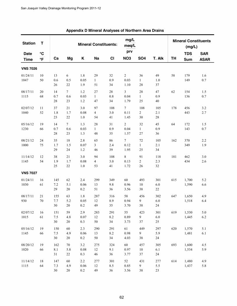
Station
DateTime
T
Ca Mg Na NO3
Mineral Constituents:mg/L
meq/L
°C °F Cl SO4 T. Alk
prv
K
Mineral Constituents(mg/L)
TDSSumTH
SARASAR
Appendix D Mineral Analyses of Northern Area Drains
VNS 7026
13 60.6 1 0.0350 0.5
29 201/24/111047
10 320.9 1
26 22 511.0
340.051.8
1.9
1.658149 0.7
1.10 28 37
36 49 179
14 70.7 1 0.0468 0.6
27 308/17/111115
20 280.8 1
28 23 470.9
340.031.2
1.2
1.562136 0.7
1.79 25 40
28 47 154
37 211.8 4 0.1152 1.7
97 702/07/121040
11 1083.0 2
23 22 542.1
410.083.0
1.0
3.2178443 2.7
1.45 30 28
108 105 456
14 70.7 1 0.0466 0.6
28 205/16/121230
19 310.9 1
28 23 480.9
350.031.3
1.3
1.564143 0.7
1.57 27 36
32 45 172
35 181.7 3 0.1275 1.5
65 708/21/121000
24 862.4 1
29 24 462.1
390.072.8
1.2
2.2162349 1.9
1.95 25 34
72 105 370
38 211.9 4 0.1354 1.7
94 811/14/121145
12 1083.0 2
25 22 532.3
410.083.0
1.0
3.0181434 2.6
1.72 26 32
91 118 462
VNS 7027
145 627.2 13 0.9661 5.1
299 6001/24/111030
16 3499.8 10
29 20 516.0
360.062.4
0.2
5.26151,590 6.6
3.56 38 22
493 301 1,700
155 637.7 12 0.9470 5.2
287 5808/17/11930
21 3168.9 9
30 20 496.0
350.051.8
0.2
4.96471,518 6.4
3.70 38 24
456 302 1,650
151 597.5 12 0.8961 4.8
283 5502/07/121015
16 2918.2 9
30 20 506.0
340.072.9
0.3
5.06191,445 6.2
3.73 37 25
423 301 1,530
150 607.5 13 0.9866 4.9
290 6105/16/121145
19 2918.2 9
30 20 505.9
340.062.3
0.2
5.16201,481 6.1
4.03 38 24
449 297 1,570
162 708.1 12 0.9766 5.8
275 6008/20/121020
19 3249.1 10
31 22 466.1
360.083.2
0.3
4.56931,534 5.9
3.77 37 24
457 305 1,600
147 607.3 12 0.8564 4.9
277 5211/14/121115
18 3018.5 9
30 20 495.5
360.062.2
0.2
4.96141,437 5.8
3.56 38 23
431 277 1,480
San Joaquin Valley Drainage Monitoring Program 2011-12
62
San Joaquin Valley Drainage Monitoring Program 2011-12
63
Appendix E Electrical Conductivity, pH, & Trace Elements in
Northern Area Drains 2011-2012
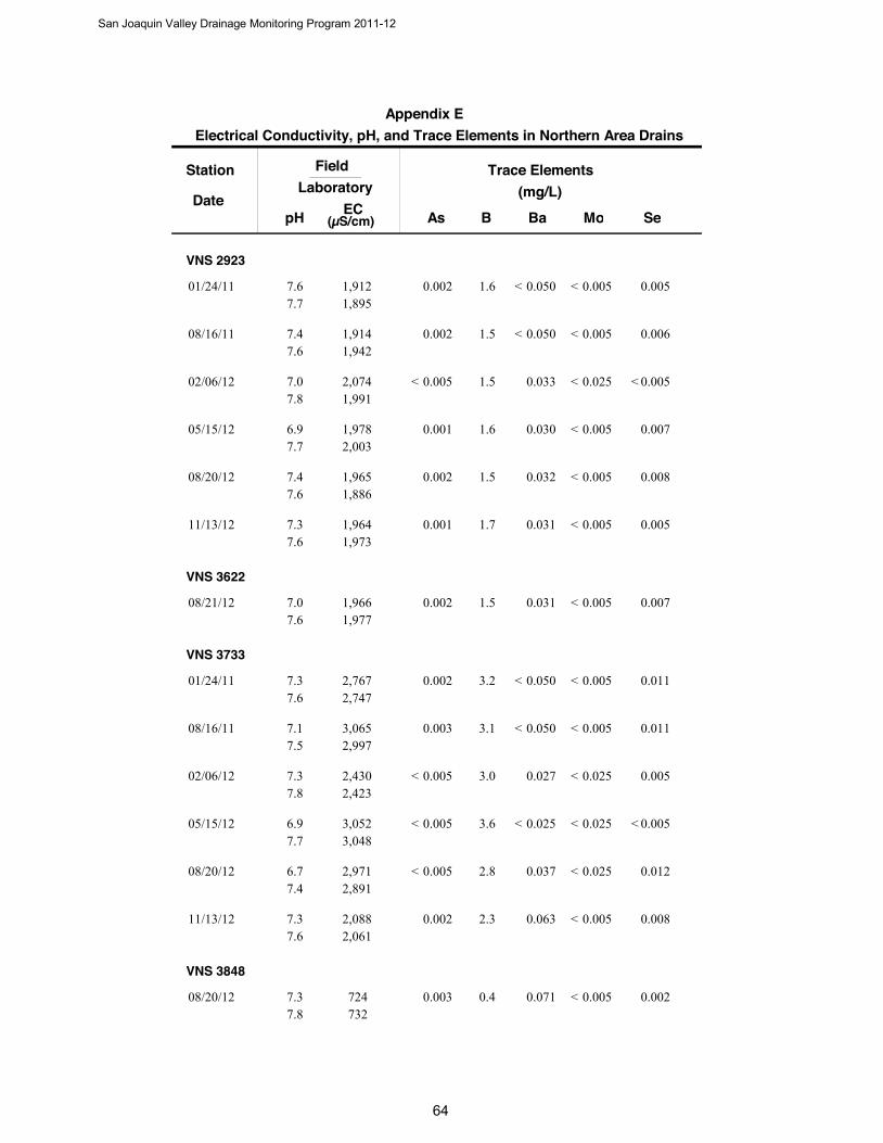
Station
DateB
Trace Elements(mg/L)
SeAs Ba Mo
FieldLaboratory
pH EC(µS/cm)
Electrical Conductivity, pH, and Trace Elements in Northern Area DrainsAppendix E
VNS 2923
1.601/24/11 0.0050.002 0.0050.0501,9121,895
7.67.7
< <
1.508/16/11 0.0060.002 0.0050.0501,9141,942
7.47.6
< <
1.502/06/12 0.0050.005 0.0250.0332,0741,991
7.07.8
< < <
1.605/15/12 0.0070.001 0.0050.0301,9782,003
6.97.7
<
1.508/20/12 0.0080.002 0.0050.0321,9651,886
7.47.6
<
1.711/13/12 0.0050.001 0.0050.0311,9641,973
7.37.6
<
VNS 3622
1.508/21/12 0.0070.002 0.0050.0311,9661,977
7.07.6
<
VNS 3733
3.201/24/11 0.0110.002 0.0050.0502,7672,747
7.37.6
< <
3.108/16/11 0.0110.003 0.0050.0503,0652,997
7.17.5
< <
3.002/06/12 0.0050.005 0.0250.0272,4302,423
7.37.8
< <
3.605/15/12 0.0050.005 0.0250.0253,0523,048
6.97.7
< < < <
2.808/20/12 0.0120.005 0.0250.0372,9712,891
6.77.4
< <
2.311/13/12 0.0080.002 0.0050.0632,0882,061
7.37.6
<
VNS 3848
0.408/20/12 0.0020.003 0.0050.071724732
7.37.8
<
San Joaquin Valley Drainage Monitoring Program 2011-12
64
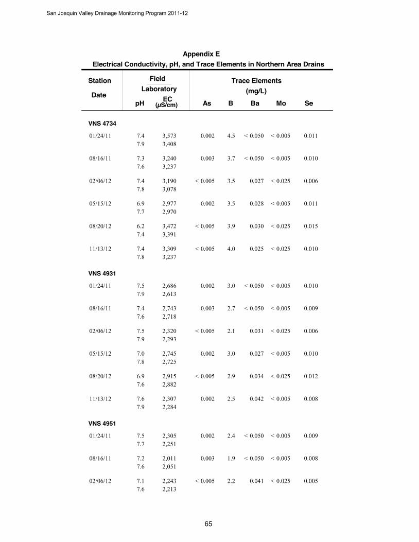
Station
DateB
Trace Elements(mg/L)
SeAs Ba Mo
FieldLaboratory
pH EC(µS/cm)
Electrical Conductivity, pH, and Trace Elements in Northern Area DrainsAppendix E
VNS 4734
4.501/24/11 0.0110.002 0.0050.0503,5733,408
7.47.9
< <
3.708/16/11 0.0100.003 0.0050.0503,2403,237
7.37.6
< <
3.502/06/12 0.0060.005 0.0250.0273,1903,078
7.47.8
< <
3.505/15/12 0.0110.002 0.0050.0282,9772,970
6.97.7
<
3.908/20/12 0.0150.005 0.0250.0303,4723,391
6.27.4
< <
4.011/13/12 0.0100.005 0.0250.0253,3093,237
7.47.8
< <
VNS 4931
3.001/24/11 0.0100.002 0.0050.0502,6862,613
7.57.9
< <
2.708/16/11 0.0090.003 0.0050.0502,7432,718
7.47.6
< <
2.102/06/12 0.0060.005 0.0250.0312,3202,293
7.57.9
< <
3.005/15/12 0.0100.002 0.0050.0272,7452,725
7.07.8
<
2.908/20/12 0.0120.005 0.0250.0342,9152,882
6.97.6
< <
2.511/13/12 0.0080.002 0.0050.0422,3072,284
7.67.9
<
VNS 4951
2.401/24/11 0.0090.002 0.0050.0502,3052,251
7.57.7
< <
1.908/16/11 0.0080.003 0.0050.0502,0112,051
7.27.6
< <
2.202/06/12 0.0050.005 0.0250.0412,2432,213
7.17.6
< <
San Joaquin Valley Drainage Monitoring Program 2011-12
65
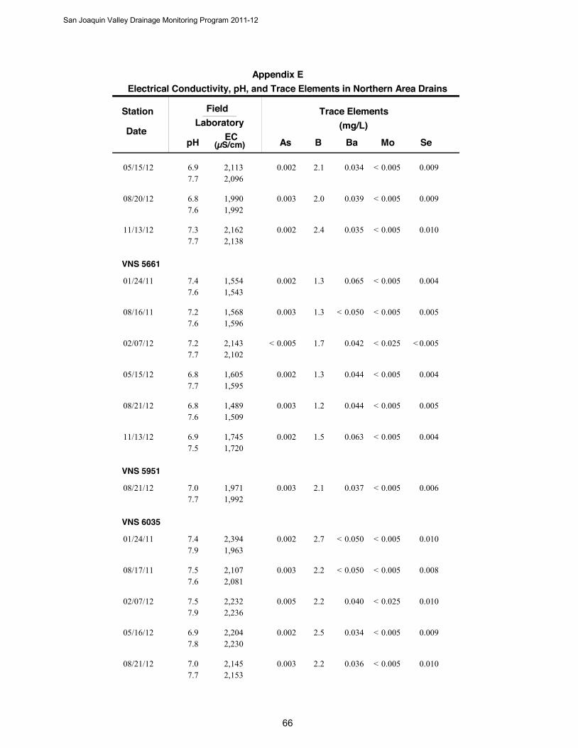
Station
DateB
Trace Elements(mg/L)
SeAs Ba Mo
FieldLaboratory
pH EC(µS/cm)
Electrical Conductivity, pH, and Trace Elements in Northern Area DrainsAppendix E
2.105/15/12 0.0090.002 0.0050.0342,1132,096
6.97.7
<
2.008/20/12 0.0090.003 0.0050.0391,9901,992
6.87.6
<
2.411/13/12 0.0100.002 0.0050.0352,1622,138
7.37.7
<
VNS 5661
1.301/24/11 0.0040.002 0.0050.0651,5541,543
7.47.6
<
1.308/16/11 0.0050.003 0.0050.0501,5681,596
7.27.6
< <
1.702/07/12 0.0050.005 0.0250.0422,1432,102
7.27.7
< < <
1.305/15/12 0.0040.002 0.0050.0441,6051,595
6.87.7
<
1.208/21/12 0.0050.003 0.0050.0441,4891,509
6.87.6
<
1.511/13/12 0.0040.002 0.0050.0631,7451,720
6.97.5
<
VNS 5951
2.108/21/12 0.0060.003 0.0050.0371,9711,992
7.07.7
<
VNS 6035
2.701/24/11 0.0100.002 0.0050.0502,3941,963
7.47.9
< <
2.208/17/11 0.0080.003 0.0050.0502,1072,081
7.57.6
< <
2.202/07/12 0.0100.005 0.0250.0402,2322,236
7.57.9
<
2.505/16/12 0.0090.002 0.0050.0342,2042,230
6.97.8
<
2.208/21/12 0.0100.003 0.0050.0362,1452,153
7.07.7
<
San Joaquin Valley Drainage Monitoring Program 2011-12
66
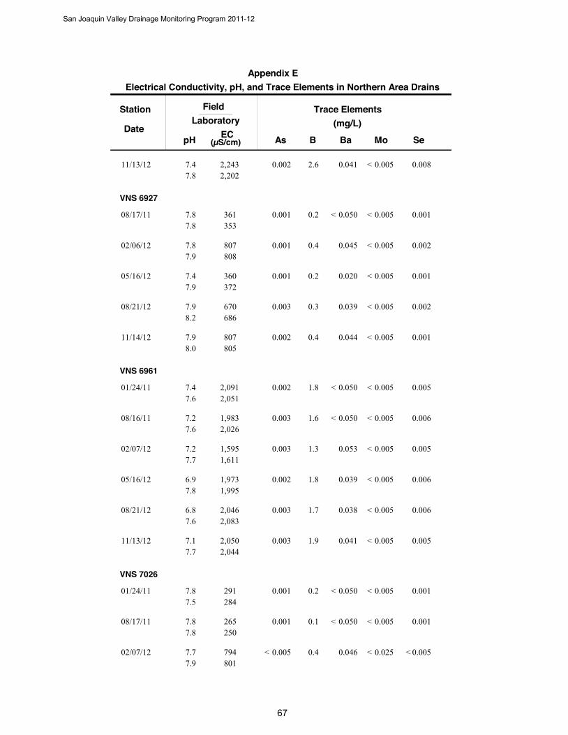
Station
DateB
Trace Elements(mg/L)
SeAs Ba Mo
FieldLaboratory
pH EC(µS/cm)
Electrical Conductivity, pH, and Trace Elements in Northern Area DrainsAppendix E
2.611/13/12 0.0080.002 0.0050.0412,2432,202
7.47.8
<
VNS 6927
0.208/17/11 0.0010.001 0.0050.050361353
7.87.8
< <
0.402/06/12 0.0020.001 0.0050.045807808
7.87.9
<
0.205/16/12 0.0010.001 0.0050.020360372
7.47.9
<
0.308/21/12 0.0020.003 0.0050.039670686
7.98.2
<
0.411/14/12 0.0010.002 0.0050.044807805
7.98.0
<
VNS 6961
1.801/24/11 0.0050.002 0.0050.0502,0912,051
7.47.6
< <
1.608/16/11 0.0060.003 0.0050.0501,9832,026
7.27.6
< <
1.302/07/12 0.0050.003 0.0050.0531,5951,611
7.27.7
<
1.805/16/12 0.0060.002 0.0050.0391,9731,995
6.97.8
<
1.708/21/12 0.0060.003 0.0050.0382,0462,083
6.87.6
<
1.911/13/12 0.0050.003 0.0050.0412,0502,044
7.17.7
<
VNS 7026
0.201/24/11 0.0010.001 0.0050.050291284
7.87.5
< <
0.108/17/11 0.0010.001 0.0050.050265250
7.87.8
< <
0.402/07/12 0.0050.005 0.0250.046794801
7.77.9
< < <
San Joaquin Valley Drainage Monitoring Program 2011-12
6

Station
DateB
Trace Elements(mg/L)
SeAs Ba Mo
FieldLaboratory
pH EC(µS/cm)
Electrical Conductivity, pH, and Trace Elements in Northern Area DrainsAppendix E
0.105/16/12 0.0010.001 0.0050.020288305
7.47.9
< < <
0.308/21/12 0.0020.002 0.0050.038633639
7.98.3
<
0.411/14/12 0.0020.002 0.0050.045790782
7.98.0
<
VNS 7027
2.801/24/11 0.0090.002 0.0050.0502,5082,407
7.78.1
< <
2.308/17/11 0.0080.003 0.0050.0502,4092,356
7.67.8
< <
2.202/07/12 0.0050.005 0.0250.0352,3082,282
7.78.0
< <
2.605/16/12 0.0090.002 0.0050.0322,3632,371
7.07.9
<
2.408/20/12 0.0100.003 0.0050.0352,3812,428
7.27.8
<
2.511/14/12 0.0080.002 0.0050.0402,2612,218
7.88.0
<
San Joaquin Valley Drainage Monitoring Program 2011-12
68

San Joaquin Valley Drainage Monitoring Program 2011-12
69
Appendix F Mineral Analyses of Central Area Drains
2011-2012
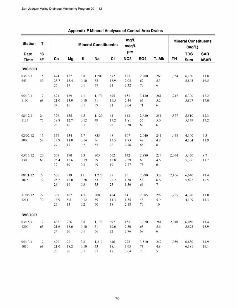
Station
DateTime
T
Ca Mg Na NO3
Mineral Constituents:mg/L
meq/L
°C °F Cl SO4 T. Alk
prv
K
Mineral Constituents(mg/L)
TDSSumTH
SARASAR
Appendix F Mineral Analyses of Central Area Drains
BVS 6001
474 18723.7 52 2.0559 15.4
1,200 12703/16/11945
15 67218.9 62
26 17 575.3
210.103.8
0.1
11.81,9545,805 16.5
2.32 70 6
2,980 269 6,180
421 16921.0 51 2.4463 13.9
1,170 15105/10/111100
17 69519.5 65
24 16 595.2
210.104.1
0.1
12.21,7475,897 17.0
2.64 71 6
3,130 261 6,300
376 15518.8 49 1.8175 12.7
1,120 11208/17/111137
24 61117.2 55
23 16 615.0
220.124.5
0.1
12.31,5775,149 17.2
2.30 69 6
2,620 251 5,510
359 13417.9 36 1.7359 11.0
833 10702/07/121000
15 48113.5 42
27 17 554.8
220.145.7
0.2
9.51,4484,104 11.9
2.76 68 8
2,040 241 4,100
509 19025.4 39 2.2968 15.6
905 14205/15/121300
20 56215.8 60
32 19 494.6
190.197.3
0.2
8.72,0545,336 11.7
2.77 73 6
2,880 234 5,470
506 21925.2 53 1.3872 18.0
1,220 8508/21/121015
22 79122.2 58
26 19 556.6
250.2811.1
0.3
11.42,1665,822 16.5
1.56 66 7
2,790 332 6,640
338 10716.9 39 1.3572 8.8
908 8411/05/121211
22 40411.3 43
26 13 605.9
180.124.7
0.2
11.01,2854,109 14.3
2.18 70 10
2,085 297 4,320
BVS 7007
432 22621.6 51 2.5063 18.6
1,170 15503/15/111200
17 69719.6 63
24 20 565.6
220.103.8
0.1
11.42,0105,872 15.9
2.76 69 6
3,020 281 6,050
420 22121.0 53 3.6363 18.2
1,210 22505/10/111030
17 64618.1 73
23 20 574.8
180.103.8
0.1
11.91,9596,381 16.1
3.64 73 5
3,510 242 6,680
San Joaquin Valley Drainage Monitoring Program 2011-12
00

Station
DateTime
T
Ca Mg Na NO3
Mineral Constituents:mg/L
meq/L
°C °F Cl SO4 T. Alk
prv
K
Mineral Constituents(mg/L)
TDSSumTH
SARASAR
Appendix F Mineral Analyses of Central Area Drains
404 20520.2 51 2.8970 16.9
1,180 17908/16/111100
21 63117.7 61
23 19 584.4
210.114.3
0.1
11.91,8535,678 16.1
3.35 71 5
2,940 224 5,930
384 17719.2 43 2.4859 14.6
1,000 15402/07/121015
15 54515.3 53
25 19 564.5
200.166.4
0.2
10.61,6884,944 14.3
3.30 70 6
2,540 229 5,070
411 19320.5 49 4.0364 15.9
1,120 25005/15/121230
18 59716.8 66
24 19 574.6
180.187.0
0.2
11.41,8215,907 15.4
4.39 72 5
3,190 232 5,950
147 697.3 21 0.9268 5.7
473 5708/20/121145
20 2446.9 22
22 17 615.3
200.104.0
0.3
8.16512,214 10.1
2.63 63 15
1,060 266 2,230
497 34224.8 88 7.1168 28.1
2,030 44111/05/121045
20 1,19633.6 86
18 20 625.4
250.187.2
0.1
17.22,6508,825 25.7
5.37 65 4
4,150 270 9,160
BVS 7402
317 12815.8 34 0.5557 10.5
781 3401/26/111030
14 37310.5 42
26 17 564.2
180.103.8
0.2
9.41,3193,774 11.7
0.97 73 7
2,010 212 3,880
325 13216.2 30 1.1861 10.9
691 7303/15/111130
16 38410.8 39
28 19 534.8
190.083.1
0.1
8.21,3553,634 10.2
2.10 70 9
1,880 243 3,820
291 11914.5 29 0.6361 9.8
658 3905/10/11930
16 36710.3 40
27 18 544.1
190.072.9
0.1
8.21,2173,523 10.3
1.15 73 8
1,920 209 3,810
349 15117.4 36 0.8370 12.4
823 5208/17/111115
21 43712.3 46
27 19 545.4
190.083.2
0.1
9.31,4944,178 12.0
1.30 71 8
2,200 271 4,400
San Joaquin Valley Drainage Monitoring Program 2011-12
1
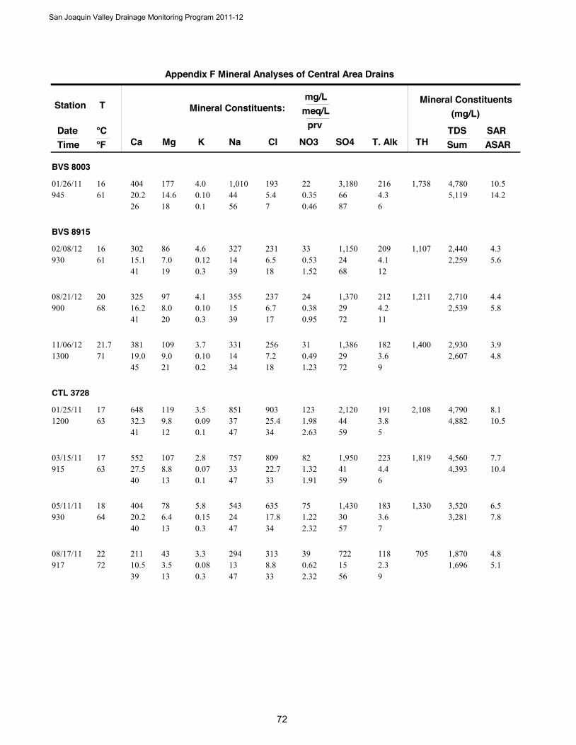
Station
DateTime
T
Ca Mg Na NO3
Mineral Constituents:mg/L
meq/L
°C °F Cl SO4 T. Alk
prv
K
Mineral Constituents(mg/L)
TDSSumTH
SARASAR
Appendix F Mineral Analyses of Central Area Drains
BVS 8003
404 17720.2 44 0.3561 14.6
1,010 2201/26/11945
16 1935.4 66
26 18 564.3
70.104.0
0.1
10.51,7385,119 14.2
0.46 87 6
3,180 216 4,780
BVS 8915
302 8615.1 14 0.5361 7.0
327 3302/08/12930
16 2316.5 24
41 19 394.1
180.124.6
0.3
4.31,1072,259 5.6
1.52 68 12
1,150 209 2,440
325 9716.2 15 0.3868 8.0
355 2408/21/12900
20 2376.7 29
41 20 394.2
170.104.1
0.3
4.41,2112,539 5.8
0.95 72 11
1,370 212 2,710
381 10919.0 14 0.4971 9.0
331 3111/06/121300
21.7 2567.2 29
45 21 343.6
180.103.7
0.2
3.91,4002,607 4.8
1.23 72 9
1,386 182 2,930
CTL 3728
648 11932.3 37 1.9863 9.8
851 12301/25/111200
17 90325.4 44
41 12 473.8
340.093.5
0.1
8.12,1084,882 10.5
2.63 59 5
2,120 191 4,790
552 10727.5 33 1.3263 8.8
757 8203/15/11915
17 80922.7 41
40 13 474.4
330.072.8
0.1
7.71,8194,393 10.4
1.91 59 6
1,950 223 4,560
404 7820.2 24 1.2264 6.4
543 7505/11/11930
18 63517.8 30
40 13 473.6
340.155.8
0.3
6.51,3303,281 7.8
2.32 57 7
1,430 183 3,520
211 4310.5 13 0.6272 3.5
294 3908/17/11917
22 3138.8 15
39 13 472.3
330.083.3
0.3
4.87051,696 5.1
2.32 56 9
722 118 1,870
San Joaquin Valley Drainage Monitoring Program 2011-12
2
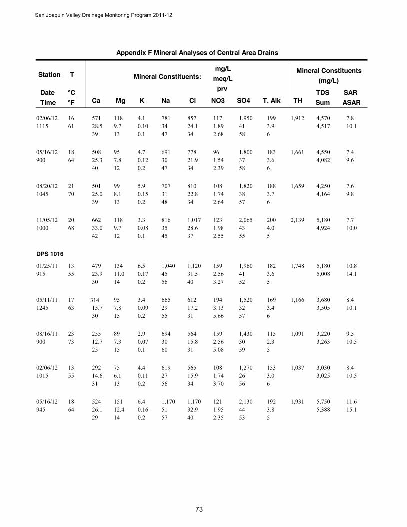
Station
DateTime
T
Ca Mg Na NO3
Mineral Constituents:mg/L
meq/L
°C °F Cl SO4 T. Alk
prv
K
Mineral Constituents(mg/L)
TDSSumTH
SARASAR
Appendix F Mineral Analyses of Central Area Drains
571 11828.5 34 1.8961 9.7
781 11702/06/121115
16 85724.1 41
39 13 473.9
340.104.1
0.1
7.81,9124,517 10.1
2.68 58 6
1,950 199 4,570
508 9525.3 30 1.5464 7.8
691 9605/16/12900
18 77821.9 37
40 12 473.6
340.124.7
0.2
7.41,6614,082 9.6
2.39 58 6
1,800 183 4,550
501 9925.0 31 1.7470 8.1
707 10808/20/121045
21 81022.8 38
39 13 483.7
340.155.9
0.2
7.61,6594,164 9.8
2.64 57 6
1,820 188 4,250
662 11833.0 35 1.9868 9.7
816 12311/05/121000
20 1,01728.6 43
42 12 454.0
370.083.3
0.1
7.72,1394,924 10.0
2.55 55 5
2,065 200 5,180
DPS 1016
479 13423.9 45 2.5655 11.0
1,040 15901/25/11915
13 1,12031.5 41
30 14 563.6
400.176.5
0.2
10.81,7485,008 14.1
3.27 52 5
1,960 182 5,180
314 9515.7 29 3.1363 7.8
665 19405/11/111245
17 61217.2 32
30 15 553.4
310.093.4
0.2
8.41,1663,505 10.1
5.66 57 6
1,520 169 3,680
255 8912.7 30 2.5673 7.3
694 15908/16/11900
23 56415.8 30
25 15 602.3
310.072.9
0.1
9.51,0913,263 10.5
5.08 59 5
1,430 115 3,220
292 7514.6 27 1.7455 6.1
619 10802/06/121015
13 56515.9 26
31 13 563.0
340.114.4
0.2
8.41,0373,025 10.5
3.70 56 6
1,270 153 3,030
524 15126.1 51 1.9564 12.4
1,170 12105/16/12945
18 1,17032.9 44
29 14 573.8
400.166.4
0.2
11.61,9315,388 15.1
2.35 53 5
2,130 192 5,750
San Joaquin Valley Drainage Monitoring Program 2011-12
3

Station
DateTime
T
Ca Mg Na NO3
Mineral Constituents:mg/L
meq/L
°C °F Cl SO4 T. Alk
prv
K
Mineral Constituents(mg/L)
TDSSumTH
SARASAR
Appendix F Mineral Analyses of Central Area Drains
148 417.4 14 0.9673 3.4
313 6008/20/12915
23 3108.7 13
30 14 562.3
350.104.0
0.4
5.95381,553 5.9
3.90 51 9
608 116 1,610
100 445.0 10 0.7464 3.6
224 4611/06/121230
18 2236.3 9
27 20 531.9
350.104.1
0.6
4.74311,126 4.5
4.18 50 11
426 97 1,170
DPS 1367
671 15733.5 26 2.8561 12.9
602 17703/15/11900
16 95826.9 38
46 18 363.3
380.093.5
0.1
5.42,3224,488 7.1
4.02 53 5
1,820 166 4,830
617 15130.8 25 3.0564 12.4
584 18905/11/111000
18 98327.6 39
45 18 373.2
380.072.8
0.1
5.52,1634,485 7.1
4.20 53 4
1,860 163 4,780
DPS 2535
432 17921.6 67 1.5863 14.7
1,540 9801/25/111030
17 1,07030.1 58
21 14 653.8
320.114.4
0.1
15.71,8166,229 20.4
1.69 62 4
2,790 193 6,500
391 15519.5 57 1.7163 12.7
1,310 10603/15/111000
17 98827.8 56
22 14 643.9
310.083.0
0.1
14.21,6155,740 18.4
1.92 63 4
2,670 195 5,900
368 15218.4 57 1.7764 12.5
1,320 11005/11/111130
18 97327.3 58
21 14 654.1
300.083.1
0.1
14.61,5455,842 19.7
1.94 64 5
2,790 209 6,160
367 14318.3 56 1.6672 11.8
1,290 10308/17/111017
22 91425.7 54
21 14 654.4
300.072.9
0.1
14.51,5065,564 19.5
1.93 63 5
2,610 223 5,800
457 17422.8 67 1.4559 14.3
1,550 9002/06/121145
15 1,09030.6 63
22 14 644.1
310.145.4
0.1
15.71,8586,499 21.1
1.47 63 4
3,010 205 6,640
San Joaquin Valley Drainage Monitoring Program 2011-12
4
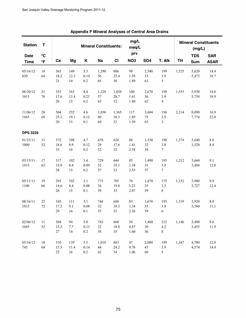
Station
DateTime
T
Ca Mg Na NO3
Mineral Constituents:mg/L
meq/L
°C °F Cl SO4 T. Alk
prv
K
Mineral Constituents(mg/L)
TDSSumTH
SARASAR
Appendix F Mineral Analyses of Central Area Drains
365 14918.2 56 1.5964 12.3
1,290 9805/16/12830
18 90625.4 53
21 14 653.9
300.145.3
0.2
14.41,5255,473 18.7
1.89 63 5
2,540 199 5,620
353 16317.6 57 1.6170 13.4
1,320 10008/20/121015
21 1,02028.7 56
20 15 653.9
320.218.4
0.2
14.61,5535,754 18.9
1.80 62 4
2,670 199 5,930
504 23225.1 80 1.8968 19.1
1,830 11711/06/121045
20 1,36538.3 75
20 15 643.9
320.124.6
0.1
16.92,2147,774 22.0
1.59 63 3
3,604 196 8,090
DPS 3235
372 10818.6 29 1.4152 8.9
678 8801/25/111000
11 62617.6 32
33 16 523.8
320.124.7
0.2
8.01,3743,520 8.8
2.58 58 7
1,530 190 3,640
317 10215.8 32 1.3863 8.4
729 8503/15/111015
17 64418.1 31
28 15 573.9
330.093.4
0.2
9.11,2123,488 12.8
2.53 57 7
1,490 195 3,660
293 10214.6 34 1.2366 8.4
773 7605/11/111100
19 70519.8 35
26 15 593.5
330.083.1
0.1
9.91,1523,727 12.4
2.07 59 6
1,670 175 3,980
345 11117.2 32 1.3472 9.1
744 8308/16/111015
22 68819.3 35
29 16 553.8
330.083.1
0.1
8.91,3193,760 11.1
2.26 59 6
1,670 193 3,920
304 9415.2 32 0.8752 7.7
743 5402/06/121045
11 66818.8 30
27 14 584.2
350.135.0
0.2
9.61,1463,455 11.9
1.60 56 8
1,460 212 3,490
310 13915.5 44 0.7664 11.4
1,010 4705/16/12745
18 86324.2 43
22 16 623.9
340.145.5
0.2
12.01,3474,574 14.4
1.06 60 5
2,080 199 4,700
San Joaquin Valley Drainage Monitoring Program 2011-12
5

Station
DateTime
T
Ca Mg Na NO3
Mineral Constituents:mg/L
meq/L
°C °F Cl SO4 T. Alk
prv
K
Mineral Constituents(mg/L)
TDSSumTH
SARASAR
Appendix F Mineral Analyses of Central Area Drains
203 6910.1 23 0.7073 5.7
522 4408/20/12945
23 51314.4 24
26 15 592.6
350.156.0
0.4
8.17912,576 9.3
1.70 57 6
1,140 132 2,640
386 15619.3 52 0.2464 12.8
1,190 1511/06/121200
18 98027.5 50
23 15 623.5
340.124.7
0.1
12.91,6705,257 16.8
0.29 62 4
2,419 178 5,450
DPS 3465
533 20326.6 50 2.0861 16.7
1,150 12903/15/11930
16 1,27035.7 50
28 18 545.4
380.124.7
0.1
10.72,1675,832 14.0
2.24 53 6
2,380 271 6,140
DPS 4616
558 29427.8 69 0.4459 24.2
1,590 2701/25/11945
15 1,45040.7 71
23 20 574.0
350.145.6
0.1
13.62,6047,447 19.0
0.38 61 3
3,400 204 7,864
522 62326.0 172 0.6459 51.2
3,950 4003/15/111030
15 2,68075.3 148
10 21 694.8
330.166.4
0.1
27.63,87015,068 38.7
0.28 65 2
7,100 244 16,770
489 37224.4 94 0.8470 30.6
2,160 5208/16/11945
21 1,92053.9 92
16 21 634.6
360.135.0
0.1
17.92,7539,577 25.1
0.55 61 3
4,440 232 9,710
455 21322.7 50 0.4357 17.5
1,160 2702/06/121030
14 1,02028.7 65
25 19 563.8
290.135.1
0.1
11.32,0146,093 14.6
0.44 66 4
3,100 189 6,560
496 41424.8 116 0.7061 34.0
2,670 4305/16/12700
16 1,93054.2 127
14 19 664.4
290.228.5
0.1
21.42,94411,807 31.0
0.37 68 2
6,111 224 12,270
458 24422.9 66 0.4970 20.1
1,520 3108/20/12930
21 1,20033.7 70
21 18 604.0
310.2710.7
0.3
14.32,1496,924 19.3
0.46 65 4
3,340 201 7,360
San Joaquin Valley Drainage Monitoring Program 2011-12
6
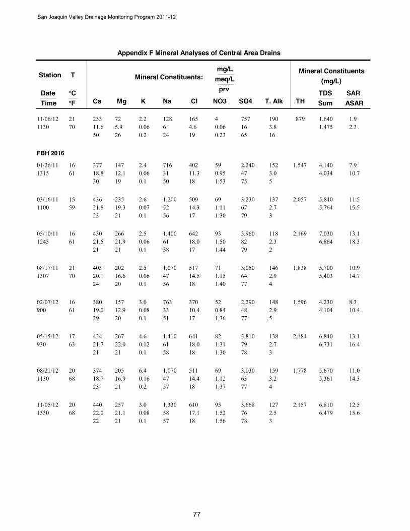
Station
DateTime
T
Ca Mg Na NO3
Mineral Constituents:mg/L
meq/L
°C °F Cl SO4 T. Alk
prv
K
Mineral Constituents(mg/L)
TDSSumTH
SARASAR
Appendix F Mineral Analyses of Central Area Drains
233 7211.6 6 0.0670 5.9
128 411/06/121130
21 1654.6 16
50 26 243.8
190.062.2
0.2
1.98791,475 2.3
0.23 65 16
757 190 1,640
FBH 2016
377 14718.8 31 0.9561 12.1
716 5901/26/111315
16 40211.3 47
30 19 503.0
180.062.4
0.1
7.91,5474,034 10.7
1.53 75 5
2,240 152 4,140
436 23521.8 52 1.1159 19.3
1,200 6903/16/111100
15 50914.3 67
23 21 562.7
170.072.6
0.1
11.52,0575,764 15.5
1.30 79 3
3,230 137 5,840
430 26621.5 61 1.5061 21.9
1,400 9305/10/111245
16 64218.0 82
21 21 582.3
170.062.5
0.1
13.12,1696,864 18.3
1.44 79 2
3,960 118 7,030
403 20220.1 47 1.1570 16.6
1,070 7108/17/111307
21 51714.5 64
24 20 562.9
180.062.5
0.1
10.91,8385,403 14.7
1.40 77 4
3,050 146 5,700
380 15719.0 33 0.8461 12.9
763 5202/07/12900
16 37010.4 48
29 20 512.9
170.083.0
0.1
8.31,5964,104 10.4
1.36 77 5
2,290 148 4,230
434 26721.7 61 1.3163 22.0
1,410 8205/15/12930
17 64118.0 79
21 21 582.7
180.124.6
0.1
13.12,1846,731 16.4
1.30 78 3
3,810 138 6,840
374 20518.7 47 1.1268 16.9
1,070 6908/21/121130
20 51114.4 63
23 21 573.2
180.166.4
0.2
11.01,7785,361 14.3
1.37 77 4
3,030 159 5,670
440 25722.0 58 1.5268 21.1
1,330 9511/05/121330
20 61017.1 76
22 21 572.5
180.083.0
0.1
12.52,1576,479 15.6
1.56 78 3
3,668 127 6,810
San Joaquin Valley Drainage Monitoring Program 2011-12
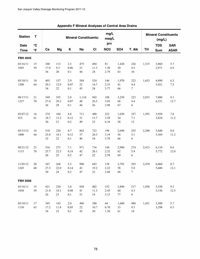
Station
DateTime
T
Ca Mg Na NO3
Mineral Constituents:mg/L
meq/L
°C °F Cl SO4 T. Alk
prv
K
Mineral Constituents(mg/L)
TDSSumTH
SARASAR
Appendix F Mineral Analyses of Central Area Drains
FBH 4045
340 11317.0 21 1.3059 9.3
475 8103/16/111045
15 40411.3 30
36 20 444.5
240.062.3
0.1
5.71,3152,971 6.8
2.79 63 10
1,420 226 3,060
403 15720.1 25 2.3564 12.9
584 14605/10/111200
18 52414.7 41
34 22 434.4
240.072.9
0.1
6.31,6533,921 7.5
3.77 66 7
1,970 223 4,090
549 35527.4 48 3.0370 29.2
1,110 18808/17/111237
21 94226.5 68
26 28 464.4
260.072.8
0.1
9.12,8336,531 12.7
2.98 67 4
3,250 223 7,080
374 16018.7 31 3.5861 13.2
711 22202/07/12915
16 48813.7 34
30 21 497.1
230.124.8
0.2
7.81,5933,824 11.2
6.10 58 12
1,650 357 3,950
518 22025.8 37 3.1964 18.1
862 19805/15/121000
18 72320.3 56
32 22 465.1
240.124.7
0.1
8.02,2005,369 11.2
3.78 66 6
2,690 255 5,440
516 27325.7 42 2.3270 22.5
971 14408/21/121115
21 71620.1 62
28 25 475.4
220.187.1
0.2
8.62,4135,772 12.0
2.58 69 6
2,980 274 6,110
547 26827.3 43 2.2268 22.0
990 13811/05/121245
20 68319.2 58
30 24 475.8
220.145.5
0.2
8.72,4705,600 12.1
2.60 68 7
2,793 293 6,060
FBH 5056
421 22021.0 41 2.4559 18.1
938 15203/16/111030
15 40211.3 60
26 23 514.3
140.083.0
0.1
9.21,9585,156 12.5
3.13 77 6
2,890 217 5,350
345 14317.2 22 0.7063 11.8
496 4405/10/111130
17 38010.7 33
34 23 439.5
200.052.0
0.1
5.71,4513,298 6.5
1.30 61 18
1,600 480 3,500
San Joaquin Valley Drainage Monitoring Program 2011-12
8
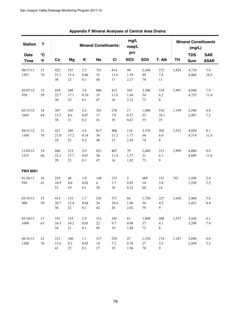
Station
DateTime
T
Ca Mg Na NO3
Mineral Constituents:mg/L
meq/L
°C °F Cl SO4 T. Alk
prv
K
Mineral Constituents(mg/L)
TDSSumTH
SARASAR
Appendix F Mineral Analyses of Central Area Drains
422 18721.1 33 1.5970 15.4
761 9808/17/111207
21 41411.6 49
30 22 487.4
170.062.3
0.1
7.81,8244,468 10.5
2.27 70 11
2,360 372 4,710
454 20822.7 35 1.6959 17.1
806 10502/07/12930
15 41211.6 54
30 23 476.2
160.103.8
0.1
7.91,9914,755 11.4
2.32 73 8
2,580 310 4,880
307 10515.3 17 0.2764 8.6
381 1705/15/121045
18 2787.8 23
38 21 4110.1
190.072.6
0.2
4.81,1992,487 7.2
0.67 55 25
1,090 510 2,590
421 20921.0 36 1.7770 17.2
817 11008/21/121100
21 40011.2 54
28 23 486.0
150.145.6
0.2
8.11,9124,714 11.8
2.45 74 8
2,570 302 4,920
446 21522.3 36 1.2766 17.7
821 7911/05/121215
19 40711.4 51
29 23 476.3
160.072.9
0.1
8.01,9994,609 11.6
1.82 73 9
2,449 315 4,880
FBH 8061
219 4810.9 6 0.0361 4.0
148 201/26/11930
16 1333.7 14
51 19 303.0
180.021.0
0.1
2.47451,330 3.2
0.12 68 14
689 151 1,430
414 15120.7 24 1.0659 12.4
541 6603/16/11900
15 37110.4 36
36 22 424.5
200.041.7
0.1
5.81,6563,431 8.4
2.02 70 9
1,750 227 3,460
331 12416.5 22 0.9863 10.2
511 6105/10/111000
17 3459.7 37
34 21 454.1
190.051.8
0.1
6.11,3373,298 7.9
1.88 72 8
1,800 208 3,450
312 10015.6 14 0.7670 8.2
317 4708/16/111200
21 2587.2 27
41 22 373.5
190.031.1
0.1
4.01,1872,450 5.2
1.96 70 9
1,310 174 2,690
San Joaquin Valley Drainage Monitoring Program 2011-12
9
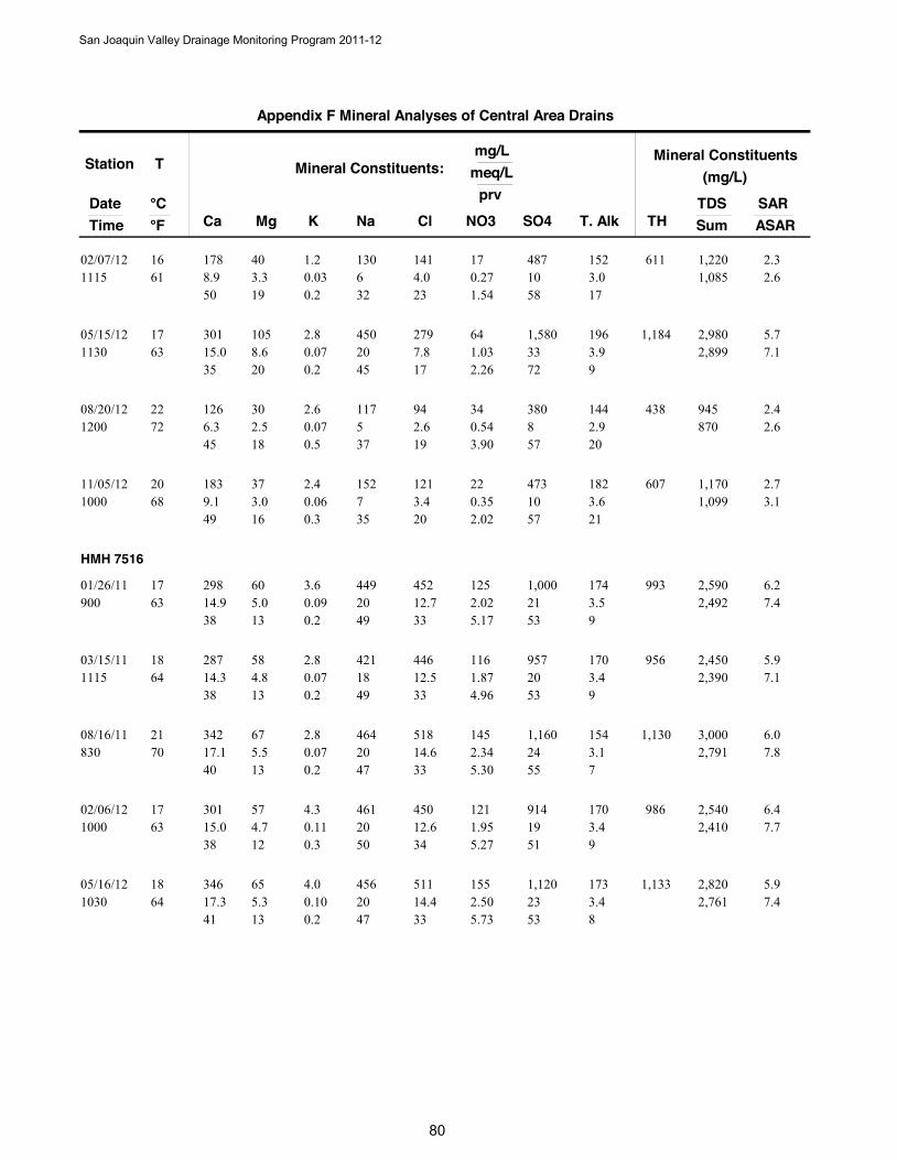
Station
DateTime
T
Ca Mg Na NO3
Mineral Constituents:mg/L
meq/L
°C °F Cl SO4 T. Alk
prv
K
Mineral Constituents(mg/L)
TDSSumTH
SARASAR
Appendix F Mineral Analyses of Central Area Drains
178 408.9 6 0.2761 3.3
130 1702/07/121115
16 1414.0 10
50 19 323.0
230.031.2
0.2
2.36111,085 2.6
1.54 58 17
487 152 1,220
301 10515.0 20 1.0363 8.6
450 6405/15/121130
17 2797.8 33
35 20 453.9
170.072.8
0.2
5.71,1842,899 7.1
2.26 72 9
1,580 196 2,980
126 306.3 5 0.5472 2.5
117 3408/20/121200
22 942.6 8
45 18 372.9
190.072.6
0.5
2.4438870 2.6
3.90 57 20
380 144 945
183 379.1 7 0.3568 3.0
152 2211/05/121000
20 1213.4 10
49 16 353.6
200.062.4
0.3
2.76071,099 3.1
2.02 57 21
473 182 1,170
HMH 7516
298 6014.9 20 2.0263 5.0
449 12501/26/11900
17 45212.7 21
38 13 493.5
330.093.6
0.2
6.29932,492 7.4
5.17 53 9
1,000 174 2,590
287 5814.3 18 1.8764 4.8
421 11603/15/111115
18 44612.5 20
38 13 493.4
330.072.8
0.2
5.99562,390 7.1
4.96 53 9
957 170 2,450
342 6717.1 20 2.3470 5.5
464 14508/16/11830
21 51814.6 24
40 13 473.1
330.072.8
0.2
6.01,1302,791 7.8
5.30 55 7
1,160 154 3,000
301 5715.0 20 1.9563 4.7
461 12102/06/121000
17 45012.6 19
38 12 503.4
340.114.3
0.3
6.49862,410 7.7
5.27 51 9
914 170 2,540
346 6517.3 20 2.5064 5.3
456 15505/16/121030
18 51114.4 23
41 13 473.4
330.104.0
0.2
5.91,1332,761 7.4
5.73 53 8
1,120 173 2,820
San Joaquin Valley Drainage Monitoring Program 2011-12
800
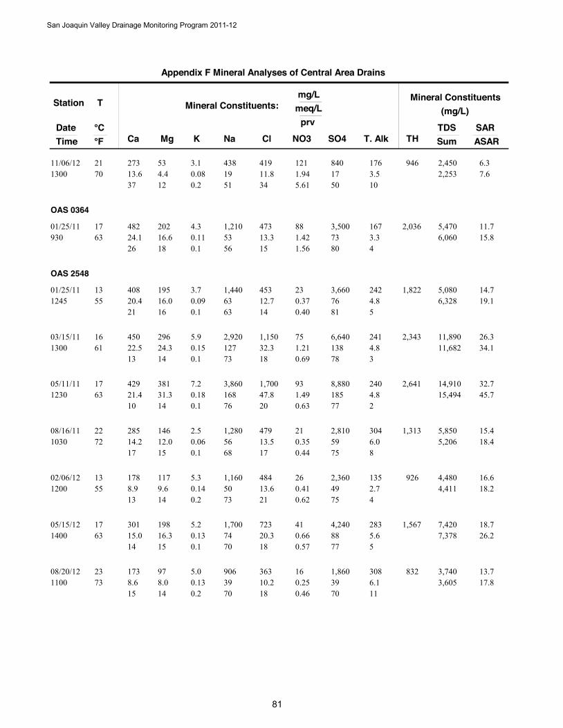
Station
DateTime
T
Ca Mg Na NO3
Mineral Constituents:mg/L
meq/L
°C °F Cl SO4 T. Alk
prv
K
Mineral Constituents(mg/L)
TDSSumTH
SARASAR
Appendix F Mineral Analyses of Central Area Drains
273 5313.6 19 1.9470 4.4
438 12111/06/121300
21 41911.8 17
37 12 513.5
340.083.1
0.2
6.39462,253 7.6
5.61 50 10
840 176 2,450
OAS 0364
482 20224.1 53 1.4263 16.6
1,210 8801/25/11930
17 47313.3 73
26 18 563.3
150.114.3
0.1
11.72,0366,060 15.8
1.56 80 4
3,500 167 5,470
OAS 2548
408 19520.4 63 0.3755 16.0
1,440 2301/25/111245
13 45312.7 76
21 16 634.8
140.093.7
0.1
14.71,8226,328 19.1
0.40 81 5
3,660 242 5,080
450 29622.5 127 1.2161 24.3
2,920 7503/15/111300
16 1,15032.3 138
13 14 734.8
180.155.9
0.1
26.32,34311,682 34.1
0.69 78 3
6,640 241 11,890
429 38121.4 168 1.4963 31.3
3,860 9305/11/111230
17 1,70047.8 185
10 14 764.8
200.187.2
0.1
32.72,64115,494 45.7
0.63 77 2
8,880 240 14,910
285 14614.2 56 0.3572 12.0
1,280 2108/16/111030
22 47913.5 59
17 15 686.0
170.062.5
0.1
15.41,3135,206 18.4
0.44 75 8
2,810 304 5,850
178 1178.9 50 0.4155 9.6
1,160 2602/06/121200
13 48413.6 49
13 14 732.7
210.145.3
0.2
16.69264,411 18.2
0.62 75 4
2,360 135 4,480
301 19815.0 74 0.6663 16.3
1,700 4105/15/121400
17 72320.3 88
14 15 705.6
180.135.2
0.1
18.71,5677,378 26.2
0.57 77 5
4,240 283 7,420
173 978.6 39 0.2573 8.0
906 1608/20/121100
23 36310.2 39
15 14 706.1
180.135.0
0.2
13.78323,605 17.8
0.46 70 11
1,860 308 3,740
San Joaquin Valley Drainage Monitoring Program 2011-12
81
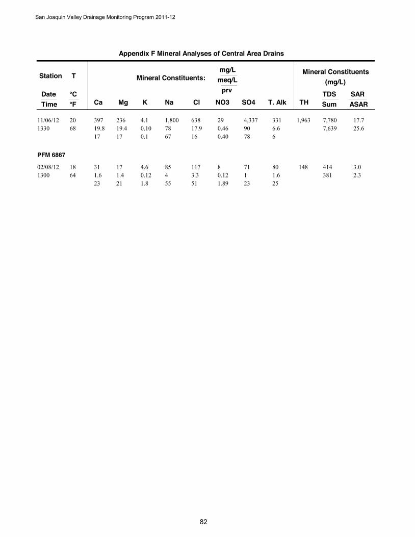
Station
DateTime
T
Ca Mg Na NO3
Mineral Constituents:mg/L
meq/L
°C °F Cl SO4 T. Alk
prv
K
Mineral Constituents(mg/L)
TDSSumTH
SARASAR
Appendix F Mineral Analyses of Central Area Drains
397 23619.8 78 0.4668 19.4
1,800 2911/06/121330
20 63817.9 90
17 17 676.6
160.104.1
0.1
17.71,9637,639 25.6
0.40 78 6
4,337 331 7,780
PFM 6867
31 171.6 4 0.1264 1.4
85 802/08/121300
18 1173.3 1
23 21 551.6
510.124.6
1.8
3.0148381 2.3
1.89 23 25
71 80 414
San Joaquin Valley Drainage Monitoring Program 2011-12
82

San Joaquin Valley Drainage Monitoring Program 2011-12
83
Appendix G Electrical Conductivity, pH, & Trace Elements in
Central Area Drains 2011-2012
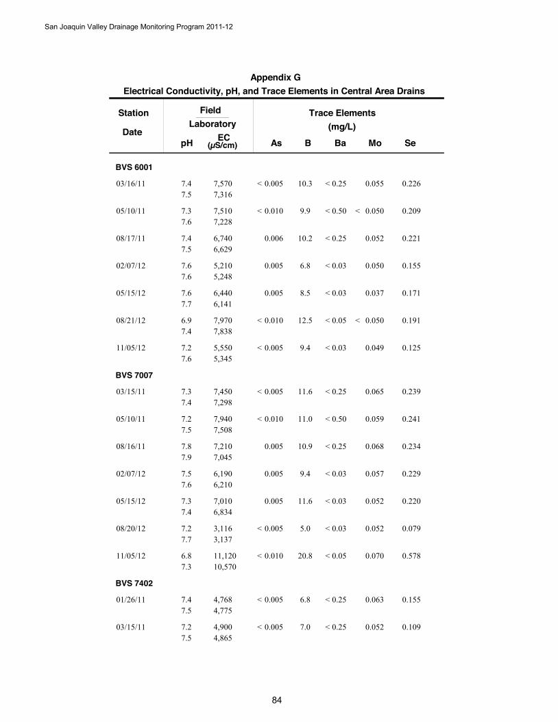
Station
DateB
Trace Elements(mg/L)
SeAs Ba Mo
FieldLaboratory
pH EC(µS/cm)
Electrical Conductivity, pH, and Trace Elements in Central Area DrainsAppendix G
BVS 6001
10.303/16/11 0.2260.005 0.0550.257,5707,316
7.47.5
< <
9.905/10/11 0.2090.010 0.0500.507,5107,228
7.37.6
< < <
10.208/17/11 0.2210.006 0.0520.256,7406,629
7.47.5
<
6.802/07/12 0.1550.005 0.0500.035,2105,248
7.67.6
<
8.505/15/12 0.1710.005 0.0370.036,4406,141
7.67.7
<
12.508/21/12 0.1910.010 0.0500.057,9707,838
6.97.4
< < <
9.411/05/12 0.1250.005 0.0490.035,5505,345
7.27.6
< <
BVS 7007
11.603/15/11 0.2390.005 0.0650.257,4507,298
7.37.4
< <
11.005/10/11 0.2410.010 0.0590.507,9407,508
7.27.5
< <
10.908/16/11 0.2340.005 0.0680.257,2107,045
7.87.9
<
9.402/07/12 0.2290.005 0.0570.036,1906,210
7.57.6
<
11.605/15/12 0.2200.005 0.0520.037,0106,834
7.37.4
<
5.008/20/12 0.0790.005 0.0520.033,1163,137
7.27.7
< <
20.811/05/12 0.5780.010 0.0700.0511,12010,570
6.87.3
< <
BVS 7402
6.801/26/11 0.1550.005 0.0630.254,7684,775
7.47.5
< <
7.003/15/11 0.1090.005 0.0520.254,9004,865
7.27.5
< <
San Joaquin Valley Drainage Monitoring Program 2011-12
84
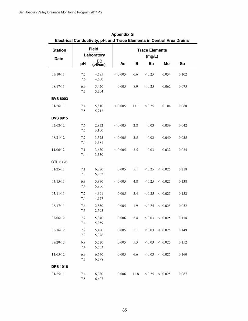
Station
DateB
Trace Elements(mg/L)
SeAs Ba Mo
FieldLaboratory
pH EC(µS/cm)
Electrical Conductivity, pH, and Trace Elements in Central Area DrainsAppendix G
6.605/10/11 0.1020.005 0.0540.254,6854,650
7.57.6
< <
8.908/17/11 0.0750.005 0.0620.255,4205,304
6.97.2
<
BVS 8003
13.101/26/11 0.0600.005 0.1040.255,8105,712
7.47.5
< <
BVS 8915
2.802/08/12 0.0420.005 0.0390.032,8723,100
7.67.5
<
3.508/21/12 0.0350.005 0.0400.033,3753,381
7.27.4
<
3.511/06/12 0.0340.005 0.0320.033,6303,550
7.17.4
<
CTL 3728
5.101/25/11 0.2180.005 0.0250.256,3705,962
7.17.3
< <
4.803/15/11 0.1380.005 0.0250.255,8905,906
6.87.4
< < <
3.405/11/11 0.1320.005 0.0250.254,6914,677
7.27.4
< <
1.908/17/11 0.0520.005 0.0250.252,5502,593
7.67.5
< <
5.402/06/12 0.1780.006 0.0250.035,9405,959
7.27.4
< <
5.105/16/12 0.1490.005 0.0250.035,4805,326
7.27.3
< <
5.308/20/12 0.1520.005 0.0250.035,5205,563
6.97.4
< <
6.611/05/12 0.1600.005 0.0250.036,6406,398
6.97.2
< <
DPS 1016
11.801/25/11 0.0670.006 0.0250.256,9306,607
7.47.5
< <
San Joaquin Valley Drainage Monitoring Program 2011-12
85
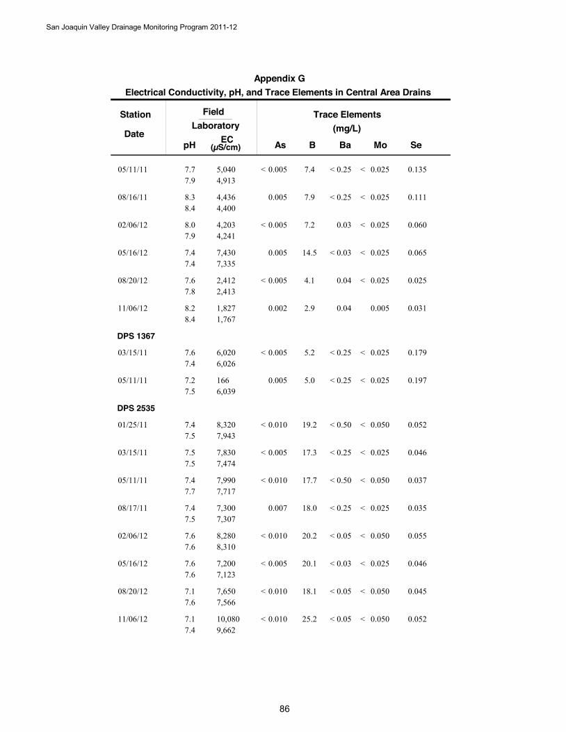
Station
DateB
Trace Elements(mg/L)
SeAs Ba Mo
FieldLaboratory
pH EC(µS/cm)
Electrical Conductivity, pH, and Trace Elements in Central Area DrainsAppendix G
7.405/11/11 0.1350.005 0.0250.255,0404,913
7.77.9
< < <
7.908/16/11 0.1110.005 0.0250.254,4364,400
8.38.4
< <
7.202/06/12 0.0600.005 0.0250.034,2034,241
8.07.9
< <
14.505/16/12 0.0650.005 0.0250.037,4307,335
7.47.4
< <
4.108/20/12 0.0250.005 0.0250.042,4122,413
7.67.8
< <
2.911/06/12 0.0310.002 0.0050.041,8271,767
8.28.4
DPS 1367
5.203/15/11 0.1790.005 0.0250.256,0206,026
7.67.4
< < <
5.005/11/11 0.1970.005 0.0250.251666,039
7.27.5
< <
DPS 2535
19.201/25/11 0.0520.010 0.0500.508,3207,943
7.47.5
< < <
17.303/15/11 0.0460.005 0.0250.257,8307,474
7.57.5
< < <
17.705/11/11 0.0370.010 0.0500.507,9907,717
7.47.7
< < <
18.008/17/11 0.0350.007 0.0250.257,3007,307
7.47.5
< <
20.202/06/12 0.0550.010 0.0500.058,2808,310
7.67.6
< < <
20.105/16/12 0.0460.005 0.0250.037,2007,123
7.67.6
< < <
18.108/20/12 0.0450.010 0.0500.057,6507,566
7.17.6
< < <
25.211/06/12 0.0520.010 0.0500.0510,0809,662
7.17.4
< < <
San Joaquin Valley Drainage Monitoring Program 2011-12
86
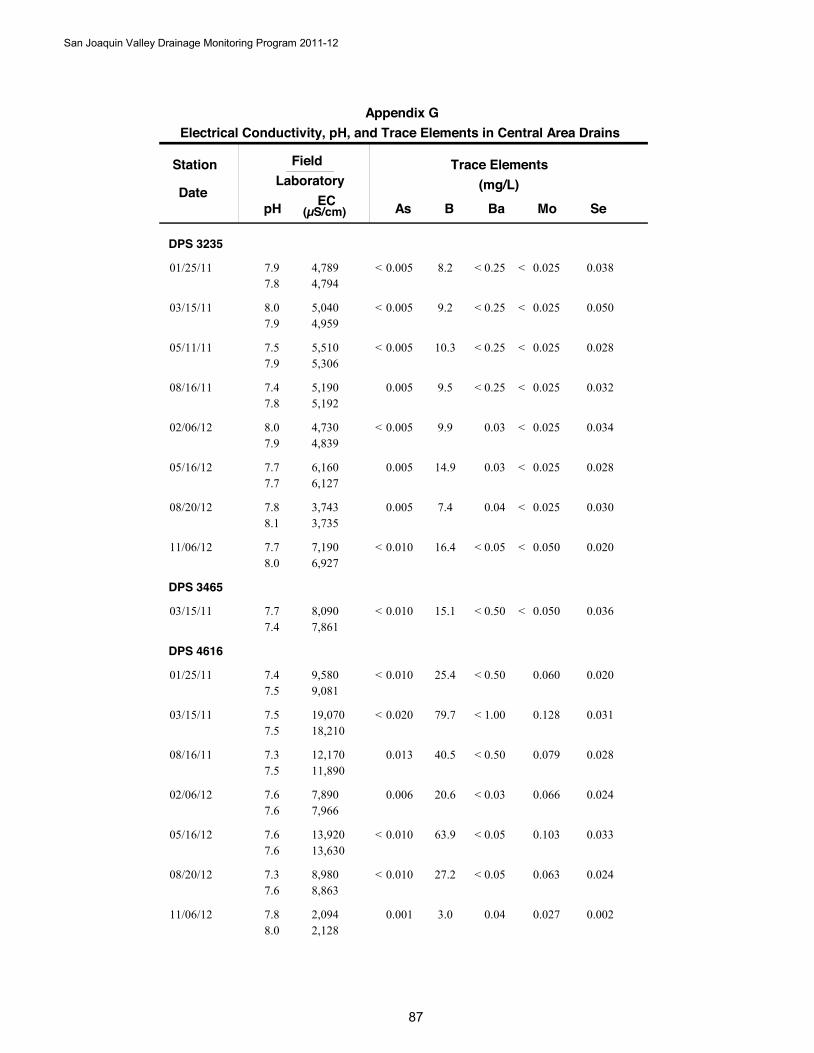
Station
DateB
Trace Elements(mg/L)
SeAs Ba Mo
FieldLaboratory
pH EC(µS/cm)
Electrical Conductivity, pH, and Trace Elements in Central Area DrainsAppendix G
DPS 3235
8.201/25/11 0.0380.005 0.0250.254,7894,794
7.97.8
< < <
9.203/15/11 0.0500.005 0.0250.255,0404,959
8.07.9
< < <
10.305/11/11 0.0280.005 0.0250.255,5105,306
7.57.9
< < <
9.508/16/11 0.0320.005 0.0250.255,1905,192
7.47.8
< <
9.902/06/12 0.0340.005 0.0250.034,7304,839
8.07.9
< <
14.905/16/12 0.0280.005 0.0250.036,1606,127
7.77.7
<
7.408/20/12 0.0300.005 0.0250.043,7433,735
7.88.1
<
16.411/06/12 0.0200.010 0.0500.057,1906,927
7.78.0
< < <
DPS 3465
15.103/15/11 0.0360.010 0.0500.508,0907,861
7.77.4
< < <
DPS 4616
25.401/25/11 0.0200.010 0.0600.509,5809,081
7.47.5
< <
79.703/15/11 0.0310.020 0.1281.0019,07018,210
7.57.5
< <
40.508/16/11 0.0280.013 0.0790.5012,17011,890
7.37.5
<
20.602/06/12 0.0240.006 0.0660.037,8907,966
7.67.6
<
63.905/16/12 0.0330.010 0.1030.0513,92013,630
7.67.6
< <
27.208/20/12 0.0240.010 0.0630.058,9808,863
7.37.6
< <
3.011/06/12 0.0020.001 0.0270.042,0942,128
7.88.0
San Joaquin Valley Drainage Monitoring Program 2011-12
8
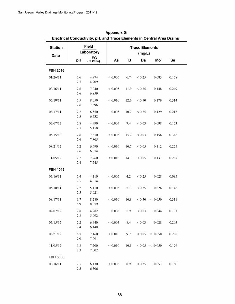
Station
DateB
Trace Elements(mg/L)
SeAs Ba Mo
FieldLaboratory
pH EC(µS/cm)
Electrical Conductivity, pH, and Trace Elements in Central Area DrainsAppendix G
FBH 2016
6.701/26/11 0.1580.005 0.0850.254,9744,909
7.67.7
< <
11.903/16/11 0.2490.005 0.1480.257,0406,859
7.67.6
< <
12.605/10/11 0.3140.010 0.1790.508,0507,896
7.57.6
< <
10.708/17/11 0.2150.005 0.1290.256,5506,532
7.27.5
<
7.402/07/12 0.1730.005 0.0980.034,9905,158
7.87.7
< <
15.205/15/12 0.3460.005 0.1560.037,8507,805
7.67.6
< <
10.708/21/12 0.2250.010 0.1120.056,6906,674
7.27.6
< <
14.311/05/12 0.2670.010 0.1370.057,9607,745
7.27.4
< <
FBH 4045
4.203/16/11 0.0950.005 0.0280.254,1104,014
7.47.5
< <
5.105/10/11 0.1480.005 0.0260.255,1105,021
7.27.5
< <
10.808/17/11 0.3110.010 0.0500.508,2808,079
6.76.9
< < <
5.902/07/12 0.1310.006 0.0440.034,9825,092
7.87.8
<
8.405/15/12 0.2050.005 0.0280.036,4406,448
7.27.4
< <
9.708/21/12 0.2080.010 0.0500.057,1607,091
6.77.0
< < <
10.111/05/12 0.1760.010 0.0500.057,2007,002
6.87.3
< < <
FBH 5056
8.903/16/11 0.1600.005 0.0530.256,4306,306
7.57.5
< <
San Joaquin Valley Drainage Monitoring Program 2011-12
88
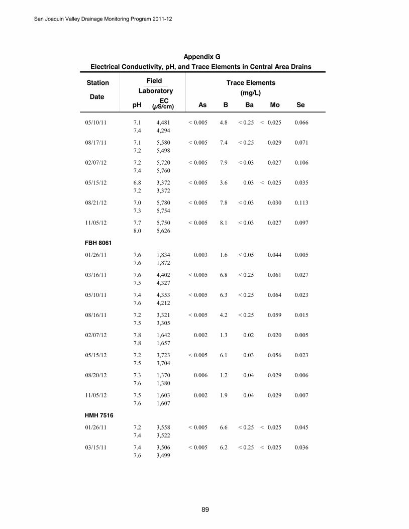
Station
DateB
Trace Elements(mg/L)
SeAs Ba Mo
FieldLaboratory
pH EC(µS/cm)
Electrical Conductivity, pH, and Trace Elements in Central Area DrainsAppendix G
4.805/10/11 0.0660.005 0.0250.254,4814,294
7.17.4
< < <
7.408/17/11 0.0710.005 0.0290.255,5805,498
7.17.2
< <
7.902/07/12 0.1060.005 0.0270.035,7205,760
7.27.4
< <
3.605/15/12 0.0350.005 0.0250.033,3723,372
6.87.2
< <
7.808/21/12 0.1130.005 0.0300.035,7805,754
7.07.3
< <
8.111/05/12 0.0970.005 0.0270.035,7505,626
7.78.0
< <
FBH 8061
1.601/26/11 0.0050.003 0.0440.051,8341,872
7.67.6
<
6.803/16/11 0.0270.005 0.0610.254,4024,327
7.67.5
< <
6.305/10/11 0.0230.005 0.0640.254,3534,212
7.47.6
< <
4.208/16/11 0.0150.005 0.0590.253,3213,305
7.27.5
< <
1.302/07/12 0.0050.002 0.0200.021,6421,657
7.87.8
6.105/15/12 0.0230.005 0.0560.033,7233,704
7.27.5
<
1.208/20/12 0.0060.006 0.0290.041,3701,380
7.37.6
1.911/05/12 0.0070.002 0.0290.041,6031,607
7.57.6
HMH 7516
6.601/26/11 0.0450.005 0.0250.253,5583,522
7.27.4
< < <
6.203/15/11 0.0360.005 0.0250.253,5063,499
7.47.6
< < <
San Joaquin Valley Drainage Monitoring Program 2011-12
89
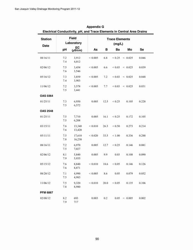
Station
DateB
Trace Elements(mg/L)
SeAs Ba Mo
FieldLaboratory
pH EC(µS/cm)
Electrical Conductivity, pH, and Trace Elements in Central Area DrainsAppendix G
6.808/16/11 0.0460.005 0.0250.253,9124,012
7.27.4
< < <
6.602/06/12 0.0390.005 0.0250.033,4543,546
7.57.6
< < <
7.205/16/12 0.0480.005 0.0250.033,8593,903
7.37.4
< < <
7.711/06/12 0.0310.005 0.0250.033,5783,441
7.27.5
< < <
OAS 0364
12.501/25/11 0.2280.005 0.1050.256,9506,572
7.37.5
<
OAS 2548
16.101/25/11 0.1050.005 0.1720.257,7106,208
7.57.5
<
26.303/15/11 0.2140.010 0.2730.5013,34013,420
7.67.6
< <
33.505/11/11 0.2880.020 0.3361.0017,61016,230
7.57.8
< <
12.708/16/11 0.0810.005 0.1460.256,9707,027
7.27.5
<
9.902/06/12 0.0900.005 0.1080.035,8405,935
8.17.9
18.605/15/12 0.1260.010 0.1460.058,8408,871
7.67.6
< <
8.608/20/12 0.0520.005 0.0790.054,9904,983
7.17.5
<
20.011/06/12 0.1060.010 0.1350.059,3208,980
7.57.8
< <
PFM 6867
0.202/08/12 0.0020.003 0.0050.05693717
8.27.9
<
San Joaquin Valley Drainage Monitoring Program 2011-12
900
San Joaquin Valley Drainage Monitoring Program 2011-12
91
Appendix H Mineral Analyses of Southern Area Drains
2011-2012
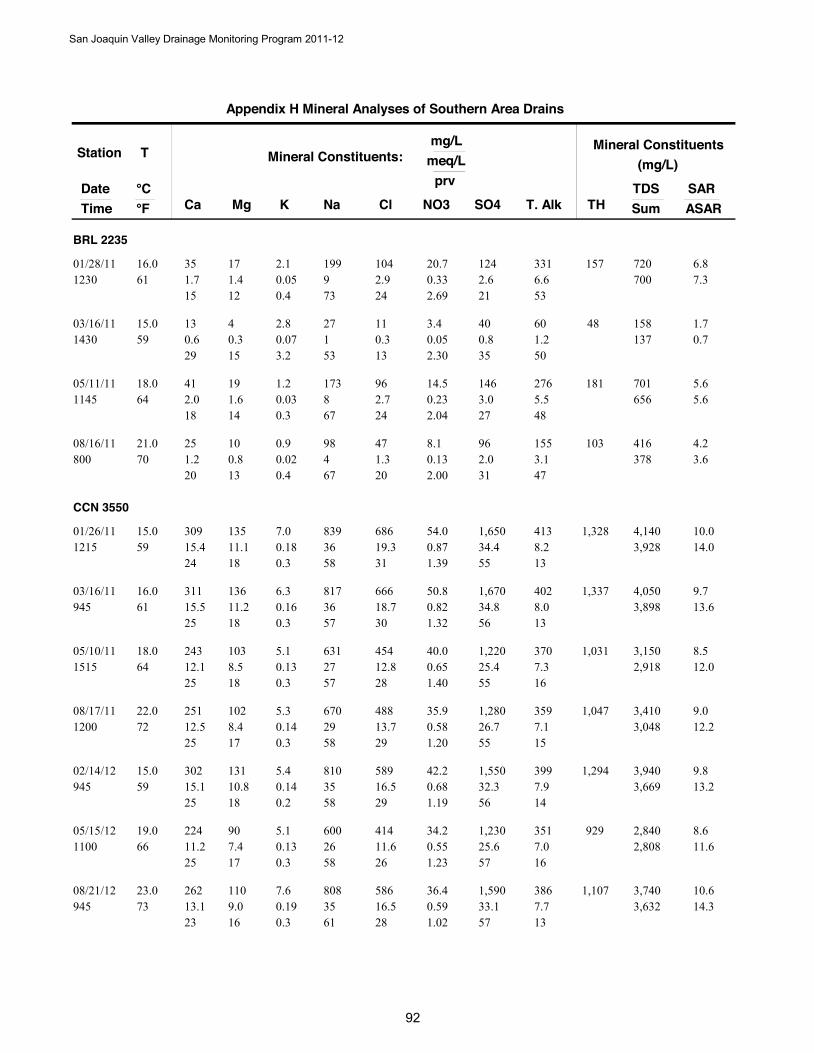
Station
DateTime
T
Ca Mg Na NO3
Mineral Constituents:mg/L
meq/L
°C °F Cl SO4 T. Alk
prv
K
Mineral Constituents(mg/L)
TDSSumTH
SARASAR
Appendix H Mineral Analyses of Southern Area Drains
BRL 2235
35 171.7 9 0.3361 1.4
199 20.701/28/111230
16.0 1042.9 2.6
15 12 736.6
240.052.1
0.4
6.8157700 7.3
2.69 21 53
124 331 720
13 40.6 1 0.0559 0.3
27 3.403/16/111430
15.0 110.3 0.8
29 15 531.2
130.072.8
3.2
1.748137 0.7
2.30 35 50
40 60 158
41 192.0 8 0.2364 1.6
173 14.505/11/111145
18.0 962.7 3.0
18 14 675.5
240.031.2
0.3
5.6181656 5.6
2.04 27 48
146 276 701
25 101.2 4 0.1370 0.8
98 8.108/16/11800
21.0 471.3 2.0
20 13 673.1
200.020.9
0.4
4.2103378 3.6
2.00 31 47
96 155 416
CCN 3550
309 13515.4 36 0.8759 11.1
839 54.001/26/111215
15.0 68619.3 34.4
24 18 588.2
310.187.0
0.3
10.01,3283,928 14.0
1.39 55 13
1,650 413 4,140
311 13615.5 36 0.8261 11.2
817 50.803/16/11945
16.0 66618.7 34.8
25 18 578.0
300.166.3
0.3
9.71,3373,898 13.6
1.32 56 13
1,670 402 4,050
243 10312.1 27 0.6564 8.5
631 40.005/10/111515
18.0 45412.8 25.4
25 18 577.3
280.135.1
0.3
8.51,0312,918 12.0
1.40 55 16
1,220 370 3,150
251 10212.5 29 0.5872 8.4
670 35.908/17/111200
22.0 48813.7 26.7
25 17 587.1
290.145.3
0.3
9.01,0473,048 12.2
1.20 55 15
1,280 359 3,410
302 13115.1 35 0.6859 10.8
810 42.202/14/12945
15.0 58916.5 32.3
25 18 587.9
290.145.4
0.2
9.81,2943,669 13.2
1.19 56 14
1,550 399 3,940
224 9011.2 26 0.5566 7.4
600 34.205/15/121100
19.0 41411.6 25.6
25 17 587.0
260.135.1
0.3
8.69292,808 11.6
1.23 57 16
1,230 351 2,840
262 11013.1 35 0.5973 9.0
808 36.408/21/12945
23.0 58616.5 33.1
23 16 617.7
280.197.6
0.3
10.61,1073,632 14.3
1.02 57 13
1,590 386 3,740
San Joaquin Valley Drainage Monitoring Program 2011-12
92
Station
DateTime
T
Ca Mg Na NO3
Mineral Constituents:mg/L
meq/L
°C °F Cl SO4 T. Alk
prv
K
Mineral Constituents(mg/L)
TDSSumTH
SARASAR
Appendix H Mineral Analyses of Southern Area Drains
223 9711.1 27 0.5568 8.0
624 34.211/14/121000
20.0 43912.3 25.7
24 17 587.1
270.135.1
0.3
8.89572,872 11.9
1.21 56 16
1,233 360 2,980
CNR 0801
388 35919.4 82 3.7464 29.5
1,890 232.001/25/111300
18.0 50914.3 102.0
15 22 625.7
111.9475.7
1.5
16.62,4488,525 23.3
2.98 81 5
4,900 286 7,190
409 39720.4 85 3.8563 32.6
1,950 239.003/16/111230
17.0 50614.2 109.5
15 23 615.3
111.4958.2
1.1
16.52,6578,978 24.7
2.90 82 4
5,260 265 9,460
390 35119.5 79 3.5668 28.9
1,810 221.005/10/111030
20.0 50514.2 108.1
15 22 615.1
111.4857.9
1.2
16.02,4208,680 22.4
2.72 83 4
5,190 259 8,230
396 31919.8 76 4.4073 26.2
1,750 273.008/17/11930
23.0 46413.0 96.8
16 21 625.0
111.4456.3
1.2
15.92,3038,058 21.4
3.69 81 4
4,650 250 8,760
410 32720.5 80 3.5063 26.9
1,840 217.002/13/121200
17.0 48613.7 100.4
16 21 625.9
111.5962.0
1.2
16.52,3718,340 23.0
2.84 81 5
4,820 296 8,620
397 27219.8 50 5.3566 22.4
1,140 332.005/15/121300
19.0 3409.6 70.8
21 24 534.1
111.2548.8
1.3
10.82,1126,053 14.6
5.96 79 5
3,400 206 6,370
347 26417.3 41 3.6172 21.7
950 224.008/20/121330
22.0 2938.2 63.9
21 27 514.6
101.2147.5
1.5
9.41,9545,335 12.6
4.49 80 6
3,070 232 5,580
401 27320.0 45 6.0172 22.5
1,040 372.611/13/121045
22.0 2948.3 63.4
22 25 513.6
101.3151.3
1.5
9.82,1265,582 12.8
7.40 78 4
3,043 179 5,850
COC 4126
526 13626.2 29 3.9064 11.2
657 242.001/25/111200
18.0 1905.3 53.5
40 17 434.9
80.176.8
0.3
6.61,8744,475 8.9
5.77 79 7
2,570 246 3,840
558 12427.8 22 3.6464 10.2
512 226.003/15/111030
18.0 2888.1 43.5
46 17 374.6
140.197.3
0.3
5.11,9043,945 6.9
6.09 73 8
2,090 232 4,160
San Joaquin Valley Drainage Monitoring Program 2011-12
93
Station
DateTime
T
Ca Mg Na NO3
Mineral Constituents:mg/L
meq/L
°C °F Cl SO4 T. Alk
prv
K
Mineral Constituents(mg/L)
TDSSumTH
SARASAR
Appendix H Mineral Analyses of Southern Area Drains
536 14626.7 27 3.9766 12.0
616 246.005/10/111100
19.0 1764.9 52.1
41 18 414.8
80.155.9
0.2
6.11,9404,372 8.2
6.03 79 7
2,500 244 4,520
500 8425.0 13 2.1873 6.9
305 135.008/17/11800
23.0 1494.2 35.8
55 15 294.1
90.124.7
0.3
3.31,5953,021 4.7
4.71 77 9
1,720 206 3,260
478 7823.9 11 1.4466 6.4
259 89.302/13/121330
19.0 1063.0 32.1
57 15 273.8
70.124.7
0.3
2.91,5152,671 3.9
3.57 80 10
1,540 194 2,830
509 12625.4 25 3.9868 10.4
570 247.005/15/121200
20.0 1805.1 51.4
42 17 415.0
80.197.4
0.3
5.91,7904,260 8.2
6.09 79 8
2,470 251 4,530
499 10324.9 22 2.3779 8.5
510 146.708/20/121230
26.0 37510.5 40.2
45 15 404.1
180.259.9
0.5
5.41,6703,699 7.3
4.13 70 7
1,930 209 3,760
521 11526.0 19 2.9264 9.5
438 181.011/13/121000
18.0 2126.0 40.8
48 17 353.5
110.208.0
0.4
4.51,7753,542 5.9
5.49 77 7
1,961 177 3,670
COC 8221
373 12718.6 33 1.9064 10.4
762 118.001/25/111230
18.0 1815.1 49.1
30 17 533.6
90.3714.5
0.6
8.71,4554,045 10.4
3.18 82 6
2,360 183 3,940
408 13420.4 31 1.6966 11.0
707 105.003/15/111130
19.0 1754.9 49.8
33 18 493.6
80.3413.4
0.5
7.81,5714,040 10.1
2.82 83 6
2,390 180 4,100
374 12718.7 28 1.7366 10.4
653 107.005/10/111145
19.0 1734.9 49.6
32 18 493.6
80.3312.8
0.6
7.41,4573,935 8.9
2.89 83 6
2,380 180 3,700
326 13016.3 33 2.3572 10.7
749 146.008/17/11830
22.0 1875.3 50.6
27 18 543.6
90.3413.4
0.6
8.91,3504,089 10.6
3.81 82 6
2,430 180 4,340
376 13918.8 32 1.8766 11.4
741 116.002/13/121400
19.0 1785.0 47.5
30 18 513.7
90.3513.5
0.6
8.31,5123,955 10.8
3.22 82 6
2,280 185 4,080
373 12418.6 30 1.9568 10.2
693 121.005/15/121230
20.0 1684.7 52.3
31 17 513.5
80.3614.2
0.6
7.91,4424,110 9.5
3.12 84 6
2,510 178 4,040
San Joaquin Valley Drainage Monitoring Program 2011-12
94
Station
DateTime
T
Ca Mg Na NO3
Mineral Constituents:mg/L
meq/L
°C °F Cl SO4 T. Alk
prv
K
Mineral Constituents(mg/L)
TDSSumTH
SARASAR
Appendix H Mineral Analyses of Southern Area Drains
333 11216.6 30 2.1073 9.2
686 130.008/20/121300
23.0 1584.4 45.4
30 16 533.5
80.4115.9
0.7
8.31,2933,722 10.0
3.78 82 6
2,180 178 3,860
375 12618.7 31 2.1372 10.4
713 132.111/13/121030
22.0 1544.3 45.3
31 17 513.6
80.3714.6
0.6
8.11,4563,799 9.8
3.85 82 6
2,177 179 3,960
ERR 8429
157 887.8 74 0.3164 7.2
1,710 19.101/26/111300
18.0 80522.6 51.6
9 8 8313.7
260.239.0
0.3
27.17545,681 39.3
0.35 59 15
2,480 688 5,920
152 887.6 77 0.3163 7.2
1,760 19.203/16/111115
17.0 85624.0 54.1
8 8 8413.7
260.187.2
0.2
28.17415,896 39.4
0.34 59 15
2,600 690 6,120
44 252.2 23 1.4564 2.1
521 90.005/11/11830
18.0 1845.2 6.3
8 8 8413.8
190.114.2
0.4
15.52121,592 18.5
5.42 24 52
304 698 1,690
127 806.3 68 1.0672 6.6
1,560 65.908/17/111230
22.0 74020.8 40.2
8 8 8414.3
270.166.3
0.2
26.76464,941 37.4
1.39 53 19
1,930 720 5,480
132 756.6 67 0.9661 6.2
1,530 59.802/14/121015
16.0 74520.9 44.1
8 8 8414.5
260.155.9
0.2
26.46385,108 36.9
1.20 55 18
2,120 733 5,320
190 1029.5 100 0.9966 8.4
2,300 61.205/15/121200
19.0 1,14032.0 72.5
8 7 8514.4
270.249.2
0.2
33.58957,717 48.5
0.82 60 12
3,480 724 7,750
42 232.1 21 1.6373 1.9
493 101.008/20/121030
23.0 1845.2 6.1
8 7 8413.1
200.145.4
0.5
15.22011,536 17.5
6.28 23 50
292 659 1,640
117 645.8 56 1.0070 5.2
1,290 62.311/14/121030
21.0 55215.5 33.7
9 8 8313.3
240.155.7
0.2
23.85554,110 32.2
1.58 53 21
1,618 668 4,170
ERR 8641
208 20910.4 99 0.0563 17.2
2,270 3.401/26/111330
17.0 97227.3 77.5
8 14 7810.7
240.5621.7
0.4
26.61,3807,726 38.5
0.05 67 9
3,720 537 8,150
San Joaquin Valley Drainage Monitoring Program 2011-12
95
Station
DateTime
T
Ca Mg Na NO3
Mineral Constituents:mg/L
meq/L
°C °F Cl SO4 T. Alk
prv
K
Mineral Constituents(mg/L)
TDSSumTH
SARASAR
Appendix H Mineral Analyses of Southern Area Drains
183 1849.1 81 0.0463 15.1
1,860 2.503/16/111030
17.0 85724.1 70.4
9 14 779.8
230.4015.7
0.4
23.21,2156,779 32.5
0.04 67 9
3,380 494 7,090
232 25611.6 98 0.0763 21.1
2,260 4.305/11/11845
17.0 1,13031.7 97.0
9 16 7510.9
230.4818.6
0.4
24.31,6348,889 37.7
0.05 69 8
4,660 547 9,130
204 22410.2 87 0.0772 18.4
2,000 4.508/17/111300
22.0 97627.4 85.8
9 16 7510.1
220.4517.5
0.4
23.01,4327,852 33.3
0.06 70 8
4,120 510 8,150
365 40918.2 166 0.2861 33.6
3,810 17.102/14/121030
16.0 1,62045.5 149.5
8 15 7613.8
220.6927.0
0.3
32.62,59613,845 55.3
0.13 72 7
7,180 694 14,540
212 23210.6 98 0.0766 19.1
2,260 4.205/15/121230
19.0 1,03028.9 88.7
8 15 779.6
230.4718.5
0.4
25.51,4858,308 35.7
0.05 70 8
4,260 485 8,240
199 2089.9 90 0.2669 17.1
2,080 16.108/21/121000
20.4 92526.0 82.0
8 14 779.6
220.6625.7
0.6
24.61,3547,684 34.5
0.22 70 8
3,940 484 8,080
58 332.9 21 0.0168 2.7
477 0.611/14/121045
20.0 2246.3 13.4
11 10 785.1
250.166.1
0.6
12.52771,594 13.1
0.04 54 21
642 258 1,660
GSY 0935
101 445.0 23 1.4363 3.6
529 88.901/26/111400
17.0 2166.1 15.2
16 11 729.0
190.187.2
0.6
11.14321,991 13.8
4.52 48 28
732 454 2,020
53 262.6 21 1.4261 2.1
473 87.803/16/111145
16.0 1694.7 8.8
10 8 8110.5
190.135.2
0.5
13.32381,554 15.3
5.56 34 41
421 531 1,660
39 211.9 17 1.1763 1.7
386 72.305/11/11800
17.0 1363.8 6.5
9 8 829.8
180.124.6
0.6
12.41841,269 13.0
5.47 31 46
313 495 1,380
56 272.8 18 1.4072 2.2
404 86.908/17/111400
22.0 1464.1 8.0
12 10 779.8
180.135.1
0.6
11.12501,408 12.8
6.00 34 42
386 495 1,510
23 121.1 15 1.0859 1.0
350 66.902/14/121100
15.0 912.6 4.0
7 6 878.8
150.052.0
0.3
14.71081,007 14.7
6.53 24 54
194 446 1,070
San Joaquin Valley Drainage Monitoring Program 2011-12
96
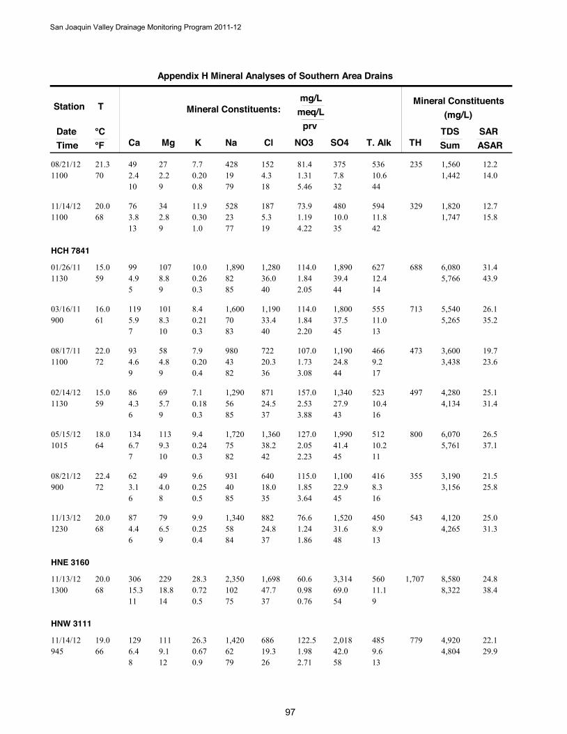
Station
DateTime
T
Ca Mg Na NO3
Mineral Constituents:mg/L
meq/L
°C °F Cl SO4 T. Alk
prv
K
Mineral Constituents(mg/L)
TDSSumTH
SARASAR
Appendix H Mineral Analyses of Southern Area Drains
49 272.4 19 1.3170 2.2
428 81.408/21/121100
21.3 1524.3 7.8
10 9 7910.6
180.207.7
0.8
12.22351,442 14.0
5.46 32 44
375 536 1,560
76 343.8 23 1.1968 2.8
528 73.911/14/121100
20.0 1875.3 10.0
13 9 7711.8
190.3011.9
1.0
12.73291,747 15.8
4.22 35 42
480 594 1,820
HCH 7841
99 1074.9 82 1.8459 8.8
1,890 114.001/26/111130
15.0 1,28036.0 39.4
5 9 8512.4
400.2610.0
0.3
31.46885,766 43.9
2.05 44 14
1,890 627 6,080
119 1015.9 70 1.8461 8.3
1,600 114.003/16/11900
16.0 1,19033.4 37.5
7 10 8311.0
400.218.4
0.3
26.17135,265 35.2
2.20 45 13
1,800 555 5,540
93 584.6 43 1.7372 4.8
980 107.008/17/111100
22.0 72220.3 24.8
9 9 829.2
360.207.9
0.4
19.74733,438 23.6
3.08 44 17
1,190 466 3,600
86 694.3 56 2.5359 5.7
1,290 157.002/14/121130
15.0 87124.5 27.9
6 9 8510.4
370.187.1
0.3
25.14974,134 31.4
3.88 43 16
1,340 523 4,280
134 1136.7 75 2.0564 9.3
1,720 127.005/15/121015
18.0 1,36038.2 41.4
7 10 8210.2
420.249.4
0.3
26.58005,761 37.1
2.23 45 11
1,990 512 6,070
62 493.1 40 1.8572 4.0
931 115.008/21/12900
22.4 64018.0 22.9
6 8 858.3
350.259.6
0.5
21.53553,156 25.8
3.64 45 16
1,100 416 3,190
87 794.4 58 1.2468 6.5
1,340 76.611/13/121230
20.0 88224.8 31.6
6 9 848.9
370.259.9
0.4
25.05434,265 31.3
1.86 48 13
1,520 450 4,120
HNE 3160
306 22915.3 102 0.9868 18.8
2,350 60.611/13/121300
20.0 1,69847.7 69.0
11 14 7511.1
370.7228.3
0.5
24.81,7078,322 38.4
0.76 54 9
3,314 560 8,580
HNW 3111
129 1116.4 62 1.9866 9.1
1,420 122.511/14/12945
19.0 68619.3 42.0
8 12 799.6
260.6726.3
0.9
22.17794,804 29.9
2.71 58 13
2,018 485 4,920
San Joaquin Valley Drainage Monitoring Program 2011-12
9
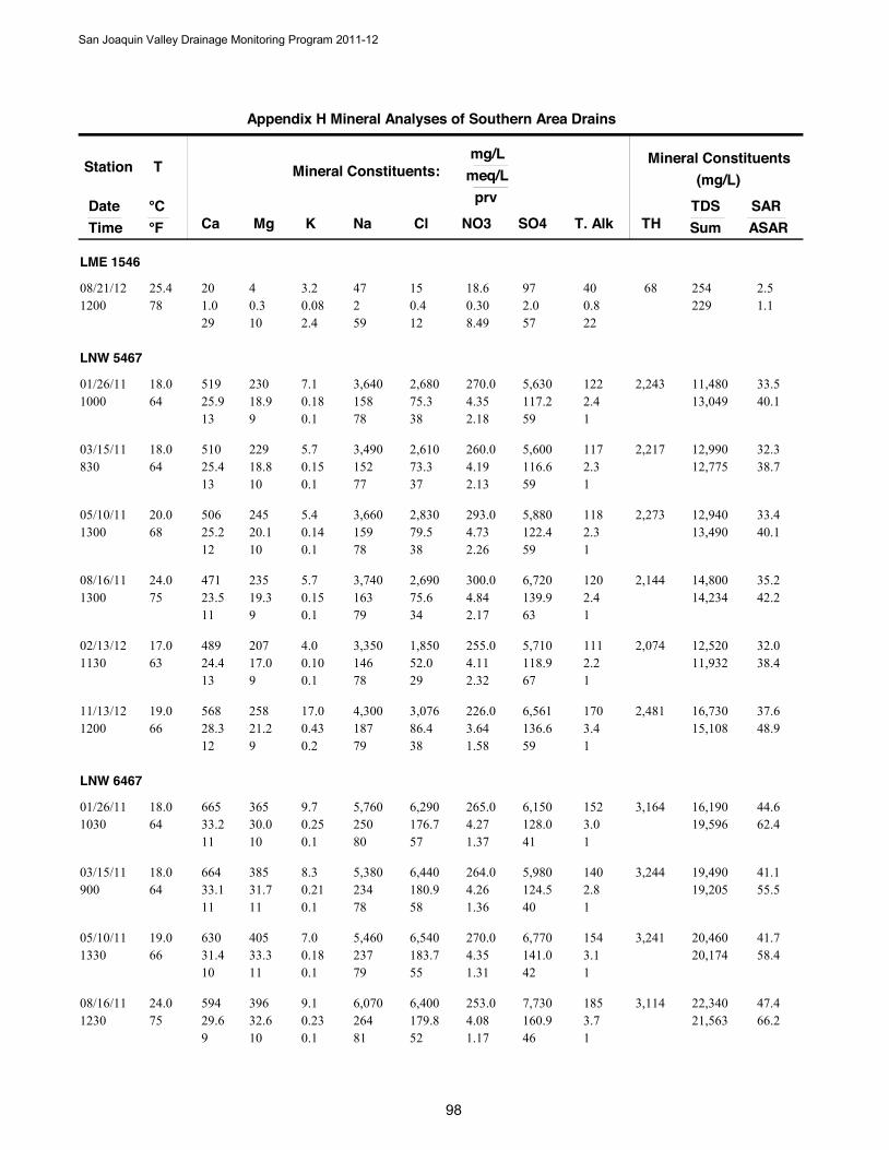
Station
DateTime
T
Ca Mg Na NO3
Mineral Constituents:mg/L
meq/L
°C °F Cl SO4 T. Alk
prv
K
Mineral Constituents(mg/L)
TDSSumTH
SARASAR
Appendix H Mineral Analyses of Southern Area Drains
LME 1546
20 41.0 2 0.3078 0.3
47 18.608/21/121200
25.4 150.4 2.0
29 10 590.8
120.083.2
2.4
2.568229 1.1
8.49 57 22
97 40 254
LNW 5467
519 23025.9 158 4.3564 18.9
3,640 270.001/26/111000
18.0 2,68075.3 117.2
13 9 782.4
380.187.1
0.1
33.52,24313,049 40.1
2.18 59 1
5,630 122 11,480
510 22925.4 152 4.1964 18.8
3,490 260.003/15/11830
18.0 2,61073.3 116.6
13 10 772.3
370.155.7
0.1
32.32,21712,775 38.7
2.13 59 1
5,600 117 12,990
506 24525.2 159 4.7368 20.1
3,660 293.005/10/111300
20.0 2,83079.5 122.4
12 10 782.3
380.145.4
0.1
33.42,27313,490 40.1
2.26 59 1
5,880 118 12,940
471 23523.5 163 4.8475 19.3
3,740 300.008/16/111300
24.0 2,69075.6 139.9
11 9 792.4
340.155.7
0.1
35.22,14414,234 42.2
2.17 63 1
6,720 120 14,800
489 20724.4 146 4.1163 17.0
3,350 255.002/13/121130
17.0 1,85052.0 118.9
13 9 782.2
290.104.0
0.1
32.02,07411,932 38.4
2.32 67 1
5,710 111 12,520
568 25828.3 187 3.6466 21.2
4,300 226.011/13/121200
19.0 3,07686.4 136.6
12 9 793.4
380.4317.0
0.2
37.62,48115,108 48.9
1.58 59 1
6,561 170 16,730
LNW 6467
665 36533.2 250 4.2764 30.0
5,760 265.001/26/111030
18.0 6,290176.7 128.0
11 10 803.0
570.259.7
0.1
44.63,16419,596 62.4
1.37 41 1
6,150 152 16,190
664 38533.1 234 4.2664 31.7
5,380 264.003/15/11900
18.0 6,440180.9 124.5
11 11 782.8
580.218.3
0.1
41.13,24419,205 55.5
1.36 40 1
5,980 140 19,490
630 40531.4 237 4.3566 33.3
5,460 270.005/10/111330
19.0 6,540183.7 141.0
10 11 793.1
550.187.0
0.1
41.73,24120,174 58.4
1.31 42 1
6,770 154 20,460
594 39629.6 264 4.0875 32.6
6,070 253.008/16/111230
24.0 6,400179.8 160.9
9 10 813.7
520.239.1
0.1
47.43,11421,563 66.2
1.17 46 1
7,730 185 22,340
San Joaquin Valley Drainage Monitoring Program 2011-12
98
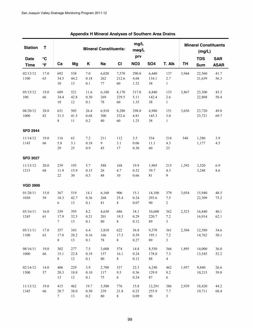
Station
DateTime
T
Ca Mg Na NO3
Mineral Constituents:mg/L
meq/L
°C °F Cl SO4 T. Alk
prv
K
Mineral Constituents(mg/L)
TDSSumTH
SARASAR
Appendix H Mineral Analyses of Southern Area Drains
692 53834.5 262 4.6863 44.2
6,020 290.002/13/121100
17.0 7,570212.6 134.1
10 13 772.7
600.187.0
0.1
41.73,94421,639 56.3
1.32 38 1
6,440 137 22,560
689 52134.4 269 5.1166 42.8
6,180 317.005/15/12100
19.0 8,170229.5 142.4
10 12 782.6
600.3011.6
0.1
43.33,86722,808 58.4
1.35 38 1
6,840 133 23,300
631 50531.5 300 4.8182 41.5
6,910 298.008/20/121000
28.0 8,280232.6 145.3
8 11 803.0
600.6826.4
0.2
49.83,65623,721 69.7
1.25 38 1
6,980 151 23,720
SFD 2944
116 635.8 9 0.0666 5.1
211 3.511/14/121145
19.0 1123.1 11.1
29 25 454.3
170.187.2
0.9
3.95481,177 4.5
0.30 60 23
534 218 1,280
SFD 3027
239 19311.9 26 0.3268 15.9
588 19.911/13/121215
20.0 1684.7 39.7
22 30 484.3
100.155.7
0.3
6.91,3923,248 8.6
0.66 81 9
1,905 215 3,520
VGD 3906
367 51918.3 268 0.2459 42.7
6,160 15.101/28/111030
15.0 90625.4 293.6
6 13 817.5
80.3614.1
0.1
48.53,05422,309 75.2
0.07 90 2
14,100 379 15,940
359 39517.9 201 0.2961 32.5
4,630 18.103/16/111245
16.0 68619.3 220.7
7 13 807.2
80.218.2
0.1
40.12,52316,914 62.1
0.12 89 3
10,600 362 16,840
357 34317.8 166 0.5963 28.2
3,810 36.805/11/111100
17.0 62217.5 195.1
8 13 787.2
80.166.4
0.1
34.62,30414,762 50.1
0.27 89 3
9,370 361 12,580
302 27715.1 157 0.2466 22.8
3,600 14.808/16/111000
19.0 57416.1 178.0
8 12 807.3
80.197.5
0.1
36.01,89513,545 52.2
0.12 88 4
8,550 366 14,000
406 22920.3 117 0.3657 18.8
2,700 22.302/14/121300
14.0 3379.5 129.9
13 12 759.2
60.103.9
0.1
26.61,95710,215 39.8
0.24 87 6
6,240 462 9,840
415 46220.7 239 0.2566 38.0
5,500 15.811/13/121345
19.0 77621.8 255.9
7 13 807.7
80.5019.7
0.2
44.22,93919,711 68.4
0.09 90 3
12,291 386 18,420
San Joaquin Valley Drainage Monitoring Program 2011-12
99
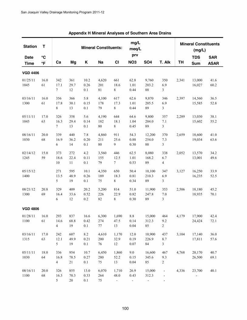
Station
DateTime
T
Ca Mg Na NO3
Mineral Constituents:mg/L
meq/L
°C °F Cl SO4 T. Alk
prv
K
Mineral Constituents(mg/L)
TDSSumTH
SARASAR
Appendix H Mineral Analyses of Southern Area Drains
VGD 4406
342 36117.1 201 1.0161 29.7
4,620 62.801/25/111045
16.0 66118.6 203.2
7 12 816.9
80.2610.2
0.1
41.62,34116,027 60.2
0.44 88 3
9,760 350 13,000
356 36617.8 178 1.0161 30.1
4,100 62.603/16/111300
16.0 61717.3 205.5
8 13 796.9
80.155.8
0.1
36.52,39715,585 52.8
0.44 89 3
9,870 346 14,560
326 35816.3 182 1.0463 29.4
4,190 64.605/11/111045
17.0 64418.1 204.0
7 13 807.1
80.145.6
0.1
38.12,28915,602 55.2
0.45 89 3
9,800 357 13,030
339 44016.9 211 0.8868 36.2
4,860 54.308/16/111030
20.0 91125.6 254.0
6 14 807.3
90.207.8
0.1
41.02,65919,034 63.6
0.30 88 3
12,200 370 18,600
373 27218.6 155 1.0159 22.4
3,560 62.502/14/121245
15.0 44612.5 168.2
10 11 796.7
70.114.2
0.1
34.22,05213,001 49.6
0.53 89 4
8,080 338 13,570
271 59513.5 189 0.8148.9
4,350 50.405/15/121400
65018.3 210.3
5 19 756.9
80.2610.1
0.1
33.93,12716,235 52.5
0.34 89 3
10,100 347 16,250
329 40916.4 226 0.8269 33.6
5,200 51.008/21/121300
20.8 81422.9 247.8
6 12 827.0
80.5220.2
0.2
45.22,50618,935 70.1
0.30 89 3
11,900 353 18,180
VGD 4806
293 83714.6 274 0.1461 68.8
6,300 8.801/28/111100
16.0 1,69047.5 312.3
4 19 779.2
130.4216.6
0.1
42.44,17924,424 72.1
0.04 85 2
15,000 464 17,900
242 60712.1 200 0.1963 49.9
4,610 12.003/16/111315
17.0 1,17032.9 226.9
5 19 768.7
120.218.2
0.1
36.03,10417,811 57.6
0.07 84 3
10,900 437 17,140
336 95416.8 280 0.1564 78.5
6,450 9.005/11/111030
18.0 1,86052.2 345.6
4 21 759.3
130.2710.7
0.1
40.74,76826,500 69.1
0.04 85 2
16,600 467 20,170
326 85516.3 264 0.4368 70.3
6,070 26.908/16/111100
20.0 1,71048.0 312.3
5 20 75-
-0.3313.0
0.1
40.14,336-
- - -
15,000 - 23,700
San Joaquin Valley Drainage Monitoring Program 2011-12
1000
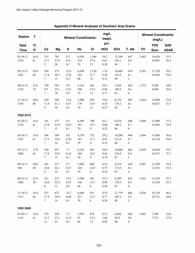
Station
DateTime
T
Ca Mg Na NO3
Mineral Constituents:mg/L
meq/L
°C °F Cl SO4 T. Alk
prv
K
Mineral Constituents(mg/L)
TDSSumTH
SARASAR
Appendix H Mineral Analyses of Southern Area Drains
315 70315.7 214 0.6261 57.8
4,920 38.202/14/121230
16.0 1,34037.6 256.1
5 20 748.9
120.218.2
0.1
35.33,68219,893 56.5
0.20 84 3
12,300 447 19,620
349 37317.4 193 0.2868 30.7
4,430 17.605/15/121345
20.0 1,13031.7 216.5
7 13 808.1
120.5822.8
0.2
39.32,28216,968 59.0
0.11 84 3
10,400 410 17,320
199 3059.9 100 0.9674 25.1
2,310 59.508/21/121330
23.4 56615.9 108.9
7 18 748.6
120.259.9
0.2
24.01,7538,940 36.0
0.71 81 6
5,230 434 9,280
238 50011.9 170 0.5568 41.1
3,900 34.411/14/121330
20.0 92025.8 170.2
5 18 768.1
130.3714.4
0.2
33.02,65414,027 52.7
0.27 83 4
8,176 407 13,890
VGD 5412
341 37717.0 183 0.6861 31.0
4,200 42.101/28/111130
16.0 70019.7 180.5
7 13 798.7
90.249.5
0.1
37.32,40414,604 55.9
0.32 86 4
8,670 440 12,900
346 38917.3 181 0.4761 32.0
4,170 29.203/16/111345
16.0 75221.1 212.4
7 14 798.7
90.208.0
0.1
36.62,46616,158 54.8
0.19 88 4
10,200 440 15,900
344 43717.2 184 0.4663 35.9
4,230 28.405/11/111000
17.0 86124.2 224.9
7 15 788.8
90.187.1
0.1
35.72,65916,973 57.1
0.18 87 3
10,800 442 14,420
361 31718.0 168 0.7768 26.1
3,860 47.608/16/11930
20.0 60016.9 173.0
8 12 798.6
80.155.7
0.1
35.82,20713,762 53.6
0.39 87 4
8,310 434 13,500
321 27216.0 156 0.9070 22.4
3,590 55.708/21/121400
21.0 54115.2 170.5
8 11 808.4
80.3714.5
0.2
35.71,92213,238 53.5
0.46 87 4
8,190 423 13,330
357 47217.8 215 0.7766 38.8
4,940 47.611/14/121315
19.0 83123.3 245.2
7 14 799.2
80.4015.7
0.1
40.42,83618,721 64.6
0.28 88 3
11,778 466 18,110
VGD 5509
275 32913.7 81 1.0861 27.1
1,870 67.201/28/111145
16.0 47913.5 92.0
11 22 669.0
120.197.3
0.2
18.02,0427,721 27.0
0.94 80 8
4,420 456 7,290
San Joaquin Valley Drainage Monitoring Program 2011-12
101
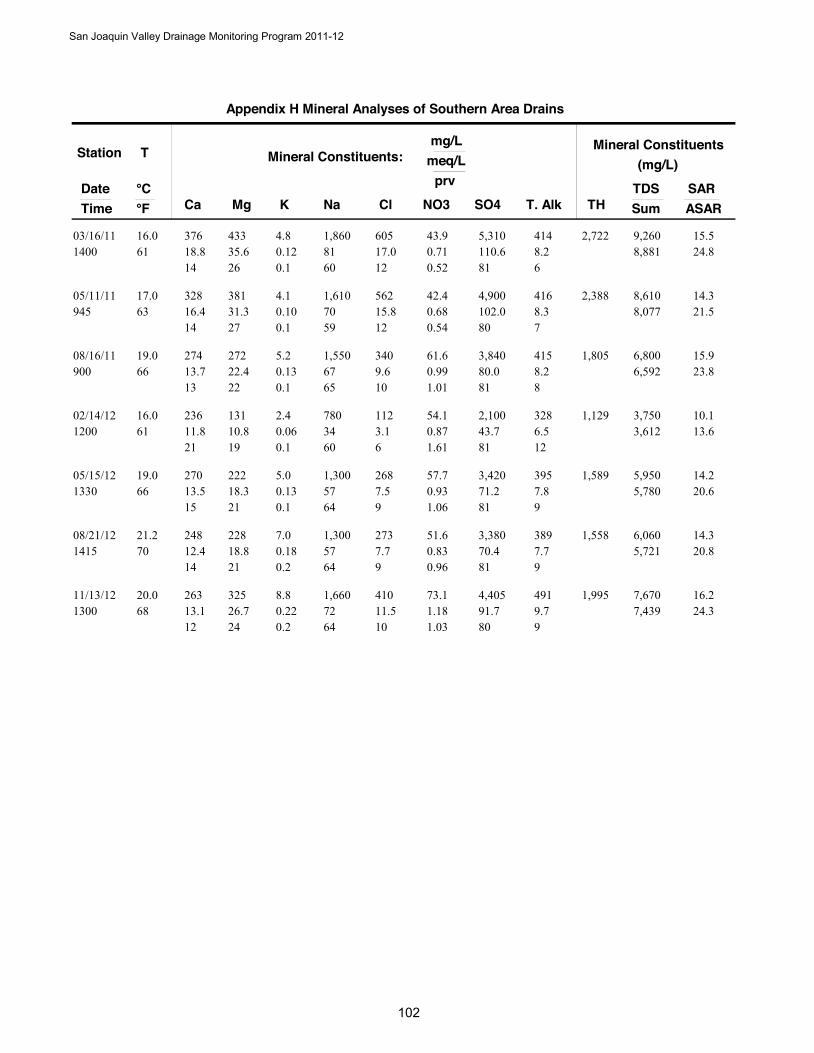
Station
DateTime
T
Ca Mg Na NO3
Mineral Constituents:mg/L
meq/L
°C °F Cl SO4 T. Alk
prv
K
Mineral Constituents(mg/L)
TDSSumTH
SARASAR
Appendix H Mineral Analyses of Southern Area Drains
376 43318.8 81 0.7161 35.6
1,860 43.903/16/111400
16.0 60517.0 110.6
14 26 608.2
120.124.8
0.1
15.52,7228,881 24.8
0.52 81 6
5,310 414 9,260
328 38116.4 70 0.6863 31.3
1,610 42.405/11/11945
17.0 56215.8 102.0
14 27 598.3
120.104.1
0.1
14.32,3888,077 21.5
0.54 80 7
4,900 416 8,610
274 27213.7 67 0.9966 22.4
1,550 61.608/16/11900
19.0 3409.6 80.0
13 22 658.2
100.135.2
0.1
15.91,8056,592 23.8
1.01 81 8
3,840 415 6,800
236 13111.8 34 0.8761 10.8
780 54.102/14/121200
16.0 1123.1 43.7
21 19 606.5
60.062.4
0.1
10.11,1293,612 13.6
1.61 81 12
2,100 328 3,750
270 22213.5 57 0.9366 18.3
1,300 57.705/15/121330
19.0 2687.5 71.2
15 21 647.8
90.135.0
0.1
14.21,5895,780 20.6
1.06 81 9
3,420 395 5,950
248 22812.4 57 0.8370 18.8
1,300 51.608/21/121415
21.2 2737.7 70.4
14 21 647.7
90.187.0
0.2
14.31,5585,721 20.8
0.96 81 9
3,380 389 6,060
263 32513.1 72 1.1868 26.7
1,660 73.111/13/121300
20.0 41011.5 91.7
12 24 649.7
100.228.8
0.2
16.21,9957,439 24.3
1.03 80 9
4,405 491 7,670
San Joaquin Valley Drainage Monitoring Program 2011-12
102
San Joaquin Valley Drainage Monitoring Program 2011-12
103
Appendix I Electrical Conductivity, pH, & Trace Elements in
Southern Area Drains 2011-2012
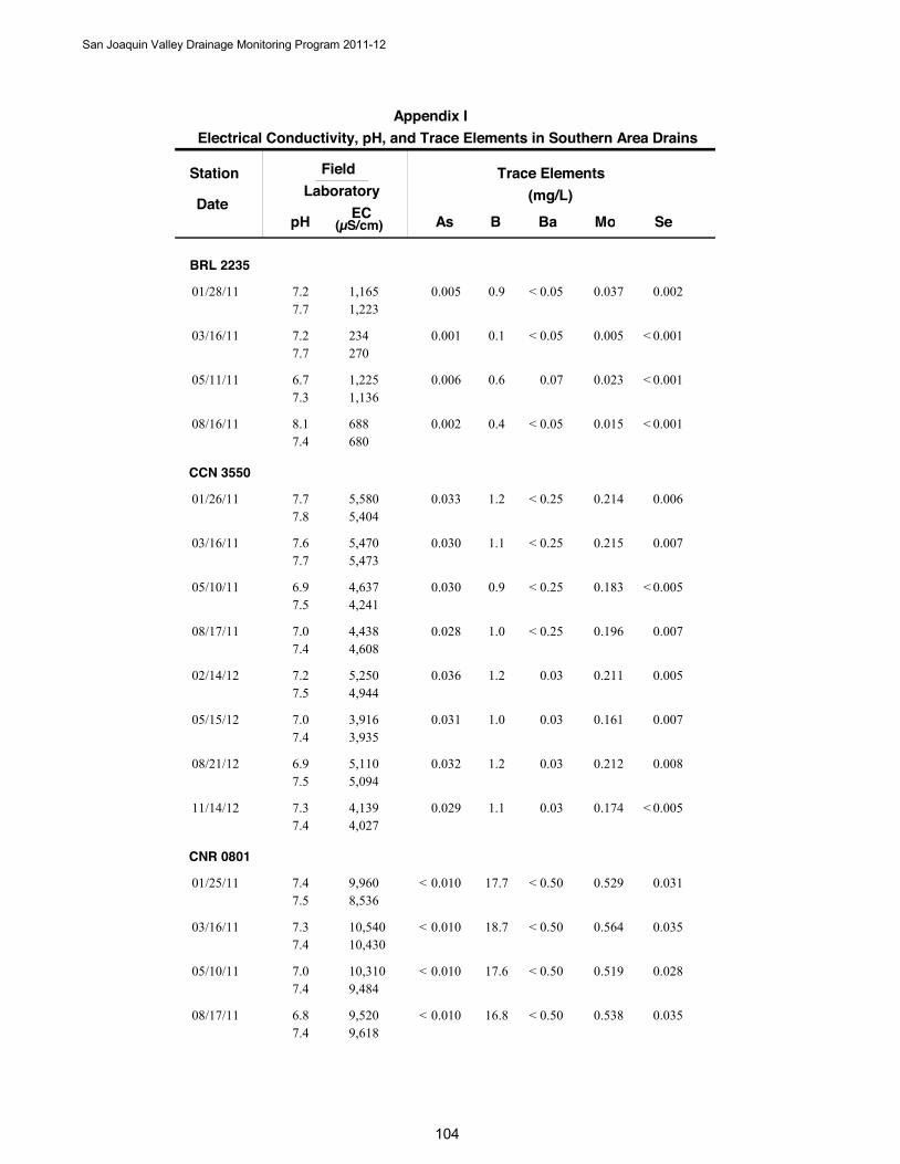
Station
DateB
Trace Elements(mg/L)
SeAs Ba Mo
FieldLaboratory
pH EC(µS/cm)
Electrical Conductivity, pH, and Trace Elements in Southern Area DrainsAppendix I
BRL 2235
0.901/28/11 0.0020.005 0.0370.051,1651,223
7.27.7
<
0.103/16/11 0.0010.001 0.0050.05234270
7.27.7
< <
0.605/11/11 0.0010.006 0.0230.071,2251,136
6.77.3
<
0.408/16/11 0.0010.002 0.0150.05688680
8.17.4
< <
CCN 3550
1.201/26/11 0.0060.033 0.2140.255,5805,404
7.77.8
<
1.103/16/11 0.0070.030 0.2150.255,4705,473
7.67.7
<
0.905/10/11 0.0050.030 0.1830.254,6374,241
6.97.5
< <
1.008/17/11 0.0070.028 0.1960.254,4384,608
7.07.4
<
1.202/14/12 0.0050.036 0.2110.035,2504,944
7.27.5
1.005/15/12 0.0070.031 0.1610.033,9163,935
7.07.4
1.208/21/12 0.0080.032 0.2120.035,1105,094
6.97.5
1.111/14/12 0.0050.029 0.1740.034,1394,027
7.37.4
<
CNR 0801
17.701/25/11 0.0310.010 0.5290.509,9608,536
7.47.5
< <
18.703/16/11 0.0350.010 0.5640.5010,54010,430
7.37.4
< <
17.605/10/11 0.0280.010 0.5190.5010,3109,484
7.07.4
< <
16.808/17/11 0.0350.010 0.5380.509,5209,618
6.87.4
< <
San Joaquin Valley Drainage Monitoring Program 2011-12
1040
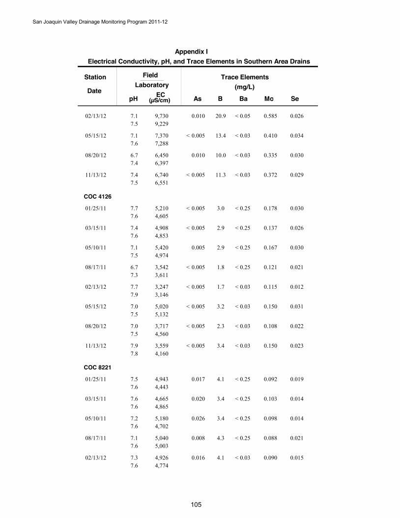
Station
DateB
Trace Elements(mg/L)
SeAs Ba Mo
FieldLaboratory
pH EC(µS/cm)
Electrical Conductivity, pH, and Trace Elements in Southern Area DrainsAppendix I
20.902/13/12 0.0260.010 0.5850.059,7309,229
7.17.5
<
13.405/15/12 0.0340.005 0.4100.037,3707,288
7.17.6
< <
10.008/20/12 0.0300.010 0.3350.036,4506,397
6.77.4
<
11.311/13/12 0.0290.005 0.3720.036,7406,551
7.47.5
< <
COC 4126
3.001/25/11 0.0300.005 0.1780.255,2104,605
7.77.6
< <
2.903/15/11 0.0260.005 0.1370.254,9084,853
7.47.6
< <
2.905/10/11 0.0300.005 0.1670.255,4204,974
7.17.5
<
1.808/17/11 0.0210.005 0.1210.253,5423,611
6.77.3
< <
1.702/13/12 0.0120.005 0.1150.033,2473,146
7.77.9
< <
3.205/15/12 0.0310.005 0.1500.035,0205,132
7.07.5
< <
2.308/20/12 0.0220.005 0.1080.033,7174,560
7.07.5
< <
3.411/13/12 0.0230.005 0.1500.033,5594,160
7.97.8
< <
COC 8221
4.101/25/11 0.0190.017 0.0920.254,9434,443
7.57.6
<
3.403/15/11 0.0140.020 0.1030.254,6654,865
7.67.6
<
3.405/10/11 0.0140.026 0.0980.255,1804,702
7.27.6
<
4.308/17/11 0.0210.008 0.0880.255,0405,003
7.17.6
<
4.102/13/12 0.0150.016 0.0900.034,9264,774
7.37.6
<
San Joaquin Valley Drainage Monitoring Program 2011-12
1050
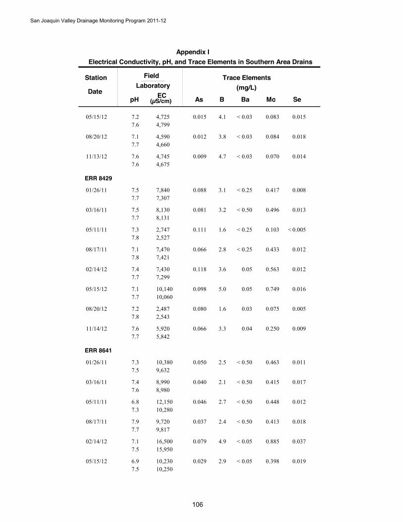
Station
DateB
Trace Elements(mg/L)
SeAs Ba Mo
FieldLaboratory
pH EC(µS/cm)
Electrical Conductivity, pH, and Trace Elements in Southern Area DrainsAppendix I
4.105/15/12 0.0150.015 0.0830.034,7254,799
7.27.6
<
3.808/20/12 0.0180.012 0.0840.034,5904,660
7.17.7
<
4.711/13/12 0.0140.009 0.0700.034,7454,675
7.67.6
<
ERR 8429
3.101/26/11 0.0080.088 0.4170.257,8407,307
7.57.7
<
3.203/16/11 0.0130.081 0.4960.508,1308,131
7.57.7
<
1.605/11/11 0.0050.111 0.1030.252,7472,527
7.37.8
< <
2.808/17/11 0.0120.066 0.4330.257,4707,421
7.17.8
<
3.602/14/12 0.0120.118 0.5630.057,4307,299
7.47.7
5.005/15/12 0.0160.098 0.7490.0510,14010,060
7.17.7
1.608/20/12 0.0050.080 0.0750.032,4872,543
7.27.8
3.311/14/12 0.0090.066 0.2500.045,9205,842
7.67.7
ERR 8641
2.501/26/11 0.0110.050 0.4630.5010,3809,632
7.37.5
<
2.103/16/11 0.0170.040 0.4150.508,9908,980
7.47.6
<
2.705/11/11 0.0120.046 0.4480.5012,15010,280
6.87.3
<
2.408/17/11 0.0180.037 0.4130.509,7209,817
7.97.7
<
4.902/14/12 0.0370.079 0.8850.0516,50015,950
7.17.5
<
2.905/15/12 0.0190.029 0.3980.0510,23010,250
6.97.5
<
San Joaquin Valley Drainage Monitoring Program 2011-12
1060
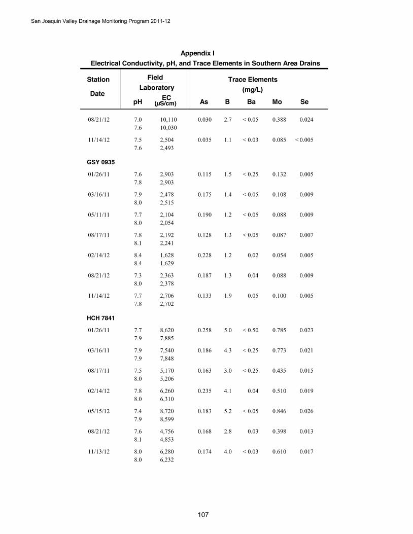
Station
DateB
Trace Elements(mg/L)
SeAs Ba Mo
FieldLaboratory
pH EC(µS/cm)
Electrical Conductivity, pH, and Trace Elements in Southern Area DrainsAppendix I
2.708/21/12 0.0240.030 0.3880.0510,11010,030
7.07.6
<
1.111/14/12 0.0050.035 0.0850.032,5042,493
7.57.6
< <
GSY 0935
1.501/26/11 0.0050.115 0.1320.252,9032,903
7.67.8
<
1.403/16/11 0.0090.175 0.1080.052,4782,515
7.98.0
<
1.205/11/11 0.0090.190 0.0880.052,1042,054
7.78.0
<
1.308/17/11 0.0070.128 0.0870.052,1922,241
7.88.1
<
1.202/14/12 0.0050.228 0.0540.021,6281,629
8.48.4
1.308/21/12 0.0090.187 0.0880.042,3632,378
7.38.0
1.911/14/12 0.0050.133 0.1000.052,7062,702
7.77.8
HCH 7841
5.001/26/11 0.0230.258 0.7850.508,6207,885
7.77.9
<
4.303/16/11 0.0210.186 0.7730.257,5407,848
7.97.9
<
3.008/17/11 0.0150.163 0.4350.255,1705,206
7.58.0
<
4.102/14/12 0.0190.235 0.5100.046,2606,310
7.88.0
5.205/15/12 0.0260.183 0.8460.058,7208,599
7.47.9
<
2.808/21/12 0.0130.168 0.3980.034,7564,853
7.68.1
4.011/13/12 0.0170.174 0.6100.036,2806,232
8.08.0
<
San Joaquin Valley Drainage Monitoring Program 2011-12
10

Station
DateB
Trace Elements(mg/L)
SeAs Ba Mo
FieldLaboratory
pH EC(µS/cm)
Electrical Conductivity, pH, and Trace Elements in Southern Area DrainsAppendix I
HNE 3160
5.311/13/12 0.0400.036 0.8710.0511,28011,100
7.67.7
<
HNW 3111
5.411/14/12 0.0150.082 0.3110.036,1106,668
7.57.6
LME 1546
0.208/21/12 0.0010.003 0.0110.02396420
7.57.7
<
LNW 5467
26.901/26/11 0.2760.020 0.9741.0016,82013,090
7.67.6
<
25.303/15/11 0.2360.020 0.9821.0016,09016,230
7.67.6
< <
26.305/10/11 0.2960.025 0.2741.0018,20015,320
7.37.6
<
27.608/16/11 0.2600.022 1.1401.0016,78016,880
7.17.6
<
26.502/13/12 0.3050.020 1.1600.0515,35014,950
7.47.7
<
39.511/13/12 0.2760.020 1.2200.1019,65019,310
8.28.0
< <
LNW 6467
36.301/26/11 0.4000.038 0.7101.0025,35018,680
7.47.5
<
32.803/15/11 0.3480.027 0.7601.0025,69024,970
7.47.5
<
36.305/10/11 0.4840.042 0.4301.0028,64022,710
7.17.5
<
41.808/16/11 0.5480.046 0.9901.0027,28026,060
7.07.6
<
42.602/13/12 0.5300.054 0.9340.1029,43027,940
7.67.8
<
43.505/15/12 0.3800.025 0.8040.1028,70028,470
7.17.4
<
San Joaquin Valley Drainage Monitoring Program 2011-12
1080
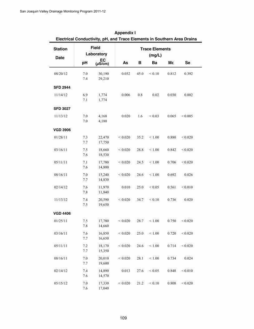
Station
DateB
Trace Elements(mg/L)
SeAs Ba Mo
FieldLaboratory
pH EC(µS/cm)
Appendix I Electrical Conductivity, pH, and Trace Elements in Southern Area Drains
45.008/20/12 0.3920.032 0.8120.1030,19029,210
7.07.4
<
SFD 2944
0.811/14/12 0.0020.006 0.0300.021,7741,774
6.97.1
SFD 3027
1.611/13/12 0.0050.020 0.0650.034,1684,180
7.07.0
< <
VGD 3906
35.201/28/11 0.0200.020 0.8801.0022,47017,750
7.37.7
< < <
28.803/16/11 0.0200.020 0.8421.0018,66018,530
7.57.6
< < <
24.505/11/11 0.0200.020 0.7061.0017,78014,800
7.17.6
< < <
24.608/16/11 0.0260.020 0.6921.0015,24014,830
7.07.7
< <
25.002/14/12 0.0100.010 0.5610.0511,97011,840
7.67.8
< <
34.711/13/12 0.0200.020 0.7360.1020,59019,650
7.47.5
< <
VGD 4406
28.701/25/11 0.0200.020 0.7501.0017,78014,660
7.57.8
< < <
25.003/16/11 0.0200.020 0.7201.0016,85016,650
7.67.7
< < <
24.605/11/11 0.0200.020 0.7141.0018,17015,350
7.27.7
< < <
28.108/16/11 0.0240.020 0.7341.0020,01019,600
7.07.7
< <
27.602/14/12 0.0100.013 0.8480.0514,89014,570
7.47.6
< <
21.205/15/12 0.0200.020 0.8080.1017,33017,040
7.07.6
< < <
San Joaquin Valley Drainage Monitoring Program 2011-12
109
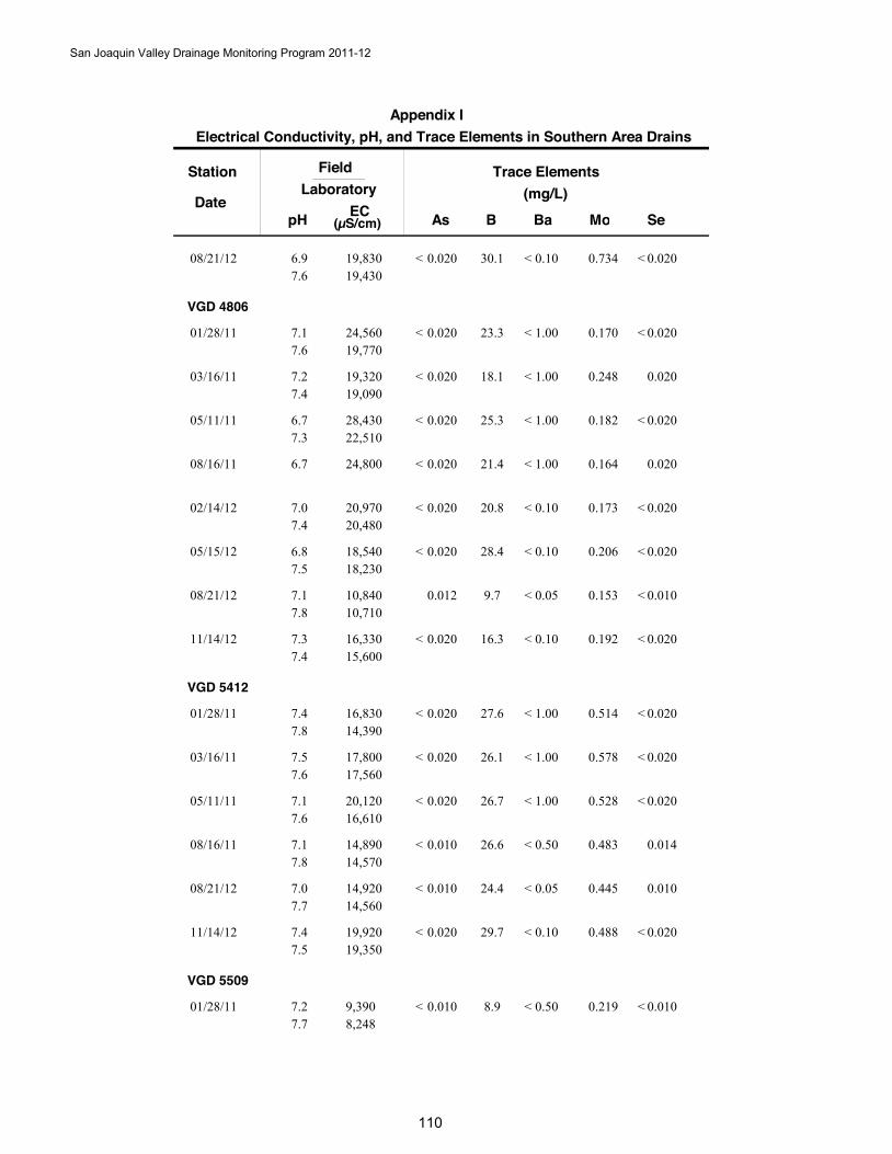
Station
DateB
Trace Elements(mg/L)
SeAs Ba Mo
FieldLaboratory
pH EC(µS/cm)
Electrical Conductivity, pH, and Trace Elements in Southern Area DrainsAppendix I
30.108/21/12 0.0200.020 0.7340.1019,83019,430
6.97.6
< < <
VGD 4806
23.301/28/11 0.0200.020 0.1701.0024,56019,770
7.17.6
< < <
18.103/16/11 0.0200.020 0.2481.0019,32019,090
7.27.4
< <
25.305/11/11 0.0200.020 0.1821.0028,43022,510
6.77.3
< < <
21.408/16/11 0.0200.020 0.1641.0024,8006.7 < <
20.802/14/12 0.0200.020 0.1730.1020,97020,480
7.07.4
< < <
28.405/15/12 0.0200.020 0.2060.1018,54018,230
6.87.5
< < <
9.708/21/12 0.0100.012 0.1530.0510,84010,710
7.17.8
< <
16.311/14/12 0.0200.020 0.1920.1016,33015,600
7.37.4
< < <
VGD 5412
27.601/28/11 0.0200.020 0.5141.0016,83014,390
7.47.8
< < <
26.103/16/11 0.0200.020 0.5781.0017,80017,560
7.57.6
< < <
26.705/11/11 0.0200.020 0.5281.0020,12016,610
7.17.6
< < <
26.608/16/11 0.0140.010 0.4830.5014,89014,570
7.17.8
< <
24.408/21/12 0.0100.010 0.4450.0514,92014,560
7.07.7
< <
29.711/14/12 0.0200.020 0.4880.1019,92019,350
7.47.5
< < <
VGD 5509
8.901/28/11 0.0100.010 0.2190.509,3908,248
7.27.7
< < <
San Joaquin Valley Drainage Monitoring Program 2011-12
1100
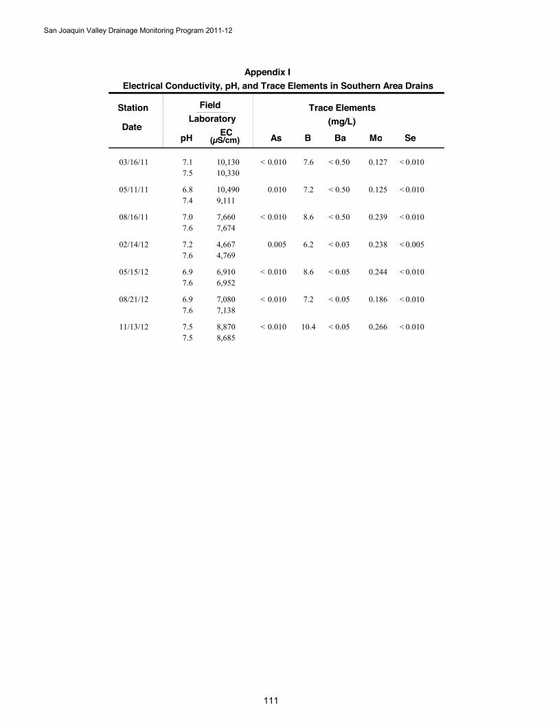
Station
DateB
Trace Elements(mg/L)
SeAs Ba Mo
FieldLaboratory
pH EC(µS/cm)
Electrical Conductivity, pH, and Trace Elements in Southern Area DrainsAppendix I
7.603/16/11 0.0100.010 0.1270.5010,13010,330
7.17.5
< < <
7.205/11/11 0.0100.010 0.1250.5010,4909,111
6.87.4
< <
8.608/16/11 0.0100.010 0.2390.507,6607,674
7.07.6
< < <
6.202/14/12 0.0050.005 0.2380.034,6674,769
7.27.6
< <
8.605/15/12 0.0100.010 0.2440.056,9106,952
6.97.6
< < <
7.208/21/12 0.0100.010 0.1860.057,0807,138
6.97.6
< < <
10.411/13/12 0.0100.010 0.2660.058,8708,685
7.57.5
< < <
San Joaquin Valley Drainage Monitoring Program 2011-12
111

San Joaquin Valley Drainage Monitoring Program 2011-12
112
Appendix J Pesticides in Area Drains
2011-2012
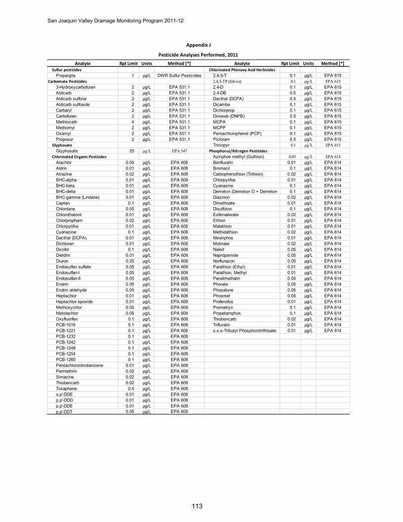
San Joaquin Valley Drainage Monitoring Program 2011-12
113
Analyte Rpt Limit Units Method [*] Analyte Rpt Limit Units Method [*]Sulfur pesticides Chlorinated Phenoxy Acid Herbicides
Propargite 1 µg/L DWR Sulfur Pesticides 2,4,5-T 0.1 µg/L EPA 615Carbamate Pesticides 2,4,5-TP (Silvex) 0.1 µg/L EPA 615
3-Hydroxycarbofuran 2 µg/L EPA 531.1 2,4-D 0.1 µg/L EPA 615Aldicarb 2 µg/L EPA 531.1 2,4-DB 0.5 µg/L EPA 615Aldicarb sulfone 2 µg/L EPA 531.1 Dacthal (DCPA) 0.5 µg/L EPA 615Aldicarb sulfoxide 2 µg/L EPA 531.1 Dicamba 0.1 µg/L EPA 615Carbaryl 2 µg/L EPA 531.1 Dichlorprop 0.1 µg/L EPA 615Carbofuran 2 µg/L EPA 531.1 Dinoseb (DNPB) 0.5 µg/L EPA 615Methiocarb 4 µg/L EPA 531.1 MCPA 0.1 µg/L EPA 615Methomyl 2 µg/L EPA 531.1 MCPP 0.1 µg/L EPA 615Oxamyl 2 µg/L EPA 531.1 Pentachlorophenol (PCP) 0.1 µg/L EPA 615Propoxur 2 µg/L EPA 531.1 Picloram 0.5 µg/L EPA 615
Glyphosate Triclopyr 0.1 µg/L EPA 615Glyphosate 25 µg/L EPA 547 Phosphorus/Nitrogen Pesticides
Chlorinated Organic Pesticides Azinphos methyl (Guthion) 0.05 µg/L EPA 614Alachlor 0.05 µg/L EPA 608 Benfluralin 0.01 µg/L EPA 614Aldrin 0.01 µg/L EPA 608 Bromacil 0.1 µg/L EPA 614Atrazine 0.02 µg/L EPA 608 Carbophenothion (Trithion) 0.02 µg/L EPA 614BHC-alpha 0.01 µg/L EPA 608 Chlorpyrifos 0.01 µg/L EPA 614BHC-beta 0.01 µg/L EPA 608 Cyanazine 0.1 µg/L EPA 614BHC-delta 0.01 µg/L EPA 608 Demeton (Demeton O + Demeton 0.1 µg/L EPA 614BHC-gamma (Lindane) 0.01 µg/L EPA 608 Diazinon 0.02 µg/L EPA 614Captan 0.1 µg/L EPA 608 Dimethoate 0.01 µg/L EPA 614Chlordane 0.05 µg/L EPA 608 Disulfoton 0.1 µg/L EPA 614Chlorothalonil 0.01 µg/L EPA 608 Esfenvalerate 0.02 µg/L EPA 614Chlorpropham 0.02 µg/L EPA 608 Ethion 0.01 µg/L EPA 614Chlorpyrifos 0.01 µg/L EPA 608 Malathion 0.01 µg/L EPA 614Cyanazine 0.1 µg/L EPA 608 Methidathion 0.02 µg/L EPA 614Dacthal (DCPA) 0.01 µg/L EPA 608 Mevinphos 0.01 µg/L EPA 614Dichloran 0.01 µg/L EPA 608 Molinate 0.02 µg/L EPA 614Dicofol 0.1 µg/L EPA 608 Naled 0.05 µg/L EPA 614Dieldrin 0.01 µg/L EPA 608 Napropamide 0.05 µg/L EPA 614Diuron 0.25 µg/L EPA 608 Norflurazon 0.05 µg/L EPA 614Endosulfan sulfate 0.05 µg/L EPA 608 Parathion (Ethyl) 0.01 µg/L EPA 614Endosulfan-I 0.05 µg/L EPA 608 Parathion, Methyl 0.01 µg/L EPA 614Endosulfan-II 0.05 µg/L EPA 608 Pendimethalin 0.05 µg/L EPA 614Endrin 0.05 µg/L EPA 608 Phorate 0.05 µg/L EPA 614Endrin aldehyde 0.05 µg/L EPA 608 Phosalone 0.05 µg/L EPA 614Heptachlor 0.01 µg/L EPA 608 Phosmet 0.05 µg/L EPA 614Heptachlor epoxide 0.01 µg/L EPA 608 Profenofos 0.01 µg/L EPA 614Methoxychlor 0.05 µg/L EPA 608 Prometryn 0.1 µg/L EPA 614Metolachlor 0.05 µg/L EPA 608 Propetamphos 0.1 µg/L EPA 614Oxyfluorfen 0.1 µg/L EPA 608 Thiobencarb 0.02 µg/L EPA 614PCB-1016 0.1 µg/L EPA 608 Trifluralin 0.01 µg/L EPA 614PCB-1221 0.1 µg/L EPA 608 s,s,s-Tributyl Phosphorotrithioate 0.01 µg/L EPA 614PCB-1232 0.1 µg/L EPA 608PCB-1242 0.1 µg/L EPA 608PCB-1248 0.1 µg/L EPA 608PCB-1254 0.1 µg/L EPA 608PCB-1260 0.1 µg/L EPA 608Pentachloronitrobenzene 0.01 µg/L EPA 608Permethrin 0.02 µg/L EPA 608Simazine 0.02 µg/L EPA 608Thiobencarb 0.02 µg/L EPA 608Toxaphene 0.4 µg/L EPA 608o,p'-DDE 0.01 µg/L EPA 608p,p'-DDD 0.01 µg/L EPA 608p,p'-DDE 0.01 µg/L EPA 608p,p'-DDT 0.05 µg/L EPA 608
Pesticide Analyses Performed, 2011
Appendix J
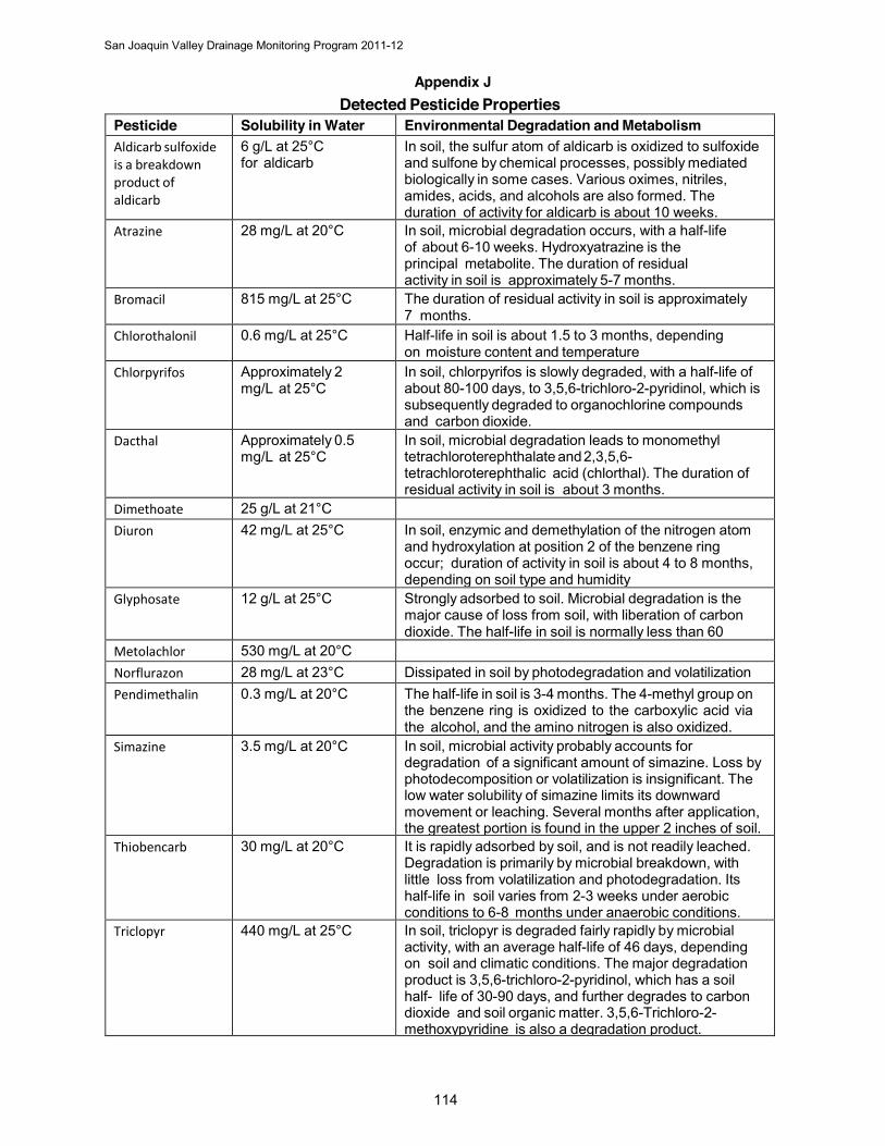
San Joaquin Valley Drainage Monitoring Program 2011-12
114
Appendix J Detected Pesticide Properties
Pesticide Solubility in Water Environmental Degradation and Metabolism Aldicarb sulfoxide is a breakdown product of aldicarb
6 g/L at 25°C for aldicarb
In soil, the sulfur atom of aldicarb is oxidized to sulfoxide and sulfone by chemical processes, possibly mediated biologically in some cases. Various oximes, nitriles, amides, acids, and alcohols are also formed. The duration of activity for aldicarb is about 10 weeks.
Atrazine 28 mg/L at 20°C In soil, microbial degradation occurs, with a half-life of about 6-10 weeks. Hydroxyatrazine is the principal metabolite. The duration of residual activity in soil is approximately 5-7 months.
Bromacil 815 mg/L at 25°C The duration of residual activity in soil is approximately 7 months.
Chlorothalonil 0.6 mg/L at 25°C Half-life in soil is about 1.5 to 3 months, depending on moisture content and temperature
Chlorpyrifos Approximately 2 mg/L at 25°C
In soil, chlorpyrifos is slowly degraded, with a half-life of about 80-100 days, to 3,5,6-trichloro-2-pyridinol, which is subsequently degraded to organochlorine compounds and carbon dioxide.
Dacthal Approximately 0.5 mg/L at 25°C
In soil, microbial degradation leads to monomethyl tetrachloroterephthalate and 2,3,5,6-tetrachloroterephthalic acid (chlorthal). The duration of residual activity in soil is about 3 months.
Dimethoate 25 g/L at 21°C Diuron 42 mg/L at 25°C In soil, enzymic and demethylation of the nitrogen atom
and hydroxylation at position 2 of the benzene ring occur; duration of activity in soil is about 4 to 8 months, depending on soil type and humidity
Glyphosate 12 g/L at 25°C Strongly adsorbed to soil. Microbial degradation is the major cause of loss from soil, with liberation of carbon dioxide. The half-life in soil is normally less than 60 days.Metolachlor 530 mg/L at 20°C
Norflurazon 28 mg/L at 23°C Dissipated in soil by photodegradation and volatilization Pendimethalin 0.3 mg/L at 20°C The half-life in soil is 3-4 months. The 4-methyl group on
the benzene ring is oxidized to the carboxylic acid via the alcohol, and the amino nitrogen is also oxidized.
Simazine 3.5 mg/L at 20°C In soil, microbial activity probably accounts for degradation of a significant amount of simazine. Loss by photodecomposition or volatilization is insignificant. The low water solubility of simazine limits its downward movement or leaching. Several months after application, the greatest portion is found in the upper 2 inches of soil.
Thiobencarb 30 mg/L at 20°C It is rapidly adsorbed by soil, and is not readily leached. Degradation is primarily by microbial breakdown, with little loss from volatilization and photodegradation. Its half-life in soil varies from 2-3 weeks under aerobic conditions to 6-8 months under anaerobic conditions.
Triclopyr 440 mg/L at 25°C In soil, triclopyr is degraded fairly rapidly by microbial activity, with an average half-life of 46 days, depending on soil and climatic conditions. The major degradation product is 3,5,6-trichloro-2-pyridinol, which has a soil half- life of 30-90 days, and further degrades to carbon dioxide and soil organic matter. 3,5,6-Trichloro-2-methoxypyridine is also a degradation product.
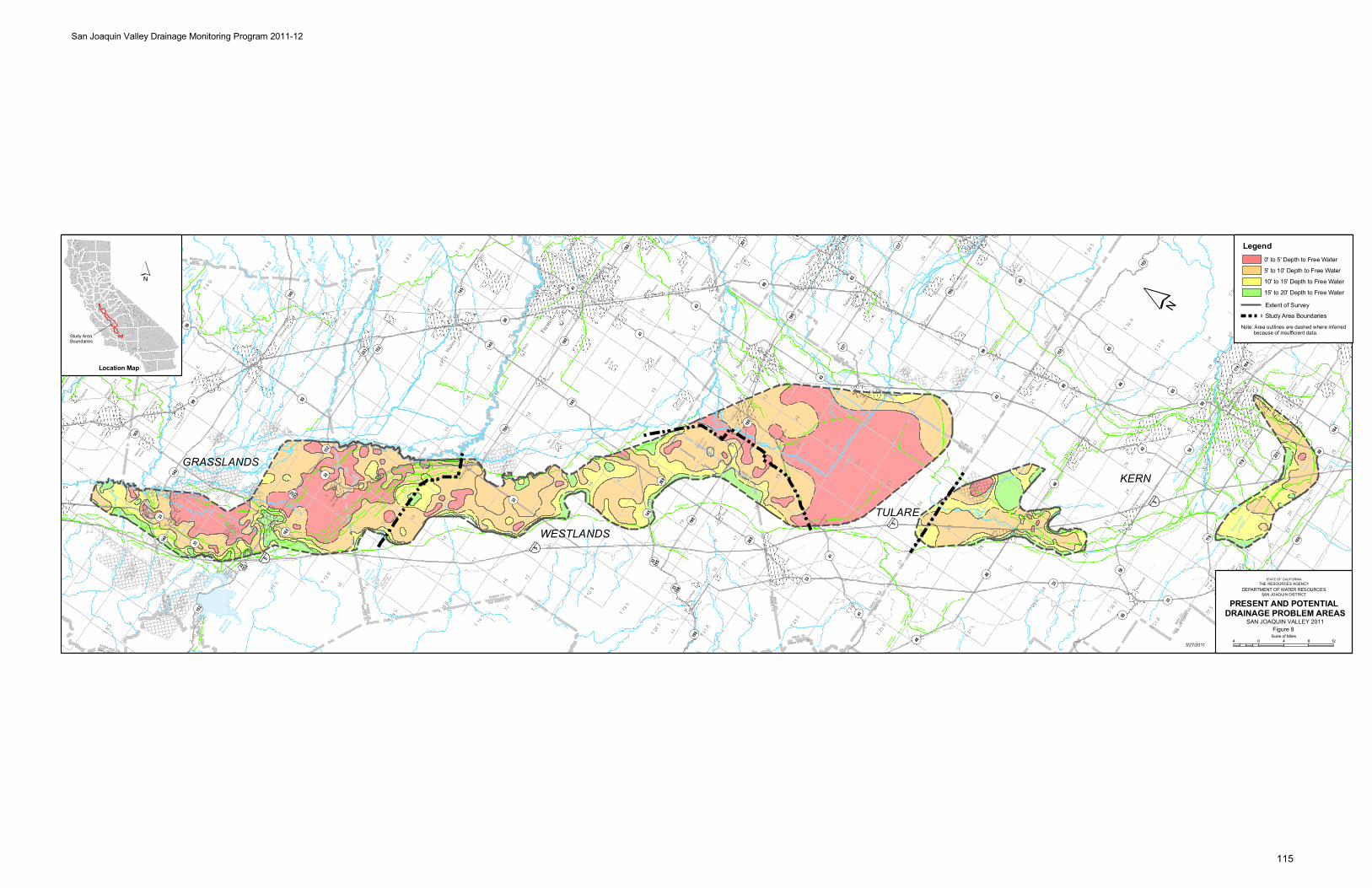
Sequ
oia
Natio
nal P
ark
Sequ
oia
Natio
nal
Park
Sequ
o ia
Nation
alPa
rk
Isabe
llaLa
ke
San
Luis
Rese
rvoi
r
Don
Pedr
oRe
serv
oir
Lake
McClu
re
Lake
Naci
mie
nto
Miller
ton
Lake
Pine
Flat
Rese
rvoi
r
Lake
San
Anto
nio
Turlo
ckLa
ke
Lake
Succ
ess
Shav
erLa
ke
O'Nei
llFo
reba
y
Lake
Kawea
h
Clift
onCou
rt
Fore
bay
Hens
ley
Lake
Modes
toRe
s.
Bass
Lake
Woo
dwar
dRe
s.
Hunt
ingt
onLa
ke
Cour
trigh
t Res
ervo
ir
Lake
Thom
asA
Edis
on
East
man
Lake
Lake
Web
b
Flor
ence
Lake
Tullo
chRe
s.
Wis
hon
Rese
rvoi
r
Burn
sRe
s.
Mamm
oth
Pool R
eser
voir
Redi
nger
Lake
Hern
ande
zRe
serv
oir
Yose
mite
Lake
Marip
osa
Res.
Los
Banos
Res.
Quail
Lake
Lake
McSw
ain
Cast
acLa
ke
Bear
Res.
Garne
t Lak
e
Thou
sand
Isla
ndLa
ke
Owens
Res.
Kerc
khof
fLa
ke
Beth
any
Res.
Littl
ePa
noch
eRe
s.
Kels
eyRe
s.
Mader
aEq
ualiz
atio
nRe
s.
Banos
Cree
k
Del
Puer
to
Sala
do
Creek
Crow
Ore
stim
ba
Cree
k
Garz as
Creek
Quinto
Creek
Ro mero
Dry
Creek
Dry
Cree
k
Cree
k
Cree
k
Los
Ow
ens
Cree
k
Banos
Los
Creek
Silver
Pano
che
Dutc
hman
Deadman
Creek
Dead
man
Cree
k
Ow
ens
Creek
Rasc
alBl
ack
Cree
k
Bear
Cree
k
Cree
k
Cotto
nwoo
d
Cree
k
Arro
yo
Cree
kW
arth
an
Gatos
Los
Cant ua
Creek
Ch in o
Zapat o
Creek
Jacalit os
Pasa
jero
Cree
k
Burn
s
Bear
Cree
k
Cree
k
Cree
k
Mar iposa
Cree
k
Cree
k
Creek
Cree
k
Elk
Deer
Poso
Poso
Cree
k
Co ttonw
ood
Creek
Cotto
nwoo
d
Bayo
u
Cree
k
Cree
k
Calie
nte
Dry
Cree
k
Cross
Creek
Ho spit al
Creek
In gram
Cree
k
Ort igalita
Creek
Cree
kPa
noch
e
Littl
e
Panoche
Cree
k
Arroyo
Hond
o
Salt
Cree
k
Cree
k
Do meng in e
White
Creek
Cree
k
Aven
al
Creek
Bit t
erw
ater
Cree
k
Sant
os
Cree
k
Martin
ez
Cree
k
Salt
Cree
k
Chico
Vist
a
Creek
Sand
y
Cree
k
Bit terwater
Creek
Bit ter
Creek
San
Creek
Buen
a
Emigdio
Salt
Creek
Tecuya
Creek
El
Creek
Tejon
Cree
k
Tunis
Creek
Paso
Calie
nte
Creek
Tehachapi
Creek
Mill
Creek
LittleCreek
Poso
Poso
Creek
Creek
Cedar
Cree
k
Deer
Lew
is
Cree
k
Yokohl
Cree
k
Mill
Cree
k
Pack
woo
d
Cree
k
Cam
eron
Cree
k
Deep
Cree
k
Outside
Creek
Dry
Creek
Deep
Cree
k
Sand
Creek
Wooten
Creek
Wahtoke
Creek
Mill
Creek
Creek
Ho lland
Fish
Creek
Fancher
Creek
Dog
Creek
Cree
k
Dry
Littl
e
Cree
k
Big
CreekFine
Creek
Willo w Creek
Co ttonw oodCreek
Dry
Sandy
Gold
Willo
w
Creek
Willo w
Cree
k
Mar
ipos
aCr
eek
Ow
ens
Creek
Bear
Creek
Bu rns
Creek
Fahrens
Creek
Cree
k
LoneTre
e
Cree
k
Littl
e joh
ns
Creek
Cree
k
Little johns
Creek
Cashman
Creek
Hood
s
Tuol
umne
Stan
isla
us
Joaquin
River
San
Mer
ced
Riv
er
River
River
River
Cho
wch
illa
River
Joaquin
San
Fres
no
Riv
er
Joaquin
SanR
iver
Sou
th
San
Fork
No
rth
Cla
rks
Sou
th
River
Kings
Kin
gs
Fork
Fork
Tule
Kings
Whi
te
Rive
r
Tule
Ker
n
Riv
er
Joaq
uin
Fresno
Riv
er
River
Kings
Riv
er
Kaw
eah
Rive
r
Johns
St.
Riv
er
River
Riv
er
Tule
Fork
Sou th
Riv
er
Branch
No
rth
Branch
River
Tule
Riv
erK
ern
Kern
River
Sou
thFo
rk
River
River
No
rthFo
rk
Tule
River
Midd le
Fork
Tule
Riv
er
Kaweah
South Fork
River
Kaw
eah
Riv
er
So.Fork
Kaweah River
Sycamore
Creek
FineGold
Creek
LittleCreek
Willo w
East
Fork
Ch
owch
il la
River
West
Fo rk Chowch il laRiver
Midd le
Fork
Chowch il la
River
Merced
Riv
er
No rthFork
Merced
River
So. Fork Merced
Rive
r
Tuol
umne
Riv
er
Tuo lumne
River
Clavey
River
Middle
River
Old
River
Slo
ugh
Duck
Slo
ugh
Ash
SloughSalt
Slough
Mud
Bere
nda
Slough
Fresno
SloughFresno
Slo
ugh
Slo
ugh
Slough
Fresno
Slough
Murphy
Co
le
Slou
gh
Lake
Goos
e
Slough
Porter
Jerry Slough
SloughLone
WillowSand
Slough
Salt
Slough
MudSlough
French Camp Sl.
Bypas
sMar
ipos
a
Bypass
Easts ide
Bypass
Easts ide
Chowchilla
James
Bypass
Bypass
L A
K E B
E D
T U L
A R
E
Lake
bed
Goos
e
Kern
Lake
bed
Lake
bed
Buen
a V
ista
KernRiver
Flood
Channel
Kern
River
Channel
North
Delta Canal
Aqueduct
California
Modesto
Canal
Mendota
Main
Modes
to
Cana
l
Dist
rict
Main
Main
Canal
MainMendotaDelta
Cana
l
Main
Canal
Line
High
Cana
l
Mai
n
Turl o
ck
Cana
l
Main
Joaq
uin
San
South
Canal
Side
Can
alM
ain
Turl
ock
Cana
l
Mai
n
Modes
to
AqueductOuts ide
Canal
Main
California
Canal
Mendota
Canal
Delta
Outs ide
Canal
Main
Canal
Lift
Third
Canal
Lift
Seco
nd
Canal
Lift
First
Canal
Canal
Canal
Stinson
Ditch
Cresce nt
Aqueduct
California
Aqu
educ
t
Lake land
Blake ley
Canal
Blake ley
Canal
Ditch
Lakeside
Branch
East
Ditch
Lakeside
Canal
Ditch
Chance
Last
Canal
Lemoore
Canal
Lake
Tulare
Drain
Coas
tal
Canal
California
Side
Can
al
Homeland
Main
We st
CanalLake
Goose
Canal
Cana
l
Vall e
y
Cro
ss
CanalLerdo
CanalCalloway
SideEast
Canal
-Kern
Friant
Canal
Aqueduct
Map
le
Cana
l
Canal
Branch
Central
Canal
SideEast
Canal
Edison
Arvi
n
Aqueduct
Califo
rnia
Dit
ch
Rim
New
Ditch
Rim
OldC
anal
Alejandro
Farmers
Canal
Stine
Canal
Bu
ena
Vista
Can
al
Madera
Friant
Can
al
-
Branch
East
Alta
Canal
Sw
itch
Canal
Fresno
Canal
Kern
Canal
Enter
prise
Lake land
Canal
Canal
- KernFriant
Coastal
Bran
ch
Sout
hSa
nJo
aqui
n
Mai
nCa
nal
Newm
an
Wast ew
ay
Wes
t ley
Was
tew
ay
BantaCabona
LiftCanal
Het
chH
etch
yA
que
duc
t
Hetc
h
Hetc
hy
Aqueduc
t
San
Luis
Was
t ew
ay
Beta
Canal
Ditch
Peop
lesLe
Grand
Canal
Grav ellyFord
Canal
Cana
l
Hern
don
Dry
Cree
k
Can
al
Cen
tervi lle
Kingsburg
Canal
Pioneer
Cana
l
Mai
n
Cana
l
Kern
Island
Canal
Arroyo
Canal
Santa Fe
Canal
Coalinga
Canal
Cere
sM
ain
Canal
Tula
reCa
nal
Dela
no-E
arlim
art
Late
ral
Shaf
ter W
asco
ID
Late
ral
Pond
-Pos
o
Cana
l
Pond-PosoCanal
Pac
heco
Con
dui
t
ALAM
EDA
CO
.
SANJO
AQU
INC
O.
SA
NJ
OA
QU
INC
O.
STA
NIS
LA
US
CO
. STA
NIS
LA
US
CO
.M
ER
CE
D C
O.
ME
RC
ED
CO
.
STA
NIS
LA
US
CO
.
STANIS LAUS CO.TUOLUMNE CO.
KE
RN
CO
.
ME
RC
ED
CO
.FR
ES
NO
CO
.
FRESNO CO.
MADE RA CO .
FR
ES
NO
CO
.K
ING
S C
O.
KIN
GS
C
O.
ME
RC
ED
C
O.
MA
DE
RA
C
O.
FRESN
O C
O.
KING
S CO.
KINGS CO.
TULARE CO.
SA
N L
UIS
O
BIS
PO
C
O.
KE
RN
C
O.
KINGS CO.
TULARE CO.
MA
DERA
CO.
FRESN
OC
O.
FRE
SN
OC
O.
TUL
AR
EC
O.
KE
RN
CO
.
TU
LA
RE
CO
.
STANIS LAUS CO.CALAVERAS CO.
MA
RIP
OS
AC
O.
MA
DE
RA
CO
.
MERCED CO.
MARIP OSA CO.
TU
OL
UM
NE
CO
.M
AR
IPO
SA
CO
.
VE
NTU
RA
CO
.
KE
RN
CO
.
MONTERE Y CO.KINGS CO.
SAN BENITO CO.FRESNO CO.
SANTA CLARACO.
STANISLAUS CO.
KE
RN
CO
.
LO
SA
NG
EL
ES
CO
.
¬«166
¬«1
¬«58
¬«178
¬«43
¬«120
¬«198
¬«25
¬«33
¬«49
¬«152
¬«46
¬«245
¬«155
¬«168
¬«99 ¬«145
¬«65
¬«137
¬«63
¬«119
¬«223
¬«184
¬«216
¬«269
¬«202
¬«135
¬«219
¬«233
¬«4
¬«180
¬«180
¬«33
198
¬«33
¬«269
¬«41
¬«120
¬«184
¬«1
¬«65
¬«41
¬«58
¬«180
¬«99
¬«223
¬«108
¬«119
¬«25
¬«178
¬«132
¬«25
¬«43
¬«198
¬«41
¬«1
¬«140
¬«120
¬«59
¬«59
¬«145
¬«198
¬«198
¬«99
¬«152
¬«1
¬«63
¬«198
¬«33
166
¬«33
152
¬«41
¬«65
¬«1
¬«140
¬«165
¬«46
¬«140
¬«41
¬«49
¬«33
¬«198
¬«216
¬«49
108
¬«41
¬«33
¬«198
¬«145
¬«201
¬«152
¬«58
¬«132
¬«137
¬«120
¬«99
¬«43
¬«46
¬«41
¬«41
¬«1
¬«140
¬«166
¬«99
¬«152
¬«99
¬«245
¬«140
¬«41
¬«120
¬«198
¬«33
¬«58
¬«180
¬«99
¬«155
¬«168
¬«46
¬«65
¬«4
¬«168
¬«63
¬«33
¬«49
120
¬«135
¬«58
¬«33
145
¬«156
¬«145
¬«41
¬«108
120
¬«58
¬«33
¬«33
152
¬«132
¬«41
¬«135
¬«58
¬«33
¬«190
¬«180
¬«25
¬«41
¬«49
¬«140
¬«58
¬«33
¬«99
¬«43
¬«198
¬«65
¬«108
¬«165
¬«178
¬«166
¬«120
¬«198
¬«25
¬«176
¬«190
¬«227
¬«146
¬«146
¬«156
¬«135
¬«229
¬«1
¬«46
¬«46
§̈¦205
§̈¦580
§̈¦5
§̈¦5
§̈¦5
§̈¦5
§̈¦5
§̈¦5§̈¦5
§̈¦5
¬«201
¬«166
¬«166
¬«1
¬«1
¬«198
¬«198
tu101
tu101
tu101
tu101
tu101
tu101
tu101
tu101
tu101
tu101
tu101
tu101
tu101
tu101
tu101
tu101tu10
1
tu101
tu101tu10
1
Lemoo
reNa
val
AirSta
tion
Fres
no
Baker
sfield
Visa
lia
Mod
esto
Taft
Trac
y
Aven
al
Merc
ed
Tular
e
Clov
is
Lebe
c
Shaf
ter
Gilroy
Atasc
ader
o
Man
teca
Orcut
t
Turlo
ck
Hanfo
rd
Sant
aM
aria
San
Jose
Mad
era
Mam
mot
hLak
es
Nipom
o
Delan
o
Vand
enbe
rgA
FB
Ceres
Was
co
Round
Valley
Lem
oore
Salid
a
Oildal
e
Delhi
Arvin
Ripon
Los B
anos
Atwate
r
Mes
a
Selm
a
Sang
er
Lam
ont
Oakda
le
Butto
nwill
ow
San
Mar
tin
Pixl
ey
Chow
chill
a
Dinub
a
Keyes
East
Oakda
le
Easto
n
Tem
plet
on
Orosi
Woo
dvill
e
Win
ton
Lato
n
Shan
don
Plan
ada
Porte
rvill
e
Cambr
ia
Mor
gan H
ill
Hollis
ter
Wes
t Bish
op
Corco
ran
Teha
chap
i
San
Luis Obi
spo
Wilk
erso
n
Lost
Hills
Mad
era
Acres
ElPa
sode
Robles
(Pas
oRob
les)
Reedl
ey
Coalin
ga
Mor
roBay
Lake
Nac
imien
to
River
dale
Fraz
ier
Park
Baywoo
d-Lo
s Oso
s
Le G
rand
Arroyo
Grand
e
Cayuc
os
River
bank
Exet
er
Grays
on
Livi
ngsto
n
Mad
era
Ranch
os
Denai
r
Lind
say
Hilmar
-Irw
in
Fowle
r
Patte
rson
DelR
io
Fire
baug
h
King
City
BigPi
ne
Wee
dpatc
h
Pism
oBea
ch
Vand
enbe
rgVill
age
Kerm
an
Teha
chap
i
Ivan
hoe
Bishop
Woo
dlak
e
Ridge
mar
k
Goshe
n
Esca
lon
Soled
ad
Armon
a
Kings
burg
Empi
re
McK
ittric
k
Farm
ingt
on
Men
dota
Parli
er
Earli
mar
t
Carut
hers
Ocean
o Los A
lam
os
Gustin
e
East
Porte
rvill
e
Huron
McF
arlan
d
Mar
icop
a
Soled
ad
Grove
r Bea
ch
Newm
an
Green
field
Wate
rford
Ford
City
Terra
Bella
Tipt
on
Farm
ersv
ille
San
Mig
uel
DosPa
los
Gonza
les
Stra
thm
ore
Yose
mite
Valley
Guada
lupe
Cutler
Dixon
Lane
-Mea
dow
Creek
Hughs
on
Biola
Wes
tM
odes
to
Sout
hTa
ft
Orang
eCov
e
Sout
hDos
Pal
os
King
City
Soled
ad
Lond
on
Chual
ar
Stra
tford
San
Joaq
uin
Raisin
City
Popl
ar-C
otto
nCen
ter
San A
rdo
Richgr
ove
San
Juan
Bautis
ta
San
Lucas
Mor
roBay
Soled
ad
Gonza
les
Bradl
ey
Kettle
man
City
Auber
ry
Yose
mite
Lake
s
Oakhu
rst
Bootja
ck
Mar
ipos
a
Weld
on
Bodfis
h
Lake
Isabe
lla
Wof
ford
Heigh
ts
Kernv
ille
Golde
nHill
s
Bear V
alle
ySp
rings
TULARE
WESTLANDS
GRASSLANDSKERN
East
man
Lake
Hens
ley
Lake Kings
R.
Porte
rvill
e
´
Location Map
´
Legend
PRESENT AND POTENTIAL DRAINAGE PROBLEM AREAS
5
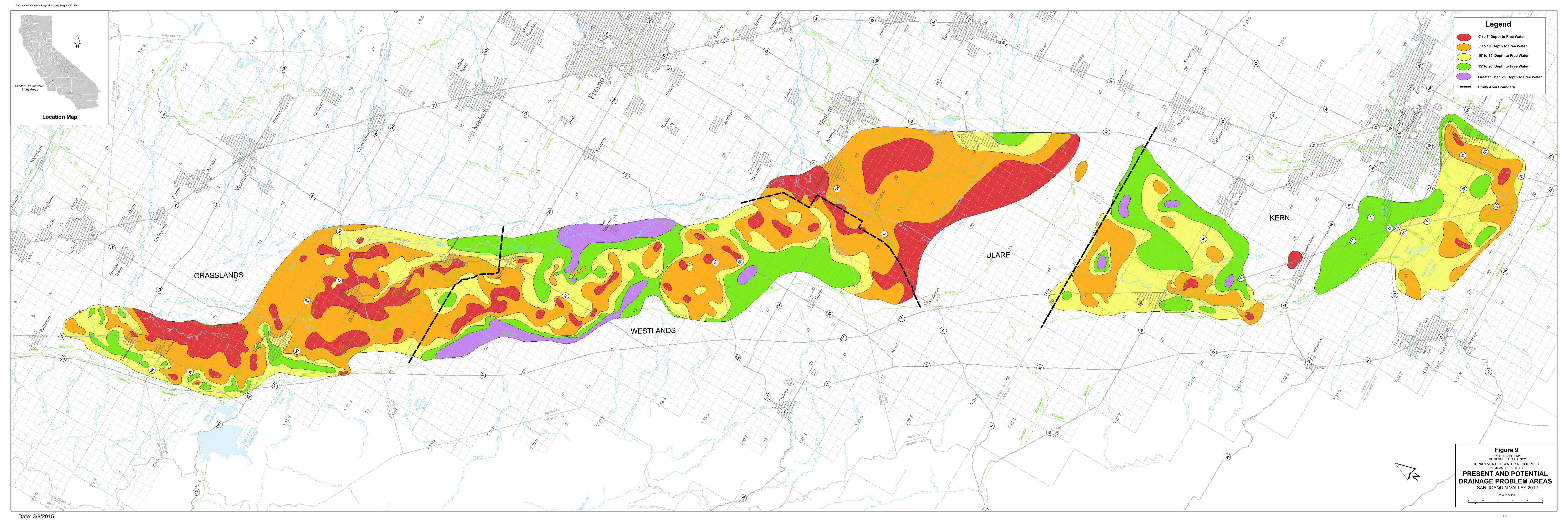
Sequ
oia N
ation
alPa
rk
Sequ
oia
Natio
nal
Park Se
quoi
aNa
tiona
lPa
rk
San
Luis
Rese
rvoi
r
Don
Pedr
oRe
serv
oir
Lake
McC
lure
Lake
Nacim
ient
o
Mille
rton
Lake
Pine
Flat
Rese
rvoi
r
Lake
San
Anto
nio
Turlo
ckLa
ke
Lake
Succ
ess
Shav
erLa
ke
O'N
eill
Fore
bay
Lake
Kawe
ah
Hens
ley
Lake
Mod
esto
Res.
Bass
Lake
Woo
dwar
dRe
s.
Hunt
ingt
onLa
ke
Cour
trigh
t Res
ervo
ir
Lake
Thom
asA
Ediso
n
East
man
Lake
Lake
Web
b
Flor
ence
Lake
Wish
onRe
serv
oir
Burn
sRe
s.
Mam
mot
hPo
olRe
serv
oir
Redi
nger
Lake
Hern
ande
z Re
serv
oir
Yose
mite
Lake
Mar
ipos
aRe
s.
Los
Bano
sRe
s.
Qua
ilLa
ke
Lake
McS
wain
Cast
acLa
ke
Bear
Res.
Gar
net L
ake
Thou
sand
Isla
ndLa
ke
Owe
nsRe
s.
Kerc
khof
fLa
ke
Littl
ePa
noch
eRe
s.
Banos
Cree
k
Del
Puer
to
Sala
do
Creek
Cro
w
Ore
stim
ba
Cre
ek
Garzas
Creek
Quinto
Creek
Romero
Dry
Creek
Dry
Cre
ek
Cre
ek
Cree
k
Los
Ow
ens
Cre
ek
Banos
Los
Creek
Silver
Pano
che
Dut
chm
an
Deadm
an
Cree
k
Dea
dman
Cree
k
Owe
ns
Creek
Ras
cal
Blac
k
Cre
ekBear
Cre
ek
Cree
k
Cot
tonw
ood
Cre
ek
Arroyo
Cre
ekW
arth
an
Gatos
Los
Cantua
Creek
Chino
Zapato
Creek
Jacalitos
Pasa
jero
Cre
ek
Burn
s
Bear
Cree
k
Cre
ek
Cre
ekMar
iposa
Cre
ek
Cre
ek
Creek
Cree
k
Elk
Dee
r
Poso
Poso
Cre
ek
Cotton
wood
Creek
Cot
tonw
ood
Bayo
u
Cre
ek
Dry
Cre
ek
Cross
Creek
Hospital
Creek
Ingram
Cre
ek
Ortigalita
Creek
Cre
ekPa
noch
e
Littl
e
Panoche
Cre
ek
Arro
yoH
ondo
Salt
Cre
ek
Cre
ek
Domengine
White
Creek
Cree
k
Aven
al
Creek
Bitte
rwat
erC
reek
Sant
os
Cre
ek
Mar
tinez
Cre
ek
Salt
Cre
ek
Chico
Vista
Creek
Sand
y
Cre
ek
Bitterwater
Creek
Bitter
Creek
San
Creek
Buen
a
Emigdio
Salt
Creek
Tecuya
Creek
El
Creek
Tejon
Tunis
Creek
Paso
Cal
ient
e
Creek
Tehachapi
Mill
Creek
LittleCreek
Poso
Poso
Creek
Creek
Cedar
Cre
ek
Deer
Lew
is
Cree
k
Yokohl
Cre
ek
Mill
Cre
ek
Pack
wood
Cre
ek
Cam
eron
Cre
ek
Dee
pCr
eek
Outside
Creek
Dry
Creek
Dee
pC
reek
Sand
Creek
Wooten
Creek
Wahtoke
Creek
Mill
Cre
ek
Creek
Holland
Fish
Creek
Fancher
Creek
Dog
Cre
ek
Cre
ek
Dry
Littl
e
Cre
ek
Big
Cr.
Fine
Creek
WillowCreek
Cottonwood Creek
Dry
Sandy
Gold
Willow
Creek
Willow Cr.
Mar
ipos
a
CreekO
wens
Creek
Bear
CreekBurns
Creek
Fahrens
Creek
Cree
k
Lone
Tree
Cree
k
Cashman Creek
Tuol
umne
Sta
nisl
aus
Mer
ced
Riv
er
River
River
River
Cho
wch
illa
Fres
no
Riv
er
Sout
h
Fork
Nor
th
Cla
rks
Sout
h
River
Kings
King
sFo
rk
Fork
Tule
Kings
Whi
te
Rive
r
Tule
Ker
n
Riv
er
Fresno
River
King
s
Riv
erKa
wea
h
Rive
r
Johns
St.
Riv
er
River
Riv
er
Tule
Fork
South
Riv
er
Branch
Nor
th
Branc
h
River
Tule
Ker
n
Rive
r
River
North
Fork
Tule
River
Middle
Fork
Tule
Riv
er
Kaweah
South Fork
River
Kaw
eah
Riv
er
So.Fork
Kaweah River
Sycamore
Creek
FineGold
Creek
Little
CreekWillow
East
Fork
Chow
chilla
River
West
Fork
ChowchillaRiver
Middle
Fork Chowchilla
RiverMerced
Riv
er
NorthFork
Merced
River
So. Fork Merced
Rive
r
Rive
r
Slou
gh
Duc
k
Slou
gh
Ash
SloughSalt
Slough
Mud
Bere
nda
SloughFresno
Slough
Fresno
Slo
ugh
Slo
ugh
Slough
Fresno
Slou
gh
Murph
y
Col
e
Slou
gh
Lake
Goo
se
Slough
Porter
Jerry Slough
Slough
Lone
Willow
SandSlough
Salt
Slough
Mud Slough
Bypa
ss
Mar
ipos
a
Bypass
Eastside
Bypass
Eastside
Chowchilla
James
BypassBypass
L A
K E
B E
D
T U
L A
R E
Lake
bed
Goo
se
Kern
Lake
bed
Lake
bed
Buen
a V
ista
KernRiver
Flood Channel
Kern
River
Channel
Fresno
Nor
th
Delta
Canal
Aqueduct
California
Modesto
Canal
Mendota
Main
Mod
esto
Cana
l
Dist
rict
Main
Main
Canal
MainMendota
Delta
Cana
l
Main
Canal
Line
High
Cana
l
Mai
n
Turlo
ck
Cana
l
Main
Joaq
uin
San
South
Canal
Side
Can
al
Mai
nTu
rlock
Can
al
Mai
n
Mod
esto
Aqueduct
Outside
Canal
Main
California
Canal
Mendo
taCanal
Delta
Outside
Cana
l
Main
Canal
Lift
Third
Canal
Lift
Seco
nd
Canal
Canal
Canal
Stinson
Ditch
Crescent
AqueductCalifornia
Aque
duct
Lakeland
Blakeley
Canal
Blakeley
Canal
Ditch
Lakeside
Branch
East
Ditch
Lakeside
Canal
Ditch
Chance
Last
Canal
Lemoore
Canal
Lake
Tulare
Drain
Coas
tal
Canal
California
Side
Canal
Homeland
Main
West
CanalLake
Goose
Canal
Cana
l
Valle
y
Cro
ss
Canal
Lerdo
Canal
Calloway
SideEast
Canal
-Kern
Friant
Canal
Aqueduct
Map
le
Cana
l
Canal
Branch
Central
Canal
SideEast
Canal
Edison
Arvi
n
Aqueduct
Califo
rnia
Ditc
h
Rim
New
Ditch
Rim
Old
Canal
Alejandro
Farmers
Canal
Stine
Canal
Buena
Vista
Canal
Madera
Friant
Can
al
-
Branch
East
Alta
Canal
Switch
Canal
Fresno
Canal
Kern
Canal
Enterp
rise
Lakeland
Canal
Canal
- KernFriant
Coastal
Bran
ch
Sout
hSa
nJo
aqui
nM
ain
Cana
l
Newman
Wasteway
Wes
tley
Was
tew
ayBantaC
abonaLift
Canal
Het
chH
etch
y
Aque
duct
Hetc
hHe
tchy
Aqued
uct
San
Luis
Was
tewa
y
Beta
Cana
l
Ditch
Peoples
Le
Grand
Canal
GravellyFord
Canal
Cana
l
Hern
don
Dry
Cree
k
Can
al
CentervilleKingsburgCanal
Pioneer
Cana
l
Mai
n
Cana
l
KernIsland
Canal
Arroyo
Canal
Santa Fe
Canal
SA
NJ
OA
QU
INC
O.
STA
NIS
LA
US
CO
.
STA
NIS
LA
US
C
O.
ME
RC
ED
C
O.
ME
RC
ED
CO
.
ST
AN
ISL
AU
S C
O.
STANISLAUS CO.TUOLUMNE CO.
KE
RN
C
O.
FRESNO CO.
MADERA CO.
FR
ES
NO
C
O.
KIN
GS
C
O.
KIN
GS
C
O.
ME
RC
ED
C
O.
MA
DE
RA
C
O.
FRESNO CO.
KINGS C
O.
KINGS C
O.TULARE C
O.
SA
N L
UIS
O
BIS
PO
C
O.
KE
RN
C
O.
KINGS C
O.TULARE C
O.
MADERA
CO.
FRESNO
CO
.
FR
ES
NO
CO
.
TU
LA
RE
CO
.
KE
RN
CO
.
TU
LA
RE
CO
.
MA
RIP
OS
AC
O.
MA
DE
RA
CO
.
MERCED CO.
MARIPOSA CO.
TU
OL
UM
NE
CO
.M
AR
IPO
SA
CO
.
VE
NTU
RA
CO
.
KE
RN
CO
.
MONTEREY CO.KINGS CO.
SAN BENITO CO.FRESNO CO.
SANTA CLARA
CO.
STANISLAUS CO.
KE
RN
CO
.LO
SA
NG
ELE
SC
O.
ME
RC
ED
CO
.
FR
ES
NO
CO
.
§̈¦205
§̈¦580
§̈¦5
§̈¦5
§̈¦5
§̈¦5
§̈¦5
§̈¦5
§̈¦5
§̈¦5
§̈¦5
§̈¦5
§̈¦5
§̈¦5
§̈¦5
§̈¦5
§̈¦5
§̈¦5
§̈¦5
§̈¦5
§̈¦5
¬«166
¬«1
¬«58
¬«43
¬«132
¬«140
¬«198
¬«25
¬«176
¬«33
¬«49
¬«152
¬«46
¬«245
¬«155
¬«41
¬«168
¬«99
¬«180
¬«145
¬«190
¬«65
¬«137
¬«140
¬«63
¬«119
¬«59
¬«223
¬«184
¬«227
¬«216
¬«201
¬«146
¬«269
¬«156
¬«135
¬«229
¬«219
¬«233
¬«33
¬«120
¬«180
¬«33
¬«1
¬«269
¬«140
¬«140
¬«1
¬«180
¬«99
¬«41
¬«223
¬«46
¬«120
¬«137
¬«156
¬«99
¬«49
¬«135
¬«58
¬«1
¬«33
¬«166
¬«184
¬«59
¬«58
¬«245
¬«140
¬«58
¬«152
¬«132
¬«168
¬«198
¬«41
¬«135
¬«178
¬«140
¬«198
¬«33
152
¬«41
¬«33
¬«1
¬«63
¬«33
¬«58
¬«58
¬«99
¬«135
¬«99
¬«1
¬«184
¬«41
¬«99
¬«33
¬«99
¬«33
¬«165
¬«58
¬«155
¬«120
¬«178
¬«198
¬«145
¬«65
¬«65
¬«99
¬«201
¬«146
¬«63
¬«140
¬«145
¬«41
¬«25
¬«33
¬«63
¬«152
¬«46
¬«132
¬«41
¬«166
¬«184
¬«41
¬«132
¬«63
¬«65
¬«33
¬«198
¬«41
¬«99
¬«41
¬«99
¬«198
¬«119
¬«43
¬«49
¬«33
145
¬«25
¬«46
¬«43
¬«166
¬«198
¬«1
¬«245
¬«33
¬«41
¬«108
¬«108
¬«99
¬«33
152
¬«43
¬«180
¬«198
¬«216
¬«46
¬«245
¬«25
¬«41
¬«168
¬«137
¬«99
¬«198
¬«46
¬«166
¬«198
¬«99
¬«119
¬«99
¬«190
¬«108
120
¬«41
¬«33¬«140
¬«152
¬«43
¬«155
¬«198
¬«180
¬«201
¬«120
¬«33
¬«65
¬«46
¬«178
¬«145
¬«152
¬«33
¬«41
¬«180
¬«198
¬«168
¬«99
¬«223
¬«25
¬«99
¬«33
¬«198
¬«178
¬«33
¬«43
¬«165
¬«43
¬«198
¬«99
§̈¦5
¬«99
¬«99
Fres
no
Bake
rsfiel
d
Visa
lia
Mod
esto
Taft
Trac
y Aven
al
Mer
ced
Tular
e
Clov
is
Lebe
c
Shaf
ter
Atas
cade
ro
Man
teca
Orcu
tt
Turlo
ck
Hanf
ord
Sant
a Mar
ia
Mad
era
Mam
mot
hLa
kes
Nipo
mo
Delan
o
Cere
s
Was
co
Roun
d Valle
y
Lem
oore
Salid
a
Oild
ale
Delh
i
Arvi
n
Ripo
n
Los B
anos
Atwa
ter
Mes
a
Selm
a
Sang
er
Lam
ont
Oakd
ale
Butto
nwill
ow
Pixl
ey
Chow
chill
a
Dinu
ba
Keye
s
East
Oakd
ale
Easto
n
Tem
pleto
n
Oros
i
Woo
dvill
e
Win
ton
Lato
n
Shan
don
Plan
ada
Porte
rvill
e
Cam
bria
Holli
ster
Corc
oran
San
Luis
Obisp
o
Lost
Hills
Mad
era
Acre
s
ElPa
sode
Robl
es(P
aso
Robl
es)
Reed
leyCo
aling
a
Mor
roBa
y
Lake
Nacim
iento
Rive
rdale
Fraz
ierPa
rk
Bayw
ood-
Los O
sos
Le G
rand
Arro
yoGr
ande
Cayu
cos
Rive
rban
k
Exete
r
Gray
son
Livi
ngsto
n
Mad
era
Ranc
hos
Dena
ir
Lind
say
Hilm
ar-
Irwin
Fowl
er
Patte
rson
Del R
io
Fire
baug
h
King
City
Wee
dpatc
h
Pism
oBe
ach
Kerm
an
Teha
chap
i
Ivan
hoe
Woo
dlak
e
Ridg
emar
k
Gosh
en
Esca
lon
Soled
ad
Arm
ona
King
sbur
g
Empi
re
McK
ittric
k
Men
dota
Parli
er
Earli
mar
t
Caru
ther
s
Ocea
no
Gusti
ne
East
Porte
rvill
e
Huro
n
McF
arlan
d
Mar
icopa
Soled
ad
Grov
erBe
ach
Newm
an
Gree
nfiel
d
Wate
rford
Ford
City
Terra
Bella
Tipt
on
Farm
ersv
ille
San
Mig
uel
Dos
Palo
s
Gonz
ales
Stra
thm
ore
Yose
mite
Valle
y
Guad
alupe
Cutle
r
Hugh
son
Biol
a
Wes
tM
odes
to
Sout
hTa
ft
Oran
geCo
ve
Sout
hDo
s Palo
s
King
City
Soled
ad
Lond
on
Chua
lar
Stra
tford
San
Joaq
uin
Raisi
nCi
ty
Popl
ar-C
otto
nCe
nter
San A
rdo
Rich
grov
e
San
Juan
Baut
ista
San
Luca
s
Mor
roBa
y
Soled
ad
Gonz
ales
Brad
ley
Kettl
eman
City
KERN
TULARE
WESTLANDS
GRASSLANDS
´
Shallow Groundwater Study Areas
Location Map
´
PRESENT AND POTENTIALDRAINAGE PROBLEM AREAS
Figure STATE OF CALIFORNIA
THE RESOURCES AGENCY
DEPARTMENT OF WATER RESOURCESSAN JOAQUIN DISTRICT
SAN JOAQUIN VALLEY
2 0 2 4 6 8
Scale in Miles
Legend0' to 5' Depth to Free Water
5' to 10' Depth to Free Water
10' to 15' Depth to Free Water
15' to 20' Depth to Free Water
Greater Than 20' Depth to Free Water
Study Area Boundary
Date: 3/9/2015
San Joaquin Valley Drainage Monitoring Program 2011-12
116
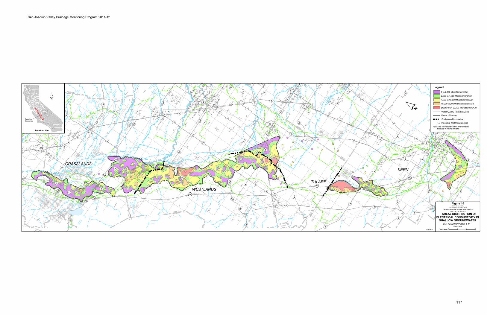
Sequ
oia N
ation
alPa
rk
Sequ
oia
Natio
nal
Park
Sequ
oiaNa
tiona
lPa
rk
Isabe
llaLa
ke
San
Luis
Rese
rvoi
r
Don
Pedr
oRe
serv
oir
Lake
McClu
re
Lake
Naci
mie
nto
Miller
ton
Lake
Pine
Flat
Rese
rvoi
r
Lake
SanAnt
onio
Turlo
ckLa
ke
Lake
Succ
ess
Shav
erLa
ke
O'Nei
llFo
reba
y
Lake
Kawea
h
Clift
onCou
rtFo
reba
y
Hens
leyLa
ke
Modes
toRe
s.
Bass
Lake
Woo
dwar
dRe
s.
Hunt
ingt
onLa
ke
Cour
trigh
t Res
ervo
ir
Lake
Thom
asA
Edis
on
East
man
Lake
Lake
Web
b
Flor
ence
Lake
Tullo
chRe
s.
Wis
hon
Rese
rvoi
r
Burn
sRe
s.
Mamm
oth
Pool
Reser
voir
Redi
nger
Lake
Hern
ande
z Reser
voir
Yose
mite
Lake
Marip
osa
Res.
Los
Bano
sRe
s.
Quail
Lake
Lake
McSwain
Cast
acLa
ke
Bear
Res.
Garne
t Lak
e
Thou
sand
Islan
dLa
ke
Owens
Res.
Kerc
khof
fLa
ke
Beth
any
Res.
Littl
ePa
noch
eRe
s.
Kelse
yRe
s.
Mader
aEq
ualiz
atio
nRe
s.
Banos
Cree
k
Del
Puer
to
Sala
do
Creek
Crow
Ore
stim
ba
Cree
k
Garzas
Creek
Quin to
Creek
Romero
Dry
Creek
Dry
Cree
k
Cree
k
Cree
k
Los
Ow
ens
Cree
k
Banos
Los
Creek
Silver
Pano
che
Dutc
hman
Deadman
Creek
Dead
man
Cree
k
Ow
ens
Creek
Rasc
alBl
ack
Cree
k
Bear
Cree
k
Cree
k
Cott
onw
ood
Cree
k
Arro
yo
Cree
kW
arth
an
Gato s
Los
Cantua
Creek
Chino
Zapato
Creek
Jacalitos
Pasa
jero
Cree
k
Burn
s
Bear
Cree
k
Cree
k
Cree
k
Mariposa
Cree
k
Cree
k
Creek
Cree
k
Elk
Deer
Poso
Poso
Cree
k
Cott onwood
Creek
Cott
onw
ood
Bayo
u
Cree
k
Cree
k
Calie
nte
Dry
Cree
k
Cross
Creek
Hospital
Creek
Ingram
Cree
k
Ortigalita
Creek
Cree
kPa
noch
e
Litt
le
Panoche
Cree
k
Arroyo
Hond
o
Salt
Cree
k
Cree
k
Domengine
White
Creek
Cree
k
Aven
al
Creek
Bitte
rwat
er
Cree
k
Sant
os
Cree
k
Martin
ez
Cree
k
Salt
Cree
k
Chic
o
Vista
Creek
Sand
y
Cree
k
Bitterwater
Creek
Bitter
Creek
San
Creek
Buen
a
Emigdio
Salt
Creek
Tecuya
Creek
El
Creek
Tejon
Cree
k
Tunis
Creek
Paso
Calie
nte
Creek
Tehachapi
Creek
Mill
Creek
Lit tleCreek
Poso
Poso
Creek
Creek
Cedar
Cree
k
Deer
Lew
is
Cree
k
Yokohl
Cree
k
Mill
Cree
k
Pack
woo
d
Cree
k
Cam
eron
Cree
k
Deep
Cree
k
Outside
Creek
Dry
Creek
Deep
Cree
k
Sand
Creek
Wooten
Creek
Wahto
ke
Creek
Mill
Creek
Creek
Holland
Fish
Creek
Fancher
Creek
Dog
Creek
Cree
k
Dry
Lit t
le
Cree
k
Big
CreekFine
Creek
Willow
Creek
Cott onwoodCreek
Dry
Sandy
Gold
Willow
Creek
Willow
Cree
k
Mar
ipos
aCr
eek
Ow
ens
Creek
Bear
Creek
Burns
Creek
Fahrens
Creek
Cree
k
Lone Tree
Cree
k
Lit t
lejo
hns
Creek
Cree
k
Lit tlejohns
Creek
Cashman
Creek
Hood
s
Tuol
umne
Stan
isla
us
Joaquin
River
San
Merce
d
Rive
r
River
River
River
Chow
chill
a
River
Joaquin
San
Fres
no
Rive
r
Joaquin
SanRi
ver
Sout
h
San
Fork
Nor
th
Cla
rks
Sout
h
River
Kings
King
s
Fork
Fork
Tule
Kings
Whi
te
Rive
r
Tule
Kern
Rive
r
Joaq
uin
Fresno
Rive
r
River
Kings
Rive
r
Kaw
eah
Rive
r
Johns
St.
Rive
r
River
Riv
er
Tule
Fork
South
Rive
r
Branch
Nor
th
Branch
River
Tule
Rive
rKe
rn
Kern
River
Sout
hFo
rk
Rive
r
River
North
Fork
Tule
River
Middle
Fork
Tule
Riv
er
Kaweah
South Fork
River
Kaw
eah
Rive
r
So .Fork
Kaweah River
Sycamore
Creek
FineGold
Creek
Lit tleCreek
Willow
East
Fork
Cho
wch
il la
River
West
Fork Chowch il laRiver
Middle
Fork
Chowch il la
River
Merced
Rive
r
NorthFork
Merced
River
So . Fork Merced
Rive
r
Tuol
umne
Rive
r
Tuolumne
River
Clavey
River
Middle
River
Old
Rive
r
Slo
ugh
Duck
Slo
ugh
Ash
SloughSal t
Slough
Mud
Bere
nda
Slough
Fresno
SloughFresno
Slo
ugh
Slo
ugh
Slough
Fresno
Slough
Murph
y
Col
e
Slou
gh
Lake
Goos
e
Sloug
h
Porter
Jerry Slough
SloughLone
WillowSand
Slough
Sal t
Slough
MudSlough
French CampSl.
Bypas
sMa ripo sa
Bypass
Eas tside
Bypass
Eas tside
Chowc hilla
James
Bypass
Bypass
L A K
E B
E D
T U L
A R
E
Lake
bed
Goos
e
Kern
Lake
bed
Lake
bed
Buen
a V
ista
KernRiver
Flood
Channel
Kern
River
Channel
Nort
h
Delta Canal
Aqueduct
California
Modesto
Canal
Mendota
Main
Modes
to
Cana
l
Dist
rict
Main
Main
Canal
MainMendotaDelta
Cana
l
Main
Canal
Line
High
Cana
l
Mai
n
Turlo
ck
Cana
l
Main
Joaq
uin
San
South
Canal
Side
Can
alM
ain
Turl
ock
Cana
l
Mai
n
Modes
to
AqueductOutside
Canal
Main
California
Canal
Mendota
Canal
Delta
Outside
Canal
Main
Canal
Lift
Third
Canal
Lift
Seco
nd
Canal
Lift
First
Canal
Canal
Canal
Stinson
Ditch
Crescent
Aqueduct
California
Aque
duct
Lakeland
Blakeley
Canal
Blakeley
Canal
Ditch
Lakeside
Branch
Eas t
Ditch
Lakeside
Canal
Ditch
Chance
Last
Canal
Lemoore
Canal
Lake
Tulare
Drain
Coas
tal
Canal
California
Side
Canal
Homeland
Main
West
CanalLake
Goose
Canal
Cana
l
Valle
y
Cro
ss
CanalLerdo
CanalCalloway
SideEas t
Canal
-Kern
Friant
Canal
Aqueduct
Map
le
Cana
l
Canal
Branch
Central
Canal
SideEas t
Canal
Edison
Arvi
n
Aqueduct
Calif
orni
a
Ditc
h
Rim
New
Ditch
Rim
OldC
anal
Alejandro
Farmers
Canal
Stine
Canal
Buen
a
Vista
Canal
Madera
Friant
Cana
l
-
Branch
Eas t
Alta
Canal
Switch
Canal
Fresno
Canal
Kern
Canal
Enter
prise
Lakeland
Canal
Canal
- KernFriant
Coastal
Bran
ch
Sout
hSa
nJo
aqui
n
Mai
nC
anal
Newm
an
Wastew
ay
Wes
tley
Was
tew
ay
BantaCabona
LiftCanal
Het
chH
etch
yA
qued
uct
Hetc
h
Hetc
hy
Aqued
uct
San
Luis
Was
tew
ay
Beta
Canal
Ditch
People
sLe
Grand
Canal
GravellyFord
Canal
Cana
l
Hern
don
Dry
Cree
k
Can
al
Centerville
Kingsburg
Canal
Pionee r
Cana
l
Mai
n
Cana
l
Kern
Island
Canal
Arroyo
Canal
Santa Fe
Canal
Coalinga
Canal
Cere
sM
ain
Canal
Tula
reCa
nal
Dela
no-E
arlim
art
Late
ral
Shaf
ter W
asco
ID
Late
ral
Pond
-Pos
o
Cana
l
Pond-PosoCanal
Pac
heco
Con
duit
SAN
LU
IS
NATI
ONA
L W
ILD
LIFE
REFU
GE
DIAB
LO R
ANG
E
NATI
ONA
L W
ILD
LIFE
REFU
GE
(PRO
POSE
D)
DIAB
LO R
ANG
E
NATI
ONA
L W
ILD
LIFE
REFU
GE
(PRO
POSE
D)
BITT
ER C
REEK
NATI
ONA
L W
ILD
LIFE
REFU
GE
KERN
NATI
ONA
L W
ILD
LIFE
REFU
GE
MEN
DO
TA
WIL
DLIF
E A
REA
MER
CED
NATI
ONA
L W
ILD
LIFE
REFU
GE
PIX
LEY
NATI
ONA
L W
ILD
LIFE
REFU
GE
LOS
BAN
OS
WIL
DLIF
E A
REA
VOLT
A
WIL
DLIF
E A
REA
SAN
JOAQ
UIN
RIVE
R
NATI
ONA
LW
ILD
LIFE
REFU
GE
PIX
LEY
NATI
ONA
LW
ILDL
IFE
REFU
GE
MER
CED
NATI
ONA
L W
ILD
LIFE
REFU
GE
NORT
HGR
ASSL
AND
S
WIL
DLIF
E A
REA
NORT
HGR
ASSL
AND
S
WIL
DLIF
E A
REA
SAN
LU
ISRE
SER
VOIR
WIL
DLIF
EAR
EA
O'NE
ILL
FOR
EBAY
WIL
DLIF
EAR
EA
LITT
LE P
ANOC
HE
RESE
RVO
IR
WIL
DLIF
E A
REA
LAKE
KAW
EAH
WIL
DLIF
EAR
EA
BLU
ER
IDG
E
NATI
ONA
LW
ILD
LIFE
REFU
GE
H I L L S
V I S T
A
ANTE L O
P EH IL L S
H I L L S
L O S T
B U E N A
H I L
L S
E L K
S E M
I T R
O P I C
R ID GE
BU TTO N W IL L O W
R I D G E
H I L
L S
K E T T L E M
A N
ALAMEDA
CO
.
SANJO
AQU
INCO
.
SA
NJO
AQ
UIN
CO
.S
TA
NIS
LA
US
CO
.
STA
NIS
LA
US
CO
.M
ER
CE
D C
O.
ME
RC
ED
CO
.
STA
NIS
LA
US
CO
.
STANISLAUS CO.TUOLUMNE CO.
KE
RN
CO
.
ME
RC
ED
CO
.FR
ES
NO
CO
.
FRESNO CO.
MADERA CO.
FR
ES
NO
CO
.K
ING
S C
O. K
ING
S C
O.
ME
RC
ED
C
O.
MA
DE
RA
C
O.
FRESNO
CO.
KING
S CO.
KINGS CO.
TULARE CO.
SA
N L
UIS
O
BIS
PO
C
O.
KE
RN
C
O.
KINGS CO.
TULARE CO.
MAD
ERACO
.
FRESNO
CO.
FRE
SN
OC
O.
TULA
RE
CO
.
KE
RN
CO
.
TU
LA
RE
CO
.
STANISLAUS CO.CALAVERAS CO.
MA
RIP
OS
AC
O.
MA
DE
RA
CO
.
MERCED CO.
MARIPOSA CO.
TU
OLU
MN
EC
O.
MA
RIP
OS
AC
O.
VE
NT
UR
AC
O.
KE
RN
CO
.
MONTEREY CO.KINGS CO.
SAN BENITO CO.FRESNO CO.
SANTA CLARACO.
STANISLAUS CO.
KE
RN
CO
.
LO
SA
NG
EL
ES
CO
.
¬«166
¬«1
¬«58
¬«178
¬«43
¬«120
¬«198
¬«25
¬«33
¬«49
¬«152
¬«46
¬«245
¬«155
¬«168
¬«99 ¬«145
¬«65
¬«137
¬«63
¬«119
¬«223
¬«184
¬«216
¬«269
¬«202
¬«135
¬«219
¬«233
¬«4
¬«180
¬«180
¬«33
198
¬«33
¬«269
¬«41
¬«120
¬«184
¬«1
¬«65
¬«41
¬«58
¬«180
¬«99
¬«223
¬«108
¬«119
¬«25
¬«178
¬«132
¬«25
¬«43
¬«198
¬«41
¬«1
¬«140
¬«120
¬«59
¬«59
¬«145
¬«198
¬«198
¬«99
¬«152
¬«1
¬«63
¬«198
¬«33
166
¬«33
152
¬«41
¬«65
¬«1
¬«140
¬«165
¬«46
¬«140
¬«41
¬«49
¬«33
¬«198
¬«216
¬«49
108
¬«41
¬«33
¬«198
¬«145
¬«201
¬«152
¬«58
¬«132
¬«137
¬«120
¬«99
¬«43
¬«46
¬«41
¬«41
¬«1
¬«140
¬«166
¬«99
¬«152
¬«99
¬«245
¬«140
¬«41
¬«120
¬«198
¬«33
¬«58
¬«180
¬«99
¬«155
¬«168
¬«46
¬«65
¬«4
¬«168
¬«63
¬«33
¬«49
120
¬«135
¬«58
¬«33
145
¬«156
¬«145
¬«41
¬«108
120
¬«58
¬«33
¬«33
152
¬«132
¬«41
¬«135
¬«58
¬«33
¬«190
¬«180
¬«25
¬«41
¬«49
¬«140
¬«58
¬«33
¬«99
¬«43
¬«198
¬«65
¬«108
¬«165
¬«178
¬«166
¬«120
¬«198
¬«25
¬«176
¬«190
¬«227
¬«146
¬«146
¬«156
¬«135
¬«229
¬«1
¬«46
¬«46
§̈¦205
§̈¦580
§̈¦5
§̈¦5
§̈¦5
§̈¦5
§̈¦5
§̈¦5§̈¦5
§̈¦5
¬«201
¬«166
¬«166
¬«1
¬«1
¬«198
¬«198
tu101
tu101
tu101
tu101
tu101
tu101
tu101
tu101
tu101
tu101
tu101
tu101
tu101
tu101
tu101
tu101tu10
1
tu101
tu101tu10
1
Lemoo
reNa
valAir
Statio
n
Fres
no
Baker
sfield
Visa
lia
Mod
esto
Taft
Trac
y
Aven
al
Mer
ced
Tular
e
Clov
is
Lebe
c
Shaf
ter
Gilroy
Atasca
dero
Man
teca
Orcut
t
Turlo
ck
Hanfo
rd
Sant
a Mar
ia
San
Jose
Mad
era
Mam
mot
hLa
kes
Nipom
o
Delano
Vand
enbe
rgAFB
Cere
s
Was
co
Roun
d Valley
Lem
oore
Salid
a
Oildale
Delhi
Arvin
Ripo
n
Los B
anos
Atwat
er
Mes
a
Selm
a
Sang
er
Lam
ont
Oakda
le
Butto
nwill
ow
San
Mar
tin
Pixl
ey
Chow
chill
a
Dinub
a
Keyes
East
Oakda
le
Easto
n
Tem
pleto
n
Orosi
Woo
dvill
e
Win
ton
Lato
n
Shan
don
Plan
ada
Porte
rvill
e
Cam
bria
Mor
gan
Hill
Hollis
ter
Wes
t Bish
op
Corc
oran
Teha
chap
i
San
Luis
Obisp
o
Wilk
erso
n
Lost
Hills
Mad
era
Acres
ElPa
sode
Robles
(Pas
oRob
les)
Reed
ley
Coali
nga
Mor
roBa
y
Lake
Nacim
ient
o
Rive
rdale
Fraz
ierPa
rk
Bayw
ood-
Los Oso
s
Le G
rand
Arroyo
Grand
e
Cayu
cos
Rive
rban
k
Exete
r
Grays
on
Livi
ngsto
n
Mad
era
Ranc
hos
Denair
Lind
say
Hilmar
-Irw
in
Fow
ler
Patte
rson
DelRio
Fire
baug
h
King
City
Big
Pine
Wee
dpatc
h
Pism
oBea
ch
Vand
enbe
rgVill
age
Kerm
an
Teha
chap
i
Ivan
hoe
Bish
op
Woo
dlak
e
Ridg
emar
k
Goshe
n
Esca
lon
Sole
dad
Armon
a
Kings
burg
Empi
re
McK
ittric
k
Farm
ingt
on
Men
dota
Parli
er
Earli
mar
t
Caru
ther
s
Ocean
o Los A
lam
os
Gustin
e
East
Porte
rvill
e
Huron
McF
arla
nd
Mar
icopa
Sole
dad
Grove
r Bea
ch
Newm
an
Green
field
Wat
erfo
rd
Ford
City
Terra
Bella
Tipt
on
Farm
ersv
ille
San
Mig
uel
DosPa
los
Gonza
les
Stra
thm
ore
Yose
mite
Valley
Guada
lupe
Cutle
r
Dixon
Lane
-Mea
dow
Creek
Hughs
on
Biol
a
Wes
tM
odes
to
Sout
hTa
ft
Orang
eCo
ve
Sout
hDos
Palo
s
King
City
Sole
dad
Lond
on
Chua
lar
Stra
tford
San
Joaq
uin
Raisi
nCi
ty
Popl
ar-C
otto
nCe
nter
San Ard
o
Rich
grov
e
San
Juan
Bautis
ta
San
Luca
s
Mor
roBa
y
Sole
dad
Gonza
les
Brad
ley
Kettle
man
City
Auber
ry
Yose
mite
Lake
s
Oakhu
rst
Boot
jack
Mar
ipos
a
Wel
don
Bodf
ish
Lake
Isabe
lla
Wof
ford
Height
s
Kernv
ille
Golde
nHill
s
Bear
Vall
eySp
rings
TULARE
WESTLANDS
GRASSLANDSKERN
East
man
Lake
Hens
ley
Lake Kings
R.
Porte
rvill
e
3/29/2012
´
Location Map
Study AreaBoundaries
´
Note: Area outlines are dashed where inferred because of insufficient data.
Legend0 to 2,000 MicroSiemens/Cm
2,000 to 4,000 MicroSiemens/Cm
4,000 to 10,000 MicroSiemens/Cm
10,000 to 20,000 MicroSiemens/Cm
greater than 20,000 MicroSiemens/Cm
Extent of Survey
Study Area Boundaries
Water Quality Transition Zone
Individual Well Measurement
4 0 4 8 12Scale of Miles
AREAL DISTRIBUTION OFELECTRICAL CONDUCTIVITY IN
SHALLOW GROUNDWATER
STATE OF CALIFORNIATHE RESOURCES AGENCY
SAN JOAQUIN DISTRICTDEPARTMENT OF WATER RESOURCES
SAN JOAQUIN VALLEY 011
San Joaquin Valley Drainage Monitoring Program 2011-12
Figure
117
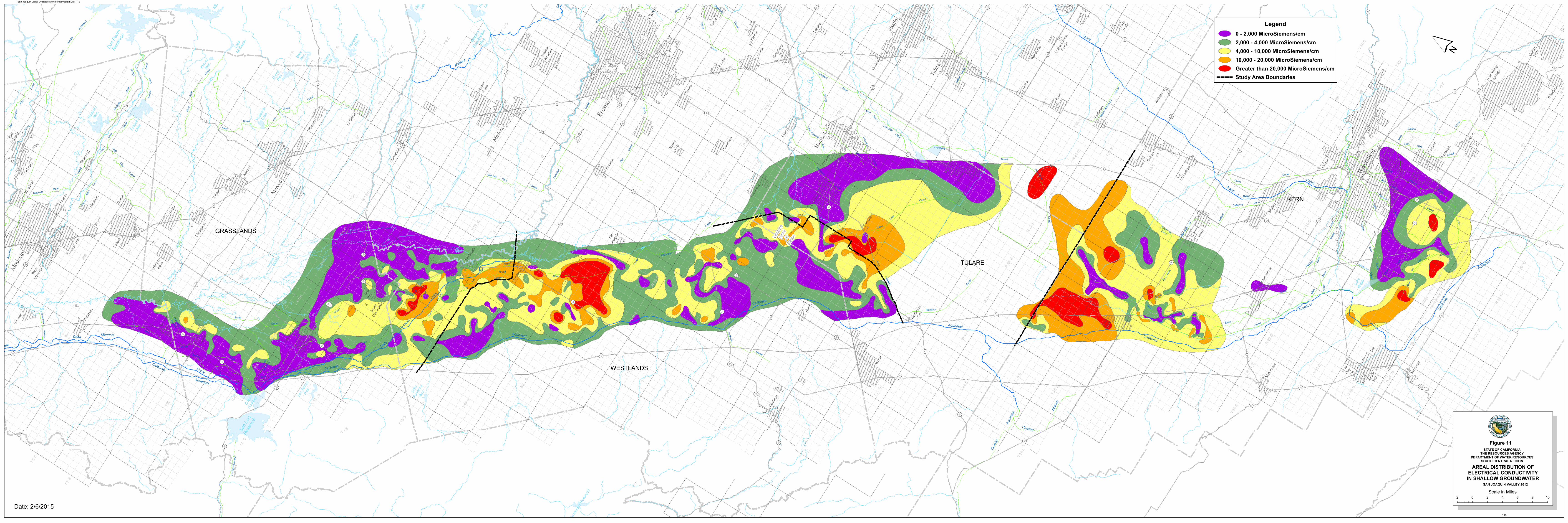
Isabe
llaLa
ke
San
Luis
Rese
rvoi
r
New
Mel
ones
Lake
Don
Pedr
oRe
serv
oir
Lake
McC
lure
Lake
Nacim
iento
Mille
rton
Lake
Pine
Flat
Rese
rvoi
r
Lake
San
Anto
nio
Turlo
ckLa
ke
Lake
Succ
ess
Shav
erLa
ke
O'Ne
illFo
reba
y
Lake
Kawe
ah
Clifto
nCo
urt
Fore
bay
Hens
leyLa
ke
Mod
esto
Res.
Bass
Lake
Woo
dwar
dRe
s.
Pyra
mid
Lake
Hunt
ingt
onLa
ke
Cour
trigh
t Res
ervo
ir
Hetch
Hetch
yRe
serv
oir
Lake
Thom
asA
Ediso
n
Eastm
anLa
ke
Lake
Web
b
Flor
ence
Lake
Tullo
chRe
s.
Wish
onRe
serv
oir
Burn
sRe
s.
Mam
mot
hPo
olRe
serv
oir
Redin
ger
Lake
Hern
ande
z Res
ervo
ir
Yose
mite
Lake
Mar
iposa
Res.
Los
Bano
sRe
s.
Quail
Lake
Lake
McS
wain
Casta
cLa
ke
Bear
Res.
Garn
etLa
ke
Thou
sand
Islan
dLa
ke
Owen
sRe
s.
Kerc
khof
fLa
ke
Beth
any
Res.
Little
Pano
che
Res.
Kelse
yRe
s.
Mad
era
Equa
lizat
ion
Res.
BanosLos Creek
Riv
er
Mer
ced
Joaquin
San
SloughSalt
SandSlough
Salt
Slough
Mud Slough
Bypa
ss
Bypass
Eastside
Eastside
Mar
ipos
a
Nor
th
Delta
Canal
Aqueduct
California
Modesto
Canal
Mendota
Main
Mod
esto
Cana
l
Dist
rict
Main
Main
Canal
MainMendotaDelta
Cana
l
Main
Canal
Line
High
Cana
l
Mai
n
Turlo
ck
Cana
l
Main
Joaq
uin
San
South
Canal
Side
Can
alM
ain
Turlo
ck
Can
al
Mai
n
Mod
esto
Aqueduct
Outside
Canal
Main
California
Canal
Mendota
Canal
Delta
Outside
Cana
l
Main
Canal
Lift
Third
Canal
Lift
Seco
nd
Canal
Lift
First
Canal
Canal
Canal
Stinson
Ditch
Crescent
Aqueduct
California
Aque
duct
Lakeland
Blakeley
Can
al
Blak
eley
Canal
Ditch
Lakeside
Branch
East
Ditch
Lakeside
Canal
Ditch
Chance
Last
Canal
Lemoore
Canal
Lake
Tulare
Drain
Coas
tal
Canal
California
Side
Canal
Homeland
Main
West
CanalLake
Goose
Canal
Cana
l
Valle
y
Cro
ss
Canal
Lerdo
CanalCalloway
SideEast
Canal
-Kern
Friant
Canal
Aqueduct
Map
le
Cana
l
Canal
Branch
Central
Canal
SideEast
Canal
Edison
Arvi
n
Aqueduct
Califo
rnia
Ditc
h
Rim
New
Ditch
Rim
Old
Canal
Alejandro
Farmers
Canal
Stine
Canal
Buena
Vista
Canal
Madera
Friant
Can
al
-
Branch
East
Alta
Canal
Switch
Canal
Fresno
Canal
Kern
Canal
Enterp
rise
Lakeland
Canal
Canal
- KernFriant
Coastal
Bran
ch
Sout
hSa
nJo
aquin
Main
Cana
l
Newm
an
Was
tewa
y
Wes
tley
Was
tew
ay
Bant
aC
abon
a
Lift
Can
al
Het
chH
etch
yAq
uedu
ct
Hetch
Hetch
y
Aqued
uct
South
Bay
Aqueduct
San
Luis
Was
tewa
y
Beta
Canal
Ditch
Peoples
Le
Grand
Canal
GravellyFord
Canal
Cana
l
Hern
don
Dry
Cree
k
Can
al
Centerville
Kingsburg
Canal
Pioneer
Cana
l
Mai
n
Cana
l
KernIsland
Canal
Arroyo
Canal
Santa Fe
Canal
Coalinga
Canal
Cere
sM
ain
Canal
Tula
reCa
nal
Delan
o-Ea
rlim
art
Late
ral
Shaf
ter W
asco
ID
Late
ral
Pond
-Pos
o
Cana
l
Pond-PosoCanal
Pach
eco
Con
duit
4
580
152
5
5
5
33
132
99
4
205
132
12010
8
120
108
108
59
3314
0
33
165
99
140
4
132
15233
233
152
33
165
15233
152
145
180
33
269
19833
198
198
14533
33
41
269
145
145
46
140
99
180
41
43
137
198
198
119
46
58
33
58
43
46
65
155
99
43
5
58
16633
166
223
184
58
184
178
9922
3
119
5
202
145
41
41
43
168
180
168
198
201
216
198
6324
519
8
99
63
216
245
201
63
65
190
137
65
65
155
178
120
59
5
5
5
120
10849
12049
49 49
140
49
41
41
190
180
219
46
65
Lemoo
reNa
val
AirSta
tion
Fres
no
Bake
rsfiel
d
Stoc
kton
Prun
edale
Visa
lia
Mod
esto
Taft
Trac
y
Aven
al
Mer
ced
Tular
e
Salin
as
Clov
is
Lebe
c
Shaf
ter
Gilroy
Atasca
dero
Man
teca
Orcutt
Turlo
ck
Hanfo
rd
Sant
a Mar
ia
San Jo
se
Mad
era
Mam
moth
Lake
s
Lom
poc
Nipom
o
Delano
Vand
enbe
rgAFB
Cere
s Was
co
Roun
d Valle
y
Lem
oore
Salid
a
Oildale
Delhi
Arvin
Ripo
n
Los B
anos
Atwate
r
Mes
a
Sant
a Yne
z
Selm
a
Sang
er
Arom
as
Lam
ont
Oakda
le
Butto
nwill
ow
San M
artin
Pixle
y
Chow
chill
a
Dinuba
Keyes
East
Oakda
le
Easto
n
Templ
eton
Orosi
Woo
dvill
e
Win
ton
Lato
n
Shan
don
Plan
ada
Porte
rvill
e
Cam
bria
Mor
gan Hill
Hollist
er
Wes
t Bish
op
Corc
oran
Teha
chap
i
San Lu
isObi
spo
Wilk
erso
n
Lost
Hills
Mad
eraAcre
s
ElPa
sode
Roble
s (Pa
soRo
bles
)
Reed
ley
Coali
nga
Mor
roBa
y
Lake
Nacim
iento
Rive
rdale
Fraz
ierPa
rk
Bayw
ood-
Los O
sos
Le G
rand
Arroyo
Grande
Cayu
cos
Rive
rban
k
Exete
r
Grayso
n
Livin
gsto
n
Mad
eraRa
ncho
s
Denair
Lind
say
Hilmar-
Irwin
Fowler
Patte
rson
DelRi
o
Fireb
augh
KingCi
ty
Wee
dpatc
h
Pism
o Beac
h
Vand
enbe
rgVi
llage
Kerman
Teha
chap
i
Ivan
hoe
Bish
op
Woo
dlak
e
Ridg
emark
Goshe
n
Esca
lon
Soled
ad
Armon
a
Kingsb
urg
Empir
e
McK
ittric
k
Farm
ingto
n
Men
dota
Parli
er
Earli
mart
Caru
thers
Ocean
o
Los A
lamos
Gustin
e
East
Porte
rvill
e
Huron
McF
arlan
d
Buell
ton
Mari
copa
Soled
ad
Grove
r Bea
ch
Newman
Greenf
ield
Wate
rford
Ford
City
Terra
Bella
Tipto
n
Farm
ersv
ille
San M
iguel
DosPa
los
Gonza
les
Strat
hmor
e
Yose
miteVa
lley
Guada
lupe
Cutle
r
Dixon La
ne-M
eado
wCr
eek
Hughs
on
Biola
Wes
tM
odes
to
Sout
hTa
ft
Orange
Cove
Sout
hDos
Palo
s
Miss
ionHill
s
KingCi
ty
Soled
ad
Lond
on
Chua
lar
Strat
ford
San
Joaq
uin
Raisi
nCi
ty
Popl
ar-Co
tton
Cent
er
San Ard
o
Rich
grov
e
San Ju
anBa
utist
a
San Lu
cas
Mor
roBa
y
Soled
ad
Gonza
les
Brad
ley
Spre
ckels
Kettlem
anCi
ty
Auberr
y
Yose
miteLa
kes
Oakhu
rst
Boot
jack
Mari
posa
Bodf
ish
Lake
Isabe
lla
Wof
ford
Heights
Kernvi
lle
Golden
Hills
Bear
Vall
eySp
rings
Legend0 - 2,000 MicroSiemens/cm2,000 - 4,000 MicroSiemens/cm4,000 - 10,000 MicroSiemens/cm10,000 - 20,000 MicroSiemens/cmGreater than 20,000 MicroSiemens/cmStudy Area Boundaries
´
AREAL DISTRIBUTION OFELECTRICAL CONDUCTIVITYIN SHALLOW GROUNDWATER
STATE OF CALIFORNIATHE RESOURCES AGENCY
DEPARTMENT OF WATER RESOURCESSOUTH CENTRAL REGION
SAN JOAQUIN VALLEY 2 2
Figure
8