GEOLOGY AND GEOCHEMISTRY OF AL FAWAKHIR MINING DISTRICT, CENTRAL EASTERN DESERT, EGYPT
Upload
khangminh22Category
view
1download
0
GEOLOGY
Paper: Hydrogeology and Engineering Geology
Module: Role of Engineering Geology in Civil
Construction and Mining Industry
Principal Investigator Co-Principal Investigator Co-Principal
Investigator
Prof. Talat Ahmad
Vice-Chancellor
Jamia Millia Islamia
Delhi
Prof. Devesh K Sinha
Department of Geology
University of Delhi
Delhi
Prof. P. P. Chakraborty
Department of Geology
University of Delhi
Delhi
Paper Coordinator Content Writer Reviewer
Prof. P. P. Chakraborty
Department of Geology
University of Delhi
Delhi
Dr. M. Masroor Alam
Department of Civil Engineering
Aligarh Muslim University
Aligarh
Prof. Vinay Jhingran
Department of Geology
University of Delhi
Delhi
Anchor Institute: Jamia Millia Islamia, Delhi
Subject Geology
Paper No and Title Hydrogeology & Engineering Geology
Module No and Title Role of Engineering Geology in Civil Construction and Mining Industry
Module Tag HG & EG IX

GEOLOGY
Paper: Hydrogeology and Engineering Geology
Module: Role of Engineering Geology in Civil
Construction and Mining Industry
Learning Outcomes
After studying this module you shall be able to:
Know about interface between geology and civil engineering.
Learn about the advent of engineering geology as a specialized discipline.
Understand different engineering geological investigations.
Identify problems of rock mass and founding ground.
Suggest remedial measures for geo-engineering issues.
1.1Introduction
Human beings are the youngest and perhaps the most intelligent of
all life forms thriving on the Earth. It were human beings who when
subjected to the vagaries of the weather and natural hazards, they
thought of safe shelters. Theythemselves carved out or found natural
GEOLOGY
Paper: Hydrogeology and Engineering Geology
Module: Role of Engineering Geology in Civil
Construction and Mining Industry
caves in rocks to hide them. They also started constructing shelters
using rocks, twigs, leaf and other different materials, sequestered
from the Earth itself. Their shelters were different in terms of shape,
size, and materials suited for different geographic areas and climatic
belts with varied earth surface processes to be negotiated.
For the safe design and longevity of any civil engineering structure
specially the mega ones, it is imperative to take into consideration
the most critical earth system process. As these processes cannot be
generalised as they vary from region to region each and every region
need fresh scrutiny. Also as far as construction materials are
concerned all are coming directly or indirectly from the rocks, except
the materials from the plant system. To get these construction
materials and other materials used in the world are to be mined from
the rocks, sometimes from great depths.
The Earth is a dynamic planet and is in constant state of change. Its
atmosphere, hydrosphere, biosphere, lithosphere, asthenosphere, all
GEOLOGY
Paper: Hydrogeology and Engineering Geology
Module: Role of Engineering Geology in Civil
Construction and Mining Industry
are interacting amongst themselves, are the manifestations of Earth’s
dynamism. To live on the Earth in harmony and sustainable fashion
we have to understand the “operating system”, the Earth is run on,
so that we can understand its processes and products to make the
life of human beings comfortable.
The studies in various disciplines of the “Earth Sciences” help us in
understanding this operating system. As the name indicates it is a
science which deals with the working processes and products of
earth system. It is a vast scientific discipline in the realm of natural
sciences, but draws heavily on the basic sciences i.e. physics,
chemistry and mathematics. Geology,as one of the major discipline
of the earth sciencedeals with the “Earth System” in totality to
understand processes which are operating on and inside the Earth
and has brought the Earth in its present state, since its origin.
Genesis of different materials in form of minerals and rocks, their
GEOLOGY
Paper: Hydrogeology and Engineering Geology
Module: Role of Engineering Geology in Civil
Construction and Mining Industry
occurrences, their natural deformation, evolution of life etc., are given
prime focus in this discipline.
There are various sub disciplines in geology to understand myriad of
processes and products operating in different realm of the earth
system involving physics, chemistry and biology. Engineering
Geology is one of such disciplines, especially important in the arena
of construction and mining engineering.
1.2Engineering Geology
Engineering Geology is the application of the geologic sciences to
engineering practice to assure the safe location, design, construction,
operation and maintenance of engineering works,which may not be
adversely affected by potential geological problems. The working
arena of the engineering geologist is essentially in the regions where
geological processes and manmade structures interact and latter’s
safety and longevity are to be ensured. For this they have to
GEOLOGY
Paper: Hydrogeology and Engineering Geology
Module: Role of Engineering Geology in Civil
Construction and Mining Industry
investigate, analyze and provide geologic and geotechnical
recommendations to ensureavailability of proper construction material
and safe founding ground.
Broadly three aspects can be mentioned here, first the study of
“Rock Material”, used in construction industry such building stones.
Secondly, the study of “Rock Mass” or founding rocky ground,
over/under which engineering operations are to be carried out leading
to loading or unloading of rock mass. Thirdly, the “endogenous” and
“exogenous” geological processes which operate around the
construction edifice and either hamper its construction or affect its
functioning in future.
Though, the science of geology has been around since the
seventeenth century, but the engineering geology was not recognized
as a specialized discipline until the early nineteenth century. Despite
the fact that geological material and perhaps knowledge of geology
was always there knowingly or unknowingly when human beings

GEOLOGY
Paper: Hydrogeology and Engineering Geology
Module: Role of Engineering Geology in Civil
Construction and Mining Industry
made innumerable castles, forts even pyramids etc., are testimony to
this,where not only minerals and rocks were used in different ways
but also these structures were sound and safe even in adverse
ground conditions. The first American engineering geology text book
was written in 1914 by Ries and Watson. In 1925, Karl Terzaghi,
an Austrian trained engineer and geologist, published the first text in
German language on Soil Mechanics. Terzaghi is known as the
father of soil mechanics, but also had great interest in geology and
considered soil mechanics and engineering geology as an important
branch of Geotechnical Engineering. He too wrote a book in German
in 1929, with Redlich and Kampe, on engineering geology. In 1947
he came up with first ever standard engineering classification of rock
mass known as “Rock Load Theory”, while working in Swiss Alps for
constructing a tunnel. He identified nine classes of rocks with
different support requirement for a 5.8 m span tunnel opening. He
once said:
GEOLOGY
Paper: Hydrogeology and Engineering Geology
Module: Role of Engineering Geology in Civil
Construction and Mining Industry
“The geotechnical engineer should apply theory with experimentation
but temper them by putting them into the context of the uncertainty
of the nature. Judgment enters through engineering geology.”
The need for geologist on engineering works gained worldwide attention after
failure of Austin Dam at Colorado River, Texas, USA in 1900 and St. Francis Dam,
California,USA in 1928. More engineering failures which occurred the following
years also prompted the requirement of formal geological knowledge to work on
large engineering projects. Charles P. Berkley, an American trained geologist who
was considered the first American engineering geologists, worked on multitude of
engineering projects and has studied many dam failures in the USA. He later worked
as engineering geologist at Hoover dam. He came up with the first ever document
linking geology and civil engineering by writing “Application of Geology to
Engineering Practice”known also as“Berkley Volume”in 1950, published by USGS,
New York.
One of the earliest definitions of the "Engineering Geologist" or "Professional
Engineering Geologist" was provided by the Executive Committee of the Division
on Engineering Geology of the Geological Society of America. The engineering
geology since then has come off an age and has now become an important discipline
aimed to introduce the critical aspect of geology in construction and mining
industry.Even the Engineering Geology, especially at undergraduate level to the
students of engineering, where emphasis is more on geology and less on engineering
being introductory discipline, is replaced by Geo-Engineering, where the emphasis

GEOLOGY
Paper: Hydrogeology and Engineering Geology
Module: Role of Engineering Geology in Civil
Construction and Mining Industry
is more on the engineering and less on geology at an advanced field. The Geo-
Engineering is taken over by Rock Mechanics, which is a branch more akin to
geotechnical engineering of civil engineering rather than geology. Large scale
underground excavations for mining mineral resources, have led to the development
of Mining Engineering,which too needs backup knowledge of geology but it is
heavily based on rock mechanics and is akin to underground construction, which too
requires large scale excavation, banks more on the rock mechanics and civil
engineering rather than engineering geology.
1.3 Civil Engineering
Civil Engineering is an amalgamation of science, art, professional skills and
engineering achievements. The requirement of the appropriate construction material
of required specification plays an important role to achieve strength and construction
economy of structure. Civil engineering works are carried out on or inside the
ground surface. As the geomorphological and geological processes operate
relentlessly and subject an area to continual change, therefore geomorphic setup and
geology of the site are vital for the success of all sorts of civil engineering works in
general and for structures made in subsurface conditions in particular. Earthquake
Engineering, an independent and very advance civil engineering subject too need
sound knowledge of tectonics and structural geology for identifying the earthquake
prone areas. Coastal and Marine Engineering, Environmental engineering etc. are
disciplines which also need interface of civil engineering and engineering geology.
The Natural Disaster studies also require knowledge of earth science in general and
of civil engineering in particular for working out ways of mitigating them.
GEOLOGY
Paper: Hydrogeology and Engineering Geology
Module: Role of Engineering Geology in Civil
Construction and Mining Industry
Engineering geologic studies may ensue at Initial Stage, to build up the logistics
based on the office study of the available literature in form of reports, maps, aerial
photographs, imageries etc. and accordingly the site or field studies can be planned.
This is an important step as the pre-construction planning or feasibility studies, cost
benefit analysis, environmental impact analysis etc. are undertaken at this stage.
During the Main Stage,it is decided that how to progress, what field studies,
geological, geophysical, laboratory and insitu tests will be required, so that design
parameters are decided. During the Review Stage, or Concurrent Stage, which may
start with excavation and go with the construction phase wherein unforeseen
problems are encountered and accordingly some changes are incorporated. The
Final Stage,or post construction phase is basically a forensic phase of the project
wherein monitoring is necessary throughout the design life structure or the project to
pre-empt any problem in future.
Why do we have to have a good knowledge of the construction site, the reasons are
many, such as:
All grounds are not “terra firma” and may lead to unstable foundations because of
the fact that unstable grounds do exist;
Unforeseen situation can always occur because of infinitely variable ground
conditions and more so due to inadequate site investigations;
Old mines and mining subsidence, development of brown field areas, land
reclamation, underground failure and caving, landslides and other slope failures
are not uncommon;
GEOLOGY
Paper: Hydrogeology and Engineering Geology
Module: Role of Engineering Geology in Civil
Construction and Mining Industry
Soft ground settlement and subsidence over clayey soil, marl, chalk, loess deposits
etc. and caving in karsted regions are encountered more than often;
Instability of hill slopes in residential locales, protection of road and rail network,
in hilly areas need continuous attention.
Hence, there are myriad of problems varying from place to place depending upon
their geographical, geomorphological and geological setup i.e. desert, flood plains,
cyclone belts, permafrost conditions, erosion by river, wind and coastal waves,
Earthquake tsunami and volcanic hazard prone areas etc. As such Civil Engineering
designs can response and accommodate almost any geological problem, ground
conditions and can counter or moderate natural hazards if they are correctly assessed
and understood. Some interface where civil engineers require geological
information:
Geological Problems Engineering Responses
Soft ground and settlement Foundation design to reduce and redistribute
loading
Weak ground and potential failure Ground improvement & cavity filling; or avoid
hazard zone
Unstable slope and potential sliding Stabilize or support slope, or avoid landslide hazard prone areas
Severe river and coastal erosion Slow down process with rock/concrete
defences
Potential Earthquake hazard Seismic zonation and structural design to
withstand vibration and evacuation plan ready

GEOLOGY
Paper: Hydrogeology and Engineering Geology
Module: Role of Engineering Geology in Civil
Construction and Mining Industry
Potential volcanic hazard Delimit & avoid hazard zone, predict eruption, have evacuation plan ready
Rocks as construction material Resource explorationand estimation, testing and exploitation
Site Survey and Investigation Photogrammetry, remote sensing, geophysical,
geological and engineering geological
investigations
Natural hazards mitigation Flood,coastal hazards, landslides, earthquake,
tsunami, volcanism, caving
Groundwater Exploration Hydrological properties of rocky aquifers,
groundwater and rock strength
Rock mechanics and engineering Rock mass classification and stresses in rocks
Strategic storage facility Underground storage of oil and gas for
emergency
Nuclear waste disposal sites Underground trapment in stable continental
areas
India is now concentrating on harnessing its energy and on development of
infrastructure. This would require large scale demand for construction material,
hydroelectric power generation, large scale mining, tunnelling, underground metros,
large scale excavations and slope stabilizations.
Some of these activities would be conducted at greater depths, with varied rock
properties and insitu stresses. Engineering Geology, Geo-Engineering and Rock
Mechanicswill act as an important tool duringplanning, logistics development,
operation and implementation of such projects in green and brown field areas.
GEOLOGY
Paper: Hydrogeology and Engineering Geology
Module: Role of Engineering Geology in Civil
Construction and Mining Industry
1.4 Engineering Geological Investigations for Civil Engineering Projects
Before starting a construction project the ground need to be
assessed in terms of its suitability and probable difficulties that may
come across during construction and also after its commissioning.
The objectives of investigation vary with the size and nature of the
project and include: (i) cost benefit analysis, (ii) site conditions and
ground properties (iii) probable difficulties, (iv) accessibility to the site
and logistics involved, (v) availability of construction material, (vi)
legal and environmental clearances, (vii) data generation for designing
the structure etc.
The cost of ground investigation vary from project to project and site
to site but is a must and only costs 0.05 to 0.2 % for buildings, 0.2
to 1.5% for roads, 1 to 3% for dams and 0.5 to 4% for tunnels
depending upon the size of the structure and differing ground
conditions. Once a project is started and complications start cropping
GEOLOGY
Paper: Hydrogeology and Engineering Geology
Module: Role of Engineering Geology in Civil
Construction and Mining Industry
up then the remedial measures alone can increase the project cost
by 10%. It is common to see that construction projects are delayed
by unforeseen ground problems, poor interpretation of data,
environmental and legal litigations.It has been said that:
“You pay for ground investigation weather you have one or not”
A ground investigation is tailored to the requirement of a particular
project to find the most suitable site within the ambit of purpose and
economy. The area and depth of investigations depends upon the
dimensions involved in the project. Data generated during
investigations are incorporated during the designing of structure so
that it should last at least for designed time span or more.
The investigations should also recognize possibilities of difficult and
unforeseen ground conditions in and around the proposed project so
that alternate site can be considered or some engineering measures
are taken to remedy or improve the site. Some common problems
encountered in rocky areas are:
GEOLOGY
Paper: Hydrogeology and Engineering Geology
Module: Role of Engineering Geology in Civil
Construction and Mining Industry
Unconsolidated, soft and expansive ground material.
Presence of glacial outwash, drift, colluvial and fluvial gravel
deposits with varying thickness and depths.
Weathered, weak and profusely fractured rock outcrops and
bed rocks.
Old or abandoned landfill or mining site.
Natural (cavernous ground) or manmade cavities (abandoned
shafts and mines) within the bed rocks.
Shallow groundwater table, cutting or breach of a confined
aquifer.
Creeping or active slopes or areas of land sliding.
1.4.1 Stages of Ground Investigations
Any mega project is envisaged to improve the standard of living of
the society and not only involves heavy expenditure but lot of time to
get completed. Hence before starting a project all of pros and cons
are taken into consideration to get maximum benefit out of the
GEOLOGY
Paper: Hydrogeology and Engineering Geology
Module: Role of Engineering Geology in Civil
Construction and Mining Industry
project. The place where a project is to be started for example a
dam and reservoir system, the area involved is usually very large
and to finalize the site of the dam so that a good founding ground
and a proper reservoir site can be located with minimum of
environmental degradation and also within proposed budget. Lots of
permutations and combinations are to be weighed, in terms of safety
and cost benefit analysis before pin pointing the final site. In case a
new road or rail line are to be layed, then locations of tunnels,
bridges, their alignment, dimensions, methods to be employed for
excavation and construction etc. should be worked out prior to
starting the tunnelling operation. For example to extend rail line
beyond Rishikesh (Uttarakhand) to Karan Prayag (Uttarakhand),
based on preliminary investigation using remote sensing and other
methods three rail route alignments were recommended by engineers
for around 130 km. The first alignment has 82 tunnels, 154 bridges;
second alignment has 90 tunnels and 126 bridges while the third

GEOLOGY
Paper: Hydrogeology and Engineering Geology
Module: Role of Engineering Geology in Civil
Construction and Mining Industry
alignment has 84 tunnels and 160 bridges of different lengths. It is
after detailed analysis, ground surveys, field checks, geological and
geophysical investigations as well as cost benefit analysis will be
carried out and any one of these alignments will be finalized before
starting the project. Once project is finalized and started,even then
some changes may have to be made locally depending upon the
situations and requirements during the construction phase.
What we can infer from the above paragraph that investigations of
different types are involved at various stages of a project for
example: (i) Preliminary Stage, (ii) Main Stage and (iii) Concurrent
Stage.
1.4.1.1Preliminary Stage: It is also called as reconnaissance stage
where a project is in planning stage. It requires Office or Deskstudy
which involves gleaning through already available literature in form of
topographic maps; aerial photographs satellite imageries, geological
maps and reports etc. The available topographic and geological maps
GEOLOGY
Paper: Hydrogeology and Engineering Geology
Module: Role of Engineering Geology in Civil
Construction and Mining Industry
may not be at suitable scales at this stage but will give a broad idea
about the area.
Site visit may then be undertaken for visual assessment of the area
and to gather information available with local populace. A first hand
idea about local topography and geology can be ascertained if
experts are available with the team.A preliminary report can be made
to chalk out detailed field work plan, once the feasibility of the
project is established.
1.4.1.2 Main Stage: Once the project gets green signal then
multitude of site investigations are undertaken which involves
detailed fieldwork to have detailed information about the soil and
rocks. Fresh surveys are undertaken at small scales for
ascertaining the topography and geology of the area. For shallow
subsurface information trial pits and trenches, exploratory adits or
shaft may be made. For knowing about deep underground
conditions drilling, bore hole logging and geophysical surveys can
GEOLOGY
Paper: Hydrogeology and Engineering Geology
Module: Role of Engineering Geology in Civil
Construction and Mining Industry
be carried out. The samples of soil and rocks are collected for the
laboratory tests and analysis. If some insitu testing is required it is
also undertaken at this stage. After corroborating the data from
field and laboratory a final report is prepared. Final report includes
detailed topographic and geological maps at scales which can
mirror the minute details of the site. Fence diagrams can be made
to get three dimensional perspective of the site.
1.4.1.3 Concurrent Stage: Once it is decided that a particular site
is good for the project the work related to construction is started
based on the information gathered at main stage of investigations.
Now excavations is done for creating opening or for laying
foundation and if some new situation arises which could not be
detected in previous investigations should be taken into
consideration and changes can be recommended accordingly in
the design. Because it has been found that unforeseen and

GEOLOGY
Paper: Hydrogeology and Engineering Geology
Module: Role of Engineering Geology in Civil
Construction and Mining Industry
unwarranted problems can come up any time especially in the hilly
and/or rocky areas, hence it has been said that:
“Design as you go, be ready for the worst and hope for the best.”
1.5 Desk Study
In the preliminary stage after the conceptualization of a project
one starts in his or her office by gleaning through already
published are unpublished material. This is the first step to make
basis for the feasibility of the project as well as for planning
further investigations and explorations. The material may include
reports, maps, aerial photographs, remote sensing imageries etc.
made either as routine analysis of that region or are the result of
some other project. The procurement of these materials requires
visit to university libraries, libraries of specific departments or can
be requested through post from departments holding these
documents. As generation of such material requires lot of finance,
the organizations may charge some money while sharing the

GEOLOGY
Paper: Hydrogeology and Engineering Geology
Module: Role of Engineering Geology in Civil
Construction and Mining Industry
information. Some information may be of classified nature due to
strategic or security concerns hence may not be easily available.
Depending upon the importance of the project even this
information can be sequestered through proper official channel.
In India different organizations are working on generating data
base for different kinds of floral, faunal, geological resources.
Maps are the most basic necessity for understanding the
topography. Maps e available at different scales with different
themes and can be used for developing spatial data base for an
area to get information about human habitation if any, related civil
utility structures, political boundaries, nature of forest and soil
cover.
The important organizations which can provide such information
include:
GEOLOGY
Paper: Hydrogeology and Engineering Geology
Module: Role of Engineering Geology in Civil
Construction and Mining Industry
Geological Survey of India (GSI), with its head office at Calcutta
and offices at capital of the states provide geological maps at
different scales.
Survey of India (SOI), with its head office at Dehradun is
entrusted with making surveys to provide maps of different kinds
at different scales. The base map on the scale of 1:50,000,
popularly known as topographic sheets or in short “toposheets”, is
a detailed map providing all the basic information including
topography of an area. Aerial photographs are also provided by
Survey of India.
National Remote Sensing Agency (NRSA), of Hyderabad has the
authority of making satellite photo maps or imageries. The remote
sensing data can be had as hard copy or as soft copy or in
digital form.
There are many other ministries and organizations such as
Ministry of Environment and Forest, Central Pollution Control
GEOLOGY
Paper: Hydrogeology and Engineering Geology
Module: Role of Engineering Geology in Civil
Construction and Mining Industry
Board, New Delhi, Oil and Natural Gas Corporation Ltd.,
Departments of Mines, Coal India Limited, State Directorates of
Geology and Mining, Department of Atomic Energy, Public Work
Departments etc. can also provide information about the
topography and geology of areas under their control. Now a
dayslot of data are available with private organizations which can
also be requested for such data. Internet has become a big
repository of such material and data and can be accessed to get
at least some basic and preliminary data to start with.
Lot of useful information can be gathered from local residents,
farmers, teachers from schools, colleges, universities and other
academic institutions.
1.6 Detailed Field Study
Depending upon nature and size of the project detailed field study is
undertaken which involves surveys of different kinds made on the
GEOLOGY
Paper: Hydrogeology and Engineering Geology
Module: Role of Engineering Geology in Civil
Construction and Mining Industry
surface for alignment, topography, soil and rock types. Sub surface
exploration is also carried out to see extension of soil and rock
underground and variation therein, depth of soil-rock contact,
presence of discontinuity surfaces in terms of kind, number and their
potential of causing problems.
1.6.1 Trial Pit and Trench
The easiest and cheapest method of exploring shallow depths directly
is of digging equidimensional pits and linear trenches. This can be
done manually or by using machine with backhoe. 1 to 5m deep pits
and trenches can be easily made and can be used for further
exploration by plate load test as well as to see old failure surfaces,
weak zones etc. More than 2m deep digging may require support
bracings so as to avoid their slippage. If the pit or trench is not
going to be used for laying foundation then it should be properly
back filled by soil, gravel or by lean concrete.
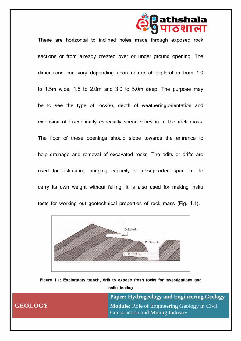
1.6.2 Exploratory Adits or Drift
GEOLOGY
Paper: Hydrogeology and Engineering Geology
Module: Role of Engineering Geology in Civil
Construction and Mining Industry
These are horizontal to inclined holes made through exposed rock
sections or from already created over or under ground opening. The
dimensions can vary depending upon nature of exploration from 1.0
to 1.5m wide, 1.5 to 2.0m and 3.0 to 5.0m deep. The purpose may
be to see the type of rock(s), depth of weathering;orientation and
extension of discontinuity especially shear zones in to the rock mass.
The floor of these openings should slope towards the entrance to
help drainage and removal of excavated rocks. The adits or drifts are
used for estimating bridging capacity of unsupported span i.e. to
carry its own weight without falling. It is also used for making insitu
tests for working out geotechnical properties of rock mass (Fig. 1.1).
Figure 1.1: Exploratory trench, drift to expose fresh rocks for investigations and insitu testing.
GEOLOGY
Paper: Hydrogeology and Engineering Geology
Module: Role of Engineering Geology in Civil
Construction and Mining Industry
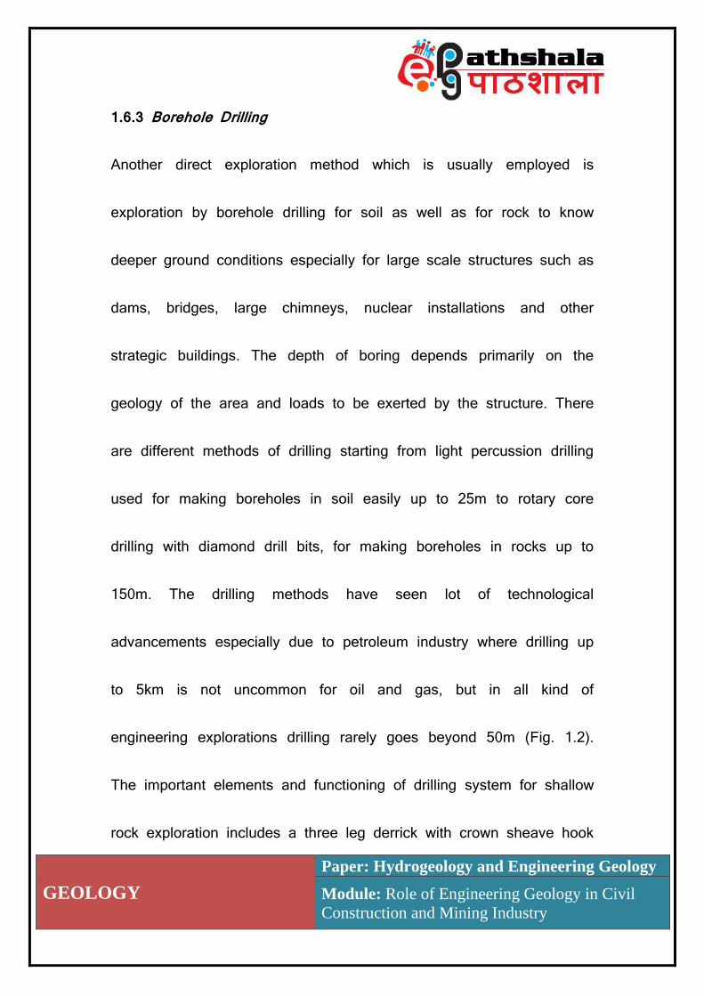
1.6.3 Borehole Drilling
Another direct exploration method which is usually employed is
exploration by borehole drilling for soil as well as for rock to know
deeper ground conditions especially for large scale structures such as
dams, bridges, large chimneys, nuclear installations and other
strategic buildings. The depth of boring depends primarily on the
geology of the area and loads to be exerted by the structure. There
are different methods of drilling starting from light percussion drilling
used for making boreholes in soil easily up to 25m to rotary core
drilling with diamond drill bits, for making boreholes in rocks up to
150m. The drilling methods have seen lot of technological
advancements especially due to petroleum industry where drilling up
to 5km is not uncommon for oil and gas, but in all kind of
engineering explorations drilling rarely goes beyond 50m (Fig. 1.2).
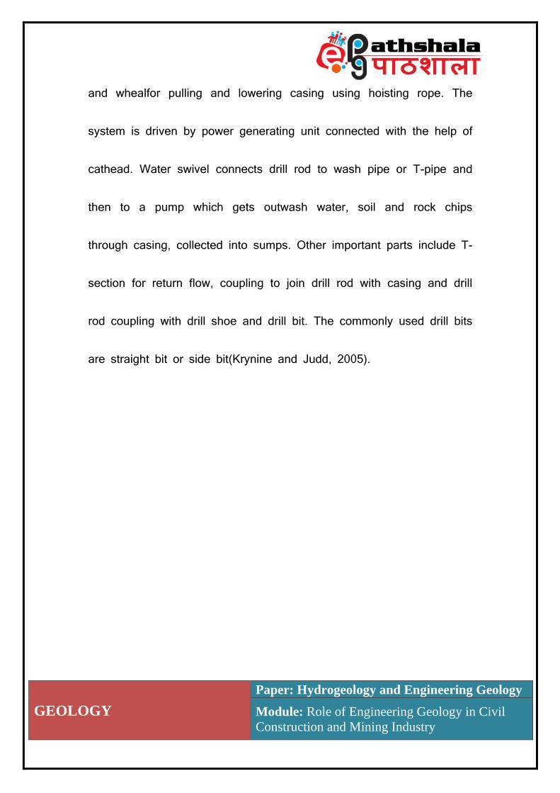
The important elements and functioning of drilling system for shallow
rock exploration includes a three leg derrick with crown sheave hook
GEOLOGY
Paper: Hydrogeology and Engineering Geology
Module: Role of Engineering Geology in Civil
Construction and Mining Industry
and whealfor pulling and lowering casing using hoisting rope. The
system is driven by power generating unit connected with the help of
cathead. Water swivel connects drill rod to wash pipe or T-pipe and
then to a pump which gets outwash water, soil and rock chips
through casing, collected into sumps. Other important parts include T-
section for return flow, coupling to join drill rod with casing and drill
rod coupling with drill shoe and drill bit. The commonly used drill bits
are straight bit or side bit(Krynine and Judd, 2005).

GEOLOGY
Paper: Hydrogeology and Engineering Geology
Module: Role of Engineering Geology in Civil
Construction and Mining Industry
Figure 1.2: Wash boring rig and bits for shallow rock exploration. A (1) three leg derrick, (2) with crown sheave hook and wheel(2), (3) Hoisting rope, (4)
Water swivel, (5) Wash pipe or T-pipe, (6) drill rod, (7) T-section for return flow, (8) coupling to join drill rod with casing, (9) cat head, (10) power generating unit, (11) outwash and samples, (12) drilling rod coupling, (13) In wash water storage, (14) pump, (15) casing, (16) drill shoe, (17) drilling bit, (18) straight bit
and (f) side bit (Krynine and Judd, 2005).
To optimise the number of drill holes, geophysical methods are
employed to make generalizations in between the drill holes and
drilling is carried out at identified critical areas.
1.7 Drilling Methods

GEOLOGY
Paper: Hydrogeology and Engineering Geology
Module: Role of Engineering Geology in Civil
Construction and Mining Industry
Most commonly used method not only to extract samples but also to
make direct observations regarding rate of drilling and depths of
change in lithology. The selection of drilling system depends upon
depth of drilling, nature of lithology i.e. soil or rock, soft or hard rock,
terrain type, accessibility to the area and economics. Here few simple
drilling systems for rocks will be discussed to explore subsurface
conditions for civil engineering point of view.
1.7.1 Jack Hammer Rock Probing
It is a manually operated or truck mounted pneumatic rock drilling
device using compressed air for making small depth holes in rocks.
The samples come in form of dust to small broken rock chips which
can be collected and observed to know the rock type. Rate of drilling
or penetration indicate strength of rocks, presence of cavities or weak
rock zones. Some field geology and previous drill records with jack
hammer probing can give working subsurface picture for small sized
projects.

GEOLOGY
Paper: Hydrogeology and Engineering Geology
Module: Role of Engineering Geology in Civil
Construction and Mining Industry
1.7.2 Percussion or Cable and Tool Drilling
For soft or weathered rocks using ‘A’ Frame, cable with powered
winch can be used. Its main component is a steel shell, which has a
chisel head to cut rock and clack valve to hold sample, mainly as
chip. It is repeatedly lifted and dropped with the help of cable, from
1 to 2m. The sampler has usually 100mm diameter and can be
lowered through 150mm casing in case of high water table. Ten to
twenty five meters of drilling exploration can be done. Apart from
getting samples, depth of water table, presence of shear zones and
cavities can also be known (Fig. 1.3).
GEOLOGY
Paper: Hydrogeology and Engineering Geology
Module: Role of Engineering Geology in Civil
Construction and Mining Industry
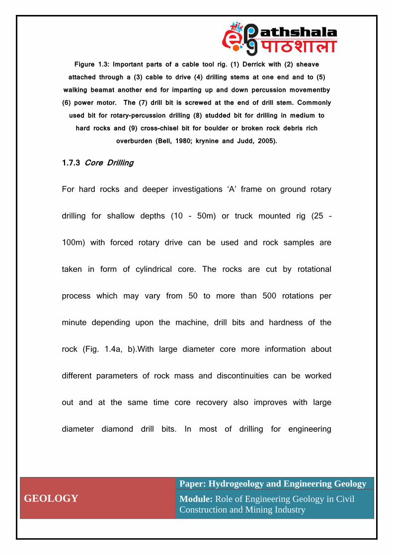
Figure 1.3: Important parts of a cable tool rig. (1) Derrick with (2) sheave attached through a (3) cable to drive (4) drilling stems at one end and to (5)
walking beamat another end for imparting up and down percussion movementby (6) power motor. The (7) drill bit is screwed at the end of drill stem. Commonly
used bit for rotary-percussion drilling (8) studded bit for drilling in medium to hard rocks and (9) cross-chisel bit for boulder or broken rock debris rich
overburden (Bell, 1980; krynine and Judd, 2005).
1.7.3 Core Drilling
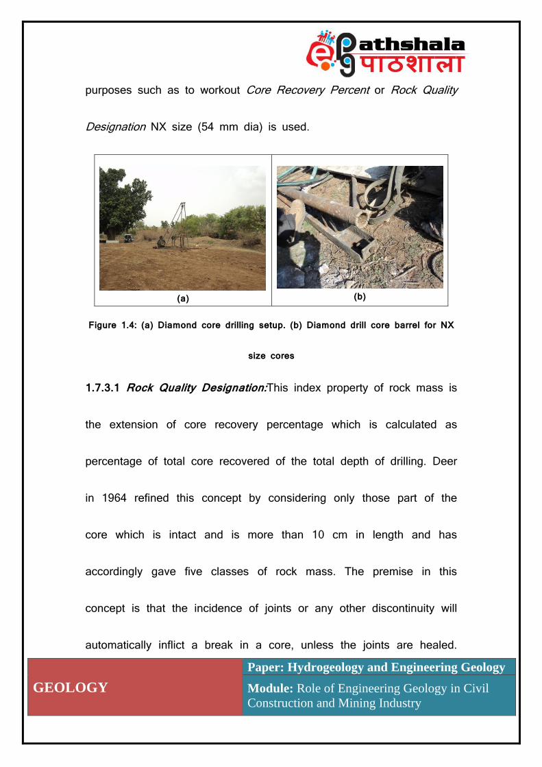
For hard rocks and deeper investigations ‘A’ frame on ground rotary
drilling for shallow depths (10 - 50m) or truck mounted rig (25 –
100m) with forced rotary drive can be used and rock samples are
taken in form of cylindrical core. The rocks are cut by rotational
process which may vary from 50 to more than 500 rotations per
minute depending upon the machine, drill bits and hardness of the
rock (Fig. 1.4a, b).With large diameter core more information about
different parameters of rock mass and discontinuities can be worked
out and at the same time core recovery also improves with large
diameter diamond drill bits. In most of drilling for engineering
GEOLOGY
Paper: Hydrogeology and Engineering Geology
Module: Role of Engineering Geology in Civil
Construction and Mining Industry
purposes such as to workout Core Recovery Percent or Rock Quality
Designation NX size (54 mm dia) is used.
(a)
(b)
Figure 1.4: (a) Diamond core drilling setup. (b) Diamond drill core barrel for NX
size cores
1.7.3.1 Rock Quality Designation:This index property of rock mass is
the extension of core recovery percentage which is calculated as
percentage of total core recovered of the total depth of drilling. Deer
in 1964 refined this concept by considering only those part of the
core which is intact and is more than 10 cm in length and has
accordingly gave five classes of rock mass. The premise in this
concept is that the incidence of joints or any other discontinuity will
automatically inflict a break in a core, unless the joints are healed.
GEOLOGY
Paper: Hydrogeology and Engineering Geology
Module: Role of Engineering Geology in Civil
Construction and Mining Industry
For example if rocks are heavily jointed or a shear or fault zone is
passing then even getting a core of 10 cm in length will be difficult.
At the same time the process of drilling and recovery of core may
result in to breaking of core at places where as such there is no
discontinuity surface. Such breaks can be identified by the absence
of discolouration, normally found even along a very tight joint plane.
RQD =Σ 𝐿𝑒𝑛𝑔𝑡ℎ 𝑜𝑓 𝑎𝑙𝑙 𝑐𝑜𝑟𝑒 𝑝𝑖𝑒𝑐𝑒𝑠 (> 10 𝑐𝑚)
𝑇𝑜𝑡𝑎𝑙 𝑐𝑜𝑟𝑒 𝑙𝑒𝑛𝑔𝑡ℎ× 100
International Society of Rock Mechanics recommends Double Tube
Core Barrel Diamond Drilling System to recover 54.7 mm (NX)
diameter with preferable length of drilling of 1.5 to 2.0 m. If drilling is
to be done for higher depth then too the RQD should be calculated
every six meters and then average may be taken (Fig. 1.5).
GEOLOGY
Paper: Hydrogeology and Engineering Geology
Module: Role of Engineering Geology in Civil
Construction and Mining Industry
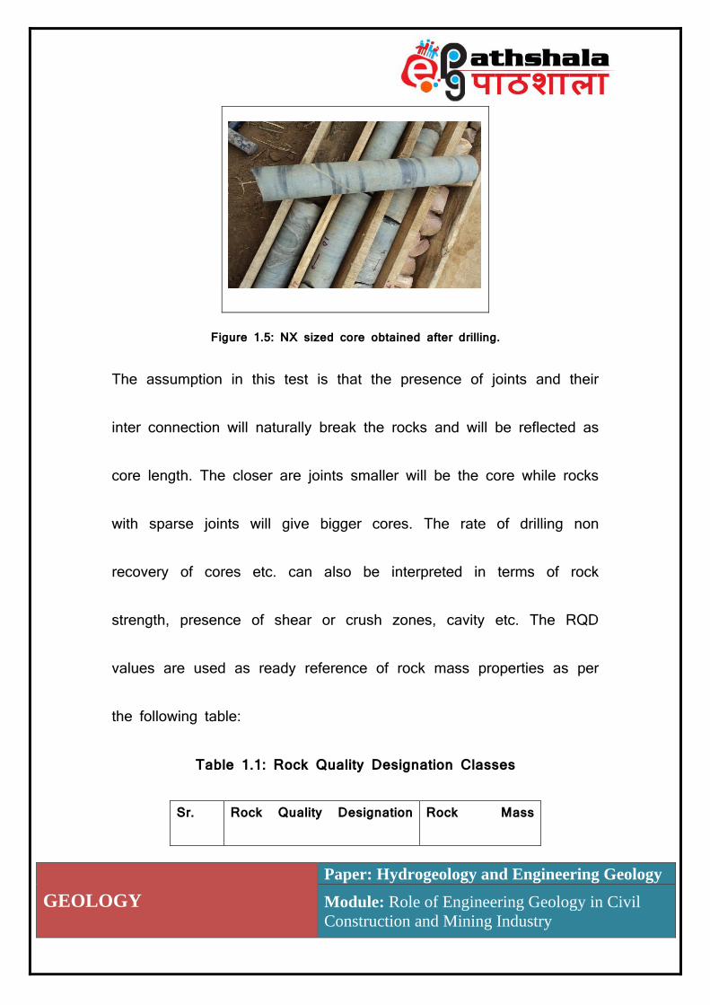
Figure 1.5: NX sized core obtained after drilling.
The assumption in this test is that the presence of joints and their
inter connection will naturally break the rocks and will be reflected as
core length. The closer are joints smaller will be the core while rocks
with sparse joints will give bigger cores. The rate of drilling non
recovery of cores etc. can also be interpreted in terms of rock
strength, presence of shear or crush zones, cavity etc. The RQD
values are used as ready reference of rock mass properties as per
the following table:
Table 1.1: Rock Quality Designation Classes
Sr. Rock Quality Designation Rock Mass

GEOLOGY
Paper: Hydrogeology and Engineering Geology
Module: Role of Engineering Geology in Civil
Construction and Mining Industry
No. (%) Class
1 > 90 Excellent
2 75 – 90 Very Good
3 50 – 75 Good
4 25 - 50 Fair
5 < 25 Poor
1.8 Geophysical Exploration Methods
The geophysical investigations are based on the measurements of
different physical properties such as density, gravity, seismicity,
resistivity, magnetism, radioactivity etc. using specially designed
instruments on the ground points as well as in bore holes to
sequester information regarding of subsurface. Geophysical methods
are rapid, economical and reliable but need calibration from known
data or may need borehole data for verification. In fact an
appropriate combination of direct and indirect methods not only

GEOLOGY
Paper: Hydrogeology and Engineering Geology
Module: Role of Engineering Geology in Civil
Construction and Mining Industry
optimizes the expenditure but also help in getting good results.Apart
from geological or engineering geological surveys geophysical
explorations are also used for detecting subsurface leakage in pipe
lines, sever lines, buried old pipe lines, ammunition storage,
abandoned shafts, small mines, and treasures etc. as non geological
uses. For some mega civil engineering projects such as site selection
of dams, reservoirs, tunnels, bridge foundations etc., geophysical
explorations are invariably used to get clear picture of subsurface
conditions in following terms:
Thickness of overburden – Presence of soil or weathered rocks, either
to be removed for reaching the sound foundation rocks or to be
located as thick loose rock debris to be used as construction
material.
Depth of bed rock - Depth and three dimensional extent i.e.
basement relief of sound rocks suitable for foundation.
GEOLOGY
Paper: Hydrogeology and Engineering Geology
Module: Role of Engineering Geology in Civil
Construction and Mining Industry
Presence of weak zones – Detection of cavities, cavernous rocks,
shear and fault zones which may not only act as weak zones but
may also act as zones of water leakage as well as major rock
structures.
Groundwater potential – Finding out regions with high groundwater
potential and its favourability or non favourability for specific project.
Rock mass exploration – To understand weathering extent, type,
thickness, attitude and extension of different rocks in subsurface.
Some important geophysical methods are explained in following
sections.
1.8.1 Gravity Method
This method uses the earth’s natural force of gravitation which pulls
down different objects towards it at the rate of 980cm/sec2 or 980
gal (standard value). One gal is an acceleration of one centimetre
per second per second. This value varies from equator (978.049 gal)
towards poles (983.221 gal) mainly due to variation in the radius of

GEOLOGY
Paper: Hydrogeology and Engineering Geology
Module: Role of Engineering Geology in Civil
Construction and Mining Industry
the earth. The theory behind this method is that for every place of
the earth there is a theoretical value of ‘g’ called as ‘gT’ which is
related to the latitude of that place by a formula:
gT = g [1 + 0.0052884 sin2 ϕ – 0.0000059 sin2 2ϕ]
Where, ‘g’ is the standard value of acceleration due to gravity
(978.049 gal at sea level) and gT is the theoretical value of ‘g’ at a
place having latitude ϕ. But if we compare gravity measurements of
two places at same latitude we may get different results, primarily
due to difference in mean sea levels, the rock mass present between
sea level and station level and effect of a topographic high or low
near the ‘g’ measuring station . To get exact results following
corrections are to be made:
Free air correction: As most of the station are above sea level and
‘g’ values decreases with increasing altitude. A correction is to be
added as +30.86 milligal per 100m increase.
GEOLOGY
Paper: Hydrogeology and Engineering Geology
Module: Role of Engineering Geology in Civil
Construction and Mining Industry
Bouguer reduction: The rocks between sea level and station will add
to the gravity values depending upon density of rocks and altitude.
Hence in this correction some value is to be detected. Free air
correction and Bouguer reduction can be worked out for 100m
elevation by formula:
gO’’ = g + H(0.0003086 – 0.0000421ρ) gals
where“gO”, is gravity corrected for free air and Bouguer corrections, H
is the height from the mean sea level and ρ, density of rocks.
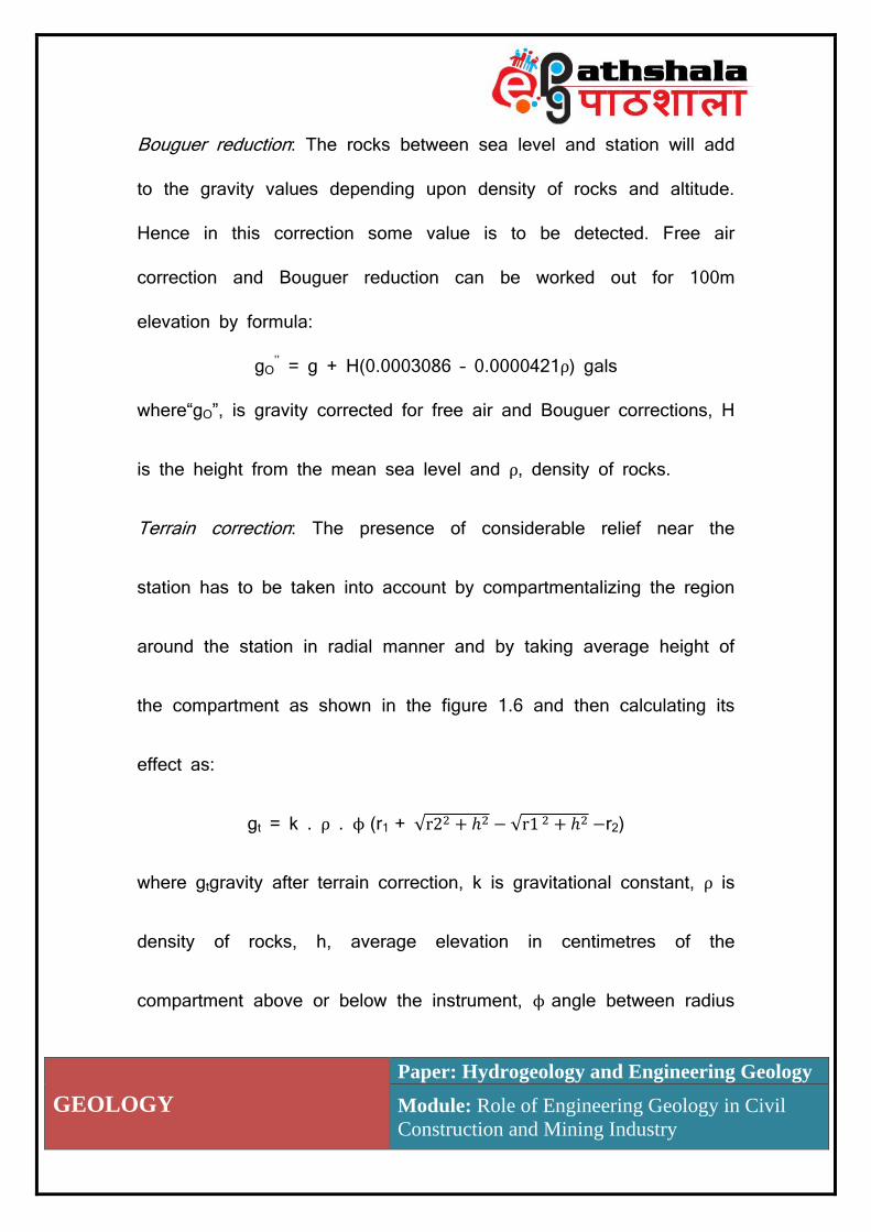
Terrain correction: The presence of considerable relief near the
station has to be taken into account by compartmentalizing the region
around the station in radial manner and by taking average height of
the compartment as shown in the figure 1.6 and then calculating its
effect as:
gt = k . ρ . ϕ (r1 + √r22 + ℎ2 − √r1 2 + ℎ2 −r2)
where gtgravity after terrain correction, k is gravitational constant, ρ is
density of rocks, h, average elevation in centimetres of the
compartment above or below the instrument, ϕ angle between radius

GEOLOGY
Paper: Hydrogeology and Engineering Geology
Module: Role of Engineering Geology in Civil
Construction and Mining Industry
of inner bounding circle, r1 and r2, is of outrebounding circle.
Standard charts and tables are available for these corrections.
Figure1.6: Topographic correction by compartmentalizing an area. For gravitational effect of compartment, abcd with respect to station S. r1 and r2 are
radii of inner and outer bounding compartments respectively in centimetres.
The difference still remaining (∆g), positive or negative, is called as
gravityanomaly, after applying all the corrections and getting ‘gO/C’
(observed and corrected), reflects conditions below ground surface in
terms of rock type, size, shape and distance from the observer.
∆g = gO/C - gT = +ve anomaly OR ∆g = gO/C - gT
= -ve anomaly
GEOLOGY
Paper: Hydrogeology and Engineering Geology
Module: Role of Engineering Geology in Civil
Construction and Mining Industry
Positive anomaly is an indication of dense material underneath while
negative anomaly indicates material of lesser density. The survey is
conducted along a linear tract or along the grid lines which can be
interpreted in terms of rock types and geological structures. The
values observed are usually very small, denoted as milligal or
gravitational unit (1gu = 10-6 m/sec2 = 0.1 milligal = 1/ 10,000 gal)
and can be plotted in form of contours termed as isogals, to get the
regional perspective of the area.
Gravity surveys have been found to be very successful in delineating
the fault zones, buried ridges, buried channels, salt domes, igneous
intrusions, cavities etc. Gravity surveys are also carried out for very
large regions to work out overall geological structure of a region or
even of a country. For this airborne gravity surveys are conducted by
installing strong gravimeter in aircrafts and equi-potential lines based
on observed gravity are drawn in form of contour lines. Some
GEOLOGY
Paper: Hydrogeology and Engineering Geology
Module: Role of Engineering Geology in Civil
Construction and Mining Industry
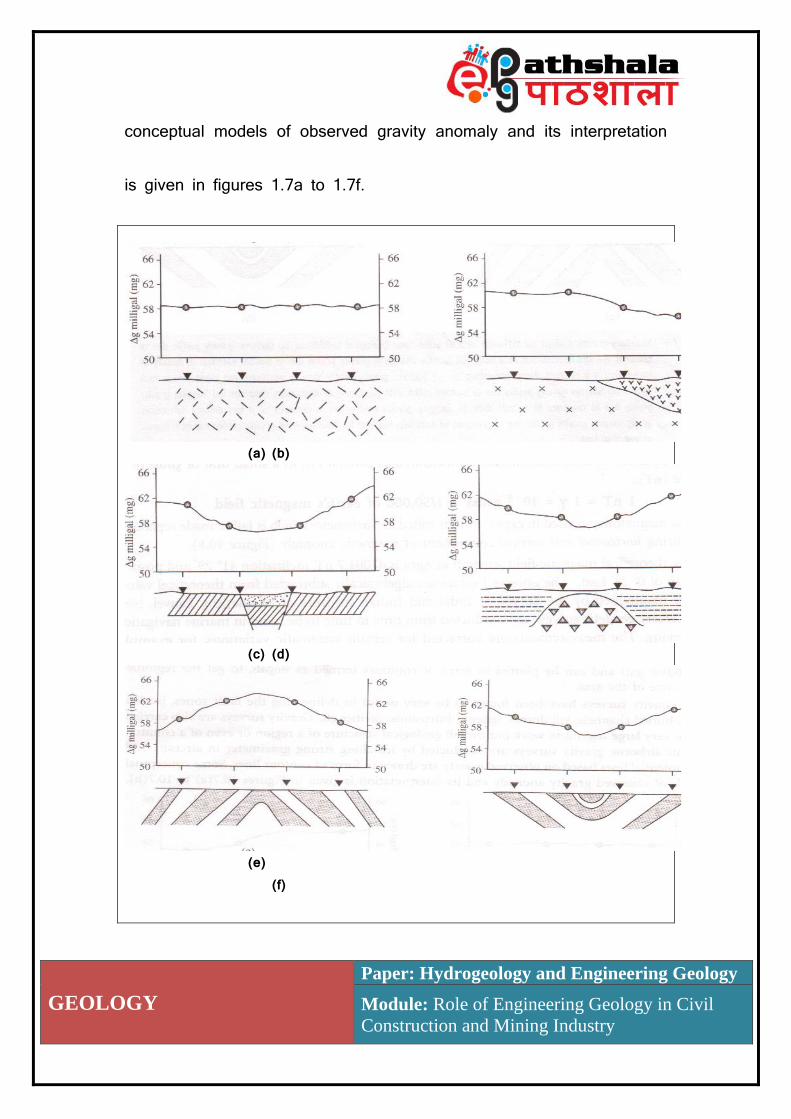
conceptual models of observed gravity anomaly and its interpretation
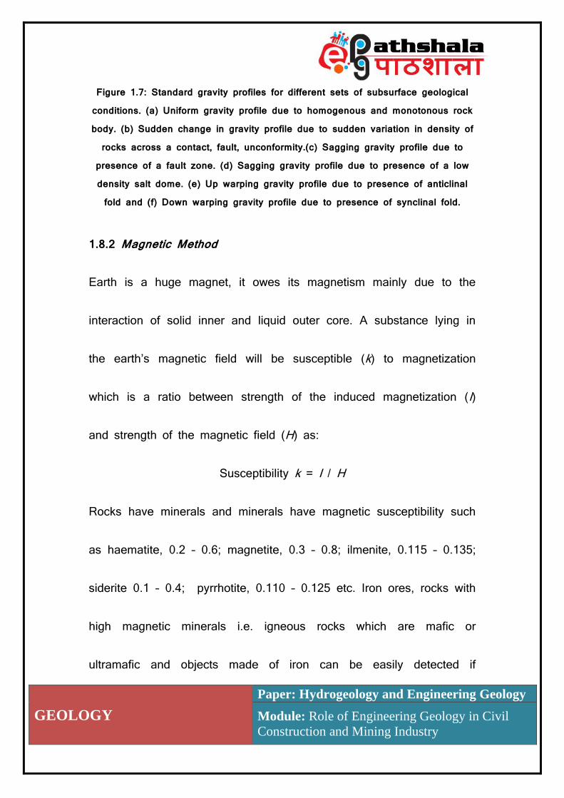
is given in figures 1.7a to 1.7f.
(a) (b)
(c) (d)
(e)
(f)
GEOLOGY
Paper: Hydrogeology and Engineering Geology
Module: Role of Engineering Geology in Civil
Construction and Mining Industry
Figure 1.7: Standard gravity profiles for different sets of subsurface geological conditions. (a) Uniform gravity profile due to homogenous and monotonous rock body. (b) Sudden change in gravity profile due to sudden variation in density of
rocks across a contact, fault, unconformity.(c) Sagging gravity profile due to presence of a fault zone. (d) Sagging gravity profile due to presence of a low density salt dome. (e) Up warping gravity profile due to presence of anticlinal fold and (f) Down warping gravity profile due to presence of synclinal fold.
1.8.2 Magnetic Method
Earth is a huge magnet, it owes its magnetism mainly due to the
interaction of solid inner and liquid outer core. A substance lying in
the earth’s magnetic field will be susceptible (k) to magnetization
which is a ratio between strength of the induced magnetization (I)
and strength of the magnetic field (H) as:
Susceptibility k = I / H
Rocks have minerals and minerals have magnetic susceptibility such
as haematite, 0.2 – 0.6; magnetite, 0.3 – 0.8; ilmenite, 0.115 – 0.135;
siderite 0.1 – 0.4; pyrrhotite, 0.110 – 0.125 etc. Iron ores, rocks with
high magnetic minerals i.e. igneous rocks which are mafic or
ultramafic and objects made of iron can be easily detected if
GEOLOGY
Paper: Hydrogeology and Engineering Geology
Module: Role of Engineering Geology in Civil
Construction and Mining Industry
magnetic anomaly is high. For using magnetism for geophysical
exploration vertical component of magnetic intensity is measured as
gamma (γ), a small unit of gauss or as nanoteslar(nT).
1 nT = 1 γ = 10-5 gauss = 1/50,000 of earth’s magnetic field
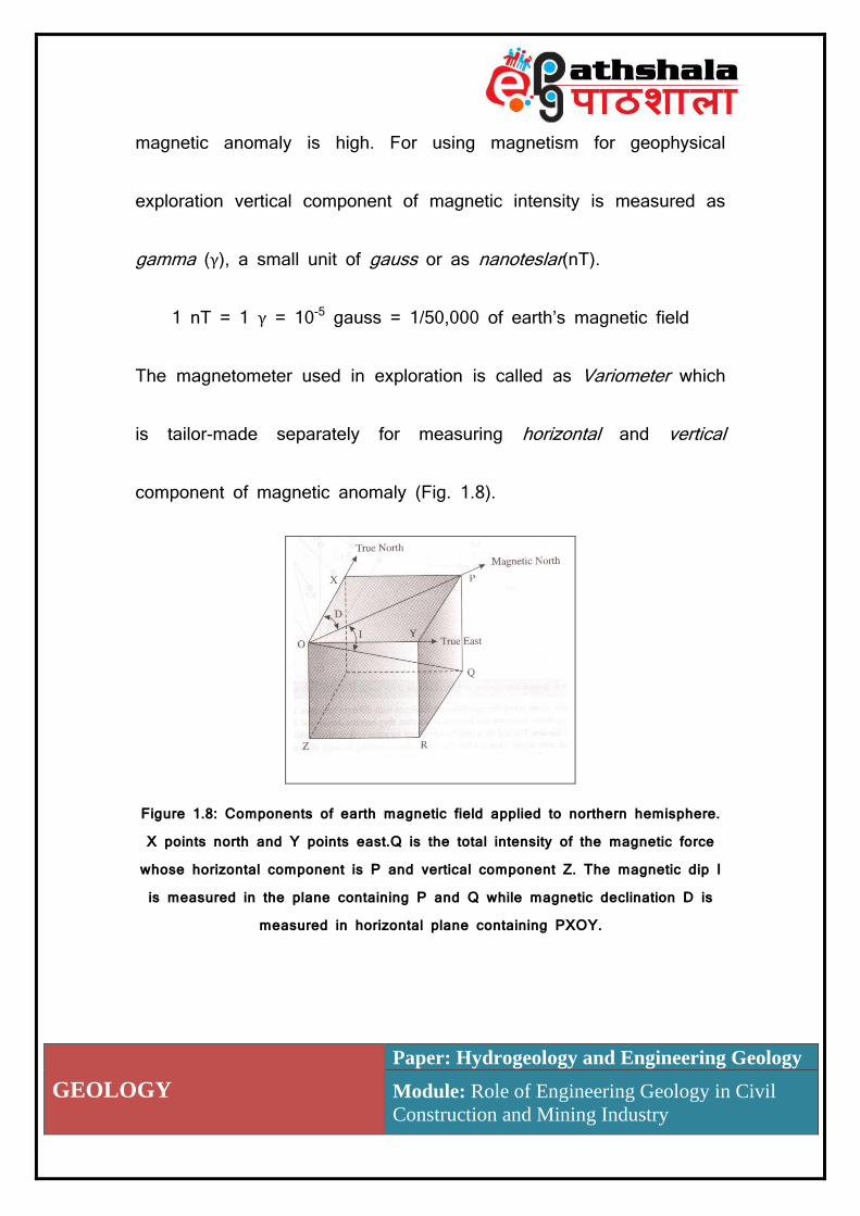
The magnetometer used in exploration is called as Variometer which
is tailor-made separately for measuring horizontal and vertical
component of magnetic anomaly (Fig. 1.8).
Figure 1.8: Components of earth magnetic field applied to northern hemisphere. X points north and Y points east.Q is the total intensity of the magnetic force whose horizontal component is P and vertical component Z. The magnetic dip I is measured in the plane containing P and Q while magnetic declination D is
measured in horizontal plane containing PXOY.
GEOLOGY
Paper: Hydrogeology and Engineering Geology
Module: Role of Engineering Geology in Civil
Construction and Mining Industry
The observed values are algebraically subtracted from theoretical
values which are maintained by the Survey of India which conducts
geodetic survey from time to time to be used in marine navigation.
The measurements are corrected for certain systematic variations for
example temperature, diurnal changes and secular horizontal
declination. Air bornemagnetic exploration methods have been used
to detect intrusive igneous rock bodies especially dikes by comparing
the known susceptibility of rocks for example granite, 0.0027; gabbro,
0.0073; basalt, 0.0143 etc. For exploring man made features such as
buried or abandoned shafts, pipelines this method is found to be
very reliable.
1.8.3 Seismic Methods
As we know that seismic waves originating from earthquake events
have been used as ‘X’ rays for exploring the earth’s deep interior.
The small doses of seismic waves produced by hammer drops,
explosions etc. are used for exploring shallow parts of the earth crust

GEOLOGY
Paper: Hydrogeology and Engineering Geology
Module: Role of Engineering Geology in Civil
Construction and Mining Industry
for mineral, oil – gas and civil engineering purposes. Seismic waves
when travel through different layers of the earth they get reflected
and refracted from the strata boundaries and return back to the
ground surface where their arrival are recorded with the help of
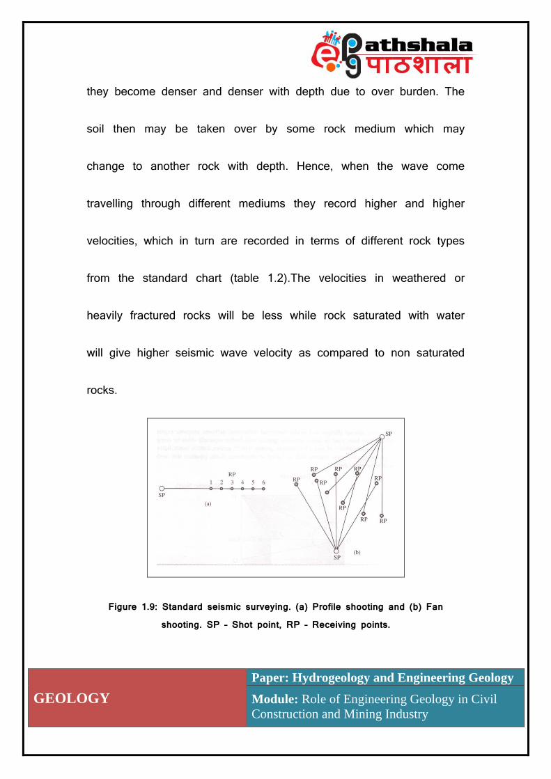
geophones. Geophones are placed at equi distance in linear or radial
manner depending upon nature of exploration i.e. profile shooting for
linear exploration and fan shooting for covering large area for survey
(Fig. 1.9) and are connected by wires to amplifiers and recording
camera and a device for noting time every hundredth of a second,
usually placed in a designed truck. The distance up to which
geophones are to be installed is usually ten times the depth to be
explored. Seismic reflection methods are mostly used for very deep
explorations usually for petroleum. For exploring shallow depths or for
civil engineering purposes seismic refraction method is used. Seismic
waves travel through different mediums with different velocities. It has
been found that as we go down from one soil horizon to another
GEOLOGY
Paper: Hydrogeology and Engineering Geology
Module: Role of Engineering Geology in Civil
Construction and Mining Industry
they become denser and denser with depth due to over burden. The
soil then may be taken over by some rock medium which may
change to another rock with depth. Hence, when the wave come
travelling through different mediums they record higher and higher
velocities, which in turn are recorded in terms of different rock types
from the standard chart (table 1.2).The velocities in weathered or
heavily fractured rocks will be less while rock saturated with water
will give higher seismic wave velocity as compared to non saturated
rocks.
Figure 1.9: Standard seismic surveying. (a) Profile shooting and (b) Fan
shooting. SP – Shot point, RP – Receiving points.

GEOLOGY
Paper: Hydrogeology and Engineering Geology
Module: Role of Engineering Geology in Civil
Construction and Mining Industry
Seismic waves have been used for exploration of the subsurface for
the minerals, ores and hydrocarbons. For exploring small areas and
depths, these waves are generated artificially and are recorded by
network of geophones in terms of their arrival time, arrival time gap
and arrival locations of direct and indirect waves to know the
subsurface distribution of earth materials.
Table 1.2: Average seismic wave velocities in different soil and
rock mediums.
Soil /
Rock
Seismic Wave Velocity
(km/sec)
Soil / Rock Seismic Wave Velocity
(km/sec)
Loose Silt 0.15 – 0.30 Limestone 2.50 – 6.50
Dry Sand 0.15 – 0.45 Phyllite 3.00 – 5.80
Wet Sand 0.50 – 0.70 Schist 3.50 – 5.70
Clay 1.50 – 2.50 Gneiss 4.00 – 6.50
Gravel 0.50 – 1.50 Granite 4.50 – 6.00
Sandstone 1.50 – 4.00 Basalt 5.50 – 6.50
Shale 2.00 – 4.50 Gabbro 6.50 – 7.00
Scientists have used a stronger source of seismic waves to fathom
the bigger and deeper areas of the earth. The principle of exploring
the subsurface can be understood with the help of figure 1.10. When

GEOLOGY
Paper: Hydrogeology and Engineering Geology
Module: Role of Engineering Geology in Civil
Construction and Mining Industry
seismic waves are generated through artificial means, waves travel
along surface with velocity V1 and can be recorded by different
seismographs as the “direct” waves. These waves reach these
recording devices (I, II, III), closer to the shot site before the
“indirect” body waves with velocity V2 , which are coming through the
subsurface lower layers hence travelling longer path requiring more
time. But, at device IV both the “direct” and the “indirect” waves
reach at the same time because the indirect wave covering longer
path has compensated the time loss by achieving higher velocity due
to higher density of the subsurface denser material. After the device
IV all the devices will first record arrival of the “indirect” waves,
followed by the “direct” waves (V, VI, VII etc.) which are much away
from the site of the shot. The distance between the shot site and the
device IV is called as the “Critical” distance “X” and by using the
following formula the depth of first discontinuity surface can be
worked out.

GEOLOGY
Paper: Hydrogeology and Engineering Geology
Module: Role of Engineering Geology in Civil
Construction and Mining Industry
𝑯 =𝑿
𝟐√(𝑽𝟐 − 𝑽𝟏) ÷ (𝑽𝟐 + 𝑽𝟏)
Figure 1,10: Schematics showingwave path from an earthquake site , measured by different geophones (G1 to G8) with corresponding time distance graph for
arrival of direct and indirect waves. Also see the “Critical Distance – X”.
1.8.4 Electrical Methods
The electrical methods of geophysical exploration measure either the
electricity generating capacity termed as Self Potential method or
resistance to flow of induced electrical currents of earth’s natural
material termed as electrical resistivity method. The self potential
method is normally used to explore the presence of iron and
sulphide ores as these materials are capable of generating electricity,
though very feeble but can be detected by using sophisticated
GEOLOGY
Paper: Hydrogeology and Engineering Geology
Module: Role of Engineering Geology in Civil
Construction and Mining Industry
instruments. From civil engineering point of view electrical resistivity
method is more pertinent especially for detecting thickness of
overburden, subsurface distribution of rocks, groundwater resource,
leakages from pipe, canal, reservoir etc. The rocks are as such
resistant to conduction of electricity but the presence of moisture in
rocks or high percentage of iron bearing minerals in a rock will
reduce the resistance. It is based on the premise that the free water
which moves freely from pore to pore constitutes effective porosity.
As an order of magnitude, the effective porosity can be for instance
70 to 80% of the total porosity in gravels and granular sand, 50 to
60% in fissured rock and 30 to 20% in fine sand and silt. This free
water due to various dissolved salts is ionically conductive and
enables electric currents to flow into the ground. Consequently,
measuring the groundresistivitycan give an idea of the presence of
water.
Conductivity (micro Siemens/cm) = 104 / Resistivity (ohm.m)
GEOLOGY
Paper: Hydrogeology and Engineering Geology
Module: Role of Engineering Geology in Civil
Construction and Mining Industry
Conductivity (micro Siemens/cm) = 1.4 x Total Dissolved Salts (mg/l)
A standard for drinkable water is 10 ohm.m, or 1000 micro
seisms/cm, or 0.7 g/l. Following basic principles are:
(i) A hard rock without pores or fracture and a dry sand without
water or clay are highly resistive to flow of electrical currents in order
of several tens of thousands ohm.m.
(ii) A porous or fractured rock bearing free water has a resistivity
which depends on the resistivity of the water and on the porosity of
the rock in order of several tens to several hundred ohm.m.
(iii) An impermeable clay layer, which has bound water, has a low
resistivity few units to several tens ohm.m.
(iv) Ametallic mineral or ore bodies (iron, manganese, copper
sulphides) have very low resistivity due to their high electrical
conductivity mostly lower or much lower than 1 ohm.m.
GEOLOGY
Paper: Hydrogeology and Engineering Geology
Module: Role of Engineering Geology in Civil
Construction and Mining Industry
The resistivity of a porous non-clayey material can be estimated by
the following Archie law formula:
Rock resistivity = a × (water resistivity) / (porosity)n
Where “a” and “n” are constants which depend on the nature of the
rock. In a very rough approximation, “a” can be taken equal to 1 and
“n” to 2. For example, 10 ohm.m water and 20% porosity give a rock
resistivity of the order of 250 ohm.m.
For measuring the ground resistivity, an electric current has to be
transmitted with two electrodes, while the potential created on the
surface by the circulation of this current into the ground is measured
with two other electrodes. By increasing the distance between the
transmitting and the receiving electrodes progressively, permits to
explore greater depth, termed as Depth Profiling or Sounding Array,
also to determine aquifer depth and its thickness (Fig. 1.11 a).
Setting the four electrodes together at fixed distances along a
traverse line helps in to detect lateral change of resistivity, termed as

GEOLOGY
Paper: Hydrogeology and Engineering Geology
Module: Role of Engineering Geology in Civil
Construction and Mining Industry
Horizontal Profiling or Profiling Array, mainly to detect fault or
fracture zones (Fig. 1.11 b). The shows of potable groundwater with
resistivity of 10 to 100 ohm.m range will give aquifer resistivity in the
range of 50 and 2000 ohm.m.
The equipments include a generator or high voltage battery as
source of current, ammeter and potentiometer to measure current and
potential difference four stainless steel, copper or metallic spikes for
current and potential electrodes with a length of 80 cm and diameter
of 2 cm and insulated cables on reels.The standard resistance of
some important rocks are given in table 1.3.
(a) (b)
Figure 1.11 (a) Wenner’s arrangement for (a) Sounding array and (b) Profiling
array
GEOLOGY
Paper: Hydrogeology and Engineering Geology
Module: Role of Engineering Geology in Civil
Construction and Mining Industry
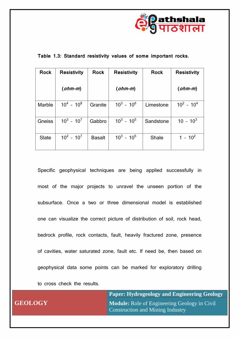
Table 1.3: Standard resistivity values of some important rocks.
Rock Resistivity
(ohm-m)
Rock Resistivity
(ohm-m)
Rock Resistivity
(ohm-m)
Marble 104 - 108 Granite 103 – 106 Limestone 102 – 104
Gneiss 103 – 107 Gabbro 103 – 105 Sandstone 10 – 103
Slate 102 – 107 Basalt 103 – 105 Shale 1 – 102
Specific geophysical techniques are being applied successfully in
most of the major projects to unravel the unseen portion of the
subsurface. Once a two or three dimensional model is established
one can visualize the correct picture of distribution of soil, rock head,
bedrock profile, rock contacts, fault, heavily fractured zone, presence
of cavities, water saturated zone, fault etc. If need be, then based on
geophysical data some points can be marked for exploratory drilling
to cross check the results.
GEOLOGY
Paper: Hydrogeology and Engineering Geology
Module: Role of Engineering Geology in Civil
Construction and Mining Industry
The site exploration should be suited to the requirement of the
project and the techniques employed should be in accordance with
the size and importance of the project. If the project is small in
terms of area covered and limited expenditure then data collected
during reconnaissance stage may be enough but if the project is big
covering large area and has ramifications on subsurface structure of
the ground then a full fledge site investigation may be required as
shown in following flow chart.
Summary
The importance of geology in mining has been known from time
immemorial. But its use as engineering geology, in Civil Engineering
has been given due importance only in last century or so. The
importance of geology in civil engineering can be summarized as
follows:
Geology provides a systematic knowledge of construction material, its
occurrence, composition, durability and other physic-mechanical properties.
GEOLOGY
Paper: Hydrogeology and Engineering Geology
Module: Role of Engineering Geology in Civil
Construction and Mining Industry
The knowledge of the geological work of natural agencies such as
water, wind, glaciers, helps in planning and carrying out major
civil engineering works in different climatic regions. For
example the knowledge of erosion, transportation and
deposition helps greatly in solving the expensive problems of
river control, coastal and harbor work and soil conservation.
Some spasmodic but strong events caused by earths
dynamism such as landslides, volcanism and earthquake need
to be well understood in terms of place and magnitude to save
human achievement.
The knowledge of groundwater system, about its quantity and depth of
occurrence in consolidated and unconsolidated earth materials are needed, in
connection with water supply, irrigation, excavation and many other
civil engineering works.
The foundation problems of buildings, bridges, retaining/containment walls,
dams etc. are directly concerned with the geology of the area. Construction
of docks, dikes, jetties etc. need engineering geological investigations.
GEOLOGY
Paper: Hydrogeology and Engineering Geology
Module: Role of Engineering Geology in Civil
Construction and Mining Industry
Constructing roads, especially in hilly areas in determining the stability of
cuts and slopes need proper engineering geological investigations.
Before staring a major engineering project at a place, a detailed
geological report followed by geophysical investigations and
drilling to corroborate and the data and to prepare detailed
engineering geological maps and sections is prepared. Such a
report helps in planning, designing and construction. The cost of
engineering works will considerably reducedif proper investigations are
made beforehand.
The geological studies form the basis for identifying locales of
interest. It provides the mining engineer with details of the
location, structure anddistribution of ore in a deposit, using
geo-scientific techniques.
It plays a crucial role in theoptimization of the ore body and is
intimately involved in the mine planning.
Geology or mining geology, geo-engineering and rock
mechanics plays key role in the development of open pits and

GEOLOGY
Paper: Hydrogeology and Engineering Geology
Module: Role of Engineering Geology in Civil
Construction and Mining Industry
quarries. The underground excavation, design of support
system, construction of adits, tunnels, shafts, raise etc. all need
proper understanding of rock mechanics, an advance version of
engineering geology.
Working as part of a multidisciplinary team, geologist, mining
and civil engineers ensure the safety.
Frequently Asked Questions (FAQs)
1. What is the role of geology in civil engineering projects?
GEOLOGY
Paper: Hydrogeology and Engineering Geology
Module: Role of Engineering Geology in Civil
Construction and Mining Industry
Engineering Geology is the application of the geologic sciences to engineering practice to assure the safe location, design, construction, operation and maintenance of civil engineering works, which may not be adversely affected by potential geological problems. The working arena of the engineering geology essentially in the regions where geological processes and manmade structures interact and latter’s safety and longevity are to be ensured. Proper investigations andanalyses are needed to provide geological and geotechnical recommendations to ensureavailability of proper construction material and safe founding ground. Broadly three aspects are important i.e. the study of “Rock Material”, used in construction industry such as building stones in terms of its availability and its strength properties. Secondly, the study of “Rock Mass” or founding rocky ground, over/under which engineering operations are to be carried out leading to loading or unloading of rock mass. Thirdly, the “endogenous” and “exogenous” geological processes which operate around the construction edifice and either hamper its construction or affect its functioning in future.
2. What do you understand by engineering geological investigations?
Any mega project is envisaged to improve the standard of living of the society and not only involves heavy expenditure but lot of time to get completed. Hence before starting a project all of pros and cons are taken into consideration to get maximum benefit out of the project. It is after detailed analysis, ground surveys, field checks, geological and geophysical investigations and cost benefit analysis are carried out before finalizing the project. The engineering

GEOLOGY
Paper: Hydrogeology and Engineering Geology
Module: Role of Engineering Geology in Civil
Construction and Mining Industry
geological investigations are done at different stages of a project such as: Preliminary Stage,Main Stage and Concurrent Stage. The investigations may start from the literature survey, followed by field surveys, geophysical investigations, drilling and performing various lab and field tests at different stages of planning and construction.
3.What are the important groundaspects need to be investigated in any mega
project?
The nature and type of investigations varies with nature and size of construction.
Following are the important aspects invariably investigated:
Thickness of overburden or depth of bed rock – Presence of soil or weathered rocks, either to be removed for reaching the sound foundation rocks or to be located as thick loose rock debris to be used as construction material. Depth of bed rock - Depth and three dimensional extent i.e. basement relief of sound rocks suitable for foundation. Presence of weak zones – Detection of cavities, cavernous rocks, shear and fault zones which may not only act as weak zones but may also act as zones of water leakage as well as major rock structures. Presence of Groundwater – Finding out regions with high groundwater potential and its favourability or non favourability for specific project. Rock mass exploration – To understand weathering extent, type, thickness, attitude and extension of different rocks in subsurface. Some other important investigations are to find out:
Availability of construction material Unconsolidated, soft and expansive ground material Presence of glacial outwash, drift, colluvial and fluvial deposits
GEOLOGY
Paper: Hydrogeology and Engineering Geology
Module: Role of Engineering Geology in Civil
Construction and Mining Industry
Old or abandoned landfill or mining site Natural caves or manmade cavities such as abandoned shafts
and underground mines Creeping or active slopes or areas of land sliding Residual stresses in rock masses
4.What are the direct and indirect methods of investigations? The direct methods involved construction of equidimensional pits or linear trenches. This can be done manually or by using machine with backhoe this method is cheapest and can be readily employed. Another direct method is excavation of linear drift or adits which are horizontal to inclined holes made through exposed rock sections or from already created over or under ground opening. The dimensions can vary depending upon nature of exploration. For deeper direct investigations and to extract samples drilling is used. The selection of drilling system depends upon depth of drilling, nature of lithology i.e. soil or rock, soft or hard rock, terrain type, accessibility to the area and economics. For covering larger area and to economize investigations indirect geophysical methods are most sought after. The important geophysical methods used in construction industry are gravity surveys, seismic surveys, electrical resistivity and magnetic surveys.
5.What do you understand by Rock Quality Designation? Rock Quality Designation (RQD) is an important parameter which measures the total length of the core greater than 10 cm in length sequestered during drilling, divided by total depth of drilling. The

GEOLOGY
Paper: Hydrogeology and Engineering Geology
Module: Role of Engineering Geology in Civil
Construction and Mining Industry
rocks are cut by rotational process using diamond double barrel drilling system to drill out 54.7 mm (NX) diameter core.
RQD =Σ 𝐿𝑒𝑛𝑔𝑡ℎ 𝑜𝑓 𝑎𝑙𝑙 𝑐𝑜𝑟𝑒 𝑝𝑖𝑒𝑐𝑒𝑠 (> 10 𝑐𝑚)
𝑇𝑜𝑡𝑎𝑙 𝑐𝑜𝑟𝑒 𝑙𝑒𝑛𝑔𝑡ℎ× 100
Another parameter i.e. Core Recovery Percent (CRP) is also simultaneously calculated which takes into based on summation of all the cores, irrespective of length taken out during drilling, divided by total depth of drilling. CRP is always greater than RQD. The premise in this test is that the presence of joints and their inter connection will naturally break the rocks and will be reflected as core length. The closer are joints smaller will be the core and vice versa. The rate of drilling non recovery of cores etc. can also be interpreted in terms of rock strength, presence of shear zones etc. The RQD values are used as ready reference of rock mass properties as per the following table:
RQD (%) Rock Mass Class
> 90 Excellent
75 – 90 Very Good
50 – 75 Good
25 – 50 Fair
< 25 Poor
Multiple Choice Questions (Quiz)
1. The concept of “Rock Load Theory”, was given by

GEOLOGY
Paper: Hydrogeology and Engineering Geology
Module: Role of Engineering Geology in Civil
Construction and Mining Industry
(a) Watson (b) Karl Terzaghi (c) Redlich (d) Charles P Berkley
2. Bouger Anomaly is related to
(a) Magnetic Survey (b) Rock Drilling (c) Gravity Survey (d) Seismic Survey
3. The fair rocks are classed when the RQD values come in between
(a) 0 – 25 (b) 50 – 75 (c) 75 – 90 (d) 25 – 50
4. Self Potential method of geophysical exploration is related to
(a) Seismic Refraction (b) Seismic Reflection (c) Gravity Survey (d) Electrical Survey
5. Which of the following rock will have lowest resistivity to electric current
(a) Sandstone (b) Slate (c) Gabbro (d) Granite
Suggested Readings:
1. Subinoy Gangopadhyay (2013), Engineering Geology, Oxford University Press, New Delhi.
2. Krynine, Dmitri P and Judd, William R (2005), Principles of Engineering Geology and Geotechnics, CBS Publishers, New Delhi.
3. Tony Waltham (2002), Foundation of Engineering Geology, 3rd Edition, CRC Press, London.
4. Bell, F G (1983), Fundamentals of Engineering Geology, Butterworths, London.
GEOLOGY
Paper: Hydrogeology and Engineering Geology
Module: Role of Engineering Geology in Civil
Construction and Mining Industry
5. Alam Masroor M. (2013), Fundamentals of Engineering Geology and Geo-Engineering, Axioe Books, India.
Copyright © 2022 FDOKUMEN