River related urban design and regeneration concepts for Polish towns
12
-
Upload
politechnikaslaska -
Category
Documents
-
view
2 -
download
0
Transcript of River related urban design and regeneration concepts for Polish towns
International Society of City and Regional Planners
Association Internatonale des Urbanistes
Internationale Gesellschaft der Stadt- und Regionalplaner
Asociación International de Urbanistas
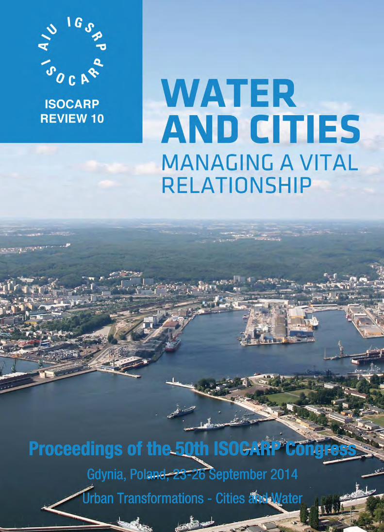
Proceedings of the 50th ISOCARP Congress
Gdynia, Poland, 23-26 September 2014
Urban Transformations: Cities and Water
Editor: Amos Brandeis
©ISOCARP 2014
Produced and published by ISOCARP
ISBN: 978-94-90354-30-5
Cover picture: © Cover Photo Tadeusz Urbaniak/ZMPG-a S.A, Poland
Authors are responsible for the content of the short outlines and the full papers.
Authors are listed in alphabetical order in each track.
ISOCARP Head Office
P.O. Box 983
2501 CZ The Hague
The Netherlands
Tel: +31-70-346-2654
Fax: +31-70-361-7909
www.isocarp.org
1
River related urban design and regeneration concepts for Polish towns Michał STANGEL Silesian University of Technology, Faculty of Architecture, Department of Urban Planning ul. Akademicka 7, 44-100 Gliwice, Poland email: [email protected] Synopsis While several Polish towns develop visions of urban regeneration, rivers are often key elements of the strategies. Neglected areas along the rivers are rediscovered, cities are being “turned back towards the water", and the leitmotif of water emerges in theming public space and urban (re)branding. The article discusses a context of the issue, and three cases from the authors design practice: the historic centre of the town of Bogatynia, a linear park along the river in Kościerzyna and a riverside development in the town of Oświęcim (internationally known as Auschwitz).
Introduction Since the change of the political system in 1989, several cities and towns in Poland have pursued comprehensive regeneration. Urban development generally concentrated in larger cities and included infrastructure works, greenfield development new housing estates, as well as downtown revitalization. In smaller cities and towns these processes had less momentum, and in many cases are still subject to debates, strategic visioning and conceptual planning. However, joining the EU in 2005 and the possibility of acquiring funding for urban regeneration has mobilized their attempts. In line of current favored regeneration trends, projects generally seek the synergy between spatial, economic and social development. An extra value – and potential for acquiring funding - comes from environmental, cultural and heritage aspects of the projects.
Several projects envision improving the attractiveness and competitiveness of towns by capitalizing on local amenities and heritage. Neglected rivers and lakes are rediscovered and used for enhancing recreation and tourist activities. Spatially and functionally, the cities are being “turned towards the water". This includes the development of waterfront places and creating new activities. Another aspect is branding and theming elements of the public space along the leitmotif of water. Such a process has happened in several Polish cities, and many other have developed regeneration strategies, which have not been implemented yet.
The paper will present case studies of projects from the authors recent design experiences, including awarded competition projects. The research by design methods used were based on a thorough site analysis and identifying local conditions, amenities and potential. This method is generally in line with the notion of design thinking (Brown, 2009), which advocates understanding and identifying the potential of a place for establishing the most adequate design solutions. In a broader context, it can be positioned in the trend of sustainable urbanism, understood as searching optimal ways to use all sort of local resources.
Theoretical framework Urban regeneration is a broad issue at the intersection of spatial, economic, social and environmental issues. The regeneration strategies usually have an urban design component, and visualizing the desired physical improvement of a place plays an important role not only as a project, but for marketing and political purposes. For the discussed cases, the context can be defined in the broad notion of sustainable urbanism - which advocates optimal use of resources; a more specific postulate of creating a vibrant system of public spaces as a canvas for urban development, with a specific notion of creating narrative places, which tell a specific story, related to local heritage and the genius loci.
195
Sustainable urbanism Contemporary urban design is profoundly related to the idea of sustainable development. The essence of sustainable development is the rational use of resources and maximizing social, economic and environmental benefits from human activities. As most of those activities take place in cities and towns, naturally the idea of sustainable development has several implications for urban environments.
The principles of shaping the built environment within the paradigm of sustainable urbanism, postulates a holistic approach in three scales: polycentric cities; shaping the urban structure of districts and neighborhoods with a grid of street and public spaces; and the micro scale of an urban block, with active frontages, amenities and public space. It implies the rediscovery of the value of traditional, compact and multifunctional urban form, with local access to services, green space and amenities. However, sustainable urban regeneration is not only about reducing the use of resources, but also maximizing social, economic and environmental benefits. Within the paradigm of sustainable urbanism, this would also mean of an optimal use of amenities such as cultural heritage, landscape beauty and location advantages – such, as a location near the river. In this perspective. A river in a city gives an opportunity to catalyze development and provide unique spatial identity.
The significance of public space in the process of urban regeneration Public spaces play a vital role in contemporary cities. They are one of the most important elements in creating an image of an attractive city, both for the work and life of the residents, as well as for tourists. Public space can be a trademark confirming the city’s identity, position and aspirations. The concept of public space may be understood in a variety of different ways – seen as non-private spaces, belonging to everyone; or as spaces accessible to the public, notwithstanding their ownership. In fact, the most adequate definition of public space seems to be that of the place of social interaction; a place of meeting, available to all. In the scale of the city, all its spaces form a kind of system of places for interaction – squares, streets, green areas and city parks – which together contribute to the city’s attractiveness.
A well-organised public space is essential in its significance for the city and the standard of life of its inhabitants. It is a physical space which creates a cohesive whole, saturated with social definition. It is a site accessible to all, possessing one of the most important advantages in the city – the ability to integrate the local community. Public space also has a major influence on the city’s identity, being; on the one hand, open to the future, and on the other emphasising the link to its historical past. The appearance and character of a given public space decide how the whole city is portrayed, which has additional value in the time of growing regional and global competition between municipal areas. Each city has its own sites which can either be the subject of pride or a reason to feel ashamed.
The current, popular view on shaping public spaces is well summarized in the works of Jan Gehl, and Project for Public Spaces (PPS). Gehl notes, the activity of the residents in public spaces may be divided into three categories: Necessary activity such as shopping, travel to school and work, waiting for the bus or tram, etc. Optional activity (municipal recreation) – walks, resting on a bench, sitting in the ‘garden area’ of cafes and restaurants, urban sports – rollerblading, cycling, and generally watching local events unfold. Social activity which means active and passive interaction with other people – conversations, meetings, watching, listening and chance contact. He emphasizes, that good urban space requires a fresh approach: firstly fostering public life and activities, then designing spaces for it, and in the end designing buildings which would enclose the space.
Fred Kent, the founder and president of Project for Public Spaces summarizes similar way of thinking in the words: when you focus on place, you do everything differently. The PPS idea of “triangulating” activities in a public space can be summarized by Kents rule of thumb to get public spaces to work called the power of 10, which says that you should have at least 10 good places in a district, and 10 things to do in each of them.
196
Narrative places While basic spatial improvements can meet community needs and improve usability, innovative design can provide additional value, such as beauty, sense of place, pleasurable experiences, building local identity and pride, etc. The additional value of public space can include transmitting local heritage in spatial forms. Dennis Frenchman proposed the concept of narrative places - spaces which transmit the multiplicity of stories – heritage, culture, history - of people and events that inhabit the city, and noted that heritage development is an aspect of the information economy (Frenchman, 2001). He claims that the growth of interest in heritage is not being pushed by a yearning for the past, but pulled by forces that are creating the future. Designing interpretative places is raising challenges not only in terms of how to physically construct them, but also choosing what messages they should carry. Spaces which transmit the multiplicity of stories of people and events that inhabit the city play an important role in cities in the so called “experience economy”. Cities devote much of their energies to the management of information and transmitting their qualities and heritage, to present a unique spatial form and experience, relating to heritage and culture. This has also happened Poland in the last decade. The themes range from historic heritage and “serious cultural issues”, to interpretations of popular culture, folk stories, fairy tales, etc. It shows that water - and river-related themes can provide attractive elements of public space landscaping.
Bogatynia – town centre regeneration study Bogatynia (approx. 19 000 inhabitants) is a town on the tripoint of the Czech, German and Polish borders, lying in the so called "panhandle" between the Czech town of Frydlant in the east and the German town of Zittau in the west. The settlement in the historical region of Upper Lusatia was first mentioned in 1262, and prospered from its location on an important trade route. Today Bogatynia is one of the richest towns per capita in Poland, due to its two principal enterprises: the open-pit Turów Coal Mine, and the associated thermal power station. The town is known for a specific regional local wooden craft building style. The Upper Lusatian house (pol. dom przysłupowy; germ. Umgebindehaus) combines log house, timber-framing and building stone methods of construction. Its main characteristic is a wooden support system, which runs around the living area of the house made of logs or boards, which has the job of freeing the frame of the living area from the weight of the roof or the roof and upper storey (Hammer, 2009).
The river Miedzianka running through the centre is both an amenity and a thread. It gives the city an unique, picturesque feel (resembling places like Bruge in Belgium, etc.). On the other hand, in 2000 a massive flood caused by extremely heavy rain flooded the entire central part of the town. It killed two people, caused heavy damage, destroyed several historic buildings and left its inhabitants with a traumatic experience.
The project concerned a 15 ha area of the centre of Bogatynia, along the river. In order to determine the needs and proposals of residents a public consultation was held, in the form of individual surveys and a participatory workshops for residents. The workshop enabled the identification of strengths, opportunities and constraints of the site at hand in the minds of the inhabitants, as well as their expectations. Among the biggest assets of the town the people declared the Upper Lusatian houses, tourist attractors such as the yearly Karbonalia festival, local sport facilities and the river. The river was in turn also counted among the biggest problems and threads with a negative impact on the place, as well as economic constraints and lack of prospects and activities for the inhabitants, especially the young ones.
The inhabitants suggested several things that are missing in the center, and could improve its comfort, functionality, image and attractiveness in the short- and long term. Some of the suggestions included urban style retail, dining and entertainment, spa, florists, pastry shops, open air markets, club, disco, playgrounds, public spaces, etc. – in general, they feel a lack of high quality services and meeting places, especially in comparison with the nearby Czech and German towns which they well know. During the workshop the citizens engaged in a lively discussion about their visions and desires for particular places in the town.
197
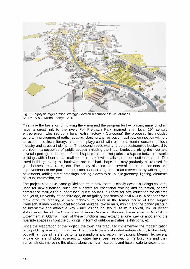
Fig. 1. Bogatynia regeneration strategy – overall schematic site visualization Source: ARCA Michał Stangel, 2013 This gave the basis for formulating the vision and the program for key places, many of which have a direct link to the river. For Preibisch Park (named after local 19th century entrepreneur, who set up a local textile factory - Concordia) the proposed list included general improvement of paths, seating, planting and recreation facilities; connection with the terrace of the local library, a themed playground with elements reminiscencent of local industry and street-art elements. The second space was a to-be pedestrianized boulevard by the river – a sequence of public spaces including the linear boulevard along the river and several openings in the form of small squares and pocket parks – a square between historic buildings with a fountain, a small open air market with stalls, and a connection to a park. The listed buildings along the boulevard are in a bad shape, but may gradually be re-used for guesthouses, restaurants, etc. The study also included several minor amendments and improvements to the public realm, such as facilitating pedestrian movement by widening the pavements, adding street crossings, adding places to sit, public greenery, lighting, elements of visual information, etc.
The project also gave some guidelines as to how the municipally owned buildings could be used for new functions, such as: a centre for vocational training and education, shared conference facilities to support local guest houses, a centre for arts education for children and youth, University of the third age, an art gallery and seats of local NGOs. A scenario was formulated for creating a local technical museum in the former house of Carl August Preibisch. It may present local technical heritage (textile mills, mining and the power plant) in an interactive and attractive way - such as the industry museum in Lowell, MA, or recent Polish examples of the Copernicus Science Centre in Warsaw, Hewelianum in Gdańsk or Experiment in Gdynia). most of these functions may expand in one way or another to the riverside spaces in front the buildings, in form of outdoor activities, exhibitions, etc.
Since the elaboration of the project, the town has gradually implemented the modernization of its public spaces along the river. The projects were elaborated independently to the study, but with an overall reference to its assumptions and recommendations. Meanwhile, several private owners of plots adjacent to water have been renovating the buildings and their surroundings, improving the places along the river – gardens and hotels, café terraces, etc.
198
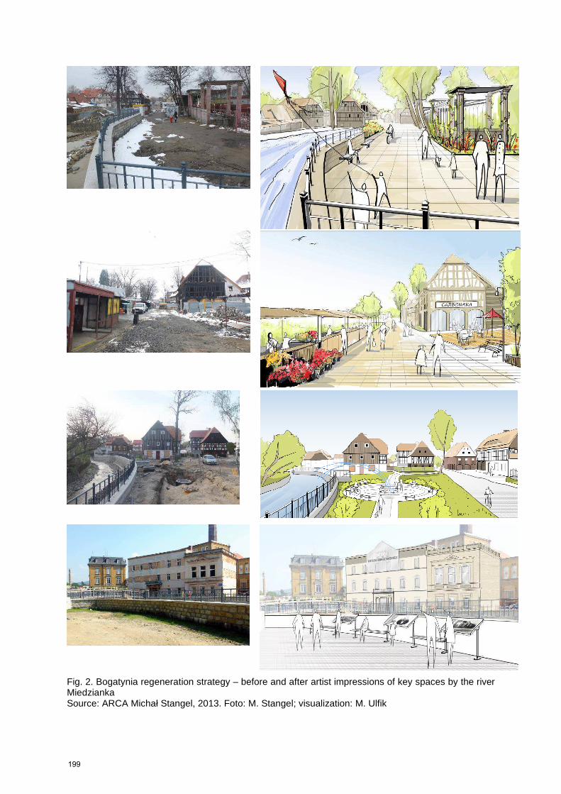
Fig. 2. Bogatynia regeneration strategy – before and after artist impressions of key spaces by the river Miedzianka Source: ARCA Michał Stangel, 2013. Foto: M. Stangel; visualization: M. Ulfik
199
Kościerzyna Culture Park Kościerzyna (approx. 24,000 inhabitants) is a picturesque town and an economic and tourist centre of the region of Kashubia (a part of Pomerania region, northern Poland). It is located approximately 50 km south-west of Gdańsk and well connected to the Tricity. The history of the town dates back to the year 1284 and up to this day it has preserved its medieval urban layout – the restored town market square with historic architectural structure, neo-Gothic town hall and a beautiful fountain. The town is literally located on water – it sits in the basin of Wierzyca river, surrounded by three lakes – Gałęźne, Kapliczne and Wierzysko. Moreover, two small rivers – Bibrowa and Kamionka run through the town.
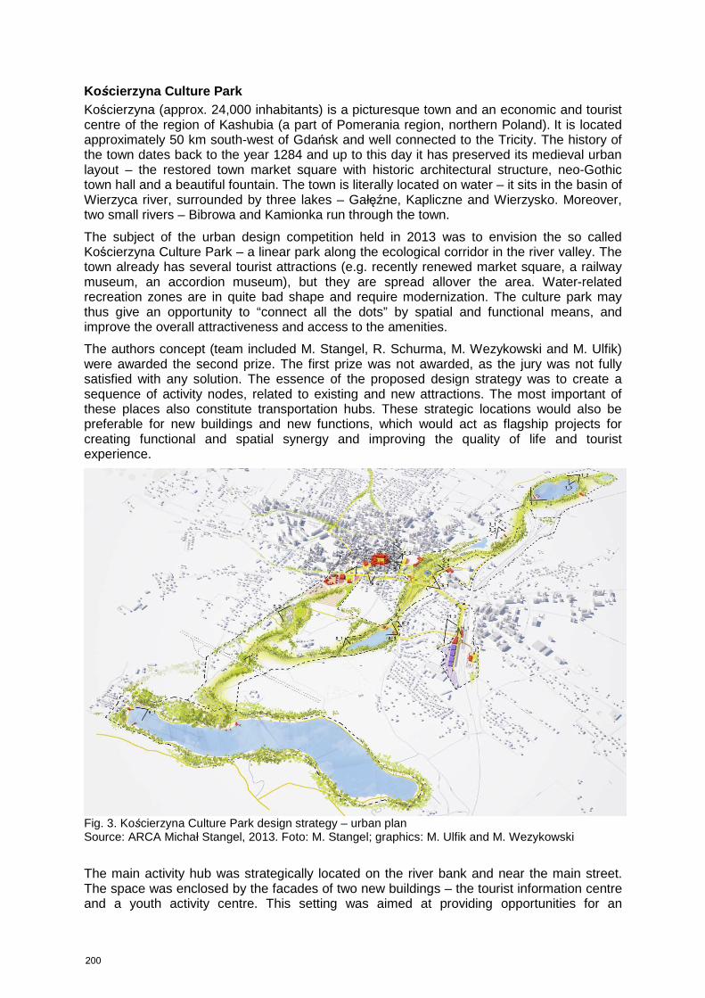
The subject of the urban design competition held in 2013 was to envision the so called Kościerzyna Culture Park – a linear park along the ecological corridor in the river valley. The town already has several tourist attractions (e.g. recently renewed market square, a railway museum, an accordion museum), but they are spread allover the area. Water-related recreation zones are in quite bad shape and require modernization. The culture park may thus give an opportunity to “connect all the dots” by spatial and functional means, and improve the overall attractiveness and access to the amenities.
The authors concept (team included M. Stangel, R. Schurma, M. Wezykowski and M. Ulfik) were awarded the second prize. The first prize was not awarded, as the jury was not fully satisfied with any solution. The essence of the proposed design strategy was to create a sequence of activity nodes, related to existing and new attractions. The most important of these places also constitute transportation hubs. These strategic locations would also be preferable for new buildings and new functions, which would act as flagship projects for creating functional and spatial synergy and improving the quality of life and tourist experience.
Fig. 3. Kościerzyna Culture Park design strategy – urban plan Source: ARCA Michał Stangel, 2013. Foto: M. Stangel; graphics: M. Ulfik and M. Wezykowski
The main activity hub was strategically located on the river bank and near the main street. The space was enclosed by the facades of two new buildings – the tourist information centre and a youth activity centre. This setting was aimed at providing opportunities for an
200
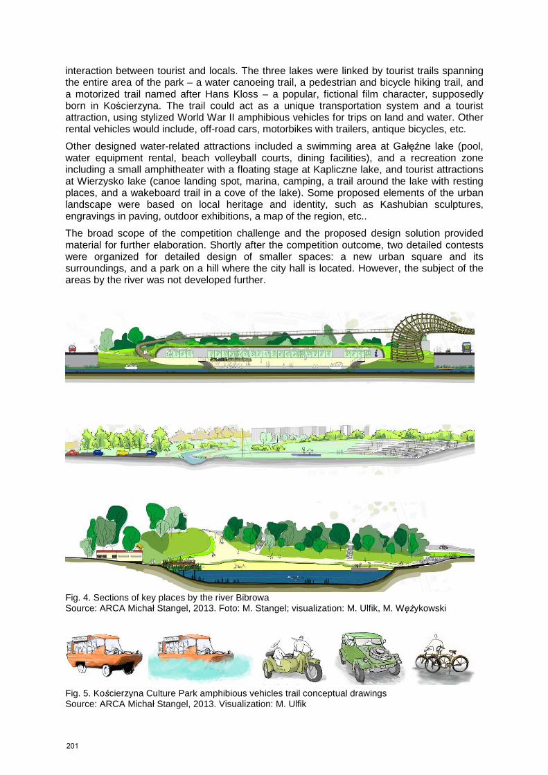
interaction between tourist and locals. The three lakes were linked by tourist trails spanning the entire area of the park – a water canoeing trail, a pedestrian and bicycle hiking trail, and a motorized trail named after Hans Kloss – a popular, fictional film character, supposedly born in Kościerzyna. The trail could act as a unique transportation system and a tourist attraction, using stylized World War II amphibious vehicles for trips on land and water. Other rental vehicles would include, off-road cars, motorbikes with trailers, antique bicycles, etc.
Other designed water-related attractions included a swimming area at Gałęźne lake (pool, water equipment rental, beach volleyball courts, dining facilities), and a recreation zone including a small amphitheater with a floating stage at Kapliczne lake, and tourist attractions at Wierzysko lake (canoe landing spot, marina, camping, a trail around the lake with resting places, and a wakeboard trail in a cove of the lake). Some proposed elements of the urban landscape were based on local heritage and identity, such as Kashubian sculptures, engravings in paving, outdoor exhibitions, a map of the region, etc..
The broad scope of the competition challenge and the proposed design solution provided material for further elaboration. Shortly after the competition outcome, two detailed contests were organized for detailed design of smaller spaces: a new urban square and its surroundings, and a park on a hill where the city hall is located. However, the subject of the areas by the river was not developed further.
Fig. 4. Sections of key places by the river Bibrowa Source: ARCA Michał Stangel, 2013. Foto: M. Stangel; visualization: M. Ulfik, M. Wężykowski
Fig. 5. Kościerzyna Culture Park amphibious vehicles trail conceptual drawings Source: ARCA Michał Stangel, 2013. Visualization: M. Ulfik
201
Oświęcim - "Green Terraces" The town of Oświęcim (population approx. 40 000) is located in south of Poland, some 50 km west of Krakow. The town is better known by its German name – Auschwitz. This name become the symbol of terror, genocide, and the Holocaust, due to the Nazi Germany concentration and extermination camp, where according to historical research, 1.5 million people were systematically tortured and murdered. The death camp, situated near the Soła River, is currently a 191 hectare State Museum, listed as a UNESCO World Heritage Site, with over 1 million visitors annually. For the city Oswiecim, the former death camp, with a surrounding monument protection zone has been a stigma on its heritage, image and development prospects. Despite the city’s rich history going back as far as the 13th century, it is currently associated mainly with Auschwitz. The number of death camp visitors hardly translates to any tourist activities in the city. In the recent years, the city has attempted to find ways – including spatial development concepts – to revitalize its image and develop beyond the genocide stigma, along the themes of reconciliation, hope, etc.
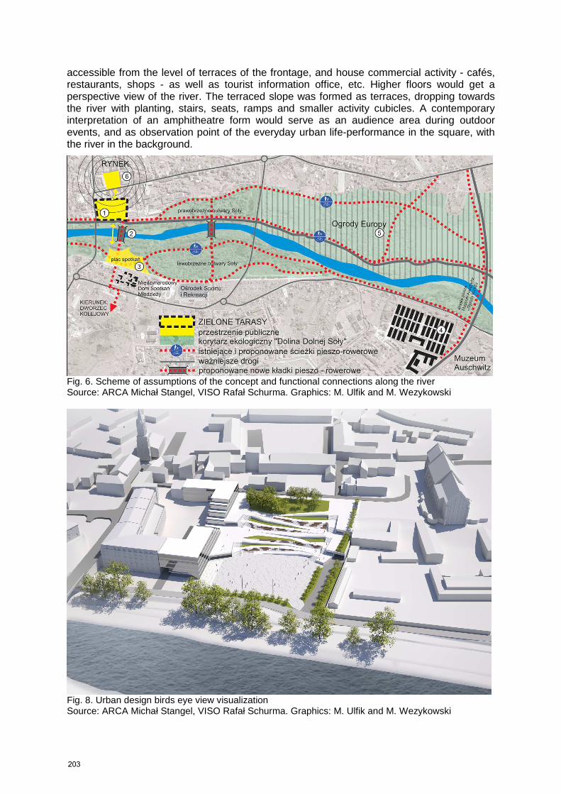
Oświęcim is located close to where the river Soła flows into the Vistula River. The river flows across the city, close to the old town, and within metres of the concentration camp. According to the Auschwitz-Birkenau State Museum human ashes and bones of those murdered there were sometimes dumped into the river. The newest, complex municipal program is to develop the spaces along the river - as a green link between the camp and downtown. The strategic municipal project Oświęcim – the meeting space envisioned the development of public spaces along the river, which shall create opportunities for the city to attract investment and tourist attention. The project includes several places by the river: a boulevard linking the concentration camp and historic downtown, The Park of Reconciliation – “Gardens of Europe” – opposite the camp, across the river, as well as a new, iconic pedestrian bridge. The design from 2010 is by a renowned artist and landscape architect Jarosław Kozakiewicz, but the idea of creating a “bridge of ghosts” across the river is disputable, by focusing on the traumatic past, rather than hope for the future.
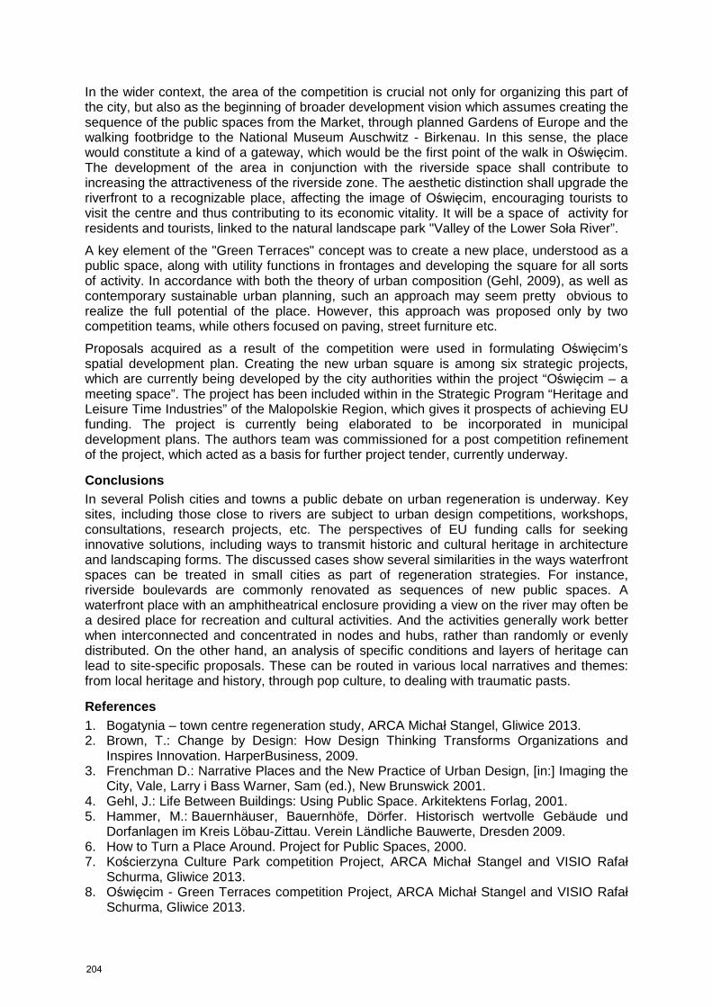
A neglected area near the Soła river, on the edge of the old town was subject to an urban design competition in 2012. The aim was stated as creating a new urban space, suitable for various civic functions. The first prize was awarded to a team of two firms from Gliwice ARCA office for architecture and urban design, and VISIO Architects and Consultants (composed of. M. Stangel, R. Schurma, A. Witeczek, M. Wężykowski and M. Ulfik). The project was acclaimed as the best solution for shaping the new urban space. The main ideas included shaping an urban square by the active frontages of new buildings, and enhancing connectivity to the river by extending the square onto the current parking lot. Instead, a covered parking was designed near the existing slope, and covered by planted recreational terraces for recreation and an occasional outdoor amphitheatre.
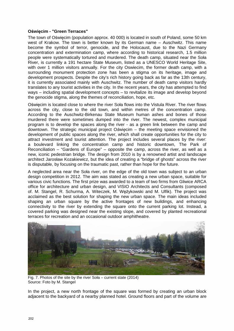
Fig. 7. Photos of the site by the river Soła – current state (2014) Source: Foto by M. Stangel In the project, a new north frontage of the square was formed by creating an urban block adjacent to the backyard of a nearby planned hotel. Ground floors and part of the volume are
202
accessible from the level of terraces of the frontage, and house commercial activity - cafés, restaurants, shops - as well as tourist information office, etc. Higher floors would get a perspective view of the river. The terraced slope was formed as terraces, dropping towards the river with planting, stairs, seats, ramps and smaller activity cubicles. A contemporary interpretation of an amphitheatre form would serve as an audience area during outdoor events, and as observation point of the everyday urban life-performance in the square, with the river in the background.
Fig. 6. Scheme of assumptions of the concept and functional connections along the river Source: ARCA Michał Stangel, VISO Rafał Schurma. Graphics: M. Ulfik and M. Wezykowski
Fig. 8. Urban design birds eye view visualization Source: ARCA Michał Stangel, VISO Rafał Schurma. Graphics: M. Ulfik and M. Wezykowski
203
In the wider context, the area of the competition is crucial not only for organizing this part of the city, but also as the beginning of broader development vision which assumes creating the sequence of the public spaces from the Market, through planned Gardens of Europe and the walking footbridge to the National Museum Auschwitz - Birkenau. In this sense, the place would constitute a kind of a gateway, which would be the first point of the walk in Oświęcim. The development of the area in conjunction with the riverside space shall contribute to increasing the attractiveness of the riverside zone. The aesthetic distinction shall upgrade the riverfront to a recognizable place, affecting the image of Oświęcim, encouraging tourists to visit the centre and thus contributing to its economic vitality. It will be a space of activity for residents and tourists, linked to the natural landscape park "Valley of the Lower Soła River”.
A key element of the "Green Terraces" concept was to create a new place, understood as a public space, along with utility functions in frontages and developing the square for all sorts of activity. In accordance with both the theory of urban composition (Gehl, 2009), as well as contemporary sustainable urban planning, such an approach may seem pretty obvious to realize the full potential of the place. However, this approach was proposed only by two competition teams, while others focused on paving, street furniture etc.
Proposals acquired as a result of the competition were used in formulating Oświęcim’s spatial development plan. Creating the new urban square is among six strategic projects, which are currently being developed by the city authorities within the project “Oświęcim – a meeting space”. The project has been included within in the Strategic Program “Heritage and Leisure Time Industries” of the Malopolskie Region, which gives it prospects of achieving EU funding. The project is currently being elaborated to be incorporated in municipal development plans. The authors team was commissioned for a post competition refinement of the project, which acted as a basis for further project tender, currently underway.
Conclusions In several Polish cities and towns a public debate on urban regeneration is underway. Key sites, including those close to rivers are subject to urban design competitions, workshops, consultations, research projects, etc. The perspectives of EU funding calls for seeking innovative solutions, including ways to transmit historic and cultural heritage in architecture and landscaping forms. The discussed cases show several similarities in the ways waterfront spaces can be treated in small cities as part of regeneration strategies. For instance, riverside boulevards are commonly renovated as sequences of new public spaces. A waterfront place with an amphitheatrical enclosure providing a view on the river may often be a desired place for recreation and cultural activities. And the activities generally work better when interconnected and concentrated in nodes and hubs, rather than randomly or evenly distributed. On the other hand, an analysis of specific conditions and layers of heritage can lead to site-specific proposals. These can be routed in various local narratives and themes: from local heritage and history, through pop culture, to dealing with traumatic pasts.
References 1. Bogatynia – town centre regeneration study, ARCA Michał Stangel, Gliwice 2013. 2. Brown, T.: Change by Design: How Design Thinking Transforms Organizations and
Inspires Innovation. HarperBusiness, 2009. 3. Frenchman D.: Narrative Places and the New Practice of Urban Design, [in:] Imaging the
City, Vale, Larry i Bass Warner, Sam (ed.), New Brunswick 2001. 4. Gehl, J.: Life Between Buildings: Using Public Space. Arkitektens Forlag, 2001. 5. Hammer, M.: Bauernhäuser, Bauernhöfe, Dörfer. Historisch wertvolle Gebäude und
Dorfanlagen im Kreis Löbau-Zittau. Verein Ländliche Bauwerte, Dresden 2009. 6. How to Turn a Place Around. Project for Public Spaces, 2000. 7. Kościerzyna Culture Park competition Project, ARCA Michał Stangel and VISIO Rafał
Schurma, Gliwice 2013. 8. Oświęcim - Green Terraces competition Project, ARCA Michał Stangel and VISIO Rafał
Schurma, Gliwice 2013.
204