Risk assessment for the Fildes Peninsula and Ardley Island ...
508
Risk assessment for the Fildes Peninsula and Ardley Island, and development of management plans for their designation as Specially Protected or Specially Managed Areas Texte 20 08 ISSN 1862-4804
-
Upload
khangminh22 -
Category
Documents
-
view
0 -
download
0
Transcript of Risk assessment for the Fildes Peninsula and Ardley Island ...

Risk assessment for the FildesPeninsula and Ardley Island, and development of management plans for their designation as SpeciallyProtected or Specially Managed Areas
Texte
2008
ISSN1862-4804

TEXTE
ENVIRONMENTAL RESEARCH OF THE FEDERAL MINISTRY OF THE ENVIRONMENT, NATURE CONSERVATION AND NUCLEAR SAFETY
Research Report 203 13 124 UBA-FB 001155e
by Dr. Hans-Ulrich Peter Dipl.-Biol. Christina Buesser Dipl.-Geogr. Osama Mustafa Dr. Simone Pfeiffer Polar and Bird Ecology Group Institute of Ecology, Friedrich Schiller University Jena On behalf of the Federal Environment Agency
UMWELTBUNDESAMT
Texte
2008
ISSN
1862-4804
Risk assessment for the Fildes Peninsula and Ardley Island, and development of management plans for their designation as Specially Protected or Specially Managed Areas

This Publication is also available as Download under http://www.umweltbundesamt.de The contents of this publication do not necessarily reflect the official opinions. Publisher: Federal Environment Agency (Umweltbundesamt) P.O.B. 14 06 06813 Dessau-Roßlau Tel.: +49-340-2103-0 Telefax: +49-340-2103 2285 Internet: http://www.umweltbundesamt.de Edited by: Section I 3.5 Fritz Hertel Dessau-Roßlau, May 2008

Report Cover Sheet
1. Report No. UBA-FB
2. 3.
4. Report Title Risk assessment for the Fildes Peninsula and Ardley Island, and development of management plans for their designation as specially protected or specially managed areas 5. Author(s), Family Name(s), First Name(s) 8. Report Date Dr. Peter, Hans-Ulrich, Dipl.-Biol. Buesser, Christina, December 2007 Dipl.-Geogr. Mustafa, Osama, Dr. Pfeiffer, Simone 9. Publication Date 6. Performing Organisation (Name, Address) Institute of Ecology 10. UFOPLAN - No. Friedrich Schiller University Jena 203 13 124 Dornburger Strasse 159 11. No. of Pages D-07743 Jena 344 pp. + 147 pp. in 8 appendices 12. No. of Reference 310 + 23 in appendices 13. No. of Tables, Diagrams 7. Sponsoring Agency (Name, Address) 37 + 11 in appendices Umweltbundesamt 14. No. of Figures P.O. Box 14 06 211 + 38 in appendices D-06813 Dessau-Roßlau 15. Supplementary Notes 16. Abstract Fildes Peninsula, as the logistical centre of King George Island (South Shetland Islands, Antarctica) has an airport and a high density of research stations and field huts. Various different interests overlap in the region: science, conservation of flora and fauna, protection of places of geological and historical value, station operations, transport logistics and tourism. The aim of this study was to create a scientific basis for the quantification of human activity and environmental problems in the Fildes Region using biotic and other data. Aspects studied included land use, infrastructure, construction, the distribution and management of waste (including organic waste and oil contamination), gaseous emissions, noise, and temporal and spatial distribution of land, air and sea traffic. Also included were fossil occurrence, the flora and fauna, and interviews of the staff at all stations in the region as to their leisure activities and their views on environmental education and protection measures. There then follows a risk analysis of the dangers facing all that is of value in the Fildes Region. This focuses on the divergent interests of nature conservation and environmental protection, science, logistics and tourism. Based on current management practices, additional suggestions are made for reducing conflict. The best solution for co-ordination would be designation as an Antarctic Specially Managed Area (ASMA), for which a draft management plan is put forward (as a framework for discussion in the International Working Group of the CEP). As an alternative a Maxwell Bay ASMA is considered, though further research is needed in that case. 17. Keywords Antarctica, Ardley Island, ASMA, behaviour, disturbance, Environmental Protection Protocol, Fildes Peninsula, indicators, human activities, King George Island, logistics, management, management plan, monitoring, penguins, science seabirds, seals, tourism 18. Price 19. 20.
ii
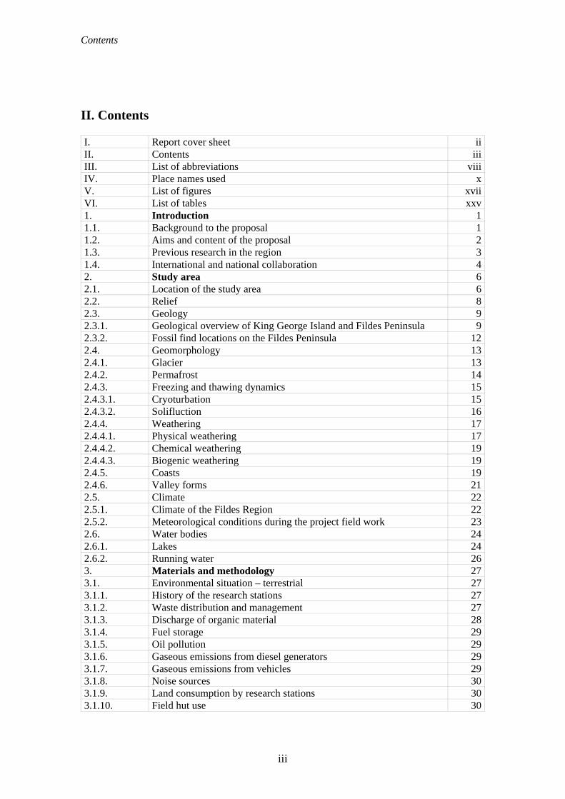
Contents
II. Contents I. Report cover sheet iiII. Contents iiiIII. List of abbreviations viiiIV. Place names used xV. List of figures xviiVI. List of tables xxv1. Introduction 11.1. Background to the proposal 11.2. Aims and content of the proposal 21.3. Previous research in the region 31.4. International and national collaboration 42. Study area 62.1. Location of the study area 62.2. Relief 82.3. Geology 92.3.1. Geological overview of King George Island and Fildes Peninsula 92.3.2. Fossil find locations on the Fildes Peninsula 122.4. Geomorphology 132.4.1. Glacier 132.4.2. Permafrost 142.4.3. Freezing and thawing dynamics 152.4.3.1. Cryoturbation 152.4.3.2. Solifluction 162.4.4. Weathering 172.4.4.1. Physical weathering 172.4.4.2. Chemical weathering 192.4.4.3. Biogenic weathering 192.4.5. Coasts 192.4.6. Valley forms 212.5. Climate 222.5.1. Climate of the Fildes Region 222.5.2. Meteorological conditions during the project field work 232.6. Water bodies 242.6.1. Lakes 242.6.2. Running water 263. Materials and methodology 273.1. Environmental situation – terrestrial 273.1.1. History of the research stations 273.1.2. Waste distribution and management 273.1.3. Discharge of organic material 283.1.4. Fuel storage 293.1.5. Oil pollution 293.1.6. Gaseous emissions from diesel generators 293.1.7. Gaseous emissions from vehicles 293.1.8. Noise sources 303.1.9. Land consumption by research stations 303.1.10. Field hut use 30
iii

Contents
3.1.11. Road network between the stations, airport and buildings (huts) 303.1.12. Use of road network 313.1.13. Tracks other than the official road network 313.1.14. Winter use 323.1.15. Air traffic 323.1.16. Ship and boat traffic 343.1.17. Construction of the Russian church 363.1.18. Construction of the airport extension 363.2. Environmental situation – coastal 363.2.1. Waste water discharge into Maxwell Bay 363.2.2. Mapping waste on the shores of Maxwell Bay and Drake Coast 373.2.3. Gaseous emissions from research station boats and zodiacs 373.3. Geology 373.3.1. Palaeontology 373.3.2. Lakes 383.4. Flora and fauna 383.4.1. Breeding and visiting birds 383.4.2. Seal populations 413.4.3. Vegetation survey 433.5. Tourist activities 473.5.1. Space use by visitors 473.6. Opinion survey to station members 483.7. Risk analysis 493.8. Mapping 504. Results and discussion 514.1. History of research stations 514.1.1. Research stations on King George Island 514.1.2. Research stations of the Fildes Region 524.2. Environmental situation – terrestrial 564.2.1. Old waste dumps and storage areas 564.2.2. Waste distribution 604.2.3. Current waste management 644.2.4. Discharge of organic material 674.2.5. Fuel storage and measures to prevent oil contamination 724.2.6. Oil contamination 754.2.6.1. Oil contamination outside stations 754.2.6.2. Oil contamination within station grounds 784.2.7. Gaseous emissions from diesel generators 804.2.8. Gaseous emissions from station land vehicles 814.2.9. Noise sources 814.2.10. Land consumption by research stations 854.2.11. Use of field huts 894.2.12. Road network 1004.2.13. Use of the road network 1044.2.14. Vehicle tracks 1064.2.15. Winter use 1094.2.16. Flight movements in the Fildes Region 1124.2.16.1. Flight statistics 1124.2.16.2. Comparison of results with data from previous years and with 117
iv

Contents
published statistics 4.2.16.3. Tourist flight activities 1194.2.16.4. Helicopter landings other than at normal landing places or the airport 1224.2.16.5. Flight movements over the ASPA Ardley Island and over the Fildes
Strait 122
4.2.17. Ship and zodiac movements in Maxwell Bay 1254.2.17.1. Ships 1254.2.17.2. Landing boats and ships' tenders 1304.2.17.3. Zodiacs 1314.2.17.4. Example of an activity peak in Maxwell Bay 1344.2.18. Construction of the Russian church 1354.2.18.1. Description of area 1354.2.18.2. Chronological overview of the construction process 1364.2.18.3. Environmental effects of the construction of the church 1384.2.19. Airport extension 1394.2.19.1. Environmental effects of the airport extension 1404.3. Environmental situation - coastal 1484.3.1. Discharge of waste water 1484.3.1.1. Discharge of waste water into Maxwell Bay 1484.3.1.2. Waste water treatment by stations 1494.3.2. Coastal waste accumulation 1524.3.3. Gaseous emissions from station boats and zodiacs 1564.4. Geology 1584.4.1. Palaeontology 1584.4.1.1. Recording fossils 1584.4.1.2. Fossiliferous regions 1624.4.1.3. Palaeobotanical interpretation and its scientific importance (after
Poole, 2005) 169
4.4.2. Importance of beach ridges on Fildes Peninsula and Ardley Island 1704.4.3. Lakes 1734.5. Flora and fauna 1774.5.1. Penguins (Pygoscelis spp.) 1774.5.2. Southern Giant Petrel (Macronectes giganteus) 1844.5.3. Cape Petrel (Daption capense) 1884.5.4. Storm Petrels (Oceanites oceanicus and Fregetta tropica) 1914.5.5. Snowy Sheathbill (Chionis alba) 1934.5.6. Skuas (Catharacta spp.) 1964.5.7. Kelp Gull (Larus dominicanus) 1994.5.8. Antarctic Tern (Sterna vittata) 2014.5.9. Potential breeding birds, visitors and transients 2034.5.10. Investigation of sea bird behaviour and physiology 2124.5.11. Seals 2164.5.12. Diptera (Insecta) 2284.5.13. Vegetation 2294.5.13.1. Vegetation survey of lichens and mosses 2294.5.13.2. Vegetation of Dart Island and Two Summit Island 2334.5.13.3. Flowering plants of the Fildes Region 2374.5.14. Damage to vegetation 2414.5.15. Introduced species 245
v

Contents
4.5.16. Effects of scientific work on flora and fauna 2504.6. Tourist activity 2534.6.1. Tourist activity on King George Island 2534.6.2. Tourist activity in the Fildes Region 2544.6.2.1. Spectrum of tourist activities 2544.6.2.2. Marathon 2564.6.2.3. Use of space by visitors 2594.6.3. Influence of tourist activity 2604.6.3.1. Effects in the Fildes Region 2614.6.4. Visitor management 2624.7. Opinion surevy to station members 2635. Risk analysis of the Fildes Region 2715.1. Presentation and evaluation of the values 2715.2. Risk analysis 2755.2.1. Sources of anthropogenic disturbance and their effects 2765.2.1.1. Research operations 2765.2.1.2. Traffic 2775.2.1.3. Introduction of alien species 2785.2.1.4. Scientific activities 2785.2.1.5. Visitors 2815.2.1.6. Cumulative effects 2845.2.1.7. Summary of current and future dangers 2856. Management of the Fildes Region 2916.1. Previous management 2916.1.1. Research station operation 2916.1.2. Traffic management 2926.1.3. Nature conservation 2936.1.4. Science management 2946.1.5. Visitor management 2946.1.6. Cumulative Effects 2956.2. Management proposals 2956.2.1. Research station operation 2966.2.1.1. Waste management 2976.2.1.2. Prevent oil pollution 2976.2.1.3. Building construction and dismantling 2976.2.1.4. Wastewater treatment 2986.2.1.5. Information on the local environment 2986.2.2. Traffic management 2986.2.2.1. Land transport 2986.2.2.2. Air traffic 2996.2.2.3. Ship & boat traffic 2996.2.3. Nature conservation 2996.2.3.1. Area protection 2996.2.3.2. Fauna 3006.2.3.3. Flora 3006.2.3.4. Introduction of alien species 3006.2.3.5. Fossils 3016.2.4. Science management 3016.2.5. Visitor Management 302
vi

Contents
6.2.6. Cumulative effects 3056.2.7. Establishing a managing group 3056.2.8. Zoning 3066.3. Possible modules of an ASMA “Fildes Region” Management Plan 3087. Unanswered questions and research needs 3098. Summary 3129. Bibliography 31410. Publications related to this project 338Appendix 1 Plant species occurring in the study area Appendix 2 Photographs documenting the classification of plant assemblages in
relation to the biotope survey Appendix 3 List of the plant samples deposited in herbaria Appendix 4 Fildes Peninsula – questionnaire to station members Appendix 5 Management Plan Appendix 6 Alternative management approaches for the Fildes Region Appendix 7 a & b
Final Report I. Poole, 2005: Anatomical and morphological assessment of plant macrofossils from King George Island, Antarctica
Appendix 8 a-e
Fildes Region-related ATCM-Information and Working Papers, including those from Germany between 2004 and 2007
vii

List of abbreviations
III. List of abbreviations AAD Australian Antarctic Division
AARI Arctic and Antarctic Research Institute (Russia)
ACAP Agreement on the Conservation of Albatrosses and Petrels
AFIM Antarctic Flight Information Manual
ASMA Antarctic Specially Managed Area (Besonderes Antarktisches Verwaltungsgebiet)
ASOC Antarctic and Southern Ocean Coalition
ASPA Antarctic Specially Protected Area (Besonderes Antarktisches Schutzgebiet)
ASTI Area of Special Tourist Interest
ATCM Antarctic Treaty Consultative Meeting (Konsultativtreffen der Antarktis-Vertragsstaaten)
ATCP Antarctic Treaty Consultative Party
ATS Antarctic Treaty System
AWI The Alfred Wegener Institute for Polar and Marine Research, Bremerhaven
AUG Gesetz zur Ausführung des Umweltschutzprotokolls vom 4. Oktober 1991 zum Antarktis-Vertrag (Umweltschutzprotokoll-Ausführungsgesetz)
BAS British Antarctic Survey, Cambridge, UK
BBS Bird Biology Subcommittee of the Working Group of Biology in SCAR
Bonn Convention
Convention on the Conservation of Migratory Species of Wild Animals
BP Breeding pairs
BP1 Years before present / Years before 1950
Capuerto Capitanía de Puerto de Bahía Fildes de la Marina de Chile
CCAMLR Convention on the Conservation of Antarctic Marine Living Resources
CEE Comprehensive Environmental Evaluation
CEMP CCAMLR Ecosystem Monitoring Programme
CEP Committee for Environmental Protection
COMNAP Council of Managers of National Antarctic Programs
CONAEIA Comité Nacional para la Evaluación de Impacto Ambiental en la Antártica, Chile
CONAMA Comisión Nacional del Medio Ambiente, Chile
DGAC Dirección General de Aeronáutica Civil
EP Protocol on Environmental Protection to the Antarctic Treaty
viii

List of abbreviations
FACH Fuerza Aérea de Chile
GIS Geographic Information System
GPS Geographic Positioning System
HSM Historical Sites and Monuments
IAATO International Association of Antarctic Tour Operators
IAU Instituto Antártico Uruguayo
IBA Important Bird Area
IEE Initial Environmental Evaluation
INACH Instituto Antártico Chileno
IPY International Polar Year
IUCN World Conservation Union
KGI King George Island, South Shetland Islands, Antarctica
KGIS SCAR King George Island GIS Project
LTER Long Term Ecological Research (Site or Programme)
MARPOL International Convention for the Prevention of Marine Pollution from Ships
NGO Non-governmental Organisation
NSF National Science Foundation, USA
RAE Russian Antarctic Expedition
SCALOP Standing Committee on Antarctic Logistics and Operations
SCAR Scientific Committee on Antarctic Research
SCAR-GEB SCAR Group of Experts on Birds
SPA Specially Protected Area
SPRI Scott Polar Research Institute, Cambridge, UK
SSI South Shetland Islands (Südshetland-Inseln)
SSSI Site of Special Scientific Interest
UBA Federal Environmental Agency, Dessau, Germany (Umweltbundesamt, Dessau)
WTO World Tourism Organisation
ix

Place names used
IV. Place names used In order to avoid ambiguity of use, the following report uses the place names listed in the SCAR Antarctic Composite Gazetteer SCARCGA (http://www3.pnra.it/SCAR_GAZE). If a place was not listed in the Gazetteer it was given an original name. Descriptions of places were also taken from SCARCGA, where available (in italics). Positional information for the locations named is taken from the SCAR KGIS project (www.kgis.scar.org/mapviewer). Name Description
(in italics if from SCARCGA) SCARCGA
Ref. No. Admiralty Bay Irregular bay, 5 mi wide at its entrance between Demay
Point and Martins Head, indenting the S coast of King George Island for 10 mi in the South Shetland Islands. The name appears on a map of 1822 by Capt. George Powell, a British sealer, and is now established in international usage.
86
Ardley Island
Island on W side of Maxwell Bay, King George Island. Charted by Discovery Investigations in 1935; named Ardley Peninsula after Lieut. Richard Arthur Blyth Ardley, RNR (1906-42), of Discovery II (GBR chart 1935 & gaz. 1955). Shown to be an island by FIDASE air photography, 1956; renamed Ardley Island (GBR gaz. 1960). Island 1 mi long, lying in Maxwell Bay close off the SW end of King George Island, in the South Shetland Islands. Charted as a peninsula in 1935 by DI personnel of the Discovery II and named for Lt. R.A.B. Ardley, RNR, officer on the ship in 1929-31 and 1931-33. Air photos have since shown that the feature is an island.
478
Ardley Isthmus = Ardley-Isthmus
Connection between the Fildes Peninsula and Ardley Island, passable at low tide
Barton Peninsula Peninsula on NE side of Maxwell Bay, King George Island, South Shetland Islands. Photographed from the air by FIDASE in 1956-57 and named after Colin Munroe Barton (b.1934), FIDS geologist, 1959-61, who worked in the area (GBR gaz.1964).
965
Biologenbach A stream flowing through Biologenbucht 1344 Biologenbucht A bay on the west coast south of Gemel Peaks 1345 Biologensee A lake near the beach in Biologenbucht Bransfield Strait Strait separating South Shetland Islands from Trinity
Peninsula and the Joinville Island group. Discovered but thought to be a gulf in Jan. 1820 by Edward Bransfield, Master, RN (1785-1852), commanding HM hired brig Williams for her Antarctic voyage of 1819-20 to survey the South Shetland Islands; discoverer of Trinity Peninsula, the first part of continental Antarctica to be seen by man; subsequently charted by early sealers [1820]; Bransfields Strait (GBR map 1825); Bransfield Strait (GBR chart.1839; GBR gaz.1955).
1762
x

Place names used
Name Description (in italics if from SCARCGA)
SCARCGA Ref. No.
Co. Basaltos Volcanic plug on the south eastern edge of the Davies Heights (101 m above sea level)
Collins Glacier = Collins-Gletscher
Part of the King George Island ice cap bordering the Fildes Peninsula on the north
Coppermine Peninsula
Rugged peninsula 1 mi long, located between Carlota Cove and Coppermine Cove at the W end of Robert Island, South Shetland Islands. The name was proposed by UK-APC in 1971. It derives from Coppermine Cove to the S, a name in use since the 1820s.
2967
Dart Island The largest of several small islands lying in the W entrance to Fildes Strait in the South Shetland Islands. This island and the two islands to the E and S of it were first surveyed and named collectively 70 Islets by DI personnel on the Discovery II in 1934-35, because at least two of them were reported to be 70 ft high. The name was rejected by the UK-APC in 1961 and a new name substituted for the largest island in the group. Dart Island is named for the British sealing vessel Dart from London, which visited the South Shetland Islands in about 1823.
3337
Davies Heights An elevated area, roughly elliptical in form and 1 mi long, rising to 150 m in north-central Fildes Peninsula, King George Island. The feature has steep sides and an undulating top which rise 60 m above the surrounding plain. Named by the UK-APC for Robert E.S. Davies, BAS geologist who worked in this area, 1975-76.
3374
Deception Island Ring-shaped island 8 mi in diameter, with a narrow entrance into a central landlocked harbour (a drowned breached crater), lying nearly 10 mi S of Livingston Island, in the South Shetland Islands. The name dates back to at least 1821 and is now established in international usage.
3457
Diomedea Island Small island lying in Ardley Cove, Fildes Peninsula, King George Island. The SovAE called the feature Ostrov Albatros or Albatross Island in 1968, but the English form duplicates a name in the Bay of Isles. To avoid confusion, the UK-APC recommended a new name in 1979; Diomedea is the generic name for several species of albatross.
3659
Drake Passage The stretch of sea between Tierra del Fuego and the Antarctic Peninsula bordering the Fildes Peninsula on the west
3862
Esther Nunatak Nunatak lying 2 mi SW of Brimstone Peak in the NE part of King George Island, South Shetland Islands. Charted and named by DI personnel on the Discovery II in 1937 probably from association with nearby Esther Harbor.
4353
Exotic Point Point on the SW side of Fildes Peninsula, King George Island, forming the S entrance point to Geographers Cove. The approved name is a translation of the Russian "Mys Ekzoticheskiy" applied by SovAE geologists in 1968. The
4409
xi

Place names used
Name Description (in italics if from SCARCGA)
SCARCGA Ref. No.
name presumably refers to the different nature of the rocks from those adjoining the point.
Fildes (Peninsula)
Peninsula 4.5 mi long, forming the SW extremity of King George Island, in the South Shetland Islands. Named from association with nearby Fildes Strait by the UK-APC in 1960.
4587
Fildes Peninsula Region = Fildes Region
The area including the Fildes Peninsula and the associated islands; Ardley, Diomedia, Geologists, Two Summit, and all islands of the Fildes Strait and on the west coast of the Fildes Peninsula
Fildes Strait
Strait which extends in a general E-W direction between King George Island and Nelson Island, in the South Shetland Islands. This strait has been known to sealers in the area since about 1822, but at that time it appeared on the charts as Field s Strait. Probably named for Robert Fildes, a British sealer of that period.
4589
Flat Top Peninsula
Small, flat-topped peninsula 1 mi N of the SW extremity of King George Island, South Shetland Islands. The peninsula was named on a chart based upon a survey by DI personnel of the Discovery II during 1935.
4692
Fossil Hill A hill north east of the Südpassage 17014 Gemel Peaks Two peaks 1.3 mi NE of Horatio Stump on Fildes
Peninsula, King George Island, in the South Shetland Islands. Charted and named Twin Peak or Twin Peaks by DI personnel on the Discovery II in 1935. To avoid duplication, this name was rejected by the UK-APC in 1960 and a new name substituted. "Gemel" means twin.
5212
Geographers Cove
A cove between Flat Top Peninsula and Exotic Point on the SW side of Fildes Peninsula, King George Island. The approved name is a translation of the Russian "Bukhta Geografov" (geographers bay), applied in 1968 following SovAE surveys from nearby Bellingshausen Station.
5238
Geologists Island An island, 0.25 mi long, lying S of Ardley Island in the entrance of Hydrographers Cove, Fildes Peninsula, King George Island. The approved name is a translation of the Russian Ostrov Geologov (geologists island), applied in 1968 following SovAE surveys from Bellingshausen Station.
5243
Greenwich Island
Island 15 mi long and from 0.5 to 6 mi wide, lying between Robert and Livingston Islands, in the South Shetland Islands. The name dates back to at least 1821 and is now established in international usage.
5662
Halfthree Point Point forming the SE end of Fildes Peninsula, King George Island, in the South Shetland Islands. Charted and named by DI personnel on the Discovery II in 1935.
5890
Horatio Stump Flat-topped hill, 165 m, lying immediately E of Flat Top Peninsula at the SW end of King George Island, South Shetland Islands. Named by the UK-APC in 1960 for the sealing vessel Horatio (Capt. Weeks) from London, which
6591
xii

Place names used
Name Description (in italics if from SCARCGA)
SCARCGA Ref. No.
visited the South Shetland Islands in 1820/21. Hydrographers Cove = Hydrographen-bucht
A cove between the SW side of Ardley Island and Fildes Peninsula, King George Island. The approved name is a translation of the Russian "Bukhta Gidrografov" (hydrographers bay), applied in 1968 following SovAE surveys from Bellingshausen Station.
6825
Jardine Peak Peak, 285 m, standing 1 mi SW of Point Thomas on the W side of Admiralty Bay, King George Island, in the South Shetland Islands. Named by the UK-APC in 1960 for D. Jardine of FIDS, geologist at Admiralty Bay in 1949, who travelled extensively on King George Island.
/073
King George Island
Island 43 mi long and 16 mi wide at its broadest part, lying E of Nelson Island in the South Shetland Islands. Named about 1820 for the then reigning sovereign of England.
7527
Kitezh Lake A lake 0.3 mi long near the centre of Fildes Peninsula, King George Island. The largest of many lakes on the peninsula, it has been used as a reservoir by the SovAE Bellingshausen Station and the Chilean Rodolfo Marsh Station. The name is adapted from the Russian "Ozero Kitezh" used in a 1973 geographical report by L.S. Govorukha and I.M. Simonov. Named after Kitezh, an ancient Russian city of legendary fame.
7587
Lago Uruguay Place from where the drinking water for the Artigas Station is taken.
15226
Laguna Bayo Lake 150 m west of the airport hanger Laguna Hydrografos
Lake between Laguna Las Estrellas and Long Lake
Laguna Las Estrellas
Lake 300 m east of the buildings of Villa Las Estrellas
Laguna Tern Lake 100 m southwest of the Chinese fuel tanks Livingston Island Island 38 mi long and from 2 to 20 mi wide, lying between
Greenwich and Snow Islands in the South Shetland Islands. This island was known to sealers as early as 1820, and the name Livingston has been well established in international usage for over 100 years.
8548
Long Lake Narrow lake, 0.1 mi long, near the head of Hydrographers Cove, Fildes Peninsula, King George Island. The name is a translation of the Russian "Ozero Dlinnoye" (long lake) in a report by L.S. Govorukha and I.M. Simonov, 1973, following SovAE surveys on the island. Acceptance of the translated form in this instance avoids a duplication of the name Dlinnoye Lake in Schirmacher Hills.
8607
Maxwell Bay Bay 10 mi long, lying between King George Island and Nelson Island, in the South Shetland Islands. The main entrance to the bay is at the SE side and is wide open; Fildes Strait on the NW side is encumbered by rocks and is only navigable by boats. The name Maxwells Straits was given to this bay and to Fildes Strait by British sealing
9188
xiii
Place names used
Name Description (in italics if from SCARCGA)
SCARCGA Ref. No.
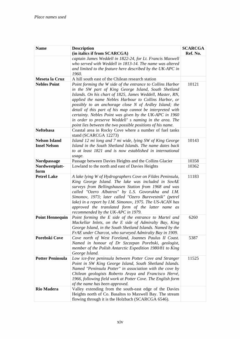
captain James Weddell in 1822-24, for Lt. Francis Maxwell who served with Weddell in 1813-14. The name was altered and limited to the feature here described by the UK-APC in 1960.
Meseta la Cruz A hill south east of the Chilean research station Nebles Point Point forming the W side of the entrance to Collins Harbor
in the SW part of King George Island, South Shetland Islands. On his chart of 1825, James Weddell, Master, RN, applied the name Nebles Harbour to Collins Harbor, or possibly to an anchorage close N of Ardley Island; the detail of this part of his map cannot be interpreted with certainty. Nebles Point was given by the UK-APC in 1960 in order to preserve Weddell’ s naming in the area. The point lies between the two possible positions of his name.
10121
Neftebasa Coastal area in Rocky Cove where a number of fuel tanks stand (SCARCGA 12273)
Nelson Island Insel Nelson
Island 12 mi long and 7 mi wide, lying SW of King George Island in the South Shetland Islands. The name dates back to at least 1821 and is now established in international usage.
10143
Nordpassage Passage between Davies Heights and the Collins Glacier 10358 Nordwestplatt-form
Lowland to the north and east of Davies Heights 10362
Petrel Lake A lake lying W of Hydrographers Cove on Fildes Peninsula, King George Island. The lake was included in SovAE surveys from Bellingshausen Station from 1968 and was called "Ozero Albatros" by L.S. Govorukha and I.M. Simonov, 1973; later called "Ozero Burevestnik" (petrel lake) in a report by I.M. Simonov, 1975. The US-ACAN has approved the translated form of the latter name as recommended by the UK-APC in 1979.
11183
Point Hennequin Point forming the E side of the entrance to Martel and Mackellar Inlets, on the E side of Admiralty Bay, King George Island, in the South Shetland Islands. Named by the FrAE under Charcot, who surveyed Admiralty Bay in 1909.
6260
Porebski Cove Cove north of West Foreland, Joannes Paulus II Coast. Named in honour of Dr Szczepan Porebski, geologist, member of the Polish Antarctic Expedition 1980/81 to King George Island.
5387
Potter Peninsula Low ice-free peninsula between Potter Cove and Stranger Point in SW King George Island, South Shetland Islands. Named "Península Potter" in association with the cove by Chilean geologists Roberto Araya and Francisco Hervé, 1966, following field work at Potter Cove. The English form of the name has been approved.
11525
Rio Madera Valley extending from the south-east edge of the Davies Heights north of Co. Basaltos to Maxwell Bay. The stream flowing through it is the Holzbach (SCARCGA 6546).
xiv

Place names used
Name Description (in italics if from SCARCGA)
SCARCGA Ref. No.
Rip Point Point on Nelson Island forming the S side of the E entrance to Fildes Strait, in the South Shetland Islands. The name appears on a British Admiralty chart showing the results of a survey by DI personnel on the Discovery II in 1935.
12167
Robert Island Island 11 mi long and 8 mi wide, lying between Nelson and Greenwich Islands in the South Shetland Islands. The name dates back to at least 1821 and is now established in international usage.
12209
Schiffsbach A stream flowing past Artigas research station on the south east into Maxwell Bay
12814
Skuabucht Bay on the north west coast between Punta Winkel and Punta Escobar
13455
South Shetland Islands
A group of more than twenty islands and islets lying northward of Antarctic Peninsula and extending about 280 mi from Smith Island and Snow Island in the WSW to Elephant Island and Clarence Island in the ENE The islands were sighted by Capt. William Smith of the brig Williams in February 1819 while cruising close to the northern edge of the islands. The name "New South Britain" was used briefly, but was soon changed to South Shetland Islands. The name is now established international usage.
13740
Stansbury Peninsula
An ice-free peninsula on the N coast of Nelson Island between Edgell Bay and Fildes Strait, in the South Shetland Islands. Named by the UK-APC following BAS geological work, 1975-76, after Michael J. Stansbury, FIDS meteorologist at Grytviken, 1958-59, and Base Leader at Admiralty Bay, 1959-60. A later Polish Antarctic Expedition called this feature "Wzgórze Helikoptera" or "Helicopter Hills" in reference to successful helicopter landings in the 1980-81 season.
13931
Südberge Upland south of the Südpassage 14200 Südpassage Lowland area between hills that leads from the east to the
west coasts in the southern Fildes Peninsula 14203
Suffield Point The SW entrance point of Norma Cove, Fildes Peninsula, King George Island, in the South Shetland Islands.
14207
Three Brothers Hill
Conspicuous hill, 210 m, which is the remnant neck of an extinct volcano situated at the E side of Potter Cove, King George Island, in the South Shetland Islands. The name was used by Scottish geologist David Ferguson in a 1921 report based upon his investigations of King George Island in 1913-14, but may reflect an earlier naming by whalers. The name may be suggestive of the appearance of the feature which consists of two higher summits and one which is lower.
14658
Trinkwassersee Lake in the western area of the Bellingshausen research station that is fed from Kitezh Lake.
Two Summit Island
Small island marked by two prominent summits, lying at the E entrance to Fildes Strait in the South Shetland Islands. It
15138
xv

Place names used
Name Description (in italics if from SCARCGA)
SCARCGA Ref. No.
was named Two Hummock Island by DI personnel following their survey in 1935, but this name has been rejected because of probable confusion with Two Hummock Island in the N entrance to Gerlache Strait. Two Summit Island, equally descriptive of the feature, was recommended by the UK-APC in 1954.
Valle Grande Valley leading to Biologenbucht Valle Klotz A valley in the north-west of Fildes Peninsula draining
from the Collins Glacier to Drake Passage
Weaver Peninsula
Small peninsula between Collins Harbor and Marian Cove, Maxwell Bay, King George Island, terminating in North Spit. Named by the UK-APC in 1977 after Stephen D. Weaver, geologist, University of Birmingham, with the BAS party in this area in 1975.
15803
Windbach Stream through the Südpassage 16129 Zentralpassage Lowland area coasts between the Südbergen and Davies
Heights leading from the east to the west coasts 16474
xvi

List of figures
V. List of figures 2.1.-1 King George Island and the Fildes Peninsula 62.1.-2 The positions and names of the Fildes Region places named in the text 72.3.-1 Map of the geological structure of King George Island and the
neighbouring Nelson Island on the southwest (after Birkenmajer 1989) 9
2.3.-2 Geological map of the Fildes Peninsula (Smellie et al., 1984) 122.4.-1 Dead ice in the end moraine of the Collins Glacier (photo: Mustafa) 132.4.-2 Tephra bands from the volcanic eruptions of Deception Island are
widely distributed in the glaciers of the South Shetland Islands, as here on Nelson Island (photo: Buesser)
14
2.4.-3 Permafrost obstructs drainage, making a swamp of the active layer (photo: Mustafa)
15
2.4.-4 Cryoturbation produces frost patterning of (a) rings on level ground and (b) bands on slopes (photo: Mustafa)
16
2.4.-5 Solifluction lobe on the south slope of Davies Heights (photo: Mustafa) 172.4.-6 Frost-wedged stone of ~0.6 m diameter (photo: Mustafa) 182.4.-7 The central west coast of the Fildes Peninsula showing cliffs and bays
cut into the platform at 40 m. The stacks and skerries offshore indicate the extent of the wave-cut platform (photo: Mustafa)
20
2.4.-8 Dune formation on the windy west coast (photo: Mustafa) 212.5.-1 Monthly average temperature and precipitation at Bellingshausen
station 1969 – 2005 from January (1) to December (12) (AARI, 2006) 22
2.6.-1 East side of Kitezh Lake at (a) the beginning and (b) the end of snow melt period (photos: Mustafa)
24
2.6.-2 Lakes and running water of the Fildes Region according to the SCAR KGIS database
25
2.6.-3 Temporary stream in its dry state (photo: Wilbert) 263.4.-1 GPS mapping of Gentoo Penguin nesting aggregations on Ardley
Island (photo: Buesser) 39
3.4.-2 Numbering of the bays on Fildes Peninsula and Ardley Island as the basis for seal counts
42
3.4.-3 Mapping a group of Elephant Seals using GPS (photo: Nordt) 433.4.-4 Overview of the Fildes Region area covered by the vegetation survey of
the 2004/05 and 2005/06 field seasons. Red indicates the areas surveyed and green the occurrence of vegetation in these areas.
46
4.1.-1 Location of the research stations on King George Island 524.1.-2 Chinese station Great Wall in the southern Fildes Peninsula (photo:
Buesser) 53
4.1.-3 Chilean stations Frei and Escudero in foreground (in part) with Russian station Bellingshausen behind (photo: Buesser)
53
4.1.-4 Uruguayan station Artigas on the Fildes Peninsula (photo: Buesser) 544.1.-5 Overview of research stations and field huts of the Fildes Region 554.1.-6 Numbers of people working in the research stations on Fildes Peninsula 564.2.-1 Waste storage areas mapped on the Fildes Peninsula and Ardley Island 574.2.-2 Proportion of total waste storage areas by originating station 584.2.-3 An active waste deposit near a station, March 2004 (photo: Buesser) 594.2.-4 Waste distribution in the Fildes Region 604.2.-5 Detailed overview of areas heavily littered with waste in the central 61
xvii

List of figures
Fildes Region 4.2.-6 Number of waste finds with the material found at each site 624.2.-7 Disposal method and origin of waste according to type of material 634.2.-8 Typical remnants of human food found (a) domestic animal bone with
clear cut end (b) sheep jawbone (photos: Buesser) 67
4.2.-9 Distribution of human food remains in the Fildes Region 684.2.-10 Causes of the distribution of human food remains in the Fildes Region 694.2.-11 Frequency distribution of distances between finds of biological waste
and the nearest research station 70
4.2.-12 Brown Skuas feeding in station grounds (a) at biological waste containers of Great Wall (photo: Buesser) (b) being fed in Bellingshausen (photo Bellinghausen station)
72
4.2.-13 Neftebasa - large oil tank farm (photo: Buesser) 734.2.-14 Oil pollution mapped on the Fildes Region during the course of the
investigation 76
4.2.-15 Examples of oil pollution: a – lost drum at Kitezh Lake, b – oil puddle under a hose (photos: Buesser)
77
4.2.-16 Measures taken after severe oil spill, a – oil boom in Maxwell Bay, b - removal of oil-soaked snow by station staff (photos: Bellinghausen station)
80
4.2.-17 Annual fuel consumption for power generation by diesel generators in research stations of the Fildes Peninsula (source: Station staff)
81
4.2.-18 Temporary and permanent sources of noise in the Fildes Region, presented according to their position, their type, and frequency of operation. The extent of the noise-affected areas is based on the survey of station grounds and traffic during the field study periods 2003/04 and 2004/05 (Secs. 4.2.10. & 4.2.16.).
83
4.2.-19 Land consumption for buildings in the Fildes Region (cf. Sec. 3.1.9.) 864.2.-20 The most heavily built-up parts of the Fildes Region, the research
stations Artigas (above left), Great Wall (above right), and Bellingshausen/Frei (below)
87
4.2.-21 Land consumption for buildings in the Fildes Region by owner 884.2.-22 Typical stilt construction as displayed by the main building
Bellingshausen station (photo: Buesser) 89
4.2.-23 Argentinean refuge hut “Ballve” at right of picture (photo: Buesser) 904.2.-24 Chilean field hut “Refugio Ripamonti” (photo: Buesser) 914.2.-25 The Chilean field hut complex “Base Ripamonti” in foreground,
“Refugio Ballve” in background (photo: Buesser) 92
4.2.-26 Field hut “Rambo” in March 2004 (photo: Buesser) 934.2.-27 Site of the field hut “Rambo” after dismantling, remains of the
foundations can be seen in the foreground (photo: Buesser) 94
4.2.-28 Plaque at the site of the dismantled hut “Rambo” (photo: Buesser) 954.2.-29 Russian field hut “Priroda” (photo: Buesser) 964.2.-30 Monthly distribution of visits to the “Priroda” hut 1998-2006 964.2.-31 Pattern of visits to “Priroda” field hut through the year, October 1998 –
February 2006 97
4.2.-32 Disused huts near “Neftebasa” (photos: Buesser) 984.2.-33 Disintegrating huts: a – north of Kitzeh Lake, b – in Biologenbucht
(photos: Buesser) 99
4.2.-34 Severely damaged containers on the east coast of the Fildes Peninsula, 99
xviii

List of figures
a – container near the Ardley Isthmus, b – container south of Great Wall station (photos: Buesser)
4.2.-35 Network of main routes in the Fildes Region 1014.2.-36 Marked routes are also used by tracked vehicles (photo: Buesser) 1024.2.-37 Muddy stretches develop in road dips as the snow thaws. These are
difficult to drive through and must often be driven around (photo: Buesser).
102
4.2.-38 Important sections of the road network are cleared of snow if necessary. The way marking is then of particular importance. (photo: Mustafa)
103
4.2.-39 Reasons for journeys between research stations 1044.2.-40 Proportions of journeys by origin and purpose with numbers of
journeys for each research station 105
4.2.-41 Permanent and periodic forms of land use in the Fildes Region 1074.2.-42 The heavily damaged main routes (“frequent traffic” category) are
marked with snow poles (right of picture) (photo: Buesser) 108
4.2.-43 Occasional tracks outside the main routes (“limited traffic” category) (photo: Mustafa)
108
4.2.-44 Use of space by snowmobiles and tracked vehicles on the Fildes Peninsula (pers. comm. O. Sakharov); light blue shading represents areas dominated by snowmobiles
111
4.2.-45 Flight activity by helicopters, small and large airplanes over the Fildes Peninsula and Ardley Island in summer 2003/04 (thin lines: estimated flight routes, thick lines: routes determined by Rangefinder GPS)
112
4.2.-46 Flight activity by helicopters, small and large airplanes over the Fildes Peninsula and Ardley Island in summer 2004/05 (thin lines: estimated flight routes, thick lines: routes determined by Rangefinder GPS)
113
4.2.-47 Flight activity by helicopters, small and large airplanes over the Fildes Peninsula and Ardley Island in summer 2005/06 (thin lines: estimated flight routes, thick lines: routes determined by Rangefinder GPS)
114
4.2.-48 Number of days with flight activity in the Fildes Region, by aircraft type, between 10 December and 26 February (shading: proportion of station aircrafts, including station-based DAP helicopter)
115
4.2.-49 Number of overflights observed over the Fildes Region, between 10 December and 26 February (shading: proportion of station aircrafts, including station-based DAP helicopter)
116
4.2.-50 Number of overflights observed over the Fildes Peninsula and Ardley Island between 20 December and 20 January (data 2000/01 – 2002/03: S. Pfeiffer)
117
4.2.-51 Flight movements at the airport Teniente Marsh between 1997 and 2005 divided according operators nationality (source: DGAC)
118
4.2.-52 Number of Chilean passengers at Teniente Marsh between 1999 and 2005 (source: DGAC)
119
4.2.-53 Sightseeing overflights of the Fildes Peninsula in December 2001 (photo: Peter)
121
4.2.-54 Number of observed instances of flights of Ardley Island which broke the minimum altitude (610 m) and minimum horizontal distance (460 m) from the island laid down by Resolution 2 (2004) XVII ATCM
123
4.2.-55 Measured infringements in summer 2005/06 of the altitude and horizontal distance limits for Ardley Island laid down by Resolution 2
124
xix

List of figures
(2004) XVII ATCM (within yellow shaded area) 4.2.-56 Low-altitude Hercules overflights in January 2006, a – over the Fildes
Strait, and b – Ardley Island; height above the penguin colonies 70 - 90 m (photos: Buesser)
125
4.2.-57 Patterns of spatial use of the inner Maxwell Bay by ships of different types anchoring or lying to in the summer seasons 2003/04, 2004/05 and 2005/06
126
4.2.-58 Number of cruise ships entering Antarctic Peninsula waters (source: www.iaato.org)
128
4.2.-59 Number of ship arrivals in Maxwell Bay by type of ship 1294.2.-60 Landing boats of (a) Bellingshausen station and (b) the supply ship
“Oscar Viel” (photos: Buesser) 130
4.2.-61 Means of transport between stations – inflatable boats of zodiac type (photo: Buesser)
132
4.2.-62 Frequency of zodiac use by origin. The category “ship” includes all the subsequent categories
134
4.2.-63 Concentration of shipping in Maxwell Bay on 15.01.2006 (photo: Pfeiffer)
135
4.2.-64 Location of the Russian Orthodox church erected in 2003/04 1374.2.-65 Russian Orthodox church erected in 2003/04 in the grounds of the
Russian station Bellingshausen (photo: Buesser) 139
4.2.-66 General overview of the areas affected by airport extension construction work. The newly-constructed parking area for aircraft is situated south of the runway (shown here as the largest filling area)
141
4.2.-67 Detailed view of the areas affected by airport extension construction work to the south of the Chilean station Frei
142
4.2.-68 Trackway laid to quarry No. 3, on the right of the picture a partly destroyed storm petrel breeding habitat (photo: Peter)
143
4.2.-69 Quarry No. 3 with lichen growing on the storm petrel breeding ground (photo: Peter)
144
4.2.-70 Worked-out quarry No. 2 with the partly destroyed storm petrel breeding ground (photo: Buesser)
146
4.2.-71 Vegetation south of Frei station destroyed by material extraction (photo: Buesser)
147
4.2.-72 Tracks of diggers and all-terrain vehicles southwest of the newly built airplane park, in the foreground a destroyed moss bed (photo: Buesser)
147
4.3.-1 Overview of waste water discharges by research stations, permanent and temporary waters, and water courses of the Fildes Peninsula and Ardley Island
149
4.3.-2 Waste water discharge into the sea near Frei station, recognisable by a reduction of surface tension (photo: December 2004, Buesser)
151
4.3.-3 Exposed by low tide, Great Wall's waste water discharge pipe (photo: December 2004, Buesser)
152
4.3.-4 Frequency of different materials amongst the total amount washed up on the beach
153
4.3.-5 Young Elephant Seal with stranded marine debris (photo: Buesser) 1544.3.-6 Elephant Seal with a neck wound caused by fishing line (photo:
Buesser) 155
4.4.-1 Fossiliferous regions and sites of fossil finds 1594.4.-2 Impression of a bird footprint (scale 100 mm, photo: Grunewald) 160
xx

List of figures
4.4.-3 Carbonised plant remains (photo: Grunewald) 1604.4.-4 Impressions of plant remains (photo: Grunewald) 1614.4.-5 Silicified wood (photo: Grunewald) 1614.4.-6 Eastern part of Fossil Hill (photo: Grunewald) 1634.4.-7 Find locality A7-01 (photo: Grunewald) 1634.4.-8 Find area Rio Madera (photo: Grunewald) 1644.4.-9 Rich find locality near to the road (photo: Grunewald) 1644.4.-10 Pieces of silicified wood in front of Escudero station (photo:
Grunewald) 165
4.4.-11 Internal structures in silicified wood (photo: Grunewald) 1664.4.-12 View from the edge of the glacier towards the southwest (photo:
Grunewald) 167
4.4.-13 Find location at the edge of the glacier (A7-27) (photo: Grunewald) 1684.4.-14 Beach ridge complex on the southwest coast of Ardley Island (photo:
Mustafa) 171
4.4.-15 Hydrogeological map of the eastern Südpassage with beach ridge complex at the mouth of the valley (after Flügel, 1990)
172
4.4.-16 Test pit for construction material in the beach ridge complex, eastern Südpassage (photo: Buesser)
173
4.4.-17 Lake at the beginning of the thaw (photo: Mustafa) 1744.4.-18 Lakes, their use as sources of drinking water, and the potential threats 1764.4.-19 Drinking water extraction from Lago Uruguay (photo: Mustafa) 1774.5.-1 Chinstrap, Gentoo and Adélie Penguins, birds breeding in the study
area (photo: Peter) 177
4.5.-2 Numbers of breeding pairs of Chinstrap, Gentoo and Adélie Penguins on Ardley Island over the last 35 years
178
4.5.-3 Changes in the spatial extent of penguin colonies on Ardley Island 1804.5.-4 Distribution of colonies of Pygoscelis penguin species on Ardley Island
in 1985/86 and during the study period 2003/04 - 2005/06 (GPS measurements). The survey of 2003/04 was carried out on the basis of the 1985/86 data set. To this was then added, in brown, on the basis of arial photographs and manual surveys, every group of nests in which Adelié Penguins had bred.
181
4.5.-5 Location of penguin colonies on Ardley Island (Pygoscelis papua, P. adeliae and P. antarctica) and on the Drake Coast of Fildes Peninsula (exclusively P. antarctica, indicated by arrows)
183
4.5.-6 Southern Giant Petrels (Macronectes giganteus) on the nest (photo: Peter)
184
4.5.-7 Number of breeding pairs (occupied nests) of Southern Giant Petrels in 1984/85 as well as 2003/04, 2004/05 and 2005/06
185
4.5.-8 Breeding success of Southern Giant Petrel in the years 2003-04, 2004/05 and 2005/06 drawn from the numbers of young in the nest in February each year compared to data from the 1980s. The zones N, S, SE and E refer to the information in Tab. 4.5.-2.
187
4.5.-9 Sudden fly-off provoked in Southern Giant Petrels by low altitude overflights by Hercules in the Fildes Strait area (photo: Peter)
188
4.5.-10 Cape Petrel (Daption capense) on the nest (photo: Peter) 1884.5.-11 Breeding colonies of Cape Petrels in the years 2003/04, 2004/05 and
2005/06 190
4.5.-12 Distribution of Wilson’s Storm Petrel (Oceanites oceanicus) and 192
xxi

List of figures
Black-bellied Storm Petrel (Fregetta tropica) breeding areas in the Fildes Region
4.5.-13 Snowy Sheathbill (Chionis alba, photo: Peter) 1934.5.-14 Sightings and known breeding places of Chionis alba in the summers
2003/04 to 2005/06 195
4.5.-15 Brown Skua (Catharacta a. lonnbergi, left) and South Polar Skua (Catharacta maccormicki, right, photos: Peter)
196
4.5.-16 Numbers of skua breeding pairs on the Fildes Peninsula and Ardley Island in the years 1980/81 to 2005/06
197
4.5.-17 Distribution of skua nests in the Fildes Re zgion during the four years of the study
198
4.5.-18 Kelp Gull (Larus dominicanus, photo: Peter) 1994.5.-19 Colonies and single nests of Kelp Gull in the summers 2003/04,
2004/05 and 2005/06 200
4.5.-20 Antarctic Tern (Sterna vittata, (photo: Peter) 2014.5.-21 Breeding localities of Antarctic Tern in the summers 2000/01 to
2005/06 ... 202
4.5.-22 Blue-eyed Shag (Phalachrocorax atriceps), a bird that rarely breeds in the study area (photo: Peter)
203
4.5.-23 An immature Emperor Penguin (Aptenodytes forsteri), a visiting bird in the study area (photo: Peter)
204
4.5.-24 Moulting Macaroni Penguin (Eudyptes chrysolophus, photo: Buesser) 2054.5.-25 Southern Fulmar (Fulmarus glacialoides, photo: Bellinghausen station) 2054.5.-26 White-rumped Sandpiper (Calidris fuscicollis, photo: Peter) 2064.5.-27 Snow Petrel (Pagodroma nivea ,photo: Froehlich) 2074.5.-28 Cattle Egret (Bubulcus ibis ,photo: Buesser) 2074.5.-29 Observations of potential breeding and visiting birds in the 2003/04
season 209
4.5.-30 Observations of potential breeding and visiting birds in the 2004/05 season
210
4.5.-31 Observations of potential breeding and visiting birds in the 2005/06 season
211
4.5.-32
Overview of all breeding birds (both colonially and singly breeding) in the 2005/06 season
212
4.5.-33 Southern Elephant Seal haul-out in the Drake Coast area (photo: Peter) 2184.5.-34 Fur Seal family in the Drake Coast area near the refuge hut “Priroda”
(photo: Peter) 219
4.5.-35 Crabeater Seal and a few Fur Seals and Weddell Seals in Hydrographers Cove (photo: Bellinghausen station)
220
4.5.-36 The Leopard Seal is the rarest species of seal in the study area (photo: Pfeiffer).
220
4.5.-37 Newborn Weddell Seal and mother in Hydrographers Cove (photo: Froehlich)
221
4.5.-38a-c Number of Elephant Seals and Fur Seals at haul-outs 222-2244.5.-39a,b Positions of Elephant Seal haul-outs with > 10 individuals in the
summer 2004/05 and 2005/06 225-2264.5.-40 Positions of seal pupping localities on the Fildes Peninsula between
2002 and 2006 (the size of the circles is proportional to the number of newborns)
227
4.5.-41 All 105 lakes of the Fildes Region showing those colonised by the 228
xxii
List of figures
chironomid Parochlus steinenii 4.5.-42 Occurrence of fungi of the genus Omphalina on the Fildes Peninsula
(photo: Buesser) 229
4.5.-43 Vegetation map of the Fildes Region as located by GPS in the field seasons 2004/05 and 2005/06. The individual patches are characterised by a major genus from the plant association in the legend.
230
4.5.-44 Vegetation map of Ardley Island. The legend lists the dominant genera of the plant associations, by which the individual patches were categorised and their positions mapped by GPS in 2004/05.
231
4.5.-45 Vegetation map of the central Fildes Peninsula mapped by GPS in 2004/05 and 2005/06. Individual patches are each characterised by a major genus from the plant associations listed in the legend.
232
4.5.-46 Vegetation on frost-patterned ground in the Fildes Region (photo: Buesser)
233
4.5.-47 Detail of the southwestern part of King George Island with the neighbouring Dart Island and Two Summit Island in the Fildes Strait
234
4.5.-48 Western part of Dart Island (photo: Pfeiffer) 2344.5.-49 Typical occurrence of plants on Dart Island. Sanionia uncinata
associated with Deschampsia antarctica, Syntrichia princeps and Polytrichastrum alpinum (photo: Pfeiffer)
235
4.5.-50 Polytrichastrum alpinum, Sanionia uncinata and Prasiola crispa in a Southern Giant Petrel nesting area (photo: Pfeiffer)
235
4.5.-51 Species association on rocky areas involving the genera Caloplaca, Xanthoria, Haematomma and other crustose lichens (photo: Pfeiffer)
236
4.5.-52 Western part of Two Summit Island. In the foreground, groups of Southern Giant Petrel nests and extensive Prasiola crispa patches. Moss-carpets occur in protected, flatter areas. Scree slopes are dominated by Usnea communities (photo: Pfeiffer)
236
4.5.-53 Distribution and density of Deschampsia antarctica individuals in the Fildes Region, plotted in 1984/85 by Gebauer et al. 1987
238
4.5.-54 Distribution and density of Deschampsia antarctica individuals in the Fildes Region, plotted in 2000/01 by Gerighausen et al, 2003
239
4.5.-55 Distribution and density of Deschampsia antarctica individuals in the Fildes Region, plotted in 2004/05 and 2005/06 as part of this study
240
4.5.-56 Colobanthus quitensis is probably represented by only a single individual in the Fildes Region. (photo: Buesser)
241
4.5.-57 Fresh footprint damage in moss, Fildes Peninsula (photo: Buesser) 2434.5.-58 Tracks, possibly several years old, made by tracked vehicles in moss,
Fildes Peninsula (photo: Buesser) 243
4.5.-59 New tracks of all-terrain and tracked vehicles in moss, Valle Klotz, Fildes Peninsula (photo: Buesser)
244
4.5.-60 Pedestrian and vehicle tracks in the grounds of the Russian station Bellingshausen (photo: Sakharov)
244
4.5.-61 Damage to vegetation cover by Fur Seals during moulting on the Fildes Peninsula (photo: Buesser)
245
4.5.-62 Dead rat found on the Fildes Peninsula 2003/04, probably brought in with timber imported from Russia for the building of the Russian church in the grounds of Bellingshausen station (photo: Buesser)
247
4.5.-63 Alien grass species in the grounds of the Chinese station Great Wall (Photo: Buesser)
247
xxiii

List of figures
4.5.-64 Deschampsia sp. in the grounds of the Chinese station Great Wall (February 2006, diameter of lens cap 72 mm, photo: Buesser)
248
4.5.-65 A second alien grass species in the grounds of the Chinese station Great Wall (February 2006, diameter of lens cap 72 mm, photo: Buesser)
248
4.5.-66 Unidentified grass species in the grounds of the Chinese station Great Wall (February 2006, diameter of lens cap 72 mm, photo: Pfeiffer)
249
4.5.-67 Removal of an alien grass species from the grounds of the Chinese station Great Wall (February 2006, photo: Pfeiffer)
249
4.5.-68 Penguin research on Ardley Island: (a) Chilean and German scientists weighing a Gentoo Penguin chick, (b) Chilean scientists attaching a flipper band to a penguin (photos: Pfeiffer)
251
4.5.-69 Vegetation survey by researchers on the project (Photo: Pfeiffer) 2514.5.-70 Number of days when there were scientific visitors on Ardley Island
during the summer months (not including Chilean scientists from INACH)
252
4.6.-1 Tourist landing sites on King George Island with the maximum and minimum figures for visitor landings during the last 10 years (ship-based tourism 1995/96 to 2005/06, source: www.iaato.org,)
254
4.6.-2 Preparation of the course on the day before the marathon on the Fildes Peninsula. Red tags mark the distances (white arrows, photo: Buesser)
256
4.6.-3 Course of the marathon on the Fildes Peninsula in February 2005 2574.6.-4 Start of the marathon in the Russian station Bellingshausen, Fildes
Peninsula, February 2005 (photo: Buesser) 258
4.6.-5 Marathon runners on the track between the Chinese and the Chilean Stations, Fildes Peninsula, February 2005 (photo: Buesser)
258
4.6.-6 Use of space by people on foot in the Fildes Region as represented by the visitor index
259
4.7.-1 Proportion of the personnel from each station who responded to the questionnaire (n = 216)
264
4.7.-2 Reasons given for stays in the Antarctic (n = 211, including multiple answers, 82 % of those responding gave one or two reasons)
266
4.7.-3 Presentation of the interests of station personnel and of what they have already learned from reading about various themes specific to the Antarctic (n = 214)
266
4.7.-4 Proportional representation of station personnel’s free time activities other than those in their own stations (n = 206)
267
4.7.-5 Temporal distribution of four possible types of free time activity by station personnel outside the grounds of their own stations (n = 216)
268
5.1.-1 Remnants of a wrecked ship on the beach south west of the Uruguayan station Artigas (Photograph: Buesser)
272
5.2.-1 The influence of human activity on breeding birds in the Fildes Region. Investigated (filled) and suspected (open). Factors are categorised by their strength of their action (red = “high”, yellow = “intermediate”, green = “limited”; expanded from Pfeiffer, 2005)
280
5.2.-2 Spatial distribution of sea birds and seals in the Fildes Region as represented by the wildlife index
282
5.2.-3 Spatial distribution of areas of potential conflict produced by combining the visitor pressure (visitor index) and the occurrence of seals and sea birds (wildlife index) in the Fildes Region
283
5.2.-4 Percentage distribution of ship-days, presence of one or more ships in 285
xxiv

List of figures
Maxwell Bay, categorised by their major purpose (1 = research, 2 = logistic, 3 = tourism, 4 = security); (total n = 157 ship-days; 35 in 79 days of observation in 2003/04, 55 days in 2005/05 and 67 days in 2005/06)
6.2.-1 Map with a proposed visitor zone, landing sites, access routes, sights, and known former camp sites of the Fildes Region
303
7.1.-1 Possible boundaries of a Maxwell Bay ASMA 311
xxv

List of tables
VI. List of tables 1.3.-1 Previous stays by project members in the Fildes Region before the start of
the project; A – Ardley Island, B – Russian station Bellingshausen, G - Chinese station Great Wall
3
2.3.-1 Vulcanite stratigraphy in the South Shetland Islands from the Upper Cretaceous to the Lower Tertiary (Smellie et al., 1984)
10
2.3.-2 Stratiographically the rocks of the Fildes Peninsula belong to the Fildes Formation which is further divided into three sections (Smellie et al., 1984).
11
2.5.-1 Monthly averages (for December, January, February) of selected climatic parameters during the project’s field work as measured at Bellingshausen station (AARI, 2006) with comparison of these with the long-term mean and extreme values for 1968/69 to 2005/06. Values in blue are higher, and red values lower, than the long-term mean.Values in bold lie outside the rms errors or the standard deviation.
23
3.4.-1 Classification of the vegetation of the Fildes Region by using the plant sociology scheme of “subformations” with subsidiary “associations” and “sociations” following Ochyra (1998) and Lindsay (1971)
44
3.7.-1 Weighting factors used in calculating the faunal index (the differentiation of seals into those breeding and those moulting hair or skin is based on their condition in the period December to March).
50
4.1.-1 Stations on King George Island (source: http://www.comnap.aq/facilities) 514.2.-1 List of measurements of noise levels from anthropogenic sources in bird
colonies in the Fildes Region (noise level measuring instrument: Volcraft 322, data from Pfeiffer (2005) on windless days, Beaufort scale < 2)
85
4.2.-2 Number of journeys per route 1064.2.-3 Land use categories as proportions for the Fildes Peninsula and Ardley
Island 109
4.2.-4 Overview of the increasing number of flights over the Fildes Peninsula between 20 December and 20 January of the years 2000/01 to 2005/06
117
4.2.-5 Development of air tourism by the company “Aerovías DAP” between Punta Arenas and KGI (with Beechcraft King Air A100 and Dash-7 aircraft). Comparison of IAATO information with data from the project (non-tourist flights bracketed)
120
4.2.-6 Overflights of the Antarctic Peninsula by jet aircraft and observations of overflights of the Fildes Region
121
4.2.-7 Number of ships recorded in Maxwell Bay during the study period (10 Dec. to 26 Feb.), in parentheses the total number of ships of each different type
127
4.2.-8 Number of days on which landing boats and ships‘ tenders were in use categorised by boat operator
131
4.2.-9 Number of days on which station zodiacs were in use categorised by station of origin
133
4.2.-10 Total use of land during construction of the airport extension derived from area measurements by GPS
140
4.2.-11 Estimated number of storm petrel breeding pairs before the extraction of building material
146
4.3.-1 Water use and station populations 1484.3.-2 Use of station zodiacs and boats in the Fildes Region 157
xxvi

List of tables
4.4.-1 Lakes used as sources of drinking water for the stations 1754.5.-1 Overview of penguin breeding success on Ardley Island 1824.5.-2 Number of juvenile Southern Giant Petrel in the nest, February 2004-06
in the Fildes Region (see also Fig. 4.5.-7) 186
4.5.-3 Number of breeding areas of Wilson’s Storm Petrel (O. oceanicus) and Black-bellied Storm Petrel (F. tropica) categorised by estimated number of breeding pairs
191
4.5.-4 List of all bird species recorded in the Fildes Region (cf. Rauschert et al. 1987; Peter et al. 1988; Nadler & Mix 1989; Lange & Naumann 1989)
208
4.5.-5 Effects of human activity on the heart rate (physiology) and behave of Southern Giant Petrels and skuas (Brown and South Polar combined) in the Fildes Region compared with the effects of natural stressors (interactions with predators and conspecifics) (classification 1 = “low”, 2 = “medium”, 3 = ”strong”). The reactions of breeding birds from areas of both low and high human activity are presented. Results for samples of fewer than five birds are bracketed. (from Pfeiffer, 2005)
214
4.5.-6 Results of the monthly seal counts on the Fildes Peninsula and Ardley Island in January/February 2004
216
4.5.-7 Results of the monthly seal counts on the Fildes Peninsula and Ardley Island from December 2004 to March 2005
216
4.5.-8 Results of the monthly seal counts on the Fildes Peninsula and Ardley Island from December 2005 to March 2006
217
4.5.-9 Results of the monthly seal counts on the Fildes Peninsula and Ardley Island from April to October 2006
217
4.6.-1 Consequences of tourist activity in general and specifically for the Fildes Region
262
4.7.-1 Demographic and other parameters of the personnel from stations on the Fildes Peninsula who took part in the questionnaire
265
4.7.-2 Results of the enquiry questionnaire on various aspects of management. Trends were tested by chi-squared test of the values obtained against the expectation of 50 % in each direction (with combination of the categories “disagree” and “strongly disagree” and the categories “agree” and “strongly agree”. Values in bold are significantly different from expected at p < 0.05.
269
5.1.-1 Estimation of the assets to be protected of the Fildes Region on the basis of the values available. Value or importance for the Antarctic categorised as 1 = “low”, 2 = “medium”, 3 = “high
273
5.1.-2 Matrix of assets to be protected and values for the Fildes Region in terms of Antarctic-wide quality criteria. Value categorised as 1 = “low”, 2 = “medium”, 3 = “high” (after SCAR, 2001)
274
5.2.-1 Ranking of the potential risks posed by current human activities in the Fildes Region
287
5.2.-2 Estimation of the environmental risks in the Fildes Region with the inclusion of both natural and anthropogenic influences as well as the risks to be expected in the future in the absence of additional management measures. Increased future environmental risks are given in red. (cf. Jezek & Tipton-Everett, 1995)
288-289
xxvii
Chapter 1.1. Background to the proposal
1. Introduction 1.1. Background to the proposal The Antarctic Continent and the Southern Ocean are unique in their biological, geological and hydrological properties. This uniqueness was recognised by several states who, in 1959, signed the Antarctic Treaty. The protection afforded to the Antarctic flora and fauna, and to sites of special scientific interest, has been fundamental to maintaining the wilderness value of the Antarctic and for work in ecosystems largely unaffected by human activities. Likewise fundamental has been the implementation of active environmental protection measures in areas of human use (see Antarctic Treaty, EP, AUG http://www.umweltbundesamt.de/antarktis/). The Antarctic Peninsula and the surrounding island groups contain much of the Antarctic’s richness in terrestrial animals and plants (e.g. Convey, 2001). In consequence, therefore, many Treaty Parties have strong scientific interests in this area. At the same time, this region is the most heavily used by tourists in Antarctica. The reasons for this intense human activity (scientific, logistic, and tourist) lie in; (1) the region’s nearness to South America, i.e. good accessibility, (2) the mild climate compared to other regions, (3) the relatively high biodiversity, (4) the limited amount of pack ice during the summer months and (5) the concentration of research stations consequent on these factors. King George Island, the largest island of the South Shetland Archipelago, carries a particularly high density of research stations and field huts. This is particularly so of the south and southwest of the island. Those on the Fildes Peninsula are the Chilean “Profesor Julio Escudero” and “Presidente Eduardo Frei Montalva” stations, the Chinese “Great Wall Station”, Russian “Bellingshausen”, and Uruguayan “Base Científica Antártica Artigas”. The Chilean airport is also in this area. In consequence, the logistic activities of the entire region are concentrated in this locality. During the summer months, about 250 station personnel are active on the Fildes Peninsula and the surrounding islands (hence forward “Fildes Region”). Research is not confined to the protected areas ASPA No. 125 and ASPA No. 150 but takes place predominantly in the vicinity of the research stations. Scientific fieldwork, station operation, and the transport of people and cargo thus frequently occur at the same time and in the same space. In addition, station personnel, international delegations and tourists visit the research stations and sites of natural interest, and large-scale events, such as marathons, also take place. The Fildes Region is also home to protected species and special species communities. There are, in addition, sites of particular geological and historical value. The co-occurrence of these features and the heavy human activity in the Region leads to
1

Chapter 1.2. Aims and content of the proposal
conflicts of interest between research, logistics, and tourism on the one hand, and environmental protection and nature conservation on the other. The monitoring (largely limited to counting the number of breeding pairs of particular bird species) and management implemented so far, have not been commensurate with the complexity of human activity in the Fildes Region. 1.2. Aims and content of the proposal The aims of this study are to determine the scientific base lines for the biotic and abiotic parameters of the area and to quantify the human activity and the environmental problems of the region. The results of the study will feed into a risk analysis from which proposals will be made for the necessary management measures. The area of the investigation is described (Sec. 2.) and the methods used follow in detail. All the data assembled in the study is presented (Sec. 3.). The use of the area and the temporal pattern of infrastructure use and construction activities are documented. The occurrence of waste, organic waste and oil contamination is mapped and the results of an enquiry into current waste management by the research stations are presented. The study also included estimation of the noise and gas emissions in both terrestrial and marine environments. The spatio-temporal pattern of land, air and sea traffic was also observed, and measured in detail, for the first time in the Fildes Region. The searches undertaken revealed new fossil exposures and these are detailed along with, in addition, the importance of beach ridges in the region. The distribution and abundance of animals and plants in the region are presented in detail (Sec. 4.5.) and compared with previous studies in order to reveal population changes. Individual sub-sections indicate the extent of the effects of human activities on the animals and plants of the region. An enquiry among research station personnel revealed new information about their free-time activities and about their attitudes to environmental education and environmental protection measures in the region. The data produced by the study are discussed (Sec. 5.) within the framework of an analysis of the risks posed to the values of the Fildes Region by the various potential threats. The analysis focuses on the different interests of nature- and environmental-protection, science, logistics and tourism. Additional proposals are made, based on current management, for the reduction of conflicts between these interests (Sec. 6). The final section consists of a proposal for a management plan for an “Antarctic Specially Managed Area” (ASMA). This proposal might function as a framework for future discussions of the International Working Group of the CEP.
2

Chapter 1.3. Previous research in the regions
1.3. Previous research in the region Researchers of the Polar and Bird Ecology Group have been working regularly on King George Island since 1983. These investigations have not only taken place during the summer but in winter too (Tab. 1.3.-1). They concentrated on the ecology of the birds, seals, and vegetation of the Fildes Region, directly and in relation to the anthropogenic influences of intensive station operations, transport and scientific activity. During the 1980s, German scientists were able to collect base line data before, and during the early stages of, the increase of anthropogenic influence to current levels (Bannasch & Odening, 1981; Bannasch et al., 1984; Lorenz, 1984; Peter et al., 1986; Gebauer et al., 1987; Rauschert et al., 1987; Kaiser et al., 1988; Mönke & Bick, 1988; Peter et al., 1988a, b; Nadler & Mix, 1989; Peter et al., 1989; Kaiser et al., 1990; Peter et al., 1990; Lange & Naumann, 1990; Peter et al., 1991; Kaiser 1995). This information provides an important comparison with the current level of threat. Then, after the return of the last members of the 1990 expedition, a long-term research programme of the Vertebrate Research group (FWF) of the Tierpark Berlin was finished on King George Island as part of the restructuring of the GDR Academy of Sciences. Thereafter, as far as German scientists are concerned, various studies and practical work have been carried out in the research area as well as Diploma and PhD programmes under the direction of H.-U. Peter (Tab. 1.3.-1, Welcker & Peter, 1999; Welcker, 2000; Pfeiffer et al., 2001; Hahn et al., 2003; Pfeiffer 2005). In summer 2000/01, during a student excursion, it was possible to start large-scale GIS-based collection of data on the fauna and flora (Quellmalz 2001, Peter et al., 2001a, b; Peter et al., 2002a, b; Wang & Peter, 2002a, b; Gerighausen et al., 2003). Tab. 1.3.-1: Previous stays by project members in the Fildes Region before the start of the project; A – Ardley Island, B – Russian station Bellingshausen, G – Chinese station Great Wall
1983/85 93/94 94/95 96/97 98/99 99/00 00/01 01/02 02/03
C. Buesser G, B G
O. Mustafa B
H.-U. Peter B A, B A B B B B
S. Pfeiffer G A, B, G B
K. Reinhardt A, B
M. Ritz G
J. Welcker B B B
H. Wemhoff B
3

Chapter 1.4. International and national collaboration
Between 1999 and 2002, research was carried out on the South Shetland Islands under a research and development plan of the UBA (FKZ 29819 159 UFO-Plan 1998) (Pfeiffer & Peter, 2003). Not only were basic data and environmental indicators obtained during this project but concrete suggestions were also made for the development of management plans covering areas used by tourists. Some environmental studies had previously been carried out for the Fildes Region (e.g. Krzyszowska, 1993; Chupin, 1997; Li & Li, 1997; Zhao & Xu, 2000). On Ardley Island extensive behavioural, eco-physiological and demographic studies have been conducted on all three of the penguin species locally present (e.g. Müller-Schwarze & Müller-Schwarze, 1975; Leyton & Valencia, 1983; Valencia & Sallaberry, 1983; Yanez et al., 1984; Sallaberry et al., 1987; Shuford & Spear, 1988; Ulbricht & Zippel, 1994; Wilson et al., 1998; Wilson et al., 1999; Soave et al., 2000). However, scientific field work in the study area also covered other animal species, and botanical, marine, and geological themes (e.g. Krylov, 1968; Covacevich & Lamperein, 1970, 1972; Simonov, 1973; Guzmán & Redon, 1981; Covacevich & Rich, 1982; Kamenev, 1987; Andreev, 1988, 1989; Fensterseifer et al., 1988; Mäusbacher, 1991; Novoatti, 1993; Shen, 1994a; Hu, 1997; Chen & Ahti, 1999; Huang et al., 1999; Zhao & Li, 1999; Jiang et al., 2000; Smykla et al., 2005). Basic topographical data were already available in the KGIS project databank and have been made available for multidisciplinary use (Vogt et al., 2004). 1.4. International and national collaboration Germany informed the community of Antarctic Treaty Parties about the aims and content of the current research project as early as 2004 (ATCM, 2004e) and reported their progress in the following year (ATCM, 2005g). Additional publications followed in the immediately subsequent years (cf. ATCM, 2006j, ATCM 2007c, d – see also Appendix 8 a-e). Over the decades, intensive scientific co-operation has occurred locally on the Fildes Peninsula because of the high density of research stations. On Ardley Island particularly, scientists of several nations have carried out research on the penguin colonies. We have worked closely with José Valencia in the context of a co-operation agreement with INACH (DLR-Project CHL 01/016), and over the last two years we have also worked with Maria José Rosello and Alejandro Simeone. We exchanged relevant data on the size and distribution of colonies and breeding success.
4

Chapter 1.4. International and national collaboration
From the 1980s to the present day we have co-operated closely with the Russian Arctic and Antarctic Institutes and the Russian Antarctic Expedition, mainly at the logistical level (Victor Pomelov, Maria Gavrilo). In this connection we should especially like to thank the long-serving head of the Russian Bellingshausen Station, Oleg Sakharov, who accommodated us in his station and without whom many things would not have been possible, including the scientific workshop in Bellingshausen in late January/early February 2006. We have, furthermore, worked together with Russian scientists from various institutes (Igor Chupin, Museum Barnaul, and Mikhail Andreev, Russian Academy of Sciences, Komarov Institute, St. Petersburg). Ron Lewis-Smith (British Antarctic Survey, Cambridge) assisted in identifying lichens and introduced plant species. Ji Hee Kim (Korea Polar Research Institute) gave us the benefit of her experience of the surroundings of King Sejong Station and supported us in learning methods to map vegetation distribution. We co-operated with the Second Oceanographic Institute, Hangzhou, China (Zipan Wang, in co-operation with Xiaoping Pang) within the framework of a BMBF-DLR Project. We have been in close contact with our Polish colleague from Krakow (Ryszard Ochyra) regarding the identification of mosses. Within Germany we recognise the excellent collaboration with the UBA (Fritz Hertel and Heike Herata, further Antje Neumann and Michaela Mayer, both formerly of the UBA), as well as collaboration with the members of the research support committee, who made very constructive suggestions (e.g. by Hartwig Gernandt, AWI). Of the committee members we should especially like to mention also Steffen Vogt, leader of the SCAR KGIS project, with whom we have worked very closely. In addition, AWI Bremerhaven supplied us, as always, with polar clothing and was also partly responsible for organising the transport logistics. Joachim Zündorf, Herbarium Haussknecht, Jena, was kind enough to undertake the identification of the plant material we had collected. Last but not least we thank our colleagues Anne Froehlich, Uwe Grunewald, Steffen Hahn, Tiemo Kahl, Markus Ritz and Elke Wolska-Böhm for their support in the field and in preparing data.
5

Chapter 2.1. Location of the study area
2. Study area 2.1. Location of the study area The Fildes Peninsula, as well as Ardley Island off its shores, are situated southwest of King George Island (Fig. 2.1.-1). KGI is the largest of the South Shetland Islands, measuring approx. 1,400 km². The South Shetland Islands stretch from the southwest to the northeast between 61°00´ and 63°30´S, and between 63°00´ and 54°00´W. They lie parallel to the coast of the Antarctic Peninsula at a distance of ~120 km. The group of islands is separated from the coast by the Bransfield Strait (Mäusbacher, 1991), which is up to 2,000 m deep.
Fig. 2.1.-1: King George Island and the Fildes Peninsula In common with the other larger islands of the South Shetlands, King George Island is almost completely glaciated. Ice covers more than 92 % of the island’s surface. The highest point on the island, 705 m above sea level, is also covered in ice (Braun & Hock, 2004). The approximately 29 km² Fildes Peninsula is the largest ice-free area of the island. It is situated at latitude 62°08´ to 62°14´S and longitude 59°02´ to 58°51´W. Ardley Island is 1.2 km² and lies off the southeast coast of the Fildes Peninsula. At low tide the island
6

Chapter 2.1. Location of the study area
may be reached on foot from the Fildes Peninsula via an isthmus ~400 m long. The Fildes Peninsula is bordered to the northeast by the Collins Glacier, to the north and west by the Drake Passage, to the southeast by Maxwell Bay – an extension of the Bransfield Strait, and to the south by the Fildes Strait. This strait is only 400 m wide and bounded on the further side by Nelson Island (Fig. 2.1.-2).
Fig. 2.1.-2: The Fildes Region, positions and names of localities mentioned in the text
7

Chapter 2.2. Relief
2.2. Relief The underwater topography of the Fildes Peninsula coasts is very asymmetrical. Whereas the west coast abutting the Drake Passage adjoins an extensive, flat wave-cut platform in water just a few meters deep, the seabed of Maxwell Bay falls steeply away from the east coast, down to a depth of 300 m at the entrance to the bay (Mäusbacher, 1991; cf. V: place names used). The terrestrial relief of the Fildes Peninsula is very varied and, according to Mäusbacher (1991), can be divided into the following large areas: • The Südberge reach heights of between 80 and 165 m. Horatio Stump, 165 m high
and situated in the west of this section, is the highest elevation of the Peninsula. The watershed lies fairly far to the west, so that most valleys are orientated towards Maxwell Bay or Fildes Strait.
• The Davies Heights also have elevations of between 80 and just 160 m. However, in contrast to the Südberge, elevations over 120 m cover a larger proportion of the surface. A very marked step can be seen on all sides.
• The Zentralpassage connects the west and east coasts at a height of 30 m at most, between the Südberge and the Davies Heights. The largest lake of the island, Kitezh Lake, is in this area. Its catchment ends just ~50 m from the west coast, while the trough-like continuation of Biologenbucht runs almost parallel to it almost as far as the east coast.
• The Nordwestplattform is 30 to 40 m high. It is cut, particularly in the northern part, by several valleys running in a westerly direction. Between these valleys, the platform usually reaches right to the sea where it forms a coastline of cliffs of up to 40 m in height.
• The Nordpassage lies between the Collins Glacier and Davies Heights, with elevations of up to 40 m. Lago Uruguay, the second-largest lake of the island, is in this area. This area is responsible for the drainage of the southwestern part of the Collins Glacier.
• Ardley Island mainly has altitudes of 20 to 40 m. The crest of a hill in the central part of the island is the only place where an altitude of just over 60 m is reached.
8

Chapter 2.3. Geology
2.3. Geology 2.3.1. Geological overview of King George Island and Fildes Peninsula King George Island and neighbouring Nelson Island are made up of different tectonic blocks, through which three extensive longitudinal faults run north-east to south-west, together with a number of minor transverse faults which run north to south and north-west to south-east (Fig. 2.3.-1). One of the smaller northwest to southeast transversal faults lies in the Fildes Strait between the two islands (Fig. 2.3.-2).
Fig. 2.3.-1: Map of the geological structure of King George Island and the neighbouring Nelson Island on the southwest (after Birkenmajer, 1989) The Fildes block to the north is down-faulted in relation to the neighbouring Barton horst and is bordered by the Collins fault, a probable strike-slip fault. The Barton horst in turn has on its southern border the right lateral Ezcurra fault zone and the Warzawa block, likewise down-faulted. Next to this is the Kraków fault zone, which lies furthest south and represents a normal fault. The Kraków fault zone separates the Warzawa block from the Kraków block (Birkenmajer, 1989). The significant differences in the nature of the rocks lead to the conclusion that large-scale dislocation has taken place. All three of the larger blocks (Fildes block, Barton
9

Chapter 2.3. Geology
horst and Warzawa block) continue to the southwest on the islands Nelson, Robert, Greenwich and Livingston (Birkenmajer, 1989). Due to the current heavy glaciation, little is known about the geological connections between the individual stratigraphic sequences on King George Island. The geological outcrops on King George Island currently accessible and the accessible sites on the other South Shetland Islands consist of rocks from the late Cretaceous to the early Tertiary period (Smellie et al., 1984).
Tab. 2.3-1: Vulcanite stratigraphy of the South Shetland Islands from the Upper Cretaceous to the Lower Tertiary (Smellie et al., 1984) Unit Location Type area Major lithological
characteristics Age
Hennequin Formation
King George Island, mainly east of Admiralty Bay
Point Hennequin, King George Island
Fine-grained and glassy hypersthene-augite-andesites; rare basaltic andesites and dacites
Early Tertiary (Eocene – Oligocene)
Fildes Formation
Mainly King George Island, west of Admiralty Bay; also Stansbury Peninsula and other outcrops on eastern Nelson Island
Fildes Peninsula, King George Island
Weathered olivine-basalts and basaltic andesites; rare pyroxene-andesites and dacites
Early Tertiary (Palaeocene – Eocene)
Coppermine Formation
North-eastern Livingston Island to Robert Island; possibly includes some of the outcrops of altered volcanic rocks on southern Robert and Greenwich islands
Coppermine Peninsula, Robert Island
Usually fresh olivine-basalt lavas; rare basaltic andesites and pyroxene-andesites; multiple intrusions
Late Cretaceous
The major part of the visible rock strata and outcrops on King George Island are situated along the bays on the southern part of the island, in particular Admiralty Bay and Maxwell Bay (Birkenmajer, 1989). The rocks in this area are thus divided lithologically (after Smellie et al., 1984) into three units (Tab. 2.3.-1). As Smellie et al. (1984) reported, there was volcanic activity in several places on King George Island at more or less the same time during the Early Tertiary. As a result of this activity, the stratigraphy on King George Island is characterised mainly by various volcanic and volcani-clastic deposits (Tab. 2.3.-2). A few plugs remain from this early volcanic activity. These are distributed over the whole island, for example at Three
10
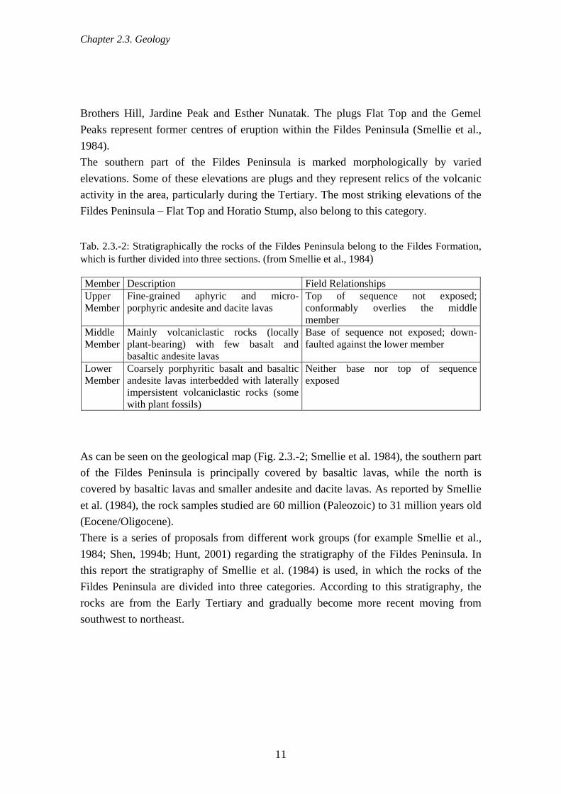
Chapter 2.3. Geology
Brothers Hill, Jardine Peak and Esther Nunatak. The plugs Flat Top and the Gemel Peaks represent former centres of eruption within the Fildes Peninsula (Smellie et al., 1984). The southern part of the Fildes Peninsula is marked morphologically by varied elevations. Some of these elevations are plugs and they represent relics of the volcanic activity in the area, particularly during the Tertiary. The most striking elevations of the Fildes Peninsula – Flat Top and Horatio Stump, also belong to this category.
Tab. 2.3.-2: Stratigraphically the rocks of the Fildes Peninsula belong to the Fildes Formation, which is further divided into three sections. (from Smellie et al., 1984) Member Description Field Relationships Upper Member
Fine-grained aphyric and micro-porphyric andesite and dacite lavas
Top of sequence not exposed; conformably overlies the middle member
Middle Member
Mainly volcaniclastic rocks (locally plant-bearing) with few basalt and basaltic andesite lavas
Base of sequence not exposed; down-faulted against the lower member
Lower Member
Coarsely porphyritic basalt and basaltic andesite lavas interbedded with laterally impersistent volcaniclastic rocks (some with plant fossils)
Neither base nor top of sequence exposed
As can be seen on the geological map (Fig. 2.3.-2; Smellie et al. 1984), the southern part of the Fildes Peninsula is principally covered by basaltic lavas, while the north is covered by basaltic lavas and smaller andesite and dacite lavas. As reported by Smellie et al. (1984), the rock samples studied are 60 million (Paleozoic) to 31 million years old (Eocene/Oligocene). There is a series of proposals from different work groups (for example Smellie et al., 1984; Shen, 1994b; Hunt, 2001) regarding the stratigraphy of the Fildes Peninsula. In this report the stratigraphy of Smellie et al. (1984) is used, in which the rocks of the Fildes Peninsula are divided into three categories. According to this stratigraphy, the rocks are from the Early Tertiary and gradually become more recent moving from southwest to northeast.
11

Chapter 2.3. Geology
Fig. 2.3.-2: Geological map of the Fildes Peninsula (Smellie et al., 1984) 2.3.2. Fossil-rich regions on the Fildes Peninsula In 1966 two particularly fossil-rich areas of the Fildes Peninsula were placed under protection, initially as SPA, later as SSSI and most recently as ASPA. The ASPA No. 125 “Fildes Peninsula” lies within the following co-ordinates
(http://www.cep.aq/apa/aspa/sites/aspa125/summary.html): Northern territory: North: 62°10'50" S; South: 62°11'28" S; East: 58°55'27" W; West: 58°56'38" W Southern territory: North: 62°12'30" S; South: 62°13'30" S; East: 58°57'11" W; West: 58°59'32" W
12

Chapter 2.4. Geomorphology
The designation of the two protected geological areas was justified by finds of unique fossil bird footprints and because of the existence of exposures of representative sequences of Tertiary stratigraphy. Most fossils, however, are remains of wood or plants, embedded in sediments in a variety of ways (cf. also Torres 2001). According to Poole (2005), King George Island has been one of the most important areas for palaeobotanical finds in the Antarctic for more than a century, as the fossil plants there represent the most complete set of terrestrial data in the Antarctic. The fossils are therefore of great significance in understanding the composition and dynamics of a unique palaeological fauna and environment at such a southerly latitude (Poole et al., 2001). 2.4. Geomorphology 2.4.1. Glacier Fildes Peninsula is bordered in the north by an extension of the Collins Glacier. The glacier, 1,250 km² in area, currently covers about 92 % of the surface of King George Island (Braun & Hock, 2004). Under the effects of climate change this glacier too is diminishing in size and melting more and more (Park, et al., 1998; Simoes et al., 1999; Braun & Goßmann, 2002). One of the clearly visible signs of this deglaciation is the melting dead ice detached from the glacier and slowly decaying, which in some places is visible in the moraines that surround the glacier (Fig. 2.4.-1).
Fig. 2.4.-1: Dead ice in the end moraine of the Collins Glacier (photo: Mustafa)
13

Chapter 2.4. Geomorphology
An interesting detail is the fact that black tephra layers can often be seen on ice faces of the Collins Glacier. These originate from the volcanic eruptions on Deception Island at the end of the 1960s (Fig. 2.4.-2).
Fig. 2.4.-2: Tephra bands from the volcanic eruptions of Deception Island are widely distributed in the glaciers of the South Shetland Islands, as here on Nelson Island (photo: Buesser) There are, in addition, a large number of perennial firn banks on the Fildes Peninsula. These are situated in particularly well-shaded areas with a lot of snowfall and snow cover all the year round. However, they show no evidence of flow structures. 2.4.2. Permafrost It was fairly easy to demonstrate the existence of permafrost in the course of field work. The depth to which your boots sink in shows the extent of the summer thaw (active layer). In spite of the relatively high average annual temperature of between -2 and -3°C, there is continuous permafrost present on the Fildes Peninsula (Blümel, 1999). The oceanic, wet, cold summers with little sunshine are put forward as a cause for this. The depth of the summer active layer is from 0.2 to 1.2 m, depending on the local exposure and plant cover. The impermeability of the ground below the surface, due to the permafrost, prevents meltwater and precipitation from flowing into the groundwater. The high water saturation of the active layer that thus results could be detected throughout the research area (Fig. 2.4.-3). However, some of these “swamps” suddenly dry out completely within a few days. It is possible that the permafrost had completely thawed in these places, allowing the blocked water to drain away.
14

Chapter 2.4. Geomorphology
Fig. 2.4.-3: Permafrost obstructs drainage, making a swamp of the active layer (photo: Mustafa)
2.4.3. Freezing and thawing dynamics 2.4.3.1. Cryoturbation Cryoturbation is the movement or sorting of ground material as a consequence of frequent alternation of freezing and thawing (Blümel, 1999). The resulting frost patterning is widespread in the Fildes Region. It takes many forms ranging from stone rings over a meter in diameter to fine-grained patterns of a few tens of millimetres. The steeper the slope the more linear the patterns become, forming stripes of sorted stones or in fine-grain material (Fig. 2.4.-4a & b). The drainage is a decisive factor for the occurrence of frost pattering because the driving force of cryoturbation is the alteration in volume that water undergoes during the freeze-thaw cycle. In water-saturated valleys, therefore, it was possible to find stone rings of large diameter containing particle sizes of a few hundred millimeter. On relatively dry hilltops, however, there are patterns of only a few centimetres extent in fine-grained material. Other factors that might affect freeze-thaw patterning are the distribution of particle sizes in the substrate, freezing frequency, the depth of the active layer, and amplitude of temperature change (Blümel, 1999).
15

Chapter 2.4. Geomorphology
Fig. 2.4.-4a & b: Cryoturbation produces frost patterning of (a) rings on level ground and (b) bands on slopes (photos: Mustafa)
We can only make rough estimates of the time needed for the formation of frost pattern structures. A maximum formation time of 5,500 years is estimated for the large ring formation of large sized blocks such as those found in the immediate foreland of the Collins icecap in the Nordpassage area (Mäusbacher, 1991). At that time, 5,500 years ago, the ice had only just melted from this area, one of the most recently deglaciated parts of the region. Working from this maximum value, the actual formation time could be significantly shorter. It is possible, for example, to detect fine-scale patterning on aggregate material dumped by humans. These patterns must be, at most, 30 - 40 years old because the area has been occupied by humans for no longer than this short time. We also observed that tyre tracks and footprints on some “striped” slopes disappeared after just one winter. Jeong (2006) carried out C14 dating on Fildes, Barton and Weaver Peninsulas and found a positive correlation between the diameters of stone rings and their age. A sample near the glacier gave an age of 1,880 BP1, while two samples taken further south indicated ages of 2,570 and 1,420 BP1. These ages should, however, be seen as minimum values. 2.4.3.2. Solifluction Blümel (1999) described solifluction as the “movement caused by gravity or by freeze-thaw cycles in loose substrate or the products of weathering on surfaces steeper than 2°”. Permafrost is not an essential precondition for solifluction. He distinguished solifluction caused by freezing and thawing, turf-creep solifluction and needle ice solifluction. Freezing and thawing solifluction is a particularly common phenomenon in the Fildes Region, due to its climatic situation (Sec. 2.5.). This is shown by the formation of stone
16

Chapter 2.4. Geomorphology
and rock-flour stripes on a majority of slopes. Solifluction lobes are also widely distributed in the region (Fig. 2.4.-5).
Fig. 2.4.-5: Solifluction lobe on the south slope of Davies Heights (photo: Mustafa)
2.4.4. Weathering 2.4.4.1. Physical weathering The various forms of physical weathering are the most important factors in the erosion and decomposition of stone in the Antarctic. In the study area under research, weathering by frost and insolation are the most important forms. This is because of the high humidity, frequent temperature changes, and frequent freezing and thawing, as well as the high albedo of the mainly dark-coloured rocks. Hydration and salt wedging also contribute to the decomposition of stone. a) Frost wedging Where liquid water can enter cracks in rocks and then later freeze when temperatures fall, the greater volume of the ice (compared to that of water) exerts pressure on the rock. This widens the crack so that yet more water can enter during the next thaw, and the crack is then further widened during the next frost. Ultimately, after numerous repetitions of this cycle, the crack is widened sufficiently for the rock to split at that point (Ahnert, 1996).
17

Chapter 2.4. Geomorphology
The very frequent freezing and thawing in the South Shetland Islands, combined with the particularly high humidity (Sec. 2.5.) lead to very intensive frost weathering. Remains of stone blocks with diameters of up to one meter could thus be found, which had been completely shattered into fragments of around some centimeter so. These pieces lay so closely on top of and next to one another that the original shape and size of the rock could easily be recognised. The fact that these pieces had not moved indicated that the stones must have broken up over a relatively short period of time (Fig. 2.4.-6).
Fig. 2.4.-6: Frost-wedged stone of ~0.6 m diameter (photo: Mustafa) b) Insolation Most rocks do not conduct heat well. Temperature changes at the surface thus travel further into the stone only very slowly. Therefore, if the surface of the rock is strongly heated by the sun (insolation) or cooled, it can lead to considerable stresses within the rock. These stresses cause microscopic fissures in the rock, which gradually lead to the rock shattering. They also provide more places for frost weathering to occur. The intensity of weathering by insolation depends mainly on the frequency of the temperature changes and their magnitude. As the South Shetland Islands are relatively far from the Pole, compared to continental Antarctica, the frequency of temperature changes on the islands is comparatively high. However, the magnitude of the changes is clearly more limited under maritime conditions than on the Antarctic continent. As the
18

Chapter 2.4. Geomorphology
deciding factor with insolation weathering is the rock surface temperature rather than the air temperature, the fact that rocks in the region are overwhelmingly dark in colour means that very big temperature changes can occur rapidly (Blümel, 1999). 2.4.4.2. Chemical weathering Compared with the weathering dynamics in the dry cold of continental Antarctica, a relatively high level of chemical weathering occurs in the maritime Antarctic. The reasons for this contrast are the Peninsula’s “mild oceanic cold climate summer temperatures above zero and high summer humidity due to rain, sleet and fog” (Blümel, 1999), as well as the petrography of the exposed rock. The limited depth of the active layer of the permafrost also means that a lot of water is available. Browning due to the liberation of iron, and conversion to soil by loamification, are the most important chemical weathering processes in the study area. Typical of polar regions is the high degree of cryoturbation mixing of the upper soil. If this ceases, however, the soils can be colonised by vegetation, leading to localised humus accumulation (cf. Barsch et al., 1985; Blümel, 1986, 1999). 2.4.4.3. Biogenic weathering In the maritime climate of the South Shetland Islands lichen are the main agents of biogenic weathering. These are important in the degradation of solid, homogeneous rocks with a smooth surface that resist other forms of weathering. Probably because the lichen produce rhizoids and hyphae, the rock surface is, in the main, weathered hydrolytically. This takes place particularly where there are microscopic fissures, boundaries between different kinds of minerals, fissures or other inhomogeneities. This can gradually create a “lichenogenic” weathered crust a few millimetres thick, made up of mineral fragments, mineral residues and pedogenic iron. Realignments of crystal lattices through hydrolysis and oxidation, and consequent increases in the volume they occupy, is presumably the cause of ‘desquamation‘ by lichens. In this process, where colonised by lichens, stone plates a few millimetres thick bulge and break off as a result of an increase in volume. The newly-formed fracture surfaces are colonised in their turn or, due to their rougher surface and newly-formed structure of fine cracks, present areas susceptible to weathering by frost and sun (Blümel, 1986, 1999). 2.4.5. Coasts The coast of the Fildes Peninsula is made up of a mixture of steep cliffs and bays filled with rock debris and scree (Fig. 2.4.-7). The cliffs are the direct link between the isostatically raised 40 m platform (Barsch & Mäusbacher, 1986) and the sea. The bays
19

Chapter 2.4. Geomorphology
lie mostly at the ends of the valleys cut into the 40 m platform and often contain several successive beach ridges (Sec. 4.4.2.). In particularly sheltered sections, forms characteristic of a graded shore line can be seen. A particularly clear example of this is the nehrung that connects Ardley Island with Fildes at low tide. Along the Drake Passage the existing coast is formed by an active abrasion platform about 1 km wide with near-vertical cliffs and off-shore stacks and islands. Barsch et al. (1985) describe its creation as a “cryogenic, marine formation process” (Fig. 2.4.-7). In some sections of the west coast of the Fildes Peninsula which are exposed to the wind, there is the formation of dunes on the beaches (Fig. 2.4.-8).
Fig. 2.4.-7: The central west coast of the Fildes Peninsula showing cliffs and bays cut into the platform at 40 m. The stacks and skerries offshore indicate the extent of the wave-cut platform (photo: Mustafa).
20
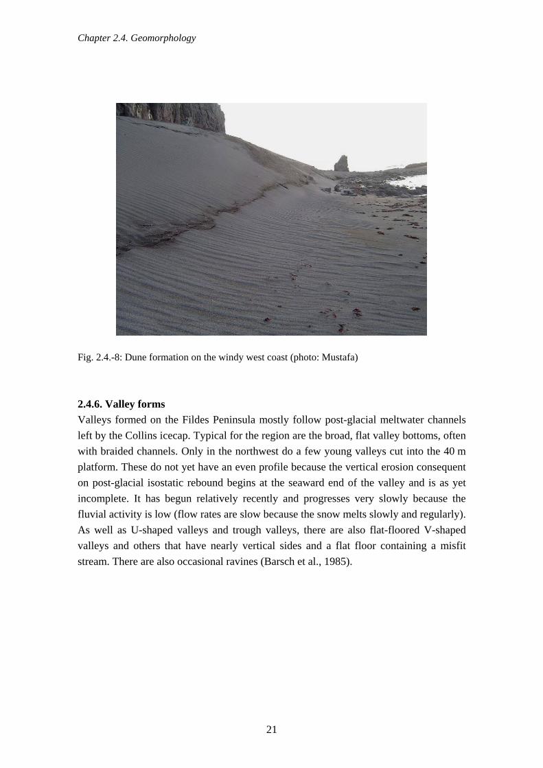
Chapter 2.4. Geomorphology
Fig. 2.4.-8: Dune formation on the windy west coast (photo: Mustafa)
2.4.6. Valley forms Valleys formed on the Fildes Peninsula mostly follow post-glacial meltwater channels left by the Collins icecap. Typical for the region are the broad, flat valley bottoms, often with braided channels. Only in the northwest do a few young valleys cut into the 40 m platform. These do not yet have an even profile because the vertical erosion consequent on post-glacial isostatic rebound begins at the seaward end of the valley and is as yet incomplete. It has begun relatively recently and progresses very slowly because the fluvial activity is low (flow rates are slow because the snow melts slowly and regularly). As well as U-shaped valleys and trough valleys, there are also flat-floored V-shaped valleys and others that have nearly vertical sides and a flat floor containing a misfit stream. There are also occasional ravines (Barsch et al., 1985).
21
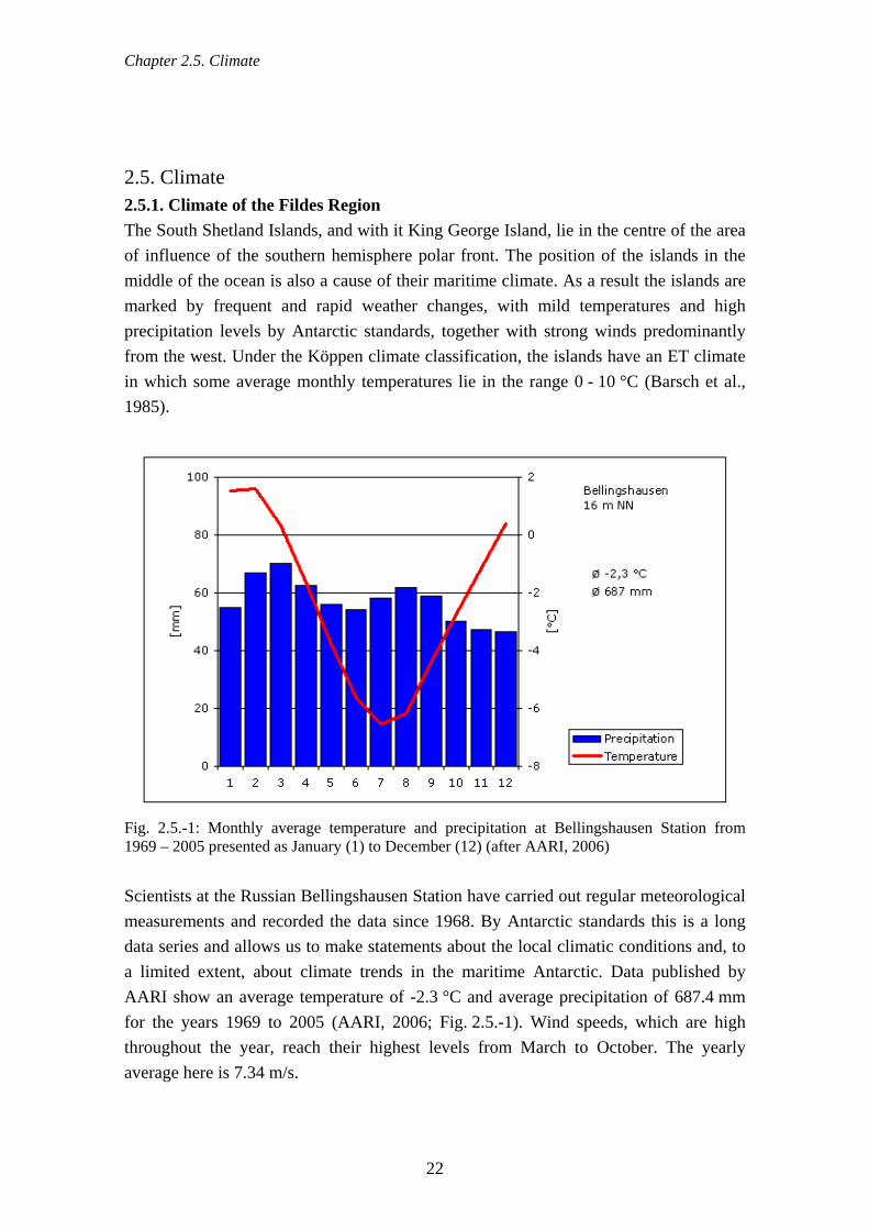
Chapter 2.5. Climate
2.5. Climate 2.5.1. Climate of the Fildes Region The South Shetland Islands, and with it King George Island, lie in the centre of the area of influence of the southern hemisphere polar front. The position of the islands in the middle of the ocean is also a cause of their maritime climate. As a result the islands are marked by frequent and rapid weather changes, with mild temperatures and high precipitation levels by Antarctic standards, together with strong winds predominantly from the west. Under the Köppen climate classification, the islands have an ET climate in which some average monthly temperatures lie in the range 0 - 10 °C (Barsch et al., 1985).
Fig. 2.5.-1: Monthly average temperature and precipitation at Bellingshausen Station from 1969 – 2005 presented as January (1) to December (12) (after AARI, 2006)
Scientists at the Russian Bellingshausen Station have carried out regular meteorological measurements and recorded the data since 1968. By Antarctic standards this is a long data series and allows us to make statements about the local climatic conditions and, to a limited extent, about climate trends in the maritime Antarctic. Data published by AARI show an average temperature of -2.3 °C and average precipitation of 687.4 mm for the years 1969 to 2005 (AARI, 2006; Fig. 2.5.-1). Wind speeds, which are high throughout the year, reach their highest levels from March to October. The yearly average here is 7.34 m/s.
22

Chapter 2.5. Climate
The global climate changes of the last years and decades are expressed at Bellingshausen Station mainly in an increase in air temperature during the summer months (December – February). Turner et al. (2005) thus record a rise of 0.3 ± 0.2 °C for every 10 years over the period 1969 to 2000. 2.5.2. Meteorological conditions during the project field work The weather during field work varied at times markedly from the long-term mean values (Tab. 2.5.-1a-d). Thus the low temperature and precipitation, especially in December, were mainly responsible for long-lasting snow cover during the 2003/04 season. In contrast the 2004/05 season was marked by above-average precipitation. There were strong winds in December and February, whereas January was remarkably calm and cloudy. During the 2005/06 season there was very little cloud and limited precipitation during parts of December and January. Air temperatures in January and February were extraordinarily high by local standards, while wind speeds during the whole season, but especially in January, were very low.
Tab. 2.5.-1a-d: Monthly averages (January, February, December) of selected climatic parameters during the project field work as measured at Bellingshausen station (AARI, 2006) with comparison of these with the long-term mean and extreme values for 1968/69 to 2005/05. Values in blue are higher than the long-term average, those in red are below average, and those in bold lie outside the rms error or the standard deviation.
Year I II XII 2006 2.7 2.4 - 2005 1.3 1.9 0.0 2004 1.1 1.5 0.3 2003 - - -1.3 Mean 1.6 1.6 0.4 Min 0.1 0.3 -1.3 Max 2.8 2.7 1.8 RMS 0.6 0.6 0.6
a: Air temperature [°C]
Year I II XII 2006 35.2 80.0 - 2005 55.5 79.8 23.3 2004 66.4 38.0 67.4 2003 - - 21.8 Mean 54.5 67.2 46.6 Min 13.5 22.7 16.1 Max 133.8 120.1 83.7 RMS 26.1 18.0 16.8
b: Precipitation [mm]
Jahr I II XII 2006 5.3 6.6 - 2005 5.2 8.2 6.4 2004 6.0 5.9 7.4 2003 - - 6.3 Mittel 6.4 6.9 6.6 Min 5.2 5.2 4.2 Max 8.2 8.2 8.8 RMS 0.7 0.7 0.8
c: Wind speed [m/s]
Jahr I II XII 2006 8.3 9.5 - 2005 9.6 8.9 8.8 2004 9.3 9.4 9.1 2003 - - 9.2 Mittel 9.2 9.1 9.2 Min 7.5 7.5 8.5 Max 9.8 9.8 9.8 RMS 0.4 0.5 0.3
d: Clouds[1/10]
23

Chapter 2.6. Water Bodies
2.6. Water bodies 2.6.1. Lakes There are a large number of lakes in the ice-free part of the Fildes Peninsula including Ardley Island. These are only free from ice during the short summer months and are fed principally by flows of meltwater from the snow cover (Fig. 2.6.-1a & b). Some lakes in the northernmost part of Fildes are also fed by meltwater from the Collins Glacier. Rain (Sec. 2.5.) and meltwater from the active layer of the permafrost also contribute to the maintenance of water levels in the lakes. In contrast, groundwater plays only a subordinate role (Flügel, 1990). The lake water levels in the area are highly dynamic on several different time scales. Thus the water levels of the lakes, which are fed to a great extent by meltwater, are controlled as much by the daily rhythms of the weather in the summer months as by the amount of snow during the winter and autumn months or the long-term melting of the glaciers (Barsch et al., 1985).
Fig. 2.6.-1a & b: East side of Kitezh Lake at (a) the beginning and (b) the end of snow melt period (photos: Mustafa) Lakes in glacier forefields are especially dynamic due to the melting of the glacier. Melting ice embedded in moraine material causes water-filled hollows without outflows and kettle holes. Ice-dammed lakes may appear and disappear. These processes are responsible for the fact that slightly different results are produced by different surveys. Thus the SCAR KGIS database (Vogt et al., 2004) records 109 lakes on Fildes Peninsula and four on Ardley Island (Fig. 2.6.-2). However, our own surveys, carried out during the mapping of Parochlus steinenii occurrence (Sec. 4.5.12.), yielded a total of 101 lakes for Fildes and four for Ardley Island. Lake water level is considerably influenced both by the dynamics of the water inflow and the discharge. It is thus at its most stable if there are glaciers or permanent firn
24

Chapter 2.6. Water Bodies
fields in the catchment, and also when there is an outlet that functions as an overflow. A typical example of such a situation is Kitezh Lake in the Central Passage.
Fig. 2.6.-2: Lakes and running water of the Fildes Region according to the SCAR KGIS database
25
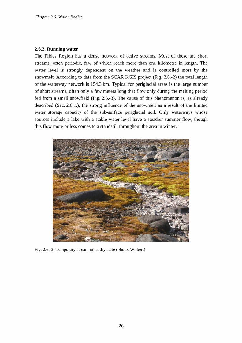
Chapter 2.6. Water Bodies
2.6.2. Running water The Fildes Region has a dense network of active streams. Most of these are short streams, often periodic, few of which reach more than one kilometre in length. The water level is strongly dependent on the weather and is controlled most by the snowmelt. According to data from the SCAR KGIS project (Fig. 2.6.-2) the total length of the waterway network is 154.3 km. Typical for periglacial areas is the large number of short streams, often only a few meters long that flow only during the melting period fed from a small snowfield (Fig. 2.6.-3). The cause of this phenomenon is, as already described (Sec. 2.6.1.), the strong influence of the snowmelt as a result of the limited water storage capacity of the sub-surface periglacial soil. Only waterways whose sources include a lake with a stable water level have a steadier summer flow, though this flow more or less comes to a standstill throughout the area in winter.
Fig. 2.6.-3: Temporary stream in its dry state (photo: Wilbert)
26

Chapter 3.1. Environmental situation - terrestrial
3. Material and methods 3.1. Environmental situation - terrestrial In addition to our own data gathering on the terrestrial environmental situation, we also used data made available to us from various research stations. Where data was gathered in station grounds it was with the permission of the person or persons responsible for the station concerned. 3.1.1. History of the research stations Information on the number of people at the Frei and Escudero stations was obtained in part from available COMNAP information. All other data were obtained by questioning the individual station leaders. 3.1.2. Waste distribution and management The presence of large quantities of human-produced waste is the result of the long history of human presence on the Fildes Peninsula. As this waste is not limited to the immediate surroundings of the stations and the field huts but is also spread widely and can be found in distant areas, we undertook a comprehensive survey of waste in the 2003/04 and 2004/05 field seasons. Only the station grounds themselves were excluded from mapping. All human-produced waste was systematically recorded, from single objects of at least the size of a hand to extensive waste deposits. As well as recording the coordinates using GPS (Garmin 72) and classifying the materials found (metal, wood, plastic, glass, toxic materials, and biodegradable waste), the objects were roughly described. Objects such as batteries, full and empty containers of oil, paint and various chemicals – for example cleaning agents containing chlorine – were classified as toxic materials as they can potentially pollute and damage the surrounding area. In addition, we determined in each case the disposal method (storing, burning, burying), the origin (marine debris, windblown, or from building collapse and dereliction) and, as far as possible, the polluter. The finds were only classified as recent if it was clear that the material had only been in the area for a short time. If we found both old and new objects at a site the new find was rated more highly and that particular site was classified as recent. Several objects found close together were categorised as a single find. Particularly striking, recent or potentially hazardous finds, or those that were already producing local pollution, were photographed. If the spread of waste was found to be too substantial for individual recording, for example when large quantities of waste were spread thickly over an area, this sector was
27
Chapter 3.1. Environmental situation - terrestrial
mapped as a polygon using GPS (Novatel smart antenna™) and classified as a waste-covered area. In the past, waste from stations was normally disposed of at storage areas in the immediate vicinity of the station, using the method that was usual for the time, i.e. dumped, buried or incinerated in the open. During the last decade most waste dumps have been cleared away. In some cases, areas have been covered with soil and levelled. However, there are still clear traces on the surface that bear witness to the historical and, to some extent, current use of the areas for the disposal of waste from stations through storing, burning or burying. In mapping the waste, we strove for a comprehensive description of these areas. All recognisable waste deposits were pinpointed using GPS (Novatel smart antenna™) and classified, which based on questioning of people familiar with the area, reviewing of available photographs, and identifying of waste characteristic of particular stations. However, changes to the earth’s surface due to effects such as naturally occurring cryoturbation of the permafrost or deliberate soil disturbance in order to cover particular areas, can blur previously visible signs of waste disposal. This can occur to such an extent that we cannot claim to have made a complete record of all areas used for waste deposit. All information as to current waste management at stations on the Fildes Peninsula were obtained by questioning well-informed station members, visiting facilities for waste collection and treatment, and observing daily activities. 3.1.3. Discharge of organic material In the 2004/05 season, in order to quantify the terrestrial occurrence of organic material on the Fildes Peninsula, we systematically checked for remnants of human food all the breeding territories of skuas (Catharacta antarctica lonnbergi and C. maccormicki). Similarly, we also checked all accessible nests and feeding areas of Kelp Gulls (Larus dominicanus). This was an extension of our previously completed waste mapping exercise (Sec. 3.1.2.). The mapping was carried out extensively in the research area and included not only current but also older, unused, nests and feeding areas. All finds designated as organic waste, as long as they were at least 20 m apart, were located by GPS and classified according to age and origin. Only obviously fresh anthropogenic food remnants were categorised as recent as it was not possible to determine the age of other remnants. Data from earlier and current studies were included in order to complete the mapping. In these studies, qualitative investigations of skua nutrition, indigestible food remains were collected from nests. Information about skua chicks observed regurgitating
28

Chapter 3.1. Environmental situation - terrestrial
anthropogenic food, was also taken into account. Comparative data from the years 2000/01 to 2002/03 from the surroundings of the Chinese station were made available by the Chinese biologist Zipan Wang. These data included no details about age. In order to show the radius within which organic station waste is spread by skuas and gulls, GPS coordinates were used to calculate the distances from the individual finds to the nearest station. In doing this all stations or parts of stations with their own food supplies or kitchens (Escudero, Marine Station Capuerto, airport hotel) were included separately for skuas, as it is possible for skuas to obtain kitchen waste from these places. 3.1.4. Fuel storage Complementary to various published inspection reports of the Antarctic Treaty Parties (ATCM, 1999a, 2001a, 2005a), we collected information on the fuel storage facilities on the Fildes Peninsula. Details of fuel use by the stations were obtained by asking well-informed station members. 3.1.5. Oil pollution In order to record current contamination of the Fildes Peninsula and Ardley Island by liquid hydrocarbons, all visible traces of oil pollution of the soil or water surface were mapped and located using GPS in all three field seasons. In addition, wherever possible, all recognisable instances of contamination within the stations were recorded. However, as the questionable practice of quickly covering contaminated surfaces with gravel or sand is still very common, the mapping we carried out can in no way present a full picture of the extent of contamination in the area under investigation. For a comprehensive investigation of the extent of oil pollution it would be necessary to analyse soil samples and this would have exceeded the technical and financial resources available. Thus the map is limited to visible contamination. No distinction was made between contamination by diesel, petrol or by lubricants. 3.1.6. Gaseous emissions from diesel generators As no precise information could be obtained about the volumes of gaseous emissions, the quantities of fuel used by the various stations to generate energy were compared with each other. This only allowed a weighting of the volumes of emissions produced by the stations’ diesel generators. 3.1.7. Gaseous emissions from vehicles Information about fuel consumption and exhaust emission by the stations’ own vehicles was not available for every station. For this reason no statement can be made as to the
29
Chapter 3.1. Environmental situation - terrestrial
precise amounts/volumes of gaseous emissions by motor vehicles. A comparison of the volumes of emissions could be made, however, based on the number of vehicles at each station and their frequency of use. 3.1.8. Noise sources Permanent and temporary sources of noise emissions were recorded spatially and categorised according to their frequency. Diesel generators were classified as permanent noise sources and land-, water- and air traffic as temporary sources. Tracked vehicles were used until the snow had melted from the roads and thereafter trucks and four-wheel-drive vehicles were used until the end of the summer season. As roads, paths and flight routes were used with different frequencies, we introduced the categories “rare” and “frequent”. 3.1.9. Land consumption by research stations Data on the buildings of the Fildes Region were assembled from several sources. The basic information was drawn from the SCAR KGIS project database (Vogt et al., 2004). These data were partly ground-truthed during the study. Alterations could be substantiated partly by reference to the stations’ own maps (CACSM, 2005) or from our own survey. The extent of research station grounds was determined on the basis of two criteria. The first of these was the area covered by station buildings and the other the area around the buildings regularly used during station operations. However, it is difficult in some cases to determine boundaries exactly, particularly when parts of the station grounds are currently no longer in use. 3.1.10. Field hut use To obtain current information about the field huts on the Fildes Peninsula and Ardley Island their current condition and usage patterns were examined in depth. This information was supplemented by enquiries to station personnel and scientists, examination of a hut register that was available, internet searches, technical reports by people overwintering, and reports presented at international meetings. All the available information was collated and evaluated. 3.1.11. Road network between the stations, airport and buildings (huts) The pattern of main routes comprising the road network on the Fildes Peninsula was obtained from the database on track distribution (Sec. 3.1.13.). Linear data was digitized from the polygon data on the category “frequent traffic” held in this database. Solely
30

Chapter 3.1. Environmental situation - terrestrial
where sensible mapping of tracks was impossible because of the intensive and varied usage, the main routes were digitized from SCAR KGIS project data for station grounds (Vogt et al., 2004). 3.1.12. Use of road network The usage of the inter-station road network was compiled representatively for a season. From December 2003 until March 2004 all observed motor vehicle movements between stations were recorded. Return journeys were counted as single movements. Wherever possible, the specific purpose of each movement was also recorded. Journeys without known purpose, and a few journeys where the purpose was known but of rare occurrence, were combined under the heading of “various journeys”. Traffic movements between Bellingshausen, Escudero and Frei station that are immediately neighboured and not clearly separated, were not taken into account. They were excluded because they do not involve use of space outside the station grounds. Continuous observation of the entire network was impossible given the restricted resources available. The number of journeys reported is therefore only a minimum value. It nevertheless allows evaluation of road network use on the Fildes Peninsula. 3.1.13. Tracks other than the official road network The positions of trackways were determined using single frequency 12-channel-(D) GPS receivers (Novatel smart antenna™). Trackways frequently have a difficult geometry, in particular by being many kilometres in length but only a few meters wide. It was therefore necessary to maximise the accuracy of the positioning measurements in order to avoid negative area. Differential GPS was therefore used with the corrections made against the German Antarctic Receiving Station O’Higgins (63°19' S, 57°54' W). For field measurements the areas used by vehicles were walked around with a rucksack-mounted GPS. The device recorded its position every second and stored the rawdata as a series of points. The tracks were divided into three categories:
- “Frequent traffic” (heavily used track in more or less daily use) - “Occasional traffic” (clearly used track, repeatedly used) - “Limited traffic” (single tracks, without regular traffic)
Islands of track categories within a delineated area of another category were specifically marked. It was then possible for them to be excised from the larger areas later. This procedure was also applied to islands of the category “no traffic”. In preparation for post-processing, the raw data had to be converted from CMC format into the DGPS-compatible Rinex format using the CMC2RNX software. The post-processing of the raw data with the correction data was carried out with Novatel
31
Chapter 3.1. Environmental situation - terrestrial
SoftSurv software. The coordinates derived for the individual points were imported into ArcGIS and there converted into linear and later to polygonal datsets. Correction for outliers was undertaken manually. Overlapping polygons were removed using geoprocessing (clipping). The track mapping indirectly represents the frequency of vehicle traffic. It has to be recognised, however, that the resistance of the substrate and its regeneration capacity influences the intensity of track marks. Tracks on slopes with strong cryoturbation disappear, for example, orders of magnitude more rapidly than those on moss-covered flat ground. Likewise, traffic on coarse beach material leaves hardly any tracks at all. 3.1.14. Winter use Winter activities on the Fildes Peninsula could not be recorded directly and were therefore obtained by enquiry amongst overwintering station personnel. An overview of land use by motor sleds (e.g. snowmobile type) and tracked vehicles was obtained in collaboration with experienced overwintering personnel. 3.1.15. Air traffic The Fildes Peninsula plays a key role as the logistic centre for the Antarctic because of its geographic position and the opportunities provided by the Chilean airport Teniente Marsh. Also important, in addition to the take off and landing possibilities are the Fildes-based meteorological and rescue services for air traffic around the Antarctic Peninsula and west Antarctica (e.g. Rothera, Patriot Hills). Information from Chilean airport personnel revealed that all aircraft overflying this area at high altitude receive regular radio support from the control tower at Teniente Marsh from personnel of DGAC, the Chilean air traffic authority. All take-offs and landings on Fildes are visual with occasional support from radio and navigation lights. Flight operations are therefore all heavily weather dependent. All additional information relevant to air traffic can be obtained from AFIM (COMNAP, 1991). A systematic survey of all flights over the region was carried out during the course of the study because no information about the intensity of flights in the region was available from the airport control tower. The survey only covered those flights within relevant horizontal or vertical distances of theFildes Region. Particular attention was paid to flights over Ardley Island because of the island’s protected status as ASPA No. 150. As much information as possible was collected for each individual overflight including date, time, route, height, the aircraft, its type, its origin, and whether the flight was a landing or take off. The craft types were categorised as large (large jets,
32

Chapter 3.1. Environmental situation - terrestrial
Hercules C-130) and small (with only one exception, twin-engined airplanes such as Dash-7, Twin Otter). Helicopter types were only distinguished to allow better identification because they were predominantly twin motor types (BO-105, Bell 212, Lynx Mk3). If a suitable observation point was in reach, flight altitudes were measured by Rangefinder GPS combination or were estimated. The flight routes were additionally sketched on a map and later digitized. These data were supplemented by information on the altitude and closeness of flights from scientists working on Ardley Island. The data on overflights from three to the study period preceding seasons made possible a comparison of flight activities during the period 20 December to 20 January over six successive years. These values are however minimum values because the records are derived exclusively from our own observations of flight movements. From our knowledge of the true number of take-offs and landings, it was possible to assess the error caused by unobserved overflights at less than 10 %. The largest proportion of these was occasioned by the very high mobility of helicopters. It is likely therefore that the ship-board helicopters of the “Xuelong” and the “Endurance” are under-represented. This is because their flights occurred largely over the southern part of the Fildes Peninsula and the south coast of Ardley Island and were less visible to the observers. Definite categorisation of flights according to their function and purpose (tourism, freight or personnel transport) was only possible for clearly tourist flights. This was because the majority of the flights carry a certain number of passengers at the same time as freight, according to the capacity of the craft. In contrast to the situation with sea traffic in Maxwell Bay (Sec. 4.2.15.) only limited data on the number of passengers carried by air could be obtained by enquiries locally. The statistics published by the Chilean air traffic authority DGAC were therefore used as the basis for statements on the development of air traffic. Because the data collection periods of the three field seasons were not identical, the following results refer to the periods of 79 days between 10 December and 26 February for which observations were available for all three seasons. This permitted better comparability of the collected data since weather is particularly important at the beginning and the end of the Antarctic summer. In addition to the observers sketching flight lines on the maps they carried with them, highly precise measurements were made by Rangefinder GPS combination (Mustafa et al., 2005). This, together with an applet developed by D. Bertges (Bertges Vermessungstechnik), made it possible to determine the absolute co-ordinates of any object from any convenient viewpoint. It was applied particularly to objects that were
33
Chapter 3.1. Environmental situation - terrestrial
difficult to reach or which were moving (such as ships or aircraft). This system combines a single frequency 12 channel GPS receiver (Novatel smart antenna™) with a laser range finder. The system further contains a digital compass and an inclinometer. In 2003/04 and 2004/05 the laser range finder used was a Leica Vector™ Aero which permits measurements within a range of up to 4,000 m with an accuracy of ± 3 m. In 2005/06 a Vectronix Vector™ 21 was used that has a greater range, up to 10,000 m, with an accuracy of ± 5 m. The absolute position of the observer, as given by GPS, and the relative position of the object, given by the range finder, were combined in a field-hardened pocket computer (Panasonic Toughbook CF-P1). The combination was carried out with an applet for the mapping package ArcPad™ (ESRI) developed during the course of this study or with the data logging software NmeaLog (Bertges Vermessungstechnik). Measurements can be made with this system even when no GPS satellites can be received so long as the coordinates of the observer’s position are known. This system can make measurements at four-second intervals. However, its effective range is dependent on visibility. Snow, rain, or fog greatly reduce the range or even prevent measurements entirely. 3.1.16. Ship and boat traffic In view of the particular logistical significance of the Fildes Peninsula, Maxwell Bay is very often a stopping place for all kinds of ships. The aim of observing shipping in the area of the bay relevant to the Fildes Peninsula was to make an exact record of all shipping movements. The area that we observed corresponds to the part of Maxwell Bay that lies in front of the research stations King Sejong (South Korea), Artigas (Uruguay), Bellingshausen (Russia), Frei (Chile) and Great Wall (China). The Chilean naval station Capuerto routinely collects data on ship arrivals. As these data differed by up to 40 % from our own observations, as far as the number of ships was concerned, we made our own independent records. In addition to arrival and departure times we obtained information, as far as was possible, on the reason for each ship’s presence, the numbers of crew members and tourists, etc. To gain an impression of the spatial use of Maxwell Bay by ships, the ship anchorages or other stopping places were precisely located with the aid of Rangefinder GPS combination. As part of our records, we categorised the types of ships according to each ship’s primary purpose in the Antarctic. This primary function can, however, contradict the actual reason for a ship visiting Maxwell Bay. This is because the majority of ships that arrive there have a number of different purposes, such as bringing supplies to stations, transporting people and materials, research tasks, and landing or picking up tourists. As
34

Chapter 3.1. Environmental situation - terrestrial
an example, some cruise ships provide support for the transport of scientists or of supplies to stations and are then even chartered for these purposes by national Antarctic programmes (e.g. ATCM, 2004a). Supply ships also carry out research tasks and research ships supply tasks, while others offer tourists the possibility of travelling on them as a way of providing the national programme with financial support. The information provided by the operator of each ship was therefore decisive for a correct classification of the ships. In addition, various sources were used (e.g. COMNAP, IAATO) to obtain information on the ice-classes of ships or any strengthening they had undergone in order to operate in ice as this represents an important safety factor. As a rule there is a lack of reliable information from national operators on the number of ships operating in the Antarctic. We thus chose, as an example, the cruise ship type, very often present in the region, in order to show the possible trend of numbers operating in the Antarctic Peninsula region. To this end we drew on statistics published by IAATO for the years 1996/97 to 2006/07 (http://www.iaato.org; ATCM 2007a). Motor and other yachts were not included as during the period of observation these vessels were recorded with greatly varying accuracy. These data were supplemented by ships that we observed ourselves that did not appear in the statistics. As well as ships, landing boats belonging to stations or to ships are also active in Maxwell Bay. These operate irregularly and are overwhelmingly used to transport large loads, rarely to transport people. These trips were also recorded. A further specific category are ships boats, known as SMBs (survey motor boats), belonging to the British research ship “HMS Endurance”, which were used for scientific purposes in 2004/05 and 2005/06. Inflatable boats of the zodiac type or of similar construction are frequently used for short journeys at sea. They are used to transport people and small amounts of freight between stations and ships, or to take scientists to their workplaces in the region. Zodiacs are also occasionally used for outings by station staff, for example to go fishing. To simplify matters the name “zodiac” will be used below to include boats of similar type. The use of these inflatable boats within the relevant area of Maxwell Bay was recorded as far as was possible. The use of zodiacs and who the people were who were operating them could usually be discovered through observation and by enquiry. In order to be able to compare the summer ship and zodiac traffic in Maxwell Bay, even though the recording periods differed between the three field seasons, the results given refer to the period between 10 December and 26 February, in which observations were made in all three seasons.
35

Chapter 3.2. Environmental situation - coastal
3.1.17. Construction of the Russian church The construction of a church in the grounds of the Russian station Bellingshausen (ATCM, 2004b) was observed and documented from the beginning. Additional information was obtained by questioning station members. We decided not to make a separate GPS mapping of the areas affected by the construction work as these areas were mainly in the station grounds or immediately adjacent to it and it was also an area of land that was strongly degraded by waste disposal and vehicle tracks. This contamination had already been recorded during the mapping of waste dumping/storing sites (Secs. 4.2.2. & 4.2.12.). 3.1.18. Construction of the airport extension Before building work started on the extension to the airport, to create a parking area for aircraft, we evaluated all information published by the Chilean authority responsible, the “Comisión Nacional del Medio Ambiente” (CONAMA), dealing with the approval process (http://www.e-seia.cl/portal/busquedas/antarticos.php). The basis for this was the Initial Environmental Evaluation prepared for this project by the applicants, the “Dirección Regional de Aeropuertos (DAP), XII Región de Magallanes y Antártica Chilena” and “Ministerio de Obras Públicas (MOP)”. After completion of all construction work except that on the airport, all areas affected by machinery were mapped. The areas were positioned using GPS (Novatel smart antenna™) and the data model “Polygon” (see above). The boundaries of such areas were judged by eye when topographical reasons (such as particularly steep slopes) prevented GPS mapping. This method was resorted to only rare occasions however. In addition to the survey of the area affected, it was also noted whether the damage was the result of the removal, filling, or moving of material. Also evaluated was the depth or the height of the previous ground surface. Anything else noticed was also recorded, such as the storing of scrap or damage to vegetation. Included in this survey were only those large areas clearly affected by construction. Not included were the numerous small trenches and fillings arising from probing in large parts of the area. 3.2. Environmental situation - coastal 3.2.1. Waste water discharge into Maxwell Bay Waste water produced from research stations is, in all cases, discharged into the sea. There are differences between the stations in the amount of waste water produced as well as in the apparent degree of pollution of the water. The pollution differences reflect the differences between stations in the technical standards of waste water management.
36
Chapter 3.4. Fauna and Flora
The amount of waste water discharged to Maxwell Bay was not quantified during this study but can be derived approximately by consideration of the amount of water used. The daily use of water per person in the stations was estimated based on the water use reported by the station leaders or other qualified personnel together with the number of people working in the stations (Sec. 4.1.1.). The changes in the number of station personnel between the four summer months and the eight winter months were taken into account. 3.2.2. Mapping waste on the shores of Maxwell Bay and Drake coast A separate examination of the waste along the coast of Maxwell Bay and of the Drake Coast was not carried out because all accessible parts had already been included in the mapping of anthropogenic waste (Secs. 3.1.2. & 4.2.2.). Nevertheless, the country or region of origin of the waste was assessed on the basis of any discernible writing on it and this origin recorded. Exact quantification of the amount of waste was beyond the capacities of this study. The mapping was supplemented by observations along the coast and enquiries relevant to this area. 3.2.3. Gaseous emissions from research station boats and zodiacs The gaseous emissions or exhaust production by research station boats and zodiacs could not be assessed because fuel use is not quantified in all stations. The frequency of boat use was therefore taken as a basis for comparison. The number and engine capacities of the craft at each station are given in complementation. 3.3. Geology 3.3.1. Palaeontology The palaeontological investigations of the project were carried out during the 2003/04 summer season. The entire region was searched for locations where fossils could be found. A particular focus were already known and well examined locations drawn from existing studies (Shen, 1994a, b; Hunt, 2001). No samples were taken directly from the outcrops. All the samples collected were loose rocks that had been redeposited from their original location. The distances between the outcrop and the find were very varied and ranged from less than a meter to distances that were impossible to determine. The individual localities were fixed by GPS (Garmin 72).
37
Chapter 3.4. Fauna and Flora
3.3.2. Lakes Indirect information was used to judge the possible threats to lakes. The clear presence, for example, of an oil film or waste on, or in, the water was taken as an indication of pollution. Quantitative statements were therefore not possible on the level of pollution risk or of contamination. The SCAR KGIS project database provided geometric base data for the survey (Vogt et al., 2004). We produced our own database of the positions of the various lakes during the 2004/05 season. The lakes were categorised on the basis of their shoreline morphology, the occurrence of vegetation, and of cyanobacterial mats at the water’s edge. The categories were; periodic lakes, perennial lakes, or perennial lakes with highly variable water levels (Hahn & Reinhardt, 2006). The differences between the SCAR KGIS data and our own reflect the dynamic nature of periglacial regions. The snow melt and active layer dynamics of these areas are likely to produce a large number of periodic and changeable lakes. The locations of water extraction points were determined by asking members of the research stations concerned. 3.4. Fauna and flora 3.4.1. Breeding and visiting birds In each of the three field seasons the breeding birds of the Fildes Region were comprehensively and systematically mapped with the help of GPS (Garmin 72). In parallel, all sightings and finds of visiting, transient and potentially breeding birds were collected and mapped. The mapping and checks extended over almost the whole of the summer season because the beginning and duration of breeding are very different depending on species. The survey was carried out on single nests (skuas: Catharacta antarctica lonnbergi, Catharacta maccormicki, C. a. lonnbergi x C. maccormicki: in collaboration with M. Ritz, A. Froehlich (2003/04 – 2005/06), Z. Wang (2003/04) and I. Chupin (2004/05); Snowy Sheathbill Chionis alba), those breeding in colonies (Southern Giant Petrel - Macronectes giganteus, Cape Petrel - Daption capense) or those that breeding both singly and in colonies (Antarctic Tern - Sterna vittata and Kelp Gull - Larus dominicanus: in collaboration with I. Chupin (2004/05)). In order not to disturb excessively colonies of Antarctic Terns or of Kelp Gulls, a detailed search for nests was avoided. The minimal number of nests was therefore derived from the number of adult birds that attacked or that gave warning calls. Because of the very frequent nest loss and changes of breeding place specific to Antarctic Tern (cf. Kaiser et al., 1988) the survey
38

Chapter 3.4. Fauna and Flora
of breeding places lasted the whole of the summer season. It is therefore not possible to derive the exact breeding population of the Fildes Region from the number of breeding pairs reported. Apart from this, the breeding success (number of surviving chicks/number of breeding pairs) was also determined for both skua species and mixed pairs, the Southern Giant Petrel, and for the penguins (Pygoscelis spp.) on Ardley Island.
Fig. 3.4.-1: GPS mapping of Gentoo Penguin nesting aggregations on Ardley Island (photo: Buesser) There are long-term data available for the penguins on Ardley Island (Peter et al., 2006). During the last three years the number of breeding pairs (in December) and the number of chicks in creches (end of January to February) has been assessed annually partly in collaboration with Chilean scientists. The colony on Ardley Island was therefore subdivided into distinguishable groups that were then precisely mapped using GPS (Novatel smart antenna™, Fig. 3.4.-1). The number of occupied nests (= number of breeding pairs) was then counted. For comparative purposes, previously unanalysed aerial photos and hand-drawn sketches from the 1980s were drawn upon (Mustafa et al., 2005). Additional data are also available on the number of breeding pairs for the small penguin colonies on the Drake Passage coast of Fildes Peninsula. Particular attention was dedicated to the population of storm petrels (Wilson’s Storm Petrel Oceanites oceanicus and Black-bellied Storm Petrel Fregetta tropica) because
39

Chapter 3.4. Fauna and Flora
these species were adversely affected by the extension of the airport. Only a rough assessment of the breeding population of these species was previously available. The particular nesting habits of these storm petrels, which occur sympatrically in the region required a greater effort to map their breeding places since these species breed in natural cavities, preferably under stones in scree slopes or in small cracks in cliffs (Roberts, 1940). To avoid the severe predation by skuas in the region (Hahn & Quillfeldt, 1998) during the breeding season from December to March, these species return to their breeding colonies only after dusk. Then, in or at the burrows, and only there, they call their partners in a characteristic way or else vocally defend their occupied burrows (Beck & Brown, 1972). Calling is therefore highest at the beginning of the breeding period (Hahn, 2000) even though, in contrast, Storm Petrels are usually silent in flight (Warham, 1990). The secretive life of these storm petrels leads to great difficulty in detecting their nests. Therefore, the nocturnal calls of these birds were used as a certain sign of breeding and a means of locating their nest burrows. We wanted to obtain the most exact information about storm petrel distribution on the Fildes Peninsula and Ardley Island. We therefore systematically surveyed the entire study area at night. The nest locations were detected under suitable weather conditions just after twilight. On calm, quiet nights the storm petrel calls could easily be exactly localised and, because of their species specific characteristics (Bretagnolle, 1989; Bretagnolle & Robisson, 1991), easily assigned to the correct species. Surveying was carried out on a total of 24 nights between 23:00 and 03:00 in December, January and February during the study period. The advantage of the night survey using the nocturnal calls was that the birds were not disturbed at their nests. storm petrels are known to be relatively sensitive to disturbance to which they can react by desertion and by abandoning their brood (Warham, 1990). Detection of the birds during the day (e.g. from calls from the breeding burrow, or noting repeated approach flights towards the same place) is unusual because of heavy predation by skuas. These signs were therefore only used as a supplement to the results of the nocturnal survey. Because of the large size of the research area, the considerable dependence of the survey on the weather conditions and on the tides in some cases, as well as on safety grounds, many areas could not be surveyed more than once. Consequently, the exact numbers of breeding pairs could not be determined and they were consequently evaluated by categories chosen as follows:
< 10; 10 – 100; > 100 breeding pairs (BP)
40

Chapter 3.4. Fauna and Flora
Small, easily delimited areas marked by calling by lone breeders were localised as single points with GPS (Garmin 72). Larger breeding colonies were drawn on maps and later digitalised as polygons with the help of the ArcGIS program. Some poorly accessible or inaccessible coast sections, as well as the offshore islands of Diomedea, Geologists, Dart, and Two Summit could not be surveyed by night. The islands, on the basis of our knowledge of the habitat structure, certainly provide breeding sites for storm petrels. This was substantiated by observations carried out during the day. The number of breeding pairs in these areas was therefore estimated on the basis of the local habitat type and the experience gained during the Fildes Peninsula survey. 3.4.2 Seal populations Monthly counts of seals were carried out during all three field seasons along the entire coast of the Fildes Peninsula and Ardley Island. Whenever possible, the entire coastline was checked on a single day (for counting schedules Sec. 4.5.11.). The basis of the counts was the existing division of the coast into clearly differentiated bays in a way that facilitated counts. The same scheme was also used in the 1980s by GDR scientists (Fig. 3.4.-2). In the 2004/05 season the counts were undertaken with the co-operation of the Russian biologist I. Chupin who also provided his counts from March 2005. In addition, counts by A. Froehlich took place every 14 days between April and October during the winter of 2006.
41

Chapter 3.4. Fauna and Flora
Fig. 3.4.-2: Numbering of the bays on Fildes Peninsula and Ardley Island as the basis for seal counts In addition to the counts, and in order to cover sections along the Fildes Peninsula and Ardley Island coasts that are sensitive to disturbance, all groups of > 10 resting Elephant Seals (Mirounga leonina) were mapped with the help of GPS (Fig. 3.4.-3). We paid particular attention to the pupping beaches. Only the Antarctic Fur Seals (Arctocephalus gazella) pup in summer (December). However, the Weddell Seals
42

Chapter 3.4. Fauna and Flora
(Leptonychotes weddelli) and Leopard Seals (Hydrurga leptonyx) pup in September and October and the Southern Elephant Seals in October, i.e. not during our stay in the Region. Therefore, apart from occasional observations of young Fur Seals during the summer seal counts, our examination of pupping places depends predominantly on the support of overwintering research station personnel or scientists (A. Petrov, O. Sakharov, A. Froehlich). Only the highest numbers of pups of each species noted in repeated visits to bays during the breeding season were taken note of. These figures were included in the geographic presentation as totals for the three years.
Fig. 3.4.-3: Mapping a group of Elephant Seals using GPS (photo: Nordt) 3.4.3. Vegetation survey The vegetation survey was carried out during the 2004/05 and 2005/06 seasons although it was started only after the snow had thawed over large areas. Initially the whole study area was traversed in order to choose a suitable classification scheme for the vegetation. No single standard procedure for vegetation surveys in the Antarctic was found in a preparatory search of the literature. Therefore we recorded the main species or the genera of mosses and lichens. Because it was impossible to identify species precisely on site without involving experts therefore categorisation was carried out along the lines of the dominant species system of Ochyra (1998) and Lindsay (1971) (Tab. 3.4.-1).
43

Chapter 3.4. Fauna and Flora
Tab. 3.4.-1 Classification of the vegetation of the Fildes Region by using the plant sociology scheme of “subformations” with subsidiary “associations” and “sociations” following Ochyra (1998) and Lindsay (1971) Subformation Association Sociation 1 flowering plants A Deschampsia antarctica
2 crustose lichens A Caloplaca - Xanthoria sp. A1 with many mosses B Placopsis contortuplicata C Turgidosculum complicatulum D Rhizocarpon geographicum 3 foliose lichens
and cushion mosses
A Andreaea - Usnea sp. A1 Usnea sp.
A2 Usnea sp. + Himantormia sp. A3 Andreaea sp. A4 Andreaea sp. + Ochrolechia
frigida A5 Himantoria sp.
A6 Usnea sp. + various other
species B Polytrichastrum alpinum C Andreaea, Psoroma sp. D Conostomum magellanicum E Turgidosculum complicatulum +
crustose lichens
4 Peat-forming mosses
A Chorisodontium aciphyllum A1 Chorisodontium aciphyllum
- Polytrichastrum alpinum A2 both A3 Polytrichastrum alpinum A4 Chorisodontium aciphyllum
+ Sanionia sp. 5 Moss carpet A Warnstorfia, Brachythecium A1 scree with crustose lichens
(+ Andreaea) standing B Sanionia sp. B1 scree with crustose lichens
(+ Andreaea) Sanionia sp. B2 + 3c C Syntrichia princeps
6 Cushion mosses A Sanionia sp. A1 scree with crustose lichens (+ Andreaea)
flowing B Bryum sp. B1 scree with crustose lichens (+ Andreaea)
C Syntrichia sp. C1 scree with crustose lichens (+ Andreaea)
D Warnstorfia, Brachythecium D1 scree with crustose lichens (+ Andreaea)
7 Algae A Prasiola crispa
44

Chapter 3.4. Fauna and Flora
Photographic documentation of the vegetation classification is given in Appendix 2. It was particularly difficult to identify the dominant species of mosses and lichens when they occurred in species mixtures or when identification of a species was not possible in the field. In such cases, samples were taken (in total 55 mixed species samples) and these were identified by experts (see Appendix 3). The Russian lichen expert Mikhail Andreev identified some of the samples on site. Because the study site was so large, it required a simple, rapid, but still relatively exact survey method. A minimum size limit was therefore imposed of 10 m2 for single patches or of several patches close together (< 5 m apart). The individual vegetation patches were recorded with GPS-12-channel/L1 receivers (Novatel smart antenna™) connected, for data storage, to a Panasonic Handheld Toughbook CF-P1. The data logging software ESRI ArcPad facilitated the conversion of the measurement data into the ESRI format used for the project. Even so, some limited incompatibilities were encountered between these applications from the same manufacturers. These predominantly related to the transfer of attributes. The data model “Polygon” was applied to ensure an adequate presentation of the vegetation units. The following attributes were defined: serial number, main genus, subformation, association, cover, and sample number, photograph number. A note field was also included predominantly to hold other genera and species, but also additional notes. The specific measurements were made by walking around the patches with a GPS receiver. Only very exceptionally was the mapping carried out visually and was the case only if the vegetation would be otherwise severely damaged or if the patch edges were inaccessible because of their position (e.g. exposed steep slopes). Survey work was initially carried out with this method. It was therefore not possible to estimate in advance how long it would take to cover the entire study area. Ardley Island and the most heavily used areas were surveyed, therefore, so as to capture the complete range of plant cover and disturbance severity (Fig. 3.4.-4):
− Uruguayan research station Artigas and eastwards to Nebles Point − Area around the Russian research station Bellingshausen as far as the station’s
diesel tanks (~1.5 km north of the station itself) − Chilean airport and its surroundings − West coast southward of the airport as far as Flat Top − Chilean research stations Frei and Escudero and southwards as far as the
Chinese station − Chinese research station Great Wall as far as Half Three Point.
45
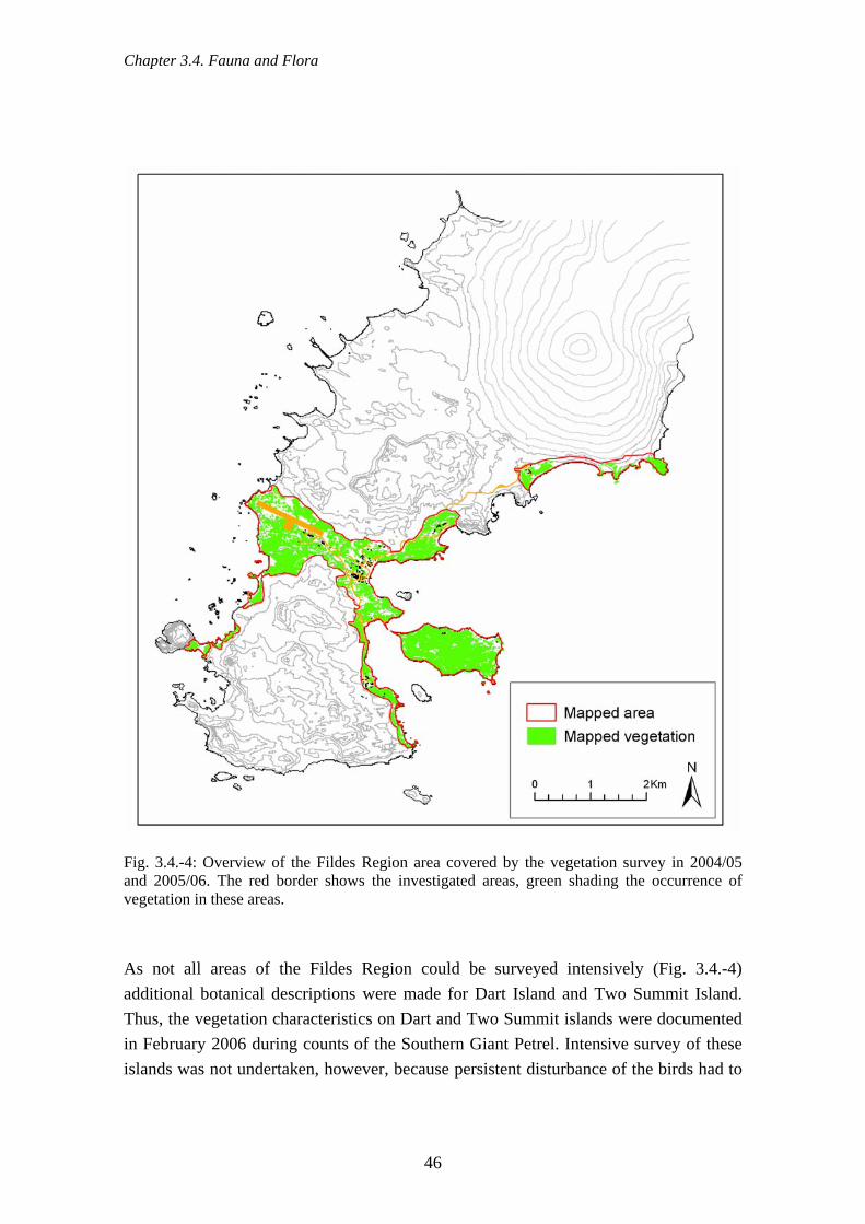
Chapter 3.4. Fauna and Flora
Fig. 3.4.-4: Overview of the Fildes Region area covered by the vegetation survey in 2004/05 and 2005/06. The red border shows the investigated areas, green shading the occurrence of vegetation in these areas. As not all areas of the Fildes Region could be surveyed intensively (Fig. 3.4.-4) additional botanical descriptions were made for Dart Island and Two Summit Island. Thus, the vegetation characteristics on Dart and Two Summit islands were documented in February 2006 during counts of the Southern Giant Petrel. Intensive survey of these islands was not undertaken, however, because persistent disturbance of the birds had to
46

Chapter 3.5. Tourist activities
be avoided. Furthermore, long stays on the islands were prevented because of the poor weather conditions prevailing at that time. Dart and Two Summit are situated in the Fildes Strait south of the Fildes Peninsula (62°14´ S, 59°01´ W and 62°14´ S, 58°57´ W; Fig. 4.5.-47). Deschampsia antarctica was additionally surveyed in some parts of the research area. The size of each colony, defined as an isolated clump or patch of the grass, was assigned to one of five categories (< 0.01 m2; 0.1 m2; 1 m2; 10 m2; > 100 m2). A full species catalogue was drawn up for the flowering plants, lichens, mosses and liverworts by searching the literature and by enquiries to herbaria (see Appendix 1). 3.5. Tourist activities 3.5.1. Use of space by visitors In order to determine space use by visitors we processed a visitor index (bi) on the basis of the data we had collected. The study area was divided into a raster grid of 500 x 500 m cells. We documented the number of visitors (z) and the number of visits (e) for each cell for the entire study area. Studies on the influence of the visitor group size and frequency of visits on the strength of animal reactions have shown the importance of both these variables (e.g. Burger et al., 1995; Carney & Sydeman, 1999; Birke 2002; Beale, 2005). The aim was therefore to develop an index for tourist activity that gave equal weight to both variables. This was achieved by introducing a weighting factor (k) derived as the quotient of the arithmetic average of both variables (1). The following formula was thus applied to each raster cell under ESRI ArcGIS:
ezk = (1)
ekzbi += (2)
bi = visitor index e = total number of visits z = total number of visitors k = weighting factor Because human activities are concentrated in the vicinity of the research stations it was often difficult to separate clearly visitor activity from station operations. Nevertheless, the distribution of visitors reflects in essentials the observed pattern of pedestrian use of the trackways (with the exception of scientists) despite the incompleteness and the slight under-representation of distant areas. However, there were no complete data available to us on the length of stay in the sites concerned or on what exactly the visitors did there.
47

Chapter 3.6. Opinion survey to station members
3.6. Opinion survey to station members An anonymous enquiry among research station members (personnel and scientists) of all the states represented on the Fildes Peninsula was undertaken during the three field seasons. The enquiry was designed to discover the knowledge station members had of environmental topics, their recreational behaviour, and their attitudes to a range of guidelines and measures for the protection of the flora and fauna. A questionnaire was developed (see Appendix 4), translated into Chinese, English, German, Russian and Spanish, and distributed. Distribution was undertaken by station leaders, a procedure that meant that station members could not query any question directly with its originators. It is therefore not surprising that in 79 of the 216 questionnaires returned one or more questions were answered incompletely or not at all. Two variables were compared in contingency tables (likelihood ratio chi-squared test for categorical data). In order to carry out a trend analysis of the questions on personal attitudes the categories “strongly disagree” and “disagree” were combined, as were “strongly agree” and “agree”. These values were then tested by the chi-squared test against the values expected under the null hypothesis of no trend of 50 % disagree and 50 % agree.
48

Chapter 3.7. Risk analysis
3.7. Risk analysis An index was constructed to illustrate the spatial distribution of potential conflicts between visitors and the local fauna. This index was composed of the visitor index (Sec. 3.5.) and a faunal index and evaluates the potential conflict between visitors on foot and wildlife. The faunal index was derived by considering together the bird breeding localities, seal pupping, and seal haul outs determined during the three field seasons. The numbers of breeding pairs of birds, young seals born the previous summer, and resting seals, for each species and season were assigned to raster cells (Sec. 2.2.6.). To accommodate the high intra-seasonal variation in the numbers of individuals using seal haul-outs, the maximum values were used for each bay and each season. The raster dataset for each species was then averaged over the three seasons and weighted to reflect breeding and protection status (Tab. 3.7.-1). Summing the resulting data produced the faunal index (fi) (3):
∑=
⋅=y
xxx npfi
1)( (3)
fi = faunal index p = weighting factor (0.5 – resting location, 1 – breeding or pupping ground, 2 – protected breeding bird) n = number of breeding, pupping, and resting locations averaged over season x = species y = species numbers We developed an index of conflict potential in order to carry out a spatial analysis of the potential effects of visitor traffic on the fauna of the Fildes Region. The conflict potential kp (4) is then derived as the product of the faunal (3) and the visitor (2) indices.
bifikp ⋅= (4)
kp = conflict potential
49
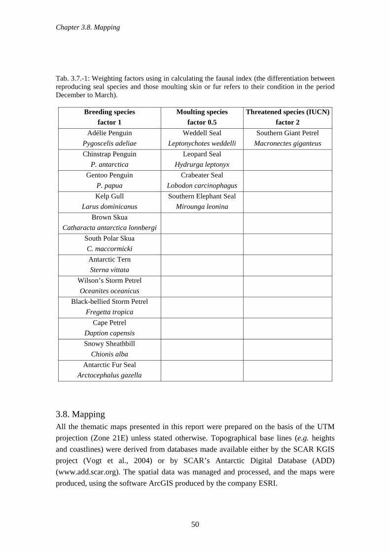
Chapter 3.8. Mapping
Tab. 3.7.-1: Weighting factors using in calculating the faunal index (the differentiation between reproducing seal species and those moulting skin or fur refers to their condition in the period December to March).
Breeding species factor 1
Moulting species factor 0.5
Threatened species (IUCN)factor 2
Adélie Penguin Pygoscelis adeliae
Weddell Seal Leptonychotes weddelli
Southern Giant Petrel Macronectes giganteus
Chinstrap Penguin P. antarctica
Leopard Seal Hydrurga leptonyx
Gentoo Penguin P. papua
Crabeater Seal Lobodon carcinophagus
Kelp Gull Larus dominicanus
Southern Elephant Seal Mirounga leonina
Brown Skua Catharacta antarctica lonnbergi
South Polar Skua C. maccormicki
Antarctic Tern Sterna vittata
Wilson’s Storm Petrel Oceanites oceanicus
Black-bellied Storm Petrel Fregetta tropica
Cape Petrel Daption capensis
Snowy Sheathbill Chionis alba
Antarctic Fur Seal Arctocephalus gazella
3.8. Mapping All the thematic maps presented in this report were prepared on the basis of the UTM projection (Zone 21E) unless stated otherwise. Topographical base lines (e.g. heights and coastlines) were derived from databases made available either by the SCAR KGIS project (Vogt et al., 2004) or by SCAR’s Antarctic Digital Database (ADD) (www.add.scar.org). The spatial data was managed and processed, and the maps were produced, using the software ArcGIS produced by the company ESRI.
50

Chapter 4.1. History of research stations
4. Results and discussion 4.1. History of research stations 4.1.1. Research stations on King George Island King George Island belongs to the South Shetland Islands and lies on the northwestern side of the Antarctic Peninsula (~1,200 km south of the southern tip of South America). Because a large proportion of it is free of ice, it has the greatest density of research stations in the Antarctic (Tab. 4.1.-1; Fig. 4.1.-1). The Chilean airport in the southwest of the island is the logistics centre for the transport of goods and people. In addition to local land and helicopter traffic between them, the stations are also supplied by ships discharging on the south side of the island and most frequently in Admiralty Bay and Maxwell Bay. Tab. 4.1.-1: Research stations on King George Island (source: http://www.comnap.aq/facilities) Nation Name of station Situated Operational
since Type
Argentina Jubany Potter Peninsula 62°14.27' S, 058°39.87' W
1982 year round
Arg/D/Nl Dallmann Potter Peninsula 62°14.27' S 058°39.87' W
1994 seasonal
Brazil Comandante Ferraz Keller Peninsula 62°05.00' S 058°23.47' W
1984 year round
Chile Escudero Fildes Peninsula 62°12.07' S 058°57.75' W
1994 year round
Chile Frei Fildes Peninsula 62°12.00' S 058°57.85' W
1969 year round
China Great Wall Fildes Peninsula 62°12.98' S 058°57.73' W
1985 year round
Korea King Sejong Barton Peninsula 62°13.40' S 058°47.35' W
1988 year round
Peru Machu Picchu Crepín Point 62°05.49' S 058°28.27' W
1989 seasonal
Poland Arctowski Arctowski Cove 62°09.57' S 058°28.25' W
1977 year round
Russia Bellingshausen Fildes Peninsula 62°11.78' S 058°57.65' W
1968 year round
Uruguay Artigas Fildes Peninsula 62°11.07'S 058°54.15'W
1984 year round
51
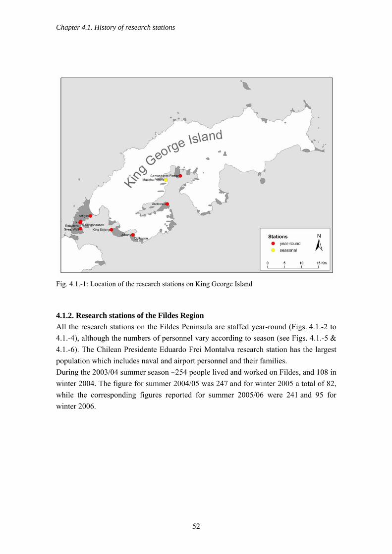
Chapter 4.1. History of research stations
Fig. 4.1.-1: Location of the research stations on King George Island 4.1.2. Research stations of the Fildes Region All the research stations on the Fildes Peninsula are staffed year-round (Figs. 4.1.-2 to 4.1.-4), although the numbers of personnel vary according to season (see Figs. 4.1.-5 & 4.1.-6). The Chilean Presidente Eduardo Frei Montalva research station has the largest population which includes naval and airport personnel and their families. During the 2003/04 summer season ~254 people lived and worked on Fildes, and 108 in winter 2004. The figure for summer 2004/05 was 247 and for winter 2005 a total of 82, while the corresponding figures reported for summer 2005/06 were 241 and 95 for winter 2006.
52

Chapter 4.1. History of research stations
Fig. 4.1.-2: Chinese station Great Wall in the southern Fildes Peninsula (photo: Buesser)
Fig. 4.1.-3: Chilean stations Frei and Escudero in foreground (in part) with Russian station Bellingshausen behind (photo: Buesser)
53
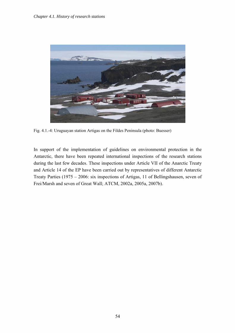
Chapter 4.1. History of research stations
Fig. 4.1.-4: Uruguayan station Artigas on the Fildes Peninsula (photo: Buesser) In support of the implementation of guidelines on environmental protection in the Antarctic, there have been repeated international inspections of the research stations during the last few decades. These inspections under Article VII of the Anarctic Treaty and Article 14 of the EP have been carried out by representatives of different Antarctic Treaty Parties (1975 – 2006: six inspections of Artigas, 11 of Bellingshausen, seven of Frei/Marsh and seven of Great Wall; ATCM, 2002a, 2005a, 2007b).
54

Chapter 4.1. History of research stations
Fig. 4.1.-5: Overview of research stations and field huts of the Fildes Region
55

Chapter 4.2. Environmental situation - terrestrial
Station
Artigas (U
ruguay)
Bellingshausen (R
ussia)
Great Wall S
tation (China)
Prof. J. E
scudero (C
hile)
Pres. E. Frei M
ontalva (C
hile)
Pop
ulat
ion
0
20
40
60
80
100
120
140
160
180summer 03/04 winter 04 summer 04/05 winter 05 summer 05/06 winter 06
Fig. 4.1.-6: Numbers of people working in the research stations on Fildes Peninsula 4.2. Environmental situation - terrestrial 4.2.1. Old waste dumps and storage areas During the waste survey 42 areas of diverse size, totalling 40,525 m2, were detected on the Fildes Peninsula and Ardley Island, where waste was disposed of. Waste was disposed of by dumping or storing (in ~95 % of the total area), burying (~5 %) or burning (< 1 %). The majority of waste storage sites were concentrated around the research stations Great Wall, Bellingshausen, and Frei, and around the airport (Fig. 4.2.-1). In addition there were two small sites near Artigas and near the Ripamonti/Ballve complex of huts on Ardley Island (Lange & Naumann, 1989), as well as a few at the Neftebasa storage tanks. There is also, as a particular exception, a collection of waste in the furthest southwest of the peninsula. However, this is not research station waste but a great mass of wood, numerous buoys, and the remains of fishing nets. This marine debris was collected together from the locality by J. Pavliček, who runs the private Czech station “Overnational Ecobase Nelson” on the neighbouring Nelson Island.
56

Chapter 4.2. Environmental situation - terrestrial
Fig. 4.2.-1: Waste storage areas mapped on the Fildes Peninsula and Ardley Island The largest number of waste storage areas derived from the Chilean station Frei, in accordance with the age and size of the station (Fig. areas). Widespread fillings of earth and stones, and large amounts of waste are visible south of this station near Long Lake where, in the past, station waste has been dumped, partly into lakes, and then covered up (Tin & Roura, 2004). Some of these storage sites were disturbed during the 2004/05 season as a result of aggregate extraction connected with airport extension construction work. This exposed large masses of waste that had been buried for years (Sec. 4.2.17.).
57

Chapter 4.2. Environmental situation - terrestrial
In addition, according to old reports, waste from the Chilean station is believed to have been buried on either side of the runway, as well as underneath it, in the 1980s (Lange & Naumann, 1989). Several old and current waste storage areas were noted near the airport and the airstrip.
Chile (54 %)China (14 %)Russia (30 %)Uruguay (1 %)unknown (2 %)
Fig. 4.2.-2: Proportion of total waste storage areas by originating station The remains of numerous large deposits were visible east and north of Bellingshausen, the Russian station, which were partially covered with earth during the 1990s. These are now increasingly exposed as a result of cryoturbation (Sec. 2.4.3.1.). Old waste storage areas are likewise recognisable around Great Wall, the Chinese station. One of these areas, with a large amount of glass, battery remains, and full medicine bottles lying around, was covered over with earth during the period of the study (Sec. 4.2.3.). Furthermore, within the station grounds, scrap derived from station construction was dug up again while, at the same time, bits of recently dismantled buildings were being buried. Two small waste storage areas with very limited traces on the surface were found in close proximity to the Uruguayan station Artigas and were assigned to that station. The vast majority of waste areas are old, i.e. used in the past, up until the 1990s, for getting rid of waste. However, six small areas (~3 % of the total area) were identified as active and used by Frei and Great Wall station for the deposit of waste. In addition,
58

Chapter 4.2. Environmental situation - terrestrial
despite all the prohibitions on burning station waste in the open that have been implemented since the 1990s (Para. 2, Art. 3, Annex III, EP), a new fire area was detected in January 2006. This was located in the middle of a thick moss carpet (Sec. 4.2.3.). A third of the waste storage areas, that including the three active sites make up ~90 % of the total, include remains of hazardous material such as batteries, solvents or chlorine-containing cleaners (e.g. a currently active site north of the runway) (Fig. 4.2.-3). Here, in addition to waste of all kinds, large quantities of hazardous materials in the form of spray paints, paint tins, and empty sulphuric acid and solvent containers have been deposited. Numerous traces of past waste disposal methods remain visible in the Region, despite various successful efforts to improve the waste situation on the Fildes Peninsula such as, for example, the removal of large quantities of scrap on the initiative of the NGO “Mission Antarctica” (ATCM, 2002c).
Fig. 4.2.-3: An active waste deposit near a station, March 2004 (photo: Buesser) Not all of the waste storage areas could be included in the survey because of two practices. The first of these is the frequent covering of waste with earth already mentioned, and the second is the earlier common practice of dumping waste in the sea (Mönke & Bick, 1988). Despite these omissions, the results presented here demonstrate waste contamination of parts of the Fildes Peninsula. Discovery of several active waste
59

Chapter 4.2. Environmental situation - terrestrial
storage sites and of an incinerator site demonstrate, furthermore, that research stations continue to dispose of waste, including hazardous and poisonous material, inappropriately; or at least to store it in a dump site (Sec. 4.2.3.). This is despite the existence of regulations against such practices in EP Annex III. 4.2.2. Waste distribution The wide-ranging waste survey of the Fildes Peninsula and Ardley Island located 2,620 individual items outside the station grounds (Fig. 4.2.-4).
Fig. 4.2.-4: Waste distribution in the Fildes Region
60

Chapter 4.2. Environmental situation - terrestrial
The survey results make very clear that waste is wide-spread on the Fildes Peninsula and Ardley Island. They nevertheless also make it obvious that waste is concentrated around the research stations and in coastal areas. Likewise, most objects classified as hazardous were also detected in these areas (Fig. 4.2.-4). The majority of waste storage sites detected were in the immediate grounds of the stations (Sec. 4.2.3.). Also entirely within this area were five further areas with exceptionally high waste densities, those qualifying for definition as areas heavily littered with waste (Fig. 4.2.-5).
Fig. 4.2.-5: Detailed overview of areas heavily littered with waste in the central Fildes Region
61

Chapter 4.2. Environmental situation - terrestrial
Very often several items of different materials were found at each single locality. The commonest material was wood, at 1,327 sites (~51 % of all sites) (Fig. 4.2.-6), followed by plastic (~39 %), metal (~15 %) and biological materials (~12 %). Clearly less often found were glass (bottles and glass shards) and hazardous materials such as solvent, oil containers and bottles of chlorine-containing cleaners.
Woo
d
Plastic
Metal
Glass
Hazard
ous m
ateria
ls
Human
food
remain
s
Num
ber o
f fin
ds
0
200
400
600
800
1000
1200
1400
Fig. 4.2.-6: Number of waste finds with the material found at each site The main cause of waste spread, responsible for ~38 % of items, was the casting on shore of marine debris. This category is treated separately (Sec. 4.3.2.) because it is not the result of the direct influence of human activity in the study area and only affects the immediate coastal areas of the Fildes Peninsula and Ardley Island. Depositing, i.e. actively taking objects into open terrain, with ~31 %, was a further main factor in the spread of waste in the Region. Also of great importance (16 %), given the strong winds that frequently sweep the area, is waste being drifted or blown around. About 10 % of waste finds had been moved by skuas or gulls. These were almost entirely anthropogenic organic items which, because of their importance, are analysed further elsewhere (Sec. 4.2.4.). From time to time, skuas carry the strangest items to their nests such as white billiard balls (similarity with penguin eggs!), tennis balls, wire, bits of plastic, and so on. An additional means by which anthropogenic materials enter the
62

Chapter 4.2. Environmental situation - terrestrial
environment is the disintegration of facilities or buildings such as defunct scientific installations, field huts, or containers (Sec. 4.2.11.7.). However, only ~3 % of the waste found originated from this source. Buried, or burned, waste was a minor source apart from the waste storage sites located, overwhelmingly, near research stations. The origin and the means of disposal for the waste found are presented in Fig. 4.2.-7. Deposited waste is predominantly metal, glass and hazardous materials, whereas wood and plastics enter the area overwhelmingly as stranded marine debris.
Depositing
Marine debris
Wind driftDecay
BurningBuryin
g
Abu
ndan
ce in
%
0
10
20
30
40
50
60
70
MetalWoodPlasticGlassHazardous materials
Fig. 4.2.-7: Disposal method and origin of waste according to the type of material (n = 2,620) Plastic was very frequently washed up on the beach e.g. as plastic bottles, whereas large amounts of polythene and polystyrene are evidently carried by the wind. In this respect, it should be realised that the proportion of polystyrene and polythene (generally classified as plastic) is likely to be underestimated. This is because it may be carried by the wind into highly inaccessible places and places difficult to observe and can accumulate in exposed cliffs and heavily fragmented rocks. These are precisely the places preferred by storm petrels as breeding sites. Particularly evident during the course of the survey were the large quantities of alcohol bottles, some of which had obviously been simply thrown away in the open. It can be accepted therefore that excursions by research station personnel are also a way in which waste enters the environment.
63
Chapter 4.2. Environmental situation - terrestrial
The disintegration of markings, pipes, measuring and experimental equipment has also resulted, and in part still results, in considerable amounts of metal, wood, plastic, and also some hazardous substances, entering the environment. This is particularly so in the immediate vicinity of the research stations of Frei and Bellingshausen. This also applies to the two dilapidated huts in the neighbourhood from which large quantities of waste derive. At a total of 67 localities hazardous items were encountered that could have caused pollution because of the fuel, lubricants, battery acids, and similar materials that they contained. Most of the hazardous materials were found in the vicinity of stations but similar items, e.g. a lorry battery and a refrigerator, were also found in remote locations. The danger of oil contamination is represented by the numerous metal and plastic oil and fuel drums found in the open environment. Such drums were found at 33 localities and, at exactly 50 % of the total, made up the greatest proportion of all hazardous items. Only 1 % of the items found could be identified as clearly of recent origin. Thus, although exact dating was not possible, the condition of most items suggested that they were old. The wide distribution of waste in the Fildes Peninsula and Ardley Island can therefore be accepted as being the result of waste management methods used in the past. 4.2.3. Current waste management Over the last few years many improvements have been made to waste management procedures after decades of, to some extent, unsafe handling of station waste (Tin & Roura, 2004). Thus, as a general rule, waste is no longer incinerated in the open or stored outside the buildings. Exceptions to this rule are the current waste storage sites (Sec. 4.2.1.), the depositing of waste material from demolished buildings (see below) and an open-air waste incineration site in the 2005/06 season. Furthermore, great value is placed on the separation of the accumulated waste in all stations of the Fildes Peninsula. Separate and distinctly labelled containers for glass, metal, plastic, paper/cardboard and other waste materials are to be found in all buildings. The waste is dealt with in buildings designed for this purpose by specially trained staff who are also responsible for the process of waste incineration. With exception of Escudero station, flammable, non-toxic waste such as paper, cardboard and organic material is burned after moisture has been removed from the waste using a press or similar device. The waste is incinerated at regular intervals and whenever necessary in special incinerators designed for this purpose. The burning of the waste is normally documented using a detailed incineration protocol. The incinerators are powered by diesel; the resulting ash is removed and disposed of in the countries of origin. The quantity, type and
64

Chapter 4.2. Environmental situation - terrestrial
composition of the gases and particles that are emitted by the plants in spite of their integrated filters are unknown. The incineration often causes a clearly detectable smell. Where necessary, glass and metal are reduced to small pieces, compressed, and as in the case of ash, used oil, batteries and toxic substances, returned to their countries of origin annually or every two years. Altogether the current waste management of stations in the Fildes Region is of a relatively high standard. Discrepancies are found as a result of differences in national standards, for example in the level of technology of the waste incinerator and of the filter system installed. To some extent there are still deficiencies in the handling of organic station waste (Sec. 4.2.4.). Moreover large amounts of polystyrene are brought in as packaging material, which not infrequently get out into the open and is blown by the wind to areas far away from the station (Sec. 4.2.2.). In the past an effort was made in all stations to clear away waste lying in the grounds. As a result the exterior appearance of the station grounds has considerably improved in comparison with the condition reported after numerous inspections carried out by representatives of the Antarctic Treaty Parties (Tin & Roura, 2004; ATCM, 2005a). Several waste collection drives were carried out by the Great Wall and Frei stations during the investigation period. The current waste management of each station will now be individually described, insofar as it varies from the usual procedures on the Fildes Peninsula (Sec. 4.2.3.1.) or has special characteristics. a) Artigas In the station grounds of Artigas there was a storage area, in close proximity to the generator station and surrounded by a small earth bank, where old pipes, foundations and large pieces of wood were stored. As only heavy material was stored there, there was no danger of the wind spreading the waste outside the storage site. Plastic waste is not burned but compressed and returned to Uruguay by ship. Station personnel informed us that, in order to reduce the amount of packaging waste, a large proportion of foodstuffs are delivered in reusable plastic crates. During construction of a new building in the 2005/06 season strict measures were taken to make sure that no packaging or building material got into the surrounding area. In addition, in February 2006 Lago Uruguay, a source of drinking water, was cleared of scrap metal that had got into the lake partly as a result of a pump fire the previous year. Once a year, near the end of March, Uruguayan station members monitor marine debris according to CCAMLR standards. The amount of washed up marine debris (ATCM,
65

Chapter 4.2. Environmental situation - terrestrial
2006e) is estimated along three sections of the Drake coast and the beach sections are checked for injured or oil-contaminated animals. b) Bellingshausen As a result of past waste management practices, a considerable number of small items of waste such as shards, wire, and the like, are spread around within the grounds of the station, whose removal would require a disproportionately high effort. Moreover, numerous remains of old measuring stations, pipes and cables, markings and huts are to be found near the station, which, due to progressive decomposition, act as an additional source of anthropogenic material that enters the surrounding area (Secs. 4.2.2. & 4.2.11.7.). c) Escudero The Escudero Station operates independently from Frei Station and possesses its own waste system that is based on the complete return transport of all the accumulated waste of the station. There is no waste incineration or waste transport to Frei Station. All accumulated waste is separated into different materials (glass, plastic, paper/cardboard, aluminium, other metals, wood and residual waste), packed and stored. Together with batteries, materials containing heavy metals and accumulated used oil or lubricants, the waste thus collected is transported by sea to Chile where it is disposed of. In the 2005/06 season the Ripamonti field station was partially dismantled and a field container was broken up (Sec. 4.2.11.7.). This put a stop to materials coming loose and being released into the surrounding area, a problem that had already been noticed to some degree. d) Frei Since the Frei station is, with the exception of fuel delivery, completely supplied by air, all accumulated station waste that is not incinerated is returned to Chile by airplane. Waste from the Capuerto naval base is added to the waste system at Frei Station. In the 2003/04 season, a new building for waste incineration was constructed in the northeastern part of the station. Here a modern double chamber incinerator was built to satisfy the needs of the 80 - 120 occupants of Frei, the biggest station on Fildes. e) Great Wall In 2003/04 materials resulting from a building demolition were open stored in the station grounds until their removal by ship in the following season. Because of the defective fastening down of insulating material, a considerable amount of polystyrene
66
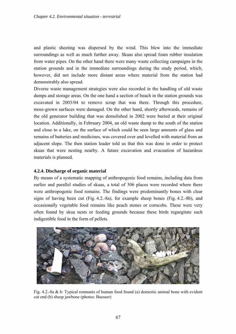
Chapter 4.2. Environmental situation - terrestrial
and plastic sheeting was dispersed by the wind. This blew into the immediate surroundings as well as much further away. Skuas also spread foam rubber insulation from water pipes. On the other hand there were many waste collecting campaigns in the station grounds and in the immediate surroundings during the study period, which, however, did not include more distant areas where material from the station had demonstrably also spread. Diverse waste management strategies were also recorded in the handling of old waste dumps and storage areas. On the one hand a section of beach in the station grounds was excavated in 2003/04 to remove scrap that was there. Through this procedure, moss-grown surfaces were damaged. On the other hand, shortly afterwards, remains of the old generator building that was demolished in 2002 were buried at their original location. Additionally, in February 2004, an old waste dump to the south of the station and close to a lake, on the surface of which could be seen large amounts of glass and remains of batteries and medicines, was covered over and levelled with material from an adjacent slope. The then station leader told us that this was done in order to protect skuas that were nesting nearby. A future excavation and evacuation of hazardous materials is planned. 4.2.4. Discharge of organic material By means of a systematic mapping of anthropogenic food remains, including data from earlier and parallel studies of skuas, a total of 306 places were recorded where there were anthropogenic food remains. The findings were predominantly bones with clear signs of having been cut (Fig. 4.2.-8a), for example sheep bones (Fig. 4.2.-8b), and occasionally vegetable food remains like peach stones or corncobs. These were very often found by skua nests or feeding grounds because these birds regurgitate such indigestible food in the form of pellets.
Fig. 4.2.-8a & b: Typical remnants of human food found (a) domestic animal bone with evident cut end (b) sheep jawbone (photos: Buesser)
67

Chapter 4.2. Environmental situation - terrestrial
As indigestible food remains such as bones and pellets do not break down for many years, Figure 4.2.-9 represents an up-to-date snapshot of the spatial distribution of anthropogenic food remains resulting from the introduction of organic waste from stations over many years. Clearly noticeable is that the majority of finds are concentrated in areas near to stations (Fig. 4.2.-9).
Fig. 4.2.-9: Distribution of anthropogenic food remains in the Fildes Region
68

Chapter 4.2. Environmental situation - terrestrial
It was shown that Skuas (~77 %) and Kelp Gulls (~10 %) feeding in and around stations and taking food to their nesting or feeding areas are the main cause of the spread of anthropogenic food on the Fildes Peninsula (Fig. 4.2.-10). Only a secondary role (~6 %) is played by people directly depositing organic waste from stations in the station grounds (Sec. 4.2.1.) or even in places far removed from the stations (Sec. 4.2.2.), such as field huts and barbecue and picnic areas. These latter places are often to be found in scenically attractive places and are to a certain extent regularly used by station personnel. In about 6 % of places where food remains were found, it was not discernible whether the food remains were left by people or brought by skuas or gulls.
Depositing
Undefinded
Gulls
Marine debrisBurning
Burying
Skuas
Fig. 4.2.-10: Causes of the distribution of human food remains in the Fildes Region expressed as proportions This type of data recording (Sec. 3.1.3.) does not allow us to reach quantitative conclusions about the frequency with which station waste is used as a resource by skuas or gulls. It only allows us to make statements to a limited extent about the precise time when this resource is used. However, in approximately 3 % of finds fresh anthropogenic food remains were detected. This supports the view that birds currently have access to anthropogenic food or food remains in the form of station waste. It is rarely possible to work out the origin of the anthropogenic food from the type of find. This was only possible in the case of remains of station-specific foodstuffs that could be identified without any doubt. Because the degree of the use of this nutritional
69

Chapter 4.2. Environmental situation - terrestrial
resource depends strongly on its accessibility or on distance from the stations (Wang & Norman, 1993), determining the distance of a find from the nearest station can provide a valuable hint as to its origin. The frequency distribution of distances between biological waste finds and the nearest station (Fig. 4.2.-11) clearly indicates that most finds were located between 100 m and ~2,000 m from the nearest station (Fig. 4.2.-11). The median distance between finds of biological waste and the nearest station was 788 m (minimum, 100 m; maximum, 3,079 m). This is partly due to finds of anthropogenic food remains in waste storage sites near stations (Sec. 4.2.1.) but particularly due to the fact that skuas mainly search for food within a limited radius around their own territory. For this reason the distances between the locations of the finds and the stations indicate the sources of the food.
Distance in m
100-2
99
300-4
99
500-6
99
700-8
99
900-1
099
1100
-1299
1300
-1499
1500
-1699
1700
-1899
1900
-2099
2100
-2299
2300
-2499
2500
-2699
2700
-2899
2900
-3099
Num
ber o
f fin
ds
0
20
40
60
80
Fig. 4.2.-11: Frequency distribution of distances between finds of biological waste and the nearest research station In the central sector of the Fildes Peninsula, determination of distance (Fig. 4.2.-11) is only of limited use in pinpointing the origins of biological waste finds because there are several potential sources of organic station waste within a very small area (Bellingshausen, Frei, Escudero, Capuerto, airport). After adding together all these sources approximately 52 % of biological waste finds can be said to have come from this area. Due to the comparatively isolated position of the stations Artigas (12 %) and
70
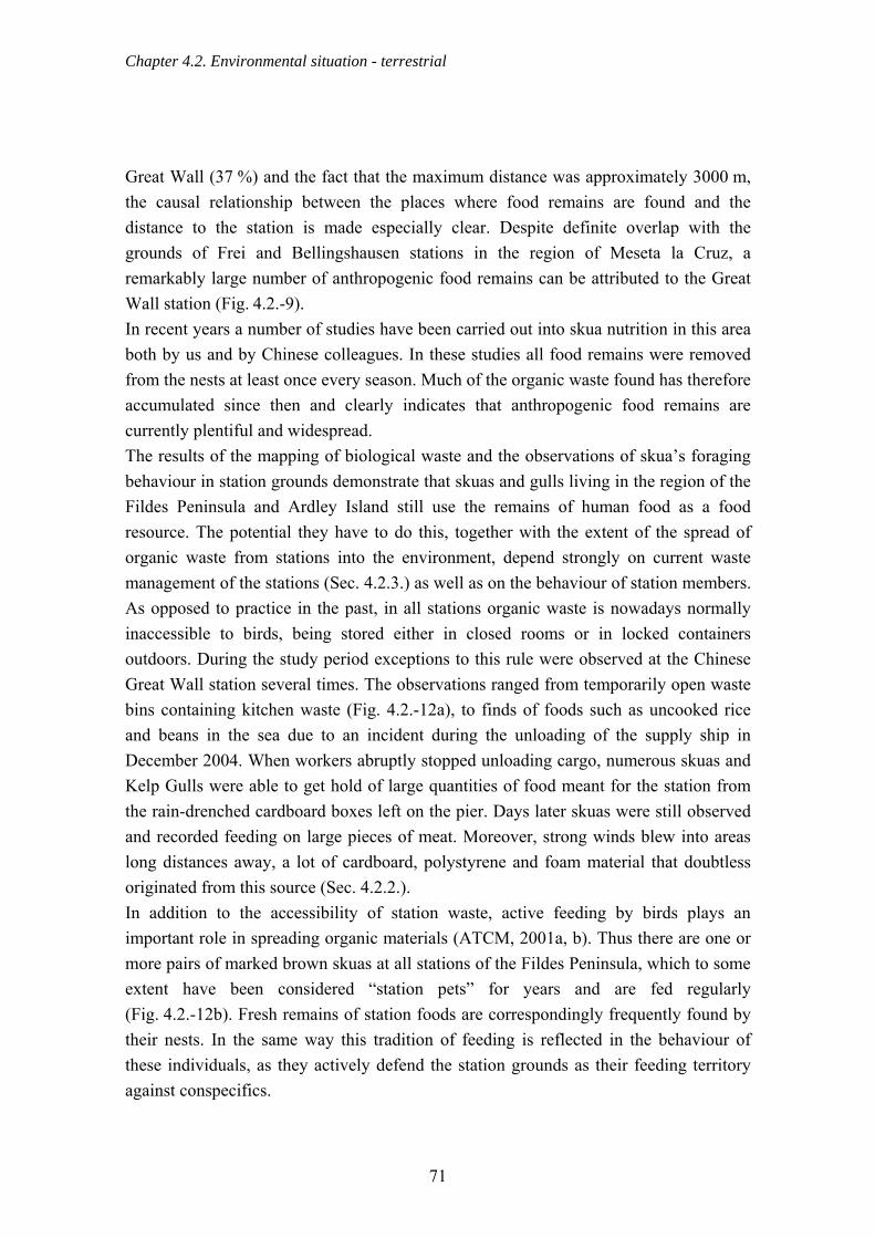
Chapter 4.2. Environmental situation - terrestrial
Great Wall (37 %) and the fact that the maximum distance was approximately 3000 m, the causal relationship between the places where food remains are found and the distance to the station is made especially clear. Despite definite overlap with the grounds of Frei and Bellingshausen stations in the region of Meseta la Cruz, a remarkably large number of anthropogenic food remains can be attributed to the Great Wall station (Fig. 4.2.-9). In recent years a number of studies have been carried out into skua nutrition in this area both by us and by Chinese colleagues. In these studies all food remains were removed from the nests at least once every season. Much of the organic waste found has therefore accumulated since then and clearly indicates that anthropogenic food remains are currently plentiful and widespread. The results of the mapping of biological waste and the observations of skua’s foraging behaviour in station grounds demonstrate that skuas and gulls living in the region of the Fildes Peninsula and Ardley Island still use the remains of human food as a food resource. The potential they have to do this, together with the extent of the spread of organic waste from stations into the environment, depend strongly on current waste management of the stations (Sec. 4.2.3.) as well as on the behaviour of station members. As opposed to practice in the past, in all stations organic waste is nowadays normally inaccessible to birds, being stored either in closed rooms or in locked containers outdoors. During the study period exceptions to this rule were observed at the Chinese Great Wall station several times. The observations ranged from temporarily open waste bins containing kitchen waste (Fig. 4.2.-12a), to finds of foods such as uncooked rice and beans in the sea due to an incident during the unloading of the supply ship in December 2004. When workers abruptly stopped unloading cargo, numerous skuas and Kelp Gulls were able to get hold of large quantities of food meant for the station from the rain-drenched cardboard boxes left on the pier. Days later skuas were still observed and recorded feeding on large pieces of meat. Moreover, strong winds blew into areas long distances away, a lot of cardboard, polystyrene and foam material that doubtless originated from this source (Sec. 4.2.2.). In addition to the accessibility of station waste, active feeding by birds plays an important role in spreading organic materials (ATCM, 2001a, b). Thus there are one or more pairs of marked brown skuas at all stations of the Fildes Peninsula, which to some extent have been considered “station pets” for years and are fed regularly (Fig. 4.2.-12b). Fresh remains of station foods are correspondingly frequently found by their nests. In the same way this tradition of feeding is reflected in the behaviour of these individuals, as they actively defend the station grounds as their feeding territory against conspecifics.
71

Chapter 4.2. Environmental situation - terrestrial
The winter feeding of Sheathbills (Chionis alba) is also common up to the present day. For this reason large numbers of these birds spend the winter at the stations (pers. comm. H.-U. Peter, A. Froehlich).
Fig. 4.2.-12a & b: Brown Skuas feeding in station grounds (a) in biological waste containers of Great Wall (photo: Buesser) (b) being fed in Bellingshausen (photo: Bellingshausen Station) 4.2.5. Fuel storage and measures to prevent oil contamination Due to its geographical location and the existence of the Chilean airport, as well as a number of stations, the Fildes Peninsula has an important function as a logistic node for the whole region of the Antarctic Peninsula. Accordingly, large quantities of fuel are needed there. Oil pollution is one of the greatest environmental dangers in the Antarctic region (ATCM, 1999a). Potential risks originate mainly from the transfer of fuel from supply ships to storage tanks, transport within the station and between stations, leaks in tanks or pipelines, as well as to a lesser extent from the cleaning of tanks. The danger of oil pollution clearly increases with the number of fuel transfers between the supply ship, different tanks and the final destination where the fuel is used for energy production. According to EP agreements (Article 15), each station must have a contingency plan that should prevent any environmental damage in the case of an accident e.g. involving oil. The measures that have been planned and the available means to avoid and contain oil disasters are various. They range from raised edges to the tank basins through floating oil booms (known from Artigas and Bellingshausen), to the availability of oil-absorbing textiles (known from Bellingshausen) and chemicals that bind or break down oil (known from Great Wall and Artigas stations). In addition, Argentinean and Chilean ships carry out regular exercises in the context of a combined patrol to contain a possible oil slick with the help of oil booms. These booms were also used in the case of
72
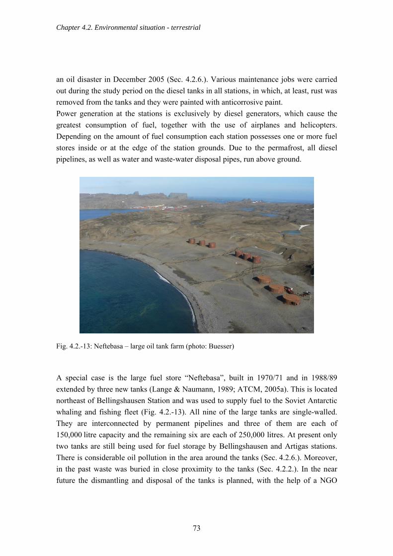
Chapter 4.2. Environmental situation - terrestrial
an oil disaster in December 2005 (Sec. 4.2.6.). Various maintenance jobs were carried out during the study period on the diesel tanks in all stations, in which, at least, rust was removed from the tanks and they were painted with anticorrosive paint. Power generation at the stations is exclusively by diesel generators, which cause the greatest consumption of fuel, together with the use of airplanes and helicopters. Depending on the amount of fuel consumption each station possesses one or more fuel stores inside or at the edge of the station grounds. Due to the permafrost, all diesel pipelines, as well as water and waste-water disposal pipes, run above ground.
Fig. 4.2.-13: Neftebasa – large oil tank farm (photo: Buesser) A special case is the large fuel store “Neftebasa”, built in 1970/71 and in 1988/89 extended by three new tanks (Lange & Naumann, 1989; ATCM, 2005a). This is located northeast of Bellingshausen Station and was used to supply fuel to the Soviet Antarctic whaling and fishing fleet (Fig. 4.2.-13). All nine of the large tanks are single-walled. They are interconnected by permanent pipelines and three of them are each of 150,000 litre capacity and the remaining six are each of 250,000 litres. At present only two tanks are still being used for fuel storage by Bellingshausen and Artigas stations. There is considerable oil pollution in the area around the tanks (Sec. 4.2.6.). Moreover, in the past waste was buried in close proximity to the tanks (Sec. 4.2.2.). In the near future the dismantling and disposal of the tanks is planned, with the help of a NGO
73
Chapter 4.2. Environmental situation - terrestrial
(“Inspire!”), staff members of which were involved in the 2002 clean-up campaign at Bellingshausen (pers. comm. G. Evans). Fuel consumption differs between stations and depends on the number of buildings and facilities to be supplied with energy, as well as the size of the station's own fleet of vehicles. In the following sections descriptions of fuel consumption and any logistical peculiarities of the stations will be presented.
a) Artigas The total diesel consumption of the station Artigas adds up to approximately 170,000 litres per year. Every year a Uruguayan supply ship brings in the amount of diesel fuel needed. The fuel is pumped ashore along a floating pipeline into one of the huge storage tanks of Neftebasa leased from Bellingshausen station. After fuel transfer, the pipeline is blown clear by compressed air and left near the tanks or at the beach. Afterwards the diesel is transported by land to the station and filled into the station’s five holding tanks whose total capacity is 120,000 litres. These tanks are located right next to the generator house and are set in sealed basins. This transport of fuel in a tank trailer pulled by a tractor or tracked vehicle makes up a great deal of the traffic on the roads between Neftebasa and Artigas (Sec. 4.2.13.). Depending on need, further transport of diesel to refill the tanks takes place.
b) Bellingshausen At Bellingshausen diesel is supplied in the same way as for Artigas but at intervals of 2 – 3 years and by a Russian supply ship. The transport of diesel to the station is been carried out by tracked vehicle pulling a tank trailer or by tank lorry. This has led to repeated oil contamination of parts of the road and to very frequent use of this particular stretch (Secs. 4.2.6. & 4.2.13.). The station’s storage tanks have been renewed recently and stand on a concrete foundation with a raised rim (in tank basins). According to the station leader, ~120,000 litres a year are used for power generation and about 2,000 litres in the station’s vehicles and boats.
c) Escudero Because Escudero station operates for only around two months a year (January and February), fuel consumption is only about 12,000 litres, clearly less than other stations of the Fildes Peninsula. About 200 litres of diesel might be needed in addition for vehicles, as well as about 125 litres for the zodiac and for pump operation. The fuel supply for Escudero comes by sea in plastic oil drums of 200 litres each. These,
74

Chapter 4.2. Environmental situation - terrestrial
immediately after landing, are transported from the beach to the station grounds where they are emptied into a holding tank (30,000 litres capacity) using an electric pump. Adjacent to this large tank are two much smaller ones that are connected to the generator one after the other. d) Frei The station is supplied with the required fuel annually by sea. Oil supply to Frei is particular, however, in that transfer from ship to station is by a conduit on the seabed. The seaward manifold of this conduit is located in the immediate vicinity of Diomedea Island. In this station there are additional tanks at other locations. These are built on concrete foundations and connected to each other by underground pipelines. In addition, a huge tank is located half way between the airport and the station. As well as the fuel already mentioned, a considerable quantity of aviation fuel is brought in using a helicopter and stored at the airport. Frei’s total fuel demand amounts to about one million litres of diesel a year (without the fuel for the aircrafts). On top of this, Frei consumes 5,000 – 6,000 litres of other fuel through vehicle use. The fuel consumption of Capuerto zodiacs was cited as less than 200 litres a year.
e) Great Wall Great Wall’s storage consists of eight diesel tanks, each of 50,000 litre capacity, located south of the station. Further smaller tanks are located near the generator house. The diesel is transported from the main tanks to the station along rubber pipes and by tanker. It is then pumped into the holding tank and later fed through into the generator house. Several inspections of the rubber pipes have shown that oil is left in them after use (Sec. 4.2.6.). The annual consumption of fuel by Great Wall was estimated at about 70,000 litres of diesel.
4.2.6. Oil Contamination 4.2.6.1. Oil contamination outside stations The majority of cases of oil contamination outside the station grounds were along the road network connecting the stations of Fildes Peninsula with each other (Fig. 4.2.-14). These consisted of numerous, mostly small, contaminated areas.
75

Chapter 4.2. Environmental situation - terrestrial
Fig. 4.2.-14: Oil pollution mapped on the Fildes Region during the course of the investigation Only a few oil patches were detected on the road between the Frei and Great Wall stations. In contrast, the entire road between the Russian station Bellingshausen and the Neftebasa tank farm must be classified as permanently polluted. This could clearly be seen by the heavy oil film on the surface of numerous meltwater puddles and snowmelt
76

Chapter 4.2. Environmental situation - terrestrial
streams. The principal cause of the oil contamination was frequently occurring oil loss from the tank lorry, tractors pulling oil tanks, or from the tank trailers themselves. An additional major cause of contamination was located in the immediate area of the Neftebasa tank farm. There were several traces of oil here on pipelines and hoses that had arisen from the transfer of fuel between the supply ship and the main storage tanks. Outside the road network only a few patches of superficial oil contamination were detected, the majority of them produced by oil drums “lost” in the area (Fig. 4.2.-15a). An example of this was an oil drum found in the 2004/05 season in the stream by the airport runway, a stream that flows into the nearby Kitezh Lake which is the source of drinking water for Frei and Bellingshausen station. Because small quantities of oil were leaking from this drum the station commandant responsible was immediately notified. Moreover, a vehicle was found buried northeast of Bellingshausen station from which small quantities of oil leaked. The vehicle had apparently been buried many years before. Larger patches of contamination were caused principally by problems with pipelines or hoses that, for example, after fuel transfer, were stored on the beach for a long time with many kinks in and in damaged conditions so that oil could leak out into the environment (Fig. 4.2.-15b).
Fig. 4.2.-15a & b: Examples of oil pollution – left: lost barrel at Kitezh Lake; right: oil spot under pipes (photos: Buesser) Further occurrences of oil contamination were detected in connection with the extension of the Chilean airport in the 2004/05 season (Sec. 4.2.19.). These were indicated by definite oil films on meltwater puddles at a quarrying site and at a depot for construction vehicles.
77

Chapter 4.2. Environmental situation - terrestrial
An anomalous example of oil pollution was the continual discharge of a considerable quantity of oil into Biologenbucht. This was identified by the permanent oil film, present in all three study seasons, on a brook originating immediately behind the buildings of the Chilean airport and flowing down hill in a north-south direction (Fig. 4.2.-14). This brook likewise transported wastewater from the airport hotel, perceptible through its smell and colour. The exact source of the oil discharge could not be found. It could be from an active leak in the airport oil tanks or pipelines, but it could also be oil continuously filtering out from soil already heavily contaminated. This last possibility is supported by the large number of reports since 1987/88 that have documented the regular severe contamination of the soil around the airport (Lange & Naumann, 1989; Krzyszowska, 1993; Tin & Roura, 2004). As a result of this continual oil contamination, the Biologenbach running further to the south frequently carried a film of oil. Moreover the soil along the course of the brook, and at its mouth, gives the appearance of being soaked with oil. 4.2.6.2. Oil contamination within station grounds It is not possible to come to any definite conclusion about the real degree of soil contamination by oil within station grounds. This is because of the common practice, still prevalent, of rapidly covering oil spills with gravel or sand, and the absence of chemical analyses of the soil. The station grounds and the holding tank zones must be considered as chronically polluted due to the long human presence in the area and decades of inadequately managed fuel transfer and storage (Tin & Roura, 2004). Conformable with this view is that evidence of oil contamination was found in all stations of the Fildes Peninsula with the exception of the Uruguayan station Artigas. Small oil spots or oil-covered puddles were recorded around the Chilean station Frei, including the naval base Capuerto, and the scientific station Escudero whose fuel is supplied entirely through Frei station. They occurred predominantly at the diesel tanks nearest Maxwell Bay and in front of the communal buildings. No currently occurring major oil pollution was recorded in the grounds of the Chilean station during the study period except for that at the airport noted above. In contrast, several current and, to a certain extent, large contaminated locations were noted, observed by us, and documented, inside Great Wall and Bellingshausen stations. There was, for example, a pipe burst at Great Wall during fuel transfer between ship and the holding tanks near the beach in December 2004 (pers. comm. Z. Wang). This polluted a large area of the beach to the south of the station. Furthermore, inattention led to a disaster in 2003 while transferring diesel to the generator building when a huge quantity of fuel poured into the soil (pers. comm. Z. Wang). Two substances were
78

Chapter 4.2. Environmental situation - terrestrial
spread on both areas that are intended to make the oil safe by catalysis (Sec. 4.2.5.). Despite this measure, in December 2003, the pollution at the generator house was clearly perceptible and the emergent meltwater carried an evident oil film. In the 2003/04 season, therefore, these areas were extensively covered with sand and gravel. Throughout the period of the investigation a regularly appearing oil film was detected on the streambed running through the grounds of Bellingshausen. This originated in an earlier disaster in the area of the diesel tanks near the generator house (pers. comm. O. Sakharov). Rain and melting snow washes the oil out of the heavily contaminated soil into the brook and thus into the sea. More recently, in the winter months of 2005, a leak in a pipe hidden under the snow passed unnoticed and, over an undetermined time, allowed the escape of a huge amount of diesel, estimated at 1000 litres (pers. comm. O. Sakharov). It was eventually noticed only at the beginning of December 2005 as the snow began to melt. Members of the adjacent Chilean naval base informed the Argentinean patrol ship “Suboficial Castillo” which was then nearby. The crew of this ship erected a barrier boom as soon as they arrived in Maxwell Bay on the 03 December 2005 (Fig. 4.2.-16a). This scenario has been regularly practised within the scope of the combined Chilean-Argentinean Antarctic naval patrol (Patrulla Antártica Naval Combinada – PANC) since 1998. The boom is intended to prevent the spread of oil slicks on the sea surface. It was unknown, though, how successful the measure might be in preventing the slick reaching the sea. By the time members of the University of Jena arrived at the site on 10 December 2005, the ship had already left the bay again after completing the work. But an oil film was still observable on the sea surface in the immediate vicinity of the brook mouth, as water from the melting snow was still carrying diesel into the sea. One of the measures carried out by Bellingshausen personnel to limit the effects of the disaster, was to remove the remaining oil soaked snow in the course of December 2005 (Fig. 4.2.-16b). This snow was loaded into tanks where the diesel separated from the meltwater (pers. comm. O. Sakharov). The fuel was then removed into drums and the water, having been cleaned in this way, was discharged again into the stream. Additionally on 29.12.2005, an attempt was made to burn off the diesel on the soil surface, a procedure that produced enormous clouds of smoke.
79

Chapter 4.2. Environmental situation - terrestrial
Fig. 4.2.-16a & b: Measures taken after a severe oil spill (a) oil boom at Maxwell Bay (b) removal of the oil impregnated snow by members of the station (photos: Bellingshausen) Despite the methodical restrictions arising from the absence of soil chemistry analyses, the findings reported here sufficiently demonstrate the extent of oil pollution still persisting. This pollution is caused by insufficient care of the station’s vehicles and, above all, from mistakes or lack of preparation when handling fuel. 4.2.7. Gaseous emissions from diesel generators The diesel generators the stations use for power generation cause considerable quantities of gaseous emissions in the Fildes Peninsula, which, however, could not be quantified despite interviews carried out with station personnel. Thus to compare the quantity of emissions expected from each of the stations, their individual use of fuel was examined (Sec. 4.2.5.). This revealed that Frei, on average, produces that greatest amount of gaseous pollutants due to its large size and correspondingly large consumption of fuel (Fig. 4.2.-17) with Artigas and Bellingshausen being the next highest emitters. It remains uncertain whether the relatively low fuel use of Great Wall station, which is less than would be expected for its size, is due to the specifications of the modern diesel generators they have installed. At Escudero station, because it operates just two months a year, the fuel use for power generation and thus the quantity of gasses produced is clearly less than for the rest of the stations. A more precise comparison should include the generators' technical specifications as various factors such as construction type, performance, hours of operation, maintenance, filter systems, etc., play a decisive role in determining the type and the volume of gaseous emissions.
80

Chapter 4.2. Environmental situation - terrestrial
Artigas
Belling
shau
sen
Escud
ero Frei
Great W
all
Die
sel c
onsu
mpt
ion
(1,0
00 li
tres)
0
200
400
600
800
1000
1200
Station Fig. 4.2.-17: Annual fuel consumption for power generation by diesel generators in research stations of the Fildes Peninsula (source: station personnel) 4.2.8. Gaseous emissions from vehicles Due to the considerable size of the station’s own vehicle fleet and the numerous daily trips between the station and the airport it can be assumed that Frei is, proportionally, the biggest producer of exhaust gasses. It must be taken into account that in the description of road network use (Sec. 4.2.13.) the stretch between Frei and the airport had to be ignored for methodical reasons. Nevertheless, Chilean vehicles drive along this portion of road several times a day. In the season 2004/05, additional emissions were caused by the fleet of heavy construction vehicles imported to extend the airport (Sec. 4.2.-19). Bellingshausen and Great Wall stations have medium-sized fleets compared with the stations as a whole, and these fleets contain some heavy-duty machines that are relatively frequently used. The lowest use of vehicles observed was by Artigas station. 4.2.9. Noise sources The study area contained several different noise sources but these were constant in neither time nor space (Fig. 4.2.-18). These sources, due to their loudness, can sometimes disturb or harm human beings and animals. Noise is defined as audible
81

Chapter 4.2. Environmental situation - terrestrial
sound that can damage health (http://www.baua.de/) in the form of, amongst others, the sound of machinery and disturbing speech noises. The effects of noise manifest themselves in people in the form of hearing damage and negative influences on the body’s physiological and psychological regulatory mechanisms. This can raise the amounts of stress hormones, constrict the peripheral blood vessels and, in the long run, increase the risk of diseases of the heart, the circulation and the digestive system (http://www.baua.de). All the stations of the Fildes Region possess their own diesel generator building which represents a permanent noise source due to the continuous power generation. In the generator rooms noises around 100 dB(A) have been detected (measured at the Russian station in January 2006). Noise as loud as this harms the health of people exposed to it without protection (87 dB(A) over 8 h is the maximum exposure, EG noise guidelines 2003/10/EG). Outside the generator houses < 70 dB(A) were recorded. Skuas and storm petrels, the breeding birds nearest to the station, breed every year over 50 m away from the generator houses. We supposed that the animals tolerate the noise and are not physically damaged by it. During 2002 and 2003, Pfeiffer (2005) measured the volume of several anthropogenic noises, both occasional and frequent, at Southern Giant Petrel and skua nesting sites (Tab. 4.2.-1). The anthropogenic noises were up to 40 dB(A) louder than the background noises registered just before and just after the measurement (30 - 100 dB(A)). Disturbance of the animals cannot be excluded (Richardson et al., 1995). Air traffic caused the loudest and, in comparison with other areas of the Antarctic, most frequent noise (Sec. 4.2.16.). Helicopters are normally louder than airplanes and Hercules airplanes are louder than small machines such as the Twin Otter or King Air (Tab. 4.2.-1). Noise at take off and in climb is frequently louder than that produced by level flight, descending or landing (Richardson et al., 1995).
82

Chapter 4.2. Environmental situation - terrestrial
Fig. 4.2.-18: Temporary and permanent sources of noise in the Fildes Region, presented according to their position, their type, and frequency of operation. The spatial dimensions of the noise areas are derived from mapping station grounds and traffic in the field work periods 2003/04 and 2004/05 (compare Sec. 4.2.10. & 4.2.16.).
83
Chapter 4.2. Environmental situation - terrestrial
Animals might habituate to flights if they always followed fixed routes and there are specific air lanes over Fildes, fixed by the airport. Nevertheless, flights outside these routes were repeatedly observed that might be more startling for the animals (Fig. 4.2.-18, Sec. 4.2.16.). Investigations of Southern Giant Petrel and skua behaviour in the study area showed that a smaller proportion of birds became nervous in response to regular air traffic than did to natural stressors (interactions with predators and conspecifics) (Pfeiffer, 2005). The heartbeat rate of Southern Giant Petrel breeding on the north side of Ardley Island (< 600 m from the main air lane, Ahigh, Tab. 4.2.-1) increased only slightly in response to aircraft in level flight. Their heart rate increased dramatically, in contrast, in response to loud take-off and landing manoeuvres as well as to flights outside the main flight route (Pfeiffer, 2005). Air traffic in the Fildes Region began with the construction of the airport in 1980. The construction of the Chinese station in 1985 also used helicopters to transport materials. Peter et al. (1991) demonstrated behavioural changes and brood losses in Southern Giant Petrels as a direct consequence of the air traffic. Nowadays all areas with little human activity are distant from the main flight routes but sometimes aircraft fly over the Fildes Strait at less than 300 m. Helicopter and Hercules C-130 pilots particularly are given to practising their skills several times per season in low level flights over land or along the coast. Disturbance of the Southern Giant Petrels or even brood loss on Dart and Two Summit Island as a consequence of these actions cannot be excluded. Normal road traffic (transport of people and material, Sec. 4.2.13.) presents a range of noise sources of different intensity depending on the type of vehicle. The few birds (particularly skuas and terns) that bree d < 50 m from roads can apparently tolerate the occasional or sometimes frequent traffic, as alternative breeding habitats are available to them. All ships and boats in Maxwell Bay produce noise above and under water (details of underwater noise in Richardson et al. 1995). The noise sources concerned are, for example, propeller rotation, engines, pumps, generators and compressors. Studies on the behavioural reactions of fishes and sea mammals to the noise (e.g. Myrberg, 1990, Richardson et al. 1995) have shown that they stop feeding, or interrupt resting periods or social interactions and show more frequent vigilance and flight behaviour. Seals, for example, move from their resting places on land and seek protection in the water. At sea, seals and whales dive or swim away from the source of disturbance. Many, if not all, sea mammals can tolerate persistent human sources of noise to a certain degree. Habituation effects have been observed in studies, but also, in a few cases, sensitisation (Richardson et al. 1995).
84

Chapter 4.2. Environmental situation - terrestrial
Tab. 4.2.-1: List of measurements of noise levels from anthropogenic sources in bird colonies in the Fildes Region (noise level measuring instrument: Volcraft 322, data from Pfeiffer (2005) on windless days, Beaufort scale < 2) Object Distance of the
measurement location to noise
source (in m)
n
Noise in dB(A) average ± S.D. max. min.
Hercules C-130 500 - 1000 32 73.2 ± 7.14 98.4 60.1 Helicopter 500 - 1000 41 76.9 ± 8.91 90.2 57.0 Small airplane 500 - 1000 5 58.9 ± 6.15 62.7 48.1 Tracked vehicle 50 1 77.4 Zodiac 50 - 100 2 81.4 ± 9.90 88.4 74.4 People talking 10 - 30 3 61.4 ± 4.41 66.0 57.2 Bird calls as reference 1 - 50 10 65.4 ± 14.56 102.0 50.0
4.2.10. Land consumption by research stations At the end of the 2005/06 season there were 159 constructions in the Fildes Region (Fig. 4.2.-19). These include buildings, and fuel stores, as well as fixed containers and large equipment housings. Not included are free-standing aerial arrays, flagpoles, and similar installations that do not occupy appreciable amounts of land.
85

Chapter 4.2. Environmental situation - terrestrial
Fig. 4.2.-19: Land consumption for buildings in the Fildes Region (cf. Sec. 3.1.9.) Chile, with Frei and Escudero stations, the airport, the “Ripamonti” complex of field huts and the research laboratory LARC (Fig. 4.2.-20), is responsible for 75, or nearly half, of these constructions. The Russian station Bellingshausen comprises 39 buildings including the large fuel store Neftebasa and three field huts, of which only “Priroda” in the far north is still in operation (Sec. 4.2.11.). The Chinese Great Wall station consists of 32 buildings, including a few laboratory buildings nearby and an unused container on
86

Chapter 4.2. Environmental situation - terrestrial
the beach approximately 1 km south of the actual station (Sec. 4.2.11.). Eleven buildings belong to the Uruguayan station Artigas. Argentina possesses two huts in the “Ballve” refuge on Ardley Island (Sec. 4.2.11.).
Fig. 4.2.-20: Most heavily built-up parts of the Fildes Region, the research stations Artigas (top left), Great Wall (top right) and the stations of Bellingshausen and Frei (bottom) The areas of constructions in the Fildes Region can vary greatly, from 2 - 3 m2 for a toolshed to 1,000 m2 for the airport hangar. For this reason the surface areas for which the various nations are responsible are represented in Fig. 4.2.-21. Here, too, Chile has the largest share: 10,180 m2, which is more than half of the total surface area of 19,350 m2 that has been built on.
87

Chapter 4.2. Environmental situation - terrestrial
Fig. 4.2.-21: Land consumption for buildings in the Fildes Region by owner Station buildings and grounds cover 403,900 m², which is 1.34 % of the total land surface of the study area. About half of this area, 202,200 m², is in the central area, comprising Bellingshausen, Frei and Escudero stations. The airport covers further 85,000 m². The Chinese station Great Wall takes up 77,200 m², including a piece of land on the southern edge of the station, where it has its own fuel tanks. Artigas Station covers 39,500 m². The construction method in the study area is, in the main, appropriate to the periglacial conditions (Andersland & Ladanyi, 2003). One aspect of this, as in other terrestrial Antarctic and Arctic regions is, above all, the technique of building on stilts (Fig. 4.2.-22). Buildings are set on stilts made of metal and/or concrete instead of normal foundations, to avoid contact between the building and the ground. The purpose of this is, above all, to prevent the ground being warmed up by heated buildings and thus avoid thawing out the frozen ground below the surface or sinking into the summer active layer. Construction on stilts also reduces the drifting of snow against the buildings. Most buildings in the study area are built on stilts, although in some cases the stilts are covered and thus not visible. Building on stilts also significantly reduces the problem of soil sealing. This construction method furthermore leaves few traces on the ground after the building has been removed (see, as an example, the Brazilian field hut
88

Chapter 4.2. Environmental situation - terrestrial
"Rambo"). The situation is similar for some storage buildings or hangars, which are not built on stilts but whose floors are not, or scarcely, sealed. During the study period from 2003/04 to 2005/06 few new buildings were put up. The most significant of these are the two-storey residential and research building at the Uruguayan station Artigas and two new buildings for waste water treatment and waste incineration at the Chilean station Frei.
Fig. 4.2.-22: Typical stilt construction as displayed by the main buildings of Bellingshausen Station (photo: Buesser) 4.2.11. Field hut use In the Fildes Peninsula and Ardley Island region, four field huts with overnight accommodation for 2 - 4 people are actively maintained. The use made of these huts varies greatly. These refuges serve primarily to accommodate scientists but they are also used to some extent by visitors from surrounding stations. The current frequency of use of the huts therefore varies a great deal. In addition to the refuges that are in use, there are a number of unused huts and containers, of which two were recently taken apart and removed due to their advanced state of dilapidation (see below). With the exception of the hut complex "Base Ripamonti" and the refuge "Ripamonti" on Ardley Island, none of the field huts has its own energy or water supply, or field toilet, so that resulting sewage is disposed of in the surrounding area. In contrast to the normal practice in the past of sinking waste in the open sea (Mönke & Bick, 1988), waste that is produced in the refuges is nowadays collected and taken back to the stations.
89

Chapter 4.2. Environmental situation - terrestrial
The field huts can be reached on foot, by vehicle or by zodiac, depending on the distance from the stations and the nature of the coast. No helicopter flights to the field huts or landings nearby were observed during the study period. a) “Ballve” (Argentina) The Argentinean refuge "Refugio Naval Teniente Ballve" on Ardley Island is the oldest hut in the Fildes Region and is in close proximity to "Base Ripamonti". "Ballve" was erected as early as 1953/54 at the same time as the Argentinean station "Teniente Jubany" on Potter Peninsula and consists of a well-equipped wooden living hut and a refuge hut (Fig. 4.2.-23), both of which are in good condition. Eight large gas canisters are stored just next to the refuge hut. For a number of years now the field hut has no longer been used by scientists, but only by a few visitors from neighbouring stations, for example radio amateurs. However, at the end of January 2006, following the refurbishment of the Ardley lighthouse by Argentinean navy personnel, "Ballve" was also comprehensively refurbished and given a new coat of paint.
Fig. 4.2.-23: Argentinean refuge hut “Ballve” (photo: Buesser)
As the refuge hut is always open and contains good emergency equipment, it was of particular importance recently when there was an accident with a zodiac and its passengers were able to take refuge in the hut (pers. comm. A. Contreras, O. Sakharov). b) “Refugio Julio Ripamonti” (Chile) In the 1980/81 season GDR scientists living at Bellingshausen and Soviet station members built a hut on the north-eastern point of Ardley Island, in the middle of the
90

Chapter 4.2. Environmental situation - terrestrial
penguin colony (Fig. 4.2.-24). This hut was the base every year for penguin studies. From 1990 it was under the control of the Alfred Wegener Institute but in 1997 was officially handed over to Chile (INACH) (source: http://www.inach.cl/antartica/territorio/bases_chi/ripamonti.htm). Despite being so far away, it belongs to the field hut complex "Base Ripamonti", 1 km to the west (Fig. 4.2.-25).
Fig. 4.2.-24: Chilean field hut “Refugio Ripamonti” (photo: Buesser)
The Ripamonti hut can only be reached on foot over the Ardley isthmus or by zodiac. In previous years scientists occasionally used it during the day and, on rare occasions, overnight. The refuge contains a gas heater and there is a field toilet outside. Towards the end of the 2004/05 season the large quantities of metal and wood pieces, numerous corroded gas canisters and empty paint and oil containers, which had been stored next to the hut for some time, were completely removed. In February 2006 a photovoltaic array consisting of four panels with a capacity of 320 W was installed on the north-eastern side of the hut. This will provide a permanent energy supply, which will improve conditions for scientists working there in the summer (source: http://www.inach.cl/noticias/energia.htm).
91
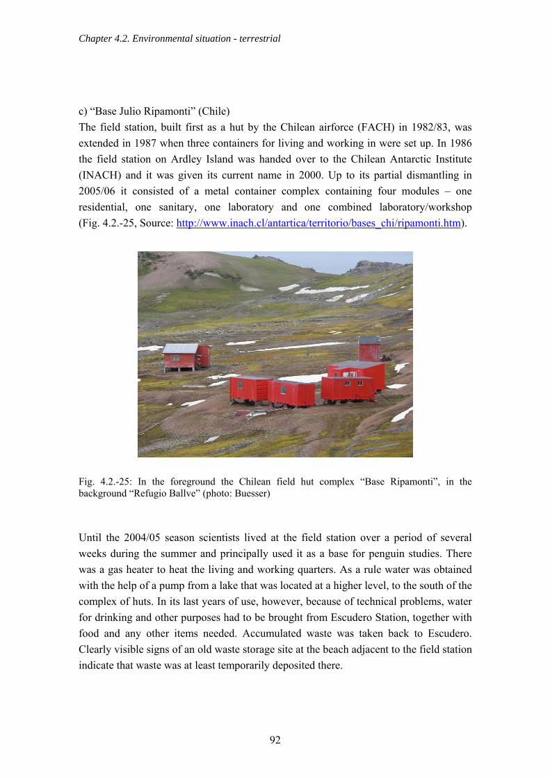
Chapter 4.2. Environmental situation - terrestrial
c) “Base Julio Ripamonti” (Chile) The field station, built first as a hut by the Chilean airforce (FACH) in 1982/83, was extended in 1987 when three containers for living and working in were set up. In 1986 the field station on Ardley Island was handed over to the Chilean Antarctic Institute (INACH) and it was given its current name in 2000. Up to its partial dismantling in 2005/06 it consisted of a metal container complex containing four modules – one residential, one sanitary, one laboratory and one combined laboratory/workshop (Fig. 4.2.-25, Source: http://www.inach.cl/antartica/territorio/bases_chi/ripamonti.htm).
Fig. 4.2.-25: In the foreground the Chilean field hut complex “Base Ripamonti”, in the background “Refugio Ballve” (photo: Buesser) Until the 2004/05 season scientists lived at the field station over a period of several weeks during the summer and principally used it as a base for penguin studies. There was a gas heater to heat the living and working quarters. As a rule water was obtained with the help of a pump from a lake that was located at a higher level, to the south of the complex of huts. In its last years of use, however, because of technical problems, water for drinking and other purposes had to be brought from Escudero Station, together with food and any other items needed. Accumulated waste was taken back to Escudero. Clearly visible signs of an old waste storage site at the beach adjacent to the field station indicate that waste was at least temporarily deposited there.
92

Chapter 4.2. Environmental situation - terrestrial
For a number of years now zodiacs have been used to transport everything to “Ripamonti”, although a little-used track eroded by traffic connects “Ripamonti” field station with the Fildes Peninsula via the Ardley isthmus. The container complex was partially dismantled in January/February 2006 because the buildings were becoming increasingly dilapidated due to serious damp inside. Only the residential module was repaired and a toilet was added (RAPAL, 2006). All material resulting from this work was transported by zodiac to Escudero station and from there it was taken by ship to Punta Arenas, Chile. d) “Padre Balduino Rambo” (Brazil) The Brazilian refuge “Padre Balduíno Rambo” (Fig. 4.2.-26) was erected in the 1985/86 season in the shore area of the Drake coast of Fildes Peninsula. It provided good service for a number of seasons to members of Brazilian Antarctic expeditions working in the area (ATCM, 2005b). After just three years, however, wear and tear and penetration by damp had already severely reduced the hut’s usefulness and it was not used after 1990. When inspected in January 2004 the field hut was in a very bad state of repair. From information provided by station members we know that the hut, during the winter months, was occasionally the destination for short visits by people travelling by skidoo.
Fig. 4.2.-26: Brazilian field hut “Rambo” in March 2004 (photo: Buesser) After receiving technical reports from previous Antarctic operations, the Brazilian government decided in 2004 to dismantle the field hut in the 2004/05 summer season
93
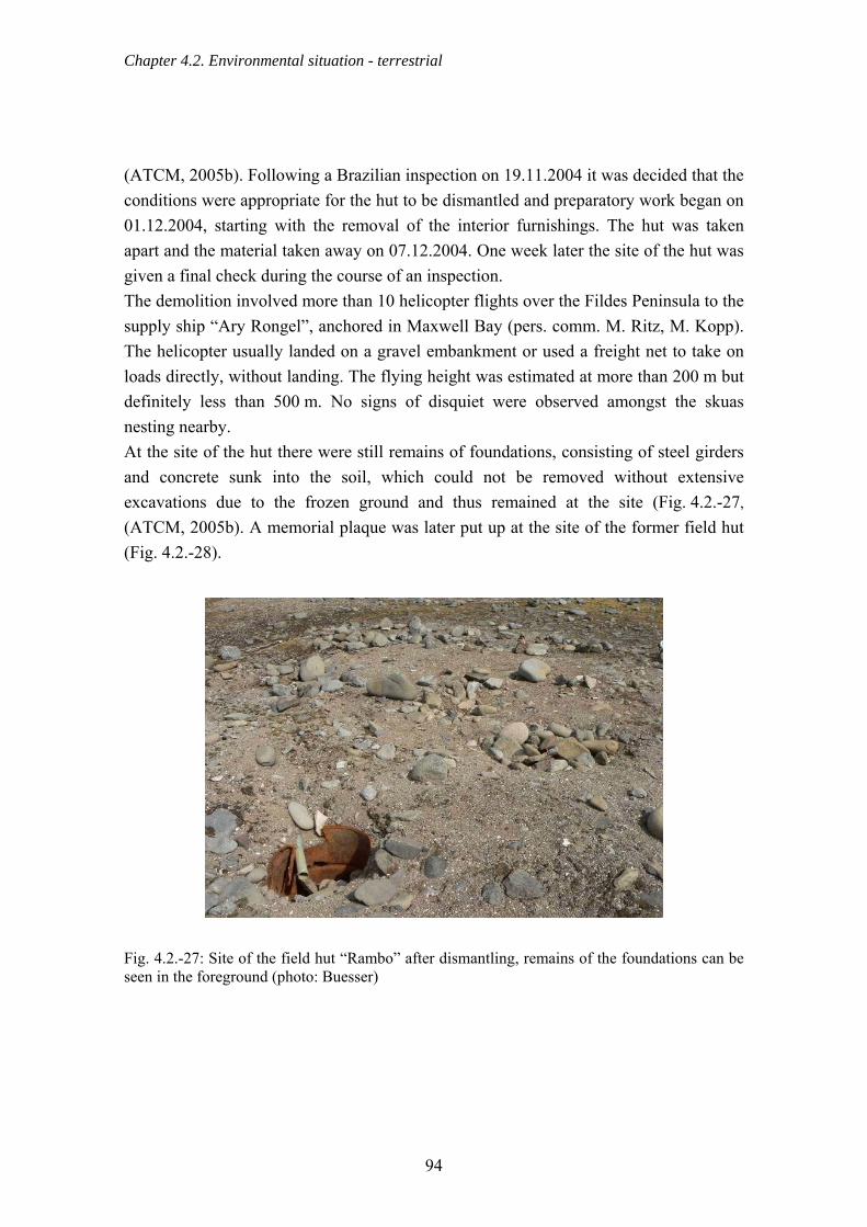
Chapter 4.2. Environmental situation - terrestrial
(ATCM, 2005b). Following a Brazilian inspection on 19.11.2004 it was decided that the conditions were appropriate for the hut to be dismantled and preparatory work began on 01.12.2004, starting with the removal of the interior furnishings. The hut was taken apart and the material taken away on 07.12.2004. One week later the site of the hut was given a final check during the course of an inspection. The demolition involved more than 10 helicopter flights over the Fildes Peninsula to the supply ship “Ary Rongel”, anchored in Maxwell Bay (pers. comm. M. Ritz, M. Kopp). The helicopter usually landed on a gravel embankment or used a freight net to take on loads directly, without landing. The flying height was estimated at more than 200 m but definitely less than 500 m. No signs of disquiet were observed amongst the skuas nesting nearby. At the site of the hut there were still remains of foundations, consisting of steel girders and concrete sunk into the soil, which could not be removed without extensive excavations due to the frozen ground and thus remained at the site (Fig. 4.2.-27,
(ATCM, 2005b). A memorial plaque was later put up at the site of the former field hut (Fig. 4.2.-28).
Fig. 4.2.-27: Site of the field hut “Rambo” after dismantling, remains of the foundations can be seen in the foreground (photo: Buesser)
94

Chapter 4.2. Environmental situation - terrestrial
Fig. 4.2.-28: Plaque at the site of the dismantled hut “Rambo” (photo: Buesser) e) “Priroda” (Russia) The newest field hut and the one furthest away from the stations is the Russian field hut “Priroda” (Fig. 4.2.-29). It was erected in 1986/87 in the far northwest of the Fildes Peninsula on the Drake coast, at the foot of a steep cliff. During the study period the hut was mainly supplied by individual scientists on foot who visited the hut fairly frequently (including scientists from the University of Jena). Since January 2005 the hut has been equipped with a small wood-burning stove which is mainly fuelled with driftwood. Because of its very attractive location, the “Priroda” field hut is a frequent goal for outings by station members. Visits are made on foot, with tracked vehicles, trucks or four-wheel-drive vehicles, and in winter also by skidoo. As the hut is relatively far from the stations, the majority of visitors prefer to travel by motor vehicle, as evidenced by the vehicle tracks, some of them very deep, which can be seen in the area (Sec. 4.2.14.). It was noticeable that during the study period the frequency of visits using motor vehicles increased, despite the station members being repeatedly informed about the consequences for the vulnerable vegetation in the area. Another potential problem of “Priroda” visits is the high number of Southern Giant Petrels breeding in the area, as these birds can react very strongly to anthropogenic disturbance (Sec. 4.5.2.).
95

Chapter 4.2. Environmental situation - terrestrial
Fig. 4.2.-29: Russian field hut "Priroda" (photo: Buesser) The frequency of use of the hut can be estimated by the number of entries in the log book. From the first entries on 23.10.1998 to the last check of the visitors’ log book on 20.2.2006, a total of 103 entries were made. Of these, 82% were in the summer months of December to March (Fig. 4.2.-30).
JuneJuly
August
September
October
November
December
January
FebruaryMarch April May
Vis
its to
"Prir
oda"
hut
0
10
20
30
40
Month
Fig. 4.2.-30: Monthly visits to the "Priroda" hut 1998 to 2006
96

Chapter 4.2. Environmental situation - terrestrial
From the information given in the visitors’ log book one can conclude that there were at least 226 visitors and nine overnight stays during this period. Scientists were, however, the main users of the field hut with 44 known overnight stays. Tourists have been visiting “Priroda” at least since 2003/04 as part of an itinerary lasting several days offered by the Chilean company “Aerovías DAP”. This travel programme occurred once per season specifically for the University of Pennsylvania and comprised guided walks and camping in various parts of the Fildes Peninsula, and also in the immediate vicinity of the “Priroda” hut. This was the largest group to visit, with around 30 people each time. Nothing is known about visits by tourists arriving by air or by ship. In spite of variations in the frequency of visits, the total results showed neither an increase nor a decrease in “Priroda” visits (Fig. 4.2.-31). To what extent this reflects the very individual behaviour as regards entries in the log book or how much it reflects the real situation, remains an open question.
Visi
ts o
f "Pr
iroda
" hut
0
2
4
6
8
Janu
ary
1999
Janu
ary
2000
Janu
ary
2001
Janu
ary
2002
Janu
ary
2003
Janu
ary
2004
Janu
ary
2005
Janu
ary
2006
Fig. 4.2.-31: Patterns of visits to "Priroda" field hut through the year, October 1998 - February 2006 f) Unused field huts and containers As well as the field huts that are in use there are a number of unused or decaying huts of Russian origin. Two huts that are still intact are located near the beach at the large fuel
97

Chapter 4.2. Environmental situation - terrestrial
store “Neftebasa” north of Bellingshausen (Fig. 4.2.-32a & b). They no longer fulfil their original function as refuge huts for station members working nearby, because as far as we know, all work in this region lasts a very short time and the neighbouring stations can be reached very quickly. There were many traces of contamination by oil and paint around the two Neftebasa huts.
Fig. 4.2.-32a & b: Disused huts near "Neftebasa" (photos: Buesser) Approximately 1 km north of the Russian station Bellingshausen there is another hut, already falling into ruin. Numerous pieces of the wooden outer wall covering are already spread around the area (Fig. 4.2.-33a). The hut’s previous function is not known. In the 1970s Russian scientists built a field hut for observing seals ~1 km south of the runway on the shore of the southern Biologenbucht (Fig. 4.2.-33b). By the beginning of the 1980s the hut was already in very bad condition and since then it has not been refurbished. In the hut and in the immediate surroundings there is still a considerable amount of foam and wood. The latter represent a danger to seals because of the many nails sticking out of the wood, as the seals frequently come to this part of the beach and to the area where the hut is (Fig. 4.2.-33b). A container positioned a number of years ago by the Chilean Antarctic Institute (INACH) as an ionosphere station had not been used for scientific purposes for a long time. At the time of examination it was already so badly damaged by weather that large pieces of the sheet metal outer cladding had been blown away, in some cases over large distances (Fig. 4.2.-34a).
98

Chapter 4.2. Environmental situation - terrestrial
Fig. 4.2.-33a & b: Disintegrating huts (a) north of Kitezh Lake (b) in the Biologenbucht (photos: Buesser) In February 2006 this container was completely dismantled by INACH staff and transported back to Chile for disposal (RAPAL, 2006). Nothing is known about the previous function of a Chinese container on the beach south of Great Wall Station (Fig. 4.2.-34b). It has been standing open for some time and there is burnt wood and waste inside and in the immediate surroundings.
Fig. 4.2.-34a & b: Severely damaged containers on the east coast of the Fildes Peninsula (a) container near the Ardley Isthmus (b) container south of Great Wall (photos: Buesser) German scientists (Erfurt & Grimm, 1990) described in an expedition report an unused observation hut at Nebles Point, which was clearly identified as being of GDR origin on the basis of items of equipment found there. In the last few years no vestiges of this hut could be found. It is, however, unclear when it was built and by whom.
99

Chapter 4.2. Environmental situation - terrestrial
4.2.12. Road network The stations on Fildes Peninsula are connected by a network of roads approximately 13.4 km in length (Figs. 4.2.-35 & 4.2.-36). The centre of this network is the station complex of Bellingshausen/Frei/Escudero. The longest stretch of road, which measures about 4 km, runs from the centre in a northeasterly direction to Artigas station. In the southern part of this stretch there is a fork, which runs about 900 m to the large fuel store Neftebasa. Going south, the centre is connected to Great Wall station by a stretch of road about 2 km long, from which an approximately 700 m stretch leads eastwards to the Ardley Isthmus. The airport is reached from the centre via two stretches of road, each about 1 km long. There are no surfaced roads on Fildes, only gravel roads whose foundations have been repaired to some extent using gravel and other materials. In some places, however, loose material and small pieces of rock have been cleared away to create enough space for vehicles. These are usually stretches of a few meters in length. The width of the roads mostly varies between 5 and 10 m. The stretches of road between the centre (Bellingshausen/Frei/ Escudero) and Artigas Station are marked with bamboo poles and the area between the centre and Great Wall station is marked with metal poles.
100

Chapter 4.2. Environmental situation - terrestrial
Fig. 4.2.-35: Road network of the Fildes Region
101
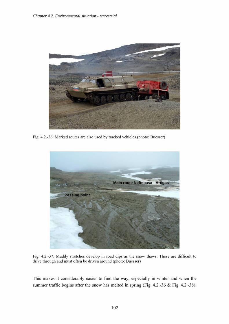
Chapter 4.2. Environmental situation - terrestrial
Fig. 4.2.-36: Marked routes are also used by tracked vehicles (photo: Buesser)
Main route Neftebasa - Artigas
Passing point
Fig. 4.2.-37: Muddy stretches develop in road dips as the snow thaws. These are difficult to drive through and must often be driven around (photo: Buesser) This makes it considerably easier to find the way, especially in winter and when the summer traffic begins after the snow has melted in spring (Fig. 4.2.-36 & Fig. 4.2.-38).
102
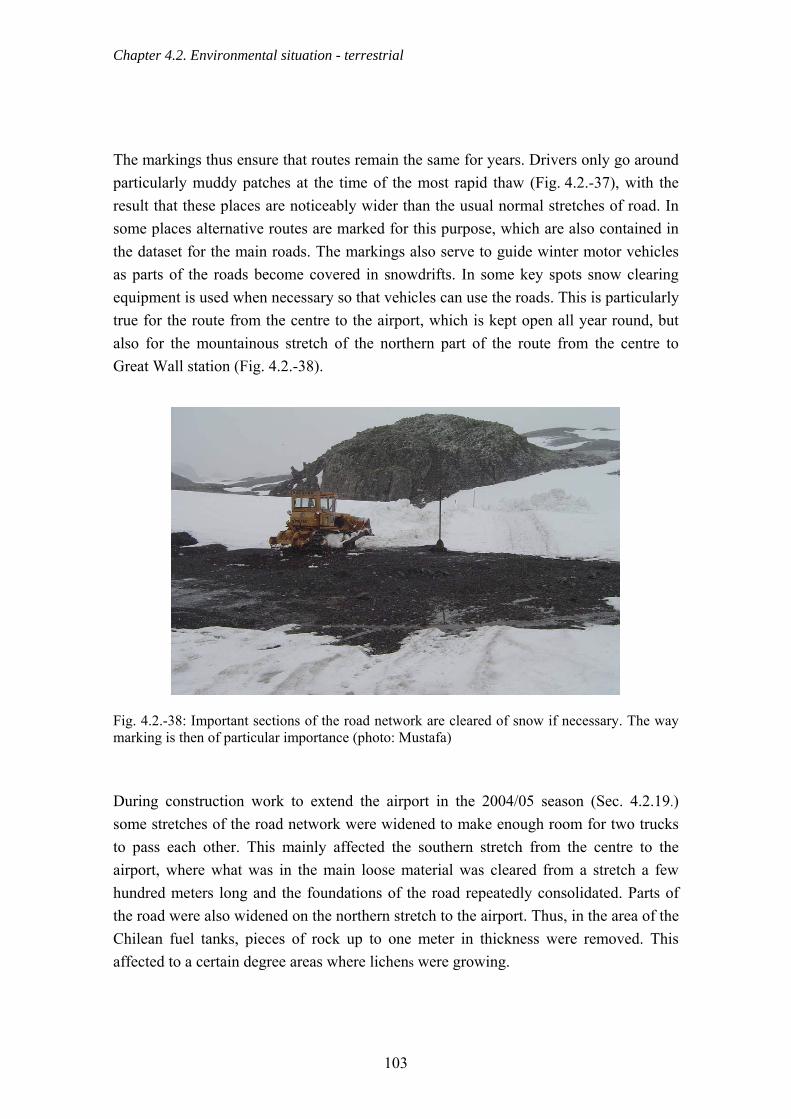
Chapter 4.2. Environmental situation - terrestrial
The markings thus ensure that routes remain the same for years. Drivers only go around particularly muddy patches at the time of the most rapid thaw (Fig. 4.2.-37), with the result that these places are noticeably wider than the usual normal stretches of road. In some places alternative routes are marked for this purpose, which are also contained in the dataset for the main roads. The markings also serve to guide winter motor vehicles as parts of the roads become covered in snowdrifts. In some key spots snow clearing equipment is used when necessary so that vehicles can use the roads. This is particularly true for the route from the centre to the airport, which is kept open all year round, but also for the mountainous stretch of the northern part of the route from the centre to Great Wall station (Fig. 4.2.-38).
Fig. 4.2.-38: Important sections of the road network are cleared of snow if necessary. The way marking is then of particular importance (photo: Mustafa) During construction work to extend the airport in the 2004/05 season (Sec. 4.2.19.) some stretches of the road network were widened to make enough room for two trucks to pass each other. This mainly affected the southern stretch from the centre to the airport, where what was in the main loose material was cleared from a stretch a few hundred meters long and the foundations of the road repeatedly consolidated. Parts of the road were also widened on the northern stretch to the airport. Thus, in the area of the Chilean fuel tanks, pieces of rock up to one meter in thickness were removed. This affected to a certain degree areas where lichens were growing.
103

Chapter 4.2. Environmental situation - terrestrial
4.2.13. Use of the road network Each station has its own fleet of vehicles. These fleets vary in size and consist of a wide variety of vehicles, such as snowmobiles (skidoos), four-wheel-drive and tracked vehicles, trucks, tractors, caterpillar tracked vehicles, and cranes, which are used for all sorts of tasks inside and outside the stations. Especially in the Antarctic summer logistical, scientific and tourist activities result in heavy use of the available road network by motor vehicles. As an example for one season, in the observation period from 11.12.2003 to 24.03.2004, a total of 179 return trips were counted on the road network between the stations. The real number must significantly exceed this total as there is frequently very busy traffic between the Chilean station Frei and the airport. Vehicles from Frei station in particular are thus clearly under-represented. The primary purpose of the journey, for example transporting people or cargo, could be noted in about 70 % of the trips counted. As only one journey was recorded that was purely related to tourist activity, this was listed under the category “Various”. Figure 4.2.-39 shows the most important reasons for journeys on the available road network.
Cargo
DelegationPeople
Fuel transport
Camp
Miscelleanous
Undefined
Veh
icle
trip
s
0
10
20
30
40
50
60
Fig. 4.2.-39: Reasons for journeys between research stations
104

Chapter 4.2. Environmental situation - terrestrial
Transport of people and fuel made up the bulk of journeys with a known purpose. Journeys related to the project run by “Coca Cola” and “Inspire!” in February 2004, which involved a tent camp for more than 40 participants set up for a number of days near the Neftebasa large fuel store, were an exceptional feature and were thus recorded separately. These journeys were made up of a mixture of tourism and transport of station staff and cargo and, for Bellingshausen station, they accounted for the largest number of journeys after those for fuel transport. Within a short time, large amounts of materials for this project were transported to Neftebasa and back, together with workers to put up and take down the tents. The purposes of the different journeys are listed according to station (Fig. 4.2.-40).
Delegation UndefinedCargo FuelPersons MiscelleanousCamp
Pro
porti
on o
f tot
al v
ehic
le tr
ips
in %
0
10
20
30
40
50Artigas (n=43)Bellingshausen (n=60)Great Wall (n=62)Frei (n=12)Escudero (n=2)
Fig. 4.2.-40: Proportion of journeys by origin and purpose with numbers of journeys per station In order to demonstrate the large variation in the volume of traffic possible on particular stretches of road, the road network was divided into five sections (Fig. 4.2.-35, Tab. 4.2.-2). It is noticeable that sections 2, 3 and 4, which connect the stations, are used very much to the same degree (Tab. 4.2.-2). Section 1 is somewhat less travelled on. Only a few trips to the Ardley Isthmus were recorded, to fetch stranded ice, or gravel for building use. In contrast to the following years, there were no journeys by motor vehicle to Ardley Island during the 2003/04 season.
105

Chapter 4.2. Environmental situation - terrestrial
Tab. 4.2.-2: Number of journeys per route
No. Route section Number of journeys1 Artigas – Neftebasa 60 2 Neftebasa – Bellingshausen/Frei 80 3 Bellingshausen/Frei – turnoff to Ardley Island 79 4 Turnoff to Ardley Island – Great Wall 82 5 Turnoff to Ardley Island – crossover Ardley 8
The transport of fuel from the Neftebasa store to Artigas accounted for a large share of the traffic on section 1 (Artigas – Neftebasa), with one-third of all journeys that took place on this stretch of road. The heaviest use of section 2 (Neftebasa – Bellingshausen/Frei), with 44 %, involved the transport of fuel, material for the tent camp and workers from Bellingshausen. As a rule, drivers kept to the existing roads in the 2003/04 season, i.e. hardly any new tracks of vehicles were noted outside of the official road network (Sec. 4.2.14.). In the 2004/05 season, in the context of the airport extension, large parts of the road network were widened and reinforced (Sec. 4.2.19.). This caused not only a noticeably greater use of the road network on Fildes, but also resulted in a large number of new tracks from tyres off the official roads. In addition, the number of tourist-related trips rose. Due to increasing tourism and the steadily growing number of station vehicles, traffic between the stations will continue to increase. If drivers keep precisely to the existing road network and if certain stretches of road are better maintained than in the past, for example by drainage work, vehicle traffic will probably have no greater effects than could previously have been expected on vegetation or nesting birds on the Fildes Peninsula. 4.2.14. Vehicle tracks Overland traffic in the study area mainly follows the marked main routes between stations. However, many tracks can be seen outside these areas. Areas that have been driven on are a problem in Antarctic regions as vegetation takes a long time to regenerate after it has been destroyed (Campbell et al., 1998; Fig. 4.5.-58).
106

Chapter 4.2. Environmental situation - terrestrial
Fig. 4.2.-41: Permanent and periodic forms of land use in the Fildes Region The mapping of vehicle tracks on Fildes and Ardley Island during the 2003/04 season showed that tracks outside the marked main roads were not isolated events, but that they affected large areas. Although most of these tracks are located inside a corridor of ~250 m beyond the main roads (Fig. 4.2.-42), there are also a series of significant
107

Chapter 4.2. Environmental situation - terrestrial
exceptions to this (Fig. 4.2.-43). These include in particular the tracks that come from the direction of Artigas station and lead through the Nordpassage to the Russian field hut “Priroda” (Fig. 4.2.-41).
Fig. 4.2.-42: Heavily used main routes ("frequent traffic" category) are marked with snow poles (right of picture) (photo: Buesser)
Fig. 4.2.-43: Occasional tracks outside the main routes ("limited traffic" category) (photo: Mustafa)
108

Chapter 4.2. Environmental situation - terrestrial
On Ardley Island there are also a series of tracks which are grouped mainly around a road to the “Ripamonti” and “Ballve” field huts in the northwest of the island. This road is hardly used nowadays as the logistics for these huts are usually handled by zodiacs (Sec. 4.2.11.). A fairly large number of tracks can also be found in the Biologenbucht (Fig. 4.2.-41). The reasons for this traffic are probably more to do with leisure activities. Tab. 4.2.-3: Land use categories as proportions for the Fildes Peninsula and Ardley Island
Category of use Area (m²) Proportion (%) Limited use 1,169,875 3.89 Occasional use 71,728 0.24 Frequent use (excluding runway) 70,363 0.23 Runway 97,552 0.33 Station grounds 403,856 1.34 Total area used by vehicles 1,813,374 6.03 Total area Fildes + Ardley 30,092,384 100
The total area used for overland travel (including station grounds) on Fildes Peninsula and Ardley Island corresponds to 6.03 % of the total land area. The shares of surface area for the different categories of use presented in Tab. 4.2.-3 show that traffic is rare on by far the largest part of the area affected by traffic (3.89 %). However, as vegetation is often destroyed the first time an area is driven over, adverse pressure could be considerably reduced by concentrating traffic on the main roads that are already frequently driven on. 4.2.15. Winter use
From reports by station staff who stay over the winter we know that outdoor activities are normally very limited during the winter months due to the weather conditions. There are occasional outings and visits between stations, which are usually carried out using motor vehicles. Every station on the Fildes Peninsula has at its disposal a range of vehicles for winter transport, consisting of at least one snowmobile (for example of the skidoo type) and one or more tracked vehicles. These are either used all year round (Artigas) or, when conditions are suitable, replaced during the summer season by four-wheel-drive vehicles (Bellingshausen, Frei, Great Wall). In collaboration with overwintering station staff it was possible to get an overview of the areas typically used by vehicles during the winter (Fig. 4.2.-44, based on information from O. Sakharov). This makes it clear that people occasionally drive by snowmobile to the plateau west of Davies Heights, the area where the “Priroda” field
109
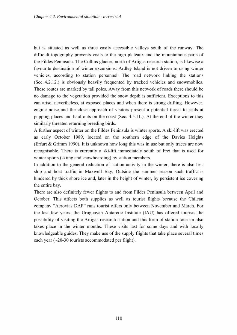
Chapter 4.2. Environmental situation - terrestrial
hut is situated as well as three easily accessible valleys south of the runway. The difficult topography prevents visits to the high plateaux and the mountainous parts of the Fildes Peninsula. The Collins glacier, north of Artigas research station, is likewise a favourite destination of winter excursions. Ardley Island is not driven to using winter vehicles, according to station personnel. The road network linking the stations (Sec. 4.2.12.) is obviously heavily frequented by tracked vehicles and snowmobiles. These routes are marked by tall poles. Away from this network of roads there should be no damage to the vegetation provided the snow depth is sufficient. Exceptions to this can arise, nevertheless, at exposed places and when there is strong drifting. However, engine noise and the close approach of visitors present a potential threat to seals at pupping places and haul-outs on the coast (Sec. 4.5.11.). At the end of the winter they similarly threaten returning breeding birds. A further aspect of winter on the Fildes Peninsula is winter sports. A ski-lift was erected as early October 1989, located on the southern edge of the Davies Heights (Erfurt & Grimm 1990). It is unknown how long this was in use but only traces are now recognisable. There is currently a ski-lift immediately south of Frei that is used for winter sports (skiing and snowboarding) by station members. In addition to the general reduction of station activity in the winter, there is also less ship and boat traffic in Maxwell Bay. Outside the summer season such traffic is hindered by thick shore ice and, later in the height of winter, by persistent ice covering the entire bay. There are also definitely fewer flights to and from Fildes Peninsula between April and October. This affects both supplies as well as tourist flights because the Chilean company ”Aerovías DAP” runs tourist offers only between November and March. For the last few years, the Uruguayan Antarctic Institute (IAU) has offered tourists the possibility of visiting the Artigas research station and this form of station tourism also takes place in the winter months. These visits last for some days and with locally knowledgeable guides. They make use of the supply flights that take place several times each year (~20-30 tourists accommodated per flight).
110
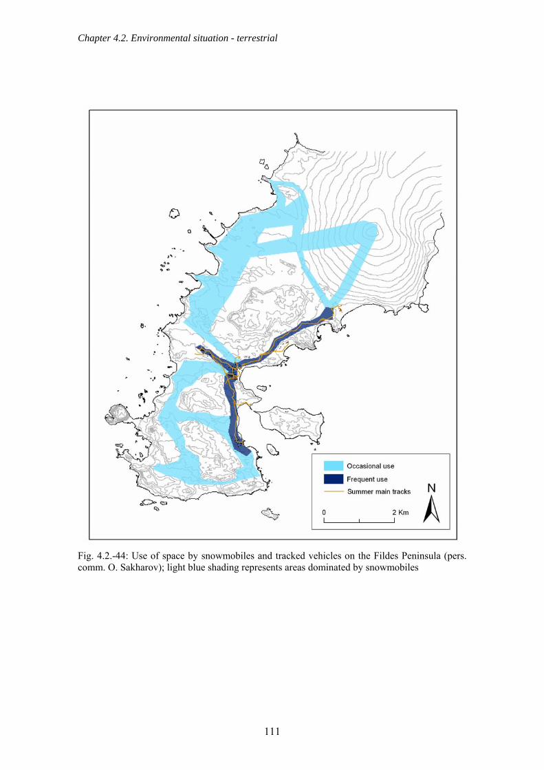
Chapter 4.2. Environmental situation - terrestrial
Fig. 4.2.-44: Use of space by snowmobiles and tracked vehicles on the Fildes Peninsula (pers. comm. O. Sakharov); light blue shading represents areas dominated by snowmobiles
111

Chapter 4.2. Environmental situation - terrestrial
4.2.16. Flight movements in the Fildes Region 4.2.16.1. Flight statistics There are regular flight movements in the Fildes Region. These flights occur almost daily and range from single take-offs or landings by large or small airplanes to groups of more than 50 helicopter flights a day between ship and station during unloading operations. Most of the flights take place in the central part of Fildes Peninsula, including Ardley Island, and an overview of the air routes in this area is given in Figs. 4.2.-45 to 4.2.-47. These routes were measured by Rangefinder GPS combination or estimated.
Fig. 4.2.-45: Flight activity by helicopters, small and large airplanes over the Fildes Peninsula and Ardley Island in summer 2003/04 (thin lines: estimated air lanes; thick lines: air lanes mapped by combined Rangefinder GPS)
112

Chapter 4.2. Environmental situation - terrestrial
Fig. 4.2.-46: Flight activity by helicopters, small and heavy airplanes over the Fildes Peninsula and Ardley Island in summer 2004/05 (thin lines: estimated air lanes; thick lines: air lanes mapped by combined Rangefinder GPS)
113
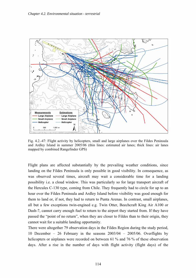
Chapter 4.2. Environmental situation - terrestrial
Fig. 4.2.-47: Flight activity by helicopters, small and large airplanes over the Fildes Peninsula and Ardley Island in summer 2005/06 (thin lines: estimated air lanes; thick lines: air lanes mapped by combined Rangefinder GPS) Flight plans are affected substantially by the prevailing weather conditions, since landing on the Fildes Peninsula is only possible in good visibility. In consequence, as was observed several times, aircraft may wait a considerable time for a landing possibility i.e. a cloud window. This was particularly so for large transport aircraft of the Hercules C-130 type, coming from Chile. They frequently had to circle for up to an hour over the Fildes Peninsula and Ardley Island before visibility was good enough for them to land or, if not, they had to return to Punta Arenas. In contrast, small airplanes, all but a few exceptions twin-engined e.g. Twin Otter, Beechcraft King Air A100 or Dash-7, cannot carry enough fuel to return to the airport they started from. If they have passed the “point of no return”, when they are closer to Fildes than to their origin, they cannot wait for a suitable landing opportunity. There were altogether 79 observation days in the Fildes Region during the study period, 10 December – 26 February in the seasons 2003/04 – 2005/06. Overflights by helicopters or airplanes were recorded on between 61 % and 76 % of these observation days. After a rise in the number of days with flight activity (flight days) of the
114

Chapter 4.2. Environmental situation - terrestrial
individual aircraft in the 2004/05 season a slight decrease was detected in the following season (Fig. 4.2.-48). Helicopters and machines of the Hercules C-130 and passenger jet types flew over the Fildes Region somewhat more rarely. There was a slight increase, however, in the proportion of flights made by light aircraft over the three seasons. Passenger jets flew over the study area on four days in the seasons 2003/04 and 2004/05, but only on one day in the following season (Fig. 4.2.-48).
Season
2003/04 2004/05 2005/06
Num
ber o
f flig
ht d
ays
0
20
40
60
80
100
120Helicopter Smaller AirplanesHercules C-130 Passenger Jets
Fig. 4.2.-48: Number of days with flight activity in the Fildes Region, by aircraft type, between 10 December and 26 February (shading: proportion of station aircrafts, including station-based DAP helicopter) Frei station has a helicopter as well as an airplane of the Twin Otter type. Both were regularly used during the observation period as was also a helicopter belonging to the tourism company “Aerovías DAP”, which was based in Frei station during the study period. Yet another helicopter came from the Peruvian station Machu Picchu in Admiralty Bay, KGI, but this was not used, however, during the seasons 2004/05 and 2005/06. Accordingly, frequent flight activity was recorded of station helicopters (Frei, Machu Picchu) or less of the station-based helicopter DAP (Fig. 4.2.-48). Between 1992/93 and 2001/02 Artigas station likewise possessed a helicopter, the frequent low-altitude flights of which are assumed to be a possible cause of the decline of the Southern Giant Petrel colony on Nebles Point (Sec. 4.5.2.).
115

Chapter 4.2. Environmental situation - terrestrial
In contrast to the relatively constant total number of flight days, the total number of helicopter and airplane overflights noted during the observation period (10 December to 16 February) rose by ~47 % to 759 overflights in the 2005/06 season from 515 in the 2003/04 season (Fig. 4.2.-49). The most noticeable rise was in helicopter activity, which increased by two-thirds within two years. Overflights by smaller aircraft increased steadily, while the number of Hercules overflights dropped back to the 2003/04 season level in the 2005/06 season following a rise during 2004/05. Overflights by passenger jets were relatively rarely observed (Fig. 4.2.-49).
Passenger Je
ts
Hercules C
-130
Smaller airplanes
Helicopter
Num
ber o
f ove
rflig
hts
0
100
200
300
400
500
6002003/04 2004/05 2005/06
Fig. 4.2.-49: Number of overflights observed over the Fildes Region, between 10 December and 26 February (shading: proportion of station aircrafts, including station-based DAP helicopter) It is clear (Fig. 4.2.-49) that overflights by research station aircraft play an important role since they make up 20 – 55 % of all overflights by small airplanes. Research station aircraft make up a similarly high percentage (31 – 50 % of total helicopter overflights) of overflights in the 'helicopter' category, these machines being used very frequently for transportation of the most diverse kinds. Overflights by the DAP helicopter (during the study period based in the Frei station) were clearly less and amounted 5 – 7 % of the total helicopter overflights (Fig. 4.2.-49)
116

Chapter 4.2. Environmental situation - terrestrial
4.2.16.2. Comparison of results with data from previous years and with published statistics Data is available for flight activity in the seasons 2000/01 to 2005/06 for the time window 20 December to 20 January in which a majority of logistics and tourism activities takes place. These data show, in a comparison over the long term, an increase in both the proportion of days on which flights occurred and the numbers of overflights of the Fildes Region (Tab. 4.2.-4). This derives in particular from a steep rise in helicopter and small airplane activity, while the number of Hercules C-130 overflights rose only slightly (Fig. 4.2.-50). Tab. 4.2.-4: Overview of the increasing number of flights over the Fildes Peninsula between 20 December and 20 January of the years 2000/01 to 2005/06
Season 2000/01 2001/02 2002/03 2003/04 2004/05 2005/06
Flight days (%) 66 63 72 60 78 78
Total overflights 75 111 192 248 195 347
Season
2000/01
2001/02
2002/03
2003/04
2004/05
2005/06
Num
ber o
f ove
rflig
hts
0
50
100
150
200
250
300Passenger Jets Hercules C-130 Smaller airplanes Helicopter
Fig. 4.2.-50: Number of overflights observed over the Fildes Peninsula and Ardley Island between 20 December and 20 January (data 2000/01 – 2002/03: S. Pfeiffer)
117

Chapter 4.2. Environmental situation - terrestrial
A long-term comparison of the data published by the Chilean aviation authority DGAC (http://www.dgac.cl/portal/page?_pageid=238,82589&_dad=portal&_schema=PORTAL) shows a clear decreasing trend year on year since 2002 in flight movements at the Teniente Marsh airport (Fig. 4.2.-51). This development was not confirmed by our results solely on the summer air traffic. The observation period included only the period between 10 December and 26 February, this means, nevertheless, that it covered very well the period of highest flight activity in the Fildes Region. Very few flights take place outside the summer.
Year
1997 1998 1999 2000 2001 2002 2003 2004 2005
Num
ber o
f flig
ht m
ovem
ents
0
200
400
600
800
1000
1200
1400
1600
1800ChileanInternational
Fig. 4.2.-51: Flight movements at the airport Teniente Marsh between 1997 and 2005, divided according to the nationality (source: DGAC) There are obvious differences between years in the number of the passengers carried (Fig. 4.2.-52). The data that we obtained for 2003 also differ from those contained in the information from Frei station. This gives rise to a discrepancy that we are unable to explain between the data collected on site and those published in the internet.
118

Chapter 4.2. Environmental situation - terrestrial
Year
1999 2000 2001 2002 2003 2004 2005
Num
ber o
f chi
lean
pas
seng
ers
0
200
400
600
800
1000
1200
1400
1600
1800
Fig. 4.2.-52: Number of Chilean passengers at Teniente Marsh between 1999 and 2005 (source: DGAC) 4.2.16.3. Tourist flight activities A substantial proportion of the overflights of the Fildes Region by small airplanes results from the tourism activities of the Chilean enterprise “Aerovías DAP”. IAATO information indicates a six-fold increase in the number of tourists (Tab. 4.2.-5), either in the context of the one or two-day schedules offered by DAP or through aerial transfer of passengers from yachts, motor yachts or ships (Sec. 4.2.17.1.). There is a mismatch between the figures published by DAP to IAATO and those we collected, on the number of flights between Punta Arenas and King George Island. This remains despite our care in accounting for non-tourist flights such as medical evacuations and supply services. Nothing is known about the causes of this discrepancy. Nevertheless, there is a clear increasing trend, not only in the number of passengers flying in but also in the number of tourism related landings on KGI. As already mentioned, flights by the DAP helicopter, for tourist but frequently also for logistic purposes (e.g. transport of scientists), made a subordinate contribution to total activity compared to the helicopters operated by the research stations.
119
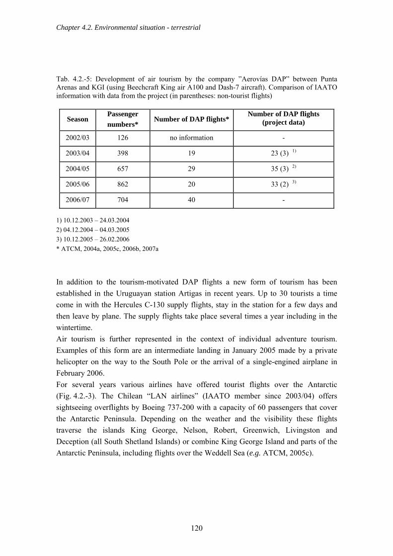
Chapter 4.2. Environmental situation - terrestrial
Tab. 4.2.-5: Development of air tourism by the company ”Aerovías DAP” between Punta Arenas and KGI (using Beechcraft King air A100 and Dash-7 aircraft). Comparison of IAATO information with data from the project (in parentheses: non-tourist flights)
Season Passenger numbers*
Number of DAP flights* Number of DAP flights
(project data)
2002/03 126 no information -
2003/04 398 19 23 (3) 1)
2004/05 657 29 35 (3) 2)
2005/06 862 20 33 (2) 3)
2006/07 704 40 -
1) 10.12.2003 – 24.03.2004 2) 04.12.2004 – 04.03.2005 3) 10.12.2005 – 26.02.2006 * ATCM, 2004a, 2005c, 2006b, 2007a In addition to the tourism-motivated DAP flights a new form of tourism has been established in the Uruguayan station Artigas in recent years. Up to 30 tourists a time come in with the Hercules C-130 supply flights, stay in the station for a few days and then leave by plane. The supply flights take place several times a year including in the wintertime. Air tourism is further represented in the context of individual adventure tourism. Examples of this form are an intermediate landing in January 2005 made by a private helicopter on the way to the South Pole or the arrival of a single-engined airplane in February 2006. For several years various airlines have offered tourist flights over the Antarctic (Fig. 4.2.-3). The Chilean “LAN airlines” (IAATO member since 2003/04) offers sightseeing overflights by Boeing 737-200 with a capacity of 60 passengers that cover the Antarctic Peninsula. Depending on the weather and the visibility these flights traverse the islands King George, Nelson, Robert, Greenwich, Livingston and Deception (all South Shetland Islands) or combine King George Island and parts of the Antarctic Peninsula, including flights over the Weddell Sea (e.g. ATCM, 2005c).
120

Chapter 4.2. Environmental situation - terrestrial
Fig. 4.2.-53: Sightseeing flight over the Fildes Peninsula in December 2001 (photo: Peter) Over the last three seasons, according to IAATO information, there was a decrease of around a third in overflights and in the number of passengers carried in this way (Tab. 4.2.-6). In agreement with this pattern only one overflight was recorded in the 2005/06 season by us. In contrast, in the 2004/05 season there were numerous jet overflights of the Fildes Region. These occasioned a total of six extremely low-altitude flights (~150 – 300 m by Rangefinder GPS combination) on all four days on which jet flights were recorded. These flights were observed over the centre of the Fildes Peninsula above the research stations Frei and Bellingshausen. Tab. 4.2.-6: Overflights by jet aircraft of the Antarctic Peninsula and observations of overflights of the Fildes Region
Season Number of flights to the
Antarctic Peninsula (passenger numbers)
Days on which jets were observed in the
Fildes Region
Overflights of the Fildes Region
2003/04 13 (679) 1) 4 6
2004/05 9 (462) 2) 4 9
2005/06 9 (450) 3) 1 1
2006/07 8 (360) 4) no information no information 1) ATCM, 2004a 2) ATCM, 2005c 3) ATCM, 2006b 4) ATCM, 2007a
121

Chapter 4.2. Environmental situation - terrestrial
4.2.16.4. Helicopter landings other than at the airport or at normal landing places With exception of Bellingshausen and Escudero, all stations possess a hardened and marked helicopter landing pad within the station grounds. However, several landings by helicopters were observed other than on the normal landing pads at the station or the airport. These exclude the landings during the disassembly of the field hut “Rambo”, landings that must be regarded as a logistical necessity and which left hardly any traces (Sec. 4.2.11.-5). Thus, in the 2003/04 season, a supply ship helicopter landed twice on the Meseta la Cruz, a hill thickly populated by skuas south of Frei station. A further remarkable observation was the one or two short landings by a station helicopter on the summit of “Flat Top” on the Drake coast. It was probably the same helicopter that landed near to Nebles Point, in the 2004/05 season, probably for sightseeing (pers. comm. I. Chupin). This is a breeding area for several bird species, including the Southern Giant Petrel, a species listed as near threatened by the IUCN (Sec. 4.5.2.). A special case is represented by a private helicopter on its way to the South Pole (mentioned above). On 6.1.2005, in the vicinity of the “Priroda” hut, this machine landed next to a group of tourists on the glacier, in order to ask the way to the nearby Argentine station “Jubany”. 4.2.16.5. Flight movements over Ardley Island ASPA and over the Fildes Strait The old management plan for Ardley Island (ASPA No. 150) states that helicopters should not fly over the island below 300 m from the ground. In the current revision of the management plan by the CEP-ICG, a vertical distance of 450 – 1,000 m is suggested depending on the type of aircraft (ATCM, 2005e, 2006f). Recently, a recommendation has come from the community of Antarctic Treaty Parties that there should be minimum distances of 610 m (vertical) and 460 m (horizontal) from colonies of breeding birds and from seal aggregations (Resolution 2 (2004), XXVII ATCM). Considering Ardley Island, we recorded numerous low-altitude flights under 610 m (Figs. 4.2.-54 & 4.2.-55). Thus, in the 2003/04 season a supply ship helicopter was twice observed flying low over both the Southern Giant Petrel and the penguin colony on Ardley Island. An altitude of scarcely 38 m was measured with Rangefinder GPS combination on both occasions. Both large and small airplanes also flew over Ardley Island in each observation season. In contrast to helicopters, however, these are subject to restrictions in their ability to change height or direction because of their particular flight characteristics (cf. AFIM). The minimum distances and minimum flight altitudes (according to Resolution 2 (2004), XXVII ATCM) are supposed to protect breeding birds in particular from disturbances and thus from damaging effects (lower breeding success etc.). The data
122

Chapter 4.2. Environmental situation - terrestrial
show that flights regularly transgress the minimum distances laid down, so that negative effects are probably not avoided. The yellow zone (Fig. 4.2.-55) represents the area where no flights should be below 460 m according to Resolution 2 (2004) XXVII ATCM. The routes of flight movements of various aircraft as measured by Rangefinder GPS combination for the 2005/06 season are also represented. The flight movements in bold occurred within the vertical distance of 610 m. It is evident (Fig. 4.2.-55) that in the time covered nearly all flights recorded in the 460 m horizontal restriction zone were likewise less than 610 m from the ground. Airplanes usually land against the wind on Fildes, which often compels them to fly over the Peninsula first in order to head for the runway from the other direction (from the southwest). The AFIM recommends that aircraft overflying from west to east should circle around to the south. Airplanes thus occasionally approach Ardley Island very closely or even fly low over the island (Fig. 4.2.-55).
2003/04 2004/05 2005/06
Num
ber o
f Ard
ley
over
fligh
ts
0
20
40
60
80
Helicopter Smaller airplanesHercules C-130
Season
Fig. 4.2.-54: Observed incidences of flights below the altitude (610 m) or horizontal distance (460 m) for Ardley Island set out in Resolution 2 (2004) XVII ATCM
123

Chapter 4.2. Environmental situation - terrestrial
Fig. 4.2.-55: Course of flights over Ardley Island in summer 2005/06 below the altitude (610 m) or horizontal distance (460 m) set out in Resolution 2 (2004) XVII ATCM (in yellow area) For the same reason airplanes, particularly of Hercules C-130 type, also often overfly the Fildes Strait at low altitude (Fig. 4.2.-56a), which raises problems because of the numerous Southern Giant Petrel colonies (Sec. 4.5.2.). Such low-altitude flights by Hercules C-130 observed were linked particularly with repetitive approach flights or training flights. The lowest altitude, 89 m, was measured by Rangefinder GPS combination in the season 2003/04 directly over the islands of the Fildes Strait. In addition, isolated overflights at low altitude without an obvious reason were observed. An example of this was a Hercules in the 2005/06 season. This, after take off, flew at only 70 – 90 m (Rangefinder GPS combination measurement) over the northeast point of Ardley Island and thus over the penguin colony there (Fig. 4.2.-56b) then, shortly afterwards, turned northward.
124

Chapter 4.2. Environmental situation - terrestrial
Refugio Ripamonti
Fig. 4.2.-56a & b: Low altitude Hercules flights (a) over Fildes Strait, January 2006 (b) Ardley Island, January 2006; flight altitude over penguin colony ~70 - 90 m (photos: Buesser) It is noteworthy that there was a clear decrease during the three observation seasons in the number of flights over Ardley Island and Fildes Strait (Fig. 4.2.-54). It is possible that this is connected with a growing knowledge on Fildes of the work of the project reported here, and with an increasing awareness of the presence of observers who were recording all flight movements. This may possibly have raised the consciousness of individual pilots that they should adhere to the minimum flight altitudes. 4.2.17. Ship and zodiac movements in Maxwell Bay The purposeful collection of data on shipping in Maxwell Bay supplies a comprehensive picture of the how often ships and other craft frequent this area and how they use the space. 4.2.17.1. Ships The locations determined for ships at anchor or lying to clearly show that the focus of spatial use lies within the western range of Maxwell Bay, north of Ardley Island (Fig. 4.2.-57). That is, ships occurred most frequently in the area of the bay directly in front of Frei and Bellingshausen research stations. There were very few near Artigas and Great Wall and then almost entirely for supply purposes. A single cruise ship visited the more southerly part of Maxwell Bay in February 2005 in order to land tourists near the Chinese station Great Wall. A total of 41 different ships and yachts were recorded during the study period (10 December to 26 February of all three years). More than half of these ships were designed specifically for trips into polar regions or at least had hull and screw
125

Chapter 4.2. Environmental situation - terrestrial
strengthened against ice which represents an important safety factor in this region. Thus ~59 % carried ice class certification (usually following the Finnish-Swedish categorisation, source: http://sea.helcom.fi/) or were strengthened against ice.
Fig. 4.2.-57: Patterns of spatial use of the inner Maxwell Bay by ships of different types anchoring or lying to in the summer seasons 2003/04, 2004/05 and 2005/06 Only two patrol ships and two research ships had no obvious special adjustments for polar waters and for five further ships (among them two cruise ships), as well as eight yachts and motor yachts, no appropriate information was available. All remaining 15 cruise ships fell into high ice classes (e.g. 1A, 1A1 super) up to ice-breaker standards. This is often due to the origin of the ships, which were often originally designed for and employed as research ships in polar waters. The tourism companies that operate all these ships, and among them also an operator of large motor yachts, possess full IAATO membership (source: http://www.iaato.org/company_descriptions.html). With one exception, all the cruise ships observed in Maxwell Bay belonged to the class with fewer than 200 passengers in the IAATO classification. A single ship headed of the category of 200 – 500 passengers once headed for Bellingshausen but landed no passengers on the Fildes Peninsula. Maxwell Bay was, however, entered only by ships of small and medium size. The
126
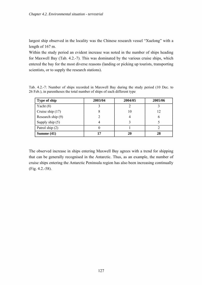
Chapter 4.2. Environmental situation - terrestrial
largest ship observed in the locality was the Chinese research vessel “Xuelong” with a length of 167 m. Within the study period an evident increase was noted in the number of ships heading for Maxwell Bay (Tab. 4.2.-7). This was dominated by the various cruise ships, which entered the bay for the most diverse reasons (landing or picking up tourists, transporting scientists, or to supply the research stations). Tab. 4.2.-7: Number of ships recorded in Maxwell Bay during the study period (10 Dec. to 26 Feb.), in parentheses the total number of ships of each different type
Type of ship 2003/04 2004/05 2005/06 Yacht (8) 3 2 3 Cruise ship (17) 8 10 12 Research ship (9) 2 4 6 Supply ship (5) 4 3 5 Patrol ship (2) 0 1 2 Summe (41) 17 20 28
The observed increase in ships entering Maxwell Bay agrees with a trend for shipping that can be generally recognised in the Antarctic. Thus, as an example, the number of cruise ships entering the Antarctic Peninsula region has also been increasing continually (Fig. 4.2.-58).
127

Chapter 4.2. Environmental situation - terrestrial
Season
1996
/97
1997
/98
1998
/99
1999
/00
2000
/01
2001
/02
2002
/02
2003
/04
2005
/05
2005
/06
2006
/07
Num
ber o
f cru
ise
ship
s
0
10
20
30
40
Fig. 4.2.-58: Number of cruise ships entering Antarctic Peninsula waters (source: www.iaato.org; ATCM 2007a) With the increasing number of ships operating in the Fildes Region, the number of ship arrivals and the approach frequency also clearly grew during the study period (Fig. 4.2.-59). The largest number of arrivals was contributed by relatively few supply ships, followed by cruise ships and research ships. Furthermore, the proportion of ship days, i.e. days with at least a ship in the bay, rose strongly from 44 % of the 79 observation days of the study period (10 December – 26 February) in 2003/04 to over 70 % in 2004/05 and 85 % in the 2005/06 season. The duration of ship stopovers ranged between short stops of less than one hour for transporting people or freight and stays of several days with extensive unloading work (research ship “Xuelong”: 10 days) or passenger transfer by air (the large luxury motor yacht “Giant 1”: 11 days). The majority of the ships (~67 %), predominantly the cruise ships, however, still left the bay on day of arrival. The average duration rose during the investigation period from 1.2 days in the 2003/04 season to over 1.7 in 2004/05 and 1.8 days in 2005/06.
128

Chapter 4.2. Environmental situation - terrestrial
Yacht
Cruise ve
ssel
Rresearch ve
ssel
Supply vesse
l
Patrol ve
ssel
Sum
Num
ber o
f shi
p ar
rival
s
0
20
40
60
80
1002003/04 2004/05 2005/06
Fig. 4.2.-59: Number of ship arrivals in Maxwell Bay by type of ship The high frequency of shipping in Maxwell Bay demonstrated is clearly connected with the rapid accessibility of South America by air. Because of this ships head for the Fildes Peninsula for logistical operations involving supplying ships and research stations in the Antarctic Peninsula and in the case of emergencies. During the study period up to five evacuations through Teniente Marsh airport occurred in each season of people from cruise ships and yachts on the basis of the international agreement EMER between IAATO and the Chilean airline “Aerovías DAP” (e.g. ATCM, 2004a & d, 2005c, 2006a). In addition to the arrivals of scientists and delegations, who travel on by ship, there is a further phenomenon of ship-air transfer. This is when passengers arriving on ships then leave by air, and arrivals by air leave by ship, a new aspect of air and sea traffic in the region. This form of passenger exchange, involving the cruise ships “Grigoriy Mikheev”, “Aleksey Maryshev” and “DAP Mares” as well as the airline “Aerovías DAP”, took place for the first time in 2003/04 and occurred increasingly from 2004/05 (ATCM, 2004a, 2005c, 2006a, 2007a). The number of passengers transported in this way rose from 37 in the 2003/04 season (1 flight or passenger exchange) to 130
129

Chapter 4.2. Environmental situation - terrestrial
(4 flights) in 2004/05 and 174 (6 flights) in the 2005/06 season. This trend looks set to continue in the future (2006/07: 211 passengers, 7 flights). 4.2.17.2. Landing boats and ships’ tenders Landing boats or ships’ tenders are regularly utilised to transport large loads in Maxwell Bay (Tab. 4.2.-8). These may belong either to the stations themselves or to ships (stations: Bellingshausen; Fig. 4.2.-60a, King Sejong; ships: “Oscar Viel”; Fig. 4.2.-60b, “Xuelong”, “Artigas”, “James Clark Ross”, “Endurance”). On occasion, these boats are also used to transport passengers, e.g. for sightseeing trips with delegations.
Fig. 4.2.-60a & b: Boats of (a) Bellingshausen Station and (b) the supply ship “Oscar Viel” (photos: Buesser) Extra boats were in use for scientific purposes during the 2004/05 and 2005/06 seasons. In addition to a zodiac, boats of the British research ship “HMS Endurance” were involved in a bathymetric survey of Maxwell Bay using a multi-beam echo sounder. For the same reason, a field camp was set up with helicopter support on the Ardley Isthmus. The camp was occupied for one period of 11 days (2004/05) and another of 7 (2005/06). For the purpose of the measurements one or two ship's boats operated from the camp throughout Maxwell Bay supported by the mother ship from time to time.
130

Chapter 4.2. Environmental situation - terrestrial
Tab. 4.2.-8: Number of days on which landing boats and ship’s tenders were in use categorised by boat operator
Boot operator 2003/04 2004/05 2005/06 Station boats Bellingshausen 14 2 0 King Sejong * - 0 1 Ship boats „Artigas“ 0 0 1 „Endurance“ 2004/05: 1 Tender 2005/06: 2 Tender
0 4 6
„James Clark Ross“ 0 1 0 „Oscar Viel“ 3 4 2 „Xuelong“ ** 0 ? ** 0 Total days of boat operation 17 > 11 10
This station has had a boat only since the 2004/05 season. ** Poor observability of this part of Maxwell Bay prevented detection of the operation frequency of boats from the Chinese ice-breaker “Xuelong” used to supply Great Wall station. Estimated maximum days of operation: 10. The use of landing boats and ships’ tenders is strongly dependent on the logistic need (e.g. transport of freight for specific seasonal construction projects by stations) and on the prevailing weather conditions. Because of this variability, only limited conclusions can be drawn from the data on boat use presented. 4.2.17.3. Zodiacs Zodiacs were used frequently throughout the entire investigation period for local transport of people and goods (Fig. 4.2.-61). Within the study period there was a strong rise in the frequency of zodiac use, i.e. in the number of days on which zodiacs were in use as a proportion of the 79 observation days of observation (10 December – 26 February). The initial figure of 61 % rose to 92 %, i.e. in the 2005/06 season at least one zodiac was in use almost every day. There was, however, a distinct difference in usage between zodiacs belonging to ships and those belonging to the stations. This makes it impossible to compare directly the frequency of use by each category. Ship zodiacs tended to shuttle many times a day between the ship and the shore but to do so only on few days in the season. Station zodiacs tend to make a few journeys to different destinations each day but on more days. However, an increase in use was demonstrated for both categories. It should be noted that here zodiac
131

Chapter 4.2. Environmental situation - terrestrial
traffic is strongly weather dependent, and that the very calm weather in 2005/06 season, especially in January, allowed zodiac use unusually often.
Fig. 4.2.-61: Means of transport between stations – inflatable boats of zodiac type (photo: Buesser) All stations of the Fildes Peninsula as well as several neighbouring stations on King George Island used zodiacs for person or freight transport in the Maxwell Bay area. Large differences existed in the frequency of their zodiac use, which is represented by the number of journey days (Tab. 4.2.-9). It is evident that zodiacs were most frequently employed at Bellingshausen and Escudero stations, which was due predominantly to necessary logistic support of numerous scientific projects (including this one). Thus, scientists active at these stations during the summer frequently visited Ardley Island, for example, by zodiac. Land access to this island is over a causeway only open at low tide and, in addition, the island possesses protected status (ASPA No. 150). Therefore, all-terrain vehicles should not, in the main, be used to reach its field huts (Sec. 4.2.11.). Furthermore, zodiacs were employed in the 2005/06 season during the dismantling of the “Ripamonti” field hut complex. They took the necessary tools and personnel between Escudero and Ardley Island as well as transporting back all the resulting debris (Sec. 4.2.11.4.). Numerous zodiac trips also took place between the stations King Sejong and Bellingshausen because the Korean personnel arrive on and leave the Fildes Peninsula entirely via the airport. Zodiac trips to the Korean station are also necessitated because it regularly receives various supplies by air. During the 2005/06 summer, a
132

Chapter 4.2. Environmental situation - terrestrial
zodiac from the Spanish research ship “Hesperides” was detached to Escudero for a long period and was frequently used in support of scientific diving exercises. With the increase of ship traffic during the study period (see below) ship’s zodiacs were also more frequently used. Their frequency of use, however, always stayed below that of station zodiacs (Fig. 4.2.-62). If ships and yachts employed zodiacs, they were often in continuous use, particularly in unloading supply ships or landing cruise passengers. Only in one case was a tour by tourists observed without a landing. Otherwise zodiacs usually brought the passengers directly to research stations. The evident rise in the use of yacht zodiacs in 2005/06 results from the presence of the large luxury motor yacht “Giant 1”. This vessel twice anchored in Maxwell Bay to wait for passengers arriving by airplanes. Furthermore, in the 2005/06 season, and in contrast to previous years, zodiacs of Argentine and Chilean patrol ships were employed for frequent visits to research stations by the naval crews. Tab. 4.2.-9: Number of days on which station zodiacs were in use categorised by station of origin
Zodiac operator 2003/04 2004/05 2005/06 Artigas 0 1 2 Arctowksy (Admiralty Bay, KGI) 0 1 0 Bellingshausen 8 26 35 Capuerto/Frei 4 7 11 Escudero 22 24 34 Great Wall 8 7 3 „Hesperides“ * 0 0 15 Jubany (Potter Cove, KGI) 2 2 6 King Sejong (Marian Cove, KGI) 8 20 21 Total days of operation of station’s zodiacs 36 50 61
* evaluated as belonging to Escudero research station as detached to the station for several weeks for scientific reasons
133

Chapter 4.2. Environmental situation - terrestrial
StationsShips
Yacht
Cruise ve
ssel
esearch ve
ssel
Supply vesse
l
Patrol vesse
l
R
Day
s w
ith z
odia
c us
e
0
10
20
30
40
50
60
702003/04 2004/05 2005/06
Fig. 4.2.-62: Frequency of zodiac use by origin. The category ships includes all the following categories. 4.2.17.4. Example of an activity peak in Maxwell Bay An extraordinary example of an accumulation of different activities was recorded in the 2005/06 season. On 15.01.2006, favoured by optimal weather conditions, a total of six ships were present in Maxwell Bay (Fig. 4.2.-63). These comprised one large motor yacht as well as three supply ships and two research vessels. There was consequently heavy boat traffic as zodiacs and landing boats shuttled between these ships and the Bellingshausen and Frei stations for the entire day either unloading large amounts of freight or to land or to embark large numbers of people. From the early morning, at five-minute intervals, there was always at least one, usually two, and maximally four, zodiacs under way at the same time. On this day we estimated that there were over 300 trips before the transport of freight and passengers finally ceased.
134
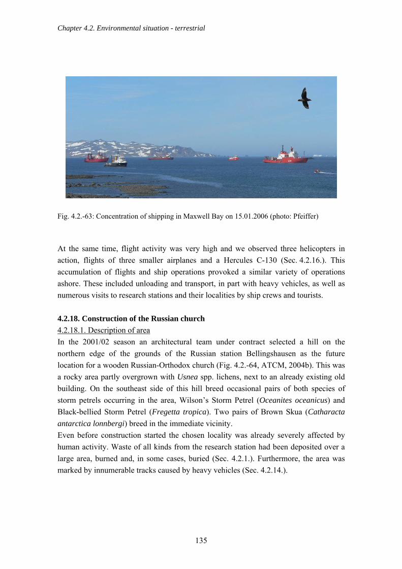
Chapter 4.2. Environmental situation - terrestrial
Fig. 4.2.-63: Concentration of shipping in Maxwell Bay on 15.01.2006 (photo: Pfeiffer) At the same time, flight activity was very high and we observed three helicopters in action, flights of three smaller airplanes and a Hercules C-130 (Sec. 4.2.16.). This accumulation of flights and ship operations provoked a similar variety of operations ashore. These included unloading and transport, in part with heavy vehicles, as well as numerous visits to research stations and their localities by ship crews and tourists. 4.2.18. Construction of the Russian church
4.2.18.1. Description of area
In the 2001/02 season an architectural team under contract selected a hill on the northern edge of the grounds of the Russian station Bellingshausen as the future location for a wooden Russian-Orthodox church (Fig. 4.2.-64, ATCM, 2004b). This was a rocky area partly overgrown with Usnea spp. lichens, next to an already existing old building. On the southeast side of this hill breed occasional pairs of both species of storm petrels occurring in the area, Wilson’s Storm Petrel (Oceanites oceanicus) and Black-bellied Storm Petrel (Fregetta tropica). Two pairs of Brown Skua (Catharacta antarctica lonnbergi) breed in the immediate vicinity. Even before construction started the chosen locality was already severely affected by human activity. Waste of all kinds from the research station had been deposited over a large area, burned and, in some cases, buried (Sec. 4.2.1.). Furthermore, the area was marked by innumerable tracks caused by heavy vehicles (Sec. 4.2.14.).
135

Chapter 4.2. Environmental situation - terrestrial
4.2.18.2. Chronological overview of the construction process After the Russian Antarctic expedition (ATCM, 2004b), responsible for this activity, had prepared an Initial Environmental Evaluation (IEE), and given permission for the building work, the building material for the church was imported directly from Russia and delivered at the beginning of December 2003 by the chartered cruise ship “Akademik Sergey Vavilov”. After the material was landed it was transported to the site along an existing track and stored temporarily nearby. Although the track had certainly been in existence for a long time, it had to be stabilised several times during church construction because of the muddy subsoil and the frequent journeys over it. Stabilisation took the form of covering the track with a thick layer of shingle removed from the beach about 300 m away. Construction started immediately on the arrival of 10 Russian craftsmen and engineers on 17.12.2003 who flew in via Punta Arenas, Chile. All the wooden components were prefabricated and were assembled on site. They consisted of debarked timber from Siberian pine and larch (ATCM, 2004b). As in usual in Russia, the joints between the timbers were sealed with Siberian moss, Hylocomium splendens (det. Herbarium Haussknecht Jena). There was no chemical treatment of the building material at any time. Construction was completed on 14.02.2004 and the church was consecrated on the day after. The ceremony took place in the presence of a 25-strong Russian delegation consisting of high-ranking church representatives, sponsors, a camera team, and additional guests from neighbouring stations.
136

Chapter 4.2. Environmental situation - terrestrial
Fig. 4.2.-64: Location of the Russian Orthodox church erected in 2003/04 The immediate surroundings of the church were levelled and stabilised with gravel during and after the end of construction. A footpath to the church was also created by bringing gravel on site but this path only begins half-way to the church and so does not guide visitors all the way from the station. Since March 2004 the building has been illuminated by searchlights at night. Even within the first two years of its existence, moisture has penetrated the church to a considerable extent. This is because of the predominantly maritime climate of King George Island with its continual high wind speeds and simultaneous high humidity. In the 2005/06 season therefore a group of five craftsmen, all of whom had worked on the construction of the church, arrived to carry out remedial work. The church was surrounded by scaffolding and wrapped in polythene sheeting for a period of several
137

Chapter 4.2. Environmental situation - terrestrial
weeks during the drying process. The joints in the construction were resealed using a material recommended for log cabins. 4.2.18.3. Environmental effects of the construction of the church The direct environmental impact of church construction between December 2002 and February 2004 was essentially limited to vehicle tracks due to material transport and footprint damage around the construction site. These affected an area that was already severely degraded. There were also a few cases of packing material, e.g. plastic sheeting, being blown around by the wind. In addition, the construction resulted in the formation of several footpaths between the station, the church, and the home of the station priest, and in more intensive use of existing paths. This extensive network of paths, which is particularly intricate in its lower reaches, traverses an area covered with patches of thick moss and through the breeding territory of a pair of Brown Skuas. This pair has been breeding in the immediate vicinity of the station for a long time and is fed by station personnel (Sec. 4.2.4.). Both members of the pair are therefore completely accustomed to the presence of people and only become agitated when a close approach is made to the nest. To prevent the birds being agitated, and to direct pedestrians on their way to the church around the nest, scientists from Jena University marked the immediate nest area with a ring of poles at a suitable distance. The Bellingshausen personnel were informed of this action. More serious than the direct effects of constructing the church is the possible colonisation and establishment of the mosses brought in to caulk joints in the building, which could considerably affect the ecosystem. Although there have been no signs of this happening so far, this potential threat should continue to be monitored in the future. To better direct pedestrian traffic between the station and the church, and so to limit treading damage, a footpath should be clearly marked out in the near future. The Russian church has proven to be an attractive destination for visitors whether they arrive by ship or by air, as well as for personnel from neighbouring stations (Fig. 4.2.-65). However, there are so far no indications of an increase in the frequency of visits to the Fildes Peninsula by cruise ships for purely tourist reasons (Sec. 4.2.17.1.). It can be assumed that it is more likely that the church is a welcome additional object of interest in a visit that would have taken place anyway.
138

Chapter 4.2. Environmental situation - terrestrial
Fig. 4.2.-65: Russian Orthodox church erected in 2003/04 in the grounds of the Russian station Bellingshausen (photo: Buesser) 4.2.19. Airport extension A hard runway (“Aerodromo Teniente Marsh”) was constructed in 1980 on the Fildes Peninsula for inter- and intra-continental flights in order to transport cargo, station personnel and visitors to and from the research stations of the South Shetland Islands and the Antarctic Peninsula. At 1,292 m long and 45 m wide, the runway can accommodate large cargo planes of the Hercules C-130 type as well as various types of small airplanes such as DC-3, Twin Otter, Dash-7, and Beechcraft King Air A100. As take off and landing must be carried out visually or with occasional radio assistance use of the airport is extremely weather dependent. Due to the maritime climate predominating on King George Island the proportion of days with suitable weather, i.e. with good enough visibility for landing, is restricted to estimated 75 % of days in summer. The number of landings possible had also been restricted until recently by the lack of a parking zone for large aircraft already on the ground. To remedy these difficulties, therefore, a parking zone sufficient for two large airplanes was constructed in the 2004/05 season. The airport extension project was called ‘Normalización Área de Estacionamiento de Aeronaves y Pista de Aterrizaje “Aeródromo Teniente Marsh”, XII Región de Magallanes y Antártica Chilena’. All the details, including the IEE, of this project are described under: http://www.e-seia.cl/portal/busquedas/antarticos.php.
139

Chapter 4.2. Environmental situation - terrestrial
4.2.19.1. Environmental effects of the airport extension According to various people present locally, building activities started around 01.12.2004. The removal of material for a bank of earth for the parking zone remained restricted to the two areas named in the above mentioned IEE for only a short time. The building site supervision knew very little about environmentally sensitive areas due to inadequate information on the occurrence of local flora and fauna in the IEE. A further search for appropriate areas for material extraction was made in December and January, as could be seen by the numerous new digger tracks and test pits in the area south of the Chilean station. The rock dynamiting and crushing in the vicinity of quarry No. 1 (Fig. 4.2.-66) that had been planned as a means of obtaining material was avoided throughout the construction period. As stated by the building site manager, both quarries were in no way sufficient for the needs of construction with a yield of in total 5,000 m3 compared to the total requirement of 50 - 70,000 m3. This was because, in these quarries, only very small quantities of material could be extracted without using explosives due to the immediately neighbouring rocks. Extraction was therefore extended immediately after the start of building to areas outside the two quarries planned and described in the IEE. The area affected by mining and transferring of material was determined by cartography as shown in Tab. 4.2.-10 and corresponds with the division of areas shown in Fig. 4.2.-66. Overall a total area of 8.36 ha was affected between December 2004 and February 2005 by the building of the airport extension. Tab. 4.2.-10: Total use of land during construction of the airport extension derived from area measurements by GPS Type of construction activity Area affected - m2 remarks Material filling of which Parking
22,748 21,526
Material moved 3604 Extraction of which Quarry No. 1 Quarry No. 2 Quarry No. 3
57,279 3799 704
15,709
Relatively low in relation to the height and steepness of
the quarry
140
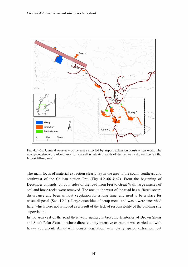
Chapter 4.2. Environmental situation - terrestrial
Fig. 4.2.-66: General overview of the areas affected by airport extension construction work. The newly-constructed parking area for aircraft is situated south of the runway (shown here as the largest filling area) The main focus of material extraction clearly lay in the area to the south, southeast and southwest of the Chilean station Frei (Figs. 4.2.-66 & 67). From the beginning of December onwards, on both sides of the road from Frei to Great Wall, large masses of soil and loose rocks were removed. The area to the west of the road has suffered severe disturbance and been without vegetation for a long time, and used to be a place for waste disposal (Sec. 4.2.1.). Large quantities of scrap metal and waste were unearthed here, which were not removed as a result of the lack of responsibility of the building site supervision. In the area east of the road there were numerous breeding territories of Brown Skuas and South Polar Skuas in whose direct vicinity intensive extraction was carried out with heavy equipment. Areas with denser vegetation were partly spared extraction, but
141

Chapter 4.2. Environmental situation - terrestrial
vegetation was harmed there too by the digging of test pits and because construction vehicles drove over it.
Fig. 4.2.-67: Detailed view of the areas affected by airport extension construction work to the south of the Chilean station Frei The addition to the Chilean airport of a parking area for large aircraft of the Hercules C-130 type in December 2004 and January 2005 led to extensive construction activity near the Chilean station Frei. As early as 05.12.2004, i.e. shortly after building began, preparatory measures were observed in the southern beach area of Maxwell Bay. Here cliff areas close to the shore, which were inhabited by storm petrels (Wilson’s Storm Petrel, Black-bellied Storm Petrel (Fig. 4.2.-67), were destroyed and removed by heavy equipment (pneumatic hammer equipped digger) in order to create an access route to the eastern section of the beach for construction vehicles. In this coastal section large scale removal of building materials was carried out from 11.01.2005 onwards. The existing, comparatively dense, moss and lichen vegetation was severely damaged by construction
142

Chapter 4.2. Environmental situation - terrestrial
vehicles and removal of material during the construction of the marked-out route (Fig. 4.2.-68). Extensive destruction of the neighbouring densely lichen covered storm petrel breeding areas was avoided through a positive discussion on site with the construction site manager on 20.01.2006 (Fig. 4.2.-69).
Fig. 4.2.-68: Trackway laid to quarry No. 3, on the right the partly destroyed storm petrel breeding ground (photo: Peter) In January 2005 several test pits were dug near the Chinese station Great Wall in order to examine the grain size of the loose rock. These were approximately 300 m west of the location indicated on the map on a beach ridge overgrown with lichen (Sec. 4.4.2.). At another meeting with the construction site manager, it was pointed out that the extraction was located in the southern section of the zone protected as ASPA No. 125. This was followed by jointly viewing alternative sites for obtaining material, none of which, according to the construction site manager, could be used for various reasons. Consequently, material extraction, using stone crushing among other techniques, was intensified in the southern coastal section of Maxwell Bay whereby, according to the agreement, the areas with dense vegetation and breeding colonies of storm petrels were left untouched (Fig. 4.2.-69).
143
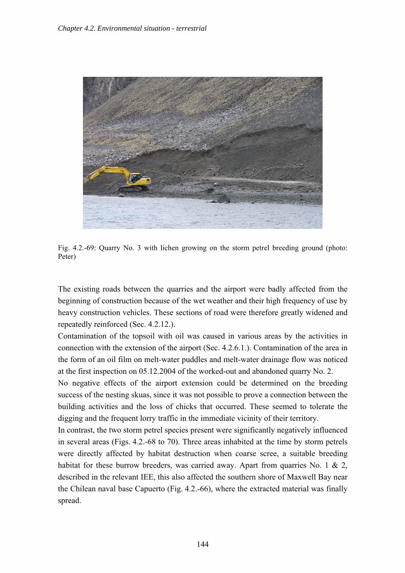
Chapter 4.2. Environmental situation - terrestrial
Fig. 4.2.-69: Quarry No. 3 with lichen growing on the storm petrel breeding ground (photo: Peter) The existing roads between the quarries and the airport were badly affected from the beginning of construction because of the wet weather and their high frequency of use by heavy construction vehicles. These sections of road were therefore greatly widened and repeatedly reinforced (Sec. 4.2.12.). Contamination of the topsoil with oil was caused in various areas by the activities in connection with the extension of the airport (Sec. 4.2.6.1.). Contamination of the area in the form of an oil film on melt-water puddles and melt-water drainage flow was noticed at the first inspection on 05.12.2004 of the worked-out and abandoned quarry No. 2. No negative effects of the airport extension could be determined on the breeding success of the nesting skuas, since it was not possible to prove a connection between the building activities and the loss of chicks that occurred. These seemed to tolerate the digging and the frequent lorry traffic in the immediate vicinity of their territory. In contrast, the two storm petrel species present were significantly negatively influenced in several areas (Figs. 4.2.-68 to 70). Three areas inhabited at the time by storm petrels were directly affected by habitat destruction when coarse scree, a suitable breeding habitat for these burrow breeders, was carried away. Apart from quarries No. 1 & 2, described in the relevant IEE, this also affected the southern shore of Maxwell Bay near the Chilean naval base Capuerto (Fig. 4.2.-66), where the extracted material was finally spread.
144
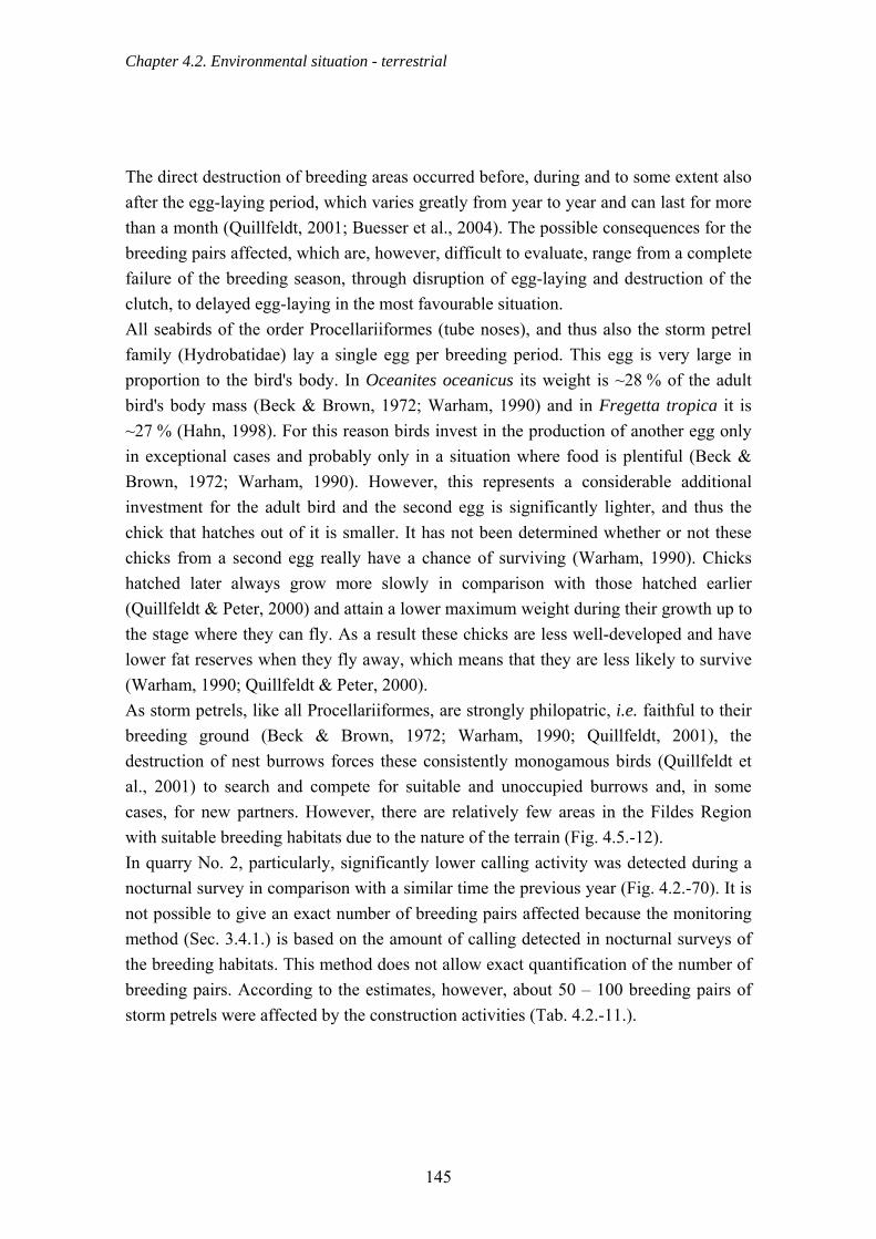
Chapter 4.2. Environmental situation - terrestrial
The direct destruction of breeding areas occurred before, during and to some extent also after the egg-laying period, which varies greatly from year to year and can last for more than a month (Quillfeldt, 2001; Buesser et al., 2004). The possible consequences for the breeding pairs affected, which are, however, difficult to evaluate, range from a complete failure of the breeding season, through disruption of egg-laying and destruction of the clutch, to delayed egg-laying in the most favourable situation. All seabirds of the order Procellariiformes (tube noses), and thus also the storm petrel family (Hydrobatidae) lay a single egg per breeding period. This egg is very large in proportion to the bird's body. In Oceanites oceanicus its weight is ~28 % of the adult bird's body mass (Beck & Brown, 1972; Warham, 1990) and in Fregetta tropica it is ~27 % (Hahn, 1998). For this reason birds invest in the production of another egg only in exceptional cases and probably only in a situation where food is plentiful (Beck & Brown, 1972; Warham, 1990). However, this represents a considerable additional investment for the adult bird and the second egg is significantly lighter, and thus the chick that hatches out of it is smaller. It has not been determined whether or not these chicks from a second egg really have a chance of surviving (Warham, 1990). Chicks hatched later always grow more slowly in comparison with those hatched earlier (Quillfeldt & Peter, 2000) and attain a lower maximum weight during their growth up to the stage where they can fly. As a result these chicks are less well-developed and have lower fat reserves when they fly away, which means that they are less likely to survive (Warham, 1990; Quillfeldt & Peter, 2000). As storm petrels, like all Procellariiformes, are strongly philopatric, i.e. faithful to their breeding ground (Beck & Brown, 1972; Warham, 1990; Quillfeldt, 2001), the destruction of nest burrows forces these consistently monogamous birds (Quillfeldt et al., 2001) to search and compete for suitable and unoccupied burrows and, in some cases, for new partners. However, there are relatively few areas in the Fildes Region with suitable breeding habitats due to the nature of the terrain (Fig. 4.5.-12). In quarry No. 2, particularly, significantly lower calling activity was detected during a nocturnal survey in comparison with a similar time the previous year (Fig. 4.2.-70). It is not possible to give an exact number of breeding pairs affected because the monitoring method (Sec. 3.4.1.) is based on the amount of calling detected in nocturnal surveys of the breeding habitats. This method does not allow exact quantification of the number of breeding pairs. According to the estimates, however, about 50 – 100 breeding pairs of storm petrels were affected by the construction activities (Tab. 4.2.-11.).
145

Chapter 4.2. Environmental situation - terrestrial
Fig. 4.2.-70: Worked-out quarry No. 2 with the partly destroyed storm petrel breeding ground (photo: Buesser) Tab. 4.2.-11: Estimated numbers of storm petrel breeding pairs before aggregate extraction Breeding area Wilson’s Storm Petrel Black-bellied Storm Petrel
Quarry No.1 (surveyed) 50 - 100 < 10 Quarry No. 2 (judged on the characteristics of the ground)
< 10 < 10
Coastal area (Capuerto, surveyed) 50 - 100 50 - 100 In several areas the local vegetation was also harmed by material extraction (Figs. 4.2.-69 to 72) and by the driving of construction vehicles elsewhere than on the existing roads (Fig. 4.2.-72).
146
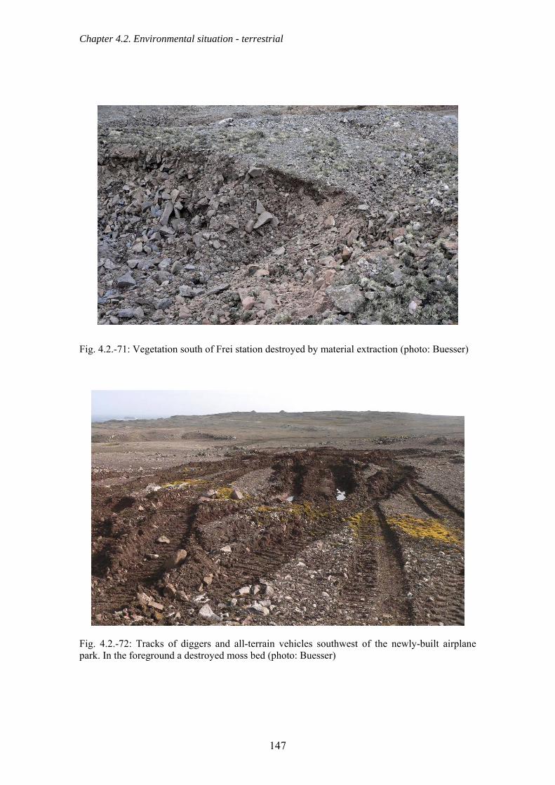
Chapter 4.2. Environmental situation - terrestrial
Fig. 4.2.-71: Vegetation south of Frei station destroyed by material extraction (photo: Buesser)
Fig. 4.2.-72: Tracks of diggers and all-terrain vehicles southwest of the newly-built airplane park. In the foreground a destroyed moss bed (photo: Buesser)
147
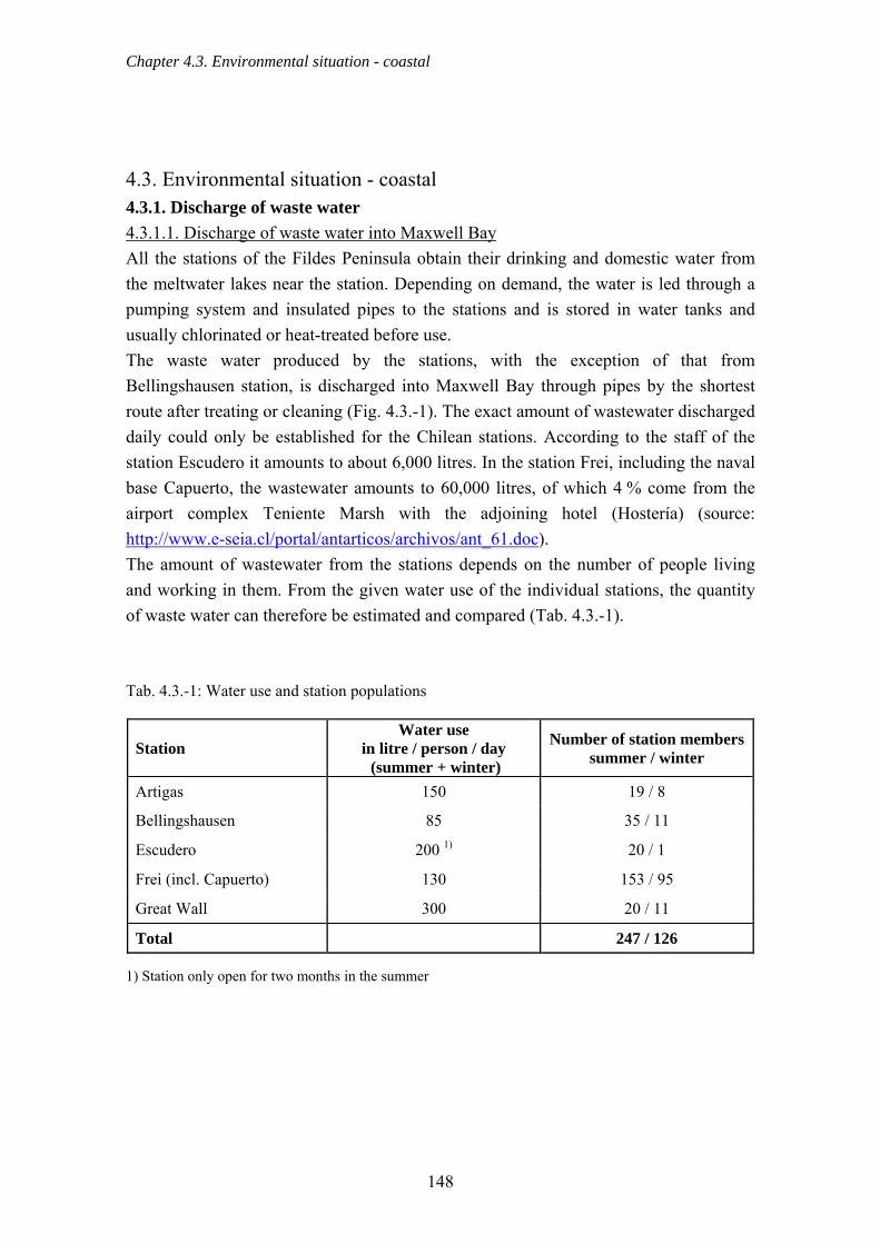
Chapter 4.3. Environmental situation - coastal
4.3. Environmental situation - coastal 4.3.1. Discharge of waste water 4.3.1.1. Discharge of waste water into Maxwell Bay All the stations of the Fildes Peninsula obtain their drinking and domestic water from the meltwater lakes near the station. Depending on demand, the water is led through a pumping system and insulated pipes to the stations and is stored in water tanks and usually chlorinated or heat-treated before use. The waste water produced by the stations, with the exception of that from Bellingshausen station, is discharged into Maxwell Bay through pipes by the shortest route after treating or cleaning (Fig. 4.3.-1). The exact amount of wastewater discharged daily could only be established for the Chilean stations. According to the staff of the station Escudero it amounts to about 6,000 litres. In the station Frei, including the naval base Capuerto, the wastewater amounts to 60,000 litres, of which 4 % come from the airport complex Teniente Marsh with the adjoining hotel (Hostería) (source: http://www.e-seia.cl/portal/antarticos/archivos/ant_61.doc). The amount of wastewater from the stations depends on the number of people living and working in them. From the given water use of the individual stations, the quantity of waste water can therefore be estimated and compared (Tab. 4.3.-1). Tab. 4.3.-1: Water use and station populations
Station Water use
in litre / person / day (summer + winter)
Number of station memberssummer / winter
Artigas 150 19 / 8
Bellingshausen 85 35 / 11
Escudero 200 1) 20 / 1
Frei (incl. Capuerto) 130 153 / 95
Great Wall 300 20 / 11
Total 247 / 126 1) Station only open for two months in the summer
148

Chapter 4.3. Environmental situation - coastal
Fig. 4.3.-1: Overview of waste water discharges by research stations, permanent and temporary waters, and water courses of the Fildes Peninsula and Ardley Island 4.3.1.2. Waste water treatment by stations a) Artigas In the station Artigas, each of the six residential buildings has a fresh water tank and also a cesspit, which works on the sedimentation principle. The accumulated waste
149

Chapter 4.3. Environmental situation - coastal
water is, in addition, treated chemically once a month. After the solid waste has fallen to the bottom of the tank, the rest of the cleaned water (which is odourless according to the station staff) is discharged into the neighbouring Schiffsbach, which flows into the sea after a short distance. Every two years the remaining sewage sludge is taken to Uruguay by ship. Noteworthy at this station are the signs posted everywhere asking people to save water. b) Bellingshausen The station Bellingshausen is the only one where the drinking water is not chlorinated or heat-treated. In addition to their fresh water tank, all the residential buildings also have a waste water tank, which is regularly pumped empty and discharged directly into the adjoining brook. Waste water treatment is not carried out here. The water resulting from compressing and drying of kitchen waste is also discharged directly into the brook. c) Escudero The Chilean scientific station Escudero has a water and wastewater system that is independent of Frei station. The station's waste water is cleaned in a heated compact system that uses an activated filter bed. The treatment is based on three steps, carried out in physically separated areas: 1) primary sedimentation, 2) an aerated biofilter based on bacterial activity and 3) final purification through secondary sedimentation. The waste water is discharged into Maxwell Bay below sea level. d) Frei The wastewater of the station Frei has so far been purified by the precipitation principle, without any further treatment apart from adding an unspecified fat decomposing substance. The solids accumulated in the water purification process are transported to Chile by air and disposed of appropriately there. The purified water is discharged into Maxwell Bay below sea level. As a consequence of the large number of residents in the station and the resulting large amount of waste water discharged, obvious traces of waste water can often be seen at the location of the discharge, because the discharge reduces the surface tension of the sea water (Fig. 4.3.-2).
150

Chapter 4.3. Environmental situation - coastal
Fig. 4.3.-2: Waste water discharge into the sea near Frei Station, recognisable by a reduction of surface tension (photo: December 2004, Buesser) In the season of 2005/06 a new building was erected in the grounds of the station, in which in March 2006 a modern biological waste water treatment plant was put into operation (source: http://www.e-seia.cl/portal/antarticos/archivos/ant_61.doc). This plant works with the Tohá system, which incorporates two purification steps. In a first step the waste water enters a heated, aerobic biofilter, consisting of a humus layer, microorganisms and earthworms of the appropriate species, which decompose the organic material. Afterwards the cleaned water is decontaminated by UV radiation in order to destroy still existing bacteria and is then discharged into the sea. All solids resulting from using the new plant are transported to Chile, however, according to the description of the system no sewage sludge in the conventional sense is produced any more. The Chilean naval base Capuerto, which has been occupied all year-round since 2005/06, is fully connected to the fresh and waste water system of Frei. In contrast the Chilean airport complex Teniente Marsh including the Hotel (Hostería) (which is thoroughly incorporated into the infrastructure of the station Frei) uses a small neighbouring lake for the drinking and domestic water needed. Even though the waste water produced is generally fed into the system of Frei station, the disposal of waste water (which also periodically contains oil) into a nearby stream could be seen regularly at the back of the hotel building (Sec. 4.2.6.1.).
151

Chapter 4.3. Environmental situation - coastal
e) Great Wall In the station Great Wall the waste water produced is purified in a chemical waste water treatment plant and additionally treated with sodium hypochlorite (NaOCl). The sewage sludge is burned in the waste incinerating plant. The discharge of the waste water is carried out below the sewage plant in the beach area in front of the station. The end-piece of the waste water pipe is exposed at low tide (Fig. 4.3.-3). During the period of investigation the water was usually dull-grey and smelled noticeably of washing-up liquid.
Fig. 4.3.-3: Exposed by low tide, Great Wall's waste water discharge pipe (photo: December 2003, Buesser) 4.3.2. Coastal waste accumulation The high level of waste pollution on the coasts of the Fildes Peninsula and Ardley Island is apparent on the basis of the results of the systematic waste survey. Nearly all beach areas showed a very high density of waste, many beach sections were downright littered with all kinds of marine debris. Marine debris constituted, with 991 sites where waste was found (~37 % of the total of number of waste sites found), the main visible source of anthropogenic materials in the investigation area (Sec. 4.2.2.). Wood was found on over 74 % of the mapped sites and was therefore the most frequently detected form of waste (Fig. 4.3.-4). Finds of natural driftwood, however, were negligibly small with only four stranded trees. On the basis of different characteristics of some of the wooden marine debris it is presumed that they might be historical remains of ships. On the other hand, numerous, recently used boxes, crates and large amounts of timber were found.
152

Chapter 4.3. Environmental situation - coastal
Objects of plastic or glass as well as hazardous materials (e.g. oil cans, fuel barrels) were very often found and together formed a large part of the total marine debris (Fig. 4.3.-4).
Metal
Woo
d
Plastic
Glass
Hazard
ous m
ateria
ls
Freq
uenc
y in
%
0
20
40
60
80
Fig. 4.3.-4: Frequency of different materials amongst the total amount washed up on the beach Particularly striking were the large number of buoys found (23 items made of plastic, polystyrene foam or metal), different floating objects, fishing-nets and -ropes, plastic cans (volumes up to 25 litres, partly filled with e.g. wood glue, solvents, etc.), packaging material and rubber gloves. These finds were most probably marine debris from fishing boats. These results correspond with the data of the annual marine debris survey, which has been conducted according to CCAMLR standards by the staff of the Uruguayan station since the year 2000 (ATCM, 2006e; Sec. 4.2.3.).
153

Chapter 4.3. Environmental situation - coastal
Fig. 4.3.-5: Young Elephant Seal with stranded marine debris (Photo: Buesser) A direct connection between shipping traffic in Maxwell Bay and stranded waste or marine debris (in the form of ship arrivals and marine debris finds at the same time) could not be made during the period of investigation. One observation was reported, however, which points towards such a causal connection. On 2 or 3 February 2002 a large amount of insulating-foam-like plastic material of very similar form and size was washed up on the east coast of Fildes and Maxwell Bay. Its origin remained unknown (pers. comm. J. Pavliček, “Overnational Ecobase Nelson”). In the following year this plastic material was also washed up for the first time on Drake coast and has, since then, turned up on nearly all beach sections. In January 2006 a young Elephant Seal (Mirounga leonina) was found on Drake coast with a deep wound on its throat, caused by a tight plastic loop (Fig. 4.3.-6). It seemed to be a fishing-line, such as the ones used in long-line fishing. The loop was removed immediately and the seal was not seen again on following days. Moreover a hook used in long-line fishing was found in a skua nest in December 2004. Both finds are typical examples of the indirect influence of fishing on sea mammals and birds in the southern polar seas and the South Atlantic. The amount of marine debris of anthropogenic origin is relatively low in the Antarctic and Sub-Antarctic compared with the rest of the globe. This is because of the relative absence of shipping in the Antarctic and the effective oceanographic barrier of the
154

Chapter 4.3. Environmental situation - coastal
Antarctic circumpolar current. Nevertheless, the amount of marine debris is continuously on the increase (Walker et al., 1997; Edyvane et al., 2004).
Fig. 4.3.-6: Elephant Seal with a neck wound caused by fishing line (Photo: Buesser) Therefore a standardised method for monitoring anthropogenic marine debris was developed in the framework of CCAMLR. This method is currently regularly used during monitoring by different national Antarctic programmes (e.g. Uruguay, Chile, Great Britain, etc.). Very few investigations exist so far of the amount of marine debris in the area of the Antarctic Peninsula and especially the South Shetland Islands (Torres, 2000; Convey et al., 2002; ATCM, 2006e). Even though a quantitative comparison of the marine debris findings with other coastal regions cannot be made in this study (for methodological reasons) the results clearly show a dense marine debris spread on the coasts of the Fildes Peninsula and Ardley Island. Since floating or stranded wood is harmless as a rule, it is generally ignored in marine debris studies. In contrast, the world-wide marine drifting of plastic waste holds a very high risk of injury for marine mammals (Fig. 4.3.-6). The high amount of marine debris caused by fishing has been shown many times (Jones, 1995; Torres, 2000; Convey et al., 2002; Otley & Ingham, 2003). Many reports have been published on seals caught in plastic mesh, drifting or washed up packaging material, nets and fishing-lines (e.g. in
155

Chapter 4.3. Environmental situation - coastal
scientific reports from CCAMLR, Croxall et al., 1990; Arnould & Croxall, 1995; Hucke-Gaete et al., 1997 ; Derraik, 2002 ; Hofmeyr et al., 2006). Sea birds are additionally at risk when using plastic material for nest building (e.g. Torres & D., 2000) or by picking it up from the surface and swallowing it (e.g. Rothstein, 1973; Pettit et al., 1981; van Franeker & Bell, 1988; Slip et al., 1990; Huin & Croxall 1996; Copello & Quintana, 2003; Auman et al., 2004). Moreover, potentially invasive species “aboard” drifting objects can reach distant areas (Barnes, 2002; review in Derraik, 2002). A relevant example of successful colonisation of marine debris and drifting by several species has already been shown for the area of the Antarctic Peninsula (Adelaide Island, 68° S) (Barnes & Fraser, 2003). Colonisation of a strip of plastic was documented for at least 10 different species of the groups Porifera, Annelida, Cnidaria and Mollusca. On the basis of the size of some of the individuals, colonisation could be assumed to have occurred more than a year earlier. It has so far, however, not been possible to prove successful colonisation of marine debris by exotic species. The increasing implementation of different agreements for the protection of the seas (e.g. EP, MARPOL) has led to some detectable improvements. Several studies have shown that the number of plastic packaging cords, which were cut in pieces to reduce the risk of injury or suffocation for seals, has risen considerably (Arnould & Croxall, 1995; Walker et al., 1997). This can significantly reduce the risk of injury or asphyxiation for seals. In the region of the Fildes Peninsula and Ardley Island, the area-wide removal of marine debris is not advisable due to the often very difficult access to most of the coastal sections. Removal with the help of vehicles would probably cause more damage than leaving the waste on the beach. Salvaging waste by boat is only possible in the area on the east coast of Fildes, as sailing on the Fildes Strait, and especially on the west coast, poses a very high safety risk because of extremely difficult currents and mooring conditions. Alerting station staff to the dangers for seals of getting caught in plastic loops or nets could lead to a possible reduction of this special risk. Staff could collect and make safe dangerous objects that they might encounter on the excursions to the coasts that they make anyway. 4.3.3. Gaseous emissions from station boats and zodiacs Gaseous emissions by station boats and zodiacs are considerably lower than those from vehicles because of the lower fuel use. Their emissions are therefore considerably lower than those caused by power generation and vehicle use. On the basis of the investigated frequency of use, the boats of Bellingshausen station produce the highest rate of emissions (Secs. 4.2.17.2. & 4.2.17.3.), followed by those of
156
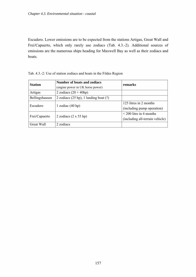
Chapter 4.3. Environmental situation - coastal
Escudero. Lower emissions are to be expected from the stations Artigas, Great Wall and Frei/Capuerto, which only rarely use zodiacs (Tab. 4.3.-2). Additional sources of emissions are the numerous ships heading for Maxwell Bay as well as their zodiacs and boats. Tab. 4.3.-2: Use of station zodiacs and boats in the Fildes Region
Station Number of boats and zodiacs (engine power in UK horse power)
remarks
Artigas 2 zodiacs (20 + 40hp) Bellingshausen 2 zodiacs (25 hp), 1 landing boat (?)
Escudero 1 zodiac (40 hp) 125 litres in 2 months (including pump operation)
Frei/Capuerto 2 zodiacs (2 x 55 hp) < 200 litre in 4 months (including all-terrain vehicle)
Great Wall 2 zodiacs
157
Chapter 4.4. Geology
4.4. Geology 4.4.1. Palaeontology 4.4.1.1. Recording fossils During the 2003/04 season, 41 fossil localities were surveyed (Fig. 4.4.-1). A locality’s productivity is represented by the size of the circle and the colour of the symbol indicates the estimation of the outcrop quality of the respective site condition. Based on our own findings and those of other groups, six large fossiliferous regions were defined. Fossils were found in four of them in the current study and 199 samples were collected. Established regions from the literature that yielded no additional discoveries were also represented. The boundaries taken from the ASPA No. 125 management plan clearly do not match the true position of the fossil localities. The reason for this seems to be the lack of a properly defined geodetic datum. In Fig. 4.4.-1 the WGS 84 datum was used, as in all other figures although at the time of the managements plan’s designation, the WGS 84 datum did not exist in any form. A redefinition of the boundaries of the ASPA No. 125 is therefore an urgent necessity. The samples consisting of plant material were by far the most abundant and were transferred to Ms I. Poole of the National Herbarium of the Netherlands (Utrecht University) for paleobotanical analysis. Her detailed results are included as appendix 7a & b (Poole, 2005). Two of the samples contained bird tracks (Fig. 4.4.-2).
158

Chapter 4.4. Geology
Fig. 4.4.-1: Fossiliferous regions and sites of fossil finds (boundaries of the ASPA No. 125 differing to the actual management plan due to the WGS 84 datum used here)
159

Chapter 4.4. Geology
Fig. 4.4.-2: Impression of a bird footprint (photo: Grunewald)
Fig. 4.4.-3: Carbonised plant remains (scale 10 cm, photo: Grunewald)
160

Chapter 4.4. Geology
Fig. 4.4.-4: Impressions of plant remains (photo: Grunewald)
Fig. 4.4.-5: Silicified wood (photo: Grunewald)
161

Chapter 4.4. Geology
Fossil embedding occurred in different ways. Trace fossils, like the previously mentioned bird tracks, are preserved in fine-grained sediments. In contrast, the fossil preservation of plants and woody tissue is due to the presence of cellulose-based, resistant structural materials. Carbonisation results when, before complete decay, oxygen and water are excluded due to sedimentary layering (Beurlen & Lichter, 1986). Such carbonised wood remains were found at a few locations on the Fildes Peninsula (Fig. 4.4.-3). When plants and plant fragments become embedded in fine-grained sediments they are protected from rapid decomposition. In this scenario, casts of leaves and branches are so well preserved that many fine details are still recognisable (Fig. 4.4.-4, Beurlen & Lichter, 1986). Furthermore, petrified tree trunks of trees and wood fragments occurred in the study area (Fig. 4.4.-5). In the case of the mineralisation (silification), silicate containing (SiO2) hydrothermal solutions fill up the empty spaces. Each molecule of the cellulose is replaced by silica, and the wood remains become petrified. 4.4.1.2. Fossiliferous regions a) Fossil Hill The Fossil Hill area (Fig. 4.4.-1) is probably the best known fossil exposure of the Fildes Peninsula and the one with the largest number of species represented. The region of Fossil Hill represents uplands in the southern part of the Fildes Peninsula and reaches a height of 130 m (a.s.l.) (eastern part in Fig. 4.4.-6). A total of 16 sites in this area yielded different kinds of fossils. One of the primary localities is A7-01 (Fig. 4.4.-7). Fossil Hill is composed of different layers of tuff deposits (Hunt, 2001). As in the uplands of the Davies Heights, it consists primarily of the remains of former Tertiary flora. These are mainly imprints of silicified wood and plant remains embedded in the layers of the pyroclastic deposits. Carbonised plant remains were also found nearby. The most important finds are high quality imprints of bird tracks (Fig. 4.4.-2). Such fossils are well known from this area (Covacevich & Lamperein, 1970, 1972; Covacevich & Rich, 1982; Jianjun & Shuonan, 1994). However, they remain rare and have so far only been found here.
162
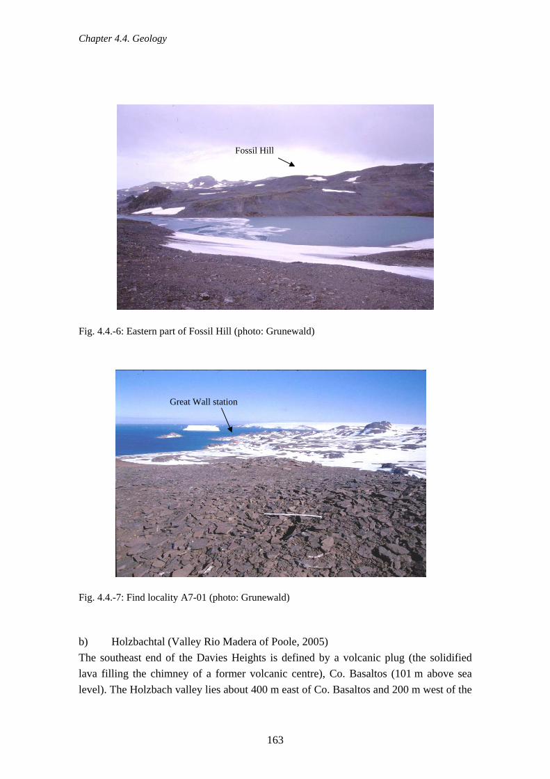
Chapter 4.4. Geology
Fossil Hill
Fig. 4.4.-6: Eastern part of Fossil Hill (photo: Grunewald)
Great Wall station
Fig. 4.4.-7: Find locality A7-01 (photo: Grunewald) b) Holzbachtal (Valley Rio Madera of Poole, 2005) The southeast end of the Davies Heights is defined by a volcanic plug (the solidified lava filling the chimney of a former volcanic centre), Co. Basaltos (101 m above sea level). The Holzbach valley lies about 400 m east of Co. Basaltos and 200 m west of the
163

Chapter 4.4. Geology
Russian station's fuel storage yard, on the road between the Bellingshausen (Russia) and Artigas (Uruguay) stations (Figs. 4.4.-8 & 9).
Fig. 4.4.-8: Find region Holzbach (photo: Grunewald)
Fig. 4.4.-9: Rich find locatity near to the road (photo: Grunewald) Fossilised wood and plant remains were found in this valley as well as in its northeast extension. These remains were embedded in sediments with a fine-grained matrix. The irregularly embedded fossil flora was found both on the upper and lower surface of rock
164
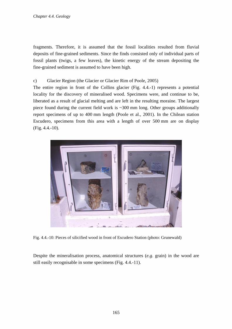
Chapter 4.4. Geology
fragments. Therefore, it is assumed that the fossil localities resulted from fluvial deposits of fine-grained sediments. Since the finds consisted only of individual parts of fossil plants (twigs, a few leaves), the kinetic energy of the stream depositing the fine-grained sediment is assumed to have been high. c) Glacier Region (the Glacier or Glacier Rim of Poole, 2005) The entire region in front of the Collins glacier (Fig. 4.4.-1) represents a potential locality for the discovery of mineralised wood. Specimens were, and continue to be, liberated as a result of glacial melting and are left in the resulting moraine. The largest piece found during the current field work is ~300 mm long. Other groups additionally report specimens of up to 400 mm length (Poole et al., 2001). In the Chilean station Escudero, specimens from this area with a length of over 500 mm are on display (Fig. 4.4.-10).
Fig. 4.4.-10: Pieces of silicified wood in front of Escudero Station (photo: Grunewald) Despite the mineralisation process, anatomical structures (e.g. grain) in the wood are still easily recognisable in some specimens (Fig. 4.4.-11).
165

Chapter 4.4. Geology
Fig.4.4.-11: Internal structures in silicified wood (photo: Grunewald) In addition, impressions of fossilised plants (branches, rarely leaves) were found in the glacier region at three different sites. Two of these (A7-16, A7-17) are located directly in the glacier range. There numerous plant remains were found embedded in fine-grained sediments in the middle of the sedimentary debris of a moraine deposit (Fig. 4.4.-12). Some of the plant remains also showed characteristics of carbonisation. The third site (A7-27) is an outcrop at the edge of the glacier (Fig. 4.4.-13). Numerous plant specimens also embedded in fine-grained sediments were found there.
166

Chapter 4.4. Geology
Davies Heights
Lago Uruguay
Moraine
Fig. 4.4.-12: View from the edge of the glacier towards the southwest (photo: Grunewald) d) Davies Heights (Northern Plateau of Poole, 2005) There are also numerous fossil sites in the eastern part of the Davies Heights (Figs. 4.4.-1 & 4.4.-12). Plant fossils were discovered in a total of nine areas in this region. These finds consisted mainly of wood and leaf imprints as well as several pieces of mineralised wood. Only a few of the samples were more than 100 mm long. The colour of the specimens ranged from light-beige, grey to dark grey. An additional fossil locality lies between the northeast edge of the Davies Heights and Lago Uruguay (Fig. 4.4.-12). The fossils lie in a pale-white to brownish tuff sediment. They consisted of badly preserved angiosperm, fern and conifer leaves (Hunt, 2001). No fossils were recovered from this site during the fieldwork described here.
167
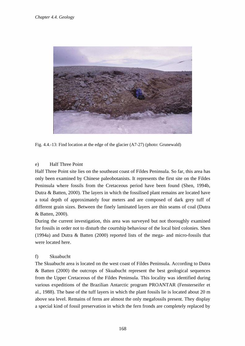
Chapter 4.4. Geology
Fig. 4.4.-13: Find location at the edge of the glacier (A7-27) (photo: Grunewald) e) Half Three Point Half Three Point site lies on the southeast coast of Fildes Peninsula. So far, this area has only been examined by Chinese paleobotanists. It represents the first site on the Fildes Peninsula where fossils from the Cretaceous period have been found (Shen, 1994b, Dutra & Batten, 2000). The layers in which the fossilised plant remains are located have a total depth of approximately four meters and are composed of dark grey tuff of different grain sizes. Between the finely laminated layers are thin seams of coal (Dutra & Batten, 2000). During the current investigation, this area was surveyed but not thoroughly examined for fossils in order not to disturb the courtship behaviour of the local bird colonies. Shen (1994a) and Dutra & Batten (2000) reported lists of the mega- and micro-fossils that were located here. f) Skuabucht The Skuabucht area is located on the west coast of Fildes Peninsula. According to Dutra & Batten (2000) the outcrops of Skuabucht represent the best geological sequences from the Upper Cretaceous of the Fildes Peninsula. This locality was identified during various expeditions of the Brazilian Antarctic program PROANTAR (Fensterseifer et al., 1988). The base of the tuff layers in which the plant fossils lie is located about 20 m above sea level. Remains of ferns are almost the only megafossils present. They display a special kind of fossil preservation in which the fern fronds are completely replaced by
168

Chapter 4.4. Geology
amorphous, green chlorite. Thus, the external morphology of the leaves is reproduced to the finest detail (Dutra & Batten, 2000). This site was not found during the fieldwork of the current investigation. The types and characteristics of plant fossils that occur were described by Dutra & Batten (2000). 4.4.1.3. Palaeobotanical interpretation and its scientific importance (from Poole, 2005 –see appendix 7a & b) Fossil Hill represented the most yielding fossiliferous area with nearly 90 specimens collected from 16 sublocalities. This is not surprising considering that Fossil Hill is probably one of the most fossiliferous localities on King George Island. The material is composed of propagules, leaves, leafy shoots, coalified axes and silicified wood with taxa affiliated to conifers, dicotyledonous angiosperms, ferns, possible Equisetum, and bryophytes. Representatives of these taxa have already been recorded by previous workers in this area but this study provides further evidence for the fossiliferous nature of this locality. The potential of finding well preserved plant material from this locality is very high. This locality should be considered to be of high scientific interest. The Holzbachtal (Valley Rio Madera), not known for its organically preserved material, yielded the best preserved leaf material with anacardiaceous/proteaceous and sapindaceous affinities. Other coniferous and fern leaf material along with some propagules were also recorded. Wood was absent. The findings of this 2003/4 field season highlights show the importance of continued collecting at localities where previous expeditions have not found interesting material. The potential of finding well-preserved plant material at this locality is relatively high and this site should be considered to be of (moderate to) high scientific value. No leaf material was found in the Glacier Region but podocarpaceous wood and bark, from unknown taxa, were found. This is an important locality for fossil wood material with the potential of finding well-preserved material is very high. Glacier Region should be considered to be of high scientific interest. At the Davies Heights there is a relatively high potential of finding good quality angiosperm and conifer wood material amongst the poorly preserved material. One eucryphiaceous piece of angiosperm has been recorded. Leaf material was limited and only leafy shoots of coniferous and ?bryophyte origins were recorded. This locality should be considered to be of moderate (to high) scientific interest. The addition of more material, particularly both from previously relatively unexplored and well-studied localities, testifies to the palaeobotanical richness of Fildes Peninsula and its importance to understanding past biodiversity and ecosystem dynamics of Antarctica. Hunt (2000), in conclusion to his intensive study of the fossils from King
169

Chapter 4.4. Geology
George Island, also concluded that the there is a great potential for further palaeobotanical research on King George Island both at existing sites, especially in light of the melting of ice-margins revealing new fossiliferous material, and under studied sites. Along with the much needed geochronological and stratigraphic studies, to determine the precise age and relationships of the various Tertiary palaeofloras, any future rigorous, yet selective, studies of the macro (and micro) fossils on King George Island will greatly enhance our understanding of an environment with no modern analogue today. 4.4.2. Importance of beach ridges on Fildes Peninsula and Ardley Island This section describes the scientific importance of beach ridges as evidence for why they should be preserved. They are currently threatened because they are attractive sources of construction material. As in other parts of the world, fossil beach ridges in the Antarctic are of great importance for the study of the regional and global paleoclimate (Berkman et al., 1998). As evidence of the complicated interrelation between isostatic uplift and eustatic sea level fluctuations, the ridges are important clues for the reconstruction of the Quaternary ice-age of the Antarctic Peninsula and its surroundings. Full clarification in this region remains to be achieved (Bluemel, 1999). Recent tectonic plate activity adds a further, more interesting, influence on land uplift in the South Shetland Island region. Beach ridges on Fildes Peninsula and Ardley Island, particularly in the bays, are often found in well-formed parallel sequences, the youngest nearest the sea, the oldest sometimes several hundred meters in the interior (Fig. 4.4.-14). These sequences, so far, have only been studied with random sampling methods (Barsch et al., 1985; Maeusbacher, 1991). This has already demonstrated their scientific potential that is due to, among other reasons, their clear morphological development and the presence of datable material. A particularly well developed system of beach ridges is located on Fildes Peninsula in the extended valley of the eastern exit of the Südpassage (Fig. 4.4.-15). Barsch et al., 1985 identified 10 beach ridges whose hypsometric classification covers all designated sand bar systems of Maxwell Bay (Riegel-, Mittel- and Strandsystem as well as recent and subrecent storm tide ridges).
170

Chapter 4.4. Geology
Fig. 4.4.-14: Beach ridge complex on the southwest coast of Ardley Island (photo: Mustafa) Because of its clear development, the highest and thus oldest ridge is particularly striking. It is long enough to close off the entire valley leaving a passage only a few meters wide through which the Windbach drains the hinterland. This convenient configuration was used repeatedly for hydrologic research (Flügel, 1985, 1990). This was also the origin of what is currently the only absolute dating of the ridge complex. As a starting point, an age of 6,600 ± 70 years BP1) was determined by C14 dating. These initial results suggest that thorough, systematic examination of the ridge complex in the eastern Südpassage in the future will yield interesting insights into the history of Quaternary land uplift and sea level fluctuations. In addition to this, paleobiological and ecological studies seem feasible because the age of the individual terraces can be clearly differentiated (Emslie & McDaniel, 2002).
171

Chapter 4.4. Geology
Beach ridge complex
Fig. 4.4.-15: Hydrogeological map of the eastern Südpassage with beach ridge complex at the mouth of the valley (after Flügel, 1990) The threat to the beach ridges as an object of scientific research is above all due to the suitability of these sites for the extraction of construction material. During surveying before airport construction started in January 2005, samples from the above mentioned ridge complex were taken (Fig. 4.4.-16). After the discussion on 20.01.2005 mentioned in Sec. 4.2.19., further removal of aggregate was decided against.
172

Chapter 4.4. Geology
Fig. 4.4.-16: Test pit for construction material in the beach ridge complex, eastern Südpassage (photo: Buesser) 4.4.3. Lakes The exact number of lakes recorded for the study area varies slightly (as described in Sec. 2.6.1.). While the KGIS data includes 113 lakes, our survey showed 105. Of those, 41 were perennial with a constant water level, 32 were permanent but had a varying water level, and 32 were temporary lakes. The value of the fresh water lakes in the area as an asset to be protected derives from the following roles they play:
- Drinking water supply for scientific stations - Habitat for aquatic species (e.g. Branchynecta gainii) - Oviposition site and larval habitat for terrestrial species (e.g. Parochlus steinenii) - Scientific value as sediment archives (Mäusbacher, 1991)
173

Chapter 4.4. Geology
Fig. 4.4.-17: Lake at the beginning of the thaw (photo: Mustafa) Since no hydrochemical analysis was performed as part of the current project, threats to the lakes can only be determined on the basis of external characteristics. The clearest indication of contamination of lakes is the presence of waste. Particularly affected here are Long Lake and Laguna Hydrografos, as well as two, smaller, unnamed lakes between them, as a result of a former landfill lying close by (Sec. 4.2.1.). This site is also referred to in a report by Tin & Roura (2004), which mentions one lake filled with waste. Lakes can be affected not only by direct proximity to waste storage areas, but also because waste transported by wind tends to accumulate in them. Lakes in particular danger here are those near the stations with large grounds. Kitezh Lake, Laguna Las Estrellas, and Biologensee deserve special mention due to the considerable amount of waste to be found on their banks. Another serious threat to the lakes takes the form of oil pollution. For example, Biologensee was contaminated by the oil spill in Biologenbucht (Sec. 4.2.6.1.). Traces of oil pollution were also found in the water of Laguna Bayo 150 m west of the airfield hangar, in the lake 70 m southeast of the airfield buildings, and in Laguna Tern not far from the Chinese tanks. A small amount, at least, of fuel wound up in Kitezh Lake from the barrels described in Sec. 4.2.6.1. The extent of the danger of oil contamination of the lakes is illustrated by an incident involving an unnoticed leakage from oil lines of the
174

Chapter 4.4. Geology
Bellingshausen station during the winter of 2005 (Sec. 4.2.6.2.). An estimated 1,000 litres of diesel contaminated the soil even at a distance of only ~20 m from the lake supplying drinking water to Bellingshausen and Frei stations. The risk of contamination of the lake was due to the close proximity and the small difference in elevation between the contaminating site and the lake. The contamination of lakes due to waste water was proven only in one case. Waste water from the airport hotel was released into the same stream responsible for the oil pollution of Biologenbucht and thus Biologensee (Sec. 4.3.1.2.). Several lakes (Tab. 4.4.-1.) are used as a source of fresh water for the operation of stations (e.g. Figs. 4.4.-18 & 19). Little is known about the effects of extracting water from these lakes, just as little is known about the practice of the Great Wall station of introducing hot water to melt the winter sea-ice. Tab. 4.4.-1: Lakes used as sources of drinking water for the stations
Station Source of drinking water
Artigas
Bellingshausen
Escudero
Frei
Frei (airport)
Great Wall
Lago Uruguay
Drinking water Lake (fed from Kitezh Lake)
Laguna Las Estrellas
Drinking water Lake (fed from Kitezh Lake)
Unnamed lake 70m south east of the airport buildings
Petrel Lake
175

Chapter 4.4. Geology
Fig. 4.4.-18: Lakes, their use as sources of drinking water, and the potential threat
176

Chapter 4.5. Flora and Fauna
Fig. 4.4.-19: Drinking water extraction from Lago Uruguay (photo: Mustafa) 4.5. Flora and fauna 4.5.1. Penguins (Pygoscelis spp.) Three breeding penguin species occur in the study area: the Chinstrap Penguin (Pygoscelis antarctica), the Adélie Penguin (P. adeliae) and the Gentoo Penguin (P. papua). Visitors and vagrant bird species including the Macaroni Penguin (Eudyptes chrysolophus), the King Penguin (Aptenodytes patagonicus) and the Emperor Penguin (Aptenodytes forsteri) have also been detected (Sec. 4.5.9.).
Fig. 4.5.-1: Chinstrap, Gentoo and Adélie Penguins are breeding birds in the study area (photos: Peter)
177
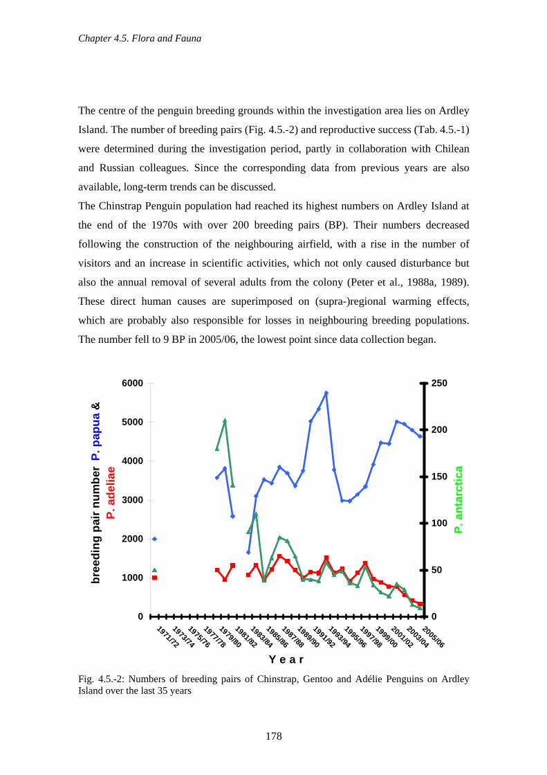
Chapter 4.5. Flora and Fauna
The centre of the penguin breeding grounds within the investigation area lies on Ardley
Island. The number of breeding pairs (Fig. 4.5.-2) and reproductive success (Tab. 4.5.-1)
were determined during the investigation period, partly in collaboration with Chilean
and Russian colleagues. Since the corresponding data from previous years are also
available, long-term trends can be discussed.
The Chinstrap Penguin population had reached its highest numbers on Ardley Island at
the end of the 1970s with over 200 breeding pairs (BP). Their numbers decreased
following the construction of the neighbouring airfield, with a rise in the number of
visitors and an increase in scientific activities, which not only caused disturbance but
also the annual removal of several adults from the colony (Peter et al., 1988a, 1989).
These direct human causes are superimposed on (supra-)regional warming effects,
which are probably also responsible for losses in neighbouring breeding populations.
The number fell to 9 BP in 2005/06, the lowest point since data collection began.
0
1000
2000
3000
4000
5000
6000
1971/72
1973/74
1975/76
1977/78
1979/80
1981/82
1983/84
1985/86
1987/88
1989/90
1991/92
1993/94
1995/96
1997/98
1999/00
2001/02
2003/04
2005/06
Y e a r
bree
ding
pai
r num
ber
P. p
apua
&
0
50
100
150
200
250
P. a
ntar
ctic
a
P. a
delia
e
Fig. 4.5.-2: Numbers of breeding pairs of Chinstrap, Gentoo and Adélie Penguins on Ardley Island over the last 35 years
178

Chapter 4.5. Flora and Fauna
Gentoo Penguins exhibit strongly fluctuating breeding populations with a generally positive trend. The BP numbers varied between 1,656 (1983/84) and 5,746 (1993/94). Similar population trends were also observed at other locations (Woehler et al., 2001), where apart from a highly variable recruitment rate (i.e., return rate of sexually mature young birds), less faithfulness to local breeding grounds compared to other species of penguin also comes into question as a cause. The third Pygoscelis species, the Adélie Penguin, has shown a decreasing tendency for more than 10 years in a row. In 1993/94, 1,516 BP were counted, while in the last season only 334 BP were present. This decrease reflects the general trend in the Antarctic Peninsula range. The Adélie Penguin can be regarded as an indicator species for the variability of the physical and biological environment (Woehler et al., 2001). Thus, the populations of numerous colonies in the west coast range of the Antarctic Peninsula have decreased. This trend can be linked to climate change in this region. Two processes must be contrasted, which have on the one side regional and on the other side local effects (Smith et al., 2003). The change in sea ice conditions, i.e. the spatial and temporal ice distribution and thickness, give us an explanation for the change in population density on a regional scale. Since the middle of the 20th century, the average winter temperature of the western range of the Antarctic Peninsula has increased by nearly 6°C, resulting in a reduction of ice coverage. The sea ice is the winter habitat of the Adélie Penguin, but the rise in temperature has an impact on the seasonal pattern of krill development and thus also on the availability of the main food source of the Adélie Penguin (Smith et al., 2003). Figs. 4.5.-3 and 4.5.-4 show the distribution of the colonies of the three Pygoscelis species on Ardley Island, supplemented by data for the northeast part of the investigation area for 1985/86, which are based on aerial photographs. Surprisingly, changes in the number of breeding pairs do not seem to correlate directly with the spatial expansion of nesting groups. The growth of the colonies when compared to years with small numbers of Gentoo Penguin breeding pairs (1989/90) and years with high numbers (1993/94) varied only slightly (Fig. 4.5.-4.). For example the total number of penguins decreased from 1993/94 to 2004/05 by 30 %, while the territorial expansion of the colonies increased by 15 %. Even considering the possible experimental bias due to the application of different mapping techniques (GPS, remote sensing, and hand mapping), these results contradict expectations.
179

Chapter 4.5. Flora and Fauna
Fig. 4.5.-3: Changes in the spatial extent of penguin colonies on Ardley Island
180
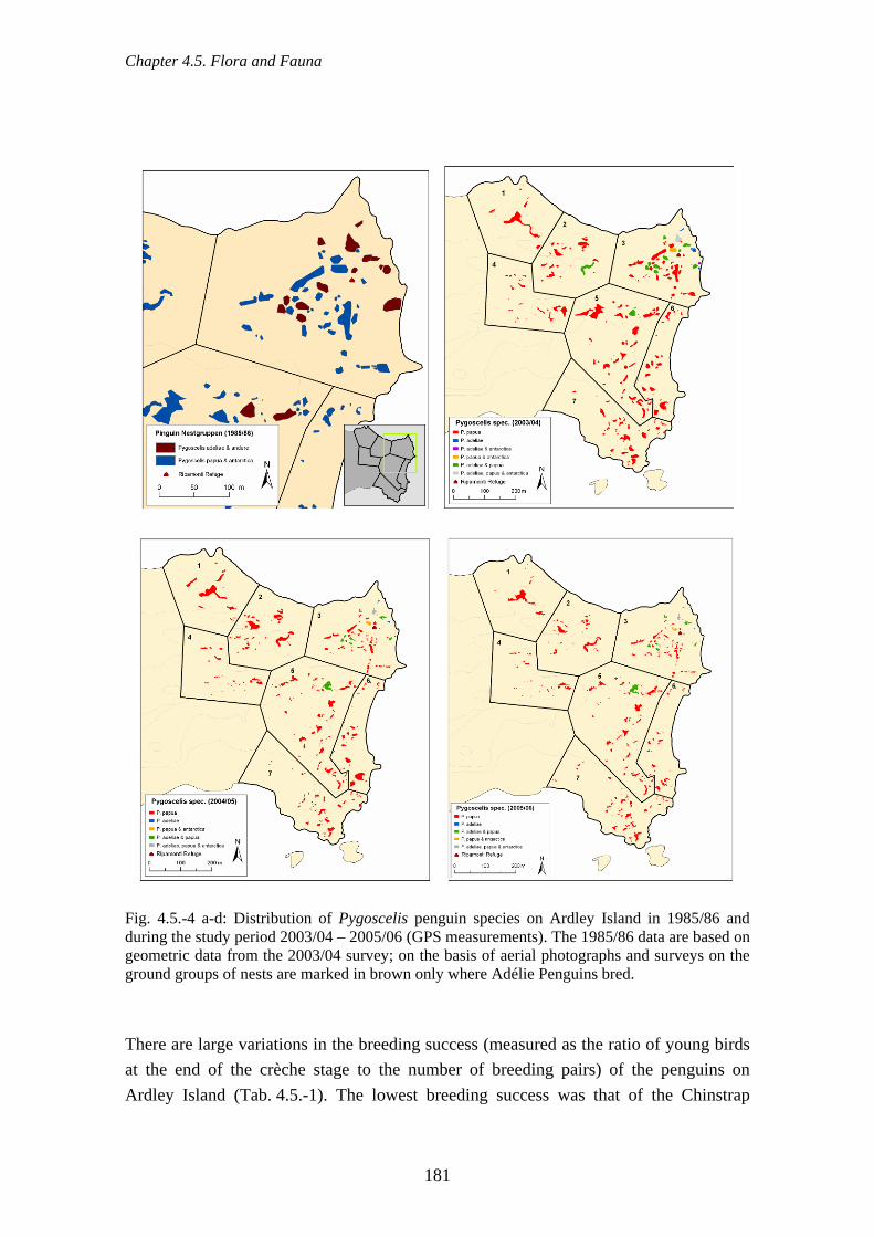
Chapter 4.5. Flora and Fauna
Fig. 4.5.-4 a-d: Distribution of Pygoscelis penguin species on Ardley Island in 1985/86 and during the study period 2003/04 – 2005/06 (GPS measurements). The 1985/86 data are based on geometric data from the 2003/04 survey; on the basis of aerial photographs and surveys on the ground groups of nests are marked in brown only where Adélie Penguins bred. There are large variations in the breeding success (measured as the ratio of young birds at the end of the crèche stage to the number of breeding pairs) of the penguins on Ardley Island (Tab. 4.5.-1). The lowest breeding success was that of the Chinstrap
181
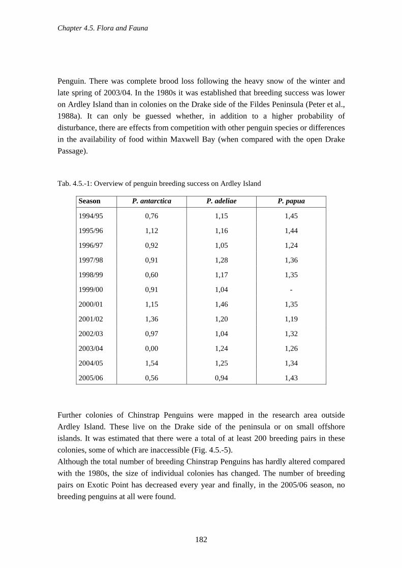
Chapter 4.5. Flora and Fauna
Penguin. There was complete brood loss following the heavy snow of the winter and late spring of 2003/04. In the 1980s it was established that breeding success was lower on Ardley Island than in colonies on the Drake side of the Fildes Peninsula (Peter et al., 1988a). It can only be guessed whether, in addition to a higher probability of disturbance, there are effects from competition with other penguin species or differences in the availability of food within Maxwell Bay (when compared with the open Drake Passage). Tab. 4.5.-1: Overview of penguin breeding success on Ardley Island
Season P. antarctica P. adeliae P. papua
1994/95 0,76 1,15 1,45
1995/96 1,12 1,16 1,44
1996/97 0,92 1,05 1,24
1997/98 0,91 1,28 1,36
1998/99 0,60 1,17 1,35
1999/00 0,91 1,04 -
2000/01 1,15 1,46 1,35
2001/02 1,36 1,20 1,19
2002/03 0,97 1,04 1,32
2003/04 0,00 1,24 1,26
2004/05 1,54 1,25 1,34
2005/06 0,56 0,94 1,43
Further colonies of Chinstrap Penguins were mapped in the research area outside Ardley Island. These live on the Drake side of the peninsula or on small offshore islands. It was estimated that there were a total of at least 200 breeding pairs in these colonies, some of which are inaccessible (Fig. 4.5.-5). Although the total number of breeding Chinstrap Penguins has hardly altered compared with the 1980s, the size of individual colonies has changed. The number of breeding pairs on Exotic Point has decreased every year and finally, in the 2005/06 season, no breeding penguins at all were found.
182

Chapter 4.5. Flora and Fauna
Fig. 4.5.-5: Location of penguin colonies (Pygoscelis papua, P. adeliae and P. antarctica) on Ardley Island and on the Drake Coast of Fildes Peninsula (exclusively P. antarctica, indicated by arrows) Chinstrap Penguins are much more numerous outside the study area, on the islands off Nelson Island on the Drake side. Thus there were estimated to be more than 35,000 BP on the islands between Fildes Strait and Withen Island (including this island), that is to say southwest of the research area (Peter et al., 1988a).
183
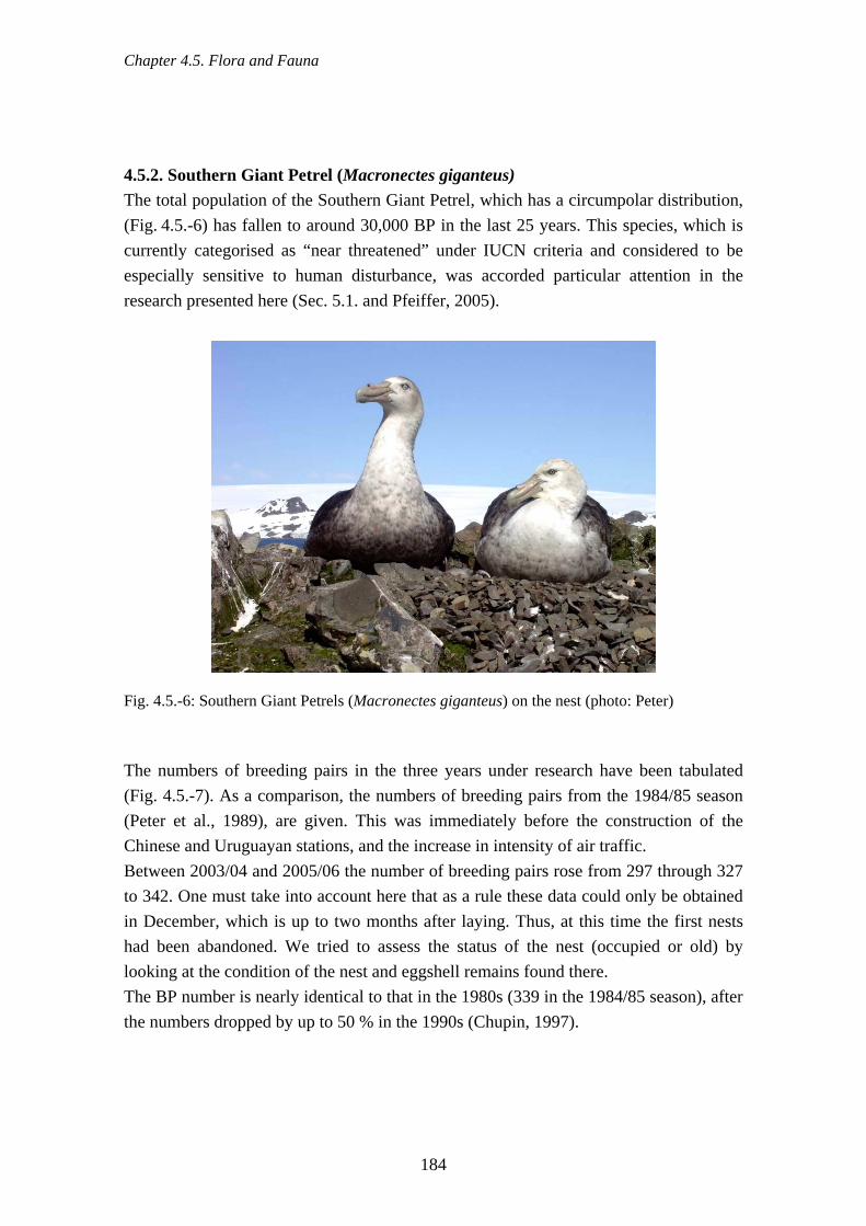
Chapter 4.5. Flora and Fauna
4.5.2. Southern Giant Petrel (Macronectes giganteus) The total population of the Southern Giant Petrel, which has a circumpolar distribution, (Fig. 4.5.-6) has fallen to around 30,000 BP in the last 25 years. This species, which is currently categorised as “near threatened” under IUCN criteria and considered to be especially sensitive to human disturbance, was accorded particular attention in the research presented here (Sec. 5.1. and Pfeiffer, 2005).
Fig. 4.5.-6: Southern Giant Petrels (Macronectes giganteus) on the nest (photo: Peter) The numbers of breeding pairs in the three years under research have been tabulated (Fig. 4.5.-7). As a comparison, the numbers of breeding pairs from the 1984/85 season (Peter et al., 1989), are given. This was immediately before the construction of the Chinese and Uruguayan stations, and the increase in intensity of air traffic. Between 2003/04 and 2005/06 the number of breeding pairs rose from 297 through 327 to 342. One must take into account here that as a rule these data could only be obtained in December, which is up to two months after laying. Thus, at this time the first nests had been abandoned. We tried to assess the status of the nest (occupied or old) by looking at the condition of the nest and eggshell remains found there. The BP number is nearly identical to that in the 1980s (339 in the 1984/85 season), after the numbers dropped by up to 50 % in the 1990s (Chupin, 1997).
184

Chapter 4.5. Flora and Fauna
Fig. 4.5.-7: Number of breeding pairs (occupied nests) of Southern Giant Petrels in 1984/85 as well as 2003/04, 2004/05 and 2005/06 Southern Giant Petrel breeding places has been displaced from Nebles Point in the far east of the study area and the surroundings of the Chinese station to the Dart Island and Two Summit Island areas. At Nebles Point there are now, at most, 7 BP instead of 118 and at the surroundings of the Chinese station now a maximum of 6 BP instead of 33. The Dart Island numbers, in contrast, have grown to a maximum of 94 BP instead of 50
185

Chapter 4.5. Flora and Fauna
and Two Summit numbers to a maximum of 117 instead of 45 (Fig. 4.5.-7). This displacement can also be detected because of ringing returns from old birds ringed in the 1980s on Nebles Point. The causes for the almost total disappearance of breeding pairs from the Great Wall colony (partly located within the grounds of the present station) can be found in the intensive helicopter and visitor traffic, in particular that during the construction of the station. The decline at Nebles Point is contemporary with the stationing of a helicopter at the neighbouring Artigas station at the end of the 1980s. The abandoned breeding sites at Nebles Point are today only partly suitable for use as many nest hollows have become overgrown with Deschampsia antarctica and as a result the stones needed for nest-building can no longer be reached. However, the number of breeding pairs is only one single criterion that can be taken into consideration as a measure of human influence. Breeding success is also decisive (in this case, the number of fledglings in February in relation to the number of nests present at the start of the season – cf. Tab. 4.5.-2). This can be evaluated not only in connection with visitor activity and air traffic (Secs. 4.6. & 4.2.16.). It also depends on natural factors such as predatory pressure from skuas – which may be increased by human disturbance and by birds leaving the nest temporarily – and the total supply of food during the breeding period. We did not carry out our own investigations into this last point. Long-line fishing is also seen as a significant cause for increased mortality in Southern Giant Petrels (Nel et al., 2002). Tab. 4.5.-2: Number of juvenile Southern Giant Petrel in the nest, February 2004-06 in the Fildes Region (Zones defined in Fig. 4.5.-7) Region Zone 2004 2005 2006
Bay 1 N 1 3 3
Bay 2/3 (Priroda) N 37 19 15
Nebles Point E 0 1 1
Diomedea Island E 0 0 2
Ardley Island E 3 2 9
Geologists Island E 0 2 10
Great Wall E 0 0 0
Two Summit Island SE 46 60 86
Dart Island S 17 5 23
Fildes Strait S 6 7 11
186

Chapter 4.5. Flora and Fauna
Breeding success in the four years of this investigation in several zones of the region (Fig. 4.5.-8) has shown lower success in the most recent three years than in the investigated area during the 1980s. What is striking is the high degree of variability, not only between the different years of research, but also between the different zones. Special events such as extremely low-flying aircraft outside the normal flight path to the airport, which cause birds to take flight (Fig. 4.5.-9), and low-flying helicopters, appear to play a significant role, although no general tendencies can be discerned over the investigation period.
0
10
20
30
40
50
60
70
80
90
1983/85 2003/04 2004/05 2005/06
Bre
edin
g su
cces
s (%
)
N S SE E
Fig. 4.5.-8: Breeding success of Southern Giant Petrel in the years 2003/04, 2004/05 and 2005/06, drawn from the numbers of young in the nest in February each year, compared to data from the 1980s. The zones N, S, SE and E relate to the data in Tab. 4.5.-2.
187

Chapter 4.5. Flora and Fauna
Fig. 4.5.-9: Sudden fly-off provoked in Southern Giant Petrels by low altitude overflights by Hercules in the Fildes Strait area (photo: Peter)
4.5.3. Cape Petrel (Daption capense)
Fig. 4.5.-10: Cape Petrel (Daption capense) on the nest (photo: Peter) The Cape Petrel (Fig. 4.5.-10) has circumpolar distribution and is one of the species that commonly breeds on King George Island. The breeding sites of this cliff breeder are not
188

Chapter 4.5. Flora and Fauna
always visible, so that variations in numbers of breeding pairs and absences of individual breeding sites in specific years could be a result of methodology. The total number of breeding pairs is estimated to be at least 500 and in the three seasons we counted 323 (2003), 437 (2004) and 449 (2006) (Fig. 4.5.-11a-c). The colonies on the distant islands of the Drake side of Fildes Peninsula were not taken into consideration. As the breeding sites on the northern, western and south-western sides of Flat Top, the largest breeding site in the research area, are only partly visible and can thus only be accurately counted to a limited extent, the numbers of breeding pairs there have also been underestimated. The same situation obtains on Heidelberg Island. If one examines the records of the last 25 years, the number of breeding pairs appears to have risen from a maximum of 300 in the 1980s (Peter et al., 1989) to 1,500 in the 1990s (Soave et al., 2000) before falling again to at least 500. There can be many causes, although direct anthropogenic disturbances are unlikely to be a factor given the location of the breeding sites.
189

Chapter 4.5. Flora and Fauna
2004/05 2003/04
2005/06
Fig. 4.5.-11a-c: Breeding colonies of Cape Petrels in the years (a) 2003/04, (b) 2004/05 and (c) 2005/06
190

Chapter 4.5. Flora and Fauna
4.5.4. Storm Petrels (Oceanites oceanicus and Fregetta tropica) By means of systematic mapping of storm petrel breeding sites, using their night-time calling activity to identify them, a total of 235 current breeding sites of the Wilson’s Storm Petrel (Oceanites oceanicus) and of the Black-bellied Storm Petrels (Fregetta tropica) were recorded. The areas recorded are to some extent very variable in size and are distributed over the whole area of the Fildes Peninsula and Ardley Island, with the exception of a few structurally poor sections with few suitable burrows (Fig. 4.5.-12). Depending on area size and number of breeding pairs, the breeding sites were either manually mapped as polygons or recorded by GPS as a point. There are thus 151 larger areas, against 84 areas measured as points, with fewer than 10 breeding pairs, according to estimates. Breeding activity by both storm petrels species was noted in the majority of the mapped breeding sites (40 %), while in 36 % of the areas only F. tropica was recorded and in 24 % only O. oceanicus, although this last species is clearly more abundant (Tab. 4.5.-3). One possible explanation for this, based on our own experience, is that the calls of F. tropica can be heard more clearly and from a greater distance, so that this species is over-represented in the records. For this reason the maps produced cannot be directly interpreted for each species. Because both storm petrel species in the area breed sympatrically and have very similar requirements for their breeding habitats, breeding activity of one species can indicate the presence of both species. The expected greater abundance of O. oceanicus in the region was demonstrated as more areas with high numbers of breeding pairs were clearly recorded (Tab. 4.5.-3). Tab. 4.5.-3: Number of breeding areas of Wilson’s Storm Petrel (O. oceanicus) and Black-bellied Storm Petrel (F. tropica) categorised by estimated number of breeding pairs
Estimated number of breeding pairs in the regions studied
O. oceanicus F. tropica
0 57 84
<10 119 117
10 - 100 54 34
> 100 6 0
Estimated breeding population of the Fildes Region
3500 - 5000 500 - 1000
191
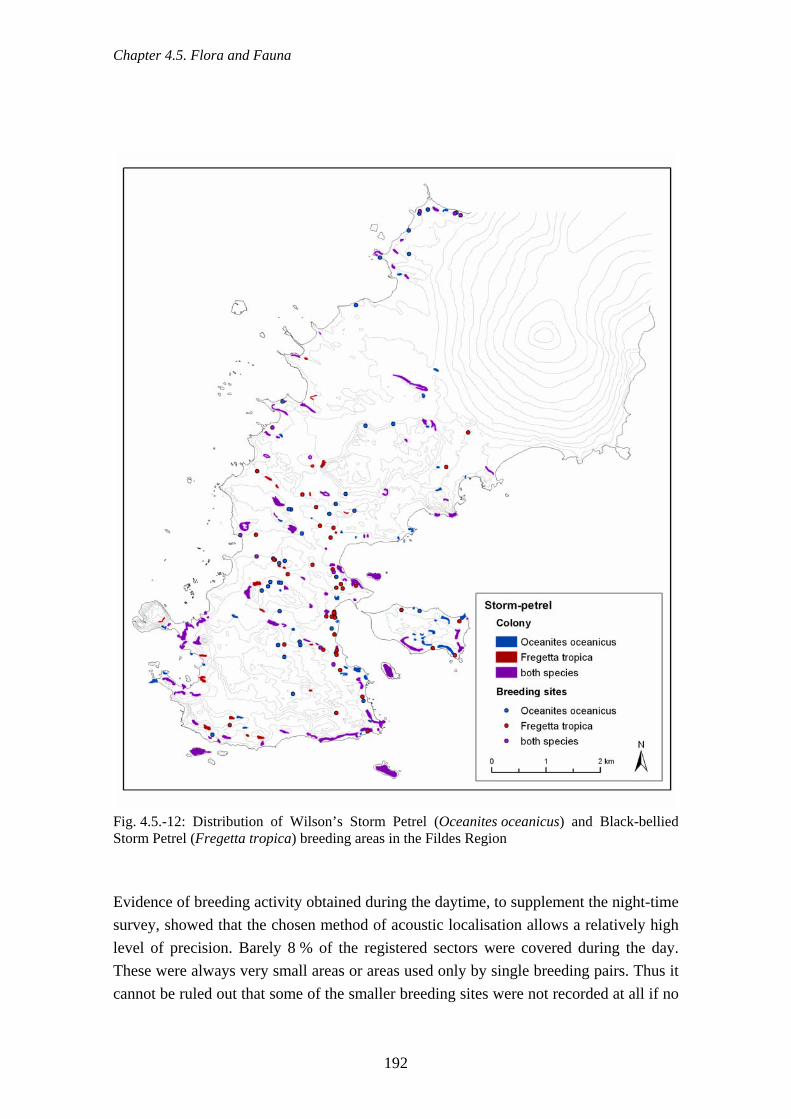
Chapter 4.5. Flora and Fauna
Fig. 4.5.-12: Distribution of Wilson’s Storm Petrel (Oceanites oceanicus) and Black-bellied Storm Petrel (Fregetta tropica) breeding areas in the Fildes Region Evidence of breeding activity obtained during the daytime, to supplement the night-time survey, showed that the chosen method of acoustic localisation allows a relatively high level of precision. Barely 8 % of the registered sectors were covered during the day. These were always very small areas or areas used only by single breeding pairs. Thus it cannot be ruled out that some of the smaller breeding sites were not recorded at all if no
192

Chapter 4.5. Flora and Fauna
calling activity was noticed, for whatever reason, while mapping was being carried out, or if other signs of use as a breeding site were lacking. There have been several studies of storm petrels in the region in the past (Bannasch & Odening, 1981; Roby et al., 1986; Peter et al., 1988a; Lange & Naumann, 1989; Nadler & Mix, 1989; Soave et al., 2000; Calvar & Fontana, 2001). Most of them were of very limited extent and they did not all use the same methods. It is thus probable that they always noticeably underestimated the numbers of breeding pairs of both species. This report presents the first comprehensive record, covering the whole area, of these species on the Fildes Peninsula and Ardley Island, with estimates of the breeding populations. 4.5.5. Snowy Sheathbill (Chionis alba)
Fig. 4.5.-13: Snowy Sheathbill (Chionis alba, photo: Peter) Sheathbills (Fig. 4.5.-13) breed regularly in the maritime Antarctic region. They prefer to breed in coastal areas at the edge of penguin colonies or, more rarely, near other colony breeders. During the breeding period they feed on the eggs and dead chicks of penguins in particular, as well as washed up marine invertebrates and seaweed. Carrion is also an important part of their diet and they eat seal placentas at the start of the season. In winter they normally leave the area and overwinter in the Falkland Islands and on the coasts of South America. Antarctic stations provide sheathbills with food in winter too (Secs. 4.2.4. & 5.2.), so that the number of birds that stay in the area is increasing, also encouraged by the more frequent mild winters. In April/May and September/October large numbers of birds migrate through the region, up to a
193

Chapter 4.5. Flora and Fauna
maximum of 129 individuals counted on the same day (Peter et al., 1988b, 1989). In contrast, the number is much lower in summer. In the last three years there were seldom more than 10 adult birds that stayed in the area under research. The breeding sites of the sheathbill in the Fildes Region are limited to the south-western point (Exotic Point and southeast of it, Fig. 4.5.-14). There was only one breeding pair in the years 2003/04 and three in 2004/05. No brood could be found in this area in 2005/06. This is probably linked to the disappearance of the neighbouring Chinstrap Penguin colony. Regular appearances in the area of the bays 11/12 (Sec. 3.4.2.) and especially on the inaccessible islands outside the research area leads to the supposition that there are more broods in this area. As the nests are made in crevices in cliffs or between rocks, it is not possible to obtain evidence of a breeding site from any great distance.
194
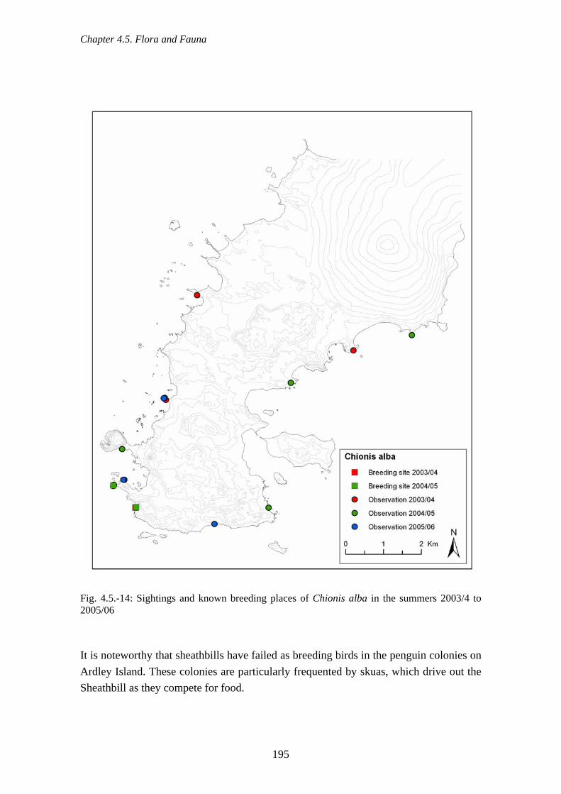
Chapter 4.5. Flora and Fauna
Fig. 4.5.-14: Sightings and known breeding places of Chionis alba in the summers 2003/4 to 2005/06 It is noteworthy that sheathbills have failed as breeding birds in the penguin colonies on Ardley Island. These colonies are particularly frequented by skuas, which drive out the Sheathbill as they compete for food.
195

Chapter 4.5. Flora and Fauna
4.5.6. Skuas (Catharacta spp.)
Fig. 4.5.-15a & b: (a) Brown Skua (Catharacta a. lonnbergi) and (b) South Polar Skua (Catharacta maccormicki ,photos: Peter) In the 2003/04 season 31 pairs of Brown Skuas (Catharacta antarctica lonnbergi), 132 pairs of South Polar Skuas (Catharacta maccormicki), and nine hybrid pairs (C. a. lonnbergi x C. maccormicki) were mapped in the Fildes Region (Fig. 4.5.-15a & b). There was a definite reduction in the numbers of breeding pairs from previous years, especially in the Brown Skuas and the hybrid pairs (Fig. 4.5.-16 & 17a - d). One cause was the extremely long duration of snow in the season 2003/2004, until January 2004, which prevented a large number of pairs on Fildes Peninsula from breeding. In the following two years the number of breeding pairs of skuas, with a total of around 350 BP, reached its highest level during the last 25 years (cf. also Peter et al., 1990). This rising trend is due, in particular, to the increase in numbers of South Polar Skuas; in 2005/06 there were 232 breeding pairs (pers. comm. M. Ritz) in the region. In this context it can be expected that changes in ice cover and the temperature of the sea surface, caused by rapid climate change, as well as changes in the marine food chain, will have consequences not only for breeding success (Hahn et al., 2007), but also on the numbers of breeding pairs in the future. Brown Skuas obtain food overwhelmingly from terrestrial sources, especially birds and dead seals. Because of the high density of stations on Fildes Peninsula, anthropogenic sources of food also play a role (Secs. 4.2.4. & 5.2.; Peter et al., 1988c; Peter 1995). This brings with it not only the danger of introducing diseases such as avian cholera, but also the possibility that nestling development will be adversely affected by food that is not typical for skuas (Peter et al., 2002 a, b).
196

Chapter 4.5. Flora and Fauna
0
50
100
150
200
250
300
350
400
1980
1982
1985
1986
1987
1997
1999
2001
2002
2003
2004
2005
2006
Skuas (overall)
Mixed pairs
South Polar
Fig. 4.5.-16: Numbers of skua breeding pairs on the Fildes Peninsula and Ardley Island in the years 1980/81 to 2005/06 In the 2005/06 season the total breeding success rate of both skua species (Brown Skua: 0.51 juv/BP; South Polar Skua: 0.71 juv/BP) was compared with that of breeding pairs near the stations and in areas that are frequently visited. These success rates did not vary significantly, although it must be noted that the samples of skuas near stations and of frequently-visited skua nests are small (pers. comm. M. Ritz).
197

Chapter 4.5. Flora and Fauna
2003/04 2000/01
2004/05 2005/06
Fig. 4.5.-17a-d: Distribution of skua nests in the Fildes Region in the four years of the study
198

Chapter 4.5. Flora and Fauna
4.5.7. Kelp Gull (Larus dominicanus)
Fig. 4.5.-18: Kelp Gull (Larus dominicanus, photo: Peter) Kelp Gulls are distributed on all continents in the southern hemisphere (Fig. 4.5.-18). In the Antarctic they breed in the Antarctic Peninsula region and on the maritime Antarctic and Sub-Antarctic islands. They prefer to nest in coastal areas. Attempts to map this relatively early breeding species were considerably hampered in the 2003/04 season as large amounts of snow in December made parts of the coast inaccessible, so that it was impossible to count birds (Fig. 4.5.-19a-c). Records for the 2003/04 season are thus incomplete. A total of 142 occupied nests or pairs were counted in 2004/05. The total population in this season was just over 150 BP, while in the following summer 2005/06 it was lower, at 120 pairs or nests counted. The population of this species can be considered to be stable compared to previous years. In the 1980s, biologists working at the Bellingshausen station put the number of breeding pairs on Fildes Peninsula and Ardley Island in 1984/85 at between a minimum of 62 and a maximum of 180 (Peter et al.,1988a). For the second half of the 1990s the only data for breeding pairs on Fildes Peninsula are 136 for 1995/96 (Soave et al., 2000) and 146 in 1998/99 and 153 in 1999/2000 (Welcker, 2000). It is noteworthy that inland breeding sites have only been found in the last 10 years, whereas in the 1980s the birds chose almost exclusively areas near the coast for breeding.
199

Chapter 4.5. Flora and Fauna
2004/05 2003/04
2005/06
Fig. 4.5.-19a-c: Colonies and single nests of Kelp Gull in the summers 2003/04, 2004/05 and 2005/06
200

Chapter 4.5. Flora and Fauna
4.5.8. Antarctic Tern (Sterna vittata)
Fig. 4.5.-20: Antarctic Tern (Sterna vittata, photo: Peter) The Antarctic Tern, which is present in the area (Fig. 4.5.-20) breeds from October to March. Depending on the duration of snow and on breeding success during the season, different breeding sites are used in the course of the summer. Even though not all breeding sites could be mapped, because some were inaccessible, this trend towards changing breeding site is shown, for example, using a comparison of data from the 2003/04 and the 2004/05 seasons (Fig. 4.5.-21a-d). The total breeding population in the region in the 2003/04 season was lower than 100 pairs, whereas in the 2000/01 season it was more than 200 BP (Fig. 4.5.-21a-d). In contrast to the summer of 2003/04, when there was a lot of snow, the number of breeding pairs on Fildes Peninsula and Ardley Island rose to around 700 BP in the summer of 2004/05 and stood at around 400 - 450 BP in the summer of 2005/06 (Fig. 4.5.-21a-d). During the last 26 years, the highest numbers for Fildes Peninsula (including Nebles Point) and Ardley Island were close to 900 BP in the summer of 1984/85 (Peter et al., 1988a; Kaiser et al., 1988a), while in 1986/87, comparable to 2003/04, only 170 BP were counted (Mönke & Bick, 1988). Comparisons of breeding site distributions in the research area over the years makes noticeable that the colony at the eastern side of Nebles Point, which contained about 300 BP in a most restricted area in 1984/85, no longer exists (Kaiser 1995). This is also the case, to some degree, with the colony on Horatio Stump, which is not occupied every year.
201

Chapter 4.5. Flora and Fauna
2000/01 2003/04
2005/06 2004/05
Fig. 4.5.-21 a-d: Breeding localities of Antarctic Tern in the summers 2000/01 – 2005/06 The colonies to the north of the runway turned out to be stable. In this area, breeding places near the lakes and temporary waterways in particular were used. It cannot be established to what extent these areas are still influenced today by air traffic and also by visitor activity, as could be demonstrated in the 1980s with the help of detailed investigations into breeding success (Peter et al., 1989). Anthropogenic disturbance,
202

Chapter 4.5. Flora and Fauna
which leads to temporary abandonment of nests or even in some cases of the colony, makes it much more probable that eggs or chicks can be caught by skuas or Kelp Gulls. In order to minimise the effects of disturbance on this very sensitive species, we did not carry out a new detailed study of breeding success. 4.5.9. Potential breeding birds, visitors and transients
Fig. 4.5.-22: Blue-eyed Shag (Phalachrocorax atriceps), a bird that rarely breeds in the study area (photo: Peter) The Blue-eyed Shag (Phalacrocorax atriceps, Fig. 4.5.-22), a potential breeding bird on the small offshore islands, was regularly observed in the region as a non-breeder with up to 14 individuals in one place (Figs. 4.5.-29 to 31). It was not possible to provide evidence of breeding activity as the islands could not be reached during the investigation period. There is evidence of breeding activity for this species in the Maxwell Bay area, amongst others for Potter Peninsula, Barton Peninsula and Duthoit Point. For the Fildes Region there were only nest finds in two years (1979/80, 1986/87) on Ardley Island or on an island offshore (Bannasch & Odening, 1981; Mönke & Bick, 1988). In addition, Peter et al. (1988a) said that they suspected breeding activity on an island on the Drake side of Fildes Peninsula in 1983/84. All of the other species presented in Tab. 4.5.-5 are regular or occasional visitors in the region (Figs. 4.5.-29 to 31 summarise the occurrences of all additional species).
203
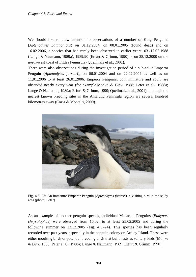
Chapter 4.5. Flora and Fauna
We should like to draw attention to observations of a number of King Penguins (Aptenodytes patagonicus) on 31.12.2004, on 08.01.2005 (found dead) and on 16.02.2006, a species that had rarely been observed in earlier years: 03.-17.02.1988 (Lange & Naumann, 1989a), 1989/90 (Erfurt & Grimm, 1990) or on 28.12.2000 on the north-west coast of Fildes Peninsula (Quellmalz et al., 2001). There were also observations during the investigation period of a sub-adult Emperor Penguin (Aptenodytes forsteri), on 06.01.2004 and on 22.02.2004 as well as on 11.01.2006 to at least 26.01.2006. Emperor Penguins, both immature and adult, are observed nearly every year (for example Mönke & Bick, 1988; Peter et al., 1988a; Lange & Naumann, 1989a; Erfurt & Grimm, 1990; Quellmalz et al., 2001), although the nearest known breeding sites in the Antarctic Peninsula region are several hundred kilometres away (Coria & Montalti, 2000).
Fig. 4.5.-23: An immature Emperor Penguin (Aptenodytes forsteri), a visiting bird in the study area (photo: Peter) As an example of another penguin species, individual Macaroni Penguins (Eudyptes chrysolophus) were observed from 16.02. to at least 25.02.2005 and during the following summer on 13.12.2005 (Fig. 4.5.-24). This species has been regularly recorded over past years, especially in the penguin colony on Ardley Island. These were either moulting birds or potential breeding birds that built nests as solitary birds (Mönke & Bick, 1988; Peter et al., 1988a; Lange & Naumann, 1989; Erfurt & Grimm, 1990).
204

Chapter 4.5. Flora and Fauna
Fig. 4.5.-24: Moulting Macaroni Penguin (photo: Buesser) In addition there have been several observations of Arctic Tern (Sterna paradisea): on 22.12.2003: two individuals, 25.12.2004 & 28.12.2004: one on each occasion, 14.12.2005: 28 individuals, 23.12.2005: 35 individuals.
Fig. 4.5.-25: Southern Fulmar (Fulmarus glacialoides, photo: Bellingshausen Station)
205

Chapter 4.5. Flora and Fauna
From November 2004 to January 2005 a group of eight White-rumped Sandpiper (Calidris fuscicollis) stayed on the north coast of Ardley Island (Fig. 4.5.-26). This species had already been observed several times in the 1980s (e.g. Rauschert et al., 1987; Nadler & Mix, 1989).
Fig. 4.5.-26: White-rumped Sandpiper (Calidris fuscicollis, photo: Peter) Particularly noteworthy is the observation of Light-mantled Sooty Albatross (Phoebetria palpebrata), which were seen during January 2005 in occasional synchronised flight (courtship!) and sitting on Flat Top. This observation is not the first of its kind on Flat Top; this is particularly remarkable as King George Island is far from the nearest breeding site (South Georgia). Southern Fulmar (Fulmarus glacialoides, Fig. 4.5.-25), Snow Petrel (Pagodroma nivea, Fig. 4.5.-27) and Antarctic Petrel (Thalassoica antarctica) rarely stay in the region or can rarely be regularly observed outside the breeding season. For the first two species there is photographic evidence obtained by the overwintering team of Bellingshausen station from the years 2004 and 2006, as well as finds of dead birds from the subsequent summer months. Cattle Egret (Bubulcus ibis, Fig. 4.5.-28) must be becoming more frequent as accidental visitors because dead birds are being found increasingly often. In the research period there were a maximum of 10 in the summer of 2004/05, which were found starved to death due to the lack of appropriate food. The first observations from the South Shetlands region were made as early as the 1970s and 1980s (Peter et al. 1988a; Kaiser et al., 1988b).
206
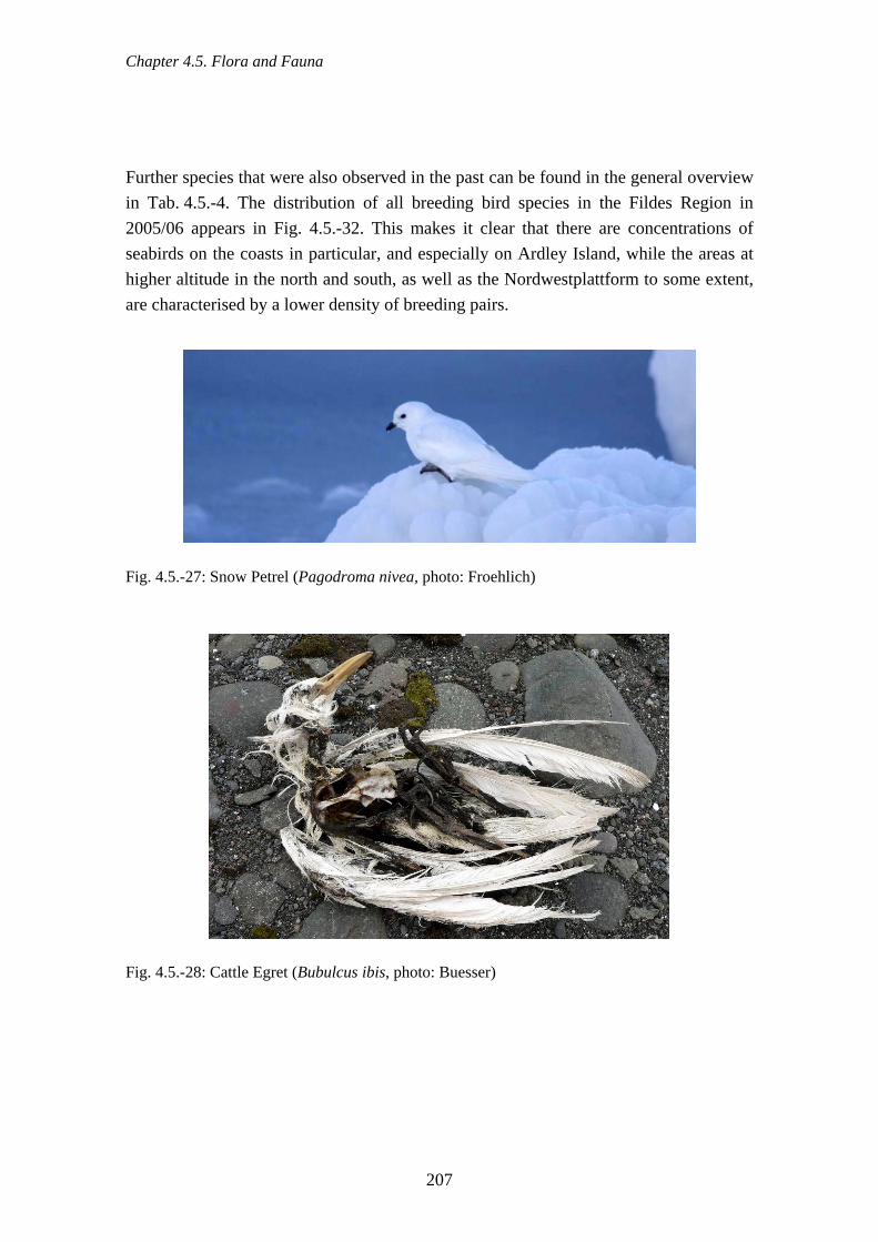
Chapter 4.5. Flora and Fauna
Further species that were also observed in the past can be found in the general overview in Tab. 4.5.-4. The distribution of all breeding bird species in the Fildes Region in 2005/06 appears in Fig. 4.5.-32. This makes it clear that there are concentrations of seabirds on the coasts in particular, and especially on Ardley Island, while the areas at higher altitude in the north and south, as well as the Nordwestplattform to some extent, are characterised by a lower density of breeding pairs.
Fig. 4.5.-27: Snow Petrel (Pagodroma nivea, photo: Froehlich)
Fig. 4.5.-28: Cattle Egret (Bubulcus ibis, photo: Buesser)
207

Chapter 4.5. Flora and Fauna
Tab. 4.5.-4: List of all bird species recorded in the Fildes Region (cf. also Rauschert et al., 1987; Peter et al. 1988a; Nadler & Mix 1989; Lange & Naumann, 1990) Family Species Status
Spheniscidae Aptenodytes forsteri Aptenodytes patagonicus Eudyptes chrysolophus Pygoscelis adeliae Pygoscelis antarctica Pygoscelis papua
Visitor Visitor (Moult) Visitor (Moult) Breeding bird Breeding bird Breeding bird
Diomedeidae
Diomedea exulans Diomedea melanophris Phoebetria palpebrata
Visitor Visitor regular Visitor
Procellariidae
Daption capense Fulmarius glacialoides Pterodroma mollis Halobaena caerulea Macronectes giganteus Pagodroma nivea Pachyptyla desolata Thalassoica antarctica
Breeding bird Visitor / Transient Visitor Visitor Breeding bird Visitor / Transient Visitor Transient
Hydrobatidae Fregetta tropica Oceanites oceanicus
Breeding bird Breeding bird
Anatidae Cygnus melancoryphus Anas georgica
Vagrant Vagrant
Scolopacidae Calidris fuscicollis Calidris melanotos
Visitor / Transient Vagrant
Chionididae Chionis alba Breeding bird Stercorariidae Catharacta maccormicki
Catharacta antarctica lonnbergi Catharacta chilensis Stercorarius pomarinus
Breeding bird Breeding bird Visitor Visitor
Laridae Larus dominicanus Breeding bird Sternidae Sterna vittata
Sterna paradisaea Breeding bird Visitor
Phalacrocoracidae Phalacrocorax atriceps Breeding bird / Visitor
208

Chapter 4.5. Flora and Fauna
Fig. 4.5.-29: Observations of potential breeding and visiting birds in the 2003/04 season
209

Chapter 4.5. Flora and Fauna
Fig. 4.5.-30: Observations of potential breeding and visiting birds in the 2004/05 season
210

Chapter 4.5. Flora and Fauna
Fig. 4.5.-31: Observations of potential breeding and visiting birds in the 2005/06 season
211

Chapter 4.5. Flora and Fauna
Fig. 4.5.-32: Overview of breeding birds (both colonially and singly breeding) in the 2005/06 season 4.5.10. Investigations of seabird behaviour and physiology Every individual receives stimuli (for example visual, acoustic and tactile) from their environment in different ways according to their individual condition and species-specific receptor system. The effects of human activities (such as scientific work, tourism or traffic) can be estimated from behavioural changes in animals. Various models have been developed relating to stress, fear and predator-prey behaviour in order to predict the behavioural reactions of animals to different stimuli (for example Cannon,
212

Chapter 4.5. Flora and Fauna
1929; Selye, 1952; Archer, 1976; Ydenberg & Dill, 1986; Toates, 1995; Gill et al., 1996; Lima, 1998). However, an activity does not always have to be experienced by an animal as a disturbance, that is to say as something negative. An animal's reactions can also be weak, and thus not measurable, or even positive, because the human activity is not interpreted as being dangerous or because the animal has already got used to it (Liddle, 1997). In the Antarctic and Sub-Antarctic behavioural studies concerning human activity are mainly concentrated on penguins (e.g. Wilson et al., 1991; Davis, 1995; Nimon et al., 1995; Giese & Riddle, 1999; Holmes et al., 2006). Hannah Point on Livingston Island is frequently visited by tourists. On the seaward portion of the peninsula, Chinstrap and Gentoo Penguins on their way to or from the water encounter tourists. Birds were observed to stop for a short time then either continue on their way or get out of the way of the people (Pfeiffer & Peter, 2003). If people came closer than 5 m, the majority of penguins reacted by briefly fleeing or by freezing. On the narrow path to the colonies the penguins frequently avoided tourists and chose rocky areas on either side of the path, which were less easy to walk on. Wilson et al. (1991) also reported on the influence of visitors on the route chosen by penguins, whereby the penguins continued to use the alternative paths for a considerable time after the tourists had left. On snow-covered paths the progress of the penguins can be particularly hampered by the deep tracks left by visitors. In addition to behavioural changes, heart rate changes have been put forward as a physiological means of measuring possible disturbance of animals by human activities (for example Gebauer et al., 1989; Culik et al., 1990; Nimon et al., 1996; Salwicka & Stonehouse, 2000; Weimerskirch et al., 2002). Between 2000 and 2003, ethological and physiological reactions of Southern Giant Petrels and skuas to these human activities in the Fildes Region were studied and the findings are briefly described below (Pfeiffer, 2005). The seabird breeding sites in the Fildes Region are visited regularly by scientists who count birds and, after catching adult or young birds, carry out measurements on individual animals. Tourists, station members and scientists in transit also visit breeding colonies less regularly, though they usually remain on specific paths so that they observe the animals from a distance of 5 - 100 m. The animals are also exposed to frequent air, shipping and land traffic, as well as the noises associated with station activities. The difference between scientific and tourist visits was simulated by means of standardised nest visits at set distances of 0 - 100 m (Pfeiffer 2005). The nest visits were carried out at breeding sites that were usually exposed either to limited or high levels of human activity, in order to determine the effects of habituation.
213

Chapter 4.5. Flora and Fauna
In addition, Pfeiffer (2005) noted the reactions of the animals to overflights by airplanes and helicopters in the area at the time of the study. The important aspect here was the difference between flights following main routes and flights that followed seldom-used routes unknown to the birds. Sounds of helicopters flying were also played to the animals in order to test their reactions to flight noises separately. The results of the study showed that scientists triggered the strongest reactions when they checked nests. However, unguided station members and tourists away from paths caused an increase in flight and defensive behaviour (see Tab. 4.5.-5). The reactions of birds varied according to each individual's degree of habituation to people. In areas of high human activity fewer animals took flight when nests were visited and they also defended their nesting sites less fiercely. The increase in the heart rate was relatively small compared to that of animals that were visited in areas with infrequent human activity. There was short-term habituation to visits in all the Southern Giant Petrel breeding sites studied. This was expressed by the fact that heart rates diminished on repeat visits. Tab. 4.5.-5: Effects of human activity on the physiology (as heart rate) and behaviour of Southern Giant Petrels and skuas (Brown and South Polar Skua combined) in the Fildes Region compared with the effects of natural stressors (such as interactions with predators and conspecifics). The classifications are: 1 = “low”, 2 = “medium”, 3 = “high effects”; and they refer to the reactions of breeding birds in areas of high or of low human activity. Figures for data from sample sizes < 5 are given in brackets. (from Pfeiffer, 2005) (Potential) Stressors
Scientific visits Tourist visits Regular air traffic
Irregular air traffic
Tourist visits and air traffic
Nesting Southern Giant Petrels in areas with high levels of human activity Effect on physiology behaviour
3 3
2 2
1 1
2 2
(3) 3
Nesting Southern Giant Petrels in areas with low levels of human activity Effect on physiology behaviour
3 3
3 2
2 1
2
(2)
(3) (3)
Nesting skuas in areas with high levels of human activity Effect on physiology behaviour
3 2
3 1
2 1
2 2
(3) 1
Nesting skuas in areas with low levels of human activity Effect on physiology behaviour
3 3
3 2
3 1
2
(2)
(3) (2)
214

Chapter 4.5. Flora and Fauna
Southern Giant Petrels and skuas reacted less strongly to regular air traffic than to irregular flights. Flights that were low or that came from unpredictable directions caused changes in behaviour in “sensitive” individuals. There are reports and experiments on the effects of air traffic on animals in other parts of the Antarctic and Sub-Antarctic, which reveal a wide spectrum of reactions in the different species (ATCM, 2001d). Whereas overflights by Hercules aircraft at a height of 300 m caused no changes in the behaviour of Adélie Penguins (Taylor & Wilson, 1990), adult birds and chicks of this species fled from helicopter overflights (Culik et al., 1990). Adult Emperor Penguins and their chicks also behavioural changes to some extent in response to air traffic (Kooyman & Mullins, 1990; Stone et al., 2003). The body temperature of adult and young birds also increased in response to overflights, leading to the assumption that there were additional energetic costs for the individuals (Regel & Pütz, 1995). Giese & Riddle (1999) observed behavioural reactions by King Penguin chicks to air traffic. All chicks that were observed demonstrated increased vigilance and the majority of the animals started to walk or run away. There have even been reports of mass panic and multiple deaths of adults and chicks of the same species as a result of overflights (Cooper et al., 1994). A second parameter for quantifying stress reactions, which is used increasingly often, is a rise in hormone levels. When under threat, animals produce increased amounts of glucocorticosteroid. This hormone can be detected in their blood and excreta (e.g. Silverin, 1998; Wingfield et al., 1998; Buchanan, 2000). The influence of human activities have also been studied by hormone analyses in the Fildes Region (Pfeiffer, 2005). The glucocorticosteroid values for breeding Brown Skua and South Polar Skua did not rise significantly with increases in the duration of visit length. Brown Skua chicks that developed in regions with little human activity reacted more strongly to visits than those in areas where human activity was more frequent. Handling the chicks resulted in higher hormone values than in chicks that were simply watched. No elevated hormone values were detected in skua droppings after repeated overflights (Pfeiffer 2005). It can not be ruled out that nevertheless the birds though showed stress reactions to air traffic which was detectable.
215

Chapter 4.5. Flora and Fauna
4.5.11. Seals Seals are among the keystone organisms of the Antarctic food web. They come on shore, or onto the onshore pack ice to moult, rest or reproduce. The occurrence of five of the six Antarctic seal species in the area was determined during the study period, i.e. the Southern Elephant Seal (Mirounga leonina), the Antarctic Fur Seal (Arctocephalus gazella), Weddell Seal (Leptonychotes weddelli), Crabeater Seal (Lobodon carcinophagus) and Leopard Seal (Hydrurga leptonyx). On the Fildes Peninsula there are pupping places of four of the five species recorded as occurring. On these species we have not only our own investigations to hand (Peter et al., 1988a; Peter et al., 1989), but also studies by Russian (Krylov, 1972; Simonov, 1973; Popov & Krylov, 1977), Chilean and East German scientists (Bannasch & Odening, 1981; Bannasch et al., 1984). Tab. 4.5.-6: Results of the monthly seal counts on the Fildes Peninsula and Ardley Island in January/February 2004
Species 06.01.2004 05.02.2004
Southern Elephant Seal 650 623
Antarctic Fur Seal 19 1226
Weddell Seal 101 25
Crabeater Seal 5 0
Leopard Seal 0 0 Tab. 4.5.-7: Results of the monthly seal counts on the Fildes Peninsula and Ardley Island from December 2004 to March 2005
Species 20.12.2004 21.01.2005 21.02.2005 20./21.03.2005
Southern Elephant Seal 362 622 476 123
Antarctic Fur Seal 6 164 144 505
Weddell Seal 102 92 45 14
Crabeater Seal 3 0 2 0
Leopard Seal 0 1 0 0
216

Chapter 4.5. Flora and Fauna
Tab. 4.5.-8: Results of the monthly seal counts on the Fildes Peninsula and Ardley Island from December 2005 to March 2006
Species 18.12.2005 15.01.2006 13.02.2006
Southern Elephant Seal 701 841 582
Antarctic Fur Seal 12 7 637
Weddell Seal 70 45 5
Crabeater Seal 0 2 0
Leopard Seal 0 1 0 Tab. 4.5.-9: Results of the monthly seal counts on the Fildes Peninsula and Ardley Island from April to October 2006 (Source: A. Froehlich)
Species 15. 04.
30. 04.
15. 05.
30. 05.
15.06.
30.06.
15.07.
30.07.
15.08.
30.08.
13. 09.
29. 09.
15. 10.
30.10.
Southern Elephant Seal
187 189 96 118 65 39 16 9 2 0 2 1 52 112
Antarctic Fur Seal
106 11 0 2 14 32 13 67 58 15 2 6 16 38
Weddell Seal
12 13 8 4 7 5 5 20 48 26 67 82 111 83
Crabeater Seal
2 1 3 0 1 1 0 6 3 19 80 418 621 220
Leopard Seal
2 1 0 0 1 0 0 5 1 1 3 5 3 2
The Fildes Peninsula, in particular the northern and central portions of the Drake coast, is used by the Elephant Seal for moulting over the entire summer (Fig. 4.5.-33). Their number peaked in January of each year with 622 to 841 (Fig. 4.5.-8 & 9). These are, however, only about 45 % of the numbers of individuals counted in the summer months during the 1980s (Rauschert et al., 1987; Peter et al., 1988a; Lange & Naumann, 1989). Whether these decreases are to be attributed thereby to human disturbances or natural fluctuations, cannot be identified with any precision.
217

Chapter 4.5. Flora and Fauna
Fig. 4.5.-33: Elephant Seal haul-outs in the Drake Coast area (photo: Peter) During the monthly seal counts, all aggregations of Elephant Seals > 10 individuals were mapped using GPS (Fig. 4.5.-39a & b). Thus, in the 2004/05 season for example, up to 133 animals were located at each of 26 haul-outs where they were spending the summer moult. All these locations were on the west coast of the Fildes Peninsula. In terms of the number of newborn pups, the Elephant Seal is the second most numerous in the area, after the Weddell Seal (Fig. 4.5.-40). Except for a few exceptions, births of Elephant Seal pups were restricted to the north and northwest part of Fildes Peninsula. A maximum of 47 newborn pups were counted at the end of October 2006. The number of newborns has varied greatly between years recently in comparison to the 1980s (9 - 55: Rauschert et al., 1987; Peter et al., 1988a; Nadler & Mix, 1989). Antarctic Fur Seals first appear after the breeding period, i.e. at the end of the summer, and are more abundant on the Fildes Peninsula coasts, although scarce on the east coast (Fig. 4.5.-38a to c). The nearest large pupping places are about 15 km north of the peninsula on Stigant Point (Peter et al., 1989). Particularly remarkable are the differences between years. The January figures in the three years of the study varied from 7 to 164, in February by much more, between 144 and 1,226 animals (Tabs. 4.5.-7 to 9), whereas during the 1980s the number of individuals ranged from 61 to 481 (Peter et al., 1988a; Lange & Naumann, 1989). The population on Fildes Peninsula appears to be increasing as well. The winter counts show that the species only leaves the Region for a short time (Tab. 4.5.-10). Depending on ice conditions, it is almost always possible to see Fur Seals.
218

Chapter 4.5. Flora and Fauna
Fur Seal pupping grounds were only rediscovered in the 1970s, on King George Island (Stigant Point) (Peter et al., 1989). Fur Seals pupping on Fildes Peninsula is, however, still exceptional (Fig. 4.5.-40) and the first birth was detected in December 1986 (Mönke & Bick 1988). During the study period, occasional Fur Seals were born in the stretch between Bay 2 and Bay 3 near “Priroda” hut and in the area of Bay 5 (Figs. 4.5.-34 & 3.4.-2).
Fig. 4.5.-34: Fur Seal family in the Drake Coast area near the refuge hut "Priroda" (photo: Peter) Crabeater Seals, as a species associated with ice, are only exceptionally observed in the summer (Tab. 4.5.-7 to 4.5.-10). They occur at the end of the winter in the bays, in particular in Maxwell Bay, provided that there is sufficient pack ice. The only recent count comes from winter/spring 2006, when a maximum of 621 Crabeater Seals was counted (Tab. 4.5.-10). In the previous year, the number seems to have been still larger, as photos from this period show (Fig. 4.5.-35). Although in the winter Crabeater Seals are the most frequent species in the area, no newborn have been observed in recent years. Leopard Seal were rarely observed in the summer, but small numbers of individuals occur regularly in the winter in the study area (Tabs. 4.5.-7 to 4.5.-10, Fig. 4.5.-36). Because penguins are part of their diet it is not especially remarkable therefore that they are observed particularly within the range of the penguin colonies around Ardley Island. Births of this species were recorded only in the south part of Fildes Peninsula at the end of the winter (Fig. 4.5.-40).
219

Chapter 4.5. Flora and Fauna
Fig. 4.5.-35: Crabeater Seal and a few Fur Seals and Weddell Seals in Hydrographers Cove (19.09.2006, photo: Bellingshausen)
Fig. 4.5.-36: The Leopard Seal is the rarest species of seal in the study area (photo: Pfeiffer)
220

Chapter 4.5. Flora and Fauna
Weddell Seals are most numerous during the pupping season in September/October. Their numbers decrease continually over the summer (max. something over 100 animals) and reach their minimum in the winter. Starting at the end of July, the numbers rise again (Tab. 4.5.-7 to 4.5.-10). Concentrations were detected particularly in the summer in the north around Bays 1 & 2 (cf. Fig. 3.4.-2), in Fildes Strait and in Bay 20. Weddell Seal pupping grounds are limited to the south part of the peninsula, but births took place not only in the Maxwell Bay area, but also in the Drake coast area (Fig. 4.5.-37). This situation is different in comparison to that at the beginning of the 1980s. Then, just in Bay 20, a maximum of 155 births was determined from August to October (Rauschert et al., 1987; Peter et al., 1988a; Nadler & Mix, 1989). Apart from changes in ice conditions, proximity to Great Wall station and the consequent increased visitor traffic are possibly responsible for this displacement and reduction of the total number.
Fig. 4.5.-37: Newborn Weddell Seal and mother in Hydrographers Cove (photo: Fröhlich)
221

Chapter 4.5. Flora and Fauna
Fig. 4.5.-38a: Number of Elephant Seals and Fur Seals at haul-outs (numbers per bay 05.02.2004)
222
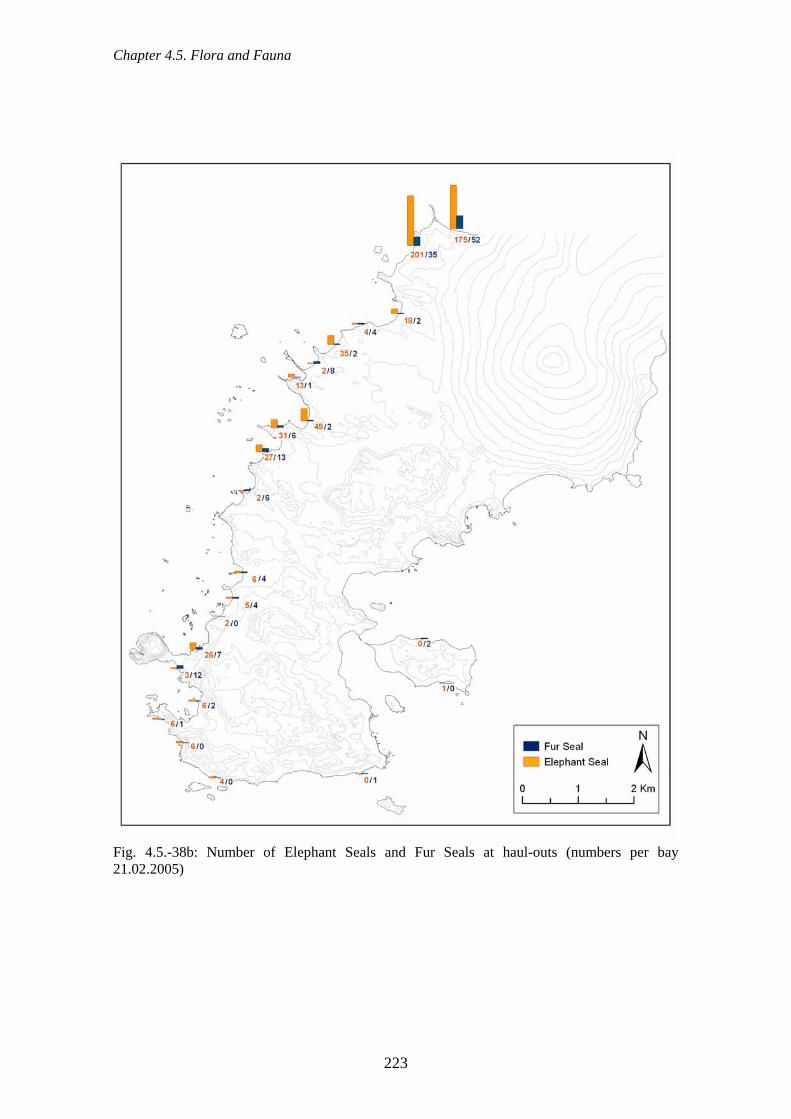
Chapter 4.5. Flora and Fauna
Fig. 4.5.-38b: Number of Elephant Seals and Fur Seals at haul-outs (numbers per bay
1.02.2005) 2
223

Chapter 4.5. Flora and Fauna
Fig. 4.5.-38c: Number of Elephant Seals and Fur Seals at haul-outs (numbers per bay 13.02.2006)
224

Chapter 4.5. Flora and Fauna
Fig. 4.5.-39a: Positions of Elephant Seals haul-outs with > 10 individuals in the summer of 2004/05
225

Chapter 4.5. Flora and Fauna
Fig. 4.5.-39b: Positions of Elephant Seal haul-outs with > 10 individuals in the summer of 2005/06
226

Chapter 4.5. Flora and Fauna
Fig. 4.5.-40: Positions of seal pupping localities on the Fildes Peninsula between 2002 and 2006
or each individual bay, size of circle increases with the number of newborns) (f
227

Chapter 4.5. Flora and Fauna
4.5.12. Diptera (Insecta) Hahn & Reinhardt (2006) examined the lakes of the Fildes Region for occurrences of the chironomid species Parochlus steinenii (Fig. 4.5.-41). They demonstrated that settlement of lakes by this species was independent of lake altitude. It seemed, however, to need ice-free areas in the winter for the survival of the poorly frost-resistant larvae and eggs. Lakes with variable water level were settled rarely or not at all by these midges since there the danger of drying out is high. They therefore occur particularly in permanent lakes with stable water level.
Fig. 4.5.-41: All 105 lakes of the Fildes Region showing those colonised by the chironomid Parochlus steinenii
228
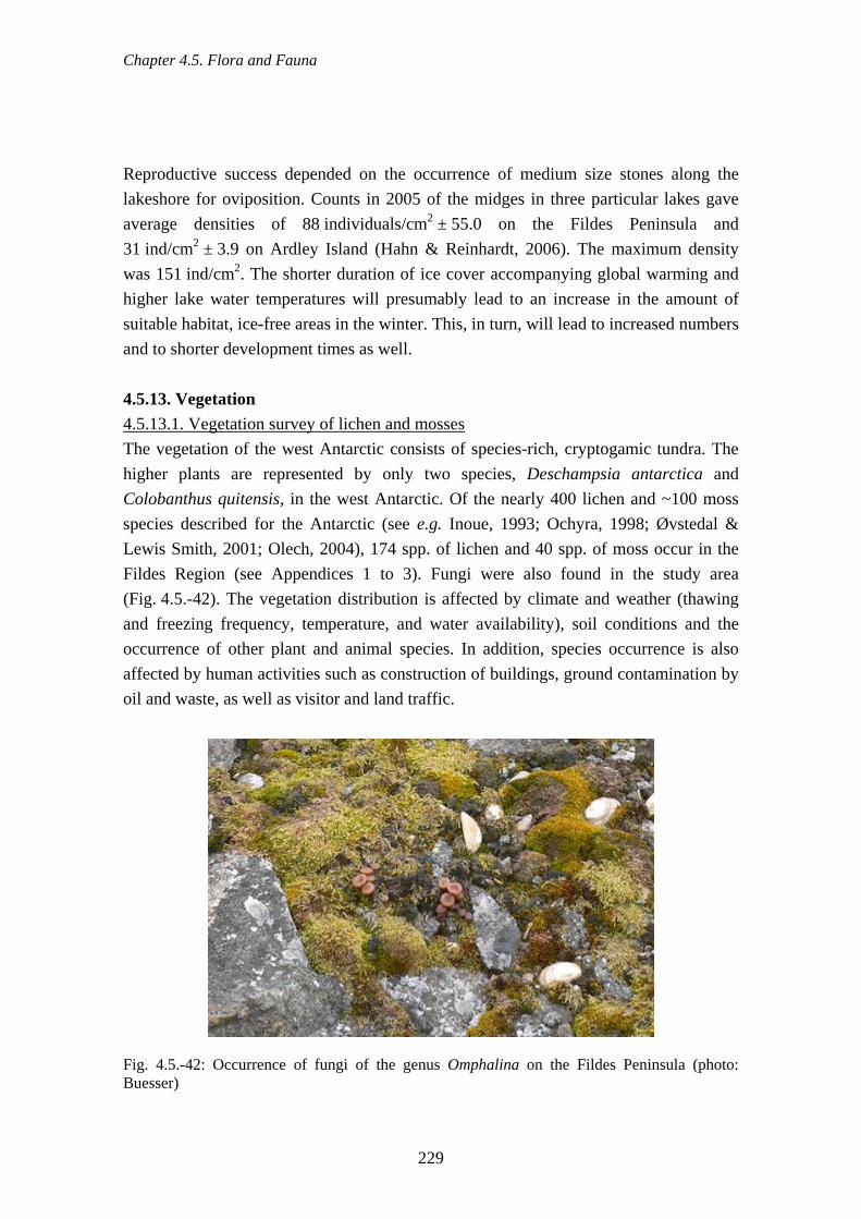
Chapter 4.5. Flora and Fauna
Reproductive success depended on the occurrence of medium size stones along the
4.5.13. Vegetation 4.5.13.1. Vegetation survey of lichen and mosses
lakeshore for oviposition. Counts in 2005 of the midges in three particular lakes gave average densities of 88 individuals/cm2 ± 55.0 on the Fildes Peninsula and 31 ind/cm2 ± 3.9 on Ardley Island (Hahn & Reinhardt, 2006). The maximum density was 151 ind/cm2. The shorter duration of ice cover accompanying global warming and higher lake water temperatures will presumably lead to an increase in the amount of suitable habitat, ice-free areas in the winter. This, in turn, will lead to increased numbers and to shorter development times as well.
The vegetation of the west Antarctic consists of species-rich, cryptogamic tundra. The higher plants are represented by only two species, Deschampsia antarctica and Colobanthus quitensis, in the west Antarctic. Of the nearly 400 lichen and ~100 moss species described for the Antarctic (see e.g. Inoue, 1993; Ochyra, 1998; Øvstedal & Lewis Smith, 2001; Olech, 2004), 174 spp. of lichen and 40 spp. of moss occur in the Fildes Region (see Appendices 1 to 3). Fungi were also found in the study area (Fig. 4.5.-42). The vegetation distribution is affected by climate and weather (thawing and freezing frequency, temperature, and water availability), soil conditions and the occurrence of other plant and animal species. In addition, species occurrence is also affected by human activities such as construction of buildings, ground contamination by oil and waste, as well as visitor and land traffic.
Fig. 4.5.-42: Occurrence of fungi of the genus Omphalina on the Fildes Peninsula (photo: Buesser)
229
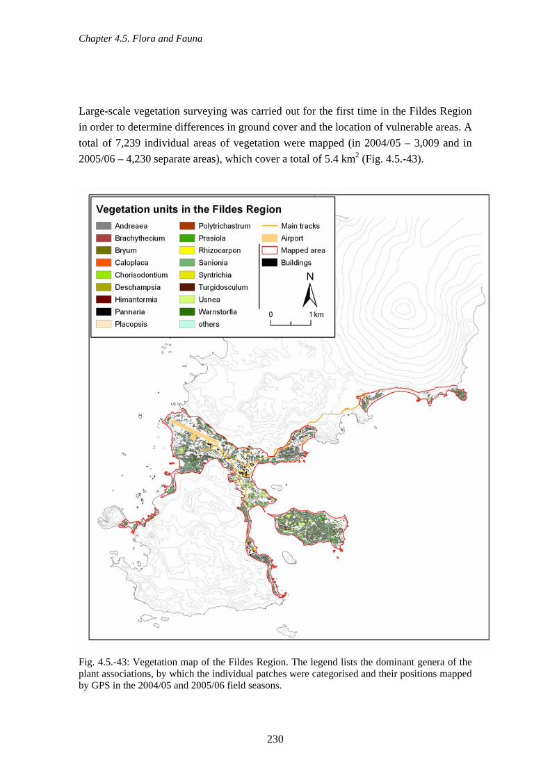
Chapter 4.5. Flora and Fauna
Large-scale vegetation surveying was carried out for the first time in the Fildes Region in order to determine differences in ground cover and the location of vulnerable areas. A total of 7,239 individual areas of vegetation were mapped (in 2004/05 – 3,009 and in 2005/06 – 4,230 separate areas), which cover a total of 5.4 km2 (Fig. 4.5.-43).
Fig. 4.5.-43: Vegetation map of the Fildes Region. The legend lists the dominant genera of the plant associations, by which the individual patches were categorised and their positions mapped by GPS in the 2004/05 and 2005/06 field seasons.
230
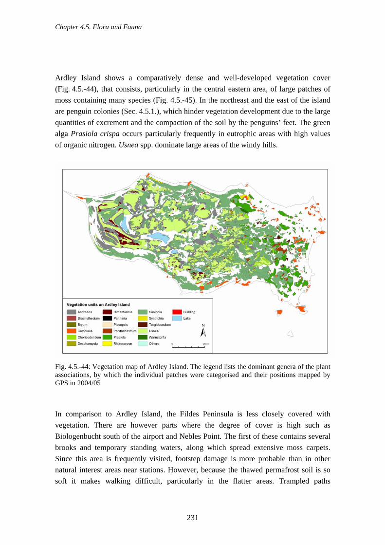
Chapter 4.5. Flora and Fauna
Ardley Island shows a comparatively dense and well-developed vegetation cover (Fig. 4.5.-44), that consists, particularly in the central eastern area, of large patches of moss containing many species (Fig. 4.5.-45). In the northeast and the east of the island are penguin colonies (Sec. 4.5.1.), which hinder vegetation development due to the large uantities of excrement and the compaction of the soil by the penguins’ feet. The green
alga Prasiola crispa occurs particularly frequently in eutrophic areas with high values of organic nitrogen. Usnea spp. dominate large areas of the windy hills.
q
Fig. 4.5.-44: Vegetation map of Ardley Island. The legend lists the dominant genera of the plant associations, by which the individual patches were categorised and their positions mapped by GPS in 2004/05 In comparison to Ardley Island, the Fildes Peninsula is less closely covered with vegetation. There are however parts where the degree of cover is high such as Biologenbucht south of the airport and Nebles Point. The first of these contains several brooks and temporary standing waters, along which spread extensive moss carpets.
in the flatter areas. Trampled paths
Since this area is frequently visited, footstep damage is more probable than in other natural interest areas near stations. However, because the thawed permafrost soil is so soft it makes walking difficult, particularly
231

Chapter 4.5. Flora and Fauna
consequently become established every year and these are then also frequently used by tourist group leaders.
Fig. 4.5.-45: Vegetation map of the central Fildes Peninsula mapped by GPS in 2004/05 and 2005/06. Individual patches are each characterised by a major genus from the plant associations listed in the legend. Research station grounds themselves have little vegetation cover because of the damage
the damper sinks of frost-patterned soils mosses are the predominant vegetation. nly limited establishment of lichens and moss is possible, however, in areas with
caused by driving and walking and because of the soil pollution. Plants grow to any degree only in protected spots. InOcontinual soil movement caused by freezing and thawing (Fig. 4.5.-46).
232

Chapter 4.5. Flora and Fauna
Fig. 4.5.-46: Vegetation on frost-patterned ground in the Fildes Region (photo: Buesser) 4.5.13.2. Vegetation of Dart Island and Two Summit Island Dart Island has relatively high plant cover with ~70 % in comparison to the Fildes Peninsula (cf. Figs. 4.5.-47 to 4.5.-49). Sanionia uncinata dominates in association with Deschampsia antarctica, Syntrichia princeps, Polytrichastrum alpinum and the alga Prasiola crispa (see Figs. 4.5.-49 and 4.5.-50). Cliffs near the Dart Island coast are covered by Caloplaca association (Fig. 4.5.-51), smaller, more central, ranges in contrast by stands of Usnea.
e Usnea association marks the scree slopes and the summits of the hills. Where the outhern Giant Petrel breeds, Prasiola crispa is dominant. Only within protected places
Two Summit Island with its two distinct peaks is floristically fundamentally different from Dart Island (Fig. 4.5.-48 and 4.5.-52). The degree of cover here is much less and thSin the beach transition zone are there larger areas of moss with Sanionia uncinata.
233
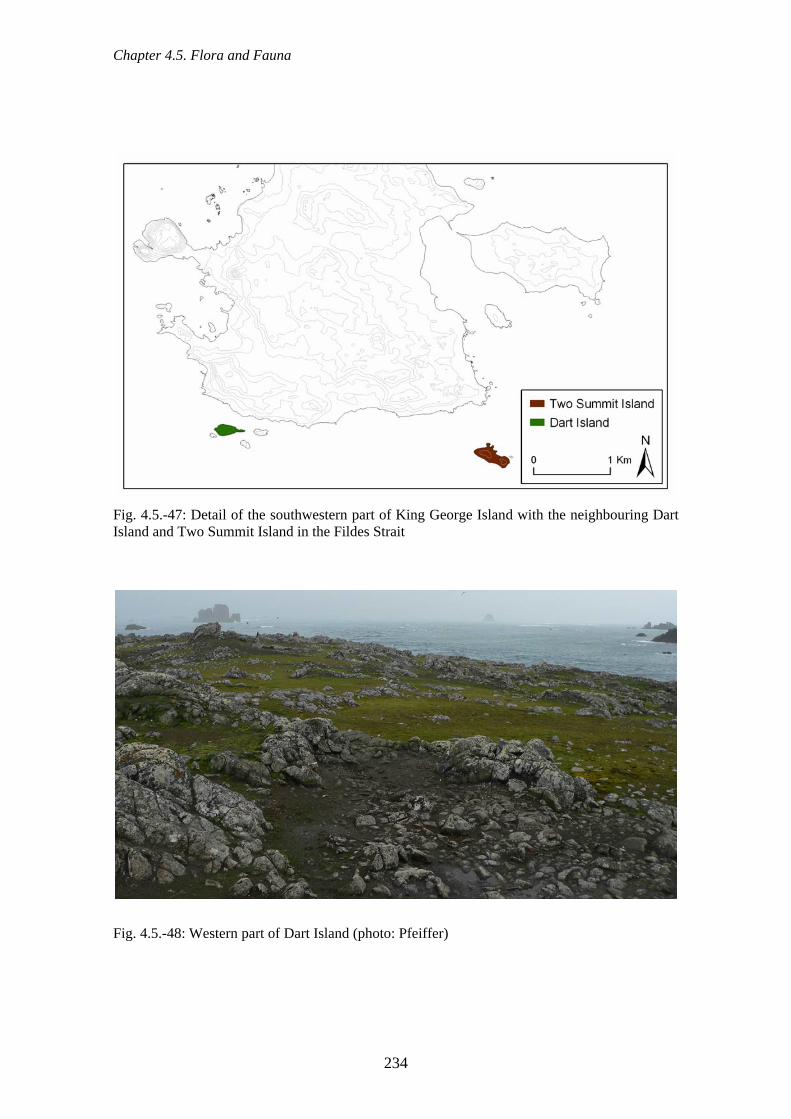
Chapter 4.5. Flora and Fauna
Fig. 4.5.-47: Detail of the southwestern part of King George Island with the neighbouring Dart Island and Two Summit Island in the Fildes Strait
Fig. 4.5.-48: Western part of Dart Island (photo: Pfeiffer)
234

Chapter 4.5. Flora and Fauna
Fig. 4.5.-49: Typical occurrence of plants on Dart Island. Sanionia uncinata associated with
eschampsia antarctica, Syntrichia princeps and Polytrichastrum alpinum (photo: Pfeiffer)
D
Fig. 4.5.-50: Polytrichastrum alpinum, Sanionia uncinata and Prasiola crispa in a Southern Giant Petrel nesting area (photo: Pfeiffer)
235

Chapter 4.5. Flora and Fauna
ig. 4.5.-51: Species association on rocky areas involving the genera Caloplaca, Xanthoria and FHaematomma and other crustose lichens (photo: Pfeiffer)
Fig. 4.5.-52: Western part of Two Summit Island: in the foreground groups of nesting Southern Giant Petrels with large patches of Prasiola crispa. Moss carpets are found in sheltered, fairly level areas. Scree slopes are dominated by Usnea communities (photo: Pfeiffer).
236
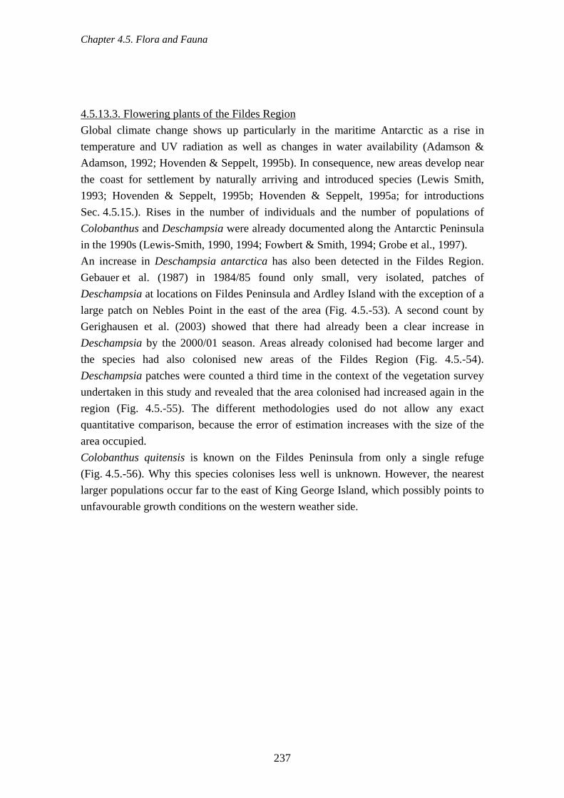
Chapter 4.5. Flora and Fauna
4.5.13.3. Flowering plants of the Fildes Region Global climate change shows up particularly in the maritime Antarctic as a rise in temperature and UV radiation as well as changes in water availability (Adamson & Adamson, 1992; Hovenden & Seppelt, 1995b). In consequence, new areas develop near the coast for settlement by naturally arriving and introduced species (Lewis Smith, 1993; Hovenden & Seppelt, 1995b; Hovenden & Seppelt, 1995a; for introductions Sec. 4.5.15.). Rises in the number of individuals and the number of populations of Colobanthus and Deschampsia were already documented along the Antarctic Peninsula in the 1990s (Lewis-Smith, 1990, 1994; Fowbert & Smith, 1994; Grobe et al., 1997). An increase in Deschampsia antarctica has also been detected in the Fildes Region. Gebauer et al. (1987) in 1984/85 found only small, very isolated, patches of Deschampsia at locations on Fildes Peninsula and Ardley Island with the exception of a large patch on Nebles Point in the east of the area (Fig. 4.5.-53). A second count by Gerighausen et al. (2003) showed that there had already been a clear increase in Deschampsia by the 2000/01 season. Areas already colonised had become larger and
ndertaken in this study and revealed that the area colonised had increased again in the egion (Fig. 4.5.-55). The different methodologies used do not allow any exact
quantitative comparison, because the error of estimation increases with the size of the area occupied. Colobanthus quitensis is known on the Fildes Peninsula from only a single refuge (Fig. 4.5.-56). Why this species colonises less well is unknown. However, the nearest larger populations occur far to the east of King George Island, which possibly points to unfavourable growth conditions on the western weather side.
the species had also colonised new areas of the Fildes Region (Fig. 4.5.-54). Deschampsia patches were counted a third time in the context of the vegetation survey ur
237

Chapter 4.5. Flora and Fauna
Fig. 4.5.-53: Distribution and density of Deschampsia antarctica individuals in the Fildes Region, plotted in 1984/85 by Gebauer et al. (1987)
238

Chapter 4.5. Flora and Fauna
Fig. 4.5.-54: Distribution and density of Deschampsia antarctica individuals in the Fildes Region, plotted in 2000/01 by Gerighausen et al. (2003)
239

Chapter 4.5. Flora and Fauna
Fig. 4.5.-55: Distribution and density of Deschampsia antarctica individuals in the Fildes Region, plotted in 2004/05 and 2005/06 as part of this study
240

Chapter 4.5. Flora and Fauna
Fig. 4.5.-56: Colobanthus quitensis is probably represented by only a single individual in the Fildes Region (photo: Buesser). 4.5.14. Damage to vegetation Human activities in the Antarctic usually entail a decrease in the degree of cover by the local vegetation as result of direct damage by walking, driving or soil pollution and as a result of the disturbance of potentially suitable habitat for colonisation in these areas. All these influences are visible in the study area (Figs. 4.5.-57 to 4.5.-59, Secs. 4.2.14., 4.2.1 to 4.2.3 & 4.2.6.). The tracks of feet or of wheels can remain evident for years due to the short season for vegetation and the slow growth of the plants. How long tracks may remain can only be determined with any exactitude, however, if the area concerned had been surveyed earlier without finding tracks. In research station grounds paths and wheel tracks are
.13.) does mean, however, that ere is relatively low potential for damage.
During scientific investigations specifically of vegetation, such as plant studies and mapping, stepping on the vegetation cannot be avoided in areas with high plant cover. The caused damage may reach from single trampling of larger areas during mapping activities to frequent trampling of particular smaller sites of intensive studies.
visible over wide areas (Olech, 1996; Campbell et al., 1998; Fig. 4.5.-60). The low degree of vegetation cover in station grounds (Sec. 4.5th
241
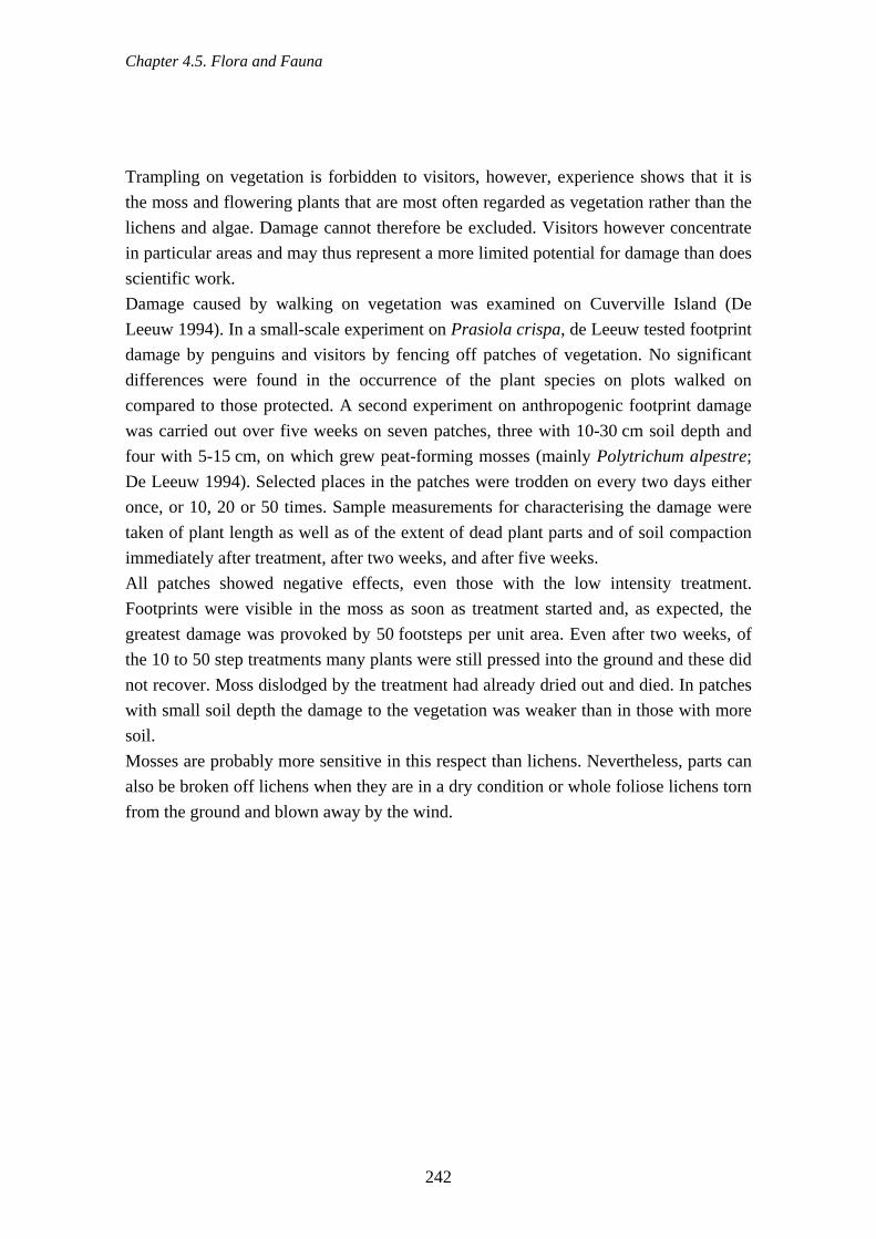
Chapter 4.5. Flora and Fauna
Trampling on vegetation is forbidden to visitors, however, experience shows that it is the moss and flowering plants that are most often regarded as vegetation rather than the lichens and algae. Damage cannot therefore be excluded. Visitors however concentrate in particular areas and may thus represent a more limited potential for damage than does scientific work. Damage caused by walking on vegetation was examined on Cuverville Island (De Leeuw 1994). In a small-scale experiment on Prasiola crispa, de Leeuw tested footprint damage by penguins and visitors by fencing off patches of vegetation. No significant differences were found in the occurrence of the plant species on plots walked on compared to those protected. A second experiment on anthropogenic footprint damage was carried out over five weeks on seven patches, three with 10-30 cm soil depth and four with 5-15 cm, on which grew peat-forming mosses (mainly Polytrichum alpestre; De Leeuw 1994). Selected places in the patches were trodden on every two days either once, or 10, 20 or 50 times. Sample measurements for characterising the damage were taken of plant length as well as of the extent of dead plant parts and of soil comp n
ootprints were visible in the moss as soon as treatment started and, as expected, the reatest damage was provoked by 50 footsteps per unit area. Even after two weeks, of
ny plants were still pressed into the ground and these did
s when they are in a dry condition or whole foliose lichens torn
actioimmediately after treatment, after two weeks, and after five weeks. All patches showed negative effects, even those with the low intensity treatment. Fgthe 10 to 50 step treatments manot recover. Moss dislodged by the treatment had already dried out and died. In patches with small soil depth the damage to the vegetation was weaker than in those with more soil. Mosses are probably more sensitive in this respect than lichens. Nevertheless, parts can also be broken off lichenfrom the ground and blown away by the wind.
242

Chapter 4.5. Flora and Fauna
Fig. 4.5.-57: Fresh footprint damage in moss, Fildes Peninsula (photo: Buesser)
Fig. 4.5.-58: Tracks, possibly several years old, made by tracked vehicles in moss, Fildes Peninsula (photo: Buesser)
243

Chapter 4.5. Flora and Fauna
Fig. 4.5.-59: New tracks of all-terrain and tracked vehicles in moss, Valle Klotz, Fildes Peninsula (photo: Buesser)
Fig. 4.5.-60: Pedestrian and vehicle tracks in the grounds of the Russian station Bellingshausen (photo: Sakharov)
244
Chapter 4.5. Flora and Fauna
Seals also negatively affect plant growth. Fur Seals during the moult between December and May, in particular, like to lie on flat vegetation-covered areas near the beach (Fig. 4.5.-61). Skuas and gulls use plants as nesting material and uproot the lichens and mosses from around their nests.
Fig. 4.5.-61: Damage to vegetation cover by Fur Seals during moulting on the Fildes Peninsula (photo: Buesser) 4.5.15. Introduced species The introduction and propagation of alien plant and animal species (neophyta and neozoa) due to human activities is a world-wide threat to biodiversity. Particularly susceptible are islands, the species composition of which can changed radically (e.g. D'Antonio & Dudley, 1995; Ruiz et al., 2000; Frenot et al., 2001; Courchamp et al., 2003). Despite the isolation of the Antarctic, alien species are intentionally as well as unintentionally introduced to the continent and the surrounding islands (Frenot et al., 2005). Of the Sub-Antarctic islands only two (Pingouins and McDonald Island) can validly be considered as in their original botanical state. On all others alien species occur, totalling more than 100 different vascular plants from the families Poaceae, Asteraceae, Brassicaceae and Juncaceae, some of which have spread widely (Frenot et l., 2005).
eld as food for expeditions and members of the first research stations and fed with imported fodder (Lewis Smith, 1996). House plants, and food plants such as tomatoes,
aFrom the early voyages of discovery until the end of the 1960s, domestic animals were h
245
Chapter 4.5. Flora and Fauna
are still present in parts of the stations and in greenhouses. Plants were often also introduced in order to investigate their survivability, sown or planted in the open but usually removed at the end of the experiments. In the maritime Antarctic particularly, the ability of additional flowering plants of several species to become established has
een demonstrated in a number of experiments (Lewis Smith, 1996). Grass species, uch as Poa annua and Poa trivialis, have survived in the Antarctic, and marine animals
such as the crab Hyas araneus can also evidently survive on occasion (Frenot et al., 2005; Hughes et al., 2005; ATCM, 2006d). Vertebrates (small mammals, birds), invertebrates, plants and microorganisms have also been introduced unintentionally into the Antarctic. Soil material from outside the region e.g. earth in which alien plants have been transported, or earth residues on shoes, vehicles and building material, have been imported without being checked at all (Kappen, 1993; Lewis Smith, 1996; Olech, 1996). The danger of the introduction of terrestrial microorganisms to the Antarctic is recognised (e.g. Lewis Smith, 1996; Frenot et al., 2005), but their influence on local species communities remains to be quantified. Ships can transport marine algae or other marine organisms over long distances (Carlton & Hodder, 1995; Clayton et al., 1997; Lewis et al., 2003) and it is also possible to imagine the transport of microorganisms on
arine debris from the shipping and fishery industries (Stranded materials, Sec. 4.2.2.)
climate of the Antarctic, alien species colonise and spread more slowly an on the Sub-Antarctic islands (Hänel & Chown, 1998; AAD, 2005). Increasing
ever, add to the as yet limited effects on local faunas and
bs
m(Barnes, 2002; Barnes & Fraser, 2003).
ue to the harshDthclimate warming could, howfloras. The further opening of the Antarctic for scientific and tourist activities will also probably lead to an increase in introductions of alien species (ATCM, 2005d). The Fildes Region itself exhibits a high risk potential in this connection due to the intensive station and visitor activity. Tourists from ships with IAATO membership clean their footwear and disinfect them before landing. This is not the case, however, for air passengers or the personnel of supply and patrol ships. Organisms can be transferred during unloading, as happened in the 2003/04 season with the import of a rat, which was found dead after few weeks in the area (Fig. 4.5.-62). Individual specimens of several grass species have established themselves in the grounds of the Chinese and Russian stations (Figs. 4.5.-63 to 4.5.-67). The identity of these grasses is unclear because of contradictory determinations by specialists from the University of Jena Herbarium and those from BAS Cambridge: Deschampsia sp. versus a Poa sp. that might have been Poa annua. All plants found classified as alien species were removed by the authors on 10.02.2006. However, further colonisation cannot be
246

Chapter 4.5. Flora and Fauna
excluded because they had already flowered and seeds could therefore be present in the soil.
Fig. 4.5.-62: Dead rat found on the Fildes Peninsula 2003/04, possibly brought in with timber from Russia for the building of the Russian church in the grounds of the Russian Station (photo: Buesser)
Fig. 4.5.-63: Alien grass species in the grounds of the Chinese station Great Wall (February 2006, photo: Pfeiffer)
247

Chapter 4.5. Flora and Fauna
Fig. 4.5.-64: Deschampsia sp. in the grounds of the Chinese station Great Wall (February 2006, diameter of lens cap 72 mm, photo: Buesser)
Fig. 4.5.-65: An additional alien grass species in the grounds of the Chinese station Great Wall (February 2006, photo: Peter)
248

Chapter 4.5. Flora and Fauna
Fig. 4.5.-66: Unidentified grass species in the grounds of the Chinese station Great Wall
ebruary 2006, diameter of lens cap 72 mm, photo: Pfeiffer) (F
FWall (February
ig. 4.5.-67: Removal of an alien grass species from the grounds of the Chinese station Great 2006, photo: Pfeiffer)
249

Chapter 4.5. Flora and Fauna
4.5.16. Effects of scientific work on the flora and fauna The Antarctic offers scientists a unique field laboratory. Furthermore, in accordance with the Antarctic Treaty, research is a privileged activity in the Antarctic. Simultaneously, however, the comprehensive protection of the Antarctic environment and dependent and associated ecosystems, which is also an objective of the German legislation (AUG) derived from the EP, imposes a general duty of obtaining a permit for all Antarctic activities. To a certain extent, it is thus possible to constantly adjust the standards to be applied to the data acquisition methods used in the light of increasing understanding of ethical practice and environmental protection. Standardised monitoring methods and “best practise” have, in fact, taken place through CCAMLR and SCAR. Their effect, however, is very much dependent on the individual attitude of the scientists. Scientists use the Fildes Region very differently according to their main research orientation. The spectrum covers everything from regular coverage of the entire area
henomena, glacier studies), to work in existing infrastructure (e.g. laboratories). These ifferences lead to differences in the use individual scientists make of the existing road
network and natural areas. Trampled paths to measuring equipment (such as meteorological devices, GPS installations, and laboratories) are limited to research station grounds. Away from the stations and the track network, isolated footprints are visible particularly on vegetation and on damper ground but only some of these can be ascribed to scientific work. It can, in fact, be assumed that scientists as a group comparatively little impair the Antarctic biota. This is because they usually (1) enter their research areas on foot alone or in small groups, (2) optimally match their investigations with the prevailing weather conditions and (3) are in many cases aware of the potential threats and the applicable behavioural guidelines. The impairment, as far as it goes, amounts to disruption of the soil or of vegetation and the disturbance of animals. This is, in our experience, true mainly of the (field) biologists. There have been numerous investigations of the effects of scientific work in the Antarctic and Sub-Antarctic (e.g. Wilson et al., 1989; Wilson et al., 1990; Young, 1990; Peter et al., 1991; Nimon et al., 1995; Wilson & Culik, 1995; Giese, 1996; Van den Brink & Pigott, 1996; Campbell et al., 1998; Carstens et al., 1999; Micol & Jouventin, 2001; Gauthier-Clerc et al., 2004; Martín et al., 2004; Frenot et al., 2005; Pfeiffer, 2005). All fieldwork represents a direct intervention in the Antarctic ecosystem and auses mild to severe disturbance of natural systems over short or long periods.
(e.g. seabird and seal counts), over intensive work in particular localities (e.g. investigations of specific sub-populations of animal and plant species, geological pd
cParticularly in work with vertebrates it has become evident that the behaviour and the
250

Chapter 4.5. Flora and Fauna
physiology of individuals can be strongly affected by parameters such as visit duration, visit frequency, intensity and duration of contact, and extent to which devices are attached to the animal or installed in the breeding or resting place.
Fig. 4.5.-68: a & b: Penguin research on Ardley Island: (a) Chilean and German scientists weighing a Gentoo Penguin chick, (b) Chilean scientists attaching a flipper band to a penguin (photos: Pfeiffer)
Fig. 4.5.-69: Vegetation survey by researchers on the project (photo: Pfeiffer)
251

Chapter 4.5. Flora and Fauna
There are no statistics from the Fildes Peninsula on the spatial and temporal behaviour of scientists. On Ardley Island, however, due to its ASPA status, work and visits are registered by INACH staff (INACH, unpublished visitor lists). Since the Chilean cientists haven’t been present in the area the entire season, we carried out our own
counts of scientists who stayed on Ardley Island (Fig. 4.5.-70). The northeast of Ardley Island is the area most frequently visited by scientists and this is where the penguin colonies are (in Fig. 4.5.-70 “Pinguinera”). Visits to all other parts of Ardley Island (in Fig. 4.5.-70 “remaining part of Ardley Island”) change in frequency depending on the research questions current at the time. In January 2005 there were a large number of visitor days because that was the year in which we surveyed the vegetation of Ardley Island. One thing that should be striven for is the unification and collation of the different scientist and visitor statistics available for the Fildes Region. This would make possible better estimates of the pressure exerted by scientists and by visitors on natural areas and of the explanations for negative effects on flora and fauna.
sS
cien
tists
vis
itor d
a
0
10
20
40Penguin colony
Ard
ley
Rest of Ardley
30
ys o
n
Janu
ary
04
Mar
ch 0
4
Dec
embe
r 03
Febr
uary
04
Dec
embe
r 04
Janu
ary
05Fe
brua
ry 0
5
Mar
ch 0
5
Dec
embe
r 05
Janu
ary
06
Febr
uary
06
Fig. 4.5.-70: Number of days when there were scientific visitors on Ardley Island during the summer months (not including Chilean scientists from INACH)
252
Chapter 4.6. Tourist activity
Coordination of scientific work in the study area is limited at the moment to personal communication between scientists of neighbouring specialities in order to clarify plans in similar research fields and to avoid potential conflicts. There have been repeated cases in the past in which planned research on animal populations by scientists from different countries lead to spatial and temporal overlapping (authors’ personal experiences). These interferences have produced unfavourable effects, particularly with long-term studies such as sea bird monitoring, not only on the individuals themselves but also on the degree to which data derived from divergent recording methods can be combined and evaluated. Cumulative effects are difficult to assess, however, since most research work is separated in time and space. 4.6. Tourist activity 4.6.1. Tourist activity on King George Island Visitors are drawn to the Antarctic by its uniqueness, remoteness and natural beauty. Tourism occurs predominately in the southern hemisphere summer, between November and March. The most frequently visited part of the Antarctic is the Antarctic Peninsula and its associated island groups (87 % of all landings and 96 % of all IAATO-registered visitors, 2005/06; www.iaato.org). King George Island offers several possibilities for visiting tourists because of the large number of research stations. Tourists arrive by ship or by air and visits are concentrated around research stations of different nations or in natural areas with diverse flora and fauna, in particular around 12 landing sites and three of the bays (Fig. 4.6.-1; www.iaato.org, statistics). The Polish station Arctowski in Admiralty Bay permits large tourist groups to land (up to 100 passengers on shore at the same time, landing in several groups is also possible). This landing is thus chosen preferentially by ships carrying 200-500 passengers. In the 2005/06 summer, at least 18,087 tourists were present in the King George Island Region. Of this number, at least 8,606 visitors landed and spent some time on shore (www.iaato.org; ATCM 2002b).
253
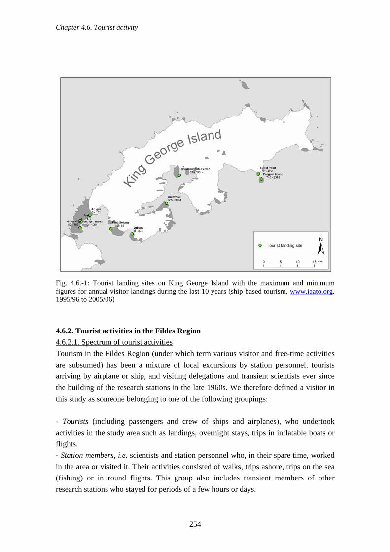
Chapter 4.6. Tourist activity
Fig. 4.6.-1: Tourist landing sites on King George Island with the maximum and minimum figures for annual visitor landings during the last 10 years (ship-based tourism, www.iaato.org, 1995/96 to 2005/06) 4.6.2. Tourist activities in the Fildes Region 4.6.2.1. Spectrum of tourist activities Tourism in the Fildes Region (under which term various visitor and free-time activities are subsumed) has been a mixture of local excursions by station personnel, tourists arriving by airplane or ship, and visiting delegations and transient scientists ever since the building of the research stations in the late 1960s. We therefore defined a visitor in this study as someone belonging to one of the following groupings: - Tourists (including passengers and crew of ships and airplanes), who undertook activities in the study area such as landings, overnight stays, trips in inflatable boats or flights. - Station members, i.e. scientists and station personnel who, in their spare time, worked in the area or visited it. Their activities consisted of walks, trips ashore, trips on the sea (fishing) or in round flights. This group also includes transient members of other research stations who stayed for periods of a few hours or days.
254

Chapter 4.6. Tourist activity
- Official delegations, groups of politicians, bureaucrats, or similar people that visited stations in the study area and also undertook trips into the surroundings. The leisure activities of station members have long remained undocumented. These people live in the study area for anything from a few weeks to two years and also spend their spare time there (Sec. 4.7.). Thus it is not always possible clearly to separate the purely work and the purely leisure time activities of station members. Tourist themes have already been covered in previous sections. Thus, the statistics for the Priroda hut (Sec. 4.2.11.) refer predominantly to overnight stays by scientists but also include visits and overnighting by station personnel visiting the hut in their free time. Free time activities of personnel also play a role in the winter use of the Region (Sec. 4.2.15.) and in traffic (e.g. tourist flights Sec. 4.2.14.3.). Station members can, in this respect, have the same potentially harmful effects as any other tourists and may disturb or damage the abiotic or biotic environment (Headland, 1994; Riffenburgh, 1998). We have thus, in the current study, attempted to investigate the spatial and temporal leisure behaviour of station members. Tourist enterprises with and without IAATO membership visit the region in order to show their customers the research stations and the concentrations of birds and seals.
acuating seriously ill or injured people through this airport (ATCM, 006f). Also characteristic of the region’s tourism is the use of the Chilean, Russian and
dation of tourists (ATCM, 2006i). ías DAP” (DAP) flies into the region with small
detail elsewhere ec. 4.2.16.3.). Helicopter operations in the study area were largely logistic rather than
ht aircraft and from 2003/04, DAP has also operated a helicopter for local
Tourist numbers in the region have further increased due to the recently introduced “fly and sail” cruises to the Fildes Peninsula using the Chilean airport, and the possibility
at now exists of evth2Uruguayan stations for the overnight accommoThe private tourist enterprise “Aerovairplanes (e.g. King Air, Dash 7) for stays of one to several days. These tourists stay overnight in the Chilean airport hotel (Hostería), in station accommodation or tents. LAN airlines offers overflights of the Antarctic Peninsula by Boeing 737-200 and the routes of these flights in the South Shetland Islands vary depending upon weather conditions (ATCM, 2006i). Tourist air traffic is described in(Sfor tourist purposes. There have been, however, isolated tourist flights with helicopters from the airport and from supply ships. DAP has flown tourists into the Fildes Region using ligflights. Ship tourism has clearly varied over recent years (Sec. 4.2.17., www.iaato.org). These changes were caused, according to numerous reports from lecturers and expedition leaders, by the absence of attractive landscape paired with the clearly visible human
255

Chapter 4.6. Tourist activity
influence in the area. Just in the last two years, however, the tourist value of the Fildes Region has been increased. This is particularly the result of improved waste
anagement, additional tourist attractions (building of a church) and extended mtransportation logistics (airport development, fly-sail cruises, and medical evacuation). Apart from classical nature tourism, with short visits to areas of natural interest, independent travellers have organised mountain tours, glacier hiking and a hot-air balloon flight in the region. Marathon races have already taken place on Fildes Peninsula several times and, as an example, the run of 2005 is described in the next section. 4.6.2.2. Marathon
Marathon races have been organised for several years on the Fildes Peninsula by the company “Antarctica Marathon & Half-Marathon”. In the 2004/05 season an event was offered and staged and run successfully on 26 February 2005 under favourable weather conditions.
Fig. 4.6.-2: Preparation of the course on the day before the marathon on the Fildes Peninsula. Red tags mark the distances (white arrows, photo: Buesser) The planned course was marked out by the supervisors the day before the event with red pennants marking the edge of the course (Fig. 4.6.-2). The total length of the course was just 10.5 km and the marathon was therefore run as several circuits of the course. Start
256

Chapter 4.6. Tourist activity
and finish were in the Russian station, where changing facilities were also provided. The course lay mostly on the network of tracks between the Chinese and Uruguayan stations but also included a stretch on the Collins glacier up to ~500 m. The marathon participants were brought to the region by the ships “Akademik Ioffe” and “Akademik Sergej Vavilov” which anchored for one night in Maxwell Bay before the run.
Fig. 4.6.-3: Course of the marathon on the Fildes Peninsula, February 2005
257

Chapter 4.6. Tourist activity
All the marathon activities took place on 26.02.2005 between 7:30 and 18:30. The participants divided into two groups, 176 people who ran the full marathon and 36 who completed the half-marathon. Altogether 72 women and 147 men took part and they
route and therefore there were no negative influences on the environment aused by going onto vegetation or disturbing breeding birds. After the marathon closed
no pennants or other articles were left behind along the course.
included six Chileans and a Russian from the local research stations. The participants were between 23 and 77 years old and of 14 nations. All participants adhered to the marked c
Fig. 4.6.-4: Start of the marathon in the Russian station Bellingshausen, Fildes Peninsula, February 2005 (photo: Buesser)
Fig. 4.6.-5: Marathon runners on the track between the Chinese and the Chilean stations, Fildes Peninsula, February 2005 (photo: Buesser)
258
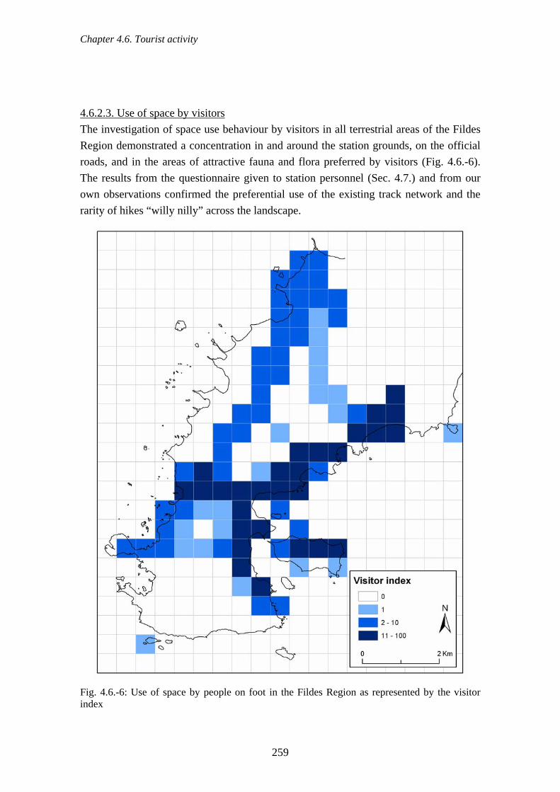
Chapter 4.6. Tourist activity
4.6.2.3. Use of space by visitors
The investigation of space use behaviour by visitors in all terrestrial areas of the Fildes Region demonstrated a concentration in and around the station grounds, on the official roads, and in the areas of attractive fauna and flora preferred by visitors (Fig. 4.6.-6). The results from the questionnaire given to station personnel (Sec. 4.7.) and from our own observations confirmed the preferential use of the existing track network and the rarity of hikes “willy nilly” across the landscape.
Fig. 4.6.-6: Use of space by people on foot in the Fildes Region as represented by the visitor index
259

Chapter 4.6. Tourist activity
Station members most frequently go for short walks on the beach in the vicinity of their
e west side of the Peninsula from the airport towards the northeast or use the established track from the Uruguayan station, parallel to the glacier, in a northwesterly direction (see Fig. 4.6.-6). Visitors climbed on the glacier only during the marathon. Station members also only infrequently walk on the glacier, as the danger of accident is considerable because of the large crevasses in the summer. 4.6.3. Influence of tourist activities Knight & Cole (1995) developed a conceptual framework to classify the impact of tourism activities on flora and fauna. An initial section results from interactions with animals and plants. Humans may kill individual organisms by hunting, fishing, or simply by just treading on things. However, watching animals, hiking, and boating, can also be enormously disturbing for animals even if they do not remove any animals from their habitat (Knight and Cole, 1995). A further section probes whether animal reactions to tourist activities are direct or indirect. Direct reactions point to behavioural changes (also Sec. 4.5.10.), for instance, longer flight patterns or interrupted foraging by birds. Physiological changes, too, combined with stress, can have a negative impact on reproduction and individual’s very survival. These direct effects can result in changes to the distribution, numbers and diversity of species (see also Sec. 4.5.). Among the indirect consequences of tourism is that viewing the groups of animals can attract predators. Thus startled parents can abandon their young or visitors can disrupt a penguin nursery making it easier for predators to pounce. Only in the past 10 years have a number of studies made on the impact of visitors to the Antarctic and Sub-Antarctic. These have concerned themselves with quantifying disruption (above all to birds), the short- and long-term effect of tourism on populations, and with effective management. Studies on Antarctic penguins in particular have revealed the effects of human activities on populations (e.g. Woehler et al., 1994; Fraser & Patterson, 1997), in colonies (Nimon & Stonehouse, 1995; Stonehouse & Crosbie, 1995; Cobley & Shears, 1999), and on individuals (e.g. Culik & Wilson, 1995). There
own stations, and this leads to high values of the visitor index along the east coast (Fig. 4.6.-6). Ardley Island is a popular goal because of the penguin colonies along the tourist zone at the north beach. The west coast of Fildes Peninsula offers vegetation-rich bays with seal haul outs and an attractive backdrop of steep coastal cliffs. The isolated high values of use around the Russian field hut “Priroda” results from the several routes that lead to this hut. Visitors walk either along th
were differences between places and between species but also similarities depending on
260

Chapter 4.6. Tourist activity
previous experience of human activity, the strength of the stimulus and the distance of the animals from the stimulus. In recent years other seabirds have been increasingly investigated (Weimerskirch et al., 2002; Martin et al., 2004; Harris, 2005; Holmes et al., 2005; Pfeiffer, 2005; de Villiers et al., 2005; de Villiers et al., 2006). 4.6.3.1. Effects in the Fildes Region Observed and conjectured effects are presented in the following specifically for the Fildes Region (Tab. 4.6.-1, see also Harris, 1991a, b; Pfeiffer & Peter, 2003). Tourists travel by ship and plane to the Fildes Region. To some extent changing weather
boat emergencies but so far no tourists have been volved. Unproven, but suspected, is the leakage of small quantities of oil from cruise ips, yachts and their zodiacs and effluent into the marine ecosystem of Maxwell Bay.
oats is rare in the region but when it occurs it can
over past decades that fossil
conditions can lead to dangerous situations that could result locally in environmental catastrophe (plane crash or shipping accident). In the area under study there have already been several ship andinshWhale watching from ships or small bdisturb marine mammals. Direct contact, with the possibility of injury (ATCM, 1999b) and behavioural changes among animals were observed only outside the Fildes Region (Richardson et al., 1995; Williams et al., 2006). Studies have shown that visits to the breeding and nesting grounds of seabirds and seals in the region, as well as low-flying helicopters and planes, increase heart rate and cause behavioural changes in Southern Giant Petrels and skuas (Pfeiffer, 2005; Sec. 4.5.10.). We assume also that tourism has had effects on individuals and populations of other species (Sec. 4.5.). However, these were not explicitly examined. Due to slow growth rates, vegetation was not investigated in the context of tourist activities (Sec. 4.5.14.). The unintentional introduction of foreign species was examined in greater depth (Sec. 4.5.15.). The expected growth of tourism in the region, especially in the context of coordinated air and shipping schedules, increases the risk of introducing non-indigenous organisms. It is known from various on-site accounts and observationsand mineral deposits in the Fildes Peninsula have been visited, and collected from, not only for scientific surveys. All visitor activities on land can adversely affect fauna and flora, historical values, and scientific/logistical activity (Sec. 5.2.). The various tourist, scientific and logistical activities in the Fildes Region overlap to some degree in time and space (Sec. 5.2.1.6.).
261
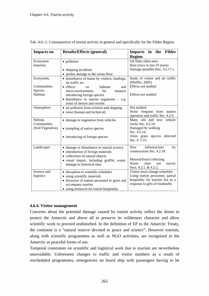
Chapter 4.6. Tourist activity
Tab. 4.6.-1: Consequences of tourist activity in general and specifically for the Fildes Region
Impacts on Results/Effects (general) Impacts in the Fildes Region
Ecosystem • pollution Oil films ofte(marine)
he ocean floor
n seen Rare (once in last 10 years) Damage possible (Sec. 4.2.17.) • shipping accidents
• anchor damage to tEcosystem, Communities
• disturbance of fauna by visitors, landings, air traffic etc.
• effects on habitats and
Study of visitor and air traffic (Pfeiffer, 2005) Effects not studied
Species Habitats
micro-environment, for instance introducing foreign species
• disturbance to marine organisms – e.g. noise of motors and vessels
Effects not studied
Atmosphere • air pollution from aviation and shipping • noise (human and technical)
Not studied Noise frequent from station operation and traffic Sec. 4.2.9.
Habitat, Communities
• damage to vegetation from vehicles Many old and new vehicle tracks Sec. 4.2.14.
(Soil/Vegetation) • trampling of native species • introducing of foreign species
Damaged by walking Sec. 4.5.14. Alien grass species detected Sec. 4. 5.15.
Landscapes • damage or disturbance to natural scenery New infrastructure by • introduction of foreign materials • collections of natural objects • visual impact, including graffiti, waste,
damage to historical sites
constructions Sec. 4.2.18. Mineral/fossil collecting Waste chart see survey Secs. 4.2.1. & 4.2.2.
Science and logistics
• disruption to scientific schedules • using scientific materials
Visitor tours change schedules Using stat
• diversion of station personnel to greet and accompany tourists
• using resources for tourist hospitality
hospitality for tourists but as a response to gifts of foodstuffs
ion personnel, partial
4.6.4. Visitor management Concerns about the potential damage caused by tourist activity reflect the desire to protect the Antarctic and above all to preserve its wilderness character and allow scientific work to proceed undisturbed. In the definition of EP to the Antarctic Treaty,
emporal constraints on scientific and logistical work due to tourism are nevertheless unavoidable. Unforeseen changes to traffic and visitor numbers as a result of rescheduled programmes, emergencies on board ship with passengers having to be
the continent is a “natural reserve devoted to peace and science”. However tourism, along with scientific programmes as well as NGO activities, are recognised in the Antarctic as peaceful forms of use. T
262
Chapter 4.7. Opinion survey to station members
flown out in consequence, have partly inhibited exact forward planning. Scientists
st l h uty only to ci e catalogue of activities. Since tourist visits are also seen as welcome diversions for station personnel, they are es (questionn on by tourism at open-air sites of scSince tourist num al personnel working in and the need for more re 3, 2006a, b; ATCM from go, 1966) to Resolution 2 (2006) – ATCM X useffects (ATCM, d by IAATO a n (ATBefore leaving for their first tour of duty in the Antarc ies station members are instructed in what to do and how to behave on the environm aterials provided to tourists on the sp e recommended m t be obse 8; and this study) r suitable means of rai onmental issuesuggestions for i e given i in Appendix 5.
.7. Opinion survey to station members he questionnaire form presented above (Sec. 3.6.) was voluntarily completed by 216
tations of the Fildes Region. Station members include both
part for the first time – that is, in addition to Frei
repeatedly act as guation personne
ides to tourists on Ardley Island and onave been used as guides, a d
the stations. In addition, be called upon in exceptional
rcumstances according to thapproved of in most cas
aire to personnel, Sec. 4.7.). Disruptiientific work is not known to us.
bers have exceeded the number of scienthe Antarctic in recent years, limiting tourism
tists and logistic
gulatory tools are increasingly under discussion (e.g. AT: Recommendation IV-27 (Santia
CM, 2002b, 200
XIX, Edinburgh). Current tourist-related themes foc on reducing the cumulative es and zone markers are use2006g & h). Certain site-specific guidelin
nd Treaty Parties as a basis for a solutio CM, 2003b). tic, in most countrto minimise negative impacts
ent. However, the information and mot, and the control mechanisms applied locally, ar incomplete. In consequence,
rved (Riffenburgh, 199inimum distances may often no. Guided tours by scientists and scientific lectu
sing visitor awareness of envires in the stations are s (our observations). Detailed
mproving visitor management ar n Secs. 6.2.5. to 6.2.8. and
4Tstation members in all local sstation personnel and scientists at the station. Station size is also reflected in the proportion of those who participated (Fig. 4.7.-1). In the first field study 2003/4, 39 station members (17 from Chinese, 22 from Russian stations) completed the questionnaire. Taking part in 2004/5 were 52 members of the Chilean stations Escudero and Frei, 17 Chinese, 11 Russians and 10 Uruguayans. In the final survey all Chilean stations tookand the research unit Escudero, questionnaires were sent to the naval station. This resulted in the large number of Chilean participants in relation to personnel from other stations of the Fildes Peninsula.
263

Chapter 4.7. Opinion survey to station members
Chile
ChinaRussia
Uruguay
the duration of the participants’ tours of duty. As in other regions of the ntarctic, the proportion of women is relatively small. The majority of station personnel
re aged between 25 and 44. Composition of personnel draws on civilian and military dministrative tasks. One fifth of station
Fig. 4.7.-1: Proportion of the personnel from each station who responded to the questionnaire (n = 216) Thus all local stations took part in the opinion poll and thanks to the high response (> 80 % participation in all stations, except for ~40 % in Frei) representative results could be computed. Tab. 4.7.-1 shows the gender and age breakdown, the proportion of scientists to station personnel andAasources, carrying out various technical and amembers are scientists. The number of those working in Antarctica for the first time is remarkable (Tab. 4.7.-1).
264
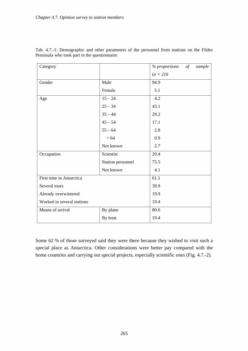
Chapter 4.7. Opinion survey to station members
Tab. 4.7.-1: Demographic and other parameters of the personnel from stations on the Fildes Peninsula who took part in the questionnaire
Category % proportions of sample
(n = 216
Gender Male
Female
94.9
5.1
Age 15 – 24
25 – 34
35 – 44
45 – 54
55 – 64
> 64
Not known
4.2
43.1
29.2
17.1
2.8
0.9
2.7
Occupation Scientist 20.4
Station personnel
Not known
75.5
4.1
First time in Antarctica
Several tours
Already overwintere
61.1
39.9
d 19.9
Worked in several stations 19.4
Means of arrival By plane
By boat
80.6
19.4
Some 62 % of those surveyed said they were there because they wished to visit such a special place as Antarctica. Other considerations were better pay compared with the ome countries and carrying out special projects, especially scientific ones (Fig. 4.7.-2).
h
265

Chapter 4.7. Opinion survey to station members
0 50 100number of pa nts
well paid
foreign country
eciality of Antarctic
special project
interesting people
other reason
Fig. 4.7.-2: Reasons given for stay rctic (n = 211 than one answer in some ca those questioned gav o reasons)
rticipa
sp
s in the Anta , moreses, 82 % of e one or tw
interestedread
80
100
120
ber o
f par
ticip
ants
0
60
num
20
40
history of exploration
wildlife geology andglaciers
climate other topics
Fig. 4.7.-3: Presentation of the interests of station personnel and of what they have already learned from reading about various themes specific to the Antarctic (n = 214)
266

Chapter 4.7. Opinion survey to station members
The majority of station personnel surveyed were interested in Antarctic phenomena such as animals and plants, climate and history, and were correspondingly informed (total 71.8 %, in Fig. 4.7.-3 divided into individual aspects). In particular, the old hands who had been back repeatedly had acquired far more specialist knowledge compared with the newcomers (likelihood ratio chi-square test: X2 = 18.4; p < 0.001; n = 214). The scientists were somewhat ‘better read’ than the station personnel (X2 = 8.77; p = 0.012; n = 214). Some 71 % of station members surveyed spent up to five hours a week of their leisure time outside the station. Almost one third spent more than six hours outside their own station (Fig. 4.7.-4). The majority said that in their leisure hours they went walking, either occasionally or invariably with others (n = 182; 52 % with others; 3.8 % always alone; 44 % with others or alone).
). Over 75 % said that during their ree time they at least once a week spent time outside the station watching animals,
going for walks or visiting other stations. Beaches were visited most frequently, followed by animal watching and the chance to visit other stations. On their walks the majority always (37.8 %, n = 150) or mostly (49.4 %) stayed on official roads and paths.
Answers to queries about the frequency and nature of leisure activity underscore the importance of natural spaces near stations (Fig. 4.7.-5f
Percentage of participants
0 10 20 30 40 50
> 10 h per week
6 - 10 h per week
1 - 5 h per week
< 1 h per week
Fig. 4.7.-4: Proportional representation of station personnel's free time activities other than those in their own stations (n = 206)
267

Chapter 4.7. Opinion survey to station members
perc
enta
ge o
f(p
er a
ctiv par
ticip
ants
ity)
0
5
10
15
20
25
30 once per seasononce per monthonce per weekseveral times per week
watchwildlife
walk on roads
visit otherstations
walk to beach
Fig. 4.7.-5: Temporal distribution of four possible types of free time activity by station personnel other than those in the immediate area of their own stations (n = 216) The results of the survey of station members in respect of their ideas and recommendations regarding various management issues in the Fildes Region are summarised in Tab. 4.7.-2. A clear majority considered behavioural rules for periods spent outside the stations to be necessary. Clear too was the rejection of unlimited use of natural spaces by station members and the agreement to the selection of certain animal groups to photograph and observe at close range. Definitely approved were guidance of station members on Fildes Peninsula and Ardley Island (apart from the existing infrastructure connecting the stations), displaying informative material in the stations, and setting up displays highlighting the Antarctic’s variety of species and local environmental concerns. A majority was also in favour of marking the more attractive nature trails for visitors. Although providing special privileges for station members as opposed to tourists received some support, the majority rejected the suggestions put
ation of areas for angling). A higher proportion of neutral nswers were given to questions on tourism. Thus an equal number of respondents were
forward (reducing minimum distance to the animals, permission to collect small souvenirs in nature, identifica
268

Chapter 4.7. Opinion survey to station members
for and against increasing tourist events and the provision of tourist accommodation in the stations (Fig. 4.7.-2). Tab. 4.7.-2: Results of the enquiry questionnaire on various aspects of management. The number of respondents in the categories “strongly disagree” and “disagree” are combined as are the numbers in the categories “strongly agree” and “agree”. The trends are analysed by chi-square test on the results against the expected values if there is no trend (50 % disagree, 50 % agree) and results significant at p < 0.05 are emphasised.
Statement % of sample disagree
% of sample agree X2 value p - value
No need for behavioural rules for station personnel outside stations 81.0 14.8 98.79 0.000
Personnel should be free to go into all areas 66.2 30.6 28.37 0.000
Station personnel should be allowed to visit some animal groups to photograph and observe at closer range
59.7 37.5 10.97 0.002
On Fildes Peninsula marked paths should lead to areas with interesting animals, plants and landscapes
34.7 52.3 7.68 0.007
Information boards should inform on species present and environmental problems
11.6 77.8 105.95 0.000
Personnel on Fildes Peninsula should be guided when they leave official paths 23.1 57.4 31.47 0.000
All visitors to Ardley Island should be given an introduction to indigenous flora and fauna
5.6 86.6 153.89 0.000
Informative material on local species and environmental problems should be displayed in the station
4.2 92.1 173.56 0.000
Behavioural rules for personnel should differ from those in force for tourists (3 examples follow)
33.8 41.2 1.58 0.23
Example 1: personnel should be permitted to view animals from less than 5 m
49.5 33.8 6.42 0.015
Example 2: personnel should be allowed to take small souvenirs of their stay in Antarctica from nature
57.4 25.0 27.53 0.000
Example 3: there should be official angling sites for personnel in the surrounding area of Fildes Peninsula
53.2 26.4 19.56 0.000
More tourists should visit the stations 42.6 24.5 10.49 0.002 Events such as marathon runs should happen more often 34.3 24.5 3.47 0.07
Tourists should be allowed to overnight in the station when there is sufficient 34.3 36.6 0.16 0.73 room
269

Chapter 4.7. Opinion survey to station members
Some 70 % of station members surveyed know with national guidelines for visitors to the Antarctic, and 82 % were afforded the opportunity to participate in presentations on
ehavioural guidelines on approaching animals and plants in the Antarctic. Almost all f those surveyed (98 %) were in favour of on-the-spot talks, in the Antarctic, by
Although station members spend veral months in Antarctica, little interest was expressed in less restrictive behavioural
guidelines in nature for them as opposed to tourists. T mong station personnel is of special significance fo ecially in view of the fact that these people lack experience in dealing with Antarctic c tions. A rity f d p ng in g up ormative lays presentations by scientists on flora and fauna and local environmental issues. Thus basic in e co be provid t relati little jointly with the instruction already provided to all station members. Favoured too were g th ting fram k of th gem lan for the ASPA No. 150. H tours uty were rwinter hic ld sh throughout the winter. Whereas negative impacts o a – f nstance, travelling overland and visiting an to snowfall between March and October, they sh y of i mative ma proviT al and spatial aspects of station members’ leisure ac ce of viding na space stati and m that should be taken in forward management p pinioo oupings in the zoning system, the creation/marking o nee observe a neces urta ist v
boscientists on the region’s flora and fauna. High participation in the survey means that for the first time a body of opinion representative of Fildes Peninsula members is available, and this can and should be incorporated into future management projections. se
he high proportion of newcomers ar future management decisions esp
ondi majo avoure rovidiformation in the stations, settin inf disp near stations, and
formation on the fragility of natur uld ed a vely expense
uided tours by biologists in addition to e exis ewor e mana ent p
alf of those present on repeated of d ove ing, w h shouarpen the focus on human activity
f human activity on flora and faun or iimal groups – are less severe dueould nevertheless feature in the bod nfor terial ded.
he survey’s findings on the temportivities underscored the importan pro tural near ons aintaining it properly. The direction
lanning can be gleaned from o ns expressed regarding the inclusion of ft-frequented beaches and animal grf recommended nature trails and the d to nd, if sary, c il tourisits.
270

Chapter 5.1. Identifying and Evaluating the Protection Targets
271
5. Risk Analysis for the Fildes Region 5.1. Identifying and Evaluating the Protection Targets Evaluating whether a locality deserves protection requires the identification of values and environmental goals. By values is meant an assessment of the importance of the locality for human needs and by environmental goals is meant a description of the desired environmental conditions. Article 3, Annex V of the Protocol on Environmental Protection to the Antarctic Treaty (hereafter “Protocol”) contains guidelines for designating an “Antarctic Specially Protected Area” (ASPA). When seeking to assess whether an area merits protection, a clear definition is required of which values are to be protected in the Antarctic. These values are listed in Annex V, Art. 3(1), of the Protocol, and include the environmental, scientific, historical, aesthetic and wilderness characteristics of the area. The Environmental value describes whether an area contains physical, chemical or biological features that are either unique to or representative of the Antarctic environment (see SCAR, 2001). If the area contains geological, geomorphological, palaeontological or biological features of scientific interest that are the basis for practical work, then we can speak of scientific value. This value is already widely protected by the ASPA instrument. Historical value is given by features or objects relating to occurrences, experiences, and places that have been important for human activities in the Antarctic. So far the historic values aroused relatively little scientific interest (ATCM 2007e). Aesthetic value arises when visitors experience the area as attractive and appealing. Wilderness value of an area is indicated by the absence of human traces. In addition, in recent years tourism value has attracted increased interest. This value could be quantified by the number of tourist attractions, accessibility, and by the costs associated with visits. The area is worthy of protection if it is considered to contain or represent one or more example of the values listed. The environmental value of the Fildes Region arises primarily from the occurrence there of special biological communities (assemblages of animal and plant species, especially on Ardley Island, Sec. 4.5.), near threatened species such as the Southern Giant Petrel (Sec. 4.5.) and the occurrence of fossils. The environmental value of the region is also reflected in its selection as an Important Bird Area (IBA), the designation of which is currently being discussed by SCAR-GEB and BirdLife International. In addition to the locality already protected under ASPA No. 125, there are also other fossil locations in the region (Sec. 4.4.). Scientific value can also be demonstrated by the considerable number of international research programmes in the region.

Chapter 5.1. Identifying and Evaluating the Protection Targets
272
Several long-term studies commenced with the founding of the research stations. These studies include the monitoring of selected seabird species (Sec. 4.5.), collection of meteorological data by AARI, atmospheric measurements by INACH and environmental analyses by IAU. These and other middle- and long-term field research projects require intensive cooperation between scientists working in the region in order to minimise spatial and temporal conflicts between researchers. Historical value is indicated by the identification of two historical monuments (HSM Nos. 50 and 52). In addition to these sites, remnants of a wrecked ship have been found on Suffield Point in Maxwell Bay. These lie on the beach in front of the Uruguayan Station Artigas (ATCM, 2004c; Fig. 5.1.-1).
Fig. 5.1.-1: Remnants of a wrecked ship on the beach south west of the Uruguayan station Artigas (Photograph: Buesser) Attractive wilderness landscapes can be found far away from the research stations, particularly in the coastal areas of the study area. The greatest visitor activity is concentrated, however, at a few easily accessible bays and viewing points (Secs. 4.2.15., 4.5.10. & 4.6.). Tourism in the region is predominantly focused on visiting research stations and on visiting the penguin colonies on Ardley Island. The knowledge of station personnel is developed through specialist talks by scientists on site. In addition, school children can learn more about the Antarctic over the internet

Chapter 5.1. Identifying and Evaluating the Protection Targets
273
through an environmental education project funded by Coca Cola and established in the Russian station. We have combined the values available for the Fildes Region and assessed them as “limited”, “intermediate”, or “high” in comparison with other Antarctic localities (Tab. 5.1.-1). Tab. 5.1.-1: Estimation of protection worthiness of the Fildes Region on the basis of available values. Value or importance for the Antarctic categorised as 1 = “low”, 2 = “medium”, 3 = “high”
Value category Special values in the region Ranking
Environment & nature
Threatened bird species and species-rich plant and animal communities (particularly on Ardley Island), occurrence of fossils
2
Scientific Research over the whole area but particularly in ASPA No. 150, several programmes of various nations
3
Historical HSM Nos. 50 and 52, old ship wreck 1
Aesthetic Windswept and precipitous west coast compared to the gentler east coast
2
Tourism/ Environmental education
Research stations, sea bird colonies, informational presentations for station personnel, development of an educational product for schools
2
Wilderness Coastal areas far from the research stations and Ardley Island largely pristine
2
The rating of the environmental value arises from both and the relatively large number of sea bird species and from the occurrence of fossils. Thirteen of the maritime Antarctic’s 17 bird species breed in the region. We nevertheless assess the environmental value as “intermediate” because the region contains no conspicuously large sea bird colonies that would merit protection (Tab. 5.1.-1). The scientific value is “high” because the natural features of the locality provide opportunities for a wide range of studies; zoological, botanical, glaciological, palaeontological, geological and geomorphological. This variety of possibilities was one of the reasons for siting four research stations on the Fildes Peninsula whereby intensive knowledge transfer and international cooperation are stimulated. Despite of the existence of two HSMs in the area the historical value has attracted scarcely any attention as yet and so is categorised as “low”.

Chapter 5.1. Identifying and Evaluating the Protection Targets
274
A more detailed way of assessing whether a locality should be protected is to assign a scale of values to each asset to be protected, i.e. to specify categories of protection and evaluate these in terms of particular quality (SCAR, 2001). We therefore evaluated the importance of the region’s assets to be protected by the following quality criteria: “representative character”, “ecological importance”, “diversity”, “science and monitoring” and also “tourist appeal” (Tab. 5.1.-2). Tab. 5.1.-2: Matrix of assets to be protected and values for the Fildes Region in terms of Antarctic-wide quality criteria. Value categorised as 1 = “low”, 2 = “medium”, 3 = “high” (after SCAR, 2001)
Quality criteria
Assets to be protected
Representative character
Ecological importance
Diversity Science & monitoring
Tourist appeal
Ecosystems 1 1 1 2 1
Species communities
3 2 1 2 3
Species 3 3 2 3 2
Habitats 1 1 1 1 1
Geological structures
2 2 2 1
Landscape 1 1 1 1
History 1 1 1
Wilderness 1 2 1 2 2
Aesthetic 2 2 Highly representative, for example, are the mixed colonies of the three Pygoscelis species and the species rich carpets of plants on Ardley Island which are both special species communities. Likewise highly representative, are the many colonies of Southern Giant Petrel (a near threatened species) on smaller islands in the region (Tab. 5.1.-2). These special communities are also of interest to scientists and visitors. However, in comparison to other Antarctic regions, the region does not have particularly exceptional habitats, ecosystems or landscapes. The history of the region is of comparatively limited scientific interest. Neither is the history incorporated into museums or brochures as is the case for other representative areas of the Antarctic.

Chapter 5.2. Risk analysis
275
5.2. Risk Analysis The signing of the Protocol in Madrid (EP) in 1991 and its incorporation into national law (e.g. AUG in Germany since 1998 into force) arised decisive progress in producing guidelines to minimise the potentially negative impacts of human activities on the Antarctic environment. The uniqueness and the sensitivity of the Antarctic ecosystem result from three particular causes. The first is its relatively simple structure (e.g. Lewis-Smith, 1990; Convey, 2006b), and its consequently smaller capacity to buffer disturbances compared to many-layered ecosystems (Hempel, 1985). The second cause is the special adaptations of Antarctic organisms to the conditions under which they live (Convey, 2006a), adaptations that to a degree restrict the flexibility of their responses to anthropogenic disturbance (Arntz & Gallardo, 1994). And the third is the slow rate of matter cycling due to the low temperatures (Clarke, 1990) and the frequent scarcity of liquid water (Kennedy, 1993). The Protocol requires all signatory parties to evaluate the environmental stress caused by scientific, logistic, and tourism in the issues for which they are responsible. In an environmental impact assessment, the outcomes of such activities are classified into three categories depending on the nature of their suspected effects. The lowest category (1) covers activities with less than a minor or transitory impact, (2) covers activities with minor and transitory impact, and (3) those whose impact is more than minor and transitory (Protocol, Art. 8(1)). Carrying out an IEE in category (2) or a CEE in category (3) provides greater clarity for planned human activities and a more precise evaluation of the risks, in case of CEE even with international participation. Analysing the risks of anthropogenic threats to Antarctic areas and their assets to be protected can strengthen or weaken the need for their protection. It is consequently necessary to identify not only the current but also the potential threats. The simple presence of important value categories does not necessarily lead to an area being given protection. The effect of human activities on different values depends on the intensity, duration and extent of the activities. When unacceptable and unquantifiable risks exist, management shall include specific counter measures and protection strategies (SCAR, 2001). The main aim of this project was the preparation of scientific data on the assets to be protected and on the intensity of human activity. The threat analysis is based on this data and interprets it in the form of a risk evaluation. This evaluation is, in turn, a prerequisite for establishing the need for management measures. A threat analysis is defined as a process of qualitatively and quantitatively evaluating risks (Suter, 1993), e.g. the risk of damage to flora and fauna by diverse human activities. Such an analysis

Chapter 5.2. Risk analysis
276
compares the human influences to the other background risks to which flora and fauna are exposed. Ideally this should involve calculations and models containing uncertainty parameters (such as those relating to variation in phenotype, demography, spatial distribution, and environmental conditions). However, there is often too little data available for determining the complex relationships between natural and human influences. Local and regional evaluation is made possible, however, by using indicators and comparisons between localities suffering different disturbance intensities. The results of all counts and observations of animals and plants, and their spatial and temporal patterns are presented (Sec. 4.) along with assessments of human activity. It is, of course, difficult to quantify exactly the effects of human activities on individuals and populations because activities act in different ways. We consequently use the predictability, frequency and intensity of activities to determine the effects of disturbance on animals or of damage to vegetation by construction, visits or vehicles. 5.2.1. Sources of anthropogenic disturbance and their effects 5.2.1.1. Research stations During the last 50 years several research stations and field huts have been built in the Fildes Region and subsequently extended (Sec. 4.1.). The direct consequences of this have been land occupancy, noise and intense human activity (Sec. 4.2.) which have caused brood losses and shifts in the location of sea bird colonies (Secs. 4.5.1., 4.5.2. & 4.5.4.). Further consequences have included changes in the ground characteristics (e.g. compaction, heavy metal contamination, amongst others; see Sheppard et al., 1994; Zhao & Xu, 2000) and in plant communities (e.g. Adamson & Seppelt, 1990; Green & Nichols, 1995; Lewis-Smith, 1996; Zhao & Xu, 2000). Continual use of these areas impedes regeneration processes. At the beginning of the study there were still open waste storage sites around the stations and these produced severe ground contamination (Secs. 4.2.1. & 4.2.2.). And at many stations organic kitchen waste is still available for skuas and gulls (Sec. 4.2.4.). Use of this food resource may not only reduce chick growth and survival but also carries a high risk of introducing disease into local populations (Hemmings, 1990; Wang & Norman, 1993; Wang et al., 1996; Reinhardt et al., 2000; ATCM, 2001a). Oil contamination was detectable in places in station grounds and along roads and tracks and was particularly concentrated around the fuel depots (Sec. 4.2.5.). However, the effects of such local contamination on the flora and fauna were not investigated in this study. Extensive pollution with oil can produce severe consequences for the surrounding flora and fauna (Sec. 4.2.6.).
Chapter 5.2. Risk analysis
277
The influence of station activities on coastal ecosystems in the Fildes Region is still very insufficiently investigated and the intensity of the local effects of waste water and waste is unknown (Sec. 4.2.). Large scale construction on Fildes Peninsula was indeed preceded by IEEs (building of a church, Sec. 4.2.18., and of the runway, Sec. 4.2.19.). Nevertheless, in both cases, the attention actually given to environmental protection during construction was insufficient. The multiplicity of human activities at the stations also presents varied future dangers to the surrounding flora and fauna. Further station extension would have particularly negative consequences because they would affect previously undisturbed and uncontaminated land. 5.2.1.2. Traffic The use of vehicles in the area poses no great danger so long as they stay on the existing roads and tracks. However, new routes are continually being formed such as that in Valle Klotz, south of “Priroda” hut, where enormous damage has been inflicted on the local vegetation, particularly in the last two years (Sec. 4.5.14.). In the course of the study, air traffic was recorded on up to 76 % of days on which observations took place, i.e. aircraft are frequently used for logistic operations in the study area (Sec. 4.2.16.). Air traffic in breeding areas can elicit anti-predator behaviour because Antarctic predators of terrestrial prey frequently attack from the air. Therefore, strong physiological reactions or even behavioural alteration can be expected in seabirds when aeroplanes or helicopters deviate from the main flight paths and operate over breeding areas (Sec. 4.5.10.). The amount of shipping in the area increased continuously during the study period with shipping recorded on 44 % of days when observations were made in 2003/04 but 85 % of observation days in 2005/06 (Sec. 4.2.17.). This increase also raises the risk of breakdowns and accidents even though safety standards for ships in the Antarctic have been raised through national legislation and international agreement. Particularly to emphasise in this respect is MARPOL, the International Agreement on the Prevention of Marine Pollution by Ships. Ships are relatively environmentally friendly compared other forms of transport because they use relatively little fuel compared to their load capacity. So far, CO2 emissions from ship and boat engines have been minor relating the number of ships with the used shipping area (Enss et al., 1999). However, the number of ships will no doubt increase because climate warming has already led to a shorter period of sea ice cover in Maxwell Bay. Ships and boats (including zodiacs) can therefore be used for a greater part of the year.

Chapter 5.2. Risk analysis
278
5.2.1.3. Introduction of alien species The danger of alien species spreading in the Antarctic is high because human activities are increasing and there is a high concentration of sea birds occupying Antarctic and sub-Antarctic ice-free areas (e.g. Woehler et al., 2001). Both humans and birds travel between different regions that may be several thousand kilometres apart and so facilitate the importation of foreign species. The second factor is that a large proportion of Antarctic species are endemic (e.g. Greenslade, 1995; Andrássy, 1998; Ochyra, 1998; Øvstedal & Lewis-Smith, 2001), even if the total number of species is relatively low, and have low competitive ability against invasive species. So far, non-native animal and plant species have not been able to survive for long or have been quickly removed from the region (Sec. 4.5.15.). Effects on the local macro-flora and fauna to date have therefore been unimportant. However, ship, air, and land transport offer numerous opportunities for the entry of alien species because of the variety of tourist and logistic activity in the region. It must be assumed, therefore that there will be an increase in introductions of animals and plants (e.g. grasses) from outside the area. 5.2.1.4. Scientific activities The wide range of scientific work in the study area has varied negative effects on the assets to be protected. Scientific field work has been carried out over practically the entire Fildes Region and presents the greatest potential for conflict with nature conservation. Such field work ranges from visits to breeding and moulting areas lasting only a few minutes to stays of several weeks in the middle of sea bird colonies on Ardley Island. The available field huts are therefore often intensively used by scientists. Transport of equipment and scientist to the work areas as well as the removal of waste is usually carried out according to the relevant guidelines (EP, ASPA No. 150 management plan). The danger of disrupting or damaging the flora and fauna is increasingly taken into account during scientific research. Non-invasive methods are increasingly applied (CCAMLR and SCAR guidelines). For all German activities permits according to AUG must be applied for in advance. These licenses can limit what is permissible and thus have a protective effect. Penguin marking has been reduced considerably (recommendations of the SCAR Group of Experts on Birds) since research demonstrated the negative effects of wing tags (Froget et al., 1998; Jackson & Wilson, 2002; Gauthier-Clerc et al., 2004). Alternative marking methods include transponders although with the disadvantage that penguins marked in this way cannot be visually recognised.

Chapter 5.2. Risk analysis
279
Field work can cause limited to severe disturbance of individuals, local populations or ecosystems over short or long periods. Special investigations of the effects of human activity in Fildes Region sea birds revealed different responses in different species. Chinstrap Penguin numbers were already in decline during the 1970s and 1980s possibility as a result of human activity (Sec. 4.5.1.). This decline was not present in Gentoo Penguins. The similar decline in Adélie Penguins is more probably the result of global warming than of human activity per se because the numbers of breeding pairs declined simultaneously in colonies at several locations all along the Antarctic Peninsula. Intense human activity did, however, induce Southern Giant Petrel to transfer their breeding places to isolated islands several decades ago (Sec. 4.5.2.). However, current visits by researchers to colonies of this species can still lead to increased nest predation by skuas and so continue to have negative effects on local populations. Because where they breed, Cape Petrel, Wilson’s Storm Petrel, and Black-bellied Storm Petrel have remained largely undisturbed. However, construction work destroyed some storm petrel nesting sites (Sec. 4.5.4.). The effect of human proximity on the occurrence of Snowy Sheathbills during the winter seems to be zero, or even positive (cf. Sec. 4.5.5.). Skua and gull numbers also appear to be little affected by human activity although reactions by individuals to visitors and to air traffic have been observed. Thus, more important in determining breeding success are natural factors such as food availability and major weather variation. Skuas in the area have been intensively studied by scientists for many years without there being any negative effects of this research on the breeding population (Sec. 4.5.6.). The number of breeding terns experience severe annual fluctuations but it is unclear how far these are influenced by human activities (Sec. 4.5.8.). Pfeiffer (2005) compiled an overview of the complex effects on sea birds of human activities in the study area (Fig. 5.2.-1). Potential stressors for the animals are changes in the breeding areas because of construction work and waste disposal as well as visual and acoustic irritation caused by visitors, shipping and air traffic. How much effect these potential stressors have is reflected by the changes in the animals’ habitat, behaviour and physiology. The size of these effects can be measured in terms of the number of breeding pairs, breeding success, and by physiological and behavioural investigations of the animals. We have assessed the extent of the effects of human activity on sea birds in the Fildes Region in categories from “low” to “high” (Fig. 5.2.-1) on the basis of information from the literature and from our own research (cf. Sec. 4.). In recent years, the greatest dangers to sea birds have been scientific and tourist visits to breeding areas. These visits have been more frequent, more intense and covered wider areas than other possible
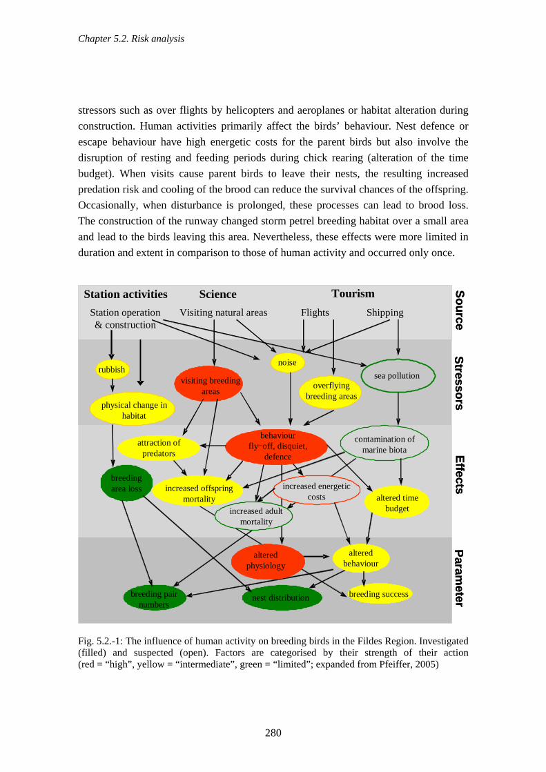
Chapter 5.2. Risk analysis
280
stressors such as over flights by helicopters and aeroplanes or habitat alteration during construction. Human activities primarily affect the birds’ behaviour. Nest defence or escape behaviour have high energetic costs for the parent birds but also involve the disruption of resting and feeding periods during chick rearing (alteration of the time budget). When visits cause parent birds to leave their nests, the resulting increased predation risk and cooling of the brood can reduce the survival chances of the offspring. Occasionally, when disturbance is prolonged, these processes can lead to brood loss. The construction of the runway changed storm petrel breeding habitat over a small area and lead to the birds leaving this area. Nevertheless, these effects were more limited in duration and extent in comparison to those of human activity and occurred only once. Station activities Science
Station operation & construction
Visiting natural areas
Tourism SourceSt resso rs
EffectsPar am
et er
physical change in habitat
noise
Flights Shipping
increased offspring mortality
nest distribution breeding success
breeding area loss
visiting breeding areas
behaviourfly-off, disquiet,
defence
increased energetic costs
altered behaviour
overflyingbreeding areas
altered time budget
attraction of predators
rubbish
breeding pair numbers
sea pollution
contamination of marine biota
increased adult mortality
altered physiology
Station activities ScienceStation operation & construction
Visiting natural areas
Tourism SourceSt resso rs
EffectsPar am
et er
physical change in habitat
noise
Flights Shipping
increased offspring mortality
nest distribution breeding success
breeding area loss
visiting breeding areas
behaviourfly-off, disquiet,
defence
increased energetic costs
altered behaviour
overflyingbreeding areas
altered time budget
attraction of predators
rubbish
breeding pair numbers
sea pollution
contamination of marine biota
increased adult mortality
altered physiology
Fig. 5.2.-1: The influence of human activity on breeding birds in the Fildes Region. Investigated (filled) and suspected (open). Factors are categorised by their strength of their action (red = “high”, yellow = “intermediate”, green = “limited”; expanded from Pfeiffer, 2005)
Chapter 5.2. Risk analysis
281
5.2.1.5. Visitors The use of the area by visitors does not pose any great danger for Antarctic assets to be protected as long as the only existing routes are used and visitor numbers remain within tolerable limits. Tourist activities in the study area have, however, resulted in some visitors approaching animals more closely than the minimum recommended distances. They have also led to visitors walking on vegetation (see also Secs. 4.5.10., 4.5.14. & 4.6.). In order to estimate the potential spatial conflicts between the fauna and visitors an index was created from the faunal data collected (Fig. 5.2.-2). This index was then combined in a GIS (see Fig. 5.2.-3) with the visitor pressure index (from Sec. 4.6.). This combination of indices shows greater potential for conflict in specific areas compared to others in the region. These are, for example, on Ardley Island, along roads and tracks, and near the research stations. Also included are popular visitor destinations along the west coast. The analysis indicates in particular that all visitor activity on the east side of Ardley Island where there are large penguin colonies should be confined to the narrow tourist zone. Entry to the rest of this area should be restricted to scientists. Visitors also use numerous unmarked tracks that are not part of the official road network. The high variability in the use of these tracks, and tourists straying from them, exposes animals to unpredictable visits. Such unpredictable visits have a high conflict potential. The concept combined air and sea tourism (Fly and Sail cruises) introduced in the region in 2003 is likely to be taken up by further tour companies in the future. It must be expected therefore that the interchange of passengers from cruise ships will increase. This will increase the visitor pressure in the area because passengers will be have to stay longer when their return trip is delayed by bad weather.

Chapter 5.2. Risk analysis
282
Fig. 5.2.-2: Spatial distribution of sea birds and seals in the Fildes Region indicated by the faunal index

Chapter 5.2. Risk analysis
283
Fig. 5.2.-3: Spatial distribution of the areas of potential conflict as created by the combination of the visitor activity (visitor pressure index) and the occurrence of sea birds and seals (faunal index) in the Fildes Region (for the method of calculation see Sec. 3.5.)

Chapter 5.2. Risk analysis
284
There is no problem with simply visiting geological localities and the sites of fossil finds (Sec. 4.4.). The threat begins with their destruction with hammers, crowbars, and other tools, and the removal of specimens as has been documented in the area of Fossil Hill. The observed collection of fossils (and minerals) for non-scientific and also for commercial ends constitutes not only environmental damage but also, and even more so, the loss of scientific material. Tourism in the region has not yet developed to the point where it alone represents a threat for the assets to be protected. Nevertheless, the concentration on specific nature areas by both scientists and visitors exerts direct, indirect and cumulative harm on the flora and fauna of the region. (Secs. 4.5.10. & 4.6.). 5.2.1.6. Cumulative effects In the Fildes Region, scientific, logistic and tourist activities acting simultaneously and in combination can produce combined effects without easily distinguishable causes. An examination of the cumulative effects is therefore absolutely necessary (cf. also ATCM, 2006c). These effects have increased along with the continuing increase over recent years in, particularly, logistical and tourism activities in the region. This increase in cumulative effects was particularly obvious in the 2005/06 season. This increase is made clear by considering the shipping traffic as an example (e.g. Sec. 4.2.17.). There has been a clear increase in the number of days when ships with different main purposes (research, logistics, tourism, and naval; Fig. 5.2.-4) were simultaneously present. During the first two field seasons there was rarely more than one ship in the bay. In the 2005/06 season, however, not only was there a greater number of ships entering the bay but they also tended to stay longer. Likewise there was a parallel increase in the simultaneous presence of different types of shipping. This had knock-on effects on land-side use of space (i.e. logistical activities at the research stations with or without helicopter traffic, visits to research stations and nature areas or, as the case might be, scientific research at sea).

Chapter 5.2. Risk analysis
285
type of shipping
prop
ortio
n of
all
days
with
shi
ps
0
20
40
602003/042004/05 2005/06
one ship several ships
1 1 2 3 4
Fig. 5.2.-4: Presence of one or more ships in Maxwell Bay categorised by type of shipping expressed as a percentage of the total number of days when ships were present (the four use categories are: 1 = research, 2 = logistics, 3 = tourism and 4 = naval) (Total n = 157 days ships present; 35 of 79 days of observation in 2003/04, 55 days in 2004/05 and 67 days in 2005/06) Pfeiffer (2005) showed that some sea bird colonies such as, for example, groups of nesting Southern Giant Petrels and of skuas and the penguin colonies in the northern part of Ardley Island were visited by scientists and visitors, and also in some cases experienced overflights by helicopters and aeroplanes at the same time. 5.2.1.7. Summarised consideration of current and future threats Our summary of the potential environmental threats posed by human activities is presented in Table 5.2.-1. Construction, for example, had effects ranging from short-term disturbance to irreversible damage to flora and fauna. It was therefore assigned a medium to high threat potential. Gaseous emissions occur only locally, continuously from the generators but only intermittently from air, sea, and land traffic. They have not yet caused any detectable environmental damage. We therefore estimate their threat potential as limited. The rapidity with which human activity can cause environmental damage we can infer from the available data (Tab. 5.2.-1). There is a sliding scale of damaging effects depending on the nature of the human activity and of the organism affected. Driving over vegetation only once is sufficient to provoke visible damage to the plants. Likewise, a single low altitude overflight by a helicopter raises the heart rate of a
Chapter 5.2. Risk analysis
286
breeding bird, but it is only potentially damaging if, for example, the total number of heart rate increases has negative effects on the survival of the adult bird or of its brood. In contrast, the amount of fish currently taken by research station personnel is so small that it is unlikely to have any adverse effects on fish populations. What we know about the effects of human activities on plant and animal population abundances varies greatly between activity types especially in respect of the comparison with natural factors. We have therefore included this as supplementary information in our tabulated ranking of current activities (Tab. 5.2.-1). The division into “insufficient” and “sufficient” takes into consideration the data collected during the current study and evidence from the associated investigation of the literature (Sec. 4.). Construction of research stations, for example, has been posited as the factor responsible for shifts of breeding area by Southern Giant Petrel (Sec. 4.5.2.). However, no research has ever been carried out at the time of construction that would allow detailed conclusions to be drawn about its effects on the behaviour of breeding birds. There has also never been as yet sufficient investigation of the possible introduction of alien species in building material. The studies on air traffic effects (Sec. 4.5.10.) are, however, sufficient to support the designation of minimum altitudes for minimising disturbance to sea birds and seals (Harris, 2005 or Resolution 2 (2004) XXVII ATCM). The proposed minimum absolute altitude for flights (~610 m = 2000 feet; ATCM, 2006g) would also be sufficient to minimise the detrimental effects of air traffic in the Fildes Region. The collection of fossils and minerals certainly entails a loss of material. It does not, however, cause any great potential threat for the flora and fauna except for possible treading damage to the vegetation. The categorisation “mid-term” recognises, however, that repeated visits produce “footprints” i.e. compacted soils and areas of dislodged stones. High potential threats in the Fildes Region are posed in some cases by research stations activities as well as by traffic and visitors in natural areas. Because, in these areas, the environmental damage is immediately obvious, it is necessary that the implementation of existing guidelines is continually examined and additional measures discussed. Future research projects in the region must take greater account of the effects of station construction, of uncontrolled spread of waste and organic substances, and of disruption of the marine ecosystem by ship and boat traffic, and by waste water discharges. The spatial and temporal extent of the environmental effects of various factors in the region, i.e. of human activities such as research station operation, visits to natural areas, air traffic, and shipping are presented (Tab. 5.2.-2). The estimation of the current environmental risks, and those to be expected in the future, are based on the results of

Chapter 5.2. Risk analysis
287
the present study (cf. Sec. 4.). Where the study provided no empirical data, the evaluation is based on the subjective evaluation of the authors and their expert knowledge. Tab. 5.2.-1: Ranking of the threat potential of current human activities in the Fildes Region
Human activity
Threat potential for flora and fauna
Time scale of the environmental
damage
Research effort on natural processes
and human influences
Station construction medium to high immediate insufficient
Waste distribution low to medium immediate sufficient in part
Discharge of organic substances
medium mid-term sufficient in part
Oil contamination medium to high immediate insufficient
Gaseous emissions low long-term sufficient
Use of field huts low to medium mid-term sufficient
Vehicle tracks & road use medium to high immediate sufficient
Air traffic low to high immediate sufficient
Ship & boat traffic low to medium mid-term insufficient
Waste water discharge low to medium immediate insufficient
Visiting animal assemblages medium to high immediate sufficient in part
Treading/driving on vegetation
medium to high immediate sufficient
Fishing low none sufficient
Fossil and mineral collection
low mid-term sufficient
Cumulative effects medium to high immediate insufficient
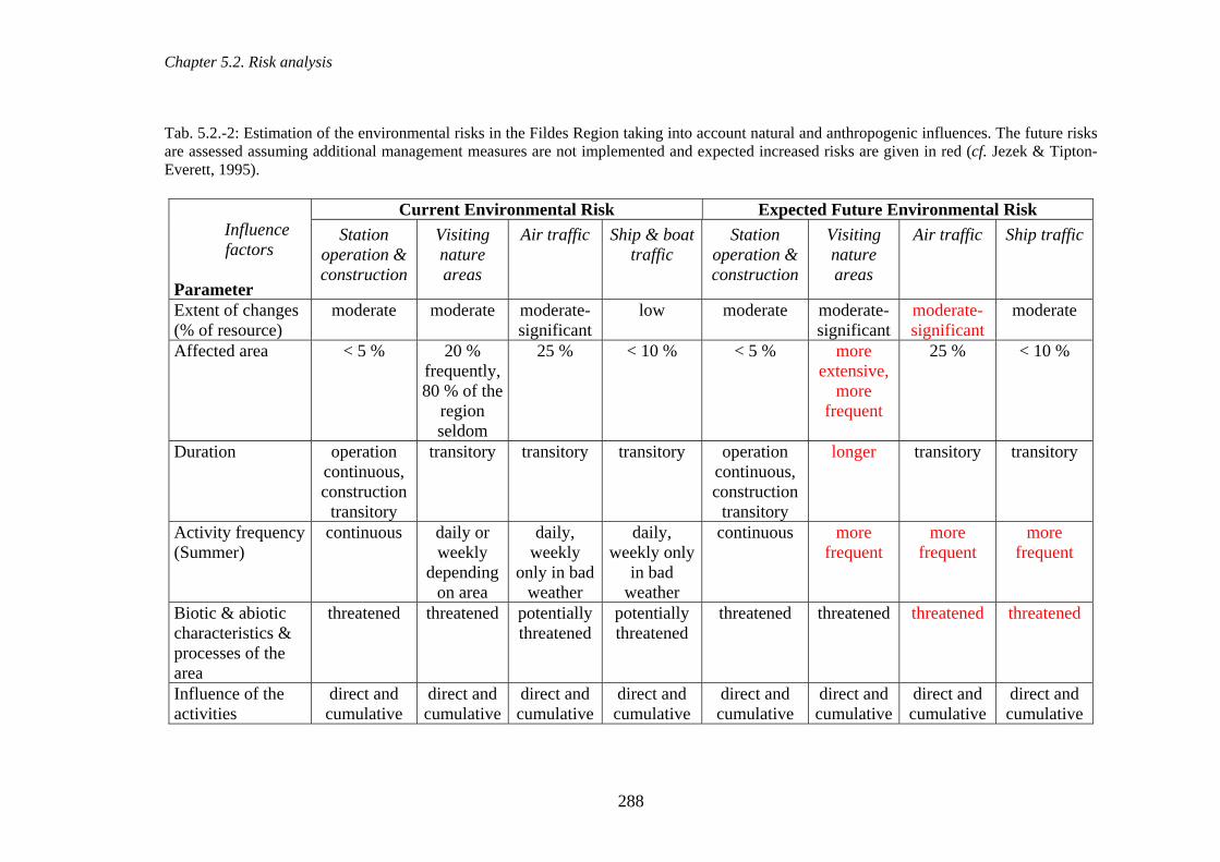
Chapter 5.2. Risk analysis
288
Tab. 5.2.-2: Estimation of the environmental risks in the Fildes Region taking into account natural and anthropogenic influences. The future risks are assessed assuming additional management measures are not implemented and expected increased risks are given in red (cf. Jezek & Tipton-Everett, 1995).
Current Environmental Risk Expected Future Environmental Risk Influence factors
Parameter
Station operation & construction
Visiting nature areas
Air traffic Ship & boat traffic
Station operation & construction
Visiting nature areas
Air traffic Ship traffic
Extent of changes (% of resource)
moderate moderate moderate-significant
low moderate moderate-significant
moderate-significant
moderate
Affected area < 5 % 20 % frequently, 80 % of the
region seldom
25 % < 10 % < 5 % more extensive,
more frequent
25 % < 10 %
Duration operation continuous, construction
transitory
transitory transitory transitory operation continuous, construction
transitory
longer transitory transitory
Activity frequency (Summer)
continuous daily or weekly
depending on area
daily, weekly
only in bad weather
daily, weekly only
in bad weather
continuous more frequent
more frequent
more frequent
Biotic & abiotic characteristics & processes of the area
threatened threatened potentially threatened
potentially threatened
threatened threatened threatened threatened
Influence of the activities
direct and cumulative
direct and cumulative
direct and cumulative
direct and cumulative
direct and cumulative
direct and cumulative
direct and cumulative
direct and cumulative
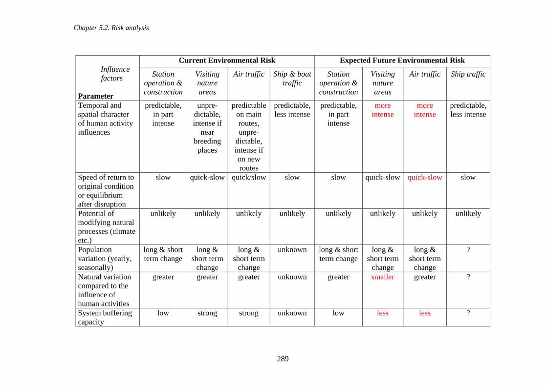
Chapter 5.2. Risk analysis
289
Current Environmental Risk Expected Future Environmental Risk Influence factors
Parameter
Station operation & construction
Visiting nature areas
Air traffic Ship & boat traffic
Station operation & construction
Visiting nature areas
Air traffic Ship traffic
Temporal and spatial character of human activity influences
predictable, in part intense
unpre-dictable, intense if
near breeding places
predictable on main routes, unpre-
dictable, intense if on new routes
predictable, less intense
predictable, in part intense
more intense
more intense
predictable, less intense
Speed of return to original condition or equilibrium after disruption
slow quick-slow quick/slow slow slow quick-slow quick-slow slow
Potential of modifying natural processes (climate etc.)
unlikely unlikely unlikely unlikely unlikely unlikely unlikely unlikely
Population variation (yearly, seasonally)
long & short term change
long & short term
change
long & short term
change
unknown long & short term change
long & short term
change
long & short term
change
?
Natural variation compared to the influence of human activities
greater greater greater unknown greater smaller greater ?
System buffering capacity
low strong strong unknown low less less ?
Chapter 5.2. Risk analysis
290
The environmental risk of research station operation and current construction is categorised as of extent “moderate” (cf. Tab. 5.2.-2). Research stations occupy only a small part of the region. In these areas the occurrence of animals and plants is already more limited than in the surrounding natural areas and a return to their original state after station demolition will be extremely slow. We have also categorised as “moderate” the future risk from station operation and construction because these activities are controlled to some extent by the existing guidelines. New construction and renovations are envisaged as taking place only in the current station areas. Nevertheless the risk of damage to the soil should be taken into account even in areas with few animals or little plant cover. At the same time, the concurrent demolition of disused buildings will reduce the risk of environmental damage. Research stations regularly update their facilities and develop their capacities but currently are seen as probably not needing to extend in area for reasons of scientific necessity. In contrast, we expect an increase in the environmental risk due to the continual rise in air traffic and in visitor numbers so long as there are still no designated flight and visitor zones. Whether visitors and air traffic would really lower population abundances of seals and sea birds is difficult to judge because habituation may occur (Acero & Aguirre, 1994; Culik & Wilson, 1995; Cobley & Shears, 1999; Nisbet, 2000; Otley, 2005; Pfeiffer, 2005). In addition to the disturbance of seabirds and seals, visitor activity also has the potential for an intensive or long-lasting negative impact on the soil and vegetation. Although visitors and air traffic have not been shown to reduce populations in previous years, such effects cannot be ruled out in the future if visitor numbers and air traffic increase further. However, further changes are possible as a result of climate change (cf. Sec. 4.5.1.). However, it is possible that increasing human activity might reduce the buffering capacity of the system i.e. that there might be less time available in which animals can rest and feed undisturbed. These are times that normally compensate for disturbance. The intensive scientific and logistical activity planned for International Polar Year 2007/08 and increasing tourist numbers will probably strengthen the negative environmental and cumulative effects in the region if no additional management measures are implemented (Tab. 5.2.-2).

Chapter 6.1. Previous management
291
6. Management of the Fildes Region 6.1. Previous management Ever since the Antarctic Treaty system came into existence, the signatory Parties have laid down numerous environmental protection regulations and negotiated several international agreements. These include, for example, Agreed Measures for the Conservation of Antarctic Fauna and Flora, Convention on the Conservation of Antarctic Seals, CCAMLR, Convention on the Regulation of Antarctic Mineral Resource Activities, EP). As the number of agreements grew, so did the number of instruments for the protection of species and areas. 6.1.1. Research station operation According to Annex III of the Protocol Art. 1, all disused installations should be completely removed provided they have no status as Historic Sites and Monuments. In accordance with this requirement, some of the disused field huts in the study area have already been dismantled (Sec. 4.2.11.). Even if not entirely sufficient, the early environmental management and monitoring programmes (e.g. environmental surveillance around Artigas Station) reduced negative effects to some degree or else indicated particular problems. Open waste storage areas are indeed now the exception as demanded jointly by the Antarctic Treaty Parties (Annex III of the Protocol Art. 3,) but hazardous materials are nevertheless still occasionally stored in the open (Sec. 4.2.3.). Large-scale collections of scrap and waste have already taken place at Frei and Bellinghausen and, although extremely demanding of time and money, achieved considerable success in reducing the amount of waste lying in the open (ATCM, 1999). As CCAMLR surveys indicate, marine debris that contaminate the coasts originate largely from fisheries. The danger of injury to marine mammals by this material is a particularly persistent problem. The CCAMLR commission published strengthened recommendations or regulations that cite the ecological reasons for avoiding jettisoning waste at sea and describing the correct handling of waste (http://www.ccamlr.org/pu/E/e_pubs/am/p6.htm#3.5Application, see also MARPOL). The improved waste management reduced the availability of anthropogenic food material to certain bird species (Tin & Roura, 2004). In spite of this, active feeding of birds and the open storage of some kitchen waste is still to be seen at research stations in the Fildes Region. When there have been major pollution incidents in the study area various damage control measures have been invoked. In the case of oil pollution these measures include barrier booms in the water, the application of special compounds (Sec. 4.2.6.), the

Chapter 6.1. Previous management
292
removal of contaminated snow and soil, covering with gravel and sand, as well as burning off. Nevertheless, the insufficiency of contingency plans, especially those for large-scale spills, have been emphasised repeatedly during inspections (ATCM, 1999, 2005) but have not yet been appropriately modified. The introduction of improved technology in the research stations as, for example, the new generators at Great Wall and Frei, has made it possible to reduce noise and gas emissions. Risk assessment for plant construction activities are in the form of IEEs carried out by the relevant national authorities. The work can be modified on site if it is realised that environmental damage is occurring. 6.1.2. Traffic management Every year since 1991, COMNAP has brought out an updated Antarctic Flight Information Manual (AFIM). AFIM contains detailed information on all Antarctic landing places for fixed wing and rotary wing aircraft, orientation aids, meteorological services and communication frequencies. ASPA No. 150 includes a ban on flights below an altitude of 300 m over Ardley Island in its management plan. Disturbance of bird colonies by low flying helicopters has been pointed out repeatedly (e.g. ATCM, 1999; Pfeiffer, 2005) but, even so, excessively low flights were observed during the current study (Sec. 4.2.16.). Various guidelines on minimum altitudes for overflights, minimum horizontal distances, landing rights, and operational intensity have been discussed for many years (Harris, 2001). These guidelines were established differently by different Treaty Parties but have recently been standardised (Resolution 2 (2004) XXVII ATCM). The guidelines for flights in the neighbourhood of bird concentrations were also included in AFIM Appendix 7 but are not always followed by pilots (cf. Sec. 4.2.16.). All parties to the treaty commit themselves to minimising environmental threats, accidents and pollution, and to offering mutual assistance in the event of such occurrences, in order to restrict damage (e.g. by oil spills) to the marine ecosystem to a minimum (Annex IV, EP Art. 6(1) and Art. 3). This commitment also produces legal requirements for estimating the risks of voyages in the Antarctic, the prevention of accidents and the minimisation of the damaging consequences of accidents. Repairs can be carried out in the nearest harbours of South America and New Zealand. Accidents or pollution incidents related to shipping that come to light are regularly reported at the annual meetings of ATCM (ATCM, 1999b) and IAATO. The limited number of accidents indicates the high safety standards of the ships, the successful

Chapter 6.1. Previous management
293
application of guidelines and contingency plans based on national and international rulings, for example permitting procedures, as well as decisions by IAATO. There are very limited possibilities of minimising damage or removing contaminants after oil spills in Antarctic waters (Enss et al., 1999). Damage avoidance is therefore the first priority. Contingency plans are activated in cases of damage (Annex IV of the EP Art. 12,). The Chilean and Argentinean navies run alternate patrols during the summer months with their ocean-going tugs (ATF Lautaro, ATF Leucotón, Aviso ARA Suboficial Castillo). These ships cover the area of sea between the South Shetlands and the Antarctic Peninsula in order to provide help in cases of ship breakdown or oil spill. In addition, new regulations on waste water discharge by ships were approved recently (Resolution 3 (2006) - ATCM XXIX, Edinburgh). The extent to which these are already being implemented or observed is not known at present. 6.1.3. Nature conservation The placement of parts of the Fildes Peninsula (ASPA No. 125) and of Ardley Island (ASPA No. 150) under protection creates long-term regional protection (habitat protection, biotope protection) by limiting human activities to urgently needed scientific research work. The Southern Giant Petrel breeding in the study area are protected under international agreements such as ACAP and the Bonn Convention. It is together with the Gentoo Penguin listed as “near threatened” on the Red List of the IUCN. Several investigations of recent years have pointed out the risks of alien species ever becoming established in the Antarctic (see Curry et al., 2005; ATCM, 2005, 2006c). The Protocol commits the Treaty Parties to preventing the introduction of non-native species to the Treaty Area (Annex II Art. 4 EP). The effects of introducing foreign species are described in CCAMLR Art. II. Visitors to the Antarctic are covered by IAATO guidelines for cleaning clothing and footwear and for avoiding introducing alien species and diseases. These guidelines are applied on all visiting ships. Current requirements, prohibitions and behavioural guidelines are also laid out in Germany’s advice to Antarctic visitors (http://www.umweltbundesamt.de/antarktis/archiv/antarktis.pdf). Sections on preventing and minimising the introduction of non-native species also occur in additional international agreements including the Convention on Biological Diversity, UN Agreement on maritime Law, and the Ballast water Agreement.

Chapter 6.1. Previous management
294
6.1.4. Science management Scientists themselves carry the obligation of checking for negative effects of their work and minimising them in the best possible way. The greater their experience of scientists, the higher the probability that habituation effects are produced in vertebrates by repeated work. For example, the time required for nest checks can be minimised with a well-planned sequence of observational and measuring steps. The yardstick for environmentally friendly science is the application of standardised and recognised methods such as those applied in this study for counting the number of breeding pairs of penguin (e.g. CCAMLR Ecosystem Monitoring Program, Standard Methods 2004). Where a suitable viewing point exists overlooking a colony, counts of individuals can also be made without disturbing the birds on the nest. Inspections have repeatedly stressed (ATCM, 1999, 2005) the need to avoid duplication of scientific investigations, several groups working in the same area, or working on the same species. They also frequently call for more and stronger cooperation in research work. None of these things have yet been implemented satisfactorily. This, to some extent, is due to language barriers. Not all research station leaders or scientists speak English which hinders communication. Furthermore, the necessity for such coordination is not universally recognised and therefore no regular international meetings are organised in the Fildes Region, either by the scientists themselves or through the local officials (ATCM, 1999, 2005). In recent years, however, we have noticed an increase in the number of informal meetings of scientists interested in cooperation and in joint leisure activities. To what extent the King George Island Science Coordination Group, as an Action Group of the Standing Scientific Group on Physical Sciences (SSG-PS), will be able to contribute to the coordination of scientific activities on King George Island, could not be established from the activities carried out so far. 6.1.5. Visitor management In recent years specific management measures have been applied to the increasing numbers of visitors to Antarctica. These include the better coordination of visits, detailed statistics, a limit on the number of visits to research stations each season, and the implementation of site-specific guidelines (www.iaato.org, Resolution 2 (2006) - XXIX ATCM Edinburgh). The potential dangers for animal and plant species of shipping movements and landings by visitors can be significantly reduced by the IAATO guidelines (http://www.iaato.org/docs/wildlife_guide_03.pdf) and the ATCP guidelines for visitors. Maintaining minimum distances between visitors and animals, prohibition of walking on vegetation and threatened soils, and a ban on

Chapter 6.2. Management proposals
295
bringing in or collecting materials are effective against specific dangers. These guidelines also apply to research station personnel in their free time but the control mechanisms are less marked for them than for commercial tourists. 6.1.6. Cumulative effects An inspection report more than 15 years ago (ATCM, 1999) described the occurrence of cumulative effects in the study region. However, the study and the reduction of such effects is still in its early stages (Morgan, 1998; Glasson et al., 1999; Petts, 1999). A working group set up by the CEP is currently occupied with drawing up suggested guidelines (ATCM, 2006c). 6.2. Management proposals The data collected during this project demonstrate an increase in human activity in the Fildes Region during the last three years. In the near future, the planned international cooperative projects will result in increased field and laboratory research in the region, particularly as a consequence of IPY 2007/08. These will necessitate logistic support on land as well as from air and sea traffic. The communications infrastructure is already highly developed (mobile phone networks, internet, marine radio) in order for the Fildes Peninsula to be developed as a regional command centre for search and rescue. The conversion and extension of research stations will continue so that technical standards can be maintained. Tourist numbers will increase further because tourist activities in the Antarctic have not yet reached their limits in terms of ship capacity or available landing places. The increase will be stimulated by the growing knowledge about the Antarctic, the greater choice of forms of travel, and the wide variety of things to do (from walks in natural environments to extreme sports). This is probably just as valid for the Fildes Region. Management measures currently in place are thus insufficient to reduce environmental damage to the point where there is only transitory damage to animals and plants and only limited influence on population size. The greater the temporal and spatial extent of human activities become the less effective are the existing ground rules. This is because they are limited to specific aspects of the problem and rarely take a view encompassing more than individual research stations. It is desirable, particularly in a region where so many nationalities are present, to develop a new working philosophy, internationally binding in the spirit of IPY. This cooperation should prioritise on-site knowledge transfer and exchange of know-how above all in science, transport and active environmental protection.

Chapter 6.2. Management proposals
296
Below we present a number of management proposals and points of view that might inform future discussions. These proposals derive from the experience of the authors and on methods already applied in other areas (e.g. those with ASMA status). 6.2.1. Research station operation In recent years there has been both renovation and demolition of stations and field huts in the Fildes Region (Secs. 4.1.2 & 4.2.11.). This has not led to much change in the number of station inhabitants but increasing numbers of tourists have been given accommodation in stations for stays of a few days to several weeks. There might be changes to station facilities therefore if in the future the guests have to be offered more services. It is thus necessary to record the additional use of food, energy, etc. in order to track the tourist-related changes in station operation. Because research stations accommodate people of more than one nationality, communication is decisive for improving the quality of life and of working conditions. The removal of language barriers would clearly facilitate organisation and cooperation in scientific, logistical and tourist activities by:
• promoting local information exchange and cooperation between scientists and station personnel on site;
• raising the efficiency of resource use between stations in logistical operations and during emergencies;
• improving understanding of different cultures. There should therefore be active support for exchanges between station members of different nationalities. This could take the form of organised meetings between research station leaders, scientific groups, doctors, technicians etc., which would promote the exchange of information and joint research on particular themes. Also worthy of support from the different parties are mutual invitations to sporting events and to joint festivities between stations. These have in the past increased interest and understanding between the nations represented in the region. Technical progress in the Fildes Region has been particularly rapid in recent years. The considerable feeling of security provided by an extensive infrastructure, runways, marine radio, and the communications network should not mask the real dangers of sudden weather changes, cold and isolation. To prevent these dangers being underestimated all station personnel, particularly new arrivals, should receive precise guidance. To regulate gas emissions from stationary diesel motors, research stations should never fall below their current national fuel and emissions standards. They should strive to

Chapter 6.2. Management proposals
297
minimise exhaust gasses by applying appropriate technical solutions. Station noise should be reduced by improving technology and sound insulation. There have been occasional outbreaks of fire in station buildings in the past and thus greater attention should be given to fire prevention. Appropriate measures in this respect would be the use of detectors and more frequent checks of danger areas. 6.2.1.1. Waste management Significant reductions in the amount of debris and dangerous materials can be made by the annual collections of waste undertaken by research stations around their buildings. Further useful reductions could be made if these actions were implemented more extensively around the stations. Areas with waste problems and individual locations of dangerous material are pinpointed by the GIS data collected by the current project. These data can be used for the more rapid location of these sites. Efforts should be made to restrict the availability to birds of anthropogenic food at the research stations. This is particularly important as a means of preventing the introduction of disease into Antarctic breeding birds but also useful because of the potential influence on breeding success and on chick growth. Therefore, the recommended measures (ATCM, 2001a & 2001b) should be quickly and consistently implemented by all research stations. These measures include not depositing biological waste outside buildings and strongly discouraging feeding birds around stations. 6.2.1.2. Preventing oil pollution Avoiding contamination through escapes of oil is of the highest priority and therefore regular checks and repairs should be carried out of fuel tanks, hoses, pipes, and of vehicles. Standardising the contingency plans of individual stations could allow more efficient use of resources. Research into biodegradation has shown promising results with Pseudomonas strains (Stallwood et al., 2005). Greater cooperation between stations in the case of oil contamination could allow available resources to be used more rapidly and thus minimise damage. 6.2.1.3. Building construction and dismantling Construction and demolition usually take place during the summer months when work and transport conditions are optimal (Secs. 4.2.18. & 4.2.19.). The flora and fauna would be spared much disruption and harm, however, if these activities took place outside the breeding and growing seasons, as in the dismantling of “Rambo” (Sec. 4.2.11.).
Chapter 6.2. Management proposals
298
As construction projects in the past have shown, the use of land for excavation and material storage, as well as the extension of the track network, frequently greatly exceeds that specified in the respective IEE. More attention should therefore be paid to the discussion of alternatives that use less land and that have less potential to cause disturbance. No building materials should be used if they might cause environmental damage in the Antarctic. Material lying in the open can be blown away by the gales that occur and thus widely distributed (Sec. 4.2.3.). Consequently, more attention should be given to securing building materials stored outside. 6.2.1.4. Wastewater treatment Waste water treatment systems in the Fildes Region are still very varied (Sec. 4.2.1.), and it is therefore desirable that the most environmentally friendly method is identified and applied across the board. Particularly necessary are joint efforts by the locally represented nations to reduce the pollution caused by the discharge of waste water into Maxwell Bay. 6.2.1.5. Information on the local environment Station personnel working in the Fildes Region for the first time should be directed to take part in courses during their orientation period after arrival. These courses are provided by the national stations and give instruction in the environmental protection measures used locally. This could be carried out using brochures, information leaflets and posters made available in the research stations in appropriate languages. They would provide information about sensitive areas, special animals and plant species, and geological features, as well as about specific guidelines. Alternatively, presentations could be made by experienced station leaders or scientists in connection with visits to particular localities. The present study offers a large amount of information that could be combined into a presentation for distribution in several languages. 6.2.2. Traffic management 6.2.2.1. Land transport The number of vehicles in operation on the Fildes Peninsula will probably not alter in the future. However, it is possible that they will be used more frequently because logistical operations on the Fildes Peninsula frequently involve land transport. Motorised visits to nature areas, e.g. the field hut “Priroda”, if necessary at all, should be made only on existing, vegetation-free tracks.
Chapter 6.2. Management proposals
299
Current national maximum emissions should not be exceeded in order to minimise exhaust emissions from vehicles. Lower noise emissions are also expected with more modern vehicles. 6.2.2.2. Air traffic The existing Antarctic air traffic guidelines (Sec. 6.1.2.) should be observed more consistently, particularly in regard to bird colonies and seal haul-outs. Maps of the present breeding and seal resting places derived from the current project could be made available to flight controllers and pilots. It is also possible to envisage using this data to designate fixed flight corridors in support of AFIM which might also be connected with facility zones. Low overflights outside the major routes should be prohibited generally because they have been shown to disturb the local fauna (Secs. 4.5.2. & 4.5.10.). 6.2.2.3. Ship & boat traffic Complete statistics should be compiled for the ship traffic in Maxwell Bay, i.e. including all types of ships and boats. Greater control over ship movements in the bay might be exercised by a single coordination base recognised by all (currently the Chilean navy). A coordination according to time and position would counter the growing risk of accidents arising from the high density of boats and ships. 6.2.3. Nature conservation 6.2.3.1. Area protection In addition to the previously designated protection areas ASPA No. 125 and No. 150, a further zoning of the Fildes Region could allow specific implementation of special guidelines on biotope and habitat protection in the context of an ASMA management plan. The zoning proposal in this report (Sec. 6.2.8.) is not limited to terrestrial areas but also includes surrounding parts of the sea up to 0.25 nautical miles from the coast. The proposal thus supports current efforts to designate marine protected areas or protected areas of the sea (Annex V of the Protocol, see also cooperation between CEP and CCAMLR). The desired buffer effect (Annex V) for the terrestrial areas is thus to some extent taken into account in the ASMA proposal for the Fildes Region (Sec. 6.3., Appendix 5) as well as in the separate discussion of an ASMA for the whole of Maxwell Bay (Sec. 7.).
Chapter 6.2. Management proposals
300
6.2.3.2. Fauna Existing protection of Antarctic sea bird species could be strengthened by including it in the world-wide network of “Important Bird Areas” (IBA). IBAs are designated by BirdLife International and are therefore in no way a category of the system of Antarctic Treaties. In consequence they have neither any legally binding character nor can measures be applied to them. Nevertheless, designation as an IBA supports the identification of an area as being worthy of protection. Discussion of which areas might, in principle, appropriately be selected took place during the two most recent meetings of the SCAR Group of Experts on Birds (Jena 2002 and Texel 2004). Because these birds need the sea for feeding and habitat, marine protected areas should also be integrated into this concept. It has been suggested that a possible protection area would be Admiralty Bay and the south western part of King George Island (the Fildes Peninsula up to and including Potter Cove). Data collection and practical implementation of IBAs has still not taken place in the Antarctic. Particular attention should be paid to the large breeding colonies of Southern Giant Petrel on Two Summit and Dart Island. Putting these islands under the protection of an IBA, or as part of one, would be an active contribution to the protection of this near threatened species even though this category of protected area is not currently legally binding. 6.2.3.3. Flora Driving and walking on vegetated areas continues to be a problem because of the great number of stations and the associated high level of activity. Journeys should always be restricted to the most essential and leaving the existing routes prohibited in order to minimise vegetation damage. Outside the station area, large groups of people should avoid vegetated areas and use only established paths. 6.2.3.4. Introduction of alien species Experts are currently active in developing strategies to avoid the introduction of and the dispersal of non-native species. They are also working to determine the main routes of entry and to evaluate methods for studies of the risks involved. The key points of current management should be precautions, observations and active counter measures against the occurrence of foreign species (ATCM, 2006c). The prevailing absence of knowledge on the lower plants, invertebrates, and microorganisms, necessitate further coordinated studies on the Antarctic continent, Antarctic islands and the surrounding sea (Frenot et al., 2005).
Chapter 6.2. Management proposals
301
Conceivable concrete precautionary measures include disinfection of (construction) materials, intended for import into the region and thorough boot washing before entering the area for both scientists as well as tourists. They might also include installing footbaths of disinfectant for newly arriving passengers at the airport. 6.2.3.5. Fossils Collecting fossils for non-scientific purposes is not allowed by the terms of the ASPA No. 125 Management Plan and new arrivals should be made aware of this fact. However, there is still free access to the geologically interesting localities of the Fildes Peninsula because, in contrast to ASPA No. 150 where scientists and visitors report at the Chilean station, no such possibility exists at ASPA No. 125. There is thus no access control at this site. Stronger protection measures at known fossil (and mineral) exposures should thus be discussed in the course of the current revision of the ASPA No. 125 management plan, along with the inclusion of the locations detailed in Sec. 4.4.1.2. 6.2.4. Science management Station leaders should support frequent meetings between scientists of the different stations to promote agreement on planned field work and to limit duplication of scientific projects during the field season. In addition, close cooperation in joint projects should be striven for. Most stations members have expressed a wish for popular scientific presentations on current research (Sec. 4.7.). These would showcase scientific work taking place in the area and could potentially raise environmental consciousness and thereby also improve adherence to the guidelines by scientists and non-scientists alike. Because scientific and monitoring information is a prerequisite of effective management in the region, the following studies should be initiated if they have not already taken place:
• monitoring the spatio-temporal extent of human impacts (land use, waste management, vehicle tracks etc.);
• studies that support the development of action- and contingency plans; • investigation of changes in biodiversity; • recording non-native species; • regular counts of selected sea bird and seal species and reports on their breeding
success; • studies on the colonisation of glacier forelands by animals and plants.

Chapter 6.2. Management proposals
302
Cooperation agreements and accords designed to avoid duplications should be made before the field season starts by the appropriate scientific institutions of the Treaty Parties. 6.2.5. Visitor management The main tasks for future management of visitors are (1) better guidance of visitors towards the interesting areas and sights of the region, (2) the introduction and implementation of locally appropriate guidelines for visitors, and (3) better collation of statistics to support active management measures. Re: (1) Better tourist guidance can be achieved by:
• specifically designating as “visitor zone” those areas that are already frequently visited in the context of a zoning system (Fig. 6.2.-1 & Sec. 6.2.8.) that will better meet visitor demands (easily accessible bird colonies and seal beaches, insights into station life);
• the designation within the existing network of special hiking routes or nature trails to attractive areas within the existing road network;
• extending and marking routes to the church at the Russian station in order to minimise damage caused by walking on vegetation and the disturbance of breeding skuas;
• making available information material in stations in the form of brochures and in visitor areas as information boards (Example Fig. 6.2.-1).
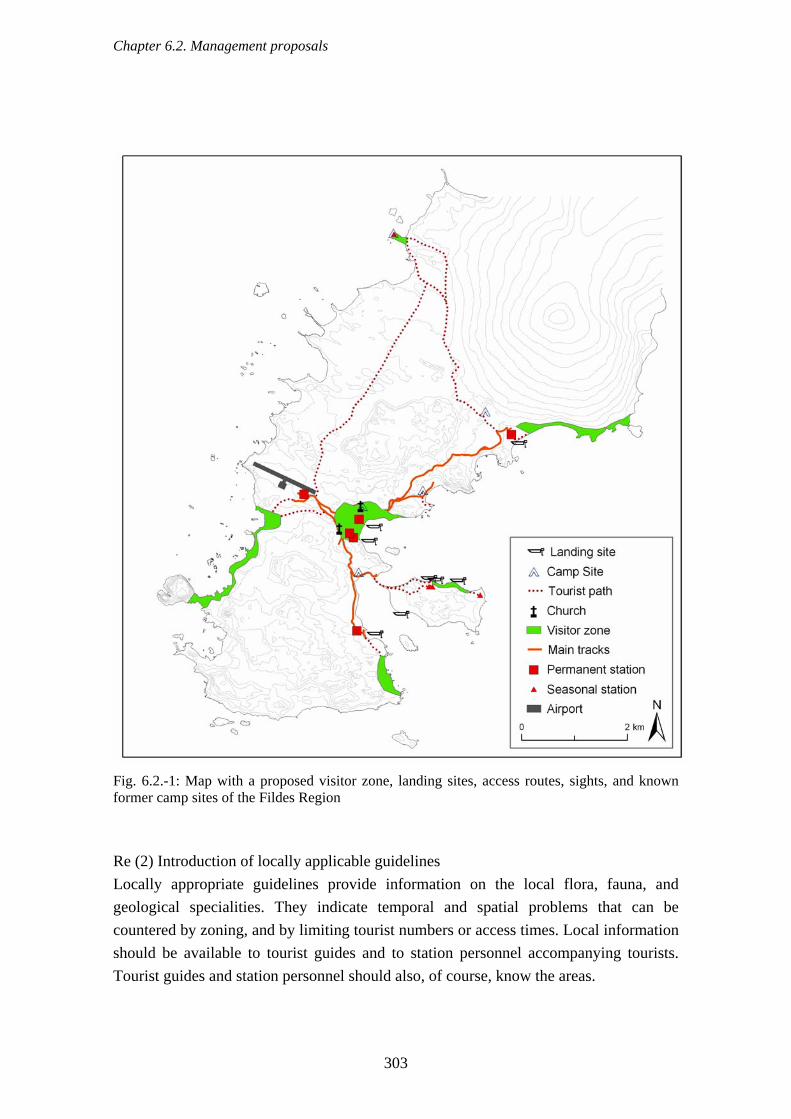
Chapter 6.2. Management proposals
303
Fig. 6.2.-1: Map with a proposed visitor zone, landing sites, access routes, sights, and known former camp sites of the Fildes Region Re (2) Introduction of locally applicable guidelines Locally appropriate guidelines provide information on the local flora, fauna, and geological specialities. They indicate temporal and spatial problems that can be countered by zoning, and by limiting tourist numbers or access times. Local information should be available to tourist guides and to station personnel accompanying tourists. Tourist guides and station personnel should also, of course, know the areas.

Chapter 6.2. Management proposals
304
These guidelines could be developed with the help of the data collected in this project. The guidelines should be in accordance with the locality specific visitor guidelines already developed for other tourist areas in the west-Antarctic (e.g. the visitor site guidelines recently decided for 12 landing sites frequently used for tourists from cruise ships (ATCM, 2006g, i). The guidelines should be on display in all stations and be prepared in various forms in order to inform visitors in advance in an appealing way. Re (3) Better collation of tourist statistics A complete record of visitors is necessary in order to improve the record of tourist activity in the Fildes Region. Arrivals and departures of visitors can very easily be checked using airline and ship passenger manifests. An amalgamation of the various current visitor statistics of IAATO, the Chilean and Uruguayan navies, and the airport, would give a realistic picture of the actual movements of tourists in the area. Visitor numbers should continue to be passed on to IAATO and this should encourage travel companies not yet members of IAATO to contribute information. Arrivals of delegations and visitors independently of travel companies should be documented and publicised by the stations (e.g. as part of an annual report). The creation of a joint statistical record could, for example, be one of the tasks of the management group, which could be established within the framework of an ASMA administration (Sec. 6.2.7.). In contrast to guided tourist groups, the majority of the visitors to the region move about without guides. It might be useful therefore to establish a central point of arrival as has been implemented successfully elsewhere (e.g. the wardens on the Falkland Islands, Otley, 2005). This position would be staffed by a single person in the summer months that would not only document visitor numbers and frequency broken down by area, but also inform visitors about tourist attractions and behavioural guidelines. The development of future strategies for this changing tourism industry is currently being driven forward (Amelung & Lamers, 2005). In the last two years, meetings of experts have led to a catalogue of possible scenarios for the development of tourism in the Antarctic and possible management approaches, which could be applied to the region. A visit to the Fildes Region is planned for 2007/08 in order to make a practical evaluation of the theoretical formulations, which are as yet unpublished.

Chapter 6.2. Management proposals
305
6.2.6. Cumulative effects Due to the large number of scientific activities in the IPY 2007/08, cooperation projects that have been agreed beforehand should be comprehensively planned on site with regard to when and where they are to be carried out, in order to reduce cumulative effects. Overlapping of human activities can be very efficiently limited by zoning. Guiding visitors into specially designed visitors’ zones and concentrating logistical activities in designated facility zones creates more efficient environmental and nature protection, and allows scientific work free from disturbances in the remaining areas (Sec. 6.2.8.). Zoning is currently being used successfully in the Antarctic in areas frequented by tourists as well as in ASMAs. It could also be practised in the Fildes Region. In the case of shipping traffic, there will in future also be overlaps in time and space between scientific, logistical and tourist activities in Maxwell Bay. Improved communication, e.g. in the form of supervision by the Chilean navy, could make it possible to monitor the simultaneous anchoring of several ships and, where necessary, control it. The main problem in evaluating cumulative effects is the failure to collate information about different activities. 6.2.7. Establishing a management group The establishment of a management group could make it possible to bring together information in a way that has hitherto been lacking. Station leaders, scientists and people responsible for environmental protection could meet on site at the start of the summer season. They would use these occasions to reach agreements on planned activities and how to monitor them as well as on possible conflicts. Possible tasks of the management group could be:
• an exchange of information regarding planned activities ahead of the field season and a meeting at the start of the field season in order to reach detailed agreements on activities in the Fildes Region. The agreements should be divided into three categories: logistical station activities, traffic, tourists, and research; and aim to ensure that these activities do not disrupt each other or negatively affect each other or the environment (especially the assets to be protected) in any way.
• making and keeping records of all planned activities (e.g. scientific projects in the region through SCAR, construction plans at the stations, flight plans and shipping plans of IAATO members);

Chapter 6.2. Management proposals
306
• encouraging meetings between individual scientists on site who are engaged in similar projects and could cause cumulative effects;
• encouraging meetings between station leaders to organise emergency drills, waste collection drives etc.;
• making available informational material (brochures, posters, etc) about the biological, geological, scientific, logistical, historical and tourist specialities of the region;
• collating tourist statistics; • the development and implementation of a monitoring programme for the Fildes
Region specifically for the investigation of the cumulative effects of human activity;
• supervising the implementation of the management plan and helping to revise it when necessary.
6.2.8. Zoning Art. 5 (3f), Annex V of the Protocol states that proposed management plans shall include, as appropriate, zoning of the area so that certain activities can be prohibited, restricted or managed, in order to achieve the desired goals. Harris (1994) describes a zoning system for the Antarctic, which can reduce the potential for conflict arising from the cumulative effects of scientific, logistical and tourist activities on the environment and on other assets to be protected. He proposed a division of an area into six types, which can be applied to ASPA and ASMA: restricted access zone, sensitive zone, scientific zone, tourist zone, facility zone and historical zone. Drawing on this outline we suggest the following zoning for the Fildes Region whose extent and spatial structure is detailed in the proposed management plan (Appendix 5):
• Facility zones These zones include the areas of all research stations, the airport, the official road network and current infrastructure. They should also cover areas marked by intensive air and sea traffic. All logistical activities can take place in these zones as long as they ensure the safety of people and of the environment.
• Visitor zones Visitor zones (since, in addition to tourists, station personnel also visit nature areas in their free time) offer easily accessible attractions in safe surroundings. They ensure the protection of the flora and fauna through the brevity of the visits
Chapter 6.2. Management proposals
307
and their lack of potential to disturb. In the Fildes Region the preferred visitor zones are the stations themselves, the edge of a penguin colony on Ardley Island and, in addition, the attractive coastal areas and seal haul-outs near the stations.
• Sensitive zones These comprise zones marked by the presence of threatened species or by a large number of species. Human activity should be minimised in these zones. In the Fildes Region inclusion in this type of zone would expose several small breeding colonies of the Southern Giant Petrel which is considered to be especially sensitive to human disturbance and some extensive areas of vegetation to a lowered risk of disturbance and damage.
• Restricted access zones These zones cover areas with high environmental value whose protection would be guaranteed by preventing human activity. Two Summit Island and Dart Island support large colonies of the near threatened Southern Giant Petrel. Access permission would be granted only for important scientific and monitoring purposes.
• Wilderness zones This type would include all the remaining areas within the boundaries of a possible ASMA in the Fildes Region. To preserve their wilderness character, no kind of infrastructure should be created in these zones. Research, environmental monitoring, and management activities would be permitted however.
It appears unnecessary to define scientific zones (areas which are reserved to scientific investigations or to activities supporting research) because scientific research takes place in all parts of the Fildes Region and significant areas are already protected by their ASPA status. The detailed zoning suggested by the authors can be found in Map 3 of Appendix 5.
Chapter 6.3. Possible modules of an ASMA “Fildes Region” management plan
308
6.3. Possible modules of an ASMA “Fildes Region” management plan According to Arts 4, 5 and 6, Annex V of the Protocol, “Antarctic Specially Management Areas” (ASMA) may be proposed. This applies to areas in which numerous human activities take place simultaneously and where planning and cooperation is desirable to avoid possible conflicts and environmental impacts (cf. Annex V of the Protocol Art. 4(1)). The Fildes Region meets these criteria because a multiplicity of scientific, logistical and tourist activities take place there due to the high density of research stations (details in Secs. 4. & 5.2.1.). The conflicts of interest that already exist between human activities and their negative effects on the environment show that the management is insufficient. The planning and coordination of management tasks needs to be strengthened in order to improve the situation because an increase in scientific, logistical and tourist activities is to be expected. Designation of an ASMA appears to the authors to be the most suitable means of managing the area and also to reduce cumulative impacts on the environment (Annex V of the Protocol Art 4(2)). The existing ASPAs No. 125 and No. l50 could thus be included in the ASMA (Annex V of the Protocol 4(4)). Therefore, the current project included a proposal for a management plan for a possible Fildes Region ASMA is provided (see Appendix 5). The proposal contains recommendations for separate codes of conduct for (1) the proposed facility zones, (2) for scientific research, and (3) for visitors to the region. These codes are derived from the results of the current project and from the existing codes of conduct for the Deception Island ASMA. They are intended to contribute to the reduction of the cumulative detrimental environmental effects caused by station operation, science, logistics and tourism. They would contribute to the preservation of assets to be protected of the region by substantially reducing the potential danger to the flora and fauna whilst at the same time maintaining special rules for planned activities in the facility zones and for scientists and visitors. A description of possible alternatives to this proposal can be found as “Alternative Management Approaches” (see Appendix 6).
Chapter 7. Unanswered questions and research needs
309
7. Unanswered questions and research needs 1) Assuming that the political process of discussing a Fildes Region ASMA in the corresponding international working group and at ATCM/CEP meetings will extend over many years to come, important real changes occurring in the region every southern summer should be noted so that they can form part of the discussions. Data collection for this report ended in February 2006, although supplementary counts of seals continued until October 2006. Of particular value are the results of current long-term monitoring programmes, which are important for assessing changes in reproduction rates etc., whether as a result of anthropogenic or of natural causes. Especially important are the numbers of breeding pairs and the breeding success of specific bird species such as the Southern Giant Petrel, a near threatened and sensitive species in the whole of the region, and the penguins on Ardley Island. 2) In developing and designating management plans checks on their success should be incorporated early in the process. These should cover not only the species mentioned in 1) but also more intensive – in terms of time and personnel – biological monitoring (breeding pair numbers of birds, seal resting and birthing sites, plant growth as well as changes relating to traffic, waste, tourism etc.). For this purpose a number of people are necessary in 3-5 year intervals. 3) The questionnaire given to station members revealed a keen interest in informative material on the local flora and fauna, on exceptional features of the Fildes Region and on environmental issues. In response to this the report authors plan to prepare a brochure on these topics for distribution in appropriate languages among the stations of the Fildes Region. At the same time, information sheets and posters could be issued summarising the brochure, and also presentations on CDs with a similar content. Producing DVDs with similar material is also possible. Information sheets or signs showing recommended tracks and the location of fragile areas in the most frequented spots would greatly assist in directing the flow of tourist traffic. 4) In the Fildes Region there is a need for further research in areas that could not be covered by the project now completed. In question here is
- the marine area nearby the stations (analysis of chemical and biological water quality, invertebrate fauna, algae flora),

Chapter 7. Unanswered questions and research needs
310
- continuing to map vegetation using the same methods to facilitate larger scale analyses (including air surveys), - detailed analyses of the relative impact of natural and anthropogenic factors on breeding pair numbers and breeding success of seabirds facilitating better monitoring and understanding of fluctuations, - monitoring of shifts in seal resting areas (also in areas outside the Fildes Region) compared with natural variations in their numbers, - detailed documentation of non-native species, - study of colonisation by flora and fauna in areas which are released by the melting
glacier, - study of new fossil occurrences in areas which are released by the melting glacier, - mapping and evaluation of remaining evidence of human activities from the time
of seal hunting. 5) A Maxwell Bay ASMA (Fig. 7.1.-1) is being considered as a further option by
Treaty Parties involved in the discussion. Such an ASMA would not only have the advantage (similar to neighbouring Admiralty Bay) of a geographical and functionally distinct region being included in the system but also that of increasing the number of stations and Treaty Parties directly concerned or involved in the discussion process. These include the Republic of Korea with station King Sejong on Barton, Argentina, the Netherlands and Germany with Jubany/Dallmann on Potter, and Brazil with Refugio Astronomo Cruls on Nelson. An increase in the area designated would automatically create additional research needs not only for the areas Potter and Barton, which are close to stations, but also for the ice-free areas on Nelson Island (Duthoit, Stansbury, Ruin Point and O’Cain Point). The planned research work would at the same time contribute to the data collection for the designation as “Important Bird Area” (IBA) by BirdLife International, supported by the SCAR Group of Experts on Birds (cf. http://www.birds.scar.org/activities/index.html).

Chapter 7. Unanswered questions and research needs
311
Fig. 7.1.-1: Boundaries of a possible Maxwell Bay ASMA

Chapter 8. Summary
312
8. Summary Fildes Peninsula, logistical centre of King George Island (South Shetland Islands, Antarctica), has an airport and a high density of research stations (Chilean stations “Profesor Julio Escudero” and “Presidente Eduardo Frei Montalva”, Chinese „Great Wall Station“, Russian station „Bellingshausen“ and Uruguayan station “Base Científica Antártica Artigas”) and several field huts. There are two reserves in the area, namely Antarctic Specially Protected Area (ASPA) No. 125 „Fildes Peninsula“ and ASPA No. 150 „Ardley Island“. Different interests like scientific research, conservation of flora and fauna, protection of places of geological and historical value, station operations, transport logistics and tourism overlap in the region. The aim of this study was to create a scientific basis for the quantification of human activities and environmental problems in the Fildes Region using biotic and other data. Field work was carried out during three austral summers between December 2003 and February 2006. Main focus of the analysis of the environmental situation onshore was the mapping of ancient waste dumps and current waste disposal. More than 2,600 sites mainly in the vicinity of stations and along the coast were detected. Besides, current waste management including organic wastes and measures to prevent oil contamination were recorded. Noise and gaseous emissions were investigated as well. The analysis of land use due to any kind of construction showed that 159 buildings cover approximately 1.9 ha. The total area used by stations is about 40 ha. The stations are connected by a network of roads approximately 13.4 km in length. Almost 6 % of the total land area of the Fildes Region is affected by vehicle traffic, mainly used for transporting people and fuel. Monitoring of air traffic showed an increase of overflights in total, particularly by helicopters. Special attention was paid to low overflights above bird colonies which may have negative effects. During the study period a significant increase of ship traffic (cruise, research, supply, patrol vessels and yachts) in the Maxwell Bay was recorded. The environmental effects of two important construction projects (Russian church, parking zone of the airport) were analysed in detail. Additionally, the environmental situation along the coast, the occurrence of fossils also beyond ASPA No. 125 as well as lakes and beach ridges of the area were recorded. The survey of fauna and flora represented another main aspect. The distribution of breeding colonies, breeding pair numbers and the breeding success of Chinstrap, Gentoo and Adélie Penguins, Southern Giant Petrel as well as other species (Cape Petrel, Wilson’s Storm Petrel, Black-bellied Storm Petrel, Brown Skua, South Polar Skua, Kelp Gull, Antarctic Tern, Snowy Sheathbill) were scrutinized considering natural and anthropogenic influencing factors. Distribution maps were compiled for all breeding bird species but also for guest birds as

Chapter 8. Summary
313
well as for transients and vagrants. In total 31 bird species were recorded. Monthly seal counts during the summer showed that Antarctic Fur Seals and Southern Elephant Seals are the most abundant species in the study area, followed by Weddell Seals, Leopard Seals and Crabeater Seals. The latter are to be seen often on sea ice during the winter months. Parochlus steinenii was the only midge species to be recorded for all 105 lakes in the Fildes Region. A vegetation mapping was carried out for the first time in the Fildes Region using GPS and covering 5.4 km2 of the area. Additionally, in continuation of the studies of 1984 and 2001 an increase in the occurrence of Deschampsia antarctica was documented. Furthermore, the members of all stations in the area were questioned about their leisure behaviour and their opinion on environmental education and protection measures. Another topic is the risk analysis of dangers to all the area’s assets to be protected. The risk analysis focuses on the diverse interests of nature conservation and environmental protection, scientific research and logistics as well as tourism. Station operation, traffic, scientific activities and thereby resulting risks of introducing alien species in the region, tourism as well as visitors' behaviour were identified as main anthropogenic impact and risk sources. If additional management measures are not taken the expected risk of negative impacts of human activities on fauna and flora and on natural processes of the ecosystem will certainly be higher than at present. Based on current management practices, additional suggestions are made for coordinating activities and reducing conflicts. Designating Fildes Region as an Antarctic Specially Managed Area (ASMA), for which a draft management plan is put forward (as a framework for discussion in the International Working Group of the Committee for Environmental Protection (CEP) of the Antarctic Treaty Parties) is considered to be the best way to improve the current situation and to implement effective management measures. This draft includes a proposal for zoning the area in Facility Zones, Visitor Zones, Sensitive Zones, Restricted Zones and Wilderness Zones. Additionally, it includes Codes of Conduct for Facility Zones, for scientific research and for visitors. Regarding open questions and research needs it is vital to continue environmental monitoring and to compile information material. Intensive research need exists for the “Maxwell Bay ASMA” proposed alternatively to the “Fildes Peninsula Region ASMA” due to its larger expansion.

Chapter 9. Bibliography
314
9. Bibliography AARI: Federal Program "World Ocean", Subprogram "Antarctic Research and
Investigation", Russian Antarcic Expedition (2006), Arctic and Antarctic Research Institute (AARI).
Acero, J. M. & Aguirre, C. A.: A Monitoring Research Plan for Tourism in Antarctica. Annals of Tourism Research 21 (1994), 295-302.
Adamson, E. & Seppelt, R. D.: A comparison of airborne alkaline pollution damage in selected lichens and mosses at Casey station, Wilkes Land, Antarctica. In: K. R. Kerry, G. Hempel. Antarctic Ecosystems: Ecological Change and Conservation (1990) Springer Verlag, Berlin, 347-353.
Adamson, H. & Adamson, E.: Possible effects of global climate change on Antarctic terrestrial vegetation. In: P. Quilty. Impact of Climate Change on Antarctica (1992), 52-62.
Ahnert, F.: Einführung in die Geomorphologie (1996), Stuttgart: Verlag E. Ulmer Amelung, B. & Lamers, M.: The Future of Antarctic Tourism: Exploring the
Implications of Complexity. (2005), 22. Polar Meeting Jena. Andersland, O. B. & Ladanyi, B.: Frozen Ground Engineering (2003), John Wiley and
Sons. Andrássy, I.: Nematodes in the sixth continent. Journal of Nematode Morphology and
Systematics 1 (1998), 107-186. Andreev, M. P.: Lichens of the Fildes Peninsula, King George Island, Antarctic.
Novosti Sistematiki Nizshikh Rastenii 25 (1988), 111-118. Andreev, M. P.: Lichens in the vicinity of Bellingshausen Station, King George Island.
Polar Geography and Geology 13 (1989), 42-45. Archer, T.: The organisation of aggression and fear in vertebrates. In: P. P. G. Baleson,
P. Klopter. Perspectives in Ethology (1976), Plenum Press, New York, 231-298 Arnould, J. P. Y. & Croxall, J. P.: Trends in Entanglement of Antarctic Fur Seals
(Arctocephalus gazella) in Man-Made Debris at South Georgia. Marine Pollution Bulletin 30 (1995), 707-712.
Arntz, W. E. & Gallardo, V. A.: Antarctic Benthos: Present position and future prospects. In: G. Hempel. Antarctic Science (1994) Springer Verlag, Heidelberg, 243-277.
ATCM: Report of a Joint Inspection under Article VII of the Antarctic Treaty, Antarctic Treaty Inspection Programme: January 1999 (1999a), Lima, Submitted by United Kingdom and Germany, WP23.

Chapter 9. Bibliography
315
ATCM: An Assessment of Environmental Emergencies Arising from Activities in Antarctica (1999b), Lima, Submitted by COMNAP, WP16.
ATCM: The Inspection Conducted in Accordance with Article VII of the Antarctic Treaty and Article XIV of the Protocol Under Auspices of the United States Department of State (2001a), Sankt Petersburg, Submitted by United States, IP17.
ATCM: Report on the open-ended Intersessional Contact Group on Diseases of Antarctic Wildlife, Report 1 - Review and Risk Assessment (2001b), Sankt Petersburg, Submitted by Australia, WP10.
ATCM: Report on the open-ended Intersessional Contact Group on Diseases of Antarctic Wildlife, Report 2 - Practical Measures to diminish risk (draft) (2001c), Sankt Petersburg, Submitted by Australia, WP11.
ATCM: Review on Guidelines for the Operation of Aircraft near Concentrations of Birds in Antarctica (2001d), Sankt Petersburg, Harris, Colin M.: 1-9, IP39.
ATCM: Antarctic Treaty Inspections (2002a), Warsaw, Submitted by Australia, WP34. ATCM: Regulating Antarctic Tourism (2002b), Warsaw, Submitted by ASOC, IP83. ATCM: Results of the waste disposal project at Bellingshausen Station (2002c),
Warsaw, Submitted by Russia, IP16. ATCM: Final Report from the Intersessional Contact Group on Cumulative
Environmental Impacts (2003a), Madrid, Submitted by the United States of America, WP6.
ATCM: Site Specific Guidelines 2003 in the Antarctic Peninsula Further Addressing Potential Cumulative Impacts (2003b), Madrid, Submitted by IAATO, IP72.
ATCM: IAATO Overview of Antarctic Tourism 2003-2004 Antarctic Season (2004a), Cape Town, Submitted by IAATO, IP63.
ATCM: Orthodox temple in the Antarctic (2004b), Cape Town, Submitted by the Russian Federation, IP45.
ATCM: Relevamiento de restos historicos del naufragio de Pta. Suffield, Bahia Maxwell, Isla Rey Jorge (Isla 25 de Mayo), en relacion a la resolucion 5 (2001), (2004c). Cape Town, Submitted by Uruguay, IP107.
ATCM: Report of the International Association of Antarctica Tour Operators 2003-2004 (2004d), Cape Town, Submitted by IAATO, IP68.
ATCM: Research Project “Risk assessment for the Fildes Peninsula and Ardley Island and the development of management plans for designation as Antarctic Specially Protected or Managed Areas” (2004e) Cape Town, Submitted by Germany, IP5.

Chapter 9. Bibliography
316
ATCM: Report of Joint Inspections under Article VII of the Antarctic Treaty and Article 14 of the Environmental Protocol (2005a), Stockholm, Submitted by Australia, Peru and United Kingdom, WP32.
ATCM: Environmental Impact Assessment on the Padre Balduíno Refuge's Dismantlement - Brazil (2005b), Stockholm, Submitted by Brazil, IP6.
ATCM: IAATO Overview of Antarctic Tourism 2004-2005 Antarctic Season (2005c), Stockholm, Submitted by IAATO, IP82.
ATCM: Measures to address the unintentional introduction and spread of non-native biota and disease to the Antarctic Treaty Area (2005d), Stockholm, Submitted by Australia, WP28.
ATCM: Revision of Management Plan for Antarctic Specially Protected Area No. 150 Ardley Island (2005e), Stockholm, Submitted by Chile, WP 37.
ATCM: IAATO Overview of Antarctic Tourism 2004-2005 Antarctic Season, revised (2005f), Stockholm, Submitted by IAATO, IP82.
ATCM: Progress Report on the Research Project “Risk assessment for Fildes Peninsula and Ardley Island and the development of management plans for designation as Antarctic Specially Protected or Managed Areas” (2005g) Stockholm, Submitted by Germany, IP16.
ATCM: IAATO Overview of Antarctic Tourism 2005-2006 Antarctic Season (2006a), Edinburgh, Submitted by IAATO, IP86.
ATCM: Land-Based Tourism and the Development of Land-based Tourism Infrastructure in Antarctica: An IAATO Perspective (2006b), Edinburgh, Submitted by IAATO, IP85.
ATCM: Methodologies for Assessing Cumulative Impacts: A Progress Report (2006c), Edinburgh, Submitted by New Zealand, IP80.
ATCM: Non-native Species in the Antarctic. Report of a Workshop (2006d), Edinburgh, Submitted by New Zealand, WP13.
ATCM: Relevamiento de Desechos Marinos en la Costa Septentrional de la Base Científica Antártica Artigas (BCAA) en la Isla Rey Jorge / 25 de Mayo. Contribución a la Efectivización del Anexo IV “Prevención de la Contaminación Marina” del Protocolo (2006e), Edinburgh, Submitted by Uruguay, IP107.
ATCM: Revision of Management Plan for Antarctic Specially Protected Area No. 150 Ardley Island (2006f), Edinburgh, Submitted by Chile, WP 30.
ATCM: Report of the CEP Intersessional Contact Group on Site Guidelines for Visitors to Antarctica (2006g), Edinburgh, Submitted by United Kingdom, WP1.
ATCM: Strategic Issues posed by Commercial Tourism in the Antarctic Treaty Area (2006h), Edinburgh, Submitted by ASOC, IP120.

Chapter 9. Bibliography
317
ATCM: Brief Update on the Antarctic Peninsula Landing Site Visits and Site Guidelines (2006i), Edinburgh, Submitted by IAATO, IP66.
ATCM: "Possibilities for environmental management of Fildes Peninsula and Ardley Island” Proposal to establish an intersessional contact group (2006j) Edinburgh, submitted by Brazil, China, Germany, Korea and Russia, WP 22.
ATCM: IAATO Overview of Antarctic Tourism 2006-2007 Antarctic Season (2007a), New Delhi, Submitted by IAATO, IP11
ATCM: United States Report of Inspection (2007b), New Delhi, Submitted by the United States, IP10
ATCM: Progress Report on the Discussion of the International Working Group about Possibilities for Environmental Management of Fildes Peninsula and Ardley Island (2007c), New Delhi, Submitted by Germany, Chile, IP 22, rev. 1.
ATCM: Possible Modules of a “Fildes Peninsula region” ASMA Management Plan (2007d), New Delhi, Submitted by Germany, IP 112.
ATCM: Historic Sites on the Northern Coast of Fildes Peninsula, King George Island (South Shetland Group) (2007e), New Delhi, Submitted by Chile, IP 127.
Auman, H. J., Woehler, E. J., Riddle, M. J. & Burton, H.: First evidence of ingestion of plastic debris by seabirds at sub-Antarctic Heard Island. Marine Ornithology 32 (2004), 105-106.
AAD - Australian Antarctic Division. Heard Island and McDonald Islands Marine Reserve Management Plan. Kingston: Commonwealth of Australia (2005).
Bannasch, R., Feiler, K. & Rauschert, M.: Fortsetzung der biologischen Untersuchungen im Gebiet der sowjetischen Antarktisstation Bellingshausen. Geod. Geoph. Veröff. R 1 11 (1984), 3-37.
Bannasch, R. & Odening, K.: Zoologische Untersuchungen im Gebiet der sowjetischen Antarktisstation "Bellingshausen". Geod. Geoph. Veröff. R. I 8 (1981), 4-19.
Barnes, D. K. A.: Biodiversity - Invasions by marine life on plastic debris. Nature 416 (2002), 808-809.
Barnes, D. K. A. & Fraser, K. P. P.: Rafting by five phyla on man-made flotsam in the Southern Ocean. Marine Ecology Progress Series 262 (2003), 289-291.
Barsch, D., Blümel, W.-D., Flügel, W.-A., Mäusbacher, R., Stäblein, G. & Zick, W.: Untersuchungen zum Periglazial auf der König-Georg-Insel Südshetlandinseln/Antarctica. Berichte zur Polarforschung 24 (1985), 75.
Barsch, D. & Mäusbacher, R.: New Data on the Relief Development of the South Shetland-Islands, Antarctica. Interdisciplinary Science Reviews 11 (1986), 211-218.

Chapter 9. Bibliography
318
Beale, C. M & Monaghan, P.: Modelling the effects of limiting the number of visitors on failure rates of seabird nests. Conservation Biology 19 (2005), 2015-2019.
Beck, J. R. & Brown, D. W.: The biology of Wilson's Storm petrel, Oceanites oceanicus (Kuhl), at Signy Island, South Orkney Islands. British Antarctic Survey Scientific Reports 69 (1972), 1-54.
Berkman, P. A., Andrews, J. T., Bjorck, S., Colhoun, E. A., Emslie, S. D., Goodwin, I. D., Hall, B. L., Hart, C. P., Hirakawa, K., Igarashi, A., Ingolfsson, O., Lopez-Martinez, J., Lyons, W. B., Mabin, M. C. G., Quilty, P. G., Taviani, M. & Yoshida, Y.: Circum-Antarctic coastal environmental shifts during the Late Quaternary reflected by emerged marine deposits. Antarctic Science 10 (1998), 345-362.
Beurlen, K. & Lichter, G.: Versteinerungen (1986), Mosaik-Verlag. Birke, L.: Effects of browse, human visitors and noise on the behaviour of captive orang
utans. Animal Welfare 11 (2002), 189-202. Birkenmajer, K.: King George Island. In: I. W. D. Dalziel, K. Birkenmajer, V. A.
Ramos, C. Mpodozis, M. R. A. Thomson. Tectonics of the Scotia Arc, Antarctica. Field Trip Guidebook T 180; 28th International Geological Congress: Washington DC (1989), American Geophysical Union, 114-127.
Blümel, W. D.: Beobachtungen zur Verwitterung an vulkanischen Festgesteinen von King George Island (S-Shetlands/W-Antarktis). Zeitschrift für Geomorphologie N. F., Suppl. Bd. 61 (1986), 39-54.
Blümel, W.-D.: Physische Geographie der Polargebiete (1999), Teubner - Borntraeger, Stuttgart.
Braun, M. & Goßmann, H.: Glacial changes in the area of Admiralty Bay and Potter Cove, King George Island, Antarctica. In: M. Beyer, M. Boelter. GeoEcology of Terrestrial Antarctic Oases (2002) Springer Verlag, Berlin-Heidelberg, 75-89.
Braun, M. & Hock, R.: Spatially distributed surface energy balance and ablation modelling on the ice cap of King George Island (Antarctica). Global and Planetary Change 42 (2004), 45-58.
Bretagnolle, V.: Calls of Wilson's Stormpetrel, function individual and sexual recognitions and geographic variations. Behaviour 111 (1989), 98-112.
Bretagnolle, V. & Robisson, P.: Species-specific recognition in birds: an experimental investigation of Wilson's storm-petrel (Procellariiforms, Hydrobatidae) by means of digitalized signals. Canadian Journal of Zoology 69 (1991), 1669-1673
Buchanan, K. L.: Stress and the evolution of condition-dependent signals. Trends in Ecology and Evolution 15 (2000), 156-160.

Chapter 9. Bibliography
319
Buesser, C., Kahles, A. & Quillfeldt, P.: Breeding success and chick provisioning in Wilsons storm-petrels Oceanites oceanicus over seven years: frequent failures due to food shortage and entombment. Polar Biology 27 (2004), 613-622.
Burger, J., Goldfeld, M. & Niles, L. J.: Ecotourism and Brids in Coastal New-Jersey - Contrasting Responses of Birds, Tourists, and Managers. Environmental Conservation 22 (1995), 56-65.
CACSM: Antarctic Great Wall Station of China (2005), Wuhan, Chinese Antarctic Center of Surveying and Mapping Wuhan University.
Calvar, M. & Fontana, N.: Relevamiento ornitológico de aves marinas migratorias en las islas Shetland del Sur: Monitoreo y anillamiento de una colonia de petrel del Wilson (Oceanites oceanicus), Boletín de Actividades Científicas 1998-2000, Instituto Antártico Uruguayo (2001).
Campbell, I. B., Claridge, G. G. C. & Balks, M. R.: Short- and long-term impacts of human disturbances on snow-free surfaces in Antarctica. Polar Record 34 (1998), 15-24.
Cannon, W.B.: Bodily Changes in Pain, Hunger, Fear and Rage (1929), Boston, Branford.
Carlton, J. T. & Hodder, J.: Biogeography and dispersal of coastal marine organisms: experimental studies on a replica of a 16th-century sailing vessel. Marine Biology 121 (1995), 721-730.
Carney, K. M. & Sydeman, W. J.: A Review of Human Disturbance Effects on Nesting Colonial Waterbirds. Waterbirds 22 (1999), 68-79.
Carstens, M., Süfke, L., Borkowitz, B., v. Juterzenka, K., Hanssen, H., Zimmermann, C., Böhmer, T. & Spindler, M.: Nutzung der Erkenntnisse der marinen Ökosystemforschung für die Antarktis-Umweltschutzaufgaben nach dem AUG. (1999), UBA-FB 99-113, Institut für Polarökologie, Christian-Albrechts-Universität Kiel.
Chen, J.-B. & Ahti, T.: Lichens from Ardley Island and Fildes Peninsula in King George Island, Antarctica. II. The genus Cladonia. Mycosystema 18 (1999) 1-8.
Chupin, I.: Human Impact and breeding success in Southern Giant Petrel Macronectes giganteus on King George Island (South Shetland Islands). Korean Journal of Polar Research 8 (1997), 113-116.
Clarke, A.: Temperature and Evolution: Southern Ocean Cooling and the Antarctic Marine Fauna. In: K. R. Kerry, G. Hempel. Antarctic ecosystems: ecological change and conservation (1990), Springer Verlag, Berlin, 9-22.
Clayton, M. N., Wiencke, C. & Klöser, H.: New records of temperate and sub-Antarctic marine benthic macroalgae from Antarctica. Polar Biology 17 (1997), 141-149.

Chapter 9. Bibliography
320
Cobley, N. D. & Shears, J. R. Breeding performance of gentoo penguins (Pygoscelis papua) at a colony exposed to high levels of human disturbance. Polar Biology 21 (1999), 355-360.
COMNAP: Antarctic Flight Information Manual (1991), COMNAP. Convey, P.: Terrestrial ecosystem responses to climate changes in the Antarctic. In:
G.R. Walther, C. A. Burga, P. J. Edwards. "Fingerprints" of climate change: adapted behaviour and shifting species ranges (2001), Kluiwer Academic/Plenum Publishers, New York, 17-42.
Convey, P.: Adaptation and evolution. In: B. Riffenburgh. Encyclopedia of the Antarctic (2006a), Routledge Taylor & Francis Group, New York, 1-5.
Convey, P.: Ecosystem functioning. In: B. Riffenburgh. Encyclopedia of the Antarctic (2006b), Routledge Taylor & Francis Group, New York, 371-372.
Convey, P., Barnes, D. K. A. & Morton, A.: Debris accumulation on oceanic island shores of the Scotia Arc, Antarctica. Polar Biology 25 (2002), 612-617.
Cooper, J., Avenant, N. L. & Lafite, P. W.: Airdrops and king penguins: a potential conservation problem at sub-Antarctic Marion Island. Polar Record 30 (1994), 277-282.
Copello, S. & Quintana, F.: Marine debris ingestion by Southern Giant Petrels and its potential relationships with fisheries in the Southern Atlantic Ocean. Marine Pollution Bulletin 46 (2003), 1513-1515.
Coria, N. & Montalti, D.: A newly discovered breeding colony of Emperor Penguins Aptenodytes forsteri. Marine Ornithology 28 (2000), 119-120.
Courchamp, F., Charpuis, J.-L. & Pascal, M.: Mammal invaders on islands: impact, control and control impact. Biological Reviews 78 (2003) 347-383.
Covacevich, V. & Lamperein, C.: Hallazgo de icnitas en Peninsula Fildes, Isla Rey Jorge, Archipielago shetland del Sur, Antartica. Ser. Cient. Inst. Antárt. Chil. 1 (1970), 55-74.
Covacevich, V. & Lamperein, C.: Ichnites from Fildes Peninsula, King George Island, South Shetland Islands. In: R.J. Adie. Antarctic geology and geophysics (1972), 71-74.
Covacevich, V. & Rich, P.V.: New bird ichnites from Fildes Peninsula, King George Island, West Antarctica. In: C. Craddock. Antarctic Geoscience (1982), The University of Wisconsin, Madison, 245-254.
Cressford, G. & Dingwall, P.R.: Research on shipborne tourism to the Ross Sea region and the New Zealand sub-Antarctic islands. Polar Record 34 (1998), 99-106.

Chapter 9. Bibliography
321
Crosbie, K.: Monitoring and management of tourist landing sites in the Maritime Antarctic (1998), Scott Polar Research Institute. Cambridge, University of Cambridge: 252.
Croxall, J. P., Rodwell, S. & Boyd, I. L.: Entanglement in Man-Made Debris of Antarctic Fur Seals at Bird Island, South Georgia. Marine Mammal Science 6 (1990), 221-233.
Culik, B., Adelung, D. & Woakes, A. J.: The effect of disturbance on the heart rate and behaviour of Adélie Penguins (Pygoscelis adeliae) during the breeding season. In: K. R. Kerry, G. Hempel. Antarctic Ecosystems. Ecological Change and Conservation (1990) Springer Verlag, Berlin, 177-182.
Culik, B. M. & Wilson, R. P.: Penguins disturbed by tourists. Nature 376 (1995), 301-302.
Curry, C. H., McCarthy, J. S., Darragh, H. M., Wake, R. A., Churchill, S. E., Robins, A. M. & Lowen, R. J.: Identification of an agent suitable for disinfecting boots of visitors to the Antarctic. Polar Record 41 (2005), 39-45.
D'Antonio, C.M. & Dudley, T. L.: Biological invasions as agents of change on islands versus mainlands. In: P. M. Vitousek, L. L. Loope, H. Adsersen. Islands. Biological Diversity and Ecosystem Function (1995), Springer Verlag, Berlin, 103-121.
Davis, P. B.: Antarctic visitor behaviour: are guidelines enough? Polar Record 31 (1995), 327-334.
de Leeuw, C.: Tourism in Antarctica and its impact on vegetation (1994), Arctic Centre, University of Groningen. Groningen.
de Villiers, M., Bause, M., Giese, M. & Fourie, A.: Hardly hard-hearted: heart rate responses of incubating Northern Giant Petrels (Macronectes halli) to human disturbance on sub-Antarctic Marion Island Polar Biology - Short Note 29 (2006), 717.
de Villiers, M.S., Cooper, J. & Ryan, P.G.: Individual variability of behavioural responses by Wandering Albatrosses (Diomdea exulans) to human disturbance. Polar Biology 28 (2005) 255-260.
del Hoyo, J., Elliott, A. & Sargatal, J.: Family Hydrobatidae (storm-petrels). In: Handbook of the Birds of the World (1992), Lynx Edicions, Barcelona.
Derraik, J. G. B.: The pollution of the marine environment by plastic debris: a review. Marine Pollution Bulletin 44 (2002), 842-852.
Dutra, T. L. & Batten, D. J.: Upper Cretaceous floras of King George Island, West Antarctica, and their palaeoenvironmental and phytogeographic implications. Cretaceous Research 21 (2000), 181-209.

Chapter 9. Bibliography
322
Edyvane, K. S., Dalgetty, A., Hone, P. W., Higham, J. S. & Wace, N. M.: Long-term marine litter monitoring in the remote great Australian Bight, South Australia. Marine Pollution Bulletin 48 (2004), 1060-1075.
Emslie, S. D. & McDaniel, J. D.: Adélie penguin diet and climate change during the middle to late Holocene in northern Marguerite Bay, Antarctic Peninsula. Polar Biology 25 (2002) 222-229.
Enß, D., Knoop, H. G., Brune, E. & Kohnen, H.: Gebietsspezifische Anforderungen an einen umweltverträglichen Seeverkehr in der Antarktis unter besonderer Berücksichtigung der Empfindlichkeit dieses Ökosystems Band I (1999), Umweltbundesamt FKZ 296 25 634. Berlin.
Erfurt, J. & Grimm, H.: Expeditionsbericht der 2. DDR-Antarktisexpedition, Überwinterungsteilnehmer an der 34. Sowjetischen Antarktisexpedition, Station "Bellingshausen" (1990), Berlin.
Fensterseifer, H. C., Soliani jr., E., Hansen, M. A. F. & Troian, F. L.: Geología e estratigrafía da associação de rochas do sector centro-norte da Península Fildes, Ilha Rei George, Shetland do Sul, Antártica. Ser. Cient. Inst. Antárt. Chil. 38 (1988), 29-43.
Flügel, W.-A.: Hydrological and hydrochemical investigations of arctic and antarctic drainage basins underlaying by continuous permafrost. Beiträge zur Hydrologie Sonderheft 5.1 (1985), 111-126.
Flügel, W.-A.: Water Balance and Discharge Simulation of an Oceanic Antarctic Catchment on King George Island, Antarctic Peninsula. Beiträge zur Hydrologie 11 (1990), 29-52.
Fowbert, J. A. & Smith, R. I. L.: Rapid increase in native vascular plants in the Argentine Islands, Antarctic Peninsula Arctic and Alpine Research 26 (1994), 290-296.
Fraser, W. R. & Patterson, D. L.: Human disturbance and long-term changes in Adelie penguin populations: a natural experiment at Palmer Station, Antarctic Peninsula. In: B. Battaglia. Antarctic Communities, Species, Structure and Survival (1997), University Press, Cambridge, 445-452.
Frenot, Y., Chown, S. L., Whinam, J., Selkirk, P. M., Convey, P., Skotnicki, M. & Bergstrom, D. M.: Biological invasions in the Antarctic: extent, impacts and implications. Biological Reviews 80 (2005), 45-72.
Frenot, Y., Gloaguen, J. C., Masse, L. & Lebouvier, M.: Human activities, ecosystem disturbance and plant invasions in subantarctic Crozet, Kerguelen and Amsterdam Islands. Biological Conservation 101 (2001), 33-50.

Chapter 9. Bibliography
323
Froget, G., Gautier-Clerc, M., Le Maho, Y. & Handrich, Y.: Is Penguin banding harmless? Polar Biology 20 (1998), 409-413.
Gauthier-Clerc, M., Gendner, J.-P., Ribic, C. A., Fraser, W. R., Woehler, E. J., Descamps, S., Gilly, C., Bohec, C. L. & Maho, Y. L.: Long-term effects of flipper bands on penguins. Proc. R. Soc. Lond. Ser. B. (2004).
Gebauer, A., Kaiser, M. & Peter, H.-U.: Der Einfluß der Vigilanz und verschiedener Erregungszustände auf die Herzrate brütender Antarktisseeschwalben. Der Falke 36 (1989), 331-137.
Gebauer, A., Peter, H.-U. & Kaiser, M.: Floristisch-ökologische Untersuchungen in der Antarktis - dargestellt am Beispiel der Verbreitung von Deschampsia antarctica DESV. im Bereich von Fildes Peninsula / King George Island (South Shetland Islands). Wissenschaftliche Zeitschrift Universität Jena, Naturwissenschaftliche Reihe 36 (1987), 505-515.
Gerighausen, U., Bräutigam, K., Mustafa, O. & Peter, H.-U.: Expansion of Antarctic vascular plants on an Antarctic island - a consequence of climate change? In: A. H. L. Huiskes, W. W. C. Gieskes, J. Rozema. : Antarctic Biology in a Global Context (2003), Backhuys Publishers, Leiden, 79-83.
Giese, M.: Effects of human activity on Adelie penguin Pygoscelis adeliae breeding success. Biological Conservation 75 (1996), 157-164.
Giese, M.: Guidelines for people approaching breeding groups of Adelie penguins (Pygoscelis adeliae). Polar Record 34 (1998), 287-292.
Giese, M. & Riddle, M.: Disturbance of emperor penguin Aptenodytes forsteri chicks by helicopters. Polar Biology 22 (1999), 366-371.
Gill, J. A., Sutherland, W. J. & Watkinson, A. R.: A method to quantify the effects of human disturbance on animal populations. Journal of Applied Ecology 33 (1996), 786-792.
Glasson, J., Chadwick, A. & Therive, R.: Introduction to Environmental Impact Assessment (1999), Oxford. Routledge.
Green, G. & Nichols, P. D.: Hydrocarbons and sterols in marine sediments and soils at Davis Station, Antarctica: a survey for human-derived contaminants. Antarctic Science 7 (1995), 137-144.
Greenslade, P.: Collembola from the Scotia Arc and Antarctic Peninsula including descriptions of two new species and notes on biogeography. Polskie Pismo Entomologieczne 64 (1995), 305-319.
Grobe, C. W., Ruhland, C. T. & Day, T. A.: A new population of the vascular plant Colobanthus quitensis (Kunth) Bartl. near Arthur Harbor, Antarctic: Correlating

Chapter 9. Bibliography
324
recruitment with warmer summer temperatures. Arctic and Alpine Research 29 (1997), 217-221.
Guzmán, G. & Redon, J.: Los líquenes do Península Ardley y zonas adyacentes, Isla Rey Jorge, Antártica Occidental. Ser. Cient. Inst. Antárt. Chil. 27 (1981), 19-37
Hahn, S.: Food and chick feeding of blackbellied stormpetrel (Fregetta tropica) at King George Island, South Shetlands. Polar Biology 19 (1998), 354-357.
Hahn, S.: The Timing of Activity of Blackbellied Storm-Petrels at a High Latitude Colony. Emu 100 (2000), 155-150.
Hahn, S. & Quillfeldt, P.: Different predation pressures on two Antarctic stormpetrel species. Berichte zur Polarforschung 299 (1998), 285-289.
Hahn, S. & Reinhardt, K.: Habitat preference and reproductive traits in the Antarctic midge Parochlus steinenii (Diptera: Chironomidae). Antarctic Science 18 (2006), 175-181.
Hahn, S., Reinhardt, K., Ritz, M. S., Janicke, T., Montalti, D. & Peter, H.-U.: Oceanographic and climatic factors differentially affect reproduction performance of Antarctic skuas. Marine Ecology Progress Series 334 (2007): 287–297.
Hahn, S., Ritz, M. S. & Peter, H.-U.: Living in mixed pairs - Better for fitness? A study in Skuas. In: A. H. L. Huiskes, W. W. C. Gieskes, J. Rozema et al. Antarctic Biology in a Global Context (2003), Backhuys Publishers, Leiden, 229-233.
Hahn, S., Peter, H.-U., Quillfeldt, P. & Reinhardt, K.: Population estimates of the birds of Potter Peninsula. Berichte zur Polarforschung (1998) 299, 174-191.
Hänel, C. & Chown, S.: An Introductory Guide to the Marion and Prince Edward Island Special Nature Reserves (1998), Department of Zoology and Entomology. Pretoria.
Harris, C. M.: Environmental effects of human activities on King George Island, South Shetland Islands, Antarctica. Polar Record 27, (1991a), 193-204.
Harris, C. M.: Environmental management on King George Island, South Shetland Islands, Antarctica. Polar Record 27 (1991b), 313-324.
Harris, C. M.: Standardisation of zones within specially protected and managed areas under the Antarctic Environmental Protocol. Polar Record 30 (1994), 283-86.
Harris, C. M.: Aircraft operations near concentrations of birds in Antarctica: The development of practical guidelines. Biological Conservation 125 (2005), 309-322.
Harris, C. M.: Ed. Wildlife Awareness Manual: Antarctic Peninsula, South Shetland Islands, South Orkney Islands (2006), Wildlife Information Publication No. 1.

Chapter 9. Bibliography
325
Environmental Research & Assessment, Cambridge, Prepared by the UK Foreign & Commonwealth Office and HMS Endurance.
Headland, R. K.: Historical development of Antarctic tourism. Annals of Tourism Research 21 (1994), 269-280.
Hemmings, A. D.: Human Impacts and Ecological Constraints on Skuas. In: K.R. Kerry, G. Hempel. Antarctic Ecosystems - Ecological Change and Conservation (1990), Springer Verlag, Berlin, 224-230.
Hempel, G.: On the biology of polar seas, particularly the Southern Ocean. Marine biology of polar regions and effects of stress on marine organisms. J. S. Gray and M. E. Christiansen. Chichester, John Wiley & Sons Ltd. (1985), 3-33.
Hofmeyr, G. J. G., Bester, M. N., Kirkman, S. P., Lydersen, C. & Kovacs, K. M.: Entanglement of Antarctic fur seals at Bouvetoya, Southern Ocean. Marine Pollution Bulletin 52 (2006), 1077-1080.
Holmes, N., Giese, M. & Kriwokena, L. K.: Testing the minimum approach distance guidelines for incubating Royal penguins Eudyptes schlegeli. Biological Conservation 126 (2005), 339-350.
Holmes, N. D., Giese, M., Achurch, H., Robinson, S. & Kriwoken, L.K.: Behaviour and breeding success of gentoo penguins Pygoscelis papua in areas of low and high human activity. Polar Biology 29 (2006), 399-412.
Hovenden, M. J. & Seppelt, R. D.: Exposure and nutrients as delimiters of lichen communities in continental Antarctica. Lichenologist 27 (1995a), 505-515.
Hovenden, M. J. & Seppelt, R. D.: Uptake of water from the atmosphere by lichens in continental Antarctica. Symbiosis 18 (1995b), 111-118.
Hu, S.-S.: Vegetation types, community species diversity and conservation of southern Fildes Peninsula (King George Island, South Shetland Islands), Antarctic. Acta Botanica Sinica 39 (1997), 957-971.
Huang, F.-P., Wu, B.-L., Xu, R.-M. & Jiang, N.-Q.: Studies on the population ecology of the limpet Nacella concinna in the intertidal zone of Fildes Peninsula, Antarctica - variation of population density in summer and vertical distribution. Oceanologia et Limnologia Sinica (1999).
Hucke-Gaete, R., Torres, R. & Vallejos, V.: Entanglement of Antarctic fur seals, Arctocephalus gazella, in marine debris at Cape Shirreff and San Telmo Islets, Livingston Island, Antarctica: 1988-1997 (1997), Hobart, Australia: 1-20.
Hughes, K. A., Walsh, S., Convey, P., Richards, S. & Bergstrom, D. M.: Alien fly populations established at two Antarctic research stations. Polar Biology 28 (2005), 568-570.

Chapter 9. Bibliography
326
Huin, N. & Croxall, J. P.: Fishing gear, oil and marine debris associated with seabirds at Bird Island, South Georgia, during 1993/1994. Marine Ornithology 24 (1996).
Hunt, R.J.: Biodiversity and palaeoecological significance of Tertiary fossil floras from King George Island, West Antarctica (2001), University of Leeds. PhD Thesis.
IAATO: Antarctic Tourism: What are the limits? (2001), World Tourism Convention, Hobart.
Inoue, M.: Floristic notes on lichens in the Fildes Peninsula of King George Island and Harmony Cove of Nelson Island, South Shetland Islands, the Antarctic. Polar Biology 6 (1993), 106-120.
Jackson, S. & Wilson, R. P.: The potential costs of flipper-bands to penguins. Functional Ecology Technical Report 16 (2002), 141-148.
Jeong, G.Y.: Radiocarbon ages of sorted circles on King George Island, South Shetland Islands, West Antarctica. Antarctic Science 18 (2006), 265-270.
Jezek, K.C. & Tipton-Everett, L.: Managing the Antarctic environment: from observations to policy (1995), Byrd Polar Research Center. Ohio.
Jiang, N.-Q., Shen, J., Xu, R.-M., Huang, F.-P. & Wu, B.-L.: Studies on population ecology of the limpet Nacella concinna in the intertidal zone of Fildes Peninsula, Antarctic - spatial distribution patterns. Oceanologia et Limnologia Sinica 31 (2000), 511-517.
Jianjun, L. & Shuonan, Z.: New Materials of bird ichnites from Fildes Peninsula, King George Island of Antarctica and their biogeographic significance. In: Y. Shen. Stratigraphy and palaeontology of Fildes Peninsula, King George Island (1994), 246-249.
Jones, M.M.: Fishing Debris in the Australian Marine-Environment. Marine Pollution Bulletin 30 (1995), 25-33.
Kaiser, M.: Untersuchungen zur Biologie und Ökologie der Antarktisseeschwalbe (Sterna vittata) während der Brutzeit auf King George Island. (1995) PhD Thesis, Berlin.
Kaiser, M., Peter, H.-U. & Gebauer, A.: Zum Bruterfolg und einigen Gelegeparametern der Antarktisseeschwalbe, Sterna vittata (GMELIN, 1789) auf King George Island. Beitr. Vogelkd. 34 (1988a), 317-340.
Kaiser, M., Peter, H.-U. & Gebauer, A.: Kuhreiher Ardeola ibis (L.) in der Antarktis. Beitr Vogelkd 34 (1988b), 202-203.
Kaiser, M., Gebauer, A. & Peter, H.-U.: Thermoregulation in the Antarctic Tern, Sterna vittata (Gmelin, 1789), Geod. Geoph. Veröff. R. I 16 (1990), 429.
Kamenev,V. M. The avifauna of the Fildes Peninsula, King George Island, South Shetland Islands: Polar Geography & Geology 11 (1987), 202-209. [Originally

Chapter 9. Bibliography
327
published in Russian in 1987 in Infomatsionnyy byulleten’ Sovetskoy antarkticheskogy ekspeditsii 109, 72-80.
Kappen, L.: Lichens in the Antarctic Region. In: E. I. Friedman. Antarctic Microbiology (1993), Liss, Inc., Wiley, 433-490.
Kennedy, K.A.D.: Water as a Limiting Factor in the Antarctic Terrestrial Environment: A Biogeographical Synthesis. Arctic and Alpine Research, 25 (4),1993): 308-315.
Knight, R. L. & Cole, D. N.: Factors that influence wildlife responses to recreationists. In: R. L. Knight, K. J. Gutzwiller. Wildlife and Recreationists: Coexistence Through Management and Research (1995), Island Press, Washington DC, USA, 71-79.
Kooyman, G. L. & Mullins, J. L.: Ross Sea Emperor Penguin breeding populations estimated by aerial photography. In: K. R. Kerry, G. Hempel. Antarctic ecosystems: ecological change and conservation (1990), Springer-Verlag, Berlin, 169-176.
Krylov, V. I.: Morskie mlekopitajuscie i pticy v rajonie Stancii Bellingshausen [Mammals and seabirds in the vicinity of Bellingshausen station]. Inf. Biull. Sov. Antarkt. Eksp. 71 (1968), 68-70.
Krylov, V. I.: Nekotorye svedenja po biologii antarkticeskogo tjulenei. Bjull. Sov.Antarkt.Eksped 83 (1972), 80-86.
Krzyszowska, A.: Human impact around polar stations on Fildes Peninsula (King George Island, Antarctica) (1993), XX Polar Symposium, Lublin.
Lange, U. & Naumann, J.: Expeditionsbericht der 1. DDR-Antarktisexpedition, Überwinterungsteilnehmer an der 33. Sowjetischen Antarktisexpedition Station Bellingshausen 1987-1989, Teil I & II (1989).
Lange, U. & Naumann, J.: Weitere Erstnachweise von Vogelarten im Südwesten von King George Island (Südshetland-Inseln, Antarktis). Beitr. Vogelkd. 36, (1990), 165-170.
Lewis-Smith, R. I.: Signy Island as a Paradigm of Biological and Environmental Change in Antarctic Terrestrial Ecosystems. In: K. R. Kerry, G. Hempel. Antarctic Ecosystems: Ecological Change and Conservation (1990), Springer Verlag, Berlin, 32-50.
Lewis-Smith, R. I.: The role of bryophyte propagule banks in primary succession: case study of an Antarctic fellfield soil. In: J. Miles, D. W. H. Walton. Primary succession on land (1993), Blackwell, Oxford, 55-77.
Lewis-Smith, R. I.: Vascular plants as bioindicators of regional warming in Antarctica. Oecologia 99 (1994), 322-328.

Chapter 9. Bibliography
328
Lewis-Smith, R. I.: Introducted plants in Antarctica: potential impacts and conservation issues. Biological Conservation 76 (1996) 135-146.
Lewis, P. N., Hewitt, C. L., Riddle, M. & McMinn, A.: Marine introductions in the Southern Ocean: an unrecognised hazard to biodiversity. Marine Pollution Bulletin 46 (2003), 213-223.
Leyton, C. V. & Valencia, J.: Gonadal Modifications in 3 Penguin Species During the Breeding-Season in Ardley Island, Chilean-Antartica. Archivos De Biologia Y Medicina Experimentales 16 (1983), R165-R165.
Li, J. X. & Li, T. J.: Primary theory and method on environmental impact assessment in Great Wall Station area, Antarctica. Chinese Journal of Polar Research 9 (1997), 308-318.
Liddle, M.: Recreation ecology - the ecological impact of outdoor recreation and ecotourism (1997), Chapman & Hall, London.
Lima, S. L.: Stress and decision making under the risk of predation: recent developments for behavioral, reproductive, and ecological perspectives. Advances in the Study of Behavior 27 (1998), 215-290.
Lindsay, D. C.: Vegetation of the South Shetland Islands. British Antarctic Survey Bulletin 25 (1971), 59-83.
Lorenz, H.: Reisebericht Teil 2. Wissenschaftlicher Bericht über die Teilnahme an der 28. Sowjetischen Antarktisexpedition, (1984), Berlin, Potsdam.
Martín, J., de Neve, L., Fargallo, J. A., Polo, V. & Soler, M.: Factors affecting the escape behaviour of juvenile chinstrap penguins, Pygoscelis antarctica, in response to human disturbance. Polar Biology 27 (2004), 775-781.
Mäusbacher, R.: Die jungquartäre Relief- und Klimageschichte im Bereich der Fildeshalbinsel Süd-Shetland-Inseln, Antarktis (1991), Geographisches Institut der Universität Heidelberg.
Micol, T. & Jouventin, P.: Long-term population trends in seven Antarctic seabirds at Pointe Geologie (Terre Adelie). Human impact compared with environmental change. Polar Biology 24 (2001), 175-185.
Mönke, R. & Bick, A.: Fachlicher Bericht über die Teilnahme der DDR-Biologengruppe an der 31. Sowjetischen Antarktisexpedition (SAE), Station "Bellingshausen", King-George-Island (Südshetland Inseln/Antarktis) (1988), Berlin, Potsdam.
Morgan, R. K.: Environmental Impact Assessment: A Methodological Approach (1998), Springer Verlag, New York.

Chapter 9. Bibliography
329
Müller-Schwarze, D. & Müller-Schwarze, C.: A survey of twenty-four rookeries of pygoscelid penguins in the Antarctic Peninsula region. In: B. Stonehouse. The biology of penguins (1975), London, 309-320.
Mustafa, O., Bertges, D., Bertges, M. & Peter, H.-U.: Environmental monitoring in the Antarctic by using a Rangefinder-GPS-System for positioning of distant and fast moving objects. Terra Nostra 2005/3 (2005), 108-109.
Myrberg, A. A. J.: The effects of man-made noise on the behaviour of marine animals. Environment International 16 (1990), 575-586.
Nadler, T. & Mix, H.: Fachlicher Bericht über die Teilnahme der DDR-Biologengruppe an der 32. Sowjetischen Antarktisexpedition, Station Bellingshausen, King George Island, Südshetland-Inseln. unveröffentl. Ber. (1989).
Naveen, R.: Human Activity and Disturbance: Building an Antarctic Site Inventory. In: R. Ross, E. Hofmann, L. Quet. Foundations for Ecosystem Research in the Western Antarctic Peninsula Region (1996), American Geophysical Union, Washington, 389-400.
Nel, D., Ryan, P. G., Crawford, R. J. M., Cooper, J. & Huyser, O. A.: Population trends of albatrosses and petrels at sub-Antarctic Marion Island Polar Biology 25 (2002), 81-89.
Nimon, A. J., Schroter, R. C. & Oxenham, R. K. C.: Artificial Eggs: Measuring Heart Rate and Effects of Disturbance in Nesting Penguins. Physiology & Behavior 60 (1996), 1019-1022.
Nimon, A. J., Schroter, R. C. & Stonehouse, B.: Heart rate of disturbed penguins. Nature 374 (1995), 415.
Nimon, A. J. & Stonehouse, B.: Penguin responses to humans in Antarctica: some issues and problems in determining disturbance caused by visitors. In: P. Dann, I. Norman, P. Reilly. The Penguins (1995), Surrey Beatty & Sons, Chipping Norton, 420-439.
Nisbet, I. C. T. Disturbance, Habituation, and Management of Waterbird Colonies. Waterbirds 23 (2000), 312-332.
Novoatti, R.: Birds and mammals of Ardley Island, South Shetland Islands. Polar Record 11 (1993), 338f.
Ochyra, R.: The moss flora of King George Island Antarctica (1998), Cracow: W. Szafer Institute of Botany, Polish Academy of Sciences.
Olech, M.: Human impact on terrestrial ecosystems in West Antarctica. Proc. NIPR Symp. Polar Biology 9 (1996), 299-306.
Olech, M.: Lichens of King George Island, Antarctica (2004), Krakow: The institute of botany of the Jagiellonian University.

Chapter 9. Bibliography
330
Otley, H. & Ingham, R.: Marine debris surveys at Volunteer Beach, Falkland Islands, during the summer of 2001/02. Marine Pollution Bulletin 46 (2003), 1534-1539.
Otley, H.: Nature-based tourism: experiences at the Volunteer Point penguin colony in the Falkland Islands. Marine Ornithology 33 (2005), 181-187.
Øvstedal, D. O. & Lewis-Smith, R. I.: Lichens of Antarctica and South Georgia - A Guide to their Identification and Ecology (2001), Cambridge: Cambridge University Press.
Park, B. K., Chang, S. K., Yoon, H. I. & Chung, H.: Recent retreat of ice cliffs, King George Island, South Shetland Islands, Antarctic Peninsula. In: Annals of Glaciology, Vol 27 (1998), Int Glaciological Soc, Cambridge, 633-635.
Peter, H.-U.: Von der Nahrungsökologie zur Artbildung bei Raubmöwen.In: Hempel, I. & G.(ed) Biologie der Polarmeere. Gustav Fischer-Verlag Jena (1995), 316-321.
Peter, H.-U., Bannasch, R., Bick, A., Gebauer, A., Kaiser, M., Mönke, R. & Zippel, D.: Bestand und Reproduktion ausgewählter antarktischer Vögel und Robben im Südwestteil von King George Island. Wiss. Ztschr. Friedrich-Schiller-Univ. Jena, Naturwiss. R. 38 (1989), 647-659.
Peter, H.-U., Braun, S., Buesser, C., Gerighausen, U., Gonzales, J., Gutsell, J., Kahl, T., Mustafa, O., Pfeiffer, S., Valencia, J. & Wang, Z.: Human impacts on Fildes Peninsula, King George Island, South Shetland Islands (2001a), Amsterdam, VIII SCAR International Biology Symposium 27.8.-1.9.
Peter, H.-U., Buesser, C., Mustafa, O., Pfeiffer, S. & Ritz, M.: Assessment of seabird breeding parameters towards the management of the Fildes Peninsula, King George Island, Antarctica (2006), 24th International Ornithological Congress. Hamburg.
Peter, H.-U., Kaiser, M. & Gebauer, A.: Reisebericht - Teil 2, Wissenschaftliche Ergebnisse der Teilnahme an der 29. Sowjetischen Antarktisexpedition Überwinterungsgruppe, Station Bellingshausen 21.11.1983-18.05.1985 (1986), Berlin, Potsdam.
Peter, H.-U., Kaiser, M. & Gebauer, A.: Untersuchungen an Vögeln und Robben auf King George Island (South Shetland Islands, Antarktis). Geodätische und geophysikalische Veröffentlichungen Reihe 1 (1988a), 1-127.
Peter, H.-U., Kaiser, M., Gebauer, A. & Zippel, D.: Zur Dynamik der Winterbestände des Weißgesicht-Scheidenschnabels (Chionis alba) auf King George Island (South Shetland Islands). Beitr Vogelkd 34 (1988b), 205-220.
Peter, H.-U., Bannasch, R., Bick, A., Gebauer, A., Kaiser, M., Mönke, R. & Zippel, D.: Effects on anthropogenic influences on abundance and reproduction of Antarctic

Chapter 9. Bibliography
331
birds and seals in the southern parts of King George Island (1988c), Fifth SCAR Symposium on Antarctic Biology.
Peter, H.-U., Kaiser, M. & Gebauer, A.: Ecological studies in the southern giant petrel Macronectes giganteus on southwestern parts of King George Island. Geod. Geoph. Veröff. R. I 16 (1990a), 387-399.
Peter, H.-U., Kaiser, M. & Gebauer, A.: Ecological and morphological investigations on South Polar Skuas (Catharacta maccormicki) and Brown Skuas (Catharacta lonnbergi) on Fildes Peninsula, King George Island, South Shetland Islands. Zool. Jb. Syst. 117 (1990b), 201-218.
Peter, H.-U., Kaiser, M. & Gebauer, A.: Breeding Ecology of the Southern Giant Petrels Macronectes giganteus on King George Island (South Shetland Islands, Antarctic). Zoologisches Jahrbuch Systematik 118 (1991), 465-477.
Peter, H.-U., Pfeiffer, S., Vetter, W. & Wang, Z.: Nachweis anthropogener Einflüsse im Bereich von Fildes Peninsula, King George Island. Terra Nostra 1 (2001b), 52-53.
Peter, H.-U., Braun, S., Buesser, C., Gonzales Soto, J., Pfeiffer, S. & Wang, Z.: Brown skuas and Antarctic station activities at Fildes Peninsula, King George Island, South Shetland Islands (2002a), Poster at the XXIII. International Ornithological Congress Bejing.
Peter, H.-U., Braun, S., Buesser, C., Gonzales Soto, J., Pfeiffer, S. & Wang, Z.: Verbreitung, Populations- und Nahrungsökologie der Skuas (Catharacta spec.) auf Fildes Peninsula und Ardley Island (King George Island, South Shetland Islands, Antarktis). Journal für Ornithologie 143 (2002b), 248-249.
Pettit, T. N., Grant, G. S. & Whittow, G. C.: Ingestion of Plastics by Laysan Albatross. Auk 98 (1981), 839-841.
Petts, J.: Handbook of Environmental Impact Assessment Vol II. (1999), Blackwell Publishing.
Pfeiffer, S.: Effects of Human Activities of Southern Giant Petrels and Skuas in the Antarctic (2005) Ecology Institute, University of Jena, PhD Thesis.
Pfeiffer, S. & Peter, H.-U.: Umsetzung des Umweltschutzprotokoll-Ausführungsgesetzes (AUG), Teilvorhaben 3: Bestandsaufnahme und Managementpläne für zwei touristisch genutzte Gebiete der Antarktis (2003), Umweltbundesamt. Berlin.
Pfeiffer, S., Peter, H.-U. & Hüppop, O.: Auswirkungen anthropogener Störungen auf Skuas der Nord und Südshetlands. Journal für Ornithologie 43 (2001) 122.
Poole, I.: Anatomical and Morphological Assessment of Plant Macrofossils from King George Island, Antarctica (2005).

Chapter 9. Bibliography
332
Poole, I., Hunt, R. J. & Cantrill, D. J.: A fossil wood flora from King George Island: Ecological implications for an Antarctic Eocene vegetation. Annals of Botany 88 (2001), 33-54.
Popov, L. P. & Krylov, V. J.: Materilay po biologii morskovo leoprada rajona Juznych Shetlandskich ostrovov. Inform. Bjull. Sov. Antarkt. Eksped. 96 (1977), 26-29.
Quellmalz, A., Brückner, A., Gutsell, J. & Peter, H.-U.: Zur Avifauna des SW-Teils von King George Island, Süd Shetland Inseln, im Südsommer 2000/2001 (2001), Institut für Ökologie, unveröffentlicher Expeditionsbericht. Jena.
Quillfeldt, P.: Variation in breeding success in Wilson's storm petrels: influence of environmental factors. Antarctic Science 13 (2001), 400-409.
Quillfeldt, P. & Peter, H.-U.: Provisioning and growth in chicks of Wilson's storm-petrels (Oceanites oceanicus) on King George Island, South Shetland Islands. Polar Biology 23 (2000), 817-824.
RAPAL: Cumplimiento por parte del INACH al Anexo III del Protocolo al Tratado Antártico Sobre Protección del Medio Ambiente (2006), Punta Arenas, Chile. Submitted by Chile.
Rauschert, M., Zippel, D. & Gruner, M.: Reisebericht Teil 2. Fachlicher Bericht über die Teilnahme der Biologengruppe der DDR an der 30. Sowjetischen Antarktisexpedition (SAE), Station "Bellingshausen", King George Island (Südshetlandinseln/Antarktis) (1987), unveröffentl. Ber. Berlin, Potsdam.
Regel, J. & Pütz, K.: Effect of human disturbance on body temperature and energy expenditure in penguins. Polar Biology 18 (1995), 246-253.
Reinhardt, K., Hahn, S., Peter, H.-U. & Wemhoff, H.: A review of diets of southern hemisphere skuas. Marine Ornithology 28 (2000), 7-19.
Richardson, W. J., Greene, C. R. J. & Malme, C. I. Marine mammals and noise (1995), London: Academic Press. 576.
Riffenburgh, B.: Impacts on the Antarctic environment: tourism vs government programmes. Polar Record 34 (1998) 193-196.
Roberts, B.: The life cycle of Wilson's Petrel Oceanites oceanicus (Kuhl). British Graham Land Expedition Scientific Report 1 (1940) 141-194.
Roby, D. D., Sallaberry, M. & Brink, K.L.: Notes on Petrels (Procellariiformes) breeding on Ardley Island, South Shetland Islands. Ser. Cient. Inst. Antárt. Chil. 34 (1986), 67-72.
Rothstein, S.I.: Plastic particle pollution of the surface of the Atlantic Ocean: evidence from a seabird. Condor 75 (1973), 344-366.
Ruiz, G.M., Rawlings, T.K., Dobbs, F.C., Drake, L.A., Mullady, T., Huq, A. & Colwell, R.: Global spread of microorganisms by ships. Nature 408 (2000), 49-50.

Chapter 9. Bibliography
333
Sallaberry, M., Valencia, J., Pincheira, B. & Lazzaro, H.: Resultados del programma chileno de anillado de aves antarticas: recapturas en las islas Shetland del Sur [Results of the Chilean Antarctic Seabird banding program: recovery data from the South Shetland Islands]. Ser. Cient. Inst. Antárt. Chil. 36 (1987), 157-165.
Salwicka, K. & Stonehouse, B.: Visual monitoring of heartbeat and respiration in Antarctic seals. Polish Polar Research 21 (2000), 189-197.
SCAR: Resolution 1 (2000) Guidelines for Implementation of the Framework for Protected Areas set forth in Article 2, Annex V of the Environmental Protocol. SCAR Bulletin 140 (2001), 6-15.
Selye, H.: The Story of the Adaptation Syndrome (1952), Montreal: Acta. Shen, Y.: Ed. Stratigraphy and palaeontology of Fildes Peninsula, King George Island
(1994a), State Antarctic Committee Monograph. Shen, Y.: Subdivision and correlation of Cretaceous to Paleogene volcano-sedimentary
sequence from Fildes Peninsula, King George Island, Antarctica. In: Y. Shen. Stratigraphy and palaeontology of Fildes Peninsula, King George Island (1994b), 1-36.
Sheppard, D. S., Campbell I. B., Claridge, G. G. C. & Deely, J. M.: Contamination of soil about Vanda Station, Antarctica (1994), Inst. Geol. Nuclear Science.
Shuford, W. D. & Spear, L. B.: Surveys of breeding chinstrap penguins in the South Shetland Islands, Antarctica. Br. Antarct. Surv. Bull. 81 (1988), 19-30.
Silverin, B.: Stress responses in birds. Poult. Avian Biol. Rev. 9 (1998), 153-168. Simoes, J.C., Bremer, U.F., Aquino, F.E. & Ferron, F.A.: Morphology and variations of
glacial drainage basins in the King George Island ice field, Antarctica. In: Annals of Glaciology, Vol 29 (1999), Int Glaciological Soc, Cambridge, 220-224.
Simonov, I.M.: Zivotnyj mir poluostrova Fajlds [The wildlife of Fildes Peninsula]. Trudy arkt. y antarkt. naucno-issled. Inst., Leningrad 318 (1973), 183-192.
Slip, D. J., Green, K. & Woehler, E. J.: Ingestion of anthropogenic articles by seabirds at Macquarie Island. Marine Ornithology 18 (1990) 74-77.
Smellie, J. L., Pankhurst, R. J., Thomson, M. R. A. & Davies, R. E. S.: The Geology of the South Shetland Islands: VI. Stratigraphy, Geochemistry and Evolution. British Antarctic Survey Scientific Reports 87 (1984), 1-85.
Smith, R. C., Fraser, W. R. & Stammerjohn, S.: Climate variability and ecological response of the marine ecosystem in the Western Antarctic Peninsula (WAP) region. In: D. Greenland, D. G. Goodin, R. C. Smith. Climatic variability and ecosystem response at long-term ecological research sites (2003), Oxford University Press, Oxford, 158-173.

Chapter 9. Bibliography
334
Smykla, J., Szarek-Gwiazda, E. & Krzewicka, B.: Trace elements in the lichens Usnea aurantiago-atra and Usnea antarctica from the vicinity of Uruguay's Artigas research station on King George Island, Maritime Antarctic. Polish Botanical Studies 19 (2005), 49-57.
Soave, G. E., Coria, N. R., Montalti, D. & Curtosi, A.: Breeding flying birds in the region of the Fildes Peninsula, King George Island, South Shetland Islands, Antarctica, 1995/96. Marine Ornithology 28 (2000), 37-40.
Stallwood, B., Shears, J., Williams, P. A. & Hughes, K. A.: Low temperature bioremediation of oil-contaminated soil using biostimulation and bioaugmentation with a Pseudomonas sp. from maritime Antarctica. Journal of Applied Microbiology 99 (2005), 794-802.
Stone, R., Ridout, M. & Shears, J.: Unpublished data from observations on the effects of helicopter overflights on the behaviour of king penguins (Aptenodytes patagonicus) at South Georgia, South Atlantic (2003), British Antarctic Survey. Cambridge.
Stonehouse, B. & Crosbie, K.: Tourist impacts and management in the Antarctic Peninsula area. In: M. E. Johnston, C. M. Hall. Polar Tourism (1995), Wiley, West Sussex, 217-234.
Suter, G.W.: Ecological Risk Assessment (1993), Lewis Publishers, Boca Raton, Fla. Taylor, R. H. & Wilson, P. R.: Recent increase and southern expansion of Adélie
penguin populations in the Ross sea, Antarctica, related to climate warming. New Zealand Journal of Ecology 14 (1990), 25-29.
Thomson, R.B.: Effects of Human Disturbance on an Adélie Penguin Rookery and Measures of Control. In: G.A. Llano. Adaptations within Antarctic Ecosystems (1977), Smithsonian Institution, Washington, 1177-1180.
Tin, T. & Roura, R.: Environmental Reports of Fildes Peninsula, 1988-1997: Benchmarks for Environmental Management (2004), Antarctic and Southern Ocean Coalition, 13.
Toates, F. Stress: Conceptual and Biological Aspects (1995), John Wiley and Sons, New York.
Torres, D.: Survey experience on marine debris at Cape Shirreff, Livingston Island, Antarctica (2000), International Conference on Marine Debris, Honolulu, Hawaii.
Torres, T.: Palinoflora y Macroflora de la Península Fiides, Isla Rey Jorge, Islas Shetland del Sur, Antártica. Monografia Numero Especial Serie Científica INACH (2001).

Chapter 9. Bibliography
335
Turner, J., Colwell, S. R., Marshall, G. J., Lachlan-Cope, T. A., Carleton, A. M., Jones, P. D., Lagun, V., Reid, P. A. & Iagovkina, S.: Antarctic climate change during the last 50 years. International Journal of Climatology 25 (2005), 279-294.
Ulbricht, J. & Zippel, D.: Delayed Laying and Prolonged Fasting in Adelie Penguins Pygoscelis-Adeliae. Polar Biology 14 (1994), 215-217.
Valencia, J. & Sallaberry, M.: Censo de pingüinos en Isla Ardley (Shetland del Sur) [The number of penguins at Ardley Island (South Shetlands)]. Ser. Cient. Inst. Antárt. Chil. 30 (1983), 93-96.
Van den Brink, N. W. & Pigott, K.: Effects of sampling blood and uropygial oil on breeding success of Antarctic birds. Journal of Field Ornithology 67 (1996), 623-629.
van Franeker, J. A. & Bell, P. J.: Plastic ingestion by petrels breeding in Antarctica. Marine Pollution Bulletin 19 (1988) 672-674.
Vogt, S., Braun, M. & Jaña, R.: The King George Island Geographic Information System Project. Pesquisa Antártica Brasileira 4 (2004) 183-186.
Walker, T. R., Reid, K., Arnould, J. P. Y. & Croxall, J. P.: Marine debris surveys at Bird Island, South Georgia 1990-1995. Marine Pollution Bulletin 34 (1997) 61-65.
Wang, Z. & Norman, F. I.: Foods of the South Polar Skua Catharacta maccormicki in the eastern Larsemann Hills, Princess Elizabeth Land, East Antarctica. Polar Biology 13 (1993), 255-262.
Wang, Z., Norman, F. I., Burgess, J. S., Ward, S. J., Spate, A. P. & Carson, C. J.: Human influences on breeding of south polar skuas in the eastern Larsemann Hills, Princess Elizabeth Land, East Antarctica. Polar Record 32 (1996), 43-50.
Wang, Z. & Peter, H.-U.: Comparison on ecology of skua populations at Great Wall Station and Zhonshan Station. Chinese Journal of Polar Research 14 (2002a), 83-92.
Wang, Z. & Peter, H.-U.: Strategy of Nesting and territory of the skuas near Great Wall Station at King George Island, Antarctica. Journal of Natural Science Advance 12 (2002b), 34-39.
Warham, J.: The Petrels - Their Ecology and Breeding Systems (1990), Academic Press, London.
Weimerskirch, H., Shaffer, S.A., Mabille, G., Martin, J., Boutard, O. & Rouanet, J. L.: Heart rate and energy expenditure of incubating wandering albatrosses: Basal levels, natural variation, and the effects of human disturbance. Journal of Experimental Biology 205 (2002), 475-483

Chapter 9. Bibliography
336
Welcker, J.: Untersuchungen zum Geschlechterverhältnis junger Dominikanermöwen Larus dominicanus (Lichtenstein 1823) (2000), Dipl.-Arbeit Institut für Ökologie. Jena, Friedrich-Schiller-Universität.
Welcker, J. & Peter, H.-U.: Breeding distribution and breeding success in the Kelp gull (Larus dominicanus) on Fildes Peninsula, King Georg Island. The Ring 21 (1999), 196.
Williams, R., Lusseau, D. & Hammond, P. S.: Estimating relative energetic costs of human disturbance to killer whales (Orcinus orca). Biological Conservation 133 (2006), 301-311.
Wilson, K.-J., Taylor, R. H. & Barton, K. J.: The impact of man on Adélie Penguins at Cape Hallett, Antarctica. In: K. R. Kerry, G. Hempel. Antarctic Ecosystems. Ecological Change and Conservation (1990) Springer Verlag, Berlin.
Wilson, R. P. & al.: To think or swim: does it really cost penguins more to waddle? Journal of Avian Biology 30 (1999), 221-224.
Wilson, R. P., Alvarrez, B., Latorre, L., Adelung, D., Culik, B. & Bannasch, R.: The movements of gentoo penguins Pygoscelis papua from Ardley Island, Antarctica. Polar Biology 19 (1998), 407-413.
Wilson, R. P., Coria, N. R., Spairani, H. J., Adelung, D. & Culik, B.: Human-induced behaviour in Adélie penguins Pygoscelis adeliae. Polar Biology 10 (1989), 77-80.
Wilson, R. P., Culik, B., Danfeld, R. & Adelung, D.: People in Antarctica - how much do Adelie Penguins Pygoscelis adeliae care? Polar Biology 11 (1991), 363-370.
Wilson, R. P. & Culik, B. M.: Energy studies of free-living seabirds: Do injections of doubly-labeled water affect Gentoo Penguin behavior? Journal of Field Ornithology 66 (1995), 484-491.
Wingfield, J. C., Maney, D. L., Breuner, C. W., Jacobs, J. D., Lynn, S., Ramenofsky, M. & Richardson, R. D.: Ecological bases of hormone-behavior interactions: The "emergency life history stage". American Zoologist 38 (1998), 191-206.
Woehler, E. J., Cooper, J., Croxall, J. P., Fraser, W. R., Kooyman, G. L., Miller, G. D., Nel, D. C., Patterson, D. L., Peter, H.-U., Ribic, C. A., Salwicka, K., Trivelpiece, W. Z. & Weimerskirch, H.: A statistical assessment of the status and trends of Antarctic and Subantarctic seabirds (2001), SCAR BBS.
Woehler, E. J., Penny, R. L., Creet, S. M. & Burton, H. R.: Impacts of human visitors on breeding success and long-term population trends in Adélie Penguins at Casey, Antarctica. Polar Biology 14 (1994), 269-274.
Yanez, J., Nunez, H., Valencia, J. & Schlatter, R. P.: Aumento de las poblaciones de pingüinos pigoscelidos en isla Ardley, Shetland del Sur [Increase in population

Chapter 9. Bibliography
337
size of pygescelid penguins at Ardley Island, South Shetlands.]. Ser. Cient. Inst. Antárt. Chil. 31 (1984), 97-101.
Ydenberg, R. C. & Dill, L. M.: The economics of fleeing from predators. Advances in the Study of Behavior 16 (1986), 229-249.
Young, E. C.: Long-Term Stability and Human Impact in Antarctic Skuas and Adelie Penguins. In: K. R. Kerry, G. Hempel. Antarctic Ecosystems. Ecological Change and Conservation (1990), Springer Verlag, Heidelberg, 231-236.
Zhao, Y. & Li, R. Q.: C-14 dating of moss peat banks in Fildes Peninsula, Antarctica. Chinese Science Bulletin 44 (1999), 1817-1819.
Zhao, Y. & Xu, C.-H.: Human impacts on the terrestrial ecosystem of Fildes Peninsula of King George Island. Antarctica. Journal of Environmental Science 12 (2000), 12-17.

Chapter 10. Publications related to this project
338
10. Publications related to this project Paper Buesser, C., Grunewald, U., Kahl, T., Mustafa, O., Pfeiffer, S. & Peter, H.-U.: Environmental data and human activities on Fildes Peninsula and Ardley. Terra Nostra 2005/03 (2005), 32-33. Hahn, S. & Peter, H.-U.: Habitat selection and reproduction of the Antarctic midge Parochlus steinenii at King George Island. Terra Nostra 2005/03 (2005), 59. Hahn, S. & Peter, H.-U.: Spatial distribution and reproduction parameters of the Antarctic midge Parochlus steinenii at King George Island. SCAR Conference, International SCAR Biology Symposium, Curitiba, Brazil (2005), 188. Hahn, S. & Reinhardt, K.: Habitat preference and reproductive traits of the Antarctic midge Parochlus steinenii (Diptera; Chironomidae). Antarctic Science 18 (2) (2006), 175-181. Mustafa, O., Bassin. M., Chupin, I., Flores, M., Godoy, C., Peter, H.-U., Pfeiffer, S. Rosello, M. J. & Valencia, J.: Changes in the spatial distribution of a 3-species penguin rookery at Ardley Island (South Shetland Islands), SCAR Conference, International SCAR Biology Symposium, Curitiba, Brazil (2005), 220. Mustafa, O., Chupin, I., Peter, H.-U., Pfeiffer, S &. Rosello, M. J.: Bestandsentwicklung und Koloniegrößen bei Zügel-, Adelie- und Eselspinguinen auf Ardley Island, Südshetlandinseln, Antarktis. 138. Jahresversammlung der Deutschen Ornithologen-Gesellschaft, Stuttgart (2005). Mustafa, O., Bertges, D., Bertges, M. & Peter, H.-U.: Environmental monitoring in the Antarctic by using a Rangefinder-GPS-System for positioning of distant and fast moving objects. Terra Nostra 2005/03 (2005), 108-109. Mustafa, O., Buesser, C., Pfeiffer, S. & Peter, H.-U.: Mapping of traffic activities on Fildes Peninsula and Ardley Island – methods and results. Terra Nostra 2005/03 (2005), 108.

Chapter 10. Publications related to this project
339
Peter, H.-U., Buesser, C., Mustafa, O. & Pfeiffer, S.): Biological data and risk assessment (Fildes Peninsula and Ardley Island). Terra Nostra 2005/03 (2005), 118-119. Peter, H.-U., Buesser, C., Mustafa, O. & Pfeiffer, S.: Risk assessment for Fildes Peninsula and Ardley Island and the development of management plans for designation as Antarctic Specially Protected or Managed Areas. Terra Nostra 2005/03 (2005),119-120. Peter, H.-U., Buesser, C., Froehlich, A., Grunewald, U., Kahl, T.,. Mustafa, O., Pfeiffer, S. & Ritz, M.: Human impact and survey of indicator species on Fildes Peninsula and Ardley Island (King George Island, South Shetland Islands). Terra Nostra 2004/4 (2004), 135. Peter, H.-U., Buesser, C., Froehlich, A., Mustafa, O., Pfeiffer, S., Ritz, M., Valencia, J. & Wang, Z.: Antarktische Seevögel und Managementpläne für Fildes Peninsula und Ardley Island (King George Island, South Shetland Islands). 137. Tagung der Deutschen Ornithologen-Gesellschaft Kiel, Oktober 2004, Tagungsband (2004), 107. Peter, H.-U., Buesser, C., Mustafa O., Pfeiffer S., & Ritz, M. (2006): Assessment of seabird breeding parameters towards the management of the Fildes Peninsula, King George Island, Antarctica. Journal of Ornithology 147 suppl. (2006), 228. Peter, H.-U.: Die Vogelwelt der Polarregionen und ihre Gefährdung. In: J. L.Lozan (ed): Warnsignale aus den Polarregionen (2006), Hamburg, 140-146. Pfeiffer, S., Buesser, C., Mustafa, O. & Peter, H.-U.: Tourism Growth and Proposed Management Solutions in the Fildes Peninsula Region (King George Island, Antarctica). Tourism in Marine Environments (2007), in press. Pfeiffer, S. & Peter, H.-U.: Effect of visitors and air traffic on skuas and southern giant petrels in the south-western part of King George Island, South Shetland Islands (2004). Terra Nostra 2004/4 (2004), 139. Pfeiffer, S. & H.-U. Peter. Von Verhaltensstudien an Seevögeln zu Managementvorschlägen – Fallstudie auf der Fildes Halbinsel, King George Island,
Chapter 10. Publications related to this project
340
Antarktis. 137. Jahresversammlung der Deutschen Ornithologen-Gesellschaft, Kiel, Oktober 2004, Tagungsband (2004), 108. Pfeiffer, S., Boehm, E., Buesser, C., Chupin, I., Flores, M., Godoy, C., Mustafa, O. & Peter, H.-U.: Risk Assessment of ASPA 150 Ardley Island (King George Island, South Shetlands). Terra Nostra 2005/03 (2005), 121. Pfeiffer, S., Buesser, C., Mustafa, O. & Peter, H.-U.: Management plan drafts for the southwestern part of King George Island. Terra Nostra 2005/03 (2005), 120. Pfeiffer, S. (2005): Effects of Human Activities on Southern Giant Petrels and Skuas in the Antarctic. PhD Thesis (2005) Ecology Institute, University of Jena – http://www.db-thueringen.de/dissOnline/FSU_Jena_Pfeiffer_Simone. Pfeiffer, S. & Peter, H.-U.: Effects of human activities on Southern Giant Petrels and skuas in the Antarctic. Journal of Ornithology 147 suppl. (2006), 229. Poster Hahn, S. & Peter, H.-U.: Habitat selection and reproduction of the Antarctic midge Parochlus steinenii at King George Island (2005). SCAR Conference, International SCAR Biology Symposium, Curitiba, Brazil. Hahn, S. & Peter, H.-U.: Habitat selection and reproduction of the Antarctic midge Parochlus steinenii at King George Island (2005), 22nd International Polar Meeting, Jena. Mustafa, O., Bassin, M., Chupin, I., Flores, M., Godoy, C., Peter, H.-U., Pfeiffer, S., Rosello, M. J. & Valencia, J.: Changes in the special distribution of a 3-species penguin rookery at Ardley Island (South Shetland Islands) (2005), SCAR Conference, International SCAR Biology Symposium, Curitiba, Brazil. Mustafa, O., Bertges, D., Bertges, M. & Peter, H.-U: Environmental monitoring in the Antarctic by using a Rangefinder-GPS-System for positioning of distant and fast moving objects. (2005), 22nd International Polar Meeting, Jena.

Chapter 10. Publications related to this project
341
Mustafa, O., Chupin, I., Peter, H.-U., Pfeiffer, S. & Rosello, M. J.: Bestandesentwicklung und Koloniegrößen bei Zügel-, Adelie- und Eselspinguinen auf Ardley Island, Südshetlandinseln, Antarktis (2005), 138. Jahresversammlung der Deutschen Ornithologen-Gesellschaft, Stuttgart. Peter, H.-U., Buesser, C., Mustafa, O., Pfeiffer, S., Ritz, M.: Assessment of seabird breeding parameters towards the management of the Fildes Peninsula, King George Island, Antarctica (2006), 24th International Ornithological Congress, Hamburg. Peter, H.-U., Buesser C., Mustafa, O. & Pfeiffer, S: Risk assessment for Fildes Peninsula and Ardley Island and the development of management plans for designation as Antarctic Specially Protected or Managed Areas . (2005), 22nd International Polar Meeting, Jena. Peter, H.-U., Buesser, C., Froehlich, A., Grunewald, U., Kahl, T., Mustafa, O., Pfeiffer, S. & Ritz, M.: Human impact and survey of indicator species on Fildes Peninsula and Ardley Island (King George Island, South Shetland Islands) (2004), XXVIII SCAR Open Science Conference, Bremen. Peter, H.-U., Buesser, C., Froehlich, A., Grunewald, U., Kahl, T., Mustafa, O., Pfeiffer, S & Ritz, M.: Human impact and survey of indicator species on Fildes Peninsula and Ardley Island (King George Island, South Shetland Islands) (2005), Texas Workshop. Pfeiffer, S., Möstl,, E., Muchar-Schulz, A. & Peter, H.-U.: Effects of disturbance on two Antarctic seabird species - analysis of faecal hormones (2003), 4. EOU conference, Chemnitz. Pfeiffer, S. & H.-U. Peter: Effect of visitors and air traffic on skuas and southern giant petrels in the south-western part of King George Island, South Shetland Island (2004), XXVIII SCAR Open Science Meeting, Bremen. Pfeiffer, S. & Peter, H.-U.: Von Verhaltensstudien an Seevögeln zu Managementvorschlägen – Fallstudie auf der Fildes Halbinsel, King George Island (2004), Antarktis. 137. Jahresversammlung der Deutschen Ornithologen-Gesellschaft, Kiel.

Chapter 10. Publications related to this project
342
Pfeiffer, S. & H.-U. Peter: Effect of visitors and air traffic on skuas and southern giant petrels in the south-western part of King George Island, South Shetland Islands (2005), Texas Workshop. Pfeiffer, S., Böhm, E., Buesser, C., Chupin, I., Flores, M., Godoy, C., Mustafa, O. & Peter, H.-U.: Risk Assessment of ASPA 150 Ardley Island (King George Island, South Shetlands) (2005), 22nd International Polar Meeting, Jena. Pfeiffer, S. & Peter, H.-U.: Effects of human activities on Southern Giant Petrels and skuas in the Antarctic (2006), 24th International Ornithological Congress, Hamburg. Talks: Buesser, C., Grunewald, U., Kahl, T., Mustafa, O., Pfeiffer, S. & Peter, H.-U.: Environmental data and human activities on the Fildes Peninsula and Ardley Island. Workshop ‘Possibilities for Environmental Management of Fildes Peninsula and Ardley Island’ (2006), Bellingshausen Station, King George Island, Antarctic. Buesser, C., Froehlich, A., Mustafa, O., Pfeiffer, S., Ritz, M. & Peter, H.-U.: Fildes Peninsula and Ardley Island, South Shetland Islands, Antarctica – Survey and managements proposals for an area with multiple use (2006), III international Scientific Conference “Scientific investigations in Antarctica”, Kiev. Buesser, C., Grunewald, U., Kahl, T., Mustafa, O., Pfeiffer, S. & Peter, H.-U.: Environmental data and human activities on Fildes Peninsula and Ardley (2005), 22nd International Polar Meeting, Jena. Mustafa, O., Buesser, C., Pfeiffer, S. & Peter, H.-U.: Mapping of traffic activities on Fildes Peninsula and Ardley Island – methods and results (2005), 22nd International Polar Meeting, Jena. Mustafa, O., Buesser, C., Grunewald, U., Peter, H.-U., & Pfeiffer, S.: Valuable Physical Evidence from the Fildes Peninsua and Ardley Island. Workshop ‘Possibilities for Environmental Management of Fildes Peninsula and Ardley Island’ (2006), Bellingshausen Station, King George Island, Antarctic.

Chapter 10. Publications related to this project
343
Mustafa, O., Buesser, C., Peter, H.-U., & Pfeiffer, S.: Mapping of traffic activities on Fildes Peninsula and Ardley Island – methods and results. Workshop ‘Possibilities for Environmental Management of Fildes Peninsula and Ardley Island’ (2006) Bellingshausen Station, King George Island, Antarctic. Peter, H.-U., Buesser, C., Froehlich, A., Hahn ,S., Mustafa, O., Pfeiffer, S. & Ritz, M.: Fauna of the Fildes Peninsula and Ardley Island. Workshop ‘Possibilities for Environmental Management of Fildes Peninsula and Ardley Island’ (2006), Bellingshausen Station, King George Island, Antarctic. Peter, H.-U. (2005): Risk assessment for Fildes Peninsula and Ardley Island and the development of management plans for designation as Antarctic Specially Protected or Managed Areas – a short introduction (2005) 22nd International Polar Meeting, Jena. Peter, H.-U., Buesser, C., Mustafa, O. & Pfeiffer, S.: Biological data from Fildes Peninsula and Ardley Island (2005), 22nd International Polar Meeting, Jena. Peter, H.-U., Buesser, C., Chupin, I., Janicke, T., Kahles, A., Pfeiffer S., Prieto S., Ritz, M., Wang, Z. & Welcker, J.: Mortalität von Skua- und Sturmschwalben-Küken in der Antarktis (2003), 21. Internationale Polartagung Kiel. Peter, H.-U.: Risk assessment for the Fildes Peninsula and Ardley Island and the development of management plans for designations of Antarctic Specially Protected or Managed Areas (2004), Meeting of the SCAR-Standing Scientific Group on Life Science, Group of Experts on Birds, TEXEL/NL. Peter, H.-U., Buesser, C., Mustafa, O. & Pfeiffer, S.: Risk assessment for Fildes Peninsula and Ardley Island and possible elements of a draft management plan for designation as Antarctic Specially Protected or Managed Areas- an introduction. Workshop ‘Possibilities for Environmental Management of Fildes Peninsula and Ardley Island’ (2006), Bellingshausen Station, King George Island, Antarctic. Peter, H.-U., Buesser, C., Froehlich, A., Mustafa, O., Pfeiffer, S., Ritz, M., Valencia, J. & Wang, Z.: Antarktische Seevögel und Managementpläne für Fildes Peninsula und Ardley Island (King George Island, South Shetland Islands) (2004), Tagung der Deutschen Ornithologen-Gesellschaft, Kiel.

Chapter 10. Publications related to this project
344
Peter, H.-U., Buesser, C., Froehlich, A., Mustafa, O., Pfeiffer, S. & Ritz, M.: Antarctic seabirds and seals and management of human activities at the Fildes Peninsula, King George Island (2006), SCAR Open Science Conference Hobart, Australia. Peter, H.-U., Buesser, C., Froehlich A., Mustafa, O., Pfeiffer, S. & Ritz, M.: Biological data, risk assessment and the development of management ideas for Fildes Peninsula and Ardley Island (2006), 13. International Symposium on Polar Sciences KOPRI, Incheon, Korea. Peter, H.-U., Buesser, C., Mustafa, O. & Pfeiffer, S.: Environmental impact assessment on Fildes Peninsula (2006), Workshop China-Germany Partnership in Polar Science, Guilin, China. Pfeiffer, S., Möstl E., Kuchar-Schulz, A. & H.-U. Peter: Nachweis von Störungen an zwei Seevogelarten in der Antarktis durch Hormonanalyse der Kotproben (2003), 136. Jahresversammlung der Deutschen Ornithologen-Gesellschaft, Halberstadt. Pfeiffer, S., Buesser, C., Mustafa, O. & Peter, H.-U. (2005): Risk assessment and possible elements of draft management plan for the southwestern part of King George Island (2005), 22nd International Polar Meeting, Jena. Pfeiffer, S., Boehm, E., Buesser, C., Mustafa, O. & Peter, H.-U.: Vegetation studies. Workshop ‘Possibilities for Environmental Management of Fildes Peninsula and Ardley Island’ (2006), Bellingshausen Station, King George Island, Antarctic. Pfeiffer, S., Buesser, C., Mustafa, O. & Peter, H.-U.: Modules for designing Fildes Peninsula and Ardley Island as an Antarctic specially managed area (ASMA), discussion of possible alternatives. Workshop ‘Possibilities for Environmental Management of Fildes Peninsula and Ardley Island’ (2006), Bellingshausen Station, King George Island, Antarctic. Pfeiffer, S.: Environmental risk assessment and questionnaire. Workshop ‘Possibilities for Environmental Management of Fildes Peninsula and Ardley Island’ (2006), Bellingshausen Station, King George Island, Antarctic.

Appendix 1: Plant species occurring in the study area Tab. 1: Vascular plants of the Fildes Region
Vascular plants Fildes Peninsula Ardley Island Colobanthus quitensis (Kunth) Bartl + Deschampsia antarctica Desv. + +
Tab. 2: Lichen species in the study area *endemic in the Antarctic and Sub-Antarctic Regions. Sources: 1 = British Antarctic Survey Herbarium; 2 = Ochyra, 1998; 3 = Guzmán & Redon F., 1981; 4 = Chen & Ahti, 1999; 5 = Mikhail Andreev (Andreev, 1988; Andreev, 1989 & nonpublished data: 6 = Olech, 2004; 7 = Inoue, 1993.
Lichen species Fildes
PeninsulaArdley Island
Fildes Region
*Acarospora convoluta Darb. 1 1 5 *Acarospora macrocyclos Vain. 1, 3, 6 6 5 Amandinea augusta (Vain.) Søchting & Øvstedal (Buellia augusta Vain.)
1, 6 5
Amandinea coniops (Wahlenb.) M. Choisy ex Scheid. (Buellia coniops (Wahlenb.) Th. Fr.)
1, 3, 6 1 5
Amandinea latemarginata (Darb.) Søchting & Øvstedal 6 *Amandinea petermannii (Hue) Matzer, Mayrh. & Scheidegger (Rinodina petermannii (Hue) Darb., R. convoluta D. C. Linds.)
1, 3 1, 6 5
Amandinea punctata (Hoffm.) Coppins & Scheid. (Buellia punctata (Hoffm.) A. Massal.)
1, 6 5
Arthrorhaphis citrinella (Ach.) Poelt 6 6 Aspicilia atroviolacea (Flotow in Nyl.) Hue 1 1 *Bacidia stipata M. Lamb 1 1, 6 5 Bellemerea alpina (Sommerf.) Clauz. & Roux 1 Bryoria chalybeiformis (L.) Brodo & D. Hawksw. 1, 3 5 *Buellia anisomera Vain. 1, 3 6 5 *Buellia cladocarpiza Lamb 3 Buellia aff. darbishirei I. M. Lamb 6 *Buellia granulosa (Darb.) Dodge 1, 3 6 5 *Buellia latemarginata Darb. 3 *Buellia melanostola (Hue) Darb. 3 Buellia papillata (Sommerf.) Tuck 1 5 *Buellia perlata (Hue) Darb. 3 *Buellia russa (Hue) Darb. 1, 3, 6 1 5 *Buellia subpedicellata (Hue) Darb. 3 Caloplaca ammiospila (Ach.) Oliv. (Caloplaca nigrescens Golubk. & Savicz, Caloplaca cinnamomea (Th. Fr.) Oliv.)
1, 6 5
Caloplaca athallina Darb. 5 Caloplaca austroshetlandica (Zahlbr.) Olech & Sochting 1 *Caloplaca cirrochrooides (Vain.) Zahlbr. 1, 6 1 5 Caloplaca citrina (Hoffm.) Th. Fr. (Pyrenodesmia mawsonii C. W. Dodge)
1, 6 5

Anhang 1
Caloplaca flavorubescens (Huds.) J. R. Laundon (Caloplaca aurantiaca (Lightf.) Th. Fr.)
5
*Caloplaca iomma Olech & Sochting 1 Caloplaca johnstonii (C. W. Dodge) Søchting & Olech 6 6 Caloplaca jungermanniae (Wahl.) Th. Fr. 1 Caloplaca lucens (Nyl.) Zahlbr. 1 1 *Caloplaca millegrana (Müll. Arg.) Zahlbr. 1 1 Caloplaca phaeocarpella (Nyl.) Zahlbr. 1 Caloplaca regalis (Vain.) Zahlbr. 1, 3 1, 6 5 Caloplaca saxicola (Hoffm.) Nordin (Caloplaca murorum (Hoffm.) Th. Fr.)
5
Caloplaca sublobulata (Nyl.) Zahlbr. 1, 3, 6 1, 6 5 Caloplaca tetraspora (Nyl.) Oliv. 1, 6 5 Caloplaca tiroliensis Zahlbr. 1, 6 *Candelariella flava (Dodge & Baker) Castello & Nimis (Protoblastenia flava C. W. Dodge & G. E. Baker, Protoblastenia citrina C. W. Dodge, Candelariella antarctica Filson, Candelariella hallettensis (J. S. Murray) Øvstedal, Protoblastenia hallettensis (J. S. Murray) C. W. Dodge, Lecidea (Biatora) hallettensis J. S. Murray)
1, 6 6 5
Candelariella vitellina (Hoffm.) Müll. Arg. 1, 6 1, 6 5 *Carbonea assentiens (Nyl.) Hertel 1, 6 6 5 Carbonea vorticosa (Flk.) Hertel 1 5 Catillaria contristans (Nyl.) Zahlbr. 6 5 *Catillaria corymbosa (Hue) M. Lamb 1, 3 5 Cetraria aculeata (Schreb.) Fr. 1, 6 6 5 Cladonia borealis Stenroos 4, 6 1 5 Cladonia carneola (Fr.) Fr. Lich. Eur. 4 Cladonia chlorophaea (Flörke ex Sommerf.) Sprengel 1 4, 6 5 Cladonia coccifera (L.) Willd. 1 Cladonia cornuta (L.) Hoffm. 4 4 Cladonia deformis (L.) Hoffm. 4 4 Cladonia fimbriata (L.) Fr. 4, 6 5 Cladonia furcata (Huds.) Schrad. 1 Cladonia gracilis ssp. elongata (L.) Willd.; (Jacq.) Vain emend Ahti
1, 6 4, 5
Cladonia novochlorophaea (Sipman) Brodo & Ahti 4 Cladonia pocillum (Ach.) O.J. Rich. 1 Cladonia pyxidata (L.) Hoffm. 4 4 Cladonia sarmentosa (Hooker & Taylor) Dodge 4 4 Cladonia cf. weymouthii Wilson ex Archer 3 4 5 Coelopogon epiphorellus (Nyl. in Crombie) Brusse & Kärnefelt (Cetraria epiphorella (Nyl.) Du Rietz, Cornicularia epiphorella (Nyl.) Du Rietz).
1, 6 6 5
Collema ceraniscum Nyl. 5 Cystocoleus ebeneus (Dillwyn) Thwaites 1, 3, 6 5 Dermatocarpon polyphyllizum (Nyl.) Blomb. & Forssell 7 Fuscidea asbolodes (Nyl.) Hertel & V. Wirth 6 5 Fuscidea mollis (Wahlenb.) V. Wirth & Vězda 5 Gyalidea antarctica Øvstedal & Vězda 6 Haematomma erythromma (Nyl.) Zahlbr. 1, 3, 6 1, 6 5 *Himantormia lugubris (Hue) M. Lamb. 1, 3, 6 6 5

Anhang 1
*Huea cerussata (Hue) Dodge & Baker (Blastenia cerussata Darb., Blastenia austroshetlandica Zahlbr., Caloplaca austroshetlandica (Zahlbr.) Olech & Søchting).
1, 6 6 5
Huea coralligera (Hue) C. W. Dodge & G. E. Baker (Blastenia coralligera (Hue) Darb., Caloplaca coralligera (Hue) Zahlbr.).
6 5
Huea grisea (Vain.) M. Lamb. 1 Hypogymnia lugubris (Pers.) Krog. 1, 6 5 Lecania brialmontii (Vain.) Zahlbr. 6 5 Lecania gerlachei (Vain.) Darb 6 5 Lecania glauca Øvstedal & Søchting 6 6 Lecania siplei Dodge 1 1 5 *Lecanora alutacea Hue 1 1 5 Lecanora dispersa (Pers.) Sommerf. 1 5 Lecanora epibryon (Ach.) Ach. 5 *Lecanora expectans Darb. 1 5 Lecanora flotowiana Spreng. 6 Lecanora hagenii Ach. (Lecanora behringii Nyl.) 5 Lecanora intricata (Ach.) Ach. 6 Lecanora leptacinodes (Vain.) Dodge 1 Lecanora parmelinoides Lumbsch. 1 *Lecanora physciella (Darb.) Hertel (Lecidea physciella Darb.)
1, 6 5
Lecanora polytropa (Hoffm.) Rabenh. 1, 6 6 5, 7 Lecanora symmicta (Ach.) Ach. (Biatora symmictera (Nyl.) Räsänen).
5
Lecanora umbrina (Ach.) A. Massal. 5 Lecanora varia (Hoffm.) Ach. 5 Lecidea atrobrunnea (Ramond ex Lam. & DC.) Schaer. 6 5 Lecidea cancriformis Dodge & Baker 1 5 Lecidea lapicida (Ach.) Ach. 1 5 Lecidea tessellata Flörke 5 Lecidella carpathica Koerb. 1 Lecidella elaeochroma (Ach.) M. Choisy 1 5 Lecidella euphorea (Flörke) Hertel 5 Lecidella stigmatea (Ach.) Hertel & Leuckert 1 5 Lecidella sublapicida (C. Knight) Hertel 1, 6 5 Lepraria caesioalba (B. de Lesd.) Laundon 1 Lepraria incana (L.) Ach. (Lepraria aeruginosa (Wigg.) Sm.)
5
Lepraria neglecta (Nyl.) Lettau 5 Leproloma membranaceum (Dicks.) Vain. (Lepraria membranacea (Dicks.) Vain.)
5
*Leptogium puberulum Hue 1, 3, 6 6 5 Massalongia carnosa (Dicks.) Koerb. 1, 6 6 5 Megaspora verrucosa (Ach.) Hafellner & Wirth 1, 6 5 Micarea lignaria (Ach.) Hedl. (Bacidia lignaria (Ach.) Lettau)
5
Micarea melaena (Ach.) Hedl. 5 Microglaena antarctica Lamb 3 Ochrolechia frigida (Sw.) Lynge 1, 3, 6 1, 6 5 Ochrolechia parella (L.) Massal. (Ochrolechia antarctica 1, 3, 6 5, 7
Anhang 1
(Müll. Arg.) Darb., Ochrolechia deceptionis (Hue) Darb.) Pannaria austro-orcadensis Øvstedal 6 5 Panaria caespitosa P. M. Jørg. 6 5 Panaria hookeri (Borr.ex Sm.) Nyl. 1 5 Parmelia saxatilis (L.) Ach. 1, 6 5 *Pertusaria corallophora Vain. 1, 6 5 Pertusaria epibryon Redon 1 Pertusaria excludens Nyl. 6 Pertusaria pseudoculata Øvstedal 6 Physcia caesia (Hoffm.) Fürnr. 1, 3, 6 1, 6 5 Physcia dubia (Hoffm.) Lettau 5 Physconia muscigena (Ach.) Poelt 1, 3, 6 6 5, 7 Placidium lachneoides (Breuss) Breuss (Catapyrenium lachneoides O. Breuss)
5
Placopsis contortuplicata M. Lamb 1, 3, 6 5, 7 Placopsis parellina (Nyl.) I. M. Lamb 6 Poeltidea perusta (Nyl.) Hertel & Hafellner (Lecidea perusta Nyl.)
7
Polyblastia gothica Th. Fr. 6 *Porpidia austroshetlandica Hertel 1 5 Porpidia crustulata (Ach.) Hertel & Knoph 5 Protoparmelia loricata Poelt & Vezda 1 Pseudephebe pubescens (L.) Choisy 1, 6 5 Pseudosagedia chlorotica (Ach.) Hafellner & Kalb (Porina chlorotica (Ach.) Müll. Arg.)
5
Psoroma cinnamomeum Malme 6 Psoroma hypnorum (Vahl) Gray 1, 6 1, 6 5 Ramalina terebrata Hook. & Tayl. 1, 3 1, 6 5, 7 Rhizocarpon badioatrum (Flörke ex Spreng.) Th. Fr. 6 Rhizocarpon disporum (Naeg.) Müll. Arg. 5 Rhizocarpon geographicum (L.) DC. 1, 3, 6 6 5 Rhizocarpon grande (Flörke) Arnold 6 5 Rhizocarpon griseolum (Hue) Darb. 1 *Rhizoplaca aspidophora (Vain.) Redon 1, 6 1, 6 5 Rhizoplaca melanophthalma (Ram.) Leuckert & Poelt 6 6 5 Rinodina archaea (Ach.) Arnold 1 5 Rinodina olivaceobrunnea Dodge & Baker (Rinodina archaeoides H. Magn.).
6 1, 6 5
Rinomina peloleuca (Nyl.) Müll. Arg. 1 5 Rinodina turfacea (Wahlenb.) Körb. 1, 3 5 Sphaerophorus globosus (Huds.) Vain. 1, 3, 6 1, 6 5, 7 Staurothele gelida (Hook. F. & Taylor) I. M. Lamb 6 Stereocaulon alpinum Laur. 1, 3 6 5 Stereocaulon antarcticum Vain. 1 1 Stereocaulon glabrum (Müll. Arg.) Vain. 1, 6 5 Tephromela atra (Huds.) Hafellner ex Kalb. (Lecanora atra) 1, 3 5 Thamnolecania brialmontii (Vain.) Gyelnik 1 1 Thamnolecania gerlachei (Vain.) Gyelnik 1 1 *Thelenella antarctica (M. Lamb) Eriksson (Microglaena antarctica M. Lamb.)
1 5
*Thelenella mawsonii (Dodge) Mayrh. & McCarthy 1, 6 5 Thelocarpon cyaneum Olech & Alstrup 6

Anhang 1
Thelocarpon laureri (Flot.) Nyl. 5 Tremolecia atrata (Ach.) Hertel 1, 6 5 Turgidosculum complicatulum (Nyl.) J. Kohlm. & E. Kohlm. (Mastodia tesselata (Hook. f. & Harvey) Hook. f. & Harvey).
3, 6 6 5, 7
*Umbilicaria antarctica Frey & Lamb 1, 3 1 5 Umbilicaria decussata (Vill.) Zahlbr. 5 Umbilicaria umbilicarioides (B. Stein) Krog & Swinscow (Umbilicaria propagulifera (Vain.) Llano).
1 5
Usnea antarctica Du Rietz 1, 3, 6 6 5, 7 Usnea aurantiaco-atra (Jacq.) Bory 1, 3, 6 6 5, 7 Verrucaria ceuthocarpa Wahlenb. 1, 3 5 *Verrucaria elaeoplaca Vain. 1, 3 5 Verrucaria maura Wahlenb. 3 6 5 *Verrucaria psychrophila M. Lamb. 1, 3 1 5 Verrucaria siplei Dodge 1 *Verrucaria tesselatula Nyl. 3 5 Xanthoria candelaria (L.) Th. Fr. 1, 3 1, 6 5, 7 Xanthoria elegans (Link.) Th. Fr. 3 5
Tab. 3: Moss species in the study area * endemic in the Antarctic and Sub-Antarctic Regions. Sources: 1 = British Antarctic Survey Herbarium List, 2 = Ochyra, 1998
Moss species Fildes Peninsula
Ardley Island
Andreaea depressinervis Card. 2 2 *Andreaea gainii var. gainii Card. 1, 2 Andreaea regularis Müll. Hal. in Neum. 2 2 Bartramia patens Brid. 2 2 Brachythecium austrosalebrosum (C. Muell.) Kindb. 1, 2 1 Bryum orbiculatifolium Card. & Broth. 1, 2 2 Bryum pallescens Schleich. ex Schwägr. 1 2 Bryum pseudotriquetrum (Hedw.) Gaertn. 1, 2 2 Campylium polygamum (B.S.G.) Lange & C. Jens. 1, 2 Ceratodon purpureus (Hedw.) Brid. 1, 2 1 Chorisodontium aciphyllum (Hook. f. & Wils.) Broth. 1, 2 2 Conostomum magellanicum Sull. 2 Dicranoweisia brevipes (Müll. Hal. in Neum.) Card. 2 Dicranoweisia crispula (Hedw.) Milde 2 Dicranoweisia dryptodontoides (C. Muell.) Broth. 1 *Didymodon gelidus Card. 2 Districhium capillaceum (Hedw.) B., S. & G. 2 Ditrichum hyalinum (Mitt.) Kuntze 1, 2 1,2 Holodontium strictum (Hook. f. & Wils.) Ochyra 1, 2 Hypnum revolutum (Mitt.) Lindb. 1, 2 Kiaeria pumila (Mitt.) Ochyra 1 1 Meesia uliginosa Hedw. 1, 2 2 Orthotheciella varia (Hedw.) Ochyra 2 Pohlia cruda (Hedw.) Lindb. 2 Pohlia nutans (Hedw.) Lindb. 2 2
Anhang 1
Polytrichastrum alpinum (Hedw.) G.L. Smith 1, 2 1, 2 Polytrichum juniperinum Hedw. 2 2 Polytrichum piliferum 2 Polytrichum strictum Brid. 2 Racomitrium sudeticum (Funck) Bruch & Schimp. 1, 2 Sanionia georgico-uncinata (Muell. Hal.) Ochyra & Hedenas
1, 2 1, 2
Sanionia uncinata (Hedw.) Loeske 1, 2 1, 2 *Schistidium antarctici (Card.) L. Savic. & Smirn. 1, 2 Schistidium rivulare (Brid.) Podp. 2 Schistidium urnulaceum (Müll. Hal. in Neum.) B. G. Bell.
2
Syntrichia filaris (C. Muell. in Neum.) Zand. 1, 2 2 Syntrichia princeps (De Not.) Mitt. 1, 2 2 Syntrichia saxicola (Card.) Zand. 1, 2 2 *Warnstorfia laculosa (Müll. Hal.) Ochyra & Matteri 2 Warnstorfia sarmentosa (Wahlenb.) Heden. 1, 2 1, 2
Tab. 4: List of the liverworts in the Fildes Region (Source: British Antarctic Survey Herbarium List) Liverwort species Fildes
Peninsula Ardley Island
Herzogobryum teres (Carringt. & Pears.) Grolle + Lophozia excisa (Dicks.) Dum. + + Pachyglossa dissitifolia Herz. & Grolle +
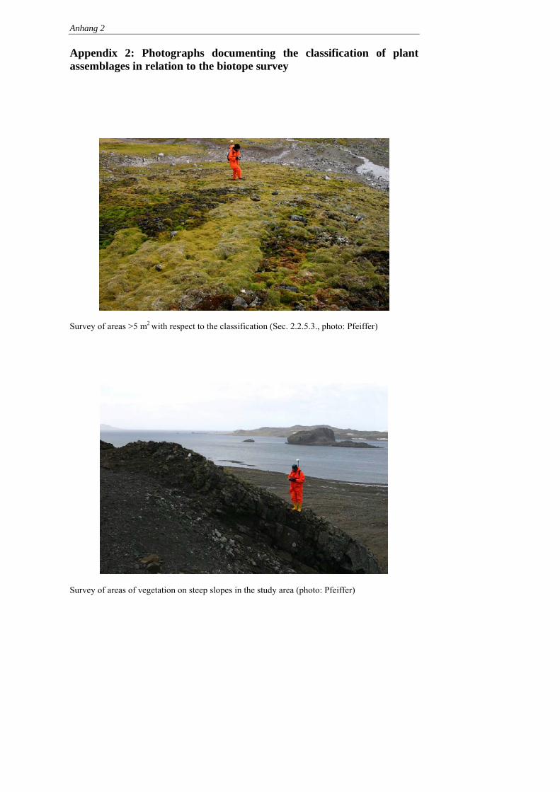
Anhang 2
Appendix 2: Photographs documenting the classification of plant assemblages in relation to the biotope survey
Survey of areas >5 m2 with respect to the classification (Sec. 2.2.5.3., photo: Pfeiffer)
Survey of areas of vegetation on steep slopes in the study area (photo: Pfeiffer)
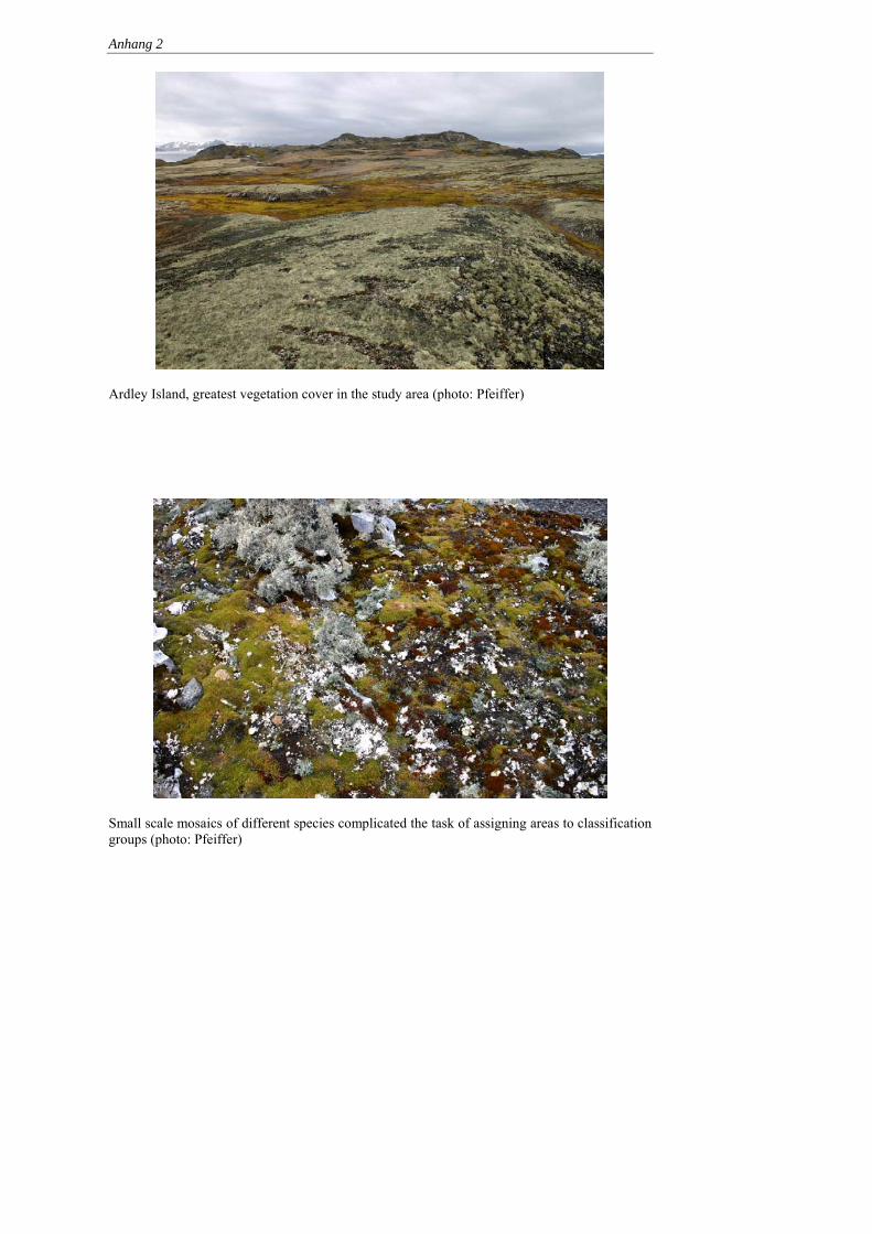
Anhang 2
Ardley Island, greatest vegetation cover in the study area (photo: Pfeiffer)
Small scale mosaics of different species complicated the task of assigning areas to classification groups (photo: Pfeiffer)

Anhang 2
Classification 1a Deschampsia antarctica (subformation flowering plants, photo: Pfeiffer)
Classification 2a Caloplaca sp. (subformation crustose lichens, photo: Pfeiffer)

Anhang 2
Classification 2a Caloplaca sp. (subformation crustose lichens, photo: Pfeiffer)
Classification 2a1 Caloplaca regalis, Haematomma erythromma, Usnea sp., Caloplaca sublobulata, Xanthoria elegans, Physcia caesia (subformation crustose lichens, photo: Pfeiffer)
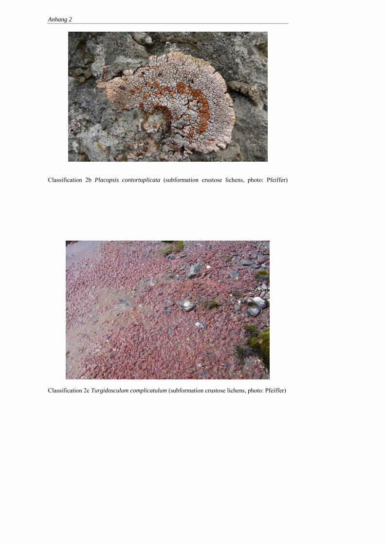
Anhang 2
Classification 2b Placopsis contortuplicata (subformation crustose lichens, photo: Pfeiffer)
Classification 2c Turgidosculum complicatulum (subformation crustose lichens, photo: Pfeiffer)

Anhang 2
Classification 2d Rhizocarpon geographicum (subformation crustose lichens, photo: Buesser)
Classification 3a2 Usnea – Himantormia (subformation foliose lichens and cushion mosses, photo: Pfeiffer)

Anhang 2
Classification 3a3 Andreaea (subformation foliose lichens and cushion mosses, photo: Pfeiffer)
Classification 3a4 Andreaea+Ochrolechia frigida (subformation foliose lichens and cushion mosses, photo: Pfeiffer)

Anhang 2
Classification 3a5 Himantormia sp. (subformation foliose lichens and cushion mosses, photo: Pfeiffer)
Classification 3a6 Usnea aurantiaco-atra, Usnea antarctica, Polytrichastrum alpinum, Phaerophorus globosus, Stereocaulon alpinum (subformation foliose lichens and cushion mosses, photo: Pfeiffer)
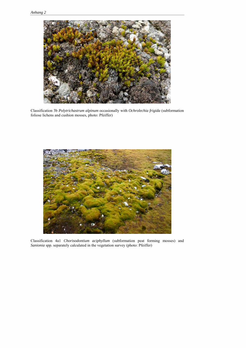
Anhang 2
Classification 3b Polytrichastrum alpinum occasionally with Ochrolechia frigida (subformation foliose lichens and cushion mosses, photo: Pfeiffer)
Classification 4a1 Chorisodontium aciphyllum (subformation peat forming mosses) and Sanionia spp. separately calculated in the vegetation survey (photo: Pfeiffer)

Anhang 2
Classification 4a3 Polytrichastrum alpinum (subformation peat forming mosses, photo: Pfeiffer)
Classification 5b Sanionia uncinata (subformation carpet mosses, photo: Pfeiffer)

Anhang 2
Classification 5b1 Sanionia uncinata + crustose lichens on scree and possibly Andreaea (subformation carpet mosses, photo: Pfeiffer)
Classification 5c Syntrichia princeps (subformation carpet mosses, photo: Pfeiffer)

Anhang 2
Classification 6d Warnstorfia sp. (subformation cushion mosses, photo: Pfeiffer)
Classification 7a Prasiola crispa (subformation algae, photo: Pfeiffer

Appendix 3 List of the plant samples deposited in herbaria
Sample number
Sample collection
date
Sample taken at Easting (UTM)
Northing (UTM)
Species
O54_2 18.01.05 Fildes Peninsula Warnstorfia sarmentosa O54_3 18.01.05 Fildes Peninsula Sanionia uncinata O54_4 18.01.05 Fildes Peninsula Bryum pseudotriquetrum B61_2 19.01.05 Fildes Peninsula 397082 3101710 Bryum confusum B96_2 20.01.05 Fildes Peninsula 398019 3101366 Warnstorfia sarmentosa B96_3 20.01.05 Fildes Peninsula 398019 3101366 Bryum pallescens
Warnstorfia sarmentosa B100_2 20.01.05 Fildes Peninsula 398027 3101375 Syntrichia filaris
Sanionia uncinata B103_2 20.01.05 Fildes Peninsula 398113 3101368 Kiaeria pumila
Bryum pseudotriquetrum B103_3 20.01.05 Fildes Peninsula 398113 3101368 Andreaea regularis B114_2 20.01.05 Fildes Peninsula 398247 3101153 Sanionia uncinata B114_3 20.01.05 Fildes Peninsula 398247 3101153 Andreaea regularis B120_2 21.01.05 Fildes Peninsula 397828 3101312 Sanionia uncinata
Polytrichatrum alpinum O112_2 21.01.05 Fildes Peninsula 397865 3101246 Warnstorfia sarmentosa
Sanionia uncinata O116_2 21.01.05 Fildes Peninsula 397893 3101043 Bryum confusum B161_3 22.01.05 Ardley Island 398844 3100754 Polytrichatrum alpinum
Pachyglossa dissitifolia O173_4 22.01.05 Ardley Island 399000 3100545 Polytrichatrum alpinum
Cephaloziella varians B203_3 24.01.05 Ardley Island 399046 3100993 Kiaeria pumila B203_4 24.01.05 Ardley Island 399046 3100993 Andreaea regularis
Sanionia uncinata O261_2 25.01.05 Ardley Island 399460 3100918 Bryum pseudotriquetrum B277_2 27.01.05 Ardley Island 399145 3100709 Andreaea regularis O363_2 28.01.05 Fildes Peninsula 397929 3102532 Warnstorfia sarmentosa

Anhang 3
O363_3 28.01.05 Fildes Peninsula 397929 3102532 Syntrichia filaris O363_4 28.01.05 Fildes Peninsula 397929 3102532 Bryum pseudotriquetrum
Sanionia uncinata O364_2 28.01.05 Fildes Peninsula 397977 3102536 Campylium polygamum B377_4 01.02.05 Ardley Island 399522 3100930 Brachythecium austrosalebrosum B377_5 01.02.05 Ardley Island 399522 3100930 Syntrichia princeps B435_4 02.02.05 Ardley Island 399504 3100677 Conostomum magellanicum O526_2 03.02.05 Ardley Island 399719 3100863 Polytrichastrum alpinum
Sanionia uncinata O527_2 03.02.05 Ardley Island 399747 3100863 Bryum confusum O527_3 03.02.05 Ardley Island 399747 3100863 Syntrichia filaris O528_2 03.02.05 Ardley Island 399789 3100901 Syntrichia princeps B533_6 03.02.05 Ardley Island 400279 3100552 Schistidium antarctici O588_4 05.02.05 Fildes Peninsula 397864 3100759 Sanionia uncinata O588_5 05.02.05 Fildes Peninsula 397864 3100759 Syntrichia filaris B606_2 07.02.05 Ardley Island 399644 3100801 Syntrichia saxicola B608_3 07.02.05 Ardley Island 399647 3100793 Syntrichia saxicola B616_2 07.02.05 Ardley Island 399698 3100791 Sanionia uncinata B616_3 07.02.05 Ardley Island 399698 3100791 Syntrichia filaris B616_4 07.02.05 Ardley Island 399698 3100791 Brachythecium austrosalebrosum
Syntrichia princeps B631_2 07.02.05 Ardley Island 400074 3100661 Sanionia uncinata B631_3 07.02.05 Ardley Island 400074 3100661 Warnstorfia fontinaliopsis B725_2 13.02.05 Fildes Peninsula 397964 3102007 Meesia uliginosa O749_2 14.02.05 Fildes Peninsula 397765 3102083 Ceratodon purpureus B821_2 15.02.05 Fildes Peninsula 396817 3102661 Brachythecium austrosalebrosum B821_3 15.02.05 Fildes Peninsula 396817 3102661 Bryum confusum B861_4 16.02.05 Ardley Island 399718 3100643 Chorisodontium aciphyllum B861_5 16.02.05 Ardley Island 399718 3100643 Andreaea depressinervis B866_4 16.02.05 Ardley Island 399697 3100668 Andreaea regularis B907_3 17.02.05 Ardley Island 399547 3100493 Andreaea regularis B907_4 17.02.05 Ardley Island 399547 3100493 Andreaea regularis B934_2 18.02.05 Fildes Peninsula 398439 3102262 Sanionia uncinata
Bartramia patens B934_3 18.02.05 Fildes Peninsula 398439 3102262 Brachythecium austrosalebrosum

Anhang 3
B934_4 18.02.05 Fildes Peninsula 398439 3102262 Campylium polygamum B906_3 17.02.05 Ardley Island 399553 3100530 Andreaea regularis 1 23.12.05 Beach east of
Artigas Ceratodon purpureus (Hedw.) Brid.
2 23.12.05 Beach east of Artigas
Bryum archangelicum Bruch & Schimp. (= B. amblyodon Müll.Hal.)
3 23.12.05 Beach east of Artigas
Ceratodon purpureus (Hedw.) Brid. Pertusaria epibryon Ochrolechia frigida Lepraria sp. Psoroma sp. Leptogium puberulum
4 23.12.05 East of Artigas, Glacier moraine
Andreaea gainii Cardot
5 23.12.05 East of Artigas, Glacier moraine
Bartramia patens Brid. (A), Ceratodon purpureus (Hedw.) Brid. (B) Sanionia uncinata (Hedw.) Loeske (C)
7 26.12.05 West of airport Syntrichia magellanica (Mont.) R.H.Zander Bryum pseudotriquetrum (Hedw.) P.Gaertn., B.Mey. & Scherb.
8 02.01.06 Between Bellingshausen and Bulk tank farm West of Punta Lapidario Neftebasa
Psoroma hypnorum
9 03.01.06 Neftebasa Pannaria austro-orcadensis Pannaria caespitosa Catillaria contristans Psoroma hypnorum Leptogium puberlum Lepraris sp.
10 04.01.06 Neftebasa Pannaria austro-orcadensis Pannaria caespitosa
Kommentar: Übersetzung korrekt?

Anhang 3
Catillaria contristans Psoroma hypnorum
11 04.01.06 Neftebasa Pannaria caespitosa Catillaria contristans
14 06.01.06 Biologenbucht Warnstorfia sarmentosa (Wahlenb.) Hedenäs (A) Cephaloziella varians (Gottsche) Steph.
15 07.01.06 Great Wall Ochrolechia frigida 16 07.01.06 Great Wall Pannaria caespitosa 19 11.01.06 Scree slope, Bay in
front of Flat Top Bartramia patens Brid. (A)
Bryum archangelicum Bruch & Schimp. (B)
20 12.01.06 Biologenbucht Campylium polygamum (Schimp.) C.E.O.Jensen (A) Brachythecium austrosalebrosum (Müll.Hal.) Kindb. (B)
21 12.01.06 Biologenbucht Syntrichia saxicola (Cardot) R.H.Zander Cetapyrenium lachneoides Leptogium puberulum
22 12.01.06 Biologenbucht Syntrichia saxicola (Cardot) R.H.Zander (A), Pohlia cruda (Hedw.) Lindb. (B) Ditrichum hyalinum (Mitt.) Kuntze Cetapyrenium lachneoides Pertusaria epibrium
23 10.02.06 Great Wall Deschampsia spec. 24 10.02.06 Great Wall Poa cf. annua

Appendix 4: Fildes Peninsula – questionnaire to station members
This survey is conducted by scientists at Jena University and Germany’s Federal Environment Agency to assemble data on station personnel and the activities that interest them on the Fildes Peninsula. These German scientists are carrying out a 3-year monitoring study covering the distribution flora and fauna and the impact of human activity on the Fildes Peninsula and surrounding islands. By answering the following questions you will be supporting this research project and contributing to the protection of the environment in the world around your station. Many thanks. Answers remain anonymous. First tell us a little about yourself that will help us better to categorise the answers.
Gender: � Male � Female
� < 15 � 15-24 � 25-34 � Age:
� 35-44 � 45-54 � 55-64 � > 64
Occupation: ______________ Nationality: ___________
How often have you worked in the Antarctic?
How many times have you overwintered in the Antarctic
This is my first time This is my 2nd time 3-5 times
6-10 times > 10 times
Have you also worked in another Antarctic stations Yes No
How did you travel to this station?
By air by research vessel by supply ship
By cruise vessel Name:__________________
1. What made you decide to work in the Antarctic? (multiple choice)
The work is well-paid.
I wanted to work abroad for a while.

ii
I wanted to go to Antarctica because it is a special place (e.g. in respect of
nature).
I’m working on a special project in the Antarctic.
I wanted to work where I could meet people from other countries.
Other reason:
2. Have you read or would you be interested in reading about Antarctica?
read already interested not interested History of discovery Flora and fauna Geology and glaciers Climate Other: Now we would like to know how you spend you leisure time outside the station. 3. How many leisure hours do you spend outside the station?
< 1 hour per week 1-5 hours per week 6-10 hours per week > 10 hours per week
4. Do you walk then….? alone in groups both 5. Where and to what extent do you spend your free time?
Once every season
Once a month
Once a week
Several times a week
Going to watch animals Going for a walk (in the direction of another station)
Going to another station (e.g. to make a phone call)
Going to the beach
iii
6. Do you stay on roads and paths on your walks? always mostly rarely
7. Please tell us to what extent you agree with these statements.
Statement % of sample reject
% of sample agree
X2 value p - value
No need for behavioural rules for station personnel outside stations
Personnel should be free to go into all areas
Station personnel should be allowed to visit some animal groups to photograph and observe at closer range
On Fildes marked paths should lead to areas with interesting animals, plants and landscapes
Information boards should inform on species present and environmental problems
Personnel on Fildes should be guided when they leave official paths
All visitors to Ardley Island should be given an introduction to indigenous flora and fauna
Informative material on local species and environmental problems should be displayed in the station
Behavioural rules for personnel should differ from those in force for tourists (3 examples follow)
Example 1: personnel should be permitted to view animals from less than 5 m
Example 2: personnel should be allowed to take small souvenirs of their stay in Antarctica from nature
Example 3: there should be official angling sites for personnel in the area surrounding Fildes
More tourists should visit the station Events such as marathon runs should happen more often
Tourists should be allowed to overnight in the station when there is enough room

iv
8. Are you aware of the national guidelines for visitors to Antarctica? Yes No
9. Did you have an opportunity to attend a lecture on behavioural guidelines on
approaching animals and plants in Antarctica? Yes No 10. Would you like to learn more about the flora and fauna from scientists working
in the region? Yes No Thank you for answering the questions.

Appendix 5: Possible Modules of a Management Plan for Antarctic Specially Managed Area No. ***, Fildes Peninsula Region, South Shetland Islands
Preamble The Fildes Peninsula and Ardley Island (King George Island, South Shetlands, Maritime Antarctic) are intensively used for scientific, logistic and tourism-related activities by several nations. This multitude of activities obviously affects the environment in that area and often leads to conflicts of interest between nature conservation, science, logistics and tourism. In response to these conflicts, a research project commissioned by the German Federal Environment Agency has been conducted since 2003 on the Fildes Peninsula, Ardley Island and associated small islands (the Fildes Peninsula Region, hereafter Region). This project is designed to provide data for a full evaluation of the role and structure of a possible broad-scale management system which could supplement the existing protection provided by ASPAs to parts of the Region. Germany carried out this project for a number of reasons. One is that German scientists have been regularly present in the Region since 1979. Their activities have been focused particularly on the collection of environmental and biological information. Furthermore, the project can be seen as a result of the joint United Kingdom and Germany Inspection Programme conducted in the Antarctic Peninsula area in January, 1999. This Inspection produced the recommendation that “... consideration could be given towards further enhancing cooperation for example in logistic support, consistency in waste management procedures and a critical examination of scientific programmes to optimise productivity and minimise duplication”. A second inspection was conducted in February 2005 by the United Kingdom, Australia and Peru (XXVIII ATCM, WP 32, Stockholm 2005). This inspection covered the Bellingshausen and Great Wall research stations which lie close to each other near Maxwell Bay in the Region. The team found relatively little co-operation on science between these stations and no consistent or focused approach to monitoring. The team welcomed the initial consultations that had been made, and the baseline surveys then underway, carried out with the aim of proposing the Region as an Antarctic Specially Managed Area. The following text includes “Possible Modules of a ‘Fildes Peninsula Region’ ASMA” in order to stimulate discussion of a management system. These modules are not the only ones possible and the authors are likewise aware that the proposal is incomplete. There are, of course, several different possible management approaches and, as well as the proposed modules, all practicable options should be discussed. It should also be emphasised that the development of a management plan can be achieved only in close co-operation with all the Antarctic Treaty signatories represented in the area.
Appendix 5
Please note that the proposal has been elaborated according to the “Guide for the preparation of Management Plans for Antarctic Specially Protected Areas” and geared to the structure of the Deception Island Management Package.
Table of Contents
Introduction
1. Description of Values
2. Aims and Objectives
3. Management Activities
4. Period of Designation
5. Description of the Area
i. Geographical Co-ordinates, Boundary Markers, and Natural Features
ii. Structures within the Area
6. Protected Areas and Managed Zones within the ASMA
i. Protected Areas and Historical Monuments
ii. Managed Zones within the Area
7. Code of Conduct
i. Access to and movement within the Area
ii. Activities allowed in the Area
iii. Installation, modification, or removal of structures
iv. Reporting requirements
8. Maps
9. Supporting documents
Appendix 1: Management Plan for ASPA No. 150 – Ardley Island
Appendix 2: Management Plan for ASPA No. 125 – Fildes Peninsula
Appendix 3: Code of Conduct for Facility Zones
Appendix 4: Code of Conduct of Scientific Research
Appendix 5: Code of Conduct for Visitors

Appendix 5
Introduction The Fildes Peninsula, Ardley Island and adjacent small islands (hereafter “Region”) forms the south-western part of King George Island, one of the South Shetland Islands in the Maritime Antarctic. The Region is a large ice-free area with important natural, scientific, educational, aesthetic, wilderness and historical values. The Region is intensively used for scientific, logistic and tourism-related activities and, during the years since 1968, seven nations (Argentina, Brazil, Chile, China, German Democratic Republic, Russia, and Uruguay) established research stations and field huts there. In addition, in 1980 Chile built a hard runway capable of handling intercontinental and intracontinental flights for transporting cargo, station personnel, and visitors. Supply, research and tourist vessels frequently anchor in Maxwell Bay. Scientific programs underway in the Region include several atmospheric, glacial, geological and biological investigations. Due to its high species diversity, Ardley Island has been designated as an Antarctic Specially Protected Area (ASPA, formerly SSSI) that includes a visitor zone for station personnel and tourists. Two fossil-rich geological sites are also designated as an ASPA although this designation ceases on 31 December 2010. Ship-based tourism occurs on a regular basis and combined air and ship tourism is currently developing. There are frequent over flights. Sporting competitions (e.g. marathon), glacier climbing, camping and diving have taken place in recent years, illustrating the diverse spectrum of non-governmental activities in the area. Human activities occurring during the breeding and moulting seasons of birds or seals produce conflicts of interest between nature conservation, science, logistics and tourism. The designation of the area as an Antarctic Specially Managed Area (ASMA) offers an integrated strategy to manage these conflicts and to minimise the impact of diverse human activities.
1. Description of Values The Region has important natural, scientific, educational, aesthetic, wilderness and historical values. i. Natural Value This large ice-free area contains diverse fauna and flora as well as special geological features, such as fossils and Tertiary rock strata. This peninsula and neighbouring islands (Ardley, Geologists, Two Summit, Dart and Diomedea) are breeding sites for thirteen species of seabirds and three species of seals. Of special interest are the large breeding colonies of Southern giant petrels, Gentoo penguins, skuas and storm petrels. Ardley Island has a varied vegetation particular to the Region of lichen and moss.

Appendix 5
ii. Scientific Value The Region is of great interest for science and several nations exploit the easy access to ice-free areas. The local fauna and flora offers unrivalled opportunities of gaining an understanding of adaptation to extreme environments. In addition, the more than 30 years of research in the Region has produced several long-term sets of environmental data including meteorological and biological observations. Unique international scientific co-operation has developed, particularly in relation to seabird censuses and behavioural and physiological studies on penguins, skuas and petrels. Likewise, international field research is run in parallel by botanists, marine biologists, microbiologists, geologists, glaciologists, oceanographers, physicists and meteorologists. The concentration of stations offers a platform for communication and interdisciplinary approaches. iii. Educational Value The Region is a peep hole into the Antarctic ecosystem. The airport offers the opportunity to fly in visitors for a few hours or days to receive a first impression of the Antarctic. Visitors have the opportunity to watch wildlife, to visit research stations and to experience international cooperation in science and logistics. INSPIRE (formerly Mission Antarctica) initiated an environmental programme in 2001. Large amounts of scrap from the Russian Station Bellingshausen were removed in a three-year project. In parallel, an education programme was run with international pupils, teachers and sponsors to enhance interest and increase funding for further activities in the locality. iv. Aesthetic Value The Region offers a wide spectrum of habitats and landscapes ranging from small wildlife hotspots to large glaciers, quiet inlets, and volcanic rock formations. The west coast of the Fildes Peninsula faces the winds and strong surges of the Drake Passage, while on the east there are the calm waters of Maxwell Bay. The narrow Fildes Strait, with its strong currents around small islands, allows stupendous views towards the Drake Passage, Maxwell Bay and the glacier on Nelson Island. v. Historic Value The sheltered waters of Maxwell Bay offered a relatively easy landing place for early explorers, whalers and sealers, and some traces remain. Near Suffield Point, Fildes Peninsula (62°11´12″S, 58° 54´02″W), a dry-stone wall enclosing three sides of an area roughly 2.40 by 2.40m was described close to the cliff (Lewis-Smith & Simpson, 1987). Stehberg (1983) excavated this site and found a small iron pot 'of European origin'. Also at Suffield Point, the remnants of a wreaked ship still lie in the water and at the beach
Appendix 5
near the Uruguayan station in Maxwell Bay. The remains are probably from a sailing ship built in the second half of the 19th century. A detailed description was given by Uruguay to CEP VII (XXVII ATCM/IP 107). Furthermore, two historical sites have been designated and marked in the Area (Nos. 50 and 52 in the list of Historic Sites and Monuments, http://www.cep.aq/apa/hsm/sites/). There is a plaque on a sea cliff south-west of the Chilean and Russian stations. This commemorates the landing in February 1976 of the first Polish Antarctic maritime research expedition which involved the research vessel Professor Siedlecki, the trawler Tazar and their crews. There is also a monolith erected to commemorate the establishment on 20 February 1985 of the Chinese Great Wall Station by the First Chinese Antarctic Research Expedition. 2. Aims and Objectives This plan aims to apply current information and best practice approaches to facilitate the orderly management of conflicting interests in the Region. The management plan could minimise the negative effects of human activities on natural values and scientific work. The diverse and intensive use of the Region is expected to continue and increase in the near future. For these reasons, the objectives of the management plan are: • to improve co-operation and co-ordination of activities between Antarctic Treaty
Parties operating in the Region; • to solve existing and avert potential conflicts of interest between logistic, scientific,
and tourist activities; This could also include: • reduce unnecessary degradation of natural values by human disturbances; • state how the protected values of the Region or of each zone of the Region are to be
conserved; • support the use of aircraft, watercraft and land vehicles in a way that minimises
environmental impacts; • increase the efficiency of scientific and logistic operations caused by more intensive
co-operation and co-ordination; • promote the environmentally compatible dismantling and removal of unused
infrastructure (buildings, roads etc.); • avoid further construction of all kinds except for scientific purposes; • protect sensitive sites within the Region ( e.g. breeding and resting sites of birds and
seals); • manage tourism and improve environmental education within the Region; • minimise the risk of introducing into the Region of alien plants, animals and
microbes.

Appendix 5
3. Management Activities To achieve the aims and objectives of this Management Plan, the following management activities could be undertaken in the Region: • A Fildes Peninsula Region Management Group could be established to
- oversee the co-ordination of activities; - facilitate communication between those working in, or visiting; - maintain a record of all activities; - disseminate information and educational material on the significance of the Region
to those visiting, or working there; - monitor the site to investigate cumulative impacts; - oversee the implementation of the Management Plan and revise it when necessary.
• A general Fildes Peninsula Region Code of Conduct, supplemented by Codes of
Conduct for Facilities Zones (Appendix 3), Codes of Conduct for Scientific Research (Appendix 4) and Codes of Conduct for Visitors (Appendix 5) could be used to guide and control activities within the Region.
• National Antarctic Programmes operating within the Region could ensure that their
personnel are briefed on, and are aware of, the requirements of the Management Plan and supplemental documents.
• Tour operators visiting the Region could ensure that their staff, crew and passengers
are briefed on, and are aware of, the requirements of the Management Plan and supplemental documents.
• Signs and markers could be erected where necessary and appropriate to show the
boundaries of ASPAs, and other zones. They would need to be informative and unobtrusive. They would also have to be secured and maintained in good condition and removed when no longer necessary.
• Contingency plans for stations emergencies, oil spills and other accidents with
possible significant negative impacts on the environment could be harmonised. They could be made available for station personnel and visitors in the Antarctic Treaty languages (English, French, Russian and Spanish).
• Copies of the Management Plan and supplementing documents and maps could be
made available for station personnel and visitors in the Antarctic Treaty languages (English, French, Russian and Spanish).

Appendix 5
• The management options required for adjacent marine areas could be identified and evaluated.
4. Period of Designation The ASMA could be designated for an indefinite period of time. 5. Description of the Area i. Geographical Co-ordinates, Boundary Markers and Natural Features General description The ASMA proposed comprises the land of the Fildes Peninsula and adjacent islands plus the sea along the coast of this land area extending 0.25 nautical mile (~ 460 m) seaward. This area lies approximately within the range 62°08´16´´S – 62°14´26´´S, 58°50´36´´W – 58°02´45´´W. The marine areas are included following the guidance of the “Working Paper on Guidelines for the Operation of Aircraft near Concentrations of Birds in Antarctica” (XXVII ATCM, WP 010, Cape Town 2004). The Region is bounded on the northwest by the Drake site in Potrebski Cove and on the north east by a point 0.25 nautical mile east of Nebles Point in Maxwell Bay. The southern border would be the Fildes Strait including all islands north of Nelson Island. The most westerly point would lie ¼ nautical mile westwards of Flat Top Peninsula. This could, furthermore, include ASPA No. 125 and ASPA No. 150. The total area of the proposed ASMA would be 63km2. Of the terrestrial part of this area about 20% is currently covered by the Collins Glacier. The suggested name of this ASAM is the Fildes Peninsula Region ASAM. Geology and geomorphology The western part of King George Island is volcanic rock of early Tertiary origin (45-60 Ma, Smellie et al., 1984). Two stratigraphic sequences are distinguished – the Fildes and the Hennequin formation. The Fildes Formation is characterised by weathered olivine-basalts and basaltic andesites, rare pyroxene-andesites and dacites. Flat Top, Horatio Stump and Gemel Peaks are volcanic plugs and represent former volcanic centres on the Fildes Peninsula. The northern part of the Peninsula is formed by the Davies Heights (80-160m a.s.l.) above sea level. The southern part is characterised by various elevations and hills. In this part Horatio Stump is the highest point of the Fildes Peninsula (166.60 m a.s.l.).
Appendix 5
Climate The area belongs to the cold climate region of the maritime Antarctic. Meteorological data of the Russian Station Bellingshausen (http://south.aari.nw.ru/default_en.html) show comparatively high precipitation (~700mm per year) and strong westerly winds. Cyclones with speeds exceeding 100km/hour are typical. Mean temperatures vary between 1.5°C in summer (January/February) and -6.5°C in winter (July/August). Snowmelt starts by the end of October. During winter the surrounding waters are covered with fast sea ice but the duration of ice cover varies greatly between years. Fauna Thirteen species of seabirds breed in the Region. In 2004/05 our counts indicated over 5000 pairs of penguins breeding on Ardley Island: Adelie (Pygoscelis adeliae, 409 breeding pairs), Chinstrap (P. antarctica, 13) and Gentoo (P. papua, 4798). The largest breeding sites of Southern giant petrels (Macronectes giganteus) can be found on Dart and Two Summit Island and, with several small colonies, the total population in the Region amounts to ~330 breeding pairs. Brown and South Polar skuas (Catharacta antarctica lonnbergi ~80 breeding pairs and C. maccormicki ~220 breeding pairs) live sympatrically in loose colonies and sometimes hybridise (about 30 mixed pairs). Kelp gulls (Larus dominicanus), Antarctic terns (Sterna vittata), and Cape petrels (Daption capensis) breed along the rocky coast line in groups ranging from single nests to medium-sized colonies. Wilson’s storm petrels and Black-bellied storm petrel (Oceanites oceanicus and Fregetta tropica) breed on scree further inland in colonies of several hundred to a thousand pairs. Sheathbills (Chionis alba) breed in the southwest part of the Fildes Peninsula. Blue-eyed shags (Phalacrocorax atriceps) have been breeding in the Region in recent years and could have nests on inaccessible islands or rocks. Several species visit the Region more or less frequently (South Georgia pintail (Anas georgica), Emperor penguin (Aptenodytes forsteri) and King penguin (A. patagonicus), Cattle egret (Bubulcus ibis), White-rumped sandpiper (Calidris fuscicollis), Black-necked swan (Cygnus melanocoryphus),Wandering albatross (Diomedea exulans), Black-browed albatross (Diomedea melanophris), Macaroni penguin (Eudyptes chrysolophus), Southern fulmar (Fulmarus glacialoides), Blue petrel (Halobaena caerulea), prions (Pachyptila spp.), Snow petrel (Pagodroma nivea), Light-mantled sooty albatross (Phoebetria palpabrata), Soft-plumaged Petrel (Pterodroma mollis), Pomerine skua (Stercorarius pomarinus), Arctic tern (Sterna paradisaea) and Antarctic petrel (Thalassoica antarctica)). In the summer months more than 600 Elephant seals (Mirounga leonina) and up to 1200 Antarctic fur seals (Arctocephalus gazella) rest and moult in the Region. Furthermore, about 100 Weddell seals (Leptonychotes weddelli) and a few Crabeaters (Lobodon carcinophagus) and Leopard seals (Hydrurga leptonyx) visit the coast at regular
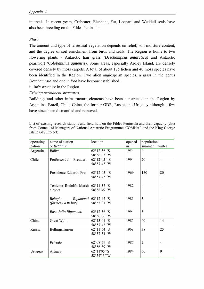
Appendix 5
intervals. In recent years, Crabeater, Elephant, Fur, Leopard and Weddell seals have also been breeding on the Fildes Peninsula. Flora The amount and type of terrestrial vegetation depends on relief, soil moisture content, and the degree of soil enrichment from birds and seals. The Region is home to two flowering plants - Antarctic hair grass (Deschampsia antarctica) and Antarctic pearlwort (Colobanthus quitensis). Some areas, especially Ardley Island, are densely covered densely by moss carpets. A total of about 175 lichen and 40 moss species have been identified in the Region. Two alien angiosperm species, a grass in the genus Deschampsia and one in Poa have become established. ii. Infrastructure in the Region Existing permanent structures Buildings and other infrastructure elements have been constructed in the Region by Argentina, Brazil, Chile, China, the former GDR, Russia and Uruguay although a few have since been dismantled and removed.
List of existing research stations and field huts on the Fildes Peninsula and their capacity (data from Council of Managers of National Antarctic Programmes COMNAP and the King George Island GIS Project). operating nation
name of station or field hut
location opened in
population summer winter
Argentina Ballve 62°12´36´´S 58°56´03´´W
1954 4 -
Chile Professor Julio Escudero 62°12´05 ´´S 58°57´45´´W
1994 20 -
Presidente Eduardo Frei 62°12´03 ´´S 58°57´45´´W
1969 150 80
Teniente Rodolfo Marsh airport
62°11´37´´S 58°58´49´´W
1982 - -
Refugio Ripamonti (former GDR hut)
62°12´42´´S 58°55´01´´W
1981 3 -
Base Julio Ripamonti 62°12´36´´S 58°56´06´´W
1994 3 -
China Great Wall 62°13´01´´S 58°57´43´´W
1985 40 14
Russia
Bellingshausen
62°11´54´´S 58°57´34´´W
1968
38
25
Priroda 62°08´59´´S 58°56´39´´W
1987 2 -
Uruguay Artigas 62°11'05´´S 58°54'13´´W
1984 60 9
Appendix 5
Minor and semi-permanent structures
• Light house on Ardley Island erected by Argentina (at Punta Faro, 62°12´37´´S, 58°55´35´´W)
• Chilean Laboratory (INACH), Laboratorio Radiacion Cosmica, (62°12´08´´S, 58°57´43´´W)
• Fuel tanks of the Russian Station Bellingshausen (62°11´34´´S, 58°56´06´´W) • Russian hut near tanks (62°11´47´´S, 58°56´09´´W) • Memorial cross south west of Frei Station (62°12´08´´S, 58°57´37´´W) • Wooden beacon near highest point on Ardley Island (62°12´52´´S, 58°55´53´´W) • Wooden beacon south west of Frei Station (62°12´19´´S, 58°57´17´´W) • Wooden beacon at Point Christian (62°11´55´´S, 58°56´57´´W) • Memorial stone on the former position of the Brazilian field hut “Rambo”
(62°09´55´´S, 58°57´56´´W) 6. Protected Areas and Managed Zones within the ASMA i. Protected Areas, Historic Sites and Monuments Within the proposed ASMA, two areas are designated as ASPAs and two as HSMs. In addition, there is a ship wreck that should probably be listed eventually as a HSM. • ASPA No. 125 comprising two geologically interesting sites on the Fildes Peninsula
(62°10´50´´ - 62°11´28´´S, 58°55´27´´ -58°56´38´´W, and 62°12´30´´ - 62°13´30´´S, 58°57´11´´ - 58°59´32´´W)
• ASPA No. 150 comprising Ardley Island (62°12´30´´ - 62°13´06´´S, 58°54´53´´ - 58°57´09´´W)
• HSM No. 50 plaque on a cliff south-west of the Chilean station Frei to commemorate the Polish research vessel ‘Professor Siedlecki’ and trawler ‘Tazar’
• HSM No. 52 monolith in the Chinese Station Great Wall to commemorate the foundation of the station
• Ship wreck in Maxwell Bay (62°11´12´´S, 58°54´02´´W; IP107, ATCM XXVII, Cape Town)
ii. Managed Zones within the Area The aim of zoning is to protect the natural and cultural features of the Region by defining suitable areas for the different kinds of activity. The proposed plan divides the ASMA into five types of zone (areas with threatened species, vegetation, sensitive geological features etc.) and defines the kind and amount of human activity appropriate to each. The five kinds of zone are Facility Zones, Restricted access Zones, Sensitive Zones, Visitor Zones and Wilderness Zones (see Map 3). The following zoning system is suggested:
Appendix 5
Facility Zones These zones provide suitable locations in which access and support operations can be conducted and permanent facilities located. These zones should thus incorporate all research stations, the airport, official roads, and all other kinds of infrastructure. Some sea areas and air space should also be included to accommodate the air and sea traffic of the Region. Special management guidelines should be applied in these zones to ensure environmental and human safety (see Map 3 and Appendix 3). Visitor Zones These zones provide appropriate management of low-impact, short-term, land-based visitor activities in the Region. They help balance the need to protect nature while, at the same time, maximising visitor experience and enjoyment. These zones can be safely accessed and offer a range of attractions in close proximity. There is already one Visitor Zone in ASPA No. 150 near the penguin rookery in the northern part of Ardley Island. Further Visitor Zones, including recommended walking routes or foot paths, could be established near the Russian hut “Priroda”, the Chilean and Russian stations, the western coast between the airport and Flat Top Hill, along the beach south of the Chinese station, and east of the Uruguayan station towards Nebles Point (Map 3, see Appendix 6). Sensitive Zones These would include places of special biological interest such as patches of dense vegetation, sites occupied by medium-sized breeding groups of Southern giant petrels, or other seabird and seal sites. This classification would ensure that visitors were aware of the vunerability of species at these sites. Human activities should be minimised in these zones and permanent facilities should not be installed. Possible Sensitive Zones (see Map 3) are: • Geologists Island (northern part): breeding site of Southern giant petrels • South Fildes opposite Dart Island: breeding site of Southern giant petrels • East of the Russian hut “Priroda”: breeding site of Southern giant petrels • Nebles Point: breeding site of Southern giant petrels • dense vegetation • Northwest corner of Ardley Island: breeding site of Southern giant petrels Restricted Zones These comprise areas of natural value that are highly sensitive to damage by human activities. In these areas it is desirable that human disturbance is kept to the absolute minimum. Two Summit Island and Dart Island could be defined as Restricted Zones (see Map 3), because large numbers of Southern Giant petrels (IUCN red species list,

Appendix 5
category ‘Vulnerable’) breed on these islands. Human visits to these colonies should be prevented because they would cause nesting birds to fly off the nest and this in turn could allow increased predation on eggs and chicks. Landing helicopters on these islands should also be prevented, a practice that might interest helicopter operators if tourism increases further. The prevention should extend to helicopter sightseeing as this could also threaten the birds. Zoning as restricted would aid in minimising such problems. To maintain the undisturbed state of areas so zoned, only very important scientific research and unavoidable management activity should be allowed. Wilderness Zones These would cover all areas within the ASMA not classified as Facility Zones, Restricted Zones, Sensitive Zones or Visitor Zones. Management of human activities should aim to maintain the quality of a relatively undisturbed wilderness. Establishing permanent facilities should therefore not be permitted in these zones but scientific research, environmental monitoring and management activities should be allowed. 7. Code of Conduct The general management and operational requirements are stated in the following. Additional guidelines are given in the Appendices. i. Access to and movement within the Region Access to the Region is possible by sea and air. Vessels enter Maxwell Bay and anchor within about a hundred meters of the research stations. Zodiacs and other boats transport people and cargo to the main landing sites in front of the stations. Air access is usually through the Chilean airport which is capable of taking large and small fixed-wing machines as well as helicopters. It is the operational centre for a large number of stations in the South Shetland area. Therefore, there are frequent transfers of station personnel, visitors and cargo not only to the research stations of the Fildes Peninsula but also to vessels in Maxwell Bay that supply stations in other regions. Regulation of this traffic requires the designated of specific landing sites for planes and helicopters. Landing at other sites in the Region should be only permitted when supporting scientific investigations. All land traffic and pedestrian movement within the Region should be undertaken in such a way as to minimize damage to vegetated ground and to soils. There should be no extension of the road network between the stations and field huts except for scientific purposes. Foot paths for people working in or visiting the area are already established in the Facility zones and Visitor zones but should be kept to a minimum in all other zones.

Appendix 5
ii. Activities that may be conducted in the Region These activities could include scientific research, logistic operations in support of science, management, visitor activity and education. Science is not restricted at any site but in restricted zones it should be allowed only if absolutely necessary. ASPAs guarantee that science should interfere little with other activities. All other activities should be conducted within the designated zones with logistics being concentrated in facility zones, and visits and education mainly being carried out in visitor zones. This separation of activities reduces cumulative effects on the environment and protects the values of the area. All human activities in the Region should take place in such a way as to minimize detrimental effects on the environmental. Collection and removal of material endogenous to the Region is only to be permitted for scientific, management or educational purposes. iii. Installation, modification or removal of structures Special care has to be taken when installing, modifying or removing infrastructure from any site in the Region. Disturbance of wildlife, movement of soil, noise and pollution should be kept to a minimum. No infrastructure should be permanently installed outside the facility Zones. Environmental impact assessments are essential before any new installation and should be considered by the Region’s Management Group. Field camps for scientific purposes can be set up temporarily in small areas but require the permission of national authorities. A few sites within visitor zones could be used as campsites for tourists but special attention needs to be given to minimising their impact on the environment. Campsites should be located as far away as practicable from wildlife, lakes, streambeds and long-term experiments, to avoid damaging or contaminating them. Individuals or groups should bring sufficient equipment to ensure safety. iv. Reporting requirements Reports of activities in the Region should be coordinated and maintained by the Management Group in order to facilitate science and minimise cumulative effects. Inspection visits should occur frequently and reports on these visits should be considered in order further to reduce detrimental human effects on the environment. Any incidents in which protected values of the Region are damaged need to be reported to the Management Group. Tour operators should report their visits to authorities in the stations that want to be visited and to IAATO.

Appendix 5
8. Maps
Map 1: The Fildes Peninsula Region ASMA No. *** located on King George Island, South Shetland Islands, Antarctica.

Appendix 5
Map 2: The Fildes Peninsula Region ASMA No.***

Appendix 5
Map 3: Proposed zones within the Fildes Peninsula Region ASMA. All areas inside the proposed ASMA that are not classified as one four zone types listed are classified as Wilderness zone.

Appendix 5
9. Supporting Documents • Management Plan for ASPA No. 150 – Ardley Island (Appendix 1) • Management Plan for ASPA No. 125 – Fildes Peninsula (Appendix 2) • Code of Conduct for the Facilities Zones (Appendix 3) • Code of Conduct of Scientific Research (Appendix 4) • Code of Conduct for Visitors (Appendix 5) Appendix 1: Management Plan for ASPA No. 150 – Ardley Island Ardley Island (62°13' S; 58°56' W) was designated as Site of Special Interest (SSSI) No. 33 through Recommendation XVI-2 in 1991. Chile proposed the designation due to the island’s diverse community of birds and terrestrial plants. It since been renamed as Antarctic Specially Protected Area No. 150. The Area is used primarily for intensive research, but also includes a visitor zone. The Area’s management plan is currently under revision (ATCM, 2006). Appendix 2: Management Plan for ASPA No. 125 – Fildes Peninsula The ‘Antarctic Specially Protected Area’ No. 125 (former SPA No. 12 at ATCM IV, Santiago, 1966, redesignated SSSI No. 5 at ATCM VIII, Oslo, 1975) has been designated in order to protect two geologically important sites with unique fossil ichnolites and outcrops of Tertiary strata which, in part, are easily accessible (http://www.cep.aq/apa/aspa/sites/aspa125/summary.html). A scientific survey of fossils in 2003/2004 revealed, apart from the known sites, new fossil localities in the Region. These findings should be taken into account during the revision of ASPA No. 125. Appendix 3: Code of Conduct for the Facility Zones 1. Introduction The Fildes Peninsula Region ASMA contains Facility zones which include P. Frei and Escudero Stations (Chile), Great Wall Station (China), Bellingshausen Station (Russia) and Artigas Station (Uruguay) and the Chilean airport. It also includes infrastructure outside stations (all field huts, fuel tanks, lakes connected with pipelines for water supply), main roads, and beach areas used for logistic operations. Activities within these zones are to be undertaken according to the following Code of Conduct the aims of which are to: • assure the health and safety of station personnel and visitors; • facilitate scientific investigation in the Region by establishing and maintaining
supportive infrastructure; • protect the natural, scientific and cultural values of the Facilities Zone. A copy of the complete Fildes Peninsula Region ASMA Management Package will be kept at the Chilean, Chinese, Russian and Uruguayan Stations where relevant maps and

Appendix 5
information posters about the ASMA will also be available. The Station Leader or the Station Environmental Officer should brief station personnel on arrival about environmental management in the field, the location of protected areas, and the provisions of the ASMA Management Plan. Visitors should be made aware of the content of this Code of Conduct before arriving at the stations. 2. Station operation, construction and removal 2.1. Waste Management Waste management should be included in the planning of all activities at the Chilean, Chinese, Russian and Uruguayan Stations. The detailed instructions are given in Annex III of the Environmental Protocol. Hazardous material should be removed from the Antarctic Treaty Area. Regular cleaning of rubbish from station grounds and surrounding areas reduces its dispersal into the environment by wind or birds. Cooperation between stations in clean-ups can increase their efficiency. Historical waste sites that cause adverse impacts should be cleaned up as soon as possible. 2.2. Use of water Water sources need to be separated from any handling or disposal of wastes, fuel or other chemicals. Regular tests of water quality and routine cleaning of water holding tanks are necessary. Used station water should not be disposed of into the environment without treatment. Filter systems need to comply with current standards. 2.3. Generation of power Regular inspections and modernisation of generators is required to reduce emissions and fuel leaks. Solar and wind power should be used as much as possible to minimize fuel demand. 2.4. Handling of fuel The regular inspection of fuel storage facilities, supply pipe lines, pumps, reels and other fuel handling equipment is of high priority. Storage areas should be secured by sitting them a safe distance from living quarters and from electrical supplies. In order to avoid incidences of fuel spills, e.g. during fuel transfer, all measures must be considered. Any spills must be treated immediately with sufficient equipment (according to Oil Spill Contingency Plans in each station) with all available help by other stations on site. Station personnel should undergo regular emergency training. 2.5. Prevention of fire Flammable substances need to be appropriately labelled. Fire fighting equipment should be available at dangerous sites like fuel stores and vehicle parks. Regular checks of electricity cables reduce the risk of short circuits.

Appendix 5
2.6. Construction and removal of infrastructure An Environmental Impact Assessment should be undertaken before any construction or removal of buildings according to Annex I of the Environmental Protocol. To avoid detrimental effects on the surrounding environment, station areas should not be further extended. 3. Traffic management 3.1. Land traffic Vehicles should only be used around and between the stations when necessary. The existing road network should not be enlarged without a clear scientific or logistic purpose. Appropriate facilities must be provided for secure refuelling and servicing of vehicles. Any wildlife disturbance, vegetation damage, or interference with scientific work should be avoided. 3.2. Air traffic Aircraft will generally take off from and land at the Chilean airport but the helicopter pads at the Chilean, Chinese and Uruguayan Stations can also be used where there is an operation reason. All air traffic should be conducted within the facility zones avoiding all other zones within the ASMA boundary. Special care should be taken when flying over land to reduce potential negative impacts on wildlife. Special guidelines should be followed as stated in the management plan of ASPA No. 150 and adopted ATCM recommendations (see also Harris 2006). 3.3. Sea traffic Small boat and zodiac use should be restricted to the marine parts of the facility zones and only in support of scientific, logistic and tourist operations. All boats need to be operated by more than one person and be equipped with life jackets and VHF radios. Weather conditions need to be suitable to reduce the risk of accidents. For safety a second boat can be used or stay on stand-by for immediate support in an emergency. 4. Field excursions The Station Leader or the Station Environmental Officer will brief field parties on environmental management in the field, the location of protected areas, and the provisions of the ASMA Management Plan. All waste from field parties, except for human waste (faeces, urine and gray water) will be returned to the stations for safe disposal. All field parties will be equipped with VHF radios.
Appendix 5
5. Protected Areas ASPA No. 125 and 150 are located in the Region. Station members will be made aware of the location of these areas and the restrictions on access to them. Information about the ASPAs including the management plans will be displayed in all stations. 6. Flora and fauna Any activity involving the removal or harmful interference with native flora or fauna (Annex II to the Environmental Protocol) is prohibited unless authorised by a permit issued by the appropriate authority. Minimum approach distances to birds or seals should be followed to reduce disturbance. Scientists and visitors should take care near wildlife particularly in the breeding and moulting seasons. Birds are not to be fed on station food. Food wastes should be hidden to prevent scavenging by birds. The introduction of non-native species should be avoided by cleaning clothes, boots and equipment before entering the Region. 7. Visitors Any visits to the Chilean, Chinese, Russian and Uruguayan stations should be arranged by informing the station leaders of the planned activity. Contacts are made via VHF Marine Channel 16. Station Leaders will co-ordinate visits to stations with Expedition Leaders. Visitors will be informed about the principles of this Code of Conduct and the ASMA Management Plan. They should follow visitor guidelines (Recommendation XVIII – 1, IAATO). The station leaders will appoint guides to present station-specific information. These guides should speak a language understood by the visitors. Appendix 4: Code of Conduct of Scientific Research Scientific investigations have priority among human activities in the Antarctic. Science activities in the Region include research on the fauna and flora, on fossils, climate, glaciers, streams, lakes, soils, and local geology and geomorphology. The following guidelines for scientific conduct seek to reduce the environmentally detrimental impact of research in the Region. Standard procedures recommended by the SCAR Code of Conduct for the Use of Animals for Scientific Purposes in Antarctica should be applied by all scientists. 1. Sampling and experimental sites All sampling equipment should be clean before being brought into the field. The location of sampling sites should be recorded. No specimens of any kind, including fossils, should be displaced or collected except for scientific and associated educational purposes. Avoid leaving markers ( e.g. flags) and other equipment for more than one season without marking them clearly with the event number and duration of the project.
Appendix 5
2. Scientific installations For scientific installations (e.g. meteorological stations, geographical installations) take care of the following: • Installations should be located carefully, should be easily removable when required,
and properly secured at all times to avoid dispersal by strong winds. • All installations in the Region should be clearly identified by country, name of the
principal investigator, and year of installation. • Installations should be as energy-efficient as possible and use renewable energy
sources wherever practicable. • Installations should pose minimal risk of harmful impacts on the environment. • Geographic locations of installations should be recorded. 3. Terrestrial fauna und flora Handling, sampling or removal of Antarctic fauna and flora should be kept to the minimum necessary. Field campaigns should be planned carefully to reduce disturbance to a minimum. Movement between working sites should be conducted to minimise harmful interference with wildlife. 4. Streams The geographic location of study plots and instrumentation should be documented. Limit the number of tracer and manipulative experiments. Whenever possible, use modelling approaches to extend the application of experimental results to other sites. Establish specific sites for biomass sampling and document geographic locations, sampling extent, and frequency. Limit biomass sample size to that required for the planned analyses and archiving. 5. Lakes The area and extent of scientific study plots on lakes should be documented. Areas that have been used for sampling or accessing the lake should be reused to the greatest extent possible. To avoid cross contamination, samplers or other instruments used in one lake should be thoroughly cleaned (sterilize if possible) before their reuse in a different lake. 6. Sea Provide adequate training for research divers and support teams so that impacts to the marine environment are minimised. Use technological developments that mitigate the environmental impacts of diving.

Appendix 5
7. Soils Restore disturbed surfaces as closely as possible to their natural state after completing your work. Excavate the smallest amounts of soil possible. Excavations should be backfilled to approximate the original contours. Limit use of mechanical equipment ( e.g. Cobra drills, soil augers). 8. Glaciers Take special security measure working on glaciers. If stakes or other markers are placed on a glacier, use the minimum number of stakes required to meet the needs of the research. When the research is finished remove all materials – wood, metal, and sensors embedded in the ice to minimize contamination. Avoid the use of chemicals and chemical solutions on the ice. Appendix 5: Code of Conduct for Visitors This code of conduct has been produced for all visitors to the Region including commercial tour operators (IAATO and non-IAATO members), private expeditions, and delegations of National Antarctic Programs when undertaking recreational visits. There are a few sites in the Fildes Peninsula Region which may generally be visited: all facility zones, the Russian hut “Priroda”, coastal sites south of the airport towards Flat Top Hill, east of the Uruguayan Station towards Nebles Point, the specified area on Ardley Island, and the beach south of the Chinese station (see Map 3). Visits to the stations are only permitted by prior agreement with the station leaders. Visits to other sites in the Region are discouraged. The following general guidelines apply to all the above sites visited in the Region: • Visits are to be undertaken in line with the Management Plan for the Fildes
Peninsula Region ASMA ***, with Recommendation XVIII –1, and with IAATO visitor guidelines.
• All visits should be conducted in a way to reduce any risk to human safety. • Vessels approaching Maxwell Bay must announce their planned activities via VHF
Marine Channel 16 to the appropriate stations. • Expedition Leaders from cruise ships and captains of other vessels in Maxwell Bay
should wherever practicable contact local authorities to arrange positioning in the anchorage and landing procedures.
• For commercial cruise operators, no more than 100 passengers may be ashore at a site at any time, accompanied by a minimum of one member of the expedition staff for every 20 passengers. For Ardley Island special requirements need to be considered.
• In order to prevent biological introductions, carefully wash boots and clean clothes and equipment before landing.

Appendix 5
• Maintain stated minimum approach distances from birds and seals which will reduce disturbance.
• Do not walk on vegetation. Walking on the alga Prasiola crispa (associated with penguin colonies) is permissible as it will not cause it any adverse disturbance.
• Do not take biological or geological souvenirs or disturb artefacts. • If there is marked path or zone, do not leave it. • Do not leave any litter. • Do not write or draw graffiti on any man-made structure or natural surface. • Do not touch or disturb any types of scientific instruments or markers. • Do not enter any field hut if not permitted. • Station leaders should be asked about site-specific guidelines.
Appendix 6: Alternative Management Approaches for the Fildes Peninsula Region The following possible alternative approaches to conduct management activities in the Area could be considered for discussion within the international framework: 1. Zoning system without ASMA designation 2. Extension of ASPA 125 3. Special guidelines on station activities, science and tourism 4. Maxwell Bay ASMA 5. No changes in the current system 1. Zoning system without ASMA designation A Zoning System without ASMA designation could contribute to protecting the Area in a non-legally binding way. Between 2001 and 2003, studies of the effect of human activities (visits, air traffic) on Southern giant petrels Macronectes giganteus have been conducted on the Fildes Peninsula and the surrounding islands (Pfeiffer, 2005). It was shown that the birds became habituated to human activities in breeding sites that are frequently visited (near the Ripamonti base on Ardley Island). However, breeding birds on remote islands like Geologists, Two Summit or Dart Island reacted strongly with heart-rate increases and behavioural changes to visitors and air traffic. In several cases, human activities caused a loss of eggs or chicks and fly-off of many breeders and non-breeders. Therefore, a zoning system might be recommended to protect the breeding sites. Restricted and Sensitive Zones could be established to manage access to the Southern giant petrel colonies (Harris 1994). For example, Two Summit Island and Dart Island could be classified as Restricted Zones, and Geologists Island as well as breeding sites on the Fildes Peninsula and Ardley Island as Sensitive Zones. However, as these are clearly defined areas and there is only one management objective, it would not be essential to designate these sites as an ‘Antarctic Specially Managed Area’. If the spatial distribution of other seabirds and vegetation were also considered, a larger number of sites could be included as Sensitive Zones. 2. Extension of ASPA No. 125 In the first instance, competence for such an approach would lie with Chile as the original designator of this ASPA. The ‘Antarctic Specially Protected Area’ No. 125 on the Fildes Peninsula was designated in 1981 in order to protect two geologically important sites. A scientific

Appendix 6
survey of fossils in 2003/2004 revealed, apart from the known sites, new fossil localities on the peninsula. These findings should be included in the revision of this ASPA currently being undertaken by Chile. If the area were extended accordingly (south site further southwards, north site to the north), consideration could be given to incorporating other management objectives (protection of bird or seal breeding sites, extensive vegetation patches). 3. Special guidelines concerning tourism, station activities, and science Guidelines are a common instrument to provide direction in a non-legally binding way. In recent ATCMs, site-specific guidelines have been intensively discussed. For a number of frequently visited sites, site guidelines have already been applied by IAATO. A considerable database now exists on the extent of human activities on the Fildes Peninsula and the surrounding islands. This database allows the identification of particular risks and threats. Therefore, specific guidelines for visitors, and also for station personnel and scientists, could be established to increase the temporal and spatial protection of natural values. Additionally, air traffic guidelines could be updated according to new ATCM recommendations. 4. Maxwell Bay ASMA Maxwell Bay is surrounded by a number of ice-free areas holding important seabird breeding sites and other natural values. It is a centre of scientific, logistic and tourist operations. The designation of an ASMA including the Fildes, Weaver, Barton and Potter peninsulas of King George Island, the northern part of Nelson (Stansbury Peninsula, Ruin, O’Cain and Duthoit Point – northeastern part of Nelson Island) and all islands inside the bay would involve all active nations in an integrated management approach (see Map 1). This approach is to be considered as a sensible additional step after designation of Fildes Peninsula Region ASAM. Collecting and evaluating data on environmental parameters and human activities, including their impact, is a necessary requirement before applying this approach.

Appendix 6
Map 1. Maxwell Bay Region, South Shetland Islands, Antarctic. 5. No changes in the current system Although the least favourable option, all existing ASPA boundaries could be kept, and no further management activities would be discussed, if parties agree that no additional protection measures are necessary. However, data collected in recent years suggest the need to update the management of human activities in the Region. It is especially necessary to consider the continuing increase in science, logistics and tourism in the Region and the uncertainties attending the future development of these diverse activities.

Leaf & wood flora from King George Island: Final Report
1
Anatomical and Morphological Assessment of Plant Macrofossils from King George Island, Antarctica Author: Imogen Poole Address: G3, Eiteren 99, 3401 PS, IJsselstein, The Netherlands Email: [email protected] / [email protected] Telephone: 00 31 30 2535068 / 6884513 Date: 8th February 2005
media
Schreibmaschinentext
Appendix 7a

Leaf & wood flora from King George Island: Final Report
2
Contents
1. Introduction ....................................................................................................................... 3
2. Materials and Methods ..................................................................................................... 4
3. Results .............................................................................................................................. 5
4. Discussion ......................................................................................................................... 7
4.1 Leaf material ........................................................................................................ 7
4.1.1 Fossil Hill ............................................................................................... 7
4.1.2 Valley Rio Madera ................................................................................. 9
4.1.3 Glacier ................................................................................................... 9
4.1.4 Northern Plateau .................................................................................. 10
4.2 Wood material ..................................................................................................... 10
4.2.1 Fossil Hill .............................................................................................. 10
4.2.2 Valley Rio Madera ................................................................................ 11
4.2.3 Glacier .................................................................................................. 11
4.2.4 Northern Plateau .................................................................................. 12
4.3 Fertile material .................................................................................................... 13
5. Conclusion ........................................................................................................................ 13
6. References ....................................................................................................................... 14
7. Appendix I
8. Appendix II
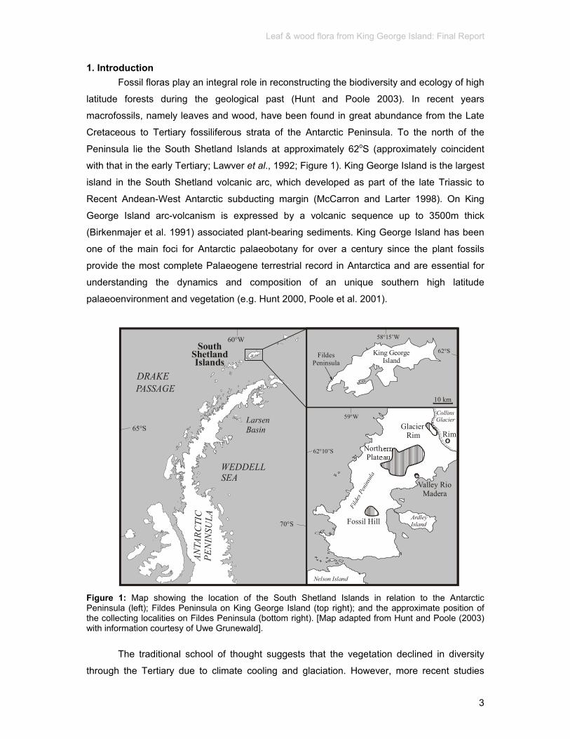
Leaf & wood flora from King George Island: Final Report
3
1. Introduction Fossil floras play an integral role in reconstructing the biodiversity and ecology of high
latitude forests during the geological past (Hunt and Poole 2003). In recent years
macrofossils, namely leaves and wood, have been found in great abundance from the Late
Cretaceous to Tertiary fossiliferous strata of the Antarctic Peninsula. To the north of the
Peninsula lie the South Shetland Islands at approximately 62oS (approximately coincident
with that in the early Tertiary; Lawver et al., 1992; Figure 1). King George Island is the largest
island in the South Shetland volcanic arc, which developed as part of the late Triassic to
Recent Andean-West Antarctic subducting margin (McCarron and Larter 1998). On King
George Island arc-volcanism is expressed by a volcanic sequence up to 3500m thick
(Birkenmajer et al. 1991) associated plant-bearing sediments. King George Island has been
one of the main foci for Antarctic palaeobotany for over a century since the plant fossils
provide the most complete Palaeogene terrestrial record in Antarctica and are essential for
understanding the dynamics and composition of an unique southern high latitude
palaeoenvironment and vegetation (e.g. Hunt 2000, Poole et al. 2001).
65°S
60°W
DRAKEPASSAGE
South ShetlandIslands
WEDDELLSEA
70°S
ANT A
RCTI
CPE
NIN
S UL A
King GeorgeIsland
Fildes Peninsula
Fild
es P
enin
sula
Ardley Island
59°W
62°10’S
Nelson Island
Collins Glacier
10 km
Glacier Rim Rim
62°S
58°15’W
Fossil Hill
Valley RioMadera
Northern Plateau
Figure 1: Map showing the location of the South Shetland Islands in relation to the Antarctic Peninsula (left); Fildes Peninsula on King George Island (top right); and the approximate position of the collecting localities on Fildes Peninsula (bottom right). [Map adapted from Hunt and Poole (2003) with information courtesy of Uwe Grunewald].
The traditional school of thought suggests that the vegetation declined in diversity
through the Tertiary due to climate cooling and glaciation. However, more recent studies

Leaf & wood flora from King George Island: Final Report
4
(e.g. Hunt 2000, Poole et al. 2001, Hunt and Poole 2003) found that vegetation dynamics, as
a result of ecological (volcanically-induced) disturbance, was a causal factor for vegetation
changes through the Tertiary superimposed upon a backdrop of climate deterioration rather
than simply as a result of climate change alone. High diversity floras may represent climax
vegetation whereas low diversity, Nothofagus dominated floras may represent a
successional flora following volcanic disturbance - a scenario similar to that seen in the
Valdivian region of Chile today (Poole et al 2001). Therefore it is not surprising that many
scientific expeditions, from e.g. China, Poland, South America and Britain, have focused (and
still continue to do so) on collecting fossil plants from King George Island.
During the austral summer of 2003-2004 further collections of Tertiary (Eocene) plant
macrofossils were made by Uwe Grunewald (Jena, Germany) from four main localities on
Fildes Peninsula namely Fossil Hill, Glacier region, Northern Plateau and Valley Rio Madera
(Figure 1) which were subdivided into a total of 35 sublocalities (Appendix I). No geological
or lithological information for the localities was supplied. Fossil Hill was originally dated as
Miocene in age (Orlando 1964) but later corrected to Paleocene-middle Eocene (Romero
1978), then ?late Paleocene-early Eocene (Troncoso) and more recently Ar/Ar dating has
shown the volcanic sequences to be Middle Eocene (Hunt 2000). The other localities on
Fildes Peninsula are all considered Middle Eocene in age (Hunt 2000) with Valley Rio
Madera and Northern Plateau1 (Rocky Cove) flora and the contemporaneous Glacier flora
(Collins Glacier) considered to be relatively younger than the Fossil Hill flora (Shen 1999).
The material collected was then sent to Utrecht for assessment. Samples included
impressions and carbonised compressions of small diameter axes, leaves and fertile
appendages of angiosperms, gymnosperms and ferns. Petrified (silicified) wood samples of
angiosperms and gymnosperms were also present. Initial examinations undertaken for the
Progress report included preliminary categorisation of the material based on the quality of
preservation. Further analysis has now been undertaken using light microscopy.
2. Materials and Methods In total c.200 slabs consisting of 100 samples, with compressed axes, 64 samples
with leaves, 55 samples of petrified wood, 5 samples with leafy shoots, 3 samples with fertile
appendages, 3 samples with propagules, were provided (Appendix II). Slabs with organs
(leaf, axis, leafy shoot etc) were recorded once and not every leaf and axis counted.
1Problems were encountered when trying to link the relevant Northern Plateau sublocalities (see Appendix I) with those collection sites of Hunt (2000). Although Hunt indicates equivalent sites on his maps (compare his Figures 2.1 and 2.2) from which he has collected botanical specimens (his Appendix I, Table 1.1) it appears that no name has been given to these sites located inland of Rocky Cove. Therefore it is assumed here that these sublocalities form the north-north westerly extreme of the Rocky Cove locality.
Leaf & wood flora from King George Island: Final Report
5
Leaf impression material was studied by light microscopy. Ordinary light microscopial
examination of the leaf specimens revealed no cuticular remains except for one specimen
(A7-01.09)(see Appendix I). Descriptive terminology is based on the Manual of Leaf
Architecture (Leaf Architecture Working Group 1999). The leaf morphotypes were grouped in
a hierarchical fashion based on characteristics of margin type and leaf venation wherever
possible and preliminary assessment follows the classification of King George Island leaf
material by Hunt (2001) as a reference.
Wood samples were studied with a hand lens and categorised according to their
relative degree of preservation. Quality of preservation determined whether a specimen
would be sectioned and in how many planes. Fourteen specimens were selected for
sectioning in transverse- (TS), radial longitudinal- (RLS) and tangential longitudinal- (TLS)
sections. Specimens that exhibited poorer quality preservation were selected for transverse
sectioning initially and only if the transverse section revealed potentially good quality
preservation were they further sectioned in the longitudinal plane. Some material was not
sectioned due to their very poor quality of preservation as determined from studies with hand
lens and binocular microscope. Sectioning followed standardised techniques employed for
petrified fossil material (e.g. Haas and Rowe 1999). Identifications were made using
published and unpublished literature of Poole and co-workers (e.g. Falcon-Lang and Cantrill
2000; Poole 2002; Poole and Barnes 2004; Poole and Cantrill 2001; Poole and Gottwald
2001; Poole and Francis 1999, 2000; Poole et al. 2003, 2001, 2000a,b,c).
Samples with carbonised remains of leaf fragments and/or axes, and organic debris
have been noted but have not been subject to further analyses.
3. Results After initial examination the samples were described and quantitatively recorded
(Appendix II). From Figure 2 it is obvious that the majority of the material is comprised of
small axes and fragments thereof, remains of leaves and petrified wood. Interestingly fertile
appendages, propagules and leafy shoots are also present but in much smaller quantities.
Since slabs with organs (leaf, axis, leafy shoot etc) rather than the individual organs
themselves were recorded, this provides an under-representation of the abundance of leaves
and axes present in the study. Attempts have been made to macerate coaly material from
King George Island in the hope of finding preserved anatomy such as cuticles, which would
aid identification of any leaf remains. However this has not been successful (Zhou and Li
1994). All samples were described wherever possible and the information summarised in
Appendix II.

Leaf & wood flora from King George Island: Final Report
6
leaves
leafy shoots
fertile appendagespetrified woodpropagules
axes
Figure 2: showing the relative proportions of the samples originating from King George Island.
Leaf fossils are preserved as impression or compressions (± mineralisation). Leaves
are preserved as fragmentary remains. The floras comprise angiosperm, conifer, fern and
possible bryophyte remains. Angiospermic taxonomic comparisons based on leaf floras
require venation patterns, leaf morphotype and ideally cuticle remains. However, much of the
material described here are fragments often with no venation patterns and neither clear
outline of leaf morphology nor cuticles. Without cuticles, identification has to rely on
physiognomic characters of leaf venation with many leaves exhibiting conservative
morphologies that occur in a broad range of families. In short the botanical affinity of the
leaves has been difficult to assess, a problem compounded by the lack of a well-described
Tertiary database for floras from the Antarctic Peninsula region. Therefore the PhD thesis of
Hunt (2000) has been used as a reference as this work includes a compilation of the largest
and most diverse assemblage of Tertiary leaf morphotypes found from King George Island.
Wood identification relies on the petrifaction of cell lumen. Processes that disturb a
faithful infill of the original plant material, and disrupt the petrified anatomy, can occur (i) pre-
petrifaction such as attack from fungi and animals (e.g. termites on land, boring bivales in the
sea), post burial compression; and/or (ii) post petrifaction such as the growth of minerals.
The material studied here showed evidence of both pre-petrifaction attack (Figure 3) and
petrifaction disruption (Figure 4) rendering the material difficult to identify. Most of the
petrified material originated from the Glacier and Northern Plateau sites.

Leaf & wood flora from King George Island: Final Report
7
Figure 3: Preservational problems frequently encountered in the petrified wood material sampled from King George Island - predepositional attack by organisms disrupt anatomical structures needed for identification.
Figure 4: Preservational problems frequently encountered in the petrified wood material sampled from King George Island - mineral growth disrupts cells and fine anatomical structures required for identification.
4. Discussion From Figure 2 and Appendix II it is obvious that there is an abundance of axes and
leaves in the samples provided. The samples were derived from different sedimentological
settings (information not provided), which seem to have affected the preservation of the
material. Some of the samples have been subject to diagenesis, which is not surprising
considering the postulated volcanic environment on King George Island during the early
Tertiary (Poole et al. 2001).
4.1 Leaf material 4.1.1. Fossil Hill
Fossil Hill (on Fildes Peninsula) is one of the main palaeobotanical outcrops on King
George Island and the stratigraphic units represent a development of lacustrine conditions
following major volcanism-related debris flow deposition (Hunt 2000). Numerous plant fossils
can be found at this locality mainly impressions characterised by thick, non-entire, pinnately
veined leaves with semicraspedodromous venation of the Monimiophyllum antarcticum
morphotype, palmately lobed leaves with actinodromous venation of the Sterculia-type and

Leaf & wood flora from King George Island: Final Report
8
entire margined leaves with actinodromous ventaion of the Dicotylophyllum dusenii
morphotype (Birkenmajer and Zastawniak 1988, 1989). Conifers are represented by
araucariaceous, podocarpaceous and cupressaceous morphotypes (Orlando 1964,
Czajkowski and Rösler 1986, Troncoso 1984, Hunt 2000).
From the angiosperm leaf material collected during 2003-4 season there is evidence
for three types of Dicotylophyllum sp.: (i) morphotype with an entire margined leaf similar in
shape to the Dicotylophyllum type [illustrated by Birkenmajer and Zastawniak (1989) and
(Morphotype 1.7 of Hunt (2000) and the Pentaneurum dusenii type illustrated by Li (1994)].
However the actinodromous venation, which characterises one of the Dicotylophyllum
morphotypes, is only clear in A7-06.05 and relatively less distinguishable in A7-06.07; (ii) the
second ‘Dicotylophyllum’ morphotype (A7-02.01, A7-02.30 and by default A7-02.28) appears
very similar to (i) but the venation is pinnate rather than actinodromous; (iii) Specimen A7-
06.05 represents a third specimen of the Dicotylophyllum morphotype distinct in that it
appears (?tri)lobed with a toothed margin and with three ?actinodromous primary veins.
Superficial similarity lies with Morphotype 1.1 of Hunt (2000) but this type has a non-toothed
margin. Trilobed lamina morphology with triple actinodromous triple branching primaries
define these leaves as another species of Dicotylophyllum (Birkenmajer and Zastawniak
1989, Hunt 2000).
Possible nothofagaceous specimens are also represented: (i) A7-06.06 with strong
subopposite venation, ?toothed margin and ?convex base with leaf trace (cf. Hunt 2000, Li
and Shen 1990, Li 1994) [although it cannot be excluded that this specimen might be a
leaflet of another morphotype (e.g. Morphotype 2.1 of Hunt 2000) although the size would
indicate otherwise]; and (ii) A7-02-01 with greatest similarity to the Nothofagus morphotypes
of Hunt (2000).
Other angiospermous leaves include a possible complete leaf(let) of the ‘Sapindus’
type (A7-21.03) with its lobed margin and pinnate venation and a fragment of leaf with
possible paliactinodromous venation suggests similarity to the Sterculiaphyllum morphotype
of Dutra and Batten (2000) but their material was found in Upper Cretaceous sequences of
King George Island and the material here is thought to be Eocene. Therefore it is
recommended that further investigation might include this specimen. ?Lauriphyllum
nordenskjoeldii (c.f. Morphotype 1.11 of Hunt; Dusén 1908) might be represented by the two
juxtaposed specimens on A7-12-01. Morphotype cf. Lomatia (Proteaceae) characterised by
the pinnatisect dissection of the lamina may be represented by one of the leaves on A7-
02.26 and A7-02.27. Specimens on A7-02.29 and A7-01.04 may represent a further three
morphotypes [c.f. Morphotypes 2.14 and 2.25, and 2.19 of Hunt (2000)].
Conifers are represented by morphotypes resembling podocarpaceous and
cupressaceous conifers. The podocarpaceous morphotypes are characterised by elongate

Leaf & wood flora from King George Island: Final Report
9
leaves with a strong midrib (e.g. A7-01.06), the cupressoid conifer by a leafy shoot (A7-
20.01) with oppositely paired scale leaves and phyllocladaceous fossils by flattened axes, or
possibe phylloclades (e.g. A7-19.01).
Ferns are represented by gleicheniaceous (Hunt 2000) and possible dicksoniaceous
types. Greatest similarity of the ‘dicksoniaceous’ ferns lies with those illustrated by Dutra and
Batten (2000) yet no ferns of this type were recorded by Hunt (2000). Possible bryophytes,
represented by a small leafy axis (A7-02.06), are also present. The leaf flora suggests a
multistratal vegetation with bryophytes and ferns forming the lower strata with angiosperms
and conifers making up the higher canopy. Although the material is scanty, evidence for
podocarpaceous and nothofagaceous plants is of interest because the two genera are
usually regarded as leading elements of the Late Cretaceous-early Tertiary floras of the
Southern Hemisphere (Dettmann 1989, Truswell 1989, Zhou and Haomin 1994).
Evidence from marginal and non-marginal feeding traces indicate that trace-forming
animal organisms (arthropods) also formed an important element of the ecology of the
southern high latitudes.
4.1.2 Valley Rio Madera
Very little organic material has been found preserved in this location (R. Hunt pers.
comm.). Fragmentary angiosperm leaves and rare seeds have been are recorded from
previous expedition (Hunt 2000; Appendix I). Therefore it is of great interest that from the
total material sampled from Fildes Peninsula during the 2003/4 field season the best
preserved leaf fossils, A7-09.01, its probable counterpart A7-09.07, and A7-09.06, were
found in this locality (Figure 5). Because of the excellent preservation, assessment has been
somewhat easier for these fossils: A7-09.01 and A7-09.07 with their distinctive margin and
apex are probably a leaflet of the pinnately compound ‘Sapindus’ (sapindaceous) leaf.
A7-09.06 is distinct by its well-preserved acuminate apex and serrate margin.
Unfortunately only the apical part of the leaf has been preserved and identification based on
all characters not possible. However greatest similarity lies with the Dicotyphyllum, (possibly
proteaceous) and Rhoophyllum (anacardiaceous) (Li 1994).
Other leaf material consists of conifers, such as possible phylloclades (A7-09.08) of
?Phyllocladus, and ferns.
4.1.3 Glacier
No leaf material was found at this locality during the 2003/4 field season. This is
somewhat surprising as Hunt records in-situ fragmentary leaf fossils (Appendix I).
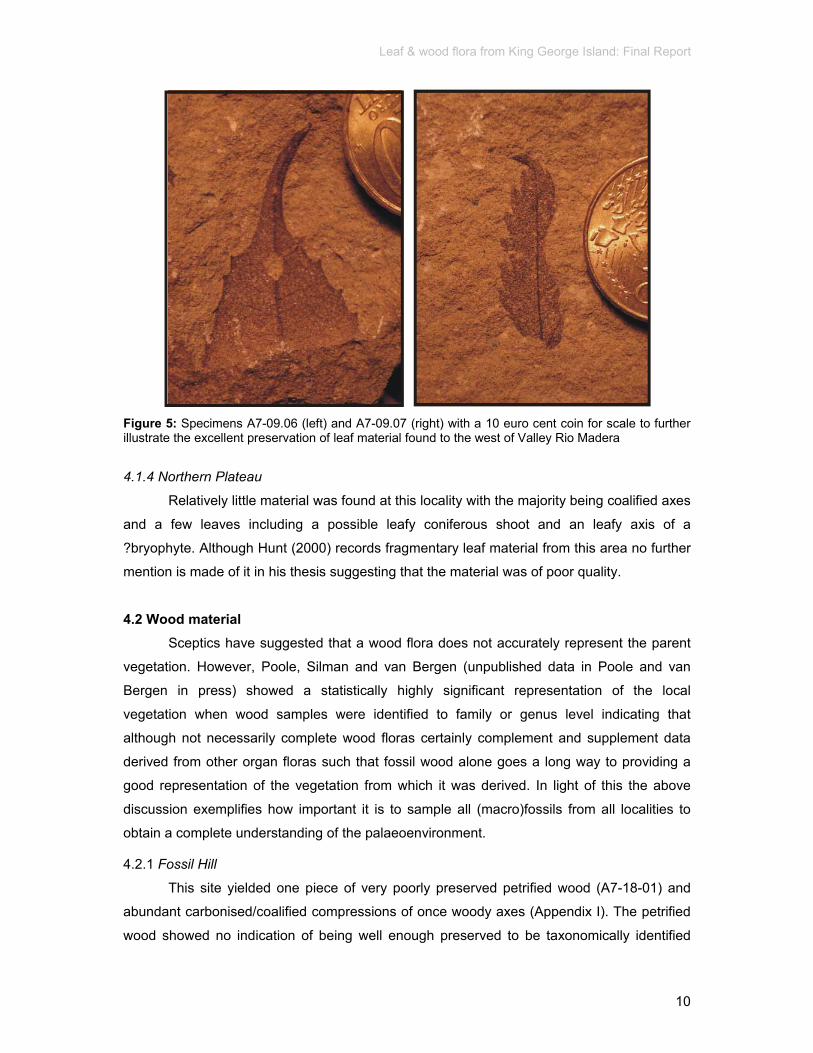
Leaf & wood flora from King George Island: Final Report
10
Figure 5: Specimens A7-09.06 (left) and A7-09.07 (right) with a 10 euro cent coin for scale to further illustrate the excellent preservation of leaf material found to the west of Valley Rio Madera
4.1.4 Northern Plateau
Relatively little material was found at this locality with the majority being coalified axes
and a few leaves including a possible leafy coniferous shoot and an leafy axis of a
?bryophyte. Although Hunt (2000) records fragmentary leaf material from this area no further
mention is made of it in his thesis suggesting that the material was of poor quality.
4.2 Wood material Sceptics have suggested that a wood flora does not accurately represent the parent
vegetation. However, Poole, Silman and van Bergen (unpublished data in Poole and van
Bergen in press) showed a statistically highly significant representation of the local
vegetation when wood samples were identified to family or genus level indicating that
although not necessarily complete wood floras certainly complement and supplement data
derived from other organ floras such that fossil wood alone goes a long way to providing a
good representation of the vegetation from which it was derived. In light of this the above
discussion exemplifies how important it is to sample all (macro)fossils from all localities to
obtain a complete understanding of the palaeoenvironment.
4.2.1 Fossil Hill
This site yielded one piece of very poorly preserved petrified wood (A7-18-01) and
abundant carbonised/coalified compressions of once woody axes (Appendix I). The petrified
wood showed no indication of being well enough preserved to be taxonomically identified

Leaf & wood flora from King George Island: Final Report
11
and was therefore not sectioned. Compression material had no anatomy preserved thus
preventing any taxonomic identification. One impression showed similarity to the axis of the
sphenopsid Equisetum, a taxon known to have been growing in Antarctica at this time.
However there were no nodes or laterals which would have confirmed identification. Two
other compression/impression fossils were reminiscent of a conifer and a bryophyte axes but
these remain to be confirmed. Interestingly, one piece of coalified material (not sectioned)
showed the distinctive anatomy in transverse section associated with the nothofageous
morphotype, Nothofagoxylon corrugatus (Poole et al. 2001, Poole 2002). No wood material
has previously been recorded from this locality (Hunt 2000; Appendix I).
4.2.2 Valley Rio Madera
Woody material collected from this locality was disappointing in that it was
predominantly carbonised axes which could not be identified due to the lack of anatomy and
external morphology. However, previous thorough collections of plant material from this
locality made by Hunt (2000) did not record the presence of wood material.
4.2.3 Glacier
The collections of Hunt (2000) record fragments of silicified wood, abundant large
fragments of well-preserved wood and partially silicifed wood from this locality (Appendix I).
Therefore it is not surprising that the majority of the petrified wood material collected during
the 2003/4 field season from Glacier Rim included some of the largest and better preserved
specimens. One piece had anatomy preserved enabling a tentative identification to the
morphotaxon Podocarpoxylon (Figure 6).
Figure 6: Specimen A7-28.02, TS of ?Podocarpoxylon wood illustrating the potentially well preserved anatomy in petrified conifer wood material found at Glacier Rim.
Alongside the petrified material compression of small axes were also sampled. This
latter material had no anatomy or external morphology preserved and thus prevented
taxonomic identification. The petrified material was sectioned and shown to include both
angiosperms and conifer. However the preservation of this material was such that no further

Leaf & wood flora from King George Island: Final Report
12
taxonomic identification was possible. There were also two pieces of possible petrified bark.
Very little work has been undertaken on modern bark anatomy (relative to anatomical studies
of wood) yet bark material is occasionally found preserved in fossil floras. This highlights a
potentially new and informative area of study providing further information on the habit of
plants, such as fire tolerance. Since silicified wood and possible bark material has been
found preserved at this location both during this field season and the one undertaken in 1999
by Hunt it would be desirable to undertake more intensive selective collections from this
locality.
The majority of the other specimens comprise coalified fragments of axes with no
anatomical preservation. However one specimen (A7-16.03, A7-17.06) has a distorted
appearance with similarity to the tundra plants such as the habit exhibited by the magellanic
Nothofagus and the Arctic willow (Salix). Another specimen (A7-27.07) exhibits possible bore
holes.
4.2.4 Northern Plateau
‘Woody’ material from this locality consisted of silicified fragments but when sectioned
no anatomy could be determined in many of the specimens and thus the material could not
be identified. It is likely that these ‘woody’ pieces have an inorganic origin. Several pieces
were of interest and could be identified to angiosperm and conifer. The longitudinal sections,
needed to enable finer systematic identification, were preserved such that for many
specimens no further taxonomic assessment could be made.
Figure 7: Specimen A7-32.01, Eucryphiaceoxylon eucryphioides, illustrating the potentially well preserved anatomy in petrified wood material found at Glacier.

Leaf & wood flora from King George Island: Final Report
13
One piece of angiosperm wood with good anatomical preservation enabling
identification to Eucryphiaceoxylon eucryphioides (Figure 7) was collected - this taxa has
been described from King George Island by Poole et al. (2001). Hunt (2000) also records
silicified wood from this area of Fildes Peninsula but does not comment on the quality of
preservation.
4.3 Fertile Material Publications concerning the reproductive material from King George Island are
relatively limited although fertile material is not uncommon (cf. Hunt 2000). The collection
undertaken in 2003-4 included a number of possible reproductive/fertile material. Valley Rio
Madera yielded possible propagules (A7-09.08) and a ?fertile organ with terminal papillae
(A7-08.03). At Fossil Hill possible fertile organ reminiscent of Fertile Organ sp. 2 of Hunt
(2000) was found exhibiting similarities with the cupules of the Fagaceae and Nothofagaceae
(Hunt 2000).
5. Conclusions The most abundant collections were made from Fossil Hill (Appendix I) with nearly 90
specimens from 16 sublocalities sent for examination. This is not surprising considering that
Fossil Hill is probably one of the most fossiliferous localities on King George Island. The
material is composed of propagules, leaves, leafy shoots, coalified axes and silicified wood
with taxa affiliated to conifers, dicotyledonous angiosperms, ferns, possible Equisetum, and
bryophytes. Representatives of these taxa have already been recorded by previous workers
in this area but this study provides further evidence for the fossiliferous nature of this locality.
The potential of finding well preserved plant material from this locality is very high. This
locality should be considered to be of high scientific interest.
Valley Rio Madera, not known for its organically preserved material, yielded the best
preserved leaf material with anacardiaceous/proteaceous and sapindaceous affinities. Other
coniferous and fern leaf material along with some propagules were also recorded. Wood was
absent. The findings of this 2003/4 field season highlights the importance of continued
collecting at localities where previous expeditions have not found interesting material. The
potential of finding well-preserved plant material at this locality is relatively high and this site
should be considered to be of (moderate to) high scientific value.
No leaf material was found at Glacier but podocarpaceous wood and bark, from
unknown taxa, were found. This is an important locality for fossil wood material with the
potential of finding well-preserved material is very high. Glacier should be considered to be of
high scientific interest.

Leaf & wood flora from King George Island: Final Report
14
At Northern Plateau there is a relatively high potential of finding good quality
angiosperm and conifer wood material amongst the poorly preserved material. One
eucryphiaceous piece of angiosperm has been recorded. Leaf material was limited and only
leafy shoots of coniferous and ?bryophte origins were recorded. This locality should be
considered to be of moderate (to high) scientific interest.
The addition of more material, particularly both from previously relatively unexplored
and well-studied localities, testifies to the palaeobotanical richness of Fildes Peninsula on
King George Island area and its importance to understanding past biodivesity and ecosystem
dynamics of Antarctica. Hunt (2000), in conclusion to his intensive study of the fossils from
King George Island, also concluded that the there is a great potential for further
palaeobotanical research on King George Island both at existing sites, especially in light of
the retreat of ice-margins revealing new fossiliferous material, and under studied sites. Along
with the much needed geochronological and stratigraphic studies, to detemine the precise
age and relationships of the various Tertiary palaeofloras, any future rigorous, yet selective,
studies of the macro (and micro) fossils on King George Island will greatly enhance our
understanding of an environment with no modern analogue today.
6. References Birkenmajer K., Francalanci L., Peccerillo A. 1991. Petrological and geochemical constraints on the
genesis of Mesozoic-Cenozoic magmatism of King George Island, South Shetland Islands (West Antarctica). Antarctic Science 3, 293-308.
Birkenmajer K., Zastawniak E. 1988. Late Cretaceous-Early Neogene vegetation history of the Antarctic Peninsula Sector. Gondwana break-up and Tertiary glaciations: Bulletin of the Polish Academy of Sciences, Earth Sciences 37, 63-88.
Birkenmajer K., Zastawniak E. 1989. Late Cretaceous-Early Tertiary floras of King George Island, West Antarctica: their stratigraphic distribution and palaeoclimatic significance. In Crame, J. A., (ed.) Origins and evolution of the Antarctic biota. Geological Society Special Publications No 47: London, Geological Society, 17-26.
Czajkowski S., Rösler O. 1986. Plantas fosseis da Peninsula Fildes; Ilha Rei Jorge (Shetlands do Sul); Morfografia das impressoes foliares. Anais Academia Brasileira de Ciencias Supplemento 58, 99-110.
Dettmann M.E. 1989. Antarctica: Cretaceous cradle of austral emperate rainforests? In Crame J.A. (ed.) Origins and evolution of the Antarctic biota. Geological Society Special Publications No. 47. pp. 89-107.
Dusén P. 1908. Über die Tertiäre Flora der Magellansländer. Wissenschaftliche Ergebnisse der Schwedischen Expedition nach den Magellansländern 1895-1897, 1, 87-107 241-248.
Dutra T., Batten D. 2000. Upper Cretaceous floras of King George Island, West Antarctica and their palaeoenvironmental and phytogeographic implications. Cretaceous Research. 21, 181-209.
Falcon-Lang, H.J., Cantrill, D.J. 2000. Cretaceous (Late Albian) Coniferales of Alexander Island, Antarctica. 1: Wood taxonomy: a quantitative approach. Review of Palaeobotany and Palynology 111, 1-17.
Haas H., Rowe, N.P. 1999. Thin sections and wafering. In: T.P. Jones and N.P. Rowe (eds.), Fossil Plants and Spores: modern techniques. Geological Society, London, pp. 76-81.
Hunt R.H. 2001. Biodiversity and palaeoecology of Tertiary fossil floras in Antarctica [Ph.D. thesis]: University of Leeds, 400 p.
Hunt R.J., Poole I. 2003. Revising Paleogene West Antarctic climate and vegetation history in light of new data from King George Island. In S.L. Wing, P.D. Gingerich, B. Schmitz and E. Thomas (eds). Causes and Consequences of Globally Warm Climates in the Early Paleogene. Geological Society of America Special Paper 369, 395-412.
Leaf & wood flora from King George Island: Final Report
15
Lawver L.A., Gahagan L.M., Coffin M.F. 1992. The development of paleoseaways around Antarctica: Antarctic Research Series 56, 7-30.
Leaf Architecture Working Group. 1999. Manual of leaf architecture – morphological description and categorization of dicotyledonous and net-veined monocotyledonous angiosperms: Washington D.C, Smithsonian Institution, 67p.
Li H. 1994. Early Tertiary Fossil Hill flora from Fildes Peninsula of King George Island, Antarctica. In Y. Shen (ed.) Antarctica State Antarctic Committee Monograph 3 Stratigraphy and Palaeontology of Fildes Peninsula, King George Island, pp 173-189.
Li H. Shen Y. 1990. A preliminary study of Fossil Hill flora from Fildes Peninsula of King George Island, Antarctica. Acta Palaeontological Sinica 29, 147-153.
McCarron J.J., Larter R.D. 1998. Late Cretaceous to early Tertiary subduction history of the Antarctic Peninsula: Journal of the Geological Society, London 155, 255-268.
Poole I. 2002. Systematics of Cretaceous and Tertiary Nothofagoxylon: Implications for Southern Hemisphere biogeography and evolution of the Nothofagaceae. Australian Systematic Botany 15, 247-276.
Poole I., Barnes R. 2004. Wood anatomy of Eucryphia jinksii and Eucryphia wilkei (Eucryphiaceae): two narrow endemics from Queensland, Australia. Australian Journal of Botany 52, 739-745.
Poole I., van Bergen P.F. in press. Physiognomic and chemical characters in wood as palaeoclimate proxies. International Journal of Plant Ecology
Poole I., Cantrill D.J. 2001. Fossil woods from Williams Point Beds, Livingston Island, Antarctica: a Late Cretaceous southern high latitude flora. Palaeontology 44, 1081-1112.
Poole I, Francis J.E. 1999. The first record of fossil atherospermataceous wood from the upper Cretaceous of Antarctica. Review of Palaeobotany and Palynology 107, 97-107.
Poole I., Francis J.E. 2000. The first record of fossil wood of Winteraceae from the Upper Cretaceous of Antarctica. Annals of Botany 85, 307-315.
Poole I., Gottwald H. 2001. Monimiaceae sensu lato, an element of Gondwanan polar forests: Evidence from the Late Cretaceous-early Tertiary wood flora of Antarctica. Australian Systematic Botany 14, 207-230.
Poole I., Cantrill D.J., Hayes P., Francis J.E. 2000a. The fossil record of Cunoniaceae: new evidence from Late Cretaceous wood of Antarctica. Review of Palaeobotany and Palynology 111, 127-144.
Poole I., Gottwald H., Francis J.E. 2000b. Illiciaceae, an element of Gondwanan polar forests? Late Cretaceous and Early Tertiary woods of Antarctica. Annals of Botany 86, 421-432.
Poole I., Hunt R.J., Cantrill D.J. 2001. A fossil wood flora from King George Island: ecological implications for an Antarctic Eocene vegetation. Annals of Botany 88, 33-54.
Poole I., Mennega A.M.W., Cantrill D.J. 2003. Valdivian ecosystems in the late Cretaceous and early Tertiary of Antarctica as evidenced from fossil wood. Review of Palaeobotany and Palynology124, 9-27
Poole I., Richter H., Francis J.E. 2000c. Gondwanan origins for Sassafras (Lauraceae)? evidence from Late Cretaceous fossil wood of Antarctica. International Association of Wood Anatomists Journal 21, 463-475.
Romero E.J. 1978. Paleoecológia y paleofitografia de las tafofloras del Cenafitico de Argentina y àreas vecinas. Ameghiniana 15, 209-227.
Troncoso A. 1986. Nuevas organo-especies en la tafoflora Terciaria inferior de peninsula Fildes, isla Rey Jorge, Antartica. Serie Cîentifica Instituto Àntartico Chileno 34, 23-46
Truswell E.M. 1989. Cretaceous and Tertiary egetation of Antarctica: a palynological perspective. In Taylor TN and Taylor EL (eds) Antarctic Paleobiology. Springer-Verlag, New York, pp. 71-88.
Zhou Z., Li H. 1990. Early Tertiary gymnosperms from Fildes Peninsula, King George Island. In Y. Shen (ed.) Antarctica State Antarctic Committee Monograph 3 Stratigraphy and Palaeontology of Fildes Peninsula, King George Island, pp 191-221.
Zhou Z., Li H. 1994a. Some Late Cretaceous plants from King George Island. In Y. Shen (ed.) Antarctica State Antarctic Committee Monograph 3 Stratigraphy and Palaeontology of Fildes Peninsula, King George Island, pp 85-96.
Zhou Z., Li H. 1994b. Early Tertiary ferns from Fildes Peninsula, King George Island, Antarctica. In Y. Shen (ed.) Antarctica State Antarctic Committee Monograph 3 Stratigraphy and Palaeontology of Fildes Peninsula, King George Island, pp 133-171.
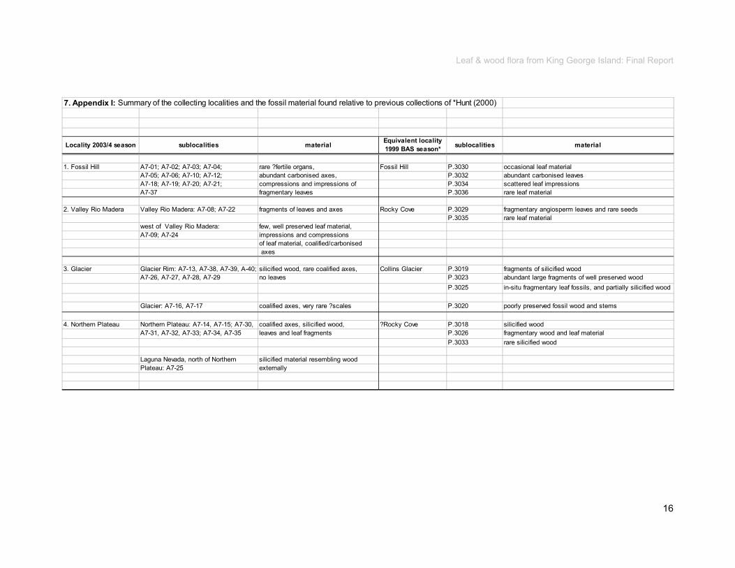
Leaf & wood flora from King George Island: Final Report
16
7. Appendix I: Summary of the collecting localities and the fossil material found relative to previous collections of *Hunt (2000)
Locality 2003/4 season sublocalities material Equivalent locality 1999 BAS season* sublocalities material
1. Fossil Hill A7-01; A7-02; A7-03; A7-04; rare ?fertile organs, Fossil Hill P.3030 occasional leaf materialA7-05; A7-06; A7-10; A7-12; abundant carbonised axes, P.3032 abundant carbonised leavesA7-18; A7-19; A7-20; A7-21; compressions and impressions of P.3034 scattered leaf impressionsA7-37 fragmentary leaves P.3036 rare leaf material
2. Valley Rio Madera Valley Rio Madera: A7-08; A7-22 fragments of leaves and axes Rocky Cove P.3029 fragmentary angiosperm leaves and rare seedsP.3035 rare leaf material
west of Valley Rio Madera: few, well preserved leaf material,A7-09; A7-24 impressions and compressions
of leaf material, coalified/carbonised axes
3. Glacier Glacier Rim: A7-13, A7-38, A7-39, A-40; silicified wood, rare coalified axes, Collins Glacier P.3019 fragments of silicified woodA7-26, A7-27, A7-28, A7-29 no leaves P.3023 abundant large fragments of well preserved wood
P.3025 in-situ fragmentary leaf fossils, and partially silicified wood
Glacier: A7-16, A7-17 coalified axes, very rare ?scales P.3020 poorly preserved fossil wood and stems
4. Northern Plateau Northern Plateau: A7-14, A7-15; A7-30, coalified axes, silicified wood, ?Rocky Cove P.3018 silicified woodA7-31, A7-32, A7-33; A7-34, A7-35 leaves and leaf fragments P.3026 fragmentary wood and leaf material
P.3033 rare silicified wood
Laguna Nevada, north of Northern silicified material resembling wood Plateau: A7-25 externally

8. Appendix II: Summary of the King George Island specimens collected during the 2003/4 field season
Specimen number locality fossilisation fossil type notes systematic Identity
*Morphotype numbers of Hunt 2001A7-01.01 Fossil Hill impressions ?organic inorganic, but possibly had an organic origin (e.g. leaf, twig lying perpendicular to the direction of flow) but no organic
preservation prevents further determination --
A7-01.03 Fossil Hill impressions (negative)
propagules possible propagules comprising infill with cast of external morphology preserved. Other propagules probably occupied the depressions seen on the surface
cf. *Isolated seed sp. 6 & 7
A7-01.04 Fossil Hill impression ?leaf leaf fragment of notophyllous leaf (or small microphyll), leaf margin serrate, midrib present angiosperm; cf. *M2.19A7-01.05 Fossil Hill cast with
impressionpropagule 3-d casts of the internal structure of two propagules with possible remains of original outer organic material in the
impression (depression) on the rock surface; groove present on one and ridge present on the second possibly indicating attachment of two nutlets
?angiosperm
A7-01.06 Fossil Hill impression (cast) ?organic --A7-01.09 Fossil Hill compression leaf and mineralisation of ?leaf with longitudinal ridge (?midrib) and evidence for epidermal anatomy present conifer; cf. *?Podocarpus sp. 1 *?Podocarpus sp. 2 A7-01.10 Fossil Hill impression axis possible axis, no organic remains, 25mm diameter and 130mm length, no anatomical preservation --A7-01.11 Fossil Hill cast with
impressionaxis ?cast of axis 35mm in length by 7mm in width, no anatomical peservation --
A7-01.12 Fossil Hill impression axis axis with longitudinal striations, 30mm diameter by >110mm length, no anatomical preserved --A7-01.14 Fossil Hill impression leaf leaf with serrate margin, no venation, >40mm in length by >7mm width ?angiospermA7-01.15 Fossil Hill impression propagule (depressions, unknown) possible propagule with groove visible --
A7-02.01 Fossil Hill impressions leaves three leaf fragments: i. microphyll with clear midrib and alternate venation angiosperm; *M2.48 Nothofagus sp. ii. linear microphyll with entire margin ?alternate venation and possible insect damage (trace feeder) angiosperm; cf. *M1.7iii. microphyll with no margin preserved but clear brochidodromous venation angiosperm
A7-02.03 Fossil Hill impressions leaves, axes leaf fragments including: i. ?notophyll with strong primary and secondary venetion, no margin or apex, possible present of gall and insect damage angiospermii. ?shoot conifer
A7-02.04 Fossil Hill impressions leaves ?palmately lobed notophyll with prominent primary veins and ?alternate secondary venetion angiosperm; cf. *M1.1A7-02.05 Fossil Hill impressions leaves entire margined microphyll, secondary veins not clear angiosperm; cf.*M1.11 ?Lauriphyllum nordenskjoeldiiA7-02.06 Fossil Hill impressions leaves, axes ?leaves and axes; comprising:
i. small leafy axis of 3mm in length ?bryophyteii. possible axis with leaf(let)s --
A7-02.07 Fossil Hill compressions axes carbonised axes up to 15mm diameter and 40mm in length; no anatomy preserved --A7-02.08 Fossil Hill compression axes coalified fragments of axes --A7-02.09 Fossil Hill impressions leaves lamina at least 25mm in length, bipinnate, primary rachis of unknown width and pinnae arrangement unknown, pinnules
opposite to subopposite, overlapping, convex basally and flattened apicallyfern; some similarity to *Fern sp. 7 and Gleicheniaceae cf. Cantrill (1998, 2000)
A7-02.10 Fossil Hill impressions leaves fragment of nannophyllous leaves with entire margin, strong midrib i. one with and ?cordate base, venation apparent to upper edge of fragment ?pinnate angiosperm; --ii. leafy shoot <2mm diameter by 10mm length, with ?paired scale leaves conifer; ?Cupressaceae
A7-02.11 Fossil Hill compression axis coalified axis >55mm diameter by indeterminable length --A7-02.12 Fossil Hill compressions axes fragment of probable axis/axes with longitudinal striations, no anatomical preservation --A7-02.13 Fossil Hill impressions leaf fragment of minutely serrated microphyll with strong midrib and alternate secondary venation, cordate (or lobate) angiospermA7-02.14 Fossil Hill impressions twig branched axis ?coniferA7-02.15 Fossil Hill compression ?axis ?leaf coalified organ with longitudinal striations, probable axis ?Equisetum but no node to clarifyA7-02.16-23 Fossil Hill compressions axes, leaf 8 pieces, see belowA7-02.16 Fossil Hill impressions leaf >15mm length by 2mm width, with prominent midrib, entire margin, linear with ?acuminate tip cf. Podocarpus sp. Zhou & Li 1994aA7-02.17 Fossil Hill compression axis coalified axis fragment 15mm width by 60mm length ?bryophyteA7-02.18 Fossil Hill compression ?fertile organ 8mm in length by 2mm in width with rounded base and ?elongate valves similar to Fertile Organ sp. 2 of Hunt 2001A7-02.19 Fossil Hill compressions axes coalified axis/es fragments, no anatomical detail --A7-02.20 Fossil Hill compression axis ?coalified curved axis >15mm width by >45mm length; no anatomical preservation --A7-02.21 Fossil Hill impression axis axis with obvious linear striations, 45mm length by 10mm width, possible node present with lateral appendage ?EquisetumA7-02.22 Fossil Hill compression axis small fragment of axis; no anatomical detail --A7-02.23 Fossil Hill compression leaf microphyll with prominent primary vein, alternately arranged secondary veins, margin toothed angiosperm; cf. ?Nothofagus typeA7-02.26 Fossil Hill impressions leaves fragments of at least three leaf types:
i. pinnately lobed notophyll with possibly ?serrate margin, narrow, straight margined apex angiosperm; cf. *M2.4 Lomatia sp.ii. notophyll with subopposite to alternate secondary venation, margin unclear angiosperm
media
Schreibmaschinentext
Appendix 7b
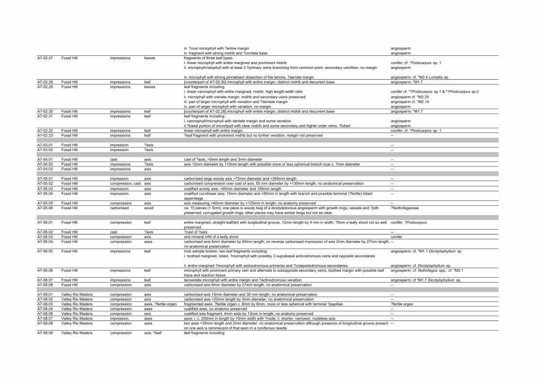
iii. ?oval microphyll with ?entire margin angiospermiv. fragment with strong midrib and ?cordate base angiosperm
A7-02.27 Fossil Hill impressions leaves fragments of three leaf types: i. linear microphyll with entire margined and prominent midrib conifer; cf. *Podocarpus sp. 1ii. microphyll/notophyll with at least 3 ?primary veins branching from common point, secondary venAtion, no margin angiosperm
iii. microphyll with strong pinnatisect dissection of the lamina, ?serrate margin angiosperm; cf. *M2.4 Lomatia sp.A7-02.28 Fossil Hill impressions leaf [counterpart of A7-02.30] microphyll with entire margin, distinct midrib and decurrent base angiosperm; *M1.7 A7-02.29 Fossil Hill impressions leaves leaf fragments including:
i. linear nannophyll with entire margined, midrib, high length:width ratio conifer cf. *?Podocarpus sp.1 & *?Podocarpus sp.2ii. microphyll with crenate margin, midrib and secondary veins preserved angiosperm cf. *M2.25iii. part of larger microphyll with venation and ?dentate margin angiosperm cf. *M2.14iv. part of larger microphyll with venation, no margin angiosperm
A7-02.30 Fossil Hill impressions leaf [counterpart of A7-02.28] microphyll with entire margin, distinct midrib and decurrent base angiosperm; *M1.7 A7-02.31 Fossil Hill impressions leaf leaf fragments including:
i. nannophyll/microphyll with dentate margin and some venation angiospermii.?basal portion of microhpyll with clear midrib and some secondary and higher order veins, ?lobed angiosperm
A7-02.32 Fossil Hill impressions leaf linear microphyll with entire margin conifer; cf. *Podocarpus sp. 1A7-02.33 Fossil Hill impressions leaf ?leaf fragment with prominent midrib but no further venation, margin not preserved --
A7-03.01 Fossil Hill impression ?axis --A7-03.02 Fossil Hill impression ?axis --
A7-04.01 Fossil Hill cast axis cast of ?axis, >5mm length and 3mm diameter --A7-04.02 Fossil Hill impressions ?axis axis 12mm diameter by 110mm length with possible more or less spherical branch scar c. 7mm diameter --A7-04.03 Fossil Hill impressions axis --
A7-05.01 Fossil Hill impression axis carbonised large woody axis >72mm diameter and >265mm length --A7-05.02 Fossil Hill compression, cast axis carbonised compression over cast of axis, 55 mm diameter by >130mm length, no anatomical preservation --A7-05.03 Fossil Hill impression axis coalified woody axis; >60mm diameter and 150mm length --A7-05.04 Fossil Hill impression axis coalified curvilinear axis; 15mm diameter and >90mm in length with branch and possible terminal (?fertile) lobed
appendage--
A7-05.05 Fossil Hill compression axis axis measuring >40mm diameter by >125mm in length; no anatomy preserved --A7-05.06 Fossil Hill carbonised wood ca. 15 pieces (< 5cm); one piece is woody twig of a dicotyledonous angiosperm with growth rings, vessels and ?pith
preserved; corrugated growth rings; other pieces may have similar twigs but not as clear.?Nothofagaceae
A7-06.01 Fossil Hill compression leaf entire margined, straight leaf(let) with longitudinal groove, 12mm length by 4 mm in width, ?from a leafy shoot not so well preserved
conifer; ?Podocarpus
A7-06.02 Fossil Hill cast ?axis ?cast of ?axis --A7-06.03 Fossil Hill compression axis and mineral infill of a leafy shoot coniferA7-06.04 Fossil Hill compression axes carbonised axis 6mm diameter by 40mm length; on reverse carbonised impression of axis 2mm diameter by 27mm length,
no anatomical preservation--
A7-06.05 Fossil Hill impressions leaf rock sample broken, two leaf fragments including: angiosperm; cf. *M1.1 Dicotylophyllum sp.i. toothed margined, lobed, ?microphyll with possibly 3 suprabasal actinodromous veins and opposite secondaries
ii. entire margined ?microphyll with actinodromous primaries and ?craspedodromous secondaries angiosperm; cf. Dicotylophyllum sp.A7-06.06 Fossil Hill impressions leaf microphyll with prominent primary vein and alternate to subopposite secondary veins, toothed margin with possible leaf
trace and reaction tissueangiosperm; cf. Nothofagus spp.; cf. *M2.1
A7-06.07 Fossil Hill impressions leaf lanceolate microphyll with entire margin and ?actinodromous venation angiosperm; cf *M1.7 Dicotylophyllum sp.A7-06.08 Fossil Hill compression axis carbonised axis 6mm diameter by 27mm length, no anatomical preservation --
A7-08.01 Valley Rio Madera compression axis carbonised axis 10mm diameter and 30 mm length, no anatomical preservation --A7-08.02 Valley Rio Madera compression axis carbonised axis <20mm length by 3mm diameter, no anatomical preservation --A7-08.03 Valley Rio Madera compression axes, ?fertile organ fragmented axes; ?fertile organ c. 8mm by 6mm, more or less spherical with terminal ?papillae ?fertile organA7-08.04 Valley Rio Madera compression axes coalified axes, no anatomy preserved --A7-08.06 Valley Rio Madera compression axis coalified axis fragment, 4mm wide by 13mm in length, no anatomy preserved --A7-08.07 Valley Rio Madera impression axes axes; i. c. 200mm in length by 10mm width with ?node; ii. shorter, narrower, nodeless axis --A7-08.08 Valley Rio Madera compression axes two axes <35mm length and 2mm diameter, no anatomical preservation although presence of longitudinal groove present
on one axis is reminiscent of that seen in a coniferous needle--
A7-08.09 Valley Rio Madera compression axis, ?leaf leaf fragments including:
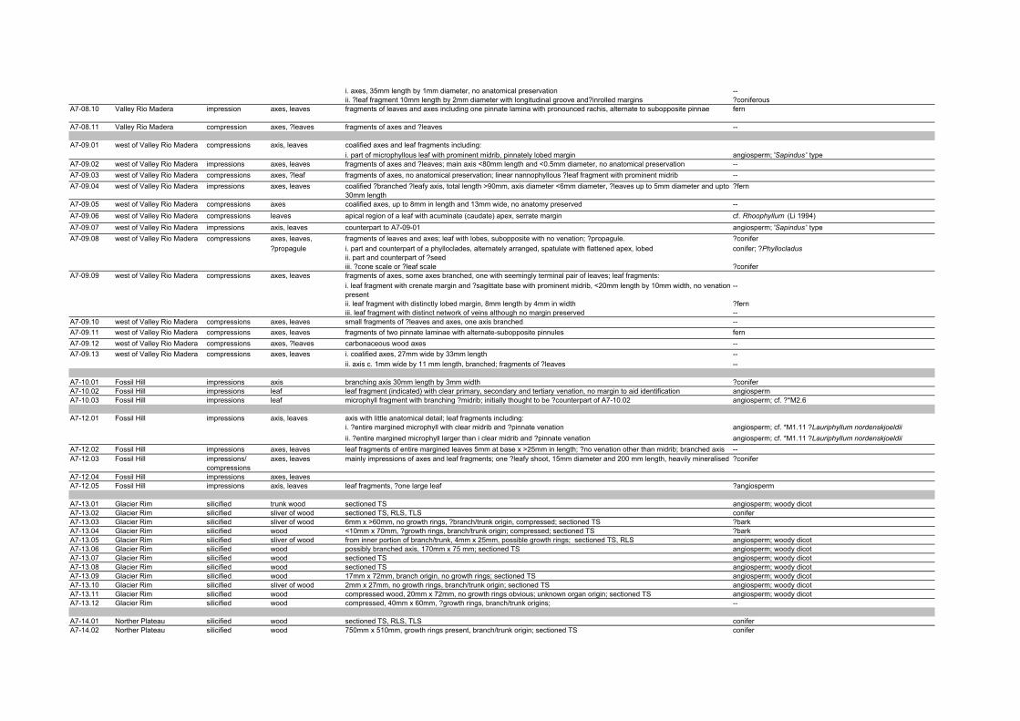
i. axes, 35mm length by 1mm diameter, no anatomical preservation --ii. ?leaf fragment 10mm length by 2mm diameter with longitudinal groove and?inrolled margins ?coniferous
A7-08.10 Valley Rio Madera impression axes, leaves fragments of leaves and axes including one pinnate lamina with pronounced rachis, alternate to subopposite pinnae fern
A7-08.11 Valley Rio Madera compression axes, ?leaves fragments of axes and ?leaves --
A7-09.01 west of Valley Rio Madera compressions axis, leaves coalified axes and leaf fragments including:i. part of microphyllous leaf with prominent midrib, pinnately lobed margin angiosperm; 'Sapindus ' type
A7-09.02 west of Valley Rio Madera impressions axes, leaves fragments of axes and ?leaves; main axis <80mm length and <0.5mm diameter, no anatomical preservation --A7-09.03 west of Valley Rio Madera compressions axes, ?leaf fragments of axes, no anatomical preservation; linear nannophyllous ?leaf fragment with prominent midrib --A7-09.04 west of Valley Rio Madera impressions axes, leaves coalified ?branched ?leafy axis, total length >90mm, axis diameter <6mm diameter, ?leaves up to 5mm diameter and upto
30mm length?fern
A7-09.05 west of Valley Rio Madera compressions axes coalified axes, up to 8mm in length and 13mm wide, no anatomy preserved --A7-09.06 west of Valley Rio Madera compressions leaves apical region of a leaf with acuminate (caudate) apex, serrate margin cf. Rhoophyllum (Li 1994)A7-09.07 west of Valley Rio Madera impressions axis, leaves counterpart to A7-09-01 angiosperm; 'Sapindus ' typeA7-09.08 west of Valley Rio Madera compressions axes, leaves, fragments of leaves and axes; leaf with lobes, subopposite with no venation; ?propagule. ?conifer
?propagule i. part and counterpart of a phylloclades, alternately arranged, spatulate with flattened apex, lobed conifer; ?Phyllocladusii. part and counterpart of ?seediii. ?cone scale or ?leaf scale ?conifer
A7-09.09 west of Valley Rio Madera compressions axes, leaves fragments of axes, some axes branched, one with seemingly terminal pair of leaves; leaf fragments: i. leaf fragment with crenate margin and ?sagittate base with prominent midrib, <20mm length by 10mm width, no venation present
--
ii. leaf fragment with distinctly lobed margin, 8mm length by 4mm in width ?ferniii. leaf fragment with distinct network of veins although no margin preserved --
A7-09.10 west of Valley Rio Madera compressions axes, leaves small fragments of ?leaves and axes, one axis branched --A7-09.11 west of Valley Rio Madera compressions axes, leaves fragments of two pinnate laminae with alternate-subopposite pinnules fernA7-09.12 west of Valley Rio Madera compressions axes, ?leaves carbonaceous wood axes --A7-09.13 west of Valley Rio Madera compressions axes, leaves i. coalified axes, 27mm wide by 33mm length --
ii. axis c. 1mm wide by 11 mm length, branched; fragments of ?leaves --
A7-10.01 Fossil Hill impressions axis branching axis 30mm length by 3mm width ?coniferA7-10.02 Fossil Hill impressions leaf leaf fragment (indicated) with clear primary, secondary and tertiary venation, no margin to aid identification angiospermA7-10.03 Fossil Hill impressions leaf microphyll fragment with branching ?midrib; initially thought to be ?counterpart of A7-10.02 angiosperm; cf. ?*M2.6
A7-12.01 Fossil Hill impressions axis, leaves axis with little anatomical detail; leaf fragments including:i. ?entire margined microphyll with clear midrib and ?pinnate venation angiosperm; cf. *M1.11 ?Lauriphyllum nordenskjoeldiiii. ?entire margined microphyll larger than i clear midrib and ?pinnate venation angiosperm; cf. *M1.11 ?Lauriphyllum nordenskjoeldii
A7-12.02 Fossil Hill impressions axes, leaves leaf fragments of entire margined leaves 5mm at base x >25mm in length; ?no venation other than midrib; branched axis --A7-12.03 Fossil Hill impressions/
compressionsaxes, leaves mainly impressions of axes and leaf fragments; one ?leafy shoot, 15mm diameter and 200 mm length, heavily mineralised ?conifer
A7-12.04 Fossil Hill impressions axes, leavesA7-12.05 Fossil Hill impressions axis, leaves leaf fragments, ?one large leaf ?angiosperm
A7-13.01 Glacier Rim silicified trunk wood sectioned TS angiosperm; woody dicotA7-13.02 Glacier Rim silicified sliver of wood sectioned TS, RLS, TLS coniferA7-13.03 Glacier Rim silicified sliver of wood 6mm x >60mm, no growth rings, ?branch/trunk origin, compressed; sectioned TS ?barkA7-13.04 Glacier Rim silicified wood <10mm x 70mm, ?growth rings, branch/trunk origin; compressed; sectioned TS ?barkA7-13.05 Glacier Rim silicified sliver of wood from inner portion of branch/trunk, 4mm x 25mm, possible growth rings; sectioned TS, RLS angiosperm; woody dicotA7-13.06 Glacier Rim silicified wood possibly branched axis, 170mm x 75 mm; sectioned TS angiosperm; woody dicotA7-13.07 Glacier Rim silicified wood sectioned TS angiosperm; woody dicotA7-13.08 Glacier Rim silicified wood sectioned TS angiosperm; woody dicotA7-13.09 Glacier Rim silicified wood 17mm x 72mm, branch origin, no growth rings; sectioned TS angiosperm; woody dicotA7-13.10 Glacier Rim silicified sliver of wood 2mm x 27mm, no growth rings, branch/trunk origin; sectioned TS angiosperm; woody dicotA7-13.11 Glacier Rim silicified wood compressed wood, 20mm x 72mm, no growth rings obvious; unknown organ origin; sectioned TS angiosperm; woody dicotA7-13.12 Glacier Rim silicified wood compressed, 40mm x 60mm, ?growth rings, branch/trunk origins; --
A7-14.01 Norther Plateau silicified wood sectioned TS, RLS, TLS coniferA7-14.02 Norther Plateau silicified wood 750mm x 510mm, growth rings present, branch/trunk origin; sectioned TS conifer

A7-15.01 Norther Plateau silicified wood 61mm x 56mm, growth rings present, branch/trunk origin; sectioned TS, RLS, TLS angiosperm
A7-16.01 Glacier compression axes coalified axes; one bifircating --A7-16.02 Glacier compression axes coalified axes up to 5mm diameter and 60mm length, no anatomical preservation --A7-16.03 Glacier compressions axes coalified fragments of axes including: --
i. 4mm diameter and 25 mmm in length --ii. more woody, c. 30 mm length and 2 mm diameter, distorted --
A7-16.04 Glacier compression axes coalified fragments of axes; 2-5.5 cm in length; one branched --A7-16.05 Glacier compressions axes coalified axes <5mm width and 55mm length, one is branched --A7-16.06 Glacier impressions axes coalified axes; one branched and measures 4mm diameter by 45 mm in length --
A7-17.01 Glacier compression axis coalified axis c. 125mm length and 13mm diameter; no anatomy preserved --A7-17.02 Glacier compression axis axis with some silicification, 5mm x 100mm, no anatomy preserved --A7-17.03 Glacier compression axis coalified axis; one ?scale ?conifer A7-17.04 Glacier compressions axes i. coalified axis with some mineral growth; possibly branched; measuring 16mm diameter by 90 mm in length --
ii. axis possibly with some silicification also mineral growth c. 18mm diameter by 90mm in length --A7-17.05 Glacier compression axes coalified fragments of axes; up to 10mm diameter by 35mm in length --A7-17.06 Glacier cast, compression axes axes including: --
(silicified) i. coalified ?axis --ii. silicifed axes with carbonised layer of woody twig 10mm diameter by 75mm length --
A7-17.07 Glacier compression axes coalified axes; no anatomy preserved --A7-17.08 Glacier compression axis coalified axes; possibly with local silicification; 12mm diameter by 52 mm in length; possibly branched --A7-17.09 Glacier compression axes large axis 82mm in length by 10mm width; no anatomical preservation --A7-17.10 Glacier compression axes coalified axes up to 40mm length and 8mm diameter, no anatomical preservation --
A7-18.01 Fossil Hill silification wood not sectioned --
A7-19.01 Fossil Hill impressions/ axes, leaves organic debris comprised predominantly of compressions of leaf and axes fragments including:i. phylloclades conifer; ?Phyllocladus
A7-19.02 Fossil Hill impressions axes, leaves fragments of axes and fronds including: ferni.phylloclades conifer; ?Phyllocladusii. pinnate lamina with ?subopposite pinnae and entire margins fern
A7-19.03 Fossil Hill impressions axis, leaves leaf fragments and axes: i. lamina with rachis and possibly 4 primary pinnae, up to 10 cm in length, alternately arranged fernii. basal fragment of ?notophyll with ?palinactinodromous primary veins and cf. Sterculiaephyllum Dutra & Batten 2000; cf. Dicotylophyllum
sp. 4 Zastawniak 1994A7-19.04 Fossil Hill impressions axis, leaves fragment of pinnate lamina with no pinnules observed ?fernA7-19.05 Fossil Hill compression leaves carbonised axis, 15mm in width, possibly branched, no anatomical preservation; other narrower, 2mm, axes of similar
type, some branched; on reverse:--
i. leafy shoot 45mm in length with leaves c. 5mm in length coniferii. bipinnate lamina <35mm length and 13mm width with prominent rachis and opposite pinnae ?fern
A7-20.01 Fossil Hill compression axes, leaves large slab of organic debris comprised predominantly of compressions of leaf and axes fragments from low velocity depositional setting. Good palynological potential. Leaves probably from a variety of different taxa; main "complete" leaves are probably fern pinnules.
fern; cf. *Fern sp. 7; possible conifer ?*Cupressoid sp.1
A7-20.02 Fossil Hill compression axes, leaves organic debris comprised of small axes and fragments of leaves from low velocity depositional setting. Good palynological sample. Leaf fragments include:
--
Fossil Hill i. lobed lamina with ?opposite secondary venation up to c. 20mm in length and 5mm width fern; ?dicksoniaceous (cf. Dutra & Batten 2000)A7-20.03 Fossil Hill impression axes, leaves leaf and axes fragments including three possible frond fragments from different taxa:
i. lamina with lobed pinnae fern; ?dicksoniaceous (cf. Dutra & Batten 2000)A7-20-04 A Fossil Hill impression axes, leaves fragments of leaves and axes including lobed nannophyll ?angiosperm cf. *M1.4A7-20.04 B Fossil Hill impression axes, leaves fragments of leaves and axes including fragment of lamina fern
A7-21.01 Fossil Hill compression axes, leaves small pieces of fragments of axes and leaves from a low velocity depositional setting. May provide good palynological samples. i. frond with dichotomous branching, lobed margin 8 mm length by 7 mm diameter fern
A7-21.02 Fossil Hill compression axes, leaves carbonised organic debris comprising leaf and axis fragments from low velocity lake or similar; good palynological potential --A7-21.03 Fossil Hill compression axes, leaves organic debris comprised predominantly of compressions of leaf and axes fragments including: --
i. lamina with alternately lobed pinnae/leaflets ?fern

ii. ?leaflet angiosperm: cf. 'Sapindus '
A7-22.01 Valley Rio Madera compression, cast axes ?cast of axes; axis fragment; no anatomical preservation --A7-22.02 Valley Rio Madera impression axis coalified impression of fragment of branched axis >15mm diameter --A7-22.03 Valley Rio Madera impression axis coalified impression of axis, 15mm width by 75mm length, no anatomical preservation --A7-22.04 Valley Rio Madera impression axis, leaf pinnate lamina with alternate pinnae ?fern; cf. *Fern sp. 7 A7-22.05 Valley Rio Madera compression axes, ?fertile organ carbonaceous axes up to 20mm diameter, length indeterminable; oval ?fertile organ c. 4mm length and 2mm width, heavily
carbonised with obvious basal portion--
A7-22.06 Valley Rio Madera compression axis compressed piece of carbonised wood - no anatomy distinguishable with the hand lens --
A7-24.01 west of Valley Rio Madera compression and axis carbonised impression of axis 53mm length and 16mm diameter --
A7-25.01 Laguna Nevada silicified ?wood sectioned TS ?inorganicA7-25.02 Laguna Nevada silicified ?wood sectioned TS ?inorganicA7-25.03 Laguna Nevada silicified ?wood sectioned TS ?inorganicA7-25.04 Laguna Nevada silicified ?wood sectioned TS ?inorganicA7-25.05 Laguna Nevada silicified ? wood sectioned TS ?inorganic
A7-26.01 Glacier Rim silicified wood compressed piece of wood, 17mm x 25mm; organ unknown; sectioned TS --A7-26.02 Glacier Rim silicified wood 30mm x 32mm, compressed, organ of origin unknown, growth rings absent; sectioned TS --
A7-27.01 Glacier Rim compression, cast axis coalified cast/compression of thin sliver of a branched axis measuring 20 mm diameter and >45mm in length, no anatomical preservation
--
A7-27.02 Glacier Rim silicified ?wood sectioned TS coniferA7-27.03 Glacier Rim impressions coalified axes --A7-27.04 Glacier Rim silicified axis silicified axis 7mm diameter by 30 mm length, possibly coniferous from longitudinal fracture but no anatomy to confirm --A7-27.05 Glacier Rim silicified wood 40mm x 35mm, possibly bored, no growth rings, unknown organ of origin; sectioned TS, RLS, TLS coniferA7-27.06 Glacier Rim silicified wood sectioned TS coniferA7-27.07 Glacier Rim silicified wood sectioned TS conifer
A7-28.01 Glacier Rim silicified wood sectioned TS coniferA7-28.02 Glacier Rim silicified wood sectioned TS, TLS, RLS ?Podocarpoxylon
A7-30.01 Northern Plateau compressions axes, ?leaves coalified fragments of axes; up to 12mm diameter and 75mm length; some ?branched; ?leaf fragments --A7-30.02 Northern Plateau compressions axes, ?leaf fragments coalified fragments of axes up to 15mm in diameter; one axis 20mm in diameter and c. 12 cm in length; no anatomy
preserved--
A7-30.03 Northern Plateau compression axes, ?leaf fragments --
A7-31.01 Northern Plateau compression axis, leaves possible leafy axis of ?conifer, some leaflets preserved with midribs and secondaries --A7-31.02 Northern Plateau impressions axes, leaves small fragments of coalified nannophyllous leaves and axes; including
i. leafy axes 13mm length and 0.75 mm diameter with linear lanceolate leaves up to 4mm long and 0.5mm diameter with midrib
?bryophyte
ii. leaves entire margined, linear, obvious midrib. --
A7-32.01 Northern Plateau silicified wood sectioned TS, RLS, TLS Eucryphiaceoxylon eucryphioides
A7-33.01 Northern Plateau ??? --
A7-34.01 Northern Plateau silicified wood 40mm x >260mm, branch/trunk, no growth rings; sectioned TS, RLS, TLS angiosperm; woody dicotA7-34.02 Northern Plateau silicified wood sectioned TS angiosperm; woody dicotA7-34.03 Northern Plateau compression wood coalified ?basal trunkA7-34.04 Northern Plateau silicified/coalified wood <10mm x 30mm, no growth rings, organ of origin unknown; sectioned TS --A7-34.05 Northern Plateau silicified/coalified sliver of wood origin organ unknown, no growth rings, 35 mm x 30 mm; sectioned TS ?angiosperm; woody dicot
A7-35.01 Northern Plateau silicified wood sectioned TS, RLS, TLS coniferA7-35.02 Northern Plateau silicified wood branch/trunk origins, growth rings present, 50mm x 55mm --A7-35.03 Northern Plateau silicified sliver of wood sectioned TS --A7-35.04 Northern Plateau silicified sliver of wood sectioned TL, RLS coniferA7-35.05 Northern Plateau silicified sliver of wood sectioned TS, RLS, TLS conifer

A7-37.01 Fossil Hill impressions axes axes, no anatomical preservation --A7-37.02 Fossil Hill impressions leaf entire margined, ?lobed leaf with prominent midrib, no venation angiospermA7-37.03 Fossil Hill impressions leaf possible leaf with a strong midrib; no further venation determinable --
A7-38.01 Glacier Rim silicified wood sectioned TS, RLS, TLS angiosperm; woody dicotA7-38.02 Glacier Rim silicified wood 175 mm x 40 mm; not sectioned --A7-38.03 Glacier Rim silicified wood unknown origin, 17mm x 45mm; sectioned TS angiosperm; woody dicotA7-38.04 Glacier Rim silicified sliver of wood 4mm x 60mm, organ of origin unknown; sectioned TS angiosperm; woody dicotA7-38.05 Glacier Rim silicified sliver of wood from inner portion of branch/trunk, 6mm x 75mm; not sectioned --
A7-39.01 Glacier Rim silicified trunk wood sectioned TS, RLS, TLS angiosperm; woody dicotA7-39.02 Glacier Rim silicified wood sectioned TS, RLS, TLS angiosperm; woody dicotA7-39.03 Glacier Rim silicified wood 20mm x 75mm, compressed, no growth rings, organ of origin ?branch/trunk; sectioned TS coniferA7-39.04 Glacier Rim silicified ?wood sectioned TS --
A7-40.01 Glacier Rim silicified wood from large branch/trunk, 43mm x 55mm; gowth rings present; not sectioned --A7-40.02 Glacier Rim silicified sliver of wood 10mm x <60mm, ?growth rings, branch/trunk origin; sectioned TS angiosperm; woody dicotA7-40.03 Glacier Rim silicified wood sectioned TS angiosperm; woody dicotA7-40.04 Glacier Rim silicified sliver of wood 2mm x 45mm, no growth rings, inner portion of branch/trunk; sectioned TS angiosperm; woody dicotA7-40.05 Glacier Rim silicified sliver of wood sectioned TS, RLS, TLS ?angiosperm; woody dicot

Appendix 8 a
XXVII ATCMInformation Paper
IP 005Agenda Item: CEP 4 g
GERMANYOriginal: English
Information Paper Submitted by Germany
Research Project “Risk assessment for the Fildes Peninsula and Ardley
Island and the development of management plans for designation as
Antarctic
Specially Protected or Managed Areas” 1. Introduction The Fildes Peninsula and Ardley Island, in the south-western part of King George Island, are intensively used for scientific, logistic and tourism-related activities. Since 1968, six nations (Argentina, Brazil, Chile, China, Russia and Uruguay) have constructed research stations and field huts in the area. In 1980, Chile additionally built a hard runway for inter- and intra-continental flights of Hercules C-130 and smaller aircraft, in order to transport cargo, station personnel, and visitors to and from stations in the region of the South Shetland Islands and the Antarctic Peninsula. Supply, research and tourist vessels anchor frequently in Maxwell Bay.

Appendix 8a
Scientific programmes include various atmospheric, glacial, geological and biological investigations. Studies on the fauna especially involve the life history of birds, such as penguins, skuas, Southern Giant Petrels, Wilson’s Storm Petrels and their interactions with humans. Due to its high species diversity, Ardley Island has been designated as an Antarctic Specially Protected Area (ASPA No. 150) for intensive research, but also includes a visitor zone for station personnel and tourists. A geological site with rich fossil deposits on Fildes Peninsula forms a second ASPA (No. 125). Ship-based tourism and overflights occur on a regular basis, and a combination of air and ship-based tourism continues developing. Marathons, glacier climbing, camping and diving activities have all taken place in recent years, illustrating the diverse spectrum of non-governmental activities in the area, which will certainly continue increasing. Such human activities occur in the breeding and moulting period of birds and seals, leading to a conflict of interest between nature conservation, science, logistics and tourism. Although there have been environmental monitoring and impact studies in the past, current data are still insufficient to propose specific recommendations for integrated management of these diverse interests. A current German research project commissioned by the Umweltbundesamt (the German Federal Environmental Agency) aims to provide the substantial body of data necessary to fully evaluate the role and structure of a possible broad-scale management system which could supplement the existing regime of protection of ASPAs. Such an area-wide system would act to minimise hazards resulting from the cumulative effects of diverse human activities in the area. This three-year research project is currently being carried out by Dr. Hans-Ulrich Peter and others at the Institute of Ecology, University of Jena, Germany. The project depends to a large extent on successful cooperation between scientists and the memberstates represented on Fildes Peninsula. Currently German, Chilean, Chinese, and Russian scientists are already co-operating in the collection of biological and environmental information on Fildes Peninsula and Ardley Island. This kind of co-operation should be extended, further consultations should take place before at the end a draft of a management plan for Antarctic Specially Protected or Managed Areas could be prepared. Therefore Germany will appreciate active support and cooperation by other states, especially those concerned by this project. The following summary of the project is submitted for general information. 2. Summary of the Research Plan 2.1. Background
More than 20 years of ecological research work carried out by German, Chilean, Chinese, and Russian scientists on Fildes Peninsula (62°12' S, 58°58' W, area about 20 km2) and Ardley Island (62°13' S, 58°56' W, see Fig. 1) has provided an extensive data pool of long-term seabird monitoring, life history studies, GIS mapping of geographical, geological and biological features, and some environmental monitoring. The project will for the first time integrate all relevant data in a consistent and complete way for comparison with new data. To evaluate what aspects of the study area are worth managing, protection categories will be combined with quality criteria (e.g. ecological importance, diversity, special features, stability or the degree of interference in the area). An environmental risk
Appendix 8a
assessment will include the documentation of possible impacts and their intensity on a spatial and temporal scale. Besides all human activities, natural processes, the biological variability and viability as well as the urgency for protection will be discussed. 2.2. Data collection Between 2003/04 and 2005/06, a survey will be carried out covering the environmental situation on land and in the coastal parts of Fildes Peninsula and Ardley Island, the frequency and distribution of fauna and flora, and the impact of station logistics (including helicopters, planes, and ships), research, and tourism on indicator species. Additionally, station members will be interviewed about their views of environmental management in the area. Environmental situation on land and in the coastal zones Besides the information collected within COMNAP, there is still a need for more quantitative data on human impact on the environment of Fildes Peninsula and Ardley Island. Therefore, historical and actual waste grounds and present waste management techniques will be documented in detail. The entry of organic material into the area will be registered. There is a special interest in the spatial and temporal use of the roads, paths, and lanes outside the official network, by scientists and station personnel. Major construction work in stations will be documented and possible adverse effects discussed. Flight activities by airplanes and helicopters will be recorded over the next three field seasons. Similar information will be collected for all ship movements in the Maxwell Bay, and also zodiac and boat use for short transport operations will be recorded. Frequency and distribution of fauna and flora on land and in the coastal areas All bird breeding sites of penguins, skuas, Kelp Gulls, Antarctic Terns, Southern Giant Petrels, Sheathbills, cormorants, Cape Petrels and storm petrels will be mapped, using GPS and GIS. Additionally, counts at seal resting and breeding sites will be carried out. Vegetation will be mapped, concentrating on the two flowering plants Deschampsia antarctica and Colobanthus quitensis, the main lichen and moss communities as well as introduced plant species. Impact of station logistic, research, and visits on indicator species Changes in breeding pair numbers, breeding success and the distribution of selected bird species in areas of human activity can be used for the impact assessment. There already exists a useful body of data for penguins, skuas, and Southern Giant Petrels, showing considerable population fluctuations in certain breeding sites partly caused by human impact. Especially, disturbed giant petrels changed their breeding sites to areas of low human activity. However, environmental parameters like variable food availability and weather conditions are also in need of assessment in relation to human impacts. For the establishment of minimum distances to be kept by humans in order to avoid disturbing breeding or resting sites, behavioural changes of animals (e.g. escape behaviour, aggression levels, reduced resting time due to human disturbance) are considered as very important indicators. Additionally, physiological data, such as heart
Appendix 8a
rate and hormone level changes, can be used for the analysis. Animals living close to frequent human activities will have partly modified their behaviour through habituation, but it has still to be estimated to what extent this has happened. Studies have been carried out on Southern Giant Petrels and skuas in areas with different human disturbance levels on Fildes Peninsula and Ardley Island, and results will be included in the assessment. The impact on vegetation by pedestrians and vehicles can also be seen in different parts of the study area but have not so far been systematically documented. Other potential impacts on the environment include damage to important geological and geomorphologic features. As field ecologists have spent a relatively long time studying the wildlife of the area, the intensity of research activities will be spatially and temporally assessed. Visiting activities from scientists and station staff in their leisure time should also be considered. Impact of tourism on indicator species on land and in coastal areas Information on tourism, such as numbers, temporal and spatial distribution of tourists on land, and their diversity of activities are essential factors for the environmental risk assessment. Pros and cons will be assessed in the light of further development of the tourism in the region. Interviews The presence of stations and scientific groups from different nations on Fildes Peninsula and Ardley Island results, for most activities, in international co-operation in logistic and science activities. All stations consist of both members with short- and long-term experience in Antarctic and many of the station staff have repeatedly visited the study area, and are thus aware of changes in the environment and station management. Interviews about individual knowledge and perception of the environmental situation could facilitate management recommendations that are supported by a large number of the people working and living on Fildes Peninsula and Ardley Island all the year round. 2.3. Data management All spatial and temporal data will be stored in databases of ArcGIS. GIS layers will include topographical information from the King George Island GIS Project (KGIS), Chinese research work and German updates. Maps of fauna and flora will be constructed for the first time for the whole study area, showing selected bird species breeding sites, seal sites, and vegetation cover. The extent of human activities will be shown in maps of waste deposits, transportation, visitation and impact levels. Sites protected already and new ‘sensitive’ parts of the study area will be described, with all necessary site-specific information. 2.4. Use of data sets During the project the following proposals will be discussed:
Appendix 8a
Prognoses According to the actual data sets of station use, tourist development, and human activity on Fildes Peninsula and Ardley Island, prognoses for future developments will be presented. Recommendations of suitable monitoring mechanisms A regular and comprehensive monitoring of indicator parameters should be established. Particularly, areas with cumulative effects from different human activities such as scientific and logistic work near stations, tourism and aircraft use need to be looked at in greater detail. It might be useful to form a co-ordination group consisting of station leaders, experts on logistics and scientists based on Fildes Peninsula and Ardley Island, taking responsibility for all monitoring and management activities in the area. This group could be supervised by an Intercessional Contact Group within the framework of the CEP. Guidelines for logistic operations Guidelines on flight routes and heights for aeroplanes and helicopters are in need of revision, in co-operation with the active Parties to the Protocol of Environment Protection to the Antarctic Treaty. If necessary, guidelines for shipping operations could also be discussed. Recommendations for land vehicle use and maintenance of roads and paths could be developed. 2.5. Workshop The project needs an intensive co-operation of all nations based at Fildes Peninsula and Ardley Island during the data analysis and decision making process. Therefore, a workshop is planned to be held at the end of the final field season in 2006 to integrate all national parties for the presentation of the results and the discussion of necessary management steps. 2.6. Management plans for the designation of ASPAs or ASMAs Based on the data collected during the project, the necessity for increased management in the study area will be assessed. Existing conflicts of interest between station operations, scientific work, tourism and environmental protection could possibly be minimised or avoided by designing Antarctic Specially Protected or Managed Areas on Fildes Peninsula and Ardley Island. According to Art. 5 (3) of Annex V of the Environmental Protocol to the Antarctic Treaty, the designation requires the proposal of management plans.
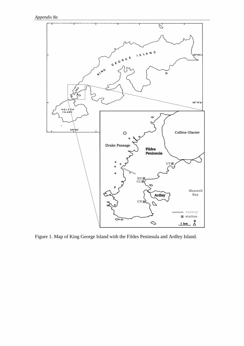
Appendix 8a
Maxwell Bay
CN
CLRU
UY
1 km N station runway
Figure 1. Map of King George Island with the Fildes Peninsula and Ardley Island.

Appendix 8 b
IP 16
Agenda Item:
CEP 4 g
Presented by:
Germany
Original Language:
English
Progress Report on the Research Project
“Risk assessment for Fildes Peninsula and Ardley Island and the development of management plans for
designation as Antarctic Specially Protected or Managed Areas”
Submitted by Germany
1. Introduction
At CEP VII Germany introduced IP 005, “Research Project “Risk assessment for the Fildes Peninsula and Ardley Island and the development of management plans for designation as Antarctic Specially Protected or Managed Areas”” at the south-western part of King-George Island. It summarised the progress of an ongoing three-year project to provide data to fully evaluate the role and structure of a possible broad-scale management system on Fildes Peninsula and Ardley Island. The project is being carried out by scientists of the Polar and Bird Ecology Group at the Institute of Ecology, University of Jena, Germany.
Furthermore, the project can be seen as a result of the joint Inspection programme conducted by the United Kingdom and Germany in the Antarctic Peninsula area during

Appendix 8b
January, 1999. As pointed out in WP 23 / XXIII ATCM under chapter “General remarks and conclusions”, lit. ix “Concentration of facilities: King George Island” the problems at Maxwell Bay were already recognized and described as “unique in Antarctica”. Therefore the recommendation was given that “In this respect consideration could be given towards further enhancing co-operation for example in logistic support, consistency in waste management procedures and a critical examination of scientific programmes to optimise productivity and minimise duplication.”.
With this paper Germany presents a further progress report which includes a summary of the activities carried out during the last two field seasons (2003/2004 and 2004/2005) and which gives an overview of planned activities at the next season. 2. Update 2.1. Environmental Information The following assessments have been carried out during the last two field seasons to record the spatial and temporal extent of human activities:
The historical and actual waste grounds of Fildes Peninsula and Ardley Island were mapped between December and March in each season (figure 1 consists of a distribution of different kinds of waste in the area). In this context hazardous material, large quantities of wood, plastic and metal and other objects were found not only close to human infrastructure but also further afield. Stranded material was most common, followed by deposits and wind-drifted material. The majority of waste was classified as originating from earlier years. Furthermore, actual oil leakage and entry of organic material were documented. The mapping of waste ground included the assessment of present management techniques at all stations on site.
Major construction activities were noted. These included for instance the establishment of a church by Russia in 2003/04 or the construction of an aircraft parking area at the existing runway on Fildes Peninsula by Chile in 2004/2005. This involved also the establishment of new vehicle and pedestrian lanes. As a consequence of these activities local environmental impacts on vegetation, breeding habitats and behaviour of birds were recorded.
Most land, air and sea traffic around the Fildes Peninsula was assessed for the first time during both field seasons by measuring frequencies and localities. This assessment included: • The registering of road traffic between and in the stations. Road traffic consisted of heavy vehicles used for fuel and cargo transports or construction work as well as cars used by station personnel and visitors. Whereas land traffic occurred, during summer, on a daily basis on existing roads between stations, off-road drives have been recorded very seldom. • The registering of air-traffic routes and altitudes of aeroplanes. In this activity, flights of aeroplanes such as Hercules C-130, Twin Otter, Beechcraft Kingair, Dash 7 and helicopters of various types were documented (for an example of helicopter flights in 2003/2004, please note figure 2). Among other things, some aircraft over-flights of

Appendix 8b
ASPA 150 Ardley Island were observed below the altitude of 300 m. The Management Plan of ASPA 150 states that “... Helicopter should not land on or overfly this island below 300m altitude. Aircraft landing at and taking off from Teniente Marsh airfield should avoid overflying the island. ...”. • Furthermore, information about most ship movements in Maxwell Bay was collected. During each summer season more than fifty entrances of supply, tourist, research and military ships and yachts were recorded. Supply vessels made up the majority of entrances to the bay, followed by tourist vessels.
2.2. Biological Information
Bird breeding sites of penguins, skuas, Antarctic terns, kelp gulls, southern giant petrels, sheathbills, cape petrels and storm petrels were mapped each season by using GPS/GIS (figure 3 shows a preliminary summary of these sites mapped in season 2004/2005). Of particular interest were changes in breeding pair numbers, breeding success and the distribution of selected bird species in relation to near-by human activities.
Furthermore, summer counts at seal resting sites were carried out, and winter station personnel of the Russian base collected records of seal breeding sites.
In 2004/05, a vegetation mapping was initiated to assign sensitive areas on Fildes Peninsula and Ardley Island. According to a literature review, dominant flowering plants, moss and lichen associations have been used for the classification. This work has been supported by Korean plant specialists from King Sejong Station. 2.3. Other Information
In 2003/04, a peninsula-wide survey of geological-paleontological sites was conducted to update published fossil data and look for a possible adjustment of the boundary of the existing ASPA 125. As announced in IP 005/CEP VII, a questionnaire was distributed among the station personnel (technical and scientific staff) of the Chilean, Chinese, Russian and Uruguayan Station. The participants responded very positive to this activity. This survey assessed individual knowledge of environmental issues in the Antarctic, the spatial and temporal land use outside the stations during free time especially in terms of wildlife visits. Of interest were opinions on existing or hypothetical scenarios of future leisure and tourist activities in the area that could have or have potential negative impacts on fauna and flora. Furthermore it was looked into improvements of presenting scientific and environmental information to station members by brochures or lectures on side.
All spatial and temporal data were stored in databases of ArcGIS. The data sets
include topographical information gathered in co-operation with the King George Island GIS Project (an international co-operation project under German leadership, http://www.geographie.uni-freiburg.de/ipg/forschung/ap3/kgis/). Biological and environmental data with detailed auxiliary information will be the major new contribution to existing data sets.

Appendix 8b
2.4. Scientific Co-operation From the beginning, it was pointed out that the success of this project will depend to a large extent on the co-operation between scientists and other representatives of the Antarctic Treaty Parties on site. Therefore co-operation between the Parties plays an important role in the whole project. First of all, as already mentioned above, a survey of individual perception and knowledge of local environmental issues carried out among station members was supported by all participants of the survey working on Fildes Peninsula and Ardley Island. Furthermore, the active field work co-operation was supported by scientists of Chile, Russia and the Republic of Korea. This support was an essential contribution for an effective census of breeding and resting bird and seal populations. In addition, the project was introduced to Chinese and Uruguayan station personnel. At the same time with these activities in the south-western part of King George Island, the Brazilian Antarctic Programme carried out similar assessment and management work in ASMA 1 in Admiralty Bay, King George Island. This work was jointed with the present research project for an active information exchange and ongoing discussions about monitoring criteria and practise. 2.5 Scientific Liaison in the field During the last CEP-Meeting several members expressed their support for, and indicated that they would willingly assist Germany in this project (see paragraphs 180 and 181 of the CEP VII Final Report). On this basis it was agreed informally to establish a liaison group consisting of those members who are represented with stations or field huts on Fildes Peninsula and Ardley Island or in the near neighbourhood of these areas. It was agreed that the objectives of this liaison group should be to exchange information on the progress of the project and to involve all members who are willing to assist Germany in this project. The following terms of reference for the work of this liaison group were adopted:
1. Exchange information of activities in the areas and of the progression of the
project. 2. Identify those members who have an interest to participate in and assist the
research project and / or who carry out similar research projects 3. Involve them specifically in the research project. This may mean co-
operation a) between the German scientists and station leaders on site b) with scientists of similar projects.
Other forms of co-operation could also be discussed. 4. Discuss and comment the circulated drafts of Management Plans, Guidelines
and Codes of Conduct. 5. Finalize and submit a “Fildes Peninsula and Ardley Island Antarctic
Specially Managed Area (ASMA) Management Package” to CEP IX (2006). Currently, there are fifteen participants of eight Antarctic Treaty Parties in that co-ordination group. IAATO and ASOC are joining it as well.

Appendix 8b
It should be underlined that this liaison group is an informal group which aims to ensure and improve the necessary exchange of information and co-ordination during the research project and at an early stage of the development of proposals for the intended management measures. The group will not anticipate or replace an Intercessional Contact Group which should be established, according to the rules of the CEP, after presentation of a draft Management Package at CEP IX (see in detail under item 4).
3. Planned Field Work Activities in 2005/06 3.1. Environmental Information Regarding the drafting of the management package, all relevant assessments of waste and fossil sites have been finished. Nevertheless, the documentation of actual environmental impacts will be continued also in 2005/2006. This shall ensure that the data will provide an adequate basis for the development of the upcoming management measures. The same applies to the documentation of land, sea and air traffic as well as to the assessment of environmental impacts caused by further construction activities on Fildes Peninsula. Although, the main data necessary for the development of appropriate management measures have been collected, this work will continue also in the next summer season in order to achieve a more comprehensive and substantive baseline. 3.2. Biological Information Also, in the season 2005/06, bird breeding sites especially penguins, skuas, southern giant petrels and storm petrels will be monitored by using GPS and GIS. This monitoring will occur in close co-operation with scientists from on-site stations. Furthermore, the breeding success of selected species will be recorded within the long-term monitoring programmes. The census work according to the “standards methods” of the “CCAMLR Ecosystem Monitoring Program” will continue, independently of the development of appropriate management and protection measures, in order to obtain long-term data sets for the analysis of human impacts. In addition, counts at seal resting sites will be continued in order to gain information on inter-annual variation. The German researchers will complete the vegetation mapping on Fildes Peninsula in co-operation with scientists of the Republic of Korea. 3.3. Other Information Last but not least, the interviews with station personnel and scientists will be continued to obtain a broader picture of the environmental needs on site. In this framework, the main work will be concentrated on new station members and visitors. 4. Further Steps Regarding the Development of a Proposal for a Management Package The intended development of proposals for new management measures and for the review of the existing regime on Fildes Peninsula and Ardley Island can only take place

Appendix 8b
in close co-operation with all Parties represented in that area. This co-operation includes not only joint work and exchange of information between scientists, station leaders and personnel on site, but also a common and agreed approach of the represented Parties and their responsible representatives in the CEP. To ensure such a co-ordination and co-operation the following steps are intended: A) First of all, the GPS/GIS data on waste, fossil, wildlife breeding and resting sites, the spatial and temporal extent of human activities and the questionnaires will be analysed (especially in terms of important management consequences). The results will be the basis for an environmental risk assessment in order to develop a proposal for the management package. In doing so it will be considered that several CEP-representatives recommended during the presentation of the project to take the “Deception Island Antarctic Specially Managed Area (ASMA) Management Package” (presented by Argentina, Chile, Norway, Spain, United Kingdom and United Stated as WP 013 at CEP VII) as a model for the development of an accordingly Management Package for Fildes Peninsula because of a lot of similarities, especially regarding the involvement of several Antarctic Treaty Parties represented in the area. Therefore, the proposal for such a package for Fildes Peninsula will include the following items:
a) Establishment of a new Antarctic Specially Managed Area Fildes Peninsula and Ardley Island have become areas with increasingly diverse human activities in recent decades. To avoid or reduce the risk of interference and minimise environmental impacts, planning and co-ordination of the existing and future activities could be strengthened by a designation as an ASMA. The area should comprise the whole of Fildes Peninsula and Ardley Island and should furthermore include small islands in the vicinity of the peninsula which hold important seabird concentrations.
b) Revision of Antarctic Specially Protected Areas The existing ASPA 150 Ardley Island and ASPA 125 Fildes Peninsula are currently under protection but require a revision of their management plans before December 2005 (according to Measure 3, XXIV ATCM 2001). In this context the research project could provide an useful contribution in order to achieve the implementation of this Measure. New scientific data also suggest that ASPA 125 should be extended. c) Establishment of a Zoning System Similar, as in the McMurdo Dry Valleys management plan, a zoning system could be included in the management package for Fildes Peninsula and the surrounding islands. This could support specific management measures by restricting or reducing access to sensitive wildlife concentrations and could facilitate logistic and management activities within station areas.

Appendix 8b
d) Code of Conduct The Code of Conduct will outline all management activities within the ASMA. It will give detailed information on the access to the area, activities, installations, waste management, scientific practise and environmental issues. e) Guidelines for Visitors and Station Personnel The high number of stations and the growing tourism activities within the Fildes Peninsula region require a revision of control mechanisms. Recommendations of spatial and temporal area use could help to minimize cumulative effects on wildlife. The results of the interviews of station members and visitors will be incorporated into these guidelines. f) Long-term Monitoring Activities As announced in IP 005/CEP VII, the scientific data sets obtained from this project will be analysed to give prognoses for future human developments in the Fildes Peninsula region. A regular and comprehensive monitoring of set indicators will be required to assess anthropogenic activities and their impacts on the local ecosystem in the long term. g) Air, Sea and Land Traffic Recommendations Recommendations for flight routes and heights for aeroplanes and helicopters should be revised under consideration of recent scientific investigation in wildlife concentrations. If necessary, further recommendations for shipping operations could also be developed. Furthermore, recommendations on land vehicle use and maintenance of roads and paths should be discussed.
B) Thereafter, a workshop about "Human impact on terrestrial habitats in the Antarctic" will be held at the 22nd International Polar Conference in Jena, September 2005. This workshop aims to join Antarctic scientists and station operators to discuss actual human impacts of logistics, science, and tourism on Antarctic fauna, flora and terrestrial ecosystems. Workshop participants will present varies methodological approaches and results of recent environmental impact assessments. Current management practise and possible advances will be discussed. Within the workshop the results of this project will also be presented and discussed. For further information please visit the webpage http://www.uni-jena.de/22nd_International_Polar_Meeting-lang-en.html. C) As a third step, the proposal for a draft management package will be distributed among co-ordination group members and other involved representatives of Antarctic Treaty Parties. A discussion of this draft will take place via e-mail, firstly. D) Following this discussion a workshop will be held on Fildes Peninsula, presumably in February 2006. The aim of this workshop is to ensure intensive co-operation during the data analysis and decision making process involving all Antarctic Treaty Parties represented at Fildes Peninsula and Ardley Island. During this workshop the environmental risk assessment, carried out in the present research project, will be presented. All participants will be invited to discuss the draft management package. It is intended to finalize it in order to submit it to CEP IX.
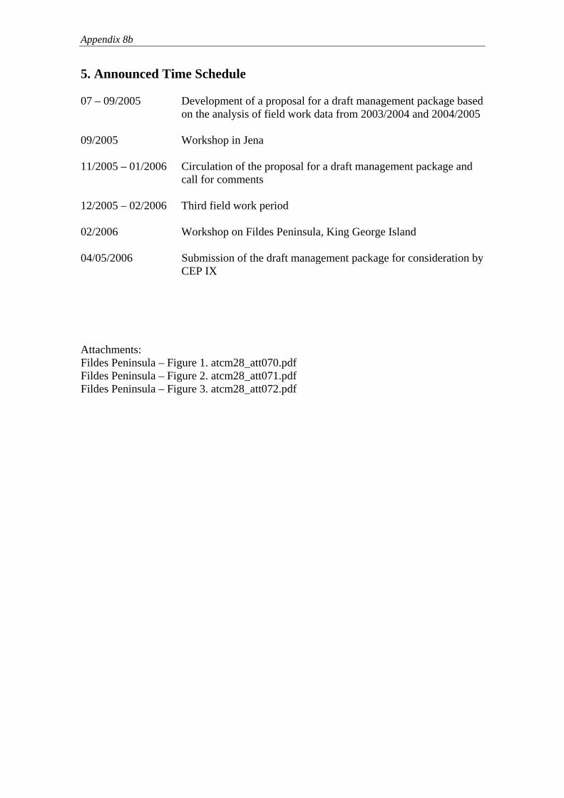
Appendix 8b
5. Announced Time Schedule 07 – 09/2005 Development of a proposal for a draft management package based
on the analysis of field work data from 2003/2004 and 2004/2005 09/2005 Workshop in Jena 11/2005 – 01/2006 Circulation of the proposal for a draft management package and
call for comments 12/2005 – 02/2006 Third field work period 02/2006 Workshop on Fildes Peninsula, King George Island 04/05/2006 Submission of the draft management package for consideration by
CEP IX Attachments: Fildes Peninsula – Figure 1. atcm28_att070.pdf Fildes Peninsula – Figure 2. atcm28_att071.pdf Fildes Peninsula – Figure 3. atcm28_att072.pdf

Figure 1. Waste assessment on the Fildes Peninsula and Ardley Island carried out between 2003 and 2005 (2379 locations).

Figure 2. Assessment of helicopter over-flight activities in 2003/04 using a Range Finder GPS system. Measurements were taken from different positions on the Fildes Peninsula and Ardley Island and aircraft flight routes were followed as long as possible (measured: at least two data points per flight, estimated: less than two measurements taken).

1
Figure 3. Preliminary summary of bird breeding sites on the Fildes Peninsula and Ardley Island. Graphic represents 1. Southern Giant Petrels Macronectes giganteus colonies, sub-colonies or single nests, 2. Brown, South Polar Skuas and mixed pair nests (Catharacta antarctica lonnbergi, C. maccormicki), 3. Antarctic Terns Sterna vittata colonies, 4. Kelp Gulls Larus dominicanus colonies and single nests, 5. Cape Petrels Daption capense colonies, 6. Sheathbills Chionis alba nests, 7. Wilson’s and Black-bellied Storm Petrel nests and colonies (Oceanites oceanicus, Fregetta tropica) so far mapped only in station surroundings, 8. Adélie, Chinstrap and Gentoo penguins colonies (Pygoscelis adeliae, P. antarctica, P. papua).

Appendix 8 c
WP 22
Agenda Item: CEP 7
Presented by: Brazil, China,
Germany, Korea
Republic of, Russian Federation
Original: English
“Possibilities for environmental management of Fildes Peninsula and Ardley Island”. Proposal to establish an
intersessional contact group

Appendix 8c
“Possibilities for environmental management of Fildes Peninsula and Ardley Island”
Proposal to establish an intersessional contact group submitted by
Brazil, China, Germany, Korea and Russia
Introduction
At CEP VII Germany introduced IP 005, “Research Project ‘Risk assessment for the Fildes Peninsula and Ardley Island and the development of management plans for designation as Antarctic Specially Protected or Managed Areas’”. This paper described a three-year research project (2003 – 2006) to provide data to fully evaluate the role and structure of a possible broad-scale management system on Fildes Peninsula and Ardley Island. The project has been carried out by scientists of the Polar and Bird Ecology Group at the Institute of Ecology, University of Jena, Germany. Several CEP members expressed their support for the proposal, and indicated that they would willingly assist Germany in the project.
At CEP VIII Germany introduced IP 016, “Progress Report on the Research Project “Risk assessment for Fildes Peninsula and Ardley Island and the development of management plans for designation as Antarctic Specially Protected or Managed Areas””. This paper provided an update on the project, noting the excellent co-operation of other Parties in the area through an informal co-ordination group. Germany also indicated its intent to submit a draft ASMA plan for consideration at CEP IX. At ATCM XXVIII, “Germany agreed that prior to tabling a draft Management Plan for Fildes Peninsula and Ardley Island (King George Island) and following a proposal by Chile an International Working Group should be established, composed of those Parties with stations and/or huts in the area, Parties with an interest in the area as well as Observers to the Antarctic Treaty. This group will discuss the issues related to the Draft Management Plan. With this purpose, Germany will carry out two international workshops, one in September 2005 and another one in January/February 2006, in order to convene the participants on this issue” (Final Report of ATCM XXVIII, para. 90). Both workshops mentioned in the preceding paragraph have been carried out. The first took place at the University of Jena (Germany) in September 2005, where participants appreciated the work undertaken and expressed support for the intention to develop effective management tools for the region. The outcome of the workshop is summarized in Appendix 1 to this Working Paper. The following deals with the second workshop.
1. The King George Island Workshop
1.1 General The second workshop was convened by the Federal Environmental Agency and the Federal Ministry of the Environment of Germany, from 30 January to 3 February 2006. It was hosted by the Russian Arctic and Antarctic Research Institute, St Petersburg, Russia, at Bellingshausen

Appendix 8c
Station on King George Island, which provided excellent facilities. All participants appreciated the hospitality and the agreeable atmosphere of the meeting. Transport was generously supported by Norwegian, Chilean and US Antarctic tour operators. Their assistance as well as the personal engagement of individuals within these companies contributed to a great extent to the success of the workshop.
The workshop was attended by government representatives, scientists, and station leaders of eight Antarctic Treaty Parties, as well as representatives of ASOC and IAATO and other non-governmental organizations.
1.2 Main Findings and Recommendations At the workshop, possible management approaches for the Fildes Peninsula Region (including Fildes Peninsula, Ardley Island and other adjacent smaller islands) were discussed; among others a Fildes Region ASMA, a zoning system without ASMA designation, the extension of ASPA Nr. 125, special guidelines for station activities, science and tourism, the possibility of a Maxwell Bay ASMA and as well the option of no changes in the current system. There was general agreement among all participants that:
• the Fildes Peninsula Region needs a multiple use management system and
• an ASMA for the Fildes Peninsula Region would provide the most comprehensive approach for managing the area.
It was recommended that further discussion on such a management system should include all Parties with stations and/or huts in the area, Parties with an interest in the area as well as Experts and Observers to the Antarctic Treaty.
The findings of the workshop, the list of the participants and the work programme are attached as Appendix 2 to this Working Paper.
2. Conclusion In order to formalize the discussion process on a management system for the Fildes Peninsula Region, a single Intersessional Contact Group should be established by the CEP. This group should collect management concepts of various Parties on a broad basis, and should discuss possible management approaches that will include among others, visitor guidelines as a practical tool, and the possibility of designing the Fildes Peninsula Region as an ASMA. For this Intersessional Contact Group the following Terms of Reference are proposed:
1) Discuss the future preparation of a draft Management Plan, for the possible designation of the Fildes Peninsula Region as an ASMA considering any revision of Management Plans for the ASPAs involved (No. 125 and 150).
2) Consider in its work in particular the findings of the King George Island Workshop.
3) Examine in cooperation with CCAMLR the possibility to include marine components in the referred Management Plan.
4) Consider the possibility to set up an integrated web based information system in order to allow for input of all scientific, tourist and logistic activities in the Fildes Peninsula Region, and to this end cooperate with SCAR, IAATO and COMNAP.
5) Submit an advance report of the mentioned discussion about the preparation of the draft Management Plan to CEP X."

Appendix 8c
Appendix 1
Outcome of the Workshop ‘Human impact on terrestrial habitats in the Antarctic’ held at the 22nd International Polar Meeting
23 September 2005, Jena, Germany
The workshop joined researchers from twelve nations currently working on human impact studies in the Antarctic and sub-Antarctic. It offered a platform for a comprehensive and profound meeting of experts on current human impacts in the Antarctic and sub-Antarctic.
After a brief opening address by a representative of the Federal Foreign Office, Germany 18 presentations were given and discussed in the course of one day (see program below).
Peter Convey gave a research overview regarding alien terrestrial organisms in the Antarctic. Although few impacts are visible in the environment, there is a strong lack of basic survey and monitoring data. He stated an urgent need for the establishment of monitoring programs and measures to mitigate the risk of introduction of such organisms by the movement of people and cargo. Kevin Hughes presented results from responses of Antarctic soil micro-organisms to oil contamination. Microcosm experiments showed that oil degradation increased to the greatest extent with a treatment combination of bioaugmentation and biostimulation.
Enn Kaup summarised studies of sewage flow and waste dispersal into Antarctic lakes between the 1970s and 90s. Impacts were evident in the vicinity of stations including increases in salinity and nutrient levels. In recent years, research and environmental monitoring activities of the Russian Antarctic Expedition focussed on these and other human impacts which Maria Gavrilo outlined in the workshop.
After Michaela Mayer had given a special overview of the development of tourism in Arctic and Antarctic, three speakers reported on human impacts on the sub-Antarctic islands. Sally Poncet provided an insight into the monitoring program for the South Georgian Islands Albatross and Prion where interactions between visitors, fur seals and wandering albatrosses are evident. Marienne de Villiers summarised a variety of human impacts and presented current management activities to reduce or eliminate them on the Prince Edward Islands. Finally, experimental and observational disturbance studies on penguins of Macquarie Island were undertaken and presented by Nick Holmes.
Then, several presentations followed dealing with studies being conducted on King George Island. Rolf Weber informed about the Brazilian research network for assessing impacts around Ferraz Station in Admiralty Bay. This large multidisciplinary study runs since 2002, joining 15 research groups. A Chinese-German co-operation project on the impacts of station food and garbage on skuas at the Fildes Peninsula was presented by Wang Zipan. Preceding the vegetation mapping on the Fildes Peninsula in 2003/04, South Korean researchers produced a GPS/GIS-map for the vegetation around King Sejong Station on Barton Peninsula – an overview was given by Ji Hee Kim. Dmitry Vlasov reported results of a survey on fungi conducted on the Fildes Peninsula, Ardley and Nelson Island that covered rock, soil and building material.
To open the last session of the workshop, Rod Downie provided an insight into the development of the ASMA management package of Deception Island. This package was the result of an intensive international co-operation over several years. In the Fildes Peninsula Region, a similar approach could be used. The German research project ‘Risk assessment for the Fildes Peninsula and Ardley Island and the development of management plans for designation as Antarctic Specially Protected or Managed Areas’ was presented by Hans-Ulrich Peter, Osama Mustafa, Christina Büsser and Simone Pfeiffer.

Appendix 8c
In a final podium discussion, preliminary results of the research project, a risk assessment and management ideas for the Fildes Peninsula were discussed constructively. The participants strongly appreciated the work undertaken and supported the intention to continue with the research and to develop an effective management of the region.
Workshop Program
08:30 – 08:45 Opening of the workshop, introduction 08:45 – 09:05 Peter Convey, Cambridge/UK: How vulnerable are Antarctic terrestrial ecosystems to biological invasions?
09:05 – 09:25 Kevin Hughes & Bethan Stallwood, Cambridge, Bangor/UK: Oil spills in Antarctic terrestrial environments – the impact on soil microorganisms
09:25 – 09:45 Enn Kaup, Tallinn/Estonia: Human impacts in catchments and lakes of Schirmacher, Thala and Larsemann oases
09:45 – 10:15 Coffee break
10:15 – 10:35 Maria Gavrilo & Victor Pomelov, St.Petersburg/Russia: Environmental activities of the Russian Antarctic Expedition 10:35 – 10:55 Sally Poncet, Falkland Islands (Islas Malvinas): Albatross and Prion Islands, South Georgia: a management challenge 10:55 – 11:15 Michaela Mayer, Bremen/Germany: Environmental impacts of Polar tourism 11:15 – 11:35 Marienne De Villiers & John Cooper, Cape Town/South Africa: Human impacts at the sub-Antarctic Prince Edward Islands 11:35 – 11:55 Nick Holmes & Melissa Giese, Hobart, Kingston/Australia: Investigating the variation in penguin responses to human activity on Macquarie Island 11:55 – 13:30 Lunch break 13:30 – 14:00 Rolf Weber, Cristina Engel Alvarez, Antonio Batista, Martin
Sander et al., São Paulo, Vitória, Santa Cruz do Sul, Rio de Janeiro, Rio Grande do Sul, Porto Alegre, Viçosa/Brazil:
Environmental assessment in the vicinity of Cmte. Ferraz Station (Brasil), Admiralty Bay, King George Island – Concepts and achievements in an integrated methodology

Appendix 8c
14:00 – 14:15 Wang Zipan, Hans-Ulrich Peter & Anne Froehlich, Shanghai/China Jena/Germany: Impacts of station garbage on the diet of Antarctic Skuas on Fildes Peninsula of King George Island 14:15 – 14:35 Ji Hee Kim & Hosung Chung, Ansan/Korea:
A baseline survey for long-term monitoring of terrestrial vegetation around King Sejong Station, King George Island
14:35 – 14:55 Dmitry Vlasov & Vycheslav Krylenkov, St. Petersburg/Russia: Mycobiota of the Antarctic Polar Stations area on the King George Island 14:55 - 15:15 Rod Downie, Cambridge/UK: Deception Island- a trailblazer in Antarctic site management 15:15 – 15:45 Coffee Break 15:45 – 15:50 Hans-Ulrich Peter, Jena/Germany: Risk assessment for Fildes Peninsula and Ardley Island and the development of management plans for designation as Antarctic Specially Protected or Managed Areas – a short introduction 15:50 – 16:10 Osama Mustafa, Christina Büsser, Simone Pfeiffer & Hans- Ulrich Peter, Jena/Germany: Mapping of traffic activities on Fildes Peninsula and Ardley Island – methods and results 16:10 – 16:30 Christina Büßer, Uwe Grunewald, Tiemo Kahl, Osama Mustafa, Simone Pfeiffer & Hans-Ulrich Peter, Jena/Germany: Environmental data and human activities on Fildes Peninsula and Ardley Island 16:30 – 16:45 Hans-Ulrich Peter, Christina Büsser, Osama Mustafa & Simone Pfeiffer, Jena/Germany:
Biological data and risk assessment (Fildes Peninsula and Ardley Island)
16:45 – 17:10 Simone Pfeiffer, Christina Büsser, Osama Mustafa & Hans- Ulrich Peter, Jena/Germany: Possible elements of a drafts Management plan for the south- western part of King George Island 17:10 – 18:00 Discussion and conclusions
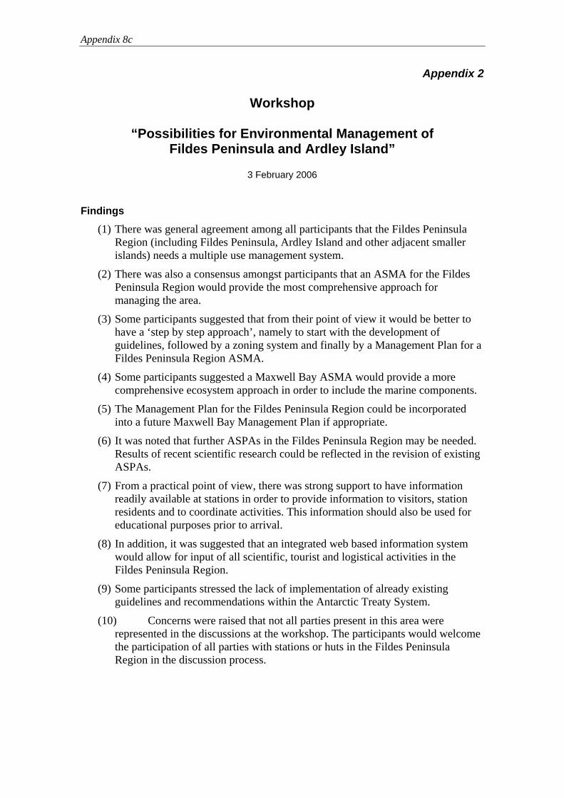
Appendix 8c
Appendix 2
Workshop
“Possibilities for Environmental Management of Fildes Peninsula and Ardley Island”
3 February 2006
Findings
(1) There was general agreement among all participants that the Fildes Peninsula Region (including Fildes Peninsula, Ardley Island and other adjacent smaller islands) needs a multiple use management system.
(2) There was also a consensus amongst participants that an ASMA for the Fildes Peninsula Region would provide the most comprehensive approach for managing the area.
(3) Some participants suggested that from their point of view it would be better to have a ‘step by step approach’, namely to start with the development of guidelines, followed by a zoning system and finally by a Management Plan for a Fildes Peninsula Region ASMA.
(4) Some participants suggested a Maxwell Bay ASMA would provide a more comprehensive ecosystem approach in order to include the marine components.
(5) The Management Plan for the Fildes Peninsula Region could be incorporated into a future Maxwell Bay Management Plan if appropriate.
(6) It was noted that further ASPAs in the Fildes Peninsula Region may be needed. Results of recent scientific research could be reflected in the revision of existing ASPAs.
(7) From a practical point of view, there was strong support to have information readily available at stations in order to provide information to visitors, station residents and to coordinate activities. This information should also be used for educational purposes prior to arrival.
(8) In addition, it was suggested that an integrated web based information system would allow for input of all scientific, tourist and logistical activities in the Fildes Peninsula Region.
(9) Some participants stressed the lack of implementation of already existing guidelines and recommendations within the Antarctic Treaty System.
(10) Concerns were raised that not all parties present in this area were represented in the discussions at the workshop. The participants would welcome the participation of all parties with stations or huts in the Fildes Peninsula Region in the discussion process.
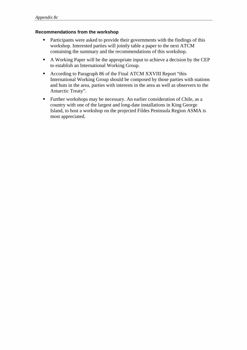
Appendix 8c
Recommendations from the workshop
Participants were asked to provide their governments with the findings of this workshop. Interested parties will jointly table a paper to the next ATCM containing the summary and the recommendations of this workshop.
A Working Paper will be the appropriate input to achieve a decision by the CEP to establish an International Working Group.
According to Paragraph 86 of the Final ATCM XXVIII Report “this International Working Group should be composed by those parties with stations and huts in the area, parties with interests in the area as well as observers to the Antarctic Treaty”.
Further workshops may be necessary. An earlier consideration of Chile, as a country with one of the largest and long-date installations in King George Island, to host a workshop on the projected Fildes Peninsula Region ASMA is most appreciated.

Appendix 8c
Workshop
‘Possibilities for Environmental Management of the Fildes Peninsula and Ardley Island’
Bellingshausen Station, King George Island, Antarctic
30 January to 3 February 2006
List of invited Participants and Guests*
Country/ Organization
Name Institution Contact details
Brazil Tania Brito Programa Antártico Brasileiro/MMA Diretoria de Áreas Protegidas - SBF Ministério do Meio Ambiente
Chile Maria Jose Rosello*
Instituto Antártico Chileno (INACH)
[email protected] [email protected]
China Jiang Xiaodong Chinese Arctic & Antarctic Administration
Korea Jaeyong Choi* Chungnam National University
Korea Sang Joon Lee Ministry of Environment
Korea Ji Hee Kim* Korea Polar Research Institute
Korea Jeong-Hoon Kim* Kyun Hee Univerity [email protected]
Korea Wanho Lim* DMZwild Co., Ltd. Nature Documentary Production
Korea Jun Woo Park* DMZwild Co., Nature Documentary Production
Russia Oleg Sakharov Base Commander of Bellingshausen Station

Appendix 8c
Russia Mikhail P. Andreev*
Komarov Botanical Institute
[email protected] [email protected]
Russia Victor E. Lagun* Arctic and Antarctic Research Institute
Russia Maria Gavrilo Arctic and Antarctic Research Institute
Russia Alexander Orup* Arctic and Antarctic Research Institute
Russia Maxim Moskalevsky*
Russian Academy of Sciences
Russia Nikolay Osokin* Russian Academy of Sciences
Spain Manuel Ballestros* University of Barcelona
Spain Javier Cristobo* Instituto Espanol de Oceanografia
Uruguay Daniel Antúnez Uruguayan Antarctic Institute
[email protected] [email protected]
Uruguay Longino Sosa* Arancet
Base Commander of Artigas Station
[email protected] [email protected]
Uruguay Gustavo Caubarrere*
Uruguayan Antarctic Institute Servicio Geografico
[email protected] [email protected]
IAATO Denise Landau International Association of Antarctica Tour Operators
ASOC Ricardo Roura Antarctic and Southern Ocean Coalition
‘Mission Antarctica’
Garry Evans* [email protected]
Germany Axel Szelinski Federal Ministry for the Environment, Nature Conservation and Nuclear Safety
Germany Antje Neumann Federal Environmental Agency
Germany Fritz Hertel Federal Environmental Agency
Germany Wolfgang Dinter Federal Agency for wolfgang.dinter@bfn-

Appendix 8c
Nature Conservation vilm.de
Germany Michaela Mayer RS Research Shipping GmbH
Germany Steffen Vogt Institute for Geography/ University of Freiburg
Germany Hans-Ulrich Peter Institute for Ecology/ University of Jena
Germany Simone Pfeiffer Institute for Ecology/ University of Jena
Germany Christina Buesser Institute for Ecology/ University of Jena
Germany Osama Mustafa Institute for Ecology/ University of Jena

Appendix 8c
Workshop
“Possibilities for Environmental Management of Fildes Peninsula and Ardley Island”
Meeting agenda
January 30 to February 3, 2006
Supported by the Russian Antarctic Expedition (RAE) Valery Lukin, Director of RAE
Location Russian Station Bellingshausen
Kindly hosted by the Base Commander of Bellingshausen Station
Oleg Sakharov
Convenor The Federal Environmental Agency, Germany
and
The Federal Ministry of the Environment, Germany
Office in charge of organisation The Federal Environmental Agency, Germany
Mr. Fritz Hertel/ Mrs. Antje Neumann Fachgebiet I 2.4
Woerlitzer Platz 1 D- 0 6 8 4 4 D e s s a u
Germany Tel.: ++49 340-2103-2688 / -2395 Fax: ++49 340-2104-2688 / -2395
Email: [email protected], [email protected] Website: www.umweltbundeamt.de

Appendix 8c
Workshop
‘Possibilities for Environmental Management of Fildes Peninsula and Ardley Island’
Bellingshausen Station, King George Island, Antarctic
January 30 to February 3, 2006
Sunday, January 29, 2006 Arrival of participants at the Russian Station Bellingshausen.
Monday, January 30, 2006 09.30 - 10.00 Addresses of welcome
Chair: H.-U. Peter
- Oleg Sakharov (Base Commander of Bellingshausen Station, Russia)
- Axel Szelinski (Federal Ministry of the Environment, Germany) 10.00 - 12.00 Technical information and introductions
Chair: H.-U. Peter - Introduction to the workshop (Antje Neumann, Federal Environmental Agency, Germany) - Introduction to the survey area (H.-U. Peter & colleagues, University of Jena, Germany) 12.00 – 13.00 Lunch break Afternoon Excursion: Visiting Ardley Island (H.-U. Peter & colleagues, University of Jena, Germany) Evening Ice Breaker Party
Tuesday, January 31, 2006 Note: All oral presentations are limited to 20 minutes plus 10 min. for discussion!
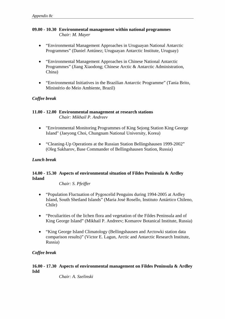
Appendix 8c
09.00 - 10.30 Environmental management within national programmes Chair: M. Mayer
• “Environmental Management Approaches in Uruguayan National Antarctic
Programmes” (Daniel Antúnez; Uruguayan Antarctic Institute, Uruguay)
• “Environmental Management Approaches in Chinese National Antarctic Programmes” (Jiang Xiaodong; Chinese Arctic & Antarctic Administration, China)
• “Environmental Initiatives in the Brazilian Antarctic Programme” (Tania Brito,
Ministério do Meio Ambiente, Brazil) Coffee break
11.00 - 12.00 Environmental management at research stations Chair: Mikhail P. Andreev
• "Environmental Monitoring Programmes of King Sejong Station King George Island" (Jaeyong Choi, Chungnam National University, Korea)
• “Cleaning-Up Operations at the Russian Station Bellingshausen 1999-2002”
(Oleg Sakharov, Base Commander of Bellingshausen Station, Russia) Lunch break
14.00 - 15.30 Aspects of environmental situation of Fildes Peninsula & Ardley Island Chair: S. Pfeiffer
• “Population Fluctuation of Pygoscelid Penguins during 1994-2005 at Ardley Island, South Shetland Islands” (Maria José Rosello, Instituto Antártico Chileno, Chile)
• “Peculiarities of the lichen flora and vegetation of the Fildes Peninsula and of
King George Island” (Mikhail P. Andreev; Komarov Botanical Institute, Russia)
• “King George Island Climatology (Bellingshausen and Arctowki station data comparison results)” (Victor E. Lagun, Arctic and Antarctic Research Institute, Russia)
Coffee break
16.00 - 17.30 Aspects of environmental management on Fildes Peninsula & Ardley Isld Chair: A. Szelinski
Appendix 8c
• “Managing Tourism on the Fildes Peninsula from an IAATO Point of View” (Denise Landau, International Association of Antarctica Tour Operators –IAATO)
• “Environmental Reports of Fildes Peninsula, 1988-1997: Benchmarks for
Environmental Management” (Ricardo Roura, The Antarctic and Southern Ocean Coalition –ASOC)
• “Environmental Studies (monitoring) in the Russian Antarctic Program:
‘Positive experience and still missing linkages’” (Maria Gavrilo, Arctic and Antarctic Research Institute, Russia)
Wednesday, February 1, 2006 09.00 - 12.00
Chair: F. Hertel
• “Risk assessment for Fildes Peninsula & Ardley Island and development of management plans for designation as Antarctic Specially Protected or Managed Areas” (Hans-Ulrich Peter, Ossama Mustafa, Christina Buesser, Simone Pfeiffer, University of Jena, Germany), discussion
Lunch break Afternoon - Excursion: Western part of Fildes Peninsula (Hans-Ulrich Peter & colleagues, University of Jena, Germany)
Thursday, February 2, 2006 09.00 - open end
Chair: A. Neumann
• “Modules for designing Fildes Peninsula & Ardley Island as an Antarctic specially managed area (ASMA), discussion of possible alternatives” (Simone Pfeiffer, University of Jena, Germany)
• Discussion
Each participant is welcome to present his views in this discussion!
Friday, February 3, 2006 09.00 - 12.00
Chair: A. Szelinski
Appendix 8c
• Conclusions and results of the workshop (Antje Neumann and Fritz Hertel, Federal Environmental Agency, Germany), discussion included
Lunch break 14.00 Wrap up and Finals
Chair: H.-U. Peter
• Other business (N.N.) • Closing of the workshop (Oleg Sakharov, Base Commander of Bellingshausen
Station, Russia and Axel Szelinski, Federal Ministry of the Environment, Germany)
Evening Farewell Party
Saturday, February 4, 2006 Begin of departure. Please note:
The agenda is flexible depending on contributions still due and other circumstances (e.g. weather conditions).

Appendix 8 d
IP 22 rev. 1
Agenda Item: CEP 7(e)
Presented by: Germany, Chile
Original: English
Progress Report on the Discussion of the International Working Group about
Possibilities for Environmental Management of Fildes Peninsula and
Ardley Island

Appendix 8d IP 22 rev. 1
Progress Report on the Discussion of the International Working Group about Possibilities for Environmental Management of Fildes Peninsula and Ardley Island
submitted by
Germany and Chile
1. Introduction
At CEP VII Germany introduced IP 005, “Research Project Risk assessment for the Fildes Peninsula and Ardley Island and the development of management plans for designation as Antarctic Specially Protected or Managed Areas’”. This paper described a three-year research project (2003 – 2006) to provide data to fully evaluate the role and structure of a possible broad-scale management system on Fildes Peninsula and Ardley Island. The project has been carried out by scientists of the Polar and Bird Ecology Group at the Institute of Ecology, University of Jena, Germany. Several CEP members expressed their support for the proposal, and indicated that they would willingly assist Germany in the project.
At CEP VIII Germany introduced IP 016, “Progress Report on the Research Project Risk assessment for Fildes Peninsula and Ardley Island and the development of management plans for designation as Antarctic Specially Protected or Managed Areas”. This paper provided an update of the project, noting the excellent co-operation with other Parties in the area through an informal co-ordination group. Germany also indicated its intent to submit a draft ASMA plan for consideration to CEP IX.
At ATCM XXVIII, “Germany agreed that prior to tabling a draft Management Plan for Fildes Peninsula and Ardley Island (King George Island) and following a proposal by Chile an International Working Group should be established, composed of those Parties with stations and/or huts in the area, Parties with an interest in the area as well as Observers to the Antarctic Treaty. This group will discuss the issues related to the Draft Management Plan. With this purpose, Germany will carry out two international workshops, one in September 2005 and another one in January/February 2006, in order to convene the participants on this issue” (Final Report of ATCM XXVIII, para. 90).
At CEP IX Brazil, China, Germany, the Republic of Korea and the Russian Federation introduced WP022, “Possibilities for Environmental Management of Fildes Peninsula and Ardley Island. Proposal to establish an Intersessional Contact Group”. This paper reported on the main findings and recommendations of the King George Island Workshop “Possibilities for Environmental Management of Fildes Peninsula and Ardley Island” in January/February 2006 as well as on the outcome of the Workshop “Human impact on terrestrial habitats in the Antarctic” in September 2005”. Discussion of this paper is reflected in paragraphs 70 to 75 of the CEP Report.
At ATCM XXIX “Germany expressed satisfaction on reaching agreement with Chile in principle on developing an ASMA for Fildes Peninsula and Ardley Island. They will jointly convene – via note verbal – an international working group (paragraph 74 of the CEP Report). Germany expressed the hope that a substantive outcome of the group’s work would be presented to the next ATCM. Chile confirmed that it will host a workshop to prepare the input on this issue for discussion at CEP X.” (Final Report of ATCM XXIX, para. 77)

Appendix 8d IP 22 rev. 1
2. The International Working Group
2.1 General
Pursuant to these understandings an international working group involving government representatives of interested Parties was convened by Germany and Chile in order to discuss management approaches, possibly aiming at drafting a management plan for an ASMA covering the Fildes Peninsula Region. With the assistance of the Antarctic Treaty Secretariat a web based Discussion Forum was established.
2.2 Questions uploaded to the web based Discussion Forum
The convenors uploaded the following questions to the web based Discussion Forum of the CEP at the beginning of the discussion in October 2006:
- What kind of management approaches for the Fildes Peninsula Region (including Fildes Peninsula, Ardley Island and other adjacent smaller islands) do you suggest?
- Which management activities should be included by such an approach?
- Which geographical area should be covered by such an approach?
- Which timeframe should be taken for implementing your suggested approach?
2.3 Participation
Besides the convenors Chile and Germany, thirteen other parties expressed their wish to join the International Working Group (IWG) dealing with possibilities for environmental management of Fildes Peninsula and Ardley Island. They nominated their national representatives to participate in the IWG (see Table 1). Table 1 - Participating parties of the International Working Group dealing with possibilities for environmental management of Fildes Peninsula and Ardley Island and their representatives
Consultative Party Representative E-mail
Argentina Mr Mariano Memolli
Mr Rodolfo Sanchez
Australia Mr Ewan McIvor [email protected]
Brazil Mrs Tania Aparecida da Silva Brito
Chile Mr Jorge Berguno
Mrs Veronica Vallejos
China Mrs Chen Danhong
Mr Cai Minghong
France Mr Yves Frenot [email protected]
Germany Mrs Heike Herata [email protected]
Japan Mr Kousei Masu [email protected]

Appendix 8d IP 22 rev. 1
Consultative Party Representative E-mail
Peru Ms Patricia Gagliuffi [email protected]
Poland Mr Andrej Tatur [email protected]
Republic of Korea Mr Jong-Min Kim
Mr Jaeyong Choi
Russian Federation Mr Victor Pomelov [email protected]
Spain Mr Manuel Catalan
Mr Guillermo Morales
United Kingdom Mr Rod Downie [email protected]
Uruguay
Mr Aldo Felici [email protected]
3. Comments of the parties involved
Table 2 gives a summary of the submitted answers to questions made by the convenors (see 2.2), including both comments made within the Discussion Forum and prior statements made in relevant documents.
4. Further steps
The participants of IWG intend to continue their work intersessionally at the web based Discussion Forum and meet at agreed intervals and venues scheduled by the members of the Antarctic Treaty System, taking into account inter alia data provided by the results of:
- the Workshop “Scientific Cooperation, Environmental Protection, Coordination of Activities in the Fildes Peninsula Region, King George Island, South Shetland Islands, Antarctica (Punta Arenas, 29-31 March 2007),
- the final report of the German Research Project “Risk Assessment for the Fildes Peninsula and Ardley Island and the development of management plans for designation as Antarctic Specially Protected or Managed Areas” (ca. May 2007), and
- the review by the CEP of the draft management plan for ASPA Nº 150 (Ardley Island).

Appendix 8d IP 22 rev. 1
Table 2 – Part I: Comments within the Discussion Forum referring to questions made at the beginning of the discussion given by the IWG participating parties
Comments within the Discussion Forum
IWG parties↓ Question 1: What kind of management do you suggest?
Question 2: Which management activities should be included by such an approach?
Question 3: Which geographical area should be covered by such an approach?
Question 4: Which timeframe should be taken for implementing your suggested approach?
Argentina No information available No information available No information available No information available
Australia
ASMA, multi operated start with general management provisions
Establishing „Management Groups“ for communication and coordination between operators; communication with Admirality Bay
Refining boundaries (and management arrangements) over time
Establish a robust management structure as soon as practicable; it will require ongoing review
Brazil ASMA Management Plan: Zoning, Code of Conduct, site-specific guidelines
Maxwell Bay Management Plan adopted in two-three years
Chile Code of Conduct required by article 5 (3) (1) of Annex V
“Management Groups” for communication and coordination between operators in the Fildes Peninsula, Admirality Bay, King Sejong and Jubany/Dallmann
Fildes Peninsula Region from Collins Glacier to Stansbury Peninsula, including Ardley and small Islands and the maritime spaces enclosed by Fildes Strait to Ruin Point (62º16’S 58º56’W) Nelson Island linked by a straight line to North Spit (62º13’S 58ª48’W) KGI
Adoption at the ATCM in 3-5 years: interim “Management by Information”
China Step by step, first Code of Conduct, then ASMA
Establishing „Coordination Group”, Establishing Code of Conduct, then comprehensive Management Plan
Maxwell Bay Code of Conduct as soon as possible, ASMA adoption in 3-5 years
France
ASMA start with general management provisions
Establishing „Coordination Group”, Guidelines & Code of Conduct, zoning strongly supported; data on vegetation must be added; suggest another zone: “areas of scientific interest” for monitoring purposes
Maxwell Bay “is likely too ambitious in a first approach”, refining boundaries (and general management provisions) over time
Draft management plan as soon as possible; flexible in term of its revision
Japan “…it is useful that we consider management approach to chose from or combine the existing system; ASMA, ASMA and Site Guidelines pursuant to Resolutions”
No information available No information available
Peru No information available No information available No information available No information available
Poland No information available No information available No information available No information available
Russia ASMA including zoning and Codes of Conduct
Zoning and site-specific guidelines Maxwell Bay Step by step, early start of ASMA Management Plan is appreciated
Spain ASMA Management Plan, Establishing Management Group, Zoning, new ASPAs if necessary
1. step: Fildes Peninsula & Ardley Island, 2. step: extending
2007 Workshop P.A. (Chile), 2008 ATCM General lines of ASMA draft, 2009 a first ASMA draft for consensus, 2010-2011 ASMA adoption
United Kingdom
ASMA Zoning, site-specific guidelines and management plan
First: Maxwell Bay, long term: King George Island (including ASMA Admirality Bay)
Adoption at ATCM in 3-5 years; In the interim “Management by Information”
Uruguay Visitors Guidelines & Code of Conduct
Code of Conduct, Coordination, Information… Fildes Peninsula & Ardley Island Nov-Dec 2006 International Consideration Jan-Feb 2007 Intersess. discussion and analysis Mar 2007 Consolidation during Workshop in P.A.
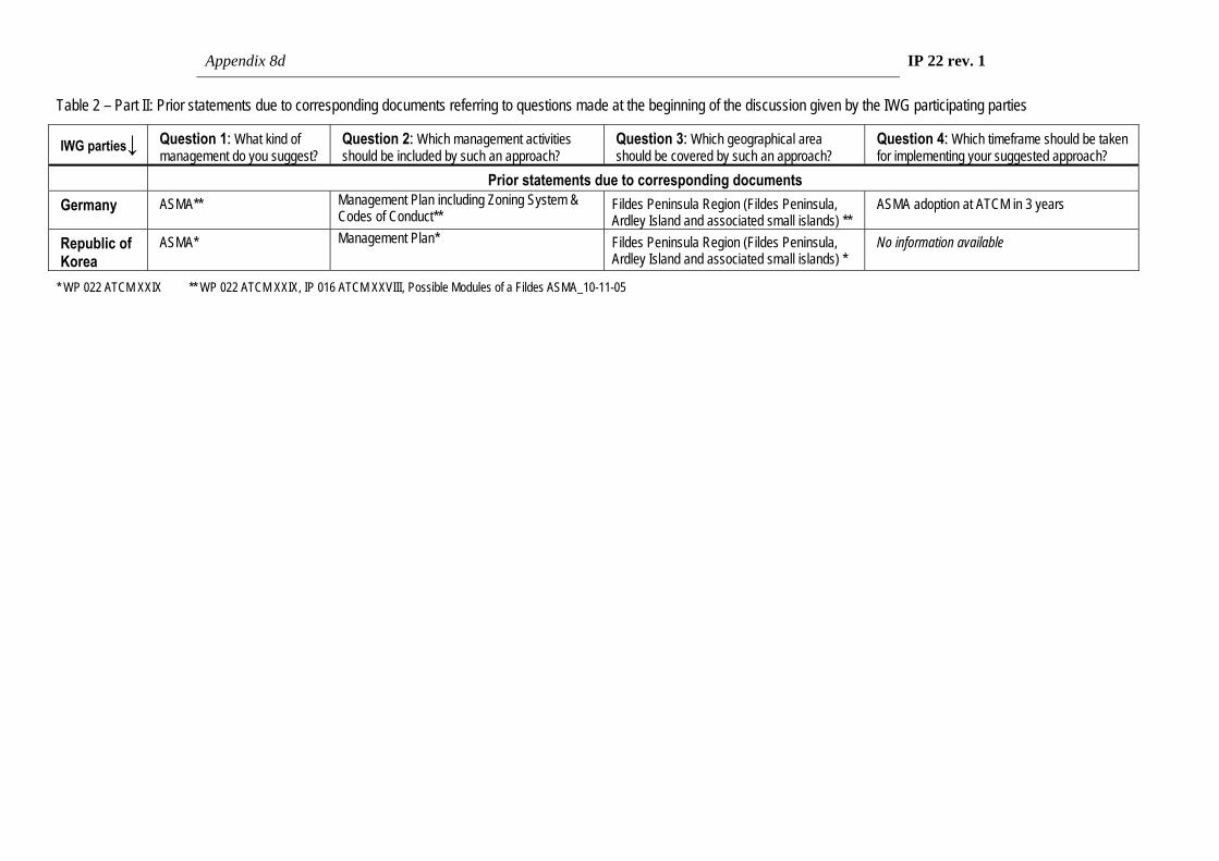
Appendix 8d IP 22 rev. 1
Table 2 – Part II: Prior statements due to corresponding documents referring to questions made at the beginning of the discussion given by the IWG participating parties
IWG parties↓ Question 1: What kind of management do you suggest?
Question 2: Which management activities should be included by such an approach?
Question 3: Which geographical area should be covered by such an approach?
Question 4: Which timeframe should be taken for implementing your suggested approach?
Prior statements due to corresponding documents Germany ASMA** Management Plan including Zoning System &
Codes of Conduct** Fildes Peninsula Region (Fildes Peninsula, Ardley Island and associated small islands) **
ASMA adoption at ATCM in 3 years
Republic of Korea
ASMA* Management Plan* Fildes Peninsula Region (Fildes Peninsula, Ardley Island and associated small islands) *
No information available
* WP 022 ATCM XXIX ** WP 022 ATCM XXIX, IP 016 ATCM XXVIII, Possible Modules of a Fildes ASMA_10-11-05

Appendix 8 e
IP 112
Agenda Item: CEP 7(e)
Presented by: Germany
Original: English
Possible Modules of a “Fildes Peninsula region” ASMA
Management Plan


Appendix 8e IP 112
Possible Modules of a “Fildes Peninsula region” ASMA Management Plan
Submitted by
Germany
1. Introduction At CEP VII Germany introduced IP 005, “Research Project Risk assessment for the Fildes Peninsula and Ardley Island and the development of management plans for designation as Antarctic Specially Protected or Managed Areas’”. With this paper the below mentioned German three-year research project (2003 – 2006) was described and introduced the first time. Several CEP members expressed their support for the proposal, and indicated that they would willingly assist Germany in the project.
At CEP VIII Germany introduced IP 016, “Progress Report on the Research Project Risk assessment for Fildes Peninsula and Ardley Island and the development of management plans for designation as Antarctic Specially Protected or Managed Areas”. This paper provided an update of the project, noting the excellent co-operation with other Parties in the area through an informal co-ordination group.
At ATCM XXVIII, “Germany agreed that prior to tabling a draft Management Plan for Fildes Peninsula and Ardley Island (King George Island) and following a proposal by Chile an International Working Group should be established, composed of those Parties with stations and/or huts in the area, Parties with an interest in the area as well as Observers to the Antarctic Treaty. This group will discuss the issues related to the Draft Management Plan. With this purpose, Germany will carry out two international workshops, one in September 2005 and another one in January/February 2006, in order to convene the participants on this issue” (Final Report of ATCM XXVIII, para. 90).
At CEP IX Brazil, China, Germany, the Republic of Korea and the Russian Federation introduced WP022, “Possibilities for Environmental Management of Fildes Peninsula and Ardley Island. Proposal to establish an Intersessional Contact Group”. This paper reported on the main findings and recommendations of the King George Island Workshop “Possibilities for Environmental Management of Fildes Peninsula and Ardley Island” in January/February 2006 as well as on the outcome of the Workshop “Human impact on terrestrial habitats in the Antarctic” in September 2005”. Discussion of this paper is reflected in paragraphs 70 to 75 of the CEP Report.
At ATCM XXIX “Germany expressed satisfaction on reaching agreement with Chile in principle on developing an ASMA for Fildes Peninsula and Ardley Island. They will jointly convene – via note verbal – an international working group (paragraph 74 of the CEP Report). Germany expressed the hope that a substantive outcome of the group’s work would be presented to the next ATCM. Chile confirmed that it will host a workshop to prepare the input on this issue for discussion at CEP X.” (Final Report of ATCM XXIX, para. 77). Pursuant to these understandings an international working group involving government representatives of interested Parties was convened by Germany and Chile in order to discuss management approaches, possibly aiming at drafting a management plan for an ASMA covering the Fildes Peninsula Region (see separate IP 22 Rev. 1 by Germany and Chile).
2. Possible Modules of a “Fildes Peninsula Region” ASMA Management Plan The Possible Modules of a “Fildes Peninsula Region” ASMA Management Plan are a German contribution to the further discussion within the International Working Group. The aim of these modules is to provide a wide basis for answering the questions ‘How are human activities affecting the environment on Fildes Peninsula and Ardley Island and what could be done to improve the situation in the most suitable way?’.
Appendix 8e IP 112
The possible modules of a “Fildes Peninsula Region” ASMA management plan (see Annex) are derived from the final report of the German research project “Risk assessment for the Fildes Peninsula and Ardley Island and the development of management plans for designation as Antarctic Specially Protected or Managed Areas”. This research project is commissioned by the German Federal Environment Agency (Umweltbundesamt) and carried out by Hans-Ulrich Peter, Christina Buesser, Osama Mustafa and Simone Pfeiffer, Polar & Bird Ecology Group, Institute of Ecology, University of Jena. The final report will be published in 2007.
The project is targeted on the collection of substantial data necessary to fully evaluate the role and structure of a possible broad-scale management system. From 2003 to 2006, data on all human activities like scientific research, logistic operations (sea-, land and air traffic), tourism as well as on the current state of flora and fauna were collected. Subsequently, a risk analysis was carried out evaluating the impact on the assets to be protected. Based on the results of the project and the risk analysis management proposals for the region were mapped out. Finally, a management plan for a possible Fildes Peninsula Region ASMA (see Annex) was proposed.
This management plan contains different codes of conduct for (1) the proposed facility zone, (2) for scientific work, and (3) for visitors to the region. As mentioned above, these codes base on the results of the project and on existing codes of conduct for the Deception Island ASMA. They are intended to reduce environmentally negative effects caused by the running of stations, scientific activities, logistic operations and tourism. They could help to preserve and minimise the impacts on flora and fauna of this region. Notwithstanding, special rules for planned activities in the facility zones and for scientists and visitors would be maintained.
Such a management plan could be a possible option and special codes of conducts could be elaborated by the IWG to administer the conflicts of interest between human activities and their negative effects on the environment. Designation of an Antarctic Specially managed Area (ASMA) appears to be a suitable means of managing the Fildes Peninsula Region and also to reduce cumulative impacts on the environment (para. 2, Art 4, Annex V of the Protocol). The existing ASPAs No. 125 and No. 150 could thus be included in the possible ASMA (para. 4, Art. 4, Annex V of the Protocol).
Appendix 8e IP 112
Annex: Possible Modules of a Management Plan for Antarctic Specially Managed Area No. ***, Fildes Peninsula Region, South Shetland Islands
Preamble
The Fildes Peninsula and Ardley Island (King George Island, South Shetlands, Maritime Antarctic) are intensively used for scientific, logistic and tourism-related activities by several nations. This multitude of activities obviously affects the environment in that area and often leads to conflicts of interest between nature conservation, science, logistics and tourism.
In response to these conflicts, a research project commissioned by the German Federal Environment Agency has been conducted since 2003 on the Fildes Peninsula, Ardley Island and associated small islands (the Fildes Peninsula Region, hereafter Region). This project is designed to provide data for a full evaluation of the role and structure of a possible broad-scale management system which could supplement the existing protection provided by ASPAs to parts of the Region.
Germany is carrying out this project for a number of reasons. One is that German scientists have been regularly present in the Region since 1979. Their activities have been focused particularly on the collection of environmental and biological information. Furthermore, the project can be seen as a result of the joint United Kingdom and Germany inspection programme conducted in the Antarctic Peninsula area in January, 1999. This inspection produced the recommendation that “... consideration could be given towards further enhancing cooperation for example in logistic support, consistency in waste management procedures and a critical examination of scientific programmes to optimise productivity and minimise duplication”. A second inspection was conducted in February 2005 by the United Kingdom, Australia and Peru (XXVIII ATCM, WP 32, Stockholm 2005). This inspection covered the Bellingshausen and Great Wall research stations which lie close to each other near Maxwell Bay in the Region. The team found relatively little co-operation on science between the stations and no consistent or focused approach to monitoring. The team welcomed the initial consultations that had been made, and the baseline surveys then underway, carried out with the aim of proposing the Region as an Antarctic Specially Managed Area.
The following text includes “Possible Modules of a ‘Fildes Peninsula Region’ ASMA” in order to stimulate discussion of a management system. These modules are not the only ones possible and that the proposal is incomplete. There are, of course, several different possible management approaches and, as well as the proposed modules, all practicable options should be discussed. It should also be emphasised that the development of a management plan can be achieved only in close co-operation with all the Antarctic Treaty signatories represented in the area.
Please note that the proposal has been elaborated according to the “Guide for the preparation of Management Plans for Antarctic Specially Protected Areas” and follows the structure of the Deception Island Management Package.

Appendix 8e IP 112
Table of Contents Introduction 1. Description of Values 2. Aims and Objectives 3. Management Activities 4. Period of Designation 5. Description of the Area i. Geographical Co-ordinates, Boundary Markers, and Natural Features ii. Structures within the Area 6. Protected Areas and Managed Zones within the ASMA i. Protected Areas and Historical Monuments ii. Managed Zones within the Area 7. Code of Conduct i. Access to and movement within the Area ii. Activities allowed in the Area iii. Installation, modification, or removal of structures iv. Reporting requirements 8. Maps 9. Supporting documents Appendix 1: Management Plan for ASPA No. 150 – Ardley Island Appendix 2: Management Plan for ASPA No. 125 – Fildes Peninsula Appendix 3: Code of Conduct for Facility Zones Appendix 4: Code of Conduct for Scientific Research Appendix 5: Code of Conduct for Visitors
Introduction
The Fildes Peninsula, Ardley Island and adjacent small islands (hereafter “Region”) forms the south-western part of King George Island, one of the South Shetland Islands in the Maritime Antarctic. The Region is a large ice-free area with important natural, scientific, educational, aesthetic, wilderness and historical values.
The Region is intensively used for scientific, logistic and tourism-related activities and, during the years since 1968, seven nations (Argentina, Brazil, Chile, China, German Democratic Republic, Russia, and Uruguay) established research stations and field huts there. In addition, in 1980 Chile built a hard runway capable of handling intercontinental and intracontinental flights for transporting cargo, station personnel, and visitors, between stations in the South Shetland Islands, to the Antarctic Peninsula and South America. Supply, research and tourist vessels frequently anchor in Maxwell Bay.
Scientific programs underway in the Region include several atmospheric, glacial, geological and biological investigations. Due to its high species diversity, Ardley Island has been designated as an Antarctic Specially Protected Area (ASPA, formerly SSSI) that includes a visitor zone for station personnel and tourists. Two fossil-rich geological sites are also designated as an ASPA although this designation ceases on 31 December 2010.
Ship-based tourism occurs on a regular basis and combined air and ship tourism is currently developing. There are frequent over flights. Sporting competitions (e.g. marathon), glacier climbing, camping and diving have taken place in recent years, illustrating the diverse spectrum of non-governmental activities in the area.
Human activities occurring during the breeding and moulting seasons of birds or seals produce conflicts of interest between nature conservation, science, logistics and tourism.
The designation of the area as an Antarctic Specially Managed Area (ASMA) offers an integrated strategy to manage these conflicts and to minimise the impact of diverse human activities.

Appendix 8e IP 112
1. Description of Values
The Region has important natural, scientific, educational, aesthetic, wilderness and historical values.
i. Natural Value This large ice-free area contains diverse fauna and flora as well as special geological features, such as fossils and Tertiary rock strata. This peninsula and neighbouring islands (Ardley, Geologists, Two Summit, Dart and Diomedea) are breeding sites for thirteen species of seabirds and three species of seals. Of special interest are the large breeding colonies of Southern giant petrels, Gentoo penguins, skuas and storm petrels. Ardley Island has a varied vegetation particular to the Region of lichen and moss.
ii. Scientific Value The Region is of great interest for science and several nations exploit the easy access to ice-free areas. The local fauna and flora offers unrivalled opportunities of gaining an understanding of adaptation to extreme environments. In addition, the more than 30 years of research in the Region has produced several long-term sets of environmental data including meteorological and biological observations. Unique international scientific co-operation has developed, particularly in relation to seabird censuses and behavioural and physiological studies on penguins, skuas and petrels. Likewise, international field research is run in parallel by botanists, marine biologists, microbiologists, geologists, glaciologists, oceanographers, physicists and meteorologists. The concentration of stations offers a platform for communication and interdisciplinary approaches.
iii. Educational Value The Region is a peep hole into the Antarctic ecosystem. The airport offers the opportunity to fly in visitors for a few hours or days to receive a first impression of the Antarctic. Visitors have the opportunity to watch wildlife, to visit research stations and to experience international cooperation in science and logistics.
INSPIRE (formerly Mission Antarctica) initiated an environmental programme in 2001. Large amounts of scrap from the Russian Station Bellingshausen were removed in a three-year project. In parallel, an education programme was run with international pupils, teachers and sponsors to enhance interest and increase funding for further activities in the locality.
iv. Aesthetic Value The Region offers a wide spectrum of habitats and landscapes ranging from small wildlife hotspots to large glaciers, quiet inlets, and volcanic rock formations. The west coast of the Fildes Peninsula faces the winds and strong surges of the Drake Passage, while on the east there are the calm waters of Maxwell Bay. The narrow Fildes Strait, with its strong currents around small islands, allows stupendous views towards the Drake Passage, Maxwell Bay and the glacier on Nelson Island.
v. Historic Value The sheltered waters of Maxwell Bay offered a relatively easy landing place for early explorers, whalers and sealers, and some traces remain. Near Suffield Point, Fildes Peninsula (62°11´12″S, 58° 54´02″W), a dry-stone wall enclosing three sides of an area roughly 2.40 by 2.40m was described close to the cliff (Lewis-Smith & Simpson, 1987). Stehberg (1983) excavated this site and found a small iron pot 'of European origin'. Also at Suffield Point, the remnants of a wreaked ship still lie in the water near the Uruguayan station in Maxwell Bay. The remains are probably from a sailing ship built in the second half of the 19th century. A detailed description was given by Uruguay to CEP VII (XXVII ATCM/IP 107).
Furthermore, two historical sites have been designated and marked in the Area (Nos. 50 and 52 in the list of Historic Sites and Monuments, http://www.cep.aq/apa/hsm/sites/). There is a plaque on a sea cliff south-west of the Chilean and Russian stations. This commemorates the landing in February 1976 of the first Polish Antarctic maritime research expedition which involved the research vessel Professor Siedlecki, the trawler

Appendix 8e IP 112
Tazar and their crews. There is also a monolith erected to commemorate the establishment on 20 February 1985 of the Chinese Great Wall Station by the First Chinese Antarctic Research Expedition.
2. Aims and Objectives
This plan aims to apply current information and best practice approaches to facilitate the orderly management of conflicting interests in the Region. The management plan could minimise the negative effects of human activities on natural values and scientific work. The diverse and intensive use of the Region is expected to continue and increase in the near future.
For these reasons, the objectives of the management plan are:
• to improve co-operation and co-ordination of activities between Antarctic Treaty Parties operating in the Region;
• to solve existing and avert potential conflicts of interest between logistic, scientific, and tourist activities; This could also include:
• reduce unnecessary degradation of natural values by human disturbances; • state how the protected values of the Region or of each zone of the Region are to be conserved; • support the use of aircraft, watercraft and land vehicles in a way that minimises environmental impacts; • increase the efficiency of scientific and logistic operations caused by more intensive co-operation and
co-ordination; • promote the environmentally compatible dismantling and removal of unused infrastructure (buildings,
roads etc.); • avoid further construction of all kinds except for scientific purposes; • protect sensitive sites within the Region ( e.g. breeding and resting sites of birds and seals); • manage tourism and improve environmental education within the Region; • minimise the risk of introducing into the Region of alien plants, animals and microbes.
3. Management Activities
To achieve the aims and objectives of this Management Plan, the following management activities could be undertaken in the Region:
• A Fildes Peninsula Region Management Group could be established to - oversee the co-ordination of activities; - facilitate communication between those working in, or visiting; - maintain a record of all activities; - disseminate information and educational material on the significance of the Region to those
visiting, or working there; - monitor the site to investigate cumulative impacts; - oversee the implementation of the Management Plan and revise it when necessary.
• A general Fildes Peninsula Region Code of Conduct, supplemented by Codes of Conduct for Facilities Zones (Appendix 3), Codes of Conduct for Scientific Research (Appendix 4) and Codes of Conduct for Visitors (Appendix 5) could be used to guide and control activities within the Region.
• National Antarctic Programmes operating within the Region could ensure that their personnel are briefed on, and are aware of, the requirements of the Management Plan and supplemental documents.
• Tour operators visiting the Region could ensure that their staff, crew and passengers are briefed on, and are aware of, the requirements of the Management Plan and supplemental documents.

Appendix 8e IP 112
• Signs and markers could be erected where necessary and appropriate to show the boundaries of ASPAs, and other zones. They would need to be informative and unobtrusive. They would also have to be secured and maintained in good condition and removed when no longer necessary.
• Contingency plans for stations emergencies, oil spills and other accidents with possible significant negative impacts on the environment could be harmonised. They could be made available for station personnel and visitors in the Antarctic Treaty languages (English, French, Russian and Spanish).
• Copies of the Management Plan and supplementing documents and maps could be made available for station personnel and visitors in the Antarctic Treaty languages (English, French, Russian and Spanish).
• The management options required for adjacent marine areas could be identified and evaluated.
4. Period of Designation
The ASMA could be designated for an indefinite period of time.
5. Description of the Area
i. Geographical Co-ordinates, Boundary Markers and Natural Features General description The ASMA proposed comprises the land of the Fildes Peninsula and adjacent islands plus the sea along the coast of this land area extending 0.25 nautical mile (~ 460 m) seaward. This area lies approximately within the range 62°08´16´´S – 62°14´26´´S, 58°50´36´´W – 58°02´45´´W. The marine areas are included following the guidance of the “Working Paper on Guidelines for the Operation of Aircraft near Concentrations of Birds in Antarctica” (XXVII ATCM, WP 010, Cape Town 2004).
The Region is bounded on the northwest by the Drake site in Potrebski Cove and on the north east by a point 0.25 nautical mile east of Nebles Point in Maxwell Bay. The southern border would be the Fildes Strait including all islands north of Nelson Island. The most westerly point would lie ¼ nautical mile westwards of Flat Top Peninsula. This could, furthermore, include ASPA No. 125 and ASPA No. 150.
The total area of the proposed ASMA would be 63km2. Of the terrestrial part of this area about 20% is currently covered by the Collins Glacier.
The suggested name of this ASAM is the Fildes Peninsula Region ASAM. Geology and geomorphology The western part of King George Island is volcanic rock of early Tertiary origin (45-60 Ma, Smellie et al., 1984). Two stratigraphic sequences are distinguished – the Fildes and the Hennequin formation. The Fildes Formation is characterised by weathered olivine-basalts and basaltic andesites, rare pyroxene-andesites and dacites. Flat Top, Horatio Stump and Gemel Peaks are volcanic plugs and represent former volcanic centres on the Fildes Peninsula. The northern part of the Peninsula is formed by the Davies Heights (80-160m a.s.l.) above sea level. The southern part is characterised by various elevations and hills. Horatio Stump in the south is the highest point of the Fildes Peninsula (166.60 m a.s.l.).
Climate The area belongs to the cold climate region of the maritime Antarctic. Meteorological data of the Russian Station Bellingshausen (http://south.aari.nw.ru/default_en.html) show comparatively high precipitation (~700mm per year) and strong westerly winds. Cyclones with speeds exceeding 100km/hour are typical. Mean temperatures vary between 1.5°C in summer (January/February) and -6.5°C in winter (July/August). Snowmelt starts by the end of October. During winter the surrounding waters are covered with fast sea ice but the duration of ice cover varies greatly between years.
Fauna Thirteen species of seabirds breed in the Region. In 2004/05 our counts indicated over 5000 pairs of penguins breeding on Ardley Island: Adelie (Pygoscelis adeliae, 409 breeding pairs), Chinstrap (P. antarctica, 13) and Gentoo (P. papua, 4798). The largest breeding sites of Southern giant petrels (Macronectes giganteus) can be found on Dart and Two Summit Island and, with several small colonies, the

Appendix 8e IP 112
total population in the Region amounts to ~330 breeding pairs. Brown and South Polar skuas (Catharacta antarctica lonnbergi ~80 breeding pairs and C. maccormicki ~220 breeding pairs) live sympatrically in loose colonies and sometimes hybridise (about 30 mixed pairs). Kelp gulls (Larus dominicanus), Antarctic terns (Sterna vittata), and Cape petrels (Daption carpensis) breed along the rocky coast line in groups ranging from single nests to medium-sized colonies. Wilson’s storm petrels and Black-bellied storm petrel (Oceanites oceanicus and Fregetta tropica) breed on scree further inland in colonies of several hundred to a thousand pairs. Sheathbills (Chionis alba) breed in the southwest part of the Fildes Peninsula. Blue-eyed shags (Phalacrocorax atriceps) have been breeding in the Region in recent years and could have nests on inaccessible islands or rocks.
Several species visit the Region more or less frequently (South Georgia pintail (Anas georgica), Emperor penguin (Aptenodytes forsteri) and King penguin (A. patagonicus), Cattle egret (Bubulcus ibis), White-rumped sandpiper (Calidris fuscicollis), Black-necked swan (Cygnus melanocoryphus),Wandering albatross (Diomedea exulans), Black-browed albatross (Diomedea melanophris), Macaroni penguin (Eudyptes chrysolophus), Southern fulmar (Fulmarus glacialoides), Blue petrel (Halobaena caerulea), prions (Pachyptila spp.), Snow petrel (Pagodroma nivea), Light-mantled sooty albatross (Phoebetria palpabrata), Soft-plumaged Petrel (Pterodroma mollis), Pomerine skua (Stercorarius pomarinus), Arctic tern (Sterna paradisaea) and Antarctic petrel (Thalassoica antarctica)).
In the summer months more than 600 Elephant seals (Mirounga leonina) and up to 1200 Antarctic fur seals (Arctocephalus gazella) rest and moult in the Region. Furthermore, about 100 Weddell seals (Leptonychotes weddelli) and a few Crabeaters (Lobodon carcinophagus) and Leopard seals (Hydrurga leptonyx) visit the coast at regular intervals. In recent years, Crabeater, Elephant, Fur, Leopard and Weddell seals have also been breeding on the Fildes Peninsula.
Flora The amount and type of terrestrial vegetation depends on relief, soil moisture content, and the degree of soil enrichment from birds and seals. The Region is home to two flowering plants - Antarctic hair grass (Deschampsia antarctica) and Antarctic pearlwort (Colobanthus quitensis). Some areas, especially Ardley Island, are densely covered densely by moss carpets. A total of about 175 lichen and 40 moss species have been identified in the Region. Two alien angiosperm species, a grass in the genus Deschampsia and one in Poa have become established.
ii. Infrastructure in the Region Existing permanent structures Buildings and other infrastructure elements have been constructed in the Region by Argentina, Brazil, Chile, China, the former GDR, Russia and Uruguay although a few have since been dismantled and removed.
List of existing research stations and field huts on the Fildes Peninsula and their capacity (data from Council of Managers of National Antarctic Programmes COMNAP and the King George Island GIS Project).
operating nation
name of station or field hut
location opened in
population summer winter
Argentina Ballve 62°12´36´´S 58°56´03´´W
1954 4 -
Chile Professor Julio Escudero
62°12´05 ´´S 58°57´45´´W
1994 20 -
Presidente Eduardo Frei
62°12´03 ´´S 58°57´45´´W
1969 150 80
Teniente Rodolfo Marsh airport
62°11´37´´S 58°58´49´´W
1982 - -
Refugio Ripamonti 62°12´42´´S 1981 3 -

Appendix 8e IP 112
(former GDR hut) 58°55´01´´W Base Julio Ripamonti 62°12´36´´S
58°56´06´´W 1994 3 -
China Great Wall 62°13´01´´S 58°57´43´´W
1985 40 14
Russia
Bellingshausen
62°11´54´´S 58°57´34´´W
1968
38
25
Priroda 62°08´59´´S 58°56´39´´W
1987 2 -
Uruguay Artigas 62°11'05´´S 58°54'13´´W
1984 60 9
Minor and semi-permanent structures • Light house on Ardley Island erected by Argentina (at Punta Faro, 62°12´37´´S, 58°55´35´´W) • Chilean Laboratory (INACH), Laboratorio Radiacion Cosmica, (62°12´08´´S, 58°57´43´´W) • Fuel tanks of the Russian Station Bellingshausen (62°11´34´´S, 58°56´06´´W) • Russian hut near tanks (62°11´47´´S, 58°56´09´´W) • Memorial cross south west of Frei Station (62°12´08´´S, 58°57´37´´W) • Wooden beacon near highest point on Ardley Island (62°12´52´´S, 58°55´53´´W) • Wooden beacon south west of Frei Station (62°12´19´´S, 58°57´17´´W) • Wooden beacon at Point Christian (62°11´55´´S, 58°56´57´´W) • Memorial stone on the former position of the Brazilian field hut “Rambo” (62°09´55´´S, 58°57´56´´W)
6. Protected Areas and Managed Zones within the ASMA
i. Protected Areas, Historic Sites and Monuments
Within the proposed ASMA, two areas are designated as ASPAs and two as HSMs. In addition, there is a ship wreck that should probably be listed eventually as a HSM.
• ASPA No. 125 comprising two geologically interesting sites on the Fildes Peninsula (62°10´50´´ - 62°11´28´´S, 58°55´27´´ -58°56´38´´W, and 62°12´30´´ - 62°13´30´´S, 58°57´11´´ - 58°59´32´´W)
• ASPA No. 150 comprising Ardley Island (62°12´30´´ - 62°13´06´´S, 58°54´53´´ - 58°57´09´´W) • HSM No. 50 plaque on a cliff south-west of the Chilean station Frei to commemorate the Polish research
vessel ‘Professor Siedlecki’ and trawler ‘Tazar’ • HSM No. 52 monolith in the Chinese Station Great Wall to commemorate the foundation of the station • Ship wreck in Maxwell Bay (62°11´12´´S, 58°54´02´´W; IP107, ATCM XXVII, Cape Town)
ii. Managed Zones within the Area
The aim of zoning is to protect the natural and cultural features of the Region by defining suitable areas for the different kinds of activity. The proposed plan divides the ASMA into five types of zone (areas with threatened species, vegetation, sensitive geological features etc.) and defines the kind and amount of human activity appropriate to each. The five kinds of zone are Facility Zones, Restricted access Zones, Sensitive Zones, Visitor Zones and Wilderness Zones (see Map 3). The following zoning system is suggested:
Facility Zones These zones provide suitable locations in which access and support operations can be conducted and permanent facilities located. These zones should thus incorporate all research stations, the airport, official roads, and all other kinds of infrastructure. Some sea areas and air space should also be included to

Appendix 8e IP 112
accommodate the air and sea traffic of the Region. Special management guidelines should be applied in these zones to ensure environmental and human safety (see Map 3 and Appendix 3).
Visitor Zones These zones provide appropriate management of low-impact, short-term, land-based visitor activities in the Region. They help balance the need to protect nature while, at the same time, maximising visitor experience and enjoyment. These zones can be safely accessed and offer a range of attractions in close proximity. There is already one Visitor Zone in ASPA No. 150 near the penguin rookery in the northern part of Ardley Island. Further Visitor Zones, including recommended walking routes or foot paths, could be established near the Russian hut “Priroda”, the Chilean and Russian stations, the western coast between the airport and Flat Top Hill, along the beach south of the Chinese station, and east of the Uruguayan station towards Nebles Point (Map 3, see Appendix 6).
Sensitive Zones These would include places of special biological interest such as patches of dense vegetation, sites occupied by medium-sized breeding groups of Southern giant petrels, or other seabird and seal sites. This classification would ensure that visitors were aware of the vunerability of species at these sites. Human activities should be minimised in these zones and permanent facilities should not be installed.
Possible Sensitive Zones (see Map 3) are: • Geologists Island (northern part): breeding site of Southern giant petrels • South Fildes opposite Dart Island: breeding site of Southern giant petrels • East of the Russian hut “Priroda”: breeding site of Southern giant petrels • Nebles Point: breeding site of Southern giant petrels • dense vegetation • Northwest corner of Ardley Island: breeding site of Southern giant petrels Restricted Zones These comprise areas of natural value that are highly sensitive to damage by human activities. In these areas it is desirable that human disturbance is kept to the absolute minimum. Two Summit Island and Dart Island could be defined as Restricted Zones (see Map 3), because large numbers of Southern Giant petrels (IUCN red species list, category ‘Vulnerable’) breed on these islands. Human visits to these colonies should be prevented because they would cause nesting birds to fly off the nest and this in turn could allow increased predation on eggs and chicks. Landing helicopters on these islands should also be prevented, a practice that might interest helicopter operators if tourism increases further. The prevention should extend to helicopter sightseeing as this could also threaten the birds. Zoning as restricted would aid in minimising such problems. To maintain the undisturbed state of areas so zoned, only very important scientific research and unavoidable management activity should be allowed.
Wilderness Zones These would cover all areas within the ASMA not classified as Facility Zones, Restricted Zones, Sensitive Zones or Visitor Zones. Management of human activities should aim to maintain the quality of a relatively undisturbed wilderness. Establishing permanent facilities should therefore not be permitted in these zones but scientific research, environmental monitoring and management activities should be allowed.
7. Code of Conduct
The general management and operational requirements are stated in the following. Additional guidelines are given in the Appendices.
i. Access to and movement within the Region
Access to the Region is possible by sea and air. Vessels enter Maxwell Bay and anchor within about a hundred meters of the research stations. Zodiacs and other boats transport people and cargo to the main landing sites in front of the stations. Air access is usually through the Chilean airport which is capable of taking large and small fixed-wing machines as well as helicopters. It is the operational centre for a large

Appendix 8e IP 112
number of stations in the South Shetland area. Therefore, there are frequent transfers of station personnel, visitors and cargo not only to the research stations of the Fildes Peninsula but also to vessels in Maxwell Bay that supply stations in other regions. Regulation of this traffic requires the designated of specific landing sites for planes and helicopters. Landing at other sites in the Region should be only permitted when supporting scientific investigations. All land traffic and pedestrian movement within the Region should be undertaken in such a way as to minimize damage to vegetated ground and to soils. There should be no extension of the road network between the stations and field huts except for scientific purposes. Foot paths for people working in or visiting the area are already established in the Facility zones and Visitor zones but should be kept to a minimum in all other zones.
ii. Activities that may be conducted in the Region
These activities could include scientific research, logistic operations in support of science, management, visitor activity and education. Science is not restricted at any site but in restricted zones it should be allowed only if absolutely necessary. ASAPs guarantee that science should interfere little with other activities. All other activities should be conducted within the designated zones with logistics being concentrated in facility zones, and visits and education mainly being carried out in visitor zones. This separation of activities reduces cumulative effects on the environment and protects the values of the area.
All human activities in the Region should take place in such a way as to minimize detrimental effects on the environmental. Collection and removal of material endogenous to the Region is only to be permitted for scientific, management or educational purposes.
Iii Installation, modification or removal of structures
Special care has to be taken when installing, modifying or removing infrastructure from any site in the Region. Disturbance of wildlife, movement of soil, noise and pollution should be kept to a minimum. No infrastructure should be permanently installed outside the facility Zones. Environmental impact assessments are essential before any new installation and should be considered by the Region’s Management Group.
Field camps for scientific purposes can be set up temporarily in small areas but require the permission of national authorities. A few sites within visitor zones could be used as campsites for tourists but special attention needs to be given to minimising their impact on the environment. Campsites should be located as far away as practicable from wildlife, lakes, streambeds and long-term experiments, to avoid damaging or contaminating them. Individuals or groups should bring sufficient equipment to ensure safety.
iv. Reporting requirements
Reports of activities in the Region should be coordinated and maintained by the Management Group in order to facilitate science and minimise cumulative effects. Inspection visits should occur frequently and reports on these visits should be considered in order further to reduce detrimental human effects on the environment. Any incidents in which protected values of the Region are damaged need to be reported to the Management Group. Tour operators should report their visits to authorities in the stations that want to be visited and to IAATO.

Appendix 8e IP 112
8. Maps
Map 1: The Fildes Peninsula Region ASMA No. *** located on King George Island, South Shetland Islands, Antarctica.

Appendix 8e IP 112
Map 2: The Fildes Peninsula Region ASMA No.***

Appendix 8e IP 112
Map 3: Proposed zones within the Fildes Peninsula Region ASMA. All areas inside the proposed ASMA that are not classified as one four zone types listed are classified as Wilderness zone.
9. Supporting Documents • Management Plan for ASPA No. 150 – Ardley Island (Appendix 1) • Management Plan for ASPA No. 125 – Fildes Peninsula (Appendix 2) • Code of Conduct for the Facilities Zones (Appendix 3) • Code of Conduct of Scientific Research (Appendix 4) • Code of Conduct for Visitors (Appendix 5)
Appendix 8e IP 112
Appendix 1: Management Plan for ASPA No. 150 – Ardley Island
Ardley Island (62°13' S; 58°56' W) was designated as Site of Special Interest (SSSI) No. 33 through Recommendation XVI-2 in 1991. Chile proposed the designation due to the island’s diverse community of birds and terrestrial plants. It is since been renamed as Antarctic Specially Protected Area No. 150. The Area is used for intensive research, but also includes a visitor zone. The Area’s management plan is currently under revision (ATCM, 2006).
Appendix 2: Management Plan for ASPA No. 125 – Fildes Peninsula
The ‘Antarctic Specially Protected Area’ No. 125 (former SPA No. 12 at ATCM IV, Santiago, 1966, redesignated SSSI No. 5 at ATCM VIII, Oslo, 1975) has been designated in order to protect two geologically important sites with unique fossil ichnolites and outcrops of Tertiary strata which, in part, are easily accessible (http://www.cep.aq/apa/aspa/sites/aspa125/summary.html).
A scientific survey of fossils in 2003/2004 revealed, apart from the known sites, new fossil localities in the Region. These findings should be taken into account during the revision of ASPA No. 125.
Appendix 3: Code of Conduct for the Facility Zones
1. Introduction
The Fildes Peninsula Region ASMA contains Facility zones which include P. Frei and Escudero Stations (Chile), Great Wall Station (China), Bellingshausen Station (Russia) and Artigas Station (Uruguay) and the Chilean airport. It also includes infrastructure outside stations (all field huts, fuel tanks, lakes connected with pipelines for water supply), main roads, and beach areas used for logistic operations. Activities within these zones are to be undertaken according to the following Code of Conduct the aims of which are to:
• assure the health and safety of station personnel and visitors; • facilitate scientific investigation in the Region by establishing and maintaining supportive infrastructure; • protect the natural, scientific and cultural values of the Facilities Zone.
A copy of the complete Fildes Peninsula Region ASMA Management Package will be kept at the Chilean, Chinese, Russian and Uruguayan Stations where relevant maps and information posters about the ASMA will also be available. The Station Leader or the Station Environmental Officer should brief station personnel on arrival about environmental management in the field, the location of protected areas, and the provisions of the ASMA Management Plan. Visitors should be made aware of the content of this Code of Conduct before arriving at the stations.
2. Station operation, construction and removal
2.1. Waste Management
Waste management should be included in the planning of all activities at the Chilean, Chinese, Russian and Uruguayan Stations. The detailed instructions are given in Annex III of the Environmental Protocol. Hazardous material should be removed from the Antarctic Treaty Area. Regular cleaning of rubbish from station grounds and surrounding areas reduces its dispersal into the environment by wind or birds. Cooperation between stations in clean-ups can increase their efficiency. Historical waste sites that cause adverse impacts should be cleaned up as soon as possible.
2.2. Use of water
Water sources need to be separated from any handling or disposal of wastes, fuel or other chemicals. Regular tests of water quality and routine cleaning of water holding tanks are necessary. Used station water should not be disposed of into the environment without treatment. Filter systems need to comply with current standards.
2.3. Generation of power
Regular inspections and modernisation of generators is required to reduce emissions and fuel leaks. Solar and wind power should be used as much as possible to minimize fuel demand.
Appendix 8e IP 112
2.4. Handling of fuel
The regular inspection of fuel storage facilities, supply pipe lines, pumps, reels and other fuel handling equipment is of high priority. Storage areas should be secured by siting them a safe distance from living quarters and from electrical supplies. In order to avoid incidences of fuel spills, e.g. during fuel transfer, all measures must be considered. Any spills must be treated immediately with sufficient equipment (according to Oil Spill Contingency Plans in each station) with all available help by other stations on site. Station personnel should undergo regular emergency training.
2.5. Prevention of fire
Flammable substances need to be appropriately labelled. Fire fighting equipment should be available at dangerous sites like fuel stores and vehicle parks. Regular checks of electricity cables reduce the risk of short circuits.
2.6. Construction and removal of infrastructure
An Environmental Impact Assessment should be undertaken before any construction or removal of buildings according to Annex I of the Environmental Protocol. To avoid detrimental effects on the surrounding environment, station areas should not be further extended.
3. Traffic management
3.1. Land traffic
Vehicles should only be used around and between the stations when necessary. The existing road network should not be enlarged without a clear scientific or logistic purpose. Appropriate facilities must be provided for secure refuelling and servicing of vehicles. Any wildlife disturbance, vegetation damage, or interference with scientific work should be avoided.
3.2. Air traffic
Aircraft will generally take off from and land at the Chilean airport but the helicopter pads at the Chilean, Chinese and Uruguayan Stations can also be used where there is an operation reason. All air traffic should be conducted within the facility zones avoiding all other zones within the ASMA boundary. Special care should be taken when flying over land to reduce potential negative impacts on wildlife. Special guidelines should be followed as stated in the management plan of ASPA No. 150 and adopted ATCM recommendations (see also Harris 2006).
3.3. Sea traffic
Small boat and zodiac use should be restricted to the marine parts of the facility zones and only in support of scientific, logistic and tourist operations. All boats need to be operated by more than one person and be equipped with life jackets and VHF radios. Weather conditions need to be suitable to reduce the risk of accidents. For safety a second boat can be used or stay on stand-by for immediate support in an emergency.
4. Field excursions
The Station Leader or the Station Environmental Officer will brief field parties on environmental management in the field, the location of protected areas, and the provisions of the ASMA Management Plan. All waste from field parties, except for human waste (faeces, urine and gray water) will be returned to the stations for safe disposal. All field parties will be equipped with VHF radios.
5. Protected Areas
ASPA No. 125 and 150 are located in the Region. Station members will be made aware of the location of these areas and the restrictions on access to them. Information about the ASPAs including the management plans will be displayed in all stations.

Appendix 8e IP 112
6. Flora and fauna
Any activity involving the removal or harmful interference with native flora or fauna (Annex II to the Environmental Protocol) is prohibited unless authorised by a permit issued by the appropriate authority. Minimum approach distances to birds or seals should be followed to reduce disturbance. Scientists and visitors should take care near wildlife particularly in the breeding and moulting seasons. Birds are not to be fed on station food. Food wastes should be hidden to prevent scavenging by birds. The introduction of non-native species should be avoided by cleaning clothes, boots and equipment before entering the Region.
7. Visitors
Any visits to the Chilean, Chinese, Russian and Uruguayan stations should be arranged by informing the station leaders of the planned activity. Contacts are made via VHF Marine Channel 16. Station Leaders will co-ordinate visits to stations with Expedition Leaders. Visitors will be informed about the principles of this Code of Conduct and the ASMA Management Plan. They should follow visitor guidelines (Recommendation XVIII – 1, IAATO). The station leaders will appoint guides to present station-specific information. These guides should speak a language understood by the visitors.
Appendix 4: Code of Conduct for Scientific Research
Scientific investigations have priority among human activities in the Antarctic. Science activities in the Region include research on the fauna and flora, on fossils, climate, glaciers, streams, lakes, soils, and local geology and geomorphology. The following guidelines for scientific conduct seek to reduce the environmentally detrimental impact of research in the Region. Standard procedures recommended by the SCAR Code of Conduct for the Use of Animals for Scientific Purposes in Antarctica should be applied by all scientists.
1. Sampling and experimental sites
All sampling equipment should be clean before being brought into the field. The location of sampling sites should be recorded. No specimens of any kind, including fossils, should be displaced or collected except for scientific and associated educational purposes. Avoid leaving markers (e.g. flags) and other equipment for more than one season without marking them clearly with the event number and duration of the project.
2. Scientific installations
For scientific installations (e.g. meteorological stations, geographical installations) take care of the following:
• Installations should be located carefully, should be easily removable when required, and properly secured at all times to avoid dispersal by strong winds.
• All installations in the Region should be clearly identified by country, name of the principal investigator, and year of installation.
• Installations should be as energy-efficient as possible and use renewable energy sources wherever practicable.
• Installations should pose minimal risk of harmful impacts on the environment. • Geographic locations of installations should be recorded.
3. Terrestrial fauna und flora
Handling, sampling or removal of Antarctic fauna and flora should be kept to the minimum necessary. Field campaigns should be planned carefully to reduce disturbance to a minimum. Movement between working sites should be conducted to minimise harmful interference with wildlife.
4. Streams
The geographic location of study plots and instrumentation should be documented. Limit the number of tracer and manipulative experiments. Whenever possible, use modelling approaches to extend the application of experimental results to other sites. Establish specific sites for biomass sampling and document geographic

Appendix 8e IP 112
locations, sampling extent, and frequency. Limit biomass sample size to that required for the planned analyses and archiving.
5. Lakes
The area and extent of scientific study plots on lakes should be documented. Areas that have been used for sampling or accessing the lake should be reused to the greatest extent possible. To avoid cross contamination, samplers or other instruments used in one lake should be thoroughly cleaned (sterilize if possible) before their reuse in a different lake.
6. Sea
Provide adequate training for research divers and support teams so that impacts to the Use technological developments that mitigatemarine environment are minimised. the environmental impacts of diving.
7. Soils
Restore disturbed surfaces as closely as possible to their natural state after completing your work. Excavate the smallest amounts of soil possible. Excavations should be backfilled to approximate the original contours. Limit use of mechanical equipment (e.g. Cobra drills, soil augers).
8. Glaciers
Take special security measure working on glaciers. If stakes or other markers are placed on a glacier, use the minimum number of stakes required to meet the needs of the research. When the research is finished remove all materials – wood, metal, and sensors embedded in the ice to minimize contamination. Avoid the use of chemicals and chemical solutions on the ice.
Appendix 5: Code of Conduct for Visitors
This code of conduct has been produced for all visitors to the Region including commercial tour operators (IAATO and non-IAATO members), private expeditions, and delegations of National Antarctic Programs when undertaking recreational visits.
There are a few sites in the Fildes Peninsula Region which may generally be visited: all facility zones, the Russian hut “Priroda”, coastal sites south of the airport towards Flat Top Hill, east of the Uruguayan Station towards Nebles Point, the specified area on Ardley Island, and the beach south of the Chinese station (see Map 3). Visits to the stations are only permitted by prior agreement with the station leaders. Visits to other sites in the Region are discouraged.
The following general guidelines apply to all the above sites visited in the Region:
• Visits are to be undertaken in line with the Management Plan for the Fildes Peninsula Region ASMA ***, with Recommendation XVIII –1, and with IAATO visitor guidelines.
• All visits should be conducted in a way to reduce any risk to human safety. • Vessels approaching Maxwell Bay must announce their planned activities via VHF Marine Channel 16
to the appropriate stations. • Expedition Leaders from cruise ships and captains of other vessels in Maxwell Bay should wherever
practicable contact local authorities to arrange positioning in the anchorage and landing procedures. • For commercial cruise operators, no more than 100 passengers may be ashore at a site at any time,
accompanied by a minimum of one member of the expedition staff for every 20 passengers. For Ardley Island special requirements need to be considered.
• In order to prevent biological introductions, carefully wash boots and clean clothes and equipment before landing.
• Maintain stated minimum approach distances from birds and seals which will reduce disturbance. • Do not walk on vegetation. Walking on the alga Prasiola crispa (associated with penguin colonies) is
permissible as it will not cause it any adverse disturbance. • Do not take biological or geological souvenirs or disturb artefacts.

Appendix 8e IP 112
• If there is marked path or zone, do not leave it. • Do not leave any litter. • Do not write or draw graffiti on any man-made structure or natural surface. • Do not touch or disturb any types of scientific instruments or markers. • Do not enter any field hut if not permitted. • Station leaders should be asked about site-specific guidelines.