Risk Assessment Chapter 6
92
Chapter 6 Risk Assessment 6-1 Risk Assessment Chapter 6 6.1 Damage of Buildings The building damage functions for multi-story residential buildings, for low-rise individual houses and for schools and hospitals are made mainly based on the damage by Spitak earthquake in 1988. Therefore, the seismic resistance of the buildings in 1988 is considered tacitly in creating the damage function; however, already over 20 years has passed from 1988. Most building in Yerevan has been constructed before 1991 and the aging effect to the seismic resistance of the buildings is a matter of concern. Also the maintenance of the residential buildings after 1991 is said to became poor than before. The effects of these issues are necessary to be included for realistic risk assessment. The quantitative effects are evaluated by expert judgment in discussing with Armenian researchers and concluded that the damage ratio is increased 10% for aging effect and 10% for poor maintenance issue. As a result, the damage functions in Figures 5.3-17, 5.3-19 and 5.3-20 are multiplied by 1.2 to calculate the damage of buildings. Multi-story residential buildings 6.1.1 Number of heavily damaged multi-story residential buildings per grid of 250m x 250m against two scenario earthquakes is shown in Figure 6.1-1. Individual house 6.1.2 Number of heavily damaged individual houses per grid of 250m x 250m is shown in Figure 6.1-2. Summary of damage of buildings 6.1.3 1) Damages of multi-story buildings and individual houses at each district are summarized in Table 6.1-1. For multi-story residential buildings, GF2 scenario: 20%, GF3 scenario: 8%. For individual houses, GF2 scenario: 33%, GF3 scenario: 16%. 2) Preliminary loss of damages by GF2 scenario is estimated. Assuming unit building price for construction is in the range of US$600 to 800/m 2 , US$2,365 to 3,154 million for multi-story residential buildings (average floor area is 4,568m 2 ), and US$1,931 to 2,574 million for individual houses (average floor area is 232m 2 ). Total is US$4,296 to 5,728 million. Above unit price is based on new construction, since the information of building price incorporating the idea of depreciation of existing buildings was not obtained. 3) Number of heavily damaged schools and hospitals, and its ratio are summarized in Table 6.1-2. It is noted that average damage ratio is slightly higher than that of multi-story residential buildings.
-
Upload
khangminh22 -
Category
Documents
-
view
2 -
download
0
Transcript of Risk Assessment Chapter 6
Chapter 6 Risk Assessment
6-1
Risk Assessment Chapter 6
6.1 Damage of Buildings
The building damage functions for multi-story residential buildings, for low-rise individual houses and
for schools and hospitals are made mainly based on the damage by Spitak earthquake in 1988. Therefore,
the seismic resistance of the buildings in 1988 is considered tacitly in creating the damage function;
however, already over 20 years has passed from 1988. Most building in Yerevan has been constructed
before 1991 and the aging effect to the seismic resistance of the buildings is a matter of concern. Also
the maintenance of the residential buildings after 1991 is said to became poor than before. The effects of
these issues are necessary to be included for realistic risk assessment. The quantitative effects are
evaluated by expert judgment in discussing with Armenian researchers and concluded that the damage
ratio is increased 10% for aging effect and 10% for poor maintenance issue. As a result, the damage
functions in Figures 5.3-17, 5.3-19 and 5.3-20 are multiplied by 1.2 to calculate the damage of buildings.
Multi-story residential buildings 6.1.1
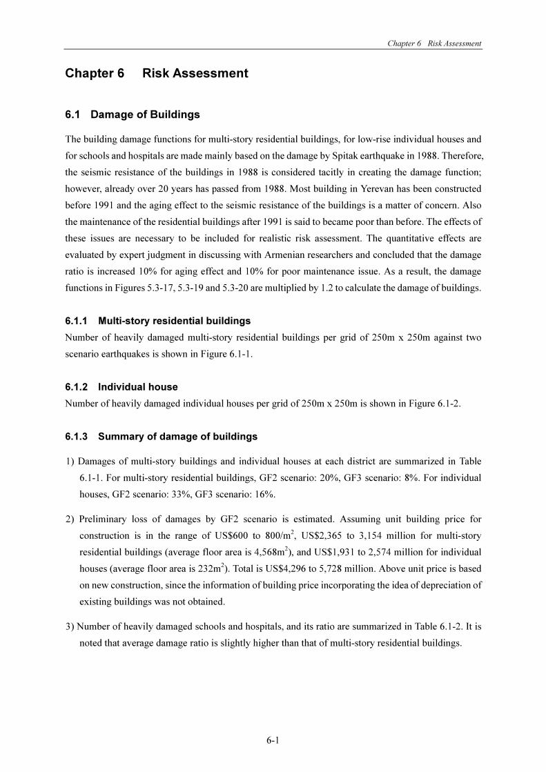
Number of heavily damaged multi-story residential buildings per grid of 250m x 250m against two
scenario earthquakes is shown in Figure 6.1-1.
Individual house 6.1.2
Number of heavily damaged individual houses per grid of 250m x 250m is shown in Figure 6.1-2.
Summary of damage of buildings 6.1.3
1) Damages of multi-story buildings and individual houses at each district are summarized in Table
6.1-1. For multi-story residential buildings, GF2 scenario: 20%, GF3 scenario: 8%. For individual
houses, GF2 scenario: 33%, GF3 scenario: 16%.
2) Preliminary loss of damages by GF2 scenario is estimated. Assuming unit building price for
construction is in the range of US$600 to 800/m2, US$2,365 to 3,154 million for multi-story
residential buildings (average floor area is 4,568m2), and US$1,931 to 2,574 million for individual
houses (average floor area is 232m2). Total is US$4,296 to 5,728 million. Above unit price is based
on new construction, since the information of building price incorporating the idea of depreciation of
existing buildings was not obtained.
3) Number of heavily damaged schools and hospitals, and its ratio are summarized in Table 6.1-2. It is
noted that average damage ratio is slightly higher than that of multi-story residential buildings.
Final Report Vol. II Main Report 1
6-2
Figure 6.1-1 Number of heavily damaged multi-story residential buildings per grid 250m x 250m
GF2 Scenario GF3 Scenario
Existing Number

Chapter 6 Risk Assessment
6-3
Figure 6.1-2 Number of heavily damaged individual houses per grid of 250m x 250m
GF2 Scenario GF3 Scenario
Existing Number

Final Report Vol. II Main Report 1
6-4
-
Table 6.1-2 Damage of schools and hospitals
Inventory GF2 Scenario GF3 Scenario
School 229 49 21% 19 8%
Hospital 44 11 25% 4 9%
Multi
-sto
ry
Apart
ment
(x100)
Indiv
idual
House
(x100)
Housin
g
Unit
(x100)
1A
japnya
k3.9
30.6
267
0.5
12%
10.9
36%
36
14%
0.1
4%
4.9
16%
12
5%
2A
van
2.3
12.2
127
0.6
27%
6.7
55%
40
32%
0.2
7%
2.4
20%
11
9%
3A
rabkir
5.8
33.2
347
1.2
21%
11.7
35%
74
21%
0.4
6%
4.7
14%
24
7%
4D
avt
ashen
1.7
7.8
98
0.0
2%
3.2
41%
55%
0.0
0%
1.3
17%
22%
5E
rebuni
2.2
106.4
228
0.5
23%
38.4
36%
69
30%
0.2
11%
21.3
20%
36
16%
6K
entr
on
7.1
55.1
364
2.5
35%
15.5
28%
103
28%
1.2
16%
7.6
14%
47
13%
7M
ala
tia-S
ebastia
5.7
45.3
346
0.3
6%
10.3
23%
27
8%
0.1
2%
4.8
11%
11
3%
8N
or
Nork
6.4
1.8
369
1.0
16%
0.5
31%
71
19%
0.3
5%
0.2
11%
23
6%
9N
ork
-Mara
sh
0.0
24.0
24
0.0
23%
8.3
35%
834%
0.0
7%
3.6
15%
415%
10
Nubara
shen
0.3
5.5
16
0.1
26%
1.4
26%
426%
0.0
15%
0.9
16%
315%
11
Shengavi
t5.5
72.0
298
1.4
26%
16.4
23%
73
25%
0.8
15%
9.4
13%
41
14%
12
Kanake
r-Zeyt
un
2.9
32.4
163
0.5
16%
15.3
47%
37
23%
0.1
5%
5.7
18%
12
7%
43.7
426.3
2,6
49
8.6
20%
138.7
33%
548
21%
3.5
8%
66.6
16%
225
8%
No.
Tota
l
Dis
tric
tM
ulti-sto
ry
Apart
ment
(x100)
Indiv
idual
House
(x100)
Housin
g
Unit
(x100)
Multi-sto
ry
Apart
ment
(x100)
Indiv
idual
House
(x100)
Housin
g
Unit
(x100)
Invento
ryG
F2
GF
3
Table
6.1
-1 D
am
ag
e o
f bu
ildin
gs
Chapter 6 Risk Assessment
6-5
Seismic Strengthening of Buildings 6.1.4
(1) Seismic retrofitting of existing buildings
There are no seismic retrofitted residential buildings in Yerevan, but a few buildings at Gyumri and
Vanadzor.
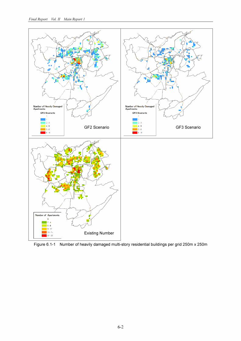
1) An example of retrofitting after the 1988Spitak earthquake
Retrofitting of damaged buildings by 1988 Spitak earthquake have been done at Gyumri. Retrofitting
of damaged stone building (series 1-451) is shown in Figure 6.1-3 and is retrofitted by RC members
for stone walls and by RC walls at stair case (Design by Dr. Khugatyan, NSSP EEC).
Figure 6.1-3 Retrofitting of damaged stone building (series 1-451),
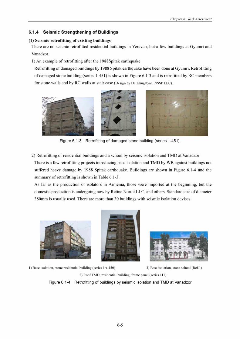
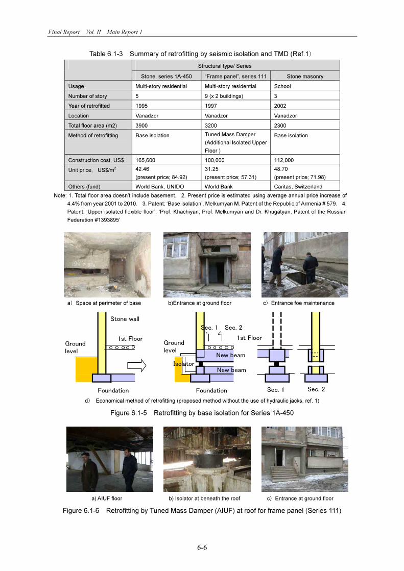
2) Retrofitting of residential buildings and a school by seismic isolation and TMD at Vanadzor
There is a few retrofitting projects introducing base isolation and TMD by WB against buildings not
suffered heavy damage by 1988 Spitak earthquake. Buildings are shown in Figure 6.1-4 and the
summary of retrofitting is shown in Table 6.1-3.
As far as the production of isolators in Armenia, those were imported at the beginning, but the
domestic production is undergoing now by Retine Noruit LLC, and others. Standard size of diameter
380mm is usually used. There are more than 30 buildings with seismic isolation devises.
1) Base isolation, stone residential building (series 1A-450) 3) Base isolation, stone school (Ref.1)
2) Roof TMD, residential building, frame panel (series 111)
Figure 6.1-4 Retrofitting of buildings by seismic isolation and TMD at Vanadzor
Final Report Vol. II Main Report 1
6-6
1st Floor 1st FloorGround
level
Ground
level
Foundation
Stone wall
New beam
New beam
Isolator
Foundation
Sec. 1 Sec. 2
Sec. 2Sec. 1
Table 6.1-3 Summary of retrofitting by seismic isolation and TMD (Ref.1)
Structural type/ Series
Stone, series 1A-450 “Frame panel”, series 111 Stone masonry
Usage Multi-story residential Multi-story residential School
Number of story 5 9 (x 2 buildings) 3
Year of retrofitted 1995 1997 2002
Location Vanadzor Vanadzor Vanadzor
Total floor area (m2) 3900 3200 2300
Method of retrofitting Base isolation Tuned Mass Damper
(Additional Isolated Upper
Floor )
Base isolation
Construction cost, US$ 165,600 100,000 112,000
Unit price, US$/m2 42.46
(present price; 84.92)
31.25
(present price; 57.31)
48.70
(present price; 71.98)
Others (fund) World Bank, UNIDO World Bank Caritas, Switzerland
Note: 1. Total floor area doesn’t include basement. 2. Present price is estimated using average annual price increase of
4.4% from year 2001 to 2010. 3. Patent; ‘Base isolation’, Melkumyan M. Patent of the Republic of Armenia # 579. 4.
Patent; ‘Upper isolated flexible floor’, ‘Prof. Khachiyan, Prof. Melkumyan and Dr. Khugatyan, Patent of the Russian
Federation #1393895’
a)Space at perimeter of base b)Entrance at ground floor c)Entrance foe maintenance
d) Economical method of retrofitting (proposed method without the use of hydraulic jacks, ref. 1)
Figure 6.1-5 Retrofitting by base isolation for Series 1A-450
a) AIUF floor b) Isolator at beneath the roof c)Entrance at ground floor
Figure 6.1-6 Retrofitting by Tuned Mass Damper (AIUF) at roof for frame panel (Series 111)

Chapter 6 Risk Assessment
6-7
A: Conventional Method B: Additional Isolated Upper Floor
(Tumed Mass damper)C: Base Isolation
Steel frame
Isolator
Isolator
Steel bracing
(2) Study of retrofitting system for existing residential buildings
Three different types of retrofitting system including method introduced at (1) have been studied as
shown in Figure 6.1-7, and the result of the comparison of performance is shown in Table 6.1-4.
Concept of retrofitting using seismic isolation is shown in Appendix 1. Result of time history response
analysis is shown in the Appendix 2.
Figure 6.1-7 Outline of three (3) retrofitting system
Table 6.1-4 Comparison of Performance of each Retrofitting System
A: Conventional
retrofitting
B: Tuned Mass Damper
(Additional Isolated
Upper Floor)
C: Base Isolation
(isolator with damper)
Space and function △ ◎ ◎
Evacuation of residents △ ◎ ◎
Improvement of strength ◎ - -
Improvement of ductility ◎ - -
Reduction of seismic load - ○ ◎
Construction cost ○ ◎ ○
Construction period ○ ◎ ○
Workability ○ ○ △
Noise and Vibration △ ○ ○
Appearance and design △ ○ ◎
Durability ○ ○ ○
Total evaluation △ - ○ △ - ○ ○
Note (additional items to
be considered)
(Cost of temporally
evacuation of residents)
(Combination with
conventional method will
be required at lower
stories)
(Cost evaluation based
on the actual condition
will be required)
Above table is prepared referring to “Guideline of Seismic Retrofitting by Seismic Isolation and Control for existing Reinforced
Concrete Buildings Japanese version, 2006)”, Japan Disaster Prevention Association.
Explanation of symbol;
◎, ○, △ shows conceptual comparison of each method.
◎: shows given performance is good compared with other method.
○: shows given performance is average compared with other method.
△: shows given performance is inferior compared with other method.

Final Report Vol. II Main Report 1
6-8
1) Outline of retrofitting and comparison of performance
The outline of conventional method, TMD at roof (Tuned Mass Damper, or Additional Isolated
Upper Floor), and base isolation are illustrated in Figure 6.1-7.
2) Estimated cost of retrofitting
Rough construction cost of roof TMD is US$500 per roof floor area (m2), and US$45 per total floor
area (m2). It is noted that a proposal selling the roof floor to get construction cost, but no preparation
of related law.
Rough construction cost of base isolation is US$80~100 per total floor area (m2) (this is estimated
from the cost of series 1A-450). Reduced cost is applied by the method without the use of hydraulic
jacks by Dr. Melkumyan.
Construction cost of new construction is supposed as US$600~800 per total floor area (m2).
(3) Existing public schools and privatized hospitals
There are a few school buildings under retrofitting in Yerevan as shown in Figure 6.1-8. On the other
hand, there is almost no hospital buildings retrofitted for privatized hospital, and seismic retrofitting
promotion measures are recommended.
Retrofitting of school building (Mortar and wire-mesh jacketing on stone walls), Kentron No.29.
Figure 6.1-8 Retrofitting work for school in Yerevan
(4) New Buildings
Number of construction of new buildings using seismic isolators is increasing in Yerevan (more than
30 buildings, Figure 6.1-9) and Vanadzor (Figure 6.1-10). Software of Russian for structural
calculation and of Ukraine for seismic isolation is used generally. Two problems are raised as follows.
1) To secure required ductility of members and frames for new RC structures.
It is evaluated that shear force design and axial force limitation are required to improve to secure
required ductility for new RC buildings.
2) To improve quality of design and construction of buildings with seismic isolator.
It is evaluated that performance of damping and isolator, providing damper, flexible joints for
piping, finishing detail such as stairs, elevators in case of isolators at intermediate story, clear space
and maintenance at ground floor are required to improve.

Chapter 6 Risk Assessment
6-9
a) External view b) Isolators above basement c) Mechanical piping
e) Isolators above 2nd
floor column f) Stairs at same level of isolator
d) External view
Figure 6.1-9 New residential buildings using seismic isolators in Yerevan
a) Building with base isolation b) isolator with diameter 380mm c) Clearance at perimeter at ground floor
Figure 6.1-10 Residential buildings with seismic isolation at Gyumri
(5) Building control
Building control for the design and construction of buildings related to the liquefaction and
landslides will be evaluated and be recommended to execute.
1) Liquefaction
Figure 4.3-11 shows the liquefaction potential of each scenario earthquakes. There are very little
areas with sandy soil layers and the liquefaction potential in Yerevan is low.
2) Landslides.
Figure 4.3-13 shows existing landslide hazard and risk, potential hazard areas of landslide and
slope. In Figure 4.3-14, “Slope Failure and Rock Fall for Buildings and Houses” are shown.
References:
1) Dr. Mikayel Melkumyan, “New Solution for Seismic Isolation 2010”.

Final Report Vol. II Main Report 1
6-10
Response of system with
low damping
Response of system with high damping
A: Retrofitting by seismic isolation
Increase of period and damping
B: Retrofitting by
vibration control,
damping increase
Natural period (Long period) (Short period)
Ma
xim
um
Resp
onse R
esto
ring F
orc
e
Response of system with
low damping
A: Retrofitting by isolation method,
Increase of period and damping
B: Retrofitting by vibration
control, damping increase
Response of system with high
damping
Natural period (Long period)(Short period)
Ma
xim
um
Resp
onse D
ispla
cem
en
t
2) Japan Disaster Prevention Association, “Guideline of Seismic Retrofitting by Seismic Isolation and
Control for existing Reinforced Concrete Buildings Japanese version, 2006)”,
Appendix:
1. Response recovering force/ displacement and natural period of buildings (Reference 2)
a) Response recovering force and natural period of buildings
b) Response displacement and natural period of buildings
2. Results of time history response analysis
Verification of seismic performance by time history response analysis is shown below.
Building: 9 story frame panel (series 111), with size of 18m x 18m in plan, longitudinal direction (frame)
is studied.
Restoring force characteristics: Tri-linear for frame, and by-linear for isolator.
Input max. acceleration: 400gal

Chapter 6 Risk Assessment
6-11
Earthquake waves: Four waves ( 、El Centro NS, Taft EW, Hachinohe NS Spitak 1988 (Vanadzor))
Response without retrofitting
1st Natural period T1 T1=0.77sec
Response by AIUF(TMD)
TMD, 0.76sec. T1=0.91sec.
Response by Base Isolation
Isolator, 2.0sec. T1=2.1sec.
Re
sto
rin
g fo
rces (
kN
) a
nd s
tory
dis
pla
ce
me
nt
Sto
ry d
eflectio
n a
ng
le
Sto
ry s
he
ar
forc
e c
oeffic
ien
t
Sto
ry d
eflectio
n (
cm
)
Results
(1) Response without retrofitting

Final Report Vol. II Main Report 1
6-12
Response ductility exceeds 2.0 at lower stories, and the damage grade of heavily and/or collapse is
predicted.
(2) Response by AIUF (TMD)
Response varies by the type of waves. It reduces the response of stories compared with stories of no
retrofitting. Average 20% to 30% reduction is expected. Tuning of TMD is required incorporating the
condition of the ground, and damping device is necessary to reduce the deflection. It will be required
to increase strength by conventional method at lower stories.
(3) Response by Base Isolation
Response acceleration at each story is reduced to less than 150gals (reduced to 1/4 to 1/3 of input
acceleration). This will also be effective to reduce the damage of external non-structural walls.
6.2 Infrastructure Risk Assessment
Results 6.2.1
The damage estimation results are summarized in Table 6.2-1 and Table 6.2-2. In GF2 and GF3 cases, all
40 structures are estimated to be Rank C. The final score of two structures (ARB-3 and ARB-5) are
larger than 20 for GF2 case. The locations of the structures are shown in Figure 6.2-1.
Figure 6.2-1 Location of Structures

Ch
apter 6
Risk A
ssessmen
t
6-1
3
1 1.00 1.00 0.60 0.80 1.00 1.00 1.00 0.50 1.00 1.00 1.00
2 1.75 2.00 1.00 1.20 1.35 1.40 1.40 1.00 1.20 1.70 1.50
3 3.00 1.15 1.70 1.50 1.50 2.40 2.00
4 1.80 3.00
5 3.50
1 ARB-1 Overpass bridge on the Friendship Square 2 3 1 2 2 1 1 2 1 1 1 1.75 3.00 0.60 1.20 1.35 1.00 1.00 1.00 1.00 1.00 1.00 5.10 C
2 ARB-2 Bridge on Vatutin str. 2 1 2 2 2 1 1 2 2 2 1 1.75 1.00 1.00 1.20 1.35 1.00 1.00 1.00 1.20 1.70 1.00 5.78 C
3 ARB-3 Bridge on Riga str. 2 3 2 2 2 1 1 2 3 2 1 1.75 3.00 1.00 1.20 1.35 1.00 1.00 1.00 1.50 1.70 1.00 21.69 C
4 ARB-4 Bridge on Saralanji HW near Riga str. 1 3 2 2 2 1 1 2 1 1 1 1.00 3.00 1.00 1.20 1.35 1.00 1.00 1.00 1.00 1.00 1.00 4.86 C
5 ARB-5 Bridge on Komitas ave. 2 3 2 2 3 1 1 2 2 2 1 1.75 3.00 1.00 1.20 1.70 1.00 1.00 1.00 1.20 1.70 1.00 21.85 C
6 AVN-1 Avan 1st bridge 2 2 2 1 2 1 1 2 1 2 1 1.75 2.00 1.00 0.80 1.35 1.00 1.00 1.00 1.00 1.70 1.00 6.43 C
7 AVN-2 Avan 2nd bridge 2 3 2 2 2 1 1 2 1 2 1 1.75 3.00 1.00 1.20 1.35 1.00 1.00 1.00 1.00 1.70 1.00 14.46 C
8 AVN-3 Bridge on Yerevan - Sevan HW 2 3 2 1 3 1 1 2 2 2 1 1.75 3.00 1.00 0.80 1.70 1.00 1.00 1.00 1.20 1.70 1.00 14.57 C
9 DVT-1 Bridge of 2nd road 2 3 1 1 3 1 1 2 1 1 1 1.75 3.00 0.60 0.80 1.70 1.00 1.00 1.00 1.00 1.00 1.00 4.28 C
10 DVT-2 Central bridge of Davtashen transport 2 3 1 1 3 1 1 2 1 1 1 1.75 3.00 0.60 0.80 1.70 1.00 1.00 1.00 1.00 1.00 1.00 4.28 C
11 DVT-3 Bridge of 7th road 2 3 1 1 3 1 1 2 1 1 1 1.75 3.00 0.60 0.80 1.70 1.00 1.00 1.00 1.00 1.00 1.00 4.28 C
12 ERB-1 Bridge on Arin-Berd str. 2 1 1 1 2 1 1 2 1 1 1 1.75 1.00 0.60 0.80 1.35 1.00 1.00 1.00 1.00 1.00 1.00 1.13 C
13 HRA-1 Davtashen bridge 2 2 2 1 3 1 1 1 1 1 1 1.75 2.00 1.00 0.80 1.70 1.00 1.00 0.50 1.00 1.00 1.00 2.38 C
14 HRA-2 Kiev bridge 2 1 1 1 3 1 1 1 1 1 1 1.75 1.00 0.60 0.80 1.70 1.00 1.00 0.50 1.00 1.00 1.00 0.71 C
15 HRA-3 Bridge near the Kiev bridge 1 1 1 2 2 1 1 1 3 1 1 1.00 1.00 0.60 1.20 1.35 1.00 1.00 0.50 1.50 1.00 1.00 0.73 C
16 HRA-4 Bridge near the Yerevan HES 1 1 1 2 1 1 1 2 2 1 1 1.00 1.00 0.60 1.20 1.00 1.00 1.00 1.00 1.20 1.00 1.00 0.86 C
17 HRA-5 Haghttanak bridge 2 1 1 1 3 1 1 1 2 1 1 1.75 1.00 0.60 0.80 1.70 1.00 1.00 0.50 1.20 1.00 1.00 0.86 C
18 KNT-1 Overpass bridge of new highway 2 3 1 1 2 1 1 2 1 1 1 1.75 3.00 0.60 0.80 1.35 1.00 1.00 1.00 1.00 1.00 1.00 3.40 C
19 KNT-2 Overpass bridge of new highway 2 3 1 2 2 1 1 2 1 1 1 1.75 3.00 0.60 1.20 1.35 1.00 1.00 1.00 1.00 1.00 1.00 5.10 C
20 KNT-3 Bridge on Heratsi str. 2 2 1 1 3 1 1 2 1 1 1 1.75 2.00 0.60 0.80 1.70 1.00 1.00 1.00 1.00 1.00 1.00 2.86 C
21 KNT-4 Bridge on Charents str. 1 3 2 2 2 1 1 2 1 1 1 1.00 3.00 1.00 1.20 1.35 1.00 1.00 1.00 1.00 1.00 1.00 4.86 C
22 KNT-5 Bridge on Khanjyan str. 1 3 2 1 2 1 1 2 1 2 1 1.00 3.00 1.00 0.80 1.35 1.00 1.00 1.00 1.00 1.70 1.00 5.51 C
23 KNT-6 Bridge on Tigran Mets ave. 1 3 2 1 2 1 1 2 1 1 1 1.00 3.00 1.00 0.80 1.35 1.00 1.00 1.00 1.00 1.00 1.00 3.24 C
24 KNT-7 Bridge on Khorenatsi str. 2 2 2 1 1 1 1 2 2 1 1 1.75 2.00 1.00 0.80 1.00 1.00 1.00 1.00 1.20 1.00 1.00 3.36 C
25 KNT-8 Subway bridge over Kristapor str. 2 3 1 1 1 1 1 2 2 1 1 1.75 3.00 0.60 0.80 1.00 1.00 1.00 1.00 1.20 1.00 1.00 3.02 C
26 KNT-9 Bridge on G. Lusavorich str. 2 3 2 2 2 1 1 2 2 2 1 1.75 3.00 1.00 1.20 1.35 1.00 1.00 1.00 1.20 1.70 1.00 17.35 C
27 KNT-10 Overpass bridge near the Hrazdan Stadium 2 3 2 2 2 1 1 1 3 2 1 1.75 3.00 1.00 1.20 1.35 1.00 1.00 0.50 1.50 1.70 1.00 10.84 C
28 MLS-1 Bridge on Isakov ave. 2 3 2 2 1 1 1 2 2 1 1 1.75 3.00 1.00 1.20 1.00 1.00 1.00 1.00 1.20 1.00 1.00 7.56 C
29 MLS-2 Argavand bridge 2 2 1 1 2 1 1 2 1 1 1 1.75 2.00 0.60 0.80 1.35 1.00 1.00 1.00 1.00 1.00 1.00 2.27 C
30 MLS-3 Bridge on Isakov ave. to Echmiadzin HW 2 3 2 2 2 1 1 2 3 1 1 1.75 3.00 1.00 1.20 1.35 1.00 1.00 1.00 1.50 1.00 1.00 12.76 C
31 NBR-1 Bridge near Nubarashen 2 2 1 1 2 1 1 2 3 1 1 1.75 2.00 0.60 0.80 1.35 1.00 1.00 1.00 1.50 1.00 1.00 3.40 C
32 NNR-1 Bridge on Galshoyan str. 2 2 1 1 2 1 1 2 2 2 1 1.75 2.00 0.60 0.80 1.35 1.00 1.00 1.00 1.20 1.70 1.00 4.63 C
33 NNR-2 Jrvejh river bridge 1 3 2 2 1 1 2 2 2 2 1 1.00 3.00 1.00 1.20 1.00 1.00 1.40 1.00 1.20 1.70 1.00 10.28 C
34 SHN-1 Bridge on Garegin Nzhdeh str. 2 2 1 1 2 1 1 2 1 1 1 1.75 2.00 0.60 0.80 1.35 1.00 1.00 1.00 1.00 1.00 1.00 2.27 C
35 SHN-2 Subway bridge over Shahamiryanner str. 1 3 2 1 2 1 1 2 1 1 1 1.00 3.00 1.00 0.80 1.35 1.00 1.00 1.00 1.00 1.00 1.00 3.24 C
36 SHN-3 Subway bridge over Tamantsineri str. 1 1 1 1 2 1 1 2 3 2 1 1.00 1.00 0.60 0.80 1.35 1.00 1.00 1.00 1.50 1.70 1.00 1.65 C
37 SHN-4 Subway bridge over railway 1 3 2 1 2 1 1 2 2 1 1 1.00 3.00 1.00 0.80 1.35 1.00 1.00 1.00 1.20 1.00 1.00 3.89 C
38 SHN-5 Shirak str. 1st bridge 2 3 2 2 2 1 1 2 3 1 1 1.75 3.00 1.00 1.20 1.35 1.00 1.00 1.00 1.50 1.00 1.00 12.76 C
39 SHN-6 Overpass bridge on Araratyan str. 2 3 2 2 2 1 1 2 2 1 1 1.75 3.00 1.00 1.20 1.35 1.00 1.00 1.00 1.20 1.00 1.00 10.21 C
40 SHN-7 Shirak str. 2nd bridge 2 3 2 2 2 1 1 2 2 2 1 1.75 3.00 1.00 1.20 1.35 1.00 1.00 1.00 1.20 1.70 1.00 17.35 C
No. Code Name
Category Risk Factor
Evalu
ation
Spans
Dis
trib
ution
Girder
Type
Bearing T
ype
Wid
th o
f B
ridge
Seat
Sensib
ility
of
Liq
uifaction
Total
Heig
ht of
Substr
uctu
re
Foundation T
ype
Mate
rial of
Substr
uctu
re
Gro
und C
lass
Exis
ting
Conditio
nS
eis
mic
Inte
nsity
Table 6.2-1 Structure Damage Estimation Result (1) YF Scenario Earthquake Table 6.2-1 Structure Damage Estimation Result (1) GF2 Scenario Earthquake

Fin
al R
epo
rt Vo
l. II M
ain
Rep
ort 1
6-1
4
1 1.00 1.00 0.60 0.80 1.00 1.00 1.00 0.50 1.00 1.00 1.00
2 1.75 2.00 1.00 1.20 1.35 1.40 1.40 1.00 1.20 1.70 1.50
3 3.00 1.15 1.70 1.50 1.50 2.40 2.00
4 1.80 3.00
5 3.50
1 ARB-1 Overpass bridge on the Friendship Square 2 3 1 2 2 1 1 2 1 1 1 1.75 3.00 0.60 1.20 1.35 1.00 1.00 1.00 1.00 1.00 1.00 5.10 C
2 ARB-2 Bridge on Vatutin str. 2 1 2 2 2 1 1 2 2 1 1 1.75 1.00 1.00 1.20 1.35 1.00 1.00 1.00 1.20 1.00 1.00 3.40 C
3 ARB-3 Bridge on Riga str. 2 3 2 2 2 1 1 2 3 1 1 1.75 3.00 1.00 1.20 1.35 1.00 1.00 1.00 1.50 1.00 1.00 12.76 C
4 ARB-4 Bridge on Saralanji HW near Riga str. 1 3 2 2 2 1 1 2 1 1 1 1.00 3.00 1.00 1.20 1.35 1.00 1.00 1.00 1.00 1.00 1.00 4.86 C
5 ARB-5 Bridge on Komitas ave. 2 3 2 2 3 1 1 2 2 1 1 1.75 3.00 1.00 1.20 1.70 1.00 1.00 1.00 1.20 1.00 1.00 12.85 C
6 AVN-1 Avan 1st bridge 2 2 2 1 2 1 1 2 1 1 1 1.75 2.00 1.00 0.80 1.35 1.00 1.00 1.00 1.00 1.00 1.00 3.78 C
7 AVN-2 Avan 2nd bridge 2 3 2 2 2 1 1 2 1 1 1 1.75 3.00 1.00 1.20 1.35 1.00 1.00 1.00 1.00 1.00 1.00 8.51 C
8 AVN-3 Bridge on Yerevan - Sevan HW 2 3 2 1 3 1 1 2 2 1 1 1.75 3.00 1.00 0.80 1.70 1.00 1.00 1.00 1.20 1.00 1.00 8.57 C
9 DVT-1 Bridge of 2nd road 2 3 1 1 3 1 1 2 1 1 1 1.75 3.00 0.60 0.80 1.70 1.00 1.00 1.00 1.00 1.00 1.00 4.28 C
10 DVT-2 Central bridge of Davtashen transport 2 3 1 1 3 1 1 2 1 1 1 1.75 3.00 0.60 0.80 1.70 1.00 1.00 1.00 1.00 1.00 1.00 4.28 C
11 DVT-3 Bridge of 7th road 2 3 1 1 3 1 1 2 1 1 1 1.75 3.00 0.60 0.80 1.70 1.00 1.00 1.00 1.00 1.00 1.00 4.28 C
12 ERB-1 Bridge on Arin-Berd str. 2 1 1 1 2 1 1 2 1 1 1 1.75 1.00 0.60 0.80 1.35 1.00 1.00 1.00 1.00 1.00 1.00 1.13 C
13 HRA-1 Davtashen bridge 2 2 2 1 3 1 1 1 1 1 1 1.75 2.00 1.00 0.80 1.70 1.00 1.00 0.50 1.00 1.00 1.00 2.38 C
14 HRA-2 Kiev bridge 2 1 1 1 3 1 1 1 1 1 1 1.75 1.00 0.60 0.80 1.70 1.00 1.00 0.50 1.00 1.00 1.00 0.71 C
15 HRA-3 Bridge near the Kiev bridge 1 1 1 2 2 1 1 1 3 1 1 1.00 1.00 0.60 1.20 1.35 1.00 1.00 0.50 1.50 1.00 1.00 0.73 C
16 HRA-4 Bridge near the Yerevan HES 1 1 1 2 1 1 1 2 2 1 1 1.00 1.00 0.60 1.20 1.00 1.00 1.00 1.00 1.20 1.00 1.00 0.86 C
17 HRA-5 Haghttanak bridge 2 1 1 1 3 1 1 1 2 1 1 1.75 1.00 0.60 0.80 1.70 1.00 1.00 0.50 1.20 1.00 1.00 0.86 C
18 KNT-1 Overpass bridge of new highway 2 3 1 1 2 1 1 2 1 1 1 1.75 3.00 0.60 0.80 1.35 1.00 1.00 1.00 1.00 1.00 1.00 3.40 C
19 KNT-2 Overpass bridge of new highway 2 3 1 2 2 1 1 2 1 1 1 1.75 3.00 0.60 1.20 1.35 1.00 1.00 1.00 1.00 1.00 1.00 5.10 C
20 KNT-3 Bridge on Heratsi str. 2 2 1 1 3 1 1 2 1 1 1 1.75 2.00 0.60 0.80 1.70 1.00 1.00 1.00 1.00 1.00 1.00 2.86 C
21 KNT-4 Bridge on Charents str. 1 3 2 2 2 1 1 2 1 1 1 1.00 3.00 1.00 1.20 1.35 1.00 1.00 1.00 1.00 1.00 1.00 4.86 C
22 KNT-5 Bridge on Khanjyan str. 1 3 2 1 2 1 1 2 1 1 1 1.00 3.00 1.00 0.80 1.35 1.00 1.00 1.00 1.00 1.00 1.00 3.24 C
23 KNT-6 Bridge on Tigran Mets ave. 1 3 2 1 2 1 1 2 1 1 1 1.00 3.00 1.00 0.80 1.35 1.00 1.00 1.00 1.00 1.00 1.00 3.24 C
24 KNT-7 Bridge on Khorenatsi str. 2 2 2 1 1 1 1 2 2 1 1 1.75 2.00 1.00 0.80 1.00 1.00 1.00 1.00 1.20 1.00 1.00 3.36 C
25 KNT-8 Subway bridge over Kristapor str. 2 3 1 1 1 1 1 2 2 1 1 1.75 3.00 0.60 0.80 1.00 1.00 1.00 1.00 1.20 1.00 1.00 3.02 C
26 KNT-9 Bridge on G. Lusavorich str. 2 3 2 2 2 1 1 2 2 1 1 1.75 3.00 1.00 1.20 1.35 1.00 1.00 1.00 1.20 1.00 1.00 10.21 C
27 KNT-10 Overpass bridge near the Hrazdan Stadium 2 3 2 2 2 1 1 1 3 1 1 1.75 3.00 1.00 1.20 1.35 1.00 1.00 0.50 1.50 1.00 1.00 6.38 C
28 MLS-1 Bridge on Isakov ave. 2 3 2 2 1 1 1 2 2 1 1 1.75 3.00 1.00 1.20 1.00 1.00 1.00 1.00 1.20 1.00 1.00 7.56 C
29 MLS-2 Argavand bridge 2 2 1 1 2 1 1 2 1 1 1 1.75 2.00 0.60 0.80 1.35 1.00 1.00 1.00 1.00 1.00 1.00 2.27 C
30 MLS-3 Bridge on Isakov ave. to Echmiadzin HW 2 3 2 2 2 1 1 2 3 1 1 1.75 3.00 1.00 1.20 1.35 1.00 1.00 1.00 1.50 1.00 1.00 12.76 C
31 NBR-1 Bridge near Nubarashen 2 2 1 1 2 1 1 2 3 1 1 1.75 2.00 0.60 0.80 1.35 1.00 1.00 1.00 1.50 1.00 1.00 3.40 C
32 NNR-1 Bridge on Galshoyan str. 2 2 1 1 2 1 1 2 2 1 1 1.75 2.00 0.60 0.80 1.35 1.00 1.00 1.00 1.20 1.00 1.00 2.72 C
33 NNR-2 Jrvejh river bridge 1 3 2 2 1 1 2 2 2 1 1 1.00 3.00 1.00 1.20 1.00 1.00 1.40 1.00 1.20 1.00 1.00 6.05 C
34 SHN-1 Bridge on Garegin Nzhdeh str. 2 2 1 1 2 1 1 2 1 1 1 1.75 2.00 0.60 0.80 1.35 1.00 1.00 1.00 1.00 1.00 1.00 2.27 C
35 SHN-2 Subway bridge over Shahamiryanner str. 1 3 2 1 2 1 1 2 1 1 1 1.00 3.00 1.00 0.80 1.35 1.00 1.00 1.00 1.00 1.00 1.00 3.24 C
36 SHN-3 Subway bridge over Tamantsineri str. 1 1 1 1 2 1 1 2 3 1 1 1.00 1.00 0.60 0.80 1.35 1.00 1.00 1.00 1.50 1.00 1.00 0.97 C
37 SHN-4 Subway bridge over railway 1 3 2 1 2 1 1 2 2 1 1 1.00 3.00 1.00 0.80 1.35 1.00 1.00 1.00 1.20 1.00 1.00 3.89 C
38 SHN-5 Shirak str. 1st bridge 2 3 2 2 2 1 1 2 3 1 1 1.75 3.00 1.00 1.20 1.35 1.00 1.00 1.00 1.50 1.00 1.00 12.76 C
39 SHN-6 Overpass bridge on Araratyan str. 2 3 2 2 2 1 1 2 2 1 1 1.75 3.00 1.00 1.20 1.35 1.00 1.00 1.00 1.20 1.00 1.00 10.21 C
40 SHN-7 Shirak str. 2nd bridge 2 3 2 2 2 1 1 2 2 1 1 1.75 3.00 1.00 1.20 1.35 1.00 1.00 1.00 1.20 1.00 1.00 10.21 C
No. Code Name
Category Risk Factor
Evalu
ation
Spans
Dis
trib
ution
Girder
Type
Bearing T
ype
Wid
th o
f B
ridge
Seat
Sensib
ility
of
Liq
uifaction
Total
Heig
ht of
Substr
uctu
re
Foundation T
ype
Mate
rial of
Substr
uctu
re
Gro
und C
lass
Exis
ting
Conditio
nS
eis
mic
Inte
nsity
Table 6.2-2 Structure Damage Estimation Result (2) GF3 Scenario Earthquake

Chapter 6 Risk Assessment
6-15
Factor Analysis 6.2.2
(1) Factor analysis of seismic performance
The weighting factors of girder structure, support and seating length are defined in Table 6.2-3.
Table 6.2-3 Criterion for Damage Evaluation (Classification of Seismic Performance)
Item Detailed Classification Weighting Factor
Girder
Structure
Arch type; the safety is confirmed by the past earthquake disaster
Rigid frame type; superstructure and substructure are combined 1.0
Continuous beam type; the effect of the connection between beams is
expected to prevent unseating 2.0
Simple beam type 3.0
Support
Support type which have unseating prevention structure 0.6
General support type; A end fix / B end move 1.0
Two movable supports are arranged on the same pier 1.15
Seating
Length
Seating length is longer than "0.7+0.005*span length (m)" 0.8
Seating length is shorter than "0.7+0.005*span length (m)" 1.2
About the item of “girder structure”, since weighting factors depend on the bridge type itself, it is
necessary to select the bridge type at the design stage to have high earthquake-proof ability. The
damage risk becomes small by adopting the rigid frame type which controls the longitudinal
direction displacement by having rigid connection between superstructure and substructure. The
continuous beam type, which connects two girders, is also effective for earthquake proof.
About the item of “support”, it turned out that ARB-3 and ARB-5 don’t have unseating prevention
equipment. Conversely, the score of the bridge which is equipped with unseating prevention
structure is almost smaller than 5. To ensure the earthquake-proof ability, installation of unseating
prevention equipment is considerably effective.
The length of the bridge seat of ARB-3 and ARB-5 are inadequate. Even if the longitudinal
displacement increases by an earthquake, the larger bridge seat width will reduce the possibility of
collapse.
Figure 6.2-2 Abutment Seating Length
Seating Length

Final Report Vol. II Main Report 1
6-16
(2) Factor analysis of quality
The weighting factor on bridge quality is defined in Table 6.2-4. The low quality of a bridge
seriously influences on bridge stability at the earthquake because expected earthquake-proof
performance at the design stage are not ensured.
Table 6.2-4 Criterion for Damage Evaluation (Classification of Quality)
Item Detailed Classification Weighting Factor
Quality
The healthy bridge with small aged deterioration 1.0
Oozed out or crack etc. are observed on the concrete surface 1.2
Corrosion of a steel bars / materials or a crack structural on the
concrete are observed 1.5
Focusing on built year of all examined 40 structures, one structure was built in the 1940s, 4 were
built in the 1950s, 3 were built in the 1960s, 6 were built in the 1970s, 4 were built in the 1980s, 3
were built in the 2000s and 19 were unknown. Moreover, the average value by built year of the
weighting factor with respect to the quality of bridge is shown in Table 6.2-6.
Table 6.2-5 The Number of structures by Built Year
Built Year 1940s 1950s 1960s 1970s 1980s 1990s 2000s Unknown
Number of Bridge 1 4 3 6 4 0 3 19
Table 6.2-6 Average Value of the Weighting Factor on the Quality by Built Year
Built Year 1940s 1950s 1960s 1970s 1980s 1990s 2000s Unknown
Average Value
of the Weighting
Factor
1.20 1.18 1.33 1.18 1.28 --- 1.07 1.12
1940s and 1950s, has been adopted non-statically determinate structure, such as arch type or rigid
frame type. These types have a high structural seismic performance. Meanwhile, because the aged
deterioration of older girder bridges completed in the 1960s and 70s was significant, weighting
factor became large in the detailed classification of quality. It is one of the causes to increase the risk
of damage in the evaluation.
Measure for Improvement in Earthquake-proof 6.2.3
In case of a large-scale earthquake, a main girder may be displaced in the longitudinal direction more
than estimated and may fall from a bridge seat. For this reason, enforcement of measure (refer to Figure
6.2-3), such as Unseating Prevention System which connects main girders or main girder and
substructure and Seating Extension System which secures the girder starting length are suggested.
Installation of Unseating Prevention System involves boring to the existing PC girder, back digging of
abutments, etc., so traffic is required to be restricted during construction. On the other hand, Seating
Extension System is to add reinforced concrete in the front of abutments or pier. The work is easy and

Chapter 6 Risk Assessment
6-17
does not affect to traffic. Therefore, Seating Extension System is examined prior to other measures. If
earthquake-proof is still not enough, Unseating Prevention System should be used together.
Figure 6.2-3 Unseating Prevention System and Seating Extension System
Conclusions and Recommendations 6.2.4
(1) Conclusion of the seismic performance
� The evaluation of damage level in this study was carried out by Katayama’s method based on
inventory survey data. General measures are recommended in this study paying attention to bridge
seats.
� Girder structure, support and seating length have great influence on damage level in the evaluation.
Therefore, rigid frame type and continuous beam type are recommended in seismic design
standard. Moreover, installation of unseating prevention structure and limiting excessive
displacement structure is recommended to be standardized.
� Low quality of a structure increases the risk of damage as well. In order to preserve the
earthquake-proof performance expected at the design stage, maintenance work is indispensable.
Moreover, to plan the repair and reinforcement in the future, specifications and drawings of
completed structure should be kept and accessible.
(2) Recommendation for the future infrastructure plan
1) Specific measures for earthquake
� There are three kinds of method for anti-seismic measures such as the replacement by new bridge,
repair / reinforcement of the whole bridge and partial repair / reinforcement of the bridge.
� It is required for planning the concrete measures against earthquake hazards, besides the detailed
investigation of the present condition of the bridges. Moreover, it is necessary to select the optimal
method by comparison study.
� Seating extension and unseating prevention can be carried out without great difficulty compared
with other measures. However, in order to create concrete plan and design, a setup of
constructional example, required seating length, action load and a load position is necessary.
Seating Extension System
Unseating Prevention System
Final Report Vol. II Main Report 1
6-18
2) Improvement of design standard
� In order to make a bridge plan or repair / reinforcement plan of the existing bridge in Armenia,
maintenance of anti-seismic design standards, such as horizontal force in case of earthquake or
bridge seating length, etc., are pressing need especially. At this point, anti-seismic design
standards, such as highway bridge specification in Japan are consulted.
� The concrete planning and design for seismic reinforcement should be carried out on the next
stage, referring to an anti-seismic design standard. Simultaneously, based on the earthquake which
occurred in the past or its damage situation in Armenia, it is proposed to improve an original
anti-seismic design standard.
6.3 Damage to Lifeline
Results of damage assessment 6.3.1
Damage of lifeline pipes and cables are calculated in each 250m grid and summarized to 12 districts of
Yerevan city. The results are shown in tables and figures below.
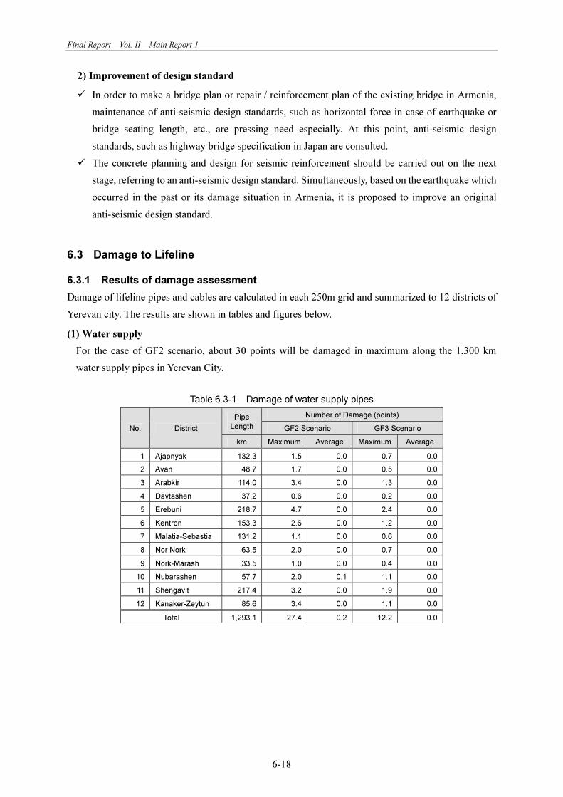
(1) Water supply
For the case of GF2 scenario, about 30 points will be damaged in maximum along the 1,300 km
water supply pipes in Yerevan City.
Table 6.3-1 Damage of water supply pipes
No. District
Pipe
Length
Number of Damage (points)
GF2 Scenario GF3 Scenario
km Maximum Average Maximum Average
1 Ajapnyak 132.3 1.5 0.0 0.7 0.0
2 Avan 48.7 1.7 0.0 0.5 0.0
3 Arabkir 114.0 3.4 0.0 1.3 0.0
4 Davtashen 37.2 0.6 0.0 0.2 0.0
5 Erebuni 218.7 4.7 0.0 2.4 0.0
6 Kentron 153.3 2.6 0.0 1.2 0.0
7 Malatia-Sebastia 131.2 1.1 0.0 0.6 0.0
8 Nor Nork 63.5 2.0 0.0 0.7 0.0
9 Nork-Marash 33.5 1.0 0.0 0.4 0.0
10 Nubarashen 57.7 2.0 0.1 1.1 0.0
11 Shengavit 217.4 3.2 0.0 1.9 0.0
12 Kanaker-Zeytun 85.6 3.4 0.0 1.1 0.0
Total 1,293.1 27.4 0.2 12.2 0.0

Chapter 6 Risk Assessment
6-19
GF2 Scenario GF3 Scenario
Figure 6.3-1 Maximum damage distribution of water supply pipes
(2) Sewerage (Waste water and Rain water)
1) Waste water
For the case of GF2 scenario, about 70 points will be damaged along the 870 km of waste water pipe
lines in Yerevan City. The damage ratio is much higher than water supply pipe lines. This may be
resulted to that the material of 75% of the waste water pipe lines are ceramic, which are fragile.
Table 6.3-2 Damage of waste water pipes
No. District
Pipe
Length
Number of Damage (points)
GF2 Scenario GF3 Scenario
km Maximum Average Maximum Average
1 Ajapnyak 62.4 3.2 0.0 1.4 0.0
2 Avan 28.5 4.0 0.0 1.2 0.0
3 Arabkir 70.8 6.4 0.0 2.5 0.0
4 Davtashen 22.6 1.7 0.0 0.6 0.0
5 Erebuni 164.8 13.0 0.0 6.7 0.0
6 Kentron 104.6 9.0 0.0 4.0 0.0
7 Malatia-Sebastia 109.3 4.0 0.0 2.1 0.0
8 Nor Nork 42.0 5.8 0.0 2.1 0.0
9 Nork-Marash 24.6 3.2 0.0 1.3 0.0
10 Nubarashen 14.2 1.9 0.0 1.1 0.0
11 Shengavit 161.4 11.5 0.0 6.7 0.0
12 Kanaker-Zeytun 60.0 7.9 0.0 2.7 0.0
Total 865.2 71.4 0.0 32.4 0.0

Final Report Vol. II Main Report 1
6-20
2) Rain water
For the case of GF2 scenario, 10 points will be damaged along the 180 km of rain water pipe lines in
Yerevan City.
Table 6.3-3 Damage of rain water pipes
No. District
Pipe
Length
Number of Damage (points)
GF2 Scenario GF3 Scenario
km Maximum Average Maximum Average
1 Ajapnyak 12.4 0.4 0.0 0.2 0.0
2 Avan 12.7 1.3 0.0 0.4 0.0
3 Arabkir 24.2 1.4 0.0 0.6 0.0
4 Davtashen 1.9 0.1 0.0 0.1 0.0
5 Erebuni 30.5 1.3 0.0 0.7 0.0
6 Kentron 31.4 0.8 0.0 0.4 0.0
7 Malatia-Sebastia 23.5 0.4 0.0 0.2 0.0
8 Nor Nork 15.4 1.9 0.0 0.7 0.0
9 Nork-Marash 1.4 0.2 0.0 0.1 0.0
10 Nubarashen 0.0 0.0 0.0 0.0 0.0
11 Shengavit 18.7 0.4 0.0 0.2 0.0
12 Kanaker-Zeytun 10.6 1.2 0.0 0.4 0.0
Total 182.6 9.5 0.0 3.8 0.0
GF2 Scenario GF3 Scenario
Figure 6.3-2 Maximum damage distribution of sewage pipes (waste water + rain water)

Chapter 6 Risk Assessment
6-21
(3) Electricity
1) Aerial cable
For the case of GF2 scenario, about 20 km out of 1,950 km aerial cables will be damaged in Yerevan
City.
Table 6.3-4 Damage of aerial electricity lines
No. District
Cable
Length
Damage Length (km)
GF2 Scenario GF3 Scenario
km Maximum Average Maximum Average
1 Ajapnyak 185.8 0.8 0.0 0.1 0.0
2 Avan 59.6 1.4 0.1 0.1 0.0
3 Arabkir 154.7 1.7 0.1 0.1 0.0
4 Davtashen 68.4 0.6 0.0 0.0 0.0
5 Erebuni 355.9 6.1 0.3 1.8 0.0
6 Kentron 237.2 2.1 0.0 0.3 0.0
7 Malatia-Sebastia 232.6 0.7 0.0 0.1 0.0
8 Nor Nork 133.1 2.6 0.1 0.4 0.0
9 Nork-Marash 48.7 0.6 0.0 0.1 0.0
10 Nubarashen 80.2 1.4 0.1 0.6 0.0
11 Shengavit 275.1 2.3 0.0 0.7 0.0
12 Kanaker-Zeytun 118.8 1.9 0.1 0.2 0.0
Total 1950.2 22.3 0.8 4.4 0.2
GF2 Scenario GF3 Scenario
Figure 6.3-3 Maximum damage distribution of aerial electricity cable

Final Report Vol. II Main Report 1
6-22
2) Underground cable
No damage is expected in Yerevan City. The damage of the underground cable is relatively small
compared to the water supply pipes because underground cable is more flexible and
earthquake-resistant than steel pipe.
Table 6.3-5 Damage of underground electricity cable
No. District
Cable
Length
Damage Length (km)
GF2 Scenario GF3 Scenario
km Maximum Average Maximum Average
1 Ajapnyak 51.1 0.0 0.0 0.0 0.0
2 Avan 40.2 0.0 0.0 0.0 0.0
3 Arabkir 69.9 0.0 0.0 0.0 0.0
4 Davtashen 25.3 0.0 0.0 0.0 0.0
5 Erebuni 71.3 0.0 0.0 0.0 0.0
6 Kentron 67.7 0.0 0.0 0.0 0.0
7 Malatia-Sebastia 53.9 0.0 0.0 0.0 0.0
8 Nor Nork 70.1 0.0 0.0 0.0 0.0
9 Nork-Marash 9.5 0.0 0.0 0.0 0.0
10 Nubarashen 0.4 0.0 0.0 0.0 0.0
11 Shengavit 74.2 0.0 0.0 0.0 0.0
12 Kanaker-Zeytun 94.4 0.0 0.0 0.0 0.0
Total 628.1 0.0 0.0 0.0 0.0
(4) Gas
1) Underground pipes
For the case of GF2 scenario, 3 points will be damaged along the 70 km of underground gas pipe
lines in Yerevan City.
Table 6.3-6 Damage of underground gas pipes
No. District
Pipe
Length
Number of Damage (points)
GF2 Scenario GF3 Scenario
km Maximum Average Maximum Average
1 Ajapnyak 11.7 0.4 0.0 0.2 0.0
2 Avan 1.6 0.1 0.0 0.0 0.0
3 Arabkir 9.6 0.6 0.0 0.2 0.0
4 Davtashen 1.6 0.1 0.0 0.0 0.0
5 Erebuni 5.2 0.2 0.0 0.1 0.0
6 Kentron 2.6 0.1 0.0 0.0 0.0
7 Malatia-Sebastia 10.4 0.2 0.0 0.1 0.0
8 Nor Nork 0.6 0.0 0.0 0.0 0.0
9 Nork-Marash 0.9 0.1 0.0 0.0 0.0
10 Nubarashen 5.8 0.3 0.0 0.2 0.0
11 Shengavit 9.0 0.3 0.0 0.2 0.0
12 Kanaker-Zeytun 8.5 0.5 0.0 0.2 0.0
Total 67.6 2.9 0.0 1.3 0.0
Chapter 6 Risk Assessment
6-23
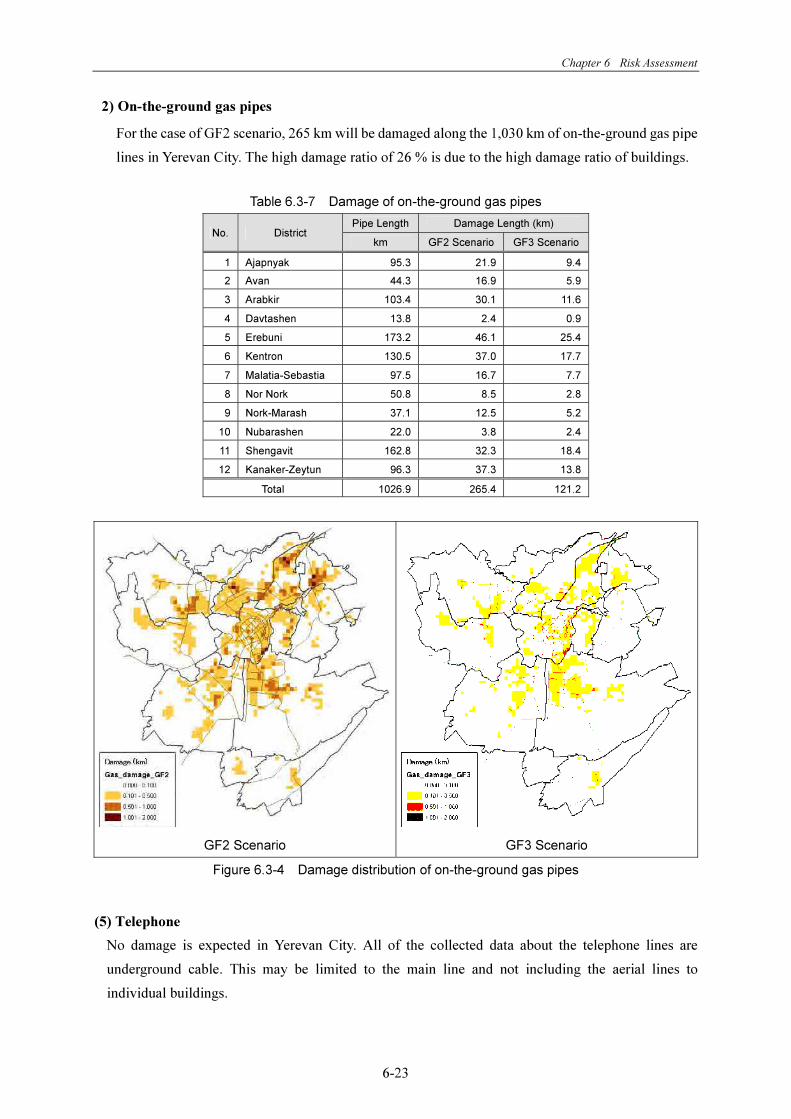
2) On-the-ground gas pipes
For the case of GF2 scenario, 265 km will be damaged along the 1,030 km of on-the-ground gas pipe
lines in Yerevan City. The high damage ratio of 26 % is due to the high damage ratio of buildings.
Table 6.3-7 Damage of on-the-ground gas pipes
No. District Pipe Length Damage Length (km)
km GF2 Scenario GF3 Scenario
1 Ajapnyak 95.3 21.9 9.4
2 Avan 44.3 16.9 5.9
3 Arabkir 103.4 30.1 11.6
4 Davtashen 13.8 2.4 0.9
5 Erebuni 173.2 46.1 25.4
6 Kentron 130.5 37.0 17.7
7 Malatia-Sebastia 97.5 16.7 7.7
8 Nor Nork 50.8 8.5 2.8
9 Nork-Marash 37.1 12.5 5.2
10 Nubarashen 22.0 3.8 2.4
11 Shengavit 162.8 32.3 18.4
12 Kanaker-Zeytun 96.3 37.3 13.8
Total 1026.9 265.4 121.2
GF2 Scenario GF3 Scenario
Figure 6.3-4 Damage distribution of on-the-ground gas pipes
(5) Telephone
No damage is expected in Yerevan City. All of the collected data about the telephone lines are
underground cable. This may be limited to the main line and not including the aerial lines to
individual buildings.

Final Report Vol. II Main Report 1
6-24
Table 6.3-8 Damage of underground telephone lines
No. District
Cable
Length
Damage Length (km)
GF2 Scenario GF3 Scenario
km Maximum Average Maximum Average
1 Ajapnyak 27.3 0.0 0.0 0.0 0.0
2 Avan 14.3 0.0 0.0 0.0 0.0
3 Arabkir 30.2 0.0 0.0 0.0 0.0
4 Davtashen 7.2 0.0 0.0 0.0 0.0
5 Erebuni 35.7 0.0 0.0 0.0 0.0
6 Kentron 62.9 0.0 0.0 0.0 0.0
7 Malatia-Sebastia 31.6 0.0 0.0 0.0 0.0
8 Nor Nork 25.7 0.0 0.0 0.0 0.0
9 Nork-Marash 7.8 0.0 0.0 0.0 0.0
10 Nubarashen 3.8 0.0 0.0 0.0 0.0
11 Shengavit 36.8 0.0 0.0 0.0 0.0
12 Kanaker-Zeytun 18.2 0.0 0.0 0.0 0.0
Total 301.5 0.0 0.0 0.0 0.0
Necessary Resources for Emergency Restoration 6.3.2
The necessary man-days for emergency restoration of the expected damages are estimated based on the
experience in Japan referring to “Tokyo Metropolitan Government (1997)”. The estimation was carried
out for the worst case scenario, namely in case of maximum damage of GF2 scenario.
The considered emergency restoration work is the recovery of the function of pipelines or cables. The
restoration of plants or substations is not considered.
(1) Water supply
When the water supply pipelines are damaged, water will leak from the damaged parts, seriously
affecting the water supply capacity. Therefore, for the purpose of emergency response after the
disaster, while surveying the condition of damage, it is necessary to close the sluice valves to
separate the damaged parts from the water supply network in order to minimize the area where the
water supply is suspended. This work should be given priority for about three days after the
occurrence of the disaster and then, substantial emergency restoration work should be carried out
from the fourth day. The estimation of the man-days required from the fourth day onwards is
described below.
a) Estimated damage: 27 points (0.021 points/km)
b) Hypothetical condition for restoration work
- Composition of work team: 1 supervisor + 8 workers /team
- Work efficiency: 1 location/team × 0.5 day
- Working hours: 8:00 - 17:00
- Number of work teams: 5 (5 supervisors and 40 workers)
c) Estimation of necessary emergency restoration days
= 27 locations / (5 teams × 2 locations/day)
= 3 days

Chapter 6 Risk Assessment
6-25
d) Estimation of water cut-off rate
P = 1/(1+0.307×R-1.17)
P: Water cut-off rate on one day after the occurrence of disaster
R: Physical damage rate of water pipes (points/km)
P = 1/ (1+0.307×0.021-1.17)
= 0.034 (3.4 %)
(2) Sewerage
Damages of sewerage lines can be classified to cracks of pipes, dislocation of joints and
accumulation of earth and sand in the pipes. The cracks of pipes and dislocation of joints will not
seriously affect the flow function of the sewerage system, except in cases of major damages.
However, earth and sand flowing into the pipes through the cracks will severely affect the flow of
sewerage.
For the purpose of emergency restoration, the condition of damage should be investigated on the day
after the occurrence of the disaster and the actual emergency restoration work should be carried out
from the second day onwards. For emergency restoration, it is necessary to repair the damage and
clean the inside of the pipes before and after the damaged part by high pressure washing to remove
the accumulated earth and sand. The estimation of the man-days required from the second day
onwards is described below.
Unlike water supply pipes, it is difficult to identify the damaged part of sewerage pipes. The
approach taken in estimating the man-days required for the emergency restoration of water supply
pipes should also be taken for sewerage pipes, but the work efficiency was assumed to be “1
location/team x day”.
1) Wastewater
a) Estimated damage: 71 points (0.083 points /km)
b) Hypothetical condition for restoration work
- Composition of work team: 1 supervisor + 8 workers /team
- Work efficiency: 1 location/team x day
- Working hours: 8:00 - 17:00
- Number of work teams: 5 (5 supervisors and 40 workers)
c) Estimation of necessary emergency restoration days
= 71 points/ (5 teams × 1 point/day)
= 15 days
2) Rain water
a) Estimated damage;10 points (0.052 points /km)
b) Hypothetical condition for restoration work
- Composition of work team: 1 supervisor + 8 workers /team
- Work efficiency: 1 location/team × day

Final Report Vol. II Main Report 1
6-26
- Working hours: 8:00 - 17:00
- Number of work teams: 2 (2 supervisors and 16 workers)
c) Estimation of necessary emergency restoration days
=10 points/ (2 teams × 1 point/day)
=5 days
(3) Electricity
The target of emergency restoration work should be distribution facilities comprising of electricity
poles, overhead lines and underground lines. Emergency restoration work of these facilities would
include installation of temporary electricity poles and aerial lines and construction of underground
or road cables. If power outage is caused by the damage to the distribution system although the
distribution facilities remain operational, the emergency restoration may involve electricity supply
from the service area of the adjacent distribution substation.
For the purpose of emergency restoration, the condition of damage should be investigated on the day
after the occurrence of the disaster and the actual emergency restoration work should be carried out
from the second day onwards. The estimation of the man-days required from the second day
onwards is described below.
a) Estimated damage;22.4km
Number of damaged electricity poles: 22.4km/50m+1 = 449 poles (Calculated based on the
assumption that the average span length is 50m)
Number of damaged spans: 22.4km/50m=448 spans
b) Hypothetical condition for restoration work
- Composition of work team: Electricity pole - 1 supervisor + 4 workers /team
Overhead line - 1 supervisor + 5 workers /team
-Work efficiency: Electricity pole - 1 pole /team × day
Overhead line - 1 span /team × day
- Working hours: 8:00 - 17:00
- Number of work teams: Electricity pole - 10 teams (10 supervisors and 40 workers)
Overhead line - 10 teams (10 supervisors and 50 workers)
c) Emergency restoration days
Electricity pole: 449 poles / (10 teams × 1 pole/day) = 45 days
Overhead line: 448 spans / (10 teams × 1 span/day)) = 45 days
(4) Gas
Damage to gas pipes may comprise of breakage and burst of pipes as well as separation of pipe
joints. As the percentage of underground gas pipes is as small as 6% of the total in Yerevan City, the
incidence of damage is assumed to be small. However, unlike water supply or sewerage pipes, in the
case of gas pipes, minor pipe damage may result in a major accident. Therefore, it is necessary to
inspect, test and repair the pipes for leakage.

Chapter 6 Risk Assessment
6-27
With respect to the restoration of on-the-ground gas pipes, the period required for the restoration
work will depend on the period required for the restoration of the buildings as gas pipes will be
constructed after the construction of the buildings.
Future measures 6.3.3
(1) Water supply
Deterioration of the water supply pipelines in Yerevan City is a serious problem and as much as 85%
of the water is lost due to leakage. Important pipelines should be given priority so that they can be
made earthquake-resistant, but it is necessary to construct a healthy water supply network in the first
place. Distribution water pipes to public facilities and hospitals, which play a key role in disaster
control activities, should be regarded as priority pipelines.
Although equipment used for the restoration work is retained, there is no stock of materials, such as
materials for pipes. Since it takes one to three months to procure such materials from abroad, it is
concerned that this may delay the restoration work. However, as storage place and budget will be
needed to keep a certain amount of materials, it is important to at least secure a stock of materials for
the important pipelines which need to be urgently restored.
(2) Sewerage
Making the sewerage system earthquake-proof is lower in priority than the water supply system. In
the event of a disaster, while water supply system is critical to human life, installation of portable
toilets, for example, may be carried out as provisional measures before the restoration of the
sewerage system, although this may lead to a sanitary problem. Nevertheless, replacement of the
ceramic pipes, which account for about 75% of the wastewater pipes, should be considered for the
future. It is possible to reduce the risk of a major earthquake by replacing these pipes with concrete
or PVC pipes that excel in earthquake resistance and durability. It is also effective to adopt a flexible
structure for the joint between the manhole and pipes that is likely to be damaged by an earthquake.
(3) Electricity
As a loop-shaped high voltage electricity network (220 kV) has been developed, even if the network
is partly damaged by accident, distribution route from other areas can be secured to avoid major
power outage. However, it is desirable to make the distribution facilities earthquake resistant
because the all of the facilities are outdated and may be extensively affected in the event of a major
earthquake. With respect to the low voltage distribution lines, it would be effective to bury them
underground so that they can be less likely to be affected by an earthquake.
(4) Gas
The underground gas pipes are seriously deteriorated and it is inevitable that they will be affected in
the event of a major earthquake. About 60% of the underground lines are major pipelines with a

Final Report Vol. II Main Report 1
6-28
diameter of 500 mm or more. Underground gas pipes account for only around 6% of the gas pipes in
Yerevan City, but they should be given priority and made earthquake-proof as the percentage of
major pipelines is high.
With respect to the on-the-ground gas pipes which account for about 94% of the gas pipes in
Yerevan City, it would be effective to reinforce the joints and pipe pedestals to make the pipes
earthquake resistant. Such pipes are often installed on the ground due to such reasons as easiness in
management and low construction costs, but it would also be effective to bury them underground in
the city redevelopment or road repair project. Burying them underground will reduce the damages
on the gas pipes due to earthquakes and falling buildings and road facilities.
6.4 Assessment of Fire and Casualty Damage
Assessment of Fire 6.4.1
During the earthquake vibration continuing or after subsided, fire sometimes brake out due to several
causes. The fire occurred from electrical appliances is most popularly found in the recent earthquakes in
Japan. Also the fire from gas stove, oven or gas boiler may break out. In Yerevan, the gas pipeline may
be broken by the earthquake and leaked gas may be ignited in high possibility.
During the 1988 Spitak Earthquake, 531 ignition points of fire are reported in Leninakan, Kirovakan and
Spitak city (Krimgold (1944)). The total population of the three cities was about 420,000 in 1988. The
current population of Yerevan is around 1,120,000; namely 2.7 times larger. The cause of fire is strongly
related to the activity of human; therefore the number of fire may be proportional to the population if
other conditions are same. If Yerevan city becomes the same condition to the three cities at the time of
Spitak Earthquake, it is supposed that fire break out 2.7 times of 531; namely about 1500.
In Japan and California, there are many examples that people are killed because of the fire occurred with
earthquake. More than 90% of the 100,000 dead persons by the 1923 Kanto earthquake in Japan were
killed by fire. This is due to the fact that the clouded urban area with wooden houses burned in the
spreading fire for two days. But there are very little wooden houses in Yerevan; therefore the possibility
of large scale spreading fire is negligible even if many fires may occur. The casualty due to the fire may
be small compared to the casualty related to the building damage.
Assessment of Casualty Damage 6.4.2
The collapse of buildings, fire and tsunami are given as the main causes of direct casualty damage due to
the earthquake. The effect of tsunami is no necessity to be considered in Yerevan and casualty due to the
fire may be very little considering the current building structure. In this section, the casualty damage due
to the building damage is assessed.
(1) Setting of damage function
The relation between building damage and casualties vary depending on the area and age because of
the building structure and dwelling situation differences. It is desirable to make the damage function

Chapter 6 Risk Assessment
6-29
based on the damage experiences by the earthquake in the study area or surrounding regions in
recent years. The damage by the 1988 Spitak earthquake is the most important and precious data to
set up the damage function for Armenia.
The damage function to estimate the number of death usually uses the number of damaged
“buildings” as the parameter; however there are many multi-story apartment buildings in Yerevan
and the number of dwelling unit in an apartment is different building to building. So, the number of
“dwelling unit” is better than the number of “building” as the parameter of the casualty damage
function for Yerevan. Therefore the function of casualty damage estimates how many people will die
in proportion to totally or heavily damaged dwelling unit number.
The relation between totally or heavily damaged dwelling unit number and number of dead people
by the earthquake is studied at first. Figure 6.4-1 shows the data from Spitak earthquake and three
Turkish earthquakes (1966 Varto earthquake, 1992 Erzincan earthquake and 1999 Kocaeli
earthquake). Solid circle shows the total number of damaged dwelling unit and number of dead
people by each earthquake; solid line shows the approximate function of them. The relation between
totally or heavily damaged dwelling unit number and number of dead people can be approximated
by the straight line on the logarithmic graph.
Solid diamond shows the damage in four cities (Spitak, Leninakan, Kirovakan and Stepanavan city)
by Spitak earthquake. The relation of damage corresponds to the approximate function except Spitak
city. Solid triangle shows the damage of Kocaeli earthquake by ward and most data corresponds to
the approximate function except two slightly damaged wards. It is noticeable that the number of
dead people in Spitak city by Spitak earthquake is much larger than the other cities. It is supposed
that the rescue operations in Spitak city may not be taken effectively because the building damage
ratio was extremely high. This may be one of the reasons of extremely severe casualty damage
compared to the other cities.
Figure 6.4-2 shows the relation between the totally or severely damaged dwelling unit ratio and the
ratio of dead people in four cities by Spitak earthquake. The dwelling unit damage ratio and death
ratio show high correlation. The approximation function that is shown in Figure 6.4-2 should be
effective to estimate the death ratio from the dwelling unit damage ratio; however the applicability is
limited. It can be used if the ratio of totally or heavily dwelling unit damage is larger than 20%. If
the approximate function will be extrapolated to lower damage ratio, it leads unrealistic number; for
example, the death ratio becomes less than 0.01% in case of dwelling unit damage reaches 10%. If
this relation is applied to Yerevan (dwelling unit is 260,000 and population is 1,120,000), totally or
heavily damaged dwelling unit becomes 26,000 and number of dead people becomes around 100.
This situation is contradictory to Figure 6.4-1. Based on the consideration above, the damage of
death should be estimated based on the relation in Figure 6.4-2 if the damage ratio of totally or
heavily damaged dwelling unit is larger than 20% and the relation in Figure 6.4-1 should be used for
other cases. In this study, the dwelling unit damage number is used for GF2 and GF3 Scenario as the
parameter.

Final Report Vol. II Main Report 1
6-30
The number of injured is estimated from number of dead people. Figure 6.4-3 shows the relation
between the number of death and number of injured by the earthquake in Caucasus and surrounding
area after 1970. If the damage is small, the ratio of death and injured number is not stable; however
the relation is stable if damage is big. The number of injured people is estimated using this relation
from number of dead people. Here injured means moderate plus hospitalization.
Figure 6.4-1 Relation of Damaged Housing Unit Number and Number of Death
[Number of Death] = 0.06 x [Number of Totally and Heavily Damaged Housing Units]1.1753
Figure 6.4-2 Relation of Damaged Housing Unit Ratio and Death Ratio
[Death Ratio] = 0.7653 x [Ratio of Totally and Heavily Damaged Housing Unit]4.2182
10
100
1,000
10,000
100,000
10 100 1,000 10,000 100,000
Totally and Heavily Damaged Dwelling Unit
Death
1999 Kocaeli
1988 Spitak
1988 Spitak by Nazaretyan
Spitak Eq.
Kocaeli Eq.
Varto Eq.
Erzincan Eq.
Spitak
Leninakan
Kirovakan
Stepanavan
y = 0.7653x4.2182
0.1%
1.0%
10.0%
100.0%
10% 100%
Ratio of Totally and Heavily Damaged Housing Unit
Death
Ratio
Spitak
Leninakan
KirovakanStepanavan

Chapter 6 Risk Assessment
6-31
Figure 6.4-3 Relation of Number of Death and Injured in Caucasus
[Number of Injured] = 8.2297 x [Number of Death]0.8494
(2) Estimated Damage
The casualty is estimated from building damage. The totally or heavily damaged dwelling unit
number is estimated from damaged building number multiplying the average number of dwelling
unit in one multi-story apartment, which is estimated based on the number of multi-story apartments
and number of dwelling units of each district. The number of multi-story apartments and number of
dwelling units in each district are listed in “The Housing Fund and Communal Facilities of the
Republic of Armenia on 2008” published by National Statistical Service of RA. The estimated
number of dwelling units in each 250m grid is shown in Figure 6.4-4.
The damage of schools and commercial buildings are not considered and casualty is not also
considered by the collapse of these facilities. The relation in Figure 6.4-1 and Figure 6.4-2 are
derived from the totally and heavily damaged building numbers or ratio during daytime, because the
estimating relation is based on the data of the 1988 Spitak earthquake which happed daytime. Then
the casualties for night time should be multiplied by 1.43 (1.0/0.7) following the methodology by
Russian MES. Human casualties at night time are calculated for each district and the summary of the
results is shown in Table 6.4-1. The death toll is shown in Figure 6.4-5. For GF2 and GF3 Scenario,
death toll is 31,800 and 11,200 respectively.
Caucasus and Surrouding Region from 1970
y = 8.2297x0.8494
1
10
100
1000
10000
100000
1 10 100 1000 10000 100000
Death
Injured
Spitak Eq.

Final Report Vol. II Main Report 1
6-32
Table 6.4-1 Casualty Damage
No. District Population GF2 Scenario GF3 Scenario
Death
(x1000)
Injured
(x1000)
Death
(x1000)
Injured
(x1000)
1 Ajapnyak 108,200 1.9 1.8% 5.1 4.7% 0.5 0.5% 1.7 1.6%
2 Avan 51,000 2.2 4.3% 5.6 11.0% 0.5 0.9% 1.5 3.0%
3 Arabkir 130,800 4.5 3.4% 10.3 7.9% 1.2 0.9% 3.3 2.5%
4 Davtashen 41,100 0.2 0.5% 0.7 1.7% 0.0 0.1% 0.2 0.5%
5 Erebuni 121,900 4.1 3.3% 9.6 7.9% 1.9 1.5% 5.0 4.1%
6 Kentron 130,600 6.5 5.0% 14.3 11.0% 2.6 2.0% 6.6 5.0%
7 Malatia-Sebastia 141,800 1.3 0.9% 3.7 2.6% 0.5 0.3% 1.5 1.1%
8 Nor Nork 147,000 4.3 2.9% 10.0 6.8% 1.1 0.8% 3.2 2.2%
9 Nork-Marash 11,300 0.3 3.1% 1.2 10.5% 0.1 1.1% 0.5 4.4%
10 Nubarashen 9,700 0.2 1.6% 0.6 6.1% 0.1 0.8% 0.3 3.6%
11 Shengavit 146,500 4.4 3.0% 10.2 7.0% 2.2 1.5% 5.6 3.8%
12 Kanaker-Zeytun 79,300 2.0 2.5% 5.2 6.5% 0.5 0.6% 1.6 2.0%
Total 1,119,200 31.8 2.8% 76.5 6.8% 11.2 1.0% 31.1 2.8%
Figure 6.4-4 Estimated Number of Dwelling Unit

Chapter 6 Risk Assessment
6-33
GF2 Scenario GF3 Scenario
Figure 6.4-5 Number of Death by District
References:
Krimgold F, 1994, Economic and social impacts of Armenia earthquake, Proceedings of the10th
World Conference of Earthquake Engineering, pp.7011-7015.
National Statistical Service of the Republic of Armenia, 2009, The Housing Fund and Communal
Facilities of the Republic of Armenia on 2008.
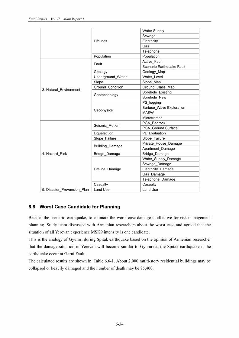
6.5 Creation of Earthquake Disaster Information Database
As shown in the Section 2.8, the database for this project is largely classified by five themes; “Base
Map”, “Built Environment”, “Natural Environment”, “Hazard Risk”, and “Disaster Prevention Plan”.
These classes are prepared as folder, and in the folders the middle classes are prepared as personal
Geodatabase which is the same format as Microsoft Access. Furthermore, in the middle classes, GIS
layers are stored. The outline of these classifications and layers are shown in the Table 6.5-1.
Table 6.5-1 Outline of Earthquake Disaster Information Database
Large Classification Middle Classification Small Classification
Folder Geodatabase GIS Layer
1. Base_Map
Armenia Country Boundary
Yerevan
Community Boundary
Digital Elevation Model
Major_Road
Water River
Lake
Satellite_Image Bing_Maps
2. Built_Environment Building
All_Building
Apartment_Building
Private_Building
School
Hospital
Bridge Bridge
Final Report Vol. II Main Report 1
6-34
Lifelines
Water Supply
Sewage
Electricity
Gas
Telephone
Population Population
3. Natural_Environment
Fault Active_Fault
Scenario Earthquake Fault
Geology Geology_Map
Underground_Water Water_Level
Slope Slope_Map
Ground_Condition Ground_Class_Map
Geotechnology Borehole_Existing
Borehole_New
Geophysics
PS_logging
Surface_Wave Exploration
MASW
Microtremor
4. Hazard_Risk
Seismic_Motion PGA_Bedrock
PGA_Ground Surface
Liquefaction PL_Evaluation
Slope_Failure Slope_Failure
Building_Damage Private_House_Damage
Apartment_Damage
Bridge_Damage Bridge_Damage
Lifeline_Damage
Water_Supply_Damage
Sewage_Damage
Electricity_Damage
Gas_Damage
Telephone_Damage
Casualty Casualty
5. Disaster_Prevension_Plan Land Use Land Use
6.6 Worst Case Candidate for Planning
Besides the scenario earthquake, to estimate the worst case damage is effective for risk management
planning. Study team discussed with Armenian researchers about the worst case and agreed that the
situation of all Yerevan experience MSK9 intensity is one candidate.
This is the analogy of Gyumri during Spitak earthquake based on the opinion of Armenian researcher
that the damage situation in Yerevan will become similar to Gyumri at the Spitak earthquake if the
earthquake occur at Garni Fault.
The calculated results are shown in Table 6.6-1. About 2,000 multi-story residential buildings may be
collapsed or heavily damaged and the number of death may be 85,400.

Chapter 6 Risk Assessment
6-35
Table 6.6-1 Summary of Damaqge for Worst Case Candidate for Planning
Case MSK-64
Intensity
Number of Totally and
Heavily Damaged
Multi-story Residential
Buildings
Number of Totally and
Heavily Damaged
Individual Houses
Number
of Death
All
Yerevan is
MSK 9
IX 2,000 29,000 85,400
Chapter 7 Related Study on Earthquake Disaster Management Plan
7-1
Chapter 7 Related Study on Earthquake Disaster Management
Plan
7.1 Urban Planning
7.1.1 Vulnerability in terms of Urban Infrastructure (Urban Area and Parks)
Yerevan city is a planned city developed in the Soviet era. Therefore, roads, parks and green space, etc.
are arranged systematically, except for a part of the slum in a densely built-up area, land use such as
residential area and industrial area is properly classified and arranged with good condition from the
viewpoint of urban planning. To give an overview of Yerevan city, vulnerability on urban planning to
the earthquake is not so high. However many buildings (individual residential houses and collective
houses) have become deteriorate, vulnerability may be increasing by rapid urbanization in recent years.
Considering to deal with a massive earthquake, and to promote an earthquake-resistant urban
development, following vulnerable aspects were identified.
(1) Vulnerability in Terms of Present Urban Infrastructure
Of the infrastructure of Yerevan city, with respect to a road deployment with width, parks and green area
per citizen, vulnerability assessment results are as follows.
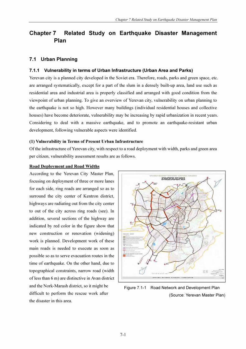
Road Deployment and Road Widths
According to the Yerevan City Master Plan,
focusing on deployment of three or more lanes
for each side, ring roads are arranged so as to
surround the city center of Kentron district,
highways are radiating out from the city center
to out of the city across ring roads (see). In
addition, several sections of the highway are
indicated by red color in the figure show that
new construction or renovation (widening)
work is planned. Development work of these
main roads is needed to execute as soon as
possible so as to serve evacuation routes in the
time of earthquake. On the other hand, due to
topographical constraints, narrow road (width
of less than 6 m) are distinctive in Avan district
and the Nork-Marash district, so it might be
difficult to perform the rescue work after
the disaster in this area.
Figure 7.1-1 Road Network and Development Plan
(Source: Yerevan Master Plan)

Final Report Vol. II Main Report 1
7-2
Parks and Green Space Per Citizen
According to estimation on the area of parks and green spaces per citizen based on the data of current
situation (see Table 7.1-1), although there are many open spaces as a green space (available to use for
evacuation), they are unevenly distributed depending on the district. In addition, Yerevan city is located
on the alluvial fan spreading at the foot of the mountainous area, and there are a few parks and green
spaces available to access in the event of a disaster due to many slopes in the northeastern part of the city
in particular. Moreover, since the open space in the vicinity of the collective houses in the densely
built-up area is mostly occupied by private warehouse or garage, its buffering function for emergency
evacuation and fire protection is lacking. Since there is a risk due to falling of broken window glass and
collapse of the surrounding buildings, the back yards are not suitable as an evacuation place.
Table 7.1-1 Green Space in Yerevan City by District (in 2003)
Source: Yerevan Master Plan and materials of Yerevan city
(2) Vulnerability in Terms of Land Use (buildings)
The vulnerability by building type was assessed as follows.
Collective Houses
The estimated damage (by GF2 scenario) to collective houses is notable in Kentron district and
Shengavit district, where old and superannuated buildings concentrate. Also it was estimated to damage
a part of the Avan district, Nor nork district and Arabkir district.
Individual Residential Houses
The estimated damage (by GF2 scenario) to individual residential houses is notable in Erebuni district,
Arabkir district and Avan district, where individual residential houses concentrate.
Area(ha) m2/person
Ajapnyak 12.0 1.12
Avan 10.5 2.10
Arabkir 122.3 9.30
Davtashen 7.8 1.90
Erebuni 18.5 1.55
Kentron 128.0 9.85
Malatia-Sebastia 60.5 4.30
Nor Nork 49.5 3.46
Nork-Marash 0.0 0.00
Nubarashen 3.1 3.30
Shengavit 32.6 2.30
Kanaker-Zeytun 95.5 12.25
Total 540.3 4.90
General use(parks, grove)District

Chapter 7 Related Study on Earthquake Disaster Management Plan
7-3
(3) Other Aspects
The vulnerability of Yerevan city was assessed based on the land use around the rivers running through
the City and the landslide prevention areas.
Land use Around the Rivers
As individual residential houses located along the Hrazdan valley and Nork valley, where steep slopes
are notable, countermeasures need to be taken against slope failure when an earthquake has occurred.
Landslide Prevention Areas
The landslide prevention areas are specified in Erebuni district and the southeastern part of Nubarachen
district, where countermeasures should be taken against landslide in time of an earthquake. Since
collective houses are not found in this area except for a few individual residential houses, the estimated
damage to houses is not found in this area. However, it could be estimated that the vulnerability is
relative high because residents will be isolated by the landslide triggered by earthquake.
7.1.2 Current Status and Issues in Terms of Urban Planning System
(1) Legal Framework in Terms of Urban Planning
Legal framework with respect to urban development and land use (see Figure 7.1-2) is based on the low
of urban development (established in 1998). Measures to control land use are taken according to the
classification of land use (established in 2001) where lands are designated as nine (9) categories in use.
Redevelopment project including reconstruction of buildings is based on Yerevan Master Plan as an
upper level plan. However, since the Master Plan indicates only a future direction on development
strategy of the whole city, actual development projects are carried out based on regulations of urban
development of the City (Mayor’s decision with legal force) and building standards (the uniform
standards applied in the former Soviet era, such as the construction norms and rules CNaR 2.07.01-89
Moscow 1989).
Urbanized areas of the City were systematically developed based on rigorous standards in the former
Soviet era, and urban structures still remain in the most part of the City. Because of the period of
confusion in Armenia (after the collapse of Soviet regime), disorderly developments were not notable
under a small population inflow and low economic growth. However, privatization of lands and
buildings that have moved ahead in the 1990s could be a factor interfering with earthquake-resistant of
the housing. In case of the collective houses in particular, burden of expenses for reconstruction
including earthquake-resistant construction and consensus of residents are difficult due to the income
gap between residents1. Therefore, redevelopment projects to the deteriorated collective houses which
are located mainly in the built-up urban area are not progressed in the City. In order to promote
1 Land use control (Land Code)
In order to avoid such a case, “Land Code” was established in Armenia, which has a legal force to the public use of land applied
to collective houses. Regarding article 104 of the Land Code, in case of eviction of residents due to reconstruction of collective
houses, the City as a landowner of collective houses gives a notice of eviction to the residents before one year. When the
residents did not move out within the specified time limit, the City can order the residents to move out of their homes by force
(available to confiscate a real estate).
Final Report Vol. II Main Report 1
7-4
earthquake-resistant urban development requiring the earthquake-resistant housing, improvement of
legal framework for urban development will be the priority issue.
(2) Master Plan
The first edition of Yerevan Master Plan was elaborated in 1976. Through a period of confusion caused
by the independence of Armenia in the 1990s, the Master Plan with a design period of the 2020 has been
fully revised in 2005 according to the governmental decision N2320-N. In the following year 2006, an
action plan for the Master Plan was approved according to the governmental decision N1402-N, in
addition, the regulation of redevelopment for urban areas of the City was approved by the Mayors
decision N2228-A. The revision of the Master Plan was approved according to the governmental
decision N208-N and N1920-N in the year of 2010 and 2011, this revision has started to work from the
beginning of 2012. Some reference and recommendations on earthquake disaster mitigation
(earthquake-resistant urban development including reconstruction of buildings and earthquake-resistant
housing) needs to be added in this revised Master Plan.
Yerevan Project
Yerevan Project (a municipal company, nonprofit company of the City) is going to execute a revision of
the Master Plan at present. Yerevan Project has more than fifty (50) years history, and has monopolized
a design work and an engineering work for construction of buildings including civil work of the City in
the former Soviet era, where more than one thousand engineers were employed. After the 1990s with
collapse of the political system, as Yerevan Project was forced to be financially independent by the
privatization due to the end of subsidy by the government, employees decreased to around one hundred
people. When participating in the project, Yerevan Project currently joins a competitive bidding in the
same qualification as other private consultant or engineering company. Business category of Yerevan
Project is generally different from private construction company or developer undertaking
redevelopment projects.
(3) Issues and New Framework in Terms of Earthquake Disaster Mitigation
Armenian government is now preparing a complex project with respect to earthquake risk mitigation
measures to the buildings based on risk assessment by the earthquake (see Figure 7.1-2), and various
projects is going to be started toward construction of earthquake-resistant buildings (reconstruction of
deteriorated buildings that was built prior to 1989). Ensuring compatibility and consistency between
various measures (projects), legal system, and concept and strategy of the Master Plan will become an
issue in the future.

Ch
apter 7
Rela
ted S
tud
y on
Ea
rthq
ua
ke Disa
ster Man
ag
emen
t Pla
n
7-5
Figure 7.1-2 Legal Framework of Earthquake Disaster Mitigation on Urban Development of the Yerevan City

Final Report Vol. II Main Report 1
7-6
7.1.3 Issues in Terms of Urban Redevelopment Projects of Yerevan City
(1) Development Projects in the Built-up Area
In most cases of the redevelopment project in the City, reconstruction of the superannuated buildings
is common at the present, and a project with wide area or slum area where individual residential
houses are concentrated is very limited. However, some redevelopment projects of high priority for
large area are proposed in the Master Plan as follows (see Figure 7.1-3);
- Kondo area of Kentron district(slum area with concentrated individual residential houses)
- Kilikia area and Noragyugu area in Kentron district(sloping lands with topographical constraints)
- Central part of Ajapnyak district(need measures against land subsidence)
- Others, several areas in Shengavit district, Arabkir district and Nor-nork district (sloping land)
Despite a few years passed after designation (specification) of these redevelopment projects, the
progress is slow at the present. Except the above, the redevelopment project of Northern Avenue and
surrounding of the Opera in Kentron district were mostly completed in 2012.
(2) Mechanism for Implementation of Redevelopment Projects
Redevelopment projects with reconstruction of the buildings are currently executing everywhere in the
central part of Kentron district (within the ring roads), such as the redevelopment project of Northern
Avenue and surroundings of the Opera. These redevelopment projects with focusing on the
reconstruction of buildings are undertaken entirely by a private developing company (so-called
"developer") through competitive bidding. In that case, the City makes an examination of procedures on
documents of application elaborated by the developer, and plays a role of supervision to whole the
project (not only the construction work itself). In terms of mechanism for implementation of
redevelopment projects, followings are memorable;
- Collective houses and office buildings which were built in the 1960s to the 1970s are mostly low
earthquake-resistant. In that case, as the reconstruction of building after demolishing has an advantage
in cost compared to anti-seismic reinforcement, it is selected in most cases.
- Within the redevelopment project, adjusting the interests between residents is left to the developer
under supervision of the City.
- The developer prepares various options for removal of residents, so that residents won't have any
issues (claim) in case that the citizens want to reconstruct their collective houses. The following cases
are given as examples; a) Housing acquisition by compensation payment (funds obtained from selling
a right to live), b) New reconstructed housing acquisition by purchase of right with a loan on the
security of compensation payment, c) Relocation to a substitute land (housing) which is a fair
equivalent for compensation payment.
- Regarding a rule for agreement on reconstruction of collective houses, though the unanimous
agreement of all co-holders will be applied in principle, some cases where residents are forcibly
ordered to move out of their houses are found on rare occasions. In such a case, solution can be found
shortly according to the law.
Chapter 7 Related Study on Earthquake Disaster Management Plan
7-7
- Yerevan city does not provide a public housing and a rental housing by its leadership because inflow of
population into the City was relative small after independence with financial difficulties of the City. In
addition, a shortage of substitute lands caused by redevelopment projects is not found at the present.
- In spite of a redevelopment project that requires spreading to large area, the integral implementation
plan with roads and parks financed by a subsidy of the City is not found in general. Reconstruction of
buildings and supplementary maintenance of streets with re-laying work are found in most cases. The
reason is that widening of roads and land readjustment is not necessary due to a partly additional space
in the block and streets are enough.
- Kond area located in the northeastern part of Kentron district was designated to the redevelopment
area by Yerevan City Master Plan. The slum of concentrated low ceiling residential houses
constructed more than one hundred years ago can be found partly. Taking account of topographical
condition (sloping lands) in this area, complex projects including land reclamation and road
improvement are needed to be considered. The developer by a foreign capital is currently engaged in
the redevelopment project of this area.
Land Ownership
After the enforcement of lows on the ownership of land in 1990 due to the collapse of the former Soviet
regime, many citizens could obtain the land ownership of housing without compensation. According to
the statistic data, the citizen owes twenty-three (23) % of the land in the City. Since ownership of the
floors for private use in the collective houses belongs to the resident, a space for common use in the
collective houses belongs to the City (management by the condominium in reality). Parking place with
garage and open space around the collective houses belongs to the City in principle. Regarding the fixed
assets tax, except small-size land and building, the owner of real estate pays their taxes to the City (see
Figure 7.1-4).
(3) Issues in Terms of Redevelopment Projects
- Most of redevelopment areas designated by the Master Plan have some topographical and geological
restrictions, so these redevelopment projects need not only reconstruction of buildings but also the
land reclamation work with countermeasures to the sloping lands and subsidence lands. In addition,
redevelopment projects also require a harmonization with its surroundings area by an integrated
development that combines improvement of roads (as an infrastructure) and reconstruction of
buildings.
- Progress of reconstruction work in the central part of the City may be a cause of excessive population
concentration especially in Kentron district and its vicinity in the future. In order to avoid this situation,
it would be expected to create a long-term plan so as to provide housing in the western part of the City
(e.g. Adjapnyak district, Malatia Sebastia district and Shengavit district), where a housing land
development is going to became popular.
- When implementing a redevelopment project, it is necessary not only to promote a reconstruction of
buildings by leadership of the developer, but also to introduce public-works (such as parks, open
spaces and widening roads, etc.) by a subsidy of the City. An integrated project like this may be of a
great advantage to urban environment and disaster mitigation.

Fin
al R
epo
rt Vo
l. II M
ain
Rep
ort 1
7-8
Figure 7.1-3 Urban Development Projects and Earthquake Disaster Mitigation Plan
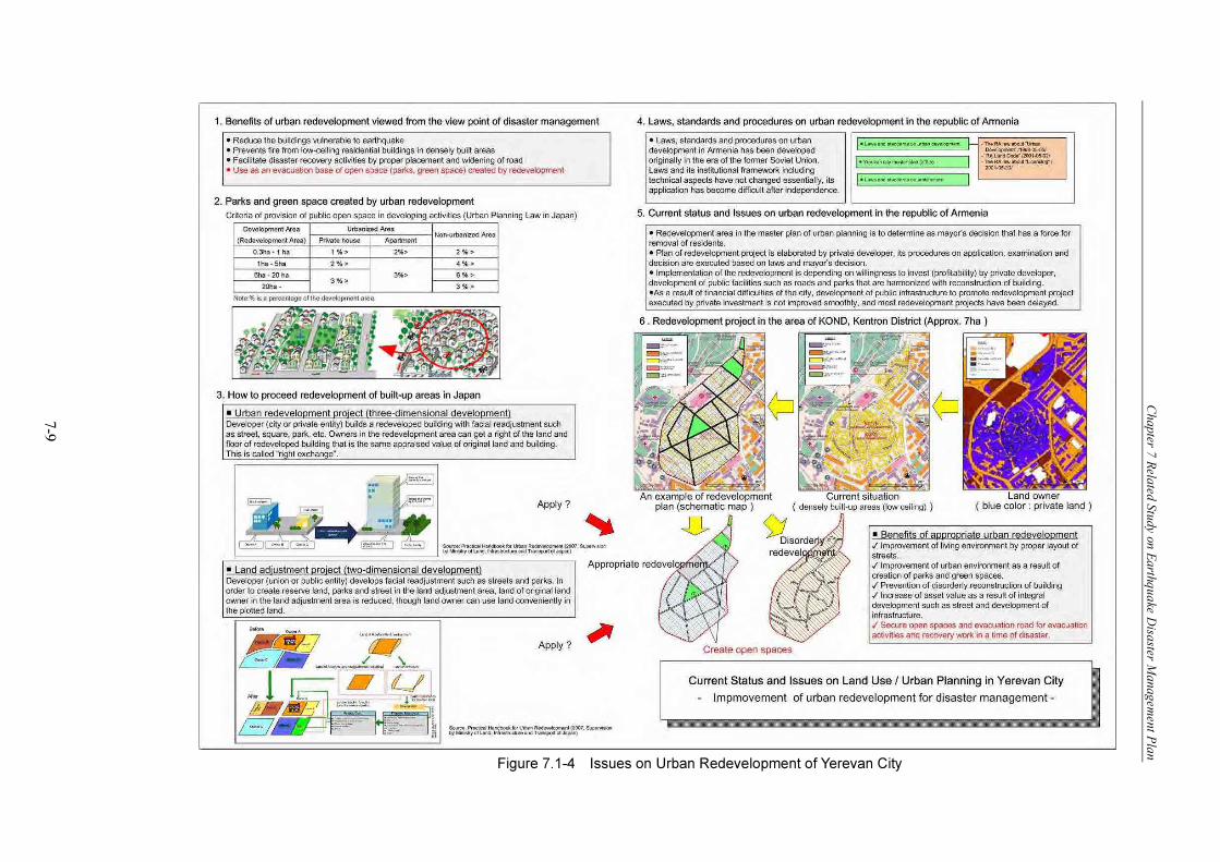
Ch
apter 7
Rela
ted S
tud
y on
Ea
rthq
ua
ke Disa
ster Man
ag
emen
t Pla
n
7-9
Figure 7.1-4 Issues on Urban Redevelopment of Yerevan City
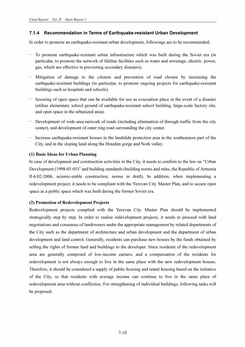
Final Report Vol. II Main Report 1
7-10
7.1.4 Recommendation in Terms of Earthquake-resistant Urban Development
In order to promote an earthquake-resistant urban development, followings are to be recommended;
- To promote earthquake-resistant urban infrastructure which was built during the Soviet era (in
particular, to promote the network of lifeline facilities such as water and sewerage, electric power,
gas, which are effective in preventing secondary disasters).
- Mitigation of damage to the citizens and prevention of road closure by increasing the
earthquake-resistant buildings (in particular, to promote ongoing projects for earthquake-resistant
buildings such as hospitals and schools).
- Securing of open space that can be available for use as evacuation place in the event of a disaster
(utilize elementary school ground of earthquake-resistant school building, large-scale factory site,
and open space in the urbanized area).
- Development of wide area network of roads (including elimination of through traffic from the city
center), and development of outer ring road surrounding the city center.
- Increase earthquake-resistant houses in the landslide protection area in the southeastern part of the
City, and in the sloping land along the Hrazdan gorge and Nork valley.
(1) Basic Ideas for Urban Planning
In case of development and construction activities in the City, it needs to confirm to the law on “Urban
Development (1998-05-05)” and building standards (building norms and rules, the Republic of Armenia
II-6.02-2006, seismic-stable construction, norms in draft). In addition, when implementing a
redevelopment project, it needs to be compliant with the Yerevan City Master Plan, and to secure open
space as a public space which was built during the former Soviet era.
(2) Promotion of Redevelopment Projects
Redevelopment projects complied with the Yerevan City Master Plan should be implemented
strategically step by step. In order to realize redevelopment projects, it needs to proceed with land
negotiations and consensus of landowners under the appropriate management by related departments of
the City such as the department of architecture and urban development and the department of urban
development and land control. Generally, residents can purchase new houses by the funds obtained by
selling the rights of former land and buildings to the developer. Since residents of the redevelopment
area are generally composed of low-income earners, and a compensation of the residents for
redevelopment is not always enough to live in the same place with the new redevelopment houses.
Therefore, it should be considered a supply of public housing and rental housing based on the initiative
of the City, so that residents with average income can continue to live in the same place of
redevelopment area without confliction. For strengthening of individual buildings, following tasks will
be proposed.

Chapter 7 Related Study on Earthquake Disaster Management Plan
7-11
Reconstructing Work
According to the Master Plan, buildings required reconstruction were built before 1989 (mainly the
1960s -1970s). Promoting reconstruction of individual houses, and processing the consensus building
between residents and developer, reconstructing work should be implemented using following manners;
- To promote a reconstruction by reducing the costs by construction of high- and medium-rise
buildings with increasing of the floor area
- To promote redevelopment project with a new collective house in the area of low ceiling houses by
conversion of the land to the apartment's floors
- By supplying of rental housings, to promote reconstruction of deteriorated houses where low-income
earner lives
Earthquake-resistant Work
Based on the seismic diagnosis for buildings classified "public buildings, historical and cultural
buildings" in the master plan of Yerevan city, earthquake-resistant work will be conducted. In particular,
with respect to hospitals and schools that play an important role in case of earthquake disaster,
quake-resistance work for them will become a priority.
(3) Securing Open Spaces
Securing Open Space in the Urban Area
As a result of overlaying the GIS data of the Master Plan and information about the population
distribution etc., the following points became clear;
- Parks and green spaces are scattered throughout the city, and open-space ratio of the outer edge of the
city is relatively high.
- While parks and green space are relatively dense in the central part of the city such as Kentron
district and Arabkir district as a residential area, no such places exist in the Nork-Marash district.
- According to the Yerevan City Master Plan, it is planned to increase green spaces and parks as more
than 10m2 /person in 2020.
When a disaster occurs, it is necessary to secure the primary evaluation place specified by the City such
as school grounds (primary schools and secondary schools), hospitals and governmental buildings
(facilities). Furthermore, an existing park in the urban area and an open space on the outskirts of the City
will be used for the secondary evacuation place. Because a lack of open space in the highly dense
residential area composed of individual residential houses, considering prevention of the spread of fire,
additional work such as a buffer tree planting in a private land and a setback at the time of reconstruction
should be promoted.

Final Report Vol. II Main Report 1
7-12
Table 7.1-2 Future Plan of Green Space by District
Designation and Development of Disaster Management Park
Existing park should be specified as a disaster management park, and developed not only for use of
temporary evacuation but for a base of operation in a time of rescue and relief, where an area needs to be
more than 10-20 ha of scale at least (see Figure 7.1-5). Considering an accessible road for evacuation
and the result of damage estimation in a time of earthquake, it would be desirable to deploy several
disaster management parks at key points in the City (see Figure 7.1-6).
Decision of City Plans
Individual residential houses have been built at the site of large-scale park in a part of the City. In
addition, some interrupted pedestrian replaced by private land can be seen in urban area. The reason of
this is that public spaces such as roads, parks and private land have not been completely divided so far,
and the use of public space has been determined based on an individual development application
(permission) respectively. In order to ensure the continuity of use of parks and green spaces as a public
open space, specification to the public open space by decision of city plans is necessary.
Area (ha) m2/person Area (ha) m
2/person
Ajapnyak 12.0 1.12 243.0 16.40
Avan 10.5 2.10 70.5 12.70
Arabkir 122.3 9.30 216.8 16.60
Davtashen 7.8 1.90 97.8 21.60
Erebuni 18.5 1.55 372.0 30.04
Kentron 128.0 9.85 148.0 11.60
Malatia-Sebastia 60.5 4.30 360.5 22.40
Nor Nork 49.5 3.46 261.5 18.00
Nork-Marash 0.0 0.00 51.0 39.20
Nubarashen 3.1 3.30 101.1 68.30
Shengavit 32.6 2.30 334.6 20.80
Kanaker-Zeytun 95.5 12.25 125.5 16.40
Total 540.3 4.90 2,382.3 19.85
Source:Yerevan city Master Plan (2005)
DistrictYear 2005(2003) Year 2020
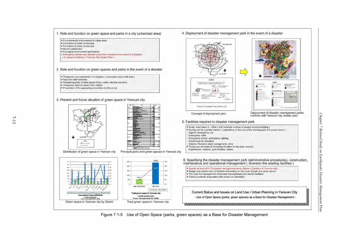
Ch
apter 7
Rela
ted S
tud
y on
Ea
rthq
ua
ke Disa
ster Man
ag
emen
t Pla
n
7-1
3
Figure 7.1-5 Use of Open Space (parks, green spaces) as a Base for Disaster Management

Fin
al R
epo
rt Vo
l. II M
ain
Rep
ort 1
7-1
4
Figure 7.1-6 Development of Large Scale Disaster Management Park

Chapter 7 Related Study on Earthquake Disaster Management Plan
7-15
(4) Road Improvement
Traffic Network
Development of a highway should take a step-by-step approach according to the Yerevan Master Plan.
For ensuring a smooth evacuation and rescue and relief at the time of earthquake disaster, construction
work of some undeveloped sections of the outer ring roads should be launched promptly so as to access
to the destinations by the shortest route from center of the city.
Parking Area
Parking spaces along the road in the urban area is generally under the control of the City. Requiring
parking restrictions to the specified emergency road for evacuation, and rescue and relief at the time of
the earthquake, it is necessary to develop additional parking area along the specified emergency road.
Since back yards of collective houses have been used as a garage in general, at the time of the earthquake,
the garage will interfere the evacuation, rescue and relief, and further, it brings a possibility of secondary
disaster as a fire caused by ignition of gasoline. Also considering that the risk of garage has been pointed
out by the citizens, so as not to interfere the activities in the event of a disaster, its proper maintenance or
limitation of use should be proposed.
Public Transportation
During disasters, use of private car will be limited except an emergency vehicle, people uses a public
transportation in general. Without interfering the movement of emergency vehicles, in order to facilitate
the movement of public transportation as much as possible, administration of the public transport and
road rail transporting companies should improve earthquake-resistant infrastructure such as a telephone
pole in the transmission line during normal time. In addition, in order to ensure pedestrian line at the
time of disaster, it would be recommended that the administration of public transport and the bus
company will improve earthquake-strengthened bus stop. For suppress the usage of private car in times
of disaster, it is also recommended to develop extension of metro which has been managed and operated
by the City (with a further extension plan).
(5) Land Use in Time of Disaster
In the time of disaster, as well as school, hospital and administrative office which should be specified
as primary evacuation place by Ministry of Emergency Situations, active use of parks, green space and
other open space (private land) as secondary evacuation place should be considered (see Figure 7.1-7).
Before usage of secondary evacuation place, it will be necessary to conclude an agreement on
permission of land use between Yerevan city and land owner. For parks and green space, assuming the
aggressive use of refuge in times of disaster, it is recommended to introduce guide sign (for notifying
the specified evacuation place), emergency toilet, emergency light, and stockpiling base (see Figure
7.1-8).

Fin
al R
epo
rt Vo
l. II M
ain
Rep
ort 1
7-1
6
Figure 7.1-7 Example of Evacuation Map in case of Kentron District

Ch
apter 7
Rela
ted S
tud
y on
Ea
rthq
ua
ke Disa
ster Man
ag
emen
t Pla
n
7-1
7
Figure 7.1-8 Image of Disaster Management Park in Japan

Final Report Vol. II Main Report 1
7-18
7.2 Environment and Social Conditions
7.2.1 Disposal of Debris
(1) Present State of Debris Disposal
At present the debris and construction waste generated due to demolition of a building is transported to
the debris disposal site in Ajapnyak District, while municipal solid waste is mainly disposed at final
disposal site in Nubarashen District.
The Department of Communal Service of Yerevan City is responsible for municipal solid waste
management, but not for construction waste management. The Department of Architecture and Urban
Construction and the Department of Urban Development and Land Inspection of Yerevan City are
responsible for debris management and only construction companies instructed and contracted by a
licensed company can transport the construction waste to the debris disposal site in Ajapnyak.
The existing debris disposal site is a vacant lot of rock quarry, located near Tsita Factory in Ajapnyak
District and the area is 10 ha. It is said that it will be used for more than 10 years from now because the
amount of construction waste discharged in Yerevan City has not been so much. Since the both
departments of Yerevan City selected the existing site among vacant lots of rock quarry as a debris
disposal site, the site for disaster debris disposal should be selected from candidate sites of vacant lot
of rock quarry.
For the reference, there is one company of municipal solid waste management in each District. They
can get the business by tendering, and collect and transport solid waste to the final disposal site,
including the job of cleaning and watering the street, and snow removal. The final disposal site in
Nubarashen is managed by the municipal solid waste management company in Erebuni District.
(2) Amount of Debris Generated due to Seismic Disaster in Yerevan City
The amount of debris generated due to a seismic disaster was calculated based on the result of scenario
GF2. The number of buildings completely destroyed due to the seismic disaster is as shown in Table
7.2-1.
The amount of debris generated due to a seismic disaster was calculated by using the average unit
(0.120 ton /m2 of combustible waste and 0.987 ton /m2 of non-combustible waste observed in Great
Hanshin Earthquake, Japan) of debris discharged from reinforced concrete building destroyed
completely, with the data of average floor areas (4,568m2 and 232m2) of a multi-story apartment and
an individual house. The result is as shown in Table 7.2-2.
Combustible waste 473x103 +386x103 = 859x103 (ton)
Non-combustible waste 3,891x103 + 3,175x103 = 7,066x103 (ton)

Chapter 7 Related Study on Earthquake Disaster Management Plan
7-19
Table 7.2-1 Number of buildings completely destroyed in Scenario GF2
Table 7.2-2 Amount of Debris generated due to Seismic Disaster of Scenario GF2
(3) Transport and Disposal of Debris
The volume of the debris can be calculated by dividing the weight of debris with weight per unit
volume, 1.2 ton / m3, and the vacant lot of quarry with depth of 30m and area of 20 ha is required to
dispose whole debris.
7,066x103 (ton) / 1.2 (ton /m3) = 5,888x103 (m3)
5,888x103 (m3) / 30(m) = 196x103 (m2)
= 20 (ha)
In Yerevan City 151 dump trucks are operating to collect municipal solid waste. Even if 200 dump
trucks with capacity of 4 tons are put in operation for transportation of disaster debris immediately
Multi-story
Apartment
(x100)
Individual
House
(x100)
Housing
Unit
(x100)
1 Ajapnyak 3.9 30.6 267 0.5 12% 10.9 36% 36 14%
2 Avan 2.3 12.2 127 0.6 27% 6.7 55% 40 32%
3 Arabkir 5.8 33.2 347 1.2 21% 11.7 35% 74 21%
4 Davtashen 1.7 7.8 98 0.0 2% 3.2 41% 5 5%
5 Erebuni 2.2 106.4 228 0.5 23% 38.4 36% 69 30%
6 Kentron 7.1 55.1 364 2.5 35% 15.5 28% 103 28%
7 Malatia-Sebastia 5.7 45.3 346 0.3 6% 10.3 23% 27 8%
8 Nor Nork 6.4 1.8 369 1.0 16% 0.5 31% 71 19%
9 Nork-Marash 0.0 24.0 24 0.0 23% 8.3 35% 8 34%
10 Nubarashen 0.3 5.5 16 0.1 26% 1.4 26% 4 26%
11 Shengavit 5.5 72.0 298 1.4 26% 16.4 23% 73 25%
12 Kanaker-Zeytun 2.9 32.4 163 0.5 16% 15.3 47% 37 23%
43.7 426.3 2,649 8.6 20% 138.7 33% 548 21%
Inventory Totally or Heavily Damaged
Multi-story
Apartment
(x100)
Individual
House
(x100)
Housing
Unit
(x100)
Total
No. District
Combustible
Waste
(x1,000 ton)
Non-Combustible
Waste
(x1,000 ton)
Combustible
Waste
(x1,000 ton)
Non-Combustible
Waste
(x1,000 ton)
1 Ajapnyak 26 210 30 249
2 Avan 33 273 19 153
3 Arabkir 66 541 32 267
4 Davtashen 2 15 9 73
5 Erebuni 28 227 107 880
6 Kentron 136 1,119 43 356
7 Malatia-Sebastia 17 142 29 236
8 Nor Nork 57 466 2 13
9 Nork-Marash 0 1 23 190
10 Nubarashen 4 36 4 33
11 Shengavit 79 654 46 375
12 Kanaker-Zeytun 25 207 43 351
473 3,891 386 3,175
Multi-story Apartment Individual House
No. District
Total

Final Report Vol. II Main Report 1
7-20
after an earthquake, with additional 49 dump trucks provided from construction companies,
conducting 10 trips per day for 250 days per year, it would take 3.5 years to transport and dispose the
disaster debris.
7,066x103 (ton) / 4 (tons) / 10 (trips) / 200 (trucks) / 250 (days) = approx. 3.5 (years)
The scenario GF2 is formulated based on the assumption that 21% of housing units would be
homeless and the remaining 79% of citizens could stay at their house. It means that Department of
Communal Service in Yerevan has to manage municipal solid waste as usual even after an
earthquake disaster and 79% of collection vehicles have to operate for daily collection of municipal
waste, not for disaster debris, and it would take 17 years to dispose whole disaster debris,
maintaining daily municipal solid waste management.
3.5 years / 0.21 = approx. 17 (years)
For your information, recycling activities have not been promoted and there is no system to separate
disaster debris into concrete blocks, reinforces and stones, for re-using and reducing amount of
debris to be disposed. The municipality government aims to fill the vacant lots of quarry with
construction debris and finally cover the lots with soil to construct a small town or a green area.
Therefore, it cannot be expected to reduce the amount of disaster debris by means of separating them
for re-use and recycling at present.
At the same time the amount of 859x103 tons of combustible solid waste would be generated due to
the earthquake. The waste should be transported to the current municipal waste disposal site in
Nubarashen District since there is no incineration system of municipal waste in Yerevan City.
If current 85 compactor trucks in operation in Yerevan City are put in operation for transportation of
combustible disaster waste, conducting 10 trips per day for 250 days per year, it would take 1 year to
transport and dispose whole combustible disaster waste. The amount of the waste falls into 9 % of
whole waste disposed at Nubarashen Disposal Site in the past 50 years and it requires the site with
height of 5 m and area of 14 ha. The Nubarashen Disposal site has the remaining capacity area of 20
ha among whole area 52.3 ha to dispose the combustible disaster waste from Yerevan City after an
earthquake.
859x103 (ton) / 4 (tons) / 10 (trips) / 85 (trucks) / 250 (days) = approx. 1 (year)
859x103 (ton) /1.2 (ton/ m3) = 716x103 (m3)
716x103 (m3) / 5(m) = 14 (ha)
The scenario GF2 is formulated based on the assumption that 21% of housing units would be
homeless and the remaining 79% of citizens could stay at their house. If 79% of waste collection

Chapter 7 Related Study on Earthquake Disaster Management Plan
7-21
system is not involved for rehabilitation from the disaster, it would take 5 years to dispose whole
combustible disaster waste, maintaining daily municipal solid waste management.
1 (year) / 0.21 = approx. 5 (years)
(4) Candidate Disposal Sites of Debris
There are several candidate sites for disposal site of disaster debris in Yerevan City and 4 sites
among them are as shown in Table 7.2-3 and Figure 7.2-1. A2 and E1 are now operating as quarry of
basalt and they will be able to be candidate sites for debris disposal site after fishing their business.
All of them are originally state land, which the government can request the operation company to
return if necessary. Total capacity will be approximately 7.75 million m3 enough to receive whole
disaster debris of 0.7 million m3.
Moreover, there is information of candidate sites located outside of Yerevan City. Since Yerevan
municipality cannot manage directly the land located outside of their jurisdiction, the coordination
between Yerevan City and each Region should be conducted by central government.
Table 7.2-3 Candidate Sites for Disaster Debris
No. Tentative
Name District
Capacity
(1,000 m3)
Calculation
(Area x Depth)
1. A1 Ajapnyak 4,000 10 ha x 40 m = 4,000,000m3
2. A2 Ajapnyak 600 1 ha x 60 m= 600,000 m3
3. N1 Nor Nork 2,250 15 ha x 15 m= 2,250,000 m3
4. E1 Erebuni 900 6 ha x 15 m =900,000 m3
Total 7,750
Figure 7.2-1 Location of Candidate Sites of Debris Disposal

Final Report Vol. II Main Report 1
7-22
7.2.2 Disposal of Hazardous Waste (Asbestos)
(1) Present State of Hazardous Waste Disposal
Health care waste including infectious waste is transported from hospitals and medical institutes by
two licensed companies to the incinerator to burn and make it nonhazardous.
After several licensed companies collect hazardous waste, they transport it to the municipal solid
waste disposal site in Nubarashen to dispose it, finally mixed with municipal solid waste because
there is no hazardous waste disposal site in Yerevan City. Although Ministry of Nature Protection
already provided the regulation for treatment of hazardous waste, municipality cannot follow it
because of short of budget. It means that there is no specific disposal site for hazardous waste.
(2) Asbestos
Little information can be obtained as regards asbestos, although hearing from Ministry of Health,
Ministry of Nature Protection, Ministry of Urban Development, Community Service Department of
Yerevan and Architecture and Urban Construction Department, etc. have been conducted. No
accidents due to asbestos have been reported. It is not clarified whether much asbestos was utilized
for construction of buildings and pipelines and whether much asbestos remains inside old building
either.
In Armenia utilization of asbestos has not been prohibited until now and it is said that there is a
company which produces asbestos in Ararat Region. On the base of information from Architecture
and Urban Construction Department of Yerevan, which issues the permission for demolition of
buildings, the licensed company for demolition of buildings disposes asbestos separately from other
wastes when they find it.
Therefore, the person involved in disposal of disaster debris for rehabilitation should wear
anti-asbestos mask, make the debris wet by watering, pack the asbestos in the bag and store in
certain place with a caution board.
7.2.3 Human Waste Management and Sanitary Condition
(1) Present State of Human Waste Treatment
The human waste discharged from toilets in Yerevan City is collected mixed with living sewage into
Charbark Wastewater Treatment Facility in Shengavit through pipeline network. The large scale
facility , which was constructed in former soviet union age, can fulfill a great function of wastewater
treatment with all necessary process and finally disinfect the wastewater before discharging into
Hrazdan River. However, unfortunately it has not been operating these twenty years due to issue of
power supply.
At present the wastewater is discharged directly into the river after only two steps of process,
removing solid waste by screen and settling down the sand. The treated water is discharged 4.5 mil.
m3 / month, equal to 1,600-1,800 l/sec. Although impact on water quality of the river is not serious
from January to May because water volume of the river is approximately 10,000 l/sec, during
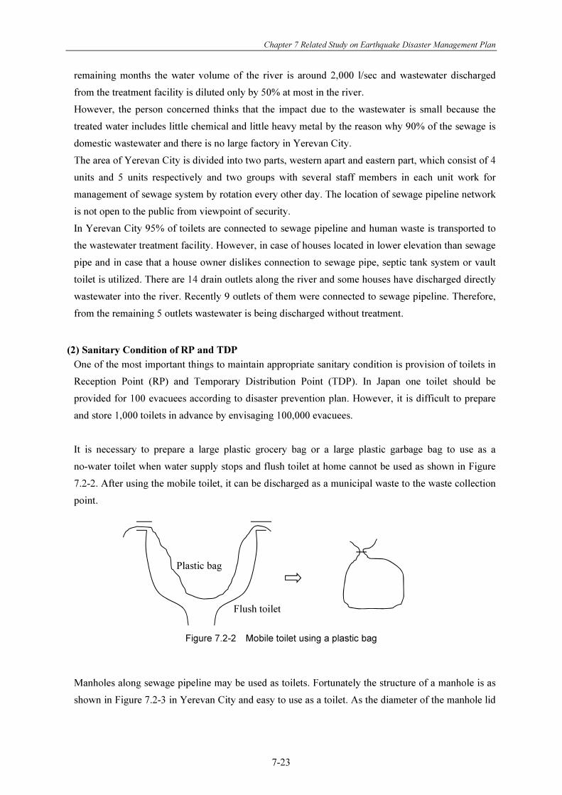
Chapter 7 Related Study on Earthquake Disaster Management Plan
7-23
remaining months the water volume of the river is around 2,000 l/sec and wastewater discharged
from the treatment facility is diluted only by 50% at most in the river.
However, the person concerned thinks that the impact due to the wastewater is small because the
treated water includes little chemical and little heavy metal by the reason why 90% of the sewage is
domestic wastewater and there is no large factory in Yerevan City.
The area of Yerevan City is divided into two parts, western apart and eastern part, which consist of 4
units and 5 units respectively and two groups with several staff members in each unit work for
management of sewage system by rotation every other day. The location of sewage pipeline network
is not open to the public from viewpoint of security.
In Yerevan City 95% of toilets are connected to sewage pipeline and human waste is transported to
the wastewater treatment facility. However, in case of houses located in lower elevation than sewage
pipe and in case that a house owner dislikes connection to sewage pipe, septic tank system or vault
toilet is utilized. There are 14 drain outlets along the river and some houses have discharged directly
wastewater into the river. Recently 9 outlets of them were connected to sewage pipeline. Therefore,
from the remaining 5 outlets wastewater is being discharged without treatment.
(2) Sanitary Condition of RP and TDP
One of the most important things to maintain appropriate sanitary condition is provision of toilets in
Reception Point (RP) and Temporary Distribution Point (TDP). In Japan one toilet should be
provided for 100 evacuees according to disaster prevention plan. However, it is difficult to prepare
and store 1,000 toilets in advance by envisaging 100,000 evacuees.
It is necessary to prepare a large plastic grocery bag or a large plastic garbage bag to use as a
no-water toilet when water supply stops and flush toilet at home cannot be used as shown in Figure
7.2-2. After using the mobile toilet, it can be discharged as a municipal waste to the waste collection
point.
Figure 7.2-2 Mobile toilet using a plastic bag
Manholes along sewage pipeline may be used as toilets. Fortunately the structure of a manhole is as
shown in Figure 7.2-3 in Yerevan City and easy to use as a toilet. As the diameter of the manhole lid
Flush toilet
Plastic bag

Final Report Vol. II Main Report 1
7-24
is 52-62 cm, it is not safe to use it directly as a toilet. The manhole should be surrounded by walls
with a floor preparing a hole suitable for toilet.
It is considered severely that water should be provided regularly from the river and the lake to flush
away human waste while water supply is stopped due to a severe earthquake. Seven vacuum wagons
(vehicles of 12m3 and 7m3 respectively, & five vehicles of 3.5m3) owned by the company of water
supply and wastewater treatment, Veolia Djur, can be used to improve the situation when a manhole
is piled up with human waste and cannot used as a toilet.
Figure 7.2-3 Temporary toilet over the manhole
(3) Provision of Toilet
There is one company which produces temporary toilets in Russia and Ukraine and imports them
into Armenia. It is not clear that 100 toilets which they sold in Armenia and in Georgia in the past
are available for population evacuation in Yerevan. They have now only 20 toilets in Armenia for
hire at the event. If they receive buying order of 100 toilets, they say they can supply them in 15-20
days including production and import.
The specification of the toilet is as shown in Table 7.2-4 and in Figure 7.2-4.
Table 7.2-4 Specification of a Temporary Toilet in Armenia
No Item Specification
1 Size 1.10 x 1.10 x 2.40 m
2 Weight 80 kg To be carried by 3 persons
3 Capacity 275 litter
4 User 400 persons per one cycle
5 Vacuum pumping 3 minutes
6 Price 1,500-3,000 US$
Manhole
Sewage pipe
Temporary toilet

Chapter 7 Related Study on Earthquake Disaster Management Plan
7-25
Figure 7.2-4 Temporary toilet set near the Government Office
7.2.4 ESCs on Disaster Management Bases
In The Plan of Organization of Protection of Population of RA in Case of a Severe Earthquake in Annex
N1 of the Decision N 919 of the Government of the Republic of Armenia dated on 2010, the role and
function to be fulfilled by Central Government, Regional Administration and Rescue Service are
stipulated definitely. Specially in case that a severe earthquake occurs in Yerevan City and Central
Government becomes dysfunctional, what organization should control the population evacuation in
place of the State Committee of Emergency Situations (SCES) is defined in the concrete.
Even in case that each Ministry of Central Government can function normally, it takes time for the SCES
to start real action managed by Prime Minister. During the time citizens have to begin to evacuate
forward to the receipt point, and the organization consisting of Ministry of Defense, Ministry of Health,
Police and Region staff should conduct activities for protection of citizens’ security before the SCES
sets off.
Every Minister establishes a management center of liquidation of disaster consequences and constructs a
communication system with CMC of RS, Ministry of Defense and Police. The Prime Minister sets up
State Evacuation Committee and Governor of the Region deploys an Evacuation Receiving Committee
to prepare for receiving evacuees.
After receiving the information that there was a severe earthquake in Yerevan City, the head of Regional
Rescue Department of Shirak Region of RS, MES should establish the organization and undertake the
obligations of Central Government with regional administration if SCES cannot manage the obligations.
Regional Committee for Emergency Situations is set up by Governor and it continues management of
emergency situations till SCES can start normal action.
The followings are private opinions of member in charge of environmental and social considerations
“The chairman of the republican committee of liquidation of earthquake consequences gives
assignments to the heads of governing bodies and rescue forces personally or by means of the Ministry
of Emergency Situations of the Republic of Armenia for the purposes of implementation of rescue and
other urgent activities. In all the cases those assignments of the authorized body are formulated in the
form of an order. Gethering places are assigned for rescue forces (also international) outside the zone of

Final Report Vol. II Main Report 1
7-26
earthquake and quick and proper exits into the working sites are provided. The concrete locations of
gathering places are defined based on the data of reconnaissance. (No.13)”
However, it is necessary to categorize and prepare the area suitable for gathering places in advance
because there might be an erratic state among a various kind of information immediately after a severe
earthquake.
“After a severe earthquake the financial means for food and goods of first necessity are allocate from
reserve fund of the Republic of Armenia. The storage and transportation of the abovementioned values
are carried out by the Ministry of Economy of the Republic of Armenia: the Ministries of Emergency
Situations, Agriculture, Labor and Social Affairs, Health, Transport and Communication, Police under
the Government of the Republic of Armenia as well as physical persons and organizations irrespective
of the type of ownership are also involved in the mentioned activities. (No.19)”
It is better to narrow down responsible organizations to only one or two and store food and goods step by
step by preparing necessary budget. How to store and keep food suitable is more big issues.
“The organizer and the body responsible for social and vital provision of the affected population,
including provision of temporary shelters is the Ministry of Labor and Social Affairs of the Republic of
Armenia by means of the marzes of the Republic of Armenia and the assisting bodies are the Ministries
of Emeregncy Situations, Healthcare, Economy, Agriculture, Energy and Natural Resources, Finances,
Transport and Communications of the Republic of Armenia, State Revenue Committee under the
Government of the Republic of Armenia and the Police under the Government of the Republic of
Armenia.
The rules of primary use of material resources and means in case of an earthquake are defined by the
state committee of emeregncy situations. (No.23)”
The rules of primary use of material resources and means in case of an earthquake should be defined in
advance because there might be an erratic state immediately after a severe earthquake.
7.2.5 ESCs at Temporary Distribution Points
The Temporary Distribution Points (TDPs) in Draft Population Evacuation Plan (2012) prepared by
Yerevan Rescue Department are as shown in Table 7.2-5. The points are 238 and evacuees of 203,164
are assumed. Most of all points are existing schools and kindergartens in Yerevan City.

Chapter 7 Related Study on Earthquake Disaster Management Plan
7-27
Table 7.2-5 TDP in Population Evacuation Plan (2012)
Point Evacuee Point Evacuee
1 Ajapnyak 11 84,654 9 7,200
2 Avan 6 50,500 6 3,550
3 Arabkir 13 130,000 22 44,000
4 Davtashen 6 40,000 5 9,500
5 Erebuni 17 23,503 26 13,864
6 Kentron 20 130,000 20 25,661
7 Malatia-Sebastia 14 140,040 48 22,888
8 Nor Norq 14 10,430 34 9,756
9 Norq-Marash 2 15,500 2 11
10 Nubarashen 2 640 3 3,872
11 Shengavit 18 166,210 15 24,180
12 Kanaker-Zeytun 9 90,000 48 38,563
Total 132 881,477 238 203,164
Source; Yerevan Department of ARS
NoReception Point
Temporary
Distribution PointDistrict
The followings should be considered from the viewpoint of environmental and social considerations
regarding operation and management of the Temporary Distribution Point (TDP).
(1) Registration of Evacuees
The cards of evacuee are distributed and collected to be used for management of the evacuees.
(2) Organization of Management
The women should be involved in the member of the management organization so that the real needs
of women and infant children can be grasped.
(3) Maintenance of Sanitary Condition
1) Evacuees should be leaded into a temporary distribution point and overcrowding problem with
evacuees be improved, privacy be protected and appropriate discharge way of municipal waste be
instructed.
2) Installation of temporary toilets, cleaning and disinfection of toilets and provision of daily sanitary
materials.
3) After rehabilitation of life line, procurement of shower facilities, instruction of sanitary
management of them and maintenance of sanitary condition of the rooms.
(4) Prevention of Epidemic
1) Toilets and garbage storage places should be disinfected immediately after the temporary
distribution point is open, and disinfection should be conducted continuously.
2) Epidemic Prevention Team should be set up to carry out health condition investigation to prevent
spreading of infectious diseases and to take sufferers from infectious disease into the hospital.
3) Team of Disinfection should be set up to disinfect the temporary distribution point.
Final Report Vol. II Main Report 1
7-28
(5) Safety Management of Drinking Water
1) Safety management of drinking water should be disseminated to the evacuees.
2) Safe Water Patrol Team should be set up to disinfect drinking water and check the effectiveness of
the disinfection.
(6) Safety Management of Food
1) Food Quality Monitoring Team should be set up to control sanitary condition of food.
2) Preparation of a list of food providers to the temporary distribution point.
3) Instruction of the issues concerned with food quality control, including washing hands.
The organizations to be set up for operation and management of TDP are as shown in Table 7.2-6.
Table 7.2-6 Organizations for Operation and Management of TDP
No Name Activities
1 Epidemic Prevention Team
To carry out health condition investigation to prevent
spreading of infectious diseases and take sufferers from
infectious disease into the hospital.
2 Team of Disinfection To disinfect the TDP
3 Safe Water Patrol Team To disinfect drinking water and check the effectiveness of
the disinfection in TDP
4 Food Quality Monitoring Team To control sanitary condition of food in TDP.
7.2.6 ESCs at Long-term Settlement Points
The Long-term Settlement Points (LTSPs) in Draft Population Evacuation Plan (2012) prepared by
Yerevan Rescue Department are as shown in Table 7.2-7. The points are only 4 and evacuees of 1,050
are assumed. All of them are existing hotels in Yerevan City. Naturally more points should be prepared
for evacuees and Yerevan Rescue Department (YRD) has been negotiating with hotel owners. However,
they have not reached mutual agreement.
At the level of central government, LTSPs are designated already in each Region according to the Plan
of Organization for Population Protection , the Decision N919, 2010. However, YRD has been making
effort to provide LTSPs in Yerevan City for the evacuees who do not want to move outside of the City to
live in other Region after a seismic disaster.
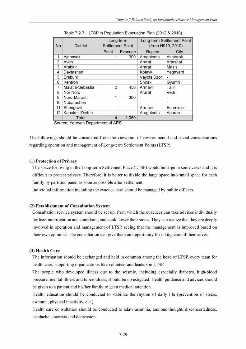
Chapter 7 Related Study on Earthquake Disaster Management Plan
7-29
Table 7.2-7 LTSP in Population Evacuation Plan (2012 & 2010)
Point Evacuee Region City
1 Ajapnyak 1 300 Aragatsotn Ashtarak
2 Avan Ararat Artashat
3 Arabkir Ararat Masis
4 Davtashen Kotayk Yeghvard
5 Erebuni Vayots Dzor -
6 Kentron Shirak Gyumri
7 Malatia-Sebastia 2 450 Armavir Talin
8 Nor Norq Ararat Vedi
9 Norq-Marash 1 300 - -
10 Nubarashen - -
11 Shengavit Armavir Echmidzin
12 Kanaker-Zeytun Aragatsotn Aparan
Total 4 1,050
Source; Yerevan Department of ARS
Long-term
Settlement Point
Long-term Settlement Point
(from N919, 2010)No District
The followings should be considered from the viewpoint of environmental and social considerations
regarding operation and management of Long-term Settlement Points (LTSP).
(1) Protection of Privacy
The space for living in the Long-term Settlement Place (LTSP) would be large in some cases and it is
difficult to protect privacy. Therefore, it is better to divide the large space into small space for each
family by partition panel as soon as possible after settlement.
Individual information including the evacuee card should be managed by public officers.
(2) Establishment of Consultation System
Consultation service system should be set up, from which the evacuees can take advices individually
for fear, interrogation and complaint, and could lower their stress. They can realize that they are deeply
involved in operation and management of LTSP, seeing that the management is improved based on
their own opinions. The consultation can give them an opportunity for taking care of themselves.
(3) Health Care
The information should be exchanged and held in common among the head of LTSP, every team for
health care, supporting organizations like volunteer and leaders in LTSP.
The people who developed illness due to the seismic, including especially diabetes, high-blood
pressure, mental illness and tuberoulosis, should be investigated. Health guidance and advices should
be given to a patient and his/her family to get a medical attention.
Health education should be conducted to stabilize the rhythm of daily life (prevention of stress,
asomnia, physical inactivity, etc.)
Health care consultation should be conducted to adaw asomnia, anxious thought, disconcertedness,
headache, anorexia and depression.

Final Report Vol. II Main Report 1
7-30
Group work like a meeting should be conducted to express feelings and play areas should be prepared
for children. Gymnastics class should be opened for elders to prevent functional decline.
(4) Support of Eating Habitats
It is important that cooking can be done by family and food stored should be delivered appropriately so
that alimentary deficiency can be prevented.
(5) Elimination and Consolidation of Long-term Settlement Points
Elimination and consolidation of long-term settlement points should be conducted in a phased manner
to recover the original function of the facility.
The living space of some evacuees who go out of the LTSP should not be shared out among remaining
evacuees but eliminated, to make the living area smaller, and elimination and consolidation should be
conducted including neighboring LTSPs.
The problem which holds evacuees back from self-supporting should be resolved by means of
consulting with individual counseling organization.
7.2.7 Chemical and Explosive Materials
The security management plan of the factories which store or utilize chemical and explosive material in
the process of production is submitted to RS to get security certificate based on the Decision of
Government of RA on Approving Security Certificate of Industrial Object in RA, No.102, 1998 and is
renewed every five years.
The content of the Security Management Plan of Nairit Plant CJSC, one of the biggest companies in
Yerevan City, is as follows;
1) Scale of company
2) Meteorological condition
3) The number of employees in neighboring factories
4) Kind and amount of chemical stored
5) Process of operation
6) Safety management measures
7) Analysis and assessment of risks
8) Action plan in emergency situation
9) Way of warning to municipality, citizens and relevant person
10) The result of simulation for amount of chemical to be dispersed, area and population to be
affected
11) Prevention measures of spreading of chemical (water curtain)
12) Action for staff to take
13) Layout map of factory
14) Nine signatures of representatives from the company

Chapter 7 Related Study on Earthquake Disaster Management Plan
7-31
In the newest version of plan in 2009, it is reported that HNO3 and HCl have been added to NH3 and Cl2
as new items of chemical in Nairit Plant. Although specific safety management plan against seismic
disaster is not included in the plan, the area and population damaged by an accident of the plant are
assessed in scientific and realistic way.
On 14th May, 2009, a real accident occurred at Nairit Plant and four persons died and twelve persons
were injured. However, there was no casualty of citizen.
On the other hand, the action plan for evacuation in case of an accident of chemically hazardous facility
and in case of explosion and fire of a factory is formulated in the “Plan of Action of Yerevan City in
Emergency Situation 2007, approved by Mayor of Yerevan City and agreed by Director of the RS”.
The summary is as follows.
1) Measures in case of an accident of chemically hazardous facility
� The accident is specific because of shortage of time and great number of the possibly affected
people.
� Necessity of protection of not only citizens but also staff carrying out rescue
� Warning to citizen is carried out immediately by “Chemical alarm” signal and mobile loudspeakers
of the police, and “Chemical alarm” signal is broadcasted also by TV and city radio network
mentioning the place and time of the accident, type of toxic materials of strong influence, the
direction of dispersion of the contaminated air, the territory of the contaminated zone and the way
of being protected from the toxic materials of strong influence.
� Chemical reconnaissance, laboratory observation and monitoring are organized for the
identification and clarification of the chemical situation in Yerevan city.
� Meteorological data are reported to the head of Yerevan rescue department and operative duty
officer of the management center of emergency situations of Yerevan. Prediction of chemical
situation in Yerevan is made by the Yerevan rescue department.
� To the people evacuated from the possible contamination zone, temporary shelters are provided by
the committee of emergency situations of Yerevan city at temporary distribution points.
� The activities of people protection from the toxic materials of strong influence in case of a threat or
occurrence of accidents in chemically hazardous facilities are carried out according to the planned
time schedule.
2) Measures in case of Explosion and Fire of a factory
� Warning to citizens on the accident is carried out based on the sizes of the accident threatening the
citizens, and information and instructions are broadcasted by TV and city radio network on what
the citizens should do.
� The main measures of the protection are as follows;
・ Provision of the first assistance to the affected and transportation of them to medical
institutions,
・ Evacuation of people from the damaged buildings and their distribution,
・ Primary isolation and extinguishing of fire targets hampering the rescue operations,

Final Report Vol. II Main Report 1
7-32
・ Taking the material values and agricultural animals out of the possible target zone.
Action plan of people protection is prepared for some kinds of accidents and disasters in Yerevan City as
mentioned above. Chemically hazardous facilities are listed up in the annex and detailed rescue
activities are planned by the minute. It is expected that the plan should be implemented faithfully at the
time of second disaster immediately after a severe earthquake.
7.2.8 Radioactive Pollution
The detail of evacuation plan is provided clearly in case of accident of nuclear power plant in “The
Republic of Armenia Government Decision On the Approval of the National Plan for the Protection of
Population in case of a Nuclear and (or) Radiological Accident at the Armenian Nuclear Power Plant
(External Emergency Plan for the Armenian Nuclear Power Plant)”.
In the plan the action which Armenian Rescue Service and Regional Rescue Department should take is
shown clearly and great role which RS should play is shown clearly. The area around ANPP is divided
into two areas within the radius of 5 km and 5-10km respectively and the evacuation plan is prepared in
response to risks of each area.
Ministry of Health shall submit a financial proposal to the State Reserve Agency of MES to obtain
necessary quantity of iodine, Ministry of Economy shall obtain necessary quantity of food and other
good of first necessity, Ministry of Transport and Communication shall obtain fuel necessary for
transportation, the Governors of two regions concerned with the accident of ANPP shall obtain
individual protection means (masks), Ministry of Foreign Affairs shall facilitate issuance of entrance
visa for the arriving relief rescue teams and deliver necessary humanitarian aid from foreign countries,
Ministry of Urban Development shall adjust cellars suitable for sheltering of the people, Ministry of
Agriculture shall manage evacuation of live stock and defining the level of radioactive contamination of
agricultural products and Ministry of Education and Science shall plan and conduct regular training in
public schools.
Evacuation is conducted under the control of many organizations including police and destination of
evacuees is already decided in safe zone far from ANPP. At the check point on the way of evacuation
route, sanitary cleaning of people by bathing and shower and deactivation of vehicles for transportation
is carried out to avoid spreading of radioactive contamination.
However, the accident envisaged in this plan is independent case, not due to severe seismic disaster. In
case of seismic disaster, first of all, evacuation route should be secured. Which organization secures an
evacuation route and how it should be informed to police who is managing evacuation of local people
have to be considered in the plan.
According to this plan of independent accident of ANPP, people should stay on the first floor or cellars
of dwelling houses for sheltering. However, it is too risky to stay inside building in case of a severe
earthquake because the building may be collapsed due to aftershocks. Therefore, the evacuation plan for
accident of ANPP due to a severe earthquake should be formulated besides this plan.

Chapter 7 Related Study on Earthquake Disaster Management Plan
7-33
Although the evacuation plan form ANPP is considered sufficiently in this plan, safety management
plan of nuclear power plant itself is not included. The safety management plan of ANPP has not been
submitted even to RS from the viewpoint of risk management.
7.2.9 Air Pollution (Dust)
(1) Standards
The standards of air quality in Armenia are as shown in Table 7.2-8.
Table 7.2-8 Standards of Air Quality
No Items Maximum Permissible Concentration (mg/m
3)
24 hrs
Average
10
minutes
30
minutes
Maximum *
1 Dust 0.15 0.5
2 SO2 0.05 0.5
3 NO2 0.04 0.085
4 NO 0.06 0.4
5 CO 3 5
6 O3 0.03 0.5
Source: Inspection of Nature Protection, Ministry of Nature Protection
* Source: Environmental assessment Report, IEE for Argavand Highway
(2) Current state of Air Pollution
According to the data2 monitored regularly by Inspection of Nature Protection, Ministry of Nature
Protection, the air quality in Yerevan City is not worse than one in the city located with a cement
factory or a copper factory. Unfortunately without data of dust in Yerevan City, concentrations of SO2
and CO fall below the standards, and those of NO2 and NO exceed the standards a little. However,
since concentration of CO mainly contributed by emission from traffic vehicles is low, impact on
environment is not serious. An expert working for Nature Protection says that emission gas from
vehicles causes air pollution by more than 90% in Yerevan City.
The reason why SO2 is lower by 50% than the standard is that there are little large factories which emit
pollutant and at the same time that Yerevan Municipality prohibits large trucks to pass through the
central area of the City.
(3) Prevention of Impact by Dust
Huge amount of dust is generated due to destruction of buildings by a severe earthquake. The people
who want to remove and dispose debris should do watering the debris to reduce occurrence of dust and
wear a mask. Especially considering mixture of hazardous waste like asbestos, it is important to
2 Ministry of Nature Protection, RA, ArmEco Monitoring, EIMC N12-1/11 Yearly 2011, (Center of Monitoring of Influence
on Environment), Reference on the Result of Ecological Monitoring of RA Environment

Final Report Vol. II Main Report 1
7-34
prepare the mask suitable for the kind of work. If the hazardous material is found, it is necessary not to
treat it easily and notify the relevant organization of it.
In Armenia it is planned that masks should be delivered to all citizens evacuating from risky zone due
to accident of ANPP to prevent radioactive contamination and the Governor of the Region concerned
has to submit a financial proposal of necessary quantity of masks to Sate Reserve Agency of MES. It is
possible to reserve masks for removal of debris and waste after earthquake in the same manner.
7.2.10 Noise
(1) Standards
Permissible Sound Level in Residential and Public Buildings and Residential Areas is as shown in
Table 7.2-9. (Source: Order on Noise in Working Places, Residential and Public Buildings and
Residential Construction Areas, Sanitary Norms N2-III-11.3, N138, Ministry of Health, March 6,
2002)
The standards of normal sound level and maximum sound level are set up and standards during night
time (22:00 - 6:00) are higher than those of daytime (6:00 - 22:00) in the Order.
(2) Current State
There is no information of complaint against traffic noise except special cases of night shops. The
sound of vehicles accelerating suddenly at night possibly may give some impact on citizens’ daily life,
but it is not serious. The policy of Yerevan Municipality that large trucks are prohibited to pass through
the central area of the city contributes to reduction of traffic noise.
(3) Noise of Rehabilitation
During rehabilitation after seismic disaster, big noise may be emitted from crushing large debris stone
into small pieces for easy transportation. Although it will not last for many days, it should be
considered to set up the sound abatement shield or cover sheet if necessary.

Chapter 7 Related Study on Earthquake Disaster Management Plan
7-35
Table 7.2-9 Permissible Sound Level in Residential and Public Buildings and Residential Areas
Source: Ministry of Health
7.2.11 Water Pollution
In Yerevan City there are two regular monitoring stations of water quality of Hrazdan River, No.112 and
No.55. The former is located near the Yerevan Lake and the latter downstream of the Wastewater
Treatment Facility. The result of monitoring at the stations of No.54 and No.56 is shown in Table 7.2-10
to confirm the change of water pollution along the river. The former station is located 0.5 km
downstream of Arzni Hydropower Station in Kotayk Region, in the north of Yerevan City, and the latter
is located at the river delta in Ararat Region in the south of City.
No Significance of Buildings and Areas
Time of the
Day
(Hour)
Sound Levels
LA, and
Equivalent
Sound Levels,
LA eq. dBA
Maximum
Levels of
Sound dBA
22 00
-600 35 50
600
- 2200 25 40
2Cabinets of doctors in clinics, infirmaries,
dispensaries, hospitals and health centers35 50
3
Classrooms, learning rooms, teachers’
rooms, auditoriums of education institutions
and schools, conference hall, reading halls
of libraries
40 55
22 00
-600 40 55
600
- 2200 30 45
22 00
-600 45 60
600
- 2200 35 50
6 Halls of cafes, restaurants, canteens 55 70
7
Shops, shopping centers, waiting halls of
airports and stations, reception points of
organizations providing utility services
60 75
22 00
-600 45 60
600
- 2200 35 50
22 00
-600 55 70
600
- 2200 45 60
22 00
-600 60 75
600
- 2200 50 65
11Open spaces envisaged for rest in the
territory of health centers and hospitals35 50
12
Open spaces envisaged for rest in the
territory of micro-districts and groups of
residential buildings, holiday houses,
boarding houses, nursing houses and houses
for the disabled, kindergartens, schools and
other education institutions
45 60
9
Territories immediately adjacent to
residential buildings, clinics, infirmaries,
dispensaries, holiday houses, boarding
houses, nursing houses, houses for the
disabled, kindergartens, schools and
education institutions, library buildings
10Territories immediately adjacent to hotels,
hostels
5 Hostel and hotel rooms
8Areas immediately adjacent to the buildings
of hospitals and health centers
1Wards of health centers and hospitals,
surgeries of hospitals
4
Apartment rooms, holiday houses, boarding
houses, nursing home and houses for the
disabled, residential areas, dormitories of
kindergartens and boarding schools

Final Report Vol. II Main Report 1
7-36
The concentration of Vanadium owing to human activity is very high upstream of the river and exceeds
the quality standard by fourteen to fifteen times. The concentrations of metal like Al, Cr, Cu exceed the
standards before the river water reaches the City area, and vary little after flowing through the City down
to the No.56.
The concentrations of Nitrate-N and NH4-N increase drastically at the station of No.55. The
concentrations of Nitrate-N go up sharply and exceed the standard by 5 times at No.55 although it is 2.5
times at No.112. And in August NH4-N shows more than 25 mg/m3 (64 times of standard) at No.55
although it is only 3 mg/m3 at No.112. The reason why the concentrations of Nitrate-N and NH4-N are
high at No.55 seems that wastewater of the City is discharged from the Wastewater Treatment Facility
into the river without appropriate treatment.
On the other hand, the concentrations of NH4-N decree down to 1 mg/m3 at No.56. It shows that the
river has a capacity of natural depuration.
Since the Wastewater Treatment Facility is operating based on two steps only, the impact on water
quality of the river might not be so serious even if the facility got some damage due to a severe
earthquake.
Table 7.2-10 Water Quality of Hrazdan River (2011)
No St.
Items
Concentration (mg/m3)
No.54 No.112 No.55 No.56 Standard
1 Nitrate-N 0.05 0.07 0.14 0.09 0.024
2 NH4-N - 3.0 26.0 1.0 0.39
3 Al 0.11 0.17 0.15 0.09 0.04
4 Mn 0.03 0.04 0.10 0.04 0.01
5 V 0.015 0.016 0.014 0.015 0.001
6 Cr 0.009 0.007 0.007 0.005 0.001
7 Cu 0.002 0.003 0.004 0.002 0.001
8 Se 0.002 0.001 0.001 0.001 0.001
The concentrations of NH4-N are average in August and others are average of year, 2011
No information of securing water resources at the seismic disaster is obtained at Department of Water
Resources Management, Ministry of Nature Protection.
7.2.12 Protection of Forest
Forest is managed by both organizations of Ministry of Agriculture and Ministry of Nature Protection.
In 1990 there was the green area of more than 1,300 ha in Yerevan City. However, the green area has
been reducing to be half at present. One of the reasons is that poor people cut the trees to get firewood
and warm themselves.

Chapter 7 Related Study on Earthquake Disaster Management Plan
7-37
National Afforestation Plan aims to plant 30,000 trees, and 5,000 trees should be planted per year.
However, the budget has been shrinking year by year and activities of afforestation have not been
realized these two years According to the Plan the green coverage should be increased from 11.2% up to
20 %.
Since a lot of trees were cut down by local people at the time of earthquake in 1988, same activities
would be repeated at the time of severe earthquake. An expert of forest management in Ministry of
Agriculture proposes that trees in the City should be divided into two categories, tree for cutting and tree
for no-cutting, in advance, depending on the importance. The trees for cutting can be cut down, but the
trees of no-cutting cannot be cut down and reserved. The amount of trees to be cut will be determined in
response to the timing of rehabilitation of life line and the season.
According to the inventory survey in 2007 conducted by the Department of Nature Protection of
Yerevan Municipality, total green area for common use in Yerevan City is 772.30 ha and average area
for each citizen is 6.90m2 as shown in Table 7.2-11. It shows that the green area for each citizen is more
than the data (4.9 m3/ capita) of year 2003 used in Urban Development Plan by 2.0m2. At present the
Department of Nature Protection of Yerevan Municipality is planning afforestation on the public land in
Nubarashen District.
Table 7.2-11 Green Area in Each District of Yerevan City
Source: Department of Nature Protection of Yerevan Municipality
7.2.13 Protection of Soil
In Armenia the surface fertile soil is so important that it must be reserved appropriately. Department of
the Policy of Preservation of the Lithosphere and Soil, Ministry of Nature Protection, intends to
formulate a national distribution map of soil. However, it has not been realized because of short of
budget. Monitoring system of soil to prevent contamination has not been strengthened due to lack of
budget.
Are
a (h
a)
m2
/cap
ita
1 Ajapnyak 54.05 5.00 496.94 126.29 2.10
2 Arabkir 272.01 20.80 281.33 9.65 0.00
3 Avan 7.97 1.56 224.41 78.18 23.55
4 Davtashen 34.58 8.41 113.45 21.82 7.35
5 Erebuni 20.60 1.69 421.87 750.59 5.25
6 Kentron 157.37 12.05 252.97 31.60 11.23
7 Malatia-Sebastia 85.10 6.00 295.76 277.83 41.33
8 Nor Nork 52.02 3.54 263.67 53.09 27.40
9 Nork-Marash 0.51 0.45 110.25 59.25 0.00
10 Nubarashen 3.83 3.95 290.91 65.12 3.23
11 Shengavit 39.50 2.70 695.38 630.18 44.99
12 Kanaker-Zeytun 44.76 5.64 217.10 31.28 0.84
Total 772.30 6.90 3,664.05 2,134.87 167.27
Common Use
Lim
ited
Use
(ha)
Spec
ial
Use
(ha)
Un
org
aniz
ed
Gre
en M
ass
(ha)
DistrictNo

Final Report Vol. II Main Report 1
7-38
By the Decision of the RA Government N 1622- “Approving the Order of the Use of Fertile Layer of the
Land”, September 9, 2002, fertile soil is stipulated to be reserved and used effectively, and also it is
regulated that the constructor has to take out, protect and use the fertile layer of the land in Section 9 of
the “Decision on Approving the Charter of Urban Development of Yerevan N2228-N December 19,
2006”.
Department of Nature Protection of Yerevan Municipality conducted a survey of soil contamination
owing to Hg, Pb, Ni, Cu, Cr, Mo, Zn and Co in whole area of Yerevan City, in 2008, and reported that
many areas are contaminated.(Report; National Academy of Sciences, Center of Ecological
-Anthropological Research, Development of Functional Landscaping Project of Yerevan,
Investigation on Land Pollution by Heavy Metals in Yerevan and Elaboration of a Map, Yerevan
Municipality, Yerevan 2008)
7.2.14 ESCs for Land Acquisition and Resettlement
The protection of private ownership rights is guaranteed in Article 31 of the Armenia’s Constitution
(1995). It is also provided that private ownership may be terminated “in exclusive cases of prevailing
public interests” based on established procedure and with prior adequate compensation.
“Everyone shall have the right to freely own, use, dispose of and bequeath the property belonging to
him/her. The right to property shall not be exercised to cause damage to the environment or infringe
on the rights and lawful interests of other persons, the society and the state. No one shall be deprived
of property except for cases prescribed by law in conformity with the judicial procedure. The private
property may be alienated for the needs of the society and the state only in exclusive cases of
prevailing public interests, in the manner prescribed by the law and with prior equivalent
compensation.”
Land acquisition and compensation issues are discussed in Article 102 and 104 of Land Code, and in
Article 218 to 221 of the Civil Code (1998), and in the Law of RA On the Alienation of the Private
Property for Public and State Needs adopted on 27 November 2006.
In Article 11 of the law on the alienation mentioned above, it is stipulated that equivalent compensation
is considered to be the sum equal to the market price plus fifteen per cent. Yerevan City is divided into 9
areas and land price of each area is regularly announced officially by State Committee of the Real
Property Cadastre of the Government of the Republic of Armenia. It is said that the alienation system is
easy for citizens to understand.
If there is no open and competitive market for the alienated property, the market price of the property is
determined by such a calculation method which will be considered as a fair one by the court.

Chapter 7 Related Study on Earthquake Disaster Management Plan
7-39
The financial duties (taxes, dues, mandatory payments) related to alienation of property, that arise for
the owner of the alienated property and are imposed by state and local government bodies, are
compensated by the acquirer.
Regarding paying compensation to the person not registered as the land owner, Deputy Minister of
Urban Development cannot approve it because it promotes illegal occupation as a result if you pay some
compensation to illegal occupier, and recommends it should be considered case by case. The
Department of Architecture and Urban Construction of Yerevan Municipality, which issues permission
certificate of construction and demolition, says that they can pay compensation to the person after illegal
occupier is changed to be legal by their instruction. It means that occupier managing a shop on the
sidewalk cannot get compensation because he cannot be registered legally as a land owner.
7.3 Social Condition Survey
For earthquake disaster management planning, the awareness, preparedness, needs, intention and
activities in the field of disaster management as well as the base line of living/ social situations are
studied.
7.3.1 Questionnaire Survey to Local Inhabitants
The survey was conducted with the population above 18 and designed with stratified-random sampling
method. The total sample is 208. The main results are as follows.
(1) House Hold
・ Most of the dwellers are the owners of their dwellings, but there is also a general feeling that the
government is still responsible for their safety.
・ The mean surface of the dwelling is 73.7m2.
・ The level of the availability of public services and utilities (Electricity, Water, Gas etc.) is quite
high in all of the surveyed communities.
・ Reconstructions of the dwellings are very rare, though most of the dwellers understand the need
of increasing the level of seismic resistance. Most of the reconstructions are made by private
house dwellers.
・ The levels of vulnerability of buildings where people work and live are different. The respondents
assessed the building where they work as being safer.
・ Most of the respondents want to reconstruct their houses according to seismic regulations, but
objectively only the minority undertakes any actions towards increasing protection against
possible risks.
・ The majority of respondents find old house blocks as the most vulnerable structures in Yerevan
(70.5%). Experts mention that old private houses are more dangerous than multi-storey house
blocks. Many of old private houses are built without considering any seismic regulations and
norms.

Final Report Vol. II Main Report 1
7-40
(2) Communication & Information
・ The survey results showed high penetration of mobile and fixed phones in households. In case of
invention of mass alarm system for protection, the mobile telephony is the most preferred means
of communication, as almost 96 percent of families have at least one mobile phone.
・ The main sources of information are television (71.6%) and Internet (21.6%). New internet
technologies are more effective in education and operative information providing for young
inhabitants.
(3) Degree of disaster awareness
・ For most of the households an earthquake is a possible, but not an actual risk. Earthquake
protection does not exist in the stack of everyday live hierarchy of needs.
・ Disaster awareness of inhabitants and pupils is quite high, though there are also some
misunderstandings and stereotypes concerning earthquakes and disasters in general. One of the
main function of trainers must be not only teaching ‘what to do’, but also ‘what not to do and why’
in case of a disaster.
・ There are some differences between child and adult perceptions of earthquakes. One of the basic
differences is that children psychologically connect all dangers and disasters.
・ The belief of probability and reduction of possible earthquake is quite high, while 10.6 percent of
inhabitants do not agree that preparedness can help to reduce the harm from natural disasters.
・ Actions and attitudes of population are mostly rooted in rational logic, scientific knowledge and
own experience, rather than religious views.
・ The inhabitants know what to do inside the buildings, but some of them do not clearly understand
the following actions outside of a building in case of an earthquake.
(4) Needs
・ The main basic needs in case of an earthquake are lodging, food and water, medication. The rest
are only additional needs.
・ The level of trust is based on the formal function of specific organizations. The Ministry of
Emergency Situation is viewed as the most trusted organization in case of disasters.
・ Half of the respondents prefer to stay in Yerevan in case of a violent earthquake.
(5) Intention to take actions and activities
・ 58.8% of respondents believe they would experience a violent earthquake.
・ Main experience of a violent earthquake is largely connected to the 1988 Spitak case. Most of the
people have experienced only the earthquake of Spitak in 1988. The psychological effects of this
earthquake still persist.
・ 38.7 percent of inhabitants believe their house will ruin in case of an earthquake. This data points
the pessimistic view towards earthquake results and in the same time the incapacity to improve
the situation.
・ One of the possible problems could be unwillingness of dwellers to leave their dangerous
apartments.

Chapter 7 Related Study on Earthquake Disaster Management Plan
7-41
(6) Demographics
・ The standard family pays 30,240 AMD (about 80$) per month for loans and taxes of housing.
7.3.2 Expert Interview
Five experts were selected from Yerevan state institutions, who work on disaster risk management
programs. Their pointed main goals of earthquake reduction are as follows.
1. Technological modernization monitoring network of seismic situation. The technical facilities and
devices are becoming technologically old and need to be updated.
2. Increase organizational opportunities - an organizational level of different organizations is not
high enough, as many private structures are not interested in cooperation.
3. Increasing information level of population about earthquake protection and reduction. The experts
noted that old methods of information and education, which were common in the Soviet period,
are not effective anymore. The most effective methods are information provided by mass media,
internet and television.
4. Increase professional level of personnel, attract new staff - experts mention that there is an
increasing drain of specialist to other spheres from state emergency structures, because of low
salary of the staff. The level of professionalism is assessed as high, but the investment of new
technologies needs more qualified specialists.
5. Increase seismic resistance of government buildings, schools and hospitals, seismic resistant
constrictions.
6. Increase the control of the reconstruction of dwellings (especially main walls in dwellings).
7. Insert culture of civil and non - governmental rescuers squads, who are mostly volunteers. This
practice is common for Germany and Austria.
7.4 Disaster Education and Community Based Disaster Risk Management
7.4.1 Elements of Disaster Education and Community Based Disaster Management in
Related Law, Decision, and Regulation
(1) Related Law, Decision, and Regulation
In Armenia, the followings are the three major plan, order, and decision which were recently legislated
and are related to earthquake disaster management. They are reviewed from the aspect of disaster
education and community based disaster risk management (CBDRM).
・ Plan of Action of Yerevan City in Emergency Situation (Yerevan City, 2007)
・ Order of the President of the Republic of Armenia on Approving the Concept of Development
of Seismic Security System of the Republic of Armenia (The Republic of Armenia, 2010)
・ Decision N 919: Plan of Organization of Protection of Population of the Republic of Armenia
in Case of a Severe Earthquake (The Republic of Armenia, 2011)

Final Report Vol. II Main Report 1
7-42
(2) Description of School Disaster Education and CBDRM
In the Plan of Action of Yerevan City in Emergency Situation, both of contents of disaster education and
CBDRM are not seen. Table 7.4-1 shows the description of disaster education and CBDRM in the other
two order and decision.
Table 7.4-1 Descriptions of disaster education and CBDRM in the order and decision
Order of the President of the Republic of Armenia on
Approving the Concept of Development of Seismic
Security System of the Republic of Armenia
Decision N 919: Plan of Organization of
Protection of Population of the Republic of
Armenia in Case of a Severe Earthquake
School dis
aste
r
Related organization
on school disaster
education
• The Ministry of Emergency Situation (MES)
• National Survey for Seismic Protection (NSSP)
• Crisis Management State Academy (CMSA)
• Local self-governing bodies
• The Ministry of Education and Science
Roles of related
organizations on
school education
• Participation in elaboration of introduction of
educational projects (NSSP)
• Preparation of teachers and teaching personnel
(CMSA)
• Conducting of training on safer behavior
in public schools and other educational
institutions.
CB
DR
M
Related organizations
on CBDRM
• The Ministry of Emergency Situation (MES)
• National Survey for Seismic Protection (NSSP)
• Crisis Management State Academy (CMSA)
• Local self-governing bodies
• The Ministry of Emergency Situation
(MES)
• Public TV-Radio Council
• Local authorities
Roles of related
organizations on
CBDRM
• Provision of information
• Training to population and government staffs
• Elaboration of educational project
• Organizing the activities
• Giving warning and awareness of
population and governing bodies (MES)
• Training and awareness raising to
population (Public TV-Radio Council)
• Giving warning to community people
The roles of schools and community are not mentioned in both order and decision. As for school disaster
education, the contents of human resource development and implementation of trainings are included
but the detail information is not shown. As mentioned later, disaster education in school is included in
school curriculum. It is considered that these order and decision mention this kind of contents since
human resource development contributes to promotion and enhancement of disaster education. The
definition of CBDRM is not mentioned. It is expected that CBDRM is implementation of trainings and
awareness raising for each of the citizens. Disaster management by community is important. In the
future, it is necessary to develop the concept of CBDRM. In these order and decision, Ministry of
Emergency Situations, National Survey for Seismic Protection, Crisis Management State Academy, and
Ministry of Education and Science are the main organizations for school disaster education and
CBDRM.
7.4.2 The Current Status of School Disaster Education
(1) The Contents of School Disaster Education
School disaster education in Armenia is to teach the contents related to disaster management in ongoing
subjects and to conduct training for evacuation and others. According to Alaverdyan et al. (2011), the
subjects and grades related to disaster management are Me and My Surrounding (2nd to 4th grades),
Secure Living (3rd, 6th, and 7th grades), Preliminary Military Preparation and Safe Lifestyle (8th to
11th grades), Biology (7th to 12th grades), Natural Sciences (5th to 6th grades), Geography (6th to 12th

Chapter 7 Related Study on Earthquake Disaster Management Plan
7-43
grades), Armenology (5th grades), Physics (7th to 9th grades), Chemistry (7th to 12th grades), and
Armenian History (6th to 12th grades). Out of these subjects, the more significant subjects are Me and
My Surrounding and Preliminary Military Preparation and Safe Lifestyle. The main contents of the
education in the ongoing subjects mentioned above are natural and man-made disasters, appropriate
measures and actions before, during, and after disasters, and past disasters. Appropriate measures and
actions after disasters mean emergency response activities and do not include the contents of recovery
and reconstruction stages. Appropriate measures and actions are mainly individual level and few
contents in community level are seen.
Since disaster education is provided in the ongoing subjects, the education is mainly lecture based
education. In case of trainings, teachers of Preliminary Military Preparation and Safe Lifestyle play the
critical roles. The Ministry of Education and Science has developed the guidebook to support disaster
education and training by teachers of this subject. Education Department of Yerevan Municipality is
monitoring trainings in schools and instructs schools how to improve training.
NSSP and non-commercial organization visit schools and provide disaster education. The contents of
the education are almost same as the contents mentioned above. The activities by these organizations
can not cover all schools.
As mentioned before, school disaster education in Armenia is provided through the ongoing subjects
and training. Therefore, the roles of school teachers are significant. School teachers are trained by
CMSA. The training contents are not only natural disasters and disaster management but also war and
man-made disasters. In the training, CMSA provide school teachers with these kinds of knowledge. At
the end of the training by CMSA, school teachers take examination which measures understanding of
training contents and which is a part of evaluation of training.
School teachers trained by CMSA are requested to provide disaster education and conduct training
properly. But monitoring and evaluation for provision of disaster education in the ongoing subjects are
not done. Each school is expected to share information of disaster education among teachers. One of the
roles of the teacher of Preliminary Military Preparation and Safe Lifestyle is to instruct other teachers in
school because the teachers take longer training than that of other teachers.
UNICEF has implemented training of trainer with cooperation of CMSA. The teacher’s guidebook
developed in the project was approved by the government. The activities by NGOs are covering
updating of evacuation plan, response, and emergency plan in family level. It can be said the activities
by NGOs are practical or realistic.
(2) Characteristics of School Disaster Education
The followings are the advantages on school disaster education in Armenia.
・ There is responsible organization (CMSA).
・ Integration of school education and disaster education
・ Education materials and teacher’s guidelines authorized by the government
・ Corporation with international organization and NGOs
・ School has trained teachers

Final Report Vol. II Main Report 1
7-44
・ Monitoring by local government
The government of Armenia expects school teachers to provide school disaster education and CMSA
has the initiative of teacher training. The guideline and other material for use by school teachers have
bee prepared. In addition to the link between CMSA as training organization and school teachers as
provider of school disaster education, international organizations, NGO, and other external organization
are also contributing to the issue of school disaster education. In the future, it is expected to introduce
innovative approach of school disaster education.
The followings are the problems on school disaster education in Armenia.
・ Few opportunities for interactive/ participatory learning
・ Lack of facilitator for disaster education
・ Low level of teacher’s awareness on disaster education
・ Less relationship between school and community
One of the problems is lack of interactive and participatory learning. The required capacity of teachers is
to provide disaster education contents which are covered in the ongoing subjects and the capacity is
different from the capacity to conduct interactive and participatory learning. In other words, facilitation
ability which is different from the ability to transfer knowledge is required. According to the interview
to NGO, school teacher’s awareness on disaster education is not high. It is considered that improvement
of teacher’s awareness is necessary through introduction of interactive/participatory learning and other
type of disaster education.
School has the role of not only education facility but also evacuation place for the citizen around school
in disaster situation. Students can transfer information to their family members and neighbors. It is
necessary that school disaster education is provided to students with involvement of their parents and
community people.
7.4.3 The Current Status of Community Based Disaster Risk Management
(1) Contents of CBDRM
The word “CBDRM” in this section does not mean enhancing disaster management capacity of each
citizen but enhancing disaster management capacity of community people as group. In regard to disaster
education focusing on the citizens, CMSA has published booklets, guidebook, and other materials with
cooperation of international organizations and NGOs. The other government organizations (NSSP and
non-commercial organizations) have conducted disaster education for the citizens and business agencies.
In the education, they transfer knowledge of appropriate actions and measures for individual citizen and
employees through lecture. The main contents are hazard, actions and measures before, during, after
disasters, and past disasters. Emergency Channel also has published booklets, brochure, and other
materials and is transferring information at the website.
Education for citizen provided by government organizations focuses on enhancing disaster management
capacity of each citizen. The current policy of CMSA is emphasis of school disaster education with aim
of enhancing disaster management capacity in the future through enhancing capacity of students.
Chapter 7 Related Study on Earthquake Disaster Management Plan
7-45
According to CMSA and NSSP, CBDRM is emphasized but the contents related to CBDRM are not
covered in the current school disaster education and education for citizen.
To promote CBDRM, one of the significant factors is capacity development of the staffs of central and
local government. CMSA is organizing training for such staffs. But the training contents are natural and
man-made disasters including war and population protection against such disasters and CBDRM factors
are not included.
At present, CBDRM activities or programs are done by NGOs and international organizations. The
followings are the major CBDRM programs.
・ Mitigation for irrigation and planting
・ Risk identification through photo taking by community
・ Resource mapping for emergency situations
・ Formulation of community contingency plan and establishment of community disaster
response team
・ Establishment of community emergency group (first aid, rescue, administrative work, and
others)
There is the case of community based activity although it is not directly related to CBDRM. Community
people discuss priority and problems on issues related to children and solve problems discussed.
CBDRM programs mentioned above were conducted in Armenia and few were in Yerevan. According
to the interview to international organization and NGOs, it is pointed out that community awareness is
not enough as the reason that promotion of CBDRM activities in Yerevan is difficult. The other reason is
that people cannot take enough incentive even if they are involved in CBDRM activities. It was
suggested that CBDRM approach in Yerevan should include schools in order to promote CBDRM.
(2) Characteristics of CBDRM
The followings are the advantages of CBDRM.
・ There is responsible organization.
・ Utilization of mass media
・ Establishment of information center
・ School, community, corporation, local officer, and other stakeholders are covered.
・ Systematic training system covering various level
・ Involvement of community in the projects by NGO
・ Corporation with international organization
CMSA is providing training targeting school teachers and staffs of central and local government.
Emergency Channel is transferring information by various media and ways. Thus, government system
to transfer knowledge and information has been developed. In addition, they are making efforts to
enhance quality of knowledge and information with cooperation of international organization and NGOs.
Activities by NGOs are expected to contribute to development community capacity for coping
emergency situations because activities by NGOs are directly related to community.
The following are the problems of CBDRM

Final Report Vol. II Main Report 1
7-46
・ Lack of concept and activities of CBDRM
・ Education by government sectors are lecture base. It targets each of population, not
community.
・ Lack of trainer and facilitator
・ Lack of incentive for population
・ Lack of linkage CBDM and local government
It can be said that education, training, and awareness raising is conducted by the central and local
government staffs including school teachers in Armenia. But it is necessary that community has
initiative and conducts activities (education, training, and awareness raising) to achieve CBDRM. For
this purpose, supporting community by Marz and other local government is necessary. As for CBDRM,
identification of roles of related to organizations and development of concept of CBDRM are issues to
be considered.
7.4.4 Suggestions and Feasible Actions to Improve Current Status
(1) Suggestions
The followings are the suggestions on school disaster education.
・ Interactive/ participatory learning is conducted as well as lecture based education.
・ Teachers learn disaster education and disaster management in order to be facilitators.
・ Students-Parents-Community linkage is emphasized.
・ Support after the teacher training should be prepared.
・ Provision of information of past disasters, especially recovery and reconstruction should be
emphasized.
・ Platform or opportunities to exchange among schools and among community is prepared.
・ Limitation of government should be included as disaster education contents.
・ Students council, parents council, and other school governance system should be utilized.
・ Local government staffs should be involved actively.
The followings are the suggestions on CBDRM.
・ Students council, parents council, and other school governance system should be utilized.
・ Information exchanged between communities should be promoted.
・ Condominium level should be utilized for CBDRM.
・ Community facilitator should be trained.
・ School disaster management and CBDRM should be integrated.
・ Youth group should be motivated.
・ Female group should be differentiated.
・ Long term support by government and other agencies are necessary.
・ Platform or opportunities to exchange among schools and among community is prepared.
・ Limitation of government should be included as disaster education contents.

Chapter 7 Related Study on Earthquake Disaster Management Plan
7-47
(2) Feasible actions to improve the current status
In this section, school disaster education and CBDRM were mentioned separately. But these are not
independent and these have overlapping portions. Especially in Yerevan, it is necessary to consider
conducting CBDRM with a central focus on schools because the framework for CBDRM is not
developed and community awareness of the citizen is not high. Table 7.4-2 shows the actions to improve
the current status based on the suggestions mentioned in (1).
In the columns “SDE (school disaster education)” and “CBDRM” of Table 7.4-2, corresponding
columns are being ticked in case each action/measure is related to SDE and/or CBDRM. Both columns
of SDE and CBDRM for many of actions/measures were ticked. It means this section proposes CBDRM
through school.

Final Report Vol. II Main Report 1
7-48
Table 7.4-2 Actions and measures to improve the current status on school disaster education (SDE)
and CBDRM
SD
E
CB
DR
M
Actions/ Measures Responsible
organizations Outputs/ effectiveness
∨ ∨
Establishment of experience
learning center and
development of education
materials
CMSA • Visitors including students can experience hazard
and realize importance of disaster management.
• Experience learning can make disaster education
in school more effective.
∨ ∨
Establishment of disaster
management information
center in Marz
Marz government
Emergency Channel
CMSA
• Government staffs can do self learning.
• School can get information.
• School teachers can consult on disaster education.
• The center can support school teachers after the
training at CMSA.
∨ Training/seminar for teachers
to promote active learning
CMSA • School teachers can conduct active learning
program by themselves.
∨
Follow-up and monitoring/
evaluation of trained teachers
for disaster education in
curriculum and active learning
CMSA
Ministry of Education
and Science
Marz and community
government
• Evaluation can be conducted to identify
effectiveness and problems of training.
• School teachers can realize their own problems.
∨
Competitions on active
learning program
CMSA
Ministry of Education
and Science
Marz and community
government
• School teachers can enhance capacities and
motivation to develop active learning programs.
• School teachers can share information of active
learning programs.
• Armenia can increase the number of active
learning programs.
∨ ∨
Archive of experiences of
Spitak Earthquake and other
disasters for educational use
Ministry of Emergency
Situations
CMSA
• Students know response, recovery, and
reconstruction.
• Students know why mitigation and preparedness
are necessary.
∨ ∨
Lecture or speech by people
affected by natural disasters
Marz and community
government
• Students and teachers can realize disaster
situation.
• It can prevent fading the memories of past
disasters.
∨ ∨
Involvement of student’s
parents and people around
school in school safety and
school disaster education
School
Parents council
• It can raise awareness of parents and people
around schools.
• It can be preparedness for emergency response.
∨ ∨
Capacity development of the
central and marz government
staff
CMSA • They can formulate plan and others on school
disaster education and CBDRM.
• They can understand problems on school disaster
education and CBDRM and improve the status.
Reference:
Alaverdyan R., Kambouryan V., and Manoucharyan H. (2011). The RA Legislation and Education
Policy in the Area of Disaster Preparedness: From the Perspective of Needs and Rights of
Children, pp. 26-33.
Chapter 8 Establish of the System for Earthquake Disaster Management
8-1
Chapter 8 Establish of the System for Earthquake Disaster
Management
8.1 Realtime Seismic Intensity Distribution Information System
8.1.1 Overview of the System
The function of “realtime seismic intensity distribution information system” (here in after referred to
as “System”) is to collect the data from strong motion seismometer when the earthquake occur and
automatically calculate and display the seismic intensity distribution in Yerevan city within short time.
The strong motion seismometer was installed at five points in Yerevan city. The multiple transmission
circuit was adopted for the communication between the strong motion seismometer and server to
secure the redundancy. The usually used main circuit (ADSL) will be substituted by sub circuit (3G
mobile phone) automatically if main circuit loose function.
The System is composed by four parts; 1) Observation, 2) Data collection and calculation, 3) Display
and 4) Information delivery. The “Observation” parts observe the earthquake wave by strong motion
seismometer, store to the memory inside and transmit the PGA value to the server if it is larger than
the preset threshold value. The “Data collection and calculation” part judge the occurrence of the
earthquake if more than two PGAs are transmitted from strong motion seismometer, and calculate the
distribution of the intensity of whole Yerevan city. The wave forms are collected and added to the
database also. The “Display” part displays the intensity distribution of Yerevan city on the screen.
“Information delivery” part transmits the observed seismic intensity to the citizen through the short
mail service (SMS) of mobile phone.
The overview of the System is shown in Figure 8.1-1. The server is placed in the crisis management
center (CMC) of MES. The seismic intensity distribution map will be shown on the screen in CMC
about 3 minutes after the earthquake occurrence. The short mail will be sent about 10 minutes after.

Final Report Vol. II Main Report 1
8-2
Figure 8.1-1 Overview of the system
8.1.2 Arrangement of the strong motion seismometer
The System uses the internet communication by telephone line with ADSL method and mobile phone.
The necessary condition of the strong motion observation point is the accessibility to the telephone
line, mobile phone and commercial power supply. Five sites in Table 8.1-1 are selected after the
discussion with Armenian side and site visit. The points are shown in Figure 8.1-2.
Table 8.1-1 Strong motion seismometer installation points
No Name Explanation Photo
1 North of the City:
NSSP
(1st Floor)
Installed on the existing concrete base
in the earthquake observatory of
NSSP building.
2 South of the City:
Erebuni museum
In the small room of right side of main
entrance.
New concrete base was made.
SMS network
SMS network
SMS network
Internet
SMS
SMS
SMS
Beeline
Vivacell
Orange
NSSP
GeoChemical
YSU
Parakar
Erebuni
for 3 minute for 6 minute
Data Collection and Calculation SMS Distribution
for Yerevan
server
Administrator
of the ARS
provide the
checked data
themselves.
for Yerevan
for Yerevan
SMS system
MAIN system
Org
data
Intensity 5 PARAKAR
Trig ger Time 14. 07.2012 14: 33.33
For Public
Seismic information from ARS;
Intensity5 PARAKAR
Trigger Time 14.07.2012 14:33.33
Act calmly
subm it
Inf omation
edit
M ail sent History
SMSC
SMSC
SMSC
data or
main route
Data distribution
for 1 minute
Org
data
SMS
create
program
Org
data
FTP
sendOrg
data
FTP
send
FTP
send
Org
data
Org
data
FTPserver
FTPserver
FTPserver
for 10 minute

Chapter 8 Establish of the System for Earthquake Disaster Management
8-3
3 East of the City:
Ground National
Science Laboratory
(basement)
Basement of the laboratory.
New concrete base was made.
4 Center of the City:
Yerevan state
university
(basement)
Installed on the existing concrete base
in the earthquake observatory of
university building.
5 West of the City:
NSSP branch office
(Parakar station)
(semibasement)
Installed on the existing concrete base
in the Parakar earthquake
observatory.
Figure 8.1-2 Five points for strong motion observation
8.1.3 Component of the System
The component of the System is shown in Table 8.1-2.
MoES/NSS
NSSP Branch
NSSP Geo-chemical
YerevanUnivercity
Erebni
Arabki
Nork Maras
City Centra
Shengavi

Final Report Vol. II Main Report 1
8-4
Table 8.1-2 Component of the system
Item Overview Equipment
1) Strong motion
seismometer
The strong motion seismometer which can
be connected to the network was adopted
because real-time data collection is
necessary.
“Basalt” strong motion
seismometer (Kinemetrics Inc.)
2) Data collection
server
Multipurpose Linux server was adopted
considering the easy maintenance and
substantiality of the operation system.
Desktop PC
3) Display
Web based display system was adopted
considering the future extension of the
display sites.
Desktop PC
30 inch display
4) Network
The multiple transmission system is
adopted referring the example in Japan
composed by wired and wireless
communication.
VRRP router
ADSL router
3G router
UPS
8.1.4 System Development
The System was developed paying attention to the followings.
1) Division of roles
- The necessary equipment is provided by study team. The negotiation to borrow the places to install
the strong motion seismometers, prepare the concrete base to set the sensor and the power and
communication lines are the role of Armenian side.
- The Armenian side will bear the expense to operate and maintain the System.
2) System development considering the maintenance
- The System was developed in collaboration with Armenian company considering the maintenance,
future extension and application to the other cities. The seismic intensity analyzing module, which
is the core part of the System, was developed by study team. The Armenian company developed
the network module and display module, which should be modified in case of the system
extension.
- The software installation manual and operation manual were compiled in Armenian and English.
- The standard operation procedure, which describes the daily checking and treatment at the
earthquake, was made. The responsible person of the System is specified as follows.
General Administrator: Minister of MES
Operation Administrator: Director of RS
Server Administrator: System Administrator of RS
Administrator of Seismic Intensity
Distribution System:
President of NSSP
Operation Administrator of Seismic
Intensity Distribution System:
Head of Network Observation and Data
Analysis Department, NSSP
Administrator of SMS System: Deputy Director of RS
Operation Administrator of SMS System: Head of CMC

Chapter 8 Establish of the System for Earthquake Disaster Management
8-5
8.1.5 Display of the System and Information Delivery
1) Display of the seismic intensity distribution
The example of the seismic intensity display screen is shown in Figure 8.1-3. The observed seismic
intensity is shown in the left and estimated seismic intensity distribution of whole Yerevan city based
on the amplification factor derived from hazard analysis is shown in the right.
Figure 8.1-3 Example of seismic intensity display
2) Delivery of seismic intensity information
Basically, one of the following texts will be sent to all the mobile phones, which are registered by
Yerevan citizens, in case of the observed MSK intensity equal 4 or larger. If the observed MSK
intensity is 3, RS will decide to deliver or not. The texts are not only Armenian language but written in
Russian and English also for the foreign people.
- “A weak intensity 3-4 earthquake was registered in Yerevan at hh/mm on dd/mm/yyyy.”
- “A weak-noticeable intensity 5-6 earthquake was registered in Yerevan at hh/mm on dd/mm/yyyy.”
- “A severe intensity 7 or more earthquake was registered in Yerevan at hh/mm on dd/mm/yyyy.
To disseminate the System and delivery of seismic intensity information by SMS, the poster in Figure 8.1-4
was printed and posted at the entrance of the apartment houses or schools where are the planned temporaly
distribution points.
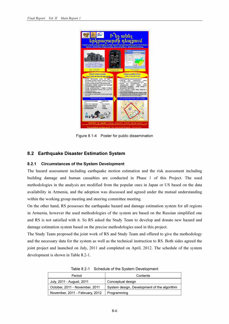
Final Report Vol. II Main Report 1
8-6
Figure 8.1-4 Poster for public dissemination
8.2 Earthquake Disaster Estimation System
8.2.1 Circumstances of the System Development
The hazard assessment including earthquake motion estimation and the risk assessment including
building damage and human casualties are conducted in Phase 1 of this Project. The used
methodologies in the analysis are modified from the popular ones in Japan or US based on the data
availability in Armenia, and the adoption was discussed and agreed under the mutual understanding
within the working group meeting and steering committee meeting.
On the other hand, RS possesses the earthquake hazard and damage estimation system for all regions
in Armenia, however the used methodologies of the system are based on the Russian simplified one
and RS is not satisfied with it. So RS asked the Study Team to develop and donate new hazard and
damage estimation system based on the precise methodologies used in this project.
The Study Team proposed the joint work of RS and Study Team and offered to give the methodology
and the necessary data for the system as well as the technical instruction to RS. Both sides agreed the
joint project and launched on July, 2011 and completed on April, 2012. The schedule of the system
development is shown in Table 8.2-1.
Table 8.2-1 Schedule of the System Development
Period Contents
July, 2011 - August, 2011 Conceptual design
October, 2011 - November, 2011 System design, Development of the algorithm
November, 2011 - February, 2012 Programming
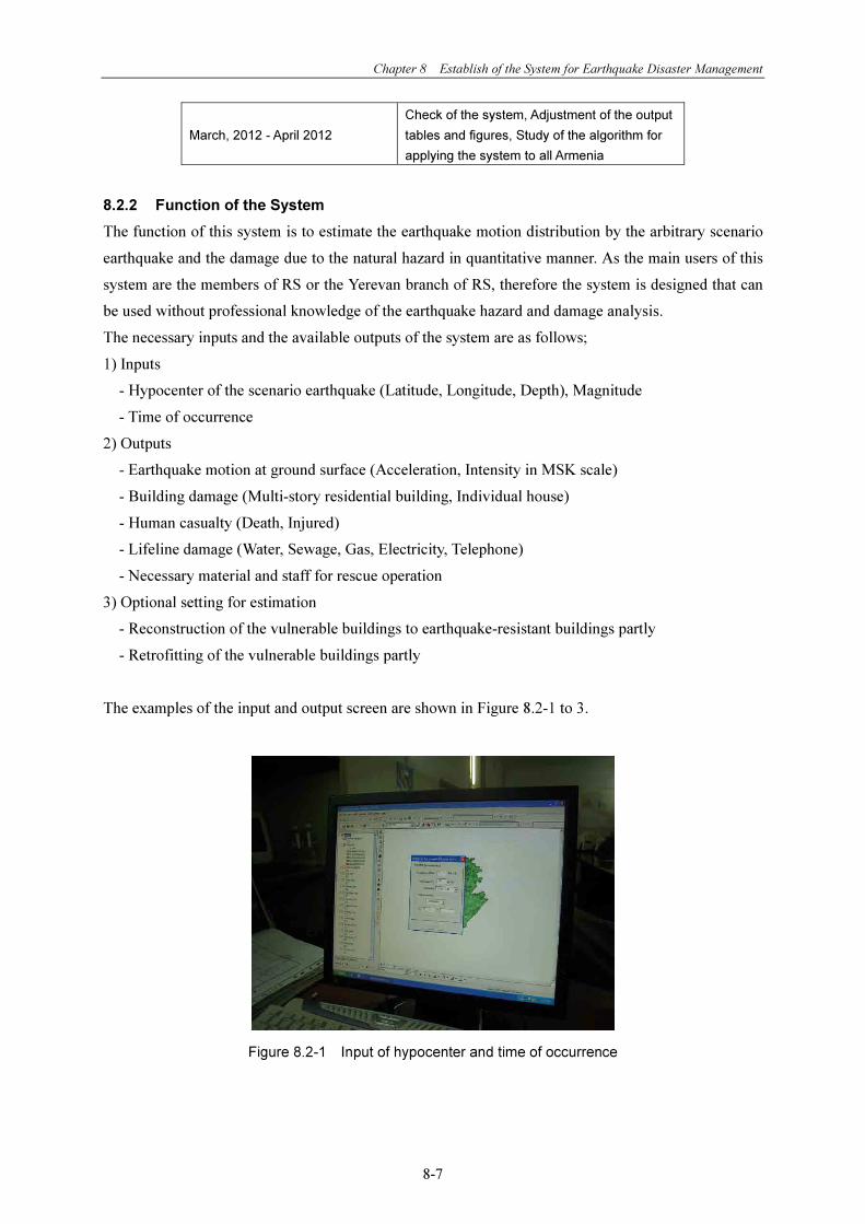
Chapter 8 Establish of the System for Earthquake Disaster Management
8-7
March, 2012 - April 2012
Check of the system, Adjustment of the output
tables and figures, Study of the algorithm for
applying the system to all Armenia
8.2.2 Function of the System
The function of this system is to estimate the earthquake motion distribution by the arbitrary scenario
earthquake and the damage due to the natural hazard in quantitative manner. As the main users of this
system are the members of RS or the Yerevan branch of RS, therefore the system is designed that can
be used without professional knowledge of the earthquake hazard and damage analysis.
The necessary inputs and the available outputs of the system are as follows;
1) Inputs
- Hypocenter of the scenario earthquake (Latitude, Longitude, Depth), Magnitude
- Time of occurrence
2) Outputs
- Earthquake motion at ground surface (Acceleration, Intensity in MSK scale)
- Building damage (Multi-story residential building, Individual house)
- Human casualty (Death, Injured)
- Lifeline damage (Water, Sewage, Gas, Electricity, Telephone)
- Necessary material and staff for rescue operation
3) Optional setting for estimation
- Reconstruction of the vulnerable buildings to earthquake-resistant buildings partly
- Retrofitting of the vulnerable buildings partly
The examples of the input and output screen are shown in Figure 8.2-1 to 3.
Figure 8.2-1 Input of hypocenter and time of occurrence

Final Report Vol. II Main Report 1
8-8
Figure 8.2-2 Output table of calculated results
Figure 8.2-3 Output figure of calculated results
8.2.3 Outline of the System
This platform of this system is ArcGIS and the program is coded using Visual BASIC. The overall
flowchart of the system is shown in Figure 8.2-4. The precise flowchart of individual analysis and the
explanation documents of the algorithm are included in the separate Data Book.

Chapter 8 Establish of the System for Earthquake Disaster Management
8-9
Figure 8.2-4 Overall Flowchart of the Earthquake Disaster Estimation System
Hypocenter
(Magnitude, Location, Depth)
Seismic Motion at Ground Surface
Residential Building
Damage
Death and Injured
Lifeline Damage
Calculation of Necessary
Resources for Rescue Operation
Predominant Period
of 250m grid
Damage Function
for Residential
Building
Damage Function
for Death and
Injured
Damage Function
for Lifeline
Inventory Data of
Lifeline
Amplification
Factor of 250m
Inventory Data of
Residential
Buildings