Responses to CEC Data Requests – Nos. A181 through A217
126
Amended Application for Certification for HYDROGEN ENERGY CALIFORNIA (08-AFC-8A) Kern County, California Responses to CEC Data Requests – Nos. A181 through A217 December 2012 Prepared for: Hydrogen Energy California LLC Submitted to: Prepared by: California Energy Commission U.S Department of Energy DOCKETED California Energy Commission DEC. 03 2012 TN # 68748 08-AFC-8A
-
Upload
khangminh22 -
Category
Documents
-
view
0 -
download
0
Transcript of Responses to CEC Data Requests – Nos. A181 through A217
Amended Application for CertificationforHYDROGEN ENERGY CALIFORNIA(08-AFC-8A)Kern County, California
Responses to CEC Data Requests – Nos. A181 through A217
December 2012
Prepared for:Hydrogen Energy California LLC
Submitted to:
Prepared by:
California EnergyCommission
U.S Departmentof Energy
DOCKETEDCalifornia Energy Commission
DEC. 03 2012
TN # 68748
08-AFC-8A

Hydrogen Energy California (08-AFC-8A) Responses to CEC Data Requests – Nos. A181 through A217 Table of Contents
i R:\12 HECA\DRs\CEC Set 3\Resp_DRs_A181-A217.docx
RESPONSES TO DATA REQUESTS A181 THROUGH A217 FROM CALIFORNIA ENERGY COMMISSION (CEC)
TABLE OF CONTENTS
CEC DATA REQUESTS A181 THROUGH A217
CULTURAL RESOURCES A181 THROUGH A197
NOISE A198 AND A199
ALTERNATIVES A200 THROUGH A209
LAND USE AND AGRICULTURAL A210 THROUGH A212
VISUAL RESOURCES A213 AND A214
WASTE MANAGEMENT A215 THROUGH A217
ATTACHMENTS
Attachment A182-1 Department of Parks and Recreation 523 Form Attachment A188-1 Department of Parks and Recreation 523 Forms Attachment A188-2 Historic Architectural Survey Report

Hydrogen Energy California (08-AFC-8A) Responses to CEC Data Requests – Nos. A181 through A217 Table of Contents
ii R:\12 HECA\DRs\CEC Set 3\Resp_DRs_A181-A217.docx
LIST OF ACRONYMS AND ABBREVIATIONS USED IN RESPONSES
Caltrans California Department of Transportation CEC California Energy Commission DPR Department of Parks and Recreation GS Gasification Solids HECA Hydrogen Energy California SCM Supplementary Cementitious Materials

Hydrogen Energy California (08-AFC-8A) Response to Data Request A181 Responses to CEC Data Requests – Nos. A181 through A217 Cultural Resources
A181-1 R:\12 HECA\DRs\CEC Set 3\Resp_DRs_A181-A217.docx
Technical Area: Cultural Resources Authors: Melissa Mourkas, Elizabeth A. Bagwell, Thomas Gates, Gabriel Roark
All responses to these Data Requests containing references to specific archaeological site locations or information, or resources of concern to Native Americans, must be submitted under a request for confidentiality.
BACKGROUND
Historic built environment studies were conducted in 2009 and 2012 to support the AFC and Amended AFC; separate reports were prepared for each inventory (JRP Historical Consulting 2009, 2012). Historic built environment resources were recorded as a result of both studies and were documented in the reports and on Department of Parks and Recreation 523 forms (DPR 523 forms).
Despite changes to the proposed project between 2009 and 2012, historic built environmental resources recorded in 2009 still cross the project area of analysis (PAA).
The Amended AFC (HECA 2012: 08-AFC-8A) proposes a linear corridor for a rail line. The corridor is shown on Map 2, Historic Architectural Resources Study Area with Defined Resources, Sheets 4-6, as submitted in April, 2012. The DPR 523 forms submitted with the revised project, April 2012, are keyed to the Map Reference Numbers on Map 2. Some of the DPR 523 forms contain photographs and/or location references which, due to the revised project footprint, are now outside of the proposed Project Area of Affect (PAA).
Staff has conducted a windshield survey of the PAA and noted that some of the resources have been altered since they were previously recorded. The built environment resources in the PAA are linear resources that go well beyond the PAA, therefore the nature and integrity of the resource within the PAA could be substantially different from that outside of the PAA.
As part of staff's environmental impact analysis, staff is requesting this level of analysis in order to understand what portion(s) of the resource could be affected by the proposed project. Staff requests that the DPR 523 forms for the following resources, identified by their map reference number, be updated to include current photographs of the resource within the current PAA, a current photograph location map, and updated evaluation of the resource based upon the current PAA and changes that have occurred to the resource in the ensuing years since the original application in 2008.
DATA REQUEST
Map Reference Number 2: Southern Pacific Asphalto/McKittrick Branch. A181.
a. Please provide current photographs of the rail line and spur as they appear within the current PAA and update the evaluation as needed to specifically discuss this portion of the resource. Record where the spur line ends and/or meets the main line within the PAA. Update the sketch map to reflect the current PAA and location of the resource. Update the section views to reflect the existing conditions.
b. Provide a discussion of how the proposed Rail Laydown Yard (URS 2012: Figure 5.10-2 [1]) would impact either the existing rail line or the historic spur identified on the DPR 523 form for Map Reference Number 2.
Hydrogen Energy California (08-AFC-8A) Response to Data Request A181 Responses to CEC Data Requests – Nos. A181 through A217 Cultural Resources
A181-2 R:\12 HECA\DRs\CEC Set 3\Resp_DRs_A181-A217.docx
RESPONSE
a. As described in Applicant’s Objections and Requests for Additional Time to Respond to California Energy Commission Staff Data Requests Set 3, docketed on November 20, 2012, the Applicant is requesting additional time to address this Data Request.
b. As described in Applicant’s Objections and Requests for Additional Time to Respond to California Energy Commission Staff Data Requests Set 3, docketed on November 20, 2012, the Applicant objects to this Data Request.
Hydrogen Energy California (08-AFC-8A) Response to Data Request A182 Responses to CEC Data Requests – Nos. A181 through A217 Cultural Resources
A182-1 R:\12 HECA\DRs\CEC Set 3\Resp_DRs_A181-A217.docx
DATA REQUEST
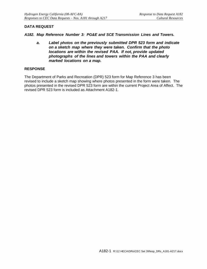
Map Reference Number 3: PG&E and SCE Transmission Lines and Towers. A182.
a. Label photos on the previously submitted DPR 523 form and indicate on a sketch map where they were taken. Confirm that the photo locations are within the revised PAA. If not, provide updated photographs of the lines and towers within the PAA and clearly marked locations on a map.
RESPONSE
The Department of Parks and Recreation (DPR) 523 form for Map Reference 3 has been revised to include a sketch map showing where photos presented in the form were taken. The photos presented in the revised DPR 523 form are within the current Project Area of Affect. The revised DPR 523 form is included as Attachment A182-1.

ATTACHMENT A182-1 DEPARTMENT OF PARKS AND RECREATION 523 FORM

Page 1 of 5 *Resource Name or # Map Reference No. 3
*P11. Report Citation: (Cite survey report and other sources, or enter “none.”) JRP Historical Consulting, LLC,“ Historic Architecture Technical Report: Inventory and Evaluation Report, Hydrogen Energy California (HECA) Project,” 2012. *Attachments: None Location Map Sketch Map Continuation Sheet Building, Structure, and Object Record Archaeological Record District Record Linear Feature Record Milling Station Record Rock Art Record Artifact Record Photograph Record
Other (list) __________________ DPR 523A (1/95) *Required Information
State of California – The Resources Agency Primary # _____________________________________ DEPARTMENT OF PARKS AND RECREATION HRI # ________________________________________ PRIMARY RECORD Trinomial _____________________________________ NRHP Status Code 6Z Other Listings _______________________________________________________________ Review Code __________ Reviewer ____________________________ Date ___________
P1. Other Identifier: Pacific Gas & Electric and Southern California Edison Transmission Lines and Towers
*P2. Location: Not for Publication Unrestricted *a. County Kern and (P2b and P2c or P2d. Attach a Location Map as necessary.)
*b. USGS 7.5’ Quad Tupman, CA Date 1954 photorevised, 1968, 1973 T___; R ___; ___ ¼ of Sec ___; _____ B.M.
c. Address City Buttonwillow Zip
d. UTM: (give more than one for large and/or linear resources) Zone _____; ______________mE/ _____________mN e. Other Locational Data: (e.g., parcel #, directions to resource, elevation, etc., as appropriate) Segments of Lines A and B: Sections 20-21 T29S/R24E; Segments of Lines C and D: Sections 19, 20, 27, 28 T29S/R24E. *P3a. Description: (Describe resource and its major elements. Include design, materials, condition, alterations, size, setting, and boundaries)
This form documents segments of two sets of transmission lines and towers southeast of Buttonwillow and west of Interstate 5. Lines A and B (Photograph No. 1) were constructed by Southern California Edison (SCE) and Pacific Gas & Electric (PG&E), respectively, sometime between 1943 and 1956. These lines begin at the Midway Substation, cross Highway 58, and then run east paralleling the highway into the City of Bakersfield. Towers include steel lattice towers, carrying either single or double circuits. Some towers are guyed. Lines C and D (Photograph No. 3) were built by PG&E and SCE, respectively, between 1956 and 1973. These lines begin at the Midway Substation, cross Highway 58, and run southeast for approximately 7 miles. South of Stockdale Highway and just east of Elk Valley Road, Line C begins to travel north and south, and is suspended on three-armed lattice towers with battered four-legged bases. The single-arm towers with masts resembling rabbit ears carry PG&E lines northwest and southeast.
*P3b. Resource Attributes: (List attributes and codes) (HP11) Engineering structure *P4. Resources Present: Structure Building Object Site District Element of District Other (Isolates, etc.)
P5b. Description of Photo: Photograph 1: Lines A and B (Point 1), facing southeast. * P6. Date Constructed/Age and Sources: Historic Prehistoric Both 1940s-1973, Historic maps & aerial photographs *P7. Owner and Address: PG&E and Southern California Edison *P8. Recorded by: Greg Rainka & Rand Herbert/ Toni Webb & Chandra Miller JRP Historical Consulting, LLC 2850 Spafford St., Davis, CA 95618
*P9. Date Recorded: April 2010 & February 2012 *P10. Survey Type: Intensive
P5a. Photo of Drawing (Photo required for buildings, structures, and objects.)

Page 2 of 5 *NRHP Status Code 6Z *Resource Name or # Map Reference No. 3
DPR 523B (1/95) *Required Information
State of California – The Resources Agency Primary # _____________________________________ DEPARTMENT OF PARKS AND RECREATION HRI # ________________________________________ BUILDING, STRUCTURE, AND OBJECT RECORD
B1. Historic Name: B2. Common Name: B3. Original Use: Electrical transmission B4. Present Use: Electrical transmission
*B5. Architectural Style: Utilitarian
*B6. Construction History: Lines A & B = between 1943 & 1956; Line C = between 1956 & 1968; Lines D= between 1968 & 1973. *B7. Moved? No Yes Unknown Date: Original Location: *B8. Related Features: B9. Architect: PG&E/SCE b. Builder: PG&E/SCE *B10. Significance: Theme n/a Area n/a Period of Significance n/a Property Type n/a Applicable Criteria n/a None of the transmission lines and towers documented on this form appear to meet the criteria for listing in the National Register of Historic Places (NRHP) or the California Register of Historical Resources (CRHR) because they lack historical significance. These resources been evaluated in accordance with Section 15064.5(a)(2)-(3) of the CEQA Guidelines, using the criteria outlined in Section 5024.1 of the California Public Resources Code, and do not appear to be historical resources for the purposes of CEQA.
The development of long distance transmission lines in California was an evolutionary process that dates to 1879, the year in which California Electric Light Company began operation. This San Francisco-based company generated electricity, and distributed it to local subscribers from a central station. During the 1880s the use of electricity in California became increasingly widespread, and local electric companies began to spring up in cities throughout the state. These early power plants, which used low-voltage direct current (D.C.) dynamos, could only transmit electricity about three miles. Only urban areas with concentrated populations could be economically served with a local electrical generating plant. The first important technological advancement that would allow the transmission of electricity over greater distances was the development of the alternating current (A.C.) system, which could produce higher voltages than the D.C. system. By 1890, this pioneering technology invented by Nikolas Tesla was put to use in a limited capacity in power plants in four California cities: Santa Barbara, Highgrove, Visalia, and Pasadena.
Although the A.C. system was a promising development, it did not catch on immediately, primarily because the D.C. system was already in place in most of the existing power stations. Pioneering developments at the San Antonio Light & Power Company’s Pomona Plant, however, greatly helped to advance the electric industry in California. In 1892, this was the first hydroelectric facility in California to use “step-up” A.C. transformers, in which the generator (See Continuation Sheet)
B11. Additional Resource Attributes: *B12. References: William A. Myers, Iron Men and Copper Wires: A Centennial History of the Southern California Edison Company (Glendale, California: Trans-Anglo Books, 1983), 11; Tupman Quadrangle, 1933, 1954, 1968 and 1973; Buttonwillow Quadrangle, 1942, 1956, 1973; USDA Aerial Photographs of Kern County, Aerial Photographs of Kern County, 1956 & 1974; also see footnotes. B13. Remarks: *B14. Evaluator: Greg Rainka/Toni Webb
*Date of Evaluation: April 2010/February 2012 (This space reserved for official comments.)
(Sketch Map with north arrow required.)
See Continuation Sheet

Page 3 of 5 *Resource Name or # Map Reference No. 3 *Recorded by Rainka/Herbert/Webb/Miller *Date April 2010/February 2012 Continuation Update
DPR 523L (1/95) *Required Information
State of California – The Resources Agency Primary # _____________________________________ DEPARTMENT OF PARKS AND RECREATION HRI # ________________________________________ CONTINUATION SHEET Trinomial ____________________________________________
B10. Significance (continued): potential of 1,000 volts was increased to 10,000 volts for transmission. On November 28, 1892, San Antonio Light & Power began delivery of 10,000 volts of electricity from its plant at San Antonio Canyon to Pomona, a distance of 14 miles. A month later service was extended to San Bernardino, roughly doubling the length of the line. Over the next decade, technological and engineering advancements made it possible for power companies to transport electricity in increasing amounts over ever-longer distances. In 1899, the Edison Electric Company built an 83-mile transmission line between its power plant on the upper Santa Ana River and Los Angeles. By far the longest in the world at the time, this engineering feat was made possible by the development of glazed porcelain insulators capable of handling 40,000 volts.1 In 1901, Bay Counties Power Company completed a transmission line 142 miles in length that brought hydroelectric power from the Colgate Powerhouse in the Sierra Nevada near Grass Valley to Oakland. The line consisted of two parallel rows of cedar poles carrying copper and aluminum wires. In addition to its length, this line was impressive because of its 4,427-foot crossing of the Carquinez Straits. John Debo Galloway was the construction engineer for the project and is credited with directing the design and construction of the cable span, the longest in the world at that time. The Colgate-Oakland line also marked the first time electrical power produced in the Sierra crossed the rugged mountain terrain and the wide Sacramento Valley to be utilized by residents of the Bay Area.2
The first decade of the 20th century ushered in a period of marked growth in the hydroelectric industry. Between 1900 and 1910 the population of California increased by 60 percent, and with it came an increased demand for electric power.3 Dozens of hydroelectric companies formed throughout California, each building networks of long-distance transmission lines to service new and growing markets. By 1902, the Bay Counties Power Company and the Standard Electric Company had a network of transmission lines in place that provided coverage to much of the Bay Area, as well as communities such as Marysville, Stockton, and Amador City. In 1907, California Gas & Electric (CG&E) purchased the lines of these two companies, as well as other smaller Northern California operations, to augment its existing system. The transmission lines of this consolidated system reached from Chico to the north to San Jose to the south, serving dozens of communities in between.4
In 1907, Edison Electric completed its Kern River No. 1 hydroelectric plant in Kern Canyon. This 118-mile long transmission line delivered power to Los Angeles, carrying a 75,000-volt line, and was the first line to use entirely steel towers. The Wind Engine Company, a windmill manufacturer, supplied the towers. In 1908, the Great Western Power Company completed its hydroelectric plant at Big Bend on the Feather River, and by January 1909 began sending electrical power to the Bay Area via its 165-mile stretch of transmission lines. By the spring of 1909, the major hydroelectric companies of Northern California, including CG&E, Stanislaus Electric Power Company, Great Western Power Company, and the American River Power Company, had a network of long-distance transmission lines in place that crisscrossed the state.5 In subsequent decades, power companies throughout California, led by major companies such as PG&E and the Southern California Edison Company, continued to expand and build upon the systems that had been founded in the decades surrounding the turn of the century.
1 Fredrick Hall Fowler, Hydroelectric Power Systems of California and Their Extensions into Oregon and Nevada (Washington DC: Government Printing Office, 1923), 1; Myers, Iron Men and Copper Wires, 24-31, 39. 2 Charles M. Coleman, PG&E of California: The Centennial Story of Pacific Gas and Electric Company 1852-1952 (New York: McGraw-Hill Book Company Inc., 1953), 146-148. 3 Coleman, PG&E of California, 257. 4 Galloway and Markwart Consulting Engineers, “Map of Central California Showing Principal Power Plants and Transmission Lines.” In: J.D. Galloway, “Report on the Stanislaus Electric Power Company on the Stanislaus River, California,” March 1909; Fowler, Hydroelectric Power Systems of California, 273-274. 5 Myers, Iron Men and Copper Wires, 44-47; Jackson Research Projects, “Great Western Power Company: Hydroelectric Power Development on the North Fork of the Feather River, 1902-1930,” prepared for PG&E, 1986, 96, 102; Fowler, Hydroelectric Power Systems of California, 275; Fowler, Hydroelectric Power Systems of California, 272-273.

Page 4 of 5 *Resource Name or # Map Reference No. 3 *Recorded by Rainka/Herbert/Webb/Miller *Date April 2010/February 2012 Continuation Update
DPR 523L (1/95) *Required Information
State of California – The Resources Agency Primary # _____________________________________ DEPARTMENT OF PARKS AND RECREATION HRI # ________________________________________ CONTINUATION SHEET Trinomial ____________________________________________
B10. Significance (continued): Under CRHR Criterion 1 or NRHP Criterion A, none of the transmission lines and towers documented on this form appear to be significant for their association with the development of electrical transmission in Kern County. All of these lines and towers were constructed in the 1940s and thereafter, more than forty years after the period of development of power lines and electricity in California. These distribution lines were installed because of a general increase in need for electrical power and do not represent significant engineering achievement, nor are they directly related to a significant precipitating event. Under CRHR Criterion 2 or NRHP Criterion B, these lines and towers do not appear to be significant for their association with the lives of persons important to history. They were built and are used by large electrical companies, and cannot be attributed to a specific individual or group of individuals significant within that context. Under CRHR Criterion 3 or NRHP Criterion C, these lines and towers do not appear to be significant for possessing distinctive characteristics of construction or high artistic value. They each exhibit the typical design of their respective power company, were ordered from their manufacturer and constructed in large quantities. None of these lines were established to solve a particular problem in power distribution, or to surmount a problem in electrical development. Lastly, these lines and towers do not appear to be a source (or likely source) of important information regarding history, and are therefore ineligible under CRHR Criterion 4 or NRHP Criterion D.
Photographs (continued):
Photograph 2. Point 2 of PG&E line (Line C, far left) and SCE lines (Lines D, right) facing southeast.

Page 5 of 5 *Resource Name or # Map Reference No. 3 *Recorded by Rainka/Herbert/Webb/Miller *Date April 2010/February 2012 Continuation Update
DPR 523L (1/95) *Required Information
State of California – The Resources Agency Primary # _____________________________________ DEPARTMENT OF PARKS AND RECREATION HRI # ________________________________________ CONTINUATION SHEET Trinomial ____________________________________________
Sketch Map:

Hydrogen Energy California (08-AFC-8A) Response to Data Request A183 Responses to CEC Data Requests – Nos. A181 through A217 Cultural Resources
A183-1 R:\12 HECA\DRs\CEC Set 3\Resp_DRs_A181-A217.docx
DATA REQUEST
Map Reference Number 10: Old Headquarters Weir. A183.
The Old Headquarters Weir appears to have experienced significant changes to the structure since the photographs were taken in 2009 and the resource evaluated on the DPR 523 form submitted with the application. In light of those changes, address the following potential integrity issues:
a. Please confirm that the steel walkway shown in photograph 2 on the DPR 523 form is no longer extant.
b. Assess the additional layer of concrete visible on the top of the benchwalls where the walkway was located prior to removal and determine its age and whether it was an addition to support the non-original wooden or steel walkways that were added later to the structure.
c. Determine whether these changes to the Old Headquarters Weir affect the integrity of the resource and its eligibility for listing on the California Register of Historical Resources (CRHR). Provide current photographs documenting the existing condition of the weir on the DPR 523 form.
RESPONSE
As described in Applicant’s Objections and Requests for Additional Time to Respond to California Energy Commission Staff Data Requests Set 3, docketed on November 20, 2012, the Applicant is requesting additional time to address this Data Request.

Hydrogen Energy California (08-AFC-8A) Response to Data Request A184 Responses to CEC Data Requests – Nos. A181 through A217 Cultural Resources
A184-1 R:\12 HECA\DRs\CEC Set 3\Resp_DRs_A181-A217.docx
DATA REQUEST
Map Reference Number 11: California Aqueduct. A184.
a. The location of photograph (dated 7/26/06) provided on the DPR 523 form map on page 2 of 4, appears to be taken in the vicinity of the Delta Mendota Canal in Tracy, CA, nearly 200 miles north of the project. As the photo location is outside the current PAA, provide a current photo of the portion of the aqueduct within the PAA and a map identifying its location. Staff suggests a photo location of the aqueduct near the Old Headquarters Weir.
RESPONSE
As described in Applicant’s Objections and Requests for Additional Time to Respond to California Energy Commission Staff Data Requests Set 3, docketed on November 20, 2012, the Applicant is requesting additional time to address this Data Request.

Hydrogen Energy California (08-AFC-8A) Response to Data Request A185 Responses to CEC Data Requests – Nos. A181 through A217 Cultural Resources
A185-1 R:\12 HECA\DRs\CEC Set 3\Resp_DRs_A181-A217.docx
DATA REQUEST
Map Reference Number 14: Buena Vista Water Storage District (BVWSD). A185.
The DPR 523 form evaluating six individual BVWSD resources was completed in 2009. One of the resources identified in the DPR 523 form is now outside the PAA. The location photographs for the five BVWSD resources listed below no longer document the portions of these resources within the PAA.
a. Provide updated photographs, location map and evaluation of the resources to reflect the revised PAA. The affected BVWSD resources are listed below, from north to south within the PAA:
1 East Side Canal;
2. Unknown drain and well (dating to at least 1954) located between Dunford Road and East Side Canal;
3. Depot Drain;
4. Levee and well at southern property boundary of the Adohr/Palm Farm complex;
5. Outlet Canal.
RESPONSE
As described in Applicant’s Objections and Requests for Additional Time to Respond to California Energy Commission Staff Data Requests Set 3, docketed on November 20, 2012, the Applicant is requesting additional time to address this Data Request.
Hydrogen Energy California (08-AFC-8A) Response to Data Request A186 Responses to CEC Data Requests – Nos. A181 through A217 Cultural Resources
A186-1 R:\12 HECA\DRs\CEC Set 3\Resp_DRs_A181-A217.docx
BACKGROUND
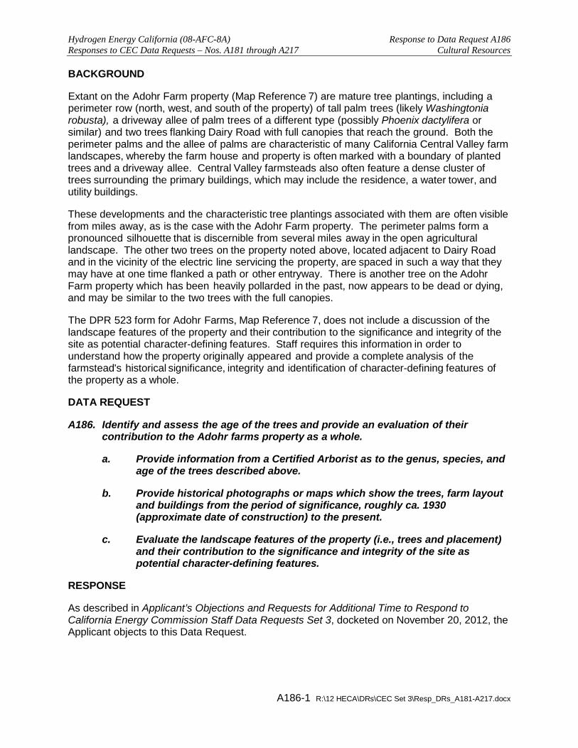
Extant on the Adohr Farm property (Map Reference 7) are mature tree plantings, including a perimeter row (north, west, and south of the property) of tall palm trees (likely Washingtonia robusta), a driveway allee of palm trees of a different type (possibly Phoenix dactylifera or similar) and two trees flanking Dairy Road with full canopies that reach the ground. Both the perimeter palms and the allee of palms are characteristic of many California Central Valley farm landscapes, whereby the farm house and property is often marked with a boundary of planted trees and a driveway allee. Central Valley farmsteads also often feature a dense cluster of trees surrounding the primary buildings, which may include the residence, a water tower, and utility buildings.
These developments and the characteristic tree plantings associated with them are often visible from miles away, as is the case with the Adohr Farm property. The perimeter palms form a pronounced silhouette that is discernible from several miles away in the open agricultural landscape. The other two trees on the property noted above, located adjacent to Dairy Road and in the vicinity of the electric line servicing the property, are spaced in such a way that they may have at one time flanked a path or other entryway. There is another tree on the Adohr Farm property which has been heavily pollarded in the past, now appears to be dead or dying, and may be similar to the two trees with the full canopies.
The DPR 523 form for Adohr Farms, Map Reference 7, does not include a discussion of the landscape features of the property and their contribution to the significance and integrity of the site as potential character-defining features. Staff requires this information in order to understand how the property originally appeared and provide a complete analysis of the farmstead's historical significance, integrity and identification of character-defining features of the property as a whole.
DATA REQUEST
Identify and assess the age of the trees and provide an evaluation of their A186.contribution to the Adohr farms property as a whole.
a. Provide information from a Certified Arborist as to the genus, species, and age of the trees described above.
b. Provide historical photographs or maps which show the trees, farm layout and buildings from the period of significance, roughly ca. 1930 (approximate date of construction) to the present.
c. Evaluate the landscape features of the property (i.e., trees and placement) and their contribution to the significance and integrity of the site as potential character-defining features.
RESPONSE
As described in Applicant’s Objections and Requests for Additional Time to Respond to California Energy Commission Staff Data Requests Set 3, docketed on November 20, 2012, the Applicant objects to this Data Request.

Hydrogen Energy California (08-AFC-8A) Response to Data Request A187 Responses to CEC Data Requests – Nos. A181 through A217 Cultural Resources
A187-1 R:\12 HECA\DRs\CEC Set 3\Resp_DRs_A181-A217.docx
BACKGROUND
The HECA project proposes a new rail line to deliver products to the project site (URS 2012). The Amended AFC and subsequent data responses have not described the method for crossing and/or abutting existing BVWSD resources.
Energy Commission Land Use and Traffic staff made site visits on September 25, 2012. HECA staff described the crossings of the canals, for example, as pre-cast concrete structures that would be installed inside the drainage channel walls, with a flow-through design for the water in the channel. As described, installation of the structures would not impact the sidewalls or levees of the drainage channel.
However, the rail line presumably would cross the top of the sidewalls and levees. In order for Cultural Resources staff to adequately address the potential impacts upon BVWSD resources and related structures and landforms, staff needs a complete description of the method of drainage crossings and a discussion of the impacts to the resources involved.
DATA REQUEST
Provide a description of the method of rail line crossing, including design, A187.accompanied by an engineering drawing in plan and section view, structural requirements and a discussion of potential impacts to the three existing structures listed below that appear to require crossings based upon the rail line route provided in the AFC and subsequent documents.
a. East Side Canal (Map Reference 14). Provide design of structural crossing in plan and section view, clearly.
b. Works Progress Administration-era culverts and headwalls on Dairy Road (Map Reference 5). Provide an analysis of the impact of the rail line on these resources, including placement of the rail line in relation to the headwalls and indicating how the span would be accomplished and what structural elements or features of the water system at this location may be impacted.
c. Main Drain (Map Reference 14). Provide design of structural crossing in plan and section view, clearly indicating how the span would be accomplished and what structural elements or features of the canal may be impacted.
RESPONSE
As described in Applicant’s Objections and Requests for Additional Time to Respond to California Energy Commission Staff Data Requests Set 3, docketed on November 20, 2012, the Applicant objects to this Data Request.

Hydrogen Energy California (08-AFC-8A) Response to Data Request A188 Responses to CEC Data Requests – Nos. A181 through A217 Cultural Resources
A188-1 R:\12 HECA\DRs\CEC Set 3\Resp_DRs_A181-A217.docx
BACKGROUND
In discussing the architectural characteristics of the buildings in the DPR forms for Map References 7 (Adohr Farms) and 9 (Adohr Farms Headquarters) (URS 2012), a reference is made to an "Oilfield" style of architecture. The narrative states that, "While the style of the buildings [Map References 7 and 9] is reminiscent of "Oilfield" architecture, a style used in the remote oilfields of Kern County, the construction date and function preclude it from being of this class of architecture. Rather, it is a modified version of this style" (JRP Historical Consulting 2012: Map Reference 7, p. 4, Map Reference 9, p. 4).
The applicant has drawn the conclusion that the buildings are not eligible for listing on the CRHR under Criteria 1, 2, 3 or 4. Specifically, the applicant determines that, relative to Criterion 3, these buildings do not possess any distinctive characteristics or high artistic value that would render them eligible under Criterion 3 (JRP Historical Consulting 2009).
In order to develop a complete analysis for the buildings and the farmstead as a whole, staff needs additional information about the architecture style referred to as "Oilfield". In addition, staff needs to understand the context of the style relative to oilfields and agricultural properties in Kern County and why the "Oilfield" style would be in use on an agricultural property.
DATA REQUEST
Staff requires additional information about the "Oilfield" architectural style and A188.how the architectural details of the buildings identified as Map References 7 and 9 refer to that style.
a. Provide a discussion of the "Oilfield" style of architecture referred to in the DPR 523 forms for Map References 7 and 9. Define the period of significance for the style, and how the construction date and function of the buildings "preclude it from being of this class of architecture".
b. Please provide staff a copy of JRP Historical Consulting (1995), cited in JRP Historical Consulting (2012) as a source for defining Oilfield architecture.
c. Provide a discussion of the buildings' design, including but not limited to, the gabled monitor with ventilation slats, the decorative notching in the fascia boards, the shed roofs covering the porches and the distinctive cross-X pattern of the porch railings and how these attributes and features fit into the broader pattern of agricultural housing forms from this period in the Central Valley, and Kern County in particular.
RESPONSE
The DPR 523 forms for Map References 7 and 9 have been revised to include a discussion of oilfield architecture, a definition of the period of significance for the style, and how the construction date and function of the buildings referred to in the DPR 523 forms preclude them from being of this class of architecture. The DPR 523 forms have also been revised to provide a discussion of the buildings' design, and how these attributes and features fit into the broader pattern of agricultural housing forms from this period in the Central Valley and Kern County. The revised DPR 523 forms are included as Attachment A188-1. A copy of JRP Historical Consulting Services Historic Architectural Survey Report, dated June 9, 1995, is included as Attachment A188-2.

ATTACHMENT A188-1 DEPARTMENT OF PARKS AND RECREATION 523 FORMS

Page 1 of 10 *Resource Name or # Map Reference No. 7
*P11. Report Citation: (Cite survey report and other sources, or enter “none.”) JRP Historical Consulting, LLC, “ Historic Architecture Technical Report: Inventory and Evaluation Report, Hydrogen Energy California (HECA) Project,” 2012. *Attachments: None Location Map Sketch Map Continuation Sheet Building, Structure, and Object Record Archaeological Record District Record Linear Feature Record Milling Station Record Rock Art Record Artifact Record Photograph Record
Other (list) __________________ DPR 523A (1/95) *Required Information
State of California – The Resources Agency Primary # _____________________________________ DEPARTMENT OF PARKS AND RECREATION HRI # ________________________________________ PRIMARY RECORD Trinomial _____________________________________ NRHP Status Code 6Z Other Listings _______________________________________________________________ Review Code __________ Reviewer ____________________________ Date ___________
P1. Other Identifier: 7307 Adohr Road
*P2. Location: Not for Publication Unrestricted *a. County Kern and (P2b and P2c or P2d. Attach a Location Map as necessary.)
*b. USGS 7.5’ Quad East Elk Hills, CA Date 1954 photorevised 1973 T_30S_; R _24E_; _NW_ ¼ of Sec _10_; _MD_ B.M. c. Address 7307 Adohr Road City Buttonwillow Zip 93206
d. UTM: (give more than one for large and/or linear resources) Zone _____; ______________mE/ _____________mN e. Other Locational Data: (e.g., parcel #, directions to resource, elevation, etc., as appropriate) Assessor Parcel Number: 159-040-18-00 *P3a. Description: (Describe resource and its major elements. Include design, materials, condition, alterations, size, setting, and boundaries)
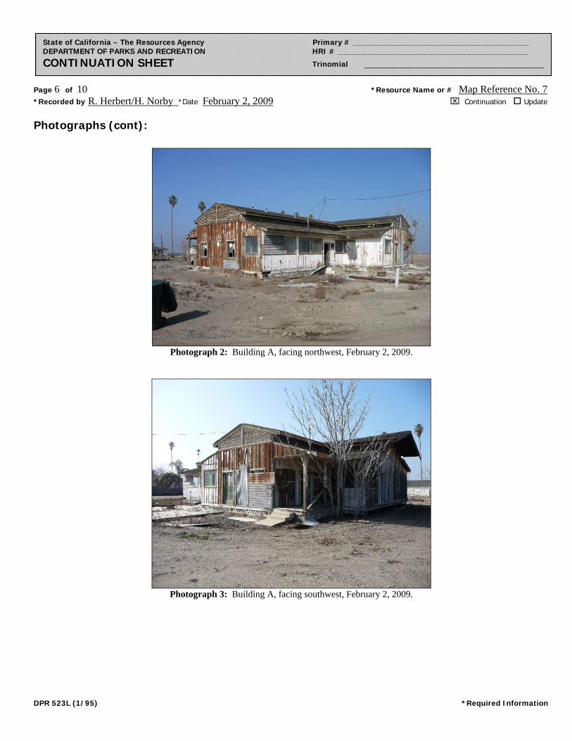
Building A has a generally rectangular but irregular footprint. Vertical wood paneling sheaths the exterior of the structure which sits on piers. Fenestration includes a variety of window styles including fixed pane and one-over-one double hung sashes. The roof is a side gabled monitor rising above a shed roof on two sides. Horizontal slats in the eaves at the gable peaks and beneath the monitor provide for ventilation. Decorative notching adorns the fascia boards in the eaves of the monitor and shed roofs. According to a Los Angeles Times article published in 1930 describing the new construction, the remnants of green paint visible on the trim are the original paint (see Photograph 4). The shed roof is supported by beams and forms a partially enclosed porch on the west side and an enclosed porch on the east side. On the east side, a perpendicular wing extends from the southern end of the house (see Photograph 2). The roofline of this wing matches the rest of the house with a monitor rising above a shed roof. Entrance doors are found on the west side, one boarded up on the southern end, two on the east side, and one on the north side. Many of the openings have been covered with corrugated metal. The structure has many composition shingles missing from the roof, broken windows, missing doors, and weather beaten wood paneling. (See Continuation Sheet.)
*P3b. Resource Attributes: (List attributes and codes) (HP33) Farm *P4. Resources Present: Building Structure Object Site District Element of District Other (Isolates, etc.)
P5b. Description of Photo: (View, date, accession #) Photograph 1: Building A, facing northeast, February 2, 2009.
*P6. Date Constructed/Age and Sources: Historic Prehistoric Both 1930, Los Angeles Times, 9 Nov. 1930
*P7. Owner and Address: Jomistro Properties LLC 1600 Corn Camp Rd. Buttonwillow, CA 93206-9729
*P8. Recorded by: Rand Herbert & Heather Norby JRP Historical Consulting, LLC 1490 Drew Ave, Suite 110, Davis, CA 95618
*P9. Date Recorded: February 2, 2009
*P10. Survey Type: (Describe) Intensive
P5a. Photo of Drawing (Photo required for buildings, structures, and objects.)
Page 2 of 10 *NRHP Status Code 6Z *Resource Name or # Map Reference No. 7
DPR 523B (1/95) *Required Information
State of California – The Resources Agency Primary # _____________________________________ DEPARTMENT OF PARKS AND RECREATION HRI # ________________________________________ BUILDING, STRUCTURE, AND OBJECT RECORD
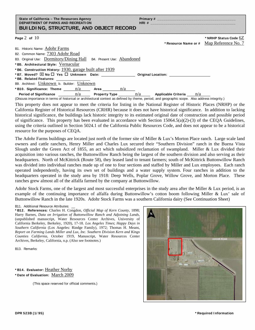
B1. Historic Name: Adohr Farms B2. Common Name: 7303 Adohr Road
B3. Original Use: Dormitory/Dining Hall B4. Present Use: Abandoned
*B5. Architectural Style: Vernacular *B6. Construction History: 1930, garage built after 1939 *B7. Moved? No Yes Unknown Date: Original Location: *B8. Related Features: B9. Architect: Unknown b. Builder: Unknown *B10. Significance: Theme n/a Area n/a Period of Significance n/a Property Type n/a Applicable Criteria n/a (Discuss importance in terms of historical or architectural context as defined by theme, period, and geographic scope. Also address integrity.)
This property does not appear to meet the criteria for listing in the National Register of Historic Places (NRHP) or the California Register of Historical Resources (CRHR) because it does not have historical significance. In addition to lacking historical significance, the buildings lack historic integrity to its estimated original date of construction and possible period of significance. This property has been evaluated in accordance with Section 15064.5(a)(2)-(3) of the CEQA Guidelines, using the criteria outlined in Section 5024.1 of the California Public Resources Code, and does not appear to be a historical resource for the purposes of CEQA.
The Adohr Farms buildings are located just north of the former site of Miller & Lux’s Morton Place ranch. Large scale land owners and cattle ranchers, Henry Miller and Charles Lux secured their “Southern Division” ranch in the Buena Vista Slough under the Green Act of 1855, an act which subsidized reclamation of swampland. Miller & Lux divided their acquisition into various ranches, the Buttonwillow Ranch being the largest of the southern division and also serving as their headquarters. North of McKittrick (Route 58), they leased land to tenant farmers; south of McKittrick Buttonwillow Ranch was divided into individual ranches made up of one to four sections and staffed by Miller and Lux employees. Each ranch operated independently, having its own set of buildings and a water supply system. Four ranches in addition to the headquarters operated in the study area by 1918: Deep Wells, Poplar Grove, Willow Grove, and Morton Place. These ranches grew almost all of the alfalfa farmed by the company at Buttonwillow.
Adohr Stock Farms, one of the largest and most successful enterprises in the study area after the Miller & Lux period, is an example of the continuing importance of alfalfa during Buttonwillow’s cotton boom following Miller & Lux’ sale of Buttonwillow Ranch in the late 1920s. Adohr Stock Farms was a southern California dairy (See Continuation Sheet)
B11. Additional Resource Attributes: *B12. References: Charles H. Congdon, Official Map of Kern County, 1898; Harry Barnes, Data on Irrigation of Buttonwillow Ranch and Adjoining Lands, (unpublished manuscript, Water Resources Center Archives, University of California Berkeley, Berkeley, 1920), 17-18. Los Angeles Times; Happy Days in Southern California (Los Angeles: Rindge Family), 1972; Thomas H. Means, Report on Farming Lands Miller and Lux, Inc. Southern Division Kern and Kings Counties California, October 1919, Manuscript, Water Resources Center Archives, Berkeley, California, n.p. (Also see footnotes.) B13. Remarks: *B14. Evaluator: Heather Norby *Date of Evaluation: March 2009 (This space reserved for official comments.)

Page 3 of 10 *Resource Name or # Map Reference No. 7 *Recorded by R. Herbert/H. Norby *Date February 2, 2009 Continuation Update
DPR 523L (1/95) *Required Information
State of California – The Resources Agency Primary # _____________________________________ DEPARTMENT OF PARKS AND RECREATION HRI # ________________________________________ CONTINUATION SHEET Trinomial ____________________________________________
P3a. Description (continued): Building B has a hipped monitor roof with boxed eaves raised above a shed roof with exposed eaves extending over three sides of the house (see Photographs 6, 7, 8). Sets of five horizontal slats in the eaves, below the monitor, allow for ventilation. The shed roof, supported by 4x4 beams at the corners and 2x4 beams in between, forms a porch around three sides of the house. Wood beams forming an “X” pattern between the supporting beams partially enclose the porch. Vertical wood paneling sheaths the exterior of the house. Although no longer present, evidence of a brick chimney on the west side of the house remains. Almost all of the windows are covered with corrugated metal panels. A pair of six-over-six double-hung sash windows are visible on the west and south sides. Entrance doors are located on both the south and east sides of the house. The house sits on mudsills with the foundation supported by piers.
Building C, a rectangular garage to the northeast of the house, rests on mudsills. It has front gabled roof with exposed rafters (see Photograph 9). A sliding garage door on the south side is the only opening; there are no windows. The siding is of vertical wood planks. Composition shingles are peeling from the concave roof, and loose boards are hanging from the exterior.
B10. Significance (continued): Adohr Stock Farms, one of the largest and most successful enterprises in the study area after the Miller & Lux period, is an example of the continuing importance of alfalfa during Buttonwillow’s cotton boom following Miller & Lux’ sale of Buttonwillow Ranch in the late 1920s. Adohr Stock Farms was a southern California dairy company owned by Rhoda Rindge Adamson and her husband Merritt Adamson. Rhoda Rindge was the daughter of Frederick H. Rindge, a very wealthy, influential East-Coast transplant to California. Rhoda attended one year of college at Wellesley before returning to finish her education in California. After marrying Merritt Adamson, an attorney and sheep rancher’s son, she used her family inheritance to start Adohr (her given name spelled backward) Farms with her husband. Mr. Adamson left the law behind to focus on ranching and dairying. Their first farm in the San Fernando Valley opened in 1916 and by the late 1920s they began to vertically integrate their business, seeking to not only maintain a herd of productive dairy cows, but to rear “replacement” calves, and grow alfalfa for their herds.1
In 1929, the Adamsons had an area northwest of Tupman, owned by Miller & Lux, analyzed to determine if the soil and conditions would support an alfalfa farm and a herd of cattle. They learned that the land had rich soil, lay on top of an artesian belt, and had already been successfully planted with corn and wheat. Satisfied that it met their requirements, they purchased 1,500 acres from Miller & Lux in July of 1930 for $250,000, and set aside $50,000 for immediate improvements. By the fall of the same year, the company had planted a field, sunk ten new wells, and built a headquarters building, dormitory, and dining hall on the southeast corner of what became Adohr Road and Dairy Road. The headquarters building remains on an adjacent parcel today. Buildings A and B are the dining hall and dormitory, although it is not clear which one served which purpose. Between 1937 and 1942, the company constructed three warehouse buildings, still existing, on an adjacent parcel.2
By May of 1933, Adohr expanded its Buttonwillow satellite ranch to 2,600 acres. This location was subsidiary to the main San Fernando Valley branch. Adohr ran an advertisement in the Los Angeles Times in 1933 with the headings, “Adohr grows its own feed; Adohr raises its own dairy cattle; Adohr operates its own stock farms; and Adohr, of course, has its own far-reaching delivery system.” The rich land in Kern County, already within close proximity to numerous irrigation structures, played a pivotal role in allowing this southern California company to vertically integrate their business model and provide an affordable product to a broader clientele. The company operated the ranch until the1940s.3
1 Frederick H. Rindge, Happy Days in Southern California (Los Angeles: Rindge Family), 1972, prologue.; Los Angeles Times, 31 Aug. 1930, L14; Van Nuys News, 10 Jan. 1949.; Los Angeles Times, 1 Mar. 1998; Beatrice Ulery, “A Bovine Nursery,” Los Angeles Times, Nov. 9, 1930, J7. 2 Los Angeles Times, Sep. 30, 1934, 21; Los Angeles Times, Jul. 26, 1930, Nov. 9, 1930; USGS Quadrangle, Buttonwillow, 1942 (based on 1937 data); Aerial photographs of Kern County, 1942. 3 Los Angeles Times, Jun. 1, 1933; Los Angeles Times, Apr. 7, 1940; Nov. 1, 1951.

Page 4 of 10 *Resource Name or # Map Reference No. 7 *Recorded by R. Herbert/H. Norby *Date February 2, 2009 Continuation Update
DPR 523L (1/95) *Required Information
State of California – The Resources Agency Primary # _____________________________________ DEPARTMENT OF PARKS AND RECREATION HRI # ________________________________________ CONTINUATION SHEET Trinomial ____________________________________________
Adohr Farms experienced two distinct phases of decline in which they sold land holdings in order to remain solvent. The first occurred during the Great Depression, and the second following Merritt Adamson’s death in 1949, until 1966 when Rhoda Adamson sold the company. The Adamsons sold the Buttonwillow satellite in 1948 to the Banducci and Anton families. By the late 1950s Fred Banducci and his brother Joe were operating Palm Farms at the former site of Adohr Farms. Today it is owned by Jomistro Properties. The only structure on the parcel not associated with Adohr Farms is a small shed in the northwest corner.4
To be eligible for listing on the National Register of Historic Places and the California Register of Historical Resources, a property must not only be shown to be significant under at least one of the NRHP and CRHR criteria, but it must also retain enough of its historic character or appearance (integrity) to be recognizable as a historical resource. Integrity is evaluated with regard to the retention of location, design, setting, materials, workmanship, feeling, and association. Buildings A and B have been altered since their original construction, likely after the property was purchased by Banducci and Anton families in 1948. Alterations to both buildings include the enclosure of the original open verandas, replacement, infilling or missing original wood windows, and missing original wood doors. Additionally, aerial photographs from 1942 and 1939 show that Building A was originally a large L-shaped building; however sometime after 1942, the northern ell was removed.5 As a result, this building is approximately half its original size. These alterations have substantially compromised these building’s integrity of design, materials, workmanship and feeling and association.
Under Criterion A/Criterion 1, the buildings documented on this form are not significant for their association with agricultural development or settlement of the Buttonwillow area. Built in 1930 and later, the buildings post-date any association with Miller & Lux’s ranches. While Adohr Farms is associated with the historical themes of agricultural development in the region, it alone did not make a significant contribution. Rather, it is one of numerous farming operations in the post-Miller & Lux period. Under Criterion B/Criterion 2, the buildings do not appear to be significant for their associations with any historically significant people. Although Rhoda Adamson and Merritt Adamson gained recognition within the dairying industry due to the success of Adohr Farms, the Buttonwillow satellite was peripheral to their main operation in the San Fernando Valley. These buildings do not convey the significance of their commercial success.
Under Criterion C/Criterion 3, these buildings do not possess any distinctive characteristics or high artistic value, nor do they appear to be the work of a master. The garage is of common utilitarian style and material and while the design of the Buildings A and B are reminiscent of oilfield houses, a building type used in the remote oilfields of Kern County (and other oil regions in California), their documented construction by Adohr Farms and their construction date preclude them from being of this building class. Oilfield houses were commonly constructed by corporate oil companies for workers and their families in the region’s remote oilfields during the late 1910s and 1920s. This building type generally took two forms: either a narrow one-room-wide (rooms connected from front to rear) rectangular building that are sometimes referred to as a shotgun house, and those rectangular buildings with gable-on-hip roofs (and sometimes pyramidal) with wide open verandas that wrap to multiple sides of the building. Other oilfield buildings, such as bunkhouses, mess halls and cook houses, were also generally rectangular in shape with hip or (less-used) gable roofs and wide open verandas that wrapped the building’s sides. These types of buildings were built to be temporary and survived within the oilfields or their associated company camps until the 1930s, and depending on the oilfield, even into the 1950s. When the oilfield camps were dismantled, a large proportion of these buildings were moved to private lots throughout Kern County and used for residences.6 Building B is
4 Kern County Recorder, records accessed online, April 3, 2009; Los Angeles Times, 1 Mar. 1998; Van Nuys News, 10 Jan. 1949; Earl M. Price & Co., Map Book Showing Ownership of Farm Lands in Kern County, California, April 1954; Hoven & Co. Inc., Land Ownership of Kern County, edition of 1972-73; Kern County Assessor Records. 5 “Dairy Maintains Model Farm at Buttonwillow,” Bakersfield Californian, September 23, 1939 p6; United States. Agricultural Adjustment Administration. Aerial Photographs of Kern County, California. Salt Lake City, UT: The Administration, 1942, ABL-2B-161. 6 JRP, Historic Architecture Survey Report, Tier 1, For Route Adoption on Route 58 Between I-5 and State Route 99 in Kern County, June 9, 1995, pp 27-28; Grace Dobler, “Oil Field Camp Wives and Mothers,” Kansas History, Spring 1987., p29; John Hustead, “How My Family Came West,” wwwstatic.kern.org/gems/bmoa/Zander.pdf, accessed online November 26, 2012; “Dairy Maintains Model Farm at Buttonwillow,” Bakersfield Californian, September 23, 1939 p6; La Belle New Cook House, Oil Industry in California, BANC PIC 19xx.129:315--ALB, The Bancroft Library, University of California, Berkeley; La Belle Property Mess House, April 6, 1912, Oil Industry in California, BANC PIC 19xx.129:267--ALB, The Bancroft Library, University of California, Berkeley; Medallion Camp, Section 20, Kettelamn [sic, Kettleman] Hills. September 1, 191, Oil Industry in California, BANC PIC 19xx.129:60--ALB, The Bancroft Library, University of California, Berkeley; California Counties Oil Company Office building

Page 5 of 10 *Resource Name or # Map Reference No. 7 *Recorded by R. Herbert/H. Norby *Date February 2, 2009 Continuation Update
DPR 523L (1/95) *Required Information
State of California – The Resources Agency Primary # _____________________________________ DEPARTMENT OF PARKS AND RECREATION HRI # ________________________________________ CONTINUATION SHEET Trinomial ____________________________________________
similar to oilfield buildings only in that it was constructed with open verandas and a gable-on-hip roof, while the only similarity of Building B is its remaining open verandas. The use of monitor’s with ventilation slats does is not associated with oilfield buildings. Instead, this feature, along with the use of verandas, was utilized to cool the interior of the buildings.7 Veranda’s and high ceilings, like those found in Buildings A and B, have been used since the 18th century to cool buildings in areas of extreme climates like that found near Buttonwillow. As technology advanced during the 19th century, architectural features such as roof monitors not only provided good ventilation but also dissipated a building’s interior heat.8 Typical for working stock farm in rural Kern County, as this complex was originally constructed, these buildings exhibit little ornamentation other than decorative fascia boards found on Building A and a “X” pattern porch balustrade on Building B.
Finally, in rare instances, buildings themselves can serve as sources of important information about historic construction materials or technologies (Criterion D/Criterion 4); however, these buildings do not appear to be a principal source of important information in this regard.
completed. Unfurnished. End view. April 25, 1911, Oil Industry in California, BANC PIC 19xx.129:23--ALB, The Bancroft Library, University of California, Berkeley; Shell Oil Company bunk house #4 and office, 1918, R.C. Baker Memorial Museum, Inc., San Joaquin Valley & Sierra Foothills Photo Heritage, image # cob00189; Shell Camp, ca. 1913, Baker Memorial Museum, Inc., San Joaquin Valley & Sierra Foothills Photo Heritage, image # cob00205; Associated Oil Company Office, ca. 1920, Baker Memorial Museum, Inc., San Joaquin Valley & Sierra Foothills Photo Heritage, image # cob0024. 7 Beatrice Ulery, “A Bovine Nursery,” Los Angeles Times, Nov. 9, 1930, J7. 8 Sharon C. Park, Preservation Brief No. 24: Heating, Ventilating, and Cooling Historic Buildings, accessed online November 26, 2012 at www.nps.gov/history/hps/tps/briefs/brief24.htm.
Page 6 of 10 *Resource Name or # Map Reference No. 7 *Recorded by R. Herbert/H. Norby *Date February 2, 2009 Continuation Update
DPR 523L (1/95) *Required Information
State of California – The Resources Agency Primary # _____________________________________ DEPARTMENT OF PARKS AND RECREATION HRI # ________________________________________ CONTINUATION SHEET Trinomial ____________________________________________
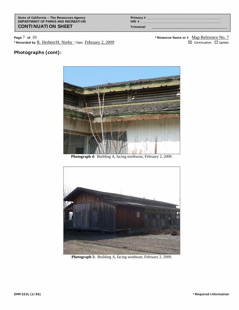
Photographs (cont):
Photograph 2: Building A, facing northwest, February 2, 2009.
Photograph 3: Building A, facing southwest, February 2, 2009.
Page 7 of 10 *Resource Name or # Map Reference No. 7 *Recorded by R. Herbert/H. Norby *Date February 2, 2009 Continuation Update
DPR 523L (1/95) *Required Information
State of California – The Resources Agency Primary # _____________________________________ DEPARTMENT OF PARKS AND RECREATION HRI # ________________________________________ CONTINUATION SHEET Trinomial ____________________________________________
Photographs (cont):
Photograph 4: Building A, facing northwest, February 2, 2009.
Photograph 5: Building A, facing southeast, February 2, 2009.

Page 8 of 10 *Resource Name or # Map Reference No. 7 *Recorded by R. Herbert/H. Norby *Date February 2, 2009 Continuation Update
DPR 523L (1/95) *Required Information
State of California – The Resources Agency Primary # _____________________________________ DEPARTMENT OF PARKS AND RECREATION HRI # ________________________________________ CONTINUATION SHEET Trinomial ____________________________________________
Photographs (cont):
Photograph 6: Building B, facing northeast, February 2, 2009.
Photograph 7: Building B, facing northeast, February 2, 2009.
Page 9 of 10 *Resource Name or # Map Reference No. 7 *Recorded by R. Herbert/H. Norby *Date February 2, 2009 Continuation Update
DPR 523L (1/95) *Required Information
State of California – The Resources Agency Primary # _____________________________________ DEPARTMENT OF PARKS AND RECREATION HRI # ________________________________________ CONTINUATION SHEET Trinomial ____________________________________________
Photographs (cont):
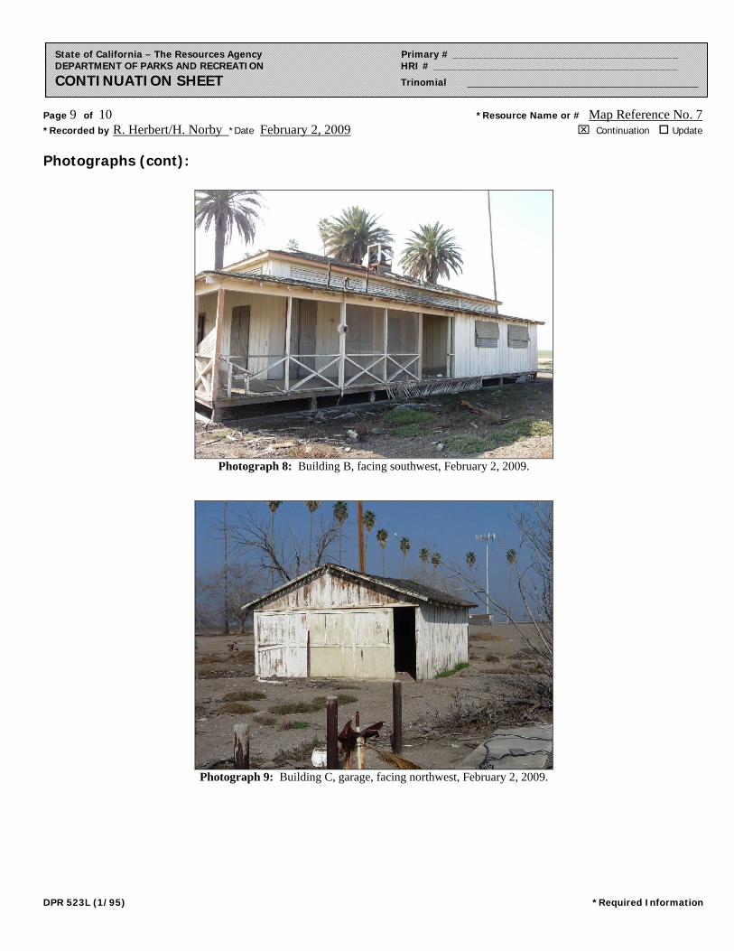
Photograph 8: Building B, facing southwest, February 2, 2009.
Photograph 9: Building C, garage, facing northwest, February 2, 2009.

Page 10 of 10 *Resource Name or # Map Reference No. 7 *Recorded by R. Herbert/H. Norby *Date February 2, 2009 Continuation Update
DPR 523L (1/95) *Required Information
State of California – The Resources Agency Primary # _____________________________________ DEPARTMENT OF PARKS AND RECREATION HRI # ________________________________________ CONTINUATION SHEET Trinomial ____________________________________________
Sketch Map:

Page 1 of 6 *Resource Name or # Map Reference No. 9
*P11. Report Citation: (Cite survey report and other sources, or enter “none.”) JRP Historical Consulting, LLC,“ Historic Architecture Technical Report: Inventory and Evaluation Report, Hydrogen Energy California (HECA) Project,” 2012. *Attachments: None Location Map Sketch Map Continuation Sheet Building, Structure, and Object Record Archaeological Record District Record Linear Feature Record Milling Station Record Rock Art Record Artifact Record Photograph Record
Other (list) __________________ DPR 523A (1/95) *Required Information
State of California – The Resources Agency Primary # _____________________________________ DEPARTMENT OF PARKS AND RECREATION HRI # ________________________________________ PRIMARY RECORD Trinomial _____________________________________ NRHP Status Code 6Z Other Listings _______________________________________________________________ Review Code __________ Reviewer ____________________________ Date ___________
P1. Other Identifier: 7345 Adohr Rd. *P2. Location: Not for Publication Unrestricted *a. County Kern and (P2b and P2c or P2d. Attach a Location Map as necessary.)
*b. USGS 7.5’ Quad East Elk Hills, CA Date 1954 photorevised 1973 T_30S_; R _24E_; NW ¼ of Sec _10_; _MD_ B.M. c. Address 7345 Adohr Rd. City Buttonwillow Zip 93206
d. UTM: (give more than one for large and/or linear resources) Zone _____; ______________mE/ _____________mN e. Other Locational Data: (e.g., parcel #, directions to resource, elevation, etc., as appropriate)
Assessor Parcel Number: 159-040-17-00 *P3a. Description: (Describe resource and its major elements. Include design, materials, condition, alterations, size, setting, and boundaries)
The house at 7345 Adohr Rd. is a heavily modified version of the headquarters building constructed in the 1930s for Adohr Farms. Two perpendicular sections of the house form an L-shaped footprint. The stucco walls enclose what was originally an open-air porch. Fenestration consists primarily of aluminum replacement windows. The roof is side gabled on each perpendicular section with a side gabled monitor roof above. Narrow, horizontal rectangular windows are placed between the two rooflines. Each end of the house has a wide brick chimney built in almost flush with the exterior wall. Decorative tile work ornaments the top of each chimney. Entrance doors are located on the east side and the north side of the east-west portion of the home. The east side of the house includes a medium pitched gabled roof porte cochere. A curved concrete driveway extends from the porte cochere, north to the fence line. The house is very modern in appearance. A small modern rectangular shed with a front gabled, composition shingle roof is on the property, west of the home.
*P3b. Resource Attributes: (List attributes and codes) (HP2) Single family property *P4. Resources Present: Building Structure Object Site District Element of District Other (Isolates, etc.)
P5b. Description of Photo: (View, date, accession #) Photograph 1: Residence, facing southwest, February 2, 2009.
*P6. Date Constructed/Age and Sources: Historic Prehistoric Both 1930, Los Angeles Times, November 9, 1930.
*P7. Owner and Address: Claire Marie Ackerman 7345 Adohr Rd. Buttonwillow, CA 93206-9795
*P8. Recorded by: (Name, affiliation, address) Rand Herbert & Heather Norby JRP Historical Consulting, LLC 1490 Drew Ave, Suite 110, Davis, CA 95618
*P9. Date Recorded: February 2, 2009
*P10. Survey Type: Intensive
P5a. Photo of Drawing (Photo required for buildings, structures, and objects.)

Page 2 of 6 *NRHP Status Code 6Z *Resource Name or # Map Reference No. 9
DPR 523B (1/95) *Required Information
State of California – The Resources Agency Primary # _____________________________________ DEPARTMENT OF PARKS AND RECREATION HRI # ________________________________________ BUILDING, STRUCTURE, AND OBJECT RECORD
B1. Historic Name: Adohr Farms Buttonwillow Headquarters B2. Common Name: 7345 Adohr Rd.
B3. Original Use: Residence B4. Present Use: Residence
*B5. Architectural Style: Vernacular *B6. Construction History: (Construction date, alteration, and date of alterations) 1930 *B7. Moved? No Yes Unknown Date: Original Location: *B8. Related Features: B9. Architect: Unknown b. Builder: Unknown *B10. Significance: Theme n/a Area n/a Period of Significance n/a Property Type n/a Applicable Criteria n/a (Discuss importance in terms of historical or architectural context as defined by theme, period, and geographic scope. Also address integrity.)
This property does not appear to meet the criteria for listing in the National Register of Historic Places (NRHP) or the California Register of Historical Resources (CRHR) because it does not have historical significance and it lacks historic integrity to its estimated original date of construction and possible period of significance. This property has been evaluated in accordance with Section 15064.5(a)(2)-(3) of the CEQA Guidelines, using the criteria outlined in Section 5024.1 of the California Public Resources Code, and does not appear to be a historical resource for the purposes of CEQA.
The Adohr Farms buildings are located just north of the former site of Miller & Lux’s Morton Place ranch. Large scale land owners and cattle ranchers, Henry Miller and Charles Lux secured their “Southern Division” ranch in the Buena Vista Slough under the Green Act of 1855, an act which subsidized reclamation of swampland. Miller & Lux divided their acquisition into various ranches, the Buttonwillow Ranch being the largest of the southern division and also serving as their headquarters. North of McKittrick (Route 58), they leased land to tenant farmers; south of McKittrick Buttonwillow Ranch was divided into individual ranches made up of one to four sections and staffed by Miller and Lux employees. Each ranch operated independently, having its own set of buildings and a water supply system. Four ranches in addition to the headquarters operated in the study area by 1918: Deep Wells, Poplar Grove, Willow Grove, and Morton Place. These ranches grew almost all of the alfalfa farmed by the company at Buttonwillow. Alfalfa and other feed grains remains a major crop south of Buttonwillow. Adohr Stock Farms, one of the largest and most successful enterprises in the study area following Miller and Lux’s ranches, is an example of the continuing important role of alfalfa during Buttonwillow’s cotton era, which began after Miller & Lux Inc. sold off Buttonwillow Ranch in the 1920s. (See Continuation Sheet) B11. Additional Resource Attributes: *B12. References: Barnes, 17-18; Means, 10-11; A. E. Stegeman, Map of 1918, Kern County, California.Los Angeles Times; Van Nuys News; Earl M. Price & Co., Map Book Showing Ownership of Farm Lands in Kern County, California, April 1954; Hoven & Co. Inc., Land Ownership of Kern County, edition of 1972-73; Kern County Assessor Records. Frederick H. Rindge, Happy Days in Southern California (Los Angeles: Rindge Family), 1972. (Also see footnotes.) B13. Remarks: *B14. Evaluator: Heather Norby
*Date of Evaluation: March 2009 (This space reserved for official comments.)

Page 3 of 6 *Resource Name or # Map Reference No. 9 *Recorded by R. Herbert & H. Norby *Date February 2, 2009 Continuation Update
DPR 523L (1/95) *Required Information
State of California – The Resources Agency Primary # _____________________________________ DEPARTMENT OF PARKS AND RECREATION HRI # ________________________________________ CONTINUATION SHEET Trinomial ____________________________________________
B10. Significance (continued): Adohr Stock Farms was a southern California dairy company owned by Rhoda Rindge Adamson and her husband Merritt Adamson. Rhoda Rindge was the daughter of Frederick H. Rindge, a very wealthy, influential East-Coast transplant to California.1 Rhoda attended one year of college at Wellesley before returning to finish her education in California. After marrying Merritt Adamson, an attorney and sheep rancher’s son, she used her family inheritance to start Adohr (her given name spelled backward) Farms with her husband.2 Mr. Adamson left the law behind to focus on ranching and dairying. Their first farm in the San Fernando Valley opened in 1916 and by the late 1920s they began to vertically integrate their business, seeking to not only maintain a herd of productive dairy cows, but to rear “replacement” calves, and grow alfalfa for their herds.3
In 1929, the Adamsons had an area northwest of Tupman, owned by Miller & Lux, analyzed to determine if the soil and conditions would support an alfalfa farm and a herd of cattle.4 They learned that the land had rich soil, lay on top of an artesian belt, and had already been successfully planted with corn and wheat. Satisfied that it met their requirements, they purchased 1,500 acres from Miller & Lux in July of 1930 for $250,000, and set aside $50,000 for immediate improvements. By the fall of the same year, the company had planted a field, sunk ten new wells, and built a headquarters building, dormitory, and dining hall on the southeast corner of what became Adohr Road and Dairy Road.5 The main residence at 7345 Adohr Road is the former headquarters building. The dining hall and dormitory remain today on an adjacent parcel.
By May of 1933, Adohr expanded its Buttonwillow satellite ranch to 2,600 acres. This location was subsidiary to the main San Fernando Valley branch. Adohr ran an advertisement in the Los Angeles Times in 1933 with the headings, “Adohr grows its own feed; Adohr raises its own dairy cattle; Adohr operates its own stock farms; and Adohr, of course, has its own far-reaching delivery system.”6 The rich land in Kern County, already within close proximity to numerous irrigation structures, played a pivotal role in allowing this southern California company to vertically integrate their business model and provide an affordable product to a broader clientele. The company used the ranch until the 1940s.7
Adohr Farms experienced two separate phases of decline in which they sold land holdings in order to remain solvent. The first occurred during the Great Depression, and the second following Merritt Adamson’s death in 1949, until 1966 when Rhoda Adamson sold the company. Available records indicate that the Buttonwillow satellite was sold sometime between 1941 and 1953. By the late 1950s Fred Banducci and his brother Joe were operating Palm Farms at the former site of Adohr Farms. Today it is owned and resided in by Claire Marie Ackerman.8
To be eligible for listing on the National Register of Historic Places and the California Register of Historical Resources, a property must not only be shown to be significant under at least one of the NRHP and CRHR criteria, but it must also retain enough of its historic character or appearance (integrity) to be recognizable as a historical resource. Integrity is evaluated with regard to the retention of location, design, setting, materials, workmanship, feeling, and association. This residence has been heavily modified since its construction. As originally constructed, this building was L-shaped with open verandas on the interior and exterior sides of both ells, clad in wood siding, and had a monitor with ventilation slats. The verandas have been enclosed; the entire building has been resided with modern stucco; a modern porte cochere was constructed on the building’s east side; modern anodized aluminum windows have replaced original wood sashes; all original doors and roofing has been replaced with modern materials; and the monitor with ventilation slats has been infilled with stucco and anodized
1 Frederick H. Rindge, Happy Days in Southern California (Los Angeles: Rindge Family), 1972, prologue. 2 Los Angeles Times, 31 Aug. 1930, L14; Van Nuys News, 10 Jan. 1949. 3 Los Angeles Times, 1 Mar. 1998; Beatrice Ulery, “A Bovine Nursery,” Los Angeles Times, Nov. 9, 1930, J7. 4 Los Angeles Times, Sep. 30, 1934, 21. 5 Los Angeles Times, Jul. 26, 1930, Nov. 9, 1930. 6 Los Angeles Times, Jun. 1, 1933. 7 Los Angeles Times, Apr. 7, 1940; Nov. 1, 1951. 8 Los Angeles Times, 1 Mar. 1998; Van Nuys News, 10 Jan. 1949; Earl M. Price & Co., Map Book Showing Ownership of Farm Lands in Kern County, California, April 1954; Hoven & Co. Inc., Land Ownership of Kern County, edition of 1972-73; Kern County Assessor Records.

Page 4 of 6 *Resource Name or # Map Reference No. 9 *Recorded by R. Herbert & H. Norby *Date February 2, 2009 Continuation Update
DPR 523L (1/95) *Required Information
State of California – The Resources Agency Primary # _____________________________________ DEPARTMENT OF PARKS AND RECREATION HRI # ________________________________________ CONTINUATION SHEET Trinomial ____________________________________________
windows. These alterations were likely completed after 1970 and have substantially altered the appearance of this early 20th century building. As a result the residence lacks integrity of design, materials, workmanship, feeling and association.
Under Criterion A/Criterion 1, neither the residence nor garage are significant for their association with agricultural development or settlement of the Buttonwillow area. Constructed in 1930, the buildings post-date any association with Miller & Lux’s ranches. While Adohr Farms is associated with the historical themes of agricultural development in the region, it alone did not make a significant contribution. Rather, it is one of numerous farming operations in the post-Miller & Lux period. Under Criterion B/Criterion 2, the buildings do not appear to be significant for their associations with any historically significant people. Although Rhoda Rindge Adamson and Merritt Adamson gained recognition within the dairying industry due to the success of Adohr Farms, the Buttonwillow satellite was subsidiary to their main operation in the San Fernando Valley. These buildings do not convey the significance of their commercial success.
Under Criterion C/Criterion 3, these buildings do not possess any distinctive characteristics or high artistic value, nor do they appear to be the work of a master. The outbuilding is of common utilitarian style and material. As originally constructed, the residence was reminiscent of oilfield houses, a building type used in the remote oilfields of Kern County (and other oil regions in California); however its documented construction by Adohr Farms and its construction date preclude it from being of this building class. Oilfield houses were commonly constructed by corporate oil companies for workers and their families in the region’s remote oilfields during the late 1910s and 1920s. This building type generally took two forms: either a narrow one-room-wide (rooms connected from front to rear) rectangular building that are sometimes referred to as a shotgun house, and those rectangular buildings with gable-on-hip roofs (and sometimes pyramidal) with wide open verandas that wrap to multiple sides of the building. Other oilfield buildings, such as bunkhouses, mess halls and cook houses, were also generally rectangular in shape with hip or (less-used) gable roofs and wide open verandas that wrapped the building’s sides. These types of buildings were built to be temporary and survived within the oilfields or their associated company camps until the 1930s, and depending on the oilfield, even into the 1950s. When the oilfield camps were dismantled, a large proportion of these buildings were moved to private lots throughout Kern County and used for residences.9 The residence is similar to oilfield buildings only in that it originally had open verandas on more than one of its sides but the verandas have since been enclosed.
Finally, in rare instances, buildings themselves can serve as sources of important information about historic construction materials or technologies (Criterion D/Criterion 4); however, these buildings do not appear to be a principal source of important information in this regard.
9 JRP, Historic Architecture Survey Report, Tier 1, For Route Adoption on Route 58 Between I-5 and State Route 99 in Kern County, June 9, 1995, pp 27-28; Grace Dobler, “Oil Field Camp Wives and Mothers,” Kansas History, Spring 1987., p29; John Hustead, “How My Family Came West,” wwwstatic.kern.org/gems/bmoa/Zander.pdf, accessed online November 26, 2012; “Dairy Maintains Model Farm at Buttonwillow,” Bakersfield Californian, September 23, 1939 p6; La Belle New Cook House, Oil Industry in California, BANC PIC 19xx.129:315--ALB, The Bancroft Library, University of California, Berkeley; La Belle Property Mess House, April 6, 1912, Oil Industry in California, BANC PIC 19xx.129:267--ALB, The Bancroft Library, University of California, Berkeley; Medallion Camp, Section 20, Kettelamn [sic, Kettleman] Hills. September 1, 191, Oil Industry in California, BANC PIC 19xx.129:60--ALB, The Bancroft Library, University of California, Berkeley; California Counties Oil Company Office building completed. Unfurnished. End view. April 25, 1911, Oil Industry in California, BANC PIC 19xx.129:23--ALB, The Bancroft Library, University of California, Berkeley; Shell Oil Company bunk house #4 and office, 1918, R.C. Baker Memorial Museum, Inc., San Joaquin Valley & Sierra Foothills Photo Heritage, image # cob00189; Shell Camp, ca. 1913, Baker Memorial Museum, Inc., San Joaquin Valley & Sierra Foothills Photo Heritage, image # cob00205; Associated Oil Company Office, ca. 1920, Baker Memorial Museum, Inc., San Joaquin Valley & Sierra Foothills Photo Heritage, image # cob0024.

Page 5 of 6 *Resource Name or # Map Reference No. 9 *Recorded by R. Herbert & H. Norby *Date February 2, 2009 Continuation Update
DPR 523L (1/95) *Required Information
State of California – The Resources Agency Primary # _____________________________________ DEPARTMENT OF PARKS AND RECREATION HRI # ________________________________________ CONTINUATION SHEET Trinomial ____________________________________________
Photographs (cont):
Photograph 2: facing southeast, February 2, 2009.
Photograph 3: 7345 Adohr Rd, facing southeast; from Los Angeles Times, November 9, 1930.
Photograph 4: Facing southwest, February 2, 2009.
Page 6 of 6 *Resource Name or # Map Reference No. 9 *Recorded by R. Herbert & H. Norby *Date February 2, 2009 Continuation Update
DPR 523L (1/95) *Required Information
State of California – The Resources Agency Primary # _____________________________________ DEPARTMENT OF PARKS AND RECREATION HRI # ________________________________________ CONTINUATION SHEET Trinomial ____________________________________________
Photographs (cont):
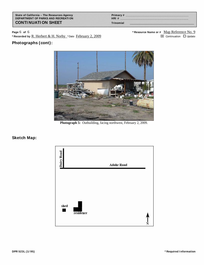
Photograph 5: Outbuilding, facing northwest, February 2, 2009.
Sketch Map:

ATTACHMENT A188-2 HISTORIC ARCHITECTURAL SURVEY REPORT
HISTORIC ARCHITECTURAL SURVEY REPORT
TIER 1, FOR ROUTE ADOPTION ON ROUTE 58,BETWEEN 1-5 AND STATE ROUTE 99
IN KERN COUNTY
EA: 06-315400Postmile: 06-Ker-58-R35.4/R52.3
Contract 06G 171
Prepal'ed i'OI':
California Department of TransportationDistrict 61352 West Olive AvenueP.O. Box 12616Fresno, C/\ 93778-2616
Prepared by:
S"ph," 0 Mlk,';1~<CQRand F. Herbert_~~~-=-=-~JRP Historical Consulting Services712 Fifth Street. Suite FDavis, C/\ 95616(916) 757-2521 Fax: (916) 757-2566
June 9, 1995

INTRODUCTION, SUMMARY OF FINDINGS
This Historic Architectural Survey Report (HASR) was prepared by JRP Historical ConsultingServices under sub-contract to Parsons De Leuw. which in turn is under contract with theCalifornia Department of Transportation (Caltrans) to provide environmental services for theHiglnvay 58 Route Adoption Studies. Caltrans and the Federal Highway Administration (FHWA)propose to improve State Highway 58 in Kern County west of Bakersfield. between postmilesR35.4 and R52.3. connecting Interstate 5 near Buttonwillow with U.S. 99 at Bakersfield. Theproject is a Tier 1 Route Adoption Study. designed to explore various alignments hom technicaLeconomic. and environmental considerations. Five alternatives are under consideration. all ofwhich are treated in this l-1ASR. The jive alignments are. from south to north: Kern River:Brimhall: Rosedale Highway: Hageman: and Seventh Standard. The Project Vicinity is shownin Figure 1. the Project Location in Figure 2. and the Area of Potential Effects (APE) in Figure3. The APE maps in Figure 3 show the alignments in three groups: South. which includes theKern River and Brimhall alignments: CentraL which includes Rosedale Highway and Hagemanalignments. along with portions of the Brimhall alignment; and North. which includes only theSeventh Standard alignment. These maps are contained in a separate plan set accompanying thisvolume. It will be observed that the alignments in the South and Central groupings areoccasionally coterminous.
This HASR seeks to fulfill responsibilities of the FHWA and Caltrans under Section 106 of theNational Historic Preservation Act and implementing regulations of the Advisory Council onHistoric Preservation (36 CFR 800) with respect to this project. Specifically. it inventories andevaluates historic buildings and structures located within the APE for this project. to determinewhether any meet the eligibility criteria for listing in the National Register of Historic Places.
The APE includes 1939 buildings or groups of buildings. all of which were inspected on-site byJRP Historical Consulting Services. Of these. 1821 were either constructed after 1945 orconstructed before 1946 but modilied heavily. These 1821 recent or modified were inspected inthe field by JRP and their locations recorded. The list of post-1945 buildings appears asAttachment I. These buildings meet the applicable criteria in the 1989 "Memorandtlm ofUnderstanding Regarding Evaluation of Post-1945 Buildings. Moved Pre-1945 Buildings. andAltered Pre-1945 Buildi[1gs." (MOU) signed by Caltrans. FHWA and the California State HistoricPreservation Officer (SHPO). The total list of MOU buildings has been submitted to Caltransfor their certification as meeting the criteria contained within the aforementioned MOU. A"MOU Short Form." signed by Caltrans personnel will be included as available in the FinalHASR for this project.'
I It "ill be observed that the total number 01' buildings far exceeds 1939. Wherever possible.buildings \vere recorded in logical groupings. \Vithin the Survey Population, several buildings on thesame parcel \vere evaluated as a single lIllit. The method for grouping Survey Population buildings isapparent in the attached Architecturallnventory/Evaluation forms. Modern subdivisions that are currentlyunder construction. of which there are many in this APE, were recorded as units. The method forrecording post-1945 buildings is explained at the introduction to Attachment I.

Field and archi val work revealed that 118 buildings or groups of related buildings within the APEwere built before 1946 and retained some measure of historical integrity. The 118 buildings orgroups of buildings were inventoried through completion of the attached ArchitecturalInventory/Evaluation (AI/E) forms. The 118 buildings. hereafter called the "Survey Population."are listed in Attachment 3: the AIlE forms are included as Attachment 4. These SurveyPopulation buildings are identified by "Map Reference No.," keyed to the APE maps. shown asFigure 3. Map Reference Nos. correspond to numbers on the APE Maps. Numbers wereassigned consecutively from north to south and west to east. i.e .. the lirst number is at thewestern end 0 I' the northern map and the final number is at the eastern end of the southern map.
In addition to the 118 buildings. 10 irrigation canals exist within the APE. These -- the James.Gates (Carricr). Pioneer. Beardsley. Stine. Calloway, Emery. Goose Lake/Rio Bravo. Friant-Kern.and Cross Valley canals -- are inventoried and evaluated in a Historic Resource EvaluationReport. attachcd as Attachment 5. The canals are shown on the APE map. identified byabbrcviations (e.g. FK. for Friant Kern Canal) to distinguish them li'om building numbers.
The APE also includes four railroad lines or spurs. which are inventoried and evaluated inAttachment 6. The railroads are also shown on the APE map. again identified by abbreviation.
In addition. the APE includes 18 resources. chiefly wells and storage tanks. associated with thepetroleum industry. Petroleum industry-related properties are inventoried and evaluated in/\ttachmcnt 7. Attachment 7 \vas prepared by Laurence H. Shoup and Jess Gutierrez ofArchacologicallilistorical Consultants. under a sub-contract to JRP Historical Consulting Services.Petroleum-related features are shown on the APE map. preceded by the letter "0."
Thc APE also cncompasses 53 bridges. including 18 local agency bridges and 35 state bridges.Thesc arc listed in Attachment 8. The 53 bridges were previously evaluated by Caltrans as partof thc Calil'orni~1 llistoric Bridgc Inventory and were found to be "Category 5." i.e., not eligibleIt)r i\ational Register listing.
As a result of this in\·estigation. three properties \vithin the APE appear to meet the eligibilitycriteria for listing in the National Register of Historic Places. Of these three properties. two arebuildings or sites. and one is a canal. All remaining properties within the APE -- the other 116buildings or groups of buildings inventoried with AIlE forms. the 1821 buildings in AttachmentI. nine of the 10 canals. the four railroads. the 18 petroleum-related properties. and the 53 bridges-- do not appcar to meet National Register eligibility criteria. The eligible properties are listedbelow:
Ii
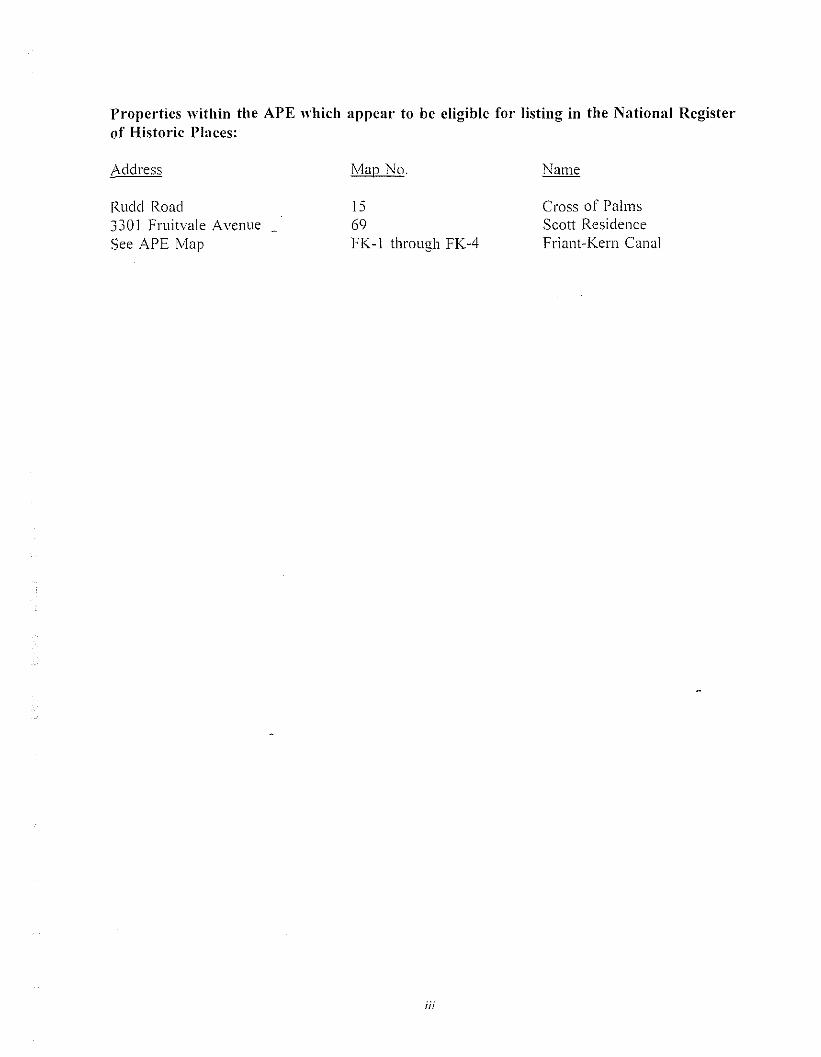
Propel"ties within the APE which appear to be eligible for listing in the National Registerof Historic Places:
Address
Rudd Road3301 Fruitvale AvenueSee APE Map
rVlap No.
1569FK-I through FK-4
iii
Cross of PalmsScott ResidenceFriant-Kern Canal

TABLE OF CONTENTS
INTRODUCTION, SUMMARY OF FINDINGS, .
Properties within the APE which appear to be eligible for listing in the NationalRegister of Historic Places . . . . . . . . . . . . . . . . . . . . . . .. III
1. PROJECT DESCRIPTION .
AIternati ves . . . . . . . . . . .
3.
4.
5.
RESEARCH METHODS ...
HISTORICAL OVERVIEW .....
Introduction .Exploration During the Spanish and Mexican Period .Early Settlement. . . . . . . . . . . . . . . . . . . . . . . . . . . . . . . . . . . . .. . .The Role of Large Land Companies in Settlement and Colonization .
Kern County Land Company Agricultural Colonies .Development of Irrigated Agriculture .Transportation . .Oil Production . . .. .lVlaior State and Federal Water Management Projects and Related Facilities .Architecture. . . . . . . .. . .
FIELD METHODS .
Buildings Originally in Survey Population but Moved to MOU List ....
FINDINGS AND CONCLUSIONS
3
9
99
10I I131620
31
Properties within the APE which are listed in the National Register of HistoricPlaces. . . . . . . . . . . . . . . . . . . . . . . . . . . . . . . . . . . . . 34
Properties within the APE which have been previously determined eligible forlisting in the National Register of Historic Places 34
Historic buildings and structures within the APE which appear to be eligible forlisting in the National Register of Historic Places 34
Pre-I946 properties which do not appear to be eligible for listing in the NationalRegister of Historic Places .. 34
Post-1945 or modified pre-1946 (MOU) properties which do not appear to beeligible for listing in the National Register of Historic Places 38
Properties previously determined ineligible for listing in the National Register ofHistoric Places .. 38
ir

6. REFERENCES 41
FIGURES
J. Project Vicinity
Project Location -
Area of Potential Effects
ATTACHMENTS
Attachment I.
Attachment 2.
Attachment 3.
Attachment 4.
Attachment 5.
Attachment 6.
Attachment 7.
Attachment 8.
"Memorandum of Understanding: List of Buildings Constructed After 1945
or Modified Pre-1946 Buildings."
Communication with Public and Interested Parties.
List of Survey Population Buildings Within the APE.
Architectural Inventory/Evaluation Forms.
"Historic Resource Evaluation Report, Kern River Irrigation Canals
Crossed by Highway 58 Alternative Alignments."
"Historic Resource Evaluation Report Railroads Crossed by Highway 58
Alternative Alignments."
"Historic Resources Evaluation Report Historic Oil Fields." [prepared by
Laurence H. Shoup. Archaeological/Historical Consultants.]
II Highway Bridges."
,.

1. PROJECT DESCRIPTION
This report is prepared in support of the Tier I EIS for Route Adoption on Route 58. between1-5 and SR 99 in Kern County and the City of Bakersfield (06-Ker-58-R35.4/R52.3). Thisproject will identify and analyze transportation corridors and provide for rOLlte adoption and rightof-way acquisition for the relocation of Route 58 between 1-5 and State Route 99 (see Figure I).The ultimate project is _envisioned as a freeway or expressway facility. A corridor band ofsufficient width to accommodate this ultimate facility is being cleared.
The purpose of and need for the project is:
To identify. adopt and preserve a transportation corridor for Route 58
The improved transportation corridor is necessary to:
Reduce congestionImprove interregional goods movementImprove State Highway System continuityReduce mobile sourced emissions
• Support economic developmentImprove east-west traffic movement
The project will attempt to:
Improve traveler safetySupport multi-modal travelAddress social. economic and environmental concerns
Alternatives
Five alternative alignments for Route 58 Route Adoption are currently being evaluated· in theenvironmental technical studies: Seventh Standard. Hageman. Rosedale Highway. Brimhall. andKern River. Three otjler alternatives are also being considered including the "No Project"Alternative which would effect no transportation facility improvements; the TransportationSystems Management (TSM) Alternative which would make incremental. low cost improvementsto the existing transportation network in the project area; and the Mass Transit Alternative whichconsists of improved commuter/light rail transit andlor bus systems either within or separate ti'omthe Route 58 highway alignments. Multi-Modal Transit Options are also being studied todetermine the effect a future transit facility might have on the Route 58 alternative alignments.
The live alternative alignments are described below and shown in Figure 2.

Seventh Standard Alternative
This alternative connects with 1-5 approximately three miles south of the existing 1-5/SeventhStandard Road Interchange. near the existing Buttonwillow Rest Area on 1-5. The alignmentextends directly eastward approximately three miles before turning northeastward. avoiding theproposed Buttonwillow Habitat Area then offsets to the north and parallels existing SeventhStandard Road at approximately one-fourth mile to the south until it interchanges with StateRoute 99. Interchanges are proposed at 1-5. Enos Lane. Nord Road. Allen Road. Calloway Driveand SR 99. The Seventh Standard alignment is approximately 20 miles long.
Hageman Alternative
This alternative begins at 1-5 about one and one-half miles south of the existing 1-5/State Route58 Interchange and continues eastwardly for about four miles. turning northeastward just beforecrossing Martin Road. The alignment follows Meacham Road between Rosedale and HagemanRoads. turning northeastward again just before crossing Renli'o Road. then follows about 500 feetto the north or Hageman Road to Calloway Drive. After crossing Calloway. the Hagemanalignment turns southeastward following the Friant Kern Canal for about one-half mile. crossingthe canal and extending about one mile. before turning northeastward again after crossingFruitnde Avenue to its interchange with State Route 99 at the existing State Routes 99/204Intcrchange. Interchanges are proposed at 1-5. Enos Lane. Nord Road. Allen Road. CallowayDrive. Corfce Road. future Mohawk Avenue and State routes 99/204. The Hageman alignmentis approximately 19 miles in length.
Rosedale Iligh""av Alternative
The Rosedale Ilighway Alternative shares the Hageman alternative alignment hom 1-5 toapproximately one mile east of Enos Lane where the Rosedale Highway alignment offsets to thesouth and parallels approximately one-fourth mile to the north of the existing Route 58 (RosedaleHiglll\a\) alignment. West of Jewetta Avenue the alignment offsets south along the north rightol~"ay line or Dee Dee Street and continues eastward crossing extended Mohawk Avenue. Analignment option in this area shifts northward at about Calloway Drive. returning to the b,tselinealignment at Conee Road. This alignment then turns southeastward to the existing RosedaleHighway/State Route 99. Interchange. Interchanges are proposed at 1-5. Enos Lane. Nord Road.Allen Road. Calloway Drive. Coffee Road. extended Mohawk Avenue and State Route 99. TheRosedale Highway alignment is approximately 18 miles in length.
Brimhall Alternative
This alternative is sited one-half mile north of existing and extended Brimhall Road from 1-5eastward to I-leath Road where the alignment turns southeastward and continues due east fromRenti'o Road to Allen Road. Continuing in this alignment. the Brimhall Alternative shifts slightlyto the south until just west of Coffee Road where it follows along the north of the Kern RiverParkway to a future extension of Mohawk Avenue. The alignment then turns southeastward.crossing the Kern River. and runs southeastward to connect with State Route 58 East at theexisting State Routes 58/99 Interchange. Two alignment options are under consideration in this

•.::::::: ....... ::: ::: ..
::\ffffffffffjf!!
06-Ker-58-R35.4/R52.3Contract No. Q6G 171
Figure 1: Project Vicinity
area. The first continues the Brimhall alignment eastward from an interchange with MohawkAvenue. crossing the Kern River to interchange with State Route 99 at Truxtun Avenue. Thesecond option places the Kern River crossing just west of Mohawk Avenue then turnssoutheastward to connect to the State Routes 58/99 Interchange. Under this alignment option.an interchange is located at California Avenue. Theses three alignments east of Coffee Road arccurrently being considered for both the Brimhall and Kern River Alternatives. Interchanges onthe mainline alignment _are proposed at 1-5. Enos Lane, Nord Road, Allen Road, CallowayAvenue. Coffee Road, Mohawk Avenue and at the existing State Routes 58/99 Interchange. TheBrimhall alignment is approximately 19 miles long.
Kern River Alternative
The Kern River alignment interchanges with 1-5 approximately one-fourth mile north of existingStockdale Highway and continues eastward on this alignment for approximately three milesbefore turning southeastward to run adjacent to the Cross Valley Canal. It then turnsnortheastward to Renti'o Road and continues eastward parallel with and approximately one-halfmile north of Stockdale Highway. East of Calloway Drive, the alignment follows along the nOl'\hside of the Kern River Parkway. The alignment crosses the Kern River east of extended MohawkAvenue to interchange with State Route 99 at Truxtun Avenue. Two alignment options are underconsideration for the Kern River Alternative in the area along the Kern River Parkway. The firstoption turns southeastward after an interchange with Mohawk Avenue, crosses the Kern River,and runs southeastward to connect with State Route 58 East at the existing State Routes 58/99Interchange. The second option places the Kern River crossing just west of Mohawk Avenuethen turns southeastward to connect to the State Routes 58/99 Interchange. Under this alignmentoption. an intcrchange is located at California Avenue. These three alignments east of CoffeeRoad arc currently being considered for both the Brimhall and Kern River Alternatives.Interchanges on the Kern River mainline alignment are at 1-5, Enos Lane, Nord Avenue. AllenRoad. Callo\\ay Drive. CoHee Road and Mohawk Avenue. Interchanges with State Route 99would be located at Truxtun Avenue or the existing State Routes 58/99 Interchange. dependingon the alignment option.
2. RESEARCH M.ETHODS
This HASR was prepared following established Cal trans procedures, as specified in Caltransmanuals and guidelines, particularly "Guidance for Consultants: Procedures for the Protection ofHistoric Properties: The Section 106 Process.'" JRP followed a four-step process to prepare thisHASR: Establishment of an APE; background research. including a record search to identifypreviously-rccorded properties; in-depth research on specific properties; and on-site field workto record potential historic properties within the APE, including matters pertaining to integrity.
, Caltrans. "Guidance for Consultants: Procedures for the Protection of Historic Properties: The 106Process." (Sacramento: Caltrans. 1991).

JRP Historical Consulting Services personnel involved with this project include:
Rand F. Herbert. Historian/Project Manager. With a B. A. in history /i'om theUniversity of California. Berkeley and an M. A. in history fi'om the University ofCalifornia. Davis. Mr. Herbert has been an active public historian since 1977. Apartner at JRP. he has served as historian and project manager in projects for avariety of federaLstate. and local agencies. including Caltrans. the Forest Service.Corps of Engineers. as well as many private firms.
Stephen D. Mikesell. Architectural Historian. A JRP partner for two years.Mikesell came to the firm with more than 11 years of experience as anarchitectural historian with the California Office of Historic Preservation andCal trans. He holds a B. A. in history ti'om Harvard University and an M. A. Inhistory from the University of California. Davis.
Stephen R. Wee. HistoriUll. With a B. A. in history fi'om the University ofWashington and an M. A. in history from the University of California. Davis. Mr.Wee has been a practicing public historian since 1976. A partner with JRP. Mr.\Vee has served as consulting historian on dozens of projects for federal. state. andlocal governments. including numerous projects for Caltrans.
Rebecca Bunse. Research Assistant. Ms. Bunse has served as research assistantIllr JRP since 1990. With a B. A. /i'0l11 the University of California. Davis. Ms.Bunsc is currcntly enrolled in the Public History Program (an M. A program) atClllil"ornill State University. Sacramento.
David Riggs. Research Assistant. Mr. Riggs holds a B. A. in history li'omiVlonmouth College in Illinois and has worked with JRP since February. 1989.
Michael L. MikeselL Research Assistant. Mr. Mikesell holds a B. A. in historyI"rom Boise State University. Boise. Idaho. and is currently enrolled in the PublicHistory 1vl. A. program at Boise State.
Margaret Watson. Research Assistant. Ms. Watson holds a B. A. in historyfrom Sonoma State University. Rohnert Parlc California and an M. A. I"rom theWinterthur Program at the University of Delaware. Newark. Delaware.
The APE I"or this project was developed by JRP in cooperation with Parsons De Leuw andCal trans and generally includes the proposed right of way for each alternative as well as anyadjacent parcels which include buildings. The west side of the project area near Interstate 5 ispredominantly I"arm land and open space and includes few buildings of any sort. In this area. theAPE was defined as the right of way and] 00' to either side of it. The APE is depicted in Figure3. the Area of Potential Effects.
JRP conducted background research to identify previously-designated properties within this APE.This research was conducted using computerized tiles maintained by the California Office of
4
Historic Preservation (OHP), accessed through modem connection with the North CentralInformation Center at California State University, Sacramento. The OHP historic file includesa variety of listings, including: properties listed in the National Register. properties determinedto be eligible (or determined not to be eligible) for listing in the National Register throughSection 106 review processes: properties listed in local agency historic inventories: CaliforniaHistorical Landmarks: and Points of Historic Interest.
This review revealed that a number of properties within or near the APE have been previouslydesignated or evaluated, chiefly by Caltrans in relation to previous highway work along the U.S,99 corridor in Bakersfield. Among the properties with prior listing which are in or near the APEare the following:
California Historic Landmarks:
Garces Circle (Landmark No. 277). This California Historic Landmark is located at ChesterAvenue and State Route 204, several miles east of the APE for this project.
Points of Historic Interest:
None.
Properties within the APE which arc listed in the National Register of Historic Places:None.
Properties within the APE which have been previously determined eligible for listing in theNational Register of Historic Places:
None.
5

P."operties p."eviously dete."mined ineligible for listing in the National Register of HistoricPlaces:'
Buildings
3227 Belle Terrace3508 Brian Way3510 Brian Way35] 5 Brian Way3212-28 Chester Lane3279 Chester Lane3820 Ethyl Street343] Ethyl Street3831 Pierce Road3214 State Street3321 State Roud8] 2 ,Vi ble Roud
Bridges
L()c.~L BRIDCIES WITHIN APE
Map Reference No. 102Map Reference No. 90rVlap Reference No. 89Map Reference No. 88Map Reference No. 110MOD ListMap Reference No. 87MOD listMap Reference No. 95Map Reference No. 93Map Reference No. 92rVlap Reference No. 103
BridgeNumber
Feature(s)Intersected
FacilityCarried
NRHPStatus
50C-1350C-4250C-6550C-6650C-6750C-17650C-In50C-17850C-25550C-25950C-26250C-294
State Street UPCalloway CanalOak St OI-l (AT&SF RR)Stine CanalCalloway CanalTruxtun Ave UPKern Ri ver CunalArvin-Edison CanalCalloway CanalFriant-Kern CanalBeardsley CanalPioneer Canal
SPTCOStandard StOak StOak StPierce RdTruxtun AveTruxtun AveTruxtun AveCalloway DrCalloway RdCoffee RdStockdale Hwy
Not EligibleNot EligibleNot EligibleNot EligibleNot EligibleNot EligibleNot EligibleNot EligibleNot EligibleNot EligibleNot EligibleNot Eligible
, Derived li'om SHPO printout "Historic Properties Directory for Bakersfield and Other Kern CountyCities." dated May 18. 1993. The bulk of these determinations were made by Caltrans or by the City ofBakerslield in Section 106 compliance documents for a Housing and Urban Development project. Oneadditional property. 3321 State Road. did not appear on the SHPO database but did appear in Caltrans'tile of previous Section 106 documents. The determination for the 53 bridges was derived from a Caltransdatabasc. reproduced in Attachment 8.
6

BridgeNumber
50C-30250C-30350C-30750C-30850C-30950C-310
Feature( s)Intersected
Kern RiverCross Valley CanalStine CanalCarrier CanalCarrier CanalCarrier Canal
FacilityCarried
Coffee RdCoffee RdTruxtun AveMohawk StTruxtun AveCorporation Yard
NRHPStatus
Not EligibleNot EligibleNot EligibleNot EligibleNot EligibleNot Eligible
STATE BRIDGES WITHIN APE
Bridge Location Structure NRI-IPNumber CO-RTE-PM Nan1e Status
50-49 Ker-099-02732 Minkler UP Not Eligible50-50L Ker-099-R02 839 Beardsley Canal Not Eligible50-50R Ker-099-R02839 Beardsley Canal Not Eligible50-64L Ker-I78-000 16 Kern River Not Eligible50-64R Ker-178-000 16 Kern River Not Eligible50-65 Ker-I78-00047 Carrier Canal Not Eligible50-73 Ker-223-02384 Arvin Edison Canal Not Eligible50-202 Ker-204-00646 Pierce Rd UC Not Eligible50-203 Kcr-204-00651 Pierce Rd UC Not Eligible50-208 Ker-204-00549 Stine Canal Not Eligible50-209 Ker-204-00590 Calloway Canal Not Eligible50-236L Ker-099-02535 Kern River Not Eligible50-236R Ker-099-02535 Kern River Not Eligible50-2391 Ker-099-02478 Bakrsf1d Yd OH Not Eligible50-239R Ker-099-02478 Bakrst1d Yd OH Not Eligible50-260L Ker-099-02460 Calif Ave UC Not Eligible50-260R Ker-099-02460 Calif Ave UC Not Eligible50-262L Ker-099-02608 Gilmore Ave UC Not Eligible50-262R Ker-099-02608 Gilmore Ave UC Not Eligible50-263 Ker-099-023I 0 Belle Terrace 0 Not Eligible50-263W Belle Terrace OC P Not Eligible50-264 Ker-099-02362 Brundage L OC Not Eligible50-265L Ker-099-02670 Calloway Canal Not Eligible50-265R Ker-099-02670 Calloway Canal Not Eligible50-265S Ker-099-02670 Calloway Canal Not Eligible50-266 Ker-099-02678 Airport Dr OC Not Eligible50-267L Ker-099-02563 Rosedale Hwy SE Not Eligible50-267R Ker-099-02653 Rosedale Hwy SE Not Eligible50-268L Kcr-099-02499 Truxtun Ave UC Not Eligible50-268R Ker-099-02499 Truxtun Ave UC Not Eligible
7

Bridge Location Structure NRHPNumber CO-RTE-PM Name Status
50-277 Ker-099-R03053 7th Std Rd OC Not Eligible50-305 Ker-005-04755 Stockdale R OC Not Eligible50-403 Ker-058-R05289 Hughes Ln OC Not Eligible50-426F Ker-058-R05233 Rte 58/99 SEP Not Eligible50-426S Ker-058-R05233 Rte 58/99 SEP Not Eligible50-427G Ker-099-02337 Wible Road UC Not Eligible
FollowinQ this record search. JRP conducted basic research on the historv of the area to identifv..... p..
those historical themes and contexts which might define potential significance for buildings andstructures within the area. The results of this historical overview research are reported in Section4 below. the "Historical Overview." Research was conducted in a variety of archival repositoriesin the Sacramento. Fresno. and Bakersfield areas.
The principal repository for historical data pertaining to the Bakersfield area is the BealeMemorial Library in Bakersfield. which includes an excellent local history collection as well asperhaps the finest petroleum-related special collection in California. Other Bakersfield archivesinclude the holdings of the Kern County Historical Museum and the library of California StateUniversity. Bakersfield. Research was also conducted in the archives of the Petroleum ProductionPioneers. an oil industry historical group. JRP also conducted exhaustive research at the officeof the Kern County Assessor. Extensive research was conducted in the Special Collections atCalifornia State University. Fresno. which maintains an excellent collection on the history of theSan Joaquin Valley. In the Sacramento area. JRP researched at the California State Library.California Statc Archives. and California State Railroad Museum Library. Sacramento. and thePhvsical Scicnccs Library and Main Library of the University of California. Davis. In the BayArea. JRP conducted rescarch at various libraries on the University of California. Berkeley.campus. including the Water Resources Center Archives. Bancroft Library. and Doe Library MapRoom.
In addition to archival research. JRP conducted an extensive progr8111 of oral history. interviewingdozens 01" knowledgeable individuals regarding the construction and social history ofthe surveyedbuildings. This oral historical program proved to be the most useful research tool in documentingthe history of these buildings. which are outside the range of most urban-based archives (SanbornFire Insurancc Maps. city directories. and so I"orth) and which were occupied by people rarelymentioned in newspapers. county histories. and other standard documentary sources.
Under sub-contract to JRP. Laurence H. Shoup of Archaeological/Historical Consultantsconducted research for petroleum-related resources.
JRP also consulted with Carola Rupert-Enriquez. director of the Kern County Museum. todevelop a list of interested parties I"rom which to request information and seek guidance. Letterswere sent to:
8

Kern County Historical SocietyPetroleum Production PioneersHistoric Preservation Commission, City of BakersfieldKern County Resources Management AgencyKern County Historic Records CommissionKern County Historical Organizations and MuseumsKern County Mu.seumShafter Historical Society
Copies of JRP"s letter and resulting responses are contained in Attachment 2.
3. HISTORICAL OVERVIEW
Intmduction
This historical overview outlines the general historic themes applicable to the study area. Itsprimary purpose is to establish historic contexts for the evaluation of properties within the generalstudy area (and more specifically, within the APE),
Seven major historical themes apply to the study area: exploration during the Spanish andMexican period: early settlement; the role and importance of large land companies in settlementand "colonization": development of irrigated agriculture; transportation: discovery anddevelopment of oil: and construction of large scale state and federal water projects. Propertiesrelated [(1 the last five themes are represented in the survey population. There are no knownhistoric properties in the APEs dating to the Spanish. Mexican, or pioneer period of Americansettlement. We have also included a brief discussion of the architectural styles and building typesthat exist in the study area. No buildings within the APEs are older than ca. 1890.
Exploration During the Spanish and Mexican Period
Spanish-led explorations penetrated the great Central Valley of California as early as ITn. butthese expeditions did not result in any permanent settlements in the area, Instead the Spanishestablished missions an0 presidios along California's coast. because they were more accessibleand easier to supply and defend. Before 1800 Spanish travellers developed EI Camino Viejo. aroad extending li'om Los Angeles to the San Francisco Bay area. running along the westernmargin of the San Joaquin Valley. Mexico gained control of the region in J 822-23 upon itsindependence Ii'om Spain. Like the Spanish the Mexicans did not establish any permanentsettlements in the study area, conducting only brief and limited excursions into the val1ey. Whilebetween 1842 and J846 Mexican governors granted land for five ranchos in the region south ofthe study area, the rancheros met with little success and no settlements grew around them.'
, William Wilcox Robinson. The S/orv ojKem ('olllJly (Bakersfield. California: Title Insurance andTrust Company. 1961), 1-12: Warren A. Beck ancl Ynez D. Haase. His/orical Atlas of('alijiJl"I1ia (Norman:University 01' Oklahoma Press, 1974).
')

American and British-Canadian trapping in the San Joaquin Valley began in 1827 when JedediahSmith led a band of men into the region via the Tehachapi Pass. followed soon thereafter byHudsons Bay Company trappers and other parties. In 1834 Joseph Walker entered the valleythrough the pass to the east that received his name. Later. in early 1844 and again in late 1845.John C. Fremont led explorations through the south end of the valley. documenting its geology.botany. and fauna. Exploration and study continued into the period of American conquest andstatehood (1846-1850). 111 1850 Lt. George Derby made a reconnaissance near the study area thatnoted the valley's vast lakes and tule swamps.' Nevertheless. well into the 1850s the study arearemained a remote and little known portion of California.
Eal"ly Settlement
Early Euro-American settlement in the vicinit, of the study area was the product of developmentin the adjacent mountains. as gold miners entered the region and as the federal governmentestablished Indian reservations to the south to contain and protect the Yokuts and other southernSan Joaquin tribes.
Settlers had not located in nor developed the study area and its environs at the time the UnitedStates assumed control of California in 1846-1848. News of the discovery of gold in 1848.however. drew many Argonauts to California. Among the areas settled by these and succeedingwaves of immigrants included the San Joaquin Valley. then still largely inhabited by aboriginalgroups. Cali Cornia gained admission into the Union in September 1850. Importantly for itsCuture dcvelopment. all of the land within the study area was in the public domain. land grantsbeing located [0 the south but not within the study area. The land was thus available foracquisition under federal land laws."
In 1853 prospectors discovered gold in the upper Kern River region. and many mll1ll1gcommunities sprang into being. Trading. supply. and freighting centers also grew and prosperedwithin the mining region. as well as in the valley: roads and stage lines helped supply the miningcamps. Unsuccessful and discouraged miners. along with those seeking different opportunitiesto advance. also began to Cilter out of the mountains. down to the valley. to become farmers andstock raisers.
In 1854 the United States Army established Fort Tejon in Grapevine Canyon to protect nativesof the San Joaquin Valley and to quell stock rustling in the area. Beginning in J 855 wagon trains
'Robinson. 1961. 7-12.
(, The Native Americans in the area sought protection and relief from the increasing encroachment ofAmerican gold-seekers and settlers into California. The federal government appointed Edward F. Bealein 1852 as the Superintendent of Indian Aft'lirs for Calilornia and Nevada. In 1853 Beale establishedTejon Indian Reservation (later named Sebastian Indian Reservation) in the southern San Joaquin Valley.This was the first reservation in the state. and soon thereafter had 2500 inhabitants raising crops. Thegovernment vacated the reservation in 1862 to save money. and relocated the inhabitants to the Tule Riverreservation east of POl1erville. Robinson. 1961. 14-15. 17.
10
brought supplies Ii'om Los Angeles to the garrison. opening a freighting route into the vaIley.The army abandoned the fort in 1864. and Edward Beale eventually incorporated the land intohis Tejon Ranch holdings. The first settlement near Bakersfield had been around Gordon's Ferry.established in 1853 near the foot of China Grade east of present-day Oildale. on the militarysupply road leading down the valley to Fort Tejon.'
Christian Bohna was one_of the first to settle on 160 acres of swamp and overf10wed lands in thearea extending along the eastern border of the study area. in what is now the city of Bakersfield.By 1862 Bohna had sold his rights to Colonel Thomas Baker. who. with his family settled on theswampy land -- known as Kern Island for its location between the channels that divided the KernRiver -- in September of 1863. The area became known as Baker's FieldS His efforts atreclaiming the swamp lands encouraged others to settle in the area; and Baker soon had ten acresplanted to a variety of crops. By the 1870s a number of settlers had migrated to the area to farmand raise stock. Settlers acquired land directly from Baker and other land owners. from therailroad. and through homestead. reclamation. and pre-emption laws. The area grew slowly. butby 1870 the town of Bakersfield had a population of 600. and in 1874 replaced Havilah. a miningtown in the Kern River Canyon. as county seat."
The Role of Large Land Companies in Settlement and Colonization
Small land holders like Bohna were soon joined by those who amassed blocks of land baronialin extent. These large land holdings have had an important and lasting impact on farming andsettlement patterns in the study area. Relatively early on -- in the 1860s and especially in the1870s -- \ast tracts of land in western Kern County (and particularly in the San Joaquin Valley)went into the hands of large land owners. These included: Henry Miller and Charles Lux. cattleranchers: Jamcs 8. I-laggin. Lloyd Tevis and Billy Carr. land speculators: the Jewett family.livestock ranchers: Clarke and Cox. livestock ranchers: and the Central Pacific Railroad.
In the 1860s and early 1870s Kern County was one of the great open range sheep ranchingsections of the state. Bakersfield was the focal point of the annual sheep drives from the valleyto the highlands via Walker Pass and Mojave. Among the factors that at first retardedagricultural settlement of the area was the damage caused by livestock in farmers' fields. Thesmall farmer was potentially at the mercy of the shepherd's f10cks and later the cattleman' s herds.This was mitigated by introduction of "no fence" laws in the county in 1874. The law passedover the opposition of major stockmen such as Miller & Lux. I-laggin. Tevis. Carr. and the Jewett
Robinson. 1961. 17-18. 21.
, Thomas A. Baker. "Early Bakersl"eld." Kem Co11m]' His/orical Socie/v. Third Annual Publication.1937. 17-19: Mildred Hoover. and Etllel and Hero Rensch. His/oric SPOIS i/1 California (Stanford.California: Stanford University Press. 1966). 121. 132-133.
<' Kern County was formed in 1866 out of portions of Tulare and Los Angeles counties. Baker. "EarlyBakersl"eld." 1937. 17-19: Hoover et al.. 1966. 121. 132-133: Robinson. 1961. 24-28. 34.
II

family.'O With the responsibility for controlling livestock placed on the rancher rather than thefarmer. the onerous cost of fencing could be avoided and farms spread farther into the valley.Some cattlemen. such as I-laggin and Tevis. looked to the sale of land to farmers -- with irrigationwater supplied -- to replace the income from their previously li'ee ranging herds.
The pattern of large land holdings was well established by 1874. Lands in the Kern River deltawere marshy. fertile. and-subject to annual -- or at least regular -- overflow. Public lands in thiscondition were available through the 1850 Arkansas Act" under liberal terms from the state.Distance Ii'om Sacramento and disagreement over what constituted swamp land allowed landspeculators to make large claims of state-owned land that may not have been swamp in thestrictest sense of the law. In her book on Kern County land and settlement. Margaret Zonlightnoted that "the manner in which Kern Svvamp lands were disposed of to private pcrsons servednot to establish a traditional system of small farms but to give the original impetus to large-scaleland ownership in the Kern River Delta." The land came into a few large land holdings by 1867.before general population growth began."
Under these laws in the late 1860s and early 1870s. the Jewett family. Horatio Livermore andJulius Chester. Henry Miller and Charles Lux. for the most part cattlemen or livestock ranchers.obtained large tracts of valley land riparian to sloughs and streams. In the years that followedothers like Haggin. Tevis and Carr manipulated the Desert Land Act to gain control of vast tractsof more arid land in Kern County. I-Iaggin obtained 33.000 acres in 1874 that "started the greatempire." Alter 1875 Haggin and his allies gained control of tracts through purchase. pre-emption.and other means. They also moved to buy up controlling interest in the majority of the county'sfarmer-initiated irrigation canals. Among the lands and water rights they purchased were O. P.CalkmC!,·s. \\hich CallO\\"uy had obtained in anticipation of the construction and completion ofhis canal. In :\pril 1877 alone. Haggin's allies submitted applications for 100.000 acres at theVisalia I.and OlfICC. \!am' of tllese were the alternatine. sections between railroad e.rant landsthat Haggin had pre,iousl)' purchased.'" ,
1\1 i\'largarct ASClllan lCooper] Zonlight. LUIId. rValet und Selliemenl in Kern COllnly, Calilornia,1850-18YO (Nc\\ York: Arno Press. 1979).6-9.
11 Also 1..:.110\\11 as the Swamp and Overflowed Act.
"Zoillight. 1979. 10-12.
"B"kers/ieldC"Ii/o,."i,,". October 15. 1968. "Gold-Rich Kentucky Lawyers. SP Agent Mold KCL.":Zonlight. 1979. 10-12. 138. 143-145: see also Chapters III andlY. Haggin and Tevis were both fromKentucky. and came to California during the Gold Rush. Both invested their riches in mines and land.They made sure that Calloway's scrip for the lands -- which may have been of dubious value -- was notcancelled bet"re they had a chance \0 llie on the same lands: on September 28. \877. the San FranciscoChronicle reponed that clerks at the land office were up late into the evening on Saturday and Sundayrecording applications made after the Desel1 Land Act was signed but before that oflice had receivedofficial notification.
12

It was two great landholding entities -- Haggin and Tevis. and Miller and Lux -- that were pittedagainst one another in the seminal water rights battle centered around diversion of the Kern Riverat the Calloway Weir. This suit. known as Lux \', Hag!!in. tested the primacy of riparian waterrights over water claimed under the appropriative doctrine,
As noted above. by 1880 Henry Miller and Charles Lux had acquired large tracts of land in theSan Joaquin Valley for l~anching. particularly lands riparian to the sloughs on the trough of thevalley between Tulare and Kern lakes, Likewise. Haggin and Tevis had accumulated vast landholdings. mostly on the eastern plain of the San Joaquin Valley in Kern County, All retied onKern River water for their farming. ranching. and land sales efforts, I-Iaggin and Tevisappropriated water li'om the Kern River and diverted i,t for use on noncriparian lands through theircanal system: Miller and Lux used Kern River Ilood flows to irrigate their riparian pasturesdownstream of the Haggin-Tevis holdings, Miller and Lux sued Haggin and Tevis. contendingthat diversions at the Calloway Weir so reduced flows as to make worthless their riparian lands,In n landmark case tried between 1880 and 1888 (known as Lux v, HaQQin) the doctrines ofriparian and appropriative water rights came under scrutiny, In May of 1888 the CaliforniaSupreme Court upheld the right of riparian owners to use a reasonable amount of water forirrigation purposes. Prompted by this decision. the adversaries agreed to a compromise dividingthe usc of Kern River water. Signed in July of the same year. the "Miller-Haggin Agreement"provided Miller et al. with one-third of the waters from March through August of each year:Haggin and his allies received the remainder."
The agreement assured Haggin and Tevis and their allied large land owners sufficient water toirrigate their holdings, Haggin and Tevis -- unlike Miller and Lux -- aimed to subdivide theirholdings and sell tracts to small farmers as well as farm and ranch as a company, J-laggin andTevis. with William "Billy" Carr. organized the Kern County Land Company [KCL] for thispurpose in 1890, Family tragedy and other interests stimulated Haggin to sell most of his landto the KCL. of which he was a major stock holder. and moved east in 1891. Tevis' familyremained the driving I'orce in the company for the remainder of the century,"
Kern Countv Land Companv AQricultural Colonies
The KCL used the colollY concept to market their lands in Kern County, These "colonies" shouldnot be confused with other efforts at land settlement where like-minded people or co-religionistsbanded together and established small enclaves, KCL's colonies were strictly used as a meansto sell its land, If its agents could attract groups -- say. Mennonites from Kansas. or land hungryBritisb -- so much the better: nevertheless. the motive was sales. not salvation,
"Robinson. 1961,36: Mary Katherine Miller. "Law and Entrepreneurship in California: Miller andLux and Calilt1l'l1ia Watel' Law. 1879-1928." Ph,D, Dissertation. University of California. San Diego. 1982.34-70, The presiding county judge in the I'l'st phase of the ease was Benjamin Bl'undage.
I;' Frank J. Tay'lor, II\rVor]cl"s Most Fabulolls Fann. n The Na/ion's Business. February 1954.42:2.42-45: Bukel'sjieIdC"lijiJrniul1. 10-15-1968. "Gold-Rich Kentucky Lawyers. SP Agent Mold KCL."
13

It was these plans that led to Haggin and Tevis' creation of the KCL in September of 1890. Thisnew enterprise sold lots for ranching. farming. and later. leased land for oil production. KCLalso sold water through its canal and water companies. and operated an extensive cattle ranch.KCL's farming operations conform to three categories: leasing: orchards and vineyards: and rowcrops. KCL colony lots averaged twenty acres. selling for $60-$100 an acre. Of the fourcolonies initiallv established bv KCL in 1890. much of the 12.000 acre Rosedale Colonv lieswithin the APE: 1(, • -
KCL conceived Rosedale Colony in 1890 as part of its attempt at subdividing and selling landin the area. and painted a rosy picture of settlers raising grain and fruit crops." In the earlyyears of colonization the KCL promoted the Rosedale Colony in England. attracting hundreds ofbuyers from that country to Bakersfield. Local historian Eugene Burmeister noted that "the landwas divided into several large ranches. each with its own large house for the superintendent.numerous smaller buildings for the servants and governesses, a huge bunkhouse for the men. acook house I'or the ranch hands. and large barns and corrals." Each ranch was fenced. andbordered by large lanes. The English settlers were mostly poor farmers who faced numerousditliculties. including drainage. irrigation, dealing with alkaline soils and other problems relativelyunique to the southern San Joaquin Valley. Some were also known for lavish living andmaintaining British customs: but after several dry years. a depression. and other problems. manyreturned to England or went to South America. Those remaining got 20 acres clear title fromthe land company. "Other settlers came to the area. also. from Michigan. Indiana. and theMidwest. and agriculture remained the main livelihood.""
One problem I(lccd by the inexperienced farmers was properly managing irrigation water homthc company's canals. principally the Calloway: they had to quickly learn how to apply water tothe land crliciently. Louis Renfro. a long time Rosedale resident and descendant of one of thecolonists (and for \V'hose family Renfro Road is named) noted in 1959 that the Rosedale of hisday \Vas completely different than the original colony. and that "the houses are gone. irrigationditches lilled in."'"
Little remains today to mark the colony period in Rosedale. Only two houses in the study -- theScott Resilience. at 3301 Fruitvale Avenue (Map Reference No. 69). and the Heimforth-Houseat 3409 Calloway Drive (Map Reference No. 44) -- date to the colony period (ca. 1892). Perhapsthe most I\'ell known and obvious resources left li'om the colony is the great cross of palm trees
", Robinson. 1961. 36-37: Norman Berg. A His/my o{ Kern C01I11/V Land COJllpanv (Bakersfield.California: The Kern County Historical Society. 1971). 19-20.34.42. Soon thereafter Haggin sold outBlld moved back to KentLlcky, where he raised race horses.
" Berg. 1971. 20.
" Eugenc Burmeisler. "Rosedale Colony: Garden of Eden." Bakersfield News Bulle/in. May 13. 1964:"English Pioneers Recruited as Rosedale Residents." Rosedale Rood Runner. History Section. October 9.1974.
'" Louis A. Renfro. "As I Recal!." His/oric Kern. Vo!. 10. No.2. December 1959. I.
14

(Map Reference No. 15) located just south of Seventh Standard Road and east of the Santa Ferailroad. Virtually all the original colony homes -- described as "mostly of a light character" -have been razed or moved. Some were replaced with modern houses. and other colony housesites have become agricultural lands. With the failure of the Rosedale Colony. the KCL turnedits principal efforts to managing its land rather than selling it as a means of generating income.'"
For the next flliy years the KCL primarily operated its company farms. Alier Tevis gradually\vithdrew from the management of the company. control shifted to Frank e. Drum (who servedas the company's vice-president in San Francisco) and Henry A. Jastro (the company's localmanager). Drum developed the company's oil lease policy (essentially. "drill or get out"; thatis. lessees had to make progress on their work or the lease would be revoked) that made thecompany wealthy as oil was discovered and developed on KCL property. "Until 1936 thecompany was willing to sell land. notably in the productive Wasco and Shafter areas. where acolony of hardworking Mennonites settled and prospered. But after 1936. K.L.e. reversed itsprogram. The company now parts with lands only for school sites or other public uses.""
By the 1950s the company employed cowboys. ranch hands. and a variety of industrial workersto manage its enterprises. It also developed some distinctive industrial structures. "Take. forexample. all the metal housing for the company' s 250 pumps." observed business writer FrankTaylor. "Most San Joaquin Valley farmers leave their pumps out in the sun and rain. K.C.L.covers each pump with a metal roof that rests on a heavy metal screen encircling the installation.A K.e.L. l(lrIn can be identifIed by these pump houses." He also reported that KCL relied on"farmer-partners" who l'ann land and shared proceeds with the company. The company beganthis policy in the 19205 in the Kern Delta area. By 1954 most KCL farmer-partners wereprosperous. li\cd in to\\'ns. and farmed about 60.000 acres in this fashion."
In recent ,'cars the area between Seventh Standard Road on the north and Kern River on thesouth has undergone great change. particularly on its eastern side. What had been blocks off'armsteads surrounded by large tracts of KCL t'arm land has gradually been more densely andheavily developed. The colony parcels sold by the KCL in the late years of the 19th century andearly in the 20th century have been subdivided over the years to produce a development pattern
,,, Charlotte L. Merrill. "Where Is Our I-louse Now"" His/oric Kel'l7. Vol. 13. No.3. March 1963. 1-2:Wallace "I. ~·Illrgan. His/on' otKel'l7 COIl/ilL Caliti)f'1Iia (Los Angeles: Historic Record C0111 pany. 1914).175-176.
" Bakersfield (·alijiJI'I7/{m. 10-17-1968. "KCL Reins Change Hands"; Bakersfield C"lijim7ial1.10-15-1968. "Gold-Rich Kentucky Lawyers. SP Agent Mold KCL." Carr was also allied with theSouthern Pacific Railroad. The Mattensdale Colony. established in the early years of the twentieth centurynear LerciD. was promoted among Mennonites in Kansas. When the colony failed many of the settlersmoved -- with their houses -- down to the vicinity of Rosedale. Regina Becker. A Blllldle of Livillg(Shafter Historical Society. 1986). quoted in Vernon H. Neulield. "The Mattensdale Colony. 1909-1910."March 15. 1989. Calitornia State University. Beale Memorial Library. VF - Colonies.
" Taylor. "World's Most Fabulous Farm." 42-45. These pump housings are common throughout thestudy area.
15

typified by scattered blocks of residences amid large farm tracts. Because the company sold landcloser in to Bakerstield tirst. the lands on the western edge of the study area have remained inlarge blocks with long distances between farmsteads.
In the area east of Allen Road numerous modern subdivision have been constructed. turningagricultural tields and producing orchards into residential tracts. The pattern of thesedevelopments is in part dictated by the former land ownership pattern of the KCL. Typically thenew subdivisions sit upon large (usually one-half mile square) blocks of what had been KCL farmland. The developments now being built west along Hageman Road illustrate this pattern. Atpresent these tracts are generally spreading west and south. although in the area beyond AllenRoad residential densities decline. The area west of Nord Avenue is primarily agricultural. withmore widely scattered residences. Beyond Highvvay 43 (Enos Lane) the area is typified by vastagricultural tracts with few residences or farm complexes. Since the I930s. and particularly afterthe 1950s. the principal crop in all of this region has been cotton."
Development of liTigated Agriculture
The San Joaquin Valley in western Kern County was among the first areas of California to comeunder large scale irrigation projects. The settlers' first. halting efforts. primarily on grain fields.began in 1858-1860: by 1867 only 650 to 700 acres were under irrigation. This changed in the1870s. While elsewhere in the Central Valley land cultivated in large wheat farms or in orchardsand vineyards were capable of surviving without irrigation. Kern County landowners faced aridconditions that required construction of large canal systems.'"
This area or the San Joaquin Valley -- west of Bakersfield. north of Buena Vista Lake. and eastof the Coast Range -- receives scant precipitation during the rainy season. usually less than 10inches a year. more often between 5 and 10 inches. most of which falls in the winter.Temperatures can climb above \ 00 degrees for extended periods during the summer. while wintertemperatures are relatively mild." Farmers recognized early that the combination of a longgrowing season and mild winter temperatures gave the region great potential ror agriculturalproduction. should a reliable water supply be developed.
Canal construction in the years before 1868 was also impacted by the shifting. sudden changesin the coursc 0 I' the lower Kern Ri ver. In \862 and in 1868. !lood flows and torrents caused the
" Berg. 1971. 43.
;.' Calilornia State Engineer. Report oj'the Swte EIIRilleer 10 Ihe LeRislalure oj'Calij'iJmia. Session oj']/!/!{). part IV (Sacramento: SPO. 1880). 34-35: George H. Baldwin. "Water Rights on Kern River."January 26. 1916. Water Resources Center Archives. MS G45621D I. 31: USGS. lrriRalioll NearBakers/ield. Cali/iJmia. WSP 17 by C. E. Grunsky. Washington DC: GPO. 1898. Grunsky's study is themost detailed available examination of canals in Kern County at the turn of the century. and provides a"snap shot" of the canals and their condition at that time.
" Robert W. Durrenberger with Robert B. Johnson. CulijiJmia: Pal/ems on Ihe Lalld (Palo Alto.California: Mayfield Publishing Company. 1976).30-33.37.
16
Kern to shift its main channel. In 1862 a f100d redirected the river from its generally north-southorientation through what is now the Citv of Bakersfield to a more northeast-southwest direction.
~ ~
The great flood of 1868 caused the river channel to fill with sand and debris: the course of theriver below Bakersfield shifted to its present bed and slough system. It was after this f100d thatthe major irrigation canals were dug. Over the next half century the river tried to return toequilibrium by scouring out its bed. The shifting, cutting channel caused endless problems forirrigators who periodicallY had to relocate their headgates farther upstream. 26
Agriculture in the area encompassed by the alternative alignments increased with the arrival ofthe Southern Pacific Railroad in 1873. The railroad provided a ready outlet for livestock andallowed access to outside markets for produce ii·om. small farms. While ownership patterns inKern County were dominated by several large holdings -- particularly those of the railroad, Millerand Lux. and Haggin, Tevis and Carr (later the KCL), small holdings before the 18705 laid thefoundation for some of the canals within the study areas."
At almost the same time that the railroad arrived. farmers had a number of canals either beingplanned or under construction to water their lands in western Kern County. These included the.lames. Gates. Stine. Pioneer, Beardsley, Calloway. and Emery Ditch, built between 1871 and1877." The canals fed distribution systems that supplied individual farms. Kern Island Canalwas the" first of any consequence to be excavated," and served both as an irrigation supply anddrainage for marshy' areas along its banks. 2Y
B) 1880 William Hammond Hall. state engineer. reported:
there is no other stream in the State from which so many canals and ditches havebeen made to divert water as Kern River. The low banks of the river. and therapid slope of the land away from it. rendering this a simple and inexpensive
". Grunsky. 1898.37-46.
,- Hoover. el. al .. 1966. 133: Baldwin. 1916. 1-15.
ox Grunsky. 1898. 48:58. Sites related to the Gates Canal are located at Map Reference NumbersC!GC-I through 3. Stine Canal sites are SC-I through 3. Pioneer Canal sites are PC-I through 4.Beardsley Canal sites are BC-I through 3. Calloway Canal sites are CC-I through 5, and the Emery Oitehis site ED-I.
2'! 'VV'illinm James \vas a local engineer and water/irrigation expert, and one of the main expertwitnesses in the famous Lux v. 1-ItH.H!in lawsuit that leel to a division of the waters of the Kern, Fnrmerslocateel a\\ay from the cannls began attempts at pump irrigation, but these were failures until cheap fuelin the lorm of oil became available to drive them. By 1905, pumps were beginning to be powered byelectrical power provided by hydro plants nearby. "A Business Men's Country Excursion." by J. M.Hunter. describes land around Rosedale. 1-lulHer noted many pumping plants around Rosedale providingwater to progressive and successful farmers, Kern ('(JllWy Calif()rl1ia, ill the Delta o.lthe Kern River. theCroll'lI oj/he S((II Joaquill Va!!ey (1905) (Promotional pamphlet) not paginated, see: "The Empire ofKern." by Charles P. Fox.
17

matter, are the causes which have multiplied the number of canals to such anunnecessary and extravagant extent ,0
The system of canals allowed irrigators to take virtually every available drop of water li'om theKern and send it to their farms, They also employed an innovative design for a wooden weir todivert water where the sandy river bed provided no footing for concrete diversion structures, Thecanals were dug with horse-drawn equipment For example "The Calloway [canal], one of thelargest irrigating canals in the world, was built entirely with [buck scrapers]." basically ahorse-drawn tool similar to a Fresno scraper. Use of these implements allowed for constructionof "three hundred miles of canals and the thousand and one miles of laterals to be made in lessthan a generation," The first canals were the products of local cooperatives, but friction anddivision among members led to trouble, and most of these sold their holdings "to corporationsof large capital. and these have since made just division of the waters, selling the commodity atrates fixed by the people through the county board of supervisors, ,,31
The Bakerslield Californian later described Haggin and Tevis's efforts in glowing terms:
Thc Calloway canal project was taken up and pushed to completion, not throughcommunity money, but by money furnished by Messrs Haggin and Tevis and thediversion of the waters of Kern River by the Calloway and other canals dried upthe swamps and lakes and made the desert to bloom, , , 3'
Haggin statcd in 1877 that he had "proceeded with the work on the 'Calloway Canal' andcxtcnded the' Pionecr Canal.' for the purpose of irrigating the lands I had before purchased, andfor the purpose of diverting this water."J,'
Bv 1888 all I~ 01' the major canals had been built." In 1890 the Kern County Land Companyformed a subsidiary to control its canal systems, Known as the Kern County Canal and WaterCompal1\, it consolidated the Buena Vista, Stine, Farmers, East Side, Kern River. Kern Island,Central. Anderson, James, Joyce, James & Dixon, Pioneer. Plunkett. Johnson, and Lerdo canalcompanics into a single unit. Of these, "the Calloway was and is the largest of the canals but did
~u California State Engineer, 1880. 35.
" F\)~, "The Empire of Kern," in r:em COIIIIIF C"lijim/iu, illihe Dell" o/Ihe Kem River. 1905,
"BukersjielciCulijiJmiulI, October 15,1908, "Kern COllnty Land Company," The paper sneered atO. P. Calloway's original plans for all irrigator owned ancl operated system as a "socialistic scheme."
"Zonlight. 1979, 145-145, Zonlight cited US v, James B, Harrrrin, "Testimony taken before theRegister ancl Receiver of the United States Land Office, at Visalia, California [SF: c.H, Street. 1878],PI', 26-27,
" Bakersfield Cali/im/hlll, November I, 1968, "Ditch Rider Once Key to KCL Irrigation WaterAmount. "
IS
not receive tirst priority ... " The Beardsley Canal weir was higher and had tirst call ondiversions. The Calloway weir. which extended clear across the river channel. also served todivert water into the Stine. Farmers. Buena Vista. James. Anderson and Plunkett canals. TheLerdo Canal received its water from the Beardsley. which had more capacity than required forthe 9.000 acres it served. Lerdo Canal's headgate is near Seventh Standard Road. The PioneerCanal. running along the north side of the river and south of Rosedale and the StockdaleHighway. served 12.190_acres." By around 19] 6 the Kern County Canal and Water Companyowned or controlled more than seventeen canals or canal companies. "mostly incorporated. which.under one management. deliver water to the various lands possessing rights thereto."-'" Thecompany operated the canals well into the 20th century.
In the 19th and early 20th centuries the principal crop produced in Kern County irrigated tieldswas alfalfa. Orchard crops accounted for a relatively small proportion of the irrigated lields. "Atone time this was much larger." noted one study. but the combination of a shortage of water anda poor market for ti·uit. coupled with the need for expensive pump irrigation. caused the failureof most of the orchards and vineyards."
In the latter decades of the 19th century. farmers located away from the canals began to developground water for irrigation. but pump irrigation failed until cheap fuel in the form of oil becameavailable. By 1905. power for pumps began to come from electricity provided by hydroelectricplants in the nearby Kern River canyon. At this time lands in the area around Rosedale wereequipped with electric pumping plants providing water to fanners."
Two \I'ater storage districts are located within the APEs for this project: the North Kern WaterStorage District (NKWSD) and the Rosedale-Rio Bravo Water Storage District (RRBWSD).Water storage districts provided an alternative to irrigation districts as a way to organize and raisemoney to linance water development projects. Large landowners and corporations tended todominate storage districts because voting was proportional to the amount of land owned andbecause lando\vners \lithin storage districts did not have to live witbin tbe district to vote indistrict elections. Several water storage districts were organized in Kern County in the 1920s.one of the earliest was established by the KCL in 1922 39
" fJakersfield Californian, November 5. 1968. "15 Original KCL Canals Still in Use."
;" Balelwin. 1916. 41.
" R. C. Benson, "Irrigation in Kern Count). California." page 15. repolt fileel in the recorels of theOffice of Irrigation Investigations at Berkeley. California. n.eI .. in Balelwin. 1916,88-90.
" Fox. "The Empire of Kern." and .I. M. Hunter. "A Business Men's Country Excursion." in KernCOIiIl/.\' Cali/ornio. ill rhe Delh' 0/ rhe Kern RiFeI'. 1905.
_,l) Donald Pisani. From the F((JJ1i~r Farm fo Agribusiness (Berkeley: University of California Press.1984). 390-392.
19

In the 1930s. many local irrigators. with Kern County water companies. established water storagedistricts. but they olien did little except to acquire and then contract operation of the district'scanals back to the canal companies. For example. the NKWSD was established in 1935. but didnothing until it adopted a plan by election in 1950; since that time it has actively operated theBeardsley and Calloway canals.~" The RRBWSD was formed later. Landowners in westernKern County. north of the river and west of Rosedale formed the RRBWSD in 1959 to build andoperate a groundwater recharge project. They took an existing canal -- the Rio Bravo -- andconnected it to percolation basins within its service area (see Map Reference Numbers RBC-lthrough 3)."'
The irrigation canals themselves. along with ancillary control structures. outlet gates. pipelines.and percolation basins. are the remaining historic resources representing the historical theme ofirrigated agriculture in the San Joaquin Valley. A more detailed history of individual canalswithin the alternative alignment APEs can be found in the HRER on canals. Attachment 5.
Transportation
As noted above. the Spanish and Mexicans had traversed the valley to the west of the study areaon the EI Camino Viejo. which ran up the valley and crossed into the Hollister area. Soon afterstatehood. the US Army established a road down the east side of the valley to connect its interiorforts. On this road. which ran south from Fort Miller through Visalia to Fort Tejon. Gordon'sFerry W~lS founded on the Kern River in 1853. Five years later. John Butterfield sent the firstwestbound l1\wland passenger/mail stage fi'om St. Louis through the San Joaquin Valley. en routefrom Los i\ngcles to San Francisco. The stage line continued travelling through the San JoaquinValley until 1861. opening the valley to postal service. and creating more widespread publicknowledgc of the valley."2
Thc arca cmcrcd by the alternative alignments proposed for Highway 58 between Highway 99on thc cast and Interstate 5 on the west is crossed by both the Santa Fe and Southern PacificRailroads. l30th operate main lines and spur lines through the area. The Southern Paciilcmainline runs roughly northwest-southeast and parallels Highway 99 through the San JoaquinValley. Thc Southern Paciflc's Asphalto branch line from Bakersiield to McKittrick runs out ofcentral Bakersfield to the south and southwcst before swinging to the northwest and then westthrough the study area. The Santa fe main line runs roughly parallel to the Southern Pacificmain linc about six miles to the west before crossing the Kern River into central Bakersfield.The Santa Fe operates the Minkler spur line connecting its main line to the Southern Pacific mainline at Oildale from a junction just west of the river crossing.
,,, Telephone interview. Charles Williams. North Kern Water Storage District. August 13. 1993.
·Ii Boyle Engineering Corporation. I\Report on Groundwater Recharge Project" for Rosedale-Rio BravoWater Storage District. June 1988.7-12.
42 Robinson. 1961. 23-24.
20
The Central Pacific Railroad Company (later the Southern Pacific Railroad) began constructionof its San Joaquin Valley Branch (eventually known as the Sunset Route) on the last day of 1869.Extending south Ii'om its existing transcontinental line at Lathrop. construction crews enteredKern County late in 1873. The flat terrain of the San Joaquin Valley made construction easy andrelatively rapid.'" The railroad construction crews built bridges across rivers and creeks aheadof the track laying brigades. which worked in teams each with a specific task -- one preparingthe roadbed. the next trenching for ties. a third placing ties. a fourth installing ties. and two crewsinstalling and spiking the rails. The Southern Pacific Mainline is recorded at Map ReferenceNumber SP-I."
The Southern Pacific' s constructing engineer believed the area near Bakersfield to be flood prone.and thus directed the route to the east on uplands along the valley's edge. The result was thatthe railroad directed its tracks into the area east of Bakersfield. By 1874 the railroad reached itsstation. In addition. little Bakersfield. like several other important towns of the lower valley. hadnot given the railroad land or subsidies. which also may have influenced the railroad to bypassthe town."' The Southern Pacillc continued building south through the Tehachapis in 1874-76.The railroad provided an outlet for the San Joaquin Valley's agricultural produce. which becameincreasingly important with the decline of mining in the mountains to the east after the 1860s.'"
In 1893 the Southern Pacific constructed a spur line to Asphalto (now McKittrick). StandardAsphalt. organized by the railroad with local residents Solomon Jewett and Hugh Blodget. builtan asphalt retlnery near the head of the line. and produced and shipped refined asphalt for pavingstrcets (see Map Reference Numbers SP-2 through 4)."
In FebruaI"\ 1895 "merchants and capitalists" of the San Francisco Traffic Association formed theSan Francisco & San Joaquin Railway Company to build a line to break the monopoly of theSouthern l'acillc. particularly in the San Joaquin Valley. Negotiations for sale to the Atchison.Topeka. and Santa Fe Railway Company began in 1899. before the line had been completed. The
" Alice L. Crothers. "The History of the Southern Pacific Railroad in the San Joaquin Valley." MAthesis. University 01" Southern California. June 1934.41-42.
~·l Clmencc ivl. 'lv'ooster, "Building. DO\\'11 the San Joaquin in 1871. 1t California Historical SocietyfduarlerlL 1939. 23-24.
4- Crothers. June 1934.41-42: William L. Preston. Vanishing Land,capes: Land and Life in Ihe TulareLake Basin (Berkeley: University of California Press. 1981). 122-123. Sumner later became called Kern.and in 1909 was incorporated into Bakersfield.
", Robinson. 1961. pp. 30-3 I: Erie Heath. Sel'el71v-Fil'e Years of Progress: HislOriwl Sketch of theSOli/hem Pac/fic (San Francisco: The Southern Pacific Bureau of News. December 1945). 11-12.28-29:Preston. 1981. 122-123.
,- William Rintoul. ,sin{(ldiug III: Recolleeliolls of Piolleer Days ill the Califilmia Oil Fields (SanFrancisco: Calilornia Historical Society. 1976). 7.
21

Santa Fe assumed control of the line in 19004' The Santa Fe built a bridge over the Kern River
west of Bakersfield as a part of its original construction. The original bridge. built in 1898. wascomprised of four central wooden ]-[owe truss spans supported by pilings. with pile-supportedtimber stringer approaches on either side of the central spans."" The line. which in Kern Countyran to the west of and parallel to the Southern Pacific. reached Bakersfield in May of 1898 andprovided competitive li'eighting for farmers and ranchers in Kern County (see. for example. MapReference Numbers SF-l.and 2). The construction of both railroads sparked the gro\\1h of manycommunities along the largely previously uninhabited route. Construction camps and station sitesbecame freighting and supply centers. and eventually grew into towns. Once the companiescompleted construction. some of the railroad laborers remained. adding to the development of thearea: and the day-to-day operations of the lines required a small army of workers.'"
The two railroads. still intensely competitive. nevertheless agreed in 1899 to jointly use the mainline running east Ii'om Bakersfield over the Tehachapis. and share a spur line running southwestii'om Bakerstleld to Lamont and Arvin: this ended the Santa Fe' s bottleneck at the southern endot'the San Joaquin Valley."
The Minkler Spur. running ii'om Oil Junction on the north to Landco on the south. was built bythc Minkler Southern Railroad in 1920. and it began operation on July 15. 1920. 1t was leasedby the Santa Fe and used as a short (2.82 miles) spur to more conveniently connect the SouthernPacific and Santa Fe main lines (see Map Reference Numbers SF-3. SF-4. and SF-G)."
A more detailed description of the railroads and related features within the proposed alternativealignments can be found in the HRER regarding railroad resources. Attachment G.
" G. Holtcrholl .fr.. compiler. Hisloricul rerielF oflhe Alehisoll. Topeka and Sal7la Fe RaillFir)"('milIum.\" (11';111 purliell/ar rej(~,.el/ce to ('ul(f()rniu lilles) us ./itrnis!Jet! !o the Railroue! ('ol11ll1issi0'l ql the
Siale olCali/omia in cOlllpli(lIIee widr ils (jeneral Order No. 38. Los Angeles. .fune 1914. 10: Keith L.Bryan!. l/islorr of Ihe Alchison. Topeka alld Sal7la Fe lIailll"(l)" (New York: Macmillan. 1974). 173-176.
I" Atchison. Topeka and Santa Fe Railway Company. Coast Lines. Valley Division. Pmfile, Kem .lei.10 Shafler. M.P. 885 to M.P. 910. .fune 30. 1912. California State Archives Railroad Profiles. The modernbridge is recorded at Map Reference Number SF-9.
'II Crothers. .fune 1934. I: Bryan!. 1974. 175-178.
" Donald Duke and Stan Kistler. SWI/a Fe ... Sleel Rails Through Calijimlia (San Marino: GoldenWest BllOks. 1%3).
" Hlllterhol'L Hisloricul Reriell' of Ihe Alchison, Topeka alld SWI/a Fe Railway COlli/Will', June 19 I4.9. 12: .lames Marshall. S"nla Fe.' lire Railroad Ih,,' BlIill (Ill Elllpire (New York: Random I-louse. 1945).436-437: USGS. "Central Valley. California, South Area." compiled in 1957. edition of 1958: USGS."Gildale Quadrangle." 1954.

Oil Production
Although mining and agriculture had attracted many settlers to Kern County in the periodbetween 1848 and the late 1800s. few industries have influenced the growth of Bakersfield andwestern Kern County more than the discovery and practical exploitation of oil. Many remnantsof the early oil production days. as well as current operations. lie within the study area.
Early settlers of the south San Joaquin Valley region knew of the oil oozing out of the ground.They often collected oil from these natural seepage sites to lubricate their farm equipment andused the thicker asphalt as a bonding agent. Still seeking quick riches. and a recess li'om the hardlife of gold mining. prospectors began in the 1860s to mine the natural oil deposits in the valleyand foothills employing the crude mining techniques of the day.
In 1866 Buena Vista Petroleum erected a primitive oil refll1ery northwest of McKittrick. but theexcessive cost of transporting the finished product to market caused the venture to fail. Minersimproved techniques for extracting the CHIde oil from the earth. progressing li'om hand-dug pits.to portable tripods supporting hand-augers. to cable drills supported by large derricks andpowered by steam. Scattered efforts in the region continued throughout the years. however. theprocess for refining and transporting the heavy crude remained a risky and expensive undertaking.
The Southern Pacific solved one transportation problem in 1893 when it constructed a spur lineto Asphalto to ship refined asphalt from a refinery near the head of the rail line. At the sametime. horse-drawn wagons continued to provide another means to haul asphalt to the railhead atBakerslield and bring supplies to the camps on their return. In] 899. with the observation ofsurface oil seepage on Thomas Means' land seven miles northeast of Bakersfield. wildcattersstruck oil by drilling with a hand auger. After initial success at depths up to seventy-live feet.they hired a steam driller to work the area. The "discovery well" of the Kern River Field at firstproduced threc barrels a day. but this was soon increased to fifteen. Less than three weeks later.Horace iv!cWhorter drilled to a depth of 265 feet and struck oil. his well becoming the llrstcommercial well of the Kern River Field.
Word of the new field drew thousand of prospectors to the area. and soon miners shipped fueloil from this new source by rail to San Francisco. The discovery prompted the llrst big oil boomin the area. Bakersfield. grew with it. and changed from a small farming town to a dynamic oilcenter. Oil men continued their production efforts throughout the southern San Joaquin Valley.and production sites with supporting communities soon sprang up. In 1909 western Kern Countyexperienced a boom with the opening of a well field in the Midway Valley. Union Oil Companyenhanced this boom with the Lakeview Gusher in 1910. Over the years oil production sites andtowns sprang into existence with the strike of each successivelleld and welL adding to thedevelopment of the region." The Fruitvale (1927). Greeley and Rio Bravo (1930s). and
5' Robinson. i961. 40-43: Berg. i971. 36: Rintoul. i976, i-i5.

Bellevue (1940s) oil fields were examples of post-World War I oil strikes that led to thedevelopment of the area west of Bakersfield."
The oil production boom in Kern County created a need for an economically efficient means ofretining the crude oil and transporting it to market centers. beyond wagons and train cars. Withthe incrcased productivity of the region. oil companies built pipelines to move their crude. someas long as 300 miles. 1n..1902 Standard Oil built a pipeline along the relatively new Santa FeRailroad right-ot~way. sllpplying its newly constructed refinery at Point Richmond with crudefrom the Kern County flelds. Likewise. in 1908. Associated Oil and Southern Pacitic built apipeline li'om Bakerslleld to the end of the rail line at the Carquinez Straits. Other pipelinesconnect the Kern County fields to the coast. 1n 1909. Union Oil helped construct the ProducersTransportation Company pipeline system for delivering crude hom Mendota to Port Harford (nowAvila) on Morro Bay. This line passed through the study area. with pumping stations located atRio Bravo. Buttonwillow. and Rosedale." None of these pipelines have left abovegroundresources within the APE: one can only assume that. if the pipelines exist. they are in theiroriginal configuration.
Among the resources left by the oil industry in the study area -- besides the obvious wells andpumps -- are surplus oiltleld houses or service buildings. In virtually all instances these havebeen moved to their present sites after the oilfield camps in which they were originallyconstructed were closed.'"
A detailed description of the oil industry-related features within the proposed alternativealignments ean be found in "Technical Studv: Historic Resources Evaluation Report for HistoricOil Fields. Ruute 58 Between 1-5 and SR 99. Kern County. California." Attachment 7. preparedby l.aurence II. Shoup of Archaeological/Historical Consultants under sub-contract to JRP.
Major State and Federal Water Management Projects and Related Facilities
Following a prolonged drought in the 1920s. and after several suggested means to bring waterfrom water surplus areas of northern California to water deficient areas of the southem SanJoaquin Valley. in tbe 1930s the state planned a "California Central Valley Project" to movewatcr from thc north to the south. Lack of funds during the Depression of tbe 1930s caused thel'ailure of the state's efforts. The state then convinced the federal government to adopt the projectas one of the major rclief employment and national development projects undertaken during theNew Deal. It was out of this federal Central Valley Project [CVPl that the Friant-Kern Canalwas developed under federal reclamation laws.
'" See Attachment 7.
"Rintoul. 1976.93-102.
", The resources are discussed bek", under "Architecture." Six surplus oilfield houses exist withinthe APE.
24
After World War II the state tried to regain control over the CVP: when this failed. and with theincreasing need for water in the southern San Joaquin and in Southern California. the statedesigned its own project the State Water Plan. to provide both agricultural andmunicipal/industrial water to thirsty farms and cities. unfettered hy federal restrictions. It wasout of this movement that the State Water Plan. with the California Aqueduct as one of its majorfeatures. was born.
The Central Valley Project feature within the APEs is the Friant-Kern Canal: the State WaterProject feature is the Cross Valley Canal. Both of these projects have had a profound affect onKern County. providing water to allow economic expansion.
The federal Friant-Kern Canal. built by the U.S. Bureau of Reclamation as pan of the CVP. 'wasauthorized for construction by Congress in the Central Valley Project Act of 1937. The objectof the overall project was to transfer water Ii'om the Sacramento Valley. where there was a"surplus." and shift it to the water-deficient San Joaquin Valley. Water stored at MillertonReservoir would be sent south as far as Bakersfield: these flows were to be replaced by watersupplied through the CVp's Delta-Mendota Canal. The USBR surveyed the route for the FriantKern Canal in the late 1930s. but when the project took shape in the 1940s. the bureau plannedfor a larger capacity. Because some right of way had been acquired in the 1930s for a smallercanal. the path adopted was therefore somewhat more sinuous. USBR contractors built the 152mile long Friant-Kern Canal between 1945 and 195 L virtually all of which was lined withconcrete. 57 The section of the Friant-Kern that is intersected by Highway 58 alignmentalternati yes (see Map Reference Numbers FK-1 through 4) was built during 1950 and] 951. usingadvanced combination excavation and concrete lining equipment referred to as "jumbos.""
The USBR considered the canal one of its major achievements in California:
The Friant-Kern Canal is an important feature of the Central Valley project inCalilornia. The structural features of this project as operated at this time. \ 958.make up one of the most extensive artilicial water transport systems in the historyof the world. ;.,
The last 3D miles of the. canal upstream of Bakersfield are concrete lined. As the canal movedsouth it grew smaller as flows declined. The construction contract tor Friant-Kern Canal in thevicinity of Bakersfield went to Peter Kicwit Sons Co" of Omaha. Nebraska. for "earthwork,
57 US Depaltment of the Interior. Bureau or Reclamation. Central Valley Project Friant Division.California. Friant-Kern Callal: Technical Record (?!' Design ami Cunsfrllcfion. Denver, Colorado, May1958. I.
" Kern COllnty Museum Photo Collection. Box 25. Canals. Friant-Kern: US Bureall or Reclamation.Friol/I-Kem ('uI/u!. May 1958. L 2. 6-7. 61-62. 82-85.
;9 US Bureau of Reclamation. Friol/l-Kel'l1 COl/o!. May 1958. I.
25

concrete lining. and structures." The company completed their work on June 29. 1951 611
The Cross Valley Canal [CVe] was built between 1973 and January 1976. when it began fulloperation. running the 22 miles between Tupman and western Bakersfield. "Construction of thecanal." noted the Kern County Water Agency [KCWA]. "enabled federal east side contractorswho were unable to bring Central Valley Project water to their lands in eastern Fresno. Tulare.and Kern counties to exchange their water from the Delta through the California Aqueduct andthe CVC by contracting with the Arvin-Edison Water Storage District."'" The CVC connectsthe State Water Project's California Aqueduct with Bakersfield and western Kern County. Thecanal runs primarily west to east. turning north along the Kern River on the left bank. crossingHighway 99 and present Highway 58 just south of the junction of Highway 99 and 58 (MapReference Numbers CVC-l through 5). The CVC takes water li'om the California Aqueduct atTupman and moves it uphill through seven pump houses to Bakersfield. The Kern County WaterAgency is the controlling entity for the CVe. and manages the water transfers made possible byits construction.'"
A morc detailed description of these projects within the proposed alternative alignments can befound in the HRER regarding irrigation canals. Attachment 5.
Architecture
The buildings Ilithin the APE exhibit a surprisingly narrow range of types and styles. given thebroad geographic diversity of the area. Three facts stand out in attempting to summarize thearchitecture of this area. First. there is an extraordinarily high percentage of homes that weremOI'ed into this area. Second. a very high percentage of the homes are small. with squarefootage of much less than 1000 sq. Ii. Finally, the vast majority of the homes are of a vernacularstyle that defies categorization according to accepted practices. This vernacular building type.constructed from the 1930s through the 1950s. is a minimal box. generally very small. usuallywith a small porch centered on the I'acade with symmetrical windows to either side."" Generallyowner-built and owner-designed. at least in those cases in which documentation exists. thisvernacular form dominates the total survey population. with examples from the 1930s and-I 940s(in the sun'ey population) being largely indistinguishable li'0111 examples from the 1950s (not partof the survey populatiol'),
,," US Bureau of Reclamation. Frialll-I\ern ('wlUl. May 1958. 2. 6-7. 61-62. 82-85.
'" Kern County Water Agency. lYY(}-/yYl Biennial Reporl. 1991. 16-17,
(l:! Inlervie\\ \vith Steven Lafond. August 17. 1993: Boyle Engineering Corporation, "Report onGroundwater Recharge." 1988. Plate I,
", In their ..J Field Guide 10 AII/ericun Houses. Virginia and Lee McAlester refer to these as "folk"hOllses. differentiated according to plan and roof form. e.g. massed pyramidaL massed side gable, and soforth,
26

With respect to moved buildings. it appears that roughly one-third of all pre-l 946 buildings foundwithin the APE were moved to the APE fr0111 elsewhere. These can be broken into two classes:those known through solid documentation to have been moved. either through county records ororal information from the person who did the moving; and those which appear to have beenmoved but which lack documentation to prove the point. Of the 118 buildings or groups ofbuildings in the survey population. 28 have solid documentation of having been moved to thearea. Auother 11 almost~certainly were moved to the area. The indicators of having been movedare guite obvious. having to do with the building type. its orientation in its parcel. and thepresence of a very new concrete slab under an old building. For example. the APE includes sixoilf1eld houses. As discussed below. the oilfield house is an unusual type built only in remoteoilt1elds. 1t is known that these buildings were moved to various places in Kern County whenthe oilf1eld housing was closed. The existence of such a building within the APE is almost primafilcie evidence that it was moved. Similarly. World War [] military type buildings within theAPE are almost certainly relocated buildings. Military and oilfield buildings were counted asknown moved buildings. however. only when hard evidence existed. It is guite likely that all 39known or probable moved buildings are. in fact. moved. The actual number of relocatedbuildings is greater than 39 because these moved buildings often appear in clusters. For example.Map Reference No. 64 includes eight buildings on a single parcel. all of which appear to havebeen moved: these eight are counted as a single Map Reference Number. The same is true ofMap Reference No. 20 with four moved buildings. Map Reference No.4. with two movedbuildings. and Map Reference No. 26. with two World War 11 buildings on it. [f the buildingswere counted separately. the proportion of moved buildings to total buildings would be evenhigher,
Moved buildings are not restricted to residential properties. l'vlap Reference No. 37. for example.was built as a store li'ont but was later adapted for use as a Grange Hall. It was later moved toa vacant parcel on Allen Road to serve as a church. Map Reference No. 79. a residence at 3505Gulf Street. was built during the 1930s as a service station and moved to this site in the 1950s.probably bccausc it was displaced by the Highway 99 fi·eeway.
Thc prcscnce of very small buildings within the survey population probably reflects. more thanany othcr fact. the socioeconomic conditions of their builders. Until recently the area west ofBakcrslicld mls a relatively poor part of the county. with small farmers and commuters residingon 10-20 acre parcels that were laid out during the early colonization period of the county'shistory. Very few of these. however. are colony houses; JRP found only two houses within theAPE which dated to the 19th and early 20th century colonization efforts. Rather. the vastm,~iority of these were second- or third-generation houses. often built by the owners. to replacethe older colony houses. which were themselves guite small. The presence of moved buildingsref1ects the same condition as it was commonly less expensive to move than to build a home.especially in this largely rural area. where buildings could be moved easily without encounteringpower lines and other impediments. The third common characteristic -- the plain vernacular formfound there -- retlects the same conditions.
27

The APE does include several unusual building types that deserve notice. The oilfield house isa bui Iding type built by corporate oil drillers for family housing in remote locations.'" The bulkof these were constructed in the late 1910s and 1920s and survived on-site until the 1930s or1950s. depending upon the field. ln this report. the term. "oiltield house." refers to a particularbuilding form not generaliy found outside the oilfields. 1t does not imply that this was the onlyform built in the oilfields. lndeed. it is known that the oilfield companies built a variety ofbuildings for their employees.
As used here. the term describes a rectangular building with a four-sided veranda. Historicphotographs indicate that it typically included a pyramidal hipped roof with two slopes. a steepslope for the roof and a shallower slope at the veranda. Buildings of this character were builtin at least two Kern County tields. the Kern River fields near Oildale and the big Camp 11-Cnear Taft"'. Buildings of this sort were also built at the Lost Hills field. northwest ofBakerstield. When the oilfield housing camps were dismantled. a large proportion of thesebuildings were moved to private parcels as homes. Six such buildings exist within the APE:Map Reference Nos. 16. 39. 41. 68. 78. and 98. Of these. all hut Map Reference Nos. 39 and98 have been substantially modified. ahvays through inlilling of the veranda.
To establish a context for this building type. JRP made a reconnaissance of areas to which similarbuildings are known to have been moved. specitically Taft and Oildale. On the basis of this tieldwork. it can be concluded that examples of relocated oilfield houses still exist in large numbers.there being more than a dozen easily identitied in Taft. several dozen in Oildale. as well asscattered examples in smaller communities such as Valley Acres and Dustin Acres. In situexamples may be found in the community of Fellows. still a company town with at least eightsuch buildings on their original sites.
Another unusual building found within the APE -- the shotgun house -- is probably an oilfieldbuilding as \\e11. The shotgun house is a well-known vernacular form. being one-room wide withpassages from room to room. ti'ont to rear. Common in the American South. the building isunusual in the West. A good example. Map Reference No. 45. exists within the APE. Anotherbuilding. one of several moved to Map Reference No.4. also appears to be a shotgun housesimilar to those found in oil company towns. The company town of Fellows includes s-everalshotgun houses in situ. South Tali. a known recipient of dozens of surplus oilJield houses.includes several dozen sbotgun houses. intermixed with the four-sided veranda oiltield building.Thus. it is surmised that the small shotgun houses within the APE may have been imported froman oillield.
Another uncommon building type within the APE is the World War 11 barrack or family housingunit. Several small military installations were built in Kern County during World War II butdismantled shortly after the war. including Minter Field at Shafter and Gardner Field near Taft.
,., Dean Van Zan!. Petroleum Production Pioneers. by telephone. August 4. 1993: Rintoul. Spuddil7g117. 1976: William Rintoul. Oi/dorw/o: BoolII Tillles Oil the West Side (Fresno: Valley Publishers. 1978).
,,< Interview with Dean Van Zant: Rintoul. Oi/dorado. 1978: Rintoul. Spuddil7g 117. 1976.
28

Surplus buildings were auctioned off and at least seven made their way into the APE. Thesebuildings are commonly called barracks by the owners and the county assessor. although it ismore likely that these small buildings were either family housing or administrative buildings.The seven buildings are included within Map Reference Nos. 21. n. 26. n. and 65. TheFleishauer family. Mennonites that settled along Nord Avenue. were responsible for importingmore than half of this group. Most buildings came from either tile Minter or Gardnerinstallations. ""
Another building type of note. found within the APE for this project. is an adobe residence. builtduring the 1930s or I940s. Adobe construction realized a brief resurgence in Kern County andother areas of California during the late 1930s and 19405. This phenomenon. which has not beenstudied in detail in architectural history. appears to stem from two unrelated trends: the use ofadobe as the ultimate expression of the Mission Revival/Spanish Colonial Revival trend ofCalifornia architecture: and the use of adobe as an inexpensive and thermally efficient buildingmaterial for low-cost homes in the hot climate areas of the state. The fine arts architectural useof adobe may be seen in large and expensive buildings built during this period. The La Quintaresort in Riverside County. for example. represents the use of this material in a very expensiveand architectonically sophisticated building. In Kern County. the "Fort" in Taft is a NationalRegister-listed county administrative center from the late 1930s. built as a scaled-down replicaof Sacramento' s Sutter's Fort, a playful and ingenious use of this material. In Bakersfield itself.it is likely that dozens of adobe residences still stand that were built during the 1930s and early1940s. some of them ranking among the most beautifi.tl homes in the city. In his survey ofhomes in the old West End neighborhoods. John Edward Powell documented a number ofimportant adobe homes from the 1930s. designed by prominent local architects such as ClarenceCullimore.'·- Aside (i'om its obvious adaptability to Mission Revival styling. adobe was (andis) an excellent building material for the hot southern San Joaquin Valley, just as it was for theCoachella Valley of Riverside County. where dozens of adobe homes were built during the 1930sand IlJ4()s.'·'
",. Steve Fleishauer. interviewed at his home. June 24. 1993. County records confirm that thesebuildings were moved. The principal sources lor moved World War II-era military buildings weredismantled bases in Shafter and Taft.
(,7 There are no general historical architectural studies of the phenomenon of adobe construction in theSan Joaquin Valley during the 19305 and 19405. The most detailed inventory of such buildings isprovided in John Edward Powell. "Preliminary Historic Architectural Survey Report, Notthern DivisionWest End District Profile. Kern 178 Architectural I-listory Survey, Bakersfield. California," CaliforniaDepartment of Transpottation, April 26. 1993.
,." While little secondary literature addresses this architectural fashion, primary literature from theperiod makes clear that adobe construction was favored principally for its thermal qualities and itsadaptability to the Mission or Spanish Colonial styles. An instructive example. focusing on the work ofClarence Cullimore is fOllnd in a Cll. 1947 issue of Ca!i/c)rn;a J-Jomes: this remnant issue may be fOllndat the University of California. Davis. Main Library but is missing its title page and date. Other perceivedadvantages were resistance to termites. sound-proofing. and the fact that unskilled labor could completethe masonry.
29

The second trend toward use of adobe in small. inexpensive homes is not totally unrelated to thefirst in that the simultaneous construction of so many adobe buildings likely helped develop awork force and body of knowledge needed for construction of smaller buildings as well.Whatever their motivation may have been. dozens of people in Bakersfield elected to build smallhomes and commercial buildings of adobe during this period. The use of adobe in thesebuildings during the 1930s and 1940s can be attributed in part to the fact that adobe masonryunits could be built cheaply and. during the war years. did not involve building materials thatwere in short supply. While no dependable count has been made. it is likely that dozens of smalladobe buildings may still be found in and around Bakersfield.
Six adobe buildings are located within the APE for this project. incllIding five residences and acommercial building. all of which were built in the late 1930s and early 1940s and all of whichhave been modi tied extensively. All fall into the latter category of small. relatively inexpensivebuildings. most of which were likely built in part by the original owner of the house. The adobebuildings arc rVlap Reference Nos. 93. 96. 101. 106. 106. and 109. all in urbanized Bakersfield.all but onc in the south part of town near the juncture of freeways 99 and 58, These adobebuildings are modest in scale and design. and most are heavily modified. None appear to besignificant within the context of adobe homes and commercial buildings in Bakersfield fi'om the1930s and I 940s. of which dozens of very distinguished examples may be found outside the APE.
Building styles and types commonly found elsewhere in California exist in small numbers withinthe APE. The Spanish Colonial or Mission Revival building. for example. is quite common inmost communities but is scarcely represented within this APE. Only a few Spanish Colonial orMission RClil'al buildings exist within the APE. All of the adobe buildings are in the MissionRel'il'al stvlc. Other than the adobes. only four buildings were designed in the Spanish Colonialor Mission RClival stvlc. including a motel (Map Reference No. 92) and an apartment building(lVlap Rcrercncc No. 110). The Craftsman bungalow. a building type found in great profusionin most California cities and in other parts of Bakersfield"". is represented with the APE by onlysCI'cn cxamplcs. ncarlv all of which were moved into the APE fi'om elsewhere. Craftsman homes\\ithin thc :\PE include: Map Reference No.1. a heavily modified building: Map Reference No.1 I. mOI'cd to thc APE from the Shafter area: Map Reference No. 23. moved to Nord Avenuefrom downtolvn Bakersfield: Map Reference No. 31. moved to Wegis Avenue from EastBakcrsficld: Map RelCrence No. 33. a Hcath Avenue house which appears to have been built onsite: rVlap Rcl'erence No. 36. a Rosedale Highway larm house: and Map Reference Nos. 75 and80. both of \\hich appear to have been moved into the industrial area in the vicinity of theFruitvale rclincries,
,." Historic inventories in Bakersfield and other Central Valley towns identified hundreds of CraftsmanbUllgrllo\\s. These buildings are especial I:;.' prevalent in previolls Caltrans surveys. including two historicalarchitectural suney reports for Highway 178 in Bakerstield. conducted hy Chris Brewer and .lohn EdwardPowell. See: Chris Brewer. "Historical Architectural Evaluation Rep0l1 for State Route 178 Study. 6-Ker178." January 15. 1989 and Po\velL 1993. Similar patterns were observed in mall)" recent historicarchitectural surve:'s conducted for Caltrans in rural and urban Fresno County.
30

The two National Register-eligible buildings or structures are among the most unusual propertiesidentified within the APE. Both are related to the Rosedale Colony subdivision which was thepioneering settlement in this part of Kern County. The Scott property. Map Reference No. 69.is an early 1890s farmstead -- house and associated agricultural outbuildings -- that almostcertainly was built as part of the Rosedale Colony. The building itself is a simple vernacularform. It is significant. not for its line arts architectural values. but as a handsome and unmodifiedexample of the sturdier Jlomes built in the Rosedale area during its pioneering period. Thesecond property is not a building but a landscape feature. the aforementioned "Cross of Palms"on Rudd Road near the Seventh Standard Road. This landscape architectural feature also datesto the Rosedale Colony period of settlement. In its formality and grand scale. it illustrates thegreat expectations for Rosedale that prevailed during the early 1890s. before the colony failed andthe settlement dispersed.
4. FIELD METHODS
JRP inventoried and evaluated buildings and structures within a defined APE for five alternativesfor this Route Adoption Study. The APE for this project was defined in cooperation with ParsonsDe Leuw and Caltrans and generally includes the proposed right of way for each alternative aswell as any adjacent parcels which include buildings. The west side of the project area nearIntcrstate 5 includes very few buildings of any sort. In this area. the APE was the right of wayand 100' to either side of it. The APE is depicted in Figure 3. the Area of Potential Effects.
Thc APE lor this project includes a vast area. more than 100 miles of western Kern County.Because the APE is so large. JRP adopted a careful lIeld methodology to ensure that the historicbuilding inventory could proceed in an efticicnt and timely manner. The inventory/evaluationemlrt followed a three-phase approach. In the lirst phase. the entire APE was surveyed toidentify all buildings and structures and to separate these into "MOU Properties" (those meetingthe criteria for the aforementioned Memorandum of Understanding among Caltrans. the SHPOand the FHWA) und the remaining properties. hereinafter called the Survey Population. In thesecond phase. Sur\'Cy Population properties were inventoried and recorded in detail. In the thirdphase. Survey Population properties were e\'aluated against the eligibility criteria for the NationalRegister of Historic Pla~es.
In identifying the Survey Population. JRP adopted a conservative approach. tagging for futureresearch any parcel which appeared to include at least one pre-1945 building. Archival research-- Assessor tiles. City Directories. phone books. and so forth -- as well as oral historical researchrevealed that many buildings originally included within the Survey Population were actually builtafter 1945. These buildings were subsequently removed from the Survey Population and includedwithin the MOU list.
Nearly all buildings that were moved from the Survey Population to the MOU list are less than.but nearly 50 years old. A separate list was maintained of those buildings that were transferredli'om one list to the other for the convenience of project planners at Caltrans and in Kern County.These buildings are either too young or too heavily modified to warrant evaluation under the
31

terms of the Caltrans MOU but may become eligible for evaluation in future years. The listbelow identifies those properties with a notation as to why they were moved fi'om one list to theother. It will be observed that there are 37 buildings on this list. Of these. 27 were removedbecause factual evidence indicated they were built after 1945. Another seven were removedbecause they have been very heavily modified. an observation made during the more intensivefield phase. Another three were removed because the buildings had been demolished betweenthe first and second phases of field work. Of these three types of buildings. only the first 27should be of interest to planners. The three demolished buildings. obviously. will never beNational Register eligible and the seven heavily modified buildings are unlikely to be any lessmodified in the future. The 27 buildings that are nearly 50 years old. however. will becomeeligible for evaluation in the near fi.nure.
Buildings Originally in Survey Population but Moved to MOU List:
Address
21 0 18 Greeley Road[No address] Wegis Avenue2800 Renfro Road4253 Renti'o Road4143 Rcnti'o Road533A f'vleacham Avenue3352.+ Allen Lane12850 Allen Lane3013 Calloway Drive2907 Callo\\ay Drive9.+20 Rosedale Itiglma\9500 Rosedale IIiglmay2904 Patton Wa)2631 Henry LaneHenry Lane (APN 452-060-16)290 I Wear Street6721 Claude Avenue2730 Fairhmen Drive27.+0 Gibson Street3120 Standard Road4300 State Road3411 State Road3312 State Road3329 Pierce Road3315 Pierce Road6830 Downing Road30399 7th Standard RoadAPN 643-010-15 (7th Standard Road)Route 11. Box 566. Calloway
194819451948195319571945193419511934194519501946194719481948
19501947195019421970
1947195219531919195019501953
Reason for Removal
Post-I 945Loss of integrityPost-1945Post-1945Post-1945Loss of integrityLoss of integrityPost-1945Loss of integrity [cont.]Loss of integrityl'ost-1945Post-1945I'ost-I 945Post-1945Post-1945Demolished during surveyPost-1945Post-1945Post-1945Loss of integrityPost-1945Demolished during surveyPost-1945Post-1945Post-1945Loss of integrityPost-1945Post-1945Post-I 945
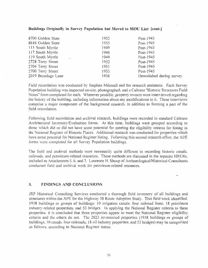
Buildings Ol'iginally in Survey Population but Moved to MOD List: Icont.]
8700 Golden State8616 Golden State115 South Myrtle117 South Myrtle119 South Myrtle2728 Terry Street2704 Terry Street:noo Terry Street2019 Brundage Lane
195219551949194619491952195119531936
Post-1945Post-1945Post-1945Post-l 945Post-1945Post-1945Post-1945Post-1945Demolished during survey
Field recordation was conducted by Stephen Mikesell and the research assistants. Each SurveyPopulation building was inspected on-site. photographed. and a Caltrans "Historic Structures FieldNotes" form completed for each. Wherever possible. property owners were interviewed regardingthe history of the building. including information about any modifications to it. These interviewscomprise a major component of the background research. in addition to forming a part of thefield recordation.
Following ficld recordation and archival research. buildings were recorded in standard CaltransArchitectural Inventory/Evaluation forms. At this time. buildings were grouped according tothose which did or did not have some potential for meeting the eligibility criteria for listing inthe National Register of Historic Places. Additional research was conducted for properties whichhave some potential for National Register listing. Following this second research effort. the AIlEforms werc completed for all Survey Population buildings.
The field and archival methods were necessarily quite different in recording historic canals.railroads. and pctroleum-related resources. These methods are discussed in the separate HRERs.included as Attachments 5. 6. and 7. Laurence H. Shoup of Archaeological/Historical Consultantsconducted licld and archival work for petroleum-related resources.
5. FINDINGS ANp CONCLUSIONS
JRP Historical Consulting Services conducted a thorough tleld inventory of all buildings andstructures within the APE for the Highway 58 Route Adoption Study. This field work identified:1938 buildings or groups of buildings: 10 irrigation canals: four railroad lines: 18 petroleumindustry-related properties: and 53 bridges. In applying the National Register criteria to theseproperties. it is concluded that three properties appear to meet the National Register eligibilitycritcria and the others do not. The 2023 inventoried properties (1938 buildings or groups ofbuildings. 10 canals. four railroads. 18 oil industry properties. and 53 bridges) may be categorizedas follows. according to National Register status:

PI'operties within the APE which al'e listed in the National Register of Historic Places:
None.
Pmperties within the APE which have been previously determined eligible for listing in theNational Register of Historic Places:
None.
Histol'ic buildings and structures within the APE which appear to be eligible for listing inthe National Register of Historic Places:
Address
Rudd Road3301 Fruitvale AvenueSee APE Map
Map No.
1569FK-I through FK-4
Cross of PalmsScott ResidenceFriant-Kern Canal
Pre-1946 properties which do not appear to be eligible for listing in the National Registerof Historic Places:
Address
8751 Bussell Road8231 Bussell Road30375 7th Standard Road8205 Koch Road22809 Baker Road22759 Baker Road22747 Baker Road22741 Baker Road22717 Baker Road30378 Baker Road2260 I Baker Road19698 Enos Lane31379 7th Standard Road7th Standard Road3418 Enos Lane1297 Enos Lane2862 Greeley Road1734 Greeley Road20759 Palm Avenue3119 Nord Avenue3139 Nord Avenue
MapReference No.
34
678910II121314161718192021YI
34
Date ofConstruction
19261940191 I1930-1950193019391925192519331935191819411920194019251929193019401920-1950s19421942
Eliuibilitv
Not EligibleNot EligibleNot EligibleNot EligibleNot EligibleNot EligibleNot EligibleNot EligibleNot EligibleNot EligibleNot EligibleNot EligibleNot EligibleNot EligibleNot EligibleNot EligibleNot EligibleNot EligibleNot EligibleNot EligibleNot Eligible

Map Date ofAddress Reference No. Construction Eliuibilitv
3155 Nord Avenue ,01912 Not Eligible~,)
3351 Nord Avenue 24 1910 Not Eligible2654 Nord Avenue ,.
1937 Not Eligible~)
1701 & 1707 Nord AVejlUe 26 1942 Not Eligible1650 Nord Avenue 27 1942 Not Eli<Tible
'"2213 Nord Avenue 28 1936 Not Eligible17324 Rosedale Highway 29 1930 Not Eligible1708 Wegis Avenue 30 1920 Not Eligible3637 Wegis Avenue 31 1920 Not Eligible2623 Heath Avenue 0,
1936 Not EligibleJ_
3433 Heath Avenue " 1925 Not EligibleJ_'
3143 l-le8th Avenue 34 1940 Not Eligible2912 Renti'o Road 35 1935 Not Eligible13554 Rosedale Highway 36 1916 Not Eligible3130 Allen Road 37 1930 Not Eligible4642 Allen Road 38 1930 Not Eligible12725 Allen Lane 39 1921 Not Eligible12653 Allen Lane 40 1922 Not Eligible12728 Allen Lane 41 1921 Not Eligible13149 Hageman Road 42 1922 Not Eligible13758 Hageman Road 43 1935 Not Eligible3409 Calloway Drive 44 1890 Not Eligible3017 Callowa, Drive 45 1920 Not Eligible2913 C~dl()way Drive 46 1940 Not Eligible2700 CaIIO\\a, Drive 47 1920 Not Eligible2824 Calk"vay Drive 48 1947 Not Eligible10217 rVleacham Road 49 1937 Not Eligible2828 Calloway Drive 50 1930 Not Eligible7900 Downing Avenue 51 1920 Not Eligible7630 Downing Avenue 52 1915 Not Eligible6621 Downing Avenue. 53 1942 Not Eligible6710 Downing Avenue 54 1942 Not Eligible6608 Downing Avenue 55 1945 Not Eligible6600 Downing Avenue 56 1936 Not Eligible2601 Henry Lane 57 1920 Not Eligible2733 Henry Lane 58 1915 Not Eligible2930 Patton Way 59 1937 Not Eligible2910 Patton Way 60 1920 Not Eligible3501 Patton Way 61 1920 Not Eligible3240 Patton Way 62 1915 Not Eligible3101 Wear Street 63 1920 Not Eligible6720-6800 Claude Avenue &
6801-6809 Fishback Avenue 64 1930s-1940s Not Eligible
35
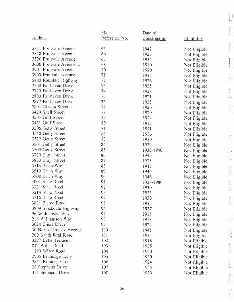
Map Date ofAddress Reference No. Construction Eliuibilitv
2811 Fruitvale Avenue 65 1942 Not Eligible2818 Fruitvale Avenue 66 1937 Not Eligible3520 Fruitvale Avenue 67 1935 Not Eligible3600 Fruitvale Avenue - 68 1910 Not Eligible2901 Fruitvale Avenue 70 1920 Not Eligible3900 Fruitvale Avenue 71 1935 Not Eligible5400 Rosedale Highway 72 1936 Not Eligible2700 Fairhaven Drive 73 1935 Not Eligible2720 Fairhaven Drive 74 1938 Not Eligible2800 Fairhaven Drive 75 1921 Not Eligible2877 Fairhaven Drive 76 1935 Not Eligible2801 Gibson Street 77 1920 Not Eligible3429 Shell Street 78 1920 Not Eligible3505 Gulf Street 79 1924 Not Eligible3431 Gulf Street 80 1915 Not Eligible3506 Getty Street 81 1941 Not Eligible3510 Gelly Street 82 1936 Not Eligible3512 Getty Street 83 1930 Not Eligible3501 Gelly Street 84 1939 Not Eligible3509 Getty Street 85 1935-1940 Not Eligible3729 Ethyl Street 86 1945 Not Eligible3820 I:tl1\1 Street 87 1935 Not Eligible3515 Brian Way 88 1945 Not Eligible3510 Brian \Vav 89 1940 Not Eligible3508 Brian Wa) 90 1946 Not Eligible4001 State Road 91 1936-1980 Not Eligible3321 State Road 92 1930 Not Eligible3214 State Road 93 1935 Not Eligible3216 State Road 94 1930 Not Eligible3831 Pierce Road 95 1935 Not Eligible3809 Stockdale Highwa.y 96 1937 Not Eligible96 Williamson Way 97 1915 Not Eligible218 Williamson Way 98 1918 Not Eligible3624 Elicia Drive 99 1924 Not Eligible30 North Garnsey Avenue 100 1945 Not Eligible200 South Real Road 101 1934 Not Eligible3227 Belle Terrace 102 1918 Not Eligible812 Wible Road 103 1935 Not Eligible1120 Wi ble Road 104 1940 Not Eligible2905 Brundage Lane 105 1930 Not El igible2821 Brundage Lane 106 1924 Not Eligible28 Stephens Drive 107 1945 Not Eligible321 Stephens Drive 108 1930 Not Eligible
36

Map Date ofAddress Reference No. Construction Eliuibilitv
314 Stephens Drive 109 1941 Not Eligible3212-3230 Chester Lane 110 1936-1949 Not Eligible116 Dixon Avenue 1I 1 1941 Not Eligible118 Dixon Avenue 112 1941 Not Eligible120 Dixon Avenue 113 1941 Not Eligible221 Hughes Lane 114 1912 Not Eligible223 Hughes Lane 115 1926 Not Eligible304 Dixon Avenue I 16 1941 Not Eligible3 \ 1 Dixon Avenue 1\ 7 1945 Not Eligible300 Dixon Avenue 118 1940 Not EligibleCarrier 1 Gates Canal C/GC-I
through C/GC-3 1872-73 Not EligiblePioneer Canal PC-I through PC-4 1873 Not EI igibleBeardsley Canal BC-l through BC-3 1873 Not EligibleStine Canal SC-l through SC-3 1873 Not EligibleCallO\vay Canal CC-I through CC-5 1875 Not EligibleEmery Ditch ED-I 1877 Not EligibleGoose Lake Sioughl RBC-I through
Rio Bravo Canal RBC-3 1870s Not EligibleCross Valley Canal CVC-I through
CVC-5 1974-75 Not EligibleArvin-Edison Canal AE-I 19605 Not EligibleAtchison Topeka/Santa Fe RR SF-I through SF-9 1898 Not EligibleSouthern Paeilic Railroad SP-l through SPA 1873 Not EligibleKCL-B #35 0-1 1938 Not EligibleKrebs;; \ 0-2 1937 Not EligibleLane # I 0-3 1933 Not EligibleFarrell # I 0-4 1929 Not EligibleRed Ribbon Raneh #23 0-5 1944 Not Eli"ible0
Van Ness #? 0-6 1939 Not EligibleVan Ness #3 0-7 1939 Not EligibleVan Ness #4 0-8 1938 Not EligibleLahore #1 0-9 1928 Not EligibleIVliami # I 0-10 1936 Not EligibleHenry #1 0-11 1936 Not EligibleAnderson #3 0-12 1936 Not EligibleAnderson #4 0-13 1937 Not EligibleGreeley Lease #2 0-14 1937 Not EligibleFee Lease #4 0-15 1938 Not EligibleKCL-B #37 0-16 1938 Not EligibleHoughton #36 0-17 1944 Not EligibleSan Joaquin Relinery 0-18 1937 Not Eligible
37

Post-1945 or modified pre-1946 (MOU) properties which do not appear to be eligible forlisting in the National Register of Historic Places:
The APE for this project includes 1821 buildings or groups of buildings which were built after1945 or. in rare instances, which were built before 1945 but modified heavily. The propertiesare identified by street address in Attachment I of this Historic Architectural Survey Report.That list is 34 pages long and is not reproduced here. The reader is referred to the attachmentfor a complete list of these properties.
Properties previously determined ineligible for listing in the National Register of HistoricPlaces:
Buildinus
3227 Belle Terrace3508 Brian \Vay3510 Brian Way3515 Brian Way3212-28 Chester Lane3279 Chester Lane3820 Ethyl Street3431 Ethyl Street3831 l'ieree Road3214 State Stred332\ State Road812 Wible Road
Briducs
LOC.\L BRIDGES WITHIN APE
Map Reference No. 102Map Reference No. 90Map Reference No. 89Map Reference No. 88Map Reference No. 110MOll ListMap Reference No. 87MOU listMap Reference No. 95Map Reference No. 93Map Reference No. 92Map Reference No. 103
Bridge Feature(s) Facility NRHPNUI11 bel' Intersected Carried Status
50C-13 State Street UP SPTCO Not Eligible50C-42 Calloway Canal Standard St Not Eligible50C-65 Oak St 01-1 (AT&SF RR) Oak St Not EligibleSOC-66 Stine Canal Oak St Not Eligible50C-67 Calloway Canal Pierce Rd Not Eligible50C-176 Truxtun Aye UP Truxtun Ave Not Eligible50C-177 Kern River Canal Truxtun Ave Not Eligible50C-I78 Arvin-Edison Canal Truxtun Ave Not Eligible50C-255 Calloway Canal Calloway Dr Not Eligible50C-259 Friant-Kern Canal Calloway Rd Not Eligible
38
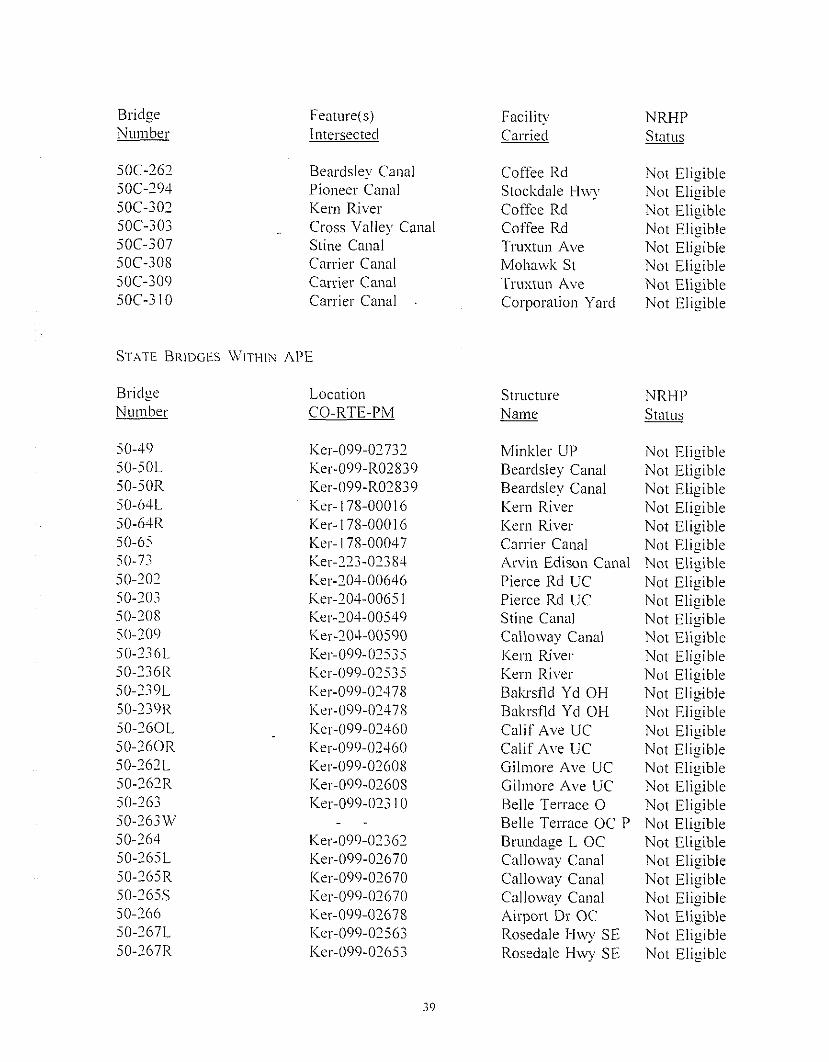
Bridge Feature(s) Facility NRHPNumber Intersected Carried Status
50C-262 Beardsley Canal Coffee Rd Not Eligible50C-294 Pioneer Canal Stockdale Hwy Not Eligible50C-302 Kern River Coffee Rd Not Eligible50C-303 Cross Valley Canal Coffee Rd Not Eligible50C-307 Stine Canal Truxtun Ave Not Eligible50C-308 Carrier Canal Mohmvk St Not Eligible50C-309 Carrier Canal Truxtun Ave Not Eligible50C-3 I0 Carrier Canal Corporation Yard Not EI igible
STATE BRIDGES WITHIN APE
BridgeNumber
50-4950-50L50-50R50-64L50-64R50-6550-7J50-20250-20350-20850-20950-2361.50-236R50-239L50-239R50-260L50-260R50-262L50-262R50-26350-263W50-26450-265L50-265R50-265S50-26650-267L50-267R
LocationCO-RTE-PM
Ker-099-02732Ker-099-R02839Ker-099-R02839Ker-178-000 16Ker- I78-00016Ker- 178-00047Ker-223-02384Ker-204-00646Ker-204-0065 IKer-204-00549Ker-204-00590Ker-099-02535Ker-099-02535Ker-099-02478Ker-099-02478Ker-099-02460Ker-099-02460Ker-099-02608Ker-099-02608Ker-099-023 10
Ker-099-02362Ker-099-02670Ker-099-02670Ker-099-02670Ker-099-02678Ker-099-02563Ker-099-02653
39
StructureName
Minkler UPBeardsley CanalBeardsley CanalKern RiverKern RiverCarrier CanalArvin Edison CanalPierce Rd UCPierce Rd UCStine CanalCalloway CanalKern RiverKern RiverBakrst1d Yd OHBakrsDd Yd Ol-ICalif Ave UCCalif Ave UCGilmore Ave UCGilmore Ave UCBelle Terrace 0Belle Terrace OC PBrundage L OCCalloway CanalCalloway CanalCalloway CanalAirport Dr OCRosedale l-lwy SERosedale l-Iwy SE
NRHPStatus
Not EligibleNot EligibleNot EligibleNot EligibleNot EligibleNot EligibleNot EligibleNot EligibleNot EligibleNot EligibleNot EligibleNot EligibleNot EligibleNot EligibleNot EligibleNot EligibleNot EligibleNot EligibleNot EligibleNot EligibleNot EligibleNot EligibleNot EligibleNot EligibleNot EligibleNot EligibleNot EligibleNot EI igible

Bridge Location Structure NRHPNumber CO-RTE-PM Name Status
50-268L Ker-099-02499 Truxtun Ave UC Not Eligible50-268R Ker-099-02499 Truxtun Ave UC Not Eligible50-277 Ker-099-R03053 7th Std Rd OC Not Eligible50-305 Ker-005-04755 Stockdale R OC Not Eligible50-403 Ker-058-R05289 Hughes Ln OC Not Eligible50-426F Ker-058-R05233 Rte 58/99 SEP Not Eligible50-426S Ker-058-R05233 Rte 58/99 SEP Not Eligible50-427G Ker-099-02337 Wible Road UC Not Eligible
40

6. REFERENCES
Books
Beck. Warren A.. and Ynez D. Haase. His/orical A/las o/"Cali/ornia. Norman: University ofOklahoma Press._1974.
Berg. Norman. A His/OlY 0/ Kern Coumy Land Compcmy. Bakersfield. California: The KernCounty Historical Society. 1971.
Bryant. Keith L. HisllilY o/Ihe A/chison. Topeka and Sanlo Fe Railwoy. New York: Macmillan.1974.
Duke. Donald. and Stan Kistler. SanlU Fe .Golden West Books. 1963.
Sled Rails Through Cali/imlia. San Marino:
Durrenberger. Robert W.. and Robert B. Johnson. Calijbrnia: Pollerns on Ihe Land Palo Alto.California: Mayfield Publishing Company. 1976.
Fox. Charles P. "The Empire of Kern." and J. M. Hunter. "A Business Men' s CountryExcursion." in Kern COUl1l.V Califimlia, inlhe Del/a oj'lhe Kern River, /he Crown o//he,';an .Iow/uin r(alley. (Promotional pamphlet). 1905.
Heath. Eric. ,\even/l'-Fh'e rears 0/ Progress: HislOrical Ske/ch o//he Sou/hem Pacific. SanFrancisco: The Southern Pacitic Bureau of News. December 1945.
Holterhol'L (j. (camp.) His/orical Revie1l' o//he A/chison, Topeka and SanlU Fe Rai!l 1'Ct1'
('omlhlm' (1I'i/h Par/icular Re/erence /0 Caliji)rnia Lines) as Furnished /0 Ihe RailroadCommission olihe SlUle o/Cali/imlia in Compliance lI'ilh ifs General Order No. 38. LosAngeles. June 1914.
Hoover. Mildred. and Ethel and Hero Rensch. Hi,\'/oric Sim/s in Cali/i)rnia. Stanford: StanfordUniversity Pres~. 1966.
Johnson. Stephen. Gerald Haslam. and Robert Dawson, The Greal Cen/ral Volley: Cali/brnia '.\'Hear/land Berkeley: University of California Press. 1993.
Marshall. James. San/a Fe: /he Railroad Ihal Buill an Empire. New York: Random House.1945,
McAlester. Virginia and Lee. A Field Guide /0 American Houses. New York: Alii-ed A. Knopf.1988.
4\

Morgan. Wallace M. HisIOI:l' of Kem COllnly. CalifiJmia. Los Angeles: Historic RecordCompany. 1914.
Padillo. Victoria. SOlilhem Cali(iJmia Gardens: An JlllIsli'CIled HislOIY Berkeley: Universityof California Press. 1961.
Pisani. Donald. From IIU! Family Farm 10 Agribusiness. Berkeley: University of CaliforniaPress. 1984.
Preston. William L. Vanishing Landscapes: Land and Life in Ibe Tulare Lake Basin. Berkeley:University of California Press. 1981.
Rintoul. William. Sjmdding In: Recolleclions ofFioneer Days in Ihe CalifiJmia Oil Fields. SanFrancisco: California Historical Society. 1976.
(iildorado: Boom Times on Ihe IVesl Side Fresno: Valley Publishers. 1978.
Robinson. William Wilcox. The SIOIY of Kem Counl)' Bakersfield. California: Title Insuranceand Trust Company. 1961.
Zonlight. Margaret A. (Cooper). Land. WaleI' and Seillemenl in Kem COllJ7ly. Califem?ia. 1850IINo. New York: Arno Press. 1979.
Periodicals
Baker. Thomas A. "Early Bakersfield." Kern County Historical Society. Third AnnualPublication. 1937.
Burmeister. Lugene. "Rosedale Colony: Garden of Eden." Bakersfield News Blillelin. May 13.196'+.
Merrill. Charlotte L. "Where Is Our House Now')" Hisloric Kem. Vol. 13. No.3. March 1963.PI'. 1-2.
Renti·o. Louise A. "As I Recall." Hisloric Kem. Vol. 10. No.2. December 1959. pp. 1. 4.
Taylor. Frank.1. "Worlds Most Fabulous Farm." The N,ilion's Blisiness. February 1954. 42:2.
Wooster. Clarence i'v1.. "Bililding Down the San Joaquin in 1871."!JlIarlerly. 1939.
42
CalifiJmia Hislorical Socien'. .
Govemment Documents and Reports
Boyle Engineering Corporation, "Report on Groundwater Recharge Project" for Rosedale-RioBravo Water Storage District, June 1988.
Brewer. Chris. "Historical Architectural Evaluation Report for State Route 178 Study. 6-Ker178." January 1~, 1989.
California State Engineer. Repor( ofrhe S(u(e Engineer (0 (he Legislature ofCalifbrniu. Sessiunof 1880. Sacramento: State Printing Ol1ice, 1880..
California OHice of Historic Preservation. "Historic Properties Directory for Bakersfield andOther Kern County Cities," May 18, 1993.
Caltrans. "Guidance for Consultants: Procedures for the Protection of Historic Properties: The106 Process." Sacramento: Caltrans, 1991,
Kern County Water Agency. 1990-1991 Biennial Report. Kern County Water Agency:Bakersfield, 1991.
LSA Associates, Inc. "Historic Property Survey Report: Route 99, 06-KER-99, 22.1 P. M. to27.0 P. M." Prepared for Caltrans, District 6. Fresno, California, April 6, 1990.
MikeselL Stephen D. "Historical Architectural Survey ReportImpro\'Cment. Highway 99/204, City of Bakersfield."Department of Transportation, ApriL 1987.
for a Proposed InterchangePrepared for the California
PowclL .lohn Ed\\ard. "Preliminary Historic Architectural Survey Report, Northern Division\lv'est End District Prolile, Kern 178 Architectural History Survey, Bakersfield,California." Prepared for the California Department of Transportation, April 26, 1993.
United States. Department of the Interior. Bureau 01' Reclamation, Central Valley Project; FriantDivision. Friunt-Kern ('unal: Tee/mimi Record of Design and Construction. Denver.Colorado, May J958.
United States Geological Survey. liTigation Near Bakersf/eld. Califom/a. Water Supply Paper17, by Carl Ewald Grunsky. Washington DC: General Printing Office, 1898.
Theses and Dissertations
Crothers, Alice L. "The History of the Southern Pacitic Railroad in the San Joaquin Valley."1\1. A.. University of Southern California, June 1934.
43

Manuscripts
Baldwin. George H. "Water Rights on Kern River." January 26.1916. Water Resources CenterArchives. University of California. Berkeley.
Benson. R. C. "Irrigation in Kern County. California." Report field in the records of the Officeof Irrigation Inwstigations at Berkeley. California. n.d .. in Baldwin. 1916. WaterResources Center Archives. University of California. Berkeley.
NeufielcL Vernon H. "The Martensdale Colony. 1909-1910." March 15. 1989. Vertical Files:Colonies. Beale Memorial Library. Bakersfield. California.
Maps
Atchison. Topeka. and Santa Fe Railway Company. Coast Lines. Valley Division. "Profile. KernJet. to Shafter. M. P. 885 to M. P. 910." June 30. 1912. California State Archives.Railroad Pro!lles.
Randall & Donne. Index Alias a/Kern ('ollnly. Cali/omia. San Francisco: Randall & Donne.1901.
United States Geological Survey. "Central Valley. California. South Area." 1957. edition of1958.
____. "Oildale Quadrangle." 1954.
Photograph Collections
Kern COUl1t~ Museum. Photo Collection. Box 25. Canals. Friant-Kern.
Newspapers
Bakersfield ('ali/i,mian
Bakersfield Nelt·s BIIIlelin
Interviews
Abhott. Mary. June 16. 1993.
Brooks. Elmer. June 14. 1993.
Bumgartner. George. July 14. 1993.
44

Cooper. George. June 23. 1993.
Cornelson. Doris Mae. June 23. 1993.
Delfino. IVlargaret. June 18. 1993.
Fleishauer. Steve. June 24. 1993.
Grauf. Paul. June 18. 1993.
Harral. Alti·ed. June 250 1993.
Hegerresell. John. June 24. 1993.
Kelly. Mr. &. Mrs. .I. D. June 24. 1993.
Lafond. Steven. City of Bakersfield Water Department. August 1993.
Lee. Mary. July 12. 1993.
McNabb. Leonard. June 24. 1993.
Nickel. Gerald. June 23. 1993.
Nord. Frank. August 11. 1993.
O·Neill. Mike. July 14. 1993.
Roblee. George. August 12. 1993.
Rupert-Enriquez. Carola. Director. Kern County Museum. Various dates.
Schulz. Violet (Mrs. Raymond). June 16. 1993.
Scott. Philip A. July 14. 1993.
Turner. .lames R. July 14. 1993.
Van Zant. Dean. Petroleum Production Pioneers. August 4. 1993.
'vValston. Earl. July 14. 1993.
Williams. Charles. North Kern Water Storage District. August 1993.
Zaragoza. Joe. Clinton. and Fay. August 5. 1993.
45

Hydrogen Energy California (08-AFC-8A) Response to Data Request A189 Responses to CEC Data Requests – Nos. A181 through A217 Cultural Resources
A189-1 R:\12 HECA\DRs\CEC Set 3\Resp_DRs_A181-A217.docx
BACKGROUND
This background and associated data request is intended to clarify information needs connected with Data Request A85. The Western Naval Oil Preserve No. 1, Elk Hills (NPR-1), now Occidental Elk Hills, Incorporated (OEHI), is the location for an Enhanced Oil Recovery (EOR) project. This project, pursuant to CEQA, is part of the proposed project under review.
NPR-1 was the subject of a historical resources evaluation and assessment report (Hamusek-McGann et al., 1997) at the time of the transfer of the property from the Department of Energy to Occidental Petroleum, parent company of OEHI. The report assessed both historic archeological resources and built environment resources. Several periods of significance were found in the report, including Early Exploration (1910-1918), Initial Development Rush (1918-1930), Depression Years (1930-1941) and the War Years (1941-1946). The report authors identified the Elk Hills Rural Historic Industrial Landscape as a historic property eligible for the National Register of Historic Places (NRHP) under Criterion A.
The State Historic Preservation Officer (SHPO) took issue with this conclusion, calling into question the landscape's integrity. The SHPO wrote: "For no period of significance does the property today exhibit enough integrity in all applicable categories to readily convey its historic appearance..." (Widell1997:1). Apparently, the report lacked identification of the landscape's character-defining features, which would have bolstered the authors' contention that it is NRHP-eligible.
Military Sites:
Staff visited the NPR-1/EOR site on September 19, 2012. Many of the early period (1910 to 1941) built environment features appear to be missing, damaged or altered.
However, there are two areas that appear to have integrity and warrant survey and evaluation. Hamusek-McGann et al. (1997) provides some documentation of Navy activity during the War Years and the activities of the Sea Bees (Construction Battalions or CBs) in particular.
According to Hamusek-McGann et al. (1997), the Sea Bees constructed roads, drill pads, wells and military trenches, bunkers and other defensive earthworks on the north and west flanks of the landscape. Of these activities, the trenches, bunkers and other earthworks appear to be intact.
These earthworks seem to be located primarily in the low oil-production areas of Elk Hills and this may contribute to their high degree of integrity. Hamusek-McGann et al. (1997) found that the relationship of the trenches to the topography offers an insight into the military's approach to defensive positions on the ground during this period.
The report states that physical evidence of defensive infrastructure during WWII are rapidly disappearing, increasing the value of NPR-1 military sites and may be eligible as historic properties under Criterion A (NRHP).
Check Dams:
During staff's site visit, OEHI staff pointed out a series of check dams constructed on the property meant to control the flow of water off the site to the valley. These check dams appear to have a design that incorporates a metal pipe that siphons the water through an earthen dam, at a point below the water level of the dam, allowing water to pass through the pipe and leaving any oily residue to collect at the bottom of the basin.
Hydrogen Energy California (08-AFC-8A) Response to Data Request A189 Responses to CEC Data Requests – Nos. A181 through A217 Cultural Resources
A189-2 R:\12 HECA\DRs\CEC Set 3\Resp_DRs_A181-A217.docx
This in effect reduces the potential for oil to flow beyond the property boundary during a rain event or a spill. These check dams are prevalent throughout the site and it is not known when these dams were constructed or by whom. Hamusek-McGann et al. (1997) report that WPA crews were on site during the Depression years constructing culverts, laying pipeline, repairing equipment and constructing roads.
The check dams are not discussed in the report and their origin is not known by staff. They are a landscape element specifically relating to this site's topography and function and require evaluation to determine their contribution to the overall landscape, their association with one of the historic periods noted above and if they qualify as historic resources under CEQA or the NRHP.
Data Requests
Supplemental information for NPR-1 is required to complete the evaluation of the resources discussed above. This may be submitted as part of the data response to Data Request Number A85.
DATA REQUEST
Provide documentation of the existing military sites (trenches, bunkers and A189.defensive earthworks) found on the north and west flanks of the NPR-1 site. Documentation shall include survey and inventory, evaluation of significance and integrity for both the CRHR and NRHP. Prepare a context statement and record the findings on the appropriate DPR 523 forms.
RESPONSE
The Applicant is requesting additional time to address this Data Request.

Hydrogen Energy California (08-AFC-8A) Response to Data Request A190 Responses to CEC Data Requests – Nos. A181 through A217 Cultural Resources
A190-1 R:\12 HECA\DRs\CEC Set 3\Resp_DRs_A181-A217.docx
DATA REQUEST
Provide documentation of the existing check dams found throughout the A190.drainage draws, gullies and washes on the NPR-1 site. Documentation shall include survey and inventory, evaluation of significance and integrity for both the CRHR and NRHP. Prepare a context statement and record the findings on the appropriate DPR 523 forms.
RESPONSE
The Applicant is requesting additional time to address this Data Request.
Hydrogen Energy California (08-AFC-8A) Response to Data Request A191 Responses to CEC Data Requests – Nos. A181 through A217 Cultural Resources
A191-1 R:\12 HECA\DRs\CEC Set 3\Resp_DRs_A181-A217.docx
BACKGROUND
The PAA as defined in the AFC (URS 2012: Map 2, Sheet 4), includes 0.5 mile on either side of the linear corridor north of Station Road and east of the project site. Several resources have been identified and evaluated within that portion of the PAA (Map Reference Numbers 12, 13 and 15).
On Station Road there is another resource, the Mesquite Hunting Club, which has not been addressed in the AFC and falls within the PAA.
Staff has identified the resource as historic in age. The Mesquite Hunting Club is clearly shown and labeled on a 1933 edition of the U.S. Geological Survey map, surveyed in 1927 and 1929 (U.S. Geological Survey 1933). This resource must be inventoried and evaluated as a potential historical resource in order to assess the proposed project's potential impacts.
DATA REQUEST
Provide documentation of the Mesquite Hunting Club. Documentation shall A191.include survey and inventory, evaluation of significance and integrity for both the CRHR and NRHP. Prepare a context statement and record the findings on the appropriate DPR 523 form(s). Note that the boundary of the Mesquite Hunting Club changed over time and include analysis of those changes in the evaluation.
RESPONSE
JRP staff conducted a field survey of the former hunting club site in 2009, and determined that no built environment features associated with the club are extant. All of the land once associated with the hunting club is currently plowed and leveled agricultural fields. JRP inventoried and evaluated the Tupman Water Plant (Map Reference No. 13), which is adjacent to the site of the former hunting club; however, the extant resources on this property are associated with the oil industry, and not that of the hunting club. Therefore, providing additional information and/or documentation of the Mesquite Hunting Club is not warranted.

Hydrogen Energy California (08-AFC-8A) Response to Data Request A192 Responses to CEC Data Requests – Nos. A181 through A217 Cultural Resources
A192-1 R:\12 HECA\DRs\CEC Set 3\Resp_DRs_A181-A217.docx
BACKGROUND
The proposed process water pipeline would extend through or adjacent to the following archaeological resources and therefore would potentially damage the archaeological resources listed below. The applicant is currently addressing a related data request (A147), which asks the applicant to determine the depth of fill material in which the proposed process water line would be installed (California Energy Commission 2012:13-14).
Staff has requested that the applicant focus on those portions of the proposed process water line that would intersect the archaeological resources listed below and to provide substantiation for its estimate of the depth of fill.
• KRM-IF-006 and P-15-89 (CA-KER-89/H) • P-15-171 (CA-KER-171) • P-15-7176 and P-15-6725 (CA-KER-5356/H) • HECA-2008-1 (JM-BVWD-1) • HECA-2009-9 • HECA-2009-10 • BS-BVWD-1 • P-15-2485 (CA-KER-2485) and BS-IF-003 • P-15-179 (CA-KER-179), KRM-IF-003, and KRM-IF-004
Similarly, the proposed natural gas pipeline is situated adjacent to archaeological site P-15-3108 (CA-KER-3108) and HECA-2009-2 is located in the Controlled Area and near the proposed CO2 pipeline. HECA-2009-2 would be subject to ground disturbance associated with agricultural activities in the Controlled Area.
Unless the applicant demonstrates that the proposed project would not affect the aforementioned archaeological resources, such resources must be evaluated for significance under CEQA's criteria as well as those of the NRHP.
The applicant can demonstrate that one or more of the aforementioned archaeological resources would not be affected by the proposed project by showing that, for instance, a given archaeological resource is situated outside the PAA and that its surface and subsurface extent are firmly established or that ground disturbance would only take place within fill sediments overlying a given archaeological resource.
Staff is requesting the applicant conduct a significance evaluation of affected archaeological resources so that staff has the ability to assess impacts on resources considered significant under CEQA and eligible for the NRHP.
DATA REQUEST
Please submit, for staff review and approval, a subsurface testing plan for any A192.of the aforementioned archaeological resources that the proposed project would not avoid. The subsurface testing plan should be prepared by an archaeologist who meets the U.S. Secretary of the Interior's Professional Qualifications Standards, as published in 36 Code of Federal Regulations 61. Please provide a resume demonstrating the archaeologist's qualifications. Testing methods should be scaled to the size and quality of evidence for the resources' presence in the PAA. For archaeological resources with scant archaeological materials in

Hydrogen Energy California (08-AFC-8A) Response to Data Request A192 Responses to CEC Data Requests – Nos. A181 through A217 Cultural Resources
A192-2 R:\12 HECA\DRs\CEC Set 3\Resp_DRs_A181-A217.docx
the PAA, methods consistent with determining presence/absence would be appropriate.
RESPONSE
As described in Applicant’s Objections and Requests for Additional Time to Respond to California Energy Commission Staff Data Requests Set 3, docketed on November 20, 2012, the Applicant is requesting additional time to address this Data Request.

Hydrogen Energy California (08-AFC-8A) Response to Data Request A193 Responses to CEC Data Requests – Nos. A181 through A217 Cultural Resources
A193-1 R:\12 HECA\DRs\CEC Set 3\Resp_DRs_A181-A217.docx
DATA REQUEST
After staff approves the subsurface testing plan, please initiate the test A193.excavations, as specified in the approved plan. A qualified archaeologist, as identified in Data Request A192 above, shall carry out the test excavations. (Note: Please ensure that a biological monitor is present during the test excavations). If deposits are found, please recover a sample of materials sufficient to support recommendations of significance for these sites. Evaluate the recovered data for its potential to address the research questions posed in the testing plan.
RESPONSE
As described in Applicant’s Objections and Requests for Additional Time to Respond to California Energy Commission Staff Data Requests Set 3, docketed on November 20, 2012, the Applicant is requesting additional time to address this Data Request.

Hydrogen Energy California (08-AFC-8A) Response to Data Request A194 Responses to CEC Data Requests – Nos. A181 through A217 Cultural Resources
A194-1 R:\12 HECA\DRs\CEC Set 3\Resp_DRs_A181-A217.docx
DATA REQUEST
Please provide a report, written by the qualified archaeologist conducting the A194.excavations, on the testing and findings at these resources. The report should present an analysis of the recovered data, recommendations regarding the significance of the sites, and justifications for the recommendations, based on the recovered data. Please complete or update and file DPR 523 "Archaeological Site" detail forms for these sites, including dating and significance recommendations, and submit copies to staff.
RESPONSE
As described in Applicant’s Objections and Requests for Additional Time to Respond to California Energy Commission Staff Data Requests Set 3, docketed on November 20, 2012, the Applicant is requesting additional time to address this Data Request.

Hydrogen Energy California (08-AFC-8A) Response to Data Request A195 Responses to CEC Data Requests – Nos. A181 through A217 Cultural Resources
A195-1 R:\12 HECA\DRs\CEC Set 3\Resp_DRs_A181-A217.docx
BACKGROUND
Energy Commission staff has reviewed the applicant's October 2012, response to Data Requests (DR) A151 and A152 for the Hydrogen Energy California application for certification (AFC). DRs A151 and A152 asked that the applicant prepare and implement a primary geoarchaeological field study research plan for the project plant site and linear facility corridors.
While evaluating the previous HECA AFC (08-AFC-8), a request for a primary geoarchaeological field study was the subject of six data requests: DR 78 and 79 (October 12, 2009), DR 143 (January 13, 2010), Workshop DR 23 (April 12, 2010), and DR 172 and 173 (October 26, 2010). In the April 2010 workshop, the applicant agreed to the following:
• For the Project Site: "Once a development plan has been finalized for the Project Site, an exploration plan for the combined geotechnical/geoarchaeological investigations will be developed, focusing on those areas with the deepest project impacts."
• For Project linears: "Once engineering and design (including the proposed depths of the linear components under consideration) have been finalized, an exploration plan for the geoarchaeological investigation will be developed..."
Staff believes that the current project description and data responses provide an adequate amount of project definition to conduct a geoarchaeological study, though the proposed project has not reached final design. Staff believes that the applicant and staff would be able to devise reasonable means to obtain the data needed for staff's impact analysis by holding a meeting among staff, the applicant, and the applicant's archaeological consultants.
DATA REQUEST
Staff requests that the applicant and its archaeological consultant, including the A195.project geoarchaeologist, meet with staff to discuss the data needed to complete the staff impact analysis with respect to buried archaeological resources.
RESPONSE
The Applicant will work with California Energy Commission (CEC) staff to schedule a meeting to discuss information needs to complete CEC staff analysis related to buried archaeological resources.

Hydrogen Energy California (08-AFC-8A) Response to Data Request A196 Responses to CEC Data Requests – Nos. A181 through A217 Cultural Resources
A196-1 R:\12 HECA\DRs\CEC Set 3\Resp_DRs_A181-A217.docx
BACKGROUND
The Amended AFC indicates that the proposed 230-kilovolt (kV) electrical transmission line would connect to existing Pacific Gas and Electric Company (PG&E) transmission lines via a new (not yet built) electrical switching station. Staff understands that PG&E would build and operate the switching station. The Energy Commission considers the electrical switching station to be a related facility, as defined at Title 20, California Code of Regulations, Section 1702(n), to the proposed HECA project. The proposed electrical switching station must, therefore, be included in the HECA project area of analysis. The site of the proposed electrical switching station is included in the applicant's records search area, but has not been surveyed for the presence of cultural resources (Farmer 2008; Hale and Laurie 2009, 2010; Hale et al., 2012; JRP Historical Consulting 2009, 2012).
DATA REQUEST
Conduct a pedestrian survey of the proposed electrical switching station, plus a A196.200-foot buffer surrounding the proposed facility's location (20 Cal. Code Regs., §§ 2001-2012, Appendix B[g][2][C]).
RESPONSE
As described in Applicant’s Objections and Requests for Additional Time to Respond to California Energy Commission Staff Data Requests Set 3, docketed on November 20, 2012, the Applicant is requesting additional time to address this Data Request.

Hydrogen Energy California (08-AFC-8A) Response to Data Request A197 Responses to CEC Data Requests – Nos. A181 through A217 Cultural Resources
A197-1 R:\12 HECA\DRs\CEC Set 3\Resp_DRs_A181-A217.docx
DATA REQUEST
Prepare and submit an addendum to Appendix G-3 (Hale et al., 2012) that A197.describes:
a. The methods used to identify cultural resources in the proposed switching station site.
b. The results of the pedestrian survey.
c. Descriptions of newly recorded cultural resources in the proposed switching station location.
d. An assessment of impacts to cultural resources in the proposed switching station.
e. Proposed mitigation measures for identified impacts.
References Cited
California Energy Commission 2012-California Energy Commission. Hydrogen Energy California (08-AFC-8A): Energy Commission Staff's Data Requests A124-A180. September 6. Sacramento, CA. Docket No. 08-AFC-8A, TN# 67037. Electronic document, http://www.energy.ca.gov/sitingcases/hydrogen energy/documents/2012-09-06 CEC Staffs Data Requests A124-A180 TN-67037.pdf, accessed October 15, 2012.
Farmer 2008-Reid Farmer. Confidential Hydrogen Energy California Cultural Resources Technical Report. July. URS Corporation, Denver, CO. Prepared for Hydrogen Energy International, Long Beach, CA. Submitted to California Energy Commission, Sacramento, CA. Docket No. 08-AFC-8.
Hale and Laurie 2009-Hale, Mark R., and Leroy T. Laurie. Confidential" Archaeological Reconnaissance, Hydrogen Energy California Study Area, Kern County, California. May. URS Corporation. Confidential Appendix H3 to Application for Certification, Volume I, Hydrogen Energy California, by Hydrogen Energy International, with URS. July. Hydrogen Energy International, Long Beach, CA, with URS, Denver, CO. Submitted to California Energy Commission, Sacramento, CA. Prepared for Hydrogen Energy International LLC, Long Beach, CA. Submitted to California Energy Commission, Sacramento, CA. Docket No. 08-AFC-8.
Hale and Laurie 2010-Hale, Mark R., and Leroy T. Laurie. Confidential Survey Report Addendum: Archaeological Reconnaissance, HECA Study Area, Kern County, CA. January. URS. Attachment 65-1 to
Hale et al., 2012.-Mark R. Hale, Leroy T. Laurie, and Jay Rehor. Confidential Archaeological Reconnaissance, Hydrogen Energy California Study Area, Kern County, California. April. URS Corporation. Appendix G-3 in Amended Application for Certification for Hydrogen Energy California (08-AFC-8), Kern County, California, by URS. May. Prepared for Hydrogen Energy California LLC. Submitted to California Energy Commission, Sacramento, CA (Docket No. 08-AFC-8A), and National Energy Technology Laboratory, U.S. Department of Energy, Morgantown, WV.
Hydrogen Energy California (08-AFC-8A) Response to Data Request A197 Responses to CEC Data Requests – Nos. A181 through A217 Cultural Resources
A197-2 R:\12 HECA\DRs\CEC Set 3\Resp_DRs_A181-A217.docx
Hamusek-McGann et al., 1997-Hamusek-McGann, Blossom, Cindy L. Baker, and Mary L. Maniery. Historical Resources Evaluation and Assessment Report of Western Naval Petroleum Preserve No. 1, Elk Hills, Kern County, California. Final. September. PAR Environmental Services, Inc., Sacramento, CA. Prepared for ICF Kaiser, ICF Resources Incorporated, Fairfax, VA. On file, Southern San Joaquin Valley Information Center, California Historical Resources Information System, Bakersfield.
JRP Historical Consulting 1995-JRP Historical Consulting. Historic Architecture Survey Report, Tier 1, For Route Adoption on Route 58 between 1-5 and State Route 99 in Kern County. June 9.
JRP Historical Consulting 2009-JRP Historical Consulting. Historic Architecture Technical Report: Inventory and Evaluation, Hydrogen Energy California Project, April 2009, Davis, CA. Prepared for URS Corporation. Appendix H-4 in Application for Certification for Hydrogen Energy California (08-AFC-8), Kern County, California, by URS. May. Prepared for Hydrogen Energy California LLC. Submitted to California Energy Commission, Sacramento, CA (Docket No. 08-AFC-8A), and National Energy Technology Laboratory, U.S. Department of Energy, Morgantown, WV.
JRP Historical Consulting 2012-JRP Historical Consulting. Historic Architecture Technical Report: Inventory and Evaluation, Hydrogen Energy California Project. April. Davis, CA. Prepared for URS Corporation. Confidential Appendix G-4 in Amended Application for Certification for Hydrogen Energy California (08-AFC-8), Kern County, California, by URS. May. Prepared for Hydrogen Energy California LLC. Submitted to California Energy Commission, Sacramento, CA (Docket No. 08-AFC-8A), and National Energy Technology Laboratory, U.S. Department of Energy, Morgantown, WV.
Meyer et al., 2009-Meyer, Jack, Jeffrey S. Rosenthal, and D. Craig Young. A Geoarchaeological Overview and Assessment of Caltrans Districts 6 and 9. Cultural Resources Inventory of Caltrans District 6/9 Rural Conventional Highways. Draft. December. Far Western Anthropological Research Group, Davis, CA. Submitted to District 6, California Department of Transportation, Fresno. EA 06-0A7408 TEA Grant.
URS 2012-URS. URS. Amended Application for Certification for Hydrogen Energy California (08-AFC-8), Kern County, California. May. Prepared for Hydrogen Energy California LLC. Submitted to California Energy Commission, Sacramento, CA (Docket No. 08-AFC-8A), and National Energy Technology Laboratory, U.S. Department of Energy, Morgantown, WV. Electronic document,-http://www.enerqy.ca.gov/sitinqcases/hydrogenenerqy/documents/applicanUamendedafcNol-1/, accessed September 11, 2012. Energy Commission Dockets, tn: 65049.
U.S. Geological Survey-U.S. Geological Survey. 1933. Tupman, California, Quadrangle. Surveyed in 1927 and 1927.
Weber 1998-Weber, Gerald E. Geologic History of Site CA-KER-3080, Interpretations and Conclusions. In Prehistoric Archaeological Resources Inventory and Evaluation at Naval Petroleum Reserve No. 1 (Elk Hills). Kern County, California, by Thomas L. Jackson, Lisa A. Shapiro, and Jerome H. King, H1 Vol. 4. Pacific Legacy. On file, Southern San Joaquin Information Center, California Historical Resources Information System, Bakersfield.

Hydrogen Energy California (08-AFC-8A) Response to Data Request A197 Responses to CEC Data Requests – Nos. A181 through A217 Cultural Resources
A197-3 R:\12 HECA\DRs\CEC Set 3\Resp_DRs_A181-A217.docx
Widdell 1997-Widdell, Cherilyn. Letter Regarding Sale of NPR-1, Kern County, California. December 11. Office of Historic Preservation, Department of Parks and Recreation, Sacramento, CA. Submitted to U.S. Department of Energy, Washington, D.C.
RESPONSE
As described in Applicant’s Objections and Requests for Additional Time to Respond to California Energy Commission Staff Data Requests Set 3, docketed on November 20, 2012, the Applicant is requesting additional time to address this Data Request.

Hydrogen Energy California (08-AFC-8A) Response to Data Request A198 Responses to CEC Data Requests – Nos. A181 through A217 Noise
A198-1 R:\12 HECA\DRs\CEC Set 3\Resp_DRs_A181-A217.docx
Technical Area: Noise Authors: Edward Brady, Shahab Khoshmashrab
BACKGROUND
Amended AFC Tables 5.10-4 and 5.10-5 provide the number of delivery trips to the project site for feedstock, operations and maintenance, and process materials and byproducts. In order for staff to adequately evaluate the noise impacts of the deliveries utilizing truck and/or railway, additional information and analysis need to be provided on the impacts of increased traffic along existing surface routes and the preferred routing of the railroad track serving the HECA project.
DATA REQUEST
Please identify the proposed routing for the truck delivery. Identify the noise- A198.sensitive receptors along the path of travel. Analyze the noise impact of the truck traffic at these receptors during both, day and night. In this analysis, please include a comparison of the existing ambient noise levels to the noise levels resulting from the deliveries, at representative locations. Please provide the resultant noise levels in terms of Leq, L10, L50, Lmin, Lmax, and L90.
RESPONSE
As described in Applicant’s Objections and Requests for Additional Time to Respond to California Energy Commission Staff Data Requests Set 3, docketed on November 20, 2012, the Applicant is requesting additional time to address this Data Request.

Hydrogen Energy California (08-AFC-8A) Response to Data Request A199 Responses to CEC Data Requests – Nos. A181 through A217 Noise
A199-1 R:\12 HECA\DRs\CEC Set 3\Resp_DRs_A181-A217.docx
DATA REQUEST
Please identify the proposed routing for the rail delivery. Identify the noise- A199.sensitive receptors along the path of travel. Analyze the noise impact of the rail traffic at these receptors during both day and night. In this analysis, please include a comparison of the existing ambient noise levels to the noise levels resulting from the deliveries, at representative locations. Please provide the resultant noise levels in terms of Leq, L10, L50, Lmin, Lmax, and L90.
RESPONSE
As described in Applicant’s Objections and Requests for Additional Time to Respond to California Energy Commission Staff Data Requests Set 3, docketed on November 20, 2012, the Applicant is requesting additional time to address this Data Request.

Hydrogen Energy California (08-AFC-8A) Response to Data Request A200 Responses to CEC Data Requests – Nos. A181 through A217 Alternatives
A200-1 R:\12 HECA\DRs\CEC Set 3\Resp_DRs_A181-A217.docx
Technical Area: Alternatives Authors: Negar Vahidi, Scott Debauche
BACKGROUND
Subsection 6.3 of the Amended Application for Certification (AFC) discusses alternative site and linear facilities locations that were part of the screening analysis for the proposed project. The four Alternative sites considered within the Amended AFC include the following (as shown in AFC Figure 6-1):
• Alternative Site 1 - located approximately 1-mile west of the proposed site; • Alternative Site 2 - located approximately 0.4-mile west of the proposed site; • Alternative Site 3 - located approximately 4-miles north/northwest of the proposed
site; and • Alternative Site 4 - located approximately 13-miles southeast of the proposed
site.
The evaluation screening criteria utilized within the Amended AFC for evaluating each site included:
• Environmental impacts; • Safety (proximity to residents, schools, day-care centers, etc.); • Proximity to sensitive receptors (population and sensitive species); • Environmental justice considerations·; • Economic feasibility; • Site acreage (300+ acres), topography, lowest elevation (to maximize power
generation); • Proximity to the CO2 customer for CO2 enhanced oil recovery (EOR) and
sequestration; • Minimization of impacts on transportation corridors; • Feasibility of land acquisition; • Proximity to infrastructure to minimize impacts from site access and linear
facilities; and • Proximity to raw water supply.
Within the Amended AFC, the elimination of Alternative Sites 1 through 4 is limited to the following reasoning and analysis: "(1) topography, (2) distance from the proposed CO2 custody transfer point, (3) lengths of linear facilities, (4) sensitive environmental receptors, and/or (5) land availability."
Additional information is needed for Energy Commission staff to adequately consider and analyze these four alternative sites. The purpose of staff's alternatives analysis is to evaluate a reasonable range of feasible alternatives that could substantially reduce or avoid any potentially significant adverse impacts of the proposed project while obtaining basic project objectives, yet to be defined by the Energy Commission, pursuant to the California Environmental Quality Act (CEQA) (Cal. Code Regs., tit. 14, §15126.6; Cal. Code Regs., tit. 20, §1765).
When determining feasible alternatives, staff includes alternative locations or sites, to determine whether such alternatives would avoid project impacts identified as significantly adverse. Given the complex nature of the siting constraints associated with this project, staff
Hydrogen Energy California (08-AFC-8A) Response to Data Request A200 Responses to CEC Data Requests – Nos. A181 through A217 Alternatives
A200-2 R:\12 HECA\DRs\CEC Set 3\Resp_DRs_A181-A217.docx
believes that further detailed evaluation of sites already reviewed by the applicant as potentially feasible is warranted.
DATA REQUEST
For Alternative Sites 1 through 4, please provide the following: A200.
1. Topography
a. Information on slope and potential available acreage for each site. Include a map showing the project footprint. Describe the topography and elevations within each site and the required linears. Compare these features to those of the proposed project site, explaining the differences.
b. Details explaining how topography influenced the site selection criteria. Provide feasibility and benefit analysis of how the topography of these alternative sites differed from that of the proposed project site.
2. Distance from the proposed CO2 custody transfer point.
a. Details and a map explaining where the CO2 custody transfer point is located.
b. Details and a map displaying the CO2 pipeline routes evaluated for each site alternative. Provide a matrix displaying the lengths of each pipeline in comparison to the length of the proposed project CO2 pipeline.
c. Provide a matrix on the number and type of landowners traversed by the CO2 pipeline for each site alternative in comparison to those of the proposed project CO2 pipeline.
d. Information on any engineering infeasibility of the CO2 pipeline route for each site alternative.
3. Lengths of linear facilities
a. Details and a map displaying all proposed alternative linear infrastructure routes (including, but not limited to: water, wastewater, natural gas, rail spur(s) and electrical gen-tie) evaluated for each site alternative. Provide a matrix displaying the lengths of each site alternative infrastructure linears in comparison to those of the proposed project.
b. Provide a matrix on the number and type of infrastructure linears that traverse across property owners land for each site alternative in comparison to those of the proposed project.
4. Sensitive environmental receptors
a. Details and a map displaying the geographic extent utilized to define sensitive environmental receptors (including, but not limited to:

Hydrogen Energy California (08-AFC-8A) Response to Data Request A200 Responses to CEC Data Requests – Nos. A181 through A217 Alternatives
A200-3 R:\12 HECA\DRs\CEC Set 3\Resp_DRs_A181-A217.docx
residences, schools, hospitals, recreational areas, sensitive species) for each site alternative.
b. Provide a matrix on the number and type of sensitive receptors considered for each site alternative in comparison to those of the proposed project.
5. Land availability
a. Discuss land ownership for each site alternative and linear right-of-ways and identify the acreage by owner type. Provide information on public versus private lands controlling each site and linear ROWs. Describe all federal, State, and local applicable land use plans for these lands
b. Description of existing land uses of each site and in the surrounding area. Include acreage figures for areas in agricultural use.
c. Description of how the economic viability of acquiring each site alternative compares to that of the proposed project site.
RESPONSE
As described in Applicant’s Objections and Requests for Additional Time to Respond to California Energy Commission Staff Data Requests Set 3, docketed on November 20, 2012, the Applicant is requesting additional time to address this Data Request.

Hydrogen Energy California (08-AFC-8A) Response to Data Request A201 Responses to CEC Data Requests – Nos. A181 through A217 Alternatives
A201-1 R:\12 HECA\DRs\CEC Set 3\Resp_DRs_A181-A217.docx
BACKGROUND
On July 26, 2012, the United States Environmental Protection Agency (EPA) provided seeping comments on the amended Notice of Intent (NOI) modifying the scope of the Environmental Impact Statement (EIS) for the proposed project. EPA has regulatory authority regarding the CO2 sequestration component, as well as any other fluid injection activities, of the proposed project. Within the EPA seeping comments, alternatives issues were identified requiring analysis in the EIS.
As noted in the EPA seeping comment letter, the Department of Energy (DOE) utilizes a financing selection process separate from NEPA that includes an "environmental critique" for the proposals deemed suitable for selection of funding. DOE selected the proposed project for a funding award, and only considers alternatives considered within the Amended AFC.
Based on EPA seeping comments, additional information is needed to evaluate the following alternatives within the Amended AFC. The alternatives mentioned by EPA seek to evaluate a reduction in project size and/or different technologies for particular component processes of the project. Consistent with CEQA Section 15126.6, the Preliminary Staff Assessment will evaluate a range of potential alternatives to the proposed project. Energy Commission staff is requesting the information below to determine alternatives that could feasibly accomplish most of the basic objectives of the project and could avoid or substantially lessen one or more of the significant effects. These types of alternatives potentially could result in an incremental reduction in emissions vehicle trips, site footprint, and water consumption. Therefore, Energy Commission staff is requesting the information below to ensure that EPA comments are addressed and these alternatives adequately analyzed per CEQA in the Staff Assessment.
DATA REQUEST
Provide a description of what proposed project activities would occur should A201.DOE funding not be obtained. Describe the differences between the proposed project as funded by DOE and that without receiving funding. Discuss any activities that would occur, and the feasibility of those actions, should DOE funding not be obtained.
RESPONSE
As described in Applicant’s Objections and Requests for Additional Time to Respond to California Energy Commission Staff Data Requests Set 3, docketed on November 20, 2012, the Applicant is requesting additional time to address this Data Request.

Hydrogen Energy California (08-AFC-8A) Response to Data Request A202 Responses to CEC Data Requests – Nos. A181 through A217 Alternatives
A202-1 R:\12 HECA\DRs\CEC Set 3\Resp_DRs_A181-A217.docx
DATA REQUEST
Provide a project description, feasibility analysis, and environmental analysis A202.discussing a reduced size project alternative (minimum of 25 percent reduction in project footprint). Provide figures and a matrix showing the configuration of this reduced project alternative and any change in megawatt (MW) output, CO2 sequestration, fertilizer production and vehicle trips, coal and petcoke usage, and all other considerations when compared to the proposed project.
RESPONSE
As described in Applicant’s Objections and Requests for Additional Time to Respond to California Energy Commission Staff Data Requests Set 3, docketed on November 20, 2012, the Applicant is requesting additional time to address this Data Request.

Hydrogen Energy California (08-AFC-8A) Response to Data Request A203 Responses to CEC Data Requests – Nos. A181 through A217 Alternatives
A203-1 R:\12 HECA\DRs\CEC Set 3\Resp_DRs_A181-A217.docx
DATA REQUEST
Provide a project description, feasibility analysis, and environmental analysis A203.discussing a dry cooling or wet-dry hybrid cooling alternative. As noted within the EPA seeping letter, these technologies would reduce water use and be more sustainable in the long-term. Please provide a focused analysis of water use/reduction in comparison to that of the proposed project.
RESPONSE
As described in Applicant’s Objections and Requests for Additional Time to Respond to California Energy Commission Staff Data Requests Set 3, docketed on November 20, 2012, the Applicant is requesting additional time to address this Data Request.

Hydrogen Energy California (08-AFC-8A) Response to Data Request A204 Responses to CEC Data Requests – Nos. A181 through A217 Alternatives
A204-1 R:\12 HECA\DRs\CEC Set 3\Resp_DRs_A181-A217.docx
DATA REQUEST
Provide a project description, feasibility analysis, and environmental analysis A204.discussing a dry scrubbing alternative. As noted within the EPA seeping comment letter, this technology would reduce water use and be more sustainable in the long-term. Please provide a focused analysis of water use/reduction in comparison to that of the proposed project.
RESPONSE
As described in Applicant’s Objections and Requests for Additional Time to Respond to California Energy Commission Staff Data Requests Set 3, docketed on November 20, 2012, the Applicant is requesting additional time to address this Data Request.
Hydrogen Energy California (08-AFC-8A) Response to Data Request A205 Responses to CEC Data Requests – Nos. A181 through A217 Alternatives
A205-1 R:\12 HECA\DRs\CEC Set 3\Resp_DRs_A181-A217.docx
BACKGROUND
Section 6.0 of the Amended AFC discusses alternatives evaluated as part of the screening analysis for the proposed project. Additional information is needed documenting the applicant's reasoning for not evaluating additional alternatives beyond those presented within Section 6.0 of the Amended AFC.
Consistent with CEQA Section 15126.6, the Preliminary Staff Assessment will evaluate a range of potential alternatives to the proposed project. Energy Commission staff is requesting the information below to determine alternatives that could feasibly accomplish most of the basic objectives of the project and could avoid or substantially lessen one or more of the significant effects. The alternatives potentially would reduce the project size or the size of project-related components, which may lead to reduced project air emissions, vehicle trips, rail traffic, water use, traffic hazards, public health and safety concerns, and avoidance of carbon sequestration.
The following information is necessary for Energy Commission staff to adequately consider a broad range of site and technology alternatives for the Preliminary Staff Assessment or adequately determine the factors that may be used to eliminate alternatives from detailed consideration in the Preliminary Staff Assessment, per CEQA requirements.
DATA REQUEST
Provide a project description, feasibility analysis, and environmental analysis A205.discussing locating the proposed project on a site within the Elk Hills Oil Field. This analysis should adequately identify all linear facilities and compare this alternative site against the site evaluation criteria identified within Amended AFC Subsection 6.3. For an Elk Hills Oil Field Site Alternative, the feasibility analysis should consider, but not be limited to, the following:
a. Topography. Discuss topography issues against the necessary acreage of land required. Include a map showing a possible project site and footprint. Describe the topography and elevations within the site and the required linear facilities. Compare these features against those of the proposed project site, explaining the differences or any engineering infeasibility.
b. Linear facilities. Details and a map displaying all linear infrastructure routes (including the CO2 pipeline route to custody transfer point). Provide a matrix displaying the lengths of each linear in comparison to those of the proposed project. Compare estimated linear cost to those of the proposed project.
c. Land Availability. Discuss land ownership issues against the necessary acreage of land required. Describe any land use siting conflicts and the economic viability of siting the proposed project within the oil field in comparison to the proposed project.
RESPONSE
As described in Applicant’s Objections and Requests for Additional Time to Respond to California Energy Commission Staff Data Requests Set 3, docketed on November 20, 2012, the Applicant is requesting additional time to address this Data Request.

Hydrogen Energy California (08-AFC-8A) Response to Data Request A206 Responses to CEC Data Requests – Nos. A181 through A217 Alternatives
A206-1 R:\12 HECA\DRs\CEC Set 3\Resp_DRs_A181-A217.docx
DATA REQUEST
Provide a project description, feasibility analysis, and environmental analysis A206.discussing a Coal Provider and Storage Alternative. Information provided should include, but not be limited to:
a. Available alternative coal supply and storage options,
b. Available alternative coal supply and storage location(s),
c. What means of transport would be available to supply the proposed project with an alternative coal source(s); and
d. How the economic viability of purchasing coal from an alternative source compares to that of the proposed project.
RESPONSE
As described in Applicant’s Objections and Requests for Additional Time to Respond to California Energy Commission Staff Data Requests Set 3, docketed on November 20, 2012, the Applicant is requesting additional time to address this Data Request.

Hydrogen Energy California (08-AFC-8A) Response to Data Request A207 Responses to CEC Data Requests – Nos. A181 through A217 Alternatives
A207-1 R:\12 HECA\DRs\CEC Set 3\Resp_DRs_A181-A217.docx
DATA REQUEST
Provide a project description, feasibility analysis, and environmental analysis A207.discussing a No Fertilizer Manufacturing Complex Alternative. Provide information on what activities would occur without the fertilizer manufacturing complex, and the ways in which the economic viability of this alternative compares to that of the proposed project.
RESPONSE
As described in Applicant’s Objections and Requests for Additional Time to Respond to California Energy Commission Staff Data Requests Set 3, docketed on November 20, 2012, the Applicant is requesting additional time to address this Data Request.

Hydrogen Energy California (08-AFC-8A) Response to Data Request A208 Responses to CEC Data Requests – Nos. A181 through A217 Alternatives
A208-1 R:\12 HECA\DRs\CEC Set 3\Resp_DRs_A181-A217.docx
DATA REQUEST
Provide a project description, feasibility analysis, and environmental analysis A208.discussing a Coal/Petcoke Mix Alternative with an increased Petcoke percentage. Provide information on what activities would occur by altering the proposed fuel mixture, and of the ways in which the economic viability of this alternative compares to that of the proposed project.
RESPONSE
As described in Applicant’s Objections and Requests for Additional Time to Respond to California Energy Commission Staff Data Requests Set 3, docketed on November 20, 2012, the Applicant is requesting additional time to address this Data Request.
Hydrogen Energy California (08-AFC-8A) Response to Data Request A209 Responses to CEC Data Requests – Nos. A181 through A217 Alternatives
A209-1 R:\12 HECA\DRs\CEC Set 3\Resp_DRs_A181-A217.docx
DATA REQUEST
Provide a project description, feasibility analysis, and environmental analysis A209.discussing a Natural Gas Combined Cycle Alternative. Provide information on what activities would occur by altering the proposed technology, and the ways in which the economic viability of this alternative compares to that of the proposed project.
RESPONSE
As described in Applicant’s Objections and Requests for Additional Time to Respond to California Energy Commission Staff Data Requests Set 3, docketed on November 20, 2012, the Applicant is requesting additional time to address this Data Request.

Hydrogen Energy California (08-AFC-8A) Response to Data Request A210 Responses to CEC Data Requests – Nos. A181 through A217 Land Use and Agricultural
A210-1 R:\12 HECA\DRs\CEC Set 3\Resp_DRs_A181-A217.docx
Technical Area: Land Use and Agricultural Author: Jonathan Fong
BACKGROUND
Land Use and Agriculture Tables:
All page numbers, figures, and tables cited in this document refer to the 2012 HECA Amended Application for Certification (08-AFC-SA) (AFC), unless otherwise stated.
Section 4, "Electrical Transmission," Subsection 4.1 "Project Description" states "[t]he project intends to connect to the Pacific Gas and Electric Company (PG&E) Midway Substation via 230- kilovolt (kV) Midway-Wheeler Ridge transmission line and a new PG&E switching station." Figure 2-12 "Overall Single-Line Diagram" in the Amended AFC references the proposed 230 kV Switching Station (at Olean Avenue and Elk Valley Road) but provides no map or other description of the location. Staff verified that the new PG&E switching station would be the first point of interconnect to the electrical grid, which would make it part of the HECA project and subject to Energy Commission staff review for CEQA and laws, ordinances, regulations and standards (LORS) compliance.
DATA REQUEST
Please provide a map to scale and written description of the location of the A210.proposed PG&E switching station and also provide the Assessor's Parcel Number.
RESPONSE
As described in Applicant’s Objections and Requests for Additional Time to Respond to California Energy Commission Staff Data Requests Set 3, docketed on November 20, 2012, the Applicant is requesting additional time to address this Data Request.

Hydrogen Energy California (08-AFC-8A) Response to Data Request A211 Responses to CEC Data Requests – Nos. A181 through A217 Land Use and Agricultural
A211-1 R:\12 HECA\DRs\CEC Set 3\Resp_DRs_A181-A217.docx
DATA REQUEST
Please amend Table 2-1 "Disturbed Acreage" to include the PG&E switching A211.station as a project component and include the size, temporary disturbance and permanent disturbance figures.
RESPONSE
As described in Applicant’s Objections and Requests for Additional Time to Respond to California Energy Commission Staff Data Requests Set 3, docketed on November 20, 2012, the Applicant is requesting additional time to address this Data Request.

Hydrogen Energy California (08-AFC-8A) Response to Data Request A212 Responses to CEC Data Requests – Nos. A181 through A217 Land Use and Agricultural
A212-1 R:\12 HECA\DRs\CEC Set 3\Resp_DRs_A181-A217.docx
DATA REQUEST
Provide the following information of the switching station and within a 1/4-mile A212.vicinity of the station:
• Existing General Plan Land Use Designation and Zone District.
• Indicate whether the proposed switching station is a permitted or conditional use.
• Identify Farmland Areas on-site and within 1/4 mile of the site as designated on the Department of Conservation Important Farmland Mapping and Monitoring Program Maps and lands under Williamson Act Contract.
• Identify the crop types in production.
RESPONSE
As described in Applicant’s Objections and Requests for Additional Time to Respond to California Energy Commission Staff Data Requests Set 3, docketed on November 20, 2012, the Applicant is requesting additional time to address this Data Request.

Hydrogen Energy California (08-AFC-8A) Response to Data Request A213 Responses to CEC Data Requests – Nos. A181 through A217 Visual Resources
A213-1 R:\12 HECA\DRs\CEC Set 3\Resp_DRs_A181-A217.docx
Technical Area: Visual Resources Author: Elliott Lum
BACKGROUND
According to the Amended Application for Certification (AFC) for the HECA project, the descriptions for Key Observation Points (KOPs) 1 and 2 (Visual Resources 5.11-10 to -11), mentions that the former Port Organics fertilizer production plant (Plant) would be visible from the KOPs 1 and 2.
Furthermore, the Simulated Conditions photographs for KOPs 2, 3, 4 and 6 (Visual Resources Figures 5.11-18, -20, -22 and -26, respectively) show that the fertilizer production plant would co-exist with the proposed HECA project after its completion.
However, on a recent site visit (September 25, 2012), Energy Commission staff was informed by Ed Western (the Kern County HECA representative) that the Plant would be removed at some point during the HECA project.
DATA REQUEST
Please confirm whether the Plant (and all related structures, palm trees A213.surrounding the Plant, etc.) would be removed.
RESPONSE
As indicated in the response to CEC Workshop Request A19, the former Port Organics fertilizer manufacturing plant and all related structures will not be demolished. The surrounding palm trees will not be removed.

Hydrogen Energy California (08-AFC-8A) Response to Data Request A214 Responses to CEC Data Requests – Nos. A181 through A217 Visual Resources
A214-1 R:\12 HECA\DRs\CEC Set 3\Resp_DRs_A181-A217.docx
DATA REQUEST
If the Plant has been confirmed for removal, please provide the following A214.information:
• The time period over which its removal would take place (i.e., prior to/during construction or during the lifespan of the completed HECA project).
• Electronic and paper copies of 11-inch by 17-inch color photographic simulations at KOPs 1, 2, 3, 4, and 6 that do not include the Plant as part of the Simulated Condition pictures.
RESPONSE
See response to CEC Data Request A213.

Hydrogen Energy California (08-AFC-8A) Response to Data Request A215 Responses to CEC Data Requests – Nos. A181 through A217 Waste Management
A215-1 R:\12 HECA\DRs\CEC Set 3\Resp_DRs_A181-A217.docx
Technical Area: Waste Management Author: Ellen Townsend-Hough, REA
BACKGROUND
As a follow-up to Data Request A122 staff has contacted the California Department of Transportation (Caltrans) to look at potential mitigation for the 246,016 cubic yards of gasifier solids. Staff has contacted the Cement Sub-Group of the California Climate Action Team (CAT) regarding Supplementary Cementitious Materials (SCMs). The SCMs can reduce greenhouse gas (GHG) emissions. Common SCMs in use include slag, fly ash, silica fume, and calcined clay. Using two or more SCMs together with Portland cement is referred to as a ternary cement mix. Proper use of ternary mixes comprised of fly ash and slag can produce better quality concrete. Many of these mixes are being used for construction of the Bay Bridge project, but the fly ash and slag are being imported because of lack of domestic sources.
Caltrans encourages the use of SCMs in Portland Cement Concrete (PCC). The Caltrans Standard Specification is crafted to require the use of SCMs such as Fly Ash, Ground Granulated Blast Furnace Slag (GGBFS), Silica Fume, and Rice Hull Ash in most concrete used by Caltrans. Through appropriate use of these industrial by- products, Caltrans is realizing enhanced concrete performance while also reducing the carbon footprint of the PCC used in the improvement of California's transportation systems. Working with Caltrans may consequently reduce the amount of waste generated from the HECA project, by turning the waste into a viable product for future use.
Suppliers of SCMs are encouraged to submit their products for pre-qualification by Caltrans. Prequalification Program Requirements for SCMs can found at: http://www.dot.ca.gov/hq/esc/approved products list/
Technical requirements for SCMs in the Standard Specification can be found at: http://www.dot.ca.gov/hq/esc/oe/standards.php
DATA REQUEST
Considering that there are specific technical requirements for SCMs, is there A215.flexibility in the gasifier technology that can be made to insure the SCMs meet Caltrans specifications?
RESPONSE
The California Department of Transportation (Caltrans) allows the following Supplementary Cementitious Materials (SCMs) in performance-based concrete: Ground Granulated Blast Furnace Slag, Class F Fly Ash, Ultra-Fine Fly Ash, Silica Fume, Metakaolin and Raw or Calcined Natural Pozzolan. In addition to these, Rice Hull Ash is allowed in minor concrete. As stated in Caltrans specifications, these materials must be on the Pre-Qualified Products List prior to use. The Gasification Solids (GS) materials, as produced, have a physical particle size range that prevents them from being used as an SCM directly in concrete without further physical processing. The GS materials, as produced, will have a particle-size range similar to sand size, and will be much larger than the blain fineness (or particle size) for the allowed SCMs. The gasifier technology cannot be altered to ensure that the GS materials are appropriate, as produced, for use as an SCM without further physical processing. See response to Data Request A217.

Hydrogen Energy California (08-AFC-8A) Response to Data Request A216 Responses to CEC Data Requests – Nos. A181 through A217 Waste Management
A216-1 R:\12 HECA\DRs\CEC Set 3\Resp_DRs_A181-A217.docx
DATA REQUEST
Considering that there are specific technical requirements for SCMs, is there A216.flexibility in the fuel supplies and feed ratios that insure the SCMs can be made to meet Caltrans specifications?
RESPONSE
The primary focus of the GS material beneficial use evaluation includes high-volume uses that can use the GS material as it is produced without substantial alteration. Additionally, Hydrogen Energy California (HECA) is evaluating the potential for use of GS materials as SCMs under Caltrans specifications. As produced, the GS materials do not have a physical character that allows direct use as SCMs. In general, the GS materials derived primarily from coal will have a chemical character similar to coal fly ash; therefore, the GS material may qualify as a SCM if it is processed to meet the character of the SCM specifications. See response to Data Request A217.

Hydrogen Energy California (08-AFC-8A) Response to Data Request A217 Responses to CEC Data Requests – Nos. A181 through A217 Waste Management
A217-1 R:\12 HECA\DRs\CEC Set 3\Resp_DRs_A181-A217.docx
DATA REQUEST
How would the project owner pursue ash and waste steam marketing A217.opportunities, like Caltrans SCMs, to reduce disposal to local landfills?
RESPONSE
HECA’s primary focus for beneficial use of GS material is based on the potential uses with the as-produced GS material. The primary uses of GS material would be in the following industries: roofing; sandblasting; and cement manufacturing. HECA will also evaluate the quality of the GS materials as an SCM for use in both cement and concrete. Although the physical character of the as-produced GS materials is not conducive to use as a SCM due to particle size, HECA will evaluate the potential for processing GS materials to meet the specifications for an SCM under the Caltrans SCM Performance Standards.

BEFORE THE ENERGY RESOURCES CONSERVATION AND DEVELOPMENT
COMMISSION OF THE STATE OF CALIFORNIA 1516 NINTH STREET, SACRAMENTO, CA 95814
1-800-822-6228 – WWW.ENERGY.CA.GOV AMENDED APPLICATION FOR CERTIFICATION FOR THE Docket No. 08-AFC-08A
HYDROGEN ENERGY CALIFORNIA PROJECT
(Revised 11/20/12)
APPLICANT SCS Energy, LLC Marisa Mascaro 30 Monument Square, Suite 235 Concord, MA 01742 [email protected] Tiffany Rau 2629 Manhattan Avenue, PMB# 187 Hermosa Beach, CA 90254 [email protected] Hydrogen Energy California, LLC George Landman Director of Finance and Regulatory Affairs 500 Sansome Street, Suite 750 San Francisco, CA 94111 [email protected] CONSULTANT FOR APPLICANT URS Corporation Dale Shileikis, Vice President Energy Services Manager Major Environmental Programs One Montgomery Street, Suite 900 San Francisco, CA 94104-4538 [email protected] COUNSEL FOR APPLICANT Latham & Watkins, LLP Michael J. Carroll 650 Town Center Drive, 20th Fl. Costa Mesa, CA 92626-1925 [email protected]
INTERESTED AGENCIES California ISO [email protected] Department of Conservation Office of Governmental and Environmental Relations (Department of Oil, Gas & Geothermal Resources) Marni Weber 801 K Street, MS 2402 Sacramento, CA 95814-3530 [email protected] INTERVENORS California Unions for Reliable Energy Thomas A. Enslow Marc D. Joseph Adams Broadwell Joseph & Cardozo 520 Capitol Mall, Suite 350 Sacramento, CA 95814 [email protected] Association of Irritated Residents Tom Frantz 30100 Orange Street Shafter, CA 93263 [email protected] Kern-Kaweah Chapter of the Sierra Club Andrea Issod Matthew Vespa 85 Second Street, 2nd Floor San Francisco, CA 94105 [email protected] [email protected]
INTERVENORS (con’t.) Environmental Defense Fund (EDF) Timothy O’Connor, Esq. 123 Mission Street, 28th Floor San Francisco, CA 94105 [email protected] Natural Resources Defense Council George Peridas 111 Sutter Street, 20th Fl. San Francisco, CA 94104 [email protected] Kern County Farm Bureau, Inc. Benjamin McFarland 801 South Mt. Vernon Avenue Bakersfield, CA 93307 [email protected] *HECA Neighbors c/o Chris Romanini P.O. Box 786 Buttonwillow, CA 93206 [email protected]

2 *Indicates Change
ENERGY COMMISSION – DECISIONMAKERS
KAREN DOUGLAS Commissioner and Presiding Member [email protected] ANDREW McALLISTER Commissioner and Associate Member [email protected] Raoul Renaud Hearing Adviser [email protected] Eileen Allen Commissioners’ Technical Advisor for Facility Siting [email protected] Galen Lemei Advisor to Presiding Member [email protected] Jennifer Nelson Advisor to Presiding Member [email protected] David Hungerford Advisor to Associate Member [email protected] Patrick Saxton Advisor to Associate Member [email protected]
ENERGY COMMISSION – STAFF
Robert Worl Project Manager [email protected] John Heiser Associate Project Manager [email protected] Lisa DeCarlo Staff Counsel [email protected]
ENERGY COMMISSION – PUBLIC ADVISER
Jennifer Jennings Public Adviser’s Office [email protected]
3
DECLARATION OF SERVICE
I, Dale Shileikis, declare that on December 3, 2012, I served and filed a copy of the attached Responses to CEC Data Requests – Nos. A181 through A217, dated December, 2012. This document is accompanied by the most recent Proof of Service list, located on the web page for this project at: http://www.energy.ca.gov/sitingcases/hydrogen_energy/index.html The document has been sent to the other parties in this proceeding (as shown on the Proof of Service list) and to the Commission’s Docket Unit or Chief Counsel, as appropriate, in the following manner: (Check all that Apply) For service to all other parties:
X Served electronically to all e-mail addresses on the Proof of Service list;
Served by delivering on this date, either personally, or for mailing with the U.S. Postal Service with first-class postage thereon fully prepaid, to the name and address of the person served, for mailing that same day in the ordinary course of business; that the envelope was sealed and placed for collection and mailing on that date to those addresses marked “hard copy required” or where no e-mail address is provided.
AND For filing with the Docket Unit at the Energy Commission:
X by sending one electronic copy to the e-mail address below (preferred method); OR
by depositing an original and 12 paper copies in the mail with the U.S. Postal Service with first class postage thereon fully prepaid, as follows:
CALIFORNIA ENERGY COMMISSION – DOCKET UNIT Attn: Docket No. 08-AFC-08A 1516 Ninth Street, MS-4 Sacramento, CA 95814-5512 [email protected]
OR, if filing a Petition for Reconsideration of Decision or Order pursuant to Title 20, § 1720: Served by delivering on this date one electronic copy by e-mail, and an original paper copy to the Chief
Counsel1 at the following address, either personally, or for mailing with the U.S. Postal Service with first class postage thereon fully prepaid:
California Energy Commission Michael J. Levy, Chief Counsel 1516 Ninth Street MS-14 Sacramento, CA 95814 [email protected]
I declare under penalty of perjury under the laws of the State of California that the foregoing is true and correct, that I am employed in the county where this mailing occurred, and that I am over the age of 18 years and not a party to the proceeding.
1 This Proof of Service form is not appropriate for the use when filing a document with the Chief Counsel under Title 20, sections 1231 (Complaint and Request for Investigation) or 2506 (Petition for Inspection or Copying of Confidential Records). The Public Advisor can answer any questions related to filing under these sections.