Report of the Task Force - To look into problems of hill states ...
116
Report of the Task Force To look into problems of hill states and hill areas and to suggest ways to ensure that these states and areas do not suffer in any way because of their peculiarities G.B. Pant Institute of Himalayan Environment & Development (An Autonomous Institute of the Ministry of Environment and Forests, Govt. of India) Planning Commission Government of India Chairperson: G.B. Mukherji
-
Upload
khangminh22 -
Category
Documents
-
view
2 -
download
0
Transcript of Report of the Task Force - To look into problems of hill states ...

Report of the Task Force
Planning Comm
ission, Government of India Report of the Task Force - Problem
s of Hill States and H
ill Areas, Year 2010
To look into problems of hill states and hill areas and to suggest ways to ensure that these states and areas do not suffer in any way because of their peculiarities
G.B. Pant Institute of Himalayan Environment & Development(An Autonomous Institute of the Ministry of Environment and Forests, Govt. of India)
Planning Commission Government of India
Chairperson: G.B. Mukherji

Dribling hill paddy in South Mizoram Organic manure in traditional agriculture of Uttarakhand
High quality, off season pea farming in Spithi Himalaya Women Drudgery & traditional Fuel

Report of the Task Force 1
The IHR States must embark on a development path that does not disturb the primary colours of this picture: white, blue, green and brown representing the precious natural resources of the IHR, namely the snow and water, forest, and land.
Report of the Task ForceTo look into problems of hill states and hill areas and to suggest ways to ensure that these states and areas do not
suffer in any way because of their peculiarities
Chairperson: G.B. Mukherji
G.B. Pant Institute of Himalayan Environment & Development(An Autonomous Institute of the Ministry of Environment and Forests, Govt. of India)
Planning Commission Government of India

Report of the Task Force2
Suggestions and Inputs received from the following are gratefully acknowledged
Dr. AK Bhandari, Prof. AN Purohit, Dr. BP Maithani, Prof. CC Pant, Prof. GS Rawat, Prof. KS Valdiya, Prof. PS Ramakrishnan, Dr. RBS Rawat, Prof. RK Pande, Dr. RS Tolia, Shri SK Pande
&
Planning Departments of Govt. of Himachal Pradesh, Meghalaya, and Nagaland
Photo Credits – GB Mukherji & Subrat Sharma
Design & Printing: Highlanders Design Services Pvt. Ltd., New Delhi
© Planning Commission (Government of India) 2010
Planning Commission, Government of IndiaYojna Bhawan, Sansad MargNew Delhi - 110 001
All rights reserved. No part of this publication may be reproduced or transmitted, in any form or by any means, electronic or mechanical, including photocopying, recording or by any information storage and retrieval system, without permission in writing from Planning Commission, Government of India
It is a matter of great pride & happiness that G.B. Pant Institute of Himalayan Environment and Development, Kosi-Katarmal, Almora was entrusted with the task of compilation of the report of the Task Force on “To look into problems of hill states and hill areas and to suggest ways to ensure that these states and areas do not suffer in any way because of their peculiarities”. I would like to thank my colleagues in the Headquarters and regional Units for providing valuable help in the collection & analysis of data. In particular, I wish to place on record appreciation for the untiring support provided to me by Dr. Subrat Sharma, as well as by Dr. D.K. Agrawal (during the initial months) without which it would not have been possible for me to complete this assignment. I also extend grateful thanks to all Task Force members and to the Chairperson, Shri G.B. Mukherje, for their valuable guidance, support and constructive critique at various stages during the compilation of this report. I am also thankful for the whole hearted support received form Shri L.P. Sonkar and Dr. Indu Patnaik of the Planning Commission. Help received from Dr. Rajeev Semwal and Ms. Kajal Joshi is also acknowledged. L.M.S. Palni
DirectorG.B. Pant Institute of Himalayan Environment and Development

Report of the Task Force 3
LIST OF FIGURES 5
LIST OF TABLES 6
LIST OF BOXES 8
FROM THE DESK OF THE CHAIRPERSON 9
DISTILLED WISDOM 10
CHAPTER 1: INTRODUCTION 15
1.1. PREAMBLE1.1.1. The Himalaya: Region & the People1.1.2. Indian Himalayan Region (IHR)1.1.3. Developmental approaches for the IHR
CHAPTER 2: GEORESOURCES 23
2.1. LAND 2.1.1. Wasteland Estimation
2.2. WATER
2.3. HYDROPOWER
2.4. OTHER GEORESOURCES 2.4.1. Coal, Petroleum and Minerals
2.5. VULNERABILITY AND DISASTERS 2.5.1. Earthquakes2.5.2. Avalanches & GLOFS2.5.3. Mass Movement / Landslides2.5.4. Cloudbursts
CHAPTER 3: BIORESOURCES 42
3.1. AGRICULTURE3.1.1. Jhum in North-eastern region
3.2. HORTICULTURE
3.3. ANIMAL HUSBANDRY & FISHERIES
3.4. FORESTS
3.5. BIODIVERSITY
CHAPTER 4: SOCIETY AND HUMAN DEVELOPMENT 64
4.1. HUMAN RESOURCE4.1.1. Demography 4.1.2. Scheduled Tribe Population 4.1.3. Scheduled Caste population
Contents

Report of the Task Force4
4.2. SOCIAL INFRASTRUCTURE4.2.1. Health Facilities4.2.2. Education4.2.3. Population below Poverty Line
4. 3. DEVELOPMENT INDICATORS4.3.1. Human Development Index (HDI) in the IHR4.3.2. Gender Equality Index (GEI)4.3.3. Human Poverty Index (HPI)
CHAPTER 5: SUPPORTIVE AMENITIES AND INFRASTRUCTURE 74
5.1. DOMESTIC ENERGYOthers Forms Of Energy
5.2. TOURISM5.3. INDUSTRIES 5.4. TRANSPORT5.5. TELECOM AND INFORMATION TECHNOLOGY INFRASTRUCTURE
Other Modes of Communication.5.6. URBAN SETTLEMENTS
CHAPTER 6: CLIMATE CHANGE 84
CHAPTER 7: GOOD GOVERNANCE 86
CHAPTER 8: RECOMMENDATIONS 88Developmental ZonesRoad, Rail and Air Connectivity Other Recommendations
1. Mountain Perspective and Sensitization2. Education and Skill Development3. Natural Resource Analysis and Advisory Centre4. Strategic Environmental Assessment5. Financial Incentives, Rewards, and Relaxations6. Resource Sharing between IHR States7. Waterways and Ropeways8. Waste Management 9. Disaster Preparedness and Mitigation10. Industries11. Climate Change12. National Mission for Sustaining the Himalayan Ecosystem
LIST OF ABBREVIATIONS 95
ANNEXUREI. COMPOSITION OF THE TASK FORCE & AMENDMENTS 97II. OVERVIEW OF THE PAST APPROACHES FOR DEVELOPMENT IN THE IHR 106III. LIST OF MAJOR INSTITUTIONS IN THE IHR 110IV. HILL AREAS-RELAXATION OF NORMS UNDER CENTRALLY SPONSORED 112 AND OTHER CENTRAL SCHEMES

Report of the Task Force 5
No Title Page
1.1. Indian Himalayan Region (IHR) 19
1.2. Developmental Perspective for the IHR 21
2.0. Schematic Plan for the Development of Land Resources in the IHR 23
2.1. Landuse Classifi cation based on the Reporting Area (Provisional 2005-2006) 25
2.2. Total Wastelands (% of total geographical area), and Area under Snow, Rocks, 26 and Steep Slopes (% of total wastelands) in Different states of the IHR
2.3. Schematic Plan for the Development of Water Resources in the IHR 28
2.4. Origin and Spread of Glacier- fed rivers along the Himalayan Arc 30
2.5. Schematic Plan for the Development of other Georesources in the IHR 34
2.6. Schematic Plan for Disaster Mitigation in the IHR 37
2.7. Damaged due to Heavy Rains/Floods/Landslides in the IHR 41
3.0. Perspective for Bioresources Development in the IHR 42
3.1. Schematic Plan for Agro-horticulture Development in the IHR 43
3.2. Distribution of Operational Landholdings in Different Size Classes 45
3.3. Schematic Plan for the Development of Forest Resource in the IHR 55
3.4. Vision and Approach for Biodiversity Conservation 59
3.5. Endemism in Various Plant Groups of the IHR 63
4.0. Schematic Plan for Societal Development in the IHR 64
4.1. State wise Change in Sex Ratio (1951-2001) in the IHR 66
4.2. Gender Equality Index in the IHR 72
5.1. Cooking Energy (Primary Source) & Use Pattern of Himalayan Households 75
5.2. Use Pattern of Cooking Energy by Urban Himalayan Households 75
5.3. Use Pattern of Cooking Energy by Rural Himalayan Households 76
List of Figures

Report of the Task Force6
No Title Page
1.1. Important Glaciers in the Indian Himalayan Region (IHR) and River Systems 17
1.2. Major peaks and lakes in the IHR 20
1.3. State wise- Water Resources in the IHR 20
1.4. Region-specifi c Factors Responsible for Low Productivity of Agriculture in the 22 IHR (11th Five Year Plan 2007-12)
2.1. Area Covered in Landuse Classifi cation 24
2.2. Wastelands and Non-usable lands in the IHR (km2) 26
2.3. Runoff and Soil Loss from Various Watersheds in the IHR 27
2.4. Principal Glacier-fed River Systems of the Himalaya 29
2.5. Rate of Recession of Various Glaciers in the IHR 30
2.6. Ground Water Potential in Different States of the IHR (BCM per year) 31
2.7. Sources of Drinking Water in the Rural areas in Various States of the IHR 32 (per cent of total rural households)
2.8. Status of Hydropower Potential and Development in the IHR (installed capacity) 33
2.9. Occurrence of Various Minerals in the IHR 35
2.10. Number of Operational Mines in the IHR (2004-2005) 35
2.11. Production of Some Minerals from the IHR 36
2.12. Seismic Zonation of the IHR States 37
2.13. Some Major Earthquake Events of the IHR 38
2.14. The major Avalanches Reported from the IHR 39
2.15. Some Major Landslides that Occurred in the IHR 40
2.16. Some of the Major Cloudburst Events Recorded in the IHR 40
3.1. Contribution of Agriculture and Allied Sectors to the Gross Domestic Product 44 (2005-06) (Lakh Rs, at 1999-2000 Prices)
3.2. Contribution of Some of the IHR States to National Agricultural Production (2005-06) 44
3.3. Gross Irrigated Area (2006-07) in Various IHR States 46
3.4. Operational Holdings (2001): Less than 2 ha in Various IHR States 46
3.5. Variations in the Estimates of Area under Jhum Cultivation in Different 47 States of the North-Eastern part of IHR
3.6. The Administrative Classes and Ownership Regimes of Forests areas under 48 Jhum Agriculture in Various States of the North Eastern part of IHR
3.7. Response of Technology Mission Programme for Himalayan States 49
3.8. A Glimpse of Genetic Diversity in the Fruit Species of Munsyari 50 (Gori sub-Watershed -31 villages) in Uttarakhand
List of Tables

Report of the Task Force 7
3.9. Livestock Population in the IHR (2003) (in thousands) 52
3.10. Population of Drought and Other Animals (2003) in the IHR (thousands) 53
3.11. Some of the Major Animal Products from the Indian Himalayan Region (2006-07) 53
3.12. Livestock economy of the IHR - Output Values for Year 2005-06 54 (Lakh Rs, at 1999-2000 Prices)
3.13. Fish Production and the Central Assistance in the IHR (2004-05) 54
3.14. Contribution of the IHR to the Total Forest Cover of India (2007) 56
3.15. Proportion of Forest Cover of the Total Geographical Area excluding area above 57 4000m amsl (FSI 2009)
3.16. Some of the Ecosystem Services Provided by the Himalayan Forests 58
3.17. Forest Ecosystem Services provided by the Different States of IHR 58
3.18. Change in Forest Cover between Two Assessments (2001 & 2007) 58
3.19. Protected Areas in Different Bio-geographic Zones of the IHR 61
3.20. Protected Area Network in the Himalayan Region- 61 National Parks & Wildlife Sanctuaries
3.21. Protected Area Network -Biosphere and Tiger Reserves 62
3.22. Endemism in Various Animal Groups of the IHR 63
3.23. Status of some of the High Altitude Plants of Himalayan Region 63
4.1. Selected Demographic Parameters for IHR 65
4.2. Tribes and their Population in the IHR as per 2001 Census 67
4.3. Number of Functioning Primary Health Centres, Sub-centres and Community 68 Health Centres in the IHR (as of March 2008)
4.4. Educational Institutions in the IHR (2007-2008) 69
4.5. Student-Teacher Ratio in Different Categories of Educational 70 Institutions/Schools in the IHR
4.6. State wise number (in lakh) and % of population below poverty line in the IHR 70
4.7. The IHR states: Human Development Index 71
4.8. Human Poverty Index for the IHR (1981 and 1991) 73
5.1. State-wise Domestic and Foreign Tourist Visits in the IHR 2006 77
5.2. Some Information on the State of Industries in the IHR 78 (Values in Rs. Lakhs, others in Numbers)
5.3. State-wise Distribution of Working and Closed SSI Units in Various States of the IHR 79 (registered SSI sector)
5.4. Road and Rail Network (km) in the States of the IHR 80
5.5. Average Area and Population Served per Post Offi ce in Various States of the IHR 82
5.6 Number of Towns in the IHR (2001) 83

Report of the Task Force8
No Title Page
1 Origin of the Himalaya and ongoing processes 16
2 Diversity of major religious Sanctum Sanctorum in the IHR 19
3 Protection of Hill Land and Ecological Sites in the Assam 27
4 Snow Water harvesting in Cold deserts 28
5 Carrying Capacity Assessment at the Basin Level 32
6 Organic Farming in Mizoram 46
7 Equitable Access to Shifting Cultivation Patches-Traditional Institution of Manipur 47
8 Traditional Wisdom - Role of Trees 48
9 Declining Natural Pollinators Costing Farmers 51
10 Empowering Women Saving Forests 59
11 Conservation through Beliefs 62
12 Health Care in Remote Areas-New Initiatives 67
13 Remoteness demands incentives for effective delivery of social services 68
14 Encouraging government policies for energy generation and conservation 76
List of Boxes

Report of the Task Force 9
From the Desk of the Task Force Chairperson
It has been a great honour and privilege to chair this Task Force on Hill Area Development, in the context of the Indian Himalayan Region; not only because the assignment came on the direction of the Hon’ble Prime Minister of India, but because we all are aware that this is a very important issue that is craving for attention; and tomorrow may be too late.
We, the Task Force members are convinced that proper planning on the Indian Himalayan Region (IHR) can be attempted only if we insulate ourselves from thinking from the view point of the plain areas. This is not to say that we should not be aware of the importance and the infl uence that the IHR has on the rest of the country; but, it is a recommendation of this Task Force that the needs of the rest of the country should not overshadow or unduly infl uence our views on the needs and vulnerabilities of the IHR.
I am very pleased that the esteemed Members of this Task Force, who in their own right and individual capacity are very well aware of the potential and the problems of the IHR, participated whole heartedly in offering practical suggestions. Yet, they have restricted their interventions only to the broad concepts leaving the details to be worked out by the state governments themselves, according to their own genius.
This Task Force, the Members felt, should not touch upon all the development and welfare issues that many earlier committees have tended to dwell upon at length. Instead, it was agreed from the very beginning that the recommendations of the Task Force would be effective only if it highlighted the major directions, leaving the rest to be followed up by those who have been tasked with that responsibility.
The Task Force is also seized of the fact that activities in the neighbouring countries can profoundly affect the ecology and economy of the Himalayan States. An example is the proposal to construct the Zhangmu dam on the Yarlung Tsangpo (as the river Brahmaputra is known in Tibet) by China. This action is likely to adversely impact the fl ow of water downstream in India including the planned hydro-
electric and irrigation projects. Construction activities may also affect glaciers which help to maintain the fl ow of water not only in the rivers but also in underground aquifers. These external infl uences, however, are not being discussed except for suggesting continuous and pre-emptive collaborative effort, both in terms of research and dialogue with countries with which we share our borders.
I must express my sincere gratitude and thanks to the Director and associated scientists of the G.B. Pant Institute of Himalayan Environment and Development, Almora, for taking the ideas expressed in the Task Force meetings and packaging them with the result of studies taken up by various organisations that have worked in the Himalayan Region. The Chapters on Climate Change, and Governance were penned by me and I am happy that the Members of the Task Force are in agreement with my views. Their suggestions have, of course, been incorporated therein.
I also thank the Planning Commission for understanding why the Chairman, being a serving Secretary to the Government of India, has not found it possible to meet more frequently with the Task Force members, so as to fi nalise the report earlier.
Shri LP Sonkar, Senior Adviser and Dr. Indu Patnaik, Deputy Adviser, have been with us all through, quietly offering incisive thoughts and looking after the secretarial requirement. I thank them and their colleagues.
The Members of the Task Force would be more than happy if, at least the major recommendations fi nd place in the planning and implementation agenda of all the Indian Himalayan States. A IHR initiative to bring about programme convergence may be the most relevant to begin with.
(G.B. Mukherji)Secretary to Government of IndiaMinistry of Tribal Affairs

Report of the Task Force10
DISTILLED WISDOM
Opinions have been expressed that the pace of development of the Indian Himalayan Region (IHR) has been slow when compared to rest of the country. At the same time, its fragile nature and diffi culty of taking up conventional development initiatives has not been appreciated. The Hon’ble Prime Minister of India, therefore, expressed1 the need for a fresh analysis of the problems of the hill states and hill areas of the country in a manner that suggests that these areas do not suffer in any way on account of their peculiarities. To take note on this, a Task Force2 was constituted by the Planning Commission of India in April, 2008. The composition of the initial Task Force and the subsequent modifi cations are at Annexure I.
The Task Force, at its fi rst meeting on 19th May, 2008 agreed on a clear understanding that the scope of work should encompass only the states
falling within the Indian Himalayan Region (comprising Jammu & Kashmir, Himachal Pradesh, Uttarakhand, Sikkim, Arunachal Pradesh, Manipur, Meghalaya, Tripura, Nagaland, and Mizoram, and the hilly areas of Assam and West Bengal). In the next meeting it resolved to recommend only such policies and programmes that help strike a balance between the four key natural treasures of the IHR viz., the snow, water, forests, and soil, with the developmental aspirations of its people. The Task Force members had no hesitation in stating that in case of a confl ict between the two, the natural treasures should get primacy. Indeed, it is felt that snow, ice, water, and soil should be declared as the blessing of the mighty Himalayan ranges to our country and beyond. The acceptance of this wisdom resulted in a “Vision” for the IHR.
1 Concluding remarks during the 54th meeting of National Development Council. 19 December, 2007.2 No.M-13055/1/Task Force/2008-MLP Planning commission (MLP Division), Dated April 2, 2008.
VISION
In order to suggest a new plan for the IHR, based on the lessons learned thus far, one needs to fi rst visualize a picture of the IHR; a picture that is not only acceptable to those who live in the region, but also to those who live beyond its physical boundaries. The picture, if painted powerfully, will provide the impetus for strict control of behaviour and action that are often tempted to accord primacy to resource exploitation, growth and markets over conservation, protection and eco-friendly living. It is not an idealistic approach but a practical one. To put it bluntly, we cannot afford to burn a Kangra painting or a Ladakhi Tangka to provide immediate warmth. The primary stakeholders living in the IHR must believe in this picture in order to effectively counter the demands of those who live outside. Likewise, the “outsiders”, becoming aware of the contents of the picture, and appreciating its infl uence on the rest of the country, must be prepared and willing to compensate the IHR for the self restrictions that it will be imposing.
Therefore, the IHR States must be persuaded to emphasize on a development path that does not disturb the primary colours of this picture: white, blue, green and brown representing the precious natural resources of the IHR, namely the snow and water, forest, and land.
Our Vision of the IHR accords maximum primacy to Blue: representing river valleys, watersheds and water bodies providing myriad sources for this life supportive elixir to multiple users, both in the Himalayan as well as the downstream regions of the country. Moisture provides support to soil, for crops to grow. Water makes forests dense and productive. So, in recognition of the ever increasing importance that water plays and will continue to play for the very survival of life, including in the IHR, and especially in the context of the anticipated adverse effects of global warming, no activity that threatens to bring a change in the natural water regimes of the IHR should be allowed. Period forests

Report of the Task Force 11
that presently occupy 65.5% of the IHR, and are the main contributor to the colour Green, trap water and let it seep gradually into the ground and into streams. Blue and Green are linked; erase one, and the other automatically gets erased. Hence, forests in the IHR should not be allowed to decline but should actually be facilitated to increase to 70% by supporting their conservation and expansion with fi scal incentives to the local inhabitants, and by encouraging traditionally protective religio-socio-cultural norms and behaviour. For every item of use that crosses the limits of sustainability, alternatives must be provided; and disincentives for crossing must be made painful.
Various shades of the Brown, representing land and soil complement the green of the forests. Stringent zoning regulations, land use plans and control mechanisms must be in place so as to quickly and effectively stop all mountain unfriendly activities, especially by those individuals and institutions whose primary stakes are not in the region. Land in the IHR is too precious to be available to speculators.
White, dominated by snow, ice and glaciers represents the crowning colour of the IHR. White, in the context of the Himalayan region, is the key contributor to the sustenance of all other natural resources, especially water, making them potentially richer. Unfortunately, white is reportedly diminishing gradually in the wake of climate change, thereby posing one of the most serious ecological challenges for the country. Not much can be done to squarely address this concern except indirectly, by increasing the extent of the blue and the green, and by regulating activities that encroach upon snow and ice bound areas.
Finally, in addition to the above, mountains of the IHR are also for the people who are born in these areas and continue to remain the primary stakeholders. So, providing knowledge, training and skills to these primary stakeholders and creating enabling policy environment and infrastructure for controlled harnessing of the above mentioned natural resources is imperative. In the process it is expected to generate pockets of additional colours that would represent agro-horticulture crops, animal husbandry, strengthened social infrastructure (health, education, and housing) and a reliable network of roads, railways and air connectivity.
The IHR should be looked as being more than a tourist destination; it can be developed as one of the major production centres for niche crops and human capital of the country. Our vision does not, however, allow these additional pockets of colours and infrastructure development to adversely affect the key resources of the IHR that we are calling Blue, Green, Brown and White.
Arguments have been presented recommending reshaping of policies to bring in the “mountain perspective” for the IHR, in the national planning. Emphasis has also been laid on developing norms for good governance and for harnessing social capital at the grassroots.
To hasten development processes in the IHR, the other important recommendations of the report cover:
Resource and environmental issues:
� In order that conservation of key natural resources and eco-sensitivity is not neglected, development planning must be based on Zones. Activity or non activity zones must
fi rst be identifi ed and taken into account for appropriate interventions;
� Zones of snow, alpine, sub-alpine areas and sacred landscapes need to be protected at any cost, for maintaining the fl ow of vital ecosystem services and for respecting and preserving religio-cultural values;
� All natural water zones (glaciers, rivers, lakes, and springs) must be strictly protected. Activities in any of the zones that, in any way, adversely impact on water resources should be nipped in the bud;
� Forest zone should be conserved and augmented for environmental services and biodiversity value. This zone should also be available for

Report of the Task Force12
sustainable bio- and non-timber forest produce (NTFP) prospecting, and for eco-tourism;
� Zone of fertile river valleys at lower altitudes should be utilized for agricultural production but conversion of agricultural land to other uses in such zones should not be allowed. Likewise sub-zones for terraced agriculture should be earmarked for unique crops, organic agriculture, horticulture, agro-forestry, and better managed shifting cultivation (Jhum);
� River zones for decentralized electricity production should be earmarked to meet the household and small industrial power requirements;
� Zone of urban spaces: no construction should be allowed in areas having slope above 30o, in areas that fall in hazardous zones, and areas falling on spring, aquifer lines and fi rst order streams. Effi cient sewage & municipal waste management systems should be mandatory in such places;
� Zone of industries should only be in non-fragile areas and include only those activities favourable to mountainous conditions, such as processing non-toxic, preferably locally available raw materials, and investment that generate local employment;
� In order to safeguard the Himalayan water regime, instead of project wise environmental impact assessments, Strategic Environmental Assessment (SEA) should be mandatory, concurrently developing the required human resource for carrying out SEAs;
� Mountain sensitive land use policy should be developed and laws should be made stringent to help minimize erosion and silt fl ow, facilitate functional land consolidation, and regulate mining irrespective of size to reduce environmental degradation;
� The solution to many connectivity related problems of the IHR seems to lie in fi nding and supporting road making technologies that are sensitive to, and also in conformity to the characteristics of mountain ecology and geology. Ridge alignment rather than along river valleys, effi cient side drains, bio proofi ng
of slopes below and above roads (tea bushes, bamboos and the like that bind the soil through intricate latticework of roots as well as a thick canopy that arrests raindrops from directly hitting the soil), location specifi c designs, and loops (networks interlinked in the region itself) are obvious choices that must be preferred;
� Planning for eco-friendly disposal of municipal solid waste must be the fi rst charge of every IHR state. IHR towns cannot make garbage dumps of river basins and hill slopes. Awareness raising of this need and skill development programmes are required at every level for the key stakeholders for this;
� IHR States and local government must empower themselves to draw up eco-sensitive habitat plans, especially for disaster prone areas, fi x zones for various activities, building codes, ownership codes, and strictly enforce implementation; and
� Since a demand for changing over from fi rewood to LPG is emerging, the Task Force recommends, all the IHR states, should capitalize on it. Increasing the availability of cylinders, especially the conveniently transportable or head loadable sizes, options for localized piped gas connections; and making LPG use mandatory for all hotels and eateries, whatever the size are corollary recommendations.
Human capital and skill development issues:
� If restrictions on the free use of natural resources are to be worked upon, alternate strategies for livelihood generation, beyond agriculture, horticulture and animal husbandry must be designed. In concrete terms, this would translate into large, focused investments in education and skill development. The human capital of the IHR must be enabled to tap technology to increase the output of traditional production, provide specialized services and even high scientifi c research into bio sciences, energy, materials and information technology;
� In whatever manner development and welfare is viewed, the need for measures that directly address the indicators of development and welfare is evident. While it is up to the

Report of the Task Force 13
respective States to design these interventions and ensure effective implementation, the Task Force is of the opinion that mountain specifi c skill development with education will enable the people themselves to avail the services on offer, either within the region or beyond;
� Design specifi c courses on mountain ecology, sensitizing key decision makers and stakeholders and institutionalize this in administrative academies, universities, and skill training institutions in the IHR. Establishing a mechanism to collate and analyze the institutional resource already available in the IHR, coordinate their output and if necessary, set up new ones that meet the objectives of skill development is a related requirement;
� Skills for niche tourism is a mountain friendly option but only if it is regulated, is eco-sensitive, not energy or waste intensive, and is accompanied with local, community participation. IHR tourism must be an area of special focus but built on the foundation of local skill development and environmental “benign-ness”;
� For the overall improvement of the IHR, the physical health and human capital of its inhabitants should be focused for quick improvement. This can be done, in the fi rst instance, by delivering both preventive and curative services, found on a supportive, effi cient and extensive infrastructure. Appropriate policy support is needed for attracting and producing quality teachers, amongst the locals, particularly for the remote areas. Introduction of mountain relevant syllabi, including vocational education, is another essential. Recruitment rules that favour area-wise, if not position-wise appointments are expected to negate pressures of moving to cities leaving vacancies in vulnerable areas. Full advantage of distant learning institutions (e.g., IGNOU), including those in the private sector (e.g., SMU, NIIT), must be taken. Policy support for this would imply satellite connectivity; and
� Upgradation of an existing institute or the establishment of a new institute for Natural
Resource Analysis and Advisory Centre (NRAAC) is also recommended.
Fiscal issues:
� Reward as well as compensation mechanisms should be put in place at the national level for acknowledging and maintaining the fl ow of life supporting ecosystem services from the IHR to the rest of the country. For the maintenance of forests, incremental green bonus should be provided based on proportion of the area of IHR under forest while paying attention to the fact that there are vast tracts of lands in high altitudes where forests cannot grow;
� Set up a non-lapsable, IHR Gap Fund from sources to be identifi ed by the IHR States with the Planning Commission, for compensating IHR states for sacrifi cing conventional development in favour of ecologically sustainable and water conserving initiatives;
� IHR development norms must be formulated on IHR relevant parameters rather than conventional, plain area parameters;
� Introduce a different price policy for organic/niche products of the mountains so as to promote energy effi cient and environmental friendly practices, support local economy, and conserve the IHR gene pool to respond to unforeseen challenges. Develop a policy framework to guide creation of Himalayan Brand (e.g., eco-mark, energy star label) for eco-friendly mountain products; and
� For seeking credit, banking norms should consider social capital as a surrogate to land ownership in states/areas where land tenure system restricts personal ownership of rights, and documented land records are not available.
Developmental issues:
� Develop reliable and effi cient road, rail and air connectivity networks in the IHR. IHR roads must, even at the cost of redundancy, especially along sensitive and strategic areas, have parallel alternatives. Two loop railway lines – one for the Western Himalayan region and the other for North-Eastern region should be designed.
Report of the Task Force 13

Report of the Task Force14
Major roads must link up with these two railway loops. There should be at least one small air-strip in every state; roads and railways should link up with that air-strip. Extensive network of ropeways and hanging bridges should be the backbone of surface connectivity in the high Himalayan region;
� Radio transmission and satellite based links should be strengthened for electronic communication at village level. This may enable electronic trading, bio-prospecting and software development for the rest of the country and the world;
� Decentralized small scale power generation and distribution are considered to be mountain friendly and need to be promoted. Medium and major projects can be planned only in areas considered to be ecologically stable and where river basin environmental impact assessments, as opposed to project-wise appraisals have been undertaken; and the resultant fi ndings support such projects. Solar and wind energy must be considered as the fi rst alternative to fuelwood and economic incentives have to
fi nd prominent place in IHR energy planning in order to help people switch over from fuel-wood to alternatives;
� Climate Change is a cross cutting issue and challenges transcend sectors. Strategies to minimize the anticipated adverse impacts must be designed right away, in association with the Central Government;
� Upgrading the standards of administration in the IHR is a task that the Task Force recommends, has to be specifi cally addressed by all the IHR States, preferably with the help of professionals and academic bodies; and
� A Convergence Mission to look into issues of delivery in the IHR is considered to be essential. Whether this should be in the form of a Himalayan Sustainable Development Forum, as was recommended by the Declaration following the Himalayan Chief Ministers’ Conclave convened on October 30, 2009 in Shimla, or in any other form is a decision best left to the IHR States.
� IHR States should invest in agro-horticulture-forestry skill and technology development.
� Output per ha will increase, productivity per person, in terms of service capability will increase.
� However, producers and skilled persons need access to markets for selling surplus as well as opportunities to offer their skills. Therefore, States should invest in connectivity, marketing arrangements including IT enabled service infrastructure.
� Wealth generated should be attracted for ploughing back on land as well as on education/ training. So, IHR States should encourage special investment opportunities with high rate of return.
� Resultant skill/ educational institutes will be enabled to improve production technology as well as human capital.
The super distilled recommendations of the Task Force are
���

Report of the Task Force 15
1.1. PREAMBLE: 1.1.1. The Himalaya: Region & the People 1.1.2. Indian Himalayan Region (IHR) 1.1.3. Developmental approaches for the IHR
1.1. PREAMBLE:
Environmental conservation and sustainable development are conventionally stated to be the two sides of the same coin, but in mountainous regions, it is the cone not coin, with natural resource as the base. This statement is most appropriate in situations that abound in the mountains across the globe. ‘Mountains are an important source of water, energy and biological diversity. Furthermore, they are a source of such key resources as minerals, forest and agricultural products and of recreation. As a major ecosystem representing the complex and interrelated ecology of our planet, mountain environments are essential to the survival of the global ecosystem’ (Agenda 213). Mountains are essential for snow to fall, ice to form and rivers to fl ow. All the major rivers in the world have their headwaters in mountains, and hence these are aptly called the Water Towers4 (or the Third Pole) on the earth.
A strong consensus was evolved during the worldwide deliberations in the International Year of the Mountains (2002) and the International Year of Freshwaters (2003) to work towards sustainable development of the mountain regions that directly impact the lives of more than half of the world’s population. However, the mountain ecosystems are rapidly changing owing to numerous biophysical and socio-economic factors and as a result the mountains, throughout the world, are experiencing environmental degradation.
CHAPTER 1
INTRODUCTIONMountains are known for their specifi cities viz., inaccessibility, fragility, marginality, diversity (heterogeneity), niche (natural suitability) and adaptability5. Therefore, in the concluding remarks during the 54th meeting of National Development Council (19th December, 2007), the Hon’ble Prime Minister of India expressed the need for a fresh analysis of the problems of the hill states and hill areas of the country in a manner that suggests ways and means so that these areas do not suffer in any way on account of their above mentioned, largely geographical, peculiarities.
The recognition that the hill states and hill areas of the country have not been able to join in the race of socio-economic development of the country6 even after more than 60 years of independence, strongly implies that the situation and underlying causes need to be analyzed afresh and suggest critical corrective measures. The primary question before the Task Force 2 is, “what type of development?” It is in the aforesaid back drop that a Task Force2 was constituted by the Planning Commission of India in April, 2008 under the Chairmanship of Shri G.B. Mukherji.
1.1.1. The Himalaya: Region & the People
The name Himalaya has been derived from two Sanskrit words Hima (snow) and Alaya (abode), i.e., the abode of snow. The massive Himalayan arc extends over 2,500 kilometers between Nanga Parbat (8,126 m) in the west and Namcha Barwa (7,755 m) in the east7 . The extreme variation in elevation and rugged relief are the result of orogenic forces with vigorous erosion processes. India-
3 Agenda 21, Section-II, Chapter 13th Managing Fragile Ecosystems: Sustainable Mountain Development. http://www.un.org/esa/dsd/ agenda21/res_agenda21_13.shtml visited on 17.9. 2009.4 Liniger, H., Weingartner R., and Grosejean, M. 1998. Mountains of the world: Water towers for the 21st century. United Nations Commission on Sustainable Development.5 Jodha, N. S. 2005. Himalayan Journal of Sciences, 3(5):33-43 6 Infrastructure Index by UNDP for Twelfth Finance Commission (2005-10) Govt. of India. Lower Middle Category – Himachal Pradesh, Uttarakhand, Low Category – Arunachal Pradesh, Manipur, Mizoram, Nagaland, Sikkim, Tripura, and J&K.7 Kenneth Mason. Abode of Snow: A History of Himalaya Exploration and Mountaineering. London: Rupert Hart-Davis, 1955. p.6

Report of the Task Force16
Asia convergence (20 mm/year) is absorbed by a thrusting along the southern front of the Himalaya leading to the continuous rising of the Himalaya
by about 5 mm/year and, therefore, making it geologically unstable and prone to earthquakes 8,9,10. Being the youngest and loftiest mountain chain (more than 30 peaks exceeding 7,600 m in elevation11) of the world which is still rising, the Himalayan region is naturally unstable and fragile.
Physiographically, starting from the Siwalik hills in the south, the Himalayan mountain range extends to the Tibetan plateau in the north. The broad divisions are the Siwaliks, the lesser Himalaya, the greater Himalaya and the trans-Himalaya; extending almost uninterrupted throughout its length, separated by major geological fault lines.
The climate ranges from tropical at the base of the mountains to permanent ice and snow at the highest elevations. The amount of yearly rainfall increases from west to east along the base of the range. The Indian Himalayan region (IHR) contains some of the wettest spots on the face of the earth in the eastern side, and vast expanses of cold desert in the north-west. The eastern Himalayan region, which is at a relatively lower latitude than the western
region, is also comparatively warmer. Local relief and location determine such climatic variation not only in different parts of the Himalaya but even on different slopes of the same range. The diversity in climate, altitude, rainfall and soil types along the altitudes and longitudes manifests itself in the presence of a variety of agro-climatic zones, each harbouring distinct and sometimes overlapping plant and animal communities.
The higher regions of the Himalaya are snowbound throughout the year and in spite of their proximity to the tropics, the perpetual snow level seldom falls below 5,500 meters. The Himalayan ranges encompass numerous glaciers (9,57512); notable among them is the Siachen which is the largest glacier in the world outside the polar region (Table 1.1). The Himalayan glaciers are the source for several large perennial rivers which in turn further defi ne and shape the mountain confi guration, and drain into major river systems of the continent (Table 1.1).
The Himalayan region is dotted with hundreds of small and big, crystal clear lakes, many of which are considered sacred by the followers of various religions. Most of such lakes are found at altitudes less than 5,000 m above mean sea level (amsl). The Pangong Tso which is spread across the border between India and Tibet (China) at an altitude of 4,600 m amsl is the largest (as wide as 8 km at places and nearly 134 km long) lake in the region. The other notable high altitude lakes are Gurudogmar (5,148 m) and Tsongmo in Sikkim, and Tilicho in Nepal.
The Himalayan ranges have a profound affect on the climate of the Indian subcontinent and the Tibetan plateau. They prevent frigid and dry arctic winds from blowing south into the subcontinent keeping South Asia much warmer when compared to the regions located between corresponding latitudes throughout the globe. They are a barrier for the moisture laden monsoon winds, preventing them from traveling further northwards and thus facilitating timely and heavy precipitation in the entire Northern India.
Box 1 - Origin of the Himalaya and ongoing processes
The Himalaya came into existence as a result of a collision along the convergent boundary between the Indian Plate and the Eurasian Plate. The collision began in the Upper Cretaceous period (about 70 million years ago) when the Indian Plate, moving north at about 15 cm/year, collided with the Eurasian Plate. By about 50 million years ago this movement completely closed the Tethys Sea thrusting the sediments up and forming the youngest and loftiest mountain ranges on the face of the earth known as the Himalaya. The Indian plate is still moving at 67 mm/year, and over the next 10 million years is likely to travel about 1,500 km into Asia.
8 Valdiya, K. S. 2001, Current Science, 81(11):1418-1431.9 Valdiya, K. S. 2002, Physical Geography, 26(3):360-399.10 Valdiya, K. S.1993, Current Science, 64(11-12):835-885.11 Gurung, H. 2005. Atlas of the Himalaya. ICIMOD, Kathmandu, Nepal.12 Raina, V.K. & Srivastava, D.K. 2008. Glacier Atlas of India. Geological Society of India, Bangalore.
Report of the Task Force16

Report of the Task Force 17
During winter, the Himalayan ranges pose a barrier to storms coming from the west, and as a consequence receive precipitation in the form of snow at higher ranges, and rainfall in lower elevations and the adjacent plains of northern India. Thus, there are two distinct periods of precipitation in the IHR: (i) the moderate amounts brought by western disturbances during winter, and (ii) the heavier precipitation during summer due to southwesterly monsoon winds. The winter
Table 1.1. Important Glaciers in the IHR and River Systems
Location Glacier Length (km) River Systems
Karakoram Range Siachin 72
The western rivers combine and drain into the Indus Basin, of which the Indus River is the largest. The Indus begins in Tibet at the confl uence of Sengge and Gar rivers and fl ows southwest through Pakistan to the Arabian Sea. It is fed by the Jhelum, the Chenab, the Ravi, the Beas, and the Sutlej rivers, among others.
The other Himalayan Rivers drain into the Ganga-Brahmaputra Basin. The Ganga originates as Bhagirathi from Gangotri glacier and fl ows southeast through the plains of northern India, fed by the Alaknanda and the Yamuna among other tributaries. The Brahmaputra originates as the Yarlung Tsangpo River in western Tibet, and fl ows east through Tibet and west through the plains of Assam. The Ganga and the Brahmaputra meet in Bangladesh, and drain into the Bay of Bengal forming one of the largest river deltas in the world.
As the only exception, the eastern-most glacial Rivers feed the Irrawady River basin, which originates in eastern Tibet and fl ows south through Myanmar and fi nally drains into the Andaman Sea. The Salween, the Mekong, the Yangtze and the Hwang Ho, all originate from parts of the Tibetan plateau which is geologically distinct from the Himalaya and are, therefore, not considered as the true Himalayan Rivers. Some geologists refer to all these rivers collectively as the circum-Himalayan Rivers.
Hispar 62
Baifo 69
Batura 59
Kashmir Kolahai 6
Machai 8
Shishram 6
Liddar 5
Himachal Pradesh Bara Shigri 30
Chhota Shigri 9
Sara Umga 17
Parvati 8
Samudra Tapu 9
Uttarakhand North Nanda Devi 19
South Nanda Devi 19
Trishul 15
Gangotri 30
Dokriani 5
Chorabari 7
Gantotri 19
Chowkhamba 12
Satopanth 13
Pindari 8
Milam 19
Sikkim Zemu 26
Kchangchendzonga 16
Source : Report of the Task Force on Mountain Ecosystems Environment and Forest Sector for Eleventh Five year Plan. Planning Commission, Govt. of India, 2006
precipitation is more pronounced in the western Himalaya in comparison to the eastern Himalayan region, while the reverse is true for the summer monsoon. Despite being a general barrier to the cold northerly winter winds, the Brahmaputra valley receives part of the frigid winds causing substantial lowering of the temperature in the North-East India helping North- East monsoon to occur during this season.

Report of the Task Force18
With such a profound infl uence on the regional climate and due to great variations in altitude and latitude, the Himalayan region nurtures a staggering diversity of fl ora and fauna. The vegetation assemblages of the Himalayan region range from tropical savanna type to alpine meadows. Taking note of this, the entire landscape has been designated as one of the global hotspots of biodiversity. IHR accounts for around 70% of the Himalayan biodiversity hotspot; Recognition of the Himalaya as one of the 34 global biodiversity hotspots aptly refl ects it’s wide ranging ecological signifi cance13. Diverse natural resources support socio-cultural diversity in these mountains.
The initial human settlement of the Himalayan region was the result of waves of Caucasoid migration from the west and Mongoloids from the east. Thus, due to their individual migration routes, the former are spread across the Western Himalaya while the latter settled in the eastern Himalaya. Migrants settled with time and brought their religions such as Hinduism from the southern plains, Buddhism from the northern high plateau and Islam from the west. While their cultural identity remains preserved in a large number of distinct languages of Tibeto-Burman and Indo-Aryan language families, which they speak across the region, the spiritual faith of many Himalayan people is still ingrained in their Shamanistic belief11.
1.1.2. The Indian Himalayan Region (IHR)
The IHR, including the Himalaya proper and the north-eastern hill states, lies between 21o57’ and 37o5’ N latitudes and 72o40’ and 97o25’ E longitudes covering an area of 5,33,000 km2 (16.2% of the total geographical area of the country). It stretches over 2,500 km from Jammu & Kashmir in the west to Arunachal Pradesh in the east, covering partially/fully twelve states of India (Fig. 1.1), but its width
13 Conservation International. 2007. http://www.biodiversityhotspots.org 14 Census of India, 2001.15 Indian Constitution – Part XXI: Article 370; 371A, B, C, F, G, & H. Foreigners (Protected Areas) Order 1958- Protected Area Permit. 16 Gurudwara Pather Sahib’s was built by Lamas of Leh in 1517 AD, and run by them for over four centuries. 17 Religious harmony between Hindu pilgrims and local Muslims during Amarnath yatra.
varies from 150 km to 600 km at different places.
The IHR is the home to four crore (40 million) people14 (3.8% of the total population of the country). Historically the region had been controlled by different principalities/tribal coalitions/ monastic orders, and then came the colonial regime that lasted till the independence of the country. Since independence, the system of democratic governance ushered in new institutional arrangements with some specifi c arrangements15 to protect and maintain socio-cultural identities of the mountain societies in the IHR.
In the religious traditions of India, the Himalaya as an entity has been personifi ed as God Himvat (in Hinduism), the father of lord Shiva’s consort, Parvati. However, religious signifi cance of the Himalaya extends to other religions as well. Some scholars opine that the IHR has become the symbol of religious harmony of the highest order in the country16,17. Multiple ethnic compositions are a striking feature of the region. More than 170 of the total 701 scheduled tribes of India inhabit the IHR.
Broadly divided into the eastern Himalaya and the western Himalaya, each region has its unique culture and cultural diversity. Ethnic mosaic of western Himalaya differs conspicuously from that of the east. A wide spectrum of biophysical gradients when superimposed with socio-cultural diversity make the IHR all the more heterogeneous, necessitating formulation of location specifi c developmental plans as well as fi nding solutions to the local problems. There is a distinct social awareness on conservation and natural resource management as refl ected by the origin of world famous environmental movement Chipko and the existence of a number of traditional institutions like Dzumsa, Mangma, and Dwichi in the IHR.
The region is vast, rugged and varied. The higher ranges remaining perpetually snow bound
Report of the Task Force18

Report of the Task Force 19
18 Valdiya K.S. 1998. Dynamic Himalaya, Universities Press, Hyderabad, p.178.19 http://www.surveyofi ndia.gov.in/ soi_maps/atlas/p_21_200.pdf
overlooked by more than 13 peaks surpassing 7000 m in elevation (Table 1.2). It plays a vital strategic role in safeguarding the entire northern boundary of the nation. Apart from national security standpoint, the Himalayan region is also important for its high forest cover. More than 65% of its geographical area is under forests representing one-third of the total forest cover and nearly half (46%) of the very good forest cover of the country. The forests of the region provide life supporting, provisioning, regulating, and cultural “ecosystem” services to millions of local as well as downstream people. Over 9,000 Himalayan glaciers and high altitude lakes form a unique reservoir storing about 12000 km3 of fresh water18 (Table 1.3). This reservoir benignly releases its wealth to the rest of the country, mostly in a manner that sustains life to millions, deep into the plains.
Fig.1.1. Indian Himalayan Region (IHR)
Source: Survey of India19
Box 2 - Diversity of major religious Sanctum Sanctorum in the IHR
Religion Important Places
Buddhism Tawang & Rumtek Monasteries, Dharmshala, Buddha temple at Manu Bakul
Hinduism Kamakhya, Badrinath, Kedarnath, Gangotri, Yamunotri, Vaishnov Devi, Shri Amarnath
Sikkhism Nisahn Shaib, Nanak Sahib, Hemkund Sahib, Ponta Sahib, Manikaran Sahib, Pather Sahib
Islam Hazratbal Shrine, Charare-e-Sharif, Peran-e-Kaliyar,
Christianity The Catholic Cathedral (Kohima), Baptist Church Of Mizoram
Report of the Task Force 19

Report of the Task Force20
Table 1.2. Major peaks and lakes in the Indian Himalayan Region (IHR)
Mountain peaks Location Height (m) amsl High Altitude Lakes Altitude (m amsl)
Kanchenjunga Sikkim 8,586 Suraj tal 4950
Nanda Devi Uttarakhand 7,824 Tso Moriri 4524
Masherbrum Kashmir 7,821 Pangong Tso 4350
Kamet Uttarakhand 7,756 Hemkund Sahib 4329
Saser Kangri J&K 7,672 Vasukital 4300
Baltoro Kangri Kashmir 7,312 Chandra tal 4300
Mana Uttarakhand 7,273 Daityatal 4275
Badrinath Uttarakhand 7,138 Dasir lake 4270
Nun Kun J&K 7,135 Manimahesh 4080
Pauhunri Sikkim 7,128 Gandhi Sarovar 3970
Trisul Uttarakhand 7,120 Nako lake 3662
Trisuli Uttarakhand 7,074 TsoMgo (Changu) 3658
Dunagiri Uttarakhand 7,066 Tulian lake 3353
Deoria tal 3255
Source: Government of Himachal Pradesh (www.himachaltourism.nic.in)
Table 1.3. State wise- Water Resources in the IHR
State Water bodies (lakh hectare) Total Replenishable ground water (Mcm/yr)
Jammu & Kashmir 0.30 4425.84
Himachal Pradesh 0.43 365.81
Uttarakhand 0.20 -
Sikkim 0.03 -
Meghalaya 0.10 539.66
Tripura 0.17 663.41
Mizoram 0.02 -
Manipur 0.46 3154.00
Nagaland 0.67 724.00
Arunachal Pradesh 0.04 1438.50Mcm = Million Cubic Meters. 1million is 10 lakhs
Source: Ground Water Statistics 1996, Central Ground Water Board

Report of the Task Force 21
1.1.3. Developmental Approaches for the IHR
Fig.1.2. Developmental Perspective for the Indian Himalayan Region
Over the years, policies for the development of the IHR as a part of the national policy have been evolving. In the initial years after independence, especially up to the Fifth Five Year Plan (1974-79), the approach to development of the Himalayan region was no different from that of the rest of the country as there was little appreciation of the unique problems and developmental needs of the IHR. However, the Fifth Five Year Plan, for the fi rst time, recognized that the development issues, needs and problems of the hill areas of the country, were markedly different from that of the vast lowland areas of the country requiring a different set of policies and programmes. It was in consideration of this need that a special Hill Areas Development Programme (HADP) was initiated during the Fifth Five Year Plan. Since then, this differential understanding has been interceding national and state level policy perspectives as well as any debate on the development of IHR.
Development programmes, based on sectoral approaches, implemented during 1970s made
limited impact in the hill areas of the country. Therefore, in recent years, the need to integrate development with environmental concerns has become centre stage, accepted and articulated in policy documents with greater regularity. The development approach for the Himalayan region and other hill areas of the country has been summarized by the working group constituted during the Eighth Five Year Plan (1992-97): “The hill areas of the country are faced with certain peculiar problems inhibiting the process of development. On account of the diffi cult terrain, variable agro-climatic conditions, distinct socio-cultural features, the hill areas have remained backward”.
The emphasis on a specifi c hill area development approach emerged from the ever growing inter-regional disparities and the isolated condition of the hill people. Initially, the interventions consisted only of special fi nancial allocations made for the development of the region. The quantum of allocation was governed by the need of two broad
Development of the IHR
Status
Treasure house with specific characteristicsDevelopment with environmental dilemma
Poor connectivity Weak social infrastructure
Lack of mountain specific norms & technologiesLimited employment opportunity
Resource related conflicts
VisionMountain perspective in planning Protection of fragile environment
Economic development in harmony with nature Good Governance
Maintain Flow of environmental services Building capacity
IssuesPeculiar topographical conditions
Environmental sustainabilityJudicious use of land & waterHuman resource development
Economic developmentResource sharing & rewards

Report of the Task Force22
sectors viz., agriculture and road connectivity. Over a period of time, it was realized that while the development of the hill areas cannot be planned without reference to the needs and resources of the adjoining plains, with which its health is closely linked, its own needs and specifi cities being vastly different, planning for the IHR must stand on a separate footing. Indeed, while the infl uence of the IHR on the welfare of the plains was obliquely appreciated, the need for harnessing its major rivers that fl ow to the plains became an immediate issue in national level planning. Subsequently, it was felt in many quarters that if the “thinking for the plains” continues to dictate the resource use of the IHR, the fragile nature of the IHR and the vulnerabilities of its people would not be protected.
Various commissions and working groups constituted by the Government of India and the Planning Commission, from time to time, recommended policy measures and programmes for the development of IHR. They generally concur with the view that the entire region does not constitute a homogenous entity and variations on the basis of terrain, climate, altitude, rainfall, topography, soil,
Table 1.4. Region-specifi c Factors Responsible for Low Productivity of Agriculture in the IHR (11th Five Year Plan 2007-12)
Agro-climatic Region State/Parts of State
Region-specifi c Constraints
Western Himalayan Region-I J&K, HP, Uttarakhand Severe soil erosion, degradation due to heavy rainfall/floods and deforestation, poor road, poor input delivery, inadequate communication infrastructure and marketing
Eastern Himalayan Region-II NE States, Sikkim, Assam
Aluminium toxicity and soil acidity, soil erosion and floods, shifting cultivation, non-availability of electricity, poor road, poor input delivery system and communication infrastructure
Source: Working Group on Agro-Climatic Zonal Planning. Planning Commission of India
proximity to plains and various socio-economic and cultural factors call for varying strategies to be developed. For instance, the Planning Commission of India has identifi ed the following constraints that affect agricultural productivity in the IHR (Table 1.4).
A review of the policy formulation at the national level related to development of the Himalayan region and hill areas, shows that while a consensus seemed to be building up regarding the need for integrating the environmental concerns of the IHR with the development issues, this focus tends to get lost in the context of the wide ranging recommendations made for all sectors in the IHR. Interestingly, the feedback from those Task Force members who are deeply rooted in the IHR is that most of these recommendations have remained unimplemented. Some of the important Commissions and working groups and their key recommendations are placed in Annexure II. Keeping the past outcome in mind, this Task Force has restricted itself to a few critical concepts and interventions; assured that if these are addressed, the rest of the valuable recommendations of the earlier committees will naturally follow.
���

Report of the Task Force 23
2.1. LAND
2.1.1. Wasteland Estimation
2.2. WATER
2.3. HYDROPOWER
2.4. OTHER GEORESOURCES
2.4.1. Coal, Petroleum and Minerals
2.5. VULNERABILITY AND DISASTERS
2.5.1. Earthquakes
2.5.2. Avalanches & GLOFS
2.5.3. Mass Movement / Landslides
2.5.4. Cloudbursts
2.1. LAND:
CHAPTER 2
GEORESOURCES
Land
Status
Land Degradation Marginal (and often scattered) land holdingsShortening of Jhum cycle Unavailability of Revenue records and cadastral maps in some areas One fifth land (under snow or barren) can not support biological growth Increase in builtup area beyond carrying capacity
Approach
Functional classification (and consolidation) according to land attributes and zonesStrict control on useOptions for wasteland utilizationLand restoration and improvement in Jhum
Process
Standard protocols for land classificationMonitoring changes in landuse / land cover Proper use of wasteland Mountain specific restoration technologies and appropriate human resources development
Outcome
Mountain specific Landuse policy Watershed based Landuse planningProductive, Stable Slopes & Improved Jhum
Fig.2.0. Schematic Plan for the Development of Land Resources in the IHR

Report of the Task Force24
At the outset, it needs to be noted that two different sets of land statistics are available for the IHR. The fi rst one provides information in terms of “Reporting Area”, whereas in the other set, the information is presented on the basis of total “Mapped Area”. These two different types of land use statistics at times present confusing fi gures. Table 2.1 depicts the summarized land use statistics for the country and the IHR. It can be seen therein that in case of Reporting Area based statistics, most parts of the country (92.8% of the total geographical area) have been represented. However, the un-reported area (~7%) represents parts of the IHR only. When one looks closely, it is observed that this land use statistics refl ect less than half (48%) of the total geographical area of the IHR only (Table 2.1).
Incompatibility of different land use classifi cations
poses problems in data matching. For example, culturable waste (not available for cultivation), permanent pastures and other grazing lands in the Reporting Area based classifi cation (which describes current use status) are not represented in the map based classifi cation.
It is apparent from Reporting Area based land use classifi cation that contrary to the general scenario in the country, where agriculture is a major land use (50.9% of the total area of the country), forests (recorded area in forest records) is the major land area in the IHR (65.4% of the total reporting area of IHR; Fig. 2.1) followed by wastelands (15.7% of the area not available for cultivation and culturable wasteland), and agriculture (13.6% comprised of net area sown and current fallow).
Table 2.1. Area Covered in Landuse Classifi cation
No. Reporting Year Area (thousand ha)
India IHR
A. Total Geographical Area 328726 53743
B. Reporting Area (Year)
1 2006-07* 305507
2 2005-06* 305269
3 2004-05* 305313
4 2003-04* 305399
5 2002-03* 305399
6 2001-02* 305112
7 2000-01 305174
8 1999-00 304946
* Provisional Estimates
Source: (Ministry of Agriculture, Govt. of India) 2006-07

Report of the Task Force 25
Area not available for cultivation is almost similar, in terms of proportion, in both the cases (IHR: 11.1%, and India: 13.9%) while the proportion of area under permanent pastures and grazing lands is higher (7.1%) in the mountains as compared to the national fi gure (3.4%). This is also true for land under tree crops and groves which are outside the forest area (IHR: 2.8%, and India: 1.1%). Thus, only limited land resource is available (outside the forest area) to be used for agricultural or allied production. It must be noted that about 12% of the land area in the IHR is either barren or fallow due to various, mostly location related reasons. These lands are prone to further degradation and soil erosion in the inherently fragile Himalayan landscape. This is refl ected by the fact that some of the rivers in the IHR carry very high sediment causing problems downstream. Marginal land holdings in the western Himalayan region and shortening of Jhum cycle in the eastern Himalayan region are some of the major land based production related concerns in the IHR.
2.1.1. Wasteland Estimation:
Wastelands per se are not included in the point classifi cation of the Central Ministry of Agriculture (Fig. 2.2). National Remote Sensing Agency (NRSA) of the Department of Space, has developed an atlas (Wasteland Atlas of India) on the wastelands of the country under the aegis of the Department of Land Resources, Ministry of Rural Development. According to this, there are 13 categories of wastelands covering 19.4% of the country’s geographical area; while in the IHR, wastelands cover signifi cantly higher (about one-third) proportion of the total area of the region (Table 2.2). More than one fi fth (22.4%) land in the IHR is either under snow or barren and does not support any biological growth (Fig. 2.2).
In the western states of the IHR, cadastral maps of villages and towns give a real estimate of land under various uses. However, for most of the states
F G H I
A- Forests, B- Not Available for Cultivation, C- Permanent Pastures & Other Grazing lands, D- Land under miscellaneous tree crops & groves, E- Culturable Waste Land, F- Fallow land other than current fallows, G- Current Fallows, H- Net Area Sown I- Area sown more than twice
Fig.2.1. Landuse Classifi cation based on the Reporting Area (Provisional 2005-2006)
Source: Provisional Estimates (Ministry of Agriculture, Govt. of India)
70
60
50
40
30
20
10
0
India
A B C D E
IHR

Report of the Task Force26
Fig.2.2. Total Wastelands (% of total geographical area), and Area under Snow, Rocks, and Steep Slopes (% of total wastelands) in Different States of the IHR
Source: Based on Wastelands Atlas of India 2000, Department of Land Resources,Ministry of Rural Development, Government of India
in the north-eastern Himalaya, reliable revenue records are yet to be prepared or updated. Land ownership and obtaining right-of-way are major issues for executing developmental projects in areas where government does not own any land20 (e.g., Nagaland). This has implications on the time taken for project execution and cost of the project.
The Wasteland Atlas has categorized Jhum21 (area under shifting cultivation) as wasteland, although
Table 2.2. Wastelands and Non-usable lands in the IHR (km2)
Region Wastelands Non-usable Area
Total Area % to Total Area Snow/Glacier Barren/Rock Steep Slopes
Indian Himalayan Region 180432.91 33.5 55788.49 38415.07 4198.37
India 638518.31 19.4 55788.49 64584.77 7656.29Source: Based on Wastelands Atlas of India 2000, Department of LandResources,
Ministry of Rural Development Government of India
it is a prominent traditional agricultural land use associated with the social framework of a large number of tribal communities of the north-eastern states. Local terrain in the region coupled with dynamic practices (both in time and space) of shifting cultivation, and lack of cadastral maps make it diffi cult to provide accurate estimates of areas under such usage. This can, however, be measured using space borne technology, albeit at higher resolution; and will require frequent updating.
20 Planning & Coordination Department, Government of Nagaland.21 Also described as shifting cultivation in documents. In literature it is also known as Swidden, Podu, Slash & Burn agriculture, etc.
80
Wasteland
Jam
mu
& Ka
shm
ir
Perc
ent
Him
acha
l Pra
desh
Utta
rakh
and
Sikk
im
Arun
acha
l Pra
desh
Meg
hala
ya
Trip
ura
Mizo
ram
Man
ipur
Nag
alan
d
Assa
m h
ills
WB
hills
Snow/Rocky/Steepy
60
40
20
0

Report of the Task Force 27
The land resources of the Himalayan region are steadily degrading due to a number of natural and man-made factors. The continuing uplift of the Himalaya has also contributed to a modifi cation in the land forms, leading to slope instability especially during heavy rains.
The soil erosion rate in northwest Kashmir is of the order of 2 to 12 mm/year, and in Kumaun region of Uttarakhand it is 1.73 mm per year. The IHR rivers transfer the eroded material to the plains and as stated earlier, the sediment load in the Himalayan rivers is amongst the highest in the world. River Brahmputra carries more that 650 million tons of sediment per year; the Ganga more than 417 million tons per year.
Soil erosion and landslides that occur in the IHR on account of very swift surface run-off from degraded forests, low vegetal cover areas, construction activities (buildings and roads), improper cultivation practices (faulty terraces and shortened Jhum cycles) are of major concern (Table 2.3).
Box 3 – Protection of Hill land and Ecological Sites in the Assam22
The State of Assam has passed a bill – The Assam Hill land and Ecological Sites (Protection and Management) Bill, 2006. This bill prevents indiscriminate cutting of hills and fi lling up of water bodies in urban areas, which has led to serious ecological problems. Under the bill, the state government can bring any hill under its purview for protection. The state government is also developing a new land use policy for traditional settler’s rights in the hills affected by the bill.
The only way of tackling this is through a strictly observed, mountain specifi c land use policy and watershed based land use planning. There is need for uniformity in protocols for land use classifi cation in the entire region. Interventions are also required to manage, improve and supplement Jhum.
Table 2.3. Runoff and Soil Loss from Various Watersheds in the IHR23
Land use/watershed Runoff (% of annual rainfall) Soil loss (t/km2 /yr)
Western Himalayan watersheds 23.2 – 65.0 362 – 3596
Central Himalayan watersheds 14.0 – 76.0 110 – 3703
Eastern Himalayan watersheds 1.12 – 4.6 67 – 616
22 The Assam Hill Land and Ecological Sites (Protection and Management) Act 2006 (2007).23 Modifi ed from Negi, G.C.S. 2002. Current Science, 83(8): 974-980.

Report of the Task Force28
Box 4– Snow Water harvesting in Cold deserts25
Among other environmental stresses, severe water shortage in remote cold deserts of the IHR makes these areas most diffi cult to live in. Snow melt water harvesting in this region has traditionally played a signifi cant role in the sustenance of farming communities. Introduction of modern technologies in snow melt water harvesting have proved benefi cial for this region. Initiatives of Chewang Norphel “glacier man’ in Ladakh have enabled the villagers to get irrigation during sowing season (April-May) by forming low cost artifi cial glaciers during winters. This has improved crop growth and added advantage is that the areas under artifi cial glaciers turn into green pastures during summers.
24 Bandyopadhyay, J. and Gyawali, D. 1994. Mountain Research & Development, 14 (1): 1-24.25 G-SHE. 2009. Governance for Sustaining Himalayan Ecosystem: Guidelines & Best Practices. Ministry of Environment & Forests (GOI) & GBPIHED, Almora.
2.2. WATER
The National Water Policy of 2002 defi nes water as “a prime natural resource, a basic human need and a precious national asset which needs to be governed through a national perspective”. It outlines the importance of planning for sustainability of all the nation’s water resources.
Since the country has been experiencing an exponential growth in population, the per capita availability of water has been correspondingly decreasing. For example, it was 1953 m3 in 1991, and is expected to fall to 1235 m3 by 2050. The annual runoff in the major Himalayan rivers has been estimated roughly to be 1658 billion m3,24 . In simple terms, disregarding the supply from other sources, the contribution from and the safeguarding of the water fl ow from the three major Himalayan river systems viz., the Indus, the Ganga, and the
Fig. 2.3. Schematic Plan for the Development of Water Resources in the IHR
Water &
Hydropower
Status
Huge resource yet under threatDiminishing discharge of springs and lowering of water tableInadequate availability and low quality of drinking waterHigh silt load and water pollution Congestion of hydropower projects & associated threats of mega projects Reduced flow due to hydropower projects
Approach
Watershed based management strategy for minimizing runoffConservation of water recharge zones & spring sanctuariesEquitable distributionAvoid water pollutionIncentives for locals from Hydro-power projectsPolicies to promote community owned power generation
Process
Revival of springs and augmentation of discharge Enforcing legislation for mandatory rain water harvesting from buildingsStringent laws on water pollution and silt load generationStrategic or Basin based Impact Assessment for hydro-projectsDecentralized hydropower generation through network of small hydro-power units
Outcome
Availability of Clean WaterImproved hygiene & HealthEconomic developmentEnergy Security

Report of the Task Force 29
Brahmputra must continue to remain issue of utmost priority in all planning. Or else, supporting life and habitations further down and spread across the plains of India, Pakistan, and Bangladesh would become impossible. The regional politico stability implications of this cannot be overstated.
The catchments of the Indus river system in the western Himalaya are in parts of Jammu & Kashmir and Himachal Pradesh, while river Ganga, originating from the snout of Gaumukh glacier drains the river valleys of Himachal Pradesh and the entire Uttarakhand. In the eastern part, the Brahmaputra river system drains a considerable area of the Tibet and North Bengal, Sikkim, Bhutan and Arunachal Pradesh.
The IHR has other fresh water reserves in its lakes and glaciers, recharged by monsoon rains and
winter precipitation. About 17% of the total area of the IHR is under permanent cover of ice and snow (~32 thousand km2). Over 9,000 Himalayan glaciers form a unique reservoir storing about 12000 km3 of fresh water24. Himalayan glaciers are important in maintaining ecosystem stability and as buffers regulating runoff water supply (Table 2.4, Fig 2.4). However, since continuous glacier recession is becoming a distinct possibility (Table 2.5) in the context of global warming, spatio-temporal monitoring of its mass and dynamics has become important. Likewise, relating the change to the likely effect on the IHR dwellers and their resource use is now a very real imperative. In a wider context, the possible impact on the operational effi ciency of downstream hydropower and irrigation projects would have to be proactively assessed.
Table 2.4. Principal Glacier-fed River Systems of the Himalaya
River Mountain Area (km2) Glacier Area (km2)
Indus 268842 7890
Jhelum 33670 170
Chenab 27195 2944
Ravi 8092 206
Sutlej 47915 1295
Beas 12504 638
Jamuna 11655 125
Ganga 23051 2312
Kali 16317 997
Karnali 53354 1543
Gandak 37814 1845
Kosi 61901 1281
Tista 12432 495
Raikad 26418 195
Manas 31080 528
Subansiri 81130 725
Brahmaputra 256928 108
Dibang 12950 90
Lohit 20720 425
Source: Glacier Atlas of India, 2008

Report of the Task Force30
Fig. 2.4. Origin and Spread of Glacier- fed rivers along the Himalayan Arc
Source: Hasnain, SI. International Commission on Snow and Ice, UK, 1999
Table 2.5. Rate of Recession of Various Glaciers in the IHR26
Name of glacier Period of Measurement Period (in years) Recession (in m) Average rate (m/yr)
Milam glacier 1849-1957 108 1350 12.50
Pindari glacier 1845-1966 121 2840 23.40
Gangotri glacier 1962-1991 29 580 20.00
Tipra glacier 1960-1986 26 325 12.50
Dokriani glacier 1962-1991 29 480 16.5
Dokriani glacier 1991-2000 09 161.15 18.0
Chorabari 1962-2005 41 238 5.8
Shankulpa 1881-1957 76 518 6.8
Poting 1906-1957 51 262 5.13
Glacier no-3 Arwa 1932-1956 24 198 8.25
Bara Shigri 1956-1963 07 219 31.28
Chhota Shigri 1987-1989 03 54 18.5
Sonapani 1909-1961 52 899 17.2
Kolai 1912-1961 49 800 16.3
Zemu 1977-1984 07 193 27.5
Note: The Department of Science and Technology, GOI, under the Himalayan Glaciology Programme (HGP) has been carrying out a multidisciplinary study on the mass balance, recession, ice thickness, glacial discharge, sediment transfer, isotopic and chemical characteristic of snow, ice and melt water and geomorphology mapping under the leadership of Wadia Institute of Himalayan Geology since 1986. During the first phase information has been generated on Chhota Shigri glacier in Himachal Pradesh, Dokhriani in Bhagirathi Valley and Chorabari in the Alaknanda basin of Uttarakhand. These glaciers are being monitored regularly to detect changes.
26 Report of the Task Force on The Mountain Ecosystems [Environemnt and Forest Sector] for Eleventh Five Year Plan. 2006. Planning Commission, Government of India.
Report of the Task Force30

Report of the Task Force 31
Because of reasons not all understood, but essentially because of an absence of primacy given to the conservation of the water resources of the IHR, many areas of the IHR are facing water and moisture scarcity. Rainfed re-charge in the springs is decreasing as evident by its drying up or decreased discharge observed in the springs of Uttarakhand23,27 (decrease was 25% to 75% during the preceding 5 to 50 years in different springs). Ground water potential of different states of the IHR (Table 2.6) should also be considered while planning for water security for the region.
Access to drinking water varies across the IHR. While Himachal Pradesh has been able to plan
for and provide tap water to 83% of its rural households, accessibility is 66.5% in Sikkim and Arunachal Pradesh, and 60.5% in Uttarakhand. The north-eastern States have been able to provide access to tap water to less than one-fourth of their total rural population (Meghalaya 24.4%, Manipur 20.6%, Mizoram 19.3, and Tripura 18.1%) (Table 2.7). Majority of the rural households in Tripura are dependent on the wells (44.8%) while hand pumps (13.9%) and tube wells (13%) are the other prominent sources. Wells are also a prominent source of drinking water in rural Meghalaya (31.7%) and Nagaland (32.6%).
Table 2.6. Ground Water Potential in Different States of the IHR (BCM per year)
S. No. State Total Replenish-able Ground Water
Resource
Provision For Domestic
Industrial and other Uses
Available Ground Water
Resources for Irrigation
Net Draft Balance Ground Water
Potential Available for Exploitation
Level of Ground Water Development
(%)
1 Arunachal Pradesh 1.44 0.22 1.22 0 1.22 0
2 Himachal Pradesh 0.37 0.07 0.29 0.03 0.26 10.72
3 Jammu & Kashmir 4.43 0.66 3.76 0.03 3.73 0.81
4 Manipur 3.15 0.47 2.68 0 2.68 0
5 Meghalaya 0.54 0.08 0.46 0.02 0.44 3.97
6 Mizoram 1.4 0.21 1.19 0 1.19 0
7 Nagaland 0.72 0.11 0.62 0 0.62 0
8 Sikkim 0.07 0.01 0.06 0 0.06 0
9 Tripura 0.66 0.1 0.56 0.19 0.38 33.43
10 Uttarakhand 2.7 0.41 2.29 0.82 1.47 35.78
IHR 15.48 2.34 13.13 1.09 12.05 7.04
ALL INDIA 433.88 71.16 362.36 149.97 213.13 41.57
Source: Ground Water Statistics, 2003. Central Ground Water Board, Govt. of India. As on 31.03.2003.
27 Valdiya K.S. and Bartarya S.K. 1991. Mountain Research and Development, Vol 11(3):239-258.
Report of the Task Force 31

Report of the Task Force32
Water is the most precious product of the Himalayan ranges, and therefore, planning and investment priority must be accorded to the conservation, protection and maintaining the purity of this resource. A prerequisite for this is the formulation of an effi cient and practical river valley and watershed management strategy within enforceable, water governance framework. There must be clear, locally acceptable distribution and consumption norms based on transparent infl ow and consumption accounting. Conservation initiatives must be introduced for the revival of springs, lakes, aquifers, underground channels and natural storage on the concept of “Spring Sanctuaries”. Likewise, the following should be made mandatory:
(i) Rain water harvesting for all government and government funded structures; incentives for establishing such structures in private premises as may be appropriate; and concurrent enforcement legislation.
(ii) Finding workable and community supported solutions to the discharge of polluted water from human habitations and agro-horticulture and industrial operations.
2.3. HYDROPOWER
The availability of large volumes of water, along great height differentials, offers tremendous potential
Table 2.7. Sources of Drinking Water in the Rural areas in Various States of the IHR (per cent of total rural households)
State Tap Hand Pump Tube well Well Tank, Pond, Lake River, Canal Spring Other
Jammu & Kashmir 40.7 12.8 1.4 7.1 1.5 17.3 7.4 11.8
Himachal Pradesh 82.9 4.2 0.5 5.3 0.9 0.7 1.8 3.8
Uttarakhand 60.5 21.4 1.1 1.6 1.6 2.4 2.8 8.7
Sikkim 66.5 0.3 0.2 0.2 1.1 1.3 28.6 1.9
Tripura 18.1 13.9 13.0 44.8 1.8 3.6 3.1 1.8
Mizoram 19.3 1.5 3.0 1.8 4.6 18.1 47.4 4.3
Manipur 20.6 7.1 1.7 7.4 28.4 20.1 13.4 1.4
Meghalaya 24.4 2.2 2.8 31.7 6.5 5.2 25.1 2.1
Nagaland 44.3 1.6 1.7 32.6 10.6 2.4 5.6 1.4
Arunachal Pradesh 63.3 7.8 2.6 4.9 1.3 9.6 7.6 2.9Source: Census of India, 2001
Box 5 - Carrying Capacity Assessment at the basin Level
At the instance of the Ministry of Environment and Forests (MoEF, GOI), a study of the carrying capacity of Teesta basin in Sikkim was conducted to suggest the optimum utilisation of hydropower potential with least environmental damage. The study helped in formulating guidelines for overall development of hydropower in Teesta basin over and above the usual, individual project to project based EIAs. The MoEF proposes to make this a standard practice for all river basins in the country especially in the IHR.
for hydropower generation in the IHR. The IHR is estimated to have 79% of the total hydropower potential of the country. Since the demand for power in India has increased manifold, especially in the northern region of the country, tapping the hydropower potential of the Himalayan rivers has become a national planning priority. Looking to the rich water potential in the region against the constantly increasing energy demand of the country, it is but natural that the IHR water resource has become and will continue to be under great pressure for exploitation. As per an assessment made by the Central Electricity Authority (CEA), Government of India, against the hydropower potential of the

Report of the Task Force 33
country (1,48,000 MW at 60% load factor), only 21.3% has been harnessed (16% developed and 7% under various stages of development) in the states of the IHR (Table 2.8).
Mega hydropower projects pose many all round challenges (very long gestation period makes it diffi cult to attain sustained focus and political priority besides this, higher risks, diffi culties in fi nancing, high investment imposed by transportation cost, non-availability of cheap labour20 are some other challenges) in the course of their establishment. Changes in the natural riverine valleys crafted over centuries, displacement, associated changes in lifestyles, environment pollution during construction, resultant vulnerabilities to natural disasters are some of the primary adverse impacts of mega hydro electric projects (HEP). These negative aspects generally outweigh the marginal positive impacts (identifi ed by the locals themselves), such as economic benefi ts and creation of employment opportunities; but in the national context of demand for power for development, the investments are taken to be justifi ed.
At the same time, the cumulative impact of multiple hydropower projects along the same river basin and the threat of a cascading chain of
catastrophes in case of structural failures or even from purely natural causes suggest the urgent need for a region or entire basin based Strategic Environmental Assessment (SEA) rather than individual project oriented environmental impact assessments (EIA) that neglect the summation effect. The Task Force supports the MoEF’s decision on basin based assessments for projects.
There is every reason to suggest that the standard pattern for hydro power generation, distribution and consumption within the IHR should be decentralized and networked through small projects only. The task force strongly seconds the views of the state governments that for exporting power, mega projects rarely; and a few medium projects are the logical recommendations for the IHR. It also seems logical and essential to demarcate zones in the higher Himalayan region that are naturally unstable. In these areas, no hydropower projects should be allowed to be developed. Areas above 3500 m should be considered to be particularly vulnerable on account of their natural fragility. Best alternatives appear to be solar energy and strengthening of general pubic participation in decision making on such matters.
Table 2.8. Status of Hydropower Potential and Development in the IHR (installed capacity)
State Identified Capacity
Capacity Developed
Capacity Under construction
Capacity Developed & Under Construction
Capacity yet to be developed
(MW) (MW) (%) (MW) (%) (MW) (%) (MW) (%)
Uttarakhand 18175 2980.1 16.40 1926.0 10.60 4906.1 26.99 13269.0 73.01
J&K 14146 1864.2 13.18 899.0 6.36 2763.2 19.53 11382.9 80.47
Himachal Pradesh 18820 6085.5 32.34 4435.0 23.57 10520.5 55.90 8299.6 44.10
Meghalaya 2394 185.2 7.74 84.0 3.51 269.2 11.24 2124.8 88.76
Sikkim 4286 254 1.96 2139.0 53.87 2393.0 55.83 893.0 44.17
Arunachal Pradesh 50328 423.5 0.84 2600.0 5.17 3023.5 6.01 47304.5 93.99
Nagaland 1574 99.0 6.29 0.0 0.00 99.0 6.29 1475.0 93.71
Assam 680 375.0 55.15 0.0 0.00 375.0 55.15 305.0 44.85
Manipur 1784 105.0 5.89 0.0 0.00 105.0 5.89 1679.0 94.11
West Bengal 2841 156.5 5.51 292.0 10.28 448.5 15.79 2392.5 84.21
Tripura 15 15.0 100.00 0.00 0.00 105.0 5.89 1679.0 94.11
Mizoram 2196 0.0 0.00 0.0 0.00 0.0 0.00 2196.0 100.00Source: Central Electricity Authority, 2008

Report of the Task Force34
2.4.1. Coal, Petroleum and Minerals
The IHR is endowed with considerable amount of natural resources and geological wealth. It accounts for about 25% of hydrocarbon potential of the country. Large quantities of low ash coal resources, limestone, dolomite, base metals, clays, gemstones, chromites, iron ore and various other minor minerals occur in the IHR (Table 2.9).
Most of the natural gas and oil fi elds occurring in the IHR are confi ned to the north eastern region, (Arunachal Pradesh - 2 Oil and Gas fi elds; Nagaland - 2 Oil fi elds; Tripura – 9 Gas fi elds;
2.4. OTHER GEORESOUCES
Fig.2.5. Schematic Plan for the Development of other Geo-resources in the IHR
Upper Assam 43 Oil and Gas fi elds). The output of petroleum products in the region during 2006-07 has been crude oil (4.51 million tonnes) and natural gas (3081 million m3). Petroleum retailers, SKO/LDO dealers, and LPG distribution in the Himalayan region account for just 4%, 5.1% and 7% of the country’s distribution chain, respectively. The constraint is not only the topography of the region but also the counter pressure of demand from the rest of the country. The question that arises is why should the need of the IHR not be addressed fi rst, especially when it is a producer?
Other Georesources
Status
Environmental damages due to MiningIndiscriminate mining in unorganised sector Fossil-fuels in NE region and uneven distribution within the region
Approach
Restricted operations as per appropriate mountain landuse policyAdherence to guidelines to restore altered environmentRegular monitoring mechanism
Process
Mandatory region based impact assessmentInvolvement of local bodies and communities in monitoringCapacity building on mountain engineering, geology, and environmental restoration
Outcome
Environmental Protection Less disturbed LandscapeGreater local satisfaction

Report of the Task Force 35
Table 2.9. Occurrence of Various Minerals in the IHR
State Minerals
Arunachal Pradesh Copper, Gold, Pyrite, Dolomite, Graphite, Flux Grade Limestone, Oil, Coal
Himachal Pradesh Limestone, Q Limestone, Quartzite, Glass, Sand , Pyrite, Copper, Rock Salt, Natural Gas, Oil, Gypsum, Bayrite uartzite, Glass, Sand , Pyrite, Copper, Rock Salt, Natural Gas, Oil, Gypsum, Bayrite
Jammu & Kashmir Coal, Lignite, Limestone, Gypsum, Bauxite, Graphite, Magnetite, Lead, Tin, Betonies, Slate, Kaolin, Oil & Natural Gas, Borax, Chromites, Precious Stone, Gold, Iron Ore, Barites, Soap Stone, Copper
Mizoram Shell Limestone, Sand Stone / Siltstone, Clay Mineral, Coal and Oil & Natural Gas
Manipur Chromites, Copper, Coal, Bog Iron, Lignite, Limestone, Nickel and Petroleum
Meghalaya Coal, Limestone, Feldspar, Quartz, Glass Sand, Sillimanite, Clay, Kaolin
Nagaland Coal, Limestone, Nickel, Ferrites, Chromites, Petroleum & Natural Gas
Sikkim Dolomite, Coal, Quartzite, Graphite, Limestone, Talc, Building Stone, Lead
Tripura Oil & Natural Gas, Fire Clay, Glass Sand, Clay, Lignite, Limestone
Uttarakhand Limestone, Dolomite, Magnesite, Rock Phosphate, Gypsum, Soap Stone, Steatite
Large scale explorations have taken place in different IHR states for locating mineral resources. At present, commercial exploitation of only coal, limestone and dolomite has been undertaken. Small scale mining in the informal sector is fairly widespread with 85% of the reported mines being active in the NE (Table 2.10). Western Himalayan region is a major provider of limestone while coal and metallic minerals are more common in the northeastern region. Overall, the states of IHR have witnessed growth of mining activities from 1998-99.
Geological reserves of coal are reported in many states such as Arunachal Pradesh, Meghalaya,
Nagaland and Jammu & Kashmir. During 2005-06, Jammu & Kashmir produced 19 MT of coal from underground mines while Meghalaya produced 5781 MT (does not include private “rat-hole mining”). This Task Force endorses the suggestion of the Government of Meghalaya to make environmental clearance mandatory for mining irrespective of size (presently not essential for area less than 5 ha). Education and skill development for alternative livelihood opportunities to the laboures may be provided. Production of some major minerals from the Himalayan region is shown in Table 2.11.
Table 2.10. Number of Operational Mines in the IHR (2004-2005)
State Reported Mines (Number)
Jammu & Kashmir 8
Himachal Pradesh 28
Uttarakhand 30
Sikkim 21
Meghalaya 156
Assam 9Source: Statistical Abstracts, India 2007

Report of the Task Force36
In the context of the fragility of the IHR, stringent zoning and clear environmental stipulations must precede any mining operation, especially for the large ones. Mandatory SEA for mining operations and identifi cation of the most appropriate technology for extraction, processing and transportation is needed before new mining activities are allowed. Development of skills for doing this should be the fi rst step.
2.5. VULNERABILITY TO DISASTERS
2.5.1. Earthquakes
The geological set up, high seismic vulnerability coupled with high precipitation collectively make the IHR highly prone to geological hazards like earthquakes, landslides and fl oods. The Himalayan frontal belt, fl anked by the Chaman fault in the west and the Indus-Tsangpo suture zone in the north, is one of the most seismically active intra-continental regions of the world. Based on the seismic zonation map of the country, the state wise vulnerability of the IHR is presented in Table 2.12.
Table 2.11. Production of Some Minerals from the IHR
State Production in ‘000 ton (Values in parenthesis are Rs ‘000)
Coal Limestone Magnesite Gypsum Bayrite Copper Concentrate
Steatite
J&K 19 (12889) 228 (52074) 32636 (16994)
Himachal Pradesh
7585 (634998)
549 (714)
Uttarakhand 56160 (43776)
98162 (41884)
Sikkim 157 (4038)
Meghalaya* 5781 (8469165)
550 (97014)
Assam 1100 (1798886)
406 (62550)
* Does not include private mines where working conditions are very diffi cult.
Despite recent advances in seismology and instrumentation, earthquakes still remain the most unpredictable phenomena among the natural disasters in the IHR. Sandwiched between the landmass of Asia and the northwardly advancing plate of India (moving northwards at the rate of approx. 5.5 cm/year), the Himalayan region is under very strong, persistent compression. The dissipation of strain manifests in the rupturing of the Himalayan crust. It has been estimated that approximately 60% of the Himalayan region has enough stored elastic energy to drive fi ve to eight great earthquakes. Since an earthquake causes a complex ground motion, both horizontal and vertical, most man made structures as well as the steep slopes in the Himalaya come under considerable tensile and shear, in addition to compressive stress, cumulatively resulting in devastation. Earthquakes exceeding 8.0 in the Richter scale have been recorded in the past in IHR, causing enormous destruction and loss of life. Some of the major earthquake events which have occurred in the IHR are listed in Table 2.13.

Report of the Task Force 37
Fig. 2.6. Schematic Plan for Disaster Mitigation in the IHR
Disasters
Status
Landscape prone to natural hazardsThreat to a large population and existing infrastructureTrans-boundary issues for impact of GLOFLow awareness, preparedness, and poor connectivity
Approach
Micro-zonation in hazard prone areasThreat analysis and mechanism of regular monitoringEarthquake resistant structuresRegional contingency plans for rescue and reliefTrained paramedics with mountaineering skills
Process
Legislation to enforce earthquake resistant building codesRapid response mechanism with reliable connectivityParticipatory micro-planning at local levelInvolving local bodies and local government in mitigationAwareness on damage, rescue and relief operationsEarly warning system for GLOFInsurance schemes to cover disaster damage
Outcome
Minimized Loss of life and property
Table 2.12. Seismic Zonation of the IHR States
States Intensity MSK28 Seismic Zone
Jammu & Kashmir VIII to IX or more IV & V
Himachal Pradesh VIII to IX or more IV & V
Uttarakhand IX or more V
Sikkim VIII IV
Meghalaya IX or more V
Assam IX or more V
Tripura IX or more V
Mizoram IX or more V
Manipur IX or more V
Nagaland IX or more V
Arunachal Pradesh IX or more VNote: West Bengal hills fall in Zone IV
Source: BIS Seismic Zone, 2000.
28 Medvedev-Sponheuer-Karnik Scale, also known as the MSK or MSK-64, is a macroseismic intensity scale used to evaluate the severity of ground shaking on the basis of observed effects in an area of the earthquake occurrence.

Report of the Task Force38
Table 2.13. Some Major Earthquake Events of the IHR
Year State Epicentre Magnitude (Richter Scale)
Impact
1869 Assam 250 N, 930 E 7.5
1885 Assam 34.10 N, 74.60 E 7.0
1897 Assam 260 N, 910 E 8.7 Caused destruction in 3,70,000 sq. km area and was responsible for 1542 deaths.
1905 Himachal Pradesh 32.30 N, 76.30 E 8.0
1943 Assam 26.80 N, 940 E 7.2
1950 Arunachal Pradesh 28.50 N, 96.70 E 8.5 Responsible for destruction in 46,000 sq. km. area. Raised the bed of the Brahmaputra river.
1967 Jammu & Kashmir - 5.3-5.7 About 786 houses collapsed and 25,000 partially damaged.
1975 Himachal Pradesh 32.380 N, 78.490 E 6.2
1986 Himachal Pradesh 32.10 N, 76.30 E 5.7 Responsible for six deaths.
1988 Manipur 25.130 N, 76.30 E 6.6
1991 Uttarakhand 30.750N, 78.860 E 6.6 About 1000 people died, more than 30000 houses destroyed
1999 Uttarakhand 30.410 N, 79.420 E 6.8 Responsible for 100 deaths and collapse of 170 houses.
Source : Central Statistical Organization & IMD
2.5.2. Avalanches & GLOFs
Avalanches, the fast fl ow of snow or ice descending from and on mountain slopes, with detritus carry huge potential and kinetic energy, altering land forms, wiping out forests and damaging settlements and infrastructure. The Snow and Avalanche Study Establishment (SASE) of the Defense Research and Development Organization (DRDO) has estimated that some 30 people are killed every year due to avalanches in the IHR. The losses caused by some major avalanche disasters in IHR are given in Table 2.14.
Global climate change may result in rapid melting of big glaciers, often forming huge lakes. Due to the fast rate of melting, accumulation of water in these lakes may increase rapidly and may lead to a sudden rupture, discharging large volumes of water
downslope, along with debris. This phenomenon is known as GLOF (Glacial Lake Outburst Flood) The resulting fl ood may be catastrophic in the downstream areas with loss of life and property, destruction of forests, agricultural land, and costly infrastructure of the mountains.
In 2004, in a similar incident, the outlet of Pereechu lake in the Tibet region (35 km from India’s border with China) had been blocked due to a landslide. In the last week of June 2005, the water pressure broke through the debris resulting in a very heavy discharge in the Sutlej River. Considerable damage to property and infrastructure was caused in the lower regions of the state of Himachal Pradesh. In the north-western part of the IHR out of 156 Glacial lakes of Himachal Pradesh 16 have been identifi ed29 as potentially dangerous while in the State of Uttarakhand there are 127 glacial lakes and
29 Ives J.D., Shresstha R.B., and Mool P.K., 2010. Formation of Glacial lakes in the Hindu Kush-Himalayas and GLOF Risk Assessment. ICIMOD, Nepal.

Report of the Task Force 39
Table 2.14. Major Avalanches Reported from the IHR
Year Area Loss
1979 Lahual & Spiti (HP) 237 people killed
1982 Ladakh (J&K) 100 people killed
1982 Ladakh (J&K) 27 people killed
1988 Jammu & Kashmir 70 people killed
1991 Himachal Pradesh Road block for 40 days
1995 Himachal Pradesh Flood caused by melting of snow brought by avalanche
30 By Central Water Commission at the confl uence of (i) the Parechu and Spiti rivers, and (ii) the Spiti and Sutlej rivers.
none of them is dangerous. In north-eastern region, Sikkim has 266 glacial lakes and 14 have been rated as potentially unstable.
Some measures have been put in place in the Sutlej River basin30 for monitoring, forecasting, and early warning to deal with fl ash fl oods, especially from cloudburst. As GLOFs are one of the causative factors in propagating fl ash fl oods downstream, these measures also act as an early warning system for a GLOF event.
2.5.3. Mass Movement/ Landslides
Landslides and land slips are common in the IHR especially during monsoons. These are induced by fragile geological conditions, faulty construction activities, and resultant blocking of natural drainage. Apart from loss of human lives, damage to infrastructure due to landslides is a serious recurring threat in the region. Table 2.15 shows some of the prominent landslide events that have occurred in IHR in the recent past.
2.5.4. Cloudburst
Cloud burst is another common natural hazard in the Himalayan region during the rainy season leading to devastating fl ash fl oods, triggering of landslides causing enormous loss of life and property and environmental degradation. Some of the cloudburst events that have occurred in the
IHR are shown in Table 2.16.
Heavy Rains/Floods/Landslides in the IHR region bring enormous toll due to damage to houses, property, and crop land (Fig 2.7). The vulnerability of fragile landscape can be understood with the fact that in the year of extreme events (e.g., year 2003) this damage may account upto 73% of the total houses damaged and 89% of the total damage to crop area due to these reasons in the country.
While little can be done to prevent the natural causes of such disasters, regulations and zoning can identify fragile and sensitive areas, prevent man induced disasters, and protect life and property to some extent. Legislations for enforcing building codes, ban on major activities and projects in fragile zones, and geologically sustainable surface connectivity projects are some of the essential measures that IHR states can ill afford to neglect. Simultaneously, planning and practicing for rapid response including evacuation, setting up of monitoring and early warning systems and technologies, with full people’s participation, are other immediate measures. The bottom line is that the IHR is fragile and unstable; yet the treasure it contains in terms of water can only be protected if the country, the IHR states and its people fi rst recognize the problems and gear up themselves for preventing the loss as much of it is humanly possible.

Report of the Task Force40
Table 2.15. Some Major Landslides that Occurred in the IHR
Year District/State Losses
July 1991 Assam 300 persons killed
June 1993 Aizwal, Mizoram 4 persons were buried
July 1993 Itanagar, Arunachal Pradesh 25 persons buried alive
Aug 1993 Kalimpong, West Bengal 40 persons killed
Aug 1993 Kohima, Nagaland 200 houses destroyed, 500 persons died
May 1995 Aizwal, Mizoram 25 persons were killed
June 1995 Malori, Jammu 6 persons were killed
Sept 1995 Kullu, Himachal Pradesh 22 persons killed
Aug 1998 Okhimath, Uttarakhand 107 persons & 723 animals killed, 525 houses damaged
Aug 1998 Malapa, Kali river, Uttarakhand 21 persons killed
Sept 2003 Varunavat Parvat, Uttarkashi, Uttarakhand Affected 300 persons
May 2005 Itanagar, Arunachal Pradesh 9 persons died and loss of property
May 2005 Mokokchung, Nagaland 12 persons died, 2 injured, 6 houses damaged
July 2006 Darjeeling, West Bengal 21 houses damaged
Aug 2006 Darjeeling, West Bengal Loss of 2 lives, 8 houses damaged
Aug 2007 Dharla Village, Himachal Pradesh 14 houses and 60 lives lost
Sept 2007 Village Baram/Sialdhar, Dharchula, Dist. Pithoragarh, Uttarakhand
15 fatalities and loss of livestock
Aug 2007 East Sikkim 4 persons killed
Sept 2007 Kurseong/ Kalimpong, West Bengal 6 persons killed
Table 2.16. Some of the Major Cloudburst Events Recorded in the IHR
Year Place Casualties
1982 Mandalkhal-Chenni 3 human & 80 animal lives and damage to 8 houses / cattle sheds.
1990 Nilkanth 100 human lives and damage to 10 houses / cattle sheds.
1991 Dewar-Khadora 24 human and 63 animal lives and damage to 38 houses/cattle sheds.
1992 Gadni 14 human lives and damage to 31 houses / cattle sheds.
1995 Bhimtal 13 human lives and damage to 6 houses / cattle sheds.
1997 Kinnaur and Shimla districts of H.P.
Cloudburst led to landslide damming the river Satluj and consequent flashflood in downstream areas Hundreds of person lost their lives apart from huge loss of cattle lives and property.
2000 Kinnaur Cloudburst washed away 2 persons.
2009 Munsiyari Village washed away along with loss of 40 human lives.

Report of the Task Force 41
Fig. 2.7. Damaged due to Heavy Rains/Floods/Landslides in the IHR (A: number of Houses/Huts, and B: Crop Area in lakh ha)
A
Year
200000
2000-2001 2001-2002 2002-2003 2003-2004 2004-2005 2005-2006 2006-2007 2007-2008 2008-2009
160000
120000
Num
ber
80000
40000
0
Source: India Statistics, 2010
Year
B
200000
2000-2001 2001-2002 2002-2003 2003-2004 2004-2005 2005-2006 2006-2007 2007-2008 2008-2009
160000
Lakh
ha
120000
80000
40000
0
���

Report of the Task Force42
3.1. AGRICULTURE
3.1.1. Jhum in North-eastern region
3.2. HORTICULTURE
3.3. ANIMAL HUSBANDRY & FISHERIES
3.4. FORESTS
3.5. BIODIVERSITY
CHAPTER 3
BIORESOURCESBIORESOURCES
Fig. 3.0. Perspective for Bioresources Development in IHR
3.1 AGRICULTURE
Traditional agriculture in the IHR is organic by default, low in the use of fossil fuel based inputs and, therefore, results in lower greenhouse gas (GHG) emissions. Himalayan agriculture is based on traditional approaches exhibiting close
interdependence among key resources -- land, livestock, and forests. According to the Central Statistical Organization (CSO), whereas the total GVA (gross value added) output of agriculture and allied activities of the IHR contribute a mere 3.5% to the GDP of the country (Table 3.1) the fi gure for horticulture (fruits and vegetables) is 7.1%.
BIORESOURCE
Status
Unique and highly diverseNiche products
Source of vital ecosystem goods & servicesOver exploitation
Vision
Increase in green coverReward for conservation
Value niche productsCreation of Himalayan Brand
Issues
DegradationIncentives for maintenance of national wealth
Bioresource conservation & Bioprospecting

Report of the Task Force 43
Fig. 3.1. Schematic Plan for Agro-horticulture Development in the IHR
Though the yield of some traditional crops in the IHR is low, as compared to modern high yielding varieties grown in the plain areas of the country (Table 3.2), productivity of niche specifi c crops has been observed to be higher than the national average, e.g., coarse cereals in western Himalayan states, and potato in Tripura. Despite limited arable land in the IHR, which is less than 14% of the total area, agriculture still remains the mainstay of the economy for majority of the local people. Being essentially of low input and therefore, tailored to the capacity of IHR farmers, it contrasts with the high input, often unsustainable agriculture that increases productivity in the short duration, with considerable eco-concerns on the long term basis. Agricultural crop diversity, as well as genetic diversity within a single crop, is the key feature of mountain agriculture. Diverse
production from small landholdings also provides insurance against crop failures. Scientists opine that such biodiversity may also enable production systems to survive changes in the climate.
Although the proportion of the total workforce engaged in agriculture in the IHR (58%) is the same as it is in the country, its composition differs signifi cantly. At the national scale, less than one-third of the total workers (31.7%) are actual cultivators. However, in the IHR half of the total workers belong to this category (49.9%). The scenario stands reversed for agricultural labourers who constitute more than one-fourth of total agricultural workers in the country (26.5%) and only 8.4% in the IHR. The percentage of women cultivators is signifi cantly higher (66.6%) in the IHR as compared to the national average (33%).
Agriculture&
Horticulture
Status
Distinct Agro-climatic zones Traditional practices & Interdependence among land, livestock, and forests Limited arable land, marginal farmers, degraded Jhum Small, often fragmented landholdingsHigh proportion of women cultivatorsDiversity of crops and genetic poolLargely organic produce, and niche specific crops
Approach
Distinct Policies for NE region and Western Himalayan regionDevelop mountain specific agro-horticultural inputs protocolWatershed based processing/value addition of perishables Chain of stores and affordable transport Recognition (and appropriate pricing) of mountain produce as organicBioprospecting of wild resources for diversificationVulnerability assessments in relation to climate change
Process
Consolidation of land on functional basisIncentivization and branding of organic produce Reward for conservation of unique gene poolResource centres including processing units in identified production zonesInstitutional arrangements for certification and market linkages
Outcome
Viable niche productionImproved economyConserved gene pool

Report of the Task Force44
Table 3.1. Contribution of Agriculture and Allied Sectors to the Gross Domestic Product (2005-06) (Lakh Rs, at 1999-2000 Prices)
Region Agriculture Fruits & Vegetables Kitchen Garden Straw & Stalks
Total
IHR 692073 740906 4250 70328 1507557
India 29566154 10426735 224437 2349741 42567067Source: Statistical Abstracts, India 2007.
Table 3.2. Contribution of Some of the IHR States to National Agricultural Production (2005-2006)
Crop State All India Ranking % of Total Average Yield (kg/ha)
Area Production State National
Food Grains Uttarakhand 17 0.85 0.76 1548 1715
Coarse Cereals Himachal Pradesh 11 1.14 1.67 1715 1172
Jammu & Kashmir 12 1.20 1.38 1344
Uttarakhand 14 0.93 0.94 1188
Wheat Himachal Pradesh 10 1.36 0.98 1894 2619
Uttarakhand 11 1.51 0.94 1633
Jammu & Kashmir 12 0.94 0.63 1790
Potato Himachal Pradesh 11 1.00 0.40 6850 17058
Tripura 12 0.38 0.39 17642
Maize Himachal Pradesh 9 3.95 3.67 1839 1938
Jammu & Kashmir 10 4.22 3.06 1413
Sugarcane Uttarakhand 8 2.38 2.18 60733 66928Source: Statistical Abstracts, India 2007.
Dependence of a large population on agriculture, population growth and limitations on land expansion and irrigation have resulted in small landholdings and low productivity, albeit with large inter and intra product diversity. Most of the cultivators (69.3% of the total operational landholdings) belong to the marginal category (less than one hectare landholding) confi ned to less than one-fourth area (23.4%) of the total agricultural landholdings in the IHR (Fig. 3.2).
The Task Force members have noted that there has been an almost total absence of inputs emanating from research on small area and eco-friendly, high yielding, varieties of rain-fed mountain crops.
As a consequence, the Himalayan states do not fi gure in the all India state-wise list of major crop producers.
Undulating topography, along with the aforementioned factors, pose considerable challenges towards development of agriculture in the IHR as refl ected by the following in comparison to the rest of the country: low share of tractors (1.4%), diesel engines (0.1%), and electric pumps (0.4%), relatively high share of ploughs (5.4%) over machines, and use of electricity (less than 6%) while agriculture consumes nearly 23% of the total electricity consumption in the rest of the country (Central Electricity Authority, 2004-2005).

Report of the Task Force 45
Fig. 3.2. Distribution of Operational Landholdings in Different Size Classes
Little scope for increasing output discourages Himalayan farmers from seeking fi nancial assistance from banks. As refl ected in the National Sample Survey (59th Round, 2003), less than one-fourth of the total farm households (24.3%) in the Himalayan region have institutional borrowings while the national fi gures are higher by a factor of 2 (48.6%).
Poor economy coupled with dominance of rainfed
areas limit the use of chemical fertilizers and inorganic pesticides for increasing agricultural production; agriculture practiced in the IHR uses only 2.4% of the total N, P, and K, and 1.3% of the total pesticides consumed in the country (2005-06). But this situation, the Task Force members opine, is a blessing in disguise, and an opening for developing niche crops.
Besides natural reasons like dependence on
70.0
25.0
IHR
% N
umbe
r%
Are
a
India60.0
20.0
50.0
15.0
40.0
10.0
30.0
5.0
20.0
0.0
0.0Marginal Small Semi
MediumMedium Large
10.0
Marginal Small Semi Medium
Medium Large
IHR
India

Report of the Task Force46
rain (Table 3.3), marginal, scattered nature of landholdings (Table 3.4), soil erosion, and poor soil fertility that result in low crop productivity, agriculture in the IHR does not offer great opportunities for value addition; essentially because of infrastructural and connectivity problems. In other words, with an improvement of these, the resultant improvement to individual income is bound to follow.
Box 6 - Organic farming in Mizoram
The Mizoram Organic Farming Act (2004)31 has been passed with the aim –
To notify areas of organic farming and to • undertake such farming in such areas.
To encourage the development of organic • farming in private land and organic processing.
To certifi y organic products in the state in • conformity to the national standards.
To facilitate marketing of organic products • in the local, national, and international markets.
To make infrastructure for organic farming, • including permitted inputs or material, easily available to the intending farmers.
Table 3.3. Gross Irrigated Area (2006-07) in Various IHR States
State Gross Irrigated Area (%)
Jammu & Kashmir 41.4
Himachal Pradesh 18.8
Sikkim 8.2
Meghalaya 24.9
Tripura 35.0
Mizoram 19.0
Manipur 23.0
Nagaland 27.4
Arunachal Pradesh 16.7
India 42.9Source: Calculated from Agriculture Census Division,
Ministry of Agriculture
31 The Mizoram Organic Farming Act. 2004. Act No 6 of 2004, passed on 12.07.2004.32 ICIMOD. 2006. Debating shifting cultivation in the eastern Himalaya.33 Ramakrishnan, P. S. 1992. Shifting agriculture and sustainable development: an interdisciplinary study from north-east India. UNESCO.
To re-emphasise, this overall scenario is a blessing in disguise for the IHR. This is the opportunity, the Task Force feels, through policy support, to encourage the farming communities of the region to maintain high crop diversity, practice organic agriculture, and harness the full potential for off season and niche crops. The diversity and niche productivity of IHR cropping (vegetables and fruits in particular) should be maintained, if not increased, through IHR friendly methods and inputs (e.g., promotion of microbial inoculants, vermiculture, micro nutrient supplements). Niche products should be supported for branding, eco-friendly packaging and for selling as such to towns and cities of India and the rest of the world. Suitable institutional arrangements should be designed for promotion and marketing of low volume but high
Table 3.4. Operational Holdings (2001): Less than 2 ha in Various IHR States
Jhum States Meghalaya 80.3%, Tripura 89% Manipur 83.2%, Nagaland 9.8% Mizoram 81.5%
Non-Jhum States J&K: 93.8%, HP: 86.3% Sikkim: 78.4%, UT: 88.2%
Source: Agriculture Census Division, Ministry of Agriculture
value organic products from the mountains such as organic turmeric from Meghalaya.
3.1.1. Jhum in the North-eastern region:
Jhum (shifting cultivation) is a prevailing age old agricultural practice in the north-eastern region of IHR. The Wastelands Atlas of India (Department of Land Resources, Ministry of Rural Development) categorizes Jhum as wasteland. It is actually a prominent traditional land use associated with the socio-cultural framework of the local communities of the north-eastern states32,33 . The area under Jhum cultivation differs widely between the states (Table 3.5) and ownership (Table 3.6).

Report of the Task Force 47
Box 7 - Equitable Access to Shifting Cultivation patches – Traditional Institution of Manipur32
The land tenure system of the Tangkhuls in Ukhrul is a mix of private and community ownership. The traditional institution, known as Hangvu, decides on all matters relating to local governance, including landuse, access and control of resources. The Hangvu ensures equitable access of all households to shifting cultivation patches. The tenure system follow a broad framework as in the case of other upland communities.The local institutions, developed by communities that practice shifting cultivation, were found to be relatively strong by enhancing social security and cultural integrity.
Table 3.5. Variations in the Estimates of Area under Jhum Cultivation in Different States of the North-Eastern part of IHR
State
Sources and Area under Shifting Cultivation (km2)
Task Force MoA, 1983 Wastelands Atlas 2000
Satapathy, 2003
NRSA, 2005
No of Families Area
Arunachal Pradesh 54000 700 3088.08 2610 1613.1
Assam 58000 696 8046.75 3100 3930.9
Manipur 70000 900 12014.10 3600 4816.6
Meghalaya 52290 530 2086.77 2650 743.8
Mizoram 50000 630 3761.23 450 4017.9
Nagaland 116046 192 5224.65 6330 1917.9
Tripura 43000 223 400.88 1080 395.2
Total area under Jhum cultivation 3869 34622.40 19820 17435.4
% of total Geographical area 2.0 17.7 10.1 8.9Source: Report of the Task Force on Mountain Ecosystems [Environment and Forest Sector] for Eleventh Five year
Plan. Planning Commission, Govt. of India. 2006
The Jhum cycle used to be longer than 15 years. This enabled regeneration of forests before the same land was cultivated again. However, in the recent past, due to increase in population, social and other changes in the traditional way of life of the local societies, the cycle has shrunk, in extreme cases, to as little as 1-2 years. As the Jhum cycle becomes successively shorter, the Jhum sites cannot remain under vegetal cover and degrade.
Following categories of Jhum in the NE region have been identifi ed34 -
(i) Long cycle Jhum is still practiced in the remote, sparsely populated areas of the Garo hills of Meghalaya and parts of Nagaland. Such Jhum is generally sustainable and is the best cropping method in areas where fl at land is not available. The practice has survived the test of time and it enables the people to live in harmony with nature. A unique example of Jhum comes from the village Lazami of Nagaland where the farmers practice an unusually long cropping phase, and a weeding system with almost no fallow period.
(ii) Stressed Jhum: With an increase in population, villagers are forced to reduce the fallow period (even as short as 2 years); not suffi cient
for natural regeneration to take place; resulting in land degradation. This type of Jhum is neither productive nor sustainable. (Occurrence: many parts of Mizoram, Arunachal Pradesh, hills of Manipur, West Khasi hills of Meghalaya).
(iii) Modifi ed Jhum: This includes land levelling, bunding, cultivation of multicrops including leguminous varieties with traditional crops in
34 Tiwari B.K. 2005.Shifting agriculture in north-eastern India: some insights in spatiotemporal patterns and processes. Paper presented in Workshop on shifting Agriculture, Environmental Conservation and Sustainable Livelihoods of Marginal Mountain Societies, 6-10 October 2005, NIRD, Guwahati.

Report of the Task Force48
Table 3.6. The Administrative Classes and Ownership Regimes of Forests Areas under Jhum Agriculture in Various States of the North Eastern part of IHR
State Administrative classes of forests where Jhum is
practiced
Ownership and Control Area
(km2) % of total
Arunachal Pradesh Unclassed State Forests (USF)35 State Forest Department 32039 23
Assam USF District Council 5713 7.3
Mizoram USF (with permission of Village Council)
State Forest Department/ Village Councils
5240 25
Manipur USF State Forest Department 11288 50.5
Meghalaya USF Traditional Durbars, District councils
7146 32
Nagaland USF Village Councils 7813 47
Tripura USF State Forest Department 2195 21Source: Report of the Task Force on Mountain Ecosystems [Environment and Forest Sector] for Eleventh Five year
Plan. Planning Commission, Govt. of India. 2006
the Jhum fi elds (e.g., green peas in Pomlakarai, Meghalaya; indigenous Kolar Beans, Rajma, in high altitude villages of Nagaland where rice cannot be grown). Such practices maintain soil fertility, and help augment household income.
Interventions for improvement of Jhum through developmental projects have been made in the states of Nagaland (NEPED - Nagaland Environmental Protection and Economic Development with support from India-Canada Environment Facility), Meghalaya, Manipur and hill districts of Assam (NERCORMP - North- Eastern Region Community Resource Management Project by IFAD and NEC). Improvement in livelihoods through promotion of tree husbandry and cash crops was achieved by NEPED while institution building and microfi nance are NERCORMP’s achievements. Programmes to manage Jhum through land leveling, contour bunding and multiple cropping offer great opportunities for improving Jhum and focus needs to be shifted from the total replacement of Jhum to improvement in the traditional practices.
35 Unclassed State Forests (USF): The USFs are loosely under the dual control of the Revenue and Forest Departments, the former being responsible only for issuing Land Possession Certifi cates (LPC). These are claimed variously as private, clan and communal property and have been traditionally under the control of the community. Though termed as forest and even included in the statistics, the USF areas are not under the control of the Forest Department as the land does not vest with the state. No survey and demarcation has been conducted in these areas as no well defi ned land statute exists there.
Box 8 - Traditional Wisdom - Role of Trees
In Nagaland, Alder (Alnus nepalensis), a multipurpose tree species providing timber and fuel wood besides fi xing nitrogen is maintained for enhancing soil fertility for growing horticulture crops by the tribal farmers. More than 200 years old alder trees can be seen growing in local farms. Agricultural crops together with alder trees form a very remunerative agro-forestry system for the people of the state. Knononome village in Kohima is proud of its alder plantation and alder tree based agriculture. Recognizing the value of this indigenous approach, Nagaland government has initiated a programme called Communitisation of Public Institutions and Services that shows appreciation of traditional wisdom by the government.

Report of the Task Force 49
Table 3.7. Response of Technology Mission Programme for Himalayan States
Category Additional area brought under horticulture (ha)
North-Eastern Region* Western Himalayan Region
Fruits 54973 18925
Vegetables 20979 4658
Spices 26950 898
Plantation crops 5252 -
Medicinal plants 1652 170
Aromatic plants 4027 135
Flowers 4039 537*including Assam
Source: Ministry of Agriculture, 2006-07
3.2 HORTICULTURE
Outstanding horticulture is nature’s gift to the mountains. It has the potential of boosting the economy of the people of the IHR while conserving its ecology. It is a welcome change in the land use that has yielded remarkable success (e.g., apple cultivation in the Himachal Pradesh) in some of the western states of IHR. While the fi rst few Five Year Plans assigned priority to achieve self-suffi ciency in food grain production, over the years, horticulture has emerged as an indispensable adjunct to agriculture, offering a wide range of choices for augmenting the income of the farmers through crop diversifi cation (fruits, vegetables, potato and other tubers, ornamentals, medicinal and aromatic plants, spices, and plantation crops). The expansion has witnessed introduction of new farm activities such as mushroom cultivation, bamboo plantations and bee keeping. Further, horticulture provides opportunities for development of local agro-industries that also help in the generation of employment.
Due to various agro-climatic zones (sub-tropical to temperate), IHR has the potential for growing diverse horticultural crops. Ministry of Agriculture (Govt. of India) has launched an extensive Technology Mission for integrated development of horticulture in the IHR. All these efforts have collectively helped in increasing the area under various horticultural crops (Table 3.7). However, it would appear that in the absence of a planned focus, the share of IHR to the total horticultural area in the country has decreased from 5.2% to 4.3% during the above period.
Importance of fruit crops in the mountains can be assessed from the fact that the area under various fruit crops in the region is 55.2 % of the total area under fruits, vegetables, spices and fl owers. Fruits account for 42.5% of the total horticultural production from the region, while vegetables, though occupying only one-fourth of the horticultural area, contribute substantially higher (52 %) than fruits to the total horticulture production from the region. Further, the region contributes nearly 6% of the total cut fl ower production of the country, and the major part of this production (95%) comes from the western Himalayan states.
Fruits and vegetables from the IHR contribute 13.2% while fl oriculture accounts for 10.2% of the total contribution made by fl oricultural products to the GDP (current price rate) of the country. It is evident from the foregoing statement that both contributions are higher than the total value of the agricultural output (3.6% from the IHR), and quite signifi cant considering that the total area under the horticultural sector is less than 7% of the total horticultural area of the country. Further, the Himalayan region is either the exclusive home of some of the major national fruit and spice crops or the largest contributor to the national production for:
(i) Apple, almond, and walnut - total production of the country comes from the western IHR states of Himachal Pradesh, Jammu & Kashmir and Uttarakhand, contributing almost the entire apple production of the country (99.5%),
(ii) Saffron - only grown in the state of Jammu &

Report of the Task Force50
Kashmir (production in 2005-06 was 8.85 tons); however, reports indicate that both area under crop and production are declining,
(iii) Large cardamom – North-Eastern region is the mega producer and Sikkim alone contributes nearly 87% of the total cardamom production of the country. Other states include Nagaland and the hills of West Bengal,
(iv) Ginger – more than half of the total production of the country comes from north-eastern states of the IHR,
(v) Meghalaya is the only mega producer of the tree spice Tejpat; though it is found throughout the IHR,
(vi) Pineapple – more than one-fourth of pineapple production (26.4% of the country) comes from north-eastern states. Tripura (8.8%) and Manipur (7.7%) are the largest pineapple producing states in the IHR,
(vii) Several other fruits are commercially grown (e.g., peach, pear, plum, orange) in the mountains but do not fi gure in the list of major fruit crops of India and are pooled up in the “others” category of national statistics.
A number of wild fruits of the IHR play some role in the local, regional, and national economy. Kafal (Myrica esculenta) is one that is sold in the local market during the tourist season in Uttarakhand, providing local employment to villagers while squash/ juice extracted from the fl owers of Buransh (Rhododendron arboreum) is available in the regional markets through local food processing industries.
A successful example of value addition of wild fruits is the development of “Leh Berry”; a product of local shrub commonly known as seabuckthorn (Hippophae rhamnoides) that grows abundantly in the wild in Ladakh (estimated production in Leh is ~12,000 ton) and also in some higher altitude areas of Uttarakhand, Himachal Pradesh and Sikkim. The Leh based laboratory of Defense Research and Development Organization (DRDO), namely Defense Institute of High Altitude Research (DIHAR) has developed the technology support
36 Tea Board of India, Ministry of Commerce & Industry, This includes only IHR states and hilly districts of Asssam & WB.
necessary to increase the shelf life of the juice and to make it commercially viable. The DRDO generated a business of Rs 5-6 crores (Rs 50-60 million) through transfer of technology in 2004 and many more players are reportedly approaching them for the technology to manufacture “Leh Berry” products. The juice of Leh berry from different producers is already available in the national markets.
Tea is a major globally known product of geographical association (e.g., Darjeeling tea) but accounts for only 3.2% of the total tea production of the country (2007 production36). Of the total tea production from that state, tea production from hilly districts of Assam (two in number) and West Bengal (one district ) accounts only 1.2% and 4.2%, respectively. Within the IHR region, north-eastern region is the major producer of tea (96.8% of the total from IHR; district Darjeeling alone contributes 31% of the total production of IHR, followed by Tripura, hilly districts of Assam, and Arunachal Pradesh).
IHR is the geographical and climatic niche for several other species of indigenous/ local varieties of fruit yielding crops (Table 3.8). Interestingly, Litchi is a fruit of the plains but is also grown in large scale in the IHR (representing 22% of the total area under cultivation in the country), yet it contributes only 7% of the total national production. Similarly, citrus fruits in general and some niche varieties in particular are grown in the IHR but their production is less than 5% of the country’s production. A number of wild varieties of citrus are growing in a “citrus sanctuary” established in the state of Meghalaya. While there is a need to maintain its large diversity, efforts also need to be made to enhance their quality, productivity and marketability.
There seems to be some scope of expansion for niche horticultural crops in the IHR in spite of the non availability of cultivable lands.
(i) In the Western region, stone fruits like peach, plum and apricot at elevations between 900 and 1500m amsl with an annual rainfall of 90-100cm,
(ii) Apple, cherry and pear at elevations between 1500 and 2700 m amsl,

Report of the Task Force 51
(iii) Nuts in the cold arid regions between 1,550 and 3,650m with annual rainfall of 25-40 cm, and novelty and lesser known products like Leh Berry.
All these are in addition to pineapple, citrus fruits, banana and papaya that need the moist conditions, available in the eastern IHR. However, production in the IHR needs to be enhanced organically and non-conventionally. Otherwise, the area will fi nd it hard to compete with such production vis-à-vis the rest of the country. Adverse impacts have already become visible in many areas due to the heavy use of biocides. There has been a decline in the population of pollinators37.
A supportive policy is concurrently required to establish infrastructure for marketing (storage, effi cient transportation, forward linkages), and skill building on post-harvest techniques (including packaging) and value addition. Identifi cation of new horticultural crops (including bio-prospecting of wild plants of horticultural value) and threat analysis should be mainstreamed for improving
and sustaining the production. This can also be supported by creating retrievable state level databases on all commercially grown and other fruits contributing to the local economy, for planning and research.
Like niche agriculture, development of niche and
Table 3.8. A Glimpse of Genetic Diversity in the Fruit Species of Munsyari (Gori sub-Watershed -31 villages) in Uttarakhand.38
Fruit Species Cultivated Types (Number)
Indigenous Introduced
Walnut 4 3
Peach 2 1
Banana 3 -
Orange 1 2
Pear 1 1
Apple - 2
Plum 1 1
off-season horticulture in the mountains, over other uses of land, is recommended and would prove benefi cial to the local communities. IHR niche agro-horticulture need not fear low statistics vis-a-vis the production from the rest of the country; it will fetch better price, while saving the environment.
3.3. ANIMAL HUSBANDRY & FISHERY
Livestock husbandry is integral to all rural systems across the IHR. Many local institutions and cultures revolve around domestic animals, especially among the Scheduled Tribes and nomadic communities. However, their produce does not reach the market essentially because of transport problems; but mainly due to the fact that these are not processed in a manner acceptable to the market.
The cattle population in the IHR is 5.3% of the total cattle population of the country. Nearly three-fourth of the cattle population in the region is of the indigenous variety (74.2% of the total cattle in the IHR) as compared to the cross bred cattle. This is particularly true in the eastern Himalayan region. Of the total cross bred cattle in the IHR, majority are reared in the western Himalayan states. In Tripura, the number of cross breeds as well as indigenous cattle have declined by 3.9% and
Box 9 - Declining Natural Pollinators Costing Farmers
In the early 90s farmers of Himanchal Pradesh estimated around 50% decline in apple productivity which continued to decline despite agronomic inputs. This decline was found to be associated with disturbance in the pollination processes; fewer insects were seen to hover in orchards and surroundings, and excessive use of insecticides had also taken its toll. This created a heavy demand for honeybees for pollination, and suffi cient bee colonies are still not available to meet the demand. The use of honeybees for pollination has led to the growth of a new vocation. Beekepers charge Rs. 500 as security and another Rs 300 as pollination fee for one colony of honeybees per fl owering season, and this has to be paid in advance. The security money is refunded only if the colonies are returned intact. 37
37 Pratap, U. and Ahamad, F. 2005. A new and more rewarding vocation for beekeepers in Himachal Pradesh, India. ICIMOD Newsletter 48:15-17.
38 Sharma, S. 2003. Bioprospecting of Munsyari region. FTR submitted to Department of Space, Govt. of India

Report of the Task Force52
7.7% respectively, between 1997 and 2003. During the same period other IHR states have also shown a decline in the indigenous cattle population, such as Jammu & Kashmir (-0.5%) and Manipur (-3.2%).The IHR is the exclusive home of the Yak and Mithun populations in the country (Table 3.9 and 3.10); both the animals are an integral part of the culture of local communities living in the high altitudes and tribal areas of the IHR. The importance of animals in the IHR, other than those used for agriculture, would be apparent from the fact that:
(i) A large population (horses and ponies ~30% and mules 36.4% of the total populations of the country, respectively) is used for transportation particularly in the western Himalayan states,
(ii) One-fourth of the total goat population of the country is in the IHR and though their contribution to the total milk production in the country is less than one per cent, it provides much needed protein in cold desert areas,
(iii) Goats and sheep produce one-fi fth of the total wool of the country (Table 3.11),
(iv) Nearly 17% of the swine population of the country is reared in the north-eastern states of the IHR for protein.
The production of milk is also low in the Himalayan
region (44.8%) as compared to the national average (54.4%). Poultry accounts for only 5% of the total poultry population of the country and contributes to only 3.2% egg production of the country (Table 3.11).
The gross output from animal husbandry sector of the IHR was Rs 76,211 million in 2005-06, contributing 4.7% of the total output value of country (Table 3.12), it was greater than the contribution of agriculture (3.7% of country).
Although, the veterinary facilities in the IHR are 11.8% and 19.8% of the hospitals and polyclinics, and dispensaries in the country respectively, their effi cient functioning is hampered in the context of remoteness of area and diffi cult terrain. Veterinary aid centers in the region (semen banks/mobile dispensaries) which are indispensable for livestock development in a given region represent 6.6% of the total of such centers in the country.
Cultivated fodder crops (data limited to western Himalayan region only) is taken up only on one per cent of the total area under fodder crops; the bulk coming from natural production systems such as forests, grasslands, and alpine meadows. Changing cropping patterns and extension of area with high yielding crop varieties is responsible for
Table3.9. Livestock Population in the IHR (2003) ( in thousands)
States Cattle Buffalo Sheep Goat Yaks Mithun
Crossbred Indigenous Total
Western Himalayan region
Jammu & Kashmir 1320 1764 3084 1039 3411 2055 47 24
Himachal Pradesh 677 1559 2236 774 926 1125 2 0
Uttarakhand 228 1961 2188 1228 296 1158 0 0
North-eastern Region
Arunachal Pradesh 13 445 458 11 19 231 9 192
Sikkim 80 79 159 2 6 124 7 0
Manipur 69 349 418 77 6 33 0 20
Meghalaya 23 744 767 18 18 327 0 0
Mizoram 9 27 36 6 1 17 0 2
Nagaland 243 208 451 34 4 175 0 40
Tripura 57 702 759 14 3 472 0 0Source: Basic Animal Husbandry Statistics, Department of Animal Husbandry, Dairying & Fisheries,
Ministry of Agriculture

Report of the Task Force 53
Table 3.10. Population of Drought and Other Animals (2003) in the IHR (thousands)
States Horse & Pony Mule Donkey Pig Poultry
Western Himalayan Region
Jammu & Kashmir 172 40 24 2 5568
Himachal Pradesh 18 24 9 3 767
Uttarakhand 17 N.A. 1 33 1984
North-eastern region
Sikkim 2 0 0 38 322
Arunachal Pradesh 7 0 0 330 1743
Manipur 2 0 0 415 2941
Meghalaya 2 0 0 419 2821
Mizoram 2 - 0 218 1125
Nagaland 1 - 0 644 2789
Tripura 0 0 0 209 3057Source: Basic Animal Husbandry Statistics, Department of Animal Husbandry, Dairying & Fisheries,
Ministry of Agriculture
a corresponding decline in hay and other fodder type by-products that traditional crops normally produced; hence the increased pressure on natural forests. Scarcity of fodder during the lean season remains a major concern. This is another reason for recommending traditional agriculture in the IHR; suitably supported by appropriate
technologies and inputs.
Thousand of lives in the IHR depend on animal husbandry, especially those who travel with their animals and provide food to high altitude areas where growing food is a problem. These animals also produce wool for clothing, tents and household
Table 3.11. Some of the Major Animal Products from the Indian Himalayan region (2006-07)
States Milk (‘000 tonnes) Eggs (Lakh Nos.) Wool (000 kgs.)
Western Himalayan region
Jammu & Kashmir 1400 6320 7400
Himachal Pradesh 872 772 1605
Uttarakhand 1213 1889 355
North-eastern region
Sikkim 49 144 1
Arunachal Pradesh 49 73 14
Manipur 77 836
Meghalaya 75 978
Mizoram 16 348
Nagaland 67 868
Tripura 89 1193
Total IHR (% of country) 3735 (3.70%) 11012 (2.2%) 9375 (20.8%)Source: Basic Animal Husbandry Statistics, Department of Animal Husbandry, Dairying & Fisheries,
Ministry of Agriculture

Report of the Task Force54
Table 3.12. Livestock economy of the IHR - Output Values for Year 2005-06 (Lakh Rs, at 1999-2000 Prices)
State Milk Egg Wool & Hair/Hides
Dung Silk Worm Cocoons, Honey
Increment in Stock
Meat Total
IHR 467445 23407 6710 68823 4402 46252 145108 762118
India 10749531 577733 29772 1282118 163320 512973 2792069 16107516
% of Country
4.3 4.1 22.5 5.4 2.7 9.0 5.2 4.7
Source: Basic Animal Husbandry Statistics, Department of Animal Husbandry, Dairying & Fisheries, Ministry of Agriculture
Table 3.13. Fish Production and the Central Assistance in the IHR (2004-05)
State/UT Inland Fish Production(tons) Inland Fishery Water Resource - Rivers & Canals
(Km)
Funds Released (2007-08, Rs lakhs)
Western Himalayan Region
Jammu & Kashmir 19100 27781 314.20
Himachal Pradesh 6901 3000 -
Uttarakhand 2566 2686 0.82
North-eastern Region
Sikkim 140 900 12.48
Arunachal Pradesh 2704 2000 61.94
Manipur 17800 3360 40.40
Meghalaya 5638 5600 -
Mizoram 3680 1395 205.59
Nagaland 4900 1600 21.32
Tripura 19838 1200 58.83
Total IHR (% of Country) 83267 (2.4%) 49522 (25.4%) 715.58 (27.7%)Source: Basic Animal Husbandry Statistics, Department of Animal Husbandry, Dairying & Fishries,
Ministry of Agriculture
needs. Yaks in high altitudes and Mithuns in the NE region are life supporting. In many regions, animals are the surest way of transporting goods or evacuating people cut off by natural or man induced calamities. In lower altitudes, milk processing factories are a distinct possibility coupled with healthy, good milk yielding cows. In some regions, re-orientation of livestock development based on traditional systems is needed. Sikkim has already shown how this issue is to be approached. Swine husbandry with poultry in the north-eastern region, and development of indigenous breeds of ruminants in the western Himalayan region are considered to
be good interventions. For the development of the animal husbandry sector, besides easily accessible micro credit and risk coverage, effective veterinary health care (of the type that provides such service door-to-door) is essential.
Endowed with numerous water bodies, the IHR is blessed with various fresh water fi sh; now considered to be the healthiest fl esh. However, the potential remains largely untapped. The total inland production of fi sh in the IHR is only 2.4% of the production in the country (Table 3.13). The potential of inland fi shery in the Himalayan region

Report of the Task Force 55
27.7% of the total funds released for this purpose in the year 2007-08 (Table 3.13).
Fish farming in the north-eastern region requires aggressive promotion. Because of the high endemism in fi sh species that occurs in the Himalayan region, in comparison to the country (25.7% vs 8.7%, respectively), pisciculture, like agro-horticulture, has to concentrate on niche species including game fi sh and trout.
lies in its rivers & canals (25.4% of the country), but the varieties are bound to be exclusive.
The recently established National Fisheries Development Board (NFDB) has initiated a programme on reservoir fi sheries in eight states of the country including Arunachal Pradesh and Tripura. Among the 10 fi sh seed hatcheries established by NFDB, seven are located in the IHR states of Manipur (5) and Mizoram (2). Central assistance to strengthen fi sheries in the IHR was
3.4. FORESTS
Fig. 3.3. Schematic Plan for the Development of Forest Resource in the IHR
Forests
Status
One-third of the national forest cover with inherent diversityUndervalued as provider of ecosystem services and goodsVital for sustenance of human society Degradation of dense forestUnder various threats and pressures including climate change
Approach
Retaining / promoting good forest coverDevelop capacity to evaluate and valuate ecosystem services Move from timber exploitation to appreciation of standing forestInvolvement of communities in management and resource sharingThreat assessments due to climate change
Process
Incentives to communities/institutions for maintaining forestsInstitutional arrangements for wider community participationDevelop alternates to forest resources for the locals Advocating for appropriate contribution in national accounting books Bio-register for controlled prospecting of wild resourcesPromote nature & ecotourism
Outcome
Enhanced healthy green coverRewards for statesImproved local economyIncreased water rechargeReduced flood and soil loss

Report of the Task Force56
Forest is major land use/land cover category (as recorded forest area) in the IHR which covers ~41% of geographical area in the region, against the national cover of 23.4%. The IHR landscape hosts (i) nearly one-third of the total forest cover of India, (ii) 45% of the very good forest cover, and (iii) 31.5% of the dense canopy forest of India (Table 3.14). The IHR forests contribute 8.8% to the GDP (current price), from the forestry sector, of the country, while contribution of industrial wood (16.3% of the total industrial wood) and non – timber forest products (19.3% of total NTFPs of the country) is greater than the total forestry sector output. A forested Himalayan landscape is vital for environmental stability and sustainability, not only for the region itself but also for the entire country.
Of the total forest area under the control of government Forest Departments (FDs) in various states of the IHR, Reserved Forest is 35.9%, Protected Forest is 30.5%, and the remaining one-third area is shown as Unclassed State Forest. Unfortunately, according to forest area assessments between 2001 and 2005, the forest cover in Arunachal Pradesh (2288 km2), Manipur (937 km2), Nagaland (937 km2), and Tripura (937 km2) has declined (calculated from FSI 2001 and 2005). However, considerable increase was observed in other states during the same period (FSI, 2005). As per a recent assessment (FSI 2009), the situation has further deteriorated in Arunachal Pradesh (lost forest cover 119 km2), Tripura (100 km2), Nagaland (201 km2) and Jammu & Kashmir (3 km2) between 2005 and 2007. Considering the improvement recorded in other states during the same period (FSI 2009), it is of some comfort that the IHR gained 20,488 km2 forest cover between 2001 and 200739.
39 Calculated from FSI Assessments for 2001 and 2007.40 Per cent of Total Geographical Area of the Country.41 Percent of Sanctioned Working Plan to the total forest area is 99.8%, 66.3%, & 68.7% in Jammu & Kashmir, Himachal Pradesh, and
Uttarakhand, respectively. Forestry Statistics India 2003. Indian Council of Forestry Research & Education.
Majority of the forest area is managed by the State Forest Departments (FD) through working plans41, under various categories: reserved forest, protected forest and protected areas in North-Western Himalayan region. However, category wise detailed information is not available for most of the North-Eastern states, except for Arunachal Pradesh which has only 2% of forest area under working plan. About 20,778 km2 of forest area in some of the IHR states, namely Himachal Pradesh, Uttarakhand, Mizoram and Nagaland is outside the control of FD, and is under the control of (i) Revenue Department, (ii) Community ownership, and (iii) Private ownership. The pooled information available for the above four Himalayan states shows that considerable forest area in these states is private (42%), followed by area under community management (33%) and revenue department (25%). Interestingly, Uttarakhand is the only state where all types of ownerships exist, while Nagaland has mainly private forests.
The temperate zone in the IHR is the home to coniferous forests (99.2% of total coniferous forests of the country). Cedar (Cedrus deodara) forests in the country are exclusively confi ned to the IHR along with 98% of the pine trees in the country. IHR forests provide 97.6% of the total coniferous round wood and 99.4% of the total resin production of the country (2001-02). Of this, majority comes from the western Himalayan region, while Arunachal Pradesh accounts for ~2% of the total wood fuel in the country. It has been estimated that 6,182 metric tons of medicinal herbs were extracted from the western Himalayan region during 2001-02. NTFP collection varies across the IHR with greater collection of medicinal herbs and resin in the above mentioned states of the IHR, while bamboo, thatch, broom stick, umbrella handles,
Table 3.14. Contribution of the IHR to the Total Forest Cover of India (2007)
Region Geographical Area (km2)(values in per cent)
Forest Cover (km2)
Very Dense Moderate Open Total
IHR 537435 (16.3%) 37741 (45.2%) 100596 (31.5%) 84892 (29.4%) 223229 (32.3%)
India 3287263 (100%) 83510 (2.5%)40 319012 (9.7%) 288377 (8.8%) 690899 (21.0%)Source: State of Forest Report 2009. Forest Survey of India

Report of the Task Force 57
42 Singh, S.P. Himalayan Forests Ecosystem Services: Incorporating in national accounting. CHEA, Nainital 2007.43 National Forestry Action- Programme India, MoEF 1999.
and agarbatti (incense sticks) are common NTFPs from the north-eastern region.
There is a great potential for the growth of forest products in the IHR but natural limitations (climate and area not suitable for tree growth) prevent its expansion. An estimation by FSI, between 1981 and 1984, shows that more than half of the total area in Jammu & Kashmir, Himachal Pradesh, Uttarakhand, Sikkim, and Arunachal Pradesh is not available for tree growth because the majority of this area (43.4% of the total geographical area of the fi ve states of the IHR, and 34% of the entire IHR) is either under permanent snow or alpine pasture (Table 3.15).
Forest output, not in terms of additional area, but as biological productivity, becomes important in comparison to the competing demand for land for supporting human population and related land use (water bodies, agriculture, etc.). Despite the limitations for expansion of forests, IHR provides valuable forest ecosystem services to the country (Table 3.16) including climate regulation, and maintenance of hydrological cycles. According to some conservative estimates42, the alpine meadows of the western Himalayan region
Table 3.15. Proportion of Forest Cover of the Total Geographical Area excluding area above 4000m amsl (FSI 2009)
State Total geographical area (km2)
Snow Cover(km2) & (%)
Forest Cover (km2) Geographical area (G.A.) > 4,000 m
(km2)
Forest cover excluding areas >
4,000m (%)
Arunachal Pradesh 83,743 837.4 (1.0) 67,353 6,514 87.2
Himachal 55,673 4954.9 (8.9) 14,668 21,119 42.5
Jammu & Kashmir 222,236 39113.5 (17.6) 22,686 141,313 28.0
Sikkim 7,096 816.0 (11.5) 3,357 3,161 85.3
Uttarakhand 53,483 4385.6 (8.2) 24,495 11,028 57.7
Total 422,231 50107.4 (47.2) 132,559 183,135 55.5
provide ecosystem services equivalent to Rs 37.79 million, and the forests of the IHR provide ecosystem services amounting to Rs 944.33 billion (based on the year 1994, Table 3.17). Forest ecosystems of IHR provide vital support to the agro-ecosystems of the region through transfer of biomass and energy, thus helping to provide food security, and in maintaining a large number of landraces of food crops.
Standing forests as a resource have not been recognized; indeed, they have been under valued in terms of its contribution to ecosystem goods and services. Their value is not refl ected in the country’s GDP. According to a conservative estimate, the value of energy, fodder, and fuel is close to Rs 30,000 crore (Rs. 300,000 million/ year43 ).
There is, therefore, a clear need for scientifi c valuation of ecosystem services provided by forests of the IHR in order to highlight their contribution to the national economy and the quality of life. It would follow from such estimation that the nation must be willing to pay for maintaining such services.

Report of the Task Force58
Table 3.16. Some of the Ecosystem Services Provided by the Himalayan Forests
Sector Services
Water & Hydrological Cycle Provisioning of water and its recharge, soil conservation, flood control, food
Agriculture Soil fertility maintenance, pollination and enhanced crop productivity
Climate Change Micro-climate regulation, carbon sequestration
Conservation Biodiversity maintenance
Societal Recreational, cultural, aesthetic and spiritual
Table 3.17. Forest Ecosystem Services provided by the Different States of IHR
Himalayan State Value of Ecosystem Services as of 1994 (Billion Rs)
Western Himalayan States
Jammu and Kashmir 118.02
Himachal Pradesh 42.46
Uttarakhand 106.89
North-Eastern States
Sikkim 14.02
Arunachal Pradesh 232.95
Manipur 59.67
Meghalaya 55.16
Mizoram 56.61
Nagaland 49.39
Tripura 20.40
Total IHR 944.33Source: Singh, S.P. 2007. Himalayan Forests Ecosystem Services: Incorporating in National
Accounting. CHEA, Nainital
Table 3.18. Change in Forest Cover between Two Assessments (2001 & 2007)
Forest Cover (km2)
Dense Open Total
India 7353 29648 37001
Himalaya 9977 10511 20488
Rest of the Country -2624 19137 16513Calculated from FSI Assessments of 2001 & 2007

Report of the Task Force 59
While the rest of the country is witnessing reduction in the dense forest cover, the situation in the IHR has improved (FSI assessments of 2001 and 2007, Table 3.18). The reason, it is generally believed, is because many strong local governance institutions exist (formal and informal, e.g., Van Panchayat, JFM Committees, Mangma, NERCORMP, etc.) for the management of natural resources in general, and forests in particular. Retaining the good forest cover of the Himalayan region is a challenge for managers where in spite of many afforestation programmes, open forest cover is increasing. There is, therefore, urgent need for supporting community protection initiatives as well as for innovative, site specifi c strategies like the Wadi model for managing Jhum.
44 http://siteresources.worldbank.org/EXTSARGETOPWATERS/Resources/Paper_12_Community Forestry_fi nal.pdf
Box 10 - Empowering Women Saving Forests44
A successful example of forest revival through empowering women to manage 300 hectares of forests is in Jamatia village of Toirupha in Tripura. This tribal village, inhabited by tribe Jamatis, depends heavily on forest resources. In the seventies, when the community experienced severe depletion of forests, the village elders decided to revive the DAIKONG BOLONG or community forestry, renaming it ASHA VAN (Forests of Hope). Unique feature of this is that it is protected entirely by the women of the village.
A case is also being made out that, in view of the importance of forests in the IHR, road connectivity must bypass protected areas unless absolutely unavoidable from the engineering, not fi nancial, point of view.
3.5 BIODIVERSITY
Fig. 3.4. Vision and Approach for Biodiversity Conservation
Biodiversity
Status
High endemism and one of the hotspots on earth Poor understanding of Himalaya as an ecosystem Park-people conflicts Habitat vulnerable to anthropogenic activities and climate change
Approach
Protection of unique ecosystems & habitatsHarnessing potential of biodiversity to improve local & national economyThreat assessment in relation to natural disturbances, anthropogenic activities & climate change
Process
Raising awareness on conservationMechanisms for community participationBioprospecting of wild resourcesPromotion of Nature & Ecotourism Encouraging conservation through cultivation, e.g., NTFPs
OutcomeConservation of unique species and habitatsImproved Local EconomyReduced floods and Soil erosion; better water percolation Discovery of new speciesNovel findings on importance of species, including drugs

Report of the Task Force60
India is one of the 18 mega biodiversity countries of the world. Many IHRs landscapes are part of the Himalayan45 biodiversity hotspot or a part of the Indo-Burma46 biodiversity hotspot.
The fl oristic studies in the Himalaya, dating back to the last quarter of the eighteenth century, have so far revealed over 18,500 taxa, belonging to various groups of plants. The Himalayan region with only 16% of India’s land area houses 81.4% of the country’s stock of gymnosperms, 47% of angiosperms, 59.5% of lichens, 58.7% of pteridophytes, 43.9% of bryophytes and 53.07% of fungi found in India47. Orchidaceae with over 750 genera represents the largest angiosperm family in the Himalaya.
The vertebrate faunal elements in the Himalaya provide a high degree of diversity at species level. Of the 372 mammalian species recorded in the country so far, as many as 241 species are recorded in the Himalaya; and of the 1,228 bird species as many as 528 species and subspecies occur in the region. Likewise 149 species of reptiles, 74 species of amphibians and 218 species of fi shes have been documented from the Himalaya which amount to 35%, 36% and 17% of known species in the country, respectively47.
The NE region, according to Dr D. C. Goswami, is reported to have about 7233 animal species that include 195 mammalian, 607 bird, 115 reptile, 54 amphibian, 267 fi sh and 4953 insect species. About 67 of these species (32 mammalian, 28 birds, 6 reptiles and 1 amphibian) are considered endangered.
The insects occupy a dominant role both in term of diversity and adaptiveness in the Himalayan fauna, and quite a few are providing ecological services. For example, Himalayan species of bee (Apis cerana) is reportedly better for pollinating during adverse weather conditions, when European bee (Apis mellifera) stop fl ying38. The Task Force feels that this is an area which needs greater research
45 http://www.biodiversityhotspots.org/xp/hotspots/himalaya/Pages/default.aspx46 http://www.biodiversityhotspots.org/xp/hotspots/indo_burma/Pages/default.aspx47 Thematic Report on Mountain Ecosystems. 2002. Ministry of Environment & Forests, Govt. of India48 New catfi sh (Erethistoides senkhiensis), Arunachal Macaque (Macaca munzala) 49 Rodgers, W.A. & Panwar, H.S. 1988. Planning a Biogeography Based Protected Area Network for India. 2 Vols. Wildlife Institute of
India, Dehradun50 Tiger Census 2001-02.
and awareness generation. Occasionally, the print media reports on the smuggling of insects from the IHR by collectors outside the country but according to Meena Haribal, an ecologist who has written a book on the butterfl ies of Sikkim, quoted by Outlook magazine, “Insect species are of great ecological value in our fragile ecosystem. Unfortunately, considering the number of species found in the subcontinent, nobody in India is studying the population trends of insects! Everyone seems to concentrate on pests and pest management.” According to the same report, the Eastern Himalayas and Western Ghats are prime hunting grounds for smugglers of rare Indian butterfl ies and beetles. They’re in demand internationally for private collections, butterfl y parks, traditional medicine, and also to be encased into jewellery. Among the sought-after species are: Pale Jezebel, Banded Apollo and Kaiser-I-Hind butterfl ies; Rhinoceros, Long-horned and Jewel beetles (2008 August). The Zoological Survey of India has a centre in Solan, Himachal Pradesh for carrying out insect related studies.
The IHR nurtures an amazing faunal diversity. The mammalian diversity in the IHR is one of the richest in the country. Foothills of the IHR are habitats for three major terrestrial fl agship species (tiger, elephant, rhino,) out of fi ve across the globe, and aquatic fl agship species (river dolphin) also occur. High altitude habitats nurture some of the charismatic and unique faunal species (snow leopard, red panda, hangul, chiru, musk deer, serow, and Himalayan tahr). New discoveries48 are still being made from the IHR.
The Himalayan states fall in three bio-geographic zones49 viz., Trans-Himalaya, Himalayan, and North-east India (Table 3.19).
It is a matter of pride that the initial conservation efforts in the country took off from the IHR in 1935 with the establishment of the Corbett National Park (second in the country for hosting more than a hundred tiger population50). By the year 2009, 25

Report of the Task Force 61
national parks (of the total 99 in the country) were established all across the IHR (Table 3.20) bringing 15,210 km2 under a dedicated conservation programme. Further, additional protection by creating Wildlife Sanctuaries (98 in the IHR) has added an area of 29,143 km2 under the Protected Area Network (PAN) (Table 3.20). Approximately 8.3% of the total geographical area of the Himalayan region is under PAN (4.8% in the country). Nearly 5% of the PAN and a quarter of the National Parks of the country lie in the IHR. Five Biosphere
Table 3.19. Protected Areas in Different Bio-geographic Zones of the IHR
Bio-geographic Zone Number of National Parks and Sanctuaries
Area (km2) Area of Bio-geographical Zone (%)
Trans-Himalaya 7 16247.56 8.7
Himalaya 77 23432.77 11.1
North-East 49 6092.62 3.5Source: National Wildlife database, Wildlife Institute of India, 2009
51 9 out of 25 Ramsar Sites.52 http://oldwww.wii.gov.in/nwdc/nparks.htm53 http://oldwww.wii.gov.in/nwdc/sanctuaries.htm
Reserves and three Tiger Reserves are also located in this region (Table 3.21) covering 4.1% of total geographical area and 0.7% area, respectively. Besides the tiger conservation programme, some of the designated Elephant Reserves are also located in the region, viz., Kameng in Arunachal Pradesh, Garo Hills in Meghalaya, and the Siwalik in Uttarakhand. Several other proposals for Elephant Reserves in the IHR are in the pipeline. More than one third of the declared internationally important wetlands51 of India are located in the IHR.
Table 3.20. Protected Area Network in the Himalayan Region– National Parks52 & Wildlife Sanctuaries53
States/Regions National Park Wildlife Sanctuary Total Area (km2) % of total area
No. Area (km2) No Area (km2)
Jammu & Kashmir 4 3925 15 10243.11 14168.11 6.4
Himachal Pradesh 2 1430 33 6171.11 7601.11 13.7
Uttarakhand 6 4915.44 6 2418.61 7334.05 13.7
Sikkim 1 1784 7 399.1 2183.1 30.8
West Bengal hills 2 166.6 3 166.14 332.74 10.6
Meghalaya 2 269.44 3 34.2 303.64 1.4
Assam hills - 0 4 360.86 360.86 1.9
Tripura 2 36.71 4 566.93 603.64 5.8
Mizoram 2 150 8 1090.75 1240.75 5.9
Manipur 1 40 1 184.4 224.4 1.0
Nagaland 1 202.02 3 20.34 222.36 1.3
Arunachal Pradesh 2 2290.82 11 7487.75 9778.57 11.7
IHR 25 15210.03 98 29143.3 44353.33 8.3

Report of the Task Force62
Table 3.21. Protected Area Network – Biosphere and Tiger Reserves54
State Biosphere Reserve Tiger Reserve
Name (Area km2) Name (Area km2)
Uttarakhand Nanda Devi* 5860.69 Corbett 1318.54
Himanchal Pradesh Cold desert 7770.00 - -
Sikkim Khangchendjunga 2619.92 - -
Meghalaya Nokrek 820.00 - -
Mizoram - - Dampa 500.00
Arunachal Pradesh Dehang-Debang 5111.5 Namdapha 1985.245
Pakhui-Nameri 1206.00*World heritage site Nanda Devi Biosphere Reserve
54 http://oldwww.wii.gov.in/nwdc/tigerreserves.htm
Many of the plants (collected/ harvested/ utilized) in the IHR are endemic to these mountain ranges, particularly in the high altitude, and alpine/sub alpine areas. Across various groups of the plant kingdom, high endemism was observed in higher taxa, i.e., fl owering plants/ angiosperms (Fig. 3.5), while the same is true for the amphibians in the animal kingdom (Table 3.22). As has been stated earlier, high endemism in fi sh species occurs in the Himalayan region in comparison to the country (25.7% vs 8.7%, respectively). The Himalayan fl ora represents 71 endemic genera and 32% endemic species. Also, fi ve families are endemic to the region (i.e., Tetracentraceae, Hamamelidaceae, Circaeasteraceae, Butomaceae, and Stachyuraceae), while over 90% of the species in Berberidaceae and Saxifragaceae are endemic to the Himalaya. A large number of orchids, many representing neo endemic taxa, have been reported from Sikkim and Arunachal Pradesh.
Several animal species are confi ned to the mountains only. Among other endemic animals, yak and mountain quail have been placed in the “critical” category (Red Data Book, IUCN 1994). Among plants, rhododendrons are highly valued and endangered. Out of 36 species of rhododendron (occurring in Sikkim), eight have been assessed as endangered.
Of the total 622 endangered plants listed so far in the Red Data Book, 137 occur in the Himalayan region. Of the 137 species, 71 are from the Eastern Himalaya, 56 from the Western Himalaya, and ten species are common to both these regions. In
addition to the listed threatened taxa, literature and herbaria surveys suggest that about 450 plant species of the region are endangered (Table 3.23). Among others, these include Panax pseudo-ginseng, Calamus inermis, Phoenix rupicola, Dioscorea deltoidea, Coptis teeta, and Picrorhiza kurrooa, etc., and a large number of orchids. The endangered avian species include Himalayan Bearded Baza, Tibetan Snowcock, Mountain Quail, Tibetan Blook Pheasant, Western Tragopan, Satyr’s Tragopan, Blyth’s Tragopan, Temmincks Tragopan, Himalayan Monal Pheasant, Elwee’s Eared Pheasant, Cheoe Pheasant, Koklass Pheasant, Black necked Crane, Rufous neckled Hornbill, etc. Most of the endangered avian species are recorded from Central or North-West Himalaya. The endangered reptilian species include such widely distributed forms as Indian Rock Python, and the only endangered amphibian in the region is Himalayan Newt in Darjeeling Himalaya47.
High endemism makes the IHR a highly signifi cant area from the conservation and resource planning point of view. Many drugs and metal substitutes
Box 11 - Conservation through Beliefs
Sacred groves/landscape are present in a variety of ecological situations where patches of forests and other type of landscapes are attached with sacred values. The philosophy is more visible in North-Eastern region but present in other states too e.g., Mawsmi in Cherrapunji, Demaazong in Sikkim, Lakes of Chhiplakot and Hemkund in Uttarakhand.

Report of the Task Force 63
Fig.3.5. Endemism in Various Plant Groups of the IHR
Table 3.22. Endemism in Various Animal Groups of the IHR.
Group Known Species Endemic Species
Amphibians 74 35
Fishes 218 56
Reptiles 149 29
Birds 528 NA
Mammals 340 12
Source: Wildlife Institute of India
Table 3.23. Status of Some of the High Altitude Plants of Himalayan Region
Red Data Book Status Species
Vulnerable Aconitum deinorrhizum, A. falconeri var. latilobum, A. ferox, Allium stracheyi, Berberis affinis, Coptis teeta, Dioscorea deltoidea, Inula racemosa, Nardostachys grandiflora, Panax pseudoginseng, Picrorrhiza kurrooa
Indeterminate Angelica nubigena, Pittosporum eriocarpum
Rare B. kashmiriana, Codonopsis affinis, S. bracteata
Endangered Sausssurea costus
50
Fung
i
Lich
ens
Bryo
phyt
es
Pter
idop
hyte
s
Gym
nosp
erm
s
Angi
ospe
rms
40
30
20
10
0
are being produced from items of biological origin. In future, biodiversity, not mineral wealth is expected to bring prosperity to the people living in biodiversity rich areas. There is, therefore, an overwhelming need, with
community participation, to make special plans and provisions for initiating activities that will facilitate the maintenance, protection, conservation and wise use of the biodiversity in the IHR.
���

Report of the Task Force64
4.1. HUMAN RESOURCE
4.1.1. Demography
4.1.2. Scheduled Tribe Population
4.1.3. Scheduled Caste population
4.2. SOCIAL INFRASTRUCTURE
4.2.1. Health Facilities
4.2.2. Education
4.2.3. Population below Poverty Line
4. 3. DEVELOPMENT INDICATORS
4.3.1. Human Development Index (HDI) in the IHR
4.3.2. Gender Equality Index (GEI)
4.3.3. Human poverty Index (HPI)
CHAPTER 4
SOCIETY AND HUMAN DEVELOPMENT
Fig. 4.0. Schematic Plan for Societal Development in the IHR
Society&
Human Resource
Status
Diverse ethno-cultural groupsRemoteness and high out-migration Weak social infrastructure and lack of basic amenitiesPoor waste management
Approach
Strengthening of basic facilities for health & educationCapacity buildingDevelop efficient and reliable modes of connectivityPromotion of mountain friendly techniques Establishment of green industries and green jobsAlternate sources of energy
ProcessSensitization and orientation towards mountain ecologyCreating institutions on mountain appropriate technologiesEstablishment and/or strengthen air, rail links and alternate modes of transportIncentives to service providers in remote locationsVocational trainings on local resources, value addition & entrepreneurshipSpecial industrial package from the CentreCommunity awareness and participation in waste management
OutcomeEducated, Healthy & Informed society Skilled human resourceEfficient transportation & communicationEffective waste managementIndustrial growth & job opportunities

Report of the Task Force 65
4.1. Human Resource
4.1.1. Demography
Population variables are thought to be both the determinant as well as the consequence of development processes in any region. The density of population in the IHR (74 persons/km2 ) is low in comparison to the rest of the country (324 persons/km2) and varies widely across the IHR states; the most densely populated being Tripura: 304 persons/km2, while the lowest density: 13 persons/km2 is in Arunachal Pradesh. Some demographic parameters of the states of the IHR according to 2001 Census are presented in Table 4.1.
The population size of most of the IHR districts, is less than 4 lakhs (0.4 million) with only 10 districts having a larger population. Darjeeling (West Bengal hills) is the most populated (16,05,900; 2001 census) district, while Upper Siang (Arunachal Pradesh) is the least populated (only 33,140). During the past four decades the population of the IHR recorded
an increase of 2.7 times. While during the last census block (1991-2001), the population growth rate (25.43%) showed a signifi cant decline, it was, however, still higher than the national growth rate (21.35%). Except Nagaland and Jammu & Kashmir, all other IHR states, including the hill region of Assam and West Bengal, have recorded a declining trend in growth rate during the past four decades. Interestingly, the growth rate in the IHR is much higher than the national average.
The literacy rate in the IHR (67%) is marginally higher than the country’s average (65.38%) as recorded in 2001. Among the various states of the region, literacy is highest (88.5%) in Mizoram and least (54.46%) in Jammu & Kashmir. Districts of these states also refl ect a similar trend, e.g., Aizawl (Mizoram) with 96.64% and Badgam (Jammu & Kashmir) with 39.54%. At the national level, population growth rate is negatively correlated with the literacy rate; to some extent this trend is also visible in the IHR.
Table 4.1. Selected Demographic Parameters for IHR
States/regions Percent contribution to the total IHR population
Decadal Growth rate (1991-2001)
Annual average
exponential growth rate (1961-2001)
Population density
(per km2)
Sex ratio (females/ 1000
males)
Literacy rate (+7yr) (%)
Jammu & Kashmir 25.41 (0.98) 30.46 2.60 99 900 54.46
Himachal Pradesh 15.34 (0.59) 17.53 1.93 109 970 75.91
Uttarakhand 21.40 (0.83) 20.27 2.16 159 964 72.28
Sikkim 1.36 (0.05) 32.98 3.01 76 875 69.68
West Bengal hills 4.05 (0.16) 23.54 2.38 510 943 72.87
Meghalaya 5.82 (0.22) 29.94 2.74 103 975 63.31
Assam hills 2.52 (0.10) 22.74 2.56 65 915 60.68
Tripura 8.05 (0.31) 15.74 2.57 304 950 73.66
Mizoram 2.25 (0.09) 29.19 3.02 42 938 88.49
Manipur 6.03 (0.23) 30.02 2.80 107 978 68.87
Nagaland 5.02 (0.19) 64.41 4.21 120 909 67.11
Arunachal Pradesh 2.75 (0.11) 26.21 2.94 13 901 54.74
IHR 100.00 (4.08) 25.43 2.47 74 940 67.00
India - - 21.35 2.12 324 933 65.38Note: Values in parenthesis are % contribution of the respective states/regions to the total population of the country.
Source: Census 2001

Report of the Task Force66
The sex ratio (females per 1000 males) is mainly an outcome of the interplay of sex differentials in mortality and selective migration. Changes in sex composition largely refl ect the underlying socio-economic and cultural pattern of a society in different ways. The sex ratio in the IHR (940 as compared to 933 at the national level) seems to be under threat due to changing social norms (Fig. 4.1). Two states in the north-east, i.e., Manipur and Sikkim recorded the highest (978) and the lowest (875) sex ratios, respectively, in the IHR. At district level, Almora in Uttarakhand has the highest (1147) and West Kameng, Arunachal Pradesh the lowest (749) sex ratio.
4.1.2. Scheduled Tribe Population
The tribes and their tracts constitute a very signifi cant part of the country, comprising about 8.13% and 18.70% of the population and area of the country, respectively. In India, about 700 tribes have
been recognized and scheduled in the constitution. A tribe is considered to be a group with traditional territory, specifi c name, common language, distinct culture, strong kin and clan relation, unique decision making structure and authority, and a strong belief in the divinity expressed through nature and natural phenomenon. As far as the percentage of tribal population vis-à-vis the rest, Mizoram tops the list (94.5%), followed by Nagaland (89.1%) and Meghalaya (85.9%).
4.1.3. Scheduled Caste Population
The Scheduled Caste (SC) population constitutes about 16.33% of India’s total population. In the IHR, the percentage of SC population is 13.5 % (excluding the SC population of Jammu & Kashmir), which is lower than the national average. Among the states of the IHR, the percentage of SC population is highest in Himachal Pradesh (42.71), while the north-eastern states have the lowest.
Fig. 4.1. State wise Change in Sex Ratio (1951-2001) in the IHR
1050
State/Hill Region
Se
x R
ati
o
1951
1981
1961
1991
1971
2001
1000
950
900
850
800
Jammu &
Kash
mirHi
macha
l Pra
desh
Utta
rakh
and
Sikkim
Wes
t Ben
gal H
ills
Assa
m Hills
Arun
acha
l Pra
desh
Nagala
nd
Man
ipur
Mizo
ram
Tripu
ra
Meg
halay
a
Report of the Task Force66

Report of the Task Force 67
Table 4.2. Tribes and their Population in the IHR as per 2001 Census
State Percentage to India’s total Scheduled Tribe Population
Percentage to Total Population of State
Arunachal Pradesh 0.84 64.2
Himachal Pradesh 0.29 4.0
Jammu & Kashmir 1.31 10.9.
Manipur 0.88 32.3
Meghalaya 2.36 85.9
Mizoram 1.0 94.5
Nagaland 2.1 89.1
Sikkim 0.13 20.6
Tripura 1.18 31.1
Uttarakhand 0.3 3.0
West Bengal 5.2 5.5
Assam 3.9 12.4
4.2. SOCIAL INFRASTRUCTURE
4.2.1. Health Facilities
Robust health, as is well known, is an important component of socio-economic development. It is an essential input for the development of the human resources and improving the quality of life of a nation or region. A positive health status is defi ned as a state of complete physical, mental and social well being and not merely the absence of disease or infi rmity. Likewise, availability of medical infrastructure is an essential component of the development process, but not suffi cient.
Availability of primary health care infrastructure55 in the IHR is shown in Table 4.3. However, a shortfall remains in numbers of Sub-Centres, PHC and CHC required in north-eastern region (Meghalaya, Nagaland, and Tripura for Sub-Centre, and others in Tripura) as well as Female Health Worker/ANM at Sub-Centres in few states of the IHR (Jammu & Kashmir, Himachal Pradesh, Arunachal Pradesh, and Tripura). Availability of ANM/Female Health Workers at Sub-Centres was better in the north-eastern region than the Western Himalayan region.
Box 12 - Health Care in Remote Areas – New Initiatives
Boat clinics in Brahmputra - Akha
In an innovative effort to bring better health to communities in the Brahmputra valley, the Centre for North East Studies and Policy Research has designed and developed Akha (A ship of hope in a valley of fl oods) to provide mobile health services to the poor and marginalized population on the river islands of Assam. In addition to human health care, veterinarians also go to these islands where large cattle populations live because these habitations are one of the primary centres of milk production in Assam, but like their owners, have no access to health treatment.
108 Mobile Health Service in Uttarakhand
Uttarakhand has la\unched Emergency Health Services in partnership with EMRI offering health care to the people across the state. An ambulance equipped with paramedical staff, police and fi re brigade personnel, life saving drugs, oxygen cylinders and fi rst-aid material reaches at the desired spot within an hour, even in the remote locations, by simply dialling 108 telephone number. This facility has become the symbol of effi ciency in catering to people’s health care needs during emergencies. This facility is now available in some other states too.
55 Rural Health Bulletin, March 2008, Ministry of Health & Family Welfare.
Report of the Task Force 67

Report of the Task Force68
For the overall improvement of the IHR, its health scenario has to be focused for quick improvement. This can be done, in the fi rst instance, by delivering both preventive and curative services; found on a supportive, effi cient and extensive infrastructure. The former requires planning for and ensuring the deployment of adequately trained quality staff. There also appears to be a need for addressing the declining availability of alternate systems of medicine traditionally relied on and believed in by the IHR people. The IHR states must take full advantage of these issues, especially with the support of the Ministry of Health and Family Welfare, Government of India.
4.2.2. Education
There are about 53,294 primary/junior basic schools, 13,918 upper/senior basic schools and 9,253 high/higher secondary schools in the IHR (Table 4.4). The three larger states (viz., Jammu & Kashmir, Uttarakhand and Himachal Pradesh) share about 66% of the total primary schools in the region. Uttarakhand has the largest number of schools in the region, besides a reasonably good infrastructure for higher education.
Box 13 - Remoteness demands incentives for effective delivery of social services
A study56 conducted in Uttarakhand reveals that in spite of the presence of health centres in remote locations, availability of trained & specialized staff decreases with increasing remoteness, i.e., distance from the road. Incentive based mechanisms are required to ensure effi cient delivery of social services in remote areas of the IHR.
The highest population served by a junior basic school (JBS) is in Tripura, followed by Nagaland, and the hill area of West Bengal. The lowest number served by a JBS is in Meghalaya, followed by Assam hills and Himachal Pradesh. All the hill states/regions falling fully under the IHR classifi cation have a university. Table 4.5 depicts the student- teacher ratio in different levels of school education in the IHR.
Appropriate policy support is needed for attracting and producing quality teachers, from amongst the locals, particularly for the remote areas. Introduction of mountain relevant syllabi, including
56 Rawat D.S. & Sharma, S. 1997. Mountain Research & Development, 17(2): 117-126.
Table 4.3. Number of Functioning Primary Health Centres, Sub-centres and Community Health Centres in the IHR (as on March 2008)
State Primary Health Centres (PHC)
Sub-Centres Community Health Centres (CHC)
Shortfall in Health Workers at Sub-Centres
Jammu & Kashmir 375 1907 85 380
Himachal Pradesh 449 2071 73 166
Uttarakhand 239 1765 55 -
Sikkim 24 147 4 -
Meghalaya 103 401 26 -
Tripura 76 579 11 24
Mizoram 57 366 9 -
Manipur 72 420 16 -
Nagaland 86 397 21 -
Arunachal Pradesh 116 592 44 375Source: Rural Health Bulletin, March 2008, Ministry of Health & Family Welfare

Report of the Task Force 69
Table 4.4. Educational Institutions in the IHR (2007-2008)
State Primary/ Jr. Basic School
Upper/ Middle/ Sr. Basic School
Secondary/ High/ Higher Secondary/
Intermediate/Jr. College
Arts, Science & Commerce
Colleges
Professional educational
institute
University/ Deemed
university/ Institute of
National Importance
Jammu & Kashmir 13369 5202 1498 65 35 7
Himachal Pradesh 11517 5009 2964 110 62 5
Uttarakhand 15356 4263 2362 107 94 11
Sikkim 772 221 164 5 4 1
West Bengal hills 775 53 84 NA NA NA
Meghalaya 6618 2259 774 58 4 1
Assam hills 3079 568 240 NA NA NA
Tripura 2151 1021 713 14 8 2
Mizoram 1700 1081 581 22 1 1
Manipur 2563 769 804 58 8 2
Nagaland 1662 465 406 42 24 1
Arunachal Pradesh 1561 664 260 10 2 2
Notes - Professional Educational Institutes include Engineering, Technology & Architecture Colleges, Medical Colleges, & Others (including Law, Management, MCA/IT, Agriculture, etc).
Sources: 1.- Abstracts of Statistics of School Education, 2007-08, Department of School Education and Literacy, Ministry of Human Resource Development, Government of India. 2.- Abstract of Selected Educational Statistics 2006-
07, Department of Higher Education, Ministry of Human Resource Development, Government of India. 3.- District Elementary Education Report Card 2007-08, National University Educational Planning and Administration,
New Delhi.
for vocational education, is another essential. Recruitment rules that favour area-wise, if not position-wise appointments are expected to negate pressures of moving to cities leaving vacancies in vulnerable areas. Full advantage of distant learning institutions, especially in the private sector (e.g., IGNOU, NIIT), must be taken. Policy support for this would imply satellite connectivity.
4.2.3. Population below the Poverty Line
Despite decades of research and debates a universally acceptable defi nition for drawing the poverty line is absent. Perhaps this will never be possible; because the context is people with livelihood differentials in needs and expectations. State wise population below poverty line in the IHR is given in Table 4.6.
Report of the Task Force 69

Report of the Task Force70
Table 4.6. State wise number (in lakh) and % of population below poverty line in the IHR
State 1973-74 1977-78 1982-83 1987-88 1993-94 1999-2000 2004-05No. % No. % No. % No. % No. % No. % No. %
Jammu & Kashmir 20.48 40.83 21.72 38.97 15.60 24.24 16.95 23.82 20.92 25.17 3.46 3.48 5.85 5.4
Himachal Pradesh 9.73 26.39 13.04 32.45 7.41 16.40 7.52 15.45 15.88 28.44 5.12 7.63 6.36 10.0
Sikkim 1.19 50.86 1.54 55.89 1.35 39.71 1.36 36.06 1.84 41.43 2.05 36.55 1.14 20.1
Meghalaya 5.52 50.20 6.79 55.19 5.62 38.81 5.48 33.92 7.38 37.92 8.23 33.87 4.52 18.5
Tripura 8.54 51.00 10.61 56.88 8.95 40.03 8.84 35.23 11.79 39.01 9.89 34.44 6.38 18.9
Mizoram 1.82 50.32 2.31 54.38 1.96 36.00 1.70 27.52 1.94 25.66 1.85 19.47 1.18 12.6
Manipur 5.86 49.96 7.06 53.72 5.65 37.02 5.29 31.35 6.80 33.78 7.19 28.54 3.95 17.3
Nagaland 2.90 50.81 3.74 56.04 3.50 39.25 3.66 34.43 5.05 37.92 5.49 32.67 3.99 19.0
ArunachalPradesh 2.66 51.93 3.36 58.32 2.82 40.88 2.83 36.22 3.73 39.35 3.98 33.47 2.03 17.6Notes – Poverty Ratio of Assam is used for Sikkim, Arunachal Pradsh, Meghalaya, Mizoram, Manipur, Nagaland, and Tripura. Data for Uttarakhand and hill regions of Assam and West Bengal are not available.
Source: Perspective Planning Division, Planning Commission
Table 4.5. Student-Teacher Ratio in Different Categories of Educational Institutions/Schools in the IHR
State Primary Upper Primary Secondary Higher Secondary
Jammu & Kashmir 39 10 11 14
Himachal Pradesh 18 13 34 25
Uttarakhand 25 16 23 25
Sikkim 16 15 8 8
Meghalaya 47 15 34 34
Tripura 27 19 26 26
Mizoram 19 7 12 13
Manipur 33 22 27 23
Nagaland 20 15 24 31
Arunachal Pradesh 33 24 24 25
Assam 37 21 18 8
West Bengal 51 70 60 51Source: Statistics of School Education, 2007-08, Ministry of Human Resource Development
Report of the Task Force70

Report of the Task Force 71
4.3. DEVELOPMENT INDICATORS
4.3.1. Human Development Index (HDI) in the IHR
Human Development Index (HDI) is a composite of variables capturing attainments in three pivotal dimensions viz., economic, educational and health of the citizens of a nation. The HDI provides an alternate to gross domestic product (GDP) to assess socio-economic development at the state and district levels. These have been captured by per capita monthly expenditure adjusted for inequality; a combination of literacy rate and intensity of formal education; and a combination of life expectancy at age 1 with infant mortality rate. Other parameters include access to safe drinking water, proportion of household with Pucca (brick and cement) houses, etc. The HDI status for different IHR states is presented in Table 4.7.
For most of the IHR states, and particularly in the north eastern states, shelter and accessibility to safe drinking water have been found to be relatively poor, and there is a need to strengthen these urgently. In urban areas the situation is much better as far as access to amenities and literacy are concerned, though the progress has been rather
slow. A substantial gap exists between rural and urban areas, particularly in relation to per capita expenditure and level of poverty.
4.3.2. Gender Equality Index (GEI)
The Gender Equality Index (GEI) represents inequality attainments on human development indicators between females and males. The index is a ratio of attainments for females to that of males. A value higher than 1 would imply that females have better attainments than males, though in reality the observed values generally remain between 0 and 1. The economic attainments for males and females are captured by taking the respective worker-population ratio, which is a direct measure of the empowerment that females have in a given society, and thus differs from the HDI in which use of per capita monthly income is taken into consideration. The GEI at national level was 0.620 in the 1980s, which improved to 0.676 in the 1990s. The states of Manipur, Meghalaya, Himachal Pradesh and Nagaland of the IHR ranked high in GEI during 1980s at the national scale (Figure 4.2). However, the IHR state of Himachal Pradesh showed highest GEI in the country during 1990s. It was observed that female literacy had a direct impact on improving GEI.
Table 4.7. The IHR states: Human Development Index
State/District 2001 1981 1991
Value Rank Value Rank
Jammu & Kashmir NA 0.337 19 0.402 21
Himachal Pradesh 0.43 0.398 10 0.469 13
Uttarakhand NA - - - -
Sikkim 0.53 0.342 18 0.425 18
Arunachal Pradesh 0.51 0.242 31 0.328 29
Meghalaya 0.52 0.317 21 0.365 24
Mizoram 0.67 0.411 08 0.548 07
Manipur 0.59 0.461 04 0.536 09
Nagaland 0.62 0.328 20 0.486 11
Tripura 0.59 0.287 24 0.389 22
Darjeeling (WB) 0.65 - - - -
Karbi Anglong (Assam) 0.49 - - - -
North Cachar hills (Assam) 0.36 - - - -
India 0.56 0.302 0.381
Source: National Human Development Report 2001 and State HDRs
Report of the Task Force 71

Report of the Task Force72
4.3.3. Human Poverty Index (HPI)
The Human Poverty Index is a negative composite of variables capturing deprivation in three dimensions of human development viz., economic, educational and health. These dimension are captured by proportion of population below poverty line, proportion of population without access to safe drinking water/sanitation/electricity, health care facilities at birth/vaccination, type of dwellings (kutcha/pucca houses); literacy/children not enrolled in schools, and proportion of population not expected to survive beyond 40 years of age. Thus, HPI refl ects derivational perspectives on development and the inability of the people to have access to basic services. The HPI takes a value between 0 and 100. A value closer to 100 means higher deprivation showing that majority of population is deprived of basic minimum attainments. The HPI in 1991 has shown improvement for all the IHR states over 1981 values, though there was a large variation among different
states. Arunachal Pradesh, Tripura, Meghalaya, and Sikkim had high HPI value (50-60) in 1981 (Table 4.7). In 1981 only Himachal Pradesh among the IHR states was better than the national situation (lower HPI than the national average) while in 1991 three other Himalayan states had also been included in this list (Table 4.8).
In whatever manner development and welfare is viewed, the need for measures that directly address the indicators of development and welfare is evident. While it is up to the respective States to design these interventions and ensure effective implementation, the Task Force is of the opinion that mountain specifi c skill development with education will enable the people themselves to avail of the services on offer, either within the region or beyond. States just need to provide opportunities for this to happen, within the boundaries of area fragility and resource conservation.
Fig. 4.2. Gender Equality Index in the IHR
Source: National Human Development Report 2001
GEI in IHR
Key
0 - 0.499
0.500 - 0.599
0.600 - 0.749
0.750+
Report of the Task Force72

Report of the Task Force 73
Table 4.8. Human Poverty Index for the IHR (1981 and 1991)
State 1981 1991
Value Rank Value Rank
Himachal Pradesh 34.05 08 26.21 08
Mizoram 47.97 18 32.20 14
Jammu & Kashmir 46.94 16 34.19 16
Sikkim 52.76 25 34.84 17
Manipur 50.82 21 41.63 21
Nagaland 49.37 19 42.07 22
Tripura 51.86 22 44.89 24
Meghalaya 54.02 26 49.19 28
Arunachal Pradesh 59.86 32 49.62 30
India 47.33 39.36
Source: National Human Development Report 2001
Report of the Task Force 73
���

Report of the Task Force74
5.1. DOMESTIC ENERGY
About 6.66 million of the total households of the country live in the IHR. Domestic energy needs in the mountains are primarily for cooking, lighting, and space heating. Firewood remains the primary source of cooking for a majority of households (4.31 million; 66.0%) in the IHR. Across the states, dependency on fi rewood varies from 54.6% (Uttarakhand) to 86.3% (Nagaland). Among other kitchen fuels, LPG is used most widely for cooking (1.58 million households; 23.7%) followed by kerosene (4.6%), cow dung cake (3.6%) and crop residue (2.1%). Use of LPG for cooking in different states of the IHR varies from 7.7% (Meghalaya) to 37.6% (Mizoram). This implies a general lack of access to clean energy sources and dependency on biomass based fuel to a larger extent in the region (Fig. 5.1).
Urban households in the north-eastern region use considerable amount of fi rewood (22.3 – 54.3% of total urban households) as compared to states located in the western region of the IHR (3.6 – 15.3% households). Among all the states, Sikkim has the lowest percentage of urban households using fi rewood. Though, LPG remains the fi rst choice of urban households in majority of the states;
5.1. DOMESTIC ENERGY
Others Forms of Energy
5.2. TOURISM
5.3. INDUSTRIES
5.4. TRANSPORT
5.5. TELECOM AND INFORMATION TECHNOLOGY INFRASTRUCTURE
Other Modes of Communication.
5.6. URBAN SETTLEMENTS
CHAPTER 5
SUPPORTIVE AMENITIES AND INFRASTRUCTURE
fi rewood is the predominant source of cooking in urban Nagaland (54.3% households; Fig. 5.2).
Use of fi rewood in rural areas has been higher (67.5% - 94.3% households) than urban areas. In the north-eastern states of IHR where Jhum cultivation (wood as a by- product during land clearing) prevails, the number of households using fi rewood is higher (82.8 – 94.3% rural households) than the states located in non-Jhum practicing areas (67.5 – 73.3%). Use of LPG shows the reverse trend between these culturally different areas (9.4 – 21.8% non-Jhum states vs 1.1 – 13.2% Jhum practicing states; Fig. 5.3). Prime social concerns associated with the use of fi rewood are drudgery of women and poor quality of life, as they traverse long distances to collect (more so in the western Himalayan states) a head load of fi rewood. There is little or no time left for them to engage in other meaningful and quality of life activities. Use of biomass for cooking is also responsible for many health hazards for womenfolk, due to long periods of exposure to smoke in the kitchen, as compared to male members of the family. Crop residues burnt as cooking fuel is a loss of valuable agricultural biomass that has the potential to be utilized as fodder.
Report of the Task Force74

Report of the Task Force 75
Fig. 5.1. Cooking Energy (Primary Source) & Use Pattern of Himalayan Households
Fig. 5.2. Use Pattern of Cooking Energy by Urban Himalayan Households
Source: Census 2001
Source: Census 2001
Any Other
100.00
%
90.0
80.0
70.0
60.0
50.0
40.0
30.0
20.0
10.0
0.0 Any Other
Jammu &
Kash
mir
Jammu &
Kash
mir
Himac
hal P
rade
sh
Himac
hal P
rade
shUt
tara
khan
d
Utta
rakh
and
Sikkim
Sikkim
Arun
acha
l Pra
desh
Arun
acha
l Pra
desh
Nagala
ndNag
aland
Man
ipur
Man
ipur
Mizo
ram
Mizo
ram
Tripu
raTri
pura
Meg
halay
aM
egha
laya
Biogas
Biogas
Electricity
Electricity
Coal, lignite, Charcol
Coal, lignite, Charcol
Crop residue
Crop residue
Cowdung cake
Cowdung cake
Kerosene
Kerosene
LPG
LPG
Firewood
Firewood
100.00
%
90.0
80.0
70.0
60.0
50.0
40.0
30.0
20.0
10.0
0.0
Any OtherBiogas
ElectricityCoal, lignite, CharcolCrop residue
Cowdung cakeKerosene
LPGFirewood
Any OtherBiogas
ElectricityCoal, lignite, Charcol
Crop residueCowdung cake
KeroseneLPGFirewood
States
States
Report of the Task Force 75

Report of the Task Force76
Since a demand for changing over from fi rewood to LPG is emerging, all the IHR states, the Task Force recommends, should capitalize on it.
Increasing the availability of cylinders, especially the conveniently transportable or head loadable sizes, options for localized piped gas connections; and making LPG use mandatory for all hotels and eateries, whatever the size are corollary recommendations.
OTHERS FORMS OF ENERGY
In the IHR, households using electricity for lighting purpose range from 41.8% (Tripura) to 94.8% (Himachal Pradesh). Kerosene based lighting is generally the pattern in the north east dominating over electricity in Tripura (57.5%) and Meghalaya (55.9%). Solar energy is used only in a limited scale in different states of the IHR such as Uttarakhand (1.9% households), Jammu & Kashmir (0.7%), and Mizoram (0.5%).
Box 14 - Encouraging government policies for energy generation and conservation
Uttarakhand:- The state of Uttarakhand has a policy for harnessing renewable energy sources through private sector/community participation which targets power generation as well as power conservation. Accordingly, power generation can be done by individuals, Gram Panchayats, Registered Societies, and Private Companies. The State has also launched a scheme for BPL families that provides stove and fi rst cylinder to support and encourage use of LPG among such households.
Himachal Pradesh:- State has a policy to allocate an additional quota of clean fuel (kerosene) to hilly areas in order to prevent deforestation. This is 20 litres per month for households having no LPG connection, and 3 litres per month for families having a single LPG cylinder.
Fig. 5.3. Use Pattern of Cooking Energy by Rural Himalayan Households
Source: Census 2001
100.00
%
90.0
80.0
70.0
60.0
50.0
40.0
30.0
20.0
10.0
0.0
Any OtherBiogasElectricityCoal, lignite, CharcolCrop residueCowdung cakeKeroseneLPGFirewood
Jammu &
Kash
mir
Himac
hal P
rade
shUt
tara
khan
dSik
kim
Arun
acha
l Pra
desh
Nagala
ndM
anipu
rM
izora
mTri
pura
Meg
halay
a
Any OtherBiogas
ElectricityCoal, lignite, Charcol
Crop residueCowdung cake
KeroseneLPG
Firewood
States
Report of the Task Force76

Report of the Task Force 77
Among other sources of energy production, solar photovoltaic would be of use, especially in the cold desert regions, but its spread is limited by the high investment needed, and perhaps, lack of facilitators. Wind & Biomass based power generation in the IHR is yet to be addressed.
5.2. TOURISM
The snowy Himalayan ranges with its blue lakes, the high altitude meadows, the sub alpine forests and the lifestyle and culture of its people are bound to become great attractions for stressed souls living in the plains of the country and beyond. Mountains, we all know, have always provided inspiration to artists and nature lovers, as well as to adventurers.
Across the globe, tourism is the fastest growing sector that contributes 10.6% to the GDP and engages 10.2% of the workforce. The industry has wide-ranging infl uence on the destination areas as it
brings income, employment and provides incentive to the development of physical infrastructure. There are a number of multiplier effects that transcend beyond the local and regional domains of a particular tourist area. Though the IHR has
been a sought after destination for varied forms of tourism, such as religious, nature, adventure, and leisure, its potential has largely been untapped.
Table 5.1 depicts the number of domestic and foreign tourist visits to different states of the IHR for the year 2006. It needs to be stated that 2006 witnessed a growth of 17.8% in domestic tourists and 18.1% of foreign tourists over 2005 in the region. The top fi ve states in terms of domestic tourist visits in 2006 were Uttarakhand, Himachal Pradesh, Jammu & Kashmir, Meghalaya and Sikkim. These states accounted for over 98.5% of the total domestic and foreign tourist visits in 2006.
In general, the level of knowledge and information of tourists intending to travel to India is poor57, particularly of those coming to the IHR. Other challenges for the tourism sector are related to marketing of IHR as a preferred destination, and
include lack of systematic information on places of interest, poor transportation and accommodation facilities, unreliable price structure (e.g., unrecognized taxi services) and associated travel costs, untrained guides and tour operators as well
Table 5.1. State-wise Domestic and Foreign Tourist Visits in the IHR 2006
State Tourist Visits (Numbers)
Percentage share (All India basis)
All India Rank
Domestic Foreign Domestic Foreign Domestic Foreign
Arunachal Pradesh 80137 607 0.02 0.01 32 32
Himachal Pradesh 7671902 281569 1.66 2.40 12 11
Jammu & Kashmir 7646274 46087 1.66 0.39 13 19
Manipur 116984 295 0.03 0.00 31 35
Meghalaya 401529 4287 0.09 0.04 25 27
Mizoram 50987 436 0.01 0.00 33 33
Nagaland 15850 426 0.00 0.00 35 34
Sikkim 292486 18026 0.06 0.15 28 22
Tripura 230645 3245 0.05 0.03 29 28
Uttarakhand 16666525 85284 3.61 0.73 7 15Source: Central Statistical Organization
57 Only about 25% of travelers know enough about India. India Tourism Statistics, Ministry of Tourism, 2006.

Report of the Task Force78
as promotional support. However, promotion to tourism also needs a balanced approach as unregulated tourism, apart from having an adverse impact on the environment, also causes alarming negative effects on the ecology, the local culture and traditional value systems of the local society58. In the absence of mechanisms, lack of environmental regulations and regulators that come down heavily on deviant behaviour, monitoring awareness, the much lauded economic gains are often capitalized by only a few individuals (frequently from outside the region), while the social and environmental costs are borne exclusively by the local communities.
Mountain tourism does not fi nd a distinct place in the National Tourism Policy except in the fi eld of adventure tourism. However, the general recommendations and cautions of the Tourism Policy apply to mountain areas as well. The Task Force would only highlight that IHR tourism must be an area of special focus, but built on the foundation of skill development of the locals, and environmental “benign-ness”. The general cautionary recommendations of
the National Tourism Policy would become crucial when viewed in the context of the IHR and, therefore, needs to be specifi cally noted by States.
5.3. INDUSTRIES
The entire IHR has considerable potential for environmentally benign industrial development. Though the region doesn’t have a high population density, human capital and locally available resources could be harnessed to realize the industrial potential of the region. The region is well known for its rich bio-diversity, hydro-electric potential, oil and natural gas, coal, limestone and the forest wealth including NTFPs. Table 5.2 presents the summarized features of all industries in the IHR for which information is readily available.
Results of the third census of Small Scale Industry Units in various states of the IHR reveal that only 3.85% of the total SSIs of the country are located in the IHR of which 5.36% represent closed units (Table 5.3).
58 Loss of biodiversity & wetlands, deforestation, pollution of air, water and soil, siltation of water bodies, congested settlements & landscape alterations, loss of land titles, social alienation, change in lifestyle and traditions (Joshi, R. & Dhyani, P.P. 2009. Current Science, 97(1):33-41).
Table 5.2. Some Information on the State of Industries in the IHR. (Values in Rs. Lakhs, others in Numbers)
Charateristics All India J & K HP Uttarakhand Nagaland Manipur Tripura Meghalaya
Number of Factories
129074 342 530 679 120 45 269 47
Fixed Capital 47333140 38189 571383 218176 2768 579 4966 10691
Working Capital 11923101 18704 157138 89458 2835 246 6340 7647
Invested Capital 67959853 66566 697916 416974 6449 804 11805 15674
Outstanding Loans
28977564 36405 467984 84016 3835 415 4831 6278
Number of Workers
6086908 21993 27636 27592 2356 1090 13105 1773
Total Persons Engaged
7870081 26952 36753 41561 2802 1231 14508 2228
Wages to Workers
3047777 8562 12261 23868 401 182 2008 496
Total Emoluments
5833675 12897 28170 46881 584 218 2701 919
Source: Central Statistical Organization
Report of the Task Force78
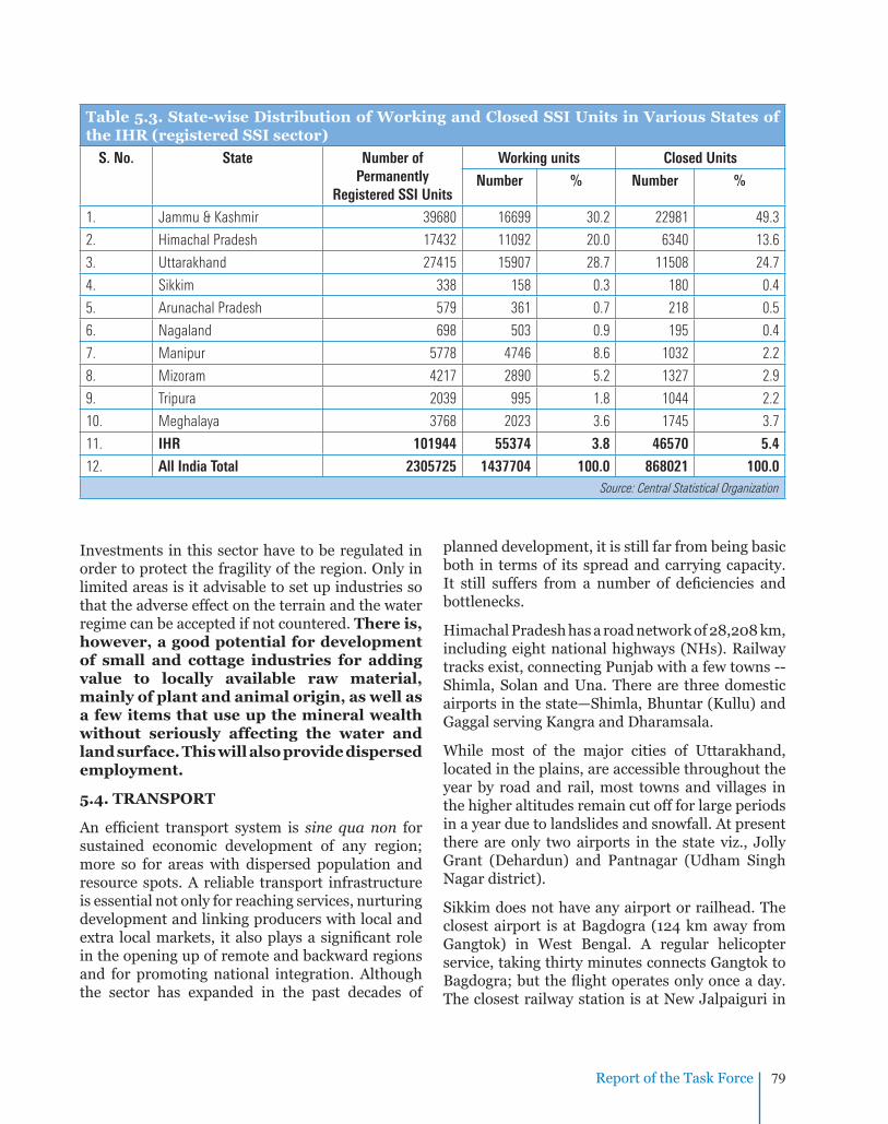
Report of the Task Force 79
Investments in this sector have to be regulated in order to protect the fragility of the region. Only in limited areas is it advisable to set up industries so that the adverse effect on the terrain and the water regime can be accepted if not countered. There is, however, a good potential for development of small and cottage industries for adding value to locally available raw material, mainly of plant and animal origin, as well as a few items that use up the mineral wealth without seriously affecting the water and land surface. This will also provide dispersed employment.
5.4. TRANSPORT
An effi cient transport system is sine qua non for sustained economic development of any region; more so for areas with dispersed population and resource spots. A reliable transport infrastructure is essential not only for reaching services, nurturing development and linking producers with local and extra local markets, it also plays a signifi cant role in the opening up of remote and backward regions and for promoting national integration. Although the sector has expanded in the past decades of
planned development, it is still far from being basic both in terms of its spread and carrying capacity. It still suffers from a number of defi ciencies and bottlenecks.
Himachal Pradesh has a road network of 28,208 km, including eight national highways (NHs). Railway tracks exist, connecting Punjab with a few towns -- Shimla, Solan and Una. There are three domestic airports in the state—Shimla, Bhuntar (Kullu) and Gaggal serving Kangra and Dharamsala.
While most of the major cities of Uttarakhand, located in the plains, are accessible throughout the year by road and rail, most towns and villages in the higher altitudes remain cut off for large periods in a year due to landslides and snowfall. At present there are only two airports in the state viz., Jolly Grant (Dehardun) and Pantnagar (Udham Singh Nagar district).
Sikkim does not have any airport or railhead. The closest airport is at Bagdogra (124 km away from Gangtok) in West Bengal. A regular helicopter service, taking thirty minutes connects Gangtok to Bagdogra; but the fl ight operates only once a day. The closest railway station is at New Jalpaiguri in
Table 5.3. State-wise Distribution of Working and Closed SSI Units in Various States of the IHR (registered SSI sector)
S. No. State Number of Permanently
Registered SSI Units
Working units Closed Units
Number % Number %
1. Jammu & Kashmir 39680 16699 30.2 22981 49.3
2. Himachal Pradesh 17432 11092 20.0 6340 13.6
3. Uttarakhand 27415 15907 28.7 11508 24.7
4. Sikkim 338 158 0.3 180 0.4
5. Arunachal Pradesh 579 361 0.7 218 0.5
6. Nagaland 698 503 0.9 195 0.4
7. Manipur 5778 4746 8.6 1032 2.2
8. Mizoram 4217 2890 5.2 1327 2.9
9. Tripura 2039 995 1.8 1044 2.2
10. Meghalaya 3768 2023 3.6 1745 3.7
11. IHR 101944 55374 3.8 46570 5.4
12. All India Total 2305725 1437704 100.0 868021 100.0Source: Central Statistical Organization
Report of the Task Force 79

Report of the Task Force80
West Bengal, situated 16 kilometres from Siliguri. NH-31A links Siliguri to Gangtok.
In Nagaland, the railway network is just till Dimapur. The length of the National Highway is only 365.38 km whereas that of state roads is 1094 km. The solitary airport is located at Dimapur (70 km away from the State Capital) though another is being planned at Kohima.
Tripura is connected with the rest of the country (takes about 36 hours) by a meter gauge railway line extending to Lumding and Silchar in Assam. National Highway-44 also connects it to Assam and the rest of India. Agartala Airport, the main airport in Tripura provides fl ights to Kolkata, Guwahati, Bangalore, Chennai, Delhi and Silchar.
Meghalaya is a land locked state with a large number of small settlements in remote areas. Roads are the only means of transport within the state. While the capital city Shillong is relatively well connected by road and air (the state has an airport at Umroi, about 40 km from Shillong on the Guwahati-Shillong highway but operation is limited to only 50 seater aircraft, and the fl ights are often irregular due to erratic weather conditions). There is also a helicopter service between Guwahati and Shillong.
Most of the arrivals into Meghalaya are through Guwahati in Assam, which is nearly 103 km away by road.
Assam has a major railhead as well as an airport with regular train and air services respectively, to and from the rest of the country.
Mizoram is connected by National Highway 4. It has only one airport at Lengpui, near the state capital Aizawl but because of its peculiar topography that traps clouds and smoke, landing has often to be aborted. Mizoram is accessible by rail (primarily for goods) up to Bairabi which is about 110 km from the Aizawl, but most goods are transported by road, via Silchar in Assam. Given the poor road conditions and unstable topography, the travel by the road within Mizoram is generally uncertain. The Central Government is reportedly in the process of developing a waterway with the port of Akyab Sittwe in Myanmar along Chhimtuipui river.
Geographically, Arunachal Pradesh is the largest and remotest state in the North Eastern IHR. The state has two highways; the 336 km long National Highway-52 that connects Jonai with Dirak and another highway which connects Tezpur in Assam with Tawang. Goods are carried to the interior
Table 5.4. Road and Rail Network (km) in the States of the IHR
States Road (2004) National Highway (2008) Rail Route (2000-2001)
Surfaced Total
Jammu & Kashmir 8962 21095 1245 96
Himachal Pradesh 17956 32582 1208 269
Uttarakhand 16783 58054 1991 356
Sikkim 1652 2063 62 -
Meghalaya 6687 9701 810 -
Tripura 9080 23856 400 45
Mizoram 2764 4898 927 2
Manipur 3839 12599 959 1
Nagaland 6570 20647 494 13
Arunachal Pradesh 6062 15712 392 1Note: Inter connectivity of state capitals of the NE states envisaged through railway network under the NE REGION VISION 2020 launched by the Hon’ble Prime Minister.
Source: Road Transport Year Book (2009), Ministry of Road Transport & Highways (http://www.dorth.gov.in); Central Statistical Organization

Report of the Task Force 81
places by porters but in case of inaccessible areas, air dropping is the only way out. Small airports/helipads are located at Daparjio, Ziro, Along, Tezu, Pasighat, Amni, and Vijayanager. However, owing to unpredictable weather conditions, these airports can only handle a few fl ights per week. Table 5.4 provides a summarized overview of road and rail networks in the hill states of the IHR.
The local economy of most of the hill states of India is still dependent on agriculture and horticulture. Yet, surplus production of agriculture or horticulture makes no sense unless these can be carried, on time, conveniently and cheaply to the places of consumption. The health and cultural welfare of the people of the IHR is also dependant on the connectivity to service centers. Construction of roads is, however, diffi cult and expensive in the IHR. Therefore, the quality of roads is relatively better in the plains as compared to roads in high altitude and high rainfall mountainous areas.
It has been suggested that wherever roads have been laid in the mountains, traffi c has increased and slopes have become unstable resulting in frequent landslides. The rate of deforestation has also increased. Task Force members have observed that road networks along the valleys support deforestation in the upper slopes as felled trees have just to be rolled down to the roadside and then quickly, often clandestinely, transported away. Ridge alignment, on the other hand makes it diffi cult for felled timber to be carried uphill.
So, it would appear that solution that meets both these ends lies in fi nding and supporting road making technologies that are sensitive to, and also in conformity to the characteristics of mountain ecology and geology. Ridge alignment rather than along river valleys, effi cient side drains, bio proofi ng of slopes below and above roads (tea bushes, bamboos and the like that bind the soil through intricate latticework of roots as well as a thick canopy that arrests raindrops from directly hitting the soil), location specifi c designs, and loops (networks interlinked in the region itself) are obvious choices that must be preferred.
Transport planning in the IHR should not discard
age old practices that have stood the test of time: e.g., rope bridges and ropeways. It is much cheaper to construct steel wire suspension bridges across chasms than roads around them. Small vehicles and trucks can ply along them easily to carry local produce as well as for reaching welfare services.
The framework for the IHR communication sector must be a combination of geo-sensitive roads, loop-linking producers with markets within the IHR; two loop railway lines (one in the eastern and another in the western sectors) to evacuate the produce from the road transport; and a small airfi eld in each State to evacuate the perishables to markets in the rest of the country and abroad.
5.5. TELECOM AND INFORMATION TECHNOLOGY INFRASTRUCTURE
Access to skills and information has already been identifi ed as a prerequisite for sectoral development. It is always not possible to set up physical infrastructure for imparting skills or knowledge, especially when such knowledge is of a specialized nature. The next best alternative is, therefore, the establishment of satellite supported connectivity from thousands of small sets throughout the IHR to specialized skill and knowledge imparting institutions in the country and beyond. One way of addressing this issue is through the existing internet providing services, but at most locations in the hill states dial-up services, broadband, lease line connectivity will continue to be diffi cult on account of the challenges posed for laying optical fi bre cables along hill terrains. Tower based wireless connectivity may also not work. So, the expensive alternative seems to be direct satellite connectivity. The SATCOM division of National Informatics Centre has nearly 3000 VSATs connecting all the Districts/States/UTs of India including in the IHR. This service needs to be augmented. Simultaneously, optical cable networks, along existing road and rail networks, must be invested on even if the costs are higher than in the plains. Such investments will directly benefi t human capital of the IHR and in the medium term generate employment in the service sector. There is every reason to believe that the IHR can become the business and service processing and software development region of the country. Appropriate restrictions may, however, have to be imposed in the border areas.

Report of the Task Force82
Table 5.5. Average Area and Population Served per Post Offi ce in Various States of the IHR
Postal Circle Average Area Served (in km2) Average Population Served
Jammu & Kashmir 135.57 4711
Himachal Pradesh 20.15 1849
Sikkim 34.80 2009
Meghalaya 46.37 3643
Tripura 14.62 3853
Mizoram 53.14 1738
Manipur 32.36 2656
Nagaland 51.56 3812
Arunachal Pradesh 284.69 2925
India 21.32 5477Data for Uttarakhand and hill regions of Assam and West Bengal are not available.
Source: Rajya Sabha Unstarred Question No. 3247 dated 25.04.2000
OTHER MODES OF COMMUNICATION:
The entire IHR is covered by 20 centres of All India Radio and 17 community radio stations. The region is also well covered by 16 Doordarshan studios. Owing to low population density the average population served by a post offi ce in the IHR is comparatively lower than the national average (Table 5.5).
5.6. URBAN SETTLEMENTS
Limited livelihood earning opportunities, lack of adequate and quality social infrastructure such as for health and education, and changing socio-economic aspirations are some of the key factors responsible for large-scale migration of rural communities to smaller towns within the IHR and also to various towns and cities in the plains. Unregulated development of urban and urban-like centres in the IHR has been creating the usual problems but in this case problems associated with environmental concerns. Rivers and river basins have become dumping grounds affecting the most valuable treasure the IHR. Unplanned settlements are degrading the quality of its soil, and air, besides increasing the vulnerability of the region to natural disasters.
Real estate development is also causing signifi cant change in the mountain environment and to the local communities. As such, entire IHR has several urban settlements and sizable number of Cantonment Boards (Table 5.6).
The Task Force members felt it unnecessary to suggest ways of solving the problems related to urbanization as it is a phenomenon emerging for the whole country and many options, including PURA
(the plan to Provide Urban amenities to Rural Areas) are being considered. For the IHR, the Members felt, it would be suffi cient to fl ag the imperative to zone stable areas for human settlements paying due attention to soil and slope conditions and proximity to natural drainage network and fault zones. Regulations governing the type of construction permissible within approved zones, heavy penalties for violation, compulsory rain water harvesting structures for all residences and commercial buildings above a prescribed plinth area, and for all offi ces; sewage disposal, solid waste management and drinking water supply should form the basic part of such master plan and regulation.

Report of the Task Force 83
Table 5.6. Number of Towns in the IHR (2001)
State/region C.T. C.B. T.C. M.C. M.B. M.Cl. M M.Corp. N.P. N.A.C. O t h e r towns
Total
Jammu & Kashmir 2 2 5 3 - - - - - 63 - 75
Himachal Pradesh 1 7 - 4 - 16 - 1 28 - - 57
Uttarakhand 12 9 - - 32 - - 1 30 - 2 86
Sikkim 1 - - - - - - - - - 8 9
W. Bengal Hills - - - - - - 3 1 - 1 4 9
Meghalaya 6 1 3 - 4 - 2 - - - - 16
Assam Hills - - 9 - - - - - - - - 9
Tripura 10 - - - - 1 - - 12 - - 23
Mizoram 21 - - - - - - - - - 1 22
Manipur 5 - - - - 7 - - 20 - 1 33
Nagaland 1 - 8 - - - - - - - - 9
Arunachal Pradesh 17 - - - - - - - - - - 17C.T. Census Town; C.B.: Cantonment Board/Cantonment; T.C.: Town Committee/Town Area Committee; M.: Municipality; M.B.: Municipal Board; M.C.: Municipal Committee; M.Cl.: Municipal Council; M.Corp. Municipal Corporation; N.P.: Nagar Panchayat; N.A.C.: Notified Area Committee/Notified Area Council
Source: Census 2001
���

Report of the Task Force84
There is enough evidence to indicate that a warming of the World’s climate is happening. What is still being debated is how much, where and what will be the effects. So, without going into the specifi cs, the Task Force members recommended that the report should highlight a couple of major issues that the IHR states must start recognizing59 and, therefore, start planning for.
When the temperature increases, rainfall will become erratic. Conventional food crops are likely to face moisture stress60. The pattern of pollination and pest incidence may also change. Consequently, there will be a fall in output61 . This will generate pressures and movements to increase agricultural area as a measure of compensation. In the context of the IHR, encroachment is likely to take place in forests. Though forests and tree crops are bound to be more tolerant to climatic changes, traditional agriculturists cannot be persuaded to depend on these as a substitute for conventional food crops. Hence, IHR states must begin planning for such contingencies, including the possible mass movement into protected forest areas.
CHAPTER 6
CLIMATE CHANGE
With uncertain rainfall, the conventional Water Towers may also experience stress. With shortage of water, both for crops and life, distribution problems may arise. If animal needs are neglected in the process, the livelihood of a large number of nomadic herder families will be in danger62 .
Planning options may range from better water channeling projects, alternate irrigation methods (pitcher, drip, etc), improved, moisture stress resistant crops, better storage technologies (thereby, reducing losses), crop diversifi cation63, improved soil and moisture conservation methods, in situ pollinators, and so on. Changes in occupation, shifting from agriculture to something allied are also scenarios to be considered. Indirectly, the alternate opportunities that may be thrown open through skill upgradation and training may absorb some of the strain.
Besides agriculturists, climate change is likely to affect the movement pattern of herdsmen. Consequential pressures, again on alpine pastures, forests and localized water sanctuaries, are likely to increase. Options for this sector have to be studied post haste.
59 An upward movement of saplings of Himalayan pine (Pinus wallichiana) has been observed in higher altitudes. This pine is sensitive to climate change at its upper elevational limit in western Himalaya. (Dubey, B., Yadav, R.R., Singh, J. and Chaturvedi, R. 2003. Current Science, 85(8):1135-1136.
60 Under limited water availability, Water Use Effi ciency (WUE) is critical relative to photosynthesis for the performance of plants. A decrease in WUE has been observed in case of Himalayan barley (Hordeum himalayens) with increasing temperature. Photosynthesis was also sensitive to higher temperature in this species and reduced with increasing temperature. The common barley (Hordeum vulgare) showed much less sensitivity to rise in temperature (Joshi SC and Palni LMS. 2005. Current Science, 89(5):879-882).
61 Despite an increase in the extent of land under apple orchards, total production is decreasing in district Kullu of Himachal Pradesh. This has been attributed to the changes in climate. During 1900s increase in maximum and minimum temperature has been recorded along with a decline in precipitation (average rainfall and snowfall) over the previous decade. (Ram, SC, Kuniyal, JC, and Rao KS. 2003. Climate changes and its impact on Apple cropping in Kullu valley, North-Western Himalaya, India. International Symposium on Temperate Zone Fruits in the Tropics and Subtropics. 14-18 October 2003, University of Horticulture and Forestry, Nauni-Solan, H.P).
62 Rhododendron and other woody species have already begun to invade alpine meadows, lush grazing fi elds, in the Valley of Flowers of Uttarakhand. (Singh, SP, Singh, V., and Skutsch, M. 2010. Climate and Development, 2:1:13; doi:10.3763/cdev.2010.0048)
63 It is possible to link livelihood issues to conservation in a way that leads to enhanced forest carbon stocks. For example, development of fodder based on grasses and legumes can reduce the need for people to lop tree branches. (Singh, SP. 2007. Climate change: An overview. Proceedings of the 15th National Symposium on Environment: Mitigation of Pollutants for Clean Environment. Macmillan India, Mumbai. pp. 24-29).

Report of the Task Force 85
Climate change will mostly affect the most vulnerable. IHR states must have a special safety net for such people till they can be provided alternate livelihood options. It must also be remembered that many inhabitants of the IHR have, at various points of time faced unpredictable changes in weather, some extending over long periods. They may have learnt to recognise the natural telltale signs, popularly termed as ‘bio-indicators’ (e.g., early fl owering
in Rododendron arboreum). A study of these and an enumeration of their responses may not only help design acceptable remedial or reactive programmes, but indeed, may make these comprehendible. Scientifi c tables and graphs may not cut much ice with illiterate farmers or livestock herders. At this point, Task Force felt it necessary for fl agging the issue to be critical for the future development of the IHR.
���

Report of the Task Force86
The Task Force has made its recommendations in as objective manner as was possible. Yet, the Task Force members are aware that decision taking at the level of State Governments is bound to be subjective and would be guided by political and pressure group interests. This is true for most recommendations and as economists believe, Government will ignore a recommendation from their advisors unless it suits them “and yet the economists routinely advise Government to act in the economy’s interests rather than their own.” 64
Hence, the Task Force members hope that its recommendations would be discussed and debated at all levels of IHR Government including in the Panchayati Raj Institutions (PRIs) and the VI Schedule Areas for mass acceptance. The recommendations that are localized in nature (e.g. relating to zoning) need particular discussion at the community level so as to make the implementation acceptable, and therefore, possible.
Two broad areas of governance have primarily to be tackled at the level of IHR State Governments. The fi rst one is infrastructure, and the second is service delivery. The approach to these two would guide the relevant supportive policy. Creating infrastructure is relatively easy; maintaining it and running it for the purpose meant is hugely diffi cult. An essential part of good governance would be to match all these three, in one package.
Service delivery is of two types. One is infrastructure based where benefi ciaries have to come and seek services; the other is where service is delivered to a family at their doorstep. For the IHR, the Task Force recommends a preponderance of the second type. For instance, instead of expecting a householder to come to the hospital with her sick cow, the paramedics should fi rst reach her in her home and only if home based treatment is not possible, she should be advised to take the sick animal to the hospital.
For effective service delivery, the cry of the country,
CHAPTER 7
GOOD GOVERNANACEincluding in the IHR, is for convergence. The Task Force would recommend that all the 8 IHR States should agree on a “Mission Convergence” that will dovetail all the State and national development/welfare projects for focused delivery. The strengths of one programme or the expertise of one programme management need to be leveraged by another that is weak in that aspect. To give a specifi c example, a self-help group (SHG) in the IHR that is effectively marketing local products outside the IHR should also be persuaded to take up the marketing responsibility of another self-help group which is weak in this. Each self help group need not duplicate all functions. Likewise, one SHG that trades in pulses may fi rst serve the needs of another that buys pulses from the market for a school feeding programme. The Forest Department, likewise, may also promote fodder in its afforestation effort if the immediate need of the people is feed for their livestock.
Convergence of economic programmes at the fi eld level can be specifi cally tasked to District Lead Banks under the supervision of district administration in consultation with the PRI or the traditional governance structure under the VI Schedule. Likewise, convergence of natural resource utilization and conservation, welfare and empowerment of its members can best be done by the PRIs/VI Schedule structure as they have the Constitutional and local mandate for this. Quite obviously, the PRIs, the Area and Village Councils, as well as the district administration will have to be supported through skilled consultants for bringing about such imaginative synergy and dovetailing.
In the VI Schedule areas, it is equally important that operating guidelines and rules are designed for laying down a framework for fi nancial and administrative transactions. This will, to a large extent, take care of the apprehension of some north east state governments in releasing funds and functionaries to autonomous councils and village
64 Kausik Basu. Indian Express, 11th March, 2010, Delhi Edition

Report of the Task Force 87
bodies. The Panchayat Raj Ministry is reportedly working out such guidelines, in consultation with the concerned states.
However laudable are the recommendations of any Task Force or the objectives of any policy on development and welfare, ultimately, it boils down to the effi ciency of the delivery mechanism, with its systems, for translating intentions to outcomes. Upgrading the standards of administration in the (IHR) is a task that the Task Force recommends, has to be specifi cally addressed by all the IHR States, preferably with the help of professionals and academic bodies. The contents of the plan must cover personnel policies that identify the best persons for the task; allow suffi cient tenure and equipment for task fulfi lment; simultaneously develop technical systems that support effi cient data collection, analysis, targeting and monitoring; reward performers; discipline non-performers; link inputs on a time schedule with the output target; fi x direct as well as supervisory responsibilities to outputs; design outputs that can be measured and so on. The Task Force recommends the Convergence Mission to also look into issues of delivery in the IHR. Whether this should be in the form of a Himalayan Sustainable Development Forum, as was recommended by the Declaration following the Himalayan Chief Ministers’ Conclave, October 30, 2009, Shimla, or in any other form is a decision best left to the IHR States. In this regard a recent publication25 may be taken note of, which forms part of broader climate change adaptation strategy, and puts together key guidelines related to the governance and management of the Himalayan Ecosystem, along with best practices.
There are some measures that are great confi dence builders; these bridge the gap between decisions, programmes and the benefi ciaries. Directly these also strengthen the link between the people behind policy making, programme implementation and the recipients. Two such confi dence building measures are being highlighted and recommended by the Task Force.
One is the right to property. Every cultivable or liveable land and every habitation must be settled with the rightful occupier or a new allottee. The settlement has to be done jointly with the husband and the wife. Following such settlement,
the confi dence of the right holders to demand services will increase. Studies show that welfare programmes, if targeted to women instead of men, have a greater benefi cial impact on the physical and mental health of the children of that family. Hence, all the welfare programmes that will, hopefully emanate from the recommendation of the Task Force, should be given to women.
The second confi dence builder is an effective and functioning grievance redressal structure and machinery. This structure should primarily address grievances relating to land, drinking water, food and general health. But no separate mechanism or institutions is needed; with convergence, the existing general revenue administrative machinery and the PRIs / VIth Schedule institutions should be enabled to undertake this task. For instance, it should be possible for a person, wrongly ousted from his property to approach the block development offi cer or the concerned revenue or forest offi cial surely, either in his or her offi ce or in camp courts (which was in vogue earlier in many States) and get justice in an open and transparent manner. If refused, he or she should understand why. The chances of extremists taking advantage of the absence of such a situation must be curbed at this stage itself before it goes totally out of hand. If mechanisms that inform, like the educated press, public meetings, radio, television, even internet, are encouraged to function, and the authorities entrusted with the redressal of grievances or for providing development and welfare are ever alert, the people of the IHR are bound to join in wholeheartedly in all the initiatives.
Some believe that the building up of the “Force for the Future” should come from the country’s youth. The Members of the Task Force are in agreement with this and strongly recommend the initiation of programmes that will “ignite” the young minds of the IHR; a word that was very dear to our earlier President.
The Task Force members believe that good governance is possible only with good politics, and that equity in social justice and delivery of services will lead to development which will benefi t all. The IHR States must take a call on this.
���

Report of the Task Force88
Developmental Zones
Road, Rail and Air Connectivity
Other Recommendations
1. Mountain Perspective and Sensitization
2. Education and Skill Development
3. Natural Resource Analysis and Advisory Centre
4. Strategic Environmental Assessment
5. Financial Incentives, Rewards, and Relaxations
6. Resource Sharing between IHR States
7. Waterways and Ropeways
8. Waste Management
9. Disaster Preparedness and Mitigation
10. Industries
11. Climate Change
12. National Mission for Sustaining the Himalayan Ecosystem
CHAPTER 8
RECOMMENDATIONS
The issue wise recommendations of the Task Force have been made in the critically relevant chapters as well as in the chapter titled “Distilled Wisdom”. The Task Force has deliberately not touched upon all conventional aspects and issues essentially because it sees no merit in the recommendations becoming a national plan document for the IHR. Instead, just the crucial items have been discussed with the hope that if these basics are addressed, the rest would fl ow and follow automatically.
This chapter is a further distillation of just the “super-critical” items and issues.
DEVELOPMENTAL ZONES
To maintain the primacy of the ‘colours’ based on eco-sensitivity, the Task Force recommends that the balance between natural resource exploitation and conservation should tilt in favour of the latter. Zones must be identifi ed for appropriate activities such as:
Zones of snow, alpine, sub-alpine areas • and sacred landscapes to be protected at
any cost, for maintaining the fl ow of vital ecosystem services and for respecting and preserving religio-cultural values,
All natural water zones (glaciers, rivers, • lakes, and springs) must be strictly protected. Activities in any of the zones that, in any way, adversely impact on water resources should be barred. Areas that harboured natural Springs must be converted to “Spring Sanctuaries” and this concept should be incorporated in all planning,
Forest zones should be conserved and • augmented for environmental services and biodiversity values. Such zones should also be available for sustainable bio and NTFP, including bamboo, prospecting, and for eco-tourism,
Zones of fertile river valleys at lower • altitudes should be utilized for maximizing agricultural production but conversion of agricultural land to other uses in such zones

Report of the Task Force 89
should not be allowed. Areas where shifting or terraced agriculture is practiced should be earmarked for unique crops, organic agriculture, horticulture, agro-forestry, and for introducing better management practices,
River zones for decentralized electricity • production should be earmarked to meet the household and small industrial power requirements,
Zones for habitation, especially of urban • spaces: no construction should be undertaken in areas having slope above 30o or areas which fall in hazardous zones or areas falling on spring and aquifer lines and fi rst order streams. Effi cient sewage & municipal waste management systems should be mandatory in such places, and
Zones for industry should only be in non • fragile areas and include only those activities favourable to mountain conditions, processing non-toxic, preferably locally available raw materials, and generate local employment, while demonstrating effi cient CSR and CER practices.
ROAD, RAIL AND AIR CONNECTIVITY
The recommendations of this Task Force will fi nd acceptance if the people of the IHR are enabled to travel outside their village or towns for work or leisure; service providers are enabled to reach distant corners, and local produce is facilitated for reaching markets. This can be achieved only if there is a good combination of road, rail and air connectivity, each supporting the other. The Task Force has already commented on the road network. Now the Task Force recommends two loop railway lines – one for the Western Himalayan region connecting Jammu & Kashmir, Himachal Pradesh, and Uttarakhand, and the other for the North-Eastern Region. These two loops should be linked to each other through the existing national network of the northern and eastern railway. The road network of the IHR must link up with the rail network at appropriate places for performing the aforementioned functions. The road network should
also be linked up with air services so as to provide opportunities for perishable goods and persons needing emergency health care to reach the rest of the country or outside. The Task Force recommends that every IHR state should have at least one small air-strip for accepting large helicopters and short take-off and landing planes. The airport should be located near the major production centre rather than the capital city of the state.
OTHER RECOMMENDATIONS
1. Mountain Perspective and Sensitization
Mountains are and should be treated as national treasures: of resource and opportunity; for today and tomorrow. Indeed, survival of the north and eastern plains of India, with their large population, will be diffi cult if IHR plans are faulty and short sighted. This would also mean that national policies65 have to have a mountain perspective so that decisions taken for the rest of the country do not adversely affect the mountain environment, its resource and its people. Planners and policy makers particularly, have to be sensitized regarding the vulnerabilities as well as the importance of the IHR.
2. Education and Skill Development
Designing of mountain specifi c courses and skills for planners, administrators, engineers, social scientists, especially on all aspects of mountain ecology, geology, and marginal socio – economic conditions of the local population is of essence. Every IHR state is expected to continue to face a huge shortfall of qualifi ed teachers, health care attendants and technicians, and architects in the next decade. IHR states must plan for meeting this demand with their human capital. Indirectly, this will ensure that basic livelihood issues will not lead to the destruction of the IHR’s natural resources. All universities, institutes and training centres, especially in the IHR must expand their activities and redesign their courses to meet these challenges.
The Task Force also recommends that all the State, Central and major private sector
65 For example - Different norms for cost calculations in developmental projects like transportation cost of material from plains and on alternate mode of transportation than on motor vehicle., e.g., Ministry of Chemical & Fertilizer provides freight of Rs. 283 per MT on P & K fertilizers from railhead to consumption centres while the actual freight is Rs. 800-900 per ton in HP hence suppliers are reluctant to supply on account of loss.

Report of the Task Force90
funded academic and skill development and training institutes should be linked to each other through administrative as well as internet based structures. The aim is to ensure focussed and coordinated output, aimed at achieving the objectives of the IHR plans. Institutes within a state may decide on a Nodal institute for this purpose; and all such Nodal Institutes be included under a network that allows annual interactions, if not earlier, on a rotational basis. A State wise list of institutes functioning in the IHR states is given in Annexure III.
3. Natural Resource Analysis and Advisory Centre (NRAAC)
The Task Force recommends the upgradation of an existing institute or the establishment of a new institute on Natural Resource Analysis and Advisory Centre (NRAAC). This institute should have full digital data on the resource base of the IHR; should be able to analyse data to detect changes or see trends; and should be able to guide policy makers and planners on any activity that is likely to affect any resource or the environment of the region. Consultation with this body should be mandatory before any major activity in the IHR is undertaken. For effectively carrying out all the recommendations, and to support their planning as well as for much needed monitoring, all IHR states need to join in and establish a user friendly digital databank (spatial and non-spatial).
4. Strategic Environmental Assessment
A new perspective to replace the practice of project based environmental impact assessment (EIA), with Strategic Environmental Assessment (SEA) needs to be introduced.
5. Financial Incentives, Rewards, and Relaxations
Since the Task Force is recommending that the IHR states should be very restrictive in the use of their resources as this will be in the long term interest
of the IHR as well as the country, it is logical then to suggest that the IHR states be compensated for this self denial of short term gain. The Task Force recommends the setting up of a dedicated, non lapsable Gap Fund and a compensation mechanism66 for IHR states. The Gap Fund must, however, not be open ended; indeed, it should be linked to Good Politics and Good Governance. IHR states that do not show this, as per the perception of the Himalayan Development Forum, suggested in the Chapter on Governance, should not be able to leverage the funds. Such non conventional measures are recommended in the context of the importance and fragility of the IHR.
Norms for centrally sponsored schemes should be formulated on geographical parameters (climate & season67, distance, topography, accessibility) rather than conventional parameters like human population68. In this regard certain welcome steps have been introduced in recent times by way of relaxation in norms under Centrally Sponsored and other Central Schemes for Hill Areas (e.g., Pradhan Mantri Gram Sadak Yojna, Sarva Shiksha Abhiyan, and National Rural Drinking Water Programme; details in Annexure IV). Different price policy for inputs and transportation of organic/niche specifi c crops of the mountains is required, coupled with an enabling framework to encourage the development IHR brand (e.g., eco-mark, energy star label). Relaxation in banking norms need to be considered for extending credit in areas where the traditional land tenure system restricts personal ownership or where land rights have not been surveyed and settled. In such situations (especially north-eastern region) social capital should be considered as a surrogate to land ownership.
6. Resource Sharing between IHR States
There is need for establishing resource sharing mechanisms and/or inter-exchange between the IHR states. For instance, extraction of petroleum and petroleum gas from Assam may fi rst be used to satisfy the need and demand of the neighbouring IHR states. Likewise, IHR states should have
66 12th Finance Commission had set additional Rs. 1000 crore for maintenance of forests by States.67 Modifi cation in building codes with reference to the location, e.g., use of Solar energy in Laddakh.68 Example -1st order priority for providing connectivity to unconnected habitations in mountains under PMGSY instead of 500+.

Report of the Task Force 91
69 Inland Waterway Authority of India.70 The Himachal Pradesh Aerial Ropeways Act, 1968.
fi rst charge on electricity generated in the region. Such policies will generate a great degree of goodwill.
7. Waterways and Ropeways
Of the three inland national waterways declared69 so far in the country, the Sadiya-Dhubri stretch of river Brahmaputra (891 km) is in the IHR. The road network should match with this waterway to optimize the cost of transportation. Ropeways, steel-rope bridges and the like must be encouraged to continue providing time saving and environment friendly transport alternatives in the mountains. The legal frame work of Himachal Pradesh70 can form the basis for the development and extension of such methods in the IHR.
8. Waste Management
Waste management is a challenging issue for the IHR. If not addressed right away, it may become the major cause of pollution of all the critical riverine systems and valleys. The easy alternative of burning, if adopted, would pollute the air and contribute towards warming of the localized climate. The Task Force, therefore, recommends immediate attention of the IHR states to this problem and suggests the formulation of schemes that address it from the production stage to the disposal. Financial incentives with legal control are recommended. Full advantage should be taken of national programmes for strengthening the capacity of local bodies for segregation, recycling and reuse of municipal solid and liquid waste, and for creating community awareness and community imposed self discipline. A small state like Mizoram has organized its youth to provide garbage bins at every roadside market, and remove the collection at the end of each day. Unfortunately, not knowing what to do with the waste, they are burning it along the hill slopes.
9. Disaster Preparedness and Mitigation
It is imperative, the Task Force feels, to zone stable
areas for human settlements paying due attention to soil and slope conditions and proximity to natural drainage network and fault zones. Unstable zones must be identifi ed and made strictly out of bounds for any human activity. Regulations governing the type of construction permissible within approved zones, heavy penalties for violation, compulsory rain water harvesting structures for all residences and commercial buildings above a prescribed plinth area, and for all offi ces; sewage disposal, solid waste management and drinking water supply should form the basic part of such master plan and regulation. Strict regulations during festivities and pilgrimages, estimating the carrying capacity of habitations, earthquake and fi re resistant buildings, proper vacant spaces for refuge in times of emergency, forecasting and early warning systems, and rapid response mechanisms are measures that should be put in place at each sensitive location. IHR states should have no hesitation for spending money on competent consulting organizations that provide disaster management services.
10. Industries
Investments in this sector have to be regulated in order to protect the fragility of the region. Only in limited areas is it advisable to set up industries so that the adverse effect on the terrain and the water regime can be accepted if not countered. There is, however, some potential for development of small and cottage industries if imaginatively linked to tourist circuits. This will add value to locally available raw material, mainly of plant and animal origin, as well as some items that use up the mineral wealth. This will also provide dispersed employment.
11. Climate Change
Without going into the specifi cs, the Task Force members recommended that the IHR states must anticipate impending warming of the earth’s climate, and therefore, encourage predictive research in order to plan for mitigating the adverse consequence.

Report of the Task Force92
12. National Mission for Sustaining the Himalayan Ecosystem (NMSHE)
The launch of NMSHE, the only location specifi c mission, along with seven other thematic missions under the National Action Plan for Climate Change, is a clear indication of the importance being given to the Himalayan region at the highest level. The major recommendation of the Task Force is also to echo similar sentiments, and to suggest that
this region should be accorded its rightful place in the planning process, giving due emphasis to mountain specifi cities. Since many factors well beyond the national boundaries, greatly infl uence this region, suitable policy framework will need to be put in place to take care of the need to exchange information with the South Asian countries and regional neighbours those who share the Himalayan ecology, as also recognized in the Mission document on NMSHE71 .
First Step –
The IHR States must agree to a common essential platform for regular interaction and from therein, decide on a common essential plan for the region. Establishment of a Himalayan Development Forum for all IHR States is recommended. Planning inputs must come from existing institutions till NRAAC is established.
The plan must prioritise the zoning of the regions so as to be sure as to what is to be done or permitted where. This is likely to take care of the environmental and resource concerns.
Simultaneously, extensive grass root engaged programmes to develop mountain specifi c skills, technology and education must be launched. This will enable production of niche crops, using up least amounts of precious water, releasing minimal wastes, reaching easily accessible markets. Equally important would be the opportunities thrown up, for the people of the IHR, for providing specialized services to existing and emerging sectors of the local economy, to the rest of the country and abroad.
IHR governance must be designed to listen, deliver, and appreciate. The treasure house of the IHR must be enabled to grow as its people grow, and for this, the plan cannot follow the same pattern as for (like) or for (benefi t of) the rest of the country.
71 National Action Plan on Climate Change, GOI (2008). http://pmindia.nic.in/Pg01-52.pdf
���

Report of the Task Force 93
Annexure

Report of the Task Force94

Report of the Task Force 95
ACRP Agro-Climatic Regional Planning
amsl Above mean sea level
APDRP Accelerated Power Development and Reform Programme
BPL Below Poverty Line
BSNL Bharat Sanchar Nigam Limited
CAT Catchment Area Treatment Plan
CCTA Cabinet Committee on Tribal Affairs
CEA Central Electricity Authority
CER Corporate Environmental Responsibility
CHEA Central Himalayan Environment Association
CIC Community Information Centres
C-NES Centre for North East Studies and Policy Research
CSO Central Statistical Organization
CSR Corporate Social Responsibility
DRDO Defence Research and Development Organization
EIA Environment Impact Assessment.
EMP Environmental Management Plan
EMRI Emergency Management and Research Institute
FDI Foreign Direct Investment
FD Forest Department
FSI Forest Survey of India
GBPIHED G.B. Pant Institute of Himalayan Environment & Development
GDP Gross Domestic Product
GEI Gender Equality Index
GHG Green House Gas
GIS Geographical Information System
GLOF Glacier Lake Outburst Flow
GOI Government of India
GVA Gross Value Added
HADP Hill area development programme.
HDI Human Development Index
HEP Hydro Electric Power
HP Himachal Pradesh
HPI Human Poverty Index
HRD Human Resource Development
ICT Information and Communication Technology
IFAD International Fund for Agricultural Development
IHR Indian Himalayan Region
ISDN Integrated Service Digital Network
ISP Internet Service Providers
IUCN International Union for Conservation of Nature
J&K Jammu and Kashmir
JBS Junior Basic School
JFM Joint Forest Management
K Potassium
LPG Liquefi ed Petroleum Gas
List of Abbreviations

Report of the Task Force96
LDO Light Diesel Oil
Mcm Million Cubic Meters
MECL Mineral Exploration Corporation Limited
MoEF Ministry of Environment & Forests
MSK Medvedev-Sponheuer-Karnik Scale
MT Metric Tons
MW Mega Watts
N Nitrogen
NAP National Agriculture Policy
NE North East
NEC North Eastern Council
NEIIP North East Industrial and Investment Policy
NEP National Environment Policy
NEPED Nagaland Environmental Protection and Economic Development
NERCORMP North – Eastern Region Community Resource Management Project
NEREGA National Rural Employment Guarantee Act
NFDB National Fisheries Development Board
NHP National Health Policy
NH National Highways
NMSHE National Mission for Sustaining the Himalayan Ecosystem
NPRR National Policy on Resettlement and Rehabilitation
NRAAC Natural Resource Analysis and Advisory Centre
NRSA National Remote Sensing Agency
NTFP Non-Timber Forest Products
NW North West
P Phosphorus
PAF Project Affected Families
PAN Protected Area Network
PURA Providing Urban amenities in Rural Areas
ROI Return On Investment
SASE Snow & Avalanche Study Establishment
SATCOM Satellite Communication Group
SC Scheduled Castes
SEA Strategic Environmental Assessment
SEIAA Strategic Environment Impact Assessment Act
SEZ Special Economic Zone
SKO Super Kerosene Oil
SOI Survey of India
SSI Small Scale Industries
ST Scheduled Tribes
STOL Short take-off or Landing
UNDP United Nations Development Programme
UT Union Territory
VP Van Panchayat
VSAT Very Small Aperture Terminal
WB West Bengal
1 Million = 10 Lakh

Report of the Task Force 97
Annexure - I

Report of the Task Force98

Report of the Task Force 99

Report of the Task Force100

Report of the Task Force 101

Report of the Task Force102

Report of the Task Force 103

Report of the Task Force104

Report of the Task Force 105

Report of the Task Force106
Annexure – II
OVERVIEW OF THE PAST APPROACHES FOR DEVELOPMENT IN THE IHR:
1. National Commission on Development of Backward Areas (1981)
The Commission under the Chairmanship of Sri B. Shivaraman devoted one volume of its report to development of backward hill areas of the country, its key recommendations were:
The focus of development planning should be on (i) complimentarily of the hills and plains within a • regional and national frame or and (ii) integrated approach encompassing ecological, economic and sociological dimensions.
Developmental plans should be made at two levels, i.e. the region, and sub watersheds within the • region.
The strategy of development should include people’s (especially women’s) participation as a central • feature.
Agro-forestry and pasture development should be given due importance.•
Forests being the single largest land-use category – development of forests with emphasis on • increasing productivity of reserved forest, proper management of community lands and participatory plantations for waste land development, should be given importance.
Increased agricultural productivity through appropriate technological intervention that are • profi table, create jobs, and reliable, and should be the major means of increasing purchasing power of the people. Land consolidation should be attempted keeping economic and ecological conditions in view. Promotion of animal husbandry should be the integral part of all development plans.
The pivotal role of women in the process of development should be recognized and education, training • and extension programmes should be designed in such a way so that these can reach them.
Provision of infrastructural facilities like roads, water supply, hospital and other services. •
2. Task Force for the Study of Eco-development in the Himalayan Region (1982)
The Task Force, under the Chairmanship of Dr. M.S. Swaminathan, in its report on Eco-development in the IHR recommends the following:
Identifi ed faulty use of principal resources of the region i.e. soil, forests and water as the primary • factor for widespread degradation and framed its core strategy for the socio-economic development of the region through determination of correct land use, intensifi cation of agriculture, recharging of water sources, afforestation and adoption of cash crops.
The report also laid emphasis on the need for co-ordinated research on action oriented basis, post • harvest technology and transport planning.
3. Working Group on Hill Area Development Programme for VII Five Year Plan (1985)
The approach and strategy evolved for the development of hill areas in 1981 has since not been followed uniformly in different hill states, the Working Group therefore recommended that a suitable mechanism had to be devised to ensure that uniform development opportunities are provided in all the categories of hill areas. The group recommended the following criteria for defi ning the hill areas of the country:
area with average slopes of 30% and above may be treated as hill areas;•
all developmental blocks/talukas with 40% of their geographical area with an average slope of 30% • or more may be designated as hill blocks/talukas;

Report of the Task Force 107
All compact regions with geographical area of 100 sq. kms. or more with an average slope of 30% • or more within a block or located in more than one administrative unit may be designated as mini-tracts, and
The hill areas of less than a 100 Km• 2. should be within the technical, administrative and fi nancial competence of micro-level planning in the respective states and should be adequately provided for in State Plans.
The group made elaborate recommendations for allocation of funds in two distinct categories of (i) Himalayan hill areas and (ii) sub-continental hill areas. It also re-emphasized that the focus of the planning process should be on the (i) complementarily of the hills and plains within the regional and the national frame work and the (ii) integrated view of ecological, economic and sociological aspects of hill area development with the common man as the central fi gure.
The suggested strategy centers round the active participation of the people, particularly of women, in the fulfi llment of their basic needs viz. food, fuel, fodder and drinking water etc, whereas agro-forestry and pastoral economy were suggested as the corner-stone of hill area development. Need for scientifi c land-use pattern with adoption of appropriate technology was also suggested to be followed keeping socio-economic and ecological conditions in view. Problems of shifting cultivation, plantation policy in horticulture, animal husbandry programmes, fuel policy, need to be reviewed. The growth of towns in the hill areas should be strictly regulated keeping in view the ecological considerations. The recommendations for utilization and development of natural resources were also made.
4. Action Plan for Himalaya (1992)
The above action plan suggests mechanisms for ecologically sound economic development of the Himalayan region, and enumerates sector wise priority actions, covering both research based and development activities, in addition to management aspects required for increasing the pace of environmentally sound development in the region.
5. Expert Group on National Policy on Integrated Development of Himalaya (1993)
The report of the Expert Group Chaired by Dr. S.Z. Qasim emphasized the need to provide an insight into the major problems of the IHR as a whole and recognized the need for participatory approaches for sound socio-economic development of the region. The recommendations of the expert group include: constitution of a Himalayan development authority, creation of national Himalayan environment and development fund, enlarged role of the Ministry of Environment and Forests, linkage and co-operation of scientifi c institution, interaction of natural sciences with social sciences, preparation of guidelines for development projects in states, conservation of biodiversity and genetic resources, maintenance of forest cover and its sustainable management, development of agriculture and allied activities, marketing of horticultural products to neighbouring countries, improving Jhum cultivation, irrigation, energy, promote non-farm economic activities, promote health, nutrition and family welfare, preparedness for coping with natural hazards in earthquake-prone areas, strengthening road network and other modes of communication, promote environment friendly and ethical tourism, development of tribal populations, institutional arrangements in states for facilitating involvement of NGOs and voluntary organization, and explore / generate source of funding.
6. High Level Commission Report on Transforming the North-Eastern Region (1997)
The Prime Minister’s economic package and offer of unconditional talks announced on the occasion of his visit to the north-eastern region in 1995 had aroused great expectations among the local people of the region. Consequently a commission was appointed under the chairmanship of Shri S. P. Shukla

Report of the Task Force108
to recommend measures to create good infrastructural facilities and bridge Basic Minimum Service Gap to bring the North-East at par with the rest of the country within the next fi ve to ten years in a process of poverty alleviation and infrastructural upgradation. The major recommendations were related to strengthening sectors like farm, horticulture and plantations, animal husbandry and fi sheries, irrigation, forests, environment, transport and inland water transport, civil aviation, communication and broadcasting, hydrocarbon, power, industry including cottage industries and handicrafts, urban and, trade and transit, tourism, and banking and fi nance. The commission also recommended additional resource mobilization for the region, creation of north eastern development council and strengthening political infrastructure.
7. Task Force on the Mountain Ecosystems for the 11th Five Year Plan (2006)
The Task Force report under the Chairmanship of Dr. R. S. Tolia presents an analysis of current • knowledge and status of sustainable use of mountain ecosystems and a number of gaps have been identifi ed in natural resource management.
Recommendations for better resource management include: (i) subsidy for fossil fuel to the hill • communities (ii) modernize forest and wildlife management (iii) strengthen agro-forestry in the region (iv) improve Protected Area - People relationships (v) participatory resource management and (vii) more research on the ecosystems functioning and services in the mountain areas.
It subsequently deals with an analysis of available information on potential impacts of climate change • on the mountain ecosystems and the main recommendations for the IHR (besides recommendation for strict adherence of Kyoto Protocol at the country level) include: establishing a network of meteorological stations and adequate infra-structure for integrated climatological research across the IHR; revamping Clean Development Mechanism across IHR; monitoring glacial recession and extending glaciological programmes to Eastern Himalayas; disease surveillance and developing forecasting system for vector borne diseases; bio-prospecting for future crops, and long term ecological research on climate – endangered species – ecosystem relationships.
Based on thorough review of institutional and individual capacities available to address issues related • to conservation and sustainable use of mountain ecosystems the report concludes that very little efforts have been made to harness growing expertise for the conservation and development of IHR. Certain priority areas have been identifi ed for capacity building viz., Training on EIA Procedures, Green Roads Engineering, Technology for management of hazardous waste, Mountain Hydrology, Water Harvesting Technology, and Rangeland Management. New Institutes visualized are Mountain Farming System Research and Centre for Mountain Studies. It is also emphasized that all organizations working in the IHR are required to be brought together to address vital environmental issues. This could be possible through (i) giving new role to local traditional institutions based in rural areas (ii) creating a synergy amongst different organizations, mountain scholars, and social workers, and (iii) recognizing social institutions, social sanctions, local culture and traditional knowledge systems.
The task force also felt that the sectoral approach which has been taken so far would not be of much • use to integrated mountain environment and development, therefore the scope of Ministry for the Development of the North – Eastern Region be broadened by incorporating the three states of Western Himalayas viz., Uttarakhand, Himachal Pradesh and Jammu & Kashmir. This would be the most logical step for an integrated planning of the Himalayan region at the national level.
The report also provides review of the new EIA guidelines issued by MoEF in 2006 and suggests • certain measures to strengthen the State Environment Impact Assessment Authorities (SEIAAs) including strict compliance of EMPs and CAT Plans.
8. Himalayan Mission under National Action Plan on Climate Change (2008)
Under the direct guidance of the Prime Minister’s Council on Climate Change, India’s National Action

Report of the Task Force 109
Plan on climate change has been recently developed, which was released on 30 June, 2008. Of the eight core national missions of the plan, the Mission for sustaining the Himalayan Ecosystem aims to conserve biodiversity, forest cover and other ecological values in the IHR and to evolve management measures for sustaining and safeguarding the Himalayan glaciers.
9. The NE Region Development Vision 2020 (2008)
Ministry for the Development of the IHR Region has prepared a vision document for the eight states of North-Eastern region of the IHR. The vision document, which was adopted by North East council on 13 May 2008, emphasizes the following:
To return the NE region to the position of national economic eminence that the region had held few • decades ago.
To create infrastructure for focusing agriculture, industrialization, connectivity and human resource • development.
Earmarking of 10% allocation of a non-lapsable pool of funds received through central assistance for • NE Region.
10. Research and Development (R&D) projects funding in the Indian Himalayan Region
About 5.3% projects (out of the total R&D projects) had a focus on the IHR (1985-86 to 1998-99) with only 4.5% fund allocation out of the total R&D expenditure in the country.
11. Governance for Sustaining Himalayan Ecosystem (G-SHE) – Guidelines & Best Practices (2009)
In view of the need for clear guidelines for sustainable management and governance of the Himalayan Ecosystem, a recent initiative of Ministry of Environment & Forests (Govt. of India) in the form of “Working Document” puts together key guidelines along with case studies from various regions. The guidelines in this document cover a wide variety of issues- including urbanization, tourism, water security, energy, forest management and infrastructure- all of which are highly pertinent as the Himalayan region faces new and increased challenges and pressures.
12. Shimla Declaration on Sustainable Himalayan Development (2009)
In the fi rst Himalayan Chief Ministers’ Conclave, held at Shimla, it was resolved that challenges of climate change and sustainable development will be faced jointly and following actions were identifi ed –
Establishment of a Himalayan Sustainable Development Forum•
Setting up State Councils for Climate Change•
Catalyzing Research for Policy Action•
Payment for Ecosystem Services•
Managing Water Resources for Sustainable Development•
Challenges of Urbanisation•
Green Transport•
Dealing with impacts of climate change on livelihoods•
Decentralized energy security•
Managing growth of eco-friendly tourism and pilgrimage•
Green Industry•
Green Job Creation•

Report of the Task Force110
Annexure – III
List of Some of the Scientifi c Institutions in the Himalayan region
S.N Institution
1 Forest Research Institute (FRI), Dehradun
2 Himalayan Forest Research Institute(HFRI), Shimla
3 Rain Forest Research Institute (RFRI), Jorhat
4 Central Soil & Water Conservation Research & Training Institute(CSWCRTI), Dehradun
5 Botanical Survey Of India,(BSI), Regional Centres
6 Forest Survey Of India (FSI), Dehradun
7 GB Pant Institute Of Himalayan Environment & Development (GBPHIED), HOs at Almora and units in HP, Uttarakhand, Sikkim and Itanagar
8 Wildlife Institute Of India (WII), Dehradun
9 Zoological Survey Of India (ZSI), Regional Centres
10 State Forest Research Institute, Itanagar
11 Central Institute of Temperate Horticulture (CITH), Srinagar
12 Centeal Potato Research Institute (CPRI), Shimla
13 Vivekanand Parvatiya Krishi Anusandhan Shala (VPKAS), Almora
14 National Research Centre for Mithun (NRCM), Nagaland
15 National Research Centre for Yak (NRCY), Arunachal Pradesh
16 National Research Centre For Orchids (NRCO), Sikkim
17 National Research Centre For Mushroom (NRCM), Solan
18 National Research Centre On Coldwater Fisheries (NRCCWF) Bhimtal
19 National Bureau Of Plant& Genetic Resources (NBPGR), Regional Centres
20 Regional Research Laboratories at Jammu & Jorhat
21 Institute Of Bioresources & Sustainable Development, Imphal
22 Institute of Himalayan Bioresources And Technology (IHBT), Palampur
23 Wadia Institute of Himalayan Geology (WIHG), Dehradun
24 Indian Institute of Remote Sensing (IIRS), Dehradun
25 Centre for Space Sicence and Technology Education in Asia & Pacifi c (affi liated to United Nations; CSSTEAP), Dehradun
26 Regional Remote Sensing Service Centre (RRSSC), Dehradun
27 North-eastern Space Application Centre (NESAC), Shillong
28 Geological Survey of India (GSI), Regional Centres
29 High Altitude Plant Physiology Research Centre (HAPPRC), Srinagar (Garhwal)
30 Indian Institute Of Technology, Roorkee
31 Defence Institute of High Altitude Research (DIHAR), Leh
32 Laboratories of Defence Research Development Organisation (DRDO)
33 Snow And Avalanche Study Establishment (SASE), Manali
34 North East Region Institute For Water & Land Management (NERIWALM),Tezpur
35 The Energy Research Institute(TERI), Mukteshwar

Report of the Task Force 111
Universities in IHR
North-Eastern Hill University, Shillong
Nagaland University, Kohima
Mizoram University, Aizawal
Arunachal University, Itanagar
Tripura University, Agartala
Assam University. Silchar
Tezpur University, Tezpur
Gauhati University, Guwahati
Assam Agriculture University, Jorhat
Dibrugarh University, Dibrugarh
Sikkim University, Gangtok
Sikkim Manipal University, Sikkim
GB Pant University Of Agriculture & Technology, Pantnagar
Doon University, Dehradun
University of Petroleum & Energy Studies, Dehradun
Uttarakhnad Technical University, Dehradun
H.N.B. Garhwal University, Srinagar (Garhwal)
Uttarkhand Open University, Haldwani
Kumaun University, Nanital
Y.S. Parmar University Of Horticulture, Solan
Himachal Pradesh University, Shimla
Sher – E- Kashmir Agriculture University, Srinagar
Kashmir University, Srinagar
Jammu University, Jammu

Report of the Task Force112
Annexure – IV
Hill Areas-Relaxation of Norms under Centrally Sponsored and other Central Schemes
1. Pradhan Mantri Gram Sadak Yojana
While in the plain areas the norm for coverage is habitations with population of 500 persons and above, for hill areas habitations with population 250 and above are to be covered. As per the guidelines for the scheme, the population, as recorded in the Census 2001, is the basis for determining the population size of the Habitation, “The population of all Habitations within a radius of 500 metres (1.5 km. of path distance in case of Hills) may be clubbed together for the purpose of determining the population size. This cluster approach would enable provision of connectivity to a larger number of Habitations, particularly in the Hill / mountainous areas”. In addition districts sharing borders with Pakistan, China, Myanmar, Bangladesh and Nepal get additional allocations from the rural roads share of diesel cess. Further, these States have been allowed to submit the estimates in two parts, if required, so that black topping can be carried out after two rainy seasons to ensure adequate stabilization of the side slopes.
2. Sarva Shiksha Abhiyan
Construction of one residential hostel, for both boys and girls has been allowed, in blocks which have a population density of less than 20 persons per square Kilometre.
3. National Rural Drinking Water Programme
In the criteria for allocation of funds, 40% weightage is given to Special Category Hill States and States with Desert Development Programme (DDP), Drought Prone Area Programm ( DPAP) and Hill Areas Development Programme.

Dribling hill paddy in South Mizoram Organic manure in traditional agriculture of Uttarakhand
High quality, off season pea farming in Spithi Himalaya Women Drudgery & traditional Fuel

Report of the Task Force
Planning Comm
ission, Government of India Report of the Task Force - Problem
s of Hill States and H
ill Areas, Year 2010
To look into problems of hill states and hill areas and to suggest ways to ensure that these states and areas do not suffer in any way because of their peculiarities
G.B. Pant Institute of Himalayan Environment & Development(An Autonomous Institute of the Ministry of Environment and Forests, Govt. of India)
Planning Commission Government of India
Chairperson: G.B. Mukherji


![Capitulo1 HILL[1]](https://static.fdokumen.com/doc/165x107/6316ac67d16b3722ff0cffbf/capitulo1-hill1.jpg)