Report of Forensic Archaeological Investigations at Sean ...
216
Report of Forensic Archaeological Investigations at Sean Ross Abbey Mother and Baby Home Children’s Burial Ground, Roscrea, Co. Tipperary On Behalf of: The Mother and Baby Homes Commission of Investigation Report submitted to: Judge Y. Murphy Compiled by: N. McCullagh L. G. Lynch A. Harte Submitted: 5 th September 2019
-
Upload
khangminh22 -
Category
Documents
-
view
0 -
download
0
Transcript of Report of Forensic Archaeological Investigations at Sean ...

Report of Forensic Archaeological Investigations at Sean Ross Abbey Mother and Baby Home Children’s Burial Ground, Roscrea, Co. Tipperary
On Behalf of:
The Mother and Baby Homes Commission of Investigation
Report submitted to:
Judge Y. Murphy
Compiled by:
N. McCullagh
L. G. Lynch
A. Harte
Submitted:
5th September 2019

Forensic Archaeological Investigations at Sean Ross Abbey, Mother and Baby Home Children’s Burial Ground
i
Contents
List of Figures ............................................................................................................................... iii
List of Tables................................................................................................................................. iv
List of Plates .................................................................................................................................. v
Executive Summary ......................................................................................................................vii
1. Introduction .............................................................................................................................. 1
1.1 Background .............................................................................................................................. 1
1.2 Aims and Objectives of the Excavation ..................................................................................... 2
1.3 Authorisation ........................................................................................................................... 2
1.4 Site Conditions & External Personnel ....................................................................................... 3
1.5 Forensic Archaeological Excavation .......................................................................................... 3
2. Historical & Cartographic Assessment....................................................................................... 4
2.1 Historical Background .............................................................................................................. 4
2.2 Cartographic Analysis ............................................................................................................... 5
2.3 Receiving Environment .......................................................................................................... 12
3. Geophysical Survey ................................................................................................................. 15
4. Methodology .......................................................................................................................... 16
4.1 Forensic Archaeology & Test Excavation ................................................................................ 16
4.2 Trench Location ..................................................................................................................... 16
4.3 Excavation Methodology........................................................................................................ 18
5. Results of Excavation .............................................................................................................. 19
5.1 Stratigraphic Evidence ........................................................................................................... 19
5.2 Trench 1 ................................................................................................................................ 19
5.3 Trench 2 ................................................................................................................................ 23
5.4 Trench 3 ................................................................................................................................ 27
5.5 Trench 4 ................................................................................................................................ 31
5.6 Trench 5 ................................................................................................................................ 37
5.7 Trench 6 ................................................................................................................................ 40
5.8 Trench 7 ................................................................................................................................ 46
6. Human Remains: Evidence and Analysis ................................................................................. 51
6.1 Methodology ......................................................................................................................... 51
6.2 In Situ Skeletal Remains ......................................................................................................... 52
6.3 Human Remains Trench 1 ...................................................................................................... 54

Forensic Archaeological Investigations at Sean Ross Abbey, Mother and Baby Home Children’s Burial Ground
ii
6.4 Human Remains Trench 2 ...................................................................................................... 57
6.5 Human Remains Trench 3 ...................................................................................................... 60
6.6 Human Remains Trench 4 ...................................................................................................... 70
6.7 Human Remains in Trench 5................................................................................................... 79
6.8 Human Remains in Trench 6................................................................................................... 81
6.9 Minimum Number of Individuals (MNI) .................................................................................. 82
7. Analysis of Evidence ................................................................................................................ 83
7.1 Radiocarbon Dating ............................................................................................................... 83
7.2 Artefactual Evidence .............................................................................................................. 86
7.3 Summary of Death Register for Sean Ross Abbey Mother and Baby Home ............................. 89
8. Utilities in the proximity of the Children’s Burial Ground ....................................................... 93
9. Discussion ............................................................................................................................... 99
10. Conclusion ............................................................................................................................. 106
10.1 Condition of the Site post excavation ................................................................................. 106
10.2 Summary and Conclusion ................................................................................................... 106
11. References ............................................................................................................................ 110
12. Appendices ........................................................................................................................... 112
Appendix A: Qualifications and Experience of Contributors ........................................................ 112
Appendix B: Warrant ................................................................................................................. 114
Appendix C: Geophysical Survey Report ..................................................................................... 115
Appendix D: Context Register .................................................................................................... 137
Appendix E: Osteological Terms (Glossary) ................................................................................ 141
Appendix F: Disarticulated Osteological Catalogue ..................................................................... 144
Appendix G: Radiocarbon Dating Specialist Report .................................................................... 151
Appendix H: Drain Inspection Report ......................................................................................... 176

Forensic Archaeological Investigations at Sean Ross Abbey, Mother and Baby Home Children’s Burial Ground
iii
List of Figures
Figure 1: Extract from the Down Survey map of Ikerrin Barony. Corbally church at left of centre (TCD
2013) ................................................................................................................................................. 5
Figure 2: Extract from the first edition 25-inch Ordnance Survey map (1901), with the subsequent
position of the burial ground indicated (© Ordnance Survey Ireland) ................................................ 6
Figure 3: Detail from the 1st edition 25-inch Ordnance Survey map (1901), with later burial ground
boundary overlaid in blue (© Ordnance Survey Ireland) .................................................................... 7
Figure 4: Extract from the 3rd edition six-inch Cassini Ordnance Survey map, 1954 (© Ordnance Survey
Ireland)) ............................................................................................................................................ 7
Figure 5: Detail from the 3rd edition six-inch Cassini Ordnance Survey map (1954), showing the current
burial ground boundary in blue and the earlier pathways/routes in red dashed lines......................... 8
Figure 6: Vertical aerial black and white image from 1974 (© Irish Defence Forces Archive) .............. 8
Figure 7: Detail from 1974 aerial photograph with current burial ground boundary marked in blue and
existing memorials shown in yellow................................................................................................... 9
Figure 8: Aerial photograph from 1999 (© Ordnance Survey Ireland) ................................................ 9
Figure 9: Aerial photograph from 2000 (© Ordnance Survey Ireland), red arrow indicating possible
groundworks ................................................................................................................................... 10
Figure 10: Aerial photograph from 2003 (© Ordnance Survey Ireland) ............................................ 10
Figure 11: Aerial photograph from 2015 (© Ordnance Survey Ireland) ............................................ 11
Figure 12: Receiving environment of the burial ground from aerial photogrammetric survey 7th
February 2019 ................................................................................................................................. 12
Figure 13: Combined survey showing the receiving environment, memorials and boundary with details
traced from the 1901 25-inch O.S. map and 1974 aerial photograph overlaid (north to top) ............ 13
Figure 14: Test trench locations ....................................................................................................... 17
Figure 15: Stratigraphic Matrix of Trench 1 ...................................................................................... 19
Figure 16: Trench 1 plan drawing (left) and photogrammetric plan view (right) ............................... 20
Figure 17: Northeast-facing section of Trench 1 (A1-A2) and profile B1-B-2 as indicated in Figure 16
........................................................................................................................................................ 21
Figure 18: Southeast-facing section of Trench 1 (C1-C2 as indicated in Figure 16) ............................ 22
Figure 19: Stratigraphic Matrix of Trench 2 ...................................................................................... 23
Figure 20: Trench 2 plan drawing (left) and photogrammetric plan view with water logging at base of
trench (right) ................................................................................................................................... 24
Figure 21: Northwest-facing section of Trench 2 (A1-A2) as indicated in Figure 20 ........................... 25
Figure 22: Southwest-facing section of Trench 2 (B1-B2) as indicated in Figure 20 ........................... 26
Figure 23: Stratigraphic Matrix of Trench 3 ...................................................................................... 27
Figure 24: West-facing section of Trench 3 (A1-A2) and South-facing section (B1-B2) as indicated in
Figure 25 ......................................................................................................................................... 28
Figure 25: Trench 3 plan drawing (left) and photogrammetric plan view (right) ............................... 30
Figure 26: Stratigraphic Matrix of Trench 4 ...................................................................................... 32
Figure 27: Trench 4 plan drawing (left) and photogrammetric plan view (right) ............................... 33
Figure 28: Southeast-facing section of Trench 4 (A1-A2), northeast-facing section (B1-B2) and
southwest-facing section (C1-C2) as indicated in Figure 27 .............................................................. 35
Figure 29: Stratigraphic Matrix for Trench 5 ..................................................................................... 38
Figure 30: Trench 5 plan drawing (left) and photogrammetric plan view (right) ............................... 38

Forensic Archaeological Investigations at Sean Ross Abbey, Mother and Baby Home Children’s Burial Ground
iv
Figure 31: Northwest-facing section of Trench 5 (A1-A2), as indicated in Figure 30 .......................... 39
Figure 32: Stratigraphic Matrix for Trench 6 ..................................................................................... 40
Figure 33: Trench 6 plan drawing (left) and photogrammetric plan view (centre), with details of NE and
SW ends enlarged (left) ................................................................................................................... 41
Figure 34: Northwest-facing section of Trench 6 (A1-A2), as indicated in Figure 33 .......................... 42
Figure 35: Stratigraphic Matrix for Trench 7 ..................................................................................... 47
Figure 36: Trench 7 plan drawing (left) and photogrammetric plan view (right) ............................... 48
Figure 37: Northwest-facing section of Trench 7 (A1-A2), as indicated in Figure 36 .......................... 49
Figure 38: Schematised diagram showing location of dry fracture on disarticulated left parietal ID1014
........................................................................................................................................................ 76
Figure 39: Schematised diagram showing location of dry fracture on disarticulated left parietal ID1058
........................................................................................................................................................ 76
Figure 40: Number of infant deaths by year ..................................................................................... 90
Figure 41: No. of Maternal Deaths by year ....................................................................................... 92
Figure 42:Schematic drawing of utilities in proximity to the Children’s Burial Ground ...................... 94
Figure 43: Extract from 1997 Report illustrating “Existing Foul Drainage Areas” showing tanks A, B and C, existing sewers and proposed sewers .......................................................................................... 96
Figure 44: Extract from report of ‘Foul Water Drainage at St Anne’s Sean Ross Abbey Roscrea, November 1996’ .............................................................................................................................. 97
Figure 45: Extract from 1969 Planning file PLC1418 illustrating ‘Location 3’ ..................................... 98
Figure 46: Distribution of burials; labels alongside in-situ burials give maximum age-at-death in months
...................................................................................................................................................... 100
Figure 47: Burial organisation; orientation indicated, arrow is at head-end.................................... 101
Figure 48: Distribution of burials with/without evidence of coffin use ........................................... 102
Figure 49: Distribution of median date of burials from radiocarbon dated samples ....................... 103
Figure 50: Aerial image of the site post-excavation, showing the back-filled and re-seeded trenches
(3rd April 2019) ............................................................................................................................. 106
Figure 51: Skeletal diagram indicating primary bones of the skeleton ............................................ 141
Figure 52: Infant cranium and mandible indicating primary skeletal elements ............................... 142
Figure 53: Anatomical directions (White and Folkens 1991, fig. 3.1, 29) ......................................... 143
List of Tables
Table 1: List of cartographic and imagery sources consulted ............................................................ 11
Table 2: List of ‘Skeleton Numbers’ and nature of find ..................................................................... 53
Table 3: Skeletal elements used to determine MNI (minimum number of individuals) ..................... 78
Table 4: Details of 13 samples submitted to SUERC.......................................................................... 83
Table 5: Calibrated age ranges and estimated years of death for the thirteen bone samples ........... 85
Table 6: Artefact details ................................................................................................................... 88
Table 7: Number of infants deaths that occurred per annum at the Sean Ross Abbey Mother and Baby
Home .............................................................................................................................................. 89
Table 8: Number of maternal deaths that occurred per annum at the Sean Ross Abbey Mother and
Baby Home ...................................................................................................................................... 91
Table 9: Maternal Ages-at-death ..................................................................................................... 92

Forensic Archaeological Investigations at Sean Ross Abbey, Mother and Baby Home Children’s Burial Ground
v
List of Plates
Plate 1: View of burial ground from southeast ................................................................................. 13
Plate 2: A memorial cross for one of two adults from northwest (left) and central memorial from
southeast (right) .............................................................................................................................. 14
Plate 3: Narrow parallel furrows through peat, Trench 4, from northwest ....................................... 32
Plate 4: SK01 in situ, from northeast ................................................................................................ 54
Plate 5: SK01 in situ, right femur for radiocarbon dating .................................................................. 54
Plate 6: SK01, right femur for radiocarbon dating ............................................................................ 54
Plate 7: SK02 in situ, from NE........................................................................................................... 55
Plate 8: SK02 in situ, right femur for radiocarbon dating .................................................................. 55
Plate 9: SK02, right femur for radiocarbon dating ............................................................................ 55
Plate 10: SK03 in situ, from NW ....................................................................................................... 56
Plate 11: SK03 in situ, detail............................................................................................................. 56
Plate 12: SK04 in situ, from SW ........................................................................................................ 57
Plate 13: SK04 left femur in situ, for radiocarbon dating .................................................................. 57
Plate 14: SK04 left femur for radiocarbon dating ............................................................................. 57
Plate 15: SK05 in situ, from NW ....................................................................................................... 58
Plate 16: SK06 in situ, from NW ....................................................................................................... 58
Plate 17: SK06 right humerus in situ, for radiocarbon dating ............................................................ 59
Plate 18: SK06 right humerus for radiocarbon dating ....................................................................... 59
Plate 19: SK07 in situ, from NE ......................................................................................................... 60
Plate 20: SK07, approximate location in relation to pipe c.52, from SE ............................................. 60
Plate 21: Location of SK07 in relation to pipe c.52, from SW ............................................................ 61
Plate 22: SK07, detail of cranial remains collapsing into void (associated with construction of pipe c.52)
and the presence of extensive roots, from NE ................................................................................. 61
Plate 23: SK07 right humerus, in situ, for radiocarbon dating ........................................................... 62
Plate 24: SK07 right humerus for radiocarbon dating ....................................................................... 62
Plate 25: SK07, SK09, and SK10 in TR3, from NE ............................................................................... 62
Plate 26: SK09 in situ, from NE ......................................................................................................... 63
Plate 27: SK09 in situ, detail, metal nails arrowed in red, from SE .................................................... 63
Plate 28: SK10 in situ from NE.......................................................................................................... 64
Plate 29: SK10 in situ, detail, metal nails arrowed in red, from SE .................................................... 64
Plate 30: SK11 in situ, from NE ......................................................................................................... 65
Plate 31: SK11 left humerus for radiocarbon dating ......................................................................... 65
Plate 32:SK11 left humerus in situ, for radiocarbon dating............................................................... 65
Plate 33: SK12 in situ from NE.......................................................................................................... 66
Plate 34: ‘SK13’ from NE .................................................................................................................. 66
Plate 35: SK19 initial identification through timber and void with roots, from NE ............................ 67
Plate 36: SK19 in situ from SE, cranium exposed and ex situ right tibia and ?right fibula .................. 67
Plate 37: SK19 cranium within void surrounded by roots, from NE ................................................... 67
Plate 38: SK19 right tibia for radiocarbon dating .............................................................................. 67
Plate 39: SK20 in situ from SE, with cranium exposed and metal nail ............................................... 68
Plate 40: SK20 in situ from SE, with exposed cranium and angled void of probable collapsed coffin . 68
Plate 41: SK21 in situ from SE .......................................................................................................... 69

Forensic Archaeological Investigations at Sean Ross Abbey, Mother and Baby Home Children’s Burial Ground
vi
Plate 42: SK21 in situ detail, from NW ............................................................................................. 69
Plate 43: SK22 in situ, from SE ......................................................................................................... 70
Plate 44: SK14 in situ, from NW (note outline of coffin of SK15) ....................................................... 70
Plate 45: SK14 in situ, detail, from NW (note inversion of right ribs of SK14) .................................... 71
Plate 46: SK14 left humerus for radiocarbon dating ......................................................................... 71
Plate 47: SK15 in situ from NW (see also Plate 50) ........................................................................... 71
Plate 48: SK15 in situ from NW, amended copy of Plate 46 with outline of coffin highlighted .......... 72
Plate 49: SK16 in situ, from NW (see also Plate 52) .......................................................................... 72
Plate 50: SK16 in situ from NW, amended copy of Plate 48 with outline of coffin highlighted .......... 72
Plate 51: SK17 in situ from NW ........................................................................................................ 73
Plate 52: SK17 in situ from NW, detail ............................................................................................. 73
Plate 53: SK17 left humerus in situ, for radiocarbon dating .............................................................. 73
Plate 54: SK17 left humerus for radiocarbon dating ......................................................................... 73
Plate 55: Disarticulated bone from spoil of TR4, ID1001-18.............................................................. 74
Plate 56: Disarticulated bone from spoil of TR4, ID1027-63.............................................................. 74
Plate 57: ID1014 (left parietal), 1015 (cranial fragments), and 1004 (possible right humerus), all with
dry fractures .................................................................................................................................... 74
Plate 58: ID1014 (left parietal), close up of dry fracture ................................................................... 75
Plate 59: ID1058 (left parietal) with dry fracture, plus additional bones ........................................... 75
Plate 60: ID1023, left radius, disarticulated within ground ............................................................... 75
Plate 61: ID1066-9 (right femur, left and right tibia, and unsided fibula), disarticulated bones as
uncovered in Trench 4 ..................................................................................................................... 76
Plate 62: ID1023, left radius, as seen in Plate 62, and ID1024, left humerus, which were recovered
together but not articulated ............................................................................................................ 76
Plate 63: ID1020-1 left humerus and scapula, infant 6 months old, still articulated but truncated ... 77
Plate 64: ID1022 left ribs, infant 6 months old, still largely articulated but truncated ....................... 77
Plate 65: ID1020-2, infant 6 months old, bones recovered in an articulated but truncated .............. 77
Plate 66: ID1064-5, 1076, infant 3-6 months old, left radius, ribs, and vertebral fragment still
articulated but truncated ................................................................................................................ 78
Plate 67: ID1064-5, 1076, infant 3-6 months old, left radius, ribs, and vertebral fragment ............... 78
Plate 68: SK18 in situ from SW ......................................................................................................... 79
Plate 69: SK18 in situ from SW, with details highlighted ................................................................... 80
Plate 70: SK18 right humerus for radiocarbon dating ....................................................................... 80
Plate 71: SK23 in situ from NE.......................................................................................................... 81
Plate 72: SK23 in situ from NE, detail ............................................................................................... 81
Plate 73: SK23 left femur for radiocarbon dating ............................................................................. 81
Plate 74: Devotional medal identified at SK14/C.29; front on the left, rear on the right ................... 87
Plate 75: Comparable devotional/commemorative medal from Lourdes; front on the left, rear on the
right ................................................................................................................................................ 87
Plate 76: Brand mark as seen in Trench 7 (left) and standard Hurlford brand mark (right) ............... 88

Forensic Archaeological Investigations at Sean Ross Abbey, Mother and Baby Home Children’s Burial Ground
vii
Executive Summary
The Mother and Baby Homes Commission of Investigation requested a forensic examination be
conducted of the site of the current Children’s Burial Ground at St Anne’s Sean Ross Abbey, Roscrea, Co. Tipperary.
There were two primary matters requiring investigation:
i) whether human remains are present at this location, ii) if present, had these remains been disturbed by potential later insertion of utilities
or drainage works at this location.
The Sean Ross Mother and Baby Home was in operation from 1931 – 1969 and operated under the
care of the Order of the Sisters of the Sacred Hearts of Jesus and Mary.
This investigation commenced with the least intrusive methods to inform a subsequently more
intrusive, targeted test-excavation.
A desktop review was conducted which surveyed historical mapping, aerial photography, and
Tipperary County Council planning files that were relevant to the site.
A geophysical survey took place in January 2019 and an independent inspection of the existing drains
in proximity to the site was conducted in February 2019.
The test excavation took place in February and March 2019 under full forensic control under a warrant
issued by Judge Y. Murphy.
Seven trenches were opened during the test excavation, representing circa 10% of the total available
area within the current burial ground.
Buried infant human remains were located during this excavation; all individuals were less than one
years old. The skeletal remains of 21 individuals were uncovered in situ. The remains of a further 11
coffins, indicating undisturbed burials, were evident. Four potential grave cuts were also identified
and at least six individuals were identified through disarticulated skeletal remains. Therefore, the
potential minimum number of possible individuals identified through the test-excavation was 42.
Coffins or evidence of coffins were located with the majority of skeletal remains (84%). Burials appear
to have some organisation, in terms of layout, and there appears also to be concentrations of
interments in particular locations within the burial ground.
Radiocarbon dating of 13 samples of skeletal remains provided estimated dates-of-death for those
individuals in the 1930s, 1940s, 1950s and 1960s, the time of the operation of the Sean Ross Abbey
Mother and Baby Home.
There were no significant subsurface structures located.

Forensic Archaeological Investigations at Sean Ross Abbey, Mother and Baby Home Children’s Burial Ground
viii
Land reclamation works were evident in the form of introduced deposits above the peat and through
the presence of stone field drains, all of which were stratigraphically earlier that the burials located in
the seven test trenches opened.
A waste-water pipe was found to transect the southern corner of the site. Stratigraphy here indicates
that the pipe was inserted prior to any burials at this location.
Disarticulated remains were found in the area where it had been indicated ploughing had occurred in
the 1980s.
The excavation here was limited by the test or sample nature of the approach and results reflect this
procedure. Results cannot be applied generally to parts of the site that remain unexcavated. Infant
human burials were located across the site and these have not been impacted by any utilities or
drainage works.

Forensic Archaeological Investigations at Sean Ross Abbey, Mother and Baby Home Children’s Burial Ground
1
1. Introduction
This report presents the results, in full, of a forensic investigation, including test excavation,
undertaken at the site of the reported Children’s Burial Ground in the grounds of the estate of St
Anne’s Sean Ross Abbey, Roscrea, Co. Tipperary. This research and excavation was undertaken at the
request of the Mother and Baby Homes Commission of Investigation. The Forensic Archaeology team
was on site for four weeks in February and March 2019. This report presents the desktop review of
the site, a summary of results of a geophysical survey, the excavation methodology, excavation results
in full, including stratigraphic report, and the results of testing and analyses of human remains that
were uncovered at this site, as well as an investigation into the utilities that are in proximity to the
burial ground.
1.1 Background
The burial ground under investigation was associated with the Mother and Baby Home in the grounds
of St Anne’s Sean Ross Abbey. The Home was in operation between 1931 and 1969. During the time
of the operation of the Home, approximately 1000 infants died. Since 1969, the wider site has
provided for services for intellectually disabled adults and children. The Mother and Baby Homes
Commission of Investigation is not aware of anyone being interred in the burial ground after the
closure of the Sean Ross Abbey Mother and Baby Home in 1969.
The term ‘exposed’ will be used throughout this report to describe graves encountered during
excavation. Human remains were not disturbed for the purpose of this investigation. The Mother and
Baby Homes Commission of Investigation has no authority to exhume human remains. When skeletal
remains or apparent coffin timbers were uncovered, they were carefully exposed for the purpose of
the forensic archaeological record but were not exhumed or disturbed. Analyses of skeletal remains
were conducted in situ by the project Osteoarchaeologist. Human remains that were previously
disturbed, or out of original context, were analysed on site and returned to their original position.
According to the Register of Deaths, the majority of children who died, while the Home was in
operation, were under the age of one year. Just 41 recorded deaths (3.8%) were aged over one year
and all recorded deaths denoted individuals under the age of five years (see Section 7.3).
On site there are crosses indicating the burial of two older individuals; these individuals appear in the
Maternal Deaths Register, aged 28 and 14, having died in 1937 and 1944 respectively. The indicated
locations of these graves are marked by two metal crosses on the southern boundary of the burial
ground. The crosses are identical in style to those marking graves in the Nuns Graveyard elsewhere
on the grounds of the estate. These two potential graves were not disturbed during the course of this
investigation.
The team was asked to consider two pieces of information that were received by the Mother and Baby
Homes Commission of Investigation in the course of this investigation. The first, and most significant,
was an assertion that the graveyard, when still in use, had drainage works inserted through it.
Secondly, based on the previous assertion, that there may be a complete absence of in situ human
remains in this location to begin with; that it may never have been used as a burial ground.

Forensic Archaeological Investigations at Sean Ross Abbey, Mother and Baby Home Children’s Burial Ground
2
Although not a specifically-requested consideration, an eyewitness account was also shared with the
investigation team that centred around the witness being present on site in the 1980s while ploughing
took place and that bone was brought to the surface during this work.
1.2 Aims and Objectives of the Excavation
The Commission identified two principal matters for investigation at the site known as the Children’s Burial Ground at St Anne’s Sean Ross Abbey:
i) To determine the presence of infant human remains at the location
ii) To determine the presence of utilities or services at the location
The excavation methodology addresses these issues for investigation, while taking into account that
any human skeletal remains uncovered at the site, whilst of evidential value, must, and are, treated
with dignity and respect.
The site was investigated through forensic archaeological principles of investigating in a priority-based
approach; utilising the least intrusive methods and moving towards a targeted response with more
intrusive methods. This process begins with a desktop review and non-invasive survey work. A desktop
assessment, reviewing cartographic sources and records of planning associated with the site, was
conducted in order to aid with the understanding of utilities that appear in close proximity to the site.
Furthermore, a drain inspection survey was independently conducted by experts while on-site.
1.3 Authorisation
This test excavation took place at the request of the Mother and Baby Homes Commission of
Investigation, hereafter MBHCOI, under the Commissions of Investigation Act 2004, Sections 8, 26 and
28. The Director of the site, N. McCullagh, was issued a warrant by Judge Yvonne Murphy to investigate
the site in accordance with Section 26 of the Commission of Investigations Act 2004. This warrant
authorised N. McCullagh to exercise the powers given under Section 28 of the Act in relation to
premises known as ‘the Children’s Burial Ground located in the grounds of St Anne’s (Sean Ross Abbey), Roscrea, Co. Tipperary’. The full warrant is given in Appendix B.
An Augustinian Abbey (Record of Monuments and Places (RMP) number TN012-014001) and an
associated burial ground (RMP TN012-014002) lie to the west of the burial ground. The proximity of
the site under investigation required a query to be raised in relation to proposed works to the National
Monuments Section (NMS) of the Department of Culture, Heritage and the Gaeltacht. It was
determined that an archaeological excavation licence was not required due to the time span under
consideration, 1922 to 1998. The burial ground was determined by the NMS to be outside the zone of
notification around the RMP associated with the Abbey and Graveyard. It was further determined by
the NMS that the abbey and burial ground are not owned by the Minister for Culture, Heritage and
the Gaeltacht, or in her guardianship, and are not subject to a preservation order. The NMS advised
that if in the course of the work, an archaeological object was found, then the provisions of Section
23 of the National Monuments Act 1930 would apply and necessitate reporting to the NMS and the
National Museum of Ireland.

Forensic Archaeological Investigations at Sean Ross Abbey, Mother and Baby Home Children’s Burial Ground
3
1.4 Site Conditions & External Personnel
An Garda Síochána (AGS) were in attendance for the duration of the excavation, specifically when
human remains were exposed. They were present to provide assistance if required, to agents of the
Commission, N. McCullagh, and the team. AGS provided site-cordon supervision and maintained a log
of those accessing the site. The site director, as holder of the warrant, held sole responsibility for
permitting access to the site. The site under investigation, including the facilities compound, were
surrounded by Herris fencing covered with black nylon sheeting to inhibit line of sight. Individual tents
covered the trenches where human remains were exposed during excavation works; this afforded
physical protection and maintained ethical considerations with regard to preventing public access and
the opportunity for unsolicited imagery. These conditions kept the site and human remains secure
and protected the continuity and the integrity of evidence collected.
On three occasions throughout the site investigation, the Sisters of the Sacred Hearts of Jesus and
Mary engaged an impartial observer (a consultant geophysicist), to monitor excavation works. This
individual was permitted unlimited access to the site while excavation was under way but was not
permitted to generate a photographic record.
The Coroner for Tipperary, Mr J. Kelly, had been notified of the potential to find modern human
remains that would be considered from a timeframe relevant to his jurisdiction. The protocol agreed
with AGS and the Coroner was that once human remains were located N. McCullagh would inform the
local Gardaí, who would in turn inform the Coroner. A Garda ‘Scenes of Crime’ photographer, on
behalf of the Coroner, would be deployed to photograph the remains and the context in which they
were found.
The Coroner provided permission for remains to leave his jurisdiction for radiocarbon dating at the
Scottish Universities Environmental Research Centre (SUERC) laboratory. The results from this testing
are detailed in Section 7.1.
1.5 Forensic Archaeological Excavation
The timeframe under consideration on behalf of the MBHCOI is from 1922-1998; the Sean Ross Abbey
Mother and Baby Home was in operation from 1931-1969. One human lifetime, or 70 years, is
considered relevant to the duty of the Coroner. This modern period under investigation would
normally be considered ‘forensic’, as it gives rise to the potential for it to become a crime scene,
although in this case no specific crime has been identified. Therefore, a forensic control has been
maintained so that, should it become necessary in the future, all evidence has been collected to a
standard that is required by forensic casework and that is submissible in a court of law.
Generally, traditional archaeology focuses on a cultural interpretation of the past as opposed to
specific events. Standards of evidence and subsequent interpretation are not subjected to the
scrupulous standards required by a court of law. While methods used are similar, the interpretations
are not, and neither are the records maintained on site or the forms of evidence gathered secured.

Forensic Archaeological Investigations at Sean Ross Abbey, Mother and Baby Home Children’s Burial Ground
4
2. Historical & Cartographic Assessment
The former Mother and Baby Home at Sean Ross Abbey is within the townland of Corville. This is
within the parish of Corbally, the barony of Ikerrin (Lewis, 1837), centred at ITM co-ordinate 615374,
688553. The current landscape of the former Mother and Baby Home consists of well-maintained
lawns and small amounts of woodland. An active quarry, over 13 hectares in extent, is immediately
west of the main building complex. A watercourse extends across the southern part of the former
grounds before joining another tributary at east. These flow northwards, eventually joining with the
Moneen River at Roscrea. The terrain is generally low-lying with occasional rises or knolls. One such
relative height is where the medieval ecclesiastical buildings are located.
2.1 Historical Background
An Augustinian Abbey (RMP TN012-014001-) and an associated graveyard (RMP TN012-014002-) lie
140m to the west of the burial ground under consideration here. Although founded in the seventh
century by St Crónán, there is no surface trace of the original early medieval site (Farrelly and O’Brien, 2015). The surrounding lowland, known as Locha Cré, meant that this was a secluded parcel of land
(Healy, 1912) and St Crónán relocated to Roscrea during the seventh century. An Augustinian Abbey
had been established at Monaincha (TN018-001001-), 1.7km to the east in 1140 and this relocated to
Corville, referred to as Corbally, circa 1485 (Gwynn and Hadcock, 1970; Stout, 1984). After the
dissolution of the monasteries in the 1560s, Corbally was included in a grant to William O’Carroll (Nicholls, 1994). By the mid-seventeenth century, the Earl of Roscommon was the listed landowner,
and the church was described as being in a ruinous state (Simington 1931, 13). Nevertheless, the
church is shown as Corbally on the Down Survey maps, 1656-1658 (Figure 1).
At present, the remains of the church date from the twelfth to sixteenth centuries and it is circa 15m
x 6.5m in extent (Farrelly and O’Brien, 2015). Repairs to the church building appear to have been carried out in both the nineteenth and twentieth centuries (ibid.). The graveyard (RMP TN012-014002-
), adjacent to, and southwest of the church, contains mostly nineteenth and twentieth century
memorials (O’Brien, 2008).
Just one other archaeological site is recorded within Corville townland. This is a mound (RMP TN017-
017----), of which no visible surface trace survives, and is situated over 400m to the southwest of the
latter site (Farrelly and O’Brien, 2002).

Forensic Archaeological Investigations at Sean Ross Abbey, Mother and Baby Home Children’s Burial Ground
5
Figure 1: Extract from the Down Survey map of Ikerrin Barony. Corbally church at left of centre (TCD 2013)
The estate of St Anne’s Sean Ross Abbey was named ‘Corville House’ estate, after the townland of the main house. Although a vast estate was granted to a Cromwellian Colonel, Henry Prittie, in 1666 (NUI
Galway, 2011), it is unclear whether it included Corville. However, it was recorded as the seat of Lord
Dunalley’s brother, Hon. F. A. Prittie, in 1837 (Lewis, 1837; NUI Galway, 2011). The manor house,
which is still extant, was built circa 1750 (National Inventory of Architectural Heritage Registration No.
22401211). It was most likely built by the Birch family in 1770 and is now a registered structure of
regional importance (Reg. No. 22401211). In the 1780s it was leased to John Kilpatrick, and then to
the Prittie family (Coughlan 2015). Following the death of Hon. F.A. Prittie, in 1853, the lands at Corville
were put up for sale in 1858. It was purchased by Count Patrick O’Byrne, who subsequently sold the
Corville Estate to the Order of the Sacred Hearts of Jesus and Mary in 1931 (ibid.). Sean Ross Abbey
Mother and Baby Home operated as such until 1969 when the Home closed. At this time the complex
was repurposed towards providing care for vulnerable children and adults in the community,
eventually being formally renamed ‘St Anne’s Sean Ross Abbey’ in 2006 (Land Registry Folio 33388).
2.2 Cartographic Analysis
A desktop review was conducted of the mapping and photography available for this location. These
were managed as layers within a GIS and ground points were secured through a GPS (GNSS) survey of
the site. It was important to assess the recorded evolution of the site in order to interpret the
geophysical survey and implement a strategy for subsequent excavations. A list of cartographic
sources that were consulted are provided at the end of this section in Table 1.
Prior to the mid-nineteenth century, cartographic sources were limited by scale and accuracy. The first
accurate map covering this area was surveyed in 1840. This is the first edition six-inch Ordnance Survey
map, and shows Corville House, with buildings extending to the rear (south) and forming an enclosed
courtyard. The church at this time is annotated ‘Corbally Abbey’ and the associated medieval
graveyard is also noted. The immediate area is demesne land and a large wooded area with formal
walled gardens and walkways set out to the east of the house. To the south of the wooded/walled
garden and stream is what appears to be a complex of farm buildings. Between the main house and
the farm complex the stream widens to a pond. An icehouse is 25m south of the main building

Forensic Archaeological Investigations at Sean Ross Abbey, Mother and Baby Home Children’s Burial Ground
6
complex, as is an unlabelled rectangular structure, possibly a folly, 280m to the west. The general
picture is one of a landed estate.
Figure 2: Extract from the first edition 25-inch Ordnance Survey map (1901), with the subsequent position of the burial
ground indicated (© Ordnance Survey Ireland)
The Estate was again mapped in 1901 at a greater scale (i.e. 25-inch to one mile). The complex of farm
buildings had expanded by this time, while some of the ancillary buildings to the rear of Corville house
had been removed (Figure 2). The icehouse is replaced by a lime kiln, marked disused, and the pond
between the main house and the farm buildings has been channelled. The rectangular structure to
the west, is in this map marked ‘Black Castle (in ruins)’, while the church is still marked ‘Corbally Abbey’ but now noted as ‘in ruins’. The map largely depicts the evolution of the partially-gentrified estate into
a working farm. However, the area under consideration here is the walled garden and wooded area
to the east. Much of the detail from the 1840 map had been retained, but the 1901 map shows the
development of a wide promenade through the area currently occupied by the burial ground (Figure
3). This wide pathway – 120m in length – extends northeast, parallel to the stream, and was of variable
width (5.5m - 9.5m). It terminates at a circular area marked ‘F.S.’, denoting a flagstaff. A small path
continues to the stream as it had done in 1840.

Forensic Archaeological Investigations at Sean Ross Abbey, Mother and Baby Home Children’s Burial Ground
7
Figure 3: Detail from the 1st edition 25-inch Ordnance Survey map (1901), with later burial ground boundary overlaid in
blue (© Ordnance Survey Ireland)
The most relevant cartographic source is the Ordnance Survey Cassini 6-inch map, created in 1954
(Figure 4). At that time, the Mother and Baby Home was operational and the whole complex termed
‘Sean Ross Abbey’. There were multiple additions to previous buildings and those at the previous farm
complex, south of the stream, are shown as ‘Hospital’. Two burial grounds are outlined and marked as such. One is east of the Abbey, known as the ‘Nun’s Graveyard’, the other is the burial ground under
consideration here now known as the Children’s Burial Ground (Figure 5). This is surveyed as
approximately 43m in length, and 14m in width, widening slightly at the northeast end.
Figure 4: Extract from the 3rd edition six-inch Cassini Ordnance Survey map, 1954 (© Ordnance Survey Ireland))

Forensic Archaeological Investigations at Sean Ross Abbey, Mother and Baby Home Children’s Burial Ground
8
Figure 5: Detail from the 3rd edition six-inch Cassini Ordnance Survey map (1954), showing the current burial ground
boundary in blue and the earlier pathways/routes in red dashed lines
Figure 6: Vertical aerial black and white image from 1974 (© Irish Defence Forces Archive)
An aerial photograph from 1974 is the earliest imagery of its kind to include the area of the burial
ground (Figure 6). This image shows the position of the current Children’s Burial Ground as largely
overgrown with a delineated area in what would now be the northeast part. An analysis of this area

Forensic Archaeological Investigations at Sean Ross Abbey, Mother and Baby Home Children’s Burial Ground
9
shows that it equates to the area that is currently northeast of the central memorial and it possibly
signifies a wall, hedge or line of trees at this location in 1974 (Figure 7).
Figure 7: Detail from 1974 aerial photograph with current burial ground boundary marked in blue and existing memorials
shown in yellow
In 1999, the site was again covered by Ordnance Survey Ireland aerial photography. There is recent
tree planting seen to the north of the burial ground boundary by this time, and the trees surrounding
the burial ground are more mature.
Figure 8: Aerial photograph from 1999 (© Ordnance Survey Ireland)

Forensic Archaeological Investigations at Sean Ross Abbey, Mother and Baby Home Children’s Burial Ground
10
Figure 9: Aerial photograph from 2000 (© Ordnance Survey Ireland), red arrow indicating possible groundworks
The first colour aerial photography is from 2000 and appears to show ground works taking place along
the line of the current sewage pipe to the north of the burial ground (Figure 9). This is likely to be in
relation to the redirecting of sewage services discussed in Section 8. The boundary kerb denoting the
southwestern boundary of the burial ground is also clearly visible. An aerial image from 2003, Figure
10, shows little change except for building alterations to the Saoirse Day services centre (the former
Hospital), as per the planning permission granted (see Section 8).
Figure 10: Aerial photograph from 2003 (© Ordnance Survey Ireland)

Forensic Archaeological Investigations at Sean Ross Abbey, Mother and Baby Home Children’s Burial Ground
11
Figure 11: Aerial photograph from 2015 (© Ordnance Survey Ireland)
The most recent imagery from Ordnance Survey Ireland is from 2015 and shows no notable changes
in recent years (Figure 11). However, it is the first visual indication, from aerial imagery, of memorials
within the burial ground. Similarly, satellite imagery from 2009 – 2018, accessed on Google Earth,
shows no significant alterations to the site under consideration here.
Table 1: List of cartographic and imagery sources consulted
Sources consulted Year of origin
Ordnance Survey 1st edition six-inch map 1840
Ordnance Survey 1st edition 25-inch map 1901
Ordnance Survey Cassini six-inch map 1954
Tipperary County Council Planning Application 51/1418 1969
Aerial Photograph (Irish Defence Forces) 1974
Aerial Photograph (Ordnance Survey Ireland) 1999
Aerial Photograph (Ordnance Survey Ireland) 2000
Aerial Photograph (Ordnance Survey Ireland) 2003
Aerial Image (Google Earth/Landsat) 2009
Aerial Photograph (Ordnance Survey Ireland) 2015
Aerial Image (Google Earth/Landsat) 2017
Aerial Image (Google Earth/Landsat) 2018
Aerial Image (Google Earth/Digital Globe) 2018

Forensic Archaeological Investigations at Sean Ross Abbey, Mother and Baby Home Children’s Burial Ground
12
2.3 Receiving Environment
Prior to site investigations commencing, a full record was created. The site is an approximately
rectangular area, 43m in length by 14-16m in width, widening to the northeast. It is accessed through
an opening in the boundary at southwest (Plate 1). The fence comprises a block/concrete kerb with
upright concrete posts. A chain-link fence joins each post. External to the fence are mature coniferous
trees along the northwest, northeast and southeast (as seen in Figures 8-11). The interior is laid out
as grass lawn (Figure 12).
Figure 12: Receiving environment of the burial ground from aerial photogrammetric survey 7th February 2019
Along the internal edges of the boundary, are small memorials, mostly surrounded by semi-circular
arrangements of stone. There are 12 of these and four smaller memorials, but also a wooden sculpture
in the south corner, a commemorative inscribed stone at the west corner, and a cross and plinth
(referred to at the central memorial here). Two memorials demarcate the postulated burial locations
of two women (Plate 2). These are shaded in yellow in Figure 13 and were not impacted by any
investigation. An isolated memorial exists at the furthest north corner, while all others are southwest
of the central memorial. The central memorial cross, Plate 2, is of concrete construction, surrounded
by a plinth approximately 2m x 2m, finished with loose gravel. Bedded plants are located at the north
corner and the western corner.

Forensic Archaeological Investigations at Sean Ross Abbey, Mother and Baby Home Children’s Burial Ground
13
Figure 13: Combined survey showing the receiving environment, memorials and boundary with details traced from the 1901
25-inch O.S. map and 1974 aerial photograph overlaid (north to top)
Plate 1: View of burial ground from southeast

Forensic Archaeological Investigations at Sean Ross Abbey, Mother and Baby Home Children’s Burial Ground
14
Plate 2: A memorial cross for one of two adults from northwest (left) and central memorial from southeast (right)

Forensic Archaeological Investigations at Sean Ross Abbey, Mother and Baby Home Children’s Burial Ground
15
3. Geophysical Survey
A geophysical survey was undertaken on the 23rd and 24th of January 2019. The results of this survey
were provided in draft form on the 5th of February to permit excavation preparation. These results
indicated anomalies that would require further, more intrusive, investigation or ‘ground truthing’ to determine their nature.
The survey results may be summarised as follows (Carrick Utsi and Birtwistle, 2019 Appendix C):
The site is characterised by large areas of disturbance, consistent with burials having taken
place over a length of time. There is signal patterning in the vertical sections consistent with
the presence of coffin remains both of child and adult proportions, although it should be
understood that this patterning might potentially also be produced by other subsurface
features, particularly in the case of smaller burials.
The evidence for these burials comes in the form of the potential outlines of pits and
horizontal patterning at depths close to the surface. The survey results indicate that burials
are near the surface, within 40cm of ground level, with no burials evident in the survey results
over 1.1m in depth. There is also evidence of stone inclusions and potential field drains.
Taken together these results indicate the presence of mass burials or mass graves as well as
individual graves over an undetermined period.
At the north of the site the magnetometry survey produced a strongly responsive linear
anomaly, stronger than any other feature on the site. This feature can also be seen in the
Ground Penetrating Radar (GPR) results for the area and forms a subsurface curvilinear
feature. Also, in this northern area the Geophysical survey results interpreted a subsurface
rectangular structure with footings close to the central cross.
A ceramic pipe whose outlet can been seen in the south bank of the stream was traced
westward by the geophysicists using a cable avoidance tool (CAT) and signal generator
(genny) and a flexitrace. The trace could go no further than 14m along the pipe indicating a
blockage. The pipe was seen to transect the south eastern boundary of the current burial
ground. The GPR data indicates the presence of an anomaly at the entrance to the burial
ground and this was offered as a potential reason that it was not possible to insert the
flexitrace any further along the pipe.

Forensic Archaeological Investigations at Sean Ross Abbey, Mother and Baby Home Children’s Burial Ground
16
4. Methodology
4.1 Forensic Archaeology & Test Excavation
The investigative strategy that was utilised here is what is termed a ‘test excavation’ approach. The aim is that both principal matters (Section 1.2) requiring investigation by the Commission are
addressed while excavating only a sample of the site. This ensures the majority of the site remains
undisturbed and available for future investigation if required. However, the strategic placement of
test trenches provides insight into the stratigraphic nature of the site and allows relevant evidence to
be recovered. This method allows for the investigative goals to be pursued with minimal disturbance
to the burial ground and therefore mitigating any unnecessary disturbance to burials.
The methodology proposed is designed to specifically address the two principle matters requiring
investigation as requested by the MBHCOI (see Section 1.2). It must be noted, however, that there
are limitations associated with this approach. The fact that it is a test excavation and not a complete
excavation of the entire burial ground, is the principle limitation. The evidence and stratigraphy that
remains within the unexcavated portion of the site (90%) may only be inferred and does not provide
a conclusive base line. Consequently, projecting an overall assessment of burial practices at this
location and on the analysis of any human skeletal remains uncovered, would be to assume
homogeneity across the site. How representative this investigated portion is, within the entire burial
ground, will be an open question and, as such, introduces an unavoidable potential bias to the analysis.
Any demographic profile of skeletal material recovered during this investigation relates only to those
remains identified, and samples recovered, from excavation. The skeletal remains of other individuals,
possibly of other age groups, in greater or lesser quantities, may be contained within the areas of the
site not covered by this test excavation.
4.2 Trench Location
The selection of exact trench location is based primarily upon historical mapping, aerial imagery, and
the results of geophysical survey (Carrick Utsi and Birtwistle, 2019). The trench design required a level
of flexibility that would be influenced by initial findings, the preservation of existing memorials, and
adverse weather conditions as the excavation proceeded. The purpose of the trench design was to: a)
determine if there were skeletal remains across a sample coverage of the site; b) if there were skeletal
remains or burials that had been impacted by the insertion of a utility pipe that was identified during
geophysics; and c) to determine if there was a drainage system across the site and what relationship
this had to potential burials on site.
The trench design proposed consisted of seven trenches, 0.60m to 1.5m in width, and of varying
lengths from 2.6m to 20m, see Figure 14. These trenches were inserted in areas where anomalies
were identified by the geophysical survey. The result was a total excavation area of 78 m2, or 9.91%
of the current available area within the site boundary.
Initially, a trench had been placed outside the current north-western boundary of the burial ground
to determine if human remains or burials extended beyond present day limits. However, this area is

Forensic Archaeological Investigations at Sean Ross Abbey, Mother and Baby Home Children’s Burial Ground
17
now under separate ownership and was not covered by the MBHCOI warrant and so was excluded in
the course of investigation.
Figure 14: Test trench locations

Forensic Archaeological Investigations at Sean Ross Abbey, Mother and Baby Home Children’s Burial Ground
18
4.3 Excavation Methodology
The trenches were initially opened using a track machine. This was fitted with a grading bucket to
remove the sterile overburden. This removal of overburden was monitored by archaeological
personnel. Once significant strata or anomalies were encountered all mechanised excavation ceased
and excavation proceeded manually.
In adherence with best practice, manual archaeological excavation conformed to the Museum of
London Archaeological Standards (MoLAS), the Codes of Practice of the Institute of Archaeologists of
Ireland (IAI), and the Chartered Institute for Archaeologists (CiFA) Standard and Guidance for Forensic
Archaeologists (2014). This necessitated the use of single context archaeological recording, through
written description, scaled photographs, and surveyed drawings. The written descriptions of soils,
scaled photography, and scaled section and plan drawings (at 1:10 and 1:20) were archived by register
on site, a practice referred to as preservation-by-record.
The site was recorded through drone aerial photography before, during, and after the excavation. This
allows for a surface model of the site to be maintained at each stage. Furthermore, each trench was
digitally recorded through photogrammetry.
The test trench approach should have minimum impact on the site while allowing relevant evidence
to be recovered. This is a minimally invasive approach making the requirement for a full and
comprehensive record an imperative to the results of the investigation.
4.3.1 Note on Health & Safety
The archaeological team maintained compliance with the Health and Safety at Work Acts (1989 to
2005) and the Construction Safety, Health and Welfare Regulations throughout this excavation. This
consisted of a commitment to the safety, health, and welfare of all investigators while at work, as well
as the health and safety of the public and persons not directly involved in the investigative works but
that may be affected by its activities. A site-specific Safety Statement and Risk Assessment was
distributed to all employees, supervisors, and administrative/office staff and was available at the
location of work.
All those engaged on site held a valid Safety Pass and a commitment to adhere to the Safety Policy of
the principle Contractor on a given site. Personal Protective Equipment (PPE) was issued to all staff.

Forensic Archaeological Investigations at Sean Ross Abbey, Mother and Baby Home Children’s Burial Ground
19
5. Results of Excavation
5.1 Stratigraphic Evidence
The following section/chapter describes the stratigraphy found in each of the seven trenches, the
order of events, and where features were evident. Traditionally, archaeological stratigraphy is detailed
from the earliest deposits or strata, to the latest, within a given cutting or trench. Context numbers
are attributed to each deposit, fill or layer and cut feature, and also to positive features such as walls
etcetera. These context numbers are presented as matrices for each trench, detailing the rational
development of the stratigraphy, or event timeline, of that trench, that is, the stratigraphic matrix.
Each context is described here in terms of colour, compaction, composition and extent. A full register
of contexts is presented in Appendix D.
The layout of the trenches discussed is given in Figure 14. Full excavation was not always realised,
instead preserving burials in situ. Where burials could be avoided, the stratigraphy was investigated
fully.
5.2 Trench 1
This trench was located to the southeast of the monument. Orientated northwest-southeast, it
measured 5.75m in length and 1.5m in width. It was excavated to a maximum depth of 0.56m at the
north-western end, but elsewhere had an average depth of 0.29m.
Figure 15: Stratigraphic Matrix of Trench 1
The stratigraphic matrix is shown in Figure 15. The earliest layers encountered were those of natural
subsoils. At the southern part of the trench, a band of compact grey sand and stone was exposed (C.3).
This was found to be at least 0.28m in thickness where tested at southwest. Two burials were found
directly on this layer (SK01 and SK02). The subsoil (C.3) was covered by a yellowish grey sandy clay at
south (C.13) and a mottled grey clay to the north (C.4). Both are natural subsoil layers which were

Forensic Archaeological Investigations at Sean Ross Abbey, Mother and Baby Home Children’s Burial Ground
20
truncated by later activity, see below. The mottled grey clay (C.4) appeared to extend northwards
where it was recorded as context 7 (Figure 16).
Figure 16: Trench 1 plan drawing (left) and photogrammetric plan view (right)
A remnant of a disused sod-line/surface was identified at the northern end of the trench directly above
C.7. This comprised dark greyish brown silt (C.15). This was preserved beneath an introduced deposit
at the northern end, where the natural slope is to the north-northwest (see Figure 17). The introduced

Forensic Archaeological Investigations at Sean Ross Abbey, Mother and Baby Home Children’s Burial Ground
21
deposit was soft orangish brown silt loam, with frequent fine pebbles, exposed at the northernmost
1.53m of the trench (C.8). This material was archaeologically sterile, up to 0.44m in thickness, but a
Figure 17: Northeast-facing section of Trench 1 (A1-A2) and profile B1-B-2 as indicated in Figure 16

Forensic Archaeological Investigations at Sean Ross Abbey, Mother and Baby Home Children’s Burial Ground
22
burial was found to have been inserted into the top of this deposit (SK03). It was also found to include
lenses of redeposited natural clays and darkened soils (C.8a). On examination these lenses indicated
disturbance caused by root-activity, with a tree-bowl likely positioned at the northern corner of the
trench (see Figure 18).
Figure 18: Southeast-facing section of Trench 1 (C1-C2 as indicated in Figure 16)
The stratigraphy here reveals that subsequent to the introduction of the latter deposit, a linear cut
feature was created, crossing the trench roughly northeast-southwest (C.12). A length of 0.53m was
excavated at the southwestern side. The linear was 0.27m in depth, 1.28m in width at the top, and
0.34m in width at the base, forming a roughly U-shaped profile, with moderately sloped sides and
irregular base. It was filled with soft greyish brown silt with moderate inclusions of stones and pebbles
(C.5). The base of this fill indicated that the orangish brown silt to the north (C.8) had initially washed-
in before the main silting-up occurred. The distinctive fill was traced across the trench for a length of
1.49m. No burials were identified within the fill C.5.
Three burials were identified within this trench (SK01, SK02 and SK03). In all instances, no distinct
grave deposit or cut could be identified surrounding the skeletal remains, but all remains were in situ
and associated with coffin material (i.e. metal nails and timber). All three burials are of limited depth
in relation to the current surface; 24cm, 21cm and 26cm respectively (see Figure 17 Profile B). The
burial at northwest (SK03) was aligned southwest-northeast, while the others were perpendicular,
orientated southeast-northwest. Burials are discussed further in Section 6.
Two further deposits were identified in the southern half of the trench. These both proved to be
formed by stone sockets - brownish grey sandy silt (C.2) and brown sandy silt (C.6). They may indicate
previous ground works to this level.
The entire trench was covered by a surface layer of topsoil (C.1). This is soft dark greyish brown silt
loam with very occasional fine-medium sub-angular pebbles. It is 0.08-0.14m in thickness and
contained no disarticulated human remains.

Forensic Archaeological Investigations at Sean Ross Abbey, Mother and Baby Home Children’s Burial Ground
23
5.3 Trench 2
Trench 2 was situated at the north-eastern end of the site, orientated northeast-southwest. It
extended from the base of the monument to the boundary at northeast. Therefore, it covered a line
from the central monument for 12m (Trench 2a), it was then offset (and overlapped) to the northwest
for the remaining 5.65m (Trench 2b). This was to maintain a centreline cross-section and to address
concerns of testing a single, potentially misrepresentative line. Therefore, it measured 16.9m in total
length and 1.55m in width. It was excavated to a maximum depth of 1.2m at the north-eastern end.
Figure 19: Stratigraphic Matrix of Trench 2
The stratigraphic matrix from Trench 2 is shown in Figure 19. The earliest layers encountered were
those of natural subsoils. Here the lowest layer encountered was firm whitish grey clay (C.35). This
was consistently found beneath the water-table level during excavation. A short section of this clay
was exposed at southwest, while approximately 6m from the monument, this layer was identified at
the base of the trench (Figure 20). Another consistent natural layer was that of peat (C.11), formed
directly on top of the grey clay. It was firm, very dark brownish black fibrous peat (C.11), 0.24-0.52m
in thickness (Figure 21). The surface of this peat had likely been the original surface for a considerable
period.
Directly on the peat surface, the collapsed remains of a drystone wall were found to traverse the
trench northwest-southeast, 5.51m from the southwestern end of the trench (Figure 21). This
comprised largely rounded grey sandstone rubble, up to 0.55m x 0.38m x 0.2m in size (C.34), set as a
drystone wall. No coursing or faces were evident, and it was found in a collapsed state, 2.13m in width
and 0.28-0.38m in height.
At the northeastern end of the trench, a layer of compact mottled brownish grey gravelly coarse sand
(C.47) was identified directly over the peat layer. This was an intermittent deposit of gravelly sand, up
to 3.7m in length and averaging 0.08m in thickness (Figure 21 and 22).
The above described deposits were all preserved beneath an introduced deposit of soft mid-orangish
brown coarse sandy clay (C.10). This was found universally across the trench and ranged from 0.16m

Forensic Archaeological Investigations at Sean Ross Abbey, Mother and Baby Home Children’s Burial Ground
24
Figure 20: Trench 2 plan drawing (left) and photogrammetric plan view with water logging at base of trench (right)

Forensic Archaeological Investigations at Sean Ross Abbey, Mother and Baby Home Children’s Burial Ground
25
Figure 21: Northwest-facing section of Trench 2 (A1-A2) as indicated in Figure 20

Forensic Archaeological Investigations at Sean Ross Abbey, Mother and Baby Home Children’s Burial Ground
26
to 0.35m in thickness (Figures 20 - 22). It contained frequent fine and medium pebbles but was
archaeologically sterile. Such a homogeneous layer is suggestive of land reclamation.
Three burials were identified at the south-western end of Trench 2 (Figure 20). All are inserted into
the aforementioned layer C.10. The first is 1.47m from the southwest end and is orientated southeast-
northwest and comprises articulated skeletal remains and evidence of in situ coffin timbers (SK04).
These remains are contained within a sub-rectangular grave fill (C.38), 0.5m in length by 0.28m in
width, and 0.27m below current ground level. The fill deposit is very soft mid greyish brown clayey silt
with occasional inclusions of medium rounded pebbles (C.38).
At 1.63m further northeast, burial SK05 was identified as in situ articulated skeletal remains. These
remains are orientated southwest-northeast and associated with metal nails indicative of coffin use.
The grave cut is highlighted by a sub-rectangular deposit of very soft reddish-brown clayey silt with
moderate inclusions of sub-angular and sub-rounded pebbles (C.39). This is 0.58m in length by 0.35m
in width and the burial is 0.36m below current ground level. At the northeast end of the deposit, one
small shard of glass was noted.
Less than 0.1m north of SK05, and with the same orientation but with the head to the northeast, is
SK06. This consists of in situ human remains and associated coffin materials (i.e. metal nails and
timber). A surrounding grave fill of very soft dark brown silt with medium rounded pebbles and very
occasional charcoal flecks (C.40) defines a sub-rectangular cut, 0.65m in length by 0.29m in width. This
burial occurs at 0.3m below current ground level. This burial, SK06, is the northernmost grave
identified during testing, 0.92m southeast of the wall C.34 and over 12m southeast of the end
boundary.
These burials are discussed further in Section 6 and have not been excavated and remain in situ.
A potential grave deposit was identified to the west of, and possibly cut by, both C.39/SK05 and
C.40/SK06. This comprises an area, 0.68m in length by 0.38m, of soft mottled reddish-brown/dark
brown silt with frequent small pieces of peat (C.45). This was excavated to 0.32m below current
ground level and no skeletal remains were identified. It does not continue to the southeast of C.39
and if a grave, it is of similar orientation to that of SK04.
Figure 22: Southwest-facing section of Trench 2 (B1-B2) as indicated in Figure 20

Forensic Archaeological Investigations at Sean Ross Abbey, Mother and Baby Home Children’s Burial Ground
27
At the northeast end of the trench a layer of loose grey gravelly sand (C.42) was found directly over
the extensive orange layer C.10 (Figures 21 and 22). This extended southwest for up to 1.9m, was the
full width of the trench, and up to 0.2m in thickness. This homogeneous and sterile deposit was
probably part of a path. A deposit of very soft dark greyish brown sandy silt (C.41) is directly over the
previous layer at the north-eastern end of the trench. It extends 0.62m to the southwest and is 0.27m
in thickness, shallowing to the southwest. The sandy component within this deposit is likely the result
of disturbance of the underlying layer C.42 and the deposit is possibly a disused flowerbed.
The entire trench was covered by a surface layer of topsoil (C.9). This is soft dark greyish brown silt
loam with occasional fine-medium pebbles. It is 0.15m in thickness and contains no disarticulated
human remains.
5.4 Trench 3
Trench 3 was located at the southern corner of the site, with an approximate north northeast – south
southeast orientation. It extended from the boundary corner northwards for a length of 5.75m. It
measured 1.6m in width and was excavated to a maximum depth of 0.93m at the southern end, where
a ceramic waste-water pipe had been inserted.
Figure 23: Stratigraphic Matrix of Trench 3

Forensic Archaeological Investigations at Sean Ross Abbey, Mother and Baby Home Children’s Burial Ground
28
Figure 24: West-facing section of Trench 3 (A1-A2) and South-facing section (B1-B2) as indicated in Figure 25

Forensic Archaeological Investigations at Sean Ross Abbey, Mother and Baby Home Children’s Burial Ground
29
The stratigraphic matrix for Trench 3 in shown in Figure 23. The earliest layers encountered were those
of natural subsoils. At the southern end, the lowest layer is firm greyish-yellow clay (C.61), into which
a pipe trench has been cut. At the northern end, a comparable natural subsoil was identified, a stiff
whitish grey sandy clay (C.49). At the northern end, this clay subsoil is covered by a layer of depleted
peat (C.44). At the southern end the clay subsoil is covered by soft greyish-brown sandy silt (C.60),
0.05m in thickness, over which a depleted peat layer (C.57) was identified and this was up to 0.18m in
thickness (Figure 24, A1-A2).
At the northern end, a sterile deposit of soft yellowish-brown (i.e. orange) clayey silt (C.36) was
directly over the depleted peat. Although up to 0.15m in thickness, it dissipated to the southeast. It
seemed to extend to the north and west beyond the limits of the trench and is a likely redeposited
subsoil used in land reclamation. A thin deposit of loose grey coarse sand (C.53), 0.05m in thickness,
was confined to the northwest corner of the trench – 0.47m x 0.3m in extent – but like C.36, appears
to extend beyond the trench in this direction.
An extensive deposit of firm yellowish-brown silty clay with frequent medium pebbles (C.43) was
found across the northern part of the trench (Figure 24, B1-B2). This is a redeposited natural subsoil
with very occasional sherds of terracotta ceramics. It is 0.22m in thickness and overlies the clay and
gravel ‘build-up’ layers at the north (C.36 and C.53). The deposit is clearly truncated 2.3m from the
southern end of the trench (Figure 25). This is a moderately sloped edge (C.55) of a presumably linear
cut, the depth and width of which remain unknown. The edge is orientated northeast-southwest, and
the cut is filled by material into which burials have been inserted (i.e. C.48). No corresponding south-
eastern edge was identified within the trench. At the southern end of the trench, above the depleted
peat layer, a firm dark reddish-brown silt (C.56) is 0.18m in thickness. Where excavated, this deposit
presented as a sterile silting layer, possibly owning to stagnant water, and could be seen to extend
beyond the southern end of the trench (Figure 24, A1-A2).
One extensive deposit C.48 was found throughout the trench. This is a soft mid-dark brown sandy silt
with frequent sub-rounded fine/medium pebbles and much effected by root activity. It is up to 0.29m
in thickness, although just 0.06m in thickness at the northern end. It may have been introduced to
level the linear ditch or gully created by the cut C.55.
A pipe trench was inserted at the southern end of the trench. This was orientated west northwest –
east southeast and exposed for a length of 0.32m (C.51). The pipe trench was 0.5m in width at the
base and likely greater than 0.75m in width at the top, with steep to vertical sides (Figure 24, A1-A2).
The base was 0.93m below current ground level. A six-inch salt-glazed clay pipe was set on a concrete
footing at the base (C.52). It is not central but displaced within the trench slightly to north (Figure 25).
The concrete footing was 0.12m in thickness and sloped away from the pipe to either side. It
functioned to maintain the gravity fall of the pipe and is suggestive of ‘soft’ ground elsewhere at the base of the pipe trench. The fill directly over the pipe comprised large loose stone, up to 0.18m x
0.11m x 0.1m, in a matrix of soft greyish brown silt (C.54); this was 0.33m in thickness. Soft greyish
brown sandy silt with frequent fine angular pebbles (C.58) was backfilled over the stone deposit. This
was 0.36m in thickness and the sides of the cut (C.51) were still well-defined at the base of this fill.
However, as the edges of the cut rise they become more indistinct due to the similarity with
surrounding layers. A redeposited natural clay (C.59) was then backfilled into the pipe trench. This was

Forensic Archaeological Investigations at Sean Ross Abbey, Mother and Baby Home Children’s Burial Ground
30
soft mottled yellowish-brown sandy clay with angular pebbles, 0.15m in thickness. The final fill of the
pipe trench comprised what was likely topsoil material at the time the trench was created.
Figure 25: Trench 3 plan drawing (left) and photogrammetric plan view (right)
This is effectively a redeposited C.48, termed C.48b, almost the same but with a slightly greyish hue.
The edges of the trench cut (C.51) were largely undisguisable at this level but C.48 could not have been

Forensic Archaeological Investigations at Sean Ross Abbey, Mother and Baby Home Children’s Burial Ground
31
entirely deposited prior to the insertion of the trench (as evidenced by C.58/C.59). Therefore, the
surface material at the time of pipe-laying was C.48.
All burials identified within Trench 3 were inserted into layer C.48/C.48b. A total of 10 burials were
recorded. Two instances of skeletal remains, SK07 and SK08, were partially above the pipe trench, but
remained articulated and in situ. They are likely the same individual with cranial fragments to the
northwest and lower limbs at southeast (the number ‘SK08’ was subsequently discarded and the individual is hereafter only referred to as ‘SK07’), total length circa. 0.47m (Figure 25). There is much
subsidence at this location, again suggestive of trench fill C.48b, and nails indicate coffin-use, but no
coffin timber is evident. This burial is 0.44m below ground level.
A sondage, a test trench within a trench, along the western side of the trench exposed burials SK09
and SK10. Notably, SK07, SK09, and SK10, all have northwest-southeast orientations, are at similar
depths, with heads at the northwest and may suggest an organised row of burials (Figure 25). Burial
SK011, orientated south-north, may also have been partially above the pipe cut, and remained in situ.
Burial SK12 is mostly represented by the flexed lower limbs but appears orientated northwest-
southeast, while the orientation of SK13 is difficult to determine. The latter is probably a burial,
although it may be displaced from a nearby burial (e.g. SK11). Although no cut was evident at a
centrally located burial, SK19, the soil here had multiple voids surrounding the remains, an area
approximately 0.55m in length by 0.26m in width, aligned northwest-southeast. There were several
nails and very fragmentary timbers evident. A possible coffin timber at its western end and voids
within the soil defined the grave area of in situ burial SK20. Several nails surrounding the remains were
also indicative of a coffined burial within a cut, measuring circa. 0.73m in length by 0.25m in width,
aligned southeast-northwest. In situ burial, SK21, was 0.3m further north, also aligned southeast-
northwest. The general area of this burial measured 0.55m in length by 0.22m in width, and there was
no evidence of a coffin. Burial SK22 was partially exposed and in situ, aligned southeast-northwest.
Collectively, the orientations and positions of SK19, SK20, SK21 and SK22 may suggest another
organised row of burials (Figure 25). These burials have not been excavated and remain in situ. Burials
are discussed further in Section 6.
The entire trench was covered by a surface layer of topsoil (C.50). This was soft dark greyish brown
silt with moderate fine-medium pebbles and frequent root activity. It was generally 0.15m in thickness
and contained no disarticulated human remains.
5.5 Trench 4
Trench 4 was located at the western corner of the site, with an approximate northeast-southwest
orientation. It extended a total length of 7.15m. It measured 0.6m in width for the westernmost 4m
(to preserve a memorial-stone positioned here), after which the trench widened to 1.53m. The trench
was excavated to a maximum depth of 0.54m.
The stratigraphic matrix for Trench 4 is shown in Figure 26. The lowest layers encountered were those
of natural subsoils. At the centre of the north-eastern part of the trench was firm light brownish yellow
clay is a natural subsoil (C.32), only with slight disturbance by root activity. Associated with this is an

Forensic Archaeological Investigations at Sean Ross Abbey, Mother and Baby Home Children’s Burial Ground
32
area of firm mid-brownish yellow clay (C.31) at the north-western side of the trench. This is a natural
subsoil but with more root activity throughout. The roots had displaced some overlying peat through
this clay. This overlying peat (C.33) occurs intermittently across the trench (Figure 27) and has formed
above clay (C.31/32). It consists of firm dark reddish-brown fibrous peat. Likely a universal layer, the
peat has been depleted by drainage and/or compaction and truncated by at least two instances of
ploughing. The first probable plough furrows are evidenced by narrow (circa. 6cm) parallel linear
features, orientated northwest-southeast. Several short lengths of these probable furrows, up to
0.28m, are found mid-trench (Plate 3). The second instance of ploughing activity appears to have
occurred later and is discussed in sequence below.
Figure 26: Stratigraphic Matrix of Trench 4
Four skeletal records were applied
to definite in situ burials with Trench
4. A further three recorded features
were very likely in situ graves, and
three more are likely to represent
grave cuts/deposits – therefore, up
to 10 burials and potential burials
were identified within this trench.
At the northeast end of the trench,
in situ but partially disturbed skeletal
remains were identified (SK14).
These remains appeared to have
been rotated by overlying soil action, probably ploughing action (Figure 27). Disarticulated remains of
infant lower limbs are found to the northeast and potentially originate from this individual. A
devotional medal was found in close association with these remains (see Section 7.2) and there is no
evidence of a coffin. This burial is orientated southwest-northeast. The grave fill, approximately 0.64m
x 0.42m in extent, consisted of soft, mottled dark brown/yellowish-brown silty peat and occasional
fine pebbles (C.29).
Plate 3: Narrow parallel furrows through peat, Trench 4, from northwest

Forensic Archaeological Investigations at Sean Ross Abbey, Mother and Baby Home Children’s Burial Ground
33
Figure 27: Trench 4 plan drawing (left) and photogrammetric plan view (right)

Forensic Archaeological Investigations at Sean Ross Abbey, Mother and Baby Home Children’s Burial Ground
34
Adjacent to the latter burial, the end-plate and side-panel timbers of a coffin (SK15) were found in situ
against the edge of the trench near the eastern corner (Figure 27). The northwest side-panel of the
coffin was 0.38m in exposed length and the end-plate was 0.14m in exposed length. The grave cut was
approximately 0.04m outside the coffin and may have truncated burial SK14. The grave fill (C.28)
consisted of soft, mottled dark brown/ mid reddish-brown silty peat with occasional pieces of peat
and redeposits of natural clay (i.e. C.33 and C.32). This fill was 0.61m in exposed length by 0.18m in
exposed width and occurs at 0.54m below ground level.
Located 0.3m southwest of the latter burial are the skeletal remains and coffin timbers of SK16. These
remains were only exposed to a minimal extent to confirm an in situ burial. A coffin was present and
represented by an end-plate at southwest (0.16m in length, 0.02m in thickness), and two pieces were
laid horizontally on the top of the burial (Figure 27). The timber at the centre was likely part of the
coffin lid (0.19m x 0.11m) and had traces of white paint over green paint. At the north-eastern end,
the timber is found horizontal but the dimensions, 0.16m x 0.06m x 0.02m, are suggestive of a possible
endplate for this coffin. Skeletal remains and the coffin indicate a southwest-northeast burial. The
grave was defined as a rectangular area of fill, 0.68m in length by 0.33m in exposed width. The fill
comprised of very soft, yellowish/greyish-brown fine gravelly silt (C.27). The only inclusions appeared
to be that of bone, timber and fine pebbles.
In situ burial SK17 had been heavily truncated by ploughing and only the left torso and left arm were
represented. The right side appeared truncated, while the left ulna is reversed (proximal end to the
distal end) indicating disturbance/rotation. These skeletal remains were positioned at the western
side of the grave fill (C.26) orientated northeast-southwest. The fill formed a sub-rectangular area
aligned almost north-south, 0.82m in length and 0.42m in width (Figure 27). The fill material was soft,
yellowish/greyish-brown clayey silt with frequent fine pebbles and pieces of redeposited natural soil
(i.e. C.32).
Along the north-western edge of the narrow part of the trench, a series of rectilinear deposits
appeared to represent burials. At the southwest end of the trench, a rectangular deposit, 0.64m in
exposed length by 0.27m in exposed width, consisted of soft yellowish-brown silty clay (C.21). This
grave has been impacted by ploughing activity, particularly at the northeast end and the deposit was
noted at a depth of 0.3m below current ground level (Figure 28, A1-A2). It was orientated northeast-
southwest.
To the northeast, another rectangular deposit consisted of very soft yellowish-brown coarse sandy
clay (C.22). This was 0.82m in length and 0.3m in exposed width, 0.45m from the burial to the
southwest (Figure 27). It was also orientated northeast-southwest. The fill had frequent fine angular
pebbles and a single piece of timber was exposed. This timber, centrally placed, had remnants of white
paint and appeared to be a coffin lid. The north-western end of the burial was inserted through the
peat layer and therefore well-defined as 0.31m in total width. The grave had been impacted by
ploughing activity, particularly at the southwest end. The deposit was excavated to 0.42m below
ground level – where the coffin timber was found – but the grave fill (C.22) was 0.24m below the
surface at the northeast end.
Separated by the peat layer, 0.24m further to the northeast another rectangular deposit was found
(Figure 27). This comprised very soft, yellowish grey coarse sandy clay with frequent pebbles (C.23). It

Forensic Archaeological Investigations at Sean Ross Abbey, Mother and Baby Home Children’s Burial Ground
35
Figure 28: Southeast-facing section of Trench 4 (A1-A2), northeast-facing section (B1-B2) and southwest-facing section (C1-
C2) as indicated in Figure 27

Forensic Archaeological Investigations at Sean Ross Abbey, Mother and Baby Home Children’s Burial Ground
36
was orientated northeast-southwest and measured 0.73m in total length and 0.3m in exposed width.
The north-eastern end was disturbed by ploughing and/or root activity. The deposit was excavated to
0.38m below ground level but the grave fill (C.23) was encountered 0.28m below the current surface.
Immediately to the north was another regular deposit/fill with a suggested orientation of north-south
(Figure 27). A limited portion of this material was exposed within the trench, measuring 0.24m north-
south by 0.14m, and was separated from C.23 by undisturbed peat (Figure 28, A1-A2). The material
consisted of very soft, greyish-yellow coarse sandy clay with fine pebbles (C.24). The southern end was
disturbed by ploughing/root activity. Therefore, the upper surface of the probable grave fill undulated
from 0.27m to 0.38m below current ground level.
Where the trench widened to 1.53m, a probable grave was identified as C.25 (Figure 27). This was a
sub-rectangular fill/deposit extending beyond the south-western trench edge at this location. The
material consisted of very soft, greyish-yellow sandy clay with some silt, fine pebbles and occasional
timber. The exposed portion measured 0.5m in length and 0.36m in width, orientated northeast-
southwest. The centre of the fill had voids within and a sizable piece of timber, 0.1m in length and
0.02m in width was orientated northeast-southwest at the side of the deposit. This was likely a part
of a side-panel of a coffin. The grave was cut through the peat layer at east and the fill truncated by
ploughing activity (Figure 28, B1-B2). The upper surface of the remaining grave deposit was between
0.33m and 0.4m below the current ground level.
Finally, a rectangular deposit was identified at the northeast end of Trench 4. This was not exposed in
its entirety but measured 0.49m in length and has an exposed width of 0.15m (Figure 27). It was
orientated northwest-southeast. Notably, this was smaller and of different orientation than other
burials within the trench. The potential grave fill was firm, yellowish-brown clay, containing voids, and
with inclusions of metal nails (C.30). The shape of the deposit and presence of nails was suggestive of
a coffined burial. The upper portion of this grave cut was truncated, most likely by later ploughing
activity, but had been inserted through an introduced layer, C.18, and into the underlying natural
subsoils (Figure 28, C1-C2).
These burials have not been excavated and remain in situ. Burials are discussed further in Section 6.
The introduced layer mentioned above, C.18, was not apparent throughout the trench. A small area
of this material was identified in the southern corner of the wide part of the trench, above the peat
layer (Figure 28, B1-B2). It was also intermittently identified in the north-easternmost 0.4m of the
trench (Figure 27 and 28, C1-C2). This consisted of a firm-soft, yellowish-brown (orange) clayey silt
(C.18). It had occasional inclusions of charcoal flecks and fine angular pebbles. It had a maximum
thickness of 0.15m. Although this potential layer had been heavily impacted by ploughing activity, it
could be seen that burial SK15/C.28 was inserted through the introduced material, as was the
potential burial C.30.
The main soil disturbance within Trench 4 was represented by an undulating deposit, that formed
deep but indistinct linear traces, generally aligned north-south (C.17). These were created as a result
of ploughing. There were at least five furrow-lines, and although poorly defined in places, they appear
parallel. Three of these intersected the trench diagonally in the narrow south-western section (Figure
28, A1-A2). Two more plough furrows were found in the wider part of the trench (Figures 27 and 28,

Forensic Archaeological Investigations at Sean Ross Abbey, Mother and Baby Home Children’s Burial Ground
37
B1-B2/C1-C2). The result of this activity was the formation of C.17, soft, mottled dark greyish-brown
clayey silt, with frequent inclusions of pebbles and occasionally disarticulated human bone. It was not
clear whether the plough traversed the area one or more times or whether the direction of ploughing
was consistent. However, the predominant orientation was north-south. The large central furrow
truncated burial SK17/C.26 and probable grave C.25. Furthermore, the disarticulated lower limb bones
north of SK14, potentially originated from that burial - a burial which showed evidence of rotation of
the skeletal remains - again indicating a north-south soil movement. The thickness of the plough layer
varied from 0.07m to 0.34m in thickness. The disarticulated skeletal remains from this deposit are
discussed further in Section 6.
A curvilinear deposit of very soft dark brownish-grey silt (C.19) extended from the north, arcing to the
southwest, where it terminated. A length of 1.2m was evident within the trench. This was 0.33m in
width and up to 0.11m in thickness. It had formed in a depression with concave sides and a rounded
base (Figure 28, A1-A2). It was not deemed a cut feature, but more likely caused by the impression of
a tree-limb, or similarly curving object, in the soft plough-soil, which was subsequently removed. The
depression silted-up with the finer particles of the surrounding soil, i.e. C.19, and contained no items
of interest.
The entire trench was covered by a surface layer of topsoil (C.16). This was soft dark brown silt with
moderate fine-medium pebbles. It was generally 0.15m in thickness and contained no disarticulated
human remains.
5.6 Trench 5
Trench 5 was located at the northern side of the central monument, between Trench 2 and Trench 6.
It was therefore orientated northeast-southwest and was a total length of 2.85m. It measured 0.6m
in width and was excavated to a maximum depth of 0.7m.
The stratigraphic matrix for Trench 5 in shown in Figure 29. At the time of excavation, the water-table
within this trench was approximately 0.6m below the ground surface. A sump or sondage for drainage
purposes was created in the north corner at a location clear of burials (Figure 30). Here, the lowest
natural subsoil was clay, but this was almost continuously beneath the water-table and therefore not
recorded in detail. The peat layer (C.100), as found in Trenches 2 and 6, was also identified here as a
universal natural subsoil. It comprised firm, dark brown fibrous peat with silty inclusions at the
interface and was identified at the south of the trench, in the sides of the central cut, and within the
sondage at north.
A layer of soft, reddish/yellowish-brown (orange) clayey silt with occasional pebbles (C.99) was
identified at the northeast and southwest of the trench (Figure 31). This was up to 0.5m in thickness
but more usually 0.3m in thickness and overlay peat. Correlating to C.8, C.10 and C.79 – in Trenches
1, 2 and 6 – this appeared to be a sterile redeposited natural subsoil, introduced from elsewhere.

Forensic Archaeological Investigations at Sean Ross Abbey, Mother and Baby Home Children’s Burial Ground
38
Figure 29: Stratigraphic Matrix for Trench 5
Figure 30: Trench 5 plan drawing (left) and photogrammetric plan view (right)

Forensic Archaeological Investigations at Sean Ross Abbey, Mother and Baby Home Children’s Burial Ground
39
Three burials were identified within the trench, although no articulated skeletal remains were
exposed. An infant humerus was found alongside a substantial fragment of coffin lid (SK18) at the
southwest. The coffin lid, orientated southwest-northeast, measured 0.4m in exposed length by
0.17m in exposed width. The upper surface of the coffin lid appeared to have been painted white and
a metal nail was positioned 0.04m to the southeast of the timber. This was cut though the introduced
layer, but the fill of the grave was largely indistinguishable from that layer except that it was softer in
compaction (C.101). The coffin lid was 0.45m below current ground level.
Occupying much of the trench was a portion of a large burial pit (C.46). The western edge of this pit
was identified and is 1.3m in length. From the north corner, the pit extended 0.7m east-southeast,
and the entire feature continued beyond the limit of the trench to east (Figure 30). Therefore, this cut
was rectangular, or sub-rectangular, in plan with rounded corners and steep, near vertical, sides
(C.46). The base of the pit cut was not excavated. At the northern side, a large part of a coffin lid was
exposed, measuring 0.49m in exposed length by 0.23m in exposed width, and orientated northwest-
southeast. Part of the grave fill was unexcavated to retain this fragile coffin timber in situ.
Figure 31: Northwest-facing section of Trench 5 (A1-A2), as indicated in Figure 30
To the south, at approximately the same level, a second probable coffin timber was identified. This
was also orientated northwest-southeast and measured 0.4m in exposed length and 0.1m in exposed
width. Both coffin timbers extended further to east and had no indication of paint or other treatment.
Both were approximately 0.66m below current ground level (Figure 30). Two further overlapping
timbers, 0.19m and 0.2m in exposed length extended from the eastern trench edge further south.
These were both more substantial in thickness than might be expected for coffin fragments (Figure
31). They may relate to the securing of the burial cut between interments and, once the pit was
disused, they were deposited here. The base of the burial pit cut (C.46) was not reached during
excavation, owing to the water-table and the fragility of the in situ coffins. The burial pit had filled
with firm, dark brown sandy clay, mottled with pieces of peat, pebbles, and occasional timber
fragments (C.37). This was up to 0.7m in thickness and occupied the entirety of the exposed burial pit.
However, the uppermost fill of the pit was concrete (C.102). This was indurated/set, sand and gravel
mix, 0.8m in length northeast-southwest, and extended further east beyond the trench edge. The
concrete did not extend to the edges of the burial pit (C.46/C.37) and therefore should not be
considered a contemporaneous sealing layer. Instead, it was likely positioned to counter later

Forensic Archaeological Investigations at Sean Ross Abbey, Mother and Baby Home Children’s Burial Ground
40
subsidence or as a foundation for the directly adjacent memorial cross. The burials identified have not
been excavated and remain in situ. Burials are discussed further in Section 6.
The entire trench was covered by a surface layer of topsoil (C.98). This was very soft dark brown silt
with occasional fine-medium pebbles. It varied from 0.12m–0.22m in thickness and contained no
disarticulated human remains.
5.7 Trench 6
Trench 6 was located centrally within the southwest part of the burial ground. It was orientated
northeast-southwest and extended from the central monument, for a length of 19.77m, towards
Trench 7 (see Figure 14). The north-eastern part of the trench (9.55m) was 1.56m in width, while the
south-western part was 0.6m in width. The trench was excavated to varying depths from 0.25m to
0.94m below ground level.
The stratigraphic matrix for Trench 6 in shown in Figure 32. The earliest deposits encountered in
Trench 6 were those of natural subsoils. Natural clay subsoil was reached across a 6m length at the
centre of the trench and intermittently through 2.5m at the southwestern end (Figure 33). This
consisted of firm, light yellowish grey clay (C.97). This was consistently found below a layer of peat
(C.96). This natural layer was firm, very dark brown fibrous peat with frequent pieces of wood and
frequent disturbance by root activity. It was generally 0.3-0.5m below ground level and up to 0.35m
in thickness (Figure 34).
Figure 32: Stratigraphic Matrix for Trench 6

Forensic Archaeological Investigations at Sean Ross Abbey, Mother and Baby Home Children’s Burial Ground
41
Figure 33: Trench 6 plan drawing (left) and photogrammetric plan view (centre), with details of NE and SW ends enlarged
(left)

Forensic Archaeological Investigations at Sean Ross Abbey, Mother and Baby Home Children’s Burial Ground
42
Figure 34: Northwest-facing section of Trench 6 (A1-A2), as indicated in Figure 33

Forensic Archaeological Investigations at Sean Ross Abbey, Mother and Baby Home Children’s Burial Ground
43
A layer of introduced clay was found across most of the trench, it lay directly on peat (C.79). This
comprised soft to firm, mid brownish-yellow silty clay with occasional rounded pebbles. The surviving
thickness of the layer varied, 0.14m-0.35m, and it extended 13m to the southwest. Here, about 6m
from the southwest end, the layer terminated where there was evidence of substantial root activity
into the peat layer below (Figure 34). Notably, although found across the mid-point of the trench it
became intermittent along the south-eastern trench edge here, for about 3.3m. This was also the
position at which the subsequent layer began (i.e. C.91). Approximately 14m from the southwest end,
a layer of soft coarse silty sand, mottled dark grey to dark greyish-yellow in colour, extended to the
southwest (C.91). This clearly overlay the introduced clay C.79, and had inclusions of lime mortar
flecks, with a concentration of mortar where the trench narrowed, c.10m from the end (Figure 34).
No ‘sod-line’ was evident where this layer and C.79 overlapped and several modern shards of pottery and glass were noted. It appeared that this deposit served the same function as that of the clay, raising
up the ground level, albeit with a different source material. Although a stratigraphic relationship was
evident, it is likely that both layers (C.79 and C.91) were broadly contemporaneous with one another.
At the northern end of the trench, a discrete area of loose grey coarse sandy gravel (C.77) was found
on the surface of C.79. This was 0.82m x 0.76m in extent and likely truncated by the drain to the north
(C.80). This was probably path/surface material due to its orientation and composition.
A series of field drains were identified at Trench 6. Crossing the trench northwest-southeast, a drain
was found (C.95) 1.8m from the southwest end (Figure 33). This had demonstrably cut through the
build-up layer (C.91) and excavation ceased where the stone fill of the drain (C.75) was encountered
(Figure 34). The cut was a linear feature, 0.53m in width at the top and 0.38m in width at the lowest
level excavated (C.95). The sides were steep and slightly concave, and a depth of 0.37m was excavated.
The basal fill appeared to comprise rounded stones – up to 0.18m x 0.16m x 0.8m – in a matrix of very
soft dark brownish-grey silt (C.75). This fill was at least 0.18m in thickness. A secondary fill of soft dark
brown silt with occasional pebbles and pieces of redeposited clay (C.93) completed the backfilled
drain. This was about 0.3m in thickness and had been truncated by a grave cut (C.95) on the northeast
side.
The greatest length of drain was witnessed in the northwest-facing section of Trench 6. This drain was
not within the trench and was only represented by the stone fill material (C.92). Orientated northeast-
southwest, the stone-filled drain was measurable for an exposed length of 3.36m and this portion is
between 0.17m and 0.41m in thickness (Figure 34). The drain fill was loose rounded and sub-angular
stone – up to 0.2m x 0.15m x 0.1m in size – in a matrix of yellowish-brown silt (C.92). The drain had
cut through the silty-clay build-up layer (C.79). The upper parts of the sides of the drain retained this
material, which occasionally fell away exposing the stone fill. At the southwest end, the line of the
drain diverged from that of the trench. It did not appear to end here or change direction significantly.
At the northeast end of the exposed drain, it likely continued to join drain C.80 but the juxtaposition
of these alignments would place any such junction beyond the area of the trench.
Traversing the trench, northwest-southeast, and 1.2m from the north-eastern end of the trench, C.80
was a linear drain cut (Figure 33). It was 1.53m in exposed length and 0.55m in width at the top,
although it did widen to 0.7m in places. It was 0.48m in depth with steep sides that rounded or stepped
to a rounded base, giving a general U-shaped profile (Figure 34). This had been filled with loose
rounded or sub-rounded stone in a matrix of yellowish-brown silt (C.78). The silt component of the fill

Forensic Archaeological Investigations at Sean Ross Abbey, Mother and Baby Home Children’s Burial Ground
44
was likely derived from the surrounding orange clay, C.79. There were stark similarities between this
drain (C.80) and that perpendicular to the southwest (C.92), in terms of fill but also the base levels of
the drains. Therefore, although any stratigraphic relationship was beyond the limits of the trench,
these drains are likely contemporaneous with one another.
A cross-section of drain C.80 was excavated at the southeast end of the exposed portion. This was
potentially a misrepresentative part of the drain, as it seemed to have been truncated by a pit cut
(C.103). The pit was inserted creating an edge aligned northeast-southwest, 0.22m from the trench
edge on this side. A 0.37m length of this upper edge of the pit survived with a vertical side to a flat
base (C.103). The base extended into the area of the drain C.80 and an arc of the corner of this
postulated pit was visible at the base of the drain (Figure 33). Should this be the case then a 0.75m
length of the base was evident. It is plausible that once the pit truncated the drain it was abandoned
and backfilled. The backfill material was firm mid yellowish-brown silty clay with frequent large
pebbles (C.104). The drain fill, i.e. stone, may then have been reinstated along the line of the drain.
Alternatively, the pit was created and backfilled prior to the drain being implemented. However, the
pit contained no evidence of use and unless it was a section of drain excavated in error, the
interpretation presented here is most likely. The backfill material (C.104) was truncated by the
insertion of a burial at the north-eastern side (C.86).
A single burial occurred within Trench 6 where skeletal remains were partially exposed (SK23). These
remains were abutting the south-eastern trench edge where the drain, C.95/75, traversed the trench.
The remains were within a rectangular grave cut (C.94) orientated northeast-southwest and measured
0.82m by an exposed width of up to 0.24m. The northern end was well defined with a sharp right-
angled corner (Figure 33). The sides were moderately steep concave and the base was not exposed.
It was evident that the skeletal remains at southwest end were higher and positioned over the drain
fill, C.75 (Figure 34). Here, the depth of the remains from the top of the grave cut was 0.3m, while
further north the skeletal elements were 0.37m from the top. The cranial remains were 0.48m below
current ground level. The grave cut (C.94) also truncated the upper fill of the drain (C.93) in addition
to the grey sandy layer (C.91). These stratigraphic relationships indicated that the burial post-dated
the stone-filled drain. Hydraulic action surrounding the drain appeared to have impacted the
positioning of skeletal remains at this end. Similarly, although two metal nails were identified at the
southwest end and two more at the northeast end, no coffin timbers survived. The grave was filled
with very soft, dark brown silt with frequent fine pebbles and occasional pieces of yellow clay (C.76).
Further details on this burial are given in Section 6.
A further five burials were evident at the north-eastern end of Trench 6. Although no skeletal remains
were exposed, each of the five burials were indicated by coffins (Figure 33). Three of these were
identified at the eastern corner. The earliest of these was represented by a presumed coffin timber –
probable lid – within a partially exposed sub-rectangular pit (C.87). The pit was truncated but a short
length (c. 0.2m) of the northwest side was preserved, as was part of the southwest edge, 0.27m in
length. What survived of the burial pit showed it had vertical sides, and the cut was at least 0.5m in
length by 0.27m and a minimum of 0.43m in depth. The coffin timber extended into the northeast and
southeast trench edge but the portion exposed measured approximately 0.15m x 0.12m. It was
difficult to assign an exact orientation to the potential coffin. The coffin timber was within grave fill,
soft mottled brown silty clay with frequent redeposited reddish-brown clays and pieces of peat (C.88).

Forensic Archaeological Investigations at Sean Ross Abbey, Mother and Baby Home Children’s Burial Ground
45
The exact edge of this grave fill material was defined only at the lowest levels (Figure 34). This burial
was 0.65m below current ground level.
A sizable burial pit truncated the latter grave. This pit cut extended to the northwest and was only
partially exposed within the trench (Figure 33). The exposed portion measured at least 0.88m in length
by 0.35m in exposed width, and 0.36m in depth (C.89). The western corner was rounded, and the sides
were near vertical to a flat base, as found at the western part. The centre of the pit was occupied by
a coffin, the upper edges of which were 0.15m above the adjacent base to northwest. The coffin
extended beyond the limits of the trench to northeast and was orientated northeast-southwest. Three
timbers were evident; two side panels and an end-plate. The southeast side and the end-plate were
in a vertical position and together with the northwest side panel defined a coffin, 0.18m in width and
at least 0.25m in length. The coffin lid was not evident, and the timber used was approximately 15mm
in thickness. The upper edges of the coffin were 0.45m below the current ground surface. This was
maintained on a pedestal of grave fill (C.90). The fill material was soft mid reddish-brown silt clay with
occasional peat inclusions. It filled the entire area of the pit, even where no burials were identified.
As previously mentioned, a burial intersected/truncated the backfilled pit, C.104 (Figure 34). This
burial (C.86) truncated the fill to the north (C.88), and therefore post-dated the latter. The grave was
orientated northwest–southeast and only 0.3m of the north-western end was exposed within the
trench (Figure 33). The near vertical sides defined the cut as 0.41m in width, although it did splay
towards the top of the northern side. The base was not reached due to three in situ coffin timbers.
These represented the side panels and end-plate of a coffin that had collapsed outwards. The coffin
lid was not evident but may have degraded into the central void. The endplate measured
approximately 0.2m in length by 0.06m in width, the northern side panel was exposed to 0.22m in
length by 0.05m and the southern side panel was exposed to 0.20 in length by 0.06m. Each timber
was 16mm in thickness and both side panels extended beyond the edge of the trench. The grave fill
was firm reddish-brown silty clay, mottled with peat, and at least 0.39m in thickness (C.86). The
uppermost edge of the northern coffin timber was 0.28m below the upper edge of the cut, and 0.54m
below current ground level.
On the opposite side of the trench a substantial pit cut was identified (C.83). This appears to have
been sub-rectangular, orientated north-south (Figure 33). The eastern edge was slightly irregular and
exposed for a length of 1.06m. The southern edge of the pit cut was largely defined by coffin timbers
and a length of 0.42m was exposed. The corner here was rounded and the sides steep/concave but
only a limited amount of the sides was excavated, 0.07m. It was not deemed necessary to excavate
the entirety of the fill within the pit as the upper parts of a coffin were present at south. The coffin
was orientated east-west and consisted of both the north and south parts of the coffin lid which had
collapsed along the centreline. There was a void in fill material between these two timbers. The
remnants of the coffin lid measure 0.25m x 0.05m and 0.34m x 0.03m, defining a coffin 0.17m in width
by at least 0.35m in length. The coffin lid extended into the trench edge at west and is 0.44m below
the current ground surface. The coffined burial rested within the burial fill, a soft reddish-brown silty
clay, with occasional pebbles (C.84).
A final burial identified in Trench 6 was located 1m to the southwest of the latter, C.84. This grave
consisted of a single coffin and associated grave fill (C.81) within a grave cut (C.82) orientated
northeast- southwest (Figure 33). The cut was sub-rectangular, with rounded corners, and measured

Forensic Archaeological Investigations at Sean Ross Abbey, Mother and Baby Home Children’s Burial Ground
46
0.54m in length by at least 0.22m (C.82). This was excavated to a depth of 0.02m at which point the
coffin was exposed. The limited sides of the cut appeared to be vertical. The grave fill consisted of
firm, dark reddish-brown silty clay (C.81). The coffin was represented by the partially exposed lid,
measuring 0.44m in length by at least 0.18m, and the end-plate at northeast, measuring 0.12m in
exposed length and 10mm in thickness. The centre of the coffin had subsided/slumped, and the upper
edges of the coffin were 0.44m below current ground level. The burials discussed here have not been
excavated and remain in situ.
The entire trench was covered by a surface layer of topsoil (C.74). This comprises very soft, dark
greyish brown silt with occasional fine-medium pebbles. While occasionally it was up to 0.25m in
thickness, it was generally found to be 0.16m in thickness and contained no disarticulated human
remains.
5.8 Trench 7
Trench 7 was located at the southwest of the site and passed through the present entrance. It was
orientated northeast-southwest and excavated for a total length of 6.4m. The trench was offset to the
northwest half of the entrance and was 3.2m in either direction from the entrance posts. It measured
0.6m in width and was excavated to a maximum depth of 0.87m.
The stratigraphic matrix for Trench 7 is shown in Figure 35. The lowest natural subsoil encountered
was firm brownish yellow clay, which is generally 0.8m below current ground level and exposed across
a large part of the north-eastern half of the trench (Figure 36). A layer of natural peat overlay the clay.
This was firm, dark reddish-brown to black fibrous peat with inclusions of silt, iron pan flecks and roots
disturbance (C.70). This was exposed over a 5.45m length of the trench and excavated in the north-
eastern half, where it was found to be up to 0.39m in thickness. These natural layers were
archaeologically sterile. The water-table was found to fluctuate within these layers during excavation,
between 0.8m and 0.6m below current ground level.
A substantial layer of soft brownish-grey gravelly silt (C.69) was excavated in the north-eastern 4.2m
of the trench. It contained frequent inclusions of coarse sand, occasional large rounded pebbles – up
to 0.07m x 0.05m x 0.04m in size – and an oyster shell and some glazed ceramics were recovered. It
varied between 0.17m and 0.32m in thickness (Figure 37). This may be considered a series of lenses
of gravelly deposits laid directly on the peat surface to build-up the ground level. At the northern end
of the trench a soft, greyish brown silt (C.71) was above the latter. This was only evident in the
northernmost 1.4m of the trench and reached a maximum thickness of 0.18m. Similar to this, was a
deposit of very soft, dark brown silt, with moderate flecks of stone throughout (C.67). This commenced
to the southeast of the entrance posts and was truncated by a pipe cut (C.64). It was evident for 1m
in length and was up to 0.25m in thickness. Above both silty deposits was a layer of soft yellowish-
brown clayey silt, with occasional patches of fine gravel (C.68). First noted at the centre of the trench,
it dissipated before the northeast end, 3.25m in length (Figure 37). It was up to 0.16m in thickness
and appeared to be similar to other clay build-up layers in surrounding Trenches 3, 4 and 6 (C.36, C.18
and C.79 respectively).

Forensic Archaeological Investigations at Sean Ross Abbey, Mother and Baby Home Children’s Burial Ground
47
Figure 35: Stratigraphic Matrix for Trench 7
The northern side of a pipe trench truncated deposits C.67, C.69 and C.70. The linear cut (C.64),
traversed the trench in east/southeast-west/northwest direction, and was 1.27 in width at the top,
0.75m in width at the base (Figure 36). The northern side was vertical while the southern side was
stepped with moderate slope (Figure 37). The base, where excavated, was flat and the cut was a
maximum 0.62m in depth (C.64). Within the cut lay a six-inch salt-glazed clay pipe (C.65). A collar at
the connection of two pipe sections was stamped with a brand mark ‘H’ within a double concentric
circle. The pipe was set as much as 0.07m off the base of the trench cut. The primary backfill material
surrounding the pipe was of regularly placed rounded and sub-rounded stones – between 0.1m x
0.07m x 0.05m and 0.28m x 0.18m x 0.16m in size (C.63). Above and to the side of the pipe at
southwest, the stones were larger and more angular. Only one large stone was noted to the northwest
of the pipe and this had been dragged out of position by the machine during excavation (see Figure
36). These stones were within a matrix of very soft, dark greyish brown silt with occasional patches of
lime mortar and angular pebbles (C.63). This backfill material (C.63) was the full width of the pipe
trench at the base, but only filled the south-eastern half of the pipe trench to the top. It may be
assumed that this material was backfilled from this side. A second fill material was deposited into the
remaining void at the top of the pipe cut. This upper fill, confined to the northeast side, was yellowish-
brown silty clay, of variable compaction, with occasional pieces of lime mortar (C.73). It spanned the
full length of the exposed pipe-cut, 0.75m in width and 0.4m – 0.5m in thickness. This could have been
backfilled from the north-eastern side.

Forensic Archaeological Investigations at Sean Ross Abbey, Mother and Baby Home Children’s Burial Ground
48
Figure 36: Trench 7 plan drawing (left) and photogrammetric plan view (right)

Forensic Archaeological Investigations at Sean Ross Abbey, Mother and Baby Home Children’s Burial Ground
49
Figure 37: Northwest-facing section of Trench 7 (A1-A2), as indicated in Figure 36

Forensic Archaeological Investigations at Sean Ross Abbey, Mother and Baby Home Children’s Burial Ground
50
Sealing the pipe trench was an expansive layer of loose coarse sand, with frequent fine-medium
pebbles (C.66). This varied in colour from yellowish-brown at south to grey at north and extended
4.85m from the southeast end of the trench. It was between 0.08m and 0.13m in thickness and was
not fully excavated southeast of the pipe trench. Although a likely surface material, this deposit and
all others were covered by a universal layer of topsoil. The topsoil (C.62) consisted of soft, mid-brown
silt with moderate amounts of fine pebbles throughout. It was generally 0.11m in thickness, and less
where gravelly sand C.66 was directly beneath, and it contained no human remains or other items of
significance.

Forensic Archaeological Investigations at Sean Ross Abbey, Mother and Baby Home Children’s Burial Ground
51
6. Human Remains: Evidence and Analysis
Evidence of burials was identified in all except one of the seven trenches excavated during this
investigation. This exception was Trench 7, located at the current main entrance to the site. Human
skeletal remains, all juvenile (<18 years old at time-of-death), were identified most typically associated
with coffins. Other coffins were identified where the wooden surface was largely intact and, in those
instances, no attempt was then made to expose the interiors: the logical assumption is that these are
intact burials, and this is the assumption that will be made for the purposes of this report. In addition,
where soil changes indicated the presence of other possible graves, none of these were examined
further in order to minimise damage to any extant skeletal remains (see Section 5.5). Bone samples
were selected from 12 of the identified burials with exposed skeletal remains and these samples were
submitted for radiocarbon dating, along with one disarticulated human bone (see Section 7.1 for
results and discussion). Apart from the bone samples for dating, no other skeletal remains were
removed from the site. During the excavation, once skeletal remains were uncovered, the
Osteoarchaeologist undertook minimal cleaning of the area to confirm, or otherwise, the presence of
an in situ burial. This was then recorded in as much detail as possible, while ensuring minimal
disturbance to any surviving skeletal remains. Disarticulated human skeletal remains were uncovered
exclusively in Trench 4. Much of this bone was retrieved from excavated spoil, while some other bones
were identified embedded, but in a disarticulated state, during hand excavation.
In general, the skeletal remains, particularly those from in situ graves, were in an excellent state of
preservation. The exception was SK17 in Trench 4 where there was visible erosion of bones. This latter
burial was truncated, which may have accelerated decomposition. The grave of SK03 in Trench 1
appeared to have also suffered some disturbance (involving collapse), apparently related to the
presence of a tree-bowl in the immediate vicinity. In Trench 3 the skeletal remains from a number of
burials, such as SK07 and SK19, were collapsing into voids, at least some of which were directly
associated with a service trench for a waste-water pipe (C.51/C.52). Root activity was also significant
in this latter trench. In comparison to the well-preserved bones in many of the burials, numerous
disarticulated remains in Trench 4 had suffered erosion and were incomplete. Three cranial fragments
and a long bone had breaks which occurred post-mortem, when the bones were still relatively fresh,
that is, still containing much of the organic content (see Trench 4 below).
6.1 Methodology
As mentioned above, once the presence of an in situ burial was established no further excavation took
place in that particular area. In addition, minimal bone was actually exposed in order to preserve the
integrity of the preservation. The Osteoarchaeologist recorded in detail the exposed skeletal remains
of any in situ individuals, with the primary focus being on establishing age-at-death. This was
determined particularly from long bone lengths, based on the established standards (Scheuer et al.
1980, Scheuer and Black 2000, Schaefer et al. 2009). Only loose bones were measured: no embedded,
or semi-embedded, bones were disturbed in order to obtain measurements. In some instances, for
example SK03, the age-at-death was determined on the basis of the size of other skeletal elements,
again using the aforementioned standards. The methods used are listed below with each individual

Forensic Archaeological Investigations at Sean Ross Abbey, Mother and Baby Home Children’s Burial Ground
52
burial. In addition, the assessment of dental development and/or eruption was also utilised (after
Moorrees et al. 1963a, Moorrees et al. 1963b), though less frequently. All assessible skeletal remains,
both in in situ burials and in the disarticulated assemblage, were from individuals aged less than 1 year
at the time of death, that is, infants. Measurements were taken using a Powerfix ® electronic digital
calipers and the measurements are provided in the details of the individual burials below and in the
disarticulated catalogue in Appendix F. Osteological terms are provided in Appendix E. The term
‘juvenile’ refers to any individual who has not reached maturity in terms of skeletal and dental growth. An ‘infant’ is defined as any individual aged less than 1 year at the time of death. Very young infants may be divided into ‘pre-term’ (<37 foetal weeks) and ‘full-term’ (37-42 foetal weeks). The more
general term ‘perinate’ refers to an individual aged anywhere between 24 foetal weeks and 7 postnatal days. ‘Neonate’ refers to an individual from birth to 28 days. These are based on paediatric
definitions (Scheuer and Black 2000, 468). No individual aged greater than 1 year at the time of death
was identified from the skeletal remains during the current investigation.
A single bone sample was taken for radiocarbon dating from each of 12 burials, along with a single
disarticulated bone from Trench 4. These samples are detailed in Section 7.1.
All of the details recorded on the identified in situ burials is provided below, on a trench-by-trench
basis. Disarticulated human remains were only present in Trench 4 and the assessment of those
remains is provided in the section pertaining to Trench 4 below. The disarticulated bones were
recorded by hand on-site and later compiled into a database. Most individual bones, and teeth where
relevant, were allocated an individual identification or ‘ID’ number (nota bene no bone was physically
marked during the process). However, in some instances, multiple fragments were grouped together
(for example, ID1017 comprises six cranial vault fragments). A total of 78 individual entries (ID1001-
1078) were recorded in the inventory, representing 128 individual fragments of bone or teeth.
The disarticulated inventory lists 13 individual fields. The unique identifier (‘ID’) is the first, followed by ‘Trench’, ‘Context’, and ‘Other Info’, with the latter pertaining to any other contextual information. The next field records whether a bone was recovered out of context or in situ. The actual ‘Bone’ is then recorded, followed by a simple relevant code (based on Chamberlain and Witkin 2000), and the
‘Side’. The age-at-death is recorded under three sections: ‘Age1’ identifies whether the remains are juvenile (‘JUV’, <18 years) or adult (‘AA’, 18> years), ‘Age2’, specifies the general age group (in this
instance, all remains were infant ‘INF’ or <1 year), while ‘Age3’ provides the specific age, if determined. The field ‘Details’ then allows a more detailed written record of the bone, while the number of fragments is also recorded.
6.2 In Situ Skeletal Remains
Skeletal remains were identified in six of the seven excavated trenches, the exception being Trench 7.
Twenty-three skeleton numbers were allocated, running from SK01 through to SK23. Most of these
represent individual in situ burials; however, this was not always the case. A summary of these initial
23 numbers is provided in Table 2. (more complete details of each burial are provided below). It must
be iterated that further probable/possible coffins and/or grave cuts were identified in Trenches 2, 4,

Forensic Archaeological Investigations at Sean Ross Abbey, Mother and Baby Home Children’s Burial Ground
53
5 and 6: however, as no skeletal remains were exposed, they are not examined in detail here (see
Sections 5.3, 5.5 – 5.7).
Table 2: List of ‘Skeleton Numbers’ and nature of find
SK.
No.
Trench Brief
Description SK01 1 In situ
burial SK02 1 In situ
burial SK03 1 In situ
SK04 2 In situ
burial SK05 2 In situ
burial SK06 2 In situ
SK07 3 In situ
burial SK08 3 Cancelled,
part of SK09 3 In situ
burial SK10 3 In situ
SK11 3 In situ
burial SK12 3 In situ
burial SK13 3 Probable In
SK14 4 In situ
burial SK15 4 No skeletal
remains SK16 4 Only cranial
remains SK17 4 In situ
SK18 5a In situ
burial SK19 3 In situ
burial SK20 3 In situ
SK21 3 In situ
burial SK22 3 In situ
burial SK23 6 In situ

Forensic Archaeological Investigations at Sean Ross Abbey, Mother and Baby Home Children’s Burial Ground
54
6.3 Human Remains Trench 1
Three in situ burials were identified in Trench 1: SK01, SK02, and SK03. No disarticulated human
remains were present in this trench. The
first two burials were in graves which cut
into the subsoil C.3, while the third burial
was buried within C.8, a layer that had
been introduced into the site.
SK01 Plates 4-6
The skeletal remains of this individual
were visible within a wooden coffin. The
burial was orientated southeast-
northwest, with the head to the
southeast. The remains were located
0.24m below current ground level. The
individual appears to have been laid
largely supine, with at least the right leg
flexed to the left lateral. This suggests an
approximate ‘foetal position’ with at least the lower legs turned onto the left side. The exposed
bones included the sphenoid from the cranium,
and the right humerus, ilium (from the hip),
femur, tibia, and fibula. The exposed bones were
in an excellent state of preservation. The right
femur was selected for radiocarbon dating.
The age-at-death of this individual was
estimated at 38.0+/-2.08 foetal weeks, based on
the right femur.
Long bone measurements were recorded on the
right femur (73.96mm) and the right humerus
(65.42mm).
Plate 4: SK01 in situ, from northeast
Plate 5: SK01 in situ, right femur for radiocarbon dating
Plate 6: SK01, right femur for radiocarbon dating

Forensic Archaeological Investigations at Sean Ross Abbey, Mother and Baby Home Children’s Burial Ground
55
SK02 Plates 7-9
The skeletal remains of this individual
were visible within a wooden coffin. The
burial was orientated southeast-
northwest, with the head to the
southeast. The remains were located
0.21m below current ground level and
were 0.54m from SK01. The individual
appears to have been laid supine. There
was some disturbance to the skeletal
remains during excavation. The exposed
bones included cranial remains, the right
humerus, the femora, the left tibia, and a fibula.
The exposed bones were in an excellent state of
preservation. The right femur was selected for
radiocarbon dating
The age-at-death of this individual was
estimated at 37.4+/-1.87 foetal weeks, based on
the left femur and tibia.
Long bone measurements were recorded on the
right femur (69.97mm), the left femur
(70.11mm), and the left tibia (61.71mm).
Plate 7: SK02 in situ, from NE
Plate 8: SK02 in situ, right femur for radiocarbon dating
Plate 9: SK02, right femur for radiocarbon dating

Forensic Archaeological Investigations at Sean Ross Abbey, Mother and Baby Home Children’s Burial Ground
56
SK03 Plates 10-11
The skeletal remains of this individual
appear to be associated with a wooden
coffin, although the remains were
slightly out of alignment with the
apparent/supposed line of the coffin.
The burial was orientated southwest-
northeast, with the head to the
southwest, and were located 0.26m
below current ground level and were
3.15m to the northwest of SK02. The
individual appears to have been laid
supine. It is possible that the burial
suffered some disturbance due to the
interpreted presence of a tree-bowl
(C.8a), immediately to the northwest of
SK03. The exposed bones included
cranial remains (including the right
petrous portion), a collection of possibly
left ribs, and some arches of the cervical
vertebrae. The exposed bones were in an
excellent state of preservation.
The age-at-death of this individual was
estimated at between 38 and 40 foetal
weeks, based on the size of the petrous
portion.
The petrous portion provided a length of 36.68mm and a width of 16.35mm.
Plate 10: SK03 in situ, from NW
Plate 11: SK03 in situ, detail

Forensic Archaeological Investigations at Sean Ross Abbey, Mother and Baby Home Children’s Burial Ground
57
6.4 Human Remains Trench 2
Three in situ burials were identified in
Trench 2: SK04, SK05, and SK06. No
disarticulated human remains were
present in this trench. The graves of all
three individuals were within an
introduced layer, C.10. One possible grave
deposit C.45, truncated by the burials of
SK05 and SK06, was also identified (see
Section 5.3).
SK04 Plates 12-14
The skeletal remains of this individual
appear to be associated with a wooden
coffin, which particularly survived at the
‘foot’ end of the individual. The burial was orientated southeast-northwest, with the
head to the southeast and were located
0.27m below current ground level. The
individual appears to have been laid supine.
The legs appeared bent out at the knees to
their respective sides, as an infant’s limbs may normally fall, but the individual may
have slipped slightly towards the foot end
of the coffin, presumably during burial. The
exposed bones included the cranium, the
left scapula, ribs, humerus, ilium, ischium
(both from the hip), vertebrae, the femora,
tibiae, and left fibula. The exposed bones
were in an excellent state of preservation. The left
femur was selected for radiocarbon dating.
The age-at-death of this individual was estimated
36.3+/-2.08 foetal weeks, based on the size of the
left femur.
Long bone measurements were recorded on the
left humerus (60.7mm) and the left femur
(68.99mm).
Plate 12: SK04 in situ, from SW
Plate 13: SK04 left femur in situ, for radiocarbon dating
Plate 14: SK04 left femur for radiocarbon dating

Forensic Archaeological Investigations at Sean Ross Abbey, Mother and Baby Home Children’s Burial Ground
58
SK05 Plate 15
Although no actual timber was apparent
with this burial, at least one metal nail was
present in the immediate vicinity,
suggesting a coffin. The burial was
orientated southwest-northeast, with the
head to the southwest, were located
0.36m below current ground level, and
were 0.60m from SK06. The individual
appears to have been laid supine. The
exposed bones included cranial remains,
the left ribs, scapula, and humerus, and
the right femur. The exposed bones were
in an excellent state of preservation.
The age-at-death of this individual was
estimated at 38.1+/-2.08 foetal weeks,
based on the size of the right femur.
Long bone measurements were recorded on the right femur (74.37mm) and the left humerus
(65.92mm).
SK06 Plates 16-18
No actual timber was immediately
apparent around this individual, although
a number of metal nails were present,
suggesting a coffin. The burial was
orientated northeast-southwest, with the
head to the northeast, were located
0.30m below current ground level, and
were 0.60m to the north of SK05. The
individual was laid supine. The exposed
bones included numerous cranial
elements (left frontal, parietals, occipital,
and possibly the left maxilla), the right
humerus and ulna. The exposed bones
were in an excellent state of preservation.
The right humerus was selected for
radiocarbon dating.
Plate 15: SK05 in situ, from NW
Plate 16: SK06 in situ, from NW

Forensic Archaeological Investigations at Sean Ross Abbey, Mother and Baby Home Children’s Burial Ground
59
The age-at-death of this individual was estimated at 36.7+/-2.33 foetal weeks, based on the right
humerus.
The long bone measurement of the right humerus was recorded as 61.17mm.
Plate 17: SK06 right humerus in situ, for radiocarbon dating
Plate 18: SK06 right humerus for radiocarbon dating

Forensic Archaeological Investigations at Sean Ross Abbey, Mother and Baby Home Children’s Burial Ground
60
6.5 Human Remains Trench 3
A total of ten in situ burials were identified in this trench: SK07, SK09, SK10, SK11, SK12, SK13, SK19,
SK20, SK21, and SK22. One skeleton number, SK08, was initially allocated to skeletal remains that was
a possible burial but this was later identified as being part of SK07. No disarticulated human skeletal
remains were present in this trench. All burials in this trench were contained within C.48/C.48b,
interpreted as an introduced layer.
SK07 Plates 19-24
Although no timber remains were
immediately apparent with this individual,
numerous metal nails were recovered,
indicating a probable coffin. The burial was
orientated northwest-southeast, with the
head to the northwest. The burial was
located 0.44m below current ground level.
This individual was identified in two stages.
The cranium and torso elements of SK07
were initially identified during the
targeted excavation of the northwest
edge of Trench 3. Subsequent excavation, targeting the line
of pipe C.52 exposed legs bones, initially recorded as SK08,
just to the southeast of SK07. Subsequent on-site analysis
indicated that SK07 and SK08 were likely to be the same
individual, ‘SK08’ was voided from the excavation record, and ‘SK07’ was subsequently used to record this individual.
There was some disturbance to the left side of the exposed
remains: this was linked with collapsing voids and the
extensive presence of roots, which were all associated with
the pipe C.52. The cranium in particular had clearly collapsed
into the voids. The evidence indicates that SK07 was buried
sometime after the works associated with the insertion of
pipe c.52.
Plate 19: SK07 in situ, from NE
Plate 20: SK07, approximate location in
relation to pipe c.52, from SE

Forensic Archaeological Investigations at Sean Ross Abbey, Mother and Baby Home Children’s Burial Ground
61
SK07 was buried in a supine, extended position.
The exposed bones included numerous elements
of the cranium, the left arch of the first cervical
vertebra, the right clavicle and humerus (both
disarticulated), right ulna, ribs, and femur, and
the right tibia, first left and right first
metatarsals, and other metatarsals (all
disarticulated). The exposed bones were in an
excellent state of preservation. The right
humerus was selected for radiocarbon dating.
The age-at-death of this individual was estimated
at 40.7+/-1.87 foetal weeks, based on the right femur and tibia.
Long bone measurements were recorded on the right humerus (66.2mm), the right femur (77.69mm),
and the right tibia (69.67mm).
Plate 22: SK07, detail of cranial remains collapsing into void (associated with construction of pipe c.52) and the presence of
extensive roots, from NE
Plate 21: Location of SK07 in relation to pipe c.52, from SW

Forensic Archaeological Investigations at Sean Ross Abbey, Mother and Baby Home Children’s Burial Ground
62
Plate 23: SK07 right humerus, in situ, for radiocarbon
dating
Plate 24: SK07 right humerus for radiocarbon dating
SK09 Plates 25-27
No timber remains were immediately apparent in association
with this individual. However, numerous metal nails were
found in the immediate vicinity of SK09 and are likely
indicative of a coffin. The remains of this individual were
located 0.50m below current ground level and were
approximately 0.50m to the northwest of SK07. SK09 was
exposed during the targeted excavation of the northwest
edge of Trench 3. The exposed remains, which were in an
excellent state of preservation, comprised elements of the
cranium, including both frontals, fragments of the parietals,
and the squamous of possibly the occipital, as well as the
right arch of the first cervical vertebra. Given the limited
exposure of the remains, it is difficult to assess burial
Plate 25: SK07, SK09, and SK10 in TR3, from
NE

Forensic Archaeological Investigations at Sean Ross Abbey, Mother and Baby Home Children’s Burial Ground
63
position. However, this presumed-coffined burial was likely interred in a northwest-southeast
direction, with the head to the west.
The age-at-death of this individual was estimated as a young infant, less than 3 months old at the time
of death, based on the size of the cervical vertebra.
The length of the right arch of the first cervical vertebra was 20.64mm.
Plate 26: SK09 in situ, from NE Plate 27: SK09 in situ, detail, metal nails
arrowed in red, from SE

Forensic Archaeological Investigations at Sean Ross Abbey, Mother and Baby Home Children’s Burial Ground
64
SK10 Plates 25, 28-29
Similar to SK09, while no coffin timbers were directly
associated with this individual, numerous metal nails were
identified, which are likely indicative of a coffin. The burial was
orientated northwest-southeast, with the head to the west:
the orientation was more definitively evident than in SK09 due
to the presence of torso remains. The burial was supine. The
right arm may have been positioned over the torso as,
although the lower half of the skeleton was not exposed, the
bones of the lower part of the arm were recovered. The
individual was 0.46m below current ground level and was
located 0.24m to the northeast of SK09. This burial was
identified during the targeted excavation of the northwest
edge of Trench 3. The exposed bones included cranial remains
(including the right frontal), the left and right mandible and
maxillae, the right humerus, radius, and ulna (slightly
disturbed during excavation), the right scapula, clavicle, and
ribs, and the left humerus.
The age-at-death of this individual was estimated at 40.9+/-
2.12 foetal weeks, based on the right humerus, radius, and
ulna (after Scheuer et al. 1980). However, the individual may
have been up to 1.5 months old (based on Maresh (1970)).
Long bone measurements were recorded on the right
humerus (71.58mm), the right radius (53.91mm), and the
right ulna (62.3mm).
SK11 (see also, SK13) Plates 30-32
No timber remains were uncovered during the examination of this individual although a number of
metal nails were present, suggesting a coffin was likely used. The individual was buried supine and
was orientated south-north, with the head to the south. The left arm was bent out slightly to the left
lateral. The burial was 0.28m below current ground level and was 0.50cm to the southeast of the
Plate 28: SK10 in situ from NE
Plate 29: SK10 in situ, detail, metal nails
arrowed in red, from SE

Forensic Archaeological Investigations at Sean Ross Abbey, Mother and Baby Home Children’s Burial Ground
65
exposed bones of SK09. The bones were in an excellent state of
preservation. The exposed bones included a portion of the cranial
vault, the left humerus, radius, and ulna, a collection of ribs and
vertebrae, as well as some metacarpals and hand phalanges. The
left humerus was selected for radiocarbon dating.
The age-at-death of this individual was estimated at 36.4+/-2.12
foetal weeks, based left humerus, radius, and ulna.
Long bone measurements were recorded on the left humerus
(59.18mm), the left radius (49.72mm), and the left ulna (56.49mm).
SK12 Plate 33
No timber was identified associated with this individual although metal nails, suggestive of a possible
coffin, were present. The orientation of the burial was difficult to determine as the exposed remains
were relatively loose in the ground. It is possible the burial was orientated northwest-southeast, with
the head to the west, or it may have been on a similar orientation with SK11. The remains were 0.49m
below current ground level and SK12 was 0.35m to the southeast of the exposed remains of SK10 and
0.30m to the northeast of SK11. SK13 was immediately (5cm) to the southeast. The legs of SK12 were
Plate 30: SK11 in situ, from NE
Plate 32:SK11 left humerus in situ,
for radiocarbon dating Plate 31: SK11 left humerus for radiocarbon dating

Forensic Archaeological Investigations at Sean Ross Abbey, Mother and Baby Home Children’s Burial Ground
66
bent to the right lateral. The exposed bones,
which were in an excellent state of
preservation, included vertebral bodies and
ribs, the left ilium (from the pelvis), the
femora, the tibiae, and an unsided fibula.
The age-at-death of this individual was
estimated at 38.6+/-1.87 foetal weeks, based
on the left femur and tibia.
Long bone measurements were recorded on
the left femur (74.89mm), the right femur
(74.58mm), and the left tibia (62.69mm).
SK13 (see also, SK11) Plate 34
The remains of this individual were recovered in a relatively loose state. The bones, a left femur and
tibia, lay immediately (5cm) to the southeast of SK12 and 0.20m to the northeast of SK11. The age-at-
death was estimated at 37.4+/-1.87 foetal weeks, based on the left femur (70.13mm) and left tibia
(61.55mm). While these bones are likely to represent an individual burial, it is possible that they
originate from SK11. The bones were in an excellent state of preservation.
Plate 34: ‘SK13’ from NE
Plate 33: SK12 in situ from NE

Forensic Archaeological Investigations at Sean Ross Abbey, Mother and Baby Home Children’s Burial Ground
67
SK19 Plates 35-38
This burial was initially identified due to the
occurrence of a void in the earth and the
presence of timber, presumably a coffin.
On closer examination, the void contained
a disarticulated right tibia and possibly a
right fibula. A second void, again with roots,
located to the northwest of the first void,
was found to contain cranial remains. The
maximum length between the two
extremes of these bone finds was 0.55m
and they are interpreted as the remains of
a single buried individual, located 0.48m below current ground
level. The burial was orientated northwest-southeast, with the
head to the northwest. The bones were in an excellent state of
preservation. The right tibia was selected for radiocarbon
dating.
Based on the lengths of the right tibia (72.69mm) and the
possible right fibula (67.66mm), this individual was estimated
to have been between 1.5-3 months at the time of death.
Plate 35: SK19 initial identification through timber and void with
roots, from NE
Plate 36: SK19 in situ from SE, cranium
exposed and ex situ right tibia and ?right
fibula
Plate 37: SK19 cranium within void surrounded by roots, from NE
Plate 38: SK19 right tibia for radiocarbon dating

Forensic Archaeological Investigations at Sean Ross Abbey, Mother and Baby Home Children’s Burial Ground
68
SK20 Plates 39-40
The remains of this individual were located just 0.30m to the northeast of SK19 and were 0.36m below
current ground level. Cranial remains were exposed with a vertical metal nail immediately adjacent,
while approximately 0.73m to the northwest was a right-angled void, surrounding by numerous metal
nails. A large quantity of metal nails was uncovered during the examination of this area. The void and
the cranial remains are tentatively interpreted as the remains of a single individual, buried largely
parallel to SK19, but with the head at the opposite end; that is, SK20 appears to have been orientated
southeast-northwest, with the head to the east. The apparent length of the burial (0.73m) possibly
suggests an older infant as modern full-term foetuses (37-42 weeks) range in crown-to-heel length
between 48-53cm (see Williams and Bannister 1995, 345). This individual may have been up to 1 year
old.
No measurements were possible.
SK21 Plates 41-44
The remains of this individual were located just 0.35m to the northeast of SK20 and were 0.22m below
current ground level. No timbers were identified directly associated with the burial, but a number of
metal nails were uncovered. The burial was orientated southeast-northwest, head to the southeast
and the individual was buried supine and largely extended: the legs may have been slightly flexed.
Extant arm bones suggest they were largely parallel to the body. The bones were excellently
preserved, if a little soft. The exposed bones included a fragment of the cranial vault, the left ribs,
possibly the right ulna, the ilia and ischia (from the pelvis), the femora, a tibia, and a collection of
vertebrae, metacarpals, and hand phalanges. The left femur was selected for radiocarbon dating.
Plate 40: SK20 in situ from SE, with exposed
cranium and angled void of probable
collapsed coffin
Plate 39: SK20 in situ from SE, with cranium exposed and metal nail

Forensic Archaeological Investigations at Sean Ross Abbey, Mother and Baby Home Children’s Burial Ground
69
The age-at-death of this individual was estimated at circa 3 months, based on the length of the left
femur.
Long bone measurements were recorded on the left femur (99.93mm).
Plate 41: SK21 in situ from SE
Plate 42: SK21 in situ detail, from NW
Plate 43: Plate 44: Plate 44: SK21 left femur in situ, for radiocarbon dating Plate 43: SK21 left femur for radiocarbon dating

Forensic Archaeological Investigations at Sean Ross Abbey, Mother and Baby Home Children’s Burial Ground
70
SK22 Plate 45
The remains of this individual were identified 0.70m to the
northeast of SK21 and was 0.25m below current ground
level. The burial appeared to be orientated southeast-
northwest, with the head to the southeast. The exposed
bones, which were well preserved, included portions of the
cranium, including the left frontal, and the right humerus.
The age-at-death of this individual was estimated at 40.2+/-
2.33 foetal weeks, based on the right humerus (after Scheuer
et al. 1980), but s/he could have been up to 1.5 months old
(after Maresh 1970).
The length of the right humerus was 68.86mm.
6.6 Human Remains Trench 4
Four ‘Skeleton Numbers’ were applied in Trench 4, and these (SK14-17) are detailed below. In
addition, exposed deposits and/or features within the trench indicated the presence of a further six
potential burials (no skeletal remains exposed, see Section 5.5). Disarticulated remains were also
identified and recovered. None of the latter were removed from the site, apart from a single
disarticulated bone that was selected for radiocarbon dating (see Section 7.1).
SK14 Plates 46-48
The skeletal remains of this individual were
partially exposed close to the northeast
corner of Trench 4. No immediate evidence
of a coffin was apparent. However, a small
vertical wooden peg was present
immediately to the left lateral of the left
humerus – it is possible that this is a wooden
dowel. The burial was orientated
southwest-northeast, with the head to the
southwest. The individual was supine and
Plate 45: SK22 in situ, from SE
Plate 46: Plate 46: SK14 in situ, from NW (note outline of coffin of SK15)

Forensic Archaeological Investigations at Sean Ross Abbey, Mother and Baby Home Children’s Burial Ground
71
the surviving bones were in an excellent state of
preservation. It was 0.47m below current ground
level. The exposed bones included a portion of the
cranium (probably the occipital), the left mandible,
the left clavicle and humerus, the scapulae, the left
and right ribs, and some vertebrae. Although the
burial was clearly supine, the right ribs were lying
prone, as if ‘flipped’ over. It was difficult to ascertain the cause, although the evidence of
ploughing in this area may be very relevant
(Section 5.5). The ribs partially overlay the adjacent
coffin of SK15: perhaps the latter disturbed the
older burial of SK14. A medal was present on the
left shoulder. The left humerus was selected for
radiocarbon dating.
The age-at-death of this individual was estimated
at circa 3 months, based on the length of the left
humerus.
The length of the left humerus was 81.2mm.
SK15 Plates 49-50
No skeletal remains were exposed in this
instance. However, a clear outline of what
may be interpreted as a coffin was
uncovered. It is location 0.54m below
current ground level and is immediately
adjacent (to the southeast of) SK14: the
latter may have been truncated by the
interment of SK15 but this is not definite.
The coffin of SK15 is orientated northeast-
southwest, but the location of the head is
Plate 47:
Plate 48: SK14 left humerus for radiocarbon dating
Plate 49: SK15 in situ from NW (see also Plate 50)
Plate 47: SK14 in situ, detail, from NW (note inversion of
right ribs of SK14)

Forensic Archaeological Investigations at Sean Ross Abbey, Mother and Baby Home Children’s Burial Ground
72
unknown. The minimum length of coffin
exposed was 0.43m (the northeastern end
of the coffin was not exposed), while the
minimum width of the coffin was 0.19m
(the side of the coffin was within the
northwest-facing baulk.
The age-at-death of this individual is
unknown. It is assumed to be that of a
juvenile (<18 years) and possibly that of an
infant (<1 year), although this is not
definite. SK16 is located just 0.30m to the
southwest and both are on the same
alignment.
SK16 Plates 51-52
SK16 was located just 0.30m to the
southwest of SK15, with the southeastern
side extending into the northwest-facing
baulk of the trench. The burial was
identified through the presence of the
remains of a coffin, with cranial remains
exposed at one end. The burial was
orientated southwest-northeast, with the
head to the southwest. The maximum
length of the coffin exposed was
approximately 0.64m, suggesting this is
the burial of an infant (<1 year, see SK20).
Apart from a small area of the ectocranial
(outer) surface of the cranium, no other
skeletal remains were exposed. The burial
was 0.46m below current ground level.
Plate 50: SK15 in situ from NW, amended copy of Plate 46 with
outline of coffin highlighted
Plate 51: SK16 in situ, from NW (see also Plate 52)
Plate 52: SK16 in situ from NW, amended copy of Plate 48 with
outline of coffin highlighted

Forensic Archaeological Investigations at Sean Ross Abbey, Mother and Baby Home Children’s Burial Ground
73
SK17 Plates 53-56
The skeletal remains of SK17 were located
close to the centre of Trench 4. There was
no immediate evidence of a coffin. The
individual, located at a depth of 0.45m
below current ground level, was buried
supine and orientated northeast-
southwest, with the head to the
northeast. While the bones were
generally well-preserved, there was
erosion to the proximal end of the left
humerus. In addition, the left ulna had
been truncated (post-burial) and was
uncovered in a disarticulated state with
the broken end close to the distal end of
the humerus and the proximal end facing
distally (essentially broken and ‘flipped’). The right side of the skeleton appears to
have been truncated, possibly by
ploughing (see Section 5.5). The left
humerus was selected for radiocarbon
dating.
The surviving humerus measured
77.45mm in length suggesting the
individual was aged between at least 1.5-
3 months, or possibly a little older, at the
time of death.
Plate 53: SK17 in situ from NW
Plate 54: SK17 in situ from NW, detail
Plate 55: SK17 left humerus in situ, for radiocarbon dating
Plate 56: SK17 left humerus for radiocarbon
dating

Forensic Archaeological Investigations at Sean Ross Abbey, Mother and Baby Home Children’s Burial Ground
74
Disarticulated Skeletal Remains
A total of 128 disarticulated bones, fragments of bones, and teeth
were recovered during the excavation of Trench 4. Many of these
were recovered from the spoil that was excavated from Trench 4
(Plates 57-58), while some were identified in the ground and still
in a disarticulated state (see below), during further hand
excavations in the trench. As noted earlier, it was apparent that
many of the disarticulated bones from Trench 4 had suffered
post-mortem erosion, in contrast to the exposed bones in many
of the in situ burials. For example, the right humerus (ID1039) of
a young infant had significant erosion of the both the proximal
and distal ends of the bone. This erosion was likely a process
that was considerably accelerated by the
actual disturbance of these bones from
their original place of deposition,
presumably from in situ burials in the
immediate area.
A small number of skeletal elements
exhibited somewhat unusual breaks. At
least two left parietals (the bones which
form most of the left and right side of the
cranium, ID1014 (Plates 59-60, Figure
38), and ID10158 (Plate 61 and Figure 39)
exhibited relatively sharp-edged breaks.
Similar breaks were identified in another
cranial fragment (ID1015 in Plate 59) and
obliquely through a possible right
humerus (ID1004 in Plate 59). However,
while the edges are sharp, they are also
clearly roughened, indicating these
resulted from a post-mortem (after the
time of death) event, and not ante- or
Plate 57: Disarticulated bone from spoil
of TR4, ID1001-18
Plate 58: Disarticulated bone from spoil of TR4, ID1027-63
Plate 59: ID1014 (left parietal), 1015 (cranial fragments), and 1004
(possible right humerus), all with dry fractures

Forensic Archaeological Investigations at Sean Ross Abbey, Mother and Baby Home Children’s Burial Ground
75
peri-mortem (before or around the
time of death). Such breaks have been
termed ‘dry’, in contrast to ‘peri-mortem’ fractures, ‘mineralised’ breaks, which occur on dried bone with
little collagen, and ‘recent’ breaks,
which occur around the time of
excavation and afterwards (Knüsel et
al. 2016, 172-173) (nota bene the
convention of using ‘break’ for post-
mortem events and ‘fracture’ for ante-
and peri-mortem events originates in
forensic science (see, for example,
Wescott 2019)). Both peri-mortem
fractures and dry breaks are
distinguishable from the others by the
fact that there is still collagen in the
bone, albeit in declining quantities after
death. The classic ‘dry’ breaks have been recorded from five months after
death (Wieberg and Wescott 2008) to
up to a year after death (Knüsel et al.
2016, 173). However, the timings may
be significantly variable. For example,
wetting of bone, including water
saturation (such as was evident at the
present site), can extend the period of
plasticity in bones post-mortem
(Wescott 2019). Notwithstanding the
precise timing, it appears some bones
were broken in the ground relatively
soon after burial. It may be surmised
that the breaks may be related to
ploughing and/or subsequent
gravedigging perhaps inadvertently
disturbing older burials.
Most of the disarticulated material
(114/128 fragments) was recovered as
loose bones from the spoil. However,
some disarticulated remains were also
uncovered within unexcavated ground.
Fourteen bones, or fragments of bones,
were uncovered within Trench 4 during archaeological hand excavation. All were from infant
individuals, with the oldest individual aged
Plate 60: ID1014 (left parietal), close up of dry fracture
Plate 61: ID1058 (left parietal) with dry fracture, plus additional
bones
Plate 62: ID1023, left radius, disarticulated within ground
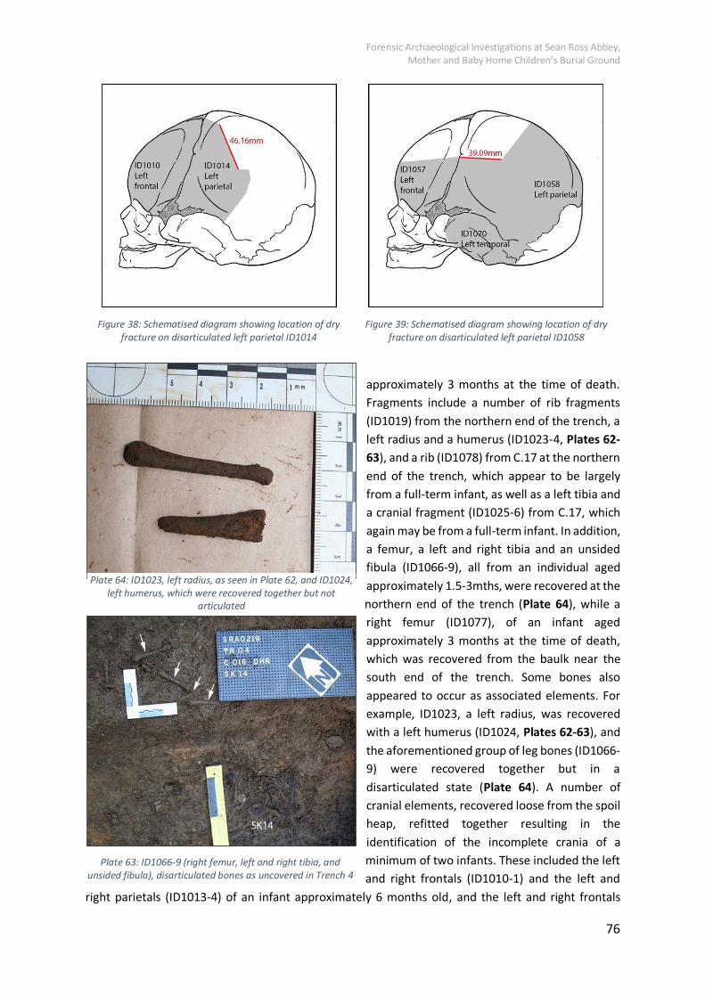
Forensic Archaeological Investigations at Sean Ross Abbey, Mother and Baby Home Children’s Burial Ground
76
approximately 3 months at the time of death.
Fragments include a number of rib fragments
(ID1019) from the northern end of the trench, a
left radius and a humerus (ID1023-4, Plates 62-
63), and a rib (ID1078) from C.17 at the northern
end of the trench, which appear to be largely
from a full-term infant, as well as a left tibia and
a cranial fragment (ID1025-6) from C.17, which
again may be from a full-term infant. In addition,
a femur, a left and right tibia and an unsided
fibula (ID1066-9), all from an individual aged
approximately 1.5-3mths, were recovered at the
northern end of the trench (Plate 64), while a
right femur (ID1077), of an infant aged
approximately 3 months at the time of death,
which was recovered from the baulk near the
south end of the trench. Some bones also
appeared to occur as associated elements. For
example, ID1023, a left radius, was recovered
with a left humerus (ID1024, Plates 62-63), and
the aforementioned group of leg bones (ID1066-
9) were recovered together but in a
disarticulated state (Plate 64). A number of
cranial elements, recovered loose from the spoil
heap, refitted together resulting in the
identification of the incomplete crania of a
minimum of two infants. These included the left
and right frontals (ID1010-1) and the left and
right parietals (ID1013-4) of an infant approximately 6 months old, and the left and right frontals
Figure 38: Schematised diagram showing location of dry
fracture on disarticulated left parietal ID1014
Figure 39: Schematised diagram showing location of dry
fracture on disarticulated left parietal ID1058
Plate 64: ID1023, left radius, as seen in Plate 62, and ID1024,
left humerus, which were recovered together but not
articulated
Plate 63: ID1066-9 (right femur, left and right tibia, and
unsided fibula), disarticulated bones as uncovered in Trench 4

Forensic Archaeological Investigations at Sean Ross Abbey, Mother and Baby Home Children’s Burial Ground
77
(ID1056-7), the left parietal (ID1058), and the left temporal (ID1070) of an infant of a similar age-at-
death to the former (see Figures 38-39).
Plate 65: ID1020-1 left humerus and scapula, infant 6
months old, still articulated but truncated
Plate 66: ID1022 left ribs, infant 6 months old, still largely
articulated but truncated
Two clumps of earth were also recovered from the
spoil which contained bones that were still in an
articulated state. These included a left humerus,
scapula, and three left ribs (ID1020-2) of an infant
aged approximately 6 months old at the time of
death (Plates 65-67), as well as the left radius,
three other left ribs, and a vertebral fragment
(ID1064-5, 1076) of an infant aged between 3-6
months at the time of death (Plates 68-69). It is
possible that these are actually from the same
individual.
All the disarticulated remains were assessed as a
single unit, in order to particularly determine the
minimum number of individuals represented by
the bones (both recovered from the spoil and
uncovered in the ground). The evidence indicates
the presence of at least six individuals, all infants
aged <1 year at the time of death, in the
disarticulated material, see Table 3.
Plate 67: ID1020-2, infant 6 months old, bones recovered
in an articulated but truncated

Forensic Archaeological Investigations at Sean Ross Abbey, Mother and Baby Home Children’s Burial Ground
78
Plate 68: ID1064-5, 1076, infant 3-6 months old, left
radius, ribs, and vertebral fragment still articulated but
truncated
Plate 69: ID1064-5, 1076, infant 3-6 months old, left
radius, ribs, and vertebral fragment
Table 3: Skeletal elements used to determine MNI (minimum number of individuals)
ID number Bone Age-at-death
1025 Left tibia (‘shin bone’) Probable full-term infant
1052 Left tibia Very young infant
1050 Left tibia 1.5-3 mths
1069 Left tibia 1.5-3 mths
ID1002, 1049, 1066, 1077 Four right femora All aged between 1.5-3mths
1070 Right tibia 6-9 mths
The tibiae indicate a minimum of five individuals: a full-term infant; three young infants; and an older
infant. However, four right femora suggest there may actually be four individuals aged between 1.5-3
months, in addition to the full-term infant and the older infant. Therefore, the MNI may be as high as
six individuals. It should be noted that the aforementioned two incomplete infant crania were
estimated to be from two individuals of approximately the same age. However, one cranium (ID1056-
8 and ID1070) was more incomplete than the other (ID1010-1 and ID1013-4), and the age at death of
the former (at approximately 6 months) is simply an estimate. In essence, there is no substantial
evidence of more than six infants in the disarticulated from Trench 4.
One disarticulated bone was selected for radiocarbon dating; a right tibia, from an individual aged
between 6-9 months at the time of death.

Forensic Archaeological Investigations at Sean Ross Abbey, Mother and Baby Home Children’s Burial Ground
79
6.7 Human Remains in Trench 5
The remains of a single in situ burial (SK18), with exposed skeletal remains, was identified in Trench 5,
while two further burials were identified through the presence of apparent coffin timbers (see Section
5.6) No disarticulated human remains were present.
SK18 Plates 70-72
The remains of this burial were identified in the southwest
corner of Trench 5, primarily through the presence of
horizontal timbers with apparent white paint. The
southwestern end of the probable coffin extended into the
northeast-facing baulk. A right humerus was uncovered on
one side of coffin. Assuming a supine burial, this suggests
that this southwest-northeast burial had the head to the
southwest. This was 0.45m below ground level. The right
humerus was selected for radiocarbon dating.
The right humerus was slightly incomplete at the proximal
end. The surviving length was 74.18mm: it is unlikely to have
been originally much more than 80mm. It was certainly
smaller than the disarticulated left humerus (ID1020), whose
age-at-death was estimated at 6 months. It is probable that
SK18 was aged between 1.5-3 months, or a little older, at the
time of death.
Plate 70: SK18 in situ from SW

Forensic Archaeological Investigations at Sean Ross Abbey, Mother and Baby Home Children’s Burial Ground
80
Plate 71: SK18 in situ from SW, with details highlighted
Plate 72: SK18 right humerus for radiocarbon dating

Forensic Archaeological Investigations at Sean Ross Abbey, Mother and Baby Home Children’s Burial Ground
81
6.8 Human Remains in Trench 6
A single in situ burial, with exposed skeletal remains (SK23), was identified in Trench 6. A further five
probable coffins were identified, though no skeletal remains were exposed (see Section 5.7). No
disarticulated skeletal remains were present.
SK23 Plates 73-75
The skeletal remains of this individual
were recovered along the northeast-
facing baulk of Trench 6. It was 0.48m
below ground level. No coffin remains
were conclusively identified. The burial
was supine and extended, orientated
southwest-northeast, with the head to the
southwest. The exposed bones included
elements of the cranium, the mandible,
the left ribs, and the left femur. The bones
were in a relatively good state of
preservation although the left femur was
incomplete. The left femur was selected
for radiocarbon dating.
The minimum surviving length of the left
femur was 93mm, and the distal end was
slightly incomplete. Certainly, this
individual was over 1.5 months at the time
of death, and could have been up to three
months old. The mandibular symphysis
was fused, which typically occurs in the
first year of life. Indeed, a disarticulated
fused mandible was recovered from TR4
(ID1063), with an estimated age-at-death,
based on dentition, of 4-6 months (see
above). This might suggest that SK23 was
indeed circa 3 months old, if not a little
older.
Plate 73: SK23 in situ from NE
Plate 74: SK23 in situ from NE, detail
Plate 75: SK23 left femur for radiocarbon dating

Forensic Archaeological Investigations at Sean Ross Abbey, Mother and Baby Home Children’s Burial Ground
82
6.9 Minimum Number of Individuals (MNI)
In total, the skeletal remains of 21 in situ individuals, with exposed skeletal remains, were identified,
with an additional coffin (SK15) identified in Trench 4 but from which no skeletal remains were
exposed. Archaeological evidence further indicates a number of other probable graves – indicated by
coffin fragments –and possible graves – suggested by deposit type, shape and orientation (see Section
5). These include a possible single burial in Trench 1, six burials in Trench 4, two burials in Trench 5,
and five burials in Trench 6. This indicates that potentially 36 in situ burials were identified during the
present investigation. In terms of additional skeletal evidence, the disarticulated remains, recovered
exclusively from Trench 4 provided evidence of six individuals. These bones may have originated from
in situ, but truncated, burials previously identified or may indicate further additional burials.
The total MNI from the present investigation is 32; 21 in situ individuals and 11 coffins indicating
probable burials. There are an additional four possible burials indicated by grave deposits and six
individuals represented in the disarticulated remains bringing the total possible number of individuals
represented in this excavation to 42. The ages-at-death of all 27 individuals represented by skeletal
remains were less than one year at the time of death. The ages-at-death of those in the probable
coffins and possible graves cannot be confirmed.

Forensic Archaeological Investigations at Sean Ross Abbey, Mother and Baby Home Children’s Burial Ground
83
7. Analysis of Evidence
7.1 Radiocarbon Dating
After Professor Gordon T. Cook, May 2019, see also Appendix G.
On the 14th of March 2019, 13 samples were presented for analysis to SUERC Radiocarbon dating
laboratory in East Kilbride, Scotland. Each sample was presented evidentially secure, appropriately
packaged and sealed with an accompanying continuity log. The samples had been released from Irish
jurisdiction with the permission of Mr J. Kelly, Coroner for Tipperary and their delivery to SUERC had
been accompanied by an agent of the MBHCOI until their submission to the laboratory. Please see
Table 4 below for sample details.
Table 4: Details of 13 samples submitted to SUERC
Sample
Number
Estimated age at
death
Origin Laboratory Ref Analysis Ref
SK01 38.0 foetal wks, +-
2.08wks
Right femur GU-51072 SUERC-85647
SK02 37.4 foetal wks, +-
1.87wks
Right femur GU-51073 SUERC-85648
SK04 36.3 foetal wks, +-
2.08wks
Left femur GU-51074 SUERC-85649
SK06 36.7 foetal wks, +-
2.33wks
Right humerus GU-51075 SUERC-85650
SK07 40.7 foetal wks, +-
1.87wks
Right humerus GU-51076 SUERC-85654
SK11 36.4 foetal wks, +-
2.12wks
Left humerus GU-51077 SUERC-85655
SK21 c. 3 months Left femur GU- 51078 SUERC-85656
SK18 c.1.5-3mths Right humerus GU-51079 SUERC-85657
C17 c.6mths Right tibia GU- 51080 SUERC-85658
SK19 c.1.5-3mths Right tibia GU-51081 SUERC-85659
SK17 c.1.5-3mths Left humerus GU-51082 SUERC-85660
SK14 c.3mths Left humerus GU-51083 SUERC-85664
SK23 c.3mths Left femur GU- 51084 SUERC-85665
14Carbon is radioactive substance, or isotope, contained within the atmosphere and is exchanged to
the biosphere and via photosynthesis and the food chain and can be found in all living organisms. Once

Forensic Archaeological Investigations at Sean Ross Abbey, Mother and Baby Home Children’s Burial Ground
84
the organism ceases to live the 14C begins to decay by a quantifiable half-life, specifically the Libby
half-life. It is this that is used to calculate radiocarbon ages. 14C can be extracted via the protein
collagen in bone in human remains.
The quantification of 14C in an organism versus the atmosphere at a known point in time can give
accuracy to this dating method. Since the 1960s this method has been used to date biological remains
to century and millennia time frames; in more recent years this method has been proven successful
in what is considered the modern era, in this case, post 1890.
The Industrial Revolution marks the first significant period of human influence on the natural 14C/stable carbon ratios into the environment resulting from the burning of fossil fuels. This release of
CO2 into the atmosphere caused a dilution of the 14CO2 activity creating what is known as the Seuss
Effect. The consequence of this effect is that it is not currently possible to distinguish between a
radiocarbon date from the seventeenth century and a sample that was formed during the period 1890-
1950 whose activity was influenced by the Seuss Effect. This needs to be born in mind when looking
at the calibrated dates as will be presented below. Nuclear programmes from the 1950s onwards in
the form of weapons testing caused a significant and quantifiable increase in the 14C in the
atmosphere, this is referred to as the ‘bomb curve’. These levels begin to decrease sharply, again in a quantifiable manner, from 1963/64 onwards with the test ban treaty. Comparison with these levels
can provide the backdrop for 14C dating evidence in the twentieth century.
In a case such as Sean Ross Abbey Mother and Baby Home Children’s Burial Ground, where skeletal
remains are those of neonates or infants, the bone samples can achieve high precision estimations on
year of birth. The bone collagen in infants is formed from the mother’s dietary intake, resulting in 14C
being relatively close to equilibrium with atmospheric levels. Atmospheric levels during the bomb peak
after 1955 provides chronologically concise information. This can be seen in some of the samples
returned in Sean Ross Abbey Mother and Baby Home. The same is not true of adult remains from this
period; the turnover of collagen is much slower making the dateable collagen return results present
over a number of years. This allows for more limited information than with infants, informing whether
or not the person died during the nuclear era. This evidence and these processes provide us with
confidence that this dating method was the most appropriate to use due in the specific context of the
infant remains recovered during this investigation.
As all remains dated in this sample were of individuals of less than six months of age it is recommended
that a delay of 1-2 years be applied to each date. This allows for the carbon to travel to the bone
collagen through the process of human consumption of carbon via plants and its appearance in the
blood and thus bone collagen. 14C measurements will therefore represent the 14C in the atmosphere
1-2 years previously.
In order to measure this collagen protein it must be isolated. Collagen, the organic fraction of bone,
is extracted and prepared via a process of solubilising the bone by adding hydrochloric acid, heating
to 80oC, and passing the resulting liquid through a filter. This is then freeze-dried until the collagen is
extracted in crystalline powder form. The collagen is then combusted to graphite for measurement
via accelerator mass spectrometry. Samples are run alongside the 14C primary standard SRM-4990C
for modern reference samples for comparison.

Forensic Archaeological Investigations at Sean Ross Abbey, Mother and Baby Home Children’s Burial Ground
85
Stable isotope measurements were also taken of the samples as part of this process. Stable isotope
and radiocarbon results combined allows for an assessment of sample suitability for dating. Collagen
samples were deemed within the range of collagen that is accepted as unaltered and therefore were
suitable for reporting.
All 13 individuals were aged from foetal to less than a year old and are feeding at a trophic level above
their mothers. The stable isotope values of 12 samples represent a typical terrestrial resourced diet
while sample SK01 isotope values suggests marine resources formed part of the mother’s diet.
Table 5: Calibrated age ranges and estimated years of death for the thirteen bone samples
Lab Code Sample Calibrated Age
Ranges (years AD)
Calibrated Age
Range of Interest
Estimated Year
of Death
GU-51072 SK01 1957-1957;1999-2002
1957-1957 1958-1959
GU-51073 SK02 1959-1961; 1983-1985
1959-1961 1960-1963
GU-51074 SK04 1647-1684; 1736-1805; 1935-1955
1935-1955 1936-1955
GU-51075 SK06 1662-1695;1726-1814; 1839-1842; 1853-1867; 1917-1955
1917-1955 1918-1955
GU-51076 SK07 1528-1544; 1634-1672; 1778-1800; 1942-1955
1942-1955 1943-1955
GU-51077 SK11 1521-1592; 1620-1659
GU-51077 SK11 1525-1558; 1631-1711; 1720-1816; 1928-1953
1928-1953 1929-1955
GU-51078 SK21 1527-1553; 1633-1670; 1780-1800; 1944-1955
1944-1955 1945-1955
GU-51079 SK18 1959-1961; 1983-1985
1959-1961 1960-1963
GU-51080 C17 1956-1957; 2002-2007
1956-1957 1957-1959
GU-51081 SK19 1524-1559;1631-1670; 1780-1800; 1945-1950
1945-1950 1946-1952
GU-51082 SK17 1646-1680; 1763- 1801;1938-1955
1938-1955 1939-1955
GU-51083 SK14 1640-1670; 1780-1800; 1945-1950
1945-1950 1946-1952
GU-51084 SK23 1646-1682; 1738-1750; 1762-1803; 1937-1955
1937-1955 1938-1955

Forensic Archaeological Investigations at Sean Ross Abbey, Mother and Baby Home Children’s Burial Ground
86
All samples present estimated years of death within the range 1918–1963. Four samples, SK01, SK02,
SK18, and C17, are all clearly from the within the nuclear era (1956-1961) and also all present with
later 20thCentury ranges. Based on the knowledge that the Mother and Baby Home at Sean Ross Abbey
was in operation from 1931 to 1969 Professor Cook discounted this later age range. For the purposes
of the final report of this investigation it is not possible to discount these dates in such a manner due
to the possibility that this burial ground continued in use post-1969. However, when the dates are
also correlated against the stratigraphic evidence and osteological evidence (Sections 5 and 6), the
mid-twentieth century dates are further supported, giving these the highest likelihood. The same can
be said of the earlier dates that are present in some samples. Site stratigraphy and the archaeological
evidence does not support the possibility of seventeenth, eighteenth, or nineteenth century dates.
Please see Table 5 below for calibrated age ranges of each sample.
7.2 Artefactual Evidence
Throughout the excavation phase, objects or artefacts were identified within certain contexts. These
artefacts can further inform the date of origin and the potential function of given deposits and
features. A selection of significant artefacts is discussed here and detailed in Table 6 below.
Discounting nails and timbers, indicative of coffins, only one artefact was found in association with a
burial. This was a devotional medal at burial SK14/C.29, in Trench 4, found positioned on the left
shoulder of the skeletal remains (Plate 47). Although corroded, with minor damage to part of the
edge, the face depicts the Virgin Mary, while the rear shows an apparition scene (Plate 76). The style
of the front depiction, with flowers to the left and portions of an inscription at the right is consistent
with that of a ‘virgo virginum’ medal from Lourdes, France. Similarly, the grotto scene on the rear face
is also that commonly associated with Lourdes (Plate 77). The medal measures 20mm in diameter and
1mm in thickness. The association of this artefact correlates closely with the radiocarbon date range
for this burial, in that this medal likely dates to the first half of the twentieth century. The medal was
returned to the position on the skeletal remains in which it was found before the trench was back-
filled.
As mentioned, coffin timbers and associated metal nails were encountered in at least 11 separate
locations, as well as throughout the plough-soil (C.17) in Trench 4. These were recorded in situ and
were unlikely to yield further information if removed. From those nails that were not within timber,
an array of types had been used. However, all were wire or steel nails, or brads, with round and flat
heads, and of various lengths. Animal bone was recovered from Trenches 2 and 7, one fragment in
each, from the introduced orange clay (C.10) and backfill surrounding the pipe (C.63). These were both
examined by the on-site Osteoarchaeologist.
Sherds of pottery were occasionally identified within the ‘orange’ introduced clay layers (i.e. C.10,
C.43, C.79) and similar build-up layers (i.e. C.69). These include modern plate and terracotta pots and
a rim from a glazed earthenware vessel. These indicate that the layers were deposited in relatively
modern times and when accompanied by the animal bone and shell, exhibit a minor domestic refuse
element within the introduced soils. At Trench 3, a ditch or gully appeared to have been infilled. Within
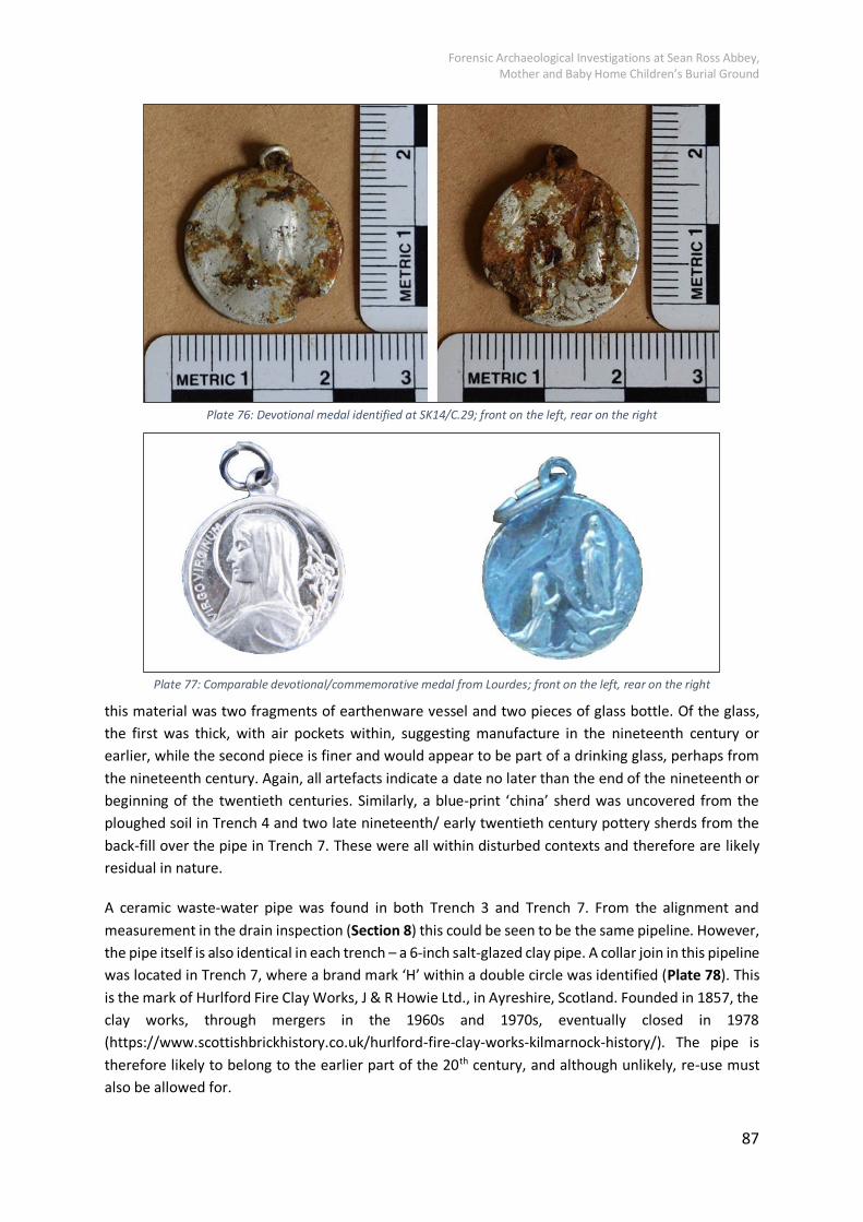
Forensic Archaeological Investigations at Sean Ross Abbey, Mother and Baby Home Children’s Burial Ground
87
Plate 76: Devotional medal identified at SK14/C.29; front on the left, rear on the right
Plate 77: Comparable devotional/commemorative medal from Lourdes; front on the left, rear on the right
this material was two fragments of earthenware vessel and two pieces of glass bottle. Of the glass,
the first was thick, with air pockets within, suggesting manufacture in the nineteenth century or
earlier, while the second piece is finer and would appear to be part of a drinking glass, perhaps from
the nineteenth century. Again, all artefacts indicate a date no later than the end of the nineteenth or
beginning of the twentieth centuries. Similarly, a blue-print ‘china’ sherd was uncovered from the ploughed soil in Trench 4 and two late nineteenth/ early twentieth century pottery sherds from the
back-fill over the pipe in Trench 7. These were all within disturbed contexts and therefore are likely
residual in nature.
A ceramic waste-water pipe was found in both Trench 3 and Trench 7. From the alignment and
measurement in the drain inspection (Section 8) this could be seen to be the same pipeline. However,
the pipe itself is also identical in each trench – a 6-inch salt-glazed clay pipe. A collar join in this pipeline
was located in Trench 7, where a brand mark ‘H’ within a double circle was identified (Plate 78). This
is the mark of Hurlford Fire Clay Works, J & R Howie Ltd., in Ayreshire, Scotland. Founded in 1857, the
clay works, through mergers in the 1960s and 1970s, eventually closed in 1978
(https://www.scottishbrickhistory.co.uk/hurlford-fire-clay-works-kilmarnock-history/). The pipe is
therefore likely to belong to the earlier part of the 20th century, and although unlikely, re-use must
also be allowed for.

Forensic Archaeological Investigations at Sean Ross Abbey, Mother and Baby Home Children’s Burial Ground
88
Plate 78: Brand mark as seen in Trench 7 (left) and standard Hurlford brand mark (right) (from
https://www.scottishbrickhistory.co.uk/howie-or-hurlford-waterdrainage-or-sewer-pipe/)
Table 6: Artefact details
Artefact Number Trench/A
rea
Type Description
SRA0219021001 2 Ceramic Large sherd of blue-print plate
SRA0219021002 2 Animal bone
Fragment of scapula, probable pig, with butchery mark
SRA0219034301 3 Ceramic Large terracotta base/body sherd
SRA0219034302 3 Ceramic Glazed earthenware rim sherd
SRA0219034801 3 Ceramic Earthenware sherd
SRA0219034802 3 Ceramic Earthenware sherd
SRA0219034803 3 Glass Thick base/body shard of glass bottle, green, with impurities within, thickness 9.5mm
SRA0219034804 3 Glass Thin body shard of glass bottle, green/brown, thickness 2mm
SRA0219041701 4 Ceramic Large sherd of blue-print plate
SRA0219041702 4 Metal Devotional medal, probably nickel, C.29
SRA0219076301 4 Ceramic Thick red earthenware with white slip glaze
SRA0219076302 4 Ceramic White ware body sherd with blue on white slip glaze
SRA02190417 7 Animal bone
Fragment of hollow angular bone, likely fowl, C.63

Forensic Archaeological Investigations at Sean Ross Abbey, Mother and Baby Home Children’s Burial Ground
89
7.3 Summary of Death Register for Sean Ross Abbey Mother and Baby
Home
7.3.1 Infant and Young Child Deaths
There are a total of 1078 children on the death register of individuals who died at the Sean Ross Abbey
Mother and Baby Home. It was possible to determine the age-at-death for 999 of these individuals.
The significant majority were very young infants; 71.5% (714) were aged 3 months and under. The
remainder were as follows: 15.5% (155) were aged four to 6 months, 8.4% (84) were aged 7 to 12
months and 4.6% (46) were over one year of age. In the latter group just eight were aged over two
years at the time of death, representing 0.8% of the total. The figures clearly indicate that the
overwhelming majority of the deaths (87%) occurred early in life, specifically in the first 6 months.
It was not possible to compare the death register with the number of living children in care in the
Home over the relevant period. However, it is possible to see that the annual numbers of infant deaths
were high in the early years of the operation of the Home. In 1936 and 1942 in particular, 92 and 80
infant deaths were recorded respectively, see Table 7 below for an annual break down of the numbers
of deaths of infant and young children that occur at the Home. Interestingly, and relevant to the
radiocarbon dates for this investigation, four individuals returned dates from the nuclear era, post-
1955. These individuals (SK01, SK02, SK18, and C17) were from periods when the rate of deaths had
slowed to approximately one per month. Pre-1945 deaths were occurring at rates of one per week,
with circa two per week in the peak years.
Table 7: Number of infants deaths that occurred per annum at the Sean Ross Abbey Mother and Baby Home
Year Number of deaths Year Number of deaths Year Number of deaths
1931 4 1944 57 1957 13
1932 56 1945 56 1958 10
1933 55 1946 33 1959 6
1934 58 1947 23 1960 7
1935 76 1948 14 1961 4
1936 92 1949 16 1962 1
1937 52 1950 16 1963 6
1938 37 1951 14 1964 7
1939 21 1952 14 1965 5
1940 51 1953 14 1966 9
1941 47 1954 16 1967 10
1942 80 1955 14 1968 3
1943 46 1956 10 1969 3

Forensic Archaeological Investigations at Sean Ross Abbey, Mother and Baby Home Children’s Burial Ground
90
Figure 40: Number of infant deaths by year
0 10 20 30 40 50 60 70 80 90 100
1969
1968
1967
1966
1965
1964
1963
1962
1961
1960
1959
1958
1957
1956
1955
1954
1953
1952
1951
1950
1949
1948
1947
1946
1945
1944
1943
1942
1941
1940
1939
1938
1937
1936
1935
1934
1933
1932
1931
No. of Infant Deaths
No. of Infant Deaths
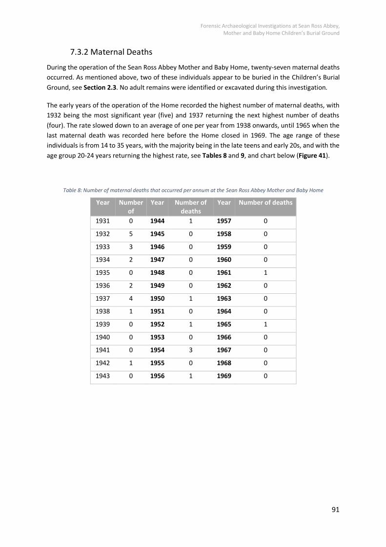
Forensic Archaeological Investigations at Sean Ross Abbey, Mother and Baby Home Children’s Burial Ground
91
7.3.2 Maternal Deaths
During the operation of the Sean Ross Abbey Mother and Baby Home, twenty-seven maternal deaths
occurred. As mentioned above, two of these individuals appear to be buried in the Children’s Burial Ground, see Section 2.3. No adult remains were identified or excavated during this investigation.
The early years of the operation of the Home recorded the highest number of maternal deaths, with
1932 being the most significant year (five) and 1937 returning the next highest number of deaths
(four). The rate slowed down to an average of one per year from 1938 onwards, until 1965 when the
last maternal death was recorded here before the Home closed in 1969. The age range of these
individuals is from 14 to 35 years, with the majority being in the late teens and early 20s, and with the
age group 20-24 years returning the highest rate, see Tables 8 and 9, and chart below (Figure 41).
Table 8: Number of maternal deaths that occurred per annum at the Sean Ross Abbey Mother and Baby Home
Year Number
of
deaths
Year Number of
deaths
Year Number of deaths
1931 0 1944 1 1957 0
1932 5 1945 0 1958 0
1933 3 1946 0 1959 0
1934 2 1947 0 1960 0
1935 0 1948 0 1961 1
1936 2 1949 0 1962 0
1937 4 1950 1 1963 0
1938 1 1951 0 1964 0
1939 0 1952 1 1965 1
1940 0 1953 0 1966 0
1941 0 1954 3 1967 0
1942 1 1955 0 1968 0
1943 0 1956 1 1969 0

Forensic Archaeological Investigations at Sean Ross Abbey, Mother and Baby Home Children’s Burial Ground
92
Figure 41: No. of Maternal Deaths by year
Table 9: Maternal Ages-at-death
Age
Group
No. of Maternal Deaths
10-14 1
15-19 7
20-24 10
25-29 6
30-34 2
35-39 1
0 1 2 3 4 5 6
1969
1967
1965
1963
1961
1959
1957
1955
1953
1951
1949
1947
1945
1943
1941
1939
1937
1935
1933
1931
No. of Maternal Deaths
No. of Maternal Deaths

Forensic Archaeological Investigations at Sean Ross Abbey, Mother and Baby Home Children’s Burial Ground
93
8. Utilities in the proximity of the Children’s Burial Ground
Investigation of Utilities
To comprehensively understand the development of utilities, possible subsurface pipework and
drainage in the proximity of the Children’s Burial Ground an on-site inspection and survey was
conducted alongside a review of development and planning permissions on the site of St Anne’s Sean Ross Abbey since 1968. Tipperary County Council shared files relevant to this research. The results are
presented here in chronological order of the evidence.
2019
While on-site, the MBHCOI initiated an independent drain inspection survey. The purpose of this
survey was to determine the current positioning of the utilities/drainage system that is in proximity
to the burial ground. There were two principal outcomes required of this survey: a) to create an
evidential record of the current drainage system; and b) to trace the position of the disused pipe that
intersects the south corner of the site.
The survey began at the manhole nearest the ‘Nuns Graveyard’ in the north west, labelled Manhole 1, see Figure 42. There is a full CCTV record of this survey available for inspection.
Current waste/foul water drainage system
The current system flows from Manhole 1 to Manhole 3 uninterrupted. At Manhole 3 the pipe joins
an inlet from the southwest, coming from the direction of Saoirse Day Services/The Stables, and then
continues directly northeast, running parallel to the burial ground. The fabric of this pipe work appears
to be modern; an exact construction date is not possible. However, an examination of the planning
records indicates that the pipework was upgraded in 1997. This appears to have included a diversion
of the system, from Manhole 1 due south to the river bank, altered to turning 90 degrees at Manhole
3, to continue east, where it crosses Manhole 4, and meets Manhole 5, and turns 90 degrees extending
north, following the river bank here. At Manhole 5 there is an additional access chamber that appears
to have been inserted reportedly to carry electrical cabling however no cables are present.
Currently, the pipe fabric changes from clay to uPVC at Manhole 2 before it reaches Manhole 3,
supporting the evidence that this section was upgraded when diverting the system. At Manhole 3 the
pipe changes from uPVC to a 0.23m diameter concrete pipe.
Salt-glazed pipe
The survey of this pipe began at the river bank in the south, where the pipe has an access chamber
that allowed for insertion of survey equipment. From the access chamber, the pipe appears to have

Forensic Archaeological Investigations at Sean Ross Abbey, Mother and Baby Home Children’s Burial Ground
94
Figure 42:Schematic drawing of utilities in proximity to the Children’s Burial Ground
continued along the river bank to east for at least the extent of the burial ground. This pipe is 0.10m
in internal diameter and appears to be aligned with Manhole 3. Cracking begins to appear in the pipe
at 9.50m from the river bank and it has collapsed approximately opposite the current entrance to the
burial ground, c. 13.5m from the southern access chamber on the river bank. It was the drain
surveyor’s opinion that this pipe used to connect with the clay pipe extending from Manhole 1 and

Forensic Archaeological Investigations at Sean Ross Abbey, Mother and Baby Home Children’s Burial Ground
95
was, at some stage, diverted, with Manhole 1 now running into the modern concrete pipe, see report
at Appendix H.
2017
In 2017 Tipperary County Council (TCC) received a complaint in relation to possible waste water
contamination of the site (PC-25 36917). This complaint alleged that that there were “issues with
waste water treatment on the site particularly in the area close to the Angels Plot burial ground and
the stables area across the stream on site” (O’Dwyer, TCC, 06/09/2017).
On foot of this, a thorough investigation was conducted by the Environment Section of TCC, consisting
of a desktop review and on-site investigations. TCC reported that among the investigations conducted
was a review of the 17 planning files that relate to the St Anne’s Sean Ross Abbey complex from 1969-
2000, and on-site dye testing was conducted of the current sewage network (ibid).
TCC reported that research of planning files revealed that prior to 1997 sewage was treated on-site
via septic tanks and was then discharged to soakaways or adjacent streams (O’Neill, TCC, 05/10/2017).
It is stated that “in Ireland, pre ’75, the normal practice would have been to discharge treated septic
effluent to soakaways” (O’Dywer, TCC, 06/09/2017). This research revealed that circa 1996 upgrading
works had taken place to the existing system at that time. These upgrading works consisted of
rerouting foul and greywater to a uPVC gravity main sewer. These works involved the joining up of a
section of an old disused surface water (salt glazed) drain, that had previously discharged to the
Verdanthill stream, to a new uPVC sewer. It was noted during the 2017 investigations that the 1996
“groundworks did not involve any drainage works that trespassed through the Angels Plot burial
ground” (ibid).
This 2017 report by TCC states that the old salt glazed drain may have carried sewage (from septic
tanks) to the stream in the distant past (ibid) and it was their opinion that while the drain does skirt
the corner of the ‘Angels Plot’ it would have predated the existence of the plot. No direct evidence is provided to support this opinion as to why the pipe would have predated the plot, however,
radiocarbon dating of remains above the pipe trench, conducted during current MBHCOI
investigations, does evidentially support this presumption.
This particular line of 6-inch salt glazed pipe work is referred to on the 2017 TCC site investigation map
as an ‘old storm water drain’, it is unclear why this is believed to be storm water. The pipes early relationship (1968) to a septic tank (Punch, 1997) suggests it is an early, now defunct, sewage waste
pipe.
The Royal Commission into Sewage Disposal of 1898-1915 legislated for the requirement of certain
dilutions of waste water into free-flowing streams and rivers. The position of the pipe outlet at a point
on the stream where the dilutions are not satisfactory may have prompted the redesign to a point in
the stream where the dilutions would have been greater (O’Dywer, TCC, 06/09/2017).
1996-1998
Tipperary County Council provided details to the MBHCOI from the planning files in relation to
drainage works in the vicinity of the Children’s Burial Ground from 1969-1998. Within these files, a

Forensic Archaeological Investigations at Sean Ross Abbey, Mother and Baby Home Children’s Burial Ground
96
significant issue that was identified in relation to the foul water sewer contaminating the stream that
circumnavigates the site to the south and north east.
Figure 43: Extract from 1997 Report illustrating “Existing Foul Drainage Areas” showing tanks A, B and C, existing sewers
and proposed sewers

Forensic Archaeological Investigations at Sean Ross Abbey, Mother and Baby Home Children’s Burial Ground
97
A memo, dated 13th January 1998, reported the placing of a gravity sewer in the grounds of ‘St Anne’s Home’, Roscrea. It is reported that these works were complete in mid-December 1997 and ‘should
now eliminate any potential to pollute the stream running through the estate and will provide
sufficient waste water drainage for any future development at this complex’ (O’Connor, TCC).
It appears that prior to 1997 there was a septic tank system that then flowed directly into the
watercourse. A survey conducted in early 1997 mapped the foul drainage system and illustrated the
existing and proposed drainage. At this time two septic tanks existed in proximity to the Children’s Burial Ground, ‘A’ c. 32m to the south west across the stream and ‘B’ c.98m uphill to the north (Figure
43). At the time of this survey, 14th January 1997, both these tanks were reported to be ‘undersized
for present use’ and connected to outflow in the watercourse (M Punch & Partners, 24th January
1997).
On the 3rd of June 1997, TCC served a Section 12 notice on ‘St Anne’s Home’ to immediately commence the implementation of measures to prevent the discharge of polluting matters from the premises. The
foul water sewers were being discharged into the watercourse going through the grounds and the
council directed the institution to alter this immediately. This event, in all likelihood, accounts the
subsequent upgrading works that appear in the concrete and uPVC pipework evident in the drain
inspection.
Figure 44: Extract from report of ‘Foul Water Drainage at St Anne’s Sean Ross Abbey Roscrea, November 1996’
In November 1996, the Maintenance Department of St Anne’s Sean Ross Abbey compiled a report detailing the foul water drainage on-site. This report shows the position of septic tanks in different

Forensic Archaeological Investigations at Sean Ross Abbey, Mother and Baby Home Children’s Burial Ground
98
locations to those in the 1997 report. In this 1996 report septic tanks A, B and C were all south of the
stream within the grounds of the current ‘Saoirse Day Services’ complex (Figure 44). This is corrected
in the 1997 report, see Figure 43.
1969
Planning file number PLC 1418, dated to 1969, also shows the position of this septic tank at location
3, which is uphill to the north of the Children’s Burial Ground, number 3 of four located on site at the
time (Figure 45). This provides evidence that the foul water from Septic tank number 3, uphill of the
current Manhole 1, did enter the stream via the now defunct salt glazed pipe that skirts the current
boundary of the Children’s Burial Ground pre-1998.
Figure 45: Extract from 1969 Planning file PLC1418 illustrating ‘Location 3’
Summary
The evidence gathered here in relation to the current foul water drainage system indicates a high
likelihood that the foul or waste water did enter the stream via the now defunct salt-glazed pipe. This
pipe appears to skirt the current boundary of the Children’s Burial Ground. This pipe was defunct by
1998. It is not possible to discern the exact date at which this pipe-line was originally constructed,
although it must pre-date 1969. Radiocarbon dates from undisturbed burials in the strata above the
trench for this pipe further refine the construction date securely pre-1955.

Forensic Archaeological Investigations at Sean Ross Abbey, Mother and Baby Home Children’s Burial Ground
99
9. Discussion
Introduction
There were two principal matters under investigation during this excavation. The first was to
determine the presence of burials at this site and the second was to determine that, if burials were
present, what was their relationship to any utilities that may also be present at the site. The
investigations outlined in previous sections have described the methodology designed to answer
these questions and the results of the subsequent investigations. This following section will discuss
the findings of the investigation and what may be determined about the burial practises at this
location and site the history with specific reference to drainage and utilities.
Burial Practises
The evidence of burial practise reported here is based on the uppermost strata of graves and so
inherent bias is present. In addition to vertical bias, trenches are limited in a horizontal sense also.
Therefore, the results of test trenching are always simply indicative of the potential subsurface
remains at any given site. However, despite this bias it is possible to determine a number of important
factors in relation to burial arrangements and burial practice at this site, based on the results of the
test trenching.
Burial Distribution
Evidence of burials were uncovered in all but one of the seven trenches excavated at the site. The
exception was Trench 7, located at the current entrance to the site. However, while burials were
uncovered in the other six trenches, the nature of the distribution was variable. This distribution is
shown in Figure 46. This was primarily highlighted in Trench 1 and Trench 2, where both confirmed
and possible burials were limited to a total of just seven (six actual burials with skeletal remains, plus
one possible grave). In Trench 2, burials were only uncovered in the southwestern end, relatively near
the present monument. None were uncovered in the remaining 13.1m of trench. In Trench 6, where
a single definite burial and five probable burials were exposed, the single burial was near the
southwest end, while the remainder were concentrated near the existing monument over 14m to the
northeast. In contrast were the minimum of ten burials identified in Trench 3, a trench just 5.75m in
length, and the four definite and six other probable/possible burials in Trench 4, which also had
evidence of the disarticulated remains of up to six infants, in a trench just over 7m in length. Both
trenches were located at corners of the southwestern end of the present site, suggesting particular
concentrations in these areas.
Burial Distribution and Age-at-death
There is some evidence to indicate variation in terms of who was buried where. There was no
evidence, from any of the skeletal remains recovered in this excavation, for any individual aged over
1 year. It was quite apparent that all six of the individuals uncovered to the northeast of the present
monument were very young infants. In fact, all three infants in Trench 1 and one of the infants in
Trench 2 were full-term infants (defined as an infant between 37-42 foetal weeks), while the
remaining two infants in Trench 2 were likely very late pre-term (SK04 36.3+/-2.08 foetal weeks, SK06
36.7+/-2.33 foetal weeks). In Trench 3, at least one infant (SK11) was a possible pre-term infant and
at least four others were full-term infants, while the remainder, with the exception of SK20 (possibly

Forensic Archaeological Investigations at Sean Ross Abbey, Mother and Baby Home Children’s Burial Ground
100
6-12 months), were all less than 3 months old at the time of death. The four individuals in Trench 4
and the single burials in Trench 5 and Trench 6, where all infants, with no evidence of pre-term or full-
term infants (Figure 46). This evidence may suggest that specifically, the area to the northeast of the
present monument was reserved for the burial of perhaps still-births or those who died very close to
the time of birth.
Figure 46: Distribution of burials; labels alongside in-situ burials give maximum age-at-death in months
Burial Organisation
The general lack of intercutting or truncation of burials may suggest graves were perhaps marked,
however, there did not appear to be a consistent pattern in terms of burial plots. Perhaps the clearest
evidence was in the two trenches which contained the most burials, Trench 3 (ten individuals) and
Trench 4 (four individuals, plus six other probable/possible burials). In the former trench, certainly
some individuals appeared to be in approximate rows: SK19 through to SK22 appeared to be in aligned
in a row, albeit SK19 had her/his head at the opposite end of the grave to the other individuals. SK07,
SK09 and SK10 also appeared to be approximately in another row (Figure 47). In Trench 4, SK15 and
SK16 were also apparently aligned lengthways, with SK14 forming an approximately row widthways
with SK15. There thus appears to be some evidence of attempts at organisation in terms of placing
burials in rows but significant variations were also recorded.

Forensic Archaeological Investigations at Sean Ross Abbey, Mother and Baby Home Children’s Burial Ground
101
Figure 47: Burial organisation; orientation indicated, arrow is at head-end
It appears that where the ‘head end’ of the coffin was placed in the grave also exhibits variation. The
lack of rigid organisation in terms of burial plots may follow on to the actual placement of the coffin.
In the case of the burials at this site, the variation may be partly linked to whether the head and the
foot of the coffin was identifiable. If the coffins comprised simple rectangular boxes, with no breast-
plates or other markers, then the gravedigger may not actually know at which end of the coffin the
head was.
Presence of Coffins
In terms of methods of burial, the vast majority of identified burials had evidence of coffins (Figure
48). This may have been in the form of the remains of coffin timbers surrounding and/or covering
skeletal remains or by the presence of metal nails in the immediate vicinity of an in situ skeleton. There
were exceptions SK02 in Trench 1, SK13 in Trench 3, and SK14 and SK17 in Trench 4. In these cases
coffins may have decayed over time and perhaps nails were not always used.

Forensic Archaeological Investigations at Sean Ross Abbey, Mother and Baby Home Children’s Burial Ground
102
Figure 48: Distribution of burials with/without evidence of coffin use
Burial Position
Where possible to assess, all individuals appeared to be buried supine (i.e. lying on the back). Some of
the skeletal positions reflected the fact that many were very young infants: SK04 was buried with legs
bent out respectively to the left and right, as an infant would normally lie with on its back. SK01 may
have been turned slightly on their left side, while the legs of SK12 appeared bent to the right side,
almost in a foetal position. However, there was also evidence of what may be interpreted as accidental
displacement of the body, likely during the processes of carrying the coffin to the site and the burial
itself. The knees of one individual in particular, SK04 in Trench 2, would essentially have been tight
against what was interpreted as the foot board of the coffin (Plate 12).
Disarticulated Remains
Disarticulated human remains appeared in just one trench, Trench 4, in the southern corner of the
site. This assemblage provides evidence of a minimum of six infants. Trench 4 was also the only trench
where remains clearly indicated disarticulation before the present excavations began. Some of the
disarticulated bones that were found occurred in what appeared to be associated groups (such as leg
bones ID1066-9), indicative of mechanical disturbance.
Many of the disarticulated bones were noted in particular for the degree of post-mortem erosion and
breaking: in contrast, the exposed skeletal remains, in almost all in situ burials, were in an excellent

Forensic Archaeological Investigations at Sean Ross Abbey, Mother and Baby Home Children’s Burial Ground
103
state of preservation. The disturbance of these bones from their original primary point of deposition
(presumably a grave) would have significantly accelerated their disintegration. This can be a strong
indicator of disturbance in the past. In addition, the sheer quantity of disarticulated bone in Trench 4
was in stark contrast to all other trenches. The circumstances of recovery indicate that most, if not all
of the bones were loose within the upper levels of the soil. A number of dry breaks, identified in two
crania and a long bone, were suggestive of truncation relatively soon after burial. This may have
occurred during ploughing or grave digging activity. It has been noted that it is possible that graves
were not individually and/or substantially marked and so, in the area of Trench 4 in particular, earlier
burials may have been inadvertently truncated by subsequent gravedigging.
Figure 49: Distribution of median date of burials from radiocarbon dated samples
Radiocarbon Dating
Radiocarbon dating produced significant results (see Section 7.1). Burials in Trench 1 were
radiocarbon dated from the late 1950s to early 1960s, while those in Trench 2 had dates spanning
from 1918 through the mid-1950s. In Trench 3 the estimated years of death spanned from 1929
through to 1955, while in Trench 4 the span was 1939-1955. In Trench 5, very close to the extant

Forensic Archaeological Investigations at Sean Ross Abbey, Mother and Baby Home Children’s Burial Ground
104
monument, SK18 returned a date of death of between 1960-1963, while SK23 in Trench, returned a
date of 1938-1955. The median year of each of these date ranges is applied in Figure 49. Thus, some
of the earliest burials may appear to be to the northeast of the existing monument. The 1960-1963
dates returned by both SK02 in Trench 1 and SK18 in Trench 5 may suggest a focus in this area in later
years. The limited nature of the collection prevents significant interpretation, however, the estimated
years of death returned by the radiocarbon dating were all within the timeframe of operation for the
Mother and Baby Home at Sean Ross Abbey.
Utilities
The second of the principal matters requiring investigation was the potential presence of utilities,
specifically in the form of drainage and waste-water drainage, at the site of the burial ground. It has
been illustrated in Sections 2.1 and 2.2 from historical mapping and aerial photography research, that
the boundary of what is now known as the Children’s Burial Ground was not always so clearly defined
as it is at present. Specifically, the aerial photo dated 1974 (Figure 6) illustrates that the boundary that
currently exists has not been persistent since the operation of the Home. This may account for the 6-
inch salt glazed utility pipe that now intersects the southern corner of the current boundary.
An examination of the history of planning applications and the development of the drainage facilities
on-site, sheds some light on the presence of utilities in close proximity to the Children’s Burial Ground
and has been presented in detail in Section 8. Investigations carried out on-site provide evidence for
the absence of currently operational utility pipes traversing any part of the Children’s Burial Ground;
none that were detectable by geophysical survey, by test excavation or by drain inspection survey.
The drain inspection and the excavation did however locate a now redundant salt glazed waste-water
pipe; this pipe was shown as present on the 1997 map accompanying the report, see Figure 43. This
map confirms that at some point the pipe carried waste water from a septic tank. It is evident that as
early as 1969 sewage was treated on-site, via septic tanks (Figure 44), and discharged to soakaways
or nearby streams. The 2019 drain inspection clearly provides evidence that this utility pipe has been
redundant for some time, the exact time-frame is unknown, however, it would appear from upgrade
works carried out in around 1996, that it had once discharged directly into the adjacent stream.
The 1996 record of upgrade works explicitly states that the ‘groundworks did not involve any drainage
works that trespassed through the Angels Plot burial ground’ (O’Dwyer, TCC, 06/09/2017. The location
of in situ burials in the material filling this pipe trench indicate that the pipe was laid prior to the use
of this space as a burial ground. These particular burials have been dated to pre-1955 by radiocarbon
dating and so it does in fact support the contention that the insertion of this pipe predates the burial
ground. This is further supported by the archaeological evidence that demonstrates no burials were
disturbed by the insertion of this pipe. This utility pipe may have been related to septic tanks recorded
on site in 1968 and again in 1996. There is a high likelihood that the pipe would have been in operation
at the time that the Sean Ross Abbey Mother and Baby Home was in operation and may have been
inserted to manage an increase in loadings from the increased population when the facility was
opened. The pipe itself is demonstrably of a pre-1970s type, see Section 7.2. Combined with the
stratigraphic evidence the pipe clearly pre-dates burial activity and also pre-dates the present
boundary of the burial ground.

Forensic Archaeological Investigations at Sean Ross Abbey, Mother and Baby Home Children’s Burial Ground
105
Other drainage that appears on site is that which is referred to in this report as ‘field drains’. The test nature of the excavation did not allow for a full exploration of the extent of these field drains.
However, the location of a burial stratigraphically above one such drain (SK23, estimated year of death
1938-1955) indicates that these drains pre-date the use of the site as a burial ground. Evidence of land
reclamation works, in the form of introduced soil deposits, above naturally formed peat sub surface
suggests that these drains were efforts to reclaim waterlogged areas of the site. Mapping evidence
that illustrates a pathway to a flagstaff around the turn of the twentieth century further indicates that
these reclamation works pre-date the twentieth century.
The cumulative results of the investigations conducted here do not support the disturbance or
displacement of any infant burials in the pursuit of drainage of the area now defined as the Children’s Burial Ground. The investigations presented here provide a cross-sectional understanding of the burial
ground. While informative, they must not be used to establish the minimum number of individuals
interred here. Similarly, age-ranges and other metrics of in situ remains should not be extrapolated to
any wider interpretation. The marked locations of both adult graves were not investigated, and several
well-preserved coffins restricted the overall sample that could be analysed. It should also be noted
that only at the current entrance was a test trench permitted to extend beyond the existing boundary
of the burial ground.

Forensic Archaeological Investigations at Sean Ross Abbey, Mother and Baby Home Children’s Burial Ground
106
10. Conclusion
10.1 Condition of the Site post excavation
Extensive work was carried out to return the site to its original condition, in so far as was possible. All
trenches excavated were infilled and levelled, first by machine and then by hand. All soil was returned
to the trench from which it had been excavated. The entire site was reseeded with grass seed (Figure
50).
Figure 50: Aerial image of the site post-excavation, showing the back-filled and re-seeded trenches (3rd April 2019)
10.2 Summary and Conclusion
The Mother and Baby Homes Commission of Investigation (MBHCOI) requested that an investigation
be conducted into the site known as the Children’s Burial Ground in the grounds of St Anne’s Sean Ross Abbey, Roscrea, Co. Tipperary. This burial ground was reportedly the site of the graveyard for the
Sean Ross Abbey Mother and Baby Home that was in operation here from 1931 to 1969.
The MBHCOI was in receipt of information that indicated the potential for drainage to cross through
the site. If such was the case, then either the graveyard had been disturbed by the insertion of this
drainage or there were no human remains present at this location to begin with (with the argument
being that evidence of burial would have been noted during the drainage works). Information had also
been received by the MBHCOI that in the 1980s ploughing had taken place on site that did resulted in
bone being brought to the surface. In response to this the MBHCOI requested that two principle
matters be investigated at this site through the use of the field of forensic archaeology.
The first and primary matter requiring investigation was the question of whether buried human
remains exist at this reported graveyard and the succeeding question; if remains exist here, have they
been disturbed by the insertion of drainage though the graveyard.
The forensic archaeological investigation of this site was dealt with through the principle of a priority-
based approach. This approach operates through first engaging in the least intrusive methods and
moving towards producing a targeted response that allows the application of more intrusive methods
in a strategic manner. The value of this type of investigation allows a site to be investigated through a

Forensic Archaeological Investigations at Sean Ross Abbey, Mother and Baby Home Children’s Burial Ground
107
test or sample method that will not disturb the entirety of the site and specifically in this case, the
human remains that have been interred here. This was deemed the most appropriate investigative
response for this case.
Investigation
During the initial non-invasive stages of the investigation a geophysical survey was undertaken to
investigate potential anomalies that may be isolated for further investigation. A complete desktop
review was also conducted of the location to determine the site history through the aerial
photography and mapping records that exist in Ordnance Survey Ireland and in the Planning files of
the Environmental Section of Tipperary County Council.
The desktop review included cartographic analysis that identified the development of the site from
the mid-nineteenth century to the twentieth century (1901), when a pathway to a flagstaff appears at
the site prior to the opening of the Sean Ross Abbey Mother and Baby Home. The near-rectangular
boundary of the present burial ground first appeared in mapping dated 1954; however, the 1974
imagery indicates that the site boundary had been altered or perhaps was not clearly visible on the
ground. In this image, an additional boundary or feature appears at what is now the area to the
northeast of the central memorial. It may have been a hedge, wall or line of trees. By the 1990s it can
be seen that the current boundary is well-defined, and some planting has occurred on the periphery.
The site appears unchanged from this to present day.
An independent survey of the waste-water drains in the vicinity of the burial ground was conducted
by a drain specialist. This survey found that there had been upgrading and redirection of some pipe
work in close proximity to the burial ground. This correlated with information from council planning
files that saw the rerouting of waste water into a newly inserted main drainage pipe in around 1996.
A salt glazed ceramic pipe was found on the geophysical survey and in the drain inspection survey that
skirts the southern corner of the site. The drain inspection found this pipe to be now defunct. A more
modern junction had been inserted to the northwest that reroutes this drainage to run parallel with
the burial ground toward the northeast where it eventually joins the local drain network to the north
of St Anne’s Sean Ross Abbey building complex.
The geophysical survey identified a number of anomalies that informed the basis for the insertion of
seven test trenches over significant anomalies or areas that indicated burial or other significant
subsurface features. These trenches were selected also to achieve a cross-section of the site in order
to determine the nature of the subsurface and potentially answer the matters under investigation;
the potential for burials and indications of drainage. Each test trench ranged from 0.6m to 1.5m in
width and from 2.6m to 20m length. This 78 m2 represented just less than 10% of the total available
area within the site boundary.
Excavation took place over four weeks in February and March 2019. The excavation took place under
a warrant issued to N. McCullagh by Judge Y. Murphy of the MBHCOI dated 1st of February 2019. The
site cordon and log was maintained by An Garda Síochána while human remains were exposed on site.

Forensic Archaeological Investigations at Sean Ross Abbey, Mother and Baby Home Children’s Burial Ground
108
This type of test excavation is limited by its nature in that it is a test approach and not a complete
excavation of the entire burial ground. As such the findings that result from this excavation cannot be
applied conclusively to other matters. Evidence and stratigraphy that remains in the unexcavated
parts of the site can only be inferred from the results of these test trenches. Equally, projecting the
analysis of human remains from these test trenches to the remaining unexcavated 90% of the site
would be to assume consistency across the entire site. The demographic profile of skeletal material
recovered here relates only to those remains identified and samples recovered. The skeletal remains
of other individuals, possibly of other age groups, in greater or lesser quantities, may be contained
within the areas of the site not covered by this test excavation. There persists and unavoidable bias
in the results of this test excavation approach.
Findings
The results of this excavation indicate that this site was at some point a wet, waterlogged or boggy
location that was subsequently reclaimed by drainage works in the form of stone field drains and the
introduction of organic material from an alternative location. This can be seen in the site stratigraphy
where there is an orangish coloured silty clay deposit overlying the natural peat. This land reclamation
predated the burials that were exposed during this investigation. Burials were found in the strata
above both the stone field drains and the salt glazed drainage pipe that transects the southern corner
of the burial ground.
Within the test trenches the skeletal remains of 21 infants were recorded. The evidence from the
skeletal remains here indicates that all excavated infants were under the age of one year old with the
majority of individuals in the early weeks and months of life. In the majority of burials there is clear
evidence of timber coffins and suggestive evidence of coffins in most other cases. There were also
coffined burials undisturbed by excavation that allow for the presumption of another 11 individuals
this allows for and MNI of 32 individuals. Archaeological evidence and evidence from disarticulated
skeletal remains indicates a further 10 possible individuals represented in the results of this
excavation.
A number of the coffins present appear to have been painted white however there were no coffin- or
name-plates in evidence here. There was an absence of grave markers or headstones and the
distribution of burials does not appear to be consistent; however, some evidence exists for the linear
organisation to these burials and in places there appears to be more significant concentrations of
burials
Thirteen samples of bones were submitted for radiocarbon dating. The results from these dates, when
correlated with the archaeological record, indicate a most likely mid-twentieth century date for each
sample. The range of estimated years-of-death for these samples are in the 1930s, 1940s and 1950s.
This clearly falls within the period of the operation of the Sean Ross Abbey Mother and Baby Home.
The register of infants deaths records a wide range of annual figures, for example, from one death in
1962 to 92 deaths in 1936. The peak of infant deaths occurred at the Home from 1932 to 1947 when
the numbers of deaths occurring per year varied from 30 up to 90 individuals. After this period the

Forensic Archaeological Investigations at Sean Ross Abbey, Mother and Baby Home Children’s Burial Ground
109
number of deaths occurring in a given year were greatly reduced, falling to single figures in the latter
years of the Home.
The total number of infant deaths which recorded as having occurred here are 1078. Without
complete excavation it is not possible to say conclusively that all of these individuals are buried within
the present site of the Children’s Burial Ground. There may have been dense concentrations of burials
in other areas of the site that were not excavated. This excavation recorded evidence of a minimum
number of 32 individuals and a further four possible graves and six disarticulated individuals across
10% of the ground surface. It was not possible to determine if other tiers or layers exist beneath these
burials.
No young adult or adult remains were exposed during this excavation; however, there are two
memorials to older individuals. These individuals are recorded in the maternal death register
indicating that the burial ground was not exclusively designated for infants and young children who
died while in the care of the Home.
These investigations took place as a direct response to two specific queries on behalf of the Mother
and Baby Homes Commission of Investigation. These queries were answered in accordance with the
limits of a test excavation approach. There are human remains, specifically those of young infants,
present in this burial ground. The evidence indicates that the human remains that have been
uncovered were not disturbed by the insertion of drainage works, field-drains or waste-water pipes.

Forensic Archaeological Investigations at Sean Ross Abbey, Mother and Baby Home Children’s Burial Ground
110
11. References
Chamberlain, A. T. and Witkin, A. 2000. Human Skeletal Remains from Cloghermore Cave, County
Kerry, Ireland. Unpublished Report for Client.
Couglan, J. 2015. Corville House – Roscrea Through the Ages [Online]. Available at: http://www.roscreathroughtheages.org/corville-house.html. Accessed 14/04/2019
Farrelly J. and O’Brien, C. (comp.) 2002. The Archaeological Inventory of County Tipperary. Vol. 1 -
North Tipperary. Dublin: Stationery Office.
Farrelly J. and O’Brien, C. 2015. TN012-014001- [Online]. Available at: http://webgis.archaeology.ie/historicenvironment/. Accessed 10/02/2019.
Gwynn, A. and Hadcock, R.N. 1970 (Reprint 1988) Medieval religious houses of Ireland. Dublin. Irish Academic Press.
Healy, J. 1912. Ireland's ancient schools and scholars. Dublin. Sealy, Bryers & Walker.
Institute of Archaeologists of Ireland (IAI). Codes of Practice of the Institute of Archaeologists of
Ireland. https://www.iai.ie/codes-of-conduct/.
Knüsel, C., Robb, J. and Tafuri, M. A. 2016. The Upper Cave: Taphonomic Analysis of the Treatment of the Dead. In: Elster, E. S., Robb, J., Isetti, E. and Traverso, A. (eds.) The Archaeology of
Grotta Scaloria. Ritual in Neolithic Southeast Italy. Los Angelus: The Cotsen Institute of Archaeology Press UCLA.
Lewis, S. 1837. A Topographical Dictionary of Ireland. London
Maresh, M. M. 1970. Measurements from Roentgenograms. In: McCammon, R. W. (ed.) Human
Growth and Development. Springfield: C. C. Thomas.
Moorrees, C. F. A., Fanning, E. A. and Hunt, JR, E. E. 1963a. Age Variation of Formation Stages for Ten Permanent Teeth. Journal of Dental Research, 42, 1490-1502.
Moorrees, C. F. A., Fanning, E. A. and Hunt, JR, E. E.. 1963b. Formation and Resorption of Three Deciduous Teeth in Children. American Journal of Physical Anthropology, 21, 205-213.
Museum of London Archaeological Service (MoLAS). 1994. Museum of London Archaeological Service
Archaeological Site Manual. London, Museum of London.
National Inventory of Architectural Heritage. http://www.buildingsofireland.ie/niah/search. jsp?type=record&county=TN®no=22401211
Nicholls, K.W. (ed.) 1994. The Irish fiants of the Tudor sovereigns during the reigns of Henry VIII,
Edward VI, Philip & Mary, and Elizabeth I, 4 vols. Dublin. Éamonn de Búrca for Edmund Burke Publisher.
NUI Galway, 2011. Connaught and Munster Landed Estates Database [Online]. Available at http://landedestates.nuigalway.ie/LandedEstates/jsp/index.jsp. Accessed 10/02/2019.

Forensic Archaeological Investigations at Sean Ross Abbey, Mother and Baby Home Children’s Burial Ground
111
O’Brien, C. 2008. TN012-014002- [Online]. Available at: http://webgis.archaeology.ie/historicenvironment/. Accessed 10/02/2019.
Powers, N. and Sibun, L. 2011. Standards and Guidance for Forensic Archaeologists. Chartered Institute for Archaeologists (CiFA), UK.
Schaefer, M., Black, S. and Scheuer, L. 2009. Juvenile Osteology. A Laboratory and Field Manual,
Amsterdam, Elsevier.
Scheuer, J. L., Musgrave, J. H. and Evans, S. P. 1980. The Estimation of Late Fetal and Perinatal Age from Limb Bone Length by Linear and Logarithmic Regression. Annals of Human Biology, 7, 257-265.
Scheuer, L. and Black, S. 2000. Developmental Juvenile Osteology, San Diego, CA, Academic Press.
Simington, R.C. (ed.) 1931. The Civil Survey, AD 1654-1656. Vol I: county of Tipperary: eastern and
southern baronies. Dublin. Irish Manuscripts Commission.
Stout, G. 1984 The archaeological survey of the barony of Ikerrin. Roscrea Heritage Society.
Trinity College Dublin (TCD). 2013. The Down Survey of Ireland [Online]. Available at: http://downsurvey.tcd.ie/down-survey-maps.php. Accessed 06/02/2019.
Wescott, D. J. 2019. Postmortem Changes in Bone Biomechanical Properties: Loss of Plasticity. Forensic Science International, https://doi.org/10.1016/j.forsciint.2019.04.017.
White, T. D. and Folkens, P. A. 1991. Human Osteology, San Diego, Academic Press.
Wieberg, D. A. M. and Wescott, D. J. 2008. Estimating the Timing of Long Bone Fractures: Correlation Between the Postmortem Interval, Bone Moisture Content, and Blunt Force Trauma Fracture Characteristics. Journal of Forensic Sciences, 53, 1028-1034.
Williams, P. L. and Bannister, L. H. (eds.) 1995. Gray's Anatomy. The Anatomical Basis of Medicine
and Surgery, New York: Churchill Livingstone.

Forensic Archaeological Investigations at Sean Ross Abbey, Mother and Baby Home Children’s Burial Ground
112
12. Appendices
Appendix A: Qualifications and Experience of Contributors
Niamh McCullagh, BA MA MSc. MIAI, MCSFS, Director, Forensic Archaeologist
Niamh has been practising in the field of professional Archaeology since 1999 and became a specialist
in Forensic Archaeology in 2007. The search for, and excavation of, graves under forensic standards
is her primary area of expertise. As an independent professional consultant she remains the primary
advisor to An Garda Síochána in such matters. She is also the Senior Forensic Archaeologist with the
Independent Commission for the Location of Victims Remains and has lead numerous searches and
recovery operations since 2010. Niamh directed excavations at the Tuam Mother and Baby Home on
behalf of the Mother and Baby Homes Commission of Investigation and was subsequently invited to
direct the Expert Technical Group to advise the Minister for Children and Youth Affairs. With an
established and proven track record Niamh has provided assistance, advice and training to a number
of police forces and government agencies in the UK and Ireland.
Niamh has a primary degree in Archaeology, a Master’s degree in Theories, Methods and Practices of Archaeology (2002), a Master of Science in Forensic Archaeology and Crime Scene Investigation (2007)
and is currently a PhD Candidate at Queens University Belfast. She is a member of the Institute of
Archaeologists of Ireland, of the Chartered Society of Forensic Sciences and is listed in the Expert
Witness Directory of Ireland.
Aidan Harte, BA MA MIAI ACSFS, Senior Archaeologist
Aidan Harte is a qualified archaeologist and geographer, with over 18 years’ archaeological experience in Ireland, the UK and France. Aidan comes to the team as a License Eligible Archaeologist and thus
expertise in the field of archaeological excavation as recognised by the Department of Culture,
Heritage and the Gaeltacht. He is also a Senior Team member on a consultation basis with the
Independent Commission for the Location of Victims Remains through his company Munster
Archaeology. He has been involved in a number of excavations and subsequent recoveries with the
ICLVR since 2010.
As a professional published archaeological consultant and surveyor/GIS analyst, he is a full member of
the Institute of Archaeologists of Ireland since 2007 and is currently Vice-Chair of that Institute (IAI).
He has also served on the Board of Directors for the Cork Historical and Archaeological Society (2013-
2019). Awarded a licence to direct archaeological excavations in 2005, Aidan has lead excavations and
surveys of over 35 archaeological sites, of various type, size and period, in a variety of locations and
conditions. Aidan has excavated and recovered humans remains of various levels of preservation –
from skeletal to soft-tissue – from a wide range of periods and locations. He is proficient in the use of
GPS mapping systems, photogrammetry and the integrated use of GIS for archaeological and
environmental data.

Forensic Archaeological Investigations at Sean Ross Abbey, Mother and Baby Home Children’s Burial Ground
113
Linda G. Lynch, MA PhD MIAI, Human Osteoarchaeologist
Linda is a professional, licence-eligible, archaeological consultant and human Osteoarchaeologist with
over 20 years’ experience in Irish archaeology. She has a significant profile as an accomplished and published specialist. Linda comes to the team as an excavation expert but also as a leading professional
in the field of Irish Osteoarchaeology. One of her major areas of research is in relation to juveniles. In
1998 Linda completed a Masters Degree focusing on archaeological neonate and infant remains, and
has continued the interest since then. More recently, she has worked as the Osteoarchaeologist in the
test excavations in the former Tuam Mother and Baby Home in Co. Galway and was also on the Expert
Technical Group for the same site. In 2014 Linda was awarded a PhD in research that focused on
human remains from various social strata in eighteenth and nineteenth century Ireland.
She is a member of the Irish Post-Medieval Archaeology Group and the Institute of Archaeologists of
Ireland, where she served on the Board of Directors from 2006-2009 and is currently a Committee
member with the Irish Association of Professional Osteoarchaeologists. Linda has published and
lectured extensively, on skeletal remains dating from over 9000 years ago to the very recent past.

Forensic Archaeological Investigations at Sean Ross Abbey, Mother and Baby Home Children’s Burial Ground
114
Appendix B: Warrant

Forensic Archaeological Investigations at Sean Ross Abbey, Mother and Baby Home Children’s Burial Ground
115
Appendix C: Geophysical Survey Report

Forensic Archaeological Investigations at Sean Ross Abbey, Mother and Baby Home Children’s Burial Ground
116

Forensic Archaeological Investigations at Sean Ross Abbey, Mother and Baby Home Children’s Burial Ground
117

Forensic Archaeological Investigations at Sean Ross Abbey, Mother and Baby Home Children’s Burial Ground
118

Forensic Archaeological Investigations at Sean Ross Abbey, Mother and Baby Home Children’s Burial Ground
119

Forensic Archaeological Investigations at Sean Ross Abbey, Mother and Baby Home Children’s Burial Ground
120

Forensic Archaeological Investigations at Sean Ross Abbey, Mother and Baby Home Children’s Burial Ground
121

Forensic Archaeological Investigations at Sean Ross Abbey, Mother and Baby Home Children’s Burial Ground
122

Forensic Archaeological Investigations at Sean Ross Abbey, Mother and Baby Home Children’s Burial Ground
123

Forensic Archaeological Investigations at Sean Ross Abbey, Mother and Baby Home Children’s Burial Ground
124

Forensic Archaeological Investigations at Sean Ross Abbey, Mother and Baby Home Children’s Burial Ground
125

Forensic Archaeological Investigations at Sean Ross Abbey, Mother and Baby Home Children’s Burial Ground
126
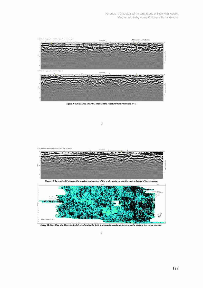
Forensic Archaeological Investigations at Sean Ross Abbey, Mother and Baby Home Children’s Burial Ground
127

Forensic Archaeological Investigations at Sean Ross Abbey, Mother and Baby Home Children’s Burial Ground
128

Forensic Archaeological Investigations at Sean Ross Abbey, Mother and Baby Home Children’s Burial Ground
129

Forensic Archaeological Investigations at Sean Ross Abbey, Mother and Baby Home Children’s Burial Ground
130

Forensic Archaeological Investigations at Sean Ross Abbey, Mother and Baby Home Children’s Burial Ground
131

Forensic Archaeological Investigations at Sean Ross Abbey, Mother and Baby Home Children’s Burial Ground
132

Forensic Archaeological Investigations at Sean Ross Abbey, Mother and Baby Home Children’s Burial Ground
133

Forensic Archaeological Investigations at Sean Ross Abbey, Mother and Baby Home Children’s Burial Ground
134

Forensic Archaeological Investigations at Sean Ross Abbey, Mother and Baby Home Children’s Burial Ground
135

Forensic Archaeological Investigations at Sean Ross Abbey, Mother and Baby Home Children’s Burial Ground
136

Forensic Archaeological Investigations at Sean Ross Abbey, Mother and Baby Home Children’s Burial Ground
137
Appendix D: Context Register
Context Trench Description Initial
1 1 Topsoil AH
2 1 Deposit of brownish @ SE end AH
3 1 Grey Sand & Pebbles AH
4 1 Grey Clay NE-SW @ Centre AH
5 1 Darker Silt & Stone NW of C.4 AH
6 1 Small mid brown, dep. 0.45” AH
7 1 Grey Clay @ NW of C.5 AH
8 1 Bright Brown (orange) @ NW AH
9 2 Topsoil AH
10 2 Bright Brown (orange) @ SW AH
11 2 Dark Peat under C.10 AH
12 1 Cut of linear filled by 5 AH
13 1 Nat Greyish Yellow clay AH
14 2 Stony Linear SEE 34 AH
15 1 Original sod layer under C.8 AH
16 4 Topsoil AH
17 4 Greyish mixed layer AH
18 4 Orange Bright Brown @NE end AH
19 4 Fill of Shallow Linear AH
20 4 Linear cut AH
21 4 Probably grave fill @ SW AH
22 4 Probably grave fill NE of C.21 AH
23 4 Probable grave fill AH
24 4 Triangular grave fill AH
25 4 Grave fill w/coffin AH
26 4 Central grave with SK17 AH
27 4 Coffined grave fill SK16 AH
28 4 Coffined grave fill SK15 AH
29 4 Grave fill SK14 w/medal AH
30 4 Grave fill of unexposed AH
31 4 Nat. S.S. Clay with roots AH
32 4 Nat. S.S. Clay AH

Forensic Archaeological Investigations at Sean Ross Abbey, Mother and Baby Home Children’s Burial Ground
138
Context Trench Description Initial
33 4 Nat. Peat layer AH
34 2a Collapsed wall in C.11 AH
35 2 Grey Clay Natural S.S. AH
36 3 Clean Red re dep.? UNDER 43 LL
37 5 Fill1 of C46 NMcC
38 2a Fill of Grave SW.04 AH
39 2a Fill/Deposit surrounding SK05 AH
40 2a Fill of Grave SK06 AH
41 2b Deposit & cut @ N. end Tr26 AH
42 2b Grey sandy gravel Tr.26 AH
43 3 Mixed Stones, layer over 36/redep.nat LL
44 3 Natural peat deps. showing under C.36 LL
45 2a Prob. Grave fill b/w C.39/C.40 AH
46 5 Cut off poss. Pile base of monument NMcC
47 2B Gravel directly on peat AH
48 3 Mixed brown/grey mottled fill over all of trench LL
49 3 Patch of grey gravelly clay S>S LL
50 3 Topsoil LL
51 3 Artificial cut, to find pipe LL
52 3 Salt Glazed Pipe in TR3 LL
53 3 Gravel in SW facing section LL
54 3 Primary stone fill over pipe AH
55 3 Cut of Diagonal Linear AH
56 3 Smooth grey/brown over 57 AH
57 3 Peat cut by C.51 AH
58 3 Mid fill in C.51 AH
59 3 Redeposited Nat upper backfill 51 AH
60 3 Thin brown layer under C.57 AH
61 3 Natural SS AH
62 7 Topsoil AH
63 7 Pipe backfill grey AH
64 7 Pipe-trench cut AH
65 7 Salt Glazed Pipe AH
66 7 Gravel under T.S. AH

Forensic Archaeological Investigations at Sean Ross Abbey, Mother and Baby Home Children’s Burial Ground
139
Context Trench Description Initial
67 7 Dark Silt AH
68 7 Orange Build up AH
69 7 Gravelly build-up layer AH
70 7 Peat AH
71 7 Layer AH
72 7 Nat. SS AH
73 7 2nd Upper fill in C.64 AH
74 6 Topsoil AH
75 6 Drain Fill Stone @ S.end AH
76 6 Possible N-S Fill N. of C.75 AH
77 6 Gravel spread, possible foothpath NMcC
78 6 Fill of Drain Stone NMcC
79 6 Orange NMcC
80 6 Cut of drain NMcC
81 6 Dark fill of coffin NMcC
82 6 Cut of 81 NMcC
83 6 Cut contrary C.84 NMcC
84 6 Fill w/waxy texture, coffin @ SW NMcC
85 6 Cut for 86 NMcC
86 6 Fill w/coffin travelling E. into baulk NMcC
87 6 Cut for 88 w/truncated ledge NMcC
88 6 Fill with square and coffin NMcC
89 6 Cut for 90 NMcC
90 6 Fill w/coffin heading NE into Baulk NMcC
91 6 Grey gravelly deposits AH
92 6 Stone drain in section AH
93 6 Upper fill of drain C.95 AH
94 6 Grave cut SK.23/C.76 AH
95 6 Drain cut filled by C75/93 AH
96 6 Natural Peat AH
97 6 Natural Clay AH
98 5 Topsoil NMcC
99 5 Orange, introduced material NMcC
100 5 Peat NMcC

Forensic Archaeological Investigations at Sean Ross Abbey, Mother and Baby Home Children’s Burial Ground
140
Context Trench Description Initial
101 5 Burial fill at SW NMcC
102 5 Concrete upper fill C.46 AH
103 6 Probable cut between C.86 and C.80 AH
104 6 Mixed fill of C.103 AH

Forensic Archaeological Investigations at Sean Ross Abbey, Mother and Baby Home Children’s Burial Ground
141
Appendix E: Osteological Terms (Glossary)
Figure 51: Skeletal diagram indicating primary bones of the skeleton

Forensic Archaeological Investigations at Sean Ross Abbey, Mother and Baby Home Children’s Burial Ground
142
Figure 52: Infant cranium and mandible indicating primary skeletal elements

Forensic Archaeological Investigations at Sean Ross Abbey, Mother and Baby Home Children’s Burial Ground
143
Figure 53: Anatomical directions (White and Folkens 1991, fig. 3.1, 29)

Forensic Archaeological Investigations at Sean Ross Abbey, Mother and Baby Home Children’s Burial Ground
144
Appendix F: Disarticulated Osteological Catalogue
?? Unknown
GB Burnt bone GC Calcified soft tissue GT Soft tissue KK Skeleton WW Unknown (faunal) AI Auditory: Incus AM Auditory: Malleus AS Auditory: Stapes CC Cranium CE Endocast CF Frontal CH Ethmoid CL Lacrimal CN Nasal CO Occipital CP Parietal CS Sphenoid CT Temporal CV Calvaria CX Vault Fragment CZ Zygomatic QH Hyoid D1 Upper dI1 D2 Upper dI2 D3 Upper dC D4 Upper dM1 D5 Upper dM2 E1 Lower dI1 E2 Lower dI2 E3 Lower dC E4 Lower dM1 E5 Lower dM2 D? ? Deciduous tooth DD Deciduous tooth DR Decid. tooth root DX Decid. crown frag. M1 Lower I1 M2 Lower I2 M3 Lower C M4 Lower P1 M5 Lower P2 M6 Lower M1 M7 Lower M2 M8 Lower M3 X1 Upper I1 X2 Upper I2 X3 Upper C X4 Upper P1 X5 Upper P2
X6 Upper M1 X7 Upper M2 X8 Upper M3 MC Mandibular body MM Mandible MR Mandibular ramus MS Mandib. symphysis MY Mandibular condyle XD Demimaxilla XP Premaxilla XX Maxilla PP Permanent tooth PR Perm. tooth root PX Tooth crown frag. QM Manubrium QS Sternum QX Sternum frag. QC Clavicle S? ? Scapula SA Acromion SB Scapula blade SC Coracoid SG Scap. glenoid cavity SS Scapula SX Scapula frag. QR Rib VC Cervical vertebra VT Thoracic vertebra VL Lumbar vertebra VS Sacrum VY Coccyx VV Vertebra VX Vertebra fragment I? ? Hip bone IA Acetabulum II Hip bone IL Ilium IP Pubis IS Ischium IX Hip bone frag. H? ? Humerus HH Humerus HP Humerus-proximal HM Humerus-midshaft HD Humerus-distal R? ? Radius RR Radius RP Radius-proximal RM Radius-midshaft RD Radius-distal
U? ? Ulna UU Ulna UP Ulna-proximal UM Ulna-midshaft UD Ulna-distal YC Carpal YY Handbone YS Scaphoid YL Lunate YQ Triquetral YI Pisiform YZ Trapezium YD Trapezoid YA Capitate YH Hamate YM Metacarpal YP Phalanx (hand) LS Sesamoid F? ? Femur FF Femur FP Femur-proximal FM Femur-midshaft FD Femur-distal LL Patella T? ? Tibia TT Tibia TP Tibia-prox TM Tibia-midshaft TD Tibia-distal B? ? Fibula BB Fibula BP Fibula-proximal BM Fibula-midshaft BD Fibula-distal ZT Tarsal bone ZZ Footbone ZA Talus ZC Calcaneus ZN Navicular ZE Medial cuneiform ZI Intermed. cuneiform ZL Lateral cuneiform ZU Cuboid ZM Metatarsal ZP Phalanx

Forensic Archaeological Investigations at Sean Ross Abbey, Mother and Baby Home Children’s Burial Ground
145
ID Trench Context Other Info Bone Code Side Age1 Age2 Age3 Details
No
of
frags
1001 4
Disartic TR4 26.2.2019
Tibia TT R JUV INF 6-9mths proximal end slightly eroded, minimum L 90.12mm, estimated no longer than 100mm, submitted for RCD
1
1002 4
Disartic TR4 26.2.2019
Femur FF R JUV INF 1.5-3mths
complete L 92.45mm
1
1003 4
Disartic TR4 26.2.2019
Fibula BB ? JUV INF
unsided shaft fragment, current length 64.64mm
1
1004 4
Disartic TR4 26.2.2019
Humerus HH R? JUV INF
inferior to deltoid to olecranon fossa, broken through obliquely from lateral inferior to medial superior, current length 56.47mm
1
1005 4
Disartic TR4 26.2.2019
Rib QR L JUV INF
1 complete left rib 1
1006 4
Disartic TR4 26.2.2019
Rib QR R JUV INF
x 2 medial ends 2
1007 4
Disartic TR4 26.2.2019
Rib QR ? JUV INF
midshaft fragment 1
1008 4
Disartic TR4 26.2.2019
Metacarpal YM ? JUV INF
1 unidentified metacarpal, L 15.17mm
1
1009 4
Disartic TR4 26.2.2019
Vertebra VC L JUV INF
x 1 left arch, unfused to body
1
1010 4
Disartic TR4 26.2.2019
Cranial CF L JUV INF 6mths complete left frontal, matches with 1011, frontal arc 102mm, frontal chord 89.19mm
1
1011 4
Disartic TR4 26.2.2019
Cranial CF R JUV INF 6mths complete right frontal, matches with 1010, frontal arc 102mm, frontal chord 86.09mm
1
1012 4
Disartic TR4 26.2.2019
Cranial CS R JUV INF
right greater wing, slightly incomplete
1
1013 4
Disartic TR4 26.2.2019
Cranial CP R JUV INF 6mths anterior half of parietal, fits with 1011
1

Forensic Archaeological Investigations at Sean Ross Abbey, Mother and Baby Home Children’s Burial Ground
146
1014 4
Disartic TR4 26.2.2019
Cranial CP L JUV INF 6mths anterior half of parietal, fits with 1010, dry fracture
1
1015 4
Disartic TR4 26.2.2019
Cranial CX ? JUV INF
2 fragments, which joint together, with dry fracture
2
1016 4
Disartic TR4 26.2.2019
Cranial CO ? JUV INF
fragment of squamous
1
1017 4
Disartic TR4 26.2.2019
Cranial CX ? JUV INF
x 6 small vault fragments
6
1018 4
Disartic TR4 26.2.2019
Cranial CO ? JUV INF 6mths pars basilaris, L 19.9mm, Sag. L 15.14mm, W 21.47mm, articulates with 1059, 1060
1
1019 4 ? 42cm BGL, NMcC 26.02.19
Rib QR L JUV INF
x 2 medial ends and 1 shaft with lateral end
3
1020 4
no label, in bag marked 'Disartic TR4 26.2.2019'
Humerus HH L JUV INF 6mths complete, L 89.19mm, probably the same as 1021, 1022
1
1021 4
no label, in bag marked 'Disartic TR4 26.2.2019'
Scapula SS L JUV INF 6mth? complete but eroded, probably the same as 1020, 1022
1
1022 4
no label, in bag marked 'Disartic TR4 26.2.2019'
Rib QR L JUV INF
1st rib and the 4th or 5th rib, probably the same as 1020, 1021
2
1023 4 17 Disartic HR Radius RR L JUV INF neonate? almost complete but slightly eroded at either end, current length 47.68, probable neonate
1
1024 4 17 Disartic HR Humerus HP L JUV INF
very eroded, only possibly a proximal diaphysis of humerus
1
1025 4 17 Disartic 27.2.19 Tibia TT L JUV INF neonate? very slight erosion, present length 66.31mm, probably a neonate
1
1026 4 17 Disartic 27.2.19 Cranial CP ? JUV INF young posible superior/anterior fragment at the anterior fontanelle
1

Forensic Archaeological Investigations at Sean Ross Abbey, Mother and Baby Home Children’s Burial Ground
147
1027 4
Disartic 26.2.19 Rib QR L JUV INF young x 5 left ribs, almost complete
5
1028 4
Disartic 26.2.19 Rib QR R JUV INF older x 8 right ribs 8
1029 4
Disartic 26.2.19 Rib QR ? JUV INF older x 7 shaft or lateral rib ends
7
1030 4
Disartic 26.2.19 Rib QR L JUV INF young x 1 left shaft 1
1031 4
Disartic 26.2.19 Rib QR R JUV INF young x 1 right shaft 1
1032 4
Disartic 26.2.19 Rib QR ? JUV INF young x 2 lateral/shaft fragments
2
1033 4
Disartic 26.2.19 Clavicle QC L JUV INF 7-12 mths
complete, L 56.46, similar in size to 1034
1
1034 4
Disartic 26.2.19 Clavicle QC R JUV INF 7-12mths?
medial half, similar in size to 1033
1
1035 4
Disartic 26.2.19 Clavicle QC R JUV INF young incomplete at medial end
1
1036 4
Disartic 26.2.19 Vertebra VC L JUV INF older left arch of a cervical, unfused to body and arch
1
1037 4
Disartic 26.2.19 Humerus HH R JUV INF 6-12mths
complete but very slightly eroded at distal end, same as 1020?, current length 88.81mm
1
1038 4
Disartic 26.2.19 Humerus HH R JUV INF 3-6mths proximal end incomplete, smaller than 1037, current length 74.83mm
1
1039 4
Disartic 26.2.19 Humerus HH R JUV INF young proximal end very eroded, smaller than 1038, current length 50.98mm
1
1040 4
Disartic 26.2.19 Scapula SS R JUV INF young quite complete, some erosion at all edges, similar to 1021
1
1041 4
Disartic 26.2.19 Metacarpal YM ? JUV INF
unsided metacarpal, incomplete
1
1042 4
Disartic 26.2.19 Metacarpal YM ? JUV INF
unsided metacarpal, L 17.44mm
1
1043 4
Disartic 26.2.19 Ulna UU R JUV INF c. 3 mths minus proximal and distal ends, may be similar to 1044
1
1044 4
Disartic 26.2.19 Ulna UU L JUV INF c. 3mths complete, L 73.83mm, similar
1

Forensic Archaeological Investigations at Sean Ross Abbey, Mother and Baby Home Children’s Burial Ground
148
in size to 1043 and matches 1045
1045 4
Disartic 26.2.19 Radius RR L JUV INF 3-6mths proximal end slightly eroded, current length 64.41, matches 1044
1
1046 4
Disartic 26.2.19 Radius RD L JUV INF young distal half, younger than 1045
1
1047 4
Disartic 26.2.19 Femur FP L JUV INF
proximal half, largest of 1047-49
1
1048 4
Disartic 26.2.19 Femur FF L JUV INF young similar size to 1049, slightly incomplete at proximal end, may match 1050 current length 89.69mm
1
1049 4
Disartic 26.2.19 Femur FF R JUV INF young similar size to 1048, slightly incomplete at distal end, may latch 1051, current length 89.79mm
1
1050 4
Disartic 26.2.19 Tibia TP L JUV INF young proximal half, may match 1048, slightly larger than 1051
1
1051 4
Disartic 26.2.19 Tibia TT R JUV INF 1.5-3mths
may match 1049, slughtly smaller than 1050, L 77.36mm
2
1052 4
Disartic 26.2.19 Tibia TT L JUV INF very young
proximal 2/3, distal end eroded, smaller than 1051
1
1053 4
Disartic 26.2.19 Tibia TT R JUV INF very young
proximal 2/3, distal end eroded, smaller than 1051
1
1054 4
Disartic 26.2.19 Cranial CX ? JUV INF young x 13 vault fragments
13
1055 4
Disartic 26.2.19 Cranial CX ? JUV INF older x 7 vault fragments
7
1056 4
Disartic 26.2.19 Cranial CF R JUV INF older fragment of superior glabella, 1056-58 and 1070 all appear to match
1
1057 4
Disartic 26.2.19 Cranial CF L JUV INF older complete except for superior portion, 1056-58
1

Forensic Archaeological Investigations at Sean Ross Abbey, Mother and Baby Home Children’s Burial Ground
149
and 1070 all appear to match
1058 4
Disartic 26.2.19 Cranial CP L JUV INF older minus superior/anterior area, 1056-58 and 1070 all appear to match, dry fracture
1
1059 4
Disartic 26.2.19 Cranial CO L JUV INF older left lateral wing, matches 1060 and articulates with 1018
1
1060 4
Disartic 26.2.19 Cranial CO R JUV INF older right lateral wing, matches with 1059 and articulates with 1018
1
1061 4
Disartic 26.2.19 Cranial CF R JUV INF 1-3mths frontal, frontal arc 87mm, frontal chord 79.75mm
1
1062 4
Disartic 26.2.19 Mandible MM L JUV INF 0-3mths? anterior half of body, symphysis unfused, contains 1071 and 1072
1
1063 4
Disartic 26.2.19 Mandible MM - JUV INF 4-6mths gonial to gonial, symphysis fused, contains 1073-1075
1
1064 4
Recovered still articulated in lump of earth, 27.2.19
Rib QR L JUV INF
3 ribs, maybe 4th, 5th, and 6th, latter complete, 1064, 1065, 1076 all artic. Together
3
1065 4
Recovered still articulated in lump of earth, 27.2.19
Radius RR L JUV INF 3-6mths proximal end very slightly incomplete, current length 66.11mm, 1064, 1065, 1076 all artic. Together
1
1066 4 18 Disartic above SK14
Femur FF R JUV INF 1.5mths L 86.9mm 1
1067 4 18 Disartic above SK14
Tibia TT R JUV INF 1.5-3mths
L 75.21mm 1
1068 4 18 Disartic above SK14
Fibula BM ? JUV INF
shaft fragment 1
1069 4 18 Disartic above SK14
Tibia TT L JUV INF 1.5-3mths
L 74.92mm 1
1070 4
Disartic 26.2.19 Cranial CT L JUV INF older quite complete, 1056-58 and 1070 all appear to match
1

Forensic Archaeological Investigations at Sean Ross Abbey, Mother and Baby Home Children’s Burial Ground
150
1071 4
Disartic 26.2.19 Tooth E1 L JUV INF 0-3mths? lower central deciduous incisor, root beginning to develop, within 1062
1
1072 4
Disartic 26.2.19 Tooth E4 L JUV INF neonate lower deciduous first molar, crown half formed, within 1062
1
1073 4
Disartic 26.2.19 Tooth E4 R JUV INF 4-6mths crown of lower first deciduous molar, within 1063
1
1074 4
Disartic 26.2.19 Tooth E5 R JUV INF 4-6mths unerupted lower second deciduous molar, within 1063
1
1075 4
Disartic 26.2.19 Tooth E5 L JUV INF 4-6mths unerupted lower second deciduous molar, within 1063
1
1076 4
Recovered still articulated in lump of earth, 27.2.19
Vertebra VL L JUV INF
left arch unfused to body and arch, 1064, 1065, 1076 all artic. Together
1
1077 4
Recovered from baulk
Femur FF R JUV INF c.3mths distal end incomplete, similar in size to right femur of SK23
1
1078 4 17 N end of TR, lowest area
Rib QR R? JUV INF
possible right rib, in two fragments, disarticulated
2

Forensic Archaeological Investigations at Sean Ross Abbey, Mother and Baby Home Children’s Burial Ground
151
Appendix G: Radiocarbon Dating Specialist Report

Forensic Archaeological Investigations at Sean Ross Abbey, Mother and Baby Home Children’s Burial Ground
152

Forensic Archaeological Investigations at Sean Ross Abbey, Mother and Baby Home Children’s Burial Ground
153

Forensic Archaeological Investigations at Sean Ross Abbey, Mother and Baby Home Children’s Burial Ground
154

Forensic Archaeological Investigations at Sean Ross Abbey, Mother and Baby Home Children’s Burial Ground
155

Forensic Archaeological Investigations at Sean Ross Abbey, Mother and Baby Home Children’s Burial Ground
156

Forensic Archaeological Investigations at Sean Ross Abbey, Mother and Baby Home Children’s Burial Ground
157

Forensic Archaeological Investigations at Sean Ross Abbey, Mother and Baby Home Children’s Burial Ground
158

Forensic Archaeological Investigations at Sean Ross Abbey, Mother and Baby Home Children’s Burial Ground
159

Forensic Archaeological Investigations at Sean Ross Abbey, Mother and Baby Home Children’s Burial Ground
160

Forensic Archaeological Investigations at Sean Ross Abbey, Mother and Baby Home Children’s Burial Ground
161

Forensic Archaeological Investigations at Sean Ross Abbey, Mother and Baby Home Children’s Burial Ground
162

Forensic Archaeological Investigations at Sean Ross Abbey, Mother and Baby Home Children’s Burial Ground
163

Forensic Archaeological Investigations at Sean Ross Abbey, Mother and Baby Home Children’s Burial Ground
164

Forensic Archaeological Investigations at Sean Ross Abbey, Mother and Baby Home Children’s Burial Ground
165

Forensic Archaeological Investigations at Sean Ross Abbey, Mother and Baby Home Children’s Burial Ground
166

Forensic Archaeological Investigations at Sean Ross Abbey, Mother and Baby Home Children’s Burial Ground
167

Forensic Archaeological Investigations at Sean Ross Abbey, Mother and Baby Home Children’s Burial Ground
168

Forensic Archaeological Investigations at Sean Ross Abbey, Mother and Baby Home Children’s Burial Ground
169

Forensic Archaeological Investigations at Sean Ross Abbey, Mother and Baby Home Children’s Burial Ground
170

Forensic Archaeological Investigations at Sean Ross Abbey, Mother and Baby Home Children’s Burial Ground
171

Forensic Archaeological Investigations at Sean Ross Abbey, Mother and Baby Home Children’s Burial Ground
172

Forensic Archaeological Investigations at Sean Ross Abbey, Mother and Baby Home Children’s Burial Ground
173

Forensic Archaeological Investigations at Sean Ross Abbey, Mother and Baby Home Children’s Burial Ground
174

Forensic Archaeological Investigations at Sean Ross Abbey, Mother and Baby Home Children’s Burial Ground
175

Forensic Archaeological Investigations at Sean Ross Abbey, Mother and Baby Home Children’s Burial Ground
176
Appendix H: Drain Inspection Report
Forensic Archaeological Investigations at Sean Ross Abbey, Mother and Baby Home Children’s Burial Ground
177

Forensic Archaeological Investigations at Sean Ross Abbey, Mother and Baby Home Children’s Burial Ground
178

Forensic Archaeological Investigations at Sean Ross Abbey, Mother and Baby Home Children’s Burial Ground
179

Forensic Archaeological Investigations at Sean Ross Abbey, Mother and Baby Home Children’s Burial Ground
180

Forensic Archaeological Investigations at Sean Ross Abbey, Mother and Baby Home Children’s Burial Ground
181

Forensic Archaeological Investigations at Sean Ross Abbey, Mother and Baby Home Children’s Burial Ground
182

Forensic Archaeological Investigations at Sean Ross Abbey, Mother and Baby Home Children’s Burial Ground
183

Forensic Archaeological Investigations at Sean Ross Abbey, Mother and Baby Home Children’s Burial Ground
184

Forensic Archaeological Investigations at Sean Ross Abbey, Mother and Baby Home Children’s Burial Ground
185

Forensic Archaeological Investigations at Sean Ross Abbey, Mother and Baby Home Children’s Burial Ground
186

Forensic Archaeological Investigations at Sean Ross Abbey, Mother and Baby Home Children’s Burial Ground
187

Forensic Archaeological Investigations at Sean Ross Abbey, Mother and Baby Home Children’s Burial Ground
188

Forensic Archaeological Investigations at Sean Ross Abbey, Mother and Baby Home Children’s Burial Ground
189

Forensic Archaeological Investigations at Sean Ross Abbey, Mother and Baby Home Children’s Burial Ground
190

Forensic Archaeological Investigations at Sean Ross Abbey, Mother and Baby Home Children’s Burial Ground
191

Forensic Archaeological Investigations at Sean Ross Abbey, Mother and Baby Home Children’s Burial Ground
192

Forensic Archaeological Investigations at Sean Ross Abbey, Mother and Baby Home Children’s Burial Ground
193

Forensic Archaeological Investigations at Sean Ross Abbey, Mother and Baby Home Children’s Burial Ground
194

Forensic Archaeological Investigations at Sean Ross Abbey, Mother and Baby Home Children’s Burial Ground
195

Forensic Archaeological Investigations at Sean Ross Abbey, Mother and Baby Home Children’s Burial Ground
196

Forensic Archaeological Investigations at Sean Ross Abbey, Mother and Baby Home Children’s Burial Ground
197

Forensic Archaeological Investigations at Sean Ross Abbey, Mother and Baby Home Children’s Burial Ground
198

Forensic Archaeological Investigations at Sean Ross Abbey, Mother and Baby Home Children’s Burial Ground
199

Forensic Archaeological Investigations at Sean Ross Abbey, Mother and Baby Home Children’s Burial Ground
200

Forensic Archaeological Investigations at Sean Ross Abbey, Mother and Baby Home Children’s Burial Ground
201

Forensic Archaeological Investigations at Sean Ross Abbey, Mother and Baby Home Children’s Burial Ground
202

Forensic Archaeological Investigations at Sean Ross Abbey, Mother and Baby Home Children’s Burial Ground
203

Forensic Archaeological Investigations at Sean Ross Abbey, Mother and Baby Home Children’s Burial Ground
204

Forensic Archaeological Investigations at Sean Ross Abbey, Mother and Baby Home Children’s Burial Ground
205

Forensic Archaeological Investigations at Sean Ross Abbey, Mother and Baby Home Children’s Burial Ground
206

Forensic Archaeological Investigations at Sean Ross Abbey, Mother and Baby Home Children’s Burial Ground
207