remembering antietam - UMD DRUM - University of Maryland
454
ABSTRACT Title of Dissertation: REMEMBERING ANTIETAM: COMMEMEMORATION AND PRESERVATION OF A CIVIL WAR BATTLEFIELD Susan W. Trail, Doctor of Philosophy, 2005 Dissertation Directed by: Associate Professor Mary C. Sies Department of American Studies Civil War memory has been the focus of a great deal of scholarship in recent years. A large percentage of this attention has been directed toward one battlefield— Gettysburg, which has come to represent remembrance of that conflict as a whole. This study of Antietam battlefield, however, reveals a very different commemorative experience than the one found at Gettysburg, suggesting a more nuanced Civil War memory at work in the United States than found by looking at Gettysburg alone. The Battle of Antietam remains, to this day, the single bloodiest day in American history. Yet, Antietam’s location within the slaveholding, Union border state of Maryland resulted in a conflicted and ambivalent remembrance of that battle on the part of local inhabitants, the state, and national veterans’ organizations. This ambivalence shaped the commemorative landscape at Antietam, and was reflected within it. The first objective of this study was to document the formation of the commemorative landscape at Antietam battlefield up to the 1960s, within the larger
-
Upload
khangminh22 -
Category
Documents
-
view
0 -
download
0
Transcript of remembering antietam - UMD DRUM - University of Maryland

ABSTRACT
Title of Dissertation: REMEMBERING ANTIETAM: COMMEMEMORATION AND PRESERVATION OF A CIVIL WAR BATTLEFIELD
Susan W. Trail, Doctor of Philosophy, 2005
Dissertation Directed by: Associate Professor Mary C. Sies Department of American Studies
Civil War memory has been the focus of a great deal of scholarship in recent
years. A large percentage of this attention has been directed toward one battlefield—
Gettysburg, which has come to represent remembrance of that conflict as a whole. This
study of Antietam battlefield, however, reveals a very different commemorative
experience than the one found at Gettysburg, suggesting a more nuanced Civil War
memory at work in the United States than found by looking at Gettysburg alone. The
Battle of Antietam remains, to this day, the single bloodiest day in American history. Yet,
Antietam’s location within the slaveholding, Union border state of Maryland resulted in a
conflicted and ambivalent remembrance of that battle on the part of local inhabitants, the
state, and national veterans’ organizations. This ambivalence shaped the commemorative
landscape at Antietam, and was reflected within it.
The first objective of this study was to document the formation of the
commemorative landscape at Antietam battlefield up to the 1960s, within the larger
evolution of Civil War memory. A major factor in this landscape’s development was the
fact that, unlike other early battlefield parks, the federal government acquired very little
land at Antietam. Paradoxically, this contributed greatly toward Antietam’s successful
preservation under present-day standards.
The second objective was to define the local community’s role in shaping the
landscape at Antietam. Because it remained in private hands, community members
exerted a great deal of influence over Antietam’s commemorative landscape relative to
other battlefields. In fact, elements within the Sharpsburg community consistently
resisted or undermined the authority of those seeking to impose a commemorative
overlay on Antietam battlefield.
Situating Antietam battlefield within the larger discourse and politics of Civil War
memory was the third objective. The complexity of remembrance at Antietam first
manifested itself with the creation of Antietam National Cemetery, and the struggle
between Maryland and the northern states over early memory of the battle. This
contrasted with the clear message conveyed by Lincoln at the dedication of the
Gettysburg cemetery, and set the stage for the different paths of remembrance taken by
the two battlefields.
REMEMBERING ANTIETAM:
COMMEMORATION AND PRESERVATION
OF A CIVIL WAR BATTLEFIELD
by
Susan W. Trail
Dissertation submitted to the Faculty of the Graduate School of the University of Maryland, College Park in partial fulfillment
of the requirements for the degree of Doctor of Philosophy
2005
Advisory Committee: Associate Professor Mary C. Sies, Chair Professor John L. Caughey Associate Professor Donald W. Linebaugh Dr. Dwight T. Pitchaithley Associate Professor Leslie S. Rowland

© Copyright by
Susan W. Trail
2005

ACKNOWLEDGMENTS
My interest in the commemorative landscape at Antietam National Battlefield
grew out of the controversy surrounding a new General Management Plan for the park in
the early 1990s. I witnessed much of the spirited debate that revolved around the
proposed alternatives in this plan, and found myself bemused by the depth of feeling it
provoked at public meetings and in correspondence. A large part of this controversy
centered around what appeared to me at that time to be a series of rather mundane little
roads crossing through the battlefield. These roads had been constructed by the U.S. War
Department in the 1890s, and later incorporated into the battlefield tour route. The debate
over what should happen to these roads—should they be removed, left as they were, or
restored to their original appearance—sparked an interest in studying what happened
after the battle was over and the memories of it began. This curiosity was reinforced
when I had the good fortune several years later to become assistant superintendent of
Antietam National Battlefield, and dealt with issues surrounding commemoration and
preservation of the battlefield on a daily basis.
I would never have been able to transform my interest in the post-war history of
Antietam battlefield into this dissertation without the full support of John Howard,
superintendent of Antietam National Battlefield and my supervisor. He generously
provided me with the time and resources to pursue this project, firm in the belief that a
critical component of management is providing for the growth and development of
employees. For providing me with this opportunity, as well as for the trust that he has
advanced me over the past eight years, I thank him.
ii
Several staff members at Antietam National Battlefield have provided assistance
for this project. Battlefield historian Ted Alexander gave me access to the park library,
helped me find several sources, and answered many questions. He also reviewed a draft
of Chapter 2, to ensure that I would not make egregious errors in my description of the
battle. GIS Specialist Debbie Cohen produced maps depicting the battlefield farmsteads
and War Department roads, and Park Ranger Keith Snyder provided me with maps of the
national cemetery and monument locations.
I also wish to extend my heartfelt thanks to the staff at Monocacy National
Battlefield, where I presently serve as superintendent. Their patience and support during
the time I was distracted by the completion of this project is very much appreciated.
Archeologist Tom Gwaltney produced the location map and finalized several others. He
also integrated all of the images into the final text and put the document into its final
format. Without Tom’s technical expertise and willingness to help this part of the process
would have been much more difficult and frustrating.
My research led me to a number of archives and institutions, where many people
provided assistance. I wish especially to thank Melinda T. Marsden, Executive Director
of the Washington County Historical Society; John Frye, librarian at the Western
Maryland Room, Washington County Free Library; and archivists Mitch Yockelson and
Joseph Schwartz at the National Archives at College Park. Archivists at the Maryland
Historical Society, the Maryland State Archives, the Library of Congress, and the New
York Public Library retrieved documents and helped me sort through various collections.
iii
I wish to extend a special thank you to the members of my dissertation
committee—Dr. Mary Corbin Sies, Professor John L. Caughey, Dr. Donald W.
Linebaugh, Dr. Dwight T. Pitcaithley, and Dr. Leslie S. Rowland, who took time from
their busy schedules to read the final dissertation draft and provide substantive comments
that I believe have greatly strengthened the final submission. I particularly thank Dr. Sies,
my advisor and chair of my dissertation committee, who has given me encouragement
and guidance from the beginning of this project to its end. Her rigorous standards and
attention to detail encouraged me to press further than I might have otherwise, leading in
the end to a much better study. I also wish especially acknowledge Dr. Dwight
Pitcaithley, Chief Historian of the National Park Service, who served as a mentor both for
this project and for my NPS career. He read early drafts of several chapters and helped
steer me down a constructive path.
Finally, I extend a huge thank you to my family for its support. Over the years my
parents, Bill and Betty Winter, have consistently encouraged me to pursue my interests
and dreams, including my doctoral degree. My husband David has stood by me
throughout this undertaking and offered his encouragement and support. My son Nathan,
who came along at the start of my dissertation, cannot help but wonder what life will be
like without “Mommy’s project.” I extend my deepest thanks to them for providing an
environment at home that made it possible for me to work on and complete this project.
iv
TABLE OF CONTENTS
List of Figures ............................................................................................................ viii Chapter 1: Introduction............................................................................................1 Memory and the Civil War ................................................................................5 Gettysburg as Civil War Battlefield Archetype ...............................................13 Looking at Antietam Battlefield ......................................................................17 Chapter 2: Setting the Stage: Maryland, Sharpsburg, and the Civil War ..............25 The Landscape Takes Shape............................................................................27 Maryland on the Eve of Civil War...................................................................32 War Comes to Maryland..................................................................................35 The Battle of Antietam.....................................................................................45 Consequences of the Battle of Antietam..........................................................54 Sharpsburg and the Aftermath of Battle ..........................................................59 Civil War Continues ........................................................................................64 Wartime Political Situation in Maryland .........................................................67 Conclusion .......................................................................................................69 Chapter 3: “Removing the Remains of Our Heroes”: The Controversial
Creation of Antietam National Cemetery ............................................71 Legislation to Create Antietam National Cemetery.........................................72 Antietam National Cemetery Association .......................................................74 Controversy Regarding ‘Lee’s Rock’ ..............................................................78 Reinterment of the Dead ..................................................................................85 Preparing for the Dedication............................................................................88 Dedication of Antietam National Cemetery ....................................................91 Investigation of Cemetery Affairs ...................................................................98 Controversy Over the Confederate Dead.......................................................100 Washington Confederate Cemetery ...............................................................109 Transfer of Antietam National Cemetery to the War Department.................114 Dedication of the Soldiers’ Monument..........................................................117 Conclusion .....................................................................................................121 Chapter 4: “Not for Themselves, but for Their Country”: Early
Commemoration at Antietam Battlefield...........................................125 Decoration Day in Sharpsburg–A Community Observance..........................127 The War Department Assumes Control.........................................................131 The Changing Face of Decoration Day .........................................................147 Twenty-fifth Anniversary Commemoration ..................................................153
v

Veteran Excursions and the Growth of Tourism ...........................................157 Creation of Antietam Battlefield Park ...........................................................170 Conclusion .....................................................................................................176 Chapter 5: “Parking the Battlefield”: The Work of the Antietam Board ............178 Establishment of the First Antietam Board....................................................180 George B. Davis Takes Charge......................................................................190 Construction of the Battlefield Avenues........................................................194 Jed Hotchkiss and the Mapping of Antietam.................................................217 Major George W. Davis and the Antietam Board..........................................219 Carman-Cope Map.........................................................................................226 Conclusion .....................................................................................................231 Chapter 6: “In Honor of Their Fallen Comrades”: Creation of the
Monumental Landscape at Antietam Battlefield ...............................233 Gettysburg and the Emergence of Civil War Battlefield Monuments...........234 Early Monuments at Antietam.......................................................................238 The Antietam Board and Commemorative Monuments................................249 Monuments in the West Woods.........................................................249 Massachusetts State Monument.........................................................254 Relocating the 11th Connecticut Monument ......................................256 State Commissions and Monuments..............................................................259 Maryland Monument .........................................................................260 New Jersey Monument and Markers .................................................265 Ohio Monuments ...............................................................................266 Pennsylvania Monuments ..................................................................269 Indiana Monument .............................................................................273 New York Monuments.......................................................................277 Army of Northern Virginia Monument..........................................................283 Conclusion .....................................................................................................285 Chapter 7: Battlefield Caretaker: War Department Management of Antietam
National Battlefield, 1900-1933.........................................................289 Appointment of First Battlefield Superintendent...........................................291 Conflicts with Local Landowners..................................................................293 Superintendent George W. Graham...............................................................297 50th Anniversary Observance of the Battle of Antietam................................302 Proposed Battlefield Acquisitions and Improvements...................................305 Burnside Bridge Area ........................................................................306 Dunker Church...................................................................................308 Philadelphia Brigade Park..................................................................310 Reconstruction of War Department Avenues and Fences .................312 McKinley Monument Revisited.....................................................................314 Growth of Community Interest in the Battlefield ..........................................317
vi
Administrative Transfer to the National Park Service...................................321 Conclusion .....................................................................................................324 Chapter 8: Forging a New Direction: The Early Years of National Park
Service Management (1933-1950).....................................................326 Turning Toward the South .............................................................................328 Changes to the Battlefield..............................................................................334 75th Anniversary of the Battle of Antietam....................................................342 Resurrecting the Dunker Church and Other Land Issues...............................354 In the Shadow of Gettysburg Again...............................................................361 Conclusion .....................................................................................................365 Chapter 9: Development Arrives at Antietam National Battlefield Site:
National Park Service Management, 1950-1967 ...............................367 Acquisition of the Dunker Church Site..........................................................369 Preparing for Mission 66 ...............................................................................372 Looking Ahead Toward the Centennial .........................................................377 ‘Antietam Bill’ ...............................................................................................389 Centennial-Related Activities in Sharpsburg.................................................390 Centennial Clashes.........................................................................................394 The Antietam Centennial Commemoration ...................................................404 Land Acquisition and Mission 66 Improvements..........................................410 Conclusion .....................................................................................................417 Conclusion ............................................................................................................419 References ............................................................................................................427
vii
LIST OF FIGURES
Figure 2.1. Location of Sharpsburg within the State of Maryland.........................27 Figure 2.2 Relationship of mid-nineteenth century farmsteads on Antietam Battlefield.............................................................................................30 Figure 2.3 Union and Confederate positions at the opening of the Battle of
Antietam, September 17, 1862.............................................................44 Figure 2.4 Confederate attack on Sedgwick’s Division in the West Woods,
and French’s advance toward the center of the Confederate line. .......48 Figure 2.5 Union attack against Confederate positions in the Sunken Road ........49 Figure 2.6 Union attack against Confederate positions holding the Lower
(or Burnside) Bridge ............................................................................51 Figure 2.7 Height of Union advance toward Sharpsburg, shortly after
Confederate General A. P. Hill’s attack against the Union left flank .....................................................................................................52
Figure 2.8 Confederate dead along the west side of the Hagerstown Pike,
north of Dunker church. Photograph taken by Alexander Gardner on September 19, 1862 ........................................................................55
Figure 2.9 Sketch of Union burial detail burying Confederate dead in
trenches on the Roulette Farm. The Sunken Road can be seen in the right background, with the Roulette Lane extending from it toward the left. This sketch, prepared by Frank Shell, originally appeared in Frank Leslies Illustrated Newspaper, October 18, 1862......................................................................................................57
Figure 2.10 Damage to Mumma Farmstead resulting from the Battle of
Antietam. The burned-out Mumma House can be seen in the center of the photograph. Original photograph by Alexander Gardner, September 1862 ....................................................................61
viii

Figure 3.1 Plan of Antietam National Cemetery, showing graves arranged in a semi-ellipse around a central monument. “Lee’s Rock” was located just below the Pennsylvania section, to the right of number 23. ...........................................................................................84
Figure 3.2 Detail from the sketch of dedication of Antietam National
Cemetery, September 18, 1867. The graves can be seen on the far right. The speakers’ stand is located on the far left, in the general vicinity of the rostrum.............................................................92
Figure 3.3 Portion of 1877 stereoview of Antietam National Cemetery,
looking west toward the lodge building, from the general vicinity of the New York and Pennsylvania sections......................................116
Figure 3.4 Dedication of Soldiers’ Monument at Antietam National
Cemetery, September 17, 1890. Photograph taken from lodge building tower, looking east...............................................................119
Figure 3.5 Soldiers’ Monument at Antietam National Cemetery, late
nineteenth century..............................................................................122 Figure 4.1 Antietam National Cemetery entrance and lodge building, c.
1880s. The Soldiers’ Monument can be seen in the center background.........................................................................................138
Figure 4.2 View of Antietam National Cemetery from the lodge building
tower, c. 1900.....................................................................................147 Figure 4.3 View of Sharpsburg, looking south down Main Street, c. 1900........161 Figure 4.4 View platform constructed by Martin E. Snavely on site of
McClellan’s signal station on Elk Ridge, c. 1889..............................169 Figure 5.1 Ezra Carman, c. 1895.........................................................................181 Figure 5.2 George B. Davis, 1909.......................................................................192 Figure 5.3 View of Bloody Lane, or the Sunken Road, looking east. To the
left is the entrance to the Roulette Farm, and to the right is the War Department Road constructed in 1895, c. 1905 .........................197
Figure 5.4 Map of War Department Avenues, Antietam Battlefield ..................199
ix

Figure 5.5 War Department Road through the Poffenberger Farm (later
known as Mansfield Avenue), c. 1905. View toward east, with remnants of the North Woods to the right (note stacked cord wood). This photograph displays the typical widths of the original roads, as well as the fences marking the edge of the right-of-way. ......................................................................................208
Figure 5.6 War Department tablets along east side of the Hagerstown Pike,
looking northeast toward the Maryland Monument, c. 1905.............214 Figure 6.1 Location of monuments on Antietam National Battlefield................241 Figure 6.2 The 14th Connecticut Monument on the Roulette Farm, c. 1905.......245 Figure 6.3 Dedication of the 34th New York Monument, September 17,
1902....................................................................................................253 Figure 6.4 Maryland Monument, c. 1900............................................................262 Figure 6.5 McKinley Monument, on or around the time of its dedication on
October 13, 1903................................................................................268 Figure 6.6 View of Confederate Avenue, c. 1906, showing the recently
erected monument to the 125th Pennsylvania within the government right-of-way. The 34th New York Monument sits to the left, within its enclosed lot. The Maryland Monument can be seen in the left distance ......................................................................271
Figure 6.7 Monument to the 7th Pennsylvania Reserve, located on the north
side of Mansfield Avenue (no. 2 on Figure 6.1). ...............................274 Figure 6.8 C. 1920 postcard showing, from left to right, the 124th
Pennsylvania Monument, the Indiana Monument, and the New Jersey Monument ...............................................................................276
Figure 7.1 View of Burnside Bridge, showing the Benner Farm in the center
background, c. 1906. This farmstead was constructed within a couple of years of the Battle of Antietam. .........................................293
Figure 7.2 C. 1910 postcard depicting monuments along Branch Avenue.
Note livestock in the roadway............................................................295
x
Figure 7.3 Reunion of the 20th New York on the 50th anniversary of the
Battle of Antietam, September 17, 1912............................................303 Figure 7.4 C. 1905 postcard depicting the entrance to Philadelphia Brigade Park ....................................................................................................310 Figure 8.1 John Kyd Beckenbaugh, c. 1930s ......................................................329 Figure 8.2 View of Bloody Lane in 1936, looking east toward the stone
observation tower. The Roulette Farm lies on the left side of the lane, the Piper Farm on the right. On the right side of the lane is the much-modified Richardson Avenue. ...........................................338
Figure 8.3 Scene from 1937 pageant “On Wings of Time.” ...............................350 Figure 9.1 View of twentieth-century store sitting on foundation of the
Dunker Church...................................................................................372 Figure 9.2 Clara Barton Monument, Antietam NB. ............................................398 Figure 9.3 Reenactment of the Battle of Antietam, September 1962..................407 Figure 9.4 Visitor Center at Antietam National Battlefield Site, c. 1965 ...........412 Figure 9.5 Map showing Rt. 65 by-pass road through West Woods, and
realigned Burnside Bridge Road........................................................414
xi

Chapter 1:
Introduction
The Battle of Antietam, fought on September 17, 1862, remains, to this day, the
single bloodiest day in American history. Like other Civil War battlefields, Antietam has
been memorialized through the placement of monuments on its fields and the
preservation of its key features. On the other hand, the commemorative history of
Antietam diverged in many respects from that of other major battlefields—particularly
Gettysburg, owing to what I perceive was an overriding ambivalence toward Antietam as
an appropriate place of remembrance. As a result, Antietam battlefield has the potential
to convey different facets of Civil War memory and commemoration than are found
elsewhere. I use Antietam as a case study of how changing and contested meanings of
that conflict became inscribed upon that particular battlefield landscape. This study, in
fact, reveals a very different experience at Antietam as compared with the other early
battlefield parks, especially Gettysburg, one that suggests a more nuanced Civil War
memory at work in the United States.
Documenting the formation of the commemorative landscape at Antietam is one
objective of this study. In the present day, Antietam National Battlefield is viewed as a
resounding success story within the battlefield preservation community. It is considered
one of, if not the best, preserved Civil War battlefields in the United States. The measures
that led to the protection of Antietam from many of the development pressures currently
faced by most other Civil War sites are relatively recent, however. Congressional
1
expansion of the park boundary to its current 3, 256 acres did not occur until 1978 (P.L.
65-625, 92 Stat. 3488), and key properties such as the D.R. Miller and Roulette farms
were not acquired until 1990 and 1998, respectively. Beginning in the late 1980s, the
State of Maryland also initiated an aggressive program to acquire scenic easements on
several thousand acres of farmland surrounding Antietam. During this same period, the
Board of County Commissioners of Washington County approved a zoning overlay
designed to protect approaches to the battlefield and significant viewsheds. Taken
together, as stated to the author by National Park Service historian Richard West Sellars,
these efforts have created an example of what the American landscape could look like, if
only we took better care of it.1
Many observers contrast the beauty and peacefulness of Antietam to the
overwhelming development and hype of its famous neighbor to the north, Gettysburg.
The irony is that throughout its post-Civil War history Antietam has always been
compared to this behemoth, but mostly unfavorably, as it lacked the commercial and
commemorative attributes of that great park. For much of its existence, in fact, Antietam
Battlefield lay neglected and overlooked relative to Gettysburg and other early battlefield
parks. Just as important as what was placed on the battlefield is what was not placed
there. Paradoxically, Antietam’s failure to replicate Gettysburg became a significant
component in its successful preservation under today’s standards.
A second objective of this study is to identify the role the local community played
in shaping the landscape at Antietam. Unlike the other early battlefield parks, the land
2
1 Richard West Sellars, comment made to author during a tour of Antietam Battlefield in May 2001. Ed Wenschhof, Chief Ranger, Antietam National Battlefield, e-mail to author, October 2, 2004.

upon which the Battle of Antietam was fought remained in private hands. As a result,
throughout most of the battlefield’s history, the owners of the battlefield properties
exerted great influence over the development of its commemorative landscape. As will be
seen, this development differed greatly from Gettysburg, where an organization
purchased key pieces of that battlefield shortly after the battle and established a uniform
structure for memorializing it. Such a structure never developed at Antietam. In fact, as
will be shown later, elements of the Sharpsburg community consistently worked to resist
or undermine the authority of those who did seek to impose a commemorative overlay on
the battlefield.
Identifying the role of the local community initially involved looking at the
interactions between the battlefield caretakers (the War Department and later the National
Park Service), the veteran and state monument associations that sought to memorialize
their actions on the field, and the people that lived on and around the battlefield. During
the course of this study, however, it became apparent that the concept of local community
needed to expand, especially when examining the twentieth-century development of
Antietam, to include county-wide organizations such as the Chamber of Commerce and
the historical society. These groups exerted extensive influence on the development of
Antietam during the twentieth century, particularly under the National Park Service
management of the battlefield. As will be seen, they attempted to co-opt commemorative
activities at Antietam under their own agendas, further complicating the role of historical
memory at that location.
3

The pervasive role of the State of Maryland in memorializing Antietam also
became evident, but primarily in a negative way. The State of Pennsylvania promoted its
battlefield at Gettysburg from the time fighting ended and projected an unambiguously
Unionist agenda as part of its preservation. Maryland, on the other hand, as a
slaveholding border state that supplied troops to both North and South, sought to use
Antietam to validate its conflicted position. Otherwise, Maryland essentially ignored
Antietam as it focused on overcoming the divisions within it arising from the Civil War.
Thus, while there was a close local-state-national alignment in the promotion and
commemoration of Gettysburg throughout the course of its history, the opposite was true
for Antietam. Instead, these entities tended to be at odds among themselves and between
each other, resulting in a contested and complex remembrance of the battle.
Building upon this complexity and divisiveness, a third, and perhaps primary,
objective of this study is to situate Antietam Battlefield within the larger discourse and
politics of Civil War memory, from the close of the Civil War through the Centennial
period. Until recently, scholarship on Civil War memory and commemoration has
focused almost exclusively on Gettysburg—to the point where what transpired at that
battlefield has become defined as the Civil War commemorative experience. In point of
fact, all preserved battlefield landscapes are artificial constructions that contain meaning,
but it does not necessarily follow that each was constructed in the same manner, or that
they hold the same meanings. Indeed, I contend that Antietam presents a different
narrative of commemoration and historical memory than Gettysburg, one that is more
4

complicated and ambiguous, and that these complexities and ambiguities reveal
themselves on the landscape.
Memory and the Civil War
The study of historical memory and its formation has received the attention of a
great number of scholars over the past couple of decades. It has become an accepted point
that “societies in fact reconstruct their pasts rather than faithfully record them, and that
they do so with the needs of contemporary culture clearly in mind—manipulating the past
in order to mold the present.” Remembered history, or tradition, can become a means of
providing social cohesion between and among different groups. It also can contain
ideological underpinnings, however, which legitimate certain political and social
relationships and exclude or subordinate others. As a result, struggles over how to
remember the past often reflect struggles over political and social power in the present.2
In Mystic Chords of Memory: The Transformation of Tradition in American
Culture, Michael Kammen provides a sweeping account of memory and tradition
throughout American history, organizing his book under several broad periods that
illustrate changing meanings and uses of these concepts. The first period of interest to
this study spans from about 1870 to 1915, which Kammen defines as an age of memory
and ancestor worship. One of the major themes to emerge from this period is Civil War
remembrance and reconciliation, aided by the growing social and political power of its
2 Michael Kammen, Mystic Chords of Memory: The Transformation of Tradition in American Culture (New York: Vintage Books, 1993), 3. For general works on memory, see Eric Hobsbawm and Terrence Ranger, The Invention of Tradition (New York: Cambridge University Press, 1983).
5
veterans. Kammen points out that the politicization of this memory led to reconciliation
between North and South, but also to the exclusion of African Americans.3
Kammen presents a rather static view of Civil War remembrance during this
period that is appropriate for what transpired at Gettysburg, but overlooks potential
differences between battlefields. This becomes apparent when looking at Antietam,
whose location in a border state effectively placed it in a reconciliationist no-man’s land.
In fact, competing local, state, and national interests led to a contested remembrance at
Antietam that was not consensual in nature, but very complex and ambiguous.
Kammen defines the period from circa 1915 to 1945 by a resurgence of local
tradition and remembrance that had its roots in the Progressive Era. “As local and
regional pride heightened the importance of historical consciousness, state and local
historical societies became increasingly significant,” asserts Kammen. “Quite often, . . .
domination of these institutions could mean controlling the identity of an area as well as
matters involving family preeminence.” One of the ways that historical societies and
other groups displayed local tradition during this period was through the staging of
historical pageants, grand outdoor spectacles with casts that could number in the
thousands. These pageants generally consisted of tableaux depicting scenes from local
history, and remained popular through the 1930s. As will be seen, this resurgence of local
tradition and use of pageantry had a significant impact upon Antietam Battlefield, with
6
3 Kammen, Mystic Chords of Memory, 12, 105-106, 121.
the Washington County Historical Society taking a leading role in preservation and
commemoration at the battlefield during the middle third of the twentieth century.4
Kammen charts the emergence between 1945 and 1990 of patriotic discourse as
an increasingly important element of historical memory, arising primarily in response to
anxieties surrounding the Cold War. The shining light in this movement was Colonial
Williamsburg, which actively promoted the cause of patriotism during this period. The
federal government’s role as a primary sponsor and custodian of collective memory also
increased during these years, including that of its leading preservation agency, the
National Park Service. The combination of Cold War anxieties and renewed patriotism,
sparked by the approaching Civil War Centennial, revived interest in that conflict.5
As will be seen, this interest in the Civil War led to a reassessment of the
significance of the Battle of Antietam and, paradoxically, a renewed emphasis in both
developing and preserving the battlefield. At the same time, the Centennial
commemoration at Antietam once again revealed deep fissures between local, state, and
national interests, who offered competing programs around the commemoration of the
battle and squabbled endlessly among themselves. Thus, the theme of reconciliation
between North and South that Kammen found so pervasive during the Centennial left
little mark on Antietam, as these competing interests were not able to come together and
present a unified perspective on the meaning of the battle.
4 Kammen, Mystic Chords of Memory, 272-273, 280-281, 375. For a comprehensive history of the pageant movement through the second decade of the twentieth century, see David Glassberg, American Historical Pageantry: The Uses of Tradition in the Early Twentieth Century (Chapel Hill: University of North Carolina Press, 1990).
7
5 Kammen, Mystic Chords of Memory, 570, 581-582, 592.
John Bodnar, in Remaking America: Public Memory, Commemoration, and
Patriotism in the Twentieth Century, views commemoration as contested terrain over
which different groups attempt to create the dominant public memory. “Public memory
emerges from the intersection of official and vernacular cultural expressions,” he asserts.
“The former originates in the concerns of cultural leaders or authorities at all levels of
society. . . . Vernacular culture, on the other hand, represents an array of specialized
interests that are grounded in parts of the whole.” Like Kammen, he sees the federal
government assuming a larger role in defining public memory beginning in the 1930s,
particularly in the case of the National Park Service. Bodnar asserts “the power and the
visibility of the park service history programs [tended] to alter the nature of the
expressions of memory on a local, regional, or ethnic level.” Again, this resulted in an
increased emphasis on nationalism and patriotism, something the NPS did promote at
Antietam battlefield after mid-century. As will be seen, however, it does not appear that
the National Park Service dominated historical memory at Antietam during the period
under consideration, but was only one of many voices.6
Other recent scholarship has focused specifically on Civil War memory. David
Blight, in Race and Reunion: The Civil War in American Memory and in his collected
essays Beyond the Battlefield: Race, Memory, and the American Civil War,
comprehensively addresses the broader collective memory of the conflict, and
demonstrates how construction of this memory served the ideology of reconciliation
between Northern and Southern whites in the late nineteenth and early twentieth
6 John Bodnar, Remaking America: Public Memory, Commemoration, and Patriotism in the Twentieth Century (Princeton: Princeton University Press, 1992), 13-14, 170, 177-178.
8
centuries. Blight effectively argues that the culture of reunion, which downplayed
sectional divisions and emphasized the heroism of white soldiers on both sides of the
conflict, can be understood only within the context of the ideology of racism. “Race was
so deeply at the root of the war’s causes and consequences, and so powerful a source of
division in American social psychology,” avers Blight, “that it served as the antithesis of
a culture of reconciliation. The memory of slavery, emancipation, and the Fourteenth and
Fifteenth Amendments never fit well into a developing narrative in which the Old and
New South were romanticized and welcomed back to a new nationalism, and which
devotion alone made everyone right, and no one truly wrong in the remembered Civil
War.” He describes attempts by African Americans to forge an alternative memory of the
Civil War, one centered around the legacy of emancipation, and how these efforts
became drowned out by an increasingly hostile nation.7
Blight notes that battlefields “served particularly well as the places where this
separation in memory became most explicit.” This was particularly true of the large-scale
reunions and major battle anniversary events that occurred during the late nineteenth and
7 David W. Blight, Race and Reunion: The Civil War in American Memory (Cambridge, Massachusetts: The Belknap Press of Harvard University Press, 2001), and Beyond the Battlefield: Race, Memory, and the American Civil War (Amherst: University of Massachusetts Press, 2002), 173. For additional perspectives on Civil War memory, particularly in relationship to the Lost Cause, or Southern viewpoint, see Gaines Foster, Ghosts of the Confederacy: Defeat, the Lost Cause, and the Emergence of the New South (New York: Oxford University Press, 1987); Charles Regan Wilson, Baptized in Blood: The Religion of the Lost Cause, 1865-1920 (Athens: University of Georgia Press, 1980); Gary W. Gallagher and Alan T. Nolan, eds., The Myth of the Lost Cause and Civil War History (Bloomington: Indiana University Press, 2000); Cynthia Mills and Pamela H. Simpson, eds., Monuments to the Lost Cause: Women, Art, and the Landscapes of Southern Memory ( Knoxville: University of Tennessee Press, 2003); Karen L. Cox, Dixie’s Daughters: The United Daughters of the Confederacy and the Preservation of Confederate Culture (Gainesville: University Press of Florida, 2003); and Catherine W. Bishir, “Landmarks of Power: Building a Southern Past, 1895-1915,” Southern Cultures 1 (1993): 5-46. For a gender-based interpretation of reconciliation, see Nina Silber, The Romance of Reunion: Northerners and the South, 1865-1900 (Chapel Hill: University of North Carolina Press, 1993).
9
early twentieth centuries. He examines the reunions held to commemorate two major
battle anniversaries at Gettysburg—the 25th in 1888 and the 50th in 1913—and notes the
evolution of reconciliation thinking between those two events.8
Blight draws his conclusions based principally on what transpired at Gettysburg,
but Civil War memory is not as clear-cut as he suggests, particularly when the history of
Antietam battlefield is taken into account. For a variety of reasons, Antietam did not
participate in the culture of reunion that prevailed at Gettysburg in the late nineteenth and
early twentieth centuries. As will be seen, these included a lack of organized veteran
support to facilitate such efforts at Antietam, and, as discussed previously, the location of
the battlefield within a border state that had not reconciled its own divided past.
Manifestations of Civil War memory, such as the reconciliation ideology
described by Blight, may be read on the battlefield landscape. In fact, such landscapes
serve as rich repositories of Civil War remembrance through time. In War Memorials as
Political Landscape, James M. Mayo provides an overview of the political and symbolic
meaning of war memorials as a whole and sets the stage for focusing on Civil War
battlefields in particular. “War is the ultimate political conflict,” contends Mayo at the
outset, “and attempts to commemorate it unavoidably create a distinct political
landscape.” At their simplest, war memorials—whether statue, battlefield, or museum—
are social and physical arrangements of space and artifacts that keep alive the memories
of those involved in that conflict. Meaning does not remain static, however, as changing
10
8 Blight, Beyond the Battlefield, 173.
historical, social, and symbolic circumstances create and recreate meaning for these
memorials over time.9
Mayo asserts that the preservation of battlefields turns them into landscaped
museums: “Battlefields and their subsequent war memorials symbolically reorder the
natural landscape as an expression of historical memory and change.” As a result, war
memorialization and battlefield preservation reflect societal values and what society
wishes to remember about war. Going one step farther, these values will change through
time and ought to be reflected in changes to the battlefield landscape. As one of the first
to look at spatial relationships on battlefields, Mayo notes the dominance of monuments
at Vicksburg and Gettysburg, and how their placement reflects the landscape of battle
itself. He contrasts these two battlefields with Antietam: “The Miller cornfield where the
line of battle swept back and forth 15 times is still maintained. Less than a mile away is
Bloody Lane where 4,000 Confederate and Union soldiers were killed in battle within
four hours. These two famous killing grounds are so physically distinct and famous that
visitors can easily ignore nearby monuments. The landscape itself is the memorial.”10
What Mayo appears to be concluding is that Antietam escaped much of the
symbolical reordering that occurred on other major Civil War battlefield landscapes. In
some sense this is true. At the time he was writing, much of the battlefield, including the
D.R. Miller Farm he mentions, was still in private ownership. This relative absence of
memorial attributes, however, actually represents a more subtle organization of the
9 John M. Mayo, War Memorials as Political Landscape: The American Experience and Beyond (New York: Praeger, 1988), 1, 10.
11
10 Mayo, War Memorials, 44, 171-173.
landscape that, as will be seen, speaks volumes about the place of Antietam battlefield
within Civil War memory.
While not looking specifically at battlefields, Kirk Savage’s Standing Soldiers,
Kneeling Slaves: Race, War, and Monuments in Nineteenth-Century America offers a
critical assessment of post-Civil War monuments found in communities across the nation,
and their relationship to slavery. “Monuments attempt to mold a landscape of collective
memory,” notes Savage, “to conserve what is worth remembering and discard the rest.”
The common soldier monument, usually standing in a watchful parade rest, proliferated
in the last part of the nineteenth century and came to represent the ideal citizen soldier
across America. These generic representations represented only the white citizen,
however, and “worked to solidify the association between the white body and the moral
duty of citizenship.” In essence, they represented in material form the reconciliation
ideology outlined by Blight, an ideology that excluded black men from the body politic.
Such statues were relatively rare on the battlefields, however, and those that were erected
generally struck active combat poses.11
11 Kirk Savage, Standing Soldiers, Kneeling Slaves: Race, War, and Monument in Nineteenth-Century America (Princeton, NJ: Princeton University Press, 1997), 4, 162-164, 182. For a comprehensive study of Civil War battlefield monuments that takes a more art historical approach, see Michael Wilson Panhorst, “Lest We Forget: Monuments and Memorial Sculpture in National Military Parks on Civil War Battlefields, 1861-1917” (Ph.D. diss., University of Delaware, 1988). A look through Gettysburg Monuments: A Field Guide to the Monuments and Markers Located on the Gettysburg Battlefield (n.p: Monumental Battlefields, 2002), reveals that statues depicting common soldiers are relatively rare when compared to other types of monuments. The same holds true at Antietam National Battlefield as well.
12

Gettysburg as Civil War Battlefield Archetype
One battlefield in particular—Gettysburg—has received by far the greatest
attention from Civil War scholars, in terms both of the battle itself and the post-war
commemoration of that engagement. In two early articles concerning the post-war
development of Gettysburg battlefield, John S. Patterson began to address the changing
social and political meanings of that battlefield through time, and the effects these
changes had upon the landscape. According to Patterson, the mythologizing process that
turned the battlefield into one of the nation’s “most precious shrines” began almost
immediately after the battle ceased, with the establishment of the national cemetery to
hold the Union dead and the formation of the Gettysburg Battlefield Memorial
Association (GBMA) to acquire and preserve the battlefield.12
Patterson divides the history of Gettysburg battlefield into three phases, which
remain the accepted classification to the present day. The first period, extending from
1863 to 1895, represented the era of Northern reunions and monumentation under the
leadership of the GBMA. The second phase began when the battlefield passed into
federal ownership in 1895. It coincided with the end of individualized monuments raised
by Northern veterans and a new emphasis on general commemorations of leading
commanders, states, and abstract ideas of nationalism and reconciliation. According to
Patterson, this phase also marks a new era in which the Southern story became
documented on the field and the battlefield finally became a national possession. He also
13
12 John S. Patterson, “A Patriotic Landscape: Gettysburg, 1863-1913,” Prospects 7 (1982): 315-333, and “From Battle Ground to Pleasure Ground: Gettysburg as a Historic Site,” in History Museums in the United States: A Critical Assessment, ed. Warren Leon and Roy Rosenzweig (Urbana: University of Illinois Press, 1989), 128.
notes that the War Department promoted the development of a balanced and militarily
detailed interpretation by erecting hundreds of battlefield markers to indicate troop
movements in an objective and nonjudgmental way.”13
Patterson dates the third phase of the battlefield’s history from World War II. This
phase coincides with the demise of the Civil War from living memory, as well as new
battles over boundaries, commercialization, and twentieth-century meanings of the
battlefield. It also corresponds roughly with the transfer of Gettysburg (along with the
other War Department battlefields) to the National Park Service (NPS) in 1933. He notes
that it was not until 1962, however, that the NPS actually constructed its visitor center on
the battlefield and thereby “emphatically marked the arrival of the Park Service on the
field, not simply to preserve and mark it, but to explain it to large numbers of visitors at a
single site.”14
While Patterson provides a good initial outline of the post-war history of
Gettysburg, he only implicitly recognizes the political and physical layering of the
battlefield by its three administrators. As a result, he does not address the changing
symbolic and political meanings of Gettysburg as revealed within this textured landscape.
In addition, Patterson alludes to but does not discuss issues of ideology and contestation
surrounding the meaning of the battlefield.
In Sacred Ground: Americans and Their Battlefields, Edward Linenthal explicitly
acknowledges the political significance of American battlefields throughout their history.
He emphasizes that “these battle sites are civil spaces where Americans of various
13 Patterson, “From Battle Ground to Pleasure Ground,” 139.
14
14 Patterson, “From Battle Ground to Pleasure Ground,” 128-129, 150-151.

ideological persuasions come, not always reverently, to compete for the ownership of
powerful national stories and to argue about the nature of heroism, the meaning of war,
the efficacy of martial sacrifice, and the significance of preserving the patriotic landscape
of the nation.” In a provocative chapter focusing on the Gettysburg battlefield, Linenthal
provides an in-depth assessment of the shifting symbolic and political meanings of “a
rich cultural archives of various modes of remembrance.” Along with Blight, he believes
that the earliest and most enduring of these meanings is the ideology of reconciliation
articulated through the reunions held in the last quarter of the nineteenth century and the
50th and 75th anniversary reunions held in 1913 and 1938, respectively.15
Linenthal also examines the hundreds of monuments that command the landscape
at Gettysburg, noting that their placement on the battlefield through time reflected “a
struggle to dominate ceremonial space and gain permanent symbolic hegemony through
the strategic placement of monuments.” For example, only Northern monuments were
erected at Gettysburg in the early years, reinforcing the great Union victory. By the mid
1890s, as part of the growing reconciliation ideology, there was widespread feeling that
the monumental landscape at Gettysburg should more fully tell the Confederate story.
Fights erupted, however, over placement of southern monuments. For example, attempts
to place Confederate markers at the points of farthest advancement through Union lines
were successfully resisted by those who oversaw the battlefield. Fights over “spatial
contamination were not confined to North versus South,” however, as conflicts also
occurred between states and units: “The placement of a monument a few feet in front of
15
15 Edward Tabor Linenthal, Sacred Ground: Americans and Their Battlefields (Urbana: University of Illinois Press, 1991), 1, 90-93.
or behind that of another state or another regiment conveyed, for those concerned, a
message about the impact of that particular unit or state on formative events.” As will be
seen, such struggles did not occur at Antietam, where position on the landscape was not
such a critical issue since there were many fewer monuments with which to compete.16
In recent years, historians also have explored the popular memory of the Battle of
Gettysburg. “It would not be overstating the case,” notes historian Amy Kinsel, “to argue
that before the fiftieth anniversary of the battle, Gettysburg entered the American
imagination as an essential symbol of what the war had been about.” What started out as
an important military victory came to represent the very essence of the Civil War. This
happened as the result of several factors. The first was the battle’s location in an area
where northern reporters had ready access. The second was Lincoln’s dedication of the
national cemetery, which served to elevate both the battle and its site in the public
imagination. Third, and perhaps most significant, was the emerging interpretation that
“the Union army turned back the Southern tide at Gettysburg . . . and it never again rose
beyond the Mason Dixon line.” This understanding of Gettysburg as the turning point, or
high water mark, of the Civil War dovetailed nicely with a centerpiece of Lost Cause
mythology, that Lee might have won the war had he won at Gettysburg.17
16 Linenthal, Sacred Ground, 105-110.
16
17 Amy J. Kinsel, “From Turning Point to Peace Memorial: A Cultural Legacy,” in The Gettysburg Nobody Knows, ed. Gabor S. Boritt (New York: Oxford University Press, 1997), 206, 209-211, 214-215. Also see Amy J. Kinsel, “‘From These Honored Dead’: Gettysburg in American Culture, 1863-1938” (Ph.D. diss.: Cornell University, 1992). Other scholars have spent time deconstructing the many myths that have developed around the Battle of Gettysburg. See Carol Reardon, Pickett’s Charge in History and Memory (Chapel Hill: University of North Carolina Press, 1997), for a thorough discussion of the historiography and meaning of that event, and Thomas A. Desjardin, These Honored Dead: How the Story of Gettysburg Shaped American Memory (Cambridge, Massachusetts: Da Capo Press, 2003), for an engaging perspective on how a number of present-day myths gained their popularity.
Another important component of popular memory at Gettysburg has been the
commercial packaging and promotion of the battlefield as an American shrine. Jim
Weeks points out that commercialization began immediately after the battle, and that
market activity and commemorative activity have been intertwined at Gettysburg from
the beginning. “In other words,” states Weeks, “the making of Gettysburg into an icon
did not simply happen because a great Civil War battle had been fought here. Rather, a
commercial web often entwined with ritualistic activity packaged it for a consuming
public and continually repackaged it for new generations.” This packaging was done not
only by local entrepreneurs, but by organizations devoted to the battlefield’s preservation,
who wanted to ensure Gettysburg’s central position in American culture.18
Looking at Antietam Battlefield
What Kinsel and Weeks describe at work at Gettysburg is the local, state, and
national alignment that enabled that battlefield to become the centerpiece of Civil War
memory. By and large, the forces that worked to push Gettysburg into the cultural
marketplace were lacking at Antietam. While Antietam and Gettysburg battlefields lie
only fifty miles from each other, the Mason-Dixon line that separates them makes a
world of difference in their postwar commemorative development. During the Civil War,
Pennsylvania was a solidly Unionist state that furnished large numbers of troops to that
cause. Maryland, on the other hand, was deeply divided. As a slaveholding state that
remained within the Union, Maryland was mistrusted by both the Union and the
17
18 Jim Weeks, “Gettysburg: Display Window for Popular Memory,” Journal of American Culture 21, no. 4 (1998): 41-56, and Gettysburg: Memory, Market, and an American Shrine (Princeton: Princeton University Press, 2003), 8.
Confederacy. As a result, the alignment of local, state, and national interests that occurred
at Gettysburg did not occur at Antietam, as conflicts within Maryland carried over into
the postwar years.
This study reveals a more complex and ambiguous memory of the Civil War at
work in the United States than has been articulated by earlier works, which have focused
almost exclusively on Gettysburg. Commemoration at Antietam was not as
straightforward as at Gettysburg, which suggests that less consensus existed among
Americans over how to remember the Civil War than previously believed. Since most
battlefields were located in border states, such as the case with Antietam, or in the
defeated South, Gettysburg may represent the exception, rather than the rule. This
analysis represents a step toward complicating the picture of Civil War remembrance on
its battlefields.
It also shows how the ambiguities surrounding remembrance at Antietam have
influenced the development of its commemorative landscape, in ways that were much
different than at the other early Civil War battlefield parks. An underlying principle of
this study is that all human landscapes have cultural meaning and can be “read” or
interpreted. “Our human landscape is our unwitting autobiography,” notes Peirce Lewis,
“reflecting our tastes, our values, our aspirations, and even our fears, in tangible, visible
form.” According to geographer D.W. Meinig, landscape also provides a “symbol of the
values, the governing ideas, the underlying philosophies of a culture.” In addition, it has
historical depth and represents a cumulative record of human and natural interaction.
Battlefield landscapes reflect these processes as well, with their added layers of
18

preservation and commemoration that “symbolically reorder the natural landscape as an
expression of historical memory and change.” A basic premise of this study is that the
meanings and interpretation of Civil War battlefields have not remained fixed through
time, but have changed according to the needs of succeeding generations. Thus, this study
examines the memorialized landscape at Antietam to see what clues it offers regarding
historical memory on the battlefield.19
Along with analysis of the historic landscape, close reading of primary
documentation also reveals these changes. Review of primary sources for this project
focused on federal records at the National Archives in Washington, D.C., and in College
Park, Maryland. These include War Department records documenting the establishment
and early administration of Antietam National Battlefield Site, and National Park Service
records detailing its later administration. Other major sources include Maryland state
records and newspapers in the Hall of Records in Annapolis, and Antietam-related
materials at the Maryland Historical Society in Baltimore, in Hagerstown at the Western
Maryland Room of the public library and the Washington County Historical Society, and
in the Antietam National Battlefield library in Sharpsburg.
The results of this study are presented chronologically, beginning with
background information on Sharpsburg, Maryland, and the Civil War, and concluding
with National Park Service management of the battlefield to 1967. Chapter 2 describes
the history and landscape development of Sharpsburg and its immediate surroundings in
19
19 Peirce F. Lewis, “Axioms for Reading the Landscape: Some Guides to the American Scene,” 11-32, and D.W. Meining, “The Beholding Eye: Ten Versions of the Same Scene,” 33-50, in The Interpretation of Ordinary Landscapes, ed. D.W. Meinig (New York: Oxford University Press, 1979); Mayo, War Memorials, 44.
the years leading up to the Civil War. It also provides a political context for the local
community and the State of Maryland on the eve of the Civil War, revealing that while
the Sharpsburg area was strongly Unionist, the state as a whole was very divided.
Emphasis is placed here on Maryland’s role as a slaveholding border state, which helped
set the stage for Antietam battlefield’s later development. This chapter also provides an
overview of the Battle of Antietam and its immediate aftermath.
The third chapter focuses on the creation of Antietam National Cemetery near the
end of the war. Established by the State of Maryland, it closely emulated Gettysburg in
all but one major respect—its legislation called for the burial of fallen Confederate
soldiers as well as Union soldiers within its walls. The resulting controversy reveals the
deep divisions that existed in Maryland relative to its slaveholding, border state status in
the Civil War. The argument is made here that the provision for the burial of Confederate
soldiers within the confines of the national cemetery represented an attempt by the state
to legitimize its presence on both sides of the conflict. In the end, Antietam National
Cemetery became unambiguously Union ground following removal of the Confederate
dead from the battlefield, transformation of the cemetery grounds by the War Department
in the 1870s, and placement of the colossal Soldier’s Monument in the heart of the
cemetery in 1880.
As elsewhere in the country, initial commemorative activities in Sharpsburg after
the war focused on remembering the fallen. As discussed in Chapter 4, Decoration Day
assumed central importance, reinforcing the community’s Republican leanings within a
heavily Democratic state and serving as the major commemorative event throughout the
20

first two decades after the Civil War. A second struggle involving the cemetery began,
however, when the War Department assumed oversight of it. This battle centered on who
truly controlled the cemetery—the local Sharpsburg community or the federal
government. A compromise appears to have been reached when a local Grand Army of
the Republic post formed in the mid 1880s that assumed a leadership role over
Decoration Day in a way that satisfied both the federal authorities and the Sharpsburg
community.
This chapter also discusses a shift that began in the 1880s toward commemoration
of the battlefield proper, as veterans began returning to Antietam in increasing numbers.
Unlike their counterparts at other battlefields, however, they did not organize to create a
national military park at Sharpsburg. This task was left instead to a local Congressman
whose efforts were only partially successful, placing Antietam at a disadvantage relative
to the other early battlefield parks. A number of factors account for the lack of veteran
interest, including the fixation on Gettysburg by the Society of the Army of the Potomac
and, indeed, of the Grand Army of the Republic as a whole, and the fact that Antietam lay
in a border state that did not fit easily into the developing reconciliation vision of the
time.
Without organized veteran support, the early development of Antietam Battlefield
suffered relative to the four military parks created in the 1890s—Chickamauga/
Chattanooga, Gettysburg, Shiloh, and Vicksburg. Chapter 5 documents the early
evolution of Antietam under War Department management. While the government
appointed commissions of Civil War veterans to oversee the other parks, the Secretary of
21
War established an ad hoc board to manage Antietam. Its first president, Major George B.
Davis, was not even a battle participant and appeared to have little sensitivity toward its
preservation. Quickly sensing a lack of support within the War Department for extensive
land acquisition or development, Davis devised a plan of purchasing strips of land for
rights-of-way through the battlefield. As a result, very little property was acquired
relative to the many thousands of acres purchased at the other parks. This led to very little
development outside of these roadways, which ironically facilitated preservation of the
battlefield in the long term.
The acquisition of narrow strips of land rather than large tracts also influenced the
placement of monuments on Antietam Battlefield. As related in Chapter 6, while other
battlefield commissions encouraged the erection of memorials on their battlefields, the
two Antietam Board presidents, Major George B. Davis and his successor Major George
W. Davis, discouraged the placement of monuments along the newly constructed
avenues. The lack of a land base also meant that veteran and state organizations wishing
to erect monuments had to purchase land on which to place them, no doubt discouraging
at least some from coming to Antietam. The Antietam Board also dissuaded veterans
from erecting individual unit monuments, encouraging instead the placement of
memorials to larger organizations, or to states. The need to purchase land also facilitated
movement in this direction. In the end, all of these factors helped reduce the number of
monuments erected at Antietam. In fact, it was to have fewer monuments than any of the
other five original War Department battlefields.
22
The reconciliation movement that followed the Spanish-American War provided
the State of Maryland with an opportunity to put its divided past behind it. The dedication
of a monument to Maryland’s Union and Confederate soldiers who fought at the Battle of
Antietam succeeded in a way that the earlier attempt to commemorate both sides at the
national cemetery had not. Even with this monument, however, Antietam did not become
a focus of the reconciliation movement as did Gettysburg, but instead remained in the
background as national organizations continued to ignore it.
During the first three decades of the twentieth century, the War Department made
few improvements at Antietam. Since little of the battlefield was under government
control, however, it avoided the indignity of being used as military training grounds and
camps, first at the very end of the previous century for the Spanish-American War and
then for World War I. Chapter 7 focuses on War Department management during these
years, particularly the government’s relationship with the surrounding community. Local
resistance to this federal presence led to a struggle, similar to the earlier one over the
national cemetery, over control of the avenues and other government property.
The transfer of Antietam Battlefield Site to the National Park Service in 1933 led
to profound changes in administrative direction. As outlined in Chapter 8, these included
a new orientation toward facilitating battlefield visitation, away from the memorialized
landscape of the War Department toward a more tourist-oriented one. The lack of a land
base at Antietam stymied many of the proposed improvements on the battlefield,
however, resulting in few changes to the landscape. On the other hand, the appointment
23
of a Southern-oriented superintendent led to more direct representation of Confederate
memory.
While very little happened at Antietam under the Public Works Programs of the
1930s, the picture changed greatly two decades later with the approaching Civil War
Centennial and the launching of the National Park Service’s Mission 66 Program to
improve visitor facilities at the National Parks. Renewed interest in the Civil War,
generated in large part by the centennial, led to a push to preserve battlefield lands from
burgeoning development. Chapter 9 relates how this desire to preserve battlefield lands
became linked with the Mission 66 program at Antietam, resulting in legislation that for
the first time enabled the NPS to acquire land on that battlefield. Ironically, initial land
acquisition was done more with development in mind than preservation, and it led to the
first major improvements on the battlefield since the War Department roads of the 1890s.
Taken together, these chapters document the formation of the commemorative
landscape at Antietam and reveal how its marginal status relative to the other early
battlefield parks led, ironically, to its preservation. They also reveal the continuous and
contentious nature of local involvement in shaping the landscape, owing in large part to
the fact that most of the battlefield remained in private ownership for much of its history.
Finally, they also explore the complexity of Civil War memory and remembrance at
Antietam.
24

Chapter 2.
Setting the Stage:
Maryland, Sharpsburg, and the Civil War
By the mid-nineteenth century, the State of Maryland reflected the divided nature
of the country as a whole. As a slaveholding state whose eastern and southern counties
were tied to the plantation system, Maryland had close ties with its neighbors to the
south. The agricultural economies and social fabric of the state’s northern and western
counties, on the other hand, were aligned closely with neighboring Pennsylvania. As a
growing industrial center focused on the port city of Baltimore, Maryland also was
forging an extensive commercial relationship with the free states of the north. The state’s
demography reflected these differences. The population of eastern and southern
Maryland was over 40% African American, the majority of whom were slaves, while the
northern and western sections of the state were 13% black, one-quarter of whom were
enslaved. In acknowledgment of these social and geographical divisions, and as a result
of the growing power and influence of Baltimore, Maryland began rotating its
governorship between the three areas of the state—the Eastern Shore, Southern
Maryland/Baltimore, and Western Maryland—after 1837. In addition, selection of the
state’s two United States senators also was based on geography, with one coming from
the eastern half of the state and the other from the western section.1
25
1 Charles L. Wagandt, “Redemption or Reaction?—Maryland in the Post-Civil War Years,” in Radicalism, Racism, and Party Realignment: The Border States during Reconstruction, ed. Richard O. Curry (Baltimore: Johns Hopkins University Press, 1969), 146-147; William A. Blair, “Maryland, Our Maryland:
These social and economic divisions, coupled with the state’s perilous
geographical position on the border between North and South, placed Maryland in an
uncertain position on the eve of the Civil War. The state’s conflicted reaction to the
ensuing war—it supplied troops for both North and South—was to have profound and
lasting effects on how that war was remembered and memorialized at Antietam, and
within Maryland as a whole. As will be seen, these geographic and social differences
created a very different commemorative experience than that at Gettysburg, located a
short distance to the north in staunchly Unionist Pennsylvania.
This chapter lays the groundwork for looking at the postwar commemoration of
Antietam Battlefield. First, it delineates the social, political, and physical landscape of
Sharpsburg in the years leading up to the Civil War to provide geographical and political
context for the battle and its later remembrance. It then briefly describes the Battle of
Antietam so as to ground it on that landscape, and outlines the larger outcomes and
significance of this engagement. The chapter continues with the effects, both short and
long-term, that the battle had upon the community of Sharpsburg. This discussion
includes an overview of the tremendous death and destruction that resulted from the
Battle of Antietam, and their lingering effects. Finally, it concludes with an overview of
the Maryland political scene at the end of the war that helped set the stage for how
Antietam would be remembered for the remainder of the nineteenth century.
26
Or How Lincoln and His Army Helped to Define the Confederacy,” in The Antietam Campaign, ed. Gary W. Gallagher (Chapel Hill: The University of North Carolina Press, 1999), 76-77.

o
Figure 2.1. Location of Sharpsburg within the State of Maryland (map by Tom Gwaltney).
The Landscape Takes Shape
The landscape comprising present-day Antietam Battlefield forms an important
part of the story relatedhere. It functioned like a chessboard upon which the battle played
out, and helped define the course of the engagement. Many features of this landscape
have entered into the national consciousness—places such as Miller’s Cornfield, the West
Woods, and the Dunker Church. This section briefly describes the development of the
battlefield landscape.
Early settler and land speculator Joseph Chapline laid out the town of Sharpsburg
in July 1763, around the time the French and Indian War ended and the western reaches
f Maryland once again had become safe to inhabit (Figure 2.1). Initial settlement in this 27

area began as early as the 1740s, when the first land patents were granted, but remained
scattered until the fourth quarter of the eighteenth century. Some of the farmsteads that
were to feature prominently in the Battle of Antietam were settled as early as the mid-
1700s, and all were developed to some extent by the end of that century. The majority of
the new settlers to the Sharpsburg area were of Pennsylvania German origin; several had
French Huguenot antecedents.2
The Sharpsburg settlement prospered as agricultural production grew, mills and
stores were constructed, and taverns and inns opened to cater to travelers. The latter
became particularly important after the Boonsboro-Shepherdstown Turnpike was
chartered in 1815. By 1820, the town contained 656 inhabitants; this number continued to
increase until on the eve of the Civil War it had doubled to about 1,300 residents. A
significant amount of this population growth resulted from an influx of Chesapeake &
Ohio Canal boatmen and their families beginning in the 1850s. The arrival of these
boatmen shifted the demographic composition of the community, as many came from
other canals in New York and Pennsylvania and were of Irish and English background. A
2 Thomas J.C. Williams, A History of Washington County, Maryland, from the Earliest Settlements to the Present Time (1906; reprint, Baltimore: Regional Publishing Company, 1968), 24; Ted Alexander, “Destruction, Disease, and Death: The Battle of Antietam and the Sharpsburg Civilians,” in The Maryland Campaign of 1862 and its Aftermath. Civil War Regiments: A Journal of the American Civil War 6, no. 2 (1998): 145-146. Well known Antietam Battlefield families of French Huguenot ancestry include the Prys, Roulettes, and Mummas. For discussions of the early histories of the farms on the battlefield, see the following reports on file at Antietam National Battlefield: Oehrlein & Associates, “Sherrick House Historic Structures Report,” 1995; Paula S. Reed “History Report: The D.R. Miller Farm, Antietam National Battlefield, Sharpsburg, Maryland,” 1991; National Park Service, “Mumma Farmstead, Antietam National Battlefield, Cultural Landscape Inventory,” 2003, and “Roulette Farmstead, Antietam National Battlefield, Cultural Landscape Inventory,” 2003.
28
second turnpike, the Sharpsburg-Hagerstown road, was completed in 1860, replacing the
original eighteenth-century road that had connected Sharpsburg with its county seat.3
By the 1830s, the landscape upon which the Battle of Antietam was to be fought
had taken the shape that would become familiar in later battle accounts (Figure 2.2). Most
of the land was improved and devoted to a mixed agriculture of small grains and
livestock husbandry, with some orchard cultivation. Many of the farms also contained
woodlots to supply their owners with firewood and fencing materials. In 1831, Samuel
Mumma purchased 190 acres from his father located primarily on the east side of the
original Hagerstown Road, about a mile north of Sharpsburg, and shortly thereafter
constructed a large brick house on the property. In 1851 Mumma deeded a lot on the west
side of the Hagerstown Road, adjacent to his woodlot, to the Brethren (or Dunker)
religious denomination, to build a small church. Adjoining Mumma on the north side of
Smoketown Road was a 150-acre farm purchased by John Miller in 1844, but operated by
his son, D.R. Miller. William Roulette acquired 180 acres along the southeast side of
Mumma’s farm in 1853 through marriage to one of John Miller’s daughters. As
3 J. Thomas Scharf, History of Western Maryland. Volume II (1882; reprint, Baltimore: Regional Publishing Company, 1968), 1206; Lee and Barbara Barron, The History of Sharpsburg (Self published, 1972), 44; Kathleen A. Ernst, Too Afraid to Cry: Maryland Civilians in the Antietam Campaign (Mechanicsburg, Penn.: Stackpole Books, 1999), 61; Susan W. Trail, “Boat Families on the C&O Canal and the Role of Women and Community,” 1997, paper in possession of the author. Hagerstown was laid out in 1762, a year before Sharpsburg. It became the seat for Washington County upon the latter’s creation in 1776. Construction of the C&O Canal began in 1828, and was completed to Cumberland, Maryland, in 1850. Several access landings to this canal were located within a couple of miles of Sharpsburg. For additional information on the C&O Canal, see Walter S. Sanderlin, The Great National Project: A History of the Chesapeake and Ohio Canal (Baltimore: Johns Hopkins University Press, 1947).
29
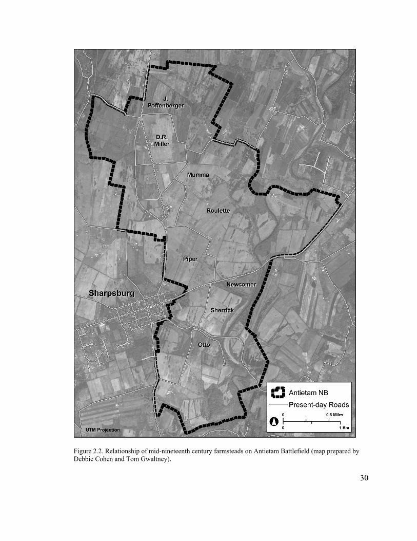
Figure 2.2. Relationship of mid-nineteenth century farmsteads on Antietam Battlefield (map prepared by Debbie Cohen and Tom Gwaltney).
30
Mumma’s second wife also was a Miller, all three of these farmsteads were connected
through marriage.4
On the south side of the Roulette Farm, separated by a narrow, sunken lane, sat
the 231-acre Piper Farm. Nestled between the Hagerstown and Boonsboro roads, this
large farm had been purchased by Daniel Piper in 1846 and was occupied by his son,
Henry Piper, on the eve of the Civil War. The Sherrick Farm, consisting of 194 acres, lay
to the south of the Piper Farm, between the Boonsboro Turnpike and the road to the
Lower, or Rohrback’s bridge. Joseph Sherrick acquired this property from his father in
1838 and probably built the large brick house that still dominates the farmstead about that
time. Overlooking the stone bridge to the east was a relatively small 60-acre farm owned
in 1860 by John Otto.5
In 1860 many of these farmers were small-scale slaveholders, while others had
manumitted their slaves during the previous decade. Like their neighbors to the south in
the village, most of these families reflected the Whig tradition of the Sharpsburg area,
which was strong in western Maryland. At the time of the 1860 census 150 slaves resided
in the Sharpsburg District under the control of 50 slave owners, along with 203 free black
residents.6
4 National Park Service, “Mumma Farm CLI”; Alexander, “Sharpsburg Civilians,” 146-148; Edith B. Wallace, “Reclaiming Forgotten History: Preserving Rural African-American Cultural Resources in Washington County, Maryland” (master’s thesis, Goucher College, 2003), 15. 5 Wallace, “Reclaiming Forgotten History,” 62, 104; Oehrlein & Associates, “Sherrick House HSR,” 7. Wallace provides an overview of slave and post-emancipation housing and communities in western Maryland, with a focus on Washington County and the Sharpsburg area.
31
6 Dean Herrin, “Antietam Rising: The Civil War and Its Legacy in Sharpsburg, Maryland, 1860-1900” (Report on file, Antietam National Battlefield, 2002), 2, 6; Ernst, Too Afraid to Cry, 12.

Maryland on the Eve of Civil War
Tensions ran high throughout the United States on the eve of the 1860 presidential
election, as the national political parties splintered into northern and southern alliances.
Northern Democrats nominated Stephen Douglas, while Southern Democrats backed
former Vice President John C. Breckinridge. The new Republican Party, which stood
against the further spread of slavery, nominated Abraham Lincoln. Remnants of the old
Whig party formed the Constitutional Union Party, which called for the preservation of
the Union above all and did not take a stand for or against slavery. This party put forth
John Bell as its candidate. Lincoln won the election with a majority of the electoral votes,
all from the free states, but garnered less than 50% of the popular vote.7
Revealing Maryland’s divided nature, the proslavery southern Democrat
Breckinridge narrowly defeated Constitutional Union candidate Bell by a margin of less
than 1,000 votes statewide. The reverse occurred in Washington County, where Bell won
by a small plurality over Breckinridge. In Sharpsburg, Bell received a greater proportion
of votes, reflecting that community’s more conservative political leanings. Overall,
Stephen Douglas garnered a few hundred votes in Washington County, while, as late
nineteenth-century historian (and former Confederate) Thomas J. C. Williams noted, “the
vote for Lincoln did not exceed that which a womans [sic] right candidate might have
7 For information on 1860 election, see http://www.u-s-history.com/pages/h92.html, Election of 1860, August, 2004.
32
received.” In fact, Lincoln received fewer than 100 votes in the county, and only one of
these was cast in the Sharpsburg District.8
Following Lincoln’s election, animated debate occurred throughout Maryland
about the question of secession. The planters of eastern and southern Maryland controlled
the state legislature, and political power was firmly in the hands of the Democrats. A
great deal of sympathy existed toward the South, particularly in the eastern and southern
parts of the state and in Baltimore. On April 19, 1861, when Massachusetts troops passed
through Baltimore on its way to Washington, D.C., they fired upon a crowd of unruly
local citizens in self defense, sparking a riot that led to the deaths of four soldiers and a
dozen civilians—the first casualties of the Civil War. Maryland lay at the brink of
secession.9
A few days after the riot, Maryland Governor Thomas Hicks convened a special
session of the General Assembly, which he moved to Frederick to prevent a confrontation
between pro-Confederate members of the legislature and the federal troops that had
occupied Annapolis. The Assembly was highly critical of Lincoln’s policies (particularly
the suspension in Maryland of the writ of habeas corpus), but divided over the legitimacy
of secession. A majority of the legislators, however, appeared to remain loyal to the
United States. Unwilling to take any chances, the Lincoln administration, “clearly
8 Jean H. Baker, The Politics of Continuity: Maryland Political Parties from 1858 to 1870 (Baltimore: Johns Hopkins University Press, 1973), 43; Maryland Free Press (Williamsport), August 30, 1866, cited in Herrin, “Antietam Rising,” 5; Williams, History of Washington County, 304. 9 Baker, Politics of Continuity, 26; Daniel Carroll Toomey, The Civil War in Maryland (Baltimore: Toomey Press, 1983), 11-12. The Democrats had gained control of the state assembly in 1860 in no small part due to John Brown’s raid on Harpers Ferry a year earlier. The new legislature had moved quickly to restrict manumission and the rights of free blacks in Maryland.
33
overestimating both the rumors of a conspiracy to ‘free Maryland’ as well as the
secessionist tendencies of certain Democrats,” ordered the arrest of 27 pro-Southern
legislators, effectively ending the session and the debate over Maryland’s future. In
November 1861, Unionist candidate Augustus W. Bradford was easily elected
governor.10
While somewhat divided in sentiment, most Washington County inhabitants
favored the Union over the Confederate cause. Although some Democratic strongholds
such as Hagerstown and Williamsport contained many Confederate sympathizers,
Sharpsburg, in line with its earlier political leanings, was solidly Unionist. After war was
declared in April 1861, the latter community raised two companies—the Sharpsburg
Rifles under Captain Roger E. Cook, and the Sharpsburg Infantry Company under
Captain William M. Cronise. In late summer they joined the First Maryland Regiment,
Potomac Home Brigade, under the leadership of former governor and congressman
Francis Thomas.11
At least 139 men from the Sharpsburg District joined the Union army during the
course of the war, including eight African Americans who enlisted with the United States
Colored Troops (USCT). In fact, as one of the strongest pro-Union areas in the county, 10 Baker, Politics of Continuity, 56-58, 71; Toomey, Civil War in Maryland, 15-16; Herrin, “Antietam Rising,” 5. Toomey credits Maryland’s remaining in the Union to Brig. Gen. Benjamin Franklin Butler, who occupied Annapolis, Baltimore and central Maryland in May 1861, and thus “was able to transfer the opening battle lines of the Civil War from the Susquehanna to the Potomac River,” sparing Washington, D.C., the embarrassment of being located behind enemy lines (p. 17). 11 Williams, History of Washington County, 305-307; Virginia Mumma Hildebrand, “The Sharpsburg Rifles,” privately published pamphlet, 1959, in collection of Antietam National Battlefield, 5; Herrin, “Antietam Rising,” 6-7. Writing in the early twentieth century, Williams noted that “Sharpsburg was a federal stronghold in 1800, a Whig stronghold in 1832, and is a Republican stronghold now.” In her short study, Hildebrand claims that the Sharpsburg Rifles predated the war and participated in the events surrounding the John Brown raid on Harpers Ferry.
34

the Sharpsburg District supplied one of the county’s largest numbers of Union volunteers
in proportion to its eligible population (27%, as compared to 16% for the entire county).
In turn, Washington County was a leading county in the number of loyal troops supplied
from the state of Maryland.12
Not all residents of Sharpsburg and its surrounding district remained faithful to
the Union. At least 14 men are known to have fought for the Confederacy, and the actual
number probably was higher. Several politically and socially prominent families—in
particular the Blackfords, Douglasses, Groves, Hoffmasters, and Millers—were
sympathetic to the southern cause and many of their members slipped into Virginia and
joined the Confederate army. These families ranked as some of the top slaveholders in
the Sharpsburg District, although this was not the only determinant of loyalty, as several
strongly Union families held significant numbers of slaves as well.13
War Comes to Maryland
The first year of the Civil War had little physical effect upon the Sharpsburg area.
Desultory skirmishing occurred along the Potomac River, and the Confederates made
some attempts to sabotage the C&O Canal, but these activities resulted in little damage to 12 These figures are taken from Herrin, “Antietam Rising,” 7-8. Herrin studied several sources, including Roger Keller, Roster of Civil War Soldiers from Washington County, Maryland, rev. ed. (Baltimore: Clearfield, 1998); Enrollment Books, “Washington County Enrollment District 1, 1862,” “Washington County Military District 51, 1864,” and “Washington County Military Districts 50-52, 1864,” Adjutant General Records (MSA S352), Maryland State Archives; and “Descriptive Books of Drafted Men,” Entry 3733, Record Group 110, National Archives. 13 Herrin, “Antietam Rising,” 7, 30-31; United States 1860 Slave Census, Washington County, Sharpsburg District. In 1860, John A. Adams held 7 slaves, brothers Henry and William Blackford owned 11 slaves between them, and their relative Rev. R. Douglas 10. The Grove family owned 16, Susan Hoffmaster 7, and the Millers 11. Staunchly Union families listed in the 1860 census as owning six or more slaves include the Pipers (11), the Rohrbacks (8) and the Showmans (12).
35
civilian property. Some Federal troops were stationed at Sharpsburg to guard the river
crossings, but they were all gone by early spring of 1862, part of Gen. Nathaniel Banks’s
force marching into the Shenandoah Valley to engage a Confederate force under Gen.
Thomas J. “Stonewall” Jackson.14
In a series of brilliant maneuvers and battles, Banks’s opponent drove the Federal
troops back across the Potomac River by the end of May 1862. This disastrous Union
campaign had been conducted in conjunction with Maj. Gen. George B. McClellan and
his Army of the Potomac’s initial movements against the main Confederate army
defending Richmond. McClellan met with the same fate as Banks, out-maneuvered by the
new Confederate commander, Gen. Robert E. Lee, during the Seven Days’ battles of June
25-July 1, 1862. McClellan’s retreat shocked the North, which had been confident that
Richmond would fall in short order. His subsequent inactivity led the Lincoln
administration to order McClellan to transfer his army to northern Virginia to reinforce
the newly created Army of Virginia under the command of Gen. John Pope.15
McClellan was slow to move, hoping privately that Pope would be defeated and
the nation would turn to him once again as its savior. He received his wish on August 29-
30, when Pope received a decisive defeat at the hands of Lee and Jackson at the Second
Battle of Manassas. Recriminations were quick to follow, in part because McClellan did
not follow orders and march to Pope’s aid, and fear ran high that the national capital 14 Williams, History of Washington County, 317-319. 15 James M. McPherson, Crossroads of Freedom: Antietam, the Battle that changed the course of the Civil War (Oxford: Oxford University Press, 2002), 41-42, 45-47, 53, 78; Stephen W. Sears, Landscape Turned Red: The Battle of Antietam (New York: Ticknor & Fields, 1983), 35. For a comprehensive study of McClellan’s Peninsula Campaign, see Stephen W. Sears, To the Gates of Richmond: The Peninsula Campaign (New York: Ticknor & Fields, 1992).
36
would fall next. Seeing little alternative, Lincoln dismissed Pope and on September 2
reluctantly appointed McClellan commander of all the Union forces around
Washington.16
Following the Second Battle of Manassas, Confederate commander Robert E. Lee
determined to take the war into United States territory. On September 4, 1862, his Army
of Northern Virginia began crossing the Potomac River into Maryland. Lee set this
course for several reasons. The first was to lift pressure from war-torn Virginia and the
Confederate capital at Richmond, which included resupplying the rebel army in the rich
northern countryside. He also hoped to liberate slaveholding Maryland from its supposed
Federal oppressors. Lee thought, according to historian James V. Murfin, that “as
deliverer of these ‘oppressed’ people, he would gain their undivided support, add
thousands of recruits to the hundreds who had already joined the army from Maryland,
and perhaps he would even achieve an effective secession.” Third, Lee anticipated that a
successful campaign on Union soil would have positive political ramifications for the
South, including recognition of the Confederacy by European countries and the
weakening of Lincoln and his supporters in upcoming congressional elections. Such
developments might lead the North to sue for peace. Lastly, he wanted to draw the Army
of the Potomac out of the capital city and, hopefully, destroy it.17
16 McPherson, Crossroads of Freedom, 78-87. For a comprehensive study of the Second Battle of Manassas, see John J. Hennessy, Return to Bull Run: The Campaign and Battle of Second Manassas (New York: Simon & Schuster, 1993). 17 Sears, Landscape Turned Red, 64-66, 72. James V. Murfin, The Gleam of Bayonets: The Battle of Antietam and the Maryland Campaign of 1862 (South Brunswick: Thomas Yoseloff, Publisher, 1965), 64-68.
37

Lee had little reason to doubt that the citizens of Maryland would join him. At
that time the Mason-Dixon Line formed a psychological as well as a physical boundary
between North and South. The Confederates believed that Maryland had been coerced
into remaining in the United States and would welcome liberation from its oppressor. To
southerners, the Baltimore riot of April 1861 served as a case in point of Maryland’s true
feelings toward the Union. Lincoln’s administration had in fact moved quickly to repress
Confederate sentiment in the state, leading to many violations of civil rights.18
As it crossed the Potomac River into western Maryland, the Confederate army did
not receive the welcome that it had anticipated. Instead, it found a lukewarm reception on
the part of the local population. Some Confederates ascribed this reluctance to fear of
retribution once the rebel army left the area. Others realized that they had entered the
wrong part of the state if they were hoping for an uprising. “It is perfectly evident that the
people of this section of the State are as hostile to us as if we were north of the Mason
Dixon line,” wrote one rebel soldier 19
Robert E. Lee also was taken by surprise when the Federal garrisons at Harpers
Ferry and Martinsburg, Virginia, did not evacuate as he had anticipated, leaving almost
13,000 troops to threaten his supply line through the Shenandoah Valley as well as his
route of retreat if needed. Characteristically, Lee created opportunity out of this
unexpected turn of events and determined to capture the rich supplies at Harpers Ferry.
While encamped a short distance south of the city of Frederick, Maryland, the
Confederate commander formulated a bold plan to divide his army into four parts,
18 Blair, “Maryland, Our Maryland,” 74-78.
38
19 Ernst, Too Afraid to Cry, 56-58; Blair, “Maryland, Our Maryland,” 90-92. Quotation found in Ernst, 56.
sending three of these toward Harpers Ferry to attack it from as many directions. Gen.
Thomas “Stonewall” Jackson, with the largest number of troops and the longest route to
travel, was given orders to cross the Potomac River upstream from Harpers Ferry and
attack it from the west, via Martinsburg. Gen. John Walker was ordered to recross into
Virginia and move against the Union garrison from the south, and Gen. Lafayette
McLaws to cross South Mountain to the west of Frederick and capture Maryland Heights
on the north side of the Potomac River. Lee and the remainder of the Army of Northern
Virginia, under command of Maj. Gen. James Longstreet, would remain near Boonsboro
and guard the passes through South Mountain. Once Harpers Ferry had been captured,
the plan called for the Confederates to reunite near Boonsboro or Hagerstown and
advance into Pennsylvania.20
This bold order, known as Special Order 191, was issued on September 9, 1862.
Lee knew that its success would depend in large part upon the unwitting cooperation of
the Union commander, Maj. Gen. George McClellan. Lee understood McClellan well,
having fought successfully against him in the Peninsula Campaign and Seven Days’
battles earlier that spring and summer. Throughout that entire campaign McClellan had
believed himself outnumbered and moved with great caution. As related earlier,
McClellan and the Army of the Potomac subsequently had been recalled to Washington
to reinforce the recently created Army of Virginia under Maj. Gen. John Pope. McClellan
39
20 Sears, Landscape Turned Red, 84-90; McPherson, Crossroads of Freedom, 106-107; Murfin, Gleam of Bayonets, 115.

had little intention of playing second fiddle to Pope, however, and his inaction had
contributed to the Union’s crushing defeat at Second Manassas.21
After his reappointment to overall command on September 2, the vain, yet overly
cautious McClellan took his time moving the Federal army out of Washington, not
beginning to march until September 7—three days after the Confederates had moved into
Maryland. Characteristically, he believed that he faced overwhelming numbers, with
some 110,000-120,000 Confederates in the vicinity of Frederick, compared to his 85,000
Federal soldiers, whereas in reality he had almost twice as many soldiers as Lee.
McClellan advanced slowly to meet the threat, reaching that city on the 13th and after the
Confederates had already moved on. Ironically, the Federal troops received the
tumultuous welcome that Lee had anticipated but not received, tremendously raising the
morale of the Union soldiers. Even so, “because of Maryland’s unique geographic and
figurative role during the war,” related historian Kathleen Ernst, “some Yankee soldiers
also considered themselves to be on foreign soil during the Antietam campaign.” As a
result, distrust ran high. In a stroke of exceedingly good luck, some resting soldiers found
a lost copy of Lee’s S.O. 191 that same day, laying out the entire Confederate plan to a
jubilant McClellan.22
In the meantime, Lee’s plan was not proceeding as intended. Jackson, Walker and
McLaws quickly fell behind schedule in their task of capturing Harpers Ferry. In an
21 Sears, Landscape Turned Red, 15, 91. This was the second time McClellan served as commander of the Army of the Potomac. 22 Sears, Landscape Turned Red, 102, 105-106, 112; McPherson, Crossroads of Freedom, 104-105; Murfin, Gleam of Bayonets, 125; Ernst, Too Afraid to Cry, 59.
40
operational change, Lee also had decided to divide his forces yet further, leaving Maj.
Gen. D.H. Hill and his division at Boonsboro to guard Turner’s Gap through South
Mountain, while he and Longstreet advanced toward Hagerstown with the latter’s
remaining two divisions. Thus, at the very moment that McClellan had Lee’s campaign
plan laid in front of him, the Confederate general’s army was scattered in five small
pieces across the countryside.23
Recognizing the splendid opportunity presented to him to crush the Army of
Northern Virginia, McClellan moved with unaccustomed, albeit deliberate, speed. The
morning after the order came into his possession, McClellan dispatched three divisions
under Maj. Gen. William Franklin toward Harpers Ferry and prepared the remainder of
his army to fight the Confederates at Turner’s Gap, under the belief that both Lee and
Longstreet were still there. In heavy fighting on September 14 at Crampton’s, Fox’s, and
Turner’s gaps, the Federals pushed the Confederates back, but did not deliver a decisive
blow. That night, Lee decided to pull his forces back to the village of Sharpsburg and
return to Virginia.24
The following morning, however, when Lee received word of Harpers Ferry’s
capitulation he decided to stay in Maryland and recombine his forces to face McClellan
in battle. “Of those factors that influenced Lee’s decision to stay in Maryland and fight,”
avers Murfin, “the terrain surrounding the small village of Sharpsburg was of prime 23 Sears, Landscape Turned Red, 95-96. 24 Sears, Landscape Turned Red, 119, 121, 128-143, 145-149; McPherson, Crossroads of Freedom, 111-112. Murfin views McClellan’s movements differently, however, and is harsh in his condemnation of him: “There can be found no plausible reason for McClellan’s delay in moving on South Mountain immediately upon receipt of the ‘dispatch.’ His most fervent supporters can offer no excuse for such negligence” (Gleam of Bayonets, 161).
41
consideration.” Lee chose a line of ridges on the north side of Sharpsburg, parallel to
Antietam Creek, to make his stand, deploying the 18,000 troops on hand in a thin line and
ordering his other scattered units to march to him as quickly as possible. Only A.P. Hills’
division remained behind in Harpers Ferry to parole the 12,000 Union prisoners and
secure the substantial supplies that had also been captured.25
While McClellan had vowed to the authorities in Washington that he would crush
Lee’s army, he did little on the 15th toward that goal, believing that the Army of Northern
Virginia was already retreating. When he learned that the Confederates apparently had
drawn themselves up for battle on the opposite side of Antietam Creek, about eight miles
from Turner’s Gap, McClellan moved into position that afternoon on the east side of that
stream, but did nothing more that day. He spent the entire next day planning his battle
strategy, still believing himself heavily outnumbered. As a result, he provided plenty of
time for the Army of Northern Virginia to reunite at Sharpsburg, with the exception of
A.P. Hill’s division in Harpers Ferry. Even so, the Confederates mustered only about
36,000 men, against McClellan’s 55,000 on hand and another 14,000 (Franklin’s Corps)
in Pleasant Valley, about six miles away.26
“As Lee filled it out on September 16,” writes historian Stephen Sears, “the
Confederate battle line was some four miles long, paralleling the Hagerstown turnpike
north of Sharpsburg and continuing southward past the town to the bluffs overlooking
Antietam Creek a mile below the Rohrbach Bridge. Longstreet’s command held the right,
Jackson’s the left.” Thus, Jackson’s force anchored itself at Mumma’s woodlot, around
25 McPherson, Crossroads of Freedom, 113-114; Murfin, Gleam of Bayonets, 198.
42
26 Sears, Landscape Turned Red, 159-163; McPherson, Crossroads of Freedom, 115.
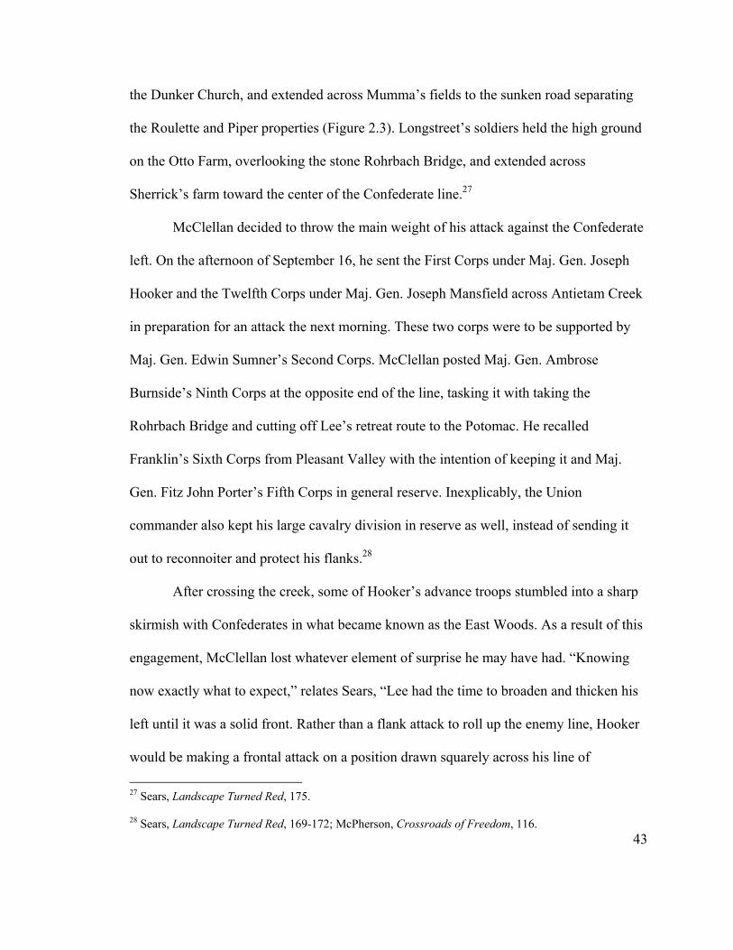
the Dunker Church, and extended across Mumma’s fields to the sunken road separating
the Roulette and Piper properties (Figure 2.3). Longstreet’s soldiers held the high ground
on the Otto Farm, overlooking the stone Rohrbach Bridge, and extended across
Sherrick’s farm toward the center of the Confederate line.27
McClellan decided to throw the main weight of his attack against the Confederate
left. On the afternoon of September 16, he sent the First Corps under Maj. Gen. Joseph
Hooker and the Twelfth Corps under Maj. Gen. Joseph Mansfield across Antietam Creek
in preparation for an attack the next morning. These two corps were to be supported by
Maj. Gen. Edwin Sumner’s Second Corps. McClellan posted Maj. Gen. Ambrose
Burnside’s Ninth Corps at the opposite end of the line, tasking it with taking the
Rohrbach Bridge and cutting off Lee’s retreat route to the Potomac. He recalled
Franklin’s Sixth Corps from Pleasant Valley with the intention of keeping it and Maj.
Gen. Fitz John Porter’s Fifth Corps in general reserve. Inexplicably, the Union
commander also kept his large cavalry division in reserve as well, instead of sending it
out to reconnoiter and protect his flanks.28
After crossing the creek, some of Hooker’s advance troops stumbled into a sharp
skirmish with Confederates in what became known as the East Woods. As a result of this
engagement, McClellan lost whatever element of surprise he may have had. “Knowing
now exactly what to expect,” relates Sears, “Lee had the time to broaden and thicken his
left until it was a solid front. Rather than a flank attack to roll up the enemy line, Hooker
would be making a frontal attack on a position drawn squarely across his line of
27 Sears, Landscape Turned Red, 175.
43
28 Sears, Landscape Turned Red, 169-172; McPherson, Crossroads of Freedom, 116.
Figure 2.3. Union and Confederate positions at the opening of the Battle of Antietam, September 17, 1862 (from Murfin, Gleam of Bayonets, 216).
44
advance.” The two sides encamped uneasily that night, knowing that they would become
embroiled in a great battle the following day.29
While the two armies arranged their battle lines, residents of Sharpsburg and
surrounding farms also prepared for the ensuing fight. Many of them fled the town,
taking refuge in a cave along the C&O Canal, while others hid in their cellars. Some of
the families situated in the line of fire, such as the Mummas, left their farms with little
more than they could carry. Others, such as the Roulettes, took their chances and stayed
put in their cellars.30
The Battle of Antietam
Early on the morning of September 17, Hooker readied his forces to attack due
south toward a small white building, the Dunker Church, located along the Hagerstown
Turnpike on the edge of a woodlot soon to become famous as the West Woods. Jackson
had deployed the strengthened Confederate left in the woods on the west side of the
turnpike and to the east on the farm of Samuel Mumma. Confederate artillery was placed
on Nicodemus Heights northwest of the West Woods and on open ground near the
Dunker Church. As a precaution, the Rebels burned the Mumma house so that it could
not fall into the hands of Federal sharpshooters.31
29 Sears, Landscape Turned Red, 176; McPherson, Crossroads of Freedom, 116-117. 30 Ernst, Too Afraid to Cry, 119-120, 140, 143. 31 Sears, Landscape Turned Red, 181-182.
45
The battle opened in the East Woods straddling Smoketown Road, just north of
the Mumma farm. Hooker moved his forces through Joseph Poffenberger’s woodlot (the
North Woods) to the edge of D.R. Miller’s large cornfield. Around 6:00 a.m., shortly
after dawn, they began advancing southward through the cornfield and were met with
withering fire. Both sides moved back and forth across the field in heavy fighting, which
resulted in heavy casualties. By 7:30 a.m. the two forces had been “reduced to mutual
shambles.” Due to the piecemeal nature of the Federal attack, writes historian Stephen
Sears, “Jackson had been able to meet force with force in the successive attacks, and the
two sides were about where they had been when the killing began at dawn.”32
About the time Hooker and Jackson had fought themselves to a standstill,
Mansfield’s Twelfth Corps entered the battle. By 9:00 a.m., the combined attack of the
First and Twelfth Corps had pushed the Confederate left flank across the Hagerstown
Turnpike and into the West Woods, and was threatening to destroy it. In an unfortunate
twist of fate for the Union forces, however, Hooker was wounded and forced to leave the
field, and Mansfield lay mortally wounded in the East Woods. This leadership vacuum
left the First and Twelfth Corps unable to capitalize on the gains they had made thus
far.33
McClellan ordered two divisions of the Second Corps into battle around 7:20
a.m., but it took time for Sumner’s men to cross Antietam Creek and they did not reach
the East Woods until the lull in the battle around 9:00 a.m. Believing that the two
preceding Corps had been completely decimated and that he was in a position to roll up
32 Sears, Landscape Turned Red, 184-190, 201.
46
33 Sears, Landscape Turned Red, 203; McPherson, Crossroads of Freedom, 119.

the Confederate left flank, Sumner moved immediately toward the West Woods with the
division of Maj. Gen. John Sedgwick aligned in column. They had pressed through the
woodlot almost without opposition, when the Confederates rose up and delivered a
devastating enfilading fire into the side and rear of the tightly massed Federals (Figure
2.4). Unable to turn and return fire, the Union troops broke and ran after receiving heavy
casualties.34
In the meantime, Sumner’s second division under Brig. Gen. William French had
lost track of the Corps commander’s whereabouts and taken off to the southwest toward
the center of the Confederate line, which was entrenched along the sunken farm road
dividing the Roulette and Piper farms. After crossing the Mumma and Roulette farms, the
Federals were hit heavily when they crested a ridge in front of the lane (Figure 2.5).
Wave after wave of attacks were beaten back until noon, when a fresh Union division
under Maj. Gen. Israel Richardson advanced against the right of the Rebel position and
drove the Confederates from the corpse-strewn road, rechristened Bloody Lane. In
another twist of fate, the capable Richardson was mortally wounded as he prepared to
make a concerted attack against the collapsing Confederate center. As a result, yet
another opportunity to destroy the Southern army was lost, and this sector of the
battlefield fell quiet, too.35
Action next shifted to the Federal left, where Burnside’s Ninth Corps had been
tasked with crossing Antietam Creek at the Rohrbach Bridge and attacking the
Confederate right flank. Burnside began the assault against the bridge around 10:00 a.m.
34 Sears, Landscape Turned Red, 221-226; McPherson, Crossroads of Freedom, 119-120.
47
35 Sears, Landscape Turned Red, 235-253; McPherson, Crossroads of Freedom, 122-123.
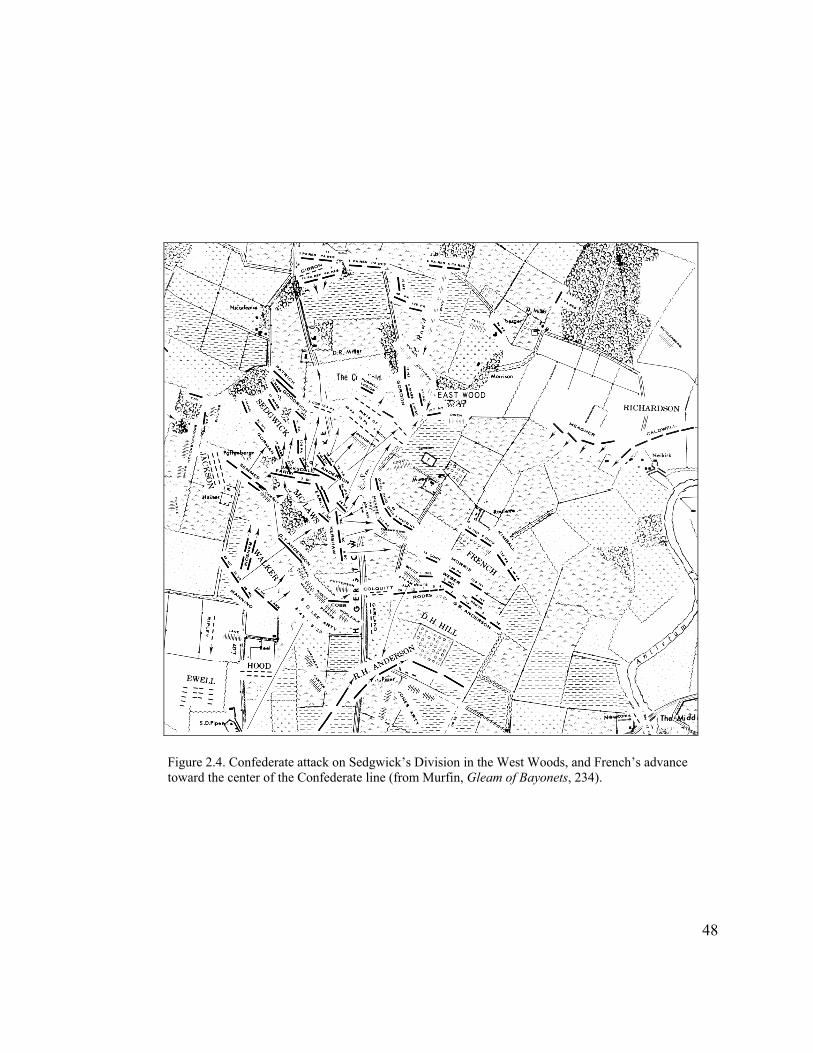
Figure 2.4. Confederate attack on Sedgwick’s Division in the West Woods, and French’s advance toward the center of the Confederate line (from Murfin, Gleam of Bayonets, 234).
48

Figure 2.5. Union attack against Confederate positions in the Sunken Road (from Murfin Gleam of Bayonets, 243).
49
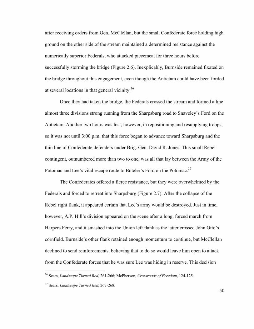
after receiving orders from Gen. McClellan, but the small Confederate force holding high
ground on the other side of the stream maintained a determined resistance against the
numerically superior Federals, who attacked piecemeal for three hours before
successfully storming the bridge (Figure 2.6). Inexplicably, Burnside remained fixated on
the bridge throughout this engagement, even though the Antietam could have been forded
at several locations in that general vicinity.36
Once they had taken the bridge, the Federals crossed the stream and formed a line
almost three divisions strong running from the Sharpsburg road to Snaveley’s Ford on the
Antietam. Another two hours was lost, however, in repositioning and resupplying troops,
so it was not until 3:00 p.m. that this force began to advance toward Sharpsburg and the
thin line of Confederate defenders under Brig. Gen. David R. Jones. This small Rebel
contingent, outnumbered more than two to one, was all that lay between the Army of the
Potomac and Lee’s vital escape route to Boteler’s Ford on the Potomac.37
The Confederates offered a fierce resistance, but they were overwhelmed by the
Federals and forced to retreat into Sharpsburg (Figure 2.7). After the collapse of the
Rebel right flank, it appeared certain that Lee’s army would be destroyed. Just in time,
however, A.P. Hill’s division appeared on the scene after a long, forced march from
Harpers Ferry, and it smashed into the Union left flank as the latter crossed John Otto’s
cornfield. Burnside’s other flank retained enough momentum to continue, but McClellan
declined to send reinforcements, believing that to do so would leave him open to attack
from the Confederate forces that he was sure Lee was hiding in reserve. This decision
36 Sears, Landscape Turned Red, 261-266; McPherson, Crossroads of Freedom, 124-125.
50
37 Sears, Landscape Turned Red, 267-268.
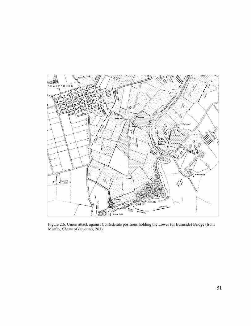
Figure 2.6. Union attack against Confederate positions holding the Lower (or Burnside) Bridge (from Murfin, Gleam of Bayonets, 263).
51

Figure 2.7. Height of Union advance toward Sharpsburg, shortly before Confederate General A.P. Hill’s attack against the Union left flank (from Murfin, Gleam of Bayonets, 287).
52
effectively ended the battle, leaving the two sides basically in the same positions they had
occupied when combat started that morning, with the important exception that all of the
Federal forces were now arrayed on the west side of Antietam Creek.38
The next day the Army of Northern Virginia remained in position around
Sharpsburg to care for its wounded and make plans to return to Virginia. McClellan
evidently had planned on renewing the attack, but thought better of it, explaining in a
later report that he did not see a “reasonable certainty of success” if he renewed the
attack. He still believed that the Confederate forces outnumbered his. In the words of
Stephen Sears, McClellan “remained in character, so fearful of losing that he would not
risk winning.” That night, Lee and his badly mauled Army of Northern Virginia slipped
quietly across the Potomac and out of McClellan’s reach.39
While strategically the Battle of Antietam was a Union victory, tactically it was a
draw, as the Confederates had held their ground against far superior numbers and
inflicted proportionally greater casualties than they had received. “Yet for all that,”
observes Sears,
Lee had lost the campaign and made a miscalculation that nearly lost him his army as well. A major reason he stood and fought at Sharpsburg was his measured judgment that he was challenging a timid general heading an army demoralized by past defeats. That judgment was only half right. . . . It would be the particular tragedy of the men of the Army of the Potomac that (unlike their opponents) they seldom got the generals they deserved. Antietam was a case in point.
38 Sears, Landscape Turned Red, 280-292; McPherson, Crossroads of Freedom, 127-129.
53
39 Official R.ecords, ser. I, vol. 19, pt. I, p. 32, quoted in McPherson, Crossroads of Freedom, 130; Sears, Landscape Turned Red, 303.
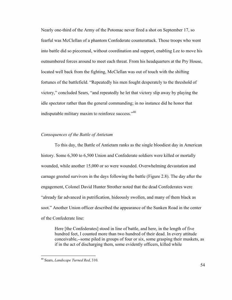
Nearly one-third of the Army of the Potomac never fired a shot on September 17, so
fearful was McClellan of a phantom Confederate counterattack. Those troops who went
into battle did so piecemeal, without coordination and support, enabling Lee to move his
outnumbered forces around to meet each threat. From his headquarters at the Pry House,
located well back from the fighting, McClellan was out of touch with the shifting
fortunes of the battlefield. “Repeatedly his men fought desperately to the threshold of
victory,” concluded Sears, “and repeatedly he let that victory slip away by playing the
idle spectator rather than the general commanding; in no instance did he honor that
indisputable military maxim to reinforce success.”40
Consequences of the Battle of Antietam
To this day, the Battle of Antietam ranks as the single bloodiest day in American
history. Some 6,300 to 6,500 Union and Confederate soldiers were killed or mortally
wounded, while another 15,000 or so were wounded. Overwhelming devastation and
carnage greeted survivors in the days following the battle (Figure 2.8). The day after the
engagement, Colonel David Hunter Strother noted that the dead Confederates were
“already far advanced in putrification, hideously swollen, and many of them black as
soot.” Another Union officer described the appearance of the Sunken Road in the center
of the Confederate line:
Here [the Confederates] stood in line of battle, and here, in the length of five hundred feet, I counted more than two hundred of their dead. In every attitude conceivable,--some piled in groups of four or six, some grasping their muskets, as if in the act of discharging them, some evidently officers, killed while
54
40 Sears, Landscape Turned Red, 310.
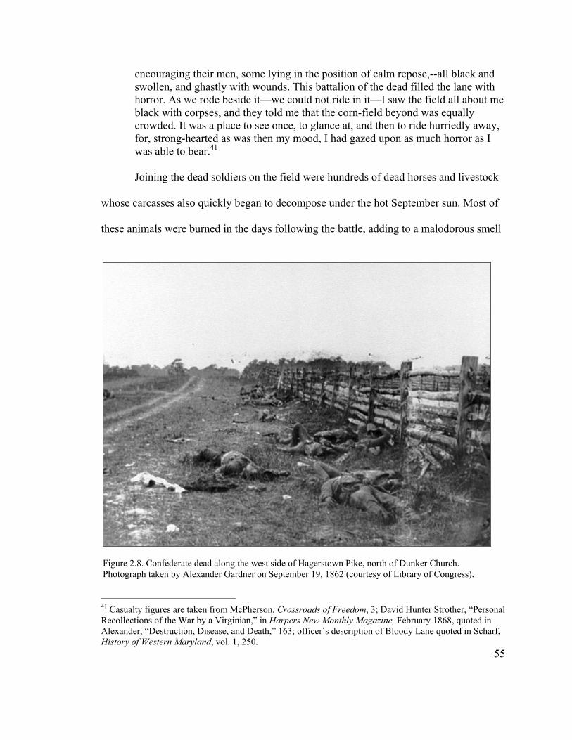
encouraging their men, some lying in the position of calm repose,--all black and swollen, and ghastly with wounds. This battalion of the dead filled the lane with horror. As we rode beside it—we could not ride in it—I saw the field all about me black with corpses, and they told me that the corn-field beyond was equally crowded. It was a place to see once, to glance at, and then to ride hurriedly away, for, strong-hearted as was then my mood, I had gazed upon as much horror as I was able to bear.41 Joining the dead soldiers on the field were hundreds of dead horses and livestock
whose carcasses also quickly began to decompose under the hot September sun. Most of
these animals were burned in the days following the battle, adding to a malodorous smell
Figure 2.8. Confederate dead along the west side of Hagerstown Pike, north of Dunker Church. Photograph taken by Alexander Gardner on September 19, 1862 (courtesy of Library of Congress).
55
41 Casualty figures are taken from McPherson, Crossroads of Freedom, 3; David Hunter Strother, “Personal Recollections of the War by a Virginian,” in Harpers New Monthly Magazine, February 1868, quoted in Alexander, “Destruction, Disease, and Death,” 163; officer’s description of Bloody Lane quoted in Scharf, History of Western Maryland, vol. 1, 250.

that overwhelmed the neighborhood. “The stench was sickening,” recalled one local
resident. “We couldn’t eat a good meal, and we had to shut the house up just as tight as
we could of a night to keep out that odor. We couldn’t stand it, and the first thing in the
morning when I rolled out of bed I’d have to take a drink of whiskey. If I didn’t I’d throw
up before I got my clothes all on.”42
Alcohol also sustained the details sent out to collect and bury the dead. These
burial parties began their grim task on September 19, taking care of the Federal casualties
first. Overcome by the stench, they worked as quickly as possible, digging shallow
trenches and burying the dead in long rows (Figure 2.9). Many of the Union soldiers were
identified and their graves marked with wooden boards. Most of the Confederate soldiers,
however, were interred in mass graves with no identification. The battlefield became a
vast cemetery, as the dead were buried near where they had fallen. As a result, the fields
became “as common for graves as the cornstalks are on a forty acre field,” according to a
local farmer. Seven hundred soldiers were buried on the property of William Roulette
alone.43
The care of 15,000 wounded presented an even more overwhelming challenge.
“But if to look upon the mangled bodies of the dead was horrible, still more terrible was
the spectacle which the wounded on this vast blood-stained battle-field presented,” wrote
42 Account of Alexander Root in Clifton Johnson, Battlefield Adventures, 101, quoted in Earnst, Too Afraid to Cry, 165.
56
43 Alexander, “Destruction, Disease, and Death,” 164; quotation from Samuel Michael letter, November 27, 1862, cited in Ernst, Too Afraid to Cry, 163. One visitor to the battlefield saw “any number of new made graves, the Union Soldiers . . . having little pieces of board with their names written with a pencil, put at the head. In one of the fields, there were a great many rebel soldiers buried, but their graves could not be marked, as their names were not known.” Angela Kirkham Davis, “War Reminiscences,” 52, quoted in Ernst, 165.
Figure 2.9. Sketch of Union burial detail burying Confederate dead in trenches on the Roulette Farm. The Sunken Road extends can be seen in the right background, with the Roulette Lane extending from it toward the left. This sketch, prepared by Frank Shell, originally appeared in Frank Leslies Illustrated Newspaper, October 18, 1862 (courtesy of Antietam NB).
one visitor of the scene. “Many of the wounded remained on the field for twenty-four
hours or more before their wounds received any attention. The surgeons were taxed
beyond their ability by the multitude of sufferers, and I regret to say there was a
lamentable deficiency in the supply of the various appliances needed at such a time.”
Injured soldiers filled to overflowing every available shelter in the vicinity of Sharpsburg,
and doctors and civilian volunteers worked day and night to care for them. Those who
could be moved were transported to large hospital sites established in Frederick and
Hagerstown, and even farther away in towns such as Chambersburg, Pennsylvania. Many
57
weeks were to pass, however, before the hospitals around Sharpsburg emptied of their
wounded.44
McClellan and his Army of the Potomac remained at Sharpsburg for more than a
month to reorganize and resupply, despite continual prodding on the part of President
Lincoln and others for them to cross the Potomac and move against the weakened
Confederates. Finally, on October 26, 1862, McClellan began moving his army into
Virginia. In early November, after he did not advance quickly enough to cut Lee off from
Richmond, Lincoln relieved McClellan of his command and placed a reluctant Ambrose
Burnside in charge of the eastern army. Following a flamboyant and tearful farewell,
McClellan returned home to sit out the remainder of the war.45
While the Battle of Antietam may not have been prosecuted as strongly as it could
have been, the result was still a great Northern victory at a time when it had experienced
little but defeat. It lifted the morale of civilian and soldier alike at a crucial moment—
mid-term elections—and contributed to the Republicans maintaining control of Congress.
Most importantly, the battle provided Lincoln with the opportunity he was waiting for to
issue the Preliminary Emancipation Proclamation, which decreed that all slaves in states
still in rebellion on January 1, 1863, would be freed. This largely symbolic act changed
the war from one to restore the old Union into a crusade to create a new nation without
the shackles of slavery.46
44 Quotation from Scharf, History of Western Maryland, 251; Alexander, “Destruction, Disease, and Death,” 165. 45 Sears, Landscape Turned Red, 324, 335-338; McPherson, Crossroads of Freedom, 150-152.
58
46 McPherson, Crossroads of Freedom, 135, 139.

During the summer of 1862, England and other European countries had given
serious consideration to recognizing the Confederate States of America and intervening
in the conflict. The Battle of Antietam, coupled with the issuance of the Preliminary
Emancipation Proclamation, led these countries to reconsider. “If Antietam abruptly
halted the movement toward foreign intervention,” argues Sears, “the proclamation on
emancipation put the seal on the matter.” No country wanted to appear to be supporting
the continuation of slavery. In the end, historian James M. McPherson declares in a
recent work, “no other campaign and battle in the war had such momentous, multiple
consequences as Antietam.” As will be seen, however, it would take a long time for the
Battle of Antietam to receive its due.47
Sharpsburg and the Aftermath of Battle
The northern victory was little consolation to the inhabitants of Sharpsburg and its
surrounding farms, where the effects of the battle were profound. As articulated by
battlefield historian Ted Alexander, “This was the first organized community in the
United States to suffer widespread damage from both combat and the sheer presence of
two opposing armies.” Many residents had fled before the battle started, while others hid
in their cellars. When calm returned on the morning of September 18, they ventured out
to find a scene of devastation beyond anything they could have imagined. Virtually every
house in Sharpsburg had received damage from Union artillery fire that passed over
Confederate positions into the town, and several had burned to the ground. Taking
advantage of the absence of their owners, Rebel soldiers ransacked most of the
59
47 Sears, Landscape Turned Red, 333-334; McPherson, Crossroads of Freedom, 146, 155.

residences, taking any food and valuables that they could find. Worst of all, residents
returned to find numerous dead and wounded Confederates in their houses and yards; in
many cases, houses were barred to them because they had been turned into hospitals.48
The heaviest damage, however, was reserved for the farms located in the thick of
the battle. A week afterward, the editor of the Hagerstown Herald and Torch Light
offered the following description:
The beautiful district of country over which the great battle of Wednesday raged presents a melancholy picture of devastation. A number of houses and barns were destroyed, fences scattered as if a tornado had swept them away, hundreds of acres of corn trampled down and devoured, and wreck, ruin, and desolation met the eye at every turn. . . . The amount of personal property—horses, cattle, hogs, sheep, corn, hay, and other provender—which was taken from the farmers, was enormous, the whole lower portion of our county has been stripped of every description of subsistence, and what our people in that section of the county will do to obtain food for man and beast during the approaching winter, God alone knows.
The wrecked landscape was almost unrecognizable. “With fences demolished,” notes one
historian, “it was hard to tell where one man’s land ended and another’s began, and
supply trains and artillery caissons had made new roads across fields in every
direction.”49
The requisitioning and looting of property by occupying Union forces in the
weeks after the battle caused perhaps even more damage than the battle itself. The
Yankees received a joyous reception when they marched into Sharpsburg two days after
the battle, one soldier reporting that “the people were beginning to return as we were 48 Ted Alexander, Foreword to Too Afraid to Cry: Maryland Civilians in the Antietam Campaign, by Kathleen Ernst (Mechanicsburg, Penn.: Stackpole Books, 1999), x; Alexander, “Destruction, Disease, and Death,” 159; Ernst, Too Afraid to Cry, 158-161.
60
49 Hagerstown Herald and Torch Light, September 24, 1862, transcription in Antietam National Battlefield vertical file “Sharpsburg and Area—After the Battle,” Western Maryland Room (WMR), Washington County Free Library (WCFL), Hagerstown, Maryland; Ernst, Too Afraid to Cry, 194.

coming through the town and they treated us very kindly; the ladies gave us fruit and
coffee and such refreshments as the rebels did not find or could not carry away.”50 The
longer the Federals remained, however, the more their welcome wore off; tension
increased as drunkenness and thievery by the soldiers became commonplace. The need
for food for the soldiers and horses led the army to requisition whatever provisions and
provender the Confederates had not consumed, and marauding soldiers stole the rest. In
fact, the Union occupation ruined some farmers, such as Philip Pry, who had housed
General McClellan as well as the entire Second Corps on his property. Other farmers on
the battlefield, such as Samuel Mumma, Henry Piper, and Joseph Sherrick, were able to
survive, but suffered heavy damages for which they were never fully compensated
(Figure 2.10). A correspondent for the New York Times reported: “The indiscriminate
50 My Diary in WhRebellion in the U
Figure 2.10. Damage to Mumma Farmstead resulting from the Battle of Antietam. The burned-out Mumma House can be seen in the center of the photograph. Original photograph by Alexander
61
ich are Recorded the Movement of the Ninth Massachusetts Volunteers in the War of the nited States, September 19, 1862, quoted in Ernst, Too Afraid to Cry, 166.
plundering by soldiers has resulted in creating and increasing local support for the
Confederates, even among many of the area’s lukewarm Unionists.”51
Perhaps more insidious than military depredations on the local populace were the
diseases that swept through the area as a result of the unsanitary conditions created by the
waste of tens of thousands of soldiers and horses, the overwhelming number of sick and
wounded men, and the inadequate burial of the dead. Many civilians became ill with
camp diseases such as cholera and dysentery, and a number died. Among them was a
young daughter of William Roulette, who had already suffered substantial property
losses. Smallpox and other epidemics continued to ravage the county for months after the
army left, claiming additional victims.52
Adding to the crowded conditions in the vicinity of the battlefield were large
numbers of gawkers who came to observe the scene of destruction. “Hundreds [of
tourists] were scattered over the field,” recorded one officer, “eagerly searching for
souvenirs in the shape of cannon balls, guns, bayonets, swords, canteens, etc.” In
addition, as news of the great battle spread throughout the North, relatives of soldiers
who fought at Antietam came searching for their loved ones, adding to the shortage of
food and accommodations. In the aftermath of the battle, the population of nearby
Frederick more than doubled in size, with the addition of soldiers wounded at South
Mountain and Antietam, those caring for them, and relatives and sightseers. Many of
these visitors were leery of the local populace, whom, like the Federal soldiers before
51 New York Times, September 15-16, 1862, quoted in Ernst, Too Afraid to Cry, 193-194; Alexander, “Destruction, Disease, and Death,” 155-156.
62
52 Alexander, “Destruction, Disease, and Death,” 157-158; Ernst, Too Afraid to Cry, 182-185.
them, they viewed as Southerners. Desperate for any kind of lodging, however, they
boarded with local families and paid them to guide them through the hospitals or over the
battlefield.53
Another hazard for Sharpsburg residents was unexploded ordnance. While it
appears that no civilians were killed during the battle itself, tragically a number died or
were wounded in the months following when they tried to remove or tamper with these
shells. This ordnance, as well as other battle debris left behind on the fields, made
farming dangerous. “After the battle of Antietam, hundreds of shells were carted from
farm fields and dumped in Antietam Creek,” relates Ernst. “Still, farmers kept turning
them over with their plowshares and picking them out of wheat stacks when threshing.
The shells sometimes broke the machinery, but the farmers considered themselves lucky
if they didn’t explode.” In addition, the battle and subsequent occupation had turned the
fields into a wasteland, making cultivation very difficult the first few years after the
battle.54
53 Josiah Marshall Favill, Diary of a Young Officer Serving with the Armies of the United States during the War of the Rebellion (Chicago: R.R. Donnelly and Sons, Company, 1909), 190, cited in Ernst, Too Afraid to Cry, 167; Ernst, Too Afraid to Cry, 174, 178.
63
54 A couple of accounts do state that a young girl was killed during the battle, but this has not been corroborated by any local records. See Alexander, “Destruction, Disease, and Death,” 160, n. 50. O.T. Reilly, The Battlefield of Antietam (Sharpsburg, Md.: O.T. Reilly, n.d.), 28; Ernst, Too Afraid to Cry, 186. Of one incident involving unexploded ordnance Reilly relates: “Mr. John Keplinger, who resided in a house that stood near the east end of the Bloody Lane, had gathered after the battle quite a number of shells and had broken 99 without any serious damage, but the 100th one exploded and tore him up so badly that he died from it.” One woman, a child at the time of the war, described what the Union occupation did to her family’s farm a short distance north of the battlefield: “It is hard to describe the change which is made by the encampment of an army. In an incredibly short time a splendid field of luxuriant verdure had been beaten down as hard as a turnpike road and every blade of grass had disappeared. It was years before the most careful cultivation could restore the land to anything like its former productive condition. When it was finally plowed the land broke up in great clods and lumps which had to be pulverized with axes and mallets” (Williams, History of Washington County, 359-360).

Civil War Continues
It was with great relief that the inhabitants of southern Washington County
watched the Union army cross into Virginia at the end of October. The local population
continued to deal with critical shortages of food and other supplies, concomitant inflation,
and the physical losses that it had sustained, but at least the war had left them alone for
the time being. The farmers and residents of Sharpsburg began totaling their losses and
filing claims for compensation. The Federal government took responsibility only for
damages inflicted by U.S. troops—primarily the removal of fencing, grain, and hay—and
refused to pay for what it determined to be Confederate damage, such as the destruction
of food and personal property. As a result, most citizens received compensation for only a
fraction of what they had lost, and for many it was years before they received even that.55
As the battlefield inhabitants began the slow task of rebuilding, war threatened
again when the Confederate army passed through Maryland in June 1863. Following the
great Union victory at Gettysburg in neighboring Pennsylvania, Gen. Robert E. Lee
retreated through Washington County and camped at nearby Williamsport, while waiting
for the water level in the storm-swollen Potomac River to drop. Local residents feared
that another battle would take place in the vicinity, but the Federal commander, Maj.
Gen. George Meade, chose not to push the Rebel army and it was able to slip back into
Virginia. During this Confederate movement, the citizens of Sharpsburg once again
64
55 Ernst, Too Afraid to Cry, 195. Samuel Mumma suffered the largest amount of property lost, filing a claim for around $10,000, but he received only a portion of that sum, as most of his property, including his house and household goods, had been destroyed by the Confederates. Some claims, such as that of Henry Piper, were not settled until the 1880s.

sustained losses of crops and livestock. Even when the main army left, the area still faced
incursions from Rebel partisans crossing the Potomac from Virginia.56
Sharpsburg faced invasion again when a small Confederate force under Maj. Gen.
Jubal Early passed through the area in early July 1864. The tone of war had changed
greatly in the year since Lee’s army last passed through the area. Angered by Union Maj.
Gen. David Hunter’s intentional destruction of civilian property in the Shenandoah
Valley, Early’s troops abandoned “the fiction of [western] Maryland being a friendly
country” and retaliated. While the Sharpsburg area escaped injury, significant damage
was done to the C&O Canal, and Hagerstown was threatened with burning if it did not
produce $20,000 and a long list of supplies. Even though it was spared destruction, the
city did not escape a thorough ransacking before the Confederates moved on. Frederick
experienced much the same fate a couple of days later, as well as a significant battle at
nearby Monocacy Junction. After demonstrating against the outskirts of Washington,
D.C., Early retired back into Virginia.57
At last, war came to an end in April 1865 and the people of Sharpsburg, who had
suffered so much, began to put their lives back together again. Returning Confederate
veterans were forced to register with the Provost Marshal, and vigilance committees
formed in each election district for a time to monitor their movements. The two sides
56 Ernst, Too Afraid to Cry, 204-210. 57 Ernst, Too Afraid to Cry, 212-219; Williams, History of Washington County, 354-356. For a detailed account of the 1864 campaign and Battle of Monocacy, see Benjamin F. Cooling, Monocacy: The Battle That Saved Washington (Shippensburg, Penn.: White Mane Publishing Company, 2000).
65

appear to have re-assimilated rather quickly, however, with lingering differences
reflected in ongoing political battles more than social ostracism within the community.58
Physically, Sharpsburg was still dealing with the damage inflicted upon it during
the September 1862 battle. Traveling through the area in August 1865, writer John T.
Trowbridge described the town as “[a] more lonesome place even than Boonsboro, a
tossed and broken sort of place, that looks as if the solid ground swell of the earth had
moved on and jostled it since the foundations were laid.” Upon the battlefield, however,
fences had been rebuilt and the fields reclaimed and planted. Trowbridge observed a
ploughman in the infamous Cornfield, leaving uprooted headboards behind him in the
furrows. He also found bones and bits of clothing on the surface of the ground as he
walked through the field, evidence of the fierce struggle that had occurred there.59
Following the end of the war, the inhabitants of Sharpsburg put the Battle of
Antietam behind them as much as possible and did not attempt to capitalize on its fame.
This determination to move on stands in contrast to that of the residents of Gettysburg,
who immediately began seeing themselves as caretakers of an important historical place.
Galvanized citizens in the latter community moved quickly to create a national cemetery
in which to inter the Union dead. President Abraham Lincoln’s speech a little more than
four months after the battle at the cemetery’s dedication enshrined Gettysburg’s position
within the national culture and, ironically, made that battlefield the fulcrum for freedom,
rather than the battle that had precipitated the Preliminary Emancipation Proclamation.
58 Herrin, “Sharpsburg Rising,” 47.
66
59 John T. Trowbridge, The Desolate South, 1865-1866: A Picture of the Battlefields and of the Devastated Confederacy, ed. Gordon Carroll (New York: Duell, Sloan and Pearce, 1956), 25-27.

Gettysburg townspeople also moved quickly to acquire key portions of the battlefield in
order to preserve them. Meanwhile, Sharpsburg was too busy rebuilding relationships
between its politically divided inhabitants to capitalize on the great battle that had
occurred in its midst.60
Wartime Political Situation in Maryland
The political divisions within Maryland evident at the beginning of the Civil War
continued throughout the conflict, particularly in connection with the fate of slavery. In
1863, at least partially in response to Lincoln’s Emancipation Proclamation, the Unionist
party split into two factions—the Unconditional Unionists, who advocated the abolition
of slavery and, among the more radical, voting rights for freedmen, and the Conservative
Unionists, who were in favor of maintaining the Union but did not want to make slavery
the leading issue of the war and opposed recruitment of black soldiers. After winning
control of the state legislature in late 1863, in part through the use of loyalty oaths at the
polls, the Unconditional Unionists drafted a new state constitution the following year that
freed all slaves, enacted voter registration laws designed to disfranchise Southern
sympathizers, and shifted the balance of power between the different regions of the state
by reapportioning the legislature based solely on the white population. In October 1864,
60 J. Matthew Gallman, with Susan Baker, “Gettysburg’s Gettysburg: What the Battle Did to the Borough,” in The Gettysburg Nobody Knows, ed. Gabor S. Boritt (New York: Oxford University Press, 1997), 173; John S. Patterson, “A Patriotic Landscape: Gettysburg, 1863-1931,” Prospects 7(1982): 315-333; Edward Tabor Linenthal, Sacred Ground: Americans and Their Battlefields (Urbana: University of Illinois Press, 1993), 89-90.
67

Maryland voters narrowly adopted this new constitution. In Washington County, by
contrast, it was approved by a wide margin with 2,441 in favor to 985 opposed.61
The 1864 presidential election was a contest between incumbent Abraham
Lincoln and the Democratic nominee, George B. McClellan, who had commanded the
Federal forces at the Battle of Antietam. McClellan garnered the support of many of the
leading Democrats in the North. While he believed, along with Lincoln, that the war had
to be prosecuted until the two sections were reunited, McClellan saw emancipation as a
mistake. Lincoln won the election in an electoral college landslide. While only a handful
of Marylanders had voted for Lincoln in the 1860 election, he won 54% of the state’s
vote four years later. Once again, the margin in Washington County was proportionally
wider, with somewhat more than two-thirds of the voters in that county casting their
ballots in favor of Lincoln. At the same time, Maryland elected Conservative Unionist
candidate Thomas Swann as governor, with a term slated to begin in January 1866.62
The political landscape in Maryland changed dramatically in the first year after
the war, as the Democratic Party revived and the Conservative Unionists under the
leadership of Governor Swann allied with it to roll back the gains of the Unconditional
Unionists. Swann threw his support behind President Andrew Johnson’s lenient policies
toward the former Confederate states and supported registrars who allowed former
Confederate soldiers and sympathizers to vote. As a result, the Democrats regained 61 Ernst, Too Afraid to Cry, 222; Herrin, “Sharpsburg Rising,” 45-46; Baker, Politics of Continuity, 84-85, 104, 109; Williams, History of Washington County, 409. 62 Baker, Politics of Continuity, 110, 141-142; Williams, History of Washington County, 410. Swann was a Conservative Unionist who had assumed control of the party after a bitter fight with the Unconditional Unionist leader, Henry Winter Davis. For an in-depth discussion of the 1864 presidential election, see John C. Waugh, Reelecting Lincoln: The Battle for the 1864 Presidency (New York: Crown Publishers, 1997).
68
control of the state legislature in the November 1866 elections. By the end of 1867,
voters ratified a new constitution that solidified Democratic power in the state, at the
expense of western Republican areas such as Sharpsburg.63
Conclusion
Throughout the Civil War, Maryland lay betwixt and between North and South.
Once the state showed its disinclination to join with the South during Lee’s 1862
campaign, it felt the full ravages of war as the Confederacy ceased to woo it. Although it
remained loyal to the Union, slaveholding Maryland was never trusted by the northern
states either.
Following the end of the war, the inhabitants of Maryland, like those of other
border states, continued on a path of divisive politics. The Democrats quickly reemerged
as the controlling party in the state. Their domination led to continued divisiveness over
issues such as the African-American franchise and the political ascendancy of former
Confederate sympathizers. As will be seen, it also placed the community of Sharpsburg at
a disadvantage within the state, as it remained a Republican stronghold for the remainder
of the century.
After the Battle of Antietam, the inhabitants of Sharpsburg struggled to rebuild
their properties and regain their livelihoods. Their perceived ill-treatment at the hands of
the Federal occupiers following the battle left a bad taste. Together with the divided
politics of the state, these factors created a lack of interest on the part of the local people
regarding the Antietam battlefield. They worked to erase the effects of the battle as
69
63 Baker, Politics of Continuity, 153, 164, 171, 179.

quickly as possible and, unlike their neighbors to the north in Gettysburg, did not move to
capitalize upon it.
70
Chapter 3.
“Removing the Remains of Our Heroes”:
The Controversial Creation of Antietam National Cemetery
As noted in the previous chapter, Maryland had divided political loyalties
throughout the Civil War. While their state remained in the United States, many
Marylanders felt sympathetic toward the Confederate States of America, and a number
joined its ranks. The ambivalent nature of Maryland’s role in the Civil War as a slave
state that stayed in the Union but supplied soldiers to both North and South is evident in
the first act of commemoration at the battlefield of Antietam—the creation of the national
cemetery.
Obviously modeled after the recently completed and tremendously popular
cemetery at Gettysburg, the burial ground at Antietam engendered considerable
controversy when the state attempted to legitimize both sides of the conflict by providing
for the burial of Confederate as well as Federal soldiers within its confines. Although
combined local and national opposition ultimately subverted this effort, the state’s pro-
Southern propensities clearly emerged at the dedication of Antietam National Cemetery
in September 1867—which can be viewed as the antithesis of the earlier event at
Gettysburg and provides the first instance of the differences in historical memory that
would set apart the two battlefields. Not until the Federal government assumed control of
the cemetery in the late 1870s and oversaw the belated placement of the colossal soldiers’
monument in the symbolic center of the burial ground did Antietam become a true
national cemetery.
71
Legislation to Create Antietam National Cemetery
The war was approaching the end of its third year when members of Maryland’s
state legislature moved to establish a national cemetery at Antietam battlefield, almost
certainly in response to the recently dedicated cemetery at Gettysburg. State Senator
Lewis P. Firey, who represented the district in which the battlefield was located,
introduced a resolution in early 1864 to investigate the possibility of acquiring up to
twenty acres, “in which the bodies of our heroes who fell in that great struggle and are
now bleaching in the upturned furrows, may be gathered for a decent burial, and their
memories embalmed in some suitable memorial.” Shortly after passage of the resolution,
the committee appointed for this purpose visited the battlefield and selected a ten-acre
site adjacent to the Boonsboro Turnpike, on the north end of the town of Sharpsburg. The
plot lay on a ridge that had formed part of the center of the Confederate battle line—the
first clear difference from its sister cemetery to the north, where it had been of supreme
importance that the burial ground be situated along a key and commanding part of the
Federal line. The location selected for the Antietam cemetery reveals that from the
beginning the Marylanders were not so much interested in inscribing the Union victory
on the landscape (as was the case at Gettysburg) as they were in upholding the honor of
the state and of its soldiers, both Union and Confederate.1
72
1 Board of Trustees of Antietam National Cemetery, History of Antietam National Cemetery (Baltimore: John W. Woods, Steam Printer, 1869), 7-8. Also cited in Charles Snell and Sharon A. Brown, Antietam National Battlefield, an Administrative History (Washington, D.C.: Government Printing Office, 1986), 1; Mary Munsell Abroe, “‘All the Profound Scenes’: Federal Preservation of Civil War Battlefields, 1861-1990” (Ph.D. diss., Loyola University, 1996), 40. The Gettysburg cemetery is situated on Cemetery Ridge, where the center of the Union line was located on July 2 and 3, 1863. For additional information on the creation and early history of Gettysburg National Cemetery, see Kathleen R. George, “‘This Grand National Enterprise’: The Origins of Gettysburg’s Soldiers’ National Cemetery and Gettysburg Battlefield Memorial Association” (Report on file, Gettysburg National Military Park, 1982), and Jeffrey S. Anderson,

On March 10, 1864, the General Assembly unanimously approved an act “to
purchase and enclose a part of the battlefield at Antietam for the purposes of a State and
National Cemetery.” The legislature appropriated $5,000 to obtain the land and enclose it
with a stone wall, and authorized the governor to appoint an agent to oversee the work in
concert with representatives to be appointed by other states. Significantly, this law called
for the burial of Confederate soldiers as well as Union soldiers, albeit in a “separate part
of the cemetery from those of General McClellan’s army.” The following month
Governor Augustus W. Bradford traveled to Sharpsburg and contracted to purchase the
site from the heirs of Robert F. Kennedy. Final acquisition of the Kennedy property
dragged on for more than a year, however, due to difficulties in locating the large number
of heirs involved.2
While negotiations for the property were under way, the General Assembly
repealed its original act, as it did not “effectively provide for the successful completion of
the object had in view,” and passed a second law on March 23, 1865. This detailed act
vested title in the property to the State of Maryland “in trust for all the States that shall
“An Admirable and Befitting Arrangement: The Soldier’s National Cemetery at Gettysburg,” Pennsylvania Heritage 23, no. 2 (1997): 20-29.
73
2 Chapter 237, Maryland Laws of 1864, Archives of Maryland, vol. 531, p. 325; Board of Trustees, History of Antietam National Cemetery, 8-9; Snell and Brown, Antietam National Battlefield,, 1-2; George French to Gov. Bradford, January 4, 1865, box 84, folder 23; W. Motter to Gov. Bradford, July 11, 1865, box 85, folder 8; Governor, Misc. Papers, 1848-1918, Maryland State Archives, Annapolis, Maryland (MSA). During this same period, Bradford was inundated with letters of recommendation for applicants for the position of cemetery agent. One of the contenders was Washington County Commissioner and battlefield resident William Roulette. “Mr. Rulett . . . was one of the great sufferers in the battle of Antietam,” related County Clerk Isaac Nesbit, “his fields laid waste by the contending armies, so that he has scarcely been able since to raise grain sufficient to support his family.” See Jeremiah Kuhn to Gov. Bradford, George French to Gov. Bradford, and Joseph Rench to Gov. Bradford, April 25, 1864, box 78, folder 26; Isaac Nesbit to Gov. Bradford, March 8, 1864, and Lewis P. Firey to Gov. Bradford, March 13, 1864, box 81, folder 16; Petition to Gov. Bradford from members of General Assembly, March 10, 1864, and Henry Gantz to Gov. Bradford, April 9, 1864, box 81, folder 18, Governor, Misc. Papers, 1848-1918, MSA.
participate as hereinafter provided.” It incorporated the Antietam National Cemetery,
appointed four trustees from Maryland, provided for the appointment of one trustee from
each of the states that participated in the Battle of Antietam, and appropriated $7,000
toward the purchase and improvement of the cemetery lot. The provision for burial of
Confederate soldiers in a separate part of the cemetery carried over into this second law,
but received no notice or comment at the time. With the exception of the provision for
Confederate burials, this new law copied almost word for word legislation passed one
year earlier in Pennsylvania (just two weeks after the first Maryland legislation)
incorporating Gettysburg National Cemetery.3
Antietam National Cemetery Association
The 1865 act identified the four men who would be Maryland’s trustees—Thomas
A. Boullt, Augustin A. Biggs, Edward Shriver, and Charles C. Fulton, all of whom were
staunch Unionists. Boullt was a prominent Hagerstown businessman who was very active
in civic and public affairs. He leaned toward the Democrats politically and gravitated into
the Conservative Unionist camp by the end of the war. Dr. Augustin A. Biggs was a well
known Sharpsburg physician and Republican whose capture had been planned, but never
74
3 Chapter 203, Maryland Laws of 1865, Archives of Maryland, vol. 530, p. 383; Anderson, “An Admirable and Befitting Arrangement,” 24, 26; Abroe, “Federal Preservation,” 38, n. 35. See Revised Report of the Select Committee Relative to the Soldiers’ National Cemetery (Harrisburg, Pa.: Singerly & Myers, State Printers, 1865), 154-157, for the text of the Gettysburg cemetery law. Gettysburg National Cemetery was incorporated on March 25, 1864. While Gettysburg and Antietam were the only national cemeteries created by state legislatures, they were not the only national cemeteries established during the war. Cemeteries were established at Chattanooga, Knoxville, and Fort Stevens battlefields, and near troop concentration points (such as Arlington). See Edward Steere, “Genesis of American Graves Registration, 1861-1870,” Military Affairs 12 (Fall 1948): 149-161, and “Early Growth of the National Cemetery System,” Quartermaster Review (March/April 1953) for additional information on the creation of the national cemetery system.
carried out, by Confederates during the war. Ironically, he also had been a slave owner.
Charles Fulton served as editor of the state’s leading Republican newspaper, the
Baltimore American. Frederick resident Edward Shriver, a Democrat and slaveholder
before the Civil War, had led the Frederick County militia early in the conflict.4
With the enthusiasm and energy that was to be characteristic of all of his actions
as trustee, Thomas Boullt sent a note to each of the other trustees less than a month after
passage of the new act to suggest that they meet early the following month to organize. “I
will suggest,” he wrote Governor Bradford, “the first work to be done is to enclose the
grounds and build a house for the keeper, who should be at his post all the time and
examine the contents of every case before it is interred, otherwise great fraud may be
practiced.” Boullt also noted that he had already contacted the surveyor to request a plat
of the property so that they could begin the process of finding a “skillful artist” to design
the cemetery grounds.5
The Maryland trustees held their first meeting on May 25, 1865, in Hagerstown.
They elected Dr. Augustin A. Biggs president and Thomas A. Boullt secretary/treasurer.
The following day, the four men met on site and began laying the groundwork for the
future direction of the cemetery. Taking the first steps toward preparing a registry of the
4 Charles A. Summers, “A History of Education in Washington County, Maryland, 1865-1900” (master’s thesis, University of Maryland, 1950), 95-96; The Hagerstown Bank at Hagerstown, Maryland: Annals of One Hundred Years, 1807-1907 (Hagerstown, Md.: Knickerbocker Press, 1910), 149-150; Thomas J.C. Williams, A History of Washington County, Maryland, from the Earliest Settlements to the Present Time (1906; reprint, Baltimore: Regional Publishing Company, 1967), 838; History of Frederick County, Maryland (1910; reprint, Baltimore: Regional Publishing Company, 1967), 221, 263, 365; Dean Herrin, “Antietam Rising: The Civil War and its Legacy in Sharpsburg, Maryland, 1860-1900” (Report on file, Antietam National Battlefield, 2002), 38. At the beginning of the Civil War, Biggs owned three slaves over the age of 65, suggesting that he may have served more as their caretaker than master.
75
5 Thomas A. Boullt to Gov. Bradford, April 14, 1865, box 85, folder 29, Gov., Misc. Papers, MSA.
names and locations of the dead Federals, they hired Sharpsburg resident Aaron Good to
complete a list of casualties and burial places that he and another Sharpsburg resident,
Joseph A. Gill, had compiled following the battle.6
In early July 1865 the four trustees traveled to Gettysburg to gather ideas for
constructing Antietam’s cemetery, as the burial ground in Pennsylvania had essentially
been completed by that time. “After a careful examination of the wall around this
cemetery,” reported Boullt, “[we] agreed to adopt, as far as practicable a similar
enclosure for Antietam National Cemetery.” They decided, however, to substitute a low
stone foundation with an iron fence on top of it along the north side of the cemetery,
fronting the road. Boullt subsequently advertised for proposals to build the wall, but the
three bids received were too high given the amount of funding available. To save money,
as well as to “avoid the danger of improper expenditure of the funds in the hands of
agents and contractors, who might have been interested only to the extent of their
profits,” the trustees decided to appoint Dr. Biggs general superintendent of the entire
cemetery project. Biggs set to work immediately, hiring a large work force consisting
primarily of local Union veterans. Some of these men opened up a nearby quarry and
began preparing stone for the wall, while others set to work removing surface stone from
6 Hagerstown Herald and Torch Light, May 31, 1865; Thomas A. Boullt, Minutes of the National Cemetery Board of Trustees, May 25, 1865-September 16, 1867, Washington County Historical Society, Hagerstown, Maryland (WCHS); Board of Trustees, History of Antietam National Cemetery, 10-11; Samuel H. and Diana Rohrback to Antietam National Cemetery trustees, September 25, 1865, Deed Book 65, p. 188-189, Washington County Land Records, cited in Snell and Brown, Antietam National Battlefield, 6.
76
the cemetery grounds. By the end of December, two-thirds of the wall had been
completed, as well as a large portion of the grading.7
The most important of the early decisions made by the Maryland trustees was not
to include Confederate burials, at least in the initial cemetery plans. An article published
over two years later reported that this issue had been “much discussed by the
Commissioners of the Cemetery from the time of the formation of the Board,” and that
they had voted three to one “not to permit the burial of the Rebel dead in the enclosure.”
Anti-Confederate feelings evidently still ran high in the Sharpsburg area: “We remember
that one of the Maryland Commissioners from the vicinity of Antietam [most certainly
Dr. Biggs] declared that if any attempt should be then made to thus honor the remains of
those who had devastated their homes and spread ruin through the surrounding country,
the people there would seize them and burn them to ashes.” This decision was kept very
quiet, however, and was recorded in neither the Board meeting minutes nor its published
proceedings. In retrospect, the Board’s opposition to the Confederate burials can be seen
as the local, more Republican, community asserting some control over the cemetery
relative to the state.8
Once the decision to exclude Confederates from the cemetery had been reached,
the four Maryland board members set to work recruiting trustees from the other Union
states. Boullt sent a printed circular “to every loyal governor whose state is interested, or
7 Boullt, Minutes, WCHS; Board of Trustees, History of Antietam National Cemetery, 13; Hagerstown Herald and Torch Light, December 27, 1865.
77
8 Baltimore American, reprinted in Hagerstown Herald and Torch Light, December 25, 1867. Given his later actions, the dissenting vote most likely was cast by Thomas A. Boullt. It is not clear when the vote not to bury Confederate soldiers in the cemetery was taken.
represented by the dead on this Battle field,” requesting his participation in this
enterprise. This circular was vague in its language concerning whose remains would be
interred in the cemetery, mentioning only the “work of removing the remains of our
heroes” to the new burial ground. In January 1866, Boullt informed the new Maryland
governor, Thomas Swann,, that he would “continue to respectfully remind [the
governors] of their duty until their state legislature make some appropriation for the
removal of their dead.” This strategy evidently worked, for by March at least six states
had appointed representatives to the Board, and three more had done so by that summer.9
Controversy Regarding ‘Lee’s Rock’
The first disagreement among the Board members arose in the summer of 1866,
during discussions about the cemetery design. This dispute centered on an unassuming
stone situated in the middle of the cemetery grounds, but one that assumed a symbolic
meaning above and beyond its prosaic appearance. The controversy it engendered served
as a harbinger of the greater divisiveness that lay ahead over how to remember the Battle
of Antietam and honor its dead.
Following a winter hiatus, Dr. Biggs resumed work on the wall and ground in
early spring of 1866, and by the middle of July this work was substantially complete. It
now became time to determine the cemetery design. The Board of Trustees contracted 9 Board of Trustees, History of Antietam National Cemetery, 13-15. Thomas A. Boullt to Gov. Thomas Swann, February 10, 1866, box 101, folder 18, Gov. Misc. Papers, MSA. Benjamin Lapham of Rhode Island and Gen. Lemuel Todd of Pennsylvania were present at a December 13, 1865, Board of Trustees meeting. New members present at a meeting held on March 7, 1866, were Col. M. Yates Selleck of Wisconsin, James G. Blaine of Maine, Henry Edwards of Massachusetts, and G.L. Cranmer of West Virginia. Former Governor Alexander Ramsay of Minnesota, Dr. J.E. Snodgrass of New York, Col. Gordon Lofland of Ohio, and Gen. Ezra A. Carman of New Jersey joined later in the summer.
78

with William Saunders, a well known landscape gardener and designer of the burial
ground at Gettysburg, to plan the layout of Antietam National Cemetery. Saunders
evidently defaulted on his agreement to the trustees, forcing the trustees to advertise for a
cemetery plan. They also decided to delay the cemetery’s dedication for one year, instead
of holding it on September 17, 1866, as originally planned.10
On September 20, the Board of Trustees met in Baltimore to consider a number of
plans that had been submitted for the cemetery. Two of these were given careful
attention, one by a firm from Baltimore and the second by Charles G. Biggs, the 15-year-
old son of Augustin Biggs. The Board adopted young Biggs’ plan, a semi-ellipse
described as “well conceived, and very suitably laid off, giving to each State a separate
lot wherein their dead will be buried, besides leaving a number of separate lots to be used
in burying the unknown dead.” Space also was reserved in the center of the plan for a
large statue or monument. This plan very closely resembled the design for Gettysburg by
William Saunders, and no doubt was inspired by it. Many of the trustees would have been
very familiar with the Gettysburg plan, as five of them also served on that cemetery’s
commission.11
10 Boullt, Minutes, WCHS; Thomas A. Boullt to William Saunders, September 16, 1866, Antietam National Cemetery Board (ANC) Correspondence, A.A. Biggs Collection, Western Maryland Room, Washington County Free Library, Hagerstown, Maryland (WCFL). In a September 8, 1866, letter to Dr. J.E. Snodgrass, Boullt notes the reason for delaying the dedication: “In view of the inadequate means of conveyance to the grounds from any R.R. point, and from the fact that the Washington County R. Road is now being constructed from Weaverton, a point on the Balti. & O. R.R. to Hagerstown, & passing within about two miles of the Cemetery; and its completion a certainty in the next nine months, the Board has postponed the dedication until Sept. 17, 1867.”
79
11 Boonsboro Odd Fellow, September 27, 1866; Boullt, Minutes, September 20, 1866, WCHS. See Revised Report of the Select Committee Relative to the Soldiers’ National Cemetery (Harrisburg, Pa.: Singerly & Myers, State Printers, 1865) for a plan of the Gettysburg cemetery. The five members of both the Antietam and Gettysburg cemetery boards were Henry Edwards, Gordon Lofland, W.Y. Selleck, A.G. Hammond, and Alexander Ramsey.
After further discussion, the Board decided that this cemetery design should begin
about 130 feet from the entrance, in order to provide “a large space in front to be
ornamented with trees and shrubbery.” The fact that a large stone in the cemetery known
as ‘Lee’s Rock’ would be located in this ornamental area evidently reopened an ongoing
debate among the trustees concerning its fate. According to local lore, during the Battle
of Antietam Gen. Robert E. Lee had stood on this rock, located in the northwest quadrant
of the cemetery property, to watch the progress of the battle. The Maryland trustees
evidently had retained it during the early grading of the grounds because of its historical
curiosity.12
‘Lee’s Rock’ had first become an issue when the expanded Board of Trustees met
in July 1866 to make its first inspection of the work completed thus far at the cemetery.
This meeting was attended by three of the four Maryland delegates (Fulton was absent),
former governor (and now U.S. Senator) Alexander Ramsey of Minnesota, Benjamin
Lapham of Rhode Island, Gen. Ezra Carman of New Jersey, and G.L. Cranmer of West
Virginia. After completing their tour of the grounds, Gen. Shriver, perhaps emboldened
by the presence of new board members from other states, made a motion to direct
Superintendent Biggs to remove the protruding stone. Shriver’s motion carried, although
it was not to be the final word on the matter.13
12 Boullt, Minutes, September 20, 1866, WCHS; Steven R. Stotelmyer, The Bivouacs of the Dead (Baltimore: Toomey Press, 1992), 23.
80
13 Boullt, Minutes, WCHS. Interestingly, Ramsey made no mention of “Lee’s Rock” in a letter he sent to the governor of Minnesota describing the meeting. See draft letter from Alexander Ramsey to Gov. William R. Marshall, August 3, 1866, Alexander Ramsey Papers, Minnesota Historical Society, Minneapolis, Minnesota (MNHS).
Following adoption of the new cemetery site plan at the September 20 meeting,
West Virginia trustee G.L. Cranmer, who had been present at the cemetery inspection in
July, moved that the earlier resolution to destroy ‘Lee’s Rock’ be reconsidered and that
the stone be retained. After the motion was seconded by Col. Gordon Lofland of Ohio,
New York trustee Dr. John Snodgrass offered an amendment to the resolution, making it
read rescinded rather than reconsidered. The motion as amended was carried by a vote of
4 to 3, with Maryland, Ohio, West Virginia, and New York voting in favor, and Rhode
Island, Pennsylvania, and Wisconsin against it. 14
Within the Maryland delegation, Biggs, Boullt, and Fulton voted in favor of the
resolution and Shriver (who had offered the original motion in August to have the stone
removed) voted against it. It is not known why the two Republicans on the Board—Biggs
and Fulton—voted to keep the rock, other than they truly believed in its historical
interest. Given Boullt’s generally conciliatory views, it is not surprising that he wished to
retain it. As the only military man in the group, Shriver may have found retention of the
rock offensive, as it may have appeared to honor an enemy commander.15
The reversal of the vote on ‘Lee’s Rock’ within such a short period of time can be
explained by examining the attendance at the two meetings. Of the five states present in
August, two (Minnesota and New Jersey) were not represented at the September meeting.
Of the three that attended both meetings, Maryland and West Virginia voted for the new
resolution, and Rhode Island against it. Thus, Minnesota and New Jersey—both of which
14 Boullt, Minutes, September 20, 1866, WCHS. At the September 20, 1866, meeting the design and contractor for an ornamental iron fence across the front of the cemetery also was approved, and there was some preliminary discussion of the central monument called for in the plan.
81
15 Boullt, Minutes, September 20, 1866, WCHS.

were represented by Republicans—must have voted for the stone’s removal in August for
the first resolution to have carried the majority; the fact that both were absent in
September made passage of the new resolution possible. Boullt later acknowledged the
role of Col. Gordon Lofland of Ohio and Dr. J.E. Snodgrass of New York, two new
members of the Board who were attending their first meeting and had not even seen the
stone, in the effort to save ‘Lee’s Rock.’16
It is interesting that Snodgrass pressed for retention of the stone, given his
background. According to the Hagerstown Herald and Torch Light, a Republican
newspaper, Dr. Snodgrass had practiced medicine in Williamsport, Maryland, for a
number of years before moving to Baltimore and publishing a literary paper. “The Dr.
was an emancipationist,” the newspaper continued, “and in his paper opposed slavery;
other writers joined him, and the paper at length became identified with the cause of
abolition. The natural result was that Dr. Snodgrass was compelled to stop his paper and
leave the state, heavily involved in debt. He went to New York, where he now resides,
practicing medicine and occasionally writing for the literary papers.” Evidently
Snodgrass, much like Augustin A. Biggs, differentiated between the historical interest of
the rock and the emotions it created in some of the other board members, who appeared
to view it as a Rebel pollution violating a sacred space. In fact, the significance of the
controversy over Lee’s Rock lay in its revelation that the trustees, while all northern
16 Thomas A. Boullt to Dr. A.A. Biggs, February 26, 1867, ANC Correspondence, Biggs Collection, WCFL.
82
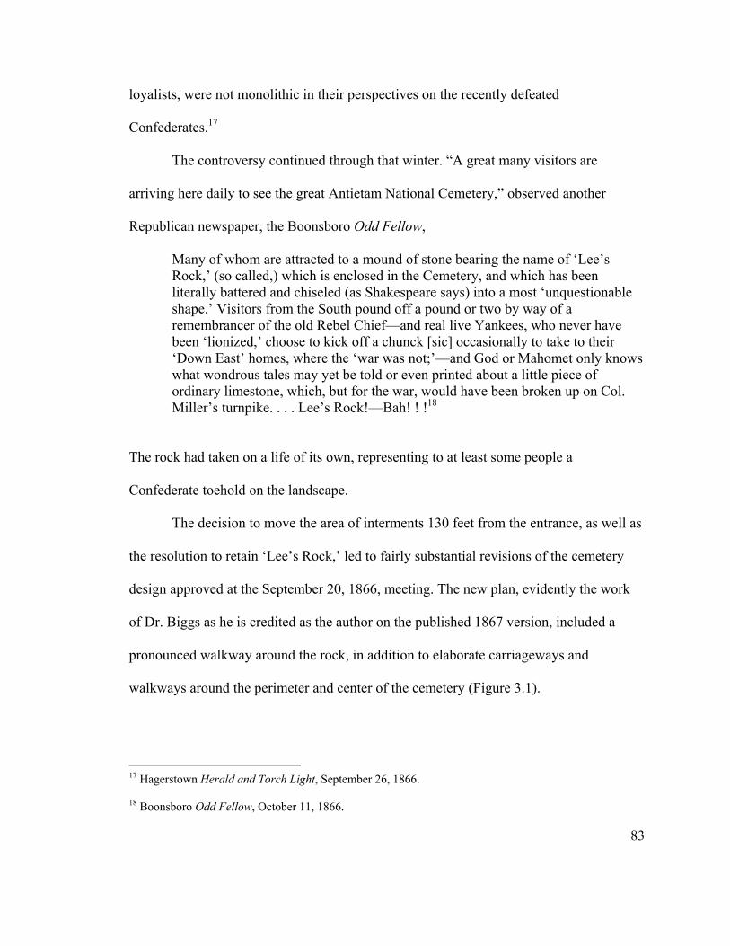
loyalists, were not monolithic in their perspectives on the recently defeated
Confederates.17
The controversy continued through that winter. “A great many visitors are
arriving here daily to see the great Antietam National Cemetery,” observed another
Republican newspaper, the Boonsboro Odd Fellow,
Many of whom are attracted to a mound of stone bearing the name of ‘Lee’s Rock,’ (so called,) which is enclosed in the Cemetery, and which has been literally battered and chiseled (as Shakespeare says) into a most ‘unquestionable shape.’ Visitors from the South pound off a pound or two by way of a remembrancer of the old Rebel Chief—and real live Yankees, who never have been ‘lionized,’ choose to kick off a chunck [sic] occasionally to take to their ‘Down East’ homes, where the ‘war was not;’—and God or Mahomet only knows what wondrous tales may yet be told or even printed about a little piece of ordinary limestone, which, but for the war, would have been broken up on Col. Miller’s turnpike. . . . Lee’s Rock!—Bah! ! !18
The rock had taken on a life of its own, representing to at least some people a
Confederate toehold on the landscape.
The decision to move the area of interments 130 feet from the entrance, as well as
the resolution to retain ‘Lee’s Rock,’ led to fairly substantial revisions of the cemetery
design approved at the September 20, 1866, meeting. The new plan, evidently the work
of Dr. Biggs as he is credited as the author on the published 1867 version, included a
pronounced walkway around the rock, in addition to elaborate carriageways and
walkways around the perimeter and center of the cemetery (Figure 3.1).
17 Hagerstown Herald and Torch Light, September 26, 1866. 18 Boonsboro Odd Fellow, October 11, 1866.
83
Figure 3.1. Plan of Antietam National Cemetery, showing graves arranged in a semi-ellipse around a central monument. ‘Lee’s Rock’ was located just below the Pennsylvania section, to the right of the number 23 (courtesy of Antietam NB).
84
Many years later local resident Henry Kyd Douglas, a prominent former
Confederate Colonel, summarized the affair of ‘Lee’s Rock’:
Near where General Lee was standing was a clump of trees. During or after the war, the trees were cut away and a large rock discovered. Rumor soon gave to this bowlder [sic] the name of ‘Lee’s Rock,’ and when the land was cleared away for the present National Cemetery this rock was left standing for historic reasons. But, as usual, fame brought trouble and envy. People who visited the Cemetery were curious to see the rock upon which Lee had stood, viewing the progress of the battle. This souvenir of Lee was most obnoxious to the extremely loyal and its removal was demanded. Bitter complaint was made to the Trustees, a mixed body of soldiers and politicians, and the debate therein grew warm and men lost their tempers. The conservative members protested against such narrowness and rather liked the idea of having it there as a historical memento, but the ultraists declared that no such relic of rebellion ought to stand amid the graves of the Union dead.19
In the end, however, controversy died down and the stone was removed without fanfare
two years later when other, more pressing, issues came to the fore. The debate
engendered by this Confederate symbol, however, revealed that creating a national
cemetery at Antietam would not be a simple process.
Reinterment of the Dead
Around the same time the cemetery plan was adopted, preparations were under
way to begin moving the dead. Dr. Biggs had appealed to Secretary of War Edward
Stanton in July 1866 for assistance in moving the Union remains, emphasizing that it was
“highly important that immediate action should be taken in the matter in order to preserve
those that can yet be identified or all traces of many will be lost.” In August, the War
Department agreed to undertake the task and, at the suggestion of the Quartermaster
85
19 Henry Kyd Douglas, I Rode with Stonewall (Chapel Hill: University of North Carolina Press, 1940), 166-167.

General, the Board of Trustees expanded the scope of the project to include all Union
dead buried in Washington, Frederick, and Allegany counties, not just those who had
died as a result of the 1862 Maryland Campaign. Operations did not begin until early
October, however, when 1,000 coffins were shipped to Sharpsburg via the C&O Canal
and a burial party of 60 men was dispatched to begin the grim task of disinterring the
dead.20
Within a couple of months, about 1,200 bodies had been moved to the cemetery.
The remains, noted the Boonsboro Odd Fellow,
are placed in substantial coffins . . . and delivered to Dr. Biggs, the President of the Cemetery Association, who buries them in their proper lots. In raising the dead every grave is carefully examined, and strict search is made for relics which may in any manner serve to identify the remains. So far about two-thirds have been fully recognized. There is no difficulty in identifying those buried in the different Church-yards—the band-boards being yet in good condition. Those buried in fields, (in many cases,) have been ploughed over and the boards destroyed. Yet many are identified by memoranda kept by farmers and others living in the neighborhood. In some cases relics found in the graves afford the most satisfactory evidence.
Several weeks later the paper noted that landowners with burials on their property had
cooperated with the burial corps, with two exceptions.
One person contended that there were none buried on his place, but the guides, and those who were present at the battle, knew better, and a large number of bodies were dug up in his garden. He had cultivated his cabbages over the shallow graves of the slain, and stoutly contended that there were none there! Another treated the members of the corps rather roughly, and asserted that none were buried on his farm. But the contrary fact was known, and a number of bodies were
86
20 Augustin A. Biggs to Sec. of War E.M. Stanton, July 16, 1866, Col. J.J. Dana to A.A. Biggs, August 23, 1866, Lt. Col. James Moore to A.A. Biggs, September 5, 1866, and October 2, 1866, Antietam National Cemetery (ANC), Gen. Correspondence of the Office of the QM General, 1865-1890 (Entry 576), Office of the Quartermaster General, Record Group 92 (RG 92), National Archives, Washington, D.C. (NA); Board of Trustees, History of Antietam National Cemetery, 15.
taken up from beneath a farm road that he had made over the loyal dead! Comment in these cases is unnecessary.21
These accounts reveal both reverence toward the dead Union soldiers on the part of many
of the local inhabitants, who sought to preserve their identities as best as they could, as
well as latent hostility on the part of others, owing perhaps to previous Confederate
sympathies or resentment about damage inflicted on their properties.
By the time winter weather shut down operations in January 1867, about 3,000
bodies had been moved to the cemetery. Thomas A. Boullt observed in a letter to trustee
G.L. Cranmer that during this process, “careful attention is also paid to the removal of
any flowers or other shrubbery which may have been planted by human hands, or those
of dear friends. Whatever head and foot boards are found, they are also removed, so the
graves present the same external appearance in the cemetery, that they did in the church
yards and fields.”22
The burial corps resumed its work in April 1867 and completed it the first week
of September. A total of 4,667 remains were interred in the cemetery during this
21 Boonsboro Odd Fellow, November 22, 1866 and December 13, 1866. 22 Board of Trustees, History of Antietam National Cemetery, 18; Boullt to G.L. Cranmer, February 16, 1867, ANC Correspondence, Biggs Collection, WCFL. The Hagerstown Herald and Torch Light, January 23, 1867, provided a graphic description of the process as it was conducted in a field on the edge of Hagerstown: “After removing the snow from the outside row of graves, the first grave was opened and the body taken out. This left a place for the earth from the next grave, and a ‘breast’ or chance to get at the frozen crust of earth covering it, (about a foot thick), and so on through the row or tier. The bodies are buried about 3 feet below the surface, the graves about 8 inches apart, and coffins were used in all cases. The earth is taken away down to the top of the coffin, and carefully cleaned therefrom. Then the top of the coffin is split by a pick and taken off. The body lies there, a black mass of decomposed flesh, and bones. Some have blankets around them; others have not. The new coffin is placed alongside of the grave; one man stations himself at the head with a square short handled shovel; another at the foot with a spade, and with these implements the remains are removed into the new coffins. What was apparently the form of a man as it lay in the coffin, when disturbed, is nothing but a pile of bones, the flesh all being decayed, and turned to a black dust. The skull is placed at the head of the coffin, the other bones, dust and decayed cloth thrown in indiscriminately; the coffin covered and lifted away, and another grave opened.”
87
operation. As intimated by Boullt, the appearance of the rows of completed burials was
not uniform, with “temporary and imperfect stones, and monuments erected by friends”
marking the graves. Evidently there was no desire on the part of the Board of Trustees to
standardize the grave markers, suggesting that the soldiers were seen more as individuals
than as part of a unified army. This lack of uniformity was in contrast to Gettysburg,
where standard stone headstone curbing was in place by mid 1865 and would have been
seen by the Maryland trustees when they visited that cemetery.23
Preparing for the Dedication
New tensions surfaced between Board members during planning for the
dedication of the cemetery, revealing ideological differences that would help set the stage
for the uproar that erupted over that ceremony. As first hinted by the ‘Lee’s Rock’
controversy, it became evident that the Board of Trustees did not have a clear and unified
vision concerning the meaning of the national cemetery. As will be seen in a subsequent
section, this lack of uniformity enabled narrow state interests to appropriate the
dedication toward their own ends, alienating many Northern supporters.
At the beginning of June 1867, the Board of Trustees set a September 17
dedication date for the national cemetery—exactly five years after the Battle of Antietam.
It appointed a special committee to make arrangements for the ceremony and selected
Andrew G. Curtin, the popular former wartime governor of Pennsylvania, as orator for
88
23 Board of Trustees, History of Antietam National Cemetery, 17-19. Lt. Col. James M. Moore to Bvt. Major General L.H. Rucker, Acting QM Gen., September 12, 1867, ANC, Entry 576, RG 92, NA. Harlan D. Unrau, Administrative History, Gettysburg National Military Park and Gettysburg National Cemetery, Pennsylvania (Washington, D.C.: Government Printing Office, 1991), 20.

the occasion. The committee met one month later in Washington, D.C., electing Dr. J.E.
Snodgrass chairman and Thomas A. Boullt secretary—a volatile combination, as it was to
turn out. The members prepared a list of people to receive invitations (all Union loyalists
except for the governor of the contiguous state of Virginia) and decided to hold a poetry
contest, with the winning entry to be read at the dedication. In the meantime, Boullt had
written to Curtin, inviting him to be the main speaker at the dedication. Curtin declined
the invitation, however, because he was residing in Europe that summer.24
The committee met a second time at Cape May, New Jersey, on August 8, 1867,
with four members—J.E. Snodgrass, Edward Shriver, G.L. Cranmer, and Thomas
Boullt—in attendance. Tensions between Boullt and the other board members,
particularly Snodgrass, came to the fore at this meeting when Boullt objected to paying
proposed expenses for transporting and entertaining specially invited guests, believing
them too high. “There being a majority against me,” he later explained, “the resolution
was carried. I had nothing to do but to ‘veto’ the bill by refusing to pay any accounts
created under the ‘act.’” The committee did manage to select Maryland governor Thomas
Swann to preside over the dedication.25
24 Report of the Annual Meeting of the Trustees of the Antietam National Cemetery, June 5, 1867, Report of Proceedings of Meeting of Committee of Arrangement, July 6, 1867, ANC, Entry 576, RG 92, NA; Boullt to Hon. Andrew A. Curtin, June 10, 1867, ANC Correspondence, Biggs Collection, WCFL. 25 Boullt to Henry Edwards, September 2, 1867, ANC Correspondence, Biggs Collection, WCFL. In regards to the Cape May meeting, Boullt noted that they met three separate times, each session lasting more than two hours. He summarized to Edwards: “As you may understand there must have been a good deal of talking. Indeed I became so tired of working hard and yet, doing nothing, that I wished I had never seen Cape Island. Why my dear sir, I did not get an opportunity of submitting my dirty body to the cleansing properties of the old ocean. I went to Cape May in a bad humor, was mad whilst there, and left scolding.”
89

Owing to Boullt’s intransigence, the entire Board of Trustees was forced to take
up the transportation and entertainment funding issue at a special meeting held later that
month in Baltimore. Following sharp discussion, Gen. Shriver assured the board that
expenses would not exceed $500, “so with that modification of the request of the
committee the Board agreed to authorize such an expenditure.” The primary purpose of
this meeting, however, was to select a new speaker for the dedication following Curtin’s
withdrawal. A number of names were proposed, and after several ballots former
Maryland governor Augustus Bradford was narrowly selected.26
Further controversy arose over selection of a poet for the dedication. Boullt
became alarmed at rumors that Snodgrass intended to select a black man, writing G.L.
Cranmer that “if the poem adopted emanates from a white man, who is respectable, then I
am satisfied. But I have no notion of allowing Dr. Snodgrass, with his miserable
proclivities to run in upon this association a poem to gratify his arrogant notions of negro
equality.” Boullt believed they had been unfortunate enough to have the doctor as their
chairman and did not need to be further compromised, suggesting that the selection of a
poet should be postponed until a board meeting scheduled for the day before the
dedication, at which time “all can learn from him who the author is, and what his
antecedents.” Evidently this issue was resolved to Boullt’s satisfaction, for no more
90
26 Boullt, Minutes, August 21, 1867, WCHS. Present at this meeting were Dr. J.E. Snodgrass, Gen. Edward Shriver, Col. M. Yates Selleck, G.L. Cranmer, and Thomas Boullt – essentially the same group that had attended the Cape May meeting. Bradford received three votes (Shriver, Snodgrass, and Boullt). The minutes identify Antietam National Cemetery as the location for this meeting.

mention was made of it. Other tensions lay just under the surface, however, ready to
ignite.27
Dedication of Antietam National Cemetery
The morning of September 17, 1867, began auspiciously, with large crowds
gathering early in anticipation of the dedication (Figure 3.2). By the time the procession
of distinguished guests belatedly arrived at the cemetery around 2 p.m., between 10,000
and 15,000 people, mostly from Pennsylvania and the immediate neighborhood of
Sharpsburg, had assembled for the event. Among the dignitaries present were President
Andrew Johnson, his Cabinet secretaries, and seven governors. Thomas Swann, the
presiding officer and governor of Maryland, delivered a short opening address welcoming
the guests. Swann had become governor in January 1866 on the Conservative Union
ticket, and in an attempt to win over Democrats favored the return of voting privileges to
former Confederate soldiers and sympathizers. He also supported Johnson’s lenient
Reconstruction policies and opposed Negro suffrage. Not surprisingly, therefore,
Swann’s speech called for “a speedy restoration of harmony and brotherly love
throughout this broad land.”28
27 Boullt to G.L. Cranmer, September 10, 1867, ANC Correspondence, Biggs Collection, WCFL. In a second letter written on that date to Gen. Edward Shriver, the other arrangements committee member, Boullt goes further in his denunciation of Snodgrass: “His discourtesy is unbearable, his arrogance disgusting, and if he don’t compromise the committee in a humiliating manner it will be because he is trying to run in a Negro for a poet, and thereby gratify his miserable proclivities at the expense of the feelings of the committee.”
91
28 Boonsboro Odd Fellow, September 19, 1867; Hagerstown Herald and Torch Light, September 25, 1867; Board of Trustees, History of Antietam National Cemetery, pp. 22-23; Charles L. Wagandt, “Redemption or Reaction?: Maryland in the Post-Civil War Years,” in Radicalism, Racism, and Party Realignment: The
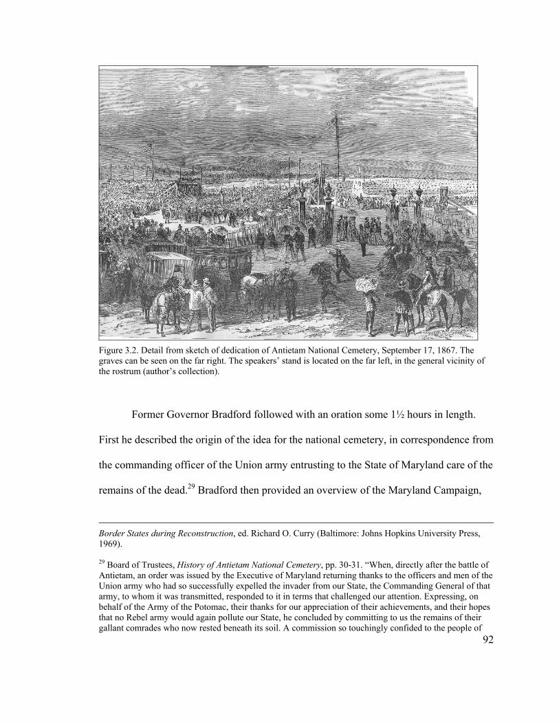
Figure 3.2. Detail from sketch of dedication of Antietam National Cemetery, September 17, 1867. The graves can be seen on the far right. The speakers’ stand is located on the far left, in the general vicinity of the rostrum (author’s collection).
Former Governor Bradford followed with an oration some 1½ hours in length.
First he described the origin of the idea for the national cemetery, in correspondence from
the commanding officer of the Union army entrusting to the State of Maryland care of the
remains of the dead.29 Bradford then provided an overview of the Maryland Campaign,
Border States during Reconstruction, ed. Richard O. Curry (Baltimore: Johns Hopkins University Press, 1969).
92
29 Board of Trustees, History of Antietam National Cemetery, pp. 30-31. “When, directly after the battle of Antietam, an order was issued by the Executive of Maryland returning thanks to the officers and men of the Union army who had so successfully expelled the invader from our State, the Commanding General of that army, to whom it was transmitted, responded to it in terms that challenged our attention. Expressing, on behalf of the Army of the Potomac, their thanks for our appreciation of their achievements, and their hopes that no Rebel army would again pollute our State, he concluded by committing to us the remains of their gallant comrades who now rested beneath its soil. A commission so touchingly confided to the people of
during which the loyalty of Maryland’s citizens to the Union had been proven, and
broadly described the Battle of Antietam, stressing the Union side of the story. The
former governor reflected upon the valor of those buried on the battlefield, and, like
Swann before him, emphasized the hope of reconciliation:
May not imagination, as it seeks to portray the future of this great American Republic, without any overstraining of its powers, see the coming time, distant it possibly may be, but none the less desirable or certain, when her sons from every State shall seek this little hamlet for its hallowed memories of the past, and coming from the South as well as North, reunited in fact as well as theory, in affection as well as formality, shall stand here together as pilgrims at a common shrine, and forgetting the feuds of the past, save only the mighty powers which their results developed, mutually admit, as they appeal to the records of this field, that they have sprung from the same stock, and united in the same destiny, entitled to the same respect, and animated by the same heroic and patriotic impulses?
Further along in his address, Bradford implied that Radical Republicans were acting
vindictively toward the South and creating unfounded fears so as to remain in power. He
concluded with a plea for moderation on all sides.30
Swann’s and Bradford’s speeches did not sit well with the audience, which
contained a large number of Union veterans, many of whom had traveled from
neighboring Pennsylvania. Local newspapers reported that after Bradford sat down the
crowd began calling for Republican Governor John W. Geary of Pennsylvania, as they
wanted to hear a ‘loyal’ governor. Geary had provided admirable service during the war,
rising to the rank of major general, but had missed the Battle of Antietam because of a the State, to say nothing of the duty otherwise incumbent on them, could never become with them a subject of indifference or neglect, and at the first meeting, therefore, of their representatives in the General Assembly of January, 1864, an Act was passed authorizing the purchase of a part of the battle field for the reception of its dead.” 30 Board of Trustees, History of Antietam National Cemetery, 47.
93
wound received at an earlier battle. Attempts by Governor Swann to quiet the crowd were
futile, and Geary finally had to stand and request the spectators to allow the program to
continue, after which, if they wished, he would say a few words. The audience complied
and listened to the rather long-winded and ponderous winning poem, read by trustee G.L.
Cranmer. Then Swann introduced President Johnson, “amidst very faint applause from a
few Maryland and Virginia rebels,” and he gave a short speech stressing that the living
should follow the example of the dead, who reposed in peace in their tombs, “and live
together in friendship and peace.”31
According to the Board of Trustees’ official history of the national cemetery,
Johnson’s speech was followed by a benediction and then leave-taking of the dignitaries.
The Boonsboro Odd Fellow, however, recounted a different ending to the event:
As soon as Johnson was done, some man jumped up and in most indecent haste pronounced the benediction. But the people were not to be snubbed in this manner, and Geary was again loudly called for. He came forward amid most enthusiastic cheering, and said: ‘It seems that myself and others of a like stamp are not in the programme. Had this occurred in Pennsylvania, the programme would have been that whoever the people desired to hear, should have spoken. But if I am not in the programme, I am pleased to know that I am in the hearts of the loyal people.’
Geary then gave a short address, which “stirred the hearts of the loyal mass of men and
women gathered there.” Governor Fenton of New York also made a few remarks, which
ended the gathering. Both governors stressed the roles of their respective states at the
94
31 Boonsboro Odd Fellow, September 19, 1867; Hagerstown Herald and Torch Light, September 25, 1867; Board of Trustees, History of Antietam National Cemetery, 54; Stotelmyer, Bivouacs of the Dead, 26. In reference to the poem, the Baltimore American (September 18, 1867) averred: “Among the minor failures of the ceremonies may be reckoned the Dedicatory Poem. The occasion ought to have produced something better than verses that can scarcely be called anything but doggrel.”
Battle of Antietam and also the larger meaning of the Civil War as a fight to extend
freedom to all men.32
Condemnation of the dedication ceremony by the Republican press was swift.
After a week to think it over, the Boonsboro Odd Fellow noted that its previous article
“merely hinted at the bad taste displayed in the programme at the stand, and the open
insult offered by Governor Swann and others, to Governor Geary, of Pennsylvania, Gov.
Fenton, of N. York, and other loyal representatives of States whose dead heroes lie buried
within that sacred ground.” It appended a portion of a bitter article from the New York
Tribune, evidently authored by Dr. J.E. Snodgrass, which opened as follows: “Taken as a
whole, a more stupidly farcical affair than that at Antietam could scarcely be imagined. A
baser attempt to degrade a noble object and praiseworthy undertaking was never made.”
In its conclusion, Snodgrass raised an issue that was to preoccupy Boullt and others on
the Board of Trustees for most of that fall: “For the last year or so, in fact since the
advent of Swann’s administration, the management of the Antietam Cemetery has not
been as it should have been. Too much politics have become interwoven with it, and a
class of men were in it who produced nothing but discord and dislike among the Northern
members of it.”33
32 Board of Trustees, History of Antietam National Cemetery, 54; Boonsboro Odd Fellow, September 19, 1867; Hagerstown Herald and Torch Light, October 2, 1867.
95
33 Boonsboro Odd Fellow, September 26, 1867. Evidence for Snodgrass’s authorship of the Tribune article comes from a note sent around this time to Ezra Carman in which he writes of exposing the “perfidious conduct of Swann & Co” in that paper (see J.E. Snodgrass to Ezra A. Carman, October 2, 1867, box 1, 1867-1868 Correspondence Folder, Ezra Carman Collection, New York Public Library). The Hagerstown Herald and Torch Light, October 2, 1867, also reprinted a short article from the Baltimore American with additional comments from Snodgrass: “A statement from the Chairman of the Antietam Cemetery Committee of Arrangements, Dr. Snodgrass, of New York, asserts that on the evening before the dedication Gov. Swann agreed to have remarks from the Governors who might be present, Governors Fenton and
The Hagerstown Herald and Torch Light also condemned the actions of Governor
Swann and his associates, focusing on the entertainment costs that had caused Thomas
Boullt such difficulty earlier:
A decidedly rich feature in the manipulation of the programme by the Baltimore Junta, is that $500 were appropriated to defray the traveling expenses of the Swann and Johnson party. We believe special cars were provided, and a full supply of things to eat and drink laid in. Thus whilst a studious effort was made by Swann & Co., to exclude the loyal Governors from all participation in the dedicatory ceremonies, the said Swann & Co., were drinking and feasting at the expense of the loyal people whom these Governors represented. The Militia General, E. Shriver, is a great commander. He makes the war support itself, and forages his forces on the enemy’s country.
The paper further advised the trustees of the loyal states “to take the entire management
of the affairs of Antietam Cemetery out of the hands of the men who countenanced these
outrages,” as Maryland had fallen “under the complete dominion of the rebels and none
but rebels will hereafter be appointed as trustees.”34
In their condemnations of the Swann “clique,” the newspapers most likely were
referring (in addition to General Shriver) to John H.B. Latrobe, a leading Baltimore
Democrat who had been appointed to the Board by Governor Swann during the week of
the dedication to replace Baltimore American editor Charles Fulton, whose term had
Geary being especially named. He afterwards utterly ignored this agreement under the dictation of the President himself, only an invited guest, and then, without a shadow of authority to dictate the programme to be observed, called for the benediction just in time to head off the remarks which he fully knew were to have been made.”
96
34 Hagerstown Herald and Torch Light, September 25, 1867. The Baltimore American (September 19, 1867) echoed these sentiments: “I would suggest that, if possible, the management of Antietam Cemetery be taken out of the hands of the present Board of Commissioners, and vested in the United States Government. Congress has passed a law looking to the proper care of the illustrious dead of the nation. As the heroes now reposing at Antietam died in defense of the Federal Government, it seems but fitting that the representatives of that Government should have control and care of their honored graves.” Such a statement probably could be expected from Fulton, who had just been replaced on the Board of Trustees by a Democrat.
expired. The papers also voiced the larger frustrations on the part of the Unconditional
Unionists and Republicans regarding the heavy-handed tactics employed by the governor
during the elections of 1866 to restore Democratic control of the state. By replacing
voting registrars with men who qualified many previously excluded pro-Southern and
Confederate voters, Swann ensured a Democratic majority in the General Assembly that
convened in January 1867. That legislature had moved quickly to restore full citizenship
to the disfranchised and had called for a new constitutional convention to overturn gains
made by the radicals in the constitution of 1864. The new constitution was ratified in
April 1867, only five months before the dedication of the cemetery, leaving a wound that
was still fresh for the state’s Republican minority.35
In addition, the dedication of Antietam National Cemetery occurred at the height
of the conflict between Andrew Johnson and Congress over Reconstruction policy and
the larger meaning of the war and emancipation. As historian David Blight has observed:
“Reconstruction was both a struggle among the living over the meaning of the dead and a
fierce political fight to determine just what was alive or dead in the new order born from
the war.” The contrast between Johnson’s perspective on the dead at Antietam and his
predecessor’s at Gettysburg four years earlier was striking. While Abraham Lincoln used
the cemetery at Gettysburg to create a powerful new meaning for the war that resonates
35 Board of Trustees, History of Antietam National Cemetery, 4; Wagandt, “Redemption or Reaction?,” 166-170.
97
down to the present day, Johnson totally ignored the reasons for which the soldiers at
Antietam had died.36
While partisan politics certainly were at work at the dedication ceremony, it also
reflected the ambivalence many in Maryland felt toward the Civil War and the role of the
state in the conflict. It is evident that the state leaders were still trying to broaden the
meaning of the cemetery to include the sacrifices of both North and South, in the same
way the General Assembly did by legislating for the burial of both Union and
Confederate soldiers within its confines. This ambivalence was manifested in the
snubbing of both Pennsylvania and New York at the dedication, two states which
combined had contributed a large percentage of the graves within the cemetery. As a
result of this blatant partisanship at the state level, Antietam National Cemetery was not
able to rise to the symbolic level attained by Gettysburg.
Investigation of Cemetery Affairs
The discord created by the dedication of the cemetery, along with the lavish
spending to entertain special guests so deplored by Boullt, led to allegations of
mismanagement on the part of the Board of Trustees. By early October 1867, New York
Governor Reuben Fenton had heard enough rumors of mismanagement that he decided to
appoint a special commissioner to investigate the accusations. The governor also
refrained from paying the state’s remaining, and substantial, appropriation to the
cemetery. Immediately upon receipt of the notice concerning the special commission,
98
36 David W. Blight, Race and Reunion: The Civil War in American Memory (Cambridge, Mass.: The Belknap Press of Harvard University Press, 2001), 52.
Boullt composed a letter to Gov. Fenton offering his full cooperation. “I shall neither
spare time or labor to convince all interested that the cemetery has been fairly and
squarely managed,” Boullt wrote several days later to trustee Col. W. Yates Selleck. In
the meantime, the lack of appropriations threatened the financial condition of the
cemetery association, forcing Boullt to borrow money to continue the construction work.
This problem was exacerbated by Pennsylvania’s decision to withhold its sizable
appropriation pending the results of the investigation.37
John Jay, the special commissioner appointed by Gov. Fenton, together with
Wisconsin trustee Col. W.Y. Yates, visited Antietam National Cemetery the last day of
October and examined the books of the Association. According to the Boonsboro Odd
Fellow,
[Jay] expressed himself fully satisfied with the management of the work, and the expenditure of the funds appropriated under the control of the President and Secretary, as well as the Board of Managers. [The] Report being favorable, the appropriations made by the State of New York, will undoubtedly be paid over immediately, and the work progress toward a speedy completion. Undoubtedly Gov’r Geary, of Pennsylvania, will, too, soon satisfy himself that the financial affairs of the Cemetery have been honestly managed, and the appropriation of that State also paid over. The bad management on the part of a few of the Commissioners at the Dedication, should not be made to reflect upon the whole Board; for we have never heard any one censure Dr. Biggs, the President, or Thos. A. Boullt, the Secretary, for any mismanagement in their particular duties.
37 Washington Star, October 4, 1867, and Baltimore American, November 1867, clippings in ANC, Entry 576, RG 92, NA; Boullt to Gov. Fenton, October 5, 1867, Boullt to Col. W.Y. Selleck, October 8, 1867, and October 19, 1867, Boullt to Gov. Geary, October 19, 1867, ANC Correspondence, Biggs Collection, WCFL. Fenton asked Dr. Snodgrass to take the position of special commissioner, but Snodgrass declined, citing professional engagements. Although no direct evidence has been found, it is evident that Snodgrass resigned from the Board of Trustees around this time, as a new trustee from New York began attending Board meetings in December 1867.
99
A portion ($1,500) of the remaining funds for the cemetery was received from New York
shortly after the report was completed, but not the state’s full $5,500 share, for an even
more controversial issue surfaced at this time: burial of Confederate dead in Antietam
National Cemetery.38
Controversy over the Confederate Dead
Rumors began circulating shortly after the cemetery dedication regarding the
burial of Rebel dead in the cemetery. “In response to your inquiry as to the truth of the
report,” wrote Thomas A. Boullt to Ezra Carman a few days before Jay’s visit, “I have
respectfully to inform you that there is no truth in the report. None of the funds of the
Association have been used for the removal of the southern dead.” That Boullt was
contemplating such a move, however, is clear, as he evidently convinced John Jay during
the latter’s visit to Sharpsburg and, through him, Governor Fenton of the appropriateness
of such an action now that interment of the Union dead had been completed.39
Emboldened by this support, and perhaps also by the appointment of Maryland
trustees more sympathetic to the Confederacy, Thomas A. Boullt opened the first Board
of Trustees meeting following the dedication by calling attention to the fourth section of
the cemetery charter, “which makes it the duty of the Trustees to remove the remains of
the Confederate soldiers, who fell in the battle of Antietam, to the Cemetery, and
requested that some action be taken to carry into effect [this] provision of the Law.”
38 Boonsboro Odd Fellow, November 7, 1867; Boullt to John Jay, December 2, 1867, ANC Correspondence, Biggs Collection, WCFL.
100
39 Boullt to Carman, October 27, 1867, ANC Correspondence, Biggs Collection, WCFL.

Following “animated” discussion, John Jay read a letter from Governor Fenton reiterating
the requirements of the law and recommending that the trustees carry out its provisions as
a means of healing the wounds caused by the recent war. Jay then introduced a resolution
calling upon the Board to set aside the southern, or back, portion of the grounds “not now
occupied, and separate from the ground devoted to the burial of the Union dead,” for the
interment of the Confederates. A “warm” debate ensued over the resolution, which
ultimately passed 7-2.40
The most important influence over the decision was the language of the law
establishing the cemetery. Many of the trustees who voted in the affirmative were
personally opposed, but felt they had no other choice given the nature of the charter. As
explained in the Boonsboro Odd Fellow: Many Northern States have given money to put
the ground in order and pay the expenses of the Cemetery, and it was claimed by their
representatives at the meeting last night that they would not have made these
appropriations had they known the character of the charter, and the use to which the
funds would be put. It was necessary, however, under the terms of the charter to set apart
40 Proceedings of the Trustees of the Antietam National Cemetery, at their Meeting held in Washington City, December 5th, 1867 (Hagerstown, Maryland, 1867), copy filed in ANC, Entry 576, RG 92, NA; State of New York, Report of John Jay, Special Commissioner on Antietam Cemetery (n.p.: n.p., 1868); Boonsboro Odd Fellow, December 12, 1867. Voting in favor of the resolution were John Jay of New York, Col. W.Y. Selleck of Wisconsin, John J. Bagley of Michigan, Maj. William Rounds of Vermont, Henry D. Washburn of Indiana, Alexander Ramsey of Minnesota, and Augustin Biggs, Edward Shriver, and Thomas Boullt of Maryland. G.L. Cranmer of West Virginia and Col. Gordon Lofland of Ohio voted against it. Ironically, Cranmer and Lofland had been two of the staunchest proponents of retaining “Lee’s Rock” in the cemetery. The importance of Fenton’s letter is underscored in a note from Thomas A. Boullt to John Jay on December 17, in which Boullt stated “I am glad to learn that Governor Fenton consents to printing his letter among the proceedings, it will have a most excellent effect in many ways.” See ANC Correspondence, Biggs Collection, WCFL.
101

at this meeting a certain portion of the grounds for the burial of Rebels, and it was
accordingly done.41
In the meantime, following passage of the resolution Boullt sent a letter to the
governors of each of the Southern states, directing attention to the Trustees’ resolution
and requesting funds to help pay for the Confederate burials. Ironically, he did not
receive a response from any state except Maryland, “whose Legislature, upon the petition
of a large number of citizens, accompanied by a copy of the resolution, appropriated the
sum of $5,000 to aid in carrying out the wishes of the Board in that behalf.” Burial of the
Confederate soldiers had become a point of pride for the Conservatives who had gained
control of the state government.42
Republican Senator Alexander Ramsey of Minnesota was one of those trustees
who had not been aware of the provision regarding Confederate burials and had only
reluctantly voted for it. He was persuaded in large part by the arguments of the Maryland
trustees, who assured the others “that there was no probability of a rebel being buried
within the enclosure. . . . Nothing would induce them to bury in the loyal enclosure at
Antietam.” Ramsey hoped that a compromise might be reached that would “satisfy the
legislature of Maryland of rebel sympathies, whose state having made large
appropriations would probably inquire into the matter,” while maintaining the integrity of
the cemetery.43
41 Boonsboro Odd Fellow, December 12, 1867. 42 Proceedings of Meetings of the Board of Trustees, of the Antietam National Cemetery, held at Philadelphia, Nov. 18, and at Washington City, Dec. 9, 1868, copy in Alexander Ramsey Papers, MNHS.
102
43 Alexander Ramsey to Gov. William R. Marshall, December 17, 1867, Alexander Ramsey Papers, MNHS.
Condemnation of the Board’s resolution was swift in most of the Republican
press. In Washington, D.C., the Chronicle observed “that the trustees of the Antietam
cemetery had held a meeting, and, after a lengthy discussion, had resolved to set apart a
portion of that cemetery for the burial of rebels, or to speak more plainly, to inter side by
side with loyal men who perished to save the Government, the traitors who sought to
destroy it.” Reaction in Maryland was more resigned. “Being unwilling to hold
animosities against the dead—who fought bravely in a bad cause—that we do not at this
day feel nor express against the living,” argued the Baltimore American, “we agree with
Gov. Fenton in his recommendation that a portion of the grounds be set apart for their
burial. We had hoped that some other disposition would have been long since made of
these bones, but as they are still scattered over the fields and road-sides; let them at once
receive a decent sepulture.” The American suggested in a parting shot, however, that the
provision of the law providing for Confederate burials probably had not been brought to
the attention of most of the Board of Trustees until the cemetery was almost complete, as
otherwise many of the states would not have appropriated funds toward its construction.44
Pennsylvania, which had not sent a representative to the December board meeting
and indeed had been lackluster in its support of the cemetery from the beginning, was
vehement in its opposition to the interment of Confederate remains in the national
cemetery. Governor John W. Geary once again refused to turn over the remaining $3,000
of that state’s appropriation. In late January 1868, the state legislature endorsed Geary’s
action along strict party lines, with Republicans voting in favor of it and Democrats
44 Washington, D.C., Chronicle, December 15, 1867, clipping filed in ANC, Entry 576, RG 92, NA. Baltimore American, reprinted in Hagerstown Herald and Torch Light, December 25, 1867.
103

against. One Democratic representative inquired whether “members were hyenas, to
leave the bodies of the Rebel dead unsepultured, to be plowed up by the farmer in his
fields?” A Republican legislator retorted that it was not a question of burying the
Confederate dead, but whether the Union dead were to be buried side by side with their
murderers.45
In the face of criticism from the Commonwealth of Pennsylvania and other
northern states, Maryland hardened its stance. About the same time the debate over the
Confederate dead was gathering steam, the original terms of Thomas A. Boullt and Dr.
Augustin A. Biggs expired. “As it is expected that an important meeting of the Trustees
will be held very soon,” wrote Boullt to Governor Swann, “and as it is very desirable that
Maryland should have a full voice at the Board, you are respectfully requested to fill the
vacancies at your earliest convenience.” A second letter followed shortly in which Boullt
strongly recommended the reappointment of Dr. Biggs and emphasized the Republican’s
fairness: “I feel it due to a faithful officer with whom I have been associated for nearly
three years, to say with reference to reports, that he had used his position on this work for
political purposes; that to my certain knowledge, employees of our political views have
found work and prompt pay from Dr. Biggs, as the superintendent of the Board. None
have been discharged because they differed from him in politics.” Almost as an
afterthought, Boullt concluded, “As to myself, Governor, I am free to acknowledge, it
104
45 John White Geary, “Annual Message to the Assembly, 1868,” in Pennsylvania Archives, Fourth Series, Papers of the Governors, 1858-1871, Volume VII (Harrisburg: The State of Pennsylvania, Wm. Stanley Ray, State Printer, 1902), 860-862; Boonsboro Odd Fellow, February 6, 1868. In his address to the state legislature, Geary concluded his discussion of the issue: “While there is no reasonable objection to giving decent sepulture to the rebel dead, those who consider them deserving of honorable testimonials may bestow them. It is our duty to render honor only to whom we believe honor is due.”

will afford me great pleasure to be reappointed.” Instead, in a move that reflected the
altered political situation in Maryland, Swann appointed Conservative Unionist Charles
E. Phelps, a Union veteran and Congressman from Baltimore, and Washington County
resident James H. Grove, a well known Confederate sympathizer. The Board retained
both Boullt and Biggs, however, in the salaried positions of secretary/treasurer and
cemetery superintendent, respectively.46
In his letter to Swann, Boullt referred to a special meeting of the cemetery
association scheduled for May 6, 1868. Eleven of the fifteen states on the Board sent
representatives to this gathering held in Washington, D.C., and all four of Maryland’s
representatives—Gen. Edward Shriver, J.H.B. Latrobe, Charles E. Phelps, and James H.
Grove—attended as well. As was to be expected, much of the discussion focused on the
Confederate burial issue.47
In a written report presented at the meeting, Dr. Biggs (who was not able to
attend) noted that a number of states had not yet contributed funds to the cemetery; the
governor of Michigan was withholding $4,000 and the governor of Pennsylvania $3,000
both in protest of the provision for burying Confederate dead on the cemetery grounds.
To mollify those states, and at the same time enlarge the space allocated, which Biggs
believed was too small, he recommended the purchase of adjoining property for the
46 Boullt to Gov. Swann, February 19 and March 2, 1868, box 115, folder 30, Gov., Misc. Papers, MSA. As another example of Biggs’ evenhanded approach to management of the cemetery, Boullt enclosed a map of the grounds surveyed and drawn by Charles P. Kohler, “a returned Confederate soldier.” Boonsboro Odd Fellow, May 29, 1868. Gerson G. Eisenberg, Marylanders Who Served the Nation: A Biographical Dictionary of Federal Officials from Maryland (Annapolis: Maryland State Archives, 1992), 171. Phelps was an officer in the 7th Maryland Volunteers. 47 Proceedings of the Trustees of the Antietam National Cemetery, at a Special Meeting held in Washington City, May 6th, 1868, copy filed in ANC, Entry 576, RG 92, NA.
105
reception of these dead. “With this arrangement,” he concluded, “it is believed the
Southern States would contribute for the removal of the remains of their soldiers buried
on Maryland Soil.” In line with this recommendation, the Board unanimously passed a
motion to purchase and enclose additional grounds adjacent to the present cemetery for a
Confederate burial ground. This compromise appeared to lay the issue to rest for the time
being.48
In June, one month later, a small group of trustees—evidently just enough to
constitute a quorum—met in Sharpsburg to inspect the work completed in the cemetery.
After viewing the grounds and the proposed location of the Confederate burial plot, they
voted to table the resolution passed in May. Perhaps as part of their continued frustration
over this issue, the trustees also ordered Superintendent Biggs to remove all projecting
rocks from the grounds, finally signaling the end of ‘Lee’s Rock.’ Ironically, the
infamous rock’s demise was not even noted in the local press, the question of burying
48 Proceedings of the Trustees of the Antietam National Cemetery, at a Special Meeting held in Washington City, May 6th, 1868, copy filed in ANC, Entry 576, RG 92, NA. In a letter written to Jay two days before the board meeting, Biggs expressed his regret that the meeting had not been held on the cemetery grounds, primarily “to make some disposition of the objectional [sic] clause in the act of incorporation, the accomplishment of which so desirable can be made satisfactorily to all parties by the purchase of an additional piece of ground on the south end of the cemetery and inclosed [sic] with an iron fence, an entrance to which made through the south wall.” Obviously having put much thought into this issue, Biggs described what this enclosure would look like: “It is not necessary that a wall should be built for an iron fence. Heavy blocks of stone planted in the ground to receive the posts of the fence is all that is necessary, and equally as durable as a wall and much less cost. A very good fence of cast iron can be purchased at much less cost than the fence in front of the Cemetery and look equally as well.” He believed this the best course, as “in the present inclosure [sic] there is not sufficient room to admit the rebel dead without destroying the design of the Cemetery and in many respects objectionable. To adopt the plan I have proposed would effectively avoid all difficulty and at the same time would afford the south an opportunity to inter and decorate the grounds as they may desire without effecting in the least the present inclosure [sic]. See Augustin Biggs to John Jay, May 4, 1868, Special Collections, Washington County Historical Society (WCHS).
106

Rebel soldiers on these grounds having superseded the conflict over the symbolic
importance of the large stone.49
The Confederate burial issue continued to simmer into the opening months of
1869. In February of that year several of the trustees traveled to Harrisburg,
Pennsylvania, to meet with Governor Geary about the remaining funds owed by that
state. The governor held fast, however, informing the trustees that “while they persisted
in . . . making Antietam a burial place for traitors, they could expect no appropriation
from a loyal people in aid of such a project.” In response, the Board members assured
Geary that they intended the present cemetery should hold only Union dead, and that a
separate location, “different and distinct, for the remains of the Rebel dead,” would be
found, with no funds from the loyal states used in its creation.50
49 Proceedings of a Meeting of the Trustees of the Antietam National Cemetery, held at the Lodge House on the Cemetery Grounds, June 17th, 1868, copy in Alexander Ramsey Papers, MNHS. Those who voted to table the resolution were James Negley of Pennsylvania (who proffered the motion), Benjamin Lapham of Rhode Island, Henry Edwards of Massachusetts, Gordon Lofland of Ohio, and G.L. Cranmer of West Virginia. Edward Shriver of Maryland was the lone dissenter.
At this time, no other national cemetery except Arlington included a Confederate burial ground, although some contained scattered Confederate burials. Confederate prisoners-of-war who died in the Washington, D.C., area were buried at Arlington beginning in 1864, and their graves were marked “REBEL.” Many of these remains were reclaimed after the war and reinterred in the South. See Philip Bigler, In Honored Glory: Arlington National Cemetery, the Final Post, 3rd ed. (Clearwater, Fla.: Vandamere Press, 1999), 34. In 1871, a Confederate cemetery was established immediately adjacent to the Springfield National Cemetery in Missouri—another border state—but it was not incorporated into the national cemetery until 1911. At Rock Island National Cemetery in Moline, Illinois, a burial ground for Confederate POWs was established next to the national cemetery in 1864. These are the only instances uncovered by this researcher of adjoining Union and Confederate cemeteries. For additional information on these sites see Department of Veteran Affairs, A Promise Made—A Commitment Kept: The Story of America’s Civil War Era National Cemeteries (Washington, D.C.: Department of Veteran Affairs, n.d.), 258-259, and web sites www.cem.va.gov/pdf/springfield.pdf, Springfield National Cemetery, November, 2003, and www.illinoiscivilwar.org/riarsenal.html, Rock Island National Cemetery, Arsenal, and Confederate POW Camp, February, 2004, for additional information on these sites.
107
50 Descriptive List of the Burial Places of the Remains of the Confederate Soldiers, who fell in the Battles of Antietam, South Mountain, Monocacy, and other Points in Washington and Frederick Counties, in the State of Maryland (Hagerstown, Md.: “Free Press” Print, 1870), 9; Boonsboro Odd Fellow, February 26, 1869; Proceedings of a Meeting of the Board of Trustees of the Antietam National Cemetery held at Washington City, Dec. 9, 1869 (Hagerstown, Md.: A.G. Boyd), copy filed in ANC, Entry 576, RG 92, NA.
The Board of Trustees met twice that year—once in June and again in
December—to resolve the deadlock over the proposed Confederate cemetery. It voted in
June to table the measure one more time. At the second meeting, James G. Blaine offered
a new motion, which revealed the true feelings of many of the board members:
Resolved, That it be respectfully represented to the State of Maryland on behalf of the Board of Trustees of the Antietam National Cemetery, that the States co-operating with Maryland in the erection and maintenance of that Cemetery, based their action on the presumption and belief that the sole object was to care for and decently inter the Federal dead, who fell on that memorable field, and that any provisions of the charter looking to other and different deeds ought to be modified or repealed in order to continue and perpetuate the harmonious feeling which led to the honorable and patriotic work of the several States represented by the Board.
Blaine’s resolution did not carry. A subsequent revote on the original resolution calling
for the purchase of the separate burial ground also failed, concluding discussion of that
issue on the part of the Association once and for all.51
The attempt to reinter the Confederate dead in Antietam National Cemetery
represents an early struggle over the memory of the Civil War at that battlefield. The
trustees from northern states generally wanted no part of the Confederate dead in their
cemetery, viewing the presence of these Rebel soldiers as a violation or pollution of the
honor of the fallen Union soldiers. On the other hand, southern states expressed little
interest in moving their dead to the cemetery. Once again, Maryland was caught in the
middle, as the newly consolidated Democratic government under Governor Swann
attempted to validate itself at least in part by acknowledging its Confederate past.
108
51 Proceedings of a Meeting of the Board of Trustees of the Antietam National Cemetery, held at New York, June 2, 1869, and Proceedings of the Board of Trustees, Dec. 9, 1869, copies on file in ANC, Entry 576, RG 92, NA.

Sentiments concerning the war still ran too deep, however, for the state to succeed in this
effort.
Washington Confederate Cemetery
Thwarted in its attempt to bury the Confederate dead in Antietam National
Cemetery, the State of Maryland began looking elsewhere. It had become evident that
there was no place on the battlefield landscape to honor these men. The same forces were
at work in neighboring Gettysburg, but while the Rebel dead were removed from
Pennsylvania soil, in Maryland means were found to accommodate them.
Toward the end of 1868 Thomas Boullt was reappointed to the Board of Trustees
of Antietam National Cemetery, replacing James H. Grove, who had resigned in
frustration over the inaction of the other trustees. Sensing that the Board was not going to
move ahead on the Confederate burial issue, Boullt galvanized the Maryland delegation
to begin acting on its own. It submitted a report to Governor Swann describing the
deplorable condition of the Confederate dead on Antietam Battlefield and requested that
work begin immediately on recording and preserving their burial sites. Due to illness on
Swann’s part, this report did not receive attention until Democrat Oden Bowie assumed
the governorship in January 1869. He approved the Maryland trustees’ recommendations
and appointed Boullt to superintend the work.52
109
52 John M. Carter, Sec. of State, to John H.B. Latrobe, January 11, 1869, John H.B. Latrobe to Gov. Oden Bowie, no date, box 118, folder 1, and Thomas A. Boullt to Gov. Oden Bowie, February 2, 1869, box 118, folder 2, Gov. Misc. Papers, MSA. The report itself has not been found, but its contents can be pieced together from the correspondence cited here. James Grove’s frustration with the Antietam Board is noted in an unidentified, undated newspaper clipping in the Antietam National Cemetery vertical file, Antietam National Battlefield library. Grove, a state senator from Washington County, helped lead the General Assembly in its later establishment of Washington Confederate Cemetery. Bowie had been elected in

With his usual enthusiasm, Boullt set to work immediately. He hired Aaron Good
and Moses Poffenberger and instructed them to “visit every grave and trench, make
careful record of localities, by permanent ‘land marks’; have the graves and trenches
properly mounded, if they need it, and especially to find out the names and former places
of residence of the deceased.” Near the end of February Boullt reported that he expected
the work in Washington County to be completed by March 10, after which he intended to
send the two men to Frederick County, “where there is a very large number of dead, as
much uncared for as those in this county.” He believed that the number from the two
counties would total over 3,000, of which about 40% would be identified fully. “Your
excellency has doubtless observed,” concluded Boullt, “that a resolution has been passed
in the U.S. House of Representatives, directing the Secretary of War, to take charge of
Gettysburg Cemetery and also “Antietam Cemetery in Maryland.’ If this resolution is
carried into effect, the dead in question will be excluded from the grounds.” Boullt
therefore suggested that a separate cemetery somewhere on the battlefield be created for
their interment.53
Meanwhile Senator Alexander Ramsey of Minnesota, a member of both the
Gettysburg and Antietam national cemetery boards, introduced in the Senate the same bill
that Boullt had alluded to in his correspondence with the governor. Ramsey had earlier
acceded to the burial of Confederates within Antietam cemetery only because of the
November 1867 with 75% of the vote, but in accordance with the state Constitution did not become governor for another year. Maryland voters also elected an entirely Democratic legislature. See Baker, Politics of Continuity, 186. 53 Boullt to Gov. Oden Bowie, February 2, 1869 box 118, folder 2, and February 27, 1869, box 118, folder 1, Gov. Misc. Papers, MSA.
110

language of the original charter. Knowing that federal control of the cemetery would end
all such discussion, he perhaps viewed this legislation as a way out of that dilemma.54
By the end of March, Poffenberger and Good had completed their work in both
Washington and Frederick counties. At this time Boullt also was preparing a pamphlet
containing a descriptive list of the Confederate dead. The pamphlet recorded about 3,300
dead, approximately one-fourth of who were identified. “From the above facts,” Boullt
concluded, “it will be at once observed that there are dead in sufficient numbers to make
a cemetery almost as large as the present one at Antietam.”55
When the Confederate burial issue had been tabled at the June 2, 1869, meeting of
the Board of Trustees, Boullt viewed the action as final. “The principal objections urged
by a majority of the trustees to the removal of the Confederate dead,” he informed Gov.
Bowie, “are substantially, that their constituents are opposed to it, and also, that at the
time of making their appropriation the Governors and Legislatures did not know of the
provision in the charter, making it the duty of the trustees to bury both classes of dead.”
Boullt therefore urged yet again that the Maryland legislature grant a charter for the
establishment of a separate Confederate cemetery to be located on the battlefield, still
believing that the southern states would contribute liberally toward its establishment. He
54 Congressional Globe, 40th Cong., 3rd sess., 1521. 55 Boullt to R.C. Hollyday, Sec. of State, March 27, 1869 and March 31, 1869, box 118, folder 2, Gov. Misc. Papers, MSA. The pamphlet was published as Descriptive List of the Burial Places of the Remains of Confederate Soldiers, who fell in the Battles of Antietam, South Mountain, Monocacy, and other points in Washington and Frederick Counties, in the State of Maryland (Hagerstown, Md.: Free Press Pinters, n.d.).
111
also called the governor’s attention to the Confederate dead from the Battle of
Gettysburg, suggesting that they be removed to the new cemetery as well.56
Galvanized by Boullt’s letter, Gov. Bowie brought the matter to the attention of
the General Assembly during his annual address on January 6, 1870. He recounted what
had been done to date regarding the locating and identifying of Confederate remains, and
observed that the Board of Trustees for Antietam National Cemetery steadfastly refused
to enforce the provision of the legislation regarding Confederate burials. Following
Boullt’s recommendation, Bowie urged the General Assembly to establish a separate
cemetery, using the $5,000 previously appropriated to the Antietam National Cemetery
Association to purchase land and prepare the grounds.57
The state legislature quickly obliged the governor, passing an act on April 4,
1870, that incorporated Washington Cemetery as “a final resting place of the remains of
the Confederate dead and all others of both armies in the late war who fell in the battles
of Antietam, South Mountain, Monocacy, and other places in the State of Maryland and
Gettysburg.” The $5,000 originally appropriated to the Antietam National Cemetery
Association was transferred to the new cemetery, which the General Assembly mandated
was to be located within one mile of Hagerstown, instead of on the Antietam battlefield
as contemplated by Boullt. The three trustees appointed by Governor Bowie to oversee
Washington Cemetery—two former Confederate officers from Washington County,
Henry Kyd Douglas and George Freaner, and former southern sympathizer James H.
56 Boullt to Gov. Oden Bowie, November 3, 1869, Box 118, Folder 2, Gov. Misc. Papers, MSA.
112
57 Message of Gov. Bowie to the General Assembly, January 6, 1870, pgs. 115-117, Proceedings of the Governor, 1869-1875, MSA.
Gambrill of Frederick County—subsequently purchased a portion of Rose Hill Cemetery,
located at the south end of the city, for the Confederate burial ground.58
Rose Hill Cemetery may have been selected on the basis of politics, since
Hagerstown was known for its Democratic proclivities. A more satisfying explanation,
however, may be found in the fact that the establishment of Washington Cemetery
mirrors the creation of Confederate burial grounds in other areas of the South, where
local communities gathered the dead from the battlefields and placed them in existing
municipal cemeteries, within their own separate sections and generally marked by a
monument. In fact, a precedent had already been set in the Sharpsburg area with the
creation of a Confederate burial ground in part of Elmwood Cemetery in Shepherdstown,
West Virginia. The Southern Soldier’s Memorial Association of Shepherdstown
dedicated this cemetery on Confederate Memorial Day, June 6, 1870.59
In the end, locating the Confederate cemeteries away from the battlefield
represented a step toward Antietam becoming a Union landscape, one upon which
58 Report of the Trustees of Washington Cemetery, Hagerstown, MD, December 9, 1873, Washington Cemetery Vertical File, Western Maryland Room, WCFL; Thomas J. Scharf, History of Western Maryland. (Reprint; Baltimore: Regional Publishing Company, 1968), 1102-1104. While the State of Pennsylvania evidently appropriated $3,000 toward the removal of the Confederate dead from Gettysburg to Hagerstown, in 1872 these dead were removed to Hollywood Cemetery in Richmond, Virginia, and other southern cities. See S. Calvin Mumma, “Washington Cemetery: Historical Sketch of the Cemetery from the Scrap Book of General Henry Kyd Douglas, owned by John Kyd Beckenbaugh, Sharpsburg, Md,” typescript in Cemeteries Vertical File, Antietam National Battlefield; Anderson, “An Admirable and Befitting Arrangement,” 29. 59 Gaines M. Foster, Ghosts of the Confederacy: Defeat, the Lost Cause, and the Emergence of the New South, 1865 to 1913 (New York: Oxford University Press, 1987), 39-40; Stotelmyer, Bivouac of the Dead, 55-56. In the South, these cemeteries were established primarily by Ladies’ Memorial Associations and other female societies. No evidence has been uncovered of a comparable association in Hagerstown. Slightly more than 1,700 Confederate remains were moved to Washington Cemetery beginning in September 1872, and the grounds dedicated on June 15, 1877, upon completion of a central monument. A much smaller number of Confederate soldiers are buried in Elmwood Cemetery.
113
Confederate soldiers had little place. At the same time, this effort differed from
arrangements at Gettysburg, where no accommodation was made for the burial of
Confederates within the Commonwealth of Pennsylvania. Instead, they were removed
during the 1870s to cemeteries in the South; most were reinterred in Hollywood
Cemetery in Richmond, Virginia, which became a shrine to the southern war dead.60
On July 14, 1870, about three months after Maryland’s legislation establishing the
Confederate cemetery in Hagerstown, the congressional bill providing for the transfer of
the two cemeteries at Gettysburg and Antietam to federal ownership became law. It
provided that the change occur “whenever the commissioners and trustees having charge
of said cemeteries are ready to transfer their care to the general government.” This act
most likely was prompted by a resolution approved in April 1868 by the Pennsylvania
state legislature authorizing the transfer of Gettysburg National Cemetery to the federal
government. The reasons for adding Antietam National Cemetery to the bill are not
known, but it can be speculated that the action arose at least in part from Maryland’s
attempt to bury Rebel soldiers in it.61
Transfer of Antietam National Cemetery to the War Department
In response to the 1870 federal law directing the Secretary of War to take charge
of the national cemeteries at Gettysburg and Antietam, the association in Gettysburg
turned its cemetery over to the federal government in 1872. By contrast, the trustees at
60 Almost 3,000 Confederate soldiers who fell at Gettysburg were removed to Hollywood Cemetery under the auspices of the Hollywood Memorial Association.
114
61 Statutes at Large, Vol. 16, 390, quoted in Snell and Brown, Administrative History, 22; Unrau, Administrative History, Gettysburg, 24-26.
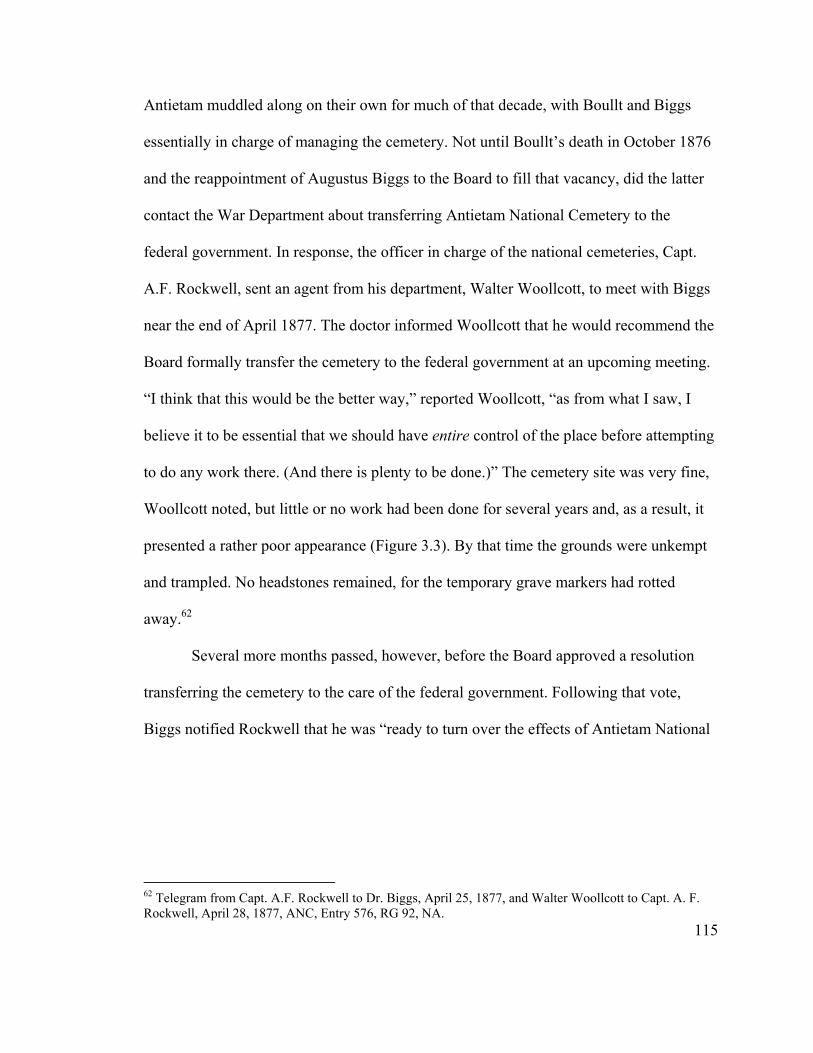
Antietam muddled along on their own for much of that decade, with Boullt and Biggs
essentially in charge of managing the cemetery. Not until Boullt’s death in October 1876
and the reappointment of Augustus Biggs to the Board to fill that vacancy, did the latter
contact the War Department about transferring Antietam National Cemetery to the
federal government. In response, the officer in charge of the national cemeteries, Capt.
A.F. Rockwell, sent an agent from his department, Walter Woollcott, to meet with Biggs
near the end of April 1877. The doctor informed Woollcott that he would recommend the
Board formally transfer the cemetery to the federal government at an upcoming meeting.
“I think that this would be the better way,” reported Woollcott, “as from what I saw, I
believe it to be essential that we should have entire control of the place before attempting
to do any work there. (And there is plenty to be done.)” The cemetery site was very fine,
Woollcott noted, but little or no work had been done for several years and, as a result, it
presented a rather poor appearance (Figure 3.3). By that time the grounds were unkempt
and trampled. No headstones remained, for the temporary grave markers had rotted
away.62
Several more months passed, however, before the Board approved a resolution
transferring the cemetery to the care of the federal government. Following that vote,
Biggs notified Rockwell that he was “ready to turn over the effects of Antietam National
115
62 Telegram from Capt. A.F. Rockwell to Dr. Biggs, April 25, 1877, and Walter Woollcott to Capt. A. F. Rockwell, April 28, 1877, ANC, Entry 576, RG 92, NA.
Cemetery to the agent who may be sent on.” The transfer was accomplished the last week
of September 1877, formally ending the tenure of the Association.63
Figure 3.3. Portion of an 1877 stereoview of Antietam National Cemetery, looking west toward the lodge building, from the general vicinity of the New York and Pennsylvania sections (author’s collection).
It took two years for the War Department to secure clear title to the cemetery,
owing to the fact that every state involved in its creation had to consent to the transfer. In
the meantime, Rockwell acted quickly in those areas where he had authority. He
appointed Hiram Siess, the Association’s long-time groundskeeper, as acting
superintendent and made arrangements for work to begin on improving the cemetery
grounds. In 1878, the Quartermaster General’s Department graded and resodded the
burial plots, repaired the lodge house and avenues, installed regulation headstones,
erected a flagpole, and planted a large number of deciduous trees along the avenues and
evergreens among the burial sections. The following year, the department constructed a
116
63 Postcard from A.A. Biggs to Capt. A.F. Rockwell, July 3, 1877, and James Gall, Jr., to Capt. A.F. Rockwell, September 26, 1877, ANC, Entry 576, RG 92, NA.

brick rostrum in the front part of the cemetery. In June 1880, civil engineer James Gall,
Jr., offered a flattering assessment of the changes that had been accomplished in an
inspection report to Capt. Rockwell: “The improvement in the appearance and condition
of the Antietam Cemetery since the Govt. assumed charge of it is great, and generally
remarked by the visitors and neighborhood residents, and each year will add to the beauty
and attractiveness of the place.” This resting ground of the Union dead had finally begun
to look like a national cemetery.64
Dedication of the Soldiers’ Monument
Once title to the national cemetery was finally secured in July 1879, Capt.
Rockwell lost no time in moving ahead with plans for erecting the soldiers’ monument
that had been part of the original cemetery design. The Board of Trustees had approved a
statue design in September 1867, representing an American soldier at parade rest. As a
result of the controversy over Confederate burials, it had not signed a contract with the
fabricator, James G. Batterson of Connecticut, until 1871. The trustees were not able to
pay for the monument, however, and it had remained with Batterson for the remainder of
that decade. In 1876 he transported the monument to Philadelphia, where it was
prominently displayed at the Centennial Exhibition, and may have been influential in
spreading the popularity of the sentinel statue across the North.65
64 James Gall, Jr., to Capt. A.F. Rockwell, October 30, 1877, H.S. Siess, Acting Supt., to Capt. A.F. Rockwell, January 9, 1878, James Gall, Jr., to Capt. Rockwell, April 8, 1878, May 11, 1878, and June 28, 1880, Capt. A.F. Rockwell to Jonathan Late, February 15, 1879, ANC, Entry 576, RG 92, NA.
117
65 The day before the cemetery dedication, the Board reviewed six proposed designs for the monument. It narrowed the field to three submitted by James G. Batterson and one by Col. W.Y. Selleck, a trustee from Wisconsin. After considerable discussion, one of Batterson’s designs was selected, “conditioned that the
Due to unfortunate circumstances—the top section of the monument fell into the
Potomac River while being transferred to a canal boat and had to be retrieved from the
river bottom before it could complete its journey up the C&O Canal to Sharpsburg—
installation of the monument in the national cemetery was not completed until early
January 1880. Later that spring, Capt. Rockwell began to think about the dedication of
the monument, initially looking toward the upcoming Decoration Day. Others convinced
him, however, that adequate planning required its postponement until the battle
anniversary.66
In its final official act, the cemetery Board of Trustees set to work making the
monument dedication happen. Taking their cue from Capt. Rockwell, the trustees
requested the Maryland Department of the Grand Army of the Republic (GAR) to lead
the ceremony, which it willingly agreed to do. The affair grew into a large-scale
celebration when the local GAR post, Reno Post No. 4, invited the entire Department to
attend a three-day campfire to be held September 15-17, 1880, in Hagerstown. This
campfire, held “under canvas” at the fairgrounds, proved highly successful and marked
style or position of the figure should be changed to the style of figure or statue submitted by Mr. Selleck.” Batterson also was the contractor for the central monument at Gettysburg National Cemetery. See Report of the Annual Meeting of the Trustees of the Antietam National Cemetery, June 5, 1867, and Proceedings of a Meeting of the Board of Trustees of the Antietam National Cemetery, held at Philadelphia, June 21, 1871, copies on file in ANC, Entry 576, RG 92, NA; Boullt, Minutes of the National Cemetery Board, September 16, 1867, WCHS; Snell and Brown, Antietam National Battlefield, 23-24; Michael Wilson Panhorst, “Lest We Forget: Monuments and Memorial Sculpture in National Military Parks on Civil War Battlefields, 1861-1917” (Ph.D. diss., University of Delaware, 1988), 220. 66 Capt. A.F. Rockwell to James Batterson, May 31, 1879, QM General, to Attorney General, July 1, 1879, S. Rutledge McNary to Capt. A.F. Rockwell, January 2, 1880, Capt. A.F. Rockwell to Dr. S.R. McNary, April 13, 1880, Milton G. Urner, House of Representatives, to Capt. A.F. Rockwell, April 15, 1880, S. Rutledge McNary to Capt. A.F. Rockwell, April 26, 1880, ANC, Entry 576, RG 92, NA; Susan Cooke Soderberg, Lest We Forget: A Guide to Civil War Monuments in Maryland (Shippensburg, Pa.: White Mane Publishing Co., 1995), 95-96.
118
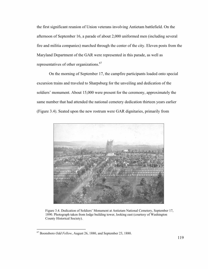
the first significant reunion of Union veterans involving Antietam battlefield. On the
afternoon of September 16, a parade of about 2,000 uniformed men (including several
fire and militia companies) marched through the center of the city. Eleven posts from the
Maryland Department of the GAR were represented in this parade, as well as
representatives of other organizations.67
On the morning of September 17, the campfire participants loaded onto special
excursion trains and traveled to Sharpsburg for the unveiling and dedication of the
soldiers’ monument. About 15,000 were present for the ceremony, approximately the
same number that had attended the national cemetery dedication thirteen years earlier
(Figure 3.4). Seated upon the new rostrum were GAR dignitaries, primarily from
Figu1890Coun
67 Boonsbo
re 3.4. Dedication of Soldiers’ Monument at Antietam National Cemetery, September 17, . Photograph taken from lodge building tower, looking east (courtesy of Washington ty Historical Society).
119
ro Odd Fellow, August 26, 1880, and September 23, 1880.
Maryland and Pennsylvania, several of the cemetery trustees, and the Republican
Congressman from the western Maryland district, Milton G. Urner. Republicans, in fact,
clearly dominated this event, as not a single representative of the Maryland state
government appears to have been present at the monument’s unveiling.68
Marriott Brosius, a Republican Congressman and Civil War veteran from
Lancaster, Pennsylvania, provided the main oration, described as “an able effort.” Unlike
the speeches offered 13 years earlier at the dedication of the national cemetery, Brosius’s
oration clearly laid blame for the war on the South and identified slavery as its cause.
“[Brosius] urged that all sectional pride, hate and jealousy should be wiped away,”
reported the Boonsboro Odd Fellow,
but there should be no forgetfulness of the past that would lull the nation into indifference to security for the future; no gushing sentiment of honor to those who died in the act of rebellion; no obliteration of the distinction between loyalty and treason, by equality of rights and ceremonies in their commemoration; no apotheosis of rebellion; no immunity to crime, by venerating the memory of its perpetrators. This would be neither rational nor patriotic. Our erring countrymen may not have sinned against conscience; they may have justified their act to themselves; but the republic can have no standard of law or morals that does not condemn as a crime the act of rebellion against her constituted authorities; and the only conceivable national basis of reconciliation and restoration is the recognition of the rightfulness of the war for the Union and entire acquiescence in its results.69
68 Boonsboro Odd Fellow, September 23, 1880. The trustees present were Ezra Carman from New Jersey, Augustus Biggs and Edward Shriver from Maryland, and General George Wright of Ohio. Milton Urner, a native of Frederick County, served in the 46th and 47th Congresses (1879-1883). See http://bioguide.congress.gov, Milton G. Urner, May, 2004, for additional information. 69 Boonsboro Odd Fellow, September 23, 1880. Marriott Brocius enlisted as a private with the 97th Pa. Vols. in October 1861 for three years, and reenlisted in May 20, 1864. He was wounded severely later that year and was discharged December 28, 1864. In February 1865, he was commissioned as a 2nd lieutenant for bravery on the battlefield. After the war he established a law practice in Lancaster, Pennsylvania. He entered Congress on March 4, 1889, and served in the House of Representatives until his death on March 16, 1901. See http://bioguide.congress.gov, Marriott Brosius, May, 2004, and http://www.millersville.edu/manuscripts/manus/manus021.htm, Marriott Brosius, May, 2004, for biographical information.
120

Clearly, the dedication of the colossal monument of the Union infantryman marked
Antietam National Cemetery as northern ground, once and for all. The decade-long
struggle between Democratic interests in the State of Maryland, who had sought to use
the battlefield to mediate its conflicted role during the Civil War, and northern and local
Republicans, who wished to memorialize the victory of the Union over the rebellious
South, had resulted in a resounding triumph for the latter.
At 21.5 feet in height, the statue dedicated that day may well be the largest of its
type in this country even today (Figure 3.5). The War Department constructed a four-foot
high embankment in the center of the cemetery to ensure that the sentry would be located
on the highest point of land inside the cemetery. Combined with its substantial pedestal,
the statue stands more than 44 feet high. Posed in an alert parade rest, his US belt buckle
prominently displayed over top of his great coat, this manly soldier proclaimed the
triumph of the North—within this cemetery, at the Battle of Antietam, and indeed of the
Civil War.70
Conclusion
From the beginning, the creation of Antietam National Cemetery was fraught with
controversy, as the State of Maryland’s attempt to bury Confederate soldiers within its
confines met stiff resistance from other states, as well as from some of its own board
members. This resistance was foreshadowed by the seemingly trivial dispute that arose
70 Panhorst, “Lest We Forget,” 219, 221; Scharf, History of Western Maryland, 1216. The simple inscription on the monument—“Not For Themselves But For Their Country September 17, 1862—reinforced this message.
121

Figure 3.5. Soldiers’ Monument at Antietam National Cemetery, late nineteenth century (courtesy of Washington County Historical Society).
122
over ‘Lee’s Rock,’ which became seen as a southern pollution that had to be removed
from the landscape, as well as by the negative reaction to the reconciliation-driven
dedication ceremony. The deep divisions separating the cemetery’s host state from the
northern states that supported it led to a lack of clear vision and meaning for the national
cemetery, in great contrast to the other state-sponsored national cemetery at Gettysburg.
This muddled sense of meaning continued for another decade, until the War Department
took charge of the burial ground and began to transform it. In the meantime, having been
rebuffed at Antietam, Maryland’s Democratic government ignored the battlefield for the
remainder of the century, focusing its commemorative efforts elsewhere.71
With the addition of the soldiers’ monument in 1880, the original conceptual
design for Antietam National Cemetery was complete. The era of the state-sponsored
Board of Trustees was now officially over. Under its tenure, the cemetery moved from its
initial purpose as a memorial to both sides of the Civil War to a resoundingly Union
landscape, dominated by the huge soldiers’ monument. The monument dedication also
marked the appropriation of the cemetery from a local to a national level. This task was
not to be accomplished without difficulty, however, as will be described in the next
chapter.
Thus, by the end of 1880, Antietam National Cemetery looked much like the
other national cemeteries established and managed by the War Department during the
preceding decades. And like those other cemeteries, most of which were located in states
that had comprised the defeated Confederacy, it embodied federal authority. The citizens
123
71 See Soderberg, Lest We Forget, for Civil War commemoration throughout Maryland.
of Sharpsburg identified closely with the cemetery, however, and would bitterly resist the
military’s attempts to co-opt what they viewed as an integral part of their community.72
124
72 See Catherine W. Zipf, “Making Union Victory in the South: The Construction of the National Cemetery System,” in Monuments to the Lost Cause: Women, Art, and the Landscapes of Southern Memory, ed. Cynthia Mills and Pamela H. Simpson (Knoxville: University of Tennessee Press, 2003), 27-45, for a discussion of the role of national cemeteries in the South as symbols of federal authority. Zipf focuses on the standardized design of elements such as flag poles, rostrums, gates, lodges, and white marble headstones as means for conveying this authority. For example, the Second Empire style chosen for the lodge buildings was the primary architectural style at that time for government buildings in Washington, D.C., such as the massive State, War, and Navy Building (now the Old Executive Office Building) and would have been seen as closely linked to northern domination of the region.
Chapter 4:
“Not for Themselves, but for Their Country”:
Early Commemoration at Antietam Battlefield
The first post-Civil War commemorative activities at Sharpsburg revolved around
Decoration Day and focused on remembering the dead recently interred in the national
cemetery. Such commemoration mirrored the nation as a whole, which struggled in the
immediate aftermath of the war to come to grips with the massive numbers of casualties
created by the conflict. Observance of Decoration Day, usually set for May 30 and
involving the decoration of graves with flowers, was well established in both the North
and the South by the close of the 1860s. In Sharpsburg, the local population, particularly
Republicans and northern veterans eager to show their loyalty to the Union in a solidly
Democratic state, marked the day with great fanfare. In fact, the Republicans and
veterans not only controlled commemorative activities at Antietam National Cemetery,
but through the local Board of Trustees members essentially controlled the cemetery as
well, with little or no input from state or national authorities throughout most of the
1870s.1
By the end of that decade, however, the cemetery again became contested space—
at a physical level when the War Department assumed management over it, and at a
125
1 Much has been written about the origins of Decoration Day. While many credit General John A. Logan, commander-in-chief of the Grand Army of the Republic (GAR), with initiating in May 1868 this ceremonial ritual of decorating the graves of the war dead, David Blight documents the first Decoration Day as occurring in Charleston, South Carolina, on May 1, 1865, when black South Carolinians and northern abolitionists decorated the graves of Union soldiers buried in that city. See David Blight, Race and Reunion: The Civil War in American Memory (Cambridge, Mass.: The Belknap Press of Harvard University Press, 2001), for an overview of the history and meaning of Decoration Day.

commemorative level as Union veterans of a Grand Army of the Republic (GAR) post
based in Hagerstown assumed a larger role in the ceremony. The increasing authority of
these outsiders created discord among the Sharpsburg citizenry, who sought to maintain
control over what they perceived to be their own property. While they were unsuccessful
in their efforts to maintain physical control of the burial ground, the townspeople were
able to regain considerable power over commemorative activities at the national cemetery
when they established their own GAR post—Antietam Post #14—in the mid 1880s. As
was the case with the previous dissension over meaning that surrounded the creation of
the national cemetery, these disputes reveal a continued lack of alignment between the
local population and other groups. A clear remembrance of the battle and its aftermath
had yet to be articulated.
A growing number of veterans began returning to Antietam in the early 1880s to
mourn their fallen comrades and relive their battle experiences. The veterans’ personal
experiences at Antietam, however, did not translate into organized support for creation of
a battlefield park, as happened elsewhere. Several factors help to explain the lack of
organized veteran support, all grounded in the larger discourse and politics of Civil War
memory at that time. The effective marketing of Gettysburg led to its all-encompassing
dominance in the minds of the Union veterans of the Army of the Potomac, the same
force that had fought at Antietam. Antietam’s location in a conflicted border state south
of the Mason-Dixon Line, one that lacked an effective statewide GAR organization to
push the battlefield, also created ambivalence toward it. In addition, the conflicts over the
national cemetery prevented the creation of a clear message of remembrance and instead
126
complicated it considerably. The results of this complicated, untidy commemoration are
seen in the lackluster silver anniversary of the Battle of Antietam (particularly when
contrasted with the event at Gettysburg), and in the subsequent legislative history of the
battlefield.
Decoration Day in Sharpsburg – A Community Observance
On the afternoon of May 30, 1869, a special train carried several hundred people
from Hagerstown to Sharpsburg, where they were “joined by loyal hearts from
Sharpsburg, Boonsboro, Keedysville, and the surrounding country, swelling the number
to over one thousand.” The crowd formed a lengthy procession that marched up the main
street of Sharpsburg to Antietam National Cemetery, where it covered the numerous
graves with flowers. After a “neat little address” and the singing of a hymn “the crowd
dispersed for their respective homes, all resolved that, on next ‘Memorial Day,’ should
their lives be spared, they would return again to strew flowers over the graves, and renew
their vows of devotion to the memory of the sacred dead.” Thus passed the first
Decoration Day in Sharpsburg, planned and led by the local citizenry.2
Sharpsburg and Washington County were joining in a new, nationwide custom
celebrated for the first time the previous year when John A. Logan, Commander-in-Chief
of the GAR, designated May 30, 1868, as a day for all Union veterans to decorate the
graves of their fallen comrades. Although Logan’s notice had been printed in the local
paper that first year, no evidence has been uncovered to show that such a ceremony
127
2 Boonsboro Odd Fellow, June 4, 1869. Sharpsburg residents David Zeller and Dr. Augustin Biggs served as marshall and assistant marshal, respectively, joined by a second assistant marshal, Col. Edward Mobley, from Hagerstown.
occurred at Antietam. Indeed, only one week’s notice had been provided for the 1869
commemoration.3
In May 1870, the citizens of Sharpsburg were better prepared for Decoration Day
under the leadership of Dr. Augustus Biggs. In addition to the cemetery procession, they
arranged a more elaborate program that set the tone for the coming decade. The program
included music by the African-American Moxley Band from Hagerstown, hymns, and an
oration by local veteran Col. E.F. Anderson. “Long before the procession reached the
portals of the cemetery, the grounds were alive with people, come to scatter upon the
soldiers’ graves the mute but eloquent tributes of their gratitude and affection,” recounted
a local newspaper. “Many had brought carriage loads of flowers with them to deck the
graves. Many who had come afoot from the surrounding country brought their modest
floral offerings too, and more than one narrow grave was beautifully decked long before
the hour for the ceremonies had arrived.” Children from the different Sunday schools in
town led the procession to the cemetery: “It was a most beautiful sight, and one
calculated to move the heart, to see those little children, doubtless many of whom had
suffered from the cruelties of war in the loss of a father or a brother, bearing in their
hands fresh flowers, mute but eloquent tributes of their affection for the departed heroes
who died to secure to them liberty and future peace.” In his speech, Anderson stressed
emancipation of the slaves as the lasting result of the Battle of Antietam. Following the
128
3 Boonsboro Odd Fellow, May 15, 1868, and June 4, 1869; Blight, Race and Reunion, 71. According to Blight, 183 cemeteries in 27 states participated in Decoration Day in 1868; a year later these numbers had increased to 336 cities and towns in 31 states.

oration, the Moxley Band played “a mournful dirge while the crowd filed through the
different avenues and scattered the flowers over the graves.”4
Capt. J.M. Mentzer served as Chief Marshal for this occasion, with Capt. William
F. Cronise, Samuel I. Piper and Charles W. Adams serving as Assistant Marshals. All
three Assistant Marshals were active Unconditional Union/Republican party members
from Sharpsburg, and veteran Mentzer most likely was a member of this party as well.
Their allegiance is reflective of Sharpsburg as a whole, as the community voted
Republican in every election for the remainder of the nineteenth century, even as the rest
of Washington County consistently cast the majority of its ballots for the Democrats.
Thus, it is not surprising that Decoration Day, already associated on a national level with
the Republicans, became closely entwined with that party on a local level at Antietam
National Cemetery as well.5
Over the next few years the leadership for Decoration Day consisted primarily of
prominent Republican veterans and politicians from Sharpsburg and Hagerstown.
Thomas A. Boullt, Secretary/Treasurer of the Antietam National Cemetery Association
and a Democrat, proved the one exception as he became an active leader of this event
4 Boonsboro Odd Fellow, June 3, 1870, and June 10, 1870. In his address, Anderson stated: “Aided by the perspective of time and the light of subsequent events, we have slavery revealed to us as the great, prime cause of the rebellion. Looking back upon all the alleged causes which were set up, and beholding them as they recede into the past, one after another diminishes out of view, while human slavery—the same that was made of the corner-stone of the Confederacy—appears to tower above all, overshadowing all. . . . Here, then, on this classic ground our soldiers stood from the rising to the setting of the sun, pleading, ‘with arguments of bloody steel,’ the cause of a helpless race.” In 1871 the Moxley Band was joined by three other local bands, and thereafter several bands generally participated each year. The Moxley Band participated in Decoration Day at least through 1873, but beginning in 1876 they were replaced by the Hagerstown Band. It is not known whether the Moxley Band dissolved, or was not allowed to play anymore.
129
5 Boonsboro Odd Fellow, September 18, 1868, November 13, 1868, and September 14, 1876; Thomas J.C. Williams, A History of Washington County, Maryland, (1906; reprint, Baltimore: Regional Publishing Company, 1967), 411-412.

from 1871 until his death in 1876. Most speakers during this period were well known
Republicans as well. By the mid-1870s, Decoration Day at Antietam National Cemetery
had become a much-anticipated event on the part of the local population, particularly
Unionists, who looked forward to the annual commemoration. The Boonsboro Odd
Fellow recorded that “business was entirely suspended in the neighborhood, and
merchants, mechanics, and farmers came with their wives and children, bearing boquets
[sic] and baskets of flowers, showing how deep a hold this annual Decoration Day has
taken upon the affections of the people.”6
The Centennial year marked a new era for Decoration Day at Antietam National
Cemetery, as it was the first time the local GAR post—Reno Post No. 4 mustered in
Hagerstown—became involved in the ceremony. On May 1, 1876, the GAR national
headquarters issued a general order requesting the participation of each of its Posts in
commemorating Memorial Day. In response, Reno Post Commander Edward Mobley
issued a directive for its members to assemble at the cemetery at noon on May 30 “to
participate in the ceremonies of decorating the graves of our fellow comrades.” Mobley
had been a leading figure in the previous Decoration Day ceremonies, but in an
individual capacity only.7
The GAR had been established in 1866 as a highly partisan organization of Union
veterans devoted to the Radical Republican cause. By the early 1870s its membership had
6 Boonsboro Odd Fellow, June 3, 1870, March 10, 1871, April 14, 1871, June 2, 1871, June 7, 1872, and June 6, 1873. Confederate sympathizers celebrated their own Decoration Day, usually during the first week of June, at the Confederate burial grounds in Elmwood Cemetery, Shepherdstown, West Virginia, and Washington Confederate Cemetery, Hagerstown. Their ceremonies followed the same format as Union Decoration Day, involving speeches, music, and strewing flowers on the graves.
130
7 Boonsboro Odd Fellow, May 18, 1876.

declined precipitously owing to a number of factors, including economic depression, the
debate over Reconstruction, and a general desire to forget the war. In fact, by 1875 the
Maryland Department of the GAR, never particularly strong, had become defunct. The
GAR revived in the late 1870s, however, swept up in the growing popularity nationwide
of fraternal organizations and a renewed interest in remembering the war. Reno Post No.
4 was one of many GAR posts created or revived during that period.8
The Reno Post played a relatively minor role at its first Decoration Day. It
participated in the procession to the cemetery, but did not appear to take part as an
organization in the planning of the event. In fact, the ceremony remained under local
control throughout the 1870s. The one exception was 1878, the first year of War
Department administration of the national cemetery, when management of Decoration
Day apparently came from outside Sharpsburg. The following year, however, prominent
residents such as Dr. Augustin Biggs and Charles W. Adams resumed their leadership
role.9
The War Department Assumes Control
When the War Department assumed management of Antietam National Cemetery
in the summer of 1877, it retained the Association’s keeper, Hiram Siess, as Acting
8 Stuart McConnell, Glorious Contentment: The Grand Army of the Republic, 1865-1900 (Chapel Hill: University of North Carolina Press, 1992), xiv, 32-33, 52; Gerald F. Linderman, Embattled Courage: The Experience of Combat in the Civil War (New York: The Free Press, 1987), 275-276. Linderman refers to the period from 1865-1880 as one of “hibernation.” He observes that membership in the GAR jumped from 30,000 in 1878 to 146,000 in 1883, 233,000 in 1884 to 320,000 in 1887, and that the organization reached its zenith in 1890 with 428,000 members. Blight prefers the term “incubation” for the 1865-1880 period, suggesting that veterans’ memories were “more festering than sleeping, and growing into a cultural force” (Race and Reunion, 149-150).
131
9 Boonsboro Odd Fellow, June 1, 1876; Hagerstown Mail, May 25, 1877, June 7, 1878, and May 9, 1879.
Superintendent. A Sharpsburg native and Union veteran, Siess had served for three years
as a sergeant in Company B of the 1st Maryland Potomac Home Brigade. Once the War
Department gained title to the cemetery, it began looking for a permanent superintendent.
Siess applied for the position, reserved by law for honorably discharged and disabled
Civil War veterans, observing that “although not wounded I was struck several times with
the enemies balls, but from these I received no material injury.” Instead, he had suffered
from extremely painful hemorrhoids, contracted while carrying heavy equipment on drills
and marches, but “never made application for a discharge on account of disability;
desiring if possible to serve my full term of enlistment.” Siess also related that while
employed by the Board of Trustees, he had not received the last two years of his salary.
In a note written on the back of this application, Quartermaster General Montgomery
Meigs noted that the keeper could be retained until a new superintendent was appointed,
suggesting that Seiss’s application was not considered.10
By passing over the local candidate, Meigs most certainly was asserting national
authority over the national cemetery. He appointed instead an outsider with no ties to the
community, but, as became apparent, a man of suspect character as well. On April 7,
1879, George A. Haverfield arrived as the first military superintendent of Antietam
National Cemetery. He had been wounded severely at the Battle of Cedar Creek in 1864,
losing one leg and leaving the other badly shattered. Haverfield moved into the lodge
132
10 Hiram Siess to Capt. A.F. Rockwell, August 26, 1878; Antietam National Cemetery Board (ANC), General Correspondence of the Office of the Quartermaster General, 1865-1890 (Entry 576), Office of the Quartermaster General, Record Group 92 (RG 92), National Archives, Washington, D.C. (NA). Siess had moved into the lodge building in 1868, but did not begin receiving a salary until June 1871. Meigs also passed over the local cemetery keeper at Gettysburg. See Charles Snell and Sharon Brown, Antietam National Battlefield, an Administrative History (Washington, D.C.: Government Printing Office, 1986), 47, and Harlan D. Unrau, Administrative History, Gettysburg National Military Park and National Cemetery, Pennsylvania (Washington, D.C.: Government Printing Office, 1991), 27.
along with Thomas Benner, a laborer employed at the cemetery, and Benner’s wife, Ida.
The superintendent’s family had remained out west, where his wife either was studying
or practicing medicine.11
This arrangement proved a costly miscalculation on Haverfield’s part. Benner
soon became suspicious of his wife and the superintendent. One Saturday night
Haverfield and Benner went into town drinking and did not return until after midnight.
The next morning, Ida found Benner lying drunk on the floor. “The moment he saw me
he commenced cursing and abusing me fearful,” she later related. “He said, ‘Ida, if you
don’t confess that Lieutenant Haverfield has the advantage of you I’ll kill you.’ I said,
‘Tom, I have nothing to confess, I am innocent of this accusation as the angels.’ He
immediately left the room. In a short time he returned holding a piece of wood in one
hand and a case knife in the other. He came towards me and I walked towards the corner
of the room where the gun was. I saw from his face that he intended to kill me.” When
Benner raised the knife, she shot him at close range. Awakened by the shot, Haverfield
rushed downstairs and found Thomas Benner lying dead near the front door of the lodge.
Ida Benner, who was about five months pregnant at the time, was brought before the
circuit court judge and released upon payment of bail by her father, canal boatman James
Marmaduke, and prominent Sharpsburg merchant Charles W. Adams.12
Shortly thereafter, Haverfield’s superior, Capt. A.F. Rockwell, succinctly related
to Quartermaster General Meigs what had transpired: “Haverfield, having no family with
11 Snell and Brown, Antietam National Battlefield, 48; R.S. Lacey to Gen. M.C. Meigs, August 19, 1879, ANC, Entry 576, RG 92, NA. .
133
12 Hagerstown Mail, August 1, 1879. Adams later would become the first superintendent of Antietam National Battlefield Site.

him, had his laborer and the laborer’s wife live in the lodge, and boarded with them. The
husband got jealous of the superintendent, and, rather reversing the usual order in such
cases, the husband was shot dead by the accused wife.” Rockwell recommended that the
superintendent remain at his post for the short term, as immediate removal “might look
too much like getting Haverfield out of the way of the civil authorities.” At the end of
November 1879 a Grand Jury declined to indict Mrs. Benner, determining that she had
killed her husband in self defense. The following March, less than a year after reporting
to Antietam, George Haverfield was reassigned to the national cemetery at Natchez,
Mississippi.13
A strict disciplinarian with high regard for rules and regulation, Meigs believed
that the Haverfield debacle was only symptomatic of larger problems involving Antietam
National Cemetery and the citizens of Sharpsburg. To deal with this situation, Meigs
appointed a very different type of person in place of Haverfield. The new superintendent,
William A. Donaldson, transferred from City Point National Cemetery in central
Virginia. Shortly before Donaldson’s appointment, Meigs had published the first set of
regulations covering the national cemetery system. These rules placed strict constraints
on visitor behavior consistent with the sacred nature of the cemetery grounds. Visitors
were expected to be “orderly and civil,” and picnics and other similar activities were
13 Capt. Rockwell to QM General, August 20, 1879, ANC, Entry 576, RG 92, NA; Hagerstown Mail, November 28, 1879; Snell and Brown, Antietam National Battlefield, 48. Ida Benner, who was only 18 years old, moved in with her parents and delivered a son in December.
134
forbidden. As befitting a good soldier, Donaldson worked hard to apply these standards at
his new duty station.14
Less than five months after his arrival, Donaldson also found himself in a difficult
situation, albeit very different from Haverfield’s, when a number of townspeople rose up
against his strict enforcement of policy. A group of 48 Sharpsburg-area citizens,
consisting primarily of working class men (laborers, boatmen and tradesmen), submitted
a petition to the Secretary of War in early August 1880, in which they called for
Donaldson’s removal “on the ground that his conduct since his residence here has been
wholly inconsistent with that of a gentleman and an officer of the United States.”
Ironically, they requested the reappointment of Lt. Haverfield, “who is highly esteemed
in this community as a gentleman of culture and refinement.”15
At the same time, cemetery employee William Mose wrote a letter to the
superintendent’s superior, Capt. A.F. Rockwell, outlining his own charges against
Donaldson. These included ungentlemanly behavior toward females, “many of whom he
has so grossly insulted since his residence here that very few ladies now visit the
cemetery”; violations of regulations, such as pasturing his horse and cow in the cemetery
“much to the injury of the shrubbery & hedge fence which they sometimes break through
& trample down”; and paying wages to his son whether he worked or not. Mose also
charged that Donaldson’s behavior toward him had been unjust, as the latter had not paid
14 Snell and Brown, Antietam National Battlefield, 48. A native of England, William A. Donaldson had served in the 71st New York Regiment during the war.
135
15 Petition to Sec. of War for removal of Capt. Walter A. Donaldson, August 2, 1880, ANC, Entry 576, RG 92, NA; 1880 Census, Sharpsburg District. Of the 47 men listed on the petition, 33 (70%) lived in the town of Sharpsburg and the remainder in the surrounding Sharpsburg District.

him for some of his work. When Mose brought this fact to the attention of the
superintendent, “he flew into a passion & called me a d—n liar & a son of a b— &
attempted to strike me with a watering can half full of water when I knocked him down.
As this occurred in the presence of a deputy sheriff, who happened to be on the ground at
the time, but who was a stranger to me, we were both arrested & taken before a
magistrate, which I very much regretted.” Mose requested an investigation of Donaldson,
particularly for his violation of regulations, and concluded “Capt. Donaldson lacks many,
if not all, the characteristics of a gentleman. In fact, he is the town talk.”16
In response, Donaldson averred that he was “unable to recall any action of mine
towards females that can deserve such strong language [on the part of William Mose]. I
have often had occasion to speak to persons not to sit on headstones, base of monument
of the mound which circles foundation of the monument, these visitors so offending were
mostly females.” He acknowledged that his cow had gotten into the cemetery through an
open gate, while grazing along the turnpike, and that he had put his horse out in it while
the stable was being completed. Also, during a time when Donaldson was sick his son
had done some work for him over the summer. He was not aware that Mose had not been
paid for all the time he had worked, “but when . . . I notified him that I should work but
one hand in August, and that he would not be needed, a short time after he became very
insolent and demonstrative.” In closing, Donaldson also requested an investigation of the
charges, so that his name could be cleared.17
16 William Mose to Capt. Rockwell, August 2, 1880, ANC, Entry 576, RG 92, NA.
136
17 William Donaldson to Lt. John McGilvray, August 12, 1880, ANC, Entry 576, RG 92, NA.

After mulling over the situation, Donaldson followed up with a second letter two
days later, providing his perspective on the lengthy sequence of events leading to the
acrimonious state of affairs at Antietam National Cemetery:
In making this report I am not actuated by hopes of escaping censure for past official acts deserving blame, but from a sense of having been grossly maligned. Communities great or small like individuals maybe mislead [sic] by prejudice, ignorance or what is still worse a train of circumstances tending to—and culminating in a belief of ideas at variance with common sense. The Antietam Cemetery was founded and perfected by a body of commissioners from different states whose citizens fell in the battle occurring in this locality. A prominant [sic] man of Sharpsburg [Biggs] was made superintendent and a native of the village placed in the lodge as keeper [Siess]. Now whilst not reflecting on the management of these parties, still it is presumable and might readily occur, that from family as well as social relations, in the direction of the cemetery government after completion be very favorable to adjacent communities, admitting such privileges, which, from continued enjoyment might easily be considered unassailable rights, and such has been the case in this instance.
When I relieved Supt Haverfield in March last, I attributed much of his sensible information volunteered at that time as being imbibed in ideas consonant to the unfortunate circumstances attending his career at this cemetery—subsequent experience has proved the correctness of his statements.
In my experience of the national cemeter[ies] obtained at Hampton Beaufort & City Point where law, decorum and the completest order was the rule I arrive at this cemetery and a totally different state of affairs prevail. As a superintendent of national cemeteries I have never had occasion to call the attention of visitors to the rules until my arrival here, where the occurrence was daily the first three months of my charge. Permit me to give a few instances—the first Sunday after my arrival I met a large number of persons in the office or rather as it was then styled (the Reception Room) the visitors register lay on a center table with a dozen chairs grouped about. Spittoons, tumblers and a pitcher of water were supplied, we smoked and talked . . . until near midnight, strangers dropping in all the while, all very sociable and pleasant but not in accord with my ideas of a lodge in an office located at the gates of a cemetery.
He added that such social relations were no longer encouraged at the lodge, and that
smoking was no longer permitted in the office (Figure 4.1). Donaldson continued with
additional, and somewhat lurid, details about community practices at the cemetery:
137
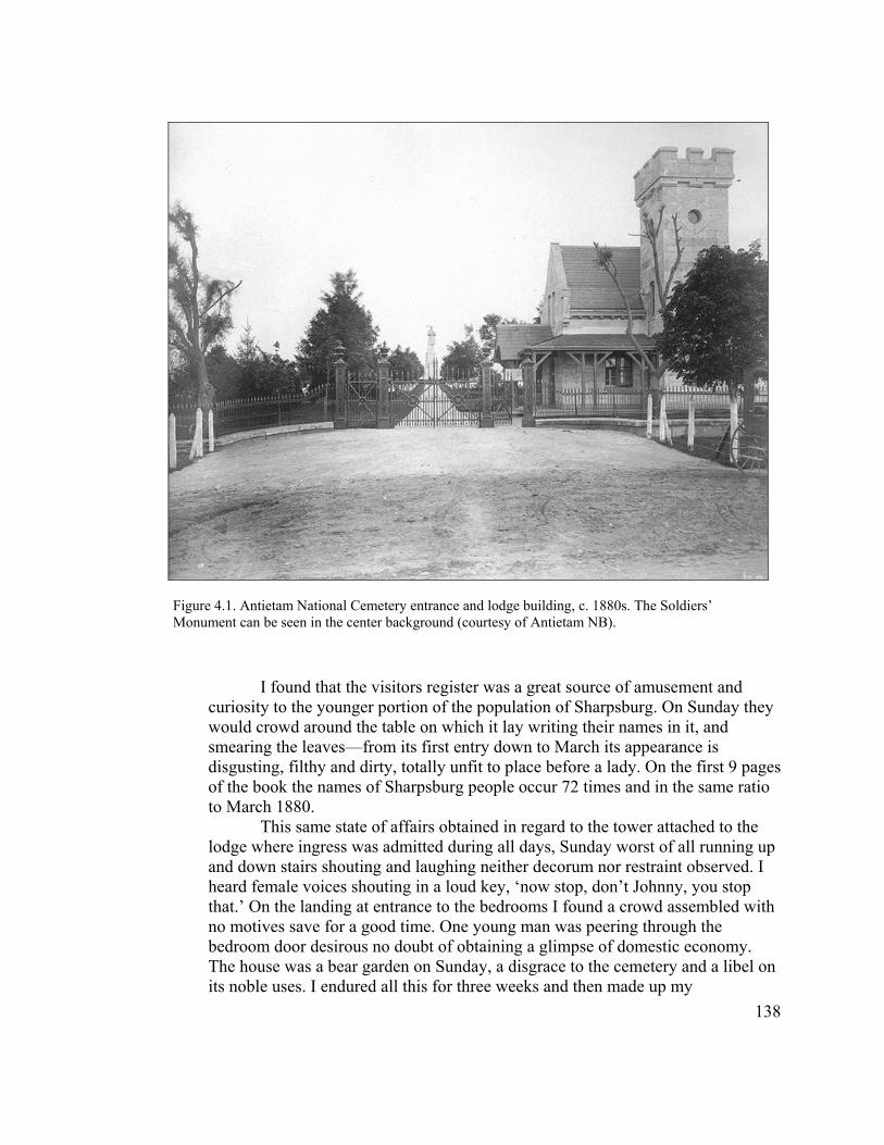
I found that the visitors register was a great source of amusement and curiosity to the younger portion of the population of Sharpsburg. On Sunday they would crowd around the table on which it lay writing their names in it, and smearing the leaves—from its first entry down to March its appearance is disgusting, filthy and dirty, totally unfit to place before a lady. On the first 9 pages of the book the names of Sharpsburg people occur 72 times and in the same ratio to March 1880.
Figure 4.1. Antietam National Cemetery entrance and lodge building, c. 1880s. The Soldiers’ Monument can be seen in the center background (courtesy of Antietam NB).
This same state of affairs obtained in regard to the tower attached to the lodge where ingress was admitted during all days, Sunday worst of all running up and down stairs shouting and laughing neither decorum nor restraint observed. I heard female voices shouting in a loud key, ‘now stop, don’t Johnny, you stop that.’ On the landing at entrance to the bedrooms I found a crowd assembled with no motives save for a good time. One young man was peering through the bedroom door desirous no doubt of obtaining a glimpse of domestic economy. The house was a bear garden on Sunday, a disgrace to the cemetery and a libel on its noble uses. I endured all this for three weeks and then made up my
138

determination how to act in the future. I placed the register in the desk under lock & key. I also locked the office door also that to the tower stairs. If a visitor wished to enter the office they could ring the bell, the door was opened and their wishes attended to, if from a distance, I was sent for to give any information desired. Persons in Sharpsburg wishing to ascend the tower were invited to do so during the week. This also applied to the office and permit me to state that the people of Sharpsburg whose good opinion we might value have one and all applauded and approved the reform. Also let me add that I never allow any young couple of different sexes ascend the tower save accompanied by myself.
He expressed his determination to prevent the lodge and cemetery from being used as
rendezvous points, or from allowing loafing on warm days and young people
congregating on Sundays. “Now I patrol the cemetery every Sunday afternoon until the
young people return to the village.” Donaldson finished this long, explanatory letter with
the statement:
There is but this conclusion to arrive at in my mind, all visitors outside of Sharpsburg enter the cemetery with feelings of respect and veneration while the latter from long acquaintance and circumstances before alluded to, regard the place as designed for pleasure and amusement, and view with jealous eye and angry suspicion a strange man who unknown steps in and places restrictions on that which hitherto had been as free as water.18
Quartermaster General Montgomery Meigs, a career military man who viewed the
national cemeteries as the embodiment of federal authority, supported his beleaguered
superintendent and maintained that no investigation was necessary. “Mr. Donaldson was
a gallant officer and has made a faithful supt,” observed Meigs. “So far as known, the
dissatisfaction expressed . . . arises out of the efforts of the supt. to enforce the orders of
the Dept. regarding the preservation of good order, the proper protection of the grounds,
and forbidding the use of the grounds of the Cemetery for picnics.” In answer to Mose’s
139
18 Supt W.A. Donaldson to Lt. John McGilvray, August 14, 1880, ANC, Entry 576, RG 92, NA.
charges, he instructed Donaldson not to employ his son anymore, and to keep his cow
and horse off the cemetery grounds. As for Mose, if he felt that wages were owed to him,
he should file a claim. In turn, the Secretary of War informed the petitioners that unless
specific charges were made against Donaldson, “the Department can not make
cognizance of the petition.”19
The stakes were raised toward the end of August, when Charles G. Biggs, son of
the former Board of Trustees superintendent Augustin Biggs and now a prominent
Sharpsburg lawyer, wrote local Republican Congressman Milton G. Urner requesting his
assistance in removing Donaldson from his position at Antietam. “Very shortly after his
appointment he instituted a great many regulations entirely uncalled for and
unnecessary,” asserted Biggs, “and in carrying them into effect acted in the most arbitrary
and offensive manner to many of our best citizens, among them some of the most
respected ladies in the community.” He cataloged the grievances against Donaldson
previously expressed by William Mose, adding that he had served as Mose’s lawyer and
had “obtained his acquittal as a matter of course under the circumstances.” Biggs made it
clear that the urgency in the matter arose from political considerations:
I have taken no active part up to this time in the opposition to him but now as a Republican and member of the County Central Committee I feel it my duty to make an effort to effect his speedy removal, because a number of ex-soldiers here, justly indignant at the treatment of their comrades by a subordinate official, have declared if the party won’t protect them they will not support the party. The retention of Donaldson means the loss of 15 or twenty votes to us in the district.20
19 1st Endorsement, QM General’s Office, August 27, 1880, enclosed with Petition to Sec. of War for removal of Capt. Walter A. Donaldson, August 2, 1880, QM General to Lt. John McGilvray, August 18, 1880, Chief Clerk, Secretary of War, to D.M. Smith, Sharpsburg, August 31, 1880, ANC, Entry 576, RG 92, NA. Mose filed a claim for three hours salary. See William Mose to Lt. John McGilvray, August 24, 1880.
140
20 Charles G. Biggs to Hon. Milton G. Urner, August 30, 1880, ANC, Entry 576, RG 92, NA.
Two weeks later Biggs followed up with a petition to Urner, which he hoped the
Congressman would forward to the Secretary of War. This second petition undoubtedly
was in response to the Secretary’s earlier statement that he would not take any action
unless specific charges were leveled against Donaldson. The document listed seven
charges, basically a restatement of the accusations made against him by William Mose,
and carried 39 signatures. Two-thirds (23) of the names on this new petition had been
listed on the first one submitted earlier.21
Upon receipt of the second petition, the Quartermaster General recommended a
formal investigation of the charges, and assigned inspector Lt. John McGilvray to the
task. McGilvray arrived in Sharpsburg on October 4 and interviewed Charles Biggs, Peter
Mose (brother of William Mose), and William Donaldson. In his interview with Biggs,
the lawyer declared “I know nothing about that” for four of the seven charges. When
asked if he knew anything else against the superintendent not already brought up against
him, Biggs replied “I know that he is unpopular here, and I believe that he is a very strict
disciplinarian [emphasis in original].”22
Peter Mose related what he knew concerning the charges, and provided several
instances of rude behavior on Donaldson’s part toward ladies. For one of these, involving
a Mrs. Snyder and two other women from Sharpsburg, he stated that “the ladies were
sitting on the base of the monument, and Donaldson told them in a very abrupt manner to
21 Petition to Hon. Milton G. Urner, undated, submitted by Charles G. Biggs, September 13, 1880, ANC, Entry 576, RG 92, NA.
141
22 Report from QM General to Secretary of War, September 14, 1880, M.C. Meigs to Maj. Gen. W.S. Hancock, Commander Mil. Div. Of the Atlantic, September 15, 1880, Report of John McGilvray to QM General, October 9, 1880, ANC, Entry 576, RG 92, NA.

‘get off there,’ and said they looked as if they ought to have more sense.” McGilvray then
met with Superintendent Donaldson, who answered each of the charges brought against
him. In reference to the Snyder incident, “I was down near the lodge at work,” he
remembered, “when I saw these women sitting on the base of the monument, apparently
eating; I went up and said, ‘Ladies, I must beg of you to come down off that monument, ‘
and they came down, and the elder of the three said, ‘Why, we are in the habit of doing so
in our own Cemeteries [emphasis added].’ I then said ‘Madam, you look too well bred
ever to act with such impropriety.’”23
Satisfied that Donaldson’s actions did not warrant censure, McGilvray
recommended no further action. Capt. Rockwell passed these findings along to
Congressman Urner: “Supt. Donaldson has done his duty, and so far as I can learn done it
well. The whole trouble arises, I think, from the fact too many people have used the
cemetery as a general loafing place and the superintendent has worked to break up this
practice.” In conclusion, Rockwell confirmed that Donaldson “was sent there for that
purpose,” corroborating the fact that the Quartermaster General viewed the local
populace as troublemakers in need of better discipline.24
The Sharpsburg townspeople, galvanized by Charles Biggs and a handful of
others, were not content to let the matter rest. Over the winter they circulated yet another
petition for the removal of William Donaldson and the reinstatement of Lt. George
Haverfield, and gathered 276 signatures before submitting this third petition to Capt. A.F.
23 Report of John McGilvray to QM General, October 9, 1880, ANC, Entry 576, RG 92, NA.
142
24 Report of John McGilvray to QM General, October 9, 1880, A.F. Rockwell to Milton G. Urner, October 18, 1880, ANC, Entry 576, RG 92, NA.

Rockwell in mid-April 1881. “Capt. Donaldson, we regret to say, has lost the respect of
this community & to such an extent has he carried his ungentlemanly conduct,” explained
the accompanying cover letter (most likely written by Charles G. Biggs), “that many are
apprehensive there will be no decoration next month as those who arranged the
decorations in former years will have nothing to do with it under the present
circumstances.” The document noted the superintendent’s insulting behavior toward
visitors, especially “unprotected ladies,” to the point that “our wives & daughters are
unwilling to expose themselves to the risks a visit to the Cemetery involves.” It
concluded that Donaldson “has rendered himself very obnoxious to our people, hence the
petition asking for his removal.”25
Near the end of April four of Sharpsburg’s leading citizens—Charles G. Biggs,
Charles W. Adams, G.F. Smith, and J. David Smith—also petitioned Congressman Urner
to use his influence with the Quartermaster General “in connection with a petition that
was sent from here last week to the Quartermaster General’s Office containing 276
names, some of the best men of the county as you will see by examining the petition.”
They wanted Urner’s assistance in removing Donaldson and reappointing Haverfield, “on
the ground that the present keeper does not give satisfaction, and the citizens are losing
all interest in the Cemetery.” As before, the Congressman forwarded this appeal to the
Secretary of War, requesting “such action taken as the case requires.”26
25 Petition to Capt. A.F. Rockwell from citizens of Sharpsburg, April 13, 1881, ANC, Entry 576, RG 92, NA.
143
26 Petition to Hon. Milton G. Urner, April 26, 1881, ANC, Entry 576, RG 92, NA. In contrast to Donaldson, according to the petition, George Haverfield “was highly esteemed and consequently the citizens took an interest in the cemetery.”

As part of a scheduled inspection of Antietam National Cemetery, engineer James
Gall, Jr., visited Sharpsburg in May and submitted a short report to Gen. Benjamin Card,
the officer in charge of the national cemetery system. This report was highly favorable
toward Donaldson, with Gall observing that the superintendent managed the cemetery
very well and that he had never seen it in such complete order. Most importantly,
Donaldson was “spoken well of by the best people of the neighborhood.” In a private
note enclosed to another officer, Gall elaborated on his findings:
I spent Saturday night and Sunday at Antietam and Sharpsburg and gained such information as I could in regard to Donaldson’s case. The best speak well of him, and I am thoroughly convinced that he is in every way a better man for the place than Haverfield. The complaints against him are such as should recommend him to the Dept. He has endeavored successfully to curb a license that was permitted by Siess, and only partially abolished by Haverfield, which allowed the people of the place to do pretty much as they pleased in the cemetery. In doing this Donaldson has of course drawn upon himself the enmity of a certain (the worst of course) class of people, who say that he insulted them, etc. Heretofore the Cemetery has been used as a lounging place for the floating part of the citizens, canal men, loafers, young fellows and their sweethearts, and Donaldson has insisted that [when] these people visit the cemetery they must behave them selves [sic], respect the place and conform to the rules established by Congress and the Dept.
He also related that Dr. Augustus Biggs, while not exactly a great personal admirer of
Donaldson, “is compelled to say that he takes good care of his Cemetery, and says further
that if he were D. he would be still more strict with the people of the place who visit the
cemetery.” Gall took a dim view of those leading the campaign to remove the
superintendent, stating that these men were discharged laborers and office-seeking
politicians “who expect advantage from the reemployment of these men in the cemetery.”
144
He concluded that he had heard many things about Haverfield that he did not care to
repeat—“enough that he ought by no means to return to the Antietam Cemetery.”27
Following Gall’s report, the Secretary of War informed Congressman Urner that
the Quartermaster General had specifically selected Mr. Donaldson for the position at
Antietam National Cemetery, and that the superintendent had performed his duties to
Meigs’ satisfaction. Therefore, no further action would be taken regarding the petitioners’
request. This finally put the matter to rest and Donaldson retained his position without
further controversy for another six years, until July 1887.28
The conflict between William Donaldson and many of the inhabitants of
Sharpsburg signified much more than a personality conflict. Meigs had brought
Donaldson to Antietam with the express intention of imposing higher standards of
behavior at the cemetery. In a larger sense, the issues surrounding Donaldson and the
citizens of Sharpsburg represent a struggle over who ultimately controlled the national
cemetery. This problem first surfaced only a year after the Quartermaster Department
assumed administrative oversight, when a lien had been placed against a contractor’s
materials comprising part of a government project in the cemetery. The major argument
centered around whether or not the state had concurrent jurisdiction over the cemetery
grounds. The attorney for the plaintiff—none other than Charles G. Biggs—argued that
27 James Gall, Jr., to Gen. Benjamin C. Card, May 16, 1881, James Gall, Jr. to Woollcott, undated, ANC, Entry 576, RG 92, NA. In his letter to Woollcott, Gall related one incident he himself witnessed: “Whilst I was at the cemetery with Dr. Biggs 4 or 5 men, well dressed, came in walked about a while then seeking the shelter and shade of some large evergreens pulled off their coats to be used at pillows took out their whisky flask and were proceeding to enjoy themselves, when D. confronted them and politely requested to do their lounging and drinking outside. Probably these were among the petitioners for Haverfield’s return, or may be among those who may clamor in a future petition for D. removal.”
145
28 Secretary of War to Hon. Milton G. Urner, May 23, 1881, ANC, Entry 576, RG 92, NA.

the state did indeed have jurisdiction within the cemetery. After several months of legal
posturing the issue disappeared, but it revealed the tensions that lay just under the surface
as the townspeople struggled with the changing circumstances surrounding cemetery
ownership and control.29
Interestingly, much of the agitation surrounding Donaldson’s actions occurred
around the same time as the dedication of the soldiers’ monument. The Depot
Quartermaster overseeing the cemetery, Capt. Rockwell, had effectively bypassed the
Board of Trustees and entrusted this ceremony to the GAR. The apparent snubbing of Dr.
Augustin Biggs and others in the Sharpsburg community may have added to the ongoing
tension. William Donaldson’s apparently acerbic personality certainly did not help the
situation, either.
By the end of 1880 the physical landscape at Antietam National Cemetery, with
the addition of the regulation headstones, flagpole and rostrum and the soldiers’
monument, had transformed into a highly Union and nationalistic military landscape. The
local population had yet to see it in that light, however, as demonstrated by the woman’s
comment to Donaldson about appropriate behavior ‘in their own cemeteries.’ In the same
manner that it had altered the physical landscape, the War Department also sought to
change the behavioral landscape (Figure 4.2). In this light, the campaign to remove
Donaldson can be seen as a struggle between national and local interests over control of
the cemetery. The War Department came out the clear winner, forcing the townspeople to
reconsider their relationship to the cemetery. This transformation first manifested itself in
H.S. Siess, Acting Superintendent, to Capt. A.F. Rockwell, AQM, October 5, 1878, Charles Devens,
Attorney General, to Hon. George W. McCrary, Sec. of War, October 25, 1878, ANC, Entry 576, RG 92, NA.
29
146
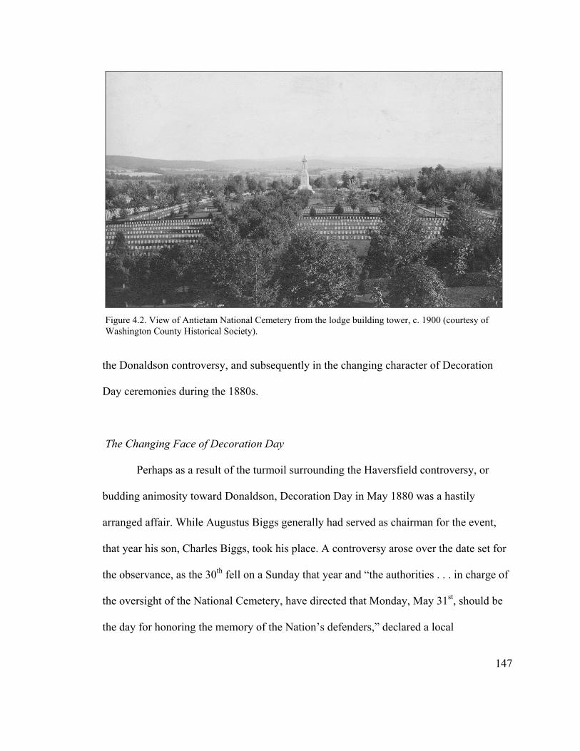
the Donaldson controversy, and subsequently in the changing character of Decoration
Day ceremonies during the 1880s.
Figure 4.2. View of Antietam National Cemetery from the lodge building tower, c. 1900 (courtesy of Washington County Historical Society).
The Changing Face of Decoration Day
Perhaps as a result of the turmoil surrounding the Haversfield controversy, or
budding animosity toward Donaldson, Decoration Day in May 1880 was a hastily
arranged affair. While Augustus Biggs generally had served as chairman for the event,
that year his son, Charles Biggs, took his place. A controversy arose over the date set for
the observance, as the 30th fell on a Sunday that year and “the authorities . . . in charge of
the oversight of the National Cemetery, have directed that Monday, May 31st, should be
the day for honoring the memory of the Nation’s defenders,” declared a local
147
correspondent, “but this day not suiting the people so well as Saturday, the committee of
arrangements were instructed to endeavor to effect a change from Monday to Saturday.
This the committee [has done].” Otherwise, the event passed without incident, with a
large procession forming about 10 o’clock and led by Reno Post. “The shops and stores
of the town did a big business—better than ever before,” observed the Hagerstown Mail,
“a large sum of money being left in their purses. They express themselves as perfectly
satisfied with the doings of the day, while the crowds were not slow in declaring
themselves pleased with the preparations made for their comfort and enjoyment.”30
By spring 1881, the animosity between Capt. Donaldson and members of the
Sharpsburg community had reached its zenith. Evidently Biggs’ statement to Rockwell
concerning the lack of interest in Decoration Day as a result of the ongoing conflict with
the cemetery superintendent was true, for there was little or no citizen involvement in the
ceremony that year. The Reno Post of the GAR stepped into the breech, setting a
precedent for the GAR to take charge of Decoration Day at Antietam National Cemetery.
By the following year much of the ill will evidently had dissipated, perhaps through the
mediation of the GAR, as the antagonists were all Civil War veterans (with the exception
of Biggs). In spring 1882, in fact, the Reno Post appointed a subcommittee consisting of
Charles W. Adams, William Donaldson, John Ward and Peter Mose, to work with a
committee to be appointed by the town “to make all the necessary local arrangements.”
All three of the other men on this subcommittee had signed at least one of the petitions
30 Hagerstown Mail, May 21, 1880 and June 4, 1880.
148
that had been circulated against Donaldson, and former employee Peter Mose even had
testified against him during the investigation in fall 1880.31
Even so, the townspeople were slow in providing their support for the event, as
they initially took no action setting up a committee as requested by Reno Post. The
Sharpsburg Enterprise, recently resurrected under the editorship of Charles Biggs,
attempted to coax its citizens into action. “Reno Post has expressed itself as being in
favor of conducting the exercises on Decoration Day according to a programme that will
be entirely free from features that were considered objectionable by many of our citizens
on former occasions,” the paper observed. “They propose coming to Sharpsburg in the
morning and holding the services at the cemetery in the afternoon, thus giving the town
an opportunity to be benefited by the presence of the large number of visitors.” Evidently,
one objectionable feature of the previous couple of years had been that the ceremony was
held relatively early in the morning (10 a.m.), and that visitors were not staying in town
and patronizing its businesses. The article concluded: “We hope there will be no further
procrastination on the part of our citizens, but that they will hold the proposed meeting,
appoint a committee and co operate with Reno Post in the same cordial spirit as that with
which they have been invited to participate in the arrangements and exercises.”32
31 Hagerstown Mail, June 3, 1881; Sharpsburg Enterprise, June 3, 1881, and April 28, 1882. As further evidence of Biggs’ apparent acceptance of Supt. Donaldson, shortly after assuming ownership of the Enterprise that year, Biggs wrote “If [Antietam National] Cemetery is not now the most beautiful national burying-ground in the United States it soon will be. In fact, many visitors have expressed themselves as being more favorably impressed by its appearance than by the cemetery at Gettysburg, which has hitherto been considered the most elegant in the country. Work has again been resumed here, and the present and contemplated improvements will greatly enhance its beauty.”
149
32 Sharpsburg Enterprise, May 5, 1882.
The townspeople finally met several weeks prior to Decoration Day, selecting
Charles Biggs as chairman and appointing a number of subcommittees. For the first time,
the committee appointed to make arrangements for flowers was all female—in the past it
had been led by men, even though it was the one committee on which women had served.
In another break from tradition, only the base of the monument was covered with flowers,
while each grave was decorated with a small U.S. flag bordered in black. “Too much
praise can not be bestowed upon the ladies of Sharpsburg who collected and arranged the
floral decorations, and entertained with so much hospitality the visiting bands, military
and strangers,” declared the Enterprise in its summary of the event. “After quartering a
large number of the visitors at private houses, the citizens raised sufficient money to pay
the expense of many more at the boarding houses in town.” As the GAR took more and
more control of Decoration Day during the remainder of the 1880s, the role of the
Sharpsburg women continued to increase.33
The GAR influence on Decoration Day at Antietam National Cemetery is
reflected in the growing national prominence of its guests. In 1884, Senator John A.
Logan, a founder of the GAR and at that time Republican candidate for vice president on
a ticket headed by James G. Blaine, participated in the observance. The following year,
General George B. McClellan, returning to Antietam Battlefield for the first time since
1862, served as the main speaker. Not surprisingly, McClellan gave a rousing
reconciliationist speech in which he blamed the Civil War on extremists on both sides,
stressed that each side had fought for what it believed in, and that the great result of the
33 Sharpsburg Enterprise, May 19, 1882, and June 2, 1882.
150
conflict had been preservation of the Union. The former commander had arrived in
Hagerstown the previous day and been treated to a reception and parade that evening.
Ironically, he was the houseguest of Henry Kyd Douglas, who had served as a
Confederate officer on Lee’s staff.34
The 1885 Decoration Day also marked the first time that Lyon Post #31 of
Hagerstown participated in the event. Organized in the spring of 1883 by Capt. John
Mentzer of Reno Post #4, this African-American post mustered in 17 members. Like
other GAR associations across the country, Reno and Lyon posts were strictly segregated
along racial lines. Interestingly, even as 1885 marked the inaugural appearance of a black
GAR post at Antietam National Cemetery, it also was the first time that a Confederate
organization—the Shepherdstown Confederate Memorial Association—marched in the
procession. According to Henry Kyd Douglas, Decoration Day “was much of a reunion,
and for the first time a large delegation of men who wore the grey came over the Potomac
and marched in review past the Federal General, as he stood on the rostrum at the
Cemetery, hat in hand, greeting them and responding to their salutes with all the
frankness and ease which distinguished him as a soldier and a gentleman.”35
34 Hagerstown Mail, June 6, 1884, and June 5, 1885; McConnell, Glorious Contentment, 194-195; Henry Kyd Douglas, I Rode with Stonewall (Chapel Hill: University of North Carolina Press, 1940), 176-177. John A. Logan was a Congressman from Illinois from 1867-1870, and Senator from 1871-77 and 1879 until his death in December 1886 (see http://bioguide.congress.gov, John A. Logan, February 2004). He was beloved by Civil War veterans as a staunch advocate of pension demands.
151
35 National Tribune, May 10, 1883; McConnell, Glorious Contentment, 71; Douglas, I Rode with Stonewall, 177. Lyon Post #31 incorporated in April 1884 with eleven subscribers (see Articles of Incorporation Book 2, p. 243, Washington County Courthouse, Hagerstown, Maryland). It appears that Lyon Post #13 participated in the Decoration Day observance at Antietam from 1885-1887, than dropped out of view for a few years. It is not known whether the group chose not to participate, or was not permitted to do so. In his memoir, Douglas (p. 177) notes that during McClellan’s visit, the general made the statement at a dinner party that “when the Antietam National Cemetery was dedicated on the 17th of
While evidence reveals that Sharpsburg established a GAR post—Antietam Post
#14—by spring of 1885, this new group did not take charge of Decoration Day until the
following year. The involvement of Antietam Post appeared to reinvigorate local civilian
participation in the event. By 1887, a Women’s Relief Corps chapter had formed as well,
devoted primarily to raising funds for the GAR post and assisting with floral decorations
on Decoration Day. With the creation of Antietam Post #14, the community of
Sharpsburg once again took control of Decoration Day at Antietam National Cemetery,
and was not to relinquish it again.36
The establishment of a GAR post in Sharpsburg during the 1880s closely reflected
what was happening throughout the nation, as membership in the GAR increased tenfold
between 1878 and 1887. This growth arose in large part from a wave of fraternalism that
swept the country at this time, as well as a revival of American interest in martial matters.
In fact, the installation of Antietam Post coincided with the resurgence of secret orders in
the Sharpsburg community. Six such orders had become active by 1882, and that same
year marked the first time that fraternal lodges participated in the Decoration Day
procession. Historian Gerald F. Linderman could have been writing of Sharpsburg during
the last two decades of the nineteenth century when he observed: “In countless Northern
towns, the GAR post became a focus of community activity. Its parades, fireworks
September, 1867, he was not asked to take any part in the ceremonies and was not even invited to be present. Hamlet and the Prince of Denmark left out with a vengeance!” 36 Hagerstown Mail, May 7, 1886. In the National Tribune for March 26, 1885, a “John W. Jackson, Sharpsburg, 14” is listed under a general order for the Maryland Department. No record of the post’s establishment has been uncovered.
152
displays, reviews, and receptions became fixtures of small-town life, and under its aegis
Memorial Day and the Fourth of July became increasingly martial occasions.”37
Twenty-fifth Anniversary Commemoration
As the 25th anniversary of the Battle of Antietam drew near, Antietam Post #14
made plans to hold its first GAR reunion, or campfire, at Sharpsburg to mark this
important date. Such events were already common occurrences at the Gettysburg
battlefield, where the powerful Pennsylvania Department of the GAR held annual week-
long encampments beginning in 1880. In contrast, the Maryland Department, never
strong in comparison to most other northern states, displayed little interest in Antietam
beyond ensuring that Decoration Day was observed in a fitting manner each year.38
In preparation for the campfire and reunion, Antietam Post issued a general
invitation in August 1887 to fellow GAR members in Maryland and surrounding states to
participate in the event and established a campground in the West Woods near the
Dunker Church with accommodations for 3,000 veterans. The campfire was held from
September 15-17. “Board huts for sleeping and cooking purposes, a rostrum for speakers,
booths of various kinds and a dancing pavilion were erected,” recounted the local press.
At this reunion, “[p]atriotic speeches and reminiscences of the dark days of 1861-1865
37 Gerald R. Linderman, Embattled Courage: The Experience of Combat in the American Civil War (New York: The Free Press, 1987), 275-276; Blight, Race and Reunion, 171; McConnell, Glorious Contentment, 181; Sharpsburg Enterprise, February 28, 1882; Hagerstown Mail, May 26, 1882. The six secret societies active in Sharpsburg were the Masons, Knights of Pythias, Rechabites, Red Men, Good Templars, and an African American Odd Fellow lodge. 38 See McConnell, Glorious Contentment, 175-181, for a description of campfire events. Unrau, Administrative History, Gettysburg, 47.
153

occupied the time of the ex-soldiers, who were regaled besides with regulation hard tack,
bacon and bean soup. Bands of music and dancing furnished entertainment for those
inclined to such diversion.” The principal event on the battle anniversary was the
dedication of the first regimental monument erected at Antietam, placed in the national
cemetery by the survivors of the 20th New York Regiment (see Chapter 6 for discussion
of this monument).39
The number of participants at the campfire was not given in any accounts of the
event, but it appeared to have fallen short of expectations. One newspaper related that the
centennial celebration of the Constitution in Philadelphia prevented the attendance of
many of the GAR posts expected from Pennsylvania. This certainly was true for
survivors of the 124th Pennsylvania, who postponed their trip to Antietam until the end of
the month. Lack of interest on the part of many of the Pennsylvanians may be just as
much to blame, however, given that they had just participated in a successful reunion at
Gettysburg less than three months earlier. In contrast to Antietam, for Gettysburg’s 25th
anniversary the following year the Society of the Army of the Potomac sponsored a
substantial reunion that featured a reenactment of Pickett’s Charge and the dedication of
133 regimental monuments. Unlike Antietam’s 25th anniversary event, Gettysburg’s
reunion included both Union and Confederate veterans. Although Antietam’s 25th
anniversary did not generate the same amount of interest as did its neighbor’s to the
north, it represented the first time that the battlefield proper was the scene of
commemorative activities, rather than the national cemetery. Given that the Antietam
154
39 National Tribune, August 18, 1887, and September 8, 1887; Keedysville Antietam Wavelet, September 3, 1887; Hagerstown Mail, September 23, 1887.
Post had been active for less than four years, it staged a relatively successful event that
drew many people from the local and surrounding communities.40
The Antietam Post and its affiliated Women’s Relief Corps (WRC) continued to
remain active in local and GAR affairs following the 25th anniversary reunion. For
example, three months after the campfire, the WRC held a festival throughout the
holidays to raise money. Some appeared to feel, perhaps unfairly, that the organizations
could do more. “We are sorry our ladies don’t take more interest in the society at this
place,” opined a local writer for the Keedysville Antietam Wavelet in November 1889,
“which is right on the battlefield where one of the hardest fights of the Civil War took
place and where one of the finest National Cemeteries of the country is located. The
G.A.R. Post which numbers only about fifty, should have three times that many of ‘The
Loyal Sons of Our Country.’” Perhaps in response to complaints such as these, a number
of the younger men organized a Sons of Veterans camp, designated Mansfield Camp, in
Sharpsburg two years later. This organization, endorsed in 1888 as an auxiliary of the
national GAR organization, was open to the sons of honorably discharged Union
veterans.41
The Antietam Post continued its leading role in organizing Decoration Day at the
National Cemetery throughout the 1890s. Beginning in 1892 both the Reno and Lyon
40 Hagerstown Mail, September 23, 1887; Robert M. Green, compiler, History of the One Hundred and Twenty-fourth Regiment Pennsylvania Volunteers in the War of the Rebellion (Philadelphia: Ware Bros. Company, Printers, 1907), 212; Unrau, Administrative History, Gettysburg, 5758; Amy Kinsel, “‘From these honored dead’: Gettysburg in American Culture, 1863-1938” (Ph.D. diss., Cornell University, 1992), 194-195. 41 Keedysville Antietam Wavelet, December 17, 1887, January 12, 1889, and November 16, 1889; Keedysville Antietam Valley Record, April 1891; McConnell, Glorious Contentment, 202.
155

Posts from Hagerstown participated in the event after a hiatus of several years, and the
Antietam Post began planning Decoration Day jointly with the Reno Post. “There is such
harmony between the posts,” enthused the Antietam Valley Record prior to the 1894
event, “and the co-operation so earnest and unselfish that good results may be obtained.”
At times the Mansfield Camp of Sons of Veterans and the Women’s Relief Corps also
participated in the procession. In addition, the Antietam Post sponsored a second
campfire, this one held in the North Woods in September 1893. Again, attendance fell far
short of the anticipated number—800 to 1,000 as compared to the 5,000 planned.42
It becomes apparent by the close of the nineteenth century that reunion events at
Antietam would never receive the same level of attention as those at Gettysburg, despite
the best efforts of the local GAR posts. This can be attributed in part to a weak statewide
GAR department in Maryland; conversely, as articulated in the next section, control of
the Gettysburg Battlefield Memorial Association by the powerful Pennsylvania
Department ensured that it would remain a magnet for Civil War veterans. The lack of a
strong organization revolving around Antietam not only resulted in a lackluster 25th
anniversary commemoration, it also led to an unorganized effort in Sharpsburg, relative
to Gettysburg, to cater to returning veterans.
156
42 Keedysville Antietam Valley Record, June 5, 1891, May 20, 1892, June 3, 1892, September 22, 1893, April 13, 1894, April 27, 1894, May 10, 1895, June 7, 1895 and June 4, 1896. At the 1893 campfire a controversy arose over a proposal to sell alcoholic beverages at the event. Condemnation in the local newspaper was swift: “We have been informed that the committee on arrangements for the GAR Campfire to be held in the woods north of this place next month, are asking for bids for the privilege of opening a saloon and selling beer during the campfire. Guess Sam Jones will stay away, as well as a great many more of our best thinking people. We believe in paying liberal pensions to every worthy veteran who fought for our country, but just as soon as a pensioner wastes his pension money for that which debauches and damns both body and soul, we are in for stopping that pension in short order.” In the end, alcohol was not allowed at the event (Keedysville Antietam Valley Record, August 25, 1893).
Veteran Excursions and the Growth of Tourism
With the exception of the national cemetery, Antietam battlefield received little
attention during the latter half of the 1860s and throughout most of the 1870s. This was
the case with other Civil War battlefields as well. The only exception appears to have
been Gettysburg, where the battlefield became a tourist attraction from a very early date.
Within months of the battle, local attorney David McConaughy began purchasing
significant portions of the battlefield and advocated the creation of a Gettysburg
Battlefield Memorial Association to preserve the grounds “in their actual form and
condition at the time of the battles.” McConaughy also stressed that the fields of battle
around Gettysburg witnessed “the scenes of the only battles fought on the soil of the free
North”—no doubt an intentional slight directed toward Antietam and reflective of
northern sentiment toward Maryland.43
In spring of 1864 the Pennsylvania legislature approved the incorporation of the
Gettysburg Battlefield Memorial Association (GBMA). The Commonwealth also
financed some land acquisition in the late 1860s, reimbursing McConaughy for his
purchases as well as appropriating funds for additional property. It is revealing that the
properties acquired by McConaughy and the GBMA, “focused only on the most dramatic
battlefield landscapes,” according to historian Jim Weeks, “and ignored less-scenic
locations where significant fighting occurred.” In effect, McConaughy was as much
interested in tying the scenic battlefield into the mid-nineteenth century genteel tourist
market, with its emphasis on natural landscapes and scenery, as on preserving and
43 Jim Weeks, Gettysburg: Memory, Market, and an American Shrine (Princeton, NJ: Princeton University Press, 2003); Unrau, Administrative History, Gettysburg, 7-9.
157
honoring the site of a great Northern victory. The GBMA ran chronically short of
funding, however, and accomplished little on the battlefield throughout the 1870s.44
Others worked in concert with the GBMA to promote Gettysburg Battlefield as a
national tourist site. John Badger Bachelder, a cartographer and illustrator, first visited
Gettysburg immediately after the battle and remained for the next thirty years as its
unceasing advocate. In 1873 he published what is probably the earliest guidebook for a
Civil War battlefield. In addition, other local promoters—led by McConaughy—opened a
large four-story hotel in 1869 at the site of Gettysburg’s medicinal springs, which did a
good business over the next two decades. As pointed out by Weeks, while circumstances
forced the battle on Gettysburg, the townspeople were not reticent in commercializing the
battlefield even before the war had ended. “Within a decade after the battle,” he declared,
“Gettysburg resembled a premodern shrine complete with relics, sepulcher, and a holy
fount, all of which beckoned middle-class pilgrims seeking spiritual rejuvenation, moral
improvement, and perhaps an encounter with the sublime.”45
The citizens of Sharpsburg charted a different course during the first decade and a
half following the Civil War. While Maryland closely followed Pennsylvania’s lead in
establishing a national cemetery—the only two states to do so—at the site of its greatest 44 Unrau, Administrative History, Gettysburg, 41-43; Kathleen Georg Harrison, “‘A Fitting and Expressive Memorial’: The Development of Gettysburg National Military Park” (Report on file at Gettysburg NMP); Weeks, Gettysburg, 20-21. For additional information on tourism during this period, see John Sears, American Sacred Places: American Tourist Attractions in the Nineteenth Century (New York: Oxford University Press, 1989). Although Weeks makes a good point about the scenic qualities of the lands purchased by McConaughy, these high points—Culp’s Hill, Little Round Top and Cemetery Hill—also were some of the most significant strategic points of the battlefield and where some of the heaviest fighting occurred. See Kinsel, “From these honored dead,” 156-157.
158
45 Weeks, Gettysburg, 22-24, 26-27, 32-33; Mary Munsell Abroe, “‘All the Profound Scenes’: Federal Preservation of Civil War Battlefields, 1861-1900” (Ph.D. diss., Loyola University, 1996), 76-77; Jim Weeks, “Gettysburg: Display Window for Popular Memory,” Journal of American Culture 21, no. 4 (1998): 44.
battle, it did not follow suit in promoting preservation of the battlefield as had its
neighbor to the north. Several factors may account for this divergent course. First,
Gettysburg was quickly seen throughout the East as the high point of the war, and it also
was the only major battle fought north of the Mason-Dixon line. Second, the
Pennsylvania state government was staunchly Unionist and united in its approach to the
Civil War. Maryland, on the other hand, was divided against itself. There was no reason
for its legislature—controlled after the war by Democrats from the eastern half of the
state—to promote a battle fought in the western, Unionist portion. Finally, in addition to
the lack of state support, no local citizen or group of citizens came forward during that
period to promote the battlefield in the manner that the townspeople of Gettysburg had
done. As a result, the battlefield at Antietam remained in private hands, with no attempt
made at this time to preserve its key features.
In the late 1870s, in concert with veterans’ growing interest in remembering the
Civil War—as manifested in the tremendous increase in membership in the GAR, these
old soldiers began revisiting their earlier fields of combat in growing numbers. Now
middle-aged, they joined together in regimental survivors’ associations and staged
reunions on the battlefields to relive their experiences and remember their comrades who
had fallen more than twenty years earlier. As might be expected, Gettysburg took the lead
in this trend, hosting a reunion of the Pennsylvania Department of the GAR in 1878 that
led to its takeover of the moribund GBMA two years later and shifted control of the
battlefield from the local to a national level. This ushered in a new era on that battlefield
159
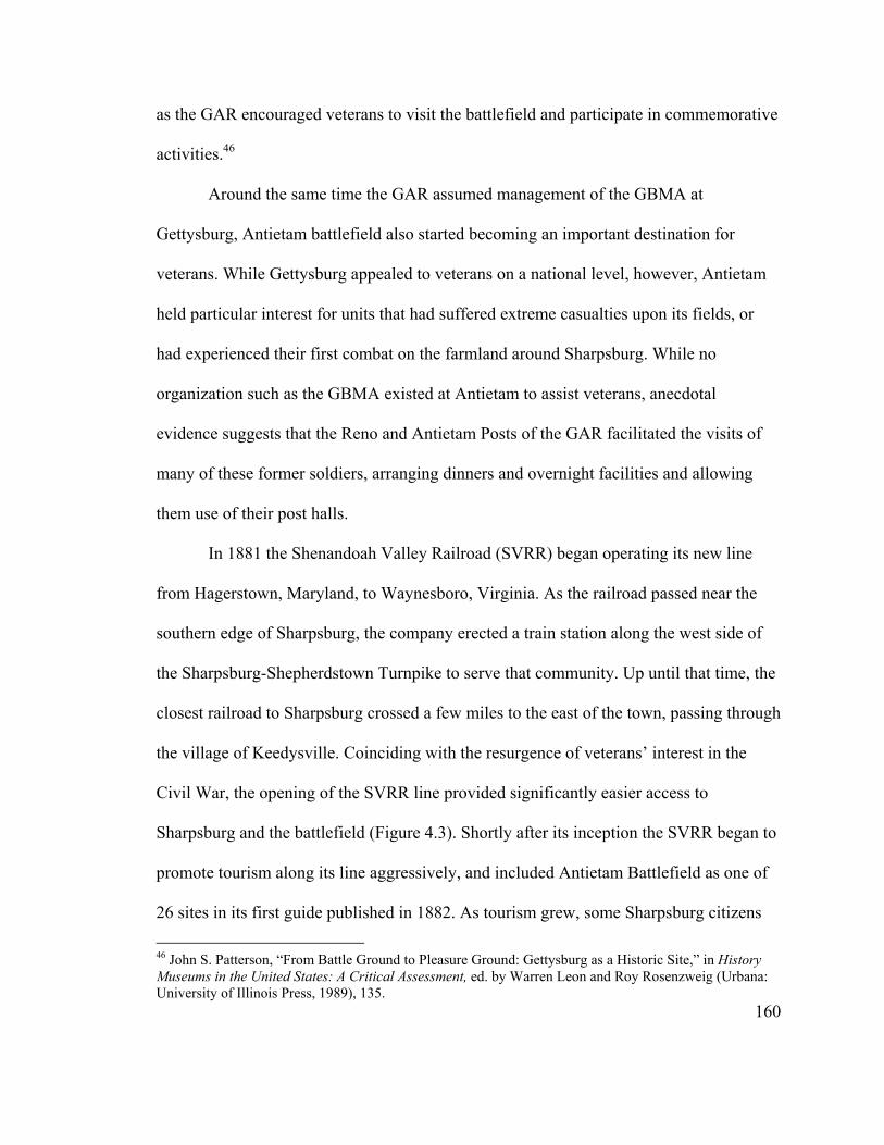
as the GAR encouraged veterans to visit the battlefield and participate in commemorative
activities.46
Around the same time the GAR assumed management of the GBMA at
Gettysburg, Antietam battlefield also started becoming an important destination for
veterans. While Gettysburg appealed to veterans on a national level, however, Antietam
held particular interest for units that had suffered extreme casualties upon its fields, or
had experienced their first combat on the farmland around Sharpsburg. While no
organization such as the GBMA existed at Antietam to assist veterans, anecdotal
evidence suggests that the Reno and Antietam Posts of the GAR facilitated the visits of
many of these former soldiers, arranging dinners and overnight facilities and allowing
them use of their post halls.
In 1881 the Shenandoah Valley Railroad (SVRR) began operating its new line
from Hagerstown, Maryland, to Waynesboro, Virginia. As the railroad passed near the
southern edge of Sharpsburg, the company erected a train station along the west side of
the Sharpsburg-Shepherdstown Turnpike to serve that community. Up until that time, the
closest railroad to Sharpsburg crossed a few miles to the east of the town, passing through
the village of Keedysville. Coinciding with the resurgence of veterans’ interest in the
Civil War, the opening of the SVRR line provided significantly easier access to
Sharpsburg and the battlefield (Figure 4.3). Shortly after its inception the SVRR began to
promote tourism along its line aggressively, and included Antietam Battlefield as one of
26 sites in its first guide published in 1882. As tourism grew, some Sharpsburg citizens
160
46 John S. Patterson, “From Battle Ground to Pleasure Ground: Gettysburg as a Historic Site,” in History Museums in the United States: A Critical Assessment, ed. by Warren Leon and Roy Rosenzweig (Urbana: University of Illinois Press, 1989), 135.

Figure 4.3. View of Sharpsburg, looking south down Main Street, c. 1900 (courtesy of Antietam NB).
realized the potential economic benefits that could be reaped from capitalizing on the
battlefield. “Sharpsburg is becoming popular as a summer resort,” claimed the Enterprise
in August 1882. “Good air, cheap boarding, beautiful natural scenery and historic
associations combine to render the ancient village attractive.”47
By the mid 1880s organized Union veterans’ reunions and excursions to Antietam
Battlefield were becoming increasingly common. The regimental historian for the 15th
Massachusetts described one such excursion to the battlefield in early June 1886: “A ride
161
47Third Annual Report, Shenandoah Valley Railroad Company, for the Year 1883 (Philadelphia: Allen, Lane & Scott, Printers, 1884), 9-10; Tourism Guide and Descriptive Book of the Shenandoah Valley R.R. 1882. (Philadelphia: National Bureau of Engraving & Manufacturing Company, 1882); Sharpsburg Enterprise, August 4, 1882. The SVRR tour guide provided a list of summer resorts located near its line, including two in Sharpsburg—the Alder House with accommodations for 16 and the Renner House with accommodations for 5. They cost $4 and $5 per night, respectively, and included monthly board as well. While Antietam Battlefield and Antietam National Cemetery were featured in the tour guide, the main attraction along the rail line clearly was Luray Caverns near Luray, Virginia.

of ten miles from Hagerstown, on the Shenandoah Valley Railroad, brought us, Friday
morning at 7 o’clock, to Antietam Station, about a mile from Sharpsburg and two miles
from Antietam battle-field. To those who were upon the platform at the station viewing
the ‘livery’ in waiting to transport us across the country to Keedysville [where they were
scheduled to depart later that day], a description would be impossible.” From the station,
the group traveled in its motley assortment of wagons and carriages to various parts of
the battlefield, including Burnside Bridge, the National Cemetery, and the West Woods.
“The trees on the ground where the Regiment stood during the battle were cut several
years ago,” observed the regimental historian concerning the West Woods,
and the ground has been broken for cultivation, but the buildings in front—the house and small barn—still remain, and were at once recognized by the veterans who saw them on that eventful September 17, 1862. Many interesting relics were found upon the ground where the regiment fought: bullets, Minnie balls, grape, pieces of shells, and fragments of equipments worn by our men who were brought away and were highly prized by the finders as relics found upon the battle-field twenty-four years after the battle.
At the conclusion of its tour, the 15th Massachusetts veterans proceeded to Keedysville,
where they boarded a train for Washington, D.C.48
Veteran excursions to Antietam National Battlefield increased in number and size
toward the end of the 1880s, most traveling to Sharpsburg on the SVRR under special
excursion packages, and the majority visiting around the anniversary of the battle. In a
typical example, in September 1889 the Antietam Wavelet observed:
48 David M. Earle, History of the Excursion of the Fifteenth Massachusetts Regiment and its Friends to the Battle-fields of Gettysburg, Pa., Antietam, Md., Ball’s Bluff, Virginia, and Washington, D.C., May 31-June 12, 1886 (Worcester, Mass.: Press of Charles Hamilton, 1886), 50-51. The main purpose of the regiment’s trip was to dedicate two monuments on Gettysburg Battlefield. The house and small barn most likely refer to the Alfred Poffenberger property.
162

Mr. O. Howard Boyer, Gen. Pass. Agt., S.V.R.R., has made arrangements with Mr. M.E. Snavely for the transportation over Antietam battlefield and for dinner for about 170 persons who will visit this place on the 17th of September, at which time the Sixteenth Connecticut Regiment will hold their reunion. Coupon tickets entitling the holder to transportation over the battlefield and to dinner, will be sold, and Mr. Snavely will collect these tickets from the visitors.
The 16th Connecticut arrived at the Antietam Station at 7:30 a.m. from Hagerstown, and
returned to that city at 7:00 p.m., spending a long day touring the battlefield. During their
tour, the veterans located a spot on Mr. Jacob Stine’s farm (the Otto Farm at the time of
the battle) for a future monument.49
Other groups made arrangements to stay in Sharpsburg. The 14th Connecticut
brought slightly more than 300 people to the battlefield on the afternoon of September
16, 1890. Concerning their arrival, regimental historian H.S. Stevens later recounted at
length:
At 4:15 the train pulled in at Antietam station, the “desired heaven.” This was located one mile from the village Sharpsburg. “And how are we all to get there?” was the solicitous inquiry. Well, there is a good, broad military road, one of Uncle Sam’s best, running clear up to the town; and look! Foresight and painstaking have done their work, and here are in waiting, like a cloud, vehicles of every description, from the simple carriage for two or three to the omnibus for twenty and those ark-like, or “prairie schooner” style, of farm wagons, with their ponderous old Maryland farm horses, ready to haul any mass of humanity. Within a few minutes all of our great crowd, for we had received reinforcements from other regiments, were, amid lots of fun at the oddity of the thing, stowed away in these vehicles and on the way to town. So thoroughly had the matter of billeting the party been attended to, that when a few minutes after the great cavalcade had driven into the village the parties in charge drove in scarcely any persons were to be seen upon the streets; they had fallen directly into their places and both people
163
49 Keedysville Antietam Wavelet, September 7, 1889, and September 21, 1889; Sixteenth Regiment Connecticut Volunteers Excursion and Reunion at Antietam Battlefield, September 17, 1889 (Hartford, Conn.: Press of The Case, Lockwood & Brainard Company, 1889). An even larger contingent of 250 Maine veterans visited the battlefield a little over two weeks later. See Keedysville Antietam Wavelet, October 5, 1889.
and carriages had disappeared, the latter to their stables and the former to “fix up” for supper, about ready at all the houses.
Stevens further reflected upon the arrangements that had been made to accommodate so
many guests.
The problem has been, how could this little village, with no facilities for public accommodation beyond two or three insignificant hotels, take care of our hundreds, especially as other hundreds of other regiments were to be provided for at the same time. Parties staying but a night or two could “bunk” in any way, but our party, composed so largely of gentle ladies, were to be away from home ten days or more of jaunting and needed good care and good resting places. The problem was solved by a Yankee devise [sic] of going months in advance to the place and spending days in canvassing for accommodations among the best families of the town, and promising the people, who had several times been grievously disappointed and imposed upon and had suffered loss because of false representations as to parties, that good persons should be sent them as guests and sure pay. This, with correspondence kept up until the last day, secured us all we wanted and the best to be found. All the places could not be equally good, and we must arrange for people as couples and as friend-groups as fully as possible, and gentlemen could put up with limitations we would not subject ladies to if avoidable; but what would the few who had cramped quarters for a hot season have said if indiscriminately the party had been obliged to bunk upon church benches and feed at improvised public tables as were many other excursionists?
The leaders of the 14th Connecticut excursion stayed at the Roulette House, in close
vicinity to the regimental campfire held on that farm their first night.50
Members of the 14th Connecticut spent the following day touring the various
landmarks of the battlefield. Stevens lamented “that a spirit of cupidity should have
prevailed over sentiment and led to the cutting down of the West Woods (at the Dunker
Church) and much of the East Woods.” Otherwise, the field remained much as he had
50 H.S. Stevens. Souvenir of the Excursion to Battlefields by the Society of the Fourteenth Connecticut Regiment and the Reunion at Antietam, September 1891; with History and Reminiscences of Battles and Campaigns of the Regiment on the Fields Revisited (Washington: Gibson Bros., Printers and Bookbinders, 1893), 44-46. Antietam was the first battle in which the 14th Connecticut participated.
164

remembered it. At the conclusion of the tour, “Well wearied, and filled with thoughts of
all the great things they had seen and learned, many of the people spent the evening at
their boarding places resting for the morrow’s jaunt. A large number gave the evening to
sociability and ice-cream at a public festival. The refreshments were particularly grateful
just at this time, and glad we were that the church ladies wanted the money enough to
prepare this festival for the visitors to their town.” Some members attended an indoor
campfire held at the Lutheran Church by the 108th New York and 130th Pennsylvania.51
“The people of Sharpsburg were pleased with our party and generally treated us
handsomely,” concluded Stevens. “One lady subsequently wrote the one in charge of the
billeting thanking him for sending her ‘such nice, good, honorable people.’” Not
everyone was as pleasant, however: “One avaricious old curmudgeon attempted to
impose upon his guests by charging extortionate rates. He will have no more patronage or
favor from the Fourteenth.” The next morning, the party moved on to its next stop, taking
pleasant memories of its visit to Antietam.52
A month after the 14th Connecticut left town, R.E. Delauney, proprietor of the
Antietam Hotel, and William Roulette received letters from the president of the 130th
Pennsylvania Regimental Association, notifying them that three of the regiments of his
brigade—the 130th Pennsylvania, 14th Connecticut and 108th New York—were planning
to hold a reunion with over 500 veterans on Antietam Battlefield the following
September. This group booked all available rooms in the town, and prompted the citizens
51 Stevens, Fourteenth Connecticut Regiment, 67-68. 52 Stevens, Fourteenth Connecticut Regiment, 68.
165

of Sharpsburg to form a committee to prepare for the large group. As the date grew
closer, it was announced that the veterans would arrive at Sharpsburg on September 16,
1891, and remain over the 17th, with a reunion to be held in the Lutheran Church on the
latter evening. An additional group, the 5th Maryland, also made arrangements to run an
excursion from Baltimore, Wilmington, and other points on that day.53
The ladies of the Lutheran Church prepared to feed 200 veterans and provide
overnight accommodations inside the church. The week before the anniversary local
furniture dealers did a brisk business selling bedsteads and other furnishings, as some
private families made arrangements to accommodate as many as forty people with board
and lodging. An estimated 1,500 to 2,000 veterans descended on Sharpsburg for the battle
anniversary. “Our hackmen reaped a rich harvest here on the 17th,” gleefully declared the
local paper. “They were all kept busy all the time. As usual the boys were on hand with
relics of the battlefield, driving their sale. They sold a great many.” On the downside: “A
number of private families did not get the number of visitors arranged for, while a few
others got none.”54
During their visits to Sharpsburg the veterans toured the most important parts of
the battlefield, particularly those areas where the heaviest fighting had occurred—Dunker
Church and the associated West Woods and Cornfield, Bloody Lane, and Burnside
Bridge. Almost all made a pilgrimage to the national cemetery to search for and mourn
53 Keedysville Antietam Valley Record, October 10, 1890, February 13, 1891, July 17, 1891, August 21, 1891, and September 4, 1891. The three regiments involved in the brigade reunion had comprised most of the Second Brigade of French’s Third Division, Sumner’s Second Corps. The remaining regiment, the 12th New Jersey, evidently did not participate. 54 Keedysville Antietam Valley Record, September 4, 1891, September 11, 1891, and September 25, 1891.
166
their fallen comrades. Those who had time marched over the ground upon which they had
fought, searching for relics and commenting, time and time again, on the contrast
between the present serenity and beauty of the battlefield and its horrific appearance on
September 17, 1862. “As we gazed on the fields surrounding Bloody Lane, now giving
forth their fruits of peace, it was hard to give expression to our thoughts,” related a
member of the 124th Pennsylvania in September 1887. “If those old trees could speak,
what an experience they could tell of twenty-five years ago, when the dead—man and
beast—dying and wounded, lay side by side beneath their spreading, shot-ridden
branches, which to-day are outstretched over fields ripe for the harvest of peace.” Many
observed how little changed the fields were from the time of the battle. The one
exception, as related earlier by a member of the 14th Connecticut, was the ongoing
destruction of the key woodlots—the North, East, and West Woods.55
It is evident that a nascent tourism industry developed in Sharpsburg during the
early 1880s as a result of the increasing visitation to Antietam Battlefield by veteran
associations. The SVRR continued to fuel much of this, running excursion trains and
arranging tours of the battlefield. In early 1890 the railroad sent a photographer to
Sharpsburg to photograph points of interest to be used in advertisements. Interestingly,
55 Green, History of the One Hundred and Twenty-fourth Regiment Pennsylvania Volunteers, 213. For examples not cited elsewhere of visits to Antietam Battlefield by veterans’ associations, see Secretary’s Report of the Re-Unions of the Survivors’ Association 125th Regiment, P.V., from Muster-out of Regiment, May 1863 to 1891 (Altoona, Penn.: Dern & Pitcairn, Printers, 1891), 14-22, copy on file at Antietam NB library, and George A. Hussey (historian) and William Todd (ed), History of the Ninth Regiment N.Y.S.M. - - - N.G.S.N.Y. (Eighty-Third N.Y. Volunteers) (New York: J.S. Ogilvie, 1889), 638-641. The historian for the 83rd New York described their reception by the townspeople of Sharpsburg: “In the evening [of September 16, 1886] the citizens of Sharpsburg called to pay their respects, and the pilgrims were given the ‘Freedom of the City’ by the authorities.” He stated “a most delightful social meeting was held during the evening. Among the townspeople were several ex-Confederates, who vied with their neighbors in rendering the visitors stay pleasant and agreeable.”
167
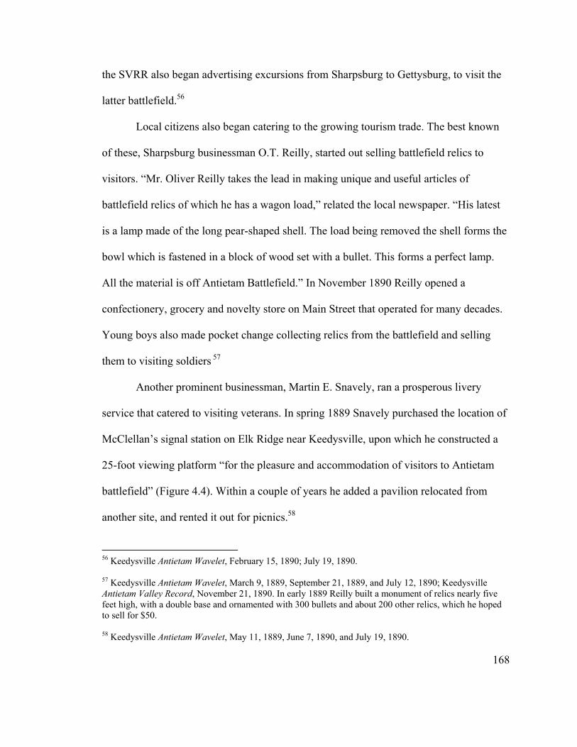
the SVRR also began advertising excursions from Sharpsburg to Gettysburg, to visit the
latter battlefield.56
Local citizens also began catering to the growing tourism trade. The best known
of these, Sharpsburg businessman O.T. Reilly, started out selling battlefield relics to
visitors. “Mr. Oliver Reilly takes the lead in making unique and useful articles of
battlefield relics of which he has a wagon load,” related the local newspaper. “His latest
is a lamp made of the long pear-shaped shell. The load being removed the shell forms the
bowl which is fastened in a block of wood set with a bullet. This forms a perfect lamp.
All the material is off Antietam Battlefield.” In November 1890 Reilly opened a
confectionery, grocery and novelty store on Main Street that operated for many decades.
Young boys also made pocket change collecting relics from the battlefield and selling
them to visiting soldiers 57
Another prominent businessman, Martin E. Snavely, ran a prosperous livery
service that catered to visiting veterans. In spring 1889 Snavely purchased the location of
McClellan’s signal station on Elk Ridge near Keedysville, upon which he constructed a
25-foot viewing platform “for the pleasure and accommodation of visitors to Antietam
battlefield” (Figure 4.4). Within a couple of years he added a pavilion relocated from
another site, and rented it out for picnics.58
56 Keedysville Antietam Wavelet, February 15, 1890; July 19, 1890. 57 Keedysville Antietam Wavelet, March 9, 1889, September 21, 1889, and July 12, 1890; Keedysville Antietam Valley Record, November 21, 1890. In early 1889 Reilly built a monument of relics nearly five feet high, with a double base and ornamented with 300 bullets and about 200 other relics, which he hoped to sell for $50. 58 Keedysville Antietam Wavelet, May 11, 1889, June 7, 1890, and July 19, 1890.
168
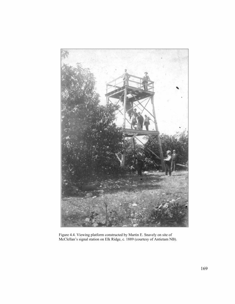
Figure 4.4. Viewing platform constructed by Martin E. Snavely on site of McClellan’s signal station on Elk Ridge, c. 1889 (courtesy of Antietam NB).
169

While veterans came to Antietam in increasing numbers throughout the 1880s,
and the citizens of Sharpsburg worked to cater to their interests, it is evident that
Antietam remained essentially a local endeavor. This contrasts with Gettysburg, which
became a national enterprise following the GAR’s take over of the GBMA in 1880. The
revitalized GBMA purchased additional portions of the Union lines and constructed
avenues to provide access through them. In addition, the GAR tirelessly promoted
Gettysburg as the Union victory that ensured ultimate triumph over the Confederacy, and
therefore the natural location for a national shrine to Civil War memory.59
Creation of Antietam Battlefield Park
The lack of organized veteran and local support for Antietam, so apparent
throughout the 1880s, carried over into efforts to create a battlefield park at that location.
This becomes evident in unsuccessful efforts to form a counterpart to the GBMA at
Sharpsburg, as well as in the backdoor way Antietam became (sort of) a federal
battlefield park. Again, it suggests the existence of ambivalent feelings toward that
battlefield on the part of veterans’ organizations and political leaders, and the inability to
project a clear and useful remembrance of that conflict.
Continuing a long-standing interest in Antietam battlefield, local Republican
Congressman Louis McComas worked to organize an Antietam Battlefield Memorial
Association in May 1890. Taking yet another page from its neighbor to the north, the
organization was to be modeled after the highly successful Gettysburg association, “the
170
59 Kinsel, “From these honored dead,” 175-177.
object of which will be to make of the Antietam battlefield what was made of the scene
of the conflict at Gettysburg,” according to the Hagerstown Globe. “The land over which
the battle was fought,” it continued, “it is implied will be purchased and beautified with
drives and fences and the several States represented in the National Cemetery by fallen
comrades petitioned to erect suitable monuments at points where their heroic dead waged
their fiercest fights.”60
While working on creation of an Antietam Battlefield Memorial Association,
McComas concurrently pursued legislative action in Congress. The first week of June
1890 he introduced a bill (HR 10830) to appropriate $15,000 to survey, locate and
preserve the lines of battle at Antietam. He almost immediately withdrew this bill,
however, inserting the same request less than a week later in a larger sundry
appropriations bill (HR 10884) submitted to the House of Representatives, perhaps
because he did not receive enough support for a stand-alone bill. McComas’s request was
modeled closely after earlier bills that appropriated federal funds to assist the private
GBMA with marking Gettysburg Battlefield.61
60 Hagerstown Globe, reprinted in Keedysville Antietam Wavelet, May 24, 1890. 61 H.R. 10830, June 7, 1890, 51st Congress, 1st Session, Records of the U.S. House of Representatives(RG 233), National Archives (NA); Ronald F. Lee, The Origin and Evolution of the National Military Park Idea (Washington, D.C.: Government Printing Office, 1973). Congress appropriated $50,000 in 1880 to complete the survey at Gettysburg under the direction of John B. Bachelder. This was the first time money had been appropriated toward preservation of a Civil War battlefield.
171
The funds for Antietam were buried among requests for maintaining and
improving the national cemeteries. When the House of Representatives passed the bill a
couple of weeks later, the Hagerstown Globe reported: “In securing this appropriation,
which will in all probability pass the Senate since it has gone through the House, Mr.
McComas has inaugurated successfully, and by a short cut, which few members would
have tried, and if tried would have been successful, is the beginning of a great national
park at Antietam, such as is being developed at Gettysburg and has just been undertaken
at Chickamauga. Next week, Mr. McComas will introduce his bill providing for such a
park.” The bill passed the Senate as expected, and was signed into law by President
Benjamin Harrison on August 30, 1890.62
McComas did indeed introduce another bill (HR 11966) in September. While both
this bill and the one signed the previous month called for marking the lines of battle, HR
11966 also provided for the Secretary of War to appoint three commissioners to mark the
lines, acquire land, and construct avenues and driveways. McComas asked for $150,000,
which the House Committee on Military Affairs cut to $50,000. Even so, the committee
reported favorably on the bill, outlining its guiding framework for preserving the
battlefield in the accompanying report:
The field on which the battle took place is practically unchanged from what it was on the day of the action, save the cutting down of some trees, and presents to-day, as it did in 1862, the most open field on which was fought any of the great battles of the rebellion—a field of which the eye at one sweep can take in all points. It is proposed to maintain the field in the same condition as to roads, fields, forests, and houses, and the sum appropriated by the bill will be ample for all purposes specified in it.
172
62 Snell and Brown, Antietam National Battlefield, 68-70; Hagerstown Globe, reprinted in Keedysville Antietam Wavelet, June 21, 1890.
McComas’s amended bill was referred to the Committee on the Whole House on the
State of the Union on February 27, 1891. Unfortunately, Louis McComas had lost his bid
for reelection the previous fall, and been replaced by a Democrat who apparently showed
no interest in the battlefield. As a result, the bill was dropped immediately from
consideration, and the following day a joint resolution (HR 295) substituted in its place
requesting the Secretary of War to provide information on the battlefield to the
Committee on Military Affairs. With no one to shepherd a bill through Congress, no
further efforts were made to create a national military park at Antietam. At the same time,
and perhaps because of this loss, the Antietam Battlefield Memorial Association also died
a quiet death.63
The treatment accorded Antietam Battlefield contrasted greatly with that afforded
to Chickamauga and Chattanooga battlefields during this same period. In the late 1880s, a
group of veterans in The Society of the Army of the Cumberland created the
Chickamauga Memorial Association, with the idea of establishing a ‘western
Gettysburg.’ The Association consisted of a number of prominent Union and Confederate
veterans, who lobbied Congress extensively to establish a park at Chickamauga
battlefield. Legislation introduced in the House of Representatives in May 1890 by a
veteran of the battle met minimal opposition, and the Senate (of which seven members
had fought at Chickamauga) shortly thereafter also passed the measure without
173
63 HR 11966, September 5, 1890, 51st Congress, 1st Session, RG 233, NA; Report No. 4019, in Reports of Committees of the House of Representatives for the Second Session of the Fifty-First Congress, 1890-91 (Washington, D.C.: Government Printing Office, 1891). Snell and Brown, Antietam National Battlefield, 72-73. The Democrat who replaced McComas was William McMahon McKaig, a lawyer from Cumberland who had served in the state legislature prior to his election to Congress. McKaig served two Congressional terms, from 1891-1895 (see http://bioguide.congress.gov, William McMahon McKaig, August, 2004).
opposition. The bill was signed into law on August 19, 1890, creating the first federal
battlefield park. It authorized the acquisition of approximately 7,600 acres, appropriated
an initial $125,000, and appointed a three-member commission to develop the park.64
As suggested by the Globe account referenced earlier, the bill McComas
unsuccessfully introduced in September 1890 to create a national military park at
Antietam no doubt was modeled after the Chickamauga legislation. Unfortunately,
McComas, who was not a veteran himself, did not garner support among the powerful
veterans’ organizations, and was thus unable to get his legislation passed before he left
office. In the end, McComas’s ‘short cut’ was to prove costly for Antietam, as it did not
provide the same status or level of recognition provided to Chickamauga or the other
three military parks established in the 1890s—Shiloh (1894), Gettysburg (1895) and
Vicksburg (1899).65
An unsuccessful effort had been made in August 1890 to establish a federal park
at Gettysburg. In late 1894, however, Congressman Daniel S. Sickles, a prominent
veteran of that battle, pushed legislation through that was signed into law in February
1895. Similar to Chickamauga and Chattanooga, the other two battlefields designated as
64 John C. Paige and Jerome A. Greene, Administrative History of Chickamauga and Chattanooga National Military Park (Washington, D.C.: Government Printing Office, 1983); Lee, Origin and Evolution of the National Military Park Idea. For a detailed discussion surrounding the creation of Chickamauga and Chattanooga National Military Park, see James A. Kaser, At the Bivouac of memory: History, Politics, and the Battle of Chickamauga (New York: Peter Lange, 1996).
174
65 Lee, Origin and Evolution of the National Military Park Idea. In his oft-cited study of national military parks, NPS historian Ronald E. Lee did not even include Antietam on his list of the first parks, declaring: “The first four battlefields to be preserved by the Nation were not selected at random but constituted, almost from the beginning, a national battlefield park system. . . . The field of Gettysburg memorialized the Union army of Northern Virginia; the field of Chickamauga honored the Union Army of the Cumberland and the Confederate Army of Tennessee; and the field of Shiloh served as a memorial to the Union Armies of the Tennessee and Ohio and to the Confederate Army of the Mississippi. Further consideration revealed, however, that a fitting memorial to the Union Army of the Tennessee needed the preservation of Vicksburg as well as Shiloh, for the campaign of Vicksburg was that army’s most brilliant operation.”

parks during this decade, Shiloh and Vicksburg, received considerable veteran support. In
1893, a coalition of Union and Confederate veterans established the Shiloh Battlefield
Association, which also sought military park status for that battlefield. After considerable
debate, Congress passed a law in December 1894 establishing Shiloh National Military
Park. Legislation initially was introduced for Vicksburg in January 1896, but Congress
balked, increasingly concerned about the high cost of acquiring and maintaining these
battlefields. A subsequent bill passed and became law in February 1899, but not until
pressure had been applied by a number of states, the GAR, and the United Confederate
Veterans’ Association, and the amount of land to be acquired reduced substantially.66
Unlike the four military parks created during the 1890s, Antietam sustained no
active veteran support. In his research for this period, NPS historian Charles Snell found
no discussion of the legislation for Antietam in the National Tribune, the newspaper for
the GAR, or in any proceedings of the Society of the Army of the Potomac. The fact that
the latter was almost entirely preoccupied with Gettysburg, and its major leadership
provided by Pennsylvanians, provides at least part of the explanation for why the
legislation for Antietam was the only one of the five that did not include a provision for
significant government land acquisition. As a result, Antietam’s development over the
66 Lee, Origin and Evolution of the National Military Park Idea. For a detailed discussion of the creation of Shiloh National Military Park, see Timothy B. Smith, This Great Battlefield of Shiloh: History, Memory, and the Establishment of a Civil War National Military Park (Knoxville: University of Tennessee Press, 2004), 18-28, and for Vicksburg National Military Park, see Christopher Waldrep, Battleground: The Civil War in Vicksburg, 1861-1947 (forthcoming).
175
next half century would follow a very different course from her sister War Department
parks.67
Conclusion
It is evident that from the end of the war and into the early 1880s, Antietam
National Cemetery was the focal point of commemorative activities at Sharpsburg.
During this period two major struggles arose over control of the commemorative
experience at the cemetery, and what that experience was going to mean. The first
centered around whether the national cemetery would become a place of remembrance
just for Union soldiers and their sacrifice, or a place of memory for both sides of the
conflict. On the one side was the State of Maryland, which hoped to validate its divided
position during, and indeed after, the Civil War, by commemorating equally both Union
and Confederate soldiers buried in its soil. On the other were northern states who still
viewed Maryland with suspicion and believed the burial of any Southern soldiers near the
loyal dead would represent a pollution. This struggle was still evident at the dedication of
Antietam National Cemetery in September 1867, as Democratic politicians from
Maryland dominated the proceedings. By the time the colossal Soldiers’ Monument was
dedicated thirteen years later the issue over who should be remembered had been
resolved, clearly in the favor of the North. The Confederates had been reinterred
176
67 Snell and Brown, Antietam National Battlefield, 71. Abroe, “All the Profound Scenes,” 198, also recognized the ramifications of a lack of a veteran base at Antietam, arguing that “one reason for limited land acquisition at Antietam apparently was the absence there of the organized, veteran-led preservation advocacy that resulted in battlefield parks at Chickamauga, Shiloh, Gettysburg, and Vicksburg.”
elsewhere, and the War Department had converted the dilapidated cemetery into a model
nationalistic and Union landscape.
After the War Department assumed administration of the national cemetery, the
second struggle focused on whether this ground was local or national property. Up until
that time, the townspeople of Sharpsburg had considered it to be their own cemetery, in
which they could act as they wished. Local Republican politicians also had appropriated
the national cemetery, using it as a means to exert some influence in an overwhelmingly
Democratic state. Sensing a fight, Quartermaster General Montgomery Meigs appointed a
no-nonsense superintendent who stood steadfast through the inevitable storm. In the end,
the townspeople acquiesced, but within a short period they reappropriated control over
the ceremonial aspects of the cemetery through the local Antietam Post of the GAR.
Beginning in the 1880s more emphasis was placed on commemoration of the
battlefield itself. Northern veterans visited Antietam in increasing numbers, especially
around the battle anniversary on September 17. Increased visitation led to a growth in
tourist-related amenities in Sharpsburg, although not nearly to the extent that it did in
Gettysburg. The economic importance of the tourist trade led to local efforts to establish
a national military park at Antietam, efforts that were only partially successful without
support of the veteran organizations. As the next chapter reveals, this half-way approach
continued at Antietam battlefield to the end of the nineteenth century, as the War
Department placed a minimum of effort into establishing a battlefield park at Sharpsburg.
177
Chapter 5:
“Parking the Battlefield”:
The Work of the Antietam Board
The creation of the battlefield parks during the 1890s was part of a larger process
of sectional reconciliation and ardent nationalism sweeping the country during the last
two decades of the nineteenth century. Battlefields became places where Civil War
memory could manifest itself most explicitly, as they served as places of American valor
and martial prowess. By focusing on the courage and honor of soldiers on both sides of
the conflict, this memory enabled the nation to avoid the larger political issues
surrounding the war and facilitated sectional healing.1
The ideology of reconciliation and soldierly valor guided the early development
of the original battlefield parks. The War Department established a commission, carefully
composed of both Union and Confederate veterans, for each battlefield. As their work
unfolded, the driving force behind each commission became at least one veteran who had
participated in the engagement on that particular battlefield, and worked hard to make his
battlefield into a shrine of Civil War memory.2
1 Mary Munsell Abroe, “‘All the Profound Scenes’: Federal Preservation of Civil War Battlefields, 1861-1990” (Ph.D. diss., Loyola University, 1996), 152-155; David Blight, “Healing and History: Battlefields and the Problem of Civil War Memory,” in Beyond the Battlefield: Race, Memory, and the American Civil War (Amherst: University of Massachusetts Press, 2002), 173-174; G. Kurt Piehler, Remembering War the American Way (Washington, D.C.: Smithsonian Institution Press, 1995), 72.
178
2 For information on the commissions and their work at the other four War Department battlefields, see James A. Kaser, At the Bivouac of Memory: History, Politics, and the Battle of Chickamauga (New York: Peter Lang, 1996); Timothy B. Smith, This Great Battlefield of Shiloh: History, Memory, and the Establishment of a Civil War National Military Park (Knoxville: University of Tennessee Press, 2004); Amy J. Kinsel, “‘From these honored dead’: Gettysburg in American Culture, 1863-1938” (Ph.D. diss., Cornell University, 1992), and Christopher Waldrep, Battleground: The Civil War in Vicksburg, 1861-1947 (forthcoming).
The one exception was Antietam, whose peculiar legislative history and lack of
veteran oversight led it down a different path. Instead of a commission, the War
Department created a smaller board to oversee the acquisition and marking of that
battlefield. The first president of the Antietam Board, Major George B. Davis, had no
personal connection with the battlefield, having enlisted during the last year of the war,
and appeared to have little or no emotional attachment as well. A key turning point in the
development of the commemorative landscape at Antietam, in fact, was Davis’s
recommendation to the Secretary of War not to pursue major land acquisition at the
battlefield, in contrast to the other battlefield parks.
The War Department’s decision to follow Davis’s recommendation was to have
far reaching ramifications for the preservation of Antietam. It left the majority of the
battlefield in private hands, outside the influence of the federal government. As a result,
local landowners would have a much greater say in the development of the
commemorative landscape at Antietam as compared to the other 1890s battlefield parks,
where the government owned the majority of the land. The War Department’s acquisition
of narrow rights-of-way through privately held farms also set the stage for ongoing
disputes between government managers and surrounding property owners, conflicts that
would not be resolved until well into the twentieth century. Finally, while the decision to
leave the battlefield in private hands led to the loss of some key features through neglect
or outright destruction, paradoxically, under present-day preservation norms, it facilitated
Antietam becoming the best preserved of the original battlefield parks.
Davis’s apparent lack of personal investment and interest in the battlefield
resulted in little encouragement to promulgate wartime memory on its fields. Unlike the
179

commissioners on the other battlefields, he did not seek to draw veterans to Antietam nor
did he facilitate commemorative activities or memorials. In fact, as will be seen in greater
detail in the following chapter, Davis’s policies toward memorialization further
complicated veterans’ efforts to commemorate the Battle of Antietam. As a result, they
ultimately would reinforce Antietam’s ambivalent position in the world of Civil War
remembrance.
The Antietam Board was not idle, however, in its work on the battlefield. During
the short period it was in existence, the board transformed the landscape at Antietam.
Miles of new avenues, hundreds of cast iron interpretive tablets, and a stone observation
tower were superimposed upon the battlefield. Communications between the various
commissions and the Antietam Board facilitated similar treatments at all of the battlefield
parks, resulting in a ‘War Department’ style that clearly marked off these battlefields
from the surrounding landscape. Unlike the other battlefields, however, Antietam was
only a shell, as the government did not own land outside the roadways.
Establishment of the First Antietam Board
Shortly after passage of the August 30, 1890, act setting aside funding to mark the
battle lines at Antietam, Congressman Louis E. McComas began actively promoting the
person he had in mind to lead the effort—Gen. Ezra A. Carman, a veteran of the battle
and long-time member of the Antietam National Cemetery Board of Trustees (Figure
5.1). “As soon as the election is over,” declared McComas to Secretary of War
180
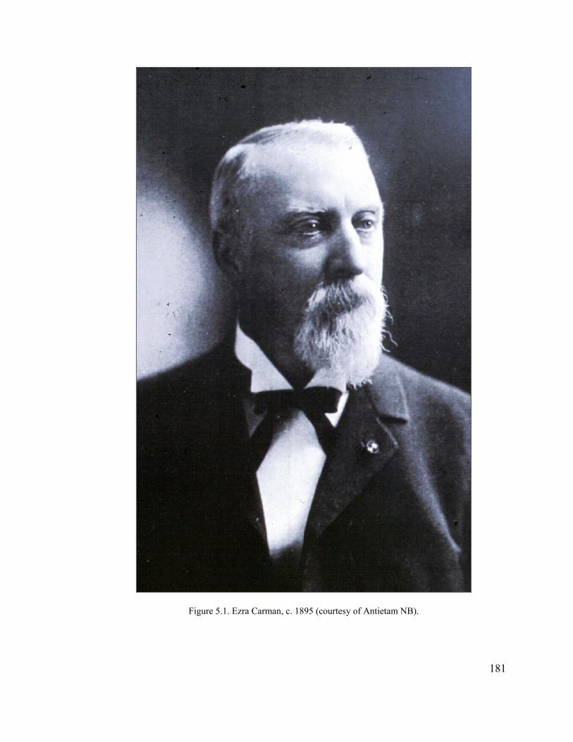
Figure 5.1. Ezra Carman, c. 1895 (courtesy of Antietam NB).
181
Redfield Proctor, “I will ask you to hear my full views on this subject because it is one of
great interest to us. Could he not now begin the work? I do not believe you can find a
fitter man than he.” Unfortunately for Carman, McComas lost the election and ceased
being an active player in Antietam battlefield affairs.3
During the Battle of Antietam Carman had commanded the recently recruited 13th
New Jersey, which comprised part of the new Twelfth Corps of Joseph Mansfield. The
heavy fighting in the East Woods and Cornfield in which this unit participated left a life-
long impression on Ezra Carman. During the almost three months the 13th New Jersey
remained in the Sharpsburg area following the battle, Carman began preparing an account
and map of it. When the regiment left, Carman set aside his work on Antietam, and did
not return to it until the 1880s.4
Carman was an ardent Republican, and held a couple of government positions in
New Jersey following the Civil War. In 1877 President Rutherford B. Hayes appointed
3 L.E. McComas, House of Representatives, to Redfield Proctor, Sec. of War, October 17, 1890, Antietam Battlefield Commission, Letters and Reports to the Secretary, 1894-1898 (ABC), Records of the Cemeterial Commissions, 1893-1916 (Entry 707), Records of the Office of the Quartermaster General, Record Group 92 (RG 92), National Archives Building, Washington, D.C. (NA). 4 John Connor Scully, “Ezra Carman: Soldier and Historian” (master’s thesis, George Mason University, 1997), 1, 8, 12-13, 19, 29, 34, 37. Prior to the Civil War, Carman was a mathematics teacher and bookkeeper. He received his first military appointment as Lieutenant Colonel of the 7th New Jersey and led this regiment at the Battle of Williamsburg, where he received a severe wound in his right arm. In July 1862 Carman accepted command of the newly created 13th New Jersey, and immediately set to work recruiting and training soldiers. The unit was mustered into service in August.
182
Carman participated in the opening of the Battle of Chancellorsville on May 1, 1863, but was injured a second time and forced to sit out the remainder of the campaign. He rejoined the 13th New Jersey in September, at which time it was ordered west along with the rest of the Twelfth Corps to Chattanooga. In the spring of 1864, as part of the Army of the Cumberland, the 13th participated in Sherman’s Atlanta Campaign. It fought in several major engagements, including Resaca (May 15-16, 1864), New Hope Church (May 25, 1864) and Kolb’s Farm (June 22, 1864). In September, Ezra Carman received his long-sought brigade command, but remained a Colonel. He participated in the siege and fall of Savannah, but after returning from a lengthy leave of absence he was not given back his command. At the war’s conclusion, Carman was placed in command of the First Division of the Twentieth Corps, just in time to lead it in the Grand Review of the Western Army through the capital. He received a promotion to Brevet Brigadier General two years after the war ended.
him Chief Clerk of the Department of Agriculture, a position he held until the first
postwar Democratic administration came into office with the election of Grover
Cleveland in 1885. Carman also was active in veteran affairs and, as previously noted,
served on the Board of Trustees for Antietam National Cemetery for over ten years. In
this capacity, he had been one of the main opponents of burying Confederate soldiers in
the cemetery.5
Even after the defeat of his ally Louis McComas, Carman did not give up seeking
a position on the Antietam commission. He personally visited Quartermaster General
R.N. Batchelder on June 2, 1891. The next day Carman followed with a letter again
offering his services. “It would afford me great pleasure to be assigned to this work,” he
declared, “and I believe that, with a somewhat extended personal knowledge of the field
and data collected for a history of the battle, I can bring it to a satisfactory completion.”6
One week later, Batchelder recommended the appointments of E.A. Carman and
Henry Heth to comprise an Antietam Board (there was no legal authority to create a
commission). Secretary of War Redfield Proctor selected Gen. Heth of Virginia to
represent the Confederates, but passed over Carman in favor of Col. John C. Stearns of
Vermont for the Union representative. Carman, deeply disappointed about not receiving
the appointment, attributed Proctor’s rebuff to allegations the Secretary of War had heard
of fraud connected to Carman’s earlier position in the Department of Agriculture.
5 Scully, “Ezra Carman,” 80-82.
1836 E.A. Carman to Gen. R.N. Batchelder, June 3, 1891; ABC; Entry 707; RG 92; NA.
Carman vehemently denied the charges, ascribing them to partisan politics, but to no
avail.7
The Union appointee to the Board, John Chandler Stearns, had served in the 9th
Vermont Infantry as Adjutant during the Civil War. He had been captured at Harpers
Ferry when that garrison surrendered to the Confederates in the days preceding the Battle
of Antietam, and thus was not present at that engagement. Gen. Henry Heth, a Division
Commander in the Army of Northern Virginia during the latter part of the war, was
fighting in the western theater at that time and also had not been present at Antietam. For
several years prior to his appointment to the Antietam Board, Heth had worked in the
War Department compiling Confederate records for publication in the Official Records.8
Thus, instead of appointing knowledgeable veterans of the battle to the Antietam
Board, the Secretary of War selected two men who had not even been present that day.
This contrasted with the three-member commissions designated for the other four
battlefield parks that, with one exception, consisted of veterans of those respective
battles. Only John B. Bachelder, appointed to the Gettysburg Commission, was not a
veteran; however, he had arrived at Gettysburg within days of the battle’s conclusion, and
had made it his life work to record and promote that great engagement. The War
Department also appointed historians and engineers to assist several of these
commissions in their work. The fact that a full-blown commission was not established for
Antietam as had occurred for the other battlefields, as well as the selection of non-battle
7 R.N. Batchelder to Sec. of War, June 11, 1891, Endorsement of Sec. of War on back of Batchelder letter, June 17, 1891, E.A. Carman to Louis E. McComas, July 4, 1891, ABC, Entry 707, RG 92, NA.
184
8 David A. Lilley, “The Antietam Battlefield Board and its Atlas: or The Genesis of the Carman-Cope Maps,” in Lincoln Herald 82 (1980): 380-387; Henry Heth, The Memoirs of Henry Heth, ed. James L. Morrison, Jr. (Westport, Connecticut: Greenwood Press, 1974), 225-227.

participants to the Board, demonstrates the lesser stature of Antietam from the very
beginning, resulting from the lack of any political pressure on the part of the powerful
Union veterans’ organizations and disinterest on the part of the State of Maryland.9
The local population was not cognizant of such fine distinctions, however, and
viewed the creation of the Antietam Board as the beginning of extensive improvements to
the battlefield. The Keedysville-based Antietam Valley Record reprinted an article from
the Baltimore American announcing the appropriation of $15,000 toward marking the
lines at Antietam and the appointment of Heth and Stearns to complete this work. The
article noted that Congressman McComas’s purpose in obtaining the appropriation was
“to preserve the entire battlefield, and to make it a national park, as is now being done
with Chickamauga,” and to purchase sites for the location of tablets to relate the history
of the battle. In reference to the latter, it cautioned:
Experience in previous undertakings by the United States government of this kind, makes one word of advice seem necessary. The persons owning the property on which these tablets are to be erected have, in many cases of other parks like the proposed Antietam park, considered it a good chance to make money out of the government’s patriotic purpose. Any such scheme in this case will end in defeat. The farmers around Chickamauga tried to charge the government money enough to pay for their whole farms, with the result that the whole plan of parking the battlefield of Chickamauga came very near being entirely abandoned. The appropriation is small for Antietam, and, while it may, perhaps, be subsequently increased, the government will show that it knows the value of the property it needs, and will pay not a cent more than it is worth.10
This caution would prove prescient as work proceeded on the battlefield.
9 Smith, This Great Battlefield, 31-36; Waldrep, Battleground, 180; Kaser, At the Bivouac of Memory, 86; Harlan D. Unrau, Administrative History, Gettysburg National Military Park and National Cemetery, Pennsylvania (Washington, D.C.: Government Printing Office, 1991), 70-71, 73.
18510 Baltimore American, reprinted in Keedysville Antietam Valley Record, July 17, 1891.

In mid-August 1891 Heth and Stearns arrived at Sharpsburg and commenced their
work. By the end of the year they had gathered enough information to locate and mark
the 43 regular army commands that had participated in the battle. The two men also had
met with a number of the local farmers to discuss the availability and price of their land.
Echoing the sentiments expressed earlier in the Baltimore American, a local
correspondent observed of this meeting: “The general impression among our land owners
is that they ought to have $100 per acre for their land while one or so are wild on the
subject and want $125. The gentlemen want to make a report to congress and ask for an
appropriation to buy twenty-five foot squares on which to place a marker of some kind . .
. or to buy the entire battlefield if the price is not too high. It is to be hoped that our
farmers will not put ‘bluff’ prices on their land, for herein lies the great danger of keeping
away this much coveted improvement to our town and adjacent country.”11
Heth and Stearns returned to Sharpsburg in late May 1892 to superintend the
replacement of the temporary stakes denoting the positions of the 43 regular army
commands with more substantial wooden markers, as the former were being destroyed
during cultivation of the fields. The two men also located the line of the Army of
Northern Virginia, but their work did not progress as rapidly as hoped due to illnesses on
both their parts. As the summer progressed J.C. Stearns’s condition worsened, requiring
11 H. Heth to Gen. R.N. Batchelder, August 12, 1891, J.C. Stearns and H. Heth to Sec. of War, October 19, 1891, Antietam Board to Gen. R.N. Batchelder, QM Gen., January 18, 1892, ABC, Entry 707, RG 92, NA; Keedysville Antietam Valley Record, August 14, 1891, and January 1, 1892.
186
him to take an extended leave of absence. Heth continued on his own, putting up
temporary markers delineating the Confederate line at the opening of the battle.12
Over the next year the two men continued their work of marking the battlefield.
As part of this effort, Heth and Stearns corresponded with numerous veterans to gather
their recollections of the lines of battle. In a June 1893 report to the Quartermaster
General, they also provided estimates for battlefield improvements to be included in
budget requests for the next fiscal year. Totaling $24,250, it included funding for 50
tablets, land for roads and tablet sites, and a separate allocation to purchase the entire
Sunken Road—the only portion of the battlefield specifically identified for acquisition.13
In their report, Heth and Stearns called attention to the fact that many thousands
of people visited Antietam battlefield each year, and that once their work was completed
the number most certainly would increase. The two men noted that large numbers of
interpretive tablets would be concentrated in specific areas, notably around the Dunker
Church, East Woods, and the Bloody Lane. “In justice to the farmers owning these
fields,” they opined, “we think roadways should be constructed to enable visitors to this
battle-field [sic] to view and inspect these tablets without trampling upon and injuring
growing crops, gardens, orchards, etc.” Precedence for such roads existed at Gettysburg,
12 J.C. Stearns and H. Heth to Gen. R.N. Batchelder, June 10, 1892, J.C. Stearns to Gen. R.N. Batchelder, June 13, 1892 and August 27, 1892, John C. Stearns and H. Heth to Gen. R.N. Batchelder, September 26, 1862, ABC, Entry 707, RG 92, NA; Keedysville Antietam Valley Record, May 27, 1892, and September 16, 1892. The wooden markers used by Heth and Stearns were 4 feet long, 18 inches wide and 2 inches thick, and stood 2 feet above ground level once planted. They were supposed to be replaced at a later date by granite or marble slabs.
187
13 J.C. Stearns and H. Heth to Gen. R.N. Batchelder, June 27, 1893, ABC, Entry 707, RG 92, NA. The estimate broke down as follows: $5,750 for battle lines, sites, and roads on Antietam Battlefield, for the purchase of fifty additional tablets, and transporting and setting up the same; $2,500 for fifty additional sites for tablets, marking battery positions for both armies; $500 for land condemnation; $6,000 for Board member slaries; $1,500 for hiring surveyors and draftsman to produce maps; and, $8,000 for acquisition and repair of the Sunken Road.
where beginning in 1881 the GBMA had constructed a number of avenues through the
main portions of the Northern lines.14
The two Board members also communicated difficulties they were encountering
with the farmers. The latter preferred to go through condemnation proceedings rather
than sell directly to the government, no doubt hoping they would receive higher prices. In
addition, the landowners refused to sell isolated pieces of land for battlefield markers, but
were willing for the government to acquire their entire farms. Heth and Stearns still
recommended acquisition of small squares of land through condemnation, but not until
their study of the troop positions had been completed. They proposed marking brigade
positions with stone tablets or monuments, and batteries with surplus cannon. By the
beginning of 1894, about 50 cannon had been delivered to Sharpsburg and were awaiting
placement on the field.15
By January 1894, the frustrations of the Antietam Board members were clearly
evident. In what would become a recurrent theme on the part of many involved with
Antietam battlefield, Heth and Stearns complained that they were not receiving the
support they needed to complete their work and were “badly handicapped” relative to the
two other War Department parks at Chickamauga and Gettysburg, “by not being able
under the Acts of Congress appropriating money for this work, to have the benefit of the
presence on the field, of Officers, holding important positions during this fight.”
Regarding Chickamauga, they noted the substantially larger appropriations granted to
14 J.C. Stearns and H. Heth to Gen. R.N. Batchelder, June 27, 1893, ABC, Entry 707, RG 92, NA; Unrau, Administrative History, Gettysburg, 49-61, passim.
188
15 J.C. Stearns and H. Heth to QM General R.N. Batchelder, January 13, 1894, ABC, Entry 707, RG 92, NA.
that battlefield, which enabled its commissioners to pay for veterans’ travel. In contrast,
“the Antietam Board has had to defray the expenses of all persons who visited the field
for the purpose of giving it information, as well as their own.” At Gettysburg, the
commission members for that battlefield “have the benefit of the life long study of their
field by Col. [John B.] Bachelder,” including the use of his detailed maps. The primary
map of Antietam that Heth and Stearns were working from, on the other hand, contained
many inaccuracies, and many reports of the battle were missing or provided little
information. “Had we been placed on the same footing with the Chickamauga
Commission,” they complained, “we would have been able to report greater progress.”
As a result, the two board members concluded that they needed an additional two years to
complete their work.16
The complaints of Heth and Stearns, while warranted, fell on deaf ears. In fact,
the patience of those overseeing the project was wearing thin. “I cannot resist the
conclusion that the Board . . . is less expeditious in its operations than Congress and the
Department have a reasonable right to expect,” wrote Secretary of War Daniel S. Lamont
to the Quartermaster General in mid July. “Over three years have passed since the
scheme was undertaken, and the Board has so little to show in the way of accomplished
results as to lead to the belief that difficulties have been encountered which are either
insurmountable, or cannot be overcome by the Board as presently constituted.” In
response, Batchelder pressured the Board to resume its work, which had been interrupted
again due to Stearns’s reoccurring, and evidently terminal, illness. The Quartermaster
189
16 J.C. Stearns and H. Heth to QM General R.N. Batchelder, January 13, 1894, ABC, Entry 707, RG 92, NA. It was the intent of Stearns and Heth to produce three maps, “the first showing positions at time battle began, the second the extreme advance of the Union forces, and the third the positions occupied when the battle ended.”
General sent a terse note to Stearns, directing him to return immediately to his duties.
One week later Stearns tendered his resignation; a couple of days later he was dead.17
Henry Heth paid tribute to his late colleague, declaring “when his health
permitted he was a valuable adjunct to the Antietam Board, a man of fine business
capacity, hard working and energetic, he took great pride in his work. Unfortunately, for
the past eighteen months his health was very bad, until finally it gave way altogether.” He
concluded it was hardly necessary to add “in consequence of Col. Stearns’ bad health, the
work has not progressed as rapidly as it would otherwise have done.” By this time, Heth
had abandoned the Board’s earlier idea of purchasing small plots of ground, owing to the
high cost involved and complaints from farmers that visitors would trample their crops.
Instead, he recommended the acquisition of 800 acres (rather than the 500 estimated
earlier), at a cost of $56,000, for the placement of markers. Construction of roads to these
monuments, he estimated, would cost an additional $15,000. As with the other ideas put
forth by the Antietam Board, Heth’s suggestions went nowhere.18
George B. Davis Takes Charge
Ezra Carman lost no time in reapplying for the Antietam Board, soliciting
Quartermaster General Batchelder less than a week after Stearns’s resignation. Over the
next two months, however, the War Department deliberated on the future of the Antietam
project, leading some to believe that it was going to be discontinued. In early October
17 Sec. of War Daniel S. Lamont to QM General R. N. Batchelder, July 14, 1894, R.N. Batchelder to Col. J.C. Stearns, July 19, 1894, John C. Stearns to Sec. of War Daniel S. Lamont, July 26, 1894, ABC, Entry 707, RG 92, NA.
19018 H. Heth to QM Gen. R.N. Batchelder, August 1, 1894, ABC, Entry 707, RG 92, NA.

1894 the Secretary of War transferred supervision of the Antietam Board from the
Quartermaster General to his own office. He appointed Carman to the coveted position of
Historical Expert, and made Maj. George B. Davis the Union representative and president
of the Antietam Board (Figure 5.2). Henry Heth remained on the reorganized Board as
the Confederate representative, but quickly withdrew into the background.19
Davis was well known to Lamont, having served since May 1889 as president of
the publication board for the Official Records of the War of the Rebellion. He had joined
the 1st Massachusetts Cavalry at the very end of the Civil War, and continued a military
career after graduating from West Point in 1871. Therefore, like Heth and Stearns before
him, Davis was not a participant in the Battle of Antietam, but would have been well
acquainted with the project. An energetic and capable man who held Lamont’s trust, it is
quite possible that Davis masterminded the reorganization of the Board following
Stearns’s death. Within a couple of months of his appointment, George B. Davis also
would lead the Antietam Board in a different direction from the tentative steps Heth and
Stearns had taken toward land acquisition at the battlefield.20
Shortly before his appointment to the Antietam Board, Davis conveyed to the
Secretary of War in detail his thoughts about the work at Sharpsburg. First, he viewed the
Congressional appropriations as totally inadequate for the task at hand. “Judging from
19 E.A. Carman to Gen. R.N. Batchelder, July 30, 1894, Sec. of War Daniel S. Lamont to QM General, October 8, 1894, Daniel S. Lamont to Ezra A. Carman, October 8, 1894, ABC, Entry 707, RG 92, NA. On August 10, 1894, the Adjutant General for the Commonwealth of Massachusetts wrote Sen. Henry Cabot Lodge, and requested “he use his influence to dissuade the Sec. of War from discontinuing the work on Antietam Battlefield, which they have been told he is considering doing.” In an August 22, 1894, response to Lodge’s subsequent inquiry, the Secretary of War related that he had no intention of doing so.
191
20 Charles Snell and Sharon Brown, Antietam National Battlefield and National Cemetery, Sharpsburg, Maryland: An Administrative History (Washington, D.C.: Government Printing Office, 1986), 86; Lilley, “The Antietam Battlefield Board,” 382.

Figure 5.2. George B. Davis, 1909 (courtesy of Library of Congress).
192
the experience gained at Chickamauga and Gettysburg, - and I cannot think that land can
be purchased more reasonably at Sharpsburg than at either of these places,” he explained,
“an expenditure of considerably more than a hundred thousand dollars will be necessary
to carry out the scheme of land purchase and line marking” called for in the
Congressional acts. Second, he felt that locating and marking the lines of battle at
Antietam would be much more difficult than at either of the other two battlefields, where
prominent natural landscape features made such work relatively easy. At Antietam, on
the other hand, the features that constituted points of reference, such as woods, fields and
fences, had been modified and changed over the years, making it much more difficult to
locate positions. He recommended preparation of a battlefield map that could be
circulated among surviving participants of the battle to facilitate recording of their
memories of troop positions on the battlefield.21
To create the map that he had in mind, Davis appointed Jedediah Hotchkiss as
Expert Topographer to the Board. Hotchkiss had served as General Thomas “Stonewall”
Jackson’s cartographer during the Civil War, and afterward he had opened an engineering
and surveying business in Staunton, Virginia. Davis knew Hotchkiss through his work
producing maps for the Official Records. From the beginning, Davis stressed to
Hotchkiss the importance of completing the map within two months of his appointment—
an impossible assignment, but reflective of the characteristic impatience Davis was to
display throughout his tenure on the Antietam Board.22
21 Maj. George B. Davis, JAG, to Sec. of War, October 4, 1894, ABC, Entry 707, RG 92, NA.
193
22 Lilley, “Antietam Battlefield Board,” 382; George B. Davis to Maj. Jed Hotchkiss, October 13, 1894, ABC, Entry 707, RG 92, NA; William J. Miller, Mapping for Stonewall: The Civil War Service of Jed Hotchkiss (Washington, D.C.: Elliott & Clark Publishing, 1993), 155; Hotchkiss Diary, October 13, 1894,
Davis, Carman, and Hotchkiss met in Sharpsburg on October 17, 1894, to “lay out
a plan of campaign.” They set up an office in Sharpsburg for Gen. Carman, who would
be spending considerable time in that town over the next year. It was Carman’s job to
negotiate with the local landowners for acquisition of land for tablets and avenues, and to
tour the battlefield with state commissions and veterans to locate positions in the field.
Hotchkiss was to begin work on his map, while Maj. Davis would begin drafting text for
tablets and seeking a contractor to cast them. Davis returned to Washington the following
day and Hotchkiss shortly thereafter, each to begin his respective task.23
Construction of the Battlefield Avenues
Within the first month the new Antietam Board made significant progress in
defining routes for new avenues through the battlefield. The three men did not begin with
an overall plan in mind for access to various points on the battlefield, but added roads
incrementally as the need arose or opportunity presented itself. Borrowing heavily from
the precedent set at Gettysburg, they focused on placing roads where key areas of the
battlefield could be viewed, and also where interpretive tablets could be placed. Such
Hotchkiss Papers, Library of Congress (LC). In a letter written to Carman the same day as his appointment letter to Hotchkiss, Davis stressed the importance of completing the maps: “Our course is, to my mind, clear. We must get our plates into the hands of the lithographer at the earliest possible date, - certainly within two months, and must make up for lost time generally. I promised the Secretary to do this, and he seemed greatly pleased.”
194
23 George B. Davis to Maj. Jed Hotchkiss, October 13, 1894, John Nicholson to Maj. George B. Davis, October 22, 1894, ABC, Entry 707, RG 92, NA; Hotchkiss Diary, October 17-19, 1894, Hotchkiss Papers, LC. The week previous to their October 17 meeting, Davis and Carman evidently had met with a delegation from Pennsylvania, during which they successfully located the positions of many regiments and batteries from that state. While in Sharpsburg for the Board meeting, they also toured the battlefield with a delegation from Rhode Island. See Maj. George B. Davis to Gen. W.W. Greenland, Adj. General of Pennsylvania, October 17, 1894, ABC, Entry 707, RG 92, NA. Carman set up his office in the “store room of Mrs. A.B. Cronice near the Antietam House,” according to the Keedysville Antietam Valley Record, November 2, 1894.
decisions were not always easy or straightforward, however, as the board members also
had to contend with the desires and needs of the local landowners, who had a voice in the
placement of the avenues and other War Department improvements and thus the
development of the commemorative landscape.
Carman initially focused on the Sunken Road, which had been identified for
acquisition earlier by Heth and Stearns. From the first Carman encountered resistance
from some of the landowners, particularly Samuel Piper and J.A. Myers. Believing that
these two men owned the two end points of the Sunken Road, Davis suggested avoiding
them by accessing the central, most important part of the lane through other properties. “I
am anxious to get to work on the macadamizing of the lane this fall,” he concluded
impatiently, “or early winter, if such work can be done at that season.”24
Carman responded that since Piper owned almost the entire south side of the lane
he could not be avoided, even though he would be the most difficult to deal with of all
the landowners. He was hopeful that William Roulette, another landowner along the lane
and “a strong union man, very public spirited and influential,” would exert influence on
the others, as the latter was very anxious to see the road improved. In fact, Roulette had
informed Carman that he would talk with Piper and “counsel him not only to be liberal,
but to give the right of way for nothing.” Carman noted growing interest on the part of
the local community in what the Antietam Board was doing at the battlefield, concluding
195
24 Maj. George B. Davis to Gen. E.A. Carman, October 22, 1894, ABC, Entry 707, RG 92, NA. J.A. Myers owned what was known as the Newcomer Mill and Farm along both sides of the Boonsboro Pike, while Samuel Piper had inherited the wartime Piper Farm from his father Henry.

rather sardonically: “The idea is largely prevalent, that in doing anything the Govt should
first consider what is best for this place.”25
Davis conveyed to Jed Hotchkiss his desire to begin work on the Sunken Lane as
soon as possible, “in order to put behind us as much of the labor as possible.” Hotchkiss,
who appears to have been the most sensitive of the three toward preservation of battle-
related landscape features, stressed his desire to maintain the width Bloody Lane had
during the time of the battle. “Gen. Carman and myself arrived at the conclusion that that
was the proper restoration to be made,” he continued, “and that the only change should be
in simply metaling [sic] the road-bed without changing the grade or the banks.” After
further reflection, Carman decided to stay out of the most historic part of Bloody Lane
altogether, between Roulette’s lane and the point where the road turned 90 degrees
toward the south (at the location of the present observation tower). Carman determined
that this new road section should go on the south side of Bloody Lane, on Samuel Piper’s
property, as the grade was better and he believed the land would be cheaper (Figure
5.3).26
While drafting text for interpretive tablets during the second half of October,
Davis determined that a road linking the Hagerstown Pike and the Smoketown Road on
the northern end of the battlefield (subsequently known as Mansfield Avenue) would
enable the Board to “erect tablets for the First, Second and Twelfth Corps which will
25 E.A. Carman to Maj. George B. Davis, October 23, 1894, ABC, Entry 707, RG 92, NA.
196
26 Maj. George B. Davis to Maj. Jed Hotchkiss, October 23, 1894, Jed. Hotchkiss to Maj. George B. Davis, October 25, 1894, E.A. Carman to Maj. George B. Davis, November 24, 1894, ABC, Entry 707, RG 92, NA. The Keedysville Antietam Valley Record, November 23, 1894, noted that the old Bloody Lane would not be disturbed, suggesting that the historical nature of this road was evident to local community members as well.
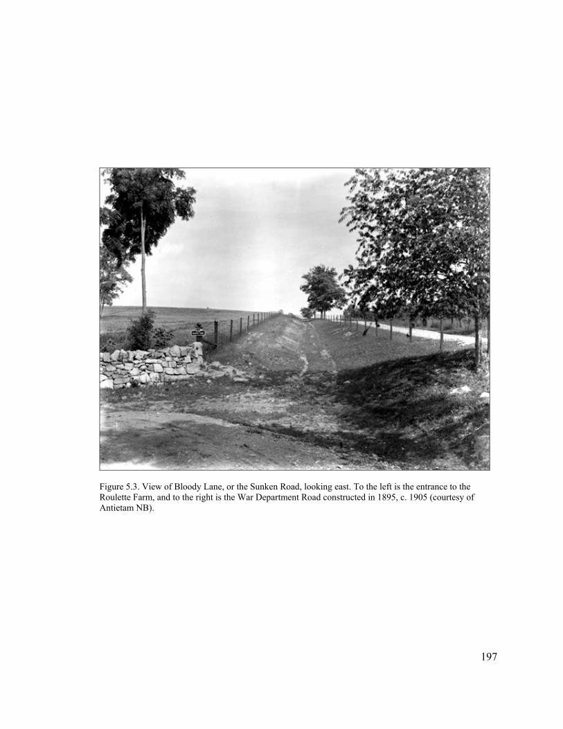
Figure 5.3. View of Bloody Lane, or the Sunken Road, looking east. To the left is the entrance to the Roulette Farm, and to the right is the War Department Road constructed in 1895, c. 1905 (courtesy of Antietam NB).
197
put them somewhere near their respective lines of advance” (Figure 5.4). He also came
up with an idea for a short lane (later known as Confederate Avenue) from the Dunker
Church “over toward what is left of the North Woods” that would open up the area of
Sedgwick’s assault and the Confederate line of advance. Carman walked the ground on
the west side of the Hagerstown Pike, between the church and the North Woods, and laid
out a new route through the West Woods of which he declared “every foot . . . is of
interest.” Carman estimated that the new road would be less than a mile in length, but
would command every fighting position on both sides. Most of this proposed route
passed through land possessed by the Locher, or Locker family, absentee owners who
lived in Pennsylvania.27
The avenue Davis had in mind on the northern end of the battlefield to connect
the Hagerstown Pike with Smoketown Road primarily lay within the old Joseph
Poffenberger Farm, now owned by Otho Poffenberger. Carman laid out a new road
through this area as well, incorporating an existing farm lane for much of its length.
Ironically, while Davis noted in his proposal that he did “not apprehend any difficulty in
the acquisition of the land,” Carman was to discover otherwise in subsequent dealings
with Otho Poffenberger, who was to prove almost as much of a problem as Samuel
Piper.28
27 Maj. George B. Davis to Gen. E.A. Carman, October 31, 1894, E.A. Carman to Maj. George B. Davis, November 3, 1894, E.A. Carman to Maj. George B. Davis, November 7, 1894, E.A. Carman to Maj. George B. Davis, November 7, 1894, ABC, Entry 707, RG 92, NA. In his letter to Davis, Carman described his proposed roadway through the West Woods: “Where it starts [opposite D.R. Miller’s] Gillan deployed; in the first wood it enters, Gillan, Patrick and Goodrich on one side and Jackson, on the other, fought on either side of it. It enters the West Woods proper, on the right flank of Sedgwick’s advance line and follows his front, and not 30 feet from it, to the small building known as the Locher house, and thence to the Hagerstown road.”
19828 Maj. George B. Davis to Gen. E.A. Carman, October 31, 1894, ABC, Entry 707, RG 92, NA.
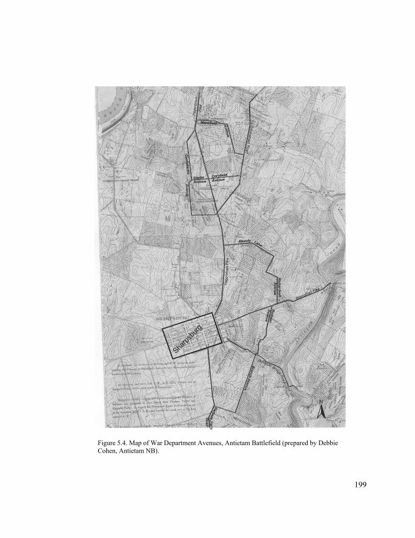
Figure 5.4. Map of War Department Avenues, Antietam Battlefield (prepared by Debbie Cohen, Antietam NB).
199

During this same period Carman also laid out a road (later designated Rodman
Avenue) from the Boonsboro Turnpike to Burnside Bridge Road, southeast of the
national cemetery (Figure 5.4). This new route began on the Boonsboro Turnpike near
the outlet for the Sunken Road, and followed fence lines to the south and east through the
old Sherrick Farm to a substantial farm lane that extended to the farm buildings. Once
past the house, the proposed road alignment crossed a steep ravine, before reaching the
county road to Burnside Bridge. The entire roadway passed through the property of Mrs.
Newcomer, another absentee owner who lived in Hagerstown.29
While laying out this road, Carman noted that the citizens of Sharpsburg were
“agitating” to improve the steep and rough road between Burnside Bridge and the town.
Indeed, the local community was watching the work of the Antietam Board carefully.
Speculation was rife in town concerning other roads as well, the Antietam Valley Record
suggesting that the “Bloody Lane Avenue” most likely would extend to Belinda Springs,
an early nineteenth-century resort on the Snavely Farm, and to Burnside Bridge. The
latter most certainly was a reference to the roadway Carman was laying out through the
Sherrick Farm.30
During his first month on the Antietam Board, George B. Davis gave a lot of
thought about how best to mark and interpret the battlefield. In a long and thoughtful
report submitted to the Secretary of War in early November 1894, Davis systematically
and logically laid out the issues surrounding the project and his ideas on how to deal with
them—ideas that were to have enormous repercussions for the future management of the
29 E.A. Carman to Maj. George B. Davis, November 5, 1894, ABC, Entry 707, RG 92, NA.
200
30 E.A. Carman to Maj. George B. Davis, November 5, 1894, ABC, Entry 707, RG 92, NA; Keedysville Antietam Valley Record, December 21, 1894.
battlefield. First, he noted that about $25,000 remained unexpended from the sums
appropriated, and the question to his mind was “determining upon a scheme of marking
which will not greatly exceed that sum.” Davis described two means of carrying out the
Congressional mandate of marking the battlefield, the first requiring acquisition of the
entire battlefield, and the second acquisition of rights-of-way for lanes and avenues
crossing the principal areas of the battlefield. Second, he noted that the three areas of
heaviest fighting—the vicinity of Dunker Church, Bloody Lane, and vicinity of Burnside
Bridge—were located on three different roads that radiated from Sharpsburg. Owing to
the lack of cross roads connecting these points, visitors were required to backtrack
through town two or three times to see the most important parts of the battlefield.
Given the two points outlined above, Davis concluded that it made the most sense
to acquire narrow strips of land upon which to construct lanes linking the major points of
the battlefield. These lanes would make the field accessible and “enable the principal
lines of battle to be so marked as to convey a clear idea of the several phases of the
engagement.” Importantly, such a plan would “involve the purchase of less than ten acres
of land, and will not commit the United States to the perpetual care and maintenance of a
large area of ground.” He believed that the four lanes already under consideration—
Bloody Lane, West Woods, Joseph Poffenberger Farm, and Sherrick Farm—would serve
admirably. “Upon the lands thus acquired,” continued Davis, “it is proposed to construct
roads, not exceeding twelve feet in width, to facilitate movements about the field and to
furnish sites for the tablets which will explain the different phases . . . of this battle.” As
noted earlier, an exception would be made for a portion of Bloody Lane, which would
retain its original configuration because of its great historical significance. The entire
201
project, which also included 200 cast iron tablets to explain the tactical maneuvers of the
battle, 100 iron poles to mark opposing lines of battle, and two wooden observation
towers, Davis estimated, would cost $33,000—not significantly greater than was already
on hand.31
Avenues were common features constructed at the military parks during this
period, following the model set by Gettysburg. The difference at Antietam, however, lay
in Davis’s proposal not to purchase the battlefield land surrounding them. This decision
not to pursue acquisition of significant portions of the battlefield represented a turning
point for Antietam and a departure from Heth and Stearns’s earlier recommendation to
acquire 800 acres. From the records it appears that Davis, when compared with the other
commission presidents, held little sentiment toward Antietam, and was more desirous of
pleasing the Secretary of War by holding down costs than by providing an extensive
commemorative setting on the battlefield.
Not surprisingly, the Secretary of War was delighted with Davis’s strategy and
quickly approved it. Lamont’s decision enabled Davis to move ahead with a “show
down” he had been contemplating with the local property owners, whom he felt were
asking exorbitant amounts for their land. “The more I think of it, the more I am
convinced that it is absurd to go over $100 per acre,” he communicated to Ezra Carman.
202
31 Maj. George B. Davis and H. Heth to Secretary of War, November 7, 1894, ABC, Entry 707, RG 92, NA. Although Henry Heth’s name is on the report, the tone and style was all Davis’s. Concurrent with the report submission, Davis also sent it to Carman and Hotchkiss for them to read “so that you may know how to talk.” After reviewing the document, Carman suggested that the rights-of-way for the avenues be 20 to 25 feet wide rather than the 12 feet proposed by Davis. He also suggested funding 300 rather than 200 cast iron tablets, “as I find I shall be able to use many in addition to those you have already put in my hands for inspection.” Finally, Carman noted that although the lanes will be used primarily for light travel, “the farmers will travel on them with heavily loaded wagons, thus requiring substantially more macadam in many places, which also will increase the cost.” While these recommendations did not make it into Davis’s first report, they all were subsequently adopted. See Maj. George B. Davis to Gen. E.A. Carman, November 8, 1894, and E.A. Carman to Maj. George B. Davis, November 10, 1894.
“There is no land in that county that will sell to-day for half that. If any of the land on the
field has value, it is historical, and not agricultural, or commercial values, and cannot be
expressed in dollars and cents.” If the landowners persisted in their demands, Davis
believed the Board would have to give up any idea of purchasing land.32
Fortunately, Davis’s meeting with the landowners in mid November evidently
went much better than expected and he decided to move ahead with the proposed land
acquisition. Davis was confident that the Antietam Board would “get the land for the
avenues that we need to have there at a reasonable price, and within a short time, without
a resort to condemnation proceedings.” Carman was not so optimistic, reporting one
week later that he was having “indifferent success” with the real estate business as “these
people require much deliberation.” Samuel Piper offered to sell all his interest along the
south side of Bloody Lane for $500, including the proposed section of new roadway that
would remove traffic from Bloody Lane. Even so, the price came to $200 per acre.
Carman also met with Otho Poffenberger, who “practically agreed to sell his lane, as it
now runs from Hagerstown road to Smoketown road for $100 per acre, but he wanted
more time for consideration.” Carman was still waiting to hear from the two absentee
landowners who owned the Sherrick and West Woods properties.33
Davis brushed off Carman’s anxieties, responding that he was “glad to see that the
land business looks so well, and that our road work can begin at once.” He suggested
construction begin with the Poffenberger Lane, followed by installation of the tablets for
32 Maj. George B. Davis to Gen. E.A. Carman, November 6, 1894, E.A. Carman to Maj. George B. Davis, November 7, 1894, ABC, Entry 707, RG 92, NA.
203
33 Maj. George B. Davis to Gen. H.V. Boynton, November 17, 1894, E.A. Carman to Maj. George B. Davis, November 24, 1894, ABC, Entry 707, RG 92, NA.
that part of the field. Unfortunately for Davis, after due deliberation Otho Poffenberger
asked $400 for his entire lane, prompting the major to respond that he could go no higher
than $100 per acre. “The arrangement I have suggested seems to me very favorable when
it is considered that the Commission takes nothing from you,” wrote an exasperated
Davis to Poffenberger, “but confers a positive benefit by making a good road in place of
the narrow lane which now exists.” Poffenberger finally acceded to the War
Department’s offer in mid December 1894. Shortly thereafter, Carman recommended to
Davis that the right-of-way be expanded from 20 to 25 feet, as the price difference would
not be great, but would improve the road greatly.34
During this period, Carman continued to work out details with Otho Poffenberger
regarding the location of the road’s outlet onto Smoketown Road. Carman wished to run
the proposed lane farther to the south along the edge of the East Woods, over a prominent
knoll that would provide a better view of the battlefield. Although Poffenberger wanted
an additional $100 for damages, due to the fact that it cut off a small corner of his farm,
Carman believed that it was preferable to pay the extra money given the advantages the
route would yield. Davis suggested Carman offer $50, “so that we can compromise on
$75.” He continued: “I am very loth [sic] to do it, for it seems to me that, in all fairness,
we are giving him all he is entitled to and more. I sometimes feel that it would be the part
of wisdom to do such marking as we can on the turnpikes, and let the whole thing go at
that, rather than yield to such demands and pay at least double the price of good farming
land for the mere privilege of paving and fencing their lanes. They are small, of course,
204
34 Maj. George B. Davis to Gen. E.A. Carman, November 26, 1894, Maj. George B. Davis to Otho Poffenberger, December 7, 1894, E.A. Carman to Maj. George B. Davis, December 10, 1894, and December 12, 1894, ABC, Entry 707, RG 92, NA.

and each is hardly worth debating on its merits, but the appropriation is small, too, and
the appropriation committees are harder to appeal to than ever before.” In the end,
Carman successfully secured the route he was after.35
Ezra Carman also continued working on land acquisition along the Sunken Road.
As noted earlier, Samuel Piper offered to sell all of his interest in the lane, plus a strip of
land on the south side of the Bloody Lane section, for $500, or about $200 per acre. After
further negotiation, the price fell slightly to $450 inclusive, and included additional
acreage at the outlet to Boonsboro Pike for a curve in the road designed to avoid a steep
descent. Ironically, William Roulette was the last to come to an agreement regarding his
property along the lane. By the end of the year, however, negotiations for both the
Sunken Road and the Poffenberger Lane appeared to have reached a successful
conclusion.36
In the final stages of negotiations for the Sunken Road, Carman considered the
probability that a number of states would wish to place monuments along the road as had
been done along the avenues at Gettysburg, and wondered whether it would be advisable
to add an additional 10 to 12 feet of width to the new section of road paralleling Bloody
Lane, as “the tendency seems to be among the regimental organizations to get as close
down to the lane as possible.” He suggested the same for the section of the Poffenberger
Lane that would be bordering the East Woods, recommending “that from the point where
35 E.A. Carman to Maj. George B. Davis, December 18, 1894, and December 19, 1894, Maj. George B. Davis to Gen. E.A. Carman, December 20, 1894, ABC, Entry 707, RG 92, NA. In his second letter to Davis, Carman also regretfully notes that the owner of the “north patch of the East woods has choppers at work leveling the whole wood, old trees and new.”
205
36 E.A. Carman to Maj. George B. Davis, November 24, 1894 and December 12, 1894; Maj. George B. Davis to Gen. E.A. Carman, December 13, 1894; ABC; Records of the Cemeterial Commissions, 1893-1916 (Entry 707); RG 92; NAB.
it turns from the south course to go west to the Smoketown road, the lane be 40 feet or 45
in width, giving room for a battery, or a pile of cannon balls for Mansfield, and for
regimental monuments for four or five regiments that did their best fighting and suffered
most here.” Evidently, neither of these requests was approved, or even considered, by the
cost-conscious Davis, providing yet another example of his disinterest in the battlefield as
a commemorative space, particularly when compared to the active lobbying conducted by
the other commissions to have monuments erected on their battlefields.37
At the end of November, after consulting with and receiving the approval of Ezra
Carman, Jed Hotchkiss proposed a “Battle Avenue”150 feet in width (no doubt to provide
room for monuments) to Maj. Davis that would extend from the Hagerstown Pike to the
edge of the East Woods, along the southern boundary of Miller’s cornfield. Hotchkiss
also campaigned for acquisition of the three main wood lots, most likely in response to
their ongoing destruction. “If these pieces . . . were secured and the woods restored,”
Hotchkiss stated in reference to the latter, “what constituted, essentially, the battle ground
of Antietam will be secured, and one of the most unique battle-fields of the war would be
preserved in its original condition; a condition that could be maintained at little or no cost
to the Government after its restoration.” Davis agreed with Hotchkiss’s recommendations
regarding the new avenue and restoration of the woods, but noted: “All those things will
come in time; but, in view of the condition of the Treasury, and the difficulty of obtaining
an appropriation, it seems to me hardly wise to urge them strongly at the present moment.
It will not be difficult to have them inserted in a future appropriation bill, and carried into
effect as soon as possible.” Davis was not above using Hotchkiss’s cornfield avenue
20637 E.A. Carman to Maj. George B. Davis, December 19, 1894, ABC, Entry 707, RG 92, NA.

concept as a bargaining point with Otho Poffenberger, however, by threatening to build
that road in lieu of the lane through Poffenberger’s property if he continued to balk at
coming to terms. Whether as a result of this tactic or not, Poffenberger finally agreed to
allow construction of the roadway.38
Of those involved in the Antietam project, Hotchkiss apparently was the only one
who saw, or at least articulated, the merit in acquiring key features of the battlefield
landscape. Even Hotchkiss did not see the need to purchase the farm fields upon which
much of the battle had been fought, however, as all of the Board members believed that
these fields would remain farmland and therefore did not require active preservation. This
way of thinking differed greatly from at least one other battlefield, Shiloh, where the
fields were viewed as cemeteries containing unclaimed dead (principally Confederate),
and thus worthy of protection.39
While finalizing negotiations for the avenues through the Sherrick Farm and West
Woods in early 1895, George B. Davis moved ahead with plans to improve the Sunken
Road and Poffenberger lane (Figure 5.5). Bid proposals for 11,000 feet of road, 12 feet in
width, were released in January, prompting a local newspaper to declare: “This begins to
look like business.” The government awarded the contract to James Snyder of
Sharpsburg, who Davis immediately admonished to have the work completed
38 Jed Hotchkiss to Maj. George B. Davis, November 30, 1894, Maj. George B. Davis to Jed Hotchkiss, December 8, 1894, Maj. George B. Davis to Gen. E.A. Carman, December 7, 1894, ABC, Entry 707, RG 92, NA. Hotchkiss’s letter to Davis also included the first proposal for constructing the observation tower inside the northeastern angle of the Sunken Road.
20739 Smith, This Great Battlefield, 18.
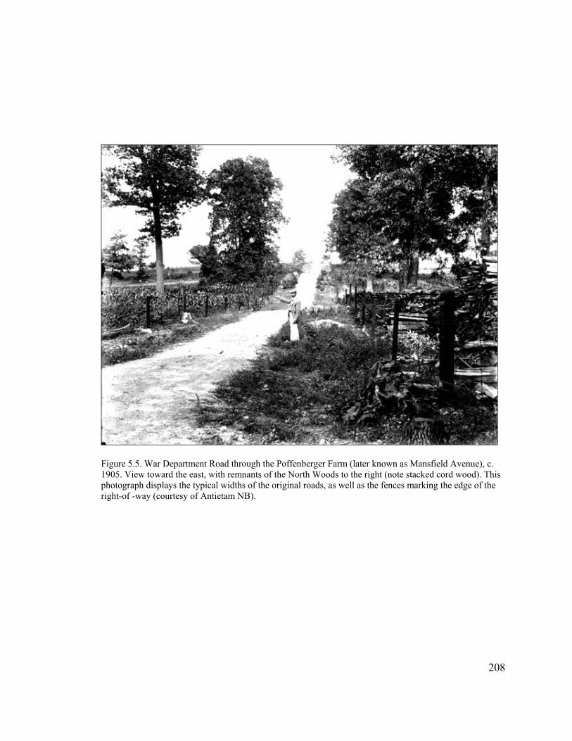
Figure 5.5. War Department Road through the Poffenberger Farm (later known as Mansfield Avenue), c. 1905. View toward the east, with remnants of the North Woods to the right (note stacked cord wood). This photograph displays the typical widths of the original roads, as well as the fences marking the edge of the right-of -way (courtesy of Antietam NB).
208
by Decoration Day. In addition to the two roads, Snyder was given informal oversight of
a separate masonry contract to construct bridges, culverts and retaining walls along the
roadways, and a stone tower at the end of Bloody Lane. Davis subsequently expanded
Snyder’s contract to include the top portion of the road through the Sherrick Farm.40
In the beginning of March Davis advertised for the remainder of the roadwork,
which consisted of the avenue through the West Woods (Confederate Avenue), and a
newly approved road (later known as Branch Avenue) extending from the Burnside
Bridge to Harpers Ferry Road, along the property line between the historic Otto Farm
(now owned by Jacob B. Stine) and the farm of Urias Gross (Figure 5.4). Altogether this
contract consisted of 10,000 feet of roadway plus all fencing and gates along them. Davis
awarded the contract to James March & Co. of Hagerstown toward the end of the
month.41
In the meantime, work had just barely begun under Snyder’s contract owing to
extremely bad weather conditions. The weather did not break until the middle of March,
40 Maj. George B. Davis to E.A. Carman, January 10, 1895, Maj. George B. Davis to James Snyder, January 26, 1895, January 29, 1895, and January 31, 1895, ABC, Entry 707, RG 92, NA. Keedysville Antietam Valley Record, January 11, 1895, and February 1, 1895. Characteristically, Davis hastily threw together a set of specifications in early January, the inadequacy of which interested contractors brought to his attention. He cancelled the first set in the middle of the month and put out new, more comprehensive ones modeled on a road constructed for Fredericksburg National Cemetery (see E.A. Carman to Maj. George B. Davis, January 9, 1895, and Maj. George B. Davis to Gen. E.A. Carman, January 10, 1895). The additional 5,000 feet of roadway on the Sherrick Farm represented a 30% increase in the cost of the contract—the maximum amount that could be added without having to go out for another bid. Davis obviously was trying to get as much work done as quickly as possible, even stating to Snyder in regard to the masonry work that he wanted “rough stone work with no dressing, save such as is necessary to make decent corners, in order to expedite the construction of the culvert and bridge abutments.” The Newcomer and Locher families each accepted $100 per acre for the rights-of-way through their properties. Charles Locher offered to sell “the whole farm very reasonable,” but of course this did not receive consideration by Davis. See Anna Newcomer to George B. Davis, Jamuary 23, 1895, and Charles H. Locher to Maj. George B. Davis, January 26, 1895.
209
41 Charles G. Biggs to Maj. George B. Davis, March 5, 1895, file 233, Maj. George B. Davis to Gen. E.A. Carman, March 8, 1895, file 236, Maj. George B. Davis to James Snyder, March 8, 1895, file 237, Maj. George B. Davis to James March & Co., March 23, 1895, file 254, ABC, Entry 707, RG 92, NA.
delaying the commencement of construction until the third week of the month. From that
time forward Snyder’s work proceeded fairly smoothly, and he had the Sunken Road and
the road through the Sherrick Farm to Burnside Bridge completed by the first week of
June. He then moved to the Poffenberger property and began work on that lane,
completing it by the end of the month.42
The second contractor, James March & Co., also experienced delays during
construction of the avenue through the West Woods, but for a different reason. Ezra
Carman had changed his mind concerning the alignment of this roadway once surveying
had begun in early March. He found that the road could be run more easily on the George
Poffenberger side of the property line, rather than the Locher side, as it shortened the
route and enabled them to avoid a ravine on the Locher property. When March & Co.
moved onto Poffenberger’s land to begin work in April, the landowner, irate over terms
for his property, ran them off. This prompted Carman to ride to the scene and “read the
riot act” to Poffenberger, enabling the contractor to continue his work and have the road
completed by the beginning of June. March & Co. then moved to the avenue above
Burnside Bridge, and after some delay had it completed by mid-July 1895.43
Interestingly, acquisition of the rights-of-way proceeded concurrently with the
road construction. In many instances, in fact, construction occurred prior to purchase of
the land. While agreements had been reached in theory with each of the landowners,
42 E.A. Carman to Maj. George B. Davis, March 9, 1895, file 248, E.A. Carman to Maj. George B. Davis, March 16, file 252, Maj. George B. Davis to James Snyder, May 30, 1895, file 218, ABC, Entry 707, RG 92, NA; Keedysville Antietam Valley Record, June 7, 1895.
210
43 E.A. Carman to Maj. George B. Davis, March 9, 1895, file 248, E.A. Carman to Maj. George B. Davis, April 11, 1895, file 320, E.A. Carman to Maj. George B. Davis, July 12, 1895, file 486, M.F. Smith, Inspector, to Gen. E.A. Carman, July 19, 1895, file 468, ABC, Entry 707, RG 92, NA; Keedysville Antietam Valley Record, June 7, 1895.
Carman continued to experience problems as he worked toward finalizing the
transactions. The major issue apparently was jealousy between some of the landowners,
who perceived that others were getting better deals.
The altercation between George Poffenberger and the road contractors provided a
case in point. “It all arose from the indiscretion of Mr. Piper,” explained Carman to
Davis, “who told Poffenberger that he was to have damages for his wheat and that the
Government had given him the fences [standing within the right-of-way] and that he had
sold them to Snyder. I absolutely refused to give the stone fences to G P or to allow
damages for the wheat.” Carman reasoned that the price for land was excessive and the
landowners’ demands were “extortionate and altogether unmeasurable.” He complained
that he would negotiate for a right-of-way one day and find it the next morning “skinned
of trees, fencing and everything else moveable.” Evidently, some deception was being
practiced, as Davis had enjoined Piper “to hold his price in strict confidence,” as indeed it
had been higher than the rates paid to the others. Davis had not thought, however, “to
mention his allowance for wheat,” nor did he ever “dream that George Poffenberger, of
all others, would get hold of it.” William Roulette also created problems for the Antietam
Board over this issue. “Roulette has recently been acting like a spoiled child,” related
attorney Charles G. Biggs to Maj. Davis, “as he [asserts] that the Commission has
overpaid Piper and ‘chiseled’ all the other property owners. . . . I hope, however, you will
not be embarrassed by his stupidity, or rather his jealousy of Piper, concerning whose
compensation he knows absolutely nothing.”44
211
44 E.A. Carman to Maj. George B. Davis, April 11, 1895, file 320, Maj. George B. Davis to Charles G. Biggs, April 3, 1895, file 290, Maj. George B. Davis to E. A. Carman, April 12, 1895, file 320, Charles G. Biggs to Maj. George B. Davis, May 23, 1895, file 389, ABC, Entry 707, RG 92, NA.
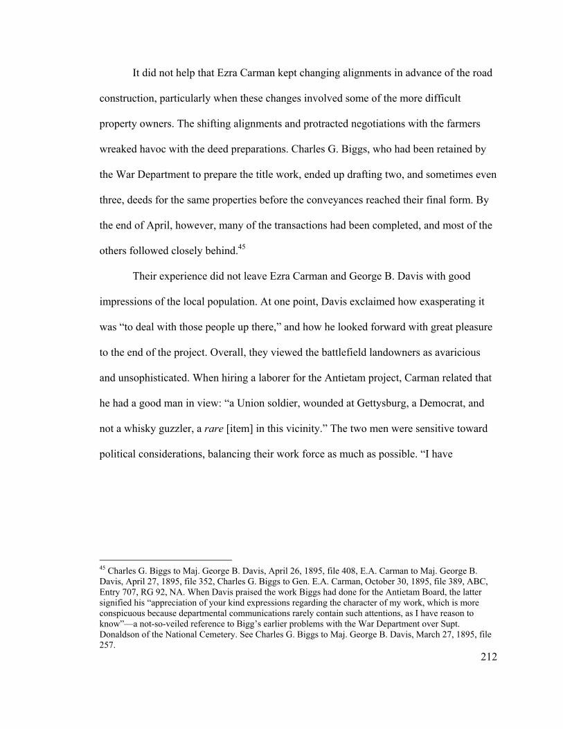
It did not help that Ezra Carman kept changing alignments in advance of the road
construction, particularly when these changes involved some of the more difficult
property owners. The shifting alignments and protracted negotiations with the farmers
wreaked havoc with the deed preparations. Charles G. Biggs, who had been retained by
the War Department to prepare the title work, ended up drafting two, and sometimes even
three, deeds for the same properties before the conveyances reached their final form. By
the end of April, however, many of the transactions had been completed, and most of the
others followed closely behind.45
Their experience did not leave Ezra Carman and George B. Davis with good
impressions of the local population. At one point, Davis exclaimed how exasperating it
was “to deal with those people up there,” and how he looked forward with great pleasure
to the end of the project. Overall, they viewed the battlefield landowners as avaricious
and unsophisticated. When hiring a laborer for the Antietam project, Carman related that
he had a good man in view: “a Union soldier, wounded at Gettysburg, a Democrat, and
not a whisky guzzler, a rare [item] in this vicinity.” The two men were sensitive toward
political considerations, balancing their work force as much as possible. “I have
212
45 Charles G. Biggs to Maj. George B. Davis, April 26, 1895, file 408, E.A. Carman to Maj. George B. Davis, April 27, 1895, file 352, Charles G. Biggs to Gen. E.A. Carman, October 30, 1895, file 389, ABC, Entry 707, RG 92, NA. When Davis praised the work Biggs had done for the Antietam Board, the latter signified his “appreciation of your kind expressions regarding the character of my work, which is more conspicuous because departmental communications rarely contain such attentions, as I have reason to know”—a not-so-veiled reference to Bigg’s earlier problems with the War Department over Supt. Donaldson of the National Cemetery. See Charles G. Biggs to Maj. George B. Davis, March 27, 1895, file 257.

organized my painting gang,” Carman wrote Davis, “four of the five are Democrats and
three of the five are Union soldiers, so no one can complain.”46
The reasons behind the difficulties caused by several of the resident landowners
varied. William Roulette had been a strong Unionist during the Civil War and was a
Republican, while Daniel Piper came from a staunchly Unionist family and most likely
was Republican as well. Conversely, the Poffenberger family tended to be Democrats and
may have been southern sympathizers. In Piper and Roulette’s case, the issues most
certainly centered on money; this may have been true for Otho Poffenberger as well. In
George Poffenberger’s case, given the amount of trouble he provided the War
Department during the remainder of his life, his motivations may have stemmed from
ideological and political, as well as remunerative, differences.47
As he had done with the roads, George B. Davis moved quickly into preparation
of tablets describing various tactical points of interest on the battlefield (Figure 5.6).
These tablets guided placement of the roads, and in turn were influenced by the road
locations, as the writing of the tablets and the surveying for the roads occurred in tandem
from the fall of 1894 through the spring of 1895. Shortly after his appointment to the
Antietam Board, Davis began conversing with the other two battlefield commissions
about the style and production of tablets. By the end of October he was busy writing text,
and in early November sent drafts for Twelfth Corps tablets to
46 Maj. George B. Davis to Gen. E.A. Carman, April 12, 1895, file 320, E.A. Carman to Maj. George B. Davis, April 11, 1895, file 321, E.A. Carman to Maj. George B. Davis, April 30, 1895, file 358, Maj. George B. Davis to Gen. E.A. Carman, April 6, 1895, file 300, ABC, Entry 707, RG 92, NA.
213
47 Dean Herrin, “Antietam Rising: The Civil War and Its Legacy in Sharpsburg, Maryland, 1860-1900” (Paper on file, Antietam National Battlefield, 2002), 53.
Figure 5.6 War Department tablets along east side of the Hagerstown Pike, looking northeast toward the Maryland Monument, c. 1905 (courtesy of Antietam NB).
214
Carman for comment and revision. It was Davis’s hope to begin casting and erecting
them within a few weeks.48
By mid-November Davis had completed rough drafts for an astonishing 80 tablets
and was making plans to travel to Chattanooga to begin the casting process. Always
seeking ways to speed up a project, Davis prevailed upon Gen. H.V. Boynton, president
of the Chickamauga Commission, to visit the foundry in advance and see if extra help
could be hired, “so as to get at our tablets” in addition to the work the company was
doing for Boynton. Although it is not known whether Boynton followed through on
Davis’s request, production was underway in December, but not fast enough to suit
Davis. “Please hurry forward the work so as to get out, if possible, two or three per day,”
he urged foundry owner J.E. Evans. “We are ready to set them up and I am anxious to do
so at the earliest day possible, in order to keep our force employed.”49
Production of the tablets was in full swing throughout the first four months of
1895. The rapid pace of Davis’s work, however, frequently resulted in erroneous text
making its way to the foundry. These errors slowed down the work, and sometimes
required the recasting of tablets. Not all delays could be blamed on Davis, however, as
Carman sometimes requested text revisions when he wished to change the intended
48 John C. Nicholson to Maj. George B. Davis, October 15, 1894, and October 22, 1894, Maj. George B. Davis to Gen. E.A. Carman, October 31, 1894, and November 5, 1894, Maj. George B. Davis to Maj. Jed Hotchkiss, October 31, 1894, ABC, Entry 707, RG 92, NA. John Nicholson from the Gettysburg Commission also had been making inquiries regarding tablets and had looked at numerous samples, finding that “none of them equaled the work at Chattanooga” either in quality or price. Davis subsequently visited the office of the Chickamauga Board and looked at their tablets. He extensively modified the layout that they used for their text, but decided to use their contract with the Chattanooga Car and Foundry Co. located in Chattanooga, Tennessee.
215
49 Maj. George B. Davis to Col. John Nicholson, November 17, 1894, Maj. George B. Davis to Gen. H.V. Boynton, November 17, 1894, Maj. George B. Davis to J.E. Evans, December 21, 1894, ABC, Entry 707, RG 92, NA.
location of a tablet. Davis quickly attempted to recall these from the foundry, but was not
always in time. Such occurrences underscore the fact that the members of the Antietam
Board were devising plans as they went along, without an overall strategy.50
In May 1895, the foundry shipped its first batch of 127 tablets and 105 smaller
markers to Maryland. Work on additional tablets continued through early summer, with
Carman taking the lead in their preparation. Carman apparently focused on tablets for the
Confederate Army, while Davis prepared most of those discussing Union forces. The text
for these tablets was completed by mid-July, and sent to Chattanooga shortly thereafter
for casting. A number of these tablets were shipped in mid-August and placed on the field
about the time the Antietam Board was disbanded. Forty-three others finally arrived in
October, completing the contract with the Chattanooga foundry.51
Thus, under the leadership of Maj. George B. Davis, within the space of a single
year the Antietam Board oversaw the completion of most of the War Department
improvements on the battlefield landscape. It also established the direction that Antietam
was to follow for the next seventy years, with the battlefield essentially remaining in
private hands with the exception of narrow rights-of-way crossing through it. In
50 Maj. George B. Davis to Gen. E.A. Carman, January 10, 1895, Maj. George B. Davis to J.E. Evans, February 19, 1895, and February 21, 1895, file 217, E.A. Carman to Maj. George B. Davis, March 22, 1895, file 262, March 23, 1895, file 266, J.E. Evans to Maj. George B. Davis, March 25, 1895, ABC, Entry 707, RG 92, NA. As one example of these practices, Davis writes on February 19: “My Dear Mr. Evans: If you have not yet cast tablet No. 334, please hold it for a few days as there seems to be an error in the name of the brigade commander. In No. 340, in the sixth line (at the end) is the name ‘Green’s.’ Please spell this ‘Greene’s,’ if you have not set it up.”
216
51 J.E. Evans to Maj. George B. Davis, May 8, 1895, file 379, E.A. Carman to Maj. George B. Davis, June 27, 1895, file 445, E.A. Carman to Maj. George B. Davis, July 12, 1895, file 486, Allen R. Adams to J.E. Evans, July 19, 1895, file 464, George W. Davis to J.E. Evans, August 9, 1895, file 482, J.E. Evans to Maj. George W. Davis, October 5, 1895, file 521, ABC, Entry 707, RG 92, NA.

retrospect, this would hinder memorialization efforts on the battlefield, as well as placing
additional improvements on it, but such issues did not matter to Davis.
Jed Hotchkiss and the Mapping of Antietam
The Congressional legislation for Antietam included provisions for marking troop
positions. The first Antietam Board had recognized the need for a good, accurate base
map from which to work, but had not been able to follow through with preparing one.
George B. Davis also recognized the need for a map, intending to use it to mark troop
positions in the field with iron poles about 30 ft in height. As noted earlier, Davis
appointed Jed Hotchkiss as Expert Topographer to the Antietam Board, to prepare a
detailed base map. From the beginning, Davis placed great pressure on Hotchkiss to
complete his work as quickly as possible. “All now depends upon dispatch,” he told him.
“We must get the map into shape for publication at the earliest moment.” Hotchkiss
moved quickly, producing the first of what was supposed to be three sheets within the
first month of the project. He also made three visits to Sharpsburg in fall 1894, spending
over two weeks conducting fieldwork on the battlefield.52
Upon receipt of this first section, Davis stated that he was very pleased with the
map “so far as it has gone.” By early December he was already becoming impatient with
Hotchkiss’s progress on the mapping project. Hotchkiss spent that month working on the
second section, hoping to have a preliminary map completed by the holidays. After the
New Year he was spending less and less time on the project, however, owing to other
217
52 Maj. George B. Davis to Col. John Nicholson, November 17, 1894, Maj. George B. Davis to Maj. Jed Hotchkiss, October 23, 1894, Jed Hotchkiss to Maj. George B. Davis, November 5, 1894, and November 27, 1894, ABC, Entry 707, RG 92, NA; Lilley, “The Antietam Battlefield Board,” 382-383; Hotchkiss Diary, October-November 1894, Hotchkiss-McCullough Collection, LC.

pressing business engagements, bad weather experienced that winter, and periods of poor
health. Preparation of the map involved much more work than the Board had anticipated,
and it was evident the timeframe imposed by George B. Davis was unrealistic.53
The apparent amount of work required to produce the map made no difference to
Davis, who continued to press Hotchkiss heavily. “How soon may we expect a part of the
Antietam Map, so that General Carman can begin locating the troops,” he inquired in
mid-February 1895. “We are about through with the tablets, and can begin locating at
once.” When nothing appeared by the end of March despite Hotchkiss’s repeated
assurances, Davis had had enough. He informed Hotchkiss that the amount of money set
aside for the map production was overspent and that, regrettably, “our existing
arrangement will have to come to an end on April 30.” Davis was more forthcoming to
Carman, writing the latter: “To continue him any longer is out of the question.”54
Hotchkiss planned to continue producing the map on his own time “until it is
completed to my satisfaction,” he informed Davis, “and, I hope, to yours.” He did indeed
spend a considerably amount of time on the project during the months of April and May,
53 Maj. George B. Davis to Maj. Jed Hotchkiss, December 8, 1894, Jed Hotchkiss to Maj. George B. Davis, December 13, 1894, ABC, Entry 707, RG 92, NA; Hotchkiss Diary, January-March 1895, Hotchkiss-McCullough Collection, LC; Lilley, “The Antietam Battlefield Board,” 383. The draftsman employed by Hotchkiss (but funded by the War Department) completed the preliminary draft of the second section in mid-January and began working on the last section right away. Hotchkiss’s diary suggests, however, that he did no work on these maps from the middle of December 1894 until the beginning of March 1895. When he did return to work on them, Hotchkiss’s discouragement over his workload was evident. “Spent most of day in office—worked on Antietam map,” he noted in his diary on March 14. “How I wish I could devote my time to writing my memoirs of the war,” he continued. “Hope I may soon sell some of my numerous landed interests and get money and pay off my debts and have some to live on so I need not devote most of my energies to making both ends meet.”
218
54 Maj. George B. Davis to Jed Hotchkiss, February 23, 1895,file 221, Jed Hotchkiss to Maj. George B. Davis, February 27, 1895, file 221, March 9, 1895, file 243, Maj. George B. Davis to Maj. Jed Hotchkiss, March 25, 1895, file 268, Maj. George B. Davis to Gen. E.A. Carman, March 27, 1895, ABC, Entry 707, RG 92, NA. Davis had allocated $1,200 for the production of maps, but $1,700 had already been expended by the end of March.
but it became increasingly evident that nothing would result from his work. By early
summer, Davis had given up and devised a new scheme to produce the map that he
needed. He decided to enlarge the existing Micheler map of the battlefield—the same one
that Heth and Stearns had complained about regarding its inaccuracies—and tasked
Carman with making the minor changes needed to make the map “sufficiently correct to
answer its purpose.” Obviously exasperated at the whole situation, Carman responded: “It
is a burning shame that Hotchkiss acts as he does. I did think that finally he would place
his map in your hands, but now I have lost all faith in his promises or in his honest
intentions.” Seeing that a much larger task lay ahead of him than Davis realized, Carman
asked Hotchkiss in late June 1895 to forward the map work he had completed up to that
time, but did not receive it before the Antietam Board was dissolved later that summer.55
One casualty of Hotchkiss’s inability to complete a new map within the required
timeframe was the iron poles that Davis had planned to use to mark troop positions on the
battlefield. Without the necessary information, the Antietam Board was not able to carry
out this portion of the project, and it was abandoned. Lack of adequate funding and the
reluctance on the part of property owners to sell small portions of their land also
contributed to this decision.
Major George W. Davis and the Antietam Board
In July 1895, Secretary of War Daniel S. Lamont promoted George B. Davis to
lieutenant colonel and reassigned him to a teaching position at West Point. By this time
219
55 Jed Hotchkiss to Maj. George B. Davis, April 30, 1895, file 357, May 16, 1895, file 399, Maj. George B. Davis to Gen. E.A. Carman, June 25, 1895, file 445, E.A. Carman to Maj. George B. Davis, June 27, 1895, file 445, ABC, Entry 707, RG 92, NA. E.A. Carman to Maj. Hotchkiss, June 27, 1895, September 4, 1895, and September 5, 1895, Hotchkiss Papers, LC.

Davis believed that work on the field was practically completed, “save for a little in the
way of embellishment.” Even so, Lamont appointed a new president to the Antietam
Board—Major George W. Davis—on August 1. The new Davis had served with the 11th
Connecticut during the Civil War and, unlike his predecessor, had been present at the
Battle of Antietam. Unfortunately for Davis, within three weeks of his appointment both
Ezra Carman and Henry Heth were dismissed from the Antietam Board due to
insufficient funds. Carman expressed a willingness to continue his duties without pay,
however, and was granted permission to remain in Sharpsburg and complete his work.56
During his first couple of months on the job, George W. Davis oriented himself to
the project at Antietam and formulated his own vision for the battlefield. From the
beginning he displayed a level of patience and forethought that George B. Davis had
lacked. Before relying unreservedly on the 1867 Micheler map as the base for all
subsequent maps to be prepared by the Antietam Board, Davis requested the mapmaker’s
report and field notes to verify “the degree of precision observed by him in preparing it.”
He methodically laid out the additional work he believed was necessary at the battlefield,
which consisted primarily of increasing the thickness of the new roads so that they could
handle the unexpectedly heavy local traffic they were experiencing, erecting additional
tablets at several other locations associated with the 1862 campaign (specifically Harpers
Ferry, Shepherdstown, and the three gaps on South Mountain,), and preparing a series of
new maps of the battlefield representing the different stages of the battle and campaign.
220
56 Sec. of War Daniel S. Lamont to Maj. George W. Davis, 11th Infantry, August 1, 1895, file 480, Maj. George B. Davis to Sec. of War, August 2, 1895, file 483, Acting Sec. of War Joseph B. Doe to Ezra A. Carman, August 17, 1895, file 497, Acting Sec. of War Joseph B. Doe to Ezra A. Carman, August 17, 1895, file 497, Sec. of War Daniel S. Lamont to Gen. E.A. Carman, August 17, 1895, file 565, ABC, Entry 707, RG 92, NA; Snell and Brown, Antietam National Battlefield, 101-102. George W. Davis also was appointed to superintend the ongoing compilation of the Official Records.
Most importantly, he believed strongly in the “Antietam Plan” of land acquisition
initiated by his predecessor, and anticipated continuing on that course of development,
even as it generated substantial controversy within the War Department, particularly in
regard to the recently created Shiloh National Military Park.57
By March 1896 Davis had expanded his proposed improvements to include over
60 additional tablets at Antietam, shell monuments to mark the locations where general
officers had been killed or mortally wounded, completion of a stone observation tower on
Bloody Lane (started by George B. Davis), and an additional tower on the extreme right
of the Confederate line. In combination with the aforementioned tablets at other sites
associated with the 1862 campaign, road improvements, and new maps, Davis calculated
the total cost at $17,000. This amount was appropriated under a Sundry Civil Bill
approved June 11, 1896, for the fiscal year beginning July 1. 58
Davis realized that he needed help supervising construction work on the
battlefield and preparing troop position maps, and in June 1896 recommended the
reinstatement of Generals Heth and Carman on the Antietam Board for the remainder of 57 Maj. George W. Davis to Brig. Gen. W.P. Craighill, Chief of Engineers, September 10, 1895, file 509, Maj. George W. Davis to Lt. Col. George B. Davis, October 9, 1895, ABC, Entry 707, RG 92, NA. In his letter to George B. Davis, George W. Davis notes at Shiloh NMP: “[Commissioners] Colonel Looney and General Buell are very much opposed to the idea of limiting the work at Shiloh to a park of say 200 acres at Pittsburg Landing, with strips of land at other points. They insist that the Act of Congress contemplates the enclosure of the whole area fought over, the same as was done at Chickamauga. . . . Colonel Cadle, after his visit to Gettysburg was entirely of the opinion that the idea we have so often talked over should be carried out,--an idea that has found complete development in a very satisfactory manner at Antietam.” Davis justified the need to improve the roadways on the battlefield in a January 17, 1896, memorandum (File 538): “It was not supposed that a heavy road construction would be needed for the reason that the traffic was expected to consist almost entirely of light vehicles, but it is now seen that these new highways have become thoroughfares of local traffic, and are used largely by the heavy wagons of the farmers. These subject the surface to a wear for which the roads were not designated, and it was soon seen that the metalling would have to be increased in thickness.” Carman earlier had warned George B. Davis that just such a problem would arise.
221
58 Maj. George W. Davis to Hon. Joseph G. Cannon, Chairman Committee on Appropriations, House of Representatives, March 24, 1896, file 540, Maj. George W. Davis to Sec. of War, June 27, 1896, file 559, ABC, Entry 707, RG 92, NA.

the calendar year. Evidently Jed Hotchkiss received word of Davis’s intentions, and
worked through political channels in an attempt to be reinstated on the Board as well. “I
have done more work in this matter of permanent value than any one that has been
connected with it except Gen. Carman,” he declared to his local Congressional
representative, Henry St. George Tucker, “and all that I want is to have opportunity to
complete my work and have proper credit for it and not let some one else, and especially
some one on the other side come in and get the credit of my labors.” Tucker pressed
Hotchkiss’s application with Sec. of War Daniel S. Lamont, but was informed by Davis
in early July that Heth and Carman had just been reappointed, and “as these gentlemen,
with the army member of the Board, will be able to attend to all the work yet to be done,
and for which a small appropriation was made, it will be impossible to appoint Major
Hotchkiss.”59
Given Hotchkiss’s reference to “the other side” receiving the credit for his work,
it is tempting to speculate that tensions may have existed between the northern and
southern members of the Antietam Board. From the time of George B. Davis’s
appointment as the first president of the Board, Henry Heth had been pushed into the
background, whether of his own volition or not is unknown. Hotchkiss, the other
Confederate member, was employed on the Board for a little more than six months before
Davis released him, ostensibly due to his lack of production.
222
59 Maj. George W. Davis to Sec. of War Daniel S. Lamont, June 27, 1896, file 559, Jed Hotchkiss to Hon. Henry St. George Tucker, May 30, 1896, Hon. Henry St. George Tucker to Sec. of War Daniel S. Lamont, June 27, 1896, Maj. George W. Davis to Hon. Henry St. George Tucker, July 2, 1896, file 566, ABC, Entry 707, RG 92, NA. In his letter to Tucker, Hotchkiss proclaimed rather plaintively: “This was the battle of R.E. Lee and Stonewall Jackson, one in which each of these great Generals displayed his peculiar and transcendent abilities as a soldier and I know that if these two had the choosing of anyone to represent them in securing an accurate map of this battle field with their men properly located on it that they would unhesitatingly choose your humble servant for that duty.”
In May 1896, Maj. George W. Davis determined that a new road about one-half
mile in length was needed at the battlefield to connect Confederate Avenue (the name
given to the road through the West Woods) with Smoketown Road. “In the intervening
fields along the proposed road—an area of less than 80 acres—occurred the most
sanguinary fighting of this most bloody field,” wrote Davis in justification. “Not less than
4,000 men were here killed and buried. The proper marking of the field and preservation
of the lines of battle, makes necessary the ownership by the United States of this narrow
strip embracing about four and one fourth acres.” He proposed acquiring a strip of land
80 feet wide, of which 40 feet would be reserved for the road and 20 feet on either side
for the placement of monuments and tablets. Ironically, this was essentially the same
proposal Jed Hotchkiss had made unsuccessfully to George B. Davis one-and-a-half years
earlier to construct a road along the south edge of Miller’s cornfield between Smoketown
Road and the Hagerstown Pike. The only difference was that George W. Davis wanted to
extend it farther west across the turnpike to link up with Confederate Avenue. Davis’s
proposal represents an about face from his predecessor in another respect, for George B.
Davis had always sought to secure the narrowest right-of-way possible, without
considering the placement of monuments or other commemorative markers upon them
(discussed in greater detail in Chapter 6).60
Ezra Carman immediately set to work contacting the affected property owners,
who quickly agreed to the government’s offer of $100 per acre. By the beginning of July
1896 the deeds for the land were in hand, just in time for the new fiscal year
appropriation. In the meantime, Davis also had determined that a half-built stone
223
60 Maj. George W. Davis to E.A. Carman, May 14, 1896, file 552, Maj. George W. Davis to Sec. of War Daniel S. Lamont, June 27, 1896, file 559, ABC, Entry 707, RG 92, NA.

observation tower on Bloody Lane, started under George B. Davis’s administration,
needed to be pulled down and rebuilt. Paying for the new road, the reconstruction of the
tower, and the reappointed Board members’ salaries, meant that Davis had to reconsider
his priorities. He dropped the idea of a second observation tower, and reduced the number
of new tablets under consideration and the funding set aside for improvements to existing
roads and the new maps.61
The War Department awarded contracts for the new road and observation tower in
mid-August 1896; construction of the road was completed in October and the tower in
December. Prior to this contract, Carman conferred with Davis about naming the new
avenue. He suggested it could appropriately be called Hooker, Mansfield, or Sumner
Avenue: “Hooker first opened the fight just north of and parallel to it and two thirds of
his corps reached and crossed it; Mansfields [sic] corps fought on and across its eastern
end and Mansfield was mortally wounded near; Sumner had charge of both Hooker and
Mansfield and all of his divisions passed its whole length. One of the three names should
be chosen.” This is the first reference to naming of roads found in the Antietam Board
records. While Confederate Avenue evidently had been designated at an earlier date, as
Davis had referenced it in May, it is apparent that the other roads had not been named by
this time, suggested by the fact that Carman listed Mansfield as one of the possibilities
224
61 E.A. Carman to Maj. George W. Davis, May 15, 1896, and May 18, 1896, file 552, Maj. George W. Davis to Sec. of War Daniel S. Lamont, June 27, 1896, file 559, E.A. Carman to Maj. George W. Davis, July 10, 1896, file 569, ABC, Entry 707, RG 92, NA. The number of new tablets was reduced from 114 to 90, and the amount for road repairs from $7,000 to $4,000. In his initial proposal, Davis had planned to spend $1,350 on completing the two towers, but later revised that figure upward to $2,000 for the Bloody Lane tower alone.
for the new road. Mansfield Avenue would instead become the name of the improved
Poffenberger lane at the north end of the battlefield.62
Between the time Carman made his suggestion in July regarding a name for the
new road, until its completion in October, his thoughts had taken a new direction. During
this period Carman also was marking the locations where general officers had fallen
during the battle. Evidence suggests that this process led to the naming of all of the
remaining avenues at this time after those generals who had fallen nearby. In early fall of
1896, Carman requested permission from the owners of the Philadelphia Brigade Park to
place a marker on their property at the location where Confederate Brig. Gen. William E.
Starke had been mortally wounded. They consented to Carman’s request, and in turn
asked for a map showing the location of the proposed marker as well as of “Starke
Avenue”—the portion of George W. Davis’s new road that extended between the
Hagerstown Turnpike and Confederate Avenue. The one deviation from this trend was
naming the section of new road between Smoketown Road and the Hagerstown Pike
“Cornfield Avenue.” All of the roads had received their names by mid-December of that
year.63
62 E.A. Carman to Maj. George W. Davis, July 8, 1896, file 567, Maj. George W. Davis to Jacob Snyder, August 14, 1896, file 595, E.A. Carman to Maj. George W. Davis, October 27, 1896, file 592, E.A. Carman to Maj. George W. Davis, December 11, 1896, file 605, ABC, Entry 707, RG 92, NA.
225
63 John W. Frazier to Gen. E.A. Carman, November 13, 1896, file 630, E.A. Carman to Maj. George W. Davis, December 12, 1896, file 632, ABC, Entry 707, RG 92, NA. Carman also had asked permission from the owners of the 9th New York property along Harpers Ferry Road to erect a marker to Gen. Rodman on their lot. While they consented to his request, Carman decided to locate it farther south, along present-day Rodman Avenue (see Charles Currie to Gen. E.A. Carman, December 12, 1896, file 638). As usual, the precedence for naming roads after generals is found at Gettysburg, where the GBMA began naming avenues after Union generals beginning in 1881 (see John Milner Associates, Inc., Design of the Commemorative Military Park: Contextual Documentation and Resource Evaluation, 95% Draft, copy on file, Antietam National Battlefield, 2-99).
Only one of the six generals mortally wounded at the Battle of Antietam—
Confederate Brig. Gen. George B. Anderson—did not have a lane named after him.
Anderson had been wounded in the foot during the fighting at the Sunken Road, and died
a month later. As with the other five generals, however, the War Department placed a
mortuary cannon at the site where he had been wounded.64
By the end of 1896, George W. Davis had completed all of his planned
improvements on Antietam Battlefield. These included a new avenue, improvements to
existing roads, completion of the observation tower, and the installation of a number of
new tablets. The projects ran smoothly with minimal complications—a testament to the
organizational skills of both Maj. George W. Davis and Gen. Ezra Carman. One cloud
remained, however: the elusive base map of the battlefield showing troop positions. With
the construction projects nearing completion, Davis turned his attention to finishing this
critical piece once and for all.
Carman-Cope Map
“I want to ask a favor,” wrote Davis to his counterpart on the Gettysburg
Commission, Col. John P. Nicholson, in November 1896. “Will you not lend to the
Antietam Board the services of Colonel Cope (if it be agreeable to him) long enough for
him to re-run the lines of roads on the Antietam Field. . . . We have found that the roads
as laid down on the Michler map are considerably ‘out’ in some cases and measured
distances and scale measurements do not always agree.” So stepped Davis into the
quagmire of mapmaking at Antietam, expressing his belief that no more than one week of
226
64 For information on Brig. Gen. George B. Anderson, see http://www.nps.gov/anti, Six Generals Who Died, August 2004 .

fieldwork would be required to accomplish this goal, as they were not intending to make
a detailed contour map of the battlefield.65
Nicholson readily granted permission for Cope and his assistants to travel to
Sharpsburg the second week of December to do this work. After a week of fieldwork,
Carman reported that all of the roads in the center of the battlefield had been surveyed
and that only a couple of more days were required to complete those along its edge. In a
significant departure from Davis’s request to Nicholson, Carman also related that they
were surveying contour lines as well, and that Cope was “enthusiastic over the work and
pushing it with energy and great care.” Cope evidently had convinced Davis and Carman
that a time-intensive contour survey was necessary. By the end of the third week of
December the engineer had completed his original task, but much of the contour work
remained to be done.66
Davis wrote Nicholson again at the end of the month, requesting additional time
for Cope to complete his contour mapping of the battlefield and enclosing a preliminary
map of Chattanooga that showed what he wished to have done at Antietam. Nicholson
expressed uneasiness about the situation, stating that they “have struggled, working early
65 Maj. George W. Davis to Col. John P. Nicholson, November 27, 1896, file 632, ABC, Entry 707, RG 92, NA. 66 John P. Nicholson to Maj. George W. Davis, November 30, 1896, E.A. Carman to Maj. George W. Davis, December 15, 1896, E.A. Carman to Maj. George W. Davis, December 18, 1896, file 632, ABC, Entry 707, RG 92, NA. In fact, Davis wrote Nicholson in June 1897: “When I made my original request for Colonel Cope’s temporary assistance, I had no thought whatever of a contour survey. All I had in mind was a re-running and measurement of the roads and free hand sketching the inequalities of surface, but the Colonel quickly convinced me that we ought to have five foot contours, and every subsequent act has been to carry out this suggestion.
227
The idea of five foot contours was quickly abandoned as involving too much work, and lately we have separated them by a still greater vertical interval. When I saw the Colonel’s first specimen of the contour work, I was easily (too easily) convinced that we ought to have the field covered that way. This may be a confession of weakness, but most men are easily convinced when their inclinations accord.” See Maj. George W. Davis to Col. John P. Nicholson, June 15, 1897, file 632.

and late, to get our own maps into shape” and that even a short absence on the part of
Col. Cope greatly affected their work. The two men were able to reach an agreement,
however, for Cope to continue with this work.67
Given Nicholson’s expressed reservations, it is somewhat surprising that two
weeks later Davis asked Cope to significantly expand the scope of his work by preparing
a theater of operations map as well. This prompted an angry response from Nicholson.
“We hoped that all your work would be finished by the middle of March, at least that was
our understanding,” he wrote. “We will be in Washington to-morrow to talk it over with
you, and we have only to say that the increase in your work is a great disappointment to
us.” Evidently Davis was able once more to convince Nicholson of the project’s efficacy,
for he received approval to extend the Gettysburg surveyors’ employment until June 1,
1897.68
Around this same time Davis submitted a request for a small appropriation of
$5,000 to complete all the remaining work at Antietam. The map work was costing much
more than had been estimated previously, due to the need to resurvey the field. Davis also
wished to employ an “expert on the Confederate side” to assist with determining troop
positions as Gen. Carman, an employee of the War Records Office since the beginning of
67 Maj. George W. Davis to John P. Nicholson, December 29, 1896, John P. Nicholson to Maj. George W. Davis, December 31, 1896, and January 7, 1897, Maj. George W. Davis to Col. E.B. Cope, January 16, 1897, file 632, ABC, Entry 707, RG 92, NA. 68 Maj. George W. Davis to Col. E.B. Cope, February 1, 1897, John P. Nicholson to Maj. George W. Davis, February 11, 1897, file 632, Maj. George W. Davis to Sec. of War, March 2, 1897, file 635, ABC, Entry 707, RG 92, NA.
228
the year, was doing the work for the Union forces. Beginning August 1, Henry Heth was
reappointed for five months as the Confederate expert to the Antietam Board.69
The Gettysburg surveyors continued their work on the Antietam map throughout
much of 1897. In September, Cope conveyed to Davis his wish to return to Sharpsburg
for a week after harvest to fill in gaps in the topographic surveying, but by this time even
Davis was becoming annoyed. “Rather than spend any longer time than you have
estimated,” he replied, “I will abandon the idea of instrumental contours, but instead have
the topography sketched within the area talked of, and the map finished.” He concluded
that he was “anxious to see something in the way of results.”70
An offended Cope fired back that he had a right to expect proper treatment from
the Antietam Board, referring to his desire for sufficient time to make accurate field
measurements. In exasperation, Davis observed that the engineer seemed “to have a
desire to do more work at Antietam than I am willing to have done.” The additional
fieldwork was completed without further incident, however, and the map work by the
middle of February 1898. In the end, the work took so much longer and cost so much
more than Davis had anticipated that while three sets of maps—the theater of operations,
the battlefield in its present condition, and the battlefield as it appeared in 1862—
essentially were completed, maps showing troop positions on the field were not. In
reference to the length of time it took to produce these maps, historian David A. Lilley
observed “In justice to Hotchkiss it is also important to observe that Cope first estimated
69 Maj. George W. Davis to Sec. of War, May 17, 1897, file 655, Sec. of War to Henry Heth, July 31, 1897, file 672, ABC, Entry 707, RG 92, NA.
229
70 Maj. George W. Davis to Gen. E.A. Carman, June 29, 1897, file 632, Maj. George W. Davis to Sec. of War, July 28, 1897, file 635, Maj. George W. Davis to Col. E.B. Cope, September 23, 1897, file 632, ABC, Entry 707, RG 92, NA.

that Antietam could be mapped in three months; more than five times that period elapsed
before the job was completed, a revealing footnote to compare with the time originally
allotted Hotchkiss.”71
Ezra Carman, who had received employment as a clerk in the War Records Office
after his tenure ended on the Antietam Board, continued working on these maps at home
on his own time. He had not completed them by the time Maj. George W. Davis was
relieved from his position on May 31, 1898, and reassigned to the field during the
Spanish-American War. In fact, they were not to be completed for another six years. By
the time the Antietam atlas was published in 1904, the project had grown from a series of
nine maps to fourteen. Within the context of this study, the importance of the maps lay in
their use as the basis for landscape preservation and restoration at Antietam by future
managers of the battlefield. Without doubt the leading figure in these efforts was Ezra
Carman. “Given the time that Carman spent with the project and the care with which he
went about his work,” summarized Lilley, “he probably knew more about Antietam than
anyone ever had known or will know. He had the advantage over present historians of
having fought there himself and of talking with many others who had also participated in
the fight. Such opportunities must have offered him insights into the battle which no one
else can ever hope to achieve.”72
71 E.B. Cope to Maj. George W. Davis, September 24, 1897, Maj. George W. Davis to Col. E.B. Cope, September 27, 1897, Maj. George W. Davis to Col. E.B. Cope, January 22, 1898, E.B. Cope to Maj. George W. Davis, February 3, 1898, file 632, Maj. George W. Davis to Hon. George D. Meiklejohn, Assistant Sec. of War, March 28, 1898, file 700, ABC, Entry 707, RG 92, NA; Lilley, “Antietam Battlefield Board,” 384.
230
72 Maj. George W. Davis to Hon. George D. Meiklejohn, March 28, 1898, file 700, ABC, Entry 707, RG 92, NA; Lilley, “Antietam Battlefield Board,” 384-386.

Conclusion
With the reassignment of George W. Davis, the Antietam Board finally came to
an end. Administration of the battlefield was transferred to the Cemetery Division of the
Quartermaster Department, and the superintendent of Antietam National Cemetery given
responsibility for maintaining the War Department improvements. The Antietam Board
laid the groundwork for the present battlefield park, however, establishing the circulation
system still in use today. The Board’s influence continued into the opening years of the
twentieth century as Ezra Carman, although not working at Antietam in an official
capacity, wielded tremendous influence over the ongoing development of the
commemorative landscape from his office in the War Department, as will be described in
the next chapter.
Compared to the other battlefield parks, however, Antietam was handicapped
from the very beginning by a lack of clear-cut legislation. Congress allocated funding in
bits and pieces based on estimated expenditures, instead of providing substantial sums up
front as it had for the others. As a result, it was easier for George B. Davis and others to
justify cost cutting at Antietam and to settle for the minimum necessary to establish a
battlefield park that in appearance looked very much like the others, but in reality was a
shell.
The Antietam Board did not include a strong advocate for changing the status
quo. Early on, Heth and Stearns attempted to point out the need for fairly substantial land
acquisition, but they were able to exert little influence within the War Department. Davis,
on the other hand, exerted a great deal of influence over the Secretary of War. As one of
only two non-battle participants to head a battlefield commission, Davis had little
231
personal connection with Antietam and appeared more interested in having the
improvements made as expeditiously and inexpensively as possible, than in creating a
place of veneration and commemoration. In fact, he actually scaled back original
Congressional expectations for the battlefield. Examples include Davis advocating for the
acquisition of the narrowest rights-of-way possible and his disinterest in providing space
for commemorative monuments and markers along these avenues. In addition, Davis
expressed no interest in acquiring key topographical features of the battlefield, even as
some were in the process of being destroyed, nor did he consider the acquisition of farms
when they were offered to him. Overall, the Antietam Board seemed more concerned
with producing an accurate map of topographic features than with preserving them on the
battlefield.
In summary, the decisions made by the Antietam Board were to have far ranging
consequences for the battlefield, and helped to set it even farther apart from the other
battlefield parks. By leaving the vast majority of Antietam battlefield in private hands,
the landowners would greatly influence the development of the commemorative
landscape at that place for years to come. The board also did little to facilitate
remembrance activities at Antietam, making it more difficult for veterans who did want
to memorialize the battlefield to erect monuments upon it.
232

Chapter 6:
“In Honor of Their Fallen Comrades”:
Creation of the Monumental Landscape
at Antietam Battlefield
The placement of monuments at Antietam Battlefield was determined by three
factors—the desire of Civil War veterans to erect monuments on the fields upon which
they had fought, the willingness of landowners to sell land for the placement of these
monuments, and the attitude of governments, both federal and state, toward establishing
monuments at Antietam. The first monuments on the battlefield were intensely
personal, generally placed by individual regiments that had lost significant numbers at
Antietam. These were relatively few in number, due in part to the overwhelming
primacy of Gettysburg and its effective promotion by national-level veterans’
organizations, and also to the relative difficulty in acquiring property on which to erect
a monument. Initially, these difficulties lay with private property owners, who asked
exorbitant prices or were reluctant to part with their land. During the 1890s, the policies
of the Antietam Board under the leadership of Maj. George B. Davis, and subsequently
under Maj. George W. Davis, tended to discourage the placement of monuments on the
battlefield as well—in direct contrast to the other battlefield commissions, which
actively sought monuments and markers for their fields.
A spate of monument building took place at Antietam around the turn of the
twentieth century, tied to the new wave of national reconciliation resulting from the
Spanish-American War. In keeping with the other battlefields, most of these either were
233

state monuments, or monuments to units that had not received recognition at other
battlefields (afterthoughts, in other words). Unlike the initial assemblage of monuments
erected during the last two decades of the nineteenth century, this second group was
much less about Antietam and more about making larger statements about American
martial prowess.
The end result is that Antietam Battlefield, with around 100 monuments,
including position markers, would have fewer monuments than any of the original five
War Department parks. This situation arose in part because the states with the largest
numbers of troops at the Battle of Antietam—New York and Pennsylvania—were
locked in intense rivalry over memorializing the field at Gettysburg, precluding any
attention toward the Maryland battlefield. While Pennsylvania spent $121,000 to place
81 unit monuments at Gettysburg between 1887 and 1904, it did not appropriate any
funding for Antietam until 1903—and then only for units that did not already have
monuments at Gettysburg! Similarly, New York appropriated $137,000 for numerous
monuments at that battlefield between 1887 and 1889, but nothing for Antietam until
the opening decade of the twentieth century. In addition, the State of Maryland did not
facilitate monument building on its battlefield the way that Pennsylvania did.1
Gettysburg and the Emergence of Civil War Battlefield Monuments
Outside of the national cemeteries and Decoration Day, little battlefield
memorialization occurred across the country during the first two decades after the end
234
1 Michael Wilson Panhorst, “Lest We Forget: Monuments and Memorial Sculpture in National Military Parks on Civil War Battlefields, 1861-1917” (Ph.D. diss: University of Delaware, 1988), 56-57, 287 n. 18.
of the Civil War. Attention focused instead on rebuilding the nation economically and
politically. Veterans on both sides moved ahead with rebuilding their own lives as well.
In addition, a severe economic depression during the 1870s constrained organized
efforts to memorialize the recent war. It was not until the end of that decade that the
country and its veterans began looking toward the battlefields as places to remember
past valor and begin the process of promoting sectional healing.
A few monuments had been erected on battlefields while the war still raged, and
others were placed in national cemeteries in the decades that followed. Without
exception, these scattered memorials honored fallen comrades or slain commanders.
Beginning in the late 1870s, following the end of Reconstruction and the rise to
political prominence of the Grand Army of the Republic (GAR), the veterans began
paying greater attention to their past valor and exploits on the battlefields. As usual,
Gettysburg took the lead in the new wave of memorialization that swept the United
States during the last two decades of the nineteenth century and the opening two
decades of the twentieth.
In 1880, the Pennsylvania Department of the GAR—the most powerful and
influential of the state departments—took over the Gettysburg Battlefield Memorial
Association, a local organization that since its establishment in 1863 had served as
caretaker for that battlefield. “What had been a local memorial society run by non-
veteran community activists became a statewide association with powerful veteran
backing,” observed historian Amy J. Kinsel. “From 1880, the GBMA was dominated
by military men and its previous interest in historic preservation in a broad sense gave
way to a major effort to build on the Gettysburg battlefield substantial monuments to
235
the victorious Union forces.” The organization used its condemnation authority to
purchase rights of way for an extensive system of avenues along Union battle lines,
then actively solicited northern units to purchase lots and erect monuments along these
roads.2
Regimental memorial associations initially raised most of the money for the
new monuments. By the mid-1880s, however, veterans were lobbying their state
legislatures for funding, and states soon became the main source of funding for these
associations to place monuments on the battlefield. As a result, between 1880 and 1888
over 200 monuments and position markers were dedicated at Gettysburg, 133 during
the 25th anniversary commemoration of that battle. The Society of the Army of the
Potomac, established in 1869 and dominated to a large degree by Pennsylvanians, also
focused its energies on Gettysburg, perceived as that army’s greatest victory. It
organized many reunions on the battlefield, which often served as focal points for
monument dedications. The Society also was responsible for the first large-scale
Union-Confederate reunion at Gettysburg, held during the 25th anniversary of the battle
and attracting more than 10,000 people. In contrast, the organization evidently paid
little or no attention to Antietam.3
2 Amy J. Kinsel, “‘From these honored dead’: Gettysburg in American Cultures, 1863-1938” (Ph.D. diss.: Cornell University, 1992), 175-177; John S. Patterson, “From Battle Ground to Pleasure Ground: Gettysburg as a Historic Site,” in History Museums in the United States: A Critical Assessment, ed. Warren Leon and Roy Rosenzweig (Urbana: University of Illinois Press, 1989), 135-136. Gettysburg battlefield functioned much like private cemeteries at that time, where the landscapes were laid out and individuals and families purchased plots and erected individualized stones.
236
3 Panhorst, “Lest We Forget,” 41; Kinsel, “From these honored dead,” 187, 194, 198; Milner, Design of the Commemorative Military Park, 2-55. In 1884 Massachusetts became the first state to fund monuments, offering $550 to each of its regiments and batteries that fought at Gettysburg. Other states soon followed, including Delaware, Rhode Island, and Indiana in 1885; New York, Pennsylvania, and Michigan in 1887; and Connecticut and Wisconsin in 1888. Maryland also provided funding for its Union units in 1888 (see Panhorst, “Lest We Forget,” 49).

Throughout the 1880s, Gettysburg Battlefield continued to serve as a shrine to
the North’s triumph over the Confederacy, and the GBMA did not lobby southern states
to fund monuments. Not until 1886 was the first monument to a Confederate unit—the
2nd Maryland—placed on the battlefield. It is perhaps ironic that such a memorial
would come from a state that had remained loyal during the Civil War. On the whole,
southern veterans and their state governments exhibited little interest in working with
the GBMA to memorialize a lost battle, especially one fought on northern soil.4
The GBMA set standards and prepared guidelines for commemorative
monuments that would be followed at all of the other battlefield parks, including
Antietam. It insisted that memorials be sited along unit lines, and reviewed monument
inscriptions to ensure their accuracy. The GBMA also established a policy permitting
only granite and bronze monuments, a practice later followed by the War Department.5
In effect, the template established at Gettysburg provided a road map for veterans’
commemorative efforts at the other battlefields, and created a standard vision of what a
Civil War battlefield should look like.
When the War Department assumed management of the newly created
Gettysburg National Military Park in 1895, it acquired over 300 monuments, 17 miles
of roadway and 600 acres of land. This included at least one monument for each of the
313 units (with the exception of West Virginia) of the Army of the Potomac that had
fought there. From the beginning of its tenure, the War Department took a different
approach from the GBMA. The military-appointed Gettysburg Battlefield Commission
4 Kinsel, “From these honored dead,” 195-196; Panhorst, “Lest we forget,” 51-52.
237
5 Kinsel, “From these honored dead,” 183-184, 186.

expanded landholdings to include significant portions of the Confederate lines and
constructed avenues through these areas. The new commissioners also carefully marked
both Union and Confederate positions, seeking a more balanced perspective.6
Early Monuments at Antietam
In contrast to Gettysburg, the first regimental monuments at Antietam
Battlefield were not erected until the 25th anniversary of the battle. Both units that
placed memorials on the field at this time had experienced their heaviest losses of the
war at Antietam. In the tradition of Gettysburg, however, both located their monuments
on public property. Interestingly, they also were the only two to return in the early
twentieth century and raise a second monument funded by their respective state
monument commissions.
In January 1887, the veterans of the 20th New York requested a site in Antietam
National Cemetery for a monument “in honor of their fallen comrades.” This regiment
had been composed almost entirely of German-speaking immigrants recruited from
New York City and Newark, New Jersey, under the auspices of the Turner Society. At
Antietam, the 20th New York participated in an attack against a line of Confederates
defending the Hagerstown Pike in front of the Dunker Church. Although some broke
through to the church, the unsupported troops were soon driven back. The regiment
incurred its heaviest casualties of the war as a result of this assault.7
6 Kinsel, “From these honored dead,” 224, 229-230; Patterson, “Battle Ground to Pleasure Ground,” 138-139.
238
7 H.E. Roehr to QM Gen., January 19, 1887, Antietam National Cemetery (ANC), Gen. Correspondence, QM General, 1865-1890 (Entry 576), Records of the Office of the Quartermaster General, Record Group

The Quartermaster General’s office approved the regiment’s application and
selected the location for the monument on the east, or left, side of the main walkway to
the Soldier’s Monument, in front of the large New York burial section. Here the
regimental association placed a square stone monument surmounted by a carved wreath
and military accoutrements including a drum, kepi, canteen, and haversack. The
inscription in memory of its fallen comrades was engraved in both German and
English. On the 25th anniversary of the Battle of Antietam, the survivors of the 20th
New York marched from the railroad station to the cemetery. They were accompanied
by several bands and a number of GAR posts from Maryland and surrounding states
that were attending a campfire associated with the anniversary. This ceremony marked
the dedication of the battlefield’s first permanent memorial (with the exception of the
National Cemetery’s Soldier’s Monument).8
The 51st Pennsylvania elected to locate its monument where it had experienced
its heaviest losses of the war, incurred while fighting to take Burnside Bridge, instead
of in the national cemetery. Less than a month after the 20th New York monument
dedication, the 51st unveiled a small marker mounted on the end of the south wing wall
of Burnside Bridge, distinguished by a sculpture of a tenor drum lying on its side. The
51st Pennsylvania and 51st New York, both part of Ferero’s Brigade, were the first to
92 (RG 92), National Archives, Washington, D.C. (NA); Ted Alexander, “Forgotten Valor: Off the Beaten Path at Antietam,” Blue & Gray Magazine, October 1995, 12-14.
239
8 R.N. Batchelder, Dep. QM Gen., to H.E. Roehr, ANC, Entry 576, RG 92, NA; Keedysville Antietam Wavelet, September 21, 1887. Four years later another New York unit, the 4th NY Volunteer Infantry, requested permission from the Quartermaster General to erect a second monument in the national cemetery, behind the New York section and near the rostrum. This monument, the fourth to be erected at Antietam, was unveiled on September 17, 1892, the 30th anniversary of the battle (see W.C. Ormsbee, 4th Regt. NY Vols, to QM General, March 27, 1891, file 11619, General Correspondence, 1890-1914 (Entry 89), RG 92, NA).
cross the bridge, but not before the two regiments were to sustain casualties
approaching 30%.9
At the end of the decade, some units began negotiating with landowners to
purchase small lots upon which to place monuments. Veterans from Companies A and I
of the Federal 5th Maryland erected the first monument on private property on Antietam
battlefield. The 5th Maryland also was the first to receive some state funding, with small
appropriations from the states of Maryland and Delaware (part of the regiment had been
raised in Wilmington, Delaware). In May 1889 the unit contracted for a plot of ground
on the Roulette Farm, on the north side of the Sunken Road (Figure 6.1, no. 49). This
was the location where the two companies had experienced their heaviest losses of the
Civil War. Erected in memory of their fallen comrades, the monument also marked the
farthest advance of the 5th Maryland’s brigade. The survivors dedicated the monument
on September 17, 1890.10
9 Keedysville Antietam Wavelet, October 15, 1887; B. Keith Toney, “‘Dying as Brave Men Should Die’: The Attack and Defense of Burnside’s Bridge,” in The Maryland Campaign of 1862 and its Aftermath. Civil War Regiments: A Journal of the American Civil War, 6, no. 2 (1998): 89-118. In spring 1894, Lt. Col. Albert A. Pope erected a monument to his fallen comrades of the 35th Massachusetts at Burnside Bridge. This small, square granite marker, surmounted by a stack of cannon balls, was mounted on the northwest corner of Burnside Bridge, on the opposite side of the creek from the 51st Pennsylvania monument. The 35th Massachusetts, also part of Ferero’s Brigade, had supported the attack of the 51st Pennsylvania and 51st New York upon the bridge (see Keedysville Antietam Valley Record, May 25, 1894).
240
10 Keedysville Antietam Wavelet, May 4, 1889; Susan Soderberg, “Lest We Forget”: A Guide to Civil War Monuments in Maryland (Chambersburg, Pa.: White Maine Publishing Co., Inc., 1995), 101-102; Charles A. Foster, A History of the G.A.R. Department of Delaware, with Special Mention of the Department of Maryland (Wilmington, DE: n.p, 1893), 184. The front inscription reads: “Erected by the survivors of Company A & I to the memory of our fallen comrades who fell on this spot Sept. 17, 1862. This stone marks the extreme advance of Weber’s Brigade, French’s Div., 2nd Army Corps. Can their glory ever fade? 5th Md. Vet. Vol. Inf’y.”

Figure 6.1. Location of monuments on Antietam National Battlefield (courtesy of Antietam NB).
241
A noted feature of this event was the floral arrangements provided by eight
Sharpsburg women. “Our citizens gave the flowers very liberally,” related the Antietam
Valley Record, “and in a way that shows their appreciation of this event of historical
importance to us and more particularly to the younger people.” In fact, participation of
the local populace in monument dedications would be a common feature throughout
this period. In much the same way as Decoration Day, Unionists could display their
loyalty at these ceremonies during a time when the state government of Maryland
seemed more sympathetic toward its Confederate heritage. By staying in private
dwellings during reunions and negotiating with private landowners, it also is likely that
these veterans developed a closer relationship with the local citizens than they might at
a place like Gettysburg, with its more highly developed tourist infrastructure and the
GBMA.11
Connecticut was the first state to make a concerted effort to raise monuments to
each of its regiments at Antietam. The genesis of the idea arose at the business meeting
of the 16th Connecticut held in Hagerstown during its 1889 reunion, prompted perhaps
by the state’s appropriation for monuments at Gettysburg made the previous year. In
June 1891, members of the organization purchased ten acres of the historic Otto Farm
from its owner, Jacob Stine, at the location where the regiment received the brunt of
A.P. Hill’s late afternoon attack (Figure 6.1, no. 91). Three months later the 14th
Connecticut held its reunion at Antietam and also deliberated on the desirability of
erecting a monument. No further action was taken by either organization, however,
242
11 Keedysville Antietam Valley Record, September 19, 1890.
until an encampment of their GAR department in early 1893, at which the department
passed a resolution to request the General Assembly of Connecticut to make an
appropriation “for the erection of monuments to Connecticut troops on the battlefields
where they fought.”12
The state legislature approved a resolution almost one-and-a-half years later, in
June 1894, which authorized monuments at a cost not to exceed $1,000 each. It did not,
however, authorize a state monument commission to oversee the process, as was
customary in other states. Prior to passage of the resolution, representatives from the
14th Connecticut purchased a 20-foot square plot of land near Bloody Lane, at “the
extreme advance of that regiment,” from Resin and Emma Fisher (owners of the
historic Mumma Farm) for $175 (Figure 6.1, no. 48). The 8th Connecticut, while
originally planning to erect its monument on the 16th Connecticut’s lot, decided to
acquire its own 20-foot square lot at the south end of the battlefield, near Harpers Ferry
Road, to mark its advanced position (Figure 6.1, no. 75). The 11th Connecticut stayed
with its original decision to co-locate with the 16th, even though its heaviest fighting
had occurred around Burnside Bridge.13
12 Walter J. Yates, Souvenir of Excursion to Antietam and Dedication of Monuments of the 8th, 11th, 14th and 16th Regiments of Connecticut Volunteers, October, 1894 (New London: E.E. Darrow, n.d.), 4; Antietam Valley Record, June 19, 1891; John W. Schildt, Monuments at Antietam, (Chewsville, MD: Antietam Publications, 1991), 26; Panhorst, “Lest We Forget,” 49. The 16th Connecticut had been in service less than two months and untested in battle before September 17. The green troops quickly broke and fled under the Confederate assault, sustaining greater than 25% casualties. This was the 16th Connecticut’s only major battle of the war, and it was to return to Antietam frequently in the late nineteenth and early twentieth centuries (see Lesley J. Gordon, “All Who Went into that Battle Were Heroes: Remembering the 16th Regiment Connecticut Volunteers at Antietam,” in The Antietam Campaign, ed. Gary Gallagher (Chapel Hill: The University of North Carolina Press, 1999), 169-191.
243
13 Yates, Souvenir of Excursion to Antietam, 5; Keedysville Antietam Valley Record, January 5, 1894, June 8, 1894, July 20, 1894, and September 21, 1894. The 8th Connecticut purchased its tract from Uria Gross for $100. At the opening of the Burnside Bridge attack, the 11th Connecticut was the first regiment
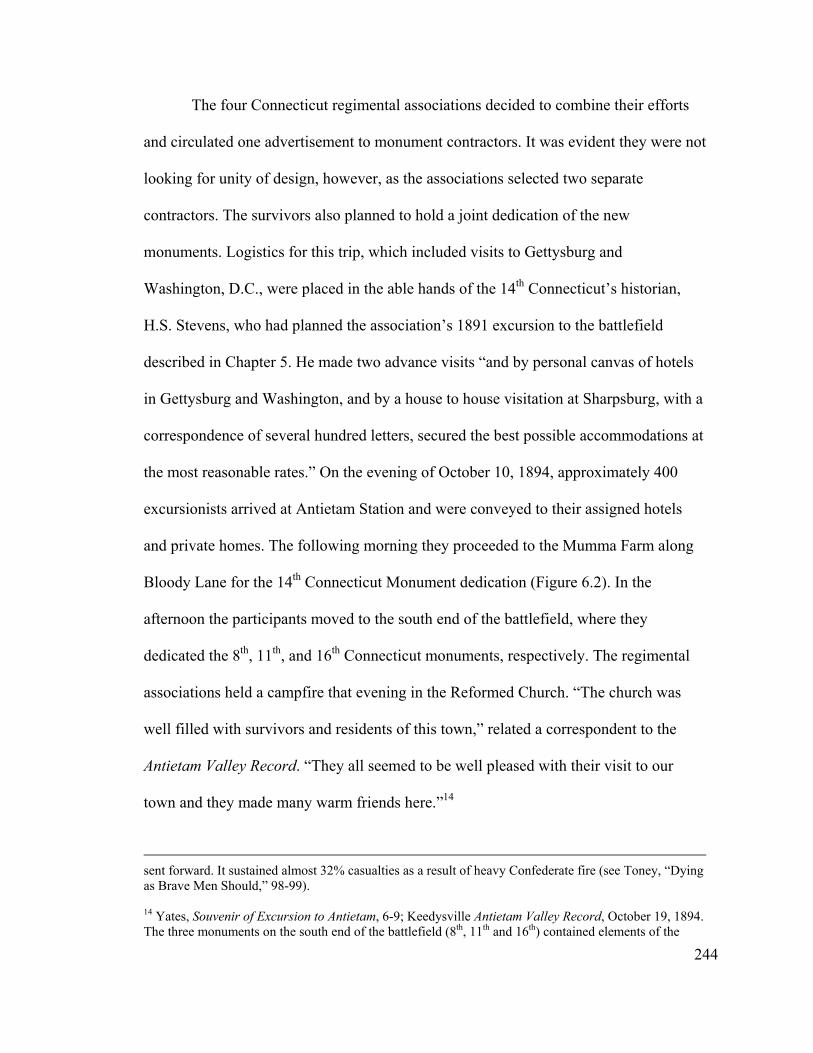
The four Connecticut regimental associations decided to combine their efforts
and circulated one advertisement to monument contractors. It was evident they were not
looking for unity of design, however, as the associations selected two separate
contractors. The survivors also planned to hold a joint dedication of the new
monuments. Logistics for this trip, which included visits to Gettysburg and
Washington, D.C., were placed in the able hands of the 14th Connecticut’s historian,
H.S. Stevens, who had planned the association’s 1891 excursion to the battlefield
described in Chapter 5. He made two advance visits “and by personal canvas of hotels
in Gettysburg and Washington, and by a house to house visitation at Sharpsburg, with a
correspondence of several hundred letters, secured the best possible accommodations at
the most reasonable rates.” On the evening of October 10, 1894, approximately 400
excursionists arrived at Antietam Station and were conveyed to their assigned hotels
and private homes. The following morning they proceeded to the Mumma Farm along
Bloody Lane for the 14th Connecticut Monument dedication (Figure 6.2). In the
afternoon the participants moved to the south end of the battlefield, where they
dedicated the 8th, 11th, and 16th Connecticut monuments, respectively. The regimental
associations held a campfire that evening in the Reformed Church. “The church was
well filled with survivors and residents of this town,” related a correspondent to the
Antietam Valley Record. “They all seemed to be well pleased with their visit to our
town and they made many warm friends here.”14
sent forward. It sustained almost 32% casualties as a result of heavy Confederate fire (see Toney, “Dying as Brave Men Should,” 98-99).
244
14 Yates, Souvenir of Excursion to Antietam, 6-9; Keedysville Antietam Valley Record, October 19, 1894. The three monuments on the south end of the battlefield (8th, 11th and 16th) contained elements of the
Relations between the Sharpsburg community and the Connecticut regimental
associations, particularly the 16th, were unusually close. Several years earlier, the 16th
Figure 6.2. The 14th Connecticut Monument on the Roulette Farm, c. 1905 (courtesy of Antietam NB).
Connecticut had been closely involved in the rehabilitation of the Reformed Church.
The regiment placed a memorial window in the church, and several representatives
attended the rededication service in June 1891. During this service, “a rising vote of
thanks was tendered the 16th Conn., for the beautiful window and the liberal
contribution of $100,” and those present from the 16th were requested to convey this
245
Richardsonian Romanesque and Gothic Victorian style, but were different architecturally—the 8th consisted of a rectangular block, the 11th a slab, and the 16th an obelisk. The 14th Connecticut monument along Bloody Lane, on the other hand, was a more severely classical obelisk.
action to the other veterans of the regiment, “together with the Christian greetings of
pastor and people.” A member of the 16th Connecticut also donated the Hymn Book
and ‘Order of Worship’ for the pulpit. Following the dedication of the four monuments
in fall 1894, one member of the 16th Connecticut sent a bound copy of the poem read at
that monument dedication to William Cronice of Sharpsburg. In a somewhat more
unusual gesture, battlefield resident Rezin Fisher sent a pair of opossums he had
captured to his new-found friends in Connecticut.15
In the summer of 1893, a year before the establishment of the Antietam Board,
Sharpsburg agent M.E. Snavely purchased a five-acre lot from Jacob Stine for the
Hawkins Zouaves Association. This unit, also known as the 9th New York, had been
part of Rodman’s division of Burnside’s 9th Corps. It participated in the afternoon
Federal movement across the Otto Farm toward Sharpsburg and suffered over 60%
casualties. The Association planned to erect a monument later that year to mark its
farthest point of advance, just south of the town. Two years passed, however, with no
progress made toward raising a monument. Ezra Carman, when appointed to the
Antietam Board in fall 1894, evidently had questioned whether the lot purchased by the
Association truly represented the farthest advance of the Zouaves on the afternoon of
the battle. A party of Association members, including the regiment’s leader Rush
Hawkins, visited the battlefield in June 1895 and with Carman’s assistance
unanimously determined that their original selection “was a blunder.” The men then
15 Keedysville Antietam Valley Record, September 19, 1890, June 19, 1891, and November 30, 1894.
246
selected a new lot situated closer to Sharpsburg and in a more commanding position
(Figure 6.1, no. 73).16
The Hawkins Zouaves Association’s hopes of dedicating its monument that year
were thwarted by difficulties with the owner of the new site, Urias Gross. He initially
asked an exorbitant $500 for a lot 60 feet square, raising the ire of the local newspaper
in the process. The impasse ended in October when the Hawkins Zouaves Association
agreed to pay $300 for the property, while at the same time selling their other lot to
Gross for $250—a net difference of $50. Acquisition of a right-of-way to the plot from
Harpers Ferry Road further delayed the process, with the result that the monument, a
classically simple obelisk, was not dedicated until Memorial Day in 1897.17
The 9th New York monument probably would not have materialized without
Ezra Carman’s assistance in negotiating with Gross, and represents the first instance of
the great influence he would wield during a critical time in the development of the
commemorative landscape at Antietam. Recognizing the importance of Gen. Carman’s
help, at the dedication ceremony the Hawkins Zouaves Association presented him with
a loving cup to express its gratitude. “What was needed most was a man on the spot,”
explained regimental commander Rush Hawkins, “some one intelligent and efficient to
16 Keedysville Antietam Valley Record, July 21, 1893, and May 10, 1895; Gen. Rush C. Hawkins to Maj. George B. Davis, May 1, 1895, file 344, E.A. Carman to Maj. George B. Davis, June 7, 1895, file 424, Antietam Battlefield Commission, Letters and Reports to the Secretary, 1894-1898 (ABC), Records of the Cemeterial Commissions, 1893-1916 (Entry 707), RG 92, NA. The idea of a monument first came up at an annual meeting of the Hawkin’s Zouaves Association in either 1890 or 1891. The organization received an appropriation of $5,000 from the New York legislature, and raised an equal amount among its membership (see Matthew J. Graham, The Ninth Regiment New York Volunteers (Hawkins Zouaves), being a History of the Regiment and Veteran Association from 1860 to 1900 (1900; reprint, with introduction by Brian C. Pohanka, Lancaster, Ohio: Vanberg Publishing, 1998), vi, 494. 17 Keedysville Antietam Valley Record, June 14, 1895, July 12, 1895, and October 24, 1895; Graham, The Ninth Regiment New York Volunteers, 495.
247
assist in locating the site, which was the most important point we had to consider, and,
besides, our dealings with the people here—the natures—were so varied, covered such
a multitude of details, that they called for most careful attention.”18
Not all regimental associations successfully secured monument sites at
Antietam. In 1888 the 124th Pennsylvania decided to erect a monument on the
battlefield and appointed a committee to purchase property. The following year, this
committee “reported having written to the party owning the desired site, but received
no reply.” As a result, that group disbanded. Several years would pass before the 124th
Pennsylvania made another effort at placing a monument at Antietam, and, as discussed
later in this chapter, another decade before they would be successful.19 It is likely that
other associations attempted unsuccessfully to acquire monument plots on the
battlefield around this same period as well. Perhaps some landowners were reluctant to
part with their property until a trusted mediator such as Ezra Carman came along and
plans for the battlefield had become more formalized. It is interesting that the
monuments established up to the appointment of the Antietam Board were located
almost entirely in the south end of the battlefield, near Burnside Bridge and the fields
between that bridge and Sharpsburg. The only exception was a couple of monuments
along the north side of Bloody Lane. Perhaps this was coincidence, or indicated which
landowners were willing to part with their property.
18 Graham, The Ninth Regiment New York Volunteers, 552-554.
248
19 Robert M. Green, compiler, History of the One Hundred and Twenty-fourth Regiment Pennsylvania Volunteers in the War of the Rebellion (Philadelphia: Ware Bros. Company, Printers, 1907), 214, 230, 250, 253.
The Antietam Board and Commemorative Monuments
Unlike his counterparts at Gettysburg, and later at the other three War
Department battlefield parks, Maj. George B. Davis believed that the Antietam Board
had no role to play in placing monuments on the battlefield. As related in the previous
chapter, both Carman and Hotchkiss recommended acquiring wider rights-of-way than
Davis had proposed, upon which regimental associations and states could place
monuments, but Davis had rejected the idea. “The avenues which we are buying are not
broad enough for large monuments,” he stated to Col. John P. Nicholson at Gettysburg,
“but regiments which desire to do so can acquire small tracts of ground for monuments
along the avenues or near them and can erect such monuments as they desire. This is a
matter over which the Commission has no jurisdiction. Regiments from New York,
Connecticut, Maryland, Ohio and Maine, have erected, or propose to erect, monuments
on land purchased by them for that purpose.” Davis made it clear, however, that he
preferred monuments for larger organizations, such as brigades or divisions, over those
for individual units, “as it gives a dignity to State representation which it could not
obtain by regimental monuments.”20
Monuments in the West Woods
Maj. George B. Davis was able to act upon his convictions in short order, when
members of the Philadelphia Brigade Association approached him in early spring 1895
about the possibility of placing monuments on the battlefield to each of the brigade’s
249
20 E.A. Carman to Maj. George B. Davis, December 19, 1894, Jed Hotchkiss to Maj. George B. Davis, November 30, 1894, Maj. George B. Davis to Gen. W.F. Rogers, Bath, NY, January 22, 1895, Maj. George B. Davis to Col. John P. Nicholson, Gettysburg, March 23, 1895, ABC, Entry 707, RG 92, NA. The state of Maine never followed through with placement of a monument on Antietam Battlefield.
four regiments. The brigade, under the command of O.O. Howard, had comprised part
of Sedgwick’s ill-fated movement into the West Woods. Davis informed the
Association that it would be difficult to locate the positions of individual regiments
owing to the paucity of geographical landmarks and the changes that had occurred to
the landscape since the time of the battle. He also conveyed his dislike of “tombstones”
across the battlefield, recommending instead that it erect one monument to the entire
Brigade. The Association agreed with Davis’s idea, and moved ahead with its plans to
raise a single memorial. In mid-August they met on site with Ezra Carman to select the
location for the monument. Just prior to this meeting, the Antietam Valley Record,
constantly lamenting the greed of battlefield landowners, exhorted “the parties from
whom they try to buy the land” not to ask an outrageous amount as had been the case in
other recent transactions. Such hopes were dashed, however, as the Association was
forced to deal with the difficult and often obstinate owner of the West Woods area,
George Poffenberger, as it was on his property that the brigade incurred its highest
losses. The members had intended on buying a small lot just large enough to hold the
monument, but when Poffenberger offered to sell them ¼ acre for the exorbitant price
of $400, or eleven acres for $1,000, they quickly chose the latter after consultation with
Gen. Carman (see Figure 6.1, no. 30, for the monument’s location). The Association
determined thereafter to establish a public park, to be known as the Philadelphia
Brigade Park, which it planned to turn over to the federal government.21
250
21 Fred Middleton, Chairman, Antietam Monument Committee, to Maj. George B. Davis, May 16, 1895, file 395, Maj. George B. Davis to Col. John W. Frazier, May 20, 1895, file 396, John W. Frazier to Maj. George W. Davis, August 31, 1895, John W. Frazier to Sec. of War Daniel Lamont, September 2, 1895, file 396a, ABC, Entry 707, RG 92, NA; Keedysville Antietam Valley Record, July 12, 1895; James V.
In addition to the private funds it raised, the Philadelphia Brigade Association
solicited the Pennsylvania state legislature for an additional $6,000—the equivalent of
four regimental monuments, which the Assembly generally funded at $1,500 apiece.
While the legislature initially agreed to the full amount, it actually appropriated $5,000.
This enabled the Association to move ahead with its plans, however, to contract for a
substantial granite obelisk. The new park was dedicated in a large ceremony held on the
afternoon of September 17, 1896, and attended by the Governors of Pennsylvania and
Maryland, as well as a substantial number of veterans’ organizations. These groups
traveled by rail from a national Blue and Gray campfire in Washington, D.C—the first
truly large-scale event to be held on the battlefield, and, ironically, by Pennsylvania
veterans. While the Association intended all along to turn its new park over to the War
Department, for some reason this did not occur before the statutory authority of the
Antietam Board had expired.22
Two other units, the 34th New York and the 15th Massachusetts—both part of
Gorman’s Brigade—also pursued monuments in the West Woods during this period. In
August 1895, about six months after the Philadelphia Brigade Association first
approached the Antietam Board, the 34th New York inquired as to “whether or not
Murfin, The Gleam of Bayonets: The Battle of Antietam and the Maryland Campaign of 1862 (Cranbury, NJ: Thomas Yoseloff, Publisher, 1965), 239-240.
251
22 John W. Frazier, Commander, Philadelphia Brigade Association, to Maj. George B. Davis, May 16, 1895, May 22, 1895, and June 7, 1895, file 396, Undated newspaper clipping enclosed with John W. Frazier to Sec. of War Daniel Lamont, September 5, 1896, file 618, ABC, Entry 707, RG 92, NA. The Philadelphia Brigade Association may have held back on conveying its property to the War Department as a result of a dispute arising over surplus cannon and cannon balls that the Secretary of War had agreed to provide the Association to embellish the grounds of the park. Evidently, the Association believed that this agreement included the cannon carriages, and did not find out otherwise until less than two weeks before the dedication. The controversy continued for another year, until the Secretary of War finally rescinded his original agreement (see Maj. George W. Davis to Gen. E.A. Carman, September 9, 1896, Maj. George W. Davis to Gen. John W. Frazier, July 6, 1897, file 396g).
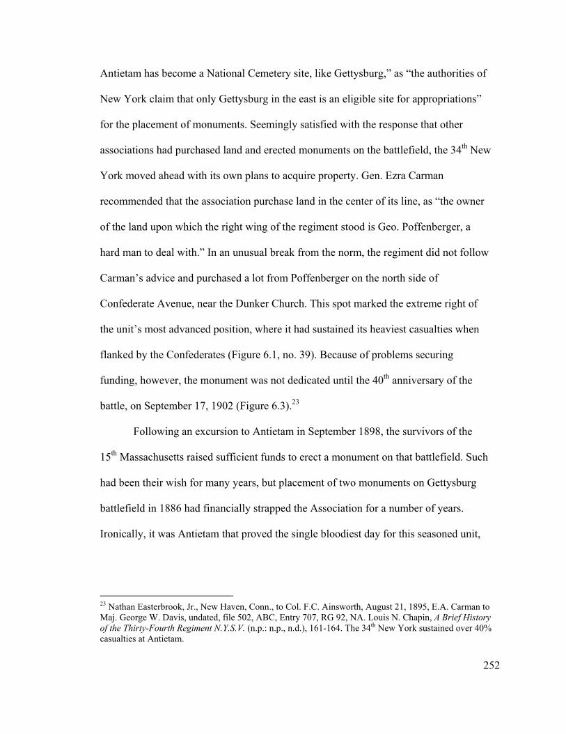
Antietam has become a National Cemetery site, like Gettysburg,” as “the authorities of
New York claim that only Gettysburg in the east is an eligible site for appropriations”
for the placement of monuments. Seemingly satisfied with the response that other
associations had purchased land and erected monuments on the battlefield, the 34th New
York moved ahead with its own plans to acquire property. Gen. Ezra Carman
recommended that the association purchase land in the center of its line, as “the owner
of the land upon which the right wing of the regiment stood is Geo. Poffenberger, a
hard man to deal with.” In an unusual break from the norm, the regiment did not follow
Carman’s advice and purchased a lot from Poffenberger on the north side of
Confederate Avenue, near the Dunker Church. This spot marked the extreme right of
the unit’s most advanced position, where it had sustained its heaviest casualties when
flanked by the Confederates (Figure 6.1, no. 39). Because of problems securing
funding, however, the monument was not dedicated until the 40th anniversary of the
battle, on September 17, 1902 (Figure 6.3).23
Following an excursion to Antietam in September 1898, the survivors of the
15th Massachusetts raised sufficient funds to erect a monument on that battlefield. Such
had been their wish for many years, but placement of two monuments on Gettysburg
battlefield in 1886 had financially strapped the Association for a number of years.
Ironically, it was Antietam that proved the single bloodiest day for this seasoned unit,
23 Nathan Easterbrook, Jr., New Haven, Conn., to Col. F.C. Ainsworth, August 21, 1895, E.A. Carman to Maj. George W. Davis, undated, file 502, ABC, Entry 707, RG 92, NA. Louis N. Chapin, A Brief History of the Thirty-Fourth Regiment N.Y.S.V. (n.p.: n.p., n.d.), 161-164. The 34th New York sustained over 40% casualties at Antietam.
252
which participated in many major engagements during the Civil War. Within twenty
minutes, the regiment sustained over 50% casualties under withering frontal and
enfilading fire. “Only three infantry regiments lost more in killed and mortally
wounded in a single battle during the war,” observed Antietam National Battlefield
historian Ted Alexander. Such was the pull of Gettysburg, though, even for the 15th
Massachusetts. In recognition of their tremendous sacrifice, the 15th Massachusetts
survivors commissioned a sculpture of a grievously wounded but defiant lion reclining
on a stone pedestal. Similarly to the 34th New York monument, it marked the farthest
advance of the 15th Massachusetts and the point where it received its heaviest casualties
(Figure 61, no. 29). Dedication services were held on September 17, 1900.24
Figure 6.3. Dedication of the 34th New York Monument, September 17, 1902 (courtesy of Antietam NB).
253
24 George W. Ward, History of the Excursion of the Fifteenth Massachusetts Regiment and its Friends to the Battlefields of Gettysburg, Antietam, Ball’s Bluff and the City of Washington, D.C., September 14-20,
The location of these two monuments along Confederate Avenue reflects the
influence that the new War Department avenues would have on the placement of
memorials on the battlefield. While discouraged from erecting monuments on
government ground, the roadways did open up significant areas that previously had not
been accessible to units that wished to commemorate their actions at Antietam. This
stands in contrast to the earlier monuments, which tended to be located in fields, set
back from roads.
Massachusetts State Monument
Several months after the Philadelphia Brigade Association first approached the
Antietam Board, the adjutant general for the Commonwealth of Massachusetts also
made inquiry of Maj. George B. Davis about marking the lines of troops from his state,
as it had done ten years earlier at Gettysburg. Davis rather uncharacteristically replied,
perhaps because he was dealing with a state official: “If the positions of any of the
Massachusetts Regiments, or batteries, fall within the avenues thus acquired, the
[Board] will cheerfully recommend to the War Department that the State be permitted
to erect monuments at such points in the several avenues, as the Massachusetts
Commission may be pleased to select.” Conversely, if located outside, it would be
necessary for the state to acquire land for monuments.25
1900 (Worcester: Press of O.B. Wood, 1901), 27; Alexander, “Forgotten Valor,” 5, 10-11. No evidence has been found indicating that Ezra Carman assisted the 15th Massachusetts with locating its monument. This may be because the regiment purchased the lot from George Poffenberger, with whom Carman did not appear to be on very good terms.
254
25 Samuel Dalton, Adj. Gen. Massachusetts, to Antietam Commission, June 28, 1895, Maj. George B. Davis to Maj. Gen. Samuel Dalton, July 1, 1895, file 450, ABC, Entry 707, RG 92, NA; Kinsel, “From these honored dead,” 187.
In the opening months of 1896 the newly appointed Massachusetts Antietam
Commission contacted the War Department to inquire whether the offer allowing
monuments along the avenues was still open. Somewhat backpedaling from his
predecessor’s earlier assurances, Maj. George W. Davis replied that it could be done,
“provided, however, that the monuments . . . will not obstruct traffic, as the roads
controlled by the Government at Antietam are not very wide, and the space available
for monuments is quite limited.” In May the Massachusetts Commission visited with
Davis in Washington, and then traveled to Sharpsburg to meet with Ezra Carman.
Evidently the Commission had determined before leaving home that a single state
monument at Antietam served its purpose better than a number of regimental
monuments, most likely because they would have to purchase land for whatever
memorials they erected. In consultation with Carman, the Commission selected a site in
the southeast corner of the Hagerstown Turnpike and the proposed Cornfield Avenue
for the new monument, Massachusetts troops experienced some of their heaviest losses
(Figure 6.1, no. 23). “I was impressed with the Massachusetts people,” expressed a
satisfied Davis, “for they all seemed to be clear headed and intelligent men; and I am
glad that they have adopted the plan of erecting one handsome monument instead of
half a dozen regimental, I think in the end it will be far more satisfactory.”26
26 C.E Davis, Sec. Massachusetts Antietam Commission, to Antietam Commission, April 24, 1896, George W. Davis to C.E. Davis, April 27, 1896, Charles E. Davis, to Maj. George W. Davis, May 8, 1896, file 450, Charles E. Davis to Gen. E.A. Carman, May 11, 1896, file 522, E.A. Carman to Major George W. Davis, May 18, 1896, file 522, Major George W. Davis to E.A. Carman, May 19, 1896, ABC, Entry 707, RG 92, NA. Acting on behalf of the Massachusetts Commission, Ezra Carman acquired a 75 square foot parcel for $100 (see E.A. Carman to Maj. George W. Davis, May 20, 1896, file 450). Schildt, Monuments at Antietam, 65.
255

The Massachusetts Monument was dedicated on the battle anniversary in 1898.
This unusual monument consisted of a low granite altar or table sitting on a three-step
platform. Compared to the later state monuments erected at Antietam it was relatively
small and unassuming, measuring 12 feet long, 6 feet high, and 8 feet deep. In the
center was a round bronze tablet with the Massachusetts state seal, flanked on both
sides by tablets listing the 21 units from the Commonwealth that fought at Antietam.
Private organizations dedicated two additional regimental monuments on the same
day—a small memorial to the 35th Massachusetts erected four years earlier on the
northwest corner of Burnside Bridge, and a second one to the 21st Massachusetts placed
on the bridge’s southwest corner. The latter monument consisted of a small stone block
surmounted by a carved minie bullet. Both of these regiments formed part of Ferrero’s
Brigade, and had supported the attack of their fellow brigade members, the 51st
Pennsylvania and 51st New York, against the bridge.27
Relocating the 11th Connecticut Monument
Not only did the Antietam Board help determine the placement of several new
monuments during its short existence, it also was instrumental in moving one that had
already been erected. Maj. George W. Davis had fought at Antietam as a member of the
11th Connecticut. Shortly after his appointment as President of the Antietam Board, he
visited the battlefield for the first time since September 1862, and “was struck with the
inappropriateness of the location of the 11th Connecticut Monument” on the 16th
Connecticut plot, believing it should be situated near Burnside Bridge instead, where
256
27 Description of Massachusetts State Monument in Milner, Design of the Commemorative Military Park, 2-186; Schildt, Monuments at Antietam, 65-67; Toney, “Dying as Brave Men Should Die,” 105.
“the regiment did its principal fighting on that field and incurred its principal losses.”
Davis recommended that it be moved to the slope on the east side of Burnside Bridge,
at the location where the regiment’s colonel, Henry W. Kingsbury, Jr., had fallen
mortally wounded.28
The 11th Connecticut survivors’ association was in fact raising funds at this time
to place a small monument at the spot where Kingsbury fell. Many of its members,
however, were beginning to favor moving the existing monument to that location
instead, and this course was clinched upon receipt of Davis’s letter suggesting the same.
“I think it will be very likely practicable to provide the 11th Connecticut with a site on
the roadside, near the Burnside Bridge, without cost or expense to it,” offered Davis,
deviating from his usual reluctance to locate monuments on government land, “as it is
in contemplation by the Antietam Board to improve the roadway running east from the
eastern end of the bridge and widen the same so as to include a strip of ground some
fifty or sixty feet wide . . . and on this strip so acquired to improve the roadway there
would then probably be abundant, and I think suitable, space for the 11th Connecticut
Monument.” The regimental survivors were not interested in waiting for this
possibility, however, and decided to move ahead with their plans that fall. They met on
site with General Carman in late November, and selected and purchased a lot at the
location Davis originally had proposed. By the end of the year, the monument had been
moved to its new location.29
28 Maj. George W. Davis to C. Quien, Sec. Society of the 11th Conn. Regiment, September 7, 1895, file 508, ANC, Entry 707, RG 92, NA.
257
29 C. Quien to Maj. George W. Davis, September 24, 1895, and September 28, 1895, file 508, Major George W. Davis to F.A. Cummings, October 28, 1895, F.A. Cummings to Major George W. Davis,
On the whole, only a handful of monuments were erected during the tenure of
the Antietam Board. One reason most likely stemmed from the absence of an organized
veterans’ movement at Antietam, similar to those found at the other four War
Department battlefield parks. Added to this was the discouragement offered on the part
of the two Major Davises toward placement of regimental monuments on the
battlefield. Another factor certainly was the lack of government land upon which to
erect them as a result of the acquisition of narrow rights-of-way only. Outside of
specific units that had incurred particularly heavy losses at Antietam, there appears to
have been little interest during this period in marking units on the battlefield,
particularly relative to Gettysburg. In fact, most of the units that erected monuments at
Antietam at this time already had memorials in place at the Pennsylvania battlefield,
even if they had suffered their highest casualties at Antietam.
After his appointment to the Antietam Board, Gen. Carman became the central
figure in helping units to locate monument sites and negotiate with local landowners—
with the exception of George Poffenberger, owner of the West Woods site, who
evidenced great reluctance to deal with the federal government. Even after the Board
ceased to exist, Carman continued informally to represent the War Department for all
dealings involving Antietam. He worked closely with veteran associations and state
commissions to situate monuments on the field, and approved all locations and
monument inscriptions.
258
November 19, 1895, and December 13, 1895, file 524, E.A. Carman to Maj. George W. Davis, December 26, 1895, file 533, ANC, Entry 707, RG 92, NA. The Connecticut organization contracted with M.E. Snavely to build a new base and to relocate the monument, under the oversight of Ezra Carman.

State Commissions and Monuments
By the turn of the twentieth century, the era of individual units placing
monuments on Antietam Battlefield had come to an end. This mirrors, albeit on a
smaller scale and at a somewhat later date, what was occurring at the other battlefields
as state commissions assumed an increasingly important role. “By the end of the
[1880s], the states had assumed control of patronage through establishment of
monument commissions that expended large sums for service monuments [at
Gettysburg] dedicated to individual regiments and batteries,” declared Michael
Panhorst. “This outpouring of state aid soon stimulated interest among veterans of other
major battles who desired equal recognition for their service on the fields where they
fought.” These commissions acquired increased importance and standing as state
legislatures delegated to them the legal authority to erect monuments. Elaborate state
monuments also became more common at the battlefield parks, and in fact became the
predominant type at Antietam beginning in 1900.30
Maryland Monument
In 1888, the State of Maryland had appropriated funding for each of its Federal
units at Gettysburg. Another ten years were to pass, however, before Maryland made its
first concerted effort to commemorate its forces at Antietam. Strikingly reminiscent of
its earlier act establishing the national cemetery, the General Assembly voted in 1898 to
fund a state monument “to the Maryland soldiers of both sides engaged in said battle,”
along with markers designating the positions of each of the individual units. As noted
259
30 Panhorst, “Lest We Forget,” 50.

earlier, Maryland’s evident lack of interest up to this time toward Antietam contrasts
greatly with the efforts of neighboring Pennsylvania to preserve and commemorate its
great battlefield. Only with the reconciliation movement arising out of the Spanish-
American War was Maryland able to put its divided past behind it, and the Maryland
Monument at Antietam become possible. And unlike the cold reception given
Maryland’s attempt to bury Confederate and Union soldiers together, its new effort to
bring North and South together would be greeted enthusiastically.31
The Maryland legislature appropriated $12,500 toward the monuments and
appointed a commission of nine Antietam veterans—six Union and three Confederate,
to oversee the process. The new commission toured the battlefield with Ezra Carman in
mid-August 1898, and with his assistance selected the sites for the various unit markers.
Significantly, it waited until the following month, after consultation with commission
member Henry Kyd Douglas (who had been absent from the August meeting), to select
the location for the main monument—on high ground across the Hagerstown Pike from
the Dunker Church (Figure 6.1, no. 41). The site, situated in the symbolic center of the
battlefield, lay along the Confederate battle line. Douglas, a member of Confederate
General Stonewall Jackson’s staff, most likely exerted great influence over the
selection of this location. The Commission subsequently authorized him to purchase the
one-acre tract from the Rezins, owners of the wartime Mumma Farm.32
31 Copy of legislation in Minutes of Proceedings, July 11, 1898, Antietam Battlefield Commission of Maryland Papers, 1898-1900, Maryland Historical Society, Baltimore, Maryland (MHS); Panhorst, “Lest We Forget,” 49. 32 Soderberg, Lest We Forget, 95. Copy of legislation in Minutes of Proceedings, July 11, 1898, Minutes of Proceedings, August 17, 1898 and September 26, 1898, Antietam Battlefield Commission of Maryland Papers, 1898-1900, MHS.
260
Conceived out of the reconciliation movement following the Spanish-American
War, the tone of the new monument was to be thoroughly in line with this view. “The
State of Maryland, through its General Assembly, recognizing the fact that all sectional
differences engendered by the late Civil War, have ceased to exist,” reflected the
Commission in its design solicitation, “offers this Monument, not only as a memorial to
the bravery of her Sons, in both Union and Confederate Armies, who, on her own soil,
at the battle of Antietam, offered their lives in maintainance [sic] of their principles, but
also in recognition of the precepts of peace and fraternity, which now find their
embodiment in the hearts of a united people.” Carrying forth this idea, in January 1899
the Antietam Battlefield Commission selected a design that consisted of a small
octagonal Greek temple or gazebo form (one side for each of the eight Maryland
commands at Antietam—six Union and two Confederate), covered by a copper-coated
dome and crowned with a bronze statue of “Peace” (Figure 6.4). The equal sides of this
Beaux Arts structure emphasized the parity of the two sides in the conflict, and that all
differences between them had been set aside.33
The Commission selected the exact site for the monument on July 12, and made
the decision “to face the monument toward the nearest angle of the Dunkard [sic]
Church.” Construction began shortly thereafter, with the intention of holding the
dedication around the September anniversary of the battle. When it became evident the
monument would require more than two months to complete, the Commission initially
261
33 “The Maryland Monument at Antietam” design solicitation, Minutes of Proceedings, January 16, 1899, Antietam Battlefield Commission of Maryland Papers, 1898-1900, MHS. In fact, one of the plaques on the monument states: “Erected by the State of Maryland to her sons, who on this field offered their lives in maintenance of their principles.” This monument measures about 15 feet wide by 35 feet high (including the statue). The statue consisted of a classical female figure with sword sheathed and holding a
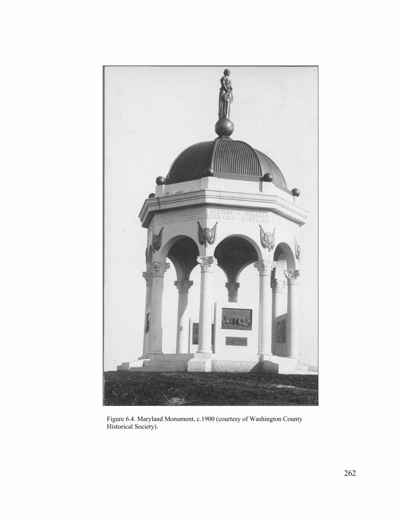
Figure 6.4. Maryland Monument, c.1900 (courtesy of Washington County Historical Society).
262
pushed back the dedication date one month. Apparently at the urging of the governor,
however, this date was rescheduled one more time to Memorial Day the following
spring, to allow adequate time to plan for the large-scale event that state officials
envisioned.34
In March 1900 the General Assembly appropriated an additional $1,500 for the
monument dedication, obviously viewing this ceremony as a highly significant event.
Invitations were extended to President William McKinley (a veteran of the Battle of
Antietam) and other prominent national officials, Union and Confederate veterans, and
state and local officials. Between 15,000 and 25,000 people—the largest crowd to
assemble at Antietam since the battle—gathered on May 30 to witness the dedication.
The President arrived by train at Antietam Station a little before noon, and paid his
respects at the national cemetery before traveling to the speaker’s stand in front of the
Dunker Church. A large number of dignitaries joined McKinley, including cabinet
officials, members of Congress, Governor John W. Smith of Maryland, Rep. George B.
McClellan (son of the general), and Civil War officers from both sides of the conflict,
including former Confederate General and Spanish-American War hero Joseph
laurel wreath. According to Susan Soderberg, the idea to erect the monument came from Maryland members of the GAR, and a state senator from Washington County, Norman C. Scott, was instrumental in having the legislation include the Confederate units (Lest We Forget, 95).
263
34 Minutes of Proceedings, June 15, 1899, George R. Graham, Secretary, to Col. Joseph M. Sudsburg, August 16, 1899, and September 23, 1899, Antietam Battlefield Commission of Maryland Papers, 1898-1900, MHS.
Wheeler. Hundreds of Confederate veterans and thousands of Union veterans attended
as well.35
Tellingly, Henry Kyd Douglas served as master of ceremonies for the occasion,
underscoring the monument dedication’s overwhelmingly reconciliation tone. The first
speaker, Maryland Governor John W. Smith, opened with the remark that this was the
“only instance in the world’s history of a single monument being erected to those who
fought each other on the field of battle.” After several other speeches, Douglas rose and
in his address stated: “the State of Maryland, mindful only of the valor of her sons who
fought under both flags, has raised this monument to them without distinction in any
wise.” President McKinley noted his pleasure at participating “with the great State of
Maryland in this tribute to the sacrifice and valor of Confederate and Union soldiers—
the valor of both, which is the heritage of all.36
Almost thirty-three years previously the governor of Maryland and the president
of the United States had all but been heckled off the stage for expressing much the
same sentiments at the dedication of the national cemetery. This time, these officials’
words were greeted with acclamation. Much had changed in the intervening years. The
Spanish-American War had demonstrated the loyalty of the South and reunited the
country under one flag. President McKinley shrewdly used this war effort to promote
sectional reconciliation. It is obvious that Maryland also capitalized on this movement
35 George R. Graham, Secretary, to Col. Joseph M. Sudsburg, March 21, 1900, Antietam Battlefield Commission of Maryland, 1898-1900, WHS; Chapter 96--1900, Laws of Maryland, copy in “5th Maryland Monument” file, Cultural Resource Office, Antietam National Battlefield; Soderberg, Lest We Forget, 96-97; Hagerstown Evening Globe, May 31, 1900, “Sacred to Both the Blue and Gray,” clipping in file “Antietam Battlefield-Monuments to State Troops,” Washington County Historical Society, Hagerstown, Maryland.
264
36 Hagerstown Daily Mail, May 31, 1900. The masthead reads “Maryland Honors Her Heroic Dead.”

to return to Antietam Battlefield once again and stake a claim on its landscape. This did
not mean, however, that Antietam would become a major focus of reconciliation
ideology.37
New Jersey Monument and Markers
The placement of the Maryland state monument on Antietam Battlefield led the
way for other states during the first two decades of the twentieth century. New Jersey
erected its state monument at the intersection of the Hagerstown Pike and Cornfield
Avenue in 1903 (Figure 6.1, no. 13). It consisted of a tall column surmounted by a
statue representing Captain Irish of Company K of the 13th New Jersey, the first
member of the regiment killed during the battle. Approximately 2,000 were present at
the dedication ceremony on the anniversary of the battle, no doubt owing to President
Theodore Roosevelt’s presence. Roosevelt’s speech sang the praises of the Union army,
and stressed the importance of the Battle of Antietam, namely the issuance of the
preliminary Emancipation Proclamation and the decision of European powers not to
side with the Confederacy. Characteristically, he also drew a comparison between the
qualities of courage and honesty displayed by the soldiers who fought at Antietam and
its need in present-day civic life. While Roosevelt gave a nod toward the valor of the
265
37 Gaines M. Foster, Ghosts of the Confederacy: Defeat, the Lost Cause, and the Emergence of the New South, 1865 to 1913 (New York: Oxford University Press, 1987), 148-149, 153; Cecilia Elizabeth O’Leary, To Die For: The Paradox of American Patriotism (Princeton: Princeton University Press, 1999), 137, 142, 146.
Confederates, he did not give a reconciliation speech such as the one delivered three
years earlier by McKinley at the dedication of the Maryland Monument.38
Ohio Monuments
The nation was shocked when an assassin’s bullets wounded President
McKinley on September 6, 1901, leading to his death one week later. His assassination
galvanized McKinley’s home state of Ohio into passing an act the following spring to
create a monument commission tasked with marking the positions of its regiments on
the battlefield of Antietam, as well as “the place where Commissary Sergeant William
McKinley issued rations to his regiment” while under fire. The act was amended later
that year to increase the amount of funding for McKinley’s monument to the substantial
sum of $5,000.39
The Ohio Commission traveled to Antietam in August 1902 and designated ten
monument sites. Half of these, including the site for the McKinley memorial, were
located on private ground that the commissioners purchased, while the other half were
situated along the War Department avenues. This marked the first time at Antietam that
monuments were located along these roads, most likely because the Antietam Board,
which had discouraged such use under the two George Davises, no longer existed. All
38 Hagerstown Herald and Torch Light, September 24, 1903. New Jersey also placed five unit position markers on the battlefield, and erected two monuments to the First New Jersey Brigade (one of these was placed at Crampton’s Gap).
266
39 D. Cunningham and W.W. Miller, Antietam: Report of the Ohio Antietam Battlefield Commission (Springfield, Ohio: Springfield Publishing Company, 1904), 18-20. The inscription on the McKinley Monument reads: “Sergeant McKinley, Co. E, 23rd Ohio Volunteer Infantry, while in charge of the Commissary Department, on the afternoon of the day of the Battle of Antietam, Sept. 17, 1862, personally and without orders, served hot coffee and warm food to every man in the regiment, on this spot; and in doing so, had to pass under fire.” For this act, McKinley was promoted that same day to lieutenant (Alexander, “Forgotten Valor,” 20).

of the monument sites were located at or near the primary positions of each of the
regiments. Since the majority of these units had been attached to the Ninth Corps, most
of them were located at the south end of the battlefield, along Branch Avenue. The two
exceptions were the joint monument to the 5th, 7th, and 66th Ohio regiments located
across from the Dunker Church (Figure 6.1, no. 42) and the 8th Ohio along Bloody Lane
(Figure 6.1, no. 54).40
In January 1903, the Ohio Commission selected a contractor from its state to
fabricate the monuments. With the exception of the McKinley Monument, they all
reflected the Richardsonian Romanesque style popular during the last two decades of
the nineteenth century. Most importantly, these monuments presented a unified design
vocabulary that marked them as representing a single state—an attribute that became
increasingly important to state commissions. As befitting its subject, the McKinley
Monument, situated above Burnside Bridge at the site where he had handed out the hot
coffee and rations (Figure 6.1, no. 93), conveyed a different, more classical appearance,
comprised of a tall Doric column on a square pedestal base (Figure 6.5). Attached to the
back of the pedestal was a relatively small bronze relief of McKinley at Antietam,
while a medallion placed on the front showed two profiles of the president—one as a
young man at the time of the battle and the second as president. A life-sized granite of a
woman in classical drapery holding a palm branch was placed on top of the pedestal. It
is evident the monument was meant as a public expression of sorrow over the
267
40 Cunningham and Miller, Ohio Antietam Battlefield Commission, 21-22. The sites requiring the acquisition of private property included the 11th Ohio, McKinley, 1st Ohio Light Artillery, and 12th Ohio monument plots on the south end of the battlefield, near the Burnside Bridge, and the combined monument to the 5th, 7th, and 66th Ohio regiments along the Hagerstown Pike, across from the Dunker Church.
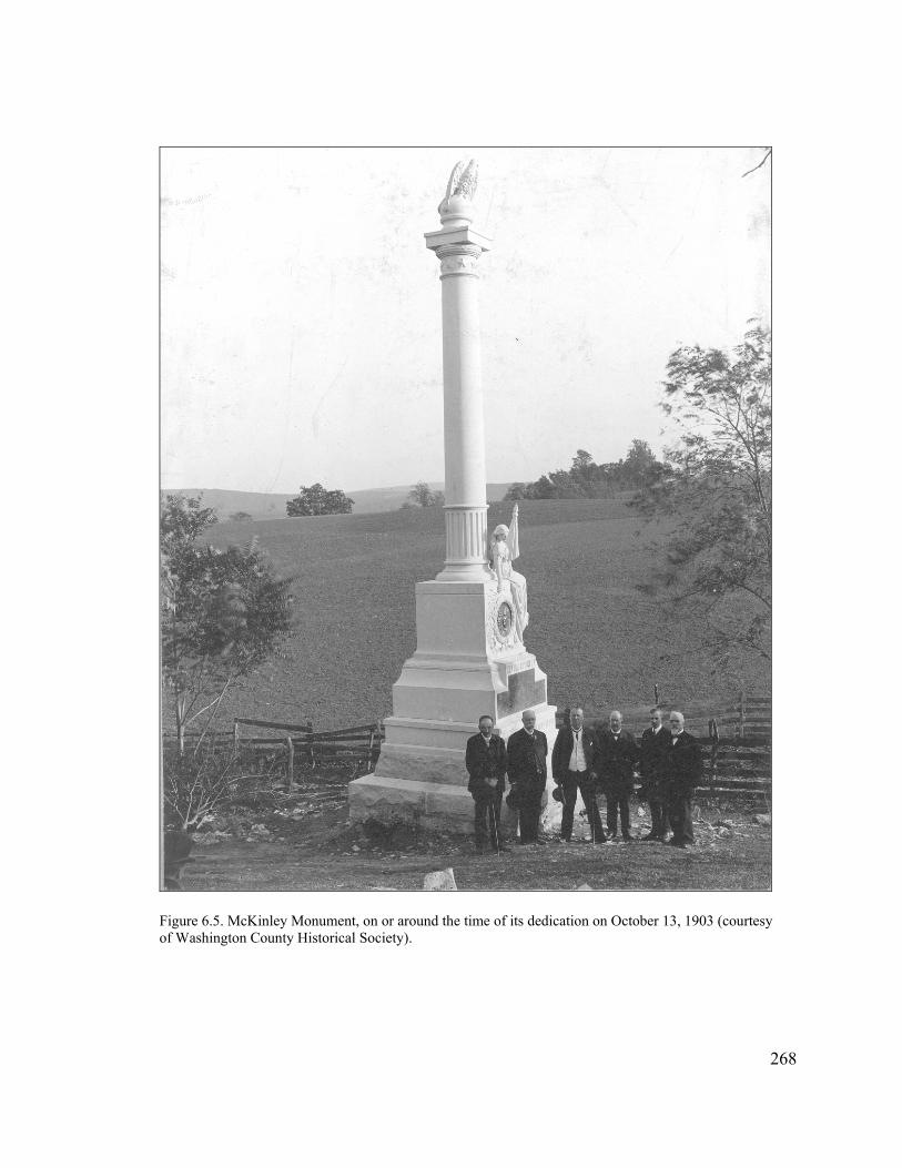
Figure 6.5. McKinley Monument, on or around the time of its dedication on October 13, 1903 (courtesy of Washington County Historical Society).
268
president’s assassination and only secondarily as a commemoration of McKinley’s war-
time service41
Originally the Ohio Commission had scheduled the dedication of the
monuments for September 17, 1903. Uncertainty as to whether they would be
completed by that date, coupled with the fact that New Jersey also had selected the
battle anniversary for the dedication of its monuments, led the Ohioans to postpone
their ceremony a month to October 13. On that date, several hundred Ohio veterans
attended the dedication service held in front of the Dunker Church, afterward touring
the battlefield and viewing the new monuments.42
Pennsylvania Monuments
Given that the Commonwealth of Pennsylvania had the second largest number
of Federal troops at the Battle of Antietam, it was very slow to acknowledge their deeds
because of the state’s long-standing fixation upon Gettysburg. In fact, when the state
legislature finally passed a bill in April 1903 appropriating funds for monuments at
Antietam, it did so only for “certain Pennsylvania commands that participated in the
battle on September [17, 1862], but were not in the battle of Gettysburg.” It also was
evident that these monuments were meant to represent a unit’s entire service, as several
of the regiments suffered very light losses at Antietam, and one (the 132nd
41 Cunningham and Miller, Ohio Antietam Battlefield Commission, 24. The commissioners selected The Hughes Granite and Marble Company of Clyde, Ohio. See Panhorst, Lest We Forget, 168-172, for discussion of Richardsonian Romanesque style monumentation on Civil War battlefields. 42 Cunningham and Miller, Report of the Ohio Antietam Battlefield Commission, 102.
269
Pennsylvania) even depicted an event from the Battle of Fredericksburg on its
monument.43
The 1903 legislation appropriated $2,500 toward each of thirteen Pennsylvania
units that initially qualified under the act, and appointed a three-man Commission to
oversee this effort. The Commission contacted the thirteen regimental associations and
arranged for a meeting at Antietam on September 17, 1903, to select the monument
sites. Unlike earlier efforts by the regimental associations from Connecticut and the
state commission for Ohio, there was little concern about placing monuments at the
exact locations where the units had fought. Perhaps as a money-saving measure, all of
the sites selected for the Pennsylvania monuments were situated along the government
avenues with the exception of two, for which lots were purchased adjoining the
roadways (Figure 6.6). The Commission did, however, attempt to locate the monument
sites in the vicinity of where the units had been engaged.44
The Pennsylvanians decided that uniformity of design was important, however,
and selected a single contractor to complete the work: “It is the desire of the
Commission that appropriateness of design shall characterize the monuments under
their supervision, that they shall bear some similarity, so that visitors to the field can
see at a glance that this group of monuments presented belong to Pennsylvania
commands.” Each unit selected a statue pose, generally of a common soldier depicting
43 Oliver C. Bosbyshell, ed., Pennsylvania at Antietam: Report of the Antietam Battlefield Memorial Commission of Pennsylvania (Harrisburg, Penn.: Harrisburg Publishing Company, 1906), 9-10, 198. The first discussions concerning the placement of Pennsylvania monuments at Antietam evidently occurred in 1891, and there were further discussions in the mid 1890s when a Pennsylvania commission marked troop locations at the battlefield, but these did not proceed any farther.
Bosbyshell, Pennsylvania at Antietam, 11. 44
270
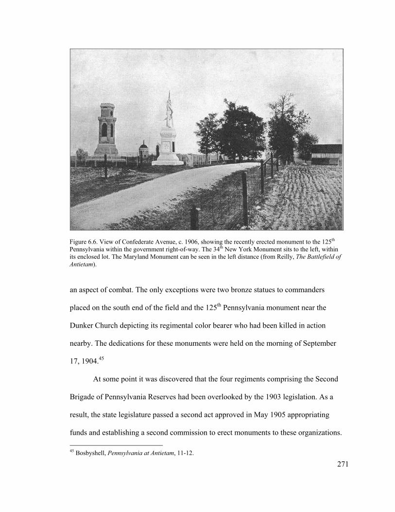
an aspect of combat. The only exceptions were two bronze statues to commanders
placed on the south end of the field and the 125th Pennsylvania monument near the
Dunker Church depicting its regimental color bearer who had been killed in action
nearby. The dedications for these monuments were held on the morning of September
17, 1904.45
Figure 6.6. View of Confederate Avenue, c. 1906, showing the recently erected monument to the 125th Pennsylvania within the government right-of-way. The 34th New York Monument sits to the left, within its enclosed lot. The Maryland Monument can be seen in the left distance (from Reilly, The Battlefield of Antietam).
At some point it was discovered that the four regiments comprising the Second
Brigade of Pennsylvania Reserves had been overlooked by the 1903 legislation. As a
result, the state legislature passed a second act approved in May 1905 appropriating
funds and establishing a second commission to erect monuments to these organizations.
271
45 Bosbyshell, Pennsylvania at Antietam, 11-12.
Like their immediate predecessors, the Antietam Battlefield Memorial Commission and
unit representatives traveled in October to Antietam and met with Ezra Carman, still
employed by the War Department as a member of the Chickamauga and Chattanooga
Commission. “After visiting the various points of the field, and looking for the
supposed positions of the different Regiments at the time of the battle,” noted
Commission member Alexander Nicholas, “it was finally decided by a unanimous vote
of those present, that the monuments be placed on Mansfield avenue in front of General
Meade’s Headquarters, as suggested by General Carman” (Figure 6.1, nos. 2, 4-6). In
fact, Carman staked out the exact location of each of the monuments a short time after
this meeting, in a line along the north side of the road. Again, little emphasis had been
placed on defining exact locations of where the units had fought.46
The Commission contracted with the same company that had created the first
set of Pennsylvania monuments, and followed the same set of design principles using
granite statues in realistic poses, “perpetuating accurately the uniform, accoutrements
and tactics of 1861-1865.” Work began in earnest in early summer of 1906, and the
four monuments were dedicated in September on the anniversary of the battle. At the
dedication ceremony, Nicholas spoke up about the Commission’s desire to acquire a
ten-foot strip of private ground behind the monuments so that “these four monuments
should have a commanding position on this field.” His appeal to the veterans was
successful and $300 was raised in short order to acquire the additional land and create a
46
272
Alexander F. Nicholas, Second Brigade of the Pennsylvania Reserves at Antietam (Harrisburg, Penn.: Harrisburg Publishing Company, State Printer, 1908), 5, 11, 90.
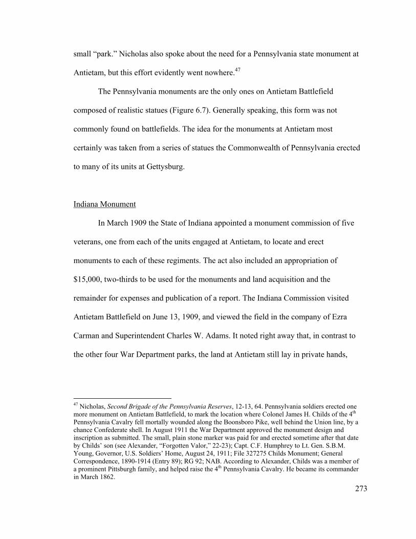
small “park.” Nicholas also spoke about the need for a Pennsylvania state monument at
Antietam, but this effort evidently went nowhere.47
The Pennsylvania monuments are the only ones on Antietam Battlefield
composed of realistic statues (Figure 6.7). Generally speaking, this form was not
commonly found on battlefields. The idea for the monuments at Antietam most
certainly was taken from a series of statues the Commonwealth of Pennsylvania erected
to many of its units at Gettysburg.
Indiana Monument
In March 1909 the State of Indiana appointed a monument commission of five
veterans, one from each of the units engaged at Antietam, to locate and erect
monuments to each of these regiments. The act also included an appropriation of
$15,000, two-thirds to be used for the monuments and land acquisition and the
remainder for expenses and publication of a report. The Indiana Commission visited
Antietam Battlefield on June 13, 1909, and viewed the field in the company of Ezra
Carman and Superintendent Charles W. Adams. It noted right away that, in contrast to
the other four War Department parks, the land at Antietam still lay in private hands,
47 Nicholas, Second Brigade of the Pennsylvania Reserves, 12-13, 64. Pennsylvania soldiers erected one more monument on Antietam Battlefield, to mark the location where Colonel James H. Childs of the 4 Pennsylvania Cavalry fell mortally wounded along the Boonsboro Pike, well behind the Union line, by a chance Confederate shell. In August 1911 the War Department approved the monument design and inscription as submitted. The small, plain stone marker was paid for and erected sometime after that date by Childs’ son (see Alexander, “Forgotten Valor,” 22-23); Capt. C.F. Humphrey to Lt. Gen. S.B.M. Young, Governor, U.S. Soldiers’ Home, August 24, 1911; File 327275 Childs Monument; General Correspondence, 1890-1914 (Entry 89); RG 92; NAB. According to Alexander, Childs was a member of a prominent Pittsburgh family, and helped raise the 4 Pennsylvania Cavalry. He became its commander in March 1862.
th
th
273

Figure 6.7. Monument to the 7th Pennsylvania Reserve, located on the north side of Mansfield Avenue (no. 2 on Figure 6.1) (courtesy of Antietam NB).
274

“and where locations have been desired for the erection of monuments or other
structures, it has been necessary to acquire the title to the same from the private owners
at the price demanded by them.” As a result, “on looking over the field and seeing what
other States had done, the commission decided that it would be more creditable to the
State of Indiana to use the fund at our disposal in erecting one monument, at some
central point on the field, and place a marker for each regiment where it was in the line
of battle on the 17th of September, 1862.”48
The commissioners decided to locate the monument in the northeast corner of
the intersection of the Hagerstown Turnpike and Cornfield Avenue, near the center of
the battlefield “and near which point the States of Pennsylvania, New Jersey and
Massachusetts have already erected handsome monuments” (Figure 6.1, no. 12).
Clearly, the location of these earlier monuments influenced the placement of the one
from Indiana. The Commission purchased a 100-foot square plot for its monument; in
the meantime, it also selected sites for the five regimental markers along the
government avenues or public roads “at or near points where the respective regiments
were in line when the battle ended, or where they performed their principal fighting
during the battle.” No doubt this was done to save money, and the aggravation of
having to deal with private landowners.49
48
Indiana at Antietam, 9-10. The regimental markers were scattered throughout the battlefield, ranging
from the 3 Indiana Cavalry situated near Middle Bridge on the Boonsboro Pike, to the 7 Indiana on the east side of the Hagerstown Pike, adjacent to the Joseph Poffenberger Farm. Of the other three, the 14 Indiana sat on the north side of Bloody Lane, the 19 Indiana on the east side of the Hagerstown Pike, just south of the Cornfield, and the 27 Indiana on the north side of Cornfield Avenue.
Indiana Antietam Monument Commission, Indiana at Antietam: Report of the Indiana Antietam Monument Commission and Ceremonies at the Dedication of the Monuments (Indianapolis: n.p., 1911), 5-9.
49
rd th
th
th
th
275
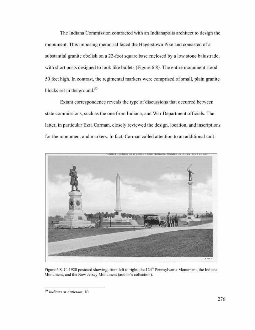
The Indiana Commission contracted with an Indianapolis architect to design the
monument. This imposing memorial faced the Hagerstown Pike and consisted of a
substantial granite obelisk on a 22-foot square base enclosed by a low stone balustrade,
with short posts designed to look like bullets (Figure 6.8). The entire monument stood
50 feet high. In contrast, the regimental markers were comprised of small, plain granite
blocks set in the ground.50
Extant correspondence reveals the type of discussions that occurred between
state commissions, such as the one from Indiana, and War Department officials. The
latter, in particular Ezra Carman, closely reviewed the design, location, and inscriptions
for the monument and markers. In fact, Carman called attention to an additional unit
Figure 6.8. C. 1920 postcard showing, from left to right, the 124th Pennsylvania Monument, the Indiana Monument, and the New Jersey Monument (author’s collection).
276
50 Indiana at Antietam, 10.

which he believed also had fought at Antietam and should be included with the other
regiments. The Indiana Commission carefully checked its records, and contacted many
veterans before replying back to Carman “there is nothing in it.” Carman, as the
Quartermaster General’s “authority on questions relating to the Battle of Antietam and
the location of troops during the same,” was in the process of reviewing and correcting
proposed marker locations and inscriptions when he died on Christmas Day 1909
following a short illness. His corrections were returned to the Indiana Commission a
couple of months later. The state monument was dedicated on September 17, 1910.
George B. Davis, now a brigadier general in the Judge Advocate General corps,
accepted it on behalf of the United States government.51
New York Monuments
Unlike the other state commissions, New York did not coordinate placement of
monuments at Antietam Battlefield at one time. Instead, the state legislature
appropriated funding for monuments as individual organizations approached it,
although the New York Monuments Commission assisted with situating monuments on
the field and other general coordination. This commission covered Gettysburg and
Chickamauga, as well as Antietam, and was chaired by former General Daniel Sickles
during much of its tenure. Given his well known fixation on Gettysburg, and the fact
51 E.A. Carman to Sec. of War, July 27, 1909, 1 Endorsement on letter from W.N. Pickerill, Secretary, Indiana Antietam Monument Commission, to Secretary of War, July 23, 1909, W.N. Pickerill to Gen. E.A. Carman, July 29, 1909, J.B. Aleshire, QM General, to Sec. of War, December 16, 1909, Capt. E.H. Humphrey to Charles W. Adams, January 6, 1910, 1 Endorsement on letter from Charles W. Adams to Gen. E.A. Carman, December 23, 1909, Capt. E.H. Humphrey to W.N. Pickerill, Secretary, Indiana Antietam Monument Commission, March 1, 1910, file 256732 Indiana Monument, Entry 89, RG 92, NA; Indiana at Antietam, 13.
277
st
st

that he was not present at Sharpsburg, it is not surprising that Antietam received very
little attention from this organization before 1900, even though New York contributed
the largest number of troops in that engagement.52
The commission took preliminary steps in 1906 toward erecting a state
monument at Antietam Battlefield, surveying the field and selecting a prominent seven-
acre site immediately adjacent to the Maryland Monument reservation, along the
Hagerstown Pike and across from the Dunker Church. The following year the state
legislature authorized acquisition of land “having suitable surroundings and convenient
approaches for the structure proposed,” and the commission moved ahead with
purchasing the property from Rezin Fisher in 1908. Nothing happened for almost
another decade, however, until the Commission enclosed the reservation with a pipe
rail and concrete post fence in 1916.53
In the meantime, individual New York units continued to move ahead with
raising monuments at Antietam. In 1908, the 51st New York erected a rough-cut block
near the east end of Burnside Bridge (Figure 6.1, no. 85). Along with the 51st
Pennsylvania, this unit had been selected to “carry this bridge at all hazards” and made
a direct frontal assault upon it, succeeding in their mission but incurring heavy
casualties in the process.54
52
Schildt, Monuments at Antietam, 88. Sickles served as chairman of the New York State Monuments Commission from 1886 to 1912, two years before his death. While serving a term in Congress in the 1890s, he ensured passage of an act establishing Gettysburg National Military Park (see Harlan D. Unrau, Administrative History, Gettysburg National Military Park and National Cemetery, Pennsylvania (Washington, D.C.: Government Printing Office, 1991), 77-78).
53 New York Monuments Commission, Dedication of the New York State Monument on the Battlefield of Antietam (Albany: J.B. Lyon Company, Printers, 1923), 11.
278
54 Toney, “Dying as Brave Men Should Die,” 105. The quote is found on the monument inscription.

The 20th New York, which earlier had placed a monument in the National
Cemetery on the 25th anniversary of the battle, returned to the battlefield in May 1910
and selected a location for a second monument on the recently acquired state
reservation (Figure 6.1, no. 44). “After an examination of the map of the field, the
reading of the reports of the Corps, Division, Brigade and Regimental commanders
made immediately after the battle, and the inscription on the tablets pertaining to the
movements of the brigade to which this regiment was attached,” reported battlefield
Superintendent Charles W. Adams, “I am convinced that the site selected is the position
of the regiment on the firing line at the time of the battle.” Within a week of its visit to
Antietam, the 20th New York Veteran Society submitted a design and inscriptions for
the monument, comprised of a granite obelisk with a carved American flag draped over
the top. It also included a bronze tablet portraying a regimental charge, and a small oval
bronze tablet depicting an owl.55
The Quartermaster General’s office requested a number of small changes to the
inscriptions without any fuss on the part of the organization, but blundered into a
political tangle when it questioned whether or not the owl should be included. When the
military discovered the bird represented the Turner Society, a private German-
American society to which a large percentage of the regiment had belonged, it informed
the 20th New York that “the regulations governing the erection of monuments prohibit
the insignia of civic organizations whose membership is not restricted to persons
55 Charles W. Adams, Supt., to Depot Quartermaster, May 2, 1910,John P. Heintz, President, Veteran Society, 20 NYV, to Maj. Gen. F.C. Ainsworth, Adjutant General, May 7, 1910, file 262450 20 N.Y. Vol. Monument, Entry 89, RG 92, NA.
th
279
th
having military or naval service, or whose membership was not originally restricted to
such persons.”56
The War Department’s decision created a furor in New York City’s German
community, and led to President Taft’s involvement in the controversy when the editor
of one of its leading newspapers contacted him in early August. Sensing the urgency, as
the dedication was scheduled for the following month, military officials quickly sought
to locate precedents for the use of such unofficial unit emblems on other monuments.
They telegraphed John P. Nicholson at Gettysburg and Superintendent Adams at
Antietam, asking them to check their monuments. Fortunately for the military, Adams
found two examples, the 20th New York monument in the national cemetery with the
owl emblem carved in granite and the recently erected monument to the 5th, 7th, and 66th
Ohio regiments, upon which was carved an owl and a rooster. These precedents enabled
the War Department to save face and recommend an exception to the regulation in this
case. President Taft concurred, and the dedication ceremony proceeded as planned on
September 17, 1913—the 50th anniversary of the battle. The small oval bronze tablet of
the Turner Society symbol was displayed prominently on the front elevation of the
monument shaft.57
th
56 Capt. C.F. Humphrey to John P. Heintz, President, Veteran Society, 20th New York Vols, May 16, 1910, John P. Heintz, President, Veteran Society, 20th N.Y. Vols., to Quartermaster General, June 24, 1910, Capt. C.F. Humphrey to John P. Heintz, President, Veteran Society, 20th New York Vols., June 28, 1910, file 262450 20th N.Y. Vol. Monument, Entry 89, RG 92, NA.
280
57 Charles D. Norton, Secretary to the President, to John C. Scofield, Assistant and Chief Clerk, August 10, 1910, Telegram from John C. Scofield, Assistant and Chief Clerk, to Colonel John P. Nicholson, August 12, 1910, George Ruhlen, Acting QM General, to Supt., Antietam Battlefield, August 15, 1910, George Ruhlen, Acting QM General, to John C. Scofield, Assistant and Chief Clerk, August 16, 1910, Charles D. Norton, Secretary to the President, to John C. Scofield, Assistant and Chief Clerk, August 18, 1910, file 262450 20th N.Y. Vol. Monument, Entry 89, RG 92, NA. On August 20, the acting Quartermaster General notified the 20 New York Veteran Society “that after reconsideration of matter
The next two regimental monuments requested by New York veterans were
placed on the battlefield without incident. In 1910 the 14th Brooklyn, which served as
the 84th New York at the Battle of Antietam, received an appropriation for a monument.
It was not until three years later, however, that the new Chairman of the New York
Monuments Commission, Col. Lewis R. Stegman, reconnoitered the battlefield and
recommended a site on the north side of Cornfield Avenue, near the area of the
regiment’s most intense fighting (Figure 6.1, no. 15). At this location the 14th Brooklyn
erected its monument, a late example of the Richardsonian Romanesque style, and
dedicated it on September 17, 1915. The following year the 104th New York also
selected a site on the north side of Cornfield Avenue (Figure 6.1, no. 16). It erected a
similar, but smaller memorial that was dedicated on September 27, 1917. Interestingly,
much of the oratory at the latter dedication used it as a springboard to focus on the
ongoing war in Europe, making the connection between the fight for freedom during
the Civil War and the present war in Europe.58
The New York legislature finally appropriated a total of $30,000 for the state
monument at Antietam in 1918 and 1919. A New York architect prepared the
specifications for the memorial, a classically inspired Doric column topped by a large,
martial-looking eagle perched on an orb (the earth?) and preparing to take flight. A low
platform measuring 36 feet square supported this column and its pedestal. The entire
Department will permit bronze tablet containing figure of owl to be placed on monument to be erected by your organization on Antietam Battlefield.”
281
58 New York Monuments Commission, Dedication of Monument to Fourteenth Brooklyn, N.Y.S.M. (Eighty-Fourth N.Y. Vols.), Antietam, MD, September 17, 1915 (Albany: J.B. Lyon Company, Printers, 1916), 5-7; Report of the New York Monuments Commission on the Dedication of Monument to the One Hundred and Fourth New York Volunteer Regiment (Wadsworth Guards), Antietam, MD, September 27, 1917 (Albany: J.B. Lyon Company, Printers, 1918).

monument extended 58 feet in height—the tallest of any on Antietam battlefield.
“Standing on an eminence, and centred in what were the most hotly-contested arenas of
battle,” rhapsodized the commissioners’ report, “this memorial, the most majestic on
the field, is entirely worthy of representing the Empire State at Antietam.” Perhaps
fittingly, it was to be the last monument placed on the field by Civil War veterans.59
An elaborate dedication was held on the fifty-eighth anniversary of the battle,
September 17, 1920. Approximately 250 Civil War veterans participated in the
ceremony, most of whom had fought at Antietam. The principal speakers were Lt. Gen.
Nelson A. Miles, commander of the 61st New York at Antietam and who had moved on
to garner fame in the Indian Wars of the late nineteenth century, and Maj. Gen. John F.
O’Ryan, commander of the Twenty-Seventh Division during the late World War. The
latter represented the Governor of New York, who was unable to attend, and spent his
entire speech relating anecdotes about American service during the late war in
Europe—a clear indication that the era of the Civil War veteran was passing, and that
this monument looked to the present as much, or perhaps more, than it did back to the
Civil War.60
59 New York Monuments Commission, Dedication of the New York State Monument, 11-12.
282
60 New York Monuments Commission, Dedication of the New York State Monument, 17, passim. A regimental monument to the 59th New York was dedicated the same day as the state monument. The 59th was another of the Union regiments “cut to pieces” during the advance of Sumner’s Second Corps through the West Woods, suffering an inconceivable 70% casualty rate. Francis Lynde Stetson had raised the monument the previous year in honor of his brother, Lieutenant Colonel John L. Stetson, who had been killed during this attack. It consisted of a classically inspired stone altar, and was situated in the northeast corner of the intersection of the Hagerstown Pike and Smoketown Road. In June 1920, Stetson placed a small stone along Confederate Avenue, a short distance south of the 15th Massachusetts Monument, to mark the spot where his brother had fallen (see New York Monuments Commission, Dedication of the New York State Monument, 61; Alexander, “Forgotten Valor,” 110.
Army of Northern Virginia Monument
Unlike their northern counterparts, former Confederate units and states raised
relatively few battlefield monuments during the period under discussion. Confederate
veterans marked a few of their positions at Gettysburg in the 1880s after the GAR had
taken control of the GBMA, but this represented just a handful compared to the many
hundreds of Union memorials. In the first two decades of the twentieth century, former
Confederate states erected monuments, many of them elaborate, at Vicksburg and
Chickamauga/Chattanooga. In 1917 Virginia raised the first Confederate state
monument at Gettysburg. No Confederate state built a monument at Antietam during
this period, however, suggesting that Antietam continued to remain on the edge of the
reconciliation movement, despite sentiments expressed at the dedication of the
Maryland Monument.61
In January 1917, Camp No. 171 of the United Confederate Veterans requested
permission to place a small memorial stone on the Piper Farm, along the east side of the
Hagerstown Pike. It wished to commemorate the action of 2nd Lt. William Wilson
Chamberlaine of the 6th Virginia in taking over an abandoned artillery position when
the Confederate center threatened to give way after the Federals overran the Sunken
Road. Chamberlaine served as Commander of Camp No. 171 at this time, although he
did not initiate the application. The Quartermaster General balked at the proposed
inscription, however, citing a previous act requiring that monument inscriptions be
“compiled without praise and without censure.” He believed that the proposed marker
did not meet this criterion, “as it appears to be more in the nature of an individual
283
61 Panhorst, “Lest We Forget,” 21-22, 52.
monument, to perpetuate the name of an officer, than one to represent the position of an
organization, and no marker of this description has heretofore been placed on the
battlefield.” If the incident could be verified, however, the monument could be erected
provided the officer’s name was omitted. Evidently he was not aware of the Childs
Monument that had been erected by Pennsylvania veterans earlier in the century to
commemorate their fallen commander, or perhaps believed that markers to fallen
offices were acceptable.62
Correspondence went back and forth over the next several months regarding the
exact language of the inscription. At one point, the War Department proposed an
account that included the time of day the gun had been in use, prompting a
counterproposal from the Confederate organization that removed this reference. “The
change we proposed,” declared correspondent Gabriel Edmonston, “would relieve us
from the criticism of firing across our own line at about that time when the gun was
silent.” Finally, the Quartermaster General approved an inscription that did not include
Chamberlaine’s name and the monument was erected a short time later. Edmonston, the
driving force behind the monument, had the final word a year later in the Confederate
Veteran: “This inscription, owing to the rigid rules laid down by the United States
government . . . tells the story of this incident as a wood sawyer might boast of a
specially pecuniary job of half a cord of firewood sawed and split in record time. It is
62 Gabriel Edmonston, Chairman of Employment Committee, Camp No. 171, U.C.V., Washington, D.C., to QM General, January 27, 1917, Henry G. Sharpe, QM General, to Sec. of War, February 10, 1917, 1st Endorsement on letter from Gabriel Edmonston to Capt. F.W. Coleman, QM General’s Office, January 31, 1917, file 293.6 Confederate Monument, General Correspondence, Subject File, 1922-1935 (Entry 1889); RG 92; National Archives at College Park (NACP); Alexander, “Forgotten Valor,” 16. In regard to Chamberlaine’s action, historian Ted Alexander notes: “Although it would be an exaggeration to give Chamberlaine and his men credit for single-handedly stemming the Union attack on Lee’s center, they along with other such volunteers played a significant role.”
284
my firm belief that fate, the man, and an abandoned gun met at an opportune moment in
the battle of Sharpsburg and turned the tide of defeat that was fast overwhelming the
Army of Northern Virginia.”63
While the state of Maryland had dedicated its monument to both its Union and
Confederate soldiers and erected two Confederate unit markers, the Army of Northern
Virginia monument was the only one placed on the battlefield by a Confederate
veterans’ organization. It also is true that this small, unassuming marker tucked in the
entrance to the Piper Farm certainly does not represent much of a claim on the
landscape. In fact, it represents a tribute to a single man’s actions, and not to the general
heroism of the Confederate army.
Conclusion
The placement of monuments on Antietam Battlefield reveals a great deal about
that battlefield and its relationship to Civil War memory during the late nineteenth and
early twentieth centuries. The first monuments at Antietam were erected in the 1880s
and early 1890s by private regimental associations that generally viewed the battle as
the high point of their military tenure and/or had incurred their heaviest losses on that
field. It was of great importance for these monuments to be located as closely as
285
63 Henry G. Sharpe, QM General, to Gabriel Edmonston, Chairman, Committee Confederate Veterans Association, Washington, D.C., March 1, 1917, G. Edmonston, Chairman, to QM General, March 29, 1917, Henry G. Sharpe, QM General, to G. Edmonston, Chairman, Committee Confederate Veterans Association, Washington, D.C., March 30, 1917, G. Edmonston, Chairman, to QM General, April 2, 1917, Henry G. Sharpe, QM General, to Gabriel Edmonston, Chairman, Committee Confederate Veterans Association, April 4, 1917, file 293.6 Confederate Monument, Entry 1889, RG 92, NACP; The Confederate Veteran, Vol. XXVI, 1918, cited in Alexander, “Forgotten Valor,” 18. The final inscription read: “Near this spot an abandoned Confederate gun manned by a second lieutenant of the 6th Virginia Infantry, Mahone’s Brigade, and two infantry volunteers from Anderson’s Georgia Brigade, was placed in action September 17, 1862.”

possible to the regiment’s exact position, either the farthest point at which it penetrated
enemy lines or where it received most of its casualties. Almost all of these early
monuments were sited on the south end of the battlefield, particularly around Burnside
Bridge, with a couple placed along the north side of Bloody Lane. These placements
may be coincidence, or may reflect a willingness on the part of some landowners to part
with their property, perhaps because they were Unionists, and reluctance on the part of
others, perhaps due to Confederate sympathies or other government antipathies.
While it existed, the Antietam Board exerted tremendous influence over
development of the monumental landscape on the battlefield, guiding the composition
and placement of specific monuments. Both George B. Davis and George W. Davis
discouraged the placement of monuments to individual units, resulting in the erection of
the Philadelphia Brigade and Massachusetts monuments rather than a substantial
number of regimental monuments for each of these groups. The Davises also promoted
construction of narrow avenues that provided minimal room for construction of
monuments on government property, and discouraged organizations that considered
taking such an action. These policies forced regimental and state associations to work
with private property owners, sometimes with indifferent success. A later case in point
is the Indiana Commission, which abandoned its idea of erecting five individual unit
monuments when it decided that working with multiple landowners would be too
difficult. Instead, it placed one state monument on private property, and a series of
smaller markers along the government avenues.
Under the Antietam Board, a new emphasis developed toward placing
monuments in the West Woods, the location of some of the heaviest fighting during the
286

battle. At the beginning of the twentieth century, attention shifted toward the Dunker
Church, perceived as the symbolic heart of the battlefield. It began with the dedication
of the Maryland Monument in May 1900. This monument enabled the State of
Maryland finally to reconcile its divided past on the battlefield.
The end of the nineteenth century also represents a shift away from individual
regimental and survivors’ associations raising monuments on the battlefield, and the
ascendancy of state monument commissions. This trend was already well in place at
other War Department parks such as Gettysburg and Chickamauga/Chattanooga. Under
the state commissions, the placement of monuments at the locations of heaviest combat
or casualties became much less important than their visibility. As a result, these state
monuments—New Jersey, Indiana, and New York—cluster around the Dunker Church
area, and seemingly vie with each other to extend the highest column or obelisk.
Not until the first decade of the new century—after the dissolution of the
Antietam Board—were any monuments erected along the government avenues. In the
case of Ohio, the primary position of the unit determined whether the monument was
placed on private or government land. Pennsylvania, on the other hand, constructed all
of its monuments along the War Department roads, with relatively little concern as to
the locations of the units during the battle. It did not really matter to the Commission,
anyway, as these monuments were meant to represent a unit’s entire service, not just its
participation in the Battle of Antietam. In fact, the Pennsylvania monuments are the
only ones on the battlefield dating from this period that list the battles in which each
unit fought. Pennsylvania’s treatment of Antietam certainly can be interpreted as a slap
in the face, as that state only authorized monuments for units that had not been part of
287
the Battle of Gettysburg. New York, the other state with a large number of troops at
Antietam, also remained fixated on Gettysburg under the leadership of Daniel Sickles,
and contributed relatively little time or money until quite late for monuments at
Antietam.
In the end, the lack of interest on the part of the two leading northern states—
Pennsylvania and New York—certainly led to fewer monuments at Antietam than
might have been expected. The fact that the federal government did not acquire land on
the battlefield suitable for the placement of monuments also had a tremendous impact
on the number of monuments erected on that battlefield. Given the interest expressed
by various units and organizations around the turn of the century, it is likely that many
more monuments would have been placed at Antietam if the land had been available.
288

Chapter 7:
Battlefield Caretaker:
War Department Management of Antietam Battlefield, 1900-1933
Following the final dissolution of the Antietam Board, care of the battlefield
transferred to the superintendent of the national cemetery in March 1898.
Unfortunately, the War Department provided Superintendent Alexander Davis no
assistance with managing these new responsibilities, and appropriated only $1,000 per
year to maintain the avenues, tablets, and monuments that had been transferred to the
government. This meager funding contrasted greatly with the other four War
Department battlefields, which retained their commissions well into the twentieth
century and received substantial appropriations each year. As a result, Antietam
struggled during these years compared to the other battlefield parks.1
During the opening decades of the twentieth century the Antietam battlefield
superintendents contended with a struggle similar to the one faced by national cemetery
superintendent William Donaldson decades earlier—establishing control over War
Department property. In this case, the superintendents fought with surrounding
289
1 QM General M.S. Ludington to Depot QM, March 30, 1898, Maj. F. G. Hodgson to QM General, September 25, 1899, file 109863, General Correspondence, 1890-1914 (Entry 89), Records of the Quartermaster General (RG92), National Archives (NA). Ludington also recommended doubling the amount appropriated to maintain the battlefield, from $1,000 per year to $2,000. For information on the other four War Department battlefields during this period, see Timothy B. Smith, This Great Battlefield of Shiloh: History, Memory, and the Establishment of a Civil War National Military Park (Knoxville: University of Tennessee Press, 2004); James A. Kaser, At the Bivouac of Memory: History, Politics, and the Battle of Chickamauga (New York: Peter Lang, 1996); John C. Paige and Jerome A. Greene, Adminstrative History of Chickamauga and Chattanooga National Military Park (Washington, D.C.: Government Printing Office, 1983); Harlan D. Unrau, Administrative History, Gettysburg National Military Park and Gettysburg National Cemetery (Washington, D.C.: Government Printing Office, 1991); and Christopher Waldrep, Battleground: The Civil War in Vicksburg, 1861-1947 (forthcoming).

landowners and Sharpsburg inhabitants who resented the intrusion of the federal rights-
of-way through their properties and viewed the avenues as a commons upon which to
run their livestock. Some of these local people also caused extensive damage to the
roads by running mechanized tractors over them. In the end the War Department
prevailed, but not before one superintendent was murdered and another dismissed.
The lack of cooperation between the local inhabitants and federal authorities
during this period influenced commemorative activities at the battlefield. The 50th
anniversary commemoration of the Battle of Antietam revealed that the battlefield
primarily remained a place of individual remembrance. No organized, overarching
event coordinated between local, state, and federal organizations was held at that
battlefield as was the case for Gettysburg, but instead a series of relatively small
observances put together by individual regimental associations. As a result, the events
at Antietam did not carry the same message of national reconciliation, particularly since
few, if any, former Confederates participated.
As with commemoration of the battle, the War Department received little
encouragement from the Sharpsburg community to preserve key features of Antietam
Battlefield. In the 1920s progressive military officials began reaching out to a wider
community, embracing the entire county. This outreach coincided with interest on the
part of local civic organizations in expanding tourism to the battlefield and other parts
of Washington County. Their efforts led to increased attention toward Antietam
Battlefield and set the stage for community involvement under National Park Service
administration.
290

Appointment of First Battlefield Superintendent
By spring 1900 the Quartermaster General was requesting the appointment of a
superintendent to manage just the battlefield, “as the visitors thereto are increasing in
numbers, and complaint is made that there is no supervision and no responsible
authority [to] guard the tablets erected by the government and the monuments erected
by states and regimental organizations.” In June the Secretary of War complied and
appointed Sharpsburg merchant and Civil War veteran Charles W. Adams as the first
superintendent of Antietam Battlefield. Adams was active in local GAR affairs,
particularly Memorial Day activities at the national cemetery. He also was a well
known Republican who at various times had been rewarded with positions as county
tax collector and doorkeeper of the House of Representatives.2
While Adams maintained Antietam as well as his small appropriation permitted,
General Ezra Carman continued to coordinate all monument placement and design,
even though he did not hold an official position at the battlefield. Adams, however,
contracted for and supervised construction of the monument foundations. This overlap
of responsibilities created tension between the two men, which came to a head
following the dedication of the thirteen Pennsylvania monuments in September 1904.
Over the following winter, Carman garnered the support of General George B. Davis,
now Judge-Advocate General of the United States, and members of the powerful
Gettysburg Battlefield Commission, who collectively convinced the Quartermaster
General that Charles W. Adams should be discharged and Carman appointed
291
2 QM Gen. M.J. Ludington to Sec. of War, May 3, 1900, file 109863, Appointment of Charles W. Adams by Elihu Root, Sec. of War, June 14, 1900, file 152827, Entry 89, RG92, NA; Thomas J.C. Williams, A History of Washington County (reprint; 1906, Baltimore: Regional Publishing Company, 1968), 858.

superintendent in his place. The Secretary of War moved to relieve Adams at the end of
May 1905 and replace him with Carman. Before this change took affect, however,
Republican Congressman George A. Pearre, who represented Western Maryland and
was a patron of Charles W. Adams, intervened and had the order rescinded.3
Ezra Carman was not left empty handed, however, as a week later the Secretary
of War appointed him to the Chickamauga-Chattanooga Park Commission as the hand-
picked successor of the recently deceased Henry Boynton. Even with this appointment,
Carman spent most of his time in Washington, D.C., and remained in charge of all
monument activity at his beloved Antietam. Adams and Carman apparently continued
to squabble, however, right up to the time of the latter’s death on Christmas Day 1909.
Less than a week earlier, Adams had countered an accusation made by Carman that he
had marked the wrong locations for several Indiana markers. With Carman’s passing,
Adams finally was able to assume sole responsibility for working with the monument
associations, and for managing the battlefield as a whole.4
3 QM Gen. C.F. Humphrey to Sec. of War, May 24, 1905, Acting Sec. of War Robert Shaw Oliver, May 27, 1905, Telegram from George A. Pearre to Hon. William H. Taft, Sec. of War, May 29, 1905, QM Gen. C.F. Humphrey to Charles W. Adams, May 31, 1905, file 109863, Entry 89, RG92, NA. The Quartermaster General used as his rationale for removing Adams the fact that the latter had been notified “of the intention of the State of Pennsylvania to erect, within the next few weeks, some forty monuments on the Antietam Battlefield,” and that Adams was unable to take charge of this work. In actuality, only four additional monuments were erected, and this was done in 1906. Part of the issue may have centered around local cronyism, a charge made against Adams at a later date.
292
4 John Connor Scully, “Ezra Carman: Soldier and Historian” (master’s thesis, George Mason University, 1997), 120; Paige and Greene, Chickamauga and Chattanooga; Charles W. Adams to Gen. E.A. Carman, December 19, 1909, file 256732, Entry 89, RG92, NA.
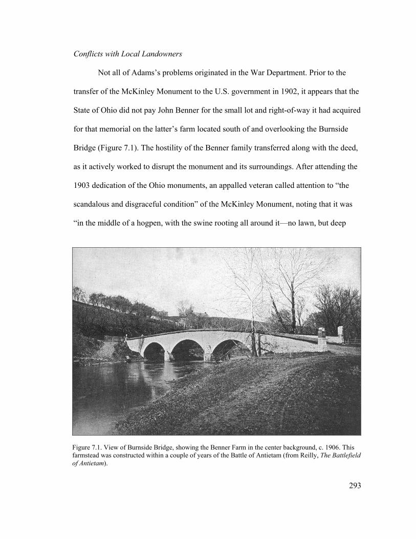
Conflicts with Local Landowners
Not all of Adams’s problems originated in the War Department. Prior to the
transfer of the McKinley Monument to the U.S. government in 1902, it appears that the
State of Ohio did not pay John Benner for the small lot and right-of-way it had acquired
for that memorial on the latter’s farm located south of and overlooking the Burnside
Bridge (Figure 7.1). The hostility of the Benner family transferred along with the deed,
as it actively worked to disrupt the monument and its surroundings. After attending the
1903 dedication of the Ohio monuments, an appalled veteran called attention to “the
scandalous and disgraceful condition” of the McKinley Monument, noting that it was
“in the middle of a hogpen, with the swine rooting all around it—no lawn, but deep
Figure 7.1. View of Burnside Bridge, showing the Benner Farm in the center background, c. 1906. This farmstead was constructed within a couple of years of the Battle of Antietam (from Reilly, The Battlefield of Antietam).
293

gorges and ruts all around it, and pigs rubbing their filthy sides against it.” A
government engineer sent to inspect the monument confirmed that it was sited inside an
enclosed calf lot “used also by swine.” He described the steep right-of-way leading
from Burnside Bridge to the McKinley Monument as a washed-out farm road and
observed “old, dilapidated and ugly post and rail fences [bounded] the road and calf
lot.”5
Congressman Pearre personally interested himself in the McKinley Monument
matter, securing an appropriation of $3,000 toward making improvements to it. In an
effort to improve access, the government negotiated a new right-of-way alignment from
John Benner, who agreed to the exchange at no cost. The War Department constructed
a new road and enclosed the monument with an iron fence in 1907, but not without
harassment on the part of the farm’s new owner, Benner’s granddaughter and heir,
Fanny Spong.6
In addition to the situation with the Benner-Spong family at Burnside Bridge,
Adams also experienced problems with local farmers who allowed livestock to graze
along the avenues and damage the roads and grass shoulders. “It has become a custom
with some of the citizens, both of the town and country, to rely entirely upon the
5 J.M. Dalzell to unidentified general, October 19, 1903; unidentified newspaper clipping, enclosed in letter from Acting Sec. of War to J.M. Dalzell, October 20, 1903, W.H. Owen, C.E., to Capt. A.W. Butt, Depot QM, November 13, 1903 file 109863, Entry 89, RG 92, NA. The engineer provided an estimate of $2,500 to fix the various problems surrounding the McKinley Monument, but perceived: “While the above scheme would insure a good (though steep) approach road and make the lot and its immediate surroundings presentable and respectable, there would still be objectionable features which could not be eliminated unless the U.S. were to purchase the whole property.”
294
6 C.F. Humphrey, QM General, to Hon. George A. Pearre, April 27, 1905, Maj. M. Gray Zalinski, Depot QM, to QM General, December 26, 1906, file 220405, Entry 89, RG 92, NA. The new right-of-way began immediately adjacent to the southeast corner of Burnside Bridge and curved around the east side of the monument—essentially the same alignment as the present-day walking trail.
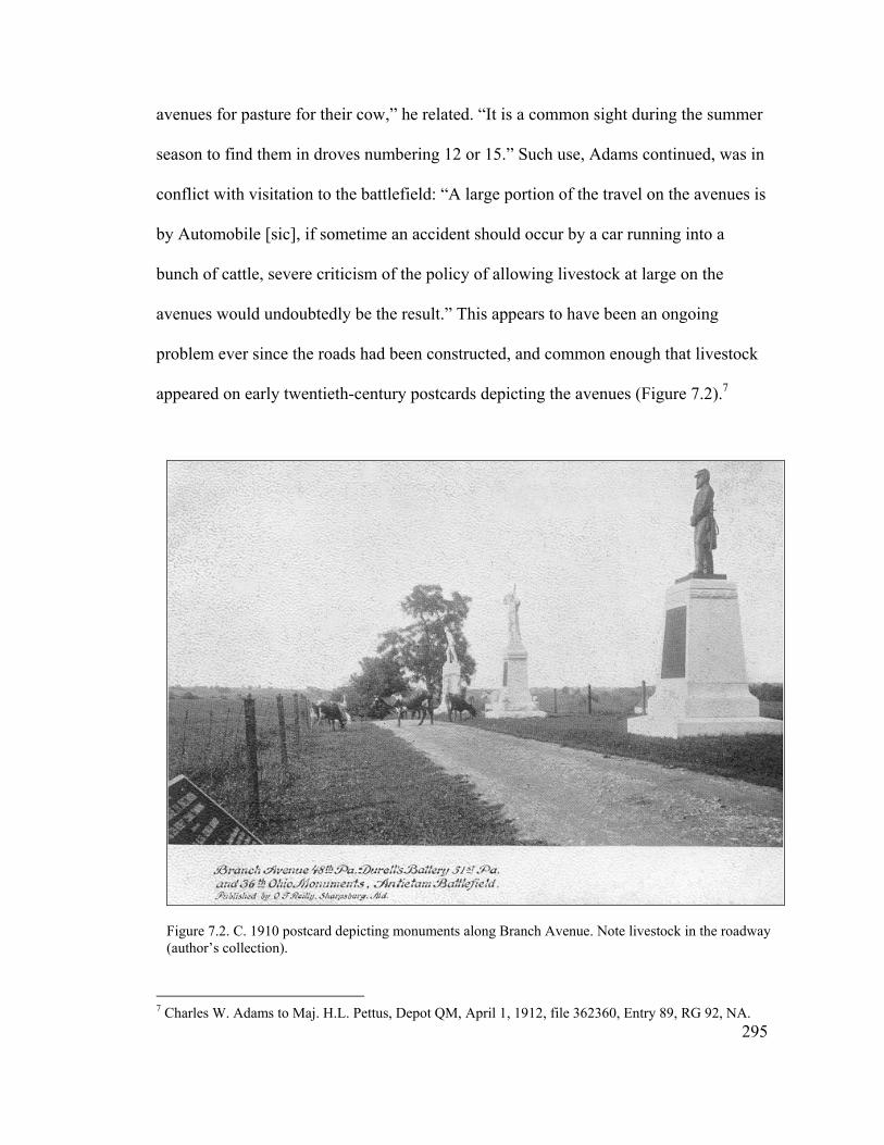
avenues for pasture for their cow,” he related. “It is a common sight during the summer
season to find them in droves numbering 12 or 15.” Such use, Adams continued, was in
conflict with visitation to the battlefield: “A large portion of the travel on the avenues is
by Automobile [sic], if sometime an accident should occur by a car running into a
bunch of cattle, severe criticism of the policy of allowing livestock at large on the
avenues would undoubtedly be the result.” This appears to have been an ongoing
problem ever since the roads had been constructed, and common enough that livestock
appeared on early twentieth-century postcards depicting the avenues (Figure 7.2).7
Figure 7.2. C. 1910 postcard depicting monuments along Branch Avenue. Note livestock in the roadway (author’s collection).
295
7 Charles W. Adams to Maj. H.L. Pettus, Depot QM, April 1, 1912, file 362360, Entry 89, RG 92, NA.
Adams also discovered that the new mechanized tractors exacerbated this
problem. “While going over Confederate Avenue, I found Mr. George H. Poffenberger
with a Traction Engine engaged in dragging heavy oak logs along and across the
Avenue” he reported in May 1909. “I protested against his doing so, he insisted that as
he owned land on both sides of the Avenue, he had the right to do so. In a defiant
manner he not only persisted in moving the logs where I found him at work but asserted
that he intended to do the same thing at another point on the Avenue.” The damaged
section of road, related Adams, “presented the appearance of a ploughed field.”8
While the War Department determined that it had sole jurisdiction over the
roads and could regulate them as it pleased, little was done over the next few years to
curb the harm done to them by tractors and livestock. In addition to the damage to the
roadways, cattle also caused injury to the monuments by continuously rubbing against
them. The superintendent finally received permission in May 1912 to place signs at the
avenue entrances prohibiting the use of tractors and the grazing of livestock;
unfortunately, he did not live long enough to see them set up.9
These festering conflicts with area landowners culminated in the assassination
of Superintendent Charles Adams by Charles Benner, son of John Benner, on the
morning of June 6, 1912. After shooting Adams several times and leaving him for dead
on the roadway, Benner returned to his home in Sharpsburg and turned the gun on
himself. Because of the suicide, no trial or inquest was performed to uncover his
8 Maj. F.G. Hodgson to QM General, September 25, 1899, file 109863, Charles W. Adams to Maj. M. Gray Zalinsky, Depot QM, May 21, 1909, file 220405, Entry 89, RG 92, NA.
296
9 Maj. H.L. Pettus to QM General, May 13, 1912, 5th endorsement on Charles W. Adams to Maj. H.L. Pettus,Depot QM, April 1, 1912, file 362360, Entry 89, RG 92, NA.
motives for killing the superintendent. According to the local newspaper, Benner
carried a grudge against 70-year-old Adams because the latter had testified against him
in court about four years earlier. The conflict over the apparent nonpayment for the
McKinley Monument site certainly contributed to Benner’s animosity toward Adams,
and evidently he caused problems for the latter from the time the new road was
constructed to the monument in 1907. It also was said that he detested the Union and
anything connected with the United States Government. Most of the community
evidently did not share Benner’s animosity toward Adams, a prominent Sharpsburg
citizen for many years, and mourned his passing greatly.10
Superintendent George W. Graham
Two months after Adam’s death, the War Department filled his position with
another local Civil War veteran, George W. Graham of Harpers Ferry, West Virginia.
Unlike Charles Adams, who had been an active and respected member of the
Sharpsburg community, the new superintendent was an outsider who quickly garnered
the dislike of his neighbors. This animosity developed in part because Graham moved
aggressively against trespassing livestock and tractors, posting within a couple of
months of his arrival the signs that had been approved earlier. He established
impoundment lots, but noted that he had “taken more vigorous means through
diplomacy” to inform transgressors (including the tenants on Fannie Spong’s farm) that
10 “Assassination at Antietam,” Typescript on file, Sharpsburg vertical file, Antietam National Battlefield; Charles W. Snell and Sharon A. Brown, Antietam National Battlefield and National Cemetery: An Administrative History (Washington, D.C.: Government Printing Office, 1986) 123-124; Hagerstown Morning Herald, June 7, 1912.
297

if any more complaints came before him, he would take out warrants against the
offenders.11
When complaints against Graham’s “diplomacy” surfaced, War Department and
political officials initially viewed them as sour grapes on the part of locals who had
been passed over for the superintendent position or chafed under Graham’s strict
adherance to the regulations. It soon became apparent, however, that a serious problem
existed at Antietam. Within a year of George Graham’s appointment, R.D. Fisher,
owner of the wartime Mumma Farm, related to the Secretary of War that Graham
“came to my house and notified me if I didn’t keep [my gate] shut he would lock it and
having been drunk for the last seven months and may be longer he talked very abusive
and unbecoming of a man in his position. He even threatens to shoot people traveling
on the avenues and patrols the avenues with gun in hand.”12
Upon receipt of Fisher’s accusation, the War Department launched an
investigation of Graham that uncovered a litany of offenses. These included extortion,
habitual drunkenness, absence without leave, and adultery. After visiting the battlefield
in mid-April 1913 and receiving numerous depositions antithetical to the
superintendent, inspector C.P. Spence concluded: “Although I had no physician
examine Graham, my candid opinion is that he is whisky crazy and that he is a
dangerous man to have as superintendent of the Battlefield. He has no friends in the
community, and a majority of the people, both men and women, are in deadly fear of 11 George W. Graham to Maj. J.E, Normoyle, Depot QM, September 13, 1912, file 362360, Entry 89, RG 92, NA. 12 QM Gen. to Sec. of War, June 22, 1912, David J. Lewis, Congressman 6th Dist. Md. to Sec. of War, September 23, 1912, Gen. J.B. Aleshire to Hon. David J. Lewis, M.C., September 25, 1912, R.D. Fisher to Sec. of War, March 20, 1913, file 371906, Entry 89, RG 92, NA.
298
him which in addition to his habit of borrowing money from widows on their notes with
property as security and from the men on the Battlefield on threats of dismissal if the
money is not loaned are a disgrace to the service.”13
Quartermaster General J.B. Aleshire quickly recommended George Graham’s
removal from service. The superintendent fought back, asserting in a rambling and
somewhat incoherent letter to local Democratic Congressman David J. Lewis (who
recently had filled the Congressional seat vacated by Pearre) that the “gang that
formerly used to drill under C.W. Adams deceased Supt. that I succeeded are now
fighting me very bitterly.” Graham in turn charged the late Adams with a number of
infractions, including graft and favoritism, and accused the present national cemetery
superintendent, John L. Cook, of “working undercover with the old Adams gang. And
squarely against your interests.” Graham was referring to the interests of the
Democratic party, as he continued “George W. Poffenberger [an active Democrat] . . .
and many other of your friends urged me to write you long ago as to this matter.” Such
entreaties were to no avail, as George Graham was suspended on April 30 and
discharged on August 1, 1913.14
13 C.P. Spence, Cemetery Clerk, to Depot QM, April 14, 1913, file 371906, Entry 89, RG 92, NA. Depositions for this case are located in the same file. Visitors to the battlefield also filed complaints against Graham. “While visiting the Antietam Battle Field I was insulted by the Superintendent who was drunk,” reported John W. Carroll to President Woodrow Wilson. “I was informed by the people of Sharpsburg that this man is an habitual drunkard and has insulted a number of visitors before insulting me. I didn’t think the government would tolerate such service” (May 7, 1913, file 457776).
299
14 QM Gen. J.B. Aleshire to Sec. of War, April 16, 1913, 6th Endorsement on report from C.P. Spence, Cemetery Clerk, to Depot QM, April 14, 1913, George W. Graham to Hon. David J. Lewis, undated, file 371906, Order of Henry Breckinridge, Acting Sec. of War, August 1, 1913, file 457776, Entry 89, RG 92, NA. There may have been some truth to Graham’s accusations concerning Adams, as cemetery superintendent John Cook levied unspecified charges against the latter in 1906 that apparently were not pursued (see Maj. J.B. Bellinger, QM, to QM Depot, July 26, 1906, file 229624).

Tensions between the government and battlefield residents did not disappear,
however, with Graham’s removal. In June tenants of the Spong Farm, through
Hagerstown attorney Thomas A. Poffenberger, accused national cemetery
superintendent Cook, who also was acting superintendent of the battlefield, of spraying
poisonous weed killer on the avenues that resulted in the deaths of two of their cattle in
adjoining fields. “The people are very much incensed at the action of those who have
directed that this fearful poison be sprinkled at random over the roads in that locality,”
averred Poffenberger. “Further it is said that when some farmers called the attention of
those in charge of the work to the fact that it was dangerous to sprinkle with that
poison, the reply was ‘Let the people of Sharpsburg be damned.’” While Congressman
Lewis had not interceded in the Graham case, he asked the Secretary of War for an
immediate investigation into this new matter and a cessation of further spraying.15
The War Department inquiry confirmed that two cows pastured on the Spong
Farm had died as a result of spraying along the road to the McKinley Monument. It also
concluded that the weed killer had been sprayed inside the fence only and that
adjoining neighbors had been warned to keep their stock off the road, implying the
cows’ deaths had occurred as a result of the owners’ negligence. Perhaps this had been
John Cook’s attempt to get the livestock off the roads once and for all. The issue did
not go away, however, for once the battlefield stopped applying the herbicide the cattle
returned.16
15 Thomas A. Poffenberger to Hon. David J. Lewis, June 13, 1913, Hon. David J. Lewis to Secretary of War, June 14, 1913, file 463850, Entry 89, RG 92, NA.
300
16 Henry Breckinridge, Asst. Sec. of War, to Hon. David J. Lewis, June 30, 1913, file 463850, Entry 89, RG 92, NA.
In desperation, Cook finally submitted to his superiors the names of the eleven
individuals who continued to run stock on the avenues in violation of the posted
regulations. The War Department sent each offender a letter threatening prosecution if
he did not desist. The likelihood of fines, and perhaps prison sentences, finally stopped
the practice on the part of those who “have for some years past been a cause of
considerable annoyance to the Department.” Some of these trespassers, such as Cyrus
Munson and George H. Poffenberger, actually lived on the battlefield, but it appears
that most were townspeople or battlefield neighbors seeking public space upon which
to pasture their livestock.17
The dispute over local use of the government avenues was similar, albeit on a
smaller scale, to the earlier struggle over control of the national cemetery. While
Graham obviously had serious character flaws that did not stand up under scrutiny, his
status as an outsider and strict enforcement of the regulations no doubt fueled the
outrage over his behavior. Out of desperation, these ongoing problems evidently led
Acting Superintendent Cook to spread poison on the avenues, in a last-ditch attempt to
keep off the livestock. With the federal government’s subsequent threat of legal action,
this issue appeared to die down and the War Department once again prevailed over the
local populace.
The ongoing struggle over control of Antietam created a situation where little
alignment existed between battlefield residents and the War Department concerning its
meaning, and therefore how the great battle should be commemorated. Complaints
301
17 John L. Cook, Acting Superintendent Antietam Battlefield, to Depot QM, December 2, 1913, form letter from Lt. Col. J.B. Houston, Dept QM, to owners of trespassing stock, December 4, 1913, Lt. Col. J.B. Houston, Depot QM, to QM General, December 9, 1913, file 362360, Entry 89, RG 92.

against Graham began to emerge about the same time the 50th anniversary observance
of the battle took place in September 1912. The relatively low-key nature of this
commemoration, as related in the next section, no doubt was influenced by the lack of
cooperation between many of the local landowners and federal officials. Without close
coordination between the two, it would have been very difficult to plan and execute a
large-scale event without a land base upon which to hold it.
50th Anniversary Observance of the Battle of Antietam
The 50th anniversary commemoration at Antietam proceeded much the same as
previous anniversaries at the battlefield, albeit on a somewhat larger scale. There was
no centralized planning, however, and individual units arranged their own reunions at
Sharpsburg to mark this significant event. Attention focused on the 20th New York—
the same organization that had played a pivotal role in commemorating the 25th
anniversary of the battle. “This is probably the last time,” waxed a Hagerstown
newspaper nostalgically, “the old 20th Turner’s Regiment, with 48 surviving members,
will turn its face to the battlefields of the rebellion.” The association spent the night of
September 16 in Hagerstown and traveled by train to Sharpsburg the following
morning. The veterans formed a procession to their monument near the Dunker Church
and held a small ceremony (Figure 7.3). Other organizations conducted observances at
their monuments as well, including the 2nd Maryland at Burnside Bridge, the
Philadelphia Brigade at its park, and the 124th and 130th Pennsylvania at their respective
memorials. In the afternoon a crowd of 3,000 attended a ceremony in the national
cemetery. Superintendent George W. Graham served as the principal speaker for the
302

occasion, although his remarks have not been preserved. By evening, the veterans had
all left town.18
The relatively subdued observance at Antietam contrasted greatly with the huge
50th anniversary commemoration staged at Gettysburg in July 1913. Planning for the
Gettysburg event began in 1908, leading to the formation of a state commission and a
congressional committee, and large amounts of funding. The three-day commemoration
drew over 53,000 veterans, of whom more than 80% were Union, and just as many
spectators. Highlights included a Union-Confederate handshake over the stone wall
Figure 7.3. Reunion of the 20th New York on the 50th anniversary of the Battle of Antietam, September 17,1912 (courtesy of Antietam NB).
303
18 Hagerstown Daily Mail, September 10, 1912, September 17, 1912, September 18, 1912; Hagerstown Morning Herald, September 17, 1912, and September 18, 1912.

near the famous Angle and an address by President Woodrow Wilson, the first
southern-born president since the Civil War.19
The Gettysburg Blue-Gray reunion served as a grand ritual of national
reconciliation. Essentially, “the memory of the Civil War as it stood in the general
American culture in the early twentieth century,” related historian David Blight, “never
saw a more fully orchestrated nor more highly organized expression than in Gettysburg
at the battle’s semicentennial.” In contrast, the 50th anniversary commemoration at
Antietam had been fragmented, composed of several small events driven by individual
units with close ties to the battlefield. It became evident that the local, state, and
national alignment so engrained at Gettysburg still did not exist for Antietam, with the
result that a unified commemorative vision did not emerge at the latter by this period.
In addition, no evidence was uncovered suggesting that any Confederate participants
traveled to Sharpsburg for the occasion, nor were any expressions of reconciliation
recorded.20
19 Unrau, Administrative History, Gettysburg, 110-111; Stan Cohen, Hands Across the Wall: The 50th and 75th Reunions of the Gettysburg Battle (Charleston, West Virginia: Pictorial Publishing Company, 1982), 8-10.
304
20 David W. Blight, “A Quarrel Forgotten or a Revolution Remembered? Reunion and Race in the Memory of the Civil War, 1875-1913,” in Beyond the Battlefield: Race, Memory, and the American Civil War (Amherst: University of Massachusetts Press, 2002), 135. Both the United Confederate Veterans and the Grand Army of the Republic held their annual reunions in Chickamauga in 1913, the latter around the time of that battle’s 50th anniversary, but they evidently did not hold any joint observances. There was no large-scale 50th anniversary commemoration at Vicksburg, but the event at Gettysburg inspired the Vicksburg veterans to plan for their own reunion, which occurred in October 1917 and was attended by 10,000 veterans. There do not appear to have been any major commemorative events held at Shiloh (see Paige and Greene, Administrative History of Chickamauga and Chattanooga; Waldrep, Battleground, 213-214, 233).
Proposed Battlefield Acquisitions and Improvements
While Antietam may have received much less attention than its neighbor to the
north, in one respect—preservation of the battlefield landscape—this may have been a
good thing. Because so little land had been acquired at the former, it escaped the heavy
military usage that bedeviled Gettysburg and Chickamauga throughout this period.
During the Spanish-American War, the latter served as the major training ground and
concentration point for troops going to fight in that war. After the War Department
established a military reservation immediately adjacent to Chickamauga in 1904, the
park also became a site for maneuvers that sometimes included use of live rounds.
While not to the same extent, Gettysburg also was used for military training and
instruction after 1900. Both parks became major military camps during World War I,
resulting in extensive damage to battlefield resources. Antietam, on the other hand,
remained undisturbed farmland.21
While the War Department continued to have no interest in accumulating a
large land base at Antietam, it was interested in acquiring specific features. Throughout
this period, various proposals were made to acquire major battle landmarks—in
particular the Dunker Church and Burnside Bridge—or to have segments of county
roadways transferred to the battlefield as a response to the growth of automobile
touring. These initiatives were not put forth as part of a larger vision for preservation of
the battlefield, but in answer to specific problems. None bore fruit, however, before the
battlefield was transferred to the National Park Service in 1933.
30521 Kaser, Bivouac of the Dead, 93-94; Unrau, Administrative History, Gettysburg, 103.
Burnside Bridge Area
Sixth District Congressman George A. Pearre began a campaign in 1901 to
rebuild the road from Sharpsburg to Burnside Bridge, noting that Antietam Battlefield
“has been but meagerly recognized by Congress in its appropriations.” The road in
question was extremely poor, “very dusty in summer and almost impassable over
portions of it in winter,” yet it served as the only direct access from town to one of the
most visited areas of the battlefield. The War Department concurred with the
Congressman’s recommendation, provided that it first receive title to the road, and
Pearre moved ahead with efforts to appropriate funding for the project.22
The project stalled for more than two years, however, during which time Ezra
Carman offered a different perspective on what should be done:
I understand a proposition is before Congress to have the Government take over and macadamize the road leading from the town of Sharpsburg to the Burnside Bridge, a road which has been in existence some 100 years, and which opens up no part of the battle lines not now accessible. But could a road be constructed running from a point where the present Government Avenue [Rodman] intersect the Burnside bridge road, thence along a farm lane and past the McKinley monument, now almost inaccessible, to the Burnside bridge, it would be very desirable and of much more importance to the development of the field and the interest of the general public than the taking over of the county road from Sharpsburg to the bridge. It would pass the positions occupied by nearly every organization of the Ninth Army Corps. . . . This line was in view when the work of the National Committee was suspended.
Pearre and Carman’s ideas about the battlefield and what it meant to “open it up” were
quite different, and reflected a shift away from developing roadways structured around
reading the military landscape toward creating an accessible and convenient tourist
306
22 Hon. George A. Pearre to Gen. M.I. Ludington, QM General, January 18, 1901, Depot QM Maj. T.E. True to QM General, January 23, 1901, 2nd Endorsement, George A. Pearre to Hon. William C. Sanger, Asst. Sec. of War, November 8, 1901, file 109863, Entry 89, RG 92; NA. In his initial letter on the subject to the Quartermaster General, Pearre enclosed a chart showing the expenditures for the five battlefields, with Antietam very much at the bottom.
landscape. Although Pearre’s perspective toward the landscape ultimately would
prevail, for the remainder of the decade his proposal went nowhere.23
In April 1929, the Washington County Board of County Commissioners
unanimously passed a resolution turning over the roadway between Sharpsburg and the
14th Connecticut Monument to the Federal Government, after receiving constant
complaints about its poor condition. The Quartermaster General determined, however,
that since the great majority of traffic on the road was local, the War Department was
not in a position to take it over. Indeed, such an acquisition would have run counter to a
law passed in 1925 requiring the department to return to states or municipalities
“government owned approach roads to national cemeteries, military parks or
battlefields, which have become more important as parts of the local highway systems
than as approaches to these activities.” In fact, this law was used at about this same
time to transfer to the State of Maryland the government-owned roadway extending
through Sharpsburg from the train station to the national cemetery.24
Several years after the federal government turned down title to the road to
Burnside Bridge, the Sharpsburg Men’s Community Club approached Pearre’s
successor, Congressman David J. Lewis, about preserving the bridge. The structure also
belonged to the county and had fallen into disrepair. In February 1933, Lewis made
known his intentions of introducing a bill to transfer the historic bridge to the War
23 E. A. Carman, quoted in Acting Sec. of War to Sen. Bois Penrose, January 18, 1904, file 109863, J.B. Aleshire to Sec. of War, January 29, 1908, file 234510, Entry 89, RG 92, NA. Ironically, almost sixty years later the National Park Service would unwittingly follow Carman’s recommendations when it built a new road to the McKinley Monument.
307
24 Hon. F.N. Zihlman to Maj. Gen. B.F. Cheatham, QM General, May 4, 1929, enclosing copy of resolution, Brig. Gen. H.F. Hethers, Acting QM General, to Hon. F.N. Zihlman, June 10, 1929, file 611—Antietam, Burnside Bridge Road, General Correspondence, Geographic File, 1922-1935 (Entry 1891); RG 92; NACP.

Department and provide funding for its restoration through the public works program.
Col. Alvin Baskette, commander of the Third Quartermaster Corps at this time and a
staunch supporter of preservation and tourism at Antietam Battlefield, “heartily”
recommended to the Quartermaster General that the department endorse the proposed
legislation. “In view of the close association of the Bridge with the Battle,” Baskette
declared to the Quartermaster General, “it is considered that it should be under the
control of the United States and permanently preserved as a memorial.” Lewis was not
able to follow through with his legislation, however, before Antietam Battlefield was
transferred that August to the Department of Interior.25
Dunker Church
When alerted to the possible sale in spring 1913 of the Dunker Church, the War
Department investigated the possibility of acquiring the venerable structure. After
visiting the battlefield, Clerk C.P. Spence recommended its acquisition as a historical
place, but in the same breath suggested “that it also could be used as an office for the
superintendent and an annex added in the rear for storage.” Congress appropriated
$1,500 the following summer for its purchase, but for an unknown reason the church
trustees decided not to sell it.26
25 David J. Lewis, House of Representatives, to Col. A.K. Baskette, February 6, 1933, Memo from Col. A.K. Baskette, QM Corps, QM, to QM General, February 14, 1933, file 201-06 Superintendents and Custodians, Central Classified Files, 1933-1949 (Entry 7B), Records of the National Park Service (RG 79), National Archives at College Park, Maryland (NACP).
308
26 C.P. Spence, Cemetery Clerk, to Depot QM, April 14, 1913, William B. Cochran, QM Corps, to Depot QM, August 12, 1914, file 451873, Entry 89, RG 92, NA. Snell and Brown, Antietam National Battlefield, 127.
Several years later, on May 23, 1921, a severe storm leveled the abandoned and
deteriorated structure. The War Department subsequently attempted in 1923 to acquire
an appropriation of $6,200 to purchase the property and rebuild the church for use as an
office by the superintendent; however, the department’s budget office turned down this
request. Several years later the heirs of Samuel Mumma, who had regained control of
the property, sold the site and “the entire pile of wreckage” at public sale to Sharpsburg
grocer Elmer G. Boyer, who placed the building material in storage.27
The issue lay dormant until 1930, when Congress initiated one more attempt to
obtain the Dunker Church site, now occupied by a refreshment and souvenir stand built
on the original foundations, through renewed legislation proposing its acquisition and
restoration. While acknowledging that the church was one of the most important
features in the Battle of Antietam, the War Department reversed its earlier stance and
opposed the bill on the basis that a reconstructed church would not contain the
memories of the battle. As a result, this third effort failed as well.28
These early attempts on the part of the War Department and others to acquire
the Burnside Bridge and the Dunker Church represent a growing realization of the
importance of preserving key elements of the battlefield landscape. Without a doubt,
these structures, along with Bloody Lane, comprised the focal points of the battle of
Antietam. As it would turn out, these features would remain the center of land
acquisition efforts for many years—efforts that would expose the inherent flaws in the 27 Memorandum relative to the old Dunkard Church on the Antietam Battlefield, Sharpsburg, Maryland, January 8, 1924, Brig. Gen. J.B. Bellinger, Acting QM General, to Hon. F.N. Zihlman, April 10, 1925, file 601.1 Antietam, Entry 1891, RG 92, NACP. Snell and Brown, Antietam National Battlefield, 129.
309
28 Maj. Gen. J.L. DeWitt, QM General, to Sen. P.L. Goldsborough, May 22, 1930, F.H. Payne, Sec. of War, to Hon. W. Frank James, Chairman, Committee on Military Affairs, House of Representatives, July 15, 1930, file 631 Antietam Battlefield—Dunkard Church, Entry 1891, RG 92, NACP.

original 1890 legislation. Ultimately, subsequent efforts to preserve Burnside Bridge
and the Dunker Church would set the stage for drawing community organizations into
battlefield affairs in the following decades.
Philadelphia Brigade Park
In 1903, the organization responsible for creating Philadelphia Brigade Park
deeded the property to the City of Philadelphia, because the War Department believed
the statutory authority for the federal government to accept land at Antietam had
expired (Figure 7.4). The city contracted with adjoining neighbor and ever-present
battlefield troublemaker, George H. Poffenberger, to serve as caretaker. As the years
Figure 7.4. C. 1905 postcard depicting the entrance to Philadelphia Brigade Park (author’s collection).
310

passed complaints were made to the War Department about the poor condition of the
park, especially when compared to the well maintained remainder of the battlefield. In
May 1928, a military inspector found a locked gate, “many benches scattered about,
helter skelter, and an unsightly wire fence strung within the ornamental iron fence to
keep in sheep that the caretaker is reported to pasture there to save use of lawn
mower.”29
Little transpired over the next three years, until the president of the Hagerstown
Chamber of Commerce, John B. Ferguson, interested his organization in the problem.
With the approbation of Col. Baskette, Ferguson contacted officials in the City of
Philadelphia in May 1932, asking them if the city would be willing to open the park to
the public and let the War Department maintain it. In return, the Director of the
Department of Public Works expressed the city’s willingness to transfer the
Philadelphia Brigade Park to the federal government, if the War Department expressed
a desire to have it. Col. Baskette obliged with a letter of interest, but nothing more
transpired before jurisdiction of Antietam Battlefield moved to the National Park
Service.30
29 George C. Sweeney, Asst. Attorney General, to Hon. George H. Dern, Sec. of War, August 19, 1933, file 601.1 Antietam, Entry 1891, RG 92, NACP; D.M. Sullivan to Hon. D. Davis, Sec. of War, April 25, 1928, and 2nd enclosure, QM Supply Officer, Washington General Depot, to QM General, May 7, 1929, file 688 Antietam, Records of the War Department Relating to National Parks, 1892-1937 (Entry 5), RG 79, NACP; “Antietam Battlefield Landmark to be Reconstructed,” typescript by H. Austin Cooper, in Dunker Church vertical file, Antietam NB.
311
30 John B. Ferguson, President, Hagerstown Chamber of Commerce, to Charles W. Neeld, Chief of the Bureau of City Property, Philadelphia, Pennsylvania, May 27, 1932, Frank H. Caven, Director, City of Philadelphia Department of Public Works, to J.B. Ferguson, June 10, 1932, Col. A.K. Baskette to Director of Public Works, City of Philadelphia, June 17, 1932, file 601 Philadelphia Brigade, Entry 7B, RG 79, NACP.
Reconstruction of War Department Avenues and Fences
In 1908 Maj. Gen. George W. Davis, former President of the Antietam Board
and now retired, visited Antietam Battlefield and commented to the Quartermaster
General on the poor condition of the fences along the avenues, which he admitted had
not been constructed with very sturdy materials. Citing lack of funds, War Department
officials did little other than minor repairs for the next twenty years. The impetus for a
major overhaul finally came from a 1928 inspection of the battlefield, which found that
the roads were too narrow for the safe passage of automobiles. This problem affected
all of the battlefield parks, which were becoming popular with the new motoring public.
As a result, in the 1920s road maintenance had become an ongoing concern of park
officials. To alleviate the situation at Antietam, Congress appropriated $150,000 in
fiscal year 1932 to rebuild the battlefield’s roads and replace all of the old fencing.31
Prior to construction, Quartermaster Department officials discussed the
appropriate level of alterations that should be made to the roads. There was general
agreement not to change the road profiles, such as cutting crowns at the tops of steep
grades, “as [these] agreed very closely with the original profiles at the time when the
Battlefield was taken over by the Government and should be retained as nearly as
possible in its original condition.” While some felt the roads should be widened, others
31 Maj. Gen. George W. Davis, ret., to QM General James B. Aleshire, June 12, 1908, file 220405 Various Battlefield Correspondence, Entry 89, RG 92, NA; Maj. J.M. McClintock, QM Corps Asst., to QM Supply Officer, Washington General Depot, June 1, 1928, file 611 Antietam Battlefield: Widening Roads, Entry 1891, RG 92, NACP; Snell and Brown, Antietam National Battlefield, 132; Milner, Design of the Commemorative Military Park, 2-66.
312
believed they should be left at their existing 16-foot width. In the end, they were
enlarged an additional two feet, and the work completed in early 1933.32
The discussions surrounding the road reconstruction indicate a growing
aesthetic perspective toward the battlefield landscape, one that would further develop as
the twentieth century progressed, and reveal awareness on the part of at least some in
the War Department that preservation of landscape features and appearance was
important. Such an attitude was further evidenced when the Chesapeake & Potomac
Telephone Company requested permission to erect lines in front of the national
cemetery and “to trim the trees along the proposed line sufficiently to clear the wires.”
War Department officials were quick to view this proposal as a “desecration” to the
battlefield, as it would have required extensive tree cutting severely compromising their
appearance. Within a month they turned down the telephone company’s request.33
Reconstruction of the roads and fencing was the only large-scale project
completed by the War Department during this period. Col. Alvin Baskette submitted a
request in 1931 to construct a new combination park office, superintendent’s lodge, and
public rest room on the New York Monument Reservation that would provide a central
point for visitors to obtain information on the battlefield. “At present no such place
exists,” he explained in a memo to the Quartermaster General, “and tourists must of
32 Memo from Horton, September 27, 1928, Col. C.E. Reese, QM Corps, Asst., to QM Supply Officer, Washington General Depot, August 13, 1928, 2nd Endorsement on letter from Maj. J.M. McClintock, QM Corps Asst., to QM Supply Officer, Washington General Depot, June 1, 1928, file 611 Antietam Battlefield: Widening Roads, Entry 1891, RG 92, NACP; Snell and Brown, Antietam National Battlefield, 135.
313
33 J.W. Talbot, General Plant Superintendent, Chesapeake and Potomac Telephone Co., to QM Supply Office, August 24, 1928, and 1st Endorsement, Lt. Col. Charles G. Mortimer, QM Supply Officer, to QM General, September 6, 1928, Maj. J. McClintock, QM Corps Asst., to Chesapeake and Potomac Telephone Company, September 25, 1928, file 680.44 Antietam—Chesapeake & Potomac Telephone Co., Entry 1891, RG 92, NACP.
necessity apply to the commercial souvenir stands for information as to the location of
the various monuments and points of interest.” Blueprints for this proposed structure
depicted a substantial and rather severe stone, two-story colonial revival-style building
with slate roof, to be located northeast of the New York Monument. Congress did not
appropriate the requested funds, however, and the project was shelved. It is perhaps
ironic that the War Department had no problem with placing a new structure in the
heart of the battlefield, but had voiced great concern with aesthetics surrounding the
road reconstruction and the proposed telephone poles.34
McKinley Monument Revisited
Throughout the 1920s the most vexing problem for the War Department at
Antietam Battlefield continued to be the controversy surrounding the McKinley
Monument. As noted earlier, following its acquisition, the War Department constructed
a new driveway up the steep and narrow right-of-way. Annoyed at the presence of this
roadway as well as her ongoing conflicts with battlefield managers, Fannie Spong had
piled stones in a drainage located on her property and adjacent to the roadway, thereby
diverting water onto the right-of-way. A severe storm in July 1918 created a large
channel in the roadway that grew wider with each passing year, until the road had
become impassable to all vehicles.35
34 Snell and Brown, Administrative History, 137-138; Memo to QM General, November 17, 1931, file 687 Antietam National Cemetery, Entry 1891, RG 92, NACP. The plans included widening the driveway to the New York Monument, and extending a narrow road from the monument to the new building.
314
35 Memo from E.G. Mitchell, Civil Engineer, to Col. H.C. Whitehead, May 27, 1925, Deposition of C.H. Bender, July 21, 1925, file 611 Antietam 1930, Entry 1891, RG 92, NACP.
In the months preceding Mrs. Spong’s act of sabotage, Antietam Battlefield
Superintendent Jacob Monath recommended moving the McKinley Monument to a
more appropriate location near Burnside Bridge. These pleas became more urgent
following destruction of the access road. Little attention was given to the situation,
however, until an influential and irate Ohio Civil War veteran contacted his senator in
May 1925 and informed him that the roadway was now no more than a rocky cliff “not
to be undertaken by any but young men of full physical vigor.” Following an inspection
later that month, the Quartermaster Supply Officer in charge of the battlefield also
suggested relocating the monument, owing to the hostility of the adjacent landowner.
“One Superintendent at Antietam was shot a few years ago,” he noted mater-of-factly,
“and no superintendent seems to have been able to establish very satisfactory relations
with [Mrs. Spong].”36
Instead of moving the monument, the Secretary of War pressed for legal action
against Fannie Spong, as “all efforts to persuade the owner to remove the obstruction
have failed.” The U.S. Attorney for Maryland believed, however, “a suit in this court
against this aged woman would be highly undesirable” and gained permission from her
for the government to correct the problem at its own expense. Additional difficulties
arose, however, when Spong rejected the War Department’s plans to correct the
drainage problem by making improvements on her property and countered that this
work should be done primarily within the government’s right-of-way. “This office is
convinced that the damage done the old roadway was caused by some person living or
315
36 Jacob Monath, Supt, Antietam Battlefield, to Depot QM, February 12, 1918, and August 2, 1921, file 688 Antietam Battlefield, McKinley Monument, Entry 5, RG 79, NACP; C.W. Pelton, Commander, Custer Post #9 G.A.R., to Hon. F.B. Willis, May 7, 1925, Col. H.C. Whitehead, QM Supply Officer, to QM General, June 1, 1925, file 611 Antietam 1930, Entry 1891, RG 92, NACP.
employed on the Spong farm,” charged an indignant Quartermaster Department
official, “and if Mrs. Spong is relieved of responsibility for this damage, she should be
ready to meet the proposition as made by this office.” Arguments ensued between the
War Department and its legal counsel over the project, with the latter recommending
acceptance of Mrs. Spong’s proposal. This suggestion was agreed to reluctantly, but
petulant officials dragged their feet under the guise that sufficient funding was not
available and the work remained undone.37
Complaints about the McKinley Monument continued, however, and the next
battlefield superintendent, G.B. Alexander, began pushing the project again in late
1929. When Alexander’s supervisor, Quartermaster Supply Officer Charles G.
Mortimer, visited Antietam the following spring to finalize construction plans with
Mrs. Spong he decided, like others before him, that it made more sense to relocate the
monument given that the existing right-of-way was too narrow for automobile traffic
anyway. He even suggested removing that portion of the inscription noting William
McKinley had fed his regiment on “this spot.” Mortimer’s replacement, Col. A.K.
Baskette, finally reached an agreement with Mrs. Spong on securing additional
easements, but the War Department denied these on the grounds that authority for land
acquisition at Antietam had expired. In the end, a concrete walkway was constructed up
37 J.L. Hines, Acting Sec. of War, to Attorney General, August 7, 1925, A.W.W. Woodcock, U.S. Attorney, District of Maryland, to Attorney General, November 20, 1925, and December 3, 1925, A.W.W. Woodcock, U.S. Attorney, District of Maryland, to Attorney General, April 23, 1926, and attached endorsements, file 611 Antietam 1930, Entry 1891, RG 92, NACP.
316
the right-of-way in late 1931, as “it was found that the walk would serve the same
purpose as the road at a considerable saving in construction cost.”38
With the exception of Fannie Spong, relations between the War Department and
battlefield inhabitants appeared to be good during the 1920s. Evidently, battlefield
managers did not encounter the same types of problems anywhere else at Antietam.
Instead, a growing interest in community development, fueled by civic groups in
Sharpsburg and the county at large, led to increased collaboration and cooperation
between community leaders and the officials in charge of the battlefield during the
1920s.
Growth of Community Interest in Battlefield
During the first two decades of the twentieth century, local interest in Antietam
Battlefield came primarily from a few entrepreneurs in Sharpsburg who made a living
catering to tourists. The most widely known of these was O.T. Reilly, a Keedysville
native and resident of Sharpsburg since 1877, who opened a grocery and novelty store
(comprised primarily of battlefield relics) in 1890 on the public square. He also
provided guide services for more than half a century and published a battlefield
guidebook in 1906 consisting of numerous photographs of key landmarks and
monuments and anecdotal stories of the battle. Martin L. Burgan, another souvenir
dealer, produced a similar, competing guidebook in 1906 as well. Both men also
317
38 Lt. Col. Charles G. Mortimer, QM Supply Officer, to QM General, Report on Repairs to McKinley Monument Road, May 27, 1930, Col. A.K. Baskette, QM Corps, to QM General, May 16, 1931, Memo from Col. A.K. Baskette to QM General, May 19, 1931, and endorsement, Memo from Lt. Col. James H. Laubach, QM Corps Asst., to QM, Third Corps Area, October 13, 1931, and endorsement, file 611 Antietam 1930, Entry 1891, RG 92, NACP.

published an extensive series of postcards of battlefield views. While little information
on tourism at the battlefield is available for this period, anecdotal evidence suggests
that these two men, and perhaps a handful of others, provided guide services for visitors
up until the time it came under National Park Service administration. In fact, one
military visitor to Antietam in 1930 contrasted it with Gettysburg, noting “the horde of
guides at that place, giving the field somewhat the atmosphere of a country fair.” He
and his fellow officers were unanimous that Antietam be left as it was, “rather than
make a second Gettysburg out of it.”39
In fact, the War Department had done little besides rehabilitating the avenues to
improve visitor services at Antietam Battlefield or to advocate for increased tourism.
This changed in the late 1920s, however, with the appointment of George B. Alexander
as superintendent in February 1928 and the arrival by mid-1931 of Col. Alvin K.
Baskette, Quartermaster of the Third Corps Area and who as part of a reorganization of
the Quartermaster Department made the previous year was in charge of both Antietam
and Gettysburg. Both Alexander and Baskette took a personal interest in the
development of Antietam battlefield and reached out to the local community beyond
Sharpsburg to generate support for it.40
39 Keedysville Antietam Valley Record, November 21, 1890; Ann K. Kretzer, “Pop Reilly ‘Mastered’ Battle He Witnessed as a Youngster,” Maryland Cracker Barrel (Aug./Sept. 1992): 12; The Battlefield of Antietam (Sharpsburg: O.T. Reilly, 1906); Views of Historic Antietam (Sharpsburg: Martin L. Burgan, 1906); Lt. Col. John D. Groves to Quartermaster, 3rd Corps Area, July 23, 1930, file 688 Antietam: Philadelphia Brigade Park/Misc., Entry 5, RG 79, NACP. In his first inspection of Antietam Battlefield, NPS Coordinating Superintendent McConaghie related: “It has been learned that two persons living in the town of Sharpsburg conduct visits over the Battlefield Site and explain the movements of troops during the battle” (see McConaghie to Director, October 20, 1933, file 013-Part 1, NBS-Antietam, Entry 7B, RG 79, NACP).
31840 Snell and Brown, Antietam National Battlefield, 130; Unrau, Administrative History, Gettysburg, 132).
In April 1931, Alexander made the first move when he urged the Hagerstown
Chamber of Commerce to use its influence to bring about the reconstruction of the
Dunker Church—a project that had been under consideration for many years, as well as
improvements to Smoketown Road and construction of a road to McClellan’s Lookout.
The president of the Chamber of Commerce, prominent businessman and contractor J.
B. Ferguson, moved quickly on the Smoketown Road issue, acting as an intermediary
between the War Department and the Washington County Board of County
Commissioners. Although this particular proposal went nowhere, Ferguson’s
communications with Col. Baskette regarding Smoketown Road grew into a cordial
working relationship focused on developing the battlefield.41
The collaboration between Ferguson and Baskette took off after the latter spoke
at an August 24, 1931, Chamber of Commerce dinner meeting focused on ways to
develop Hagerstown. At this meeting, Baskette remarked on the advantages of having
Antietam Battlefield “lying at the front gate” of the county seat. He articulated a need
for “a thoughtful campaign of advertising” that would place maps and other
promotional materials at gas stations and souvenir shops, along with lists of hotels and
eating establishments in Hagerstown to promote overnight stays. On the battlefield
itself, Baskette advocated construction of restrooms and a superintendent’s office, and
asserted that if a private interest bought the site of the Dunker Church and presented it
to the government, Congress would fund its reconstruction. The next day J.B. Ferguson
thanked Baskette for his attendance at the meeting, declaring “your presence at the
41 Hagerstown Morning Herald clipping, April 9, 1931, “Antietam Plan Mapped out by Local Chamber: Further Improvements at Battlefield are Urged”, file 688, Entry 5, RG 79, NACP.
319
meeting and your very pointed suggestions will have far reaching results.” In the same
vein, three months later Ferguson wrote how “we are very fortunate to have the area in
charge of a man who has manifested such genuine interest and in such a practical way.”
He also noted that the Chamber of Commerce had formed a committee “to watch over
Antietam.”42
Over the following months the two men pursued essentially parallel tracks
concerning Antietam, Baskette submitting his ideas to his superiors in the War
Department and Ferguson sending a list of proposed improvements, “most of which
should have been taken care of long ago,” to Congressman Lewis. The items on
Ferguson’s list pertaining to the battlefield proper were not new. They consisted of
proposed improvements to Smoketown Road, acquisition of the Dunker Church site
and its reconstruction, construction of a headquarters building, opening Philadelphia
Brigade Park to the public, and construction of a new road from Burnside Bridge to
Rodman Avenue (basically the same route proposed earlier in the century by Carman).
According to Ferguson, the two road improvements would reduce the number of dead
ends found in the present system and facilitate the flow of traffic—the first documented
observation that the roadways were becoming perceived as a touring system, not just
access to key points of the battlefield.43
42 Hagerstown Morning Herald clipping, no date or title, file 688—Antietam Battlefield, misc., John B. Ferguson, President, Hagerstown Chamber of Commerce, to Col. A.K. Baskette, QM Corps, 3rd Corps Area, August 25, 1931, file 688—Antietam: Reconstruction of Avenues, $150,000 Project, Re Smoketown Road, Entry 5, RG 79, NACP; John B. Ferguson, President, Hagerstown Chamber of Commerce, to Col. A.K. Baskette, QM Third Corps Area, November 21, 1931, file 601 Philadelphia Brigade, Entry 7B, RG 79, NACP.
320
43 John B. Ferguson, President, Hagerstown Chamber of Commerce, to Hon. David J. Lewis, February 22, 1932, Ferguson to Col. A.K. Baskette, 3rd Corps Area, February 27, 1932, file 688 Antietam: Reconstruction of Avenues, $150,000 Project, General Correspondence, Entry 5, RG 79, NACP; Snell

Very little came of Baskette’s and Ferguson’s efforts to improve Antietam
Battlefield, owing primarily to fiscal constraints caused by the ongoing Depression.
Even so, many of their ideas and proposals carried over into the new National Park
Service administration. With his outreach toward the greater community, and vision of
a developed battlefield that catered more to tourists, Alvin Baskette broke out of the
War Department mold at Antietam and foreshadowed the efforts of the NPS during the
remainder of the 1930s. Given that Baskette also managed Gettysburg during this time,
it is likely that he was attempting to bring that battlefield’s model of local tourist
boosterism to Antietam.
During most of the War Department administration of Antietam, battlefield
managers sought primarily to preserve the status quo and did not look beyond day-to-
day management of government property. Except in narrowly prescribed cases—
connecting the roadways more efficiently or acquiring battlefield landmarks such as the
Dunker Church or Burnside Bridge—the War Department did not advocate additional
land acquisition. This perspective was to change dramatically with the transfer of
Antietam Battlefield to the National Park Service.
Administrative Transfer to the National Park Service
When Congress established the National Park Service in 1916, all of the areas
placed under its administration were situated west of the Mississippi River. By contrast,
almost all of the War Department’s growing number of military parks were located east
321
and Brown, Antietam National Battlefield, 137-138. Other suggested improvements by Ferguson consisted of new roads to McClellan’s Lookout, Reno Monument and the Washington Monument located on South Mountain above Boonsboro.
of that river. The first assistant director of the NPS, Horace Albright, believed that
bringing the military units under its jurisdiction would expand the influence of his
agency nationwide and ensure its continued independence. As a historian, he also felt
that the NPS would do a better job than the War Department of preserving and
interpreting these resources for the visiting public.44
From the time he was appointed to his position in the new agency, Horace
Albright campaigned extensively for the transfer of the military parks to the NPS.
Initially, War Department officials generally supported these efforts owing to the
expense of managing these areas. Albright’s efforts throughout the 1920s to realize his
vision failed, however, as many members of Congress were skeptical of the National
Park Service’s ability to manage these sacred sites properly. Some were opposed to
civilian control of the national cemeteries, while others believed the NPS would build
“hot dog stands” on the battlefields and convert them into “playgrounds.”45
It was not until Franklin D. Roosevelt became president in March 1933 that
Albright, now director of the Park Service, was to see his dream realized. Seizing an
opportunity the following month, Albright personally discussed his proposal with
Roosevelt and received his unqualified support. On June 10, 1933, the president issued
Executive Order 6166 which, among many things, transferred jurisdiction of the
“National Cemeteries and Parks of the War Department which are located within the
44 Harlan D. Urnau and G. Frank Willis, Administrative History: Expansion of the National Park Service in the 1930s (Washington, D.C.: Government Printing Office, 1983). 45 Unrau and Willis, Expansion of the NPS; Snell and Brown, Antietam National Battlefield, 141.
322
continental limits of the United States” to the newly renamed Office of National Parks,
Buildings, and Reservations.46
Ironically, once the transfer of the military parks became assured the War
Department developed cold feet. Much of the opposition concerned the national
cemeteries, and in June the acting Secretary of War requested postponement of all
transfers for an indefinite period. As NPS historian Ronald F. Lee later noted, “Park
Service officials were no more interested in obtaining the cemeteries open for burial
than War Department personnel were in giving them up.” In fact, Albright successfully
campaigned to have this action rescinded in a second order (E.O. 6228) issued at the
end of July, although cemeteries associated with battlefield parks, such as the one at
Antietam, generally went to the NPS.47
The official transfer occurred on August 10, 1933. Forty-seven units—11
national military parks, 2 national parks, 10 battlefield sites, 10 national monuments, 3
memorials and 11 national cemeteries—formally became part of the Department of
Interior. This transfer went smoothly, and after almost 40 years of War Department
control administration of Antietam battlefield quietly moved to the new Office of
National Parks, Buildings, and Reservations.48
46 Executive Order 6166, Section 2, quoted in Unrau and Willis, Expansion of the National Park Service. This Executive Order went much further than Albright had expected, as it also transferred to the NPS all national monuments under the jurisdiction of the Forest Service, the parks, monuments, and public buildings in the District of Columbia, and the National Capital Park and Planning Commission. Albright and other NPS officials were not happy, however, with the name change. Executive Order 6166 also separated out the National Capital Park and Planning Commission from the NPS. 47 Unrau and Willis, Expansion of the National Park Service.
32348 Unrau and Willis, Expansion of the National Park Service.

Conclusion
During the early years of War Department administration of Antietam
Battlefield, the primary issue centered around conflict between local inhabitants and
federal officials over control of the government avenues. This tension no doubt was
exacerbated by the fact that the roads consisted of narrow ribbons of federal land
threading through private property. It is probable that the struggle also represented
continuing political tension in the community between the dominant Republicans and
the Democratic minority. Such politics may be at work in the shifting alliances and
counter accusations surrounding the superintendencies of Republican Charles W.
Adams and Democrat George W. Graham. The charges of cronyism and favoritism
leveled against Adams, and Graham’s apparent tie to George Poffenberger support this
idea.
The continued political divisiveness in Sharpsburg and the struggle over control
of the battlefield had an impact on commemorative activities at Antietam during the
period under consideration. As noted earlier, the absence of alignment, or cooperation,
between the local community and the battlefield’s federal administrators, facilitated the
continued lack of commemorative focus that, as described in the last chapter, was
reflected at the state and national level. As a result, commemorative activities at
Antietam remained outside the mainstream reconciliation politics as found at
Gettysburg.
The War Department administration of the first third of the twentieth century
resulted in few changes to the landscape at Antietam. Attempts were made to acquire
key battle features, but none of these bore fruit. Since the government owned so little
324

land, there was not very much that it could do to the battlefield. In some instances this
could be considered a good thing, as it prevented use of the fields for modern day
military maneuvers and training as occurred at Gettysburg and Chickamauga. However,
it also facilitated the disappearance of critical features such as the woodlots and the
Dunker Church from the landscape.
Progressive Quartermaster Department leadership late in this period led to an
interest in promoting tourism at Antietam Battlefield. For the first time this resulted in
outreach beyond Sharpsburg, and led to the creation of a productive working
relationship with a leading local civic organization, the Hagerstown Chamber of
Commerce. These ties would expand when the National Park Service assumed control
of the battlefield in 1933. As discussed in the next chapter, interest in the battlefield
would continue to grow as prominent county residents used the battlefield to promote
their concept of civic ideals.
325
Chapter 8:
Forging a New Direction:
The Early Years of National Park Service Management (1933-1950)
At the time Antietam National Battlefield Site was transferred to the National
Park Service in August 1933, it had changed little from its initial development in the
1890s by the Antietam Board. The battlefield consisted of the original avenues and a
handful of monument reservations conveyed to the federal government over the years.
Because of Antietam’s small size, the NPS placed it under the general administration of
nearby Gettysburg National Military Park and appointed that park’s superintendent,
James R. McConaghie, as coordinating superintendent for both Antietam National
Battlefield Site and the National Cemetery. On site, the NPS retained the War
Department-appointed superintendent of Antietam National Cemetery, Clarence L. Nett,
but released battlefield superintendent George B. Alexander.1
The change in administration from the War Department to the National Park
Service resulted in an immediate and major shift in management direction at Antietam.
As will be seen, the appointment of a southern-oriented superintendent led to more direct
representation of Confederate memory at the battlefield, specifically with the installation
of the Lee Memorial on the outskirts of Sharpsburg. The fact that this individual also was
a prominent Sharpsburg citizen garnered local support for the battlefield and led to good
326
1 Snell and Brown, Antietam National Battlefield and National Cemetery: An Administrative History (Washington, D.C.: Government Printing Office, 1986), 146-147. The War Department appointed James R. McConaghie, an architect, as superintendent of Gettysburg National Military Park in February 1933, and the NPS retained him in that position. In addition to Antietam, Gettysburg also assumed responsibility for administering Fort McHenry National Park, Fort Necessity National Monument, and Monocacy Battlefield Site (see Harlan D. Unrau, Administrative History, Gettysburg National Military Park and National Cemetery, Pennsylvania (Washington, D.C.: Government Printing Office, 1991), 136, 147).
relations with its residents. Continuing the work initiated by Col. Alvin Baskette of the
War Department, the battlefield superintendent also reached out to a broader local
community encompassing county-wide civic groups who played an increasingly
significant role at Antietam during this period.
The new NPS management placed an increased emphasis on catering to the
visiting public, and a concomitant decrease on maintaining the earlier War Department
monumental landscape. The emphasis placed on visitor experience at Antietam created a
desire to construct new facilities in the heart of the battlefield, including comfort stations
and parking lots, as well as a perceived need to make further improvements to the War
Department avenues for automobile traffic. While other battlefield parks were able to
follow through with substantial improvements through the Public Works programs of the
1930s, relatively little was accomplished in this direction at Antietam, however, due to
the National Park Service’s legal inability to acquire land at the battlefield.
The Battle of Antietam received national recognition with its 75th anniversary
commemoration, which evidently marked the first time that Union and Confederate
veterans (albeit a very small number) officially came together on that field. Even so, as
occurred before with the 50th anniversary, 75th anniversary events at Antietam paled in
comparison with those held at Gettysburg the following year. At Antietam this
commemoration was sponsored principally by Washington County civic organizations
and furnished a vehicle for these organizations to highlight significant local history
events over those of the battle. In contrast, the 75th anniversary commemoration at
Gettysburg provided an opportunity to emphasize national themes of peace and
reconciliation.
327

The same community leaders who coordinated the 75th anniversary
commemoration at Antietam also worked in concert with the NPS on acquiring the two
key battlefield landmarks—the Dunker Church site and Burnside Bridge—that had
eluded the War Department. Although they were successful only with the Burnside
Bridge, these attempts represent a shift, already underway during the latter years of
military administration, toward a realization that significant features of the battlefield
required protection. This desire to save individual landmarks did not translate into an
appreciation of the need to preserve the landscape as a whole, however, until the very end
of the period under consideration here. In fact, just as the War Department and Civil War
veterans did not see a contradiction between preserving battlefields and erecting
monuments, the NPS did not perceive a conflict between preserving battlefield features
while at the same time imposing an overlay of its own, in this case comprised of visitor
amenities.
Turning Toward the South
The NPS appointed Washington County native John Kyd Beckenbaugh as the
new superintendent at Antietam (Figure 8.1). Beckenbaugh, who had no previous Park
Service experience, was a nephew of prominent Confederate officer Henry Kyd Douglas
and an active member of the Shepherdstown camp of the Sons of Confederate Veterans.
Earlier, he had replaced Douglas as one of the three trustees of Washington
328

Figure 8.1. John Kyd Beckenbaugh, c. 1930s (courtesy of Antietam NB).
329
uncle’s substantial property overlooking the Potomac River a short distance south of
Sharpsburg, upon which he operated a hog farm from 1914-1928. After moving to Ferry
Hill he became active in Sharpsburg civic affairs as well, and was one of the leading
advocates for the War Department to acquire Burnside Bridge. A strong personality,
Beckenbaugh chafed under the tutelage of Gettysburg and worked hard to separate
himself from its influence. In December 1935, two years after he had assumed the
position at Antietam, he received his wish and was administratively separated from that
behemoth to the north. “These duties are accepted with a full sense of their
responsibility,” related Beckenbaugh, “and a determination to make the administration of
this area as nearly 100% as possible.” While the reasons behind Beckenbaugh’s wish to
separate from Gettysburg are not known, they do not appear to have stemmed from any
policy or management differences, but from the superintendent’s belief that Antietam
would not receive the attention it deserved as long as it was under the administration of
the larger battlefield. The fact that upper level NPS officials approved the separation
suggests that at the time they viewed it as an important step as well.2
John Beckenbaugh’s southern leanings manifested themselves immediately,
signaling an abrupt change from the War Department bias at Antietam toward the north.
For his first battle anniversary in September 1934, Beckenbaugh inaugurated the
“Memorial Service to the Blue and Gray,” a band concert held in the national cemetery.
2 Sheperdstown Register, April 12, 1934, “After Seventy Years,” and Hagerstown Daily Mail, October 7, 1940, “Beckenbaugh Dies Suddenly,” in “Newspaper Clippings” scrapbook, April 1934-September 1947, Antietam NB; Robin D. Ziek, Archeological Survey at Ferry Hill (Washington, D.C.: Government Printing Office, 1979), 22; Report for December 1935, submitted by John Kyd Beckenbaugh, Supt., Antietam Battlefield Site, January 2, 1936, file 207-01.3, National Battlefield Sites-Antietam (NBS-Antietam), Central Classified Files, 1933-1949 (Entry 7B), Records of the National Park Service (RG 79), National Archives at College Park, Maryland (NACP).
330
He invited both northern and southern organizations “within a radius of fifty miles,”
including the Sons of Confederate Veterans, the United Daughters of the Confederacy,
the American Legion and all Civil War veterans. This concert marked the first time that
an event commemorating both Union and Confederate soldiers had been held at that
shrine to northern sacrifice. It also allowed both sides to come together for the first time
since the dedication of the Maryland Monument and, most significantly, signaled a larger
and more lasting shift toward a more even-handed approach in commemorating the
battle. The initial concert was so successful that it became an annual event through the
mid-1940s.3
From the beginning of his tenure, Beckenbaugh conceived a vision for a more
permanent memorial to the Confederacy. “Owing to my Southern ancestry it has been my
one great desire since taking charge of [Antietam] to see that the Lee Headquarter’s Site .
. . should be fixed up in some suitable manner and presented to the Government,” he
related to NPS Chief Historian Verne Chatelain in October 1934. To this end,
Beckenbaugh had spent his first year as superintendent lobbying the United Daughters of
the Confederacy, specifically the Shepherdstown Chapter and West Virginia Division, to
sponsor construction of the memorial. Robert E. Lee’s headquarters had been located in
an oak grove, long since gone, situated a short distance south of Sharpsburg along the
3 Report for September 1934, submitted by Supt. Antietam Battlefield Site, September 29, 1934, file 207-01.3 Superintendent’s Monthly Reports, NBS-Antietam, Entry 7B, RG 79, NACP; Shepherdstown Register, September 13, 1934, “Memorial Service Sunday,” Hagerstown Herald, September 13, 1934, “Anniversary of Battle to be Observed on Sunday” and September 24, 1935, “Big Crowd Hear Concert by Band,” in “Newspaper Clippings” scrapbook, April 1934-September 1947, Antietam NB. Beckenbaugh reported that a little more than 2,000 people attended the event, while the newspaper estimated 1,500.
331
road to Shepherdstown. The UDC enthusiastically embraced the project, and by January
1935 had purchased a small lot of ground (see Figure 6.1, no. 64, for location).4
The United Daughters of the Confederacy was a longtime leader in the movement
to memorialize the Confederacy. Formed in 1894 to honor and vindicate its Confederate
ancestors, the organization focused on preserving and transmitting Confederate culture
through monument building and educational activities. The UDC erected numerous
monuments across the South and at nationally significant places associated with the Civil
War such as Arlington National Cemetery and Shiloh National Military Park. In
Maryland, the UDC sponsored several monuments in the first two decades of the
twentieth century, including the elaborate Confederate Soldiers and Sailors Monument
(1903) and Confederate Women of Maryland Monument (1918), both located in
Baltimore, and a less assuming monument on Monocacy Battlefield (1914) marking the
50th anniversary of that engagement. Curiously, none of the Maryland chapters or the
state division placed a memorial on Antietam battlefield during the heyday of UDC
monument construction spanning the first two decades of the twentieth century. This
inaction strongly suggests that divisions within the state had continued up until this time
and Antietam had remained a commemorative no-man’s land. The fact that Beckenbaugh
had to work with women from West Virginia also implies that the United Daughters of
the Confederacy did not have an organized presence in western Maryland.5
4 John Kyd Beckenbaugh, Supt., Antietam Battlefield Site, to Verne E. Chatelain, Chief, Historical Division, NPS, October 2, 1934, file 608 Memorials, Report for January 1935, submitted by John Kyd Beckenbaugh, Supt., Antietam NBS, January 31, 1935, file 207-01.3 Superintendent’s Monthly Reports, NBS-Antietam, Entry 7B, RG 79, NACP.
332
5 Karen L. Cox, Dixie’s Daughters: The United Daughters of the Confederacy and the Preservation of Confederate Culture (Gainseville: University Press of Florida, 2003), 1-2, 5, 67; Susan Cooke Soderberg,

The West Virginia Division of the UDC had intended originally to dedicate its
new monument on the 75th anniversary of the Battle of Antietam. Sometime in early 1936
the organization decided to hold the ceremony on the 74th instead, most likely so as not to
compete with the extensive schedule of events planned for the following year. With
substantial support from John Kyd Beckenbaugh, who gave “liberal financial and
personal service to the committee and to the cause,” the organization proceeded to erect a
granite monument with bronze tablet upon the headquarters location, and planted oak
trees to restore the grove.6
The dedication ceremony was held as scheduled on the 74th anniversary of the
“Battle of Sharpsburg,” following the conclusion of the annual convention of the West
Virginia Division of the UDC held in nearby Martinsburg. Robert Edward Lee, great-
grandson of the famous general, unveiled the monument and his father, Dr. George
Bolling Lee, accepted it. Historian Harper L. Garrett spoke on behalf of the National Park
Service. Following the event, and reinforcing the close social ties between the battlefield
superintendent and the UDC, the Beckenbaughs held a reception at Ferry Hill for some
200 guests. Red and white candles and flowers were distributed throughout the house,
“carrying out the red and white of the Confederacy.”7
“‘Lest We Forget’: A Guide to Civil War Monuments in Maryland (Shippensburg, Penn.: White Mane Publishing Company, 1995), 7, 9, 64. 6 Undated and unidentified newspaper clipping, “Daughters to Improve Site of Lee’s Tent,” enclosed with note from John Kyd Beckenbaugh, Supt., Antietam Battlefield Site, to Miss Isabelle F. Story, Editor-in-Chief, NPS, September 25, 1935; Martinsburg Evening Journal, September 18, 1936, “Sharpsburg Unveiling Final Event for U.D.C. Convention”; File 501-03 Newspaper Articles (Press notices); NBS-Antietam; Central Classified Files, 1933-1949 (Entry 7B); RG 79; NACP. The simple inscription on the tablet reads: “C.S.A. On this site in an oak grove from Sept. 15 to Sept. 18, 1862 stood the Headquarters tent of General Robert E. Lee, Commanding the Confederate forces. Purchased, restored and marked by the West Virginia Division United Daughters of the Confederacy. Unveiled Sept. 17, 1936.”
3337 Ibid.

Overall, the Lee Memorial represented a tentative incursion of Confederate
memory onto Antietam Battlefield. This modest monument was not even located on the
battlefield proper, but instead marked the site where Robert E. Lee had established his
headquarters south of Sharpsburg (Figure 6.1, no. 64). As would be revealed later, John
Beckenbaugh did not favor placement of new monuments on the battlefield. Such was the
power of Lee as the South’s premier champion, and his rehabilitation into a national hero
in the opening decades of the twentieth century, however, that this out-of-the-way
monument was able to convey the dignity of the Confederacy’s stand at Antietam.
Although defeated, Lee did not flee the field, but defiantly maintained his position.8
Changes on the Battlefield
In a second break from War Department management, the NPS initiated efforts
almost immediately through a Public Works program to remove much of the original
fencing the veterans had erected to delineate their monument plots. John Kyd
Beckenbaugh continued this work once he entered on duty in early 1934, as he believed
the cast iron pipe, concrete and “old style iron post and woven wire” fences were
“unsightly” and detracted from the appearance of the monuments. Within a year of his
arrival, most of the fencing had been removed. From the beginning, this work revealed a
disregard, even disdain, of veteran and War Department-era improvements to Antietam
Battlefield, one that would continue under the National Park Service administration for
8 Gaines Foster, Ghosts of the Confederacy: Defeat, the Lost Cause, and the Emergence of the New South, 1865 to 1913 (New York: Oxford University Press, 1987), 120-121. For additional information on the place of Robert E Lee in Civil War memory, see Thomas L. Connelly, The Marble Man: Robert E. Lee and His Image in American Society (New York: Alfred A. Knopf, 1977).
334

many years. Such feelings were not unique to Antietam, but extended to removing much
of the military overlay at the other battlefield parks as well.9
The National Park Service’s negative views also included the military’s road
system. Although the War Department had made extensive repairs to these avenues just a
few years earlier, NPS officials quickly found them inadequate and unsafe. In his first
annual report, Beckenbaugh recommended the acquisition of small parcels of land to
eliminate “8 dangerous curves” and to improve entrances along the Hagerstown and
Boonsboro roads. He believed the purchase would entail a small outlay “for the very vast
improvement it would make in both the looks and safety of the Field.” Beckenbaugh’s
supervisor at that time, Gettysburg superintendent James R. McConaghie, also suggested
widening Mansfield and Cornfield avenues to enable cars to pull off the road and park.10
Superintendent Beckenbaugh also resurrected the Smoketown Road issue,
proposing its acquisition, as had War Department officials several years earlier, to
provide visitors with a better tour route. His proposal sparked a debate within the agency
over the preservation of this historic road, known to have been in existence at the time of
the battle. Beckenbaugh reacted strongly to a proposal to construct a parallel road so as to
preserve the original trace. “I do not think that this road is in a class with Bloody Lane
where this idea was carried out. In fact,” he continued, “I cannot see that the part of the
Smoketown Road [between the Dunker Church and Mansfield Avenue] has any great
9 Clarence L. Nett, Supt., Antietam Battlefield Site, to James R. McConaghie, Supt., Gettysburg NMP, January 4, 1934, file 618 Public Works, John Kyd Beckenbaugh, Supt., Antietam Battlefield Site, to Director, NPS, September 1, 1934, file 611 Repairs and Improvements, Fiscal Year 1934 Annual Report, submitted by John Kyd Beckenbaugh, Carl M. Taute and James R. McConaghie, file 207-01.4 Superintendent’s Annual Reports, NBS-Antietam, Entry 7B, RG 79, NACP.
335
10 Fiscal Year 1933 Report, submitted by John K. Beckenbaugh, Supt., Antietam Battlefield Site, file 207-01.4 Superintendent’s Annual Reports, H.J. Spelman, Principal Highway Engineer, to A.E. Demaray, Director, June 14, 1934, file 631-2 Roads Budget, NBS-Antietam, Entry 7B, RG 79, NACP.
historical importance for it is not likely that any troops even marched over the same.”
Chief Historian Chatelain demurred on this point, noting in the margins of
Beckenbaugh’s letter that it was “a bit of a quibble” and that it did not make any
difference whether or not troops marched on or across the road. One of his historical
technicians sided with the battlefield superintendent, however, and the issue was dropped.
No one appears to have raised the point that construction of a parallel road might have
represented an even greater intrusion upon the battlefield landscape than improving the
original road.11
There were no “quibbles” within the NPS, however, over changing the character
of the War Department avenues. A sketch of proposed improvements submitted by
Beckenbaugh in June 1934 shows extensive rounding of the roads’ sharp angles,
especially along Richardson Avenue between the Hagerstown and Boonsboro pikes.
Ironically, given the discussion surrounding Smoketown Road, it is obvious that National
Park Service officials did not know that many of these roads, including Richardson
Avenue, had incorporated lanes already in existence at the time of the battle. In fact, the
NPS apparently was not aware at this time of Ezra Carman’s earlier research, nor of the
existence of the Carmen-Cope maps of the battlefield. As it turns out, Public Works
funding became available for the proposed road improvements, but since no money was
11 John Kyd Beckenbaugh, Supt, Antietam Battlefield Site, to Director, NPS, February 23, 1934, Beckenbaugh to Director, NPS, June 21, 1934, R.L. Jones, Historical Technician, to Verne E. Chatelain, Chief Historian, NPS, June 22, 1934, file 630 Roads (General), NBS-Antietam, Entry 7B, RG 79, NACP. Historical Technician Jones also stressed the need for historical research at the battlefield: “May I repeat that a basic study of this battlefield should be made before any extensive land purchases are made.”
336
forthcoming for the necessary land acquisition the project languished for the remainder of
that year.12
In addition to the road improvements, Beckenbaugh was very concerned about the
paucity of visitor facilities on the battlefield. Early in his administration he proposed a
second comfort station at the observation tower, “as this is where our particularly
unsanitary conditions exist.” In addition to the comfort station, Beckenbaugh also
advocated for additional parking facilities to alleviate crowded and dangerous situations.
In early spring 1935 he went so far as to negotiate for a portion of the Roulette Farm
upon which to locate the new comfort station and parking facilities (Figure 8.2). The
superintendent’s hopes for these improvements, as well as his proposals for the avenues,
were dashed, however, when the solicitor’s office determined that the federal government
had no authority to acquire land at Antietam, either through donation or purchase, as the
original statute had expired. “Plans for the development of the area,” concluded NPS
Director Arno B. Cammerer, “therefore should be confined to the existing area of
Government lands.”13
12 John Kyd Beckenbaugh, Supt, Antietam Battlefield Site, to Director, NPS, June 30, 1934, Verne E. Chatelain, Chief, Historical Division, to John Kyd Beckenbaugh, Supt, Antietam Battlefield Site, July 27, 1934, file 630 Roads (General), NBS-Antietam, Entry 7B, RG 79, NACP. At this time, Beckenbaugh had “more Civil Works labor at Sharpsburg than he knows what to do with” (Memo from Oliver G. Taylor, Eastern Division, Branch of Engineering, Office of National Parks, Buildings, and Reservations, to Mr. Chatelain, January 2, 1934). 13Fiscal Year 1933 and 1934 Reports, submitted by John K. Beckenbaugh, Supt., Antietam Battlefield Site, file 207-01.4 Superintendent’s Annual Reports, John Kyd Beckenbaugh, to Director, NPS, June 21, 1934, and April 3, 1935, and Arno B. Cammerer, Director, to Superintendent, Antietam NBS, May 7, 1935, file 630 Roads (General), NBS-Antietam, Entry 7B, RG 79, NACP. Following the negative decision regarding land acquisition, Beckenbaugh turned his attention toward constructing a new parking area on the New York Monument Reservation, which the NPS owned (see Report for October 1936, submitted by John Kyd Beckenbaugh, Supt., Antietam Battlefield Site, November 5, 1936, file 207-01.3 Superintendent’s Monthly Reports, for photographs and description of that project).
337

Owing to this lack of land acquisition authority, Antietam avoided many of the changes
made to other War Department-era battlefields through the Public Works programs
managed by the NPS in the 1930s. For example, at Gettysburg these programs made
substantial alterations to the nineteenth-century road system—in some cases over the
objections of the park historians—to accommodate automobile traffic, and constructed
parking lots, buildings, and water and sewage systems. Taking care of modern traffic
needs and necessary conveniences were paramount concerns to McConaghie. “Within the
Figure 8.2. View of Bloody Lane in 1936, looking east toward the stone observation tower. The Roulette Farm lies on the left side of the lane, the Piper Farm on the right. On the right side of the lane is the much-modified Richardson Avenue (courtesy of Washington County Historical Society).
338

past few years it became obvious that these roads,” remarked the superintendent, “built
for horse-drawn vehicles, would not do for modern traffic.”14
The changes made at Gettysburg, and by extension the other battlefield parks, to
accommodate automobiles altered the landscape and transformed the way tourists
experienced it. When the NPS assumed administrative oversight of Gettysburg, “not only
was it saddled with a park that reflected the leisure practices of an earlier day,” observed
historian Jim Weeks, “but it also had to reconstruct memory of the battle for a new public
of auto travelers.” At Gettysburg this meant downplaying the monuments and restoring
the landscape as close to its war-time appearance as possible for a public increasingly
accustomed to graphic as opposed to symbolic representation. In fact, NPS officials at
Gettysburg regarded the fields of monuments as a liability toward gaining an appropriate
understanding of the battlefield. So did some members of the public. In one account
published earlier in the century, a tourist who visited both Gettysburg and Antietam
wrote: “We secured at Antietam what we missed at Gettysburg: the vision of a battle. It
did not come from government roads, nor acres of land turned into a park. . . . It came
from the fields of grain serving as they had served in war time, fulfilling their mission as
the soldier fulfilled his.”15
Ironically, while some were taking note of the unspoiled landscape at Antietam,
Beckenbaugh’s thinking essentially aligned with McConaghie’s. It was not from lack of
trying on his part that the battlefield did not undergo significant alterations. From the
14 Unrau, Administrative History, Gettysburg, 151. 15 Jim Weeks, Gettysburg: Memory, Market, and an American Shrine (Princeton: Princeton University Press, 2003), 116, 120-121, 151-152.
339

beginning of his tenure, John Kyd Beckenbaugh underscored the importance of acquiring
key features of the battlefield. “It seems the greatest drawback to any accomplishment at
this Site is the lack of proper land areas being owned by the Government,” stressed the
superintendent in his first annual report, “and it is most earnestly recommended that some
action to acquire certain lands here be taken as soon as funds can be made available.” In
addition to the small parcels already noted for road improvements, Beckenbaugh
proposed acquiring the Dunker Church site to rebuild that famous structure, the Grove
House (site of Robert E. Lee’s battle council) on the public square in Sharpsburg for use
as a park headquarters, and the surviving remnants of the West, East, and North woods.
The following year, reiterating “little or no improvements can be made at Antietam
except through land acquisition,” he also recommended acquisition of Burnside Bridge
and Smoketown Road, both of which had been offered by Washington County to the
NPS, as they had been previously to the War Department.16
In fact, most of the National Park Service’s plans at Antietam during the mid-
1930s hinged on the acquisition of key tracts of land. When it became evident to agency
officials that this was not possible through existing legislation, they turned to Congress to
rectify the situation. The Chairman of the House Public Lands Committee, Rene Louis de
16 Fiscal Year 1933 and 1934 Reports, submitted by John K. Beckenbaugh, Supt., Antietam Battlefield Site, file 207-01.4 Superintendent’s Annual Reports, NBS-Antietam, Entry 7B, RG 79, NACP. Beckenbaugh’s interest in the transfer of Burnside Bridge and Smoketown road to the federal government predated his appointment as superintendent. He wrote the NPS Director in November 1933, enclosing a deed to the Burnside Bridge and relating: “In conversation with the President of the County Commissioners, who is a personal friend, have gotten the information that if the United States desires at any time to acquire the Smoketown Road, also the road from the end of the Burnside Bridge out past the last monument, that is now located out that improved road, that it will be possible to get deeds for same” (see Beckenbaugh, Ferry Hill Gardens, to Director, NPS, November 8, 1933, file 650-04 Bridges, NBS-Antietam).
340

Rouen, introduced a bill (H.R. 7929) on May 7, 1935, to provide authority for land
acquisition at Antietam, but this legislation evidently never made it out of committee.17
This setback did not stop the NPS from thinking about what should be done at
Antietam. Upon request in mid-December 1936, Beckenbaugh supplied a list of
properties he believed essential for preserving the battlefield and “which should be
included specifically in any new bill presented to Congress.” These included the new Lee
Memorial, Burnside Bridge, Philadelphia Brigade Park, and several small monument
plots that the government had maintained for a number of years, but did not own. A week
later the superintendent augmented this list with several other sites, including lands on
both sides of Burnside bridge to “prevent erosion to bridge and debris build up [and]
historic stone wall that slowly is being lost,” the 16-acre Lohman property described as
“a disgrace to the Bloody Lane section of the Battlefield,” and the West Woods, which
the superintendent noted contained “many of the original trees that were struck by shot
and shell,” but were slowly being cut for fire wood.18
In addition to the removal of War Department fencing around and clearing of the
monument lots, the major Depression-era public works programs at Antietam focused on
historical/interpretive research, cleaning up the Philadelphia Brigade Park, and rebuilding
the massive national cemetery wall. Because the battlefield lacked a land base, as noted
17 Memo from Acting Assistant Director, NPS, to Mr. Demoray, September 16, 1935, file 601 Lands (General), John Kyd Beckenbaugh, Supt., Antietam Battlefield Site, to Congressman David J. Lewis, May 27, 1936, file 604 Donations, NBS-Antietam, Entry 7B, RG 79, NACP. Beckenbaugh wrote local Congressman Lewis a year after the legislation had been introduced to solicit his support, but evidently did not receive much of a response from him. 18 John Kyd Beckenbaugh, Supt., Antietam Battlefield Site, to Director, NPS, December 18, 1936, file 601 Lands (General), Beckenbaugh to Director, December 23, 1936, file 611 Repairs and Improvements, NBS-Antietam, Entry 7B, RG 79, NACP.
341
earlier, the overall program was not nearly as extensive as those found at other battlefield
parks, or indeed of the National Park Service as a whole. As a result, few physical
changes were made to the battlefield during the 1930s. While viewed with great
consternation by Beckenbaugh and others at that time, in hindsight it enabled Antietam to
emerge relatively unscathed from the first round of extensive National Park Service-era
development.19
75th Anniversary of the Battle of Antietam
Hagerstown Chamber of Commerce interest in the development of Antietam
Battlefield did not end with the War Department tenure. In late summer 1935, Chamber
president J.B. Ferguson, who had worked closely with Col. Alvin Baskette several years
earlier during the early stages of promoting the park, formed an “Antietam Battle
Association” within the organization. Its purpose was to bring recognition to the park and
“help put into execution long time plans for the improvement of that neglected
battlefield” that would “make the Antietam battle ground a shrine that will attract
thousands of tourists every year.” In a move that was to have far reaching implications
for the battlefield for decades to come, Ferguson appointed local businessman Park W.T.
Loy chairman of the new group. As its first step, the committee sponsored a dinner
meeting at the Sharpsburg Community Center on September 17, 1935, to begin laying the
foundation for future efforts involving Antietam. Over 100 people attended, including a
342
19 Snell and Brown, Antietam National Battlefield, 151-156, 217-220. For discussions of the New Deal public works programs and their relationship to the NPS, see John C. Paige, The Civilian Conservation Corps and the National Park Service, 1933-1942: An Administrative History (Washington, D.C.: Government Printing Office, 1985), and Richard West Sellars, Preserving Nature in the National Parks, A History (New Haven: Yale University Press, 1997), 100-101, 140-142. Sellars notes (p. 100), “By one estimate, during the New Deal the Service was able to advance park development as much as two decades beyond where it would have been without Roosevelt’s emergency relief programs.”

number of senior National Park Service officials—Acting Director A.E. Demaray,
Assistant Director of National Park Operations H.A. Tolson, Assistant Director of the
Branch of Planning Conrad L. Wirth, and Chief Historian Verne E. Chatelain—all of
whom spoke at the gathering. Distinguished guests included Dr. George Bolling Lee,
grandson of Confederate General Robert E. Lee, and West Virginia Congressman
Jennings Randolph. This meeting solidified Loy’s leadership position, providing him
with the consensus he needed to move ahead with the many plans he had been
formulating for Antietam battlefield.20
From the beginning, Loy envisioned adding additional monuments to the
battlefield. Less than a month after the dinner meeting, he approached John Beckenbaugh
about contacting those states that had participated in the battle but lacked monuments on
the field, to perhaps “crystallize some sentiment along these lines.” While the
superintendent supplied Loy with the information he requested, he conveyed his personal
objections to any more monuments. “If it would be possible to have some of these states
purchase some of the ground over which their troops fought,” responded Beckenbaugh,
“it would be a much more fitting and no doubt a much less expensive memorial than
some large and unsightly granite shaft.” This reply is ironic, given that Beckenbaugh and
the UDC had just announced their plans for the Lee Memorial at the September dinner.
Loy was unsuccessful at this time in generating interest in the placement of additional
343
20 Park W.T. Loy, Chairman, Antietam Battle Anniversary Committee, to Verne E. Chatelain, Chief of the Historical Division, NPS, September 5, 1935, Hagerstown Mail, September 5, 1935 clipping, “Launch Movement to Make People Antietam Battlefield Conscious”, file 502 Entertainment and Lectures, NBS-Antietam, Entry 7B, RG 79, NACP; Southern Spectator, September 1937, “The National Antietam Commemoration,” and Shepherdstown Register, September 19, 1935, “A Fine Celebration,” in Antietam Centennial [sic] Celebration 1937 vertical file, Washington County Historical Society, Hagerstown, Maryland (WCHS); Real Estate Bulletin, September 28, 1935, “Historic Antietam Battlefield,” in “Newspaper Clippings” scrapbook, April 1934-September 1947, Antietam NB.
state monuments on the battlefield, and was forced to set this idea aside for the next
quarter century. He may have played a role in moving the dedication date for the UDC
monument forward one year, however, as he also had suggested “that perhaps some
specific improvement now contemplated might be completed by September 17th, 1936
and be the basis for the observance next year.”21
The initial focus of the new Chamber of Commerce committee was on physical
development, particularly the construction of access roads that would bring more visitors
to the battlefield and thereby to Washington County. At this time planning was underway
at a national level to construct a parkway linking Washington, D.C., with Gettysburg,
Pennsylvania. Prominent West Virginia Congressman Jennings Randolph was seeking to
have this roadway extend on a circuitous route through Harpers Ferry, which he hoped to
designate a national park. At the September dinner meeting, which Randolph attended,
there was overwhelming support for a resolution calling for this boulevard to come
through Antietam Battlefield (and Washington County) as well. Park superintendent John
Beckenbaugh also was in favor of this improvement, and had lobbied for it extensively.
The proposal for this roadway died, however, evidently due to funding issues.22
Any development plans were soon shelved, however, by planning for the 75th
battle anniversary commemoration. Park Loy had aspirations of making this event, to be
21 Report for September 1935, submitted by John Kyd Beckenbaugh, Supt., Antietam Battlefield Site, October 2, 1935, file 207-01.3 Superintendent’s Monthly Reports, Park W.T. Loy, Chairman, Antietam Battle Anniversary Committee, to John K. Beckenbaugh, Antietam Battlefield, September 23, 1935, and John Kyd Beckenbaugh, Supt., Antietam Battlefield Site, to Park W.T. Loy, Chairman, Antietam Battlefield Anniversary Committee, Chamber of Commerce, October 29, 1935, file 502 Entertainment & Lectures, NBS-Antietam, Entry 7B, RG 79, NACP.
344
22 Hagerstown Morning Herald, no date, “Move Launched to Secure Boulevard,” and Hagerstown Mail, September 18, 1935, “Movement is Started for New Highway,” in “Newspaper Clippings” scrapbook, April 1934-September 1947, Antietam NB.
held in September 1937, “the high spot in the lives of the Washington County residents.”
At the pivotal September 1935 dinner meeting the idea had arisen, most certainly under
Loy’s prompting, to combine the commemoration of the battle anniversary with the 200th
anniversary of the settlement of Washington County and the 175th anniversary of the
founding of Hagerstown. A proposal for celebrating the county’s 200th anniversary had
been circulating within the Chamber of Commerce for several years, but had been
postponed from year to year due to the difficult economic conditions. Given the scale of
this “triple celebration” Loy conceived the idea that the Washington County Historical
Society, which he described as “somewhat inactive,” should be revived and sponsor this
momentous event. To this end, he orchestrated a second, larger meeting of Washington
County civic groups and community leaders on January 16, 1936, to endorse the “triple
celebration.” Two of the primary speakers at this luncheon were Acting Assistant
Director Verne E. Chatelain and Col. Thomas L. Heffernan of the NPS, who extolled the
work at hand and pledged the agency’s support. Not surprisingly, the group unanimously
voted to move ahead with the event, under the historical society’s sponsorship.23
At its annual meeting exactly two weeks later, the Washington County Historical
Society (WCHS) membership voted to sponsor the celebration. Several days later the
newly elected directors met at the Chamber of Commerce to reorganize. Not surprisingly,
they elected Park Loy chairman, further solidifying his position as local community
23 Park W.T. Loy, Chairman, Antietam Battle Anniversary Committee, to John K. Beckenbaugh, Antietam Battlefield, September 23, 1935, and Loy to Arno B. Cammerer, Director, NPS, December 7, 1935, file 502 Entertainment & Lectures, Monthly Report for January 1936, submitted by John Kyd Beckenbaugh, Superintendent, February 5, 1936, file 207-01.3 Superintendent’s Monthly Reports, NBS-Antietam, Entry 7B, RG 79, NACP; Southern Spectator, September 1937, “The National Antietam Commemoration,” copy in Antietam Centennial [sic] Celebration 1937 vertical file, WCHS; Minutes of the Washington County Historical Society, February 3, 1936, WCHS.
345
leader for matters pertaining to Antietam battlefield. Later that month the board also
adopted his elaborate proposal for the celebration. A complicated organization comprised
of eight separate divisions was established to oversee all the different aspects of the
observance, including a large-scale pageant, historical background research, finances,
hospitality, and events at the battlefield. Numerous committees were created under each
division, resulting in the direct participation of over 250 people in the planning effort.24
In addition to establishing a local organization to plan the anniversary
commemoration, Loy worked with the Maryland legislature to create a State Advisory
Committee, and with his congressional delegation to form a national group, the United
States Antietam Celebration Commission. These two commissions were in place by mid-
summer 1936, but the state committee appears to have contributed very little toward the
commemoration. The national commission, on the other hand, came to dominate the
event planning, particularly after President Franklin D. Roosevelt appointed Park Loy to
it. Loy became secretary-treasurer and set up an office for himself in the center of
Hagerstown, in essence a one-man show as most of the other national commission
members—three senators and two congressmen—did not become involved in day-to-day
affairs. The remaining member of the commission, General Milton A. Reckord, appeared
to have been involved in selected aspects of the commemoration only.25
24 Minutes of the Washington County Historical Society, February 3, 1936, and February 25, 1936, WCHS; Official Program and Guide, National Antietam Commemoration (Hagerstown, Md.: The Official Program Committee, 1937), copy in Battle of Antietam—75th Anniversary vertical file, Western Maryland Room, Washington County Free Library, Hagerstown, Maryland (WCFL).
346
25 Park W.T. Loy, WCHS, to Arno B. Cammerer, Director, NPS, March 24, 1936, Loy to Verne E. Chatelain, NPS, March 26, 1936, file 502 Entertainment & Lectures, NBS-Antietam, Entry 7B, RG 79, NACP; Hagerstown Morning Herald, July 9, 1936. General Reckord was Adjutant General of Maryland from 1920 to 1965. He also commanded the 29th Division of the National Guard from 1934 to 1941 (see
From the beginning, the centerpiece of the festivities was to be a large-scale
pageant that would celebrate the historical and civic development of Washington County.
Grand pageants were very popular during this period and generally represented
constructions of public memory that reinforced social structures in the present and
encouraged civic loyalty and patriotism. As such, they made a perfect vehicle for local
organizations such as historical societies and Chambers of Commerce to project their
vision of historical progress. The pageant committee contracted with John B. Rogers, a
nationally recognized company based in Ohio, to produce “On Wings of Time.” Planning
for this production began in earnest by spring 1937, with rehearsals starting in July.26
A division was set up to coordinate events associated with Antietam battlefield
under the direction of historical society board member and Sharpsburg physician, Dr.
William H. Shealy. This group appears to have accomplished little, however, before
spring 1937. The U.S. Antietam Celebration Commission stepped into the vacuum and
decided to hold a reenactment on the battlefield using the Maryland National Guard. This
threw Superintendent Beckenbaugh into a panic, particularly over the proposed use of
government-owned lands at Bloody Lane. In response to his inquiries about the proposed
reenactment, Acting Assistant Director Branch Spaulding strongly recommended that
Beckenbaugh do everything in his power “to persuade the sponsoring agency not to
http://www.ngaus.org/ngmagazine/guardcentuary-reckord1099.asp, Milton A. Reckord, July 2004, for additional information on Reckord). 26 Washington Star, June 26, 1937, clipping in file 501-03 Newspaper Articles (Press notices), NBS-Antietam, Entry 7B, RG 79, NACP; Michael Kammen, Mystic Chords of Memory: The Transformation of Tradition in American Culture New York: Vintage Books, 1991), 269, 272-273, 277-278; John Bodnar, Remaking America: Public memory, Commemoration, and Patriotism in the Twentieth Century (Princeton: Princeton University Press, 1992), 135-136. For an in-depth study of pageantry in late nineteenth and early twentieth century America, see David Glassberg, American Historical Pageantry: The Use of Tradition in the Early Twentieth Century (Chapel Hill: University of North Carolina Press, 1990).
347

present any military maneuvers in this celebration,” as he believed the sponsors “had not
gone thoroughly enough into the question of the expense, work, etc., required for a battle
re-enactment.” The superintendent agreed with Spalding’s assessment and decided to try
to convince the Commission to change the event to a military encampment. Director
Arno Cammerer had other ideas, however, and on the day following Spalding and
Beckenbaugh’s meeting informed the latter that, under the provisions of the June 24,
1936, resolution creating the U.S. Antietam Celebration Commission and in accord with
past tradition, he was to cooperate regarding military use of the battlefield after all.27
Even so, John Beckenbaugh remained hesitant about the reenactment, and
requested Branch Spalding’s presence at an on-site meeting on June 8, 1937, with Maj.
Gen. Milton Reckord and other Commission members as they reconnoitered the
battlefield. Spalding was unable to attend, but did pass along cost figures for a recent
reenactment he had overseen at the Crater in Petersburg, no doubt hoping to dissuade the
group from its present course. The tactic did not work, however, for at this meeting the
Commission decided to move ahead with plans to reenact the Bloody Lane phase of the
battle. In an effort to retain some sort of control over the event, Spalding asked
Beckenbaugh in July to provide him with the reenactment plan “so that he could have
27 Monthly Report for January 1937, submitted by John Kyd Beckenbaugh, Superintendent, February 8, 1937, file 207.01.3 Superintendent’s Monthly Reports, Beckenbaugh to the Director, NPS, May 11, 1937, Acting Assistant Director to Superintendent, Antietam Battlefield Site, May 17, 1937, Director Arno B. Cammerer to Beckenbaugh, May 26, 1937, Beckenbaugh to Director, May 27, 1937, file 502 Entertainments & Lectures, NBS-Antietam, Entry 7B, RG 79, NACP. All of the conversations and letters relative to the proposed reenactment occurred within a few days of each other in late May 1937.
348
same checked for historical accuracy.” The superintendent forwarded the plan, which he
and other NPS officials above him found inadequate and incomplete.28
Tensions grew over the following weeks between the NPS and the Antietam
Celebration Commission concerning the reenactment plans, leading to a face-to-face
meeting in Hagerstown on August 9 between Branch Spalding, Francis S. Ronalds, and
Major Joseph M. Hanson (Assistant Historian) of the NPS, and Park W.T. Loy and Paul
S. Shields of the Commission. At the beginning Loy displayed antagonism toward the
government officials, due no doubt to their disapprobation of the reenactment concept,
but perhaps also because of recent wrangling over the historical society’s attempts to
reconstruct the Dunker Church (see below). By the conclusion of the meeting they had
agreed, however, that Hanson and Maj. Gen. Reckord would work together on the battle
reenactment. “As you may recall,” Branch afterward related to the Director, “our fear was
that a re-enactment might be undertaken without proper preparation, properly trained
troops, or adequate research. There is still some danger of the first two contingencies, but
the prospects look better than they did.” With the stand off now resolved, Superintendent
Beckenbaugh proceeded with Park Service preparations for the event, which included
removing the War Department wire fencing along a 500-foot section of Bloody Lane,
between the Roulette lane and the observation tower, and replacing it with a wooden
worm fence reminiscent of the type there during the Civil War battle.29
28 John Kyd Beckenbaugh, Supt., Antietam Battlefield Site, to Director, NPS, June 2, 1937, Branch Spalding, Acting Assistant Director, to Supt., Antietam National Battlefield Site, June 5, 1937, Beckenbaugh to Director, July 31, 1937, file 502 Entertainments & Lectures, NBS-Antietam, Entry 7B, RG 79, NACP.
349
29 Memo from Branch Spalding, Acting Assistant Director, to Director, NPS, August 10, 1937, and Press Notes, undated, file 502 Entertainments & Lectures, Report for September 1937, submitted by John Kyd

The National Antietam Commemoration officially opened on September 4, 1937,
with a grand parade to the fairgrounds in Hagerstown, opening remarks by Sen. Millard
Tydings of Maryland, Chairman of the U.S. Antietam Celebration Commission, and the
first performances of ‘On Wings of Time’ (Figure 8.3). This extravaganza contained a
cast of 1,600, who performed 32 scenes spanning from creation (“the first step in the
onward march of progress”) to the Grand Finale Spectacle displaying the wheels of
progress, all on a 600-foot wide stage. It was performed twice, and sometimes three
times, a day through September 16. Due to its overwhelming success, four extra
Figure 8.3. Scene from 1937 pageant “On Wings of Time” (courtesy of Washington County Historical Society).
350
Beckenbaugh, Supt., Antietam Battlefield Site, October 14, 1937, file 207-01.3 Superintendent’s Monthly Reports, NBS-Antietam, Entry 7B, RG 79, NACP.

performances were added, and it was estimated that some 75,000 people viewed the
how.30 As part of the emphasis on the “march of progress,” the pageant placed great
stress on technological improvements, particularly the railroad, which had fueled the hub
city’s growth and development around the turn of the century. In fact, much of the
pageant appears to have been shaped around the extensive collection of historical railroad
equipment provided by the B&O Railroad for the exposition. In addition to technological
advancements, several pageant scenes focused on the early settlement of Washington
County, including the founding of Hagerstown in 1762. Almost one quarter dealt with the
Civil War, much of this centered, of course, on the Battle of Antietam. Surprisingly, the
official program identifies slavery as the issue that divided the states, and in one scene
featuring Lincoln’s funeral train, “a group of Negroes pay homage to the great
Emancipator.”31
The 1937 pageant can be seen as a reflection of larger forces at work in American
society at this time. As noted earlier, business leaders and historical society members—
often one and the same—across the nation sought to instill particular versions of their
local pasts that helped bolster their position in the community. As was the case in
Hagerstown, this often resulted in a focus on the earliest settlers, or pioneers, who
symbolized the foundation of existing political power. The pageant also highlighted the
inherent tension between forward-looking progress, and backward-looking nostalgia so
pervasive during this period, and served to mediate the two. As a spectacle focused on
30 Official Program & Guide, National Antietam Commemoration, 9-11, 17-21; unidentified and undated newspaper clipping, “Celebration Closes Here,” in Antietam Centennial [sic] Celebration 1937 vertical file, WCHS. 31 Official Program & Guide, National Antietam Commemoration, 17-21.
351

local historical events, it appropriated the (national) history of the battlefield to provide
additional legitimacy for these events. It also translated the Civil War into a local
occurrence as well, as only one of the seven war-related scenes depicts a battle scene
(Burnside Bridge), while the others portray scenes such as caring for the wounded and
McCausland’s 1864 raid on Hagerstown.32
In contrast to the bustling exposition and pageant at the Hagerstown fairgrounds,
the battlefield was relatively quiet for the first ten days of the celebration, with the
exception of guided tours of Antietam that left daily from Hagerstown. On September 4
the town of Sharpsburg evidently opened its own celebration, with 2,000 to 5,000
attending the various programs held there. Several small ceremonies were held at the
national cemetery, but these were only leading up to the climactic day of the entire
celebration—the 75th anniversary of the Battle of Antietam.33
The morning of September 17, 1937, dawned cold and rainy, but soon
transformed into a beautiful day. “All roads leading to the historic battlefield were lined
with automobiles,” as roughly 25,000 made their way to Antietam Battlefield for the
climax, or grand finale, of the National Antietam Celebration. At noon, President
Franklin D. Roosevelt arrived at a stand set up for him on the Piper Farm and gave a
short address which stressed “the United States is now thinking and acting with national
unity for the first time since the Civil War.” On stage with him were 21 of the 65 known
32 Kammen, Mystic Chords of Memory, 272-273, 277-278; Bodnar, Remaking America, 135-136. 33 Official Program & guide, National Antietam Commemoration, 9; Fiscal Year 1937 Annual Report, submitted by John Kyd Beckenbaugh, Coordinating Superintendent, Antietam National Battlefield Site, file 207-01.4 Superintendent’s Annual Reports, NBS-Antietam, Entry 7B, RG 79, NACP. With the exception of the tours leaving from Hagerstown, events held in Sharpsburg were not listed in the Official Program, suggesting that there was little coordination between the two.
352

living veterans of the Battle of Antietam. After completing his speech, the Baltimore Sun
reported that the president “looked over the scene, had some of the historic landmarks
pointed out to him and then left the field,” unable to remain for the mock battle to
follow.34
Over 1,200 National Guard troops were on hand to stage the reenactment of the
Bloody Lane phase of the battle. Most implausibly, it began with an advance of Southern
forces against Federals posted at Bloody Lane. “After the contending ‘Rebels’ and
‘Yankees’ had charged and counter charged across the Bloody Lane for more than an
hour,” recounted Beckenbaugh in his monthly report, “the Confederates fell back to a
position behind an old ‘snake fence’ on the Piper Farm which they held against all
assaults and the bugles sounded ‘cease firing’ and the ‘second Battle of Antietam’ was
over.” While not particularly accurate in its portrayal—Union forces attacked the
Confederates at Bloody Lane, not the other way around, for example—the reenactment
did provide both sides an opportunity to show their valor and bravery, which may have
been the main point, anyway.35
34 Report for September 1937, submitted by John Kyd Beckenbaugh, Supt., Antietam Battlefield Site, October 14, 1937, file 207-01.3 Superintendent’s Monthly Reports, NBS-Antietam, Entry 7B, RG 79, NACP; Hagerstown Globe, September 17, 1937; Baltimore Sun, September 17, 1937. An excerpt from Roosevelt’s speech displays his reconciliationist perspective: “Whether we be old or young, it serves us little to discuss again the rights and the wrongs of the long four-year War Between the States. We can but wish that the war had never been. We can and we do revere the memory of the brave men who fought on both sides—we can and we do honor those who fell on this and other fields.” In addition, “Today old and young alike are saddened by the knowledge of the bitter years that followed the war—years bitter to the South because of economic destruction and the denial to its population of the normal rights of free Americans—years bitter to the North because victory engendered among many the baser passions of revenge and tyranny” (see Baltimore Evening Sun, September 17, 1937, which provided full text of speech).
353
35 Baltimore Evening Sun, September 17, 1937; Fiscal Year 1937 Annual Report, submitted by John Kyd Beckenbaugh, Coordinating Superintendent, file 207-01.4 Superintendent’s Annual Reports, Report for September 1937, submitted by Beckenbaugh, October 14, 1937, NBS-Antietam, Entry 7B, RG 79, NACP. Also representing the NPS at the 75th anniversary event were Assistant Director Conrad L. Worth, Editor-
Overall, the 75th anniversary commemoration of the battle of Antietam was driven
more by local needs, as displayed in the pageant, than by a national agenda of Civil War
memory. This is particularly evident when the event at Antietam is compared with the
one staged the following year at Gettysburg. In preparation for the latter, state and federal
commissions were created several years in advance. Commission members lobbied the
United Confederate Veterans and Grand Army of the Republic to ensure a large turn out
of Civil War veterans. An elaborate tent city housed and cared for the almost 2,000 aged
men who attended the three-day event. The climax of the commemoration was the
unveiling and dedication of the Eternal Light Peace Memorial by President Franklin
Roosevelt, witnessed by 200,000 people. This memorial transformed Gettysburg into a
symbol of world peace and reconciliation—much different from the more localized
significance evidenced in the Antietam commemoration.
Resurrecting the Dunker Church and Other Land Issues
Once Park Loy had been installed as chairman of the Washington County
Historical Society Board of Directors in January 1936, he also turned his attention toward
acquisition of the Dunker Church site, most likely at the urging of John Beckenbaugh. As
with others before him, it was Loy’s intention to purchase the site and reconstruct that
critical landmark. Unable to obtain the original site of the church, however, as the owner
was “obsessed” over its value, Loy instead acquired a six-month option on an adjoining
parcel along with the material salvaged when the building had blown down. In mid-
March the ever-enthusiastic Loy expressed to National Park Service officials the
354
in-chief Isabelle Story, Supt. and Mrs. George Palmer of Ft. McHenry, and Associate Landscape Architect and Mrs. Tell W. Nicolet.

historical society’s desire to rebuild the church on this adjoining site, even though he
understood the agency did not favor such actions. The organization’s determination to
proceed was revealed, however, in a subsequent newspaper article in which the WCHS
announced that it had made the “irrevocable decision” to reconstruct the church in time
for the 75th anniversary of the battle of Antietam.36
Acting Assistant Director Branch Spaulding responded quickly, speaking with
Park Loy personally and following up with a letter outlining Park Service policy against
the reconstruction of historic structures unless accomplished on the original site. Not
easily deterred, Loy countered with a second proposal to reconstruct the Dunker Church
on its original site, provided the present owner was allowed to build an access lane over
the property to his other buildings. The NPS, which viewed these surrounding structures
as “undesirable,” was willing to support the proposed reconstruction on the original site,
but was opposed to the lane. An impasse was reached throughout the month of May and
into mid-June, at which time Director A.E. Demaray met with Park Loy and reiterated his
agency’s stand. Following this meeting, Loy evidently gave up on the idea altogether.
Interestingly, the WCHS had just published a Memorial Day pamphlet a couple of weeks
36 Park W.T. Loy, Chairman, Board of Directors, Washington County Historical Society [WCHS], to Verne E. Chatelain, NPS, April 4, 1936, file 504 Publications, Loy, Chairman, General Committee, United States Antietam Celebration Commission, to Ronald F. Lee, file 611 Repairs and Improvements, Hagerstown Daily Mail, March 30, 1937, “Historic Old Dunkard Church Will be Restored near Original Site,” enclosed in letter from Park W.T. Loy, Chairman, General Committee, National Antietam Commemoration, to Harper L. Garrett, NPS, March 30, 1937, file 620 Buildings, NBS-Antietam, Entry 7B, RG 79, NACP. In his letter to Chatelain, Loy also mentioned the possibility of obtaining an option on the Grove House in the center of Sharpsburg (a pet project of Beckenbaugh’s), but this evidently did not move forward.
355

earlier, in which it still stated its intention of rebuilding the church on a nearby site in
time for the 75th anniversary commemoration.37
Planning for the battle anniversary precluded any additional forays into potential
land acquisition at Antietam Battlefield for the remainder of that year. When the WCHS
profited greatly from its “triple celebration” of September 1937, earning in excess of
$15,000, the society reopened the idea of acquiring the Dunker Church site. It soon was
persuaded to look elsewhere, however, following an “inspiring talk” given by John Kyd
Beckenbaugh at the historical society’s January 26, 1939, annual meeting. In his lecture
the superintendent contrasted the large numbers of acres acquired at other battlefields
with the very few purchased at Antietam. “Virginia, Pennsylvania and many other states
realize the value of the tourist trade, they realize that it is the ‘goose that lays the golden
egg,’” declared Beckenbaugh. “I will not say that Maryland, Washington County,
Hagerstown or any of their organizations have ever done anything to kill this ‘goose’ but
I have yet to see them feed her one little grain of corn.” As a result of this appeal, the
37 Branch Spalding, Acting Assistant Director, to Park W.T. Loy, Chairman, Antietam Battle Anniversary Commission, April 7, 1937, Loy to Ronald F. Lee, Acting Assistant Director, NPS, April 13, 1937, A.E. Demaray, Acting Director, to Loy, May 5, 1937, Loy to Demaray, May 10, 1937, Demaray to Loy, June 2, 1937, and June 15, 1937, file 611 Repairs and Improvements, NBS-Antietam, Entry 7B, RG 79, NACP; Souvenir pamphlet, May 31, 1937, “Famous Old Church to be Restored,” in Battle of Antietam-75th Anniversary vertical file, WCFL. In a February 1937 report of land acquisition priorities at Antietam, a team of NPS professionals had noted in reference to the Dunker Church site that negotiations were then underway between the WCHS and the owner “for the purchase of the immediate site, comprising less than one half an acre. In order to properly develop this area and remove other undesirable structures, it is essential that more land be acquired than is now under consideration before any development should be undertaken” (see Special Report, Antietam National Battlefield Site, by Tell W. Nicholet, Resident Landscape Architect, Harper L. Garrett, Assistant Historian, and Alfred D. Curradi, Assistant Engineer, February 27, 1937, file 504 Publications, NBS-Antietam).
356
WCHS passed a resolution enabling the Board of Directors to use about one third of the
profits from the 75th anniversary observance to buy land at the battlefield.38
The following week Beckenbaugh met with the Board of Directors and called its
attention to an upcoming public sale of the Spong Farm. He wanted this property
purchased to help protect the Burnside Bridge, as its west abutment was situated on that
farm. The superintendent compared the likely fate of this historic bridge to that of the
Dunker Church if no one stepped in to preserve it. “After considerable heated discussion
the Board voted 6 to 4 to bid the property up to $4000,” reported Beckenbaugh to the
Director, “and to present same to the Government as a part of the battlefield area.”
Beckenbaugh also noted that gifts of this nature had previously been blocked “by the
pretty-well-known fact” that the government had no authority to accept them, “and had
this matter come up for discussion or had I been asked about same I do not believe the
action of the Board would have been favorable.” Significantly, he chose not to bring this
issue up himself.39
Maintaining the “utmost secrecy” regarding its intentions, the historical society
acquired the property on February 11, 1939, with a bid of $2,350. A jubilant
Beckenbaugh declared this purchase “the most outstanding thing that has ever been done
for this area,” noting “the only outstanding historical structure on this battlefield—the
Burnside Bridge—is located on this land, also the monument put up by the state of Ohio
38 Minutes of the Washington County Historical Society, January 27, 1938, April 28, 1938, January 24, 1939; Impromptu remarks of Superintendent Beckenbaugh made at the meeting of the Washington County Historical Society on January 26, 1939, file 501-03 Newspaper Articles (Press Notices), NBS-Antietam, Entry 7B, RG 79, NACP. 39 Memo from John Kyd Beckenbaugh, Supt., Antietam Battlefield Site, to Director, NPS, February 6, 1939, file 601 Lands (General), NBS-Antietam, Entry 7B, RG 79, NACP.
357
to President William McKinley and with a right-of-way entrance to same.” Since the
price of this property was lower than anticipated, the superintendent also set his sights on
the east bank of Antietam Creek. Three days after the Spong Farm purchase,
Beckenbaugh met again with the WCHS Board of Directors and presented an agreement
from J. Wesley Dorsey, the owner of the historic Rohrbach property, to sell a strip of land
extending along the east side of the creek from the government-owned 11th Connecticut
Monument reservation upstream approximately 0.4 mile. This small parcel encompassed
the east abutment of Burnside Bridge as well as the historic stone wall used as cover by
Federal troops during the battle. The directors voted to move ahead with this acquisition
as well.40
Prior to acquiring that portion of the Dorsey property, the historical society
directors met at the battlefield on March 10th with Francis S. Ronalds, Chief of the
Branch of Historic Sites, and other NPS representatives to inspect the Spong and Dorsey
properties and discuss their transfer to the federal government. Ronalds conveyed to the
directors that new legislation had been introduced to enable the NPS to accept donated
lands at Antietam, and once passed the Park Service would be more than happy to accept
the properties. In fact, Beckenbaugh had been banking on this legislation all along in his
dealings with the historical society. On the strength of these assurances, the organization
signed an option several days later on approximately 3.5 acres of the Dorsey tract.41
40 Memo from John Kyd Beckenbaugh, Supt., Antietam Battlefield Site, to Director, NPS, February 13, 1939, and February 15, 1939, file 601 Lands (General), Report for February 1939, submitted by Beckenbaugh, March 3, 1939, file 207-01.3 Superintendent’s Monthly Reports, NBS-Antietam, Entry 7B, RG 79, NACP; Minutes of the Washington County Historical Society, February 14, 1939, WCHS.
358
41 Memo from Francis S. Ronalds, Chief, Historic Sites Division, Branch of Historic Sites, to Director, NPS, March 15, 1939, file 0-01 Conferences, Fiscal Year 1938 Report, submitted by John Kyd Beckenbaugh, Coordinating Superintendent, Antietam NBS, file 207-01.4 Superintendent’s Annual
The legislation referred to by Ronalds was S. 1780, introduced by Senator George
L. Radcliffe of Maryland at that official’s request. This bill would authorize the Secretary
of Interior to acquire lands at Antietam Battlefield through donation or by using donated
funds. Unfortunately, the Senate did not pass the bill until August 1, 1939, and while
reported to the House Committee on Public Lands the following week, it was too late in
the session to be considered. This turn of events infuriated Park Loy. “When the
suggestion that our Society purchase this farm was made to us by Capt. Beckenbaugh,
there was considerable opposition on the part of some of the Directors of the Society.
This opposition I succeeded in overcoming with the result that the purchase was made,”
related Loy to NPS official Ronald F. Lee. “The Legislative failure therefore came as a
distinct shock to me and personally is extremely embarrassing, in view of the efforts
which I put forth to have the Society Board of Directors purchase the land in question.”
Beckenbaugh noted that many members of the Washington County Historical Society
were “so wrought up” that they spoke of selling the Burnside Bridge Farm and dropping
their option on the Dorsey Tract. It evidently took hard work on the part of the
superintendent and “Antietam minded members” of the society to calm them down.42
Lee assured Loy that the NPS did everything possible to secure passage of the bill
and expressed his confidence in its reintroduction and early passage during the next
session. The WCHS directors must have been mollified, for they closed their option on
Reports, Report for March 1939, submitted by Beckenbaugh, April 12, 1939, file 207-01.3 Superintendent’s Monthly Reports, NBS-Antietam, Entry 7B, RG 79, NACP.
359
42 Memo from Arno B. Cammerer, Director, to Bruce Macnamee, March 3, 1939, file 601 Lands (General), Copy of S. 1780, File S. 1780 Antietam Battlefield Site 76, Park W.T. Loy, Washington County Historical Society, to Ronald F. Lee, Supervisor of Historic Sites, NPS, August 22, 1939, file 120 Legislation, Report for August 1939, submitted by John Kyd Beckenbaugh, Supt., Antietam Battlefield Site, September 9, 1939, file 207-01.3 Superintendent’s Monthly Reports, NBS-Antietam, Entry 7B, RG 79, NACP.
the Dorsey property the following month, in September 1939. Just as Lee predicted, the
House Committee on Public Lands reported favorably on the legislation in mid-February
1940, but it was not passed and signed into law until May 14, 1940, provoking one last fit
from the directors, who in April expressed to Beckenbaugh their intention of selling the
properties “to a private party from whom they now have an offer of purchase” if the law
did not pass that session.43
Passage of this legislation also enabled the United Daughters of the Confederacy
to transfer the Lee Memorial Plot to the federal government. Beckenbaugh must have felt
a deep sense of satisfaction when the organization presented the property to the National
Park Service in what he described as “a short but very beautiful ceremony” held on July
6, 1940. The UDC land transfer was followed in September by notification of the
government’s acceptance of the Philadelphia Brigade Park. Unfortunately,
Beckenbaugh’s sense of accomplishment was to be short lived, for he suffered a severe
heart attack at the end of September and died a short time later on October 5, 1940,
following a second one. Ironically, the WCHS presented its deed for the Spong Farm,
which Beckenbaugh had worked so hard to acquire, to the battlefield on October 22, a
little more than two weeks after the superintendent’s death. For reasons unknown, at the
annual meeting of the historical society held the following January, Park Loy proposed
and the membership unanimously passed a motion to repeal the resolution adopted two
years earlier permitting the directors to acquire properties on the battlefield. Thus, just at
360
43 Ronald F. Lee, Supervisor of Historic Sites, NPS, to Park W.T. Loy, Washington County Historical Society, September 2, 1939, file 120 Legislation, Report for September 1939, submitted by John Kyd Beckenbaugh, Supt., Antietam Battlefield Site, October 6, 1939, and Report for April 1940, submitted May 8, 1940, file 207-01.3 Superintendent’s Monthly Reports, NBS-Antietam, Entry 7B, RG 79, NACP; Snell and Brown, Antietam National Battlefield, 179.
the time the NPS had received congressional authority to accept donated land at
Antietam, all efforts in that direction effectively halted for most of the next decade.44
In the Shadow of Gettysburg Again
Following Beckenbaugh’s death, administration of Antietam National Battlefield
Site reverted back to Gettysburg National Military Park and McConaghie once again
became Coordinating Superintendent. Two months later, however, Dr. J. Walter Coleman
became superintendent at Gettysburg, and was to provide overall management for
Antietam for the next thirteen years. The superintendent of Antietam National Cemetery
at that time, Carl M. Taute, also assumed the position of battlefield superintendent, a
position he held until his transfer to Gettysburg National Cemetery a couple of years later
in April 1942. Clarence Nett, who had served earlier as superintendent of Antietam
National Cemetery, returned to manage both the battlefield and cemetery until his death
in 1945. At that time, the NPS appointed Paul H. Younger as “Custodian,” doing away
with the title of superintendent altogether.45
In the early 1940s the Region One office of the NPS in Richmond, Virginia,
began to take a more active interest in Antietam. After inspecting the park in the spring of
44 Memo from John K. Beckenbaugh, Supt, Antietam Battlefield, to Director, NPS, July 2, 1940, file 101-01 Antietam Dedications, Report for July 1940, submitted by John Kyd Beckenbaugh, August 7, 1940, Report for September 1940, submitted by Ida F. Mongan, Clerk, October 11, 1940, and Report for October 1940, submitted by Ida F. Mongan, Clerk, November 12, 1940, file 207-01.3 Superintendent’s Monthly Reports, NBS-Antietam, Entry 7B, RG 79, NACP; Minutes of the Washington County Historical Society, January 30, 1941, and April 20, 1942, WCHS. 45 Snell and Brown, Antietam National Battlefield, 148, 227. Coleman had served as superintendent at Petersburg National Battlefield and Poplar Grove National Cemetery from 1936-1938, and at Vicksburg National Military Park from 1938-1941. He received a doctoral degree in history from Pennsylvania State University (Unrau, Administrative History, Gettysburg, 168, n. 54).
361
1941, historian Ralston B. Lattimore concluded that while Antietam had been one of the
most important battles of “the War Between the States,” it had been greatly overlooked
both by the NPS and the visiting public. In his report, Lattimore perceptively observed:
Relatively small in area with few developed features, Antietam has been overshadowed by the much larger and more spectacular Gettysburg, which is less than 50 miles distant from it. . . . The lack of interest in this park and the consequent failure of government agencies to develop and promote it have been a blessing, however, for [due to] the absence of modern improvements Antietam battlefield has retained an atmosphere of authenticity, which is rarely found in other battlefield parks under our administration.46
These observations did not prevent him from recommending construction of a new
administrative/museum in the national cemetery, however, to be situated between the old
lodge and the cemetery superintendent’s house. The NPS had already considered this
option and proposed later that spring to erect a stone building at that location.47
Ironically, the regional director doubted the need for such a substantial structure
at “a small historical area such as Antietam.” Director Newton B. Drury overruled this
decision, however, stating that a new museum was needed, but at a different location. He
believed this not because of the sacred qualities of the cemetery, but because “the
obligation to contrive an attractive building in harmony with the Victorian Gothic lodge
and the nondescript stuccoed residence of the custodian, both so close at hand, will be a
problem difficult to solve.” Drury suggested instead the vicinity of the observation tower
overlooking Bloody Lane. In fall 1941 the NPS determined instead to locate this new
facility on the reservations for the New York and Maryland monuments, along the
46 Inspection of Interpretive Program, Antietam National Battlefield Site, April 11, 1941, by Ralston B. Lattimore, file 840, NBS-Antietam, Entry 7B, RG 79, NACP, quoted in Snell and Brown, Antietam National Battlefield, 198-199.
36247 Snell and Brown, Antietam National Battlefield, 192-193.

Hagerstown Pike—the very same area the War Department had first proposed ten years
earlier. As no construction funding was available at this time, these plans lay dormant for
the remainder of the decade.48
The National Park Service finally accepted the deed to Burnside Bridge in
September 1943—ten years after its proffer by Washington County. The transfer of the
structure was not finalized, however, until the Maryland General Assembly approved the
earlier action of the Board of County Commissioners. The bridge was the only major
property acquired by the battlefield in the 1940s.49
Land acquisition continued to be the primary focus at Antietam, however,
especially after regional historian Roy E. Appleman in 1947 sounded the first alarm
regarding the spread of residential development to the Sharpsburg area when he alerted
NPS officials of the construction of three new houses adjoining the park. “This new
construction is fair warning of what may be expected to take place in the vicinity of
Sharpsburg at an increasing tempo, as the years pass,” he related to the regional director.
“It is my belief,” Appleman continued, “that within a relatively few years the Sharpsburg
area will be built up, either for permanent residences or for summer homes. This
spreading-out building tendency has gone on at an accelerated rate of speed, drawing
from the Washington area during and since the war [referring to World War II].
Circumstances have left Sharpsburg and the adjoining countryside relatively unchanged
from the Civil War period up to the present, but we cannot expect that this condition will
continue very much longer. Time is running short for the Federal government to act in
48 Thomas J. Allen, Regional Director, Region One, to Director, November 4, 1941, file 833.05, NBS-Antietam, Entry 7B, RG 79, NACP, quoted in Snell and Brown, Antietam National Battlefield, 193.
36349 Snell and Brown, Antietam National Battlefield, 229.

acquiring (while there is still time) sufficient lands at Antietam to make a battlefield park
of this historic ground.” He concluded that the War Department had made a mistake at
Antietam, and the NPS needed to recognize that fact and “act quickly to correct it.” In
fact, Appleman appears to have been the first person to view the battlefield landscape
holistically, and not just in terms of discrete structures or features that needed to be
preserved.50
Appleman also clearly articulated the significance of the Battle of Antietam,
perhaps for the first time since Ezra Carman. He cited its importance as the place where
Lee’s first invasion of the North was turned back, as well as its role in preventing the
recognition of the Confederate States of America by England and in enabling Abraham
Lincoln to issue the preliminary Emancipation Proclamation. “My own personal opinion
is that if the Federal government were to maintain and preserve only three areas as
national battlefield parks of the Civil War period,” he asserted, “Antietam should be one
of them.”51
Although Appleman continued to push for land acquisition at Antietam, nothing
occurred due to the fact that the NPS still lacked authority to purchase land. While the
warning was first sounded in the 1940s, it was not until the following decade that the
growth of residential development would become the leading challenge facing Antietam.
Fortunately for the battlefield, this issue came to the forefront at the very time that the
approaching Centennial led to a renewed interest in the Civil War.
50 Memo from Roy E. Appleman, Regional Historian, to Regional Director, Region One, November 12, 1947, file 207-03, NBS-Antietam, Entry 7B, RG 79, NACP.
364
51 Memo from Roy E. Appleman, Regional Historian, to Regional Director, Region One, November 12, 1947, file 207-03, NBS-Antietam, Entry 7B, RG 79, NACP.
Conclusion
The first two decades of NPS administration at Antietam National Battlefield Site
resulted in major shifts in management direction, and concomitant changes to the
landscape. The appointment of southern sympathizer John Kyd Beckenbaugh as
superintendent led to the inclusion of southern perspectives on the battlefield—not
something fostered at Antietam under the War Department. The placement of the Lee
Memorial on the south edge of Sharpsburg, outside of the main battlefield, suggests that
the Confederates still remained outside the mainstream of memory as encoded on the
landscape during this period.
National Park Service managers also began moving away from the monumental
landscape created under the War Department toward a tourist landscape. This shift
manifested itself in such actions as removing much of the fencing around the monuments,
particularly along the roads. It also is revealed by an increased emphasis on placing
tourist amenities such as parking lots and comfort stations on the battlefield, and
improving the avenues for automobile traffic. The stress placed on visitor services was
not unique to Antietam. Because the NPS owned so little land there as compared to other
battlefields under its stewardship, however, relatively little was accomplished during the
public works era, resulting in yet another preservation irony at Antietam.
Its appointment of a prominent local man as superintendent was a shrewd decision
on the part of the NPS. While the War Department’s earlier move in that same direction
ultimately proved disastrous with the murder of Charles Adams, Beckenbaugh did not
appear to carry to same baggage as did his predecessor. Adams, a well known
Republican, appears to have garnered many enemies over the years, particularly among
365

the disaffected and some Democrats. Beckenbaugh, on the other hand, evidently did not
have these same problems and built good relations with the Sharpsburg community,
leading to greater support for the battlefield as reflected in activities such as the Blue and
Gray Concert, which became a community fixture for many years.
Beckenbaugh also continued the initiative begun under Col. Alvin Baskette to
expand community support for Antietam outside of Sharpsburg. The superintendent’s
primary goal was to gain the assistance of prominent civic organizations in promoting
and preserving the battlefield. Through them Beckenbaugh was able to secure a couple of
key properties such as the Spong Farm, which had bedeviled park managers for several
decades. In return, these organizations co-opted much of the commemorative power of
the battlefield for their own ends, keeping activities associated with the 75th anniversary
tied primarily to locally driven agendas.
In fact, the 75th anniversary commemoration of 1937 once again revealed that
Civil War memory was not monolithic across its battlefields, but varied depending upon
the local political geography. A comparison between the commemorative activities at
Antietam with those staged at Gettysburg shows that the latter continued its alignment of
local, state, and national interests to promote Gettysburg as a symbol of peace and
goodwill, while primarily local forces were at work at Antietam that stressed local
memory and reconciliation. As will become apparent in the next chapter, however, forces
were stirring that would move Antietam closer to the forefront of Civil War
commemoration.
366
Chapter 9:
Development Arrives at Antietam Battlefield:
National Park Service Management, 1950-1967
The contested nature of commemoration of the Battle of Antietam and
preservation of the battlefield intensified during the 1950s and 1960s. These heightened
conflicts largely resulted from two factors—the approaching centennial of the Civil War
and the inauguration of the National Park Service’s Mission 66 program of park
improvements. The inauguration of these two programs coincided with a renewed interest
in the Civil War nationwide, and led to increased visibility of Antietam battlefield and
interest in it on the part of many organizations. The attention given to the battlefield did
not translate into consensus over its meaning, however, as these different groups
disagreed about appropriate ways to remember the battle.
The coming Civil War centennial revived interest in the battlefield on the part of
the Washington County Historical Society, under the leadership of Sharpsburg doctor
Walter Shealy. The society pushed for the creation of a state-level centennial
commission, initially composed entirely of Washington County residents and basically
under the control of the WCHS. Karl Betts, executive director of the national Civil War
Centennial Commission, became concerned about the lopsided composition of the
Maryland commission, however, and lobbied the state legislature to expand it and include
members from other parts of the state. When Park Loy, who had fallen out with the
Washington County Historical Society, was appointed executive director of the newly
revamped Maryland Civil War Centennial Commission, Shealy countered by creating a
367

private group—the Antietam-South Mountain Centennial Association—to oversee local
centennial planning. Fueled by personal politics and animosities, this set the stage for a
struggle between local, state, and national interests over how to commemorate the battle
of Antietam.
The issue of land acquisition at Antietam also came to the forefront in the 1950s,
spearheaded by an increasing threat of development and the rise of a vocal, politically
connected Civil War constituency that sought to preserve significant battlefields across
the country. The growing interest in the Civil War and the preservation of its sites of
conflict in large part reflected the patriotic nationalism of the 1950s that arose in the face
of the Cold War. It was believed that Civil War battlefields showcased American valor
and heroism—traits that were needed to fight the new Communist enemy. “With citizens’
attention fixed upon subversive threats—real or imagined—to democratic institutions,”
reflected historian Mary Munsell Abroe, “the vision of a United States tested and fortified
in the crucible of civil conflict offered reassurance that the nation could meet any crisis
and emerge victorious.” Similar to the reconciliation tradition of the late nineteenth and
early twentieth centuries, this perspective focused on the common heroism of North and
South, and the fact that both sides had fought for what they believed in. The difference
lay in the fact that the veterans themselves had led the first movement, while the
government sponsored the second under the aegis of nationalism. As part of the new
movement, Antietam finally was able to take its place as a truly national battlefield, for it
marked the location where more Americans sacrificed their lives in a single day than at
any other place or time in the nation’s history. This recognition did not lead, however, to
368
a more reflective view of the meaning and larger results of the battle, such as the issuance
of the preliminary Emancipation Proclamation.1
The push for land acquisition also became entwined with the needs of the Mission
66 Program, which required fee ownership before major development could take place on
the battlefield. Within this program, great emphasis was placed on readying the Civil War
battlefields for the onslaught of visitors anticipated during the Centennial. Thus, the
timing was right in several respects for legislation to enable the NPS to purchase land at
Antietam battlefield. As will be seen, however, the land acquisition that occurred during
this period at Antietam, as with the Mission 66 program as a whole, privileged
development over preservation.2
Acquisition of the Dunker Church Site
In August 1950, the National Park Service appointed Harry W. Doust to the
superintendency of Antietam Battlefield Site, although he still had to answer to a
coordinating superintendent at Gettysburg National Military Park. After three years of
able administration under the eccentric and colorful Doust, NPS officials separated the
two parks and Antietam moved out on its own once again. During Doust’s decade-long
1 Mary Munsell Abroe, “Observing the Civil War Centennial: Rhetoric, Reality, and the Bounds of Selective Memory,” CRM, no. 11 (1998): 22-25; Michael Kammen, Mystic Chords of Memory: The Transformation of Tradition in American Culture (New York: Vintage Books, 1991), 592; John Bodnar, Remaking America: Public Memory, Commemoration, and Patriotism in the Twentieth Century (Princeton, NJ: Princeton University Press, 1992), 191. For an overview of the Cold War and nationalism as seen through the lens of race relations, see Gary Gerstle, American Crucible: Race and Nation in the Twentieth Century (Princeton: Princeton University Press, 2001), and Mary L. Dudziak, Cold War Civil Rights: Race and the Image of American Democracy (Princeton: Princeton University Press, 2000).
369
2 Mary Munsell Abroe, “‘All the Profound Scenes’: Federal Preservation of Civil War Battlefields, 1861-1990” (Ph.D. diss., Loyola University, 1996), 452.

tenure as superintendent, Antietam was to begin its transformation from small backwater
battlefield to a significant national park.3
Within a few months of Harry Doust’s arrival a proposal by the Maryland State
Highway Administration to widen the Hagerstown Pike sparked renewed interest in
acquisition of the Dunker Church site. In October the new superintendent met with the
Washington County Historical Society Board of Directors at member Dr. Walter H.
Shealy’s house in Sharpsburg. At this gathering Doust told them “of his plans and
aspirations in connection with his administration of the battlefield” and spoke of the
threat to the Dunker Church site. When he sought the historical society’s assistance in
acquiring it, the superintendent found ready allies in Shealy, who had become president
of the organization the year before, and its immediate past president, Mary Mish. As a
result, by April 1951 the WCHS had reversed its earlier decision not to acquire additional
battlefield property and purchased the 0.3-acre site of the church for $4,000. On
Memorial Day it conveyed the deed to the National Park Service in a small ceremony.4
While Harry Doust and the WCHS were very interested in seeing the church
rebuilt, other NPS officials were more cautious. In fact, at the May ceremony the
3 Snell and Brown, Antietam National Battlefield and National Cemetery: An Administrative History (Washington, D.C.: Government Printing Office, 1986), 248-251. Previous to his appointment at Antietam, Doust had served as chief ranger at Colonial National Historical Park. According to Snell and others who knew him, Doust was obsessed with nineteenth-century English Victorian culture. He dressed as a gentleman from that time period, and spent much of his time writing a Gothic English novel, which he destroyed after a publisher rejected it.
370
4 Minutes of the Washington County Historical Society Board of Directors, October 1, 1950, Washington County Historical Society, Hagerstown, Maryland (WCHS); Snell and Brown, Antietam National Battlefield, 253-254. The NPS did not formally accept the deed for the Dunker Church property until April 1953, after completion of title research. At this time Mary Mish also was working toward the establishment of Harpers Ferry National Monument, and was instrumental in convincing the Maryland State Assembly to appropriate funding for the acquisition of Maryland Heights (see Teresa S. Moyer et al., “‘To Preserve the Evidences of a Noble Past’: An Administrative History of Harpers Ferry National Historical Park (Frederick, Md.: Catoctin Center for Regional Studies, Frederick Community College, 2004), 61, 68-71, 76).
assistant director for the Park Service was careful not to make any commitment when he
accepted the deed. This official reticence did not stop the battlefield staff and Mary Mish
from collaborating the following year on detailed research of the structure in preparation
for its possible reconstruction. Regional NPS officials responded that additional
architectural studies were needed before these plans could proceed. Additionally, when
the regional director subsequently placed an exorbitant price tag on the church’s
reconstruction ($50,000) and determined that the structure was not important enough to
justify this expenditure, the project fell through. The WCHS made some attempts through
Congressional channels to have the funding authorized, but these did not get very far. As
a result, the only action taken was the removal of the modern structure sitting on the
church foundation and stabilization of the latter by park staff in 1953 (Figure 9.1).5
Not one to give up easily, Mary Mish resurrected the issue three years later. “As
you are aware, in six more years we shall be celebrating the 100th anniversary of the
Battle of Antietam, otherwise known as the Battle of Sharpsburg,” she related to Chief
Historian Herbert E. Kahler. “It is desirable, from our local viewpoint,--and especially
from that of our Society, which donated the Dunker Church site to the National Park
Service,--that the restoration of this famous little church be undertaken prior to that time.
. . . So far as I can determine, this building, as a landmark, took precedence over all
others on the date of battle. By September 17, 1962, its counterpart should surely once
more be in evidence as part of the American scene.” While it is not known whether
Kahler responded to Mish, the seeds were already planted within the WCHS to
371
5 Snell and Brown, Antietam National Battlefield, 254, 262-263; Minutes of the Washington County Historical Society Board of Directors, June 25, 1953, and September 24, 1953, WCHS.

incorporate the Dunker Church reconstruction into forthcoming Centennial planning
efforts.6
Figure 9.1. View of twentieth-century store sitting on foundation of the Dunker Church (courtesy of Antietam NB).
Preparing for Mission 66
Years of wartime neglect, coupled with an exponential increase in the number of
automobiles and tourists descending upon the parks when peace returned, had placed
great stress on the national park system by the early 1950s. At this time Conrad Wirth,
who had led the Civilian Conservation Corps efforts for the NPS during the 1930s,
372
6 Mary V. Mish , Washington County Historical Society, to Herbert E. Kahler, Chief Historian, NPS, July 18, 1956, Antietam National Battlefield Site Correspondence, 1955-1959, History Division Files, Washington Office (WASO), NPS .

became director of the agency. Within a few years Wirth had formulated a bold ten-year
plan, known as Mission 66, to bring park facilities and staff up to standard for the golden
anniversary of the National Park Service in 1966. “Without question, Mission 66’s
primary focus was the improvement of physical facilities in all parks,” noted NPS
historian Richard West Sellars. The program focused on development of visitor services,
such as visitor centers, comfort stations, roads, and parking lots for an increasingly
mobile population. Paradoxically, the NPS felt that such development offered the best
protection for parks, as it would limit impacts to specific areas. The projects were drawn
from revised park master plans and a Mission 66 Prospectus prepared for each park.7
The Mission 66 Prospectus for Antietam National Battlefield Site provoked
heated controversy when it moved the location of the proposed visitor center from the
New York/Maryland monument reservations to a site immediately adjacent to the
National Cemetery. Roy Appleman, an early proponent of the former site and now a
member of the director’s Mission 66 planning team, disapproved of this new plan. He
believed that the original site was better as it provided “the best general view of the field
of operations, and accordingly permits the best visitor comprehension from any one spot
of what happened at Antietam. This site is near the center of the most important field of
action. Located just off the Hagerstown Road, the most important and most heavily
traveled one passing through the battlefield, it would be ideally situated for visitor
convenience.” The newly proposed site next to the cemetery, on the other hand, had
373
7 Richard West Sellars, Preserving Nature in the National Parks, A History (New Haven: Yale University Press, 1997), 181-183. For a detailed history of the evolution of Mission 66, see Conrad L. Wirth, Parks, Politics, and the People (Norman: University of Oklahoma Press, 1980). In the end, Mission 66 resulted in 114 new visitor centers, over 2,700 miles of new or rehabilitated roads, 1,502 new and 330 rehabilitated parking areas, along with hundreds of new campgrounds, water, power and sewer systems, administrative buildings, and employee housing units (see Sellars, Preserving Nature, 184).
“nothing in its favor as an interpretive point for telling the story of the Antietam battle.
The ground of action cannot be seen, and it is distant from the scene of that action.”8
Appleman’s stance is somewhat ironic, given his earlier warning about
encroaching development and its potential for destroying the historic character of the
battlefield. Like many other NPS officials during the mid-twentieth century, however, he
saw no contradiction in placing the new facility in one of the most prominent locations on
the field. In fact, Appleman had argued for the same thing at Gettysburg, where the
visitor center also was placed in a prominent location on the landscape. As noted by
Abroe, “catering to the public took precedence over preservation interests in deciding the
sites of principal visitor facilities at both Gettysburg and Antietam.” Such thinking
continued the trend begun from the earliest days of NPS administration at Antietam, but
was not unique to that park and indeed formed a centerpiece of the Mission 66 program
as a whole.9
Superintendent Doust did not give up without a fight, however, offering an
alternative location west of the Dunker Church site, along a proposed by-pass road.
Again, Appleman countered this site would not provide any views of the field for the
visitor, “nor does it place him at the beginning of the tour.” In the end, Director Wirth
8 Roy E. Appleman, Staff Historian, to Chief, Division of Interpretation, August 31, 1956, Antietam NBS Correspondence, 1955-1959, History Division Files, WASO, NPS.
374
9 Abroe, “All the Profound Scenes,” 461-463. In further discussion of the Gettysburg visitor center Abroe declares: “Indeed, the rationale undergirding the structure’s location on the battlefield reflected the ‘one-stop shopping’ approach to tourist accommodations that was typical of American automobile culture: like a fast-food restaurant, the visitor center had to satisfy consumers as quickly as possible and send them happily on their way.” For a more sympathetic overview of the development of Mission 66 visitor centers, see Sara Allabach, Mission 66 Visitor Centers: The History of a Building Type (Washington, D.C.: Government Printing Office, 2000).

decided in favor of the site near the New York Monument, and the visitor center moved
forward in the Mission 66 plan for Antietam.10
The Mission 66 Prospectus for Antietam National Battlefield Site provided for
more than a new visitor center. It also included construction of new roads to improve the
“Battlefield Tour Loop so that the park visitor can more thoroughly cover the battlefield
and understand for himself what took place there.” Proposals included bypass roads to
take through traffic off both the Hagerstown Road as it passed through the park and the
Burnside Bridge. “Generally speaking, we need not be bound by the existing roads in
developing a tour route,” declared Director Wirth in his approval memo. “We should
develop the best possible tour route, irrespective of the existing roads.” This
development, of course, depended upon the acquisition of additional land for its
fulfillment.11
Most tellingly, the Prospectus—for the first time in the history of the battlefield—
also emphasized the need to purchase “all the land within the area over which the battle
was fought, necessary to the proper development and preservation of the historic scene.”
At that time, the NPS defined this area as approximately 1,300 acres in size. Basically
following historian Roy Appleman’s recommendations, it included all or significant
portions of the historic D.R. Miller, Joseph Poffenberger, Roulette, Mumma, and Piper
farms, as well as a few other parcels such as the East and West Woods. “It is not too late
to acquire the historic land needed to guarantee the Antietam battlefield,” concluded
10 Roy E. Appleman, Staff Historian, to Chief, Division of Interpretation, January 16, 1957, Conrad L. Wirth, Director, to Chief, Eastern Office, Division of Design and Construction, March 1, 1957, Antietam NBS Correspondence, 1955-1959, History Division Files, WASO, NPS.
375
11 Conrad L. Wirth, Director, to Chief, Eastern Office, Division of Design and Construction, March 1, 1957, Antietam NBS Correspondence, 1955-1959, History Division Files, WASO, NPS.
Appleman in September 1956, “but that time is running out. The 100th Aniversary of the
battle is 1962. Before that time all the land needed should be acquired and related
development completed for the Centennial Celebration we know will take place. Land
acquisition at Antietam should have the very highest priority among the Civil War
Battlefield parks.”12
At the battlefield, Superintendent Harry Doust continually reinforced this
expanded thinking about land acquisition and repeatedly stressed the urgency of the land
protection situation at Antietam. In early 1956 Doust reported the sale of the historic
Roulette Farm. “It is rather a shame that we were unable to acquire this property due to
its historic significance,” he concluded. “On its fields perhaps was fought some of the
most savage battles of the Civil War.” He also reported the subdivision of lots occurring
along the Hagerstown Pike: “In the near future, unless the Park Service does something
to prevent it, the entire battlefield along this road will be hidden from view by these
buildings.” In July the superintendent sounded the alarm when he learned that the Piper
Farm was “to be taken over by a real estate group in Hagerstown for the purpose of
breaking the farm into small tracts for rural housing development.” Fortunately, the
subdivision of the Piper Farm did not occur, but the threat remained for all of the
battlefield properties. While the NPS was in favor of revising the old 1940 act so as to
12 “Mission 66 for Antietam National Battlefield Site and Cemetery,” copy in Antietam Battlefield Historical Park—Preservation vertical file, Western Maryland Room, Washington County Free Library, Hagerstown, Maryland (WCFL); Roy E. Appleman, Staff Historian, to Chief, Division of Interpretation, September 6, 1956, Antietam NBS Correspondence, 1955-1959, History Division Files, WASO, NPS.
376
enable the agency to purchase lands at the battlefield, it was not until 1958 that the first
serious Congressional efforts were made in that direction.13
Looking Toward the Centennial
Still enamored by the overwhelming triumph of the 75th anniversary
commemoration of the Battle of Antietam almost twenty years earlier, the Washington
County Historical Society began thinking seriously in the latter half of 1956 about the
upcoming Centennial. Sharpsburg physician Walter H. Shealy, who had succeeded the
energetic Mary Mish as president of the organization in 1949, first brought the subject up
in April 1956. It was not until September, however, after continual prodding on the part
of Shealy, that the Board of Directors authorized him to form a committee to begin
preliminary planning for the centennial observance. The following month this group
traveled to Gettysburg to find out what plans that community was making. They
discovered the Pennsylvania legislature had already appropriated $5,000 toward
preliminary planning and had authorized formation of a Gettysburg Battle Centennial
Commission. Shealy subsequently recommended to the historical society board that it
request the same for Antietam at the upcoming Maryland General Assembly session. He
also began articulating an ambitious set of objectives for the observance, which included
reconstruction of the Dunker Church, creation of a memorial to Clara Barton,
377
13 Ronald F. Lee, Chief, Division of Interpretation, to Chief of Lands, April 23, 1956, Doust to Regional Director, Region Five, July 24, 1956, Antietam NBS Correspondence, 1955-1959, History Division Files, WASO, NPS.

improvement of roads around the battlefield, and assistance in land acquisition and
protection.14
Not bashful about recycling its successful formula for the 75th anniversary, the
WCHS choreographed a meeting of prominent civic leaders on December 4, 1956, to
gain their support in establishing an Antietam Centennial Committee under the historical
society’s general sponsorship. This ad hoc group approved three previously prepared
resolutions—the first in support of a 100th anniversary commemoration, the second
designating the historical society to take the lead in forming a steering committee, and the
third to request the Maryland General Assembly to establish a state-sponsored centennial
commission. That the National Park Service had been a part of these discussions
beforehand is revealed by the fact that Chief Historian Herbert E. Kahler served as the
featured speaker for the meeting, at which he pledged the full support of the NPS in
planning the centennial observance.15
The newly formed steering committee met in December 1956 with local delegate
Myron L. Bloom, who also happened to sit on the Board of Directors for the WCHS, to
request that he introduce legislation in the Maryland General Assembly to create and
fund a state centennial commission. Bloom shepherded a bill through the legislature the
following spring establishing the Centennial Celebration Commission of the Battle of
Antietam. In October 1957 the WCHS forwarded a list of potential nominees to Governor
J. Millard Tawes, and one month later he appointed the commission members. Of its 14 Minutes of the Washington County Historical Society, January 27, 1949, April 12, 1956, September 24, 1956, and October 11, 1956, WCHS.
378
15 Hagerstown Morning Herald, December 5, 1956, “Over 20 Groups Pledge Aid for Preparing Celebration of Antietam Battle in 1962,” in Antietam Centennial Celebration—1962 vertical file, Minutes of the Washington County Historical Society, December 4, 1956, WCHS. The resolutions were typed on Shealy’s personal letterhead, supporting the idea that they were prepared ahead of the meeting.
thirteen members, ten resided in Hagerstown and three in other areas of Washington
County. They constituted a representative cross-section of local business and political
interests. At its organizational meeting in December, Hagerstown businessman Ellsworth
R. Roulette was elected chairman and Walter H. Shealy, representing the WCHS,
secretary/treasurer.16
One of the first things Roulette did was appoint a temporary committee to provide
recommendations on community involvement and planning for the Centennial. This
raised the hackles of the WCHS Board of Directors on two points. First, the directors
believed they had already galvanized the support of the local community and taken the
lead in planning efforts through Shealy’s Antietam Centennial Committee. Second, they
were perturbed by the appointment of Park W.T. Loy to this committee, as he had fallen
out with the historical society more than ten years earlier and had resigned in a huff from
the board. Fortunately for the interests of the historical society, board president Dr.
Shealy was placed in charge of this temporary advisory committee. He ensured that it
recommend the formation of a permanent Committee for the Commemoration of the
Centennial, for which he was appointed chairman and filled with hand-picked
members—essentially a continuation of the historical society’s Antietam Centennial
Committee. As a result of this appointment, Shealy, who had been somewhat involved
with the planning for the 1937 reenactment, now took center stage in his triple role as
president of the Washington County Historical Society, secretary/treasurer of the
379
16 “Background for the Centennial Commemoration of the Battle of Antietam,” by Walter H. Shealy, undated, in file Antietam National Battlefield, box A, Maryland Civil War Centennial Commission, General Files (MCWCC), Maryland State Archives, Annapolis, Maryland (MSA); List of Maryland Civil War Centennial Commission members, August 22, 1958, file Maryland State Commission, Civil War Centennial Commission (CWCC), Subject Files, 1957-1966, Records of the National Park Service (RG 79), National Archives at College Park, Maryland (NACP).
Maryland Centennial Celebration Commission, and chairman of the committee
responsible for coordinating the centennial of the Battle of Antietam. While Roulette
nominally remained Commission chairman, Shealy now took the lead in all local
planning efforts. He determined on a course very similar to the one taken for the 75th
anniversary, with a reenactment to be staged on Antietam battlefield and a large-scale
pageant in Hagerstown to mark the city’s bicentennial.17
While these events were transpiring in Washington County, the stage was being
set for the Centennial at the national level, as well. Growing interest in the Civil War
during the late 1940s and throughout the 1950s led to the creation of a number of Civil
War Round Tables across the country. In August 1956, the politically connected District
of Columbia Round Table set up a committee to work with Congress to establish a
national commission. This committee drafted legislation that was introduced early the
following year and adopted that September. In its final form, the act “heavily underlined
support of the National Park Service’s Mission 66 program for the development and
preservation of the national military and battlefield parks, ‘at such time and in such
manner . . . as will insure that a fitting observance may be held at each such battlefield or
site as its centennial occurs during the period 1961-1965.’” Thus, from the very
beginning the Centennial and Mission 66 became linked together, especially with the
placement of the Civil War Centennial Commission under the oversight of the NPS.18
17 Minutes of the Washington County Historical Society, December 10, 1957, and January 7, 1958, WCHS. Although the particulars are sketchy, Loy evidently had come under criticism for his handling of the historical society’s activities in connection with the christening and commissioning of the aircraft carrier U.S.S. Antietam (see February 2, 1945, minutes).
380
18 Victor Gondos, Jr., “Karl S. Betts and the Civil War Centennial Commission,” Military Affairs 27 (Summer 1963): 52-54; Abroe, “Observing the Civil War Centennial,” 22.
Two members of the District of Columbia Round Table who had worked hard to
ensure passage of the act, General U.S. Grant III and Karl S. Betts, received the main
leadership positions. At its first meeting in late 1957 the Commission elected Grant,
grandson and namesake of the famous Union general, as its Chairman. A month later it
appointed Betts, a Baltimore advertising businessman, as Executive Director. The two
men believed in a decentralized approach to the centennial. They worked hard their first
year to promote the establishment of state centennial commissions and local committees,
in an effort “to bring the centennial closer to the people and involve the largest possible
number in observances of local ties to Civil War history and grass roots celebrations of
national unity and American valor under fire.” Unfortunately, they ignored the racial
divisions that precluded true national unity—an oversight that would come back to haunt
them.19
These problems still lay in the future, however, in the spring of 1959. By that
time, apprehensions were surfacing in other parts of Maryland concerning the Antietam-
Washington County focus of the Maryland centennial commission. In fact, the Frederick
County delegation pushed through passage of a resolution in March directing the
governor to recognize the part played by the citizens of that county in the Civil War.
Stirring this pot was Betts, who was becoming increasingly concerned about the lack of
statewide representation on the Commission. “There is a growing feeling in Baltimore
and Annapolis that the Eastern part of the state is not adequately represented on the
Commission,” he declared. “I have had calls from the Maryland Historical Society and
381
19 Gondos, “Karl S. Betts,” 56-58; Abroe, “All the Profound Scenes,” 477. For additional insights on the leadership of Betts and Grant, see Kammen, Mystic Chords of Memory, 592-594.
from members of the Round Table, all of them complaining that little or nothing is being
done in comparison with other states.”20
As a result of the controversy surrounding the commission, the Maryland General
Assembly passed a second act in the summer of 1959—no doubt in large part due to
pressure applied by Betts—that expanded the commission’s membership to 38, to be
drawn from all areas of the state, and changed its name to the Maryland Civil War
Centennial Commission (MCWCC). This legislation also included an appropriation of
$150,000, two-thirds of which was earmarked for the reenactment at Antietam.
Interestingly, the newly reorganized group retained the two Washington County natives
Ellsworth Roulette as Chairman and Walter Shealy as Secretary/ Treasurer, signaling that
even with its enlarged membership the Commission’s focus essentially would remain
similar to what it had been.21
At the same time the MCWCC was undergoing its transformation during the
summer and early fall of 1959, Shealy continued with plans for a reenactment on
Antietam battlefield. He was assisted in this endeavor by three local organizations that
had formed the latter half of that decade—the Hagerstown Civil War Round Table, the
Sharpsburg Rifles, and Living History, Inc. The Hagerstown CWRT was one of dozens
of such organizations that had been established as a result of renewed interest in the study
of the Civil War. While primarily an educational organization, under the leadership of
president Samuel Pruett it became active in the burgeoning reenactment movement and 20 Copy of House Resolution 46, approved March 20, 1959, and Karl S. Betts, Exec. Dir., CWCC, to Rufus U. Darby, Living History, August 24, 1959, file Maryland State Commission, CWCC, Subject Files, 1957-1966, RG 79, NACP.
382
21 Walter H. Shealy, M.D., Secretary/treasurer, Maryland Civil War Centennial Commission (MCWCC) , to Karl S. Betts, Exec. Dir., Civil War Centennial Commission, September 29, 1959, file Maryland State Commission, CWCC, Subject Files, 1957-1966, RG 79, NACP.
formed its own Confederate gun crew. The Sharpsburg Rifles, a Federal unit that
historically formed part of the 1st Potomac Home Brigade, reorganized under the
leadership of Sharpsburg native Page Otto. It consisted of 61 men, many of whom were
direct descendents of the regiment’s original members, living in Sharpsburg and
surrounding communities.22
The third organization, Living History, Inc., was a wide-ranging for-profit
reenactment group founded by the eccentric Rufus U. Darby of Big Pool, a small
community located in western Washington County. “Ruf” Darby was obsessed with
“authenticity,” and in addition to staging some of the first true battle reenactments, also
conducted what may have been the first “living history” at Antietam battlefield, where his
organization conducted programs on soldier life and artillery demonstrations. Walter
Shealy appointed Darby subchairman of the reenactment program, and the latter set to
work by early 1959 coordinating with the North-South Skirmishers Association, a
national organization representing both northern and southern units, and other
reenactment groups to secure their participation at the Antietam event.23
As another example of Shealy’s adherence to the template provided by the 75th
anniversary commemoration, in early September 1959 he announced that the Antietam
Centennial Committee had made arrangements with the John B. Rogers Production
22 Samuel E. Pruett, President, Hagerstown Civil War Round Table, to Karl S. Betts, Exec. Dir., CWCC, June 28, 1958, file Reenactments—Antietam, CWCC, Subject Files, 1957-1966, RG 79, NACP; Abroe, “All the Profound Scenes,” 475, n 86; Virginia Hildebrand, “The Sharpsburg Rifles, First Maryland Regiment, Potomac Home Brigade, Maryland Volunteers,” 1959, pamphlet on file, Antietam NB.
383
23 Walter H. Shealy, Secretary/Treasurer, MCWCC, to Raymond G. Barber, January 19, 1959, file Antietam National Battlefield; MCWCC, General Files, MSA; Samuel E. Pruett, Hagerstown CWRT, to Karl S. Betts, Exec. Director, CWCC, February 22, 1959, file Reenactments—Antietam; CWCC, Subject files, 1957-1966, RG 79, NACP; Joan M. Zenzen, Battling for Manassas: The Fifty-Year Preservation Struggle at Manassas National Battlefield Park (University Park, Penn.: The Pennsylvania State University Press, 1998), 70.
Company—the same one that had overseen the 1937 pageant—to take charge of all of the
plans and activities associated with the centennial commemoration, specifically the
Antietam reenactment and the Hagerstown pageant. In turn, Rogers “was most insistent”
that the MCWCC create a separate, private corporation that could legally enter into a
binding contract with his production company (as a public commission, the MCWCC
could not do this). Shealy moved quickly that fall to incorporate the Antietam-South
Mountain Centennial Association.24
This new corporation replaced the old Committee for the Commemoration of the
Centennial established earlier by the Washington County Historical Society, and was
independent of the Maryland Civil War Centennial Commission. It is interesting that
Shealy took this direction at the very time the state commission was undergoing its
reorganization, and it may have represented a conscious move on his part to retain control
over centennial events in Washington County. Yet at the same time, the newly
reorganized MCWCC stated its intention of following the national commission policy of
letting local communities plan and execute their own events and observances.25
Shealy also may have contracted with the John B. Rogers Production Company
out of concern that the local groups he had been working with were not moving fast
24 Walter H. Shealy, M.D., Secretary/Treasurer, MCWCC, to Karl S. Betts, Exec. Dir., CWCC, September 2, 1959, and Copy of Articles of Incorporation of Antietam-South Mountain Centennial Association, Inc., approved November 13, 1959, file Maryland State Commission, CWCC, Subject Files, 1957-1966, RG 79, NACP; Walter H. Shealy, Chairman, Pro-tem, The Antietam—Hagerstown Commemoration, to members, MCWCC, September 28, 1959, file Antietam National Battlefield, CWCC, General Files, MSA.
384
25 Walter H. Shealy, Secretary/Treasurer, MCWCC, to Karl S. Betts, Exec. Dir., CWCC, September 29, 1959, file Maryland State Commission, CWCC, Subject Files, 1957-1966, RG 79, NACP. In regard to the reorganized MCWCC, Shealy writes: “In general, the Maryland Commission is following the same policy as announced by the National Civil War Commission in that we will not step in and assume the burden for any commemorations, dedications or what not, in any local community. However, we will stand ready to give all aid, assistance and advice to any community which wishes to put on a commemoration on their own.”
enough, or did not have the expertise to follow through with a large-scale reenactment on
Antietam battlefield. It certainly was the case that Shealy and others on the MCWCC
were becoming disenchanted with Rufus Darby, whom they believed was “engaging in a
private promotion” for his own gain while at the same time serving as a representative of
the Commission. At this time, Darby was involved in establishing a private museum on
Antietam Battlefield (which is discussed in greater detail below). Karl Betts had his own
suspicions. “I have been in close touch recently with officials of the North-South
Skirmish Association,” he related to Shealy, “and frankly, they have expressed the same
opinion as you, in that Mr. Darby is more interested in personal gain than in giving his
efforts to insure an authentic reenactment.” As a result, both the state and national
commission disassociated themselves from Darby, and refused to allow him to participate
in either organization after the opening months of 1960. In his response to Betts, Darby
praised the work of the national Civil War Centennial Commission. He had harsh words,
however, for the state commission:
On the other hand, and as you already probably know the Maryland Centennial Commission stifles the study of the student of the War Between the States. I certainly don’t mind political appointments if the men appointed would become a little enthused about the subject. Unfortunately, such is not the case, at least not in Maryland, for the present
Living History, Inc. has proven without a doubt that this centennial is more attractively presented by actually bringing history to life. Very frankly, the Maryland Commission thinks very little of this viewpoint. On the other hand, they have certainly been receptive to a large out of state pageant company, which stages historical dramas, parades, etc. In the opinion of many of us, the re-enactment at Antietam concerning the actual battle will either be done hodge-podge and with nothing authentic, or it may be handled entirely as a profitable venture by a local group.
385
Darby concluded that Maryland “sorely needs men like yourself,” and that Dr. Shealy
“gets his hands tied every turn by the suggestions and force of the Maryland
Commission.”26
One of the Maryland Commission members Darby referred to so disparagingly
probably was Chairman Ellsworth Roulette, who from an early date was opposed to
reenactments. The chairman’s opposition may have been another reason Walter Shealy
moved ahead with creating a separate corporation to oversee the reenactment. In June
1960 Roulette died, however, and was replaced by former U.S. Senator George L.
Radcliffe, who was in his early 80s by this time and may have occupied the position more
in a ceremonial rather than active capacity. To take care of day-to-day matters of the
MCWCC, none other than Park W.T. Loy was appointed Executive Secretary around the
time Radcliffe became chairman. The new Executive Secretary immediately opened an
office in Hagerstown. The fact that Loy and Shealy personally did not get along would
result in significant squabbling between their respective organizations.27
The newly incorporated Antietam-South Mountain Centennial Commission
announced in October 1959 that it had signed the contract with J.B. Rogers Production
Company to produce the reenactment and pageant at a cost of just under $79,800. Little
happened, however, over the next year. “The Antietam-South Mountain Corp. manages
26 Walter H. Shealy, Secretary/Treasurer, MCWCC, to Karl S. Betts, Exec. Dir., CWCC, February 12, 1960, Karl S. Betts, Exec. Director, CWCC, to Dr. Walter H. Shealy, MCWCC, February 16, 1960, Rufus U. Darby, Living History, Inc., to Karl S. Betts, Exec. Dir., CWCC, March 14, 1960, file Maryland State Commission, CWCC, Subject Files, 1957-1966, RG 79, NACP.
386
27 Samuel E. Pruett, President, Hagerstown CWRT, to Karl S. Betts, Exec. Director, CWCC, June 28, 1958, file Reenactments—Antietam, W.H. Shealy, Secretary/Treasurer, MCWCC, to Karl S. Betts, Director, CWCC, June 17, 1960, file Maryland State Commission, CWCC, Subject Files, 1957-1966, RG 79, NACP. George L. Radcliffe served as a Democratic Senator from 1935-1946. He had been a member of the national Antietam Celebration Commission in 1937, and may have been instrumental in having Loy appointed to the position of secretary/treasurer for that earlier organization as well as the MCWCC.

to put forth spurts of activity but cannot maintain it for too long at a stretch,” noted an
exasperated Samuel Pruett in May 1961. “At the present pace, they can expect to be
trying to do everything at the last minute.”28
‘Antietam Bill’
The activities surrounding the Centennial raised public awareness of Antietam
battlefield’s vulnerability to development. The formation of groups such as the
Hagerstown Civil War Round Table, Maryland Civil War Centennial Commission, and
the national Civil War Centennial Commission resulted in a powerful lobbying network
that worked hard to secure passage of legislation that would enable the National Park
Service to purchase land at the battlefield. When H.R. 9581, introduced in 1958 by local
Congressman DeWitt S. Hyde, died in committee “because no one kept after it,” resolve
grew on the part of these groups to follow up immediately with another bill. At the same
time, the local press also brought the issue to the forefront. In September 1958 the
Baltimore News American editorialized that unless the government acted immediately,
the battlefield “will be hidden behind gasoline stations and low-cost housing
developments,” and that the infamous Cornfield “could become at any moment a housing
development for commuting Hagerstown workers.” Two months later the hometown
Hagerstown Morning Herald noted several dwellings already were under construction at
387
28 Samuel E. Pruett to Edmund C. Gass, Asst Exec. Dir., CWCC, May 8, 1961, file Maryland State Commission, CWCC, Subject Files, 1957-1966, RG 79, NACP; Hagerstown Morning Herald, October 25, 1960, “Former Mayor Herman L. Mills . . .” and undated sheet showing total payments to Rogers Company, file Antietam National Battlefield, MCWCC, General Files, MSA.
Antietam, and that “hundreds of other home sites on the battlefield are being offered by
private owners of the land.”29
Representative John R. Foley introduced H.R. 1805 when Congress reconvened in
fall 1958. His bill provided the National Park Service with the necessary authority to
purchase land on the battlefield with appropriated funds. A number of local groups
submitted resolutions in favor of the legislation—the mayor and town council of
Sharpsburg, the Sharpsburg American Legion Post, the Washington County Board of
County Commissioners, the Hagerstown Chamber of Commerce and the Hagerstown
CWRT—as well as the national Civil War Centennial Commission. In addition to
submitting its own resolution, the Hagerstown CWRT actively solicited organizations
from other states, including state-level Civil War centennial commissions, to support the
legislation. Interestingly, the Round Table noted that this legislation did not request
additional funding, but would “enable Antietam to participate in the Mission 66 program”
as the battlefield to date “has been unable to accept any Mission 66 money. . . . All this
because Antietam needs land.”30
Significantly, the owners of most of the battlefield farms under consideration for
acquisition protested the legislation, fearful that the NPS would condemn their properties.
In response, Congressman Foley felt sure “that if the owners have no intention of selling
29 Karl S. Betts, Exec. Dir., to Laurence V. Franklin, December 5, 1958, Baltimore News American, September 14, 1958, “Save Antietam! Shrine’s Future is in Danger!”, Hagerstown Morning Herald, November 29, 1958, “Help Comes from Many Sources to Save Antietam Battle Site”, file Reenactments-Antietam, CWCC, Subject Files, 1957-1966, RG 79, NACP.
388
30 John R. Foley, M.C., to Wayne N. Aspinall, Chairman, Committee on Interior and Insular Affairs, U.S. House of Representatives, January 26, 1959, copy sent by Samuel E. Pruett to Karl Betts, February 12, 1959, file Reenactments-Antietam, CWCC, Subject Files, 1957-1966, RG 79, NACP; Samuel E. Pruett, Exec. Committee, Hagerstown CWRT, to Dr. Bert Maybee, Chairman, Missouri Civil War Centennial Commission, December 15, 1958, file Civil War Round Table—Hagerstown, MCWCC, General Files, MSA.
that the National Park Service will be guided by this fact or if the owners, in breach of
good faith, would sell to a subdivider, then the National Park Service can protect the
Government’s interests in the Battlefield site area by exercising the power of
condemnation. Thus, by exercising discretion, the objections of the farm owners should
be easily resolved by the National Park Service.” Such thinking was to set the stage for
growing tensions between local landowners and the NPS over the following decades.31
The Hagerstown CWRT continued to lobby hard for the bill, with Samuel Pruett
and other members testifying at a public hearing for H.R. 1805 held before the House
Interior and Insular Affairs Committee on February 26, 1959. Karl Betts also spoke in
support of the bill on behalf of the Civil War Centennial Commission. In April, the
Congressional committee visited Antietam Battlefield, accompanied by representatives
from the Washington County Historical Society and the Maryland House of Delegates, to
“examine the land problems first hand.” All of these efforts paid off, as “An Act to
provide for the protection and preservation of the Antietam Battlefield in the State of
Maryland” was signed into law by President Dwight D. Eisenhower on April 22, 1960.
This law authorized the NPS to acquire up to 600 acres in fee and approximately 1,200
additional through scenic easement, for a total of 1,800 acres.32
31 John R. Foley, M.C., to Wayne N. Aspinall, Chairman, Committee on Interior and Insular Affairs, U.S. House of Representatives, January 26, 1959, copy sent by Samuel E. Pruett to Karl Betts, February 12, 1959, file Reenactments-Antietam, CWCC, Subject Files, 1957-1966, RG 79, NACP. The names on the petition include the owners of the historic Roulette, J. Poffenberger, S. Poffenberger, D.R. Miller and Mumma farms.
389
32 Samuel E. Pruett, Hagerstown CWRT, to Karl S. Betts, Exec. Director, CWCC, February 22, 1959, and Statement of Karl S. Betts, Exec. Director, CWCC, before the Subcommittee on Public Lands, Committee on Interior and Insular Affairs, on H.R. 1805, February 26, 1959, file Reenactments-Antietam, CWCC, Subject Files, 1957-1966, RG 79, NACP; Snell and Brown, Antietam National Battlefield, 306; U.S. Statutes at Large, Vol. 74, p. 79.

While the act ostensibly was about protecting and preserving Antietam battlefield,
it more readily reflected the development orientation of the battlefield’s approved
Mission 66 program. About half of the fee acreage was allocated to land needed for
proposed improvements, in particular the visitor center (205-acre Mumma Farm), a
service area (32 acres), and rights-of-way for new roads (69 acres). The remainder was to
be used to acquire the sites of the three main woodlots (265 acres) and the site where
Clara Barton was supposed to have ministered to the wounded (29 acres). Instead of
acquiring most of the battlefield in fee as advocated earlier by Appleman and others, the
bill made provisions to acquire scenic easements only for most of the areas that had
witnessed the heaviest fighting.33
Centennial-Related Activities in Sharpsburg
In addition to the Antietam-South Mountain Centennial Association, local groups
organized to facilitate Centennial efforts at the battlefield or to capitalize on the event.
Membership in these organizations overlapped considerably, but they all worked to bring
attention to the battlefield. By and large, they were composed of Sharpsburg residents
who wanted to see Antietam both preserved and developed for the tourist trade.
In February 1959, controversial Living History, Inc. founder Rufus U. Darby
purchased four lots on the Piper Farm fronting the Boonsboro-Sharpsburg Road, directly
across from the National Cemetery, upon which he began constructing a museum.
Evidently, at the same time Darby was advising the local people that the NPS was
390
33 Protecting and Preserving the Antietam Battlefield Site in the State of Maryland, Report no. 1214 to accompany H.R. 1805, 86th Congress, 2nd Session, April 1, 1960, copy in file Antietam NB Legislation, History Division Files, WASO, NPS.
spending all of its money at Harpers Ferry and Gettysburg and that if Antietam were to
have a museum, it would have to be financed privately. No doubt he was saying this to
raise money for his new venture, but such talk may have been one factor leading to his
fall from favor with the Maryland Civil War Centennial Commission.34
Later that year Darby also formed a company, Antietam-Sharpsburg Museum,
Inc., to provide interpretive services for tourists at Antietam Battlefield. In March 1960
this company purchased the remainder of the Piper Farm with the ambitious intention of
developing a Civil War-period farmstead. “Tenants on the farm are to dress in Civil War
period clothes,” proclaimed a local newspaper. “The farmer will use horses and antique
plows, modern buildings will be torn down, and the structures left standing will be
authentically restored to Civil War appearance.” That September, Darby conveyed to the
corporation his lots along the Boonsboro-Sharpsburg Road, along with the unfinished
museum.35
The new museum opened on April 9, 1961. The primary speakers at its dedication
were James V. Murfin, president of the Hagerstown Civil War Round Table, and Pierre
G.T. Beauregard, great-grandson and namesake of the Confederate general. As befitting
an event coordinated by Rufus Darby, reactivated Civil War units performed various
maneuvers and activities as part of the opening. The museum consisted of three
sections—main exhibit room, theater, and sutler’s store, and remained in operation
34 Unid. newspaper clipping, April 13, 1960, “Piper Farm Bought for Use by Museum Company,” in Antietam-Sharpsburg Museum vertical file, WCHS; Herbert E. Kahler, to Director, February 29, 1959, File Antietam NB Legislation, History Division Files, WASO, NPS. 35 Appraisal, Sadie V. Piper, now in the name of Antietam-Sharpsburg Museum, Inc., and unid. Newspaper clipping, April 13, 1960, “Piper Farm Bought for Use by Museum Company,” in Antietam-Sharpsburg Museum vertical file, WCHS.
391
through the fall. It reopened for a second season in 1963, at which time the directors
offered bus tours of the battlefield. Unfortunately for its owners, the museum evidently
was not a very successful venture and it closed down after its second year. The company
also did not follow through with its plans for creation of the Civil War-period farm.36
The Antietam-Sharpsburg Museum, Inc., facilitated the creation of another
organization in fall 1961, which became known as the Antietam-Sharpsburg Historical
Association. This loosely organized group reflected the extensive cross-pollination
between the different groups involved with the Antietam Centennial planning. Its
chairman, Francis Saunders, was head of the military planning division of the Antietam-
South Mountain Centennial Association. Co-chairman Charlene Griffith served as
executive director of the museum. Recording secretary Page Otto founded the Sharpsburg
Rifles, and corresponding secretary Virginia Hildebrand was a well known Sharpsburg
historian. Evidently this group did not remain active past the Centennial period.37
At around this same time, Francis Saunders, also an active member of the
Sharpsburg chapter of the American Legion, created a committee within that organization
to raise money for land acquisition outside the recently legislated boundary for Antietam.
The Maryland department of the American Legion took up the cause, with the goal of
raising $40,000 by the 100th anniversary of the battle. In the end, this campaign raised a
tenth of that amount and the committee presented a check for $4,000 to the battlefield
36 Program, “Grand Opening Antietam-Sharpsburg Museum, April 9, 1961,” Antietam-Sharpsburg Museum vertical file, unid. newspaper clipping, April 12, 1962, Antietam Centennial Celebration-1962 vertical file, WCHS. 37 Unid. newspaper clipping, August 21, 1961, “Sharpsburg Historical Group Formed,” in Antietam Battlefield Historical Park-Preservation vertical file, WCHS.
392
superintendent during the Centennial observance. It did, however, succeed in raising
awareness of Antietam’s vulnerability to development.38
The most significant local undertaking originated from the combined efforts of
the Sharpsburg Rifles and the Church of the Brethren, who spearheaded a new campaign
to rebuild the Dunker Church. In March 1960 Page Otto and Rev. Austin Cooper of the
Church of the Brethren met with NPS officials at the regional office in Philadelphia and
gained their support in this effort. Later that year, the State of Maryland appropriated
$35,000 toward the reconstruction of the church, to be completed under NPS oversight.
The groundbreaking for the reconstruction was held on May 6, 1961, under the
sponsorship of the Washington County Historical Society and the National Park Service.
Later that month, Walter Shealy and Page Otto collaborated to form the Dunker Church
Reconstruction Fund Committee to raise money to purchase salvaged and other materials
from the original church. Almost forty years after its destruction, and after several
attempts over as many decades to rebuild it, the church at long last was going back up.39
38 Hagerstown Daily Mail, December 16, 1961, “Legion Moves to Preserve Antietam Battlefield Land,” clipping in Antietam Battlefield Historical Park-Preservation vertical file, Hagerstown Daily Mail, February 28, 1962, “The Great Centennial,” clipping in Antietam Centennial Celebration-1962 vertical file, WCHS; Hagerstown Daily Mail, September 20, 1962.
393
39 George A. Palmer, Assistant Regional Director, to Ellsworth R. Roulette, Chairman, MCWCC, April 26, 1960, file Dunker Church, MCWCC, General Files, MSA; “Antietam Battlefield Landmark to be Reconstructed,” typescript by H. Austin Cooper, in file Dunker Church, the Dedication of the Reconstructed, Antietam NB; Unidentified newspaper clipping, May 28, 1961, “Committee to Restore Dunker Church Formed,” WCHS; “Program for Ground-Breaking Ceremony for the Reconstruction of the Dunker Church on the Antietam Battlefield, May 6th, 1961,” copy in Church of the Brethren vertical file, WCFL; John Frye, Western Maryland Room librarian, personal communication, October 25, 2004.
Centennial Clashes
In August 1961 the national Civil War Centennial Commission voted to fire Karl
Betts, in part due to criticisms surrounding its annual National Assembly held earlier that
year in Charleston, South Carolina. The conference hotel had refused admittance to black
delegates, and Betts had only reluctantly moved the assembly to a federal facility. In
addition, the Commission expressed reservations about Betts’ perceived commercialism
and conveyed a desire to shift the emphasis toward historical study of the Civil War. In
response Betts resigned, as did an indignant Grant. Two respected Civil War historians
replaced them—James I. Robertson as executive director and Allan Nevins as chairman.
The resignations of Betts and Grant were not popular with the Maryland Civil War
Centennial Commission, which believed they had “in all of their relations with us in
Maryland been energetic, helpful and impartial.” Executive Secretary Park Loy
communicated to Betts: “The undeserved treatment which you have received filled me
with such a feeling of resentment that I actually had to fight off a lacking of interest in the
work which lies ahead.” Indeed, the close personal ties that Loy, Shealy, Pruett and
others had formed with Betts were not to be reestablished with Robertson, who had very
different ideas concerning the direction of the Centennial, some of which were to come
into direct conflict with plans for Antietam.40
In the meantime, planning for the Antietam Centennial began to pursue two
separate tracks. In line with the philosophy of decentralization adopted by the national
394
40 Kammen, Mystic Chords of Memory, 598-599; Park W.T. Loy, Exec. Dir., to Karl S. Betts, September 26, 1961, file Civil War Centennial Commission, MCWCC, General Files, MSA; Telegram to CWCC from MCWCC, September 12, 1961, Fred Schwengel, Vice Chairman, CWCC, to Hon. George L. Radcliffe, Chairman, and E. Leister Mobley, Chairman, Exec. Committee, MCWCC, September 13, 1961, file Maryland State Commission, CWCC, Subject Files, 1957-1966, RG 79, NACP. As late as July 8, 1962, Samuel Pruett communicated to Edmund C. Gass, Assistant Director of the CWCC in a handwritten postscript: “It was quite a blow to us to read about Karl Betts. He had been very good to me.”
Civil War Centennial Commission, the Maryland CWCC encouraged local organizations
to plan their own events. This included the Antietam-South Mountain Centennial
Association, which focused its attention on the reenactment at the battlefield and the
pageant in Hagerstown, and assisted with other local events. Even though the Maryland
Commission concentrated its efforts on facilitating activities throughout the state, Park
Loy could not resist becoming involved at a much closer level at Antietam than he did
elsewhere in Maryland. The interest he had shown in 1937 toward placing new
monuments on Antietam Battlefield finally was able to manifest itself a quarter century
later, as Loy worked assiduously to convince states that were not already represented on
the field to erect monuments. By and large, his efforts were conducted independent of
those of the Antietam-South Mountain Centennial Association. Although Loy had been
instrumental in organizing and promoting the reenactment for the 75th anniversary
commemoration in 1937, he had reversed his earlier thinking and now opposed the one
contemplated for the Centennial—perhaps because Shealy and the Washington County
Historical Society supported it.41
Within a few months of his appointment as Executive Secretary of the Maryland
Civil War Centennial Commission, Park Loy began lobbying states that did not have
monuments on Antietam Battlefield to erect one, and those that did have monuments to
rededicate them as part of the Centennial observance. His first success was Delaware,
whose representatives met with Loy and Superintendent Benjamin Davis on the 41 Park W.T. Loy, Exec. Dir., to Robert S. Harper, Staff Executive, Ohio CWCC, July 20, 1962, file Ohio—McKinley Monument, MCWCC, General Files, MSA. In this letter, Loy states: “I must admit that I am personally in accord with the position taken by the Ohio Commission with reference to battle reenactments. The fact that the local Antietam Commemorating group does not share this view is most distressing in my way of thinking. . . . Independent of local planning, but coordinated therewith the Commission undertakes to directly sponsor supplemental programs which are dignified in character and significance.”
395
battlefield in November 1960 to locate the positions of that state’s three regiments. Due
to funding constraints, one monument—to the 1st Delaware—was placed on the north
side of Bloody Lane in spring 1962 (see Figure 6.1, no. 50, for location).42
While Loy was working with Delaware, Georgia moved ahead on its own to erect
a state monument to its troops on Antietam battlefield. The legislature appointed a
committee of prominent members of the Georgia United Daughters of the Confederacy to
oversee the selection and dedication of monuments for Antietam and Gettysburg. Much
to Loy’s consternation, these resolute—and apparently unreconstructed—ladies totally
bypassed the Maryland Commission and worked directly with the NPS. Most likely at the
suggestion of Superintendent Davis the Georgia monument was placed on the south side
of Cornfield Avenue, as the great majority of its soldiers had fought in this area (Figure
6.1, no. 24).43
Georgia dedicated its new monument on September 20, 1961, the first such
memorial to be placed at Antietam by a former Confederate state, and the first erected by
that state on any battlefield. The Georgia Monument also marked the arrival of
Confederate commemoration in the heart of the battlefield. This simple “modernistic”
granite stele incorporated the state seal and the short inscription ‘We sleep here in
obedience to law; When duty called, we came, When country called, we died.’ In a
ceremony dominated by Confederate organizations including the UDC and Sons of
42 William T. Mahoney, Centennial Commission of Delaware, to Park W.T. Loy, Exec. Sec., November 21, 1960, file Delaware Civil War Centennial Commission, MCWCC, General Files, MSA. The 1st Delaware Monument was dedicated on May 26, 1962.
396
43 Atlanta Constitution, September 6, 1961, copy in file, Park W.T. Loy, Exec. Sec., to Mrs. Forrest E. Kibler, September 8, 1961, Gertrude L. Kibler, Chairman, Hall of Fame Committee for Placing Monuments at Antietam and Gettysburg, to Park W.T. Loy, September 10, 1962, file Georgia Monument at Antietam, MCWCC, General Files, MSA.
Confederate Veterans, the governor of Georgia spoke of the inevitability of the Civil
War, but noted that it was imperative that the country now present a “united front, an
armor of solidarity, to the world,” presumably in the face of its Communist enemies. The
Cold War had united the country and enabled the Confederates finally to reenter
Antietam.44
Park Loy may have not played a part in the Georgia Monument, but he was
closely involved with creating a memorial to Clara Barton. When the local chapter of the
American Red Cross approached him in early 1961 about placing a plaque in her memory
on the battlefield, Loy elicited the assistance of Karl Betts to gain the support of the
national office of the Red Cross and the NPS for this project. At some point during that
year the idea arose of attaching the tablet to a rough, unfinished boulder. “A rugged
individualist, strong of feature and serious of mien,” summarized a Hagerstown
newspaper, “Clara Barton could not be epitomized in retrospect by a monument that was
either slender, graceful or delicate of line.” Loy personally began searching for a stone,
traveling first to Gettysburg, but finally found a chunk of marble near Sharpsburg that
had been quarried outside Keedysville a half century earlier.45
44 Unid. newspaper clipping, September 21, 1962, “Georgia Governor Vandiver Presents Antietam Marker,” Antietam Battlefield Monuments vertical file, WCHS. Identical Georgia state monuments were placed on the battlefields of Gettysburg, Vicksburg and Kennesaw Mountain (John Milner Associates, Inc., Design of the Commemorative Military Park, 95% draft on file, Antietam National Battlefield, 2-195).
397
45 Park W.T. Loy, Exec. Sec., MCWCC, to Karl S. Betts, Exec. Dir., CWCC, January 26, 1961, Karl S. Betts, Exec. Dir., CWCC, to Park W.T. Loy, Exec. Sec., MCWCC, March 9, 1961, file Maryland State Commission, CWCC, Subject Files, 1957-1966, RG 79, NACP; Park W.T. Loy, Exec. Sec., to Converse Tyler, Chief, Group Relations Section, Office of Public Information, The American Red Cross, January 29, 1962, MCWCC, General Files, MSA; Unid. newspaper clipping, no date, “Monument to Clara Barton Will Symbolize Character of ‘Angel of Battlefield,’” Antietam Centennial Celebration—1862 vertical file, WCHS.
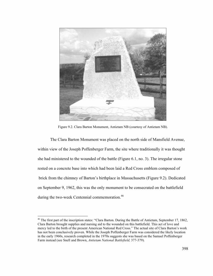
The Clara Barton Monument was placed on the north side of Mansfield Avenue,
within view of the Joseph Poffenberger Farm, the site where traditionally it was thought
she had ministered to the wounded of the battle (Figure 6.1, no. 3). The irregular stone
rested on a concrete base into which had been laid a Red Cross emblem composed of
Figure 9.2. Clara Barton Monument, Antietam NB (courtesy of Antietam NB).
brick from the chimney of Barton’s birthplace in Massachusetts (Figure 9.2). Dedicated
on September 9, 1962, this was the only monument to be consecrated on the battlefield
during the two-week Centennial commemoration.46
46 The first part of the inscription states: “Clara Barton. During the Battle of Antietam, September 17, 1862, Clara Barton brought supplies and nursing aid to the wounded on this battlefield. This act of love and mercy led to the birth of the present American National Red Cross.” The actual site of Clara Barton’s work has not been conclusively proven. While the Joseph Poffenberger Farm was considered the likely location in the early 1960s, research completed in the 1970s suggests she was based on the Samuel Poffenberger Farm instead (see Snell and Brown, Antietam National Battlefield, 377-379).
398

The Antietam-South Mountain Centennial Association did not seriously begin
planning for the centennial until September 1961, when Robert H. Rockhold of the John
B. Rogers Production Company arrived to assume the position of Executive Director. He
had served as a Celebration Field Supervisor for the Rogers Company in the South, and
had staged many events in that region. Immediately upon his arrival, Rockhold opened a
headquarters in downtown Hagerstown—just a couple of blocks from the MCWCC
headquarters of Park W.T. Loy, but, as it would turn out, metaphorically miles apart.47
Within a couple of months of his arrival in Hagerstown, Rockhold had formed a
number of committees and work was well underway. Perhaps inevitably, the Association
quickly ran into conflicts with Park Loy who, as noted above, was pursuing many of his
own Antietam Centennial projects. Simmering resentments boiled over into an open feud
beginning in March 1962, when Rockhold accused Loy of holding up materials that the
governor’s office needed in order to invite other state officials to the reenactment. Loy
also had refused to take the Association’s brochures to the annual meeting of the national
Civil War Centennial Commission, as they emphasized the reenactment and the national
commission was opposed to such events. “It was the feeling of the Board that since our
plans were in effect before the National Commission’s ruling against reenactments,”
stated the Antietam-South Mountain Centennial Association, “that it should have been
Mr. Loy’s primary concern for the success of the commemoration.” In mid-May Loy and
47 Report to the MCWCC from the Antietam-South Mountain Centennial Association, Inc., November 7, 1961, File Antietam-South Mountain Reports, MCWCC, General Files, MSA; Battle of Antietam Centennial and Hagerstown Bicentennial, Official Program and Historical Guide, Aug. 31 through Sept. 17, 1962 (Hagerstown, Md.: Antietam-South Mountain Centennial Association, Inc., 1962), vi.
399

the Association somehow reached an entente and agreed to work together on building
closer communications between their respective offices.48
Their truce fell apart in less than a month, however, following the dedication of
the monument to the 1st Delaware on May 28, 1962. “In spite of the fact that the State of
Delaware had a dedication of a monument on the Antietam Battlefield with the help and
assistance of the Antietam-South Mountain Centennial Commission [sic],” fired off
Shealy to Loy, “our name was nowhere mentioned, before, during, or after this program.”
He also was upset that Loy was planning events involving Antietam without consulting
or acknowledging the Association. This included Loy directly contacting reactivated
Civil War units and “strongly requesting and insisting that they take part in these plans.”
Citing the confusion that had ensued as a result, Shealy requested that Loy coordinate
such requests with his office. In addition, Shealy believed many of the things Loy was
doing were diverting “attention from the central theme of the commemoration and
reenactment of the Battle of Antietam and therefore should be somewhat curbed.” In
effect, instead of the MCWCC supporting the locally sponsored events at Antietam, as it
was supposed to do, it worked in competition with the Antietam-South Mountain
Centennial Association due to the personal interest of Park Loy in that battlefield.
Evidently, the two men never met to work out their issues, which continued to fester.49
48 Minutes of the Board of Directors Meetings, May 22, 2004, file Antietam-South Mountain Reports, MCWCC, General Files, MSA.
400
49 John W. Schildt, Monuments at Antietam (Chewsville, Md.: Antietam Publications, 1991), 42; W.H. Shealy, President, Antietam-South Mountain Centennial Association, Inc., to Park W.T. Loy, MCWCC, June 7, 1962, file Antietam National Battlefield, MCWCC, General Files, MSA. Loy had written a response to Shealy on June 18, 1962, asking for a meeting, but in a February 21, 1963, memo attached to this correspondence, Loy wrote: “No acknowledgement of this letter either written or spoken has ever been received from Dr. Shealy.”
The Association also encountered problems in early spring 1962 with a
recalcitrant Sharpsburg town government. Walter Shealy, a Sharpsburg resident, had
been coordinating activities for the Centennial with the local community “somewhat
apart from the official program and yet coordinated with it in such a way as to form, as it
were, a prelude and postlude to the official climactic day of Sept. 17th.” As part of this
effort, he evidently asked the town to regulate concession stands during the Centennial
observance. Shealy was more than a little surprised when Mayor Elmer Koontz informed
him in mid-March that Sharpsburg was levying a $5,000 charge for complying with this
request. “Asked last night about his own ties with Sharpsburg,” related one newspaper,
“Dr. Shealy said he might formally ‘disown them.’” Instead, members of the Antietam-
Sharpsburg Historical Association met with the mayor and town council a few weeks
later to work through the problem. As it turned out, $5,000 was the expense the town
expected it would incur as a result of the extra police protection and clean up needed for
the Centennial events. “The meeting, which began with a few harsh words, ended on a
note of sweetness and light,” when the historical association agreed to cover the
additional expenses. Two weeks later, the town council voted to allow out-of-town
concessions to operate on town property subject to a charge. Interestingly, Mayor Koontz
noted that he would be out of town on vacation during that period.50
A more serious issue arose concerning water and other material assistance for the
reenactment. In early spring of 1962, the NPS began investigating the possibility of
drilling a well on the Spong Farm, the designated encampment site for the reenactors.
401
50 Report of Division “F”, W.H. Shealy, Director, J.J. Roulette, Associate Director, no date, and unidentified newspaper clippings, March 21, 1962, “Sharpsburg Asks Cash for Cooperation,” April 3, 1962, “Sharpsburg Rescinds Request for $5,000 for Centennial,” and April 17, 1962, “Sharpsburg Council Votes to Allow Centennial Concession,” Antietam Centennial Celebration-1962 vertical file, WCHS.
This well did not materialize, however, and confusion followed over who actually was
supposed to supply water for the event. In June Lt. Gen. Milton A. Reckord, still Adjutant
General of the Maryland Military Department, was surprised to learn that Superintendent
Benjamin Davis had informed the health department that Reckord’s department would be
supplying it, although the general evidently had never been approached. “It seems to me
that our friends at Hagerstown and Sharpsburg are running around in circles, and they
have delayed to a very late date requesting assistance from any source whatever,”
Reckord declared to his old friend Park Loy. “I am therefore advising you that, in my
opinion, assistance should be requested of the Commanding General, Second Army, at
Fort Meade since the Military Department of Maryland is not in a position to meet this
requirement.” While Reckord’s involvement had been central to the 1937 reenactment,
and he was in fact a member of the expanded Maryland Civil War Centennial
Commission, his experience evidently had not been tapped in the reenactment planning.
One wonders if at least some of his recalcitrance could be attributed to sour grapes,
perhaps fueled by Park Loy.51
The water issue was symptomatic of the reenactment planning as a whole.
“Centennial affairs locally are proceeding good or bad depending upon how you look at
it. If you thought the reenactment at Manassas was in any way lacking in planning you
should see Antietam,” Samuel Pruett related in July to Edmund C. Gass, Assistant
Director of the CWCC (who was not in favor of reenactments). “A number of the units
51 Minutes of the Division Chairman Meeting, March 20, 1962, Antietam-South Mountain Centennial Association vertical file, WCHS; Lt. Gen. Milton A. Reckord, The Adjutant General, Military Department, State of Maryland, to Park W.T. Loy, Exec. Dir., MCWCC, June 20, 1962, file Antietam National Battlefield, MCWCC, General Files, MSA.
402
participating have stated that they will not arrive on the scene until within 24 hours of the
first reenactment and will be unable to attend any of the few rehearsals being planned. I
can only cross my fingers and trust that no accidents will occur thereby strengthening the
Commission’s mistaken belief that reenactments are illegal, immoral or fattening.”52
The national CWCC was forced to weigh in on the Antietam reenactment the
following month, however, when the Department of Defense turned down the Antietam-
South Mountain Centennial Association’s request for assistance. Its denial prompted
local Congressman Charles McC. Mathias, a founding member of the Association as well
as a member of the Executive Committee of the Maryland Civil War Centennial
Commission, and Maryland U.S. Senator J. Glenn Beall to introduce legislation to force
the Defense Department to acquiesce. As part of his effort, Mathias also insisted that the
national Commission go on record in favor of the legislation, “even though aware of this
Commission’s opposition to battle reenactments,” recounted Executive Director James I.
Robertson. Uncomfortable with speaking about this issue on his own, Robertson polled
the other directors asking whether or not the Commission should support the legislation.
The response was a strong negative—3 in favor and 12 against. In his follow-up letter to
Mathias, Robertson conveyed the results of the poll, noting that in no way was it intended
as a ‘veto’ of the planned reenactment, but a statement of policy on the part of the
Commission.53
52 Samuel E. Pruett, Asst. Secretary/Treasurer, MCWCC, to Edmund C. Gass, Assistant Director, CWCC, July 8, 1962, file Maryland State Commission, CWCC, Subject Files, 1957-1966, RG 79, NACP; Kammen, Mystic Chords of Memory, 605-606.
403
53 Memo from James I. Robertson, Jr., Exec. Director, CWCC, to Members of CWCC, August 10, 1962, and August 30, 1962, James I. Robertson, Jr., Exec. Director, CWCC, to Rep. Charles McC. Mathias, Jr. August 30, 1962, file Maryland State Commission, CWCC, Subject Files, 1957-1966, RG 79, NACP.
The Antietam Centennial Commemoration
The two-and-a-half-weeks of the Centennial Commemoration began August 31,
1962, with the opening of “The Hills of Glory” pageant and climaxed with the battle
anniversary on the 17th. It represented the culmination of six years of dreams, aspirations,
controversies, and hard work. All the disparate planning threads came together in an
ambitious and much anticipated program packed with activities throughout the
commemorative period.
The extravagant “The Hills of Glory” featured a cast of 1,000 local citizens in
sixteen different episodes, each episode divided into a number of scenes. Its content was
very different from the 1937 pageant. While the earlier show focused on county history
and technological progress, the Centennial pageant highlighted Maryland history and
warfare, and focused on nationally significant events that had occurred in the state. The
first episode opened in England and recounted the origins of religious toleration in the
new colony. The next several episodes focused on early wars in the state—conflicts
between the Indians, the French and Indian wars, and the War of 1812. A “Social”
depicting life in the 1850s closed the first half, providing an opportunity to showcase
dancing.54
The second half of the pageant opened with yet another dance, this one reflecting
“a way of life—the easy, gentle living on a plantation in southern Maryland . . . a gay,
carefree cotillion reflects the culture and people of the area in the late 1850’s [sic].” This
pleasant reminiscence comes to a jarring end with the ominous arrival of John Brown in
the next scene. Following an episode on the divisive 1860 presidential election, the next
40454 Hagerstown Morning Herald, September 1, 1962; Official Program and Historical Guide, ii-iii.
two described the coming of Civil War to Maryland. Titled “Dissension” and
“Occupation,” these portrayed the Baltimore Riot of April 1861, Gen. Benjamin Butler’s
subsequent occupation of Annapolis, and the arrest of Maryland legislators, in a manner
sympathetic to the southern supporters. In fact, the episodes conclude with the singing of
“Maryland, My Maryland” to Confederate troops.
The next three episodes depicted events associated with the Battle of Antietam,
the first providing a lead up to the battle from a Confederate perspective, the second
depicting the engagement at Bloody Lane, and the third the care of the wounded
(featuring, of course, Clara Barton). One additional Civil War episode highlighted the
Confederate raids of 1864 and the ransoming of Hagerstown, Williamsport, and
Frederick. Significantly, the last episode celebrated the dedication of the Maryland
Monument, which focused on the fact that “time does heal wounds of conflict.”
Interestingly, the date given in the program for the monument dedication was May 30,
1902—almost nine months after President McKinley, the primary speaker at that event,
had died from an assassin’s bullet!55
The intent of the pageant was to place Maryland within the larger Civil War
landscape. This objective echoes what the state had attempted to do earlier at the national
cemetery dedication, albeit unsuccessfully, and at the dedication of the Maryland
Monument. The latter did work in the atmosphere of national reconciliation following the
Spanish American War, when all soldiers, both northern and southern, were again
counted as Americans. It therefore was appropriate that the pageant concluded with the
dedication of Maryland’s monument to both its Union and Confederate dead, as the focus 55 Official Program and Historical Guide, iv-v.
405

of the Centennial was on the brotherhood that reunited the two sides. In the finale, the
cast reunited to sing “a song born in Maryland,” the Star Spangled Banner.
The pageant was performed continuously through September 16 to large crowds.
Many other events were held in conjunction with the Centennial as well, including the
dedication of the newly reconstructed Dunker Church on September 2, dedication of the
Clara Barton Monument on the 9th, rededications of the New York Monument and
several of the Pennsylvania monuments, and various local community days, such as
“Sharpsburg Day” on September 5. Unfortunately, unremittingly rainy weather
throughout this period curtailed some activities and reduced attendance.56
In contrast, the two days of the reenactment enjoyed “near-perfect weather.”
About 2,000 troops from 17 states reenacted the Bloody Lane phase of the battle,
performed with much greater accuracy than twenty-five years earlier (Figure 9.3). Only
18,000 spectators turned out over the two days, however, a much lower number than the
50,000 expected and far fewer than the 100,000 who attended the two-day reenactment at
Manassas a year earlier. One reason given for the low turnout at Antietam was the
advance publicity that projected huge numbers of visitors and predicted traffic jams if
people did not come early, with the result that many did not bother to come at all. Adding
insult to injury, the return of inclement weather on the battle anniversary led to the
cancellation of the memorial service planned for that afternoon at Bloody Lane.57
56 Official Program and Historical Guide, xvi-xvii; Hagerstown Morning Herald, September 4, 1962, September 5, 1962, and September 6, 1962.
Unid. newspaper, September 17, 1862, “Spectators Praise Battle Re-Enactment at Antietam; Estimated 18,000 Attend,” Antietam Centennial Celebration—1962 vertical file, WCHS; Zenzen, Battling for Manassas, 69; John Frye, Western Maryland Room librarian, personal communication, October 25, 2004.
57
406

The relatively low turnout for the reenactment, coupled with the cancellation of
the memorial service on the 17th, meant that the Centennial ended with a whimper rather
than the climax originally anticipated. The immediate consequence was that the
Antietam-South Mountain Centennial Association did not raise sufficient funds to pay
expenses, forcing it to turn to the MCWCC to cover an extra $10,000 “long overdue” to
various creditors, over and above the $100,000 originally allocated by the state for the
reenactment. Throwing more wood on the fire, the Antietam Sharpsburg Museum sued
the Association for $5,000 to cover damages incurred to the corn crop growing on the
Piper Farm, although the latter believed these “damages amounted to not more than $400
Figure 9.3. Reenactment of the Battle of Antietam, September 1962 (courtesy of the Washington County Historical Society).
407
or $450.” Just as galling must have been the fact that they were forced to work closely
with Park Loy, who paid the bills for the MCWCC.58
Loy was not afraid to heap criticism upon the Antietam-South Mountain
Centennial Association, declaring to the national Civil War Centennial Commission
Executive Director, James I. Robertson, in March 1963 that the battle commemoration
“fell far short of anticipated public acceptance and attendance, to a large extent being due
to over-commercialization.” A year later he declared: “The Antietam Project was
cheapened by excessive commercialization, dissension among management and
participating groups and a financial failure.” In contrast, Loy felt that many of the other
Centennial events at Antietam (particularly those planned or promoted by himself)
largely counteracted this failure through their “outstanding success.” What Loy did not
acknowledge was that the achievements of the Antietam-South Mountain Centennial
Association likely fell short at least in part because he did not cooperate with the
organization as he should have done in his position with the MCWCC, and thus
contributed to the “dissension among management.” Instead, he focused on his own
interests and programs to the detriment of the other organization. Others certainly shared
Loy’s sentiments, however. Samuel Pruett referred to Antietam as a “fiasco” and believed
that it negatively affected local Centennial activities the following year.59
58 J.V. “Johnny” Jamison, 3 , Treasurer, Antietam-South Mountain Centennial Association, Inc., to Leister E. Mobley, Exec. Vice President, MCWCC, April 18, 1963, Park W.T. Loy, Exec. Dir., MCWCC, to J.B. Ferguson Company, May 21, 1963, Park W.T. Loy, Exec. Dir., MCWCC, to J.V. Jamison, III, May 22, 1963, and May 29, 1963, file Antietam National Battlefield, MCWCC, General Files, MSA.
rd
Park W.T. Loy, Exec. Dir., MCWCC, to James I. Robertson, Jr., Exec. Dir., CWCC, March 11, 1963,
Samuel E. Pruett to Edmund C. Gass, CWCC, July 14, 1963, file Maryland State Commission, CWCC, Subject Files, 1957-1966, RG 79, NACP; Park W.T. Loy, Exec. Dir., to Carl A. Zenor, Exec. Dir., Indiana Sesquicentennial Commission, May 14, 1964, file Indiana, MCWCC, General Files, MSA. In response to Loy, Robertson agreed “that the Antietam program succumbed to over-commercialization.” Because of the.
59
408

Remaining Centennial-related activities at Antietam included the placement of
several additional monuments on the battlefield. Park Loy worked with the State of
Delaware to erect two more monuments, one to the 2nd Delaware on the north side of
Bloody Lane (Figure 6.1, no. 57), and the second to the 3rd Delaware, located in
Philadelphia Brigade Park (Figure 6.1, no. 26). Loy also coordinated their dedication on
Memorial Day in 1964. During this period planning also was underway to erect a
monument to Texas troops. The state’s Civil War Centennial Commission made its
request to the battlefield in March 1963, which was approved quickly. Acting
Superintendent Robert L. Lagemann suggested Cornfield Avenue, “a battlefield tour
road,” for its location (Figure 6.1, no. 24). “Not only did the Texas regiments in Hood’s
Division literally plug a threatening gap in the Confederate line in the Cornfield during a
crucial phase of the early morning action,” he noted, “but in so doing one of them
sustained the highest casualty rate for an infantry regiment of the entire war.” Lagemann
also recommended that the Texas Commission contact Park Loy, who would be glad to
work with them and the NPS in arranging the dedication ceremony. The monument was
dedicated on Veteran’s Day in 1964. Loy also continued to try and convince other states,
particularly Virginia, to erect monuments at Antietam, but the Delaware and Texas
monuments were the last to be erected on the battlefield during the Centennial period.60
controversies surrounding it, he had asked his friend James Murfin to investigate and summarize the events for him (see Robertson to Loy, March 12, 1963). According to John Frye, Western Maryland Room librarian, the ‘commercialism’ described by Loy and others referred to the fact that a commercial, for-profit firm—the John B. Rogers Company—had been hired to produce and promote the reenactment (personal communication, October 25, 2004).
Park W.T. Loy, Exec. Dir., to William T. Mahoney, February 28, 1964, Park W.T. Loy, Exec. Dir., to Hon. Charles McC. Mathias, February 10, 1964, file Memorial Day—Sharpsburg 1964, Delaware Marker, George W. Hill, Director, Texas State Historical Survey Committee and Texas Civil War Centennial Commission, to Superintendent, Antietam NBS, March 28, 1963, Robert L. Lagemann, Acting
60
409
Overall, the Centennial commemoration appears to have had little lasting effect at
Antietam beyond a few new structures—the visitor center, reconstructed Dunker Church,
and a few new monuments. By April 1965, most of the local reactivated Civil War units
had disbanded or become inactive. While visitation to the battlefield had spiked to
slightly more than 175,000 in 1962, the following two years it dropped back to a steady
100,000, “higher than before but not sufficient to create a tourist-centered economy in
Sharpsburg such as Gettysburg has.” In fact, the Centennial “seems to have settled for the
time being the question of whether Sharpsburg would become another Gettysburg.” One
casualty of the drop in tourism at Antietam was the financially strapped Antietam-
Sharpsburg Museum, which closed its doors in 1963.61
Land Acquisition and Mission 66 Improvements
Following passage of the 1960 legislation enabling the NPS to purchase land at
Antietam Battlefield, the agency began moving ahead with its acquisition program. As
noted earlier, the law emphasized procurement of land for Mission 66 development, and
acquisition of easements for preservation purposes. Not surprisingly, therefore, the first
tract to be purchased was the designated site for the new visitor center—the 148.5-acre
Superintendent, Antietam NBS, to George W. Hill, Exec. Dir., Texas State Historical Survey Committee, April 5, 1963, file Texas Monument at Antietam, James J. Geary, Exec. Dir., VCWCC, to Park W.T. Loy, January 17, 1962, Park W.T. Loy to James J. Geary, Exec. Dir., July 9, 1963, and March 11, 1964, file Virginia Civil War Centennial Commission, James J. Geary, Exec. Director, MCWCC, General Files, MSA; Hagerstown Morning Herald, May 22, 1964. In his July 9, 1963, letter to Geary, Loy declares: “May I again remind you that we continue to regret the fact that the State of Virginia has no marker on the Antietam Battlefield upon which the renowned Robert E. Lee so valiantly sought to uphold the cause which he thought right.” 61 Unid., undated newspaper clipping [April 1965], Antietam Centennial Celebration-1962 vertical file, WCHS.
410
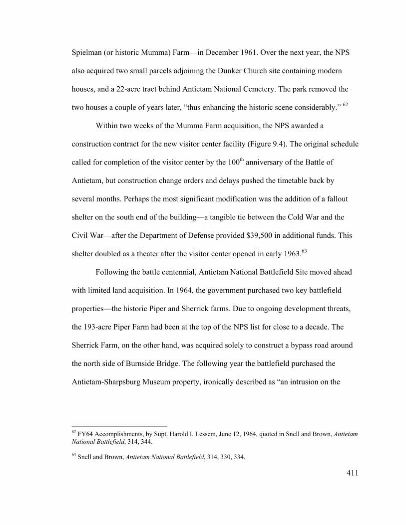
Spielman (or historic Mumma) Farm—in December 1961. Over the next year, the NPS
also acquired two small parcels adjoining the Dunker Church site containing modern
houses, and a 22-acre tract behind Antietam National Cemetery. The park removed the
two houses a couple of years later, “thus enhancing the historic scene considerably.” 62
Within two weeks of the Mumma Farm acquisition, the NPS awarded a
construction contract for the new visitor center facility (Figure 9.4). The original schedule
called for completion of the visitor center by the 100th anniversary of the Battle of
Antietam, but construction change orders and delays pushed the timetable back by
several months. Perhaps the most significant modification was the addition of a fallout
shelter on the south end of the building—a tangible tie between the Cold War and the
Civil War—after the Department of Defense provided $39,500 in additional funds. This
shelter doubled as a theater after the visitor center opened in early 1963.63
Following the battle centennial, Antietam National Battlefield Site moved ahead
with limited land acquisition. In 1964, the government purchased two key battlefield
properties—the historic Piper and Sherrick farms. Due to ongoing development threats,
the 193-acre Piper Farm had been at the top of the NPS list for close to a decade. The
Sherrick Farm, on the other hand, was acquired solely to construct a bypass road around
the north side of Burnside Bridge. The following year the battlefield purchased the
Antietam-Sharpsburg Museum property, ironically described as “an intrusion on the
62 FY64 Accomplishments, by Supt. Harold I. Lessem, June 12, 1964, quoted in Snell and Brown, Antietam National Battlefield, 314, 344.
411
63 Snell and Brown, Antietam National Battlefield, 314, 330, 334.
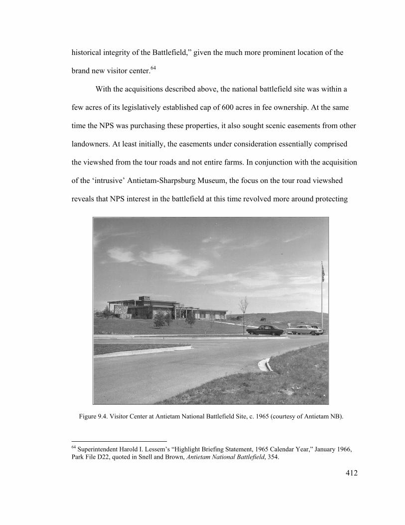
historical integrity of the Battlefield,” given the much more prominent location of the
brand new visitor center.64
With the acquisitions described above, the national battlefield site was within a
few acres of its legislatively established cap of 600 acres in fee ownership. At the same
time the NPS was purchasing these properties, it also sought scenic easements from other
landowners. At least initially, the easements under consideration essentially comprised
the viewshed from the tour roads and not entire farms. In conjunction with the acquisition
of the ‘intrusive’ Antietam-Sharpsburg Museum, the focus on the tour road viewshed
reveals that NPS interest in the battlefield at this time revolved more around protecting
Figure 9.4. Visitor Center at Antietam National Battlefield Site, c. 1965 (courtesy of Antietam NB).
412
64 Superintendent Harold I. Lessem’s “Highlight Briefing Statement, 1965 Calendar Year,” January 1966, Park File D22, quoted in Snell and Brown, Antietam National Battlefield, 354.
the tourist experience than preserving the actual fields of battle.
The NPS encountered significant resistance to scenic easements upon the part of
the local landowners, who early on believed their properties held great commercial value
and envisaged “Antietam as a second Gettysburg with a similar commercial potential.”65
This resistance apparently began to lessen by the mid-1960s after the Centennial did not
result in sustained tourism development at Antietam, but the NPS still acquired few
easements. As a result, battlefield officials became increasingly alarmed about
encroaching development and advocated raising the land acquisition ceiling. This would
not occur until the middle of the next decade, however, with the result that the NPS
purchased very little land over the next ten years. In the meantime, the regional director
suggested battlefield managers work with the county zoning department “as a means of
preserving the open rural atmosphere around the park.”66
In conjunction with its limited land acquisition, the NPS proceeded with its
Mission 66 program at Antietam. Most of this program focused on road improvements
designed to separate visitor traffic from other traffic, facilitate a seamless tour route, and
eliminate as many cars as possible from the two battlefield landmarks, the Dunker
Church and Burnside Bridge. The focal points of this effort were two proposed public
road bypasses (Figure 9.5). The first of these was the relocation of the Hagerstown Pike
(Rt. 65) a short distance to the west. “This arrangement will result in the separation of
65 Sec. of Interior Stewart L. Udall to Wayne N. Aspinall, Chairman, House Committee on Interior and Insular Affairs, December 8, 1962, quoted in Snell and Brown, Antietam National Battlefield, 346.
413
66 Lee to Chief, EODC, June 9, 1965, Park File D18, quoted in Snell and Brown, Antietam National Battlefield, 365.
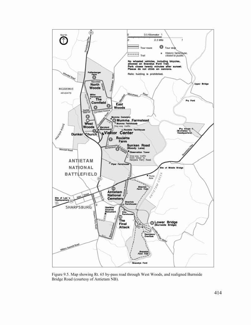
Figure 9.5. Map showing Rt. 65 by-pass road through West Woods, and realigned Burnside Bridge Road (courtesy of Antietam NB).
414
park visitor and through traffic,” noted Superintendent Harold Lessem.67 The original
plans called for placing this new road to the west of Confederate Avenue and the West
Woods area. Sometime between the initial proposal around 1960 and the actual road
construction in 1965, the alignment shifted eastward and ended up following the
Confederate Avenue right-of-way, most likely due to land acquisition or funding
constraints. As a result, the Rt. 65 bypass obliterated most of the War Department-era
road and cut through an area of the West Woods that witnessed heavy fighting during the
battle.
The second project involved construction of a by-pass road to remove all vehicle
traffic from Burnside Bridge and therefore preserve “one of the most significant
landmarks in American military history.” Visitors wishing to see the bridge now parked
in a new lot constructed in 1962 adjacent to the McKinley Monument and walked down
the old monument right-of-way. Once the two bypasses were completed, the NPS
conveyed the Rt. 65 bypass to the State of Maryland and the Burnside Bridge bypass to
Washington County in return for the two original road sections. These sections of old
roadway subsequently became incorporated into the battlefield tour route, “thus
expanding [the park’s] interpretive capability.”68
In fact, with the exception of the visitor center, most of the focus of master
planning and the Mission 66 program at Antietam was upon creating an internal
67
“Highlight Briefing Statement, 1965 Calendar Year,” by Superintendent Harold I. Lessem, January 1966, Park File D22, quoted in Snell and Brown, Antietam National Battlefield, 352.
68
“Highlight Briefing Statement, 1965 Calendar Year,” by Superintendent Harold I. Lessem, January 1966, Park File D22, quoted in Snell and Brown, Antietam National Battlefield, 352; Hagerstown Morning Herald, May 19, 1964. See Hagerstown Daily Mail, June 26, 1962, for description of construction of parking area adjacent to the McKinley Monument.
415
automobile tour loop through the battlefield separate from regular traffic. This is reflected
in a planning map dating from March 1960, which depicts three bypass roads—the two
that were constructed and one that was not, the latter extending from Rt. 65 east to
Mansfield Road through the Joseph Poffenberger and Samuel Poffenberger farms—plus a
new tour road segment on the south end of the battlefield to take visitor traffic off
Harpers Ferry Road. The proposed tour road segment was never constructed, most likely
because the NPS was not able to acquire the property. One proposed improvement that
did take place, however, involved the historic Mumma Farm lane. “This timeworn, rutted
country lane will be widened, graded and paved and integrated in the park tour route
complex,’ announced Superintendent Lessem. “This improvement will enable visitors to
secure a better comprehension of the events which led to the sanguine Sunken Road
phase of the Battle of Antietam.”69
Little would occur at the battlefield following completion of the Mission 66
program. In fact, in December 1967, the administration of Antietam National Battlefield
Site became subsumed under the superintendent of C&O Canal National Monument. The
battlefield received little attention for the next seven years, finally becoming its own park
again in 1974. Several more years would pass before land acquisition authority was
finally expanded at Antietam to encompass the majority of the battlefield. 70
69
“Highlight Briefing Statement, 1965 Calendar Year,” by Superintendent Harold I. Lessem, January 1966, Park File D22, quoted in Snell and Brown, Antietam National Battlefield, 353. The March 1960 map can be found on p. 308.
416
70 Snell and Brown, Antietam National Battlefield, 438. During the 1970s, park officials and local political representatives focused on expanding land acquisition authority at Antietam National Battlefield Site. Charles McC. Mathias, now serving as Senator, and Representative Goodloe Byron introduced legislation in 1972, and again in 1974 and 1975, proposing to increase the size of the battlefield from roughly 1,800 to 3,200 acres and establishing a set boundary. Opposition on the part of local officials, who were concerned about loss of tax revenue, led Congressman Goodloe Byron to change the House version to acquisition of
Conclusion
During the Civil War Centennial Antietam finally became a truly American
battlefield, where both northern and southern soldiers could be celebrated for their valor
and heroism. This was accomplished not by creating a national consensus about the
meaning of the historic battle fought there, however, as much as it represented an uneasy
accommodation of a number of interests that had different perspectives toward and
reasons for commemorating the Battle of Antietam. Under the reconciliation ideology
espoused during the Cold War period, pushed at the national level by the Civil War
Centennial Commission and facilitated by the National Park Service, the Confederates
finally occupied a central place on the battlefield with the erection of the Georgia and
Texas monuments along Cornfield Avenue. The Confederate appropriation of Antietam
during this period was reinforced by the pageant in Hagerstown, with a pro-Southern
orientation that culminated in the last episode featuring the dedication of the Maryland
Monument. The pageant also symbolized the return of the State of Maryland to Antietam,
which could not occur under the new national reconciliation umbrella.
While a degree of alignment existed between the state and federal levels during
the centennial commemoration of Antietam, this did not extend to the local level, where
centennial planning was fraught with conflict and dissension over what constituted
appropriate commemoration. A clear split emerged between those aligned with Dr.
Walter Shealy, who felt that some degree of commercialism as reflected by the re-
enactment and pageant was appropriate, and those such as Park Loy who felt that
417
scenic easements only. Mathias evidently acquiesced to this decision, as the law passed on November 10, 1978, provided for the acquisition of scenic easements only. This law also dropped the word “Site” from the park’s name.

commemoration at the battlefield was best served through other means of veneration such
as placing new monuments upon it. The local turmoil resulted in a centennial
commemoration at Antietam that did not resonate to the level that it could have if all of
the entities involved had cooperated with each other.
A concerted effort to preserve Antietam battlefield finally organized in the late
1950s as residential development increasingly threatened the battlefield. This
preservation undertaking was fraught with irony, however, as the legislation that passed
in 1960 enabling battlefield managers to purchase land for the first time was driven by
development goals established under the Mission 66 program. The initial focus was on
acquiring properties that were necessary for construction of the visitor center and tour
route. Thus, while NPS officials and others were concerned about encroaching
development, they pushed ahead with their own plans to develop the battlefield.
The apparent development/preservation dichotomy was not perceived as such by
NPS officials at that time, who saw no contradiction between placing a new visitor center
on a prominent ridge in the heart of the battlefield, while removing other modern
structures that they felt constituted visual intrusions upon the landscape. This apparent
contradiction suggests that the gaze they were concerned about radiated out from the
visitor center and the tour roads—the perspective from which visitors would see the
battlefield, rendering the modern improvements essentially invisible from a visitor
perspective. Thus, at the same time that a more holistic perspective of the battlefield
landscape emerged, replacing the previous focus on particular features, the NPS remained
unreflective of its own presence upon it.
418

Conclusion
In many respects, Antietam Battlefield is an accidental preservation. It is ironic
that Antietam has become one of, if not the best preserved, Civil War battlefields in the
country in part because it was ignored for many years. Of the original War Department
battlefield parks created in the 1890s, it was the only one without a significant land base.
Instead, the federal government acquired only narrow rights-of-way. As a result, most of
the battlefield remained in private hands, and continued to be farmed with minimal
changes to the landscape. Conversely, the War Department made few improvements at
Antietam other than the avenues. In addition, the lack of land prevented the government
from using the battlefield as a training camp during the Spanish-American War and
World War I, as happened at Gettysburg and Chickamauga. It would not be until the
1980s and 90s, outside the scope of this study, that the NPS finally would acquire large
portions of the battlefield. Aggressive action by the State of Maryland during this period
to purchase easements on thousands of acres of land surrounding the battlefield also
helped ensure that Antietam would not be lost to the residential development that
threatens to overwhelm southern Washington County at the beginning of the twenty-first
century.
The narrow rights-of-way, coupled with the policies of the Antietam Board,
resulted in relatively few monuments at Antietam. The Board discouraged their
placement along the government-owned avenues, and encouraged the erection of state or
brigade level monuments in place of numerous regimental memorials. The fact that most
of the battlefield remained in private hands also influenced the number and placement of
419

monuments at Antietam. When state commissions discovered they had to purchase land
for their monuments, unlike at the other battlefield parks, some abandoned their efforts
altogether, or settled on fewer monuments in line with the Board’s inclinations. One case
in point was the Indiana Commission, which came to Antietam intending to place five
regimental monuments on the field and determined instead to erect one large state
monument and small regimental markers along the War Department avenues. Again, this
resulted in fewer changes to this landscape as compared to the other battlefields
administered by the War Department.
The loss of some key battlefield features did occur during this period, however, as
a result of their unprotected status. The War Department attempted unsuccessfully to
acquire the Dunker Church, but was hamstrung by the lack of land acquisition authority.
Unfortunately, a storm leveled the abandoned church in the 1920s while it was still in
private hands. The woodlots that figured so prominently in the battle—the East, North
and South Woods—began disappearing in the late nineteenth century and were all but
gone by the time the National Park Service assumed administration of Antietam in 1933.
During the 1930s, the NPS was tied closely to the Public Works programs of the
Roosevelt administration. These programs accomplished a tremendous amount of work in
parks across the country, including construction of roadways, administrative and visitor
facilities, and housing. Although the desire to make such improvements at Antietam was
evident, its small land base hampered these efforts. As a result, while some alterations
were made to War Department-era improvements, such as removal of much of the
fencing around the monuments, other desired projects, including improvements to the
avenues and construction of amenities such as comfort stations and administrative
420
buildings could not be accommodated. Thus Antietam battlefield essentially missed the
first round of NPS-imposed development.
It thus becomes very evident that the absence of a substantive land base greatly
influenced early development, or lack thereof, at Antietam battlefield. The absence of a
land base, in turn, arose from the disinterest of Congress toward Antietam relative to the
other early War Department parks, which garnered tremendous national support on the
part of both legislators and veterans (who often were one and the same). Such support
simply did not materialize for Antietam, resulting in large part from a lack of alignment
between local, state, and national interests.
The lack of alignment between these levels first manifested itself in the creation
of the national cemetery. As a slaveholding, Union border state wedged between the
Mason-Dixon line and the Potomac River, Maryland attempted to redeem its presence on
both sides of the conflict by burying both Confederate and Union soldiers in the
cemetery. This effort failed miserably as both local and national interests fought to thwart
the intent of the state legislature, fueling a deep distrust of Maryland on the part of other
northern states. The founding of Antietam’s national cemetery contrasts greatly with the
establishment of Gettysburg National Cemetery, where local, state and national interests
were in alignment from the beginning and worked together toward a powerful dedication
whose message reverberates to the present day.
After the fiasco over Antietam National Cemetery, the State of Maryland backed
away from any association with either the battlefield or the cemetery for the remainder of
the nineteenth century, and the latter essentially fell under the control of the local
Republican establishment. It was not until the late 1870s, after the War Department
421

assumed ownership of the cemetery, that a struggle arose between the Sharpsburg
community and the federal government over who had ultimate authority to set standards
of behavior and decorum within its confines. The War Department’s victory assured
national control of Antietam National Cemetery, but a persistent undercurrent of
resistance against government authority had become established, particularly on the part
of the disaffected and the local Democratic minority. Creation of a local GAR post in
Sharpsburg, however, did enable the local community to regain its control of the
Decoration Day ceremony.
About the same time the War Department assumed control of the national
cemetery, commemorative activity began to pick up on the battlefield as veterans
returned in increasing numbers to remember their fallen comrades and relive their combat
experiences. These excursions to Antietam were privately organized gatherings, however,
unlike those at Gettysburg, where the Grand Army of the Republic had taken over the
Gettysburg Battlefield Memorial Association and actively solicited the veterans’
memorialization activities on the battlefield. Whereas the alignment between local, state,
and national interests generally continued at Gettysburg, particularly with the
strengthening of the state (Pennsylvania Department of the GAR) and national (Society
of the Army of the Potomac, national GAR) aspects of the continuum, there was little
movement at Antietam at this time toward such an alignment. Instead, memorial activities
generally remained private affairs.
As noted earlier, a direct connection exists between this lack of local, state, and
national alignment and the dearth of broad support for the creation of a battlefield park at
Antietam. Of the five battlefields established in the 1890s, Antietam was the only one
422

that did not have an organized veteran constituency behind its creation. This lack of
interest, as well as alignment, may be the result of an ambivalence felt toward Antietam
as a place for remembering the Civil War in late nineteenth-century America. The battle
had been fought in a border state that felt its own ambivalence toward its role in the
conflict. Antietam also was essentially a draw, with no great victory to point toward for
either side. It probably did not help that the Union commander had been a Democrat who
had run for president in 1864 against Abraham Lincoln. Instead, the veterans of the Army
of the Potomac and the powerful GAR put almost all of their interest and energy into
Gettysburg—an undisputed Union victory—and essentially ignored Antietam.
The relative paucity of national-level veteran interest in Antietam during the last
two decades of the nineteenth century created the conditions that led to a lack of support
for building a land base at that battlefield. This in turn reinforced the continuing
subordination of Antietam relative to Gettysburg, and perhaps to the other battlefield
parks as well, as it continued to be relatively difficult for veterans to erect monuments at
Antietam. As a result, remembrance at Antietam remained primarily private in scope,
with individual units memorializing the most memorable battle of the war for them.
A shift began following the Spanish-American War, when Maryland returned to
the battlefield to finish what it had failed to do with the national cemetery and dedicated a
monument to its soldiers who had fought on both sides of the battle. Occurring at the
height of the reconciliation movement following the Spanish-American War—when the
country reunited against a foreign enemy, it became appropriate, indeed desirable, to
meet on an important border state battlefield as part of the national healing process. This
opened the door for other monuments of national scope, but only northern states
423

responded; no former Confederate states placed monuments on Antietam during this
period, suggesting that true reconciliation at that battlefield did not extend beyond
Maryland. As a result, Antietam continued to remain in the shadow of Gettysburg, and in
the background of Civil War commemoration overall throughout the first half of the
twentieth century.
After mid-century, several movements came together to push Antietam Battlefield
to the forefront. The first of these was a renewed interest in the Civil War on the part of a
new generation that had no personal knowledge of it. This interest grew in part out of the
patriotic nationalism that arose after World War II in the face of the Cold War and the
approach of the Civil War Centennial. Similar to the reconciliation movement following
the Spanish-American War, Civil War battlefields once again could be used to showcase
American valor and heroism. Renewed attention toward the battlefields also led to
increased efforts to protect battlefield sites from increasing development pressures. The
second movement was the inauguration of the National Park Service’s Mission 66
Program to build a visitor services infrastructure to support burgeoning visitation and
protect park resources.
At Antietam these two forces resulted in a concerted push by the local
Hagerstown Civil War Round Table and the NPS for Congress finally to enact legislation
in 1960 providing authority for the federal government to purchase land for the
battlefield. Ironically, this land acquisition centered more around development than it did
around preservation, focusing on properties required for road improvements or
construction of facilities such as the new visitor center. Thus the battlefield did not
escape the second round of major NPS improvements (the 1930s PWA projects having
424

been the first), with new structures and roads constructed on the battlefield to facilitate
tourist movement through it. Because the land base was still quite circumscribed,
however, the scale of these improvements was not as large as originally planned.
The Centennial commemoration at Antietam reflected the Cold War patriotism of
the era. While there were disagreements between the different organizations sponsoring
events, some of which was based on personality differences, it was evident that all
supported the supposition that the soldiers from both North and South were equally
heroic, and that all fought for what they believed in. The reenactment supported this on a
basic physical level, while the placement of monuments on the battlefield for the first
time by former Confederate states asserted the righteousness of their cause at a critical
point in the Civil Rights movement. Antietam had become a truly national battlefield, but
as was the case at Gettysburg and the other Civil War battlefields at this time, it did not
become one of true national reunification. It is telling that the commemorative activities
associated with the 100th anniversary of the Preliminary Emancipation Proclamation,
issued as a result of the Battle of Antietam, were conducted at the Lincoln Memorial in
Washington, D.C., and not at the battlefield.
At the start of this study, I had taken at face value that Civil War remembrance at
Antietam battlefield would follow the model established at Gettysburg, which has been
codified over the years as the Civil War battlefield commemorative experience. Instead,
what I discovered along the way is that Antietam did not fit into the culture of reunion as
defined by David Blight and other scholars who have contributed to our understanding of
Civil War memory. The fact that the results of the battle were comparatively ambiguous,
and that the battlefield was situated within a border state that had not reconciled its own
425
divided past, led Antietam down a very different road than the one followed by
Gettysburg. For most of its post-battle history, little agreement existed between local,
state, and national interests concerning the meaning of Antietam. As a result, Antietam
has presented a different narrative of commemoration and historical memory, one that is
more complicated and ambivalent.
In the end, memory on Civil War battlefields has not been a monolithic entity, but
has varied depending in large part upon local political geography. This has created a
more complex and nuanced remembrance of that war than found if one looks at
Gettysburg alone. It is more appropriate to state that each battlefield occupies its own
place on the landscape of Civil War remembrance and thus has its own story to tell.
Another important story Antietam has to convey is the enduring presence of local
influences on the development and commemoration of the battlefield
426
References Primary Sources
Antietam National Battlefield, Sharpsburg, Maryland Cooper, Austin. “Antietam Battlefield Landmark to be Reconstructed.”
Typescript in “Dunker Church” vertical file. Herrin, Dean. “Antietam Rising: The Civil War and Its Legacy in Sharpsburg,
Maryland, 1860-1900.” Report on file, 2002. Hildebrand, Virginia Mumma. “The Sharpsburg Rifles.” Pamphlet on file, 1959. John Milner Associates, Inc., “Design of the Commemorative Military Park:
Contextual Documentation and Resource Evaluation.” 95% Draft, 2004. Mumma, S. Calvin. “Washington Cemetery: Historical Sketch of the Cemetery
from the Scrap Book of General Henry Kyd Douglas, owned by John Kyd Beckenbaugh, Sharpsburg, Md.” Typescript in “Cemeteries” vertical file.
National Park Service, “Mumma Farmstead, Antietam National Battlefield, Cultural Landscape Inventory.” Report on file, 2003.
_____. “Roulette Farmstead, Antietam National Battlefield, Cultural Landscape Inventory.” Report on file, 2003.
Newspaper Clippings Scrapbook, April 1934-September 1947. Oehrlein & Associates, “Sherrick House Historic Structures Report.” Report on
file, 1995. Reed, Paula S. “History Report: The D.R. Miller Farm, Antietam National
Battlefield, Sharpsburg, Maryland.” Report on file, 1991. Gettysburg National Military Park, Gettysburg, Pennsylvania
Georg, Kathleen R. “‘This Grand National Enterprise’: The Origins of Gettysburg’s Soldiers’ National Cemetery and Gettysburg Battlefield Memorial Association.” Report on file.
Harrison, Kathleen Georg. “‘A Fitting and Expressive Memorial’: The Development of Gettysburg National Military Park.” Report on file.
Library of Congress, Washington, D.C. (LC) Hotchkiss-McCullough Collection
Jedediah Hotchkiss Papers
Maryland Historical Society, Baltimore, Maryland (MHS) Antietam Battlefield Commission of Maryland Papers, 1898-1900 Maryland State Archives, Annapolis, Maryland (MSA)
Archives of Maryland Governor, Miscellaneous Papers, 1848-1918 Maryland Civil War Centennial Commission, General File, 1959-1965
427
Minnesota Historical Society, Minneapolis, Minnesota (MNHS) Alexander Ramsey Papers
National Archives and Records Administration, College Park, Maryland (NACP) RG 79 Records of the National Park Service
Civil War Centennial Commission, Subject Files, 1957-1966 Entry 5, Records of the War Department Relating to National Parks,
1892-1937 Entry 7B, Central Classified Files, 1933-1949 RG 92 Records of the Office of the Quartermaster General Entry 1889, General Correspondence, Subject File, 1922-1935 Entry 1891, General Correspondence, Geographic File, 1922-1935 National Archives and Records Administration, Washington, D.C. (NA) RG 92 Records of the Office of the Quartermaster General
Entry 89, General Correspondence, 1890-1914 Entry 576, General Correspondence and Reports Relating to National and
Post Cemeteries, 1865-90 Entry 707, Records of Cemeterial Commissions, 1893-1916, Antietam
Battlefield Commission, Letters and Reports to Secretary, 1894-98 RG 233 Records of the U.S. House of Representatives United States 1860 Slave Census, Washington County, Sharpsburg District
(microfilm) National Park Service, Washington Office, Washington, D.C. History Division Files New York Public Library, New York, New York (NYPL)
Ezra Carman Collection
Washington County Historical Society, Hagerstown, Maryland (WCHS) Antietam Battlefield Historical Park—Preservation vertical file Antietam Centennial [sic] Celebration 1937 vertical file Antietam Centennial Celebration—1962 vertical file Antietam-South Mountain Centennial Association vertical file Augustin Biggs to John Jay, May 4, 1868, Special Collections Boullt, Thomas A. “Minutes of the National Cemetery Board of Trustees, May
25, 1865-September 16, 1867” Minutes of the Washington County Historical Society
Western Maryland Room, Washington County Free Library, Hagerstown, Maryland (WCFL)
Antietam Battlefield Historical Park—Preservation vertical file Antietam National Cemetery Board Correspondence, A. A. Biggs Collection Battle of Antietam—75th Anniversary vertical file
428

Church of the Brethren vertical file Sharpsburg and Area—After the Battle vertical file
Newspapers
Keedysville Antietam Valley Record Keedysville Antietam Wavelet Baltimore American Baltimore Evening Sun Boonsboro Odd Fellow Hagerstown Herald and Torch Light Hagerstown Daily Mail Hagerstown Mail Hagerstown Morning Herald National Tribune Sharpsburg Enterprise Shepherdstown Register Williamsport Maryland Free Press Published Primary Sources --------. A Descriptive List of the Burial Places of the Remains of Confederate Soldiers, who fell in the Battles of Antietam, South Mountain, Monocacy, and other points in Washington and Frederick Counties, in the State of Maryland. Hagerstown, Md.: Free Press Printers. Battle of Antietam Centennial and Hagerstown Bicentennial, Official Program and Historical Guide, Aug. 31 through Sept. 17, 1962. Hagerstown, Md.: Antietam-South Mountain Centennial Association, Inc., 1962. Board of Trustees of Antietam National Cemetery. History of Antietam National Cemetery. Baltimore: J.W. Woods, 1869. Bosbyshell, Oliver C., editor. Pennsylvania at Antietam: Report of the Antietam Battlefield Memorial Commission of Pennsylvania. Harrisburg, Pa.: Harrisburg Publishing Company, 1906. Burgan, Martin L. Views of Historic Antietam. Sharpsburg: Martin L. Burgan, 1906. Chapin, Louis N. A Brief History of the Thirty-Fourth Regiment N.Y.S.V. embracing a Complete Roster of all Officers and Men and a Full Account of the Dedication of the Monument on the Battlefield of Antietam, September 17, 1902, with Numerous Illustrations.
429

Congressional Globe: Containing the Debates and Proceedings of the Third Session Fortieth Congress: Together with an Appendix, Comprising the Laws Passed at that Session. Washington: Office of the Congressional Globe, 1869. Cunningham, D. and W.W. Miller. Report of the Ohio Antietam Battlefield Commission. Springfield, Ohio: Springfield Publishing Co., 1904. Descriptive List of the Burial Places of the Remains of the Confederate Soldiers, who fell in the Battles of Antietam, South Mountain, Monocacy, and other Points in Washington and Frederick Counties, in the State of Maryland. Hagerstown: “Free Press” Print, 1870. Douglas, Henry Kyd. I Rode with Stonewall. Chapel Hill: University of North Carolina Press, 1940. Earle, David M. History of the Excursion of the Fifteenth Massachusetts Regiment and its Friends to the Battle-fields of Gettysburg, Pa., Antietam, Md., Ball’s Bluff, Virginia, and Washington, D.C., May 31-June 12, 1886. Worcester: Press of Charles Hamilton, 1886. Geary, John White. “Annual Message to the Assembly, 1868.” In Pennsylvania Archives, Fourth Series, Papers of the Governors, 1858-1871, Volume VII. Harrisburg: The State of Pennsylvania, Wm. Stanley Ray, State Printer, 1902. Graham, Matthew J. The Ninth Regiment New York Volunteers (Hawkins Zouaves), being a History of the Regiment and Veteran Association from 1860 to 1900. 1900; reprint, with introduction by Brian C. Pohanka, Lancaster, Ohio: Vanberg Publishing, 1998. Green, Robert M., compiler. History of the One Hundred and Twenty-fourth Regiment Pennsylvania Volunteers in the War of the Rebellion. Philadelphia: Ware Bros. Company, Printers, 1907. Heth, Henry. The Memoirs of Henry Heth. Edited by James L. Morrison, Jr. Westport, Connecticut: Greenwood Press, 1974. Hussey, George A., historian, and William Todd, editor. History of the Ninth Regiment N.Y.S.M.—N.G.S.N.Y. (Eighty-Third N.Y. Volunteers). New York: J.S. Ogilvie, 1889. Indiana Antietam Monument Commission. Indiana at Antietam: Report of the Indiana Antietam Monument Commission and Ceremonies at the Dedication of the Monuments. Indianapolis: n.p., 1911. New York Monuments Commission (Lewis R. Stegman). Dedication of Monument to Fourteenth Brooklyn, N.Y.S.M. (Eighty-Fourth N.Y. Vols.), Antietam, MD, September 17, 1915. Albany: J.B. Lyon Company, Printers, 1916.
430

________. Report of the New York Monuments Commission on the Dedication of the Monument to the One Hundred and Fourth New York Volunteer Regiment (Wadsworth Guards), Antietam, MD, September 27, 1917. Albany: J.B. Lyon Company, Printers, 1918. ________. Dedication of the New York Monument on the Battlefield of Antietam. Albany: J.B. Lyon Company, 1923. Nicholas, Alexander F. Second Brigade of the Pennsylvania Reserves at Antietam: Report of the Antietam Battlefield Memorial Commission of Pennsylvania and Ceremonies at the Dedication of the Monuments erected by the Commonwealth of Pennsylvania to Mark the Position of Four Regiments of the Pennsylvania Reserves Engaged in the Battle. Harrisburg, Pa: Harrisburg Publishing Company, State Printer, 1908. Official Program and Guide, National Antietam Commemoration. Hagerstown, Md: The Official Program Committee, 1937. Pennsylvania Antietam Battlefield Monument Commission. The Pennsylvania Reserves at Antietam. Harrisburg: n.p. 1908. Reilly, O. T. The Battlefield of Antietam. Sharpsburg: O.T. Reilly, n.d. Reports of Committees of the House of Representatives for the Second Session of the Fifty-First Congress, 1890-91. Washington, D.C.: Government Printing Office, 1891. Revised Report of the Select Committee Relative to the Soldiers’ National Cemetery. Harrisburg, Pa: Singerly & Myers, State Printers, 1865. Secretary’s Report of the Re-Unions of the Survivors’ Association 125th Regiment, P.V., from Muster-out of Regiment, May 1863 to 1891. Altoona, Pa: Dern & Pitcairn, Printers, 1891. Sixteenth Regiment Connecticut Volunteers Excursion and Reunion at Antietam Battlefield, September 17, 1889. Hartford, Conn.: Press of The Case, Lockwood & Brainard Company, 1889. State of New York. Report of John Jay, Special Commissioner on Antietam Cemetery. n.p.: n.p., 1868. Stevens, H. S. Souvenir of the Excursion to Battlefields by the Society of the Fourteenth Connecticut Regiment and the Reunion at Antietam, September 1891; with History and Reminiscences of Battles and Campaigns of the Regiment on the Fields Revisited. Washington: Gibson Bros., Printers and Bookbinders, 1893.
431
Third Annual Report, Shenandoah Valley Railroad Company, for the Year 1883. Philadelphia: Allen, Lane & Scott, Printers, 1884. Tourism Guide and Descriptive Book of the Shenandoah Valley R.R. 1882. Philadelphia: National Bureau of Engraving & Manufacturing Company, 1882. Trowbridge, John T. The Desolate South, 1865-1866: A Picture of the Battlefields and of the Devastated Confederacy, edited by Gordon Carroll. New York: Duell, Sloan and Pearce, 1956. Ward, George W. History of the Excursion of the Fifteenth Massachusetts Regiment and its Friends to the Battlefields of Gettysburg, Antietam, Ball’s Bluff and the City of Washington, D.C., September 14-20, 1900. Worcester: Press of O.B. Wood, 1901. Yates, Walter J. Souvenir of Excursion to Antietam and Dedication of Monuments of the 8th, 11th, 14th and 16th Regiments of Connecticut Volunteers. October, 1894. New London: E.E. Darrow.
Secondary Sources
Published Secondary Sources
Abroe, Mary Munsell. “Observing the Civil War Centennial: Rhetoric, Reality, and the Bounds of Selective Memory.” CRM, no. 11 (1998): 22-25. Alexander, Ted. “Forgotten Valor: Off the Beaten Path at Antietam.” Blue and Gray Magazine, October 1995, 12-14. ________. “Destruction, Disease, and Death: The Battle of Antietam and the Sharpsburg Civilians,” in The Maryland Campaign of 1862 and its Aftermath. Civil War Regiments: A Journal of the American Civil War 6, no. 2 (1998): 143-173. ________. Foreword to Too Afraid to Cry: Maryland Civilians in the Antietam Campaign, by Kathleen A. Ernst. Mechanicsburg, Pa.: Stackpole Books, 1999. Allabach, Sara. Mission 66 Visitor Centers: The History of a Building Type. Washington, D.C.: Government Printing Office, 2000. Anderson, Jeffrey S. “An Admirable and Befitting Arrangement: The Soldier’s National Cemetery at Gettysburg.” Pennsylvania Heritage 23, no. 2 (1997): 20-29. Baker, Jean H. The Politics of Continuity: Maryland Political Parties from 1858 to 1870. Baltimore: The Johns Hopkins University Press, 1973.
432

Bigler, Philip. In Honored Glory: Arlington National Cemetery, The Final Post. Third Edition. Clearwater, Fla.: Vandamere Press, 1999. Bishir, Catherine W. “Landmarks of Power: Building a Southern Past, 1895-1915.” Southern Cultures 1 (1993): 5-46. Blair, William A. “Maryland, Our Maryland: Or How Lincoln and His Army Helped to Define the Confederacy,” in The Antietam Campaign, edited by Gary W. Gallagher, 74-100. Chapel Hill: The University of North Carolina Press, 1999. Blight, David W. Race and Reunion: The Civil War in American Memory. Cambridge: The Belknap Press of Harvard University Press, 2001. ________. Race, Memory, and the American Civil War. Amherst: University of Massachusetts Press, 2002. Bodnar, John. Remaking America: Public Memory, Commemoration, and Patriotism in the Twentieth Century. Princeton: Princeton University Press, 1992. Cohen, Stan. Hands Across the Wall: The 50th and 75th Reunions of the Gettysburg Battle. Charleston, West Va.: Pictorial Publishing Company, 1982. Connelly, Thomas L. The Marble Man: Robert E. Lee and His Image in American Society. New York: Alfred A. Knopf, 1977. Cooling, Benjamin F. Monocacy: The Battle That Saved Washington. Shippensburg, PA: White Mane Publishing Company, 2000. Cox, Karen L. Dixie’s Daughters: The United Daughters of the Confederacy and the Preservation of Confederate Culture. Gainesville: University Press of Florida, 2003. Department of Veteran Affairs. A Promise Made—A Commitment Kept: The Story of America’s Civil War Era National Cemeteries. Washington, D.C.: Department of Veteran Affairs, n.d. Desjardin, Thomas A. These Honored Dead: How the Story of Gettysburg Shaped American Memory. Cambridge, Mass.: Da Capo Press, 2003. Dudziak, Mary L. Cold War Civil Rights: Race and the Image of American Democracy. Princeton: Princeton University Press, 2000. Eisenberg, Gerson G. Marylanders Who Served the Nation: A Biographical Dictionary of Federal Officers from Maryland. Annapolis: Maryland State Archives, 1992.
433
Ernst, Kathleen A. Too Afraid to Cry: Maryland Civilians in the Antietam Campaign. Mechanicsburg, Pa: Stackpole Books, 1999. Foster, Charles A. A History of the G.A.R. Department of Delaware, with Special Mention of the Department of Maryland. Wilmington, Del.: n.p., 1893. Foster, Gaines M. Ghosts of the Confederacy: Defeat, the Lost Cause, and the Emergence of the New South. New York: Oxford University Press, 1987. Gallagher, Gary W., editor. The Antietam Campaign. Chapel Hill: The University of North Carolina Press, 1999. Gallagher, Gary W., and Alan T. Nolan, editors. The Myth of the Lost Cause and Civil War History. Bloomington: Indiana University Press, 2000. Gallman, J. Matthew, with Susan Baker. “Gettysburg’s Gettysburg: What the Battle Did to the Borough” In The Gettysburg Nobody Knows, edited by Gabor S. Boritt, 144-174. New York: Oxford University Press, 1997. Gerstle, Gary. American Crucible: Race and Nation in the Twentieth Century. Princeton: Princeton University Press, 2001. Gettysburg Monuments: A Field Guide to the Monuments and Markers Located on the Gettysburg Battlefield. n.p.: Monumental Battlefields, 2002. Glassberg, David. American Historical Pageantry: The Use of Tradition in the Early Twentieth Century. Chapel Hill: University of North Carolina Press, 1990. Gondos, Victor, Jr. “Karl S. Betts and the Civil War Centennial Commission.” Military Affairs 27 (Summer 1963): 49-70. Gordon, Lesley J. “All Who Went into that Battle Were Heroes: Remembering the 16th Regiment Connecticut Volunteers at Antietam.” In The Antietam Campaign, edited by Gary Gallagher (Chapel Hill: The University of North Carolina Press, 1999). The Hagerstown Bank at Hagerstown, Maryland: Annals of One Hundred Years, 1807-1907. Hagerstown: The Knickerbocker Press, 1910. Hennessy, John J. Return to Bull Run: The Campaign and Battle of Second Manassas. New York: Simon & Schuster, 1993. Hobsbawm, Eric, and Terrence Ranger, editors. The Invention of Tradition. New York: Cambridge University Press, 1983.
434

Kaser, James A. At the Bivouac of Memory: History, Politics, and the Battle of Chickamauga. New York: Peter Lang, 1996. Kammen, Michael. Mystic Chords of Memory: The Transformation of Tradition in American Culture. New York: Knopf, 1991. Kinsel, Amy J. “From Turning Point to Peace Memorial: A Cultural Legacy.” In The Gettysburg Nobody Knows, edited by Gabor S. Boritt, 203-222. New York: Oxford University Press, 1997. Kretzer, Ann K. “Pop Reilly ‘Mastered’ Battle He Witnessed as a Youngster.” Maryland Cracker Barrel, August/September 1992. Lee, Ronald F. The Origin and Evolution of the National Military Park Idea. Washington, D.C.: Government Printing Office, 1973. Levinson, Sanford. Written in Stone: Public Monuments in Changing Societies. Durham: Duke University Press, 1998. Lewis, Peirce F. “Axioms for Reading the Landscape: Some Guides to the American Scene.” In The Interpretation of Ordinary Landscapes, edited by D.W. Meinig, 11-32. New York: Oxford University Press, 1979. Lilley, David A. “The Antietam Battlefield Board and its Atlas: Or the Genesis of the Carman-Cope Maps.” Lincoln Herald 82, no. 2 (1980), 380-386. Linderman, Gerald F. Embattled Courage: The Experience of Combat in the American Civil War. New York: Free Press, 1987. Linenthal, Edward T. Sacred Ground: Americans and Their Battlefields. Urbana: University of Illinois Press, 1991. Mayo, James M. War Memorials as Political Landscape: The American Experience and Beyond. New York: Praeger, 1988. McConnell, Stuart. Glorious Contentment: The Grand Army of the Republic, 1865-1900. Chapel Hill: The University of North Carolina Press, 1992. McPherson, James M. Crossroads of Freedom: Antietam, the Battle that Changed the Course of the Civil War. Oxford: Oxford University Press, 2002. Meining, D.W. “The Beholding Eye: Ten Versions of the Same Scene.” In The Interpretation of Ordinary Landscapes, edited by D.W. Meinig, 33-50. New York: Oxford University Press, 1979.
435
Miller, William J. Mapping for Stonewall: The Civil War Service of Jed Hotchkiss. Washington, D.C.: Elliott & Clark Publishing, 1993. Mills, Cynthia, and Pamela H. Simpson, editors. Monuments to the Lost Cause: Women, Art, and the Landscapes of Southern Memory. Knoxville: University of Tennessee Press, 2003. Moyer, Teresa S., Kim E. Wallace, and Paul A. Shackel. “To Preserve the Evidences of a Noble Past”: An Administrative History of Harpers Ferry National Historical Park. Frederick, Md.: Catoctin Center for Regional Studies, Frederick Community College, and Center for Heritage Resource Studies, University of Maryland, 2004. Murfin, James V. The Gleam of Bayonets: The Battle of Antietam and the Maryland Campaign of 1862. Cranbury, NJ: Thomas Yoseloff, Publisher, 1965. Paige, John C. The Civilian Conservation Corps and the National Park Service, 1933-1942: An Administrative History. Washington, D.C.: Government Printing Office, 1985. Paige, John C., and Jerome A. Greene. Administrative History of Chickamauga and Chattanooga National Military Park. Washington, D.C.: Government Printing Office, 1983. Patterson, John S. “A Patriotic Landscape: Gettysburg, 1863-1913.” Prospects: The Annual of American Culture Studies 7 (1982): 315-333. ________. “From Battle Ground to Pleasure Ground: Gettysburg as a Historic Site.” In History Museums in the United States: A Critical Assessment, edited by Warren Leon and Roy Rosenzweig. Urbana: University of Illinois Press, 1989. Piehler, Guenter Kurt. Remembering War the American Way. Washington, D.C.: Smithsonian Institution Press, 1995. Reardon, Carol. Pickett’s Charge in History and Memory. Chapel Hill: University of North Carolina Press, 1997. Sanderlin, Walter S. The Great National Project: A History of the Chesapeake and Ohio Canal. Baltimore: The Johns Hopkins Press, 1946. Savage, Kirk. Standing Soldiers, Kneeling Slaves: Race, War and Monument in Nineteenth-Century America. Princeton: Princeton University Press, 1997. Scharf, J. Thomas. History of Western Maryland. Volume II. 1882; reprint, Baltimore: Regional Publishing Company, 1968. Schildt, John W. Monuments at Antietam. Chewsville, Md: Antietam Publications, 1991.
436

Sears, John F. Sacred Places: American Tourist Attractions in the 19th Century. New York: Oxford University Press, 1989. Sears, Stephen. Landscape Turned Red: The Battle of Antietam. New York: Ticknor & Fields, 1983. ________. To the Gates of Richmond: The Peninsula Campaign. New York, Ticknor & Fields, 1992. Sellars, Richard West. Preserving Nature in the National Parks, A History. New Haven: Yale University Press, 1997. Silber, Nina. The Romance of Reunion: Northerners and the South, 1865-1900. Chapel Hill: University of North Carolina Press, 1993. Snell, Charles W., and Sharon A. Brown. Antietam National Battlefield and National Cemetery: An Administrative History. Washington, D.C.: Government Printing Office, 1986. Soderbuerg, Susan Cooke. “Lest We Forget”: A Guide to Civil War Monuments in Maryland. Shippensburg, Pa: White Mane Publishing Company, 1995. Steere, Edward. “Genesis of American Graves Registration, 1861-1870.” Military Affairs 12 (Fall 1948): 149-161. ________. “Early Growth of the National Cemetery System.” Quartermaster Review (March/April 1953). Stotelmyer, Steven R. The Bivouacs of the Dead: The Story of Those Who Died at Antietam and South Mountain. Baltimore: Toomey Press, 1992. Toney, B. Keith. “‘Dying as Brave Men Should Die’: The Attack and Defense of Burnside’s Bridge.” In The Maryland Campaign of 1862 and its Aftermath. Civil War Regiments: A Journal of the American Civil War, 6, no. 2 (1998): 89-118. Toomey, Daniel Carroll. The Civil War in Maryland. Fourth Edition. Baltimore: Toomey Press, 1990. Unrau, Harlan D. Administrative History, Gettysburg National Military Park and National Cemetery, Pennsylvania. Washington, D.C.: Government Printing Office, 1991. Unrau, Harlan D., and G. Frank Willis. Administrative History: Expansion of the National Park Service in the 1930s. Washington, D.C.: Government Printing Office, 1983.
437
U.S. Civil War Centennial Commission. The Civil War Centennial: A Report to the Congress. Washington, D.C.: Government Printing Office, 1968. Wagandt, Charles L. “Redemption or Reaction?: Maryland in the Post-Civil War Years.” In Radicalism, Racism, and Party Realignment: The Border States During Reconstruction, edited by Richard O. Curry. Baltimore: Johns Hopkins University Press, 1969. Waldrep, Christopher. Battleground: The Civil War in Vicksburg, 1861-1947. Forthcoming. Waugh, John C. Reelecting Lincoln: The Battle for the 1864 Presidency. New York: Crown Publishers, Inc., 1997. Weeks, Jim. “Gettysburg: Display Window for Popular Memory.” Journal of American Culture 21, no. 4 (1998): 41-56. ________. Gettysburg: Memory, Market, and an American Shrine. Princeton: Princeton University Press, 2003. Williams, Thomas J.C. A History of Washington County, Maryland, from the Earliest Settlements to the Present Time. 1906; reprint, Baltimore: Regional Publishing Company, 1968. ________. History of Frederick County, Maryland. 1910; reprint, Baltimore: Regional Publishing Company, 1967. Wilson, Charles Regan. Baptized in Blood: The Religion of the Lost Cause, 1865-1920. Athens: University of Georgia Press, 1980. Wirth, Conrad L. Parks, Politics, and the People. Norman: University of Oklahoma Press, 1980. Zenzen, Joan M. Battling for Manassas: The Fifty-Year Preservation Struggle at Manassas National Battlefield Park. University Park, Pa: The Pennsylvania State University Press, 1998. Ziek, Robin D. Archeological Survey at Ferry Hill. Washington, D.C.: Government Printing Office, 1979. Zipf, Catherine W. “Marking Union Victory in the South: The Construction of the National Cemetery System.” In Monuments to the Lost Cause: Women, Art, and the Landscapes of Southern Memory, edited by Cynthia Mills and Pamela H. Simpson, 27-45. Knoxville: University of Tennessee Press, 2003.
438
Dissertations and Theses
Abroe, Mary Munsell. “‘All the Profound Scenes’: Federal Preservation of Civil War Battlefields, 1861-1990.” Ph.D. diss., Loyola University, Chicago, 1996. Cass, Kelsey R. “None Else of Name: The Origin and Early Development of the United States National Cemetery System.” Ph.D. diss., Claremont Graduate University, 2001. Kinsel, Amy J. “‘From These Honored Dead’: Gettysburg in American Culture, 1863-1938.” Ph.D. diss., Cornell University, 1992. Panhorst, Michael Wilson. “Lest We Forget: Monuments and Memorial Sculpture in National Military Parks on Civil War Battlefields, 1861-1917.” Ph.D. diss., University of Delaware, 1988. Scully, John Connor. “Ezra Carman: Soldier and Historian.” Master’s thesis, George Mason University, 1997. Summers, Charles A. “A History of Education in Washington County, Maryland, 1865-1900.” Master’s thesis, University of Maryland, 1950. Wallace, Edith B. “Reclaiming Forgotten History: Preserving Rural African-American Cultural Resources in Washington County, Maryland.” Master’s thesis, Goucher College, 2003. Unpublished Papers Trail, Susan W. “Boat Families on the C&O Canal and the Role of Women and Community.” Paper in possession of author. Internet http://bioguide.congress.gov Marriott Brosius, May 2004 John A. Logan, February 2004 William McMahon McKaig, August 2004 Milton G. Urner, May 2004 http://www.cem.va.gov/pdf/springfield.pdf, Springfield national Cemetery, November 2003 http://www.illinoiscivilwar.org/riarsenal.html, Rock Island National Cemetery, Arsenal, and Confederate POW Camp, February 2004 http://www.millersville.edu/~archives/archweb/manuscripts, Marriott Brosium, May 2004 http://www.Ngaus.org/ngmagazine/guardcentuary-reckord1099.asp, Milton A. Reckord, July 2004 439

440
http://www.nps.gov/anti, Six Generals Who Died, August 2004 http://www.u-s-history.com/pages/h92.html, Election of 1860, August 2004