Informal Settlements and Marginalization in Argentine Film ...

Bronze Age Rites and Ritual in the Carpathian Basin, 2011, p.
RELATIONSHIP BETWEEN SETTLEMENTS AND NECROPOLES OF THE BRONZE AGE IN EASTERN SERBIA
Aleksandar KAPURAN Institute of Archaeology
Belgrade, Serbia [email protected]
Keywords: Eastern Serbia, Middle Bronze Age, necropolis, settlement, landscape
“Conquering of territory” of South Eastern Serbia was conditioned both by geomorphologic and geographic features, as well as by climactic changes in prehistory. This territory is located in the middle section of the Carpathian–Balkan region (also called Timočka Krajina or the Timok eruptive basin), demarcated to the north by the Danube and the Djerdap gorge, and to the east by the Wallachian Plain and the Homolje Mountains. The undulating relief with alternating high hills and wide karst valleys, with numerous rivers and brooks create a ‘chess board’ appearance. The climate is a sharp continental climate, with altitude that varies from the Wallachian Basin with around 20 m above sea level, to medium-high mountains that do not exceed an altitude of 1550 m. During the optimum climactic period in the middle of the VIIth millennium, the first agropastoral communities abandoned their cave dwellings in inaccessible river canyons and settled raised river terraces, with chernozemic deposits (КАПУРАН ET AL. 2011, in print). The settlements are short lasting with pronounced horizontal stratigraphy, similar to other parts of Europe (TRINGHAM 1971, 30) (Fig. 1). Cultural caesura in the territory of north-eastern Serbia, which appeared at a time when the Vinča civilisation was expanding in the central Balkans, to this very day remains relatively unexplored for archaeologists. It is an interesting fact that despite the absence of Vinča culture settlements, the oldest Vinča culture copper mine dating back to the early Aeneolithic was discovered in Rudna Glava, in eastern Serbia (JOVANOVIĆ 1971), with only one Vinča culture settlement on the banks of the Danube, near Korbovo (BABOVIĆ 1986). The assumption is that the absence of wide open areas without vegetation, and with tillable land, did not make this territory economically viable for the Vinča culture economy and the need to feed large population groups that at that time settled parts of the fertile plains of the Morava and the Sava valleys. The first wave of more active settlement started immediately after the period of more intense exploitation of rich and easily accessible resources of indigenous copper and gold which represent the economic trigger of cultural changes that took place at the end of the 6th
Fig. 1. Early Neolithic settlements.

and the start of the 5th millenniums BC. Open pit mines with easily accessible ore rich veins also existed in places of modern day mines in Bor and Majdanpek (JANKOVIĆ ET AL. 1980, fig. 11; SIMIĆ 1969, 19), which could be exploited for many centuries by Aeneolithic populations, judging by the distribution of settlements in their immediate vicinities. The first large Balkan cultural complex that settled a large portion of the territory of north-eastern Serbia is the Bubanj–Sălcuţa–Krivodol cultural complex (ГАРАШАНИН 1973, map 4; СРЕЈОВИЋ 1981, 28; ТАСИЋ 1997, 80). The economy of this culture was dominated by copper exploitation and processing, but if we analyse more closely the body of material cultural finds from settlements, in particular those associated with spiritual customs (numerous finds of figurines, sacrificial altars and amulets), as well as objects of everyday use, we can conclude that it is still Neolithic in essence. It is an interesting fact that so far only 2 graves have been discovered from the Aeneolithic period, one in Lepenski Vir that belongs to the Sălcuţa culture (ЛETИЦA 1981, fig. 2) and one in Padina (JOVANOVIĆ 1976), which belongs to the Kostolac–Coţofeni culture. The Bubanj–Sălcuţa–Krivodol cultural complex ceased to exist around 4000/3900 BC, probably due to a period of adverse climactic influences that resulted in the depopulation of the territory of eastern Serbia and western Bulgaria (TODOROVIĆ 2007). The new wave of settlement by newly arrived populations on this territory followed after several centuries, around 3300 BC, and is represented by a larger number of settlements of different type, cave settlements, settlements on river bank terraces, settlements in higher hills and settlements on inaccessible positions. A new cultural complex occurred as the symbiosis of the Coţofeni III and Kostolac cultures (TASIĆ 1971; 1979; ТАСИЋ 2004, 89). Based on the topography of the settlements that are located in Djerdap gorge on river bank terraces, and that on the Serbian side rest on very inaccessible, naturally protected cliff locations (Jezero, Kulmja Škjopuluji, Pjatra Kosti, Vratna) or in caves (Zlotska cave, Rajkova cave, Pešćera Mare cave, Cave near Trojan’s tablet), we can claim with certainty that they practiced transhumant cattle-herding (TASIĆ 1969; TASIĆ 1995, 137, 139, 173, NIKOLIĆ 2000, 32; КАПУРАН ET AL. 2007). Material culture excludes any assumptions of more intense contact with agricultural production. After their disappearance around 3000/2900 (NIKOLIĆ 2000, 78), a pronounced cultural hiatus ensued on the territory of north-eastern Serbia, right up to the period of the Middle Bronze Age and the appearance of the Gamzigrad culture (СРЕЈОВИЋ–ЛАЗИЋ 1997). Excavations of the Middle Bonze Age on the territory of north-eastern Serbia started in the 70s and continued until the end of the 90s of the last century. Numerous archaeological excavations were carried out that significantly changed the understanding of the genesis and cultural influences of the three Bronze Age cultural complexes, Vatina, Paraćin and the Verbicioara, that overlap in the area of the Crni Timok river (СРЕЈОВИЋ–ЛАЗИЋ 1997, 242; KAPURAN 2009a, 60). The most attractive results were yielded by the excavations of the three large necropolises in Trnjani (JOVANOVIĆ–JANKOVIĆ 1990; JOVANOVIĆ–JANKOVIĆ 1996), in Borsko jezero and Magura (СРЕЈОВИЋ–ЛАЗИЋ 1997; ЛАЗИЋ 2010, pl. 1, fig. 12/13) that consisted of flat graves (with urns buried inside circular stone structures), although there are also instances of smaller, solitary burials. By contrast with the excavations of the necropolises, a significant problem associated with excavations of settlements in this region is posed by the high impact of soil erosion which has destroyed the stratigraphy in nearly all of the settlements where archaeological excavations have been carried out so far. For this reason there is considerable discontinuity between excavated necropolises and settlements on this territory. The only instance where this is not the case is the hill fort Banjska stena, which unfortunately still remains to be fully published (СРЕЈОВИЋ–ЛАЗИЋ 1997). The settlement with the necropolis in Trnjani for now represents the most extensively excavated site which shed new light on the appearance of daily life and economic activities of the Bronze Age communities in eastern Serbia.

Owing to comprehensive identification work carried out of the left and rights banks of the Crni Timok river on several occasions over the past ten years, understanding of the settlement of this territory has changed significantly (ЛАЗИЋ ET AL. 2002, 64–67).1 Mapping of newly discovered settlements led to the uncovering of a pattern in the manner that territory was conquered, in the wider surroundings of two large valleys encircled by high hills, Draganov potok (west of Zaječar) and Džanovo polje (south-west of Bor),2 which are the only fully researched areas on the territory of eastern Serbia (Fig. 2). Settlements dating back to the Middle Bronze Age are primarily located on gentle slopes in the close proximity of flowing rivers, although there is one rampart fortified hill fort, Banjska Stena (СРЕЈОВИЋ–ЛАЗИЋ 1997, 229–230). The settlements covered a relatively small area (around 1 acre), and probably consisted of one or two households, with several structures for living and economic activities. They have direct visual contact with their neighbours and are distributed in the immediate vicinity of forts, like in the case of the near vicinity around Draganov potok (КАПУРАН–ШКУНДРИЋ 2009, map. 2). At none of the excavated settlements was the cultural stratigraphy spared from the destructive effects of erosion, which also points to the fact that these settlements were short-lived. A similar case was observed in the excavation of the lower part of the Morava, at Novačka Ćuprija, where in terms of duration and settlement disposition during the Bronze Age identical results were obtained (BANKOFF–GREENFIELD 1984). This could be explained by new social transformation in relation to the late Neolithic period, when long lasting tell settlements were abandoned and were replaced by a larger cluster of short-lived and widely distributed self-sufficient households. By contrast with the late Neolithic period in the Balkans, which was characterized by tell settlements that had to have several square kilometres of fertile land in order to feed a large population, in the Bronze Age the same areas were divided up into smaller self-sufficient lots that could more easily satisfy the needs of smaller family communities, owing to new technologies of land cultivation (metal plough) and the use of wagons. Clearing of vegetation in combination with the wide use of the metal plough and agricultural cultivation of the land on gentle slopes, that rested atop cliffs, after a certain period led to the erosion of this soil, which probably resulted in the cultural hiatus on this territory from 1300/1200 BC to 700 BC. It is at that time that representatives of the late Iron Age culture appeared (КАПУРАН–ШКУНДРИЋ 2009, 259). Judging by the presented distribution and layout of settlements that coincide with early Neolithic settlements, as well as by the layout of modern day smaller agricultural households, we can conclude that the economy of the Middle Bronze Age was dominated by a combination of agriculture and cattle-herding. Some results of Bronze Age zoological analysis, as well as cattle-herding customs of the population that remain to the modern day, point to the conclusion that even at that time the economy was based on transhumant cattle-herding (ARNOLD–GREENFIELD 2006, 122; ČOVIĆ 1990), although this is characteristic of the Early Bronze Age period, which is definitely absent on the territory of north-eastern Serbia. The number of horses increased dramatically, which is linked to improved conditions of transportation and improved intercommunication. Remains of metallurgical activity were discovered in the house floors in Trnjani, with firing ore pots and slag, that indicate conditions
1 During 2008 and 2009 through cooperation of the Institute of Archaeology in Belgrade and the TOPOI project of Freie Universität in Berlin, revised identification work was carried out on the territory around Romuliana. Besides archaeologists the project also involved geographers and geologists who took probe samples and gathered information on the pedological makeup and quality of the soil. The project is led by Ph.D. U. Wolf-Rheidt and Ph.D. E. Shut, and involved J. Škundrić, A. Kapuran, Ј. Тóth, М. Leistner and К. Lerche. 2 In the early 80s of the previous century, the curator of the Museum of Mining and Metallurgy in Bor, I. Janković, conducted identification work of the Džanovo polje area over a period of several years, with his findings remaining unpublished. Thanks to the new curator, I. Jovanović, the author of this article visited all the sites at which surface materials had been gathered, with GPS positions having been taken of all the sites on that occasion.
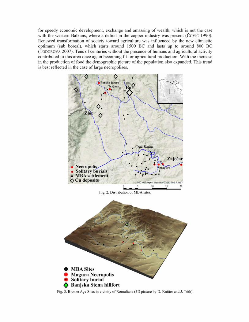
for speedy economic development, exchange and amassing of wealth, which is not the case with the western Balkans, where a deficit in the copper industry was present (ČOVIĆ 1990). Renewed transformation of society toward agriculture was influenced by the new climactic optimum (sub boreal), which starts around 1500 BC and lasts up to around 800 BC (TODOROVA 2007). Tens of centuries without the presence of humans and agricultural activity contributed to this area once again becoming fit for agricultural production. With the increase in the production of food the demographic picture of the population also expanded. This trend is best reflected in the case of large necropolises.
Fig. 2. Distribution of MBA sites.
Fig. 3. Bronze Age Sites in vicinity of Romuliana (3D picture by D. Knitter and J. Tóth).

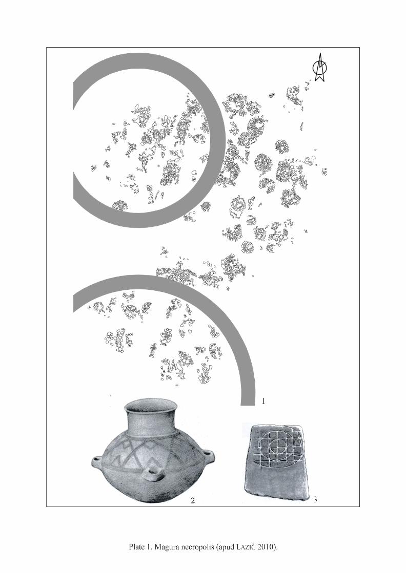
In the middle of the course of the Crni Timok River, on its right bank, the amphitheatric shaped valley of Draganov potok stands surrounded by hills, at the confluence of the left tributary of the Crni Timok River. This area is far better known as the Roman Emperor’s Memorial Complex with a palace dating back to the period of the tetrarchs, having been erected by the Roman emperor Galerius. Recent identification work established that this valley was very densely populated during the Bronze Age as well (around 40 settlements) (Fig. 3), as well as during the late Iron Age (around 10 settlements), including the area where the Emperor’s Palace itself is located. The main necropolis is located on the Magura hill which divides the Zaječar valley of the lower course of the Crni Timok river from the valley of the middle course of the Crni Timok river, and which has a very favourable strategic position, as confirmed by the erection of the Emperor’s Memorial Complex in the 4th century AD, which in spite of its monumental architecture did not destroy the prehistoric necropolis. At present this is the largest Bronze Age necropolis in eastern Serbia, and had probably endured for some time as a “holy place”, together with one of its annexes, located a little further north (which had been completely destroyed with the erection of the Roman Tetrapylon) (Pl. 1/1). The layout of circular burial structures indicates that there is little divergence in terms of burial method, although the greater number of urns in one structure could indicate family burial (ЛАЗИЋ 1998a, 152). The outer circular ring of these flat graves is constructed with large pieces of sandstone, while the inner area is tiled with light grey shale (ЛАЗИЋ 1998b, 111) (Fig. 4). Interestingly a very small number of metal gifts were discovered in the urns, 2 needles and one spearhead, although artistic potential is most pronounced in the abstract geometric motives on the stone lids of the urns. The stylistic-typological characteristics of the ornamentation and the shape of the urns (Pl. 1/2) indicate significant influence of the Verbicioara culture (СРЕЈОВИЋ–ЛАЗИЋ 1997, fig. 29–34). The prominent, strategic position allows this necropolis to be seen from nearly all parts of the Draganov potok valley, i.e. from all the surrounding settlements (Fig. 3). A Bronze Age settlement was discovered around 100 m to the south, but because of the very thick oak forest surrounding the necropolis, excavation did not extent beyond the exterior edge of the stone structures. We can assume that along with the necropolis on the plateau part of the hill a smaller settlement stood once. Such organisation of spatial expansion of the population points to a great influence of the cult of the dead and of belonging to the community in Middle Bronze Age culture. The custom of burying the dead near households is observed in one more instance, with the discovery of separate graves inside the Roman Emperor’s Palace Romuliana, near structure E (Fig. 5), followed by the example of the solitary grave in the village of Zvezdan at the foot of the eastern side of Magura, and that of the grave at Pišura česma in Zaječar, where Crni Timok and Beli Timok join (СРЕЈОВИЋ–ЛАЗИЋ 1997, 227–229). As demonstrated with the example of Magura, these isolated burial finds were not destroyed by subsequent construction in the Roman Period, as they were also worshiped at that time as sacred places.
Fig. 4. Grave construction from Magura Necropolis (with permission of M. Živić).

That is why we can be certain that these are solitary graves that were located in the immediate vicinity of prehistoric settlements (Fig. 3), that have been observed nearly in the entire area of Romuliana and the village of Zvezdan (СРЕЈОВИЋ 1983; КАПУРАН 2007). The necropolis at Trnjani is located on the edge of a Bronze Age settlement that stood on the northern slopes of the very wide Džanovo polje (field) which is of karst origin, south-east of Bor (Fig. 2). The slight slope on the top of the hill on which the settlement stood was shaped like an amphitheatre, flanked by two cone shaped cliff elevations, looking onto the Brestovačka River. The necropolis was erected along the southern area of the settlement that, judging by the finds from the houses (Pl. 2/1), engaged in metallurgy (JOVANOVIĆ–JANKOVIĆ 1990; 1996). The burial ritual is identical with the ritual at Magura, the urns are buried inside the circular stone structures and are organised into family tombs (JOVANOVIĆ 1999, 69), although the ceramic forms indicate a strong influence of the Paraćin culture (Pl. 2/2–4). By contrast with the middle and southern Morava basin and the Serbian part of the Danube basin, it is only on the territory of eastern Serbia that burial rituals required for urns to be surrounded by circular stone structures during the Middle and the Late Bronze Age. There are indications that the structure could have been covered by soil in the form of a burial mound, giving a different appearance to the surrounding landscape. At this necropolis 41 graves were discovered, as well as phases of horizontal stratigraphy of expansion of the necropolis. Here as well burial offerings are scarce, for only a single bronze razor (grave 28) had been discovered in one of the urns and pieces of slag. According to preliminary results of analysis of burnt bones, it could be concluded that children were buried on the rim, while older individuals were buried in the central section of the necropolis (JOVANOVIĆ–JANKOVIĆ 1990, 8–9). Another Middle Bronze Age settlement stood contemporaneously on the other side of Brestovačka River, in direct visual contact with Trnjani, with two solitary graves with urns having been discovered in it. The site is called Ogašu Driki (Fig. 2), where the settlement had been organised on an identical slope in the shape of an amphitheatre, with a water source at its foot. Other Middle Bronze Age settlements are oriented more often toward the rim and centre of Džanovo polje and the fertile land located in that area (Fig. 2). High altitude and hill fort settlements were predominantly associated with the vicinity of surface deposits of copper sulphide oar, where in the Roman Period smaller castles were nearly always erected on top of them. Džanovo polje is well supplied with water thanks to the large number of small brooks that flow down from the surrounding hills, and it has pronounced terraces, which is indicative of fluvial deposits. Such conditions contribute to improved irrigation of the land and development of agriculture and cattle-herding, which are practiced up to modern times. It is possible that in the Bronze Age such wide fields could have been used as wintering grounds for herds of cattle, as part of transhumant pastoralism. The large necropolis Borsko jezero is located west of Trnjani. Since the 60s of the last century an artificial lake occupies the area in which the necropolis stood, having been created
Fig. 5. Solitary Grave in Romuliana Palace (with permission of M. Živić).

by the blocking off of a smaller brook that flows into Brestovačka River. Excavations were carried out in two very brief periods of low water levels in 1997 and 20023 (Fig. 2; 6).
Fig. 6. Borsko jezere landscape (by A. Kapuran and M. Kočić).
The necropolis is only visible at times of low water levels, when it emerges from the water in the shape of a small peninsula. The construction of a beach and a large hotel complex in the immediate vicinity of the lakeshore probably destroyed the associated prehistoric settlement (Pl. 3/1). The grave structures were largely devastated by the effects of water level changes (Pl. 3/2), so that many circular stone wreaths have been destroyed, where the urns have also been devastated, with only two graves having retained the remains of the burnt dead. Judging by the topography, the major portion of this necropolis is probably under water. The burial customs are identical with those at Magura and Trnjani, where we can only observe that in the Borsko jezero certain circular structures are of a slightly larger area than structures in previous necropolises (r = 4–5 m). Stylistic and typological characteristics of ceramics in the settlements point to a mixture of influences of the Paraćin, Vatina and Verbicioara cultures, which together represent a symbiosis in the Gamzigrad culture (Pl. 3/3–4). Of course, the ceramic forms of urns (the influence of Paraćin culture at Trnjani and Borsko jezero, and of Verbicioara culture at Magura) still retained strong characteristic ethnicities from which the members of a community originated, given that burial rituals and customs are the slowest and hardest to change.
3 At the end of November 1997 excavation work was carried out by the curator of the Museum of Mining and Metallurgy in Bor, T. Rajkovača, together with a team that numbered S. Đuričić, A. Kapuran and R. Drašković. On that occasion 13 burial structures were excavated. Subsequent excavation work was carried out in the summer of 2002 by the Centre for Archaeological Research of the Faculty of Philosophy in Belgrade and the Museum of Mining and Metallurgy in Bor. The excavation work was led by M. Lazić. Documentation has been graciously made available by the curator of the Museum of Mining and Metallurgy in Bor, I. Jovanović, and I take this opportunity to express my gratitude to him.

Finally we can conclude that the intertwining of the geological heritage (deposits of copper sulphide oar) and pedological characteristics of the soil, climactic changes and socio-economic transformation of the communities of the Middle Bronze Age, during the middle of the second millennium BC, all together contributed to a demographic explosion both on the territory of middle and eastern Europe and on the territory of north-eastern Serbia. The increased density of settlements and their distribution is also noticeable in other regions in Europe, the Central European Alpine region (KENLIN–STÖLLNER 2009, 90; BERTELHEIM 2009, 38), Pannonia (TASIĆ 1984, Taf. LIX/2, 3), Banat (GARAŠANIN 1983; Mao. 14; GUMĂ 1995, fig. 5), central Balkans (STOJIĆ 1998, Carte 1), western Bulgaria (GREGOVA 1995, fig. 1; GRĘBSKA-KULOWA–KULOW 2007, fig. 9; STEFANOVICH–BANKOFF 1998, fig. 2), etc. The climatic optimum after depopulation of eastern Serbia that lasted for several centuries, led to the mutual intertwining of three contemporaneous cultural complexes – the Vatina, Paraćin and Verbicioara cultures – whose territories overlapped around the Crni Timok River (КАПУРАН 2009b, map 1). The decisive role in settlement, as in previous epochs, was played by the proximity of copper oar deposits on the territory north of Borsko jezero and Trnjani (Fig. 2), although the acceptance of new technologies for land cultivation, the metal plough and the use of wagons, with the increasing use of the horse as a domestic harnessing animal (GREENFIELD 2006, Tab. 2), resulted in accelerated settlement and occupation of every square meter of economically viable land suitable for this (MANNING 1997, 152–153). By building large necropolises that dominated the surrounding landscape these communities wanted to emphasize their cultural identity and territorial dominance. That is why we can conclude that clusters of settlements, together with the large necropolises, played an important role in transforming and shaping the prehistoric landscape of the Middle and Late Bronze Age. Judging by the remains of the burnt stratum containing houses on Banjska stena and Trnjani, as the largest excavated settlements, the Gamzigrad culture ceased to exist quite abruptly. Its end can be linked to the sudden increase in the settlements of the Gáva–Belegiš cannelured ceramics culture in the Danube basin and the discovery of four bronze hoards on the territory of the Serbian side of the Djerdap gorge (ТАСИЋ 1997). It is quite indicative that not a single settlement of the representatives of cannelured ceramics culture has been observed south of Djerdap. Such a situation could suggest the swift advance of the Gáva–Belegiš cultural group, which very quickly conquered all cultures that stood in their way, both on the banks of the Danube and on the banks of the middle and southern course of the Morava river valley (БУЛАТОВИЋ 2001; KAPURAN 2009a, 152–153).
References
ARNOLD–GREENFIELD
2006 Arnold, E. R.–Greenfield, H. J., The Origins of Transhumant Pastoralism in Temperate South Eastern Europe: The zooarchaeological Perspective from the Central Balkans, BAR International Series, 1538.
BABOVIĆ 1986 Babović, L., Zbradila, Korbovo, Compte-rendu des Fouilles 1981, Đerdapske Sveske, III, 95–115.
BANKOFF–GRIENFIELD
1984 Bankoff, H. A.–Greenfield, H., Decision-making and culture change in Yugoslav Bronze Age, Balcanica, XV, 7–31.
BERTELHEIM 2009 Bertelheim, M., Elites and Metals in the Central European Early Bronze Age, IN: Kienlin, T. L.–Roberts, B. (eds.), Metals and Societes, Studies in honour of Barbara S. Otaway, UPA, 169, 33–

46. БУЛАТОВИЋ 2001 Булатовић, А., Керамика прелазног периода из бронзаног у
гвоздено доба у јужноморавском сливу, Лесковачки зборник, XLI, 163–178.
ČOVIĆ 1990 Čović, B., Über die struktur der viehzucht im nordwestlichen Balkan während der bronze und eisenzeit, IN: Benac, A. (ed.), Godišnjak, XXVIII, V Poljsko-Jugoslovenski okrugli sto, ANIBiH i Centar za balkanološka ispitivanja, Sarajevo, 65–73.
ГАРАШАНИН 1973 Гарашанин, М., Праисторија на тлу Србије, Српска књижевна задруга, Београд.
GARAŠANIN 1983 Garašanin, M., Vatinska grupa, IN: Benac, A. (ed.), Praistorija Jugoslovenskih zemalja, IV, ANUBiH i Svjetlost, Sarajevo, 504–519.
GERGOVA 1995 Gergova, D., Culture in the Late Bronze and Early Iron Age in southwest Thrace (Upper Mesta and middle Struma Valey), Зборник 1. археологија, Музеј на Македонија, Скопје, 27–48.
GRĘBSKA-KULOWA–KULOW 2007
Grębska-Kulowa, M.–Kulow, I., Prehistorical Sites in the Middle Struma River Valley Between the End of the VIIIth mill. BC and the Beginning of the Ist mill. BC, IN: Todorova, H.–Stefanovich, M.–Ivanov, G. (еds.), Struma/Strymon River Valley in Prehistory. In the Steps of James Harvey Gaul, 2, Sofia, 279–296.
GREENFIELD 2006 Greenfield, J. H., The Social and Economic Context for Domestic Horse Origins in South-Eastern Europe: A View from Ljuljaci in the Central Balkans, IN: Olse, S. L.–Grant, S.–Choyke, A. M.–Bartosiewicz, L. (eds.), Horses and Humans: The Evolution of Human-Equine Relationships, BAR International Series, 1560, Oxford, 221–244.
GUMĂ 1997 Gumă, M. Epoca bronzului în Banat, Timişoara. JANKOVIĆ ET AL. 1980 Janković, I.–Terzic, M.–Aleksic, D.–Karamata, S.–Spasov, T.–
Jovanovic, M.–Milicic, M.–Miskovic, V.–Grubic, A.–Antoniievic, I., Metallogenic features of Copper deposits in the volcano-intrusive complexes of the Bor District, Yugoslavia, IN: Janković, S.–Sillitoe, R. (eds.), European cooper deposits, Proceedings of an International Symposium held at Bor in September 1979, SGA Special Publication I and Department of Economic Geologv, Faculty of Mining and Geology, Belgrade University, Belgrade, 42–49.
JOVANOVIĆ 1971 Jovanović, B., Metalurgija eneolitskog perioda Jugoslavije, Arheološki institut, Beograd.
JOVANOVIĆ 1976 Jovanović, B., Obredi sahranjivanja u Kostolačkoj grupi, Godišnjak, XIII, Centar za balkanološka ispitivanja ANUBiH, Sarajevo, 131–141.
JOVANOVIĆ 1999 Jovanović, B., Funerary Rites and Tomb Constructions in Necropoles of Paraćin and Donja Brnjica Cultures, IN: Macedonia and the Neighbouring Regions from 3rd to 1st millennium B.C., Museum of Macedonia, Skopje, 67–72.
JOVANOVIĆ–JANKOVIĆ
1990 Jovanović, B.–Janković, N., Nekropola paraćinske grupe u Trnjanima kod Brestovačke banje, Zbornik radova muzeja rudarstva i metalurgije u Boru, 5/6, Bor, 1987–1990, 1–20.
JOVANOVIĆ–JANKOVIĆ Jovanović,–B. Janković, N., Die keramik der nekropole der

1996 Paraćin-Kultur-Trnjane bei Bor, IN: Tasić, N. (ed.), The Yugoslav Danube basin and the neighbouring regions in the 2nd Millenium B.C., SANU and Institute for Balkan studies, Beograd, 185–200.
КАПУРАН 2007 Капуран, А., Прилог раисторијској стратиграфији Феликс Ромулијане у светлу нових налаза, Гласник Српског археолошког друштва, 23, Српско археолошко друштво, Београд, 245–264.
KAPURAN 2009a Kapuran, A., Late Bronze and Early Iron Age architecture in the Južna Morava Basin, Centre for Archeological Research Faculty of Philosophy, 23, Belgrade.
КАПУРАН 2009b Капуран, А., О утицајима Ватина и Вербичоаре на налазима гамзиградске културне групе, Старинар, LIX, Археолошки институт, Београд, 53–69.
КАПУРАН–ШКУНДРИЋ
2009 Капуран, А.–Шкундрић, Ј., Резултати систематског рекогносцирања локалитета Ромулијана 2008/9, Саопштења XLI, Републички завод за заштиту споменика културе Србије, Београд: 245–263.
КАПУРАН ET AL. 2007 Капуран, A.–Борић, Д.–Јевтић, М. Налази керамике из енеолита и гвозденог доба у две новооткривене пећине на територији Ђердапа, Гласник Српског Археолошког Друштва, 23, Српско археолошко друштво, Београд, 103–124.
КАПУРАН ET AL. 2011 Капуран, А.–Булатовић, С.–Јовановић, И., Неолитизација Тимочке краијине и њена улога у раном неолиту централног Балкана, Старинар, LX, Археолошки институт, Београд, in print.
KEINLIN–STÖLLNER
2009 Keinlin, L. T.–Stöllner, T., Singen Copper, Alpine Settlement and Early Bronze Age Mining: Is there Need for Elites and Strongholds? IN: Kienlin T. L.–Roberts B. (eds.), Metals and Societes, Studies In honour of Barbara S. Otaway, UPA, 169, 67–104.
ЛАЗИЋ 1998a Лазић, М., Гамзиградска култура-последње откриће Драгослава Срејовића, IN: Тасић, Н. (ed.), Рад Драгослава Срејовића на истраживању праисторије Балкана, Центар за научна истраживања САНУ, Крагујевац, 147–158.
ЛАЗИЋ 1998b ЛАЗИЋ 2010 Лазић, М., Праисторијска насеља и некрополе у Гамзиграду и
његовој околини, IN: Поповић, И. (ed.), Феликс Ромулијана-Гамзиград, Археолошки институт, Београд, 21–27.
ЛАЗИЋ ET AL. 2002 Лазић, М.–Сладић, М.–Пековић, М., Резултати археолошког рекогносцирања територије обухваћене просторним планом археолошког налазишта Ромулијана–Гамзиград, Развитак, 2007–2008, година, XLII, Зајечар, 64–67.
ЛETИЦA 1981 MANNING 1997 Manning, S. W., Cultural Change in Aegean c. 2200 BC, IN:
Dalfes, H. N.–Kukla, G.–Weiss, H. (eds.), Third Millennium BC Climate Change and Old World Collapse, NATO ASI Series, Global Environmental Change, Vol. 49, Springer, Overjise, 147–171.
NIKOLIĆ 2000 Nikolić, D., Kostolačka kultura na teritoriji Srbije, Centar za arheološka istraživanja Filozofskog fakulteta, Beograd.

SIMIĆ 1969 Simić, V., Istorijski osvrt na rudarstvo bakarnog rudišta u Boru i okolini, Zbornik radova, Rudarsko-metalurški fakultet i Institut za bakar u Boru, VIII, Bor.
СРЕЈОВИЋ 1981 Срејовић, Д., Историја српског народа. Српска књижевна задруга, Београд.
СРЕЈОВИЋ 1983 Срејовић, Д., Гамзиград у праисторији, IN: Ћелић, С. (ed.), Каталог иѕложбе Галерије САНУ, САНУ, Београд, 17–21.
СРЕЈОВИЋ–ЛАЗИЋ 1997 Срејовић, Д.–Лазић, М., Насеља и некрополе бронзаног доба у Тимочкој крајини, IN: Лазић, М. (еd.), Археологија Источне Србије, Центар за археолошка истраживања Филозофског факултета, Београд, 225–244.
STEFANOVICH–BANKOFF
1998 Stefanovich, M.–Bankoff, A., Kamenska Čuka, IN: Stefanovich, M. (ed.), James Harvey Gaul in memoriam, The James Harvey Gaul Foundation, Sofija, 255–348.
STOJIĆ 1998 Stojić, М., Lieux de trouvaille de la céramique de type Vatin en Serbie au sud de la Save et du Danube, IN: Die kulturen der bronzezeit in dem Gebiet des Eisernen Tores, Rumänisch-Jugoslawische Kommission für die Erforschung der Region des Eisernen Tores, Bukarest, 81–114.
TASIĆ 1969 TASIĆ 1971 Тasić, N., Osnovni rezultati istraživanja u Zlotskoj pećini i
nalazišta na Đerdapu, IN: Tasić, N. (ed.), Matеrijali, VI, Arheološko društvo Jugoslavije, Beograd, 71–80.
TASIĆ 1979 Тasić, N., Coţofeni (Kocofeni) kultura, IN: Benac, A. (ed.), Praistorija jugoslavenskih zemalja III – eneolitsko doba, Svjetlost, Sarajevo, 115–128.
TASIĆ 1984 Тasić, N., Kulturen der frühbronzenzeit das Karpatenbeckens und Nordbalkans, Balkanološki institut SANU, Beograd.
TASIĆ 1995 Тasić, N., Eneolithic cultures of Central and West Balkans, Draganić, Beograd.
ТАСИЋ 1997 Тасић, Н., Енеолит и бронзано доба источне Србије. IN: Лазић, М. (ed.), Археологија Источне Србије, Центар за археолошка истраживања Филозофског факултета, Београд, 79–90.
ТАСИЋ 1998a ТАСИЋ 2004 Тасић, Н., Налазишта и културе из енеолитског периода, Бор
и околина у праисторији антици и средњем веку, IN: Лазић, М. (ed.), Музеј рударства и металургије у Бору и Центар за археолошка истраживања Филозофског факултета у Београду, Бор–Београд, 57–100.
TODOROVA 2007 Todorova, H., Die paleoklimatische Entwicklung in VII–I Jt. Vor Chr., IN: Todorova, H.–Stefanovich, M.–Ivanov, G. (еd.), Struma/Strymon RiverValley in Prehistory, In the Steps of James Harvey Gaul, 2, Sofia, 19–26.
TODOROVIĆ 2007 TRINGHAM 1971 Tringham, R., Hunters, Fishers and Farmers of Eastern Europe
6000–3000 B.C., Hutchinson University Library, London.

List of figures
Fig. 1. Early Neolithic Settlements. Fig. 2. Distribution of MBA sites. Fig. 3. Bronze Age Sites in vicinity of Romuliana (3D picture by D. Knitter and J. Tóth). Fig. 4. Grave construction from Magura Necropolis (with permission of M. Živić). Fig. 5. Solitary Grave in Romuliana Palace (with permission of M. Živić). Fig. 6. Borsko jezere landscape (by A. Kapuran and M. Kočić).
List of plates
Pl. 1. Magura necropolis (apud LAZIĆ 2010). Pl. 2. Trnjane necropolis (apud JOVANOVIĆ 1996). Pl. 3. Borsko jezero necropolis.


Copyright © 2022 FDOKUMEN