Record of Decision for Nomans Land Island
190
RECORD OF DECISION FOR NOMANS LAND ISLAND CHILMARK, MASSACHUSETTS NAVAL AIR STATION SOUTH WEYMOUTH WEYMOUTH, MASSACHUSETTS NAVFAC and BRAC PMO EAST U.S. NAVY JANUARY 2022
-
Upload
khangminh22 -
Category
Documents
-
view
0 -
download
0
Transcript of Record of Decision for Nomans Land Island
RECORD OF DECISION FOR
NOMANS LAND ISLAND
CHILMARK, MASSACHUSETTS
NAVAL AIR STATION SOUTH WEYMOUTH WEYMOUTH, MASSACHUSETTS
NAVFAC and BRAC PMO EAST U.S. NAVY
JANUARY 2022
This page intentionally left blank.
Record of Decision Final Nomans Land Island, Chilmark, MA January 2022
4659-WE05-22-0003 i
TABLE OF CONTENTS
1.0 DECLARATION............................................................................................................... 1 1.1 Site Name and Location .......................................................................................... 1 1.2 Statement of Basis and Purpose .............................................................................. 1 1.3 Assessment of Site .................................................................................................. 1 1.4 Description of Selected Remedy ............................................................................. 1 1.5 Statutory Determinations ........................................................................................ 2 1.6 ROD Data Certification Checklist .......................................................................... 3 1.7 Authorizing Signatures and Support Agency Acceptance of Remedy ................... 4
2.0 DECISION SUMMARY .................................................................................................. 4 2.1 Site Name, Location, and Brief Description ........................................................... 4 2.2 Site History and Enforcement Activities ................................................................ 5 2.3 Community Participation ........................................................................................ 9 2.4 Scope and Role of Operable Unit or Response Action ........................................... 9 2.5 Site Characteristics ................................................................................................ 10
2.5.1 Physical Characteristics ............................................................................. 10 2.5.2 Conceptual Site Model .............................................................................. 11 2.5.3 Nature and Extent of UXO ........................................................................ 11
2.6 Current and Potential Future Site and Resource Uses .......................................... 12 2.7 Summary of Site Risks.......................................................................................... 12
2.7.1 Risk to Human Health ............................................................................... 12 2.7.2 Risk to Public Welfare .............................................................................. 13 2.7.3 Risk to the Environment ............................................................................ 13 2.7.4 Risk of Harm to Public Safety ................................................................... 15
2.8 Remedial Action Objectives ................................................................................. 16 2.9 Description of Alternatives ................................................................................... 17
2.9.1 Alternative S-1 .......................................................................................... 17 2.9.2 Alternative S-2 .......................................................................................... 18 2.9.3 Alternative S-3 .......................................................................................... 19
2.10 Comparative Analysis of Alternatives .................................................................. 20 2.10.1 CERCLA Threshold Criteria ................................................................... 20 2.10.2 CERCLA Primary Balancing Criteria ..................................................... 20 2.10.3 CERCLA Modifying Criteria .................................................................. 23 2.10.4 Additional MCP-Specific Criteria ........................................................... 23 2.10.5 Additional Navy-Specific Criteria .......................................................... 26
2.11 Principal Threat Waste .......................................................................................... 27 2.12 Selected Remedy ................................................................................................... 27
2.12.1 Summary of the Rationale for the Selected Remedy .............................. 27 2.12.2 Description of the Selected Remedy ....................................................... 27 2.12.3 Summary of the Estimated Remedial Costs ............................................ 31 2.12.4 Expected Outcomes of Selected Remedy ................................................ 32
2.13 Statutory Determinations ...................................................................................... 32 2.13.1 Protection of Human Health and the Environment ................................. 32 2.13.2 Compliance with ARARs ........................................................................ 32
Record of Decision Final Nomans Land Island, Chilmark, MA January 2022
4659-WE05-22-0003 ii
2.13.3 Cost Effectiveness ................................................................................... 32 2.13.4 Utilization of Permanent Solutions and Alternative Treatment Technologies or Resource Recovery Technologies to the Maximum Extent Practicable ............................................................................................................. 33 2.13.5 Preference for Treatment as a Principal Element .................................... 33 2.13.6 5-Year Review Requirement ................................................................... 33
2.14 Documentation of Significant Changes ................................................................ 33
3.0 RESPONSIVENESS SUMMARY ................................................................................. 34 3.1 Stakeholder Comments and Lead Agency Responses .......................................... 34 3.2 Technical and Legal Issues ................................................................................... 34
4.0 REFERENCES ................................................................................................................ 34
LIST OF FIGURES
Figure 1-1 Site Location Map Figure 2-1 Conceptual Site Model for the Safety Risk Characterization for Nomans Land
Island Figure 2-2 Refined Conceptual Site Model for the Stage II Environmental Risk
Characterization for Nomans Land Island Figure 2-3 Land Use Control Area Boundary Map (Includes Water Site Restrictions) Figure 2-4 Marine Restricted Areas in the Vicinity of Nomans Land Island
LIST OF TABLES
Table 1-1 ROD Data Certification Checklist Table 2-1 Environmental Investigations and Documentation Table 2-2 Summary of Ordnance Debris Collected from the Island (1998 Ordnance Debris
Clearance RAM) Table 2-3 SEBS Review Item/Additional Areas Summary Table 2-4 Alternative S-1 � Completion Timeline Table 2-5 Alternative S-2 � Completion Timeline Table 2-6 Evaluation Criteria for Remedial Alternatives Table 2-7 Risk to Safety � Remedial Action Alternatives Summary of CERCLA/MCP/Navy
Criteria Evaluation
LIST OF APPENDICES
Appendix A MassDEP Concurrence Letter Appendix B Proposed Remedial Action Plan and Public Notice Appendix C Ecological Risk Assessment Summary Tables Appendix D Cost Estimate Appendix E ARARs Appendix F USFWS UXO Awareness Pamphlet Appendix G Transcript of the Public Hearing on the Proposed Remedial Action Plan and
Reponses to Public Comments
Record of Decision Final Nomans Land Island, Chilmark, MA January 2022
iii 4659-WE05-22-0003
ACRONYMS
ARAR applicable or relevant and appropriate requirement BAF bioaccumulation factor BIP blow-in-place BRAC Base Realignment and Closure CERCLA Comprehensive Environmental, Response, Compensation, and
Liability Act CFR Code of Federal Regulations CMR Code of Massachusetts Regulations COC chemicals of concern COPC chemicals of potential concern CSA Comprehensive Site Assessment CSM Conceptual Site Model DDESB United States Department of Defense Explosive Safety Board DoD United States Department of Defense DOI United States Department of the Interior EBS Environmental Baseline Survey EBST Environmental Baseline Survey for Transfer EOD Explosive Ordnance Disposal ERC environmental risk characterizations FDA Former Debris Area FS Feasibility Study HHRA Human Health Risk Assessment LUC land use control LUCIP Land Use Control Implementation Plan MassDEP Massachusetts Department of Environmental Protection MCP Massachusetts Contingency Plan MDAS material documented as safe MEC munitions and explosives of concern NAUL Notice of Activity Use Limitation Navy United States Department of the Navy NCP National Oil and Hazardous Substances Pollution Contingency Plan NOAA National Oceanic and Atmospheric Administration NPL National Priorities List OB/OD open burning/open detonation OHM oil and/or hazardous material O&M Operation and Maintenance QA/QC quality assurance/quality control RAM release abatement measure RAO remedial action objectives ROD Record of Decision ROM rough order of magnitude SEBS Supplemental Environmental Baseline Survey TBC to be considered U.S. United States
Record of Decision Final Nomans Land Island, Chilmark, MA January 2022
iv 4659-WE05-22-0003
USCG United States Coast Guard USEPA United States Environmental Protection Agency USFWS United States Fish and Wildlife Service UXO unexploded ordnance VOC volatile organic compound
Record of Decision Final Nomans Land Island, Chilmark, MA January 2022
1 4659-WE05-22-0003
1.0 DECLARATION
1.1 Site Name and Location
Nomans Land Island Chilmark, Massachusetts Massachusetts Department of Environmental Protection (MassDEP) Release Tracking Number 4-13390
1.2 Statement of Basis and Purpose
This Record of Decision (ROD) presents the Selected Remedy for Nomans Land Island, Chilmark, Massachusetts (referred to as �the Site�) (see Figure 1-1; all figures are provided at the end of the text). The Selected Remedy was chosen in accordance with the Comprehensive Environmental Response, Compensation, and Liability Act (CERCLA), as codified in 42 United States (U.S.) Code § 9601 et seq., and amended by the Superfund Amendments and Reauthorization Act, and, to the extent practicable, the National Oil and Hazardous Substances Pollution Contingency Plan (NCP), codified in 40 Code of Federal Regulations (CFR) 300 et seq., as amended. The regulatory program that includes these combined laws and regulations is commonly referred to as �Superfund�. The Selected Remedy was also chosen in accordance with the Massachusetts Contingency Plan (MCP), as the Site is overseen by MassDEP as the agency for regulatory approval, and in accordance with the 2010 Navy Guidance for Optimizing Remedy Evaluation, Selections, and Design as the U.S. Department of the Navy (Navy) is the lead agency for remediation of the Site (Navy 2010).
This decision is based on information contained in the Administrative Record for the Site, copies of which are available for review at the Information Repositories maintained at Aquinnah Town Hall, Chilmark Town Hall, and the Wampanoag Tribe of Gay Head (Aquinnah), all located on Martha Vineyard Island, Massachusetts. The Navy, U.S. Fish and Wildlife Service (USFWS), and MassDEP concur with the Selected Remedy for Nomans Land Island (see Appendix A for the MassDEP concurrence letter). Since Nomans Land Island is not on the National Priorities List (NPL) and is a non-Superfund-financed state-lead enforcement site, U.S. Environmental Protection Agency (USEPA) concurrence is not required.
1.3 Assessment of Site
The remedy selected in this ROD is necessary to protect public health from actual or threatened exposure to surface and subsurface explosives hazards presented by potential munitions on land and in the nearshore marine environment of Nomans Land Island that may present an imminent and substantial endangerment to public welfare.
1.4 Description of Selected Remedy
Nomans Land Island is presently used as an unstaffed wildlife refuge by the USFWS and will continue as such under the transfer agreement between Navy and USFWS. The Selected Remedy, which includes an institutional controls/public awareness and enforcement component, addresses

Record of Decision Final Nomans Land Island, Chilmark, MA January 2022
2 4659-WE05-22-0003
the risk of harm to public safety from explosives hazards related to unexploded ordnance (UXO)in the soil on the island and in the nearshore marine environment near the shoreline. The Selected Remedy for the Nomans Land Island, known as Alternative S-2, will limit access to the Site and risk of harm to public safety using the following institutional controls, public awareness training, and enforcement components:
Selected Remedy for the Terrestrial Portion of the Island
Institutional Controls - Upland Signage Replacement/Maintenance - Beach Signage - Operation and Maintenance (O&M) Plan - Navy O&M (e.g., Limited Munitions and Explosives of Concern [MEC] Surface
Clearances, UXO Response) - UXO Response Program - Land Use Controls (LUCs)
Public Awareness � Restriction and Dangers - USFWS/Public UXO Awareness Training - UXO Awareness Pamphlet
Enforcement - USFWS Violations/Fine System
Selected Remedy for the Nearshore Marine Environment
Institutional Controls - Restricted Waters Designation - Upland Signage - Beach Signage - Annual Verification
Public Awareness � Restriction and Dangers - USFWS/Public UXO Awareness Training - UXO Awareness Pamphlet
Enforcement - U.S. Coast Guard (USCG)/Massachusetts Environmental Police Coastal Bureau
1.5 Statutory Determinations
The Selected Remedy is protective of human health, complies with federal and state requirements that are applicable or relevant and appropriate to the remedial action, is cost effective, and utilizes permanent solutions and alternative treatment (or resource recovery) technologies to the maximum extent practicable.
Record of Decision Final Nomans Land Island, Chilmark, MA January 2022
3 4659-WE05-22-0003
The Selected Remedy for the Site does not satisfy the statutory preference for treatment as a principal element of the remedy because the Site risk is a risk of harm to public safety due to the presence of UXO in soil and in sediment within the nearshore marine portion of the Site. Complete removal and neutralization of the UXO in the terrestrial and in the nearshore marine environment was deemed impracticable because it would result in damage to habitat and loss of wildlife, if implemented.
Because this Selected Remedy will result in hazardous substances, pollutants, or contaminants in the form of UXO remaining on site above levels that allow for unlimited use and unrestricted exposure, a statutory review will be conducted within 5 years after initiation of remedial action to ensure that the Selected Remedy remains protective.
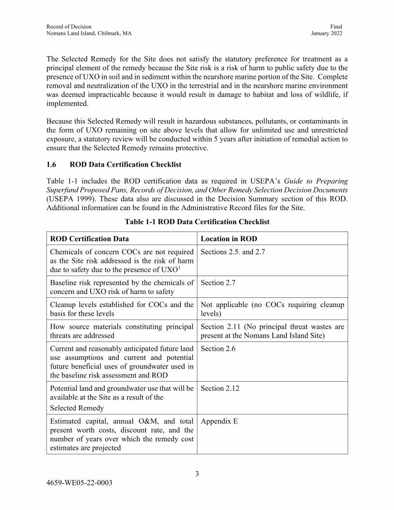
1.6 ROD Data Certification Checklist
Table 1-1 includes the ROD certification data as required in USEPA�s Guide to Preparing Superfund Proposed Pans, Records of Decision, and Other Remedy Selection Decision Documents(USEPA 1999). These data also are discussed in the Decision Summary section of this ROD. Additional information can be found in the Administrative Record files for the Site.
Table 1-1 ROD Data Certification Checklist
ROD Certification Data Location in ROD
Chemicals of concern COCs are not required as the Site risk addressed is the risk of harm due to safety due to the presence of UXO1
Sections 2.5. and 2.7
Baseline risk represented by the chemicals of concern and UXO risk of harm to safety
Section 2.7
Cleanup levels established for COCs and the basis for these levels
Not applicable (no COCs requiring cleanup levels)
How source materials constituting principal threats are addressed
Section 2.11 (No principal threat wastes are present at the Nomans Land Island Site)
Current and reasonably anticipated future land use assumptions and current and potential future beneficial uses of groundwater used in the baseline risk assessment and ROD
Section 2.6
Potential land and groundwater use that will be available at the Site as a result of the
Selected Remedy
Section 2.12
Estimated capital, annual O&M, and total present worth costs, discount rate, and the number of years over which the remedy cost estimates are projected
Appendix E
Record of Decision Final Nomans Land Island, Chilmark, MA January 2022
4 4659-WE05-22-0003
ROD Certification Data Location in ROD
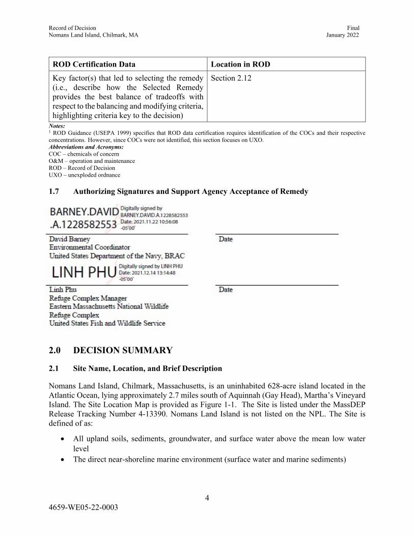
Key factor(s) that led to selecting the remedy (i.e., describe how the Selected Remedy provides the best balance of tradeoffs with respect to the balancing and modifying criteria, highlighting criteria key to the decision)
Section 2.12
Notes: 1 ROD Guidance (USEPA 1999) specifies that ROD data certification requires identification of the COCs and their respective concentrations. However, since COCs were not identified, this section focuses on UXO. Abbreviations and Acronyms: COC � chemicals of concern O&M � operation and maintenance ROD � Record of Decision UXO � unexploded ordnance
1.7 Authorizing Signatures and Support Agency Acceptance of Remedy
2.0 DECISION SUMMARY
2.1 Site Name, Location, and Brief Description
Nomans Land Island, Chilmark, Massachusetts, is an uninhabited 628-acre island located in the Atlantic Ocean, lying approximately 2.7 miles south of Aquinnah (Gay Head), Martha�s Vineyard Island. The Site Location Map is provided as Figure 1-1. The Site is listed under the MassDEP Release Tracking Number 4-13390. Nomans Land Island is not listed on the NPL. The Site is defined of as:
All upland soils, sediments, groundwater, and surface water above the mean low waterlevel
The direct near-shoreline marine environment (surface water and marine sediments)
Record of Decision Final Nomans Land Island, Chilmark, MA January 2022
5 4659-WE05-22-0003
The Navy and the U.S. Department of the Interior (DOI) entered into a Joint Wildlife Management Agreement for Nomans Land Island in 1970, designating the entire island as a National Wildlife Refuge in recognition of known wildlife nesting habitats. The island was transferred in June 1998 (Navy 1998a) from the U.S. Department of Defense (DoD) to the USFWS for the intended use as an unstaffed wildlife refuge (as part of the Eastern Massachusetts National Wildlife Refuge Complex). As part of the transfer agreement, the USFWS is the current owner and operator of the island, and all environmental remediation and MCP work has been and will continue to be conducted and financed by the Navy, the potential responsible party. The Navy is the lead agency for remediation, MassDEP is the approving agency, and USFWS is the supporting agency for Site cleanup.
2.2 Site History and Enforcement Activities
Site activities that led to environmental investigations to address the risk of harm to safety were related to the use of the island by the Navy for air-to-surface bombing and gunnery target exercises, that took place on the island from 1943 through 1996. This activity resulted in the dropping or firing of ordnance onto and into the island which may remain in an unexploded state. Prior to 1943, the island was utilized for various purposes, including fishing and game hunting, and, at one time, a small population of people occupied a portion of the island. No civilians have lived on the island since 1943. The water surrounding the island is a Restricted Waterway, as marked on nautical maps depicting the island and vicinity.
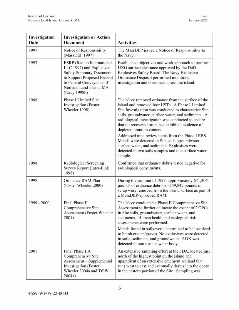
Table 2-1 provides a brief summary of previous investigations and munitions removal actions that have taken place at Nomans Land Island. Results of these activities indicate that the Site poses a �Risk of Harm to Safety� (as described in 310 Code of Massachusetts Regulations [CMR] 40.0900) due to the presence of UXO on site.
Table 2-1 Environmental Investigations and Documentation
Investigation Date
Investigation or Action Document Activities
1986 Environment impact review The Navy began evaluating environmental impacts at NAS South Weymouth, including conducting Site walkovers, reviews of Base records, and interviews.
1995-1996 Final Report, Phase I Environmental Baseline Survey Stone & Webster 1996)
The Navy performed a Phase I EBS to identify potentially contaminated sites requiring further investigation. Nomans Land Island was one of the sites identified for further study.
1995-1998 EBST for Nomans Land Island (including Responsiveness Summary) (NAVFAC 1998)
This report for the island was developed in support of the Environmental Summary Document for transfer of federal property from one agency to another. The EBST is based on the 1996 EBS - Phase I Report and presents updated information where applicable to reflect additional data and actions concerning conditions at the Site through 1998.
Record of Decision Final Nomans Land Island, Chilmark, MA January 2022
6 4659-WE05-22-0003
Investigation Date
Investigation or Action Document Activities
1997 Notice of Responsibility (MassDEP 1997)
The MassDEP issued a Notice of Responsibility to the Navy.
1997 ESRP (Radian International LLC 1997) and Explosives Safety Summary Document to Support Proposed Federal to Federal Conveyance of Nomans Land Island, MA (Navy 1998b)
Established objectives and work approach to perform UXO surface clearance approved by the DoD Explosives Safety Board. The Navy Explosive Ordinance Disposal performed munitions investigation and clearance across the island.
1998 Phase I Limited Site Investigation (Foster Wheeler 1998)
The Navy removed ordnance from the surface of the island and removed four USTs. A Phase I Limited Site Investigation was conducted to characterize Site soils, groundwater, surface water, and sediments. A radiological investigation was conducted to ensure that no recovered ordnance exhibited evidence of depleted uranium content.
Addressed nine review items from the Phase I EBS. Metals were detected in Site soils, groundwater, surface water, and sediment. Explosives were detected in two soils samples and one surface water sample.
1998 Radiological Screening Survey Report (Inter-Link 1998)
Confirmed that ordnance debris tested negative for radiological constituents.
1998 Ordnance RAM Plan (Foster Wheeler 2000)
During the summer of 1998, approximately 671,306 pounds of ordnance debris and 59,847 pounds of scrap were removed from the island surface as part of a MassDEP-approved RAM.
1999 - 2000 Final Phase II Comprehensive Site Assessment (Foster Wheeler 2001)
The Navy conducted a Phase II Comprehensive Site Assessment to further delineate the extent of COPCs in Site soils, groundwater, surface water, and sediments. Human health and ecological risk assessments were performed.
Metals found in soils were determined to be localized to bomb craters/graves. No explosives were detected in soils, sediment, and groundwater. RDX was detected in one surface water body.
2001 Final Phase IIA Comprehensive Site Assessment � Supplemental Investigation (Foster Wheeler 2004a and TtFW 2004a)
An extensive sampling effort at the FDA, located just north of the highest point on the island and upgradient of an extensive emergent wetland that runs west to east and eventually drains into the ocean in the eastern portion of the Site. Sampling was
Record of Decision Final Nomans Land Island, Chilmark, MA January 2022
7 4659-WE05-22-0003
Investigation Date
Investigation or Action Document Activities
conducted to further characterize the FDA and to determine the health of the FDA wetland.
Elevated levels of metals were detected on the island in the FDA. FDA wetland sediments were found to exceed multiple benthic community endpoints. A potential pathway from Site soils to marine environment was identified.
2001 Final Supplemental Environmental Baseline Survey (Foster Wheeler 2003 and 2004b)
The Navy conducted the SEBS, which incorporated and evaluated the airborne geophysical survey data, and included an aerial photographic site analysis, and further public interviews and historical records reviews. The aerial photogrammetric survey established an accurate basemap for the Site. The airborne geophysical survey identified areas containing subsurface metal debris and confirmed the CSM and biased investigation approach.
2003 Final Release Abatement Measure Completion Report (Ordnance Debris Removal) (TtFW 2004b)
The SEBS resulted in the removal and/or closure of 19 additional review items, including one 275-gallon UST, one septic system, and two dry wells. The Navy also conducted a UXO inspection and performed removal activities in accessible upland and near-shoreline marine areas, and remediated 19 cubic yards of contaminated soil.
2004 Final Phase IIB � Supplemental Investigation - Risk to Safety (TtFW 2006)
(EFANW and EFANE 2004)
A Phase IIB Report, focused on the risk of harm to safety on the island due to remaining ordnance, was presented to the Technical Review Committee and submitted to the MassDEP. A UXO Awareness Pamphlet was developed to educate USFWS workers conducting studies on the island.
2005 Final Environmental Risk Management Memorandum (TtEC 2006a)
Per a request from USFWS, the Navy prepared an Environmental Risk Characterization Memorandum to more clearly characterize the risk to the environment on the island. Results revealed that a level of �no significant risk� to the environment associated with chemical contamination was achieved for Site soils. Removal of metal debris from the FDA was recommended.
2006 Final RAM Completion Report (FDA) (TtEC 2006b)
The Navy implemented the FDA RAM, which involved removal of the old Quonset Hut material, believed to be a source contributing to adverse impacts in the downgradient wetland. A total of 1.5 tons of metal debris was removed. Performed field soil screening at Aviation Landing Strip areas.
Record of Decision Final Nomans Land Island, Chilmark, MA January 2022
8 4659-WE05-22-0003
Investigation Date
Investigation or Action Document Activities
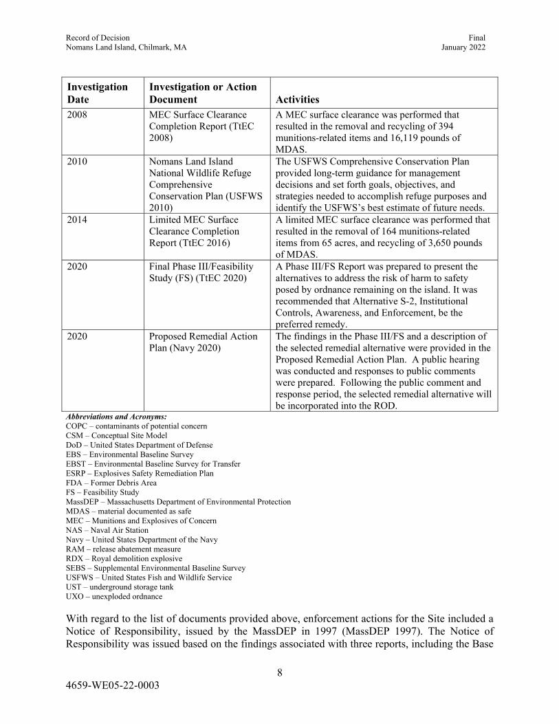
2008 MEC Surface Clearance Completion Report (TtEC 2008)
A MEC surface clearance was performed that resulted in the removal and recycling of 394 munitions-related items and 16,119 pounds of MDAS.
2010 Nomans Land Island National Wildlife Refuge Comprehensive Conservation Plan (USFWS 2010)
The USFWS Comprehensive Conservation Plan provided long-term guidance for management decisions and set forth goals, objectives, and strategies needed to accomplish refuge purposes and identify the USFWS�s best estimate of future needs.
2014 Limited MEC Surface Clearance Completion Report (TtEC 2016)
A limited MEC surface clearance was performed that resulted in the removal of 164 munitions-related items from 65 acres, and recycling of 3,650 pounds of MDAS.
2020 Final Phase III/Feasibility Study (FS) (TtEC 2020)
A Phase III/FS Report was prepared to present the alternatives to address the risk of harm to safety posed by ordnance remaining on the island. It was recommended that Alternative S-2, Institutional Controls, Awareness, and Enforcement, be the preferred remedy.
2020 Proposed Remedial Action Plan (Navy 2020)
The findings in the Phase III/FS and a description of the selected remedial alternative were provided in the Proposed Remedial Action Plan. A public hearing was conducted and responses to public comments were prepared. Following the public comment and response period, the selected remedial alternative will be incorporated into the ROD.
Abbreviations and Acronyms: COPC � contaminants of potential concern CSM � Conceptual Site Model DoD � United States Department of Defense EBS � Environmental Baseline Survey EBST � Environmental Baseline Survey for Transfer ESRP � Explosives Safety Remediation Plan FDA � Former Debris Area FS � Feasibility Study MassDEP � Massachusetts Department of Environmental Protection MDAS � material documented as safe MEC � Munitions and Explosives of Concern NAS � Naval Air Station Navy � United States Department of the Navy RAM � release abatement measure RDX � Royal demolition explosive SEBS � Supplemental Environmental Baseline Survey USFWS � United States Fish and Wildlife Service UST � underground storage tank UXO � unexploded ordnance
With regard to the list of documents provided above, enforcement actions for the Site included a Notice of Responsibility, issued by the MassDEP in 1997 (MassDEP 1997). The Notice of Responsibility was issued based on the findings associated with three reports, including the Base
Record of Decision Final Nomans Land Island, Chilmark, MA January 2022
9 4659-WE05-22-0003
Realignment and Closure Cleanup Plan (dated September 13, 1996) (Navy 1996), the Environmental Baseline Survey (EBS) - Phase I Report (dated November 18, 1996), and the Prescribed Burn Prescription (dated January 7, 1997) (Patterson 1997). The Site was also issued the MassDEP Release Tracking Number of 4-13390.
2.3 Community Participation
The Navy performed public participation activities in accordance with CERCLA and the NCP throughout the site cleanup process at Nomans Land Island. The Nomans Land Island Community Relations and Involvement Plan, dated September 2000 (Navy 2000), formalized the process for involving the Martha�s Vineyard community, interested members of the public, and the extended community in environmental restoration activities for the Site. In 2000, the Navy also established a Technical Review Committee to discuss environmental actions on Nomans Land Island. Public meetings have been held to provide community feedback. Information repositories, including documents from the Administrative Record, have been established for Nomans Land Island at the Aquinnah Town Hall, Chilmark Town Hall, and Wampanoag Tribe of Gay Head (Aquinnah), all located on Martha�s Vineyard Island, Massachusetts.
The Phase III/Feasibility Study (FS) (TtEC 2019) and Proposed Remedial Action Plan (Navy 2020a) for Nomans Land Island were made available to the public in August 2020. The Notice of Availability of these two documents was published in the Vineyard Gazette on August 28, 2020. The published public comment period was from September 15, 2020 to October 15, 2020, and was extended by the Navy to November 2, 2020 at the time of the public meeting. In addition, a public meeting and hearing were held on September 29, 2020 to present the Proposed Remedial Action Plan to a broader community audience than those that had already been involved at the Site. During the public hearing portion of the public meeting, the Navy solicited comments and questions concerning issues at the Site and the remedial alternatives detailed in the Proposed Remedial Action Plan. The published Public Notice for the Notice of Availability and the Proposed Remedial Action Plan are provided in Appendix B.
2.4 Scope and Role of Operable Unit or Response Action
Nomans Land Island remediation area is not divided up into operable units or separate response actions. The entire island and near-shoreline marine environment are considered the Site with regard to this ROD. The response action is directed by the Navy as the lead agency for remediation, with concurrence by the MassDEP (since the Site is a state-lead enforcement site), as well as concurrence by the USFWS, as the current owner and operator of the wildlife refuge on the island, to address the risk of harm to public safety due to explosives hazards presented by UXO remaining in the terrestrial onshore environment and in the nearshore marine environment. Specific response action activities include the following:
Institutional Controls Public Awareness � Restriction and Dangers Enforcement
Record of Decision Final Nomans Land Island, Chilmark, MA January 2022
10 4659-WE05-22-0003
The risk of harm to public safety will be managed with the use of institutional controls restricting unauthorized access to the island, public awareness of the island�s access restrictions and dangers, and enforcement of access restrictions through surveillance, citations, and fines for violations. The island is currently, and will remain, an unstaffed USFWS wildlife refuge with access restricted to trained and authorized personnel.
2.5 Site Characteristics
This section presents the physical characteristics, Conceptual Site Model (CSM), and nature and extent and fate and transport of UXO in the uplands and in the nearshore environment. Human health and ecological receptors are discussed in Section 2.7. Detailed information about the Site is presented in the documents listed in Table 2-1.
2.5.1 Physical Characteristics
The island is 1.6 miles long, east to west, and slightly more than 1 mile wide, north to south. Two large and many small surface water areas (ponds) are present on the island. One of the large ponds, Ben's Pond, lies just west of the center of the island and is approximately 1,000 feet across, from east to west, and approximately 500 feet across, from north to south. The other large pond, Rainbow Pond, lies on the east end of the island, and is approximately 625 feet across, east to west. Two extensions of the pond are present to the north and northwest. Many of the small depressions on the island may be the result of bomb craters (live bombing occurred from 1943 to the early 1950s) filled in with rainwater. On occasion during the Phase I and Phase II sampling phases, the rainwater in some of these depressions contained a visible sheen on the surface. Furthermore, many of the temporary small surface water areas and permanent ponds were observed to have a deep reddish tint. These areas were sampled, and the sheens and tints observed were determined to be the result of natural conditions.
Several man-made ponds are also present on the Site and are believed to have been made prior to 1943 by residents excavating down to the groundwater table and then piling up the excavated soil around the outskirts of the excavation in a horseshoe fashion. No evidence has been collected to date that indicates these features were the result of Navy ordnance activity.
The surface of the island is composed of a glacial moraine of sand, gravel, cobbles, and large erratics (boulders) with no apparent outcrops of bedrock. Wetland types range from persistent emergent wetlands to permanently flooded open water. All inland wetlands are classified as palustrine. Cranberry bogs meander over about 200 acres, while shallow ponds or lakes resulting from springs and runoff cover approximately 40 acres. Diking of bog overflow by previous owners, prior to 1943, has created a number of artificial ponds.
The perimeter of the Site is characterized by wave-cut bluffs reaching 50 feet in height, and a narrow beach of coarse gravel, cobbles, and boulders characterizes three sides of the island. The north shore is characterized by a gently sloping, sand-gravel beach with a prominent sand spit. The highest point, 110 feet above sea level, is on the southern half of the island, near the north-south axis of the island. Large placards currently in place along the shoreline warn boaters to stay clear of the island because of its previous use as a military target range.
Record of Decision Final Nomans Land Island, Chilmark, MA January 2022
11 4659-WE05-22-0003
Nomans Land Island was previously settled by native American Indians and colonial people. There are some archeological remains and a graveyard on the island. A review of historical settlement can be found in the USFWS Nomans Land Island National Refuge Comprehensive Conservation Plan, dated September 2010 (USFWS 2010). The USFWS oversees any archeological or tribal visits to Nomans Land Island.
2.5.2 Conceptual Site Model
The current risk of harm to safety due to explosives hazards presented by UXO addressed in this CSM is shown on Figure 2-1. The CSM relates to assessing the potential risk of harm to safety from explosives hazards associated with UXO located within the accessible soil layer (i.e., 0-3 feetbelow ground surface and, potentially, at greater depths) and UXO in the marine sediments. The CSM was developed to support the Phase II evaluation of the risk of harm to safety (Foster Wheeler 2001).
The current CSM identifies five human receptor groups that could potentially come into contact with UXO that may currently be present on the island. They are:
1. A USFWS Worker (Routine) 2. A USFWS Worker (Tern Nesting/Special Initiative) 3. An Authorized Visitor 4. An Adult Trespasser 5. A Child Trespasser
2.5.3 Nature and Extent of UXO
Soil was investigated primarily during Phase II sampling at Nomans Land Island. Various investigation, assessment, and remedial programs have been conducted to address risk of harm to safety from explosives hazards due to UXO, as listed in Table 2-1.
The CSM identifies the primary sources of ordnance-related activities, which were or may have been conducted, that resulted in ordnance being present on the island. The primary source of greatest significance was the air-to-surface bombing and gunnery target exercises that took place on the island for many years. This activity resulted in the dropping or firing of ordnance onto/into the island. Historical records indicate that the Navy SeaBees would clear UXO from the island twice a year. Documentation on the final disposition of these materials is not available, although it is likely that the UXO were destroyed in place by detonation. The potential exists for the presence of a burial pit or trench where these items may have been placed, or an area where open burning/open detonation (OB/OD) disposal may have occurred. Ordnance items are often found in or around OB/OD areas due to kick-outs of items caused by the force of the detonations or as the result of incomplete disposal. No evidence of such a pit or disposal area on the island has been observed to date. On Nomans Land Island, these releases would have resulted in potentially energetic UXO items being present in the soil, the upland pond and wetland sediments, and, possibly, the marine sediments.
The ordnance CSM also indicates the anticipated mechanisms by which UXO items may migrate or move from one location to another on the island, or shift from one depth in the soil to another.
Record of Decision Final Nomans Land Island, Chilmark, MA January 2022
12 4659-WE05-22-0003
These potential transport and migration mechanisms include mechanical redistribution and human activity, precipitation runoff, erosion, frost heave, storm surge, and tidal action. The net result of the original deposition of the UXO items and the localized transport and migration processes over time is a new distribution of items in the surficial and subsurface soil, the upland pond and wetland sediments, and the near-shore marine sediments. In addition, UXO items may become exposed at the surface in or near the upland ponds when water levels on the island drop during prolonged dry weather or a drought. These locations may be locations of direct contact exposure by current or reasonably foreseeable future users of the island. This �baseline� distribution of UXO items on Nomans Land Island was significantly modified in 1998 by the implementation of the Release Abatement Measure (RAM) for Ordnance Debris Removal. This action included the removal of ordnance items and related scrap from the surface of the island, and removal of ordnance items to a greater degree on the unimproved �roads,� including a portion of the northern beach area near the current boat landing area. Based on the transport and migration mechanisms discussed above, UXO migration of location or shift from one depth to another in soil may occur anywhere on the island.
2.6 Current and Potential Future Site and Resource Uses
The current and potential future use of Nomans Land Island is as an unstaffed wildlife refuge. Currently (and in any scenario or potential future use), access to the island is restricted to specific USFWS and remedial activities. Existing LUCs, set forth as part of the property transfer agreement between the Navy and USFWS, describe those activities that may and/or may not take place at the Site. These activities involve restrictions on site excavation activities, nearshore and offshore lobstering and anchoring, and other USFWS work activities (freshwater/wetland pond work).
2.7 Summary of Site Risks
Site risks to human health, the environment, and public welfare, and harm to public safety were initially assessed in the Phase II Comprehensive Site Assessment (Foster Wheeler 2001). The Phase IIA Comprehensive Site Assessment � Supplemental Investigation (TtFW 2004a) was conducted to further characterize the Site and to determine the risk to the environment. In addition, risk to the environment was further assessed in the Final Environmental Risk Management Memorandum (TtEC 2006a). The risk of harm to public safety was further assessed in the Final Phase IIB � Supplemental Investigation - Risk to Safety (TtFW 2006). Conclusions from these assessments indicated that there was �No Significant Risk� established for human health, the environment, and public welfare associated with chemical contamination. However, a condition of �No Significant Risk� could not be established for risk of harm to public safety associated with UXO in the soil and nearshore marine environment.
2.7.1 Risk to Human Health
The human health risk assessment (HHRA), provided in the Phase II Comprehensive Site Assessment (Foster Wheeler 2001), characterized the potential risks to USFWS workers, adult and child trespassers, and authorized visitors. The HHRA was prepared based on the current and reasonably foreseeable future use of the island as an unstaffed wildlife refuge. No chemicals of concern (COCs) were identified, based on the chemicals of potential concern (COPCs) assessed.
Record of Decision Final Nomans Land Island, Chilmark, MA January 2022
13 4659-WE05-22-0003
Based on the exposure frequencies and duration associated with these receptors and the contaminated media identified, a condition of �No Significant Risk� was established for human health.
2.7.2 Risk to Public Welfare
In accordance with 310 CMR 40.0994, a characterization of risk to public welfare was also conducted and summarized in the Phase II Comprehensive Site Assessment (Foster Wheeler 2001). This characterization consisted of two aspects � a comparison of the levels of the COCs detected on the island, and an evaluation of nuisance conditions and significant community effects. A comparison of exposure point concentrations developed for soil and groundwater for each COC indicated that the chemical-specific upper concentration limits for these media were not exceeded. No specific nuisance or negative impact associated with the conditions on the island were identified. Therefore, a condition of �No Significant Risk� to public welfare can be established for the island based on its current and foreseeable use.
Under the MCP, an assessment of the potential risks to public welfare relative to both the current and anticipated future use of the Site was required. This assessment was conducted to identify and evaluate nuisance conditions, significant community effects, and loss of active or passive property uses. A risk to public welfare exists if:
1. A nuisance condition exists or will result from the release or the threat of a release of an oil and/or hazardous material (OHM);
2. A segment of the community is affected or may reasonably be expected to be affected and experience a significant adverse impact from a release; and
3. An MCP upper concentration limit for soil or groundwater is exceeded.
On Nomans Land Island, no nuisance condition exists or will result from the release or the threat of a release of an OHM, since there are no current potential activities to create releases. The island is unstaffed and has no community that can be affected by a release. MCP upper concentration limits were not exceeded for soil or groundwater. Based on the assessment of the Site conditions and these criteria, a determination was made that the island does not pose a risk to public welfare.
2.7.3 Risk to the Environment
The results of the initial Stage I Environmental Screening, performed as part of the Phase II assessment (Foster Wheeler 2001), indicated a potential risk predominantly based on the levels of metals, including cadmium, copper, chromium, lead, and zinc, present in the soil, sediment, and surface water at the Site. The Stage 1 screening assessment suggested that shallow soils/sediment and surface water may pose a risk to ecological receptors on the island. The ecological CSM suggested that exposure pathways to a number of ecological receptor groups are potentially complete. In particular, it was recommended that the Former Debris Area (FDA) be evaluated for risk to specific receptors. A supplemental investigation, Phase IIA Comprehensive Site Assessment � Supplemental Investigation (TtFW 2004a) was conducted to further characterize the Site and to determine the risk to the environment. A Stage II Environmental Risk Characterization that specifically addressed the FDA and the upland surface water bodies throughout the island was
Record of Decision Final Nomans Land Island, Chilmark, MA January 2022
14 4659-WE05-22-0003
performed; a refined ecological CSM was used for this characterization as an assessment tool (see Figure 2-2). The results of the Stage II Environmental Risk Characterization were further evaluated in the Environmental Risk Management Memorandum (TtEC 2006a). This supplemental evaluation provided a more realistic estimate of exposure by re-evaluating the No Observable Adverse Effects Levels and the Lowest Observable Adverse Effect Levels Hazard Quotients for songbirds through utilization of the mean Bioaccumulation Factor (BAF) and the natural log mean BAF, in addition to the 90th percentile BAF. The memorandum addressed specific locations of concern, impacts, and proposed action, and stated that a level of �No Significant Risk� to theenvironment had been achieved for this Site. Removal from the FDA of the source material potentially responsible for adverse impacts on local wetlands was summarized in Final RAM Completion Report (FDA) (TtEC 2006b). Following removal of the source material, the refined ecological CSM, shown on Figure 2-2, no longer characterized the Site. The current CSM is defined by risk of harm to safety in Figure 2-1, as described in Section 2.5.2 of this ROD. Summary environmental risk assessment tables from the Environmental Risk Management Memorandum (TtEC 2006a) are provided in Appendix C.
Stage I (screening level) and Stage II (baseline) environmental risk characterizations (ERCs) conducted for Nomans Land Island consisted of the three steps described below.
Step 1 � Formulate the Problem
The Navy collected and evaluated information regarding the Site conditions (e.g., types of habitat and types of plant and animal species at the Site), the presence of any federal, state, or trust species of concern, the number and types of contaminants potentially present, and potential exposure pathways and mechanisms for wildlife to come into contact with these contaminants. The Navy evaluated the following ecological receptor groups: terrestrial plants and invertebrates, wetland plants and aquatic receptors (benthic invertebrates, other aquatic life and plants), and wetland and terrestrial wildlife present that are exposed to surface water (i.e., freshwater ponds), surface soil, and freshwater and marine sediment. In the FDA, the Navy evaluated wetland plants exposed to sediment; aquatic receptors (invertebrates, plants, and amphibians) exposed to surface water, sediment, and groundwater; and wetland vertebrates exposed to surface water and sediment.
The Navy also conducted a shellfish transplant and monitoring study. This shellfish study involved collecting and analyzing blue mussels from the shoreline of the island to help identify whether any contaminants were migrating off-island and into the near-shoreline marine environment. Sediment samples also were collected from various runoff channels around the island, and shellfish (blue mussels) were transplanted offshore to help aid in this part of the environmental assessment.
Step 2 � Perform Exposure and Effects Assessment
The Navy evaluated the potential exposure of a range of the relevant environmental receptors to COPCs using direct measurement of biological exposure and modeled exposure approaches. The chemical concentrations that environmental receptors would be exposed to were determined by directly sampling environmental media. Exposure modeling also included potential chemical exposure via food-chain interaction, which was estimated using BAFs cited from technical
Record of Decision Final Nomans Land Island, Chilmark, MA January 2022
15 4659-WE05-22-0003
references, and directly assessed using site-specific data. The primary exposure routes that were evaluated in the ERCs included:
Dermal absorption and direct contact with environmental media Dietary ingestion of prey Surface water ingestion Incidental ingestion of environmental media
The exposure assessment looked at individual lines of evidence using a weight of evidence approach. Each line of evidence was assigned a level of significance to assess exposure to the resource values identified as assessment endpoints in the risk assessment.
Step 3 � Characterize Risks to Environmental Receptors
The results from the exposure assessment were used in conjunction with toxicity reference values to assess the extent of potential adverse effects to the ecological receptors present on the island. In accordance with MCP and CERCLA guidance, a refinement of the conservative exposure assumptions/concentrations for evaluating the potential risks to ecological receptors (i.e., plants, invertebrates, and wildlife receptors) was performed to reduce uncertainties in highly conservative risk estimates derived during the screening-level assessment. The objective of the Stage II or baseline ecological risk assessment refinement was to determine which chemicals contribute to unacceptable levels of ecological risk, and to eliminate from further consideration those COPCs that were retained because of the use of very conservative exposure scenarios. This allowed the ERC to focus on those COPCs that are considered risk drivers for the island environment.
2.7.4 Risk of Harm to Public Safety
An evaluation of the potential risk of harm to safety in consideration of the ordnance that may be present in the subsurface and near-shoreline environment did not find a condition of �No Significant Risk� to public safety. A Phase IIB � Supplemental Investigation - Risk to Safety (TtFW 2006) evaluation was completed to present an expanded CSM to more completely evaluate the Site with respect to explosives safety.
Figure 2-1 provides the current CSM for risk of harm safety. Figure 2-1 includes primary sources, primary release mechanisms, secondary sources, transport and migration mechanisms, exposure media, exposure routes, and potential receptors.
For risk of harm to safety due to UXO, there are no established quantitative methodologies for determining exposure or toxicity assessments to evaluate UXO-related explosives safety or hazard. However, the CSM provides an effective tool for conducting a qualitative analysis of exposure or risk. The CSM for potential exposure to UXO developed for the original Phase II analysis of risk of harm to safety is provided in Figure 2-1. Examples of the types of UXO found in the soil during the 1998 ordnance clearance RAM are listed in Table 2-2 (Tables 2-2 through 2-7 are provided at the end of the text). In addition, findings related to UXO-, debris-, and ordnance-related soil contamination found during the Supplemental Environmental Baseline Survey (SEBS) in 2003 are listed in Table 2-3. To evaluate risk of harm to safety, the original CSM was expanded to enable a
Record of Decision Final Nomans Land Island, Chilmark, MA January 2022
16 4659-WE05-22-0003
closer evaluation to be made of three of its components with respect to access and interactions between people and the island: the exposure media; the exposure routes; and the receptors themselves. The expanded CSM framework focused on a broader set of factors affecting the level of exposure and explosives hazard posed by the potential presence of UXO on the island uplands and in the nearshore environment. These factors that affect exposure included:
The receptor�s motivation, frequency of access, and the degree to which their activities disturb and intrude into the ground
The set of off-island and on/near island deterrents put in place to control access The Site management procedures to be implemented on the island
Ordnance remaining on the island was considered in the evaluation of risk to public safety. The current and foreseeable use of the island is an unstaffed wildlife refuge, closed to the public, and is compatible with safety risk factors established by the DoD Explosive Safety Board (DDESB). Mechanisms to deter access to the island by trespassers include posted warning signs placed and maintained by the USFWS, and restricted water around the island. USFWS has the responsibility to limit access on the island and the USCG has the responsibility for enforcing access restrictions to the restricted waters surrounding the island. The DoD and the Navy will retain the responsibility for removal of ordnance that may become exposed, in accordance with the UXO Safety O&M Plan that has been prepared and will be periodically updated by the Navy for USFWS. While a framework to deter unauthorized access to the island has been established, whether this framework will be effective in deterring access remains to be demonstrated. For this reason, the condition �No Significant Risk� to public safety was not established.
2.8 Remedial Action Objectives
The environmental program for the Site has included various investigation, assessment, and remedial activities to address the risk of harm to public safety. The following remedial action objectives (RAOs) focus on reducing the risk of harm to public safety for the island:
Reduce receptor exposure to surface UXO Reduce receptor exposure to subsurface UXO Reduce receptor exposure to near-shoreline/offshore UXO Achieve a permanent solution, with conditions, using the selected remedial action
alternative
These RAOs, which are focused on limiting public exposure to UXO onshore and UXO in the near-shoreline around the island to limit the risk of harm to public safety, provide the basis for developing remedial action alternatives. The selected remedial action alternative will work to establish a �Permanent Solutions with Conditions�, per the MCP (310 CMR 40.1012), to address risk of harm to public safety for the island due to UXO. A Permanent Solution with Conditions maintains a level of �No Significant Risk�, in part by relying on a Notice of Activity Use Limitation (NAUL) and/or on assumptions about future conditions and use of the Site. The NAUL is a legal document incorporated into all future deeds, easements, mortgages, leases, licenses, occupancy agreements or any other instrument of transfer.
Record of Decision Final Nomans Land Island, Chilmark, MA January 2022
17 4659-WE05-22-0003
2.9 Description of Alternatives
In the FS, three remedial action alternatives were selected to address risk of harm to public safety for the Site. They are detailed below.
1. Alternative S-1, Source Removal Terrestrial � Subsurface UXO Removal Nearshore Marine � Underwater UXO Clearance
2. Alternative S-2, Institutional Controls/Public Awareness/Enforcement Terrestrial � Institutional Controls/Public Awareness/Enforcement Nearshore Marine � Institutional Controls/Public Awareness/Enforcement
3. Alternative S-3, No Action Terrestrial � No Action Nearshore Marine � No Action
Each of the three alternatives is discussed in detail, below.
2.9.1 Alternative S-1
Terrestrial � Subsurface UXO Removal Program Nearshore Marine � Nearshore Marine UXO Clearance Program
Alternative S-1 would reduce receptor exposure to UXO, both in upland soils and near-shoreline/offshore marine sediments, by removing the source material (applicable to upland removal) such that there is no likelihood of receptor contact with UXO. This alternative would provide the highest level of effectiveness in reducing receptor exposure to UXO on the Site by removing UXO in the terrestrial environment and removing the UXO hazard in the nearshore marine environment. LUCs and O&M activities would still be necessary for this alternative (including sign replacement/maintenance and limited MEC surface clearances to remove UXO) as the risk cannot be reduced to zero. This alternative includes the following:
Subsurface UXO Removal - Planning/Report Preparation - Permitting - Mobilization - Land Surveying - Clearing of Vegetation - Land-based Geophysical Survey - UXO Removal Program - Quality Assurance/Quality Control (QA/QC) Program - Inerting/Demilitarization Program
Record of Decision Final Nomans Land Island, Chilmark, MA January 2022
18 4659-WE05-22-0003
- Transportation and Disposal of material documented as safe (MDAS) and Range Related Scrap
- Restoration - Demobilization - Reporting
Underwater UXO Clearance - Planning/Report Preparation - Permitting - Mobilization - Underwater Geophysical Survey
Sub-bottom Profiler Side-scan Sonar Marine Magnetometry
- Confirmatory Investigation/Assessment UXO Specialty Divers Documentation
- QA/QC - Inerting/Demilitarization Program
Blow-in-Place (BIP) of UXO Removal and Inserting of Practice Items
- Transportation and Disposal of MDAS Scrap (if warranted) - Demobilization - Completion - Reporting
The Alternative S-1 rough order of magnitude (ROM) (+ 50/-50 percent) cost estimates for the terrestrial UXO removal and the nearshore marine UXO clearance are provided in Appendix D. The projected time frame for remediation under this alternative is provided in Table 2-4.
2.9.2 Alternative S-2
Terrestrial � Institutional Controls/Public Awareness / Enforcement
Nearshore Marine � Institutional Controls/Public Awareness / Enforcement
Alternative S-2 would involve the design and implementation of extensive institutional controls and O&M programs to reduce receptor exposure to UXO potentially remaining in Site soils and potential UXO remaining in the near-shoreline/marine sediments. This alternative would impede receptor exposure by producing numerous deterrents to inhibit human contact with UXO. This alternative includes the following:
Record of Decision Final Nomans Land Island, Chilmark, MA January 2022
19 4659-WE05-22-0003
Terrestrial Institutional Controls
- Upland Signage Replacement/Maintenance - Beach Signage - O&M Plan - Navy O&M (i.e. Limited MEC Surface Clearances for UXO removal, UXO response,
etc.) - UXO Response Program - LUCs
Public Awareness - USFWS/Public UXO Awareness Training - UXO Awareness
Enforcement - USFWS Violations/Fine System
Marine Institutional Controls
- Restricted Waters Designation - Upland Signage - Beach Signage - Annual Verification
Public Awareness - USFWS/Public UXO Awareness Training - UXO Awareness Pamphlet
Enforcement - USCG/Massachusetts Environmental Police Coastal Bureau
Alternative S-2 would include limited MEC surface clearances for UXO removal every 5 years, or, if possible, immediately following a controlled burn of vegetation, for a period of 30 years (for an estimated total of six events). The ROM (+ 50/-50 percent) cost estimate for Alternative S-2 is provided in Appendix D. The time frame for Alternative S-2 implementation is provided in Table 2-5.
2.9.3 Alternative S-3
Terrestrial � No Action Marine � No Action
Alternative S-3 was provided as a baseline for Alternatives S-1 and S-2. No administrative, process, remediation, or closure activities would be performed for either the terrestrial or marine portions of the Site. All Site closure activities would cease and no further funding would be applied to the Site. There is no cost or time frame associated with Alternative S-3.
Record of Decision Final Nomans Land Island, Chilmark, MA January 2022
20 4659-WE05-22-0003
2.10 Comparative Analysis of Alternatives
The remedial action Alternatives S-1 and S-2 were compared using CERCLA, MCP, and Navy evaluation criteria listed in Table 2-6. CERCLA requires that remedial action alternatives be evaluated, using nine criteria, to identify the Selected Remedy. In addition, four MCP-specific criteria and two Navy-specific criteria were applied in the selection of the Preferred Alternative. Alternative S-3, No Action, was initially screened and removed from consideration as it did not adequately address the RAOs for the risk of harm to safety considerations of the Site. A complete discussion of the evaluation of remedial alternatives can be found in the Phase III/FS Report. A comparison of remedial alternatives to the nine CERCLA criteria, four additional MCP criteria, and two Navy criteria is provided in Table 2-7, and the criteria are discussed below.
2.10.1 CERCLA Threshold Criteria
All potential remedial action alternatives must meet the threshold criteria described below.
1. Overall Protection of Human Health and the Environment
The Site is considered to have a level of no significant risk to the environment associated with chemical contamination. However, there is a risk of harm to safety at the Site associated with UXO in the soil and in nearshore marine environment. The risk of harm to safety from explosives hazards due to UXO at the Site is addressed by both Alternatives S-1 and S-2. Alternative S-3 does not address the risk of harm to safety from explosives hazards due to UXO and was eliminated from further consideration. Alternative S-1 removes UXO from the terrestrial environment and clears UXO from the nearshore marine environment. Alternative S-2 applies institutional controls, public awareness programs, and enforcement, limiting access to both the terrestrial environment and the nearshore marine environment.
2. Compliance with Applicable or Relevant and Appropriate Requirements
Both Alternatives S-1 and S-2 would comply with location-, action-, and chemical-specific applicable or relevant and appropriate requirements (ARARs) and �to be considered� (TBC) actions. For Alternatives S-1 and S-2, ARARs and TBCs, their requirements and actions to be taken to attain the requirements are provided in Tables E-1 and E-2, respectively, in Appendix E.
2.10.2 CERCLA Primary Balancing Criteria
The CERCLA primary balancing criteria, described below, distinguish and measure differences between alternatives.
Record of Decision Final Nomans Land Island, Chilmark, MA January 2022
21 4659-WE05-22-0003
3. Long-Term Effectiveness and Permanence
Both Alternatives S-1 and S-2 would meet the CERCLA balancing criterion of (3) long-term effectiveness and permanence. Alternative S-1 would reduce risk by removing UXO in upland soil and UXO in the nearshore marine sediment, whereas Alternative S-2 would reduce risk to contact with UXO in upland soil and in the nearshore marine sediment by requiring legal and regulatory controls to limit access to island.
Long-term effectiveness and permanence for Alternative S-1 would depend on the data incorporated into the site-specific explosives safety risk assessment. Based on the previous investigations and assessments completed for the Site (Phase I Limited Site Investigation, Phase II Comprehensive Site Assessment (CSA), Phase IIA Supplemental CSA, and SEBS), the nature and extent of UXO contamination within Site soils has been adequately determined. Potentially, Alternative S-1 would have a high level of effectiveness in Site soils. The nature and extent of UXO contamination in the marine environment has not been fully defined. Effectiveness for UXO removal on both land and nearshore is also critically dependent on factors such as QA/QC procedures, training of personnel, performance of technical systems, operations, and management. The marine environment is much more dynamic than an upland soils environment. Therefore, Alternative S-1, if implemented properly, may have a moderate level of reliability for the nearshore and offshore environment.
Long-term effectiveness and permanence for Alternative S-2 will be determined by the level of interest and dedicated involvement by all the stakeholders that retain the responsibility to reduce receptor exposure at the Site (e.g., Navy, USFWS, USCG, Wampanoag Tribe). The effectiveness will also be a function of the local population�s willingness to abide by the rules and regulations created. O&M activities would be used to periodically audit implementation of Alternative S-2 to correct identified deficiencies in the programs implemented. These actions would act to reinforce stakeholder commitment to reduce potential receptor exposure at the Site and would heighten the effectiveness of the alternative applied. This dedicated focus would enable Alternative S-2 to have a high level of effectiveness for both the terrestrial and marine environments.
4. Short-Term Effectiveness
Both Alternatives S-1 and S-2 would meet the CERCLA balancing criterion of (4) short-term effectiveness. For Alternative S-1 short-term effectiveness would be dependent on the accuracy and completeness of the geophysical investigation data, geophysical data processing and interpretation and the positioning systems employed to locate identified anomalies identified as potential UXO. For Alternative S-2, short-term effectiveness would be dependent on the strength of the legal and regulatory mechanisms employed to formally enact and enforce institutional controls for Alternative S-2.
Record of Decision Final Nomans Land Island, Chilmark, MA January 2022
22 4659-WE05-22-0003
5. Implementability
Both Alternatives S-1 and S-2 would meet the CERCLA balancing criterion of (5) implementability.
For Alternative S-1 there are no known implementability or feasibility concerns inhibiting successfully implementing a UXO geophysical and removal/excavation program for this Site onshore. However, limits of technology used to discern metallic objects that may be UXO with 100 percent accuracy and adverse weather and/or sea conditions that could hinder divers and supporting boating operations during underwater UXO investigation and removal activities would directly affect the implementability of the offshore portion of the alternative.
For Alternative S-2 the technical implementability is considered high. Institutional controls, training, and management policies are currently applied to the Site and remain relatively effective (i.e., upland signage, National Oceanic and Atmospheric Administration (NOAA) nautical charts designation, public awareness through public meetings, pamphlets and training, and enforcement of restricted access). Tasks required for this alternative can be implemented effectively with available legal, permitting, and government resources and procedures.
6. Reduction in Toxicity, Mobility, and Volume
Only Alternative S-1 would address the CERCLA balancing criterion of (6) reduction in toxicity, mobility, and volume with UXO removal on land and UXO clearance in the nearshore marine environment. Alternative S-2 only provides limited UXO surface removal on land every 5 yearsand does not provide UXO clearance in the nearshore marine environment.
7. Cost
For the CERCLA balancing factor (7) of cost, Alternative S-1 would be almost three times the cost of Alternative S-2. A comparison of costs is provided in Table 2-7. Detailed ROM (+ 50/-50 percent) cost estimates for Alternatives S-1 and S-2 are provided in Appendix D.
For Alternative S-1, in addition to costs associated with UXO removal, long-term costs would include O&M costs similar to Alternative S-2 (annual sign maintenance, sign replacement, inspections, limited MEC surface clearances for UXO removal, and various reports), since it cannot be certain that the clearances would result in removal of all of the UXO.
For Alternative S-2. the estimated costs include long-term costs for institutional controls, as well as for annual O&M activities listed in the cost estimate in Appendix D. Costs would also account for limited MEC surface clearances for UXO removal and reporting every 5 years for a minimum 30-year period.
Record of Decision Final Nomans Land Island, Chilmark, MA January 2022
23 4659-WE05-22-0003
2.10.3 CERCLA Modifying Criteria
The CERCLA modifying criteria presented below are those that are fully evaluated after public comment on the Proposed Remedial Action Plan (Navy 2020a).
8. Acceptance by Appropriate State Agencies or Agencies with Jurisdiction over Affected Resources
Only Alternative S-2 would meet the CERCLA modifying criterion of (8) acceptance by agencies with jurisdiction over the affected resources. Currently, Nomans Land Island is a wildlife refuge administered by the USFWS. If Alternative S-1 was implemented, a loss of habitat and wildlife will likely occur due to the need for removal of vegetation (surface clearance) and land disturbance required to apply the technology, which is not desirable for a wildlife refuge.
9. Community Acceptance
Both Alternatives S-1 and S-2 meet the modifying criterion of (9) community acceptance from residents on nearby Martha�s Vineyard Island. During the public comment period, the community expressed mixed support for Alternative S-2. Some members of the community considered Alternative S-1 preferable. However, in consideration of the current and future use of Nomans Land Island as a wildlife refuge, many in the community agreed that Alternative S-1 would result in unacceptable loss of habitat and wildlife without the expressed benefit of unabated access to the island being realized.
The Notice of Availability of the Phase III/FS and the Proposed Remedial Action Plan listing the date for the virtual public meeting and hearing as well as the public comment period were published. During the public meeting, the Proposed Remedial Action Plan was presented to a broader community audience than those that had previously been involved at the Site. At this meeting and hearing, the Navy solicited comments and questions concerning the Site and the remedial alternatives. The Proposed Remedial Action Plan and Notice of Availability for the public meeting and hearing are provided in Appendix B. The Navy�s response to comments received during the comment period are discussed in the Responsiveness Summary (Section 3.0) of this ROD.
2.10.4 Additional MCP-Specific Criteria
The four additional MCP-specific criteria discussed below were also used to assess the alternatives.
Record of Decision Final Nomans Land Island, Chilmark, MA January 2022
24 4659-WE05-22-0003
1. Risk of Alternative
Both Alternatives S-1 and S-2 would meet the MCP-specific criterion of (1) risk of alternative for the short-term on-site and off-site risks posed during implementation. The Alternative S-1 UXO risk can be managed and the Alternative S-2 has minimal risk.
Implementation of Alternative S-1 would involve the following identified risks:
Potential Site worker exposure (injury or death) to potential UXO present in Site soil while performing field geophysics and target excavation
Large-scale destruction of habitat and disruption of wildlife related to upland subsurface UXO removal operations
Increased risk of encountering UXO during any intrusive activity at the Site Off-site disposal/recycling of MDAS scrap Risk of encountering cultural/archaeological resources Adverse weather conditions and rough seas Diving operations and underwater demolition operations (UXO removal, as applicable) Transportation of equipment, material, and personnel by boat and barge across
approximately 3.5 miles of open water
Implementation of Alternative S-1 would involve completing many intrusive investigation activities to identify and remove subsurface anomalies in the terrestrial environment. These intrusive operations have the potential to adversely impact nesting bird habitat, endangered/threatened species habitat, and benthic communities. Since Nomans Land Island is managed as an unstaffed wildlife refuge and has shown signs of great ecological diversity, the impact of Alternative S-1 on the environment should be weighed heavily in consideration of damage to habitat and disruption to wildlife.
All of the terrestrial risks for Alternative S-1 have been previously identified and successfully managed at this Site on a smaller scale. Alternative S-1 risks associated with diving operations and underwater demolition and UXO removal activities have been performed elsewhere and the risks have been identified and adequately managed through implementation of site-specific procedures. UXO excavation would be performed by certified UXO technicians. Proper procedures would be followed to ensure that all UXO scrap being transported off-site for disposal/recycling is certified inert, and, therefore, does not pose an explosives hazard. Cultural resource screening would be performed by a professional archaeologist during excavation activities. Adverse weather plans would be developed and implemented to address site-specific conditions. Experienced marine transporters would transport equipment, material, and personnel to the Site. However, avoiding adverse impact to nesting bird habitat and endangered/threatened species habit would be more problematic.
Implementation of Alternative S-2 would involve the following potential risks:
Lack of or eroding stakeholder commitment
Record of Decision Final Nomans Land Island, Chilmark, MA January 2022
25 4659-WE05-22-0003
Exposure to UXO that remains in the environment; therefore, a breakdown of Alternative S-2 programs would not effectively protect against receptor exposure to UXO
Continuing O&M activities associated with maintaining the institutional controls (e.g., signage)
Of primary importance is continued stakeholder commitment to the application of Alternative S-2. A breakdown of stakeholder commitment and Alternative S-2 programs would likely result in the failure of Alternative S-2 to meet the RAOs of the Site. Therefore, potential receptor exposure to UXO would not be reduced and the risk of harm to safety would remain unchanged. As part of the property transfer agreement between the Navy and USFWS, the Navy has retained the responsibility for environmental cleanup and closure and has pledged commitment to the successful implementation of Alternative S-2 at the Site.
2. Comparative Benefits
Both Alternatives S-1 and S-2 would meet the MCP-specific criterion of (2) comparative benefits. The two primary benefits of implementing Alternative S-1 would be removal of the UXO that create a risk of harm to safety for the upland Site, and rendering safe UXO identified in the nearshore marine portions of the Site (subject to technological limitations). Furthermore, the overall risk to receptors would be reduced by reducing the number of UXO items available to beencountered. Terrestrial UXO would be removed and disposed of off-site, creating a permanent solution. The remediation would include the restoration of the excavated areas, such that those regions would eventually become productive habitats once again. UXO identified underwater would be BIP, but all scrap material would remain in place.
The benefits of implementing Alternative S-2 would showcase stakeholder commitment to safety by formally putting in place a legal and regulatory framework aimed at reducing receptor exposure to UXO hazards remaining on the Site. If proved effective, a permanent solution would be achieved. The capital costs for Alternative S-2 are much lower than that of Alternative S-1. However, the O&M costs are somewhat greater.
3. Comparative Timeline
The MCP-specific criterion of (3) comparative timeline for both alternatives would be 30 years to provide for long-term Site maintenance, LUCs, and limited MEC surface clearances for UXO removal. The time frames for specific actions related to Alternatives S-1 and S-2, are provided in Tables 2-4 and 2-5, respectively.
4. Relative Effect Upon Non-Pecuniary Interests
The MCP-specific criterion of (4) relative effect upon non-pecuniary interests for Alternative S-2 would be minimal, whereas, for Alternative S-1, it would require temporary, short-term detonation of donor explosives to neutralize potential UXO.
Record of Decision Final Nomans Land Island, Chilmark, MA January 2022
26 4659-WE05-22-0003
2.10.5 Additional Navy-Specific Criteria
The two Navy-specific criteria described below were also used to assess the alternatives.
1. Performance Objectives
Both Alternative S-1 and S-2 would meet the Navy-specific criterion of achieving performanceobjectives that measure the operational efficiency and suitability of a particular remedial technology. Specific performance objectives for the implementation of Alternative S-1 would be identified at the work plan stage, but, mostly likely would include conducting a risk assessment to determine the areas and spacing (e.g., transect, 100 percent coverage) required for the UXO removal geophysical survey programs. The nearshore marine UXO clearance and the terrestrial UXO removal performance goals would be to locate the underground/underwater anomalies (processed, interpreted, and positioned by the geophysics processing the data) that the geophysicists have identified as possible UXO. The UXO technicians would excavate the UXO (utilizing specific safety procedures), evaluate and identify the UXO, and determine further action (i.e. BIP, stage, etc.).
Specific performance objectives for the implementation of Alternative S-2 would be identified at the work plan stage, but, most likely would include both qualitative and quantitative evaluations of the effectiveness of the alternative and the O&M practices to be employed.
For both Alternatives S-1 and S-2, data collected regarding performance objectives would then be reviewed as part of the overall risk assessment to ensure that the RAOs were met and that the overall risk of harm to safety for Site receptors had been reduced.
2. Optimization and Exit Strategy
The Navy criteria for optimization and exit strategy, a means of determining when it is time to stop, modify, or change a particular technology, based on the achievement of previously established performance objectives, would be determined as an ongoing process during implementation. Optimization would be an ongoing process during the implementation of Alternatives S-1 or S-2.
Alternative S-1 optimization would include implementation of an extensive QA/QC program (e.g., detection limits, re-acquisition, re-surveys) to provide a high level of confidence of the overall geophysics and the terrestrial UXO removal and nearshore marine UXO clearance programs. This QA/QC program would provide clear end points for each phase and ensure that the data quality objectives for each phase would be met prior to continuing on to another phase or another area.
Alternative S-2 optimization would include reviewing and updating the O&M Plan over the 30-year life of the alternative. The technologies selected for Alternative S-2 would be periodically evaluated and updated for effectiveness.
Record of Decision Final Nomans Land Island, Chilmark, MA January 2022
27 4659-WE05-22-0003
2.11 Principal Threat Waste
The NCP at 40 CFR § 300.430(a)(1)(iii)(A) establishes an expectation that treatment will be used to address the principal threats posed by a site wherever practicable. Principal threat wastes are those source materials considered to be highly toxic or highly mobile that generally cannot be reliably contained or that would present a significant risk to human health or the environment should exposure occur. A source material is a material that includes or contains hazardous substances, pollutants, or contaminants that act as a reservoir for migration of contamination to groundwater, surface water, or air, or acts as a source for direct exposure. No principal threat wastes are present at the Nomans Land Island Site.
2.12 Selected Remedy
2.12.1 Summary of the Rationale for the Selected Remedy
The Selected Remedy for the Site was Alternative S-2, Terrestrial � Institutional Controls/Public Awareness/Enforcement and Nearshore Marine � Institutional Controls/Public Awareness/ Enforcement. Alternative S-2 provides the best remedy with respect to balancing and modifying criteria discussed in Section 2.10 in that Alternative S-2 is the only option that is acceptable to the USFWS, the agency with jurisdiction over the Site. In addition, Alternative S-2 is the most cost-effective and implementable alternative, complying with the MCP definition of a Permanent Solution with Conditions. Alternative S-2 addresses the risk of harm to public safety for the Site, given that the future use of the island is as an unstaffed wildlife refuge. The institutional controls, public awareness, and enforcement programs to be employed under this alternative have been determined to adequately reduce receptor exposure to UXO remaining in Site soils and in the nearshore marine environment.
Alternative S-2 can be implemented without a loss of habitat and wildlife that would likely occur with Alternative S-1. In addition, if Alternative S-1 was implemented, there would still be residual risk at completion of UXO removal, given the general likelihood that an unknown number of UXO items could potentially be missed, and long-term institutional controls such as those proposed in Alternative S-2 would need to be implemented.
The current upland institutional controls that aid in limiting receptor (trespassing) exposure on the terrestrial portion of the Site have been shown to be relatively effective deterrents. Trespassing is known to occur on a limited basis. These institutional controls would be further refined and formally enacted as part of Alternative S-2, along with a public awareness and enforcement program. Applied to the nearshore marine portion of the Site, these institutional control programs would also provide an acceptable level of reduction in receptor exposure to UXO in the surrounding waters.
2.12.2 Description of the Selected Remedy
Alternative S-2 involves the design and implementation of an extensive institutional controls and O&M program to reduce receptor exposure to UXO potentially remaining in Site soils and potential UXO remaining in the near-shoreline/marine sediments. This alternative would reduce
Record of Decision Final Nomans Land Island, Chilmark, MA January 2022
28 4659-WE05-22-0003
receptor exposure by implementing numerous deterrents to inhibit people�s contact with UXO. This alternative includes the activities identified below.
2.12.2.1 Terrestrial Remedial Remedy
Institutional Controls - Upland Signage Replacement/Maintenance � These signs will warn/educate boaters
that the Site is restricted and not to be entered. - Beach Signage � These signs will act as a second deterrent point for boaters and
potential island trespassers attempting to access the island. Figure 2-3 shows the LUC boundaries to estimated mean low water and provides locations of signs indicating that the island is a restricted area.
- O&M Plan � This plan provides site-specific UXO safety information to USFWS personnel authorized to conduct work activities on the island. This O&M Plan also provides specific O&M responsibilities for the Navy and the USFWS. The O&M Plan (TtEC 2021a) is currently being implemented on the Site.
- Navy O&M (e.g., Limited MEC Surface Clearances, UXO response) � Based on the results of inspections, the Navy will conduct recurring surface clearances on the Site, similar to the ones conducted in 2003, 2008 and 2014. Requirements for these activities were a part of the Explosives Safety Remediation Plan (Radian International LLC 1997) approved by the DDESB in 1997.
- UXO Response Program � A UXO response program for the island is currently in place and will be continued. The O&M Plan provides information regarding the organization USFWS personnel can contact in the event that they encounter UXO during their work activities on the island (i.e., Explosive Ordnance Disposal [EOD], currently Mobile Unit 12, Detachment Newport, Rhode Island). EOD will review the digital photographs and locational information provided by the USFWS personnel and determine if an immediate response action is necessary, or if the item is safe to remain on site until the next formal clearance is conducted.
- LUCs � LUCs have been formally implemented in order to ensure that the current and foreseeable activities on the Site remain those activities associated with an unstaffed wildlife refuge, and that no subsurface work is conducted without the oversight of a certified UXO technician. When the property was transferred from the Navy to the DOI (i.e., USFWS), conditions, covenants, and reservations of transfer were included in the property transfer documents. These included a provision that the USFWS would administratively close the island to all public access, conduct periodic surveillance, and install and maintain appropriate and adequate warning devices. A LUC Implementation Plan (LUCIP) (TtEC 2021b) will be developed to further detail LUC restrictions.
Public Awareness - USFWS/Public UXO Awareness Training � A site-specific training program has been
instituted and will be further developed to continue to educate USFWS personnel and the public about the hazards remaining on the island, as well as in the nearshore/ offshore marine environment.
Record of Decision Final Nomans Land Island, Chilmark, MA January 2022
29 4659-WE05-22-0003
- UXO Awareness Pamphlet � A UXO safety awareness pamphlet that describes the hazards of the island and nearshore/offshore marine environment, off-limits area, and violations enforcement information has been developed. The pamphlet focuses on the USFWS personnel conducting work on the island, as well as the general public. The pamphlet will be distributed to areas where the greatest public coverage and impact can be provided (harbormaster�s office, marinas, police station, etc.). The USFWS UXO Awareness Pamphlet was originally developed in 2004 (TtFW 2004c) and updated in 2019 and provided in the Phase III/FS (TtEC 2020). The 2019 version of the pamphlet, which is currently being used on the Site, is provided in Appendix F. This pamphlet will be updated as needed.
Enforcement - USFWS Violations/Fine System � For implementation, this alternative will require
periodic surveillance by USFWS enforcement personnel. Currently, it is illegal to access the island without permission from the USFWS. The USFWS has enforcement policies and measures in place that allow for the issuance of a violation (citation) and the fining of trespassers on federal properties.
2.12.2.2 Nearshore Marine Remedial Remedy
Institutional Controls - Restricted Waters Designation � This designation is already in place on NOAA nautical
charts, in accordance with 33 CFR, Restricted Danger Zone Area 334.70. Figure 2-4 shows the marine seasonal and permanent restricted areas around Nomans Island, as defined in 33 CFR 334.70 and by NOAA Nautical Chart 13218.
- Upland Signage � Upland signage is currently in place and will continue to be required to warn offshore boaters who may potentially enter the restricted waters surrounding the island that the area is restricted and off limits.
- Beach Signage � Beach signage is currently in place and will continue to be required to warn offshore boaters who may potentially enter the restricted waters surrounding the island that the area is restricted and off limits.
- Annual Verification � The Navy will contact the USCG and Massachusetts Environmental Police Coastal Bureau annually to confirm that they are continuing with their patrols and whether any incidents of trespassing have occurred in the past year.
Public Awareness - USFWS/Public UXO Awareness Training � A site-specific training program has been
instituted and will be further developed to continue to educate USFWS personnel and the public about the hazards remaining on the island, as well as in the nearshore/offshore marine environment.
- UXO Awareness Pamphlet � A UXO safety awareness pamphlet has been developed that describes the hazards of the island and nearshore/offshore marine environment, off-limits area, and violations enforcement information. This pamphlet focuses on the USFWS personnel conducting work on the island, as well as the general public. This
Record of Decision Final Nomans Land Island, Chilmark, MA January 2022
30 4659-WE05-22-0003
pamphlet will be distributed to areas with the greatest public coverage and impact (harbormaster�s office, marinas, police station, etc.).
Enforcement - USCG Massachusetts/Environmental Police Coastal Bureau � For implementation,
this alternative will require USFWS periodic surveillance, with enforcement by the USCG. Currently, it is illegal to access the island without permission from the USFWS and the nearshore/offshore areas are currently designated as a Restricted Danger Zone Area 334.70. The Massachusetts Environmental Police Coastal Bureau deals with fishing violations.
2.12.2.3 LUC Implementation Plan
A LUCIP (TtEC 2021b) that details the institutional controls, public awareness and enforcement requirements discussed in the Selected Remedy (Sections 2.12.2.1 and 2.12.2.2 of this ROD) will be prepared. The LUCIP will cover the entire island, as shown in Figure 2-3, and the marine restricted area, as shown in Figure 2-4. The LUCIP will detail requirements for institutional controls, public awareness, and enforcement programs to adequately reduce receptor exposure to UXO remaining in Site soils and UXO in the nearshore marine environment. The LUCIP programs will be consistent with the use of the island as an unstaffed USFWS wildlife refuge with accessrestricted to trained and approved personnel.
The LUCIP will include the following LUC performance objectives for the Selected Remedy:
Reduce receptor exposure to UXO Prohibit activities or uses of the Site that do not support the USFWS management of the
site as an unstaffed wildlife refuge Prohibit vessels and persons from entering into the restricted offshore waters of the
property, other than those required for Navy remedial activities and/or USFWS responsibilities associated with maintaining the property as an unstaffed wildlife refuge
The LUCIP will contain information regarding the following:
1. Uses and activities that are considered inconsistent with the LUC performance objectives, including: Any access on or intrusive activity within upland portions of the property (all land area
above mean low water), other than that associated with Navy remedial activities and/or USFWS responsibilities required to maintain the property as a wildlife refuge.
Any vessels and persons entering the restricted offshore waters of the property, other than those associated with Navy Remedial activities or USFWS to maintain the property as a wildlife refuge. Offshore restrictions will be enforced by the USCG or the Massachusetts Environmental Police Coastal Bureau.
Restrictions on these uses and activities have been already been established by the USFWS and the Navy to ensure that LUC performance objectives are met.
Record of Decision Final Nomans Land Island, Chilmark, MA January 2022
31 4659-WE05-22-0003
2. Uses and activities that are consistent with the LUC objectives and will be allowed in the areas shown on Figure 2-3, including: USFWS and Navy O&M activities conducted in accordance with the approved UXO
Safety O&M Plan. USFWS and Navy activities conducted in accordance with the USFWS Comprehensive
Conservation Plan. LUC monitoring inspections. Environmental investigation, surface clearance, and/or remediation activities
conducted in accordance with approved plans.
In addition, the LUCIP will describe:
LUC implementation and maintenance actions Annual LUC requirements Requirements for LUC inspections and implementation actions Potential 5-Year frequency LUC requirements
LUCs will be maintained until the UXO in the soil and in the nearshore marine environment are present at levels that allow for unlimited use and unrestricted exposure. LUCs will also be maintained in compliance with the USFWS requirements for use of the Site as an unstaffed wildlife refuge.
Even though the Navy has transferred custody of the property to the USFWS and does not currently have custody of the property, the Navy is ultimately responsible for ensuring the protectiveness of the selected remedy, as well as implementing, inspecting, reporting on, and enforcing the institutional controls.
A LUCIP will be prepared for LUCs, instead of a remedial design. Within 90 days of the ROD being signed, the Navy will prepare and submit a LUCIP for review and approval. The LUCIP will contain implementation and maintenance actions, including periodic inspections.
2.12.2.4 Notice of Activity Use Limitation
To legally ensure that institutional controls set forth as part of the Selected Remedy at the Site will be incorporated into future property transfers or agreements, a NAUL will be drafted by the Navy for signature by USFW, in accordance with the MCP (310 CMR 40.0000). This NAUL will help establish a �Permanent Solution with Conditions�, per the MCP (310 CMR 40.1012) to address risk of harm to public safety for the island due to the presence of UXO.
2.12.3 Summary of the Estimated Remedial Costs
A ROM (+ 50/-50 percent) cost estimate for Alternative S-2 is provided in Appendix D. The time frame for Alternative S-2 implementation is provided in Table 2-5.
Record of Decision Final Nomans Land Island, Chilmark, MA January 2022
32 4659-WE05-22-0003
The costs associated with Alternative S-2 were assessed to determine the cost/benefit of implementing this approach. Long-term costs are included, since O&M activities will be required to audit and assess the effectiveness of Alternative S-2 for a minimum 30-year period.
2.12.4 Expected Outcomes of Selected Remedy
The purpose of the Selected Remedy is to reduce the risk of harm to safety and establish a level of �No Significant Risk� to public safety by minimizing potential public contact with UXO remaining on the island and in the nearshore marine environment. The risk of harm to safety will be managed with the use of institutional controls restricting unauthorized access to the island, public awareness of the island�s access restrictions and dangers, and enforcement of access restrictions through surveillance, citations, and fines for violations. The expected outcome of Alternative S-2 is that the island will remain an unstaffed USFWS wildlife refuge with access restricted to trained and authorized personnel.
2.13 Statutory Determinations
In accordance with the NCP §300.430(f)(5)(ii), the Selected Remedy, Alternative S-2, meets the statutory determinations described below.
2.13.1 Protection of Human Health and the Environment
The Selected Remedy, which includes terrestrial and nearshore marine institutional controls, public awareness, and enforcement, is needed to prevent risks to safety due to the presence of UXO in the upland soils and in the nearshore marine environment. Institutional controls, including island signage and marine restricted zone designations, will warn the public that the island and nearshore waters are off limits to trespassers. Public awareness retraining and pamphlets will remind the public that the island has restricted access. USFWS surveillance and USCG enforcement citations and fines will discourage trespass on and around the island.
2.13.2 Compliance with ARARs
The Selected Remedy will attain the ARARs identified for Alternative S-2, presented in Table E-2 in Appendix E.
2.13.3 Cost Effectiveness
The Selected Remedy is the most cost-effective alternative and allows for the current and future use of the island to remain that of an unstaffed wildlife refuge monitored by the USFWS. Detailedcosts for the Selected Remedy are presented in Appendix D.
Record of Decision Final Nomans Land Island, Chilmark, MA January 2022
33 4659-WE05-22-0003
2.13.4 Utilization of Permanent Solutions and Alternative Treatment Technologies or Resource Recovery Technologies to the Maximum Extent Practicable
Based on information currently available, the agency for regulatory approval, MassDEP, believes the Selected Remedy, Alternative S-2, meets the threshold criteria and provides the best balance of selected tradeoffs among the alternatives, with respect to the balancing and modifying criteria, with minimal harm to the wildlife and habitat on the island. The Selected Remedy satisfies the following statutory requirements of CERCLA §121(b): (1) be protective of human health and the environment; (2) comply with ARARs (or justify a waiver); (3) be cost-effective; (4) utilize a permanent solution with conditions to the maximum extent practicable; and (5) satisfy the objective to establish a level of no significant risk of harm to safety using a combination of institutional controls, awareness of dangers, and enforcement.
2.13.5 Preference for Treatment as a Principal Element
Treatment is not a principal element of the Selected Remedy at Nomans Land Island because there are no principal threat wastes at the Site. The Selected Remedy provides the best balance of tradeoffs, with respect to long-term effectiveness and permanence, at a reasonable cost.
2.13.6 5-Year Review Requirement
In accordance with NCP §300.430(f)(4)(ii), a 5-year review will be conducted since the Selected Remedy will result in explosives hazards remaining on site. Therefore, a statutory review will be conducted within 5 years of initiation of the Selected Remedy and every 5 years thereafter to ensure that the Selected Remedy is, or will be, protective of human health and the environment and as protective of the risk of harm to safety due to the presence of UXO in the soil and in nearshore sediment.
2.14 Documentation of Significant Changes
The Navy presented a Proposed Remedial Action Plan for Nomans Land Island to the public at a virtual public meeting and hearing. After the public comment period, the Navy reviewed all written and verbal comments submitted during the public comment period. Based on the review of the public comments, no significant changes were required to the Selected Remedy following the public comment period.
During the public comment period, the community expressed mixed support for the Selected Remedy. Refer to Appendix G for a copy of the verbal and written comments on the Proposed Remedial Action Plan for the Site received during the public comment period. Responses to public comments are summarized in Part 3, the Responsiveness Summary, of this ROD. There was no unanimous consensus or clear public preference for either of the alternatives. Therefore, it was determined that no significant changes to the decision, as originally identified in the Proposed Remedial Action Plan, were necessary.
Record of Decision Final Nomans Land Island, Chilmark, MA January 2022
34 4659-WE05-22-0003
3.0 RESPONSIVENESS SUMMARY
3.1 Stakeholder Comments and Lead Agency Responses
Participants in the virtual public meeting and hearing held included representatives of the Navy, MassDEP and USFWS. Navy responses to comments received during the public comment period are provided in Appendix G along with the transcript of the public hearing. No changes to the Selected Remedy, as originally identified in the Proposed Remedial Action Plan were necessary or appropriate based on the comments received during the public comment period.
During the public comment period, the community expressed mixed support for the Selected Remedy, Alternative S-2. Some members of the community considered Alternative S-1 preferable. However, in consideration of the current and future use of Nomans Land Island as a wildlife refuge, many in the community agreed that Alternative S-1 would result in unacceptable loss of habitat and wildlife without realizing the expressed benefit of unabated access to the Island.
3.2 Technical and Legal Issues
Comments received from the public and regulatory agencies regarding the Proposed Remedial Action Plan for Nomans Land Island were reviewed. Navy does not believe that any of the comments presented technical or legal issues that necessitated a change from the preferred alternative, Alternative S-2 with Terrestrial � Institutional Controls/Public Awareness/ Enforcement and Nearshore Marine � Institutional Controls/Public Awareness/Enforcement.
4.0 REFERENCES
EFANW (Navy Engineering Field Activity Northwest). 2003. Final After-Action Report, Nomans Land Island, Massachusetts, Draft prepared for the U.S. Navy, Engineering Field Activity Northeast (Lester, PA). March 17.
EFANW and EFANE (EFANW and Navy Engineering Field Activity Northeast). 2004. After-Action Report, Nomans Land Island, Chilmark, Massachusetts. August.
Foster Wheeler (Foster Wheeler Environmental Corporation). 1998. Phase I Limited Site Investigation, prepared for the U.S. Navy South Weymouth Naval Air Station (South Weymouth, MA), Scope of Work, June 12/Phase I Report, October 1.
Foster Wheeler. 2000. Release Abatement Measure � Ordnance Debris Removal � RAM Plan, prepared for the U.S. Navy South Weymouth Naval Air Station (South Weymouth, MA), May 1, 1998/Draft RAM Completion Report � Ordnance Debris Removal, October 12.
Foster Wheeler. 2001. Final Phase II Comprehensive Site Assessment Report, prepared for the U.S. Navy South Weymouth Naval Air Station (South Weymouth, MA), Scope of Work, August 2, 1999/Phase II Report, March.
Record of Decision Final Nomans Land Island, Chilmark, MA January 2022
35 4659-WE05-22-0003
Foster Wheeler. 2003. Final Supplemental Environmental Baseline Survey, Nomans Land Island, Chilmark, MA. December 3.
Foster Wheeler. 2004a. Final Phase IIA Comprehensive Site Assessment Supplemental Investigation � Risk to the Environment Report, prepared for the U.S. Navy South Weymouth Naval Air Station (South Weymouth, MA). September.
Foster Wheeler. 2004b. Final Supplemental Environmental Baseline Survey Completion Report, Nomans Land Island, Chilmark, MA. August 27.
Inter-Link (Inter-Link Group Ltd. and Duke Engineering & Services Environmental Laboratory). 1998. Survey Report for the Radiological Screening Survey on Nomans Land Island. September 2.
MassDEP (Massachusetts Department of Environmental Protection). 1997. Notice of Responsibility for Nomans Land Island. September 26.
NAVFAC (Naval Facilities Engineering Command, Northern Division). 1998. Environmental Baseline Survey for Transfer, Nomans Land Island (March 12) and Environmental Summary Document, March 13.
Navy (United States Department of the Navy). 1996. Base Realignment and Closure (BRAC) Cleanup Plan. Prepared for Nomans Land Island. September 13.
Navy. 1998a. Memorandum for Commander, Naval Facilities Engineering Command. Interagency Transfer of Navy Base Closure Property at Nomans Land Island, an Off-Site Area Associated with Naval Air Station South Weymouth, Massachusetts, to the Department of Interior For The Use By The U.S. Fish and Wildlife Service. June 26.
Navy. 1998b. Memorandum for the Record. Explosives Safety Summary Document to Support Proposed Federal to Federal Conveyance of Nomans Land Island, MA. March 13.
Navy. 2000. Community Relations and Involvement Program. Nomans Island National Wildlife Refuge, Chilmark, Massachusetts. September.
Navy. 2010. DON Guidance for Optimizing Remedy Evaluation, Selections, and Design. NAVFAC ESC UG-2087-ENV. March 9.
Navy. 2020. Proposed Remedial Action Plan. Nomans Land Island, Chilmark, Massachusetts. August.
Patterson, William A. III. 1997. Prescribed Burn Prescription for Nomans Land Island. January 6.
Radian International LLC. 1997. Explosives Safety Remediation Plan for Nomans Land Island, Prepared for the U.S. Navy South Weymouth Naval Air Station (South Weymouth, MA). April.
Record of Decision Final Nomans Land Island, Chilmark, MA January 2022
36 4659-WE05-22-0003
Stone & Webster (Stone & Webster Environmental Technology & Services). 1996. Environmental Baseline Survey, Section Eight and Figure 8-2 (Findings for Nomans Land Island). November 18.
TtEC (Tetra Tech EC, Inc.). 2006a. Final Nomans Land Island Environmental Risk Management Memorandum prepared for U.S. Navy. April 24.
TtEC. 2006b. Final Release Abatement Measure Completion Report (Former Debris Area). Nomans Island, Chilmark, MA. Prepared for U.S. Navy Contract No. N62472-99-D-0032. December 19.
TtEC. 2008, MEC Surface Clearance Completion Report, prepared for U.S. Navy. March 27.
TtEC 2016. Final Limited Munitions and Explosives of Concern Surface Clearance Completion Report. Task Order No. WE05 Nomans Island, Chilmark, MA. Prepared for U.S. Navy Contract No. N62370-13-D-8007. January.
TtEC. 2020. Final Phase III/Feasibility Study Report. Nomans Land Island, Chilmark, Massachusetts. January.
TtEC. 2021a. Draft Final Unexploded Ordnance (UXO)Safety Operation and Maintenance Plan. Nomans Land Island National Wildlife Refuge. (Date To Be Determined).
TtEC. 2021b. Draft Final Land Use Control Implementation Plan. Nomans Land Island. (Date To Be Determined).
TtFW (Tetra Tech FW, Inc.). 2004a. Final Phase IIA Comprehensive Site Assessment Supplemental Investigation � Risk to the Environment Report, prepared for the U.S. Navy South Weymouth Naval Air Station (South Weymouth, MA), Scope of Work, July 2001/ Draft Phase IIA Report. September 10.
TtFW. 2004b. Final Release Abatement Measure Completion Report (Ordnance Debris Removal), Nomans Land Island, Chilmark, Massachusetts. Prepared for U.S. Navy Engineering Field Activity Northeast (Lester, PA). May 14.
TtFW. 2004c. Draft Nomans Land Island Tri-Fold UXO Awareness Pamphlet, prepared for U.S. Navy. December 3.
TtFW. 2006. Phase IIB Comprehensive Site Assessment Supplemental Investigation � Risk to Safety, prepared for U.S. Navy. April 25.
USEPA (United States Environmental Protection Agency). 1999. A Guide to Preparing Superfund Proposed Plans, Records of Decision, and Other Remedy Selection Decision Documents. EPA 540-R-98-031. OSWER 9200.1-23P. PB98-963241. July.
USFWS (United States Fish and Wildlife Service). 2010. Nomans Land Island National Wildlife Refuge Comprehensive Conservation Plan. September 2010.

Record of Decision Final Nomans Land Island, Chilmark, MA January 2022
4659-WE05-22-0003
FIGURES

Record of Decision Final Nomans Land Island, Chilmark, MA January 2022
4659-WE05-22-0003
This page intentionally left blank.
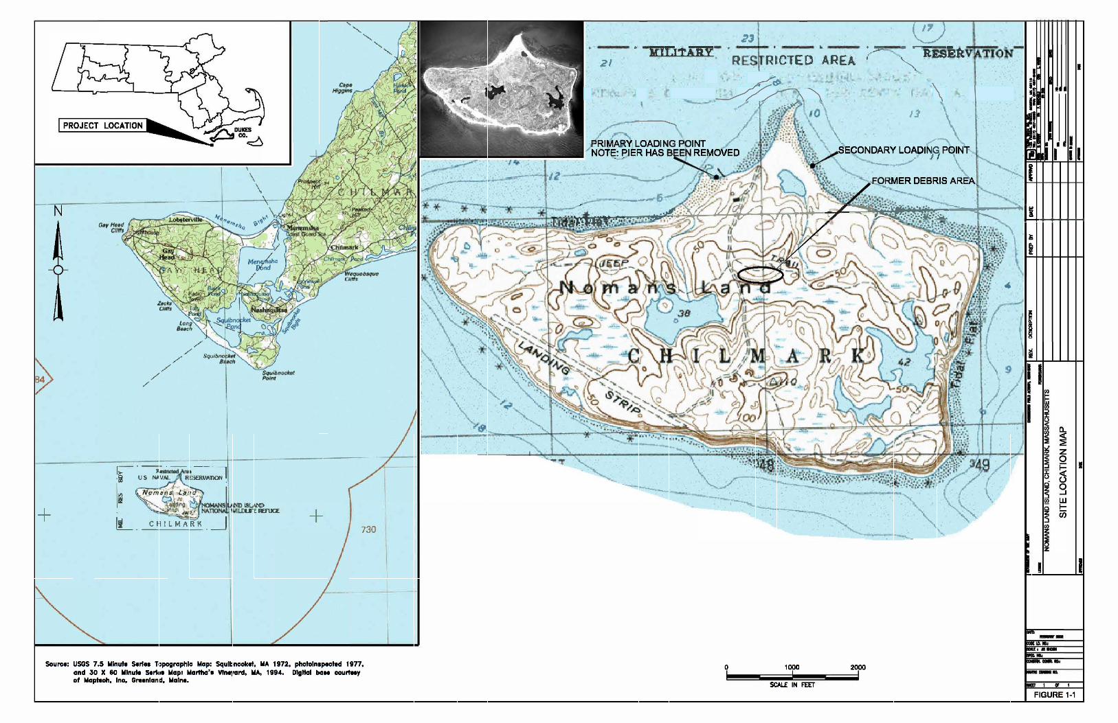
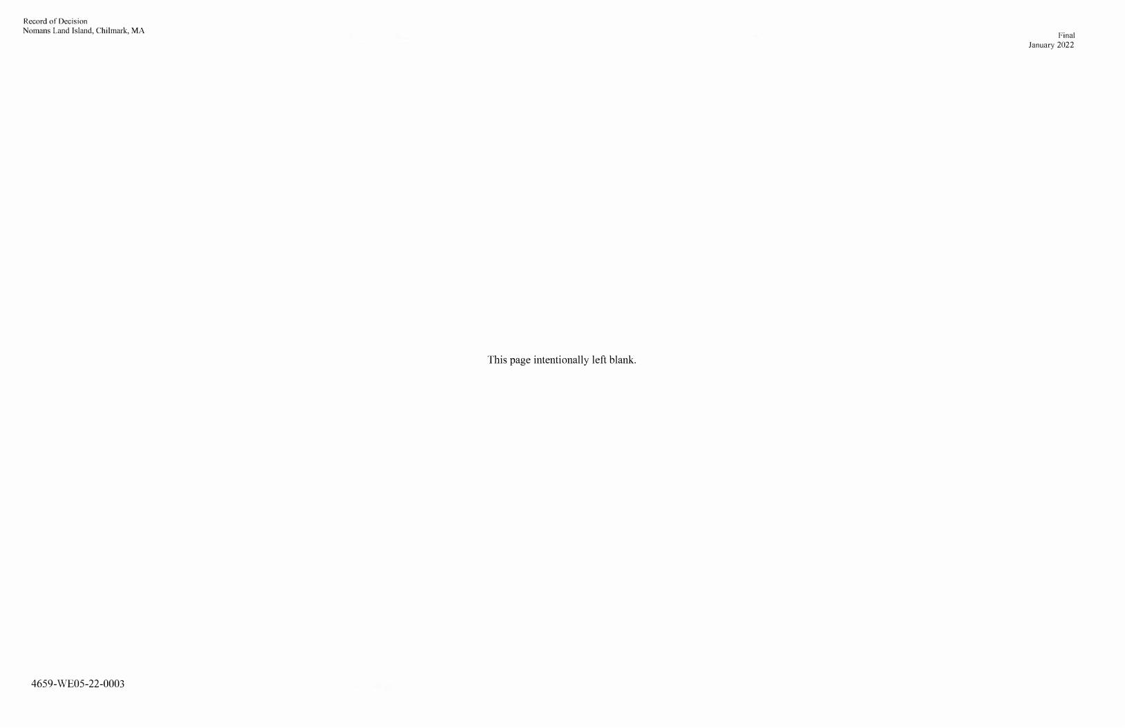
Record of Decision Nomans Land Island, Chilmark, MA
4659-WE0S-22-0003
This page intentionally left blank.
Final January 2022
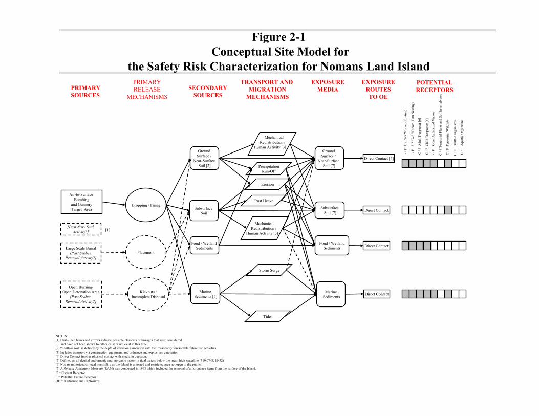
Air-to-Surface Bombing
and GunneryTarget Area
Large Scale Burial[Past Seabee
Removal Activity?]
Open Burning/Open Detonation Area
[Past Seabee Removal Activity?]
Dropping / Firing
Placement
Kickouts /Incomplete Disposal
Ground Surface /
Near-Surface Soil [2]
Subsurface Soil
Pond / Wetland Sediments
MarineSediments [5]
MechanicalRedistribution /
Human Activity [3]
PrecipitationRun-Off
Erosion
Mechanical Redistribution /
Human Activity [3]
Storm Surge
Tides
Ground Surface /
Near-Surface Soil [7]
SubsurfaceSoil [7]
Pond / WetlandSediments
MarineSediments
Direct Contact [4]
Direct Contact
Direct Contact
Direct Contact
PRIMARYSOURCES
PRIMARYRELEASE
MECHANISMS
SECONDARYSOURCES
TRANSPORT AND MIGRATION
MECHANISMS
EXPOSUREMEDIA
EXPOSUREROUTESTO OE
POTENTIALRECEPTORS
-/ F
U
SF
WS
Wor
ker
(Rou
tine
)
-/ F
U
SFW
S W
orke
r (T
ern
Nes
ting
)
C /
F A
dult
Tre
spas
ser
[6]
-/ F
O
ther
Aut
hori
zed
Vis
itor
C /
F T
erre
stri
al P
lant
s an
d S
oil I
nver
tebr
ates
C /
F T
erre
stri
al W
ildl
ife
C /
F B
enth
ic O
rgan
ism
s
C /
F A
quat
ic O
rgan
ism
s
[Past Navy Seal Activity?]
Figure 2-1Conceptual Site Model for
the Safety Risk Characterization for Nomans Land Island
NOTES:[1] Dash-lined boxes and arrows indicate possible elements or linkages that were considered
and have not been shown to either exist or not exist at this time [2] �Shallow soil� is defined by the depth of intrusion associated with the reasonably foreseeable future use activities[3] Includes transport via construction equipment and ordnance and explosives detonation[4] Direct Contact implies physical contact with media in question.[5] Defined as all detrital and organic and inorganic matter in tidal waters below the mean high waterline (310 CMR 10.52)[6] Not an authorized or legal possibility as the Island is a posted and restricted area not open to the public.[7] A Release Abatement Measure (RAM) was conducted in 1998 which included the removal of all ordnance items from the surface of the Island.C = Current ReceptorF = Potential Future ReceptorOE = Ordnance and Explosives
[1]
C /
F C
hild
Tre
spas
ser
[6]
Frost Heave
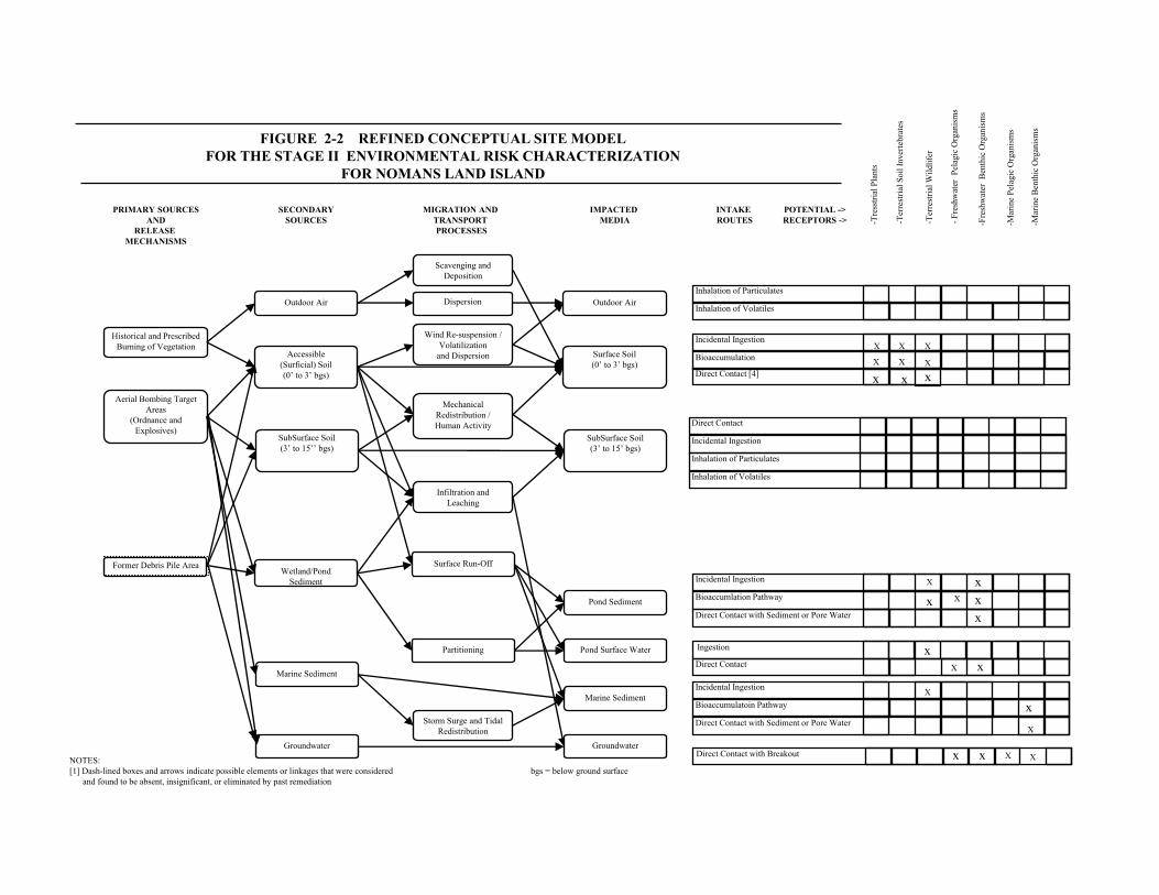
Historical and Prescribed Burning of Vegetation
INTAKE ROUTES
POTENTIAL ->RECEPTORS ->
FIGURE 2-2 REFINED CONCEPTUAL SITE MODEL FOR THE STAGE II ENVIRONMENTAL RISK CHARACTERIZATION
FOR NOMANS LAND ISLAND
PRIMARY SOURCESAND
RELEASE MECHANISMS
Aerial Bombing Target Areas
(Ordnance and Explosives)
SECONDARYSOURCES
Accessible(Surficial) Soil(0� to 3� bgs)
Wetland/Pond Sediment
MIGRATION AND TRANSPORT PROCESSES
IMPACTED MEDIA
Inhalation of Particulates
Inhalation of Volatiles
Incidental IngestionXXX
BioaccumulationXXX
-Tre
sstr
ial P
lant
s
-Ter
rest
rial
Soi
l Inv
erte
brat
es
-Ter
rest
rial
Wil
dlif
er
NOTES:[1] Dash-lined boxes and arrows indicate possible elements or linkages that were considered bgs = below ground surface
and found to be absent, insignificant, or eliminated by past remediation
Direct Contact
Incidental Ingestion
Inhalation of Particulates
Inhalation of Volatiles
Marine Sediment
Groundwater
Outdoor Air
Partitioning
Outdoor Air
SubSurface Soil(3� to 15�� bgs)
Surface Soil(0� to 3� bgs)
SubSurface Soil(3� to 15� bgs)
Marine Sediment
Pond Sediment
Pond Surface Water
Groundwater
-Fr
eshw
ater
Pel
agic
Org
anis
ms
Storm Surge and Tidal Redistribution
-Fre
shw
ater
Ben
thic
Org
anis
ms
-Mar
ine
Ben
thic
Org
anis
ms
Incidental Ingestion
Bioaccumlation Pathway
xx
Direct Contact with Sediment or Pore Water x
Incidental IngestionX
Bioaccumulatoin Pathway xDirect Contact with Sediment or Pore Water
X
Direct Contact with Breakout Xxx
Surface Run-Off
Infiltration and Leaching
Mechanical Redistribution /Human Activity
Wind Re-suspension / Volatilization
and Dispersion
Scavenging and Deposition
-Mar
ine
Pel
agic
Org
anis
ms
Direct Contact [4] x
Direct Contact xX
Ingestion x
X
x X
Dispersion
X
Former Debris Pile Area
x x
!!
!!
!!
!!!!
!!
!!
!!
!!
!!!!
!! !!
Source: Esri, DigitalGlobe, GeoEye, Earthstar Geographics, CNES/Airbus DS, USDA, USGS, AeroGRID, IGN, and the GIS UserCommunity
P:\NavyRac-2282\Nomans-Land-CTO-0033\GIS\Updated MXDs March 2008\MXDs\2019_LandUseControlBoundary.mxd
Figure 2-3Land Use Control Area
Boundary Map(Includes Water Site
Restrictions)
Nomans Land Island Chilmark, Massachusetts
¯0 370 740 1,110 1,480
Feet
!! Restricted Area Signage
Land Use Control Area Boundary(Estimated Mean-Low Water)
OFFSHORE WATERS RESTRICTIONSPROHIBITED AREA 334.70
REPRESENTATIVE RESTRICTED AREA SIGNAGE
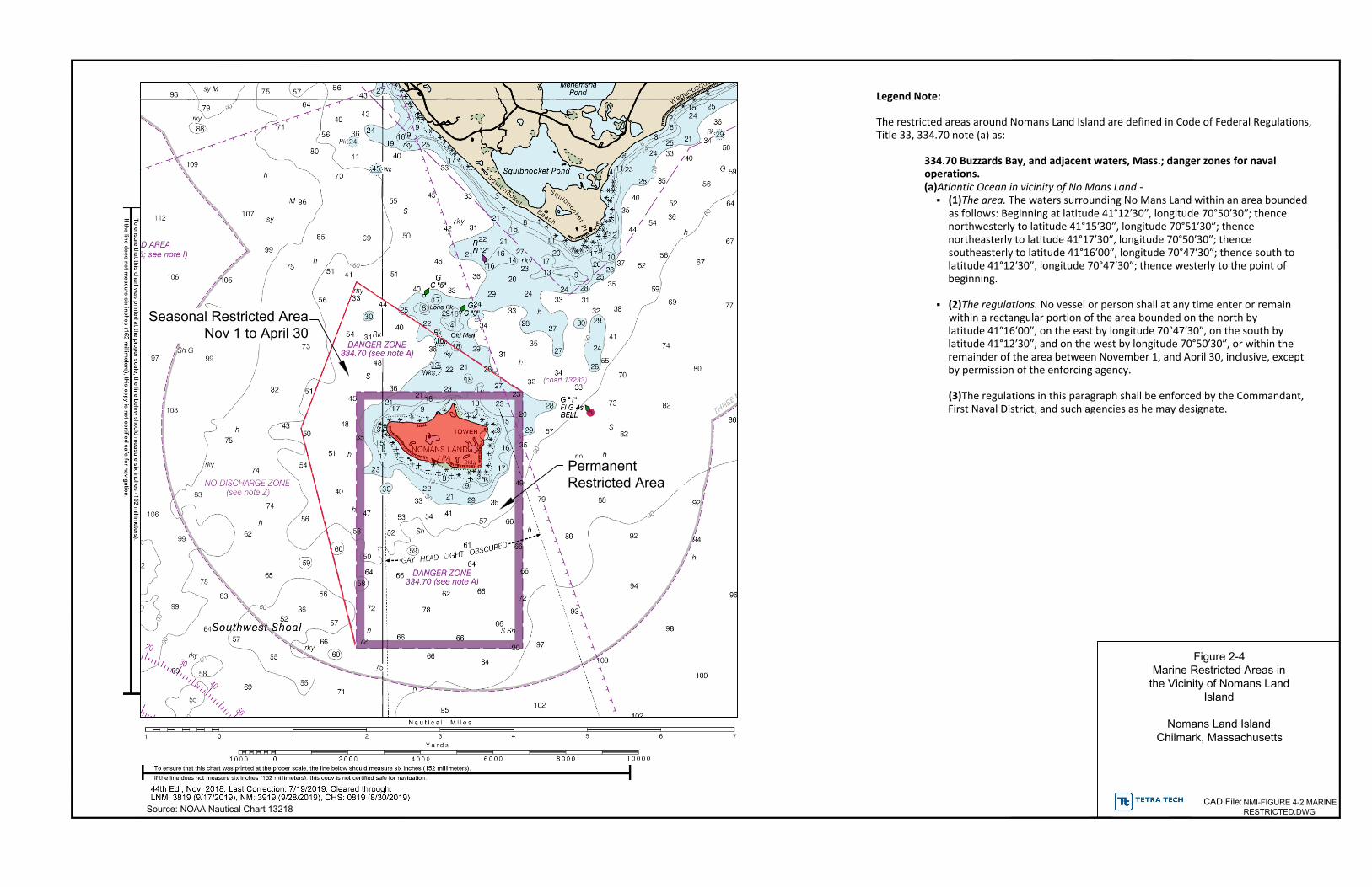
Figure 2-4Marine Restricted Areas in
the Vicinity of Nomans Land Island
Nomans Land Island Chilmark, Massachusetts
Source: NOAA Nautical Chart 13218
Legend Note:
The restricted areas around Nomans Land Island are defined in Code of Federal Regulations,Title 33, 334.70 note (a) as:
334.70 Buzzards Bay, and adjacent waters, Mass.; danger zones for navaloperations.(a)Atlantic Ocean in vicinity of No Mans Land
§ (1)The area. The waters surrounding No Mans Land within an area boundedas follows: Beginning at latitude 41°12′30″, longitude 70°50′30″; thencenorthwesterly to latitude 41°15′30″, longitude 70°51′30″; thencenortheasterly to latitude 41°17′30″, longitude 70°50′30″; thencesoutheasterly to latitude 41°16′00″, longitude 70°47′30″; thence south tolatitude 41°12′30″, longitude 70°47′30″; thence westerly to the point ofbeginning.
§ (2)The regulations. No vessel or person shall at any time enter or remainwithin a rectangular portion of the area bounded on the north bylatitude 41°16′00″, on the east by longitude 70°47′30″, on the south bylatitude 41°12′30″, and on the west by longitude 70°50′30″, or within theremainder of the area between November 1, and April 30, inclusive, exceptby permission of the enforcing agency.
(3)The regulations in this paragraph shall be enforced by the Commandant,First Naval District, and such agencies as he may designate.
Seasonal Restricted AreaNov 1 to April 30
PermanentRestricted Area
NMI-FIGURE 4-2 MARINERESTRICTED.DWG
CAD File:

Record of Decision Final Nomans Land Island, Chilmark, MA January 2022
4659-WE05-22-0003
TABLES

Record of Decision Final Nomans Land Island, Chilmark, MA January 2022
4659-WE05-22-0003
This page intentionally left blank.
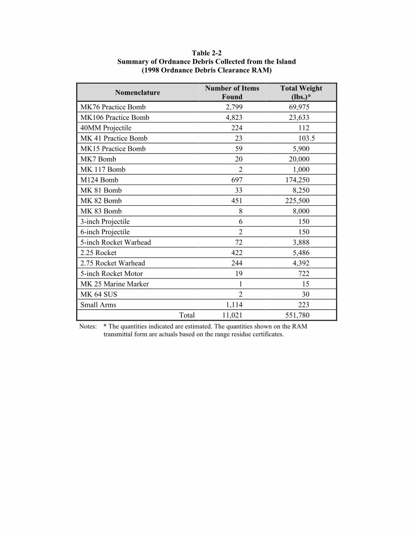
Table 2-2 Summary of Ordnance Debris Collected from the Island
(1998 Ordnance Debris Clearance RAM)
Nomenclature Number of Items
Found Total Weight
(lbs.)*MK76 Practice Bomb 2,799 69,975
MK106 Practice Bomb 4,823 23,633
40MM Projectile 224 112
MK 41 Practice Bomb 23 103.5
MK15 Practice Bomb 59 5,900
MK7 Bomb 20 20,000
MK 117 Bomb 2 1,000
M124 Bomb 697 174,250
MK 81 Bomb 33 8,250
MK 82 Bomb 451 225,500
MK 83 Bomb 8 8,000
3-inch Projectile 6 150
6-inch Projectile 2 150
5-inch Rocket Warhead 72 3,888
2.25 Rocket 422 5,486
2.75 Rocket Warhead 244 4,392
5-inch Rocket Motor 19 722
MK 25 Marine Marker 1 15
MK 64 SUS 2 30
Small Arms 1,114 223
Total 11,021 551,780
Notes: * The quantities indicated are estimated. The quantities shown on the RAM transmittal form are actuals based on the range residue certificates.
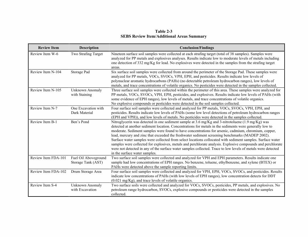
Table 2-3 SEBS Review Item/Additional Areas Summary
Review Item Description Conclusion/Findings
Review Item W-6 Two Strafing Target Nineteen surface soil samples were collected at each strafing target (total of 38 samples). Samples were analyzed for PP metals and explosives analyses. Results indicate low to moderate levels of metals including one detection of 332 mg/Kg for lead. No explosives were detected in the samples from the strafing target areas.
Review Item N-104 Storage Pad Six surface soil samples were collected from around the perimeter of the Storage Pad. These samples were analyzed for PP metals, VOCs, SVOCs, VPH, EPH, and pesticides. Results indicate low levels ofpolynuclear aromatic hydrocarbons (PAHs) (no detectable petroleum hydrocarbon ranges), low levels of metals, and trace concentrations of volatile organics. No pesticides were detected in the samples collected.
Review Item N-105 Unknown Anomaly with Staining
Three surface soil samples were collected within the perimeter of this area. These samples were analyzed for PP metals, VOCs, SVOCs, VPH, EPH, pesticides, and explosives. Results indicate low levels of PAHs (with some evidence of EPH ranges), low levels of metals, and trace concentrations of volatile organics. No explosive compounds or pesticides were detected in the soil samples collected.
Review Item N-7 One Excavation with Dark Material
Four surface soil samples were collected and analyzed for PP metals, VOCs, SVOCs, VPH, EPH, and pesticides. Results indicate low levels of PAHs (some low level detections of petroleum hydrocarbon ranges (EPH and VPH)), and low levels of metals. No pesticides were detected in the samples collected.
Review Item B-1 Ben’s Pond Nitroglycerin was detected in one sediment sample at 3.6 mg/Kg and 3-nitrotoluene (1.9 mg/Kg) was detected at another sediment location. Concentrations for metals in the sediments were generally low to moderate. Sediment samples were found to have concentrations for arsenic, cadmium, chromium, copper, lead, mercury and zinc that exceeded the freshwater sediment screening benchmarks (MADEP 2002). Surface water samples were collected from select locations collocated with sediment samples. Surface water samples were collected for explosives, metals and perchlorate analysis. Explosive compounds and perchlorate were not detected in any of the surface water samples collected. Trace to low levels of metals were detected in the surface water samples.
Review Item FDA-101 Fuel Oil AbovegroundStorage Tank (AST)
Two surface soil samples were collected and analyzed for VPH and EPH parameters. Results indicate one sample had low concentrations of EPH ranges. No benzene, toluene, ethylbenzene, and xylene (BTEX) or PAHs were detected above the sample reporting limits.
Review Item FDA-102 Drum Storage Area Four surface soil samples were collected and analyzed for VPH, EPH, VOCs, SVOCs, and pesticides. Results indicate low concentrations of PAHs (with low levels of EPH ranges), low concentration detects for DDT (0.021 mg/Kg), and trace levels of volatile organics.
Review Item S-4 Unknown Anomaly with Excavation
Two surface soils were collected and analyzed for VOCs, SVOCs, pesticides, PP metals, and explosives. No petroleum range hydrocarbon, SVOCs, explosive compounds or pesticides were detected in the samples collected.
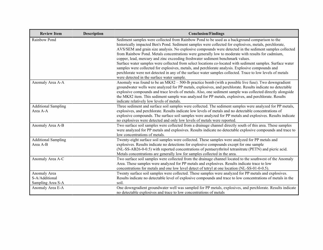
Review Item Description Conclusion/Findings
Rainbow Pond Sediment samples were collected from Rainbow Pond to be used as a background comparison to the historically impacted Ben's Pond. Sediment samples were collected for explosives, metals, perchlorate, AVS/SEM and grain size analysis. No explosive compounds were detected in the sediment samples collected from Rainbow Pond. Metals concentrations were generally low to moderate with results for cadmium, copper, lead, mercury and zinc exceeding freshwater sediment benchmark values. Surface water samples were collected from select locations co-located with sediment samples. Surface water samples were collected for explosives, metals, and perchlorate analysis. Explosive compounds and perchlorate were not detected in any of the surface water samples collected. Trace to low levels of metals were detected in the surface water sample.
Anomaly Area A-A Anomaly was found to be an MK82 – 500-lb practice bomb (with a possible live fuse). Two downgradient groundwater wells were analyzed for PP metals, explosives, and perchlorate. Results indicate no detectable explosive compounds and trace levels of metals. Also, one sediment sample was collected directly alongside the MK82 item. This sediment sample was analyzed for PP metals, explosives, and perchlorate. Results indicate relatively low levels of metals.
Additional Sampling Area A-A
Three sediment and surface soil samples were collected. The sediment samples were analyzed for PP metals, explosives, and perchlorate. Results indicate low levels of metals and no detectable concentrations of explosive compounds. The surface soil samples were analyzed for PP metals and explosives. Results indicate no explosives were detected and only low levels of metals were reported.
Anomaly Area A-B Two surface soil samples were collected from a drainage channel directly south of this area. These samples were analyzed for PP metals and explosives. Results indicate no detectable explosive compounds and trace to low concentrations of metals.
Additional Sampling Area A-B
Twenty-eight surface soil samples were collected. These samples were analyzed for PP metals and explosives. Results indicate no detections for explosive compounds except for one sample (NL-SS-AB26-0-0.5) with reported concentrations of pentaerythritol tetranitrate (PETN) and picric acid. Metals concentrations are generally low for samples collected in the area.
Anomaly Area A-C Two surface soil samples were collected from the drainage channel located to the southwest of the Anomaly Area. These samples were analyzed for PP metals and explosives. Results indicate trace to low concentrations for metals and one low level detect of tetryl at one location (NL-SS-01-0-0.5).
Anomaly Area S-A/AdditionalSampling Area S-A
Twenty surface soil samples were collected. These samples were analyzed for PP metals and explosives. Results indicate no detectable level of explosive compounds and trace to low concentrations of metals in the soil.
Anomaly Area E-A One downgradient groundwater well was sampled for PP metals, explosives, and perchlorate. Results indicate no detectable explosives and trace to low concentrations of metals
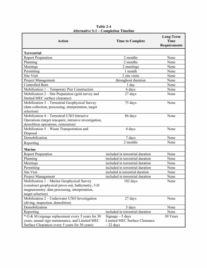
Table 2-4 Alternative S-1 – Completion Timeline
Action Time to Complete Long-Term
Time Requirements
Terrestrial
Report Preparation 2 months None Planning 2 months None Meetings 2 meetings None Permitting 1 month None Site Visit 2 site visits None Project Management throughout duration None Controlled Burn 1 day None Mobilization 1 – Temporary Pier Construction 6 days None Mobilization 2 – Site Preparation (grid survey and limited MEC surface clearance)
27 days None
Mobilization 3 – Terrestrial Geophysical Survey (data collection, processing, interpretation, target selection)
75 days None
Mobilization 4 – Terrestrial UXO IntrusiveOperations (target reacquire, intrusive investigation, demolition operations, restoration)
86 days None
Mobilization 5 – Waste Transportation and Disposal
4 days None
Demobilization 7 days None
Reporting 2 months None
Marine
Report Preparation included in terrestrial duration None Planning included in terrestrial duration None Meetings included in terrestrial duration None Permitting included in terrestrial duration None Site Visit included in terrestrial duration None Project Management included in terrestrial duration None Mobilization 1 – Marine Geophysical Survey (construct geophysical prove-out, bathymetry, 3-D magnetometry, data processing, interpretation, target selection)
102 days None
Mobilization 2 – Underwater UXO Investigation (diving, inspection, demolition)
27 days None
Demobilization 5 days None Reporting included in terrestrial duration None * O & M (signage replacement every 5 years for 30 years, annual sign maintenance, and Limited MEC Surface Clearances every 5 years for 30 years)
Signage – 5 days Limited MEC Surface Clearance – 22 days
30 Years
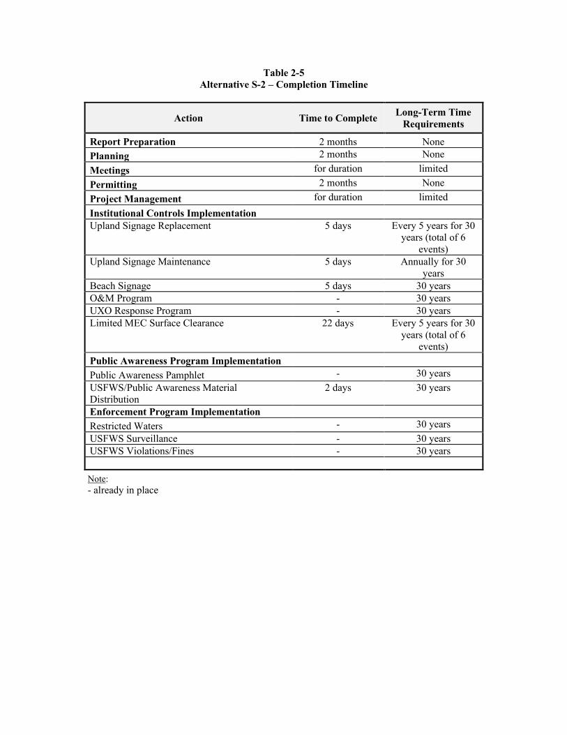
Table 2-5 Alternative S-2 – Completion Timeline
Action Time to Complete Long-Term Time
Requirements
Report Preparation 2 months None
Planning 2 months None
Meetings for duration limited
Permitting 2 months None
Project Management for duration limited
Institutional Controls Implementation
Upland Signage Replacement 5 days Every 5 years for 30 years (total of 6
events) Upland Signage Maintenance 5 days Annually for 30
years Beach Signage 5 days 30 years O&M Program - 30 years UXO Response Program - 30 years Limited MEC Surface Clearance 22 days Every 5 years for 30
years (total of 6 events)
Public Awareness Program Implementation
Public Awareness Pamphlet - 30 years
USFWS/Public Awareness Material Distribution
2 days 30 years
Enforcement Program Implementation
Restricted Waters - 30 years
USFWS Surveillance - 30 years USFWS Violations/Fines - 30 years
Note: - already in place
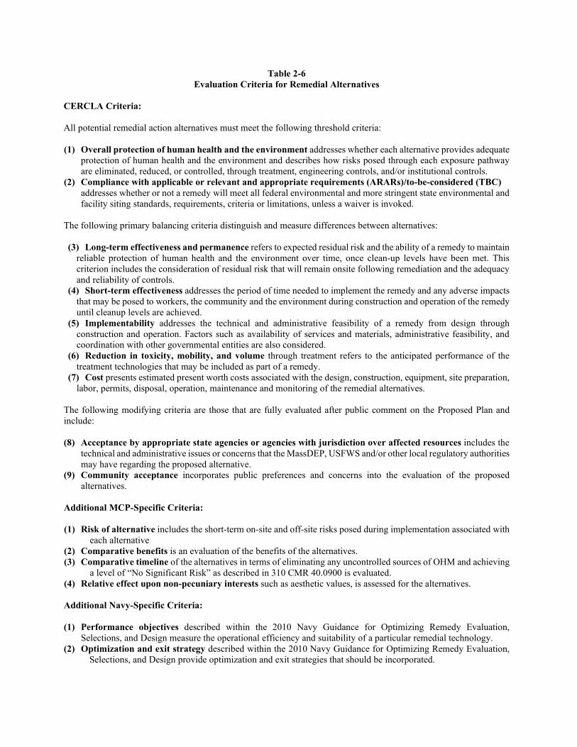
Table 2-6 Evaluation Criteria for Remedial Alternatives
CERCLA Criteria:
All potential remedial action alternatives must meet the following threshold criteria:
(1) Overall protection of human health and the environment addresses whether each alternative provides adequate protection of human health and the environment and describes how risks posed through each exposure pathway are eliminated, reduced, or controlled, through treatment, engineering controls, and/or institutional controls.
(2) Compliance with applicable or relevant and appropriate requirements (ARARs)/to-be-considered (TBC) addresses whether or not a remedy will meet all federal environmental and more stringent state environmental and facility siting standards, requirements, criteria or limitations, unless a waiver is invoked.
The following primary balancing criteria distinguish and measure differences between alternatives: (3) Long-term effectiveness and permanence refers to expected residual risk and the ability of a remedy to maintain
reliable protection of human health and the environment over time, once clean-up levels have been met. This criterion includes the consideration of residual risk that will remain onsite following remediation and the adequacy and reliability of controls.
(4) Short-term effectiveness addresses the period of time needed to implement the remedy and any adverse impacts that may be posed to workers, the community and the environment during construction and operation of the remedy until cleanup levels are achieved.
(5) Implementability addresses the technical and administrative feasibility of a remedy from design through construction and operation. Factors such as availability of services and materials, administrative feasibility, and coordination with other governmental entities are also considered.
(6) Reduction in toxicity, mobility, and volume through treatment refers to the anticipated performance of the treatment technologies that may be included as part of a remedy.
(7) Cost presents estimated present worth costs associated with the design, construction, equipment, site preparation, labor, permits, disposal, operation, maintenance and monitoring of the remedial alternatives.
The following modifying criteria are those that are fully evaluated after public comment on the Proposed Plan and include: (8) Acceptance by appropriate state agencies or agencies with jurisdiction over affected resources includes the
technical and administrative issues or concerns that the MassDEP, USFWS and/or other local regulatory authorities may have regarding the proposed alternative.
(9) Community acceptance incorporates public preferences and concerns into the evaluation of the proposed alternatives.
Additional MCP-Specific Criteria: (1) Risk of alternative includes the short-term on-site and off-site risks posed during implementation associated with
each alternative (2) Comparative benefits is an evaluation of the benefits of the alternatives. (3) Comparative timeline of the alternatives in terms of eliminating any uncontrolled sources of OHM and achieving
a level of “No Significant Risk” as described in 310 CMR 40.0900 is evaluated. (4) Relative effect upon non-pecuniary interests such as aesthetic values, is assessed for the alternatives. Additional Navy-Specific Criteria:
(1) Performance objectives described within the 2010 Navy Guidance for Optimizing Remedy Evaluation, Selections, and Design measure the operational efficiency and suitability of a particular remedial technology.
(2) Optimization and exit strategy described within the 2010 Navy Guidance for Optimizing Remedy Evaluation, Selections, and Design provide optimization and exit strategies that should be incorporated.
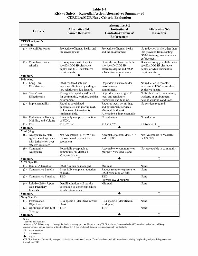
Table 2-7 Risk to Safety – Remedial Action Alternatives Summary of
CERCLA/MCP/Navy Criteria Evaluation
Criteria Alternative S-1
Source Removal
Alternative S-2 Institutional
Controls/Awareness/ Enforcement
Alternative S-3 No Action
CERCLA Specific Threshold
(1) Overall Protection Protective of human health and the environment.
Protective of human healthand the environment.
No reduction in risk other than that provided from existing O&M, training, awareness, and enforcement.
(2) Compliance with ARARs
In compliance with the site-specific DDESB clearance depths and MCP substantive requirements.
General compliance with the site-specific DDESB clearance depths and MCP substantive requirements.
Does not comply with the site-specific DDESB clearance depths or MCP substantive requirements.
Summary Balancing
(3) Long-Term Effectiveness
UXO rendered safe and exposure eliminated yielding a low relative residual hazard.
Dependent on stakeholder involvement/ commitment.
No reduction in receptor exposure to UXO or residual explosive hazard.
(4) Short-Term Effectiveness
Managed acceptable risk level for community, workers, and the environment.
Dependent on strength of legal and regulatory framework and funding.
No further risk to community, workers, or environment beyond existing conditions.
(5) Implementability Requires specialized geophysicists and marine UXO technicians. Alternative is implementable.
Requires legal, permitting, and government services. Minimal field work. Alternative is implementable.
No services required.
(6) Reduction in Toxicity, Mobility, and Volume
Essentially complete reduction of UXO.
No reduction. No reduction.
(7) Cost $30,925,063 $10,737,526 $ 0 (relative) Summary Modifying
(8) Acceptance by state agencies and agencies with jurisdiction over affected resources
Not Acceptable to USFWS as removal would disrupt the ecosystem
Acceptable to both MassDEP and USFWS
Not Acceptable to MassDEP or USFWS
(9) Community Acceptance
Potentially acceptable to community on Martha’s Vineyard Island
Acceptable to community on Martha’s Vineyard Island
Not Acceptable to community
Summary MCP Specific
(1) Risk of Alternative UXO risk can be managed. Minimal. None (2) Comparative Benefits Essentially complete reduction
of UXO. Reduce receptor exposure to UXO remaining on-site.
None
(3) Comparative Timeline TBD TBD (30 year O&M required)
None
(4) Relative Effect Upon Non-Pecuniary Interests
Demilitarization will require detonation of donor explosives which is temporary.
Minimal. None
Summary Navy Specific
(1) Performance Objectives
Risk specific (identified in work plan).
Risk specific (identified in work plan).
None
(2) Optimization and Exit Strategy
TBD TBD None
Summary
Notes: TBD = to be determined Alternative S-3 did not progress through the initial screening process. Therefore, the CERCLA nine evaluation criteria, MCP detailed evaluation, and Navy criteria were not applied in detail within this Phase III/FS Report, though they are discussed generally in this table.
= Not Preferred = Acceptable = Best CERCLA State and Community acceptance criteria are not depicted herein. These have been, and will be addressed, during the planning and permitting phases and through the TRC.
Record of Decision Final Nomans Land Island, Chilmark, MA January 2022
4659-WE05-22-0003
This page intentionally left blank.
Record of Decision Final Nomans Land Island, Chilmark, MA January 2022
4659-WE05-22-0003
APPENDIX A
MASSDEP CONCURRENCE LETTER

Record of Decision Final Nomans Land Island, Chilmark, MA January 2022
4659-WE05-22-0003
This page intentionally left blank.
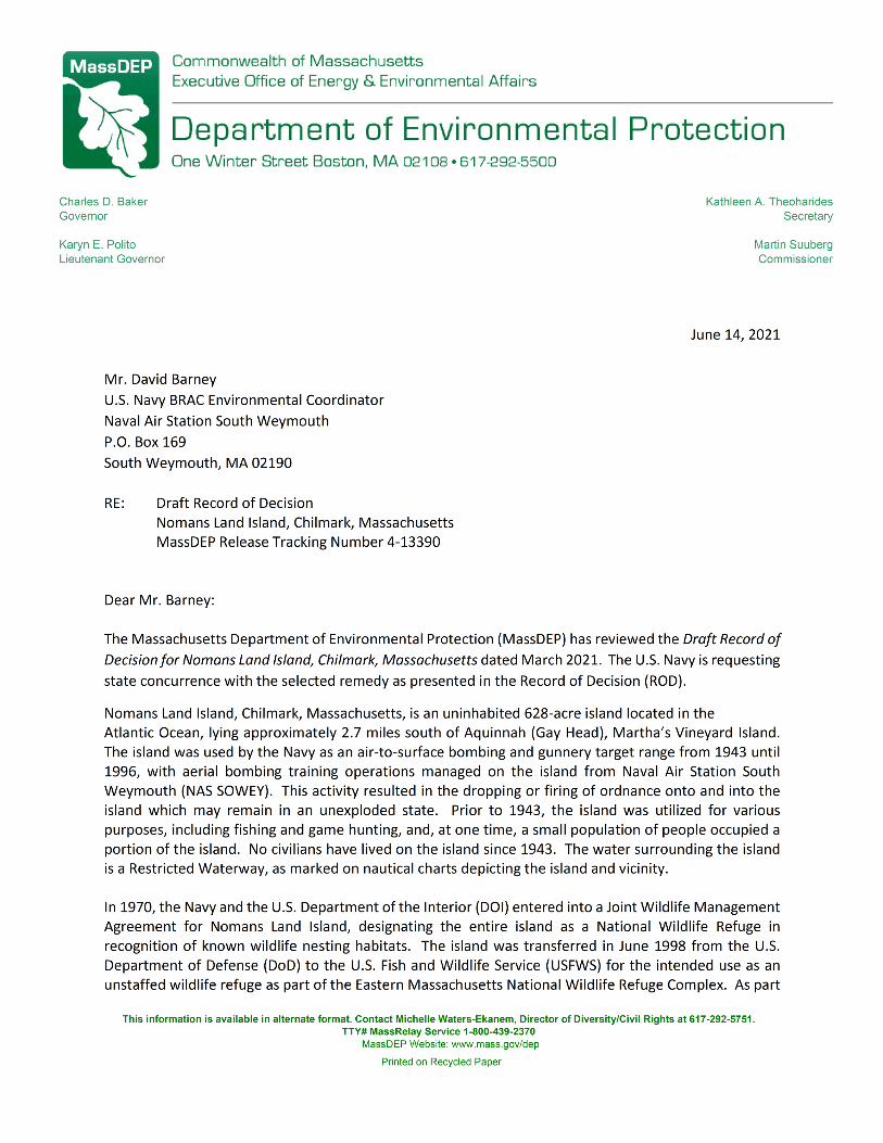
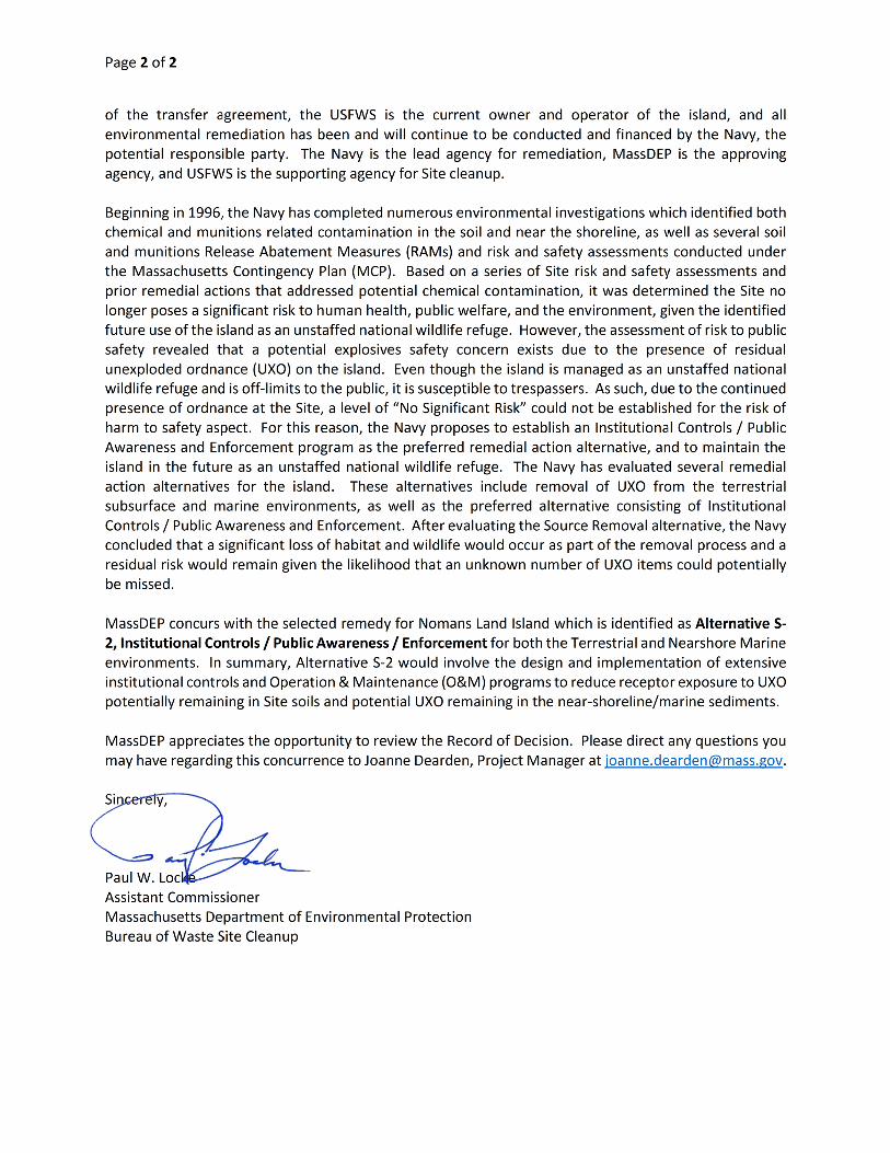
Record of Decision Final Nomans Land Island, Chilmark, MA January 2022
4659-WE05-22-0003
APPENDIX B
PROPOSED REMEDIAL ACTION PLAN AND PUBLIC NOTICE

Record of Decision Final Nomans Land Island, Chilmark, MA January 2022
4659-WE05-22-0003
This page intentionally left blank.
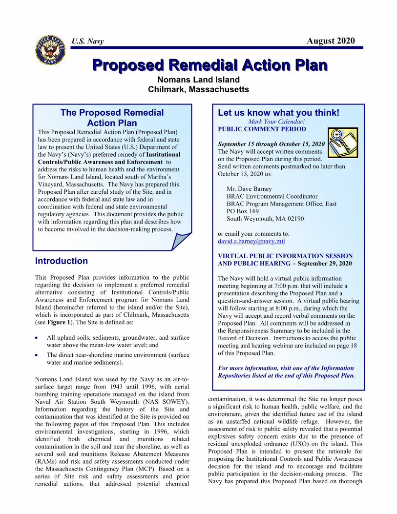
U.S. Navy August 2020
PPPrrrooopppooossseeeddd RRReeemmmeeedddiiiaaalll AAAccctttiiiooonnn PPPlllaaannn Nomans Land Island
Chilmark, Massachusetts
Introduction
This Proposed Plan provides information to the public regarding the decision to implement a preferred remedial alternative consisting of Institutional Controls/Public Awareness and Enforcement program for Nomans Land Island (hereinafter referred to the island and/or the Site), which is incorporated as part of Chilmark, Massachusetts (see Figure 1). The Site is defined as: All upland soils, sediments, groundwater, and surface
water above the mean-low water level; and
The direct near-shoreline marine environment (surface water and marine sediments).
Nomans Land Island was used by the Navy as an air-to-surface target range from 1943 until 1996, with aerial bombing training operations managed on the island from Naval Air Station South Weymouth (NAS SOWEY). Information regarding the history of the Site and contamination that was identified at the Site is provided on the following pages of this Proposed Plan. This includes environmental investigations, starting in 1996, which identified both chemical and munitions related contamination in the soil and near the shoreline, as well as several soil and munitions Release Abatement Measures (RAMs) and risk and safety assessments conducted under the Massachusetts Contingency Plan (MCP). Based on a series of Site risk and safety assessments and prior remedial actions, that addressed potential chemical
contamination, it was determined the Site no longer poses a significant risk to human health, public welfare, and theenvironment, given the identified future use of the island as an unstaffed national wildlife refuge. However, the assessment of risk to public safety revealed that a potential explosives safety concern exists due to the presence of residual unexploded ordnance (UXO) on the island. This Proposed Plan is intended to present the rationale for proposing the Institutional Controls and Public Awareness decision for the island and to encourage and facilitate public participation in the decision-making process. The Navy has prepared this Proposed Plan based on thorough
Let us know what you think! Mark Your Calendar! PUBLIC COMMENT PERIOD September 15 through October 15, 2020 The Navy will accept written comments on the Proposed Plan during this period. Send written comments postmarked no later than October 15, 2020 to:
Mr. Dave Barney BRAC Environmental Coordinator BRAC Program Management Office, East PO Box 169 South Weymouth, MA 02190
or email your comments to: [email protected] VIRTUAL PUBLIC INFORMATION SESSION AND PUBLIC HEARING – September 29, 2020 The Navy will hold a virtual public information meeting beginning at 7:00 p.m. that will include a presentation describing the Proposed Plan and a question-and-answer session. A virtual public hearing will follow starting at 8:00 p.m., during which the Navy will accept and record verbal comments on the Proposed Plan. All comments will be addressed in the Responsiveness Summary to be included in the Record of Decision. Instructions to access the public meeting and hearing webinar are included on page 18 of this Proposed Plan. For more information, visit one of the Information Repositories listed at the end of this Proposed Plan.
The Proposed Remedial Action Plan
This Proposed Remedial Action Plan (Proposed Plan) has been prepared in accordance with federal and state law to present the United States (U.S.) Department of the Navy’s (Navy’s) preferred remedy of Institutional Controls/Public Awareness and Enforcement to address the risks to human health and the environment for Nomans Land Island, located south of Martha’s Vineyard, Massachusetts. The Navy has prepared this Proposed Plan after careful study of the Site, and in accordance with federal and state law and in coordination with federal and state environmental regulatory agencies. This document provides the public with information regarding this plan and describes how to become involved in the decision-making process.
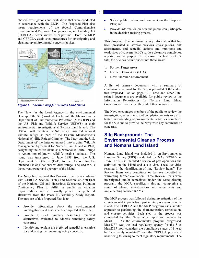
2
phased investigations and evaluations that were conducted in accordance with the MCP. The Proposed Plan also meets requirements of the federal Comprehensive Environmental Response, Compensation, and Liability Act (CERCLA), better known as Superfund. Both the MCP and CERCLA established procedures for investigating and cleaning up environmental concerns at sites.
Figure 1 – Location map for Nomans Land Island
The Navy (as the Lead Agency in the environmental cleanup of the Site) worked closely with the Massachusetts Department of Environmental Protection (MassDEP) and the U.S. Fish and Wildlife Service (USFWS) in their environmental investigations at Nomans Land Island. The USFWS will maintain the Site as an unstaffed national wildlife refuge as part of the Eastern Massachusetts National Wildlife Refuge Complex. The Navy and the U.S. Department of the Interior entered into a Joint Wildlife Management Agreement for Nomans Land Island in 1970, designating the entire island as a National Wildlife Refuge in recognition of known wildlife nesting habitats. The island was transferred in June 1998 from the U.S. Department of Defense (DoD) to the USFWS for the intended use as a national wildlife refuge. The USFWS is the current owner and operator of the island. The Navy has prepared this Proposed Plan in accordance with CERCLA Section 117(a) and Section 300.430(f)(2) of the National Oil and Hazardous Substances Pollution Contingency Plan to fulfill its public participation responsibilities and to formally present the preferred alternative from the Phase III/Feasibility Study Report. The purpose of this Proposed Plan is to: Provide information about the environmental
investigations and assessments completed at the Site;
Provide a brief summary describing remedial alternatives evaluated to address remaining safety concerns;
Identify and explain the preferred remedial alternative for addressing the remaining safety concerns;
Solicit public review and comment on the Proposed Plan; and
Provide information on how the public can participate in the decision-making process.
This Proposed Plan summarizes key information that has been presented in several previous investigations, risk assessments, and remedial actions and munitions and explosives of concern (MEC) surface clearance completion reports. For the purpose of discussing the history of the Site, the Site has been divided into three areas: 1. Former Target Areas
2. Former Debris Area (FDA)
3. Near-Shoreline Environment
A list of primary documents with a summary of conclusions prepared for the Site is provided at the end of this Proposed Plan on page 19. These and other Site-related documents are available for public review at the Information Repositories for Nomans Land Island (locations are provided at the end of this document). The Navy encourages members of the public to review the investigation, assessment, and completion reports to gain a better understanding of environmental activities completed for the Site and to provide the Navy with any comments or concerns.
Site Background: The Environmental Cleanup Process and Nomans Land Island Nomans Land Island was included in an Environmental Baseline Survey (EBS) conducted for NAS SOWEY in 1996. This EBS included a review of past operations and activities on the island and a site visit. These activities resulted in the identification of nine “Review Items”. The Review Items were conditions or features identified as warranting further evaluation. These Review Items were investigated and/or remediated under the State cleanup program, the MCP, specifically through completing a series of phased investigations and assessments and implementing focused RAMs. The MCP process was followed during investigation of the environmental impacts from past military operations on the island. The CERCLA and the MCP programs use a similar approach to performing site characterization, remediation, and closure activities. Each step in the process was completed by the Navy with input and review by MassDEP. As the environmental program progressed, MassDEP was the lead regulatory agency for the Site. MassDEP now considers the compliance status of Site to be “adequately regulated”, and the CERCLA process is now being following to meet regulatory requirements. The
3
MassDEP compliance status is provided at: https://eeaonline.eea.state.ma.us/portal#!/wastesite/4-0013390.
To address the EBS Review Item pertaining to ordnance remaining on the surface of the ground on the island and the presence of possible underground storage tanks (USTs), the Navy implemented two focused RAMs in 1998 to remove the surface ordnance and to remove four USTs. Furthermore, as part of the standard MCP process, samples were collected on the island during a Phase I investigation and were analyzed for the presence of contaminants of potential concern (COPCs). The results were screened against human health and ecological risk-based benchmarks. The human health risk-based screening benchmarks that were used in this evaluation were the conservative MCP “Reportable Concentrations” reflecting potential unrestricted exposure to the soil (RCS) (i.e., the RCS-1 benchmarks that are associated with the MCP “S-1” soil category) and the potential drinking of groundwater (RCGW) ( i.e., the RCGW-1 benchmarks associated with the MCP “GW-1” groundwater classification). The initial finding based on the limited Phase I information was that there was no significant risk to human health or public welfare. A Phase II Comprehensive Site Assessment (CSA) subsequently was implemented to further delineate the extent of the COPCs on the island. This evaluation found that a risk to the environment was present due to elevated levels of certain COPCs (in particular, lead, cadmium, chromium, and zinc) in Site soils near the primary target areas and at the FDA, where old military Quonset huts had been disposed of. Based on a discussion with MassDEP and the USFWS, an Environmental Risk Management Memorandum was developed that provided a more detailed assessment of the risk to the environment on the island. This more detailed assessment revealed that the COPCs remaining in the upland soils at the Site posed no significant risk to the environment. However, the source material (i.e., metal debris from the old Quonset huts), located along the slope of the FDA, was linked to impacts to a wetland area located directly downgradient. Therefore, a RAM was implemented in 2006 to remove these source materials. The removal effort resulted in a finding of no significant risk to environment for the entire island, as described in a Phase III/Feasibility Study Report.
In 1998, a Technical Review Committee (TRC) was established for the project to provide presentation and review opportunities for project stakeholders and the public. Project stakeholders include the town of Chilmark, town of Aquinnah, Wampanoag Tribe of Aquinnah, the Navy, the United States Environmental Protection Agency (USEPA), MassDEP, and the USFWS. In 2001, the TRC determined that further information was necessary to understand past operations at the Site. As a
result, the Navy performed a Supplemental EBS (SEBS). This SEBS included the following activities: Aerial photogrammetric survey;
Airborne geophysical survey;
Aerial photograph analysis of the Site;
Review of military documentation;
Development of an extensive geographical information system (GIS);
SEBS fieldwork (investigation and sampling associated with 19 Review Items);
RAM to remove/close one UST, two drywells, and one septic system; and
Preparation of a SEBS Completion Report. Nineteen additional Review Items identified during the SEBS were investigated, assessed, and closed with MassDEP concurrence. One additional UST was removed (along with petroleum-contaminated soils), one septic system was closed, and two drywells were closed. Ecological risk-based benchmarks have been established for all representative ecological receptor groups (aquatic life and island wildlife) present in the habitats of the island. Environmental media to which these receptor groups are exposed were considered in the risk assessments to assess on-island exposure to these receptor groups. All detected COPCs exceeding the conservative ecological risk screening benchmarks were compared to established background levels. The background levels were developed from analytes detected in non-target area samples collected from areas where historical target range activities were minimal. Background samples were collected as part of the Phase I and Phase II investigations and the SEBS investigations. Background levels are described in the Final CSA Report. The Navy performed risk assessments using data collected from the Phase I and Phase II environmental investigations. Based on the risk assessments, the Navy concluded that a level of “No Significant Risk” exists for the human health, environment, and public welfare aspects of the Site. Due to the continued presence of ordnance at the Site, a level of “No Significant Risk” could not be established for the risk of harm to safety aspect. For this reason, the Navy proposes to establish an Institutional Controls / Public Awareness and Enforcement program as the preferred remedial action alternative, and to maintain the island in the future as an unstaffed national wildlife refuge. The MassDEP has concurred with this finding. As part the response to the risk of harm to safety due to the presence of ordnance, four MEC surface clearance events were conducted, in 1998, 2003, 2008 and 2014. MEC
4
located on or protruding from the surface that could potentially pose a hazard within the accessible shoreline or along roadways was removed and disposed. Information about the Target Areas, the FDA, and the Near-Shoreline Area is provided below. Documents associated with these sites and referenced in this Proposed Plan are listed in a table provided on page 16.
Site Background: Risk Assessments In accordance with the MCP, the Navy conducted two phases of risk assessment to identify and quantify the potential effects of the COPCs on human health and the environment now and in the future, given the anticipated future use of the island. Additional assessments also were conducted to evaluate the potential risks to public welfare and to safety, as defined under the MCP. A wide range of probable and possible exposure scenarios was evaluated in the risk assessments, as discussed below. The types and magnitude of the potential effects associated with these scenarios were considered in making decisions regarding the future management and use of the island.
Human Health Risks A multi-chemical, multi-pathway human health risk assessment (HHRA) was performed to estimate the likelihood of health problems occurring for the identified users of the island if contaminants were to remain on site. To estimate the baseline risk to human health, a four-step process was used.
Step 1 – Hazard Identification COPCs were identified as those chemicals with detected concentrations that exceeded benchmark screening levels and background levels, if applicable. The COPCs included metals, pesticides, selected volatile organic compounds (VOCs), petroleum-related constituents, and residualexplosives in the soil. The COPCs identified in the island sediments consisted of metals only. The COPCs identified in the upland surface water consisted of metals and one explosive residual. The COPCs identified in groundwater consisted of metals and VOCs. Site-specific risk calculations (i.e., Steps 2 through 4, below) were performed for each identified COPC in each exposure medium. Step 2 – Exposure Assessment The exposure assessment examines the possible pathways by which humans may come into contact with the COPCs in the soil, water, or sediment at the Site during current or future activities and receive a dose of the COPCs. Under the current use scenario, potential exposures and doses to on-site USFWS workers performing routine refuge management activities and adult and child trespassers were evaluated. Potential exposure routes associated with the current use scenario included dermal absorption through the skin (i.e., associated with direct contact), incidental ingestion, and inhalation of particulates or vapors associated with the impacted environmental media on the island. Potential exposure to COPCs through the ingestion of potentially impacted marine shellfish also was examined. The future use of Nomans Land Island has been established as an unstaffed national wildlife refuge. Given this use, potential exposures and doses of COPCs would be expected for USFWS workers (performing routine activities and potentially implementing a new tern nesting program), adult and child trespassers, and special authorized visitors to the island via the same set of potential exposure routes as for the current receptors. Step 3 – Toxicity Assessment The possible harmful effects to humans from the COPCswere evaluated as part of the toxicity assessment. These chemicals were separated into two groups: carcinogens (i.e., COPCs that may cause cancer) and non-carcinogens (i.e., COPCs that may cause adverse health effects other than cancer). The toxicity of lead, a non-carcinogen, also was evaluated using a chemical-specific assessment approach. When appropriate, the nature of the non-cancer health effects was considered (i.e., an impact on the liver or an effect on the nervous system).
How are the Risks Expressed? It depends on the type of chemical. For potential carcinogens, the risk to human health is expressed in terms of the probability of the chemical causing cancer over an estimated lifetime of 70 years. USEPA’s acceptable risk range for carcinogens is from 1 in 1,000,000 to 1 in 10,000. In general, excess lifetime cancer risks calculated to be greater than 1 in 10,000 require consideration of cleanup alternatives and remedial response. MassDEP uses an excess lifetime cancer risk of 1 in 100,000 as the threshold. For non-carcinogens, the risk to human health is expressed as a Hazard Index (HI). For both the USEPA and MassDEP, an HI greater than 1 suggests that adverse health effects from exposure at that level are possible.
5
Step 4 – Risk Characterization
Lastly, the results from the exposure and toxicity assessment were combined to calculate the level of carcinogenic and non-carcinogenic risks anticipated to be associated with the projected exposure to Site COPCs (see text box describing how risk calculations are expressed). In addition, the calculated exposure point concentrations of the COPCs were compared to Applicable or Suitably Analogous Public Health Standards to evaluate the condition of “No Significant Risk.”
Based on the results of the HHRA and the comparison of the Site conditions to the limits contained in the Applicable or Suitably Analogous Public Health Standards, a condition of “No Significant Risk to Human Health” was found to exist for the island. Ecological Risks Stage I (screening level) and Stage II (baseline) environmental risk characterizations (ERCs) were conducted for Nomans Land Island. The ERCs consisted of the following three steps.
Step 1 – Formulate the Problem
The Navy collected and evaluated information regarding the Site conditions (e.g., types of habitat and types of plant and animal species at the Site), the presence of any federal, state, or trust species of concern, the number and types of contaminants potentially present, and potential exposure pathways and mechanisms for wildlife to come into contact with these contaminants. The Navy evaluated the following ecological receptor groups: terrestrial plants and invertebrates, wetland plants and aquatic receptors (benthic invertebrates, other aquatic life and plants), and wetland and terrestrial wildlife present that are exposed to surface water (i.e., freshwater ponds), surface soil, and freshwater and marine sediment. In the FDA, the Navy evaluated wetland plants exposed to sediment; aquatic receptors (invertebrates, plants, and amphibians) exposed to surface water, sediment, and groundwater; and wetland vertebrates exposed to surface water and sediment.
The Navy also conducted a shellfish transplant and monitoring study. This shellfish study involved collecting and analyzing blue mussels from the shoreline of the island to help identify whether any contaminants were migrating off-island and into the near-shoreline marine environment. Sediment samples also were collected from various runoff channels around the island, and shellfish (blue mussels) were transplanted offshore to help aid in this part of the environmental assessment. Step 2 – Perform Exposure and Effects Assessment The Navy evaluated the potential exposure of a range of the relevant environmental receptors to COPCs using direct measurement of biological exposure and modeled exposure approaches. The chemical concentrations that environmental receptors would be exposed to were determined by directly sampling environmental media. Exposure modeling also included potential chemical exposure via food chain interaction, which was estimated using bioaccumulation factors (BAFs) cited from technical references and directly assessed using site-specific data. The primary exposure routes that were evaluated in the ERCs included:
Dermal absorption and direct contact with environmental media;
Dietary ingestion of prey;
Surface water ingestion; and
Incidental ingestion of environmental media. The exposure assessment looked at individual lines of evidence using a weight of evidence approach. Each line of evidence was assigned a level of significance to assess exposure to the resource values identified as assessment endpoints in the risk assessment. Step 3 – Characterize Risks to Environmental Receptors
The results from the exposure assessment were used in conjunction with toxicity reference values to assess the extent of potential adverse effects to the ecological receptors present on the island. In accordance with MCP and CERCLA guidance, a refinement of the conservative exposure assumptions/concentrations for evaluating the potential risks to ecological receptors (i.e., plants, invertebrates, and wildlife receptors) was performed to reduce uncertainties in highly conservative risk estimates derived during the screening-level assessment. The objective of the Stage II or baseline ecological risk assessment refinement was to determine which chemicals contribute to unacceptable levels of ecological risk, and to eliminate from further consideration those COPCs that were retained because of the use of very conservative exposure scenarios. This allowed the ERC to focus on those COPCs that are considered risk drivers for the island environment (see text box describing how ecological risk calculations are expressed).
How is Ecological Risk Expressed? The risk to ecological receptors is expressed as a Hazard Quotient (HQ). A receptor’s exposure estimate (e.g., amount of chemical a receptor is exposed) is compared to an effects-based benchmark for chemical uptake that is selected to be conservatively protective. When the HQ is below 1.0, toxicological effects are unlikely to occur and no significant risk is present. When the HQ is above 1.0, there is a potential for biological harm to be present.
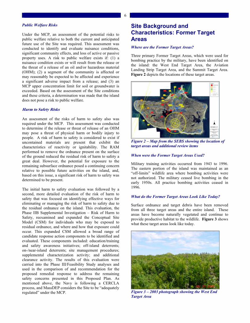
6
Public Welfare Risks
Under the MCP, an assessment of the potential risks to public welfare relative to both the current and anticipated future use of the Site was required. This assessment was conducted to identify and evaluate nuisance conditions, significant community effects, and loss of active or passive property uses. A risk to public welfare exists if: (1) a nuisance condition exists or will result from the release or the threat of a release of an oil and/or hazardous material (OHM); (2) a segment of the community is affected or may reasonably be expected to be affected and experience a significant adverse impact from a release; and (3) an MCP upper concentration limit for soil or groundwater is exceeded. Based on the assessment of the Site conditions and these criteria, a determination was made that the island does not pose a risk to public welfare. Harm to Safety Risks
An assessment of the risks of harm to safety also was required under the MCP. This assessment was conducted to determine if the release or threat of release of an OHM may pose a threat of physical harm or bodily injury to people. A risk of harm to safety is considered to exist if uncontained materials are present that exhibit the characteristics of reactivity or ignitability. The RAM performed to remove the ordnance present on the surface of the ground reduced the residual risk of harm to safety a great deal. However, the potential for exposure to the remaining subsurface ordnance posed a continuing concern relative to possible future activities on the island, and, based on this issue, a significant risk of harm to safety was determined to be present.
The initial harm to safety evaluation was followed by a second, more detailed evaluation of the risk of harm to safety that was focused on identifying effective ways for eliminating or managing the risk of harm to safety due to the residual ordnance on the island. This evaluation, the Phase IIB Supplemental Investigation – Risk of Harm to Safety, reexamined and expanded the Conceptual Site Model (CSM) for individuals who may be exposed to residual ordnance, and where and how that exposure could occur. This expanded CSM allowed a broad range of candidate response action components to be identified and evaluated. These components included: education/training and safety awareness initiatives; off-island deterrents; on-/near-island deterrents; site management procedures; supplemental characterization activity; and additional clearance activity. The results of this evaluation were carried into the Phase III/Feasibility Study analyses and used in the comparison of and recommendation for the proposed remedial response to address the remaining safety concerns presented in this Proposed Plan. As mentioned above, the Navy is following a CERCLA process, and MassDEP considers the Site to be “adequately regulated” under the MCP.
Site Background and Characteristics: Former Target Areas Where are the Former Target Areas? Three primary Former Target Areas, which were used for bombing practice by the military, have been identified on the island: the West End Target Area, the Aviation Landing Strip Target Area, and the Summit Target Area. Figure 2 depicts the locations of these target areas.
Figure 2 – Map from the SEBS showing the location of target areas and additional review items When were the Former Target Areas Used? Military training activities occurred from 1943 to 1996. The eastern portion of the island was maintained as an “off-limits” wildlife area where bombing activities were not authorized. The military ceased live bombing in the early 1950s. All practice bombing activities ceased in 1996. What do the Former Target Areas Look Like Today?
Surface ordnance and target debris have been removedfrom all three target areas and the entire island. These areas have become naturally vegetated and continue to provide productive habitat to the wildlife. Figure 3 shows what these target areas look like today.
Figure 3 – 2003 photograph showing the West End Target Area
7
What were the Investigation Results?
Investigations were directed toward the target areas as a “biased approach” that focused on the portions of the Site that exhibited the greatest impact from previous use as an aerial target range. Several rounds of environmental sampling and investigations were conducted, which are discussed in this Proposed Plan. See sidebar titled “Nomans Land Island Environmental Investigations” for an overview/timeline of the investigations. Detailed information regarding the more significant investigations is provided below. Phase I Limited Site Investigation – 1998 In 1998, the Navy performed Phase I sampling of each target area (and of the surface water bodies and sediments, as well as at the FDA).
Soils – Of the 52 samples analyzed for priority pollutant (PP) metals, 10 samples contained concentrations of six metals above the RCS-1 levels. Analyses of surface soil samples indicated non-detectable levels of explosives in 50 samples, hexahydro-1,3,5-trinitro-1,3,5-triazine (RDX) (0.586 part per million [ppm]) in one sample, and trinitrotoluene (TNT) (3.11 ppm), octahydro-1,3,5,7-tetranitro-1,3,5,7-tetrazocine (2.7 ppm), and RDX (19.7 ppm) in another sample. The concentration of TNT was below the RCS-1 level.
Groundwater – The analyses for explosives in the groundwater samples did not detect any compounds, and approximately half of the metals results for the groundwater samples were non-detects. Most of the metals detected in the groundwater samples were below the RCGW-1 levels, with the exception of four parameters. Of the seven groundwater samples analyzed, six contained levels of zinc and three samples contained a level of nickel, thallium, or cadmium above the respective RCGW-1 level.
Surface Water – Most of the analyses of surface water samples for metals and explosives were non-detect. However, RDX was detected in one sample from Rainbow Pond at 1.8 micrograms per liter. Furthermore, of the seven samples analyzed, four samples contained levels of metals above the USEPA Chronic Ambient Water Quality Criteria for fresh water.
Freshwater Sediment – All of the sediment samples indicated non-detectable levels of explosives. The analyses for metals indicated various concentrations of metals were present. Lead and zinc were detected at concentrations above the RCS-1 levels: sample MP1-01 contained lead at 402 milligrams per kilogram (mg/kg) and zinc at 4,200 mg/kg.
Nomans Land Island EnvironmentalInvestigations
1986 – The Navy began evaluating environmental impacts at NAS SOWEY, including conducting Site walkovers, reviews of Base records, and interviews. 1995 – The Navy performed a Phase I EBS to identify potentially contaminated sites requiring further investigation. Nomans Land Island was one of the sites identified for further study. 1997 – The MassDEP issued a Notice of Responsibility to the Navy. 1998 – The Navy removed ordnance from the surface of the island and removed four USTs. A Phase I Limited Site Investigation was conducted to characterize Site soils, groundwater, surface water, and sediments. A radiological investigation was conducted to ensure that no recovered ordnance exhibited evidence of depleted uranium content. 1999 - 2000 – The Navy conducted a Phase II CSA to further delineate the extent of COPCs in Site soils, groundwater, surface water, and sediments. Human health and ecological risk assessments were performed. 2001 – The Navy conducted an aerial photogrammetric survey to establish an accurate basemap for the Site and to construct an extensive GIS. The Navy conducted an airborne geophysical survey to identify areas containing subsurface metal debris and to support/confirm the CSM and biased investigation approach. 2003 – The Navy conducted the SEBS, which incorporated and evaluated the airborne geophysical survey data, an aerial photographic site analysis and further public interviews and historical records review. This resulted in the removal and/or closure of 19 additional Review Items, including one UST, one septic system, and two drywells. The Navy also conducted an MEC inspection and performed removal activities in accessible upland and near-shoreline marine areas. 2004 – A Phase IIB Report, focused on the risk of harm to safety on the island due to remaining ordnance, was presented to the TRC and submitted to the MassDEP. A UXO Awareness Pamphlet was developed to educate USFWS workers conducting studies on the island. 2005 – Per a request from USFWS, the Navy prepared an Environmental Risk Characterization Memorandum to more clearly characterize the risk to the environment on the island. 2006 – The Navy implemented the Former Debris Area RAM, which involved removal of the old Quonset Hut material believed to be a source contributing to adverse impacts in the downgradient wetland. 2008 – A MEC surface clearance was performed that resulted in the removal and recycling of 394 munitions-related items and 16,119 pounds of material documented as safe (MDAS). 2014 – A limited MEC surface clearance was performed that resulted in the removal of 164 munitions-related items from 65 acres, and recycling of 3,650 pounds of MDAS. 2019 – A Phase III/Feasibility Study Report is currently being prepared to present the alternatives to address the risk of harm to safety posed by ordnance remaining on the island.
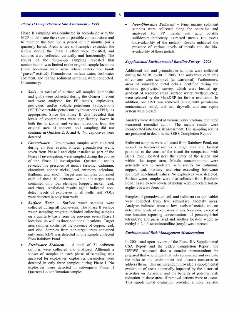
8
Phase II Comprehensive Site Assessment – 1999
Phase II sampling was conducted in accordance with the MCP to delineate the extent of possible contamination and to monitor the Site for a period of 12 months (on a quarterly basis). Areas where soil samples exceeded the RCS-1 during the Phase I effort were revisited, and samples were collected vertically and horizontally. The results of the follow-up sampling revealed that contamination was limited to the original sample locations (these locations were areas where craters and bomb “graves” existed). Groundwater, surface water, freshwater sediment, and marine sediment sampling were conducted. In summary: Soils – A total of 43 surface soil samples (composite
and grab) were collected during the Quarter 1 event and were analyzed for PP metals, explosives, pesticides, and/or volatile petroleum hydrocarbons (VPH)/extractable petroleum hydrocarbons (EPH), as appropriate. Since the Phase II data revealed that levels of contaminants were significantly lower in both the horizontal and vertical directions from the original area of concern, soil sampling did not continue in Quarters 2, 3, and 4. No explosives were detected.
Groundwater – Groundwater samples were collected during all four events. Fifteen groundwater wells, seven from Phase I and eight installed as part of the Phase II investigation, were sampled during the course of the Phase II investigation. Quarter 1 results revealed the presence of metals (arsenic, cadmium, chromium, copper, nickel, lead, antimony, selenium, thallium, and zinc). Target area samples contained each of these 10 elements, while non-target areas contained only four elements (copper, nickel, lead, and zinc). Analytical results again indicated non-detect levels of explosives in all wells, and VOCs were detected in only four wells.
Surface Water – Surface water samples were collected during all four events. The Phase II surface water sampling program included collecting samples on a quarterly basis from the previous seven Phase I locations, as well as three additional locations. Target area samples confirmed the presence of copper, lead, and zinc. Samples from non-target areas contained only zinc. RDX was detected in one sample collected from Rainbow Pond.
Freshwater Sediment – A total of 21 sediment samples were collected and analyzed. Although a subset of samples in each phase of sampling was analyzed for explosives, explosives parameters were detected in only three samples during Phase I. No explosives were detected in subsequent Phase II Quarters 1-4 confirmation samples.
Near-Shoreline Sediment – Nine marine sediment samples were collected along the shoreline and analyzed for PP metals and acid volatile sulfide/simultaneously extracted metals (to assess bioavailability of the metals). Results indicated the presence of various levels of metals and the bio-availability of these metals.
Supplemental Environmental Baseline Survey – 2003 Additional soil and groundwater samples were collected during the SEBS event in 2003. The soils from each area of concern were sampled (as warranted). Furthermore, areas of subsurface metal debris identified during the airborne geophysical survey, which were located up-gradient of resource areas (surface water, wetland, etc.), were selected by the MassDEP for further evaluation. In addition, one UST was removed (along with petroleum-contaminated soils), and two drywells and one septic system were closed. Analytes were detected at various concentrations, but none warranted remedial action. The metals results were incorporated into the risk assessment. The sampling results are presented in detail in the SEBS Completion Report. Sediment samples were collected from Rainbow Pond, not subject to historical use as a target area and located proximal to the coast of the island for comparison with Ben’s Pond, located near the center of the island and within the target area. Metals concentrations were generally low to moderate, with results for cadmium, copper, lead, mercury, and zinc exceeding freshwater sediment benchmark values. No explosives were detected. Surface water samples were also collected from Rainbow Pond. Trace to low levels of metals were detected, but no explosives were detected. Samples of groundwater, soil, and sediment (as applicable) were collected from five subsurface anomaly areas. Analyses indicated trace to low levels of metals, and no detectable levels of explosives at any locations, except at one location reporting concentrations of pentaerythritol tetranitrate and picric acid and another location where n-methyl-n-2,4,6-tetranitroaniline (tetryl) was detected. Environmental Risk Management Memorandum In 2004, and upon review of the Phase IIA Supplemental CSA Report and the SEBS Completion Report, the USFWS requested that a concise memorandum be prepared that would quantitatively summarize and evaluate the risks to the environment and discuss measures to address them. This memorandum provided a supplemental evaluation of areas potentially impacted by the historical activities on the island and the benefits of potential risk reduction in these areas if removal actions were to occur. This supplemental evaluation provided a more realistic
9
estimate of exposure by re-evaluating the no observable adverse effects level and the lowest observable adverse effects level (LOAEL) for songbirds through utilization of a mean BAF, the natural log (LN) mean BAF, and a 90th percentile BAF. These supplemental evaluations were requested by the USFWS to provide a more accurate and realistic estimation to support risk management decision-making. The Navy conducted three project management meetings with the USFWS and the MassDEP on the subject. The final version of the memorandum, dated April 24, 2006, stated that utilization of the mean LN BAF (the BAF reached by consensus) resulted in no LOAEL-based exceedances for cadmium, chromium, lead, or zinc on an island-wide basis for the songbird. Upon discussion of these results between the Navy, USFWS, and MassDEP, it was concluded that a level of no significant risk to environmental receptors associated with the soil/ invertebrate pathway related to the target areas had been achieved. Furthermore, it was concluded that remedial action should be performed at the FDA in order to remove the source material identified in the FDA slope. Former Target Areas Conclusions The risk assessments conducted during the Phase I and Phase II assessments have revealed that the soils, surface water, sediment, and groundwater at the Site pose no significant risk to human health and public welfare. Based on the information contained in the environmental risk assessments, the USFWS and MassDEP have determined that a level of “no significant risk” to the environment has been achieved at the Site. Ordnance remains in the subsurface soils at the Site and in the near-shoreline marine environment. The island is managed as an unstaffed national wildlife refuge, and, while it is off-limits to the public, is susceptible to trespassers. As such, a level of “no significant risk” to safety has not been achieved. The Navy proposes to implement Remedial Alternative S-2 (described in the Phase III/FS Report), which consists of “Institutional Controls/Public Awareness and Enforcement”. This Proposed Plan would formally put in place a system of institutional controls (e.g., signage, Activity Use Limitation (AUL), inspections, UXO response), which will aid in keeping potential trespassers off of the island, thus reducing the potential for people to come into contact with ordnance-related materials. Similar controls and inspections have already been implemented as interim measures to mitigate risks and ensure safety during the planning process. As part of this plan, the USFWS will continue to maintain the access restrictions and enforcement actions applicable to the national wildlife refuge. The implementation of this remedial alternative would ensure that a level of “no significant risk” to safety
can be achieved at the Site by reducing receptor exposure to potential explosive hazards remaining on the island.
Site Background and Characteristics: Former Debris Area Where is the Former Debris Area? The FDA is located just north of the highest point on theisland (Figure 4). It is located upgradient of an extensive emergent wetland that runs west to east and eventually drains into the ocean in the eastern portion of the Site. Former Debris Area Use During the Phase I Limited Site Investigation, the Navy identified this location as having the characteristics of a “debris area.” Metal debris, particle board, ceramics, etc. were observed to be protruding from the surface soilsalong the hillside located down-slope from numerous concrete foundations. Soil, groundwater, surface water, and sediment sampling were conducted as part of the Phase I and II investigations. In 2001, a test pitting program confirmed that subsurface debris was present. The aerial photograph analysis of the area (conducted as part of the SEBS) provided conclusive evidence that the origin of the debris was the former Quonset huts that hadbeen demolished and disposed in this location sometime between 1951 and 1957. The Quonset huts had occupied the area where concrete pads currently exist (Figure 4).
Figure 4 – Former Debris Area showing location of old Quonset huts What does the Former Debris Area Look Like Today? In 2003, the Navy implemented a RAM to close a septic system along the slope of the FDA. In 2006, another RAM was implemented to remove the metal debris that had the potential to act as a “source” of potential contamination to the downgradient wetland resource. Figure 5 shows the FDA wetland.
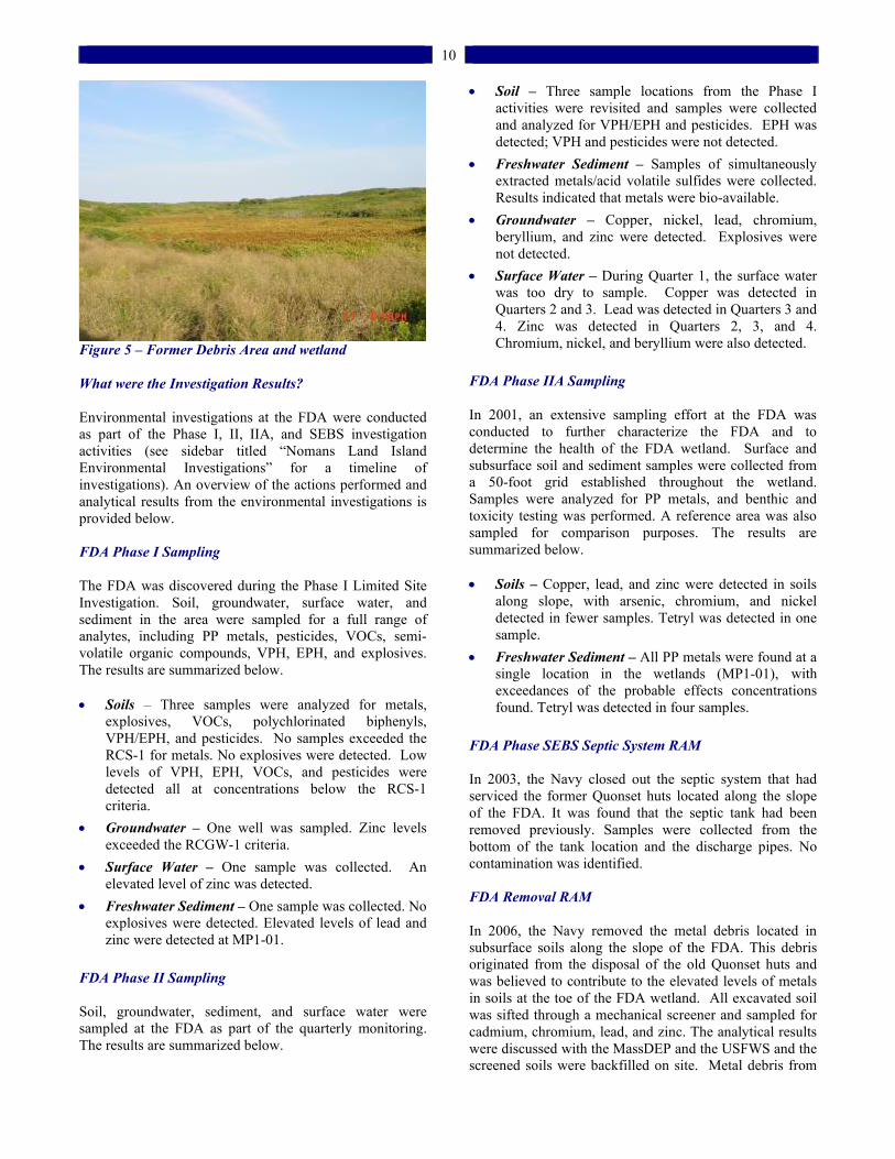
10
Figure 5 – Former Debris Area and wetland
What were the Investigation Results? Environmental investigations at the FDA were conducted as part of the Phase I, II, IIA, and SEBS investigation activities (see sidebar titled “Nomans Land Island Environmental Investigations” for a timeline of investigations). An overview of the actions performed and analytical results from the environmental investigations is provided below. FDA Phase I Sampling The FDA was discovered during the Phase I Limited Site Investigation. Soil, groundwater, surface water, and sediment in the area were sampled for a full range of analytes, including PP metals, pesticides, VOCs, semi-volatile organic compounds, VPH, EPH, and explosives. The results are summarized below. Soils – Three samples were analyzed for metals,
explosives, VOCs, polychlorinated biphenyls, VPH/EPH, and pesticides. No samples exceeded the RCS-1 for metals. No explosives were detected. Low levels of VPH, EPH, VOCs, and pesticides were detected all at concentrations below the RCS-1 criteria.
Groundwater – One well was sampled. Zinc levels exceeded the RCGW-1 criteria.
Surface Water – One sample was collected. An elevated level of zinc was detected.
Freshwater Sediment – One sample was collected. No explosives were detected. Elevated levels of lead and zinc were detected at MP1-01.
FDA Phase II Sampling Soil, groundwater, sediment, and surface water were sampled at the FDA as part of the quarterly monitoring. The results are summarized below.
Soil – Three sample locations from the Phase I activities were revisited and samples were collected and analyzed for VPH/EPH and pesticides. EPH was detected; VPH and pesticides were not detected.
Freshwater Sediment – Samples of simultaneously extracted metals/acid volatile sulfides were collected. Results indicated that metals were bio-available.
Groundwater – Copper, nickel, lead, chromium, beryllium, and zinc were detected. Explosives were not detected.
Surface Water – During Quarter 1, the surface water was too dry to sample. Copper was detected in Quarters 2 and 3. Lead was detected in Quarters 3 and 4. Zinc was detected in Quarters 2, 3, and 4. Chromium, nickel, and beryllium were also detected.
FDA Phase IIA Sampling In 2001, an extensive sampling effort at the FDA was conducted to further characterize the FDA and to determine the health of the FDA wetland. Surface and subsurface soil and sediment samples were collected from a 50-foot grid established throughout the wetland. Samples were analyzed for PP metals, and benthic and toxicity testing was performed. A reference area was also sampled for comparison purposes. The results are summarized below. Soils – Copper, lead, and zinc were detected in soils
along slope, with arsenic, chromium, and nickel detected in fewer samples. Tetryl was detected in one sample.
Freshwater Sediment – All PP metals were found at a single location in the wetlands (MP1-01), withexceedances of the probable effects concentrations found. Tetryl was detected in four samples.
FDA Phase SEBS Septic System RAM In 2003, the Navy closed out the septic system that had serviced the former Quonset huts located along the slope of the FDA. It was found that the septic tank had been removed previously. Samples were collected from the bottom of the tank location and the discharge pipes. No contamination was identified. FDA Removal RAM In 2006, the Navy removed the metal debris located in subsurface soils along the slope of the FDA. This debris originated from the disposal of the old Quonset huts and was believed to contribute to the elevated levels of metals in soils at the toe of the FDA wetland. All excavated soil was sifted through a mechanical screener and sampled for cadmium, chromium, lead, and zinc. The analytical results were discussed with the MassDEP and the USFWS and the screened soils were backfilled on site. Metal debris from

11
one area containing elevated concentrations of metals (MP1-01) was removed during this field effort. This location, which exhibited the highest concentrations of zinc, was on the direct pathway from the potential source material to the wetland sediment that was shown to exceed multiple benthic community endpoints. Former Debris Area Conclusions Prior to implementation of the FDA removal effort in 2006, the USFWS and the MassDEP had indicated that a level of no significant risk had been established for the environment in regard to the Site soils. However, the subsurface debris at the FDA required removal since this material was providing a continuing source of metals contamination to the adjacent wetland. Since this removal effort is now complete, a level of no significant risk to the environment has been achieved at the FDA.
Site Background and Characteristics: Near-Shoreline Marine Environment Where is the Near-Shoreline Marine Environment?
The near-shoreline marine environment includes the immediate marine waters and sediments surrounding the island. What was the Near-Shoreline Marine Environment used for? The near-shoreline marine environment around the island was not a target area but is considered part of the Site due to the possibility that not all ordnance items landed on their respective targets, but may have landed in the waters surrounding the island. This has been confirmed by MEC that has been observed in the waters directly offshore. What does the Near-Shoreline Marine Environment Look Like Today? The near-shoreline area looks very similar to the shoreline of Martha’s Vineyard (see Figure 6), with steep cliffs on the southern shoreline and sandy beaches along the northern shore of the island. Occasionally, MEC, deposited from the eroding banks or as the result of being washed onshore from the ocean during storm events, has been observed on the shoreline.
Figure 6 – Nomans Land Island shoreline showing signage What were the Investigation Results? Near-Shoreline Sediment Sampling As part of the Phase IIA investigation in 2001, sediment samples were collected from seven runoff channels and seven near-shoreline locations to evaluate the potential of migration of COPCs off the island. Metals concentration results were relatively low, and no explosives were detected. It was concluded that a potential pathway (i.e., surface water runoff) did exist for the West End Target area. Shellfish Sampling A shellfish sampling study was conducted as part of the 2001 Phase IIA Investigation. Native blue mussels were harvested from three areas along the shoreline to assess potential exposure for comparison with representative reference levels. Metals levels in the blue mussels exceeded National Oceanic and Atmospheric Administration (NOAA) National Status and Trends Program database levels for Massachusetts waters, but were generally comparable to metals concentrations found in blue mussels harvested from Martha’s Vineyard, Massachusetts marine waters. Shellfish Transplant Study The objective of the 2001 Phase IIA Investigation transplant study was to support the assessment of off-site COPC migration and the potential for leaching of ordnance in the marine environment. Seven racks were deployed, along with one reference station near Menemsha Harbor. Only four racks were recovered (three from the island and one from a reference location). No statistical difference in metals concentrations was detected from transplanted shellfish as compared to the reference station. Figure 7 shows the shellfish transplant study locations.
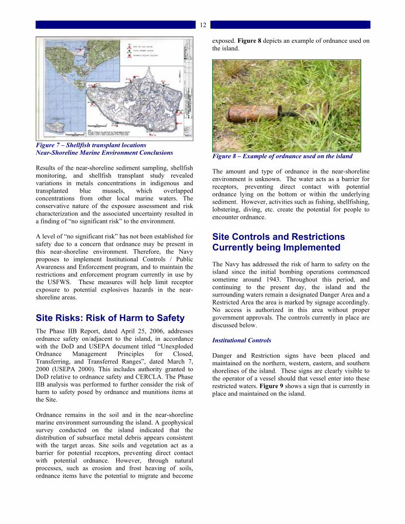
12
Figure 7 – Shellfish transplant locations Near-Shoreline Marine Environment Conclusions Results of the near-shoreline sediment sampling, shellfish monitoring, and shellfish transplant study revealed variations in metals concentrations in indigenous and transplanted blue mussels, which overlapped concentrations from other local marine waters. The conservative nature of the exposure assessment and risk characterization and the associated uncertainty resulted in a finding of “no significant risk” to the environment.
A level of “no significant risk” has not been established for safety due to a concern that ordnance may be present in this near-shoreline environment. Therefore, the Navy proposes to implement Institutional Controls / Public Awareness and Enforcement program, and to maintain the restrictions and enforcement program currently in use by the USFWS. These measures will help limit receptor exposure to potential explosives hazards in the near-shoreline areas.
Site Risks: Risk of Harm to Safety The Phase IIB Report, dated April 25, 2006, addresses ordnance safety on/adjacent to the island, in accordance with the DoD and USEPA document titled “Unexploded Ordnance Management Principles for Closed, Transferring, and Transferred Ranges”, dated March 7, 2000 (USEPA 2000). This includes authority granted to DoD relative to ordnance safety and CERCLA. The Phase IIB analysis was performed to further consider the risk of harm to safety posed by ordnance and munitions items at the Site. Ordnance remains in the soil and in the near-shoreline marine environment surrounding the island. A geophysical survey conducted on the island indicated that the distribution of subsurface metal debris appears consistent with the target areas. Site soils and vegetation act as a barrier for potential receptors, preventing direct contact with potential ordnance. However, through natural processes, such as erosion and frost heaving of soils, ordnance items have the potential to migrate and become
exposed. Figure 8 depicts an example of ordnance used on the island.
Figure 8 – Example of ordnance used on the island The amount and type of ordnance in the near-shoreline environment is unknown. The water acts as a barrier for receptors, preventing direct contact with potential ordnance lying on the bottom or within the underlying sediment. However, activities such as fishing, shellfishing, lobstering, diving, etc. create the potential for people to encounter ordnance.
Site Controls and Restrictions Currently being Implemented The Navy has addressed the risk of harm to safety on the island since the initial bombing operations commenced sometime around 1943. Throughout this period, and continuing to the present day, the island and the surrounding waters remain a designated Danger Area and a Restricted Area the area is marked by signage accordingly. No access is authorized in this area without proper government approvals. The controls currently in place are discussed below. Institutional Controls Danger and Restriction signs have been placed and maintained on the northern, western, eastern, and southern shorelines of the island. These signs are clearly visible to the operator of a vessel should that vessel enter into these restricted waters. Figure 9 shows a sign that is currently in place and maintained on the island.
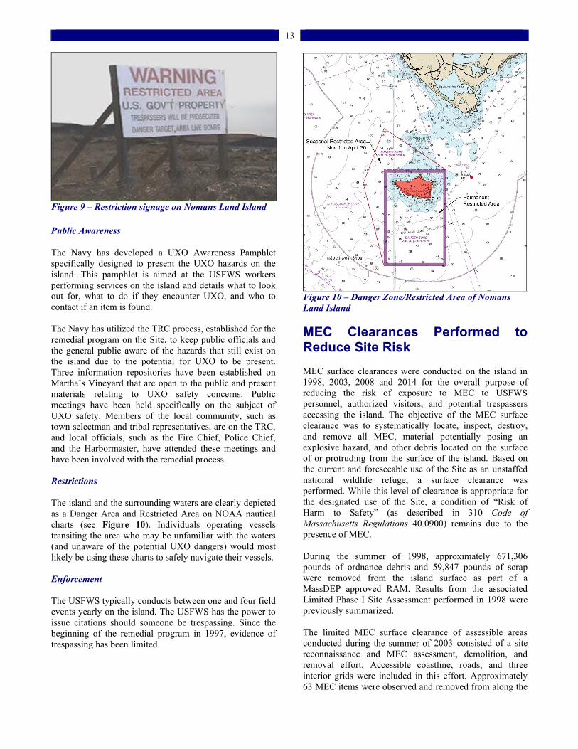
13
Figure 9 – Restriction signage on Nomans Land Island
Public Awareness
The Navy has developed a UXO Awareness Pamphlet specifically designed to present the UXO hazards on the island. This pamphlet is aimed at the USFWS workers performing services on the island and details what to look out for, what to do if they encounter UXO, and who to contact if an item is found. The Navy has utilized the TRC process, established for the remedial program on the Site, to keep public officials and the general public aware of the hazards that still exist on the island due to the potential for UXO to be present. Three information repositories have been established on Martha’s Vineyard that are open to the public and present materials relating to UXO safety concerns. Public meetings have been held specifically on the subject of UXO safety. Members of the local community, such as town selectman and tribal representatives, are on the TRC, and local officials, such as the Fire Chief, Police Chief, and the Harbormaster, have attended these meetings and have been involved with the remedial process. Restrictions The island and the surrounding waters are clearly depicted as a Danger Area and Restricted Area on NOAA nautical charts (see Figure 10). Individuals operating vessels transiting the area who may be unfamiliar with the waters (and unaware of the potential UXO dangers) would most likely be using these charts to safely navigate their vessels. Enforcement The USFWS typically conducts between one and four field events yearly on the island. The USFWS has the power to issue citations should someone be trespassing. Since the beginning of the remedial program in 1997, evidence of trespassing has been limited.
Figure 10 – Danger Zone/Restricted Area of Nomans Land Island
MEC Clearances Performed to Reduce Site Risk MEC surface clearances were conducted on the island in 1998, 2003, 2008 and 2014 for the overall purpose of reducing the risk of exposure to MEC to USFWS personnel, authorized visitors, and potential trespassers accessing the island. The objective of the MEC surface clearance was to systematically locate, inspect, destroy, and remove all MEC, material potentially posing an explosive hazard, and other debris located on the surface of or protruding from the surface of the island. Based on the current and foreseeable use of the Site as an unstaffed national wildlife refuge, a surface clearance was performed. While this level of clearance is appropriate for the designated use of the Site, a condition of “Risk of Harm to Safety” (as described in 310 Code of Massachusetts Regulations 40.0900) remains due to the presence of MEC. During the summer of 1998, approximately 671,306 pounds of ordnance debris and 59,847 pounds of scrap were removed from the island surface as part of a MassDEP approved RAM. Results from the associated Limited Phase I Site Assessment performed in 1998 were previously summarized. The limited MEC surface clearance of assessible areas conducted during the summer of 2003 consisted of a site reconnaissance and MEC assessment, demolition, and removal effort. Accessible coastline, roads, and three interior grids were included in this effort. Approximately 63 MEC items were observed and removed from along the
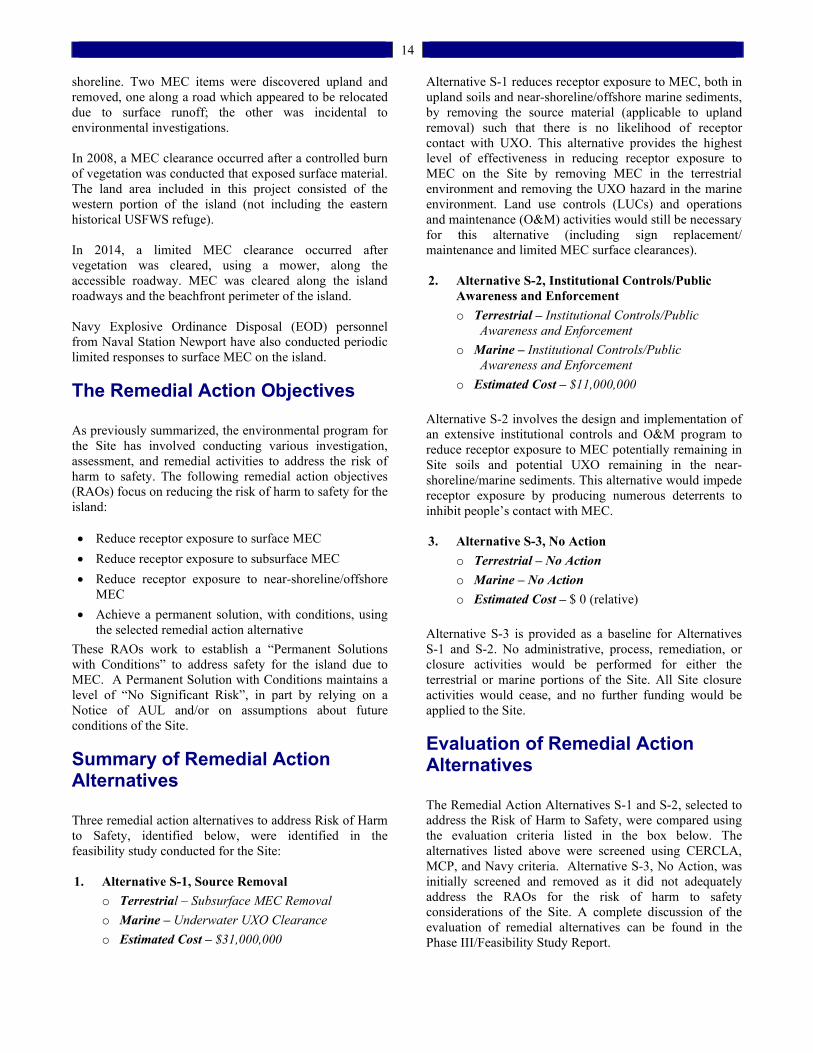
14
shoreline. Two MEC items were discovered upland and removed, one along a road which appeared to be relocated due to surface runoff; the other was incidental to environmental investigations. In 2008, a MEC clearance occurred after a controlled burn of vegetation was conducted that exposed surface material. The land area included in this project consisted of the western portion of the island (not including the eastern historical USFWS refuge). In 2014, a limited MEC clearance occurred after vegetation was cleared, using a mower, along the accessible roadway. MEC was cleared along the island roadways and the beachfront perimeter of the island. Navy Explosive Ordinance Disposal (EOD) personnel from Naval Station Newport have also conducted periodic limited responses to surface MEC on the island.
The Remedial Action Objectives
As previously summarized, the environmental program forthe Site has involved conducting various investigation, assessment, and remedial activities to address the risk of harm to safety. The following remedial action objectives (RAOs) focus on reducing the risk of harm to safety for the island: Reduce receptor exposure to surface MEC
Reduce receptor exposure to subsurface MEC
Reduce receptor exposure to near-shoreline/offshore MEC
Achieve a permanent solution, with conditions, using the selected remedial action alternative
These RAOs work to establish a “Permanent Solutions with Conditions” to address safety for the island due to MEC. A Permanent Solution with Conditions maintains a level of “No Significant Risk”, in part by relying on a Notice of AUL and/or on assumptions about future conditions of the Site.
Summary of Remedial Action Alternatives
Three remedial action alternatives to address Risk of Harm to Safety, identified below, were identified in the feasibility study conducted for the Site:
1. Alternative S-1, Source Removal
o Terrestrial – Subsurface MEC Removal
o Marine – Underwater UXO Clearance
o Estimated Cost – $31,000,000
Alternative S-1 reduces receptor exposure to MEC, both in upland soils and near-shoreline/offshore marine sediments,by removing the source material (applicable to uplandremoval) such that there is no likelihood of receptor contact with UXO. This alternative provides the highest level of effectiveness in reducing receptor exposure to MEC on the Site by removing MEC in the terrestrial environment and removing the UXO hazard in the marine environment. Land use controls (LUCs) and operations and maintenance (O&M) activities would still be necessary for this alternative (including sign replacement/ maintenance and limited MEC surface clearances).
2. Alternative S-2, Institutional Controls/Public
Awareness and Enforcement
o Terrestrial – Institutional Controls/Public Awareness and Enforcement
o Marine – Institutional Controls/Public Awareness and Enforcement
o Estimated Cost – $11,000,000
Alternative S-2 involves the design and implementation of an extensive institutional controls and O&M program to reduce receptor exposure to MEC potentially remaining in Site soils and potential UXO remaining in the near-shoreline/marine sediments. This alternative would impede receptor exposure by producing numerous deterrents to inhibit people’s contact with MEC.
3. Alternative S-3, No Action
o Terrestrial – No Action
o Marine – No Action
o Estimated Cost – $ 0 (relative)
Alternative S-3 is provided as a baseline for Alternatives S-1 and S-2. No administrative, process, remediation, or closure activities would be performed for either the terrestrial or marine portions of the Site. All Site closure activities would cease, and no further funding would be applied to the Site.
Evaluation of Remedial ActionAlternatives The Remedial Action Alternatives S-1 and S-2, selected to address the Risk of Harm to Safety, were compared using the evaluation criteria listed in the box below. The alternatives listed above were screened using CERCLA, MCP, and Navy criteria. Alternative S-3, No Action, was initially screened and removed as it did not adequately address the RAOs for the risk of harm to safety considerations of the Site. A complete discussion of the evaluation of remedial alternatives can be found in the Phase III/Feasibility Study Report.
15
Both Alternatives S-1 and S-2 would meet the CERCLA threshold criteria of (1) overall protection of human health and the environment, and (2) compliance with ARARs/TBC. Both Alternatives S-1 and S-2 would meet the CERCLA balancing criteria of (3) long-term effectiveness and permanence, (4) short-term effectiveness, and (5) implementability. Alternative S-1 would reduce risk by removing MEC, whereas Alternative S-2 would reduce risk by requiring legal and regulatory controls to limit access to the island. Only Alternative S-1 would address the CERCLA balancing criteria of reduction in toxicity, mobility and volume with MEC removal. The CERCLA balancing factor of cost for Alternative S-1 would be much greater than Alternative S-2. Both Alternatives S-1 and S-2 would meet the MCP-specific criteria of (1) risk of alternative and (2) comparative benefits. The MCP criterion of (3) comparative timeline for both alternatives would be 30 years to provide for long-term site maintenance, LUCs, and limited MEC surface clearances. The MCP criterion of (4) relative effect upon non-pecuniary interests for Alternative S-2 is minimal, whereas, for Alternative S-1, it would require temporary, short-term detonation of donor explosives to neutralize potential MEC. Both Alternative S-1 and S-2 would meet the Navy specific criteria of performance objectives that measure the operational efficiency and suitability of a particular remedial technology. However, the Navy criteria for optimization and exit strategy, a means of determining when it is time to stop, modify, or change a particular technology based on the achievement of previously established performance objectives, would be determined as an ongoing process during implementation. If Alternative S-1 was implemented, a significant loss of habitat and wildlife would occur. In addition, if Alternative S-1 was implemented, there would still be residual risk at completion of MEC removal, given the likelihood that an unknown number of MEC items could potentially be missed. Alternative S-1 would provide an appropriately selected remedy should future use of the Site change (e.g., construction of residences, recreational use by the general public, public site visits). However, given that the current and future use of the island remains that of an unstaffed national wildlife refuge, the risks associated with the MEC hazards that remain on the island can be managed such that potential receptor exposure to potentially explosive hazards is reduced to acceptable levels using institutional controls. The current upland controls that aid in limiting receptor (trespassing) exposure on the terrestrial portion of the Site have been shown to be relatively effective deterrents, Trespassing is known to occur on a limited basis. These controls need to be further refined and
formally enacted, along with a public awareness and enforcement program. Applied to the marine portion of the Site, these programs would also provide an acceptable level of reduction in receptor exposure to MEC in the surrounding waters. Therefore, Alternative S-2 was selected as the proposed remedy to address the risk of harm to safety, given that the current and future use of the Site remains an unstaffed national wildlife refuge.
The Proposed Plan for the Preferred Remedial Alternative The preferred remedial alternative, S-2, Institutional Controls / Public Awareness and Enforcement, will meet the RAOs by achieving a permanent solution with conditions to address safety for the island due to MEC. Remedial Alternative S-2 was selected to address the risk of harm to safety, since the current and future use of the Site will remain an unstaffed national wildlife refuge. The Navy, USFWS, and the MassDEP concur with the selection of this remedy. However, the preferred alternative, discussed below, can change in response to public comment or new information. The environmental cleanup of chemical contamination of the island has been completed. During the earlier phased investigations, Site access restrictions were implementedand USFWS workers and the public were educated on the remaining safety concerns due to the presence of MEC. The USFWS has been implementing a safety program that was proposed by the Navy. Through discussion betweenthe MassDEP, USFWS, and the Navy, and as part of the implementation, the selected remedial alternative includes the safety program for the Site, which consists of institutional controls, public awareness, and enforcement components. These components will be formalized with an O&M Plan, LUC Implementation Plan, and a Notice of AUL. The Proposed Plan for the selected Remedial Alternative, S-2, includes the following components: Institutional Controls Restricted Water Designation
Signage
o Upland signage replacement/maintenance
o Beach signage
USFWS O&M Plan
o Inspections
Navy O&M (e.g., limited MEC surface clearances, UXO response)
UXO response program
16
LUCs - restricted assess
Annual Verification
Public Awareness USFWS/public UXO awareness training
UXO awareness pamphlet
Enforcement USFWS violations/fine system
U.S. Coast Guard/Marine Police violations/fine system
These components have already been in use by the Navy and USFWS and will continue to reduce the level of receptor exposure to potential UXO on the Site. An O&M Plan was drafted for the USFWS in 2001, finalized and implemented in 2004, and revised in 2019. This plan was prepared to ensure that the institutional controls already in place (i.e., signs and restrictions) were adequately maintained and to provide feedback on MECthat had potentially come to the surface due to natural processes. The USFWS has incorporated this plan into its site visit and fieldwork schedule. As a result, the signs and restrictions have been maintained and only a limited amount of trespassing has occurred. The preferred remedial alternative, S-2, meets thethreshold criteria and provides the best balance of tradeoffs among the alternatives with respect to the balancing andmodifying criteria. The preferred remedial alternative satisfies the following statutory requirements of CERCLA §121(b): (1) be protective of human health and the environment; (2) comply with ARARs (or justify a waiver); (3) be cost-effective; (4) utilize a permanent solution with conditions to the maximum extent practicable; and (5) satisfy the objective to establish a level of no significant risk using a combination of institutional controls, public awareness, and enforcement.
Rationale for the Proposed Plan of Institutional Controls/Public Awareness and Enforcement The Phase III/Feasibility Study examined a range ofalternatives and was designed to address the only remaining risk identified for the island, the risk of harm to safety associated with the remaining subsurface ordnance in the soil and nearshore environment. Different possible responses were considered and evaluated. The selected Remedial Alternative of Institutional Controls/Public Awareness and Enforcement was judged to be the best option for meeting the safety-related remedial goals. The Navy has concluded that the selection of this alternative,
Evaluation Criteria for Remedial Alternatives
CERCLA requires that remedial action alternatives be evaluated, using nine criteria, to identify the “Preferred Alternative”. For this Site, three additional MCP-specific criteria and two additional Navy-specific criteria were applied in the selection of the Preferred Alternative. The criteria are summarized below.
CERCLA Criteria:
All potential remedial action alternatives must meet the following threshold criteria:
(1) Overall protection of human health and the environment
(2) Compliance with applicable or relevant and appropriate requirements (ARARs)/to-be-considered (TBC)
The following primary balancing criteria distinguish and measure differences between alternatives: (1) Long-term effectiveness and permanence
(2) Short-term effectiveness
(3) Implementability
(4) Reduction in toxicity, mobility, and volume
(5) Cost
The following modifying criteria are those that are fully evaluated after public comment on the Proposed Plan and include:
(1) Acceptance by appropriate state agencies or agencies with jurisdiction over affected resources
(2) Community acceptance
Additional MCP-Specific Criteria: (1) Risk of alternative
(2) Comparative benefits
(3) Comparative timeline
(4) Relative effect upon non-pecuniary interests
Additional Navy-Specific Criteria:
(1) Performance objectives
(2) Optimization and exit strategy
17
detailed within the Phase III/FS Report, is appropriate for the reasons outlined below. Phase I, II, IIA, and SEBS chemical sampling results
for soil, groundwater, sediments, and surface waters at the Site demonstrated that exposures to these media do not pose a significant risk to human health, public welfare, and the environment. This finding was mutually agreed upon by the Navy, the USFWS, and MassDEP, and was summarized in the Environmental Risk Management Memorandum.
All known sources of potential OHM contaminants (with the exception of subsurface ordnance) have been removed from the island or remediated to eliminate or mitigate their potential impact on people or the environment.
The current and foreseeable future use remains that of an unstaffed national wildlife refuge. Public access is not permitted.
The components of this proposed response alternative have been selected to specifically address the site-specific safety concerns.
The proposed response reflects a multiple initiative approach, including elements of additional site access controls and use prohibitions, education about site conditions and safety, and enforcement measures.
Implementation of this Proposed Plan will effectively reduce people’s exposure to potential explosive hazards associated with the ordnance present on the island.
Next Steps – Community Participation
The next step in the CERCLA processes for the Site is to review and consider this Proposed Plan for acceptance by the community. The Navy encourages the public to review this Plan and to submit comments. During the public comment period from September 15, 2020 to October 15, 2020, the Navy will accept written comments on the Proposed Plan. The Navy will accept verbal comments during a public hearing that follows a public information meeting to be held on September 29, 2020 via webinar. Following the public comment period on this Proposed Plan, the Navy will summarize and respond to comments received during that period and during the virtual public hearing in a document called a Responsiveness Summary. The Navy, the USFWS, and MassDEP will carefully consider all comments received. Once the communities have commented on this Proposed Plan, the Navy will consider all comments received. It is possible that public comments can change this Proposed Plan. The Navy is required by law to provide written responses to comments received on this Proposed Plan.
Ultimately, the final plan will be documented in a Record of Decision (ROD). The Responsiveness Summary will be issued as a section of the ROD. The ROD will contain the rationale for the Navy’s decision regarding the selected alternative. The Navy and MassDEP will review all comments and they will be included in the final ROD. The document will then be made available to the public at the information repositories listed at the end of this document. Also, the Navy will announce the availability of the ROD through the local news media and the community mailing list.
If the institutional controls, public awareness, and enforcement alternative in this Proposed Plan is approved, all environmental investigations and activities for the Site will be considered complete following signature of the ROD, and the island will continue to be managed by the USFWS accordingly.
Commitment to the Communities The Navy is committed to keeping the communities informed regarding the environmental cleanup programs at the Site. Public meetings have been held to provide community feedback. The TRC, comprised of community leaders, government agency representatives, and local citizens, was formed to discuss the environmental programs for the island. The Navy also maintains a community mailing list for distributing information about the environmental programs. If you would like to be added to the mailing
Your Questions and Comments are Important
Formal comments are used to improve the decision-making process. The Navy will accept formal comments from the public during a 30-day comment period and will hold a public information meeting and hearing for both written and verbal comments (see page 1 for information regarding how to submit a formal comment to the Navy). Your formal comments during this time will become part of the official record for Nomans Land Island. The Navy will consider the comments received during the comment period prior to making the final decisions for the Site. The public is encouraged to participate during this period as your thoughts and opinions will help in making the final decision. You do not have to be a technical expert to take part in the process.
18
list, please contact Mr. David Barney at the address provided in this Proposed Plan.
Details of the information summarized in this Proposed Plan are contained in the documents below, which are available for your review at the information repositories listed at this end of this document.
Important Dates and Meeting Information
Public Comment Period: September 15, 2020 through October 15, 2020
Virtual Public Information Meeting and Public Hearing: September 29, 2020 Public Information Meeting at 7 p.m. Public Hearing at 8 p.m. The Virtual Public Information Meeting and Public Hearing will be presented as a WebEx Webinar.
To participate in the Webinar, type into your browser this shortened link: https://tinyurl.com/NMLPPWE5
or this full link:
https://tetratech-events.webex.com/tetratech-events/onstage/g.php?MTID=ee31dd9f0b3b991b6ddbdc5197a58fc0a
Then enter your name and email address and click the “Join Now” button.
If you are unable to join the meeting online, you may join by phone by calling +1-408-418-9388 and entering the Access code: 132 470 7236#. A WebEx Webinar Information and Tips instruction sheet for accessing and participating in the meeting is available from the repositories and BRAC website. If you experience technical difficulties accessing the meeting, please contact WebEx by telephone at 1-866-779-3239.
19
Document Type Document Name Conclusion/Result
Investigation/ Assessment
Explosives Safety Remediation Plan (ESRP) – 1997
Established objectives and work approach to perform UXO surface clearance approved by the DoD Explosives Safety Board.
Phase I Limited Site Investigation – 1998
Addressed nine review items from the EBS. Metals detected in Site soils, groundwater, surface water,
and sediment. Explosives were detected in two soils samples and one
surface water sample. Radiological Screening Survey Report – 1998
Confirmed that ordnance debris tested negative for radiological constituents.
Phase II Comprehensive Site Assessment – 1999/2000
Metals in soils determined to be localized to bomb craters/graves.
No explosives detected in soils, sediment, and groundwater. RDX detected in one surface water body.
Phase IIA Comprehensive Site Assessment – Supplemental Investigation – 2001
Elevated levels of metals detected in the FDA. FDA wetland sediments found to exceed multiple benthic
community endpoints. Identified potential pathway from Site soils to marine
environment. Interview Summary Letter Report – 2002
Generally confirmed what was already known regarding Site history and use.
Airborne Geophysical Survey – 2001/2002
Areas of subsurface metal identified. Data supports the CSM and biased sampling approach.
Aerial Photographic Site Analysis – 2001
Filled data gaps regarding historical use. Confirmed the CSM.
Supplemental Environmental Baseline Survey – 2003
Identified 19 additional review items. Inspected, assessed, and sampled these review items under
MassDEP oversight. Phase IIB – Supplemental Investigation - Risk to Safety – 2004
Expanded the explosive hazards CSM and evaluated ordnance risk of harm to safety.
Environmental Risk Management Memorandum – 2006
Determined a level of “no significant risk” to environment was achieved for Site soils.
Recommended removal of metal debris from the FDA. Final Phase III/Feasibility Study – 2019
Recommended that Alternative S-2 Institutional Controls, Public Awareness, and Enforcement be selected as the preferred plan.
RAMs Ordnance Debris Removal RAM – 1998
Removed over 11,000 ordnance-related items (671,306 pounds) and 59,847 pounds of scrap from the island.
UST Removal RAM – 1998 Four USTs (and associated piping) removed. Twenty-five cubic yards of petroleum-contaminated soils
removed. Removal of One UST, Two Drywells, and One Septic System RAM – 2003
Removed one 275-gallon UST and 19 cubic yards of contaminated soil.
Two drywells and one septic system were closed in place. FDA Removal RAM – 2006 A total of 1.5 tons of metal debris removed.
Performed field soil screening at Aviation Landing Strip Areas.
MEC Clearance After-Action Report – August 2004 Summarized the 1998 MEC surface clearance operations and the 2003 limited MEC surface clearance of assessible areas.
Confirmed completion of the ESRP objectives. MEC Surface Clearance – 2008 A total of 16,119 pounds MDAS removed and recycled.
A total of 394 munitions-related items disposed off-site. Limited MEC Surface Clearance – 2014
A total of 65 acres cleared of 164 munitions-related items. A total of 3,650 pounds of MDAS removed and recycled.
Background Documents
Final Report, Phase I Environmental Baseline Survey, November 1996
Identified review item areas for further study.
20
GLOSSARY OF TERMS
Activity and Use Limitation – A grant of environmental restriction or notice of activity and use limitation recorded, registered, or filed. Background Level – Chemicals or concentrations of chemicals present in the environment due to naturally occurring geochemical processes and sources, or to human activities not related to specific point sources or source releases. Benchmark – A concentration of a chemical considered to be protective of human health or the environment. Comprehensive Environmental Response, Compensation, and Liability Act (CERCLA) – A federal law passed in 1980 and amended in 1986 by the Superfund Amendments and Reauthorization Act (SARA). These laws created a system and funding mechanism for investigating and cleaning up abandoned and/or uncontrolled hazardous waste sites. The Navy’s cleanup of sites regulated by CERCLA/SARA is funded by the United States Department of Defense under the Defense Environmental Restoration Fund. Environmental Baseline Survey – An environmental assessment conducted by the Navy at bases that have been closed under the Base Realignment and Closure (BRAC) Act. Institutional Controls – Non-engineering measures, such as administrative and/or legal controls, that help to minimize the potential for human exposure to contamination and/or to protect the integrity of a remedy by limiting land or resource use.
Munitions and Explosives of Concern (MEC) – Military munitions that pose an explosive safety risk and include both fired military munitions (UXO) and unfired military munitions. Ordnance – Bullets, bombs, grenades, blasting caps, shells, and fuzes. Proposed Plan – A CERCLA document that summarizes the Navy’s preferred cleanup remedy for a site and provides the public with information on how they can participate in the remedy selection process. Responsiveness Summary – A document containing the responses to the formal comments submitted by the public regarding the Proposed Plan. This summary is issued as a section of the Record of Decision (ROD). Review Item – Areas of concern generated from the Environmental Baseline Survey. These areas require removal actions and/or investigations/assessments to address site concerns. Streamlined Risk Assessment – An ecological or human health risk assessment using a limited number of conservative exposure pathways, receptors, and exposure assumptions agreed upon in advance with the regulatory agencies. Results indicating acceptable risk under the most conservative approach (for example, the residential scenario) would therefore indicate acceptable risk under all other scenarios. Unexploded Ordnance (UXO) – Objects resulting from the military’s use of munitions in training. Specifically, ordnance that was fired but did not explode.
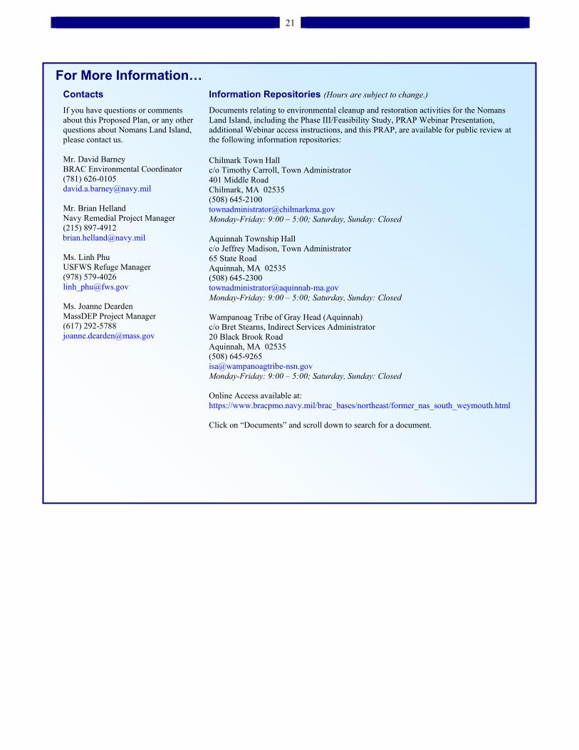
21
For More Information…
Contacts
If you have questions or comments about this Proposed Plan, or any other questions about Nomans Land Island, please contact us. Mr. David Barney BRAC Environmental Coordinator (781) 626-0105 [email protected] Mr. Brian Helland Navy Remedial Project Manager (215) 897-4912
[email protected] Ms. Linh Phu USFWS Refuge Manager (978) 579-4026 [email protected] Ms. Joanne Dearden MassDEP Project Manager (617) 292-5788 [email protected]
Information Repositories (Hours are subject to change.)
Documents relating to environmental cleanup and restoration activities for the Nomans Land Island, including the Phase III/Feasibility Study, PRAP Webinar Presentation, additional Webinar access instructions, and this PRAP, are available for public review at the following information repositories: Chilmark Town Hall c/o Timothy Carroll, Town Administrator 401 Middle Road Chilmark, MA 02535 (508) 645-2100 [email protected] Monday-Friday: 9:00 – 5:00; Saturday, Sunday: Closed Aquinnah Township Hall c/o Jeffrey Madison, Town Administrator 65 State Road Aquinnah, MA 02535 (508) 645-2300 [email protected] Monday-Friday: 9:00 – 5:00; Saturday, Sunday: Closed Wampanoag Tribe of Gray Head (Aquinnah) c/o Bret Stearns, Indirect Services Administrator 20 Black Brook Road Aquinnah, MA 02535 (508) 645-9265 [email protected] Monday-Friday: 9:00 – 5:00; Saturday, Sunday: Closed Online Access available at: https://www.bracpmo.navy.mil/brac_bases/northeast/former_nas_south_weymouth.html Click on “Documents” and scroll down to search for a document.

This page intentionally left blank.
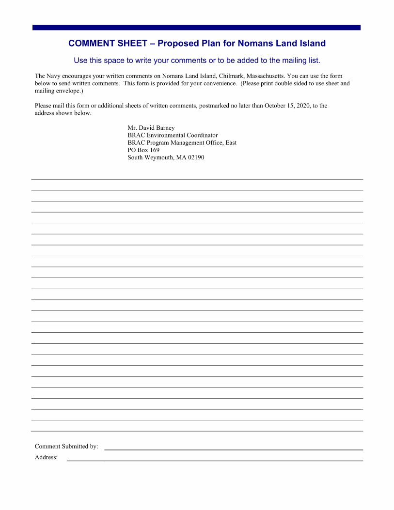
COMMENT SHEET – Proposed Plan for Nomans Land Island
Use this space to write your comments or to be added to the mailing list.
The Navy encourages your written comments on Nomans Land Island, Chilmark, Massachusetts. You can use the form below to send written comments. This form is provided for your convenience. (Please print double sided to use sheet and mailing envelope.)
Please mail this form or additional sheets of written comments, postmarked no later than October 15, 2020, to the address shown below.
Mr. David Barney BRAC Environmental Coordinator BRAC Program Management Office, East PO Box 169 South Weymouth, MA 02190
Comment Submitted by:
Address:
___________________________ AffixPostage
___________________________ ___________________________
Mr. David Barney BRAC Environmental Coordinator BRAC Program Management Office, EastPO Box 169 South Weymouth, MA 02190
(Fold on dotted line, staple, stamp, and mail)
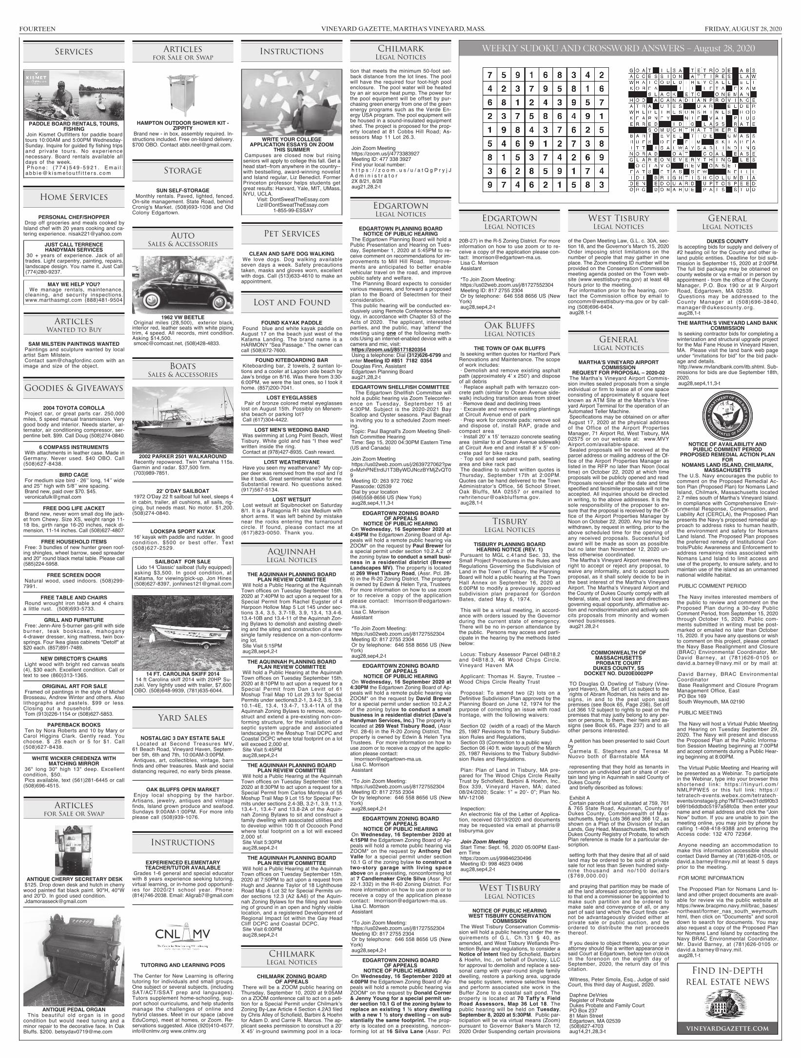
VINEYARD GAZETTE, MARTHA’S VINEYARD, MASS. FRIDAY, AUGUST 28, 2020FOURTEEN
WEEKLY SUDOKU AND CROSSWORD ANSWERS – August 28, 2020Services
PADDLE BOARD RENTALS, TOURS,FISHING
Join Kismet Outfitters for paddle boardtours 10:00AM and 5:00PM Wednesday-Sunday. Inquire for guided fly fishing tripsand pr ivate tours. No exper iencenecessary. Board rentals available alldays of the week.P hone : ( 7 7 4 ) 5 4 9 - 5 9 21 . Ema i l :a b b i e@k i sme t o u t f i t t e r s . c om
Home Services
PERSONAL CHEF/SHOPPERDrop off groceries and meals cooked byIsland chef with 20 years cooking and ca-tering experience. [email protected]
JUST CALL TERRENCEHANDYMAN SERVICES
30 + years of experience. Jack of alltrades. Light carpentry, painting, repairs,landscape design. You name it. Just Call(774)280-9237.
MAY WE HELP YOU?We manage rentals, maintenance,
cleaning, and security inspections.www.marthasmgt.com (888)481-9504
ArticlesWanted to Buy
SAM MILSTEIN PAINTINGS WANTEDPaintings and sculpture wanted by localartist Sam Milstein.Contact [email protected] with animage and size of the object.
Goodies & Giveaways
2004 TOYOTA COROLLAProject car, or great parts car. 250,000miles, 5 speed manual transmission. Verygood body and interior. Needs starter, al-ternator, air conditioning compressor, ser-pentine belt. $99. Call Doug (508)274-0840.
6 COMPASS INSTRUMENTSWith attachments in leather case. Made inGermany. Never used. $40 OBO. Call(508)627-8438.
BIRD CAGEFor medium size bird - 26ʼʼ long, 14ʼʼ wideand 25ʼʼ high with 5/8ʼʼ wire spacing.Brand new, paid over $70. [email protected]
FREE DOG LIFE JACKETBrand new, never worn small dog life jack-et from Chewy. Size XS, weight range 11-18 lbs, girth range 16-20 inches, neck di-mension, 11-14 inches. Call (508)627-4807.
FREE HOUSEHOLD ITEMSFree: 3 bundles of new hunter green roof-ing shingles, wheel barrow, seed spreaderand 20" round black metal table. Please call(585)224-5958.
FREE SCREEN DOORNatural wood, used indoors. (508)299-7991.
FREE TABLE AND CHAIRSRound wrought iron table and 4 chairs;a little rust. (508)693-5733.
GRILL AND FURNITUREFree: Jenn-Aire 5-burner gas-grill with sideburner , teak bookcase, mahogany4-drawer dresser, king mattress, twin box-springs. Four Ikea glass cabinets "Detolf" at$20 each. (857)891-7489.
NEW DIRECTOR'S CHAIRSLight wood with bright red canvas seats(4), $30 each. Excellent condition. Call ortext to see (860)313-1365.
ORIGINAL ART FOR SALEFramed oil paintings in the style of MichelBrosseau, Andrew Winter and others. Alsolithographs and pastels. $99 or less.Closing out a household.Tom (913)226-1154 or (508)627-5853.
PAPERBACK BOOKSTen by Nora Roberts and 10 by Mary orCarol Higgins Clark. Gently read. Youchoose. $ .25 each or 5 for $1. Call(508)627-8438.
WHITE WICKER CREDENZA WITHMATCHING MIRROR
36" long 30" high 13" deep. Excellentcondition, $50.Pics available, text (561)281-6445 or call(508)696-4515.
Articlesfor Sale or Swap
ANTIQUE CHERRY SECRETARY DESK$125. Drop down desk and hutch in cherrywood painted flat black paint. 90"H, 40"Wand 20"D. In good used [email protected]
ANTIQUE PEDAL ORGANThis beautiful old organ is in good
condition but would need tuning and aminor repair to the decorative face. In OakBluffs. $200. [email protected]
Articlesfor Sale or Swap
HAMPTON OUTDOOR SHOWER KIT -ZIPPITY
Brand new - in box, assembly required. In-structions included. Free on-Island delivery.$700 OBO. Contact [email protected].
Storage
SUN SELF-STORAGEMonthly rentals. Paved, lighted, fenced.
On-site management. State Road, behindCronig's Market. (508)693-1036 and OldColony Edgartown.
AutoSales & Accessories
1962 VW BEETLEOriginal miles (28,500), exterior black,interior red, leather seats with white pipingtrim, 4 speed. All records, mint condition.Asking $14,[email protected], (508)428-4833.
BoatsSales & Accessories
2002 PARKER 2501 WALKAROUNDRecently repowered. Twin Yamaha 115s.Garmin and radar. $37,500 firm.(703)989-7851.
22' O'DAY SAILBOAT1972 O'Day 22 ft sailboat full keel, sleeps 4in cabin, trailer, all cushions, all sails, rig-ging, but needs mast. No motor. $1,200.(508)274-0840.
LOOKSPA SPORT KAYAK16' kayak with paddle and rudder. In goodcondit ion. $500 or best of fer. Text(508)627-2529.
SAILBOAT FOR SALELido 14 'Classic' sailboat (fully equipped)asking $3,500. In good condition, atKatama, for viewing/pick-up. Jon Hines(508)627-8397, [email protected]
14 FT. CAROLINA SKIFF 201414 ft Carolina skiff 2014 with 20HP Su-zuki. Very lightly used with trailer, $7,600OBO. (508)648-9939, (781)635-6044.
Yard Sales
NOSTALGIC 3 DAY ESTATE SALELocated at Second Treasures MV,
61 Beach Road, Vineyard Haven, Septem-ber 5th, 6th and 7th, 10:00AM-3:00PM.Antiques, art, collectibles, vintage, barnfinds and other treasures. Mask and socialdistancing required, no early birds please.
OAK BLUFFS OPEN MARKETEnjoy local shopping by the harbor.Artisans, jewelry, antiques and vintagefinds, Island grown produce and seafood.Sundays 9:00AM-1:00PM. For more infoplease call (508)939-1076.
Instructions
EXPERIENCED ELEMENTARYTEACHER/TUTOR AVAILABLE
Grades 1-6 general and special educatorwith 8 years experience seeking tutoring,virtual learning, or in-home pod opportunit-ies for 2020/21 school year. Phone:(814)746-2038. Email: [email protected]
TUTORING AND LEARNING PODS
The Center for New Learning is offeringtutoring for individuals and small groups.One subject or several subjects, (includingSAT/ACT/SSAT prep and languages).Tutors supplement home-schooling, sup-port school curriculums, and help studentsmanage the challenges of online andhybrid classes. Meet in our space (aboveEduComp), meet at homes, or Zoom. Re-servations suggested. Alice (920)[email protected] www.cnlmv.org
Instructions
WRITE YOUR COLLEGEAPPLICATION ESSAYS ON ZOOM
THIS SUMMERCampuses are closed now but risingseniors will apply to college this fall. Get ahead start--from anywhere in the country--with bestselling, award-winning novelistand Island regular, Liz Benedict. FormerPrinceton professor helps students getgreat results: Harvard, Yale, MIT, UMass,NYU, UCLA.
Visit: [email protected]
1-855-99-ESSAY
Pet Services
CLEAN AND SAFE DOG WALKINGWe love dogs. Dog walking availableseven days a week. Safety precautionstaken, masks and gloves worn, excellentwith dogs. Call (513)633-4610 to make anappointment.
Lost and Found
FOUND KAYAK PADDLEFound blue and white kayak paddle onAugust 17 on the beach just west of theKatama Landing. The brand name is aHARMONY “Sea Passage.” The owner cancall (508)672-7600.
FOUND KITEBOARDING BARKiteboarding bar, 2 towels, 2 suntan lo-tions and a cooler at Lagoon side beach byJawʼs bridge on 8/16. Was there from 3:30-6:00PM, we were the last ones, so I took ithome. (857)200-7041.
LOST EYEGLASSESPair of bronze colored metal eyeglasseslost on August 15th. Possibly on Menem-sha beach or parking lot?Call (617)304-4422.
LOST MEN’S WEDDING BANDWas swimming at Long Point Beach, WestTisbury. White gold and has “I thee wed”written inside the ring.Contact at (978)427-8935. Cash reward.
LOST WEATHERVANEHave you seen my weathervane? My cop-per deer was removed from the roof and Iʼdlike it back. Great sentimental value for me.Substantial reward. No questions asked.(917)567-5134.
LOST WETSUITLost wetsuit at Squibnocket on Saturday8/1. It is a Patagonia R1 size Medium withshort arms. It was left behind by mistakenear the rocks entering the turnaroundcircle. If found, please contact me at(617)823-0050. Thank you.
AquinnahLegal Notices
THE AQUINNAH PLANNING BOARDPLAN REVIEW COMMITTEE
Will hold a Public Hearing at the AquinnahTown offices on Tuesday September 15th,2020 at 7:40PM to act upon a request for aSpecial Permit from Rachel Eugster of 4Harpoon Hollow Map 5 Lot 145 under sec-tions 3.4, 3.5, 3.7-1B, 3.9, 13.4, 13.4-6,13.4-10B and 13.4-11 of the Aquinnah Zon-ing Bylaws to demolish and existing dwell-ing and the siting and construction of a newsingle family residence on a non-conform-ing lot.Site Visit 5:15PMaug28,sep4,2-t
THE AQUINNAH PLANNING BOARDPLAN REVIEW COMMITTEE
Will hold a Public Hearing at the AquinnahTown offices on Tuesday September 15th,2020 at 8:10PM to act upon a request for aSpecial Permit from Dan Levitt of 61Moshup Trail Map 10 Lot 29.3 for SpecialPermits under sections3.2-1, 3.4-2, 3.5, 3.9,10.1-4E, 13.4, 13.4-7, 13.4-11A of theAquinnah Zoning Bylaws to remove, recon-struct and extend a pre-existing non-con-forming structure, for the installation of aseptic system upgrade and associatedlandscaping in the Moshup Trail DCPC andCoastal DCPC where total footprint on a lotwill exceed 2,000 sf.Site Visit 5:45PMaug28,sep4,2-t
THE AQUINNAH PLANNING BOARDPLAN REVIEW COMMITTEE
Will hold a Public Hearing at the AquinnahTown offices on Tuesday September 15th,2020 at 8:30PM to act upon a request for aSpecial Permit from Carlos Montoya of 55Moshup Trail Map 9 Lot 15 for Special Per-mits under sections 2.4-3B, 3.2-1, 3.9, 11.3,13.4-1, 13.4-7 and 13.8-2A of the Aquin-nah Zoning Bylaws to sit and construct afamily dwelling with associated utilities andto develop within 100 ft of Occooch Pondwhere total footprint on a lot will exceed2,000 sf.Site Visit 5:30PMaug28,sep4.2-t
THE AQUINNAH PLANNING BOARDPLAN REVIEW COMMITTEE
Will hold a Public Hearing at the AquinnahTown offices on Tuesday September 15th,2020 at 7:50PM to act upon a request fromHugh and Jeanne Taylor of 18 LighthouseRoad Map 6 Lot 32 for Special Permits un-der sections 12.3 (A2 &A6) of the Aquin-nah Zoning Bylaws for the filling and level-ing of ground in an open and highly visiblelocation, and a registered Development ofRegional Impact lot within the Gay HeadCliff DCPC and Coastal DCPC.Site Visit 6:00PMaug28,sep4,2-t
ChilmarkLegal Notices
CHILMARK ZONING BOARDOF APPEALS
There will be a ZOOM public hearing onThursday, September 10, 2020 at 9:05AMon a ZOOM conference call to act on a peti-tion for a Special Permit under ChilmarkʼsZoning By-Law Article 4 Section 4.2A3 filedby Chris Alley of Schofield, Barbini & Hoehnfor Adam D. and Carrie R. Marcus. The ap-plicant seeks permission to construct a 20ʼX 45ʼ in-ground swimming pool in a loca-
ChilmarkLegal Notices
tion that meets the minimum 50-foot set-back distance from the lot lines. The poolwill have the required four foot-high poolenclosure. The pool water will be heatedby an air source heat pump. The power forthe pool equipment will be offset by pur-chasing green energy from one of the greenenergy programs such as the Verde En-ergy USA program. The pool equipment willbe housed in a sound-insulated equipmentshed. The project is proposed for the prop-erty located at 81 Cobbs Hill Road; As-sessors Map 11 Lot 26.3.
Join Zoom Meetinghttps://zoom.us/j/4773383927Meeting ID: 477 338 3927Find your local number:h t t p s : / / z o o m . u s / u / a t Q g P r y j JA d m i n i s t r a t o r2X 8/21, 8/28aug21,28,2-t
EdgartownLegal Notices
EDGARTOWN PLANNING BOARDNOTICE OF PUBLIC HEARING
The Edgartown Planning Board will hold aPublic Presentation and Hearing on Tues-day, September 1, 2020 at 5:45PM to re-ceive comment on recommendations for im-provements to Mill Hill Road. Improve-ments are anticipated to better enablevehicular travel on the road, and improvepublic safety and welfare.The Planning Board expects to considervarious measures, and forward a proposedplan to the Board of Selectmen for theirconsideration.This public hearing will be conducted ex-clusively using Remote Conference techno-logy, in accordance with Chapter 53 of theActs of 2020. The applicant, interestedparties, and the public, may 'attend' themeeting using one of the following meth-ods:Using an internet-enabled device with acamera and mic, visit:https://zoom.us/j/85171820354Using a telephone: Dial (312)626-6799 andenter Meeting ID #851 7182 0354Douglas Finn, AssistantEdgartown Planning Boardaug21,28,2-t
EDGARTOWN SHELLFISH COMMITTEEThe Edgartown Shellfish Committee will
hold a public hearing via Zoom Teleconfer-ence on Tuesday, September 15 at4:30PM. Subject is the 2020-2021 BayScallop and Oyster seasons. Paul Bagnallis inviting you to a scheduled Zoom meet-ing.Topic: Paul Bagnall's Zoom Meeting Shell-fish Committee HearingTime: Sep 15, 2020 04:30PM Eastern Time(US and Canada)
Join Zoom Meetinghttps://us02web.zoom.us/j/2639727062?pwd=MzhPNEtrdlJ1T3ByWDJNczBYMjZvQT09Meeting ID: 263 972 7062Passcode: 02539Dial by your location(646)558-8656 US (New York)aug28,sep4,11,3-t
EDGARTOWN ZONING BOARDOF APPEALS
NOTICE OF PUBLIC HEARINGOn Wednesday, 16 September 2020 at4:45PM the Edgartown Zoning Board of Ap-peals will hold a remote public hearing viaZOOM* on the request by Paul Brewer fora special permit under section 10.2.A.2 ofthe zoning bylaw to conduct a small busi-ness in a residential district (BrewerLandscapes MV). The property is locatedat 269 West Tisbury Road, (Assr. Pcl. 28-6) in the R-20 Zoning District. The propertyis owned by Edwin & Helen Tyra, Trustees.For more information on how to use zoomor to receive a copy of the applicationplease contact: [email protected] C. MorrisonAssistant
*To Join Zoom Meeting:https://us02web.zoom.us/j/81727552304Meeting ID: 817 2755 2304Or by telephone: 646 558 8656 US (NewYork)aug28,sep4,2-t
EDGARTOWN ZONING BOARDOF APPEALS
NOTICE OF PUBLIC HEARINGOn Wednesday, 16 September 2020 at4:30PM the Edgartown Zoning Board of Ap-peals will hold a remote public hearing viaZOOM* on the request by David Brewerfor a special permit under section 10.2.A.2of the zoning bylaw to conduct a smallbusiness in a residential district (Dave’sHandyman Services, Inc.) The property islocated at 269 West Tisbury Road, (Assr.Pcl. 28-6) in the R-20 Zoning District. Theproperty is owned by Edwin & Helen Tyra,Trustees. For more information on how touse zoom or to receive a copy of the applic-ation please contact:[email protected] C. MorrisonAssistant
*To Join Zoom Meeting:https://us02web.zoom.us/j/81727552304Meeting ID: 817 2755 2304Or by telephone: 646 558 8656 US (NewYork)aug28,sep4,2-t
EDGARTOWN ZONING BOARDOF APPEALS
NOTICE OF PUBLIC HEARINGOn Wednesday, 16 September 2020 at4:15PM the Edgartown Zoning Board of Ap-peals will hold a remote public hearing viaZOOM* on the request by Anthony DelValle for a special permit under section10.1 G of the zoning bylaw to construct atwo-story garage with living spaceabove on a preexisting, nonconforming lotat 7 Candlemaker Circle Silva (Assr. Pcl.22-1.332) in the R-60 Zoning District. Formore information on how to use zoom or toreceive a copy of the application pleasecontact: [email protected] C. MorrisonAssistant
*To Join Zoom Meeting:https://us02web.zoom.us/j/81727552304Meeting ID: 817 2755 2304Or by telephone: 646 558 8656 US (NewYork)aug28,sep4,2-t
EDGARTOWN ZONING BOARDOF APPEALS
NOTICE OF PUBLIC HEARINGOn Wednesday, 16 September 2020 at4:00PM the Edgartown Zoning Board of Ap-peals will hold a remote public hearing viaZOOM* on the request by Donald Corner& Jenny Young for a special permit un-der section 10.1 G of the zoning bylaw toreplace an existing 1 ½ story dwellingwith a new 1 ½ story dwelling – on sub-stantially the same footprint. The prop-erty is located on a preexisting, noncon-forming lot at 16 Silva Lane (Assr. Pcl.
EdgartownLegal Notices
20B-27) in the R-5 Zoning District. For moreinformation on how to use zoom or to re-ceive a copy of the application please con-tact: [email protected] C. MorrisonAssistant
*To Join Zoom Meeting:https://us02web.zoom.us/j/81727552304Meeting ID: 817 2755 2304Or by telephone: 646 558 8656 US (NewYork)aug28,sep4,2-t
Oak BluffsLegal Notices
THE TOWN OF OAK BLUFFSIs seeking written quotes for Hartford ParkRenovations and Maintenance. The scopeof work includes:· Demolish and remove existing asphaltpath (approximately 4ʼ x 250ʼ) and disposeof all debris· Replace asphalt path with terrazzo con-crete path (similar to Ocean Avenue side-walk) including transition areas from street· Remove dead and declining trees· Excavate and remove existing plantingsat Circuit Avenue end of park· Prep work for concrete pads; remove soiland dispose of, install RAP, grade andcompact area· Install 20ʼ x 15ʼ terrazzo concrete seatingarea (similar to at Ocean Avenue sidewalk)at Circuit Ave end and install 8ʼ x 5ʼ con-crete pad for bike racks· Top soil and seed around path, seatingarea and bike rack padThe deadline to submit written quotes isThursday, September 17th at 2:00PM.Quotes can be hand delivered to the TownAdministratorʼs Office, 56 School Street,Oak Bluffs, MA 02557 or emailed [email protected],1-t
TisburyLegal Notices
TISBURY PLANNING BOARDHEARING NOTICE (REV. 1)
Pursuant to MGL c.41and Sec. 33, theSmall Project Procedures in the Rules andRegulations Governing the Subdivision ofLand in the Town of Tisbury, the PlanningBoard will hold a public hearing at the TownHall Annex on September 16, 2020 at6:00PM to modify a previously approvedsubdivision plan prepared for GordonBates, dated May 6, 1974.
This will be a virtual meeting, in accord-ance with orders issued by the Governorduring the current state of emergency.There will be no in-person attendance bythe public. Persons may access and parti-cipate in the hearing by the methods listedbelow:
Locus: Tisbury Assessor Parcel 04B18.2and 04B18.3, 46 Wood Chips Circle,Vineyard Haven MA
Applicant: Thomas H. Sayre, Trustee –Wood Chips Circle Realty Trust
Proposal: To amend two (2) lots on aDefinitive Subdivision Plan approved by thePlanning Board on June 12, 1974 for thepurpose of correcting an issue with roadfrontage, with the following waivers:
Section 02 (width of a road) of the March25, 1987 Revisions to the Tisbury Subdivi-sion Rules and Regulations,Section 03 (Connection to a public way)Section 06 (40 ft. wide layout) of the March25, 1987 Revisions to the Tisbury Subdivi-sion Rules and Regulations.
Plan: Plan of Land in Tisbury, MA pre-pared for The Wood Chips Circle RealtyTrust by Schofield, Barbini & Hoehn, Inc.,Box 339, Vineyard Haven, MA; dated08/24/2020; Scale: 1” = 20ʼ- 0”; Plan No.MV-12106
Inspection:An electronic file of the Letter of Applica-tion, received 03/19/2020 and documentsmay be requested via email at [email protected]
Join Zoom MeetingStart Time: Sept. 16, 2020 05:00PM East-ern Timehttps://zoom.us/j/99846230496Meeting ID: 998 4623 0496aug28,sep4,2-t
West TisburyLegal Notices
NOTICE OF PUBLIC HEARINGWEST TISBURY CONSERVATION
COMMISSIONThe West Tisbury Conservation Commis-sion will hold a public hearing under the re-quirements of G.L. Ch.131 § 40, asamended, and West Tisbury Wetlands Pro-tection Bylaw and regulations, to consider aNotice of Intent filed by Schofield, Barbini& Hoehn, Inc., on behalf of Duncley, LLCfor approval to demolish and replace a sea-sonal camp with year-round single familydwelling, restore a parking area, upgradethe septic system, remove selective trees,and perform associated site work in theBuffer Zone to a coastal salt pond. Theproperty is located at 70 Taffy’s FieldRoad Assessors, Map 36 Lot 18. Thepublic hearing will be held on Tuesday,September 8, 2020 at 5:30PM. Public par-ticipation will be via virtual means (Zoom)pursuant to Governor Bakerʼs March 12,2020 Order Suspending certain provisions
West TisburyLegal Notices
of the Open Meeting Law, G.L. c. 30A, sec-tion 18, and the Governorʼs March 15, 2020Order imposing strict limitations on thenumber of people that may gather in oneplace. The Zoom meeting ID number will beprovided on the Conservation Commissionmeeting agenda posted on the Town web-site (www.westtisbury-ma.gov) at least 48hours prior to the meeting.For information prior to the hearing, con-tact the Commission office by email [email protected] or by call-ing (508)696-6404.aug28,1-t
GeneralLegal Notices
MARTHA'S VINEYARD AIRPORTCOMMISSION
REQUEST FOR PROPOSAL – 2020-02The Marthaʼs Vineyard Airport Commis-sion invites sealed proposals from a singleindividual or firm to lease all of one spaceconsisting of approximately 6 square feetknown as ATM Site at the Marthaʼs Vine-yard Airport Terminal for the operation of anAutomated Teller Machine.Specifications may be obtained on or afterAugust 17, 2020 at the physical addressof the Office of the Airport PropertiesManager, 71 Airport Rd, West Tisbury, MA02575 or on our website at: www.MVYAirport.com/available-space.Sealed proposals will be received at theparcel address or mailing address of the Of-fice of the Airport Properties Manager aslisted in the RFP no later than Noon (localtime) on October 22, 2020 at which timeproposals will be publicly opened and read.Proposals received after the date and timespecified and facsimile proposals will not beaccepted. All inquiries should be directed,in writing, to the above addresses. It is thesole responsibility of the proposer to en-sure that the proposal is received by the Of-fice of the Airport Properties Manager byNoon on October 22, 2020. Any bid may bewithdrawn, by request in writing, prior to theabove scheduled time for the opening ofany received proposals. Successful bidaward will be made as soon as possible,but no later than November 12, 2020 un-less otherwise coordinated.The Marthaʼs Vineyard Airport reserves theright to accept or reject any proposal, towaive any informality, and to accept suchproposal, as it shall solely decide to be inthe best interest of the Marthaʼs VineyardAirport. The Marthaʼs Vineyard Airport andthe County of Dukes County comply with allfederal, state, and local laws and directivesgoverning equal opportunity, affirmative ac-tion and nondiscrimination and actively soli-cits proposals from minority and womenowned businesses.aug21,28,2-t
COMMONWEALTH OFMASSACHUSETTSPROBATE COURT
DUKES COUNTY, SSDOCKET NO. DU20E0002PP
TO Douglas O. Dowling of Tisbury (Vine-yard Haven), MA, Set off Lot subject to therights of Abram Rodman, his heirs and as-signs, in and to the peat upon saidpremises (see Book 65, Page 236), Set offLot 366 1/2 subject to rights to peat on thepremises that may justly belong to any per-son or persons, to them, their heirs and as-signs (see Book 65, Page 237) and to allother persons interested.
A petition has been presented to said CourtbyCarmela E. Stephens and Teresa M.Nuovo both of Barnstable MA
representing that they hold as tenants incommon an undivided part or share of cer-tain land lying in Aquinnah in said County ofDukes Countyand briefly described as follows:
Exhibit ACertain parcels of land situated at 759, 761& 765 State Road, Aquinnah, County ofDukes County, Commonwealth of Mas-sachusetts, being Lots 366 and 366 1/2 , asshown on a Plan of the Division of IndianLands, Gay Head, Massachusetts, filed withDukes County Registry of Probate, to whichPlan reference is made for a particular de-scription.
setting forth that they desire that all of saidland may be ordered to be sold at privatesale for not less than Seven hundred sixty-n ine thousand and no/100 dol la rs($769,000.00)
and praying that partition may be made ofall the land aforesaid according to law, andto that end a commissioner be appointed tomake such partition and be ordered tomake sale and conveyance of all, or anypart of said land which the Court finds can-not be advantageously divided either atprivate sale or public auction, and beordered to distribute the net proceedsthereof.
If you desire to object thereto, you or yourattorney should file a written appearance insaid Court at Edgartown, before ten o'clockin the forenoon on the eighth day ofSeptember, 2020, the return day of thiscitation.
Witness, Peter Smola, Esq., Judge of saidCourt, this third day of August, 2020.
Daphne DeVriesRegister of ProbateDukes Probate and Family CourtPO Box 23781 Main StreetEdgartown, MA 02539(508)627-4703aug14,21,28,3-t
GeneralLegal Notices
DUKES COUNTYIs accepting bids for supply and delivery of#2 heating oil for the County and other is-land public entities. Deadline for bid sub-mission is September 15, 2020 at 2:00PM.The full bid package may be obtained oncounty website or via e-mail or in person byappointment - from the office of the CountyManager, P.O. Box 190 or at 9 AirportRoad, Edgartown, MA 02539.Questions may be addressed to theCounty Manager at (508)696-3840,[email protected],1-t
THE MARTHA’S VINEYARD LAND BANKCOMMISSION
Is seeking contractor bids for completing awinterization and structural upgrade projectfor the Mai Fane House in Vineyard Haven,MA. Please visit the land bank web pageunder “invitations for bid” for the bid pack-age and details.http://www.mvlandbank.com/itb.shtml. Sub-missions for bids are due September 18th,2020.aug28,sep4,11,3-t
NOTICE OF AVAILABILITY ANDPUBLIC COMMENT PERIOD
PROPOSED REMEDIAL ACTION PLANFOR
NOMANS LAND ISLAND, CHILMARK,MASSACHUSETTS
The U.S. Navy encourages the public tocomment on the Proposed Remedial Ac-tion Plan (Proposed Plan) for Nomans LandIsland, Chilmark, Massachusetts located2.7 miles south of Marthaʼs Vineyard Island.In compliance with Comprehensive Envir-onmental Response, Compensation, andLiability Act (CERCLA), the Proposed Planpresents the Navyʼs proposed remedial ap-proach to address risks to human health,the environment and safety for NomansLand Island. The Proposed Plan proposesthe preferred remedy of Institutional Con-trols/Public Awareness and Enforcement toaddress remaining risks associated withNomans Land Island to limit access anduse of the property, to ensure safety, and tomaintain use of the island as an unmannednational wildlife habitat.
PUBLIC COMMENT PERIOD
The Navy invites interested members ofthe public to review and comment on theProposed Plan during a 30-day PublicComment Period, from September 15, 2020through October 15, 2020. Public com-ments submitted in writing must be post-marked or emailed no later than October15, 2020. If you have any questions or wishto comment on this project, please contactthe Navy Base Realignment and Closure(BRAC) Environmental Coordinator, Mr.David Barney, at (781)626-0105 [email protected] or by mail at:
David Barney, BRAC EnvironmentalCoordinatorBase Realignment and Closure ProgramManagement Office, EastPO Box 169South Weymouth, MA 02190
PUBLIC MEETING
The Navy will host a Virtual Public Meetingand Hearing on Tuesday September 29,2020. The Navy will present and discussthe Proposed Plan at the Public Informa-tion Session Meeting beginning at 7:00PMand accept comments during a Public Hear-ing beginning at 8:00PM.
The Virtual Public Meeting and Hearing willbe presented as a Webinar. To participatein the Webinar, type into your browser thisshor tened l ink : h t tps : / / t inyur l .com/NMLPPWE5 or this ful l l ink: https:/ /tetratech-events.webex.com/tetratech-events/onstage/g.php?MTID=ee31dd9f0b3b991b6ddbdc5197a58fc0a then enter yourname and email address and click the “JoinNow” button. If you are unable to join themeeting online, you may join by phone bycalling 1-408-418-9388 and entering theAccess code: 132 470 7236#.
Anyone needing an accommodation tomake this information accessible shouldcontact David Barney at (781)626-0105, [email protected] at least 5 daysprior to the meeting.
FOR MORE INFORMATION
The Proposed Plan for Nomans Land Is-land and other project documents are avail-able for review via the public website athttps://www.bracpmo.navy.mil/brac_bases/northeast/former_nas_south_weymouth.html, then click on “Documents” and scrolldown to search for documents. You mayalso request a copy of the Proposed Planfor Nomans Land Island by contacting theNavy BRAC Environmental Coordinator,Mr. David Barney, at (781)626-0105 [email protected],1-t
Find in-depthreal estate news
vineyardgazette.com

Record of Decision Final Nomans Land Island, Chilmark, MA January 2022
4659-WE05-22-0003
This page intentionally left blank.
Record of Decision Final Nomans Land Island, Chilmark, MA January 2022
4659-WE05-22-0003
APPENDIX C
ECOLOGICAL RISK ASSESSMENT SUMMARY TABLES

Record of Decision Final Nomans Land Island, Chilmark, MA January 2022
4659-WE05-22-0003
This page intentionally left blank.
Table 34Cadmium Results for the Entire Island Evaluation
Nomans Land Island
Mean Exceeds Mean Percent STATION EPC Background Reduction in NOAEL LOAEL NOAEL LOAEL NOAEL LOAELREMOVED MG/KG Concentration Exposure HQ HQ HQ HQ HQ HQ
- 0.89 Yes 0.0 4.1 0.3 1.1 0.1 0.5 0.04G20-165-193 0.81 Yes 8.7 3.7 0.3 1.0 0.1 0.5 0.03I31-125-195 0.74 Yes 16.7 3.4 0.2 0.9 0.1 0.4 0.03T39-159-163 0.68 Yes 23.6 3.1 0.2 0.8 0.1 0.4 0.03I31-198-69 0.64 Yes 27.8 3.0 0.2 0.8 0.1 0.4 0.03I13-192-145 0.61 Yes 31.6 2.8 0.2 0.7 0.1 0.3 0.02T38-21-71 0.58 Yes 35.2 2.7 0.2 0.7 0.1 0.3 0.02T38-116-126 0.54 Yes 38.6 2.5 0.2 0.7 0.05 0.3 0.02F20-151-187 0.52 Yes 41.8 2.4 0.2 0.6 0.05 0.3 0.02S41-179-200 0.49 Yes 44.5 2.3 0.2 0.6 0.04 0.3 0.02T38-136-181 0.47 Yes 47.1 2.2 0.2 0.6 0.04 0.3 0.02T38-54-42 0.45 Yes 49.3 2.1 0.2 0.6 0.04 0.2 0.02S40-5-5 0.43 Yes 51.4 2.0 0.1 0.5 0.04 0.2 0.02F23-159-40 0.42 Yes 53.1 1.9 0.1 0.5 0.04 0.2 0.02I13-159-200 0.40 Yes 54.9 1.8 0.1 0.5 0.04 0.2 0.02O20-105-0 0.38 Yes 56.7 1.8 0.1 0.5 0.03 0.2 0.02F23-149-38 0.37 Yes 58.4 1.7 0.1 0.5 0.03 0.2 0.01T39-172-148 0.36 Yes 60.0 1.6 0.1 0.4 0.03 0.2 0.01N19-27-23 0.34 Yes 61.4 1.6 0.1 0.4 0.03 0.2 0.01F23-18-93 0.33 Yes 62.7 1.5 0.1 0.4 0.03 0.2 0.01G20-131-183 0.32 Yes 64.1 1.5 0.1 0.4 0.03 0.2 0.01F21-3-33 0.31 Yes 65.2 1.4 0.1 0.4 0.03 0.2 0.01SS-O20-6 0.30 Yes 66.3 1.4 0.1 0.4 0.03 0.2 0.01F23-168-35 0.29 No 67.3 1.3 0.1 0.4 0.03 0.2 0.01H31-52-54 0.28 No 68.3 1.3 0.1 0.3 0.02 0.2 0.01S39-0-50 0.27 No 69.2 1.3 0.1 0.3 0.02 0.1 0.01
EPC = Exposure point concentration.1Exceeds mean concentration for surface soils in Non-Target Area.2 Bioaccumulation factor (BAF) from Table 3 in Sample et al. (1998).3 Mean Bioaccumulation factor (BAF) from Table 11 in Sample et al. (1998).4 Mean LN BAF from Table 12 in Sample et al. (1998).
Concentration contributes to a NOAEL HQ > 1.0.-'= Complete data set for areaBold Number = Exceedance
90th Percentile BAF2 Mean BAF3 Mean LN BAF4
On-Island Avian Insectivore
Table 35Chromium Results for the Entire Island Evaluation
Nomans Land Island
Mean Exceeds Mean Percent STATION EPC Background Reduction in NOAEL LOAEL NOAEL LOAEL NOAEL LOAELREMOVED MG/KG Concentration Exposure HQ HQ HQ HQ HQ HQ
- 17.5 Yes 0.0 5.1 1.0 2.3 0.5 0.9 0.2S40-5-5 10.8 Yes 38.3 3.1 0.6 1.4 0.3 0.6 0.1I31-125-195 9.3 Yes 46.6 2.7 0.5 1.2 0.2 0.5 0.1G20-131-183 8.7 Yes 50.1 2.5 0.5 1.1 0.2 0.5 0.1F23-200-76 8.3 Yes 52.7 2.4 0.5 1.1 0.2 0.4 0.1O20-105-0 7.9 Yes 54.6 2.3 0.5 1.0 0.2 0.4 0.1F23-157-35 7.7 Yes 55.8 2.3 0.5 1.0 0.2 0.4 0.1H31-52-54 7.5 Yes 56.9 2.2 0.4 1.0 0.2 0.4 0.1G20-165-193 7.4 Yes 57.9 2.2 0.4 1.0 0.2 0.4 0.1SS-O20-6 7.2 Yes 58.8 2.1 0.4 0.9 0.2 0.4 0.1S41-179-200 7.1 Yes 59.5 2.1 0.4 0.9 0.2 0.4 0.1T38-136-181 7.0 Yes 60.0 2.0 0.4 0.9 0.2 0.4 0.1T39-159-163 6.9 Yes 60.6 2.0 0.4 0.9 0.2 0.4 0.1H31-40-54 6.8 Yes 61.1 2.0 0.4 0.9 0.2 0.4 0.1SS-O20-12 6.7 Yes 61.6 2.0 0.4 0.9 0.2 0.3 0.1F23-149-38 6.6 Yes 61.9 1.9 0.4 0.9 0.2 0.3 0.1NL-SS-AB-03 6.6 Yes 62.3 1.9 0.4 0.9 0.2 0.3 0.1NL-SS-B1-01 6.5 Yes 62.7 1.9 0.4 0.9 0.2 0.3 0.1T38-116-126 6.5 Yes 63.0 1.9 0.4 0.8 0.2 0.3 0.1F21-3-33 6.4 Yes 63.4 1.9 0.4 0.8 0.2 0.3 0.1J22-140-143 6.3 Yes 63.8 1.9 0.4 0.8 0.2 0.3 0.1NL-SS-AB-14 6.3 Yes 64.1 1.8 0.4 0.8 0.2 0.3 0.1F23-168-35 6.2 Yes 64.4 1.8 0.4 0.8 0.2 0.3 0.1NL-SS-AB-02 6.2 Yes 64.8 1.8 0.4 0.8 0.2 0.3 0.1I13-192-145 6.1 Yes 65.1 1.8 0.4 0.8 0.2 0.3 0.1F20-151-187 6.0 Yes 65.4 1.8 0.4 0.8 0.2 0.3 0.1NL-SS-AB-10 6.0 Yes 65.7 1.8 0.4 0.8 0.2 0.3 0.1NL-SS-AB-30 5.9 Yes 66.0 1.7 0.3 0.8 0.2 0.3 0.1NL-SS-AB-19 5.9 Yes 66.4 1.7 0.3 0.8 0.2 0.3 0.1I31-198-69 5.8 Yes 66.6 1.7 0.3 0.8 0.2 0.3 0.1F23-159-40 5.8 Yes 66.9 1.7 0.3 0.8 0.2 0.3 0.1NL-SS-AB-01 5.7 Yes 67.1 1.7 0.3 0.8 0.2 0.3 0.1F23-33-172 5.7 Yes 67.3 1.7 0.3 0.7 0.1 0.3 0.1T38-21-71 5.7 Yes 67.6 1.7 0.3 0.7 0.1 0.3 0.1NL-SS-W6-35 5.6 Yes 67.8 1.6 0.3 0.7 0.1 0.3 0.1NL-SS-AB-08 5.6 Yes 68.0 1.6 0.3 0.7 0.1 0.3 0.1SS-O19-1 5.5 Yes 68.2 1.6 0.3 0.7 0.1 0.3 0.1
90th Percentile BAF2 Mean BAF3 Mean LN BAF4
On-Island Avian Insectivore
Table 35Chromium Results for the Entire Island Evaluation
Nomans Land Island
Mean Exceeds Mean Percent STATION EPC Background Reduction in NOAEL LOAEL NOAEL LOAEL NOAEL LOAELREMOVED MG/KG Concentration Exposure HQ HQ HQ HQ HQ HQ
90th Percentile BAF2 Mean BAF3 Mean LN BAF4
On-Island Avian Insectivore
J22-122-145 5.5 Yes 68.5 1.6 0.3 0.7 0.1 0.3 0.1NL-SS-AB-07-AV 5.5 Yes 68.7 1.6 0.3 0.7 0.1 0.3 0.1F23-18-93 5.4 Yes 68.9 1.6 0.3 0.7 0.1 0.3 0.1G31-0-14 5.4 Yes 69.1 1.6 0.3 0.7 0.1 0.3 0.1EE11-120-39 5.4 Yes 69.3 1.6 0.3 0.7 0.1 0.3 0.1NL-SS-W6-08 5.3 Yes 69.6 1.6 0.3 0.7 0.1 0.3 0.1NL-SS-B1-02 5.3 Yes 69.8 1.5 0.3 0.7 0.1 0.3 0.1NL-SS-AB-04 5.2 Yes 70.0 1.5 0.3 0.7 0.1 0.3 0.1I13-159-200 5.2 Yes 70.2 1.5 0.3 0.7 0.1 0.3 0.1N19-27-23 5.2 Yes 70.4 1.5 0.3 0.7 0.1 0.3 0.1SS-O19-6 5.1 Yes 70.6 1.5 0.3 0.7 0.1 0.3 0.1SS-O19-7 5.1 Yes 70.8 1.5 0.3 0.7 0.1 0.3 0.1NL-SS-W6-36 5.1 Yes 71.0 1.5 0.3 0.7 0.1 0.3 0.1F23-144-10 5.0 Yes 71.2 1.5 0.3 0.7 0.1 0.3 0.1NL-SS-AB-18 5.0 Yes 71.4 1.5 0.3 0.7 0.1 0.3 0.1U41-8-152 5.0 Yes 71.5 1.5 0.3 0.6 0.1 0.3 0.1H31-40-128 4.9 Yes 71.7 1.4 0.3 0.6 0.1 0.3 0.1NL-SS-AB-17 4.9 Yes 71.9 1.4 0.3 0.6 0.1 0.3 0.1EE11-172-82 4.9 Yes 72.0 1.4 0.3 0.6 0.1 0.3 0.1NL-SS-W6-40-AV 4.9 Yes 72.2 1.4 0.3 0.6 0.1 0.3 0.1NL-SS-AB-05 4.8 Yes 72.3 1.4 0.3 0.6 0.1 0.3 0.1F22-34-35 4.8 Yes 72.5 1.4 0.3 0.6 0.1 0.3 0.1H31-29-52 4.8 Yes 72.6 1.4 0.3 0.6 0.1 0.2 0.05NL-SS-S4-02 4.8 Yes 72.8 1.4 0.3 0.6 0.1 0.2 0.05T39-172-148 4.7 Yes 72.9 1.4 0.3 0.6 0.1 0.2 0.05NL-SS-AB-15 4.7 Yes 73.1 1.4 0.3 0.6 0.1 0.2 0.05NL-SS-AB-16 4.7 Yes 73.2 1.4 0.3 0.6 0.1 0.2 0.05NL-SS-S4-01 4.6 Yes 73.4 1.4 0.3 0.6 0.1 0.2 0.05SS-N20-15 4.6 Yes 73.5 1.4 0.3 0.6 0.1 0.2 0.05NLSS-N105-03 4.6 Yes 73.7 1.3 0.3 0.6 0.1 0.2 0.05H31-56-133 4.6 Yes 73.8 1.3 0.3 0.6 0.1 0.2 0.05G20-130-172 4.5 Yes 73.9 1.3 0.3 0.6 0.1 0.2 0.05NL-SD-AC-02 4.5 Yes 74.1 1.3 0.3 0.6 0.1 0.2 0.05S40-31-150 4.5 Yes 74.2 1.3 0.3 0.6 0.1 0.2 0.05NL-SS-AB-06-AV 4.5 Yes 74.4 1.3 0.3 0.6 0.1 0.2 0.05F23-49-108 4.5 Yes 74.5 1.3 0.3 0.6 0.1 0.2 0.05NL-SS-AB-09 4.4 Yes 74.6 1.3 0.3 0.6 0.1 0.2 0.05
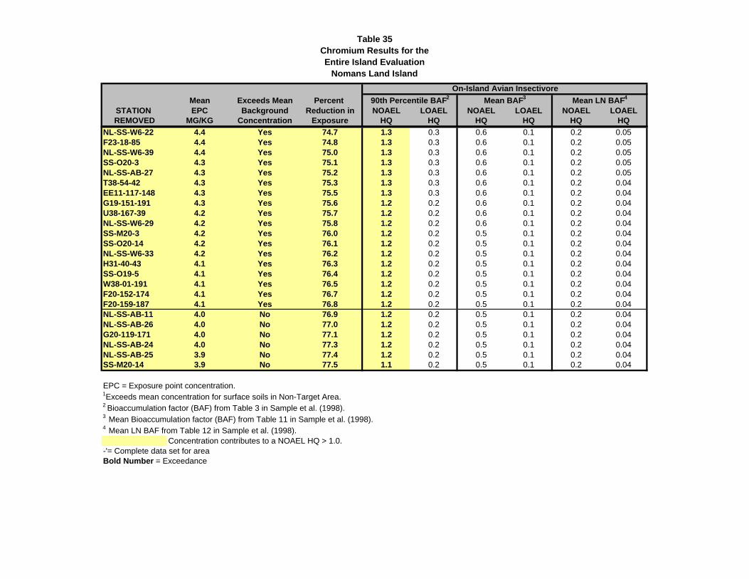
Table 35Chromium Results for the Entire Island Evaluation
Nomans Land Island
Mean Exceeds Mean Percent STATION EPC Background Reduction in NOAEL LOAEL NOAEL LOAEL NOAEL LOAELREMOVED MG/KG Concentration Exposure HQ HQ HQ HQ HQ HQ
90th Percentile BAF2 Mean BAF3 Mean LN BAF4
On-Island Avian Insectivore
NL-SS-W6-22 4.4 Yes 74.7 1.3 0.3 0.6 0.1 0.2 0.05F23-18-85 4.4 Yes 74.8 1.3 0.3 0.6 0.1 0.2 0.05NL-SS-W6-39 4.4 Yes 75.0 1.3 0.3 0.6 0.1 0.2 0.05SS-O20-3 4.3 Yes 75.1 1.3 0.3 0.6 0.1 0.2 0.05NL-SS-AB-27 4.3 Yes 75.2 1.3 0.3 0.6 0.1 0.2 0.05T38-54-42 4.3 Yes 75.3 1.3 0.3 0.6 0.1 0.2 0.04EE11-117-148 4.3 Yes 75.5 1.3 0.3 0.6 0.1 0.2 0.04G19-151-191 4.3 Yes 75.6 1.2 0.2 0.6 0.1 0.2 0.04U38-167-39 4.2 Yes 75.7 1.2 0.2 0.6 0.1 0.2 0.04NL-SS-W6-29 4.2 Yes 75.8 1.2 0.2 0.6 0.1 0.2 0.04SS-M20-3 4.2 Yes 76.0 1.2 0.2 0.5 0.1 0.2 0.04SS-O20-14 4.2 Yes 76.1 1.2 0.2 0.5 0.1 0.2 0.04NL-SS-W6-33 4.2 Yes 76.2 1.2 0.2 0.5 0.1 0.2 0.04H31-40-43 4.1 Yes 76.3 1.2 0.2 0.5 0.1 0.2 0.04SS-O19-5 4.1 Yes 76.4 1.2 0.2 0.5 0.1 0.2 0.04W38-01-191 4.1 Yes 76.5 1.2 0.2 0.5 0.1 0.2 0.04F20-152-174 4.1 Yes 76.7 1.2 0.2 0.5 0.1 0.2 0.04F20-159-187 4.1 Yes 76.8 1.2 0.2 0.5 0.1 0.2 0.04NL-SS-AB-11 4.0 No 76.9 1.2 0.2 0.5 0.1 0.2 0.04NL-SS-AB-26 4.0 No 77.0 1.2 0.2 0.5 0.1 0.2 0.04G20-119-171 4.0 No 77.1 1.2 0.2 0.5 0.1 0.2 0.04NL-SS-AB-24 4.0 No 77.3 1.2 0.2 0.5 0.1 0.2 0.04NL-SS-AB-25 3.9 No 77.4 1.2 0.2 0.5 0.1 0.2 0.04SS-M20-14 3.9 No 77.5 1.1 0.2 0.5 0.1 0.2 0.04
EPC = Exposure point concentration.1Exceeds mean concentration for surface soils in Non-Target Area.2 Bioaccumulation factor (BAF) from Table 3 in Sample et al. (1998).3 Mean Bioaccumulation factor (BAF) from Table 11 in Sample et al. (1998).4 Mean LN BAF from Table 12 in Sample et al. (1998).
Concentration contributes to a NOAEL HQ > 1.0.-'= Complete data set for areaBold Number = Exceedance
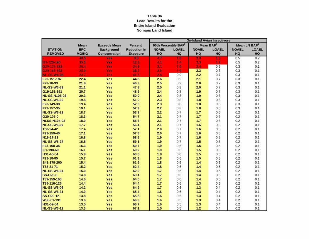
Table 36Lead Results for the
Entire Island EvaluationNomans Land Island
Mean Exceeds Mean Percent STATION EPC Background Reduction in NOAEL LOAEL NOAEL LOAEL NOAEL LOAELREMOVED MG/KG Concentration Exposure HQ HQ HQ HQ HQ HQ
- 40.5 Yes 0.0 4.7 1.6 3.8 1.3 0.5 0.2I31-125-195 35.5 Yes 12.3 4.1 1.4 3.3 1.1 0.5 0.2G20-131-183 26.4 Yes 34.9 3.1 1.0 2.4 0.8 0.3 0.1G20-165-193 25.0 Yes 38.2 2.9 1.0 2.3 0.8 0.3 0.1NL-SS-W6-08 23.7 Yes 41.5 2.8 0.9 2.2 0.7 0.3 0.1F20-151-187 22.4 Yes 44.6 2.6 0.9 2.1 0.7 0.3 0.1F23-18-93 21.8 Yes 46.3 2.5 0.9 2.0 0.7 0.3 0.1NL-SS-W6-33 21.1 Yes 47.8 2.5 0.8 2.0 0.7 0.3 0.1G19-151-191 20.7 Yes 48.9 2.4 0.8 1.9 0.7 0.3 0.1NL-SS-N105-03 20.3 Yes 50.0 2.4 0.8 1.9 0.6 0.3 0.1NL-SS-W6-02 19.8 Yes 51.0 2.3 0.8 1.8 0.6 0.3 0.1F23-149-38 19.4 Yes 52.0 2.3 0.8 1.8 0.6 0.3 0.1F23-157-35 19.1 Yes 52.9 2.2 0.8 1.8 0.6 0.3 0.1NL-SS-W6-23 18.7 Yes 53.8 2.2 0.7 1.7 0.6 0.2 0.1O20-105-0 18.3 Yes 54.7 2.1 0.7 1.7 0.6 0.2 0.1NLSS-N104-03 18.0 Yes 55.6 2.1 0.7 1.7 0.6 0.2 0.1NL-SS-W6-07 17.7 Yes 56.4 2.1 0.7 1.6 0.6 0.2 0.1T38-54-42 17.4 Yes 57.1 2.0 0.7 1.6 0.5 0.2 0.1F23-159-40 17.1 Yes 57.8 2.0 0.7 1.6 0.5 0.2 0.1N19-27-23 16.8 Yes 58.5 1.9 0.7 1.6 0.5 0.2 0.1NL-SS-W6-27 16.5 Yes 59.1 1.9 0.7 1.5 0.5 0.2 0.1F23-168-35 16.3 Yes 59.7 1.9 0.6 1.5 0.5 0.2 0.1I31-198-69 16.1 Yes 60.2 1.9 0.6 1.5 0.5 0.2 0.1H31-40-54 15.9 Yes 60.8 1.8 0.6 1.5 0.5 0.2 0.1F23-18-85 15.7 Yes 61.3 1.8 0.6 1.5 0.5 0.2 0.1S41-179-200 15.4 Yes 61.9 1.8 0.6 1.4 0.5 0.2 0.1T38-21-71 15.2 Yes 62.4 1.8 0.6 1.4 0.5 0.2 0.1NL-SS-W6-04 15.0 Yes 62.9 1.7 0.6 1.4 0.5 0.2 0.1SS-O20-6 14.8 Yes 63.4 1.7 0.6 1.4 0.5 0.2 0.1T39-159-163 14.6 Yes 64.0 1.7 0.6 1.4 0.5 0.2 0.1T38-116-126 14.4 Yes 64.4 1.7 0.6 1.3 0.5 0.2 0.1NL-SS-W6-06 14.2 Yes 64.9 1.7 0.6 1.3 0.4 0.2 0.1NL-SS-W6-31 14.0 Yes 65.4 1.6 0.6 1.3 0.4 0.2 0.1SS-O20-12 13.8 Yes 65.8 1.6 0.5 1.3 0.4 0.2 0.1W38-01-191 13.6 Yes 66.3 1.6 0.5 1.3 0.4 0.2 0.1H31-52-54 13.5 Yes 66.7 1.6 0.5 1.3 0.4 0.2 0.1NL-SS-W6-12 13.3 Yes 67.1 1.5 0.5 1.2 0.4 0.2 0.1
90th Percentile BAF2 Mean BAF3
On-Island Avian Insectivore
Mean LN BAF4
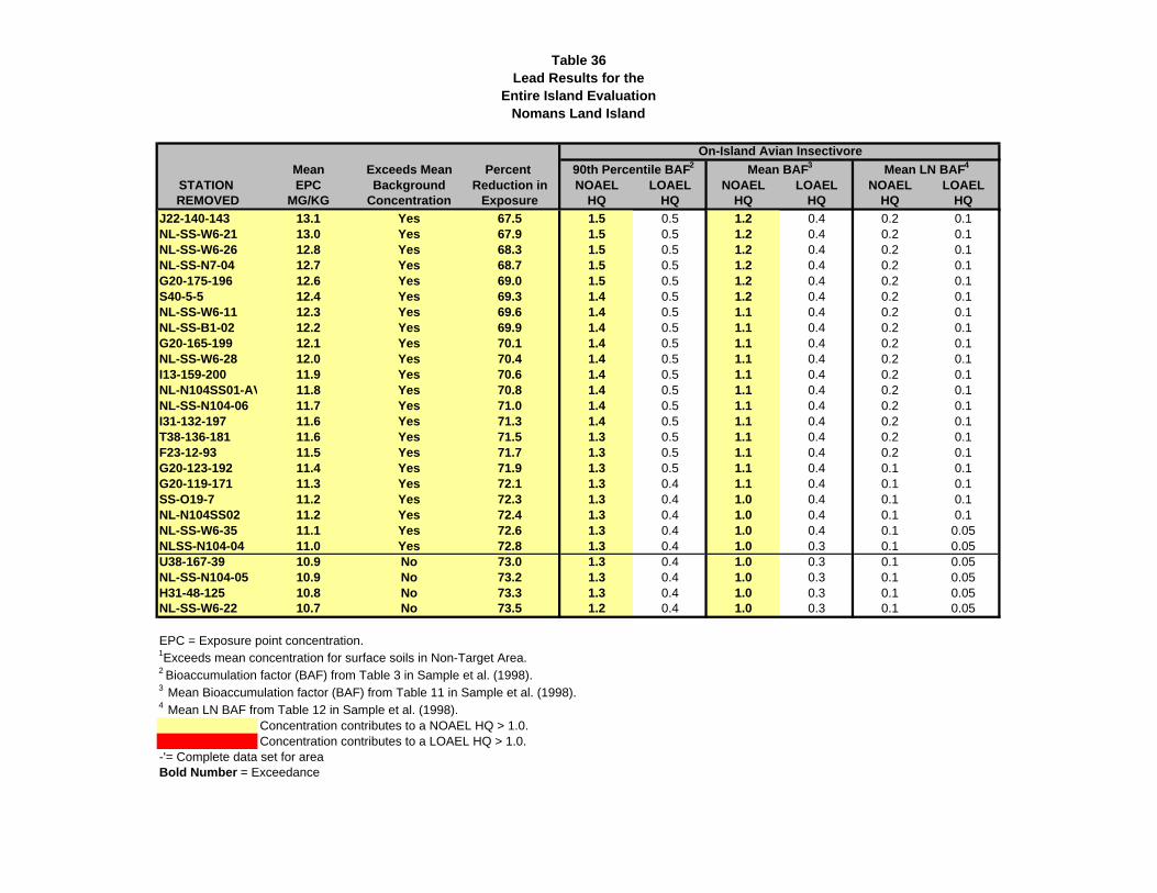
Table 36Lead Results for the
Entire Island EvaluationNomans Land Island
Mean Exceeds Mean Percent STATION EPC Background Reduction in NOAEL LOAEL NOAEL LOAEL NOAEL LOAELREMOVED MG/KG Concentration Exposure HQ HQ HQ HQ HQ HQ
90th Percentile BAF2 Mean BAF3
On-Island Avian Insectivore
Mean LN BAF4
J22-140-143 13.1 Yes 67.5 1.5 0.5 1.2 0.4 0.2 0.1NL-SS-W6-21 13.0 Yes 67.9 1.5 0.5 1.2 0.4 0.2 0.1NL-SS-W6-26 12.8 Yes 68.3 1.5 0.5 1.2 0.4 0.2 0.1NL-SS-N7-04 12.7 Yes 68.7 1.5 0.5 1.2 0.4 0.2 0.1G20-175-196 12.6 Yes 69.0 1.5 0.5 1.2 0.4 0.2 0.1S40-5-5 12.4 Yes 69.3 1.4 0.5 1.2 0.4 0.2 0.1NL-SS-W6-11 12.3 Yes 69.6 1.4 0.5 1.1 0.4 0.2 0.1NL-SS-B1-02 12.2 Yes 69.9 1.4 0.5 1.1 0.4 0.2 0.1G20-165-199 12.1 Yes 70.1 1.4 0.5 1.1 0.4 0.2 0.1NL-SS-W6-28 12.0 Yes 70.4 1.4 0.5 1.1 0.4 0.2 0.1I13-159-200 11.9 Yes 70.6 1.4 0.5 1.1 0.4 0.2 0.1NL-N104SS01-AV 11.8 Yes 70.8 1.4 0.5 1.1 0.4 0.2 0.1NL-SS-N104-06 11.7 Yes 71.0 1.4 0.5 1.1 0.4 0.2 0.1I31-132-197 11.6 Yes 71.3 1.4 0.5 1.1 0.4 0.2 0.1T38-136-181 11.6 Yes 71.5 1.3 0.5 1.1 0.4 0.2 0.1F23-12-93 11.5 Yes 71.7 1.3 0.5 1.1 0.4 0.2 0.1G20-123-192 11.4 Yes 71.9 1.3 0.5 1.1 0.4 0.1 0.1G20-119-171 11.3 Yes 72.1 1.3 0.4 1.1 0.4 0.1 0.1SS-O19-7 11.2 Yes 72.3 1.3 0.4 1.0 0.4 0.1 0.1NL-N104SS02 11.2 Yes 72.4 1.3 0.4 1.0 0.4 0.1 0.1NL-SS-W6-35 11.1 Yes 72.6 1.3 0.4 1.0 0.4 0.1 0.05NLSS-N104-04 11.0 Yes 72.8 1.3 0.4 1.0 0.3 0.1 0.05U38-167-39 10.9 No 73.0 1.3 0.4 1.0 0.3 0.1 0.05NL-SS-N104-05 10.9 No 73.2 1.3 0.4 1.0 0.3 0.1 0.05H31-48-125 10.8 No 73.3 1.3 0.4 1.0 0.3 0.1 0.05NL-SS-W6-22 10.7 No 73.5 1.2 0.4 1.0 0.3 0.1 0.05
EPC = Exposure point concentration.1Exceeds mean concentration for surface soils in Non-Target Area.2 Bioaccumulation factor (BAF) from Table 3 in Sample et al. (1998).3 Mean Bioaccumulation factor (BAF) from Table 11 in Sample et al. (1998).4 Mean LN BAF from Table 12 in Sample et al. (1998).
Concentration contributes to a NOAEL HQ > 1.0.Concentration contributes to a LOAEL HQ > 1.0.
-'= Complete data set for areaBold Number = Exceedance
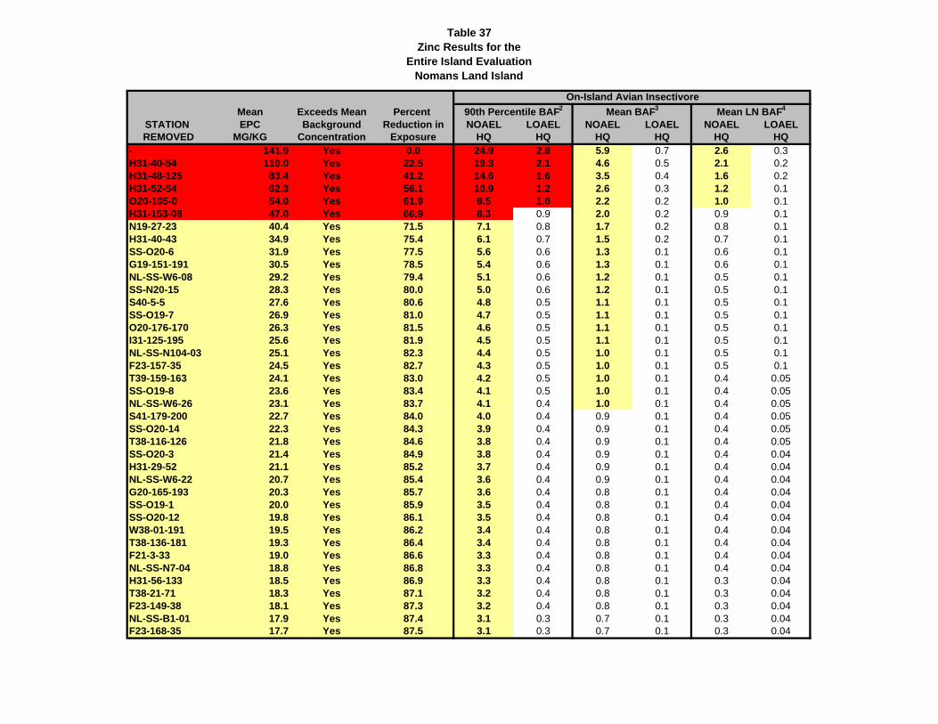
Table 37Zinc Results for the
Entire Island EvaluationNomans Land Island
Mean Exceeds Mean Percent STATION EPC Background Reduction in NOAEL LOAEL NOAEL LOAEL NOAEL LOAELREMOVED MG/KG Concentration Exposure HQ HQ HQ HQ HQ HQ
- 141.9 Yes 0.0 24.9 2.8 5.9 0.7 2.6 0.3H31-40-54 110.0 Yes 22.5 19.3 2.1 4.6 0.5 2.1 0.2H31-48-125 83.4 Yes 41.2 14.6 1.6 3.5 0.4 1.6 0.2H31-52-54 62.3 Yes 56.1 10.9 1.2 2.6 0.3 1.2 0.1O20-105-0 54.0 Yes 61.9 9.5 1.0 2.2 0.2 1.0 0.1H31-153-08 47.0 Yes 66.9 8.3 0.9 2.0 0.2 0.9 0.1N19-27-23 40.4 Yes 71.5 7.1 0.8 1.7 0.2 0.8 0.1H31-40-43 34.9 Yes 75.4 6.1 0.7 1.5 0.2 0.7 0.1SS-O20-6 31.9 Yes 77.5 5.6 0.6 1.3 0.1 0.6 0.1G19-151-191 30.5 Yes 78.5 5.4 0.6 1.3 0.1 0.6 0.1NL-SS-W6-08 29.2 Yes 79.4 5.1 0.6 1.2 0.1 0.5 0.1SS-N20-15 28.3 Yes 80.0 5.0 0.6 1.2 0.1 0.5 0.1S40-5-5 27.6 Yes 80.6 4.8 0.5 1.1 0.1 0.5 0.1SS-O19-7 26.9 Yes 81.0 4.7 0.5 1.1 0.1 0.5 0.1O20-176-170 26.3 Yes 81.5 4.6 0.5 1.1 0.1 0.5 0.1I31-125-195 25.6 Yes 81.9 4.5 0.5 1.1 0.1 0.5 0.1NL-SS-N104-03 25.1 Yes 82.3 4.4 0.5 1.0 0.1 0.5 0.1F23-157-35 24.5 Yes 82.7 4.3 0.5 1.0 0.1 0.5 0.1T39-159-163 24.1 Yes 83.0 4.2 0.5 1.0 0.1 0.4 0.05SS-O19-8 23.6 Yes 83.4 4.1 0.5 1.0 0.1 0.4 0.05NL-SS-W6-26 23.1 Yes 83.7 4.1 0.4 1.0 0.1 0.4 0.05S41-179-200 22.7 Yes 84.0 4.0 0.4 0.9 0.1 0.4 0.05SS-O20-14 22.3 Yes 84.3 3.9 0.4 0.9 0.1 0.4 0.05T38-116-126 21.8 Yes 84.6 3.8 0.4 0.9 0.1 0.4 0.05SS-O20-3 21.4 Yes 84.9 3.8 0.4 0.9 0.1 0.4 0.04H31-29-52 21.1 Yes 85.2 3.7 0.4 0.9 0.1 0.4 0.04NL-SS-W6-22 20.7 Yes 85.4 3.6 0.4 0.9 0.1 0.4 0.04G20-165-193 20.3 Yes 85.7 3.6 0.4 0.8 0.1 0.4 0.04SS-O19-1 20.0 Yes 85.9 3.5 0.4 0.8 0.1 0.4 0.04SS-O20-12 19.8 Yes 86.1 3.5 0.4 0.8 0.1 0.4 0.04W38-01-191 19.5 Yes 86.2 3.4 0.4 0.8 0.1 0.4 0.04T38-136-181 19.3 Yes 86.4 3.4 0.4 0.8 0.1 0.4 0.04F21-3-33 19.0 Yes 86.6 3.3 0.4 0.8 0.1 0.4 0.04NL-SS-N7-04 18.8 Yes 86.8 3.3 0.4 0.8 0.1 0.4 0.04H31-56-133 18.5 Yes 86.9 3.3 0.4 0.8 0.1 0.3 0.04T38-21-71 18.3 Yes 87.1 3.2 0.4 0.8 0.1 0.3 0.04F23-149-38 18.1 Yes 87.3 3.2 0.4 0.8 0.1 0.3 0.04NL-SS-B1-01 17.9 Yes 87.4 3.1 0.3 0.7 0.1 0.3 0.04F23-168-35 17.7 Yes 87.5 3.1 0.3 0.7 0.1 0.3 0.04
90th Percentile BAF2 Mean BAF3 Mean LN BAF4
On-Island Avian Insectivore
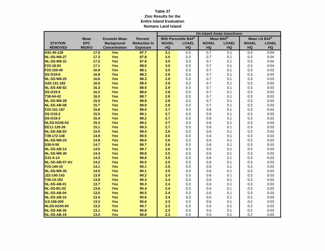
Table 37Zinc Results for the
Entire Island EvaluationNomans Land Island
Mean Exceeds Mean Percent STATION EPC Background Reduction in NOAEL LOAEL NOAEL LOAEL NOAEL LOAELREMOVED MG/KG Concentration Exposure HQ HQ HQ HQ HQ HQ
90th Percentile BAF2 Mean BAF3 Mean LN BAF4
On-Island Avian Insectivore
H31-40-128 17.5 Yes 87.7 3.1 0.3 0.7 0.1 0.3 0.04NL-SS-W6-27 17.3 Yes 87.8 3.0 0.3 0.7 0.1 0.3 0.04NL-SS-W6-31 17.2 Yes 87.9 3.0 0.3 0.7 0.1 0.3 0.04F23-18-93 17.1 Yes 88.0 3.0 0.3 0.7 0.1 0.3 0.04F23-159-40 16.9 Yes 88.1 3.0 0.3 0.7 0.1 0.3 0.03SS-O19-6 16.8 Yes 88.2 2.9 0.3 0.7 0.1 0.3 0.03NL-SS-W6-25 16.6 Yes 88.3 2.9 0.3 0.7 0.1 0.3 0.03G20-131-183 16.5 Yes 88.4 2.9 0.3 0.7 0.1 0.3 0.03NL-SS-AB-02 16.3 Yes 88.5 2.9 0.3 0.7 0.1 0.3 0.03SS-O19-5 16.2 Yes 88.6 2.8 0.3 0.7 0.1 0.3 0.03T38-54-42 16.0 Yes 88.7 2.8 0.3 0.7 0.1 0.3 0.03NL-SS-W6-28 15.9 Yes 88.8 2.8 0.3 0.7 0.1 0.3 0.03NL-SS-AB-08 15.7 Yes 88.9 2.8 0.3 0.7 0.1 0.3 0.03F20-151-187 15.6 Yes 89.0 2.7 0.3 0.6 0.1 0.3 0.03SS-O19-2 15.5 Yes 89.1 2.7 0.3 0.6 0.1 0.3 0.03SS-O19-3 15.4 Yes 89.2 2.7 0.3 0.6 0.1 0.3 0.03NLSS-N105-03 15.3 Yes 89.2 2.7 0.3 0.6 0.1 0.3 0.03EE11-120-39 15.1 Yes 89.3 2.7 0.3 0.6 0.1 0.3 0.03NL-SS-AB-03 15.0 Yes 89.4 2.6 0.3 0.6 0.1 0.3 0.03T39-172-148 14.9 Yes 89.5 2.6 0.3 0.6 0.1 0.3 0.03NL-SS-W6-23 14.8 Yes 89.6 2.6 0.3 0.6 0.1 0.3 0.03S39-0-50 14.7 Yes 89.7 2.6 0.3 0.6 0.1 0.3 0.03NL-SS-AB-14 14.5 Yes 89.7 2.6 0.3 0.6 0.1 0.3 0.03NL-SS-W6-30 14.4 Yes 89.8 2.5 0.3 0.6 0.1 0.3 0.03G31-0-14 14.3 Yes 89.9 2.5 0.3 0.6 0.1 0.3 0.03NL-SS-AB-07-AV 14.2 Yes 90.0 2.5 0.3 0.6 0.1 0.3 0.03F23-144-10 14.1 Yes 90.1 2.5 0.3 0.6 0.1 0.3 0.03NL-SS-W6-35 14.0 Yes 90.1 2.5 0.3 0.6 0.1 0.3 0.03J22-140-143 13.9 Yes 90.2 2.4 0.3 0.6 0.1 0.3 0.03T40-14-193 13.8 Yes 90.3 2.4 0.3 0.6 0.1 0.3 0.03NL-SS-AB-01 13.7 Yes 90.3 2.4 0.3 0.6 0.1 0.3 0.03NL-SS-B1-02 13.6 Yes 90.4 2.4 0.3 0.6 0.1 0.3 0.03NL-SS-AB-04 13.5 Yes 90.5 2.4 0.3 0.6 0.1 0.3 0.03NL-SS-AB-10 13.4 Yes 90.6 2.4 0.3 0.6 0.1 0.2 0.03I13-159-200 13.3 Yes 90.6 2.3 0.3 0.6 0.1 0.2 0.03NLSS-N104-04 13.2 Yes 90.7 2.3 0.3 0.5 0.1 0.2 0.03NL-SS-AB-30 13.1 Yes 90.8 2.3 0.3 0.5 0.1 0.2 0.03NL-SS-AB-19 13.0 Yes 90.8 2.3 0.3 0.5 0.1 0.2 0.03
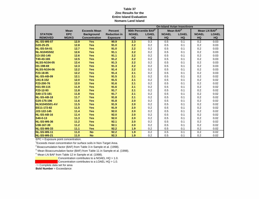
Table 37Zinc Results for the
Entire Island EvaluationNomans Land Island
Mean Exceeds Mean Percent STATION EPC Background Reduction in NOAEL LOAEL NOAEL LOAEL NOAEL LOAELREMOVED MG/KG Concentration Exposure HQ HQ HQ HQ HQ HQ
90th Percentile BAF2 Mean BAF3 Mean LN BAF4
On-Island Avian Insectivore
NL-SS-W6-07 12.9 Yes 90.9 2.3 0.3 0.5 0.1 0.2 0.03G20-25-25 12.8 Yes 91.0 2.2 0.2 0.5 0.1 0.2 0.03NL-SS-S4-01 12.7 Yes 91.0 2.2 0.2 0.5 0.1 0.2 0.03NL-N104SS02 12.6 Yes 91.1 2.2 0.2 0.5 0.1 0.2 0.03I13-192-145 12.6 Yes 91.1 2.2 0.2 0.5 0.1 0.2 0.03T40-43-165 12.5 Yes 91.2 2.2 0.2 0.5 0.1 0.2 0.03NLSS-N104-05 12.4 Yes 91.3 2.2 0.2 0.5 0.1 0.2 0.03I31-198-69 12.3 Yes 91.3 2.2 0.2 0.5 0.1 0.2 0.03NLSS-N104-06 12.2 Yes 91.4 2.2 0.2 0.5 0.1 0.2 0.03F23-18-85 12.2 Yes 91.4 2.1 0.2 0.5 0.1 0.2 0.03NL-SS-AB-09 12.1 Yes 91.5 2.1 0.2 0.5 0.1 0.2 0.02U41-8-152 12.0 Yes 91.5 2.1 0.2 0.5 0.1 0.2 0.02F23-200-76 12.0 Yes 91.6 2.1 0.2 0.5 0.1 0.2 0.02H31-59-115 11.9 Yes 91.6 2.1 0.2 0.5 0.1 0.2 0.02F23-12-93 11.8 Yes 91.7 2.1 0.2 0.5 0.1 0.2 0.02S40-172-181 11.8 Yes 91.7 2.1 0.2 0.5 0.1 0.2 0.02NL-SS-AB-18 11.7 Yes 91.8 2.1 0.2 0.5 0.1 0.2 0.02G20-175-196 11.6 Yes 91.8 2.0 0.2 0.5 0.1 0.2 0.02NLN104SS01-AV 11.5 Yes 91.9 2.0 0.2 0.5 0.1 0.2 0.02EE11-172-82 11.5 Yes 91.9 2.0 0.2 0.5 0.1 0.2 0.02J22-122-145 11.4 Yes 92.0 2.0 0.2 0.5 0.1 0.2 0.02NL-SS-AB-16 11.4 Yes 92.0 2.0 0.2 0.5 0.1 0.2 0.02S40-0-13 11.3 Yes 92.0 2.0 0.2 0.5 0.1 0.2 0.02NL-SS-W6-36 11.2 Yes 92.1 2.0 0.2 0.5 0.1 0.2 0.02U38-167-39 11.2 Yes 92.1 2.0 0.2 0.5 0.1 0.2 0.02NL-SS-W6-33 11.1 Yes 92.2 1.9 0.2 0.5 0.1 0.2 0.02NL-SS-W6-11 11.0 No 92.2 1.9 0.2 0.5 0.1 0.2 0.02NL-SS-W6-21 11.0 No 92.3 1.9 0.2 0.5 0.1 0.2 0.02EPC = Exposure point concentration.1Exceeds mean concentration for surface soils in Non-Target Area.2 Bioaccumulation factor (BAF) from Table 3 in Sample et al. (1998).3 Mean Bioaccumulation factor (BAF) from Table 11 in Sample et al. (1998).4 Mean LN BAF from Table 12 in Sample et al. (1998).
Concentration contributes to a NOAEL HQ > 1.0.Concentration contributes to a LOAEL HQ > 1.0.
-'= Complete data set for areaBold Number = Exceedance

Record of Decision Final Nomans Land Island, Chilmark, MA January 2022
4659-WE05-22-0003
This page intentionally left blank.
Record of Decision Final Nomans Land Island, Chilmark, MA January 2022
4659-WE05-22-0003
APPENDIX D
COST ESTIMATE

Record of Decision Final Nomans Land Island, Chilmark, MA January 2022
4659-WE05-22-0003
This page intentionally left blank.
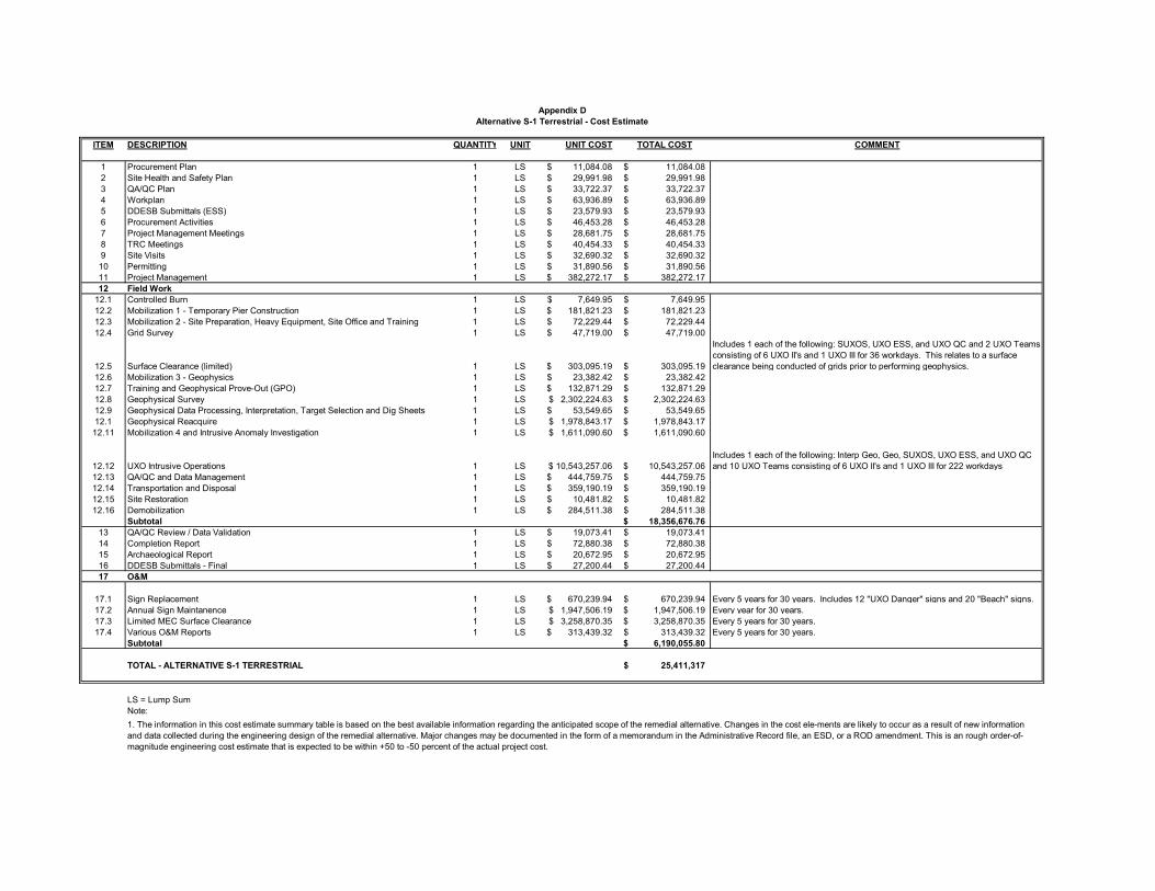
ITEM DESCRIPTION QUANTITY UNIT UNIT COST TOTAL COST COMMENT
1 Procurement Plan 1 LS 11,084.08$ 11,084.08$ 2 Site Health and Safety Plan 1 LS 29,991.98$ 29,991.98$ 3 QA/QC Plan 1 LS 33,722.37$ 33,722.37$ 4 Workplan 1 LS 63,936.89$ 63,936.89$ 5 DDESB Submittals (ESS) 1 LS 23,579.93$ 23,579.93$ 6 Procurement Activities 1 LS 46,453.28$ 46,453.28$ 7 Project Management Meetings 1 LS 28,681.75$ 28,681.75$ 8 TRC Meetings 1 LS 40,454.33$ 40,454.33$ 9 Site Visits 1 LS 32,690.32$ 32,690.32$ 10 Permitting 1 LS 31,890.56$ 31,890.56$ 11 Project Management 1 LS 382,272.17$ 382,272.17$ 12 Field Work
12.1 Controlled Burn 1 LS 7,649.95$ 7,649.95$ 12.2 Mobilization 1 - Temporary Pier Construction 1 LS 181,821.23$ 181,821.23$ 12.3 Mobilization 2 - Site Preparation, Heavy Equipment, Site Office and Training 1 LS 72,229.44$ 72,229.44$ 12.4 Grid Survey 1 LS 47,719.00$ 47,719.00$
12.5 Surface Clearance (limited) 1 LS 303,095.19$ 303,095.19$
Includes 1 each of the following: SUXOS, UXO ESS, and UXO QC and 2 UXO Teams consisting of 6 UXO II's and 1 UXO III for 36 workdays. This relates to a surface clearance being conducted of grids prior to performing geophysics.
12.6 Mobilization 3 - Geophysics 1 LS 23,382.42$ 23,382.42$ 12.7 Training and Geophysical Prove-Out (GPO) 1 LS 132,871.29$ 132,871.29$ 12.8 Geophysical Survey 1 LS 2,302,224.63$ 2,302,224.63$ 12.9 Geophysical Data Processing, Interpretation, Target Selection and Dig Sheets 1 LS 53,549.65$ 53,549.65$ 12.1 Geophysical Reacquire 1 LS 1,978,843.17$ 1,978,843.17$ 12.11 Mobilization 4 and Intrusive Anomaly Investigation 1 LS 1,611,090.60$ 1,611,090.60$
12.12 UXO Intrusive Operations 1 LS 10,543,257.06$ 10,543,257.06$ Includes 1 each of the following: Interp Geo, Geo, SUXOS, UXO ESS, and UXO QC and 10 UXO Teams consisting of 6 UXO II's and 1 UXO III for 222 workdays
12.13 QA/QC and Data Management 1 LS 444,759.75$ 444,759.75$ 12.14 Transportation and Disposal 1 LS 359,190.19$ 359,190.19$ 12.15 Site Restoration 1 LS 10,481.82$ 10,481.82$ 12.16 Demobilization 1 LS 284,511.38$ 284,511.38$
Subtotal 18,356,676.76$ 13 QA/QC Review / Data Validation 1 LS 19,073.41$ 19,073.41$ 14 Completion Report 1 LS 72,880.38$ 72,880.38$ 15 Archaeological Report 1 LS 20,672.95$ 20,672.95$ 16 DDESB Submittals - Final 1 LS 27,200.44$ 27,200.44$ 17 O&M
17.1 Sign Replacement 1 LS 670,239.94$ 670,239.94$ Every 5 years for 30 years. Includes 12 "UXO Danger" signs and 20 "Beach" signs.17.2 Annual Sign Maintanence 1 LS 1,947,506.19$ 1,947,506.19$ Every year for 30 years.17.3 Limited MEC Surface Clearance 1 LS 3,258,870.35$ 3,258,870.35$ Every 5 years for 30 years.17.4 Various O&M Reports 1 LS 313,439.32$ 313,439.32$ Every 5 years for 30 years.
Subtotal 6,190,055.80$
TOTAL - ALTERNATIVE S-1 TERRESTRIAL 25,411,317$
LS = Lump Sum 18269694 CheckNote: 25411317.38
Appendix DAlternative S-1 Terrestrial - Cost Estimate
1. The information in this cost estimate summary table is based on the best available information regarding the anticipated scope of the remedial alternative. Changes in the cost ele-ments are likely to occur as a result of new information and data collected during the engineering design of the remedial alternative. Major changes may be documented in the form of a memorandum in the Administrative Record file, an ESD, or a ROD amendment. This is an rough order-of-magnitude engineering cost estimate that is expected to be within +50 to -50 percent of the actual project cost.
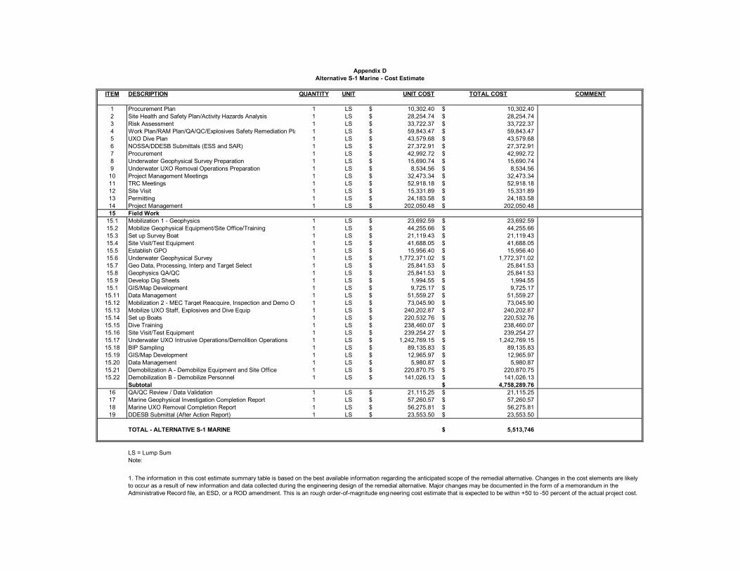
ITEM DESCRIPTION QUANTITY UNIT UNIT COST TOTAL COST COMMENT
1 Procurement Plan 1 LS 10,302.40$ 10,302.40$ 2 Site Health and Safety Plan/Activity Hazards Analysis 1 LS 28,254.74$ 28,254.74$ 3 Risk Assessment 1 LS 33,722.37$ 33,722.37$ 4 Work Plan/RAM Plan/QA/QC/Explosives Safety Remediation Pla 1 LS 59,843.47$ 59,843.47$ 5 UXO Dive Plan 1 LS 43,579.68$ 43,579.68$ 6 NOSSA/DDESB Submittals (ESS and SAR) 1 LS 27,372.91$ 27,372.91$ 7 Procurement 1 LS 42,992.72$ 42,992.72$ 8 Underwater Geophysical Survey Preparation 1 LS 15,690.74$ 15,690.74$ 9 Underwater UXO Removal Operations Preparation 1 LS 8,534.56$ 8,534.56$
10 Project Management Meetings 1 LS 32,473.34$ 32,473.34$ 11 TRC Meetings 1 LS 52,918.18$ 52,918.18$ 12 Site Visit 1 LS 15,331.89$ 15,331.89$ 13 Permitting 1 LS 24,183.58$ 24,183.58$ 14 Project Management 1 LS 202,050.48$ 202,050.48$ 15 Field Work
15.1 Mobilization 1 - Geophysics 1 LS 23,692.59$ 23,692.59$ 15.2 Mobilize Geophysical Equipment/Site Office/Training 1 LS 44,255.66$ 44,255.66$ 15.3 Set up Survey Boat 1 LS 21,119.43$ 21,119.43$ 15.4 Site Visit/Test Equipment 1 LS 41,688.05$ 41,688.05$ 15.5 Establish GPO 1 LS 15,956.40$ 15,956.40$ 15.6 Underwater Geophysical Survey 1 LS 1,772,371.02$ 1,772,371.02$ 15.7 Geo Data, Processing, Interp and Target Select 1 LS 25,841.53$ 25,841.53$ 15.8 Geophysics QA/QC 1 LS 25,841.53$ 25,841.53$ 15.9 Develop Dig Sheets 1 LS 1,994.55$ 1,994.55$ 15.1 GIS/Map Development 1 LS 9,725.17$ 9,725.17$
15.11 Data Management 1 LS 51,559.27$ 51,559.27$ 15.12 Mobilization 2 - MEC Target Reacquire, Inspection and Demo Op 1 LS 73,045.90$ 73,045.90$ 15.13 Mobilize UXO Staff, Explosives and Dive Equip 1 LS 240,202.87$ 240,202.87$ 15.14 Set up Boats 1 LS 220,532.76$ 220,532.76$ 15.15 Dive Training 1 LS 238,460.07$ 238,460.07$ 15.16 Site Visit/Test Equipment 1 LS 239,254.27$ 239,254.27$ 15.17 Underwater UXO Intrusive Operations/Demolition Operations 1 LS 1,242,769.15$ 1,242,769.15$ 15.18 BIP Sampling 1 LS 89,135.83$ 89,135.83$ 15.19 GIS/Map Development 1 LS 12,965.97$ 12,965.97$ 15.20 Data Management 1 LS 5,980.87$ 5,980.87$ 15.21 Demobilization A - Demobilize Equipment and Site Office 1 LS 220,870.75$ 220,870.75$ 15.22 Demobilization B - Demobilize Personnel 1 LS 141,026.13$ 141,026.13$
Subtotal 4,758,289.76$ 16 QA/QC Review / Data Validation 1 LS 21,115.25$ 21,115.25$ 17 Marine Geophysical Investigation Completion Report 1 LS 57,260.57$ 57,260.57$ 18 Marine UXO Removal Completion Report 1 LS 56,275.81$ 56,275.81$ 19 DDESB Submittal (After Action Report) 1 LS 23,553.50$ 23,553.50$
TOTAL - ALTERNATIVE S-1 MARINE 5,513,746$
LS = Lump SumNote: 0
Appendix DAlternative S-1 Marine - Cost Estimate
1. The information in this cost estimate summary table is based on the best available information regarding the anticipated scope of the remedial alternative. Changes in the cost elements are likely to occur as a result of new information and data collected during the engineering design of the remedial alternative. Major changes may be documented in the form of a memorandum in the Administrative Record file, an ESD, or a ROD amendment. This is an rough order-of-magnitude engineering cost estimate that is expected to be within +50 to -50 percent of the actual project cost.
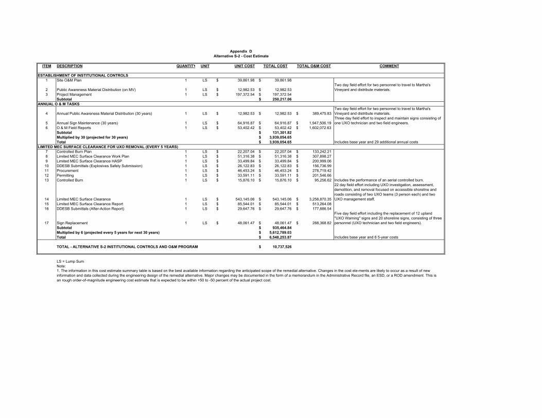
Escalation 39.09%ITEM DESCRIPTION QUANTITY UNIT UNIT COST TOTAL COST TOTAL O&M COST COMMENT
ESTABLISHMENT OF INSTITUTIONAL CONTROLS1 Site O&M Plan 1 LS 39,861.98$ 39,861.98$
2 Public Awareness Material Distribution (on MV) 1 LS 12,982.53$ 12,982.53$ Two day field effort for two personnel to travel to Martha's Vineyard and distribute materials.
3 Project Management 1 LS 197,372.54$ 197,372.54$ Subtotal 250,217.06$
ANNUAL O & M TASKS
4 Annual Public Awareness Material Distribution (30 years) 1 LS 12,982.53$ 12,982.53$ 389,475.83$ Two day field effort for two personnel to travel to Martha's Vineyard and distribute materials. 30
5 Annual Sign Maintenance (30 years) 1 LS 64,916.87$ 64,916.87$ 1,947,506.19$ Three day field effort to inspect and maintain signs consisting of one UXO technician and two field engineers. 30
6 O & M Field Reports 1 LS 53,402.42$ 53,402.42$ 1,602,072.63$ 30Subtotal 131,301.82$ Multiplied by 30 (projected for 30 years) 3,939,054.65$ Total 3,939,054.65$ Includes base year and 29 additional annual costs
LIMITED MEC SURFACE CLEARANCE FOR UXO REMOVAL (EVERY 5 YEARS)7 Controlled Burn Plan 1 LS 22,207.04$ 22,207.04$ 133,242.21$ 68 Limited MEC Surface Clearance Work Plan 1 LS 51,316.38$ 51,316.38$ 307,898.27$ 69 Limited MEC Surface Clearance HASP 1 LS 33,499.84$ 33,499.84$ 200,999.06$ 6
10 DDESB Submittals (Explosives Safety Submission) 1 LS 26,122.83$ 26,122.83$ 156,736.99$ 611 Procurement 1 LS 46,453.24$ 46,453.24$ 278,719.42$ 612 Permitting 1 LS 33,591.11$ 33,591.11$ 201,546.66$ 613 Controlled Burn 1 LS 15,876.10$ 15,876.10$ 95,256.62$ Includes the performance of an aerial controlled burn. 6
14 Limited MEC Surface Clearance 1 LS 543,145.06$ 543,145.06$ 3,258,870.35$
22 day field effort including UXO investigation, assessment, demolition, and removal focused on accessible shoreline and roads consisting of two UXO teams (3 person each) and two UXO management staff. 6
15 Limited MEC Surface Clearance Report 1 LS 85,544.01$ 85,544.01$ 513,264.08$ 616 DDESB Submittals (After-Action Report) 1 LS 29,647.76$ 29,647.76$ 177,886.54$ 6
17 Sign Replacement 1 LS 48,061.47$ 48,061.47$ 288,368.82$
Five day field effort including the replacement of 12 upland "UXO Warning" signs and 20 shoreline signs, consisting of three personnel (UXO technician and two field engineers). 6
Subtotal 935,464.84$ Multiplied by 6 (projected every 5 years for next 30 years) 5,612,789.03$ Total 6,548,253.87$ Includes base year and 6 5-year costs
TOTAL - ALTERNATIVE S-2 INSTITUTIONAL CONTROLS AND O&M PROGRAM 10,737,526$
LS = Lump SumNote: 0
Appendix DAlternative S-2 - Cost Estimate
1. The information in this cost estimate summary table is based on the best available information regarding the anticipated scope of the remedial alternative. Changes in the cost ele-ments are likely to occur as a result of new information and data collected during the engineering design of the remedial alternative. Major changes may be documented in the form of a memorandum in the Administrative Record file, an ESD, or a ROD amendment. This is an rough order-of-magnitude engineering cost estimate that is expected to be within +50 to -50 percent of the actual project cost.

Record of Decision Final Nomans Land Island, Chilmark, MA January 2022
4659-WE05-22-0003
This page intentionally left blank.
Record of Decision Final Nomans Land Island, Chilmark, MA January 2022
4659-WE05-22-0003
APPENDIX E
ARARs

Record of Decision Final Nomans Land Island, Chilmark, MA January 2022
4659-WE05-22-0003
This page intentionally left blank.
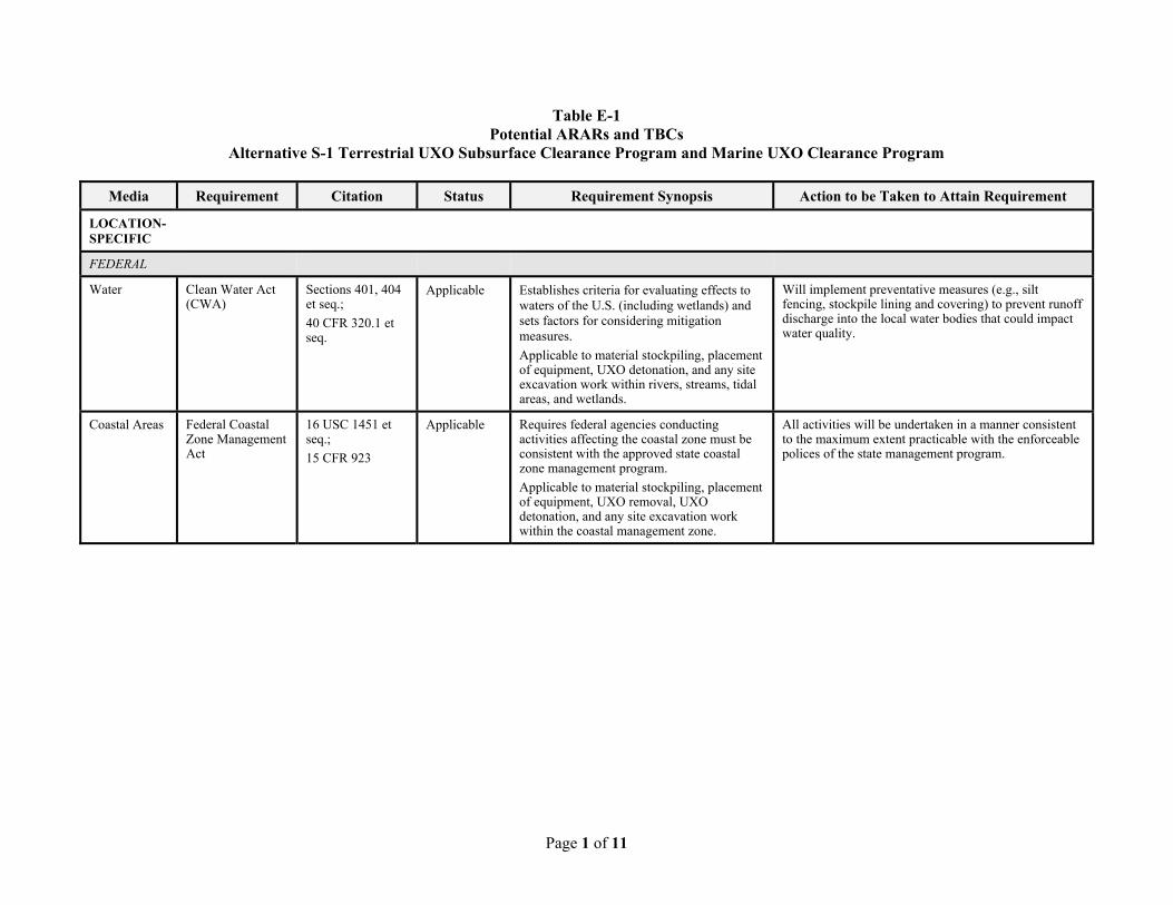
Page 1 of 11
Table E-1 Potential ARARs and TBCs
Alternative S-1 Terrestrial UXO Subsurface Clearance Program and Marine UXO Clearance Program
Media Requirement Citation Status Requirement Synopsis Action to be Taken to Attain Requirement
LOCATION-SPECIFIC
FEDERAL
Water Clean Water Act (CWA)
Sections 401, 404 et seq.;
40 CFR 320.1 et seq.
Applicable Establishes criteria for evaluating effects to waters of the U.S. (including wetlands) and sets factors for considering mitigationmeasures.
Applicable to material stockpiling, placement of equipment, UXO detonation, and any site excavation work within rivers, streams, tidal areas, and wetlands.
Will implement preventative measures (e.g., silt fencing, stockpile lining and covering) to prevent runoff discharge into the local water bodies that could impact water quality.
Coastal Areas Federal Coastal Zone Management Act
16 USC 1451 et seq.;
15 CFR 923
Applicable Requires federal agencies conducting activities affecting the coastal zone must be consistent with the approved state coastal zone management program.
Applicable to material stockpiling, placement of equipment, UXO removal, UXO detonation, and any site excavation work within the coastal management zone.
All activities will be undertaken in a manner consistent to the maximum extent practicable with the enforceable polices of the state management program.
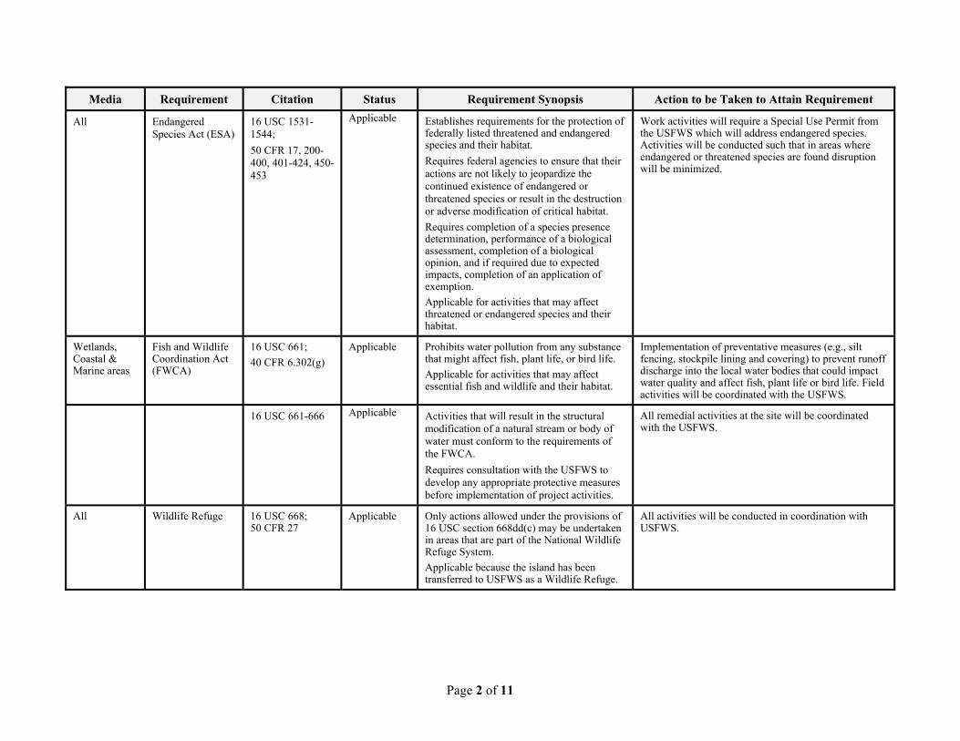
Page 2 of 11
Media Requirement Citation Status Requirement Synopsis Action to be Taken to Attain Requirement
All Endangered Species Act (ESA)
16 USC 1531-1544;
50 CFR 17, 200-400, 401-424, 450-453
Applicable Establishes requirements for the protection of federally listed threatened and endangered species and their habitat.
Requires federal agencies to ensure that their actions are not likely to jeopardize the continued existence of endangered or threatened species or result in the destruction or adverse modification of critical habitat.
Requires completion of a species presence determination, performance of a biological assessment, completion of a biological opinion, and if required due to expected impacts, completion of an application of exemption.
Applicable for activities that may affect threatened or endangered species and their habitat.
Work activities will require a Special Use Permit from the USFWS which will address endangered species. Activities will be conducted such that in areas where endangered or threatened species are found disruption will be minimized.
Wetlands, Coastal & Marine areas
Fish and Wildlife Coordination Act (FWCA)
16 USC 661;
40 CFR 6.302(g)
Applicable Prohibits water pollution from any substance that might affect fish, plant life, or bird life.
Applicable for activities that may affect essential fish and wildlife and their habitat.
Implementation of preventative measures (e.g., silt fencing, stockpile lining and covering) to prevent runoff discharge into the local water bodies that could impact water quality and affect fish, plant life or bird life. Field activities will be coordinated with the USFWS.
16 USC 661-666 Applicable Activities that will result in the structural modification of a natural stream or body of water must conform to the requirements of the FWCA.
Requires consultation with the USFWS to develop any appropriate protective measures before implementation of project activities.
All remedial activities at the site will be coordinated with the USFWS.
All Wildlife Refuge 16 USC 668; 50 CFR 27
Applicable Only actions allowed under the provisions of 16 USC section 668dd(c) may be undertaken in areas that are part of the National Wildlife Refuge System.
Applicable because the island has been transferred to USFWS as a Wildlife Refuge.
All activities will be conducted in coordination with USFWS.
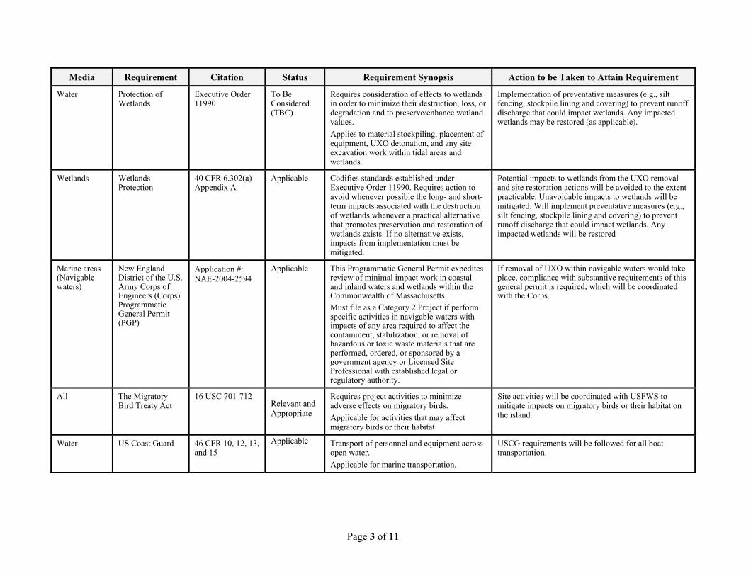
Page 3 of 11
Media Requirement Citation Status Requirement Synopsis Action to be Taken to Attain Requirement
Water Protection of Wetlands
Executive Order 11990
To Be Considered (TBC)
Requires consideration of effects to wetlands in order to minimize their destruction, loss, or degradation and to preserve/enhance wetland values.
Applies to material stockpiling, placement of equipment, UXO detonation, and any site excavation work within tidal areas and wetlands.
Implementation of preventative measures (e.g., silt fencing, stockpile lining and covering) to prevent runoff discharge that could impact wetlands. Any impacted wetlands may be restored (as applicable).
Wetlands Wetlands Protection
40 CFR 6.302(a) Appendix A
Applicable Codifies standards established under Executive Order 11990. Requires action to avoid whenever possible the long- and short-term impacts associated with the destruction of wetlands whenever a practical alternative that promotes preservation and restoration of wetlands exists. If no alternative exists, impacts from implementation must be mitigated.
Potential impacts to wetlands from the UXO removal and site restoration actions will be avoided to the extent practicable. Unavoidable impacts to wetlands will be mitigated. Will implement preventative measures (e.g., silt fencing, stockpile lining and covering) to prevent runoff discharge that could impact wetlands. Any impacted wetlands will be restored
Marine areas (Navigable waters)
New England District of the U.S. Army Corps of Engineers (Corps) Programmatic General Permit (PGP)
Application #: NAE-2004-2594
Applicable This Programmatic General Permit expedites review of minimal impact work in coastal and inland waters and wetlands within the Commonwealth of Massachusetts.
Must file as a Category 2 Project if perform specific activities in navigable waters with impacts of any area required to affect the containment, stabilization, or removal of hazardous or toxic waste materials that are performed, ordered, or sponsored by a government agency or Licensed Site Professional with established legal or regulatory authority.
If removal of UXO within navigable waters would take place, compliance with substantive requirements of this general permit is required; which will be coordinated with the Corps.
All The Migratory Bird Treaty Act
16 USC 701-712 Relevant and Appropriate
Requires project activities to minimize adverse effects on migratory birds.
Applicable for activities that may affect migratory birds or their habitat.
Site activities will be coordinated with USFWS to mitigate impacts on migratory birds or their habitat on the island.
Water US Coast Guard 46 CFR 10, 12, 13, and 15
Applicable Transport of personnel and equipment across open water.
Applicable for marine transportation.
USCG requirements will be followed for all boat transportation.
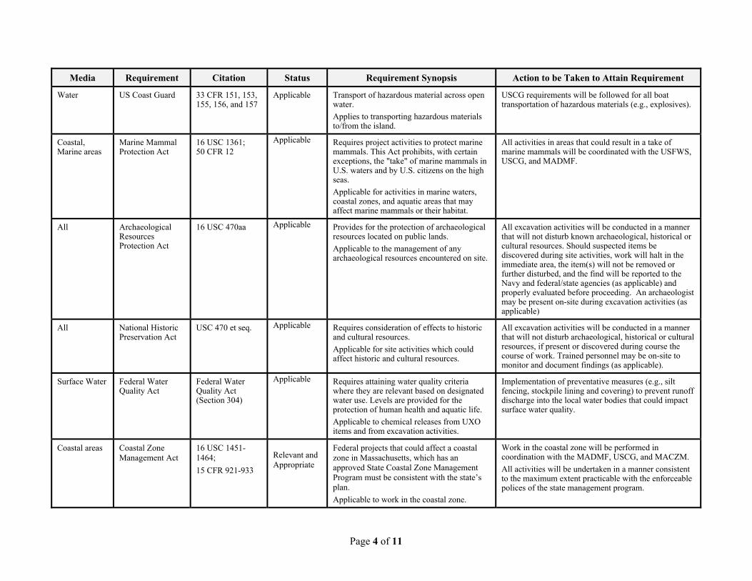
Page 4 of 11
Media Requirement Citation Status Requirement Synopsis Action to be Taken to Attain Requirement
Water US Coast Guard 33 CFR 151, 153, 155, 156, and 157
Applicable Transport of hazardous material across open water.
Applies to transporting hazardous materials to/from the island.
USCG requirements will be followed for all boat transportation of hazardous materials (e.g., explosives).
Coastal, Marine areas
Marine Mammal Protection Act
16 USC 1361; 50 CFR 12
Applicable Requires project activities to protect marine mammals. This Act prohibits, with certain exceptions, the "take" of marine mammals in U.S. waters and by U.S. citizens on the high seas.
Applicable for activities in marine waters, coastal zones, and aquatic areas that may affect marine mammals or their habitat.
All activities in areas that could result in a take of marine mammals will be coordinated with the USFWS, USCG, and MADMF.
All Archaeological Resources Protection Act
16 USC 470aa Applicable Provides for the protection of archaeological resources located on public lands.
Applicable to the management of any archaeological resources encountered on site.
All excavation activities will be conducted in a manner that will not disturb known archaeological, historical or cultural resources. Should suspected items be discovered during site activities, work will halt in the immediate area, the item(s) will not be removed or further disturbed, and the find will be reported to the Navy and federal/state agencies (as applicable) and properly evaluated before proceeding. An archaeologist may be present on-site during excavation activities (as applicable)
All National Historic Preservation Act
USC 470 et seq. Applicable Requires consideration of effects to historic and cultural resources.
Applicable for site activities which could affect historic and cultural resources.
All excavation activities will be conducted in a manner that will not disturb archaeological, historical or cultural resources, if present or discovered during course the course of work. Trained personnel may be on-site to monitor and document findings (as applicable).
Surface Water Federal Water Quality Act
Federal Water Quality Act (Section 304)
Applicable Requires attaining water quality criteria where they are relevant based on designated water use. Levels are provided for the protection of human health and aquatic life.
Applicable to chemical releases from UXO items and from excavation activities.
Implementation of preventative measures (e.g., silt fencing, stockpile lining and covering) to prevent runoff discharge into the local water bodies that could impact surface water quality.
Coastal areas Coastal Zone Management Act
16 USC 1451-1464;
15 CFR 921-933
Relevant and Appropriate
Federal projects that could affect a coastal zone in Massachusetts, which has an approved State Coastal Zone Management Program must be consistent with the state�s plan.
Applicable to work in the coastal zone.
Work in the coastal zone will be performed in coordination with the MADMF, USCG, and MACZM.
All activities will be undertaken in a manner consistent to the maximum extent practicable with the enforceable polices of the state management program.
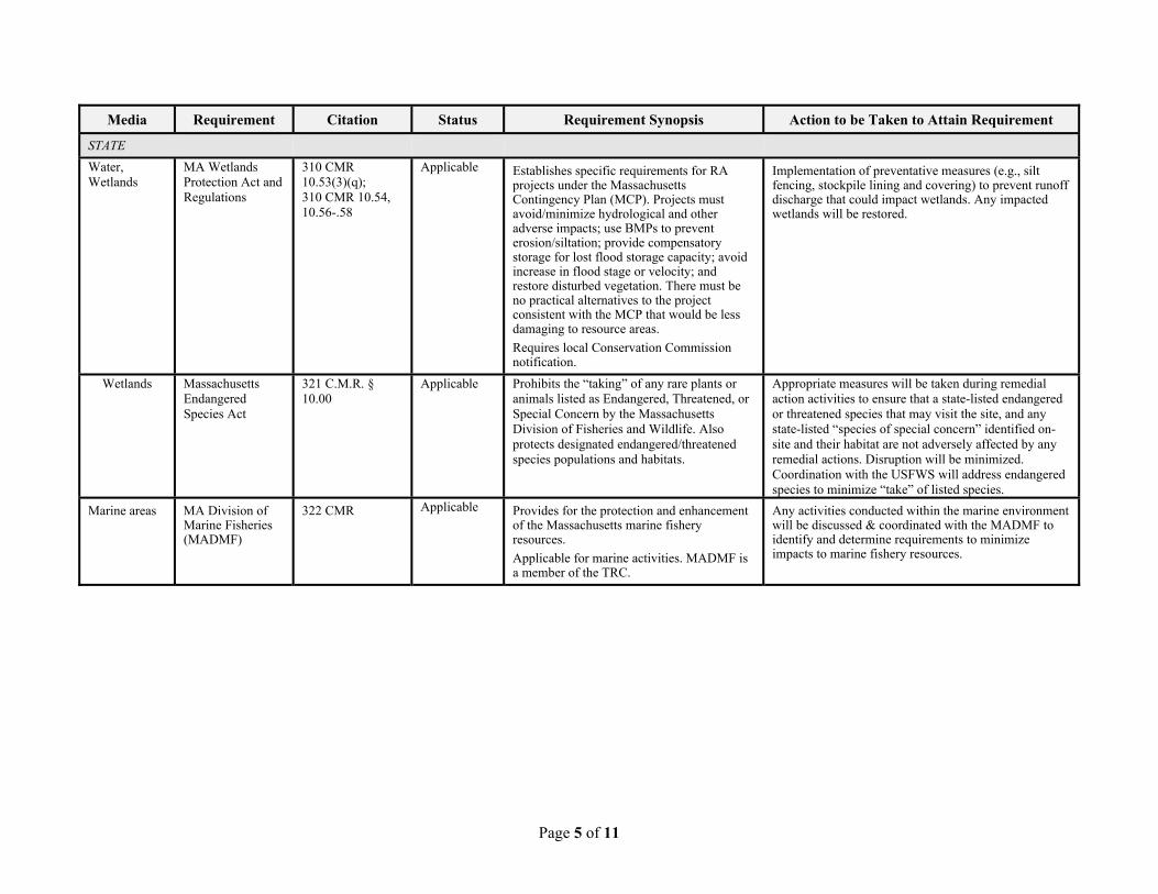
Page 5 of 11
Media Requirement Citation Status Requirement Synopsis Action to be Taken to Attain Requirement
STATE
Water, Wetlands
MA Wetlands Protection Act and Regulations
310 CMR 10.53(3)(q); 310 CMR 10.54, 10.56-.58
Applicable Establishes specific requirements for RA projects under the Massachusetts Contingency Plan (MCP). Projects must avoid/minimize hydrological and other adverse impacts; use BMPs to prevent erosion/siltation; provide compensatory storage for lost flood storage capacity; avoid increase in flood stage or velocity; and restore disturbed vegetation. There must be no practical alternatives to the project consistent with the MCP that would be less damaging to resource areas.
Requires local Conservation Commission notification.
Implementation of preventative measures (e.g., silt fencing, stockpile lining and covering) to prevent runoff discharge that could impact wetlands. Any impacted wetlands will be restored.
Wetlands Massachusetts Endangered Species Act
321 C.M.R. § 10.00
Applicable Prohibits the �taking� of any rare plants or animals listed as Endangered, Threatened, or Special Concern by the Massachusetts Division of Fisheries and Wildlife. Also protects designated endangered/threatened species populations and habitats.
Appropriate measures will be taken during remedial action activities to ensure that a state-listed endangered or threatened species that may visit the site, and any state-listed �species of special concern� identified on-site and their habitat are not adversely affected by any remedial actions. Disruption will be minimized. Coordination with the USFWS will address endangered species to minimize �take� of listed species.
Marine areas MA Division of Marine Fisheries (MADMF)
322 CMR Applicable Provides for the protection and enhancement of the Massachusetts marine fishery resources.
Applicable for marine activities. MADMF is a member of the TRC.
Any activities conducted within the marine environment will be discussed & coordinated with the MADMF to identify and determine requirements to minimize impacts to marine fishery resources.
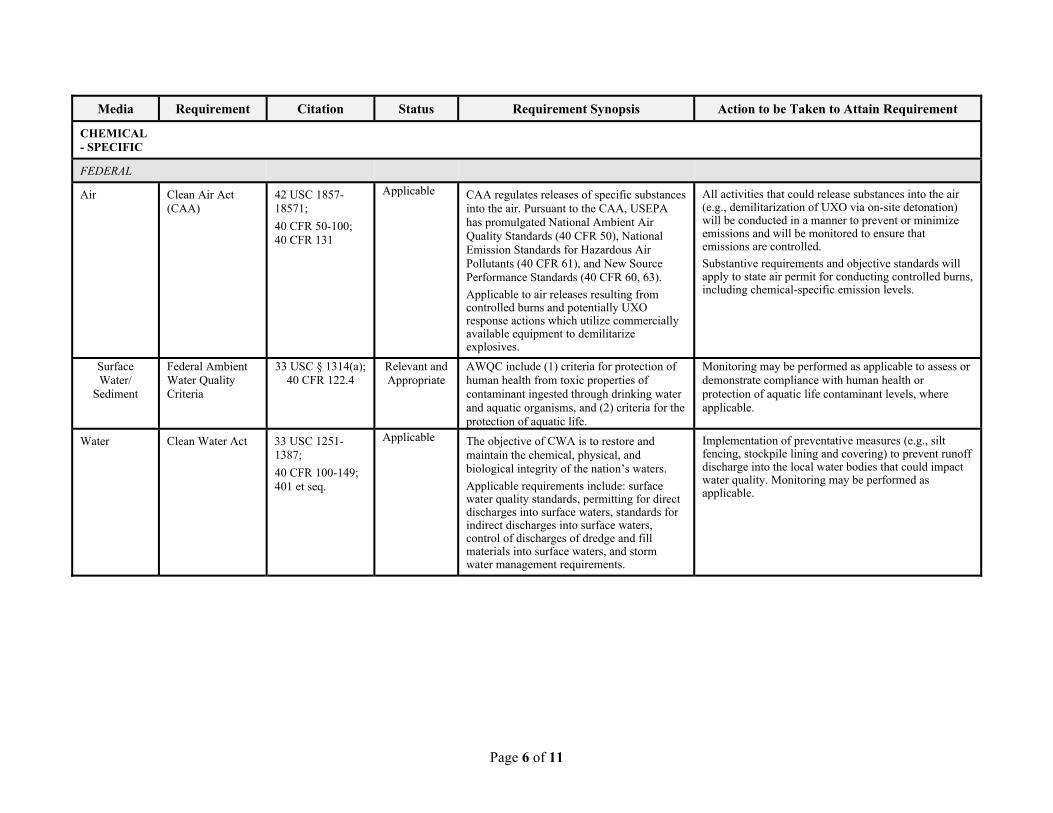
Page 6 of 11
Media Requirement Citation Status Requirement Synopsis Action to be Taken to Attain Requirement
CHEMICAL- SPECIFIC
FEDERAL
Air Clean Air Act (CAA)
42 USC 1857-18571;
40 CFR 50-100; 40 CFR 131
Applicable CAA regulates releases of specific substances into the air. Pursuant to the CAA, USEPA has promulgated National Ambient Air Quality Standards (40 CFR 50), National Emission Standards for Hazardous Air Pollutants (40 CFR 61), and New Source Performance Standards (40 CFR 60, 63).
Applicable to air releases resulting from controlled burns and potentially UXO response actions which utilize commercially available equipment to demilitarize explosives.
All activities that could release substances into the air (e.g., demilitarization of UXO via on-site detonation) will be conducted in a manner to prevent or minimize emissions and will be monitored to ensure that emissions are controlled.
Substantive requirements and objective standards will apply to state air permit for conducting controlled burns, including chemical-specific emission levels.
Surface Water/
Sediment
Federal Ambient Water Quality Criteria
33 USC § 1314(a); 40 CFR 122.4
Relevant and Appropriate
AWQC include (1) criteria for protection of human health from toxic properties of contaminant ingested through drinking water and aquatic organisms, and (2) criteria for the protection of aquatic life.
Monitoring may be performed as applicable to assess or demonstrate compliance with human health or protection of aquatic life contaminant levels, where applicable.
Water Clean Water Act 33 USC 1251-1387;
40 CFR 100-149; 401 et seq.
Applicable The objective of CWA is to restore and maintain the chemical, physical, and biological integrity of the nation�s waters.
Applicable requirements include: surface water quality standards, permitting for direct discharges into surface waters, standards for indirect discharges into surface waters, control of discharges of dredge and fill materials into surface waters, and storm water management requirements.
Implementation of preventative measures (e.g., silt fencing, stockpile lining and covering) to prevent runoff discharge into the local water bodies that could impact water quality. Monitoring may be performed as applicable.
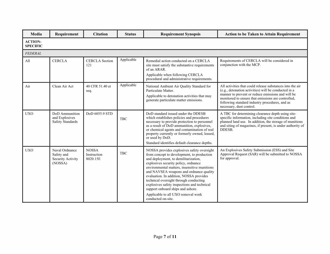
Page 7 of 11
Media Requirement Citation Status Requirement Synopsis Action to be Taken to Attain Requirement
ACTION-SPECIFIC
FEDERAL
All CERCLA CERCLA Section 121
Applicable Remedial action conducted on a CERCLA site must satisfy the substantive requirements of an ARAR.
Applicable when following CERCLA procedural and administrative requirements.
Requirements of CERCLA will be considered in conjunction with the MCP.
Air Clean Air Act 40 CFR 51.40 et seq.
Applicable National Ambient Air Quality Standard for Particulate Matter.
Applicable to detonation activities that may generate particulate matter emissions.
All activities that could release substances into the air (e.g., detonation activities) will be conducted in a manner to prevent or reduce emissions and will be monitored to ensure that emissions are controlled, following standard industry procedures, and as necessary, dust control.
UXO DoD Ammunition and Explosives Safety Standards
DoD 6055.9 STD
TBC
DoD standard issued under the DDESB which establishes policies and procedures necessary to provide protection to personnel as a result of DoD ammunition, explosives, or chemical agents and contamination of real property currently or formerly owned, leased, or used by DoD.
Standard identifies default clearance depths.
A TBC for determining clearance depth using site-specific information, including site conditions and planned land use. In addition, the storage of munitions and siting of magazines, if present, is under authority of DDESB.
UXO Naval Ordnance Safety and Security Activity (NOSSA)
NOSSA Instruction 8020.15E
TBC
NOSSA provides explosives safety oversight from concept to development, to production and deployment, to demilitarization, explosives security policy, ordnance environmental matters, insensitive munitions and NAVSEA weapons and ordnance quality evaluation. In addition, NOSSA provides technical oversight through conducting explosives safety inspections and technical support onboard ships and ashore.
Applicable to all UXO removal work conducted on-site.
An Explosives Safety Submission (ESS) and Site Approval Request (SAR) will be submitted to NOSSA for approval.
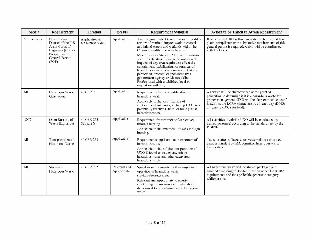
Page 8 of 11
Media Requirement Citation Status Requirement Synopsis Action to be Taken to Attain Requirement
Marine areas New England District of the U.S. Army Corps of Engineers (Corps) Programmatic General Permit (PGP)
Application #: NAE-2004-2594
Applicable This Programmatic General Permit expedites review of minimal impact work in coastal and inland waters and wetlands within the Commonwealth of Massachusetts.
Must file as a Category 2 Project if perform specific activities in navigable waters with impacts of any area required to affect the containment, stabilization, or removal of hazardous or toxic waste materials that are performed, ordered, or sponsored by a government agency or Licensed Site Professional with established legal or regulatory authority.
If removal of UXO within navigable waters would take place, compliance with substantive requirements of this general permit is required; which will be coordinated with the Corps.
All Hazardous Waste Generation
40 CFR 261 Applicable Requirements for the identification of hazardous waste.
Applicable to the identification of contaminated materials, including UXO as a potentially reactive (D003) or toxic (D008) hazardous waste.
All waste will be characterized at the point of generation to determine if it is a hazardous waste for proper management. UXO will be characterized to see if it exhibits the RCRA characteristic of reactivity (D003) or toxicity (D008 for lead).
UXO Open Burning of Waste Explosives
40 CFR 265 Subpart X
Applicable Requirement for treatment of explosives through burning.
Applicable to the treatment of UXO through burning.
All activities involving UXO will be conducted by trained personnel according to the standards set by the DDESB.
All Transportation of Hazardous Waste
40 CFR 263 Applicable Requirements applicable to transporters of hazardous waste.
Applicable to the off-site transportation of UXO if found to be a characteristic hazardous waste and other excavated hazardous waste.
Transportation of hazardous waste will be performed using a manifest by MA permitted hazardous waste transporters.
All Storage of Hazardous Waste
40 CFR 262 Relevant and Appropriate
Specifies requirements for the design and operation of hazardous waste stockpile/storage areas.
Relevant and Appropriate to on-site stockpiling of contaminated materials if determined to be a characteristic hazardous waste.
All hazardous waste will be stored, packaged and handled according to its identification under the RCRA requirements and the applicable generator category while on-site.
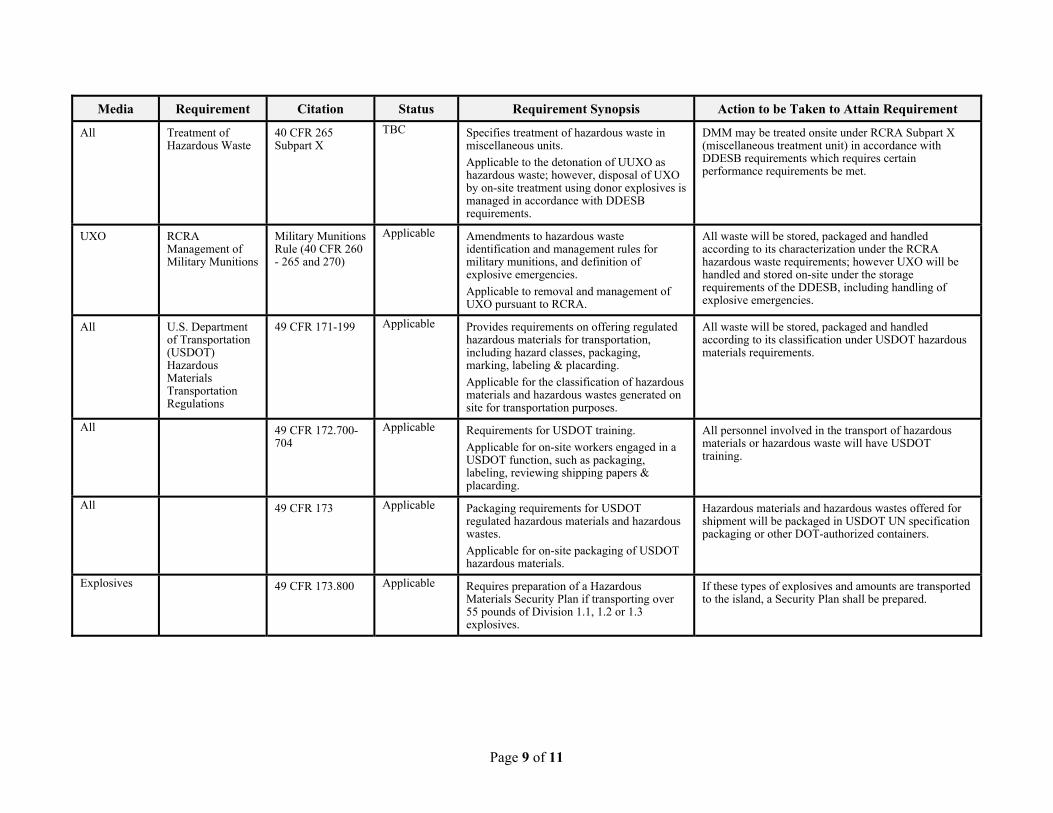
Page 9 of 11
Media Requirement Citation Status Requirement Synopsis Action to be Taken to Attain Requirement
All Treatment of Hazardous Waste
40 CFR 265 Subpart X
TBC Specifies treatment of hazardous waste in miscellaneous units.
Applicable to the detonation of UUXO as hazardous waste; however, disposal of UXO by on-site treatment using donor explosives is managed in accordance with DDESB requirements.
DMM may be treated onsite under RCRA Subpart X (miscellaneous treatment unit) in accordance with DDESB requirements which requires certain performance requirements be met.
UXO RCRA Management of Military Munitions
Military Munitions Rule (40 CFR 260 - 265 and 270)
Applicable Amendments to hazardous waste identification and management rules for military munitions, and definition of explosive emergencies.
Applicable to removal and management of UXO pursuant to RCRA.
All waste will be stored, packaged and handled according to its characterization under the RCRA hazardous waste requirements; however UXO will be handled and stored on-site under the storage requirements of the DDESB, including handling of explosive emergencies.
All U.S. Department of Transportation (USDOT) Hazardous Materials Transportation Regulations
49 CFR 171-199
Applicable Provides requirements on offering regulated hazardous materials for transportation, including hazard classes, packaging, marking, labeling & placarding.
Applicable for the classification of hazardous materials and hazardous wastes generated on site for transportation purposes.
All waste will be stored, packaged and handled according to its classification under USDOT hazardous materials requirements.
All 49 CFR 172.700-704
Applicable Requirements for USDOT training.
Applicable for on-site workers engaged in a USDOT function, such as packaging, labeling, reviewing shipping papers & placarding.
All personnel involved in the transport of hazardous materials or hazardous waste will have USDOT training.
All 49 CFR 173 Applicable Packaging requirements for USDOT regulated hazardous materials and hazardous wastes.
Applicable for on-site packaging of USDOT hazardous materials.
Hazardous materials and hazardous wastes offered for shipment will be packaged in USDOT UN specification packaging or other DOT-authorized containers.
Explosives 49 CFR 173.800 Applicable Requires preparation of a Hazardous Materials Security Plan if transporting over 55 pounds of Division 1.1, 1.2 or 1.3 explosives.
If these types of explosives and amounts are transported to the island, a Security Plan shall be prepared.
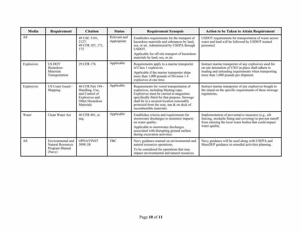
Page 10 of 11
Media Requirement Citation Status Requirement Synopsis Action to be Taken to Attain Requirement
All 49 USC 5101, 2127; 49 CFR 107, 171, 172
Relevant and Appropriate
Establishes requirements for the transport of hazardous materials and substances by land, sea, or air. Administered by USEPA through USDOT.
Applicable for off-site transport of hazardous materials by land, sea, or air.
USDOT requirements for transportation of waste across water and land will be followed by USDOT trained personnel.
Explosives US DOT Hazardous Materials Transportation
29 CFR 176 Applicable Requirements apply to a marine transporter of Class 1 explosives.
Applicable if the marine transporter ships more than 1,000 pounds of Division 1.4explosives at one time.
Instruct marine transporter of any explosives used for on-site detonation of UXO in-place shall adhere to loading and unloading requirements when transporting more than 1,000 pounds per shipment.
Explosives US Coast Guard - Shipping
46 CFR Part 194 - Handling, Use, and Control of Explosives and Other Hazardous Materials
Applicable Requirements for vessel transportation of explosives, including blasting-caps. Explosives must be carried in magazines specifically fitted for that purpose. Stowage shall be in a secured location reasonably protected from the seas, sun & on deck of incombustible materials.
Instruct marine transporter of any explosives bought to the island on the specific requirements of these stowage regulations.
Water Clean Water Act 40 CFR 401, et seq.
Applicable Establishes criteria and requirements for stormwater discharges to minimize impacts on water quality.
Applicable to stormwater discharges associated with disrupting ground surface during excavation activities.
Implementation of preventative measures (e.g., silt fencing, stockpile lining and covering) to prevent runoff from entering the local water bodies that could impact water quality.
All Environmental and Natural Resources Program Manual (Navy)
OPNAVINST 5090.1B
TBC Navy guidance manual on environmental and natural resources operations.
To be considered for operations that may impact environmental and natural resources.
Navy guidance will be used along with USEPA and MassDEP guidance in remedial activities planning.
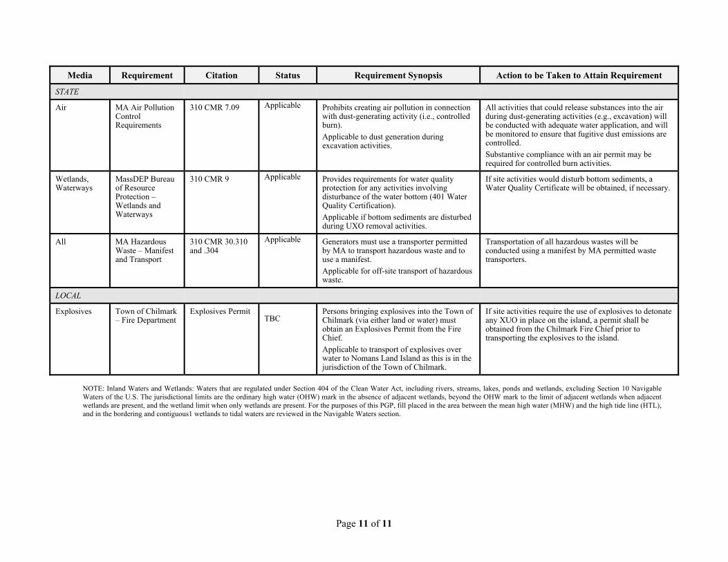
Page 11 of 11
Media Requirement Citation Status Requirement Synopsis Action to be Taken to Attain Requirement
STATE
Air MA Air Pollution Control Requirements
310 CMR 7.09 Applicable Prohibits creating air pollution in connection with dust-generating activity (i.e., controlled burn).
Applicable to dust generation during excavation activities.
All activities that could release substances into the air during dust-generating activities (e.g., excavation) will be conducted with adequate water application, and will be monitored to ensure that fugitive dust emissions are controlled.
Substantive compliance with an air permit may be required for controlled burn activities.
Wetlands, Waterways
MassDEP Bureau of Resource Protection � Wetlands and Waterways
310 CMR 9 Applicable Provides requirements for water quality protection for any activities involving disturbance of the water bottom (401 Water Quality Certification).
Applicable if bottom sediments are disturbed during UXO removal activities.
If site activities would disturb bottom sediments, a Water Quality Certificate will be obtained, if necessary.
All MA Hazardous Waste � Manifest and Transport
310 CMR 30.310 and .304
Applicable Generators must use a transporter permitted by MA to transport hazardous waste and to use a manifest.
Applicable for off-site transport of hazardous waste.
Transportation of all hazardous wastes will be conducted using a manifest by MA permitted waste transporters.
LOCAL
Explosives Town of Chilmark � Fire Department
Explosives Permit TBC
Persons bringing explosives into the Town of Chilmark (via either land or water) must obtain an Explosives Permit from the Fire Chief.
Applicable to transport of explosives over water to Nomans Land Island as this is in the jurisdiction of the Town of Chilmark.
If site activities require the use of explosives to detonate any XUO in place on the island, a permit shall be obtained from the Chilmark Fire Chief prior to transporting the explosives to the island.
NOTE: Inland Waters and Wetlands: Waters that are regulated under Section 404 of the Clean Water Act, including rivers, streams, lakes, ponds and wetlands, excluding Section 10 Navigable Waters of the U.S. The jurisdictional limits are the ordinary high water (OHW) mark in the absence of adjacent wetlands, beyond the OHW mark to the limit of adjacent wetlands when adjacent wetlands are present, and the wetland limit when only wetlands are present. For the purposes of this PGP, fill placed in the area between the mean high water (MHW) and the high tide line (HTL), and in the bordering and contiguous1 wetlands to tidal waters are reviewed in the Navigable Waters section.
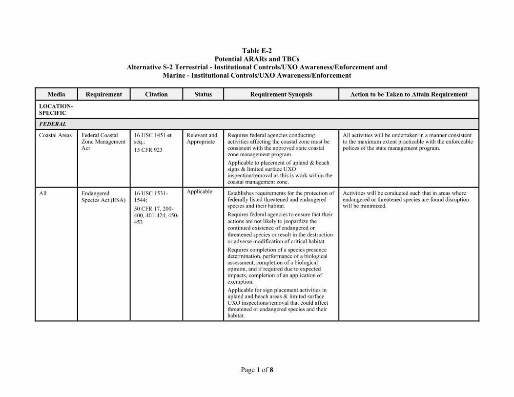
Page 1 of 8
Table E-2 Potential ARARs and TBCs
Alternative S-2 Terrestrial - Institutional Controls/UXO Awareness/Enforcement and Marine - Institutional Controls/UXO Awareness/Enforcement
Media Requirement Citation Status Requirement Synopsis Action to be Taken to Attain Requirement
LOCATION-SPECIFIC
FEDERAL
Coastal Areas Federal Coastal Zone Management Act
16 USC 1451 et seq.;
15 CFR 923
Relevant and Appropriate
Requires federal agencies conducting activities affecting the coastal zone must be consistent with the approved state coastal zone management program.
Applicable to placement of upland & beach signs & limited surface UXO inspection/removal as this is work within the coastal management zone.
All activities will be undertaken in a manner consistent to the maximum extent practicable with the enforceable polices of the state management program.
All Endangered Species Act (ESA)
16 USC 1531-1544;
50 CFR 17, 200-400, 401-424, 450-453
Applicable Establishes requirements for the protection of federally listed threatened and endangered species and their habitat.
Requires federal agencies to ensure that their actions are not likely to jeopardize the continued existence of endangered or threatened species or result in the destruction or adverse modification of critical habitat.
Requires completion of a species presence determination, performance of a biological assessment, completion of a biological opinion, and if required due to expected impacts, completion of an application of exemption.
Applicable for sign placement activities in upland and beach areas & limited surface UXO inspections/removal that could affect threatened or endangered species and their habitat.
Activities will be conducted such that in areas where endangered or threatened species are found disruption will be minimized.
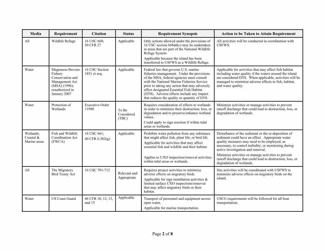
Page 2 of 8
Media Requirement Citation Status Requirement Synopsis Action to be Taken to Attain Requirement
All Wildlife Refuge 16 USC 668; 50 CFR 27
Applicable Only actions allowed under the provisions of 16 USC section 668dd(c) may be undertaken in areas that are part of the National Wildlife Refuge System.
Applicable because the island has been transferred to USFWS as a Wildlife Refuge.
All activities will be conducted in coordination with USFWS.
Water Magnuson-Stevens Fishery Conservation and Management Act (MSA) (1996); reauthorized in January 2007
16 USC Section 1851 et seq.
Applicable Federal law that governs U.S. marine fisheries management. Under the provisions of the MSA, federal agencies must consult with the National Marine Fisheries Service prior to taking any action that may adversely affect designated Essential Fish Habitat (EFH). Adverse effects include any impact that reduces the quality or quantity of EFH.
Applicable for activities that may affect fish habitat including water quality if the waters around the island are considered EFH. When applicable, activities will be managed to minimize adverse effects to fish, habitat, and water quality.
Water Protection of Wetlands
Executive Order 11990
To Be Considered (TBC)
Requires consideration of effects to wetlands in order to minimize their destruction, loss, or degradation and to preserve/enhance wetland values.
Could apply to sign erection if within tidal areas or wetlands.
Minimize activities or manage activities to prevent runoff discharge that could lead to destruction, loss, or degradation of wetlands.
Wetlands, Coastal & Marine areas
Fish and Wildlife Coordination Act (FWCA)
16 USC 661;
40 CFR 6.302(g)
Applicable Prohibits water pollution from any substance that might affect fish, plant life, or bird life.
Applicable for activities that may affect essential fish and wildlife and their habitat.
Applies to UXO inspection/removal activities within tidal areas or wetlands.
Disturbance of the sediment or the re-deposition of sediment could have an effect. Appropriate water quality measures may need to be employed, as necessary, to control turbidity, or monitoring during active investigation and removal.
Minimize activities or manage activities to prevent runoff discharge that could lead to destruction, loss, or degradation of wetlands.
All The Migratory Bird Treaty Act
16 USC 701-712 Relevant and Appropriate
Requires project activities to minimize adverse effects on migratory birds.
Applicable for sign installation activities & limited surface UXO inspections/removal that may affect migratory birds or their habitat.
Site activities will be coordinated with USFWS to minimize adverse effects on migratory birds on the island.
Water US Coast Guard 46 CFR 10, 12, 13, and 15
Applicable Transport of personnel and equipment across open water.
Applicable for marine transportation.
USCG requirements will be followed for all boat transportation.
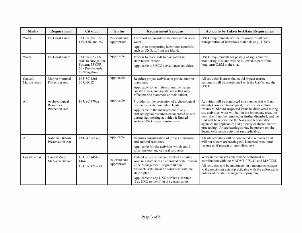
Page 3 of 8
Media Requirement Citation Status Requirement Synopsis Action to be Taken to Attain Requirement
Water US Coast Guard 33 CFR 151, 153, 155, 156, and 157
Relevant and Appropriate
Transport of hazardous material across open water.
Applies to transporting hazardous materials, such as UXO, to/from the island.
USCG requirements will be followed for all boat transportation of hazardous materials (e.g., UXO).
Water US Coast Guard 33 CFR 62 - US Aids to Navigation System; 33 CFR 66 - Private Aids to Navigation
Applicable Process to place aids to navigation in state/federal waters.
Applicable to USCG surveillance activities.
USCG requirements for posting of signs and for monitoring of island will be followed as part of the long-term O&M at the site.
Coastal, Marine areas
Marine Mammal Protection Act
16 USC 1361; 50 CFR 12
Applicable Requires project activities to protect marine mammals.
Applicable for activities in marine waters, coastal zones, and aquatic areas that may affect marine mammals or their habitat.
All activities in areas that could impact marine mammals will be coordinated with the USFW and the USCG.
All Archaeological Resources Protection Act
16 USC 470aa Applicable Provides for the protection of archaeological resources located on public lands.
Applicable to the management of any archaeological resources encountered on site during sign-posting activities & limited surface UXO inspections/removal.
Activities will be conducted in a manner that will not disturb known archaeological, historical or cultural resources. Should suspected items be discovered during site activities, work will halt in the immediate area, the item(s) will not be removed or further disturbed, and the find will be reported to the Navy and federal/state agencies (as applicable) and properly evaluated before proceeding. An archaeologist may be present on-site during excavation activities (as applicable).
All National Historic Preservation Act
USC 470 et seq. Applicable Requires consideration of effects to historic and cultural resources.
Applicable for site activities which could affect historic and cultural resources.
All site activities will be conducted in a manner that will not disturb archaeological, historical or cultural resources, if present or upon discovery.
Coastal areas Coastal Zone Management Act
16 USC 1451-1464;
15 CFR 921-933
Relevant and Appropriate
Federal projects that could affect a coastal zone in a state with an approved State Coastal Zone Management Program like in Massachusetts, must be consistent with the state�s plan.
Applicable to any UXO surface clearance (i.e., UXO removal) in the coastal zone.
Work in the coastal zone will be performed in coordination with the MADMF, USCG, and MACZM.
All activities will be undertaken in a manner consistent to the maximum extent practicable with the enforceable polices of the state management program,
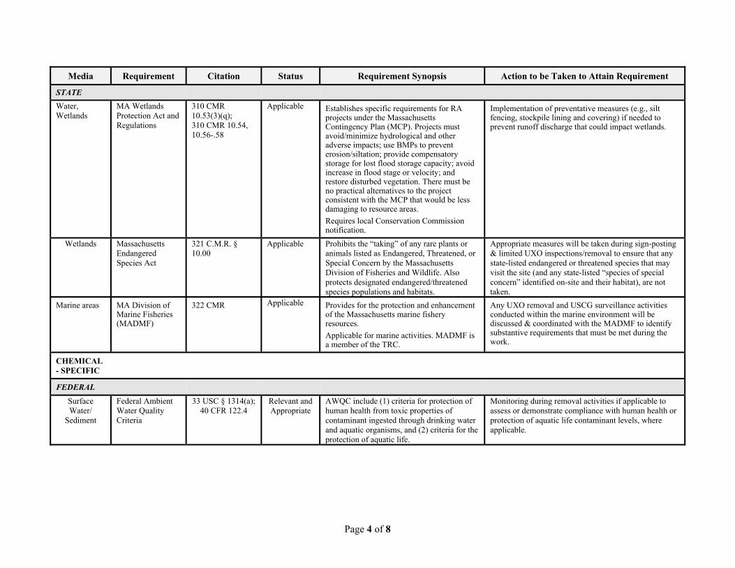
Page 4 of 8
Media Requirement Citation Status Requirement Synopsis Action to be Taken to Attain Requirement
STATE
Water, Wetlands
MA Wetlands Protection Act and Regulations
310 CMR 10.53(3)(q); 310 CMR 10.54, 10.56-.58
Applicable Establishes specific requirements for RA projects under the Massachusetts Contingency Plan (MCP). Projects must avoid/minimize hydrological and other adverse impacts; use BMPs to prevent erosion/siltation; provide compensatory storage for lost flood storage capacity; avoid increase in flood stage or velocity; and restore disturbed vegetation. There must be no practical alternatives to the project consistent with the MCP that would be less damaging to resource areas.
Requires local Conservation Commission notification.
Implementation of preventative measures (e.g., silt fencing, stockpile lining and covering) if needed to prevent runoff discharge that could impact wetlands.
Wetlands Massachusetts Endangered Species Act
321 C.M.R. § 10.00
Applicable Prohibits the �taking� of any rare plants or animals listed as Endangered, Threatened, or Special Concern by the Massachusetts Division of Fisheries and Wildlife. Also protects designated endangered/threatened species populations and habitats.
Appropriate measures will be taken during sign-posting & limited UXO inspections/removal to ensure that any state-listed endangered or threatened species that may visit the site (and any state-listed �species of special concern� identified on-site and their habitat), are not taken.
Marine areas MA Division of Marine Fisheries (MADMF)
322 CMR Applicable Provides for the protection and enhancement of the Massachusetts marine fishery resources.
Applicable for marine activities. MADMF is a member of the TRC.
Any UXO removal and USCG surveillance activities conducted within the marine environment will be discussed & coordinated with the MADMF to identify substantive requirements that must be met during the work.
CHEMICAL- SPECIFIC
FEDERAL
Surface Water/
Sediment
Federal Ambient Water Quality Criteria
33 USC § 1314(a); 40 CFR 122.4
Relevant and Appropriate
AWQC include (1) criteria for protection of human health from toxic properties of contaminant ingested through drinking water and aquatic organisms, and (2) criteria for the protection of aquatic life.
Monitoring during removal activities if applicable to assess or demonstrate compliance with human health or protection of aquatic life contaminant levels, where applicable.
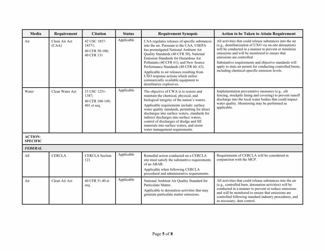
Page 5 of 8
Media Requirement Citation Status Requirement Synopsis Action to be Taken to Attain Requirement
Air Clean Air Act (CAA)
42 USC 1857-18571;
40 CFR 50-100; 40 CFR 131
Applicable CAA regulates releases of specific substances into the air. Pursuant to the CAA, USEPA has promulgated National Ambient Air Quality Standards (40 CFR 50), National Emission Standards for Hazardous Air Pollutants (40 CFR 61), and New Source Performance Standards (40 CFR 60, 63).
Applicable to air releases resulting from UXO response actions which utilize commercially available equipment to demilitarize explosives.
All activities that could release substances into the air (e.g., demilitarization of UXO via on-site detonation) will be conducted in a manner to prevent or minimize emissions and will be monitored to ensure that emissions are controlled.
Substantive requirements and objective standards will apply to state air permit for conducting controlled burns, including chemical-specific emission levels.
Water Clean Water Act 33 USC 1251-1387;
40 CFR 100-149; 401 et seq.
Applicable The objective of CWA is to restore and maintain the chemical, physical, and biological integrity of the nation�s waters.
Applicable requirements include: surface water quality standards, permitting for direct discharges into surface waters, standards for indirect discharges into surface waters, control of discharges of dredge and fill materials into surface waters, and storm water management requirements.
Implementation preventative measures (e.g., silt fencing, stockpile lining and covering) to prevent runoff discharge into the local water bodies that could impact water quality. Monitoring may be performed as applicable.
ACTION-SPECIFIC
FEDERAL
All CERCLA CERCLA Section 121
Applicable Remedial action conducted on a CERCLA site must satisfy the substantive requirements of an ARAR.
Applicable when following CERCLA procedural and administrative requirements.
Requirements of CERCLA will be considered in conjunction with the MCP.
Air Clean Air Act 40 CFR 51.40 et seq.
Applicable National Ambient Air Quality Standard for Particulate Matter.
Applicable to detonation activities that may generate particulate matter emissions.
All activities that could release substances into the air (e.g., controlled burn, detonation activities) will be conducted in a manner to prevent or reduce emissions and will be monitored to ensure that emissions are controlled following standard industry procedures, and as necessary, dust control.
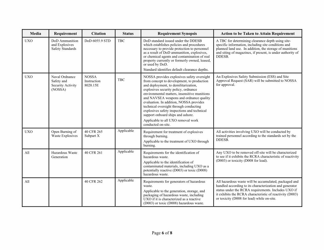
Page 6 of 8
Media Requirement Citation Status Requirement Synopsis Action to be Taken to Attain Requirement
UXO DoD Ammunition and Explosives Safety Standards
DoD 6055.9 STD TBC DoD standard issued under the DDESB which establishes policies and procedures necessary to provide protection to personnel as a result of DoD ammunition, explosives, or chemical agents and contamination of real property currently or formerly owned, leased, or used by DoD.
Standard identifies default clearance depths.
A TBC for determining clearance depth using site-specific information, including site conditions and planned land use. In addition, the storage of munitions and siting of magazines, if present, is under authority of DDESB.
UXO Naval Ordnance Safety and Security Activity (NOSSA)
NOSSA Instruction 8020.15E
TBC
NOSSA provides explosives safety oversight from concept to development, to production and deployment, to demilitarization, explosives security policy, ordnance environmental matters, insensitive munitions and NAVSEA weapons and ordnance quality evaluation. In addition, NOSSA provides technical oversight through conducting explosives safety inspections and technical support onboard ships and ashore.
Applicable to all UXO removal work conducted on-site.
An Explosives Safety Submission (ESS) and Site Approval Request (SAR) will be submitted to NOSSA for approval.
UXO Open Burning of Waste Explosives
40 CFR 265 Subpart X
Applicable Requirement for treatment of explosives through burning.
Applicable to the treatment of UXO through burning.
All activities involving UXO will be conducted by trained personnel according to the standards set by the DDESB.
All Hazardous Waste Generation
40 CFR 261 Applicable Requirements for the identification of hazardous waste.
Applicable to the identification of contaminated materials, including UXO as a potentially reactive (D003) or toxic (D008) hazardous waste.
Any UXO to be removed off-site will be characterized to see if it exhibits the RCRA characteristic of reactivity (D003) or toxicity (D008 for lead).
All 40 CFR 262 Applicable Requirements for generators of hazardous waste.
Applicable to the generation, storage, and packaging of hazardous waste, including UXO if it is characterized as a reactive (D003) or toxic (D008) hazardous waste.
All hazardous waste will be accumulated, packaged and handled according to its characterization and generator status under the RCRA requirements. Includes UXO if it exhibits the RCRA characteristic of reactivity (D003) or toxicity (D008 for lead) while on-site.
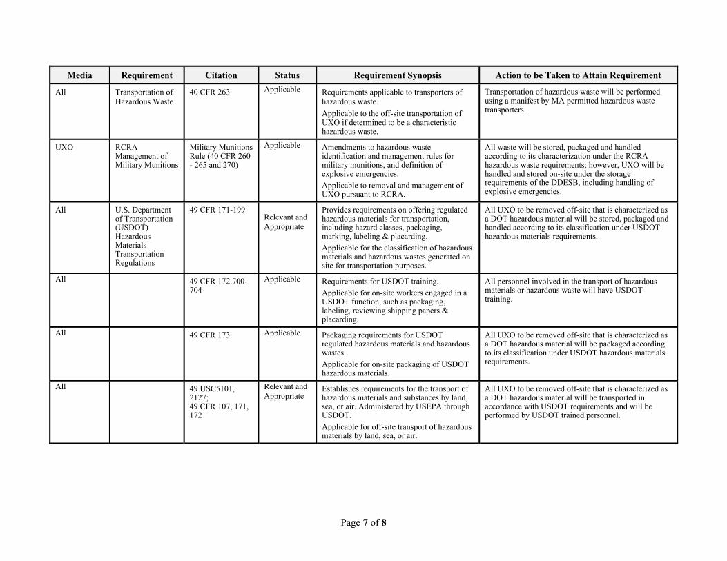
Page 7 of 8
Media Requirement Citation Status Requirement Synopsis Action to be Taken to Attain Requirement
All Transportation of Hazardous Waste
40 CFR 263 Applicable Requirements applicable to transporters of hazardous waste.
Applicable to the off-site transportation of UXO if determined to be a characteristic hazardous waste.
Transportation of hazardous waste will be performed using a manifest by MA permitted hazardous waste transporters.
UXO RCRA Management of Military Munitions
Military Munitions Rule (40 CFR 260 - 265 and 270)
Applicable Amendments to hazardous waste identification and management rules for military munitions, and definition of explosive emergencies.
Applicable to removal and management of UXO pursuant to RCRA.
All waste will be stored, packaged and handled according to its characterization under the RCRA hazardous waste requirements; however, UXO will be handled and stored on-site under the storage requirements of the DDESB, including handling of explosive emergencies.
All U.S. Department of Transportation (USDOT) Hazardous Materials Transportation Regulations
49 CFR 171-199
Relevant and Appropriate
Provides requirements on offering regulated hazardous materials for transportation, including hazard classes, packaging, marking, labeling & placarding.
Applicable for the classification of hazardous materials and hazardous wastes generated on site for transportation purposes.
All UXO to be removed off-site that is characterized as a DOT hazardous material will be stored, packaged and handled according to its classification under USDOT hazardous materials requirements.
All 49 CFR 172.700-704
Applicable Requirements for USDOT training.
Applicable for on-site workers engaged in a USDOT function, such as packaging, labeling, reviewing shipping papers & placarding.
All personnel involved in the transport of hazardous materials or hazardous waste will have USDOT training.
All 49 CFR 173 Applicable Packaging requirements for USDOT regulated hazardous materials and hazardous wastes.
Applicable for on-site packaging of USDOT hazardous materials.
All UXO to be removed off-site that is characterized as a DOT hazardous material will be packaged according to its classification under USDOT hazardous materials requirements.
All 49 USC5101, 2127; 49 CFR 107, 171, 172
Relevant and Appropriate
Establishes requirements for the transport of hazardous materials and substances by land, sea, or air. Administered by USEPA through USDOT.
Applicable for off-site transport of hazardous materials by land, sea, or air.
All UXO to be removed off-site that is characterized as a DOT hazardous material will be transported in accordance with USDOT requirements and will be performed by USDOT trained personnel.
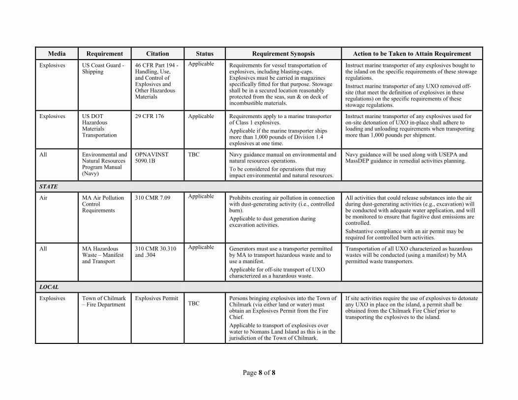
Page 8 of 8
Media Requirement Citation Status Requirement Synopsis Action to be Taken to Attain Requirement
Explosives US Coast Guard - Shipping
46 CFR Part 194 - Handling, Use, and Control of Explosives and Other Hazardous Materials
Applicable Requirements for vessel transportation of explosives, including blasting-caps. Explosives must be carried in magazines specifically fitted for that purpose. Stowage shall be in a secured location reasonably protected from the seas, sun & on deck of incombustible materials.
Instruct marine transporter of any explosives bought to the island on the specific requirements of these stowage regulations.
Instruct marine transporter of any UXO removed off-site (that meet the definition of explosives in these regulations) on the specific requirements of these stowage regulations.
Explosives US DOT Hazardous Materials Transportation
29 CFR 176 Applicable Requirements apply to a marine transporter of Class 1 explosives.
Applicable if the marine transporter ships more than 1,000 pounds of Division 1.4explosives at one time.
Instruct marine transporter of any explosives used for on-site detonation of UXO in-place shall adhere to loading and unloading requirements when transporting more than 1,000 pounds per shipment.
All Environmental and Natural Resources Program Manual (Navy)
OPNAVINST 5090.1B
TBC Navy guidance manual on environmental and natural resources operations.
To be considered for operations that may impact environmental and natural resources.
Navy guidance will be used along with USEPA and MassDEP guidance in remedial activities planning.
STATE
Air MA Air Pollution Control Requirements
310 CMR 7.09 Applicable Prohibits creating air pollution in connection with dust-generating activity (i.e., controlled burn).
Applicable to dust generation during excavation activities.
All activities that could release substances into the air during dust-generating activities (e.g., excavation) will be conducted with adequate water application, and will be monitored to ensure that fugitive dust emissions are controlled.
Substantive compliance with an air permit may be required for controlled burn activities.
All MA Hazardous Waste � Manifest and Transport
310 CMR 30.310 and .304
Applicable Generators must use a transporter permitted by MA to transport hazardous waste and to use a manifest.
Applicable for off-site transport of UXO characterized as a hazardous waste.
Transportation of all UXO characterized as hazardous wastes will be conducted (using a manifest) by MA permitted waste transporters.
LOCAL
Explosives Town of Chilmark � Fire Department
Explosives Permit TBC
Persons bringing explosives into the Town of Chilmark (via either land or water) must obtain an Explosives Permit from the Fire Chief.
Applicable to transport of explosives over water to Nomans Land Island as this is in the jurisdiction of the Town of Chilmark.
If site activities require the use of explosives to detonate any UXO in place on the island, a permit shall be obtained from the Chilmark Fire Chief prior to transporting the explosives to the island.

Record of Decision Final Nomans Land Island, Chilmark, MA January 2022
4659-WE05-22-0003
This page intentionally left blank.
Record of Decision Final Nomans Land Island, Chilmark, MA January 2022
4659-WE05-22-0003
APPENDIX F
USFWS UXO AWARENESS PAMPHLET
Record of Decision Final Nomans Land Island, Chilmark, MA January 2022
4659-WE05-22-0003
This page intentionally left blank.
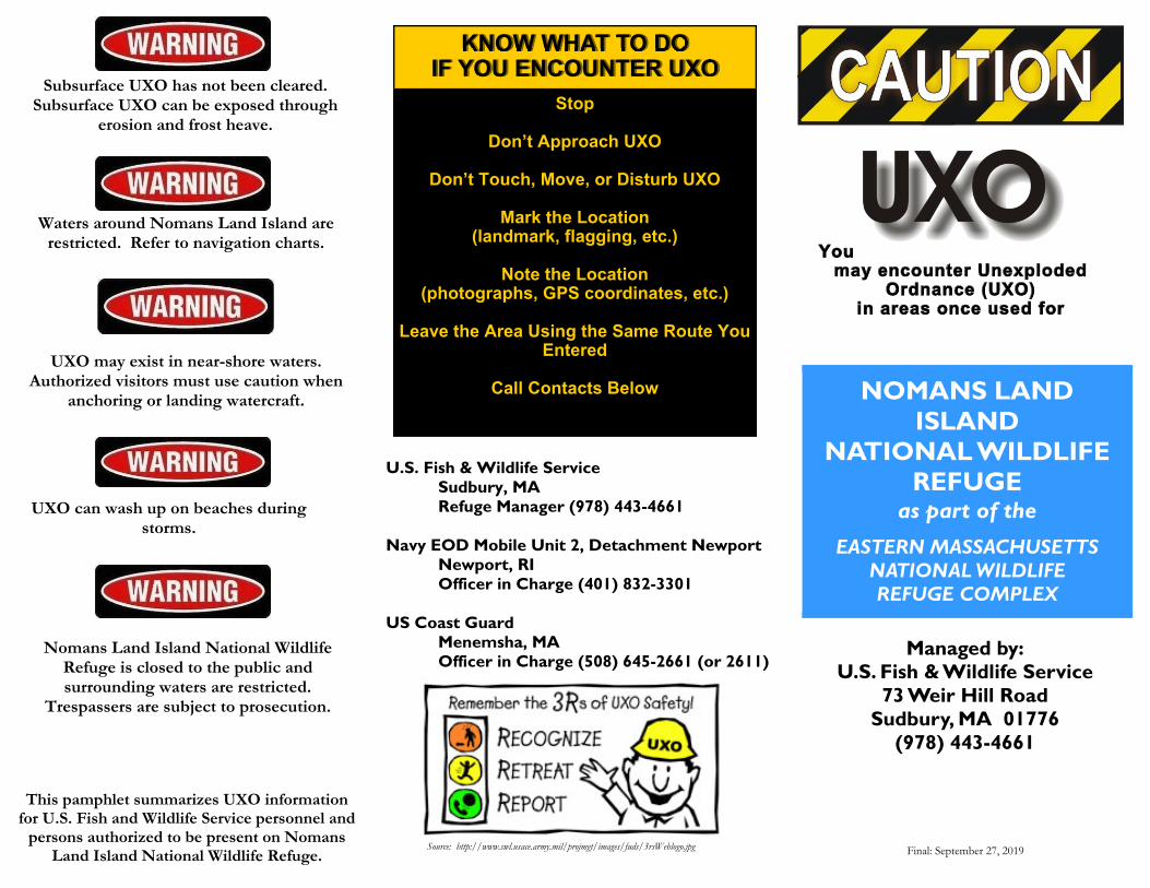
KNOW WHAT TO DO IF YOU ENCOUNTER UXO
Stop
Don�t Approach UXO
Don�t Touch, Move, or Disturb UXO
Mark the Location (landmark, flagging, etc.)
Note the Location
(photographs, GPS coordinates, etc.)
Leave the Area Using the Same Route You Entered
Call Contacts Below
U.S. Fish & Wildlife Service Sudbury, MA Refuge Manager (978) 443-4661 Navy EOD Mobile Unit 2, Detachment Newport Newport, RI Officer in Charge (401) 832-3301 US Coast Guard Menemsha, MA Officer in Charge (508) 645-2661 (or 2611)
NOMANS LAND ISLAND
NATIONAL WILDLIFE REFUGE
as part of the
EASTERN MASSACHUSETTS NATIONAL WILDLIFE REFUGE COMPLEX
Final: September 27, 2019 Source: http://www.swl.usace.army.mil/projmgt/images/fuds/3rsWeblogo.jpg
Managed by: U.S. Fish & Wildlife Service
73 Weir Hill Road Sudbury, MA 01776
(978) 443-4661
This pamphlet summarizes UXO information for U.S. Fish and Wildlife Service personnel and
persons authorized to be present on Nomans Land Island National Wildlife Refuge.
Nomans Land Island National Wildlife Refuge is closed to the public and surrounding waters are restricted.
Trespassers are subject to prosecution.
UXO can wash up on beaches during storms.
Subsurface UXO has not been cleared. Subsurface UXO can be exposed through
erosion and frost heave.
Waters around Nomans Land Island are restricted. Refer to navigation charts.
UXO may exist in near-shore waters. Authorized visitors must use caution when
anchoring or landing watercraft.
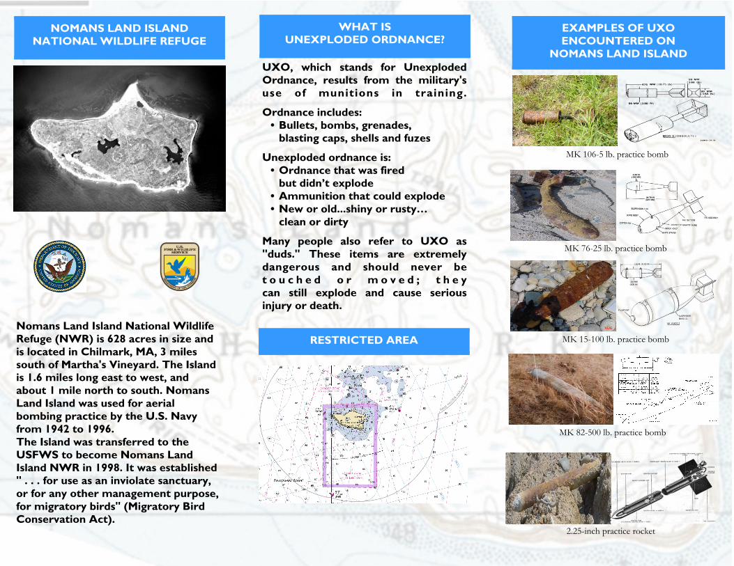
UXO, which stands for Unexploded Ordnance, results from the military's use of munitions in training.
Ordnance includes: � Bullets, bombs, grenades,
blasting caps, shells and fuzes
Unexploded ordnance is: � Ordnance that was fired
but didn�t explode � Ammunition that could explode � New or old...shiny or rusty�
clean or dirty
Many people also refer to UXO as "duds." These items are extremely dangerous and should never be t o u c h e d o r m o v e d ; t h e y can still explode and cause serious injury or death.
Nomans Land Island National Wildlife Refuge (NWR) is 628 acres in size and is located in Chilmark, MA, 3 miles south of Martha's Vineyard. The Island is 1.6 miles long east to west, and about 1 mile north to south. Nomans Land Island was used for aerial bombing practice by the U.S. Navy from 1942 to 1996. The Island was transferred to the USFWS to become Nomans Land Island NWR in 1998. It was established " . . . for use as an inviolate sanctuary, or for any other management purpose, for migratory birds" (Migratory Bird Conservation Act).
MK 106-5 lb. practice bomb
MK 76-25 lb. practice bomb
MK 15-100 lb. practice bomb
2.25-inch practice rocket
MK 82-500 lb. practice bomb
WHAT IS UNEXPLODED ORDNANCE?
EXAMPLES OF UXO ENCOUNTERED ON
NOMANS LAND ISLAND
RESTRICTED AREA
NOMANS LAND ISLAND NATIONAL WILDLIFE REFUGE
Record of Decision Final Nomans Land Island, Chilmark, MA January 2022
4659-WE05-22-0003
APPENDIX G
TRANSCRIPT OF THE PUBLIC HEARING ON THE PROPOSED REMEDIAL ACTION PLAN AND RESPONSES TO PUBLIC COMMENTS

Record of Decision Final Nomans Land Island, Chilmark, MA January 2022
4659-WE05-22-0003
This page intentionally left blank.
www.blummoore.com 215-345-7966BLUM-MOORE REPORTING SERVICES, INC.
1
Nomans Land Island Public Hearing 29 September 2020
PUBLIC HEARING for NOMANS LAND ISLAND, CHILMARK, MA
---
Tuesday, September 29, 2020
A public hearing was held virtually via
WebEx platform, commencing at 8:00 p.m. on the
day and date above set forth, before Tara Wilson,
Professional Reporter and Notary Public in and
for the Commonwealth of Pennsylvania.
----
BLUM-MOORE REPORTING SERVICES, INC. 350 SOUTH MAIN STREET, SUITE 203 DOYLESTOWNN, PENNSYLVANIA 18901
2 (Pages 2 to 5)
www.blummoore.com 215-345-7966BLUM-MOORE REPORTING SERVICES, INC.
2
1 Nomans Land Island Public Hearing 29 September 202023 ATTENDEES
David Barney4 Brian Helland
Jackie Boltz5 Joanne Deaerden
Linh Phu6 Stephanie Koch
Larry Kahrs7 Ron Marnicio
Christine Joblon89 Annie Cooke
Peter Cooke10 Brett Sterns
Ann Malowitz11 John
Dicks Leeson12 Paul Needem13141516171819202122232425
www.blummoore.com 215-345-7966BLUM-MOORE REPORTING SERVICES, INC.
3
1 Nomans Land Island Public Hearing 29 September 20202 MR. BARNEY: Thank you, Larry.3 Okay. It's just a little after eight,4 but that's okay. We will now begin the -- the5 public hearing portion of this. So I'm going to6 click that off and give it a start.7 We will now begin the formal comment8 period. My name is Dave Barney and I'm the BRAC9 environmental coordinator for Nomans Land Island.
10 This portion of this evening's events will be11 recorded. We will also have a certified court12 reporter to capture the comments and provide the13 formal transcript for the record. This is14 opportunity for you to provide verbal comment for15 the record on the Navy's proposed plan to address16 the effects of Navy use of the island located17 just off the southwest corner of Martha's18 Vineyard.19 The Navy's preferred remedy is for20 institutional controls, public awareness of21 enforcements, to address the risks to human22 health and the environment. Please know that the23 public comment period runs until October 30th and24 we will accept written comments up to that time25 either via e-mail or regular mail addressed to
www.blummoore.com 215-345-7966BLUM-MOORE REPORTING SERVICES, INC.
4
1 Nomans Land Island Public Hearing 29 September 20202 Brian Helland or myself. Written comments will3 also become part of the record for the site.4 Since this particular public hearing is5 being held via the internet and not in person in6 a group form because of safety consideration with7 the ongoing novel coronavirus pandemic, our8 ability to recognize comments is limited to9 virtual hand-raising or requests to speak via
10 chat message with question to the host. I will11 recognize commenters first by raised hand. We12 will then unmute you, confirm you have a comment,13 ask you to state your name and affiliation and14 then provide your comment or question. We15 request you keep your comments limited to three16 minutes duration, so we can ensure all are heard.17 At that, I will look for the first18 commenter. Jackie has put up the instructions on19 how to make a comment. And I have a note that20 Annie is raising her hand. So let's go to Annie21 Cooke.22 ANNIE COOKE: Hi. Thanks again. So I23 guess we're on the record now. I want to thank24 you for this really, I don't know, just very25 courteous and open and transparent and
www.blummoore.com 215-345-7966BLUM-MOORE REPORTING SERVICES, INC.
5
1 Nomans Land Island Public Hearing 29 September 20202 informative meeting. Thank all of you.3 I would ask that the public be given4 the opportunity to have a longer period of time5 than is currently apparently available to respond6 this proposed plan before any record of decision7 is made, because again, as we have discussed, I8 am not sure who or which entities either together9 or singular were responsible for more adequate
10 promotion of the Nomans Land issue; but I think11 it's something that really does need to be12 addressed. And if me and others in the public13 can help with that, I'd be happy to do that.14 I think the questions that have already15 been asked in the preliminary chat after the16 presentation, been all been really apropos and my17 interest is in the island being accessible to18 people by request, if needed; but it not being19 restricted to only certain people. We don't -- I20 don't it should be overrun by humans, but some21 access to fish and other things without being22 intimidated and chased away is -- would be23 preferable, and we just need more time as the24 public. And I also think that to the best of25 your ability for the subsurface under the ground
3 (Pages 6 to 9)
www.blummoore.com 215-345-7966BLUM-MOORE REPORTING SERVICES, INC.
6
1 Nomans Land Island Public Hearing 29 September 20202 and under the water on the sea floor to be3 removed to the best of one's ability, I think4 it's a good investment to get that done now. I'm5 concerned about depleted uranium in the ground6 and water. I understand that you may assessed it7 in the debris itself that was removed, but if it8 leached into the environment, then that is a9 long-term concern for carcinogenics things. So
10 there's just a lot of questions that I don't want11 to get into too much, it's too -- you know,12 there's a lot of information for the public to13 look at, and we are going to need to coordinate14 and cooperate together on the public side so15 that's it's clear and succinct for all of us.16 And I also just am curious what part17 does the town of Chilmark play in so far as18 Nomans is part of its jurisdiction. What19 liability rests with the town of Chilmark and20 what responsibility rests with the town of21 Chilmark vis-à-vis all the representatives from22 the other entities on this call?23 Thank you.24 MR. BARNEY: Thank you, Annie.25 Jackie, can you see any other questions
www.blummoore.com 215-345-7966BLUM-MOORE REPORTING SERVICES, INC.
7
1 Nomans Land Island Public Hearing 29 September 20202 or hands raised?3 MS. BOLTZ: Yes. Brett Sterns.4 MR. BARNEY: Okay.5 MS. BOLTZ: I'll unmute that line.6 BRETT STERNS: Good evening, everyone.7 MR. BARNEY: Hello.8 BRETT STERNS: Hi. Can you hear me9 okay?
10 MR. BARNEY: Yes, we can hear you fine.11 BRETT STERNS: The tribe has been12 involved in this in federal process since the13 beginning. I mean, I'm having recalls of, you14 know, conversations in 1996 and before. In fact,15 some of you may know that the tribe actually16 tried through federal surplus property to attain17 the island and rally the tribe's goal at that18 point was to assure that it was cleaned up and19 removed debris ordnances and explosives.20 So the tribe has some goals with Nomans21 Island. In fact, we were just there the other22 day with US Fish and Wildlife Service, who we23 have a great relationship with. And there's a24 few things that I -- I would like to make sure25 that I pass on for the record on behalf of the
www.blummoore.com 215-345-7966BLUM-MOORE REPORTING SERVICES, INC.
8
1 Nomans Land Island Public Hearing 29 September 20202 tribe. The make desires greater and safer access3 to the island both for cultural use and for4 general access by tribal members. That was5 something that was promised from the very6 beginning. In fact, promised from the very7 beginning and also in negotiations with US Fish8 and Wildlife Service was unsupervised access and9 the only that could happen is by the designation
10 of safe zones, which to date, hasn't happened11 because, 'cause they're -- I think really because12 you've also have to have a D&B companion. And13 we're -- the tribe wants assurance that leeching14 metals that are impacting sustenance foods. This15 is something that we recognized in 1998 through16 the studies that were done in the shellfish17 adjacent to the island, you know, that was a one18 time study. I think there's room for continued19 studies for this purpose to determine whether the20 island actually has the environmental impacts. I21 think some decisions that have been made that22 they don't have environmental impacts or human23 health impacts. We don't agree with that as an24 outcome and I think there's room for continued25 studies especially with federal agencies
www.blummoore.com 215-345-7966BLUM-MOORE REPORTING SERVICES, INC.
9
1 Nomans Land Island Public Hearing 29 September 20202 companionship, partnership with federal agencies3 for studies on the island as it deals with4 environmental health and toxicology.5 The tribe needs assurance that there's6 going to be clearance for new areas for7 repatriation for both tribal members and8 non-tribal people. That was one of the purposes9 of the visit the other day is to check on areas
10 that have been impacted and repatriation is an11 important cultural aspect to the tribe and I --12 also for the Town of Chilmark, where people are13 laid to rest, they should continue to be laid to14 rest, and that continues to be a problem there.15 If it's not gonna get any better and it's16 something that is going on currently, it needs to17 be addressed and it needs to be part of the plan,18 a very specific part of the plan. It can't be19 ignored and it can't be overlooked.20 I guess I really want to focus on the21 fact that the continued study part where we have22 a compliment of federal agencies that have the23 ability to partner with the tribe beside -- with24 other federal agencies in US Fish and Wildlife25 Service. We certainly saw that US Fish and
4 (Pages 10 to 13)
www.blummoore.com 215-345-7966BLUM-MOORE REPORTING SERVICES, INC.
10
1 Nomans Land Island Public Hearing 29 September 20202 Wildlife Service can -- let rabbits go out there3 and that's something that in the very beginning4 was not considered, but it's happening today. So5 we know that things can be moved or manipulated6 to continue studies in programs and we'd truly7 like to see that happen in the future. Of8 course, the tribe formally would like to see all9 toxic metals and, you know, non-native species
10 removed. We know that this is -- that's a high11 bar for what we're looking at, but certainly I12 think it would most comfortable for everyone13 involved if the greatest budget possible was held14 because we really don't know what to anticipate15 out there. I've been, you know, out there16 several times over this process. I know what it17 looks like, I know what's happening out there.18 You know, we want to make sure that we recognize19 that the goal would be to have a clean20 reservation there. Like, there's no reason to21 have metals and excess of exploded ordnances22 strewn in an area that is so susceptible to23 erosion and impacts like that. That's going end24 up on our shores, so. And I think -- I would25 hope that we all agree on that.
www.blummoore.com 215-345-7966BLUM-MOORE REPORTING SERVICES, INC.
11
1 Nomans Land Island Public Hearing 29 September 20202 So really the message here is how do we3 work together to do that? Do we have to seek4 congressional funding separately? Do we find5 partnership opportunities to continue that work?6 No, it doesn't all necessarily lay on your hands,7 we want to come in as partners to try to find8 ways to do it and we know that there's9 restriction budgets. We understand that you
10 can't just go in and ask for everything and get11 everything, but we're -- we maintain a12 partnership and we want to be, you know, treated13 in such a way so that we can help leverage14 funding and opportunity to assure that there's15 safe lands for everyone. That's my comment.16 MR. BARNEY: Well, thank you, Brett.17 Jackie, do you see any additional18 commenters?19 MS. BOLTZ: I do not. And just as a20 reminder for those who are joining only by phone,21 you can dial Star 3 if you would like to make a22 comment.23 I don't see any other hands raised24 right now, Dave.25 MR. BARNEY: Okay.
www.blummoore.com 215-345-7966BLUM-MOORE REPORTING SERVICES, INC.
12
1 Nomans Land Island Public Hearing 29 September 20202 Let's go to Peter Cook. I believe he3 may have a comment.4 MS. BOLTZ: Okay. One moment.5 Mr. Cook, your line is unmuted.6 PETER COOKE: Actually I'm -- I asked7 my question and I'm thankful for the opportunity8 to listen on this and will be following up on the9 discussion over the next month very closely. It
10 will be a big part of our discussions about11 developing a master plan for Chilmark and because12 of -- Nomans figures into that a fair amount.13 Thank you very much.14 MR. BARNEY: Okay. Thank you.15 MS. BOLTZ: I see call-in user 6 has16 raised their hand. I'll unmute that line.17 Okay. Go ahead.18 ANN MALOWITZ: Hi. It's Ann Malowitz19 (phonetic) just really one comment. I would just20 suggest for the public record that the coast21 guard be part of the team with the five-year22 review and also when you do yearly reviews for23 O&M so they are aware of their enforcement24 capabilities.25 Thank you.
www.blummoore.com 215-345-7966BLUM-MOORE REPORTING SERVICES, INC.
13
1 Nomans Land Island Public Hearing 29 September 20202 MR. BARNEY: Okay. Great. Thank you,3 Ann.4 MS. BOLTZ: All right. I don't see any5 other hands currently, Dave. I think Anne cook6 would like to speak again.7 MR. BARNEY: Okay.8 ANNIE COOKE: Hi everybody. I'm really9 not trying to dominate here, but I just think
10 what was -- what was just discussed, both the11 tribal -- tribal interest in (indiscernible) with12 non-tribal members and with the Town of Chilmark,13 et cetera, to get the clean-up thoroughly done14 and to get their historical relationship to and15 with the island well established and honored is16 very important. And also the coast guard being17 involved, I think is another great notion. I18 think we have an opportunity to -- hopefully all19 of you agree, that on the civilian side so to20 speak, the nongovernment and the nonmilitary21 side, you actually do have partners that maybe22 you weren't aware of until tonight. And all of23 us on this call I think can tell we have the24 partners the civilian community that hopefully we25 can convene and present you, on the
5 (Pages 14 to 17)
www.blummoore.com 215-345-7966BLUM-MOORE REPORTING SERVICES, INC.
14
1 Nomans Land Island Public Hearing 29 September 20202 organizational side, with sort of a consensus3 hopefully, as much as possible, request and ask4 to get the complete clean-up done; the subsurface5 ordnance below the waters and below the ground6 even if it takes a little more time. And if7 possible, to not have these reviews and clean-up8 efforts only happen every five years. I would9 ask why we can't try to take care of this now,
10 ASAP, 22 years into the post-transfer agreement11 period.12 That's all I have to say. And I'm13 going to try to hold my tongue the rest of the14 time, but I hope -- I hope more people feel15 comfortable chiming in. I'm just -- I did -- I16 did quite a bit of reading on this and -- but17 there's still more to do. It's a fascinating18 situation, but I do think that opting for this19 alternative of keeping people away and not20 removing the subsurface ordnance, to me, is not21 really acceptable. So I just want to -- and I22 think I'm not alone from what I hear on here.23 Thank you.24 MR. BARNEY: Thank you, Annie.25 We'll continue to take any comments or
www.blummoore.com 215-345-7966BLUM-MOORE REPORTING SERVICES, INC.
15
1 Nomans Land Island Public Hearing 29 September 20202 statements.3 MS. BOLTZ: Dicks Leeson (phonetic) has4 a hand raised.5 MR. BARNEY: Okay. Dicks.6 DICKS LEESON: Yes. Thank you. And I7 want to add my thanks for this process to the8 appreciation that's been expressed already9 tonight. In the document explaining the
10 alternative management options, it was mentioned11 that the $31 million alternative of complete12 clearing of the MEC/UXOs would cause unacceptable13 environmental damage and tonight it was mentioned14 that the environment would be devastated. I'm15 assuming that there are other listeners like16 myself who don't know what's involved in such a17 thorough removal. Although Mr. Barry18 cuddie-hunker, who has discussed this with me,19 informs me that that amount of removal of20 unexploded ordnance could only be accomplished by21 detonating all of them and that that may explain22 why some feel that the impact on the environment23 is unacceptable.24 So my comment is that I would like to25 have a better explanation of what happens to the
www.blummoore.com 215-345-7966BLUM-MOORE REPORTING SERVICES, INC.
16
1 Nomans Land Island Public Hearing 29 September 20202 ecology if the ordnance is removed under that3 alternative.4 MR. KAHRS: Dave, could I take that5 one?6 MR. BARNEY: For clarification, Larry,7 please go ahead.8 MR. KAHRS: Okay. I wasn't sure if you9 heard me.
10 So, Dicks, we're -- as I said, I'm11 working at a very similar site in terms of volume12 and distribution of munitions. And I'm out13 there, you know, pretty often and we've got, I14 think three different teams of ex-military EOD15 guys working for us out there. This is done in16 six inch lifts. This is done by scraping down,17 almost like an archeology experiment and finding18 what's there using metal detectors and it's a19 very labor-intensive process.20 So if you dig down, let's say three or21 four feet and you find a 500 pound bomb from22 World War II that's still live, you've got to do23 what's called a blow in place, which means you24 attach munitions to it, C-4 explosive and you25 push a charge on it and you detonate it. That's
www.blummoore.com 215-345-7966BLUM-MOORE REPORTING SERVICES, INC.
17
1 Nomans Land Island Public Hearing 29 September 20202 the kind of destruction we're talking about.3 MR. BARNEY: Thank you, Larry.4 MR. KAHRS: You bet, you bet.5 MS. BOLTZ: Just a reminder, if you've6 asked your -- or made your comment, if you could7 click the raised button to unraise your hand. If8 you would to make another comment, you can keep9 your hand raised. If you're on the phone, you
10 can dial Star 3 to unraise your hand or if you11 would like to make a comment, dial Star 3 to12 raise your hand.13 Dave, I see Paul Needem (phonetic) has14 his hand raised.15 MR. BARNEY: Very good.16 Paul.17 PAUL NEEDEM: Hi. Can you hear me?18 MR. BARNEY: Yes, we can.19 PAUL NEEDEM: Yeah, I just wanted to20 echo Ann's point, that I think there a lot of21 civilians with strong interests in the island and22 I think the whole reason, you know, the notion of23 exploring and exploration, whether by boat or24 otherwise, just kind of seeing all the nooks and25 crannies of this region is something that's
6 (Pages 18 to 21)
www.blummoore.com 215-345-7966BLUM-MOORE REPORTING SERVICES, INC.
18
1 Nomans Land Island Public Hearing 29 September 20202 really important and traditional in this area.3 And so I do hope that there's an ability the4 civilians to really play a role here in5 advocating for access to this federal land and6 for us to try to be partners in making this7 possible, whether at this juncture in the future,8 as someone else said, as technology improves, I9 just hope -- even if it's not achievable at this
10 minutes, that the north star goal will always be11 to restore access as widely as possible.12 MR. BARNEY: Thank you, Paul.13 Just as a reminder it is -- was14 identified as an unmanned, unstaffed wildlife15 refuge.16 MS. BOLTZ: I believe Brett Sterns may17 have another question or comment to put on the18 record.19 MR. BARNEY: Okay. Brett?20 BRETT STERNS: I do, yes. Thank you21 for that opportunity. I, you know, through the22 23 years we've been discussing this island, this23 point has come up many times on how the -- it24 would be the destruction of the island by25 cleaning it up. And, you know, I think it's
www.blummoore.com 215-345-7966BLUM-MOORE REPORTING SERVICES, INC.
19
1 Nomans Land Island Public Hearing 29 September 20202 important to point out, you know, we went through3 a brief history of the island in the beginning4 about an hour ago where there's direct of5 descendants of Chilmark and of the tribe who all6 they had -- they had -- it was used for pasture7 and it was used for cod fishing. The destruction8 took place when we started dropping ammunitions9 and bombs out there.
10 So the concern is -- and I think it's11 important not to lose track of the concern. If12 this were -- perhaps if this were in the middle13 of Arizona, there would be some different14 thoughts about restriction. Much of that 50015 pound bomb is going to be in Menemsha Harbor. So16 let's not lose sight of the people who live here17 who inevitably this island will recede, this will18 island will erode and these lands will become19 part of the ocean again. So it's the things that20 are carried that contain the potential harm to21 the public that is of grave concern. So I22 understand that there could be an environmental23 -- quite frankly, a temporary environmental24 impact in the cleaning up of that island, but the25 we do -- the impact really is to the community in
www.blummoore.com 215-345-7966BLUM-MOORE REPORTING SERVICES, INC.
20
1 Nomans Land Island Public Hearing 29 September 20202 which we all live for ammunitions that end up in3 the waterways and back on our shores.4 That's my comment.5 MR. BARNEY: Thank you, Brett. It's6 important for us to hear the local perspective.7 MS. BOLTZ: Dave, we have another8 call-in attendee who has his their hand raised.9 MR. BARNEY: Okay. Call-in user No. 9.
10 Go ahead.11 JOHN: Hi. My name is John. Can you12 hear me? I want to make sure I was the one that13 was unmuted.14 MR. BARNEY: Yes, John, we can hear15 you. Thanks. Go ahead.16 JOHN: Great. Thank you so much.17 Again, I want to echo some of the gratitude for18 the -- for the rigor of the work you guys have19 put in literally over a decade. It's really --20 it's quite an investment. My comment is really a21 question, Mr. Barney. I really appreciate your22 offer of making yourself available for an23 offlines reprocess conversation about what a24 partnership might look like. However,25 specifically my question for the group is, are
www.blummoore.com 215-345-7966BLUM-MOORE REPORTING SERVICES, INC.
21
1 Nomans Land Island Public Hearing 29 September 20202 you guys able to help us as a public understand3 what other relationships have looked like when4 actions like this have been taken historically5 across the country? Right, like other CERCLA6 compliant public comment periods and how those7 public comment periods could've had a -- anyone8 would describe as a successful relationship from9 this period to the -- I'm sorry the acronym is
10 ROD, is that -- or is it something of decision?11 MR. BARNEY: Yes, correct. ROD stands12 for record of decision, which would be the next13 step in the process.14 JOHN: Record, that's the word I15 missed, yes. Are you able to point us to any16 examples of a successful collaboration between17 Navy from a comment period to record of decision18 as a model for what this engagement might look19 like? I mean, I think it's kind of the first20 time a lot of us are coming to this issue and21 don't benefit from your -- your level of22 expertise here.23 MR. BARNEY: That's a very good24 comment. I'm going refrain from responding to25 that immediately, but I would be happy to talk to
7 (Pages 22 to 25)
www.blummoore.com 215-345-7966BLUM-MOORE REPORTING SERVICES, INC.
22
1 Nomans Land Island Public Hearing 29 September 20202 you offline about -- about that and we will3 provide a written comment on this.4 Again, I want to remind folks that this5 is the recorded portion where your comments and6 notes get put on the record and we respond to7 them in writing, you know, as part of the8 official transcript of this evening's call.9 Thank you.
10 Jackie, do we have additional comments?11 MS. BOLTZ: I don't see any new ones.12 I do see hands remaining raised from people that13 have already spoken. So I believe we captured14 everyone who would like to make a comment.15 MR. BARNEY: Okay. It appears as16 though we can circle back to Annie Cooke again.17 MS. BOLTZ: Okay. One moment.18 ANNIE COOKE: Hi. Thank you. I really19 -- I don't see a raised hand function, so I have20 to keep sending Dave and you a text, chat text,21 I'm so sorry. You know, this is turning into a22 conversation rather than just a public comment,23 which is great. I'm really glad that John just24 asked what he asked.25 I understand there's at least one
www.blummoore.com 215-345-7966BLUM-MOORE REPORTING SERVICES, INC.
23
1 Nomans Land Island Public Hearing 29 September 20202 example of a island in Hawaii where there was3 military ordnance, there was a cleanup that had4 to be conducted. There had to be public5 involvement and frankly, the public had to be6 galvanized to make it clear to the military that7 it mattered to them. And then it was cleaned up8 and eventually the invasive species that had come9 out of the island were removed and the native
10 species were repopulated. I don't know the11 details, but what I -- what I would just ask is,12 how can we ensure that between this phase right13 here and the quote "record of decision" phase,14 that there's another phase? That there is15 discussion with all of you and the ability for16 the public and those of us who are willing to17 spearhead what I would want to have be sort of an18 independent task force that would interact with19 the historical stakeholder, such as the tribe,20 Town of Chilmark, all of you, so that really the21 public has an entity, a stake-holding entity22 ourselves that can be, you know, taken seriously23 and really be part of insuring that this does get24 cleaned up.25 I frankly have to agree with Brett that
www.blummoore.com 215-345-7966BLUM-MOORE REPORTING SERVICES, INC.
24
1 Nomans Land Island Public Hearing 29 September 20202 if in the short run some ordnance gets -- you3 know, the way you deal with it as professionals4 gets diffused or blown up and then has to -- that5 area has to be remediated, you know, and it takes6 a few more years, I would rather have that7 investment be made. And I feel as I sort of said8 to Dave in a sidebar, I said we're actually9 dealing with a delayed reaction literally, in
10 that maybe this could have happened sooner if the11 process wasn't taking so long, like five years12 between further efforts.13 So, yeah, I -- if -- if -- I understand14 the risk and assuming the Navy has and is15 continuing to develop technology and solutions16 that will lower the risk to your personnel from17 this type of thing; robots, I guess a rat in18 Florida just got an award for sniffing out a land19 mine or something. I think there are all kinds20 of ways, but even if the island could, portion by21 portion, be cleaned up in this manner, just, you22 know, I still think it should be a priority even23 though it will have initial -- it will cause24 initial environmental trauma, but I can't imagine25 it's going come anywhere near the trauma that the
www.blummoore.com 215-345-7966BLUM-MOORE REPORTING SERVICES, INC.
25
1 Nomans Land Island Public Hearing 29 September 20202 island dealt with from the bombing. So it's, you3 know, it just goes with the territory literally,4 I suppose.5 Now, I'm really going to try to be6 quiet. But I -- just I was inspired by the fact7 that this turning into a real conversation. I8 find that very encouraging.9 Thank you.
10 MR. BARNEY: Thank you, Annie.11 Are there any follow-up comments?12 Brett, did you have a follow-up13 comment?14 BRETT STERNS: No, Dave. I'm not sure15 what's going on there. Thank you.16 MR. BARNEY: Okay. I just see a couple17 of hands raised. Are there any follow-up18 additional comments or statements to be made for19 the record?20 MS. BOLTZ: I don't see any other hands21 raised, Dave.22 MR. BARNEY: Okay. Then I'd like to,23 you know, follow-up and thank people for coming24 and let people know that, you know, we can25 continue to receive written comments or questions
8 (Pages 26 to 29)
www.blummoore.com 215-345-7966BLUM-MOORE REPORTING SERVICES, INC.
26
1 Nomans Land Island Public Hearing 29 September 20202 or statements that we will respond to in writing3 in the response to this summary. It also sounds4 like there's a desire to have some, you know,5 offline dialogue about the process and how we6 arrived at where we are today, and I'm more than7 happy to do that. My contact information is here8 and we have a -- a follow-on screen after we9 close the public hearing portion.
10 I want to give it one more shot. Does11 anybody have any follow-up statements they'd like12 to make orally for the record?13 Okay. Jackie, can you confirm with me14 that there's no more comments?15 MS. BOLTZ: I don't see any other hands16 raised other than those that have already spoken.17 Oh, actually Brett Sterns would like to speak18 again. I'll unmute his line.19 BRETT STERNS: Thank you.20 Getting back to my first statement,21 will there be a specific notation in this plan22 about repatriation? 'Cause I haven't seen one23 yet. That's my question.24 MR. BARNEY: Okay. It's a good25 question and we will respond to that in writing.
www.blummoore.com 215-345-7966BLUM-MOORE REPORTING SERVICES, INC.
27
1 Nomans Land Island Public Hearing 29 September 20202 Thank you.3 BRETT STERNS: Thank you.4 MR. BARNEY: Okay. Oops, I'm sorry.5 MS. BOLTZ: I was just going to say, I6 don't see any other hands raised. I guess, like7 you said the comments that were received in the8 presentation will be in the response to the9 summary.
10 MR. BARNEY: Any questions that we had11 in the Q&A box that we did not respond will be,12 you know, made part of the record and we will13 respond to those.14 I believe, Jackie, we're able to pull15 those off?16 MS. BOLTZ: Yes, that's correct.17 MR. BARNEY: Okay. We'll do that. And18 here are the contact information for our19 panelists the tonight. And with that I will20 close the public hearing and I want thank21 everyone for attending. We couldn't do it22 without you and we're very happy to, you know,23 explain our work to you and continue this24 dialogue. So thank you very much.25 MR. KAHRS: Thank you.
www.blummoore.com 215-345-7966BLUM-MOORE REPORTING SERVICES, INC.
28
1 Nomans Land Island Public Hearing 29 September 20202 (Public hearing concluded at 8:36 p.m.)3456789
10111213141516171819202122232425
www.blummoore.com 215-345-7966BLUM-MOORE REPORTING SERVICES, INC.
29
1 Nomans Land Island Public Hearing 29 September 2020234 C E R T I F I C A T E5678 I hereby certify that the proceedings9 and evidence are contained fully and accurately,
10 to the best of my ability, in the notes taken by11 me at the meeting in the above matter; and that12 the foregoing is a true and correct transcript of13 the same.14151617 TARA WILSON, C.R.1819202122232425
www.blummoore.com 215-345-7966BLUM-MOORE REPORTING SERVICES, INC.
www.blummoore.com 215-345-7966BLUM-MOORE REPORTING SERVICES, INC.
Page 30
Aability 4:8 5:25
6:3 9:23 18:323:15 29:10
able 21:2,1527:14
accept 3:24acceptable
14:21access 5:21 8:2,4
8:8 18:5,11accessible 5:17accomplished
15:20accurately 29:9achievable 18:9acronym 21:9actions 21:4add 15:7additional 11:17
22:10 25:18address 3:15,21addressed 3:25
5:12 9:17adequate 5:9adjacent 8:17advocating 18:5affiliation 4:13agencies 8:25
9:2,22,24ago 19:4agree 8:23 10:25
13:19 23:25agreement 14:10ahead 12:17
16:7 20:10,15alternative
14:19 15:10,1116:3
ammunitions19:8 20:2
amount 12:1215:19
Ann 2:10 12:1812:18 13:3
Ann's 17:20
Anne 13:5Annie 2:9 4:20
4:20,22 6:2413:8 14:2422:16,18 25:10
anticipate 10:14anybody 26:11apparently 5:5appears 22:15appreciate
20:21appreciation
15:8apropos 5:16archeology
16:17area 10:22 18:2
24:5areas 9:6,9Arizona 19:13arrived 26:6ASAP 14:10asked 5:15 12:6
17:6 22:24,24aspect 9:11assessed 6:6assuming 15:15
24:14assurance 8:13
9:5assure 7:18
11:14attach 16:24attain 7:16attendee 20:8ATTENDEES
2:3attending 27:21available 5:5
20:22award 24:18aware 12:23
13:22awareness 3:20
Bback 20:3 22:16
26:20bar 10:11Barney 2:3 3:2,8
6:24 7:4,7,1011:16,25 12:1413:2,7 14:2415:5 16:6 17:317:15,18 18:1218:19 20:5,920:14,21 21:1121:23 22:1525:10,16,2226:24 27:4,1027:17
Barry 15:17beginning 7:13
8:6,7 10:3 19:3behalf 7:25believe 12:2
18:16 22:1327:14
benefit 21:21best 5:24 6:3
29:10bet 17:4,4better 9:15
15:25big 12:10bit 14:16blow 16:23blown 24:4BLUM-MOO...
1:24boat 17:23Boltz 2:4 7:3,5
11:19 12:4,1513:4 15:3 17:518:16 20:722:11,17 25:2026:15 27:5,16
bomb 16:2119:15
bombing 25:2bombs 19:9box 27:11BRAC 3:8Brett 2:10 7:3,6
7:8,11 11:1618:16,19,2020:5 23:2525:12,14 26:1726:19 27:3
Brian 2:4 4:2brief 19:3budget 10:13budgets 11:9button 17:7
CC 29:4,4C-4 16:24C.R 29:17call 6:22 13:23
22:8call-in 12:15
20:8,9called 16:23capabilities
12:24capture 3:12captured 22:13carcinogenics
6:9care 14:9carried 19:20cause 8:11 15:12
24:23 26:22CERCLA 21:5certain 5:19certainly 9:25
10:11certified 3:11certify 29:8cetera 13:13charge 16:25chased 5:22chat 4:10 5:15
22:20check 9:9Chilmark 1:5
6:17,19,219:12 12:1113:12 19:523:20
chiming 14:15Christine 2:7circle 22:16civilian 13:19,24civilians 17:21
18:4clarification
16:6clean 10:19clean-up 13:13
14:4,7cleaned 7:18
23:7,24 24:21cleaning 18:25
19:24cleanup 23:3clear 6:15 23:6clearance 9:6clearing 15:12click 3:6 17:7close 26:9 27:20closely 12:9coast 12:20
13:16cod 19:7collaboration
21:16come 11:7 18:23
23:8 24:25comfortable
10:12 14:15coming 21:20
25:23commencing
1:11comment 3:7,14
3:23 4:12,144:19 11:15,2212:3,19 15:2417:6,8,1118:17 20:4,2021:6,7,17,2422:3,14,2225:13
commenter 4:18commenters
4:11 11:18
www.blummoore.com 215-345-7966BLUM-MOORE REPORTING SERVICES, INC.
Page 31
comments 3:123:24 4:2,8,1514:25 22:5,1025:11,18,2526:14 27:7
Commonwealth1:14
community13:24 19:25
companion 8:12companionship
9:2complete 14:4
15:11compliant 21:6compliment
9:22concern 6:9
19:10,11,21concerned 6:5concluded 28:2conducted 23:4confirm 4:12
26:13congressional
11:4consensus 14:2consideration
4:6considered 10:4contact 26:7
27:18contain 19:20contained 29:9continue 9:13
10:6 11:514:25 25:2527:23
continued 8:188:24 9:21
continues 9:14continuing
24:15controls 3:20convene 13:25conversation
20:23 22:22
25:7conversations
7:14cook 12:2,5 13:5Cooke 2:9,9
4:21,22 12:613:8 22:16,18
cooperate 6:14coordinate 6:13coordinator 3:9corner 3:17coronavirus 4:7correct 21:11
27:16 29:12could've 21:7country 21:5couple 25:16course 10:8court 3:11courteous 4:25crannies 17:25cuddie-hunker
15:18cultural 8:3 9:11curious 6:16currently 5:5
9:16 13:5
DD&B 8:12damage 15:13date 1:12 8:10Dave 3:8 11:24
13:5 16:417:13 20:722:20 24:825:14,21
David 2:3day 1:12 7:22
9:9Deaerden 2:5deal 24:3dealing 24:9deals 9:3dealt 25:2debris 6:7 7:19decade 20:19
decision 5:621:10,12,1723:13
decisions 8:21delayed 24:9depleted 6:5descendants
19:5describe 21:8designation 8:9desire 26:4desires 8:2destruction 17:2
18:24 19:7details 23:11detectors 16:18determine 8:19detonate 16:25detonating
15:21devastated
15:14develop 24:15developing
12:11dial 11:21 17:10
17:11dialogue 26:5
27:24Dicks 2:11 15:3
15:5,6 16:10different 16:14
19:13diffused 24:4dig 16:20direct 19:4discussed 5:7
13:10 15:18discussing 18:22discussion 12:9
23:15discussions
12:10distribution
16:12document 15:9dominate 13:9
DOYLESTO...1:25
dropping 19:8duration 4:16
EE 29:4,4e-mail 3:25echo 17:20
20:17ecology 16:2effects 3:16efforts 14:8
24:12eight 3:3either 3:25 5:8encouraging
25:8enforcement
12:23enforcements
3:21engagement
21:18ensure 4:16
23:12entities 5:8 6:22entity 23:21,21environment
3:22 6:8 15:1415:22
environmental3:9 8:20,22 9:415:13 19:22,2324:24
EOD 16:14erode 19:18erosion 10:23especially 8:25established
13:15et 13:13evening 7:6evening's 3:10
22:8events 3:10eventually 23:8
everybody 13:8evidence 29:9ex-military
16:14example 23:2examples 21:16excess 10:21experiment
16:17expertise 21:22explain 15:21
27:23explaining 15:9explanation
15:25exploded 10:21exploration
17:23exploring 17:23explosive 16:24explosives 7:19expressed 15:8
FF 29:4fact 7:14,21 8:6
9:21 25:6fair 12:12far 6:17fascinating
14:17federal 7:12,16
8:25 9:2,22,2418:5
feel 14:14 15:2224:7
feet 16:21figures 12:12find 11:4,7
16:21 25:8finding 16:17fine 7:10first 4:11,17
21:19 26:20fish 5:21 7:22
8:7 9:24,25fishing 19:7
www.blummoore.com 215-345-7966BLUM-MOORE REPORTING SERVICES, INC.
Page 32
five 14:8 24:11five-year 12:21floor 6:2Florida 24:18focus 9:20folks 22:4follow-on 26:8follow-up 25:11
25:12,17,2326:11
following 12:8foods 8:14force 23:18foregoing 29:12form 4:6formal 3:7,13formally 10:8forth 1:12four 16:21frankly 19:23
23:5,25fully 29:9function 22:19funding 11:4,14further 24:12future 10:7 18:7
Ggalvanized 23:6general 8:4Getting 26:20give 3:6 26:10given 5:3glad 22:23go 4:20 10:2
11:10 12:2,1716:7 20:10,15
goal 7:17 10:1918:10
goals 7:20goes 25:3going 3:5 6:13
9:6,16 10:2314:13 19:1521:24 24:2525:5,15 27:5
gonna 9:15
good 6:4 7:617:15 21:2326:24
gratitude 20:17grave 19:21great 7:23 13:2
13:17 20:1622:23
greater 8:2greatest 10:13ground 5:25 6:5
14:5group 4:6 20:25guard 12:21
13:16guess 4:23 9:20
24:17 27:6guys 16:15
20:18 21:2
Hhand 4:11,20
12:16 15:417:7,9,10,1217:14 20:822:19
hand-raising 4:9hands 7:2 11:6
11:23 13:522:12 25:17,2026:15 27:6
happen 8:9 10:714:8
happened 8:1024:10
happening 10:410:17
happens 15:25happy 5:13
21:25 26:727:22
Harbor 19:15harm 19:20Hawaii 23:2health 3:22 8:23
9:4hear 7:8,10
14:22 17:1720:6,12,14
heard 4:16 16:9hearing 1:1,5,10
2:1 3:1,5 4:1,45:1 6:1 7:1 8:19:1 10:1 11:112:1 13:1 14:115:1 16:1 17:118:1 19:1 20:121:1 22:1 23:124:1 25:1 26:126:9 27:1,2028:1,2 29:1
held 1:10 4:510:13
Helland 2:4 4:2Hello 7:7help 5:13 11:13
21:2Hi 4:22 7:8
12:18 13:817:17 20:1122:18
high 10:10historical 13:14
23:19historically 21:4history 19:3hold 14:13honored 13:15hope 10:25
14:14,14 18:318:9
hopefully 13:1813:24 14:3
host 4:10hour 19:4human 3:21
8:22humans 5:20
Iidentified 18:14ignored 9:19II 16:22imagine 24:24
immediately21:25
impact 15:2219:24,25
impacted 9:10impacting 8:14impacts 8:20,22
8:23 10:23important 9:11
13:16 18:219:2,11 20:6
improves 18:8inch 16:16independent
23:18indiscernible
13:11inevitably 19:17information
6:12 26:727:18
informative 5:2informs 15:19initial 24:23,24inspired 25:6institutional
3:20instructions
4:18insuring 23:23interact 23:18interest 5:17
13:11interests 17:21internet 4:5intimidated 5:22invasive 23:8investment 6:4
20:20 24:7involved 7:12
10:13 13:1715:16
involvement23:5
island 1:1,5 2:13:1,9,16 4:15:1,17 6:1 7:1
7:17,21 8:1,38:17,20 9:1,310:1 11:1 12:113:1,15 14:115:1 16:1 17:117:21 18:1,2218:24 19:1,319:17,18,2420:1 21:1 22:123:1,2,9 24:124:20 25:1,226:1 27:1 28:129:1
issue 5:10 21:20
JJackie 2:4 4:18
6:25 11:1722:10 26:1327:14
Joanne 2:5Joblon 2:7John 2:11 20:11
20:11,14,1621:14 22:23
joining 11:20juncture 18:7jurisdiction 6:18
KKahrs 2:6 16:4,8
17:4 27:25keep 4:15 17:8
22:20keeping 14:19kind 17:2,24
21:19kinds 24:19know 3:22 4:24
6:11 7:14,158:17 10:5,9,1010:14,15,16,1710:18 11:8,1215:16 16:1317:22 18:21,2519:2 22:7,2123:10,22 24:3
www.blummoore.com 215-345-7966BLUM-MOORE REPORTING SERVICES, INC.
Page 33
24:5,22 25:325:23,24,2426:4 27:12,22
Koch 2:6
Llabor-intensive
16:19laid 9:13,13land 1:1,5 2:1
3:1,9 4:1 5:15:10 6:1 7:18:1 9:1 10:111:1 12:1 13:114:1 15:1 16:117:1 18:1,519:1 20:1 21:122:1 23:1 24:124:18 25:126:1 27:1 28:129:1
lands 11:1519:18
Larry 2:6 3:216:6 17:3
lay 11:6leached 6:8leeching 8:13Leeson 2:11
15:3,6let's 4:20 12:2
16:20 19:16level 21:21leverage 11:13liability 6:19lifts 16:16limited 4:8,15line 7:5 12:5,16
26:18Linh 2:5listen 12:8listeners 15:15literally 20:19
24:9 25:3little 3:3 14:6live 16:22 19:16
20:2
local 20:6located 3:16long 24:11long-term 6:9longer 5:4look 4:17 6:13
20:24 21:18looked 21:3looking 10:11looks 10:17lose 19:11,16lot 6:10,12 17:20
21:20lower 24:16
MMA 1:5mail 3:25MAIN 1:24maintain 11:11making 18:6
20:22Malowitz 2:10
12:18,18management
15:10manipulated
10:5manner 24:21Marnicio 2:7Martha's 3:17master 12:11matter 29:11mattered 23:7mean 7:13 21:19means 16:23MEC/UXOs
15:12meeting 5:2
29:11members 8:4 9:7
13:12Menemsha
19:15mentioned
15:10,13message 4:10
11:2metal 16:18metals 8:14 10:9
10:21middle 19:12military 23:3,6million 15:11mine 24:19minutes 4:16
18:10missed 21:15model 21:18moment 12:4
22:17month 12:9moved 10:5munitions 16:12
16:24
Nname 3:8 4:13
20:11native 23:9Navy 3:16 21:17
24:14Navy's 3:15,19near 24:25necessarily 11:6need 5:11,23
6:13needed 5:18Needem 2:12
17:13,17,19needs 9:5,16,17negotiations 8:7new 9:6 22:11Nomans 1:1,5
2:1 3:1,9 4:15:1,10 6:1,187:1,20 8:1 9:110:1 11:1 12:112:12 13:114:1 15:1 16:117:1 18:1 19:120:1 21:1 22:123:1 24:1 25:126:1 27:1 28:1
29:1non-native 10:9non-tribal 9:8
13:12nongovernment
13:20nonmilitary
13:20nooks 17:24north 18:10Notary 1:13notation 26:21note 4:19notes 22:6 29:10notion 13:17
17:22novel 4:7
OO&M 12:23ocean 19:19October 3:23offer 20:22official 22:8offline 22:2 26:5offlines 20:23Oh 26:17okay 3:3,4 7:4,9
11:25 12:4,1412:17 13:2,715:5 16:818:19 20:922:15,17 25:1625:22 26:13,2427:4,17
one's 6:3ones 22:11ongoing 4:7Oops 27:4open 4:25opportunities
11:5opportunity
3:14 5:4 11:1412:7 13:1818:21
opting 14:18
options 15:10orally 26:12ordnance 14:5
14:20 15:2016:2 23:3 24:2
ordnances 7:1910:21
organizational14:2
outcome 8:24overlooked 9:19overrun 5:20
Pp.m 1:11 28:2pandemic 4:7panelists 27:19part 4:3 6:16,18
9:17,18,2112:10,21 19:1922:7 23:2327:12
particular 4:4partner 9:23partners 11:7
13:21,24 18:6partnership 9:2
11:5,12 20:24pass 7:25pasture 19:6Paul 2:12 17:13
17:16,17,1918:12
Pennsylvania1:14,25
people 5:18,199:8,12 14:1414:19 19:1622:12 25:23,24
period 3:8,235:4 14:11 21:921:17
periods 21:6,7person 4:5personnel 24:16perspective 20:6Peter 2:9 12:2,6
www.blummoore.com 215-345-7966BLUM-MOORE REPORTING SERVICES, INC.
Page 34
phase 23:12,1323:14
phone 11:2017:9
phonetic 12:1915:3 17:13
Phu 2:5place 16:23 19:8plan 3:15 5:6
9:17,18 12:1126:21
platform 1:11play 6:17 18:4please 3:22 16:7point 7:18 17:20
18:23 19:221:15
portion 3:5,1022:5 24:20,2126:9
possible 10:1314:3,7 18:7,11
post-transfer14:10
potential 19:20pound 16:21
19:15preferable 5:23preferred 3:19preliminary
5:15present 13:25presentation
5:16 27:8pretty 16:13priority 24:22problem 9:14proceedings
29:8process 7:12
10:16 15:716:19 21:1324:11 26:5
Professional1:13
professionals24:3
programs 10:6promised 8:5,6promotion 5:10property 7:16proposed 3:15
5:6provide 3:12,14
4:14 22:3public 1:1,5,10
1:13 2:1 3:1,53:20,23 4:1,45:1,3,12,24 6:16:12,14 7:1 8:19:1 10:1 11:112:1,20 13:114:1 15:1 16:117:1 18:1 19:119:21 20:121:1,2,6,7 22:122:22 23:1,4,523:16,21 24:125:1 26:1,927:1,20 28:1,229:1
pull 27:14purpose 8:19purposes 9:8push 16:25put 4:18 18:17
20:19 22:6
QQ&A 27:11question 4:10,14
12:7 18:1720:21,25 26:2326:25
questions 5:146:10,25 25:2527:10
quiet 25:6quite 14:16
19:23 20:20quote 23:13
RR 29:4
rabbits 10:2raise 17:12raised 4:11 7:2
11:23 12:1615:4 17:7,9,1420:8 22:12,1925:17,21 26:1627:6
raising 4:20rally 7:17rat 24:17reaction 24:9reading 14:16real 25:7really 4:24 5:11
5:16 8:11 9:2010:14 11:212:19 13:814:21 18:2,419:25 20:19,2020:21 22:18,2323:20,23 25:5
reason 10:2017:22
recalls 7:13recede 19:17receive 25:25received 27:7recognize 4:8,11
10:18recognized 8:15record 3:13,15
4:3,23 5:6 7:2512:20 18:1821:12,14,1722:6 23:1325:19 26:1227:12
recorded 3:1122:5
refrain 21:24refuge 18:15region 17:25regular 3:25relationship
7:23 13:1421:8
relationships21:3
remaining 22:12remediated 24:5remedy 3:19remind 22:4reminder 11:20
17:5 18:13removal 15:17
15:19removed 6:3,7
7:19 10:1016:2 23:9
removing 14:20repatriation 9:7
9:10 26:22repopulated
23:10reporter 1:13
3:12REPORTING
1:24representatives
6:21reprocess 20:23request 4:15
5:18 14:3requests 4:9reservation
10:20respond 5:5 22:6
26:2,25 27:1127:13
responding21:24
response 26:327:8
responsibility6:20
responsible 5:9rest 9:13,14
14:13restore 18:11restricted 5:19restriction 11:9
19:14rests 6:19,20
review 12:22reviews 12:22
14:7right 11:24 13:4
21:5 23:12rigor 20:18risk 24:14,16risks 3:21robots 24:17ROD 21:10,11role 18:4Ron 2:7room 8:18,24run 24:2runs 3:23
Ssafe 8:10 11:15safer 8:2safety 4:6saw 9:25scraping 16:16screen 26:8sea 6:2see 6:25 10:7,8
11:17,23 12:1513:4 17:1322:11,12,1925:16,20 26:1527:6
seeing 17:24seek 11:3seen 26:22sending 22:20separately 11:4September 1:1,8
2:1 3:1 4:1 5:16:1 7:1 8:1 9:110:1 11:1 12:113:1 14:1 15:116:1 17:1 18:119:1 20:1 21:122:1 23:1 24:125:1 26:1 27:128:1 29:1
seriously 23:22Service 7:22 8:8
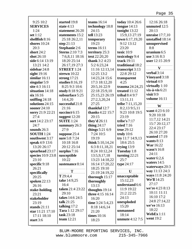
www.blummoore.com 215-345-7966BLUM-MOORE REPORTING SERVICES, INC.
Page 35
9:25 10:2SERVICES
1:24set 1:12shellfish 8:16shores 10:24
20:3short 24:2shot 26:10side 6:14 13:19
13:21 14:2sidebar 24:8sight 19:16similar 16:11singular 5:9site 4:3 16:11situation 14:18six 16:16sniffing 24:18solutions 24:15sooner 24:10sorry 21:9 22:21
27:4sort 14:2 23:17
24:7sounds 26:3SOUTH 1:24southwest 3:17speak 4:9 13:6
13:20 26:17spearhead 23:17species 10:9 23:8
23:10specific 9:18
26:21specifically
20:25spoken 22:13
26:16stake-holding
23:21stakeholder
23:19stands 21:11star 11:21 17:10
17:11 18:10start 3:6
started 19:8state 4:13statement 26:20statements 15:2
25:18 26:2,11step 21:13Stephanie 2:6Sterns 2:10 7:3
7:6,8,11 18:1618:20 25:1426:17,19 27:3
STREET 1:24strewn 10:22strong 17:21studies 8:16,19
8:25 9:3 10:6study 8:18 9:21subsurface 5:25
14:4,20successful 21:8
21:16succinct 6:15suggest 12:20SUITE 1:24summary 26:3
27:9suppose 25:4sure 5:8 7:24
10:18 16:820:12 25:14
surplus 7:16susceptible
10:22sustenance 8:14
TT 29:4,4take 14:9,25
16:4taken 21:4 23:22
29:10takes 14:6 24:5talk 21:25talking 17:2Tara 1:12 29:17task 23:18team 12:21
teams 16:14technology 18:8
24:15tell 13:23temporary
19:23terms 16:11territory 25:3text 22:20,20thank 3:2 4:23
5:2 6:23,2411:16 12:13,1412:25 13:214:23,24 15:617:3 18:12,2020:5,16 22:922:18 25:9,1025:15,23 26:1927:2,3,20,2427:25
thankful 12:7thanks 4:22 15:7
20:15they'd 26:11thing 24:17things 5:21 6:9
7:24 10:519:19
think 5:10,14,246:3 8:11,18,218:24 10:12,2413:5,9,17,1813:23 14:18,2216:14 17:20,2218:25 19:1021:19 24:19,22
thorough 15:17thoroughly
13:13thoughts 19:14three 4:15 16:14
16:20time 3:24 5:4,23
8:18 14:6,1421:20
times 10:1618:23
today 10:4 26:6tongue 14:13tonight 13:22
15:9,13 27:19town 6:17,19,20
9:12 13:1223:20
toxic 10:9toxicology 9:4track 19:11traditional 18:2transcript 3:13
22:8 29:12transparent
4:25trauma 24:24,25treated 11:12tribal 8:4 9:7
13:11,11tribe 7:11,15,20
8:2,13 9:5,119:23 10:8 19:523:19
tribe's 7:17tried 7:16true 29:12truly 10:6try 11:7 14:9,13
18:6 25:5trying 13:9Tuesday 1:8turning 22:21
25:7type 24:17
Uunacceptable
15:12,23understand 6:6
11:9 19:2221:2 22:2524:13
unexploded15:20
unmanned18:14
unmute 4:12 7:5
12:16 26:18unmuted 12:5
20:13unraise 17:7,10unstaffed 18:14unsupervised
8:8uranium 6:5use 3:16 8:3user 12:15 20:9
Vverbal 3:14Vineyard 3:18virtual 4:9virtually 1:10vis-à-vis 6:21visit 9:9volume 16:11
Wwant 4:23 6:10
9:20 10:1811:7,12 14:2115:7 20:12,1722:4 23:1726:10 27:20
wanted 17:19wants 8:13War 16:22wasn't 16:8
24:11water 6:2,6waters 14:5waterways 20:3way 11:13 24:3ways 11:8 24:20We'll 14:25
27:17we're 4:23 8:13
10:11 11:1116:10 17:224:8 27:14,22
we've 16:1318:22
WebEx 1:11went 19:2
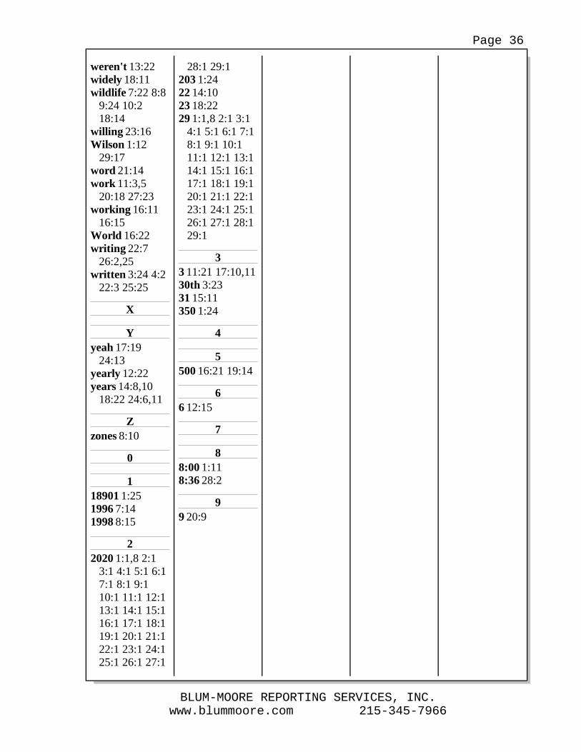
www.blummoore.com 215-345-7966BLUM-MOORE REPORTING SERVICES, INC.
Page 36
weren't 13:22widely 18:11wildlife 7:22 8:8
9:24 10:218:14
willing 23:16Wilson 1:12
29:17word 21:14work 11:3,5
20:18 27:23working 16:11
16:15World 16:22writing 22:7
26:2,25written 3:24 4:2
22:3 25:25
X
Yyeah 17:19
24:13yearly 12:22years 14:8,10
18:22 24:6,11
Zzones 8:10
0
118901 1:251996 7:141998 8:15
22020 1:1,8 2:1
3:1 4:1 5:1 6:17:1 8:1 9:110:1 11:1 12:113:1 14:1 15:116:1 17:1 18:119:1 20:1 21:122:1 23:1 24:125:1 26:1 27:1
28:1 29:1203 1:2422 14:1023 18:2229 1:1,8 2:1 3:1
4:1 5:1 6:1 7:18:1 9:1 10:111:1 12:1 13:114:1 15:1 16:117:1 18:1 19:120:1 21:1 22:123:1 24:1 25:126:1 27:1 28:129:1
33 11:21 17:10,1130th 3:2331 15:11350 1:24
4
5500 16:21 19:14
66 12:15
7
88:00 1:118:36 28:2
99 20:9
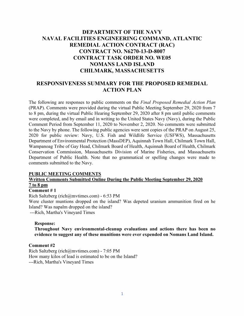
1
DEPARTMENT OF THE NAVY NAVAL FACILITIES ENGINEERING COMMAND, ATLANTIC
REMEDIAL ACTION CONTRACT (RAC) CONTRACT NO. N6270-13-D-8007
CONTRACT TASK ORDER NO. WE05 NOMANS LAND ISLAND
CHILMARK, MASSACHUSETTS
RESPONSIVENESS SUMMARY FOR THE PROPOSED REMEDIAL ACTION PLAN
The following are responses to public comments on the Final Proposed Remedial Action Plan(PRAP). Comments were provided during the virtual Public Meeting September 29, 2020 from 7to 8 pm, during the virtual Public Hearing September 29, 2020 after 8 pm until public commentswere completed, and by email and in writing to the United States Navy (Navy), during the PublicComment Period from September 11, 2020 to November 2, 2020. No comments were submitted to the Navy by phone. The following public agencies were sent copies of the PRAP on August 25, 2020 for public review: Navy, U.S. Fish and Wildlife Service (USFWS), MassachusettsDepartment of Environmental Protection (MassDEP), Aquinnah Town Hall, Chilmark Town Hall, Wampanoag Tribe of Gay Head, Chilmark Board of Health, Aquinnah Board of Health, Chilmark Conservation Commission, Massachusetts Division of Marine Fisheries, and MassachusettsDepartment of Public Health. Note that no grammatical or spelling changes were made tocomments submitted to the Navy.
PUBLIC MEETING COMMENTS Written Comments Submitted Online During the Public Meeting September 29, 2020 7 to 8 pm Comment # 1 Rich Saltzberg ([email protected]) - 6:53 PM Were cluster muntions dropped on the island? Was depeted uranium ammunition fired on heIsland? Was napalm dropped on the island? ---Rich, Martha's Vineyard Times
Response: Throughout Navy environmental-cleanup evaluations and actions there has been noevidence to suggest any of these munitions were ever expended on Nomans Land Island.
Comment #2 Rich Saltzberg ([email protected]) - 7:05 PM How many kilos of lead is estimated to be on the Island? ---Rich, Martha's Vineyard Times
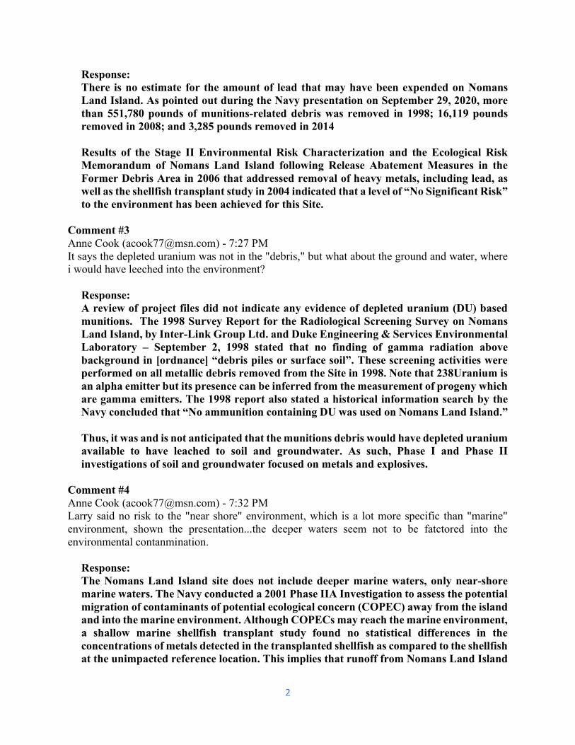
2
Response: There is no estimate for the amount of lead that may have been expended on NomansLand Island. As pointed out during the Navy presentation on September 29, 2020, morethan 551,780 pounds of munitions-related debris was removed in 1998; 16,119 poundsremoved in 2008; and 3,285 pounds removed in 2014 Results of the Stage II Environmental Risk Characterization and the Ecological RiskMemorandum of Nomans Land Island following Release Abatement Measures in the Former Debris Area in 2006 that addressed removal of heavy metals, including lead, as well as the shellfish transplant study in 2004 indicated that a level of “No Significant Risk”to the environment has been achieved for this Site.
Comment #3 Anne Cook ([email protected]) - 7:27 PM It says the depleted uranium was not in the "debris," but what about the ground and water, wherei would have leeched into the environment?
Response: A review of project files did not indicate any evidence of depleted uranium (DU) based munitions. The 1998 Survey Report for the Radiological Screening Survey on NomansLand Island, by Inter-Link Group Ltd. and Duke Engineering & Services EnvironmentalLaboratory – September 2, 1998 stated that no finding of gamma radiation abovebackground in [ordnance] “debris piles or surface soil”. These screening activities wereperformed on all metallic debris removed from the Site in 1998. Note that 238Uranium is an alpha emitter but its presence can be inferred from the measurement of progeny whichare gamma emitters. The 1998 report also stated a historical information search by theNavy concluded that “No ammunition containing DU was used on Nomans Land Island.” Thus, it was and is not anticipated that the munitions debris would have depleted uraniumavailable to have leached to soil and groundwater. As such, Phase I and Phase II investigations of soil and groundwater focused on metals and explosives.
Comment #4 Anne Cook ([email protected]) - 7:32 PM Larry said no risk to the "near shore" environment, which is a lot more specific than "marine"environment, shown the presentation...the deeper waters seem not to be fatctored into theenvironmental contanmination.
Response: The Nomans Land Island site does not include deeper marine waters, only near-shore marine waters. The Navy conducted a 2001 Phase IIA Investigation to assess the potentialmigration of contaminants of potential ecological concern (COPEC) away from the island and into the marine environment. Although COPECs may reach the marine environment, a shallow marine shellfish transplant study found no statistical differences in the concentrations of metals detected in the transplanted shellfish as compared to the shellfishat the unimpacted reference location. This implies that runoff from Nomans Land Island
3
does not alter the metals concentration of the near-shore marine environment. If the island runoff is not impacting the near-shore environment, then it is not impacting thedeeper marine waters.
Comment #5 Rich Saltzberg ([email protected]) - 7:33 PM What type of geiger counter was employed to scan for depleted uranium and was it calibrated foralpha particles? Also, is there any evidence there's a geologic fresh water link between the island and the Vineyard's aquifers? ---Rich, Martha's Vineyard Time
Response: Duke Engineering & Services Environmental Laboratory surveyed the munitions,munitions fragments, and target debris for radiological contamination (1998). The radiological screening consisted of 34 in situ gamma-ray spectrometry measurements inand around the staging area, using a high-purity germanium detector, supplemented with direct low-level gamma measurements made with a Ludlum M-19 Micro R Meter.Measurements were then compared with six reference background radiationmeasurements performed on Martha’s Vineyard. No radioactivity above background wasdetected on any of the staged material. There is no evidence of a freshwater link betweenNomans Land Island and Martha’s Vineyard.
Comment #6 Bret Stearns ([email protected]) - 7:46 PM Does the budget include the regular maintenance of trails as well as the anticipated repatriation ofTribal and non Tribal people buried on the Island?
Response: Under the transfer agreement between the Navy and Department of the Interior, the USFWS maintains existing pathways and roadways on Nomans Land Island. The Navy isnot funded for any repatriation activities.
Comment #7 Karin Kugel ([email protected]) - 7:50 PM Can you speak more to the effects to the environment, flora and fauna of the islands and oceanenvironment, in the foreseeable long term for option 1 versus option 2?
Response: Alternative S-1, Source Removal would involve disturbance of essentially most of the soiland vegetation on the island during removal of unexploded ordnance (UXO) or munitionsof concern (MEC) For the upland portion of Nomans Land Island, this alternative would include clearing vegetation, conducting geophysical surveys to detect subsurface MEC,digging up suspected MEC to a depth of approximately 4 feet below ground surface, and then detonating identified suspect MEC in-place. The near-shore marine environment would also be disturbed from water depths of approximately -15 ft MLLW to a depth -75 ft. Most of the existing island wildlife, flora and fauna as well as their habitats would be
4
removed or severely altered. The island would cease to provide the habitats needed for a wildlife refuge. The near-shore environment would be disrupted by submarine removalprocedures. Denuding the island surface, would increase sediment runoff from the islandinto the near-shore environment and disrupt the near-shore environment habitats. Alternative S-2, Institutional Controls/ Awareness/Enforcement, would have minimaldisruption to the island environment. The proposed remedy includes limited MECremovals performed every 5 years, which would remove MEC present on the groundsurface and along the shoreline. These MEC removals would most likely be limited toareas that are accessible by people visiting the island, and would occur in concordancewith the conservation plans of the USFWS.
Comment #8 Dix Leeson ([email protected]) - 7:50 PM Apparently I'm unable to "raise my hand" although I have repeatedly pressed the button on myscreen. 2 questions: amount of time to expend the 11 or 31 million; second: have you consideredaerial seeding of the original trees?
Response: The implementation time for both Alternatives S-1 Source Removal, estimated at $31 million +- 50%, and S-2 Institutional Controls/ Awareness/Enforcement at $11 million +=50%, is both 30 years, per Comprehensive Environmental Response, Compensation, andLiability Act (CERCLA) regulations. USFWS is currently in charge of the health of island’s vegetation and any suchreintroduction of species.
Comment #9 Rich Saltzberg ([email protected]) - 7:59 PM Who is liable for damage, injury, or death resulting from munitions that travel outside the exclusionzone through weather, sea action, or geologic action? Rich, Martha's Vineyard Times
Response: It is inappropriate to speculate about possible future damages given the number ofunknown factors. It is highly unlikely that munitions from the island would move beyondthe near-shore areas.
5
PUBLIC HEARING COMMENTS Written Comments Submitted Online During Public Hearing September 29, 2020 After 8pm.
Comment #1 Anne Cook ([email protected]) - 8:12 PM Can we get an attendee list? I want to know who the man speaking for the Tribe is. Thanks!
Answer: Linh Phu - 8:12 PM Bret Sterns is currently speaking on behalf of the tribe- Linh Phu - 8:13 PM*Strearns-
Response: A Public Hearing attendee list is not generated for the Public Hearing. Commenters areidentified for each comment provided.
Comment #2 Anne Cook ([email protected]) - 8:33 PM Thank you all, and I look forward to next steps in communication with Dave, since a few of us aretrying to coordinate on forming a citizen task force as we speak!
Response: Noted. Citizens groups can be formed and meet with the Navy and USFWS as part of thecommunity participation process.
Comment #3 Paul Needham ([email protected]) - 8:35 PM Will the presentation PowerPoint be posted online?
Response: Jacqueline Boltz - 8:36 PM Yes it will on the BRAC PMO site- Jacqueline Boltz - 8:37 PM Online Access available at: https://www.bracpmo.navy.mil/brac_bases/northeast/former_nas_south_weymouth.html Click on “Documents” and scroll down to search for a document.
6
Comments Submitted Verbally During Public Hearing September 29, 2020 After 8 pm. From the Court Reporter Transcript.
Comment #1 ANNIE COOKE: Hi. Thanks again. So I guess we're on the record now. I want to thank you forthis really, I don't know, just very courteous and open and transparent and informative meeting.Thank all of you.
I would ask that the public be given the opportunity to have a longer period of time than is currentlyapparently available to respond this proposed plan before any record of decision is made, becauseagain, as we have discussed, I am not sure who or which entities either together or singular wereresponsible for more adequate promotion of the Nomans Land issue; but I think it's something thatreally does need to be addressed. And if me and others in the public can help with that, I'd be happy to do that.
I think the questions that have already been asked in the preliminary chat after the presentation,been all been really apropos and my interest is in the island being accessible to people by request,if needed; but it not being restricted to only certain people. We don't -- I don't it should be overrunby humans, but some access to fish and other things without being intimidated and chased away is -- would be preferable, and we just need more time as the public. And I also think that to the bestof your ability for the subsurface under the ground and under the water on the sea floor to beremoved to the best of one's ability, I think it's a good investment to get that done now. I'mconcerned about depleted uranium in the ground and water. I understand that you may assessed itin the debris itself that was removed, but if it leached into the environment, then that is a long-term concern for carcinogenics things. So there's just a lot of questions that I don't want to get into toomuch, it's too -- you know, there's a lot of information for the public to look at, and we are going to need to coordinate and cooperate together on the public side so that's it's clear and succinct forall of us.
And I also just am curious what part does the town of Chilmark play in so far as Nomans is part of its jurisdiction. What liability rests with the town of Chilmark and what responsibility rests withthe town of Chilmark vis-à-vis all the representatives from the other entities on this call? Thank you.
Response: The following address comments discussed above. The public has been given a longer time for responses to the PRAP. The original
response date of October 15, 2020 has been extended to November 2, 2020. The island is owned by USFWS. MassDEP provides oversight of the remediation. Citizens groups can be formed and meet with the Navy and USFWS as part of the
community participation process. Public access to Nomans Land Island for fishing or public recreation is not a
reasonable expectation for the foreseeable future. The island is closed to the publicnot only due to the presence of MEC, but also to provide wildlife with habitat that is undisturbed by human activities. Under the USFWS Conservation Plan, the islandwould remain an unstaffed wildlife refuge even if all safety issues could be addressed.
7
Additionally, the transfer agreement between the Navy and USFW to provide anunstaffed wildlife refuge recognized the fact that, due to technology limitations, the island could not be cleared to an extent that would allow unrestricted public access tothe island for the foreseeable future. A risk to safety, however slight, would remain and the government would continue to apply a restriction against unfettered public access. The Navy is not aware of any technology that can provide 100% certainty thatall MEC presently on the island and in the near shore environment would be removed.Thus, there will always be the possibility of “Risk of Harm to Safety” to personsvisiting the island due to the presence of unknown MEC, even if a source removaloption was implemented. As such, even Alternative S-1, Source Removal, includes acomponent that is essentially the same as Alternative S-2, Institutional Controls/Awareness/Enforcement, following Source Removal activities for up to 30 years.
Extensive assessments have been conducted on soil and groundwater on the island from 1996 through 2004 including Phase 1 Environmental Baseline Survey (1996);Phase I Limited Site Investigation (1998); Phase IIA Comprehensive Site Assessment(2004) Report of 2001 fieldwork, focused on risk to the environment, with soilsampling in the Former Debris Area (FDA) wetland, ecological risk characterizationfieldwork, sampling of wetland and nearshore sediment, and shellfish sampling; and Phase IIB Comprehensive Site Assessment Report focused on the risk of harm tosafety on the island due to remaining ordnance. In addition, potential contaminantsin soil as well as debris and potential munitions were removed in Release AbatementMeasures (RAMs) conducted: prior to 1998, 1998, 2003, and in 2006. RiskCharacterizations on the environmental sampling results associated with these assessments and RAMs indicated that a condition of “No Significant Risk” wasestablished for human health, public welfare, and for the environment, both marine and the entire upland of the island. These risk characterizations were based on afuture use of the island as an unstaffed wildlife refuge.
A review of project files did not indicate any evidence of DU based munitions. The 1998 Survey Report for the Radiological Screening Survey on Nomans Land Island,by Inter-Link Group Ltd. and Duke Engineering & Services Environmental Laboratory – September 2, 1998 stated that no finding of gamma radiation abovebackground in [ordnance] “debris piles or surface soil”. These screening activitieswere performed on all metallic debris removed from the Site in 1998. Note that238Uranium is an alpha emitter but its presence can be inferred from the measurement of progeny which are gamma emitters. The 1998 report also stated a historical information search by the Navy concluded that “No ammunition containingDU was used on Nomans Land Island.” The radiological investigation in 1998,discussed in the Response to Comment #1, of recovered ordnance indicated that there were no elevated levels of gamma radiation associated present in ordnance debris. Inaddition, the 1998 report also stated a historical information search by the Navy concluded that “No ammunition containing DU was used on Nomans Land Island.” Thus, it was and is not anticipated that the munitions debris would have depleted uranium available to have leached to soil and groundwater. As such, Phase I andPhase II investigations of soil and groundwater focused on metals and explosives.
The USFWS, a US government agency, has ownership of the island and is responsiblefor future decisions for the island, within limits of any deed restrictions for future use.
8
Please contact the Town of Chilmark regarding jurisdictional and liability issues.
Comment #2 BRETT STERNS: The tribe has been involved in this in federal process since the beginning. Imean, I'm having recalls of, you know, conversations in 1996 and before. In fact, some of you mayknow that the tribe actually tried through federal surplus property to attain the island and rally thetribe's goal at that point was to assure that it was cleaned up and removed debris ordnances andexplosives.
So the tribe has some goals with Nomans Island. In fact, we were just there the other day with USFish and Wildlife Service, who we have a great relationship with. And there's a few things that I -- I would like to make sure that I pass on for the record on behalf of the tribe. The make desiresgreater and safer access to the island both for cultural use and for general access by tribal members.That was something that was promised from the very beginning. In fact, promised from the verybeginning and also in negotiations with US Fish and Wildlife Service was unsupervised accessand the only that could happen is by the designation of safe zones, which to date, hasn't happenedbecause, 'cause they're -- I think really because you've also have to have a D&B companion. And we're -- the tribe wants assurance that leeching metals that are impacting sustenance foods. This issomething that we recognized in 1998 through the studies that were done in the shellfish adjacentto the island, you know, that was a one time study. I think there's room for continued studies forthis purpose to determine whether the island actually has the environmental impacts. I think somedecisions that have been made that they don't have environmental impacts or human healthimpacts. We don't agree with that as an outcome and I think there's room for continued studiesespecially with federal agencies companionship, partnership with federal agencies for studies onthe island as it deals with environmental health and toxicology.
The tribe needs assurance that there's going to be clearance for new areas for repatriation for bothtribal members and non-tribal people. That was one of the purposes of the visit the other day is tocheck on areas that have been impacted and repatriation is an important cultural aspect to the tribe and I -- also for the Town of Chilmark, where people are laid to rest, they should continue to be laid to rest, and that continues to be a problem there. If it's not gonna get any better and it'ssomething that is going on currently, it needs to be addressed and it needs to be part of the plan, avery specific part of the plan. It can't be ignored and it can't be overlooked.
I guess I really want to focus on the fact that the continued study part where we have a complimentof federal agencies that have the ability to partner with the tribe beside – with other federal agenciesin US Fish and Wildlife Service. We certainly saw that US Fish and Wildlife Service can -- let rabbits go out there and that's something that in the very beginning was not considered, but it's happening today. So we know that things can be moved or manipulated to continue studies inprograms and we'd truly like to see that happen in the future. Of course, the tribe formally would like to see all toxic metals and, you know, non-native species removed. We know that this is --that's a high bar for what we're looking at, but certainly I think it would most comfortable foreveryone involved if the greatest budget possible was held because we really don't know what toanticipate out there. I've been, you know, out there several times over this process. I know what itlooks like, I know what's happening out there. You know, we want to make sure that we recognizethat the goal would be to have a clean reservation there. Like, there's no reason to have metals and
9
excess of exploded ordnances strewn in an area that is so susceptible to erosion and impacts likethat. That's going end up on our shores, so. And I think -- I would hope that we all agree on that.
So really the message here is how do we work together to do that? Do we have to seekcongressional funding separately? Do we find partnership opportunities to continue that work? No, it doesn't all necessarily lay on your hands, we want to come in as partners to try to find ways todo it and we know that there's restriction budgets. We understand that you can't just go in and ask for everything and get everything, but we're -- we maintain a partnership and we want to be, youknow, treated in such a way so that we can help leverage funding and opportunity to assure that there's safe lands for everyone. That's my comment.
Response: The following address comments discussed above. The Navy acknowledges the Tribe’s desire for greater and safer access to the island
both for cultural use and for general access by tribal members. However, custody ofthe island was transferred from Navy to USFWS as an unstaffed wildlife refuge. Navyretains responsibility for cleanup necessary for that reuse. Decisions regardingchanges to that reuse should be referred to USFWS. The Navy is not currently funded to perform additional cleanup beyond that envisioned in the transfer agreement.
Public access to Nomans Land Island for fishing or public recreation is not areasonable expectation for the foreseeable future. The island is closed to the public not only due to the presence of MEC, but also to provide wildlife with habitat that is undisturbed by human activities. Under the USFWS Conservation Plan, the islandwould remain an unstaffed wildlife refuge even if all safety issues could be addressed. Additionally, the transfer agreement between the Navy and USFW to provide anunstaffed wildlife refuge recognized the fact that, due to technology limitations, theisland could not be cleared to an extent that would allow unrestricted public access to the island for the foreseeable future. A risk to safety, however slight, would remain and the government would continue to apply a restriction against unfettered publicaccess. As mentioned in Comment #1 above, the Navy is not aware of any technologythat can provide 100% certainty that all MEC presently on the island and in the nearshore environment would be removed. Thus, there will always be the possibility of“Risk of Harm to Safety” to persons visiting the island due to the presence of unknown MEC, even if a source removal option was implemented. As such, it isunlikely that general access without supervision by personnel trained in spottingUXO/MEC will be a viable option.
As discussed in Comment #1 above, the environmental assessments and RAMsperformed by the Navy with regard to leaching of contaminants from the island intonearshore marine environment concluded a condition of “No Significant Risk” wasestablished for human health, public welfare, and for the environment, both near-shore marine and the entire upland of the island. If the Tribe can find partnershipopportunities that would provide funding to further study specific environmental issues in collaboration with the Navy, please contact the Navy to determine a pathforward.
10
Tribal and/or citizens groups can be formed and meet with the Navy and USFWS aspart of the community participation process.
Comment #3 PETER COOKE: Actually I'm -- I asked my question and I'm thankful for the opportunity to listenon this and will be following up on the discussion over the next month very closely. It will be abig part of our discussions about developing a master plan for Chilmark and because of -- Nomansfigures into that a fair amount.
Thank you very much.
Response: The Town of Chilmark should consult with USFWS concerning their future plans forNomans Land Island since the island is owned and operated by USFWS.
Comment #4ANN MALEWICZ: Hi. It's Ann Malewicz just really one comment. I would just suggest for thepublic record that the Coast Guard be part of the team with the five-year review and also when you do yearly reviews for O&M so they are aware of their enforcement capabilities.
Thank you.
Response: The Coast Guard will be afforded an opportunity to review and comment on the Five-year review. Yearly reviews for O&M are not part of the selected remedial alternative.
Comment #5 ANNIE COOKE: Hi everybody. I'm really not trying to dominate here, but I just think what was -- what was just discussed, both the tribal -- tribal interest in (indiscernible) with non-tribal membersand with the Town of Chilmark, et cetera, to get the clean-up thoroughly done and to get theirhistorical relationship to and with the island well established and honored is very important. Andalso the Coast Guard being involved, I think is another great notion. I think we have an opportunity to -- hopefully all of you agree, that on the civilian side so to speak, the nongovernment and thenonmilitary side, you actually do have partners that maybe you weren't aware of until tonight. Andall of us on this call I think can tell we have the partners the civilian community that hopefully wecan convene and present you, on the organizational side, with sort of a consensus hopefully, asmuch as possible, request and ask to get the complete clean-up done; the subsurface ordnancebelow the waters and below the ground even if it takes a little more time. And if possible, to nothave these reviews and clean-up efforts only happen every five years. I would ask why we can'ttry to take care of this now, ASAP, 22 years into the post-transfer agreement period.
That's all I have to say. And I'm going to try to hold my tongue the rest of the time, but I hope -- I hope more people feel comfortable chiming in. I'm just -- I did -- I did quite a bit of reading onthis and -- but there's still more to do. It's a fascinating situation, but I do think that opting for thisalternative of keeping people away and not removing the subsurface ordnance, to me, is not reallyacceptable. So I just want to -- and I think I'm not alone from what I hear on here.
11
Thank you.
Response: The following address comments discussed above. Tribal and/or citizens groups can be formed and meet with the Navy and USFWS as
part of the community participation process. As mentioned in Comment #1 and 2 above, since there is no known technology that
can provide 100% certainty that MEC presently on the island and in the near shoreenvironment will be removed, public access to the island will need to be restricted forthe foreseeable future. Public access to Nomans Land Island for fishing or publicrecreation is not a reasonable expectation for the foreseeable future. The island isclosed to the public not only due to the presence of MEC, but also to provide wildlife with habitat that is undisturbed by human activities. Under the USFWS Conservation Plan, the island would remain an unstaffed wildlife refuge even if all safety issuescould be addressed. Additionally, the transfer agreement between the Navy and USFW to provide an unstaffed wildlife refuge recognized the fact that, due totechnology limitations, the island could not be cleared to an extent that would allowunrestricted public access to the island for the foreseeable future. A risk to safety,however slight, would remain and the government would continue to apply a restriction against unfettered public access. The Navy is not aware of any technologythat can provide 100% certainty that all MEC presently on the island and in the nearshore environment would be removed. Thus, there will always be the possibility of“Risk of Harm to Safety” to persons visiting the island due to the presence of unknown MEC, even if a source removal option was implemented. As such, evenAlternative S-1, Source Removal, includes a component that is essentially the same asAlternative S-2, Institutional Controls/ Awareness/Enforcement, following SourceRemoval activities for up to 30 years.
Five-year reviews of this site following the implementation of the selected remedy inthe ROD are a CERCLA requirement. More frequent reviews can be conducted aswarranted by observations.
Comment #6 DICKS LEESON: Yes. Thank you. And I want to add my thanks for this process to theappreciation that's been expressed already tonight. In the document explaining the alternativemanagement options, it was mentioned that the $31 million alternative of complete clearing of theMEC/UXOs would cause unacceptable environmental damage and tonight it was mentioned thatthe environment would be devastated. I'm assuming that there are other listeners like myself whodon't know what's involved in such a thorough removal. Although Mr. Barry cuddie-hunker, who has discussed this with me, informs me that that amount of removal of unexploded ordnance couldonly be accomplished by detonating all of them and that that may explain why some feel that theimpact on the environment is unacceptable.
So my comment is that I would like to have a better explanation of what happens to the ecology ifthe ordnance is removed under that alternative.
12
Response: VERBAL RESPONSE: MR. KAHRS: Dave, could I take that one? MR. BARNEY: For clarification, Larry, please go ahead. MR. KAHRS: Okay. I wasn't sure if you heard me. So, Dicks, we're -- as I said, I'm working at a very similar site in terms of volume anddistribution of munitions. And I'm out there, you know, pretty often and we've got, I think three different teams of ex-military EOD [explosive ordnance disposal] guys working forus out there. This is done in six inch lifts. This is done by scraping down, almost like an archeology experiment and finding what's there using metal detectors and it's a verylabor-intensive process. So if you dig down, let's say three or four feet and you find a 500 pound bomb from WorldWar II that's still live, you've got to do what's called a blow in place, which means youattach munitions to it, C-4 explosive and you push a charge on it and you detonate it.That's the kind of destruction we're talking about. WRTTEN RESPONSE: As mentioned in Comment #7 from the response section “Written Comments Submitted Online During the Public Meeting September 29, 2020 7 to 8 pm”, Alternative S-1, Source Removal, would involve disturbance of essentially most of the soil and vegetation on theisland during removal of UXO. For the upland portion of Nomans Land Island thisalternative would include clearing vegetation, conducting geophysical surveys to detect subsurface MEC, digging up suspected MEC to a depth of approximately 4 feet belowground surface, and then detonating identified suspect MEC in-place. The near-shore marine environment would also be disturbed from water depths of approximately -15 ft MLLW to a depth -75 ft. Most of the existing island wildlife, flora and fauna and theirhabitats would be removed or severely altered. The island would cease to provide thehabitats needed for a wildlife refuge. The near-shore environment would be disrupted bysubmarine removal procedures. Denuding the island surface, would increase sedimentrunoff from the island into the near-shore environment and disrupt the near-shoreenvironment habitats. Alternative 2, Institutional Controls/ Awareness/Enforcement, would have minimaldisruption to the island environment. The proposed remedy includes limited MECremovals performed approximately every 5 years, which would remove MEC present on the ground surface and along the shoreline. These MEC removals would most likely be limited to areas that are accessible by people visiting the island, and would occur inconcordance with the conservation plans of the USFWS.
Comment #7 PAUL NEEDEM: Yeah, I just wanted to echo Ann's point, that I think there a lot of civilians withstrong interests in the island and I think the whole reason, you know, the notion of exploring and exploration, whether by boat or otherwise, just kind of seeing all the nooks and crannies of thisregion is something that's really important and traditional in this area. And so I do hope that there'san ability the civilians to really play a role here in advocating for access to this federal land and
13
for us to try to be partners in making this possible, whether at this juncture in the future, as someoneelse said, as technology improves, I just hope -- even if it's not achievable at this minutes, that thenorth star goal will always be to restore access as widely as possible.
Response: VERBAL RESPONSE: MR. BARNEY: Thank you, Paul. Just as a reminder it is – was identified as an unmanned, unstaffed wildlife refuge. WRITTEN RESPONSE: Public access to Nomans Land Island for fishing or public recreation is not a reasonableexpectation for the foreseeable future. The island is closed to the public not only due tothe presence of MEC, but also to provide wildlife with habitat that is undisturbed by human activities. Under the USFWS Conservation Plan, the island would remain an unstaffed wildlife refuge even if all safety issues could be addressed. Additionally, the transfer agreement between the Navy and USFW to provide an unstaffed wildlife refugerecognized the fact that, due to technology limitations, the island could not be cleared toan extent that would allow unrestricted public access to the island for the foreseeablefuture. A risk to safety, however slight, would remain and the government would continueto apply a restriction against unfettered public access. The Navy is not aware of anytechnology that can provide 100% certainty that all MEC presently on the island and in the near shore environment would be removed. Thus, there will always be the possibilityof “Risk of Harm to Safety” to persons visiting the island due to the presence of unknownMEC, even if a source removal option was implemented. As such, even Alternative S-1, Source Removal, includes a component that is essentially the same as Alternative S-2, Institutional Controls/ Awareness/Enforcement, following Source Removal activities forup to 30 years.
Comment #8 BRETT STERNS: I do, yes. Thank you for that opportunity. I, you know, through the 23 yearswe've been discussing this island, this point has come up many times on how the -- it would be thedestruction of the island by cleaning it up. And, you know, I think it's important to point out, youknow, we went through a brief history of the island in the beginning about an hour ago wherethere's direct of descendants of Chilmark and of the tribe who all they had -- they had -- it wasused for pasture and it was used for cod fishing. The destruction took place when we starteddropping ammunitions and bombs out there.
So the concern is -- and I think it's important not to lose track of the concern. If this were -- perhapsif this were in the middle of Arizona, there would be some different thoughts about restriction. Much of that 500 pound bomb is going to be in Menemsha Harbor. So let's not lose sight of thepeople who live here who inevitably this island will recede, this will island will erode and theselands will become part of the ocean again. So it's the things that are carried that contain thepotential harm to the public that is of grave concern. So I understand that there could be anenvironmental -- quite frankly, a temporary environmental impact in the cleaning up of that island,but the we do -- the impact really is to the community in which we all live for ammunitions thatend up in the waterways and back on our shores.
14
That's my comment.
Response: VERBAL RESPONSE: MR. BARNEY: Thank you, Brett. It's important for us to hear the local perspective. WRITTEN RESPONSE: The Selected Remedial Alternative addressed remediation time, under CERCLA, of 30years. Public access to Nomans Land Island for fishing or public recreation is not areasonable expectation for the foreseeable future. The island is closed to the public not only due to the presence of MEC, but also to provide wildlife with habitat that isundisturbed by human activities. Under the USFWS Conservation Plan, the island wouldremain an unstaffed wildlife refuge even if all safety issues could be addressed. Additionally, the transfer agreement between the Navy and USFW to provide an unstaffed wildlife refuge recognized the fact that, due to technology limitations, the island could not be cleared to an extent that would allow unrestricted public access to the island for the foreseeable future. A risk to safety, however slight, would remain and the government would continue to apply a restriction against unfettered public access. The Navy is not aware of any technology that can provide 100% certainty that all MECpresently on the island and in the near shore environment would be removed. Thus, there will always be the possibility of “Risk of Harm to Safety” to persons visiting the islanddue to the presence of unknown MEC, even if a source removal option was implemented. As such, even Alternative S-1, Source Removal, includes a component that is essentiallythe same as Alternative S-2, Institutional Controls/ Awareness/Enforcement, following Source Removal activities for up to 30 years. The proposed remedy does include periodic surface clearances of the island and shoreline to address any MEC that surfaces or erodes from the island cliffs. There is no evidence that MEC from the island has or will migrate to the Vineyard. Ordnance that washes ashore on Martha’s Vineyard is likely from former bombing targets on Martha’sVineyard. The MassDEP is involved with the United States Army Corps of Engineers (USACE) on three sites: Tisbury Great Pond Former Bomb Target Area, Moving Target Machine Gun Range South Beach, and Cape Poge Former Bomb Target Area. TheMassDEP, USACE, and others have also suspected that there could be a munitions dump area located between Martha’s Vineyard and Nantucket, but this is currentlyunconfirmed.
Comment #9 JOHN: Great. Thank you so much. Again, I want to echo some of the gratitude for the -- for therigor of the work you guys have put in literally over a decade. It's really -- it's quite an investment.My comment is really a question, Mr. Barney. I really appreciate your offer of making yourselfavailable for an offlines reprocess conversation about what a partnership might look like. However,specifically my question for the group is, are you guys able to help us as a public understand whatother relationships have looked like when actions like this have been taken historically across thecountry? Right, like other CERCLA compliant public comment periods and how those public
15
comment periods could've had a -- anyone would describe as a successful relationship from thisperiod to the -- I'm sorry the acronym is ROD, is that -- or is it something of decision?
MR. BARNEY: Yes, correct. ROD stands for record of decision, which would be the next step in the process.
JOHN: Record, that's the word I missed, yes. Are you able to point us to any examples of asuccessful collaboration between Navy from a comment period to record of decision as a modelfor what this engagement might look like? I mean, I think it's kind of the first time a lot of us arecoming to this issue and1 don't benefit from your -- your level of expertise here.
Response: VERBAL RESPONSE: MR. BARNEY: That's a very good comment. I'm going refrain from responding to that immediately, but I would be happy to talk to you offline about -- about that and we will provide a written comment on this. Again, I want to remind folks that this is the recorded portion where your comments and notes get put on the record and we respond to them in writing, you know, as part of the official transcript of this evening's call. Thank you. WRITTEN RESPONSE: Generally, the time between the public comment period on the Proposed Plan and thecompleted and signed Record of Decision is not a period of public collaboration. Rather, the lead agency, in this instance the Navy, reviews the Administrative Record for the site, considers the comments received on the Proposed Plan and selects the remedy. Thisremedy selection is coordinated with the lead regulatory agency, in this instanceMassDEP. There have been many opportunities for community input since the remedialactions for Noman’s began in earnest in 1997 and it is acknowledged that the time since the last community engagement activity regarding cleanup has been longer than is typical.
Comment #10 ANNIE COOKE: Hi. Thank you. I really -- I don't see a raised hand function, so I have to keepsending Dave and you a text, chat text, I'm so sorry. You know, this is turning into a conversationrather than just a public comment, which is great. I'm really glad that John just asked what he asked.
I understand there's at least one example of a island in Hawaii where there was military ordnance,there was a cleanup that had to be conducted. There had to be public involvement and frankly, thepublic had to be galvanized to make it clear to the military that it mattered to them. And then itwas cleaned up and eventually the invasive species that had come out of the island were removedand the native species were repopulated. I don't know the details, but what I -- what I would justask is, how can we ensure that between this phase right here and the quote "record of decision"phase, that there's another phase? That there is discussion with all of you and the ability for thepublic and those of us who are willing to spearhead what I would want to have be sort of an independent task force that would interact with the historical stakeholder, such as the tribe, Town
16
of Chilmark, all of you, so that really the public has an entity, a stake-holding entity ourselves thatcan be, you know, taken seriously and really be part of insuring that this does get cleaned up.
I frankly have to agree with Brett that if in the short run some ordnance gets -- you know, the wayyou deal with it as professionals gets diffused or blown up and then has to -- that area has to beremediated, you know, and it takes a few more years, I would rather have that investment be made.And I feel as I sort of said to Dave in a sidebar, I said we're actually dealing with a delayed reaction literally, in that maybe this could have happened sooner if the process wasn't taking so long, likefive years between further efforts.
So, yeah, I -- if -- if -- I understand the risk and assuming the Navy has and is continuing to developtechnology and solutions that will lower the risk to your personnel from this type of thing; robots,I guess a rat in Florida just got an award for sniffing out a land mine or something. I think thereare all kinds of ways, but even if the island could, portion by portion, be cleaned up in this manner,just, you know, I still think it should be a priority even though it will have initial -- it will causeinitial environmental trauma, but I can't imagine it's going come anywhere near the trauma that theisland dealt with from the bombing. So it's, you know, it just goes with the territory literally, I suppose.
Now, I'm really going to try to be quiet. But I -- just I was inspired by the fact that this turning into a real conversation. I find that very encouraging.
Thank you.
Response: The following address comments discussed above. Public access to Nomans Land Island for fishing or public recreation is not a
reasonable expectation for the foreseeable future. The island is closed to the public not only due to the presence of MEC, but also to provide wildlife with habitat that is undisturbed by human activities. Under the USFWS Conservation Plan, the islandwould remain an unstaffed wildlife refuge even if all safety issues could be addressed.Additionally, the transfer agreement between the Navy and USFW to provide anunstaffed wildlife refuge recognized the fact that, due to technology limitations, theisland could not be cleared to an extent that would allow unrestricted public access to the island for the foreseeable future. A risk to safety, however slight, would remainand the government would continue to apply a restriction against unfettered publicaccess. The Navy is not aware of any technology that can provide 100% certainty thatall MEC presently on the island and in the near shore environment would be removed. Thus, there will always be the possibility of “Risk of Harm to Safety” to personsvisiting the island due to the presence of unknown MEC, even if a source removaloption was implemented. As such, even Alternative S-1, Source Removal, includes a component that is essentially the same as Alternative S-2, Institutional Controls/Awareness/Enforcement, following Source Removal activities for up to 30 years.
In Hawaii, according to the Star and Stripes a Pacific newspaper, April 4, 2018, there was a legal suit for $723 million for the Army Corp of Engineers to remediate a formerNavy artillery range in northwest Hawaii Island on land that was leased from the
17
state. Nomans Land Island is owned by USFWS. The considerations involved for theHawaii site and for Nomans Land Island are not comparable or equivalent.
Given the future use of Nomans Land Island as an unstaffed Wildlife Refuge, owned by USFWS, the environmental impact and cost for source removal of munitions is notwarranted.
Comment #11 BRETT STERNS: Thank you. Getting back to my first statement, will there be a specific notationin this plan about repatriation? 'Cause I haven't seen one yet. That's my question.
Response:VERBAL RESPONSE: MR. BARNEY: Okay. It's a good question and we will respond to that in writing. Thank you. WRITTEN RESPONSE:The Navy acknowledges the Tribe’s desire for greater and safer access to the island bothfor cultural use and for general access by tribal members. However, custody of the islandwas transferred from Navy to USFWS as an unstaffed wildlife refuge. Navy retainsresponsibility for cleanup necessary for that reuse. Decisions regarding changes to thatreuse should be referred to USFWS. The Navy is not currently funded to performadditional cleanup beyond that envisioned in the transfer agreement.
18
COMMENTS RECEIVED BY THE NAVY Comments Submitted By Email to the Navy
Comment #1 From: Marshall Katzen <[email protected]> Sent: Friday, September 11, 2020 8:15 AM
Greetings,
As a Chilmark resident my opinion is that the island should remain as is. So no development norenvironment disturbance. Leave the ordinance and warn the populace. It must remain an undisturbed refuge.
Thanks for your consideration, Marshall Katzen
Response: Noted. The remedial alternative selected in the Proposed Remedial Action Plan,Alternative S-2: Institutional Controls/Public Awareness and Enforcement, will limitaccess to the island, provide public warning of hazards, and provide for limited surface munitions removal approximately every 5-years or as needed.
Comment #2 From: Brian McCarty <[email protected]> Sent: Thursday, September 10, 2020 9:14 PM
Mr. Barney, My name is Brian McCarty, I am a Martha's Vineyard resident, veteran, and ecologist. Asignificant portion of my research continues to include the aftermath of the Navy's use of our community as a gunnery range. I am proud to say that I have read and obtained every publiclyaccessible Nomans' document, in addition to obtaining copies of personal documents from the last island families (Crane/Wood). I was even friends with a former U.S. Navy Commander (nowdeceased), who was involved with bombing Nomans for decades. I can confidently say, there areonly three people who know more about the island than myself, and those involved with the actual"management" of the island, have never taken the time to utilize them as a resource.
I don't truly believe that the US Navy or US Fish & Wildlife care about Nomans. In years of activeresearch, I have met nothing but opposition along the way. Site "managers" don't stay long, thus they never obtain a true understanding of the island, and what it means to the people of Martha'sVineyard. U.S. Fish and Wildlife claim cultural preservation is part of its' management goal, yetthe island cemetery is falling into the sea. In 2019, a new manager was appointed, who is moredistant and uncaring than the last. I can confidently say that there has been NO cultural preservation conducted by involved agencies. Additionally, all requests for private cultural preservation havebeen denied, with exception to Alex Bushe (who aims to make a documentary for the public).There is a vast range of correspondence from Vineyard residents regarding Nomans - each denied
19
accordingly. The biggest overall problem with managing Nomans Land: the process never involvesanyone who truly cares.
There is a particularly interesting chain of correspondence requesting classification as a super fundsite. Clearly, Nomans Land Island does meet the criteria of a Superfund Site; however, it is muchless expensive to create an off-limits boundary on a nautical map. Out of sight, out of mind, right?Historically, this has been the U.S. Navy and U.S. Fish & Wildlife Nomans Management Plan. In2008, 11,021 surface MECS were recovered, which pun intended, did not even scratch the surface.The Navy claims that these munitions were "training ordinance" to lessen the stigma of chemicalcontaminant worries. Despite this claim, the "biggest public concern is manual detonation of remaining ground ordinance". This couldn't be further from the truth.
The biggest ecological concern is degrading munitions which are now in the water. Munitionsbecome more volatile as they corrode. The chemicals within, make their way into the water table,which affect all living things, far beyond Nomans Land. For my undergraduate degree, I wrote athesis linking local munitions dumping to the high rates of autism and cancer on Martha'sVineyard. I was actually approached by a faculty member who offered to buy my work - as theresearch is overwhelmingly supportive. This water pollution is compounded by OperationC.H.A.S.E. (Cut Holes And Sink Em'), in which the U.S. Navy / Army dumped munitions into thesea from May of 1964, until the passing of the Marine Protection, Research, and Sanctuaries Actof 1972. During this time, our local waters were filled with nuclear, biological, chemical, and radioactive waste. Again, out of sight, out of mind. It wasn't until the Bureau of Offshore Energy Management was created (and the government wanted to use the dumping grounds for offshorewind power), that they realized how badly the region had been littered with munitions. I have no doubt you are also aware of the NOAA MEC/Risk Assessment Surveys. I would love to expandon the environmental atrocities which have, and will continue to occur without proper remediation, but will spare your time. Fortunately for the U.S. Navy, most local people are too oblivious to realize how degrading munitions impact their vitality.
Any remediation action needs to begin by getting the local community involved - just becauseChilmark receives one-hundredth of one percent of the total value of the island each year (with theland grossly under-valued), doesn't mean we forfeit cultural significance and concern. All scienceactivity approved on Nomans has been conducted by outsiders, and thus never benefits (or is shared with) our community. There is no baseline biodiversity survey - this would be a great place to start. The state cranberry bog manager knew nothing of the island (despite the abundance of bog land). This place once had 400 residents and 2 bustling towns... yet is all but forgotten.
In summary, I believe the island needs to remain off limits to the public at least until a biodiversitysurvey is done. This should also include lidar mapping, water/air sampling, and formal surveying. The local community needs to be involved, rather than bringing in lots of outsiders. There needsto be open dialog with a representative who will stay for the longevity of the project. This person needs to be accessible to the community for questions and concerns. Instead of simply denying each and every request for access, take the time to consider the validity. Currently, the only peoplewho access the island are trespassers rather than scientists, who continue to ruin any scientific/historic data. This land is sacred, and the community wants to hold onto the culturalsignificance. There is a tremendous amount to be learned by allowing scientific data to be
20
collected. The U.S. Navy needs to continue removing each and every ordinance they can locate,no matter how long that takes. If the task seems impossible, perhaps they can alleviate the burdenby recommending the island be classified as a Superfund site. All effort short of this, will bewasted. You dropped it, you pick it up. If the Navy isn't capable, give it back to the community -it won't kill us any faster. Please remember that you manage property which belongs to a community you have no connection with. While this remediation may be a temporary assignmentto you, the community of Martha's Vineyard will be impacted by your decisions for generations tocome.
Sincerely, Brian McCarty Martha's Vineyard, MA 774-310-0273
Response: The following address comments discussed above. The current owners of Nomans Land Island, the USFWS, are actively involved in the
management and welfare of the island and are planning a conservation path forward, consistent with the current and foreseeable use as an unstaffed wildlife refuge.
As mentioned in the response to Comment #1 in the Section “Comments Submitted Verbally During Public Hearing September 29, 2020 After 8 pm…”, chemicalcontamination related to practice munitions on Nomans Land Island have beenextensively investigated. Environmental Assessments have been conducted on soil and groundwater on the island from 1996 through 2004 including Phase 1 EnvironmentalBaseline Survey (1996); Phase I Limited Site Investigation (1998); Phase IIAComprehensive Site Assessment (2004) Report of 2001 fieldwork, focused on risk to the environment, with soil sampling in the Former Debris Area (FDA) wetland,ecological risk characterization fieldwork, sampling of wetland and nearshoresediment, and shellfish sampling; and Phase IIB Comprehensive Site AssessmentReport, focused on the risk of harm to safety on the island due to remaining ordnance. In addition, potential contaminants in soil as well as debris and potential munitionswere removed in Release Abatement Measures (RAMs) conducted: prior to 1998,1998, 2003, and in 2006. Risk Characterizations on the environmental samplingresults associated with these assessments and RAMs indicated that a condition of “NoSignificant Risk” was established for human health, public welfare, and for the environment, both marine and the entire upland of the island. These risk characterizations were based on a future use of the island as an unstaffed wildliferefuge.
Phase I and Phase II site investigation results from fieldwork conducted from 1996 to2004, and site risk characterization studies completed in 2005 have indicated that thegroundwater is not at risk from degrading munitions. Site risk characterization studies have identified the primary risk as a “Risk of Harm to Safety” to personsvisiting the island from unexploded munitions.
Public access to documentation concerning Nomans Land Island is available throughthe towns of Chilmark, Aquinnah, and the Wampanoag Tribe.
21
Cleanup of the island is the responsibility of the Navy with oversight by the MassDEPand USFWS. The proposed remedial alternative, Alternative S-2: InstitutionalControls/Public Awareness and Enforcement, was considered the best option to limit further island habitat loss and to protect people from the “Risk of Harm to Safety”from remaining munitions. It is physically impossible to ensure that 100% ofmunitions dropped on the island and nearshore environment can be removed. Even if the Alternative S-1: Source Removal remedial option was implemented,Institutional Controls/Public Awareness and Enforcement, would be required as part of the remedy and access to the island would be limited to address the “Risk of Harm to Safety” due to the uncertainty of unknown ordnance still on the island.
Any waste disposed of in local marine waters outside of the nearshore marine coastof Nomans Land Island is outside of the scope of this remediation project. The vastmajority of munitions used for practice bombing were practice bombs that contained only a spotting charge, and were not filled with high explosives.
Archeologists and the Wampanoag Tribe have been to the island in support ofhistorical issues related to the excavation of tanks in the FDA during the 2003 RAM. The Navy is unaware of any private requests for cultural preservation that have beendenied. All intrusive work on Nomans Land Island has involved a Tribalrepresentative to observe for potential cultural items during excavation.
Nomans Land Island currently belongs to USFWS and is operated and an unstaffedwildlife refuge. Any community group with historically-related requests will havethose requests considered by USFWS.
Currently, supervised access to the island has been granted by the USFWS on a case-by-case basis for research and cultural purposes.
Community involvement is considered part of the CERLA remediation process.Community groups are encouraged to provide specific input to the Navy and to the USFWS as the site owners.
Comment #3 From: Gail OBrien <[email protected]> Sent: Wednesday, September 09, 2020 10:29 AM
I believe the Navy has a responsibility to remove the ordnance from this island. You made a mess,you should clean it up. The risk to the environment is high.
Gail O'Brien Oak Bluffs MA
Response: Phase I and Phase II site investigation results from fieldwork conducted from 1996 to2004, and site risk characterization studies completed in 2005 have indicated thatfollowing soil and debris removal efforts in 2006, there is “no significant risk to theenvironment from contaminants of potential concern. Site risk characterization studieshave identified the primary risk as a “Risk of Harm to Safety” from unexplodedmunitions. Thus, the remedial option selected that would limit further environmental habitat loss is Alternative S-2: Institutional Controls/Public Awareness and Enforcement.
22
As mentioned in Comments # 1, 2, 5, 7, 8, and 10 in section “Comments SubmittedVerbally During Public Hearing September 29, 2020 After 8 pm…”, there is no knowntechnology that can provide 100% certainty that MEC presently on the island and in thenear shore environment will be removed. Thus, there will always be the possibility of“Risk of Harm to Safety” to persons visiting the island due to the presence of unknown MEC, even if a source removal option was implemented. As such, even Alternative S-1, Source Removal, includes a component that is essentially the same as Alternative S-2,Institutional Controls/ Awareness/Enforcement, following Source Removal activities forup to 30 years.
Comment #4 From: ANNE COOK <[email protected]> Sent: Monday, September 14, 2020 2:18 PM
Hello, All: Please confirm you received my updated/edited Word document attachment (sent in the wee hours this past weekend), which represents a CORRECTED and CLARIFIED petition to the Navy reps regarding the Noman's Land issue. I want to apologize to Mr. Helland for misspelling his name as "Holland" in my initial email, which was never intended to be my formal public comment: I just got emotionally invested in the issue in "real time" and pressed Send. I had to go back and try and better structure my case, thus that attached Word doc is my best attempt, despite a couple of outstanding typos (like a repeated word in one place). Regards, Anne Cook
[This is an edited version with corrections/clarifications (original draft sent 9/11/2020). I amasking that this document replace that prior version, which no longer adequately reflects mypetition.]
Petition to the U.S. Navy re: Noman's Land Remediation Action Plan (with note on PublicComment Period)
Messrs Helland and Barney (any capitalized words here are simply one form of emphasis, and are not "yelling"):
As a requester for an extended Public Comment period, please understand my concern is due toyour public presentation being scheduled for late September, which means the public won’t benefitfrom engaging with you until two weeks into the currently scheduled time frame for submittingcomments. This restricts the amount of time any of us have to research, consider, and respond to the issue in question.
Below, I lay out my case to the U.S. Navy that to continue to put off identifying, removing, anddisposing of remaining subsurface unexploded ordnance (UXOs) on and around Noman’s Land, after decades of such delay, is unacceptable.
There appears to be a rather grave disconnect between what the Navy is publicly asserting and what those of us directly affected by the ecological contamination on and around Noman's Land
23
believe needs to FINALLY happen. I was troubled by a recent headline in the Cape Cod Timesstating the Navy intends to "opt out" of its longstanding, overdue obligation to the region to finallyrid Noman’s of ALL UXOs. I concur wholeheartedly with the sentiments expressed in a Letter tothe Editor published in this past week's Martha's Vineyard Times (and what I expect will be a similar response by many of our fellow citizens of the Cape and Islands): that the Navy’s“preference” of maintaining the “status quo” is no “action plan” but rather a potentially outrageousabnegation of duty that might more appropriately be titled an “INaction Plan.” I am asking theNavy to prioritize the Noman’s Land Subsurface UXO Cleanup mission. To simply fall back ona default position of reminding us that were are indefinitely prohibited from visiting the islandor fishing would be, to put it bluntly, a deeply disheartening cop-out. I want to believe our “PublicComments” are going to be respected and acted upon, but it could easily seem the Navy is alreadymaking up its mind to walk away from its obligation. If so, then pretending to hear out the affectedcivilian population would make a joke of our trust that your institution is capable of taking timelyaction to right a longstanding legacy of harm.
The Navy can and should adopt a fast-track strategy to apply those $31 million taxpayer-funded dollars supposedly dedicated to the restoration of Noman’s Land and its surrounding waters, andCOMPLETE THE UXO CLEANUP MISSION. That mission should not be somehow secondary to the almost laughable distraction of flying in cottontail bunnies as a strange sort of public-relations Band-Aid! The PRIORITY needs to be REMOVING the remaining UXOs from theground and the sea floor in the area, specifically to allow for not just migratory birds to harborthere, but for the type of limited, responsible HUMAN use commonly associated with ALLU.S. Wildlife Refuge system lands, such as hiking, nature studies, and fishing. Not only do I hopethe children in our Southeastern Massachusetts communities have the chance to visit the island,but as a native Vineyarder who used to hear the bombs being dropped over Noman's as a child, I'dlike to think I’ll be able to safely set foot on the island in my own lifetime.
The residents of this region pay taxes to help fund the Navy’s very existence, and we have been living alongside a toxic weapons dump for nearly a century; a site that continues to endanger the lives of U.S. civilians on DOMESTIC soil. As we all know, Andrews Air Force Base is part ofthat overall regional reckoning as well. This cannot continue to be any kind of status quo. The sub-surface ordnance (i.e., under the ground and/or the ocean surface) on Noman’s represents anongoing threat the Navy MUST NOT continue to ignore: this is a matter of HONOR and URGENCY. The situation is compounded by the documented history of the Navy’s ownsuperficial environmental-impact assessments, resulting in unsatisfactory decision-making thatseems to have normalized delay as a sort of evasive tactic. According to the documentationavailable on the MassDEP website, those review and assessment phases over the past twenty-something years have been inadequate in the extreme, constituting an incomplete record ofenvironmental damage and its reverberations throughout the region due to the weapons-gradewaste embedded in the ground of Noman’s Land and the surrounding area.
Your own scientists and engineers cannot possibly be ignorant of the deadly impacts of warmateriel debris left to seep into land, water, and the bodies of sea animals and human beings alike. Less than a month ago, ordnance washed up on the shores of Edgartown and had to be defused. It’s appalling that such dangers from early last century STILL lurk in our local environment twentyyears into the new millennium. In related news, this past summer an alarming appearance of toxic
24
algae in Chilmark Pond and huge swarms of Man ‘o War invading Vineyard beaches are knownindicators of toxic levels of nitrates linked to human-generated chemical pollutants. I am sure a thorough assessment of the Noman’s Land site would reveal a connection to such events. We thePeople of the Cape and Islands need Navy leaders to acknowledge the full truth of the situation, and to respond accordingly. Our rising breast and prostate cancer rates in this region are evidenceof that truth, even in the absence of the Navy's environmental engineers being able to SPEAK IT.
We ask the Navy to admit the FULL nature of the ecological disaster Exhibit A that is Noman’sLand, and to attack the final cleanup phase with "overwhelming force.” You have the technologyand the know-how, and you will have the full support of the people of this region to bring in mine-sweeper boats, ground and water sonar, reverse detonation and other munitions-removal devicesto clean up the gigantic mess left by your peers from another era: when ignorance of environmentalimpacts and of the long-term adverse consequences on human and marine life WAS the "statusquo" among our supposed "best and brightest." Intelligence without conscience is and is preciselythe type of outdated, destructive mindset our species MUST overcome, by marrying environmentalconscience to our activities on this planet.
The history of Noman's Land story is a microcosm of humankind’s irresponsible abuse of theEarth’s environmental resources; it represents just one of many “crimes of humanity” against even our own survival that we are seeing play out in real time all over the country and the world. Ourchildren and grandchildren, and YOURS, are watching to see if the adult generations responsiblefor the environmental desecration of Noman’s Land are CAPABLE of admitting fault and acting to redress it. We NEED to have faith that Navy leaders will take the kind of personal responsibilitythat informs SYSTEMIC ACCOUNTABILITY. I know it’s possible, because I have familymembers, friends, and colleagues who have served in the Navy. I am asking your environmentalengineering leadership, in this critical moment, to adopt a higher-level standard operatingprocedure to meet the challenge and not revert to the "pre-existing condition" of futility andcomplacency reflected in the MassDEP records.
Your mighty branch of the U.S. Military should be able to get this mission done within three to five years, clearing sections of Noman’s so as not to render the entire island desolate at any onetime; and to accomplish as much as possible during the seasons when migratory birds are not present. You can enlist a team of filmmakers to document your achievement – we have plenty ofthem on Martha’s Vineyard, both year-round and seasonal residents. Such a documentary of heroicrestitution can include footage of the parents, children, and others who will line the beaches of theVineyard’s South Shore, and witness your efforts on their own boats from a safe distance, to cheeryour personnel ON.
The Navy must be part of a SOLUTION that offers American children hope that our nation’s rulingclass is worthy of trust and confidence. It would be SO GREAT to be able to celebrate the best ofAmerican ingenuity, honor, and integrity as the Navy repairs the bitter fruits of toxic, weaponizedactivities from its past, conducted FAR too close to so many civilian back yards. The time is NOW.The Noman’s Land UXO Cleanup buck MUST stop with THIS generation of naval leaders,informed by conscience.
Thank you for your consideration,
25
Anne F Cook Chilmark, MA
Response: The following address comments discussed above.
The public comment period on the Proposed Remedial Action Plan has been extended to November 2, 2020.
The selected remedy was based on considerations of human health risk, risk to publicwelfare, risk to the environment and risk of harm to safety. Phase I and Phase II siteinvestigation results from fieldwork conducted from 1996 to 2004, and site risk characterization studies completed in 2005 have indicated that following soil and debrisremoval efforts in 2006, there is “no significant risk to the environment fromcontaminants of potential concerns. Risk characterization results also indicated there was“No Significant Risk” to human health and public welfare. However, site risk characterization studies did identify the primary risk as a “Risk of Harm to Safety” from unexploded munitions.
The proposed remedial alternative, Alternative S-2: Institutional Controls/PublicAwareness and Enforcement, was considered the best option to limit further islandhabitat loss and to protect people from the “Risk of Harm to Safety” from remainingmunitions. It is physically impossible to ensure that 100% of munitions dropped on theisland and nearshore environment can be removed. Even if the Alternative S-1: Source Removal remedial option was implemented, Institutional Controls/Public Awareness andEnforcement, would be required as part of the remedy and access to the island would belimited to address the “Risk of Harm to Safety” due to the uncertainty of unknownordnance still on the island.
At this time, the Navy is not aware of remedial solutions, technically and reasonablyavailable, that would 100% ensure the safety of recreational visitors to the island frompotential unexploded ordnance. As such, the island owners, USFWS, are legally obligatedto enforce safety measures that limit access to the island. The current and best future useof the island is as an unstaffed wildlife refuge.
Ordnance that washes ashore on Martha’s Vineyard is likely from former bombingtargets on Martha’s Vineyard. The MassDEP is involved with the USACE on three sites:Tisbury Great Pond Former Bomb Target Area, Moving Target Machine Gun Range South Beach, and Cape Poge Former Bomb Target Area. The MassDEP, USACE, and others have also suspected that there could be a munitions dump area located betweenMartha’s Vineyard and Nantucket, but this is currently unconfirmed.
Comment #5 From: Diana Gilmore <[email protected]> Sent: Monday, September 14, 2020 11:12 AM
To whom it may concern, I am a resident and tax payer in Dukes county on Martha's Vineyard Massachusetts. I write to you to relay my strong desire for the Navy to remove any and all debris left on this island or the waterssurrounding it. The ordnance is dangerous, a source of contamination, and an explosion risk.
26
Sincerely, Diana Gilmore 774-563-1004 Island Real Estate [email protected] https://no-click.mil/?www.islandrealestatemv.com
Response: Please see responses to Comments 2, 3, and 4 of this section above regardingsource removal of munitions.
Comment #6 From: Richard Hugus <[email protected]> Sent: Tuesday, September 15, 2020 9:30 PM
Comments on U.S Navy August 2020 Proposed Remedial Action Plan for Nomans Land Island, Chilmark, Massachusetts:
I received a copy of your Proposed Remedial Action Plan for Nomans Island because I attended ameeting on Martha's Vineyard in February 2000 also attended by representatives of Mass DEP,the Navy, U.S Fish and Wildlife, and the Wampanoag Tribe. During that meeting the Navy arguedthat it would not be able to do important remediation work on Nomans because of the existence ofan endangered plant species on the island. The Navy bombed and strafed Nomans from 1943 to 1996 -- 53 years -- without showing concern for anything living on Nomans.Their sudden concernfor an endangered plant was an obvious ploy to get out of its responsibily to clean up its mess.
Now, 20 years later, the same attitude is evident. The Navy is claiming that any cleanup effortsbeyond what they have been forced to do by MassDEP would cause harm to the environment.Again, where was the Navy's concern for the environment when they were bombing Nomans?
It was clear in 2000 that having another federal agency -- the U.S. Fish and Wildlife Service -- come in and designate the island a wildlife refuge, and putting up 'No Trespassing' signs, was alsoan evasion by the Navy of its responsibility to clean up its mess. A piece of land where it is unsafe for anyone to set foot is obviously not remediated.
There is no mention in the plan of health effects on people living on Martha's Vineyard resulting from 53 years of bombing and gunnery, some of it undoubtedly being done with depleted uranium.
The Plan does not propose a serious cleanup of UXO beyond that which is visible on the ground. This is a cleanup in name only.
I do not accept the idea that your September 29, 2020 public hearing is actually a public hearing. "Webinars" do not legitimately involve the public, especially those who are not involved withonline communication. I request that this hearing be postponed until it can take place in person, not as a "virtual" event.
27
The Plan is a whitewash and a disgrace, both for the Navy, and the regulators at MassDEP who have facilitated and approved it.
Richard Hugus 312 Woods Hole Rd. Falmouth, MA 02540
Response: The following address comments discussed above. Please see responses to Comments 2, 3, and 4 of this section above regarding source
removal of munitions. The health effects on residents of Martha’s Vineyard from historical bombing
operations is not within the scope of Nomans Land Island remediation. However, the Navy is not aware of any studies that establish a link. As discussed in the response to Comment # 4 of this section above, there were local historical practice bombingtargets on Martha Vineyard that are more likely sources of ordnance on Martha’s Vineyard.
Due to the restrictions in place with the COVID-19 pandemic, a virtual webinar wasconsidered the safest option for a Public Hearing to protect the health of concernedcitizens. On April 16, 2020, the USEPA Office of the General Counsel issued a memoon Virtual Public Hearings and Meetings indicating that: “Virtual public hearingsand meetings are a permissible tool under the federal environmental statutes that theUnited States Environmental Protection Agency administers to provide for public participation in permitting, rulemaking, and similar regulatory actions in lieu of in-person public hearings and meetings.”
Comment #7 From: Charles Shabica <[email protected]> Sent: Wednesday, September 16, 2020 4:36 PM
Hello David,
This letter is in response to a request for public comment on munitions cleanup on Nomans Land Island National Wildlife Refuge. As a Professional Geologist and scientist, It is my opinion that itwill be better for the Noman’s Land environment to leave it alone. It will be disruptive to the localecosystem and unproductive to search for, and dig-up WWII munitions. As it is a wildlifesanctuary, the risk to humans is remote. Although I’ve visited Nomans Land only once, I’ve spentmuch of my professional career doing research on Martha’s Vineyard, a similar coastal plainenvironment to Nomans Land. I should add that my brother Stephen, who is also a scientist, and Icollected dummy bombs on South Beach, when we were kids in the 1950s.
Our Uncle Ken Wright who was a WWII Navy Pilot, made sure the ordnance was harmless beforehe’s let us dismantle the bombs. We had hoped for explosives but we only found plaster or chalkdust. We were disappointed but lucky.
Sincerely,
28
Charles W. Shabica, P.G., Ph,D. President, Shabica & Associates, Coastal Scientists Emeritus Professor Northeastern Illinois University Mob. 847-812-2369 Cc: Stephen Cofer-Shabica, Ph.D.
Response: Noted. As mentioned in the response to Comment No. 1 above in this response section,the remedial alternative selected in the Proposed Remedial Action Plan, Alternative S-2:Institutional Controls/Public Awareness and Enforcement, will limit access to the island,provide public warning of hazards, and provide for limited surface munitions removalapproximately every 5-years or as needed.
Comment # 8 From: Stephen Cofer-Shabica <[email protected]> Sent: Wednesday, September 16, 2020 4:45 PM
Well said! I totally agree with you. Leave the ecosystem alone. Stephen
Response: Noted.
Comment #9 From: mike houghton <[email protected]> Sent: Saturday, September 26, 2020 6:55 AM
I have read the articles on the choices for the cleaning of Nomans and find it appalling that theNavy would even consider the options of anything but a total clean up of the island.
For all the years I heard the Navy fighters flying over the Island and the noise from the bombdrops, the Navy certainly had no concern for wildlife on the island or the plant life or for thepollution you were creating.
Now that it is time to clean up the mess and toxic waste left from all those years, the Navy considershiding behind the care for the surface ecosystem...
Give me a break! That is nothing more than a veiled attempt to walk away from the responsibilityto make things right on the island and the surrounding community.
Bombing runs were done on that land for years without care or consideration for the land and nowwhen it is time to do the right thing, the Navy is trying to remove itself from responsibility.
My Dad fought valiantly in the Navy during WWII and would be disgusted with the service he loved for doing anything more than the right thing.

29
As Bill Belichick has famously been quoted as saying "Do your job"! Clean up the environmentproperly and thoroughly and stop your false claim of environmental consideration for doinganything but a full clean up!
You made the mess now clean it up!
Mike Houghton
Response: Noted. See Please see responses to Comments 2, 3, and 4 of this section above regarding source removal of munitions.
Comment #10 From: Wilde Whitcomb <[email protected]> Sent: Thursday, October 01, 2020 2:25 AM
Dear Sir,
I am writing in concern to the Noman's commenting period and future management of the Island.
As a lifelong resident of the MV and a resident of Aquinnah for the past 30 years I am veryconcerned about the possible uses of Depleted Uranium during the late 90's. I have seen the entireIsland of Noman's bombed and burning many times in my youth, particularly during the build upto the Balkin Conflict in the late 90's under President Clinton. I attended the transfer meeting ofthe Island from Navy to Fish and Wildlife many years ago and was told by one Navy official (inconfidence) that traces of Uranium were discovered, during the initial cleanup period, cerca 1999-2000. I think a detailed research needs to be done, both in the records and new sampling onNoman's. I also support field research which will ascertain whether Noman's and MV'sgroundwater is linked via the aquifer.
Finally, I think it is really important that future access be granted to residents of Martha's Vineyard and maybe US citizens in general.
If the chief of police from Chilmark can be invited on a private tour by the Navy, why can't regular citizens visit the Island?
This is a National Park and obviously there are safety concerns around the munitions, therefore a major cleanup is needed, so that future generations can access this gem of conservation.
Considering the enormous waste of Federal tax dollars in other areas of the military, I consider it the government's duty to clean up their messes and restore this habitat.
So we build one or two less fighter jets--so be it.
Respectfully,
30
Wilde Whitcomb 15 Moshup Trail Aquinnah, MA
Response:
The following address comments discussed above. Please see responses to Comments 2, 3, and 4 of this section above regarding source
removal of munitions. At this time, there are no remedial solutions technically andreasonably available that would 100% ensure the safety of recreational visitors to the island from potential unexploded ordnance. As such, the island owners, USFWS, arelegally obligated to enforce safety measures that limit access to the island. The currentand best future use of the island is as an unstaffed wildlife refuge.
As noted in response to Comment # 1 and 2 of the above section “Written CommentsSubmitted Online During the Public Meeting September 29, 2020 7 to 8 pm”, a reviewof project files indicated that there were no findings and no evidence through datareviews and phone interviews of any depleted uranium based munitions. Use of theisland for practice bombing ceased in 1996, which is prior to the late 1990’s period ofconcern cited in the comment. In addition, the 1998 Survey Report for theRadiological Screening Survey on Nomans Land Island, by Inter-Link Group Ltd.and Duke Engineering & Services Environmental Laboratory – September 2, 1998 stated that no finding of gamma radiation above background in [ordnance] “debrispiles or surface soil”. Note that Uranium-238 is an alpha emitter but its presence canbe inferred from the measurement of progeny which are gamma emitters. The 1998report also stated a historical information search by the Navy concluded that “No ammunition containing DU was used on Nomans Land Island.” Uranium is anaturally occurring element found in low levels within all rock, soil, and water. Detection or trace levels of uranium do not indicate that the presence pf uranium iscontamination caused by operations.
Nomans Land Island is not a National Park. It is owned by the USFWS anddesignated as an unstaffed national wildlife refuge.
Comment #11 From: Marilyn Hopkins <[email protected]> Sent: Sunday, October 04, 2020 10:19 AM
Dear Mr. Barney and Naval Decision Making Committee members,
As island residents, we submit the following comment regarding the Noman's Land remedialaction plan under discussion:
We emphatically support Alternative S-1 *. It is our strong opinion that every effort despite thecost must be made to clean up Noman's Island. It is our government's responsibility to take careof the harm made to the environment from using it as bombing practice for years. The military should think twice before engaging in such destructive and harmful activity anyplace in the world, let alone in our backyard.
31
We regret that when our son was a child, he witnessed the jets flying over Moshup Beach Preserve,circling the island, dropping bombs, and flying off in a flash. We witnessed this violence knowing it was not good for any living things. Please clean it up, as thoroughly as possible, so that ourgrandchildren will know that Noman's has been restored to its natural state. It's the right andenvironmentally conscious thing to do.
Thank you for soliciting and considering our comments.
Marilyn and Tom Hopkins
Response: Noted. Please see responses to Comments 2, 3, and 4 of this section above regarding sourceremoval of munitions.
Comment #12 From: PAM GOFF <[email protected]> Sent: Wednesday, October 07, 2020 4:16 PM
Larry Kahrs,
As a long time resident of Chilmark, and member of the Conservation Commission, I urge you to hold the course on treating Noman's Island as a wild life refuge. Any human intrusion wouldjeopardize it's unique isolation which makes it so valuable for wild life, especially migrating birds.
Thank you. Pamela Goff
Response: Noted. As mentioned in the response to Comment No. 1 above in this response section, the remedial alternative selected in the Proposed Remedial Action Plan, Alternative S-2:Institutional Controls/Public Awareness and Enforcement, will limit access to the island,provide public warning of hazards, and provide for limited surface munitions removalapproximately every 5-years or as needed.
Comment #13 From: Joan Malkin <[email protected]> Sent: Wednesday, October 07, 2020 5:12 PM
I am a resident of Chilmark MA. I am also a member of the Chilmark Conservation Commissionand a member of the Martha’s Vineyard Commission - although I am not speaking as arepresentative of either of those organizations.
I urge you to keep with your original plan and continue to let this amazing island be used exclusively as a wildlife refuge. Nomans serves as a significant habitat for nesting and migratingbirds. The thought of potential human activity on the island is disturbing, as it would be impossiblefor such activity (however brief) to not interfere with the natural activities of the wildlife. So few
32
places exist where wildlife is truly free from human encroachment. Nomans' unique status as anisland must be respected for its positive impact on the local flora and fauna.
Thank you for the opportunity to comment.
Joan Malkin 10 Tilton Cove Way Chilmark, MA 02535 646-894-0656 joanmalkin@gmail.
Response: Noted. As mentioned in the response to Comment No. 1 above in this response section, theremedial alternative selected in the Proposed Remedial Action Plan, Alternative S-2: Institutional Controls/Public Awareness and Enforcement, will limit access to the island,provide public warning of hazards, and provide for limited surface munitions removalapproximately every 5-years or as needed.
Comment #14 From: Peter Mcghee <[email protected]> Sent: Friday, October 09, 2020 1:49 PM
I am currently a Chilmark resident and voter.In my 86 years I have gone ashore, walked all the way around and across, and fished adjacent waters around Nomans. In the 60's as a reporter forthe Gazette I took the Crane's last caretaker for a visit to the island. I say this as a means only ofestablishing my actual familiarity with the island. (For all that I never saw unexploded ordnance,although no doubt some exists.)
My view is that the island should be preserved as a wild life sanctuary, and that nothing should bedone that increases the possibility or ease of public use. As much as the risk of stumbling acrossan unexploded munition acts as a caution against public trespass, I say therefore forget doing further costly "clean up."
The island may be charming, its desolation may be appealing, but there are too few untrammelled such places in our country. And there are plenty of other places that offer visitors a comparableexperience, even Chilmark itself.
Once open to the public, even on a limited basis, that pristine environment will be irreversiblycompromised.
Lets not do that.
Respectfully, Peter S McGhee 37 Menemsha Inn Road
33
Response: Noted. As mentioned in the response to Comment No. 1 above in this response section, theremedial alternative selected in the Proposed Remedial Action Plan, Alternative S-2: Institutional Controls/Public Awareness and Enforcement, will limit access to the island,provide public warning of hazards, and provide for limited surface munitions removalapproximately every 5-years or as needed.
Comment #15 From: Barbara Bassett <[email protected]> Sent: Monday, October 19, 2020 7:08 PM Please continue to clean up your mess. Your sudden concern for the wildlife on the island islaughable. You had no such concern during the many years you bombarded the island andterrorized the wildlife there. Pick up your toxic trash. Despite your protestations, we believe that degrading munitions will contaminate our water and many of us believe that has already happened.Then continue to restrict visitation and let the island truly become the wildlife refuge it is supposed to be.
Barbara Bassett Aquinnah, MA
Response: Thank you for your concern. Risk Characterizations have determined that thegroundwater is not at risk from degrading munitions. As mentioned in the response toComment #1 in the Section “Comments Submitted Verbally During Public HearingSeptember 29, 2020 After 8 pm…”, chemical contamination related to practice munitionson Nomans Land Island have been extensively investigated. Environmental Assessmentshave been conducted on soil and groundwater on the island from 1996 through 2004 including Phase 1 Environmental Baseline Survey (1996); Phase I Limited SiteInvestigation (1998); Phase IIA Comprehensive Site Assessment (2004) Report of 2001fieldwork, focused on risk to the environment, with soil sampling in the Former DebrisArea (FDA) wetland, ecological risk characterization fieldwork, sampling of wetland andnearshore sediment, and shellfish sampling; and Phase IIB Comprehensive SiteAssessment Report, focused on the risk of harm to safety on the island due to remainingordnance. In addition, potential contaminants in soil as well as debris and potentialmunitions were removed in Release Abatement Measures (RAMs) conducted: prior to1998, 1998, 2003, and in 2006. Risk Characterizations on the environmental samplingresults associated with these assessments and RAMs indicated that a condition of “NoSignificant Risk” was established for human health, public welfare, and for the environment, both marine and the entire upland of the island. These riskcharacterizations were based on a future use of the island as an unstaffed wildlife refuge. Phase I and Phase II site investigation results from fieldwork conducted from 1996 to2004, and site risk characterization studies completed in 2005 have indicated that thegroundwater is not at risk from degrading munitions. Site risk characterization studies have identified the primary risk as a “Risk of Harm to Safety” to persons visiting theisland from unexploded munitions.
34
Comment #16 From: Dix Leeson <[email protected]> Sent: Thursday, October 29, 2020 1:24 PM
Mr. David Barney Base Realignment And Closure Act Environmental Coordinator BRAC Program Management Office, East P.O. Box 169 South Weymouth, MA 02190.
Dear Mr. Barney,
We wish to comment on the Navy’s Proposed Remedial Action Plan for Nomans Land Island. We are tax payers on Cuttyhunk Island, Gosnold, MA. We can easily see Nomans on clear days. We have also had the opportunity to read its 2010 Comprehensive Conservation Plan and to visit the island.
We applaud the many measures taken to assess and mitigate dangers to its environment stemming from the prior use as an aerial target range.
Our goals are first to make the island as safe as possible to towns on Martha’s Vineyard on whichUXO sometimes washes up. Secondly we would like to see the upland restored to a condition asclose as possible to its original state. Lastly we suggest that your team seriously explore the feasibility of aerial seeding of tree species that originally grew on the island. WhenUSFWS staff was asked about this during the 9/29/20 webinar the reply was simply that aerialseeding was not considered because the maritime forest is doing fine. Are these current tree andshrub species ones that were native to the island? Monographs are available describing the tree population, type and kind, when the islands were discovered by European explorers and settlers.
For these reasons we recommend Alternative S1, Source Removal so that a maximum amount of the unexploded ordinance can be removed. We appreciate the opportunity to comment.
Sincerely,
James F. Barry Allen D. Berry Dix Leeson, Jr.
Response: Thank you for your comments. The following address comments discussed above. Ordnance that washes ashore on Martha’s Vineyard is likely from former bombing
targets on Martha’s Vineyard. The MassDEP is involved with the USACE on three sites: Tisbury Great Pond Former Bomb Target Area, Moving Target Machine Gun Range South Beach, and Cape Poge Former Bomb Target Area. The MassDEP,USACE and others has also suspected that there could be a munitions dump area
35
located between Martha’s Vineyard and Nantucket, but this is currentlyunconfirmed.
USFWS, the island’s owner, is currently in charge of the health of island’s vegetationand any such reintroduction of species.
As mentioned in Comment #7 from the response section “Written Comments Submitted Online During the Public Meeting September 29, 2020 7 to 8 pm”, Alternative S-1, Source Removal, would involve disturbance of essentially most of thesoil and vegetation on the island during removal of UXO. For the upland portion ofNomans Land Island this alternative would include clearing vegetation, conductinggeophysical surveys to detect subsurface MEC, digging up suspected MEC to a depthof approximately 4 feet below ground surface, and then detonating identified suspectMEC in-place. The near-shore marine environment would also be disturbed from water depths of approximately -15 ft MLLW to a depth -75 ft. Most of the existing island wildlife, flora and fauna and their habitats would be removed or severely altered. The island would cease to provide the habitats needed for a wildlife refuge. The near-shore environment would be disrupted by submarine removal procedures.Denuding the island surface, would increase sediment runoff from the island into thenear-shore environment and disrupt the near-shore environment habitats.
Comment #17 From: [email protected] <[email protected]> Sent: Saturday, Oct 31, 2020, 10:25 PM
Mr. Barney, It is illegal for all DOD agencies and services (including the Army, Navy, and Air Force) to firedepleted uranium rounds in training at any location under the jurisdiction of the NuclearRegulatory Commission (the fifty states and US possessions and territories), which includesNoman’s Land. DOD only fires DU rounds in testing and evaluation at special ranges that the NRClicenses. You can tell that to your questioner.
(It was once legal for the Army to fire Davy Crockett depleted uranium spotting rounds in trainingin the 1960s. The NRC required a license for those ranges in 2006, which is now in effect.)
If the reporter is still in doubt, refer your questioner to the Nuclear Regulatory Commission(specifically, Ms. Yadav Priyat, who is the NRC project manager for two Army DU licenses onwhich I am the radiation safety officer as an Army civilian).
Bob Cherry COL, USA (ret) [former Army Radiation Safety Officer]
Response: Comments noted, no response required.
36
No Comments Submitted By Phone to the Navy
Comments Submitted in Writing to the Navy
Comment #1 The following was sent to Navy as a reprint of Commentary, titled “Let No Man Mess withNoman’s Land” published in the Vineyard Gazette on Thursday, October 15, 2020 - 1:30pm, thatgenerated 24 community responses, of which 19 comments agreed with the comment below.
From: Augustus Ben David 2nd Date Published: Thursday, October 15, 2020 - 1:30pm
Once again there is pressure to spend millions of dollars to clean up Noman’s Land. And onceagain I say, leave it alone.
Noman’s was first leased by the Navy from the Crane family in 1943. In the early years they usedexplosive ordnance for target practice, but eventually moved away from explosives to smoke-emitting projectiles when the federal government bought the island in 1953. In the 1960s, the public would look out and see planes strafing the Island and there was a greatconcern about the wildlife being destroyed. So in 1973, Henry Beetle Hough, the editor of theVineyard Gazette and one of my great mentors, asked if I would go over there as a biologist, assessthe situation and give an honest opinion of what it was like. What I concluded is that it was anabsolutely unbelievable place for wildlife — totally protected.
To this day I have been a hawk on no human visitation to Noman’s. Can’t we end up with oneincredible place that we leave alone?
During the 1970s and 1980s, I continued to make regular visits under the auspices of the Navy. No private individual has been to Noman’s as much as I have. I have crawled on my belly acrossthat island, overturning every stone. I’ve camped out there. I’ve been for three days in a rowstudying wildlife. I know it intimately.
It is a migratory bird stopover for the ospreys, eagles and peregrine falcons that frequent our shores. It has probably the largest and healthiest spotted turtle population in the commonwealth — alongwith two other species of turtle. There are four species of reptiles, including garter snakes, extraordinary for their greenish-blue coloration. Virginia rail nest there along with white egretsand Leach’s storm petrels.
The wildlife on Noman’s is extraordinary. Everything is in harmony.
In a letter to the Navy after one such expedition in 1987, I wrote, “I concede that it is an irony thatan island that is actively used as a military target range can also remain a wildlife paradise.However, that is the present condition and should I be allowed to continue my inspections I willbe the first to report any change in these conditions.”
37
After using the west end of Noman’s for target practice, the Navy conducted a massive cleanup ofresidual metal and other stuff. Fuel tanks, pipelines — everything was taken out. For the firstcleanup, which I was there for and watched, they were meticulous and did a good job.
Now people want to go over there and strip everything which will just destroy so much wildlife.They want to open it up for public access, which would be totally detrimental to the habitat. The art of managing wildlife and a piece of land is to use it proportionally. Wildlife is a productof habitat. You reach points where it’s all you can handle so that’s all we’ll allow. And that’s theway it is because of our population.
If we were talking about Chernobyl and there was a possibility of cleaning up nuclear material, ofcourse you would, but on Noman’s there’s none of that. I’m not a chemist, but you’ve got morenatural organisms now that are just now showing themselves. To me it’s the most romantic,mysterious place on earth.
Since the 1970s, I’ve stated in my reports that if this island and its control were relinquished by the Navy, it was going to be the beginning of the degradation of Noman’s. And damn if that isn’tstarting to happen.
We should leave it alone and let it be a wildlife refuge, with public access tightly controlled.Perhaps there could be a planet-earth style documentary so that people could experience it without physically going to it.
It just seems in society we can’t take certain pieces of land and just leave them alone. It is such an extraordinary place. It would break my heart to see them go over there and tear that Island up again.
I hope that the good powers that be in the federal government use their knowledge to do the bestthat they can to maintain the biological integrity of Noman’s Land.
Gus Ben David is a longtime biologist and naturalist who lives in Edgartown.
Response: Noted. Thank you for your commentary. The remedial alternative selected in the Proposed Remedial Action Plan, Alternative S-2:Institutional Controls/Public Awareness and Enforcement, will limit access to the island,provide public warning of hazards, and provide for limited surface munitions removalapproximately every 5-years or as needed.