Decision Document
175
Environmental Protection Act 1986 Page 1 of 10 Decision Document: L7798/1993/6 Amendment date: Thursday, 21 January 2016 File Number: 2010/003052 IRLB_TI0669 v2.7 Decision Document Environmental Protection Act 1986, Part V Proponent: Deflector Mining Limited Licence: L7798/1993/6 Registered office: 41-43 Ord Street WEST PERTH WA 6005 ACN: 092 493 653 Premises address: Gullewa Gold/Copper Operations Mining Tenements M59/49, L59/49, L59/64, M59/68, M59/356, M59/391, M59/392, M59/335 and M59/442 Morawa - Yalgoo Road YALGOO WA 6635 Issue date: Thursday, 21 November 2013 Commencement date: Sunday, 1 December 2013 Expiry date: Friday, 30 November 2018 Decision Based on the assessment detailed in this document the Department of Environment Regulation (DER), has decided to issue an amended Licence. DER considers that in reaching this decision, it has taken into account all relevant considerations. Decision Document prepared by: Ty Hibberd Licensing Officer Decision Document authorised by: Alana Kidd Manager Licensing – Resource Industries
-
Upload
khangminh22 -
Category
Documents
-
view
6 -
download
0
Transcript of Decision Document

Environmental Protection Act 1986 Page 1 of 10 Decision Document: L7798/1993/6 Amendment date: Thursday, 21 January 2016 File Number: 2010/003052 IRLB_TI0669 v2.7
Decision Document
Environmental Protection Act 1986, Part V
Proponent: Deflector Mining Limited
Licence: L7798/1993/6
Registered office: 41-43 Ord Street
WEST PERTH WA 6005 ACN: 092 493 653 Premises address: Gullewa Gold/Copper Operations
Mining Tenements M59/49, L59/49, L59/64, M59/68, M59/356, M59/391, M59/392, M59/335 and M59/442 Morawa - Yalgoo Road
YALGOO WA 6635
Issue date: Thursday, 21 November 2013 Commencement date: Sunday, 1 December 2013 Expiry date: Friday, 30 November 2018 Decision Based on the assessment detailed in this document the Department of Environment Regulation (DER), has decided to issue an amended Licence. DER considers that in reaching this decision, it has taken into account all relevant considerations. Decision Document prepared by: Ty Hibberd
Licensing Officer Decision Document authorised by: Alana Kidd
Manager Licensing – Resource Industries
Environmental Protection Act 1986 Page 2 of 10 Decision Document: L7798/1993/6 Amendment date: Thursday, 21 January 2016 File Number: 2010/003052 IRLB_TI0669 v2.7
Contents Decision Document 1 Contents 2 1 Purpose of this Document 2 2 Administrative summary 2 3 Executive summary of proposal and assessment 3 4 Decision table 5 5 Advertisement and consultation table 8 6 Risk Assessment 9 Appendix A 10 Attachment 1 – Amendment Notices 11
1 Purpose of this Document This decision document explains how DER has assessed and determined the application and provides a record of DER’s decision-making process and how relevant factors have been taken into account. Stakeholders should note that this document is limited to DER’s assessment and decision making under Part V of the Environmental Protection Act 1986. Other approvals may be required for the proposal, and it is the proponent’s responsibility to ensure they have all relevant approvals for their Premises.
2 Administrative summary
Administrative details
Application type
Works Approval New Licence Licence amendment Works Approval amendment
Activities that cause the premises to become prescribed premises
Category number(s) Assessed design capacity
05 300,000 tpa
06 300,000 tpa
Application verified
Application fee paid
Date: NA
Date:NA
Works Approval has been complied with
Compliance Certificate received
Yes No N/A
Yes No N/A
Commercial-in-confidence claim Yes No
Commercial-in-confidence claim outcome
Is the proposal a Major Resource Project? Yes No
Was the proposal referred to the Environmental Protection Authority (EPA) under Part IV of the Environmental Protection Act 1986?
Yes No
Referral decision No:
Managed under Part V
Assessed under Part IV
Is the proposal subject to Ministerial Conditions? Yes No Ministerial statement No: EPA Report No:

Environmental Protection Act 1986 Page 3 of 10 Decision Document: L7798/1993/6 Amendment date: Thursday, 21 January 2016 File Number: 2010/003052 IRLB_TI0669 v2.7
Does the proposal involve a discharge of waste into a designated area (as defined in section 57 of the Environmental Protection Act 1986)?
Yes No
Department of Water consulted Yes No
Is the Premises within an Environmental Protection Policy (EPP) Area Yes No
Is the Premises subject to any EPP requirements? Yes No
3 Executive summary of proposal and assessment Deflector Mining Ltd (the Licensee) currently operates the Gullewa Gold/Copper Operations Project (the Project) for Category 5 and 6 activities within Schedule 1 of the Environmental Protection Regulations 1987. The Project is located 370 kilometres (km) north of Perth in the Yalgoo Mineral Field of the South Murchison District of Western Australia. The Project includes two operation areas: (1) the Gullewa Plant and (2) the Deflector Minesite. The Gullewa Plant and 45-person accommodation village is located on M59/49, 55 km south west of the town of Yalgoo in the Shire of Yalgoo. The Deflector Minesite is 7 km east of the Gullewa Plant on M59/442. The nearest potential sensitive receptor is the abandoned Barnong Station homestead approximately 3 km from the Gullewa Plant, followed by the Yalgoo townsite. The closest water body is the ephemeral Salt River drainage system approximately 2 km east of the Deflector Minesite. There are no recreational areas known in the region. The depth to groundwater across the Premises is 20 metres below ground level (mbgl) and groundwaters in the region are hypersaline with salinity downstream of the Deflector Minesite recorded as high as 200,000 milligrams per litre (mg/L). The Licence in the results of an amendment sought by the Licensee to include the Golden Stream Pit on tenement M59/68 as a dewatering discharge point for dewatering operations from the Deflector Pit. The Licensee is currently using and will continue to use some of the water from the Deflector Pit for dust suppression. However, in the short term the Deflector Pit is required to be dewatered to commence grade control drilling during the construction of the processing plant. Given the high salinity content of the water in the Deflector Pit (hypersaline), processing operations cannot utilise this water. As such, as per L7798/1993/6 the Licensee is required to discharge the remaining volume of water via a settling pond and out of the dewatering discharge point at Salt River. As a result of this amendment, dewater will also be discharged to the Golden Stream Pit, which is at present a pit lake containing infiltrated groundwater. The primary geology is basalt and water level is at 275 metres relative level (mRL). Groundwater in the pit is also hypersaline and has an equivalent chemistry to water from Deflector Pit (Table 1). If required, i.e. prior to the capacity of the Golden Stream Pit being exhausted, dewater from the pit will be pumped to the Salt River discharge point. This operational change will reduce the overall volume of water that is required to be discharged into Salt River.
Changes to the Licence as a part of this amendment include: - Conversion to Licence template version 2.9; - Inclusion of the Golden Stream Pit and discharge point;

Environmental Protection Act 1986 Page 4 of 10 Decision Document: L7798/1993/6 Amendment date: Thursday, 21 January 2016 File Number: 2010/003052 IRLB_TI0669 v2.7
- Amendment to Premises boundary to include tenements M59/68 and M58/356. The Licensee holds mineral titles for both these tenements;
- Removal of previous conditions A1 – A5(c), W1, W7(a) – W7(d), W9(a) – W10(d), W15 and S1(a) – S1(c);
- All other previous conditions are now covered by modern Licence conditions as per template v2.9; - Updated premises maps; and - Administrative changes
Where conditions have been added or removed from the existing Licence these have been justified in Section 4.

Environmental Protection Act 1986 Page 5 of 10 Decision Document: L7798/1993/6 Amendment date: Thursday, 21 January 2016 File Number: 2010/003052 IRLB_TI0669 v2.7
4 Decision table All applications are assessed in line with the Environmental Protection Act 1986, the Environmental Protection Regulations 1987 and DER’s Operational Procedure on Assessing Emissions and Discharges from Prescribed Premises. Where other references have been used in making the decision they are detailed in the decision document.
DECISION TABLE
Licence section
Condition number
L= Licence
Justification (including risk description & decision methodology where relevant)
Reference documents
Definitions NA. Various definitions have been removed where no longer relevant to the Licence, or added where necessary to account for current operations and Licence conditions.
NA.
General conditions
N/A. Previous conditions W10(a) - W10(d) were removed in accordance with Departmental reform as published on DER’s website under “Administrative changes implemented within the Department of Environment Regulation” www.der.wa.gov.au. Condition L1.2.1 was included on the Licence to ensure appropriate management of infrastructure which has the potential to contaminate stormwaters on the Premises. Previous conditions A5(a) – A5(c) for the burning of waste have been removed as this is a secondary activity, which does not contribute to the nature and type of emissions from the primary activity. These conditions have been removed in accordance with the DER guidance statement Licencing and works approvals process (September 2015). Previous conditions W1, and W6(a) – W7(d) were removed in accordance with Departmental reform as published on DER’s website under “Administrative changes implemented within the Department of Environment Regulation” www.der.wa.gov.au. . These conditions have been deleted as it is the occupier’s responsibility to ensure they comply with relevant legislative requirements for waste and the storage and handling of environmentally hazardous materials. Unauthorised discharges of environmentally hazardous materials maybe subject to the provisions of the Environmental Protection (Unauthorised Discharges) Regulations 2004. Solid waste conditions S1(a) - S1(c) were removed as the Licensee is not authorised under Schedule 1 of the Environmental Protection Regulations 1987 to conduct landfilling operations on the Premises. The Licensee should seek advice from DER
General provisions of the Environmental Protection Act 1986.
Environmental Protection (Unauthorised Discharges) Regulations 2004.
DER public website at: www.der.wa.gov.au.
Landfill Waste Classification and Waste Definitions 1996. Department of Environment Regulation. DER guidance statement Licencing and works approvals process (September 2015).

Environmental Protection Act 1986 Page 6 of 10 Decision Document: L7798/1993/6 Amendment date: Thursday, 21 January 2016 File Number: 2010/003052 IRLB_TI0669 v2.7
DECISION TABLE
Licence section
Condition number
L= Licence
Justification (including risk description & decision methodology where relevant)
Reference documents
regarding storage or burial of waste onsite with reference to the ‘Landfill Waste Classification and Waste Definitions 1996’. These general conditions will be reassessed at the next amendment to ensure they align with DER’s reform process.
Premises operation
L1.3.1 L1.3.2 L1.3.3 L1.3.4
L1.3.1 has been added to the Licence to ensure the Licensee records and investigates any exceedances of a descriptive or numerical limit in this section. This condition, and condition L2.1.1, replace the requirement for previous conditions G1(a) – G1(c). L1.3.2 had been added to specify processing limits for Categories 5 and 6. Previous conditions W2, W4 and W5 are now covered by L1.3.3 which specifies the requirements for containment infrastructure and management of waste onsite (i.e. tailings and slurry). L1.3.4 has been added to the Licence to ensure appropriate management of tailings and dewatering pipelines.
General provisions of the Environmental Protection Act 1986.
Environmental Protection (Unauthorised Discharges) Regulations 2004.
Emissions general
L2.1.1
Descriptive limits will be set through condition 2.2.1 of the Licence and therefore condition regarding recording and investigation of exceedances of limits has been included.
NA.
Point source emissions to surface water including monitoring
NA. The nearest surface water body is Salt River 2 km south-east of the Deflector Pit Surface water in the Salt River system is ephemeral and only occurs after significant storm event. The addition of the Golden Stream Pit as a dewatering discharge point does change the approved discharge to Salt River and thus is not expected to increase the risk to the environment.
NA.
Emissions to land including monitoring
L2.2.1, L2.2.2 and L3.2.1
Details of DER’s assessment and decision making are included in Appendix A. General provisions of the Environmental Protection Act 1986.
Environmental Protection (Unauthorised

Environmental Protection Act 1986 Page 7 of 10 Decision Document: L7798/1993/6 Amendment date: Thursday, 21 January 2016 File Number: 2010/003052 IRLB_TI0669 v2.7
DECISION TABLE
Licence section
Condition number
L= Licence
Justification (including risk description & decision methodology where relevant)
Reference documents
Discharges) Regulations 2004.
Fugitive emissions
NA. Given the siting of the Premises (>2 km from the nearest sensitive receptor being Salt River) and excess of water onsite (dewatering water), the risk of fugitive dust emissions is low. Consequently, previous conditions A1 – A4 were removed in accordance with Departmental reform as published on DER’s website under “Administrative changes implemented within the Department of Environment Regulation” www.der.wa.gov.au. Dust emissions can be sufficiently regulated under section 49 of the Environmental Protection Act 1986.
General provisions of the Environmental Protection Act 1986.
Environmental Protection (Unauthorised Discharges) Regulations 2004.
DER public website at: www.der.wa.gov.au
Monitoring general
L3.1.1 – L3.1.4 Previous conditions W17(a) and W17(b) are now covered by condition L3.1.1. L3.1.2, L3.1.3 and L3.1.4 have been added to the Licence to provide definitions for monitoring frequency and to ensure monitoring equipment are appropriately calibrated.
General provisions of the Environmental Protection Act 1986.
Process monitoring
L3.3.1 and L4.3.1
Previous conditions W3(a) – W3(c) relating to inspections of the TSF, and W12(a) - W12(b) relating to inspections of the dewatering pipeline, are now covered by condition L3.3.1. A requirement to report any failures in relations to the TSF or dewatering infrastructure has been added as a notification requirement in condition L4.3.1.
General provisions of the Environmental Protection Act 1986.
Ambient quality monitoring
L3.4.1 and L4.3.1
Previous conditions W8 relating to ambient groundwater monitoring in the vicinity of the TSF is now covered by condition L3.4.1. Previous conditions W9(a) and W9(b) relating to groundwater quality criteria were removed in accordance with Departmental reform as published on DER’s website under “Administrative changes implemented within the Department of Environment Regulation” www.der.wa.gov.au. The Licensee will still be required to compare the groundwater monitoring results to the appropriate ANZECC 2000 water quality values in the Annual Environmental Report, including a comparison against previous years monitoring data. Previous condition W16 relating to the management of mine dewatering discharges on vegetation is now covered by condition L3.4.1. A requirement to report discernible
General provisions of the Environmental Protection Act 1986. DER public website at: www.der.wa.gov.au

Environmental Protection Act 1986 Page 8 of 10 Decision Document: L7798/1993/6 Amendment date: Thursday, 21 January 2016 File Number: 2010/003052 IRLB_TI0669 v2.7
DECISION TABLE
Licence section
Condition number
L= Licence
Justification (including risk description & decision methodology where relevant)
Reference documents
vegetation impacts as a result of dewatering discharge and proposed remedial actions has been include as a notification requirement in condition L4.3.1.
Information L4.1.1 – L4.1.4, L4.2.1 – 4.2.3 and 4.3.1.
Previous conditions G1 – G4 are now covered under conditions L4.1.3, L4.1.4 and Table 4.2.1. A requirement has been added to condition L4.3.1, Table 4.3.1, requiring the Licensee to notify the CEO of any (i) TSF pipeline failures, (ii) dewatering pipeline failures or (iii) identified detrimental vegetation impacts. A requirement has been added to notify DER of a breach of any limit specified in conditions L1.3.2 and L2.2.1.
NA.
5 Advertisement and consultation table
Date Event Comments received/Notes How comments were taken into consideration
15/01/2016 Proponent sent a copy of draft instrument
Nil comments. Waiver form received 19/01/2016 (A1036324).
NA.

Environmental Protection Act 1986 Page 9 of 10 Decision Document: L7798/1993/6 Amendment date: Thursday, 21 January 2016 File Number: 2010/003052 IRLB_TI0669 v2.7
6 Risk Assessment Note: This matrix is taken from the DER Corporate Policy Statement No. 07 - Operational Risk Management
Table 1: Emissions Risk Matrix

Environmental Protection Act 1986 Page 10 of 10 Decision Document: L7798/1993/6 Amendment date: Thursday, 21 January 2016 File Number: 2010/003052 IRLB_TI0669 v2.7
Appendix A Emissions to land including monitoring
Emission Description
Emission: Hyper saline dewatering water discharged to the Settlement Pond, Golden Stream Pit and Salt River.
Impact: Contamination of surrounding land and surface water with elevated nutrients and total suspended solids, potential resulting in eutrophication and impacts to local ecology.
Controls: The Licensee will implement a dewatering system with options for reuse or disposal of water as follows: 1. Reuse onsite for processing and dust suppression; and 2. Surplus water will be sent to the Settlement Pond or Golden Stream Pit then to the discharge
location at Salt River. Dewatering water quality at both Golden Stream Pit and the existing Settlement Pond is monitored quarterly and compared against appropriate ANZECC 2000 water quality trigger values and previous years’ monitoring data. The exception being elevated levels of total dissolved solids given the hypersaline groundwaters in the region.
The dewatering pipeline is visually inspected daily to monitor pipeline integrity, bunds and identify leaks or environmental issues. Vegetation health at the Salt River discharge point is also monitoring so as to identify any decline in vegetation health. Risk Assessment Consequence: Moderate Likelihood: Unlikely Risk Rating: Moderate
Regulatory Controls The design capacity for Category 6 will not change as a result of this amendment, nor with the volume of water discharge to Salt River.
Conditions L2.2.1 – L2.2.3 have been included on the Licence to specify the dewatering discharge points and management of these locations to minimise potential environmental risk.
Previous conditions W13(a) – W14(b) relating to dewatering water quality monitoring are now covered by condition L3.2.1.
Previous conditions W15 relating to dewatering water quality criteria was removed in accordance with Departmental reform as published on DER’s website under “Administrative changes implemented within the Department of Environment Regulation” www.der.wa.gov.au. The Licensee will still be required to compare the dewatering water monitoring results to the appropriate ANZECC 2000 water quality values in the Annual Environmental Report, including a comparison against previous years monitoring data.
Residual Risk Consequence: Minor Likelihood: Rare Risk Rating: Low

Attachment 1 – Amendment Notices The following amendment notices also apply to the premises.
Amendment Notice log
Amendment No. Issued Description
Amendment Notice 1 11/06/2018 Increase production of category 5 to 700,000 tonnes per
annual period, addition of category 64 class II putrescible
landfill, addition of category 85 sewage facility and
extension of the prescribed premises boundary.
Amendment Notice 2 20/07/2018 Increase dewatering discharge to the Salt River discharge
location while alternative methods of disposal are
planned and implemented.
Amendment Notice 3 16/10/2018 Construction of an embankment lift at the Gullewa
Tailings Storage Facility and the installation of an in-pit
TSF at the Monarch Pit.
Amendment Notice 4 10/12/2019 Increase in throughput for category 5 and 85, relocation
of dewatering discharge outlet, reduce SWL limit and
install new groundwater monitoring bores and a recovery
bore at the existing TSF.


Licence: L7798/1993/6 1
Licence Number L7798/1993/6
Licensee Deflector Mining Limited
ACN 101 224 999
File Number: 2010/003052
Premises Gullewa Gold-Copper Operations
Mining Tenements M59/49, L59/49, L59/64, M59/68, M59/356, M59/391, M59/392, M59/335, M59/442 L59/35, M59/507, M59/336, M59/522 and L59/71 Morawa - Yalgoo Road
Date of Amendment 11 June 2018
Amendment
The Chief Executive Officer (CEO) of the Department of Water and Environmental Regulation (DWER) has amended the above Licence in accordance with section 59 of the Environmental Protection Act 1986 (EP Act) as set out in this Amendment Notice. This Amendment Notice constitutes written notice of the amendment in accordance with section 59B(9) of the EP Act.
Louise Lavery
A/Manager Licensing (Resource Industries)
Officer delegated under section 20 of the Environmental Protection Act 1986 (WA)
Amendment Notice 1

Licence: L7798/1993/6 2
Definitions and interpretation
Definitions
In this Amendment Notice, the terms in Table 1 have the meanings defined.
Table 1: Definitions
Term Definition
AACR Annual Audit Compliance Report
ACN Australian Company Number
AER Annual Environment Report
Amendment Notice refers to this document
Category/ Categories/ Cat.
categories of Prescribed Premises as set out in Schedule 1 of the EP Regulations
CEO means Chief Executive Officer.
CEO for the purposes of notification means:
Director General Department Administering the Environmental Protection Act 1986 Locked Bag 33 Cloisters Square PERTH WA 6850 [email protected]
Delegated Officer an officer under section 20 of the EP Act
Department means the department established under section 35 of the Public Sector Management Act 1994 and designated as responsible for the administration of Part V, Division 3 of the EP Act.
DPF Deflector Processing Facility
DWER Department of Water and Environmental Regulation
EPA Environmental Protection Authority
EP Act Environmental Protection Act 1986 (WA)
EP Regulations Environmental Protection Regulations 1987 (WA)
Existing Licence The Licence issued under Part V, Division 3 of the EP Act and in force prior to the commencement of and during this Review

Licence: L7798/1993/6 3
Licensee Deflector Mining Limited
mᶟ cubic metres
Meters below ground level
mbgl
Minister the Minister responsible for the EP Act and associated regulations
NEPM National Environmental Protection Measure
Occupier has the same meaning given to that term under the EP Act.
Prescribed Premises
has the same meaning given to that term under the EP Act.
Premises refers to the premises to which this Decision Report applies, as specified at the front of this Decision Report.
Risk Event as described in Guidance Statement: Risk Assessment
TDS Total Dissolved Solids
tpa tonnes per annum
TSF Tailings Storage Facility
UDR Environmental Protection (Unauthorised Discharges) Regulations 2004 (WA)
WWTP Waste Water Treatment Plant

Licence: L7798/1993/6 4
Amendment Notice
This amendment is made pursuant to section 59 of the Environmental Protection Act 1986 (EP Act) to amend the Licence issued under the EP Act for a prescribed premises as set out below. This notice of amendment is given under section 59B(9) of the EP Act.
This notice is limited only to an amendment for Categories 5 and 6, changes to the Premises boundary, and addition of Categories 64 and 85.
The following guidance statements have informed the decisions made on this amendment:
• Guidance Statement: Decision Making (February 2017)
• Guidance Statement: Risk Assessment (February 2017)
• Guidance Statement: Environmental Siting (November 2016)
Amendment description
On 12 August 2017, Deflector Mining Limited (Deflector) submitted an application for an amendment to the Gullewa Gold-Copper Operations Licence L7798/1993/6. The Licence amendment application relates to the following:
• Licence the operation of the new Deflector Processing Facility (DPF) which was built under Works Approval W5188/2012/1, and increase the existing Category 5 throughput from 300,000 tpa up to 700,000 tpa.
The DPF, including new tailings pipelines were completed in March 2016 with compliance documents submitted to DWER on 17 March 2016. The Gullewa Processing Facility is no longer required and will be decommissioned. Works Approval W5188/2012/1 for the construction of the DPF was originally assessed with a design capacity of 480,000 tpa. Increasing the throughput to 600,000 tpa is within the design capacity of the plant (GR Engineering Services, April 2017). The Licensee submitted a further request via email on 26 October 2017 to increase the throughput to 700,000 tpa. The Licensee stated that this further increase in throughput is within the capacity of the plant with no modifications required. All tailings generated at the Premises are discharged to the existing tailings storage facility.
• Include Mining Tenements L59/35, M59/507, M59/336, M59/522 and L59/71 into the Premises description.
• Licence the operation of the Category 64 landfill constructed under Works Approval W5188/2012/1. The Class II landfill has a design capacity of 4,000 tpa and consists of two separate areas located at the waste rock landform for the burial of Type 1 and 2 wastes and Putrescible wastes. Dedicated trenches are used for the burial of all wastes.
• Licence the operation of the Category 85 WWTP constructed under Works Approval W5188/2012/1. The WWTP has a design capacity of 35 m3/day. Construction of the WWTP was completed during 2016 with a compliance document submitted to DWER on the 16 November 2016.
As part of this Licence amendment application, Deflector also applied for the use of the Monarch pit as a storage facility for dewatered pit effluent from the Rocksteady and Michelangelo pits. Deflector has now advised DWER on the 14 May 2018 that they no longer wish to proceed with this part of the application.
TSF Evaporators
Also as part of this Licence amendment, DWER initially assessed the trial use of six evaporators at the Tailings Storage Facility (TSF), however Deflector has now advised DWER

Licence: L7798/1993/6 5
on 28 May 2018 that they now wish to use the evaporators at the TSF on a permanent basis.
The evaporators have recently been installed and have been in use since February 2018 to increase the rate of evaporation at the TSF, as part of Deflector’s onsite water management program. The evaporators are designed and expected to remove approximately 9 L/s of water from the TSF, with water supplied to the evaporators via the TSF decant water feed. Deflector estimates that half a million litres per day may be evaporated under optimal operating conditions. The evaporators do not change the design capacity for category 5 on the existing Licence.
Table 2 below outlines the proposed changes to the Licence.
Table 2: Proposed design or throughput capacity changes
Category Current design throughput capacity
Proposed design throughput capacity
Description of proposed amendment
5 300,000 tonnes per annual period
700,000 tonnes per annual period
Increasing the throughput to 700,000 tpa is within the design capacity of the plant with no modifications required. All additional tailings generated will be discharged to the existing tailings storage facility.
64 New category to Licence 4,000 tonnes per annual period
Licence the operation of the Category 64 landfill constructed under Works Approval W5188/2012/1.
85 New category to Licence 35 m3/day Licence the operation of the Category 85 WWTP constructed under Works Approval W5188/2012/1.
Other approvals
The Licence Holder has provided the following information relating to other approvals as outlined in Table 3.
Table 3: Relevant approvals
Legislation Number Approval
Rights in Water and Irrigation Act 1914
GWL168757(5) Licence to take water – 1,280,000 kL of groundwater per annum
Mining Act 1978 Registration ID 71910 and 53343
Use of evaporators at the TSF and mining at the Gullewa Gold-Copper Operations respectively.
Amendment history
Table 4 provides the amendment history for L7798/1993/6.
Table 4: Licence amendments
Instrument Issued Amendment
L7798/1993/6 25/07/2008 Licence amendment to transfer the Licence from ATW (Australia) Pty Ltd to Mutiny Gold Ltd

Licence: L7798/1993/6 6
L7798/1993/6 21/01/2016 Licence amendment to change the occupier name to Deflector Mining Ltd, include dewatering to the Golden Stream Pit and Salt River, and convert the Licence to template version 2.9.
L7798/1993/6 11/06/2018 Amendment Notice #1 for the operation of the new DPF, increase the existing Category 5 throughput from 300,000 tpa up to 700,000 tpa, operate 6 evaporators at the TSF, operation of the Category 64 landfill, and the operation of the Category 85 Wastewater treatment plant.
Location and receptors
Table 5 below lists the relevant sensitive land uses in the vicinity of the Prescribed Premises which may be receptors relevant to the proposed amendment.
Table 5: Receptors and distance from activity boundary
Residential and sensitive premises Distance from Prescribed Premises
The Premises is isolated with the nearest town of Yalgoo located approximately 60 km away.
The Barnong Station homestead which is located 10 km away is managed by the Department of Biodiversity, Conservation and Attractions (DBCA). The homestead is unoccupied and is in a state of disrepair. DBCA has advised DWER there are no plans to repair the homestead for the purpose of occupation.
60 km from the Premises
Table 6 below lists the relevant environmental receptors in the vicinity of the Prescribed Premises which may be receptors relevant to the proposed amendment.
Table 6: Environmental receptors and distance from activity boundary
Environmental receptors Distance from Prescribed Premises
Salt River Approximately 9.0 km south east of the TSF.
One of a number of ephemeral creeks in the area that discharge into salt lakes. Flows during heavy rainfall events, remnant pools may remain for several weeks or months.
Water quality is highly saline (20,000 to 23,000 mg/L TDS) and alkaline (pH 8.3 to 8.4), with elevated concentrations of total nitrogen and low concentrations of heavy metals.
The local surface water drains from the northwest to the southeast across the Premises towards the Salt River system.
The area is typically associated with sheet flow that contributes to the nearby Salt River during periods of heavy rainfall. The river is the main drainage channel for the catchment. In the vicinity of the mine, the river flows in a southerly direction for approximately 15 km, before intercepting a chain of salt lakes including Burra Lake; the local terminus. While the river is substantial in length, drainage along the channel and surrounding floodplain can be highly diffuse (Stantec, 2017).
Groundwater Groundwater flow is assumed to be in a southeasterly direction towards the Salt River where static water levels are higher.
Groundwater is approximately 20 metres below ground level. Salinity at the Premises varies greatly with ranges from 1,000 mg/L TDS up to 67,000 mg/L TDS nearer to the salt river system.
There are no nearby groundwater users. The closest groundwater bore is located 4 km away from the TSF however is located on the Premises and is not in use.

Licence: L7798/1993/6 7
Conservation significant fauna Considered unlikely due to lack of suitable habitat, a long history of land disturbance from grazing, timber cutting and mining, and disturbance created by mining, including light exposure at night and the noise associated with operations and equipment.
Threatened or priority flora No threatened of priority flora species have been identified from Department of Biodiversity, Conservation and Attractions database searches, or recorded during previous surveys of the area associated with the Deflector Mine.
Risk assessment
Table 7 below describes the Risk Events associated with the amendment consistent with the Guidance Statement: Risk Assessments. The table identifies whether the emissions present a material risk to public health or the environment, requiring regulatory controls.

Licence: L7798/1993/6 8
Table 7: Risk assessment for proposed amendments during operation
Risk Event
Consequence rating
Likelihood rating
Risk Reasoning Source/Activities
Potential emissions
Potential receptors
Potential pathway
Potential adverse impacts
Cat 5 Processing
or beneficiation of metallic
or non-metallic ore
Increased operation of crushing infrastructure and increased discharge of tailings
Dust: associated with ore handling
Town of Yalgoo is 60 km away
Air Health and amenity impacts
Slight Rare Low Water sprays are fitted along conveyor belts and at material handling and transfer points. All transfer chutes are hooded. A water cart is used around the process plant when required. The Premises is isolated with the nearest sensitive premises located 60 km away.
Noise: associated with ore handling
Town of Yalgoo is 60 km away
Air Health and amenity impacts
Minor Rare Low Operating noise will be attenuated by distance (60km to nearest sensitive premises) and undulating terrain. Any noise complaints are recorded for investigation and corrective actions. Noise awareness training provided at pre-start inductions.
Tailings: Discharge of tailings to land due to overtopping of the pit
Surrounding soils and vegetation Salt River
Sheet flow across land
Impacts to vegetation Changes to the surrounding soil composition Contamination of the Salt River system
Minor Unlikely Medium Daily inspections of the TSF including the discharge and return pipelines and freeboard continue to be conducted in accordance with the Licence. Water is recovered through the decant tower and returned for use in the processing plant.

Licence: L7798/1993/6 9
The surrounding vegetation is highly degraded as a result of current and historical mining practices. The Salt River system is located approximately 9 km away from the TSF. Operation of the TSF in accordance with the ‘Deflector Mine Tailings Storage Facility (TSF) Management Plan V3’.
Tailings Seepage: Increased
seepage to groundwater from an extra 400,000 tonnes of tailings being discharged into the tailings storage facility (TSF) per year
Groundwater Seepage through soil
Contamination of groundwater potentially used for livestock drinking purposes. Adverse impacts to the health and survival of vegetation inundated with rising groundwater
Moderate Possible Medium Refer to detailed risk assessment (risk event 1) below.
Cat 5: TSF evaporator
system
Use of evaporators at the TSF
Saline spray drift
Surrounding vegetation and soils at the TSF
Air: Transport through air then deposition
Smothering and the potential suppression of photosynthetic and respiratory functions of vegetation. Accumulation of salts within the soil surface affecting the
Slight Unlikely Low The vegetation surrounding the TSF is highly degraded due to historical and current mining activities and historical pastoral activities. Four vegetation monitoring areas are photographed on a monthly basis. The evaporators are controlled by a weather

Licence: L7798/1993/6 10
growth of vegetation
station so if the wind is from the wrong direction or is very strong, the units shut down automatically. The area immediately outside of the TSF which is adjacent to the location of the evaporators contains the excess material stockpile A large portion of the wind direction at 9 am in this area is from the NE to SE (BOM, 2017) which causes the spray drift to settle on the surface of the TSF. A large portion of the wind direction at 3pm in this area is from the SW to SE (BOM, 2017) which may cause some of the spray drift to settle outside of the TSF if the wind is from the SW; however this area is not expected to be affected because it contains the excess material stockpile.
Cat 64 Putrescible
landfill
Operation of a Class II landfill facility
Odour: Associated with decomposition of putrescible waste
Town of Yalgoo is 60 km away
Air Health and amenity impacts
Slight Rare Low The Premises is isolated with the nearest sensitive premises located 60 km away. Wastes will be covered regularly.
Dust: Associated with stockpiled cover material, vehicle movement and covering
Town of Yalgoo is 60 km away
Air Health and amenity impacts Smothering of vegetation
Slight Rare Low The Premises is isolated with the nearest sensitive premises located 60 km away. A water cart will be used to suppress dust.

Licence: L7798/1993/6 11
activities The landfill is located on the waste rock landform with vegetation in this area degraded due to historical grazing and current mining activities. No nearby rare or endangered vegetation.
Noise: Associated with vehicle movement and covering activities
Town of Yalgoo is 60 km away
Air Health and amenity impacts
Slight Rare Low Operating noise will be attenuated by distance (60km to nearest sensitive premises) and undulating terrain. Minimal vehicle and plant use at the landfill during the day. Any noise complaints are recorded for investigation and corrective actions.
Waste: Windblown waste
Surrounding vegetation
Air Visual amenity Slight Rare Low Wastes are buried in dedicated trenches with the waste being covered regularly. The tipping area is less than 30 metres in length. Routine inspections to ensure no windblown waste. Cover material placed on the sides of the trenches shelters the waste from the wind.
Waste: Contaminated stormwater associated with contact with deposited
Surrounding soils and surface waters
Sheet flow across land
Contamination of surrounding soils and surface waters
Slight Rare Low Contaminated stormwater is contained within the trench. The nearest surface water is located 1.5 km away.

Licence: L7798/1993/6 12
waste Clean stormwater is diverted away from the landfill through the use of earthen bunding around the trenches.
Waste: Seepage of leachate due to putrescible waste decomposition and rainwater infiltration
Groundwater (about 40,000 mg/L TDS in this area)
Seepage through soil
Contamination of groundwater
Slight Rare Low Leachate is not expected to reach groundwater which is located 16.5 mbgl from the base of the landfill. Groundwater in the area of the landfill is hypersaline (about 40,000 mg/L TDS) and is unsuitable for drinking water. Stormwater is diverted away from the landfill through the use of earthen bunding around the trenches. Waste is covered on a regular basis.
Cat 85 Sewage Facility
Operation of a Waste Water Treatment Facility
Odour: Associated with effluent treatment and disposal
Town of Yalgoo is 60 km away
Air Amenity Slight Rare Low Odours generated at the WWTP are not expected to reach the nearest sensitive premises which is located 60 km away. The generation of odour is expected to be low with the use of a contained batch reactor for the processing of sewage. The WWTP will be managed in accordance with the WWTP management plan. Servicing of the equipment will be conducted in accordance with the

Licence: L7798/1993/6 13
manufacturers specifications.
Waste: Seepage of nutrient rich waste water to groundwater or discharge into surface waters
Groundwater Surface waters (Salt River)
Seepage through soil Sheet flow across land
Contamination of groundwater. Eutrophication of surface waters.
Minor Rare Low Irrigated waste water is not expected to reach groundwater which is located 16.5 mbgl. Groundwater in the area of the WWTP is highly saline (about 40,000 mg/L TDS). The nearest surface water from the WWTP is located about 3.8 km away. Evaporation rates are high and rainfall low in this area. Effluent is treated by aeration and chlorination prior to discharge. Wastewater is sampled and analysed on a monthly basis. The sprinklers in the spray field are rotated on a regular basis to reduce the likelihood of pooling or water logging.

Licence: L7798/1993/6 14
1. Risk Event: Increased seepage to groundwater from an extra 400,000 tonnes of tailings being discharged into the tailings storage facility (TSF) per year
Description of Risk Event
Increasing the amount of tailings disposed per year into the TSF causing an increase in the rate of seepage from the facility impacting on local groundwater levels.
Identification and general characterisation of emission
Historical depth to groundwater at the TSF ranged from 20 to 25 metres below ground level. Monitoring data presented in the Gullewa Gold Copper Operations 2017 Annual Environmental Report (AER), indicates seepage from the TSF has been occurring since the deposition of tailings recommenced in early 2016.
Monitoring of the Standing Water Level (SWL) in each of the five ground monitoring bores at the TSF show there has been an increase (shallowing) in the SWL since tailings deposition commenced in early 2016, however most of the increase occurred in the initial tailings deposition stages (see Figure 1). With the exception of monitoring bore MB1, there has been a gradual shallowing trend.
Figure 1
Monitoring for Total Dissolved Solids (TDS) in each of the five groundwater monitoring bores at the TSF also indicate that seepage has occurred. This is shown by an increase in the concentration of TDS in all monitoring bores since tailings deposition commenced (see Figure 2). Initially the concentrations were relatively stable for the first three quarters in 2016, however this started trending upwards from the fourth quarter with a significant increase

Licence: L7798/1993/6 15
observed from the middle of 2017. The Licensee stated in their AER that a ‘contributing factor to the gradual increase is likely to be the introduction of increasing amounts of (saline) mine dewater into the process circuit (and subsequently, tailings), which occurred from August 2017’. Figure 2
Low levels of Weak Acid Dissociable Cyanide (WAD CN) has been detected in groundwater monitoring bores MB1 to MB4 that are downstream of the TSF, however no WAD CN has been detected in the upstream groundwater monitoring bore MB5 (see Figure 3). Although WAD CN has been detected in groundwater at the location of the TSF, the concentrations are still considered low with the highest reading of 0.011 mg/L observed in the fourth quarter of 2017. DWER normally applies a limit of 0.5 mg/L for WAD CN in groundwater a licence which is approximately 45 times higher in concentration than what has been observed in the groundwater monitoring bores at the TSF.

Licence: L7798/1993/6 16
Figure 3
Description of potential impacts
Contamination of local groundwater with tailings seepage which contains cyanide and elevated levels of salt.
Criteria for assessment
DWER ‘Water Quality Protection Guidelines No.2, Mining and Mineral Processing, Tailings facilities’, 2000.
The Department of Mines, Industry Regulation and Safety Code of Practice ‘Tailings Storage Facilities in Western Australia’, 2013.
Relevant freshwater quality criteria for comparison include ANZECC guidelines for livestock drinking water quality.
Licensee controls The Licensee has recently created the ‘Deflector Mine Tailings Storage Facility (TSF) and Monarch Pit In-fill TSF (In-pit TSF) Management Plan, Rev 3.0. The management plan focuses on:
• Decant operations. This includes ensuring the decant pond is maintained well away from the embankment walls of the TSF, the pond is positioned around the decant facility and is maintained at the smallest practical operational size to maximise water return to the plant and enable most of the free water to be recovered for recycling at the process plant;
• Method of tailings deposition. This includes tailings being deposited over the exposed beaches at a low velocity from numerous spigot discharge points, and deposition occurs for a period of two to three days from each group of spigots;
• The use of evaporators to increase the rate of evaporation of the supernatant pond; and

Licence: L7798/1993/6 17
• Daily inspections. This includes evaporators and gensets, discharge points/location, decant and return water pumps, tailings deposition, position of the supernatant pond in relation to the water recovery system/s, visible seepage (if present) from the embankment toe, and seepage sumps and pumps.
Note the ‘Monarch Pit In-fill TSF’ is currently under assessment through a separate Licence amendment application which was received by DWER on the 20 March 2018.
Current tailings density is 24-26 percent however the Licensee intends to increase this to 34 percent (Doray Minerals Limited, March 2018).
Routine monitoring of an additional seven new groundwater monitoring bores that have been recently installed downstream of the TSF to monitor for any impacts associated with seepage from the TSF.
A number of the existing monitoring bores around the TSF have been designed to be used as abstraction bores if required. These bores will be used to control the groundwater mound around the TSFs if unacceptable impacts are identified through the groundwater monitoring program.
Consequence
The impacts from the seepage of low quality saline water from the TSF will be moderate due to groundwater in this location flowing in a south easterly direction towards the Salt River system (approximately 9 km away), which has a high groundwater salinity of up to 67,000 mg/L TDS and that the nearest downstream groundwater bore is 4 km away, located on the Licensee’s exploration lease. This bore, however, is not currently used, and the area around the TSF is highly disturbed and does not contain any threatened or priority flora or groundwater dependent vegetation.
Likelihood of Risk Event
The likelihood of an occurrence impacting on vegetation due to rising groundwater levels is possible given data showing increasing standing water levels. The impact on water quality of downstream users is also considered possible, despite the adjacent bore currently being not in use; this bore may be required for future use.
Overall rating of Risk Event
The risk rating for increasing the throughput at the processing plant with an increased tailings discharge to the TSF is medium; acceptable subject to an amendment to the existing conditions imposed in the Licence and the inclusion of new conditions which are discussed below.
Decision
Increased throughput at the processing plant
Based on the application supporting documentation, the Delegated Officer has determined that the increased throughput at the processing plant presents a low risk to the environmental for noise and dust emissions.
The risks associated with an increased discharge of tailings into the TSF presents a moderate risk to the environment as discussed above in Risk Event 1.
The approved premises production or design capacity for Category 5 has been increased to 700,000 tpa. This is an increase of 400,000 tpa to account for the increase in throughput at the processing plant and increased discharge of tailings into the TSF.
Condition 1.3.2 of the License has been amended to increase the process limit for Category 5

Licence: L7798/1993/6 18
processing or beneficiation of metallic or non-metallic ore at the Premises from 300,000 tpa up to 700,000 tpa.
Conditions currently in the Licence capture operational emissions relating to processing of tailings at the TSF and the monitoring and reporting of ambient groundwater quality at the TSF. The Delegated Officer considers an amendment to these conditions is required to include limits for ambient monitoring for WAD CN in all groundwater monitoring bores at the TSF, and the inclusion of new groundwater monitoring bores TSFMB06, TSFMB07, SMW1, SMW2, SMW3, WB1 and WB2 as part of the ambient groundwater monitoring at the TSF. These new groundwater monitoring bores were recently installed by the Licensee following an independent groundwater investigation.
Additional parameters for contaminants generally associated with gold ores have also been added to Table 3.4.1.
Putrescible landfill
Based on the application supporting documentation, the Delegated Officer has determined that the operation of the landfill built under works approval W5188/2012/1 presents a low risk to the environment.
The approved premises production or design capacity for Category 64 of 4,000 tpa has been included in the Licence.
New conditions relating to the types and quantities of wastes allowed to be accepted at the landfill for burial and the covering of waste requirements have been included in the Licence.
Waste Water Treatment Plant
Based on the application supporting documentation, the Delegated Officer has determined that the operation of the waste water treatment plant built under works approval W5188/2012/1 presents a low risk to the environment.
The approved premises production or design capacity for Category 85 of 35 m3/day has been included in the Licence.
Condition 1.3.2 of the Licence has been amended to include the throughput limit of 35 m3/day for Category 85.
Condition 2.2.1 has been amended to include the emission point for irrigation to land of treated wastewater.
The Licensee has committed to monthly monitoring of the wastewater discharged to land to assess concentrations of biological oxygen demand, total suspended solids, faecal coliforms, pH, total phosphorus and total nitrogen and this has been included as new condition 3.2 for the monitoring of emissions to land. Also included is the requirement to monitor the cumulative volumes of wastewater discharged.
Evaporator at the TSF
Based upon information provided to DWER, the Delegated Officer has determined that the operation of six evaporators at the TSF presents a low risk to the environment.
Table 3.4.2 has been amended to include the nominated photo monitoring sites Point 1, Point 2, Point 3 and Point 4 for the assessment of any impacts to vegetation health from the operation of the evaporators at the TSF.
New condition 2.3 has been included in the Licence for the operation of the evaporators at the TSF.

Licence: L7798/1993/6 19
Other Amendments
Condition 3.5.1 has been added to the Licence to require monitoring of the discharges to Golden Stream pit.
Administrative changes to the Licence have been made as follows:
• Addition of definitions for ‘Anniversary Date’, ‘Annual Audit Compliance Report’, ‘Australian Standards’, ‘Department’, and updates to the definition of ‘CEO for the purpose of correspondence’;
• Removal of condition 1.2.1 as it is an explanatory condition to provide clarification of the operation of the Licence and DWER considers it is not enforceable or risk based; and
• Removal of the Annual Audit Compliance Report form.
Licence Holder’s comments
The Licence Holder was provided with the draft Amendment Notice on 17 May 2018. Comments received from the Licence Holder have been considered by the Delegated Officer as shown in Appendix 2.
Amendment 1. The Licence is amended by the deletion of the text shown in strikethrough below and
the insertion of the bold text shown in underline below: Prescribed premises category Schedule 1 of the Environmental Protection Regulations 1987
Category number
Category description Category production or design capacity
Approved Premises production or design capacity
5 Processing or beneficiation of metallic or non-metallic ore
50,000 tonnes per annual period
300,000 700,000 tonnes per annual period
6 Mine dewatering 50,000 tonnes or more per annual period
300,000 tonnes per annual period to Salt River
64 Class II landfill site 20 tonnes or more per year
4,000 tonnes per annual period
85 Sewage facility: premises- a) On which sewage is treated (excluding septic tanks); or b) From which treated sewage is discharged onto land or into waters
More than 20 but less than 100 cubic metres per day
35 cubic metres per day
2. Definitions of the Licence is amended by the deletion of the text shown in strikethrough
below and the insertion of the text shown in bold and underline below: ‘Anniversary Date’ means 30 June of each year; ‘Annual Audit Compliance Report’ means a report in a format approved by the CEO as presented by the Licensee or as specified by the CEO from time to time and published on the Department’s website’ ‘AS/NZS 5667.10’ means the Australian Standard AS/NZS 5667.10 Water Quality –

Licence: L7798/1993/6 20
Sampling – Guidance on sampling of waste waters; ‘AS/NZS 2031’ means the Australian Standard AS/NZS 2031:2001 - Selection of containers and preservation of water samples for microbiological analysis; ‘CEO’ for the purpose of correspondence means:
Chief Executive Officer Department Administering the Environmental Protection Act 1986 Locked Bag 33 CLOISTERS SQUARE WA 6850 Email: [email protected] Department Div.3 Pt. V EP Act Locked Bag 33 Cloisters Square Perth WA 6850 [email protected] ‘Department’ means the department established under section 35 of the Public Sector Management Act 1994 and designated as responsible for the administration of Division 3 Part V of the EP Act’;
3. The Licence is amended by the deletion of the text shown in strikethrough below:
1.1.5 Nothing in the Licence shall be taken to authorise any emission that is not mentioned in the Licence, where the emission amounts to: (a) pollution; (b) unreasonable emission; (c) discharge of waste in circumstances likely to cause pollution; or (d) being contrary to any written law.
4. The Licence is amended by the deletion of the text shown in strikethrough below and
the insertion of the bold text shown in underline below: 1.3.2 The Licensee shall carry out the Authorised Activities on the Premises in accordance with the
requirements set out in Table 1.3.1.
Table 1.3.1: Authorised Activities
Authorised activity
Process(es) Process limits
Category 5 Processing or beneficiation of metallic or non-metallic ore
Processing of material at the premises shall not exceed 3 700,000 tonnes of ore per annual period
Category 6 Mine dewatering Dewatering discharge at the premises shall not exceed 300,000 tonnes per annual period to Salt River
Category 85 Sewage facility: premises- a) On which sewage is treated (excluding septic tanks); or b) From which treated sewage is discharged onto land or into waters
35 cubic metres per day
2.2.1 The Licensee shall ensure that where waste is emitted to land from the emission points in Table
2.2.1 and identified on the map of emission points in Schedule 1 it is done so in accordance with the conditions of this Licence.

Licence: L7798/1993/6 21
Table 2.2.1: Emissions to land
Emission point reference on Map of emission points
Description Source including abatement
Golden Stream Pit End of pipe discharge Water from dewatering of mine.
Approved to discharge a maximum of 300,000 tonnes per annual period.
Salt River Rock-armoured gabion outlet/s
Irrigation spray field Discharge of treated wastewater by irrigation to land
Treated waste water from the waste water treatment facility.
5. The Licence is amended by the insertion of the following conditions shown in bold and
underline below: 1.3.5 The Licensee shall only accept waste on to the landfill if:
a) it is of a type listed in Table 1.3.3; b) the quantity accepted is below any quantity limit listed in Table 1.3.3; c) it meets any specification listed in Table 1.3.3;and d) it conforms to the description in the documentation supplied by the producer and
holder.
Table 1.3.3: Waste acceptance
Waste Quantity Limit Specification
Clean fill None specified None specified
Inert Waste Type 1 Combined total of 4,00 tonnes per annual period
None specified
Putrescible waste
Inert Waste Type 2 100 used tyres are stored Used tyres only
1.3.6 The Licensee shall ensure that cover is applied to waste in the tipping area in accordance with Table 1.3.2 and that sufficient stockpiles of cover are maintained on site at all times for the tipping area of the site to be covered, in accordance with this condition, at least twice.
Table 1.3.4: Cover requirements
Waste type Material Depth Timescale
Putrescible Wastes
Inert and incombustible material
A minimum of 200 mm. No waste is to be left exposed after covering
Cover shall be applied fortnightly
2.3 Emissions to air 2.3.1 The Licensee shall ensure that where waste is emitted to air from the emission points in
Table 2.3.1 and identified on the map of emission points in Schedule 1 it is done so in accordance with the conditions of this Licence.
Table 2.3.1: Emissions to air
Emission point reference on Map of emission points
Description Source including abatement
TSF Evaporators Six turbo mist evaporators Water supplied to the evaporators is provided via the TSF decant water feed.
3.2.2 The Licensee shall undertake the monitoring in Table 3.2.2 according to the
specifications in that table.

Licence: L7798/1993/6 22
Table 3.2.2: Monitoring of point source emissions to land
Monitoring point reference
Parameter Units Frequency
Discharge to irrigation area
pH1 - Quarterly
E.coli cfu/100mL
Biochemical Oxygen Demand mg/L Residual chlorine2
Total Phosphorus
Total Nitrogen
Total Suspended Solids
Volumes of wastewater discharged to the environment
m3 Continuous
Note 1: In-field non-NATA accredited analysis permitted for pH measurement. Note 2: In-field non-NATA accredited analysis permitted for residual chlorine measurement.
3.5 Monitoring of emissions to groundwater 3.5.1 The Licensee shall undertake the monitoring in Table 3.5.1 according to the
specifications in that table.
Table 3.5.1: Monitoring of point source emissions to groundwater
Emission point reference and location as depicted in Schedule 1
Parameter Units
Averaging Period
Frequency
Dewatering discharge outlet/s into the Golden Stream pit
Volumetric flow rate m3/day Monthly Continuous
Aluminium Arsenic Cadmium Chlorine Copper Chromium Iron Lead Magnesium Manganese Mercury Molybdenum Nickel Potassium Selenium Sodium Thallium Zinc
mg/L
Spot sample Quarterly
Total dissolved solids
Total suspended solids
pH1 - Note 1: In-field non-NATA accredited analysis permitted.
6. The Licence is amended by the insertion of the bold text shown in underline below: 3.1.1 The Licensee shall ensure that:
(a) all water samples are collected and preserved in accordance with AS/NZS 5667.1; (b) all surface water sampling is conducted in accordance with AS/NZS 5667.4 or AS/NZS
5667.6 as relevant;

Licence: L7798/1993/6 23
(c) all groundwater sampling is conducted in accordance with AS/NZS 5667.11; and (d) all samples are submitted to and tested by a laboratory with current NATA accreditation
for the parameters being measured unless indicated otherwise in relevant table; (e) all wastewater sampling is conducted in accordance with AS/NZS 5667.10; and (f) all microbiological samples are collected and preserved in accordance with
AS/NZS 2031; 3.4.1 The Licensee shall undertake the monitoring in Tables 3.4.1 and 3.4.2 according to the
specifications in those tables and present this information in the Annual Environmental report, including a comparison against the appropriate ANZECC 2000 water quality trigger values and previous years’ monitoring data.
Table 3.4.1: Monitoring of ambient groundwater quality
Monitoring point reference and location as depicted in Schedule 1
Parameter Units
Limit Averaging Period
Frequency
Monitoring bores: MB1-MB5 TSFMB01, TSFMB02, TSFMB03, TSFMB04, TSFMB05, TSFMB06, TSFMB07, SMW1, SMW2, SMW3, WB1 and WB2
Standing Water Level1 m(AHD) - Spot sample
Quarterly
pH2 -
Major ions and metals – Aluminium Arsenic Cadmium Chlorine Chromium Copper Iron Lead Magnesium Manganese Mercury Molybdenum Nickel Selenium Sodium Thallium Zinc
mg/L
Total dissolved solids
Weak Acid Dissociable Cyanide (WADCN)
0.5 mg/L
Table 3.4.2: Monitoring of ambient vegetation quality
Monitoring point reference and location as depicted in Schedule 1
Parameter Requirements Frequency Method
Photo monitoring sites: PS#1 – PS#4, PMS#1, PMS#6 and PSC#9 , Point 1, Point 2, Point 3 and Point 4
Vegetation health (i.e. decline in vegetation or change in composition)
The Licensee shall on a monthly basis: (i) take photographic
images; (ii) provide a general
environmental description of the site; and
(i) record any changes to vegetation health or
Monthly while dewatering is occurring
Visual inspection and photographs

Licence: L7798/1993/6 24
composition which may have been induced by dewatering.
7. The Licence is amended by the deletion of the text shown in strikethrough below and
the insertion of the bold text shown in underline below: Table 4.2.1: Annual Environmental Report
Condition or table
Parameter Format or form1
- Summary of any failure or malfunction of any pollution control equipment and any environmental incidents that have occurred during the annual period and any action taken
None specified
Table 1.3.1 Actual throughput for the annual period for Categories 5 and 6
Table 3.2.1 All dewatering water monitoring parameters specified in Table 3.2.1
Table 3.2.2 All discharge to irrigation area monitoring parameters specified in Table 3.2.2
Table 3.3.1 Summary of the TSF inspections including details on any seepage, spills or leaks and corrective measures undertaken to rectify any issues identified.
Table 3.3.1 Summary of the dewatering pipeline and discharge point inspections including details on any identified pipeline failures, seepage, spills or leaks and corrective measures undertaken to rectify any issues identified.
Table 3.4.1 All ambient groundwater quality monitoring parameters specified in Table 3.4.1
Table 3.4.2 All ambient vegetation quality monitoring parameters specified in Table 3.4.2
Table 3.5.1 All dewatering water monitoring parameters specified in Table 3.5.1
4.1.3 Compliance Annual Audit Compliance Report (AACR)
4.1.4 Complaints summary None specified
8. The licence is amended by the removal of the Annual Audit Compliance Report
template in Schedule 2.

Licence: L7798/1993/6 25
9. The Licence is amended by removing the map in Schedule 1 Premises map and insertion of the map below:
Premises map

Licence: L7798/1993/6 26
10. The Licence is amended by insertion of the maps below into Schedule 1: Landfill Area Map The area in which the disposal of waste by landfilling may take place is show in the map below.

Licence: L7798/1993/6 27
The location of the irrigation spray field defined in Table 2.2.1 is shown in the map below.
The locations for the Point 1, Point 2, Point 3 and Point 4 photo monitoring sites in Table 3.4.2 is shown in the map below.
Licence: L7798/1993/6 28
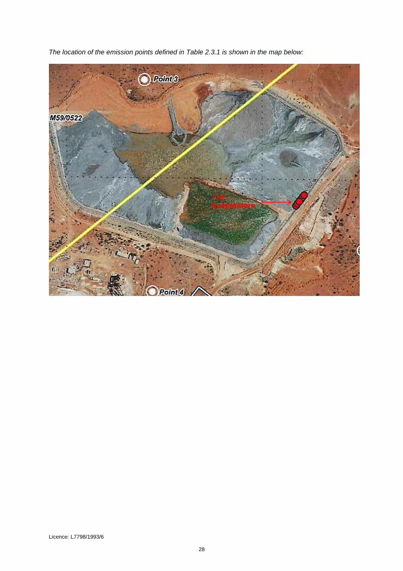
The location of the emission points defined in Table 2.3.1 is shown in the map below:
TSF Evaporators

Licence: L7798/1993/6 29
11. The Licence is amended by removing the map in Schedule 1 Map of emission and monitoring points defined in Table 3.4.1 and insertion of the map below:
The locations of the groundwater quality monitoring points defined in Table 3.4.1 are shown below.

Licence: L7798/1993/6 30
Appendix 1: Key documents
Document title In text ref Availability
1 Licence L7798/1993/6 – Gullewa
Gold/Copper Operations L7798/1993/6
accessed at www.dwer.wa.gov.au
2 Works Approval W5188/2012/1 W5188/2012/1
DWER records (A947191 and
A1537279)
3 GR Engineering Services, April 2017.
Doray Minerals Limited, Deflector
Gold Project, Process Plant
Throughput Design Review
GR
Engineering,
April 2017
A1504573
4 Stantec, June 2017. Deflector Mining
Limited. Gullewa Gold-Copper
Operations Licence Amendment
Stantec, 2017
A1504573
5 Deflector Mining Limited Annual Environmental Report 2016
AER, 2016 A1406065
6 Doray Minerals Limited, ‘Deflector Mining Limited Operations, Licence Amendment Application Supporting Document’, Gullewa TSF Embankment Lift to MRL 335.5 and Monarch In-Pit TSF, 20 March 2018
Doray Minerals Limited, March 2018
A1639723

Licence: L7798/1993/6 31
Appendix 2: Summary of Licence Holder comments
The Licensee was provided with the draft Amendment Notice on 23 May 2018 for review and comment. The Licensee responded on 28 May 2018.The following comments were received on the draft Amendment Notice.
Condition Summary of Licence Holder comment DWER response
Page 5, Table 3 GWL168757 (6) is in the process of being finalised and has an allocation of 4,700,000 kL. Mining Proposal MP06 pertains to LoM TSF lift and Monarch In-Pit Tailings.
This table refers to relevant approvals at the time of the assessment. GWL 168757(6) is under assessment by DWER and is yet to be approved. Reference to Mining Proposal MP06 has been removed.
Page 6, Table 4 Salt Lake should be Salt River. With reference to the evaporators, it is likely that we would make them a permanent installation. Can we include them on the licence without an end date?
All reference to ‘Salt Lake’ has been amended to ‘Salt River’. Note the document also refers to salt lakes which reference general salt lakes within that region. The evaporators at the TSF were considered a low risk to the environment and therefore have been included as permanent infrastructure at the Premises. The requirement for routine inspections and vegetation monitoring remains as a requirement of the Licence.
Page 6, Table 6 TDS in top line should be TSF. The 67,000 TDS value is considered an outlier. This reading was from a sample taken in 2015 prior to dewatering operations and not considered representative.
Amended to TSF. The concentrations shown for TDS in groundwater in this table are used to illustrate the large variation across the Premises only. The concentration of 67,000 mg/L from sampling taken in 2015 was the latest available information provided to DWER. DWER expects this to vary due to seasonal changes and influences from mining activities, however is likely to remain high

Licence: L7798/1993/6 32
Condition Summary of Licence Holder comment DWER response
due to the close proximity to the Salt River system.
Page 8, Table 7 There is currently no approval in place for the depositing of tailings into an In-Pit TSF. There has been a licence amendment application lodged for this purpose into Monarch Pit but this is still being assessed. Also, considering Salt River is 9km to the east, it is very unlikely that a spill from this TSF would ever make it to Salt River. I would suggest that risk level at "medium" could be reviewed to "low".
All potential receptors (for example groundwater, soils, and vegetation) are considered in determining the overall risks. The Salt River was considered as part of this overall risk assessment as a potential receptor, however due to distance the likelihood of impacts to the Salt River would be rare. DWER has reassessed the risks to the environment from the overtopping of the embankment at the TSF and now considers the consequences to be Minor due to the degraded surrounding vegetation, depth to groundwater and distance to surface water, and the likelihood to be Unlikely as a result of tailings management practices and routine inspections. The overall risk remains the same as Medium.
Page 8, Table 7 It is likely that this trial will be successful and that units will be purchased rather than hired as they currently are. If we include on the licence, can we take out the reference to trial such that we can proceed past 6 months if proven successful?
Updated to reflect the permanent use of the evaporators at the TSF.
Page 13 Reference to Salt Lake in Potential receptors column should be Salt River.
Amended to Salt River
Page 16 As is suggested on page 17, the area is disturbed and contains no groundwater dependent vegetation. Does this still constitute a potential impact?
Amended to remove the reference to groundwater depended vegetation as a potential impact.
Page 21 Table 2.3.1 As alluded to in earlier part of the document, It is likely that these could become permanent. Can we leave it open ended?
Reference to the operation of the evaporators at the TSF for a 6 month period only has been removed from this new condition.
Page 22 Table 3.2.2 Reference to monitoring associated with emissions to land only refers to the irrigation spray field and not to Salt River.
Monitoring of emissions to the Salt River remains a requirement of the Licence under Table 3.2.1 of

Licence: L7798/1993/6 33
Condition Summary of Licence Holder comment DWER response
Condition 3.2.1. Condition 3.2.2 and Table 3.2.2 of this condition was included as a new condition to the Licence for the monitoring of emissions to land from the waste water treatment plant.
Page 24 Table 4.2.1 Reference to Table 3.2.1 is confusing as there doesn’t seem to be one in the document.
Table 3.2.1 of Condition 3.2.1 remains as part of the Licence. No changes occurred to this condition therefore is not part of this Amendment Notice 1.

1 L7798/1993/6 IR-T06 Licence Template v2.0 (July 2017)
Licence Number L7798/1993/6
Licensee Deflector Mining Limited
ACN
101 224 999
File Number: 2010/003052
Premises Gullewa Gold-Copper Operations
Mining Tenements M59/49, L59/49, L59/64, M59/68, M59/356, M59/391, M59/392, M59/335, M59/442 L59/35, M59/507, M59/336, M59/522 and L59/71 Morawa - Yalgoo Road
Date of Amendment 20 July 2018
Amendment
The Chief Executive Officer (CEO) of the Department of Water and Environmental Regulation (DWER) has amended the above Licence in accordance with section 59 of the Environmental Protection Act 1986 (EP Act) as set out in this Amendment Notice. This Amendment Notice constitutes written notice of the amendment in accordance with section 59B(9) of the EP Act.
Alana Kidd
Manager, Resource Industries
Regulatory Services (Environment)
an officer delegated under section 20 of the Environmental Protection Act 1986 (WA)
Amendment Notice 2

2 L7798/1993/6 IR-T06 Licence Template v2.0 (July 2017)
Definitions and interpretation
Definitions
In this Amendment Notice, the terms in Table 1 have the meanings defined.
Table 1: Definitions
Term Definition
ACN Australian Company Number
AER Annual Environment Report
Amendment Notice refers to this document
Category/ Categories/ Cat.
categories of Prescribed Premises as set out in Schedule 1 of the EP Regulations
CEO means Chief Executive Officer.
CEO for the purposes of notification means:
Director General Department Administering the Environmental Protection Act 1986 Locked Bag 33 Cloisters Square PERTH WA 6850 [email protected]
Delegated Officer an officer under section 20 of the EP Act
Department means the department established under section 35 of the Public Sector Management Act 1994 and designated as responsible for the administration of Part V, Division 3 of the EP Act.
DWER Department of Water and Environmental Regulation
EPA Environmental Protection Authority
EP Act Environmental Protection Act 1986 (WA)
EP Regulations Environmental Protection Regulations 1987 (WA)
Existing Licence The Licence issued under Part V, Division 3 of the EP Act and in force prior to the commencement of and during this Review
Highly saline means water containing salts at levels above 10,000 mg per litre
Licensee Deflector Mining Limited
mᶟ cubic metres
mbgl Metres below ground level

3 L7798/1993/6 IR-T06 Licence Template v2.0 (July 2017)
Minister the Minister responsible for the EP Act and associated regulations
Occupier has the same meaning given to that term under the EP Act.
Prescribed Premises has the same meaning given to that term under the EP Act.
Premises refers to the premises to which this Decision Report applies, as specified at the front of this Decision Report.
Risk Event as described in Guidance Statement: Risk Assessment
Saline means water containing salts at levels above 2,000 but less than 10,000 mg per litre.
TDS Total Dissolved Solids
tpa tonnes per annum

4 L7798/1993/6 IR-T06 Licence Template v2.0 (July 2017)
Amendment Notice
This amendment is made pursuant to section 59 of the Environmental Protection Act 1986 (EP Act) to amend the Licence issued under the EP Act for a prescribed premises as set out below. This notice of amendment is given under section 59B(9) of the EP Act.
This notice is the result of a DWER initiated Licence amendment and is limited only to an amendment of Category 6 for mine dewatering.
The following guidance statements have informed the decisions made on this amendment:
• Guidance Statement: Decision Making (February 2017)
• Guidance Statement: Risk Assessment (February 2017)
• Guidance Statement: Environmental Siting (November 2016)
Amendment background
The Licensee operates the Gullewa Gold-Copper Operations (Premises) through Licence L7798/1993/6 (Licence). The prescribed activities authorised through the Licence are described below:
Table 2: Prescribed activities at the Premises
Category Number
Category description Category production or design capacity
Approved Premises production or design capacity
5 Processing or beneficiation of metallic or non-metallic ore
50,000 tonnes or more per year
700,000 tonnes per annual period
6
Mine dewatering: premises on which water is extracted and discharged into the environment to allow mining of ore
50,000 tonnes or more per year
300,000 tonnes per annual period
64 Class II landfill site 20 tonnes or more per year
4,000 tonnes per annual period
85 Sewage facility: premises- a) On which sewage is treated (excluding septic tanks); or
b) From which treated sewage is discharged onto land or into waters
More than 20 but less than 100 cubic metres per day
35 cubic metres per day
Open pit mining commenced at the Premises in 1994 however the Premises was placed into care and maintenance (C&M) in 1996. Mining operations recommenced in 2002 with the beginning of underground mining, however the Premises was again placed back into C&M in 2003.
Dewatering of the open pits commenced in late 2002 with the discharge to the Salt River system (described as ‘Salt River discharge location’ in the Licence). The discharge outlet is not within the Salt River proper, which is located approximately 1.5 km away, but is located within the flood plains of the Salt River.
Works Approval W5188/2012/1 (Works Approval) was issued in August 2012 for an increase in throughput at the processing plant to 480,000 tpa and an increase in the dewatering discharge rate to 600,000 tpa. These increases were to facilitate an expansion of mining operations at the Premises which included underground mining at the Deflector location. The

5 L7798/1993/6 IR-T06 Licence Template v2.0 (July 2017)
dewatering discharge point remained the same. The Works Approval was amended a number of times as a result of changes to the location of the new processing facility and the wastewater treatment plant, and to extend the expiry date due to delays in construction.
Mining operations recommenced in September 2015, with the dewatering of the Deflector pit lake in preparation for mining underground in early 2016. The dewatering water was discharged at a rate of approximately 15 to 28 litres per second (L/s); equating to 20,000 to 30,000 kL (tonnes) per month.
The Licence was amended in January 2016 to include the Golden Stream open pit as a dewatering discharge location prior to the final dewatering discharge to the Salt River discharge location. The Licence as amended in January 2016 limited dewatering discharge to the Golden Stream Pit and the rock-armoured gabions at the Salt River discharge location to a maximum of 300,000 tpa. The Licensee has since advised DWER that the Golden Stream pit is utilised as a storage node to receive water from the dewatering of the underground mine. Stored water is then used in the process plant, for dust suppression and the excess is sent to the Salt River discharge location to maintain a net zero discharge quantity (i.e. the volume received at the Golden Stream pit is consistent with volumes pumped out).
While the Works Approval authorised the construction of infrastructure at the Premises so the dewatering discharge rate could be increased to 600,000 tpa, a compliance document in accordance with condition 3.1.1 of the Works Approval was not submitted by the Licensee. An Amendment Notice to the Works Approval was issued on 30 June 2017 which extended the expiry date of the Works Approval and also authorised the construction of a lift to the TSF. Conditions authorising other construction at the Premises, which included increasing the throughput for category 6 to 600,000 tpa, and the requirement for submitting compliance documentation for those works, were deleted from the Works Approval.
Compliance
DWER was notified by the Licensee on 3 August 2016 that vegetation (monitoring required by the Licence) was showing a decline in health at the Salt River discharge location.
A further notification to DWER on 26 August 2016 advised that the Licensee had exceeded the dewatering discharge limit of 300,000 tonnes per annum specified in the Licence for the reporting period 1 January to 31 December 2016 with 314,000 kL having been discharged to the Salt River discharge location.
The Licensee notified DWER again on 27 March 2017 that they had exceeded the dewatering throughput for the reporting period with total discharge for the first quarter of 2017 at 314,680 kL, due to dewatering rates consistently exceeding estimates and inflow rates steadily rising as the depth of the Deflector Underground Mine increased.
The 2016 Annual Environmental Report (AER) shows that during the 2016 calendar year, 943,976 kL was discharged via the Salt River discharge location and information provided in the Deflector Dewatering Management Plan, August 2017 (DDMP) shows that for the period January – July 2017, a total of 825,156 kL of water was discharged to the Salt River discharge location.
DWER officers conducted an inspection of the Premises on 5 April 2017 and observed that the vegetation in the vicinity of the Salt River discharge location was stressed and dying. At the time of the inspection the officers alleged this was due to the constant inundation caused by the dewatering discharge exceedance, or the elevated TDS levels in the discharged water.
Licensee representatives advised that mining could not safely continue if the current dewatering rate was not maintained. As the depth of the underground mine has increased, the total volume of water required to be dewatered has also increased.
An Environmental Field Report was issued to the Registered Manager requiring the submission of a DDMP (mentioned above) which details the processes being undertaken to

6 L7798/1993/6 IR-T06 Licence Template v2.0 (July 2017)
address the non-compliance and a timeframe for when these corrective actions would be implemented.
The DDMP submitted to DWER on 18 May 2017 detailed the process being taken to address the excess dewatering discharges. Included in the DDMP was a third party report which suggested that some metals may be elevated in the discharge water.
A further site visit to assess the discharge area was conducted by DWER officers on 6 October 2017. Widespread death of vegetation and large areas of pooled water were observed at the dewatering discharge location (Figure 1).
Figure 1: Dewatering discharge area
Satellite imagery review undertaken by DWER identified that approximately 75 ha of vegetation has been affected downstream of the discharge point (Figure 2).
DWER has had several meetings with the Licensee (May, August, November 2017 and February 2018) to discuss the current situation of the dewatering discharge and alternative methods for disposal.
Amendment description
Dewatering of the groundwater at Deflector is required to maintain dry working conditions underground to facilitate mining. The collected groundwater is initially discharged to the Golden Stream Pit which is used as a storage node and facilitates settlement of suspended materials, before the water is reused in the processing plant and for dust suppression. In order to maintain a balanced discharge quantity to the Golden Stream pit, any excess water

7 L7798/1993/6 IR-T06 Licence Template v2.0 (July 2017)
not required in the processing plant or used for dust suppression is pumped to a series of clay lined settlement ponds located at the discharge point for further settlement of materials, with a final discharge to land at the Salt River discharge location. The discharge point is located in a low lying area with no defined drainage channels. The Salt River is located approximately 1.5 km away. The Licence currently authorises 300,000 tpa to be discharged to the Salt River discharge location.
The discharge of highly saline dewatering water to the Salt River discharge location, at levels above the Licence limit, has had an impact on vegetation. This impact includes the total death of most native vegetation species within the immediate discharge area with only salt tolerate species surviving, and death or high levels of stress on vegetation further down the discharge extent.
A desk top survey by DWER using satellite imagery (Figure 2) shows that since the recommencement of mining in September 2015, and the discharge of dewatering water to the Salt River discharge location, there has been a significant impact on vegetation with up to 75ha being affected.
Figure 2: Sentinel 2 satellite image - 24 October 2017
Approximately 75 hectares of change outlined in red. Northern portion appears to be inundated with change extending up to 5 kilometres south.

8 L7798/1993/6 IR-T06 Licence Template v2.0 (July 2017)
As a consequence, the Licensee through consultation with DWER, has had to implement short-term changes to their current dewatering discharge program to reduce any further impacts while new alternative methods for the disposal of dewatering water at the Premises are planned and implemented. These interim changes include maximizing water use at the Premises where possible through increased dust suppression, increased use in the processing plant and use of evaporators at the TSF. Prior to these changes, dewatering water was being discharged to the Salt River discharge location at rates of up to 66 L/s , however the current dewatering discharge rate now sits at around 13.5 L/s (6 March 2018) which is equivalent to approximately 425,000 tpa and is still above the amount of 300,000 tpa currently authorised in the Licence. During the winter months when less evaporation occurs, the Licensee expects the volumes of dewatering water discharged to Salt River to increase and therefore anticipates up to 750,000 tonnes total will need to be discharged per year.
Long term solutions include dewatering directly to either the Salt River proper or to Burra Lake, or to a purpose built evaporation pond. These long term solutions are currently in the planning and assessment process to determine the most suitable method for the disposal of dewatering water. The Licensee is also in process of seeking approval from the relevant government and non-government agencies. This process along with the relevant approvals and the construction of infrastructure is anticipated to take up to a further 18 months.
As a consequence, DWER has initiated a Licence amendment to update the risk assessment for the discharge of dewatering effluent to the Salt River discharge location via overland flow. DWER, through this risk assessment, will determine if the dewatering discharge of highly saline water for a further approximately 18 months (ending 31 December 2019) at levels above the Licence limit, to an area that is already highly degraded due to previous dewatering discharges, is acceptable.
Table 3 below outlines the proposed changes to the Licence to capture the current operations.
Table 3: Proposed design or throughput capacity changes
Category Current design throughput capacity
Proposed design throughput capacity
Description of proposed amendment
6 300,000 tonnes per annual period
750,000 tonnes per annual period (based on an average discharge volume of 23.8 litres per second).
Increase the throughput for dewatering discharge to land until the 31 December 2019.
Amendment history
Table 4 provides the amendment history for L7798/1993/6.
Table 4: Licence amendments
Instrument Issued Amendment
L7798/1993/6 25/07/2008 Licence amendment to transfer the Licence from ATW (Australia) Pty Ltd to Mutiny Gold Ltd
L7798/1993/6 21/01/2016 Licence amendment to change the occupier name to Deflector Mining Ltd, include dewatering to the Golden Stream Pit and Salt River, and convert the Licence to template version 2.9
L7798/1993/6 Amendment Notice 1
11/06/2018
Increase the production of category 5 from 300,000 tonnes to 700,000 tonnes per annual period, addition of category 64 class II putrescible landfill, addition of category 85 sewage facility and extension of the prescribed premises boundary.

9 L7798/1993/6 IR-T06 Licence Template v2.0 (July 2017)
L7798/1993/6 20 July2018 Increase dewatering discharge to current amount being discharged at the Salt River discharge location while alternative methods of disposal are planned and implemented.
Other Approvals
Department of Mines, Industry Regulation and Safety (DMIRS)
The Licensee has submitted to DMIRS a Notice of Intent (dated 22 February 2018) for the trial of a clarifier on Mining Tenements M59/442, M59/68 and L59/64. The purpose of the clarifier is to reduce the level of metals within the dewatering discharge waters. DWER has not considered the use of the clarifier in this assessment however it may be considered at a future date following successful trials and approvals.
Location and receptors
Table 5 below lists the relevant sensitive land uses in the vicinity of the Prescribed Premises which may be receptors relevant to the proposed amendment.
Table 5: Receptors and distance from activity boundary
Residential and sensitive premises Distance from Prescribed Premises
The Premises is isolated with the nearest town of Yalgoo located approximately 60 km away.
The Barnong Station homestead which is located 10 km away is managed by the Department of Biodiversity, Conservation and Attractions (DBCA). The homestead is unoccupied and is in a state of disrepair. DBCA has advised DWER there are no plans to repair the homestead for the purpose of occupation.
60 km from the Premises
Table 6 below lists the relevant environmental receptors in the vicinity of the Prescribed Premises which may be receptors relevant to the proposed amendment.
Table 6: Environmental receptors and distance from activity boundary
Environmental receptors Distance from Prescribed Premises and description
Salt River Located approximately 1.5 km east of the dewatering discharge point.
One of a number of ephemeral creeks in the area that discharge into salt lakes. Flows are generally during heavy rainfall events with remnant pools remaining for several weeks or months.
Water quality is highly saline (20,000 - 23,000 mg/L TDS) and alkaline (pH 8.3 - 8.4), with elevated concentrations of total nitrogen and some metals.
The local surface water drains from the northwest to the southeast across the Premises towards the Salt River system.
The area is typically associated with sheet flow that contributes to the nearby Salt River during periods of heavy rainfall. The river is the main drainage channel for the catchment. In the vicinity of the mine, the river flows in a southerly direction for approximately 15 km, before intercepting a chain of salt lakes including Burra Lake which is the local terminus. While the river is substantial in length, drainage along the channel and surrounding floodplain can be highly diffuse (Stantec, 2017).
Groundwater Groundwater flow is assumed to be in a southeasterly direction towards Salt River where static water levels are higher.
Groundwater at the premises is approximately 20 metres below ground level and contains salts of between 30-40,000 mg/L and is considered a highly saline environment.

10 L7798/1993/6 IR-T06 Licence Template v2.0 (July 2017)
Fauna The occurrence of potentially conservation significant fauna is considered highly unlikely in the area, due to the lack of suitable habitat, a long history of land disturbance from grazing, timber cutting and mining, and disturbance created by mining, including light exposure at night and the noise associated with operations and equipment (Ninox Wildlife Consulting 2011).
The surface drainages and salt lakes in the region are dry for much of the time however infrequent heavy rainfall events cause endemic brine shrimp to hatch in some of these lakes. Recent sampling conducted by the Licensee shows brine shrimp are absent from the Salt River, however are present in the Burra Lake.
Brine Shrimp are a known food source for migratory birds.
Flora No threatened or priority flora species have been identified from Department of Biodiversity, Conservation and Attractions (DBCA) database searches, or recorded during previous surveys of the area associated with the Deflector Mine.
The dominant vegetation formations in the area of the Gullewa project are mulga and low acacia shrublands with local eucalypts, chenopods and halophytic communities in the saline drainages.
Risk assessment
Table 7 describes the Risk Events associated with the amendment consistent with the Guidance Statement: Risk Assessments. The table identifies whether the emissions present a material risk to public health or the environment, requiring regulatory controls.

11 L7798/1993/6 IR-T06 Licence Template v2.0 (July 2017)
Table 7: Risk assessment for proposed amendments during operation
Risk Event
Consequence rating
Likelihood rating
Risk Reasoning Source/Activities
Potential emissions
Potential receptors
Potential pathway
Potential adverse impacts
Cat 6 Mine
dewatering
Discharge of mine dewatering water
Waste: An approximate 18 month increased dewatering discharge rate of 750,000 tonnes per annual period (based on an average discharge volume of 23.8 litres per second); high in TDS, with some elevated metals.
Surrounding soils and remnant stressed vegetation in the discharge zone
Direct discharge Sheet flow
Continued vegetation impacts or death from inundation of highly saline water Toxicity to microfauna in surface and subsurface soils and leaf litter Continued contamination of soils with high TDS and some metals
Moderate Likely High 1. Refer to detailed risk assessment (risk event 1) below.
Waste: An approximate 18 month increased dewatering discharge rate of 750,000 tonnes per annual period (based on an average discharge volume of 23.8 litres per second)); high in TDS, with
Salt River
Indirect discharge into surface water via sheet flow across land following significant rainfall event
Contamination of the Salt River with inflow containing high TDS and some metals following a flood event
Moderate Possible Medium 2. Refer to detailed risk assessment (risk event 2) below.

12 L7798/1993/6 IR-T06 Licence Template v2.0 (July 2017)
some elevated metals, flushed to the Salt River following a rainfall event.
Waste: An approximate 18 month increased dewatering discharge of 750,000 tonnes per annual period (based on an average discharge volume of 23.8 litres per second)); high in TDS, with some elevated metals.
Groundwater Infiltration through soil profile
Impacts on groundwater quality – contamination with elevated TDS and some elevated metals
Minor Possible Medium Groundwater is approximately 20 metres below ground level. Salinity ranges up to 67,000 mg/L TDS at the discharge location. The groundwater is not suitable for human, livestock or horticultural purposes due to the high salinity levels. The source of the dewatering discharge water is from the dewatering of the adjacent underground mine at Deflector and is therefore considered similar in quality to the groundwater at the discharge location. The impacts from dewatering water on groundwater will be minor due to the groundwater in this area being similar quality as the dewatering discharge water, and the groundwater has no beneficial use. The likelihood of an occurrence is possible. The risk rating for dewatering discharge to the groundwater is therefore medium.

13 L7798/1993/6 IR-T06 Licence Template v2.0 (July 2017)
Detailed Risk Assessment
1. Risk Event: Increased discharge of mine dewatering effluent to land
Description of Risk Event
An increased discharge throughput of approximately 750,000 tpa (average 23.8 L/s) of dewatering water containing high levels of salt into a highly degraded area, due to previous dewatering discharges, with the discharge impacting the remaining small amount of remnant vegetation. The dewatering discharge is only for a maximum period of up to approximately 18 months while alternative methods of dewatering discharge are implemented.
The dewatering discharge water also has elevated levels of some metals and has caused contamination of the soils in the immediate discharge area when compared with the control site (soil sampling results, 19 December 2017). An increase in the dewatering discharge volumes above the Licence limit may increase the size of the contaminated area and the concentration of the contaminants within the soil.
Identification and general characterisation of emission
The dewatering water quality has been monitored since September 2015 with the results shown in Table 8 below. The pH of the discharge water has remained consistent with a range of 7.5 to 8 (alkaline). The salinity measured as TDS has ranged from 31,000 mg/L to 48,000 mg/L (the initial high of 67,000 mg/L sampled in 8 September 2015 represented pit lake water quality) and has remained relatively steady. The total suspended solids have been low at 39 mg/L which is well below the Licence limit of 5,000 mg/L.
The dewatering discharge area is a vegetated low lying area with no defined drainage channels and is located within the flood plains of the Salt River. Dewatering discharge to this area for the past 2 years at a rate of up to 66 L/s has resulted in large scale death of vegetation that extends for approximately 5 km south of the discharge point and covers an area of approximately 75 hectares. The death of the vegetation has been attributed to inundation and the high salinity of the water. Recent improvements to the management of water at the Premises has now resulted in less water being discharged (less than 10 L/s) therefore reducing the area influenced by the dewatering discharge (see Figure 2).
The concentration of some metals within the discharge water were noted to have risen since dewatering recommenced in September 2015 however these levels are now trending down. Three metals of initial concern were cadmium, copper and nickel which are discussed below.
Cadmium concentrations within the discharge water were observed to be trending upwards for just over 12 months initially, with a high of 0.087 mg/L recorded on 25 January 2017. Since then the concentration of cadmium has trended down with levels now recorded at around 0.01 mg/L.
Initial copper concentration levels remained steady for the first 12 months and remained well below the previous Licence limit of 0.5 mg/L (limit removed through a Licence amendment in January 2016). Following the first 12 months the copper concentration within the dewatering discharge water increased to as high as 0.65mg/L as recorded on 30 November 2016, however since then have been steadily declining again to levels below 0.2 mg/L.
Nickel concentrations initial increased for the first 10 months with a high of 0.49 mg/L recorded on the 1 June 2016; however after then the concentrations have remained steady. As a comparison a limit of 1.0 mg/L had previously been applied to an earlier Licence version. Current concentrations are well below this previous Licence limit.

14 L7798/1993/6 IR-T06 Licence Template v2.0 (July 2017)
Description of impacts from the increased emission
The Licensee has conducted monthly field monitoring since June 2017 to determine the extent of the dewatering discharge. Figure 2 below indicates the extent when dewatering discharge rates were above 60 L/s in July 2017. Since then, this area has reduced in size as a result of reduced rates of discharge, which is now down to around 13.5 L/s (6 March 2018) due to an increased reuse of dewatering water within the processing plant, for dust suppression and the use of evaporators at the TSF. This is expected to rise during the winter months when evaporation rates are lower, however is not expected to return to the highs of July 2017 (around 60 L/s) due to improved water management measures at the Premises. As a result, the continued dewatering discharge at an increased rate above the Licence limit, however well below historical levels, is expected to remain within the already impacted area from previous dewatering discharges.
The Licensee has also undertaken soil sampling within the impacted area to determine the concentrations of particular metals. A control site upstream of the discharge area was also sampled for comparison. The results from the soil sampling are presented in Table 9 below. The sampling locations are presented within Figure 4.
Sampling results show that the concentration of metals within soils reduces with distance from
the Salt River discharge location. Sampling at the dewatering discharge terminus (DEFD01)
shows the concentrations of metals were above the control site sample with copper noted to
be six times and nickel over twelve times the levels sampled at the control site; these
concentrations are shown to reduce with distance to levels just over the control site.
Dewatering to the Salt River discharge location has been occurring for a number of years at
rates sometimes well above the Licence limit of 300,000 tpa (average 9.5 L/s). The past two
years has seen discharge rates at 3 to 4 times the Licence limit (up to an average of
approximately 40 L/s). Increasing the dewatering discharge Licence limit to 750,000 tpa
(based on an average discharge volume of 23.8 L/s) for another 18 months is expected to
increase the concentrations of metals in the immediate discharge area, however these
concentrations are expected to remain well within the already high degraded area as previous
discharge rates were far higher and therefore the discharge extent was larger.
Criteria for assessment
There are no guidelines specifically for the discharge of water to terrestrial environments.
Previous discharge of highly saline water at the Salt River discharge location has resulted in large scale vegetation death.
Salinity dramatically impedes plant growth as a result of osmotic stress and ion toxicity. Osmotic stress occurs because saline soils have high osmotic potential, so plants which grow in saline soils have difficulty taking up water. Ion toxicity occurs because saline water moves up the transpiration stream, causing sodium and chlorine ions to accumulate in leaf tissue. Leaves with high sodium and chlorine ion levels display premature senescence and death (Munns and Tester, 2008).
The Premises is characterised by low to open woodlands of Eucalyptus, Acacia and Callitris which have a low salinity tolerance (glycophytes). Tecticornia and Atriplex which have an exceptionally high salinity tolerance (halophytes) occur in the saline drainage areas at the Premises.
A soil sample was taken from a control site (background) to compare the result with soil samples taken from areas within the dewatering discharge extent.

15 L7798/1993/6 IR-T06 Licence Template v2.0 (July 2017)
Licensee controls
From mid-2017, the Licensee has reduced the volumes of dewatering water discharged to the Salt River discharge location through:
- increasing the water use in the processing plant during the summer months;
- discharging the water over the waste rock facility;
- trialing the use of 6 turbo mist evaporators at the TSF; and
- all water used underground is sourced from the Golden Stream storage pit (settlement pond prior to discharge to the Salt River) rather than other sources.
More recently the Licensee is trialing the use of a clarifier to reduce the concentration of metals in the dewatering discharge water.
The Licensee discharges dewatering water to the settlement ponds prior to discharge to land as required by Condition 1.3.3 of the Licence. All dewatering water is discharged to land through rock-armored gabions as required by Condition 2.2.2 of the Licence. The discharge to the Golden Stream Pit prior to the settlement ponds also acts to settle suspended materials in the dewatering water prior to discharge to land.
As required by Condition 3.2.1 of the Licence, the Licensee monitors the cumulative volumes of dewatering water discharged to land and takes quarterly water samples for analysis, and results of the sampling are provided in the AER as required by Condition 4.2.1 of the Licence.
The Licensee conducts monthly photo monitoring of the vegetation health at the dewatering discharge location as required by Table 3.4.2 of Condition 3.4.1 of the Licence.
The Licensee commenced monthly field surveys in June 2017 to determine the extent of the dewatering.
The Licensee has undertaken the sampling of soils at various locations within the dewatering discharge extent, including an upstream control site, to determine the concentration of metals.
Consequence
The impacts from an increased discharge to land for a period of approximately 18 months with mine dewatering water which is high in TDS and has some elevated metals will be moderate as the land is highly degraded from previous dewatering discharges with only small amounts of remnant stressed vegetation remaining, there are no threatened or priority flora species, the dewatering discharge extent is expected to be smaller than the historical dewatering discharge extent and the past two years of discharge hasn’t substantially increased the concentration of metals within the soils above background levels except at the immediate discharge point.
Likelihood of Risk Event
The likelihood of an occurrence is likely given the salinity of the dewatering discharge water remains high and inundation and pooling will continue to occur close to the discharge location causing metal concentrations to increase in the soils.
Overall rating of Risk Event
The risk rating for an increased dewatering discharge to land is therefore high but is deemed acceptable subject to the existing conditions imposed in the Licence and new conditions that limit the increased discharge to Salt River discharge location until the 31 December 2019, and quarterly soil sampling within the discharge area.

16 L7798/1993/6 IR-T06 Licence Template v2.0 (July 2017)
Table 8: Quarterly dewatering discharge monitoring results
Date pH TDS TSS Total
Chlorine Chloride Sodium
Magnesiu
m
Calcium Potassium
pH units (mg/L) mg/L mg/L (mg/L) (mg/L) (mg/L) (mg/L) (mg/L) (µg/L) (mg/L) (µg/L) (mg/L) (µg/L) (mg/L) (µg/L) (mg/L) (µg/L) (mg/L) (µg/L) (mg/L) (µg/L) (mg/L) (µg/L) (mg/L) (µg/L) (mg/L)
0.1 10 5 0.10 1 0.5 0.1 0.2 0.1 5 0.01 1 0.001 0.1 0.0001 1 0.001 5 0.05 1 0.02 1 0.001 1 0.001 1 0.01
3/15 8/09/2015 7.64 67,400 38 37,800 15,000 3,610 2,340 520 <0.10 <0.010 <0.0010 0.018 <0.50 <0.010 0.266 0.017 <0.10
4/15 15/12/2015 7.9 45,000 33 23,000 12,000 1,900 1,000 340 <0.1 <0.02 <0.002 0.044 <0.1 <0.02 0.055 <0.02
1/16 30/01/2016 7.7 43,000 39 24,000 11,000 1,900 1,200 310 <0.1 <0.02 0.011 0.062 <0.1 <0.02 0.26 <0.02
1/16 27/02/2016 7.7 36,000 23 <0.1 9,400 1,600 1,100 270 <0.1 <0.02 0.018 0.055 <0.1 <0.02 0.2 0.3 <0.02
1/16 13/03/2016 7.5 41,000 28 <0.1 9,400 1,700 1,100 270 <0.1 <0.02 0.023 0.034 <0.1 <0.02 0.15 0.320 <0.02
2/16
2/16 1/06/2016 7.6 31,000 9 <0.1 N.A. 11,000 1,600 960 140 <0.1 <0.02 0.022 0.16 <0.1 <0.02 1 0.49 <0.02
3/16 24/08/2016 7.9 41,000 35 <0.1 N.A. 11,000 1,400 1,000 180 <100 <20 44 86 <100 <20 1,100 230 <20
4/16 10/10/2016 7.9 35,000 12 0.20 N.A. 13,000 1,700 1,000 210 <100 <20 41 510 <100 <20 1,100 260 <20
4/16 30/11/2016 8 39,000 9 0.20 N.A. 13,000 1,700 1,000 220 <100 <20 64 650 <100 <20 980 330 <20
1/17 25/01/2017 7.6 46,000 N.A. 0.20 N.A. 13,000 1,900 1,000 250 <100 <20 87 440 <100 <20 930 360 <20
2/17 13/04/2017 7.9 48,000 54 0.50 N.A. 14,000 1,800 1,000 240 <250 <50 60 350 <250 <50 910 380 <50
2/17 29/05/2017 7.78 44,000 140 0.60 N.A. 16,000 1,700 1,100 270 <100 10 33 460 50 10 950 410 0.01
2/17 28/06/2017 7.9 44,000 22 0.40 N.A. 12,000 1,700 990 270 <100 <20 23 280 <100 <20 790 360 <20
3/17 9/08/2017 7.9 41,000 51 0.40 N.A. 12,000 1,800 1,100 250 <100 <20 21 160 <100 <20 840 420 <20
3/17 29/08/2017 7.9 43,000 120 0.30 N.A. 9,900 1,600 980 250 <100 <20 25 110 <100 <20 820 450 <20
3/17 20/09/2017 7.3 44,000 120 0.20 N.A. 11,000 1,700 1,000 250 <100 <20 19 140 <100 <20 840 470 <20
Soluble Arsenic
Qu
art
er
Soluble Aluminium Soluble SeleniumSoluble Cadmium Soluble Copper Soluble Iron Soluble Lead Soluble Manganese Soluble Nickel

17 L7798/1993/6 IR-T06 Licence Template v2.0 (July 2017)
Figure 3: Monthly extent of the dewatering discharge
Table 9: Soil sampling results
Trigger value ISQG-High Salt River Control Site (PSC-9) DEFD01 DEFD10 DEFD16 DEFD18 DEFD07 DEFD21 DEFD22
Antimony 2 25 *N.A. *N.A. *N.A. *N.A. *N.A. *N.A. *N.A. *N.A.
Arsenic 20 70 1 2 3 3 3 2 3 3
Cadmium 1.5 10 0.3 <0.3 0.5 1.1 0.7 <0.3 <0.3 <0.3
Chromium 80 370 *N.A. *N.A. *N.A. *N.A. *N.A. *N.A. *N.A. *N.A.
Copper 65 270 5.9 37 24 14 17 12 8.7 8.3
Lead 50 220 6 13 18 17 21 15 10 12
Mercury 0.15 1 *N.A. *N.A. *N.A. *N.A. *N.A. *N.A. *N.A. *N.A.
Nickel 21 52 4.4 12 34 19 23 16 10 9.3
Silver 1 3.7 *N.A. *N.A. *N.A. *N.A. *N.A. *N.A. *N.A. *N.A.
Zinc 200 410 *N.A. *N.A. *N.A. *N.A. *N.A. *N.A. *N.A. *N.A.
* Metals that were not analysed during the 19 December 2017 soil sampling.
ANZECC INTERIM SEDIMENT QUALITY GUIDELINES - METALS/METALLOIDS (mg/kg)
Trigger value: is a threshold concentration, below this concentration the frequency of adverse biological effects is expected to be very low
ISQG-High: represents a concentration above which adverse biological effects are expected to occur more frequently
NOTE: Exceeding trigger value concentrations does not necessarily mean that adverse biological effects will occur in sediments, but further investigations should be undertaken to confirm this.

18 L7798/1993/6 IR-T06 Licence Template v2.0 (July 2017)
Figure 4: Soil sampling locations
2. Risk Event: Increased discharge of mine dewatering effluent to Salt River
Description of Risk Event
The Premises is located in an area which is subject to infrequent heavy rainfall events due to tropical cyclones originating from the north of the State and larger cold fronts from the west of the State. These intermittent heavy rainfalls can cause widespread flooding which results in large movements of water and sediment across the land due to sheet flow. Any contaminated soils located at the discharged location could be transported in the sheet flow and discharged into the Salt River or downstream salt lakes; floodwaters may widely disperse contaminated soils or may concentrate soils within drainage lines depending on their magnitude and frequency.
Identification and general characterisation of emission
The concentration of some metals within the discharge water were noted to have risen since dewatering recommenced in September 2015, however these levels are now trending down. Three metals of initial concern were cadmium, copper and nickel which are discussed below.
Cadmium concentrations within the discharge water were observed to be trending upwards for just over 12 months initially, with a high of 0.087 mg/L recorded on the 25 January 2017.

19 L7798/1993/6 IR-T06 Licence Template v2.0 (July 2017)
Since then the concentration of cadmium has trended down with levels now recorded at around 0.01 mg/L.
Initial copper concentrations remained steady for the first 12 months and remained well below the previous Licence limit of 0.5 mg/L. This limit was removed through a Licence amendment in January 2016. Following the first 12 months the copper concentration within the dewatering discharge water increased as high as 0.65mg/L as recorded in 30 November 2016, however since then have been steadily declining again to levels below 0.2 mg/L.
Nickel concentrations initially increased for the first 10 months with a high of 0.49 mg/L recorded on the 1 June 2016; however after then the concentrations have remained steady. As a comparison a limit of 1.0 mg/L had previously been applied to an earlier Licence version. Current concentrations are well below this previous Licence limit.
Description of potential impacts from contaminated soils being flushed into the Salt River
The Salt River is the main drainage channel for the catchment in the vicinity of the Premises. The Salt River flows in a southerly direction for approximately 15 km, before intercepting a chain of salt lakes including Burra Lake which is the local terminus. While Salt River is substantial in length, drainage along the channel and surrounding floodplain can be highly diffuse (Stantec, 2017).
Although surface drainages and salt lakes in the region are dry for much of the time, infrequent heavy rainfall events cause endemic brine shrimp to hatch and form an important food source for migratory birds. The hatching success of brine shrimp is known to be greatly reduced when water contains elevated concentrations of metals, particularly elevated concentrations of copper (Brix et al., 2006).
Recent sampling for brine shrimp in both the Salt River and Burra Lake was undertaken by the Licensee. Results indicate the absence of brine shrimp in Salt River however were present in Burra Lake.
Recent soil sampling (19 December 2017) conducted within the impacted dewatering discharge area, indicates that the concentration of metals within soils reduces with distance from the Salt River discharge location (see Table 9 and Figure 4). Sampling at the dewatering discharge location (DEFD01) shows the concentrations of metals were above the control site sample with copper noted to be six times and nickel over twelve times the levels sampled at the control site; however these concentrations are shown to reduce with distance to levels just over the control site. With the Salt River located 1.5 km away from the dewatering discharge area, the concentrations of any metals that maybe flushed into the Salt River as a result of a heavy rainfall event are expected to reduce even further. Additionally, there are large volumes of water associated with heavy rainfall events which would dilute the concentration of metals even further.
Cadmium and copper are absorbed strongly by suspended material which would be high during these heavy rainfall events. Also cadmium complexes with chloride, resulting in reduced toxicity at higher salinity. Copper toxicity in algae, invertebrates and fish generally increases as salinity decreases.
The terminus of the Salt River is the Burra Lake. Any metals flushed into the Salt River from the dewatering discharge location are expected to be at or just above background levels and are therefore not expected to have any impacts on the Burra Lake due to the separation distance of 15 km and the large volumes of water associated with heavy rainfall events therefore diluting the metal concentrations even further.
Criteria for assessment
Australian and New Zealand Guidelines for Fresh and Marine Water Quality, Volume 2

20 L7798/1993/6 IR-T06 Licence Template v2.0 (July 2017)
Aquatic Ecosystems — Rationale and Background Information (Chapter 8) October 2000, Australian and New Zealand Environment and Conservation Council
The hatching success of brine shrimp is known to be greatly reduced when water contains elevated concentrations of metals, particularly elevated concentrations of copper (Brix et al., 2006).
Licensee controls
The Licensee discharges dewatering water to the settlement ponds prior to discharge to land as required by Condition 1.3.3 of the Licence. All dewatering water is discharged to land through rock-armoured gabions as required by Condition 2.2.2 of the Licence. The discharge to the Golden Stream Pit prior to the settlement ponds also acts to settle suspended materials in the dewatering water prior to discharge to land.
Recent soil sampling (19 December 2017) conducted within the impacted dewatering discharge area, indicates that the concentration of metals within soils reduces with distance from the Salt River discharge location (see Table 9 and Figure 4).
No Licensee controls are in place to prevent elevated levels of cadmium, copper and nickel in soils at the dewatering discharge location from being transported through sheet flow to the Salt River as a result of heavy rainfall events.
Consequence
The impacts from soils, which have elevated levels of cadmium, copper and nickel when compared with the control site, being flushed into the Salt River via overland flow is considered to be minor due to soil sampling results showing that the concentration of metals within the soils is reduced with distance, and that there will be absorption onto suspended solids such as sediment and organic material, and a high dilution factor during heavy rainfall.
Likelihood of Risk Event
The likelihood of an occurrence is possible given this area is part of the Salt River catchment, noting that the terminus of the Salt River is Burra Lake, approximately 15 km downstream.
Overall rating of Risk Event
The risk rating for dewatering discharge to the Salt River discharge location for a limited time is therefore moderate and is deemed acceptable subject to the existing conditions imposed in the Licence and new conditions that limit the increased discharge to Salt River discharge location until the 31 December 2019 and quarterly soil sampling within the discharge area.
Other amendments
The emission to Golden Stream Pit is considered an emission to groundwater; therefore condition 2.2.1, table 2.2.1, condition 3.2.1 and table 3.2.1 have been amended by removing all reference to Golden Stream Pit.
Condition 2.3.1 has been amended to authorise the discharge of dewatering water to the Golden Stream pit.
Condition 3.5.1 has been amended to include the monitoring of dewatering water discharged into the Golden Stream pit.
Table 1.3.2 has been amended to include the Golden Stream Pit as infrastructure for the containment of waste and minimum freeboard requirements for the Golden Stream Pit and the settlement ponds.

21 L7798/1993/6 IR-T06 Licence Template v2.0 (July 2017)
Amendment 1. The Licence is amended by the deletion of the text shown in strikethrough below and
the insertion of the bold text shown in underline below. 1.3.2 The Licensee shall carry out the Authorised Activities on the Premises in accordance with the
requirements set out in Table 1.3.1.
Table 1.3.1: Authorised Activities
Authorised activity
Process(es) Process limits
Category 5 Processing or beneficiation of metallic or non-metallic ore
Processing of material at the premises shall not exceed 700,000 tonnes of ore per annual period
Category 6 Mine dewatering Dewatering discharge at the premises shall not exceed 300,000 750,000 tonnes per annual period
Category 64 Class II putrescible landfill 4,000 tonnes per annual period
Category 85 Sewage facility: premises- a)on which sewage is treated (excluding septic tanks); or b) from which treated sewage is discharged onto land or into waters
35 cubic metres per day
2. The Licence is amended by the deletion of the text shown in strikethrough below and
the insertion of the bold text shown in underline below. 2.2 Emission to land 2.2.1 The Licensee shall ensure that where waste is emitted to land from the emission points in Table
2.2.1 and identified on the map of emission points in Schedule 1 it is done so in accordance with the conditions of this Licence.
Table 2.2.1: Emissions to land
Emission point reference on Map of emission points
Description Source including abatement
Golden Stream Pit End of pipe discharge Water from dewatering of mine.
Approved to discharge a maximum of 750,000 tonnes per annual period until the 31 December 2019
Salt River Rock-armoured gabion outlet/s
Irrigation spray field Discharge of treated wastewater by irrigation to land
Treated waste water from the waste water treatment facility.
3. The Licence is amended by the inclusion of the bold text shown in underline below. 2.3 Emission to groundwater 2.3.1 The Licensee shall ensure that where waste is emitted to groundwater from the emission point
in Table 2.3.1 and identified on the map of emission points in Schedule 1 it is done so in accordance with the conditions of this Licence.

22 L7798/1993/6 IR-T06 Licence Template v2.0 (July 2017)
Table 2.3.1: Emission to groundwater
Emission point reference on Map of emission points
Description Source including abatement
Golden Stream Pit End of pipe discharge Water from dewatering of mine.
4. The Licence is amended by the deletion of the text shown in strikethrough below: 3.2.1 The Licensee shall undertake the monitoring in Table 3.2.1 according to the specifications in
that table and present this information in the Annual Environmental Report, including a comparison against the appropriate ANZECC 2000 water quality trigger values and previous years’ monitoring data.
Table 3.2.1: Monitoring of emissions to land
Emission point reference
Parameter Units Frequency
Salt River; and Golden Stream Pit As shown in Map of emission points in Schedule 1.
Cumulative volume kL Continuous
pH1 pH units
Quarterly
Total Dissolved Solids
mg/L
Total Suspended Solids
Major ions and metals - copper, sodium, chloride, aluminium, cadmium, iron, magnesium, calcium, potassium, manganese, nickel, selenium, arsenic and lead.
Note 1: In-field non-NATA accredited analysis permitted.
5. The Licence is amended by the inclusion of the bold text shown in underline below. 3.5 Monitoring of emissions to groundwater 3.5.1 The Licensee shall undertake the monitoring in Table 3.5.1 according to the specifications in
that table.
Table 3.5.1: Monitoring of point source emissions to groundwater
Emission point reference
Parameter Units Averaging Period
Frequency
Golden Stream Pit
Volumetric flow rate m3/day Monthly Continuous
Aluminium, arsenic, cadmium, chloride, copper, iron, lead, magnesium, manganese, mercury, molybdenum, nickel, potassium, selenium, sodium, zinc
mg/L
Spot sample Quarterly
Standing water level in pits mbgl
Total dissolved solids mg/L
Total recoverable hydrocarbons mg/L
pH1 -
Note 1: In-field non-NATA accredited analysis permitted.

23 L7798/1993/6 IR-T06 Licence Template v2.0 (July 2017)
6. The Licence is amended by the deletion of the text shown in strikethrough below and the insertion of the bold text shown in underline below.
Table 1.3.2: Containment infrastructure for management of waste
Storage vessel or compound as shown on the Premises map in Schedule 1
Material Management Strategy
Requirements
TSF Tailings and slurry
Containment in the TSF
The Licensee must:
(i) maintain all installed toe drains and associated cut offs along the external toe of the TSF perimeter embankments, so that any liquid matter resulting from seepage or breach of the TSF embankments is contained and recovered;
(ii) maintain a minimum top of embankment freeboard of 300 mm; and
(iii) divert stormwater away from the TSF to minimise threat of accidental loss of stored matter due to flooding or erosion.
Golden Stream Pit and Settlement pond/s
Dewater Containment in the Golden Stream Pit and settlement pond/s prior to discharge to Salt River
Prior to discharge to Salt River, the Licensee must:
(i) direct dewater to the Golden Stream Pit and Settlement Pond/s; and
(ii) retain dewater in the Golden Stream Pit and Settlement Pond/s for a sufficient time to reduce Total Suspended Solids to less than 5,000 mg/L.
The Licensee must maintain a minimum top of embankment freeboard of 300mm.
7. The Licence is amended by the inclusion of the conditions shown in bold and underline
below. 3.4.2 The Licensee shall undertake the monitoring in Table 3.4.3 according to the
specifications in that table.
Table 3.4.3: Monitoring of ambient soil quality
Monitoring point reference and location as depicted in Schedule 1
Parameter Units Averaging period
Frequency
Soil monitoring sites: PSC-9, DEFD01, DEFD10, DEFD16, DEFD18, DEFD07, DEFD21 and DEFD22
Cadmium Copper Nickel
mg/kg Spot sample
Quarterly
8. The Licence is amended by the insertion of the bold text shown in underline below. 4.2.3 The Licensee shall submit the information in Table 4.2.2 to the CEO according to the
specifications in that table.
Table 4.2.2: Non-annual reporting requirements
Condition or table (if relevant)
Parameter Reporting period
Reporting date (after end of the reporting period)
Format or form
- Copies of original Not Within 14 days of As received by the

24 L7798/1993/6 IR-T06 Licence Template v2.0 (July 2017)
monitoring reports submitted to the Licensee by third parties
Applicable the CEOs request Licensee from third parties
Condition 3.4.2, Table 3.4.3
Copies of monitoring results from monitoring undertaken by the Licensee; or Copies of originals submitted to the Licensee by third parties
Quarterly Within 30 days As received by the Licensee if compiled by third parties
9. The Licence is amended by the deletion of the text shown in strikethrough below and the insertion of the bold text shown in underline below.
4.1.1 The Licensee shall submit to the CEO an Annual Environmental Report by 31 March each year.
The report shall contain the information listed in Table 4.2.1 in the format or form specified in that table.
Table 4.2.1: Annual Environmental Report
Condition or table
Parameter Format or form1
- Summary of any failure or malfunction of any pollution control equipment and any environmental incidents that have occurred during the annual period and any action taken
None specified
Table 1.3.1 Actual throughput for the annual period for Categories 5, 6, and 85
Table 3.2.1 All dewatering water monitoring parameters specified in Table 3.2.1
Table 3.2.2 All discharge to irrigation area monitoring parameters specified in Table 3.2.2
Table 3.3.1 Summary of the TSF inspections including details on any seepage, spills or leaks and corrective measures undertaken to rectify any issues identified.
Table 3.3.1 Summary of the dewatering pipeline and discharge point inspections including details on any identified pipeline failures, seepage, spills or leaks and corrective measures undertaken to rectify any issues identified.
Table 3.4.1 All ambient groundwater quality monitoring parameters specified in Table 3.4.1
Table 3.4.2 All ambient vegetation quality monitoring parameters specified in Table 3.4.2
Table 3.4.3 All ambient soil quality monitoring parameters specified in Table 3.4.3
Table 3.5.1 All emission to groundwater monitoring parameters specified in Table 3.5.1
4.1.3 Compliance Annual Audit Compliance Report (AACR)
4.1.4 Complaints summary None specified

25 L7798/1993/6 IR-T06 Licence Template v2.0 (July 2017)
10. The Licence is amended by insertion of the map below into Schedule 1 Map of emission and monitoring points:
The locations of the soil sampling points defined in Table 3.4.3 are shown below:

26 L7798/1993/6 IR-T06 Licence Template v2.0 (July 2017)
Licensee comments The Licensee was provided with the draft Amendment Notice on 15 December 2017. A second draft of the Amendment Notice was provided to the Licensee on 27 June 2018. Comments received from the Licensee have been considered as shown in Appendix 2.

27 L7798/1993/6 IR-T06 Licence Template v2.0 (July 2017)
Appendix 1: Key documents
Document title In text ref Availability
1 Licence L7798/1993/6 – Gullewa
Gold/Copper Operations
L7798/1993/6 accessed at www.dwer.wa.gov.au
2 Works Approval W5188/2012/1 W5188/2012/1 DWER records (A947191 and
A1537279)
3 Deflector Gold Mine, Dewatering
Discharge Management Plan, 31
August 2017
DDMP DWER record A1434352
4 Steve Appleyard, DWER Principal
Hydrogeologist, Contaminated Sites ,
memorandum, 1 November 2017
Appleyard, 2017
DWER record A1565716
5 Deflector Mining Limited Annual Environmental Report 2016
AER, 2016 DWER record A1406065
6 Ninox Wildlife Consulting. (2011). A level 1 vertebrate fauna assessment of the Gullewa Gold Copper Project – north of Morowa, Western Australia. Prepared for Mutiny Gold.
Ninox Wildlife Consulting (2011)
DWER record A1514911
7 Stantec Australia Pty Ltd, Deflector Gold and Copper Operations: Desktop Review and Discharge Options Study, prepared for Doray Minerals limited, 31 August 2017
Stantec, 2017 DWER record
8 Munns, R. & Tester, M. (2008) Mechanisms of salinity tolerance. Annual Review of Plant Biology, 59, 651-681.
(Munns and Tester, 2008)
http://research-repository.uwa.edu.au/en/publications
9 Archives of Environmental Contamination and Toxicology, 51, 580 – 583, Brix et al., 2006
Brix et al 2006 researchgate.net/publication
28 L7798/1993/6 IR-T06 Licence Template v2.0 (July 2017)
Appendix 2: Summary of Licensee comments
The Licensee was provided with the draft Amendment Notice on 15 December 2017 for review and comment. The Licensee responded on 18 January 2018. The following comments were received on the draft Amendment Notice.
Reference DWER Licence — Points for clarification/discussion
Summary of Licensee comment
DWER response
Page 4, Amendment background.
• paragraph 3
Any dewatering that was in excess of onsite use was discharged to the Salt River system located about 1.5km away from the discharge location
The mining history narrative mixes the historic Gullewa workings (pits, underground and plant located West of the Morawa-Yalgoo Rd) with the current Deflector workings (current licenced pits, underground and new plant located East of the Morawa-Yalgoo Rd). Only dewatering from the Deflector Central and Deflector West starter pits (mined in late 2002-early 2003 and treated at Gullewa) would have had dewatering discharged at the current licenced point i.e. the Salt River flood plain area.
Agree. Report has been updated.
Page 5 • paragraph 1
Reference to discharge of water into
Salt River System
The current licenced discharge point could be better described as flood plain adjacent to Salt River; water is not discharged into the Salt River system proper.
Agree. Update description of discharge point.
Page 5 • paragraph 1
Gabion "Gabion" should be plural as there are three distinct cells in the discharge arrangement.
Agree. Report updated.
Page 5 • paragraph 10
Reference to submission version of DDMP
Mentions the Dewatering Discharge Management Plan (DDMP) was submitted on 31 August 2017, however the initial Version 1.0 was actually submitted on 18 May 2017. The date of 31 August 2017 was when Version 1.1 was submitted.
Agree. Update report to reference submission dates for both versions of the DDMP.
Page 5 • last paragraph
Compliance Infers that the DWER (Compliance) team met with DML on these dates, whereas it was the DWER Licensing team. Compliance only met with DML in
Paragraph 8 of page 5 updated to remove ‘Environmental Compliance officers’.

29 L7798/1993/6 IR-T06 Licence Template v2.0 (July 2017)
November 2017 in conjunction with a scheduled DML-Licencing meeting.
The department is made up of many sections and divisions however are referred to collectively in correspondence as DWER.
Reference to a proposal DWER refer to a proposal to be completed and submitted (by DML?). Please clarify what proposal the DWER are referring to.
DWER issued an Environmental Field Report requiring DML to submit a DDMP to DWER. Report has been updated.
Page 6 Other Approvals (DMIRS)
Refers to "the most appropriate option for tenure" regarding the Salt River dewatering discharge point.
Environmental discharge does not require tenure; tenure is only required for infrastructure and discharge outfall infrastructure which was confirmed when DML met with DMIRS (15/11/2017). The tenure option over the dewatering discharge impact area was removed as a consideration by DMIRS. DMIRS has since advised that the tenure option was referring to the gabions on L59/64 and that on review, DMIRS had failed to list the correct tenure activity on L59/64 when the Mining Proposal was approved for the discharge point. This discussion point could be removed from the amendment text as doesn't seem to add anything factual.
DWER is aware that tenure is only required for infrastructure and discharge outfall infrastructure. This is identified in DML’s licence as occurring on mining tenement L59/64. However both onsite and offsite impacts from prescribed activities occurring on that tenement are taken into consideration as part of DWER’s decision making process. Note DMIRS’s comments to DWER have been removed from the document.
"DMIRS have not, and would not approve this style of discharge (i.e. a large volume of saline water dispersing into vegetated, non-saline land), even if metals were not a concern. The release of water would need to be better controlled for DMIRS to find it acceptable."
Bullet point #2 seems to be opinion from DMIRS, whereas DWER are the lead agency on licencing environmental discharge. Again, it may improve clarity if removed.
Refer to above comment.
Page 7 • Location and receptors table 5
Reference to Barnong Station Homestead as a residential and sensitive premises.
The Barnong homestead is an unoccupied, derelict building. The managing agency (DBCA) have indicated there are no plans of refurbishment. It would seem a strange inclusion as either residential or sensitive receptor. Note the managing agency is listed as the Department of Biodiversity, Parks and Attractions - "Parks" should be Conservation”.
Supporting documentation for the Licence amendment application submitted to DWER on 12/08/2017 referred to the Barnong Station Homestead as the nearest public residential area. The documentation referred to the homestead as being unoccupied and owned by the Western Australian Government with management through DBCA.

30 L7798/1993/6 IR-T06 Licence Template v2.0 (July 2017)
What distance do DWER consider qualifies a receptor as sensitive? Table 6 describes receptors close to the mine, within the broader region and further afield again.
DWER has now confirmed with DBCA that the homestead is in a state of disrepair and will not be restored for occupational purposes. The report and risk assessment has been updated to reflect this new information. DWER’s Guidance Statement “Risk Assessments”, February 2017 provides guidance on how risk is assessed to determine regulatory controls.
Page 7 • Table 6 Salt River
Permanent groundwater fed pools in some places
This may be the case but DML is unaware of studies or surveys that have evidence of this conclusion. Does DWER have a reference for this comment?
This section has been updated to remove the reference to surface water discharges as it was not considered in the risk assessment.
The surface drainages and salt lakes in the region are dry for much of the time however infrequent heavy rainfall events cause endemic brine shrimp to hatch and form an important food source for migratory birds (Appleyard, 2017)
Fuller reference requested. Many invertebrates and fish (which are present in Salt River) provide a food source for migratory birds. All available data and recent (September 2017) sampling undertaken by Stantec (on behalf of DML) indicates that there are no brine shrimp within Salt River. There would seem to be material doubt regarding using brine shrimp as a relevant receptor in Salt River. There does not seem to be evidence that Deflector discharge has had any impact on Burra Lake brine shrimp, or that any likelihood of that risk exists. Brine shrimp are characteristic of lakes, and usually salt lakes, and recent sampling has confirmed their existence in Burra Lake.
Advice by Steve Appleyard, DWER Principal Hydrogeologist, Contaminated Sites (memorandum, dated 1/11/2017) advised salt lakes in the region contain endemic brine shrimp to hatch. Results from sampling undertaken by Stantec in September 2017 to determine the presence of brine Shrimp in the Salt River was not available at the time of this assessment. DWER assessed the potential for the presence of brine shrimp in the Salt River based on the latest available information at the time with reference to: Timms, B.V., Pinder, A.M. and Campagna, V.S., 2009, ‘The biogeography and conservation status of the Australian endemic brine shrimp Parartemia’, Conservation Science Western Australia. The report has been updated to reflect the latest sampling data.
Page 7 Reference to groundwater ranging up to up to 67,000mg/L TDS at the
DWER to clarify if they mean discharge water or groundwater
DWER is referring to the groundwater quality in the area of the discharge

31 L7798/1993/6 IR-T06 Licence Template v2.0 (July 2017)
• Table 6 Groundwater discharge location by reference to the 67,000mg/L reading (which is a discharge value).
Average readings of Salt River discharge are 42,000mg/L and as such is classified as mesosaline. The 67,000mg/L discharge value is an outlier in the data set and not representative.
location. 67,000mg/L was incorrectly reported. The report has been updated to identify that groundwater at the Premises contains salts of between 30-40,000 mg/L which is classified as a saline environment.
Page 7 • Table 6 Fauna
"There are a large number of brine shrimp species in the region, including a number that should be considered to be threatened species (Timms et al., 2009)"
All available data and recent (September 2017) sampling undertaken by Stantec on behalf of DML, indicates that there are no brine shrimp within Salt River.
There would seem to be material doubt regarding using brine shrimp as a relevant receptor in Salt River.
Brine shrimp are characteristic of lakes, and usually salt lakes, and recent sampling has confirmed their existence in Burra Lake. Typically only one brine shrimp species may occur in a lake, and several species may be present in a region such as this, however usually not a large number of species. In addition, most brine shrimp species are not threatened (or further work is required to confirm distribution).
See above comment regarding DWER’s decision criteria for determining whether brine shrimp are present in the Salt River in the absence of sampling. The Salt River is one of a number of ephemeral creeks in the area that discharge into a chain of salt lakes including the Burra Lake which is the local terminus. As stated by DML ‘recent sampling has confirmed their existence in Burra Lake’. Therefore any discharge of dewatering water, containing some elevated heavy metals, into the Salt River may end up in the Burra Lake which may have an impact on brine shrimp and is therefore considered in the risk assessment.
Brine shrimp form a large food source for migratory birds
This comment may well be generally true, but if brine shrimp aren't a relevant receptor for Salt River then the extension as a risk to migratory birds is not valid. The brine shrimp information is somewhat confusing without defining if it is referencing fauna receptors in Salt River (actual) or
Recent sampling has shown brine shrimp are not present within the Salt River, however the Salt River discharges into the Burra Lake during heavy rainfall events where recent sampling has shown that brine shrimp are present. DWER considers any impacts to brine shrimp present in the Burra Lakes may have an impact on migratory birds

32 L7798/1993/6 IR-T06 Licence Template v2.0 (July 2017)
the current discharge point (terrestrial floodplain area).
The report has been updated.
Page 8
• Table 7 Potential Receptors
Environmental receptors including
Salt River, Groundwater, Flora and
Fauna.
Clarification from DWER to confirm if they are defining the area currently affected by discharge as a significant environment in the risk assessment, as there has been no reference to a conservation significant vegetation within the risk assessment.
DML has reviewed surveys undertaken within the area and the vegetation within the discharge area aligns with the vegetation codes 364 and 683 (Pre — European extent) and according to data presented by the WA Government (managed by DBCA), the current extent of both vegetation units is 99% of the pre-European extent (i.e. less than 1% of the mapped extent has been cleared at the State, Bioregion, Subregion and Local Government extents). As the actual impacted area is orders of magnitude lower than 1%, DML consider the risk rating of EXTREME, as inconsistent with the supporting evidence.
Risk assessment has been updated. The area receiving the dewatering discharge waters has now been assessed as highly degraded as a result of historical dewatering discharges.
Page 8
• Table 7
Reference to microfauna Can DWER confirm the intended meaning of microfauna in this context? Please clarify if this relates to terrestrial invertebrates?
Microfauna are the smallest of the terrestrial invertebrates. DWER has amended this section to refer only to potential impacts on terrestrial invertebrates.
Page 9 • Table 7
Bioaccumulation of metals through food chain in Potential Pathway column.
Please be more specific with regards the metal of interest, as different metals have different bio-accumulation potential e.g. copper is known to bio-accumulate in aquatic invertebrates but does not biomagnify up the chain to waterbirds, and nickel is not known to bio accumulate or bio magnify up the food chain.
Noted. Report has been updated.

33 L7798/1993/6 IR-T06 Licence Template v2.0 (July 2017)
Contamination of the Salt River with inflow containing high TDS and heavy metals following a flood event in potential adverse impacts column.
The volume of water associated with a flood event crossing the discharge area and reaching Salt River would be orders of magnitude greater than the discharge rate and there would affect corresponding dilution and dispersal of any metals to levels inconsistent with the consequence rating of Severe.
DWER has reassessed the risks following the submission of results from soil sampling conducted in December 2017 which shows metal concentrations in soils reduce with distance, and the discharge to Salt River discharge location will be limited until 31 December 2019.
Impacts to brine shrimp hatching reproduction as a result of elevated metals in water in potential adverse impacts column.
All available data and recent (September 2017) sampling undertaken by Stantec on behalf of DML, indicates that there are no brine shrimp within Salt River. There would seem to be material doubt regarding using brine shrimp as a relevant receptor in Salt River.
The Salt River discharges into the Burra Lakes where brine shrimp are confirmed to exist. Risk assessment table in report has been amended to reflect this change.
Impacts to migratory birds Ingestion of invertebrates by waterbirds is assumed however the uptake of metals to the birds is unlikely to bio-accumulate as the invertebrates have a short life expectancy and it highly unlikely that the metals will have time to bio-accumulate.
Noted. Risk assessment updated to remove ‘bioaccumulation of metals through food chain’ as a result of the short life span of invertebrates.
Page 11
• Paragraph 1 & Paragraph 3
reference to the "Salt River
discharge point"
Terminology could be read as that the discharge is in the Salt River 'proper' i.e. river bed. Distinction should be made that the current discharge point, 'Salt River' is within the floodplain area west of Salt River proper.
‘Salt River’ discharge point is the emission point reference described in Licence condition 2.2.1 and identified on the map of emission points in Schedule 1 of the Licence. The following sentences in paragraph 1 describe the emission area (discharge point). ‘…at the Salt River discharge point. The discharge point is located in a low lying area with no defined drainage channels. The Salt River is located approximately 1.5 km away.’
Page 11 "Initial dewatering discharge rates were around 15-18L/s in the last quarter of 2015, however that rate
The last quarter of 2015 was pre-mining and discharge was to dewater shallow, pre-existing pits. Little
Report updated to remove pre-mining underground figures, anomaly and current dewatering figures of

34 L7798/1993/6 IR-T06 Licence Template v2.0 (July 2017)
• Paragraph 2 has risen to as high as 88L/sec in December 2016."
"the current discharge rate now sits at around 38L/s"
variation has occurred over long range data abstraction rates discharged to the Golden Stream pit since the commencement of mining. The quoted high figure of 88L/s is an anomaly across the wider dewatering discharge rates.
From July 2017, discharge rates have steadily decreased at the Salt River discharge point, as Dewatering Discharge Management Plan (DDMP) management actions have taken effect.
The current discharge rate (with re-use measures in place as part of the DDMP) during summer seasons and higher evaporation rates is between 20-25L/s: - November 2017 approximately
19L/s - December 2017 nil L/s (directive
from DWER Licencing and not sustainable), and;
- January 2018 less than 20L/s
approximately 20 L/s. DWER notes DML has reduced dewatering discharge volumes due to implementation of the DDMP and an increase of evaporation during the summer months, however DWER also notes at a rate of 23.8 L/s or 750,000 kL per year this is well above the Licence limit of 300,000 kL per year (equivalent tonnes per year as described in the Licence).
Page 11
• Paragraph 4
"The dewatering discharge water is
high in salinity and elevated levels of
cadmium, copper and nickel..."
There has been little change to discharge water quality since 2015.
Metal concentrations within the Deflector results are reflective of groundwater in highly mineralised region.
Results for copper and cadmium in the discharged water have declined over time, reflecting the change in the mineralogy from oxide / transitional ore to primary ore. DWER's assessment has not acknowledged this trend, the assessment is highlighting maximums which are outliers among the dataset.
Water sampling results presented to DWER show the levels of Cadmium, Copper and Nickel increased significantly in the initial 3 months of dewatering discharge. DWER acknowledges these results reflect the quality of the water contained within the pit. Sampling results for cadmium show an increasing trend in concentration from the beginning of January 2016 with a peak seen in January 2017 (8 times the January 2016 result). There has been a steady decline since that time. Copper was steady for the first 4-5 months of dewatering discharge (<0.062 mg/L) then increased over the

35 L7798/1993/6 IR-T06 Licence Template v2.0 (July 2017)
following 10-11 months with a high of 0.65 mg/L observed (10 fold increase). DWER notes the level of copper has been trending down since that time (0.140 mg/L September 2017). Nickel has remained relatively steady however the last few months an increasing trend has been observed.
Page 13 Paragraph 8 "The low flow rates and long discharge
period would mean that the adsorption
of minerals in the overland flow area
would rapidly become saturated"
The area is also characterised by clay material, so there is likely to be capacity for metals to bind to the clay particles and no longer be bio-available. DML acknowledges that further testing over the discharge area is required to confirm the extent of any metals accumulation above background levels.
The risk assessment has been updated. Recent soil sampling conducted by DML in December 2017 showed the metal concentrations in soils in the discharge area decreased with distance from the discharge point.
Page 14
• Criteria for assessment
"There are no guidelines specifically for the discharge of water to terrestrial environments. Relevant land and freshwater quality criteria for comparison include ANZECC 2000 for fresh and marine water quality."
DML agrees with this the first sentence of this statement, but disagree that it follows that ANZECC 2000 land and fresh water guidelines are appropriate for regulation of the site.
Risk assessment updated to recognise that dewatering discharge water is not directly discharged into an aquatic environment.
Page 15
• Consequence
"The impacts from the increasing rate
of dewatering water discharged to land
high in TDS, and elevated cadmium,
copper and nickel will be severe due to
both the onsite and offsite impacts
already observed"
Current discharge rates are declining rather than increasing. DML do not dispute the impact that has already occurred, however, given that the impact has already occurred, any further impact from discharge that is lower volume (contained within the current impact footprint), better quality (with metals reduction treatment as currently being implemented), and for short duration, must result in lesser impact. The assigned consequence rating of Severe seems overly harsh in this instance.
Risk has been updated to take into consideration the latest available information.

36 L7798/1993/6 IR-T06 Licence Template v2.0 (July 2017)
Page 16
• 1st paragraph
"The discharged water is hypersaline..." According to the salinity classification system of Hammer (1986) the average salinity level of the discharge is mesosaline (42,000 mg/L). The reference made to hypersaline is based on one result (September 2015), which is an outlier within the dataset. Sampling since September 2015 have not exceeded 48,000 mg/L (April 2017) at the Salt River discharge point.
Amended so saline described as water containing salts at levels above 2,000 but less than 10,000 mg per litre. Highly saline described as water containing salts at levels above 10,000 mg per litre.
Page 17
• Description of potential
impacts from the emission
"the dewatering discharge is also
shown to have elevated metals,
arsenic, cadmium and copper."
This is the sole reference to
arsenic in the risk assessment.
The arsenic levels from
discharge monitoring results
show that apart from one outlier,
the levels are low.
Administrative error noted. Cadmium, Copper and Nickel are the metals of concern.
Page 18
• 1st paragraph
"There is the likelihood that metals
will concentrate causing wide
spread contamination and impacts
to vegetation."
The level and extent of metal concentration is assumed. Preliminary soil testing has been carried out by DML (December 2017) to begin to inform the development of a remediation strategy, and DML are happy to share the results with DWER as soon as they are interpreted. There is limited definitive information available on metal toxicity of native plants. The available science is ambiguous, far from settled, and unsuitable to use as a basis of supporting a Severe consequence rating in the risk assessment. Tecticornia and Atriplex are surviving (the former is colonising).
The risk assessment has been updated. Recent soil sampling conducted by DML in December 2017 showed the metal concentrations in soils in the discharge area decreased with distance from the discharge point. DWER also acknowledges that vegetation death in the discharge area is attributed to inundation and/or high saline water.
Page 19
• Description of potential
impacts from contaminated
soils being flushed into the
"The impacts from discharging
dewatering water with elevated
cadmium, copper and nickel into the
Salt River via overland flow will be
severe due to the impact on endemic
All available data and recent (September 2017) sampling undertaken by Stantec (on behalf of DML) indicates that there are no brine shrimp within Salt River therefore it is not a valid receptor
Noted. Risk assessment has been updated to recognise the most recent results from sampling for Brine shrimp in the Salt River and Burra Lakes.

37 L7798/1993/6 IR-T06 Licence Template v2.0 (July 2017)
Salt River brine shrimp and other species which
form an important food source for
migratory birds, and the contamination
of downstream salt lakes"
for this risk. It is very unlikely that the discharge water would reach Salt River (proper) at current rates or flow path, however if as a result of a large flood event it was to reach the Salt River (proper), there would be very significant dispersal and dilution of metals and TDS due to the very large influx of freshwater and it is unlikely it would pose a risk to biota.
Page 19:
• Reference to Brix
et al., 2006
Reference to brine shrimp of Great
Salt Lake in Utah, USA
All available data and recent surveys indicate that there are no brine shrimp present in Salt River. Testing of a different genus in North America may not necessarily be comparable to Australian taxa that have evolved in naturally mineralised zones. DWER has acknowledged there is no experimental data available for Australian brine shrimp species to verify this reference.
DWER acknowledges the recent sampling results show the absence of Brine shrimp in the Salt River system. The reference to brine shrimp of Great Salt Lake in Utah has been removed. DWER accepts that the tolerance to metals by brine shrimp in Great Salt Lake in Utah may differ than brine shrimp in Australia, however, concentrations of metals above background levels as a result of dewatering discharge may have an effect on invertebrates in that area. Therefore they have been considered as a sensitive receptor in the risk assessment.
Page 19
• Description of potential
impacts from contaminated
soils being flushed into the
Salt River
"...it would generally be assumed
that overland flow of the effluent
would remove some of the metals
prior to discharging into Salt River"
If the discharge were to reach the Salt River it would be in a very large rainfall event. In this case, metals will be diluted and dispersed, and it is highly unlikely it would pose a risk to biota under such conditions. Current data from the recent baseline aquatic study (September 2017) indicates this has not occurred previously, when comparing water/sediment data upstream and downstream in the vicinity of the current discharge point.
Noted. DWER has updated the risk assessment following the submission of results from recent soil sampling conducted in the dewatering discharge area.

38 L7798/1993/6 IR-T06 Licence Template v2.0 (July 2017)
Page 20:
• Consequence
The impacts from discharging water
with elevated cadmium, copper and
nickel into the Salt River via overland
flow will be severe due to the impact
on endemic brines shrimp and other
species which form an important food
source for migratory birds, and the
contamination of downstream lakes
All available data and recent (September 2017) sampling undertaken by Stantec on behalf of DML, indicates that there are no brine shrimp within Salt River.
There would seem to be material doubt regarding using brine shrimp as a relevant receptor in Salt River.
In addition, many invertebrates and fish (which are present in the river) provide a food source for migratory birds. The baseline study that DML have commissioned will define these relationships in detail.
As discussed above, any metals potentially delivered to Salt River by overland flood flow would be highly diluted and dispersed and unlikely to represent a risk to existing biota. The assignment of a Severe consequence to this risk seems overly harsh.
Noted. As discussed above, DWER has updated the risk assessment following the submission of results from recent sampling.
Page 20
• Decision
"the increased discharge of
dewatering to the Salt River
Discharge location specified in the
licence must cease immediately,
unless effective controls are put in
place, or an alternate suitable method
of disposal is implemented."
The removal of the Salt River discharge point within the licence amendment will result in the cessation of the Deflector operations as discussed in the above body letter. The draft licence amendment only provides for one method of disposal (Golden Stream), which is limited at 300,000kL per annum, and of very finite capacity.
DML have been implementing solutions to address DWERs concerns regarding discharge as previously described, addressing water volume, water quality (metals) and water quality (salinity) via increased evaporation and recycling, active
DWER notes the progress made in implementing alternative strategies for the disposal of dewatering waters and the interim measures taken to reduce the impacts from current operations. As a result DWER has reassessed the risk and has determined the risk of continuing to discharge dewatering waters to the Salt River discharge location identified within the Licence is acceptable subject to existing and new conditions within the Licence, including limiting the discharge until the 31 December 2019.

39 L7798/1993/6 IR-T06 Licence Template v2.0 (July 2017)
water treatment, and a more suitable aquatic environment discharge location.
DML believe with the above measures assessed in the risk assessment, a satisfactory outcome will be obtained that temporarily retains the current discharge point and allows the longer term actions above to be properly implemented. DML seek the opportunity to work with DWER to achieve this sustainable result.
Page 21 It has been determined that the
elevated levels of salt, cadmium,
copper and nickel in the dewatering
discharge waters present an
unacceptable extreme risk to the
environment
Salinity levels of the discharge water are within the upper limit of the Yalgoo region and are for example, less than that of Burra Lake. TDS levels for Deflector dewatering discharge were presented in supporting documentation for the initial Works Approval W5188/2012/1, and the more recent 2015 Licence Amendment.
As mentioned above, implementation of several mitigating actions have commenced addressing the DWER concerns of volume, water quality (metal levels and salinity) within the discharge water.
As discussed above, DWER has updated the risk assessment following the submission of results from recent sampling and has determined that the receiving environment is considered highly degraded (as opposed to pristine) as a result of previous dewatering discharges.
References to other technical
reports within the amendment
Stantec, 2017—
no reference provided
Reference to Steve Appleyard, 2017
Request that a reference list of technical documentation is included within the licence amendment
Reference list updated.
Terminology Reference Terminology confirmation for a
saline, meso and hypersaline
A list of terminology for reference within the document to ensure consistency
Included in definitions

40 L7798/1993/6 IR-T06 Licence Template v2.0 (July 2017)
environment or water quality throughout this process
Terminology confirmation and
reference for Salt River (discharge
point/location or Salt River actual)
and Salt Lake.
There is reference to Salt Lake throughout the licence amendment document e.g. Page 18 Overall rating of risk event refers to Salt Lake?
Within documentation presented to DWER, there is no mention of a name Salt Lake, there is reference to Salt River (discharge location) and Salt River (proper).
Noted. Updated
Tenure All tenure to be included Reference to the TSF is included within the licence amendment (Table 1.3.2 Containment Infrastructure) but is not shown on the premises boundary map. Tenements to be included on licence amendment are: M59/49, L59/49, L59/64, M59/68, M59/356, M59/391, M59/392, M59/335, M59/442, L59/35, M59/507, M59/336, M59/522 and L59/71.
The TSF is identified in the Premises map within Schedule 1of the Licence. All tenure is included within this Amendment Notice.
Page 23 Premise map Premise map needs to be updated to include the TSF
Premises map has been updated in Amendment Notice 1 which is under assessment.
Risk Criteria Table
• Consequence: Environment -
Severe
Ranking determines the
consequence of the risk event
occurring:
"mid to long term or permanent impact
to an area of high conservation value
Assumption this reference of an Extreme rating under the guidance statement refers to the land that the Project is located on, being ex-Barnong pastoral lease. While the land has been identified as a general Conservation Area under the Gascoyne/Murchison Strategy, during recent meetings between DML and DBCA (1/11/2017), DBCA indicated that some areas (such as active or historic mining areas) may be
DWER has reassessed the risk. Refer to above comments.
41 L7798/1993/6 IR-T06 Licence Template v2.0 (July 2017)
or special significance" excluded from any future conservation tenure. Therefore there may be provision for the discharge area to not be included within the area for tourism or conservation. DBCA could not confirm if and when this may occur.
Vegetation surveys of the area both along the impact area and within the DML tenements have determined that there is no conservation significant species within the impact area or within the tenements. Therefore the use of "high conservation value or special significance" description does not seem to be valid.
The Licensee was provided with an updated draft Amendment Notice on 27 June 2018 for review and comment. The Licensee responded on 9 July 2018. The following comments were received on the draft Amendment Notice.
Reference DWER Licence — Points for clarification/discussion
Summary of Licensee comment
DWER response
Page 4, Paragraph 1, Amendment Notice
Prescribed premise
Naming of Prescribed Premises throughout the document, to be consistent with Table 1, Definitions.
Not applicable. This Amendment Notice 2 only refers to Prescribed Premises as shown in Table 1: Definitions
Page 4, Amendment Background
Table 2
Table 2 does not have recently approved Category Number 64 and 85 included despite Category 5 having the updated approved 700,000 tonnes per annum processing limit.
Updated.
Page 4, Amendment Background Paragraph 3
The flood plans of Salt River Please update to flood plains of Salt River
Updated.
Page 6, Amendment description
This impact includes the total death of most vegetation species within the immediate discharge area with only salt tolerate species surviving
The Salt Tolerant Species have only established since the discharge point became active. In a survey undertaken by Stantec in 2017, it was identified that Tecticornia were becoming more
Not supported. Stantec identified that Tecticornia were becoming more prevalent, not newly established. The increase in population would be attributed to the altered environment

42 L7798/1993/6 IR-T06 Licence Template v2.0 (July 2017)
prevalent, especially in the Acacia eremaea community, due to their ability to cope with higher salt and inundation regimes. DML are requested this wording is updated to ‘with only newly established salt tolerant species surviving’ or similar.
from the discharge of saline dewatering water.
Page 8, Table 4 Amendment Notice not yet issued –
Increase the production of category 5 from 300,000 to 600,000 tonnes per annual period to include dewatering discharge to the Monarch Pit
Correspondence sent from David Niven to Louise Lavery (14 May 2018) in response to queries associated with the dewatering of Monarch Pit confirmed that no other pits are intended to receive mine dewatering other than Golden Stream.
Supported. Updated.
Page 10 Recent sampling conducted by the Licensee showns brine shrimp
Please update to Recent sampling conducted by the Licensee shows brine shrimp
Updated.
Page 21 Table 1.3.1 Table 1.3.1 Authorised activity
Landfill (Category 64) has not been included within this table, please update.
Updated.
Page 22 Table 2.2.1
Table 2.2.1 Emissions to land Irrigation spay field requires correcting to spray.
Updated.
Page 22 Table 2.3.1
Monarch Pit
Dewatering of Monarch Pit has been removed from licence as per correspondence to Louise Lavery (14 May 2018)
Updated.
Page 22 Table 3.2.1 Table 3.5.1
Parameter of chlorine Chlorine reference should be replaced with chloride.
Supported. Updated.
Page 22 Table 3.2.1 Table 3.5.1
Emission Point reference column – Dewatering discharge outlet/s into the Monarch Pit
Monarch Pit and associated parameters should be removed as the domain is not being used for receipt of dewatering discharge.
Supported. Updated.
Page 23 Table 3.4.3
Parameter – copies of original monitoring reports submitted to the Licensee by third parties Format or form – As received by the Licensee from third parties
Please confirm what is meant by third parties sampling and reporting. Is DWER requiring that this work can only be undertaken by a third party?
Supported. Updated to include monitoring undertaken by either the Licensee or third parties.
Table 4.2.1 This table will require updating as per comments within this response.
Updated.

1 L7798/1993/6 IR-T06 Licence Template v2.0 (July 2017)
Licence Number L7798/1993/6
Licensee Deflector Mining Limited
ACN
101 224 999
File Number: 2010/003052
Premises Gullewa Gold-Copper Operations
Mining Tenements M59/49, L59/49, L59/64, M59/68, M59/356, M59/391, M59/392, M59/335, M59/442 L59/35, M59/507, M59/336, M59/522 and L59/71 Morawa - Yalgoo Road
Date of Amendment 16 October 2018
Amendment
The Chief Executive Officer (CEO) of the Department of Water and Environmental Regulation (DWER) has amended the above Licence in accordance with section 59 of the Environmental Protection Act 1986 (EP Act) as set out in this Amendment Notice. This Amendment Notice constitutes written notice of the amendment in accordance with section 59B(9) of the EP Act.
Alana Kidd
Manager, Resource Industries
Regulatory Services (Environment)
an officer delegated under section 20 of the Environmental Protection Act 1986 (WA)
Amendment Notice 3
Alana Kidd
Digitally signed by Alana Kidd Date: 2018.10.15 15:05:08 +08'00'

2 L7798/1993/6 IR-T06 Licence Template v2.0 (July 2017)
Definitions and interpretation
Definitions
In this Amendment Notice, the terms in Table 1 have the meanings defined.
Table 1: Definitions
Term Definition
ACN Australian Company Number
AER Annual Environment Report
Amendment Notice refers to this document
ANZECC means the most recent version and relevant parts of the Australian and New Zealand Environment guidelines for fresh and marine water quality Volume 1 – 3 (Australian and New Zealand Environment and Conservation Council, Agriculture and Resource Management Council of Australia and New Zealand);
Category/ Categories/ Cat.
categories of Prescribed Premises as set out in Schedule 1 of the EP Regulations
CEO means Chief Executive Officer.
CEO for the purposes of notification means:
Director General Department Administering the Environmental Protection Act 1986 Locked Bag 33 Cloisters Square PERTH WA 6850 [email protected]
Delegated Officer an officer under section 20 of the EP Act
Department means the department established under section 35 of the Public Sector Management Act 1994 and designated as responsible for the administration of Part V, Division 3 of the EP Act.
DWER Department of Water and Environmental Regulation
EPA Environmental Protection Authority
EP Act Environmental Protection Act 1986 (WA)
EP Regulations Environmental Protection Regulations 1987 (WA)
Existing Licence The Licence issued under Part V, Division 3 of the EP Act and in force prior to the commencement of and during this Review
Licensee Deflector Mining Limited

3 L7798/1993/6 IR-T06 Licence Template v2.0 (July 2017)
mᶟ cubic metres
mbgl Metres below ground level
Minister the Minister responsible for the EP Act and associated regulations
mRL Metres Reduced Level
Occupier has the same meaning given to that term under the EP Act.
Operational Freeboard is defined as the vertical height between the lowest elevation of the perimeter embankment and the tailings beach immediately inside the embankment.
Prescribed Premises has the same meaning given to that term under the EP Act.
Premises refers to the premises to which this Decision Report applies, as specified at the front of this Decision Report.
Risk Event as described in Guidance Statement: Risk Assessment
SWL Standing Water Level
TDS Total Dissolved Solids
tpa tonnes per annum

4 L7798/1993/6 IR-T06 Licence Template v2.0 (July 2017)
Amendment Notice
This amendment is made pursuant to section 59 of the Environmental Protection Act 1986 (EP Act) to amend the Licence issued under the EP Act for a prescribed premises as set out below. This notice of amendment is given under section 59B(9) of the EP Act.
This notice is limited only to an amendment to allow an embankment lift at the Gullewa Tailings Storage Facility (TSF) and the use of the Monarch pit as an in-pit TSF.
The following guidance statements have informed the decisions made on this amendment:
Guidance Statement: Decision Making (February 2017)
Guidance Statement: Risk Assessment (February 2017)
Guidance Statement: Environmental Siting (November 2016)
Amendment description
Deflector Mining Limited (Deflector) operates the Gullewa Gold-Copper Operations (Premises) through Licence L7798/1993/6 (Licence). The prescribed activities authorised through the Licence are described below:
Table 2: Prescribed activities at the Premises
Category Number
Category description Category production or design capacity
Approved Premises production or design capacity
5 Processing or beneficiation of metallic or non-metallic ore
50,000 tonnes or more per year
700,000 tonnes per annual period
6
Mine dewatering: premises on which water is extracted and discharged into the environment to allow mining of ore
50,000 tonnes or more per year
750,000 tonnes per annual period
64 Class II landfill site 20 tonnes or more per year
4,000 tonnes per annual period
85 Sewage facility: premises- a) On which sewage is treated (excluding septic tanks); or
b) From which treated sewage is discharged onto land or into waters
More than 20 but less than 100 cubic metres per day
35 cubic metres per day
Deflector submitted an application to DWER on 20 March 2018 for an amendment to their Licence to allow an increase in the embankment height at the TSF and to use the Monarch Pit as an in-pit tailings storage facility. Further detail is provided in the sections below.
Monarch in-pit tailings storage facility
The Monarch open pit will be used as an in-pit TSF for the deposition of tailings material to provide additional tailings storage capacity at Deflector.
The Monarch open pit is an open pit that was historically mined from 1994 and completed during 1995. The pit is located approximately 150 m south of the TSF (see Figure 2 below) with a majority of the pit located on mining tenement M59/507 with a small portion on mining tenement M59/49.

5 L7798/1993/6 IR-T06 Licence Template v2.0 (July 2017)
The Monarch pit is circular (165 m x 180 m) and is 54 m deep measured from the top of ramp to the base of the pit. The pit consists of a pit lake which is approximately 30 m deep.
Construction of the in-pit TSF is limited to the installation of slurry and return water lines from the existing lines between the processing plant and existing TSF as part of the slurry and return water systems.
The newly installed pipelines will be bunded with any spilled tailings reporting to either catchment sumps or into the in-pit TSF. The existing safety bund around the in-pit TSF will be retained to divert stormwater.
The tailings at the Premises have been assessed as potentially acid forming (PAF) and therefore Deflector has determined that the subaqueous deposition of tailings into the in-pit TSF is the most suitable method. Subaqueous deposition isolates the tailings mass from oxidation caused by atmospheric oxygen interaction which can result in Acid Mine Drainage.
Additionally, retaining a pit lake within the in-pit TSF through the subaqueous deposition of tailings continues to facilitate the functioning of the pit as a seepage interceptor for the adjacent TSF.
Tailings will be deposited through a single discharge point. The tailings will be deposited into the southern end of the pit and moved to ensure the even build-up of a consolidated tailings profile below the water. The pit lake will not be dewatered prior to tailings discharge and instead water will be removed from the pit during operations by the use of a floating pontoon and pump with return lines to the ramp. Collected water is pumped back to the process plant for reuse.
Tailings will be deposited into the in-pit TSF to ensure the final consolidated tailings bed will not exceed a maximum height of 287 mRL which is 5 m below the post mining groundwater level of 292 mRL (see Figure1 below).
Figure 1: Monarch in-pit TSF
Deposition of tailings will occur on an intermittent basis to ensure that no impacts to groundwater or vegetation occur and the supernatant pond does not rise above 297 mRL. An underdrainage system has not been included in the in-pit TSF design.
TSF Embankment lift
The TSF is currently an above ground, side-hill type facility comprising southern, eastern and western perimeter embankments and a decant system (see Figure 2).
The most recently completed embankment raise at the TSF which was approved under Works Approval W5188/2012/1 was completed in 2017. The finished height of the embankment was 327.5 mRL. Downstream toe drains and sumps were installed on the southern embankment

6 L7798/1993/6 IR-T06 Licence Template v2.0 (July 2017)
and north-eastern embankment toes as part of the 2017 TSF embankment raise.
Deflector will now undertake an additional eight metre lift of the embankment at the TSF through four 2.0 metre raises with a final crest height of 335.5 mRL (Table 3).
Table 3: Estimated storage capacity
Deflector will utilise an upstream construction method for raising the existing embankments which will also be extended to form a hillside storage. An additional saddle embankment will be constructed on the north-western corner of the facility. The final increased height of the embankment at the TSF will provide an additional storage capacity of approximately 7 years.
The embankments will be constructed using an upstream method utilising tailings from within the TSF. The downstream slope will be rock armored for protection against erosion from rainfall runoff. The crest of the embankment will have a minimum of two percent cross fall towards the TSF beach.
Existing spigots, which are located at 25 metre intervals along the perimeter embankment and are used for the deposition of tailings into the TSF, will be lifted at each embankment raise. Slurry will be discharged into the TSF sub-aerially and cyclically from the spigots such that the supernatant pond is located within and around the decant facility. The sub-aerial deposition allows for maximum removal of water from the facility by forming a large beach for draining and drying. It also enables the supernatant pond to be managed to a small size and increase tailings settled density, thereby improving the storage potential of the facility (CMW Geosciences, 2018a).
The TSF has been designed to safely and temporarily store a 1 in 100 year rainfall event for a duration of 72 hours by maintaining a minimum operational freeboard of 0.3 m at all times during operation.
A pump is installed in a decant rock ring which is installed centrally in the TSF. Water collected is either pumped to evaporators located on the TSF embankment and/or to the process plant for re-use. An access track to the decant rock ring extends southeast from the northern ridge. The access causeway will be raised with each perimeter embankment lift.
A stormwater diversion drain will be constructed initially along the northern ridge (328 mRL) to intercept and divert rainfall runoff away from the TSF. As the embankment is raised with each lift, additional diversion drains will be constructed.
A total of 10 groundwater monitoring bores are installed around the TSF which are routinely sampled and analysed in accordance with the requirements of the Licence and Deflector’s TSF

7 L7798/1993/6 IR-T06 Licence Template v2.0 (July 2017)
Management Plan. No additional groundwater monitoring bores are being established as part of the embankment raise program. A number of the groundwater monitoring bores have been designed to be used as recovery bores if required.
Figure 2: Gullewa Tailings Storage Facility
Amendment history
Table 4 provides the amendment history for L7798/1993/6.
Table 4: Licence amendments
Instrument Issued Amendment
L7798/1993/6 25/07/2008 Licence amendment to transfer the Licence from ATW (Australia) Pty Ltd to Mutiny Gold Ltd
L7798/1993/6 21/01/2016 Licence amendment to change the occupier name to Deflector Mining Ltd, include dewatering to the Golden Stream Pit and Salt River, and convert the Licence to template version 2.9
L7798/1993/6 Amendment Increase the production of category 5 from 300,000 tonnes to 700,000 tonnes per annual period, addition of category 64 class II putrescible landfill,

8 L7798/1993/6 IR-T06 Licence Template v2.0 (July 2017)
Notice 1
11/06/2018
addition of category 85 sewage facility and extension of the prescribed premises boundary.
L7798/1993/6 Amendment Notice 2
20/07/2018
Increase dewatering discharge to current amount being discharged at the Salt River discharge location while alternative methods of disposal are planned and implemented.
L7798/1993/6 Amendment Notice 3
16/10/2018
Amendment to allow an embankment lift at the Gullewa Tailings Storage Facility and the installation of an in-pit TSF at the Monarch Pit.
Other Approvals
Department of Mines, Industry Regulation and Safety (DMIRS)
Deflector has submitted to DMIRS a Mining Proposal (Reg ID73017) for an increase in the embankment height at the Gullewa TSF and use of the Monarch Pit as an in-pit TSF.
DMIRS has advised DWER on 2 October 2018 that conditional approval is likely to be granted for the TSF embankment lift and use of the Monarch pit as an in-pit TSF.
Location and receptors
Table 5 below lists the relevant sensitive land uses in the vicinity of the Prescribed Premises which may be receptors relevant to this amendment.
Table 5: Receptors and distance from activity boundary
Residential and sensitive premises Distance from Prescribed Premises
The Premises is isolated with the nearest town of Yalgoo located approximately 60 km away.
The Barnong Station homestead which is located 10 km away is managed by the Department of Biodiversity, Conservation and Attractions (DBCA). The homestead is unoccupied and is in a state of disrepair. DBCA has advised DWER there are no plans to repair the homestead for the purpose of occupation.
60 km from the Premises
Table 6 below lists the relevant environmental receptors in the vicinity of the Prescribed Premises which may be receptors relevant to the proposed amendment.
Table 6: Environmental receptors and distance from activity boundary
Environmental receptors Distance from Prescribed Premises and description
Salt River Located approximately 10 km away in an east to south easterly direction from the TSF and monarch pit.
One of a number of ephemeral creeks in the area that discharge into salt lakes. Flows are generally during heavy rainfall events with remnant pools remaining for several weeks or months.
Water quality is highly saline (20,000 - 23,000 mg/L TDS) and alkaline (pH 8.3 - 8.4), with elevated concentrations of total nitrogen and some metals.
The local surface water drains from the northwest to the southeast across the Premises towards the Salt River system.
The area is typically associated with sheet flow that contributes to the nearby Salt River during periods of heavy rainfall. The river is the main drainage channel for the catchment. In the vicinity of the mine, the river flows in a southerly direction for approximately 15 km, before intercepting a chain of salt lakes including Burra Lake which is the local terminus. While the river is substantial in length, drainage

9 L7798/1993/6 IR-T06 Licence Template v2.0 (July 2017)
along the channel and surrounding floodplain can be highly diffuse (Stantec, 2017).
Groundwater Pre-mining groundwater depths at the Premises were between 10 to 25 metres below ground level (mbgl).
Groundwater quality measured at the nearby Gullewa production borefield shows TDS concentrations of between 600 to 1,200 mg/L, pH ranging between 7.1 and 8.1, nitrate levels are naturally high (50 to 130 mg/L) which is common in semi-arid regions of Western Australia, and WAD CN concentrations are below detection limits.
Groundwater flow is assumed to be in a southeasterly direction towards Salt River where static water levels are higher.
Recent groundwater sampling of the monitoring bores at the TSF shows TDS levels of between 3,500 to 6,000 mg/L.
WAD CN has been recorded in six groundwater monitoring bores at the TSF before tailings deposition commenced which indicates impacts from historical tailings deposition associated mining activities at the Premises.
The nearby Monarch pit acts as a local evaporation sink and captures seepage emanating from the TSF.
Fauna The occurrence of potentially conservation significant fauna is considered highly unlikely in the area, due to the lack of suitable habitat, a long history of land disturbance from grazing, timber cutting and mining, and disturbance created by mining, including light exposure at night and the noise associated with operations and equipment (Ninox Wildlife Consulting 2011).
The surface drainages and salt lakes in the region are dry for much of the time however infrequent heavy rainfall events cause endemic brine shrimp to hatch in some of these lakes. Recent sampling conducted by the Licensee shows brine shrimp are absent from the Salt River, however are present in the Burra Lake.
Brine Shrimp are a known food source for migratory birds.
Flora No threatened or priority flora species have been identified from Department of Biodiversity, Conservation and Attractions (DBCA) database searches, or recorded during previous surveys of the area associated with the Deflector Mine.
The dominant vegetation formations in the area of the Gullewa project are mulga and low acacia shrublands with local eucalypts, chenopods and halophytic communities in the saline drainages.
Risk assessment
Tables 7 and 8 describe the Risk Events associated with the amendment consistent with the Guidance Statement: Risk Assessments. The table identifies whether the emissions present a material risk to public health or the environment, requiring regulatory controls.

10 L7798/1993/6 IR-T06 Licence Template v2.0 (July 2017)
Table 7: Risk assessment for proposed amendments during construction
Risk Event
Consequence rating
Likelihood rating
Risk Reasoning Source/Activities
Potential emissions
Potential receptors
Potential pathway
Potential adverse impacts
Cat 5 TSF
embankment lifts and
Monarch In-pit tailings
storage facility
Earthworks and construction of infrastructure
Dust Sensitive premises (Town of Yalgoo)
Air/wind dispersion
Amenity Slight Rare Low
Nearest sensitive premises is the town of Yalgoo which is 60 km away. Dust will be controlled by the use of water carts. No additional regulatory controls are required to mitigate this risk. The distance is considered too great to impact offsite receptors.
Noise Nearest sensitive premises is the town of Yalgoo which is 60 km away. No additional regulatory controls are required to mitigate this risk. The distance is considered too great to impact offsite receptors.

11 L7798/1993/6 IR-T06 Licence Template v2.0 (July 2017)
Table 8: Risk assessment for proposed amendments during operation
Risk Event
Consequence rating
Likelihood rating
Risk Reasoning Source/Activities
Potential emissions
Potential receptors
Potential pathway
Potential adverse impacts
Cat 5 In-pit tailings
storage facility
Discharge of tailings into a disused mine pit (Monarch)
Waste:
Seepage from tailings material
Groundwater Surrounding soils and vegetation
Direct interaction with groundwater and mounding Migration through soils
Contamination of groundwater potentially used for stock watering purposes. Impacts to vegetation
Moderate Possible Moderate 1. Refer to detailed risk assessment (risk event 1) below.
Waste:
Tailings and return water from rupture or leaks of pipelines.
Surrounding soils and vegetation Groundwater
Direct discharge to land and infiltration to groundwater
Impacts on vegetation Contamination of surrounding soils with metals and metalloids, dissolved solids and cyanide affecting soil and groundwater quality
Minor Possible Moderate The newly installed pipelines will be located within earthen containment corridors. Any spilled tailings or return water reports to either catchment sumps or back into the in-pit TSF. The vegetation in this area is highly disturbed due to historical mining activities and pastoral use. Depth to groundwater is between 10 to 25 mbgl. There are no groundwater dependent vegetation located in this area. Existing Licence condition 1.3.4 requires the Licensee to ensure all pipelines containing tailings materials are equipped with automatic cut-outs, provided with secondary containment, or provided with telemetry systems and pressure sensors. Existing Licence condition 3.3.1 requires the Licensee conducts daily inspections

12 L7798/1993/6 IR-T06 Licence Template v2.0 (July 2017)
of the tailings pipelines and return water pipelines and all inspections are noted in a log book kept in the plant control room. The Licensee management measures and licence controls are satisfactory and the likelihood of pipeline failure is possible, and the risk to the environment is therefore moderate. No additional
regulatory controls are required to mitigate this risk.
Waste:
Discharge of tailings due to overtopping of the pit embankment
Surrounding soils and vegetation Groundwater
Migration through soils Sheet flow across land
Impacts on vegetation Contamination of surrounding soils with metals and metalloids, dissolved solids and cyanide affecting soil and groundwater quality
Moderate Rare Moderate Deflector has updated the ‘Deflector TSF Management Plan’ to include the operation of the Monarch in-pit. Deflector has committed to two inspections to be undertaken during each shift. An existing abandonment bund surrounding the Monarch in-pit TSF prevents the ingress of stormwater. The separation distance from the top of the pit to the pit lake is 22 metres. Deflector plans to retain the current height of the pit lake during tailings deposition by pumping water back to the processing plant for reuse. This separation distance provides sufficient freeboard for the temporary storage of a 1 in 100 year rainfall event for a duration of 72 hours. Impacts to groundwater due to overtopping of the embankment at the Monarch in-pit TSF are not expected due the depth of the groundwater being greater than 10 metres. The Licensee management measures are satisfactory and the likelihood of

13 L7798/1993/6 IR-T06 Licence Template v2.0 (July 2017)
overtopping is determined to be rare, and the risk to the environment is therefore moderate. The Monarch in-pit
TSF will be included into the existing regulatory controls for maintaining freeboard and routine inspections.
Cat 5 Embankment
lifts at the TSF
Increased tailings storage in the TSF
Waste:
Increased seepage from tailings material
Groundwater Surrounding soils and vegetation
Infiltration to groundwater Migration through soils caused by water mounding and seepage from TSF embankment
Contamination of groundwater potentially used for stock watering purposes. Impacts on vegetation Contamination of surrounding soils with metals and metalloids, dissolved solids and cyanide affecting soil and groundwater quality
Moderate Possible Moderate Groundwater modelling concluded that the nearby Monarch pit will act as a groundwater sink for any seepage from the TSF. The discharge of tailings into the Monarch pit are proposed and have been assessed as part of this amendment, however the tailings deposition will cease 5 metres below the predicted post mining groundwater water level. This method will enable the Monarch pit to continue to act as a local evaporative sink and capture seepage from the TSF. Of the 10 existing groundwater monitoring bores (bores) installed at the TSF and Monarch in-pit TSF, 5 of these bores have been constructed to act as recovery bores if required. According to the geological logs, the bores are screened in the fractured rock and saprolite, which constitute the main aquifer at the Premises. These 5 bores have been place downstream of the TSF and in-pit TSF to capture any migrating seepage if required. Existing condition 3.4.1 requires quarterly ambient monitoring of bores located at the TSF and in-pit TSF. A limit of 0.5 mg/L for weak acid dissociable cyanide (WADCN) already exists in the Licence with reporting of an exceedance required in the Licence. Historical monitoring results indicate levels for WADCN are shown to be well below the

14 L7798/1993/6 IR-T06 Licence Template v2.0 (July 2017)
Licence limit of 0.5 mg/L. Existing condition 1.3.3 requires the maintaining of the existing toe drain at the TSF so any seepage is contained and collected. 12 evaporators are located on the TSF embankment to increase the evaporation rate and therefore assist in reducing the supernatant pond. Existing condition 3.3.1 requires the Licensee to conduct daily inspects of the ponding on the surface of the TSF and the external walls of the TSF to assess for any seepage. The nearest groundwater bore is 4 km away from the TSF however is located at the Premises and is not in use. There are no groundwater dependent vegetation located in this area. Infrequence use of sodium cyanide during ore processing. Existing condition 3.4.1 table 3.4.2 requires routine photo monitoring at various locations upstream and downstream of the TSF to record any changes to vegetation health. The Licensee management measures and existing licence controls are satisfactory and the likelihood of seepage is possible, the risk to the environment is therefore moderate. No
additional regulatory controls are required to mitigate this risk.

15 L7798/1993/6 IR-T06 Licence Template v2.0 (July 2017)
Waste:
Tailings and return water from rupture or leaks of pipelines.
Surrounding soils and vegetation Groundwater
Direct discharge to land and infiltration to groundwater
Impacts on vegetation Contamination of surrounding soils with metals and metalloids, dissolved solids and cyanide affecting soil and groundwater quality
Minor Possible Moderate Existing pipelines are located within earthen containment corridors. Any spilled tailings or return water reports to catchment sumps. Infrequence use of sodium cyanide during ore processing. Existing Licence condition 1.3.4 requires the Licensee to ensure all pipelines containing tailings materials are equipped with automatic cut-outs, provided with secondary containment, or provided with telemetry systems and pressure sensors. Existing Licence condition 3.3.1 requires the Licensee conducts daily inspections of the tailings pipelines and return water pipelines and all inspections are noted in a log book kept in the plant control room. The Licensee management measures and licence controls are satisfactory and the likelihood of pipeline failure is possible, the risk to the environment is therefore moderate. No additional
regulatory controls are required to mitigate this risk.
Waste:
Discharge of tailings due to overtopping of the embankment
Surrounding soils and vegetation Groundwater
Migration through soils Sheet flow across land
Impacts on vegetation Contamination of surrounding soils with metals and metalloids, dissolved solids and cyanide affecting soil and
Minor Rare Low The TSF has been designed to safely and temporarily store a 1 in 100 year rainfall event for a duration of 72 hours by maintaining a minimum operational freeboard of 0.3 m at all times during operation. A stormwater diversion drain will be constructed initially along the northern ridge (328 mRL) to intercept and divert rainfall runoff away from the TSF. As the embankment is raised which each lift, additional diversion drains will be

16 L7798/1993/6 IR-T06 Licence Template v2.0 (July 2017)
groundwater quality
constructed. Infrequence use of sodium cyanide during ore processing. Existing Licence condition 1.3.3 requires the Licensee maintains a minimum top of embankment freeboard of 300mm and stormwater is diverted away from the TSF. Existing Licence condition 3.3.1 requires the Licensee conducts daily inspections of the internal embankment freeboard and all inspections are noted in a log book kept in the plant control room. The Licensee management measures and existing licence controls are satisfactory and the likelihood of overtopping rare, the risk to the environment is therefore low. No
additional regulatory controls are required to mitigate this risk.

17 L7798/1993/6 IR-T06 Licence Template v2.0 (July 2017)
Detailed Risk Assessment
1. Risk Event: Discharge of tailings into a disused mine pit
Description of Risk Event
The discharge of 700,000 tonnes per year of tailings material into a disused mine pit which was mined to below the water table with the possibility of tailings interacting with groundwater.
Identification and general characterisation of emission
Geochemical test work was undertaken on a tailings slurry sample in October 2017. The test work focused on acid formation potential (AFP), multi element composition and mineralogy of the tailings solids samples. Results from the test work are provided below.
Tailings solids:
Contains accessory-pyrite in a gangue containing trace-carbonates, at most, and classified as Potentially-Acid Forming (PAF);
Contains major/minor elements either below, or close to, those typically recorded for soils, regolith’s and bedrocks derived from un-mineralised terrain. The tailings are slightly enriched with arsenic, selenium, cobalt, copper, silver and bismuth;
A gangue comprising mainly of a mineral consisting of a silicate of calcium, magnesium, and iron, which occurs in many igneous and metamorphic rocks (hornblende), and a series of tectosilicate (framework silicate) minerals within the feldspar group (plagioclases); and
The population of pyrite grains in the tailings solids includes varieties that area intrinsically reactive.
Water fraction:
pH value of between 7.0 to 7.3;
TDS of 31,503 mg/L;
Concentration of cyanide forms below the respective detection limits which reflects the infrequent use of sodium cyanide during ore processing; and
Concentrations of a wide range of minor elements in the tailing slurry water sample were either below, or close to, the respective detection limits.
Description of impacts from the increased emission
Potential contamination of the local groundwater, determined as suitable for stockwatering
purposes in accordance with ANZECC guidelines, with tailings materials which is PAF,
containing some slightly elevated metals, and high in TDS.
Currently the Monarch pit acts as an evaporation basin. Increasing the water level within the pit
by the discharge of tailings may act to reverse flow from the evaporation basin into the
surrounding aquifer.
Criteria for assessment
DWER ‘Water Quality Protection Guidelines No.2, Mining and Mineral Processing, Tailings facilities’, 2000.
The Department of Mines, Industry Regulation and Safety, Code of Practice ‘Tailings Storage Facilities in Western Australia’, 2013.
Relevant freshwater quality criteria for comparison include ANZECC guidelines for livestock drinking water quality.

18 L7798/1993/6 IR-T06 Licence Template v2.0 (July 2017)
Licensee controls
Deflector will incorporate the management of the in-pit TSF into the existing TSF operational manual. The operational manual outlines the operating procedures, inspection criteria, monitoring requirements and maintaining log sheets.
Tailings will be deposited through a single discharge point. The tailings will be deposited into the southern end of the pit and moved to ensure the even build-up of a consolidated tailings profile below the water. The pit lake will not be dewatered prior to tailings discharge and instead water will be removed from the pit during operations by the use of a floating pontoon and pump with return lines to the ramp. Collected water is pumped back to the process plant for reuse.
Deflector will deposit tailings intermittently into the in-pit TSF by also using the TSF concurrently to allow the tailings to settle and consolidate to ensure maximum storage capacity, reduce seepage from the pit and maintain the in-pit TSF as an evaporation basin.
Tailings will be deposited into the in-pit TSF to ensure the final consolidated tailings bed will not exceed a maximum height of 287 mRL which is five metres below the post mining groundwater level of 292 mRL. Retaining a pit lake within the in-pit TSF through the subaqueous deposition of tailings continues to facilitate the functioning of the pit as a seepage interceptor for the adjacent TSF. Additionally, subaqueous deposition eliminates the potential for the saturated tails to come into contact with the atmosphere, thereby preventing acidification of the tailings mass via oxidization.
Two inspections of the in-pit TSF will be undertaken for each 12 hour shift. These inspections will include checking the:
pipelines, pumps and valves for leaks;
discharge location;
location and the size of the decant pond;
integrity of the pit walls to determine any changes to existing cracking or any new ones; and
the freeboard is being maintained.
A monthly inspection will also be conducted by a geotechnical engineer.
Two groundwater monitoring bores have been installed near the in-pit TSF to monitor groundwater levels and quality. These bores have also been constructed as dual purpose bores and can be converted to recovery bores if seepage is detected during routine monitoring.
Monitoring of the SWL in the groundwater monitoring bores will be undertaken on a monthly basis to determine any increase in groundwater levels as a result of tailings deposition into the in-pit TSF. A trigger level of 8 metres below ground level has been adopted to enable additional seepage management measures to be implemented. If the trigger level is reached, these two bores will be utilised for seepage recovery. Sampling for water quality will be conducted on a quarterly basis.
Deflector will maintain flow meters to monitor water recovery from the in-pit to assess against the water balance model predictions.
Consequence
The consequence of discharging tailings materials into the in-pit TSF is considered moderate due to the potential contamination of the local groundwater due to seepage which would result in a detrimental impact on the future use of the groundwater for stockwatering purposes, and over pressurisation of the pit water that could force water into the open void system that could result in surface expression and potential discharge as surface drainage.

19 L7798/1993/6 IR-T06 Licence Template v2.0 (July 2017)
Likelihood of Risk Event
The likelihood of an occurrence is unlikely given Deflector’s management measures are satisfactory, recovery bores are installed and the ongoing consolidation of the tailings material will progressively seal the base of the pit thereby reducing seepage.
Overall rating of Risk Event
The risk rating for the discharge of tailings material into a disused mined pit is therefore considered moderate.
Decision TSF Embankment lift
Based upon the applicant supporting documentation, the Delegated Officer has determined that the construction of the embankments lifts at the TSF presents a low risk to the environment. Construction conditions and compliance reporting have been included as new conditions to the Licence as shown below.
Condition 1.3.7 has been included as a new condition for the construction of the embankment lifts at the TSF.
Condition 1.3.8 has been included as a new condition requiring the Licensee to provide engineering certification to DWER within 60 days following the completion of each embankment lift at the TSF.
Based upon the applicant supporting documentation, the Delegated Officer has determined that the operation of the TSF with an increased embankment height presents a moderate risk to the environment due to an increase in seepage and discharge of tailings due to pipeline failure, and presents a low risk to the environment due to overtopping of the embankment wall. However these risks are acceptable subject to the existing regulatory controls in the Licence.
In-pit TSF
Based upon the applicant supporting documentation, the Delegated Officer has determined that the installation of infrastructure associated with the use of the Monarch pit as an in-pit TSF, presents a low risk to the environment therefore no additional regulatory controls are required to mitigate this risk.
Based upon the applicant supporting documentation, the Delegated Officer has determined that the operation of the in-pit TSF presents a moderate risk to the environment due to potential seepage from the pit, surface expression due to increase pressure, and discharge of tailings due to pipeline failure and overtopping of the pit wall. However these risks are acceptable subject to amendments to the existing regulatory controls in the Licence as shown below.
Condition 1.3.3 Table 1.3.2 is amended to include the Monarch in-pit TSF as containment infrastructure for the storage of tailings materials and requirements for the operation of the in-pit TSF.
Condition 3.3.1 is amended to include the Monarch in-pit TSF as a monitoring location.
Condition 3.4.1 Table 3.4.1 is amended to increase the frequency of monitoring the standing water levels in ground watering monitoring bores from quarterly to monthly and include a limit of 8 metres below ground level.
Schedule 1 Maps is amended by the inclusion of a new map which identifies the Monarch in-pit TSF as defined in Table 1.3.2

20 L7798/1993/6 IR-T06 Licence Template v2.0 (July 2017)
Amendment 1. The Licence is amended by the inclusion of the bold text shown in underline below.
Table 1.3.2: Containment infrastructure for management of waste
Storage vessel or compound as shown on the Premises map in Schedule 1
Material Management Strategy
Requirements
TSF Tailings and slurry
Containment in the TSF
The Licensee must:
(i) maintain all installed toe drains and associated cut offs along the external toe of the TSF perimeter embankments, so that any liquid matter resulting from seepage or breach of the TSF embankments is contained and
recovered;
(ii) maintain a minimum top of embankment freeboard of 300 mm; and
(iii) divert stormwater away from the TSF to minimise threat of accidental loss of stored matter due to flooding or erosion.
Monarch in-pit TSF Tailings and slurry
Containment within the pit
The Licensee must:
(i) ensure the final consolidated tailings bed is greater than 5 metres below the predicted post mining groundwater level of 292 mRL; and
(ii) divert stormwater away from the Monarch in-pit TSF to minimise threat of accidental loss of stored matter due to flooding or erosion.
Golden Stream Pit and Settlement pond/s
Dewater Containment in the Golden Stream Pit and settlement pond/s prior to discharge to Salt River
Prior to discharge to Salt River, the Licensee must:
(i) direct dewater to the Golden Stream Pit and Settlement Pond/s; and
(ii) retain dewater in the Golden Stream Pit and Settlement Pond/s for a sufficient time to reduce Total Suspended Solids to less than 5,000 mg/L.
The Licensee must maintain a minimum top of embankment freeboard of 300mm.

21 L7798/1993/6 IR-T06 Licence Template v2.0 (July 2017)
2. The Licence is amended by the inclusion of the bold text shown in underline below.
Table 3.4.1: Monitoring of ambient groundwater quality
Monitoring point reference and location as depicted in Schedule 1
Parameter Units
Limit Averaging Period
Frequency
Monitoring bores: TSFMB01; TSFMB02; TSFMB03; TSFMB04; TSFMB05; TSFMB06; TSFMB07; SMW1; SMW2; SMW3; WB1; and WB2
Standing Water Level1
m(AHD) 8 mbgl Spot sample Monthly
pH2 - - Spot sample
Quarterly
Major ions and metals – Aluminium Arsenic Bicarbonate Cadmium Calcium Chloride Chromium Cobalt Copper Iron Lead Magnesium Manganese Mercury Molybdenum Nickel Nitrate Potassium Selenium Sodium Sulfate Thallium Zinc
mg/L
Total dissolved solids
Weak Acid Dissociable Cyanide (WADCN)
0.5 mg/L
3. The Licence is amended by the inclusion of the bold text shown in underline below.
Table 3.3.1: Process monitoring
Monitoring point reference
Process description
Requirements Frequency Method
TSF and Monarch in-pit TSF
Tailings and slurry contained in TSF for drying and storage
The Licensee shall undertake daily visual inspections of the TSF and the Monarch in-pit TSF. As a minimum the following shall be inspected: (i) tailings delivery lines; (ii) return water lines; (iii) tailings deposition; (iv) ponding on the surface of the TSF and the
Monarch in-pit TSF; (v) internal embankment freeboard; and
Daily Visual inspection

22 L7798/1993/6 IR-T06 Licence Template v2.0 (July 2017)
(vi) the external walls of the TSF.
The Licensee shall ensure a log book is kept for all visual inspections. The log book shall be signed by the person undertaking the inspection and shall indicate any problems noted.
The Licensee shall ensure the log book is retained in the plant control room and is made available to an inspector on request.
Dewatering Pipeline and discharge points
Dewatering water
The Licensee shall undertake daily visual inspections of the dewatering pipeline and discharge points to: (i) identify any potential or actual pipeline
failures and any erosion of the discharge sites; and
(ii) identify any seepage, spills or leaks.
The Licensee shall ensure a log book is kept for all visual inspections of the dewatering pipeline and discharge points.
Daily Visual inspection
4. The Licence is amended by the inclusion of the bold text shown in underline below.
Table 4.3.1: Notification requirements
Condition or table
Parameter Notification requirement1 Format or form2
L1.3.2, and L2.2.1 and Table 3.4.1
Breach of any limit specified in the Licence
Part A: As soon as practicable but no later than 5pm of the next usual working day.
Part B: As soon as practicable
N1
Table 1.3.5 Geotechnical Investigation Report certifying each item of infrastructure or component of infrastructure specified in Column 1 of Table 1.3.5 has been constructed with no material defects and to the requirements specified in Column 2.
The report must be prepared or reviewed by a person with tertiary qualifications in Civil or Geotechnical Engineering and at least two years employment in geotechnical structures.
Within 60 days of the completion of each stage of the works specified in Column 1 of Table 1.3.5
None specified
3.1.5 Calibration report As soon as practicable. None specified
Table 3.3.1 The Licensee shall notify the CEO of any TSF pipeline failures and provide an estimate of the tailings and slurry lost due
As soon as practicable but no later than 5pm of the next usual working day.
Volume estimate provided within one week of the incident.
None specified

23 L7798/1993/6 IR-T06 Licence Template v2.0 (July 2017)
to the failure within one week of the incident.
Table 3.3.1 The Licensee shall notify the CEO of any dewatering pipeline failures and provide an estimate of the mine dewatering water lost due to the failure within one week of the incident.
As soon as practicable but no later than 5pm of the next usual working day.
Volume estimate provided within one week of the incident.
None specified
Table 3.4.3 The Licensee shall notify the CEO of any identified detrimental vegetation impacts including details of a strategy for remediation works.
Within one week of the detrimental vegetation impacts being identified.
None specified
Note 1: Notification requirements in the Licence shall not negate the requirement to comply with s72 of the Act Note 2: Forms are in Schedule 2
5. The Licence is amended by the inclusion of the conditions shown in bold text in
underline below. 1.3.7 The Licensee must install and undertake the works for the infrastructure and equipment:
(a) specified in Column 1; and
(b) to the requirements specified in Column 2;
of Table 1.3.5 below.
Table 1.3.5: Infrastructure and equipment requirements table
Column 1 Column 2
Infrastructure Requirements (design and construction)
Stage 5 TSF embankment lift and associated infrastructure
2.0 metre lift of the TSF embankment wall, utilising an upstream construction method, from the current height of 327.5 mRL to a final crest level of 329.5 mRL
Stage 6 TSF embankment lift and associated infrastructure
2.0 metre lift of the TSF embankment wall, utilising an upstream construction method, from the current height of 329.5 mRL to a final crest level of 331.5 mRL
Stage 7 TSF embankment lift and associated infrastructure
2.0 metre lift of the TSF embankment wall, utilising an upstream construction method, from the current height of 331.5 mRL to a final crest level of 333.5 mRL
Stage 8 TSF embankment lift and associated infrastructure
2.0 metre lift of the TSF embankment wall, utilising an upstream construction method, from the current height of 333.5 mRL to a final crest level of 335.5 mRL

24 L7798/1993/6 IR-T06 Licence Template v2.0 (July 2017)
6. The Licence is amended by insertion of the map below into Schedule 1 Maps: Map of containment infrastructure as defined in Table 1.3.2 is shown below:

25 L7798/1993/6 IR-T06 Licence Template v2.0 (July 2017)
Licensee comments The Licensee was provided with the draft Amendment Notice 3 on 11 October 2018. Comments received from the Licensee have been considered as shown in Appendix 2.

26 L7798/1993/6 IR-T06 Licence Template v2.0 (July 2017)
Appendix 1: Key documents
Document title In text ref Availability
1 Licence L7798/1993/6 – Gullewa
Gold/Copper Operations
L7798/1993/6 accessed at www.dwer.wa.gov.au
2 Works Approval W5188/2012/1 W5188/2012/1 DWER records (A947191 and
A1537279)
3 Deflector Mine Tailings Storage
Facility, Stage 4 Upstream Raise to
RL327.5m Construction Report.
CMW
Geosciences.
(2017a)
DWER record A1639705
4 Steve Appleyard, DWER Principal
Hydrogeologist, Contaminated Sites ,
memorandum, 1 November 2017
Appleyard, 2017
DWER record A1565716
5 Deflector Mining Limited Annual Environmental Report 2016
AER, 2016 DWER record A1406065
6 Deflector Mining Limited Operations, Licence Amendment Application Supporting Documentation, 20 March 2018
- DWER record A1639700
7 Email from Doray Minerals Limited, Confirmation of changes to tailings deposition method, 18 June 2018
- DWER record A1722134
8 Amendment to CEO321/18 – Licence Application for Deflector Mine Site. Updated supporting information, 1 August 2018
- DWER record A1709650
9 Steve Appleyard, DWER Principal Hydrogeologist, Contaminated Sites , memorandum, 22 August 2018
- DWER record A1722155
10 Doray Minerals Limited – Hydrologist technical response to further information required, 11 September 2018
- DWER record A1719169
11 Memo, Lazarus Leonhard, Senior Hydrogeologist, MWG, Deflector Mining Limited - TSF Modification, 19 September 2018
- DWER record A1722171

27 L7798/1993/6 IR-T06 Licence Template v2.0 (July 2017)
Appendix 2: Summary of Licensee comments
The Licensee was provided with the draft Amendment Notice 3 on 11 October 2018 for review and comment. The Licensee responded on 11 and 12 October 2018. The following comments were received on the draft Amendment Notice.
Reference DWER Licence — Points for clarification/discussion
Summary of Licensee comment
DWER response
A1728269 (11/10/2018) No comments The Licensee requested the Licence be amended as presented in the draft.
Licence prepared for final signing
Phone call from David Niven, Environmental Superintendent – Deflector (12/10/2018) to clarify the description of ‘Operational Freeboard’ in the Licence.
Draft Licence Amendment 3 referred to the minimum ‘Operational Freeboard’ at the TSF as 0.7 m.
Minimum ‘Operational Freeboard’ in accordance with DMIRS guidelines for operation standards for tailings storage is normally set at 0.3 m.
Licence Amendment updated with definition of ‘Operational Freeboard’ and minimum requirement amended to 0.3 m.

1 L7798/1993/6 IR-T06 Licence Template v2.0 (July 2017)
Licence Number L7798/1993/6
Licensee Silver Lake (Deflector) Pty Ltd
ACN
101 224 999
File Number: 2010/003052
Premises Gullewa Gold-Copper Operations
Mining Tenements M59/49, L59/49, L59/64, M59/68, M59/132, M59/294, M59/356, M59/391, M59/392, M59/335, M59/442 L59/35, M59/507, M59/336, M59/522, L59/71, L59/158, L59/159 and L59/160 Morawa - Yalgoo Road
Date of Amendment 10 December 2019
Amendment
The Chief Executive Officer (CEO) of the Department of Water and Environmental Regulation (DWER) has amended the above Licence in accordance with section 59 of the Environmental Protection Act 1986 (EP Act) as set out in this Amendment Notice. This Amendment Notice constitutes written notice of the amendment in accordance with section 59B(9) of the EP Act.
Alana Kidd
Manager, Resource Industries
Regulatory Services
an officer delegated under section 20 of the Environmental Protection Act 1986 (WA)
Amendment Notice 4

2 L7798/1993/6 IR-T06 Licence Template v2.0 (July 2017)
Definitions and interpretation
Definitions
In this Amendment Notice, the terms in Table 1 have the meanings defined.
Table 1: Definitions
Term Definition
ACN Australian Company Number
AER Annual Environment Report
Amendment Notice refers to this document
ANZECC means the most recent version and relevant parts of the Australian and New Zealand Environment guidelines for fresh and marine water quality Volume 1 – 3 (Australian and New Zealand Environment and Conservation Council, Agriculture and Resource Management Council of Australia and New Zealand);
Category/ Categories/ Cat.
categories of Prescribed Premises as set out in Schedule 1 of the EP Regulations
CEO means Chief Executive Officer.
CEO for the purposes of notification means:
Director General Department Administering the Environmental Protection Act 1986 Locked Bag 10 JOONDALUP DC WA 6919 [email protected]
Delegated Officer an officer under section 20 of the EP Act
Department means the department established under section 35 of the Public Sector Management Act 1994 and designated as responsible for the administration of Part V, Division 3 of the EP Act.
DWER Department of Water and Environmental Regulation
EPA Environmental Protection Authority
EP Act Environmental Protection Act 1986 (WA)
EP Regulations Environmental Protection Regulations 1987 (WA)
Existing Licence The Licence issued under Part V, Division 3 of the EP Act and in force prior to the commencement of and during this Review
Ha means Hectare

3 L7798/1993/6 IR-T06 Licence Template v2.0 (July 2017)
HDPE Means High-density polyethylene
kL kilolitre
Licensee Silver Lake (Deflector) Pty Ltd
L/s means litres per second
mᶟ cubic metres
mbgl metres below ground level
Minister the Minister responsible for the EP Act and associated regulations
Occupier has the same meaning given to that term under the EP Act.
Prescribed Premises has the same meaning given to that term under the EP Act.
Premises refers to the premises to which this Decision Report applies, as specified at the front of this Decision Report.
Risk Event as described in Guidance Statement: Risk Assessment
SWL Standing Water Level
tpa Tonnes per annum
TDS Total Dissolved Solids
TSS Total Suspended Solids
tpa tonnes per annum

4 L7798/1993/6 IR-T06 Licence Template v2.0 (July 2017)
Amendment Notice
This amendment is made pursuant to section 59 of the Environmental Protection Act 1986 (EP Act) to amend the Licence issued under the EP Act for a prescribed premises as set out below. This notice of amendment is given under section 59B(9) of the EP Act.
This notice is limited only to an amendment for an increase in the throughput at the processing plant, to relocate the dewatering discharge outlet, increase the throughput of the waste water treatment plant (WWTP) and size of the irrigation field, and install new monitoring bores and a recovery bore at the tailings storage facility (TSF). The limit set for Standing Water Level (SWL) as part of the TSF monitoring requirements will also be assessed in this amendment.
The following guidance statements have informed the decisions made on this amendment:
• Guidance Statement: Decision Making (April 2019)
• Guidance Statement: Risk Assessment (February 2017)
• Guidance Statement: Environmental Siting (November 2016)
Amendment description
Deflector Mining Limited operated the Gullewa Gold-Copper Operations (Premises) through Licence L7798/1993/6 (Licence). Silver Lake Resources Limited has now purchased Deflector Mining Limited and all associated assets and has changed the name of the company to Silver Lake (Deflector) Pty Ltd (Deflector). The Australian Company Number (ACN) has remained the same and therefore the Licensee for the Premises has not changed but has had a name change only.
The prescribed activities authorised through the Licence are described below:
Table 2: Prescribed activities at the Premises
Category Number
Category description Category production or design capacity
Approved Premises production or design capacity
5 Processing or beneficiation of metallic or non-metallic ore
50,000 tonnes or more per year
700,000 tonnes per annual period
6
Mine dewatering: premises on which water is extracted and discharged into the environment to allow mining of ore
50,000 tonnes or more per year
750,000 tonnes per annual period
64 Class II landfill site 20 tonnes or more per year
4,000 tonnes per annual period
85 Sewage facility: premises- a) On which sewage is treated (excluding septic tanks); or
b) From which treated sewage is discharged onto land or into waters
More than 20 but less than 100 cubic metres per day
35 cubic metres per day
The Licensee submitted an application to DWER on 12 July 2019 for an amendment to their Licence to allow for an increase in the throughput at the processing plant, to relocate the dewatering discharge outlet, increase the throughput of the wastewater treatment plant (WWTP) and size of the irrigation field, install new monitoring bores and a recovery bore at the tailings storage facility (TSF) and assess the suitability of the limit set for SWL in the groundwater

5 L7798/1993/6 IR-T06 Licence Template v2.0 (July 2017)
monitoring bores at the TSF. Further detail is provided in the sections below.
Increased throughput at the processing plant
Category 5 of the Licence currently allows for 700,000 tonnes of ore to be processed at the Premises per year. The Licensee now proposes to increase this throughput to 760,000 tpa.
The existing crushing/screening plant and process circuit has a design capacity of 750,000 tpa. The Licensee now proposes to increase the licensed throughput up to 760,000 tpa (an additional 10,000 tpa over the design capacity of the existing plant) through the following changes:
• Install ore sorters adjacent to the existing crushing and screen circuits (see Figure 1 below). The ore sorters are density based sorting equipment used to remove harder basalt gangue rock. The ore sorters consist of small conveyors and feed hoppers feeding the existing conveyor system with selected ore. A total of 760,000 tpa of ore will be feed through the ore sorters first with an expected 10,000 tpa of reject ore sent to the waste rock dump. The ore sorter system will be fitted with dust suppression systems.
• The remaining approximately 750,000 tpa from the ore sorters will then be sent to the existing crushing and screening plant for processing. The existing plant already has a design capacity to process up to 750,000 tpa, and therefore no actual changes are required to this facility. Tailings waste will continue to be sent to the existing TSF for disposal. The total tailings sent to the TSF for disposal will increase to 750,000 tpa, as a result of the increase in throughput at the processing plant by an additional 50,000 tpa.
Figure 1: Ore sorters (highlighted in yellow)
Installation of a water clarification plant
Dewatering effluent from the underground mine is currently discharged to the Golden Stream Pit which is used as a storage node and facilitates settlement of suspended materials. The Licensee now plans to install a clarification modular unit (Clarifier) to reduce the suspended solids in the dewatering effluent prior to discharge into the Golden Stream open pit.

6 L7798/1993/6 IR-T06 Licence Template v2.0 (July 2017)
The Licensee trialed the use of a mobile clarifier at the Premises during 2018, however it was found to be unsuccessful in reducing suspended materials in the dewatering effluent. In May 2019 the Licensee commenced trialing the Siltbuster technology with multiple methodologies. These trials were run from 16 May 2019 until 10 June 2019. With the addition of flocculants the trials were found to be successful with results presented in the table below.
29-May-19 01-Jun-19 06-Jun-19 09-Jun-19
Field Siltbuster Inflow
SiltBuster Product
Siltbuster Inflow
SiltBuster Product
Siltbuster Inflow
SiltBuster Product
Siltbuster Inflow
SiltBuster Product
Aluminium, Al (mg/L) 0.009 0.084 0.006 0.044 0.006 <0.005 <0.005 <0.005
Arsenic, As (mg/L) <0.001 <0.001 <0.001 <0.001 0.002 <0.001 0.002 0.001
Cadmium, Cd (mg/L) 0.004 0.005 0.005 0.006 0.003 0.005 0.003 0.003
Calcium, Ca (mg/L) 1,000 990 1,000 990 1,400 1,400 1,400 1,400
Chloride, Cl (mg/L) 23,000 23,000 23,000 22,000 21,000 21,000 20,000 21,000
Copper, Cu (mg/L) 0.063 0.065 0.19 0.13 0.026 0.027 0.011 0.008
Electrical Conductivity (uS/cm) 58,000 58,000 56,000 56,000 56,000 56,000 57,000 57,000
Iron, Fe (mg/L) <0.01 0.021 0.023 <0.01 0.038 0.024 0.018 0.02
Lead, Pb (mg/L) <0.001 <0.001 <0.001 <0.001 <0.001 <0.001 <0.001 <0.001
Magnesium, Mg (mg/L) 1,600 1,600 1,600 1,600 2,200 2,200 2,300 2,300
Manganese, Mn (mg/L) 0.71 0.7 0.55 0.58 0.44 0.71 0.3 0.42
Mercury (µg/L) <0.05 <0.05 <0.05 <0.05 <0.05 <0.05 <0.05 <0.05
Nickel, Ni (mg/L) 0.25 0.26 0.23 0.25 0.27 0.31 0.2 0.2
pH** (No unit) 7.9 7.8 7.8 7.6 8 7.7 8.3 8.2
Potassium, K (mg/L) 220 220 230 230 320 320 330 320
Selenium (mg/L) 0.004 0.002 0.009 0.005 0.002 0.005 0.005 0.004
Sodium, Na (mg/L) 9,600 9,600 10,000 10,000 12,000 11,000 10,000 11,000
Total Dissolved Solids (mg/L) 39,000 38,000 40,000 39,000 41,000 41,000 41,000 42,000
Total Suspended Solids Dried at 103-105C (mg/L) 2,500 9 1,600 42 4,000 8 2,300 93
The Licensee now proposes to install a permanent Clarifier at the Premises. The Clarifier will be installed on a purpose built concrete pad which will be graded to a sump to capture any spills. Dewatering effluent will be pumped from the underground mine into the Clarifier for treatment. The treated water will then be pumped via an existing bunded 280 mm pipeline to the Golden Stream open pit for further settling.
The Clarifier will consist of lamella plates and the addition of flocculants to reduce suspended solids. The underflow (wastes) generated at the Clarifier will be pumped to the processing plant at the Premises to recover any gold or copper. Wastes from the process plant are directed to the Tailings Storage Facility (TSF). The Clarifier is designed to manage up to 50 L/s.
The Clarifier will be equipped with a high level alarm which automatically activates a diversion valve to direct the underground inflow straight to the Golden Stream open pit in the event of a malfunction in the Clarifier. Water levels in the Golden Stream open pit will be maintained to ensure there is sufficient capacity to store dewatering effluent during maintenance and emergency situations. The location of the proposed Clarifier is shown in Figure 2 below.

7 L7798/1993/6 IR-T06 Licence Template v2.0 (July 2017)
Figure 2: Clarifier location
The expected water quality from the proposed Clarifier is shown in the table below. Metals are measured as dissolved metals. The expected water quality was determined by averaging all technologies investigated. The Licensee reviewed these results and confirmed they can be achieved with the selected Siltbuster technology.
Total Suspended Solids <300 mg/L
Copper <0.07 mg/L
Sodium <15,000 mg/L
Aluminum <0.12 mg/L
Cadmium <0.005 mg/L
Iron <0.18 mg/L
Magnesium <1,800 mg/L
Calcium <1,600 mg/L
Potassium <370 mg/L
Manganese <0.8 mg/L
Nickel <0.3 mg/L
Selenium <0.005 mg/L
Arsenic <0.001 mg/L
Lead <0.003 mg/L
Table 3: Expected metal concentrations following clarification treatment
Total Dissolved Solids are expected to remain high however less than 44,000 mg/L with a pH range of 6.5 to 8.5.
Relocation of the dewatering discharge outlet
Water stored in the Golden Stream pit is reused in the processing plant and for dust
Clarifier

8 L7798/1993/6 IR-T06 Licence Template v2.0 (July 2017)
suppression. In order to maintain a balanced discharge quantity to the Golden Stream pit, any excess water not required in the processing plant or used for dust suppression is pumped to a series of clay lined settlement ponds located at the discharge point for further settlement of materials, with a final discharge to the floodplain of the Salt River. The discharge point is located in a low lying area with no defined drainage channels. The current extent of the dewatering discharge flows in a southerly direction (adjacent to the Salt River) however never intercepts the Salt River which is located approximately 1.5 km away.
The discharge of saline dewatering water to the Salt River discharge location, at levels historically above the Licence limit, has had an observable impact on vegetation. This impact includes the total death of most native vegetation species within the immediate discharge area with only salt tolerate species surviving, and death or high levels of stress on vegetation further down the discharge extent. Satellite imagery indicates a total of 75 Ha has been affected.
As a consequence, the Licensee through consultation with DWER, had to implement short-term changes to their dewatering discharge program to reduce any further impacts, while new alternative methods for the disposal of dewatering effluent at the Premises were planned and implemented. These interim changes include maximizing water use at the Premises where possible through increased dust suppression, increased use in the processing plant and use of evaporators at the TSF. Prior to these changes, dewatering water was being discharged to the current Salt River discharge location at rates of up to 66 L/s , however the current dewatering discharge rate now averages 23.8 L/s.
In addition to the short term changes implemented by the Licensee, DWER initiated an amendment to the Licence on 20 July 2018 (Amendment Notice 2) approving the discharge of dewatering effluent to the current Salt River discharge outlet only until the 31 December 2019. This date was set to allow the Licensee time to determine a more suitable dewatering discharge location and apply to DWER to update the Licence. In light of the improvements made by the Licensee to date, DWER has since revised this to the 31 March 2020 to facilitate more time to finalise the approvals process and allow.
Stantec Australia Pty Ltd (Stantec) were commissioned to investigate a range of alternative discharge options for the Licensee as part of the approach to manage the mine’s dewatering discharge. The investigation was conducted in two stages, Stage 1 of the investigation identified Salt River and Burra Lake as potentially viable receiving environments, in contrast to the current discharge point. Stage 2 of the discharge options study comprised reporting on minor (September 2018) and major (January 2018) flood surveys of Salt River and Burra Lake, collectively referred to as “the baseline ecological assessment”. The aim of the baseline ecological assessment was to determine the ecological values of Salt River and Burra Lake, in relation to the potential influence of dewatering discharge.
Stantec were also commissioned to undertake an ecotoxicity study of Salt River aquatic biota (Stantec, July 2019). The results of the study were finalised in July 2019. The objective of the study was to gain an understanding of the potential bioavailability and toxicity of metals within the proposed discharge water and the likely risk to biological communities in the river. The outcomes from this study is discussed further in Risk Event 2 of this Amendment Notice.
As a result of the above studies, the Licensee has now determined the most suitable location for the dewatering discharge outlet is directly into the Salt River (see Figure 3). This was based upon risk to the environmental factors of this area taking into consideration water quality, sediment, dispersion rates and infiltration.
The pipeline corridor from the Golden Stream open pit to the new discharge location in the Salt River will be within Miscellaneous Licence L59/160. The pipeline will be installed adjacent to a cleared access road for the purpose of routine inspections and maintenance. The pipeline will be bunded along the whole length. The pipeline will have a maximum diameter of 280 mm and will be constructed out of HDPE. Spill sumps will be located at low points to capture any leaks.

9 L7798/1993/6 IR-T06 Licence Template v2.0 (July 2017)
Figure 3: Dewatering discharge pipeline corridor

10 L7798/1993/6 IR-T06 Licence Template v2.0 (July 2017)
At the dewatering discharge terminus, a designed and purpose-built energy dissipater will be installed. The energy dissipater will consist of a 20m long, 0.5m deep, geotextile lined drain perpendicular to the riverbank with rock armouring extending to the riverbed (Figure 4). The geotextile lining is included to ensure seepage is minimised.
Figure 4: Rock lined drain entering Salt River
At the end of the discharge pipe, and at the start of the drain, a polypipe ‘T’ piece/spigot will be installed with holes to ensure water energy is dissipated before free flowing down the drain to the riverbank (Figure 5). This is designed to ensure scour and erosion is minimised both on the riverbank and the riverbed. The pipe will be anchored at the terminus to reduce the risk of movement in a flood event.
Figure 5: Energy dissipating pipe terminus
Increased throughput at the WWTP and an increase to the irrigation field
The WWTP at the Premises treats sewage generated at the 150 person accommodation village and the administration village. The WWTP was designed and constructed to treat up to 35 m3 per day with the treated wastewater discharged to an approximate one hectare fenced irrigation area.
The WWTP is a sequence batch reactor system and comprises of a series of tank modules that contain anaerobic and aerobic bioreactors, clarification chamber (sludge settlement and removal), disinfection chamber with chlorine and a pump out chamber. The treated wastewater

11 L7798/1993/6 IR-T06 Licence Template v2.0 (July 2017)
is discharged to the irrigation field through a sprinkler system that can be isolated for separate spray zones. Table 4 below shows the quality of the treated waste water discharged to the irrigation area over the last couple of years.
Table 4: WWTP Water Quality Analysis
The Licensee now plans to add a further 50 rooms to the accommodation village and therefore will make modifications to the existing WWTP so it is capable of treating up to 50m3 per day. This capacity is still below 100m3 per day which would trigger category 54 as per the EP Regulations. The modification will include the addition of an appropriately sized activated sludge bioreactor. The Licensee will also increase the size of the irrigation area to four Ha (see Figure 6) to facilitate the extra discharge required from the WWTP.
Figure 6: WWTP irrigation field

12 L7798/1993/6 IR-T06 Licence Template v2.0 (July 2017)
The Licensee expects the upgraded WWTP will achieve the same concentrations levels as the existing WWTP.
Installation of additional groundwater monitoring bores and a recovery bore at the TSF
Groundwater Resource Management Pty Ltd (GRM), of behalf of the Licensee, carried out a hydrogeological study and groundwater modelling of the Gullewa Region in early 2019 (GRM, 2019). The groundwater study indicated that levels around the TSF would increase through the Life of Mine because of continuous seepage from the TSF. Routine sampling of groundwater monitoring bores TSFMB01 to TSFMB07, which are located at the toe of the TSF (see Figure 7), indicate there has been a continuous increase in the groundwater levels. However, the groundwater study indicates that the Monarch mine void, which is situated directly south of the TSF, would intercept seepage and control groundwater levels around the TSF. Additionally, the groundwater study indicated the data from groundwater monitoring bores TSFMB01 to TSFMB07 might not be representative of the groundwater conditions in the aquifer, as water levels might be influenced by pressures exerted on the aquifer from the TSF. As a result, the Licensee has now installed four new groundwater monitoring bores (TSFMB08 to TSFMB11) and a recovery bore (TSFRB01) at the TSF (see Figure 7).
These new groundwater monitoring bores are located between 50 to 150 metres away from the TSF as the groundwater study indicates they will better represent the condition of the groundwater around the TSF (GRM, 2019). The Licensee proposes to amend the Licence by replacing the requirement to routinely sample groundwater monitoring bores TSFMB01 to TSFMB07, with sampling of new groundwater monitoring bores TSFMB08 to TSFMB11 instead. The Licensee proposes the replaced monitoring bores located in the toe of the TSF, can be equipped with bore pumps so they can be used to manage rising groundwater levels in that area.

13 L7798/1993/6 IR-T06 Licence Template v2.0 (July 2017)
Figure 7: TSF and Monarch in-pit TSF Groundwater monitoring bores
Assessment of the limit set for SWL in the TSF
The Licence currently sets a limit of 8 metres below ground level (mbgl) for SWL at all ambient groundwater monitoring bores at the Premises. The Licensee has requested the limit for SWL is reduced to 4 mbgl in line with other similar type of industries in this region.
Amendment history
Table 5 provides the amendment history for L7798/1993/6.
Table 5: Licence amendments
Instrument Issued Amendment
L7798/1993/6 25/07/2008 Licence amendment to transfer the Licence from ATW (Australia) Pty Ltd to Mutiny Gold Ltd
L7798/1993/6 21/01/2016 Licence amendment to change the occupier name to Deflector Mining Ltd, include dewatering to the Golden Stream Pit and Salt River, and convert the Licence to template version 2.9

14 L7798/1993/6 IR-T06 Licence Template v2.0 (July 2017)
L7798/1993/6 Amendment Notice 1
11/06/2018
Increase the production of category 5 from 300,000 tonnes to 700,000 tonnes per annual period, addition of category 64 class II putrescible landfill, addition of category 85 sewage facility and extension of the prescribed premises boundary.
L7798/1993/6 Amendment Notice 2
20/07/2018
Increase dewatering discharge to current amount being discharged at the Salt River discharge location while alternative methods of disposal are planned and implemented.
L7798/1993/6 Amendment Notice 3
16/10/2018
Amendment to allow an embankment lift at the Gullewa Tailings Storage Facility and the installation of an in-pit TSF at the Monarch Pit.
L7798/1993/6 Amendment Notice 4
10/12/2019
Amendment to allow an increase in the throughput for category 5 and 85, relocation of the dewatering discharge outlet, reduce the SWL limit and install new groundwater monitoring bores and a recovery bore at the TSF.
Other Approvals
Department of Mines, Industry Regulation and Safety (DMIRS)
Mining Proposal (Reg ID 83066) approved 20 November 2019.
Department of Water and Environmental Regulation
• License to take Water - GWL168757 (6) for 4,700,000 kL.
• Native Vegetation Clearing Permit – CPS 5128/4 for an area of 295 Ha including L59/160 for the new dewatering discharge location.
Location and receptors
Table 6 below lists the relevant sensitive land uses in the vicinity of the Prescribed Premises which may be receptors relevant to this amendment.
Table 6: Receptors and distance from activity boundary
Residential and sensitive premises Distance from Prescribed Premises
The Premises is isolated with the nearest town of Yalgoo located approximately 60 km away.
The Barnong Station homestead which is located 10 km away is managed by the Department of Biodiversity, Conservation and Attractions (DBCA). The homestead is unoccupied and is in a state of disrepair. DBCA has advised DWER there are no plans to repair the homestead for the purpose of occupation.
60 km from the Premises
Table 7 below lists the relevant environmental receptors in the vicinity of the Prescribed Premises which may be receptors relevant to the proposed amendment.
Table 7: Environmental receptors and distance from activity boundary
Environmental receptors Distance from Prescribed Premises and description
Salt River The Salt River is located approximately 3.0 km away in an east to south easterly direction from the Premises.
The area is typically associated with sheet flow that contributes to the nearby Salt River during periods of heavy rainfall. The river is the main drainage channel for the catchment and is up to 30 m wide, and is often fed by minor tributaries. In the vicinity of the mine, the river flows in a southerly direction for approximately 15

15 L7798/1993/6 IR-T06 Licence Template v2.0 (July 2017)
km, before intercepting a chain of salt lakes including Burra Lake which is the local terminus. While the river is substantial in length, drainage along the channel and surrounding floodplain can be highly diffuse (Stantec, 2017).
The Salt River supports permanent pools of saline water in topographic lows.
Water quality is highly saline (20,000 - 23,000 mg/L TDS) and alkaline (pH 8.3 - 8.4), with elevated concentrations of total nitrogen and some metals.
Refer to Risk Event 2 for a more detailed description of the Salt River
Burra Lake The Burra Lake provides a local terminus or compensation basin for the Salt River and is located approximately 15 km south of the Premises. The Salt River intercepts the lake from the northern end and is the main source of inflow. Drainage occurs in a southerly direction through the Burra Lake. The lake is approximately 1.2 km by 0.9 km across, forming a large shallow evaporative basin. The lake typically has short hydroperiods due to high evaporation rates and shallow water depths, with the lake rarely flooding in its entirety.
During the baseline ecological assessment, the water depths ranged from less than 0.1 m during the minor flood to more than 0.5 m during the major flood survey.
The lake bed is made up of predominantly clay, with evidence of salt deposition and accumulation on the playa. There is a low lying primary dune system surrounding the lake with occasional elevated sandstone quartz outcropping on the western side.
The lake is highly productive during flooding, with primary producers comprising benthic algal mats and macrophytes providing a food source for a range of aquatic invertebrates and waterbirds.
The riparian zone is dominated by samphire (Tecticornia) and several chenopod species. Burra Lake has also been affected by secondary salinisation, with the addition of salts from the river and the surrounding catchment via runoff.
The lake is located on a working pastoral station which is currently stocked with cattle which is causing degradation.
Groundwater The Premises is located within a greenstone belt that forms part of the Yilgarn Craton. Information from the Mindat database (refer to web site www.mindat.org) indicates that the site is underlain by a sequence of high-magnesium basalts of Archaean age that have been intruded by dolerite and dolerite-lamprophyre dykes. These basement rocks have been intensively weathered to depths of about 35 metres, and are locally overlain by lateritized alluvial sediments that vary in thickness from about 2.5–10 metres.
Groundwater is likely to be found in two distinct settings beneath the Premises: in one or more bedrock aquifers that consist of fracture zones within basalts and other basement rocks; and in shallow regolith that overlies basement rocks. It is likely that the shallow regolith forms an ephemeral perched aquifer that is only likely to contain fresh-brackish groundwater for short periods after heavy rainfall events, whereas the bedrock aquifers will contain small amounts of saline to hypersaline groundwater on a permanent basis.
The rate of groundwater flow in fractured bedrock is likely to be limited by the generally low hydraulic conductivity of these materials. Additionally, the presence of dykes, faults or other structural features in the vicinity of the Premises is likely to compartmentalise groundwater in bedrock into a number of distinct flow-systems that will only have a limited degree of hydraulic interconnection. This is supported by the large variations in groundwater salinity that are observed near the Premises.
Recent groundwater sampling of the monitoring bores at the TSF shows TDS levels of between 3,500 to 6,000 mg/L.
Fauna A number of ecological assessments have been undertaken at the Premises over the years, however the information presented below relates to assessments undertaken in tenement L59/160 where the dewatering infrastructure will be located, and area of discharge within the Salt River.

16 L7798/1993/6 IR-T06 Licence Template v2.0 (July 2017)
The occurrence of potentially conservation significant fauna (mallefowl, peregrine falcon, and the gilled slender blue-tongue) is considered highly unlikely in the area, due to the lack of suitable habitat, a long history of land disturbance from grazing, timber cutting and mining, and disturbance created by mining, including light exposure at night and the noise associated with operations and equipment (Ninox Wildlife Consulting 2011). Targeted surveys found no suitable habitat was present and did not locate any specimens
Aquatic vertebrate fauna
During the baseline ecological assessment, four aquatic vertebrate fauna species were recorded from Salt River, comprising two fish and two amphibian taxa (frog).
One fish species (Craterocephalus cuneiceps) was recorded in sites SR02 and SR03 (see figure 9) during the minor flood survey, and from sites SR01, SR03 and SR04 during the major flood survey. The second species (Gambusia holbrooki) identified at all sites during both flood surveys with the exception of site SR06 during the major flood survey. Craterocephalus cuneiceps is a native fish species widespread in river systems throughout the Murchison and Gascoyne regions of WA. It commonly inhabits slow-flowing streams and isolated pools and is capable of withstanding high temperatures and salinities. Gambusia holbrooki was an introduced species in the 1920s and is listed under the Fisheries Resources Management Act 1994 as “noxious” due to its threat to other aquatic biota through aggressive predation of eggs and larvae and competition for food.
Two amphibian species were recorded from Salt River and only during the major flood survey; Neobatrachus kunapalari (Wheatbelt frog; SR01, SR06) and Pseudophryne occidentalis (western toadlet; SR03). The frog fauna of the WA arid zone is relatively poorly known due to their dependenceon intermittent rainfall and flooding, as well as habitat inaccessibility during heavy rainfall events (WAM 2017a).
The occurrence of native fish and frogs was primarily within the upper reaches of Salt River, north of the proposed discharge location. This suggests that the semi-permanent and permanent pools are important refuge for aquatic vertebrate fauna, which have an important role as top level predators, affecting prey abundance and habitat availability and extent (Kingsford et al. 2006).
More than 33,000 aquatic invertebrate specimens from 104 taxa were recorded at the Salt River and Burra Lake during the baseline ecological assessment. Of these, more than 22,000 specimens from 88 taxa occurred in Salt River and 11,000 specimens from 46 taxa were found in Burra Lake. More than 11,500 specimens from 62 taxa were recorded from inundated sites and rewetting trials during the minor flood survey, with a notable increase during the major flood survey to more than 21,500 specimens from 84 taxa. Crustaceans (brine shrimp) were the dominant group in both surveys and are considered characteristic of inland waterbodies in Australia.
Crustaceans were also a key component of resting stages (dormant eggs) within the sediment, with the ability of these taxa to produce desiccation-resistant eggs integral to wetland recovery after flooding (Waterkeyn et al. 2011). Brine Shrimp are also a known food source for migratory birds.
Salt River was more diverse than Burra Lake during both surveys. The higher diversity at Salt River was likely attributed to greater habitat availability and complexity, compared to the more homogenous conditions of Burra Lake.
Flora Terrestrial assessments were undertaken on the proposed pipeline option for the alternative discharge location (Figure 3 above). The broad vegetation units generally migrate from an Acacia shrubland near the existing Deflector and Golden Stream open pits, through to a low floodplain consisting of Chenopods and halophytic plant communities comprising mainly samphire (Tecticornia) and salt bush (Atriplex) and finally ending at Salt River and the associated riparian vegetation.
A total of 22 taxa representing eight families were identified from the riparian zone of Salt River and Barra Lake with Chenopodiaceae being the most diverse family dominated by the genus Tecticornia (Samphire).

17 L7798/1993/6 IR-T06 Licence Template v2.0 (July 2017)
No threatened or priority-listed flora of conservation significance have been found, with habitat in the area considered extensive throughout the Yalgoo bioregion (Stantec 2017b).
Several Banded Ironstone Formation listed as Priority Ecological Community’s (PEC) are located within 5-10 km of the Premises boundary, however no impacts have occurred as a result of operations at the Premises.
No groundwater dependent ecosystems have been identified during environmental assessments.
Risk assessment
Tables 8 and 9 describe the Risk Events associated with the amendment consistent with the Guidance Statement: Risk Assessments. The table identifies whether the emissions present a material risk to public health or the environment, requiring regulatory controls.

18 L7798/1993/6 IR-T06 Licence Template v2.0 (July 2017)
Table 8: Risk assessment for proposed amendments during construction
Risk Event
Consequence rating
Likelihood rating
Risk Reasoning Source/Activities
Potential emissions
Potential receptors
Potential pathway
Potential adverse impacts
Cat 5 Install ore
sorting equipment at
the processing
circuit
Construction of infrastructure
Dust Surrounding vegetation
Air/wind dispersion
Smothering of vegetation causing detrimental effects on the health of vegetation
Slight Minimal on-site impacts
Rare The risk even may only occur in exceptional circumstances
Low
Processing plant is surrounded by other infrastructure with the nearest vegetation located approximately 150 m away. Limited amounts of dust are expected to be generated with the installation of ore sorting equipment to existing infrastructure. Any dust generated during construction is likely to remain within the footprint of the processing infrastructure. No additional regulatory controls are required to mitigate this risk. Any potential dust emissions can be regulated by section 49 of the EP Act.
Noise No receptors. Nearest sensitive premises is the town of Yalgoo which is 60 km away.
None expected
- - - No receptor present. Construction works are minimal. No additional regulatory controls are required to mitigate this risk. The distance is considered too great to impact offsite receptors. The provisions of the Environmental Protection (Noise) Regulations 1997 are applicable.
Cat 6 Installation of
new dewatering
pipeline and outlet into Salt River
Earthworks and construction of infrastructure
Dust Surrounding vegetation
Air/wind dispersion
Smothering of vegetation causing detrimental effects on the health of vegetation
Slight Minimal on-site impacts
Possible The risk event could occur at some time
Low Dust is likely to be generated during the clearing of vegetation for the installation of the dewatering pipeline and discharge area. The control of dust emissions will be through the use of water trucks when required. Only a short construction time frame is expected for the installation of the pipeline and discharge outlet.

19 L7798/1993/6 IR-T06 Licence Template v2.0 (July 2017)
No additional regulatory controls are required to mitigate this risk.
Noise No receptors. Nearest sensitive premises is the town of Yalgoo which is 60 km away.
None expected
- - - No receptor present. No additional regulatory controls are required to mitigate this risk. The distance is considered too great to impact offsite receptors. The provisions of the Environmental Protection (Noise) Regulations 1997 are applicable.
Cat 6 Installation of clarification modular unit
Earthworks and construction of infrastructure
Dust Surrounding vegetation
Air/wind dispersion
Smothering of vegetation causing detrimental effects on the health of vegetation
Slight Minimal on-site impacts
Rare The risk even may only occur in exceptional circumstances
Low The clarification modular unit is located within the footprint of the processing area. Any dust generated from vehicle movements during construction is likely to remain within this area. No additional regulatory controls are required to mitigate this risk. Any potential dust emissions can be regulated by section 49 of the EP Act.
Noise No receptors. Nearest sensitive premises is the town of Yalgoo which is 60 km away.
None expected
- - - No receptor present. Prefabricated modular unit therefore construction works are minimal. No additional regulatory controls are required to mitigate this risk. The distance is considered too great to impact offsite receptors. The provisions of the Environmental Protection (Noise) Regulations 1997 are applicable.
Cat 85 Upgrade to
the sequence batch reactor and increase
size of irrigation
area
Earthworks and construction of infrastructure
Dust Surrounding vegetation
Air/wind dispersion
Smothering of vegetation causing detrimental effects on the health of vegetation
Slight Minimal on-site impacts
Rare The risk even may only occur in exceptional circumstances
Low Minor changes required at the batch reactor and the installation of additional sprinklers and fencing required at the irrigation area are not expected to generate large amounts of dust. The control of dust emissions will be through the use of water trucks when required.

20 L7798/1993/6 IR-T06 Licence Template v2.0 (July 2017)
No additional regulatory controls are required to mitigate this risk. Any potential dust emissions can be regulated by section 49 of the EP Act.
Noise No receptors. Nearest sensitive premises is the town of Yalgoo which is 60 km away.
None expected
- - - No receptor present. Minor changes required at the batch reactor and the installation of additional sprinklers and fencing required at the irrigation area are not expected to generate excessive noise emissions. No additional regulatory controls are required to mitigate this risk. The distance is considered too great to impact offsite receptors. The provisions of the Environmental Protection (Noise) Regulations 1997 are applicable.

21 L7798/1993/6 IR-T06 Licence Template v2.0 (July 2017)
Table 9: Risk assessment for proposed amendments during operation
Risk Event
Consequence rating
Likelihood rating
Risk Reasoning
Source/Activities Potential emissions
Potential receptors
Potential pathway
Potential adverse impacts
Cat 5 Processing
or beneficiation of metallic or non-metallic
ore
Increased sorting and screening of
ore from 700,000 up to 760,000
tpa
Dust: associated with screening and sorting of ore
Surrounding vegetation
Air/wind dispersion
Smothering of vegetation causing detrimental effects on the health of vegetation
Slight Minimal on-site impacts
Rare The risk even may occur in exceptional circumstances
Low
Processing plant is surrounded by other infrastructure with the nearest vegetation located approximately 150 m away. A small increase in dust generation is expected with the additional screening and sorting of ore, however this will be control by sprinklers and covers in strategic locations. No additional regulatory controls are required to mitigate this risk. Any potential dust emissions can be regulated by section 49 of the EP Act.
Noise: associated with an increase in screening and sorting of ore
No receptors. Nearest sensitive premises is the town of Yalgoo which is 60 km away.
None expected
- - Not applicable
No receptor present. Slight increase in noise expected with the additional screening and sorting of ore. No additional regulatory controls are required to mitigate this risk. The distance is considered too great to impact offsite receptors. The provisions of the Environmental Protection (Noise) Regulations 1997 are applicable.
Cat 5 Processing
or beneficiation of metallic or non-metallic
ore
Increased processing of crushed ore (for the recovery of minerals)
from 700,000 up to 750,000
tpa
Waste: Discharge of tailings due to overtopping of the pit embankment
Surrounding soils and vegetation Groundwater Salt River
Migration through soils Sheet flow across land
Impacts on vegetation Contamination of surrounding soils with metals and metalloids, dissolved solids and cyanide
Minor Low level on-site impacts
Rare The risk event may only occur in exceptional circumstances
Low Daily inspections of the TSF and Monarch in-pit to assess the available freeboard will continue to be conducted in accordance with conditions of the Licence. Water contained within the TSF and Monarch in-pit is recovered for reuse within the processing facility. Remnant vegetation within the area

22 L7798/1993/6 IR-T06 Licence Template v2.0 (July 2017)
affecting soil and groundwater quality
surrounding the two TSF facilities is highly degraded. The Salt River system is located approximately 9 km away from the tailings storage facilities. Impacts to groundwater due to overtopping of the embankment at the TSF facilities is not expected due the depth of the groundwater being greater than 10 metres. The Licensee management measures and existing licence controls are satisfactory with the likelihood of overtopping determined to be rare, therefore the risk to the environment is considered low. No additional regulatory controls are required to mitigate this risk.
Waste: Discharge of tailings and return water from ruptured pipelines as a result of increased flows.
Surrounding soils and vegetation Groundwater Salt River
Direct discharge to land and infiltration through soils to groundwater Sheet flow across land
Impacts on vegetation Contamination of surrounding soils with metals and metalloids, dissolved solids and cyanide affecting soil and groundwater quality
Minor Low level on-site impacts
Possible The risk event could occur at some time
Medium Existing Licence conditions require the Licensee ensures that all pipelines containing tailings and recovered decant water are either: (a) equipped with automatic cut-outs in the event of a pipe failure; or (b) provided with secondary containment sufficient to contain any spill for a period equal to the time between routine inspections; or (c) provided with telemetry systems and pressure sensors along pipelines carrying environmentally hazardous materials to allow the detection of leaks and failures. The existing Licence also requires the Licensee to undertake daily inspections of the pipelines. Remnant vegetation within the area surrounding the two TSF facilities is highly degraded.

23 L7798/1993/6 IR-T06 Licence Template v2.0 (July 2017)
The Salt River system is located approximately 9 km away from the tailings storage facilities. Impacts to groundwater due to infiltration of spilt tailings is not expected due the depth of the groundwater being greater than 10 metres. The Licensee management measures and existing licence controls are satisfactory and the likelihood of discharge of tailings due to pipeline failure determined to be possible with the consequence minor, therefore the risk to the environment is considered medium. No additional regulatory controls are required to mitigate this risk.
Tailings seepage: An increase in discharge of tailings into the tailings storage facilities resulting is an increase in seepage
Groundwater Seepage through soil Direct interaction with groundwater aquifer
Contamination of groundwater potentially used for livestock drinking purposes Adverse impacts on the health and survival of vegetation inundated with rising groundwater levels
Major On-site impacts high level
Possible The risk event could occur at some time
High 1. Refer to detailed risk assessment (risk event 1) below.
Cat 6 Dewatering to
allow the mining of ore
Discharging of up to 750,000 tpa of saline dewatering effluent into
Waste: Discharge of saline dewatering effluent to surface water
Lake and riparian ecosystems Waterbirds
Direct discharge Seepage
Disruption of normal ecosystem function Impacts to
Moderate Mid-level onsite impacts
Unlikely The risk event will probably not occur in most
Medium 2. Refer to detailed risk assessment (risk event 2) below.

24 L7798/1993/6 IR-T06 Licence Template v2.0 (July 2017)
the Salt River
Groundwater riparian vegetation Eutrophication Contamination of local groundwater Scouring of river bed
circumstances
Waste: Discharge of saline dewatering effluent due to pipeline failure
Vegetation Soils Groundwater
Direct discharge to soils Seepage through soils to groundwater
Contamination of surrounding land and groundwater with hypersaline water affecting soil and groundwater quality and causing vegetation stress or death.
Moderate Mid-level onsite impacts
Possible The risk event could occur at some time
Medium The new dewatering pipeline from Golden Stream pit into the Salt River will be installed in a bunded corridor to capture any discharge in the event of a pipeline failure. An access track will be located adjacent to the pipeline corridor for daily inspections and for maintenance when required. Vegetation surveys indicate there are no known Threatened or Priority Ecological Communities in this area however the vegetation is considered in a good to very good condition. Groundwater in this area is highly saline because it is located adjacent to the Salt River. Any spills outside of the pipeline bunding as a result of pipeline failure is not expected to have any effect on groundwater due to the similarities in the water qualities. The Licensee has committed to conducting daily inspections of the dewatering pipeline. Existing licence conditions require daily inspections of the dewatering pipelines to identify any failures, spills or seepage issues.

25 L7798/1993/6 IR-T06 Licence Template v2.0 (July 2017)
The Licensee management measures and existing licence controls are satisfactory to control the risks, therefore the risk to the environment is considered medium. No additional regulatory controls are required to mitigate this risk.
Cat 85 Sewage facility
Increased treatment and disposal of wastewater at the WWTP from 35m3/day up to 50m3/day
Odour: Associated with effluent treatment and disposal
No receptors. Nearest sensitive premises is the town of Yalgoo which is 60 km away.
Air/Wind dispersion
None expected
- - Not applicable
No receptor present. No additional regulatory controls are required to mitigate this risk. Any potential odour emissions can be regulated by section 49 of the EP Act.
Waste: Irrigation to land with nutrient rich waste water
Groundwater Vegetation The Salt River is over 3 km away and is therefore not considered a receptor
Seepage through soils Sheetflow across the land
Contamination of groundwater with nutrient rich wastewater Detrimental effects on native vegetation outside of irrigation area due to increased nutrients in the soil
Slight Minimal on-site impacts
Rare The risk event may only occur in exceptional circumstances
Low The irrigated waste water is not expected to reach groundwater which is located approximately 16 mbgl in that area. Groundwater in the area of the WWTP is highly saline (about 40,000 mg/L TDS). The nearest surface water from the WWTP (Salt River) is located about 3.8 km away. Evaporation rates are high and rainfall low in this area. The sprinklers in the spray field will be rotated on a regular basis to reduce the likelihood of pooling, water logging or runoff. The irrigation area will be increased in size by approximately 400 percent to accommodate an increase in irrigation by approximately 40 percent therefore further diluting the nutrient loading. The upgrade to the existing WWTP is expected to achieve the same discharge water quality results as the existing

26 L7798/1993/6 IR-T06 Licence Template v2.0 (July 2017)
WWTP. The increase in capacity to 50m3/day remains within the design capacity of between 20 – 100 m3/day when a Registration of the facility would normally be required and therefore considered a low risk Premises. Existing conditions in the Licence require the Licensee to conduct quarterly sampling of the wastewater and report the results in the AER. The Licensee management measures and existing licence controls are satisfactory with the likelihood of groundwater contamination, and effects on vegetation outside of the irrigation area determined to be rare, therefore the risk to the environment is considered low. No additional regulatory controls are required to mitigate this risk.

27 L7798/1993/6 IR-T06 Licence Template v2.0 (July 2017)
Detailed Risk Assessment
1. Risk Event: Increased discharge of tailings into the TSF
Description of Risk Event
Increasing the rate of tailings discharged into the TSF by a further 50,000 tonnes per annum.
Identification and general characterisation of emission
Geochemical test work has previously been undertaken on the tailings material. The test work focused on acid formation potential (AFP), multi element composition and mineralogy of the tailings solids samples. Results from the test work are provided below.
Tailings solids:
• Contains accessory-pyrite in a gangue containing trace-carbonates, at most, and classified as Potentially-Acid Forming (PAF);
• Contains major/minor elements either below, or close to, those typically recorded for soils, regolith’s and bedrocks derived from un-mineralised terrain. The tailings are slightly enriched with arsenic, selenium, cobalt, copper, silver and bismuth;
• A gangue comprising mainly of a mineral consisting of a silicate of calcium, magnesium, and iron, which occurs in many igneous and metamorphic rocks (hornblende), and a series of tectosilicate (framework silicate) minerals within the feldspar group (plagioclases); and
• The population of pyrite grains in the tailings solids includes varieties that area intrinsically reactive.
Water fraction:
• pH value of between 7.0 to 7.3;
• TDS of 31,503 mg/L;
• Concentration of cyanide forms below the respective detection limits which reflects the infrequent use of sodium cyanide during ore processing; and
• Concentrations of a wide range of minor elements in the tailing slurry water sample were either below, or close to, the respective detection limits.
The removal of 10,000 tpa of harder basalt gangue rock from the processing circuit through the use of ore sorters, is expected to have an negligible effect on the density of the final tailings material as it only contributes to 1.3 % of the total throughput at the crushing and screening plant.
Description of impacts from the increased emission
Routine sampling of existing groundwater monitoring bores (monitoring bores) located at the TSF indicate there has been an increasing trend in the groundwater levels for the past approximately two years (see Figure 8 below). This increasing trend is likely caused from seepage at the TSF. The disposal of an additional 50,000 tonnes of tailings per year into the TSF could increase the rate of seepage.
Increasing groundwater levels can cause impacts on the health and survival of vegetation inundated with rising groundwater levels due to waterlogging and from increased salts in the soils. There is also the potential contamination of the local groundwater, determined as suitable for stock watering purposes in accordance with ANZECC guidelines, with tailings materials high in TDS.

28 L7798/1993/6 IR-T06 Licence Template v2.0 (July 2017)
Figure 8: TSF monitoring bores Standing Water Levels
Criteria for assessment
DWER ‘Water Quality Protection Guidelines No.2, Mining and Mineral Processing, Tailings facilities’, 2000.
The Department of Mines, Industry Regulation and Safety, Code of Practice ‘Tailings Storage Facilities in Western Australia’, 2013.
Relevant freshwater quality criteria for comparison include ANZECC guidelines for livestock drinking water quality.
Licensee controls
The Licensee currently managers the TSF through procedures set out in the existing TSF operational manual. The operational manual outlines the operating procedures, inspection criteria, monitoring requirements and maintaining log sheets.
Two inspections of the TSF are undertaken for each 12 hour shift. These inspections include checking the:
• pipelines, pumps and valves for leaks;
• discharge locations;
• location and the size of the decant pond; and
• the freeboard is being maintained.
The Licensee maintains flow meters to monitor water recovery from the TSF to assess against water balance model predictions.
The Licensee proposes the original monitoring bores TSFMB01 to TSFMB07 could be equipped with bore pumps and used to manage rising water levels around the TSF if required. The

29 L7798/1993/6 IR-T06 Licence Template v2.0 (July 2017)
Licensee has installed four new monitoring bores (and one seepage recovery bore) around the existing TSF and proposes these will replace the existing monitoring bores TSFMB01 to TSFMB07 (see Figure 7 above for the location of existing and new monitoring bores). The Licensee also proposes an additional recovery bore will be installed at the northern side of the TSF if water levels are observed to be rising in the new monitoring bores. A seepage trench is installed on the southern side of the TSF embankment wall and any captured seepage water is pumped either back to the TSF decant pond or to the Monarch Pit. The Licensee has suggested a second seepage trench may be effective on the eastern side and maybe constructed in lieu of or in addition to the recovery bores if required.
Consequence
The consequence of discharging an additional 50,000 tonnes of tailings material into the TSF is considered major as the onsite impacts are high level due to data from monitoring bores near the TSF indicating that excessive seepage is taking place from this facility, which is leading to the development of a significant groundwater mound around the TSF.
Likelihood of Risk Event
The likelihood of an occurrence is possible given that monitoring data is showing seepage from the TSF is already causing rising groundwater levels, and any additionally tailings deposition could increase the seepage rate which could further contribute to the already rising groundwater levels.
Overall rating of Risk Event
The risk rating for the discharge of an additional 50,000 tonnes per year of tailings material into the TSF is therefore considered high.
2. Risk Event: Discharge of dewatering effluent into Salt Lake River
Description of Risk Event
The discharge of approximately 750,000 tonnes per year of highly saline dewatering effluent containing slightly elevated copper to the Salt Lake River.
Identification and general characterisation of emission
The requirement to dewater the underground mine at the Premises has remained relatively consistent over time at approximately 50 L/s. Currently the Licensee utilises dewatering effluent for dust suppression and for process water, with some also sent to the TSF for disposal through evaporators. Approximately 20 L/s of the remaining dewatering effluent still requires discharge to the environment.
The dewatering discharge effluent has been monitored on a quarterly basis since March 2015 as part of the requirements of the Licence. A summary of the water quality is provided below.
• The water is highly saline, with a total dissolved solids (TDS) generally between 30,000 to 60,000 mg/L (average 40,000 mg/L).
• Slightly alkaline with an average pH of 7.8
• Several metals where identified, when compared with available ANZECC & ARMCANZ (2000) guideline trigger values, as having concentrations that may be toxic to aquatic biota. These metals include cadmium, chromium, copper, nickel and zinc. In particular, copper was found to be much higher than background levels which reflects the orebody and underground environment. Only minor exceedances on occasions were noted for cadmium and zinc.

30 L7798/1993/6 IR-T06 Licence Template v2.0 (July 2017)
• Low suspended solids with an average of approximately 60 mg/L.
The quality of the dewatering effluent prior to treatment is presented in Table 10 below.
Table 10: Dewatering discharge water quality prior to treatment
Toxicity testing was undertaken to investigate potential contaminants within the discharge water and focused on algae and aquatic invertebrates, representing primary producers and lower order consumers respectively. The test organism for algae, chlorophyte (green) Dunaliella salina, was one of 41 algal taxa recorded from phytoplankton samples of Salt River. Dunaliella salina is commonly used in toxicity testing (Shirazi et al. 2015).
Crustaceans, namely ostracods, copepods and branchiopods were the most abundant aquatic invertebrates in Salt River, from which 88 taxa were recorded (Stantec 2019b). Based on this, the closely related branchiopod Artemia salina was selected as a surrogate for lower order consumers (Stantec, July 2019). This taxon, which inhabits salt lakes and coastal wetlands, is widely used in toxicology testing (Riisgård et al. 2015), and is known to exhibit strong predictive potential for contaminant effects in other species (Persoone and Wells 1987).
During a 72 hour chronic toxicity test based on algal growth, there was no observable toxicity in Dunaliella salina. The lack of toxicity to metals observed in Dunaliella salina during the Study is likely to reflect two primary factors:
• Metal concentrations within the waters were relatively low compared to concentrations
Golden Stream outlet
Under-ground effluent

31 L7798/1993/6 IR-T06 Licence Template v2.0 (July 2017)
shown to inhibit the growth of this species; and
• Halotolerant algae such as Dunaliella salina are also likely to be inherently tolerant to salts and metals.
The maximum concentration of copper at the underground mine (0.623 mg/L), which is prior to treatment, exceeded levels found to limit growth (EC50) in Dunaliella salina (0.38 mg/L) (Visviki and Rachlin 1994). However, during the most recent sampling the concentration of copper at the Golden Stream outlet (final settlement process before discharge) was considerable less at 0.01 mg/L.
The 48-hour acute toxicity test did not cause any toxic effects in Artemia salina during the study. For each of the five sites tested, 100% of the Artemia salina specimens remained unaffected, regardless of the various treatments or water dilution factors.
The maximum cadmium concentration recorded during the Study (0.0115 mg/L) was well below values previously found to impact movement (EC50) or cause mortality (LC50) in Artemia salina.
The toxic effects of nickel on Artemia species have been observed at concentrations of above 10 mg/L (Kalcikova et al. 2012; Zulkifli et al. 2014). The maximum concentration of nickel during this Study was 0.585 mg/L. Similarly, the maximum zinc concentration was 0.24 mg/L, also several orders of magnitude below values known to cause mortality (LC50) (Kalcikova et al. 2012; Kokkali et al 2011).
Chromium has been associated with altered movement (EC50) at a concentration of 39.9 mg/L in water (Svensson et al. 2005). Another study observed reduced hatching (EC45) in Artemia salina at a concentration of 80 mg/L (Pawlisz et al. 1997). The maximum concentration during this Study was 0.0041 mg/L, well below the concentrations of toxicity for both metals (Stantec, July 2019).
Copper concentrations at the underground (0.623 mg/L) were in excess of that associated with Artemia salina mortality (LC50) in a previous study (Zulkifli et al. 2014). However, the concentrations related to altered mobility (EC50) or mortality (LC50) vary widely and mostly exceeded the underground concentration (Stantec, July 2019). Mortality (LC50) has been reported at concentrations ranging from 0.2 mg/L to 1,000 mg/L, with increasing sensitivity in response to longer exposure periods (Corner and Sparrow 1956; Zulkifli et al. 2014). Additionally, copper concentrations at the Golden Stream outlet (final settlement process before discharge) are considerable less than the underground mine with recent sampling showing concentrations at 0.01 mg/L.
The absence of discernible toxic effects in Artemia salina were consistent with the results for Dunaliella salina, although the implications of increased sensitivity over longer exposure periods is an additional consideration. Regardless, for the most part, metal concentrations during this Study were considerably lower than those documented in the literature as metal toxicity thresholds for these taxa. It is also likely that both species have a natural resistance to elevated salinity and metal concentrations, consistent with previous studies (Stantec, July 2019).
Description of the receiving environment
The Salt River is the main drainage channel for the catchment and is up to 30 m wide, and is often fed by minor tributaries. In the vicinity of the mine, Salt River flows in a southerly direction for approximately 15 km, before intercepting a chain of salt lakes including Burra Lake which is the local terminus. While the river is substantial in length, drainage along the channel and surrounding floodplain can be highly diffuse (Stantec, 2017).
The Licensee undertook ecological and hydrological baseline assessments at various locations in the Salt River and also an assessment of the dewatering discharge water.
The Salt River sites sampled during the baseline ecological assessment were located along a stretch of 25 km, upstream and downstream of the Premises (see Figure 9 below).

32 L7798/1993/6 IR-T06 Licence Template v2.0 (July 2017)
The Salt River is ephemeral with major flow events being rare however when they do occur they contribute to substantial volumes of water to the river causing erosion and deposition. Minor flow events are more common which cause surface water to pool, particularly in the upper reaches of the river. Several survey sites (SR01, SR02 and SR05) appear to be characterised by semi-permanent to permanent pools, with water depths exceeding a metre. The downstream sites from the disposal location were dry during the minor flood survey, although they were inundated in the major flood survey.
The river bed is characterised by a clay to rocky substrate upstream of the proposed discharge location, which then progresses to highly mobile sands and sandy clay further downstream. The highly mobile sands is a feature of the location for the proposed dewatering discharge outlet. This allows for rapid infiltration into the profile. Elevated sandy banks or calcareous outcropping is also evident along most sections of the river with the exception of a floodplain area at location SR06 as shown in Figure 9 below.
The survey observed a diverse range of aquatic habitat types during the flooding events which were highly productive, and supported an array of algae, macrophytes, aquatic invertebrates, fish, frogs and waterbirds. The riparian zone was typically characterised by a range of samphires (Tecticornia) and other chenopods.
The Salt River has historically been affected by various land use practices including clearing for agriculture and pastoralism. This area has now been destocked as part of the Barnong Station which is managed by DBCA.
Table 11 below provides a summary of the baseline ecological assessment of Salt River.
Waterbody Hydrology/hydrogeology Water Quality Sediment Quality
Biological Assemblage
New or Listed Taxa
Ecological Values
Salt River Upper Reaches (north of Premises)
• Semi-permanent to permanent pools
• Defined channel
• Clay, sand or rocky substrate
Lower reaches (south of Premises)
• Predominantly dry, infrequent flow
• Defined to braided channel
• Clay or sand substrate
• Alkaline (pH 8.0 to 9.7)
• Hyposaline to Mesosaline (6,450 to 28,100 mg/L)
• Variable nutrients (total nitrogen <3.0 mg/L)
• Elevated copper (natural mineralisation within catchment)
• Alkaline
• Low to high salt loads
• Variable nutrients
• Elevate nickel
Total assemblage of 235 taxa
Aquatic invertebrates
• Coxiella sp.
• Cyprinotus sp.
• Reticypris sp.
Upper reaches above the discharge outlet were ‘High’. Below the Premises ‘Low’ to ‘Medium’
Table 11: Summary of habitat characteristics, aquatic and riparian biota, new and listed taxa, and ecological values for baseline ecological assessment of Salt River
The Licensee expects that there will be some degree of natural resilience of organisms inhabiting the naturally salinised Salt River. An ecotoxicity study of Salt River aquatic biota has been undertaken (Stantec, July 2019) with toxicity testing on salt tolerant species showing no adverse effects, even when exposed to water directly from the underground. However, some aquatic biota inhabiting the river may have a lower salinity tolerance and resilience to elevated metal concentrations.
The catchment for Salt River also shows enrichment of copper, nickel and chromium, while the characteristics of Salt River (alkaline, elevated ions and metals, with fine clays and organics for complexation) are also likely to reduce potential toxicity (Stantec 2019b). The most recent survey conducted by the Licensee (Stantec, July 2019) was required to verify these claims.

33 L7798/1993/6 IR-T06 Licence Template v2.0 (July 2017)
Figure 9: Salt River sampling sites
Salt River - Option 1
The Licensee considered a number of options for the disposal of excess dewatering effluent to the environment. These options included disposal to the Salt River at 3 separate locations (Options 1, 2 and 3) and to the Burra Lakes. The Burra Lakes option has now been withdrawn due to the cost and complexities associated with the distance from the Premises. The Licensee has now determined Option 1 (see Figure 10 below) was the most suitable disposal area.
This stretch of river lies south of the semi-permanent to permanent pools in the upper reaches of the Salt River. The river channel for Option 1 is reasonably well defined for approximately 2.7 km, and comprises a predominantly sandy substrate which is rarely inundated. Stantec (2018) developed a high level catchment rainfall-runoff model (Model) and confirmed the ephemeral, and predominantly dry nature of Salt River. Runoff is sporadic and occurs for short periods of
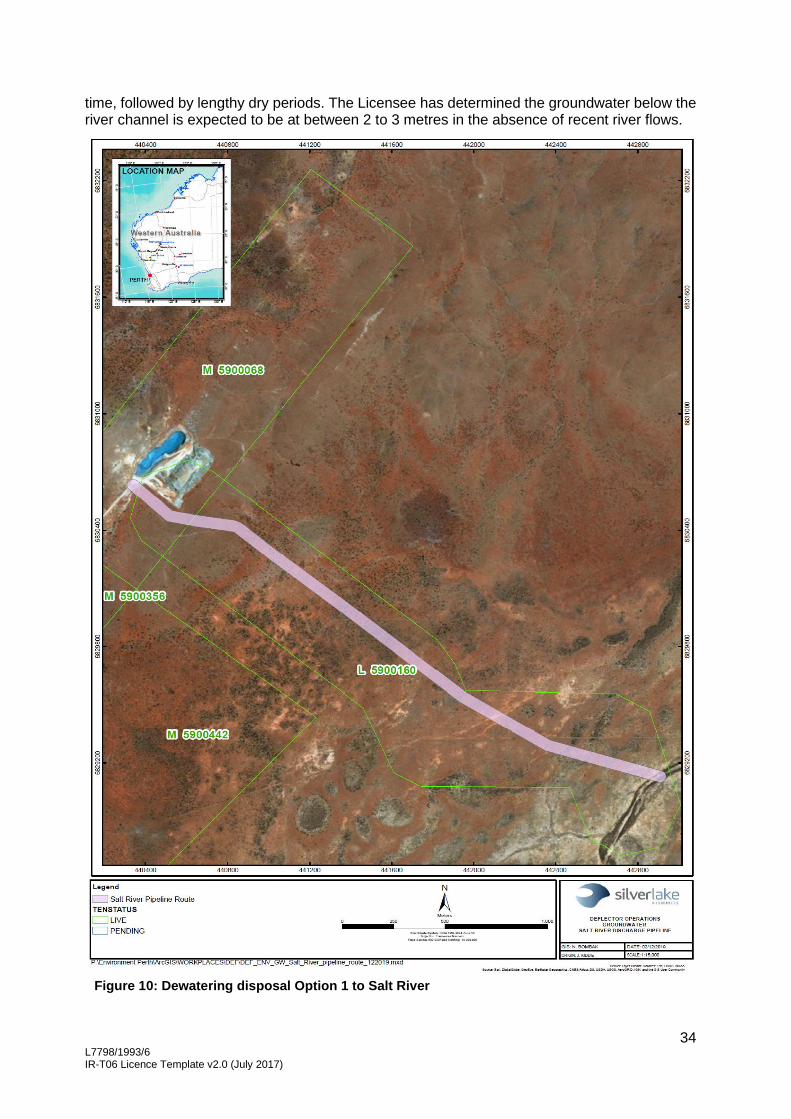
34 L7798/1993/6 IR-T06 Licence Template v2.0 (July 2017)
time, followed by lengthy dry periods. The Licensee has determined the groundwater below the river channel is expected to be at between 2 to 3 metres in the absence of recent river flows.
Figure 10: Dewatering disposal Option 1 to Salt River

35 L7798/1993/6 IR-T06 Licence Template v2.0 (July 2017)
Description of potential impacts from the emission
The potential impacts to the Salt River are discussed below.
• A previous risk assessment undertaken by the Licensee (Stantec, January 2019) identified that elevated metals within the dewatering discharge effluent may pose a toxicity risk to receptors inhabiting Salt River, and a secondary risk to migratory birds who use the aquatic biota as a food source. The risk assessment identified several metals of concern which were identified through the assessment of historical discharge data. These metals included cadmium, chromium, copper, nickel and zinc. The metals were shown to be elevated in comparison to available ANZECC & ARMCANZ (2000) guideline trigger values, in concentrations that may be toxic to aquatic biota, and in particular copper has been much higher than background levels (Stantec, July 2019).
Selenium and mercury are also considered highly toxic and are also known to biomagnify up the food chain. However, the concentration of these elements in the dewatering discharge effluent has shown to be either below detection or well below available guidelines, therefore are not considered a toxicity risk (Stantec, July 2019).
• Erosion and build-up of sediments at the discharge outlet smothering aquatic biota and riparian vegetation.
• Elevated salts in surface water and sediments above background levels causing adverse effects on aquatic biota and riparian vegetation. Increased likelihood of salt crust on the river bed.
• Breach of the storage capacity during major flood events.
• Discharge of accumulated metals from Salt River into the Barra Lake during major flooding events.
• Increased hydroperiods in Salt River affecting aquatic biota and riparian vegetation.
The Licensee undertook a baseline hydrological assessment in 2018 which included modelling the extent of the dewatering impact to the Salt River. The Salt River flows for a further 24 km south of the Premises before intercepting a chain of salt lakes including the Burra Lake described in Table 7 above. The river and lakes are predominately dry with flow estimated for approximately 2% of the time, which is typical for this region (Stantec, 2019). The surrounding floodplains are flat with gradients less than 0.3%.
Dewatering plumes were assessed at a discharge rate of 15, 25 and 50 L/s to predict the extent of the downstream impact. At 25 L/s (maximum expected discharge rate at the Premises) the wetted footprint is expected to reach 4.5km. Even at 50 L/s the wetted footprint is expected to dissipate well before the Burra Lake at 6.2 km (see Figure 11 below). The Burra Lake is 24 km away. Groundwater is predicted to extend a further 40 to 60% past the surface extent and therefore still well before the salt lakes systems further downstream.

36 L7798/1993/6 IR-T06 Licence Template v2.0 (July 2017)
Figure 11: Hydrological modelling indicative discharge extents at 15, 25 and 50 L/s rates for Option 1
Criteria for assessment
Department of Water, Western Australian water in mining guidelines, Report no. 12, May 2013.
Relevant water quality criteria for comparison include ANZECC guidelines for marine water quality.
Relevant sediment quality criteria for comparison include ANZECC sediment quality guidelines.

37 L7798/1993/6 IR-T06 Licence Template v2.0 (July 2017)
Licensee controls
Erosion Control
The Licensee proposes to install a 20 m long rock lined drainage area that extends over the riverbank to the bed of the Salt River (see Figure 4 above). Dewatering effluent will be discharged onto the rock drainage area via an energy diffusion device (see Figure 5 above) before flowing into the river through gravity. Dewatering flow velocity is reduced through the use of the energy diffusion device and rock lining. Once the dewatering effluent reaches the river bed the flow rates are expected to be low at less than 0.1 m/s. The installed discharge infrastructure has been designed to withstand a 1 in 20 year flood event.
Daily inspections of the dewatering discharge infrastructure will be conducted.
Increased hydroperiods in the Salt River
In order to reduce dewatering discharge rates to the Salt River, the Licensee will continue to maximise the reuse in the processing circuit, for dust suppression purposes and operation of evaporators at the TSF when possible.
Discharge downstream of the Premises (Option 1) where the channel is incised, sandy and predominately dry allowing greater infiltration.
The Licensee will implement spatial and ecological monitoring to assess hydroperiods impacts annually and during major foods.
Consider cessation of discharge for short periods (two to four weeks) following major flood events, to enable aquatic biota to emerge, persist and reproduce in low salinity conditions, as required.
Re-evaluate hydrological modelling results following the commencement of discharge and assess the water extent downstream.
Elevated metals
Discharge into the Salt River is only expected to occur for approximately 5 years.
Sediment samples were collected at all locations shown in Figure 9 during the baseline ecological assessment. The samples were collected following a 2017 minor flood event and a 2018 major flood event. The Licensee will continue to collect quarterly water and sediment quality data from Salt River and Burra Lake to develop site specific background or control site ranges (trigger values), for comparison to discharge water quality.
In order to reduce dewatering discharge rates to the Salt River, the Licensee will continue to maximise the reuse in the processing circuit, operation of evaporators at the TSF and use for dust suppression where possible.
Use of the Golden Stream pit as a settling pond and the Clarifier to reduce metal concentrations in the dewatering discharge effluent. If trigger values (see decision below for including trigger values) are exceeded, continue to investigate effective engineering and design of settling ponds and water treatment technologies to reduce suspended solids and metal concentrations, prior to discharge to the river.
Implement a suitable ecological monitoring program to assess impacts annually and during major floods. If required, consider ceasing discharge (2 – 4 weeks) to the river during major floods. Assess metal concentrations within the river post-cessation of discharge and if required intermittently flush area with freshwater from borefield to aid natural mitigation.
The dewatering discharge outlet will be located downstream of the conservation significant taxa which were identified upstream of the Premises.

38 L7798/1993/6 IR-T06 Licence Template v2.0 (July 2017)
Elevated salts in surface water and sediments
Reduce environmental discharge volume via re-use in mining processes and evaporators where possible. Salinity levels in dewatering discharge effluent are similar to background ranges and salt balance indicates negligible salt loads compared to catchment salt loads. Additional dissipation and dilution of salts during major floods.
Implementation of a suitable ecological monitoring program to assess impacts annually and during major floods. If required, consider ceasing discharge to the river during major floods. Assess salt loads of river post-cessation of discharge and if required intermittently flush area with freshwater from borefield to aid natural mitigation.
Licensee proposed monitoring program
Proposed discharge monitoring program:

39 L7798/1993/6 IR-T06 Licence Template v2.0 (July 2017)
Proposed soil monitoring program:
Consequence
The consequence of discharging dewatering effluent directly into the Salt River is considered moderate as the onsite impacts are mid-level and offsite impacts are low level due to the quality of the dewatering discharge effluent being of similar ionic composition to the surface water sampled at Salt River with the exception of Copper which is higher, conservation significant taxa are identified upstream of the discharge area and are also widespread elsewhere, at 25 L/s (maximum expected discharge rate at the Premises) the wetted footprint is expected to only reach 4.5km downstream, the Burra Lake is located over 24 km downstream of the discharge, the river banks are elevated (incised) at the discharge location where the river bed is sandy and predominately dry allowing greater infiltration, and the riparian vegetation being dominated by salt tolerant species with no priority flora taxa identified from the riparian zone.
Likelihood of Risk Event
The likelihood of an occurrence is unlikely as the areas of ecological significance are located upstream of the discharge, background copper concentrations are naturally high due to the local mineralisation of the area, the riparian vegetation is dominated by salt tolerant species and the Burra Lake system is located over 24 km away.
Overall rating of Risk Event
The risk rating for the discharge of dewatering effluent to Salt River is therefore considered medium.
Decision
Increased throughput at the processing plant
Based upon the applicant supporting documentation and additional information and data available to DWER, the Delegated Officer has determined the following points:
• Increasing the category 5 throughput by an additional 50,000 tpa presents a high risk to the environment due to the additional tailings material being discharged into the TSF causing an increased rate of seepage from the TSF, and a potential surface expression due to the increased pressure.
However the Delegated Officer has determined these risks are acceptable subject to the proposed Licensee controls, amendments to the existing regulatory controls in the Licence and the addition of new Licence conditions as shown below.
The approved premises production or design capacity has been amended to include the
throughput limit of 760,000 tpa for category 5.
Condition 1.3.8 is included as a new condition for the construction of the ore sorter at the processing plant.

40 L7798/1993/6 IR-T06 Licence Template v2.0 (July 2017)
Table 3.4.4 has been amended by removing groundwater monitoring bores TSFMB01 – TSFMB07, and including new groundwater monitoring bores TSFMB08 – TSFMB11.
Table 4.3.1 has been amended to include the notification requirements following the completion of the works.
Table 3.4.1 has been amended by reducing the SWL limit from 8 mbgl to 4 mbgl for all
groundwater monitoring bores at the TSF and Monarch in-pit TSF.
Table 3.4.2 has been amended to include TSF vegetation monitoring requirements.
Relocation of the dewatering discharge outlet
Based upon the applicant supporting documentation, the Delegated Officer has determined that the relocation of the dewatering discharge outlet presents a medium risk to the environment due to a potential increase in the concentration of metals within sediments affecting aquatic biota, increased salt levels within the surface water affecting riparian vegetation and aquatic biota, erosion of the river bed and a reduction in the storage capacity. However these risks are acceptable subject to amendments to the existing regulatory controls in the Licence and the addition of new conditions as shown below.
Condition 1.3.8 is included as a new condition for the construction of the dewatering effluent clarification unit, dewatering discharge outlet and dewatering pipelines.
Table 2.2.1 has been amended by extending the expiry date for ceasing dewatering discharge to land. This will allow additional time to complete the approvals process for the new dewatering discharge location, and installation of the dewatering infrastructure.
Table 4.3.1 has been amended to include the notification requirements following the completion of the works.
Condition 2.4 has been included as a new condition to authorise the discharge of dewatering effluent to surface water.
Condition 3.4.1 has been amended to include new table 3.4.4 for the monitoring of surface water quality.
Table 3.4.3 has been amended to include sediment monitoring within the Salt River.
Condition 3.6.1 has been included as a new condition for the monitoring of the dewatering effluent discharged into the new discharge location at Salt River. A trigger value, requiring reporting to DWER in accordance with condition 4.3.1, has been included for copper. Copper concentrations in the underground mine are currently as high as 0.623 mg/L (July 2019) with historically levels in the discharge water up to 0.65 mg/L, however with improvements in the management of sediments in dewatering effluent at the Premises, levels have since dropped with sampling results indicating copper levels as low as 0.01 mg/L at the Golden Stream outlet prior to discharge to the environment (see Table 10 above).
The ANZECC & ARMCANZ (2000) guidelines set a copper concentration level of 0.008mg/L for the protection of 80 % of species in marine environments. However, with the background concentration levels for copper elevated due to the natural mineralisation within the catchment and therefore a naturally higher tolerance by aquatic biota, and recent testing indicating there were no toxic effects of the discharge water on Dunaliella salina (algae) and Artemia salina (brine shrimp) species, this guideline level has not been applied as a limit or trigger value in the Licence as it is considered too low.
Additionally, the Licensee proposes to install a Clarifier which is expected to reduce the copper concentration in dewatering effluent to be below 0.07 mg/L (currently 0.126 mg/L), before discharge into the Golden Stream pit for further settlement before a final discharge to the environment. Therefore the final concentration of copper within the dewatering discharge effluent to the environment is expected to drop even further than the discharge concentration of

41 L7798/1993/6 IR-T06 Licence Template v2.0 (July 2017)
0.012 mg/L. Consequently, a trigger value of 0.07 mg/L has been set for copper in dewatering effluent discharged to surface water at the Premises. An exceedance of this trigger value will require the Licensee to undertake reporting requirements as set out in condition 4.3.1 of the Licence. Trigger values have not been applied to cadmium, chromium, nickel and zinc (other metals of concern) as their current concentration levels are well below the ANZECC & ARMCANZ (2000) guidelines.
Table 4.3.1 has been amended to include the reporting requirements for a breach of a trigger value set in Table 3.6.1.
Schedule 1 Maps has been amended by the inclusion of a new map describing the location of the dewatering discharge outlet to the Salt River.
Schedule 1 Maps has been amended by the inclusion of a new map describing the monitoring points defined in Table 3.4.3 and 3.4.4.
Increase the throughput at the WWTP
Based upon the applicant supporting documentation, the Delegated Officer has determined that an increase in the capacity of the WWTP and the irrigation area presents a low risk to the environment. Construction conditions and compliance reporting have been included as new conditions to the Licence as shown below. Existing conditions regulate the emission to land and the monitoring of those emissions. No additional regulatory controls are required to mitigate this risk.
The approved premises production or design capacity has been amended to include the throughput limit of 50 m3/day for category 85.
Condition 1.3.8 is included as a new condition for the construction of the upgrade to the WWTP and the increase in the irrigation field.
Table 1.3.6 has been amended to include the notification requirements following the completion of the works.
Schedule 1 Maps has been amended by replacing the map defined in Table 2.2.1 with a new map of the upgraded WWTP irrigation area.
Additional amendments
Previous condition 2.3 ‘Emission to groundwater’ and corresponding Table 2.3.1 have been updated to condition 2.5 ‘Emission to groundwater’ and corresponding Table 2.5.1 as there was already an existing condition 2.3 ‘Emission to air’.
Table 3.4.2 has been amended to correctly define all photo monitoring sites at the Salt River discharge area at mining tenement L59/64.
Table 4.2.1 of condition 4.1.1 has been amended to include the additional reporting requirements in the Annual Environmental Report.
Schedule 1 Maps has been amended by updating the map defined in Table 3.4.2 with a new map to show all vegetation monitoring locations defined in Table 3.4.2.

42 L7798/1993/6 IR-T06 Licence Template v2.0 (July 2017)
Amendment 1. The Licence Premises address is amended by the inclusion of the additional mining
tenements shown in bold and underline below.
Gullewa Gold-Copper Operations
Mining Tenements M59/49, L59/49, L59/64, M59/68, M59/132, M59/294, M59/356, M59/391, M59/392, M59/335, M59/442 L59/35, M59/507, M59/336, M59/522, L59/71, L59/158, L59/159 and L59/160 Morawa - Yalgoo Road
2. The Licence is amended by the deletion of the text shown in strikethrough below and
the inclusion of the bold text shown in underline below.
Category number
Category description Category production or design capacity
Approved Premises production or design capacity
5 Processing or beneficiation of metallic or non-metallic ore
50,000 tonnes per annual period
7600,000 tonnes per annual period
6 Mine dewatering 50,000 tonnes or more per annual period
750,000 tonnes per annual period
64 Class II landfill site 20 tonnes or more per year
4,000 tonnes per annual period
85 Sewage facility: premises- a) on which sewage is treated (excluding septic tanks); or b) from which treated sewage is discharged onto land or into waters
More than 20 but less than 100 cubic metres per day
35 50 cubic metres per day
3. The Licence is amended by the deletion of the text shown in strikethrough below and
the inclusion of the bold text shown in underline below. 2.2.1 The Licensee shall ensure that where waste is emitted to land from the emission points in Table
2.2.1 and identified on the map of emission points in Schedule 1 it is done so in accordance with the conditions of this Licence.
Table 2.2.1: Emissions to land
Emission point reference on Map of emission points
Description Source including abatement
Salt River Rock-armoured gabion outlet/s Water from dewatering of mine.
Approved to discharge a maximum of 750,000 tonnes per annual period until the 31 December 2019 31 March 2020
Irrigation spray field Discharge of treated wastewater by irrigation to land
Treated waste water from the waste water treatment facility.
4. The Licence is amended by the insertion of the following Conditions shown in bold and
underline:
2.4 Emission to surface water
2.4.1 The Licensee shall ensure that where waste is emitted to surface water from the emission point in Table 2.4.1 and identified on the map of emission points in Schedule 1 it is done so in accordance with the conditions of this Licence.

43 L7798/1993/6 IR-T06 Licence Template v2.0 (July 2017)
Table 2.4.1: Emissions to surface water
Emission point reference on Map of emission points
Description Source including abatement
Salt River discharge point as shown in Schedule 1
Dewatering effluent
Water from dewatering of mine.
Approved to discharge a maximum of 750,000 tonnes per annual period
Dewatering effluent discharged via an energy dissipater which consists of a 20m long, 0.5m deep, geotextile lined drain perpendicular to the riverbank with rock armouring extending to the riverbed
5. The Licence is amended by the deletion of the text shown in strikethrough below and
the inclusion of the bold text shown in underline below.
3.4.1 The Licensee shall undertake the monitoring in Tables 3.4.1, and 3.4.2, 3.4.3 and 3.4.4 according to the specifications in those tables and present this information in the Annual Environmental Report, including a comparison against the appropriate ANZECC 2000 water quality trigger values and previous years’ monitoring data.
Table 3.4.1: Monitoring of ambient groundwater quality
Monitoring point reference and location as depicted in Schedule 1
Parameter Units
Limit Averaging Period
Frequency
Monitoring bores: TSFMB01; TSFMB02; TSFMB03; TSFMB04; TSFMB05; TSFMB06; TSFMB07; TSFMB08, TSFMB09, TSFMB10, TSFMB11, SMW1; SMW2; SMW3; WB1; and WB2
Standing Water Level1
m(AHD) 8 4 mbgl Spot sample Monthly
pH2 - - Spot sample
Quarterly
Major ions and metals – Aluminium Arsenic Bicarbonate Cadmium Calcium Chloride Chromium Cobalt Copper Iron Lead Magnesium Manganese Mercury Molybdenum Nickel Nitrate Potassium Selenium Sodium Sulfate Thallium Zinc
mg/L
Total dissolved solids
Weak Acid Dissociable Cyanide (WADCN)
0.5 mg/L

44 L7798/1993/6 IR-T06 Licence Template v2.0 (July 2017)
Table 3.4.2: Monitoring of ambient vegetation quality
Monitoring point reference and location as depicted in Schedule 1
Parameter Requirements Frequency Method
Photo monitoring sites: PS#1 – PS#4, PMS#1, PMS#6 and PSC#9 Salt River Discharge L59/64 PS1 – PS11 and SC9
Vegetation health (i.e. decline in vegetation or change in composition)
The Licensee shall on a monthly basis: (i) take photographic
images; (ii) provide a general
environmental description of the site; and
(i) record any changes to vegetation health or composition which may have been induced by dewatering.
Monthly while dewatering is occurring and quarterly thereafter
Visual inspection and photographs
TSF Monitoring EMP01 – EMP04
The Licensee shall on a monthly basis: (i) take photographic
images; (ii) provide a general
environmental description of the site; and
(iii) record any changes to vegetation health or composition which may have been induced by seepage from the TSF.
Quarterly
Table 3.4.3: Monitoring of ambient soil quality
Monitoring point reference and location as depicted in Schedule 1
Parameter Units Averaging period
Frequency
Soil monitoring sites: PSC-9, DEFD01, DEFD10, DEFD16, DEFD18, DEFD07, DEFD21 and DEFD22
Cadmium Copper Nickel
mg/kg Spot sample
Quarterly
Salt River sampling sites: SR01, SR02, SR03, SR04, SR05, SR06, SR07, SR08, BL01, BL02, BL03, BL04 and BL05
Table 3.4.4: Monitoring of ambient surface water quality
Monitoring point reference and location as depicted in Schedule 1
Parameter Units Averaging period
Frequency
Salt River sampling sites: SR01, SR02, SR03, SR04, SR05, SR06, SR07, SR08, BL01, BL02, BL03, BL04 and BL05
pH pH units Spot sample
6 monthly when water is present TDS
TSS mg/L
Major ions and metals - copper, sodium, chloride, chromium, aluminium, cadmium, iron, magnesium, nickel, calcium,

45 L7798/1993/6 IR-T06 Licence Template v2.0 (July 2017)
potassium, manganese, nickel, selenium, arsenic, lead and zinc.
Aquatic ecology – diversity and abundance
- Following a flood event (river flow)
6. The Licence is amended by the insertion of the following condition as shown in bold
and underline: 1.3.8 The Licensee must install and undertake the works for the infrastructure and equipment:
(a) specified in Column 1; and
(b) to the requirements specified in Column 2;
of Table 1.3.6 below.
Table 1.3.6: Infrastructure and equipment requirements table
Column 1 Column 2
Infrastructure Requirements (design and construction)
Clarification modular unit
• Installed on a purpose built bunded concrete pad graded to a sump to capture any spills;
• Designed to manage up to 50 L/s; and
• Equipped with a high level alarm which automatically activates a diversion valve to direct the underground inflow straight to the Golden Stream open pit in the event of a malfunction in the Clarifier.
Ore sorter at processing plant
• Fitted with dust suppression systems
Additions to WWTP and expansion of irrigation area
• Modify the existing WWTP so it is capable of treating a maximum of 50 m3 per day of untreated wastewater;
• Increase the size of the irrigation spray field to a minimum of four hectares;
• Install the additional sprinkler system so separate spray zones can be isolated; and
• Install stock proof fencing around the perimeter of the irrigation area, except in areas where a gate is located.
Dewatering discharge outlet at Salt River
• Construction of a 20m long, 0.5m deep, rock lined trapezoidal drain perpendicular to the river bank that extends over the riverbank and terminates in the bed of the Salt River;
• The rock lined drain is lined with a geotextile fabric to minimise seepage;
• Dewatering discharge outlet onto rock drain is fitted with an energy diffusion device; and
• All dewatering discharge infrastructure is designed to withstand a 1 in 20 year flood event.

46 L7798/1993/6 IR-T06 Licence Template v2.0 (July 2017)
Column 1 Column 2
Infrastructure Requirements (design and construction)
Dewatering pipelines
• equipped with automatic cut-outs in the event of a pipe failure; or
• provided with secondary containment sufficient to contain any spill for a period equal to the time between routine inspections; or
• provided with telemetry systems and pressure sensors along pipelines carrying environmentally hazardous materials to allow the detection of leaks and failures.
7. The Licence is amended by the insertion of the following condition as shown in bold
and underline: 1.3.9 The Licensee shall operate the clarification modular unit, ore sorter, WWTP additions,
dewatering discharge outlet at Salt River and new dewatering pipelines in accordance with the conditions of this Licence, following submission of the compliance documents required under condition 4.3.1.
8. The Licence is amended by the deletion of the text shown in strikethrough below and
the inclusion of the bold text shown in underline below. 2.35 Emission to groundwater 2.35.1 The Licensee shall ensure that where waste is emitted to groundwater from the emission point
in Table 2.35.1 and identified on the map of emission points in Schedule 1 it is done so in accordance with the conditions of this Licence.
Table 2.35.1: Emissions to groundwater
Emission point reference on Map of emission points
Description Source including abatement
Golden Stream Pit End of pipe discharge Water from dewatering of mine.
9. The Licence is amended by the insertion of the following condition in bold and
underline: 3.6 Monitoring of emission to surface water
3.6.1 The Licensee shall undertake the monitoring in Table 3.6.1 according to the
specifications in that table and present this information in the Annual Environmental Report, including a comparison against previous years’ monitoring data.
Table 3.6.1: Monitoring of emissions to surface water
Emission point reference
Parameter Units Trigger value
Frequency
Salt River As shown in Map of emission points in Schedule 1.
Cumulative volume kL Not specified
Continuous
pH1 pH units
Monthly for the first 6 months of discharge then quarterly thereafter
Total Dissolved Solids mg/L
Total Suspended Solids
Copper mg/L 0.07
Major ions and metals - sodium, chloride, aluminium, cadmium, chromium, iron, magnesium, calcium, potassium, manganese, nickel, selenium, arsenic, lead and zinc.
mg/L
Not specified

47 L7798/1993/6 IR-T06 Licence Template v2.0 (July 2017)
Note 1: In-field non-NATA accredited analysis permitted.
10. The Licence is amended by the inclusion of the bold text shown in underline below in Table 4.3.1.
Table 4.3.1: Notification requirements
Condition or table
Parameter Notification requirement1 Format or form2
L1.3.2, L2.2.1 and
Tables 3.4.1 and
3.6.1
Breach of any limit or trigger value specified in the Licence
Part A: As soon as practicable but no later than 5pm of the next usual working day.
Part B: As soon as practicable
N1
Table 1.3.5 Geotechnical Investigation Report certifying each item of infrastructure or component of infrastructure specified in Column 1 of Table 1.3.5 has been constructed with no material defects and to the requirements specified in Column 2.
The report must be prepared or reviewed by a person with tertiary qualifications in Civil or Geotechnical Engineering and at least two years employment in geotechnical structures.
Within 60 days of the completion of each stage of the works specified in Column 1 of Table 1.3.5
None specified
Table 1.3.6 Construction Compliance Report certifying each item of infrastructure or component of infrastructure specified in Column 1 of Table 1.3.6 has been constructed with no material defects and to the requirements specified in Column 2.
Within 60 days of the completion of each Stage of the Works specified in Column 1 of Table 1.3.6
None specified
3.1.5 Calibration report As soon as practicable. None specified
Table 3.3.1 The Licensee shall notify the CEO of any TSF pipeline failures and provide an estimate of the tailings and slurry lost due to the failure within one week of the incident.
As soon as practicable but no later than 5pm of the next usual working day.
Volume estimate provided within one week of the incident.
None specified
Table 3.3.1 The Licensee shall notify the CEO of any dewatering pipeline failures and provide an estimate of the mine dewatering water lost due to the failure within one week of the incident.
As soon as practicable but no later than 5pm of the next usual working day.
Volume estimate provided within one week of the incident.
None specified

48 L7798/1993/6 IR-T06 Licence Template v2.0 (July 2017)
Table 3.4.2 The Licensee shall notify the CEO of any identified detrimental vegetation impacts as a result of dewatering discharge, including details of a strategy for remediation works.
Within one week of the detrimental vegetation impacts being identified.
None specified
Note 1: Notification requirements in the Licence shall not negate the requirement to comply with s72 of the Act Note 2: Forms are in Schedule 2
11. The Licence is amended by the inclusion of the bold text shown in underline below. 4.1.1 The Licensee shall submit to the CEO an Annual Environmental Report by 31 March each year.
The report shall contain the information listed in Table 4.2.1 in the format or form specified in that table.
Table 4.2.1: Annual Environmental Report
Condition or table
Parameter Format or form1
- Summary of any failure or malfunction of any pollution control equipment and any environmental incidents that have occurred during the annual period and any action taken
None specified
Table 1.3.1 Actual throughput for the annual period for Categories 5, 6 and 85
Table 3.2.1 All dewatering water monitoring parameters specified in Table 3.2.1
Table 3.3.1 Summary of the TSF inspections including details on any seepage, spills or leaks and corrective measures undertaken to rectify any issues identified.
Table 3.3.1 Summary of the dewatering pipeline and discharge point inspections including details on any identified pipeline failures, seepage, spills or leaks and corrective measures undertaken to rectify any issues identified.
Table 3.4.1 All ambient groundwater quality monitoring parameters specified in Table 3.4.1
Table 3.4.2 All ambient vegetation quality monitoring parameters specified in Table 3.4.2
Table 3.4.3 All ambient soil quality monitoring parameters specified in Table 3.4.3
Table 3.4.4 All ambient surface water quality monitoring parameters specified in Table 3.4.4
Table 3.5.1 All emission to groundwater monitoring parameters specified in Table 3.5.1
Table 3.6.1 All emission to surface water monitoring parameters specified in Table 3.6.1
4.1.3 Compliance Annual Audit Compliance Report (AACR)
4.1.4 Complaints summary None specified Note 1: Forms are in Schedule 2

49 L7798/1993/6 IR-T06 Licence Template v2.0 (July 2017)
12. The Licence is amended by insertion of the map below into Schedule 1 Maps: The location of the dewatering discharge to Salt River defined in Table 2.4.1 is shown below.

50 L7798/1993/6 IR-T06 Licence Template v2.0 (July 2017)
13. The Licence is amended by replacing the Schedule 1 map defined in Table 2.2.1 with the new map shown below.
The location of the irrigation spray field defined in Table 2.2.1 is shown in the map below.

51 L7798/1993/6 IR-T06 Licence Template v2.0 (July 2017)
14. The Licence is amended by replacing the Schedule 1 map defined in Table 3.4.2 with the new map shown below.
The location of the vegetation quality monitoring points defined in Table 3.4.2 are shown below.

52 L7798/1993/6 IR-T06 Licence Template v2.0 (July 2017)
15. The Licence is amended by insertion of the map below into Schedule 1 Maps: The location of the monitoring points defined in Tables 3.4.3 and 3.4.4 are shown below:

53 L7798/1993/6 IR-T06 Licence Template v2.0 (July 2017)
16. The Licence is amended by insertion of the map below into Schedule 1 Maps: The location of the photo monitoring points defined in Table 3.4.2 are shown below:

54 L7798/1993/6 IR-T06 Licence Template v2.0 (July 2017)
Licensee comments The Licensee was provided with the draft Amendment Notice 4 on 27 November 2019. Comments received from the Licensee have been considered as shown in Appendix 2.

55 L7798/1993/6 IR-T06 Licence Template v2.0 (July 2017)
Appendix 1: Key documents
Document title In text ref Availability
1 Licence L7798/1993/6 – Gullewa
Gold/Copper Operations
L7798/1993/6 accessed at www.dwer.wa.gov.au
2 Licence Amendment application Application DWER record DWERDT179051
3 Deflector Mining Limited (Silver Lake
(Deflector) Pty Ltd), Amendment (4)
Application Supporting Document, 12
July 2019
Supporting
documentation
DWER record DWERDT179042
4 Email dated 25/08/2019, Deflector
Licence Amendment, information for
additional processing equipment
- DWER record A1818490
5 Email dated 13/09/2019, Deflector
response to further information
request
- DWER record A1827473
6 Deflector Mining Limited Annual Environmental Report 2018
AER, 2018 DWER record A1777673
7 Steve Appleyard, DWER Principal Hydrogeologist, Contaminated Sites , memorandum, 10 September 2019
- DWER record A1827482
6 DWER, July 2015. Guidance Statement: Regulatory principles. Department of Environment Regulation, Perth.
-
accessed at www.dwer.wa.gov.au
7 DWER, October 2015. Guidance Statement: Setting conditions. Department of Environment Regulation, Perth.
-
8 DWER, August 2016. Guidance Statement: Licence duration. Department of Environment Regulation, Perth.
-
9 DWER, November 2016. Guidance Statement: Risk Assessments. Department of Environment Regulation, Perth.
-
10 DWER, November 2016. Guidance Statement: Decision Making. Department of Environment Regulation, Perth.
-
11 DWER, June 2019. Guideline: Decision Making. Department of Water and Environment Regulation, Perth
-
12 Kingsford, R. T., Georges, A. and Unmack, P. J. (2006). Vertebrates of desert rivers: meeting the challenges of temporal and spatial unpredictability. In: R. Kingsford (ed) Ecology of Desert Rivers. Cambridge
Kingsford et al, 2006
-

56 L7798/1993/6 IR-T06 Licence Template v2.0 (July 2017)
University Press, Cambridge, UK, pp 154-200
13 Ninox Wildlife Consulting, 2011. A level 1 vertebrate fauna assessment of the Gullewa Gold Copper Project – north of Morowa, Western Australia. Prepared for Mutiny Gold
Ninox Wildlife Consulting, 2011
DWER record A1514911
14 Stantec. (2017a). Deflector Gold and Copper Operations: Desktop review and discharge options study. Internal report for Doray Minerals Limited.
Stantec, 2017a DWER record DWERDT179042
15 Stantec. (2017b). Deflector Gold Mine: Level 1 flora, vegetation and fauna survey. Internal Report prepared for Doray Minerals Ltd, Perth, Western Australia.
Stantec, 2017b
15 Stantec. Deflector Gold and Copper Mine: Baseline Aquatic Ecology and Discharge Impact Assessment of Salt River and Burra Lake. Internal report prepared for Doray Minerals Ltd, January 2019
Stantec, January 2019
16 Deflector Dewatering Discharge Infrastructure – Concept Design, Stantec 2019
Stantec, 2019
17 Stantec. Ecotoxicity Study of Salt River Aquatic Biota. Internal report prepared for Doray Minerals Ltd, July 2019
Stantec, July 2019
DWER record A1844446
18 Waterkeyn, A., Vanschoenwinkel, B., Vercampt, H., Grillas, P. and Brendonck, L. (2011). Long-term effectsof salinity and disturbance regime on active and dormant crustacean communities. Limnol. Oceanogr. 56(3): 1008-1022.
Waterkeyn et al, 2011
-
19 Persoone, G. and Wells, P. G. (1987). Artemia in Aquatic Toxicology: A Review. In: P. Sorgeloos, D. A. Bengison, W. Decleir and E. Jaspers (eds) Artemia Research and its Applications, vol Volume 1. Morphology, Genetics, Strain Characterization, Toxicology. Universa Press, Wetteren, Belgium, pp 259-275
Persoone & Wells 1987
-
20 Shirazi, A., Shariati, F., Keshavarz, A. K. and Ramezanpour, Z. (2015). Toxic effect of aluminium oxide nanoparticles on green micro-algae Dunaliella salina. International Journal of Environmental Research 9(2): 585-594.
Shirazi et al 2015
-

57 L7798/1993/6 IR-T06 Licence Template v2.0 (July 2017)
21 Riisgård, H. U., Zalacáin, D., Jeune, N., Brandt Wiersma, J., Lüskow, F. and Pleissner, D. (2015). Adaptation of the Brine Shrimp Artemia salina (Branchiopoda: Anostraca) to Filter-Feeding: Effects of Body Size and Temperature on Filtration and Respiration Rates. Journal of Crustacean Biology 35(5): 650-658.
Riisgard et al 2015
22 Visviki, I. and Rachlin, J. W. (1994). Acute and chronic exposure of Dunaliella salina and Chlamydomonas bullosa to copper and cadmium: effects on growth. Archives of Environmental Contamination and Toxicology 26(2): 149-153.
Visviki and Rachlin 1994
-
23 Kalcikova, G., J., Z.-K. and Zgajnar Gotvajn, A. (2012). Artemia salina acute immobilisation test: a possible tool for aquatic exotoxicity assessment. Water Science and Technology 66(4): 903-908.
Kalcikova et al. 2014
-
24 Zulkifli, S. Z., Aziz, F. Z. A., Ajis, S. Z. M. and Ismail, A. (2014). Nauplii of Brine Shrimp (Artemia salina) as a Potential Toxicity Testing Organism for Heavy Metals Contamination. In: A. Z. Aris, T. H. T. Ismail, R. Harun, A. M. Abdullah and M. Y. Ishak (eds) From Sources to Solution. Springer Science & Business Media, Singapore, pp 233-237
Zulkifli et al. 2014
-
25 Kokkali, V., Katramados, I. and Newman, J. D. (2011). Monitoring the Effect of Metals Ions on the Mobility of Artemia salina Nauplii. Biosensors 1: 36-45.
Kokkali et al. 2011
-
26 Svensson, B. M., Mathiasson, L., Mårtensson., L. and Bergström, S. (2005). Artemia salina as Test Organism for Assessment of Acute Toxicity of Leachate Water from Landfills. Environmental Monitoring and Assessment 102: 309-321.
Svensson et al. 2005
-
27 Pawlisz, A. V., Ketn, R. A., Schneider, U. A. and Jefferson, C. (1997). Canadian Water Quality Guidelines for Chromium. Environmental Toxicology and Water Quality 12: 185-193.
Pawlisz et al. 1997
-
28 Groundwater Resource Management, Monitoring Borehole Completion Report: Gullewa Tailings Storage
GRM, 2019 DWER record A1848610

58 L7798/1993/6 IR-T06 Licence Template v2.0 (July 2017)
Facility and Borefield, Deflector Mine, May 2019

59 L7798/1993/6 IR-T06 Licence Template v2.0 (July 2017)
Appendix 2: Summary of Licensee comments
The Licensee was provided with the draft Amendment Notice 4 on 27 November 2019 for review and comment. The Licensee responded on 4 December 2019. The following comments were received on the draft Amendment Notice.
Summary of Licensee comment DWER Licence — Points for clarification/discussion
DWER response
Can the specific flocculant chemistry be removed to reduce operational constraints?
The Licensee proposed the use of feCl or AlOH which was mentioned within the amendment notice.
Supported.
Upon further aboriginal heritage surveys a more direct route has been identified by the Licensee.
Option 1 was originally proposed. Supported. Map in amendment notice updated to show dewatering pipeline corridor. Only minor variation to original Option 1.
Licensee provided groundwater study in support of replacement monitoring bores at the TSF (GRM, 2019).
DWER originally suggested the replacement groundwater monitoring bores at the TSF may represent the condition of the groundwater.
Supported. Amendment notice updated to include outcomes of groundwater study.
The Licensee advised they had invested considerable resources into investigating engineering/technologies to reduce TSS and metal concentrations and believe the chosen engineering solution will be suitable. The Licensee proposed if the proposed water quality parameters/trigger levels could not be met, further investigations will be conducted.
DWER proposed to include the following as part of the Licensee controls section: Continue to investigate effective engineering and design of settling ponds and water treatment technologies to reduce suspended solids and metal concentrations, prior to discharge to the river.
Supported. Trigger values are now included as part of the amendment notice and DWER acknowledges the extra effort the Licensee has undertaken to reduce TSS in the dewatering discharge water.
The Monitoring Borehole Completion Report, Gullewa Tailings Storage Facility and Borefield was provided to support the new bore hole locations. SLR provides a copy again for review.
DWER proposed in its decision that the Licensee has not provided sufficient information to demonstrate that the proposed replacement monitoring bores will produce comparable groundwater potentiometric head levels to the original
Supported. The Licensee had provided sufficient information to demonstrate that the proposed replacement monitoring bores would produce comparable groundwater results to the original bores, and

60 L7798/1993/6 IR-T06 Licence Template v2.0 (July 2017)
bores, or to demonstrate that they are located in appropriate locations to monitor seepage from the Gullewa TSF.
demonstrated that they are located in appropriate locations to monitor seepage from the Gullewa TSF. These statements have been removed from the Decision section.
This has now been addressed after the embankment wall construction phase.
DWER proposed that seepage is taking place from the TSF because the Licensee was not adequately managing inputs and outputs from the facility.
Supported. The Licensee has now provided evidence to show the supernatant pond at the TSF is away from the TSF embankment, is reduced in size and located at the decant. This statement in the Decision has been removed.
This has been addressed with improved supernatant management after the construction phase. A memo report will be provided
A new condition was proposed requiring the Licensee to ‘Identify measures that will be undertaken to address the current water imbalance at the TSF in order to reduce seepage”
Supported. Proposed condition 5 for the requirement to provide evidence that measures had been undertaken to address the current water imbalance has been removed.
Please review provided borehole completion report.
A new condition was proposed requiring the Licensee to demonstrate that the proposed replacement monitoring bores TSFMB08 to TSFMB11 are located in appropriate locations to monitor seepage from the Gullewa TSF
Supported. The Licensee provided the groundwater study in support of replacement monitoring bores at the TSF (GRM, 2019). Proposed condition 5 for the requirement to demonstrate the new monitoring bores at the TSF are suitable for monitoring seepage has been removed.
Please can these be replaced with TSFMB08-11? The Licensee wishes to update the License by removing the requirement to monitor bores TSFMB01-07, and instead monitor bores TSFMB08-11.
Monitoring bores TSFMB01-07 were proposed to be retained in Table 3.4.1 of the Licence.
Supported. The Licensee has provided evidence to support groundwater monitoring bores TSFMB08-11 will provide suitable data to monitor for seepage at the TSF. Additionally, the Licensee has provided supporting evidence that suggests the current monitoring bores TSFMB01-07 are being affected from pressure exerted by the TSF and are not reflecting true

61 L7798/1993/6 IR-T06 Licence Template v2.0 (July 2017)
groundwater conditions. The requirement to monitor these bores has been removed.
Some of the monitoring quadrats are located in the drainage channel inundation area. These plants are likely to be impacted when inundated (as is shown during extended natural hydroperiods). Suggest wording amended to show impacts outside of the drainage channel.
- Partially supported. Table 3.4.2 of the Licence already requires the Licensee to only record any changes to vegetation health or composition ‘which may have been induced by dewatering’. The notification requirements in accordance with column 2 of Table 4.3.1 of the Licence has been amended to include ‘…as a result of dewatering discharge’.