Reconstruction of the landscape history around the remnant arch of the Klidhi Roman Bridge,...
14
Reconstruction of the landscape history around the remnant arch of the Klidhi Roman Bridge, Thessaloniki Plain, North Central Greece Matthieu Ghilardi a, * , Abdelsalem Genç b , George Syrides c , Jan Bloemendal d , David Psomiadis e , Thodoris Paraschou c , Ste ´ phane Kunesch f , Eric Fouache g a CEREGE, U.M.R. 6635, C.N.R.S., Europo ˆleMe´diterrane ´en de l’Arbois BP 80, 13545 Aix-en-Provence CEDEX 04, France b University of Paris 4 Sorbonne, 191 rue Saint Jacques – 75005 Paris, France c Aristotle University of Thessaloniki, Department of Geology, Thessaloniki, Greece d University of Liverpool, Department of Geography, Laboratory of Environmental Magnetism, UK e Institute of Materials Science, N.C.S.R. ‘‘Demokritos’’, 153 10 Agia Paraskevi Attikis, Athens, Greece f Laboratoire de Ge´ographie Physique, U.M.R. 8591, C.N.R.S.,1 Place Aristide Briand – 92195 Meudon, France g University of Paris 10 Nanterre, Department of Geography, 200 Boulevard de la Re ´publique, 92000 Nanterre, France article info Article history: Received 21 June 2009 Received in revised form 8 September 2009 Accepted 10 September 2009 Keywords: Aliakmon River Axios River Geoarchaeology Greece Recent Holocene Klidhi Remote sensing Roman Bridge Palaeoenvironments Sedimentology Thessaloniki Plain abstract This paper deals with the palaeoenvironmental reconstruction of the area surrounding the remnant arch of the ancient bridge of Klidhi, Thessaloniki Plain, Greece. 19th century travellers and 20th century historians discussed the age of the monument and concluded that it was built during Late Roman Times (3rd Cent. AD) and supported a branch of the Via Egnatia road. However, few studies have considered the environmental context of the construction of the bridge, and until now, only two hypotheses have been presented: The bridge was built on or over a junction of the Aliakmon and Loudias Rivers, or on a coastal barrier. Within the framework of a geoarchaeological project developed in April 2008, five boreholes were drilled and the sediment cores analysed for microfauna and sedimentology. Seven 14 C AMS dates provided a chro- nostratigraphic sequence and helped to define the geomorphological evolution of the area. Spatial inter- pretation of the results was possible using a Landsat TM image (False Colour Composite – FCC). Our data indicate the gradual transition of the site from a marine to a terrestrial environment during Ancient Times. Lagoonal conditions dominated during the construction of the bridge and the presence of a palaeochannel of the Aliakmon River was later revealed (transition from Byzantine and Ottoman periods), overlying sediments of a coastal barrier. Ó 2009 Elsevier Ltd. All rights reserved. 1. Introduction Over the last 30 years a significant number of geoarchaeological studies have been carried out around the Mediterranean (Kraft et al., 1977; Fouache, 1999, 2003). Arguably the most important work comprises studies of remnant archaeological constructions such as harbours (Devillers et al., 2007; Fouache et al., 2005; Gifford et al., 1992; Goiran and Morhange, 2003; Marriner and Morhange, 2007; Marriner et al., 2005, 2007 and 2008; Vo ¨tt, 2007b). The palae- oenvironmental reconstruction of the area surrounding ancient buildings has enabled the analysis of geomorphological processes and landscape reconstruction during the Holocene and in particular within historical times. Coastal areas are a suitable place to study the environmental history of Ancient cities (Bru ¨ ckner, 2005), or of archaeological artefacts, since stratigraphic and sedimentological studies can highlight the morphological dynamics responsible for the creation of deltaic areas (Ghilardi, 2007). Thessaloniki Plain, located in Northern Greece (Fig. 1), is the largest coastal plain in Greece, spanning an area of approximately 2200 km 2 and was mainly created during the late Holocene, from 4000 BC until the 3rd Century AD (Ghilardi, 2007; Ghilardi et al., 2008a,b). Over the last six millennia there has been intense human occupation, and the habi- tants have been forced to adapt to the rapid displacement of the shoreline by the (re)construction of harbours and bridges. Indeed, the ancient writer Livy mentioned that for example in 190 A.D., the Roman armies left Greece in the direction of the Hellespont through Ancient Macedonia and encountered several bridges built during the reign of Philip the 2nd, King of Macedonia (Livy, XXIX, 29: ‘‘Vias munivi, pontes feci. Commeatus præbui’’). As a result, we can at present observe some of these remnant artefacts which inform us * Corresponding author. Mobile: þ00 33 6 10 26 08 64. E-mail address: [email protected] (M. Ghilardi). Contents lists available at ScienceDirect Journal of Archaeological Science journal homepage: http://www.elsevier.com/locate/jas 0305-4403/$ – see front matter Ó 2009 Elsevier Ltd. All rights reserved. doi:10.1016/j.jas.2009.09.030 Journal of Archaeological Science 37 (2010) 178–191
Transcript of Reconstruction of the landscape history around the remnant arch of the Klidhi Roman Bridge,...

lable at ScienceDirect
Journal of Archaeological Science 37 (2010) 178–191
Contents lists avai
Journal of Archaeological Science
journal homepage: ht tp: / /www.elsevier .com/locate/ jas
Reconstruction of the landscape history around the remnant arch of the KlidhiRoman Bridge, Thessaloniki Plain, North Central Greece
Matthieu Ghilardi a,*, Abdelsalem Genç b, George Syrides c, Jan Bloemendal d, David Psomiadis e,Thodoris Paraschou c, Stephane Kunesch f, Eric Fouache g
a CEREGE, U.M.R. 6635, C.N.R.S., Europole Mediterraneen de l’Arbois BP 80, 13545 Aix-en-Provence CEDEX 04, Franceb University of Paris 4 Sorbonne, 191 rue Saint Jacques – 75005 Paris, Francec Aristotle University of Thessaloniki, Department of Geology, Thessaloniki, Greeced University of Liverpool, Department of Geography, Laboratory of Environmental Magnetism, UKe Institute of Materials Science, N.C.S.R. ‘‘Demokritos’’, 153 10 Agia Paraskevi Attikis, Athens, Greecef Laboratoire de Geographie Physique, U.M.R. 8591, C.N.R.S., 1 Place Aristide Briand – 92195 Meudon, Franceg University of Paris 10 Nanterre, Department of Geography, 200 Boulevard de la Republique, 92000 Nanterre, France
a r t i c l e i n f o
Article history:Received 21 June 2009Received in revised form8 September 2009Accepted 10 September 2009
Keywords:Aliakmon RiverAxios RiverGeoarchaeologyGreeceRecent HoloceneKlidhiRemote sensingRoman BridgePalaeoenvironmentsSedimentologyThessaloniki Plain
* Corresponding author. Mobile: þ00 33 6 10 26 08E-mail address: [email protected] (M. Ghilardi).
0305-4403/$ – see front matter � 2009 Elsevier Ltd.doi:10.1016/j.jas.2009.09.030
a b s t r a c t
This paper deals with the palaeoenvironmental reconstruction of the area surrounding the remnant arch ofthe ancient bridge of Klidhi, Thessaloniki Plain, Greece. 19th century travellers and 20th century historiansdiscussed the age of the monument and concluded that it was built during Late Roman Times (3rd Cent. AD)and supported a branch of the Via Egnatia road. However, few studies have considered the environmentalcontext of the construction of the bridge, and until now, only two hypotheses have been presented: Thebridge was built on or over a junction of the Aliakmon and Loudias Rivers, or on a coastal barrier. Within theframework of a geoarchaeological project developed in April 2008, five boreholes were drilled and thesediment cores analysed for microfauna and sedimentology. Seven 14C AMS dates provided a chro-nostratigraphic sequence and helped to define the geomorphological evolution of the area. Spatial inter-pretation of the results was possible using a Landsat TM image (False Colour Composite – FCC). Our dataindicate the gradual transition of the site from a marine to a terrestrial environment during Ancient Times.Lagoonal conditions dominated during the construction of the bridge and the presence of a palaeochannelof the Aliakmon River was later revealed (transition from Byzantine and Ottoman periods), overlyingsediments of a coastal barrier.
� 2009 Elsevier Ltd. All rights reserved.
1. Introduction
Over the last 30 years a significant number of geoarchaeologicalstudies have been carried out around the Mediterranean (Kraft et al.,1977; Fouache, 1999, 2003). Arguably the most important workcomprises studies of remnant archaeological constructions such asharbours (Devillers et al., 2007; Fouache et al., 2005; Gifford et al.,1992; Goiran and Morhange, 2003; Marriner and Morhange, 2007;Marriner et al., 2005, 2007 and 2008; Vott, 2007b). The palae-oenvironmental reconstruction of the area surrounding ancientbuildings has enabled the analysis of geomorphological processesand landscape reconstruction during the Holocene and in particularwithin historical times. Coastal areas are a suitable place to study the
64.
All rights reserved.
environmental history of Ancient cities (Bruckner, 2005), or ofarchaeological artefacts, since stratigraphic and sedimentologicalstudies can highlight the morphological dynamics responsible forthe creation of deltaic areas (Ghilardi, 2007). Thessaloniki Plain,located in Northern Greece (Fig. 1), is the largest coastal plain inGreece, spanning an area of approximately 2200 km2 and wasmainly created during the late Holocene, from 4000 BC until the 3rdCentury AD (Ghilardi, 2007; Ghilardi et al., 2008a,b). Over the last sixmillennia there has been intense human occupation, and the habi-tants have been forced to adapt to the rapid displacement of theshoreline by the (re)construction of harbours and bridges. Indeed,the ancient writer Livy mentioned that for example in 190 A.D., theRoman armies left Greece in the direction of the Hellespont throughAncient Macedonia and encountered several bridges built during thereign of Philip the 2nd, King of Macedonia (Livy, XXIX, 29: ‘‘Viasmunivi, pontes feci. Commeatus præbui’’). As a result, we can atpresent observe some of these remnant artefacts which inform us

Fig. 1. Location map of the study area. Elevations were obtained from the derivation of the Shuttle Radar Topography Mission and included in Geographic Information System. Thelimits of the former Giannitsa Lake, totally drained in the 1930s (Ancel, 1930) are based on Ghilardi, 2007. The coastal barriers were identified by NEDECO (1970). The Roman bridgewith a red symbol is the one of Klidhi.
M. Ghilardi et al. / Journal of Archaeological Science 37 (2010) 178–191 179
about important geomorphologic processes during the historicalperiod. The Thessaloniki Plain provides a particularly interestingcase-study. The site of interest lies close to the actual cities of Klidhiand Trikala (Prefecture of Emathia), just one kilometre to the west ofthe modified course of the Loudias channel and 8 km from the actualcoastline. Here a remnant arch, the ancient bridge of Klidhi (Fig. 2A),exists and is hydrographically isolated. Various sources (Delacou-lonche,1859; Edson,1955; Bintliff,1976; Astaras and Sotiriadis,1988;Ghilardi, 2007) indicate the age of the arch is Late Roman circa 3rdCent. A.D. and must have supported a southern branch of the Romanroad Via Egnatia, running from Ancient Dyon to Thessaloniki (Ghi-lardi, 2007). The factors leading to the construction of this bridge,where only one remnant arch is still visible, are unclear. Varioushypotheses (Cousinery, 1831; Delacoulonche, 1859; NEDECO, 1970;Bintliff, 1976) suggest that is was used as a byway over rivers and/oras a coastal barrier. Our research, based on a geoarchaeologicalapproach using the palaeoenvironmental data from five boreholesand a spatial interpretation, based on a Landsat TM imagery inter-pretation, aims to provide a better understanding of the evolution ofthe landscape surrounding the remnant arch of Klidhi Bridge.
2. Previous studies covering The Ancient bridge of Klidhi
2.1. Cousinery’s description (1830s)
No historical studies mention the existence of this bridge duringAncient Times (archaic, classical, hellenistic and imperial periods)
and few maps show its presence in the lower part of ThessalonikiPlain. Cousinery (1831) mentioned briefly the remnant arch(Fig. 2A) and speculated that the bridge spanned the junction of theAliakmon and Loudias Rivers (Cousinery, 1831); however, unfor-tunately he did not describe the architecture more precisely norestimate the age of its construction.
2.2. Delacoulonche’s work: the most detailed historical andarchaeological studies (1850s)
The most detailed work is that by the French archaeologistDelacoulonche (1859) who participated, with his colleague LeonHeuzey, in a mission to Greek Macedonia under the supervision ofFrench Emperor Napoleon III, who was especially fascinated by thebattlefield where Caesar’s army fought. His description of theremnant arch included an estimate of the number of arches, prob-ably between 8 and 10 (Delacoulonche, 1859, p. 65). He assumedthat the remnant arch still visible (Fig. 2B) was the third or fourthlargest assuming that size of the arches decreased towards theextremities. According to Delacoulonche’s description, the totallength of the monument was around 187 to 190 m (circa 70.40 m inthe direction of Thessaloniki and 100.32 m on the other side of thearch) and thus was of comparable size to the Roman bridge ofNorba-Caesarea (Alcantara, Extremadura, Spain) with similarsymmetric arches (Delacoulonche, 1859). Particular attention hasbeen paid to the architecture of the edifice, indeed the remnant archwas particularly helpful on this point. Following careful scrutiny

Fig. 2. A: The remnant arch of the ancient Klidhi Bridge. B: drawing of the arch realised by Alfred Delacoulonche in 1859, evident alteration of the edifice is visible in almost one andhalf century of time. C: Modern city of Klidhi, in the square we have rectangular stones carved into a travertine formation (Poros in greek; Delacoulonche, 1859); they were used firstto build the roman bridge of Klidhi and then reemployed to build the church of the city in 1856 (date recorded on a wall). D: Ancient village of Kaliani, we have in the red square,a rectangular stone carved into the same travertine formation as the ones observed in the remnant arch of Klidhi. It is clear that local people used the stones from the ancient bridgeof Klidhi to build houses, churches, etc. (For interpretation of the references to colour in this figure legend, the reader is referred to the web version of this article).
M. Ghilardi et al. / Journal of Archaeological Science 37 (2010) 178–191180
from Delacoulonche, it appears that the arch is formed in two parts(Delacoulonche, 1859, p.64): the base consists of 6 rectangularstones (length: 1.07 m, width: 0.73 m, height: 0.43 m) whichsupports the arch, and the remnant one is 17.14 m long (lengthmeasured just above the ground), 5.73 m wide and 6.52 m high. Thedimensions of the stones are similar to the marble blocks used tobuild the base of the ‘‘Classical’’ Bridge at Amphipolis (Bakalakis,1970). The main difficulty encountered in describing the monumentprecisely comes from the lack of other arches. These were probablyused by the local people to build churches (Aghios Demetrios ofKaliani was present in 1820 but in 2008 the church did not exist,probably having been destroyed or abandoned) and houses in thevicinity. Delacoulonche’s description of Aghios Demetrios indicatesthat the four corners of the church were built with massive blocks ofworked limestone (length: 1.80 m, width: 0.62 m, height: 0.59 m).These large blocks probably supported the other arches of theRoman Bridge. Also, in the abandoned village of Kaliani, situated2.8 km to the north–west, we can observe on the ground the pres-ence of several large blocks formed in a massive travertine forma-tion (Fig. 2D). During our fieldwork campaign, we observed similarblocks in the modern city of Klidhi, close to the church built in 1856(Fig. 2C). Until today the last arch (called in Greek ‘Kamara’) hassurvived to the present because of the local legend which states thatthe people who initially removed the stones from the bridge to buildtheir own houses died the following year (Delacoulonche, 1859).
2.3. A new examination of the remains (1908)
Following the valuable and unique study delivered by Delacou-lonche in 1859, few archaeological and geomorphological investiga-tions have been carried out in the area surrounding the remnant arch.Some sources have attempted to explain the geomorphologicalprocesses responsible for the landlocking of the bridge. A newexamination, founded on Cousinery’s and Delacoulonche’s
indications, is provided by Struck who confirmed the Late Roman age(probably the 3rd Century A.D.) of the edifice (Struck, 1908). Strucksuggested that by 200–300 A.D. the main road crossed the plaindirectly instead of skirting around it (the early Roman road run fromPydna to Pella through Veria – see Fig. 1 for the location of the citiesmentioned). Re-examination of the evidence for the bridge’s dateconfirms Struck’s proposal, its construction fitting neatly with theshorter route of Peutinger Table (Tafel, 1841; Edson, 1955, p.178).
2.4. Hammond’s historical study (1972)
Hammond, one of the most eminent authorities on the historyof ancient Macedonia (Hammond, 1972; Bintliff, 1976; Ghilardi,2007), cites a Medieval reference for use of both long and shortroutes (Hammond, 1972, 162). In 1078, the Emperor Alexis the 1st(Comnene, L’Alexiade) waited with his army between two arms ofthe Axios, near Chalastra and the ancient bridge of Klidhi (still usedduring Byzantine times), but his enemies did not take the directroute (i.e. the coast road) but came instead by the inland road(Bintliff, 1976). This historical source clearly shows that the Bridgeof Klidhi, which supported the shorter road, was used in the sameway as the Roman armies used it did during their travel from Pydnato Pella and/or Thessaloniki.
2.5. Attempts at landscape reconstruction around the arch (1976)
In 1970, a geotechnical assessment by the Dutch companyNEDECO reported that the bridge could have had been built overa coastal barrier or over one or two rivers, probably the Aliakmonand Loudias. Based on the study of four boreholes (Figs. 1 and 3)drilled up to 6 m maximum depth, the sedimentological analysesrevealed the presence of fluvial deposits (mean thickness of 4 m)overlying limnic deposits. Bintliff’s interpretation is quite different,suggesting that the bridge spanned the junction of the Aliakmon

M. Ghilardi et al. / Journal of Archaeological Science 37 (2010) 178–191 181
and Loudias Rivers (Bintliff, 1976), but his hypothesis could not beproven due to the lack of palaeonvironmental data, even if heconsidered the NEDECO reports. Later work by Astaras and Sotir-iadis (1988) were no more precise, and until today no studies havebeen able to elucidate the palaeoenvironmental conditions pre-vailing at the time of the construction of the Roman bridge ofKlidhi.
3. Geomorphological context
The Dutch company NEDECO have drilled four boreholes (Fig. 3)up to a maximum depth of six meters (E627, E675, E676 and E 677)and some sedimentological and geochemical analyses were per-formed in the area surrounding the ancient Bridge of Klidhi. Thefacies are dominated by three types of environment and can bedescribed as follows:
- In the upper part of the core, lake shore deposits are present intwo boreholes and are characterised by clay and organic matterof a total thickness of approximately 40 cm.
- Below the lake shore deposits, fluvial sands and silts (close tothe actual surface topography) were deposited to a maximumthickness of 5.50 m (E676).
Fig. 3. Core profiles of cores E627, E675, E676 and E
- At a depth of 5.90 in E676 limnic sediments with an organicmatter content of 5% were identified.
Recent published work has highlighted the geomorphologicalbackground of the entire Thessaloniki Plain (Ghilardi, 2007; Fou-ache et al., 2008; Ghilardi et al., 2008a,b). The main finding is therapid stranding of a large bay since the Mid-Holocene period, asa consequence of the slowing of the sea-level rise and the rapidinfilling of the cove by the Aliakmon and Axios Rivers deposits. Asa result, the Neolithic settlement of Nea Nikomideia (Fig. 1) musthave been located on the margin of the sea w6000 years ago and ispresently landlocked 30 km inland (Bintliff, 1976, Ghilardi, 2007).The sea regressed south–eastwards and gradually the shorelineshifted in the same direction until it reached its present day posi-tion. Until late Roman times (circa 400 A.D.) the deltaic progradationwas very important, but Pella was still connected to the sea via theLoudias channel (22.2 km long), the outlet of the former LoudiasLake (Stabo, VII). Subsequently there occurred a major slowing ofthe rate of shoreline displacement at the end of Roman times(Ghilardi et al., 2008a) and in this geomorphological context (rela-tive stability of the coastline) the ancient bridge of Klidhi was built.Due to the rapid creation of the deltaic complex (Axios and Aliak-mon lobes), the main rivers shifted gradually south–eastwards, to
677. They are based on NEDECO report (1970).
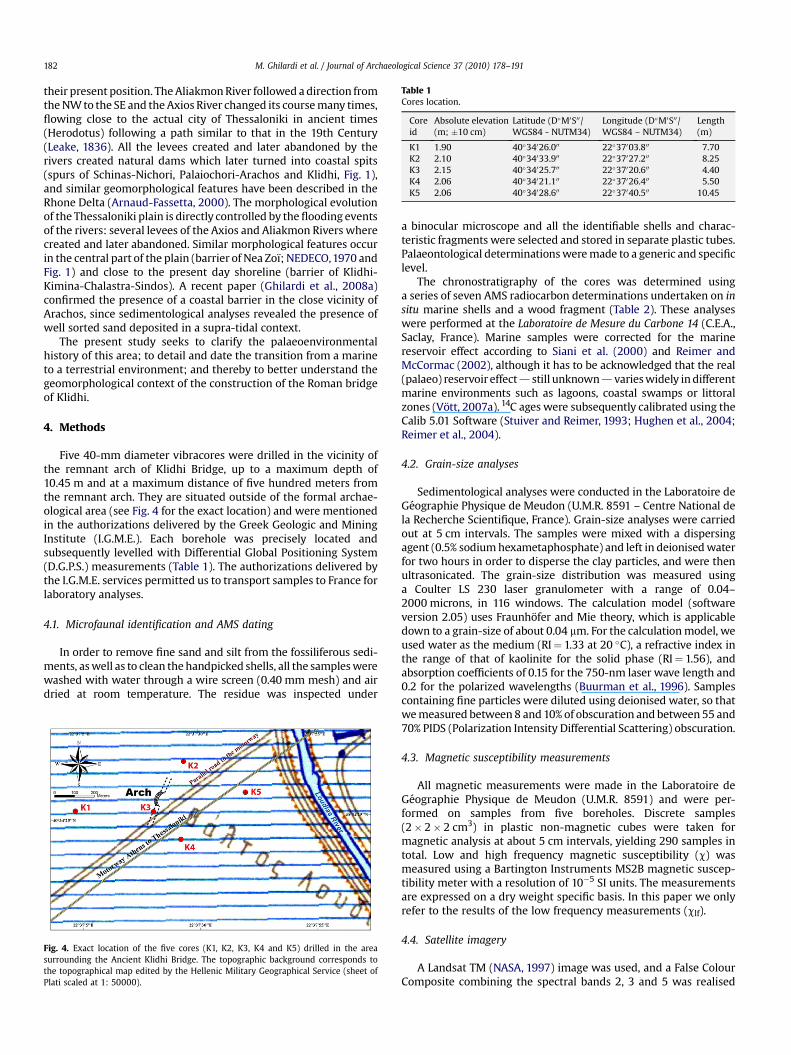
Table 1Cores location.
Coreid
Absolute elevation(m; �10 cm)
Latitude (D�M0S00/WGS84 - NUTM34)
Longitude (D�M0S00/WGS84 – NUTM34)
Length(m)
K1 1.90 40�34026.000 22�37003.800 7.70K2 2.10 40�34033.900 22�37027.200 8.25K3 2.15 40�34025.700 22�37020.600 4.40K4 2.06 40�34021.100 22�37026.400 5.50K5 2.06 40�34028.600 22�37040.500 10.45
M. Ghilardi et al. / Journal of Archaeological Science 37 (2010) 178–191182
their present position. The Aliakmon River followed a direction fromthe NW to the SE and the Axios River changed its course many times,flowing close to the actual city of Thessaloniki in ancient times(Herodotus) following a path similar to that in the 19th Century(Leake, 1836). All the levees created and later abandoned by therivers created natural dams which later turned into coastal spits(spurs of Schinas-Nichori, Palaiochori-Arachos and Klidhi, Fig. 1),and similar geomorphological features have been described in theRhone Delta (Arnaud-Fassetta, 2000). The morphological evolutionof the Thessaloniki plain is directly controlled by the flooding eventsof the rivers: several levees of the Axios and Aliakmon Rivers wherecreated and later abandoned. Similar morphological features occurin the central part of the plain (barrier of Nea Zoı; NEDECO,1970 andFig. 1) and close to the present day shoreline (barrier of Klidhi-Kimina-Chalastra-Sindos). A recent paper (Ghilardi et al., 2008a)confirmed the presence of a coastal barrier in the close vicinity ofArachos, since sedimentological analyses revealed the presence ofwell sorted sand deposited in a supra-tidal context.
The present study seeks to clarify the palaeoenvironmentalhistory of this area; to detail and date the transition from a marineto a terrestrial environment; and thereby to better understand thegeomorphological context of the construction of the Roman bridgeof Klidhi.
4. Methods
Five 40-mm diameter vibracores were drilled in the vicinity ofthe remnant arch of Klidhi Bridge, up to a maximum depth of10.45 m and at a maximum distance of five hundred meters fromthe remnant arch. They are situated outside of the formal archae-ological area (see Fig. 4 for the exact location) and were mentionedin the authorizations delivered by the Greek Geologic and MiningInstitute (I.G.M.E.). Each borehole was precisely located andsubsequently levelled with Differential Global Positioning System(D.G.P.S.) measurements (Table 1). The authorizations delivered bythe I.G.M.E. services permitted us to transport samples to France forlaboratory analyses.
4.1. Microfaunal identification and AMS dating
In order to remove fine sand and silt from the fossiliferous sedi-ments, as well as to clean the handpicked shells, all the samples werewashed with water through a wire screen (0.40 mm mesh) and airdried at room temperature. The residue was inspected under
Fig. 4. Exact location of the five cores (K1, K2, K3, K4 and K5) drilled in the areasurrounding the Ancient Klidhi Bridge. The topographic background corresponds tothe topographical map edited by the Hellenic Military Geographical Service (sheet ofPlati scaled at 1: 50000).
a binocular microscope and all the identifiable shells and charac-teristic fragments were selected and stored in separate plastic tubes.Palaeontological determinations were made to a generic and specificlevel.
The chronostratigraphy of the cores was determined usinga series of seven AMS radiocarbon determinations undertaken on insitu marine shells and a wood fragment (Table 2). These analyseswere performed at the Laboratoire de Mesure du Carbone 14 (C.E.A.,Saclay, France). Marine samples were corrected for the marinereservoir effect according to Siani et al. (2000) and Reimer andMcCormac (2002), although it has to be acknowledged that the real(palaeo) reservoir effect d still unknown d varies widely in differentmarine environments such as lagoons, coastal swamps or littoralzones (Vott, 2007a). 14C ages were subsequently calibrated using theCalib 5.01 Software (Stuiver and Reimer, 1993; Hughen et al., 2004;Reimer et al., 2004).
4.2. Grain-size analyses
Sedimentological analyses were conducted in the Laboratoire deGeographie Physique de Meudon (U.M.R. 8591 – Centre National dela Recherche Scientifique, France). Grain-size analyses were carriedout at 5 cm intervals. The samples were mixed with a dispersingagent (0.5% sodium hexametaphosphate) and left in deionised waterfor two hours in order to disperse the clay particles, and were thenultrasonicated. The grain-size distribution was measured usinga Coulter LS 230 laser granulometer with a range of 0.04–2000 microns, in 116 windows. The calculation model (softwareversion 2.05) uses Fraunhofer and Mie theory, which is applicabledown to a grain-size of about 0.04 mm. For the calculation model, weused water as the medium (RI¼ 1.33 at 20 �C), a refractive index inthe range of that of kaolinite for the solid phase (RI¼ 1.56), andabsorption coefficients of 0.15 for the 750-nm laser wave length and0.2 for the polarized wavelengths (Buurman et al., 1996). Samplescontaining fine particles were diluted using deionised water, so thatwe measured between 8 and 10% of obscuration and between 55 and70% PIDS (Polarization Intensity Differential Scattering) obscuration.
4.3. Magnetic susceptibility measurements
All magnetic measurements were made in the Laboratoire deGeographie Physique de Meudon (U.M.R. 8591) and were per-formed on samples from five boreholes. Discrete samples(2� 2� 2 cm3) in plastic non-magnetic cubes were taken formagnetic analysis at about 5 cm intervals, yielding 290 samples intotal. Low and high frequency magnetic susceptibility (c) wasmeasured using a Bartington Instruments MS2B magnetic suscep-tibility meter with a resolution of 10�5 SI units. The measurementsare expressed on a dry weight specific basis. In this paper we onlyrefer to the results of the low frequency measurements (clf).
4.4. Satellite imagery
A Landsat TM (NASA, 1997) image was used, and a False ColourComposite combining the spectral bands 2, 3 and 5 was realised

Table 2Radiocarbon dating results.
Core id Sample type Depth belowsurface (m)
Depth belowsea-level (m)
Datingmethod
Laboratoryreference
d13C Age (14C BP) � Cal. BC/AD
K1 Shell (Nassarius reticulatum) 3.85 1.95 AMS SacA 11504 �2,5 2230 30 177/347 ADK1 Shell (Cyclope neritea) 4.18 2.28 AMS SacA 11505 �4,3 2885 30 632/417 BCK2 Shell (Spisula subtruncata) 8.12 6.02 AMS SacA 11506 �1,6 2270 30 130/295 ADK2 Shell (Spisula subtruncata) 8.23 6.13 AMS SacA 11507 �0,5 2155 30 269/426 ADK3 Wood fragment (Quercus sp.) 4.40 2.25 AMS SacA 11510 �25,7 485 30 1419/1441 ADK5 Shell (Spisula subtruncata) 9.20 7.14 AMS SacA 11508 0,6 2155 30 269/426 ADK5 Shell (Spisula subtruncata) 9.54 7.48 AMS SacA 11509 0,2 2205 30 220/387 AD
M. Ghilardi et al. / Journal of Archaeological Science 37 (2010) 178–191 183
using the Er Mapper software, version 7.0 and later integrated ina Geographic Information System. Important results using remotesensing techniques were recently obtained for Thessaloniki Plain’s(palaeo) landscape interpretation (Ghilardi, 2007 and Ghilardiet al., 2008b). Former alluvial levees, palaeo channels and lake/swamps have been clearly distinguished.
5. Results
5.1. Stratigraphy
Based on the various laboratory analyses, seven sedimentaryunits can be distinguished and are described as follows:
- The first unit is only identified in the lower part of core K1, from2.00 m below mean sea-level (b.m.s.l.) down to 5.80 m b.m.s.l.It consists of heterogeneous sediments, ranging from clay tofine sands, with clf values in the range 45–130�10�8 m3/kg.Within the sediments, we identified marine molluscs (Fig. 5).The most abundant species was the gastropod Bittium retic-ulatum, which belongs to the subtidal sands and hard substratemolluscan assemblage (Marriner et al., 2008). From the sedi-mentological and microfaunal analyses, we infer that thissedimentary unit is of marine origin in its lower part and whichgradually changed to a lagoonal environment at the top. Fromthe age model, the transition from marine to shallow marine/lagoonal conditions occurred around 632/417 BC (based oncore K1 interpretation).
- The second unit is well represented and observed in cores K1,K2, K4 and K5. The grain-size distribution indicates sedimentsranging from silts to very coarse sands (well sorted), and the clf
values range from 25 to 95�10�8 m3/kg. In core K1, from1.90 m until 3.35 m b.m.s.l. (Fig. 6), we found very abundant
Fig. 5. Shell identifications. 1a and b: Bittium reticulatum; 2a and b: Cyclope neritea; 3a and band b: Ocinebrina aff. Aciculate; 7a and b: Mangelia sp.
marine molluscal debris and in situ marine shells such asgastropods (Cyclope neritea, Nassarius reticulatum, Ocinebrinaaff. Aciculate, Mangelia sp., see Fig. 5) and bivalves (Loripeslacteus, Cerastoderma edule). Cerastoderma edule (an Atlanticspecies which is also called Cerastoderma glaucum in theMediterranean) is usually found in lagoons and especiallythose still connected to the sea (Kevrekidis et al., 1996).Generally, it lives in abundance in very well sorted fine sand inlow energy environments (Kevrekidis et al., 1996; Poluzzi et al.,1981), and where wave action is not observed (Boyden andRussel, 1972). For cores K2 and K5, the molluscan assenblages isrelatively poor, with very few tests represented. The onlyspecies identified is Spisula subtruncata, in cores K2 (from5.90 m down to 6.15 m b.m.s.l.) and K5 (from 7.05 m down to7.40 m b.m.s.l.). This clearly indicates a shallow marine envi-ronment (Cardoso et al., 2007) and important freshwaterinfluences can be clearly observed based on the shape of themolluscs (Fig. 5). In doing so, we can infer that above themarine sediments the second unit corresponds to lagoonalenvironments. Nevertheless, it is clear that the lagoonal stagesobserved in cores K2 and K5 are more influenced by terrestrialdynamics and the environment appears to be strongly affectedby freshwater influxes. In contrast, the lagoonal sedimentaryunit is richer in fauna and a connection with the sea seems tobe evident. We infer a lagoonal phase in cores K1, K2 and K5 butthe salinity conditions were different. Radiocarbon dating givesages for the lagoonal unit from 632/417 BC to 177/347 AD forcore K1, from 130/295 AD to 269/426 AD for core K2, and forcore K5, we find similar ages as for K2, ranging from 220/387AD to 269/426 AD.
- The third unit is found in cores K1, K2 and K5 (approximately1.70 m thick) and is characterised by very fine grey-colouredsediments with a modal grain size up to 50 mm, thus indicating
: Nassarius reticulatum; 4a and b: Spisula subtruncata; 5a and b: Cerastoderma edule; 6a

M. Ghilardi et al. / Journal of Archaeological Science 37 (2010) 178–191184
a very calm depositional environment. Some small shell frag-ments occur within the sediments but unfortunately it wasimpossible to determine the species. This bio-sedimentary unitis found over the lagoonal deposits and terrestrial dynamicsmay have influenced the salinity. We infer that brackishconditions obtained and which were subject to terrestrialinfluences, probably caused by the presence of a river channelin the vicinity.
- The fourth unit is found only in cores K3 (from 2.01 m to 2.25 mb.m.s.l.) and K4 (from 2.17 m to 3.36 m b.m.s.l.) and iscomposed of very coarse grey sands in the lower part and bya mixture of grey and yellow/orange coarse sands at the top.The modal grain size ranges from 150 to 350 mm and the clf
values range from 70 to 155�10�8 m3/kg. No intact fossilswere identified (very small fragments) and generally littleorganic matter was found. We can infer that this sedimentaryunit represents a coastal barrier.
- The fifth unit consists of dark grey sediments, with intercalatedorganic layers, and ranging from clay to sands. Peaks of up to150 mm in modal grain size are observed in cores K2 and K5, butin general the modal grain size index does not exceed 50 mm.The clf values range from 5 to 70�10�8 m3/kg and distinctfluctuations are observed. No fauna were observed. We inter-pret this unit as fluvial deposits indicating a low river transportcapacity, and that the depositional environment was calm.
- In the upper part of cores K1, K2, K3, K4 and K5 the sixth unitcomprises coarse-grained sediments (yellow to orange colourreveals oxidation), interpreted as fluvial deposits. In cores K2and K5, these sediments overlie the first fluvial sequence (thefifth unit described above). The modal grain size indicatesalternations between silts and coarse sands, which are gener-ally well sorted. clf values range from 40–180�10�8 m3/kg.Fig. 7 shows the relationship between clf and the modal andmean grain size. For the fluvial sediments of all the cores, thereis a general increase in clf with increasing grain size, indicatinga tendency for detrital ferrimagnetic grains to be concentratedin the coarser sediment fraction. A fluvial sequence, recorded incores K1, K3 and K4, was dated to 1419/1441 AD (radiocarbondating was performed on a wood fragment, Quercus sp.) in thetransition from coastal barrier deposits to fluvial sediments forcore K3.
- The seventh unit, identified in cores K1, K3, K4 and K5, iscomposed of dark brown clay deposits and intercalated peatlayers with a maximum thickness of circa 50 cm. A few landsnails (Helicidae sp.) were found. clf values are generally low,from 35–75�10�8 m3/kg. This last unit probably correspondsto continental swamps and there is insufficient data to confirmthe NEDECO (1970, Fig. 3) interpretation considering that veryrecent lake shore deposits occur around the remnant arch ofKlidhi Bridge. Furthermore, maps dated from the 19th Centuryand the beginning of the 20th Century (Struck, 1908) do notshow the presence of a lake in the area instead, there was thejunction of the Loudias and Axios Rivers.
5.3. Landsat imagery interpretation
The false colour composition based on the combination ofspectral bands 2, 3 and 5 of a Landsat TM imagery (period: 11/05/1997) reveals the presence of wet (green-to-light olive-colour) anddry (light pink colour) areas (Fig. 8). According to previous work(Ghilardi et al., 2008a) in the western part of the Thessaloniki Plain,meanders of the Aliakmon River created several alluvial leveescomposed mainly of medium to coarse sands (permeable). We canobserve in Fig. 8, with a dashed line (blue colour), ancient courses of
the Aliakmon running from south–west to north–east, close to theactual Loudias channel and less than one kilometre northward ofthe remnant arch of the Klidhi Bridge. The deltaic geomorphologiccontext suggests that other branches could have developed to thesouth and could have flowed beneath the arches. All the corescontain yellow fluvial sediments in their upper part, close to thepresent surface level. The Landsat interpretation reveals that a firstchannel was meandering from core K1 to cores K3 and K4 with aneast–west direction. A second channel, running some tens of metersto the north from cores K2 to K5, is also evident. Based on thecombination of the Landsat imagery results and the core analyses, itis evident that a channel from the Aliakmon River flowed to thesouth beneath the bridge (the actual remnant arch), and due to theabsence of the other arches to the north it is difficult to concludethat a second branch was flooding under the edifice. Indeed, basedon the Delacoulonche (1859) and Struck (1908) estimations, it maybe estimated that to the north of the arch, the bridge measuredapproximately 70 m and this is also the distance between the Klidhiarch and core K2, which records a very thin fluvial layer whichprobably marks the margin of the river.
The green-to-light olive coloured areas indicate the recentoccurrence of saturated conditions in the subsoil. The uppermostpart of all the cores analysed in the framework of our researchindicate the presence of marshes (green-to-grey clay deposits).These marshes probably existed prior to the reclamation of theentire Thessaloniki Plain in the 1920s (Ancel, 1930). It is possible toconsider these topographically low areas as ancient lagoons createdwithin the general context of deltaic progradation where leveeschanged into coastal barriers.
6. Discussion
6.1. Palaeoenvironmental reconstruction of the area surroundingAncient Roman Klidhi Bridge
According to Ghilardi et al. (2008a,b) and Fouache et al. (2008),and based on the results obtained in this article, the lower part ofThessaloniki Plain was a marine environment during the Archaicand classical periods (from the 7th to the 4th Century BC). Theoccurrence in cores K2 and K5 of lagoon shells at a depth of circa7 m below the mean marine sea-level, dated to Roman Times, mustbe considered in the context of recent subsidence studies (Stiros,2001; Psimoulis et al., 2007). These revealed significant rates ofsubsidence in the lower part of the deltaic complex of ThessalonikiPlain. Indeed, over the last 50 years, accurate measurements of thesubsidence phenomena indicate values of around 4 m per yearclose to the present day shoreline (Psimoulis et al., 2007). It is easyto imagine that on a longer time scale (the last 2500 years),subsidence could had been more important.
During early Roman Times (from 168 B.C. to the 1st CenturyA.D.), there was general deltaic progradation which affected thewhole area, and Strabo considers that at this time Pella was con-nected to the sea and that ships used to reach the ancient capitalafter navigating a narrow channel 22.2 km length (Geography, VII,frag. 20 and 22). Ghilardi et al. (2008a) revealed the shape of thecoastline at that time and it is evident that marine to shallowmarine environments occurred in the area of Klidhi Bridge. Severallagoons were in the process of being formed and coastal barrierswere being created (Fig. 11). However, the bridge did not yet existand neither Livy (in his Natural Histories) nor Strabo (in his Geog-raphy) mention the existence of a shorter road, along the shoreline.From this we can conclude that the bridge was not constructedduring the first Century A.D.
Gradually, due to the growth of terrestrial dynamic influences(alluviation of the Aliakmon and Axios Rivers) and the constant

Fig. 6. Core profiles of cores K1, K2, K3, K4 and K5. Results for grain-size distribution and magnetic susceptibility are provided.
M. Ghilardi et al. / Journal of Archaeological Science 37 (2010) 178–191 185

Fig. 7. Magnetic susceptibility measurements vs. grain-size distribution. Uppercartoon: Magnetic susceptibility (Lf) vs. modal index, downer cartoon: magneticsusceptibility (Lf) vs. Mean index
M. Ghilardi et al. / Journal of Archaeological Science 37 (2010) 178–191186
deltaic progradation, a transition to lagoonal conditions occurredduring the Hellenistic period, and was well attested during RomanTimes (Fig. 9). Such palaeoenvironmental conditions were prob-ably caused by the creation of a series of coastal barriers, as sug-gested by the NEDECO report (1970) – probably the barrier calledKlidhi-Kimina-Chalastra-Sindos (Fig. 1). The development ofseveral isolated lagoons accumulating sediments, ranging fromsilts to medium- and coarse sands, was possible and connectionswith the sea still existed. This situation would have justified theconstruction of the Klidhi Bridge. Based on the microfaunal iden-tifications done for cores K1, K2 and K5, and the various analyses ofthe sediments from cores K3 and K4, we conclude that two lagoonswere separated by a coastal barrier. A shorter road (Bintliff, 1976)was then constructed, which branched from Pydna to Thessaloniki,
Fig. 8. LANDSAT TM imagery (11/05/1997), False Colour Composite established afterthe combination of the spectral bands 2, 3 and 5. The red stars indicate the location ofthe cores K1, K2, K3, K4 and K5. The black half circle is the remnant arch of KlidhiBridge. The dashed blue lines correspond to old channels of the Aliakmon River. Thedashed red line corresponds to an old channel of the Axios River (Ghilardi, 2007). Thevillage of Kaliani is nowadays abandoned but Delacolounche stayed there during histravel to Macedonia. (For interpretation of the references to colour in this figurelegend, the reader is referred to the web version of this article).
to the Egnatia Road. Our work shows that the Roman road ranbetween two lagoons and was built over a coastal barrier at circa300 AD (Fig. 11). The Roman engineers decided to establish a road inthe lower part of the recently created Thessaloniki Plain. In order toavoid swampy/lagoonal areas, close to the shoreline, they elected tobuild the road on the highest topographic point. The course ofthe Loudias Channel, the outlet of Loudias Lake (mentioned byStrabo during the 1st Century A.D., c.f. Geography, VII, frag. 23) wasprobably moving laterally in the geomorphological context of theformation of lagoons. This channel definitely existed, and it had noprecise lateral limits, e.g. many swamps occurred along the mainchannel, flooding under the central/northern part of the bridge. Indoing so, the ancient Bridge of Klidhi was built on a coastal barrier,over the outlet of Loudias Lake which drained directly intoa lagoonal complex, itself connected to the sea.
The change from lagoonal/brackish environments to a dynamicterrestrial environment is confirmed by the passage of a river,depositing coarse sediments, after the 15th Century AD (during theByzantine and Ottoman periods, Figs. 10 and 11) under the centralpart of the bridge. The presence of a wood fragment (Quercus sp.)found beneath the ancient bridge of Klidhi in core K3 (probablya part of the bridge deck refurbished at the end of Byzantine Times/beginning of the Ottoman period. Indeed, oak was often employedfor bridge construction since it was a hard material useful forsupporting and protecting bridges in particular), at the transitionbetween coastal barrier deposits and fluvial sediments, may indi-cate that it belongs to the bridge itself and suggests that a violentflood may have damaged part of the bridge. Furthermore, themultiplicity of several distributaries of the Aliakmon River and theclose presence of the Loudias River did not result in the mainte-nance of the edifice and it was probably abandoned for anotherroad. Based on the satellite imagery and the sedimentologicalanalyses, we conclude that Aliakmon was flooding from the site ofcore K1, through the sites of cores K3 and K4 to core K5.
Until the mid fifteenth century (Fig. 11), it is probable that therate of progradation of the Aliakmon and Axios rivers slowed downand lagoons still existed at those times and that the shoreline wasstill in the close vicinity, as it was during Roman times. Moreover,no rivers were flooding in the nearby area according to the detailedmap constructed by Leake (1836): neither the Aliakmon (flowingfurther south–westwards) nor the Loudias River (connected to theAxios River, further to the east). It is likely that swamps still existedaround the remnant arch. At this time, local villagers decided toremove the stones from the edifice in order to construct buildingssuch as churches and houses.
In the first half of the 20th Century, significant efforts weremade to reclaim the plain and to drain the swamps (Ancel, 1930;Ghilardi, 2007; Ghilardi et al., 2008a). In addition, the major riverswere controlled and several dams were built to protect the fieldsfrom major floods. The present day topography was established,and numerous landforms which existed in the ancient landscapedisappeared.
6.2. Evidence for the alteration of the status of Pella due tolandscape changes during Hellenistic/Roman Times
In general, historians consider that wars and conflicts wereresponsible for the demise of kingdoms, and this was also thecase for the Macedonian Realm (Hammond, 1972) – in particularfor its former capital, Pella. Pella became the capital of theHellenistic period (323–168 B.C.), and gradually, after the Romanconquest, political control of the Macedonian province and of theMediterranean began to weaken. Thessaloniki became the mostimportant city during late Roman Times and a major site duringthe Byzantine Period (Bintliff, 1976; Papazoglou, 1988). The

Fig. 9. Cross section using the results derived from cores K1, K2 and K5, the chronostratigraphic sequences are connected together to facilitate a spatial interpretation.
M. Ghilardi et al. / Journal of Archaeological Science 37 (2010) 178–191 187
important point is the establishment of the Late Roman Roadthrough the plain, along the coastline, which linked Athens –Pydna – to Thessaloniki. Pella was then situated on the margin ofthis main axis, landlocked inside the Central Macedonian Plain. Atthe present day, this branch of the Egnatia Way is only evidencedby the presence of the arch of Klidhi and it is probable that mostof its pavement is buried by a significant thickness of fluvial
sediments. Our work reveals that the rapid landscape evolutionand the creation of the Thessaloniki Plain at the end of the LateRoman Times altered Pella’s status. The emergence of Thessalonikias the capital of the Roman province of Macedonia must be linkedwith the construction of new Roman roads across the newlycreated plain: at that time the distance between Athens andThessaloniki was shorter, and the latter city was also situated on

Fig. 10. Cross section using the results derived from cores K1, K3 and K4, the chronostratigraphic sequences are connected together to facilitate a spatial interpretation.
M. Ghilardi et al. / Journal of Archaeological Science 37 (2010) 178–191188
the main axis of the Egnatia Way, from Dyrrachium to Byzance(O’Sullivan, 1972).
6.3. Evidence for a river flowing under the remnant arch during theByzantine–Ottoman periods: a possible consequence of climatecontrol on the river dynamics, or the effect of human impacts onsedimentation processes?
Previous studies mentioned the possibility of a river (Bintliff,1976), or the junction of two rivers (NEDECO, 1970), flowing beneathKlidhi Bridge during Roman times. From the results presented here,we can assume that marine to lagoonal conditions were predominantduring the archaic, classical, hellenestic and imperial periods.Subsequently, sedimentological evidence indicates the presence of
fluvial conditions and suggests that a river flowed beneath the bridgefrom the mid 15th Century until the beginning of the 19th Century.During his visit to the remnant arch at the beginning of the 19thCentury, Cousinery (1831) observed that ‘new soils’ had beendeposited by a river and had almost buried the edifice. Presumably,therefore, the river was still active at that time. Furthermore, whenDelacoulonche (1859) described the edifice in the mid 19th Century,no rivers were flowing beneath the remnant arch of Klidhi bridge. InNorthern Greece, observations made in the Epirus area (Fouache,1999) and in Eastern Macedonia (Lespez, 1999, 2003), point to analluvial crisis affecting the major rivers during the Byzantine and theOttoman periods. If anthropogenic factors (Lespez, 2003) are high-lighted to explain significant fluvial activity, climate variability is alsolikely to have been an important influence (the Little Ice Age episode).

Fig. 11. Palaeogeographic reconstruction of the area surrounding the remnant arch of the Klidhi Bridge. The scenario is inferred after combining the results from the palae-oenvironmental study, the historical geography critical analysis and the remote sensing interpretation.
M. Ghilardi et al. / Journal of Archaeological Science 37 (2010) 178–191 189
7. Conclusions
In previous work (Ghilardi et al., 2008a,b; Fouache et al., 2008),the main phases of the deltaic progradation of Thessaloniki Plainwere detailed using a palaeoenvironmental approach. However, thelower part of the largest deltaic complex in Greece was little studiedand palaeonvironmental reconstructions were not made for severalimportant archaeological sites. The remnant arch of the RomanKlidhi Bridge has witnessed the rapid geomorphological evolutionof Thessaloniki Plain, especially in its lower part. The palae-oenvironmental reconstruction presented in this paper confirmsthe research recently carried out in the area (Ghilardi, 2007) andprovides a more detailed understanding of the geomorphologicalevolution of the landscape in the vicinity of the remnant arch.
The new results detailed here allow us to infer that a marineenvironment occupied the area during the archaic, classical andhellenestic periods. Shallow marine to lagoonal conditions obtainedin mid and late Roman Times (from the 1st to the 4th Century AD)and the construction of the bridge dates from this period. Thecreation of a series of coastal barriers led to the isolation of lagoons,although some connections with the sea still existed. In order toestablish a new road, connecting Southern Macedonia (the ancientcity of Pydna) to Thessaloniki (and the Egnatia Road), Roman engi-neers decided to construct several edifices over the coastal barrierand to avoid swamps. Some bridges were built in areas of swamp inorder to span the connections between the lagoons and the sea.
The geoarchaeological approach used here reveals that rapidlandscape changes strongly affected not only the use of the Roman
M. Ghilardi et al. / Journal of Archaeological Science 37 (2010) 178–191190
Bridge of Klidhi but also influenced Ancient Pella’s leadership in theprovince of Macedonia. After the connections between the deltaiclobes of Axios and Aliakmon Rivers, probably in the vicinity ofancient Klidhi, the Thessaloniki Plain was created and Pella wascompletely isolated inland and its status of a city with a harbourcollapsed during roman Times. It is generally accepted that theMacedonian Kingdom started to collapse around the third CenturyBC (Hammond, 1972) and the battle of Pydna in 168 BC concludedthe achievement of the one world’s largest Kingdom, and aroundthe 6th Century AD references to Pella disappeared completelyfrom the written sources (Bintliff, 1976). At the same time, theperiod from the 4th BC to the 4th Century AD shows that the deltaicprogradation of the Axios and Aliakmon River was very intensearound the ancient Macedonian capital (Ghilardi, 2007; Ghilardiet al., 2008a,b). An important question now arises: was the romaninvasion and occupation the only factors responsible for the end ofthe Macedonian Realm, or is it possible to consider that landscapechanges determined the status of ancient Pella? It is difficult toseparate both factors and the results presented in this article clearlyindicate that archaeological studies must not be dissociated fromlandscape reconstruction.
Acknowledgements
Thanks to I.G.M.E. for providing authorizations for the geomor-phological prospection and for the drilling; in particular we aregrateful to Irene Zananiri for her precious help and her kindness.
This article was financially supported by the Laboratoire deGeographie Physique (U.M.R. 8591, C.N.R.S.) and by the ResearchTeam GEONAT E.A. 435 directed by Professor Eric Fouache. Anne-Marie Lezine from L.S.C.E. – C.N.R.S is thanked for her help in per-forming A.M.S. dating. Marie-Claude Saad from the University ofParis 10 is acknowledged for the botanic identification of the woodfragments.
The authors are graceful to Antoine Chabrol and to Zisis Kozla-kidis for their help in coring in April 2008.
We also thank the Prefecture of Emathia (Greece) and themunicipalities of Trikala and Plati (Prefecture of Emathia) for kindlysupporting our researches, the inhabitants of these two cities arealso acknowledged for the facilities offered. Haralambos Tzenikidisand the members of his family (Andonis and Sotiris) are warmlyacknowledged for their precious help and for the hospitalityoffered.
Finally, Anthony Blundell from the University of Leeds isthanked for his fruitful remarks and for improving the writing styleof an early version.
References
Ancel, J., 1930. La Macedoine, etude de la colonisation contemporaine. Delagrave,Paris, p. 352.
Arnaud-Fassetta, G., 2000. Quatre mille ans d’histoire d’hydrologique dans le deltadu Rhone, vol. 11. Grafigeo, Paris, 229 p.
Astaras, T.A., Sotiriadis, L., 1988. The Evolution of the Thessaloniki – Giannitsa Plainin Northern Greece During the Last 2500 Years – from the Alexander the GreatEra Until Today. Lake, Mire and River Environments During the Last 15 000Years. Balkema, Rotterdam, pp. 105–114.
Bakalakis, G., 1970. The ‘‘Classical’’ Bridge at Amphipolis. American Journal ofArchaeology 74 (3), 289–291.
Bintliff, J., 1976. The plain of western Macedonia and the Neolithic site of NeaNikomedeia. Proceedings of the Prehistoric Society 42, 241–262.
Boyden, C.R., Russel, P.J.C., 1972. The distribution and habitat range of the brackishwater cockle (Cardium – Cerastoderma- glaucum), in the British Isles. Journal ofAnimal Ecology 43, 719–734.
Bruckner, H., 2005. Holocene shoreline displacements and their consequences forhuman societies: the example of Ephessus in western Turkey. Zeitschrift furGeomorphologie 137 (Suppl.), 11–22.
Buurman, P., Pape, T., Muggler, R.C.C., 1996. Laser grain-size determination in soilgenetic studies: practical problems. Soil Science 162, 211–218.
Cardoso, J.F.M.F., Witte, J.I.J., Van Der Veer, H.W., 2007. Growth and reproduction ofthe bivalve Spisula subtruncata (da Costa) in dutch coastal waters. Journal of SeaResearch 57 (4), 316–324. http://dx.doi.org/doi:10.1016/j.seares.2006.12.002.
Cousinery, E.M., 1831. Voyage dans la Macedoine, vol. 2. Imprimerie Royale, Paris.Delacoulonche, A., 1859. Memoire sur le berceau de la puissance macedonienne des
bords de l’Haliacmon a ceux de l’Axius. Archives des missions scientifiques etlitteraires.
Devillers, B., Excoffon, P., Morhange, C., Bonnet, S., Bertoncello, F., 2007. Relative sea-level changes and coastal evolution at Forum Julii (Frejus, Provence). ComptesRendus Geoscience 339, 329–336. http://dx.doi.org/10.1016/j.crte.2007.03.004.
Edson, C., 1955. Strepsa (Thucydides 1. 61. 4). Classical Philology 50 (3), 169–190.Fouache, E., 1999. BCH. L’Alluvionnement historique en Grece occidentale et au
Peloponnese: geomorphologie, archeologie et histoire, vol. 35. Editions DeBoccard. 235 p.Suppl.
Fouache, E., 2003. The Mediteranean World: Environment and History, Actes duColloque Environmental Dynamics and History in Mediterraneans Areas.Working Group on Geoarchaeology (IAG), Universite de Paris IV, UMR 8505,EFA, EFR, Casa de Velasquez, ENS LSH/Lyon, Universite de Paris IV, 24–25–26avril 2002. Elsevier, Paris, 485 p.
Fouache, E., Dalongeville, R., Kunesch, S., Suc, J.P., Subally, D., Prieur, A., Lozouet, P.,2005. The environmental setting of the harbour of the classical site of Oeniades(Archanania, Acheloos Delta, Greece). Geoarchaeology 20 (3), 285–302.
Fouache, E., Ghilardi, M., Vouvalidis, K., Syrides, G., Kunesch, S., Styllas, M., Stiros, S.,2008. Contribution on the Holocene reconstruction of Thessaloniki Plain, NorthCentral Greece. Journal of Coastal Research 24 (5), 1161–1173. http://dx.doi.org/10.2112/06-0786.1.
Ghilardi, M., 2007. Dynamiques spatiales et reconstitutions paleogeographiques dela plaine de Thessalonique (Grece) a l’Holocene recent. PhD thesis, University ofParis 12 Val-de-Marne, 475 p. http://tel.archives-ouvertes.fr/tel-00201255/fr
Ghilardi, M., Kunesch, S., Styllas, M., Fouache, E., 2008a. Reconstruction of Mid-Holocene sedimentary environments in the central part of the ThessalonikiPlain (Greece), based on microfaunal identification, magnetic susceptibility andgrain-size analyses. Geomorphology 97 (3–4), 617–630. http://dx.doi.org/10.1016/j.geomorph.2007.09.007.
Ghilardi, M., Fouache, E., Queyrel, F., Syrides, G., Vouvalidis, K., Kunesch, S.,Styllas, M., Stiros, S., 2008b. Human occupation and geomorphological evolu-tion of the Thessaloniki Plain (Greece) since Mid Holocene. Journal of Archae-ological Science 35 (1), 111–125. http://dx.doi.org/10.1016/j.jas.2007.02.017.
Gifford, J.A., Rapp Jr., G., Vittali, V., 1992. Palaeogeography of Carthage (Tunisia):coastal change during the first millennium BC. Journal of Archaeological Science19, 575–596. http://dx.doi.org/10.1016/0305-4403(92)90029-3.
Goiran, J.-P., Morhange, C., 2003. Geoarcheologie des ports antiques de medi-terranee. Topoi 11, 645–667.
Hammond, N.G.L., 1972. A History of Macedonia. In: Historical Geography andPrehistory, vol. I. Clarendon Press, Oxford.
Hughen, K.A., Baillie, M.G.L., Bard, E., Bayliss, A., Beck, J.W., Bertrand, C., Blackwell, P.G.,Buck, C.E., Burr, G., Cutler, K.B., Damon, P.E., Edwards, R.L., Fairbanks, R.G.,Friedrich, M., Guilderson, T.P., Kromer, B., McCormac, F.G., Manning, S.,Ramsey, Bronk, Reimer, P.J., Reimer, R.W., Remmele, S., Southon, J.R., Stuiver, M.,Talamo, S., Taylor, F.W., Van der Plicht, J., Weyhenmeyer, C.E., 2004. Radiocarbon46, 1059–1086.
Kevrekidis, T., Gouvis, N., Koukouras, A., 1996. Bionomy of Macrobenthic Molluscs inEvros Delta (North Aegean Sea). International Revue ges. Hydrobiologia 81 (3),455–468.
Kraft, J.-C., Aschenbrenner,., S.-E., Rapp, G., 1977. Palaeogeographic reconstructionsof coastal Aegean Archaeological sites. Science 195, 941–947.
Leake, W.M., 1836. Travels in Northern Greece. Blackwell, London.Lespez, L., 1999. L’evolution des modeles et des paysages de la plaine de Drama et
de ses bordures au cours de l’Holocene (Macedoine orientale, Grece). PhDthesis, Lille theses, 539 p.
Lespez, L., 2003. Geomorphic responses to long-term land use changes in EasternMacedonia (Greece). Catena 51, 3–4. http://dx.doi.org/10.1016/S0341-8162(02)00164-9. 181–208.
Marriner, N., Morhange, C., Saghieh-Beydoun, M., 2008. Geoarchaeology of Beirut’sancient harbour, Phoenicia. Journal of Archaeological Science 35, 2495–2516.http://dx.doi.org/10.1016/j.jas.2008.03.018.
Marriner, N., Morhange, C., 2007. Geoscience of Mediterranean harbours. EarthScience Reviews 80 (3–4), 137–194. http://dx.doi.org/10.1016/j.earscirev.2006.10.003.
Marriner, N., Morhange, C., Doumet-Serhal, C., 2007. Geoarchaeology of Sidon’sancient harbours, Phoenicia. Journal of Archaeological Science 33, 1524–1535.http://dx.doi.org/10.1016/j.jas.2006.02.004.
Marriner, N., Morhange, C., Boudagher-Fadel, M., Bourcier, M., Carbonel, P., 2005.Geoarchaeology of Tyre’s ancient northern harbour, Phoenicia. Journal ofArchaeological Science 32, 1302–1327. http://dx.doi.org/10.1016/j.jas.2005.03.019.
NASA, 1997. Landsat image 4-5 TM, May, 11th of 1997, Path 184/Row 32.NEDECO Co., Netherlands Engineering Consultants, The Hague, Netherlands, 1970.
Regional Development project of the Salonika (Thessaloniki) plain. LandReclamation Service (YEB) of the Ministry of Agriculture, Athens.
O’Sullivan, F., 1972. The Egnatian Way. David & Charles, 264 p.Papazoglou, F., 1988. Les villes de Macedoine a l’epoque romaine. Bulletin de Cor-
respondance Hellenique 16 (Suppl.), 528. De Boccard.Poluzzi, A., Sabelli, B., Taviani, M., 1981. Auto-sinecologia dei Molluschi: dei fondi
mobili del delta settentrionale del Po (Estate 1980). Bollettino della SocietaPaleontologica Italiana 21, 169–178.

M. Ghilardi et al. / Journal of Archaeological Science 37 (2010) 178–191 191
Psimoulis, P., Ghilardi, M., Fouache, E., Stiros, S., 2007. Subsidence and evolution of theThessaloniki Plain, Greece, based on historical leveling and GPS data. EngineeringGeology 90 (1–2), 55–70. http://dx.doi.org/10.1016/j.enggeo.2006.12.001.
Reimer, P.J., McCormac, F.G., 2002. Marine radiocarbon reservoir corrections for theMediterranean and Aegean Seas. Radiocarbon 44, 159–166.
Reimer, P.J., Baillie, M.G.L., Bard, E., Bayliss, A., Beck, J.W., Bertrand, C., Blackwell, P.G.,Buck, C.E., Burr, G., Cutler, K.B., Damon, P.E., Edwards, R.L., Fairbanks, R.G.,Friedrich, M., Guilderson, T.P., Hughen, K.A., Kromer, B., McCormac, F.G.,Manning, S., Bronk Ramsey, C., Reimer, R.W., Remmele, S., Southon, J.R.,Stuiver, M., Talamo, S., Taylor, F.W., Van der Plicht, J., Weyhenmeyer, C.E., 2004.Radiocarbon 46, 1029–1058.
Siani, G., Paterne, M., Arnold, M., Bard, E., Metivie, B., Tisnerat, N., Bassinot, F., 2000.Radiocarbon reservoir ages in the Mediterranean Sea and Black Sea. Radio-carbon 42, 271–280.
Stiros, S., 2001. Rapid subsidence of the Thessaloniki (Northern Greece) coastalplain, 1960–1999. Engineering Geology 61, 243–256. http://dx.doi.org/10.1016/S0013-7952(01)00027-8.
Struck, A., 1908. ‘‘Die makedonischen Niederlande’’ dans Zur Kunde des Balkan-halbinsel. Reisen und Beobachtungen, Heft 7, Wien and Leipzig.
Stuiver, M., Reimer, P.J., 1993. Radiocarbon 35, 215–230.Tafel, F., 1841. Via militaris romanorum Egnatia qua Illyricum, Macedonia et Thracia
iungebantur. Pars occidentalis. Tubingae: Typis Hopferi de l’Orme, 59 p.Vott, A., 2007a. Relative sea level changes and regional tectonic evolution of seven
coastal areas in NW Greece since the mid-Holocene. Quaternary ScienceReviews 26, 894–919. http://dx.doi.org/10.1016/j.quascirev.2007.01.004.
Vott, A., 2007b. Silting up Oiniadai’s harbours (Archeloos River delta, NW Greece).Geoarchaeological implications of late Holocene landscapes changes. Geo-morphologie, relief, processus et environnement 1, 19–36.