Datarizing the Self: Reconstructing Identities Through Self-Quantifying Practices
73
In 2004, the Ahmose and Tetisheri Project Geographical Information System (ATP-GIS) was createdprimarily to integrate satellite imagery with site plans, survey maps, and vector data in order to inves-tigate the secular and sacred New Kingdom constructions in the desert periphery. Yet the pan-oramic nature of satellite imagery challenges one to broaden one’s perspective to encompass thelargely unexplored cultivation. In the cultivation zone, there is evidence of what seems to be a net-work of relict canals, as well as relict mounding from historic earthworks and/or settlement. InDecember 2004, the investigators traveled to several of these locations to assess these cropmarksand mounding. Since this groundtruthing work was chiefly meant to be a feasibility study, this paperwill discuss preliminary findings and the future trajectory of the ATP-GIS.
This area was chosen to utilize remote sensing imagery for both site prospection and conservationin the cultivated and desert zones of the Abydos region. As many have noted, survey in the floodplainin particular has become increasingly urgent for the sake of site preservation and conservation.1
Explosive agricultural, settlement, and cemetery expansion in the decades following the completionof the Aswan High Dam in 1970 threatens sites that were once secure in the desert periphery. Koms(site mounds in the floodplain) continue to be “harvested” by local farmers for their nitrate- andphosphate-rich sebbakh, slowly eroding any perceptible relief—and thus stratified settlement—from thefloodplain. Plowing continues to obscure cropmarks that could reveal ancient route systems, canals,or walls.
The monuments and floodplain settlements of Abydos are far from immune to these effects, andactive steps need to be taken to preserve their cultural heritage. Remote sensing imagery can thus bean invaluable aid for arriving at informed decisions about concession management, site location andpreservation, and, if necessary, salvage excavations. Remote sensing is a technology that archaeologistsfamiliar with aerial photography have quickly seized upon for site detection and analysis.2 Coronaimagery in particular provides high resolution views for a minimal amount of cost and effort.3 This
1 See, for example, E. van den Brink, “A Geo-Archaeological Survey in the North-Eastern Nile Delta, Egypt; the First TwoSeasons, a Preliminary Report,” MDAIK 43 (1986), 7–9. on the reasons why survey in the cultivation is crucial.
2 D. R. Wilson, Air Photo Interpretation for Archaeologists, 2nd ed. (Stroud: Tempus, 2000). Also, an extensive bibliographicaldatabase of archaeological prospecting using aerial imagery is provided by the Aerial Archaeology Research Group website ataarg.univie.ac.at.
3 USGS. Declassified Satellite Imagery—1 (1996) edc.usgs.gov/guides/disp1.html, USGS. Declassified Satellite Imagery—2 (2002)edc.usgs.gov/products/satellite/declass2.html. CORONA actually refers to images captured by the satellite series of the samename, but the term has come to encompass those images taken by the LANYARD and ARGON satellites as well. According tothe National Reconnaissance Office of the United States, CORONA was the first satellite system to conduct reconnaissance
Reconstructing the Desert andSown Landscape of Abydos
Joshua Trampier
An earlier version of this paper was presented at the 2005 Annual Meeting of ARCE held in Boston, Massachusetts. Manythanks to the Supreme Council of Antiquities and the Sohag inspectorate for their cooperation and support of our research atAbydos. I would like to thank project director Stephen Harvey for his invitation to work on this material, his initial observa-tions of the cropmarks, and my inclusion on the Ahmose and Tetisheri Project 2004 team. My sincere thanks to Scott Branting,Jennifer Starbird, and Amber Meriwether for their helpful comments on earlier drafts.
JARCE 42 (2005–2006)74
article will not attempt to analyze various types of remote sensing imagery with their attendant advan-tages and disadvantages nor provide a comprehensive list of sources for imagery.4 However, oneshould note that the Center for Ancient Middle Eastern Landscapes (CAMEL) research facility basedin the Oriental Institute is developing into an indispensable digital archive for all satellite imagery,aerial photographs, and maps of varying scales of the greater Middle East.5
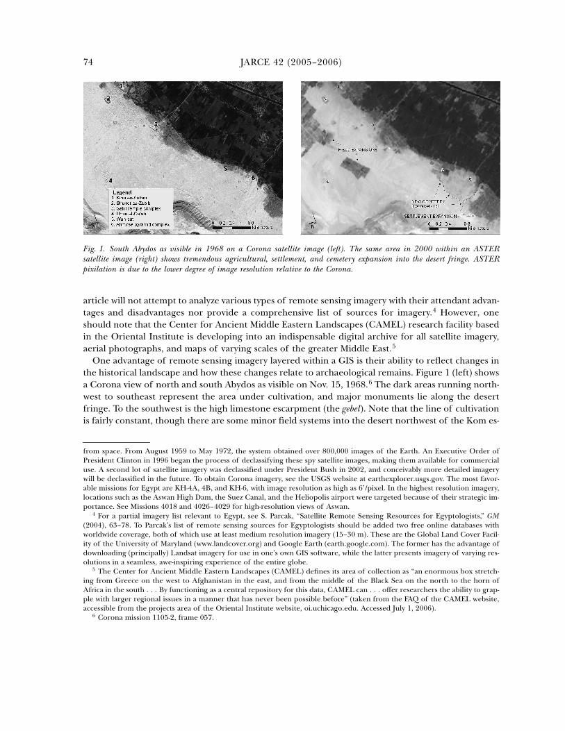
One advantage of remote sensing imagery layered within a GIS is their ability to reflect changes inthe historical landscape and how these changes relate to archaeological remains. Figure 1 (left) showsa Corona view of north and south Abydos as visible on Nov. 15, 1968.6 The dark areas running north-west to southeast represent the area under cultivation, and major monuments lie along the desertfringe. To the southwest is the high limestone escarpment (the gebel). Note that the line of cultivationis fairly constant, though there are some minor field systems into the desert northwest of the Kom es-
4 For a partial imagery list relevant to Egypt, see S. Parcak, “Satellite Remote Sensing Resources for Egyptologists,” GM(2004), 63–78. To Parcak’s list of remote sensing sources for Egyptologists should be added two free online databases withworldwide coverage, both of which use at least medium resolution imagery (15–30 m). These are the Global Land Cover Facil-ity of the University of Maryland (www.landcover.org) and Google Earth (earth.google.com). The former has the advantage ofdownloading (principally) Landsat imagery for use in one’s own GIS software, while the latter presents imagery of varying res-olutions in a seamless, awe-inspiring experience of the entire globe.
5 The Center for Ancient Middle Eastern Landscapes (CAMEL) defines its area of collection as “an enormous box stretch-ing from Greece on the west to Afghanistan in the east, and from the middle of the Black Sea on the north to the horn ofAfrica in the south . . . By functioning as a central repository for this data, CAMEL can . . . offer researchers the ability to grap-ple with larger regional issues in a manner that has never been possible before” (taken from the FAQ of the CAMEL website,accessible from the projects area of the Oriental Institute website, oi.uchicago.edu. Accessed July 1, 2006).
6 Corona mission 1105-2, frame 057.
from space. From August 1959 to May 1972, the system obtained over 800,000 images of the Earth. An Executive Order ofPresident Clinton in 1996 began the process of declassifying these spy satellite images, making them available for commercialuse. A second lot of satellite imagery was declassified under President Bush in 2002, and conceivably more detailed imagerywill be declassified in the future. To obtain Corona imagery, see the USGS website at earthexplorer.usgs.gov. The most favor-able missions for Egypt are KH-4A, 4B, and KH-6, with image resolution as high as 6’/pixel. In the highest resolution imagery,locations such as the Aswan High Dam, the Suez Canal, and the Heliopolis airport were targeted because of their strategic im-portance. See Missions 4018 and 4026–4029 for high-resolution views of Aswan.
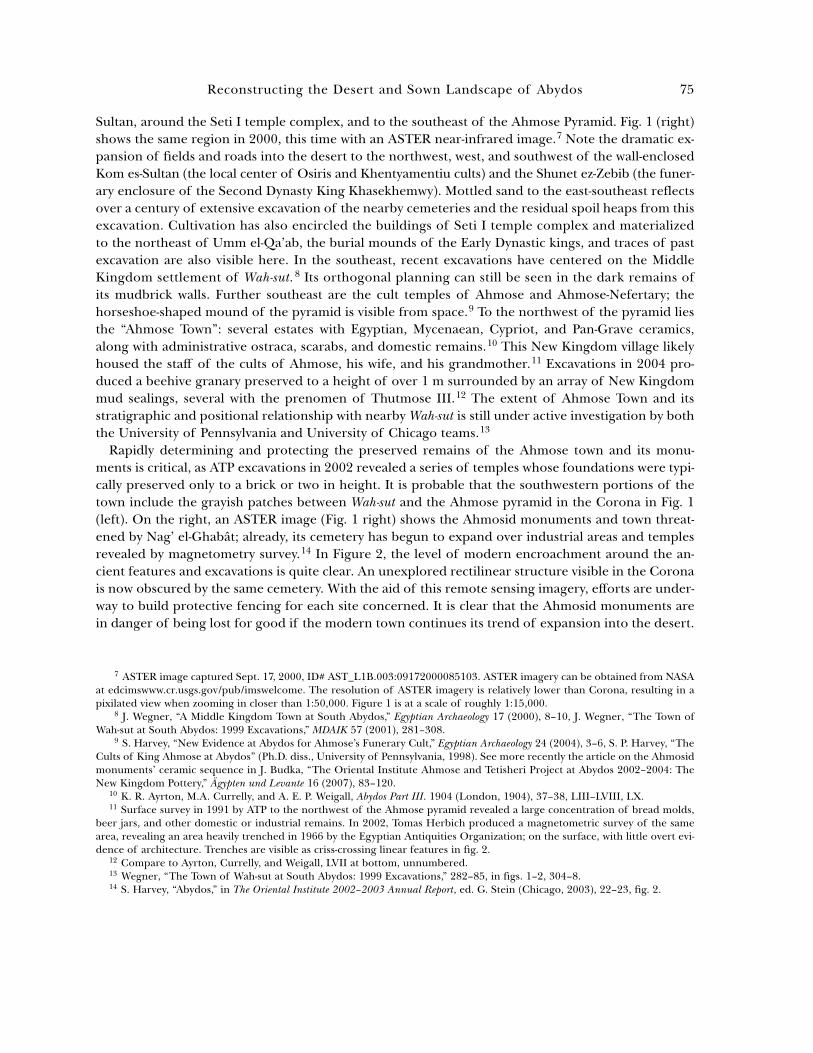
Fig. 1. South Abydos as visible in 1968 on a Corona satellite image (left). The same area in 2000 within an ASTERsatellite image (right) shows tremendous agricultural, settlement, and cemetery expansion into the desert fringe. ASTERpixilation is due to the lower degree of image resolution relative to the Corona.
Reconstructing the Desert and Sown Landscape of Abydos 75
Sultan, around the Seti I temple complex, and to the southeast of the Ahmose Pyramid. Fig. 1 (right)shows the same region in 2000, this time with an ASTER near-infrared image.7 Note the dramatic ex-pansion of fields and roads into the desert to the northwest, west, and southwest of the wall-enclosedKom es-Sultan (the local center of Osiris and Khentyamentiu cults) and the Shunet ez-Zebib (the funer-ary enclosure of the Second Dynasty King Khasekhemwy). Mottled sand to the east-southeast reflectsover a century of extensive excavation of the nearby cemeteries and the residual spoil heaps from thisexcavation. Cultivation has also encircled the buildings of Seti I temple complex and materializedto the northeast of Umm el-Qa’ab, the burial mounds of the Early Dynastic kings, and traces of pastexcavation are also visible here. In the southeast, recent excavations have centered on the MiddleKingdom settlement of Wah-sut.8 Its orthogonal planning can still be seen in the dark remains ofits mudbrick walls. Further southeast are the cult temples of Ahmose and Ahmose-Nefertary; thehorseshoe-shaped mound of the pyramid is visible from space.9 To the northwest of the pyramid liesthe “Ahmose Town”: several estates with Egyptian, Mycenaean, Cypriot, and Pan-Grave ceramics,along with administrative ostraca, scarabs, and domestic remains.10 This New Kingdom village likelyhoused the staff of the cults of Ahmose, his wife, and his grandmother.11 Excavations in 2004 pro-duced a beehive granary preserved to a height of over 1 m surrounded by an array of New Kingdommud sealings, several with the prenomen of Thutmose III.12 The extent of Ahmose Town and itsstratigraphic and positional relationship with nearby Wah-sut is still under active investigation by boththe University of Pennsylvania and University of Chicago teams.13
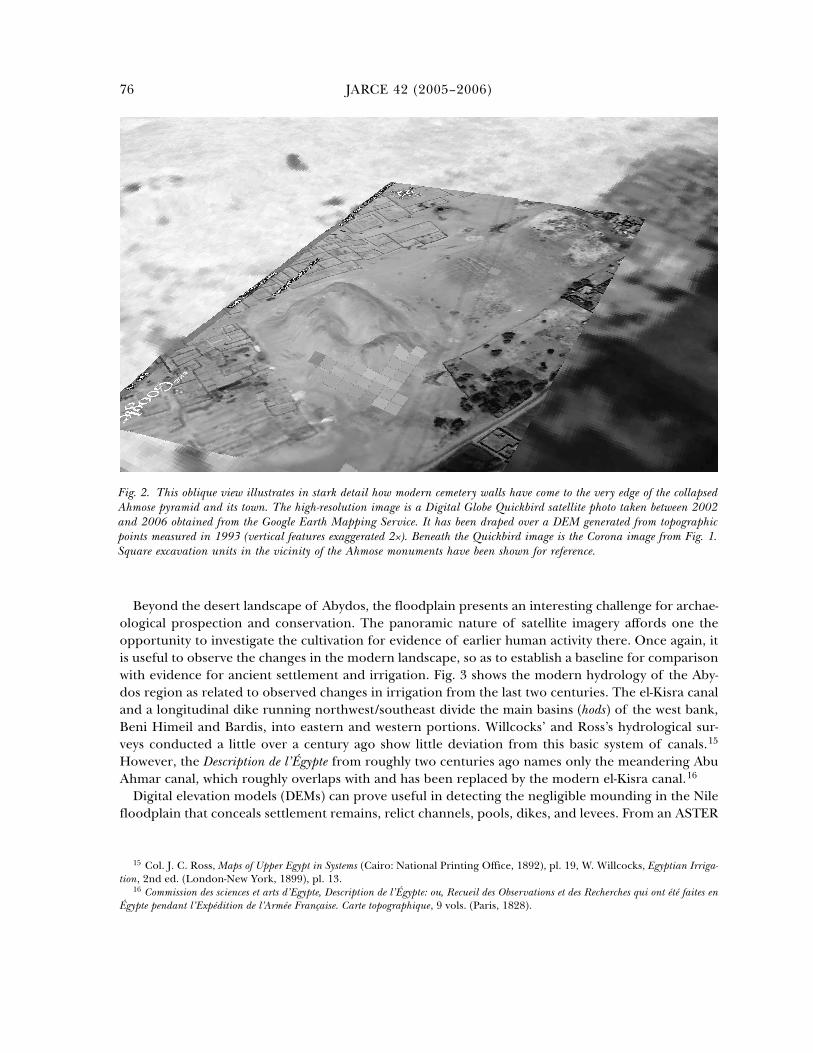
Rapidly determining and protecting the preserved remains of the Ahmose town and its monu-ments is critical, as ATP excavations in 2002 revealed a series of temples whose foundations were typi-cally preserved only to a brick or two in height. It is probable that the southwestern portions of thetown include the grayish patches between Wah-sut and the Ahmose pyramid in the Corona in Fig. 1(left). On the right, an ASTER image (Fig. 1 right) shows the Ahmosid monuments and town threat-ened by Nag’ el-Ghabât; already, its cemetery has begun to expand over industrial areas and templesrevealed by magnetometry survey.14 In Figure 2, the level of modern encroachment around the an-cient features and excavations is quite clear. An unexplored rectilinear structure visible in the Coronais now obscured by the same cemetery. With the aid of this remote sensing imagery, efforts are under-way to build protective fencing for each site concerned. It is clear that the Ahmosid monuments arein danger of being lost for good if the modern town continues its trend of expansion into the desert.
7 ASTER image captured Sept. 17, 2000, ID# AST_L1B.003:09172000085103. ASTER imagery can be obtained from NASAat edcimswww.cr.usgs.gov/pub/imswelcome. The resolution of ASTER imagery is relatively lower than Corona, resulting in apixilated view when zooming in closer than 1:50,000. Figure 1 is at a scale of roughly 1:15,000.
8 J. Wegner, “A Middle Kingdom Town at South Abydos,” Egyptian Archaeology 17 (2000), 8–10, J. Wegner, “The Town ofWah-sut at South Abydos: 1999 Excavations,” MDAIK 57 (2001), 281–308.
9 S. Harvey, “New Evidence at Abydos for Ahmose’s Funerary Cult,” Egyptian Archaeology 24 (2004), 3–6, S. P. Harvey, “TheCults of King Ahmose at Abydos” (Ph.D. diss., University of Pennsylvania, 1998). See more recently the article on the Ahmosidmonuments’ ceramic sequence in J. Budka, “The Oriental Institute Ahmose and Tetisheri Project at Abydos 2002–2004: TheNew Kingdom Pottery,” Ägypten und Levante 16 (2007), 83–120.
10 K. R. Ayrton, M.A. Currelly, and A. E. P. Weigall, Abydos Part III. 1904 (London, 1904), 37–38, LIII–LVIII, LX.11 Surface survey in 1991 by ATP to the northwest of the Ahmose pyramid revealed a large concentration of bread molds,
beer jars, and other domestic or industrial remains. In 2002, Tomas Herbich produced a magnetometric survey of the samearea, revealing an area heavily trenched in 1966 by the Egyptian Antiquities Organization; on the surface, with little overt evi-dence of architecture. Trenches are visible as criss-crossing linear features in fig. 2.
12 Compare to Ayrton, Currelly, and Weigall, LVII at bottom, unnumbered.13 Wegner, “The Town of Wah-sut at South Abydos: 1999 Excavations,” 282–85, in figs. 1–2, 304–8.14 S. Harvey, “Abydos,” in The Oriental Institute 2002–2003 Annual Report, ed. G. Stein (Chicago, 2003), 22–23, fig. 2.
JARCE 42 (2005–2006)76
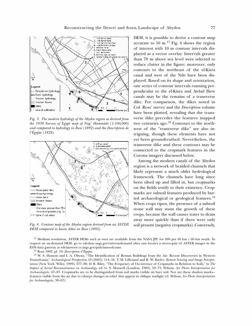
Beyond the desert landscape of Abydos, the floodplain presents an interesting challenge for archae-ological prospection and conservation. The panoramic nature of satellite imagery affords one theopportunity to investigate the cultivation for evidence of earlier human activity there. Once again, itis useful to observe the changes in the modern landscape, so as to establish a baseline for comparisonwith evidence for ancient settlement and irrigation. Fig. 3 shows the modern hydrology of the Aby-dos region as related to observed changes in irrigation from the last two centuries. The el-Kisra canaland a longitudinal dike running northwest/southeast divide the main basins (hods) of the west bank,Beni Himeil and Bardis, into eastern and western portions. Willcocks’ and Ross’s hydrological sur-veys conducted a little over a century ago show little deviation from this basic system of canals.15
However, the Description de l’Égypte from roughly two centuries ago names only the meandering AbuAhmar canal, which roughly overlaps with and has been replaced by the modern el-Kisra canal.16
Digital elevation models (DEMs) can prove useful in detecting the negligible mounding in the Nilefloodplain that conceals settlement remains, relict channels, pools, dikes, and levees. From an ASTER
15 Col. J. C. Ross, Maps of Upper Egypt in Systems (Cairo: National Printing Office, 1892), pl. 19, W. Willcocks, Egyptian Irriga-tion, 2nd ed. (London-New York, 1899), pl. 13.
16 Commission des sciences et arts d’Egypte, Description de l’Égypte: ou, Recueil des Observations et des Recherches qui ont été faites enÉgypte pendant l’Expédition de l’Armée Française. Carte topographique, 9 vols. (Paris, 1828).
Fig. 2. This oblique view illustrates in stark detail how modern cemetery walls have come to the very edge of the collapsedAhmose pyramid and its town. The high-resolution image is a Digital Globe Quickbird satellite photo taken between 2002and 2006 obtained from the Google Earth Mapping Service. It has been draped over a DEM generated from topographicpoints measured in 1993 (vertical features exaggerated 2x). Beneath the Quickbird image is the Corona image from Fig. 1.Square excavation units in the vicinity of the Ahmose monuments have been shown for reference.
Reconstructing the Desert and Sown Landscape of Abydos 77
DEM, it is possible to derive a contour mapaccurate to 10 m.17 Fig. 4 shows the regionof interest with 10 m contour intervals dis-played as a vector overlay. Intervals greaterthan 70 m above sea level were selected toreduce clutter in the figure; moreover, onlycontours to the northeast of the el-Kisracanal and west of the Nile have been dis-played. Based on its shape and orientation,one series of contour intervals running per-pendicular to the el-Kisra and Awlad Iliewcanals may be the remains of a transversedike. For comparison, the dikes noted inCol. Ross’ survey and the Description volumehave been plotted, revealing that the trans-verse dike precedes the features mappedtwo centuries ago.18 Contours to the north-west of the “transverse dike” are also in-triguing, though these elements have notyet been groundtruthed. Nevertheless, thetransverse dike and these contours may beconnected to the cropmark features in theCorona imagery discussed below.
Among the modern canals of the Abydosregion is a network of braided channels thatlikely represent a much older hydrologicalframework. The channels have long sincebeen silted up and filled in, but cropmarkson the fields testify to their existence. Crop-marks are subsoil features produced by bur-ied archaeological or geological features.19
When crops ripen, the presence of a subsoilstone wall may stunt the growth of thesecrops, because the wall causes water to drainaway more quickly than if there were onlysoil present (negative cropmarks). Conversely,
17 Medium resolution, ASTER DEMs such as ours are available from the NASA JPL for $80 per 60 km x 60 km swath. Torequest an on-demand DEM, go to edcdaac.usgs.gov/asterondemand after one locates a stereo-pair of ASTER images in theEOS data gateway at edcimswww.cr.usgs.gov/pub/imswelcome.
18 Ross 1892, pl. 19; Description d’Égypte.19 W. S. Hanson and I. A. Oltean, “The Identification of Roman Buildings from the Air: Recent Discoveries in Western
Transylvania,” Archaeological Prospection 10 (2003), 114–16, T. M. Lillesand and R. W. Kiefer, Remote Sensing and Image Interpre-tation (New York: Wiley, 1999), 277–80, D. R. Riley, “The Frequency of Occurrence of Cropmarks in Relation to Soils,” in TheImpact of Aerial Reconnaissance on Archaeology, ed. G. S. Maxwell (London, 1983), 59–73, Wilson, Air Photo Interpretation forArchaeologists, 67–87. Cropmarks are to be distinguished from soil marks visible on bare soil. Nor are these shadow marks—features visible from the air due to (sharp) changes in relief that appear in oblique sunlight (cf. Wilson, Air Photo Interpretationfor Archaeologists, 38–67).
Fig. 3. The modern hydrology of the Abydos region as derived fromthe 1938 Survey of Egypt map of Nag’ Hammâdi (1:100,000)and compared to hydrology in Ross (1892) and the Description del’Égypte (1828).
Fig. 4. Contour map of the Abydos region derived from an ASTERDEM compared to basin dikes in Ross (1892).
JARCE 42 (2005–2006)78
the additional moisture and nutrient depos-its in a silted-up canal elicit a positive crop-mark recognizable as a dark linear feature onan aerial or satellite image. Dry conditionsonly enhance these differences. Cereal crops,particularly wheat and barley, give marks ofespecially good definition and resolution.
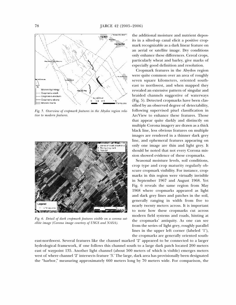
Cropmark features in the Abydos regionwere quite common over an area of roughlyseven square kilometers, oriented south-east to northwest, and when mapped theyrevealed an extensive pattern of singular andbraided channels suggestive of waterways(Fig. 5). Detected cropmarks have been clas-sified by an observed degree of detectability,following supervised pixel classification inArcView to enhance these features. Thosethat appear quite darkly and distinctly onmultiple Corona imagery are drawn as a thickblack line, less obvious features on multipleimages are rendered in a thinner dark greyline, and ephemeral features appearing ononly one image are thin and light grey. Itshould be noted that not every Corona mis-sion showed evidence of these cropmarks.
Seasonal moisture levels, soil conditions,crop type and crop maturity regularly ob-scure cropmark visibility. For instance, crop-marks in this region were virtually invisiblein September 1967 and August 1968. YetFig. 6 reveals the same region from May1968 where cropmarks appeared as lightand dark grey lines and patches in the soil,generally ranging in width from five tonearly twenty meters across. It is importantto note how these cropmarks cut acrossmodern field systems and roads, hinting atthe cropmarks’ antiquity. As one can seefrom the series of light grey, roughly parallellines in the upper left corner (labeled ‘1’),the cropmarks are generally oriented south-
east-northwest. Several features like the channel marked ‘2’ appeared to be connected to a largerhydrological framework, if one follows this channel south to a large dark patch located 200 meterseast of waypoint 135. Another light channel (about 500 meters of which is visible) emerges meterswest of where channel ‘2’ intersects feature ‘3.’ The large, dark area has provisionally been designatedthe “harbor,” measuring approximately 660 meters long by 70 meters wide. For comparison, the
Fig. 5. Overview of cropmark features in the Abydos region rela-tive to modern features.
Fig. 6. Detail of dark cropmark features visible on a corona sat-ellite image (Corona image courtesy of USGS and NASA).
Reconstructing the Desert and Sown Landscape of Abydos 79
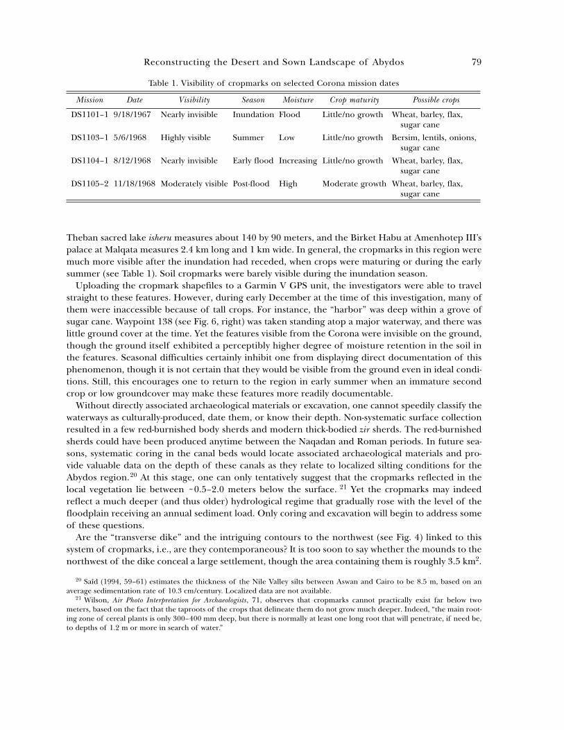
Theban sacred lake isheru measures about 140 by 90 meters, and the Birket Habu at Amenhotep III’spalace at Malqata measures 2.4 km long and 1 km wide. In general, the cropmarks in this region weremuch more visible after the inundation had receded, when crops were maturing or during the earlysummer (see Table 1). Soil cropmarks were barely visible during the inundation season.
Uploading the cropmark shapefiles to a Garmin V GPS unit, the investigators were able to travelstraight to these features. However, during early December at the time of this investigation, many ofthem were inaccessible because of tall crops. For instance, the “harbor” was deep within a grove ofsugar cane. Waypoint 138 (see Fig. 6, right) was taken standing atop a major waterway, and there waslittle ground cover at the time. Yet the features visible from the Corona were invisible on the ground,though the ground itself exhibited a perceptibly higher degree of moisture retention in the soil inthe features. Seasonal difficulties certainly inhibit one from displaying direct documentation of thisphenomenon, though it is not certain that they would be visible from the ground even in ideal condi-tions. Still, this encourages one to return to the region in early summer when an immature secondcrop or low groundcover may make these features more readily documentable.
Without directly associated archaeological materials or excavation, one cannot speedily classify thewaterways as culturally-produced, date them, or know their depth. Non-systematic surface collectionresulted in a few red-burnished body sherds and modern thick-bodied zir sherds. The red-burnishedsherds could have been produced anytime between the Naqadan and Roman periods. In future sea-sons, systematic coring in the canal beds would locate associated archaeological materials and pro-vide valuable data on the depth of these canals as they relate to localized silting conditions for theAbydos region.20 At this stage, one can only tentatively suggest that the cropmarks reflected in thelocal vegetation lie between ~0.5–2.0 meters below the surface. 21 Yet the cropmarks may indeedreflect a much deeper (and thus older) hydrological regime that gradually rose with the level of thefloodplain receiving an annual sediment load. Only coring and excavation will begin to address someof these questions.
Are the “transverse dike” and the intriguing contours to the northwest (see Fig. 4) linked to thissystem of cropmarks, i.e., are they contemporaneous? It is too soon to say whether the mounds to thenorthwest of the dike conceal a large settlement, though the area containing them is roughly 3.5 km2.
20 Saîd (1994, 59–61) estimates the thickness of the Nile Valley silts between Aswan and Cairo to be 8.5 m, based on anaverage sedimentation rate of 10.3 cm/century. Localized data are not available.
21 Wilson, Air Photo Interpretation for Archaeologists, 71, observes that cropmarks cannot practically exist far below twometers, based on the fact that the taproots of the crops that delineate them do not grow much deeper. Indeed, “the main root-ing zone of cereal plants is only 300–400 mm deep, but there is normally at least one long root that will penetrate, if need be,to depths of 1.2 m or more in search of water.”
Table 1. Visibility of cropmarks on selected Corona mission dates
Mission Date Visibility Season Moisture Crop maturity Possible crops
DS1101–1 9/18/1967 Nearly invisible Inundation Flood Little/no growth Wheat, barley, flax, sugar cane
DS1103–1 5/6/1968 Highly visible Summer Low Little/no growth Bersim, lentils, onions, sugar cane
DS1104–1 8/12/1968 Nearly invisible Early flood Increasing Little/no growth Wheat, barley, flax, sugar cane
DS1105–2 11/18/1968 Moderately visible Post-flood High Moderate growth Wheat, barley, flax, sugar cane
JARCE 42 (2005–2006)80
Nevertheless, the perpendicular orientation of the dike contour to both modern canals and the crop-mark features compare well to Willcocks’ idealized depiction of the basin system as used in UpperEgypt.22
Summarizing what is known of the cropmarks, they share a general northwest/southeast alignmentwith modern hydrology, though they do not directly map onto modern canals or lie adjacent to mod-ern villages (see Fig. 3). The major cropmarks, including the “harbor,” roughly bisect Hod Bardis. Onewould suggest that these cropmarks indicate several feeder canals (likely operating at different times)for the basin(s) that preceded the Bardis. The orientation and shape of the canals implies culturalusage, though one cannot rule out a natural origin for these waterways. Prior to the reforms ofMohammed Ali Pasha, irrigation systems relied upon slight modifications of natural river channelmeanders, given limitations in manpower, organization, and technology.23 The highly sinuous AbuAhmar canal in the Abydos region from the Description de l’Égypte seen in Figure 3 reflects reliance onsuch meanders.
The cropmarks are virtually invisible from the ground, both due to high crops and seasonal mois-ture levels, and early May has been suggested as an ideal time for survey. Their age is as yet unde-termined, as is their association with the transverse dike, though geomorphological coring, intensesystematic survey, and test excavations would certainly begin to address some of these questions ingreater detail.
Satellite imagery, like aerial photography, are increasingly being used to impart a fresh perspectiveat the level of the site. Where satellite imagery can truly show its worth is its scalability, providingboth a detailed view at the sub-site level and a panoramic view at the regional level. In the Abydosregion, remote sensing imagery conceptually links the desert fringe to the cultivation and serves as aplatform for new research. Future seasons should investigate additional cropmarks, contour mounds,and other promising archaeological signatures in the remote sensing imagery, while simultaneouslyintegrating geophysical, survey, and architectural data from the other projects at Abydos. Throughefforts to reconstruct ancient hydrology, earthworks, and settlement in the floodplain desert, one willhopefully begin to develop a more holistic view of the ancient landscape of Abydos.
Oriental InstituteUniversity of Chicago
22 Willcocks, Egyptian Irrigation, pl. 14.23 H. E. Hurst, The Nile; A General Account of the River and the Utilization of its Waters (London, 1952), 46–47.
Copyright © 2022 FDOKUMEN