Sufi Cosmopolitanism in the Seventeenth-century Indian Ocean

46
D. Brad HatchBarbara J. HeathLauren K. McMillan
Reassessing the Hallowes Site: Conflict and Settlement in the Seventeenth-Century Potomac ValleyABSTRACT
The John Hallowes site in Westmoreland County, Virginia, was excavated from 1968 to 1969. No report of the excavations was completed at that time, although an article summariz-ing the findings was published in Historical Archaeology in 1971. The artifacts from the site were not systematically cataloged until the 1980s, and it was not until 2010–2012 that an integrated study comparing the artifact data with site features, site history, regional archaeological findings, and regional history was completed. Benefiting from nearly 50 years of advances in Chesapeake archaeology, the reanalysis has challenged accepted dates for the site’s initial occupa-tion, resulted in new interpretations of John Hallowes’s role in the Maryland conflict known as Ingle’s Rebellion, traced political alliances formed during that rebellion that led to the creation of the Potomac River community of Appamattucks, and examined changing ideas about military masculinity on the Chesapeake frontier.
Introduction
Curated archaeological collections offer impor-tant opportunities to reassess the findings of past researchers and offer new interpretations based on a better understanding of artifact types and chronologies, an expanded body of comparative data, and current theoretical per-spectives. A recently completed reassessment of the John Hallowes site (44WM6) is a case in point (Hatch et al. 2013). The reassessment has resulted in a refined site chronology that chal-lenges previous interpretations of the site as an example of the response of Virginian colonists living in the Potomac River valley to the events leading up to and inclusive of Bacon’s Rebel-lion (1675–1676), and instead situates the site’s fortifications within the framework of a conflict that rocked Maryland some 30 years earlier.
Located along the shores of Currioman Bay in Westmoreland County, Virginia, on land patented in 1651 by John Hallowes, the site was excavated from July 1968 to August 1969 by William Buchanan, Jr., Edward Heite, and a group of volunteers. Documentary evidence directly relating to the site’s history was com-piled by Virginia Sherman. No written report was completed at the time, and no systematic inventory was made of the artifacts until the 1980s. From 2010 to 2012 the artifacts were on loan to the Department of Anthropology, University of Tennessee, Knoxville, for a reex-amination of the site as part of a broader study of 17th-century settlement of Virginia’s Northern Neck, the peninsula bounded by the Potomac and Rappahannock rivers (Figure 1).
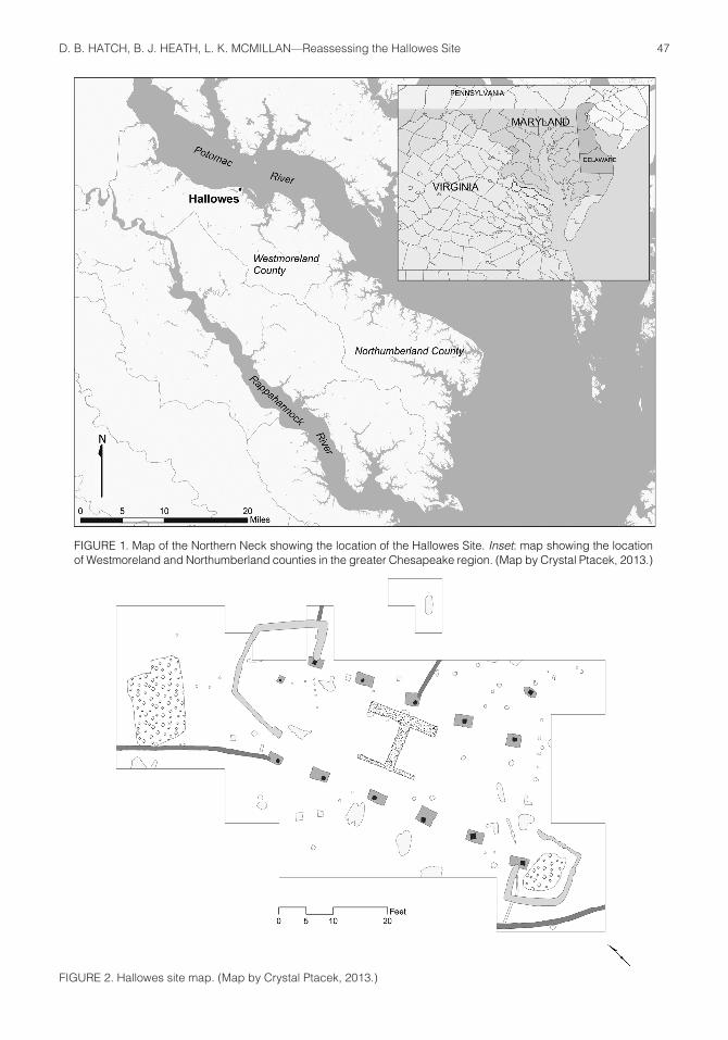
In an article published in Historical Archae-ology in 1971, Buchanan and Heite (1971:39) interpreted the site as the “yeoman cottage” of Hallowes’s granddaughter, Restitute Whiston Steel Manley, one of her sons, or a tenant, and dated the occupation from the 1680s to 1716. Buchanan and Heite’s excavations uncovered a house of earthfast construction consisting of post holes, associated post molds, and a brick hearth, and two large features (Figure 2). Sets of roughly rectangular trenches were located at the northeast and southwest corners of the build-ing, and additional linear trenches extended from the building at the northwest corner and along the east wall. The trenches were interpreted as drains or possibly ditch-set fences (Buchanan and Heite 1971:40).
During the 1970s, Fraser Neiman uncovered a fortified house at a nearby plantation known as the Clifts (Neiman 1978, 1980a, 1980b). The earthfast dwelling, the construction of which dates to 1670, was surrounded by a rectangu-lar palisade with opposing, circular bastions. Neiman (1980a:75) and others have argued that this palisade was built in response to conflict in the Potomac River valley that contributed to Bacon’s Rebellion (1675–1676) and identified the rectangular trenches at the corners of the Hallowes site structure as bastions built to for-tify that house against attack during the conflict
Historical Archaeology, 2014, 48(4):46–75.Permission to reprint required.Accepted for publication 2 December 2013.
47D. B. HATCH, B. J. HEATH, L. K. MCMILLAN—Reassessing the Hallowes Site
FIGURE 1. Map of the Northern Neck showing the location of the Hallowes Site. Inset: map showing the location of Westmoreland and Northumberland counties in the greater Chesapeake region. (Map by Crystal Ptacek, 2013.)
FIGURE 2. Hallowes site map. (Map by Crystal Ptacek, 2013.)
48 HISTORICAL ARCHAEOLOGY 48(4)
(Carson et al. 1981:191; Hodges 1993:205–208, 2003:509). The recent reassessment, however, argues for a new interpretation of the timing and purpose of the Hallowes defenses. The revised chronology for the site places the con-struction of the house at the Hallowes site at just after Ingle’s Rebellion in Maryland, when, between 1644 and 1646, control of that colony was seized from the proprietary family (Jonas 1966:247; Riordan 2004). This earlier conflict resulted from internal political animosities and divided loyalties brought about by the English Civil War, a political crisis that reverberated across the Atlantic and directly affected the settlement of Virginia’s Potomac River frontier.
Settlement of the Northern Neck
John Smith initiated English exploration of the upper reaches of Chesapeake Bay in 1608, arriving on the Potomac River in June of that year (Wells 1994:15). The area was home to dispersed communities of Algonquian-speaking Indians who became important suppliers of both foodstuffs and furs to English colonists in the years that followed (Wells 1994:17; Rice 2009). While trading partnerships emerged, during the first four decades of the 17th century the lands lying north of the York River and south of the Potomac remained contested territory between Indians and English settlers from Maryland and southern Virginia.
Rich soils, well-suited for tobacco cultiva-tion, were distributed between tributary rivers and creeks emptying into the Potomac River and Chesapeake Bay in the northeastern por-tion of the Northern Neck. Fertile farmland and easily navigable waterways, combined with a landscape that had been partially cleared by Indian farmers, made the inlets and necks of the area desirable locations for 17th-century English settlement (Potter and Waselkov 1994; Klein and Sanford 2004:66–67).
The third Anglo-Powhatan War (1644–1646) resulted in a 1646 treaty between the Virginia Colony and an alliance of Indian groups. The treaty specified that all land north of the York River, including the area along the southern shore of the Potomac, was to remain free of English settlement. Virginia’s colonial govern-ment, however, did not strictly enforce the ban. Northumberland County, which encompassed
modern-day Westmoreland County, was created in 1648 when the ban on settlement was lifted. At that time, a community known as Chicacoan, established near the Coan River in the early 1640s, became the political center of the new county. Within a short time, colonists began entering land patents in Northumberland County into the official record (Nugent 1934; E. Morgan 1975:231; McCartney 1990:13).
English immigrants arrived in large numbers in lower York, Rappahannock, and Potomac counties during the 1650s and 1660s, many of them servants imported to work on plantations that produced medium- to high-quality tobacco, specifically the Oronoco strain (E. Morgan 1975:227–228; Walsh 1999:54,59, 2010). By 1653, the European population of the Northern Neck had grown so rapidly that Westmoreland County was formed from Northumberland. By 1664, settlement upriver necessitated the forma-tion of the Potomac River county of Stafford. Merchants from London and Bristol supplied colonists living along the Potomac and Rap-pahannock rivers, purchasing tobacco on credit and delivering a variety of finished goods from English manufacturers (Horn 1988:75). Rapid settlement of the Northern Neck resulted in shortages of land within a few decades, and as servants fulfilled the terms of their indentures they were forced to look elsewhere for patent-able land (Sprinkle 1985:3992–3993).
John Hallowes
John Hallowes was born in December 1615 in Lancashire, England, to Henry and Elizabeth Hallowes (Fishwick 1888:158; Buchanan and Heite 1971:38). He was baptized in the Roche-dale Parish Anglican church later that month. In March of 1634, at the age of 19, he travelled on the Ark, one of the first two ships sent to colonize Maryland. Upon his arrival in the fledgling colony, he was indentured to Thomas Cornwalyes, who had paid for his passage under the headright system (Stone 1987:17). Corn-walyes, destined to become one of the richest men in the colony prior to the 18th century, was a Roman Catholic and a commissioner of the Maryland Colony (Maloney 1996:45; Rior-dan 2004:24–26,29,195–196).
With his indenture complete by 1639, John Hallowes married Restitute Tew on 2 June of

49D. B. HATCH, B. J. HEATH, L. K. MCMILLAN—Reassessing the Hallowes Site
that year in a ceremony performed by Thomas White, most likely a Protestant who served as a justice of the peace for St. Mary’s County (Browne 1887:52). Hallowes subsequently acquired land at St. Michael’s Hundred, work-ing as a mariner and carpenter throughout the 1640s and transporting tobacco to Virginia as early as 1642 (Browne 1887:67,154,169). By 1647, he had established a residence at a settle-ment known as Appamattucks, located along an approximately 10 mi. stretch of riverfront between Mattox Creek and Nomini Bay on the south bank of the Potomac River (Library of Virginia 1650–1652:49, 1653–1659:15; Browne 1887:331). He still nurtured close ties to Mary-land, however, and continued to do business there for the remainder of his life.
Hallowes became a wealthy man by the stan-dards of the day, owning over 5,000 ac. of land and several servants. He served as a commis-sioner for Northumberland County from at least 1650, when records for the county begin (Library of Virginia 1650–1652:49; Nugent 1934:207,252). Additionally, when Westmoreland County was created from Northumberland, he was appointed major in the militia and a justice for that county (Library of Virginia 1653–1659:36; Buchanan and Heite 1971:39). In 1655 Restitute Hallowes died, and John married Elizabeth Sturman (Nicklin 1938:444). By 1657, the year of his death, Hal-lowes had been appointed sherriff of the county, a position generally reserved for members of the gentry (Library of Virginia 1653–1659:80; Carr et al. 1991:23).
Andersons, Whistons, Steels, Manleys, Tenancy, and the Lees
Hallowes’s widow married David Anderson and probably lived on the Appamattucks property until 1666, when Anderson moved to Stafford County (Nicklin 1938:440). The property then passed to Hallowes’s daughter, Restitute, and her husband, John Whiston, who repatented the land in 1667, but probably did not live there. In 1674, Resti-tute, granddaughter of John Hallowes, and her husband, Matthew Steel, acquired the property. Court records confirm that the land was occupied by tenants during this period (Buchanan and Heite 1971:39). Upon Steel’s death in 1680, Restitute married John Manley, who, in 1681, obtained per-mission to evict the tenants from his wife’s land
(Library of Virginia 1675–1689:220; Buchanan and Heite 1971:39). Although the period of tenancy is unclear, the property may have been leased as early as 1666, when the Andersons moved to Stafford. The land stayed in the Manley family until 1722, when Samuel Hallowes, John’s distant cousin, sued for and won the property. He never came to Virginia and sold the land to Thomas Lee of Stratford Hall in 1733. The property then stayed in the Lee family until 1838 as part of the plantation at Stratford (Buchanan and Heite 1971:39). It went through a series of subsequent owners before being acquired by the Stratford Harbour development in the 1960s.
Archaeology at the Site
Excavations 1968–1969
Field notes from the 1968–1969 excavations lack the standardization and detail expected in modern recording systems. However, enough information was recorded in notes, maps, photo-graphs, and in the article published in Historical Archaeology to allow overall field methods to be understood (Buchanan and Heite 1971:40). Excavators gridded the site and used a system of lot numbers, grid numbers, and feature num-bers to record artifact- and feature-provenience information. Volunteers conducted surface collec-tions, with some collection areas tied to the site grid. They removed the plowzone at the site by shovel, although a photograph from the excavation period also shows a bulldozer in use. Only one artifact type with a terminus post quem postdating the 17th century (two ironstone fragments) was recovered from a total of 1,974 surface-collected artifacts and faunal remains. The tight clustering of artifact dates overall indicates a short period of occupation.
There is no evidence that excavators screened plowzone or feature fill; however, the recovery of a few small artifacts from features indicates that these were probably excavated by trowel, resulting in greater recovery rates for these contexts. Indeed, more than two decades after the excavation at Hallowes, Edward Heite remained opposed to screening, arguing that the use of screens detracted from attention to stratigraphic provenience of the artifacts in situ, despite several studies that had demonstrated their importance to artifact recovery (Heite 1992:15–16). The nonstandard

50 HISTORICAL ARCHAEOLOGY 48(4)
recovery methods that excavators used biased the assemblage in favor of larger and more vis-ible artifacts. These methods probably led to the underrepresentation of beads, straight pins, and small animal bones in the collection.
Artifacts: Interpreting Site Chronology
Prior to the reanalysis, the fortification of the house at the Hallowes site was thought to date to the last quarter of the 17th century (Buchanan and Heite 1971:39; Neiman 1980a:74, 1993:265; Carson et al. 1981:191; Hodges 1993:205–206, 2003:509). Subsequent refinements of chronolo-gies for artifact manufacture and use in the 1600s have resulted in a reassignment of site-occupation dates to approximately 30 years earlier.
Common methods of dating for archaeological sites from the 17th and 18th centuries that were
used in the reanalysis included calculating an adjusted mean ceramic date for the site and for features, dating by terminus post quem, using a ceramic intersection (Figure 3), and calculating pipe-stem dates (Figure 4) (Tables 1 and 2). Historical research allowed for the creation of an hypothesized date range of occupation of 1647–1681, bracketed on one end by John Hal-lowes’s arrival in Virginia and on the other by a reference in the Westmoreland County records that describes the eviction of tenants from the land (Library of Virginia 1675–1689:220). The hypothesized date range yielded a mean occu-pation date of 1664 that is extremely close to the dates arrived at through the analysis of the archaeological assemblage.
Artifact date ranges were adjusted by removing wares with extremely long periods o f p roduc t ion―in th i s ca se t i n -g l azed
FIGURE 3. Ceramic intersection with occupation dates derived from historical records. (Figure by Lauren McMillan, 2013.)

51D. B. HATCH, B. J. HEATH, L. K. MCMILLAN—Reassessing the Hallowes Site
FIGURE 4. Pip-stem bore diameter distribution for entire assemblage. (Graph by Lauren McMillan, 2013.)
TABLE 1TOBACCO-PIPE BORE DIAMETERS BY MASTER CONTEXT
F. 17 F. 63 Bastions Fence Lines Features Total Site Total
Imported 5 45 5 8 63 882 5/64 in. 0 0 0 0 0 9 6/64 in. 2 3 0 0 5 90 7/64 in 2 16 1 3 22 391 8/64 in. 0 5 0 0 5 97 9/64 in. 0 3 0 0 3 36Local 15 11 3 1 30 139
TABLE 2DATING METHODS AND RESULTS FOR HALLOWES ASSEMBLAGE
Dating Method Entire Site Features
TPQ (adjusted) 1675 1675MCD (adjusted) 1670 1664Binford formula 1660 1657Hanson formula 1665 1662Harrington histogram 1650–1680 1650–1680Ceramic intersection 1650–1675 1650–1675Historical records 1647–1681 ––Historical records mean 1664 ––
earthenware―in order to prevent the date from being extended artificially. Two fragments of surface-collected ironstone were not included in the analysis because they were clearly unassociated with the occupation of the site. Morgan Jones–type ceramics were also excluded
from the mean ceramic date since the precise date range for the ware is uncertain. A more detailed discussion of this type at Hallowes has been published separately (McMillan et al. [2014]). The beginning dates for all the early ceramic types were pushed forward to 1634,

52 HISTORICAL ARCHAEOLOGY 48(4)
since the European occupation of the Potomac Valley did not begin until the settlement of St. Mary’s City in that year. In effect, the adjustment of these dates kept the mean ceramic date from being pushed back in time artificially. In addition, while North Devon gravel-tempered coarse earthenware can date as early as 1650, for this study an introduction date of 1675 has been assigned in keeping with common use in the Chesapeake (Maryland Archaeological Conservation Lab 2012). Following these considerations, the adjusted mean ceramic date for the site as a whole is 1670, while the adjusted date for features is 1664. The latest-dating artifact that is contemporary with the site’s occupation is a Priamus Williams marked pipe with a terminus post quem of 1677.
Several other artifact types and patterns from the site also lend support to an occupation date range that spans the third quarter of the 17th century. For example, 14% of the total tobacco-pipe assemblage is comprised of locally made pipes, mirroring patterns seen in sites dating from 1660 to 1680 excavated by members of the Lost Towns Project in Maryland (Cox et al. 2005). Glass bottles on the site also point to a pre-1680 occupation, since three of the four glass ves-sels identified were case bottles, and the fourth vessel was a round bottle of the globe-and-shaft style dating to ca. 1640–1660 (Lanmon 2011:19–20,287–288). Finally, even the faunal remains point to a pre-1660 date, since the proportions of beef, swine, and venison closely resemble the averages for sites dating between 1620 and 1660 (Miller 1984; Bowen 1996). While these methods are not standard dating tools in the Chesapeake, they do provide important corroborating evidence for site dates that have been determined using more conventional methods and must be seen as more than just coincidence.
Site Features and Chronology
The 1960s excavations revealed the remains of a single post-in-ground dwelling with a brick chimney base and ditch-set bastions at opposite corners (a possible later addition), two ditch-set fence lines, a shallow basin-like feature (Feature 63) within the southwest bastion, a large pit fea-ture (Feature 17) directly north of the dwelling, and other small features in the yard and within the building (Figure 2).
An exact chronology of individual feature con-struction, use, and abandonment is not possible due to some methodological issues relating to excavations, and to the problems of chronological resolution arising from the ubiquity of Morgan Jones–type coarse earthenwares. Nevertheless, three phases of development and alteration have been identified.
Dwelling, Phase 1
The first phase of occupation incorporates the construction and early use of the dwelling, bas-tions, and Features 17 and 63 (Figure 5). The structure was a hall-and-parlor plan of earthfast construction with an off-center brick hearth. The house was oriented with its east facade facing Currioman Bay (Buchanan and Heite 1971:41). It measured approximately 50 ft. north–south by 20 ft. east–west and was supported by a total of 12 structural posts, 11 of which were exposed and excavated. The distances between post molds, starting from the northeast corner of the east wall, were 9.5, 10.5, 9.7, and 9.9 ft, while from the northwest corner along the west wall they measured 9.1, 10, 9.9, 9.7, and 10.4 ft. The spacing is consistent with construction methods used in 17th-century “Virginia houses,” where studs, placed between posts set at 10 ft. intervals, served as points of attachment for 5 ft. lengths of clapboarding that formed the outer walls of the structure (Stone 1982:233).
Judging from the orientation of the post holes––long axes parallel to the wall line––and the location of the post molds, the dwelling was raised using what is variously known as the tie-beam, reverse, or bent-assembly method (Carson, Barka et al. 1981:150; Moser et al. 2003:200–201; Carson, Bowen et al. 2008:54–55). If one story in height, the dwelling contained 1,000 ft.2 of interior space within the main block; if two storied, or, more likely, one story with a loft, the available space doubled to 2,000 ft.2. Summary data for post-hole and -mold features are presented in Table 3.
A locally made belly bowl–style pipe bowl fragment with a rouletted rim was the single dateable historical artifact recovered from the fill of the structural post holes (Feature 51) (Table 3). While this particular style of pipe cannot be dated with certainty, it is generally associated with contexts dating from the early to mid-17th century

53D. B. HATCH, B. J. HEATH, L. K. MCMILLAN—Reassessing the Hallowes Site
FIGURE 5. Major features associated with Phase 1 of the site. (Map by Crystal Ptacek, 2013.)
(Luckenbach and Sharpe 2007). One post hole contained three fragments of Prince George–type Indian pottery; the remainder did not contain any artifacts (Table 3).
Post molds contained numerous artifacts, including a fragment of North Devon gravel-tempered ceramic, suggesting that the destruc-tion of the house dated to the late 1670s or early 1680s (Noël Hume 1969:133; Maryland Archaeological Conservation Lab 2012) (Table 3). The posts were not replaced during the life of the structure, supporting the argument that the site was occupied for a relatively short time. The average lifespan of a post-in-ground structure in the Chesapeake was about 20 years, although with the right materials and conditions some posts could last much longer without replacement (Carson, Barka et al. 1981:133). From his experience as a carpenter in Maryland, John Hallowes may well have been familiar with the durability of various species and would have selected the proper wood for a long-lasting house, probably red cedar or black locust.
Indeed, the fact that the building stood for more than 30 years without repair to the structural posts speaks to his skill as a carpenter.
Located slightly off center of the interior of the structure were the remains of an H-shaped, partially robbed, brick chimney base (Buchanan and Heite 1971:41). Measuring approximately 11 ft. north–south by 10.5 ft. east–west, the chimney divided the dwelling into a minimum of two rooms. The northern room, the chamber or parlor, measured roughly 20 × 20 ft. The southern room, the hall, may have measured roughly 30 × 20 ft. Irregular spacing between the last two post molds in the west wall line, however, indicates that this space was likely partitioned, with an unheated room measuring 10.5–11 × 20 ft. along the south gable end, and the hall measuring 20 × 20 ft. In this scenario, the house follows a three-unit plan described by Neiman as typical of 17th-century English houses with a lobby entry (Neiman 1978:3107, 1990:261–262, 1993:265–267).

54 HISTORICAL ARCHAEOLOGY 48(4)
TABLE 3SUMMARY DATA FOR POST HOLES AND POST MOLDS
Feature Feature Type Corresponding Dimensions ArtifactsNumber Feature Number (Ft.)a
7 Post hole 9 2.7 × 2.3 None 9 Post mold 7 0.7 × 0.8 Bone, bricks, green vessel glass 11 Post hole 12 3.3 × 2.0 None 12 Post mold 11 0.5 × 0.7 Pipe stem, window glass 21 Post mold 96 0.7 × 0.8 Bone, green vessel glass imported pipe, Morgan Jones, N. Devon gravel-tempered, wrought nail 96 Post hole 21 2.8 × 1.6 None 31 Post hole 32 2.7 × 1.7 None 32 Post mold 31 0.6 × 0.7 None 43 Post hole 43 2.7 × 1.5 None 43 Post mold 43 0.8 × 0.8 Bone, brick, local pipes Morgan Jones, stone, wrought nails 48 Post hole 48 2.7 × 2.3 None 48 Post mold 48 0.9 × 0.7 Bone, brick, chert, green vessel glass, imported pipe, lead shot, Morgan Jones, N. Devon gravel-tempered, Rhenish blue-and-grey stoneware, wrought nails 51 Post hole 51 3.3 × 2.2 Local belly-bowl pipe 51 Post mold 51 0.8 × 0.8 Bone, brick, imported pipe, wrought nail 67 Post hole 67 3.1 × 2.0 None 67 Post mold 67 1.0 × 1.0 Imported pipe, wrought nail 71 Post hole 71 3.4 × 2.0 Bone, brick, Prince George– type pottery 71 Post mold 71 0.9 × 0.8 Bone, imported pipe, Morgan Jones, quartz, wrought nail 81 Post hole 81 3.0 × 2.8 None 81 Post mold 81 0.8 × 0.9 Bone, green vessel glass, wrought nail 85 Post hole 85 3.4 × 2.0 None 85 Post mold 85 0.8 × 0.8 Bone, brick, flint, imported pipe, mortar, Rhenish blue- and-grey stoneware, straight pin, wrought nail 92 Post hole 92 3.3 × 1.9 None 92 Post mold 92 0.8 × 0.7 Bone, imported pipe, straight pin
aThe first dimension for post holes and post molds is measured north–south, second is measured east–west.

55D. B. HATCH, B. J. HEATH, L. K. MCMILLAN—Reassessing the Hallowes Site
Feature 17
Feature 17, a large square pit measuring approximately 13 ft. east–west by 9.5 ft. north–south, with a 2 ft. extension from the southeast quadrant, was located approximately 20 ft. north of the dwelling. Photographs indicate that the walls of the feature appear to have been rela-tively vertical, but its depth could not be deter-mined because there were no post-excavation images (Figure 6). It contained three layers and was cut by what the excavators described in the excavation notes as a “brick disturbance.” The top layer contained dark fill, rich in artifacts and oyster shells. It sealed a layer defined by ash and oyster shell, which in turn sealed a layer characterized by significant amounts of mortar.
Morgan Jones–type ceramics in the uppermost layer indicate a fill date of no earlier than the mid-1660s. This date is supported by the pres-ence of a single fragment of Rhenish stoneware with manganese decoration, which post-dates 1660 (Noël Hume 1969:281). The middle layer
of fill contained the largest number of artifacts on the site, particularly faunal remains, and was assigned a terminus post quem of ca. 1640 due to the presence of a Bookbinder-style pipe stem (Luckenbach and Kiser 2006:165). Finally, the deepest layer contained a single fragment of Martincamp-type earthenware, in production during the first half of the 17th century (Hurst et al. 1986; Straube 2001:55–58). The brick dis-turbance contained few artifacts, but a terminus post quem of ca. 1640 was assigned based upon the presence of a Bookbinder-style pipe stem (Luckenbach and Kiser 2006:165).
The pit and the dwelling are not aligned. This fact, in combination with the early date of the artifacts from the deeper fill layers and the pres-ence of building materials in the fill, indicate that it was created and filled quite early in the site’s history. Shortly after its abandonment, the pit became a location for the disposal of refuse from the Hallowes household. A later ditch-set fence, originating at the northwest corner of the dwelling, cut the northwest corner of the feature.
FIGURE 6. Profile view of Feature 17 facing west and showing a depth of around 2 ft., but the excavation does not appear complete. (Photo courtesy Virginia Department of Historic Resources, 1968–1969.)

56 HISTORICAL ARCHAEOLOGY 48(4)
This relationship indicates that the pit was filled while the house was still occupied. Buchanan and Heite (1971:41) interpreted the feature as a temporary pit house used while the dwelling was under construction, and the results of the reassessment support this interpretation based on the available evidence.
Bastions
Attached to the southwest and northeast corners of the house were two large ditch-set bastions. The Hallowes site was among the first post-in-ground buildings and the first fortified house uncovered in the Chesapeake, and methods for identifying and excavating this type of structure were underdeveloped in the 1960s. Previously interpreted by Buchanan and Heite (1971:41) as wing additions or drains, the bastions have subsequently been recognized as components of a domestic fortification (Neiman 1980a:74, 1993:265–266; Carson, Barka et al. 1981:191; Hodges 1993:205–208). Ditch fill and post molds were not separated during excavation, although the excavators did recognize post molds in some sections of these features, particularly the south-west bastion (Buchanan and Heite 1971:40).
The southwest bastion measured approximately 9 ft. north–south by 12 ft. east–west and enclosed 105 ft.2 of space. It was designed to defend the structure’s western facade and the southern gable end. The northeast bastion defended the eastern facade and the northern gable end. It measured approximately 13 ft. north–south by 20 ft. east–west and enclosed 212 ft.2, or twice as much space as its counterpart to the south. The reason for the much larger size of this bastion is unknown, but it may be due to the dwelling’s orientation. The larger bastion, facing the water, made the dwelling seem more imposing to those viewing the site from Currioman Bay and the Potomac River (Figure 7).
No evidence exists to pinpoint a construction date for the bastions, but the fact that both features cut into structural post holes for the house indicates that they were put up after the building was completed. The fill from the bastions, which included Morgan Jones–type lead-glazed coarse earthenware, indicates that they were taken down as early as the mid-1660s. Based upon the lack of North Devon gravel-tempered coarse earthenware in the fill, and the
incorporation of at least one bastion into a later fence line, it appears that these features were not present for the whole life of the structure. They were probably constructed right after the house was finished and removed about the time that Hallowes’s widow left the property.
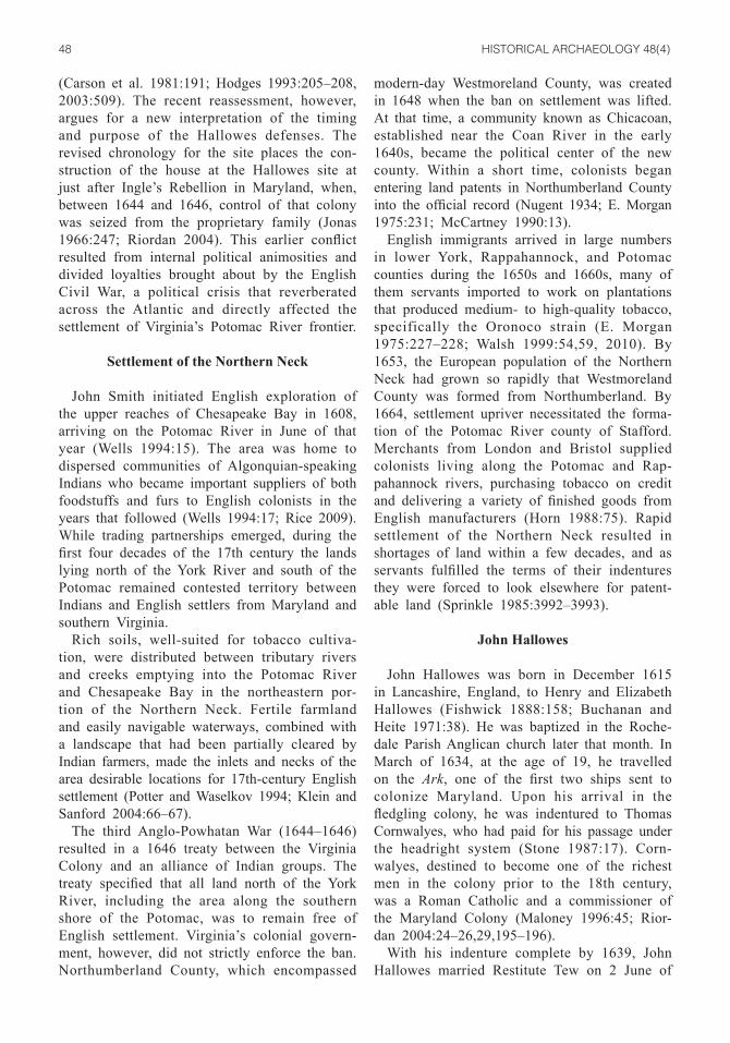
Feature 63
Within the southwest bastion, the excavators discovered a shallow basin-like feature (Feature 63) that they interpreted as a pit, privy, or but-tery (Buchanan and Heite 1971:41). It measured approximately 8 ft. east–west by 5 ft. north–south. The depth of the feature is unknown, but photographs suggest that it was relatively shallow compared to the bastion (Figure 8). The location of Feature 63, and the way that it respects the boundaries of the bastion ditch, suggests that it was created while the bastion was being used. It is possible that the feature was excavated and the fill was thrown against the sides of the bas-tion to create a firing step, which would have allowed defenders to shoot over the palisade from the interior (Noël Hume 1982:223–225; Miller 1986:54). This interpretation is supported by the presence of several divots within the feature cut that are recorded photographically, possibly suggesting shovel marks created during the initial excavation of the feature in the late 1640s (Figure 9).
The feature contained two layers, each filled with domestic trash, including a large amount of faunal remains. Large numbers of fish remains in each layer, particularly sheepshead (Archosar-gus probatocephalus) and black drum (Pogonias cromis), indicate that the feature was filled in late spring, since those species spawn during May and June and would have been more accessible to colonists at that time of year (Wenner and Archambault 2006). Following the same logic used to date the bastions and with the presence of Morgan Jones–type ceramics in both layers, the feature was filled no earlier than the 1660s, most likely after the bastions were removed.
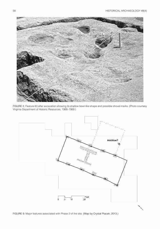
Phase 2
A post hole and mold were uncovered 10 ft. east of the last excavated post hole and mold along the eastern wall of the dwelling (Figure 9). They are oriented parallel to the wall line, but

57D. B. HATCH, B. J. HEATH, L. K. MCMILLAN—Reassessing the Hallowes Site
FIGURE 7. Orientation of the Hallowes dwelling to Currioman Bay and the Potomac River. (Map by Barbara Heath, 2013.)
the hole is smaller than the structural holes for the main house (3 × 1.5 ft.) and, therefore, does not appear to be contemporaneous with them. However, the post mold is roughly the same size as the other structural posts, being about 1 × 1 ft. The hole and mold were excavated
together, making it impossible to date the hole itself. Morgan Jones–type coarse earthenware is the latest dating artifact recovered from the combined features. The post hole and mold may represent the corner post for a room added to the dwelling sometime after the original
58 HISTORICAL ARCHAEOLOGY 48(4)
FIGURE 8. Feature 63 after excavation showing its shallow bowl-like shape and possible shovel marks. (Photo courtesy Virginia Department of Historic Resources, 1968–1969.)
FIGURE 9. Major features associated with Phase 2 of the site. (Map by Crystal Ptacek, 2013.)

59D. B. HATCH, B. J. HEATH, L. K. MCMILLAN—Reassessing the Hallowes Site
construction, with an additional post or posts aligned to a structural timber from the east wall line falling just outside of the excavated area.
While the evidence for such a construction is tenuous, an earthfast addition would explain the presence of the post hole and mold east of the southeast end of the dwelling, and would pro-duce a floor plan strikingly similar to the earli-est plan of the Clifts manor house and the ca. 1670s manor house at Newman’s Neck (Neiman 1978, 1980a:39–47; Heath et al. 2009). If this room were added, its presence along the east facade of the house would have obscured lines of sight from the northeast bastion. Therefore, its construction likely postdated the destruction of the fortifications.
Phase 3
There are numerous other features on the Hallowes site, but most consist of small posts or amorphous yard features, the dates and func-tions of which are difficult, if not impossible,
to determine. However, there appear to be at least four distinct ditch-set fences related to the house (Figure 10). The presence of these fences indicates a substantial rearrangement of the landscape that took place during the later occupation of the site.
Ditch-set fences could be built in two ways. One method consisted of setting upright planks in an approximately 1 ft. deep ditch and pack-ing the soil around them to hold them in place, creating a barrier known as a slot fence (Samford and Moody 1989:14). Another method employed the use of woven wattle around upright poles set in a shallow ditch (Neiman 1980b:25). Excavations of a number of 17th-century landscapes, including those at Brush-Everard, Rich Neck, Wolstenholme Towne, Nansemond Town, Hampton in the James River valley, and the Clifts in the Potomac Valley of Virginia, have uncovered fences of these types (Neiman 1980b:25; Samford and Moody 1989:14; Muraca et al. 2003:26–28,71,90–91). Similar fences have been found at a range
FIGURE 10. Major features associated with Phase 3 of the site. (Map by Crystal Ptacek, 2013.)

60 HISTORICAL ARCHAEOLOGY 48(4)
of 17th-century sites in Maryland, including St. John’s, Mattapany-Sewall, Van Sweringen, and King’s Reach (Keeler 1978:47; King 1990:112; Pogue 1997:112; Chaney and King 1999:148).
The latest-dating artifacts contained within the ditches at the Hallowes site are Morgan Jones–type coarse earthenwares, indicating a construction date in the mid-1660s or later. The relationship of the lines to the bastions and to the eastern addi-tion also indicates that they were later features at the site. One fence line extends from the southeast corner of the northeast bastion, suggesting that it incorporated a remnant of that bastion. Another fence cuts the western side of the southwest bas-tion, while a third runs northwest of the northeast bastion and would have blocked the line of sight from that vantage point had it been standing when the bastion was in use. The fourth fence runs per-pendicular to the east wall of the structure. This line would have significantly hindered the defen-sive capability of the fortifications, creating blind spots along the eastern portion of the structure if the two features were contemporary. Additionally, this fence must postdate the eastern addition, as the two elements could not have been in place at the same time.
The division of the yard space through the use of fences at the site is reminiscent of the yards at Mattapany-Sewall and at the St. John’s site in St. Mary’s City, Maryland, during the ca. 1675–1690 period (Keeler 1978:54–58,63–64,147; Chaney and King 1999). At St. John’s, the residents delineated a large forecourt area with fences in front of the primary facade of the structure. Additionally, the backyard was divided into two areas by a fence that corresponded to the interior hall and parlor rooms, effectively creating two outdoor spaces that mirrored the interior of the dwelling (Keeler 1978:54–58). These two areas served distinct func-tions at St. John’s, indicating the increasing for-malization of space in the Chesapeake over time (Keeler 1978:72–74). The segmentation of the yard through the use of fences at the Hallowes site may indicate similar processes taking place during the 1670s, but with almost no excavation in the yard area this conclusion is only speculative.
Discussion: John Hallowes and Colonial Conflict
The reanalysis of the Hallowes site has created an opportunity for a detailed examination of
the history and culture of 17th-century Potomac society in Virginia. While the Potomac Valley has been at the heart of numerous historical and archaeological studies, the majority of work has focused on 17th-century Maryland and prehistoric or 18th-century Virginia, often treating the two localities as distinct from one another (Fausz 1988; Carr et al. 1991; Potter 1993; Wells 1994; Riordan 2004; Rice 2009; Walsh 2010). Archaeological and historical research focusing on Virginia’s 17th-century Potomac shore has been conspicuously absent as compared to research in Maryland, with a few exceptions (Buchanan and Heite 1971; Neiman 1978, 1980a, 1980b; 1993; Coombs 2004; Heath et al. 2009; Rice 2009; Hatch et al. 2013).
The reanalysis revealed that John Hallowes built the fortified house, and he and his family occupied the site for much of its history. A closer look at Hallowes’s political alliances illuminates the strong connections that existed between people on both sides of the river in the 17th century. These con-nections, seen through the combination of archaeo-logical and historical data, reveal how intercolonial interaction affected settlement, politics, and trade in Virginia’s Potomac Valley.
John Hallowes’s experiences in Maryland and his subsequent move to Virginia were shaped by political tensions between and within the two colonies and by ethnic tensions between colonizers and Indians. The first wave of settlers to Mary-land, of which he was a part, found themselves in contested territory. In 1632, King Charles I granted Cecil Calvert, Lord Baltimore, substantial lands in the northern reaches of Chesapeake Bay. To the south, powerful Virginians, who were ardent Protestants, petitioned the king to revoke this royal charter that took away land they considered to be part of their colony. The charter was upheld by the Lords Commissioners for Foreign Plantations, to whom the king had referred the challenge (Jonas 1966:242).
Cecil Calvert thus became lord proprietor of Maryland. Tensions mounted between Calvert sup-porters and their southern neighbors over control of Kent Island, a fur-trading post in the Chesa-peake Bay, and armed conflict erupted in 1635 (Jonas 1966; Menard 1981:129–133). In an early confrontation that helped spark the Chesapeake “fur wars,” men aboard a sloop belonging to Virginian William Claiborne, who had previously laid claim to the island, fired upon two Maryland
61D. B. HATCH, B. J. HEATH, L. K. MCMILLAN—Reassessing the Hallowes Site
ships, the St. Helen and the St. Margaret. John Hallowes was aboard the St. Margaret, defend-ing Calvert’s claims to power (Browne 1887:22; Jonas 1966:242–244; Fausz 1988:71; McMillan and Hatch 2012). Whether he was a willing supporter or defended Calvert in the service of Cornwayles is less clear. In 1638, the Maryland Council gave Hallowes and Cuthbert Fenwick, who had also been transported into Maryland by Thomas Cornwayles and later served as his factor (Stone 1987:27), permission to arrest people trading with Indians without a license and to confiscate their goods and vessels. This act effectively made Hallowes and Fenwick privateers and put them on the front lines of opposition to Virginians’ claims to trade in the area (Browne 1885:83–84; Maloney 1996:56).
Although he may have begun life in Maryland as a supporter of the lord proprietor, by the 1640s Hallowes was no longer allied with the proprietary cause. His former master, Thomas Cornwayles, had also become a vocal critic of Calvert (Malo-ney 1996:46). In 1644, Richard Ingle, a promi-nent trader, arrived in the Chesapeake, setting off a series of events that brought the rancorous politics and unrest of the English Civil War to the Potomac Valley (Riordan 2004:3–6). A strong Parliamentarian and Protestant (he named his ship The Reformation), Ingle was accused of defaming the king by acting Maryland governor Giles Brent. Under orders from the Maryland Council, Thomas Cornwalyes apprehended Ingle. Cornwalyes eventually released him without the governor’s consent because Ingle was never convicted of a crime. Brent accused Cornwalyes of being in league with Ingle and tried to arrest him. Both Ingle and Cornwalyes left Maryland together for England (Riordan 2004:139–149). Ingle returned to the Chesapeake again in 1644 and recruited men from the Chicacoan settle-ment on the Virginian side of the Potomac River to capture Maryland in the name of Parliament (Riordan 2004:185–186). In February 1645, he lead an attack on St. Mary’s, the colonial capital, captured Cornwalyes’s house, and used it as a base of operations until he moved the rebel force to Nathaniel Pope’s house. Renamed “Mr. Pope’s Fort,” the house, which had formerly belonged to Cecil Calvert’s brother Leonard, was fortified with a palisade (Riordan 2004:227–231). Ingle left about a month after the invasion, and the rebels commanded Maryland until December 1646, a
period known as the “Plundering Time” (Menard 1981:140, n. 54). The rebel forces were comprised primarily of Protestant settlers who lived on the manors controlled by the Catholic gentry of Mary-land (Riordan 2004:221–223).
One of these rebels was John Hallowes. His opposition to Calvert and the Loyalists is con-firmed by the oath of fealty that he had to swear to Lord Baltimore in January 1647 (Browne 1885:174), and by his service to Edward Hill, a Virginian illegally appointed as governor of Maryland during the rebellion (Riordan 2004:268). By September 1647, Hallowes had left Maryland for the Virginia settlement of Appamattucks. His reasons for leaving are ultimately unknown, but his disapproval of how the Maryland Colony was being governed by Lord Baltimore was likely an important factor. During the late 1640s, there was an influx of former Maryland rebels to the Appamattucks settlement, including Hallowes, Nathaniel Pope, and Walter Broadhurst (Library of Virginia 1650–1652:49,67,71–73, 1653–1659:36; Riordan 2004:221–223; McMillan and Hatch 2012). These men all left Maryland at about the same time and for a similar reason. Indeed, they may have feared retribution for their role in the rebellion.
The archaeological manifestations of conflict in the Potomac Valley can be viewed on both the broad scale of settlement patterning around the Hallowes site and the narrow scale of site architecture, particularly relating to the forti-fication of Hallowes’s house. The settlement and community at Appamattucks illustrates the important role that the people and politics of Maryland had in Virginia, while the fortification of John Hallowes’s house reveals how conflict in the Potomac Valley impacted individuals on a day-to-day level. Both examples illustrate why the river valley can be a more productive unit of analysis than other proposed units, which include the tobacco region, modern and past political boundaries, or the Chesapeake Bay, for interpret-ing archaeological assemblages (Walsh 1999; P. Morgan 2011).
Settlement
Settlement on the Northern Neck, particularly before the influx of transatlantic migrants in the 1660s, was often heavily tied to kinship and community networks that were established

62 HISTORICAL ARCHAEOLOGY 48(4)
prior to migration. Ongoing research by Hatch concerning the early European communities established on the southern shore of the Potomac has revealed that colonists often settled near people that they either already knew or with whom they shared strong ideological or economic connections (McMillan and Hatch 2012; Hatch 2013). Indeed, this pattern of settlement appears common throughout the Chesapeake into the 18th century (Beeman 1984; Rutman and Rutman 1984; Walsh 1988; Perry 1990; Carr et al. 1991; Ptacek 2013). An example of this process on the Northern Neck includes a concentration of Maryland emigrants, mostly from Kent Island, settling around Chicacoan prior to 1645, possibly in relation to Calvert taking control of the northern Chesapeake fur trade (McMillan and Hatch 2012). Additionally, Robert and Elizabeth Newman moved to the Chicacoan area from Elizabeth City sometime in the late 1640s and settled near two of their relatives, William Presley and John Haynie (Heath et al. 2009:14). Most important to this study, and discussed in detail below, is the community at Appamattucks established by former Maryland rebels in 1647. Clearly, these communities, or enclaves, were important in the early history of the Northern Neck and provide a great deal of insight into life in the area. For the purposes of this paper, however, we emphasize the broader context of the river valley as our primary unit of analysis because of the social, economic, and ideological connections and conflicts that spanned the Potomac’s shores.
A detailed examination of land patents, Virginia county court records, and proprietary records from Maryland reveals that there were 11 landowners who moved from Maryland to Virginia with their families and servants between 1647 and 1648, in what appears to be an intentional migration stemming from the aftermath of Ingle’s Rebellion (Figure 11) (Table 4). All but one of the patentees had obtained land patents by 1652, and all the patents indicate that they settled at Appamattucks (McMillan and Hatch 2012; Hatch et al. 2013). Nine of these households appear to have come from the two neighboring hundreds of St. Mary’s or St. Michael’s in Maryland, indicating that they had likely known and interacted with each other long before their relocation. Two of the patentees in this wave had resided on Kent Island. Perhaps the most significant factor in this migration is the
role that most, if not all, of these men played in Ingle’s Rebellion and how their participation led them to settle together at Appamattucks.
At least 8 of these 11 men are known to have rebelled against the Maryland government during the Plundering Time (Browne 1885:174,182,228; Nicklin 1938). Forces loyal to Lord Baltimore recaptured Maryland in late 1646 and early 1647, spurring the former rebels to seek out new homes free from the influence of the Calverts. One man, Nathaniel Pope, made his intentions explicit by attempting to recruit people on Kent Island to move with him to Appamattucks until they were able to retake Maryland from Lord Baltimore (Browne 1885:192). His choice of destinations suggests that Appamattucks, where John Hal-lowes lived, had become a haven for former rebels who did not want to submit to the rule of Baltimore. They chose not to move to Chi-cacoan, which had been settled downriver almost a decade earlier, but rather settled in an area of the Potomac Valley that had not yet been popu-lated by Europeans. This decision marked their intention to create a distinct community identity for themselves through geographical separation.
Once settled in Virginia, these former Mary-landers continued to interact frequently, as evi-denced by a variety of economic activities pre-served in the public record (Library of Virginia 1650–1652:9,11, 1653–1659:20,38,45,53,81–82) and through their roles as county commissioners well into the 1650s. Indeed, a significant propor-tion of the commissioners of Northumberland County prior to 1652 were Appamattucks men, as were the majority of justices in the newly formed Westmoreland County after 1653 (Table 5).
Not only did Ingle’s Rebellion act as a catalyst for the mass migration of people in 1647, it also served to unite these migrants around anti-Calvert political views. Unlike the relative diversity that defined many other communities settled by unrelated transatlantic migrants, the community at Appamattucks was formed in the crucible of rebellion by people who shared common beliefs and already knew one another and the Potomac landscape. The direct participation of the majority of these settlers in the rebellion served to create distinct community bonds that were reflected for the next decade and beyond in the lists of com-missioners for Westmoreland County, which were dominated by former rebels (Table 5).

63D. B. HATCH, B. J. HEATH, L. K. MCMILLAN—Reassessing the Hallowes Site
FIGURE 11. Locations related to Potomac conflict. (Map by Crystal Ptacek, 2013.)

64 HISTORICAL ARCHAEOLOGY 48(4)
TABLE 4LIST OF MARYLANDERS WHO FLED TO VIRGINIA AFTER INGLE’S REBELLION
Name Year Moved Place of Origin in Maryland Place Settled in Virginia Last Reference in Maryland
John Aires 1647 Kent Island –– Browne 1885:182James Baldridge 1647 St. Mary’s Appamattucks Browne 1885:179Thomas Baldridge 1647 St. Mary’s Appamattucks Browne 1887:453Walter Brodhurst 1647 St. Michael’s? Appamattucks Browne 1885:174John Hallowes 1647 St. Michael’s Appamattucks Browne 1887:310William Hardidge 1647 –– Appamattucks Browne 1891:122Andrew Monroe 1647/8 –– Appamattucks Browne 1887:499Nathaniel Pope 1647 St. Mary’s Appamattucks Browne 1887: 21John Rosier 1647 –– Appamattucks Browne 1887: 378Thomas Speke 1647 –– Appamattucks Browne 1887:333Thomas Yuell 1647 Kent Island Appamattucks Browne 1887:540
TABLE 5SAMPLE OF NORTHUMBERLAND AND WESTMORELAND COUNTY
COMMISSIONERS DATES AND REFERENCES
11-20-1651a 9-20-1652b 11-25-1652c 1-20-1653d 3-10-1653e 4-4-1655f
John Mottrom John Mottrom John Mottrom John Mottrom John Mottrom Thomas SpekeThomas Speke George Fletcher Thomas Speke George Fletcher Thomas Speke Nathaniel PopeWilliam Presley Thomas Speke John Trussell Thomas Speke John Trussell John HallowesThomas Baldridge John Trussell William Presley John Trussell Thomas Baldridge John HillerJohn Hallowes William Mosly Nathaniel Pope William Presley John Hallowes Walter BrodhurstWalter Brodhurst John Hallowes Thomas Baldridge John Hallowes John Dodman Walter Brodhurst Walter Brodhurst Walter Brodhurst Gerrard Fowke Sam Smith Sam Smith Sam Smith John Tew Nicholas Morris Nicholas Morris Nicholas Morris James Baldridge Alex Bainham Thomas Blagg
Note: Former Marylanders in bold; most are associated with Ingle’s Rebellion. aLibrary of Virginia (1650–1652:67).bLibrary of Virginia (1652–1665:1).cLibrary of Virginia (1652–1665:5).dLibrary of Virginia (1652–1665:8).eLibrary of Virginia (1652–1665:11).fLibrary of Virginia (1653–1659:36).
Why Build a Fortified House?
Fortification
The archaeological remains of 17th-century fortifications in the Chesapeake region are well documented from the 1607 James Fort to the fortified compound at the Clifts, dating to 1675. The earliest fortifications, associated with settle-ments funded by the Virginia Company, enclosed
domestic and commercial complexes that could include several buildings. The English drew on professional military designs developed in war-fare on the Continent and from the experiences of early Virginia Company leaders in Ireland, specifically with the use of bawn architecture (St. George 1990: 242–244; Hodges 1993, 2003; Kelso et al. 1999; Pecoraro 2010). Fortifications from the early period of settlement in Vir-ginia resulted first from fears of Indian attack,

65D. B. HATCH, B. J. HEATH, L. K. MCMILLAN—Reassessing the Hallowes Site
especially in the wake of the 1622 and 1644 Powhatan uprisings, and as precautions against attacks from foreign European powers, spe-cifically the Spanish (Deetz 1993; Hodges 1993, 2003; Pecoraro 2010). All of the earliest fortified sites are located on the peninsula and southside of Virginia, for obvious reasons of settlement patterning, but no fortified houses post-dating the mid-1640s have been found in those regions, perhaps due to increased English settlement.
The later dating fortified houses, of which there are at least four, all occur in the upper Chesapeake region, three along the Potomac and one along the Patuxent River. These four fortifications—at Pope’s Fort in St. Mary’s City (1645–1655), Hallowes in Westmoreland County (1647–ca. 1666), Mattapany along the Patuxent in St. Mary’s County (1665–ca. 1695), and the Clifts in Westmoreland County (1675–1685)—have a less unified interpretive scheme compared to those in the southern Chesapeake. In general, archaeologists working on these sites have opted for more site-specific contextual explanations for fortification, likely due to the completeness of the historical records in the region (Neiman 1980a; Miller 1991:73; Chaney and King 1999).
Two of these four sites, however, have direct connections to Ingle’s Rebellion and the Plunder-ing Time in Maryland: Pope’s Fort and Hallowes. Nathaniel Pope’s palisaded house, Pope’s Fort, acted as a base of operations for the Maryland rebels before Calvert’s return in 1646 (Riordan 2004:227–236). The fortification at the Hallowes site is unique, not only in its form, but also in how it reveals the effects of conflict in the Potomac Valley.
To date, Hallowes is the only known Chesapeake site with fortifications built into the house. Other fortified domestic compounds include Sites C and H at Martin’s Hundred (1619–1622), 44PG65 (1619–1627), Jordan’s Journey (1620–1635), 44SK194 (1625–1650), Nansemond Fort (1636–1646), Pope’s Fort (1645–1655), Mattapany (1665– ca. 1695), and the Clifts (1670–1685) (Neiman 1980b:15–20; Noël Hume 1982:216–225,266–278; Miller 1986:47–66; Chaney and King 1999; Hodges 2003:58–341; Riordan 2004:227–231; Pecoraro 2010:62,86–87; Jamestown Rediscovery 2013). A bastion associated with a probable mid-17th-century structure was also uncovered beneath a modern building at Gloucester Town, but the fortification could not be fully exposed (Kelso et al. 1999:30).
Of these sites, four had defensive works that included pairs of measurable bastions: Martin’s Hundred Sites C and H, Nansemond Fort, and the Clifts. With the exception of the Clifts, where the bastions were of equal size, bastions of signifi-cantly different sizes characterize the remaining sites (Table 6). Martin’s Hundred Site H and Nansemond Fort bastions have a square footage ratio of 1:1.6, while Martin’s Hundred Site C and Hallowes have ratios of 1:2. While the size difference between the bastions at Hallowes was not unusual, the orientation of the structure and the large size of the bastions were. The larger bastion at Hallowes faced the Potomac River, toward Maryland. At the other sites, the largest bastion was oriented toward the land side (Mar-tin’s Hundred Site C and Nansemond Fort) or the sites were completely landlocked (the Clifts, Site H at Martin’s Hundred), as would have been
TABLE 6BASTION SIZES FOR A SAMPLE OF PRIVATE FORTIFICATIONS IN THE CHESAPEAKE
Bastion 1 Bastion 2 Site Name Area Location Area Location Area Ratio of Bastion 1 to Bastion 2
Martin’s Hundred 48 ft.2 SW 100 ft.2 SE 1:2Site CMartin’s Hundred 54 ft.2 SE 110 ft.2 SW 1:1.6Site HNansemond Fort 29 ft.2 SW 46 ft.2 NE 1:1.6The Clifts 52 ft.2 SE 53 ft.2 NW 1:1Hallowes 105 ft.2 SW 212 ft.2 NE 1:2
66 HISTORICAL ARCHAEOLOGY 48(4)
appropriate when the perceived threat was of an Indian attack.
The larger bastion at Hallowes was also approximately two times larger than any other bastion associated with a domestic fortification in the Chesapeake, and the smaller bastion was comparable only to the largest bastions at other sites. While our sample for domestic fortifica-tions is admittedly small, it does encompass all the published sites with bastions in the region, making the comparison of the bastions at Hal-lowes to those of other sites strongly suggestive but not conclusive. Other than defense and visual display, little can be surmised concerning the use of the bastions at Hallowes. Due to excavation methods that sampled plowzone in an unsys-tematic way, the spatial analysis of artifacts is suspect at best. However, it is likely that these spaces may have been used for storage of goods or livestock under certain conditions. In general, they were probably spaces for the performance of daily household activities due to their large size and proximity to the house.
Before exploring the link between Ingle’s Rebellion and the architecture at the Hallowes site further, it is useful to consider local rela-tions with Indian groups in the area generally, and Hallowes’s relations specifically, in order to assess the likelihood that the fortifications were built in response to the real or perceived threat of Indian attack.
Hallowes and the Indian Trade
By 1634, the colonization of Maryland made Anglo-Indian interaction in the Potomac Valley a factor in the day-to-day lives of both Indians and European colonists. During the 1630s, William Claiborne’s Virginians at Kent Island fostered strong relationships with the Susquehannocks to the north based on the fur trade, while Calvert’s Marylanders closely allied themselves with neighboring Indian groups, such as the Piscataways, in order to act as a buffer against attacks from northern tribes (Fausz 1988; Rice 2009:98–102). Calvert’s alliance with the Piscataways, traditional enemies of the Susquehannocks, and his attempts to wrest the northern fur trade from William Claiborne led to significant conflict between Maryland and the Susquehannocks that lasted until the 1650s (Potter 1993:191–192; Rice 2009:102–105).
During this period of conflict, particularly after 1642, Susquehannock raiding parties traveled down the Potomac Valley and attacked Mary-landers and their Algonquian allies, resulting in the deaths of several colonists. Additionally, the Susquehannocks raided Algonquian groups on the Virginia shore during this same period, including the Patawomecks (Rice 2009:105). However, the majority of these raids tended to strike upriver of the major areas of settlement. In general, conflict on this scale between the Europeans settling along the Potomac River prior to the 1660s—such as the Chicacoans, for whom the English settlers named their settle-ment, and their Indian neighbors the Matchotics and Yaocomicos—was minimal to nonexistent. Instead, it appears that large-scale violence between colonists and neighboring Indian groups did not occur during the early settlement of the Potomac Valley as it had along the James River from 1609 to 1646.
While fear of Indian attacks along the tidal Potomac was still a reality of life prior to the 1660s, it tended only to be referenced in the Maryland records (Rice 2009:103). This is not to suggest that the Virginians at either the Chicacoan or Appamattucks settlements were immune to Anglo-Indian conflict, but, rather, the unique circumstances of these early settlements may have provided a stronger sense of security as compared to that of the Maryland colonists across the river. Many of the Chicacoan set-tlers were involved in Claiborne’s Kent Island venture in the 1630s, and, as a result, would likely have been on good terms with the Susquehannocks, unlike their Maryland counter-parts (McMillan and Hatch 2012). The Maryland rebels who settled at Appamattucks received aid from the Virginians at Chicacoan during Ingle’s Rebellion and maintained strong ties with that settlement after they had fled Maryland in the late 1640s. These connections to Claiborne, in conjunction with strong alliances with local Algonquian tribes, likely made the threat of a disastrous Indian attack on the colonists seem more unlikely for these Virginians than it did for the Maryland colonists during the 1640s and 1650s. Eventually, Anglo-Indian conflict did reach Virginia’s Potomac Valley, but only after the massive influx of transatlantic immigrants starting in the 1660s, leading up to Bacon’s Rebellion in 1676 (Sprinkle 1985).

67D. B. HATCH, B. J. HEATH, L. K. MCMILLAN—Reassessing the Hallowes Site
Hallowes’s relationship with Indians during the 1640s is complex. In 1642, his former master, Thomas Cornwalyes, and Giles Brent, military commander of Kent Island following Claiborne’s expulsion, organized and led a raid against the Susquehannocks in retaliation for Indian raids on the Maryland colonists the previous year (Riordan 2004:113). Surviving records indicate that Hallowes’s boat was hired for the expedition, and Hallowes accompanied the raiders (Browne 1885:119–120; Riordan 2004:113). Closer to home, he engaged in unlicensed trade with members of local tribes, an action that resulted in a warning from the council (Browne 1887:186). Until 1646, Hal-lowes appeared numerous times in the Maryland records suing or being sued for payments of tobacco, beaver, and roanoke (a type of bead) (Browne 1887:164,175–176,192,206,220,282). He was also warned in 1643 and 1644 about giving guns to Indians, again indicating his close association with the Indian trade in the upper Chesapeake Bay (Browne 1887:259).
Fortifications: A Masculine Response to Ingle’s Rebellion
Unlike other domestic fortifications in the Chesapeake, which are generally houses sur-rounded by palisade fences, the fortifications at Hallowes effectively turned the house itself into a fort. The most interesting aspect of the architecture is the discrepancy in size between the two bastions. The difference in size appears to have little to do with practicality of defense, but is likely best explained in terms of visual perspective. The orientation of the site is such that the northeast bastion faces both Currioman Bay, which would have been the primary means of access to the site by water, and the Potomac River, the primary route of travel up and down the Northern Neck during the mid-17th century (Figure 7). When this fact is taken into account, along with the knowledge that the northeast bastion is twice as large as any associated with a domestic fortification in the region, it seems probable that John Hallowes purposefully con-structed the northern bastion at a larger scale in order to make his home seem more imposing from the water along which most English set-tlers would have traveled. Indeed, other bawn-type fortifications, such as Nansemond Fort or
Martin’s Hundred, which presumably had larger populations to man and defend the bastions, had smaller bastions, suggesting that the fortifica-tions at Hallowes were more about display than actual functionality. While Hallowes was quite wealthy, it is unlikely that he had a household larger than the population of Martin’s Hundred in the early 1620s, which numbered around 40 (Noël Hume 1982:260).
Similar efforts at displaying power through the orientation of public buildings to waterways have been observed in other colonial contexts of political conflict or competition (Lenik 2010; Pyszka 2012). The size and prominence of the waterside bastion at Hallowes does not support the proposition that the house was fortified to protect against Indian attacks, since most Indian raids would have been overland. Additionally, Hallowes’s close relationship with local Indian groups, based upon historical and archaeological evidence of trade, would also seem to rule out that possibility. The important aspects of orienta-tion and scale, when coupled with the documen-tary evidence of John Hallowes’s involvement in Ingle’s Rebellion, helps to explain the presence of the fortifications at the site.
The interpretation of what this architecture meant to both John Hallowes and the people who saw it along the Potomac River, however, is less straightforward. Based upon a close reading of the events before and after Ingle’s Rebellion and how Hallowes was impacted by these events, we offer an interpretation of this unique architecture couched in ideas of colonial masculinity. Our argument is highly contextual in its examination of the maintenance of a single aspect of John Hallowes’s identity, namely gender. However, as other researchers have pointed out, gender is, by its very nature, intimately tied to other aspects of identity, including race and status, and its expression is closely linked to context (Conkey and Spector 1984; Spector 1993; Brown 1996; Wilkie 2004, 2010; Beaudry 2006; Voss 2008). The ways in which people choose to create and express this aspect of identity and what remains of it archae-ologically can be highly variable. Therefore, this is an interpretation of a single site, place, and time, and should not be viewed as a “gendered pattern” of fortification to be tested at other sites in the Chesapeake. Rather, it is an attempt to understand what this architecture might have
68 HISTORICAL ARCHAEOLOGY 48(4)
meant to John Hallowes and his contemporaries in reference to only one aspect of his identity.
Upon his reclamation of Maryland, Cecil Calvert and, later, Thomas Greene, passed sev-eral laws that suppressed the rights of former rebels. One of these acts forbade them from leaving the colony without permission (Browne 1885:193–194). This law was a clear attempt to prevent the rebels from conspiring with sympathizers in Virginia, particularly those at Chicacoan, who had aided in the overthrow of the lord proprietor. For men like Hallowes, however, who had made a significant portion of their living from trade with Indians and the colonists of Virginia, the law proved oppres-sive to commerce, and no doubt influenced his decision to leave the colony. Perhaps Hallowes thought that if Baltimore and his allies passed laws to restrict the freedom of former rebels, it was only a small step from seeking martial ret-ribution. His fears may have been magnified by the fact that Calvert used a group of hired mer-cenaries from southern Virginia to reclaim his colony and then gave them land to settle near present-day Annapolis (Krugler 2004:182–184; Riordan 2004:258–270).
In this sense, the fortification of his house may have been a way for John Hallowes to allay his own fears of retribution from the Cal-vert faction in Maryland. Calvert never did seek military action against the former rebels, and the Virginia records show no evidence of any fear of an attack from Maryland by the Chicacoan settlers. With this being the case, perhaps the fortification at Hallowes was less of a defensive strategy and more of a challenge to the Balti-more faction’s treatment of the former rebels. The orientation of the larger bastion toward the Potomac River created a more imposing facade for those approaching the site from the north, which, in addition to discouraging any form of attack, overtly signaled the militaristic nature of the settlement.
In addition to imposing travel restrictions, Thomas Greene, who took over as governor of Maryland after Calvert’s death in June of 1647, passed a law that required men involved in the rebellion to surrender their arms and ammunition while they were within the Maryland Colony (Browne 1885:193). While this law seems quite practical in preventing another uprising at first glance, a closer examination of the importance
of weapons in the colonial Chesapeake and competing ideas about military authority reveals that it may have been meant as a way of insult-ing the men involved in the rebellion.
By the mid-17th century, gun ownership in the Chesapeake was almost universal among free men (Brown 1996:177). Guns were essen-tial to frontier life in order to defend life and property, as well as to acquire food. The posses-sion of firearms by property-holding men came to symbolize colonial masculinity, so much so that guns were passed down from fathers to sons as a form of “patrilineal continuity” (Brown 1996:177). The ideas of masculinity and patriarchal authority associated with guns would have been all the more important in the Chesapeake during the mid-17th century when mortality rates were high and demography was skewed such that traditional English family roles were difficult or impossible to duplicate. By stripping former rebels of their weapons while in Maryland, Greene was effectively stripping them of their manhood and reinforcing his own patriarchal authority.
The same strategy was mirrored by Westmore-land County petitioners 30 years later following Bacon’s Rebellion, when they suggested, unsuc-cessfully, that Baconians be denied the right to carry guns (Brown 1996:178). The following decade, the Maryland government tried a similar tactic in order to thwart an uprising. In 1689, the provincial council ordered that “[a]ll the publick Armes” be collected for repairs and sent to the sheriff at St. Mary’s City or the magazine at Mattapany under the pretext of an impending attack by the Dutch (Browne 1890:56; Chaney and King 1999:72). However, rather than stem-ming from concern over foreign attack, their orders sought to remove firearms from the hands of the Protestant Associators who opposed the proprietary government. The council’s plan failed, as few if any people surrendered their arms. The Protestant Associators successfully rebelled and took over the Maryland government in April of that year. In reviewing this tumul-tuous 40-year period in Chesapeake history, it is clear that access to firearms by the majority of men challenged the patriarchal authority of colonial leaders like the Calverts in Maryland and William Berkeley in Virginia. Yet limit-ing or forbidding the possession of firearms to men served to hinder the colonial venture. In

69D. B. HATCH, B. J. HEATH, L. K. MCMILLAN—Reassessing the Hallowes Site
1647, Greene’s decision to suspend this right in the wake of Ingle’s Rebellion resulted in the abandonment of the Maryland Colony by many former rebels.
The use of patriarchal authority to suppress rebellion is an indication that new ideas about masculinity and the military may have clashed with medieval forms of masculinity during and after the Plundering Time. While St. Mary’s City was not created as a military settlement as Jamestown had been decades earlier, the conflicts surrounding Ingle’s Rebellion were militaristic in character, including fortifications, plunder, and physical conflict. In the medieval view, military service was seen as a way for the lower classes to achieve a form of masculinity through mastery by way of plunder, conquest, or mutiny. Mutiny, which became a grave offense after the changes in military masculinity around the mid-17th century, was seen as acceptable if soldiers were being mistreated (McCurdy 2011:14–15). Starting in the late 16th century with the introduction of large numbers of small arms on the battlefield, new views of military order and masculinity were being formed that emphasized obedience, discipline, and defer-ence to commanders. However, this form of military masculinity coexisted with the medi-eval form into the mid-17th century (McCurdy 2011:21–22).
Viewed through the lens of military mascu-linity, the actions by both the rebels and the leaders of Baltimore’s proprietorship during and, specifically, immediately after Ingle’s Rebel-lion can be seen as a conflict between these two schools of thought. The Baltimore fac-tion’s demands for obedience from the former rebels, expressed through the passage of laws and the oath of fealty, were crucial to the spe-cific circumstances of the time and his need to keep control over his colony. More broadly, however, they were in keeping with the new ideas about masculinity and military authority that had started to solidify during this period, emphasizing obedience and punishing mutiny. However, many of the Maryland rebels appear to have subscribed to the medieval ideas of masculinity, evidenced by their participation in the Plundering Time. When Baltimore and his allies tried to force new gendered behaviors on the former rebels, many, like John Hallowes, fled to Virginia, where they could exercise
their own forms of masculine authority through service as county commissioners, burgesses, and militia officers.
If the fortifications at John Hallowes’s house are viewed in light of the suspension of gun ownership and conflicting concepts of military masculinity, then the bastions may be seen as a symbolic rejection of Lord Baltimore’s patri-archal authority. The presence of fortifications at the site sent a general signal of power and, more specifically, indicated an armed, almost military, presence. The orientation of the larg-est bastion toward the water demonstrated Hallowes’s strength to passersby, especially Marylanders who had supported Baltimore and acted to dissuade them from antagonizing him. In the simplest terms, by fortifying his home John Hallowes was reclaiming his own mas-culinity and patriarchal authority that had been taken by Leonard Calvert, Thomas Greene, and Lord Baltimore.
While fortifications in the Chesapeake have not been interpreted as explicit symbols of colonial masculinity, their relationship to gun ownership, military prowess, and competing forms of masculinity create important connec-tions among the concepts (Boulware 2011; Ditz 2011:257–259; Lindman 2011; McCurdy 2011). The context of Hallowes’s flight from Maryland after Ingle’s Rebellion, coupled with Lord Bal-timore and his allies’ passage of laws aimed at punishing the former rebels, provide important support to this interpretation. Whatever the exact meanings of the fortifications, it becomes clear that they were the direct consequence of Ingle’s Rebellion, illustrating the extent to which conflict shaped the lives of the early settlers in Virginia’s Potomac Valley.
Conclusion
Reanalysis of the Hallowes site has provided the opportunity to rediscover important aspects of the early history of Virginia’s Potomac Valley that have been largely unexplored. It has revealed connections between Maryland and Vir-ginia that have generally not been examined by archaeologists and historians working mostly in the lower Tidewater region. These connections, long recognized by many Maryland research-ers, had an immeasurable impact on the early colonial history of the Northern Neck, and their
70 HISTORICAL ARCHAEOLOGY 48(4)
remnants can still be seen today. The movement of people, ideas, and goods along the Potomac was integral to the societies that formed on both sides of the river in the mid-17th century. The effect of colonial conflict on settlement patterns and architecture at the Hallowes site is a prime example.
John Hallowes came to Maryland as a servant in 1634. By 1639 he was a free tobacco planter, mariner, and carpenter, and continued to live there with his family until 1647. He partici-pated in Ingle’s Rebellion from 1645 to 1646, attempting to free the colony from Lord Balti-more’s control. However, upon the failure of the rebellion, Hallowes and several other rebels fled across the Potomac to the less-regulated shores of Virginia, where they created a community at Appamattucks. Fearing retribution from Calvert’s forces, or reclaiming the power and masculin-ity that he felt Calvert had taken from him, John Hallowes fortified his house so that all travelers along the Potomac could see it. His relationship with the local Matchotic Indians and connections to Chicacoan settlers allied with the Susquehannock Indians served to allay his fears of large-scale Anglo-Indian conflict. Therefore, the construction of fortifications at the site was almost certainly related to his participation in Ingle’s Rebellion, rather than a fear of Indian attack, as was the case for many other fortified sites in the Chesapeake (Neiman 1980a, 1980b Noël Hume 1982; Mouer et al. 1992; Kelso et al. 1999; Pecoraro 2010:62,88).
Prior to this reanalysis, the site was interpreted as dating to after 1675, which had a significant impact on how it was viewed by historical archaeologists and historians, particularly in reference to the fortification and its purpose (Buchanan and Heite 1971; Neiman 1980a, 1980b; Carson et al. 1981; Hodges 1993). This reanalysis, which has revised the occupation date of the site to 1647–1681, has benefitted from more than 50 years of research in Chesapeake history and historical archaeology, allowing for the refinement of dating and subsequent interpretations. This work has also benefitted from a nuanced understanding of early colonial history in the Potomac Valley, demonstrating how local events can have large impacts on the archaeological record. Finally, this research argues, indirectly, for the river valley as an important unit of analysis, particularly in the
colonial Chesapeake (Rice 2009; P. Morgan 2011). While it remains vitally important to understand community connections in this context, it was the river that helped to connect the members of the community and allowed them to move and coalesce into a unique entity. Early English settlers saw the river as a permeable boundary and a conduit for exchange. Understanding the Potomac Valley from their perspective deepens our understanding of the history and culture of its people.
Acknowledgments
The authors would like to thank William Buchanan and Edward Heite for leading the archaeological work at the Hallowes site in advance of its development in the late 1960s. Their efforts laid the groundwork for this analy-sis and served to bring to light an important piece of history that might otherwise have been lost. Virginia Sherman also deserves special credit for first bringing this site to the atten-tion of Buchanan and Heite and for conducting historical research on the site’s inhabitants that served as a starting point in this reanalysis. Without the dedication of these three people and the volunteers who aided them more than 40 years ago, this reanalysis would not have been possible.
Dee DeRoche, Virginia Department of Historic Resources, deserves special thanks for allow-ing us to bring this collection to Knoxville and hold it until our analysis was complete. Charles Hodges and Bly Straube prepared the original artifact inventory in the 1980s, and we are grateful for its accuracy and complete-ness. At the University of Tennessee, Crystal Ptacek produced the maps used here. Eleanor Breen helped to navigate the somewhat confus-ing original recording system, so necessary to assess contexts accurately. Lisa Phelan assisted in the measurement of some of the imported pipe-stem bore diameters, and Yolonda Moore spent hours combing the Archives of Maryland for references to John Hallowes.
Bly Straube and Merry Outlaw, Preservation Virginia, and Julie King, St. Mary’s College of Maryland, have recently provided insight into some of the ambiguous coarse earthenwares in the collection, including Morgan Jones type. Julie generously shared her historical research

71D. B. HATCH, B. J. HEATH, L. K. MCMILLAN—Reassessing the Hallowes Site
on Jones’s potting career. Additionally, numerous conversations with Julie concerning her research on the Potomac River valley during the early colonial period have been of significant benefit to shaping the ideas presented here. Taft Kiser, Cultural Resources, Inc., provided information and help with identifying some of the locally made pipes. Al Luckenbach and Jane Cox, Lost Towns, also provided information about locally made pipes. Silas Hurry and Henry Miller, His-toric St. Mary’s City, shared information about artifacts and faunal remains, and provided valu-able insights into the early history of Maryland. Luke Pecoraro provided detailed measurements of the bastions at Nansemond Fort, and Andy Edwards provided measurements for the bastions at Martin’s Hundred Sites C and H.
The staff at Hodges Library, University of Tennessee, Knoxville, provided efficient access to microfilm copies of the Westmoreland and Northumberland County records through inter-library loan, making the process of historical research for this article much easier. Dennis Pogue, Elizabeth Kellar, and an anonymous reviewer provided useful critiques of an earlier draft and helped us to rework portions of our argument. While the contributions of all of these individuals have been essential to this research, we acknowledge that any errors in fact or inter-pretation are entirely our own.
References
Beaudry, Mary c.2006 Findings: The Material Culture of Needlework and
Sewing. Yale University Press, New Haven, CT.
BeeMan, ricHard r.1984 The Evolution of the Southern Backcountry: A Case
Study of Lunenburg County, Virginia, 1746–1832. University of Pennsylvania Press, Philadelphia.
BouLware, tyLer2011 “We are MEN”: Native American and Euroamerican
Projections of Masculinity during the Seven Years’ War. In New Men: Manliness in Early America, Thomas A. Foster, editor, pp. 51–70. New York University Press, New York, NY.
Bowen, Joanne1996 Foodways in the 18th-Century Chesapeake. In The
Archaeology of 18th-Century Virginia, Theodore R. Reinhart, editor, pp. 87–130. Archeological Society of Virginia, Richmond.
Brown, KatHLeen M.1996 Good Wives, Nasty Wenches, and Anxious Patriarchs:
Gender, Race, and Power in Colonial Virginia. University of North Carolina Press, Chapel Hill.
Browne, wiLLiaM Hand (editor)1885 Proceedings of the Council of Maryland 1636–1667,
Vol. 3, Archives of Maryland. Maryland Historical Society, Baltimore. Archives of Maryland Online <http://www.aomol.net/html/index.html>. Accessed 25 December 2013.
1887 Judicial and Testamentary Business of the Provincial Court 1637–1650, Vol. 4, Archives of Maryland. Maryland Historical Society, Baltimore. Archives of Maryland Online <http://www.aomol.net/html/index
.html>. Accessed 25 December 2013.1890 Proceedings of the Council of Maryland, 1687/8–1693.
Maryland Historical Society, Baltimore. Maryland State Archives and Hall of Records Commission <http://msa.maryland.gov/megafile/msa/speccol/sc2900/sc2908/000001/000008/html/index.html>. Accessed 10 September 2013.
1891 Judicial and Testamentary Business of the Provincial Court 1649/50–1657, Vol. 10, Archives of Maryland. Maryland Historical Society, Baltimore. Archives of Maryland Online <http://www.aomol.net/html/index
.html>. Accessed 25 December 2013.
BucHanan, wiLLiaM t., and edward F. Heite1971 The Hallowes Site: A Seventeenth-Century Yeoman’s
Cottage in Virginia. Historical Archaeology 5:38–48.
carr, LoiS Green, ruSSeLL r. Menard, and Lorena S. waLSH
1991 Robert Cole’s World: Agriculture and Society in Early Maryland. University of North Carolina Press, Chapel Hill.
carSon, cary, norMan F. BarKa, wiLLiaM M. KeLSo, Garry wHeeLer Stone, and deLL upton
1981 Impermanent Architecture in the Southern American Colonies. Winterthur Portfolio 16(2&3):135–196.
carSon, cary, Joanne Bowen, wiLLie GraHaM, MartHa Mccartney, and Lorena waLSH
2008 New World, Real World: Improvising English Culture in Seventeenth-Century Virginia. Journal of Southern History 74(1):31–88.
cHaney, edward e., and JuLia a. KinG1999 “A Fair House of Brick and Timber”: Archaeological
Excavations at Mattapany-Sewall (18ST390), Naval Air Station, Patuxent River, St. Mary’s County, Maryland. Report to Department of Public Works, Naval Air Station, Patuxent River, MD, from Maryland Archaeological Conservation Laboratory, Jefferson Patterson Park and Museum, St. Leonard.
conKey, MarGaret w., and Janet d. Spector1984 Archaeology and the Study of Gender. In Advances
in Archaeological Method and Theory 7, Michael B. Schiffer, editor, pp. 1–38. Academic Press, Orlando, FL.

72 HISTORICAL ARCHAEOLOGY 48(4)
cooMBS, JoHn c.2004 Building “the Machine”: The Development of Slavery
and Slave Society in Early Colonial Virginia. Doctoral dissertation, Department of History, College of William and Mary, Williamsburg, VA. University Microfilms International, Ann Arbor, MI.
cox, c. Jane, aL LucKenBacH, and daVe GadSBy2005 Locally-Made Tobacco Pipes in the Colonial
Chesapeake, Shawn Sharpe, contributor. Paper presented at the 38th Conference on Historical and Underwater Archaeology, York, UK.
deetz, JaMeS1993 Flowerdew Hundred: The Archaeology of a Virginia
Plantation, 1619–1864. University Press of Virginia, Charlottesville.
ditz, toBy L.2011 Afterword: Contending Masculinities in Early America.
In New Men: Manliness in Early America, Thomas A. Foster, editor, pp. 256–267. New York University Press, New York, NY.
FauSz, J. FredericK1988 Merging and Emerging Worlds: Anglo-Indian Interest
Groups and the Development of the Seventeenth-Century Chesapeake. In Colonial Chesapeake Society, Lois Green Carr, Philip D. Morgan, and Jean B. Russo, editors, pp. 47–98. University of North Carolina Press, Chapel Hill.
FiSHwicK, Henry (editor)1888 The Registers of the Parish Church of Rochdale in the
County of Lancaster from October, 1582, to March, 1616. James Clegg, Rochdale, UK.
HatcH, d. Brad2013 Conflict and Displacement in the 17th-Century
Potomac River Valley. Paper presented at the Inaugural Symposium on Disasters, Displacement, and Human Rights, Knoxville, TN.
HatcH, d. Brad, Lauren K. McMiLLan, and BarBara J. HeatH
2013 Archaeological Reassessment of the Hallowes Site (44WM6). Report to Virginia Department of Historic Resources, Richmond, from Department of Anthropology. University of Tennessee, Knoxville.
HeatH, BarBara J., eLeanor e. Breen, duStin LawSon, and danieL w.H. BrocK
2009 Archaeological Reassessment of Newman’s Neck (44NB180). Report to Virginia Department of Historic Resources, Richmond, from Department of Anthropology, University of Tennessee, Knoxville.
Heite, edward p.1992 Letter to the Editor. Council for Northeast Historical
Archaeology Newsletter 21:15–16.
HodGeS, cHarLeS t.1993 Private Fortifications in 17th-Century Virginia: A Study
of Six Representative Works. In The Archaeology of 17th-Century Virginia, Theodore R. Reinhart and Dennis J. Pogue, editors, pp. 183–221. Archeological Society of Virginia, Richmond.
2003 Forts of the Chieftains: A Study of Vernacular, Classical and Renaissance Influence on Defensible Town and Villa Plans in 17th-Century Virginia. Master’s thesis, Department of Anthropology, College of William and Mary, Williamsburg, VA. William and Mary Digital Archive <https://digitalarchive.wm.edu/handle/10288/1119>. Accessed 12 April 2013.
Horn, JaMeS p.1988 “The Bare Necessities”: Standards of Living in
England and the Chesapeake 1650–1700. Historical Archaeology 22(2):74–91.
HurSt, JoHn G., daVid S. neaL, H. J. e. Van BeuninGen1986 Pottery Produced and Traded in North-West Europe
1350–1650. Rotterdam Papers 6. Stichting “Het Nederlandse Gebruiksvoorwerp,” Rotterdam, the Netherlands.
JaMeStown rediScoVery2013 Martin’s Hundred Site H. Jamestown Rediscovery
<http://apva.org/rediscovery/page.php?page_id=407>. Accessed 18 September 2013.
JonaS, ManFred1966 The Claiborne-Calvert Controversy: An Episode in
the Colonization of North America. Jahrbuch für Amerikastudien 11:241–250.
KeeLer, roBert winSton1978 The Homelot on the Seventeenth-Century Chesapeake
Tidewater Frontier. Doctoral dissertation, Department of Anthropology, University of Oregon, Eugene. University Microfilms International, Ann Arbor, MI.
KeLSo, wiLLiaM M., nicHoLaS M. LuccKetti, and BeVerLy a. StrauBe
1999 Jamestown Rediscovery V. Association for the Preservation of Virginia Antiquities, Richmond.
KinG, JuLia a.1990 An Intrasite Spatial Analysis of the Van Sweringen
Site, St. Mary’s City, Maryland. Doctoral dissertation, Department of American Civilization, University of Pennsylvania, Philadelphia. University Microfilms International, Ann Arbor, MI.
KLein, MicHaeL J., and douGLaS w. SanFord2004 Analytical Scale and Archaeological Perspectives on the
Contact Era in the Northern Neck of Virginia. In Indian and European Contact in Context: The Mid-Atlantic Region, Dennis B. Blanton and Julia A. King, editors, pp. 47–73. University Press of Florida, Gainesville.
KruGLer, JoHn d.2004 English and Catholic: The Lords Baltimore in the
Seventeenth Century. Johns Hopkins University Press, Baltimore, MD.

73D. B. HATCH, B. J. HEATH, L. K. MCMILLAN—Reassessing the Hallowes Site
LanMon, dwiGHt p.2011 The Golden Age of English Glass, 1650–1775. Antique
Collectors’ Club, Woodbridge, UK.
LeniK, StepHan t.2010 Frontier Landscapes, Missions and Power: A French
Jesuit Plantation and Church at Grand Bay, Dominica (1747–1763). Doctoral dissertation, Department of Anthropology, Syracuse University, Syracuse, NY. University Microfilms International, Ann Arbor, MI.
LiBrary oF VirGinia1650–1652 Northumberland County Order Book. Microfilm,
Reel 1, Library of Virginia, Richmond.1652–1665 Northumberland County Order Book. Microfilm,
Reel 47, Library of Virginia, Richmond.1653–1659 Westmoreland County Deeds, Wills, and Patents.
Microfilm, Reel 1, Library of Virginia, Richmond.1675–1689 Westmoreland County Order Book. Microfilm,
Reel 51, Library of Virginia, Richmond.
LindMan, Janet Moore2011 “Play the Man ... for Your Bleeding Country”: Military
Chaplains as Gender Brokers during the American Revolutionary War. In New Men: Manliness in Early America, Thomas A. Foster, editor, pp. 236–255. New York University Press, New York, NY.
LucKenBacH, aL, and taFt KiSer2006 Seventeenth Century Tobacco Pipe Manufacturing in
the Chesapeake Region: A Preliminary Delineation of Makers and Their Styles. In Ceramics in America 2006, Robert Hunter, editor, pp. 160–177. Chipstone Foundation, Hanover, NH.
LucKenBacH, aL, and SHawn SHarpe2007 A Seriation Analysis of “Trade” and “Belly Bowl”
Tobacco Pipe Forms from ca.1655 to ca.1725. Maryland Archeology 43(1):28–33.
MaLoney, eric JoHn1996 Papists and Puritans in Early Maryland: Religion in
the Forging of Provincial Society, 1632–1665. Doctoral dissertation, Department of History, State University of New York at Stony Brook. University Microfilms International, Ann Arbor, MI.
MaryLand arcHaeoLoGicaL conSerVation LaB2012 North Devon. Diagnostic Artifacts in Maryland,
Jefferson Patterson Park and Museum <http://www .jefpat.org/diagnostic/ColonialCeramics/Colonial%20
Ware%20Descriptions/NorthDevon.html>. Accessed 17 April 2013.
Mccartney, MartHa w.1990 44NB180 and Its Historical Continuum: Newman’s
Neck, Northumberland County, Virginia. Report on Archival Research. Manuscript, Virginia Department of Historic Resources, Richmond.
Mccurdy, JoHn GiLBert2011 Gentlemen and Soldiers: Competing Visions of
Manhood in Early Jamestown. In New Men: Manliness in Early America, Thomas A. Foster, editor, pp. 9–30. New York University Press, New York.
McMiLLan, Lauren, and d. Brad HatcH2012 The “Unjust and Wicked Designes of Invading this
Province by the Way of Chicacoan and Appamattucks.” Paper presented at the 42nd Annual Middle Atlantic Archaeology Conference, Virginia Beach, VA.
McMiLLan, Lauren K., d. Brad HatcH, and BarBara J. HeatH
2014 Dating Methods and Techniques at the John Hallowes Site (44WM6): A Seventeenth-Century Example. Northeast Historical Archaeology 43:18–36.
Menard, ruSSeLL1981 Maryland’s “Time of Troubles”: Sources of Political
Disorder in Early St. Mary’s. Maryland Historical Magazine 76(2):124–140.
MiLLer, Henry M.1984 Colonization and Subsistence Change on the
17th-Century Chesapeake Frontier. Doctoral dissertation, Department of Anthropology, Michigan State University, East Lansing. University Microfilms International, Ann Arbor, MI.
1986 Discovering Maryland’s First City: A Summary Report on the 1918–1984 Archaeological Excavations in St. Mary’s City, Maryland. St. Mary’s City Archaeology Series No. 2. St. Mary’s Commission, St. Mary’s City, MD.
1991 Tobacco Pipes from Pope’s Fort, St. Mary’s City, Maryland: An English Civil War Site on the American Frontier. In The Archaeology of the Clay Tobacco Pipe XII, Chesapeake Bay, Peter Davey and Dennis J. Pogue, editors, pp. 73–88. British Archaeological Reports, International Series 56. Oxford, UK.
MorGan, edMund S.1975 American Slavery, American Freedom: The Ordeal
of Colonial Virginia. W. W. Norton & Co., New York, NY. Reprinted 2005 by History Book Club, New York, NY.
MorGan, pHiLip d.2011 Conclusion: The Future of Chesapeake Studies. In Early
Modern Virginia: Reconsidering the Old Dominion, Douglas Bradburn and John C. Coombs, editors, pp. 300–331. University of North Carolina Press, Chapel Hill.
MoSer, JaSon d., aL LucKenBacH, SHerri M. MarSH, and donna ware
2003 Impermanent Architecture in a Less Permanent Town: The Mid-Seventeenth-Century Architecture of Providence, Maryland. Perspectives in Vernacular Architecture, Constructing Image, Identity, and Place 9:197–214.

74 HISTORICAL ARCHAEOLOGY 48(4)
Mouer, L. danieL, douGLaS c. McLearen, r. taFt KiSer, cHriStopHer p. eGGHart, BeVerLy BinnS, and dane MaGoon
1992 Jordan’s Journey: A Preliminary Report on Archaeology at Site 44PG302, Prince George County, Virginia, 1990–1991. Manuscript, Virginia Commonwealth University Archaeological Research Center, Richmond.
Muraca, daVid, pHiLip LeVy, and LeSLie McFaden2003 The Archaeology of Rich Neck Plantation (44WB52):
Description of the Features. Manuscript, Colonial Williamsburg Foundation, Williamsburg, VA. Colonial Williamsburg Archaeological Research <http://research.history.org/Files/Archaeo/MajorStudies/Rich%20Neck%20Technical%20Interim.pdf>. Accessed 11 April 2013.
neiMan, FraSer d.1978 Domestic Architecture at the Clifts Plantation: The
Social Context of Early Virginia Building. Northern Neck of Virginia Historical Magazine 28(1):3096–3128.
1980a Field Archaeology of the Clifts Plantation Site, Westmoreland County, Virginia. Manuscript, Robert E. Lee Memorial Association, Stratford, VA.
1980b The “Manner House” before Stratford (Discovering the Clifts Plantation). Robert E. Lee Memorial Association, Stratford, VA.
1990 An Evolutionary Approach to Archaeological Inference: Aspects of Architectural Variation in the 17th-Century Chesapeake. Doctoral dissertation, Department of Anthropology, Yale University, New Haven, CT. University Microfilms International, Ann Arbor, MI.
1993 Temporal Patterning in House Plans from the 17th-Century Chesapeake. In The Archaeology of 17th-Century Virginia, Theodore R. Reinhart and Dennis J. Pogue, editors, pp. 251–284. Archeological Society of Virginia, Special Publication No. 30. Dietz Press, Richmond.
nicKLin, JoHn BaiLey caLVert1938 Immigration between Virginia and Maryland in the
Seventeenth Century. William and Mary Quarterly, 2nd ser., 18(4):440–446.
noëL HuMe, iVor1969 A Guide to Artifacts of Colonial America. Alfred A.
Knopf, New York, NY. Reprinted 2001 by University of Pennsylvania Press, Philadelphia.
1982 Martin’s Hundred. Alfred A. Knopf, New York, NY.
nuGent, neLL Marion1934 Cavaliers and Pioneers: Abstracts of Virginia Land
Patents and Grants 1623–1666. Genealogical Publishing Co., Baltimore, MD.
pecoraro, LuKe J.2010 “Of Chusinge and Takinge Some Place of Advantage,
and There to Make Some Pallysadoes”: Atlantic Connections at the Nansemond Fort, Virginia. Master’s thesis, Department of Anthropology, Boston University, Boston, MA.
perry, JaMeS r.1990 The Formation of a Society on Virginia’s Eastern Shore,
1615–1655. University of North Carolina Press, Chapel Hill.
poGue, denniS J.1997 Culture Change along the Tobacco Coast: 1670–1720.
Doctoral dissertation, Department of Anthropology, American University. University Microfilms International, Ann Arbor, MI.
potter, StepHen r.1993 Commoners, Tribute, and Chiefs: The Development of
Algonquian Culture in the Potomac Valley. University Press of Virginia, Charlottesville.
potter, StepHen r., and GreGory a. waSeLKoV1994 Whereby We Shall Enjoy Their Cultivated Places.
In Historical Archaeology of the Chesapeake, Paul A. Shackel and Barbara J. Little, editors, pp. 23–33. Smithsonian Institution Press, Washington, DC.
ptaceK, cryStaL L.2013 A GIS Analysis of the Dynamics of Power: An Example
from 18th-Century Piedmont Virginia. Master’s thesis, Department of Anthropology, University of Tennessee, Knoxville.
pySzKa, KiMBerLy2012 “Unto Seynte Paules”: Anglican Landscapes and
Colonialism in South Carolina. Doctoral dissertation, Department of Anthropology, University of Tennessee. University Microfilms International, Ann Arbor, MI.
rice, JaMeS d.2009 Nature and History in the Potomac Country: From
Hunter-Gatherers to the Age of Jefferson. Johns Hopkins University Press, Baltimore, MD.
riordan, tiMotHy B.2004 The Plundering Time: Maryland and the English
Civil War 1645–1646. Maryland Historical Society, Baltimore.
rutMan, darrett B., and anita H. rutMan1984 A Place in Time: Middlesex County, Virginia, 1650–
1750. Norton, New York, NY.
St. GeorGe, roBert BLair1990 Bawns and Beliefs: Architecture, Commerce, and
Conversion in Early New England. Winterthur Portfolio 25(4):241–287.
SaMFord, patricia, and MereditH Moody1989 Archaeological Excavations on the Brush-
Everard Property: An Interim Report. Manuscript, Department of Archaeological Research, Colonial Williamsburg Foundation, Williamsburg, VA. Colonial Williamsburg Archaeological Research <http://research.history.org/DigitalLibrary/View/index
.cfm?doc=ResearchReports/RR1580.xml>. Accessed 12 April 2013
75D. B. HATCH, B. J. HEATH, L. K. MCMILLAN—Reassessing the Hallowes Site
Spector, Janet d.1993 What This Awl Means: Feminist Archaeology at a
Wahpeton Dakota Village. Minnesota Historical Society Press, St. Paul.
SprinKLe, JoHn H.1985 A Prelude to Rebellion: Indian–White Relations on
Virginia’s Northern Neck 1660–1676. Northern Neck of Virginia Historical Magazine 35(1):3990–4004.
Stone, Garry wHeeLer1982 Society, Housing and Architecture in Early Maryland:
John Lewger’s St. John’s. Doctoral dissertation, Department of American Civilization, University of Pennsylvania, Philadelphia. University Microfilms International, Ann Arbor, MI.
1987 Manorial Maryland. Maryland Historical Magazine 82(1):3–36.
StrauBe, BeVerLy2001 European Ceramics in the New World: The Jamestown
Example. In Ceramics in America 2001, Robert Hunter, editor, pp. 47–71. Chipstone Foundation, Hanover, NH.
VoSS, BarBara L.2008 The Archaeology of Ethnogenesis: Race and Sexuality
in Colonial San Francisco. University of California Press, Berkeley.
waLSH, Lorena S.1988 Community Networks in the Early Chesapeake. In
Colonial Chesapeake Society, Lois Green Carr, Philip D. Morgan, and Jean B. Russo, editors, pp. 200–241. University of North Carolina Press, Chapel Hill.
1999 Summing the Parts: Implications for Estimating Chesapeake Output and Income Subregionally. William and Mary Quarterly 56(1):53–94.
2010 Motives of Honor, Pleasure, and Profit: Plantation Management in the Colonial Chesapeake, 1607–1763. University of North Carolina Press, Chapel Hill.
weLLS, caMiLLe1994 Social and Economic Aspects of Eighteenth-Century
Housing on the Northern Neck of Virginia. Doctoral dissertation, Department of History, College of William and Mary, Williamsburg, VA. University Microfilms International, Ann Arbor, MI.
wenner, cHarLie, and JoHn arcHaMBauLt2006 The Natural History and Fishing Techniques for
Sheepshead in South Carolina. Marine Resources Research Institute, South Carolina Department of Natural Resources, Education Report No. 23. Charleston.
wiLKie, Laurie a.2004 Granny Midwives: Gender and Generational
Mediators of the African American Community. In Engendering African American Archaeology: A Southern Perspective, Jillian E. Galle and Amy L. Young, editors, pp. 73–100. University of Tennessee Press, Knoxville.
2010 The Lost Boys of Zeta Psi: A Historical Archaeology of Masculinity at a University Fraternity. University of California Press, Berkeley.
d. Brad HatcHdepartMent oF antHropoLoGyuniVerSity oF tenneSSee, KnoxViLLe250 S. StadiuM HaLLKnoxViLLe, tn 37996
BarBara J. HeatHdepartMent oF antHropoLoGyuniVerSity oF tenneSSee, KnoxViLLe250 S. StadiuM HaLLKnoxViLLe, tn 37996
Lauren K. McMiLLandepartMent oF antHropoLoGyuniVerSity oF tenneSSee, KnoxViLLe250 S. StadiuM HaLLKnoxViLLe, tn 37996
Copyright © 2022 FDOKUMEN