Rapid ice retreat in Disko Bugt supported by 10 Be dating of the last recession of the western...
11
This article appeared in a journal published by Elsevier. The attached copy is furnished to the author for internal non-commercial research and education use, including for instruction at the authors institution and sharing with colleagues. Other uses, including reproduction and distribution, or selling or licensing copies, or posting to personal, institutional or third party websites are prohibited. In most cases authors are permitted to post their version of the article (e.g. in Word or Tex form) to their personal website or institutional repository. Authors requiring further information regarding Elsevier’s archiving and manuscript policies are encouraged to visit: http://www.elsevier.com/authorsrights
Transcript of Rapid ice retreat in Disko Bugt supported by 10 Be dating of the last recession of the western...
This article appeared in a journal published by Elsevier. The attachedcopy is furnished to the author for internal non-commercial researchand education use, including for instruction at the authors institution
and sharing with colleagues.
Other uses, including reproduction and distribution, or selling orlicensing copies, or posting to personal, institutional or third party
websites are prohibited.
In most cases authors are permitted to post their version of thearticle (e.g. in Word or Tex form) to their personal website orinstitutional repository. Authors requiring further information
regarding Elsevier’s archiving and manuscript policies areencouraged to visit:
http://www.elsevier.com/authorsrights
Author's personal copy
Rapid ice retreat in Disko Bugt supported by 10Be dating of the lastrecession of the western Greenland Ice Sheet
Samuel E. Kelley a,*, Jason P. Briner a, Nicolás E. Young b
aDepartment of Geology, University at Buffalo, Cooke 411, Buffalo, NY 14260, USAb Lamont-Doherty Earth Observatory, Comer 217, P.O. Box 1000, Palisades, NY 10904, USA
a r t i c l e i n f o
Article history:Received 28 May 2013Received in revised form20 September 2013Accepted 23 September 2013Available online 26 October 2013
Keywords:Greenland Ice SheetDisko Bugt10Be datingIce dynamicsRetreat rates
a b s t r a c t
Due to rising sea levels and warming ocean currents, marine-based sectors of the Greenland and Ant-arctic ice sheets are particularly vulnerable to warming climate. Reconstructions of the timing of marine-based ice margin fluctuations in Greenland during the early Holocene can provide context for historicaland modern observations of ice-sheet change. Here, we generate a 10Be chronology of ice-sheet retreatthrough Disko Bugt, western Greenland. Our new chronology, consisting of twelve 10Be ages from sitessurrounding and within Disko Bugt, fills a gap in the history of the western margin of the Greenland IceSheet and allows for a continuous composite record of ice-margin recession between the continentalshelf break and the current margin. We constrain the onset of ice-margin retreat from outer Disko Bugtto 10.8 � 0.5 ka. When combined with previous chronologies, these results place the final Greenland IceSheet retreat out of Disko Bugt onto land at Jakobshavn Isfjord and Qasigiaanguit at 10.1 � 0.3 ka, andlater at 9.2 � 0.1 ka in southeastern Disko Bugt. The rate of retreat during this time period is betweenw50e450 m a�1 for central Disko Bugt and w50e70 m a�1 along the southern coast of Disko Bugt.Deglaciation of Disko Bugt occurred w1000 years later than in neighboring Uummannaq Fjord to thenorth. This asynchrony in the timing of deglaciation suggests that local ice dynamics played an importantrole in the retreat of the Greenland Ice Sheet from large marine embayments in western Greenland.
� 2013 Elsevier Ltd. All rights reserved.
1. Introduction
Interest in the Greenland Ice Sheet (GrIS) has grown in recentyears as investigations have demonstrated drastic Arctic warmingduring the 20th century, including w2 �C in western Greenland(Box, 2002; Kaufman et al., 2009; Fisher et al., 2012; Perren et al.,2012). Warming in the Arctic has been shown to outpace globaltemperature rise, with the warming intensified through positivefeedbacks, such as those related to Arctic Ocean sea-ice cover(Serreze et al., 2009; Miller et al., 2010; Maslanik et al., 2011). Thisaccelerated warming is important for future sea-level rise pre-dictions, as the increase in mass lost from Earth’s ice sheets, such asthe GrIS, is expected to become the dominant factor in eustatic sea-level rise, soon surpassing contributions to sea-level rise from icecaps and alpine glaciers and thermal expansion of the oceans(Meier et al., 2007; Joughin et al., 2010; Rignot et al., 2011).
Records of past glacier fluctuations spanning the Holocene arenecessary to place firsthand ice-margin observations from historic
accounts, aerial photographs, and satellite imagery in the broadercontext of pre-historic ice margin fluctuations (e.g. Weidick, 1968;Weidick, 1994; Rignot and Kanagaratnam, 2006; Csatho et al.,2008; Bjørk et al., 2012; Kjær et al., 2012). Recent efforts have ledto increasingly robust terrestrial chronologies for GrIS marginfluctuations during the Holocene (e.g. Weidick et al., 1990; Kaplanet al., 2002; Weidick et al., 2004; Möller et al., 2010; Hugheset al., 2012; Kelley et al., 2012; Levy et al., 2012; Roberts et al.,2013; Young et al., 2013a). Reconstructions of ice-margin fluctua-tions from land have revealed the timing of multiple local re-advances or standstills throughout the Holocene (e.g. Kelley et al.,2012; Levy et al., 2012; Young et al., 2013a). Studies of the latestPleistocene and earliest Holocene recession of the GrIS from thewestern continental shelf reveal asynchronous retreat of icestreams that crossed the continental shelf (e.g. McCarthy, 2011; ÓCofaigh et al., 2013).
Despite ice margin reconstructions at specific locations or forspecific time periods, complete records tracking the ice marginposition from the Last Glacial Maximum position to the present arelacking in Greenland. Here, we present a cosmogenic 10Be exposuredating (hereafter 10Be dating) chronology of ice retreat throughDisko Bugt, bridging previously published ice margin chronologies
* Corresponding author.E-mail address: [email protected] (S.E. Kelley).
Contents lists available at ScienceDirect
Quaternary Science Reviews
journal homepage: www.elsevier .com/locate/quascirev
0277-3791/$ e see front matter � 2013 Elsevier Ltd. All rights reserved.http://dx.doi.org/10.1016/j.quascirev.2013.09.018
Quaternary Science Reviews 82 (2013) 13e22
Author's personal copy
from the continental shelf and from farther inland in the Disko Bugtregion (Weidick et al., 1990; Briner et al., 2010; McCarthy, 2011; ÓCofaigh et al., 2013; Young et al., 2013a). This record affords aview into past changes in the position of the GrIS in Disko Bugtthroughout the Holocene and gives insight into how an ice sheetrecedes through large marine embayments.
2. Disko Bugt
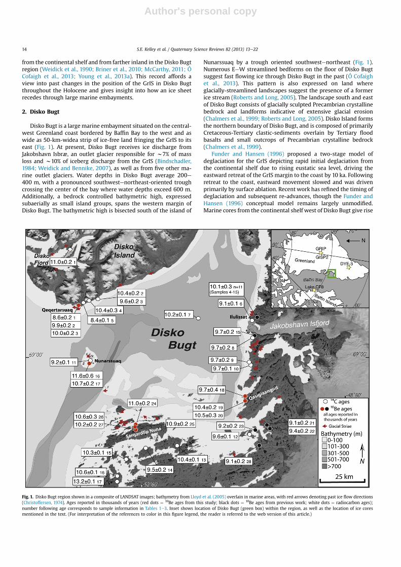
Disko Bugt is a largemarine embayment situated on the central-west Greenland coast bordered by Baffin Bay to the west and aswide as 50-km-widea strip of ice-free land fringing the GrIS to itseast (Fig. 1). At present, Disko Bugt receives ice discharge fromJakobshavn Isbræ, an outlet glacier responsible for w7% of massloss and w10% of iceberg discharge from the GrIS (Bindschadler,1984; Weidick and Bennike, 2007), as well as from five other ma-rine outlet glaciers. Water depths in Disko Bugt average 200e400 m, with a pronounced southwestenortheast-oriented troughcrossing the center of the bay where water depths exceed 600 m.Additionally, a bedrock controlled bathymetric high, expressedsubaerially as small island groups, spans the western margin ofDisko Bugt. The bathymetric high is bisected south of the island of
Nunarssuaq by a trough oriented southwestenortheast (Fig. 1).Numerous EeW streamlined bedforms on the floor of Disko Bugtsuggest fast flowing ice through Disko Bugt in the past (Ó Cofaighet al., 2013). This pattern is also expressed on land whereglacially-streamlined landscapes suggest the presence of a formerice stream (Roberts and Long, 2005). The landscape south and eastof Disko Bugt consists of glacially sculpted Precambrian crystallinebedrock and landforms indicative of extensive glacial erosion(Chalmers et al., 1999; Roberts and Long, 2005). Disko Island formsthe northern boundary of Disko Bugt, and is composed of primarilyCretaceous-Tertiary clastic-sediments overlain by Tertiary floodbasalts and small outcrops of Precambrian crystalline bedrock(Chalmers et al., 1999).
Funder and Hansen (1996) proposed a two-stage model ofdeglaciation for the GrIS depicting rapid initial deglaciation fromthe continental shelf due to rising eustatic sea level, driving theeastward retreat of the GrIS margin to the coast by 10 ka. Followingretreat to the coast, eastward movement slowed and was drivenprimarily by surface ablation. Recent work has refined the timing ofdeglaciation and subsequent re-advances, though the Funder andHansen (1996) conceptual model remains largely unmodified.Marine cores from the continental shelf west of Disko Bugt give rise
Fig. 1. Disko Bugt region shown in a composite of LANDSAT images; bathymetry from Lloyd et al. (2005) overlain in marine areas, with red arrows denoting past ice flow directions(Christoffersen, 1974). Ages reported in thousands of years (red dots ¼ 10Be ages from this study; black dots ¼ 10Be ages from previous work; white dots ¼ radiocarbon ages);number following age corresponds to sample information in Tables 1e3. Inset shows location of Disko Bugt (green box) within the region, as well as the location of ice coresmentioned in the text. (For interpretation of the references to color in this figure legend, the reader is referred to the web version of this article.)
S.E. Kelley et al. / Quaternary Science Reviews 82 (2013) 13e2214

Author's personal copy
to a chronology of retreat from the western shelf break that beganby 13,860 � 90 cal yr BP (core VC34; Fig. 4; all marine radiocarbonages are calibrated using MARINECAL09 with a DR of 140 � 25based on http://calib.qub.ac.uk/marine/ and Lloyd et al. (2011) andare presented as the mean � half the 1-sigma range; Ó Cofaighet al., 2013), with a brief, but significant, re-advance at12,370 � 210 cal yr BP (core VC20; Fig. 4; Ó Cofaigh et al., 2013). Icesubsequently retreated rapidly eastward from the continental shelfby 10,920 � 140 cal yr BP (core MSM-343300; Fig. 4; McCarthy,2011; Hogan et al., 2012). High rates of ice-sheet ablationcontinued between 10.9 ka and 9.5 ka (Jennings et al., 2013), withice sheet recession out of Disko Bugt by 10,160 � 210 cal yr BP (corePOR-18; Fig. 1; Lloyd et al., 2005).
The terrestrial chronology constraining retreat of ice from thewestern margin of Disko Bugt exhibits a wide range of ages (Fig. 1;Table 1). Much of the deglaciation constraints are from minimum-limiting radiocarbon ages derived from marine macrofossils andbulk sediments in lake sediment cores. The oldest of these radio-carbon ages comes fromsouthwest of DiskoBugt,where aminimumage of 13,220 � 130 cal yr BP was derived from bulk sediment in alake sediment core (Fredskild, 1996). This age has previously beenconsidered dubious because it is at odds with the existing under-standing of the local relative sea level history (Bennike and Björck,2002). Additional basal ages obtained from bulk lake sediment inthe area constrain deglaciation to before 10,550�140,10,360�120,and 10,330� 80 cal yr BP (Long andRoberts, 2003; Long et al., 2003).Bivalves in raised marine deposits (18 m asl), south of SarqardîpNuna, constrain deglaciation prior to 9510 � 220 cal yr BP (Donnerand Jungner, 1975). On Nunarssuaq Island, in west-central DiskoBugt, bivalves date to 9190 � 130 cal yr BP (Bennike et al., 1994),indicating theGrIS had retreated fromthemouthofDiskoBugt sometime prior to this age.
To the north of Disko Bugt, the deglacial chronology from DiskoIsland is derived from a basal organic sediment sample in a lakesediment core and numerous shells from raised marine deposits.Geomorphic evidence suggests the possibility of two local advancesduring what has been termed the Godhavn Stade and Disko Stade.
Fig. 2. Sample photos with corresponding ages in thousands of years. (A) View across Qasigiaanguit field site to the WNW toward Disko Bugt with Disko Island in the distance. (B)View to the north of Qeqertarsuaq field site, note crystalline bedrock outcrop below overlying basalt. (C) Boulder perched on bedrock in the foreground: view to the north across theSarqardîp Nuna field site. (D) View to the north of the two sampled bedrock surfaces at Nunarssuaq, with southern Disko Island in the background.
Fig. 3. Satellite image of the sampling transect on Sarqardîp Nuna; ages in thousandsof years. Inset map shows the location of the figure (yellow star) within Disko Bugt.(For interpretation of the references to color in this figure legend, the reader is referredto the web version of this article.)
S.E. Kelley et al. / Quaternary Science Reviews 82 (2013) 13e22 15
Author's personal copy
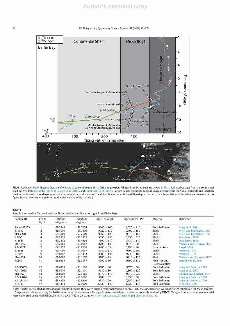
Fig. 4. Top panel: Time-distance diagram of western Greenland ice margin in Disko Bugt region. All ages from Disko Bugt are shown in Fig. 1. Radiocarbon ages from the continentalshelf derived from McCarthy (2011), Ó Cofaigh et al. (2013), and (Quillmann et al., 2009). Bottom panel: composite LandSat image depicting the individual transects and locationsused in the time-distance diagram as well as in retreat rate calculations. The dotted line represents the 400 m depth contour. (For interpretation of the references to color in thisfigure legend, the reader is referred to the web version of this article.)
Table 1Sample information for previously published deglacial radiocarbon ages from Disko Bugt
Sample ID Ref. toFig. 1
Latitude(degrees)
Longitude(degrees)
Age (14C yrs BP) Age (cal yrs BP)a Material Reference
Beta-183253 1 69.5243 �53.7224 9700 � 100 11,020 � 210 Bulk Sediment Long et al., 2011K-4567 2 69.3000 �53.2500 9220 � 130 10,400 � 150 Shells Frich and Ingólfsson, 1990Hel-2210 3 69.3000 �53.2500 9060 � 120 9610 � 150 Shells Frich and Ingólfsson, 1990AAR-5 4 69.2833 �53.3333 9650 � 250 10,350 � 320 Shells Ingólfsson, 1990K-3663 5 69.2833 �53.4666 7600 � 110 8430 � 110 Shells Ingólfsson, 1990Ua-1086 6 69.2000 �51.0667 8795 � 130 9070 � 90 Shells Weidick and Bennike, 2007AA-37711 7 69.1757 �51.8230 9483 � 65 10,190 � 80 Foraminifera Lloyd, 2005K-1818 8 69.1000 �51.0667 8630 � 130 9690 � 200 Shells Weidick, 1972K-2023 9 69.0167 �51.1333 8680 � 135 9740 � 180 Shells Weidick, 1974Ua-4574 10 69.0000 �51.1167 9180 � 75 9710 � 130 Shells Weidick and Bennike, 2007RCD-21 11 68.9833 �53.3167 8690 � 90 9190 � 130 Mya truncata;
Hiatella arcticaBennike et al., 1994
AA-35659 12 68.6333 �51.1176 8585 � 86 9570 � 90 Bulk Sediment Long and Roberts, 2002AA-39655 13 68.6170 �52.1101 9180 � 80 10,360 � 120 Bulk Sediment Long et al., 2003Hel-362 14 68.6000 �52.5666 8970 � 170 9510 � 220 Shells Donner and Jungner, 1975AA-38844 15 68.5333 �52.9667 9185 � 62 10,330 � 80 Bulk Sediment Long and Roberts, 2003AA-38842 16 68.4333 �52.8500 9330 � 99 10,550 � 140 Bulk Sediment Long and Roberts, 2003K-5133 17 68.4333 �52.9500 11,320 � 140 13,220 � 130 Bulk Sediment Fredksild, 1996
Note: K dates are treated as atmospheric samples because they were originally normalized to 0 per mil PDB, the DR correction was made after calibration for these samples.a Ages were calibrated using Calib 6.0 and reported as the mean� 1s; ages from terrestrial sourcematerial are calibrated using INTCAL09; ages frommarine sourcematerial
were calibrated using MARINECAL09 with a DR of 140 � 25 based on http://calib.qub.ac.uk/marine/ and Lloyd et al. (2011).
S.E. Kelley et al. / Quaternary Science Reviews 82 (2013) 13e2216

Author's personal copy
The Godhavn Stade is expressed as a discontinuous moraine at themouth of major valleys along the southwestern margin of DiskoIsland. The age of the Godhavn Stade is constrained by a minimumlimiting age from a shell dating to 10,350 � 320 cal yr BP, and isbelieved to represent GrIS expansion from Disko Bugt on to DiskoIsland during the LGM (Ingólfsson et al., 1990). The Disko Stade is anadvance of local Disko Island glaciers expressed as a series of mo-raines near the valley mouth, which truncate Godhavn Stade mo-raines on eastern Disko Island. The Disko Stade is dated to w10 ka,and theorized to be the result of changes in the predominant winddirection and moisture source (Ingólfsson et al., 1990), while otherssuggest that the advance could be attributed to surging local gla-ciers (Weidick and Bennike, 2007). At the eastern end of DiskoFjord, on western Disko Island, the oldest age constraint of degla-ciation is from bulk lake sediments, which place deglaciation priorto 11,020 � 210 cal yr BP (all terrestrial radiocarbon ages are cali-brated using INTCAL09 using http://calib.qub.ac.uk/marine/;Long et al., 2011). Four radiocarbon ages derived from bivalvesalong the south coast of Disko Island indicate ice-free marineconditions by 10,350 � 320, 10,400 � 150, 9610 � 150, and8430 � 110 cal yr BP (Frich and Ingólfsson, 1990; Ingólfsson et al.,1990). Overall, the existing chronology suggests the retreat of icefrom Disko Island began at w11 ka on the western portion of theisland, with slightly later retreat occurring along the southern coastat w10 ka, though it remains unclear whether the chronologypertains to the retreat of the GrIS or retreat of locally sourcedglaciers.
The deglacial chronology from eastern Disko Bugt relies on bothradiocarbon dating as well as 10Be dating. Radiocarbon ages fromnear the mouth of Jakobshavn Isfjord yield minimum-limitingconstraints on deglaciation of 9070 � 90 cal yr BP (Weidick andBennike, 2007) and 9690 � 2000 cal yr BP (Weidick, 1972). Sam-ples collected w20 km south of Jakobshavn Isfjord yield similarradiocarbon ages of 9740 � 180 cal yr BP (Weidick, 1974) and9710� 130 cal yr BP (Weidick and Bennike, 2007). These ages are inagreement with recent 10Be ages, which indicate the landscapenear Jakobshavn Isfjord deglaciated at 10.1�0.3 ka (n¼ 12; Corbettet al., 2011; Young et al., 2011a, 2011b, 2013a). In southeasternDisko Bugt, the timing of deglaciation is derived from 10Be ages andradiocarbon ages from a lake sediment core. The core yields a bulksediment basal age of 9570� 90 cal yr BP (Long and Roberts, 2002),and four 10Be ages from nearby average 9.2 � 0.1 ka (Fig. 1; Younget al., 2013a).
The existing chronology in and around Disko Bugt constrainsdeglaciation to w9e11 ka. However, in most places the timing ofdeglaciation has not been dated directly. The majority ofradiocarbon-dated material is of marine origin, and thus relies ona marine reservoir correction based on modern ocean circulationwithin Disko Bugt (Lloyd et al., 2011), which may differ from theoceanographic conditions during deglaciation. In addition, manyof the radiocarbon ages are from bulk lake sediment samples thathave been noted in a number of studies to give erroneous old ages(Kaplan et al., 2002; Bennike et al., 2010), or are from marine or-ganisms which colonize the seafloor some unknown period oftime following deglaciation. Here, we report twelve new 10Be agesfrom four new locations around Disko Bugt, which directly datethe retreat of ice from the landscape. We compare these new agesto previously published 10Be and 14C ages to improve the chro-nology of ice retreat out of Disko Bugt during the early Holocene.The additional 10Be ages connect the comprehensive chronologiesof early-to-late Holocene ice margin fluctuation on the Green-landic mainland to emerging records from the continental shelf.The combined time-distance history spans from w14 ka to pre-sent, and from the continental shelf break to the present icemargin.Ta
ble
2Sa
mple
inform
ationforpreviou
slypublished
10Beag
es.
Ref.to
Fig.
1Sa
mple
nam
eLatitude
(N)
Longitude
(W)
Elev
ation
(m)
Sample
type
Thickn
ess
(cm)
Shielding
correction
Quartz
(g)
9Be
(ug)
10Be/
9Be
ratio
Uncertainty
(atomsg�
1)
10Be
(atomsg�
1)
10Beuncertainty
(atomsg�
1)
10Beag
e(ka)
Referen
ce
4GL0
9769
.251
0�5
0.82
2047
0Bou
lder
2.0
1.00
016
.350
247
6.54
E�14
1.70
E�15
6.62
0Eþ0
41.72
1Eþ0
39.6�
0.3
Corbe
ttet
al.,20
115
GL0
9669
.250
0�5
0.82
3046
8Bed
rock
3.0
1.00
015
.280
247
6.72
E�14
1.29
E�15
7.27
0Eþ0
41.39
6Eþ0
310
.7�
0.2
Corbe
ttet
al.,20
116
JAKN08
-21
69.241
0�5
0.98
0739
0Bed
rock
1.0
1.00
075
.487
154
4.68
E�13
2.48
E�14
6.38
8Eþ0
43.38
3Eþ0
310
.0�
0.5
You
nget
al.,20
11a,
You
nget
al.2
011b
7JAKN08
-22
69.240
1�5
0.96
1436
0Bou
lder
4.5
1.00
080
.162
159
4.49
E�13
1.41
E�14
5.96
4Eþ0
41.86
8Eþ0
39.8�
0.3
You
nget
al.,20
11a,
You
nget
al.2
011b
8GL0
9269
.230
0�5
0.90
2039
7Bou
lder
1.0
1.00
020
.140
248
8.01
E�14
1.59
E�15
6.59
0Eþ0
41.30
8Eþ0
310
.2�
0.2
Corbe
ttet
al.,20
119
GL0
9369
.230
0�5
0.90
2039
7Bed
rock
2.0
1.00
018
.940
246
7.71
E�14
1.94
E�15
6.69
0Eþ0
41.68
3Eþ0
310
.4�
0.3
Corbe
ttet
al.,20
1110
GL1
0069
.227
0�5
0.93
0029
2Bou
lder
2.0
1.00
015
.530
247
5.60
E�14
1.22
E�15
5.95
0Eþ0
41.29
6Eþ0
310
.3�
0.2
Corbe
ttet
al.,20
1111
GL1
0169
.227
0�5
0.92
9029
5Bed
rock
3.5
1.00
020
.190
247
6.87
E�14
1.30
E�15
5.62
0Eþ0
41.06
3Eþ0
39.8�
0.2
Corbe
ttet
al.,20
1112
GL1
0269
.207
0�5
1.13
4085
Bed
rock
1.0
1.00
019
.650
247
5.70
E�14
1.27
E�15
4.79
0Eþ0
41.06
7Eþ0
310
.2�
0.2
Corbe
ttet
al.,20
1113
JAKN08
-01
69.205
5�5
1.12
4411
2Bed
rock
2.5
1.00
080
.046
181
3.20
E�13
7.85
E�15
4.75
8Eþ0
41.16
8Eþ0
310
.0�
0.2
You
nget
al.,20
11a,
You
nget
al.2
011b
14JAKN08
-08
69.199
3�5
0.94
7433
8Bed
rock
1.0
1.00
085
.060
120
6.50
E�13
1.83
E�14
6.14
2Eþ0
41.72
7Eþ0
310
.1�
0.3
You
nget
al.,20
11a,
You
nget
al.2
011b
1509
GRO-01
69.109
8�5
1.04
1520
8Bed
rock
5.0
1.00
077
.094
102
5.69
E�13
1.42
E�14
5.02
5Eþ0
41.25
4Eþ0
39.7�
0.2
You
nget
al.,20
11a,
You
nget
al.2
011b
2110
GRO-33
68.702
7�5
0.84
4532
8Bed
rock
3.0
0.99
850
.040
162
2.50
E�13
4.69
E�15
5.40
0Eþ0
41.01
0Eþ0
39.1�
0.2
You
nget
al.,20
13a
2210
GRO-34
68.700
0�5
0.82
0914
8Bed
rock
2.0
1.00
053
.460
162
2.79
E�13
5.24
E�15
5.67
0Eþ0
41.06
0Eþ0
39.4�
0.2
You
nget
al.,20
13a
2310
GRO-08
68.669
5�5
0.99
8713
5Bed
rock
3.5
1.00
058
.060
162
2.39
E�13
4.57
E�15
4.46
0Eþ0
48.53
0Eþ0
29.2�
0.2
You
nget
al.,20
13a
2810
GRO-18
68.616
4�5
1.05
1218
0Bed
rock
4.5
1.00
058
.780
162
2.51
E�13
6.21
E�15
4.62
0Eþ0
41.14
0Eþ0
39.1�
0.2
You
nget
al.,20
13a
S.E. Kelley et al. / Quaternary Science Reviews 82 (2013) 13e22 17
Author's personal copy
3. Methods
Samples for 10Be dating were collected from glacially sculptedbedrock surfaces (n¼ 8) and perched erratic boulders (n¼ 4) with ahammer and chisel. Samples were collected from the centralportion of boulders and outcrops, away from non-horizontal sur-faces, edges, and corners. Latitude, longitude and elevation werecollected at all sample locations using a handheld GPS device andtopographic shielding was measured using a clinometer. Sampleswere collected above the local marine limit as indicated by pub-lished relative sea level curves (Long and Roberts, 2002, 2003; Longet al., 2006, 2011), and geomorphic evidence such as the presenceof raised beaches and washing limits. An exception to this samplingstrategy is our collection of samples KE-11-01 and KE-11-02 atw90 m asl from the highest point on the island of Nunarssuaq,which is below the published marine limit of >95 m for the site(Rasch, 2000). However, local relative sea level curves suggest thatrebound was rapid at this time, and thus we expect a negligible agedifference for the actual timing of deglaciation and the age of oursamples. Nonetheless, 10Be ages from this location should beconsidered minimum-limiting constraints on the timing ofdeglaciation.
All samples underwent physical and chemical processingfollowing procedures modified from Kohl and Nishiizumi (1992) atthe University at Buffalo Cosmogenic Isotope Laboratory. Sampleswere crushed and the 425e850 mm size fraction was separated bysieving. Dilute HCl and HNO3eHF acid treatment and heavy liquidmineral separationwere used to isolate quartz. Quartz was digestedwith a known amount of 9Be carrier and Be was isolated by ion-exchange chromatography and selective precipitation withNH4OH. 10Be/9Be AMS measurements were performed at LawrenceLivermore National Laboratory and normalized to standard07KNSTD3110 with a reported ratio of 2.85 � 10�12 (Nishiizumiet al., 2007; Rood et al., 2010). Ratios from process blanks were6.19 � 10�15 and 1.49 � 10�15, with AMS precision ranging from 5.4to 1.8% for blank corrected 10Be/9Be sample ratios.
All 10Be ages (including previously published ages) are calcu-lated using a modified version of theMatlab code developed for theCRONUS-Earth web-based calculator using the regionally cali-brated Baffin Bay 10Be production rate of 3.96 � 0.07 atoms g�1 a�1
(Young et al., 2013b) and the constant-production scheme of Lal/Stone (Lal, 1991; Stone, 2000) with no corrections made for localisostatic rebound. We use the regionally calibrated Baffin Bayproduction rate (vs. NENA 10Be production rate of 3.91 � 0.19atoms g�1 a�1; Balco et al., 2009) because ages calculated with theBaffin Bay rate have been demonstrated to agree with independentlocal radiocarbon evidence, and the Baffin Bay rate minimizes thesystematic error contribution fromproduction-rate uncertainties toour 10Be ages. Sample sites are at local high points on the landscapeand are inferred to be windswept, thus no corrections for snowcover have been made. Additionally, glacial polish and striae areabundant on bedrock surfaces throughout the field area, indicatinglittle erosion since ice sheet recession. Thus, we made no correc-tions for erosion when calculating 10Be ages.
4. Results and interpretation
We calculate twelve 10Be ages from glacially sculpted bedrocksurfaces (n¼ 8) and perched erratic boulders (n¼ 4). Two ages frombedrock samples collected w10 m apart on Nunarssuaq are11.6 � 0.6 ka and 10.7 � 0.2 ka and average 11.1� 0.7 ka (Figs. 1 and2; Table 3; all averages are the mean � one standard deviation).Although it is possible that the older age may reflect inherited 10Befrom previous exposures, these two ages from the same site overlapat 2-sigma so we opt to calculate their average. At Qeqertarsuaq, Ta
ble
3Sa
mple
inform
ationfor10Beag
es.
Ref.toFig.
1Sa
mple
nam
eLatitude
(N)
Longitude
(W)
Elev
ation
(m)
Sample
type
Thickn
ess
(cm)
Shielding
correction
Quartz
(g)
9Be(ug)
10Be/
9Be
ratio
Uncertainty
(atomsg�
1)
10Be
(atomsg�
1)
10Beuncertainty
(atomsg�
1)
10Beag
e(ka)
Qeq
ertarsua
q1
DISKO-03
69.263
7�5
3.55
4817
3Bed
rock
3.0
0.99
260
.060
016
22.39
E�13
4.59
E�15
4.32
Eþ04
8.30
Eþ02
8.6�
0.2
2DISKO-01
69.262
4�5
3.55
2115
0Bed
rock
3.0
0.99
250
.037
316
22.23
E�13
4.21
E�15
4.84
Eþ04
9.12
Eþ02
9.9�
0.2
3DISKO-02
69.262
1�5
3.55
0815
3Bou
lder
3.0
0.99
260
.204
616
22.73
E�13
5.26
E�15
4.92
Eþ04
9.47
Eþ02
10.0
�0.2
Nun
arssua
q16
KE-11
-01
68.984
5�5
3.33
3789
Bed
rock
3.0
1.00
040
.784
428
31.15
E�13
6.23
E�15
5.36
Eþ04
2.89
Eþ03
11.6
�0.6
17KE-11
-02
68.984
3�5
3.33
3787
Bed
rock
1.0
1.00
050
.004
228
51.31
E�13
2.72
E�15
5.00
Eþ04
1.04
Eþ03
10.7
�0.2
Qasigiaan
guit
18QA-11-05
68.847
3�5
1.16
7619
5Bou
lder
2.5
1.00
025
.152
728
66.68
E�14
3.02
E�15
5.08
Eþ04
2.30
Eþ03
9.7�
0.4
19QA-11-02
68.810
6�5
1.14
0042
0Bed
rock
3.0
1.00
049
.846
928
41.77
E�13
3.23
E�15
6.75
Eþ04
1.23
Eþ03
10.4
�0.2
20QA-11-01
68.804
6�5
1.15
5236
0Bed
rock
3.0
1.00
050
.127
628
51.70
E�13
4.07
E�15
6.47
E þ04
1.55
Eþ03
10.5
�0.3
SarqardîpNun
a24
SN-11-07
68.693
1�5
2.69
6911
9Bou
lder
1.5
1.00
041
.596
522
41.49
E�13
2.80
E�15
5.34
Eþ04
1.01
Eþ03
11.0
�0.2
25SN
-11-02
68.672
5�5
2.70
7211
9Bou
lder
2.0
1.00
040
.571
622
41.42
E�13
2.69
E�15
5.26
Eþ04
9.93
Eþ02
10.9
�0.2
26SN
-11-04
68.649
1�5
2.66
6422
0Bed
rock
3.0
1.00
032
.577
828
49.65
E�14
2.31
E�15
5.64
Eþ04
1.35
Eþ03
10.6
�0.3
27SN
-11-05
68.649
1�5
2.66
4922
1Bou
lder
2.0
1.00
050
.118
828
61.44
E�13
3.39
E�15
5.50
Eþ04
1.29
Eþ03
10.2
�0.2
Notes:Allsamplesweresp
iked
witha40
5.4mg/g
9Becarrierex
ceptSN
-11-02
whichweresp
iked
witha37
2.5mg/g
9Becarrier;
AMSresu
ltsarestan
dardized
to07
KNST
D;ratios
areblan
k-co
rrected,a
ndsh
ownat
1-sigm
auncertainty.
S.E. Kelley et al. / Quaternary Science Reviews 82 (2013) 13e2218
Author's personal copy
southern Disko Island, one sample from a boulder yields an age of8.6� 0.2 ka, and two bedrock samples yield ages of 9.9� 0.2 ka and10.0 � 0.2 ka (Figs. 1 and 2; Table 3). We consider the age of8.6 � 0.2 ka as an outlier because it is much younger than the othertwo 10Be ages, as well as a radiocarbon age of 10.4 � 0.3 ka derivedfrommarine bivalves collectedw5 km to the east (Ingólfsson et al.,1990). Thus, the two ages from the Qeqertarsuaq site average10.0� 0.1 ka. On the southernmargin of Disko Bugt, on the island ofSarqardîp Nuna, four 10Be ages are calculated from samplescollected at three sites along transect extending 5 km to the southfrom the northern coast of the island (Fig. 3). A boulder samplefrom the northernmost site yields a 10Be age of 11.0 � 0.2 ka (Figs. 1and 2; Table 3). To the south, a boulder sample collected at themiddle site of the transect provides a 10Be age of 10.9 � 0.2 ka(Figs. 1 and 2; Table 3). At the southernmost transect site, bedrockand boulder samples located w10 m apart yield 10Be ages of10.6 � 0.3 ka and 10.2 � 0.2 ka, respectively (Figs. 1 and 2; Table 3);the average age from the southernmost site is 10.4 � 0.3 ka. AtQasigiaanguit, in eastern Disko Bugt, 40 km south of JakobshavnIsfjord, 10Be ages derived from two bedrock samples and oneboulder sample are 10.5 � 0.3 ka, 10.4 � 0.2 ka, and 9.7 � 0.4 karespectively. The younger of these ages, 9.7 � 0.4 ka, is from asample collected at w200 m lower in elevation than the older twosamples (Table 3). The difference in agesmay reflect thinning of theice margin at this location during deglaciation. However, for an ageof deglaciation of the Qasigiaanguit area we use an average age of10.2 � 0.4 ka (n ¼ 3; Figs. 1 and 2; Table 3).
5. Discussion
5.1. Deglaciation of Disko Bugt
Samples collected from four localities on the perimeter of DiskoBugt, combined with previously published 10Be ages from theeastern coast of Disko Bugt, outline a pattern of initial ice retreatout of central Disko Bugt with later recession along the margins.The oldest 10Be ages are from Nunarssuaq, where two ages average11.1 � 0.7 ka and provide a closer constraint on deglaciation than aminimum limiting radiocarbon age of 9190� 130 cal yr BP from thesite (Fig. 1; Bennike et al., 1994). A similar age of 11.0 � 0.2 ka wasdetermined for the northernmost site (most proximal to DiskoBugt) in the Sarqardîp Nuna transect. The remaining ages from theSarqardîp Nuna transect decrease in age toward the south. Radio-carbon ages from south of Sarqardîp Nuna range from 10,550 � 140to 9510 � 220 cal yr BP (n ¼ 4; Fig. 1; Donner and Jungner, 1975;Long and Roberts, 2003) and further corroborate ice recessionoccurring later to the south of Disko Bugt than in central Disko Bugt.
On southern Disko Island at Qeqertarsuaq 10Be ages that average10.0 � 0.1 ka (n ¼ 2) indicate later deglaciation than in central-western and central-southern Disko Bugt. One interpretation forthese younger ages is that ice lingered on Disko Island followingrecession of the GrIS from Disko Bugt, fed by local ice caps on thehigh plateaus covering much of Disko Island. It is also possible thatthe relatively young 10Be ages is evidence of the Disko Stadeadvance (Ingólfsson et al., 1990), although no other evidence of theDisko Stade advance has been found on western Disko Island. Our10Be ages overlap within error with radiocarbon ages from thesouthern coast of Disko Island that range from 10,400 � 150 to8430 � 110 cal yr BP (n ¼ 4; Fig. 1; Frich and Ingólfsson, 1990;Ingólfsson et al., 1990).
At Qasigiaanguit, in eastern Disko Bugt, the average 10Be age of10.2 � 0.4 ka (n ¼ 3; Fig. 1) overlaps within error with the average10Be age of deglaciation from the Ilulissat area of 10.1 � 0.3 ka(n ¼ 12; Corbett et al., 2011; Young et al., 2013a) and is older than10Be ages constraining deglaciation in southeastern Disko Bugt at
9.2� 0.1 ka (n¼ 4; Young et al., 2013a). The ages from eastern DiskoBugt suggest that deglaciation in east-central Disko Bugt occurredfirst, and then later in southeastern Disko Bugt. Radiocarbon ages of9740 � 180 and 9710 � 1300 cal yr BP (Weidick, 1974; Weidickand Bennike, 2007) from 25 km north of Qasigiaanguit, and9570 � 90 cal yr BP (Long and Roberts, 2002) from 20 km south ofQasigiaanguit, provide minimum limiting constraints on deglacia-tion and support our 10Be ages. A sedimentological shift observed ina marine sediment core from offshore of Disko Bugt indicates apronounced decrease in ice-rafted debris at w10 ka (core MSM-343340), and correlates to the time when ice retreated out ofeast-central Disko Bugt and onto the mainland (McCarthy, 2011).
The pattern of ages suggests ice receded out of central DiskoBugt first near Jakobshavn Isfjord, with the timing of ice recessionlater along the mainland south of Disko Bugt. The spatial pattern ofice retreat may be explained in part by the bathymetric configu-ration of Disko Bugt (Fig. 1), withmore rapid ice retreat occurring inareas of deeper water in central Disko Bugt. Here, ice may havebeen more vulnerable to collapse as it retreated into deeper waterwith a widening bay geometry (Nick et al., 2010; Enderlin et al.,2013). Conversely, ice retreat may have been slower along south-ern Disko Bugt as the ice resided in relatively shallow water. Thisconceptual model of deglaciation is corroborated by acoustic pro-files fromDisko Bugt. The lack of significant sediment accumulationin the western and central bay suggests that central Disko Bugtdeglaciated rapidly without major standstills or re-advances(Hogan et al., 2012).
5.2. Retreat rates
Ice-margin retreat rates through Disko Bugt can be estimatedfrom our 10Be chronology. We calculate maximum and minimumpossible retreat scenarios based on the average age of deglaciationwith full consideration of the standard deviation of the average ageat strategic locations. We exclude the Disko Island ages from thecalculation of GrIS retreat rates, as our ages from Disko Island mayconstrain the retreat of locally sourced glaciers rather than that ofthe GrIS. The retreat of the GrIS margin 90 km from western DiskoBugt (10.8 � 0.5; n ¼ 6) to eastern Disko Bugt (9.9 � 0.5; n ¼ 19)yields rates that range from instantaneous (beyond the resolutionof our 10Be chronology) to 50 m a�1. However, closer inspection ofthe 10Be chronology demonstrates that the GrIS retreated onto landlater along the southeastern margin of Disko Bugt, while the retreatof ice onto land occurred earlier the Jakobshavn and Qasigiaanguitareas. The spatial variability in the retreat rate is further examinedby sub-dividing Disko Bugt into a southern and central section(Fig. 4). Retreat of 90 km in the central section of Disko Bugt, fromNunarssuaq and the northern site at Sarqardlîp Nuna (11.1 � 0.5;n ¼ 3) to the eastern coast of Disko Bugt at Jakobshavn Isfjord andQasigiaanguit (10.1 � 0.3; n ¼ 15) occurred at a rate of betweenw50 and 450 m a�1. In contrast, the GrIS receded the 70 km fromthe southern site at Sarqardlîp Nuna (10.4 � 0.3 n ¼ 2) to south-eastern Disko Bugt (9.2 � 0.1; n ¼ 4) at a rate between w50 and70 m a�1.
Our compilation of 10Be and radiocarbon ages reveals rapidretreat of the GrIS margin through Disko Bugt. Retreat rates rangingfromw50 to 450 m a�1 for central Disko Bugt overlaps the range of22e275 m a�1 retreat rates reported from the nearby continentalshelf (Ó Cofaigh et al., 2013) following a re-advance at 12.3 ka, andis equal to or faster than the w100 m a�1 reconstructed for thedeglaciation of Jakobshavn Isfjord during the middle Holocene(Young et al., 2011b). Ice retreat through Disko Bugt is also esti-mated to be equal to or faster than at Sermilik Fjord in southeastGreenland (�80 m a�1; Hughes et al., 2012) and at Sam Ford Fjordon Baffin Island (>58 m a�1; Briner et al., 2009). On the west coast
S.E. Kelley et al. / Quaternary Science Reviews 82 (2013) 13e22 19

Author's personal copy
of Norway, Mangerud et al. (2013) estimate retreat rates of 240e370 m a�1, and suggest that this is near the maximum possibleretreat rates in a long fjord system. If retreat rates within centralDisko Bugt are at the upper end of the range we calculate then theymay have been faster than rates reported for other fjord systems,and may have even resembled the rapid break-up of ice shelves inthe western Antarctica Peninsula (Scambos et al., 2004).
5.3. Deglaciation from the continental shelf to the present icemargin
In this section, we describe the reconstruction of a time-distancehistory of the western GrIS in the Disko Bugt region from thecontinental shelf break to the present ice margin (Fig. 4). Theearliest constraints on deglaciation of the western margin of theGrIS are from marine sediment cores collected from trough mouthfans at the edge of the continental shelf (Ó Cofaigh et al., 2013).These cores reveal that GrIS retreat from the continental shelfinitiated by 13,860� 90 cal yr BP (core VC34; Ó Cofaigh et al., 2013).Following a re-advance at 12,230 � 130 cal yr BP (core VC20; ÓCofaigh et al., 2013), the ice margin continued to retreat acrossthe continental shelf with recession off the inner shelf occurring by10,920 � 140 cal yr BP (Fig. 3; MSM-343300; Quillmann et al.,2009).
The timing of western Disko Bugt deglaciation at 10.8� 0.5 ka issimilar to an age on deglaciation of 10,920 � 140 cal yr BP from thenearby continental shelf (60 km southwest; core MSM-343300;Quillmann et al., 2009). This similarity implies little pause, orslowdown, during deglaciation from the western Greenland shelfand into Disko Bugt. Following ice retreat out of Disko Bugt, the GrISdeposited the Fjord Stade moraines during re-advances at 9.3 and8.2 ka (Weidick and Bennike, 2007; Young et al., 2011a, 2013a).Following these re-advances, the GrIS retreated to a location at orbehind its latest Holocene ice margin by w7.4 ka near JakobshavnIsfjord andw7.0 ka in southeastern Disko Bugt (Young et al., 2011b,2013a). The GrIS remained behind its present margin throughoutthemiddle Holocene, and radiocarbon-dated lake sediments from athreshold lake basin reveal that the GrIS achieved its minimummid-Holocene extent at or by 5770 � 110 cal yr BP (Briner et al.,2010). At Jakobshavn Isfjord, the GrIS was approaching the latestHolocene configuration by w2.3 ka, achieved its late Holocenemaximum around 0.4 ka (Briner et al., 2010), and began retreatingby 1850 AD (Csatho et al., 2008). In southeast Disko Bugt, the icemargin neared its latest Holocene maximum position by w0.3 ka,and culminated in its maximum extent during the late 20th century(Kelley et al., 2012).
5.4. Forcing mechanisms
In evaluating possible forcing mechanisms for rapid retreat ofthe GrIS from Disko Bugt, two end member scenarios are possible:1) the retreat of the GrIS was climatically driven by increasing airand ocean temperatures, and 2) ice dynamic factors independent ofclimatic forcing drove the recession. Retreat of the GrIS from DiskoBugt occurred during a period of ocean and climatic warming, aswell as ice sheet thinning. Arctic summer temperatures on BaffinIsland (w600 km west) increased 2e4 �C between 11 and 10 ka(Fig. 5; Axford et al., 2009). In addition, evidence of relatively warmAtlantic-derived water reaching northern Baffin Bay just after10.9 ka implies increased advection of Atlantic water into Baffin Bayaround the time of ice retreat from Disko Bugt (Knudsen et al.,2008). Further evidence of a warming Baffin Bay is derived fromthe presence of driftwood in southwest Greenland dated to10.8 � 0.4 ka indicating ice free conditions for part of the year(Weidick, 1975). Estimates of ice sheet elevation change from the
GRIP and DYE-3 ice cores indicate that accelerated thinning of theGrIS occurred between 11 and 10 ka (Fig. 5; Vinther et al., 2009).This evidence of ameliorating climate provides a possible mecha-nism for GrIS retreat during the early Holocene.
Evidence for the role of ice dynamics on ice sheet retreat comesfrom a comparison of the deglaciation of the Disko Bugt area to thatof the Uummannaq Fjord system and cross-shelf trough to thenorth (w220 km). A major difference between the two glaciersystems is their geometry, with Disko Bugt exhibiting a wideningand bathymetrically deepening geometry from west to east, whileUummannaq is much narrower and bathymetrically deeper, withnumerous islands (McCarthy, 2011). Recent investigations of theUummannaq trough suggest that deglaciation commenced fromthe continental shelf atw14.8 ka,w1000 years earlier than offshoreof Disko Bugt (Ó Cofaigh et al., 2013; Roberts et al., 2013). Ice sheetretreat also progressed differently between the two systems, withthe ice sheet well within the main fjord at Uummannaq by 12.4 ka,into the inner fjords by 10.8 ka and likely behind its present posi-tion at Store Gletscher by 8.7 ka (Roberts et al., 2013). This asyn-chronous initiation and evolution of ice sheet retreat between thetwo neighboring systems suggests a local ice dynamic influence onice sheet recession.
We postulate that climatic factors created a situation in DiskoBugt where the western margin of the GrIS became more suscep-tible to rapid retreat driven by ice dynamics. As the GrIS thinned,buoyancy may have increased, and was exacerbated by basal meltdue to contact with warming ocean water. As buoyancy of themarine-based section of the GrIS increased, the margin may havelost contact with the bathymetric high spanning the mouth ofDisko Bugt, which acted as a pinning point. This change could haveled to accelerated calving as the basin geometry widens from westto east, prompting rapid recession of the ice margin from deep,
Fig. 5. A) Time-distance diagram presented in Fig. 4, depicting the location of the GrISmargin in the Disko Bugt region since 14 ka; B) Summer air temperature reconstruc-tion from Lake CF8 on Baffin Island, Arctic Canada (Axford et al., 2009); C) Recon-structed temperature from the GISP2 ice core (Alley, 2000); D) ice sheet elevationchanges at the GRIP and DYE-3 sites (Vinther et al., 2009).
S.E. Kelley et al. / Quaternary Science Reviews 82 (2013) 13e2220
Author's personal copy
central Disko Bugt to a more stable configuration along southernand eastern coasts of Disko Bugt (Enderlin et al., 2013). This pro-posed scenario is supported by sedimentological data from themarine cores that suggest calving was a major factor in the earlyHolocene retreat of the GrIS from the continental shelf (Jenningset al., 2013).
6. Conclusions
New 10Be ages from around Disko Bugt, western Greenland,place the deglaciation of western Disko Bugt at 10.8 � 0.5 ka, withthe ice margin reaching the eastern coast of Disko Bugt near Ilu-lissat at 10.1�0.3 ka and in southeastern Disko Bugt at 9.2� 0.1 ka.This chronology yields a retreat rate between w50 and 450 m a�1
across central Disko Bugt. This rate indicates that w25% of theoverall retreat between the shelf edge and the current positionoccurred in as little as 700 years. We suggest this retreat was theresult of internal ice dynamics acting upon an ice sheet driven outof equilibrium by climatic factors. These findings further emphasizethe ability of marine sectors of ice sheets to change rapidly due toice dynamics in warming climates (e.g. Kjær et al., 2012). Ourchronology fills a gap in the current understanding of the earlyHolocene behavior of the GrIS in Disko Bugt, and provides a datasetthat completes a history of a western GrIS margin spanning fromthe continental shelf to the present ice position, and from the latestPleistocene through the Holocene.
Acknowledgments
This work greatly benefitted from high precision 10Be mea-surements from Lawrence Livermore National Laboratory by SusanZimmerman and Robert Finkel.We appreciate laboratory assistancefrom Michael Badding and Sarah Lavin. We are grateful for the re-views of A. Jennings and A. Hughes, whose comments improvedthis manuscript. This research was funded by a Geologic Society ofAmerica graduate student grant and grant NSF-1156361 from theU.S. National Science Foundation Program of Geography and SpatialScience.
Appendix A. Supplementary data
Supplementary data related to this article can be found at http://dx.doi.org/10.1016/j.quascirev.2013.09.018.
References
Alley, R.B., 2000. The Younger Dryas cold interval as viewed from central Greenland.Quat. Sci. Rev. 19, 213e226.
Axford, Y., Briner, J.R., Miller, G.H., Francis, D.R., 2009. Paleoecological evidence forabrupt cold reversals during peak Holocene warmth on Baffin Island, ArcticCanada. Quat. Res. 71, 142e149.
Balco, G., Briner, J.P., Finkel, R., Rayburn, J.A., Ridge, J.C., Schaefer, J.M., 2009.Regional beryllium-10 production rate calibration for late-glacial northeasternNorth America. Quat. Geochronol. 4, 93e107.
Bennike, O., Hansen, K.B., Knudsen, K.L., Penney, D.N., Rasmussen, K.L., 1994. Qua-ternary marine stratigraphy and geochronology in central West Greenland.Boreas 23, 194e215.
Bennike, O., Anderson, N.J., McGowan, S., 2010. Holocene palaeoecology of south-west Greenland inferred from macrofossils in sediments of an oligosaline lake.J. Paleolimnol. 43, 787e798.
Bennike, O., Björck, S., 2002. Chronology of the last recession of the Greenland IceSheet. J. Quat. Sci. 17, 211e219.
Bindschadler, R.A., 1984. Jakobshavns Glacier drainage basin: a balance assessment.J. Geophys. Res. Oceans (1978e2012) 89, 2066e2072.
Bjørk, A.A., Kjær, K.H., Korsgaard, N.J., Khan, S.A., Kjeldsen, K.K., Andresen, C.S.,Larsen, N.K., Funder, S., 2012. An aerial view of 80 years of climate-relatedglacier fluctuations in southeast Greenland. Nat. Geosci. 5, 427e432.
Box, J.E., 2002. Survey of Greenland instrumental temperature records: 1873e2001.Int. J. Climatol. 22, 1829e1847.
Briner, J.P., Bini, A.C., Anderson, R.S., 2009. Rapid early Holocene retreat of a Lau-rentide outlet glacier through an Arctic fjord. Nat. Geosci 2, 496e499.
Briner, J., Stewart, H., Young, N., Philipps, W., Losee, S., 2010. Using proglacial-threshold lakes to constrain fluctuations of the Jakobshavn Isbræ ice margin,western Greenland, during the Holocene. Quat. Sci. Rev. 29, 3861e3874.
Chalmers, J., Pulvertaft, T., Marcussen, C., Pedersen, A., 1999. New insight into thestructure of the Nuussuaq Basin, central West Greenland. Mar. Petrol. Geol. 16,197e224.
Christoffersen, M., 1974. Quaternary Map of Greenland: Søndre Strømfjord-Nûgs-suaq Kvartærgeologisk. Sheet 3, Quaternary Map of Greenland. GreenlandGeologic Survey, Copenhagen, Denmark.
Corbett, L.B., Young, N.E., Bierman, P.R., Briner, J.P., Neumann, T.A., Rood, D.H.,Graly, J.A., 2011. Paired bedrock and boulder 10Be concentrations resulting fromearly Holocene ice retreat near Jakobshavn Isfjord, western Greenland. Quat.Sci. Rev. 30, 1739e1749.
Csatho, B., Schenk, T., Van der Veen, C., Krabill, W.B., 2008. Intermittent thinning ofJakobshavn Isbræ,West Greenland, since the Little Ice Age. J. Glaciol. 54,131e144.
Donner, J., Jungner, H., 1975. Radiocarbon dating of shells from marine Holocenedeposits in the Disko Bugt area, West Greenland. Boreas 4, 25e45.
Enderlin, E., Howat, I., Vieli, A., 2013. High sensitivity of tidewater outlet glacierdynamics to shape. Cryosphere Discuss. 7, 551e572.
Fisher, D., Zheng, J., Burgess, D., Zdanowicz, C., Kinnard, C., Sharp, M., Bourgeois, J.,2012. Recent melt rates of Canadian arctic ice caps are the highest in fourmillennia. Global Planet. Change 84e85, 3e7.
Fredskild, B., 1996. Holocene Climatic Changes in Greenland. The Paleo-eskimoCultures of Greenland. Danish Polar Center, Copenhagen, pp. 243e251.
Frich, P., Ingólfsson, O., 1990. Det holocæne sedimentationsmiljø ved Igpik samt enmodel for den relative landhævning i Disko Bugt området, Vestgrønland. In:AÊrsskrift for Dansk Geologisk Forening 1987, vol. 89, pp. 1e10.
Funder, S.V., Hansen, L., 1996. The Greenland ice sheet-a model for its culminationand decay during and after the last glacial maximum. Geol. Soc. Den. Bull. 42,137e152.
Hogan, K., Dowdeswell, J., Cofaigh, C., 2012. Glacimarine sedimentary processes anddepositional environments in an embayment fed by West Greenland icestreams. Mar. Geol. 311e314, 1e16.
Hughes, A.L., Rainsley, E., Murray, T., Fogwill, C.J., Schnabel, C., Xu, S., 2012. Rapidresponse of Helheim Glacier, southeast Greenland, to early Holocene climatewarming. Geology 40, 427e430.
Ingólfsson, Ó., Frich, P., Funder, S., Humlum, O., 1990. Paleoclimatic implications ofan early Holocene glacier advance on Disko Island, West Greenland. Boreas 19,297e311.
Jennings, A., Walton, M.E., Cofaigh, C.Ó., Kilfeather, A., Andrews, J.T., Ortiz, J., DeVernal, A., Dowdeswell, J.A., 2013. Paleoenvironments during the YoungerDryas-early Holocene retreat of the Greenland Ice Sheet from outer DiskoTrough, central west Greenland. Journal of Quaternary Science 28, http://dx.doi.org/10.1002/jqs.2652.
Joughin, I., Smith, B.E., Howat, I.M., Scambos, T., Moon, T., 2010. Greenland flowvariability from ice-sheet-wide velocity mapping. J. Glaciol. 56, 415e430.
Kaplan, M.R., Wolfe, A.P., Miller, G.H., 2002. Holocene environmental variability insouthern Greenland inferred from lake sediments. Quat. Res. 58, 149e159.
Kaufman, D.S., Schneider, D.P., McKay, N.P., Ammann, C.M., Bradley, R.S., Briffa, K.R.,Miller, G.H., Otto-Bliesner, B.L., Overpeck, J.T., Vinther, B.M., 2009. Recentwarming reverses long-term Arctic cooling. Science 325, 1236e1239.
Kelley, S.E., Briner, J.P., Young, N.E., Babonis, G.S., Csatho, B., 2012. Maximum lateHolocene extent of the western Greenland Ice Sheet during the late 20thcentury. Quat. Sci. Rev. 56, 89e98.
Kjær, K.H., Khan, S.A., Korsgaard, N.J., Wahr, J., Bamber, J.L., Hurkmans, R., van denBroeke, M., Timm, L.H., Kjeldsen, K.K., Bjørk, A.A., 2012. Aerial photographsreveal Late-20th-century dynamic ice loss in Northwestern Greenland. Science337, 569e573.
Knudsen, K.L., Stabell, B., Seidenkrantz, M.S., Eiriksson, J., Blake, W., 2008. Deglacialand Holocene conditions in northernmost Baffin Bay: sediments, foraminifera,diatoms and stable isotopes. Boreas 37, 346e376.
Lal, D., 1991. Cosmic-ray labeling of erosion surfaces: in situ nuclide productionrates and erosion models. Earth Planet. Sci. Lett. 104, 424e439.
Levy, L.B., Kelly, M.A., Howley, J.A., Virginia, R.A., 2012. Age of the Ørkendalenmoraines, Kangerlussuaq, Greenland: constraints on the extent of the south-western margin of the Greenland Ice Sheet during the Holocene. Quat. Sci. Rev.52, 1e5.
Lloyd, J., Park, L., Kuijpers, A., Moros, M., 2005. Early Holocene palaeoceanographyand deglacial chronology of Disko Bugt, west Greenland. Quat. Sci. Rev. 24,1741e1755.
Lloyd, J., Moros, M., Perner, K., Telford, R.J., Kuijpers, A., Jansen, E., McCarthy, D.,2011. A 100 yr record of ocean temperature control on the stability of Jakob-shavn Isbrae, West Greenland. Geology 39, 867e870.
Long, A.J., Roberts, D.H., 2002. A revised chronology for the ‘Fjord Stade’ moraine inDisko Bugt, west Greenland. J. Quat. Sci. 17, 561e579.
Long, A.J., Roberts, D.H., 2003. Late Weichselian deglacial history of Disko Bugt,West Greenland, and the dynamics of the Jakobshavns Isbrae ice stream. Boreas32, 208e226.
Long, A.J., Roberts, D.H., Rasch, M., 2003. New observations on the relative sea leveland deglacial history of Greenland from Innaarsuit, Disko Bugt. Quat. Res. 60,162e171.
Long, A., Roberts, D., Dawson, S., 2006. Early Holocene history of the westGreenland Ice Sheet and the GH-8.2 event. Quat. Sci. Rev. 25, 904e922.
S.E. Kelley et al. / Quaternary Science Reviews 82 (2013) 13e22 21
Author's personal copy
Long, A.J., Woodroffe, S.A., Roberts, D.H., Dawson, S., 2011. Isolation basins, sea-levelchanges and the Holocene history of the Greenland Ice Sheet. Quat. Sci. Rev. 30,3748e3768.
Mangerud, J., Goehring, B.M., Lohne, Ø.S., Svendsen, J.I., Gyllencreutz, R., 2013.Collapse of marine-based outlet glaciers from the Scandinavian Ice Sheet. Quat.Sci. Rev. 67, 8e16.
Maslanik, J., Stroeve, J., Fowler, C., Emery, W., 2011. Distribution and trends in Arcticsea ice age through spring 2011. Geophys. Res. Lett. 38, L13502.
McCarthy, D.J., 2011. Late Quaternary Ice-ocean Interactions in Central WestGreenland. Deptment of Geography, Durham University, Durham, UK, p. 292.
Meier, M.F., Dyurgerov, M.B., Rick, U.K., O’Neel, S., Pfeffer, W.T., Anderson, R.S.,Anderson, S.P., Glazovsky, A.F., 2007. Glaciers dominate eustatic sea-level rise inthe 21st century. Science 317, 1064e1067.
Miller, G.H., Brigham-Grette, J., Alley, R.B., Anderson, L., Bauch, H.A., Douglas, M.S.V.,Edwards, M.E., Elias, S.A., Finney, B.P., Fitzpatrick, J.J., Funder, S.V., Herbert, T.D.,Hinzman, L.D., Kaufman, D.S., MacDonald, G.M., Polyak, L., Robock, A.,Serreze, M.C., Smol, J.P., Spielhagen, R., White, J.W.C., Wolfe, A.P., Wolff, E.W.,2010. Temperature and precipitation history of the Arctic. Quat. Sci. Rev. 29,1679e1715.
Möller, P., Larsen, N.K., Kjær, K.H., Funder, S., Schomacker, A., Linge, H., Fabel, D.,2010. Early to middle Holocene valley glaciations on northernmost Greenland.Quat. Sci. Rev. 29, 3379e3398.
Nick, F., Van der Veen, C., Vieli, A., Benn, D., 2010. A physically based calving modelapplied to marine outlet glaciers and implications for the glacier dynamics.J. Glaciol. 56, 781e794.
Nishiizumi, K., Imamura, M., Caffee, M.W., Southon, J.R., Finkel, R.C., McAninch, J.,2007. Absolute calibration of 10Be AMS standards. Nucl. Instrum. Meth. Phys.Res. B 258, 403e413.
Ó Cofaigh, C., Dowdeswell, J., Jennings, A., Hogan, K., Kilfeather, A., Hiemstra, J.,Noormets, R., Evans, J., McCarthy, D., Andrews, J., 2013. An extensive and dy-namic ice sheet on the West Greenland shelf during the last glacial cycle. Ge-ology 41, 219e222.
Perren, B.B., Wolfe, A.P., Cooke, C.A., Kjær, K.H., Mazzucchi, D., Steig, E.J., 2012.Twentieth-century warming revives the world’s northernmost lake. Geology40, 1003e1006.
Quillmann, U., Andrews, J.T., Jennings, A.E., 2009. Radiocarbon Dates from MarineSediment Cores of the Iceland, Greenland, and Northeast Canadian ArcticShelves and Nares Strait. Institute of Arctic and Alpine Research OccasionalPaper 59, pp. 14e15.
Rasch, M., 2000. Holocene relative sea level changes in Disko Bugt, West Greenland.J. Coast. Res. 16, 306e315.
Rignot, E., Kanagaratnam, P., 2006. Changes in the velocity structure of theGreenland Ice Sheet. Science 311, 986e990.
Rignot, E., Velicogna, I., van den Broeke, M.R., Monaghan, A., Lenaerts, J.T.M., 2011.Acceleration of the contribution of the Greenland and Antarctic ice sheets to sealevel rise. Geophys. Res. Lett. 38, L05503.
Roberts, D.H., Long, A.J., 2005. Streamlined bedrock terrain and fast ice flow,Jakobshavns Isbrae, West Greenland: implications for ice stream and ice sheetdynamics. Boreas 34, 25e42.
Roberts, D.H., Rea, B.R., Lane, T.P., Schnabel, C., Rodés, A., 2013. New constraints onGreenland ice sheet dynamics during the last glacial cycle: evidence from theUummannaq ice stream system. J. Geophys. Res. Earth Surf.
Rood, D.H., Hall, S., Guilderson, T.P., Finkel, R.C., Brown, T.A., 2010. Challenges andopportunities in high-precision Be-10 measurements at CAMS. Nucl. Instrum.Meth. Phys. Res. Sec. B Beam Interact. Mater. Atoms 268, 730e732.
Scambos, T.A., Bohlander, J., Shuman, C., Skvarca, P., 2004. Glacier acceleration andthinning after ice shelf collapse in the Larsen B embayment, Antarctica. Geo-phys. Res. Lett. 31, L18402.
Serreze, M.C., Barrett, A.P., Stroeve, J.C., Kindig, D.N., Holland, M.M., 2009. Theemergence of surface-based Arctic amplification. Cryosphere 3, 11e19.
Stone, J.O., 2000. Air pressure and cosmogenic isotope production. J. Geophys. Res.105, 23753e23759.
Vinther, B.M., Buchardt, S.L., Clausen, H.B., Dahl-Jensen, D., Johnsen, S.J., Fisher, D.A.,Koerner, R.M., Raynaud, D., Lipenkov, V., Andersen, K.K., Blunier, T.,Rasmussen, S.O., Steffensen, J.P., Svensson, A.M., 2009. Holocene thinning of theGreenland ice sheet. Nature 461, 385e388.
Weidick, A., 1968. Observations on some Holocene glacier fluctuations in westGreenland. Medd. Grønl. 165, 202.
Weidick, A., 1972. Rapport Grønlands Geologiske Undersøgelse. 14C Dating of SurveyMaterial Performed in 1971, vol. 41, pp. 1e39.
Weidick, A., 1974. Rapport Grønlands Geologiske Undersøgelse. 14C Dating of SurveyMaterial Performed in 1973, vol. 66, pp. 42e44.
Weidick, A., 1975. A Review of Quaternary Investigations in Greenland, vol. 70,p. 22.
Weidick, A., 1994. Rapport Grønlands Geologiske Undersølgelse. HistoricalFluctuations of Calving Glaciers in South and West Greenland, vol. 161,pp. 73e79.
Weidick, A., Kelly, M., Bennike, O.L.E., 2004. Late Quaternary development of thesouthern sector of the Greenland Ice Sheet, with particular reference to theQassimiut lobe. Boreas 33, 284e299.
Weidick, A., Oerter, H., Reeh, N., Thomsen, H.H., Thorning, L., 1990. The recession ofthe Inland Ice margin during the Holocene climatic optimum in the JakobshavnIsfjord area of West Greenland. Global Planet. Change 2, 389e399.
Weidick, A., Bennike, O., 2007. Quaternary Glaciation History and Glaciology ofJakobshavn Isbræ and the Disko Bugt Region, West Greenland: a Review.Geological Survey of Denmark and Greenland.
Young, N.E., Briner, J.P., Axford, Y., Csatho, B., Babonis, G.S., Rood, D.H., Finkel, R.C.,2011a. Response of a marine-terminating Greenland outlet glacier to abruptcooling 8200 and 9300 years ago. Geophys. Res. Lett. 38, L24701.
Young, N.E., Briner, J.P., Stewart, H.A., Axford, Y., Csatho, B., Rood, D.H., Finkel, R.C.,2011b. Response of Jakobshavn Isbræ, Greenland, to Holocene climate change.Geology 39, 131e134.
Young, N.E., Briner, J.P., Rood, D.H., Finkel, R.C., Corbett, L.B., Bierman, P.R., 2013a.Age of the Fjord Stade moraines in the Disko Bugt region, western Greenland,and the 9.3 and 8.2 ka cooling events. Quat. Sci. Rev. 60, 76e90.
Young, N.E., Schaefer, J.M., Briner, J.P., Goehring, B.M., 2013b. A precise 10Beproduction-rate calibration for the Arctic. J. Quat. Sci. 28, 515e526.
S.E. Kelley et al. / Quaternary Science Reviews 82 (2013) 13e2222