Quantity and Configuration of Available Elephant Habitat and Related Conservation Concerns in the...
10
Quantity and Configuration of Available Elephant Habitat and Related Conservation Concerns in the Lower Kinabatangan Floodplain of Sabah, Malaysia Jason G. Estes 1,2 *, Nurzhafarina Othman 3,4 , Sulaiman Ismail 5 , Marc Ancrenaz 5,6,7 , Benoit Goossens 3,4,6 , Laurentius N. Ambu 6 , Anna B. Estes 8 , Peter A. Palmiotto 1 1 Department of Environmental Studies, Antioch University New England, Keene, New Hampshire, United States of America, 2 Department of Environmental Conservation, University of Massachusetts, Amherst, Massachusetts, United States of America, 3 Organisms and Environment Division, School of Biosciences, Cardiff University, Cardiff, United Kingdom, 4 Danau Girang Field Centre, Sabah Wildlife Department, Kota Kinabalu, Sabah, Malaysia, 5 Hutan, Kinabatangan Orang-utan Conservation Program, Kota Kinabalu, Sabah, Malaysia, 6 Sabah Wildlife Department, Kota Kinabalu, Sabah, Malaysia, 7 North of England Zoological Society, Honorary Conservation Fellow, Chester, United Kingdom, 8 Center for Regional Environmental Studies, Dept. of Environmental Sciences, University of Virginia, Charlottesville, North Carolina, United States of America Abstract The approximately 300 (298, 95% CI: 152–581) elephants in the Lower Kinabatangan Managed Elephant Range in Sabah, Malaysian Borneo are a priority sub-population for Borneo’s total elephant population (2,040, 95% CI: 1,184–3,652). Habitat loss and human-elephant conflict are recognized as the major threats to Bornean elephant survival. In the Kinabatangan region, human settlements and agricultural development for oil palm drive an intense fragmentation process. Electric fences guard against elephant crop raiding but also remove access to suitable habitat patches. We conducted expert opinion-based least-cost analyses, to model the quantity and configuration of available suitable elephant habitat in the Lower Kinabatangan, and called this the Elephant Habitat Linkage. At 184 km 2 , our estimate of available habitat is 54% smaller than the estimate used in the State’s Elephant Action Plan for the Lower Kinabatangan Managed Elephant Range (400 km 2 ). During high flood levels, available habitat is reduced to only 61 km 2 . As a consequence, short-term elephant densities are likely to surge during floods to 4.83 km 22 (95% CI: 2.46–9.41), among the highest estimated for forest-dwelling elephants in Asia or Africa. During severe floods, the configuration of remaining elephant habitat and the surge in elephant density may put two villages at elevated risk of human-elephant conflict. Lower Kinabatangan elephants are vulnerable to the natural disturbance regime of the river due to their limited dispersal options. Twenty bottlenecks less than one km wide throughout the Elephant Habitat Linkage, have the potential to further reduce access to suitable habitat. Rebuilding landscape connectivity to isolated habitat patches and to the North Kinabatangan Managed Elephant Range (less than 35 km inland) are conservation priorities that would increase the quantity of available habitat, and may work as a mechanism to allow population release, lower elephant density, reduce human-elephant conflict, and enable genetic mixing. Citation: Estes JG, Othman N, Ismail S, Ancrenaz M, Goossens B, et al. (2012) Quantity and Configuration of Available Elephant Habitat and Related Conservation Concerns in the Lower Kinabatangan Floodplain of Sabah, Malaysia. PLoS ONE 7(10): e44601. doi:10.1371/journal.pone.0044601 Editor: Andrew Hector, University of Zurich, Switzerland Received May 20, 2011; Accepted August 9, 2012; Published October 5, 2012 Copyright: ß 2012 Estes et al. This is an open-access article distributed under the terms of the Creative Commons Attribution License, which permits unrestricted use, distribution, and reproduction in any medium, provided the original author and source are credited. Funding: The authors greatly appreciate our funders including the Center for Tropical Ecology and Conservation (CTEC), Idea Wild, the Rainforest Information Center (RIC), The Mohamed Bin Zayed Species Conservation Fund, ARCUS Foundation, Abraham Foundation, Shining Hope, Foundation Ensemble, Cared for the Earth, World Women Work, World Land Trust, Wildlife Conservation Network, Elephant Family, AOP, the U.S. Fish and Wildlife Service, and the following zoos: Columbus, Houston, Pittsburgh, Cleveland, Oregon, Philadelphia, Woodland Park, Phoenix, Basel, Bush Gardens, Boise, Hogle, Chester, Apenheul, La Palmyre, Beauval, Saint-Louis, Victoria, and Roger Williams Park. Our generous funders had no role in study design, data collection and analysis, decision to publish, or preparation of the manuscript. Competing Interests: The authors have declared that no competing interests exist. * E-mail: [email protected] Introduction As wildlife habitats and populations become increasingly isolated, assessing the relative potential for animal movement between habitat patches, known as the permeability of the landscape [1], becomes increasingly important to understanding a landscape’s functional connectivity. Landscape permeability is species specific, is linked to both habitat composition and configuration in a landscape, and is spatially and temporally complex. Spatially, managers must consider movement of target species at multiple scales. Landscape connectivity that supports intra-territorial movement necessary for wildlife to access habitat resources may not maintain movement at greater spatial scales such as the inter-territorial movements influencing metapopula- tion function, dispersal, and range shifts [1]. Temporal consider- ations are also necessary as natural disturbances can temporarily reduce permeability [1]. A lack of connectivity can leave otherwise suitable wildlife habitat unoccupied [2] resulting in discrepancies between the spatial distribution of suitable habitat and species occupancy [3]. Limiting elephant (Elephantidae) movement options and reducing habitat area available to them have a myriad of cascading consequences. The disruption of natural movements of elephants PLOS ONE | www.plosone.org 1 October 2012 | Volume 7 | Issue 10 | e44601
Transcript of Quantity and Configuration of Available Elephant Habitat and Related Conservation Concerns in the...
Quantity and Configuration of Available ElephantHabitat and Related Conservation Concerns in the LowerKinabatangan Floodplain of Sabah, MalaysiaJason G. Estes1,2*, Nurzhafarina Othman3,4, Sulaiman Ismail5, Marc Ancrenaz5,6,7, Benoit Goossens3,4,6,
Laurentius N. Ambu6, Anna B. Estes8, Peter A. Palmiotto1
1 Department of Environmental Studies, Antioch University New England, Keene, New Hampshire, United States of America, 2 Department of Environmental
Conservation, University of Massachusetts, Amherst, Massachusetts, United States of America, 3 Organisms and Environment Division, School of Biosciences, Cardiff
University, Cardiff, United Kingdom, 4 Danau Girang Field Centre, Sabah Wildlife Department, Kota Kinabalu, Sabah, Malaysia, 5 Hutan, Kinabatangan Orang-utan
Conservation Program, Kota Kinabalu, Sabah, Malaysia, 6 Sabah Wildlife Department, Kota Kinabalu, Sabah, Malaysia, 7 North of England Zoological Society, Honorary
Conservation Fellow, Chester, United Kingdom, 8 Center for Regional Environmental Studies, Dept. of Environmental Sciences, University of Virginia, Charlottesville, North
Carolina, United States of America
Abstract
The approximately 300 (298, 95% CI: 152–581) elephants in the Lower Kinabatangan Managed Elephant Range in Sabah,Malaysian Borneo are a priority sub-population for Borneo’s total elephant population (2,040, 95% CI: 1,184–3,652). Habitatloss and human-elephant conflict are recognized as the major threats to Bornean elephant survival. In the Kinabatanganregion, human settlements and agricultural development for oil palm drive an intense fragmentation process. Electricfences guard against elephant crop raiding but also remove access to suitable habitat patches. We conducted expertopinion-based least-cost analyses, to model the quantity and configuration of available suitable elephant habitat in theLower Kinabatangan, and called this the Elephant Habitat Linkage. At 184 km2, our estimate of available habitat is 54%smaller than the estimate used in the State’s Elephant Action Plan for the Lower Kinabatangan Managed Elephant Range(400 km2). During high flood levels, available habitat is reduced to only 61 km2. As a consequence, short-term elephantdensities are likely to surge during floods to 4.83 km22 (95% CI: 2.46–9.41), among the highest estimated for forest-dwellingelephants in Asia or Africa. During severe floods, the configuration of remaining elephant habitat and the surge in elephantdensity may put two villages at elevated risk of human-elephant conflict. Lower Kinabatangan elephants are vulnerable tothe natural disturbance regime of the river due to their limited dispersal options. Twenty bottlenecks less than one km widethroughout the Elephant Habitat Linkage, have the potential to further reduce access to suitable habitat. Rebuildinglandscape connectivity to isolated habitat patches and to the North Kinabatangan Managed Elephant Range (less than35 km inland) are conservation priorities that would increase the quantity of available habitat, and may work as amechanism to allow population release, lower elephant density, reduce human-elephant conflict, and enable geneticmixing.
Citation: Estes JG, Othman N, Ismail S, Ancrenaz M, Goossens B, et al. (2012) Quantity and Configuration of Available Elephant Habitat and Related ConservationConcerns in the Lower Kinabatangan Floodplain of Sabah, Malaysia. PLoS ONE 7(10): e44601. doi:10.1371/journal.pone.0044601
Editor: Andrew Hector, University of Zurich, Switzerland
Received May 20, 2011; Accepted August 9, 2012; Published October 5, 2012
Copyright: � 2012 Estes et al. This is an open-access article distributed under the terms of the Creative Commons Attribution License, which permitsunrestricted use, distribution, and reproduction in any medium, provided the original author and source are credited.
Funding: The authors greatly appreciate our funders including the Center for Tropical Ecology and Conservation (CTEC), Idea Wild, the Rainforest InformationCenter (RIC), The Mohamed Bin Zayed Species Conservation Fund, ARCUS Foundation, Abraham Foundation, Shining Hope, Foundation Ensemble, Cared for theEarth, World Women Work, World Land Trust, Wildlife Conservation Network, Elephant Family, AOP, the U.S. Fish and Wildlife Service, and the following zoos:Columbus, Houston, Pittsburgh, Cleveland, Oregon, Philadelphia, Woodland Park, Phoenix, Basel, Bush Gardens, Boise, Hogle, Chester, Apenheul, La Palmyre,Beauval, Saint-Louis, Victoria, and Roger Williams Park. Our generous funders had no role in study design, data collection and analysis, decision to publish, orpreparation of the manuscript.
Competing Interests: The authors have declared that no competing interests exist.
* E-mail: [email protected]
Introduction
As wildlife habitats and populations become increasingly
isolated, assessing the relative potential for animal movement
between habitat patches, known as the permeability of the
landscape [1], becomes increasingly important to understanding
a landscape’s functional connectivity. Landscape permeability is
species specific, is linked to both habitat composition and
configuration in a landscape, and is spatially and temporally
complex. Spatially, managers must consider movement of target
species at multiple scales. Landscape connectivity that supports
intra-territorial movement necessary for wildlife to access habitat
resources may not maintain movement at greater spatial scales
such as the inter-territorial movements influencing metapopula-
tion function, dispersal, and range shifts [1]. Temporal consider-
ations are also necessary as natural disturbances can temporarily
reduce permeability [1]. A lack of connectivity can leave otherwise
suitable wildlife habitat unoccupied [2] resulting in discrepancies
between the spatial distribution of suitable habitat and species
occupancy [3].
Limiting elephant (Elephantidae) movement options and reducing
habitat area available to them have a myriad of cascading
consequences. The disruption of natural movements of elephants
PLOS ONE | www.plosone.org 1 October 2012 | Volume 7 | Issue 10 | e44601
ASUS
Highlight
Asus
Highlight
Asus
Highlight
Asus
Highlight
Asus
Highlight

due to human actions such as fencing, habitat reduction,
fragmentation, and transformation is a cause of locally high
elephant densities [4]. High elephant densities have been cited for
degradation to vegetation [5] and subsequent negative effects on
other species [6]. Limited connectivity in a landscape can also
leave populations vulnerable by removing their ability to shift their
range in response to natural landscape processes and the effects of
climate change [7]. Reduction of land available to elephants can
both elevate elephant densities in remaining habitat patches and
increase the human-elephant interface; two phenomenon that
have been linked to increased levels of crop raiding [8–10].
In the early 1980s, Borneo’s elephants (Elephas maximus borneensis)
in Sabah, Malaysia were estimated to number between 500 and
2,000 [11]. The estimate was updated in 2002 to approximately
1,100 to 1,600 individuals with methods primarily based on
habitat availability [12]. Recent work based on distance sampling
of dung piles, estimated the total population of Bornean elephants
(mostly in Sabah) at around 2,000 (published estimate: 2,040, 95%
CI: 1,184–3,652), all residing in the northeastern portion of the
island [13].
The Sabah Wildlife Department declared four Managed
Elephant Ranges: the Lower Kinabatangan (400 km2), North
Kinabatangan (1,400 km2), Tabin (1,200 km2), and Central Sabah
(7,900 km2), which hold over 90% of Sabah’s wild elephant
population in its current Elephant Action Plan (Fig. 1) [12,14].
These ranges were based upon the current and likely future
pattern and extent of forested land in the state as well as the
number of elephants residing within the Ranges [12]. The Lower
Kinabatangan Managed Elephant Range population is estimated
at about 300 (published estimate: 298, 95% CI: 152–581)
elephants [13], living within a matrix of protected and unprotected
lands. Although estimates for conducting population surveys were
very different, managers believe there has been a twofold increase
in the ten years since the late nineties when the population was
estimated at 95–115 elephants [14]. In 2005, the Lower
Kinabatangan Wildlife Sanctuary successfully secured protection
for 260 km2 of forest and connected approximately 150 km2 of
Virgin Jungle Reserves already protected within the Lower
Kinabatangan (Fig. 2). This conservation effort protects a semi-
continuous corridor of natural vegetation connecting the coastal
mangrove swamps with dry forests upriver in the central parts of
the state. However, the overall reduction in available habitat, the
disruption of elephant migration routes, and the subsequent
intensification of human-elephant conflicts are all cited as
conservation threats in the Lower Kinabatangan Managed
Elephant Range [14].
Habitat loss is a major obstacle for elephant conservation
statewide in Sabah and particularly in the Lower Kinabatangan.
Habitat loss in the Lower Kinabatangan occurs directly through
conversion of existing forests to other land-use such as agriculture
or human settlement, while habitat isolation results from related
fragmentation processes. Sabah lost approximately 40% of its
forests in the 20th century [15]. Over five years (1998–2003),
2,926 km2 of oil palm (Elaeis guineensis) plantation was created in
Sabah, representing an average annual growth rate of 6.1% [16].
Oil palm in the Lower Kinabatangan accounts for about 28% of
the total oil palm area in Sabah [17]. Plantations reduce the
quantity of habitat available to elephants and are a source of
conflict when elephants graze on oil palm trees. An estimated 80%
of the Lower Kinabatangan floodplain has today been converted
to agriculture or other human-made, non-forest land cover.
Conversion of forest to agricultural land in the Lower Kinaba-
tangan has fragmented elephant habitat and elephant populations
[12]. The conversion process in the Kinabatangan is also credited
with creating conflicts between elephants and people by disrupting
traditional elephant migration routes, and increasing the risk of
crop predation, damage to property, damage to local cemeteries,
and loss of human life [12].
We suspected that available elephant habitat was overestimated
by elephant management plans for the region, so we sought to
identify the current quantity and configuration of available
suitable habitat in the Lower Kinabatangan Managed Elephant
Range. By comparing our habitat estimates with previous
estimates of available habitat, we aimed to demonstrate the
importance of incorporating both landscape permeability and the
natural disturbance regime into elephant habitat estimates for this
area. Another objective was to compare elephant density among
the different habitat quantity estimates using the most recent
Kinabatangan elephant population numbers available. To aid in
management of this landscape we also conducted an analysis of
bottlenecks in the Lower Kinabatangan. Lastly, we included
discussion of what our estimates may suggest about human-
elephant conflicts in the region.
Materials and Methods
Study areaResearch was conducted in the Lower Kinabatangan floodplain
of Sabah, Malaysia (approximate range of the study area is 5u189N
to 5u429N and 117u549E to 118u339E). The Kinabatangan River is
560 km long, has a water catchment area of about 16,800 km2,
and is subject to the Northeasterly Monsoonal climate. The mean
annual rainfall is about 3,000 mm with the heaviest precipitation
from October to March [18]. The region’s matrix of habitat types
include riparian forest, seasonally flooded forest, swamp forest, dry
dipterocarp forest, estuary nipa palm (Nypa fruticans), and
mangrove.
This study focused on the area between the villages of Abai and
Batu Puteh (Fig. 2). Beyond Abai, elephants are restricted by vast
mangrove forest. Beyond Batu Puteh, elephants are blocked from
traveling upriver by a major road bordered by human settlement.
The study area contains lots 1–7 (approximately 218 km2) of the
Lower Kinabatangan Wildlife Sanctuary (LKWS) and approxi-
mately 89 km2 (calculation does not include mangrove forest
reserves) of protected forest reserves (Fig. 2). The disturbance
regime of the Lower Kinabatangan is characterized by seasonal
flooding and occasional severe floods, which inundate the study
area. The highest recorded flood level as of 2001 was 14 m above
sea level [18]. Severe floods also occurred in 1971, 1974, 1977,
1981, 1986, 1996, and 2000. In 2000, WWF Malaysia estimated
that 100 km2 of the Lower Kinabatangan was inundated with
water for approximately 22 days. Negative effects were reported
on elephants when approximately 80% of the Lower Kinabatan-
gan Wildlife Sanctuary was flooded [18]. During the floods of
1996, inundation lasted for 35 days from the village of Sukau,
about 140 km upriver, to the village of Kuala Karamuak (Fig. 1)
[18]. The most recent major flood occurred in 2010.
Available elephant habitat modelingLandscape suitability and permeability for elephants was
modeled through least-cost analysis facilitated by CorridorDe-
signer [19], a suite of GIS tools created for Arc GIS [20]. Four
GIS layers (factors), representing land cover, linear barriers,
swamps, and level of protection, were created from a combination
of satellite images, scanned paper maps, field data, and local
knowledge (Text S1).
A team of eight experts, all with extensive experience observing
the Kinabatangan elephants, provided the weighting of the
Available Elephant Habitat in the Kinabatangan
PLOS ONE | www.plosone.org 2 October 2012 | Volume 7 | Issue 10 | e44601
Asus
Highlight
user
Highlight
user
Highlight
user
Highlight
Asus
Highlight

‘‘expert opinion-based model’’ (Table S1). The team consisted of
one professional researcher who had worked in the Kinabatangan
over a decade, two graduate students studying the Kinabatangan
elephants, and five local field research assistants who were
employed full-time to track and study this population of elephants.
The team of experts weighted each of the four factors and the suite
of classes within them. Both factors and classes were given weights
between 0 and 100. However, the sum of all factor scores for each
expert had to sum to 100 in order to account for the relative
importance of each factor. Class scores were allowed to vary
independently within the weighting range.
Weighting of factors and classes occurred during an in person
meeting to allow participants to ask clarifying questions through-
out the process. Participants assigned weights without knowledge
of other participants’ weights. The experts based their opinions on
their field observations of the Kinabatangan’s elephants and the
current body of knowledge about Bornean elephants and elephant
populations elsewhere. Each participant score was given equal
weight with opinions averaged for use in the ‘‘expert opinion-
based model.’’
In the land cover factor, the expert opinion-based model
assigned high suitability to regenerating forest, also known as
logged over forests, since these areas are believed to hold the
highest proportion of forage for elephants. Riparian habitat along
the Lower Kinabatangan River, often characterized with sandy
substrate and open grassy areas, was also rated with high
suitability. Human settlements were given a low suitability score
since people tend to push elephants out of these areas. Similarly,
oil palm plantations, although holding a great deal of forage for
elephants, were rated low due to the fact that people generally
protect them from elephants. Electric fences and trenches in the
linear barriers factor layer, and the three swamp classifications in
the swamps layer, were given low suitability scores since these have
been observed to inhibit elephant passage. CorridorDesigner
operates under the assumption that habitat suitability is synony-
mous with permeability while landscape resistance is defined as the
inverse of suitability.
Factor and class weights were used to create the expert opinion-
based Habitat Suitability Model (HSM). The four factors were
combined with a geometric mean algorithm to reflect that one
factor, such as linear barriers in the Lower Kinabatangan, can
limit suitability of the pixel in a way that cannot be compensated
by other factors [19]. Since an important aspect of least-cost
analyses is Euclidean distance, two artificial habitat patches were
placed as endpoints behind the known upriver and downriver
extents of the Kinabatangan elephants’ range. This was done to
Figure 1. Managed Elephant Ranges of Sabah, Malaysia.doi:10.1371/journal.pone.0044601.g001
Available Elephant Habitat in the Kinabatangan
PLOS ONE | www.plosone.org 3 October 2012 | Volume 7 | Issue 10 | e44601
Asus
Highlight

give the models ‘‘room to run,’’ so that the modeled corridor
would not simply represent the shortest distance between the
starting and ending habitat patches [19]. Providing source and
destination points allowed us to take our point specific HSM (cost
surface), and address route specific connectivity [21] with a cost-
distance surface. The cost-distance surface combines cost of travel
for an elephant with distance. This cost-distance grid was then
used to generate a least-cost corridor model, illustrating the two
dimensional configuration of the most permeable pathway
between the two endpoints.
In addition to the expert opinion-based model, 21 other HSMs,
cost-distance grids, and least-cost corridors were created using
biologically plausible alternatives with input weights ranging
within plausible bounds (Table S1). Varying the weights of model
inputs provided variation in outputs. One assumption is that the
modeler is able to produce much of the variation in model outputs
that could be attained from various combinations of model weights
falling within reasonable bounds. These alternative models were
used to conduct uncertainty analysis on the final linkage design
(the Lower Kinabatangan Elephant Habitat Linkage) of available
suitable elephant habitat.
The expert opinion-based model and one alternative model,
which identified a different pathway around the village of Sukau,
were merged in order to capture the majority of variation among
all models. This output was considered the most permeable
suitable portion of the landscape if an elephant was traveling
between the two endpoints and was referred to as the least-cost
corridor.
The Elephant Habitat Linkage, representing all available
suitable habitat for elephants in the Lower Kinabatangan
floodplain, was created by merging the least-cost corridor with
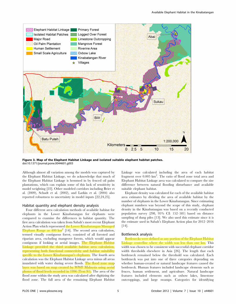
all intersecting habitat patches. Elephant habitat patches (Fig. 3)
for the entire study area were determined using CorridorDesigner
tools, with a 50 m moving window, a minimum patch size of
1000 m2, and the expert opinion-based HSM.
Uncertainty analysisUncertainty analysis was conducted to assess how susceptible
the least-cost corridor and the Elephant Habitat Linkage were to
variations in model weighting and design. Uncertainty analysis
addresses how much the model output varies in response to
uncertainty in the input parameters. The model can be considered
robust to uncertainty, if the range of assumptions is wide enough to
be credible and the subsequent inferences are narrow enough to be
useful [22,23]. To calculate the amount of variation captured by
the least-cost corridor and the Elephant Habitat Linkage, the
proportion of area of each of the 21 alternative models contained
within the least-cost corridor and the Elephant Habitat Linkage
was calculated [22].
Both the least-cost corridor and the Elephant Habitat Linkage
were robust to uncertainty in input parameters (Fig. S1). The
minimum proportion of any alternative model captured by the
area of either the least-cost corridor or the Elephant Habitat
Linkage was 92.5%. The least-cost corridor captured an average
of 97.5% of the 20 alternative models, while the Elephant Habitat
Linkage captured an average of 99.3% of all alternatives.
Figure 2. Map of the Lower Kinabatangan study area with protected forest reserves and the Lower Kinabatangan WildlifeSanctuary.doi:10.1371/journal.pone.0044601.g002
Available Elephant Habitat in the Kinabatangan
PLOS ONE | www.plosone.org 4 October 2012 | Volume 7 | Issue 10 | e44601
Although almost all variation among the models was captured by
the Elephant Habitat Linkage, we do acknowledge that much of
the Elephant Habitat Linkage is hemmed in by fenced oil palm
plantations, which can explain some of this lack of sensitivity in
model weighting [22]. Other modeled corridors including Beier et
al. (2009), Schadt et al. (2002), and Larkin et al. (2004) also
reported robustness to uncertainty in model inputs [22,24,25].
Habitat quantity and elephant density analysisFour different area calculation methods of available habitat for
elephants in the Lower Kinabatangan for elephants were
compared to examine the differences in habitat quantity. The
first area calculation was taken from Sabah’s most recent Elephant
Action Plan which represented the Lower Kinabatangan Managed
Elephant Range as 400 km2 [14]. The second area calculation,
termed visually contiguous forest, consisted of all forested and
riparian area, excluding mangrove forests, which would appear
contiguous if looking at aerial images. The Elephant Habitat
Linkage provided the third available habitat area calculation,
representing both functional connectivity and habitat suitability
specific to the Lower Kinabatangan’s elephants. The fourth area
calculation was the Elephant Habitat Linkage area minus all areas
inundated with water during severe floods. The flood zone map
layer was based on map created by WWF Malaysia using aerial
photos of flood levels recorded in 1996 (Text S1). The area of the
flood zone within the study area was calculated after digitizing the
flood zone. The full area of the remaining Elephant Habitat
Linkage was calculated including the area of each habitat
fragment over 0.005 km2. The ratio of flood zone total area and
Elephant Habitat Linkage area was calculated to compare the size
difference between natural flooding disturbance and available
suitable elephant habitat.
Elephant density was calculated for each of the available habitat
area estimates by dividing the area of available habitat by the
number of elephants in the Lower Kinabatangan. Since estimating
elephant numbers was beyond the scope of this study, elephant
density in the Kinabatangan was based on a recently conducted
population survey (298, 95% CI: 152–581) based on distance
sampling of dung piles [13]. We also used this estimate since it is
the estimate used in Sabah’s Elephant Action plan for 2012–2016
[14].
Bottleneck analysisBottlenecks were defined as any portion of the Elephant Habitat
Linkage centerline where the width was less than one km. This
width was chosen to be consistent with successful elephant corridor
width thresholds elsewhere in Asia [26]. The length that each
bottleneck remained below the threshold was calculated. Each
bottleneck was put into one of three categories depending on
whether human-created or natural landscape features caused the
bottleneck. Human features included landscape elements such as
fences, human settlement, and agriculture. Natural landscape
features included elements such as oxbow lakes, limestone
outcroppings, and large swamps. Categories for identifying
Figure 3. Map of the Elephant Habitat Linkage and isolated suitable elephant habitat patches.doi:10.1371/journal.pone.0044601.g003
Available Elephant Habitat in the Kinabatangan
PLOS ONE | www.plosone.org 5 October 2012 | Volume 7 | Issue 10 | e44601
Asus
Highlight
User
Highlight
User
Highlight
Asus
Highlight

bottleneck cause included: human/human, where the bottleneck
was bordered by human features on each side of the centerline,
natural/natural, where natural landscape features were on each
side of the centerline, and human/natural, where a combination of
human and natural features caused the bottleneck.
Results
Modeled available elephant habitat: quantity andconfiguration
The Elephant Habitat Linkage (Fig. 3) covers an area of
approximately 184 km2 and is our estimate of the current quantity
and configuration of available suitable elephant habitat in the
Lower Kinabatangan Managed Elephant Range. It passes close to
the villages of Abai, Sukau, Bilit, and Batu Puteh. As a thin strip
following the Kinabatangan River, the Elephant Habitat Linkage
has an average width of only 1.3 km. At its widest, the Linkage
spans 3.3 km, while the narrowest portion is 0.1 km. The widest
portions include Lower Kinabatangan Wildlife Sanctuary lots 2, 6,
and the combination of lots 3 and 4.
The area with visual connectivity of forests in the Lower
Kinabatangan was estimated at 351 km2. This area is 12% smaller
than the most recent documented area of the Lower Kinaba-
tangan Managed Elephant Range. The Elephant Habitat Linkage,
at 184 km2, is a reduction in area of 54% from the published
Lower Kinabatangan Managed Elephant Range and 47% from
our visual connectivity estimate.
During times of extensive flooding (as seen in 1996), approx-
imately 423 km2 of the study area is inundated with water and
more than 120 km2 of the Elephant Habitat Linkage is flooded,
reducing the area available to elephants within the Elephant
Habitat Linkage by 66% (62 km2 Elephant Habitat Linkage
remaining). Inundation for much of this area lasted for 35 days
[18]. Floodwaters break the Elephant Habitat Linkage into 23
fragments over 0.005 km2 that range in size from 31 km2 to
0.007 km2 (mean = 2.68 km2, SD66.67 km2), representing a total
area (62 km2) that is only 15% of the size of the Lower
Kinabatangan Managed Elephant Range (Table 1).
Elephant densityElephant density varies dramatically based on the four area
calculations (Table 1). There was a 14% increase in elephant
density between the documented area of the Lower Kinabatangan
Managed Elephant Range and the visual connectivity approach. A
117% increase was found between the density of the Lower
Kinabatangan Managed Elephant Range area and the Elephant
Habitat Linkage. During flooding, the Elephant Habitat Linkage
will experience a surge in elephant density by 548% compared to
the Lower Kinabatangan Managed Elephant Range, and 198%
compared to the Elephant Habitat Linkage.
BottlenecksTwenty bottlenecks (,1.0 km width) were identified by our
model throughout the Elephant Habitat Linkage. Thirty-eight
percent of the Elephant Habitat Linkage’s centerline was below
the one km threshold. The average length for bottlenecks in the
Kinabatangan was 1.9 km (max: 9.0 km, min: 0.2 km, SD62.1).
The average length between bottlenecks was 3.2 km (max:
14.0 km, min: 0.3 km, SD64.2). Twelve bottlenecks, accounting
for 44% of total bottleneck length (17.2 km), were a result of both
human and natural features; four bottlenecks, representing 8% of
the total bottleneck length (3.1 km), were caused by only natural
features; and four bottlenecks, making up the remaining 48%
(18.6 km) of bottleneck length, were caused entirely by human
features.
Discussion
Available suitable elephant habitatRecent landscape change, such as extensive development of oil
palm plantations, has altered both the quantity and the
configuration of suitable habitat for elephants in the Kinabatangan
[18]. The Elephant Habitat Linkage provides a snapshot in time of
our estimate of both the quantity and location of available
elephant habitat in the Lower Kinabatangan.
The way in which managers classify available habitat clearly
affects the quantity of habitat assumed to exist. This study’s visual
connectivity area estimate (351 km2) is 12% smaller than the
documented area of the Lower Kinabatangan Managed Elephant
Range. The difference likely reflects variation in the definition of
available and suitable habitat but may also reflect landscape
change that has occurred since the declaration of Lower
Kinabatangan Managed Elephant Range. Inclusion of unreach-
able forest patches [27] (Goossens et al. unpublished data) west of the
major road at Batu Puteh also contributes to the discrepancy
between the Elephant Action Plan and Elephant Habitat Linkage
habitat estimates.
A visual connectivity approach likely provides a more accurate
estimate of available habitat compared to the Lower Kinabatan-
gan Managed Elephant Range estimate, however it is overly
simplistic. Within the Lower Kinabatangan’s contiguous natural
vegetation, both suitability and resistance vary due to a myriad of
landscape features. Limestone outcroppings, for example, cause
variation in permeability and suitability within visually connected
Lower Kinabatangan forests. Limestone outcroppings often have
steep slopes or cliff edges. Although these features can be small in
area, they create holes of unsuitable habitat within otherwise
suitable habitat and offer resistance in the landscape by acting as
barriers that elephants must circumvent. Elephants are capable of
navigating steep terrain when required, but have been document-
ed in Africa to avoid gradual slopes even when forage on these
slopes is optimal [28,29]. Our results demonstrate that without
Table 1. Habitat area and elephant density estimates.
Area Estimate Area (km2) Density (elephants km22)
Lower Kinabatangan Managed Elephant Range [12] 400.00 0.75 (95% CI: 0.38–1.45)
Visually contiguous forest 350.83 0.85 (95% CI: 0.45–1.66)
Elephant Habitat Linkage 184.23 1.62 (95% CI: 0.83–3.15)
Remaining Elephant Habitat Linkage during flooding 61.75 4.83 (95% CI: 2.46–9.41)
All density estimates were based on the population estimate of 298 (95% CI: 152–581) elephants [13].doi:10.1371/journal.pone.0044601.t001
Available Elephant Habitat in the Kinabatangan
PLOS ONE | www.plosone.org 6 October 2012 | Volume 7 | Issue 10 | e44601
user
Highlight
user
Highlight
Asus
Highlight

considering suitability and permeability, the amount of available
habitat for elephants may be greatly overestimated in the
Kinabatangan. Our estimation of current available suitable
elephant habitat (the Elephant Habitat Linkage) in the Lower
Kinabatangan, at 184 km2, is 54% smaller than the Lower
Kinabatangan Managed Elephant Range habitat estimate and
47% smaller than our visual connectivity estimate.
We took our available habitat area estimate one step further to
demonstrate the importance of including natural flooding distur-
bance in Lower Kinabatangan elephant habitat estimates. During
severe floods, the Elephant Habitat Linkage will be cut into 23
habitat fragments over the size of 0.005 km2 (Fig. 4) with a
combined area of approximately 62 km2 of non-contiguous
suitable habitat and an average fragment size of less than 3 km2.
Elephants may face the risk of being temporarily trapped within
these small habitat patches bordered by floodwaters, human
settlements, and fenced oil palm plantations. Severe floods render
66% of the Elephant Habitat Linkage temporarily unsuitable,
leaving a suitable area of only 15% the size of the Lower
Kinabatangan Managed Elephant Range.
Flooding in the Kinabatangan is an important natural
disturbance process that affects species, ecosystems, and landscape
structure. Management areas that maintain natural disturbance
regimes without the risk of negatively affecting species, ecosystems,
and landscape structure probably require areas several times larger
than the maximum disturbance size typical of the region [30]. The
Elephant Habitat Linkage falls far short of this, with the 1996
Lower Kinabatangan flood zone (423 km2) more than 2.3 times its
size. While we see value in managing currently unavailable habitat
patches in the Managed Elephant Range for the maintenance of
biodiversity and for the option to reconnect areas in the future, we
stress the importance of having a more realistic awareness of the
quantity of habitat available to elephants at any given time.
Elephant densityWhen relatively dense populations of elephants exist, whether a
result of natural population growth or growth by compression of
elephants into smaller areas, undesirable changes may occur to the
local habitat, vegetation, and other wildlife species [31–34].
Elephant density in the Kinabatangan (Table 1) surges during high
flood levels to levels among the highest estimated for forest
elephants anywhere in the world, comparing to 4 km22 in India
[35], and 3.18 km22 in the Central African Republic [36]. The
already high elephant density in the Kinabatangan may rise
quickly if additional habitat is lost or isolated, and if managers are
correct that the Lower Kinabatangan elephant population is
growing at a rate that produced a twofold increase since the late
1990s [14].
There is no density of elephants that can serve as a definition of
‘overabundance’ for all areas, and a prerequisite for taking any
action to manage elephant levels should include clear conservation
and management objectives [37]. Elephant induced degradation
of vegetation [5] which has negative effects on other species [6]
have fueled debate about elephant overabundance elsewhere but
has not yet been cited as a problem in the Kinabatangan.
However, there is a danger of mismanaging the Lower
Figure 4. Map of visually contiguous forest, the Elephant Habitat Linkage, and the 1996 flood zone.doi:10.1371/journal.pone.0044601.g004
Available Elephant Habitat in the Kinabatangan
PLOS ONE | www.plosone.org 7 October 2012 | Volume 7 | Issue 10 | e44601
Asus
Highlight

Kinabatangan elephant population when the quantity of habitat is
grossly overestimated in management plans.
Furthermore, provisional minimum home-range estimates for
Bornean elephants are between 250 km2 to 400 km2 in relatively
non-fragmented forests and 600 km2 in fragmented forests of the
Kinabatangan [27]. This suggests that the Elephant Habitat
Linkage may not be large enough to hold the full extent of an
elephant’s home range. Indeed, over 50% of GPS fixes from three
collared elephants in the Kinabatangan between July 2008 and
February 2009 were located in oil palm plantations (Goossens et al.
unpublished data), possibly suggesting that elephants access a
portion of their resources from behind electric fences. These
resources are unavailable when plantations are effectively fenced
or defended strongly by people and should be considered
unreliable to support the elephant population. Conservation
action is needed in the Lower Kinabatangan to increase available
habitat for elephants by providing functional connectivity to
existing habitat patches within the Kinabatangan (Fig. 3) and
outside of the Kinabatangan to other Managed Elephant Ranges
to the west.
BottlenecksThe configuration of elephant habitat in the Lower Kinaba-
tangan jeopardizes the ability for elephants to pass throughout the
Elephant Habitat Linkage. A total of 20 bottlenecks currently
squeeze elephants through habitat areas where the width is
narrower than 1 km. Eighty percent of all bottlenecks, and 92% of
total bottleneck length, are caused at least in part by human
landscape features such as oil palm plantations and human
settlement. The average length of these bottlenecks is almost two
km with the two longest bottlenecks (9.0 km and 6.5 km) serving
as the only options for elephants to pass by Sukau Village. If
elephants choose the pathway arcing farther outside Sukau
through lot 3 of the Lower Kinabatangan Wildlife Sanctuary,
then they would travel through more than nine km in a bottleneck
approximately 0.8 km wide (Fig. 5). If they chose to travel adjacent
to Sukau, they would be in a bottleneck area for about 6.5 km with
width varying from 0.5 to 0.6 km or less (Fig. 5). A study in India
investigated the length and width dimensions of corridors found to
be used by elephants. Both bulls and family groups used passages
0.5–1 km wide and less than about five km long. It was suggested
that bulls may use narrower passages, or ones with greater length
to width ratios, even if these corridor dimensions were unsuitable
for family groups [26]. The two bottleneck pathways around
Sukau both have greater length to width ratios than seen to be
effective in India, suggesting that some bottlenecks in the
Kinabatangan may be nearing critical thresholds for effective
use by elephants. Additionally, the average distance between
bottlenecks in the Lower Kinabatangan is just over three km,
which means elephants are frequently funneled into narrow
passages (Fig. 5).
Human-elephant conflict (HEC)A combination of the quantity and configuration of available
suitable habitat, high elephant densities, and bottleneck areas
make the Lower Kinabatangan susceptible to high levels of HEC
and put the villages of Bilit and Sukau particularly at risk.
Elephants passing by Sukau must travel within one of two long,
narrow bottlenecks. Bottlenecks act as funnels pinching the
pathway between larger habitat patches and may cause higher
incidences of conflict compared to areas outside of bottlenecks
[26].
Elephants may be discouraged from using the southern passage,
which takes them away from Sukau, due to its narrow northern
opening caused by a combination of electric fencing and limestone
outcroppings. Elephants choosing to pass closer to Sukau may
frequently encounter houses and subsistence crops of local people
on the south side of the Kinabatangan River.
High elephant densities resulting from population growth or
habitat reduction have been associated with increased levels of
HEC [8]. Additionally, the loss of elephant range [12], whether
through direct habitat conversion or inaccessibility caused by
isolation of habitat patches, increases the probability of contact
between elephants and people by increasing the human-elephant
interface [9] resulting in increased levels of crop raiding [10].
During severe floods, when the Kinabatangan experiences a surge
in elephant density, the two largest Elephant Habitat Linkage
fragments remaining dry are situated adjacent to the villages of
Bilit and Sukau. The majority of the Kinabatangan’s elephants
may be trapped in these areas until floodwaters recede. If this is
the case, the surge in elephant density and the proximity of the
largest remaining available habitat to Sukau and Bilit may
encourage HEC around these two villages.
Elephants will need to reach well-drained or higher ground
when the Kinabatangan floods, which will put them in direct
conflict with people. Oil palm plantation owners chose to plant on
the least flood prone land and actively rid the plantations of water
by digging trenches from their plantations to nearby rivers and
swamps, creating bunds along the river, and installing pumping
mechanisms. Elephants are left with land prone to flooding since
the majority of plantations owners have installed electric fences on
the plantation perimeter to exclude crop-raiding elephants. This
non-random landscape change, where the comparably flood-safe
land is chosen for plantations, puts elephants into conflict with
people when elephants take refuge in plantations to escape
floodwaters [18] and forage in areas currently planted with palm
oil while other foraging areas are temporarily unavailable.
DispersalElephant dispersal is clearly limited in the Kinabatangan by a
combination of electric fences, human settlements, and movement
resistant natural features with low permeability such as large
swamps. Gomantong Forest Reserve (Fig. 2), for example, is
isolated from the Elephant Habitat Linkage by a large swamp
which is bordered on each side by the electric fences of oil palm
plantations (Fig. 5). Large portions of Lower Kinabatangan
Wildlife Sanctuary lots 1 and 5 are modeled as unavailable due
to large swamps. Combinations of barriers limiting dispersal
abilities, puts the long term survival of elephants at risk by
reducing their capability to respond to natural flood cycles.
Unprotected lands between sanctuaries and reserves must
remain permeable in order for Lower Kinabatangan elephants
to travel the extent of their current range. Predictions have
doomed wildlife reserves to become islands of habitat sitting
among vast inhospitable human-modified landscapes [38,39].
However, if stakeholders in the Kinabatangan can increase the
permeability of the landscape between isolated habitat patches by
widening bottlenecks and establishing corridors, they may be able
to reduce levels of HEC, increase elephants’ abilities to respond to
the natural flooding regime, and allow for genetic mixing between
Sabah’s elephant populations.
Managers and their partners have already established the Lower
Kinabatangan Wildlife Sanctuary to provide some connectivity
among other protected forests. Modern approaches of responding
to overabundance of elephants in southern Africa, call for closed
populations to be ‘‘released,’’ resulting in the decompression of
populations and allowing natural processes rather than constant
human intervention, to limit the effects of overabundant elephant
Available Elephant Habitat in the Kinabatangan
PLOS ONE | www.plosone.org 8 October 2012 | Volume 7 | Issue 10 | e44601
Asus
Highlight
Asus
Highlight
Asus
Highlight
Asus
Highlight
Asus
Highlight
user
Highlight

populations [4]. If Lower Kinabatangan managers can increase
available elephant habitat by reopening passages to other
Managed Elephant Ranges such as North Kinabatangan Man-
aged Elephant Range, managers may be able to avoid the
expensive management of overabundant populations. The Sega-
liud Lokan Forest Reserve (Fig. 1) section of the North
Kinabatangan Managed Elephant Range is less than 35 km
inland from the main road at Batu Puteh that severs connectivity
for elephants traveling westward. Sabah’s 2002 Action Plan
referred to the North Kinabatangan Managed Elephant Range
when it stated that prospects exist for a corridor to be created
which links the Lower Kinabatangan elephants with the extensive
forest blocks and elephant ranges farther inland [12]. The new
action plan (2012–2016) also mentions corridor creation between
the Lower and Northern Kinabatangan Ranges [14]. Conserva-
tion action creating this linkage is an important step for Sabah’s
elephants.
Opportunities and next stepsThe methods applied here can be used for elephant conserva-
tion throughout Sabah to reassess the quantity and configuration
of habitat actually available to elephants, identify areas where
natural and human made barriers are working in conjunction to
limit permeability or sever connectivity, locate suitable habitat
patches, and generate least-cost corridors and linkage designs to
identify permeable elephant movement routes with the goal of
reconnecting isolated elephant habitat and elephant populations.
Primary management goals should include: 1) increasing the
quantity of suitable habitat in the Kinabatangan by enhancing
landscape permeability and functional connectivity between the
Elephant Habitat Linkage and currently isolated suitable habitat
(Fig. 3), 2) widening both bottlenecks passing Sukau, and 3)
reconnecting the Lower Kinabatangan elephant population with
the elephants in Segaliud Lokan Forest Reserve to allow for
genetic mixing and decompression of the Lower Kinabatangan
elephant population.
Supporting Information
Table S1 Weights given to the expert opinion-basedmodel (model 1) and the 21 alternative models (models2–22).
( )
Figure S1 Percent of habitat area modeled by the expertopinion-based model (model 1) and all alternativemodels (models 2–22) that was captured by the ElephantHabitat Linkage area.
(DOCX)
Text S1 Information sources used to derive the fourfactor layers and flood map used in this study.
(DOCX)
Figure 5. Map of electric fences, bottleneck areas, and the Elephant Habitat Linkage.doi:10.1371/journal.pone.0044601.g005
Available Elephant Habitat in the Kinabatangan
PLOS ONE | www.plosone.org 9 October 2012 | Volume 7 | Issue 10 | e44601
XLSX

Acknowledgments
This work in Sabah would not have been possible without the support of
the Economic Planning Unit (research pass number 2396) and the Sabah
Wildlife Department. We want to thank the Kinabatangan Orangutan
Conservation Project (KOCP) and their Elephant Conservation Unit
(ECU) for consistent help and expertise provided throughout the study. We
also greatly appreciate our funders including the Center for Tropical
Ecology and Conservation (CTEC), Idea Wild, the Rainforest Information
Center (RIC), The Mohamed Bin Zayed Species Conservation Fund,
ARCUS Foundation, Abraham Foundation, Shining Hope, Foundation
Ensemble, Cared for the Earth, World Women Work, World Land Trust,
Wildlife Conservation Network, Elephant Family, AOP, the U.S. Fish and
Wildlife Service, and the following zoos: Columbus, Houston, Pittsburgh,
Cleveland, Oregon, Philadelphia, Woodland Park, Phoenix, Basel, Bush
Gardens, Boise, Hogle, Chester, Apenheul, La Palmyre, Beauval, Saint-
Louis, Victoria, and Roger Williams Park.
Author Contributions
Conceived and designed the experiments: JGE PAP MA BG LA NO SI.
Performed the experiments: JGE SI NO MA BG. Analyzed the data: JGE.
Wrote the paper: JGE MA BG PAP ABE.
References
1. Singleton PH, Gaines WL, Lehmkuhl JF, Portland OPNRS (2002) Landscapepermeability for large carnivores in Washington: A geographic information
system weighted-distance and least-cost corridor assessment. US Dept. of
Agriculture, Forest Service, Pacific Northwest Research Station.2. Villard MA, Taylor PD (1994) Tolerance to habitat fragmentation influences the
colonization of new habitat by forest birds. Oecologia 98(3–4): 393–401.3. Wiens JA, Schooley RL, Weeks RD(1997) Patchy landscapes and animal
movements: Do beetles percolate? Oikos 78(2): 257–264.
4. van Aarde RJ, Jackson TP, Ferreira SM (2006) Conservation science andelephant management in southern Africa. S Afr J Sci 102: 385–388.
5. Penzhom BL, Robbertse PJ, Oliver MC (1974) The influence of the Africanelephant on the vegetation of the Addo Elephant National Park. Koedoe 17:
137–158.6. Laws RM (1970) Elephants as agents of habitat and landscape change in East
Africa. Oikos 21: 1–15.
7. Soule ME, Mackey BG, Recher HF, Williams JE, Woinarski JCZ, et al. (2004)The role of connectivity in Australian conservation. Pac Cons Biol 10: 266–279.
8. Barnes RFW, Asika S, and Asamoah-Boateng B (1995) Timber, cocoa and crop-raiding elephants: a preliminary study from southern Ghana. Pachyderm 19:
33–38.
9. Hart LA, O’Connell CE (1998) Human conflict with African and Asianelephants and associated conservation dilemmas. Unpublished Paper. Center for
Animals in Society in the School of Veterinary Medicine and Ecology.University of California, Davis, 95616 USA. Available: http://www.vetmed.
ucdavis.edu/CCAB/hart-oconnell.pdf.
10. Sukumar R (1991) The management of large mammals in relation to malestrategies and conflict with people. Biol Conserv 55(1): 93–102.
11. Davies G, Payne JB (1982) A faunal survey of Sabah. IUCN/WWF ProjectNo 1692, WWF-Malaysia, Kuala Lumpur, Malaysia.
12. Ambu LN, Andua PM, Sen N, Tuuga A, Jensen SM, et al. (2002) Asian elephantaction plan, Sabah (Malaysia). Sabah Wildlife Department, Kota Kinabalu,
Malaysia.
13. Alfred R, Ahmad AH, Payne J, William C, Ambu L (2010) Density andPopulation Estimation of the Bornean Elephants (Elephas maximus borneensis) in
Sabah. OnLine J Biol Sci 10(2): 92–102.14. Sabah Wildlife Department (2011) Elephant Action Plan. Kota Kinabalu,
Sabah, Malaysia.
15. McMorrow J, Talip MA (2001) Decline of forest area in Sabah, Malaysia:relationship to state policies, land code and land capability. Global Environ
Chang 11(3): 217–230.16. Rautner M, Hardiono M, Alfred RJ (2005) Borneo: Treasure Island at risk. 1.
World Wildlife Fund – Germany, Frankfurt.17. Cheng AHK (1999) Oil palm industry economics in Sabah with special emphasis
on the Kinabatangan Basin: Towards industry – Environmental Conservation
Symbiosis. WWF Malaysia.18. Hai TC, Ng A, Prudente C, Pang C, Yee JTC (2001) Balancing the need for
sustainable oil palm development and conservation: The Lower Kinabatanganfloodplains experience. ISP National Seminar 2001: Strategic Directions for the
Sustainability of the Oil Palm Industry. Kota Kinabalu, Sabah, Malaysia.
19. Majka D, Jenness J, Beier P (2007) CorridorDesigner: ArcGIS tools for designingand evaluating corridors. Available www.corridordesign.org. Accessed 2008
May 7.20. ESRI (2008) ArcGIS9.3. Environmental Systems Research Institute, Redlands,
CA.
21. Cushman SA, Chase MJ, Griffin C (2010) Mapping landscape resistance to
identify corridors and barriers for elephant movement in southern Africa. In:
Cushman SA, Huettman F, editors. Spatial complexity, informatics and wildlife
conservation. Tokyo, Springer, pp. 349–368.
22. Beire P, Majka DR, and Newell SL (2009) Uncertainty analysis of least-cost
modeling for designing wildlife linkages. Ecol Appl 19(8): 2067–2077.
23. Leamer EE (1985) Sensitivity analysis would help. Am Econ Rev 75: 308–313.
24. Schadt S, Knauer F, Kaczensky P, Ravilla E, Wiegand T, et al. (2002) Rule-
based assessment of suitable habitat and patch connectivity for the Eurasian
lynx. Ecol Appl 12: 1469–1483.
25. Larkin JL, Maehr DS, Hoctor TS, Orlando MA, Whitney K (2004) Landscape
linkages and conservation planning for the black bear in west-central Florida.
Anim Cons 7: 23–34.
26. Sukumar R (2003) The Living Elephants: Evolutionary Ecology, Behavior, and
Conservation. New York: Oxford University Press 359 p.
27. Alfred R, Ahmad AH, Payne J, Williams C, Ambu LN, et al. (2012) Home
Range and Ranging Behaviour of Bornean Elephant (Elephas maximus borneensis)
Females. PLoS ONE 7(2): e31400.
28. Nellemann C, Moe SR, Rutina LP (2002) Links between terrain characteristics
and forage patterns of elephants (Loxodonta africana) in northern Botswana. J Trop
Ecol 18: 835–844.
29. Douglas-Hamilton I, Krink T, Vollrath F (2005) Movements and corridors of
African elephants in relation to protected areas. Naturwissenschaften 92(4): 158–
163.
30. Baker WL (1992) The landscape ecology of large disturbances in the design and
management of nature reserves. Landscape Ecol 7: 181–194.
31. Fritz H, Duncan P, Gordon IJ, Illius AW (2002) Megaherbivores influence
trophic guild structure in African ungulate communities. Oecologia 131: 620–
625.
32. Guldemond R. van Aarde RJ (2008) A meta-analysis of the impact of African
elephants on savanna vegetation. J Wildlife Manage 72: 892–899.
33. O’Connor TG, Goodman PS, Clegg B (2007) A functional hypothesis of the
threat of local extirpation of woody plant species by elephant in Africa. Biol
Conserv 136: 329–45.
34. Valeix M, Fritz H, Chamaille-Jammes S, Bourgarel M, Murindagomo F (2008)
Fluctuations in abundance of large herbivore populations: insights into the
influence of dry season rainfall and elephant numbers from long-term data.
Anim Cons 11: 391–400.
35. Sukumar R (1989) Ecology of the Asian elephant in southern India. I.
Movement and habitat utilization patterns. J Trop Ecol 5: 1–18.
36. Blom A (1999) Ten years Dzanga-Sangha Project: 1988–1999. World Wildlife
Fund –Central African Republic.
37. IUCN/SSC African Elephant Specialist Group (2008) The Status of Africa’s
Elephants: Emerging Challenges and Opportunities for Their Conservation and
Management. CITES African Elephant Range State Meeting, June 23–25,
2008, Mombasa, Kenya.
38. Soule ME, Wilcox BA, Holtby C (1979) Benign collapse: a model of faunal
collapse in the game reserves of East Africa. Biol Conserv 15: 259–272.
39. Owen-Smith RN (1983) Dispersal and the dynamics of large herbivores in
enclosed areas: implications for management. In: Owen-Smith RN, editor.
Management of Large Mammals in African Conservation Areas. Pretoria:
Haum Educational Publishers. pp. 127–143.
Available Elephant Habitat in the Kinabatangan
PLOS ONE | www.plosone.org 10 October 2012 | Volume 7 | Issue 10 | e44601
user
Highlight