Proceedings Sixth Annual Gulf of Mexico Information Transfer Meeting
16
OCS STUDY MMS 86-0073 PROCEEDINGS SIXTII ANNUAL GULF OF MEXICO INFORMATION 'IRANSFER MEETING International Hotel New Orleans, Louisiana 22-24 October 1985 SPONSORED BY DEPARTMENT OF TIIE INTERIOR MINERALS MANAGEMENT SERVICE GULF OF MEXICO OCS REGIONAL OFFFICE Arrangements Handled by Science Applications International Corporation Raleigh, North Carolina and :Qepartment of Conferences and Workshops University of Southern Mississippi Long Beach, Mississippi
-
Upload
khangminh22 -
Category
Documents
-
view
4 -
download
0
Transcript of Proceedings Sixth Annual Gulf of Mexico Information Transfer Meeting

OCS STUDY MMS 86-0073
PROCEEDINGS
SIXTII ANNUAL GULF OF MEXICO
INFORMATION IRANSFER MEETING
International Hotel New Orleans Louisiana
22-24 October 1985
SPONSORED BY
DEPARTMENT OF TIIE INTERIOR
MINERALS MANAGEMENT SERVICE
GULF OF MEXICO OCS REGIONAL OFFFICE
Arrangements Handled by
Science Applications International Corporation Raleigh North Carolina
and
Qepartment of Conferences and Workshops University of Southern Mississippi
Long Beach Mississippi
Session CULTURAL RESOURCE I CURRENT RESEARCH 1N THE GULF OF MEXICO
Chairmen Ms Melanie Stright Mr Rik Anuskiewicz
Date October 23 1985
Presentation Title AuthorAffiliation
Cultural Resources I - Current Research in the Gulf of Mexico Session Summary
The Archaeological Significance of Sinkholes in the Eastern Gulf of Mexico
Cultural Resource fuvestigations of Magnetic Anomalies in Mobile Bay
A Computerized High Resolution Underwater Ultrasound Triangulation Mapping System
Evaluation ofMinerals Management Service Archaeological Management Zone 1
Evaluation ofPrehistoric Site Preservation on the Outer Continental Shelf The Sabine River Area Offshore Texas
Ms Melanie Stright Minerals Management Service
Dr Ervan G Garrison Civil Engineering Department Texas AampM University
Ms Dorothy Gibbens US Army Corps of Engineers and Mr Clell L Bond Espey Huston amp Associates fuc
Dr GlenN Williams Computer Science Department Texas AampM University and Dennis A Hahn Shell Oil Company
Mr James Parrent Department of Anthropology Texas AampM University
Dr Charles Pearson Coastal Environments fuc and Louisiana State University
209
Cultural Resources I bull Current Research in the Gulf of Mexico
Session Summary
Ms Melanie Stright Minerals Management SeIVice
The locations of historic shipwrecks like any archaeological site are governed by common factors which lend a certain predictability to their occwrence
Where historically active shipping areas such as major shipping routes ports and harbors coincide with environmental factors such as shoals reefs and historic hurricane paths the probability for locating shipwrecks is high
The presentation by Mr James Parrent Texas AampM University outlines a study proposal to evaluate these various cultural and environmental factors to predict better where shipwrecks might have occurred in the Gulf of Mexico
The U S Army Corps of Engineers intensively investigated one such high probability area Mobile Bay AL in order to locate any historic resources present within a proposed harbor deepening project area The Corps of Engineers contractor Espey Huston amp Associates conducted an extensive magnetometer survey within the project area and investigated all unidentified magnetic anomalies to detennine their source The results of this investigation were presented by Mr Clell Bond of Espey Huston amp Associates and Ms Dorothy Gibbons of the Corps of Engineers Mobile District
After shipwrecks are located accurate mapping and recording of the site sometimes requires years of intensive effort
Dr Glen Williams Texas AampM University reported on a high resolution ultrasound underwater triangulation mapping system which allows rapid accurate mapping of a shipwreck site even in a blackwater environment The system utilizes three ultrasound receivers a stationary ultrasound transmitter and a mobile transmitter linked to an IBM PC portable computer at the surface After calibrating the positions of the receivers the computer can calculate the position of the mobile transmitter through triangulation as it traces objects on the seabed The rapidness and accuracy provided by this mapping system may make obsolete the present time-consuming and subjective underwater site mapping techniques such as hand sketching and photomosaics
The locations of prehistoric archaeological sites like historic shipwrecks are governed by common factors
which make their occurrence somewhat predictable The cultural resources baseline study for the northern Gulf of Mexico (CE 1977) established criteria for predicting prehistoric site locations in the offshore environment A 1982 study by the National Park Service established sedimentary criteria which would allow sitenon-site determinations to be made from core-sized sediment samples in the offshore environment These two studies provided the baseline data necessary to locate prehistoric archaeological deposits on the OCS In 1983 MMS funded a study to test the predictive and sedimentary criteria established by the 1977 and 1982 studies The final results of this 1983 study entitled Prehistoric Site Evaluation of the Northern Gulf of Mexico Ground Truth Testing of the Predictive Model were reported by Dr Charles Pearson of Coastal Environments Inc
Of the types of geomorphic features representing high probability areas for prehistoric site occurrence only karst areas were not included in MMSs 1983 study Freshwater springs which often occur in association with these karst areas provided not only a water source but also a concomitant increase in plant and animal food resources for prehistoric man during periods of drier climatic conditions and lower standing sea level Dr Ervan Garrison Texas AampM University presented a proposal to locate submerged karst features (sinkholes) with associated springs offshore in the eastern Gulf of Mexico using infrared scanners and high-resolution side scan sonar systems These sinkholes would then be investigated for the presence of associated archaeological deposits
Coastal Environments Inc 1977 Cultural Resources Evaluation of the Northern Gulf of Mexico Continental Shelf Prepared for Interagency Archaeological Services Office of Archaeology and Historic Preservation National Park Service US Department of the Interior Baton Rouge LA
Coastal Environments Inc 1982 Sedimentary Studies of Prehistoric Archaeological Sites Prepared for Division of State Plans and Grants National Park Service US Department of the Interior Baton Rouge LA
Melanie J Stright obtained a BA in Anthropology from Ohio State University in 1976 From 1976 to 1978 she was District Archaeologist for the Rawlins District of the Bureau of Land Management in Rawlins WY In 1978 she became the staff archaeologist for the Gulf of Mexico Outer Continental Shelf Office where she has worked on developing the marine archaeology program and geophysical survey requirements for oil and gas related high-resolution surveys Her current research interests are the archaeological applications of remoteshy
211
sensing methods paleoenvironmental reconstruction and Holocene sea level change
The Archaeological Significance of Sinkholes
in the Eastern Gulf of Mexico
Dr Ervan G Garrison Civil Engineering Department
Texas AampM University
Inundated karst features such as sinkholes exist on the Outer Continental Shelf of the Eastern Gulf of Mexico Terrestrial counterparts of these geological features have demonstrated clear evidence of prehistoric mans association with them particularly in Western Florida Holocene occupation of Little Salt Springs and Wann Mineral Springs by Archaic Period peoples is currently under archaeological study at these important sites Occupation of these sinkhole springs occurred during periods oflowered sea standmiddot-ThiS-is-especially true for Warm Mineral Springs where Cockrell has dated skeletal remains to over 8500 years before the present (BP)
Since large areas of the now inundated Outer Continental Shelf were open to settlement as early as 18000 years BP it is reasonable to assume that sinkhole springs active in the early Holocene should have had similar occupations by nomadic hunting and gathering peoples of this period Springs are an exception to the scenario of fill by marine transgressional processes by the simple discharge of an amount of fresh water sufficient to offset the hydrostatic pressure of sea water and deposition of current transported sediments Further in areas of the Outer Continental Shelf such as that off Western Florida (Figure IIIFl) sediment starvation regimes active there have resulted in little deposition of sediments like that typically observed in the central and western portions of the Gulf ofMexico
Location of these submarine sinkhole springs presents a challenge to instrumental techniques typically used for other geophysical and remote sensing purposes Two promising techniques for the location of submerged springsmiddotare (1) infrared scanning of the sea surface in the 8 to 125 micron band and (2) acoustical survey of the sea bottom with high resolution side scan sonar systems (100-500KHz) Both these techniques have proven successful in the detection of active and inactive submarine sinkhole springs off Jamaica and Western Florida
An infrared scanner capable of sensing the sea surface infrared emission radiation in the 8 to 125 micron band by use of a mercury cadmium tellutide (trimetal) detector can map sea surface temperature to 02C from an airplane flying at an elevation of 1000 to 2000 feet To
obtain only emission radiation rather than emission plus reflection it is best to fly just before dawn or at night A mrad detector will give a ground (sea) resolution of (pixel size) 1 foot by 1 foot when flown at 1000 feet of elevation Band 6 (104 to 125 micron) of the Thematic Mapper of Landsat 4 yields only a 30m by 30m pixel size which is far too large for the detection of submarine springs
The detection of submarine sinkholes has been successfully accomplished off Western Florida using high resolution side scan sonar and digital recordingplayback color depthfinders A sonograph of such a sinkhole is shown in Figure IIIF2 With instrumentation such as CTD probes (conductivityshytemperature-dissolved oxygen sensors) mounted on ships and submersibles it is further possible to locate precisely the submarine feature for archaeological exploration If it is not an active spring reliance on only acoustical detection gear coupled with precision navigation has resulted in the finding and relocation of such sinks as that shown in Figure IIIF2
No extensive investigations of these exciting offshore geological features have been conducted to date The research discussed here has identified and field deployed these technologies successfully in the location of these middot sinkholes Continued research may produce verifiable evidence of prehistoric mans early location and use of these same phenomena
Dr Ervan G Garrison is an archaeologist and a lecturer and associate research scientist of Civil Engineering at Texas AampM University His research interests include the application of geophysical instrumentation to the study of archaeological problems onshore and offshore Of particular interest to Dr Garrison is the clear demonstration of early mans presence on the now inundated continental shelf during the Late Quaternary
Cultural Resource Investigations of Magnetic Anomalies in Mobile Bay
Ms Dorothy Gibbens US Anny Corps of Engineers
and Mr Qell L Bond
Espey Huston amp Associates Inc
The US Army Corps of Engineers Mobile District was authorized in the mid-1960s to examine the feasibility of deepening Mobile Harbor Alabama A feasibility report was completed in 1980 recommending channel deepening to 50 ft
212
The proposed improvements include the following items turning basin and anchorage area transshipment facility channel deepening to 55 feet at existing 400-ft width passing lane upper channel widening disposal of new work material in Wilson Gaillard Island and disposal of new work material in the Gulf of Mexico
In compliance with current federal cultural resources laws and US Army Corps of Engineers regulations cultural resources investigations were initiated for the Mobile Harbor deepening project in 1982 Work performed in 1982 included archival and historic research on the prehistory and history of the study area and a remoteshysensing survey of all proposed work items A total of 603 magnetic anomalies were recorded by the survey However correlation of magnetic data with side-scan sonar imagery revealed that most of the anomalies were produced by cable pipe and other modem ferrous debris
In 1983 underwater archaeological investigations of the anomalies recommended for evaluation were initiated One of the anomalous areas located within the limits of the proposed new turning basin proved to be part of the western arm of obstructions built by the Confederate engineers as part of the defens es of the City of Mobile during the Civil War The remainder of the anomalies investigated in 1983 proved to be modem ferrous debris Subsequently in 1984 additional archaeological testing of the obstructions was completed As a result of the 1984 testing program the remains of a mid-19th century steamboat the Cremona and a wooden flat loaded with brick were documented Additionally the remains of a third vessel believed to be the Carondelet also sunk as part of the western arm of obstructions were encountered The Confederate obstructions designated submerged historic site 1Mb28 have been determined eligible for inclusion in the National Register of Historic Places
During the 1984 field season three trenches placed at the bow stem and amidship of the Cremona were excavated The hull though broken in several places was found to be in an excellent state of preservation The hull was filled to varying depths with brick and other rubble In addition to documenting the dimensions and construction of theCremona a trench placed to the north of that vessel identified a simply-constructed wooden flat loaded with brick The lines of wooden pilings demarcating the western arm of obstructions were also delineated running diagonally from southeast to northwest across the turning basin Planking and bricks were encountered exposed above the bay bottom at the southern end of the line ofobstructions This material is believed to represent the remains of theCarondelet
In 1985 twenty-one anomalies within and adjacent to the Mobile Harbor Ship Channel were evaluated Five were no longer in place in their positions as reported in 1982
The remaining 16 were identified as modem ferrous debris In addition to identifying the anomalies located along the ship channel the western end of the southern line of obstructions and southern end of the western line of obstructions were delineated by underwater archaeologists and recorded with side-scan sonar magnetometer and survey fathometer
The highly variable environment of Mobile Bay its considerable different water depths and especially its potentially hazardous diving conditions necessitated a flexible approach in terms of field methodology The techniques and equipment of the investigations were continually refmed during the 1983 1984 and 1985 field seasons In the areas of investigation water depths varied from three to over 50 feet and visibility while typically limited by extreme turbidity to less than a foot reached as much as 20 feet in the lower bay Bottom conditions included mollusk reefs as well as consolidated and unconsolidated silts and clays The range of work platforms necessary to meet the various work tasks and Bay conditions included inflatable and rigid-hull skiffs small steel barges outboard power work boats and diesel-powered crew boats Underwater inspection of the anomalies was conducted using both open circuit SCUBA as well as a surface-supplied air system
The investigation of each anomaly involved up to eight steps 1) Initially the suspected position of each anomaly as identified during the 1982 survey was relocated using a line-of-sight radio-positioning system and buoyed 2) after the positioning the area was reinspected with the magnetometer to determine the strength size shape and characteristics of the magnetic signature 3) after refining and rebuoying the suspected location the position was again recorded using both the line-of-sight system and Loran C 4) the area was then subjected to an initial diver inspection and tactile search 5) if the divers failed to locate the anomalous object additional magnet prospections were initiated using a diver-manipulated sensor 6) after fmal location was made a program of systematic probing was used to penetrate bottom sediments with solid probes being used to penetrate to depths of eight feet and hydraulic probes penetrating up to 20 feet of sediment 7) excavations were then conducted depending on conditions using propwash deflectors hydraulic dredges and hydraulic jets 8) where possible the anomaly source was either then archaeologically documented andor brought to the surface for inspection and removed from the area
The Mobile Bay investigations have thus far documented a significant portion of American history identifying both specific cultural resources of the Civil War as well as providing details of ship and harbor defense construction techniques The investigations have also provided additional information on the interpretation of magnetic signatures
213
Ms Dorothy Gibbens is a cultural resource specialist with the US Anny Corps ofEngineers Mobile District Obtahling her masters degree from Louisiana State University she has conducted archaeological investigations in Central America and served with the Louisiana State Historic Preservation Office For the past seven years Ms Gibbens has been with the Mobile District specializing in southeastern prehistory and marine survey archaeology
Mr Clell Bond is employed by and directs the cultural resources program of Espey Huston amp Associates Inc an engineering and environmental consulting firm headquartered in Austin Texas Actively engaged in cultural resources management for the past 15 years his special interests are in historical and nautical archaeology
A Computerized High Resolution Underwater
Ultrasound Triangulation Mapping System
Dr Glen N Williams Computer Science Department
Texas AampM University and
Dennis A Hahn Shell Oil Company
A computerized high resolution ultrasound underwater triangulation mapping system has been developed for the Institute of Nautical Archaeology This system determines the position of a mobile ultrasound transmitter using a stationary calibration ultrasound transmitter and three ultrasound receivers All three receivers and both transmitters are hardlinked to the surface via data lines connected to an IBM PC portable computer The receivers provide sixteen bits of resolution (112 millimeter) to the computer for calibrationtriangulation purposes The computer determines the location of the mobile transmitter at a frequency of ten hertz time stamps the observations graphically displays them in real time for shipboarddiver interactive communications and optionally archives them for future post-processing and analysis
Of keen interest to nautical archaeologists is the ability to record accurately the visual appearance of their underwater excavations Currently the techniques employed range from freehand sketches by underwater artists to more sophisticated stereoscopic photographs and videotaping However each of these methods has inherent disadvantages First the excavation must be at least partially visible for the artistscameras to properly operate in addition the later translation of individual pictures to large mosaics includes an intrinsic amount of
subjectivity by the artist Finally and most importantly the large quantity of time to perform the recording is expensive An alternative method minimizing both subjectivity and time would improve the efficiency and accuracy of the excavation recording tasks
One such possible solution is electronic triangulation By utilizing ultrasound pulses instead of light as the primary) source of information the stringent visibility requirement intrinsic to artists and cameras is removed Also the triangulation computations are performed by computer thus assuring mathematical objectivity Lastly the construction of individual pictures and large mosaics is acomplished in real time during the survey and can be redrawn efficiently after a diving session thus enabling timely reviews of the excavation progress
The electronic hardware used with the computerized triangulation system consists of three ultrasound receivers two ultrasound transmitters and an integrated circuit control module designed to fit a long slot of an IBM PC portable computer
The three ultrasound receivers are small objects they measure approximately one inch in diameter and twelve inches in length Their purpose is to filter digitally all incoming sound frequencies to detect the ultrasound pulse wave When a receiver detects the designated ultrasound frequency the receiver transmits a signal to the control module via an attached coaxial cable acknowledging the arriv~ of the pulse
The stationary ultrasound transmitter has approximately the same dimensions as the receivers It is also attached to the control module via a coaxial cable When instructed by the control module the transmitter emits an ultrasound pulse for the receivers to detect
The mobile ultrasound transmitter is similar to the stationary transmitter in control attachment and control However there exist two major differences Although the electronics within the mobile transmitter are the same size as the stationary transmitter the mobile transmitter is housed in a longer body with an attached handle for the diver to grasp the general shape resembles an oversized revolver In addition the mobile transmitter has a small trigger switch with a red light emitting diode (LED) for simple divercomputer communications The diver presses the switch when he is ready to trace an object while the computer activates the light when it is ready for an object to be traced
Lastly the control module measures the time delays required for the mathematical geometric computations Upon computer operator control the control module simultaneously instructs the transmitter to emit an ultrasound pulse and counts the number of elapsed clock cycles until the return signals from the individual receivers are obtained The counts are maintained in a
214
series of sixteen-bit registers If the elapsed number of clock cycles exceeds (216 - 1) the control module stops the counting process This condition is hereafter referred to as a flooded gate response a value of (216shy1) is assigned to the time delay counter a semaphore signaling the software that a valid time delay was not obtained When all three time delays have been calculated the computer control module signals the software of the availability of the delay values
The computerized triangulation procedure consists of four major components initialization data input point determination and graphical display When the program is started the system geometry (transmitterreceiver relationships) is initialized either from preset conditions or new survey parameters The program stores the new parameters and proceeds to the data acquisition phase On the decision of the operator the initialization procedure can be re-executed to relocate the position of a receiver or completely establish a new underwater relative coordinate system
The first phase of the data acquisition cycle consists of the data input When invoked this section of code performs a series of polls to the ultrasound transmitters and receivers via the computer control module First the mobile transmitter is instructed to emit a pulse Next the respective receivers will supply the experienced time delays as the number of clock cycles for the pulse to traverse the water If a flooded gate response is experienced by any of the three receivers the program displays an error message on the console and requests that the mobile transmitter emit another pulse This cycle continues until eventually no flooded gate responses are recorded
Next the stationary transmitter will emit a pulse to be detected Again the receivers supply the time delays or record flooded gate responses A series of five valid time delays are averaged to reduce the amount of variability within the observations
After the time delays between the transmitters and receivers have been established the position determination routine is invoked First the sound travel rate and mass flow vector are calculated using the averaged time delays from the stationary transmitter via the calibration equations Next the location of the mobile transmitter is computed by translating the time delays experienced from the mobile transmitter Then the calculated coordinates are stored in an archive file for future reference Finally control is passed to the graphic display section
Subsequent to the computation of the location of the mobile transmitter the calculated point is graphically displayed within the XY-plane of the relative coordinate system in real time for the operator to view
The computerized ultrasound triangulation mapping system is designed for and implemented on an IBM PC portable computer The computer software is written in MicroSoft BASIC and is executed in compiled form with an 8087 Math coprocessor A ten hertz control module sampling rate was experienced with this configuration While the software was being written at Texas AampM the hardware was being designed and built by Martin Wilcox of Applied Sonics Inc The hardware and software components were generated and debugged independently
The first version of the computerized triangulation procedure was tested in a swimming pool with the swveyed object being a brick A following test was performed at a Civil War wreck site in the York River Virginia and the system functioned as designed
A second version of a computerized triangulation procedwe is currently being designed with modifications to both hardware and software components The stationary ultrasound transmitter and three ultrasound
_ receivers will be replaced by four ultrasound transducers capable of both transmitting and receiving ultrasound pulse waves
The computerized ultrasound triangulation mapping system is a more feasible and economically better system of recording the physical characteristics of underwater excavations than are artists sketchings and stereoscopic photography This has been proven by the ease of operation of the mapping system during the preliminary tests middotHowever as with any new developments future research can greatly aid the evolvement of the computerized triangulation system In addition sensitivity and parametric tests are required to establish the limits of the software and hardware components
Dr Glen Williams is an associate professor of computer science at Texas AampM University His primary areas of interest include computational algorithms in numerical methods and computer graphics and their applications to the oceanic engineering environment Contributional areas include surfacesubshysurface oil spill transport and diffusion submarine slope stability and geologic process simulation and modeling He received his BS ME and PhD degrees in Civil Engineering from Texas AampM University
215
Evaluation of Minerals Management Service
Archaeological Management Zone 1
Mr James Parrent Department of Anthropology
Texas AampM University
Archaeological studies are conducted in the Gulf of Mexico (GOM) as part of the offshore oil and gas leasing program because of the great number of historic shipwreck sites located there Accordingly the Minerals Management Service (MMS) Manual for Archaeological Resource Protection (draft) requires that archaeological baseline studies be updated as new data become available These baseline studies containing predictive models which deal with the location of both prehistoric and historic cultural resources are the foundation for MMS decisions on where to invoke the archaeological survey requirement No systematic evaluation of historic archaeological resource data has been accomplished since Coastal Environments Inc (CEI) completed a report titled Cultural Resources Evaluation of the Northern Gulf of Mexico Continental Shelf (CEI 1977) The CEI study was utilized by MMS to establish the present cultural resource management zones
The present study will compile information collected since 1977 and will consider additional factors which contribute to site location and preservation on the GOM Outer Continental Shelf (OCS) It is anticipated that the present study will more clearly define historic archaeological resource areas on the GOM OCS thereby avoiding costly surveys in areas where the potential for archeological sites is low
Volume II of CEIs 1977 report addresses the historic cultural resources which may be found on the GOM OCS Questions concerning the validity of certain aspects of this volume and the archaeological management program on the OCS have been raised by industry Gulf Coast State Historic Preservation Officers the Sierra Club and the professional archaeological community Industry for example has expressed concern over the amount of money and effort spent on the required lease block surveys in Archaeological Management Zone 1 (AMZI) versus the sparsity of information gained about historic shipwrecks Another point was raised by the Sierra Oub when they responded to the call for comments on the Draft Environmental Impact Statement (DEIS) for 1984 They questioned the following statement in the DEIS Due to the general lack of a data base for OCS cultural resources the expected impact from offshore development is uncertain In their written response the Sierra Club asked (1) What are you going to do about the lack of a data base for OCS
cultural resources and (2) How will you alleviate this problem (MMS 1983)
Archaeologists from academia federal agencies and state agencies have raised the following questions (I) Why has so little information about historic shipwrecks been recovered from the lease block surveys in Zone I (2) In view of what is known about GOM prevailing wind and ocean current directions are the sailing routes depicted in CEIs report accurate (3) How do factors such as bottom sediment types depth of unconsolidated sediments water depth and energy zones affect the state of preservation and integrity of shipwreck sites (4) Why does the Zone I boundary follow for the most part the 20middotm bathymetric curve disregarding the influences of such major ship concentrating factors as important historic ports major harbors and inland watexways (5) What is the correlation between historic shipping lanes and historic hurricanes and how has this correlation affected the shipwreck pattern in the GOM These questions plus others will be addressed by the present study
The question about the lack of historic shipwrecks found as a resul~ of lease block surveys can be explained by the fact that mdustry chooses to avoid almost all magnetic anomalies located during the surveys rather than identifying them Other questions are not so easily answered However new data germaine to the issues are available For example preliminary investigation of GOM prevailing wind and currents coupled with a review of historic maps suggests that historic shipping ~utes were different than previously thought However it must be emphasized that many maps and historic documents must be examined before any conclusions are reached by the present study
Another question deserving attention is whether or not shipwrecks will be preserved in high energy zones in the GOM Oaims by some that historic shipwrecks in areas of high energy will be scattered and of minimum historic value are not supported by recent investigations In August 1984 an historic shipwreck located in the GOM Eastern Planning Area was investigated by MMS personnel Site reports on file at the Florida Division of Archives History and Records Managment Office in Tallahassee show that when first discovered the shipwreck was very well preserved even though it was in an area of high energy (Parrent 1984) It is well documented that preserved historic shipwrecks can be found in very high energy zones (Arnold and Weddle 1978 Bass 1975 Hoyt 1984 and others) However before conclusions can be reached by the present study environmental conditions in the various areas of the GOM must be examined thoroughly to determine their role in the preservation or deslruction of shipwreck sites
Clearly there remains a need to examine the various factors affecting the occurrence and preservation of
216
historic shipwreck sites These factors need to be analyzed weighed and developed into a framework which will assist in determining where the most probable locations of preserved sites are on the OCS This new and comprehensive approach may lead to recommendations for changing the boundary of AMZl in the GOM In general archaeologists would like to see the area of Zone 1 increase while other individuals would like for the area to decrease or perhaps not to exist at all Only through rigid scientific investigation can the concerns of industry as well as those of the archaeological community be addressed Ideas or boundaries not supported by scientific data will always be open to criticism
Arnold J Barto III Weddle RS The nautical archaeology of Padre Island The Spanish shipwrecks of 1554 Texas Antiquities Committee Publication No 7 Academic Press New York 1978
Bass George F Archaeology Beneath the Sea Walker and Company New York 1975
Coastal Environments Inc Cultural Resources Evaluation of the Northern Gulf of Mexico Continental Shelf Prepared for Intraagency Archaeological Services Office of Arcl1Iistltarlogfresea1lalion National Park Service US Department of the Interior Baton Rouge Louisiana 1977
Hoyt SD The archaeological survey of Pedro Bank Jamaica 1981-1983 The International Journal of Nautical Archaeology and Underwater Exploration (1984) 13299-111 Academic Press New York 1979
Minerals Management Service Gulf of Mexico OCS Region Final Environmental Impact Statement Sale 1984 MMS GOM OCS Regional Office Metairie Louisiana
Parrent James M New ground reef shipwreck investigations in the eastern Gulf of Mexico Proceedings Fifth Annual Gulf of Mexico Information Transfer Meeting 1984 pp 451-54 MMS GOM OCS Regional Office Metairie Louisiana 1984
Mr Parrent is a research scientistarchaeologist with the Department of Anthropology at Texas AampM University For the past year he has been working with the Minerals Management Service Gulf of Mexico Region through an Interagency Personnel Agreement Mr Parrents responsibilities included the re-evaluation of the historic cultural resource zone in the Gulf of Mexico He received the BA in Anthropology from Wright State University and the MA specializing in nautical archaeology from Texas AampM University
Evaluation of Prehistoric Site Preservation on the Outer Continental
Shelf The Sabine River Area Offshore Texas
Dr Charles Pearson Coastal Environments Inc
and Louisiana State University
For the past decade there has been an increasing interest in the prehistoric cultural resources potential of the continental shelves of the world Many would agree that given certain conditions prehistoric sites established on the continental shelf during periods of lower sea stand would have withstood the effects of rising seas and now remain preserved on the submerged portions of the shelf One of the settings which provides that set of conditions conducive to site preservation is a filled stream valley -shy
- - especially -the larger Nalleys which- with sea level rise develop into estuaries and slowly fill with sediments before being completely inundated Archaeological deposits can become covered by and encapsulated in estuarine sediments and remain intact beneath the erosive impacts of transgressive seas Developing statements concerning the occurrence and distribution of archaeological deposits in these offshore settings requires first the projection of a culture history for the area with its attendant settlement patterns probably best drawn from onshore analogies second an assessment of the geologic history of the area and third the identification of the geomorphic processes which have occurred relative to their effect on archaeological site preservation
To date several studies relying on these types of data have produced what appear to be reasonable models of site occurrence and preservation in large stream valleys on the North American continental shelf (Belknap and Kraft 1981 Coastal Environments Inc 1977 Kraft Belknap and Kayan 1983 Masters and Fleming 1983) Testing these models however is another and more complicated problem It requires a technology that permits the identification of submerged and buried landforms which have a high likelihood ofcontaining cultural remains and it also requires a method for collecting samples from these landforms In essence it demands a practical geologicalgeophysical approach to an archaeological problem Fortunately this technology is today available in the form of a variety of instruments which permit refined mapping of the shallow subsurface geology and in a range of coring devices which can collect an analyzable sample from a submerged target landform
217
This paper discusses a project undertaken by Coastal Environments Inc to test a predictive model of site occurrence and preservation developed in an earlier baseline study of the cultural resources potential of the OCS (Coastal Environments Inc 1977) This project is being sponsored and funded by the Minerals Management Service of the Department of the Interior
The project was conducted in two phases The first phase involved the collection evaluation and synthesis of archaeological geological seismic and bore hole data from the study area The second phase involved the collection and analysis of vibracore samples taken from target areas which had been identified from the seismic records as potential cultural resource locales
The region selected for implementation of this study is a 35-mile-square area in the offshore Sabine-High Island region of eastern Texas and western Louisiana containing the relict- filled channels of the late Pleistocene to Holocene age Sabine River Valley (Figure IIIF3) This late Pleistocene river system provided an ideal research universe for the present study largely because a series of published works is available which provides infonnation on the present setting and geologic history of the trench area Of particular importance is the published work of H F Nelson and E E Bray (1970) which delineates the Pleistocene river system and the subsequent changes it underwent with sea level rise In addition to the work of Nelson and Bray an extensive body of seismic and bore hole data collected relative to oil industry activities is available from the area and the regional geology has been well studied (Aronow 1971 Aten 1983 Bernard 1950 Bernard and LeBlanc 1965 Bernard LeBlanc and Major 1962 Berryhill 1980 Curray 1960 Nelson 1968)
Other factors which make the buried Sabine Trench conducive in the search for submerged sites are (1) the river system was active and the region was subaerially exposed when prehistoric populations occupied the region (2) the river system was active for at least 12000 years sufficient time to permit the accumulation of an extensive archeological record possibly including multicomponent stratified sites (3) relict features having a high probability for both site occurrence and preservation had been identified within the valley system and (4) importantly these landforms are often not deeply buried and many are within the range of vibracoring the sampling technique used in this study
Working from the base provided by Nelson and Bray we have augmented and refined their model of the geology of the area using previously collected seismic and bore hole records Information from over 100 lease block surveys 23 pipeline rights-of-way surveys and 35 borings were examined An extensive amount of additional seismic data was collected within the study area in an effort to locate and map accurately landforms on which archaeological sites may occur Added to this
were 77 vibracores taken at five high probability locales Samples were taken from these vibracores in an effort to refine further the local geology and to test for cultural deposits Types of analytical techniques conducted included radiocarbon dating as well as grain size point countmiddot pollen foraminifera and geochemical analyses
In every case vibracores struck the target landsurfaces within one to three feet of the suspected depth derived from the seismic records This indicated accuracy in tenns of positioning and provided a satisfying measure of reliability in terms of our interpretation of features the seismic records
The analysis of all of the collected seismic and core data has provided information on the geologic history of the study area and its archaeological potential In most respects our findings correspond closely to those developed by Nelson and Bray relative to the configuration and age of the buried Sabine Trench A major departure from Nelson and Bray is our identification of extensive areas of relict Deweyville floodplain within the Sabine Trench area
On seismic records Deweyville surfaces usually appear as an initial hard reflector beneath which there is a void or little indication of variability in the sediments This signal is distinctly different from that produced by the earlier PrairieBeaumont Pleistocene features The PrairieBeaumont terrace is characterized by distinctive multiple parallel reflectors through which the pinger generally achieved considerable penetration up to 100 feet
The features identified from seismic and bore hole data have been interpreted through correlation with the known on-shore Sabine system The data demonstrate that extensive areas of buried late Pleistoceneearly Holocene landfonns are preserved in the offshore study area Many of the offshore settings identified are known on the basis of onshore archaeological data to be locales commonly associated with prehistoric settlement
It is impossible here to discuss all five offshore areas from which vibracores were taken in the search for evidence of cultural activity Rather a brief discussion of one of the locales is presented The location discussed is about ten miles offshore in lease block Sabine Pass 6 along the eastern side of the former Sabine River valley Figure IIIF4 presents a plan view of the area derived from the seismic records Contour lines are in feet below the seafloor to the identified Deweyville surface The track of the seismic survey vessel and vibracore locations are also shown in Figure IIIF4
The basal deposits consist of Deweyville terrace clays and in the stream and the modem Sabine Valley preshytransgressive freshwater organic deposits Immediately above these organic deposits is a fluvial silty clay facies
218
which is interpreted as a submarine possibly subaerial river mouth deposit Blanketing this deposit is a thin stratum of sandy to silty clay heavily burrowed and containing numerousRangia cuneata shells The shells exhibit minimal wear so disturbance has not been great Foraminifera species in this deposit indicate moderate salinities This facies is interpreted as a low-energy transgressive deposit probably formed with the initial expansion of estuarine systems into the area The conditions when this stratum was formed were evidently conducive toRangia growth This blanketing disturbed zone was noted in all of the areas examined and is critical in marking the boundary of transgression Archaeological materials are expected to be found primarily within or beneath this deposit
Above this initial transgressive facies is a massive deposit of gray clay which represents bayestuarine fill The massiveness and homogeneity of this deposit suggest relatively rapid sedimentation The uppermost stratum in the section consists of heavilymiddotburrowed clay containing varieties of marine shell This facies represents modem open gulf seafloor deposits
The areas of critical importance are the organic deposits which rest atop the Deweyville terrace bordering the filled stream These shown in black were contacted by three cores Pollen samples from these deposits contain a high percentage of grasses and a diversity of arboreal types suggesting an uplandswamp interface Point count analysis of samples from these deposits produced large quantities of charred wood and vegetation nut hulls seeds fish scales and bone Much of the bone is carbonized and some is definitely calcined In addition to fish bone are fragments from reptiles and other small animals The quantity of bone fragments is extremely high Some of the samples produced projected counts of over 700 fragments of bone per kilogram of sample
The critical question of course is whether these are or are not cultural deposits In the very small samples collected we did not anticipate that finding an identifiable artifact would be a high probability Rather it is the sedimentary character and content of the deposit which are most likely to be useful in making this assessment The basis against which a decision can be made as to the siteness of a deposit are the results of an earlier study by Coastal Environments which attempted to identify through several types of analyses the characteristics of coastal archaeological site deposits relative to natural deposits (Gagliano et al 1982) That study indicated that the simple particle content derived from point counts provided useful parameters for distinguishing coastal archaeological sites from nonmiddotsites We know of no other data set which provides the necessary comparative model for making this assessment
That earlier sOJdy indicated that the simple co--occurrence of certain components in particular size fractions could be
used to distinguish culttlral from nonmiddotcultural deposits at a statistically reliable level Owing to space limitations only the quantitative results of the point count analyses are discussed here In the two size fractions examined ( middot 1 phi and 0 phi) the critical element for distinguishing between cultural and non--culOJral deposits was the simple occurrence of bone alone or the presence of bone and charred organic material These results suggest that the organic deposit in Sabine Pass 6 has a high probability of being a cultural deposit Based on that previous model that probability is very high ranging from 88 to 100
We do however question the strength of this identification because of limitations in our comparative model That model did not encompass all possible nonmiddot cultural coastal settings Particularly relevant here are buried peat and organic deposits Studies in coastal Louisiana indicate that bone can occur in these deposits although in small quantities and apparently no evidence of burned bone has been reported (Coleman 1966) The knowledge that bone can occur in buried natural deposits weakens the argument that the material is cultural however this may be offset by the presence of burned bone the quantity of which seems to be inordinately high to be a natural occurrence Thus we are left with the situation that while the deposit is suspected of being cultural in origin we are unable to quantify that likelihood because of the narrowness of our comparative model
Several other locations within our study area produced similar tantalizing examples ofpossible cultural remains While the indicators for these being truly cultural in origin are strong in all cases there is room for question The results of geochemical analyses not yet finalized may allow for a more definitive identification
Aronow Saul 1971 Quaternary Geology InGrolUUimiddot Water Resources ofChambers and Jejferson Counties Texas by JB Wesselman pp 34-53 Texas Water Development Board Report 133 Austin
Aten Laurence E 1983 Indians of the Upper Texas Coast Academic Press New York
Belknap DF and JC Kraft 1981 Preservation potential of transgressive coastal lithosomes on the US Atlantic Shelf Marine Geology 42429-442
Bernard HA 1950 Quaternary Geology of Southeast Texas Unpublished PhD dissertation Department of Geology Louisiana State University Baton Rouge
Bernard HA and R J LeBlanc 1965 Resume of the Quaternary Geology of the Northwestern Gulf of Mexico Province In The Quaternary ofthe United States edited
219
by HE Wright and DG Frey pp 137-185 Princeton University Press Princeton
Bernard HA RJ LeBlanc and C1 MSj61 Recent and Pleistocene Geology of Southeast Texas In Geology of the Gulf Coast and Central Texas and Guidebook of Excursions pp 175-224 Houston Geologic Society Houston
Berryhill HL Jr 1980 Environmental Geology of the Pleistocene Trend Area Northwest Gulf of Mexico Ms on file USDI Minerals Management Service Corpus Christi
Coastal Environments Ind977 Cultural Resources Evaluation ofthe Northern GulfofMexico Continental Shelf Cultural Resources Management Studies Office of Archaeology and Historic Preservation National Park Service Washington DC
Coleman James M 1966 Recent Coa tal Sedimentation Central Louisiana Coast Coastal Studies Institute Technical Report 29 middotLouisiana State University Baton Rouge
Curray Joseph R 1960 Sediments and History of Holocene Transgression Continental Shelf Northwestern Gulf of Mexico In Recent Sediments Northwestern Gulf ofMexico edited by FP Shepard EB Phleger and TH van Andel pp 221-226 American Association of Petroleum Geologists Tulsa
Gagliano Sherwood M Charles E Pearson Richard A Weinstein Diane E Wiseman and Christopher M McClendon 1982 Sedimentary Studies ofPrehistoric Archaeological Sites Criteria for the Identification of Submerged Archaeological Sites on the Northern Gulf of Mexico Continental Shelf Preservation Planning Services National Parle Service US Department of the Interior Washington DC
Kraft JC DF Belknap and I Kayan 1983 Potentials of Discovery of Human Occupation Sites on the Continental Shelves and Nearshore Coastal ZOne In Quaternary Coastlines and Marine Archaeology edited by PM Masters andNC Fleming pp 87-120 Academic Press London
Masters PM and NC Fleming (editors) 1983 Quaternary Coastlines and Marine Archaeology Academic Press New York
Nelson Henry F 1968 Shoreline changes during the Recent Epoch in the Sabine-High Island Area Gulf of Mexico Geological Society ofAmerica South Central SectionProgram 196830-31
Nelson Henry F and EE Bray 1970 Stratigraphy and history of the Holocene sediments in the Sabine-High
Island Area Gulf of Mexico InDeltaic Sedimentation edited by JP Morgan pp 48-77 Publication No 15 Society of Economic Paleontologists and Mineralogists Tulsa
Dr Charles E Pearson is Senior Archaeologist for Coastal Environments Inc Baton Rouge LA and Adjunct Assistant Professor of Anthropology for the Department ofGeography and Anthropology at Louisiana State University Baton Rouge LA Dr Pearson obtained the PhD in Anthropology from the University of Georgia in 1979 and the MA in Anthropology from the University of Georgia in 1976
220
Figure IIIF1 - Karst Plain-Western Florida Shelf
221
SONOGRAPH OF 96 FATHOM SINKHOLE EASTERN GULF OF MEXICO OCS 50 100 METER SCALES
Figure IIIF2 - Sonograph of 96 Fathom Sink
222
N N VJ
ll GINO -- bull~abull-
bullN~~~~~~~~~~~~~~~~~~ LA
Figure IlIF3 -The Study Area Showing the Lease Blocks Selected for Close Order Seismic Survey
eshy
~I ~ i INSET r
bull
345500
22 14
l-i-~--l~Jkamp~~F~~~l=t========~==-J_=- -o ~
1--+~~-+-J-1~-xi+~~--===--=~1-+__~~~--b_~~-11i1---- -0
30500
3bull1500
339500
Figure IIIF4 - Plan View of Pretransgressive Surfaces Lease Block Sabine Pass 6 224
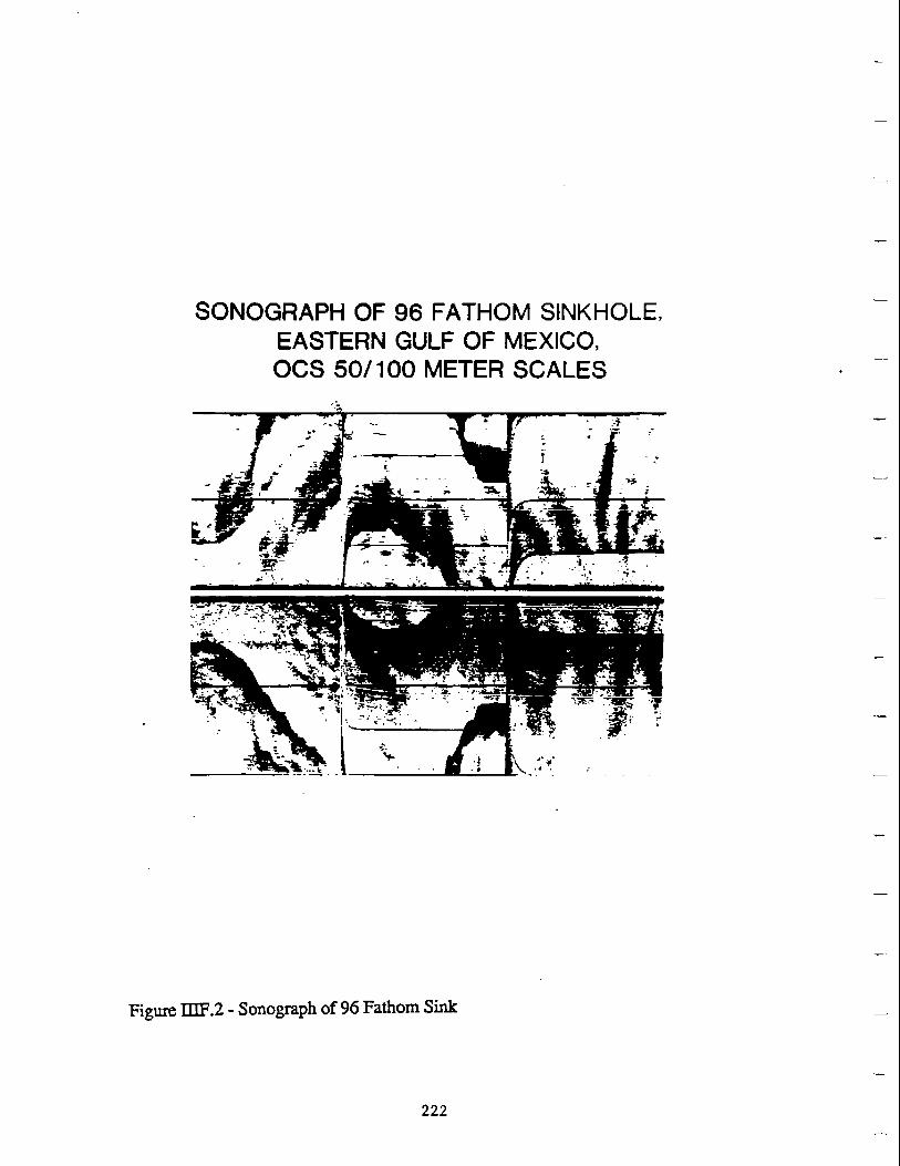

eshy
~I ~ i INSET r
bull
345500
22 14
l-i-~--l~Jkamp~~F~~~l=t========~==-J_=- -o ~
1--+~~-+-J-1~-xi+~~--===--=~1-+__~~~--b_~~-11i1---- -0
30500
3bull1500
339500
Figure IIIF4 - Plan View of Pretransgressive Surfaces Lease Block Sabine Pass 6 224