Preliminary Results of Adaptive-Reinforcement Learning Control for Morphing Aircraft
Rock Art Research 2005 - Volume 22, Number 2, pp. 147-197. R. G. BEDNARIK, G. KUMAR, A. WATCHMAN and R. G. ROBERTS172
tered in a shallow alcove.It followed from this deduction that there would be a
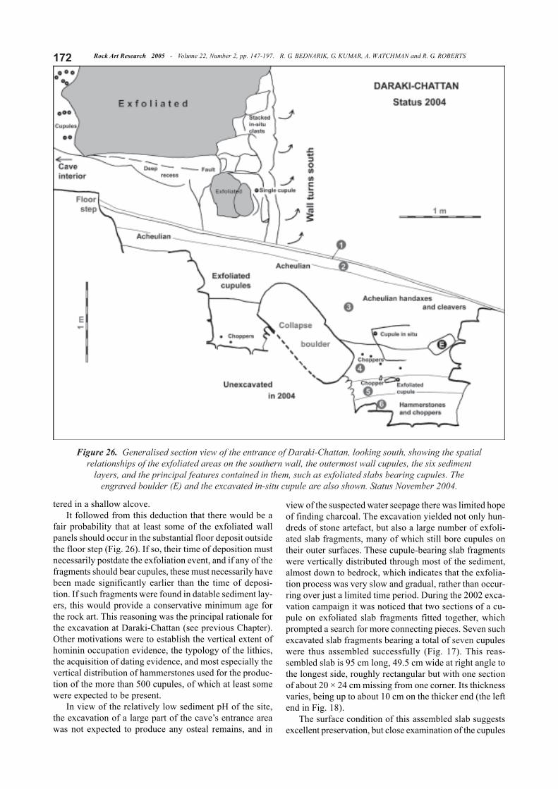
fair probability that at least some of the exfoliated wallpanels should occur in the substantial floor deposit outsidethe floor step (Fig. 26). If so, their time of deposition mustnecessarily postdate the exfoliation event, and if any of thefragments should bear cupules, these must necessarily havebeen made significantly earlier than the time of deposi-tion. If such fragments were found in datable sediment lay-ers, this would provide a conservative minimum age forthe rock art. This reasoning was the principal rationale forthe excavation at Daraki-Chattan (see previous Chapter).Other motivations were to establish the vertical extent ofhominin occupation evidence, the typology of the lithics,the acquisition of dating evidence, and most especially thevertical distribution of hammerstones used for the produc-tion of the more than 500 cupules, of which at least somewere expected to be present.
In view of the relatively low sediment pH of the site,the excavation of a large part of the cave’s entrance areawas not expected to produce any osteal remains, and in
view of the suspected water seepage there was limited hopeof finding charcoal. The excavation yielded not only hun-dreds of stone artefact, but also a large number of exfoli-ated slab fragments, many of which still bore cupules ontheir outer surfaces. These cupule-bearing slab fragmentswere vertically distributed through most of the sediment,almost down to bedrock, which indicates that the exfolia-tion process was very slow and gradual, rather than occur-ring over just a limited time period. During the 2002 exca-vation campaign it was noticed that two sections of a cu-pule on exfoliated slab fragments fitted together, whichprompted a search for more connecting pieces. Seven suchexcavated slab fragments bearing a total of seven cupuleswere thus assembled successfully (Fig. 17). This reas-sembled slab is 95 cm long, 49.5 cm wide at right angle tothe longest side, roughly rectangular but with one sectionof about 20 × 24 cm missing from one corner. Its thicknessvaries, being up to about 10 cm on the thicker end (the leftend in Fig. 18).
The surface condition of this assembled slab suggestsexcellent preservation, but close examination of the cupules
Figure 26. Generalised section view of the entrance of Daraki-Chattan, looking south, showing the spatialrelationships of the exfoliated areas on the southern wall, the outermost wall cupules, the six sediment
layers, and the principal features contained in them, such as exfoliated slabs bearing cupules. Theengraved boulder (E) and the excavated in-situ cupule are also shown. Status November 2004.
173Rock Art Research 2005 - Volume 22, Number 2, pp. 147-197. R. G. BEDNARIK, G. KUMAR, A. WATCHMAN and R. G. ROBERTS
indicates that the surface surrounding some ofthem may be more recent than the cupules them-selves. This impression is created by the veryreflective crystal facets on the surrounding sur-face, compared to the dull and weathered sur-face in the cupules, and also by the perimeter ofthe cupules. It appears that the surface of thecupules has withstood whatever process causedthe surrounding surface. This seems to have beenheat, because there are several scalloped scarson the surrounding surface, only 1 or 2 mm deep,tapering down to thin slivers in the opposite di-rection, mimicking the pattern of heat spalls ongranite. Since the slab was found in the depositwith the decorated face up, it is possible that itwas part of a living floor, which would readilyexplain the effects of fire damage and also ac-count for some wear through foot traffic. It isalso evident that this surface exfoliation islocalised. For instance, close to its most obvi-ous extent, near the wide end of the slab, is anarea morphologically dominated by severalstress marks resulting from the detachmentevent. These are worn and weathered, but therehas certainly not been any major exfoliation inthis area.
Besides the slab fragments incorporated inthis panel, the 2002 excavation of the uppermost80 cm of the deposit also recovered four more cupule-bear-ing slab fragments, but they could not be connected to anyother finds so far. A relevant factor to be considered is thelack of rounding along the various fractures of the slabfragments. The rounding is very significantly greater onthe four unconnected fragments than on the assembled slab,by a factor in the order of ten. It would be hard to accountfor such a great difference except by a significant time in-terval between fracture events. While it is possible that sev-eral fragments became dislodged in a single event, it isperhaps more likely that the seven reassembled fragmentsremained in one piece until very much later. It could havebeen broken by later rock-fall or by human activity. Thethree other pieces excavated in 2002 are more weatheredand bear more surface accretion.
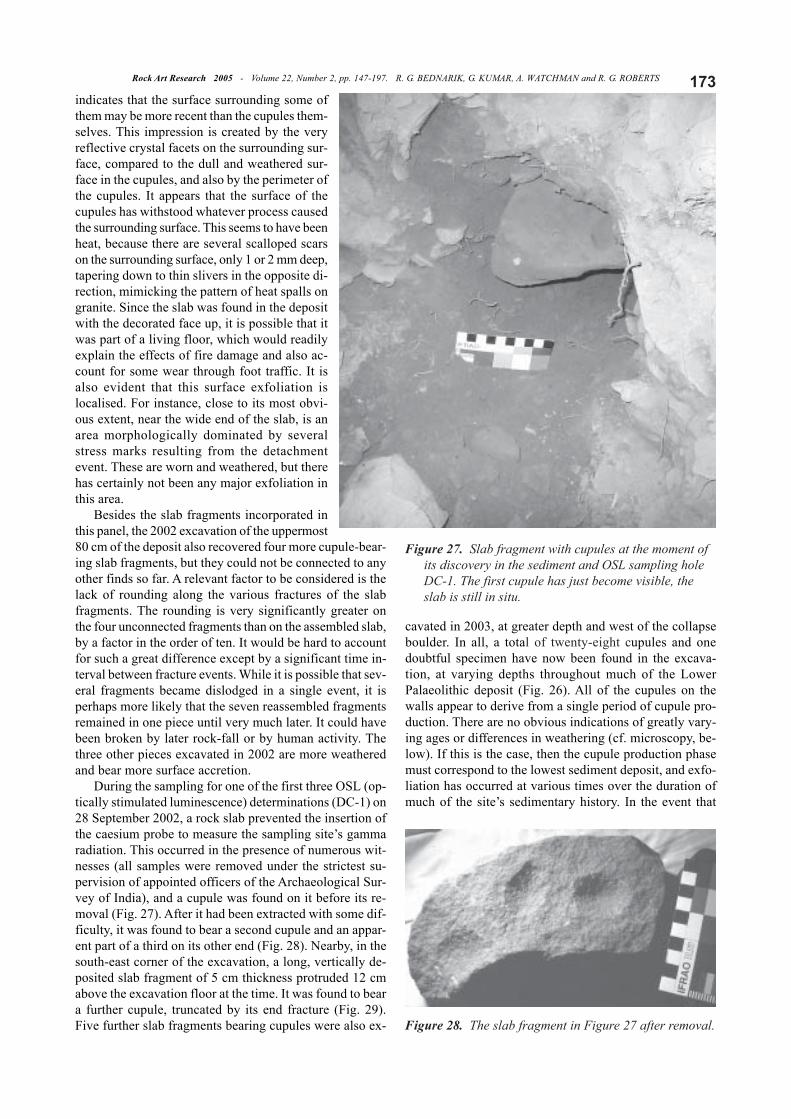
During the sampling for one of the first three OSL (op-tically stimulated luminescence) determinations (DC-1) on28 September 2002, a rock slab prevented the insertion ofthe caesium probe to measure the sampling site’s gammaradiation. This occurred in the presence of numerous wit-nesses (all samples were removed under the strictest su-pervision of appointed officers of the Archaeological Sur-vey of India), and a cupule was found on it before its re-moval (Fig. 27). After it had been extracted with some dif-ficulty, it was found to bear a second cupule and an appar-ent part of a third on its other end (Fig. 28). Nearby, in thesouth-east corner of the excavation, a long, vertically de-posited slab fragment of 5 cm thickness protruded 12 cmabove the excavation floor at the time. It was found to beara further cupule, truncated by its end fracture (Fig. 29).Five further slab fragments bearing cupules were also ex-
cavated in 2003, at greater depth and west of the collapseboulder. In all, a total of twenty-eight cupules and onedoubtful specimen have now been found in the excava-tion, at varying depths throughout much of the LowerPalaeolithic deposit (Fig. 26). All of the cupules on thewalls appear to derive from a single period of cupule pro-duction. There are no obvious indications of greatly vary-ing ages or differences in weathering (cf. microscopy, be-low). If this is the case, then the cupule production phasemust correspond to the lowest sediment deposit, and exfo-liation has occurred at various times over the duration ofmuch of the site’s sedimentary history. In the event that
Figure 27. Slab fragment with cupules at the moment ofits discovery in the sediment and OSL sampling holeDC-1. The first cupule has just become visible, theslab is still in situ.
Figure 28. The slab fragment in Figure 27 after removal.

Rock Art Research 2005 - Volume 22, Number 2, pp. 147-197. R. G. BEDNARIK, G. KUMAR, A. WATCHMAN and R. G. ROBERTS174
cupules were made over a much greater time span, the firstto exfoliate and become buried must still be of an antiquitycorresponding to the lowest sediment deposit, but otherscould have been made much later. However, the concen-tration of hammerstones of the type used to make petro-glyphs (Bednarik 1998) just above and below the ‘pave-ment floor’ (see below) renders the first possibility morelikely. In either case, the lowest occurrence of exfoliatedslab fragments with cupules coincides with the earliest evi-dence of human occupation at Daraki-Chattan.
Stratigraphy and stone implementsBearing in mind that this is only a preliminary report
and that no sedimentological and little other detailed ana-lytical work has been conducted at this early stage, onlythe broadest detail is provided here. After establishing in2004 that the large boulder in the central part of the cave’sentrance deposit broke from the bedrock face to its east(the two fracture surfaces match, both in shape and petro-graphical strata), we divided the sediment stratigraphy into‘pre-collapse’ and ‘post-collapse’ phases. As is evident fromFigure 26, upon becoming detached from the rock face tothe left, this boulder slid down and came to rest in its presentposition. We estimate the boulder’s weight to be close totwo tonnes — a formidable barrier to further excavation— but it was removed in 2005 (see above) and the sedi-ments sealed by it were excavated almost down to bed-rock. The stratigraphical distribution of the lowest stonetools indicates that the collapse occurred after the time ofthe site’s initial use by humans. The few chopping toolsfound to the east of the boulder seem to postdate its col-lapse, but several other anthropic features on its west sideappear to be on the floor on which the boulder came torest, and continue below it. The latter include stone imple-
ments, hammerstones, an apparently artificial floor of sev-eral slabs, and one small slab with two cupules.
The large collapse boulder is maximal 1.4 m long, 1.2m wide and 64 cm thick, of distinct horizontal stratifica-tion, now separated from its parent surface by 50 to 60 cm,having broken from it vertically. The quartzite stratum form-ing the bedrock face it broke from is inclined about 9º,dipping west as does the general facies. The collapse boul-der was inclined 54º. Most of the vertical fracture face isflat, 90 cm wide, except the northernmost part, which is 50cm wide and angled at 30º outward, i.e. west. The outer-most part of the collapse boulder probably fell only in theorder of 40 cm before it came to rest in its present position,while its inner, i.e. eastern part became raised relative toits previous level.
Prior to the availability of the results of sediment analy-ses little should be said about the deposit. It is high inregolithic clasts, clearly derived from local breakdown, andlow in clay fractions. Saprolithisation increases markedlyas a function of increasing depth. The upper strata haveexperienced water sorting, probably up to the sand frac-tions, which renders any age estimates derived from them,including OSL analyses, questionable. We thus assume thatwetter conditions caused limited sediment transport of thefiner fractions in the upper strata, in the direction of theslope (west). Most notable is the difference between thepreservation of clasts in the upper and lower halves of thecolumn. Whereas the upper coarse detritus is relatively wellpreserved, that of the saprolithic lower half is deeply weath-ered and often coated by ferromanganous accretions. It hasclearly experienced conditions of waterlogging, and this isalso reflected in the redder colour of these lower sediments.
So far, six sediment samples have been secured for OSLanalysis from Daraki-Chattan, and the relevant gamma ra-diation levels for them have been determined in accordancewith standard procedures. The surplus material from theseand the two back-up samples from each sampling site willbe the initial source of material for sedimentary analysis.During the 2002 field season, three samples were collectedfrom the uppermost levels just inside the dripline. Sam-pling commenced on 27 September and continued for threedays and two nights (OSL samples must be collected incomplete darkness). To gain a better understanding of thesite’s radiation regime, we also took three readings onnearby bedrock surfaces. As already mentioned, during thecollection of sample DC-1 we had to extract a rock frag-ment from the cylindrical sampling hole, on which we foundcupules (Fig. 27). The remaining three sediment sampleswere secured on 8 December 2004. DC-4 is from belowthe apparent slab pavement, at 142 cm depth, where stonetools occur in abundance. DC-5, 127 cm below floor, wastaken from immediately below a large chopping tool andabove a slab fragment with two cupules. DC-6 is from un-der the shelter roof to the north of the main excavation. Ineach of these three sampling holes, stone tools were recov-ered, including small flakes and, within DC-6, a hammer-stone. All sediment samples and related measurements weretaken under the strict supervision of appointed officers ofthe Indian Archaeological Survey.
Figure 29. Upper end of a long, vertically deposited slabbearing a partial cupule, found under Acheulian tools.
175Rock Art Research 2005 - Volume 22, Number 2, pp. 147-197. R. G. BEDNARIK, G. KUMAR, A. WATCHMAN and R. G. ROBERTS
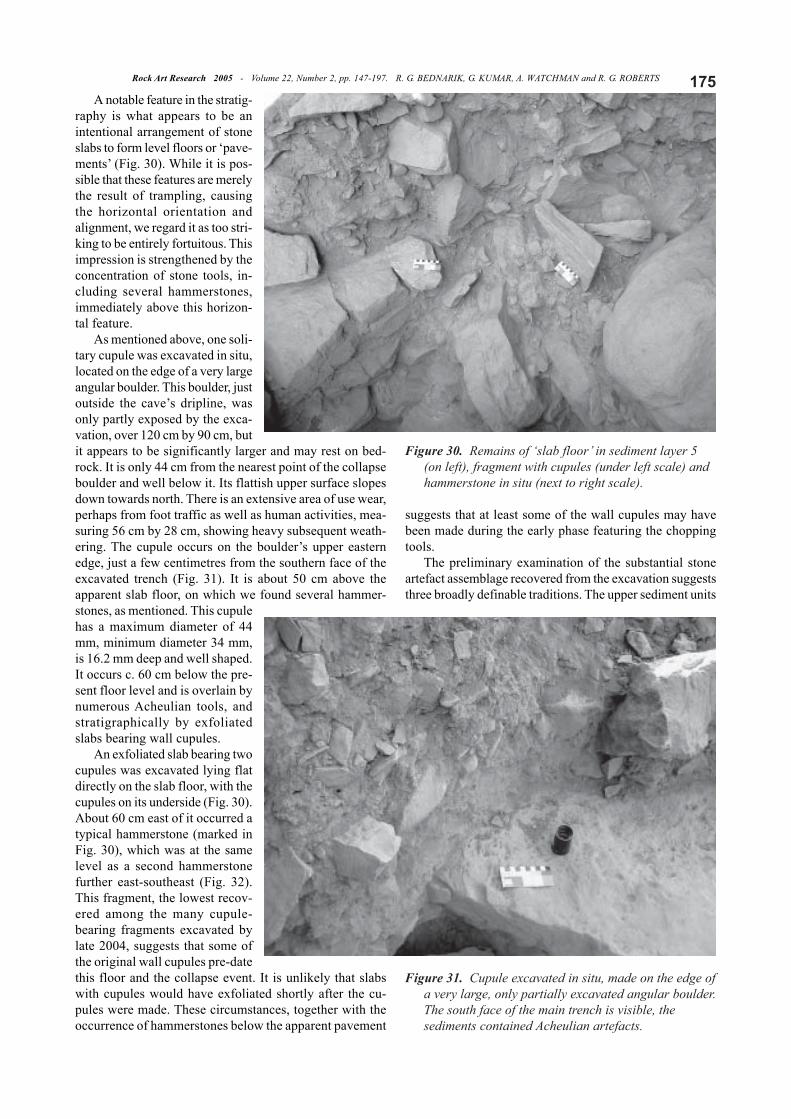
A notable feature in the stratig-raphy is what appears to be anintentional arrangement of stoneslabs to form level floors or ‘pave-ments’ (Fig. 30). While it is pos-sible that these features are merelythe result of trampling, causingthe horizontal orientation andalignment, we regard it as too stri-king to be entirely fortuitous. Thisimpression is strengthened by theconcentration of stone tools, in-cluding several hammerstones,immediately above this horizon-tal feature.
As mentioned above, one soli-tary cupule was excavated in situ,located on the edge of a very largeangular boulder. This boulder, justoutside the cave’s dripline, wasonly partly exposed by the exca-vation, over 120 cm by 90 cm, butit appears to be significantly larger and may rest on bed-rock. It is only 44 cm from the nearest point of the collapseboulder and well below it. Its flattish upper surface slopesdown towards north. There is an extensive area of use wear,perhaps from foot traffic as well as human activities, mea-suring 56 cm by 28 cm, showing heavy subsequent weath-ering. The cupule occurs on the boulder’s upper easternedge, just a few centimetres from the southern face of theexcavated trench (Fig. 31). It is about 50 cm above theapparent slab floor, on which we found several hammer-stones, as mentioned. This cupulehas a maximum diameter of 44mm, minimum diameter 34 mm,is 16.2 mm deep and well shaped.It occurs c. 60 cm below the pre-sent floor level and is overlain bynumerous Acheulian tools, andstratigraphically by exfoliatedslabs bearing wall cupules.
An exfoliated slab bearing twocupules was excavated lying flatdirectly on the slab floor, with thecupules on its underside (Fig. 30).About 60 cm east of it occurred atypical hammerstone (marked inFig. 30), which was at the samelevel as a second hammerstonefurther east-southeast (Fig. 32).This fragment, the lowest recov-ered among the many cupule-bearing fragments excavated bylate 2004, suggests that some ofthe original wall cupules pre-datethis floor and the collapse event. It is unlikely that slabswith cupules would have exfoliated shortly after the cu-pules were made. These circumstances, together with theoccurrence of hammerstones below the apparent pavement
suggests that at least some of the wall cupules may havebeen made during the early phase featuring the choppingtools.
The preliminary examination of the substantial stoneartefact assemblage recovered from the excavation suggeststhree broadly definable traditions. The upper sediment units
Figure 30. Remains of ‘slab floor’ in sediment layer 5(on left), fragment with cupules (under left scale) andhammerstone in situ (next to right scale).
Figure 31. Cupule excavated in situ, made on the edge ofa very large, only partially excavated angular boulder.The south face of the main trench is visible, thesediments contained Acheulian artefacts.
Rock Art Research 2005 - Volume 22, Number 2, pp. 147-197. R. G. BEDNARIK, G. KUMAR, A. WATCHMAN and R. G. ROBERTS176
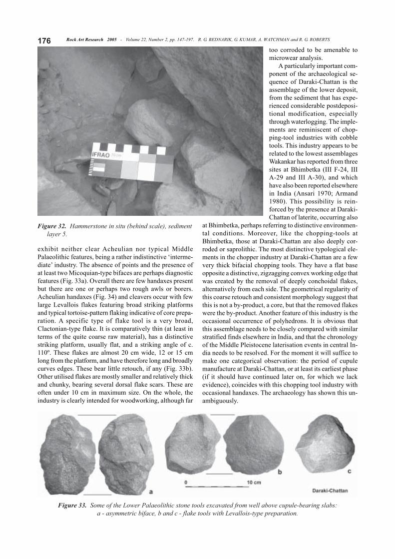
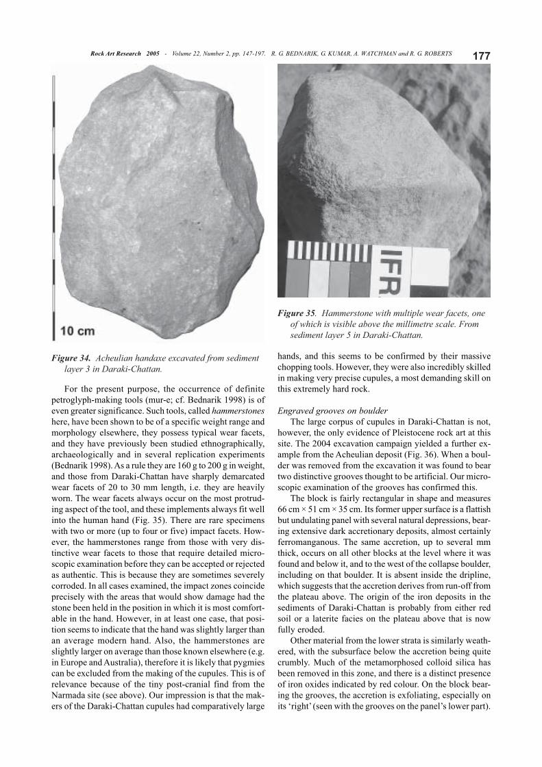
exhibit neither clear Acheulian nor typical MiddlePalaeolithic features, being a rather indistinctive ‘interme-diate’ industry. The absence of points and the presence ofat least two Micoquian-type bifaces are perhaps diagnosticfeatures (Fig. 33a). Overall there are few handaxes presentbut there are one or perhaps two rough awls or borers.Acheulian handaxes (Fig. 34) and cleavers occur with fewlarge Levallois flakes featuring broad striking platformsand typical tortoise-pattern flaking indicative of core prepa-ration. A specific type of flake tool is a very broad,Clactonian-type flake. It is comparatively thin (at least interms of the quite coarse raw material), has a distinctivestriking platform, usually flat, and a striking angle of c.110º. These flakes are almost 20 cm wide, 12 or 15 cmlong from the platform, and have therefore long and broadlycurves edges. These bear little retouch, if any (Fig. 33b).Other utilised flakes are mostly smaller and relatively thickand chunky, bearing several dorsal flake scars. These areoften under 10 cm in maximum size. On the whole, theindustry is clearly intended for woodworking, although far
too corroded to be amenable tomicrowear analysis.
A particularly important com-ponent of the archaeological se-quence of Daraki-Chattan is theassemblage of the lower deposit,from the sediment that has expe-rienced considerable postdeposi-tional modification, especiallythrough waterlogging. The imple-ments are reminiscent of chop-ping-tool industries with cobbletools. This industry appears to berelated to the lowest assemblagesWakankar has reported from threesites at Bhimbetka (III F-24, IIIA-29 and III A-30), and whichhave also been reported elsewherein India (Ansari 1970; Armand1980). This possibility is rein-forced by the presence at Daraki-Chattan of laterite, occurring also
at Bhimbetka, perhaps referring to distinctive environmen-tal conditions. Moreover, like the chopping-tools atBhimbetka, those at Daraki-Chattan are also deeply cor-roded or saprolithic. The most distinctive typological ele-ments in the chopper industry at Daraki-Chattan are a fewvery thick bifacial chopping tools. They have a flat baseopposite a distinctive, zigzagging convex working edge thatwas created by the removal of deeply conchoidal flakes,alternatively from each side. The geometrical regularity ofthis coarse retouch and consistent morphology suggest thatthis is not a by-product, a core, but that the removed flakeswere the by-product. Another feature of this industry is theoccasional occurrence of polyhedrons. It is obvious thatthis assemblage needs to be closely compared with similarstratified finds elsewhere in India, and that the chronologyof the Middle Pleistocene laterisation events in central In-dia needs to be resolved. For the moment it will suffice tomake one categorical observation: the period of cupulemanufacture at Daraki-Chattan, or at least its earliest phase(if it should have continued later on, for which we lackevidence), coincides with this chopping tool industry withoccasional handaxes. The archaeology has shown this un-ambiguously.
Figure 32. Hammerstone in situ (behind scale), sedimentlayer 5.
Figure 33. Some of the Lower Palaeolithic stone tools excavated from well above cupule-bearing slabs:a - asymmetric biface, b and c - flake tools with Levallois-type preparation.
177Rock Art Research 2005 - Volume 22, Number 2, pp. 147-197. R. G. BEDNARIK, G. KUMAR, A. WATCHMAN and R. G. ROBERTS
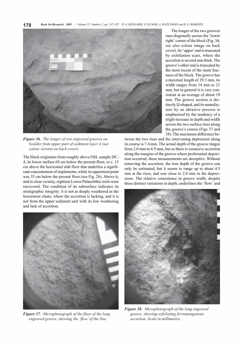
For the present purpose, the occurrence of definitepetroglyph-making tools (mur-e; cf. Bednarik 1998) is ofeven greater significance. Such tools, called hammerstoneshere, have been shown to be of a specific weight range andmorphology elsewhere, they possess typical wear facets,and they have previously been studied ethnographically,archaeologically and in several replication experiments(Bednarik 1998). As a rule they are 160 g to 200 g in weight,and those from Daraki-Chattan have sharply demarcatedwear facets of 20 to 30 mm length, i.e. they are heavilyworn. The wear facets always occur on the most protrud-ing aspect of the tool, and these implements always fit wellinto the human hand (Fig. 35). There are rare specimenswith two or more (up to four or five) impact facets. How-ever, the hammerstones range from those with very dis-tinctive wear facets to those that require detailed micro-scopic examination before they can be accepted or rejectedas authentic. This is because they are sometimes severelycorroded. In all cases examined, the impact zones coincideprecisely with the areas that would show damage had thestone been held in the position in which it is most comfort-able in the hand. However, in at least one case, that posi-tion seems to indicate that the hand was slightly larger thanan average modern hand. Also, the hammerstones areslightly larger on average than those known elsewhere (e.g.in Europe and Australia), therefore it is likely that pygmiescan be excluded from the making of the cupules. This is ofrelevance because of the tiny post-cranial find from theNarmada site (see above). Our impression is that the mak-ers of the Daraki-Chattan cupules had comparatively large
hands, and this seems to be confirmed by their massivechopping tools. However, they were also incredibly skilledin making very precise cupules, a most demanding skill onthis extremely hard rock.
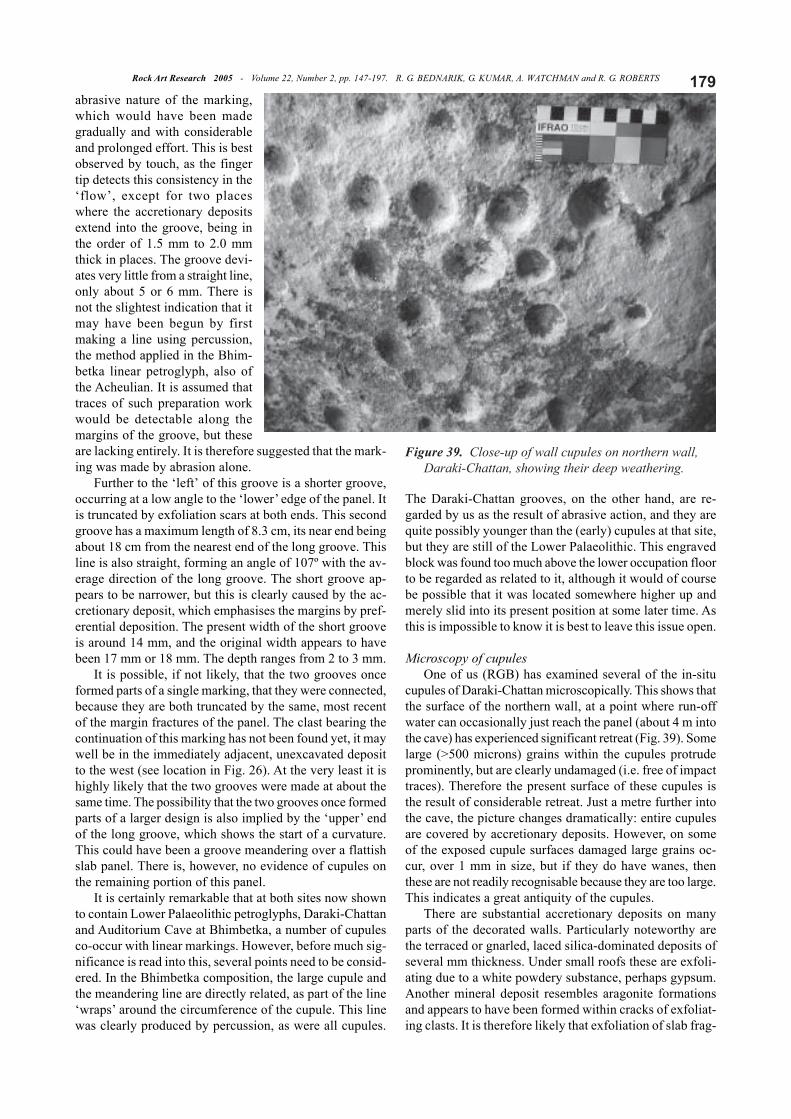
Engraved grooves on boulderThe large corpus of cupules in Daraki-Chattan is not,
however, the only evidence of Pleistocene rock art at thissite. The 2004 excavation campaign yielded a further ex-ample from the Acheulian deposit (Fig. 36). When a boul-der was removed from the excavation it was found to beartwo distinctive grooves thought to be artificial. Our micro-scopic examination of the grooves has confirmed this.
The block is fairly rectangular in shape and measures66 cm × 51 cm × 35 cm. Its former upper surface is a flattishbut undulating panel with several natural depressions, bear-ing extensive dark accretionary deposits, almost certainlyferromanganous. The same accretion, up to several mmthick, occurs on all other blocks at the level where it wasfound and below it, and to the west of the collapse boulder,including on that boulder. It is absent inside the dripline,which suggests that the accretion derives from run-off fromthe plateau above. The origin of the iron deposits in thesediments of Daraki-Chattan is probably from either redsoil or a laterite facies on the plateau above that is nowfully eroded.
Other material from the lower strata is similarly weath-ered, with the subsurface below the accretion being quitecrumbly. Much of the metamorphosed colloid silica hasbeen removed in this zone, and there is a distinct presenceof iron oxides indicated by red colour. On the block bear-ing the grooves, the accretion is exfoliating, especially onits ‘right’ (seen with the grooves on the panel’s lower part).
Figure 34. Acheulian handaxe excavated from sedimentlayer 3 in Daraki-Chattan.
Figure 35. Hammerstone with multiple wear facets, oneof which is visible above the millimetre scale. Fromsediment layer 5 in Daraki-Chattan.
Rock Art Research 2005 - Volume 22, Number 2, pp. 147-197. R. G. BEDNARIK, G. KUMAR, A. WATCHMAN and R. G. ROBERTS178
The block originates from roughly above OSL sample DC-4, its lower surface 68 cm below the present floor, or c. 15cm above the horizontal slab floor that underlies a signifi-cant concentration of implements, while its uppermost pointwas 35 cm below the present floor (see Fig. 26). Above it,and in close vicinity, eighteen Lower Palaeolithic tools wererecovered. The condition of its subsurface indicates itsstratigraphic integrity: it is not as deeply weathered as thelowermost clasts, where the accretion is lacking, and it isnot from the upper sediment unit with its low weatheringand lack of accretion.
The longer of the two groovesruns diagonally across the ‘lowerright’ corner of the block (Fig. 36,see also colour image on backcover). Its ‘upper’ end is truncatedby exfoliation scars, where theaccretion is several mm thick. Thegroove’s other end is truncated bythe most recent of the main frac-tures of the block. The groove hasa maximal length of 29.3 mm, itswidth ranges from 14 mm to 21mm, but in general it is very con-sistent at an average of about 19mm. The groove section is dis-tinctly U-shaped, and its manufac-ture by an abrasive process isemphasised by the tendency of aslight increase in depth and widthacross the two surface rises alongthe groove’s course (Figs 37 and38). The maximum difference be-
tween the two rises and the intervening depression alongits course is 7.4 mm. The actual depth of the groove rangesfrom 2.0 mm to 6.9 mm, but as there is extensive accretionalong the margins of the groove where preferential deposi-tion occurred, these measurements are deceptive. Withoutremoving the accretion, the true depth of the groove canonly be estimated, but it seems to range up to about 4.5mm at the rises, and was close to 2.0 mm in the depres-sions. The relative consistence in groove width, despitethese distinct variations in depth, underlines the ‘flow’ and
Figure 36. The longer of two engraved grooves onboulder from upper part of sediment layer 4 (seecolour version on back cover).
Figure 37. Microphotograph of the floor of the longengraved groove, showing the ‘flow’ of the line.
Figure 38. Microphotograph of the long engravedgroove, showing exfoliating ferromanganousaccretion. Scale in millimetres.
179Rock Art Research 2005 - Volume 22, Number 2, pp. 147-197. R. G. BEDNARIK, G. KUMAR, A. WATCHMAN and R. G. ROBERTS
abrasive nature of the marking,which would have been madegradually and with considerableand prolonged effort. This is bestobserved by touch, as the fingertip detects this consistency in the‘flow’, except for two placeswhere the accretionary depositsextend into the groove, being inthe order of 1.5 mm to 2.0 mmthick in places. The groove devi-ates very little from a straight line,only about 5 or 6 mm. There isnot the slightest indication that itmay have been begun by firstmaking a line using percussion,the method applied in the Bhim-betka linear petroglyph, also ofthe Acheulian. It is assumed thattraces of such preparation workwould be detectable along themargins of the groove, but theseare lacking entirely. It is therefore suggested that the mark-ing was made by abrasion alone.
Further to the ‘left’ of this groove is a shorter groove,occurring at a low angle to the ‘lower’ edge of the panel. Itis truncated by exfoliation scars at both ends. This secondgroove has a maximum length of 8.3 cm, its near end beingabout 18 cm from the nearest end of the long groove. Thisline is also straight, forming an angle of 107º with the av-erage direction of the long groove. The short groove ap-pears to be narrower, but this is clearly caused by the ac-cretionary deposit, which emphasises the margins by pref-erential deposition. The present width of the short grooveis around 14 mm, and the original width appears to havebeen 17 mm or 18 mm. The depth ranges from 2 to 3 mm.
It is possible, if not likely, that the two grooves onceformed parts of a single marking, that they were connected,because they are both truncated by the same, most recentof the margin fractures of the panel. The clast bearing thecontinuation of this marking has not been found yet, it maywell be in the immediately adjacent, unexcavated depositto the west (see location in Fig. 26). At the very least it ishighly likely that the two grooves were made at about thesame time. The possibility that the two grooves once formedparts of a larger design is also implied by the ‘upper’ endof the long groove, which shows the start of a curvature.This could have been a groove meandering over a flattishslab panel. There is, however, no evidence of cupules onthe remaining portion of this panel.
It is certainly remarkable that at both sites now shownto contain Lower Palaeolithic petroglyphs, Daraki-Chattanand Auditorium Cave at Bhimbetka, a number of cupulesco-occur with linear markings. However, before much sig-nificance is read into this, several points need to be consid-ered. In the Bhimbetka composition, the large cupule andthe meandering line are directly related, as part of the line‘wraps’ around the circumference of the cupule. This linewas clearly produced by percussion, as were all cupules.
The Daraki-Chattan grooves, on the other hand, are re-garded by us as the result of abrasive action, and they arequite possibly younger than the (early) cupules at that site,but they are still of the Lower Palaeolithic. This engravedblock was found too much above the lower occupation floorto be regarded as related to it, although it would of coursebe possible that it was located somewhere higher up andmerely slid into its present position at some later time. Asthis is impossible to know it is best to leave this issue open.
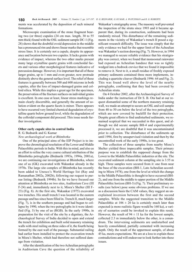
Microscopy of cupulesOne of us (RGB) has examined several of the in-situ
cupules of Daraki-Chattan microscopically. This shows thatthe surface of the northern wall, at a point where run-offwater can occasionally just reach the panel (about 4 m intothe cave) has experienced significant retreat (Fig. 39). Somelarge (>500 microns) grains within the cupules protrudeprominently, but are clearly undamaged (i.e. free of impacttraces). Therefore the present surface of these cupules isthe result of considerable retreat. Just a metre further intothe cave, the picture changes dramatically: entire cupulesare covered by accretionary deposits. However, on someof the exposed cupule surfaces damaged large grains oc-cur, over 1 mm in size, but if they do have wanes, thenthese are not readily recognisable because they are too large.This indicates a great antiquity of the cupules.
There are substantial accretionary deposits on manyparts of the decorated walls. Particularly noteworthy arethe terraced or gnarled, laced silica-dominated deposits ofseveral mm thickness. Under small roofs these are exfoli-ating due to a white powdery substance, perhaps gypsum.Another mineral deposit resembles aragonite formationsand appears to have been formed within cracks of exfoliat-ing clasts. It is therefore likely that exfoliation of slab frag-
Figure 39. Close-up of wall cupules on northern wall,Daraki-Chattan, showing their deep weathering.
Rock Art Research 2005 - Volume 22, Number 2, pp. 147-197. R. G. BEDNARIK, G. KUMAR, A. WATCHMAN and R. G. ROBERTS180ments was accelerated by the deposition of such mineralformations.
Microscopic examination of the stone fragment bear-ing two (or three) cupules (24 cm max. length, 30 to 55mm thick) found with the OSL sediment sample DC-1 (Fig.28) shows that the doubtful ovoid depression in the middlehas a pronounced rim and shows linear marks that resemblestress lines. It is certainly not a cupule, despite its appear-ance and location between two cupules. It lacks grains withevidence of impact, whereas the two other marks presentmany large crystalline quartz grains with conchoidal fac-ets and various other morphological features indicative ofpercussion damage. However, it is important that all of theselarger grains, up to 1 mm and even greater, now protrudedistinctly above the general surface level. The relief of thesefeatures is generally between 500 and 600 microns in bothcupules, after the loss of impact-damaged grains and col-loid silica. While this implies a great age for the specimen,the preservation of the fracture surfaces on individual grainsis excellent. In one case at least, linear stress markings re-main clearly discernible, and generally the amount of so-lution evident on the quartz facets is minor. There appearsto have occurred very limited chemical degradation of crys-talline quartz below ground level, while the degradation ofthe colloidal component did proceed. This issue needs fur-ther investigation.
Other early cupule sites in central IndiaR. G. Bednarik and G. KumarNew archaeological work at Bhimbetka
One of the principal aims of the EIP Project is to im-prove the chronological resolution of the Lower and MiddlePalaeolithic periods in India. With this in mind, and also asan effort to refine the very coarse cultural attribution of theBhimbetka petroglyphs (Bednarik 1993a, 1994a, 2001a),we are continuing our investigations at Bhimbetka, whereone of us (GK) excavated with Wakankar already in the1970s. The large site complex of Bhimbetka has recentlybeen added to Unesco’s World Heritage list (Ray andRamanathan 2002a, 2002b), following our request to pur-sue listing (Bednarik 1994b). So far we have focused ourattention at Bhimbetka on two sites, Auditorium Cave (IIIF-24) and, immediately next to it, Misra’s Shelter (III F-23) (Fig. 8). At the first site, Wakankar (1975) excavatedtwo trenches. His small trench I was located in the easternpassage and has since been filled in. Trench II, much larger(Fig. 7), is in the southern passage and had begun to col-lapse by 1990, when the two petroglyphs in it were identi-fied (Fig. 5) by one of us (RGB). In the early 1990s, inpreparation for the visit of the site by a dignitary, the Ar-chaeological Survey of India decided to open and extendthe trench for exhibition and built solid masonry retainingwalls with steel railing on three sides of it, the fourth beingformed by the east wall of the passage. Substantial railinghad earlier been installed to protect the excavation trenchin Misra’s Shelter, which had therefore not suffered dam-age from visitation.
After the identification of the two Acheulian petroglyphsin Auditorium Cave the question of the reliability of
Wakankar’s stratigraphy arose. The masonry wall preventedthe inspection of the strata since 1993 and it became ap-parent that, during its construction, sediments had beenrandomly mixed. This disturbance of the remaining sedi-ments in the vicinity of Wakankar’s trench II posed a sig-nificant research difficulty. The issue was simply that theonly evidence we had for the upper limit of the Acheulianwas Wakankar’s section drawing (Fig. 7). However, in 1994we managed to secure reliable evidence that his stratigra-phy was correct, when we found that monsoonal rainwaterhad exposed an Acheulian handaxe that was so tightlywedged into a bedrock crevice that we found it impossibleto remove it. Next to it, a small residue of freshly exposedprimary sediments contained three more implements, in-cluding a quartzite cleaver (Bednarik 1996: 64 and Fig. 2).This was found well above the level of the nearbypetroglyphs, confirming that they had been covered byAcheulian strata.
On 4 October 2002, after the Archaeological Survey ofIndia under the instruction of Dr S. B. Ota had at our re-quest dismantled some of the northern masonry retainingwall, we made an attempt to secure an OSL and soil samplefrom 40 to 50 cm below the level of the two petroglyphs,which are now covered by backfill for their protection.Despite great efforts to find undisturbed sediments, we re-mained sceptical that we succeeded in this quest, and al-though we did secure sample BH-4 and experimentallyprocessed it, we are doubtful that it was uncontaminatedprior to collection. The disturbance of the sediments upuntil 1994, first by unsupervised visitation and then by theuncontrolled work of the early 1990s, is too great.
The collection of three samples from nearby Misra’sShelter yielded three impeccable samples. Their primarypurpose was to establish the supposed change from theLower to the Middle Palaeolithic industries at the site. Theexcavated sediment column at the sampling site is 3.55 mhigh. Three samples were secured from it: one from nearthe base of the excavation (BH-1, Late Acheulian accord-ing to Misra 1978), one from the level at which the changeto the Middle Palaeolithic is thought to have occurred (BH-2), and one from the middle to upper portion of the MiddlePalaeolithic horizon (BH-3) (Fig. 7). Their preliminary re-sults (see below) pose some obvious problems. If we useas a discussion basis the CAM values, they suggest an un-explained inversion between the first and the secondsamples. While the suggested transition to the MiddlePalaeolithic at 106 ± 20 ka is certainly much later thanexpected (a more realistic figure would be 160 ka), a vari-ety of scenarios could be invoked to explain this result.However, the result of 94 ± 11 ka for the lowest sample,collected 2.3 m immediately below the other, is a conun-drum. The intervening sediments are undisturbed andheavily consolidated, partially cemented with increasingdepth. Only the result of the uppermost sample, of about45 ka, meets expectations. We are at a loss to explain thesecontradictions and will endeavour to look further into theseissues.
181Rock Art Research 2005 - Volume 22, Number 2, pp. 147-197. R. G. BEDNARIK, G. KUMAR, A. WATCHMAN and R. G. ROBERTS
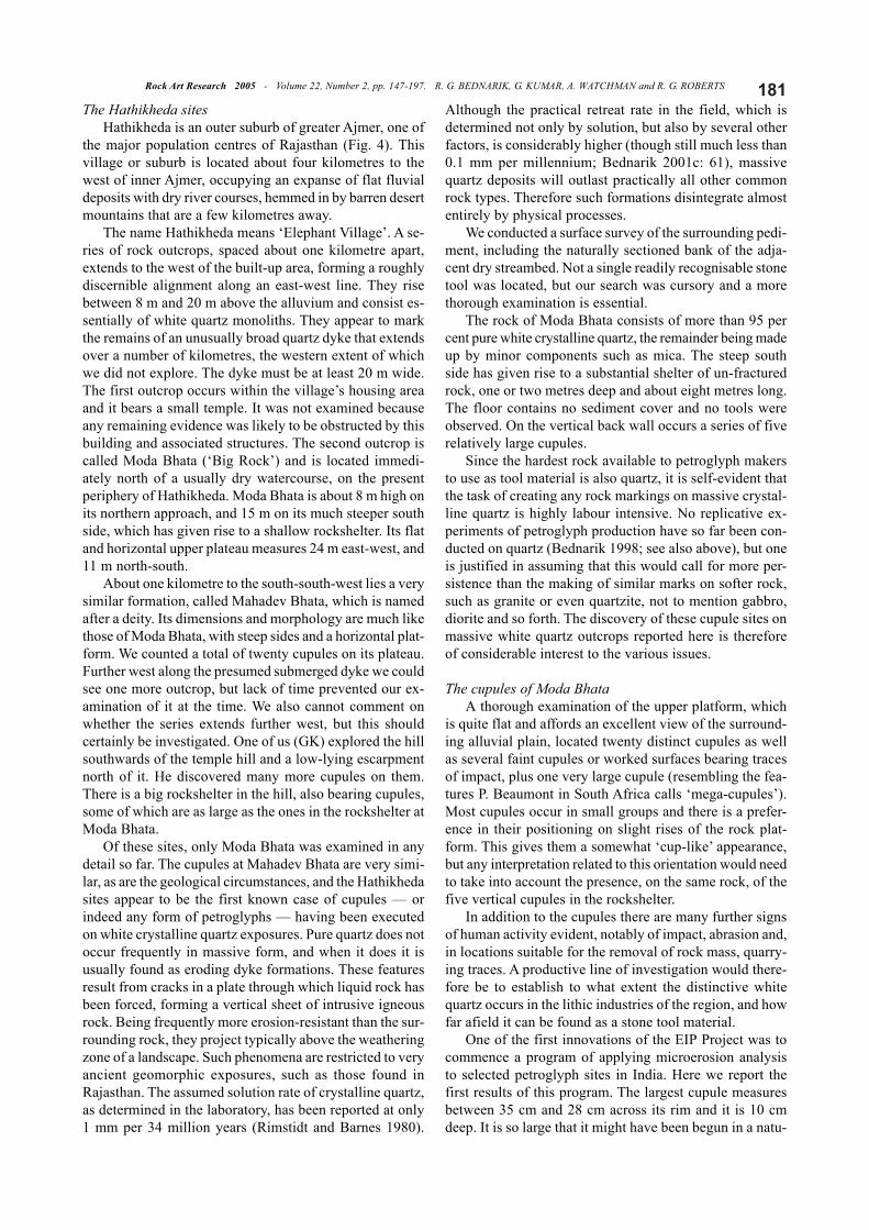
The Hathikheda sitesHathikheda is an outer suburb of greater Ajmer, one of
the major population centres of Rajasthan (Fig. 4). Thisvillage or suburb is located about four kilometres to thewest of inner Ajmer, occupying an expanse of flat fluvialdeposits with dry river courses, hemmed in by barren desertmountains that are a few kilometres away.
The name Hathikheda means ‘Elephant Village’. A se-ries of rock outcrops, spaced about one kilometre apart,extends to the west of the built-up area, forming a roughlydiscernible alignment along an east-west line. They risebetween 8 m and 20 m above the alluvium and consist es-sentially of white quartz monoliths. They appear to markthe remains of an unusually broad quartz dyke that extendsover a number of kilometres, the western extent of whichwe did not explore. The dyke must be at least 20 m wide.The first outcrop occurs within the village’s housing areaand it bears a small temple. It was not examined becauseany remaining evidence was likely to be obstructed by thisbuilding and associated structures. The second outcrop iscalled Moda Bhata (‘Big Rock’) and is located immedi-ately north of a usually dry watercourse, on the presentperiphery of Hathikheda. Moda Bhata is about 8 m high onits northern approach, and 15 m on its much steeper southside, which has given rise to a shallow rockshelter. Its flatand horizontal upper plateau measures 24 m east-west, and11 m north-south.
About one kilometre to the south-south-west lies a verysimilar formation, called Mahadev Bhata, which is namedafter a deity. Its dimensions and morphology are much likethose of Moda Bhata, with steep sides and a horizontal plat-form. We counted a total of twenty cupules on its plateau.Further west along the presumed submerged dyke we couldsee one more outcrop, but lack of time prevented our ex-amination of it at the time. We also cannot comment onwhether the series extends further west, but this shouldcertainly be investigated. One of us (GK) explored the hillsouthwards of the temple hill and a low-lying escarpmentnorth of it. He discovered many more cupules on them.There is a big rockshelter in the hill, also bearing cupules,some of which are as large as the ones in the rockshelter atModa Bhata.
Of these sites, only Moda Bhata was examined in anydetail so far. The cupules at Mahadev Bhata are very simi-lar, as are the geological circumstances, and the Hathikhedasites appear to be the first known case of cupules — orindeed any form of petroglyphs — having been executedon white crystalline quartz exposures. Pure quartz does notoccur frequently in massive form, and when it does it isusually found as eroding dyke formations. These featuresresult from cracks in a plate through which liquid rock hasbeen forced, forming a vertical sheet of intrusive igneousrock. Being frequently more erosion-resistant than the sur-rounding rock, they project typically above the weatheringzone of a landscape. Such phenomena are restricted to veryancient geomorphic exposures, such as those found inRajasthan. The assumed solution rate of crystalline quartz,as determined in the laboratory, has been reported at only1 mm per 34 million years (Rimstidt and Barnes 1980).
Although the practical retreat rate in the field, which isdetermined not only by solution, but also by several otherfactors, is considerably higher (though still much less than0.1 mm per millennium; Bednarik 2001c: 61), massivequartz deposits will outlast practically all other commonrock types. Therefore such formations disintegrate almostentirely by physical processes.
We conducted a surface survey of the surrounding pedi-ment, including the naturally sectioned bank of the adja-cent dry streambed. Not a single readily recognisable stonetool was located, but our search was cursory and a morethorough examination is essential.
The rock of Moda Bhata consists of more than 95 percent pure white crystalline quartz, the remainder being madeup by minor components such as mica. The steep southside has given rise to a substantial shelter of un-fracturedrock, one or two metres deep and about eight metres long.The floor contains no sediment cover and no tools wereobserved. On the vertical back wall occurs a series of fiverelatively large cupules.
Since the hardest rock available to petroglyph makersto use as tool material is also quartz, it is self-evident thatthe task of creating any rock markings on massive crystal-line quartz is highly labour intensive. No replicative ex-periments of petroglyph production have so far been con-ducted on quartz (Bednarik 1998; see also above), but oneis justified in assuming that this would call for more per-sistence than the making of similar marks on softer rock,such as granite or even quartzite, not to mention gabbro,diorite and so forth. The discovery of these cupule sites onmassive white quartz outcrops reported here is thereforeof considerable interest to the various issues.
The cupules of Moda BhataA thorough examination of the upper platform, which
is quite flat and affords an excellent view of the surround-ing alluvial plain, located twenty distinct cupules as wellas several faint cupules or worked surfaces bearing tracesof impact, plus one very large cupule (resembling the fea-tures P. Beaumont in South Africa calls ‘mega-cupules’).Most cupules occur in small groups and there is a prefer-ence in their positioning on slight rises of the rock plat-form. This gives them a somewhat ‘cup-like’ appearance,but any interpretation related to this orientation would needto take into account the presence, on the same rock, of thefive vertical cupules in the rockshelter.
In addition to the cupules there are many further signsof human activity evident, notably of impact, abrasion and,in locations suitable for the removal of rock mass, quarry-ing traces. A productive line of investigation would there-fore be to establish to what extent the distinctive whitequartz occurs in the lithic industries of the region, and howfar afield it can be found as a stone tool material.
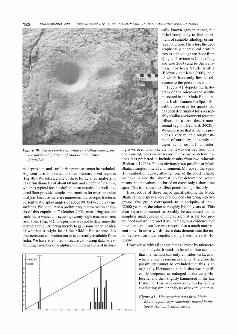
One of the first innovations of the EIP Project was tocommence a program of applying microerosion analysisto selected petroglyph sites in India. Here we report thefirst results of this program. The largest cupule measuresbetween 35 cm and 28 cm across its rim and it is 10 cmdeep. It is so large that it might have been begun in a natu-
Rock Art Research 2005 - Volume 22, Number 2, pp. 147-197. R. G. BEDNARIK, G. KUMAR, A. WATCHMAN and R. G. ROBERTS182
ral depression, and a utilitarian purpose cannot be excluded.Adjacent to it is a series of three standard-sized cupules(Fig. 40). We selected one of these for detailed analysis. Ithas a rim diameter of about 60 mm and a depth of 9.4 mm,which is typical for the site’s plateau cupules. Its well-tex-tured floor provides ample opportunities for microero-sionanalysis, because there are numerous microscopic fracturespresent that display angles of about 90º between cleavagesurfaces. We conducted a preliminary microerosion analy-sis of this cupule on 7 October 2002, measuring severalsuch micro-wanes and securing twenty-eight measurementsfrom them (Fig. 41). The purpose was not to determine thecupule’s antiquity, it was merely to gain some tentative ideaof whether it might be of the Middle Pleistocene. Nomicroerosion calibration curve is currently available fromIndia. We have attempted to secure calibrating data by ex-amining a number of sculptures and inscriptions of histori-
cally known ages in Ajmer, butfailed completely to find speci-mens of suitable lithology or sur-face condition. Therefore the geo-graphically nearest calibrationcurves at this stage are those fromQinghai Province in China (Tangand Gao 2004) and to Um Sana-man, northern Saudi Arabia(Bednarik and Khan 2002), bothof which have only limited rel-evance to the present location.
Figure 41 depicts the histo-gram of the micro-wane widthsmeasured in the Moda Bhata cu-pule. It also features the Spear Hillcalibration curve for quartz thathas been determined for a reason-ably similar environment (easternPilbara, in a semi-desert mon-soonal region; Bednarik 2002b).We emphasise that while this pro-vides a very reliable rough esti-mate of antiquity, it is only anexperimental result. In consider-
ing it we need to appreciate that it was derived from onlyone mineral, whereas in secure microerosion determina-tions it is preferred to include results from two minerals(Bednarik 1992b). This is obviously not possible at ModaBhata, a single-mineral environment. Moreover, the SpearHill calibration curve, although one of the most reliablewe have, is also the ‘shortest’ so far determined, whichmeans that the values it is based on cover only a short timespan. This is assumed to affect precision significantly.
Irrespective of these major qualifications, the ModaBhata values display a very pronounced clustering into twogroups. One group corresponds to an antiquity of aboutE2000 years BP, the other to roughly E9000 years BP. Thisclear separation cannot reasonably be accounted for bysampling inadequacies or imprecision, it is far too pro-nounced and we interpret it as unambiguous evidence thatthe older cupule surface was reworked at a much more re-cent time. In other words, these data demonstrate the mi-nor reuse of an older cupule, dating from the early Ho-locene.
However, as with all age estimates derived by microero-sion analysis, it needs to be taken into accountthat the method can only consider surfaces ofwhich remnants remain available. Therefore thepossibility cannot be excluded that this is anoriginally Pleistocene cupule that was signifi-cantly deepened or enlarged in the early Ho-locene, and then slightly hammered in the lateHolocene. This issue could only be clarified byconducting similar analyses of several other cu-
Figure 40. Three cupules on white crystalline quartz, onthe horizontal plateau of Moda Bhata, Ajmer,Rajasthan.
Figure 41. Microerosion data from ModaBhata cupule, experimentally placed in theSpear Hill calibration curve.
183Rock Art Research 2005 - Volume 22, Number 2, pp. 147-197. R. G. BEDNARIK, G. KUMAR, A. WATCHMAN and R. G. ROBERTS
pules at this site. Most certainlyour work has shown that cupulesites have been reused duringmore recent periods, so to deter-mine the beginning of the prac-tice at a site such as Moda Bhatait is essential to establish ages ofthe oldest cupule surfaces presentat the location. Although thiswould involve a considerableamount of work it is certainly rec-ommended, because it wouldprobably also tell us a great dealabout the duration of site use, andabout the pattern of accumulationof the cupules and apparent cu-pule arrangements through time.Bearing in mind that currently weknow almost nothing about the traditions that created thesefeatures, it is obvious that such a strategy promises a greatdeal of improvement in our understanding of how thesemysterious petroglyphs were made.
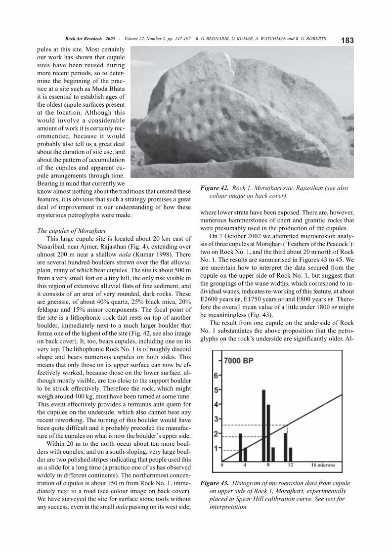
The cupules of MorajhariThis large cupule site is located about 20 km east of
Nasaribad, near Ajmer, Rajasthan (Fig. 4), extending overalmost 200 m near a shallow nala (Kumar 1998). Thereare several hundred boulders strewn over the flat alluvialplain, many of which bear cupules. The site is about 500 mfrom a very small fort on a tiny hill, the only rise visible inthis region of extensive alluvial flats of fine sediment, andit consists of an area of very rounded, dark rocks. Theseare gneissic, of about 40% quartz, 25% black mica, 20%feldspar and 15% minor components. The focal point ofthe site is a lithophonic rock that rests on top of anotherboulder, immediately next to a much larger boulder thatforms one of the highest of the site (Fig. 42, see also imageon back cover). It, too, bears cupules, including one on itsvery top. The lithophonic Rock No. 1 is of roughly discoidshape and bears numerous cupules on both sides. Thismeans that only those on its upper surface can now be ef-fectively worked, because those on the lower surface, al-though mostly visible, are too close to the support boulderto be struck effectively. Therefore the rock, which mightweigh around 400 kg, must have been turned at some time.This event effectively provides a terminus ante quem forthe cupules on the underside, which also cannot bear anyrecent reworking. The turning of this boulder would havebeen quite difficult and it probably preceded the manufac-ture of the cupules on what is now the boulder’s upper side.
Within 20 m to the north occur about ten more boul-ders with cupules, and on a south-sloping, very large boul-der are two polished stripes indicating that people used thisas a slide for a long time (a practice one of us has observedwidely in different continents). The northernmost concen-tration of cupules is about 150 m from Rock No. 1, imme-diately next to a road (see colour image on back cover).We have surveyed the site for surface stone tools withoutany success, even in the small nala passing on its west side,
where lower strata have been exposed. There are, however,numerous hammerstones of chert and granitic rocks thatwere presumably used in the production of the cupules.
On 7 October 2002 we attempted microerosion analy-sis of three cupules at Morajhari (‘Feathers of the Peacock’):two on Rock No. 1, and the third about 20 m north of RockNo. 1. The results are summarised in Figures 43 to 45. Weare uncertain how to interpret the data secured from thecupule on the upper side of Rock No. 1, but suggest thatthe groupings of the wane widths, which correspond to in-dividual wanes, indicates re-working of this feature, at aboutE2600 years BP, E1750 years BP and E800 years BP. There-fore the overall mean value of a little under 1800 BP mightbe meaniningless (Fig. 43).
The result from one cupule on the underside of RockNo. 1 substantiates the above proposition that the petro-glyphs on the rock’s underside are significantly older. Al-
Figure 42. Rock 1, Morajhari site, Rajasthan (see alsocolour image on back cover).
Figure 43. Histogram of microerosion data from cupuleon upper side of Rock 1, Morajhari, experimentallyplaced in Spear Hill calibration curve. See text forinterpretation.
Rock Art Research 2005 - Volume 22, Number 2, pp. 147-197. R. G. BEDNARIK, G. KUMAR, A. WATCHMAN and R. G. ROBERTS184
though the data is widely spread, its mean age estimate ofabout E5000 seems realistic (Fig. 44). The data derivedfrom the third cupule is very compact, by contrast, clearlyfavouring an age of about E1900 years, i.e. falling withinthe range of the events expressed in the results from thefirst cupule (Fig. 45). We defer any further discussion ofthese results until much more data, including a geographi-cally relevant calibration, become available, therefore pro-posed tolerances are not cited here. The results do, how-ever, clearly eliminate any possibility that the Morajharicupules might be of the Pleistocene. Despite the prelimi-nary nature of the results we present here, a Palaeolithicage of these very ancient features can be categorically ex-cluded.
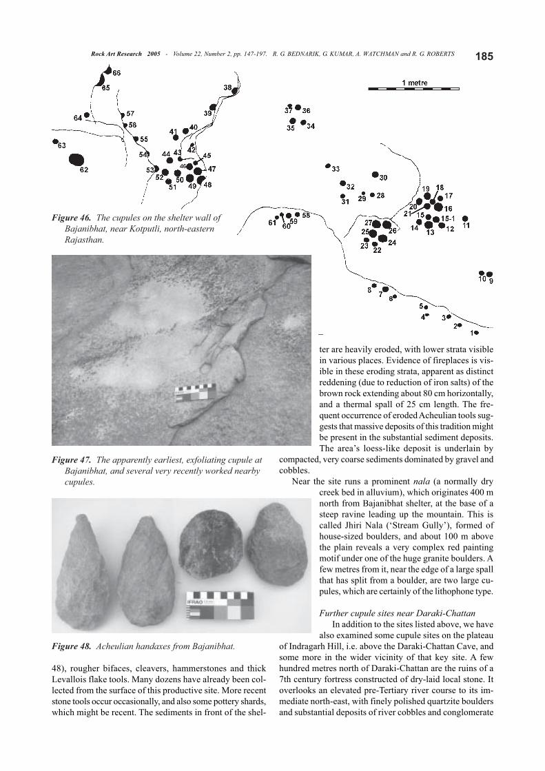
The Bajanibhat cupule siteAnother candidate for Palaeolithic-age cupules is
Bajanibhat (‘Rock that gives sound’; i.e. lithophone). Thelink between cupule sites and lithophones is very real in
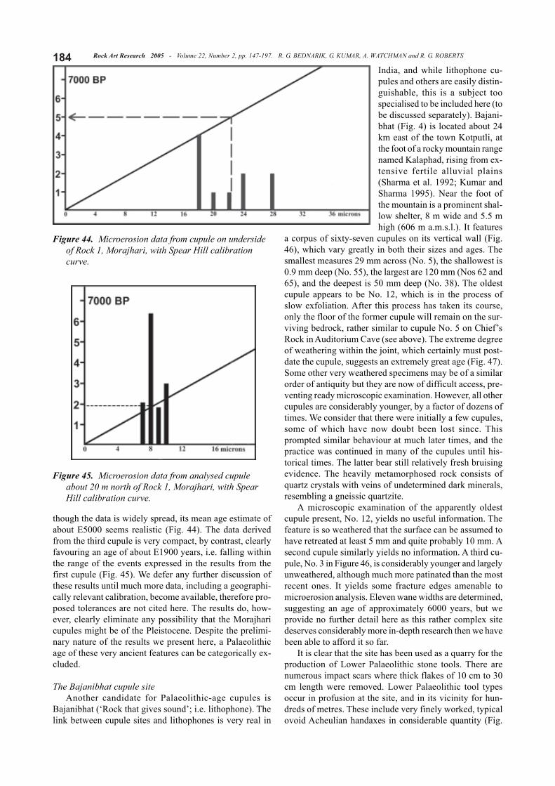
India, and while lithophone cu-pules and others are easily distin-guishable, this is a subject toospecialised to be included here (tobe discussed separately). Bajani-bhat (Fig. 4) is located about 24km east of the town Kotputli, atthe foot of a rocky mountain rangenamed Kalaphad, rising from ex-tensive fertile alluvial plains(Sharma et al. 1992; Kumar andSharma 1995). Near the foot ofthe mountain is a prominent shal-low shelter, 8 m wide and 5.5 mhigh (606 m a.m.s.l.). It features
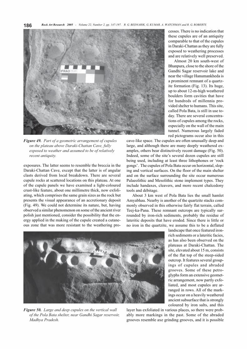
a corpus of sixty-seven cupules on its vertical wall (Fig.46), which vary greatly in both their sizes and ages. Thesmallest measures 29 mm across (No. 5), the shallowest is0.9 mm deep (No. 55), the largest are 120 mm (Nos 62 and65), and the deepest is 50 mm deep (No. 38). The oldestcupule appears to be No. 12, which is in the process ofslow exfoliation. After this process has taken its course,only the floor of the former cupule will remain on the sur-viving bedrock, rather similar to cupule No. 5 on Chief’sRock in Auditorium Cave (see above). The extreme degreeof weathering within the joint, which certainly must post-date the cupule, suggests an extremely great age (Fig. 47).Some other very weathered specimens may be of a similarorder of antiquity but they are now of difficult access, pre-venting ready microscopic examination. However, all othercupules are considerably younger, by a factor of dozens oftimes. We consider that there were initially a few cupules,some of which have now doubt been lost since. Thisprompted similar behaviour at much later times, and thepractice was continued in many of the cupules until his-torical times. The latter bear still relatively fresh bruisingevidence. The heavily metamorphosed rock consists ofquartz crystals with veins of undetermined dark minerals,resembling a gneissic quartzite.
A microscopic examination of the apparently oldestcupule present, No. 12, yields no useful information. Thefeature is so weathered that the surface can be assumed tohave retreated at least 5 mm and quite probably 10 mm. Asecond cupule similarly yields no information. A third cu-pule, No. 3 in Figure 46, is considerably younger and largelyunweathered, although much more patinated than the mostrecent ones. It yields some fracture edges amenable tomicroerosion analysis. Eleven wane widths are determined,suggesting an age of approximately 6000 years, but weprovide no further detail here as this rather complex sitedeserves considerably more in-depth research then we havebeen able to afford it so far.
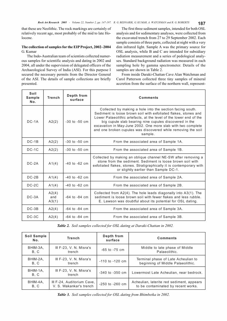
It is clear that the site has been used as a quarry for theproduction of Lower Palaeolithic stone tools. There arenumerous impact scars where thick flakes of 10 cm to 30cm length were removed. Lower Palaeolithic tool typesoccur in profusion at the site, and in its vicinity for hun-dreds of metres. These include very finely worked, typicalovoid Acheulian handaxes in considerable quantity (Fig.
Figure 44. Microerosion data from cupule on undersideof Rock 1, Morajhari, with Spear Hill calibrationcurve.
Figure 45. Microerosion data from analysed cupuleabout 20 m north of Rock 1, Morajhari, with SpearHill calibration curve.
185Rock Art Research 2005 - Volume 22, Number 2, pp. 147-197. R. G. BEDNARIK, G. KUMAR, A. WATCHMAN and R. G. ROBERTS
48), rougher bifaces, cleavers, hammerstones and thickLevallois flake tools. Many dozens have already been col-lected from the surface of this productive site. More recentstone tools occur occasionally, and also some pottery shards,which might be recent. The sediments in front of the shel-
ter are heavily eroded, with lower strata visiblein various places. Evidence of fireplaces is vis-ible in these eroding strata, apparent as distinctreddening (due to reduction of iron salts) of thebrown rock extending about 80 cm horizontally,and a thermal spall of 25 cm length. The fre-quent occurrence of eroded Acheulian tools sug-gests that massive deposits of this tradition mightbe present in the substantial sediment deposits.The area’s loess-like deposit is underlain by
compacted, very coarse sediments dominated by gravel andcobbles.
Near the site runs a prominent nala (a normally drycreek bed in alluvium), which originates 400 mnorth from Bajanibhat shelter, at the base of asteep ravine leading up the mountain. This iscalled Jhiri Nala (‘Stream Gully’), formed ofhouse-sized boulders, and about 100 m abovethe plain reveals a very complex red paintingmotif under one of the huge granite boulders. Afew metres from it, near the edge of a large spallthat has split from a boulder, are two large cu-pules, which are certainly of the lithophone type.
Further cupule sites near Daraki-ChattanIn addition to the sites listed above, we have
also examined some cupule sites on the plateauof Indragarh Hill, i.e. above the Daraki-Chattan Cave, andsome more in the wider vicinity of that key site. A fewhundred metres north of Daraki-Chattan are the ruins of a7th century fortress constructed of dry-laid local stone. Itoverlooks an elevated pre-Tertiary river course to its im-mediate north-east, with finely polished quartzite bouldersand substantial deposits of river cobbles and conglomerate
Figure 46. The cupules on the shelter wall ofBajanibhat, near Kotputli, north-easternRajasthan.
Figure 47. The apparently earliest, exfoliating cupule atBajanibhat, and several very recently worked nearbycupules.
Figure 48. Acheulian handaxes from Bajanibhat.
Rock Art Research 2005 - Volume 22, Number 2, pp. 147-197. R. G. BEDNARIK, G. KUMAR, A. WATCHMAN and R. G. ROBERTS186
exposures. The latter seems to resemble the breccia in theDaraki-Chattan Cave, except that the latter is of angularclasts derived from local breakdown. There are severalcupule rocks at scattered locations on this plateau. At oneof the cupule panels we have examined a light-colouredcrust-like feature, about one millimetre thick, now exfoli-ating, which comprises the same grain sizes as the rock butpresents the visual appearance of an accretionary deposit(Fig. 49). We could not determine its nature, but, havingobserved a similar phenomenon on some of the ancient riverpolish just mentioned, consider the possibility that the en-ergy applied in the making of the cupule created a cutane-ous zone that was more resistant to the weathering pro-
cesses. There is no indication thatthese cupules are of an antiquitycomparable to that of the cupulesin Daraki-Chattan as they are fullyexposed to weathering processesand are relatively well preserved.
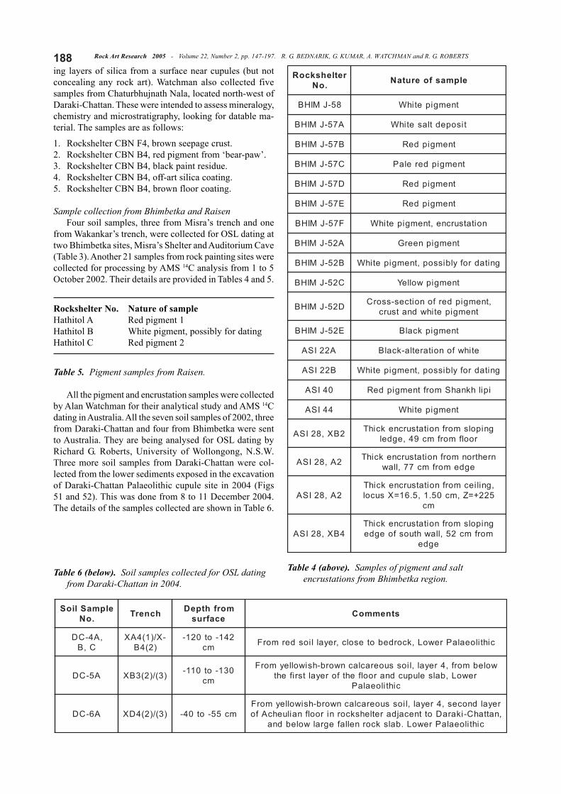
Almost 20 km south-west ofBhanpura, close to the shore of theGandhi Sagar reservoir lake andnear the village Hanumankheda isa prominent remnant of a quartz-ite formation (Fig. 13). Its huge,up to about 12-m-high weatheredboulders form cavities that havefor hundreds of millennia pro-vided shelter to humans. This site,called Pola Bata, is still in use to-day. There are several concentra-tions of cupules among the rocks,especially on the wall of the maintunnel. Numerous largely fadedred pictograms occur also in this
cave-like space. The cupules are often unusually deep andlarge, and although there are many deeply weathered ex-amples, others bear distinctively recent damage (Fig. 50).Indeed, some of the site’s several dozen cupules are stillbeing used, including at least three lithophones or ‘rockgongs’. The cupules of Pola Bata occur on horizontal, slop-ing and vertical surfaces. On the floor of the main shelterand on the surface surrounding the site occur numerousPalaeolithic and Mesolithic stone implement types. Theyinclude handaxes, cleavers, and more recent chalcedonytools and débitage.
About 3 km west of Pola Bata lies the small hamletAmyabhau. Nearby is another of the quartzite stacks com-monly observed in this otherwise fairly flat terrain, calledTeej-ka-Pana. These remnant outcrops are typically sur-rounded by iron-rich sediments, probably the residue oflateritic deposits that have eroded. Since there is little orno iron in the quartzite, we assume this to be a deflated
landscape that once featured iron-rich sediments or a lateritic facies,as has also been observed on theplateaus at Daraki-Chattan. Thesite, elevated about 15 m, consistsof the flat top of the steep-sidedoutcrop. It features several group-ings of cupules and abradedgrooves. Some of these petro-glyphs form an extensive geomet-ric arrangement, now partly exfo-liated, and most cupules are ar-ranged in rows. All of the mark-ings occur on a heavily weatheredancient subsurface that is stronglycoloured by iron salts, and this
layer has exfoliated in various places, so there were prob-ably more markings in the past. Some of the abradedgrooves resemble axe grinding grooves, and it is possible
Figure 49. Part of a geometric arrangement of cupuleson the plateau above Daraki-Chattan Cave, fullyexposed to weather and assumed to be of relativelyrecent antiquity.
Figure 50. Large and deep cupules on the vertical wallof the Pola Bata shelter, near Gandhi Sagar reservoir,Madhya Pradesh.
187Rock Art Research 2005 - Volume 22, Number 2, pp. 147-197. R. G. BEDNARIK, G. KUMAR, A. WATCHMAN and R. G. ROBERTS
that these are Neolithic. The rock markings are certainly ofrelatively recent age, most probably of the mid to late Ho-locene.
The collection of samples for the EIP Project, 2002–2004G. Kumar
The Indo-Australian team of scientists collected numer-ous samples for scientific analysis and dating in 2002 and2004, all under the supervision of delegated officers of theArchaeological Survey of India (ASI). For this purpose Isecured the necessary permits from the Director Generalof the ASI. The details of sample collections are brieflypresented.
The first three sediment samples, intended for both OSLanalysis and for sedimentary analyses, were collected fromthe excavated trench from 27 to 29 September 2002. Eachsample consists of three parts, collected at night with a verydim infrared light. Sample A was the primary source forOSL analysis, while B and C are intended for subsidiaryradiation measurement and a series of pedological analy-ses. Standard background radiation was measured in eachsampling hole by gamma spectrometer. Details of thesamples are shown in Table 2.
From inside Daraki-Chattan Cave Alan Watchman andCarol Patterson collected three tiny samples of mineralaccretion from the surface of the northern wall, represent-
Table 2. Soil samples collected for OSL dating at Daraki-Chattan in 2002.
lioSelpmaS.oN
hcnerT morfhtpeDecafrus stnemmoC
A1-CD )2(2A mc05-ot03-
.htuosgnicafnoitcesehtotnielohagnikamybdetcelloCdnasenots,sekalfdetailofxehtiwliosnworbesoolsitnemideSehtfodnerewolehtfolevelehtta,stcafetracihtiloealaPrewoL
ehtniderevocsidselupuceningniraebbalselupucgibetelpmocowthtiwbalseromenO.2002enuJ-yaMninoitavacxeliosehtgnivomerelihwderevocsidsawselupucnekorbenodna
.elpmas
B1-CD )2(2A mc05-ot03- .A1elpmaSfoaeradetaicossaehtmorF
C1-CD )2(2A mc05-ot03- .B1elpmaSfoaeradetaicossaehtmorF
A2-CD )4(1A mc26-ot04-
agnivomerretfaWS-ENlennahceuqilbonagnikamybdetcelloChtiwliosnworbesoolsitnemideS.tnemidesehtmorfenots
htiwyraropmetnocsitiyllacihpargitartS.senots,sekalfdetailofxe.1-CDelpmaSnahtreilraeylthgilsro
B2-CD )4(1A mc26-ot04- .A2elpmaSfoaeradetaicossaehtmorF
C2-CD )4(1A mc26-ot04- .B2elpmaSfoaeradetaicossaehtmorF
A3-CD)4(2A
dna)1(3A
mc48-ot46-ehT.)1(3AotniyllanogaidsdaelelohehT.)4(2AmorfdetcelloC.elbbursseldnasekalfrewefhtiwliosnworbesoolsitnemides
.gnitadLSOroflaitnetopstituobaluftbuodsawnoswaL.E
B3-CD )4(2A mc48-ot46- .A3elpmaSfoaeradetaicossaehtmorF
C3-CD )4(2A mc48-ot46- .B3elpmaSfoaeradetaicossaehtmorF
Table 3. Soil samples collected for OSL dating from Bhimbetka in 2002.
elpmaSlioS.oN hcnerT morfhtpeD
ecafrus stnemmoC
,A3-MIHBC,B
s'arsiM.N.V,32-FIIIhcnert mc57-ot56- elddiMfoesahpetalotelddiM
.cihtiloealaP
,A2-MIHBC,B
s'arsiM.N.V,32-FIIIhcnert mc021-ot011- otnailuehcAetaLfoesahplanimreT
.cihtiloealaPelddiMfogninnigeb
,A1-MIHBC,B
s'arsiM.N.V,32-FIIIhcnert mc053-ot043- .kcordebraen,nailuehcAetaLtsomrewoL
,A4-MIHBC,B
,evaCmuirotiduA,42-FIIIhcnerts'raknakaW.S.V mc062-ot052- sraeppa,tnemidesderetiretal,nailuehcA
.skrowtnecerybdetanimatnocebot
Rock Art Research 2005 - Volume 22, Number 2, pp. 147-197. R. G. BEDNARIK, G. KUMAR, A. WATCHMAN and R. G. ROBERTS188ing layers of silica from a surface near cupules (but notconcealing any rock art). Watchman also collected fivesamples from Chaturbhujnath Nala, located north-west ofDaraki-Chattan. These were intended to assess mineralogy,chemistry and microstratigraphy, looking for datable ma-terial. The samples are as follows:
1. Rockshelter CBN F4, brown seepage crust.2. Rockshelter CBN B4, red pigment from ‘bear-paw’.3. Rockshelter CBN B4, black paint residue.4. Rockshelter CBN B4, off-art silica coating.5. Rockshelter CBN B4, brown floor coating.
Sample collection from Bhimbetka and RaisenFour soil samples, three from Misra’s trench and one
from Wakankar’s trench, were collected for OSL dating attwo Bhimbetka sites, Misra’s Shelter and Auditorium Cave(Table 3). Another 21 samples from rock painting sites werecollected for processing by AMS 14C analysis from 1 to 5October 2002. Their details are provided in Tables 4 and 5.
Rockshelter No. Nature of sampleHathitol A Red pigment 1Hathitol B White pigment, possibly for datingHathitol C Red pigment 2
Table 5. Pigment samples from Raisen.
All the pigment and encrustation samples were collectedby Alan Watchman for their analytical study and AMS 14Cdating in Australia. All the seven soil samples of 2002, threefrom Daraki-Chattan and four from Bhimbetka were sentto Australia. They are being analysed for OSL dating byRichard G. Roberts, University of Wollongong, N.S.W.Three more soil samples from Daraki-Chattan were col-lected from the lower sediments exposed in the excavationof Daraki-Chattan Palaeolithic cupule site in 2004 (Figs51 and 52). This was done from 8 to 11 December 2004.The details of the samples collected are shown in Table 6.
Table 6 (below). Soil samples collected for OSL datingfrom Daraki-Chattan in 2004.
retlehskcoR.oN elpmasfoerutaN
85-JMIHB tnemgipetihW
A75-JMIHB tisopedtlasetihW
B75-JMIHB tnemgipdeR
C75-JMIHB tnemgipderelaP
D75-JMIHB tnemgipdeR
E75-JMIHB tnemgipdeR
F75-JMIHB noitatsurcne,tnemgipetihW
A25-JMIHB tnemgipneerG
B25-JMIHB gnitadrofylbissop,tnemgipetihW
C25-JMIHB tnemgipwolleY
D25-JMIHB ,tnemgipderfonoitces-ssorCtnemgipetihwdnatsurc
E25-JMIHB tnemgipkcalB
A22ISA etihwfonoitaretla-kcalB
B22ISA gnitadrofylbissop,tnemgipetihW
04ISA ipilhknahSmorftnemgipdeR
44ISA tnemgipetihW
2BX,82ISA gnipolsmorfnoitatsurcnekcihTroolfmorfmc94,egdel
2A,82ISA nrehtronmorfnoitatsurcnekcihTegdemorfmc77,llaw
2A,82ISA,gniliecmorfnoitatsurcnekcihT522+=Z,mc05.1,5.61=Xsucol
mc
4BX,82ISAgnipolsmorfnoitatsurcnekcihT
morfmc25,llawhtuosfoegdeegde
Table 4 (above). Samples of pigment and saltencrustations from Bhimbetka region.
elpmaSlioS.oN hcnerT morfhtpeD
ecafrus stnemmoC
,A4-CDC,B
-X/)1(4AX)2(4B
241-ot021-mc cihtiloealaPrewoL,kcordebotesolc,reyalliosdermorF
A5-CD )3(/)2(3BX 031-ot011-mc
wolebmorf,4reyal,liossuoeraclacnworb-hsiwolleymorFrewoL,balselupucdnaroolfehtforeyaltsrifeht
cihtiloealaP
A6-CD )3(/)2(4DX mc55-ot04-reyaldnoces,4reyal,liossuoeraclacnworb-hsiwolleymorF,nattahC-ikaraDottnecajdaretlehskcorniroolfnailuehcAfo
cihtiloealaPrewoL.balskcornellafegralwolebdna
189Rock Art Research 2005 - Volume 22, Number 2, pp. 147-197. R. G. BEDNARIK, G. KUMAR, A. WATCHMAN and R. G. ROBERTS
First OSL results of the EIP ProjectR. G. RobertsOptical dating methods
Quartz grains of 90–125 µm in diameter were extractedfrom the samples under dim red illumination using stan-dard purification procedures, followed by a final etch inhydrofluoric acid to remove the alpha-irradiated rinds(Aitken 1998). Grains were then mounted on stainless-steeldiscs using silicone oil spray as adhesive, with each ali-quot being composed of ~80 grains. The absorbed radia-tion dose (the ‘palaeodose’) was estimated for each ali-
quot from the opticallystimulated luminescence(OSL) signals emitted un-der intense blue (470 nm)illumination. The ultravio-let OSL emissions weredetected by an ElectronTubes Ltd 9235QA photo-multiplier tube fitted with7.5 mm of Hoya U-340 fil-ter, and laboratory irradia-tions were performed us-ing a calibrated 90Sr/90Ybeta source.
A single-aliquot regen-erative-dose (SAR) proto-col was used forpalaeodose determination,whereby the ‘natural’ OSLsignal of an aliquot is in-terpolated on to the dose-response curve for thesame aliquot, the latter be-ing constructed from a se-
ries of regenerative doses that includes, as internal checksof protocol performance, a duplicate dose point and a zero-dose point (Bøtter-Jensen et al. 2003). Each aliquot was
held at 200ºC for 10 s be-fore measuring the naturaland regenerated OSL sig-nals. Any changes in lumi-nescence sensitivity dur-ing this measurement pro-cedure were monitored,and corrected for, using aseries of test doses, whichwere heated to 160ºC be-fore optical stimulation.Each of the natural, regen-erative and test doses wereoptically stimulated for100 s at 125ºC, and the re-sulting OSL signals wereintegrated over the first 3s of illumination, using thecount rate over the final 30s as background. The SAR
protocol has been shown to work well in a variety of depo-sitional environments where independent age control isavailable (e.g. Turney et al. 2001; Murray and Olley 2002;Olley et al. 2004a, 2004b; Duller 2004; Anderson et al. inpress). In addition, we performed ‘dose recovery’ tests,whereby fresh aliquots of sample are bleached at room tem-perature in the laboratory to erase their natural OSL sig-nals, and are then given a known dose. Ratios of the mea-sured dose to the given dose of 1.04 ± 0.03 and 1.00 ± 0.02were obtained for the Auditorium Cave (n = 12) and Daraki-Chattan (n = 9) samples, respectively, indicating that thecorrect (known) dose can be recovered for these samples
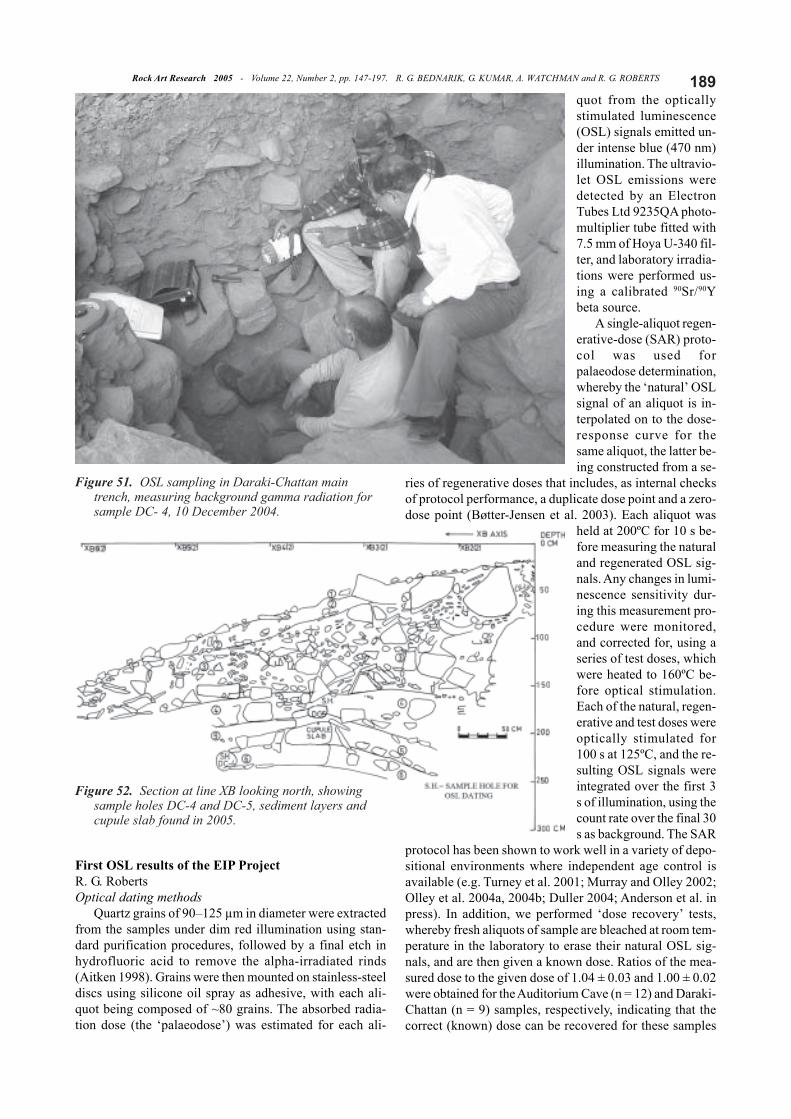
Figure 51. OSL sampling in Daraki-Chattan maintrench, measuring background gamma radiation forsample DC- 4, 10 December 2004.
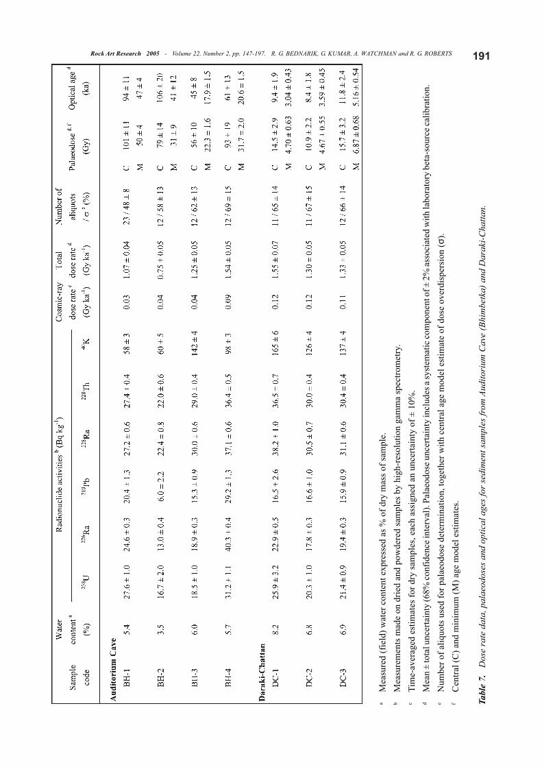
Figure 52. Section at line XB looking north, showingsample holes DC-4 and DC-5, sediment layers andcupule slab found in 2005.

Rock Art Research 2005 - Volume 22, Number 2, pp. 147-197. R. G. BEDNARIK, G. KUMAR, A. WATCHMAN and R. G. ROBERTS190using the SAR protocol.
A potential problem in optical dating of multi-grainaliquots is the presence of grains that have not been ex-posed to sufficient sunlight (‘bleached’) prior to burial, and/or the inclusion of grains that have been incorporated intothe sample from older or younger strata by means of post-depositional mixing. Olley et al. (1999) have shown thatincomplete bleaching cannot be readily detected if aliquotsare composed of more than ~80 luminescent grains, whichdictated the choice of maximum aliquot size in this study.The identification of partial bleaching/sediment mixing isbest achieved by single-grain analyses (e.g. Roberts et al.1998a, 1998b, 1999; Olley et al. 1999, 2004a, 2004b; Jacobset al. 2003a), which we intend to conduct on these samplesin the next phase of investigation.
From the single-aliquot palaeodose estimates, thesample burial doses were determined using two statisticalmodels — the ‘common age model’ and the ‘minimum agemodel’ — which are described in detail elsewhere, togetherwith examples of their application (e.g. Roberts et al. 1998a,1999; Galbraith et al. 1999; Jacobs et al. 2003b; Olley etal. 2004a, 2004b; Anderson et al. in press). The central agemodel calculates the weighted-mean burial dose for a setof single-aliquot estimates, taking into account the extraspread (‘overdispersion’) above and beyond that associ-ated with the measurement uncertainties. Even samples thatwere well-bleached at deposition can have palaeodose dis-tributions that are overdispersed by up to 20% (e.g. Rob-erts et al. 1998b, 2000; Jacobs et al. 2003a, 2003b; Olley etal. 2004a, 2004b; Galbraith et al. 2005; Anderson et al. inpress), although the exact causes of this overdispersion arenot fully understood. The minimum age model provides anestimate of the sample burial dose for the lowest-dose popu-lation of single aliquots. This model has been thoroughlytested in simulations and yields correct burial dose esti-mates for partially bleached samples of known age (e.g.Olley et al. 2004a). Statistical models should, of course, beapplied in tandem with stratigraphic considerations andother lines of evidence about the bleaching and burial his-tory of the deposit.
The sample dose rates were determined from high-reso-lution gamma spectrometry measurements of lithogenicradioactive elements 238U, 235U, 232Th (and their decay prod-ucts) and 40K in dried and powdered samples of sediment,using the same equipment as Olley et al. (1997). Such analy-ses provide information on the particular forms of past andpresent disequilibria in 238U and 232Th decay series that ex-ert most influence on the dose rate. Time-averaged watercontents of 6 ± 2 and 7 ± 2% were used for the AuditoriumCave and Daraki-Chattan samples, respectively, to accom-modate the present-day field water contents (see Table 7)and any likely long-term fluctuations in these rockshelterdeposits. A minor dose rate contribution of 0.02 Gy ka-1
from internal alpha and beta emitters was included in thetotal dose rate for each sample, and the cosmic-ray contri-butions were estimated from the data of Prescott and Hutton(1994), making allowance for site altitude and geomag-netic latitude, the thickness of bedrock shielding, and thetime-averaged depth of sediment overburden.
Optical dating resultsMeasurements of various radionuclides in the 238U and
232Th decay chains revealed that disequilibrium is restricted,at the present day, to the escape of radon (222Rn) gas fromboth the Auditorium Cave and Daraki-Chattan deposits(Table 7). Radon is a short-lived (half-life ~4 days) decayproduct between 226Ra and 210Pb in the 238U decay series,and is commonly lost from unconsolidated sediments(Aitken 1998). The 210Pb/226Ra ratios range from 0.46 ±0.17 to 0.93 ± 0.06, with an average of ~0.76 (i.e. ~24%loss to atmosphere), which is similar to the values reportedfor other archaeological deposits (e.g. Olley et al. 1997;Turney et al., 2001; Anderson et al. in press). We have as-sumed that the measured ratios have prevailed throughoutthe period of sample burial.
For all of the samples examined, the palaeodose distri-butions were significantly overdispersed, ranging from 48± 8 to 69 ± 15% (Table 7). These values are substantiallyhigher than is typical of samples that have been well-bleached before burial. However, it is premature to attributethe overdispersion to incomplete bleaching before deposi-tion, because the possibility remains that quartz grains de-posited at different times may have been mixed togetherafter burial. Single-grain analyses are required to distin-guish between sediment mixing and partial bleaching, withthe dual-signal linear modulation OSL technique beingespecially useful in this regard (Yoshida et al. 2003; Olleyet al. 2004b, Olley et al. in press). Such measurements willform part of our next set of investigations.
As the major cause of the overdispersion is not knownat this stage, we have taken a conservative approach to thedetermination of the optical ages. Following Roberts et al.(1998a, 1999), we have calculated the age of each sampleusing both the central and minimum age models (Table 7).If the overdispersion is due mainly to insufficient bleach-ing before deposition, then the minimum age model esti-mate will correspond most closely to the burial age of themost fully bleached grains, provided the sample has notbeen disturbed subsequently. However, for a mixed sample— that is, one composed of well-bleached (or poorlybleached) grains that have been turbated after burial,thereby mixing together grains from strata of different ages— the minimum age model will yield the age of the mostrecently and fully bleached, intrusive grains. The age ofthe ‘host’ deposit will be greater, but by an unknownamount.
The central age model will not necessarily yield thecorrect age for the host grains in a sediment mixture, but itmight provide some age constraints. For example, if someof the grains in the sample had been insufficiently bleachedat the time of burial, and the OSL signal from these grainsoverwhelms the OSL emissions from any younger, intru-sive grains, then the central age model will yield an ageestimate that is too old. On the other hand, if all the grainsin the sample had been well-bleached at burial, and olderand younger grains have since been mixed together, thenthe age calculated by the central age model could be tooyoung (if the mixture is dominated by grains derived fromyounger strata), too old (if the mixture is dominated by
191Rock Art Research 2005 - Volume 22, Number 2, pp. 147-197. R. G. BEDNARIK, G. KUMAR, A. WATCHMAN and R. G. ROBERTS
aM
easu
red
(fie
ld) w
ater
con
tent
exp
ress
ed a
s % o
f dry
mas
s of s
ampl
e.b
Mea
sure
men
ts m
ade
on d
ried
and
pow
dere
d sa
mpl
es b
y hi
gh-r
esol
utio
n ga
mm
a sp
ectro
met
ry.
cTi
me-
aver
aged
est
imat
es fo
r dry
sam
ples
, eac
h as
sign
ed a
n un
certa
inty
of ±
10%
.d
Mea
n ±
tota
l unc
erta
inty
(68%
conf
iden
ce in
terv
al).
Pala
eodo
se u
ncer
tain
ty in
clud
es a
syst
emat
ic co
mpo
nent
of ±
2%
asso
ciat
ed w
ith la
bora
tory
bet
a-so
urce
calib
ratio
n.e
Num
ber o
f aliq
uots
use
d fo
r pal
aeod
ose
dete
rmin
atio
n, to
geth
er w
ith c
entra
l age
mod
el e
stim
ate
of d
ose
over
disp
ersi
on (σ
).f
Cen
tral (
C) a
nd m
inim
um (M
) age
mod
el e
stim
ates
.
Tabl
e 7.
D
ose
rate
dat
a, p
alae
odos
es a
nd o
ptic
al a
ges f
or se
dim
ent s
ampl
es fr
om A
udito
rium
Cav
e (B
him
betk
a) a
nd D
arak
i-Cha
ttan.
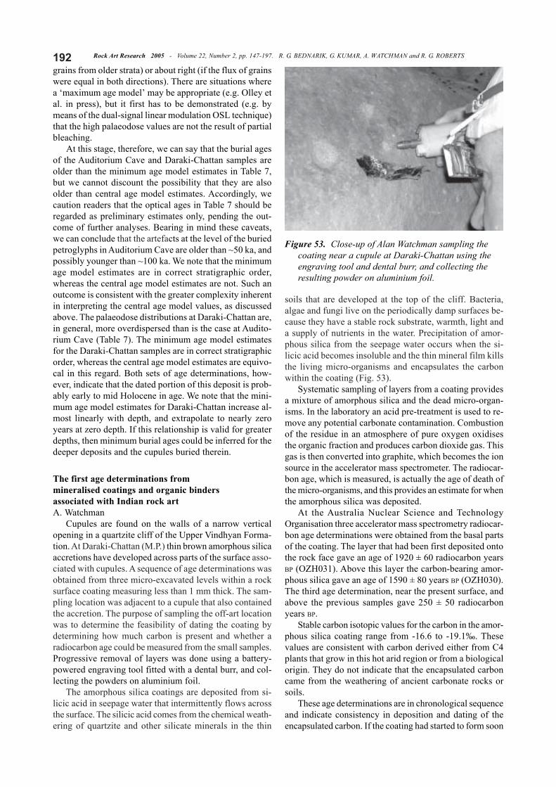
Rock Art Research 2005 - Volume 22, Number 2, pp. 147-197. R. G. BEDNARIK, G. KUMAR, A. WATCHMAN and R. G. ROBERTS192grains from older strata) or about right (if the flux of grainswere equal in both directions). There are situations wherea ‘maximum age model’ may be appropriate (e.g. Olley etal. in press), but it first has to be demonstrated (e.g. bymeans of the dual-signal linear modulation OSL technique)that the high palaeodose values are not the result of partialbleaching.
At this stage, therefore, we can say that the burial agesof the Auditorium Cave and Daraki-Chattan samples areolder than the minimum age model estimates in Table 7,but we cannot discount the possibility that they are alsoolder than central age model estimates. Accordingly, wecaution readers that the optical ages in Table 7 should beregarded as preliminary estimates only, pending the out-come of further analyses. Bearing in mind these caveats,we can conclude that the artefacts at the level of the buriedpetroglyphs in Auditorium Cave are older than ~50 ka, andpossibly younger than ~100 ka. We note that the minimumage model estimates are in correct stratigraphic order,whereas the central age model estimates are not. Such anoutcome is consistent with the greater complexity inherentin interpreting the central age model values, as discussedabove. The palaeodose distributions at Daraki-Chattan are,in general, more overdispersed than is the case at Audito-rium Cave (Table 7). The minimum age model estimatesfor the Daraki-Chattan samples are in correct stratigraphicorder, whereas the central age model estimates are equivo-cal in this regard. Both sets of age determinations, how-ever, indicate that the dated portion of this deposit is prob-ably early to mid Holocene in age. We note that the mini-mum age model estimates for Daraki-Chattan increase al-most linearly with depth, and extrapolate to nearly zeroyears at zero depth. If this relationship is valid for greaterdepths, then minimum burial ages could be inferred for thedeeper deposits and the cupules buried therein.
The first age determinations frommineralised coatings and organic bindersassociated with Indian rock artA. Watchman
Cupules are found on the walls of a narrow verticalopening in a quartzite cliff of the Upper Vindhyan Forma-tion. At Daraki-Chattan (M.P.) thin brown amorphous silicaaccretions have developed across parts of the surface asso-ciated with cupules. A sequence of age determinations wasobtained from three micro-excavated levels within a rocksurface coating measuring less than 1 mm thick. The sam-pling location was adjacent to a cupule that also containedthe accretion. The purpose of sampling the off-art locationwas to determine the feasibility of dating the coating bydetermining how much carbon is present and whether aradiocarbon age could be measured from the small samples.Progressive removal of layers was done using a battery-powered engraving tool fitted with a dental burr, and col-lecting the powders on aluminium foil.
The amorphous silica coatings are deposited from si-licic acid in seepage water that intermittently flows acrossthe surface. The silicic acid comes from the chemical weath-ering of quartzite and other silicate minerals in the thin
soils that are developed at the top of the cliff. Bacteria,algae and fungi live on the periodically damp surfaces be-cause they have a stable rock substrate, warmth, light anda supply of nutrients in the water. Precipitation of amor-phous silica from the seepage water occurs when the si-licic acid becomes insoluble and the thin mineral film killsthe living micro-organisms and encapsulates the carbonwithin the coating (Fig. 53).
Systematic sampling of layers from a coating providesa mixture of amorphous silica and the dead micro-organ-isms. In the laboratory an acid pre-treatment is used to re-move any potential carbonate contamination. Combustionof the residue in an atmosphere of pure oxygen oxidisesthe organic fraction and produces carbon dioxide gas. Thisgas is then converted into graphite, which becomes the ionsource in the accelerator mass spectrometer. The radiocar-bon age, which is measured, is actually the age of death ofthe micro-organisms, and this provides an estimate for whenthe amorphous silica was deposited.
At the Australia Nuclear Science and TechnologyOrganisation three accelerator mass spectrometry radiocar-bon age determinations were obtained from the basal partsof the coating. The layer that had been first deposited ontothe rock face gave an age of 1920 ± 60 radiocarbon yearsBP (OZH031). Above this layer the carbon-bearing amor-phous silica gave an age of 1590 ± 80 years BP (OZH030).The third age determination, near the present surface, andabove the previous samples gave 250 ± 50 radiocarbonyears BP.
Stable carbon isotopic values for the carbon in the amor-phous silica coating range from -16.6 to -19.1‰. Thesevalues are consistent with carbon derived either from C4plants that grow in this hot arid region or from a biologicalorigin. They do not indicate that the encapsulated carboncame from the weathering of ancient carbonate rocks orsoils.
These age determinations are in chronological sequenceand indicate consistency in deposition and dating of theencapsulated carbon. If the coating had started to form soon
Figure 53. Close-up of Alan Watchman sampling thecoating near a cupule at Daraki-Chattan using theengraving tool and dental burr, and collecting theresulting powder on aluminium foil.
193Rock Art Research 2005 - Volume 22, Number 2, pp. 147-197. R. G. BEDNARIK, G. KUMAR, A. WATCHMAN and R. G. ROBERTS
after the cupules were made then the age determinationsindicate that the cupules may not be as old as previouslythought. The relatively young age for the accretion contra-dicts the expected ancient age for the oldest cupules at thissite. Such contradiction can be argued against on thegrounds that cupule production was ongoing for many yearsand that the accretionary deposits only started to form onthe vertical rock faces approximately 2000 years ago.
In Madhya Pradesh several rock paintings were alsodated. Sites at Bhimbetka, Jamjori and Hathitol (Raisen)were visited and mostly white paint was collected for analy-sis. While the bulk of the paintings are in red haematite itis only the white gypsum-bassanite paintings that containdatable carbon. Further research is necessary to establishthe source of the organic components in the paints, but atfirst inspection the compound is consistent with an oxalatesalt (whewellite). The preliminary estimates of age rangefrom 1100 to 5200 years ago.
Location AS-144 at Bhimbetka is a shallow rockshelterwith the remains of a white quadruped painted on the slop-ing back wall (Fig. 54). A sample of the hard white paintfrom the front leg provided an age estimate of 1100 ± 60years BP (OZG 814). The oldest paint so far dated comesfrom an adjacent site (AS-122) at Bhimbetka. Another whitequadruped with cross-hatching in the abdomen (Fig. 55)
gave an age of 5190 ± 310 years BP (OZG 369).At Jamjori (site J-52), the white paint from one of three
interior rectangular lines gave an age of 1720 ± 310 yearsBP (OZG 368) (Fig. 56). The ceiling at Hathitol contains apanel of red and white quadrupeds with interior cross-hatch-ings. The back wall contains a series of paintings of ani-mals apparently walking in rows from left to right. Thesered outline and white infilled animals give the impressionof a hump-backed herd migrating across the landscape.White paint from the chest area of one of these animals(Fig. 57) gave an age estimate of 4810 ± 370 years BP (OZG370). Red paint from the hind leg of the same animal pro-duced an age of 2780 ± 40 years BP (ä13C = -15.3 per mil).These two results indicate that the first painting was whiteand a later addition of red was used to outline and decoratethe body.
White paint at the various locations contains carbon inthe form of whewellite, an oxalate salt, but the source ofthat mineral has not yet been investigated. The carbon inthe white paint is easily dated, but only one of the red paintssampled so far contains dateable material. The ages ob-
Figure 54. R. K. Choudhury at site AS-144, Bhimbetka.
Figure 55. Sampling at Bhimbetka site AS-122.
Figure 56. Sampling at Jamjori site J-52. Figure 57. Sampling at Hathitol shelter B.
Rock Art Research 2005 - Volume 22, Number 2, pp. 147-197. R. G. BEDNARIK, G. KUMAR, A. WATCHMAN and R. G. ROBERTS194tained so far for the paintings appear young and it wouldbe appropriate to measure the ages of some figures wherethe antiquity is known. Some excavated sites where paintedsections of the rockshelter walls have fallen off should pro-vide some stratigraphic control over the age determinations.Based on these preliminary analyses potential exists formuch more systematic work on the compositions and agesof rock paintings in India.
Interpretation and summaryRobert G. Bednarik
Cupules (or cup marks) are a universal feature in therock art of the world, and are presumed to be the mostnumerous of all petroglyph motifs. They occur in allcontinents except Antarctica, and they seem to have beenmade in most periods of history, beginning with the LowerPalaeolithic and ending in the Middle Ages in Europe —and in even more recent times in such regions as Australiawhere their manufacture only ceased in the 20th century.They are very common in Bronze Age and Iron Age rockart, but the most mysterious tradition of them is the earliest.It concerns the Middle Palaeolithic cupule tradition thatseems represented in Europe, Asia, Australia and possiblyAfrica, which in some cases even extends to the LowerPalaeolithic. The great uniformity and enormous geographi-cal extent of these extremely early cupule traditions raisefundamental questions in Pleistocene archaeology. To whatdegree are they culturally related, or refer to similar culturalpractices?
There are specific common characteristics emerging,but because this subject has been so severely neglected untilvery recently it might be premature to elaborate on possibleuniversal variables within these very early traditions, orthe significance they might seem to have shared overimmense spatial and temporal distances. The EIP Project(Bednarik 2001b; Kumar 2000/01; Kumar et al. 2002) isendeavouring to secure the first data of Lower and MiddlePalaeolithic petroglyphs. The present preliminary reportprovides unambiguous evidence of such rock art fromarchaeological occupation strata at two sites, AuditoriumCave and Daraki-Chattan. It consists of a total of thirtycupules, in situ or exfoliated from the cave wall, and fourlinear grooves. At Daraki-Chattan, the lack of cupules onexfoliation scars on the cave walls implies that theremaining wall cupules are of ages similar to those in theexcavation. The same relationship has been suggested forthe cupules above ground in Auditorium Cave.
The taphonomic dimensions of the subject of extremelyearly rock art have also been considered (Bednarik 1997b).It is highly relevant that the very earliest examples we haveof this oldest known rock art tradition in the world occurinevitably on the most weathering-resistant rock typesavailable, specifically on well-metamorphosed quartzite.Moreover, they are found only in sheltered locations wherethey are either protected from precipitation, or experienceonly very limited run-off. It seems justified to assume thatthese two factors are directly related to the survival of theseexamples, i.e. that they are so old that they would havesurvived neither out of caves nor on less resistant rock.
Based on this reasoning, taphonomic logic (Bednarik1994c) can be brought into play, which would select infavour of a high probability that this kind of homininbehaviour was also practised in less protected locationsand on less resistant materials. The mode of occurrence ofthe surviving sample is probably a function of taphonomy(Bednarik 2000/01: 42–6).
This conclusion seems reasonable, but good sciencestill demands that ways be found to test it. One way to testthe proposition would be to establish the ages of similarphenomena in various other circumstances, and to plotthese against the predictable resistance of the respectivesupporting lithologies to weathering. If correct, the modelwould predict that the maximum age of the cupules on allused rock types increases roughly corresponding to theirresistance to weathering. To attempt such testing one wouldneed considerably more data, and more systematicallycollected data than what are available to us presently.
AcknowledgmentsThe work of the EIP Project has enjoyed the financial sup-
port of the Archaeological Survey of India, the Indian Councilof Historical Research and the Australia-India Council. We thankthe directors and staff of these three sponsors.
Our special thanks are due to the Director General, Archaeo-logical Survey of India, for granting us permission for the exca-vation at Daraki-Chattan and for sample collection from the earlyIndian petroglyph and rock painting sites. We have also ben-efited greatly from the collaboration of Dr Narayan Vyas, Dr P.K. Bhatt, Arakhita Pradhan, Dr A. Sundara, Dr S. P. Gupta, DrR. S. Bisht, Dr R. C. Agrawal, Dr Amarendra Nath, P. B. S.Sengar, Dr R. K. Sharma, Dr B. L. K. Somyajulu, Dr A. K.Sighavi, Dr K. K. Chakravarty, Ram Krishna Kumar, Dr S.Pradhan, K. K. Muhammed, Alok Tripathi, Dr B. L. Bamboria,Dr Ashvin Kumar Sharma, Dr R. K. Sharma, Dr B. L. K.Somyajulu and Dr A. K. Sighavi.
Most importantly we wish to thank the visiting scholars ofthis project for their invaluable participation and contributions:Dr Ewan Lawson (carbon isotope analysis), Dr Carol Patterson(rock art research), Professor V. N. Misra (Pleistocene archaeol-ogy), Dr R. K. Choudhury (nuclear physics), Professor S. N.Behera (nuclear physics), R. K. Pancholi (rock art research), DrG. L. Badam (palaeontology), Dr R. K. Ganjoo (geology), S. B.Ota (archaeology), M. L. Sharma and M. L. Meena (both rockart research). Their co-operation has greatly facilitated the suc-cess of this endeavour.
Robert G. BednarikP.O. Box 216Caulfield South, VIC 3162AustraliaE-mail: [email protected]
Dr Giriraj KumarFaculty of ArtsDayalbagh Educational InstituteDayalbagh, Agra 282 005IndiaE-mail: [email protected]
Professor Alan WatchmanDept of Archaeology and Natural HistoryResearch School of Pacific and Asian StudiesAustralian National University
195Rock Art Research 2005 - Volume 22, Number 2, pp. 147-197. R. G. BEDNARIK, G. KUMAR, A. WATCHMAN and R. G. ROBERTS
Canberra, A.C.T. 0200AustraliaE-mail: [email protected]
Professor Richard G. RobertsSchool of GeosciencesUniversity of WollongongWollongong, N.S.W. 2522AustraliaE-mail: [email protected]
Final MS received 5 November 2005.
REFERENCES
ACHARYYA, S. K. and P. K. BASU 1993. Toba ash on the Indiansubcontinent and its implications for the correlation of LatePleistocene alluvium. Quaternary Research 40: 10–19.
AGRAWAL, D. P., B. S. KOTLIA and S. KUSUMGAR 1988. Chronol-ogy and significance of the Narmada formations. Proceed-ings of the Indian National Science Academy 54A: 418–24.
AGRAWAL, D. P., R. DODIA, B. S. KOTLIA, H. RAZDAN and A. SAHNI
1989. The Plio-Pleistocene geologic and climatic record ofthe Kashmir valley, India: a review and new data.Palaeogeography, Palaeoclimatology, Palaeoecology 73:267–86.
AITKEN, M. J. 1998. An introduction to optical dating: the datingof Quaternary sediments by the use of photon-stimulated lu-minescence. Oxford University Press, Oxford.
ANDERSON, A., R. ROBERTS, W. DICKINSON, G. CLARK, D. BURLEY,A. DE BIRAN, G. HOPE and P. NUNN in press. Times of sand:sedimentary history and archaeology at the Sigatoka Dunes,Fiji. Geoarchaeology.
ANSARI, Z. D. 1970. Pebble tools from Nittur. In S. B. Deo andM. K. Dhavalikar (eds), Indian antiquary 4: Professor H. D.Sankalia felicitation volume, pp. 1–7. Popular Prakashan,Bombay.
ARMAND, J. 1980. The Middle Pleistocene pebble tool site ofDurkadi in central India. Palaeorient 5: 105–44.
BADAM, G. L. 1973. Pleistocene fossil studies. Bulletin of theDeccan College Research Institute 33(1–4): 21–40.
BADAM, G. L. 1979. Pleistocene fauna of India. Deccan College,Pune.
BADAM, G. L. 1995. Palaeontological research in India: retrospectand prospect. In S. Wadia, R. Korisettar and V. S. Kale (eds),Quaternary environments and geoarchaeology of India, pp.437–495. Geological Society of India, Bangalore.
BADAM, G. L. and S. N. RAJAGURU 1994. Comment on ‘Toba ashon the Indian subcontinent and its implications for the corre-lation of Late Pleistocene alluvium’ by S. K. Acharyya and P.K. Basu. Quaternary Research 41: 398–99.
BEDNARIK, R. G. 1979. The potential of rock patination analysisin Australian archaeology – part 1. The Artefact 4: 14–38
BEDNARIK, R. G. 1990a. An Acheulian haematite pebble with stria-tions. Rock Art Research 7: 75.
BEDNARIK, R. G. 1990b. On the cognitive development of homi-nids. Man and Environment 15: 1–7.
BEDNARIK, R. G. 1992a. Palaeoart and archaeological myths. Cam-bridge Archaeological Journal 2(1): 27–43.
BEDNARIK, R. G. 1992b. A new method to date petroglyphs.Archaeometry 34(2): 279–91.
BEDNARIK, R. G. 1993a. Palaeolithic art in India. Man and Envi-ronment 18(2): 33–40.
BEDNARIK, R. G. 1993b. About cupules. Rock Art Research 10(2):138–39.
BEDNARIK, R. G. 1994a. The Pleistocene art of Asia. Journal of
World Prehistory 8(4): 351–75.BEDNARIK, R. G. 1994b. Some suggestions for the management
of Bhimbetka. Purakala 5(1-2): 5–24.BEDNARIK, R. G. 1994c. A taphonomy of palaeoart. Antiquity 68:
68–74.BEDNARIK, R. G. 1995a. Wallace’s barrier and the language bar-
rier in archaeology. Bulletin of the Archaeological and An-thropological Society of Victoria 1995(3): 6–9.
BEDNARIK, R. G. 1995b. Concept-mediated marking in the LowerPalaeolithic. Current Anthropology 36: 605–34.
BEDNARIK, R. G. 1996. The cupules on Chief’s Rock, AuditoriumCave, Bhimbetka. The Artefact 19: 63–72.
BEDNARIK, R. G. 1997a. The origins of navigation and language.The Artefact 20: 16–56.
BEDNARIK, R. G. 1997b. Rock art, taphonomy and epistemology.Purakala 8(1-2): 53-60.
BEDNARIK, R. G. 1998. The technology of petroglyphs. Rock ArtResearch 15: 23–35.
BEDNARIK, R. G. 1999a. Maritime navigation in the Lower andMiddle Palaeolithic. Comptes Rendus de l’Académie des Sci-ences Paris 328: 559–63.
BEDNARIK, R. G. 1999b. Pleistocene seafaring in the Mediterra-nean. Anthropologie 37(3): 275–82.
BEDNARIK, R. G. 2000. Pleistocene Timor: some corrections. Aus-tralian Archaeology 51: 16–20.
BEDNARIK, R. G. 2000/01. Early Indian petroglyphs and their glo-bal context. Purakala 11/12: 37–47.
BEDNARIK, R. G. 2001a. Cupules: the oldest surviving rock art.International Newsletter on Rock Art 30: 18–23.
BEDNARIK, R. G. 2001b. The Early Indian Petroglyphs Project(EIP). Rock Art Research 18(1): 72.
BEDNARIK, R. G. 2001c. Rock art science: the scientific study ofpalaeoart. Turnhout.
BEDNARIK, R. G. 2002a. An outline of Middle Pleistocenepalaeoart. Purakala 13(1-2): 39–44.
BEDNARIK, R. G. 2002b. First dating of Pilbara petroglyphs.Records of the Western Australian Museum 20: 415–29.
BEDNARIK, R. G. 2003. The earliest evidence of palaeoart. RockArt Research 20: 89–135.
BEDNARIK, R. G. and M. KHAN 2002. The Saudi Arabian rock artmission of November 2001. Atlal 17: 75–99
BEDNARIK, R. G. and M. KUCKENBURG 1999. Nale Tasih: EineFloßfahrt in die Steinzeit. Thorbecke, Stuttgart.
BEDNARIK, R. G. and G. KUMAR 2002. The quartz cupules of Ajmer,Rajasthan (with Giriraj Kumar). Purakala 13(1–2): 45–50.
BEDNARIK, R. G., G. KUMAR and G. S. TYAGI 1991. Petroglyphsfrom central India. Rock Art Research 8: 33–35.
BOSE, N. K. 1940. Prehistoric research in Mayurbhanj. Scienceand Culture 6(2): 29–34.
BOSE, N. K. and D. SEN 1948. Excavations in Mayurbhanj. Uni-versity of Calcutta, Calcutta.
BØTTER-JENSEN, L., S. W. S. MCKEEVER and A. G. WINTLE 2003.Optically stimulated luminescence dosimetry. Elsevier Sci-ence, Amsterdam.
CHAKRAVARTY, K. K. and R. G. BEDNARIK 1997. Indian rock artand its global context. Motilal Banarsidass, Delhi and IndiraGandhi Rashtriya Manav Sangrahalaya, Bhopal.
CHESNER, C. A., W. I. ROSE, A. D. R. DRAKE and J. A. WESTGATE
1991. Eruptive history of earth’s largest Quaternary caldera(Toba, Indonesia) clarified. Geology 19: 200–3.
CIOCHON, R. 1995. The earliest Asians yet. Natural History104(12): 50–4.
DAVIDSON, I. & W. NOBLE 1990. Tools, humans and evolution —the relevance of the Upper Palaeolithic. Tools, language andintelligence: evolutionary implications. Wenner-Gren Foun-dation, Cascais, Portugal, 1–21.

Rock Art Research 2005 - Volume 22, Number 2, pp. 147-197. R. G. BEDNARIK, G. KUMAR, A. WATCHMAN and R. G. ROBERTS196DE LUMLEY, H. and A. SONAKIA 1985. Contexte stratigraphique et
archaeologique de l’homme de le Narmada, Hathnora,Madhya Pradesh, Inde. L’Anthropologie 89: 3–12.
DE LUMLEY, M.-A. and A. SONAKIA 1985. Première découverted’un Homo erectus sur le continent indien, à Hathnora, dansle moyenne vallée de la Narmada. L’Anthropologie 89: 13–61.
D’ERRICO, F., C. GAILLARD and V. N. MISRA 1989. Collection ofnon-utilitarian objects by Homo erectus in India. Hominidae.Proceedings of the 2nd International Congress of HumanPaleontology, pp. 237–239. Editoriale Jaca Book, Milan.
DE TERRA, H. and T. T. PATERSON 1939. Studies on the Ice Age inIndia and associated human cultures. Carnegie Institution ofWashington Publication 493, Washington, DC.
DULLER, G. A. T. 2004. Luminescence dating of Quaternary sedi-ments: recent advances. Journal of Quaternary Science 19:183–92.
FOLEY, R. and M. M. LAHR 1997. Mode 3 technologies and theevolution of modern humans. Cambridge ArchaeologicalJournal 7: 3–36.
GAILLARD, C., V. N. MISRA and M. L. K. MURTY 1990. Compara-tive study of three series of handaxes: one from Rajasthanand two from Andhra Pradesh. Bulletin of the Deccan Col-lege Post-Graduate and Research Institute 49: 137–43.
GAILLARD, C., D. R. RAJU, V. N. MISRA and S. N. RAJAGURU 1986.Handaxe assemblage from the Didwana region, the TharDesert. India: a metrical analysis. Proceedings of the Prehis-toric Society 52: 189–214.
GALBRAITH, R. F., R. G. ROBERTS, G. M. LASLETT, H. YOSHIDA andJ. M. OLLEY 1999. Optical dating of single and multiple grainsof quartz from Jinmium rock shelter, northern Australia: PartI, experimental design and statistical models. Archaeometry41: 339–64.
GALBRAITH, R. F., R. G. ROBERTS and H. YOSHIDA 2005. Error varia-tion in OSL palaeodose estimates from single aliquots ofquartz: a factorial experiment. Radiation Measurements 39:289–307.
GANJOO, R. K. and S. B. OTA 2002. EIP Project Report-III: Pre-liminary geoarchaeological study on Quaternary deposits ofriver Rewa near Indragarh, Madhya Pradesh. Purakala 13:29–36.
GUZDER, S. 1980. Quaternary environments and Stone Age cul-tures of the Konkan, coastal Maharashtra, India. DeccanCollege, Pune.
HUANG WANPO and FANG QIREN 1991. Wushan hominid site. OceanPress, Beijing.
HUANG WANPO, R. CIOCHON, GU YUMIN, R. LARICK, FANG QIREN,H. SCHWARCZ, C. YONGE, J. DE VOS and W. RINK 1995. EarlyHomo and associated arte-facts from Asia. Nature 378: 275–8.
JACOBS, Z., G. A. T. DULLER and A. G. WINTLE 2003a. Opticaldating of dune sand from Blombos Cave, South Africa: II—single grain data. Journal of Human Evolution 44: 613–25.
JACOBS, Z., A. G. WINTLE and G. A. T. DULLER 2003b. Opticaldating of dune sand from Blombos Cave, South Africa: I—multiple grain data. Journal of Human Evolution 44: 599–612.
KENNEDY, K. A. R., A. SONAKIA, J. CHIMENT and K. K. VERMA
1991. Is the Narmada hominid an Indian Homo erectus?American Journal of Physical Anthropology 86: 475–96.
KORISETTAR, R. 2002. The archaeology of the south Asian LowerPalaeolithic: history and current studies. In S. Settar and R.Korisettar (eds), Prehistory. Archaeology of south Asia, pp.1–65. Indian Archaeology in Retrospect, Volume 1, IndianCouncil of Historical Research, Manohar.
KSHIRSAGAR, A. 1993. The role of fluorine in the chronometric
dating of Indian Stone Age cultures. Man and Environment18(2): 23–32.
KSHIRSAGAR, A. and K. PADDAYYA 1988–89. Relative chronologyof Stone Age cultures of Hunsgi-Baichbal valley, northernKarnataka, by fluorine analysis. Bulletin of the Deccan Col-lege Post-Graduate and Research Institute 47/48: 143–5.
KSHIRSAGAR, A. and G. L. BADAM 1990. Biochronology and fluo-rine analysis of some Pleistocene fossils from central andwestern India. Bulletin of the Deccan College Post-Gradu-ate and Research Institute 49: 199–211.
KSHIRSAGAR, A. and V. D. GOGTE 1990. Fluorine determinationsin fossil bones with ion-selective electrode. Bulletin of theDeccan College Post-Graduate and Research Institute 49:213–5.
KUMAR, G. 1996. Daraki-Chattan: a Palaeolithic cupule site inIndia. Rock Art Research 13: 38–46.
KUMAR, G. 1998. Morajhari: a unique cupule site in Ajmer Dis-trict, Rajasthan. Purakala 9: 61–4.
KUMAR, G. 2000–01. Early Indian Petroglyphs: scientific investi-gations and dating by international commission, April 2001to March 2004. Purakala 11/12: 49–68.
KUMAR, G. 2002. EIP Project Report-I: Archaeological excava-tion and explorations at Daraki-Chattan-2002: a preliminaryreport. Purakala 13(1–2): 5–20.
KUMAR, G., R. G. BEDNARIK, A. WATCHMAN, R, G. ROBERTS, E.LAWSON and C. PATTERSON 2002. 2002 progress report of theEIP Project. Rock Art Research 20: 70–71.
KUMAR, G. and M. SHARMA 1995. Petroglyph sites in Kalapahadand Ganesh Hill: documentation and observations. Purakala6: 56–59.
MISHRA, S. 1982. On the effects of basalt weathering on the dis-tribution of Lower Palaeoliths sites in the Deccan. Bulletinof the Deccan College Post-Graduate and Research Institute41: 107–51.
MISHRA, S. 1992. The age of the Acheulian in India: new evi-dence. Current Anthropology 33: 325–8.
MISHRA, S. 1994. The south Asian Lower Palaeolithic. Man andEnvironment 19(1/2): 57–71.
MISRA, S. 1992. The age of the Acheulian in India: new evidence.Current Anthropology 33: 325–28.
MISRA, S. and S. N. RAJAGURU 1994. Comment on ‘Toba ash onthe Indian subcontinent and its implications for the correla-tion of Late Pleistocene alluvium’ by S. K. Acharyya and P.K. Basu. Quaternary Research 41: 396–97.
MISRA, V. D. 1977. Some aspects of Indian archaeology. PrabhatPrakashan, Allahabad.
MISRA, V. N. 1978. The Acheulian industry of rock shelter IIIF-23 at Bhimbetka, central India — a preliminary report. Aus-tralian Archaeology 8: 63–106.
MISRA, V. N. 1989. Stone Age India: an ecological perspective.Man and Environment 14: 17–64.
MISRA, V. N., S. N. RAJAGURU, D. R RAJU and H. RAGHVAN 1982.Acheulian occupation and evolving landscape aroundDidwana, in the Thar Desert. Man and Environment 7: 112–31.
MISRA, V. N., S. N. RAJAGURU and H. RAGHVAN 1988. Late MiddlePleistocene environment and Acheulian culture aroundDidwana, Rajasthan. Proceedings of the Indian National Sci-ence Academy 54A, 3: 425–38.
MORWOOD, M. and I. DAVIDSON 2005. Out of ancient disasters,forebears may have colonised new lands. Sydney MorningHerald, 14 January: 17.
MORWOOD, M. J., F. AZIZ, NASRUDDIN, D. R. HOBBS, P. B.O’SULLIVAN and A. RAZA 1999. Archaeological andpalaeontological research in central Flores, east Indonesia:results of fieldwork, 1997–98. Antiquity, 73: 273–86.
197Rock Art Research 2005 - Volume 22, Number 2, pp. 147-197. R. G. BEDNARIK, G. KUMAR, A. WATCHMAN and R. G. ROBERTS
MURRAY, A. S. and J. M. OLLEY 2002. Precision and accuracy inthe optically stimulated luminescence dating of sedimentaryquartz: a status review. Geochronometria 21: 1–15.
NEUMAYER, E. 1995. Letter to R. G. Bednarik. AURA Archive.OLLEY, J. M., R. G. ROBERTS and A. S. MURRAY 1997. Disequilib-
ria in the uranium decay series in sedimentary deposits atAllen’s Cave, Nullarbor Plain, Australia: implications for doserate determinations. Radiation Measurements 27: 433–43.
OLLEY, J. M., G. G. CAITCHEON and R. G. ROBERTS 1999. The ori-gin of dose distributions in fluvial sediments, and the pros-pect of dating single grains of quartz from fluvial depositsusing optically stimulated luminescence. Radiation Measure-ments 30: 207–17.
OLLEY, J. M., T. PIETSCH and R. G. ROBERTS 2004a. Optical datingof Holocene sediments from a variety of geomorphic settingsusing single grains of quartz. Geomorphology 60: 337–58.
OLLEY, J. M., P. DE DECKKER, R. G. ROBERTS, L. K. FIFIELD, H.YOSHIDA and G. HANCOCK 2004b. Optical dating of deep-seasediments using single grains of quartz: a comparison withradiocarbon. Sedimentary Geology 169: 175–89.
OLLEY, J. M., R. G. ROBERTS, H. YOSHIDA and J. M. BOWLER inpress. Single-grain optical dating of grave-infill associatedwith human burials at Lake Mungo, Australia. QuaternaryScience Reviews.
PADDAYYA, K. 1976. Excavation of an Acheulian site at Hunsgi,south India. Current Anthropology 17: 760–1.
PADDAYYA, K. 1979. Excavation of a new Acheulian occupationsite at Hunsgi, peninsular India. Quartär 29/30: 139–55.
PADDAYYA, K. 1991. The Acheulian culture of the Hunsgi andBaichbal valleys, peninsular India: a processual study.Quartär 41/42: 111–38.
PADDAYYA, K. and M. D. PETRAGLIA 1996/97. Acheulian work-shop at Isampur, Hunsgi valley, Karnataka: a preliminary re-port. Bulletin of the Deccan College Post-Graduate and Re-search Institute 56/57: 3–26.
PANCHOLI, R. K. 1994. Bhanpura khetra me navin shodha (Hindi).Purakala 5(1–2): 75.
PETRAGLIA, M. D. 1998. The Lower Palaeolithic of India and itsbearing on the Asian record. In M. D. Petraglia and R.Korisettar (eds), Early human behaviour in global context:the rise and diversity of the Lower Palaeolithic record, pp.343–390. Routledge, London.
PEYRONY, D. 1934. La Ferrassie. Préhistoire 3: 1–92.PRESCOTT, J. R. and J. T. HUTTON 1994. Cosmic ray contributions
to dose rates for luminescence and ESR dating: large depthsand long-term time variations. Radiation Measurements 23:497–500.
RAGHVAN, H., S. N. RAJAGURU and V. N. MISRA 1989. Radiomet-ric dating of a Quaternary dune section, Didwana, Rajasthan.Man and Environment 13: 19–22.
RAJAGURU, S. N. 1985. The problem of Acheulian chronology inwestern and southern India. In V. N. Misra and P. Bellwood(eds), Recent advances in Indo-Pacific prehistory, pp. 13–18. Oxford-IBH, New Delhi.
RAY, R. and A. R. RAMANATHAN 2002a. Rock shelters ofBhimbetka: continuity through antiquity, art & environment.Archaeological Survey of India, New Delhi.
RAY, R. and A. R. RAMANATHAN 2002b. Rock shelters ofBhimbetka: continuity through antiquity, art & environment.Management. Archaeological Survey of India, New Delhi.
RIMSTIDT, J. D. and H. L. BARNES 1980. The kinetics of silica-water reactions. Geochimica et Cosmochimica Acta 44: 1683–99.
ROBERTS, R., M. BIRD, J. OLLEY, R. GALBRAITH, E. LAWSON, G.LASLETT, H. YOSHIDA, R. JONES, R. FULLAGAR, G. JACOBSEN
and Q. HUA 1998a. Optical and radiocarbon dating at Jinmium
rock shelter in northern Australia. Nature 393: 358–62.ROBERTS, R., H. YOSHIDA, R. GALBRAITH, G. LASLETT, R. JONES and
M. SMITH 1998b. Single-aliquot and single-grain optical dat-ing confirm thermoluminescence age estimates atMalakunanja II rock shelter in northern Australia. AncientTL 16: 19–24.
ROBERTS, R. G., R. F. GALBRAITH, J. M. OLLEY, H. YOSHIDA and G.M. LASLETT 1999. Optical dating of single and multiple grainsof quartz from Jinmium rock shelter, northern Australia: PartII, results and implications. Archaeometry 41: 365–95.
ROBERTS, R. G., R. F. GALBRAITH, H. YOSHIDA, G. M. LASLETT andJ. M. OLLEY 2000. Distinguishing dose populations in sedi-ment mixtures: a test of single-grain optical dating proce-dures using mixtures of laboratory-dosed quartz. RadiationMeasurements 32: 459–65.
SAHASRABUDHE, Y. S. and S. N. RAJAGURU 1990. The laterites ofthe Maharashtra State. Bulletin of the Deccan College Post-graduate and Research Institute 49: 257–70.
SANKALIA, H. D. 1974. Prehistory and protohistory of India andPakistan. Deccan College, Pune.
SANKHYAN, A. R. 1999. The place of the Narmada hominid in thejigsaw puzzle of human origins. Gondwana Geological Maga-zine 4: 335–45.
SHARMA, M. L., V. KUMAR and P. T. SHARMA 1992. New rock artsites discovered in Sahibi valley, Rajasthan. Purakala 3: 84.
SONAKIA, A. 1984. The skull cap of early man and associatedmammalian fauna from Narmada valley alluvium,Hoshangabad area, M.P. (India). Records of the GeologicalSurvey of India 113: 159–72.
SONAKIA, A. 1997. The Narmada Homo erectus — its morphol-ogy and analogues. In Quaternary geology and the Narmadavalley. Geological Survey of India Special Publication 46:123–5.
SWISHER, C. C., G. H. CURTIS, T. JACOB, A. G. GETTY, A. SUPRIJO
and WIDIASMORO 1994. The age of the earliest hominids inIndonesia. Science 263: 1118–21.
SZABO B. J., C. MCKINNEY, T. S. DALBEY and K. PADDAYYA 1990.On the age of the Acheulian culture of the Hunsgi-Baichbalvalleys, peninsular India. Bulletin of the Deccan CollegePostgraduate and Research Institute 50: 317–21.
TANG HUISHENG and GAO ZHIWEI 2004. Dating analysis of rockart in the Qinghai-Tibetan Plateau. Rock Art Research 21:161–72.
TRIVEDI, H. V. and V. S. WAKANKAR 1958–59. Excavations atIndragarh, M.P. Indian Archaeology 1958–59: A Review, NewDelhi.
TRIVEDI, H. V. and V. S. WAKANKAR 1959–60. Excavations atIndragarh, M.P. Indian Archaeology 1959–60: A Review, NewDelhi.
TURNEY, C. S. M., M. I. BIRD, L. K. FIFIELD, R. G. ROBERTS, M.SMITH, C. E. DORTCH, R. GRÜN, E. LAWSON, L. K. AYLIFFE, G.H. MILLER, J. DORTCH and R. G. CRESSWELL 2001. Early hu-man occupation at Devil’s Lair, southwestern Australia 50,000years ago. Quaternary Research 55: 3–13.
WALLACE, A. R. 1890. The Malay Archipelago. Macmillan, Lon-don.
WAKANKAR, V. S. 1975. Bhimbetka — the prehistoric para-dise.Prachya Pratibha 3(2): 7–29.
YOSHIDA, H., R. G. ROBERTS and J. M. OLLEY 2003. Progress to-wards single-grain optical dating of fossil mud-wasp nestsand associated rock art in northern Australia. QuaternaryScience Reviews 22: 1273–8.
ZEUNER, F. E. 1950. Stone Age and Pleistocene chronology ofGujarat. Deccan College, Pune.
RAR 22-726
Copyright © 2022 FDOKUMEN