Preliminary GIS and intra-site spatial analysis of the faunal remains from Redaka II Cave.
8
Second European SCGIS Conference “Conservation of Natural and Cultural Heritage for Sustainable Development: GIS-Based Approach” 2013 Page 54 PRELIMINARY GIS AND INTRA - SITE SPATIAL ANALYSIS OF THE FAUNAL REMAINS FROM REDAKA II CAVE Dr. Aleta Guadelli 1 Dr. Jean-Luc Guadelli 1 Dr. Philippe Fernandez 2 Dr. Nikolay Sirakov 3 1 PACEA/PPP-UMR 5199 CNRS, Université Bordeaux 1, France 2 Aix Marseille Université, CNRS, MCC, LAMPEA UMR 7269, Aix-en-Provence, France 3 National Institute of Archaeology and Museum, Bulgarian Academy of Sciences, Bulgaria ABSTRACT - Redaka II cave is located at the entrance of village Salash, district of Belogradchik, North-west Bulgaria. The overall length is of 97m. Prospected by I. Krumov the previous years, Redaka II cave had been the subject in 2005 and 2006 of two surveys-tests which permitted to collect fauna as well as small series of lithic artefacts- Middle and Upper Paleolithic. The study of fauna allowed, for the first time in Bulgaria, to highlight a Hyenas den [1]. In 2008 the more systematic excavations were started and we began a preliminary space analysis to be able to distinguish the two sequences of the occupations by the hyena. We have also carried out a data processing in 3D for a better understanding of the formation of the layers and the development of the archaeological sequence in comparison to that of the presence of hyena. Because this first step didn’t solve the problem of the interaction between man and hyena occupations, in our future works we planned to add others criteria like the level of digestion of bones for example. Keywords: Redaka II, Upper Paleolithic, faunal remains, GIS, intra - site spatial analysis INTRODUCTION Redaka II Cave is situated in the northwestern part of the lower Balkans near the Danube plain, approximately 15km from Belogradchik and about 3km from the Serbian border (fig. 1). Fig. 1. Map of Bulgaria with some of the most important Upper Paleolithic sites.
-
Upload
independent -
Category
Documents
-
view
0 -
download
0
Transcript of Preliminary GIS and intra-site spatial analysis of the faunal remains from Redaka II Cave.
Second European SCGIS Conference “Conservation of Natural and Cultural Heritage for Sustainable Development: GIS-Based Approach” 2013
Page 54
PRELIMINARY GIS AND INTRA - SITE SPATIAL ANALYSIS OF THE FAUNAL
REMAINS FROM REDAKA II CAVE
Dr. Aleta Guadelli 1
Dr. Jean-Luc Guadelli 1
Dr. Philippe Fernandez 2
Dr. Nikolay Sirakov 3 1PACEA/PPP-UMR 5199 CNRS, Université Bordeaux 1, France
2 Aix Marseille Université, CNRS, MCC, LAMPEA UMR 7269, Aix-en-Provence, France
3National Institute of Archaeology and Museum, Bulgarian Academy of Sciences, Bulgaria
ABSTRACT - Redaka II cave is located at the entrance of village Salash, district of Belogradchik, North-west
Bulgaria. The overall length is of 97m. Prospected by I. Krumov the previous years, Redaka II cave had been the
subject in 2005 and 2006 of two surveys-tests which permitted to collect fauna as well as small series of lithic artefacts-
Middle and Upper Paleolithic. The study of fauna allowed, for the first time in Bulgaria, to highlight a Hyenas den [1]. In 2008 the more systematic excavations were started and we began a preliminary space analysis to be able to
distinguish the two sequences of the occupations by the hyena.
We have also carried out a data processing in 3D for a better understanding of the formation of the layers and the
development of the archaeological sequence in comparison to that of the presence of hyena. Because this first step
didn’t solve the problem of the interaction between man and hyena occupations, in our future works we planned to add
others criteria like the level of digestion of bones for example.
Keywords: Redaka II, Upper Paleolithic, faunal remains, GIS, intra - site spatial analysis
INTRODUCTION
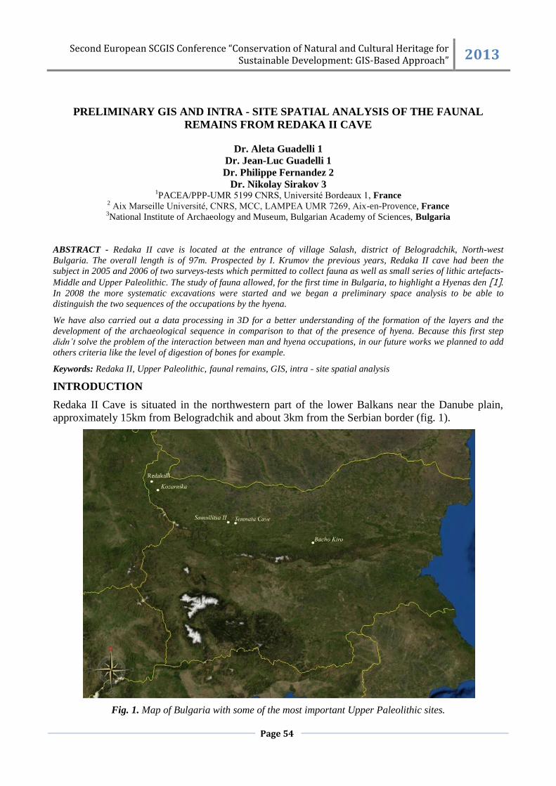
Redaka II Cave is situated in the northwestern part of the lower Balkans near the Danube plain,
approximately 15km from Belogradchik and about 3km from the Serbian border (fig. 1).
Fig. 1. Map of Bulgaria with some of the most important Upper Paleolithic sites.
Second European SCGIS Conference “Conservation of Natural and Cultural Heritage for Sustainable Development: GIS-Based Approach” 2013
Page 55
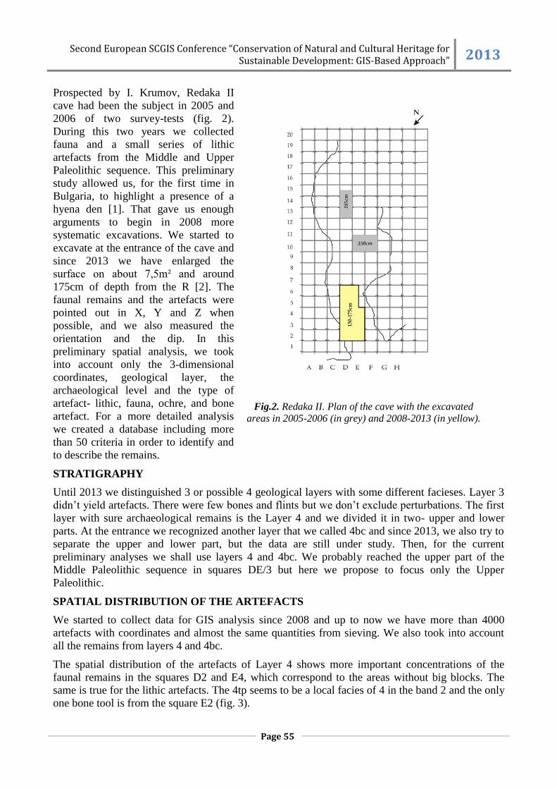
Prospected by I. Krumov, Redaka II
cave had been the subject in 2005 and
2006 of two survey-tests (fig. 2).
During this two years we collected
fauna and a small series of lithic
artefacts from the Middle and Upper
Paleolithic sequence. This preliminary
study allowed us, for the first time in
Bulgaria, to highlight a presence of a
hyena den [1]. That gave us enough
arguments to begin in 2008 more
systematic excavations. We started to
excavate at the entrance of the cave and
since 2013 we have enlarged the
surface on about 7,5m² and around
175cm of depth from the R [2]. The
faunal remains and the artefacts were
pointed out in X, Y and Z when
possible, and we also measured the
orientation and the dip. In this
preliminary spatial analysis, we took
into account only the 3-dimensional
coordinates, geological layer, the
archaeological level and the type of
artefact- lithic, fauna, ochre, and bone
artefact. For a more detailed analysis
we created a database including more
than 50 criteria in order to identify and
to describe the remains.
Fig.2. Redaka II. Plan of the cave with the excavated
areas in 2005-2006 (in grey) and 2008-2013 (in yellow).
STRATIGRAPHY
Until 2013 we distinguished 3 or possible 4 geological layers with some different facieses. Layer 3
didn’t yield artefacts. There were few bones and flints but we don’t exclude perturbations. The first
layer with sure archaeological remains is the Layer 4 and we divided it in two- upper and lower
parts. At the entrance we recognized another layer that we called 4bc and since 2013, we also try to
separate the upper and lower part, but the data are still under study. Then, for the current
preliminary analyses we shall use layers 4 and 4bc. We probably reached the upper part of the
Middle Paleolithic sequence in squares DE/3 but here we propose to focus only the Upper
Paleolithic.
SPATIAL DISTRIBUTION OF THE ARTEFACTS
We started to collect data for GIS analysis since 2008 and up to now we have more than 4000
artefacts with coordinates and almost the same quantities from sieving. We also took into account
all the remains from layers 4 and 4bc.
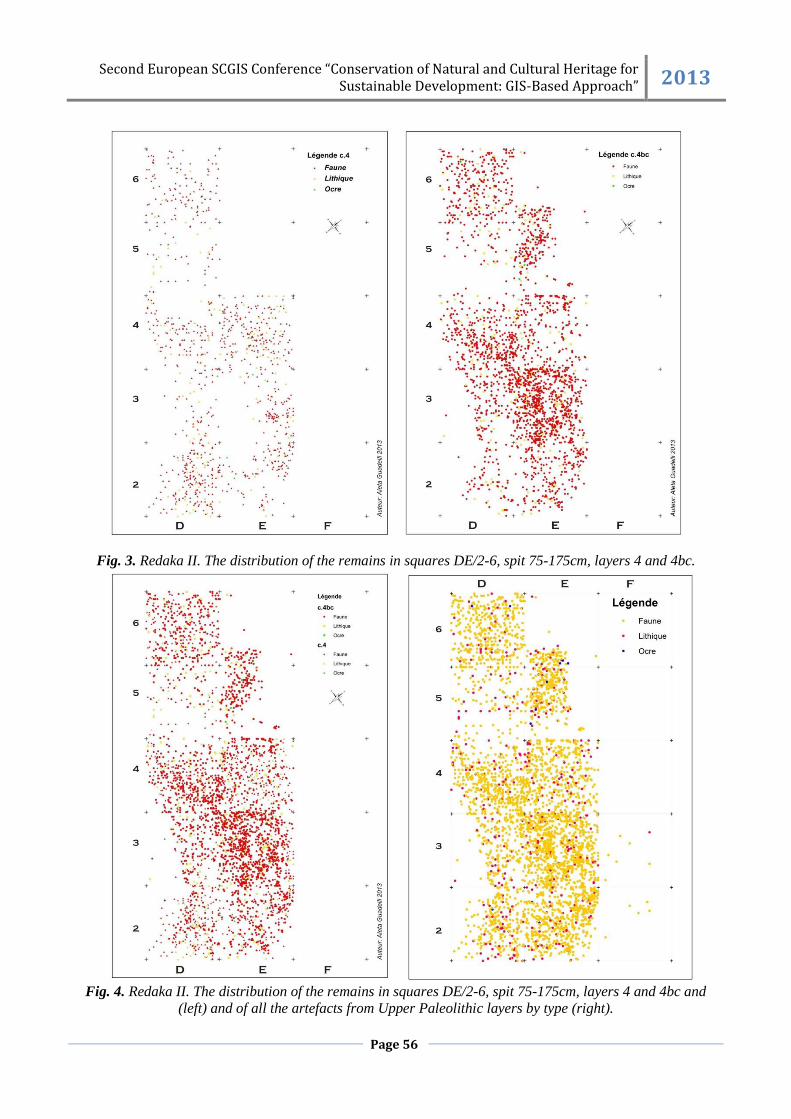
The spatial distribution of the artefacts of Layer 4 shows more important concentrations of the
faunal remains in the squares D2 and E4, which correspond to the areas without big blocks. The
same is true for the lithic artefacts. The 4tp seems to be a local facies of 4 in the band 2 and the only
one bone tool is from the square E2 (fig. 3).
Second European SCGIS Conference “Conservation of Natural and Cultural Heritage for Sustainable Development: GIS-Based Approach” 2013
Page 56
Fig. 3. Redaka II. The distribution of the remains in squares DE/2-6, spit 75-175cm, layers 4 and 4bc.
Fig. 4. Redaka II. The distribution of the remains in squares DE/2-6, spit 75-175cm, layers 4 and 4bc and
(left) and of all the artefacts from Upper Paleolithic layers by type (right).
Second European SCGIS Conference “Conservation of Natural and Cultural Heritage for Sustainable Development: GIS-Based Approach” 2013
Page 57
In the facies 4bc artefacts are very numerous (fig. 4). We observed a high concentration of the
faunal remains in E3 and D4 and less in E2, E6, E4 and D6. Here, on the contrary of layer 4, the
concentrations are not dependent of the limestone blocks but seem to be related to the fireplaces.
The lithic artefacts are dispersed without any concentrations and we didn't observe any connections
with fireplaces. In the future analyses we'll check out if there are some tendencies for the
distribution depending of the typological groups. In 2013 we found only few ochre fragments and
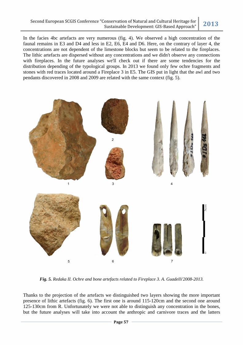
stones with red traces located around a Fireplace 3 in E5. The GIS put in light that the awl and two
pendants discovered in 2008 and 2009 are related with the same context (fig. 5).
Fig. 5. Redaka II. Ochre and bone artefacts related to Fireplace 3. A. Guadelli'2008-2013.
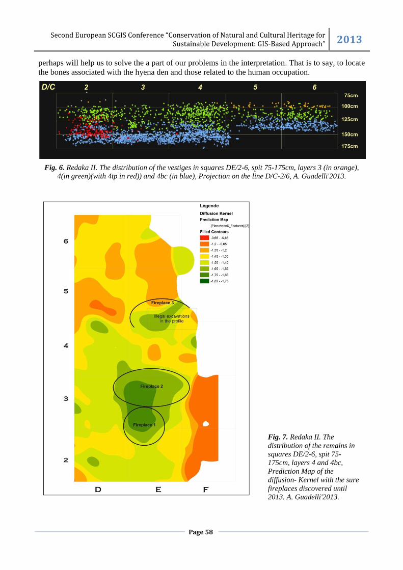
Thanks to the projection of the artefacts we distinguished two layers showing the more important
presence of lithic artefacts (fig. 6). The first one is around 115-120cm and the second one around
125-130cm from R. Unfortunately we were not able to distinguish any concentration in the bones,
but the future analyses will take into account the anthropic and carnivore traces and the latters
Second European SCGIS Conference “Conservation of Natural and Cultural Heritage for Sustainable Development: GIS-Based Approach” 2013
Page 58
perhaps will help us to solve the a part of our problems in the interpretation. That is to say, to locate
the bones associated with the hyena den and those related to the human occupation.
Fig. 6. Redaka II. The distribution of the vestiges in squares DE/2-6, spit 75-175cm, layers 3 (in orange),
4(in green)(with 4tp in red)) and 4bc (in blue), Projection on the line D/C-2/6, A. Guadelli'2013.
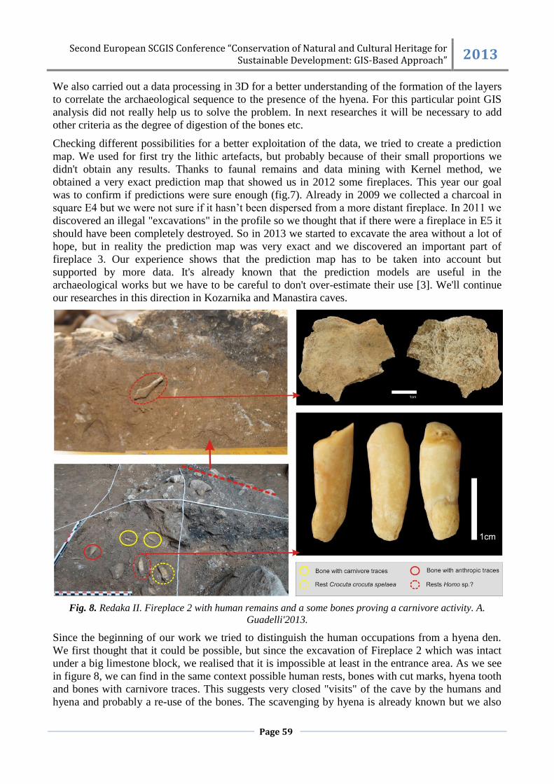
Fig. 7. Redaka II. The
distribution of the remains in
squares DE/2-6, spit 75-
175cm, layers 4 and 4bc,
Prediction Map of the
diffusion- Kernel with the sure
fireplaces discovered until
2013. A. Guadelli'2013.
Second European SCGIS Conference “Conservation of Natural and Cultural Heritage for Sustainable Development: GIS-Based Approach” 2013
Page 59
We also carried out a data processing in 3D for a better understanding of the formation of the layers
to correlate the archaeological sequence to the presence of the hyena. For this particular point GIS
analysis did not really help us to solve the problem. In next researches it will be necessary to add
other criteria as the degree of digestion of the bones etc.
Checking different possibilities for a better exploitation of the data, we tried to create a prediction
map. We used for first try the lithic artefacts, but probably because of their small proportions we
didn't obtain any results. Thanks to faunal remains and data mining with Kernel method, we
obtained a very exact prediction map that showed us in 2012 some fireplaces. This year our goal
was to confirm if predictions were sure enough (fig.7). Already in 2009 we collected a charcoal in
square E4 but we were not sure if it hasn’t been dispersed from a more distant fireplace. In 2011 we
discovered an illegal "excavations" in the profile so we thought that if there were a fireplace in E5 it
should have been completely destroyed. So in 2013 we started to excavate the area without a lot of
hope, but in reality the prediction map was very exact and we discovered an important part of
fireplace 3. Our experience shows that the prediction map has to be taken into account but
supported by more data. It's already known that the prediction models are useful in the
archaeological works but we have to be careful to don't over-estimate their use [3]. We'll continue
our researches in this direction in Kozarnika and Manastira caves.
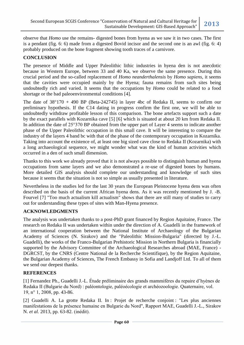
Fig. 8. Redaka II. Fireplace 2 with human remains and a some bones proving a carnivore activity. A.
Guadelli'2013.
Since the beginning of our work we tried to distinguish the human occupations from a hyena den.
We first thought that it could be possible, but since the excavation of Fireplace 2 which was intact
under a big limestone block, we realised that it is impossible at least in the entrance area. As we see
in figure 8, we can find in the same context possible human rests, bones with cut marks, hyena tooth
and bones with carnivore traces. This suggests very closed "visits" of the cave by the humans and
hyena and probably a re-use of the bones. The scavenging by hyena is already known but we also
Second European SCGIS Conference “Conservation of Natural and Cultural Heritage for Sustainable Development: GIS-Based Approach” 2013
Page 60
observe that Homo use the remains- digested bones from hyena as we saw it in two cases. The first
is a pendant (fig. 6: 6) made from a digested Bovid incisor and the second one is an awl (fig. 6: 4)
probably produced on the bone fragment showing tooth traces of a carnivore.
CONCLUSION
The presence of Middle and Upper Paleolithic lithic industries in hyena den is not anecdotic
because in Western Europe, between 33 and 40 Ka, we observe the same presence. During this
crucial period and the so-called replacement of Homo neanderthalensis by Homo sapiens, it seems
that the cavities were occupied mainly by the Hyena; fauna remains from such sites being
undoubtedly rich and varied. It seems that the occupations by Homo could be related to a food
shortage or the bad paleoenvironmental conditions [4].
The date of 38°170 + 490 BP (Beta-242745) in layer 4bc of Redaka II, seems to confirm our
preliminary hypothesis. If the C14 dating in progress confirm the first one, we will be able to
undoubtedly withdraw profitable lesson of this comparison. The bone artefacts support such a date
by the exact parallels with Kozarnika cave [5] [6] which is situated at about 20 km from Redaka II.
In addition the date of 25°370 BP obtained from the upper part of Layer 4 seems to indicate another
phase of the Upper Paleolithic occupation in this small cave. It will be interesting to compare the
industry of the layers 4 band bc with that of the phase of the contemporary occupation in Kozarnika.
Taking into account the existence of, at least one big sized cave close to Redaka II (Kozarnika) with
a long archaeological sequence, we might wonder what was the kind of human activities which
occurred in a den of such small dimension.
Thanks to this work we already proved that it is not always possible to distinguish human and hyena
occupations from same layers and we also demonstrated a re-use of digested bones by humans.
More detailed GIS analysis should complete our understanding and knowledge of such sites
because it seems that the situation is not so simple as usually presented in literature.
Nevertheless in the studies led for the last 30 years the European Pleistocene hyena dens was often
described on the basis of the current African hyena dens. As it was recently mentioned by J. -B.
Fourvel [7] "Too much actualism kill actualism" shows that there are still many of studies to carry
out for understanding these types of sites with Man-Hyena presence.
ACKNOWLEDGMENTS
The analysis was undertaken thanks to a post-PhD grant financed by Region Aquitaine, France. The
research on Redaka II was undertaken within under the direction of A. Guadelli in the framework of
an international cooperation between the National Institute of Archaeology of the Bulgarian
Academy of Sciences (N. Sirakov) and the "Paleolithic Mission-Bulgaria" (directed by J.-L.
Guadelli), the works of the Franco-Bulgarian Prehistoric Mission in Northern Bulgaria is financially
supported by the Advisory Committee of the Archaeological Researches abroad (MAE, France) -
DGRCST, by the CNRS (Centre National de la Recherche Scientifique), by the Region Aquitaine,
the Bulgarian Academy of Sciences, The French Embassy in Sofia and Landjoff Ltd. To all of them
we send our deepest thanks.
REFERENCES
[1] Fernandez Ph., Guadelli J.-L. Étude préliminaire des grands mammifères du repaire d’hyènes de
Redaka II (Bulgarie du Nord) : paléontologie, paléoécologie et archéozoologie. Quaternaire, vol.
19, n° 1, 2008, pp. 43-86.
[2] Guadelli A. La grotte Redaka II. In : Projet de recherche conjoint : "Les plus anciennes
manifestations de la présence humaine en Bulgarie du Nord", Rapport MAE, Guadelli J.-L., Sirakov
N. et al. 2013, pp. 63-82. (inédit).
Second European SCGIS Conference “Conservation of Natural and Cultural Heritage for Sustainable Development: GIS-Based Approach” 2013
Page 61
[3] Banks W.E., Antunes N., Rigaud S., d'Errico F. Ecological constraints on the first prehistoric
farmers in Europe. Journal of Archaeological Science 40, 2013, pp. 2746–2753.
[4] Guadelli A., Guadelli J.-L.,Sirakov N. La grotte Redaka II. Conclusion et perspectives. In:
Projet de recherche conjoint : "Les plus anciennes manifestations de la présence humaine en
Bulgarie du Nord", Rapport MAEE, Guadelli J.-L., Sirakov N. et al. 2013, pp. 80-81. (inédit).
[5] Гуадели А. Костни артефакти от палеолита в България. Дисертации 6, Вагалински Л.
(ред.), НАИМ-БАН, София, 2011, p. 288.
[6] Sirakov N., Guadelli J.-L., Ivanova S., Sirakova S., Boudadi-Maligne M., Dimitrova I.,
Fernandez Ph., Ferrier C., Guadelli A., Iordanova D., Iordanova N., Kovatcheva M., Krumov I.,
Leblanc J.-Cl., Miteva V., Popov V., Spassov R., Taneva S., Tsanova T. An ancient continuous
human presence in the Balkans and the beginnings of the settlement of western Eurasia. The Lower
Pleistocene example of Lower Palaeolithic in Kozarnika cave (Northwestern Bulgaria). Quaternary
International 223-224, 2010, pp. 94-106.
[7] Fourvel J.-B. Hyénidés modernes et fossiles d'Europe et d'Afrique: taphonomie comparée de
leurs assemblages osseux, Thèse de Doctorat, Université de Toulouse-Le Mirail, 2012, p. 609.