Prague, Wroclaw and Krakow: Public and Private Space at the Time of the Medieval Transition
182
WRATISLAVIA ANTIQUA 19 Jerzy Piekalski PRAGUE, WROCŁAW AND KRAKOW: PUBLIC AND PRIVATE SPACE AT THE TIME OF THE MEDIEVAL TRANSITION
Transcript of Prague, Wroclaw and Krakow: Public and Private Space at the Time of the Medieval Transition

WRATISLAVIA ANTIQUA 19
Jerzy Piekalski
PRAGUE, WROCŁAW AND KRAKOW: PUBLIC AND PRIVATE SPACE AT THE TIME
OF THE MEDIEVAL TRANSITION
ZESPÓŁ DO BADAŃ ŚREDNIOWIECZNEGO I NOWOŻYTNEGO WROCŁAWIA RESEARCH TEAM FOR STUDIES ON MEDIEVAL AND EARLY MODERN
WROCŁAW
WRATISLAVIA ANTIQUASTUDIA Z DZIEJÓW WROCŁAWIA
STUDIES ON THE HISTORY OF WROCŁAW
19Edited by
Krzysztof WachowskiJan Klápště
Stefan KrabathMarta Młynarska-Kaletynowa
Jerzy Piekalski

UNIVERSITY OF WROCŁAWInstitute of Archaeology
Jerzy Piekalski
PRAGUE, WROCŁAW AND KRAKOW: PUBLIC AND PRIVATE SPACE
AT THE TIME OF THE MEDIEVAL TRANSITION
WROCŁAW 2014

4
Reviewed by: Jan KlápštěTranslation from Polish: Anna Kinecka
Proofreading: Agnes KerriganEditing: Karol BykowskiLayout: Marek J. Battek
Cover design: Barbara KaczmarekCover illustration:
Wrocław in 1562 r., Weiner’s planaccording to reproduction by J. Partsch from 1826.
(after: Wrocław na planach XVI–XX wiek, Wrocław 1999)
ISBN 978-83-61416-13-5
University of WrocławInstitute of Archaeology
This book was published with th financial support of the Faculty of Historical and Pedagogical Sciences
University of Wrocław
© Copyright by Uniwersytet Wrocławski(University of Wrocław) and author, Wrocław 2014
Print and bound: Wrocławska Drukarnia Naukowa PAN
im. St. Kulczyńskiego, Sp. z o.o. 53-505 Wrocław, 4 J. Lelewela St.

5
SPIS TREŚCI
I. Introduction ....................................................................................................................................... 7
II. The origins of pre-incorporation proto-urban centres in East Central Europe .................................. 13 1. The definition of a medieval town................................................................................................ 13 2. The problem of pre-incorporation proto-urban centres in East Central Europe ........................... 17 a. Prague ....................................................................................................................................... 18 b. Wrocław ................................................................................................................................... 31 c. Krakow ...................................................................................................................................... 40 3. Main features of proto-towns of the inner zone of East Central Europe ...................................... 45
III. Incorporated towns ............................................................................................................................ 49 1. The question of incorporation and the new structure of towns ...................................................... 49 a. Prague ....................................................................................................................................... 50 b. Wrocław ................................................................................................................................... 54 c. Krakow ...................................................................................................................................... 63 2. The principal features of the transition ......................................................................................... 68
IV. Organization of the burgage plot space ............................................................................................ 73
V. The house ........................................................................................................................................... 91 1. Merchant’s and craftsmen’s houses in the western zone of Central Europe, 11th-12th century. . 91 2. Timber and stone houses of Prague .............................................................................................. 104 3. Early houses of Wrocław ............................................................................................................. 116 4. Houses of Krakow ........................................................................................................................ 129
VI. Sanitation and street surface construction ......................................................................................... 139
VII. Prague, Wrocław and Krakow – the towns of new Europe. Conclusion .......................................... 155
Bibliography ........................................................................................................................................... 161


7
I. INTRODUCTION
We live in an industrialized world so our fasci-nation with towns must come from our conviction that towns have played a major role in the building of civilizations. So much so that according to some researchers, there can be no sustained progress without an organized group of people living within a limited space and pursuing a non-agrarian econo-my (Weber 1920/21; Benevolo 1971; Ennen 1988). As it continued developing, a town would evolve in its outlook adjusting to new needs and circumstanc-es. For us, towns of the Middle Ages are ‘towns of that time’ and we would be greatly deceived if we assessed them with the criteria of our age. There is general consensus that a town can be built and ex-ist only within a suitably developed economic and cultural space. A town never stands alone without the right hinterland it will cease developing, descend into stagnation or decline (e.g. Sombart 1907, 3; Ennen 1987, 638–639; Samsonowicz 1986, 5; Klápště 2012, 325–457). Thus, a town can only be created when the social and economic substratum is suitably prepared. In the cultural formation that was characteristic of Europe’s Latin West, a legally sanctioned affiliation to an urban community tendedto be a mark of distinction and a guarantee of rela-tive social safety. Town communes and an urban mode of life moulded the mentality of the European middle classes from the Medieval period until the Industrial Age.
Towns have an identity of their own. This is something worth stressing and cultivating, es-pecially in our age of globalization, which is for numerous reasons, useful and inevitable, but also has quite a few unwelcome consequences. One of them is the loss of cultural self- identification. Themedieval past of Prague, Wrocław and Krakow has a significant impact on the appearance of thesecities and the way they function, and not less so, on the region for which they continue to be the
central settlement (Fig. 1). Their most attractive districts developed in the period from the 12th to 14th century and produced the spatial layout that is preserved to this day. They continue to serve the broad spectrum of functions of a city centre – from administrative to recreational. Each of these towns has some individual features while sharing some similarities – the result of their development in the same civilization zone.
The aim of this book is to add a voice to the discussion on the medieval urbanisation of East Central Europe and the changes in lifestyle ex-pressed in the new organization of urban space, private property and living conditions. As a starting point, we adopted the assumption that life in towns had special circumstances, different from standards typical of rural settlements and elite establishments. Urban life may be said to have had two rhythms that were separate but interlocked in the public and the private space. Both these spheres were necessary to sustain the urban lifestyle, reconciling the interests of the commune, economic goals and private life. Prague, Wrocław and Krakow, major urban centres in Bohemia, Silesia and Lesser Poland, were chosen because they best illustrate the cultural turnaround noted in East Central Europe during the High Mid-dle Ages. This was not the first critical period in thehistory of this part of the continent. Three centuries earlier the region was swept by political and social transformation when tribal structures were replaced by state structures, and the Christian religion was adopted in the western rite. In contrast to these de-velopments, the transformation of the 13th century was not political. Its foundation was the adoption of a new economic model, its main driving force – an influx of colonists from the West. It is no accidentthat this process has been referred to as commer-cialization (Gawlas 2006; McCormick 2007). Using

8
I. INTRODUCTION
this approach, the transformation of central European proto-towns into communal towns was mainly a proc-ess of their adaptation to new economic challenges. The laws and the structure of towns were adjusted to them too. The chronology of this book is definedby the time of this transformation. We cannot specify its exact dates but the first evidence of change maybe observed during the 12th century, its intensifica-tion in the 13th century and the consolidation of new structures in the 14th century (Klápště 1994).
Also addressed in this study are several specificthemes and questions such as the relationship of early medieval proto-towns to the legally regulated towns of the High Middle Ages, the progress of incorpora-tion, the organization of the burgage plot etc. Another essential question relates to the origins of the town house in East Central Europe. To what extent was it a phenomenon transplanted from the West, and to what extent did it take form in the region, as a merchant’s house in a proto-urban centre, conditioned by local needs? Also presented are a number of insights into the emerging infrastructure – the techniques and facilities associated with communication and waste disposal. Finally, some local and cross-regional fea-tures are examined to identify elements that Prague, Wrocław and Krakow have in common and those that are discrete.
The material used in completing this work is medieval archaeology and methods appropriate to this discipline. Consequently, our inferences derive
from the analysis of the material record obtained through excavation. Certainly, the author is aware that the study of medieval towns extends beyond the scope of the interest and methodological potential of a single branch of research. We have to make use of left bank findings contributed by researchers whosework is within other disciplines: history sensu stricto, history of architecture and art history, legal history and ethnology. Let us also add that the borderline between archaeology, architectural history and urban planning is fluid, understood variously in differentcountries and research communities. We assume that the object of our study is held in common, despite differences in the way we understand numerous is-sues. The history of towns, their structure and urban lifestyle is compatible with the subject of the daily life of medieval man that all these disciplines address. It may be understood as an attempt to describe man by making an analysis of his immediate material surroundings. These questions may be accessed by all of the disciplines named earlier through an ar-ray of sources, which range from the written record through iconographical representations to surviving material remains contained in functioning buildings and in cultural deposits. Because of the fragmentation of the record, none of these disciplines can hope to achieve the expected results by relying only on the method that is appropriate to it. Nevertheless, we can get a perspective that is closer to the bygone reality through discussion and by corroborating the results
Fig. 1. Prague, Wrocław and Krakow within the network of urban centres of the Central European inner zone. Main trade routes according to Myśliwski 2009, with author’s additions. Drawing N. Lenkow

9
I. INTRODUCTION
contributed by individual areas of research (Le Goff 1990; Schreg 2001, 333–334). In effect, this means that the author does not propose to make an independ-ent analysis of the written record; however, he shall make use of the published interpretations contributed by historians.
Studies focused on Prague, Wrocław and Krakow are but a small fraction of the vast field of researchthat covers the history of medieval and modern towns. To remove the analysis of these centres from the totality of urban studies is to substantially limit our perspective but this must be done if we are to investigate their individual character. At the same time, in undertaking to describe these three towns, we have to be aware that they were a part of a larger whole – the network of towns of Europe’s Latin West evolved as a result of a complex, socially and economically conditioned urbanization process. It would be equally helpful, and no less interesting, to examine features shared by Prague, Nuremberg and Regensburg, or alternatively by Krakow, Toruń and Gdańsk. We have chosen Krakow, Prague and Wrocław because they were part of the same econom-ic set of connections within the Sudetes-Carpathians zone and share a number of historical themes, such as being under the governance, at one time or other, of Přemyslid, Piast, Luxembourg, Habsburg and Jagiel-lonian rulers and, possibly most notably, because of their demography, the result mostly of a process of migration described in literature as eastward coloni-sation (Higounet 1990; Kejř 1998; Gawlas 2003). In addition, and not without importance in this choice is the fact that the author has substantial experience from archaeological investigations undertaken in Wrocław and from his exchanges with archaeologists working in Krakow and Prague.
The principal part of the existing contribution to the study of Central European medieval towns, including the centres of most interest to us here is from historians (Hoffmann 1992; Wyrozumski 1992; Goliński 1997; Manikowska 2001; Rajman 2004; Duchhardt and Reininghaus 2005; Czaja 2005). At present, there is no longer a need to justify the claim that without input from other medieval researchers our knowledge of this subject would be incomplete, distorted even. A full account of the past progress of historical and archaeological research on Krakow, Prague and Wrocław would not be useful in this book, especially as I have presented the contribution of general historians, architectural historians and archaeologists in my earlier works, and in a wider context too (Piekalski 1999; 2001; 2004). I hope it is enough if I focus on the more relevant issues of the
research on Prague, Wrocław and Krakow that have become available over the last several years. The reader will find references to these earlier works inthe relevant publications.
Recent years have brought many new archaeologi-cal discoveries that have enriched, but also altered our earlier understanding of medieval towns and their inhabitants. Many of these findings have not beenpublished to-date. Nevertheless, we can say that the lively debate on their subject has been quite produc-tive. Some important phenomena can now be placed in a new historical context. We need to revisit issues such as information flow, commercial contacts andmigrations between the western and eastern region of Central Europe in the 12th–14th century. In light of the new evidence, the legal and social transformation and the commercialization of the economic systems of Prague, Wrocław and Krakow appear to be earlier and more intense than previously thought. We need to reassess the phenomenon traditionally described as establishing a town and known to researchers in our region as incorporation. The question arises whether the purpose of town privileges granted during the 13th century was always to stimulate the economy, or rather, was this fiscal regulation and a change to thesystem of control over an independently unfolding intensive process of urbanization. The new findingson chronology lead us to claim that the influx ofmerchants and craftsmen from the West to the East is evident in at least some centres, prior to the constitu-tion of the town communes in a legal sense.
The status of the archaeological studies of Prague corresponds with the size of that city and its signifi-cance in the history of Central Europe. Systematic and well-organized heritage preservation is being rewarded by the regular recording of discoveries and their scientific evaluation. Due to them we know theextent, structure and character of the built environ-ment below Prague Castle (Ježek and Klápště 2001; Čiháková and Havrda 2008; Čiháková and Müller 2008). Moreover, we can partially reconstruct its street system and the techniques used to protect their surfaces (Cymbalak and Podliska 2011). We have a relatively wide range of information about the town on the right bank of the Vltava River during both of its development phases – the proto-urban and the communal. Due to the research of Ladislav Hrdlička, we have a grasp of the original topography of the town and of the stratigraphy of deposits between the Vltava crossing and Tyn Court which closes off Prague’s main market place from the east (Hrdlička 2000, 2001, 2005). The economic base of the early town has been discussed at length (Podliska and

10
I. INTRODUCTION
Zavřel 2006; Podliska 2008; Ježek 2011). The famous Romanesque houses of Prague have now been pro-vided with a proper source publication (Dragoun et al. 2003). Less well understood are the structure of the burgage plots and the town’s level of sanitation. An archaeological excavation carried out between 2003–2006 in Náměsti Republiky Square (Juřina et al. 2009; Vyšohlid 2011) covered two hectares of the New Town in a zone occupied by a proto-urban settlement since the 12th century, but left outside the boundary of the incorporated town. A vast collection of diverse small finds was recovered which were ofmajor significance for the study of medieval struc-tures. Some data was made available for discussion and the rest awaits analysis. A good starting point for the future discussion of the rhythm of change in Prague and other Czech towns are the comprehensive works by Jan Klápště (2012, 325–457). An unques-tioned contribution to the progress of Central Euro-pean urban medieval archaeology made by Moravian and Czech archaeologists is the Forum Urbes Medii Aevi cycle of conferences, documented through a publication series, which publishes sources, inter-pretations and discussions (FUMA 2004–2012).
What are the current trends in the analysis and discussion on the medieval past of Wrocław and what does archaeology have to contribute to them? Having formulated our question in this way we wish to note that the research of the last decade has been built upon earlier studies. In Wrocław, an evident watershed in the development of urban archaeology is marked by the early 1990s. Construction projects undertaken at the time ran concurrently with a major intensification of archaeological rescue excavation,which has continued to this day. The exponential increase in the volume of new evidence stimulated analysis, discussion and cross-regional comparative studies. It also fuelled debate on many key subjects and helped to identify new research themes. It bore fruit in the form of the first monographic analysis ofthe burgage plot (Buśko and Piekalski eds. 1999), and a wide-ranging body of evidence on the Rynek – the main market square of the incorporated town (Bresch, Buśko and Lasota 2001; Bresch, Lasota and Piekalski 2002). However, some technical and organizational problems appeared too, resulting from the surfeit of new materials in need of urgent conservation and analysis. Much of this newly secured evidence is still unpublished, and consequently, still omitted from the discussion. When archaeological work was brought onto a construction site and became a commercial enterprise the quality of a large part of the conducted research suffered.
Nevertheless, we can say that substantial progress in archaeological excavation work has made it pos-sible to put into effect a wide-ranging and reason-ably organized programme of research. Generally speaking, its aim is to use archaeological methods and the archaeological record in the study of the town’s past to understand it as a whole, which makes this research a segment of an interdisciplinary one. Emphasis is placed on reconstructing the structure of the medieval town and the dynamics of the changes in the built environment, on tracing the growth of infrastructure and town fortifications, on improvingour understanding of craft production and living conditions. The main source for analysing the latter topic is small finds. What makes Wrocław one of thebest archaeologically investigated towns of Central Europe is not so much the archaeological excavations but to the stages that followed upon them – the post-excavation analysis of the excavated archaeological record, analysis and organized discussions during meetings, lectures and a relatively wide circulation of the research results through scholarly and popu-lar-science publications and museum exhibitions. We owe our present level of understanding to the efforts of archaeologists and researchers from related disciplines made over the last few decades. As is the nature of these endeavours, they were usually a team effort.
The groundbreaking studies of the proto-urban settlement on the left bank of the Odra undertaken by Józef Kaźmierczyk (1966–1970) were continued by Cezary Buśko (2005). His team, guided by insight ob-tained from linear trenches dug to install underground infrastructure in the eastern area of the Old Town, confirmed the earlier interpretation of this area as anartisan’s settlement and proposed some corrections to its dating. The next stage of investigation took place in 2010–2012 and covered an extensive area of 40,000 m2 in Nowy Targ Square. It was carried out by a team of archaeologists from the University of Wrocław. Provisional conclusions drawn from this excavation allow us to make a further revision of earlier deductions and were used, to some extent, in the present work.
The debate on the structure of the incorporated town and its early development has changed direction in recent years. The place of the statistical method of study of the cadastral town plan of the regularly laid out part of the town has been replaced by analysis of the actual material remains of the oldest built en-vironment found in the burgage plots (Lasota 2002; Chorowska and Lasota 2010). In consequence, our perspective on the built environment of the incor-

11
I. INTRODUCTION
porated town has changed. At present, it is thought, more realistically than in the older literature, that it developed over several stages, over time, rather than as part of a single act. The burgage plot differed in its appearance depending on its location within the town and the prosperity of its owner – this was ar-gued convincingly by Paweł Konczewski in his study (2007), the result of painstaking analysis of confus-ing input from rescue excavations carried out in the south-eastern area of the incorporated town. The plots described by him present a reality different from the one known to us from the Market Square (Rynek) and its environs (Chorowska et al. 2012).
The streets of the Old Town in Wrocław had been studied for a long time (Kaźmierczyk 1966–1970; Buśko 1997; 1999a) but there was a rapid accelera-tion after 2000. The underground grid was replaced under the streets and this exposed a several kilometre long section through the medieval deposits and the sequence of street paving structures. Most essential in this respect were the investigations in Kiełbaśnicza, Szewska and Wita Stwosza streets, which were ele-ments of the regular town plan. Next to the informa-tion about the methods used to consolidate and repair the streets, this research resulted in a large body of small finds which were later used to analyse the typi-cal behaviour in a public urban space (Piekalski and Wachowski 2010).
These studies of medieval Wrocław are described in a separate publication series called ‘Wratislavia Antiqua’. Since 1999 seventeen volumes have been published which present the excavated material record, its analytical results, papers from confer-ences held, and monographic studies (Wachowski 1999–2013), e.g. of medieval glass (Biszkont 2005), weapons (Marek 2008), cemeteries (Wachowski 2010), and the water supply and waste disposal systems (Cembrzyński 2011). Issues central to the study of medieval Wrocław are being presented in succession at colloquia on the archaeology of Hanseatic towns organized by the conservation authority in Lübeck (Piekalski 2004, 2006, 2008; Konczewski, Mruczek and Piekalski 2010; Piekalski and Wachowski 2012).
Krakow, similar to Prague but in contrast to Wrocław, is a city fortunate to have escaped destruc-tion during World War II. As a result, it has its own rhythm of archaeological and architectural investiga-tion, which was not driven by the need to excavate in the ruins or in vacant lots left by demolished build-ings. Greater insight into the structure of medieval houses only occurred in the 1980s in connection with projects concerned with the restoration of historic
architecture. The last decade in particular has seen a substantial revival of research activity in Krakow in the wake of repairs and adaptations made to the cellars of townhouses of the Old Town (referred to in Krakow as Śródmieście, or ‘town centre’) adjust-ing them to businesses, mostly associated with the food and drink industry. Moreover, an extensive renovation of the Main Market Square was carried out accompanied by a widescale archaeological investigation (Firlet 2010). This was not the firstexcavation undertaken in the city’s principal square. Kazimierz Radwański (1975, 1995) and Emil Zaitz (2010, 203–210) have reviewed the long history of past research and conservation projects. Neverthe-less, their scope was small and they never went beyond the basic, source-critical stage of research. Current views and the progress of discussion of the medieval urban historians of Krakow were pre-sented in an individual monograph by Jerzy Rajman (2004). A wider selection of views is given in an interdisciplinary tome edited by Jerzy Wyrozumski (2007). A new contribution to the discussion about the development of the ‘new towns’ of Krakow was presented by Marek Słoń in his monograph on double and multiple towns (2010, 288–306).
A general view of the structure of Krakow’s proto-town was reconstructed using evidence from numer-ous small area and sondage excavations undertaken in different parts of the city. The interpretation provided at the time was that the early agglomeration had four zones of settlement (Radwański 1975) and these were the stronghold in Wawel (zone I), the suburbium of Okół to the north of it (zone II), the area to the north of the suburbium settled during the 11th and 12th century (zone III) and the agricultural settlements and the convent of the Premonstratensian nuns in Zwierzyniec. Studies carried out in the Main Market Square, pursued with some interruption during the first decade of the 21st century, resulted in somecrucial adjustments to this image. Most notably, they improved our understanding of zone III by adding the extensive graveyard found there to the archaeological record (Myszka 2003, 121–144; Głowa 2010), which was later occupied by an ironworking settlement (Buśko and Głowa 2010).
The current findings from the study of the struc-ture of the incorporated town rely, in the main, on the theoretical study made by Bogusław Krasnowolski (2004, 88–136). His scrupulous analysis of measure-ments led him to reconstruct the plan of the town designed by surveyors, vogts and Duke Bolesław the Chaste at the time of the 1257 incorporation. We may conclude that this project was put into effect almost
12
I. INTRODUCTION
fully. Studies of the layout of the plots within blocks of buildings and their early transformation were also undertaken, also based mainly on the measurement method without sufficient understanding of the old-est boundary walls (Łukacz 1999). Nevertheless, the findings made using this method are apparentlybeing confirmed by architectural studies carried outin townhouse cellars.
A key development for understanding the origins of the townhouses of Krakow was inventory work undertaken on the former Hungarian Dormitory (Bursa Węgierska) on 3/5 Bracka Street and the discovery within its remains of a residential tower dating to the 13th century. Guided by the results from the analysis of this structure, Waldemar Komorowski and Marek Łukacz rejected as inaccurate results from a search for the oldest town buildings made earlier (Komorowski and Łukacz 1985; Komorowski 1997). At the same time, a new stage was started to identify town houses from the 13th/14th century compatible in their workmanship to the features of the tower on Bracka Street. The results of studies carried out since then have been presented in a number of publications illustrating the already significant level of under-standing of the origins of the houses of Krakow’s merchants (Komorowski 2000; Cechosz and Holcer 2006, 2007; Łukacz 2010, 2011; Sławiński 2010; Komorowski and Opaliński 2011).
Quite concentrated research undertaken during the last decade focused on the area of the town occupied from the 15th century adjacent to the University of Krakow (Niemiec 2007; Sławiński 2010, 86–90). This is a section of the western district of the town, near the wall. The area is significant for the under-standing of medieval Krakow because its inhabitants were very mixed socially and ranged from members of the less affluent trades (mainly potters and tan-ners), through Krakow Jews, the noble family of Szczepan Pęcherz to the professors of the university founded by King Władysław Jagiełło (1386–1434).
This book is the result of research, reflection anddiscussion with fellow researchers specialising in the study of the towns of Central Europe. To some extent, it continues themes I have addressed in my earlier publications but my views have been much altered by new archaeological evidence recovered from re-cent excavations carried out in Prague, Krakow and Wrocław. This text was written at the Albert-Ludwig University of Freiburg thanks to the support of the Alexander von Humboldt Foundation and Profes-sor Sebastian Brather, my kind host at the Institut für Archäologische Wissenschaften. I am grateful for their assistance and for that of the first readersof this book – Professor Jan Klápště in Prague, Dr. Dariusz Niemiec in Krakow and Karol Bykowki in Wrocław.

13
Due to the importance of urbanisation and of the prosperity of towns for the progress of civilization at large as stressed earlier, emotional identificationwith towns may at times be more pronounced on the peripheries of medieval Europe where the urbaniza-tion processes unfolded more slowly and less inten-sively. Apparently, this is true not only of the early inhabitants of these towns, but of their modern day investigators too. This is reflected by the discussionon the definition of a town, long in progress in CentralEurope and East Central Europe in particular.
The key difficulty in defining the concept ofa town is the marked variability of the phenomenon in time and space. It evolved across several millen-nia adjusting to changing economic, demographic, legal-political and natural circumstances. Due to this, we cannot hope to present a universal, generally ac-cepted definition of a town. Some experienced urbanresearchers, such as Edith Ennen (1953, 10), deliber-ately choose not to address this question. Others, like Marek Słoń in his recent book on the new towns of Central Europe, have concluded that the discussion about the definition of a town is unproductive. Afterall, everyone can see what a town is like (Słoń 2010, 7–16). Nevertheless, in a study addressing the origins of urbanisation some reflection on the material scopeof the object of analysis is necessary.
In modern research practice many criteria have been used to draw a distinction between towns and other centres of settlement, namely legal status, an urban type of economy, a complex social structure, a religious-ideological function, the presence of
‘urban’ buildings and fortifications. The featurerecognized as obligatory for a town from the earliest age, even the Middle Ages, was the defensive wall, which also served legal and ideological functions and marked the boundary with the surrounding outer area. In addition, there is no doubt that urban space is one that is singled out in a positive way. There are hints to this effect in the 14th-century German law book Sachsenspiegel (cf. Isenmann 1988, 20) and three centuries later, in the Universal Lexicon of Jo-hann Heinrich Zedler (Universallexikon 1774, 769). In most of Europe – the Mediterranean, the north-west, including Great Britain, and in Germany, this criterion is indeed a significant piece of information.However, what are we to do about East Central Eu-rope, and more specifically, modern Polish territory?Here, a good many towns did not have fortifications,or these were built with a delay of up to 200–300 years after the time of incorporation (Widawski 1973, 1977; Samsonowicz 1986, 93). Economic potential, but also the peculiar political situation, did not favour defensive measures in urban projects.
A central feature of a town, one emphasized by all the researchers, is a crafts-and-market economy (cf. e.g. Strahm 1950, 372; Stoob 1956/1970, 20; Irsigler 1983, 84). To claim that a town depends for its existence on the results of an agrarian economy pursued in its hinterland is to strongly underscore this criterion, but at the same time, to simplify the problem (Sombart 1907, 93). In the light of a more recent approach, the nature of urban economy is a corollary of the social division of labour into crafts
II. THE ORIGINS OF PRE-INCORPORATION PROTO-URBAN CENTRES IN EAST CENTRAL EUROPE
Städte schießen wie Pilze aus dem Boden(Carl Haase 1978, 77)
1. THE DEFINITION OF A MEDIEVAL TOWN

14
II. THE ORIGINS OF PRE-INCORPORATION PROTO-URBAN CENTRES IN EAST CENTRAL EUROPE
and commerce on the one hand, and agriculture on the other. Urban markets and the food-producing countryside were mutually complementary, the proc-ess of urbanization largely the result of surplus food production (Krüger 1991, 191; Engel 1995, 10). Let us add that this does not rule out there being some agricultural activity within a town. Urban centres with a purely commerce-and-crafts character were something of an exception. For a dozen-odd percent of late medieval towns on German territory agricul-ture was the mainstay of livelihood and about ¾ of the population were involved, to a limited extent, in crop cultivation and animal husbandry (Isenmann 1988, 22). In Poland, the percentage was higher (Samsonowicz 2002, 13–14). The borderline be-tween the agrarian and non-agrarian economy was hazy, especially in smaller towns. We have to note that some townspeople, who farmed land, so long as they engaged to some extent in commerce or in non-agricultural production, also fulfilled urban functions(Haase 1978, 70–71; Goliński 1991, 172). We do not know the extent of crop farming or animal hus-bandry during the early phases of town development. Nevertheless, the presence, discovered in the course of archaeological fieldwork, of a cultural depositcontaining a significant percentage of manure, leavesno doubt that the breeding and selling of livestock, or at least the keeping it for a time inside a town were common practices.
Another feature of a town is its unique social differentiation. This is manifested by growing pro-fessional specialization and the resulting economic stratification. In some urban centres, a number oftown communes functioned side by side, at times with an ethnically different makeup (Goehrke 1980, 196; Irsigler 1983, 84; Młynarska-Kaletynowa 1986, 51–67; Ennen 1988, 638). According to Fernand Braudel (1979/1992, 408–409) a large town could function only if it had a steady inflow of peoplefrom the outside, who were for the most part, poor and lacking professional training, to form is plebeian stratum. Nevertheless, there were also communities where the dominant role was played by a single professional group, for example, miners’ towns (Schwabenicky 1993; Hrubý 2011).
The next criterion distinguishing medieval towns is legal regulation. In Central Europe, town law was formed in the period of the 12th–13th century in many variants, the most important of them as-sociated with Freiburg am Breisgau, Nuremberg, Brunswick, Lüneburg, Dortmund and Aachen. For East Central Europe the town laws of Lübeck and Magdeburg were of particular importance. Town
rights were granted by the landowner to an existing or an emerging town. They regulated ownership of the land, buildings and the personal freedom of the townspeople. They included market privileges, the organization of commerce and penal law, complete with its implementation (Isenmann 1988, 78, with references; Engel 1993, 38–54). They regulated the relationship not only between the town’s lord and the commune, but also between the town and the surrounding area. Their main element – regulation of payments for the land granted to the commune and from the specifically organized economic activity,had an impact on the regulation of urban space. These payments became the basis for planning the town and its inner divisions. The legally regulated bur-gage plot was adopted as a basic unit in calculating one of the main town taxes (Schich 1993; Goliński 1997, 289–309; Piekalski 2001, 230–238). Contracts between the lord of the town and the commune could be renewed and changed, even in specific matters. Asthey prospered economically, larger towns tended to obtain greater political freedom and military compe-tences. The town law belongs among the key criteria of urban status. However, to recognize it as critical and necessary would be to exclude from the category of urban places all other communities that meet the rest of the criteria obligatory for urban status (Steuer 1995, 89–90; Gawlas 2000, 26–37). Occasionally, it is also problematic to distinguish town rights from village rights in East Central Europe as granted by an act of incorporation. The charter does not always specify whether it relates to a town or to a village organized according to German law. Such a village was given a separate juridical district and the right to land in exchange for rent (Zientara 1976, 88; Piskor-ski 1990/1991, 156–186). To invoke the now classical theory of Max Weber (1920/21) we may conclude that the criterion of legal regulation does distinguish a key stage in the history of development of towns, but not of a town in general. Indeed, it emphasizes the phenomenon in the history of urbanisation such as the towns of western and central Europe of the High and Late Middle Ages and of the modern age.
A town fulfils a religious function that is regulatedby the Church. Relations with the Church are there in every stage of the development of medieval towns. The presence of one or more churches in a town was the rule. Only some mining communities or newly founded towns were without a religious edifice oftheir own and used, for a time, the one in a castle or in the neighbouring village. Ecclesiastical organization in a town was closely allied with the process of its formation and growth. It is often a reflection of the

15
II. THE ORIGINS OF PRE-INCORPORATION PROTO-URBAN CENTRES IN EAST CENTRAL EUROPE
territorial and social polycentrism of towns, not only at the early stage of their development (cf. Blaschke 1987). Not infrequently, the dating of churches con-firms the early development of a town, earlier thanthe legal regulation of the municipal commune. De-velopmental stages of a town may be reflected in thenetwork of monasteries within it or in its immediate vicinity (Steuer 1995, 96; Piekalski 2002). Regard-ing the elements that are useful in confirming urbanstatus we have to note that only serving a religious function is not enough to identify a town and set it apart from other settlement structures. This criterion becomes significant only when the church is onewith a higher status and dominates in the religious organization of the area, in keeping with the theory of central places (Cristaller 1933; Meynen 1979). In a town of the High and Late Middle Ages all becomes clear – the parish church is the key factor unifying a municipal commune.
An essential criterion in separating a town from other settlement structures is distinctive spatial or-ganization. A town is supposed to be a settlement centre with a major cluster of buildings in an orderly arrangement (Irsigler 1983, 84). In this context, sev-eral ideal models of urban topography are usually invoked. One of them refers to an idealized plan of Jerusalem. It was to have been circular, its perimeter wall with 24 evenly spaced towers, a regular street plan, or some such similar variant (Junghanns 1959, 79; Borst 1983, 195). Plans of this type were not put into effect in medieval Europe; the built environment of towns that did come to exist in the historical reality was born of a compromise in their development be-tween actual economic, legal and geographical condi-tions. In fact, the criterion of a deliberately planned or outright, regular built environment of a town, used as proof of urban status, may be highly misleading. For there are towns which took shape as a result of their own multiphase development, their street plan irregular, and then again, there are communities set up a novo, in cruda radice (on a site previously never under any form of development), their plan regular but with reduced urban functions, or an outright agricultural economy (Kiryk 1980; Stephan 1997). In proto-urban communities, the criterion of regular planning has no application although the problem of the design of their sacred space is still discussed (Michałowski 1993; Manikowska 2000; Słoń 2002, 135). What is certain however is that the arrangement of buildings and of communication routes in between was orderly.
There should be special buildings in an urban space that are not seen in other categories of settle-
ment namely, townhouses, permanent commercial facilities, or town halls that we would not find ona castle or a monastic site (Steuer 2004, 41). As Edith Ennen noted (1988, 637–638) such houses, relatively expensive to build and furnish, are supposed to guar-antee a suitable level of living conditions.
The criteria named here are not the only ones we find in the rich literature on the subject but theybecame the basis of a discussion aimed, not so much on formulating an unequivocal definition, as on dif-ferentiating urban places from centres that do not meet the conditions in a satisfactory manner and remain outside the category of towns. In the view of Carl Haase, not all of these criteria need to be fulfilled by a town, and none of them is absolutelyobligatory. This is because their selection depends on the time and space in which a given town was functioning (Haase 1978, 79–81). A similar conclu-sion was reached independently by Martin Biddle in his study of the towns of medieval England. He noted that urban functions were more pronounced if a larger number of criteria of the 12 named by him were applicable in a given centre. Martin Biddle proposed, subjectively, that 3–4 criteria were the required number and in this way suggested there is continuity of urban life in England from the Ro-man age through to the Middle Ages (Biddle 1976, 99–100). Different sets of criteria are not useful so much for defining the concept of a town as fordistinguishing and describing their individual types. Thus, according to the definitions based on legaland topographical criteria (e.g. Below 1887–1888; Strahm 1950; Kroeschell 1985, 12), towns have ex-isted in Central Europe since the 12th century. They were characterized by the following: a crafts-and-market economy, the presence of a municipal com-mune governed by its own council who administered municipal finances, marked social and professionalstratification, regularly arranged buildings centred ona marketplace, fortifications defining the boundariesof the town, developed ideological functions and art. Centres of this sort have been described as fully evolved, municipal, incorporated towns in a legal sense, or as towns of western European type (e.g. Planitz 1954; Stoob 1956/1970, 15, 1970, 6; Irsigler 1983, 84; Haase 1976; Ennen 1987).
The second group of definitions, ones that placeemphasis on economic and social criteria, highlights the richness of town forms. Using these, we should assign miscellaneous communities that evolved over several millennia in Asia, Africa, Europe and the New World to the category of town. In the case of Central Europe, these would be the early medieval settlement
16
II. THE ORIGINS OF PRE-INCORPORATION PROTO-URBAN CENTRES IN EAST CENTRAL EUROPE
structures. Their main features are an economy based on production and commerce, the presence of central political-administrative foci, military functions and religious ones (e.g. Sombart 1907; Tymieniecki 1919; Weber 1920/1921; Junghanns 1959; Hensel 1963; Leciejewicz 1968, 1989; Jankuhn, Schlesinger and Steuer 1974/1975; Lalik 1976; Moździoch 1991; Žemlička 1978).
The use of social-economic criteria to define ur-ban status created a basis for the rapid development of the study of early medieval towns. Different mod-els of towns were now compared that were distant from each other in terms of culture, chronology and territory. At the same time, the distinction between towns and other settlement structures became less clear. This is evident especially in the study of the Slav settlement complexes of East Central Europe. The freedom to choose among many criteria and their unequal weight in relation to different centres re-sulted in the term ‘town’ also being used with regard to settlement foci of quite a different character. This freedom was made use of especially by archaeologists who, faced by the scarcity of written sources have, as a matter of course, to rely heavily on material facts. We know that a central place became a town when crafts and commerce were added to the administra-tive, military and religious function. However, how to differentiate, in early medieval centres, between commerce and production of a stronghold or village type on the one hand, and early urban on the other? Is the density of the material remains of trade and production sufficient to support the interpretation thatthe leading role was that of a non-agrarian economy? Does the discovery of scales, weights and coins or the solitary remains of production warrant the conclusion that the settlement centre had an urban economy? In a search of yet another early medieval town, will we not exceed the limits of the interpretative potential of archaeology? Neither can we hope to obtain an answer as to when individual centres became towns since their emergence has the nature of a long-term process and not a single act.
There is no ignoring these problems and the impossibility of their clear resolution has prompted a more cautious use in recent years of the term ‘early medieval town’. After several years devoted to the study of early towns in Poland, Sławomir Moździoch concluded that ‘…the earlier fruitful discussion of the definition of a town has played itself out today’ andits place should be taken by the question of central places (Moździoch 1997, 45). Sebastien Rossignol went further, observing that the criteria of urban status discussed in literature were not noticed at all
by early medieval authors describing these centres and thus, presumably, nor by their inhabitants. Writ-ten accounts tend to focus on the monumental and opulent aspects of town buildings associated with centres of power and pay little heed to the economy (Rossignol 2009). Therefore, we have to agree with the observation made by Ernst Pitz (1991, 11) that the concept of a town does not lend itself to accurate definition. Moreover, while on this subject, let us addthat the problem of differentiating towns from other settlement structures does not apply to the Middle Ages alone; it is characteristic for the whole history of urbanisation (Christie and Loseby 1996). The discussion about its definition, at times not free fromstrong sentiment, does confirm the belief about sub-stantial internal differentiation of the phenomenon. The discussion also shows that settlement structures underwent transformation in response to changing conditions. Economic fluctuation, legal change, de-mographic and ethnic shift, extreme political devel-opments and natural disasters that were common in the history of towns resulted in their structure having to adjust to a new reality. The changes could have had the nature of decline or rapid growth; they could have caused the earlier structure of a town to contract or expand, or cause its radical transformation. In some not uncommon cases reorganizing a town involved having it moved by as much as a few kilometres. Some changes could be so pronounced that some-times it is legitimate to question the continuity of a given centre (Urbańczyk 1994; Brachmann 1997). Thus, one interpretation would be that the town was established at the same location several times over and the other that it was transformed to adapt to new needs. The latter interpretation, unlike the first,accepts the complexity of the problem and provides a basis for an analysis of the causes of change. The richness and diversity of the forms of urban life in Antiquity, the Middle Ages and the early modern period followed from the diversity and variability of conditions in which they emerged and functioned. Despite lacking universal criteria to define the con-cept of a town, we can describe diverse categories of habitation and social urban, proto-urban structures and ones similar in their character to towns (Johanek and Post 2004; especially Steuer 2004, 43–46). Limit-ing ourselves to medieval Europe, we can turn our attention to post-antique towns (transforming to the form typical for the Middle Ages), early medieval seacoast crafts-and-trade emporia, settlement com-plexes developed around central places of lay and ecclesiastical authority, communal towns of north Italy and the Netherlands, German communal towns

17
II. THE ORIGINS OF PRE-INCORPORATION PROTO-URBAN CENTRES IN EAST CENTRAL EUROPE
evolving from early medieval centres or established based on contracts between merchants and the territo-rial lord, incorporated towns of East Central Europe and a range of others, such as burgi novi, bastides, villes noveaux, borough, villae forensic, etc. often small, and organized to fill the remainder of urbanisa-tion niches (Pitz 1991; Steuer 1995; Benevolo 2000, 337–515; Bartlett 2003, 253–274; Schofield andSteuer 2007).
In the present contribution the phenomena unfold-ing in East Central Europe, especially in its inland area where the key points of the urban network were Prague, Wrocław and Krakow are of most interest
to us. Medieval urbanisation occurred in this area in two major phases, the first of them may be describedas pre-communal or pre-incorporation, the second as urban, communal or incorporation phase. Each of them has its corresponding distinct categories of town and the transformation from one type to the next, or the decline of some to be succeeded by another form took place within a complex process of cultural change across the territory of the former barbaricum and advanced them to a previously unat-tainable level of civilization (Piekalski 2001; Klápště 2012, 325–326).
2. THE PROBLEM OF PRE-INCORPORATION PROTO-URBAN CENTRES IN EAST CENTRAL EUROPE
For some time now, scholars have ceased to question the existence of early medieval towns. Past discussion of this subject is summarized in a recently published manual of medieval European archaeol-ogy, complete with a long and varied list of these centres (Schofield and Steuer 2007). The classifica-tion proposed therein may be too detailed, however. It suggests we divide these centres geographically, chronologically, by their economic base and legal-political organization. In assigning them to one of ten categories of relevance, it is advisable to consider their relationship to the traditions of Antiquity and to the new state organisms. Centres in the heartland of East Central Europe are classified by Heiko Steuer toType 7, in company with proto-towns of the region more to the west, between the Rhine and the Elbe (Schofield and Steuer 2007, 139–142). The similar-ity of the proto-towns of the western and the eastern zone of the Central European interior results from the similarity of their origin; they all evolved from settlement nuclei formed next to prominent power centres, secular or religious. In this way, they are set apart from post-antique towns on the Rhine and the Danube, near the former limes, but also from crafts-and-market emporia on the North Sea and the Baltic, the latter of which owe their origin largely to economic factors (Urbańczyk 1994; Piekalski 2001, 63–88).
Less easy is the assessment of the extent of ur-banization in the area more to the east and the form of the centres that arose there. The earlier mentioned, imprecise criteria used in identifying early towns used to represent, especially for archaeologists, a difficult temptation to resist to amplify the urbanlandscape of East Central Europe, vesting almost
every larger castle with its accompanying settlement with urban status. The listings of early towns or their nuclei in Poland and Bohemia proposed in the past are untenable today (e.g. Hensel 1963; Kavka 1963). Urban researchers are agreed on the matter (e.g. Urbańczyk 2002, 37–42; Moździoch 1997). After several years of study on early towns, I have come to the realization that my calculations in this respect used to be over-optimistic (Piekalski 2001, e.g. 88–89, 116–117). Perhaps it would be timely to ask whether we are in a position, at all, to identify and describe the early towns of inner East Central Europe. Moreover, is there a need to do so? The latter ques-tion can be easily answered in the affirmative giventhe importance of these centres for economic and social development, and their undeniable relevance for scholarly analysis. Nevertheless, as to the former question, caution is advisable. The challenge of sort-ing out the proto-towns, or for that matter, early urban centres from other settlement structures, admittedly reflects their actual features, and the way they differfrom the later image of a town encoded in our aware-ness. Unlike Przemysław Urbańczyk (2002, 39–43), I feel that the stages of development of these centres lend themselves to a precise definition only in theory.We lack the answer as to when the castle with its ac-companying settlement, morphed into a proto-town, because the distinction between the two is vague, dependent on our subjective choice of criteria. Nei-ther shall we determine the boundaries of the area occupied by individual early towns. The absence of a clear-cut chronological and territorial divide seems to describe the earlier stage of urbanization in Central Europe on both banks of the Elbe. This is presumably why some researchers, mainly historians

18
II. THE ORIGINS OF PRE-INCORPORATION PROTO-URBAN CENTRES IN EAST CENTRAL EUROPE
and architectural historians, are not inclined to accept the urban nature of these settlement complexes, most notably, centres situated outside the territory of the former Carolingian empire. Presumably, a balanced and relatively objective view on such structures on Slav territory was expressed by Ernst Pitz, historian, author of a comprehensive work on early European towns. He accepted the urban nature of many pre-incorporation centres of East Central Europe, empha-sizing how different they were compared to the early towns of ‘older Europe’ (to the line of the Elbe and the Saale), and how similar to the centres of Scandi-navia and Hungary. He ascribes the growth of their non-agrarian economy to the necessity to sustain and supply power structures – the prince with his court, local officials and armed retinue (Pitz 1991, 212–219;cf. Urbańczyk 1994). Robert Bartlett, an English scholar on medieval Europe, addressing the question of the early urban phase on Slav territory, concluded that the granting of town rights was tantamount only to a change in the organization of an existing town rather than its initiation from scratch. Economically the town had existed much earlier before it devel-oped in a legal sense. The same author also draws
attention to a series of similarities in the urbanization process of East Central Europe and other areas under medieval colonization – mainly in the Celtic zone of the British Isles, and to a certain extent, in the kingdoms of the Iberian Peninsula emerging in the course of the Reconquista (Bartlett 2003, 256–260). It would seem that the views of Ernst Pitz and Ro-bert Bartlett correctly summarize today’s research on the early towns of East Central Europe and give the phenomenon its proper place within the process of urbanization across the continent. At the same time, they both see the number of early urban centres on this territory as seriously limited.
Proceeding with due caution we propose to list among these early centres ones that have a prominent central function – the multi-component settlement complexes at Prague, Krakow and Wrocław. They are not the only proto-towns in the cultural zone of interest but urban features in them are more evident than elsewhere. Their individual identities deserve a separate discussion. In addition, while belonging to the same category of proto-town and sharing sev-eral features, each of them is different, shaped by its individual course of development.
A. PRAGUE
The site selected for the construction of the cas-tles at Prague and Krakow was the summit of an elevation rising over a major river, which was soon elevated to the role of central foci of state power. In Prague two castles were built, occupying two upland promontories lying roughly across the river from one another at a point where the Vltava River forms a bend flowing down a broader stretch of val-ley sometimes referred to as ‘the Prague Basin’. The natural defensive values of the promontories were utilised when building Prague Castle and, a little more to the south, the ‘Upper Castle’- Vyšehrad. Of special significance for the siting of the futuretown of Prague at this particular location were the advantages of the elevation on which Prague Castle was built (Fig. 2). It has the form of an attenuated ridge rising over the left bank of the river, above the north-western rim of the Prague Basin (Borkovský 1962, 1969, 12; Boháčová et al. 1994, 153; Herichová 1996; Hrdlička 1997, 2001, 201; Boháčová and Heri-chová 2008). When Prague’s location is described, emphasis is placed on the political significance ofits position in Bohemia, in the middle course of the Vltava. For the development of the town, this fac-tor was no less essential than its position within the
trade route network, which has been much stressed in publication (Vávra 1973; Třeštik 1995, 229). It may be more correct to assume that it was Prague’s central functions that dictated the course of the main routes. This was the point of intersection of routes from Rus and Moravia to southern Germany, and down the Elbe and the Vltava to the Danube and onwards to Venice. The presence as early as in the 10th century of a major commercial centre was what made these routes attractive and, at the same time, a factor that contributed to the town’s growth (Čiháková and Zavřel 1997, 93–96). A separate issue is the position of Prague Castle within this region at large. It was decided by a relatively intensive settle-ment in this part of the Bohemian Basin, forming the demographic and economic base of Přemyslid rule. The principal seat of the Přemyslids was moved from Levý Hradec to Prague Castle some 10 more kilome-tres to the south. Most commonly, it is assumed that the reason for the translocation was the position of the new castle, which was better for communication (Klápště, Smetánka and Dragoun 1983; Cymbalak and Podliska 2011, 299–301). Possibly more note-worthy and closer to the truth is the argument recently presented by Martin Ježek who noted the role played

19
II. THE ORIGINS OF PRE-INCORPORATION PROTO-URBAN CENTRES IN EAST CENTRAL EUROPE
by the working of iron ores in the Prague Basin, es-pecially on the hill at Petřin, on the left bank of the Vltava. Prague Castle was built in the late 9th century in order to control iron metallurgy and subsequently,
the relocation of the seat of the Přemyslids from the fortified establishment Levý Hradec took place,which in his view had better defensive values (Ježek 2011, 625). The argument gains force if we consider
Fig. 2. Prague around 1200: 1 – Suburbium with St Nicholas’s and St Martin’s churches; 2 – Rybáře settlement with St Peter’s church; 3 – Obora settlement with St John the Baptist’s church; 4 – Strahov with the Premonstratensian monastery; 5 – Trávnik
settlement with the Commandry of the Knights of St John; 6 – Nebovidy settlement with St Lawrence’s church; 7 – Ujezd settlement with St John the Baptist’s church; 8 – Petřin with St Lawrence’s church; 9 – settlement around St Philip and St James’s
church; 10 – Rubna with St Clement’s church; 11 – settlement around the later St Cyriac’s monastery; 12 – settlement with the later Poor Clares nunnery; 13 – Ujezd settlement with St Clement’s church; 14 – settlement with St Peter’s church; 15 – area of
later Old Town with Romanesque churches; 16 – settlement with St Peter’s church Na Struze and St Albert’s church; 17 – Opatovice with St Michael’s church; 18 – settlement around St Lawrence’s church; 19 – Zderaz settlement with
St Wenceslas’ church; 20 – Rybnik settlement with St Stephen’s church; 21 – St John’s church; 22 – suburbium of Vyšehrad with the churches of St Cosmas and St Damian, St John the Baptist and St Nicholas, and St Andrew: a – flood zone;
b – flood zone by Vyšehrad; c – Old Town terrace; d – gravel; e – castles; f – open settlements. Huml, Dragoun and Nový 1990/91 with author’s additions.

20
II. THE ORIGINS OF PRE-INCORPORATION PROTO-URBAN CENTRES IN EAST CENTRAL EUROPE
the role that ironworking would play in the Prague agglomeration over the three next centuries (Havrda, Podliska and Zavřel 2001; Podliska and Zavřel 2006; Podliska 2008).
Urban settlement, developing next to Prague Cas-tle and Vyšehrad, occupied the land on both banks of the Vltava within its terraces as far as the edges of the river valley. The Holocene floodplain of the Vltavaremained free from occupation during the Middle Ages. A special role in the evolution of the right bank town was played by terraces VIIa, VIIb and VIIc, described jointly as ‘the Old Town terrace’ or the ‘Maniny terrace’. In the area bounded by the bend of the river, it was a broad plain, its higher lying areas safe from floodwaters (Fig. 3). On the other hand,the less elevated tracts of the terrace were subject to occasional flooding. The great flood of 1118 ismentioned by Cosmas (1923, III, 44). It is accepted that the flooding of the Old Town area in Praguebecame more serious after anthropogenic changes that involved the raising of the river bottom through its regulation during the Late Medieval period and climate change, evidenced to have started from the mid–13th century (Hrdlička 1984, 1996, 1996a; Brázdil and Kotyza 1997, 670–684). This phenom-enon was more wide-ranging and is thought to have resulted mostly from the intensification of economicdevelopment and the increased forest clearance as-
sociated with it and in the upper reaches of rivers (Dunin-Wąsowicz 1974, 53; Sowina 2009, 62).
The earliest element of the polycentric proto-town at Prague is the Castle (Hrad) which united the func-tion of secular power and that of a central religious focal point. The study of Prague Castle has lasted for nearly a century resulting in ever-new materials for discussion (Frolík and Smetánka 1997, 1998; Boháčová 1998, 1998a; 2001; Líbal 1998). The earliest occupation is dated to the late 9th century. This is when, under Duke Bořivoj (870–889), the first phase of the defences was built and the churchof the Virgin Mary constructed (Borkovský 1953; Merhautová-Livorová 1983; Frolík and Smetánka 1997; Boháčová 1998a, 37–42). The accepted view is that since around AD 900 the castle had an earth-and-timber rampart in a grid construction. Presum-ably, at this time it enclosed the entire hilltop result-ing in the area being a markedly elongated oval in plan. It is unclear when the inner space of the castle was divided by ramparts into two parts (Figs. 4, 5). However, there is reliable evidence that the eastern part, the larger of the two, during the Romanesque phase housed the ducal residence (palatium) and the churches of St George and St Vitus. St George’s had the form of a basilica; the church of St Vitus is reconstructed as a rotunda with four apses. In 973, St Vitus’s church was raised to the rank of a cathe-
Fig. 3. Prague, Old Town. Stratigraphical cross-section. Hrdlička 2000

21
II. THE ORIGINS OF PRE-INCORPORATION PROTO-URBAN CENTRES IN EAST CENTRAL EUROPE
dral. The next element of Prague Castle, founded by Duke Boleslav II (971/972–999), or possibly earlier, by Vratislav I (915–921), was a Benedictine nun-nery. Its buildings were built next to the church of
St George (Borkovský 1969; Merhautová-Livorová 1966; Smetánka 1982; Vlček, Sommer, Foltyn 1997, 438–439). Prior to the mid–11th century, the castle was subjected to a gradual but thorough remodelling.
Fig. 4. Castle in Prague in the late 12th century: 1 – St Vitus’s Cathedral; 2 – St George’s church. Reconstruction P. Chotebor in Hrdlička 1997
Fig. 5. Castle in Prague. Projected cross-section: a – bedrock; b – slate deposit; c – the oldest moat; d – ramparts; e – Romanesque fortifications after 1135; f – embankments from the second half of the 12th century; g – later embankments. Hrdlička 1997

22
II. THE ORIGINS OF PRE-INCORPORATION PROTO-URBAN CENTRES IN EAST CENTRAL EUROPE
Under Břetyslav I (1035–1055) changes were made to the ramparts. Presumably, at this time they had three gates in the south, east and west. During the second half of the 11th century, the churches of St Vitus and St George were remodelled and enlarged. Both were given the form of a three-aisled basilica. At this time, a claustrum for the canons serving the cathedral was built next to St Vitus (Durdík, Chotěbor and Muk 1984, 113–122). The next phase of the cas-tle’s development commenced in 1135 under Duke Soběslav (1125–1140). At this time new, masonry fortifications with towers were built to facilitateactive defence. A new ducal palace was also con-structed (Borkovský 1969, 59–64; Merhautová 1971, 202–206; Burian and Svoboda 1973, 12; Smetánka, Durdík and Hrdlička 1980; Frolík and Klápšté 1991, 103–106; Boháčová et al. 1994, 153–157; Frolík and Smetánka 1997, 82–98).
The other castle at Prague, Vyšehrad, was situated on the right bank of the Vltava, on a promontory clos-ing off Prague Basin to the south-east. To the north, the promontory bordered the valley of a stream (the Botič); in the west, it was contiguous with the steep bank of the Vltava. The plan of Vyšehrad’s fortifica-tions dated to the second half of the 10th century was defined by the shape of the hill. They enclosedan area approximately the shape of a triangle with rounded corners in plan. The south-western part of this triangle, lying within the right angle, was set apart by means of a moat, as a quadrilateral ‘acropo-lis’ housing the duke’s residence and the chapel of St John the Evangelist. Outside the acropolis was the church of St Lawrence, built in the late 10th century and remodelled in the second half of the 11th century (Nechvátal 2009). Next to it, after 1070, the principal religious edifice of Vyšehrad, the collegiate basilicaof St Peter and St Paul was built (Nechvátal 2004). A third church was built around AD 1100– the ro-tunda of St Martin (Merhautová 1971, 237; Kašička and Nechvátal 1976; 1976a, 1976b, 1984; Nech-vátal 1973; Huml, Dragoun and Nový 1990/91, 38; Varadzin 2009). It has been argued by some authors that Vyšehrad was built for the protection of long-distance trade, which supposedly took place on the right bank of the Vltava as early as during the second half of the 10th century. This argument was said to be supported by the presence of an allegedly ethni-cally, foreign cemetery with graves provided with stone settings, identified at Bartolomějská Street(Borkovský 1948; Ječný et al. 1984, 215). However, this ethnic interpretation, and consequently, its asso-ciation with the environment of foreign, presumably Jewish merchants is being questioned (Klápště 1996,
20). Prior to the end of the 10th century ducal coins were minted in Vyšehrad (Hásková 1975). Its role as a centre of secular power came to the fore at the time of the crisis in the Czech state in the early 11th century. At this time, the main ducal residence was installed in this area. Written sources indicate that next to the ducal residence there was a residence of the elite (Ječný et al. 1984, 225–228). The central religious aspect of Vyšehrad finds reflection in thepresence of a complex of religious buildings with the functionally dominant collegiate basilica of St Peter. On occasion, the seat of Prague bishop’s curia was housed there.
The earliest crafts-and-market zone of Prague is thought to be the suburbium found to the south of Prague Castle (Fig. 1). It is accepted that the subur-bium started to develop during the 9th century on the hillslope, especially in its less elevated zone at the point of convergence of roads leading to the castle (Zavřel 2001). To the east, the suburbium extended as far as the old river channel of the Vltava. Its buildings clustered in the area of the Lesser Town Square gradually spreading south-east to the river crossing, where the residence of the bishop was. The site occupied by the suburbium was an elongated oval in plan with a surface area of 14–15 ha. The density of the timber buildings in the suburbium is, at present, hard to reconstruct. According to approxi-mate estimates it may have had up to 360 houses that formed an irregular plan. The marketplace has been located by researchers next to a road leading to the southern gate of Prague Castle (Čiháková and Zavřel 1995, 1997; Havrda 1996; Čiháková 1999; Čiháková, Dragoun and Podliska 2000, 128–139; Čiháková and Havrda 2008, 209–215). Other roads ran south-east to the bridge on the Vltava and west to the settlement of Obora, and to Strahov Monastery. According to one concept, the suburbium’s eastern bank, by the ford to latter-day Klárov, was settled by Jewish merchants, who later moved to the right bank of the Vltava (Ječný et al. 1984, 220). The communications thoroughfares within the built-up area have been partly reconstructed, their plan ap-parently irregular (Fig. 6) (Čiháková and Müller 2008; Cymbalak and Podliska 2011, 307). They were removed after 1257, during the construction of the incorporated town.
The suburbium was fortified, the design of itsdefences and their orientation altered several times. The older defences were an earth-timber-and-stone rampart, the younger, enclosing a somewhat larger area, was a wall built of limestone (Čiháková 1999, 15, 2001, 30–52, 2009; Čiháková, Dragoun and

23
II. THE ORIGINS OF PRE-INCORPORATION PROTO-URBAN CENTRES IN EAST CENTRAL EUROPE
Podliska 2000, 130–132; Čihákova and Havrda 2008, 209–215).
The built environment of the suburbium by Prague Castle continued developing even when the ducal residence was moved to Vyšehrad in the early 11th century. Archaeological sources do not confirm anymore prolonged crises. On the contrary, it is thought that with space being in short supply, the rapid de-velopment of the settlement resulted in the relocation of production activity, and subsequently of the mar-ketplace too, to the right bank of the Vltava, to the south-western margin of the later Old Town (Tomas 1984; Hrdlička 1996, 163–168; Podliska and Zavřel 2006, 392–394). Left bank Prague and chiefly, thesuburbium by Prague Castle is the one mentioned in the mid–10th century account of Ibrâhîm ibn Ya`qûb, a Jewish merchant from Spain, who described a large marketplace of supralocal importance (Lewicki 1971;
Čiháková and Zavřel 1997; Čiháková, Dragoun and Podliska 2000, 135). It appears from this description that at this time, this was an important slave market. Not all the researchers concerned with early medieval Prague refer to this category of activity, which was pursued by merchants and by local rulers. Recently this question was addressed by Martin Ježek (2011, 634–638), who reviewed past ideas on this subject and noted that in the 10th and 11th centuries this traf-fic was one of the pillars of the economic prosperityof the early town. An equally important role was that of the aforementioned ironworking, including the lo-cal extraction of ores, smelting in bloomery furnaces, and at least, the initial working and marketing. This activity is confirmed by the findings of archaeologicalresearch (Podliska 2008).
Areas with evidence of non-agrarian occupation were also identified on the right bank part of the
Fig. 6. Prague, Lesser Town. Projected early medieval road network of the intramural suburbium: red colour – site of individual discoveries of roads and their reconstruction (shaded blue colour – the course of the Malostranský stream: A – Prague Castle; B – suburbium; C – southern residential area; D – residential area of Hradčany; E – extramural settlement next to the Lesser
Town; F – old branch of the Vltava River. 1 – Lesser Town Square plot no. 260; 2 – Lesser Town Square plot no. 993; 3 – Lesser Town Square plot no. 2; 4 – Mostecká Street; 5 – Lesser Town Square plot no. 271; 6 – Karmelitská Street.
Cymbalak and Podliska 2011

24
II. THE ORIGINS OF PRE-INCORPORATION PROTO-URBAN CENTRES IN EAST CENTRAL EUROPE
Prague settlement agglomeration. In the 11th century, a suburbium developed adjacent to Vyšehrad, in an area to the north of it, separated by the Botič stream. It occupied an area of varied topography from the upland margin to the floodplain. The uncovered sec-tions of the cultural deposit show that the settlement extended along the terrace for some 800 m. Within it were the churches of St Cosmas and St Damian, St Nicholas and St Andrew and St John (Huml, Dragoun and Nový 1990–1991, 41; Dragoun 1997). Houses were built of timber and the presence of evidence on the smelting of iron found next to them testi-fies to at least a partial production character (Pavlů1970/1971; Beranová 1979, 300–304; Podliska 2008, 169–172).
To the south of Vyšehrad are the settlements of Krušyna and Psary, which were located using ar-chaeological methods, and they mark the southern periphery boundary of the early urban agglomeration of Prague. The church of St Pancras built at Krušyna was a rotunda with a tower added later. The original architectural form of the church of St Margaret at Psary is obscure. Krušyna and Psary had an ac-cumulation of semi-dugouts built of timber, their nature as a crafts settlement recognized based on the recorded evidence of ironworking (Krumphanzlová 1966; Beranová 1979, 300–304; Klápště, Smetánka and Dragoun 1983, 421; Podliska and Zavřel 2006, 393–395).
Based on local place names that are known from the written sources, the distribution of Romanesque churches and drawing on archaeological discover-ies, further settlements were identified lying to thenorth of Vyšehrad and its suburbium: Zderaz with the church of St Wenceslas; Na Struze with the church of St Peter and St Adalbert; Opatovice with the church of St Michael; Ujezd, on the right bank with the church of St Martin; a settlement with the church of St Lazarus; and a settlement next to the Vltava crossing with the church of St Clement (Ječný et al. 1984, 226; Richterová 1977; Huml 1978, 1981, 1987, 161–244); Dragoun 1988; Huml, Dragoun and Nový 1990/1991, 41). The function and signifi-cant importance of these settlements are variously interpreted in publications on the subject. As noted earlier, a case was previously made based on grave finds, for the early presence on the right bank of anethnically foreign population (Borkovský 1948 and the critical observations of Klápště 1996, 27). This laid the foundation for a concept on the early origin and major significance of this zone of proto-urbansettlement for long-distance trade. The area along the right bank of the Vltava would thus correspond
to an area, recorded in the written sources as oc-cupied by merchants, known as Mezihradi meaning ‘between the castles’ (Cosmas 1923, 153; Ječný et al. 1984, 215–220). In keeping with this concept, the development of commerce would have resulted in the settlement continuing to spread northward into the area of today’s Old Town, on the bend of the river (Ječný et al. 1984, 215–220). Václav Huml, Zdeněk Dragoun and Rostislav Nový (1990/1991, 42–44) do not share the view that settlement associated with Vyšehrad played an important role in the develop-ment of the crafts-and-market economy in Prague during the 11th–12th century. They rightly claim that archaeological material recovered in that area are too modest and do not justify this view. This was also the conclusion reached by Ladislav Hrdlička (1996, 163–168, 1996a), who even refers to the occupation in the area to the east of the river crossing as the suburbium on the right bank. His view is supported by the major economic importance and intensity of development of the suburbium at Prague Castle, confirmed by the rich corpus of archaeological mate-rial. Another view was expressed by Jindřich Tomas (1984a, 44), who is inclined to recognize the area next to Prague Castle and by Vyšehrad as separate, early urban agglomerations.
At the current stage of research, it can be said that the key to the origin of settlement on the Old Town terrace is, as noted earlier, intensive ironworking activity, confirmed by archaeological material. Tracesof smelting and of the early stage of ironworking recovered on the right riverbank show that some workshops had been moved from the foot of Prague Castle already in the late 10th century. During the 11th century, they covered the whole floodplain onthe bend of the Vltava with a dense network of such workshops (Fig. 7). Also present, although in a much smaller number, were non-ferrous metallurgy work-shops. Heavy production generated logistical activity – continuous supplies of wood and charcoal, of food and other staple products, which in turn resulted in the development of the built environment. The labour force was presumably the duke’s unfree men. This is as least what Martin Ježek suggests, arguing that most of the dozen-odd small Romanesque churches were built on the right bank terrace for them (Fig. 8). In this, he has challenged a view presented in past pub-lications that links these structures with high-ranking members of the duke’s entourage, supposedly resid-ing in the agglomeration at Prague (Dragoun 1997; Klápště 2012, 52–60). Martin Ježek argues that this view lacks support in the sources. No remains of elite residences have been identified next to these churches
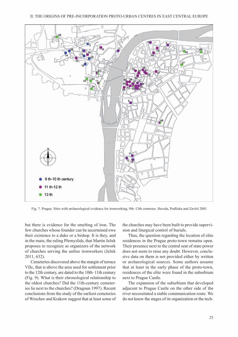
25
II. THE ORIGINS OF PRE-INCORPORATION PROTO-URBAN CENTRES IN EAST CENTRAL EUROPE
but there is evidence for the smelting of iron. The few churches whose founder can be ascertained owe their existence to a duke or a bishop. It is they, and in the main, the ruling Přemyslids, that Martin Ježek proposes to recognize as organizers of the network of churches serving the unfree ironworkers (Ježek 2011, 632).
Cemeteries discovered above the margin of terrace VIIc, that is above the area used for settlement prior to the 12th century, are dated to the 10th–11th century (Fig. 9). What is their chronological relationship to the oldest churches? Did the 11th-century cemeter-ies lie next to the churches? (Dragoun 1997). Recent conclusions from the study of the earliest cemeteries of Wrocław and Krakow suggest that at least some of
the churches may have been built to provide supervi-sion and liturgical control of burials.
Thus, the question regarding the location of elite residences in the Prague proto-town remains open. Their presence next to the central seat of state power does not seem to raise any doubt. However, conclu-sive data on them is not provided either by written or archaeological sources. Some authors assume that at least in the early phase of the proto-town, residences of the elite were found in the suburbium next to Prague Castle.
The expansion of the suburbium that developed adjacent to Prague Castle on the other side of the river necessitated a stable communication route. We do not know the stages of its organization or the tech-
Fig. 7. Prague. Sites with archaeological evidence for ironworking, 9th–13th centuries. Havrda, Podliska and Zavřel 2001

26
II. THE ORIGINS OF PRE-INCORPORATION PROTO-URBAN CENTRES IN EAST CENTRAL EUROPE
nological solutions used. It is assumed that a timber bridge linked the two parts of the agglomeration at a relatively early date, already by the end of the 10th century (Čiháková, Dragoun and Podliska 2000, 132). We know, however, that after 1158 and prior to 1173, a Romanesque stone bridge was built, named after Judith, the queen of Vladislav II (1158–1172) (Píša 1960; Dragoun 1989; Dragoun et al. 2003, 354).
The available options for dating archaeological finds from the Old Town terrace, mainly pottery, butalso dendrochronological dates, suggest that the area was settled at a rapid rate. After the middle of the 11th century, the settlement occupied much of the area of the later Old Town (Ječný et al. 1984, 235; Hrdlička 1996, 174–177). Findings from archaeo-logical research indicate that the churches built there were accompanied mostly by timber buildings. The intensification of development and its spread northeastwards came in the 12th century. This is con-firmed by discoveries made on the site occupied ina later period by the nunnery of St Agnes (Borkovský 1955, 1956), next to St Clement’s church built after the mid–11th century (Fig. 10; Juřina 2005) and at Haštalské Square (Ječný et al. 1984, 238). In down-
town Prague this was confirmed in many excavationtrenches, e.g. in the Old Town Square and at Tyn Court (Hrdlička 1977, 212, 2005, 6; Hrdlička, Drag-oun and Richterová 1981; Bureš, Kašpar and Vařeka 1997, 205–209) and at St Martin’s (Dragoun 1979). In this way, the border of the settled zone shifted deep into the Old Town terrace, beyond the area of the ‘Mezihradi’ of old. Based on recent discoveries, it has been concluded that the timber houses built there had an orderly arrangement, associated with a network of streets leading to the marketplace (Juřina 2005, 154). Thus, it is assumed, that street plan of the later Old Town presumably started to take shape as early as in the 12th century.
In earlier publications, the north-eastern area of proto-urban Prague was regarded as a separate settlement centred around the church of St Peter na Pořiči. It was thought to have occupied the edge of the right bank terrace of the Vltava next to the road leading eastward (Špaček 1983; Kršáková 1983; Bureš, Kašpar and Vařeka 1994; Bureš, Kašpar and Vařeka 1997). In the light of a charter confirmedby Duke Soběslav at St Peter’s between 1173 and 1178, it is usually assumed that the settlement was inhabited by a commune of German hospites who had their own law (CD Bohemiae I, no. 290; Kejř 1969). However, Jindřich Tomas (1984a, 49–50) pointed out nevertheless, that the document does not specify whether the Germans lived next to St Peter’s Church and whether they occupied that area only. As an argu-ment in confirmation of his theory that the Germanmerchants inhabited a broader area on the right bank of Prague, he referred to the absence of Romanesque stone houses in the district of Pořiči a part of which, in his view, belonged to those merchants. Meanwhile, a major excavation undertaken in 2003–2006 in Re-public Square shed new light on the area between the Romanesque churches of St Benedict, St Clement and St Peter. The discovery there in an area of 2 hectares of 12th century buildings shows that the area by the church of St Peter was not a separate unit, but was an integral part of the right bank settlement. We may assume at present that the entire area within the bend of the Vltava was settled during the 12th and early 13th century.
The dating of buildings in Republic Square is corroborated by the discovery of coins from the reign of King Vladislav II (1158–1172), other finds,including fragments of imported glass vessels, have the mark of elite material culture. Some of the timber houses depart in their character from the local build-ing tradition, which was mainly that of log houses. Thus, there is now evidence of dugout buildings in
Fig. 8. Prague, Old Town. St John the Baptist’s church. Photograph taken prior to the demolition of the church
in 1896. Ježek 2011
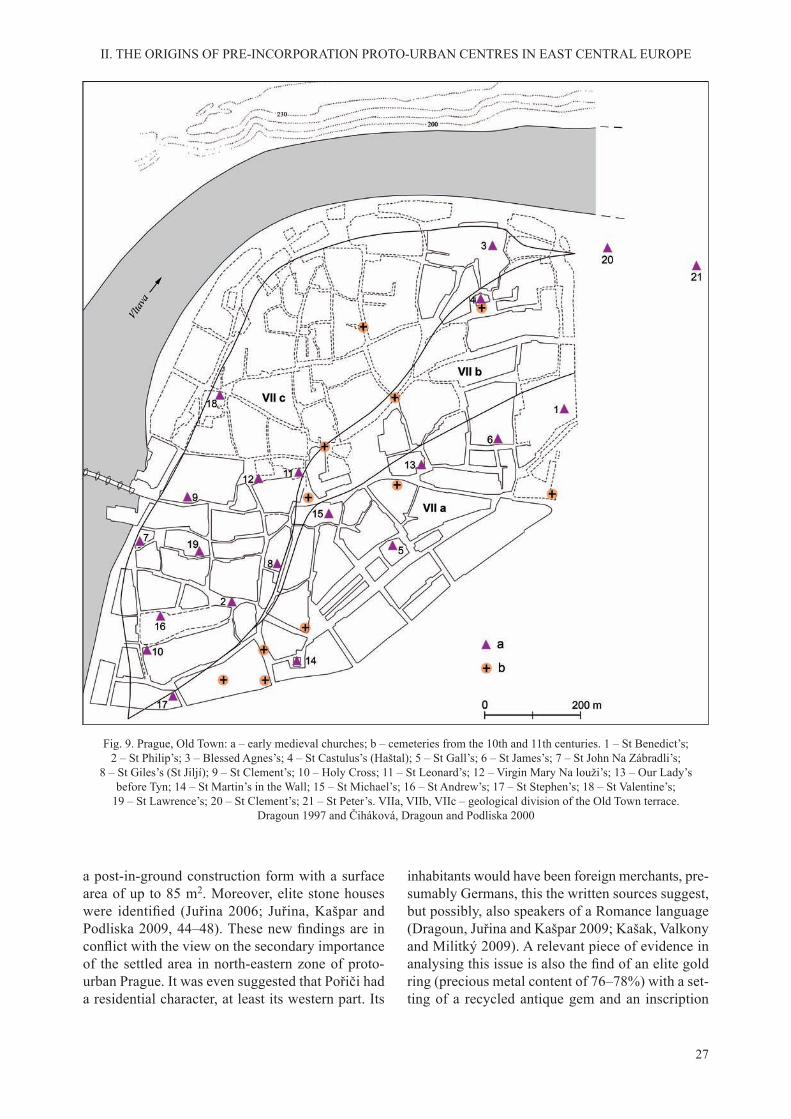
27
II. THE ORIGINS OF PRE-INCORPORATION PROTO-URBAN CENTRES IN EAST CENTRAL EUROPE
a post-in-ground construction form with a surface area of up to 85 m2. Moreover, elite stone houses were identified (Juřina 2006; Juřina, Kašpar andPodliska 2009, 44–48). These new findings are inconflict with the view on the secondary importanceof the settled area in north-eastern zone of proto-urban Prague. It was even suggested that Pořiči had a residential character, at least its western part. Its
inhabitants would have been foreign merchants, pre-sumably Germans, this the written sources suggest, but possibly, also speakers of a Romance language (Dragoun, Juřina and Kašpar 2009; Kašak, Valkony and Militký 2009). A relevant piece of evidence in analysing this issue is also the find of an elite goldring (precious metal content of 76–78%) with a set-ting of a recycled antique gem and an inscription
Fig. 9. Prague, Old Town: a – early medieval churches; b – cemeteries from the 10th and 11th centuries. 1 – St Benedict’s; 2 – St Philip’s; 3 – Blessed Agnes’s; 4 – St Castulus’s (Haštal); 5 – St Gall’s; 6 – St James’s; 7 – St John Na Zábradli’s;
8 – St Giles’s (St Jiljí); 9 – St Clement’s; 10 – Holy Cross; 11 – St Leonard’s; 12 – Virgin Mary Na louži’s; 13 – Our Lady’s before Tyn; 14 – St Martin’s in the Wall; 15 – St Michael’s; 16 – St Andrew’s; 17 – St Stephen’s; 18 – St Valentine’s;
19 – St Lawrence’s; 20 – St Clement’s; 21 – St Peter’s. VIIa, VIIb, VIIc – geological division of the Old Town terrace. Dragoun 1997 and Čiháková, Dragoun and Podliska 2000

28
II. THE ORIGINS OF PRE-INCORPORATION PROTO-URBAN CENTRES IN EAST CENTRAL EUROPE
Fig. 10. Prague. Pre-incorporation buildings near St Clement’s church: a – plan, b – projection. Juřina 2005

29
II. THE ORIGINS OF PRE-INCORPORATION PROTO-URBAN CENTRES IN EAST CENTRAL EUROPE
in Hebrew MSH BR SLMH, interpreted in Czech literature as MOSHE BAR SHLOMO. This find wasrecognized as a seal ring of a Jewish merchant by its excavators (Zavřel and Žegklitz 2007; Kašpar and Žegklitz 2009, 56).
What we know at present leaves no doubt that the crafts-and-market settlement on the right bank was, during the first decades of the 13th century thelargest part of the Prague agglomeration. This was the settlement that decided the non-agrarian charac-ter of the economy of the proto-town. The dynam-ics of socio-economic growth is confirmed by thedense network of churches and Romanesque stone houses. Its central element was the marketplace on
the right bank of the Vltava. It is assumed to have been larger than the later Old Town Square (Ječný et al. 1984, 246–247). It extended from the margin of the Vltava terrace in the west to Tyn Court in the east. Tyn Court that formed its eastern border and known also as Ungelt or Teinhof, was a defensive complex that serviced and controlled commerce (Fig. 11). Some of its buildings were stonebuilt; others were timber, enclosed by a moat, 4–5 m wide with a depth of around 3 m. The area was irregular in plan, 45 × 65 m. Traces of non-ferrous metallurgy were found in this area (Hrdlička, Dragoun and Richterová 1981; Hrdlička 2005).
Fig. 11. Prague. Tyn Court (Ungelt, Teinhof). A – church; B – court; C – Týnská Street; D –St James’s church. a – Romanesque stage; b – early medieval moat; c – 14th century; d – late Romanesque stage. Hrdlička, Dragoun and Richterová 1981

30
II. THE ORIGINS OF PRE-INCORPORATION PROTO-URBAN CENTRES IN EAST CENTRAL EUROPE
The original shape of the marketplace changed prior to the mid-13th century. Its western part, as well as it northern and southern edges were occupied by timber or masonry merchants’ houses. The plots were set out without precisely measured units. In its finalform the marketplace was an irregularly shaped quad-rangle in plan with seven streets issuing from it.
Putting aside the solitary find of a merchant’sseal ring with the Hebrew inscription from Republic Square, we have to emphasize that the main site of activity of the Jewish commune came to be the rela-tively large area to the north of the marketplace. The Jewish population settled there prior to the mid–12th century after leaving the left bank suburbium next to Prague Castle. It had a synagogue and a graveyard in the new district at Opatovice (Ječný et al. 1984, 233).
The rapid growth on the Old Town terrace of set-tlement subordinated to commerce and crafts brought significant change in the topography of proto-urbanPrague. The breakdown of the early structure that had formed around the power centres occurred here sooner than in other towns of East Central Europe. A large economic centre developed there even prior to the urban reform regulating the legal status of the commune. Its supraregional importance made Prague of the first half of the 13th century not only the politi-cal and religious state capital, but also a supraregional economic centre.
The early agglomeration at Prague included some centres of monastic life. The earliest of these were associated with the bishopric and the Přemyslid residence. Next to the church of St George in Prague Castle was a Benedictine nunnery founded at the end of the 10th century at the latest by Duke Boleslav II (971/972–999). Cannons Regular were established at St Vitus’s Cathedral after 1060. Masonry remains of the monastery date from the period when the church building was remodelled by Duke Spytihněv II (1055–1061) to the form of a basilica. The build-ings of the monastery were constructed to connect with the north-eastern wall of the basilica. It was a quadrilateral complex with a formal chapter house and a typical cloister. A vaulted refectory with three aisles was added to the north-eastern part of the quadrangle. The results of archaeological research confirm that the monastery was an establishment builtfor display (Durdík, Chotěbor and Muk 1984).
The second monastery of canons in Prague was associated, as noted earlier, with the collegiate ba-silica of St Peter in Vyšehrad. Its purpose was to service the existing complex of religious buildings
and the bishop’s chapter that functioned periodically in the castle. The plan of this monastery is obscure. External power centres and the Prague Bishopric had an array of monastic communities. Strahov Monas-tery with the church of the Virgin Mary was on the north-western margin of the early agglomeration. It was founded around 1140 for an as yet unidentifiedmonastic community, which was soon replaced by the Premonstratensians of Steinfeld in Bavaria. The first monastery was housed in timber buildings; itwas replaced by masonry buildings in the second half of the 12th century (Sommer 1984; Vlček, Sommer, Foltyn 1997, 442–451). On the left bank of the Vltava crossing, in the settlement of Travnik, during the sec-ond half of the 12th century a fortified commandry ofthe Knights of St John was built (Huml, Dragoun and Nový 1990–1991, 55). There is also evidence that by the early 13th century the Order of Brothers of the German House of Saint Mary had built a residence at Pořici on the right bank of Prague but the form of their precinct is unknown (Bureš, Kašpar, Špaček and Vařeka 1997, 7; Dragoun, Juřina and Kašpar 2009, 58). During the same period, the presence of the Knights Templar by the church of St Lawrence at the south-western margin of the Old Town terrace was confirmed (Borkovský 1957; Huml, Dragounand Nový 1990–1991, 50).
Completing the proto-urban structure of Prague were settlements to which we are unable to ascribe a crafts-commercial function or associate with a mon-astery. They continued to emerge from the 10th cen-tury, mainly along the left bank margin of the Vltava valley. Farthest north, on a holm at the confluence ofBrušnice stream and the Vltava, was the settlement of Rybaře with the church of St Peter (Hrdlička 1972, 644). To the west of the suburbium by Prague Castle, was the settlement of Obora with the rotunda of John the Baptist (Ječný et al. 1984, 219; Dragoun 1988a). Four other 11th–12th-century settlements have been identified spread along the margin of the terrace tothe south of the suburbium. They are thought to rep-resent settlements known from the written sources: Travnik with the later commandry of the Knights of St John’s at the river crossing; Nebovidy with the church of St Lawrence; Ujezd with the church of St John, and a settlement centred on the church of St Philip and St James (Ječný et al. 1984, 219; Tomas 1984a, 41; Huml, Dragoun and Nový 1990–1991, 42, Fig. 2). In all probability, the mainstay of economy of these settlements was mostly agriculture, even though not every one of them lies on soils favourable for farming.

31
II. THE ORIGINS OF PRE-INCORPORATION PROTO-URBAN CENTRES IN EAST CENTRAL EUROPE
The origins of the proto-urban settlement com-plex in Wrocław date back to the castle on a river island. The decision to site the castle on the later Ostrów Tumski (Cathedral Island) was based on its naturally defensive position created by the unique local hydrography. It is created by the Odra River, meandering down a broad depression and divided into several channels, joined by the tributaries of the Oława, Bystrzyca, Widawa and Ślęza rivers and many smaller streams. At first, these waterwayschanged course naturally, and later, due to anthro-
pogenic causes give rise to a string of low-lying islands. Of special significance were changes in thecourse of the Odra and the Oława as they determined the locations suitable for development (Fig. 12). It is accepted that these two rivers may have had six to seven main channels. They were rather shallow, on average about 50 cm deep (Leonhard 1901). With no humans to interfere, the islands and the riverbanks could change form with every flood, of which therewere many. Thus, one of the conditions for the de-velopment of settlement was having protection from
B. WROCŁAW
Fig. 12. Ancient meanders of the Odra River in Wrocław. Badura 2010

32
II. THE ORIGINS OF PRE-INCORPORATION PROTO-URBAN CENTRES IN EAST CENTRAL EUROPE
the river’s destructive force. Of major importance for the development of settlement were the islands of Ostrów Tumski and Piasek as well as the area on both banks of what was then the main river channel. The latter could have been hemmed in by minor channels of the Odra and the Oława. The differences of elevation within the town and its close surround-ings were slight. The mean water level in the Odra prior to the rise of the communal town is estimated at about 111 m above sea level. Elevation in the set-tled islands was about 115–116 m asl. This was also the elevation of the area on the riverbanks. The up-per terrace has an elevation of about 117 m asl, and development began only in the 13th century. This is where the central marketplace of the incorporated town was established. By raising its original level by 5–6 m higher than the mean water level in the river,
it was made relatively safe from flooding. More tothe south, the land sloped to a natural depression and this was used for a moat, described as ‘the outer moat’. Thus, a substantial area of the town, especially in the north, remained marshy (Badura 2010, 40–44; Piekalski 2013, 380–382).
The nucleus around which the settlement of early Wrocław would concentrate was the castle on Ostrów Tumski (Fig. 13). The available evidence at present induces us to locate the earliest stable occupation on the eastern part of that island. With it are associated remains, identified at two locations, of an earth-and-timber rampart in hooked joint construction. One of these remnants was dated using input from dendrochronological analysis to a time prior to the mid–10th century (Kaźmierczyk 1991–1995, part 2, 21). Trial reconstruction of the defences undertaken
Fig. 13. Wrocław, 11th–12th century: a – river; b – castle rampart; c – main road; d – settlement documented by archaeology; e – settlement documented by written sources; f – church; g – church, approximate location; h – cemetery; i – ducal residence;
j – marketplace; k – inn; l – noble residence approximate location. 1 – castle precinct with St Martin’s chapel; 2 – St John’s Cathedral; 3 – Augustinian abbey with Our Lady’s church; 4 – Premonstratensian abbey with St Vincent’s church;
5 – St Michael’s church; 6 – St Peter’s church; 7 – St Wojciech/Adalbert’s church; 8 – St Nicholas’s church; 9 – site of the annual fair in front of St Vincent’s church; 10 – projected location of the marketplace in the left bank district; 11 – estate of the noble
Włostowic family; 12 – estate of the nobleman Mikora; 13 – projected location of Gerung’s estate (curia); 14 – district centred on St Wojciech/Adalbert’s church; 15 – Jewish district; 16 – inn in the district ‘Na Bytyniu’; 17 – inn ‘Birvechnik’; 18 – inn ‘ad fine
pontis’; 19 – inn of the Augustinian abbey. J. Piekalski based on data from Młynarska-Kaletynowa 1986. Drawing N. Lenkow
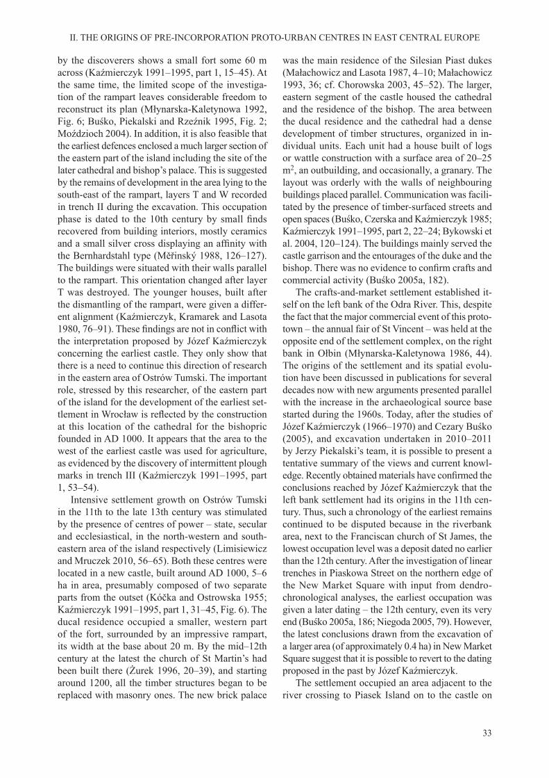
33
II. THE ORIGINS OF PRE-INCORPORATION PROTO-URBAN CENTRES IN EAST CENTRAL EUROPE
by the discoverers shows a small fort some 60 m across (Kaźmierczyk 1991–1995, part 1, 15–45). At the same time, the limited scope of the investiga-tion of the rampart leaves considerable freedom to reconstruct its plan (Młynarska-Kaletynowa 1992, Fig. 6; Buśko, Piekalski and Rzeźnik 1995, Fig. 2; Moździoch 2004). In addition, it is also feasible that the earliest defences enclosed a much larger section of the eastern part of the island including the site of the later cathedral and bishop’s palace. This is suggested by the remains of development in the area lying to the south-east of the rampart, layers T and W recorded in trench II during the excavation. This occupation phase is dated to the 10th century by small findsrecovered from building interiors, mostly ceramics and a small silver cross displaying an affinity withthe Bernhardstahl type (Měřinský 1988, 126–127). The buildings were situated with their walls parallel to the rampart. This orientation changed after layer T was destroyed. The younger houses, built after the dismantling of the rampart, were given a differ-ent alignment (Kaźmierczyk, Kramarek and Lasota 1980, 76–91). These findings are not in conflict withthe interpretation proposed by Józef Kaźmierczyk concerning the earliest castle. They only show that there is a need to continue this direction of research in the eastern area of Ostrów Tumski. The important role, stressed by this researcher, of the eastern part of the island for the development of the earliest set-tlement in Wrocław is reflected by the constructionat this location of the cathedral for the bishopric founded in AD 1000. It appears that the area to the west of the earliest castle was used for agriculture, as evidenced by the discovery of intermittent plough marks in trench III (Kaźmierczyk 1991–1995, part 1, 53–54).
Intensive settlement growth on Ostrów Tumski in the 11th to the late 13th century was stimulated by the presence of centres of power – state, secular and ecclesiastical, in the north-western and south-eastern area of the island respectively (Limisiewicz and Mruczek 2010, 56–65). Both these centres were located in a new castle, built around AD 1000, 5–6 ha in area, presumably composed of two separate parts from the outset (Kóčka and Ostrowska 1955; Kaźmierczyk 1991–1995, part 1, 31–45, Fig. 6). The ducal residence occupied a smaller, western part of the fort, surrounded by an impressive rampart, its width at the base about 20 m. By the mid–12th century at the latest the church of St Martin’s had been built there (Żurek 1996, 20–39), and starting around 1200, all the timber structures began to be replaced with masonry ones. The new brick palace
was the main residence of the Silesian Piast dukes (Małachowicz and Lasota 1987, 4–10; Małachowicz 1993, 36; cf. Chorowska 2003, 45–52). The larger, eastern segment of the castle housed the cathedral and the residence of the bishop. The area between the ducal residence and the cathedral had a dense development of timber structures, organized in in-dividual units. Each unit had a house built of logs or wattle construction with a surface area of 20–25 m2, an outbuilding, and occasionally, a granary. The layout was orderly with the walls of neighbouring buildings placed parallel. Communication was facili-tated by the presence of timber-surfaced streets and open spaces (Buśko, Czerska and Kaźmierczyk 1985; Kaźmierczyk 1991–1995, part 2, 22–24; Bykowski et al. 2004, 120–124). The buildings mainly served the castle garrison and the entourages of the duke and the bishop. There was no evidence to confirm crafts andcommercial activity (Buśko 2005a, 182).
The crafts-and-market settlement established it-self on the left bank of the Odra River. This, despite the fact that the major commercial event of this proto-town – the annual fair of St Vincent – was held at the opposite end of the settlement complex, on the right bank in Ołbin (Młynarska-Kaletynowa 1986, 44). The origins of the settlement and its spatial evolu-tion have been discussed in publications for several decades now with new arguments presented parallel with the increase in the archaeological source base started during the 1960s. Today, after the studies of Józef Kaźmierczyk (1966–1970) and Cezary Buśko (2005), and excavation undertaken in 2010–2011 by Jerzy Piekalski’s team, it is possible to present a tentative summary of the views and current knowl-edge. Recently obtained materials have confirmed theconclusions reached by Józef Kaźmierczyk that the left bank settlement had its origins in the 11th cen-tury. Thus, such a chronology of the earliest remains continued to be disputed because in the riverbank area, next to the Franciscan church of St James, the lowest occupation level was a deposit dated no earlier than the 12th century. After the investigation of linear trenches in Piaskowa Street on the northern edge of the New Market Square with input from dendro-chronological analyses, the earliest occupation was given a later dating – the 12th century, even its very end (Buśko 2005a, 186; Niegoda 2005, 79). However, the latest conclusions drawn from the excavation of a larger area (of approximately 0.4 ha) in New Market Square suggest that it is possible to revert to the dating proposed in the past by Józef Kaźmierczyk.
The settlement occupied an area adjacent to the river crossing to Piasek Island on to the castle on

34
II. THE ORIGINS OF PRE-INCORPORATION PROTO-URBAN CENTRES IN EAST CENTRAL EUROPE
Ostrów Tumski. In the 11th–12th century, it extended southward not more than 400 m, i.e. at most as far as the church of St Adalbert and today’s Wita Stwosza Street; its east-west span was about 300 m (Piekalski 2010). A ditch discovered by the south-western edge of the settlement, at the intersection of Wita Stwosza and Biskupia streets, could have been a boundary ditch. It was dug during the 12th, possibly the early 13th century and ran north-south. Its width was more than 6.8 m but less than 12 m, and the depth was 1.1 m. The ditch was lined with brushwood, visible at the time of discovery as a smudge of deep brown humus (Konczewski and Piekalski 2010, 139–140).
This early phase of the settlement is documented by the remains of small semi-dugouts and other pits, mostly hard to interpret as to their function. No timber samples were obtained from them that were useful for dendrochronological analysis and the dat-ing is based on small finds, mostly pottery vessels,but also on metal finds. Józef Kaźmierczyk was thefirst to identify the settlement as a crafts centre, hisinterpretation based mostly on traces of metallurgy and leatherworking (Kaźmierczyk 1966–1970, part 2, 83–182). This argument too was confirmed by laterresearch (Buśko 2005a, 185–186).
In the south the settlement bordered on an exten-sive cemetery, spreading from the later St Adalbert’s church in the east to St Elizabeth’s church in the west. The graves were widely spaced with some discovered along Wita Stwosza Street, at Szewska Street, and where Kuźnicza Street joins the Market Square. The earliest burials from the 11th century were deposited in the eastern area of the cemetery, the latest, from the first decades of the 13th century, at its westernend. At this point it is worth noting that the study of cemeteries from the proto-urban phase may have now reached a turning point and promises to bring essential changes in interpretation. In the past, we used to search in Wrocław, seat of a bishopric since AD 1000, for cemeteries attached to the churches that functioned according to the principles of cura animarum (Piekalski 1991, 61–64). If we happened to unearth a cemetery older than a known church as in the case of the parish church of St Elizabeth, we suspected the presence in that area of a wooden church not documented by legible sources (Lasota and Piekalski 1997). When graves next to St Adal-bert’s and St Mary Magdalene’s appeared to be older than the churches, we were inclined to push back the chronology of the latter. However, the discovery of churches from the 11th–12th centuries along present day Wita Stwosza Street, relatively far from the churches of St Adalbert and St Mary Magdalene,
suggest a different relationship between graves and churches and a different status of the cemetery in the structure of the settlement (Czerner et al. 2000; Buśko 2005a, 191–192; Konczewski and Piekalski 2010, 142–145, also the graves discovered by Przemysław Guszpit at Krawiecka Street, known to me person-ally). It is quite likely that the topographical position of the burial site had a bearing on the choice of site for the construction of the Wrocław churches of St Adalbert during the first half of the 12th century,St Mary Magdalene’s church around 1200, and St Elizabeth’s before 1250 (Piekalski 2011, 150–152; Wojcieszak 2012, 18–20).
The second half of the 12th century, and espe-cially, the first decades of the 13th century, sawa marked intensification of settlement on the leftbank of the Odra. This conclusion is drawn based on cultural layers dated to this period. The area of the early settlement was augmented by adding a strip of land about 250 m wide adjacent to it from the south and south-west (Fig. 14). The burial site to the south gradually went out of use, its function taken over by cemeteries attached to the churches. The oldest of these was St Adalbert’s, built during the 1140s at the latest (CDS Maleczyński, vol. 1, no. 22, 55–56, no. 68, 158–159; Młynarska-Kaletynowa 1986, 44 with information about the written source). It gave its name to a settlement known in the early 13th century as ad sanctum Adalbertum (SUB, vol. I, no. 77). The younger church of St Mary Magdalene was built in the south-western area of the newly settled zone. Its early history is not illuminated adequately by written sources. Nevertheless, they make it pos-sible to conclude with a great measure of probability, that in 1226 the existing church was vested with the rights and duties of a parish church, exercised earlier by St Adalbert’s which that same year passed to the Dominicans, who arrived in Wrocław from Krakow (SUB, vol. 1, no. 266; Młynarska-Kaletynowa 1986, 90). Archaeological excavation carried out on the church during the 1960s confirmed the presence ofthe remains of earlier buildings, of which the oldest were dated to the late 12th century. The surviving stone-and-brick foundations were too poorly pre-served to reconstruct the size and shape of this build-ing. Its chronology was determined from stratigraphy and the attributes of pottery vessels discovered in as-sociation with the foundations. Religious function is determined by graves associated with these buildings (Broniewski and Kozaczewski 1967, 9–13). Let us add here that the use of brick in the foundations and the lack of grave goods in the inhumations suggest – or even impose outright – a dating to the early 13th
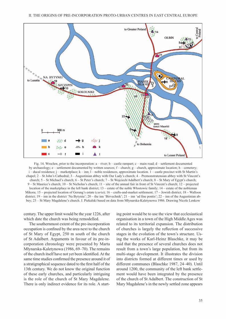
35
II. THE ORIGINS OF PRE-INCORPORATION PROTO-URBAN CENTRES IN EAST CENTRAL EUROPE
century. The upper limit would be the year 1226, after which date the church was being remodelled.
The southernmost extent of the pre-incorporation occupation is confined by the area next to the churchof St Mary of Egypt, 250 m south of the church of St Adalbert. Arguments in favour of its pre-in-corporation chronology were presented by Marta Młynarska-Kaletynowa (1986, 69–70). The remains of the church itself have not yet been identified. At thesame time studies confirmed the presence around it ofa stratigraphical sequence dated to the first half of the13th century. We do not know the original function of these early churches, and particularly intriguing is the role of the church of St Mary Magdalene. There is only indirect evidence for its role. A start-
ing point would be to use the view that ecclesiastical organisation in a town of the High Middle Ages was related to its territorial expansion. The distribution of churches is largely the reflection of successivestages in the evolution of the town’s structure. Us-ing the works of Karl-Heinz Blaschke, it may be said that the presence of several churches does not result from a town’s large population, but from its multi-stage development. It illustrates the division into districts formed at different times or used by different communes (Blaschke 1987, 24–40). Until around 1200, the community of the left bank settle-ment would have been integrated by the presence of the church of St Adalbert. The construction of St Mary Magdalene’s in the newly settled zone appears
Fig. 14. Wrocław, prior to the incorporation: a – river; b – castle rampart; c – main road; d – settlement documented by archaeology; e – settlement documented by written sources; f – church; g – church, approximate location; h – cemetery; i – ducal residence; j – marketplace; k – inn; l – noble residences, approximate location. 1 – castle precinct with St Martin’s
chapel; 2 – St John’s Cathedral; 3 – Augustinian abbey with Our Lady’s church; 4 – Premonstratensian abbey with St Vincent’s church; 5 – St Michael’s church; 6 – St Peter’s church; 7 – St Wojciech/Adalbert’s church; 8 – St Mary of Egypt’s church;
9 – St Maurice’s church; 10 – St Nicholas’s church; 11 – site of the annual fair in front of St Vincent’s church; 12 – projected location of the marketplace in the left bank district; 13 – estate of the noble Włostowic family; 14 – estate of the nobleman
Mikora; 15 – projected location of Gerung’s estate (curia); 16 – crafts-and-market settlement; 17 – Jewish district; 18 – Walloon district; 19 – inn in the district ‘Na Bytyniu’; 20 – the inn ‘Birvechnik’; 21 – inn ‘ad fine pontis’; 22 – inn of the Augustinian ab-bey; 23 – St Mary Magdalene’s church. J. Piekalski based on data from Młynarska-Kaletynowa 1986. Drawing Nicole Lenkow

36
II. THE ORIGINS OF PRE-INCORPORATION PROTO-URBAN CENTRES IN EAST CENTRAL EUROPE
to reflect the emergence in Wrocław of the early 13thcentury of a separate community. One could venture the conclusion that this was the earliest commune of German speaking hospites (Piekalski 2002a, 58–59, 2011, 152–153; differently Goliński 2012, 38).
On the western edge of the settlement, starting from around 1200 was a district of Jewish hospites. This dating of the presence of Jewish merchants on the left bank of the Odra is substantiated by finds oftombstones from a cemetery destroyed during the 14th century (Wodziński 1996, 39, 163, 167–172). The site of their settlement was determined using in-formation from later written sources (Markgraf 1896, 225–226; Młynarska-Kaletynowa 1986, 51–58) and, to some extent, archaeological evidence. The view af-forded by the latter is not entirely clear since objects of material culture discovered in the cultural deposit are no different in the main from those recorded in the town’s Christian districts. Objects associated with religious symbolism very rarely found their way into the ground. The only reasonably reliable information to confirm the enduring presence of a Jewish com-mune is animal bone assemblages deficient in theremains of pig (Kaźmierczyk 1959, 245).
It was accepted in earlier publications that Wal-loon colonists arrived in Wrocław during the second half of the 12th century (Goerlitz 1936; Młynarska-Kaletynowa 1986, 59–67). Their settlement conceiv-ably was thought to have formed the south-eastern margin of the proto-town; its central point was the church of St Maurice, mentioned for the first time in1226–1234 (Goliński 2007; Słoń 2007). The findingsfrom an archaeological investigation carried out next to this church did not produce such early materials associated with the settlement (Konczewska and Piekalski 2008). It is more likely that it developed during the first decades of the 13th century, in thearea of today’s Dominikański Square, where archaeo-logical material was discovered dating from the firstdecades of the 13th century, and with time, in con-nection with the incorporation, shifted slightly to the east. Nonetheless, the Walloon settlement formed part of the proto-urban pre-incorporation complex. Let us add that there is no indication that this commune was marked by having a material culture different from that of other hospites. This would undermine the argument of Colmar Grünhagen (1861) long established in literature that they had come directly from the far off Moselle (cf. Młynarska-Kaletynowa 1986, 59–67, with earlier references). It is more likely that they had moved in from a much closer neighbourhood – from Lusatia or Saxony – where they had migrated to at the end of the 11th century
and during the 12th, in stages, as was usual during the entire colonisation process.
The artisanal character of the expanded left bank settlement linked with the civitas Wratislaviensis of written sources is confirmed by rich archaeologicalevidence, e.g. traces of iron and non-ferrous metals working, including gold, as well as leather, wood, bone and antler working. These activities went on in an orderly townscape, which had buildings of diverse construction. Timber-framed houses predominated, a design unknown earlier in the region that was introduced from the West. However, no individual burgage plots were identified in the layout of thesettlement.
The right bank of the Odra river was used inter-mittently starting from the 8th century. An enclosure with a semi-dugout house was identified there andwas dated by an assemblage of small finds (Fig. 15).It is notable that this is the earliest evidence of medi-eval occupation discovered in Wrocław to-date. On the other hand, permanent settlement in Ołbin may be said to have been documented as beginning from the 11th century. Timber buildings organised into individual units were discovered there and indicate an agrarian economy. We know from the written sources that in the 12th century this settlement was associated with the fortified residence of the powerfulnoble Włostowic family. Its prominent representa-tive was Piotr, palatine to Bolesław the Wrymouth (1102–1138) and Władysław II (1138–1146). Ac-cording to Carmen Mauri, an epic source from the late 12th century, during the first half of that centuryPiotr was in possession of a manor described as satis bene munitam, meaning that it was ‘sufficiently wellfortified’ (Cronica Petri Comitis 1951, 35–46). Thisestablishment had at least a palisade with a gate. The residence itself had several chambers. After the palatine’s fall in the winter of 1145, the manor was burnt down.
The Włostowic family were not the only repre-sentatives of Wrocław’s powerful, only we are un-able to identify their residences. Somewhere in the western part of Ołbin was the seat of comes Mikora, passed in 1175 to the Cistercians of Lubiąż. Gerung’s curia was in the settlement ad sanctum Adalbertum. In addition, Pomian and presumably, Bezelin, in the second half of the 12th century, had their residences there (Młynarska-Kaletynowa 1986, 37). In addition, some hard to name area vel curiae were found in Ostrów Tumski (SUB, vol. 2, no. 247).
The origins of two large monasteries are associ-ated with the powerful Włostowic family, and these were elements of the settlement structure of the

37
II. THE ORIGINS OF PRE-INCORPORATION PROTO-URBAN CENTRES IN EAST CENTRAL EUROPE
Wrocław proto-town. In the 1120s or 1130s, at the initiative of Palatine Piotr, construction started in Ołbin, next to the Włostowic residence, of an abbey for Benedictine monks brought in from their house at Tyniec near Krakow (Fig. 16; Lasota and Piekalski 1990/91). The Romanesque basilica of the monastery, raised of granite mined in Mount Ślęża, was equal in size to cathedral churches. The cemetery next to it served the lay populations and attests to the proto-parish function of the abbey. Prior to 1149, an annual fair was instituted at Ołbin, intensifying Wrocław’s long-distance trade. The market was held in front of
the abbey church (ante atrium ecclesiae), ten days after the feast of Saint Vincent, from the 6 – 16 June (Młynarska-Kaletynowa 1986, 44). The monastery was, moreover, the owner of an inn and other com-mercial facilities, which later changed hands repeat-edly. Their organization was affected by political developments linked to the return to Silesia of sons of the exiled Duke Władysław II. Property in Ołbin, including a meat market, was acquired at that time by the Cistercians from the newly established abbey at Lubiąż. The ejection of the Benedictines from the abbey and the introduction of the Premonstratensians
Fig. 15. Wrocław-Ołbin. 1–17 –archaeological finds, 8th–9th century. Piekalski 1991
38
II. THE ORIGINS OF PRE-INCORPORATION PROTO-URBAN CENTRES IN EAST CENTRAL EUROPE
in the late 12th century is also viewed in this context (Młynarska-Kaletynowa 1986, 39–44; Piekalski 1991, with references to sources and publications).
The other monastery, also a foundation of the Włostowic family – the Augustinian abbey – definedthe character of Piasek Island, to the west of Ostrów Tumski. During the phase prior to the rise of the ur-ban commune, the monasteries played an important function in organizing proto-urban commerce, both on a local and supraregional scale. Nevertheless, the non-agrarian economic activity and the profits it gen-erated were under the control of the duke (Rabęcka-Brykczyńska 1984, 18–21; Goliński 1991, 8–19).
Institutions run by the Church in the proto-town also included the Holy Ghost Hospital founded by Duke Henry I (1201–1238) in 1214 and run by the Augustinian monks from their abbey on Piasek Island (Trojak 1980; Słoń 2000, 80–130; Romanow and Romanow 2011). It was set up on the outskirts of the settlement, on the Odra where it was joined by the Oława in those days, east of the crossing to Piasek Island. The original layout of the hospital building and its chapel is unknown.
It is unlikely that non-local trade routes influencedthe siting of Wrocław. It seems however that like the hydrographical network, they did have signifi-cant impact on the formation of the topographical structure of the proto-town. The nodal point of pre-incorporationWrocław was the Odra crossing. The river was forded where it flowed down a numberof channels with islands in between; the largest of them is Piasek Island. The route to the river crossing passed Ostrów Tumski with its ducal castle on the west side. Prior to 1149, at least a part of the crossing was over a wooden bridge, presumably controlled by the Augustinian abbey on Piasek Island (Młynarska-Kaletynowa 1986, 38, with footnotes to the sources and commentary). The location of this crossing is connected with the settled area on the left bank of the Odra. During the late phase of the early urban agglomeration, in the second half of the 12th and the early 13th century, settlement on the left bank was spread out mainly along the length of the long-distance routes. Of special importance in this respect was the section between the bridge and St Adalbert’s, which was shared by two major routes – the Via Regia
Fig. 16. Wrocław-Ołbin. Construction site of the Benedictine abbey: a – ghost wall of S aisle of St Vincent’s church; b – foundry; c – lime kiln; d – stoneworking site; e – settlement feature; f – watercourse. Piekalski 1991
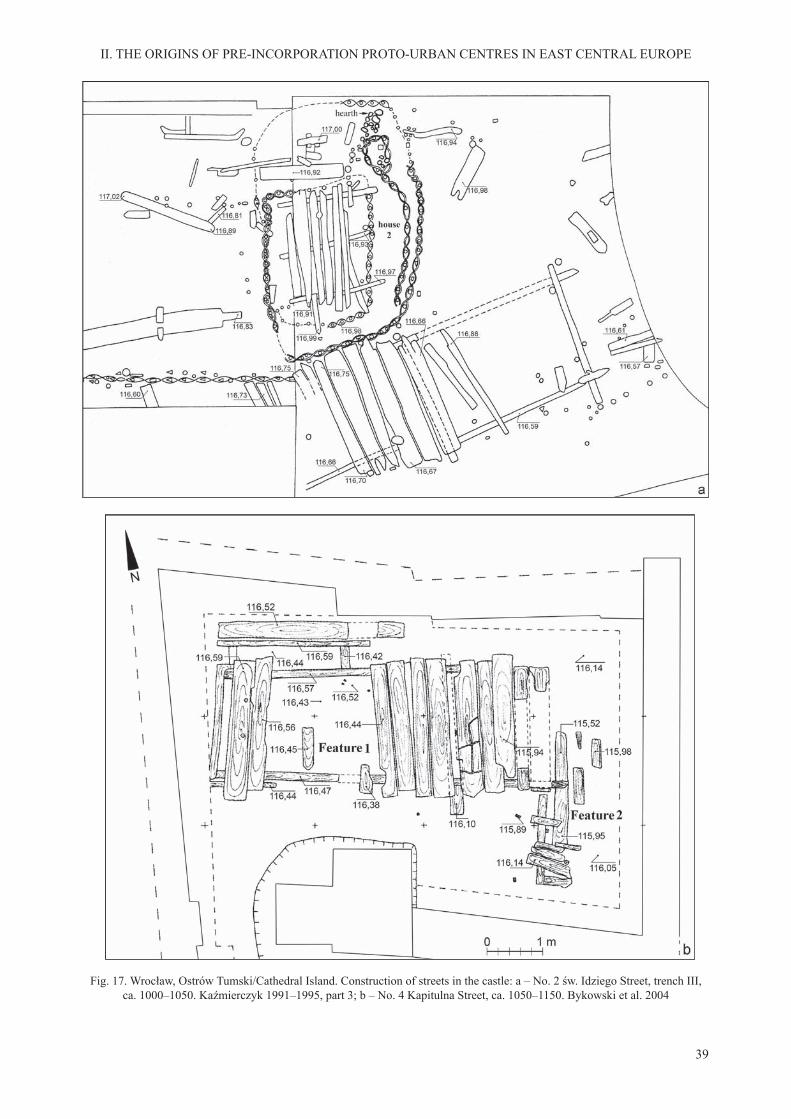
39
II. THE ORIGINS OF PRE-INCORPORATION PROTO-URBAN CENTRES IN EAST CENTRAL EUROPE
Fig. 17. Wrocław, Ostrów Tumski/Cathedral Island. Construction of streets in the castle: a – No. 2 św. Idziego Street, trench III, ca. 1000–1050. Kaźmierczyk 1991–1995, part 3; b – No. 4 Kapitulna Street, ca. 1050–1150. Bykowski et al. 2004

40
II. THE ORIGINS OF PRE-INCORPORATION PROTO-URBAN CENTRES IN EAST CENTRAL EUROPE
and the route from Greater Poland to Bohemia. We suspect the presence of a marketplace in this area, described in the early 13th century as forum wrati-slaviensis. Most researchers are inclined to place it in the neighbourhood of the bridge to Piasek Island (Markgraf 1881, 532–534; Młynarska-Kaletynowa 1986, 49–50, 141; Piekalski 1999, 121). However, it needs to be clearly said that at present, we have no sources to pinpoint its exact location. The route lead-ing south from the settlement, beyond St Adalbert’s and its churchyard, spilt into two roads; southward to Bohemia and south-eastwards to Krakow. On the route to Krakow, that is, on the Via Regia, the settle-ment of Walloon weavers was established. In 1226, this section was described as pons sancti Mauricii (SUB, vol. I, no. 266, 194–195), and later, as platea gallica or platea romanorum. In a record from 1315–1316, it is described as pons lapideus – a road paved with stone (Młynarska-Kaletynowa 1986, 59–66: cf. Goliński 2007; Konczewska and Piekalski 2008; Słoń 2007). On the southbound route, the church of St Mary of Egypt was built with its scatter of at-tendant buildings, dated by archaeological evidence to the first decades of the 13th century. This was thesouthern limes of civitas Wratislaviensis. The extent of the occupation layers, datable to around 1200, indicates that from the Odra crossing next to today’s Piaskowy Bridge, the Via Regia ran west along the Odra to a Jewish settlement and a Jewish inn Bir-vechnik nearby (Młynarska-Kaletynowa 1986, 112), and onwards, now outside civitas Wratislaviensis,
through the settlements of Sokolniki and Szczepin with the church of St Nicholas, and the settlement of Na Bytyniu, which had an inn.
Some of the streets of proto-urban Wrocław had a timber surface. This is true of thoroughfares and small open spaces inside the castle on Ostrów Tum-ski, and of streets on the left bank of the river (see Kaźmierczyk 1966–1970, part 1, 23–24). Regular streets with a timber surface were discovered under the later New Market Square. They were constructed of sleepers laid along the street edge to support heavy boards placed across them (Fig. 17). In the castle on Ostrów Tumski oak was used, often from demolished buildings. In two better investigated sections, the tim-ber came from a dismantled or reconstructed section of the rampart. The streets were up to 2.5 m wide, but evidence was found of narrower thoroughfares and surfaced passages between buildings (Kaźmierczyk 1991–1995 part 3, Fig. 73; Bykowski et al. 2004, 120). At this time, most of the thoroughfares of the early urban agglomeration were not surfaced. This, presumably, was the form of the main street in the left bank settlement which developed on the stretch shared by the two long-distance routes, linking the Odra crossing with the church of St Adalbert’s. No evidence of surface material was discovered during excavation and the course of this street is confirmedonly by the remains of regular timber buildings, dating from the 1220s and 1230s (Niegoda 2005, 70–71).
C. KRAKOW
The main city of Lesser Poland (Małpolska) and of the medieval Kingdom of Poland too, was built in a landscape of varied morphology on the borderland of the Małopolska Upland, the Carpathian Foot-hills and the Vistula River valley. The proto-urban development started on a site lying in the contact zone of the Małopolska Upland and the Vistula val-ley (Fig. 18). The decisive factor presumably was the defensive value of Wawel Hill – a prominent limestone rock rising 25 m above the margin of the Vistula floodplain. The summit of Wawel Hill isrelatively flat with some 4 hectares available for use.It is here that a castle was constructed – the seat of secular power and of a bishopric. Other elements of the structure of the town occupied a broad promon-tory of the middle terrace adjacent to Wawel in the north, known as the alluvial cone of the Prądnik, a tributary of the Vistula. This uniquely shaped spur of land tapers southward to form a bridge between
the upland and Wawel Hill, adjacent to its southern tip. The width of the promontory in the settled zone is between about 180 m in the south to 800 m in the north. The settlement value of Prądnik Cone followed from its direct neighbourhood with Wawel Hill as a power centre, the Vistula’s proximity and, not less important, safety from flooding. This is because thearea under settlement was elevated by 4–7 m above the bottom of the floodplain (Poleski 2004, 393,2013, s. 57). Given that the channel of the Rudawa, a left tributary of the Vistula, was dug to the north of Wawel Hill only sometime during the 13th or the 14th century; there was no natural feature to divide the castle from the rest of the area occupied by settle-ment (Kmietowicz-Drahtowa 1971, 1974; Radwański 1975, 14–18, 33–41; Wyrozumski 1992, 9–22; Wierz-bicki 2010, 177; cf. Czop et al. 2010).
It is reasonable to assume that the castle on Wawel Hill was established and prospered due to its hinter-
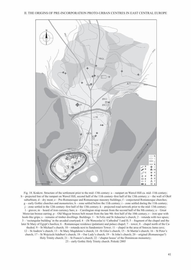
41
II. THE ORIGINS OF PRE-INCORPORATION PROTO-URBAN CENTRES IN EAST CENTRAL EUROPE
Fig. 18. Krakow. Structure of the settlement prior to the mid–13th century: a – rampart on Wawel Hill ca. mid–11th century; b – projected line of the rampart on Wawel Hill, second half of the 11th century–first half of the 13th century; c – the wall of Okół
suburbium; d – dry moat; e – Pre-Romanesque and Romanesque masonry buildings; f – conjectured Romanesque churches; g – early Gothic churches and monasteries; h – zone settled before the 11th century; i – zone settled during the 11th century; j – zone settled in the 12th century–first half of the 13th century; k – projected road network prior to the mid–13th century; l – graves; m – hoard of iron currency bars; n – Carolingian strap mount from the second half of the 8th century; o – Great
Moravian bronze earring; p – Old Magyar bronze belt mount from the late 9th–first half of the 10th century; r – iron spur withhook-like grips; s – remains of timber dwellings. Buildings: 1 – St Felix and St Adauctus’s church; 2 – rotunda with two apses; 3 – ‘rectangular building’ in the arcaded courtyard; 4 – (St Wenceslas’s) ‘Cathedral’ I and II; 5 – fragment of the chapel and the
later St Mary of Egypt’s basilica; 6 – Romanesque residence (palatium) and palace chapel; 7 – tower; 8 – chapel north of the Ca-thedral; 9 – St Michael’s church; 10 – rotunda next to Sandomierz Tower; 11 – chapel in the area of Smocza Jama cave;
12 – St Andrew’s church; 13 – St Mary Magdalene’s church; 14 –St Giles’s church; 15 – St Martin’s church; 16 – St Peter’s church; 17 – St Wojciech/Adalbert’s church; 18 – Our Lady’s church; 19 – St John’s church; 20 – original (Romanesque?)
Holy Trinity church; 21 – St Francis’s church; 22 –‘chapter house’ of the Dominican monastery; 23 – early Gothic Holy Trinity church. Poleski 2005

42
II. THE ORIGINS OF PRE-INCORPORATION PROTO-URBAN CENTRES IN EAST CENTRAL EUROPE
land of early medieval open settlements, sufficientlydense in western Lesser Poland. Agriculture based on the cultivation of local loess soils and the early extraction of rock salt and iron ores provided a good hinterland for the castle at Krakow (Radwański 1991, 62–65). It is less easy to reach a decision as to the role the pattern of trade routes had on the choice of the site for the castle. Nevertheless, there is no question that they contributed to the economic growth of the proto-town prior to the incorporation of 1257. Perhaps the most important routes were those running West-East, from south Germany, through Regensburg, Prague and Olomouc, linking up at Krakow with the Via Re-gia, although the latter would increase in importance only during the 12th century (Myśliwski 2006, 254, 2009, 74–81). An important economic role is also ascribed to the route which connected Krakow and Hungary and to the increasingly significant waterwaydown the Vistula River to Gdańsk.
The topography of Wawel Hill determined the plan of the castle set upon its summit (Fig. 19). Thus, it was roughly irregularly oval-shaped in plan, wider in its western part. Five hectares were quite enough to build a complex necessary for effecting central political and ecclesiastical functions. The dating of the origins of the castle is still unresolved. In past publications, it was accepted that during the 10th century the castle was the power centre of the Czech Přemyslid rulers, and at the end of that century passed to the Piast dukes, who were then laying the founda-tions for the Polish state. At this time with no reliable source base, we cannot pronounce on the concept of the tribal stronghold, subordinated subsequently to Great Moravia. According to the researchers of Wawel’s past, its first clay-and-sand rampart datesback to as early as the 9th century, and was replaced in the early 10th century by a stone-timber-and-earth structure (Pianowski 1991, 29; Firlet 1994, 274–277).
Fig. 19. Krakow. Pre-Romanesque and Romanesque Wawel; a – castle rampart; b – stone buildings. Firlet and Pianowski 1989

43
II. THE ORIGINS OF PRE-INCORPORATION PROTO-URBAN CENTRES IN EAST CENTRAL EUROPE
That this chronology is not definitive is indicated bydendrochronological dates. To-date isolated samples have been secured from the rampart that dates from the time of the reign of Bolesław Chrobry in the early 11th century (Kukliński 1995, 243; 2005; Poleski 2004, 392–399). However, it is better to delay finalconclusions pending the analysis of a larger number of timber samples with a well-defined stratigraphicalposition, and input from the study of archaeological finds from the oldest occupation level in Wawel.
In the 11th century, the eastern, ducal part of the castle was separated from the rest of the castle interior with another rampart (Firlet 1994, 277–278; Pianowski 1994, 8–37). A stone palatium was built by the northern edge of the ducal compound with a hall of 24 pillars (referred to as aula) and an annex that was added in the east. To the west of the hall, on the same axis, the church of St Mary of Egypt was built – at first a chapel, later a basilica with a transeptand presbytery closed by an apse – interpreted as the ‘palace church’. The ducal compound also housed the rotunda of St Felix and St Adauctus’s as well as another structure with a sunken floor, square in planthat was entered down a ramp (Pianowski 1994; Firlet and Pianowski 2007). The latter may have been part of a larger, raised timber building.
The principal element of the second area inside the castle was the Romanesque cathedral of St Wenc-eslas. The question of its functional predecessor, contemporary with the founding of the bishopric in AD 1000, is not fully clear. What is evident is that the Romanesque cathedral was an aisled basilica without a transept and with two western towers. It contained the vaulted crypt of St Leonard. In the eastern and central area of Wawel, five other, smallerRomanesque churches have been identified: three inthe form of a rotunda and two rectangular structures with a nave and a well-defined presbytery. Therewas also some raised log houses next to the masonry buildings (Firlet and Pianowski 1989, 56; Pianowski 1994; Poleski 2004, 396; Firlet and Pianowski 2007, 2009).
During the 9th century or possibly, the first half ofthe 10th century, to the north of Wawel Hill the sub-urbium of Okół developed. It owed its location to the favourable morphology of the terrain, and eventually occupied about 10 ha. At its southern edge, the set-tlement spread 180–200 m east-west, at its northern end over it was 300 m wide, making use of the entire width of Prądnik Cone, elevated above the Vistula floodplain. The northern extent of the settlement, ata distance of about 450 m from the castle in Wawel, was restricted by a line of defences. During the 10th
century, they presumably were palisades with a moat dug during the early 11th century (Radwański 1975, 57–140; Krasnowolski 2004, 134). Okół’s status is illustrated by the presence of the Romanesque churches of St Andrew and St Mary Magdalene, and possibly also, of the churches of St Martin, St Gilles and St Peter the Apostle with All Saints and Holy Trinity churches added in the 13th century (Bicz-Su-knarowska, Niewalda and Rojkowska 1996, Fig. 1; Zin and Grabski 1996, 53–57; Zaitz 2006, 229–245; Bober 2008; Niemiec and Szyma 2009). Holy Trinity church is recognized as the earliest parish church of Krakow (Rocznik Kapituły 1978, 19; Münch 1958; Rajman 2004, 154; Szyma 2004; Bojęś-Białasik and Niemiec 2013). Next to the stonebuilt ecclesiastical buildings, there were timber dwellings in the form of semi-dugouts that retained some fragments of their log constructions (Radwański 1975, 57–149, 1995, 11–13).
There is little in the archaeological record from Okół to confirm its function as a crafts settlement.Some traces of ironworking surfaced in the area bordering on the moat. There is more evidence to sup-port the hypothesis of the presence of a marketplace between the churches of St Andrew and St Mary Magdalene. This conclusion is supported by the dis-covery of a paved area, a few lead weights and some coins (Jamroz 1967, 18; Radwański 1975, 139–140, 274–275, 1995, 23). An argument is also made for the presence in the suburbium of residences of the powerful and privileged (Rajman 2004, 67–78). Presumably, some of the elite finds may be attributedto the noble and the warrior class rather than only to the merchant class, such as the great deposit of axe-shaped iron currency bars with a very early dating to the 9th century (Zaitz 1990, 145, 172–173). During the second half of the 11th century, in Okół, near to St Andrew’s, the prominent state grandee, Palatine Sieciech (1080–1100), supposedly had his residence. The architectural form of this establishment is poorly understood however (Lalik 1968, 240).
Questions such as these do not detract from the status of the suburbium, at least until the early 13th century, the time of the intensification of settlementand economic activity in the area to the north of Okół’s moat.
During the 11th century, the northern area of proto-urban Krakow – the later incorporated town – was under a great burial site. The boundaries of its area cannot be easily determined but we have evidence that there was no great density of burials. Findings made so far suggest that the area of the burial site was greater than that of the later Main
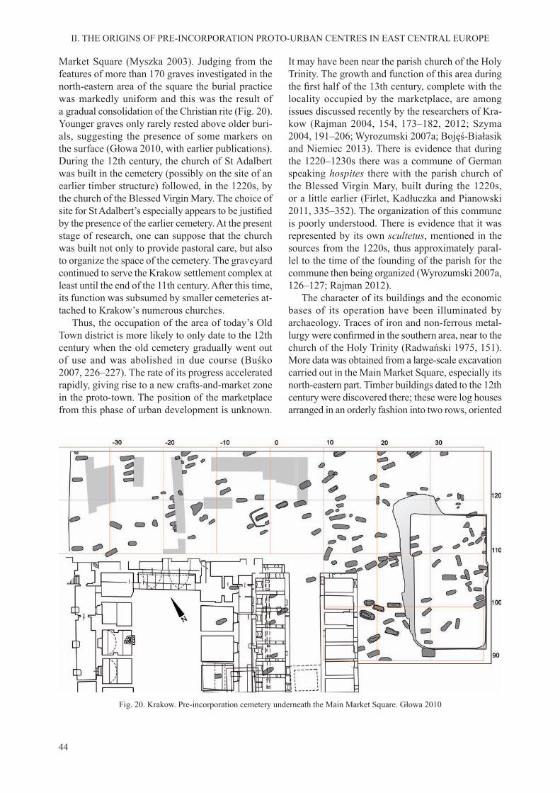
44
II. THE ORIGINS OF PRE-INCORPORATION PROTO-URBAN CENTRES IN EAST CENTRAL EUROPE
Market Square (Myszka 2003). Judging from the features of more than 170 graves investigated in the north-eastern area of the square the burial practice was markedly uniform and this was the result of a gradual consolidation of the Christian rite (Fig. 20). Younger graves only rarely rested above older buri-als, suggesting the presence of some markers on the surface (Głowa 2010, with earlier publications). During the 12th century, the church of St Adalbert was built in the cemetery (possibly on the site of an earlier timber structure) followed, in the 1220s, by the church of the Blessed Virgin Mary. The choice of site for St Adalbert’s especially appears to be justifiedby the presence of the earlier cemetery. At the present stage of research, one can suppose that the church was built not only to provide pastoral care, but also to organize the space of the cemetery. The graveyard continued to serve the Krakow settlement complex at least until the end of the 11th century. After this time, its function was subsumed by smaller cemeteries at-tached to Krakow’s numerous churches.
Thus, the occupation of the area of today’s Old Town district is more likely to only date to the 12th century when the old cemetery gradually went out of use and was abolished in due course (Buśko 2007, 226–227). The rate of its progress accelerated rapidly, giving rise to a new crafts-and-market zone in the proto-town. The position of the marketplace from this phase of urban development is unknown.
It may have been near the parish church of the Holy Trinity. The growth and function of this area during the first half of the 13th century, complete with thelocality occupied by the marketplace, are among issues discussed recently by the researchers of Kra-kow (Rajman 2004, 154, 173–182, 2012; Szyma 2004, 191–206; Wyrozumski 2007a; Bojęś-Białasik and Niemiec 2013). There is evidence that during the 1220–1230s there was a commune of German speaking hospites there with the parish church of the Blessed Virgin Mary, built during the 1220s, or a little earlier (Firlet, Kadłuczka and Pianowski 2011, 335–352). The organization of this commune is poorly understood. There is evidence that it was represented by its own scultetus, mentioned in the sources from the 1220s, thus approximately paral-lel to the time of the founding of the parish for the commune then being organized (Wyrozumski 2007a, 126–127; Rajman 2012).
The character of its buildings and the economic bases of its operation have been illuminated by archaeology. Traces of iron and non-ferrous metal-lurgy were confirmed in the southern area, near to thechurch of the Holy Trinity (Radwański 1975, 151). More data was obtained from a large-scale excavation carried out in the Main Market Square, especially its north-eastern part. Timber buildings dated to the 12th century were discovered there; these were log houses arranged in an orderly fashion into two rows, oriented
Fig. 20. Krakow. Pre-incorporation cemetery underneath the Main Market Square. Głowa 2010

45
II. THE ORIGINS OF PRE-INCORPORATION PROTO-URBAN CENTRES IN EAST CENTRAL EUROPE
north-south, divided by a street (?) some 10 m wide. Their wooden logs were from coniferous trees with the bark still intact. The buildings had a surface area of an average of 5 × 5 m with 2–3 levels of their log walls below ground level. The interiors were provided with a wooden floor or one of compactedclay, and heated with an open hearth or a dome stove built of clay. Finds of keys suggest that doors were fitted with locks. A separate area dedicated to eco-nomic activity was also identified next to the dwell-ings on their west side. It consisted of sunken wattle structures, lightweight roofed structures, assorted pits and open hearths. Next to them traces of iron and non-ferrous metallurgy were discovered. Small finds (weights and coins) would confirm commercialactivity, also on a more than local scale. The settle-ment with log buildings was destroyed in the early spring of 1241 during the Mongol invasion (Buśko and Głowa 2010, 146–148).
An important urban-forming factor was the intro-duction of mendicant orders into the settlement and social structure of Krakow. In 1222, Holy Trinity church, to the north of the eastern section of Okół’s moat, was granted to the Dominicans (Rocznik Kapituły 1978, 72; Szyma 2004, 21–22). The rights and duties of a parish church were taken over in 1227 by the Blessed Virgin Mary’s (Rajman 2004, 157–158; Wyrozumski 2007, 130). Nearby, next to the western fragment of the boundary of Okół, the Franciscans were installed in 1237, and soon built a new church dedicated to Saint Francis (Rocznik Krakowski 1872, 838; Włodarek and Węcławowicz
1991, 329–331; Szyma 2005; Niewalda and Roj-kowska 2008).
Less directly associated with the Krakow proto-urban complex was the Premonstratensian nunnery, founded during the 12th century on holms on the flood terrace of the Vistula River, to the west ofWawel Hill. This complex comprised the churches of the Saviour, St John and St Augustine, some monastic buildings and an attached settlement (Radwański 1975, 247–259; Radwańska 1993).
The image of early Krakow is completed by set-tlements found in its surrounding area, most of them with their own church. They were founded both on the Vistula floodplain and on the uplands. To thenorth of the later incorporated town, a settlement developed with the church of St Florian founded in 1185, later named Kleparz (Dzikówna 1932; Radwański 1975, 229–231). The area to the east of the Old Town district, on the terrace margin, is identi-fied with the settlement of Wesoła with the churchof St Nicholas, the latter mentioned for the first timein 1229. The Gothic fabric of the church was found to retain some Romanesque elements, and a cultural deposit discovered next to this building included early medieval pottery (Dzikówna 1938; Zin and Grabski 1996, 59–62; Radwański 1975, 231–232). Pre-incorporation occupation was also confirmed inseveral localities on the margin of the proto-urban complex – at Piasek, Kazimierz and Krzemionki, and across the river, on the right bank of the Vistula (Radwański 1975, 229–267, 1995, 13–15; Czopek 1995, 178–181).
3. MAIN FEATURES OF PROTO-TOWNS OF THE INNER ZONE OF EAST CENTRAL EUROPE
What is unique about the first phase of urbaniza-tion in the inner region of East Central Europe? To characterize briefly the origin of Prague, Wrocławand Krakow one could say that at some stage, each of them was a polycentric settlement complex com-bining central political, religious and economic func-tions. To set them apart from towns in a legal sense they are referred to as proto-towns. Each of them has its own individual character and is unique. At the same time, they have a number of common fea-tures resulting from the special nature of the cultural space from which they emerged. They took shape on a territory lacking the cultural heritage of Antiquity. They had no access to maritime commercial routes with their communications and transport potential and extensive network of trade emporia. They were
the modest country cousins of the earlier and more intensively developed towns of the western region of Central Europe. It was only natural that in evolving their structures during the 10th century, the nascent Czech and Polish states drew on the political models of their great neighbour – the Holy Roman Empire – against which with varying success, they guarded their independence (Gawlas 2000, 72–94). The simi-larity of the organization of the system of power and the methods of exercising it as well as a comparable Church organization resulted in parallel develop-ments in the evolution of central foci (Piekalski 2001, 67–158; 2011a).
The first act in the development of each of thethree proto-towns under discussion was the decision to establish a castle on a specific site. Thus, only this

46
II. THE ORIGINS OF PRE-INCORPORATION PROTO-URBAN CENTRES IN EAST CENTRAL EUROPE
sole element of the polycentric agglomeration was the result of a well-considered choice. Evolution of all the other elements was secondary and followed from this earlier resolution. Largely dependent on this primary decision were the perspectives for economic growth and conditions of urban life. Determined by specific geographical factors, each town went on todevelop its separate and unique character.
It is no accident that each of these three towns de-veloped on a major river. It may be assumed that this situation resulted from the interplay of economic and military considerations – river communication and transport on the one hand, and its control on the other. During subsequent phases of urban development, these factors were less important while the merits and deficiencies of the position of the river tendedto balance each other out. The periodic threat from flooding was compensated for by the easy access towater, the harnessing of its energy and the ease of sewage disposal (Sowina 2009, 41–76). Therefore, in Prague and Krakow the castles were established on inaccessible elevations over the valleys of the Vltava and the Vistula. This is different to Wrocław, where the castle was constructed on a low-lying island on the Odra River. The same military objective – to take the fullest advantage of natural defensibility – was achieved in two different ways.
According to earlier assumptions, large castles could achieve urban character per se (Hołubowicz 1956; Hensel 1963). They used to be described as castle-towns (Brachmann 1995). Let us recall that the archaeological studies of the castles in Prague, Wrocław and Krakow do not confirm the pursuit ofa non-agrarian economy in them. The castles were the initial building block of the polycentric and multifunctional settlement complexes. They were elite establishments that united political, administra-tive, ideological and military functions (Leciejewicz 1989, 138–148, 264–280; Moździoch 1997, 41–44; Piekalski 2001, 75–90).
As with market settlements attached to the castles, they do not by themselves form the nuclei of towns. As aptly claimed even in the late 19th century, a town is not made by its market, a market lies within a town (Hegel 1898, 137; cf. commentary of Schlesinger 1973, 291–292). After all, there is a written record on the many but unstable markets found outside larger settlement complexes (Schlesinger 1973; Hardt-Frie-drichs 1980). Nevertheless, it is certain that the mar-ket-crafts suburbia of Prague, Wrocław and Krakow developed as a result of the concentration of secular and church elites in castles with the concomitant demand for luxury goods, iron and articles of eve-
ryday use. The organization of widescale supralocal commerce, mainly in Prague, was associated with its control by the castle.
The castle and the non-agrarian suburbium that were important for supralocal commerce formed the main axis of the proto-town. At the same time, we need to recall that the structure of each of the dis-cussed centres was created jointly by monasteries, residences of the nobility and agricultural settlements. The emergence of a proto-town with a developed structure was in each case a complex and prolonged process. Successive building blocks of a complex occurred in different periods in response to politi-cal, military, religious opportunities and needs, and to the economic situation. The proto-towns had no linear boundary. Consequently, we cannot say which of their surrounding settlements are to be treated as connected with them on a stable basis.
In the case of each of the discussed centres, the earliest cemeteries lie outside the settled zone, on the river terrace, and were extensive burial sites with a low density of graves. In Krakow, this was the area to the north of Okół, site of the later Market Square. In Wrocław, the cemetery neighboured the left bank settlement from the south. In Prague, the situation is less clear. It is assumed that during the 11th century there were several cemeteries in the more elevated area of the Old Town terrace. It seems that at least in Wrocław and Krakow the churches were built in already existing cemeteries over which they subsequently extended pastoral care and control. In the case of Prague, the process of the consolida-tion of the Christian burial rite and bringing it under ecclesiastical control is still in need of elucidation – a proposition for future research.
The archaeological method admittedly lacks suit-able tools to identify the ethnicity of communities, but by piecing together material and written evidence, we can formulate some conclusions. The presence of hospites is confirmed in each of the investigatedearly medieval proto-towns, albeit at different stages of development. It is assumed that Jewish merchants and entrepreneurs were present in Prague as early as in the 11th century, mainly in the suburbium at the foot of Prague Castle. During the 12th century, the presence of a Jewish population on the right bank of the Vltava is confirmed. Both the written sources andarchaeological finds suggest that this was a well-to-do community. We can associate at least some of the western European style built structures – stonebuilt and timber – with a German and a Romanic popula-tion, confirmed by the written sources for the secondhalf of the 12th and the first decades of the 13th cen-

47
II. THE ORIGINS OF PRE-INCORPORATION PROTO-URBAN CENTRES IN EAST CENTRAL EUROPE
tury. In Wrocław, one can speak of the stable presence of ethnically foreign hospites during a slightly later period. New designs in building construction and new tendencies in pottery making are recorded no earlier than around 1200. Their dating roughly coincides with the dating of the Jewish tombstones from the de-stroyed cemetery and with the written sources, which confirm the permanent presence of Jews, Germansand a Romanic population in Wrocław. In Krakow, the presence of Jewish merchants has to be taken into account as early as in the 11th century (Zaremska 2011). We also find evidence on the institution ofa German commune there, datable to the 1220s. It is difficult to overestimate the value of the activityof the ethnically foreign hospites for the economic growth of the proto-town (Lübke 1995). They were
the ones who serviced supralocal commerce, carried information important for organizing the economy, for craft technology, for constructing buildings as well as for lifestyle and civilization advancement in general. In the current state of knowledge, we may even venture the claim that the presence of immi-grants was one of the conditions for the emergence and functioning of a proto-town.
Proto-towns, which existed in the described man-ner, were a social and a settlement phenomenon reflecting demographic, political-legal and economicneeds and conditions that were typical of their time. The change in these conditions during the 13th cen-tury brought their existence, in its earlier form, to an end transforming them in to a form dictated by new requirements.


49
Like several other central foci of East Central Europe Prague, Wrocław and Krakow evolved during the 13th century from the proto-town to the com-munal town form. The change was deep-seated and affected all the principal domains of town activity: its spatial structure, legal foundations, organization of crafts and commerce, and a range of economic and personal freedom. It was associated with the influx of a new population and changes to the ethnicstructure. The process of transformation was differ-ent in different centres. The decision on its imple-mentation could be a one-time affair, confirmed byan oral agreement or one made in writing, between the lord of the town and the townspeople, or it took the form of several legal acts, spread out over time. It could relate to an existing town or one only being established. Nonetheless, the building of a commu-nal town was always an extended process. In East Central Europe, the founding of a new town or the transformation of a proto-town to an urban structure typical of the High and Late Middle Ages is definedin Latin as locatio, translated here from the Polish lokacja as incorporation.
The Latin term locatio, locaccio, locacio, has no straightforward translation into modern languages (Piskorski 1987, 79–89). In the dictionary of medi-eval Latin its meaning when applied to villages and towns, is given as ‘placing’, ‘founding’, ‘seating’ or ‘settling’. Another meaning would be ‘putting out to lease’ (Plezia 1984, 1486–1488; Wołodkiewicz 1986, 96). The term can be interpreted quite broadly and we are warned by the rich legacy of medieval urban studies against its schematic reading. With regard to Prague, Wrocław and Krakow, it cannot be translated as Stadtgründung, as accepted in traditional historical
German literature (e.g. Planitz 1954; Stoob 1961). This interpretation has been criticized by historians themselves as they have come to view locatio (in-corporation) more as a process than a single act (Bla-schke 1997, 74–75; Młynarska-Kaletynowa 2006, 13; Gawlas 2005, 148–152). The meaning of the idea of locatio was analysed by Adrienne Körmendy (1995, 96–98) continuing, in this respect, the research by Benedykt Zientara (1975, 175–176, 1976) on medi-eval Silesia. Her conclusions are largely valid also for Bohemia, Lesser Poland and other regions of East Central Europe. Adrienne Körmendy also empha-sized that the terms locare and locator were borrowed from the Elbe region during the reign of Duke Henry the Bearded (1201–1238). They are closely related functionally with ius teutonicum, the legal basis for the reorganization of settlement (Kejř 1998, 135–172; Wyrozumski 2007, 123–125). Consequently, locatio was tantamount to the legal regulation of the activ-ity of settlers already in place or being brought to East Central Europe from the West in general, but in practice, from the German Empire. The term may be applicable also to a village or town undergoing organization as a legal basis for the restructuring of an already existing settlement, expanded with a sec-tioned off area granted to a newly created commune (Młynarska-Kaletynowa 1980). It may also mean changes made to the provisions of an incorporation contract concluded earlier. Incorporation, being an issue of considerable importance and one with a wide scope for interpretation, has been the focus of special-ist analysis from several research disciplines. Due to the difference in methods and sources appropriate for different branches of research, phenomena related to incorporation have been analysed using differently
III. INCORPORATED TOWNS
1. THE QUESTION OF INCORPORATION AND THE NEW STRUCTURE OF TOWNS
50
III. INCORPORATED TOWNS
formulated research problems. Particularly relevant for our discussion is the approach taken by historians, architectural historians and archaeologists.
For the historian the focus of research tends to be incorporation that is understood as a legal regulation for enabling the development of a town. An architect or historian of urbanisation sees it mainly as a spatial transformation. This is supposed to involve the map-ping of the town boundaries, transferring the area to the town – commune and the detailed planning of streets, squares and building districts, complete with their subdivision into properties (plots). The task of archaeologists is more challenging because the method used by them does not make it possible to directly study legal acts. They can carry out an archaeological analysis of incorporation only by formulating their questions so that the answers to them are within the reach of the real interpretative potential available to an investigator of material remains. Thus, archaeologists need to rely on their own sources and to draw conclusions based on them, rather than be content to choose, embrace or reject existing concepts, formulated – often on fragile
premises – by representatives of related research disciplines (Piekalski 2011, 144–145). Their aim is not so much to study incorporation itself as to trace its effects on the structure of a town and the material culture of its inhabitants. In this way, archaeologists undertake their portion of research consistently with the concept of histoire totale (Schreg 2001, 333–334, with a list of publications) avoiding, at the same, risky over-interpretation.
The transformation of Prague, Wrocław and Krakow in to a new form was caused by processes at work everywhere in the Europe of the High Middle Ages, most notably, the economic, demographic and cultural expansion of the Latin West (Benevolo 2000, 337–542; Génicot 2008). They were the product of new way of thinking about the economy, demo-graphic growth within the German Empire, and new legal regulations developed in towns evolving during the 12th century west of the Elbe and Saale rivers (Piskorski 1990/91, 17–19; Kejř 1998, 115–133; Gawlas 2005). In each of these centres, the process of transformation was conditioned by local factors.
A. PRAGUE
It is hard to determine the actual boundary be-tween proto-urban and incorporation Prague as is the case with many towns that have resulted from long development. Several factors and develop-ments at work in the town from the 1230s–1260s, combined to produce this transition. They included the transformation of the structure of the earlier crafts-and-market settlement on the right bank of the Vltava, the setting up of Gallus Town, building the city wall, followed by the abolition of the suburbium below Prague Castle and the planning of the Lesser Town of Prague.
The incorporation privilege for right bank Prague, i.e. for the later Old Town (Staré Město), was granted by King Wenceslaus I in 1234 (Nový 1984, 30). The area covered by the incorporation privilege already had a well formed structure, complete with an ir-regular road network (Fig. 21). The centrally placed marketplace had become, during this earlier period, the point of origin of several streets, in a radial lay-out. The principal thoroughfare led to Judith Bridge and to Prague Castle beyond. Consequently, in this case incorporation did not involve the charting of the main streets. Other thoroughfares added during the Late Middle Ages often added to this lack of regularity (Huml, Dragoun and Nový 1990–1991, 57; Kašička 1992). The marketplace (approximately
quadrilateral in plan) became the communal centre of the Old Town. Its legal situation was reflected by thepresence within this area of two power centres: Tyn Court (Ungelt) controlled by the king on the eastern edge of the market and, some decades later, the town hall on the west side, seat of the urban self-govern-ment. The rise of the urban centre did not go hand in hand with the breakdown of the earlier settlement structure – as in the suburbium below Prague Castle – just the opposite; it appears to have stimulated its development. This did not apply however to the area on the right bank terrace occupied during the earlier period.
The area within the boundaries of the incorporated town was circumscribed in the west and the north by the bend of the Vltava and had an irregular oval shape in plan. After the start of the incorporation, this area was soon enclosed with a stonewall which cut off the built-up area outside the limits of the newly constituted town. The settlements at Vyšehrad – Opa-tovice, St Martin’s Ujezd and Zderaz, complete with their ten Romanesque churches were left outside the newly charted boundary (Wallisová 1998; Podliska and Wallisowa 1999). This situation may have been dictated by the need to defend the new town. The settlements next to Vyšehrad ran along the riverbank and could not be easily enclosed by fortifications.

51
III. INCORPORATED TOWNS
Nevertheless, why was the wealthy merchant quar-ter in the north-east left outside the city wall? Its lively growth, confirmed by the discovery of large,presumably, two-storey timber houses and stone houses, one of them a palace, was interrupted after the incorporation and the area was soon abandoned (cf. Ježek et al. 2009, 120–122). The built-up area beyond the line of the fortifications was destroyed.The only survivors were the churches of St Clement and St Peter. Next to St Peter’s, a separate suburban settlement of Petřin developed, but it had lost much of its earlier importance. If we view the incorporation
as a well thought out royal project we may suppose that not everybody could take part in the project.
In the south-eastern area of the planned out and in-corporated town, there was room for the new structure of Gallus Town. This zone, previously mostly under buildings of a dugout type, was purchased after the 1230s by merchants and entrepreneurs represented by the minter, Eberhard. New settlers were brought in from Bavaria and granted town rights (Kejř 1975; Hoffmann 1980). A new spatial plan was laid out with a large marketplace an elongated rectangle in plan. Sites for the church of St Gallus and burgage plots
Fig. 21. Prague agglomeration during the second half of the 13th century: a – flood zone; b – flood zone by Vyšehrad; c – Old Town terrace; d – gravel; e – castles; f – built-up area. Huml, Dragoun and Nový 1990/91 with author’s additions

52
III. INCORPORATED TOWNS
were pegged out. The marketplace was surfaced with stones laid over the remnants of earlier structures (Muk 1964; Líbal, Muk, Mílan 1966; Huml 1992, 1996). There is evidence that Gallus Town was the site of both commerce and craft activity. However, the new structure did not retain its independent status and was absorbed both in terms of its space and in terms of rights by the Old Town. Its traces now sur-vive in the regularly planned out quarter around the Fruit Market (Ovocny Trh), which is not too typical for Prague (Fig. 22).
The reform of the town came in conjunction with some legal regulations. The brutal way in which these regulations were implemented and the abso-lute supremacy of the interests of the monarch are documented by the way the incorporation of the left bank town of Prague, the Lesser Town, was treated. In 1257, the buildings of the old suburbium below Prague Castle were demolished and the indigenous Czech population expelled. Their place was taken by colonists from Germany who were to build nova civitas Pragensis. Such was the wish of King Ot-tokar II (1253–1278) (Letopisy česke, 194). The area charted for the new town was bounded in the east by the valley of the Vltava’s old river chan-nel, in the south by the Malostranský stream and in the north by Prague Castle. The plan of the new structure comprised a rectangular marketplace, sur-rounded by square shaped blocks of buildings divided into parcels. Some of the streets issuing from the marketplace roughly followed the earlier road pat-tern. The parish church of St Nicholas stood in the
central marketplace. The entire new structure was rectangular in plan with a surface area of more than 5 ha. Its regularity was somewhat impaired by its topographical situation, especially in the northern area which lay on the steep slope of Castle hill (Fig. 23). The new town was enclosed by fortifications,their eastern line additionally serving the function of flood control. Separate defences were given to thebishop’s castle and to the commandry of the Knights of Saint John beyond the south-eastern corner of the city wall, next to the Judith Bridge, which was built of stone (Kašička 1995, 131; Čiháková 2009, 18–24). The Premonstratensian monastery in Strahov and the settlements of Obora, Rybaře, Nebovidy and Ujezd were left outside the left bank town.
Mendicant orders made their appearance in Prague at the time of the town’s transformation to its new form. The difference between those orders in Italy, Spain or France is that the rulers of Prague extended their patronage over them. This found re-flection in their privileged position within the townspace. A convent, possibly with more distinction than most, was the Poor Clares of Prague, their firstmother superior was Princess Agnes of the Přemyslid dynasty. The Dominican community in Prague was endowed with the church of Saint Clement, by the bridge on the Vltava (Huml 1978, 1987, 166). The Franciscans took up residence in the privileged and densely populated part of the town behind Tyn Court, close to the marketplace. These two localities were definitely not without economic importance.
Fig. 22. Prague. Gallus Town. Reconstructed plan from the second half of the 13th century: a – Romanesque structures; b – early Gothic tower houses; c – other early Gothic structures. Líbal and Muk 1996

53
III. INCORPORATED TOWNS
The result of the described developments was a significant and sweeping transformation of thestructure of the entire agglomeration. Its territory, and even more so, its inhabitants had been singled out by the law. New rules of economic activity and new fiscal instruments were instituted. Control of tradeand commerce, pursued in designated zones, seems to have been the rationale behind the royal decisions. The area we can describe as urban was significantlyreduced in size. At the same time, there were now
two urban centres – the Old Town and the Lesser Town of Prague – with a degree of freedom which resulted from contracts concluded with the monarch. The larger and richer Old Town presumably had a complex social and ethnic structure. It included the inhabitants of the earlier pre-incorporation settlement and at least some hospites brought in to Gallus Town. The population of the Lesser Town were colonists who had come to establish a new commune.
Fig. 23. Prague. Lesser Town ca. 1260: 1 – Commandry of the Knights of Saint John; 2 – bishop’s residence; 3 – property of the Benedictine monastery of Břevnov; 4 – Premonstratensian monastery in Strahov. Čiháková 2009

54
III. INCORPORATED TOWNS
The incorporation of Wrocław encompassed the left bank fragment of the proto-urban agglomeration. This was a prolonged process, regulated during the 13th century by several legal acts. Written sources do not provide sufficient information on the contentof these regulations. Most researchers who study Wrocław accept, based on indirect evidence, that the first incorporation was when German town rightswere granted during the reign of Duke Henry I the Bearded (1201–1238), or his son, Duke Henry II the Pious (1238–1241). The incorporation contract was not written down, as it was issued only in the form of an oral decree (Młynarska-Kaletynowa 1986, 100–101). The second legal act was issued after the Mongol invasion of 1241, prior to 10 March 1242, by Duke Bolesław the Bald (1241–1247). Of its im-plementation, we learn only from references in other documents. The next regulation was effected in 1261 by Dukes Henry III the White (1248–1266) and his
brother, Władysław, Bishop of Salzburg. It is also the first to be confirmed in writing. It spelled out the rela-tionship between the commune and the duke but gave no clear information on the spatial transformation of the structure of the town (SUB, II, no. 229, 138–139; III, no. 373–374, 241–243; Młynarska-Kaletynowa 1986, 100–121). The final act of incorporation ap-plied to the New Town (Nowe Miasto), laid out in the area bordering on the earlier pre-incorporation settlement from the east (Fig. 24; SUB III, no. 436; Rosik 2002; Słoń 2010, 150–157).
Researchers who study medieval Wrocław have drawn several conclusions on the early phases of the transformation process. Some of these had to be dis-carded as new archaeological discoveries were made, while others are still being discussed today.
The most original concept is that of Jerzy Rozpędowski, an architect (1995, 2011), who has argued that the first incorporation was effected very
B. WROCŁAW
Fig. 24. Wrocław around 1300: a – urban; b – non-urban; c – municipal property; d – ducal property; e – ecclesiastical property; f – monastic property; g – confirmed Jewish area; h – early earth-and-timber rampart; i – confirmed masonry structures;
j – projected masonry structures; k – confirmed timber buildings; l – projected timber buildings; m – settlement; n – approximatelocation of church; o – synagogue; p – hospital; r – cemetery; s – mill; t – inn; u –slaughterhouse. Chorowska 2001

55
III. INCORPORATED TOWNS
early, already during the first decade of the 13thcentury, and covered the large tract of ground con-tained by the ‘outer moat’ known from archaeologi-cal excavation. The same researcher is inclined to identify this moat as the fossata primae locationis mentioned in the document issued by Dukes Henry III and Władysław in 1261. The regularly planned out town of such scope would have developed dy-namically until the time of its destruction by the armies of Batu Khan in April 1241. According to Jerzy Rozpędowski, following this disaster under the incorporation by Duke Bolesław the Bald the town was given new boundaries, its area now reduced to the space contained by the ‘inner circuit of defences’. The interpretation of Jerzy Rozpędowski finds supportin the discovery of buildings dated to the first half ofthe 13th century in the zone outside the line of the in-ner moat, thus, in theory, lying on the territory of the greater town from the period of the first incorporation(Limisiewicz and Mruczek 2010, 89–96; Badura et al. 2010, 366–389). The weak point of this concept is that it ignores the traces of the proto-urban phase of Wrocław’s development, discovered precisely in the area outside the inner circuit of defences.
Also notable is an early concept put forward by Hermann Markgraf (1881) who argued that the firstincorporation covered the area of the later eastern district of the Old Town, the site of the pre-in-corporation settlement ad sancti Adalberti. This interpretation was revived by Cezary Buśko (2005) and Jerzy Niegoda (1999, 2005, 78–84) after their archaeological investigation of this area. However, the reconstruction proposed by them for the street plan from Duke Henry I’s time was not confirmedby input from later excavations carried out in this area. Nonetheless, this does not mean that this part of the town was fully bypassed by development. On the contrary, archaeological research carried out in 2010–2011 confirmed the major dynamicsof a non-agrarian economy in this area along with the relatively good quality of its built environment, mostly of timber-framed buildings. At the same time, we have no evidence on the implementation of legal regulations in this part of the town.
Yet another concept, one that has reappeared re-peatedly in different variants in the works of many authors since Colmar Grünhagen (1861), links the first incorporation with the area around today’sMarket Square (e.g. Goliński 1991, 165, 1997, 9; Chorowska 1994, 29; Piekalski 1997, 2005). This area was not occupied during the pre-incorporation phase. Its strong point was its relatively elevated situation on the upper terrace ensuring relative safety
from flooding. In the case of this concept, two aspectsrequire consideration: the dating of the earliest traces of occupation and, even more importantly, the time when the marketplace was laid out together with the streets and districts of urban development associated with it.
The question of the chronology of the earliest phase of occupational and economic activity in the Market Square and its adjacent area is connected with the level of preservation of the earliest cultural layers. It varies but is generally poor. A zone of major building activity by the first settlers was presum-ably focused on the outer edge of the already laid out marketplace, but is now destroyed by the cellars of later town houses. In this way, the remains of al-most all the earliest houses and structures associated with them were irretrievably lost. One of the few exceptions is the area now under Kurzy Targ Street running from the Market Square east to the church of St Mary Magdalene. The street was expanded at the cost of the buildings next to it or, possibly, even laid out anew. The stratigraphy and structures from the phase antedating this project are known due to the research of Roland Mruczek carried out in 1998 (Mruczek 2000).
Roland Mruczek has proposed to separate the uncovered structures into a ‘pre-incorporation’ and an ‘incorporation’ phase, suggesting that the former originated prior to the marking out of the regular town plan and plots. By saying this, he leads us to believe that ‘incorporation’ is understood by him as the parcelling out of the area intended for the com-munal town. Five features are classified by this re-searcher to the ‘pre-incorporation’ phase, the earliest occupation in the area of the Market Square: a timber building, three associated pits, and a timber surface at the side of the square. It should be noted that the building intrudes on the area of the marketplace and the conflict, suggested by Roland Mruczek with theregular plan applies to the boundary of the plot re-constructed using the metrological method (Mruczek 2000, 268). Also during the ‘incorporation phase’, the boundary of the built-up area roughly followed the boundary of the square. One building, of light-weight construction, discovered in the open space of the Market Square, was interpreted as a stall. The sequence of layers containing the remains of struc-tures confirms the rapid growth and and the transi-tory nature of the buildings., repeatedly destroyed by fire. Buildings with a cellar had a timber-framedconstruction, the pottery discovered in association with them represented technologies new to Wrocław and were interpreted as a phenomenon unknown to

56
III. INCORPORATED TOWNS
the local, early medieval pottery making tradition. One of this new assortment of vessels is a slender beaker-like form (Fig. 25), foreshadowing the transi-tion to Late Medieval production and use of ceramic wares (Rzeźnik 1998, 1999; Piekalski 2002a, 53–54). That the distinction into ‘pre-incorporation’ and ‘in-corporation’ phases proposed by Roland Mruczek is insufficiently substantiated is demonstrated by the
continuity of occupation, which is evidenced by the unvarying nature of the building constructions, of the ceramics, and the use, during both these phases, of the same timber surfacing in front of the houses, presumably in an already laid out Market Square.
The dating of the earliest cultural deposit in the marketplace, complete with constructions and ceramics new to Wrocław, is assisted by a series of
Fig. 25. Wrocław, Kurzy Targ Street. 1–7 – pottery from the first half of the 13th century. Mruczek 2000
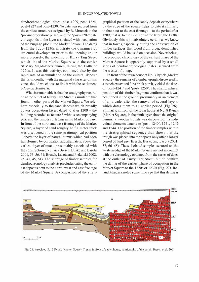
57
III. INCORPORATED TOWNS
dendrochronological dates: post–1209, post–1224, post–1227 and post–1230. No date was secured from the earliest structures assigned by R. Mruczek to the ‘pre-incorporation’ phase, and the ‘post–1209’ date corresponds to the layer associated with occupation of the burgage plot in the Market Square. The dates from the 1220–1230s illustrate the dynamics of structural development prior to the opening up, or more precisely, the widening of Kurzy Targ Street which linked the Market Square with the earlier St Mary Magdalene’s church, during the 1240s or 1250s. It was this activity, confirmed also by therapid rate of accumulation of the cultural deposit that is in conflict with the marginal character of thiszone, should we choose to link it with the settlement ad sancti Adalberti.
What is remarkable is that the stratigraphy record-ed at the outlet of Kurzy Targ Street is similar to that found in other parts of the Market Square. We refer here especially to the sand deposit which broadly covers occupation layers dated to after 1209 – the building recorded as feature 5 with its accompanying pits, and the timber surfacing in the Market Square. In front of the north and west frontage of the Market Square, a layer of sand roughly half a meter thick was discovered in the same stratigraphical position – above the layer of natural humus which had been transformed by occupation and alternately, above the earliest layer of muck, presumably associated with the construction of cellars (Bresch, Buśko and Lasota 2001, 53, 56, 61; Bresch, Lasota and Piekalski 2002, 25, 41, 45, 61). The shortage of timber samples for dendrochronology analysis precludes dating the earli-est deposits next to the north, west and east frontage of the Market Square. A comparison of the strati-
graphical position of the sandy deposit everywhere by the edge of the square helps to date it similarly to that next to the east frontage – to the period after 1209, that is, to the 1220s or, at the latest, the 1230s. Obviously, this is not absolutely certain as we know that in towns, especially during the construction of timber surfaces that wood from older, demolished buildings would be used on occasion. Nevertheless, the proposed chronology of the earliest phase of the Market Square is apparently supported by a small series of dendrochronological dates, secured from the western frontage.
In front of the town house at No. 3 Rynek (Market Square), the remains of a timber upright discovered in a trench excavated for a brick porch, yielded the dates of ‘post–1241’ and ‘post- 1250’. The stratigraphical position of this timber fragment confirms that it waspositioned in the ground, presumably as an element of an arcade, after the removal of several layers, which dates them to an earlier period (Fig. 26). Similarly, in front of the town house at No. 8 Rynek (Market Square), in the ninth layer above the original humus, a wooden trough was discovered, its indi-vidual elements datable to ‘post–1240’, 1241, 1242 and 1244. The position of the timber samples within the stratigraphical sequence thus shows that the trough was placed into the deposit only after a longer period of land use (Bresch, Buśko and Lasota 2001, 57, 66–68). These isolated samples secured on the western edge of the Market Square are not in conflictwith the chronology obtained from the series of dates at the outlet of Kurzy Targ Street, but do confirmthe dating of the earliest phase of occupation in the Market Square to the 1220s or 1230s (Fig. 27). Ro-land Mruczek noted some time ago that this dating is
Fig. 26. Wrocław, No. 3 Rynek (Market Squae). Trench in front of a townhouse, stratigraphy of the porch. Bresch et al. 2001

58
III. INCORPORATED TOWNS
consistent with samples secured on plot No. 50 Rynek (Market Square) and No. 18 Igielna Street, thus, at the northern frontage of the Market Square where the timber surface of a yard, resting over an earlier deposit, was dated to 1245 (–6/+9), and also from No. 2 Ruska Street, where a timber sample yielded the date of 1233 (Mruczek 2000, 30; Guszpit and Wiśniewski 2002, 184–189, 204). Moreover, from the area to the north of the Market Square we know of dendrochronological dates which confirm an earlyoccupation. The timber used in the sill beam of a house discovered in the earliest occupation layers in the plot at 26a Więzienna/26 Kotlarska streets was felled in 1216. The house at No. 8 Igielna Street, set directly over natural humus, was dated to around 1236 (Piekalski 1995, 76; Mruczek 2000, 30).
If we accept that the area in the Market Square was first occupied in the 1220s–1230s, we also haveto accept that this was the time of the laying out of the square, the streets and the blocks of building as-sociated with it. This conclusion follows more from a logical assumption than from a sound source base. At the present stage, we cannot answer conclusively
whether we can link the regular town plan directly and in a chronological sense to any of the incorpora-tion acts, and, if so, to which of these? Would this be the first incorporation by Duke Henry I? Perplexing,because it is not confirmed by evidence, or is it pos-sibly, Duke Henry II’s? Or the incorporation of 1242? Alternatively, could it be that the earliest marketplace in this part of the town was more of a forum campes-tre, set up outside an area under urban development, already an element of the polycentric proto-town (Piekalski 1997).
After many years of studying the built environ-ment of medieval Wrocław, Małgorzata Chorowska concluded that the act of incorporation and the par-celling of land inside the town might have been two separate projects (Chorowska 2010, 67). She is in favour of an early dating for the incorporation and bringing the area around the Market Square under management, stressing nevertheless that building a large town is, for obvious reasons, a prolonged process. The regular plan of Wrocław within its inner circuit of fortifications would have been the resultof several plot division projects, organized over
Fig. 27. Wrocław. Evidence for dating the origins of the Market Square. Piekalski 2005
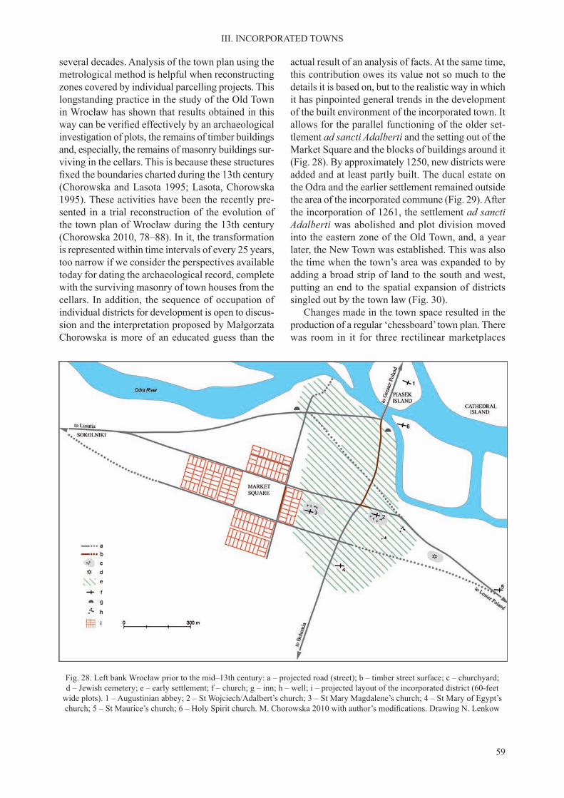
59
III. INCORPORATED TOWNS
several decades. Analysis of the town plan using the metrological method is helpful when reconstructing zones covered by individual parcelling projects. This longstanding practice in the study of the Old Town in Wrocław has shown that results obtained in this way can be verified effectively by an archaeologicalinvestigation of plots, the remains of timber buildings and, especially, the remains of masonry buildings sur-viving in the cellars. This is because these structures fixed the boundaries charted during the 13th century(Chorowska and Lasota 1995; Lasota, Chorowska 1995). These activities have been the recently pre-sented in a trial reconstruction of the evolution of the town plan of Wrocław during the 13th century (Chorowska 2010, 78–88). In it, the transformation is represented within time intervals of every 25 years, too narrow if we consider the perspectives available today for dating the archaeological record, complete with the surviving masonry of town houses from the cellars. In addition, the sequence of occupation of individual districts for development is open to discus-sion and the interpretation proposed by Małgorzata Chorowska is more of an educated guess than the
actual result of an analysis of facts. At the same time, this contribution owes its value not so much to the details it is based on, but to the realistic way in which it has pinpointed general trends in the development of the built environment of the incorporated town. It allows for the parallel functioning of the older set-tlement ad sancti Adalberti and the setting out of the Market Square and the blocks of buildings around it (Fig. 28). By approximately 1250, new districts were added and at least partly built. The ducal estate on the Odra and the earlier settlement remained outside the area of the incorporated commune (Fig. 29). After the incorporation of 1261, the settlement ad sancti Adalberti was abolished and plot division moved into the eastern zone of the Old Town, and, a year later, the New Town was established. This was also the time when the town’s area was expanded to by adding a broad strip of land to the south and west, putting an end to the spatial expansion of districts singled out by the town law (Fig. 30).
Changes made in the town space resulted in the production of a regular ‘chessboard’ town plan. There was room in it for three rectilinear marketplaces
Fig. 28. Left bank Wrocław prior to the mid–13th century: a – projected road (street); b – timber street surface; c – churchyard; d – Jewish cemetery; e – early settlement; f – church; g – inn; h – well; i – projected layout of the incorporated district (60-feet
wide plots). 1 – Augustinian abbey; 2 – St Wojciech/Adalbert’s church; 3 – St Mary Magdalene’s church; 4 – St Mary of Egypt’s church; 5 – St Maurice’s church; 6 – Holy Spirit church. M. Chorowska 2010 with author’s modifications. Drawing N. Lenkow

60
III. INCORPORATED TOWNS
Fig. 29. Left bank Wrocław around 1250. a – reconstructed road; b – timber street surface; c – churchyard; d – Jewish cemetery; e – early settlement; f – church; g – city walls and gates; h – tower of the left bank castle; i – projected layout of the incorporated
district (60-feet wide plots). 1 – Augustinian abbey; 2 – Dominican monastery with St Wojciech/Adalbert’s church; 3 – St Mary Magdalene’s church; 4 – St Mary of Egypt’s church; 5 – St Maurice’s church; 6 – Holy Spirit church;
7 – St Elizabeth’s church; 8 – Franciscan monastery with St James’s church; 9 – Convent of St Clare; 10 – St Matthew’s church; 11 – St George’s (subsequently, St Agnes’s) church. M. Chorowska 2010 with author’s modifications. Drawing Nicole Lenkow
– the centrally placed Market Square (180 × 200 m), the Salt Market immediately to the south-west (80 × 120 m), and the youngest, the New Market (85 × 120 m), laid out on the site of the pre-incorporation settlement. During the second half of the 12th cen-tury, a complex of permanent commercial facilities was installed in the Market Square, the property of the duke rented out to the merchants (Czerner 2002, 17–25). The N-S axis of the town plan was charted by Kuźnicza Street, leading from the Market Square to the new ducal castle on the Odra, and by Świdnicka Street, issuing from the Market Square southward to the main route out of town. The E-W axis was mapped out by Ruska Street – leading from the Mar-ket Square, through the Salt Market to Mikołajska Gate, the point of issue of the road to Legnica and Germany, and by Oławska Street leading to Oławska Gate and on to Krakow. Other streets were planned mostly parallel or at right angles to these axes. Departures from the regular plan were made when there was need, generally speaking, to adjust to the
outer boundaries of the town, marked out by the city fortifications, or make the necessary shortcuts.Archaeological study of the street plan confirms thestability of their layout during the Late Middle Ages and the post-medieval period (Buśko 1997, 126; 1999a; Konczewski and Piekalski 2011).
The northern area spread along the Odra River was settled on the townspeople. It continued as a ducal property, its areas gradually given over to ecclesiastical projects. The younger ducal castle was constructed at a new Odra crossing (Lasota, Kon-czewski and Piekalski 2007).
By the north-west corner of the Market Square the new parish church of St Elizabeth of Hungary was founded, replacing an earlier cemetery. The time of its construction is established by the details of its architecture to the 1220s–1230s (Lasota and Rozpędowski 1980). Additionally, its dedication to St Elizabeth of Hungary, deceased in 1231 and beatified in 1235, suggests a dating closer to late1230s and early 1240s, or even, to the period after

61
III. INCORPORATED TOWNS
the incorporation of 1242 by Bolesław the Bald. The second dedication of this church – to St Lawrence – appears in the records only during the 15th cen-tury and there is no justification for placing it in thefirst half of the 13th (Młynarska-Kaletynowa 1986,103–104). The church was one of the two principal parish churches of 13th-century Wrocław. Only the parish church of St Mary Magdalene was older in the new topographical layout now found to the east of the Market Square.
As in Prague, the position of the mendicant or-ders in Wrocław was special. Here also they put in an appearance prior to incorporation, or possibly, during the transformation. In addition, they were treated differently than the modest communities of the Dominicans, and the Franciscans of Southern and Western Europe, who were usually established in a peripheral position (Moorman 1968, 62–72; Stüdeli 1969, 68–84). In 1226, the Dominicans came into possession of the parish church St Adalbert in the southern area of the left bank settlement. The
Franciscans were presented with an estate next to the bridge to Piasek Island, thus, presumably next to the pre-incorporation marketplace. They received the privilege of serving the court of Duke Henry II’s. Slain at the Battle of Legnica against the Mongols, the Duke was laid to rest in the Franciscan church of St James (Zientara 1975, 298–299; Lasota and Rozpędowski 1981). The growth of incorporated Wrocław altered the position of the monasteries within the town space. With new boundaries marked out and the new central Market Square set in place, their position became peripheral, in line with the general tendency prevailing in Europe.
The boundaries of the incorporated town in Wrocław cannot be identified more closely withoutdifficulty. They did not follow the circuit of the ‘innerfortifications’ erected after the incorporation. Theseenclosed an area of about 40 ha, an irregular oval in plan bordering on the left bank of the Odra River. Within lay the area of the town commune and the earlier pre-incorporation settlement administered un-
Fig. 30. Left bank Wrocław around 1275: a – churchyard; b – Jewish cemetery; c – ducal land partly given over to the ecclesi-astical foundations; d – church; e – town walls and gates; f – well; g – tower of the left bank castle; h – projected layout of the
incorporated district (60- feet wide plots); i – moat. 1 – Augustinian abbey; 2 – Dominican monastery with St Wojciech/Adalbert’s church; 3 – St Mary Magdalene’s church; 4 – St Mary of Egypt’s church; 5 – St Maurice’s church; 6 – Holy Spirit church;
7 – St Elizabeth’s church; 8 – Franciscan monastery with St James’s church; 9 – Convent of St Clare; 10 – St Matthew’s church; 11 – St George’s (subsequently, St Agnes’s) church; 12 – St. Catherine church. Chorowska 2010, drawing Nicole Lenkow

62
III. INCORPORATED TOWNS
der the older ducal law, and the duke’s estates along the Odra River. We can try to reconstruct the area covered by the town law provided to the townspeople by comparing it against the extent of the regular town plan. However, the latter, as we know, continued to evolve over time.
A part of the area settled during the pre-incorpora-tion phase was left outside the circuit of the fortifica-tions, and consequently, definitely beyond the zoneof operation of the town law. This was mainly the districts south and east of the church of St Adalbert, spread along the route running to Bohemia and to Krakow, therefore, to the outlying churches of St Mary of Egypt at the southern end and the church of St Maurice at the south-eastern end of the proto-town. The laying out and the construction of the fortifica-tions resulted in their approachesbeing cleared of buildings. Let us note that this project affected the definitely non-agrarian and thus, in an economicsense, the urban Walloon settlement. In addition, outside the town was the pre-incorporation built-up area dated to the first decades of the 13th century, tothe west of the inner fortification zone (Jastrzębski,Piekalski and Wysocka 2001, 336).
The situation of the area enclosed by the town defences where individual districts enjoyed differ-ent legal and administrative status was not unique to Wrocław. In Silesia, we find a similar situation inGłogów. Here the new town boundary, and in due course, the fortifications, enclosed the town com-mune of colonists incorporated in 1250, but also, the pre-incorporation settlement on the Odra River, not granted the new rights (Hendel and Moździoch 1996, 90–95). Marian Kutzner (1970, 151) has named it the ‘ducal jurisdiction’, noting that its inhabitants were subjects of the ruler. This interpretation apparently illustrates the status of pre-incorporation settlement well, even though it lacks a sound source base, something that was emphasized strongly by Mateusz Goliński (2012, 25–27).
Differences in the legal status of the area within the fortifications in Wrocław were largely eliminatedby the incorporation act of 1261. A new district was added to the town at this time and a new, outer line of defences was constructed (Konczewski, Mruczek and Piekalski 2010, 597–598). The island of Ostrów Tumski with the old ducal palace, the cathedral and residence of the bishop, the monastery of St Vincent in Ołbin and the monastery of the Blessed Virgin Mary on Piasek Island were left outside the bound-ary of the urban district. The New Town set up in 1262 soon came under the increasingly powerful self-government of the Old Town.
What sort of population formed the town com-mune of Wrocław? The older interpretations that were so confident as to the distinctions between theindigenous population and the immigrant (colonist) populations of the pre-incorporation settlement and the communal town are no longer valid. The angles for studying this issue, especially with unambiguous written sources in short supply, are quite modest and any insight had to be weighed down with potential error and misunderstandings (Brather 1996, 2000, 2004). Nevertheless, the issue is sufficiently relevantthat a position must be taken on it. Historians and archaeologists agree that the transformation of the town during the 13th century was associated with the arrival of colonists from German-speaking areas (Piskorski 1987, 85–88; Gawlas 2005, 134, 2006, 49–57; Piekalski 2001, 252–253). At the same time, there is evidence that already during the pre-incor-poration phase the population of Wrocław, similar to Prague, was multi-ethnic. Diverging views on the time of the arrival of the Walloons to Wrocław – in the late 12th or the early 13th century – do not change the fact that their settlement was already a part of the pre-incorporation agglomeration (Młynarska-Kaletynowa 1986, 59; Konczewska and Piekalski 2008). The early presence of a Jewish commune appears to be incontrovertible too, as attested by the presence of tombstones. It is less easy to deal with the question of the time of the arrival of the German colonists. Gerung’s curia in the settlement ad sanctum Adalbertum in Wrarzlau, presented in 1202 by Duke Henry I the Bearded to the Cistercian Abbey at Lubiąż, is mentioned in the sources just once (Młynarska-Kaletynowa 1986, 49, 51, 59–67). Of more significance are references to sculteti of the Wrocław civitas, made in 1214 and 1229, testifying to the presence of an organized group of colonists in the pre-incorporation town (SUB, I, no. 42, 100–101, no. 305, 225–226; Młynarska-Kaletynowa 1986, 78–80).
Some general premises of assistance in dealing with this issue come from the analysis of archaeologi-cal sources. Archaeologists can now make a cautious attempt to discern the indigenous and the imported elements in the material culture. The latter would include, in addition to the earlier mentioned evidence on new pottery making technologies, new construc-tions of timber buildings. It is safe to conclude that the post- in-ground system with interrupted sills and the timber-framed design in all their variants are western imports (Piekalski 1996). However, we are not in a position to say if this was the result of a single episode of colonisation or of a series of episodes,

63
III. INCORPORATED TOWNS
intermittent or uninterrupted, involving arrivals from different areas of the German Empire. In a major centre such as Wrocław, the early presence of non-in-digenous constructions is unsurprising. Their earliest finds are datable to around 1200 and it is no accidentthat they are found on Ostrów Tumski, in the bishop’s precinct (Bykowski et al. 2004, 127). Since the early 13th century, houses of this description were known widely on the left bank settlement, which became part of the incorporated town only during the second half of that century. In the western area of the Old Town, where there was no occupation during the pre-incorporation phase, timber-framed buildings make their appearance as the first town houses, placed atthe upper end of the plot, while the traditional log buildings and wattle structures accompany them as outbuildings (Piekalski 1999a). Another new element in 13th-century Wrocław was water wells. In the area south of the church of St Adalbert two concentrations of these structures were discovered, dated to the first decades of the 13th century (Konczewski 2007,23–24). They were destroyed, like the buildings they
presumably had accompanied, no later than during the construction of the town fortifications. These newdevelopments, noted during the pre-incorporation phase, foreshadow a general transformation of the material culture of medieval Wrocław. They may be treated as a relevant indication of the presence of ethnically foreign hospites in the town during the first decades of the century (Piekalski 2002a, 53–60;2011). This population presumably was utilised when organizing the incorporated urban commune.
To describe the process of incorporation in Wrocław in brief we can say that its principal fea-ture is the absence of a clear watershed between the phase of the proto-urban settlement and that of the incorporated town. Its transformation to the structure typical for a new type of town had the nature of an accelerated process. Legal regulations served to make this process orderly and to control it, in condi-tions that saw the considerable domination of the autocrat, who was a representative of the Silesian Piast dynasty.
C. KRAKOW
The view largely accepted in earlier reference literature is that the construction, during the 1220s, of the parish church of the Blessed Virgin Mary and written references to a scultetus, is sufficientevidence to conclude that this was the time when Krakow was incorporated, adopting German town rights (Wyrozumski 1992, 159–160). At present, not all the researchers of Lesser Poland’s main centre are convinced as to this. Re-examination of these same sources has brought alternative interpretations. This change of view is the result of a more general reflection on the subject of urban transformation andon the notion of incorporation itself. As in the case of other centres, it is now accepted that the trans-formation of Krakow too was a prolonged process, its turning point the legal regulation of 1257, the only one documented by the written sources. (KD Krakowa, I, no. 1; Wyrozumski 2007a). From the surviving written record, we learn that the area for the urban commune was marked out, older buildings were demolished, and a new town plan was prepared under a decision of Duke Bolesław the Chaste, ruler of Krakow (1243–1279).
The incorporated town, organized for arrivals from different countries homines inibi de diversis climatibus congregare, but in practice, from the Ger-man-speaking region, occupied the area to the north of the older suburbium of Okół and the Dominican
and Franciscan monasteries (Rocznik Kapituły 1978, 86; Rajman 2004, 212). This area was already in use during the pre-incorporation phase, had several churches and pastoral care provided by the church of the Blessed Virgin Mary. Nevertheless, the crafts settlement developed on this site, possibly the one that is meant in a reference to scultetus Peter, was de-stroyed by the Mongols in 1241 and not fully rebuilt (Wyrozumski 1992, 159; Rajman 2004, 182–184; Buśko and Głowa 2010, 151–152). Ironically, this situation was advantageous for the decision to in-corporate a new structure. The presence of a Polish population – including the unfree or semi-free ducal bondsmen (ascripticium), who would not be granted the new town rights – must have been limited. This situation is in line with a general tendency, stressed in literature, in which incorporated towns were estab-lished next to already existing settlements with the people dependent on the duke or the Church remained on their old site (Piskorski 1990/91, 225; Rębkowski 2001, 53–58; Moździoch, 1996, 33; Goliński 2012, 24–27).
The process of planning the space of the incor-porated structure of Krakow was analysed in great depth by Bogusław Krasnowolski, an art historian. He summarized a sizable series of earlier studies on this subject in his contribution (Jamroz 1960, 1967; Borowiejska-Birkenmajerowa 1975; Krasnowol-

64
III. INCORPORATED TOWNS
ski 2004, 91–119, 2007, 361–372, 2010, 53–55). These in the main drew on input from the metrology analysis of early modern and the recent town plans, relying to a lesser extent on the remains of medieval buildings. The remarkable historical stability of Kra-kow’s built environment and the fact that the city was spared from destruction during World War II largely justifies the selection of this particular method. Un-like in Wrocław and in Prague, the limited progress
of archaeological investigations of building districts and streets does not provide a sufficient alternativeto the metrology method. It is safe to claim that the designed town plan provided for nine rectilinear districts, the central intended for the main square, the focus of central functions (Fig. 31). The others would have been divided into four blocks of buildings each, divided by streets. This ideal design was never fully implemented due to major obstacles. These included
Fig. 31. Krakow. Projected layout of the incorporated district: a – grid lines (quadratic plots; a = 4/12 measuring units); b – implemented; c – not implemented; d – area associated with expansion of blocks over the modular size. Krasnowolski 2010

65
III. INCORPORATED TOWNS
the presence of church buildings in the area dating from the earlier period, the need to connect to the proto-urban communications network and to make space for the town fortifications, all of which inter-fered with the perimeter of the whole town. The result obtained was a structure with a strongly emphasized regularity with some imperfections however. The area south of the Market Square was irregular in plan. The main feature of this irregularity was the south-ern corner of the square from which Grodzka Street issued in a funnel-like fashion – main axis of the suburbium of Okół, leading to the castle in Wawel. Each of the other three corners of the Market Square
was a starting point for two streets. In addition, each side of the Market Square was divided into two by one more street (Fig. 32). The relative homogeneity of the town plan of the incorporated Krakow does not mean that the districts were soon built up although, admittedly, the layout remained stable until it was set in stone by masonry buildings.
As in Wrocław, a complex of commercial facili-ties was installed at the centre of the town’s principal market by a decision of the duke. They included the cloth halls (camera) and stalls (kram), ranged in rows aligned with the axis of the square. They are known from archaeological investigation, the first carried
Fig. 32. Krakow. Projected layout of the town in 1257: 1 – St Wojciech/Adalbert’s church; 2 – St John’s church; 3 – Holy Trinity church; 4 – All Saints church; 5 – conjectured axis of street layout from 1220; 6 – Our Lady’s church; 7 – Dominican monastery;
8 – Franciscan monastery; 9 – hospital with the churches of the Holy Spirit and the Holy Cross; 10 – stronghold of the town headman; 11 – conjectured boundary of the centre of the urban grid from the time of the ‘Great Incorporation’; 12 – layout of the
first complex of residential blocks and streets; 13 – modular divisions of property lots: full-curia (36 × 72 ells) and half-curia (18 × 72 ells); 14 – area with plots of modular full-curia and half-curia size; 15 – areas with non-modular plots; 16 – areas
associated with expansion of blocks to more than a modular size; 17 – regular full- and half-curia plots laid out in areas with an irregular plan; 18 – areas divided into plots of a size derived from full-curia module; 19 – defunct street;
20 – earth-and-timber fortifications from ca. 1285; 21 – city walls after 1298; 22 – earliest townhouses; 23 – St Stephen’s church; 24 – St Mark’s church. Krasnowolski 2007

66
III. INCORPORATED TOWNS
out during the 1960s, and a major project completed 2005–2009 (Dryja et al. 2010; 2010a; 2010b; Zaitz 2010). There is evidence that during the second half of the 13th century most of these buildings were tim-ber-framed structures. The stalls east of the cloth hall, later referred to as kramy bogate (rich stalls), were built of stone (Fig. 33). Over subsequent decades, the infrastructure of the Market Square evolved rapidly; a town hall was built and more rows of stalls.
The incorporation bypassed Okół – next to Wawel, the main area of the proto-town. Its earlier economic role is not fully clear. Very likely, during the period following the incorporation its conjectural crafts and commercial function expired. Nevertheless, Okół’s position between the ducal castle and the Market Square, and its several churches, suggests that it cannot be regarded as a lesser element of the agglomeration. Its attraction for the upper ranks of the Krakow community – secular and ecclesiasti-cal – is evident. Okół retained its irregular layout, based on the earlier existing axes of Grodzka and Kanonicza streets. A plot division project carried out
presumably under King Władysław the Elbow-high in 1320–1330s removed at least some of this irregu-larity. A change was also made to the status of Okół, now described as nova civitas (Wyrozumski 1992, 259; Bicz–Suknarowska, Niewalda and Rojkowska 1996, 89–95; Krasnowolski 2004, 108, 120–122; Rajman 2004, 209–211; Słoń 2010, 295–306).
The relationship of the town’s fortifications tothe boundaries of the incorporated town in Krakow is not fully clear. We know that their construction started after 1285 with the approval and involve-ment of Duke Leszek the Black (1279–1288). The earliest archaeologically confirmed survivor ofthese defences is a moat discovered in the northern circuit by the later-day Sławkowska Street and to the west of the university district (Wyrozumski 1992, 183–184; Dębowski 1996; Poleski 2010, Fig 6; Niemiec et al. 2011). This find suggests thatthe area of the town covered by the incorporation was smaller, which is consistent with the conclu-sions of M. Borowiejska-Birkenmajerowa (1975). In all probability, the moat and the earth rampart
Fig. 33. Krakow. Rich Stalls, phase I. Dryja and Głowa et al. 2010a. Trial projection after W. Głowa, W. Niewalda and S. Sławiński, digital model after P. Opaliński

67
III. INCORPORATED TOWNS
enclosed only the incorporated town. To the south, these fortifications presumably connected with themoat of Okół. There is evidence that at this time, the townspeople were opposed to having the town fortifications joined to Wawel (Wyrozumski 1992,215, with sources; Rajman 2004, 206–208). The construction of the stone city wall only started
around 1300, at the behest of King Wenceslaus II (1300–1305). The reconstruction of its course in the southern part is only conjectural (Fig. 34). The town and the castle were given a single system of defences presumably only around the mid–14th century (Niewalda, Rojkowska and Zaitz 2001; Krasnowolski 2004, 204–108).
Fig. 34. Krakow. City walls ca. 1300: 1– Floriańska Gate; 2 – Rzeźnicza Gate; 3 – Grodzka Gate; 4 – Wiślna Gate; 5 – Szewska Gate; 6 – Sławkowska Gate; 7 – St Mark’s church; 8 – hospital with Holy Cross church; 9 – Blessed Virgin Mary’s
parish church; 10 – Dominican Holy Trinity church; 11 – All Saints church; 12 – Franciscan St Francis’s church; 13 – suburbium of Okół; 14 – Wawel. Widawski 1973

68
III. INCORPORATED TOWNS
Studies of the structures of Prague, Wrocław and Krakow from the time of a widely understood reform of towns, conducted by several generations of historians, architectural historians and archaeolo-gists, did not bring any definitive conclusions that arehelpful for defining the nature of this phenomenon.On the other hand, input from this research allows us to reflect on some important issues and to suggestdirections for future discussion.
The acceleration of the urbanisation process in East Central Europe and the transition to the sec-ond, urban stage was largely due to developments that were at work in the region west of the Elbe and the Saale. Rapid demographic growth had produced a ‘surplus’ of the main resource of the early medi-eval world – an able workforce. The first effect ofthis development was economic use of lands not yet populated, in a process usually referred to as internal colonisation with the other, almost parallel result of eastward migration. Eastern colonisation (Ostkolonisation) unfolding in East Central Europe is viewed as a part of this complex phenomenon. Other elements, of a comparable magnitude, are the Crusades, the reconquista in the Iberian Peninsula and colonisation in the British Isles. This process, difficult to interpret, is being discussed with an equalintensity as that of the origin of towns (Schlesinger 1975; Higounet 1990; Bartlett 2003; Gawlas 2003; Fernandez-Armesto and Muldoon 2008). Without going deeper into this discussion, we can say that the influx of foreign settlers was of prime importance forthe urbanisation of East Central Europe and for its cultural image in the centuries to follow, but was also fraught with political consequences. Another factor in town formation, which in a way was symmetrical to the mounting overpopulation of the post-Carolin-gian zone, was the demand for settlers and new forms of economic activity in the West Slav states and Hungary, expressed by incorporation contracts (Körmendy 1995).
The proto-towns and incorporated towns of East Central Europe differ substantially in their organiza-tion, economy, spatial and social structure and many other respects. These dissimilarities have already been analysed and there is no need to reiterate them here (Piekalski 2001; Rębkowski 2001). Accepting that there were differences between the two basic stages of urbanisation of the ‘new Europe’, we should not treat these two categories of towns as fully separate phenomena. Researchers with an inter-est in incorporated towns, most notably, historians
2. THE PRINCIPAL FEATURES OF THE TRANSITION
and architectural historians, rarely venture into an analysis of their origin or reach back to earlier times and structures. They settle for an over-generalization that pre-incorporation phenomena and processes have nothing to do with the communal town. Nonetheless, towns such as Prague, Krakow, Wrocław or Szczecin, obviously contest this claim. The pre-incorporation, incorporation and post-incorporation phases of de-velopment cannot be separated with any accuracy. It would seem that our views have been following the rule of the pendulum – in the period follow-ing the end of World War II, we were ready to finda town at almost every castle with a castle settlement (suburbium), while at present, we have a tendency to downplay the importance of the pre-incorpora-tion structures. In doing so we forget that the larger towns of Central Europe evolved, almost without exception, next to centres of major significance evenbefore the formation of a legally constituted town commune. Towns founded during the 13th century, a novo, overwhelming in number, usually remained centres of lesser significance. This applies both tothe post-Carolingian zone, and to the area affected by colonisation in the East.
There is a need to discuss the issue of the so-called first incorporations that took place during theearly decades of the 13th century in Wrocław and in Krakow, and possibly in Poznań and elsewhere. This subject was introduced mainly by historians, subsequently gained general acceptance and was embraced by archaeologists as well (see Zientara 1976; Młynarska-Kaletynowa 1986, 100–123; Kras-nowolski 2004, 32–34). We know that such centres, described as civitates, had a municipal head (sculte-tus), presumably had a non-agrarian economy and had mendicant communities established next to them, which highlighted the urban nature of settle-ment. However, it remains hypothetical whether they functioned based on an actual incorporation contract, be it only oral, which transferred a specified area tothe urban commune in exchange for fiscal obligations(Młynarska-Kaletynowa 1986, 100). Presumably, the situation was very much like that in Prague where the privilege of Duke Soběslav of the 1170s confirmedthe distinct judicial rights of a group of immigrant colonists, but without linking them with payments for a specified piece of land (CD Bohemiae I, no.290; Kejř 1969; Goliński 2012, 21). These groups are identifiable mainly by their different customsand their own, one might say, internal law. We findthem only in the large ducal centres that evolved over

69
III. INCORPORATED TOWNS
several centuries, defined by us as polycentric proto-towns. The market settlements were a fundamental element of these agglomerations. In many cases, we have grounds to conclude that the demographic basis of these settlements was formed of ethnically foreign hospites, rightly regarded by Christian Lübke (1995, 38–39) as a catalyst of the town-forming processes. The unclear status of civitates during this phase of development is aptly reflected by Sławomir Gawlasin his penetrating analysis of the incorporation water-shed, inspired by Benedykt Zientara’s contribution, who is inclined to define them as, admittedly post-incorporation, but at the same time, pre-communal. The same researcher also notes that it may be mis-leading to conclude as to the date of incorporation solely based on a reference to a scultetus (Zientara 1976, 74–78; Gawlas 2005, 152).
Specifying the location of the settlements of the first hospites and their place within the urban topog-raphy is not easy. It is uncertain whether the first set-tlement of the Prague Germans was in fact in Pořiči, by the church of St Peter’s, where the judiciary privilege was signed (Kejř 1969, 1998, 75–76, 89–90; Tomas 1984a, 49–50). In Wrocław, the location of the ‘commune of the first incorporation’ continuesto be the subject of a never-ending discussion and almost every scholar holds a separate viewpoint (Rozpędowski 1995; Młynarska-Kaletynowa 1986; Piekalski 2002a; 2011; Buśko 2005a). In Szczecin, the site of the settlement of German traders, already in place during the second half of the 12th century, admittedly has been identified based on the writtensources but its traces in the archaeological record have yet to be detected (Rębkowski 2001, 26, 42, 60–63). In Krakow, no final conclusions were reachedon this question (Krasnowolski 2004, 88–91; Raj-man 2004, 173–182). Jerzy Wyrozumski, author of pivotal contributions to the research of Krakow recently voiced his doubts as to how the situation of this town during the first half of the 13th century hasbeen viewed so far (Wyrozumski 2007a).
The question is, are we to treat these structures as an actual result of early incorporations, understood as well considered legal regulations, or otherwise, as an effect of the evolution of proto-urban centres. Economic prosperity and the dynamic growth of the non-agrarian economy in the western zone of Cen-tral Europe are dated to the 12th century. Possibly, the economic developments unfolding to the west of the Elbe were the source for the acceleration of the evolution of pre-incorporation centres of East Central Europe. After all, the economic growth of Prague, Wrocław and Krakow, was supposedly based
on long-distance trade – controlled by the rulers, bishoprics or large monasteries. Financial success was something also enjoyed by merchants trading in the eastern centres, not only in Cologne, Regensburg and Magdeburg. The process may be viewed from a supraregional perspective and its result was the evolution of towns during the early decades of the 13th century, usually recognized as the effect of the ‘first incorporations’, which to be truthful, are notreally confirmed by written sources. Thus, it mightbe more correct to argue that organized communes of foreign, mainly German-speaking, hospites func-tioned as one of the elements of pre-incorporation settlement complexes. It seems that quite without justification, the peak phase of the development ofearly urban centres has been made part of the history of incorporated towns.
Were the town plans the result of a single survey-ing episode, or the effect of evolution? It seems that a question formulated in such a way and looking for an unequivocal answer is now outdated, and even awkward and provoking. Nonetheless, even a cur-sory review of research results will show that it does reflect the actual differences of opinion rooted in themethod used. The dissimilarity of views on the nature of the changing settlement, including the origin of towns, often coincides with a division into research disciplines and individual specializations. Where an historian, an art historian and an architectural histo-rian suspects determined action, faits accomplis and readymade solutions, i.e. the founding of a town, a single surveying project to plan the town and rapid development of a large area – the archaeologist sees, most often, a prolonged evolution of settlement struc-tures, usually in an area occupied and in use during an earlier period.
That the vision of an ideal medieval town, one that has a long tradition (Gruber 1942; Planitz 1954), can still be attractive is shown by a discussion re-cently renewed in German publications (Humpert and Schenk 2001; Schreg 2002; Untermann and Falk 2004). It demonstrates that even today not every scholar is willing to accept the fact that single-layer town plans are extremely rare and post-medieval ca-dastral plans are not a sufficient source for the studyof the intentions of the founders and reformers of the incorporated civitas. Fortunately, most historians of architecture and urbanisation now realize that if used without an analysis of the material remains of the ear-liest houses and streets, the measurement method will not produce a reliable understanding of the medieval structure of the town and its transformations. Let us take Silesian towns as an example. The centres that
70
III. INCORPORATED TOWNS
we know have the least regular town plans are rec-ognized as fully corresponding to an incorporation, which is understood as a single event. These towns scarcely investigated by archaeological excavation and lacking surviving medieval town houses, include Złotoryja, Lwówek Śląski, Środa Śląska, Strzegom and many more. The results of metrology studies, based on 19th century cadastral plans, are accepted without any discussion (Pudełko 1967; Kozaczewski 1973; Chorowska 2005, 210–214). Wrocław, on the other hand, has provoked a lively exchange of opinion because it is a centre with a relatively well-preserved and investigated structure. The results of studies by architectural historians and archaeologists have convinced us that this town with an indisputably regular built environment, was subject during the 13th century to dynamic transformations, and yet, experienced researchers are unable to link legal acts with individual stages in the town’s development. Wrocław’s chessboard plan is actually one of mul-tiple layers and the sequence of planning individual districts and filling them with buildings is not entirelyclear (Chorowska 2010). The earliest that this town plan became stable was during the second half of the 13th century.
In describing the degrees of regularity of the street grid and the blocks of urban development, we can place at one end of the spectrum – Flemish Bruges, and at the other end – Krakow or Chełmno. The cen-tres of Flanders, the pioneers in the development of town communes in Europe to the north of the Alps, assumed an irregular structure. As successive town communes continued to be set up in the region more to the east a tendency was born to regulate the town plans taking form, and in the end, a geometric model was arrived at during the second half of the 13th century, in Poland, Bohemia and Moravia. Which factors were the cause of this regularity, observed between the Atlantic coast and the Vistula River from the 11th through to the 13th century? In my opinion, they were the following:
1. The charging of rent for a burgage plot. In time, it became compulsory to peg out regular, rectangular plots with an easily calculated surface area, which contributed to the creation of a transparent method for calculating the due payments.
2. Land was readily available for building on. In earlier settlement centres of post-Carolingian Europe the structure of the town most often took shape on a partly built-up area with an already established net-work of main streets. Thus, newly marked out blocks of urban development assumed an irregular form. In towns founded to the east of the Elbe where land was
more easily available it was possible to plan a town’s layout in an area free from earlier occupation.
3. Moving the trade from urban domestic buildings to permanent market facilities owned by the ruler and concentrated in a square in the town centre. This step, taken by the Piast dukes, mainly Henry the Bearded, has recently come to be viewed as the reason for the preference for rectangular marketplaces and blocks of buildings at their centre, which finds reflection inthe chessboard plans of towns (Gawlas 2000, 32–34, 2005, 150–157; Krasnowolski 2010, 70).
4. Improvement in medieval surveying skills and aesthetic considerations with the town viewed as an object of art.
Thus, the main factor that determined the town plan was the regulation of the relationship between the territorial lord and the townspeople. Let us add here that even if the towns of the post-Carolingian zone were laid out in an irregular plan it was not disorderly or changed in arbitrary fashion, as once suggested by Daniel Gutscher (1993, 1997). The case of Freiburg im Breisgau confirms that succes-sive streets, blocks of buildings and burgage plots along them had been measured out by surveyors, and the size of the plots listed in tax records roughly corresponds with the findings from archaeologicalexcavations (Untermann 2000, 2004). On the other hand, the town plans in the East never attained the ideal geometric form indicated by researchers, who prefer the metrology method (e.g. Kozaczewski 1972, 1973; Rogalanka 1977). The perfection-seeking intentions of medieval surveyors were overthrown by the irregularity of the terrain, the fluctuating eco-nomic and property conditions, disasters befalling the townspeople, and finally, surveying errors. Perhapsthe most persuasive image of a 13th-century town has emerged in Wrocław due to the successful pooling together of the objectives and efforts of historians, architectural historians and archaeologists (Lasota and Chorowska 1995; Chorowska 2010).
When attempting to describe the features of the urbanisation process of Central Europe of the 12th–13th centuries, in its western and eastern zone alike and the rise of successive towns, it would seem that in each case we find an accelerated evolution ratherthan an incident with a definite timeframe. Ever morefrequently, we have come to refer to incorporation as a complex process rather than the act of founding a town (Chorowska and Lasota 1995). The dynamic evolution of the pre-incorporation civitates of East Central Europe, increasingly slipping out from un-der the control of the rulers during the first half ofthe 13th century was halted by incorporations. At
71
III. INCORPORATED TOWNS
present, we may say that one of the aims of incor-porations carried out in ducal settlement centres was to strengthen the authority of the ruler over foreign merchants and to focus trade into permanent market facilities owned by the ruler (Gawlas 2005, 155–156). The urbanisation of East Central Europe viewed as a demographically and economically conditioned process, followed from the rhythm of the overall advancement of civilisation on the continent and was inevitable in the 13th century. Town building had been made possible by economic reasons, i.e. the combination of craft production, trade and consump-
tion and of luxury objects (Weber 1920/21). Legal, political and ideological conditions determined only the form of urbanisation. Incorporation contracts proved for the power elites, who were interested in a quick and big profit, to be the best instrument tomanage the independently unfolding process. The method of organizing communal towns instituted by territorial rulers made urbanisation in East Central Europe a highly dynamic process. However, in the end it did not produce the intensity and quality of urbanisation that is comparable to that in the region situated farther to the west and south.

73
Ownership of a plot according to the rules in force in communal towns was a condition necessary for obtaining full town rights. The plot is understood as a separate fragment of town space that was available for the residential and economic activity of craftsmen or traders. The plot was not fully the property of the townsman. It was a tenancy leased out for perpetual use, subject to inheritance, sale, completely or in part, but also taxed, in favour of the lord of the town. In the written sources from the High and Late Middle Ages, it is referred to as area, hereditas, curia, or hof (Strahm 1945, 35–40). Jointly with the house, the plot represented the private space of the townsman, his family and other co-residents, in contrast to public squares and streets.
Traditionally it is accepted that plots were laid out at the time of the granting of the incorporation privilege. At least this is suggested by the situation known from Freiburg im Breisgau, which is re-garded as a classical example. In 1120, the dukes of Zähringen granted land to traders, divided it into 50 × 100-foot plots and charged rent for them (Schich 1993, 81–83; Schadek 1995). Was this also the case with Prague, Wrocław and Krakow? In their case, the direct adoption of this model is complicated by the fact that each of these towns had pre-existing com-munities of colonists – traders and craftsmen – dating from their pre-incorporation phase. At the same time, little is known about the rules that governed their use of the ducal land.
In attempting to draw a distinction between the burgage plot and tracts of land in the neighbour-hood of houses in pre-incorporation centres, Rudolf Procházka proposed using the term ‘proto-plot’ (Procházka 2007, 6–15). Examples of such ‘proto-plots’, or ‘proto-burgage’ plots (Piekalski 2001, 217) are known from commercial emporia (vics), spread across northern Europe from the British Isles all
the way to the eastern coast of the Baltic and Rus during the early medieval period. For some of these centres a reconstruction was made of their original planned parcels. The example of Dorestadt – a major Carolingian proto-town at the mouth of the Rhine – is usually cited as evidence of carefully carried out plot division (Fig. 35) as are Haithabu and Ribe on the Jutland Peninsula, and numerous other northern proto-towns (Jankuhn 1986; Müller-Wille 2002; Schofield and Steuer 2007, 145–146). Parcels in theshape of an elongated rectangle were set with their shorter side to the waterfront, convenient for trade in the port (Fig. 36). The plot pattern was orderly with timber-lined streets laid out between rows of houses. In most cases the buildings were tightly packed. It seems that larger plots could have accommodated several houses, as in Bergen (Fig. 37), or Sigtuna (Fig. 38), which raises a question as to the relation-ship between the ownership rights to plots and houses (Herteig 2002; Tesch 2001). Written sources from Western Europe suggest that rent was levied upon such plots. The terms of use, tenancy or inheritance varied. Plots available for use or sale were measured in feet, ells or rods. Based on archaeological findingsthe size of plots at Haithabu was reconstructed as 6–10 × 12–20 m (Jankuhn 1986, 92–99). Thus, the land in proto-towns had a value that was tangible (Strahm 1945, 22–30; Steuer 1995, 99; Procházka 2007, 6). Most of the northern commercial emporia had faded away before transformation to the com-munal phase. Nevertheless, we find examples ofplot continuity inland from the proto-urban period well into the High and Late Middle Ages such as in Osnabrück. During the 11th century, the area next to the bishop’s marketplace, reclaimed and raised by dumping, had been divided into plots and built on with timber houses (Fig. 39). The layout of these plots was accepted during subsequent stages of the development of the town (Schlüter 2002, 82–83).
IV. ORGANIZATION OF THE BURGAGE PLOT SPACE

74
IV. ORGANIZATION OF THE BURGAGE PLOT SPACE
In Novgorod, in an entirely different legal situation where there was no transformation associated with incorporation, the continuity of several centuries’ duration is accepted as self-evident (Fig. 40).
Therefore, there is evidence that in proto-towns across Western Europe traders’ parcels and their legal status were subject to an evolution similar to other regulations which later added up to form the town law. In such cases, to seek the origin of the burgage plot or, at least, to seek a conclusive answer, seems beside the point. We will not establish decisively
whether the burgage plot in Central Europe derives from the tradition of the northern proto-towns (Vogel 1986, 256–262) or from the early communal towns of Italy, France or Flanders (Lavedan and Hugueney 1974, 59–116; Benevolo 2000, 328–451; Verhulst 1986/1996, 382–384). What we can study is the evo-lution of its form, uses and legal regulations related to ownership and taxation.
The research problem outlined in this manner ex-ceeds the methodological scope of one discipline of research. The inquiry is pursued, jointly or separately,
Fig. 35. Dorestad. Projected layout of plots, the 8th–9th century: 1, 2 – waterfront; 3 – frontage; 4 – back; 5–6 – projected rear boundary of the plot; a – plot boundary; b – conjectured plot boundary; c-d – houses; e – plots;
f – waterfront; g – second row of plots. Van Es and Verwers 2002

75
IV. ORGANIZATION OF THE BURGAGE PLOT SPACE
by historians, architectural historians and urban ones as well as by archaeologists. Each of these fieldsmakes use of methods of inquiry specific to it and theobtained results are based on sources appropriate to
it. Historians have at their disposal information about the size of plots in many towns of Central Europe – ranging from Freiburg to the towns in Poland. How-ever, they do not date from the period of the original
Fig. 36. Haithabu. Built-up area by the waterside of the trading settlement. Elsner 1994

76
IV. ORGANIZATION OF THE BURGAGE PLOT SPACE
laying out of the town plan only from a later time, of which we know that plot size was far from uniform (Schich 1993). This information formed the basis for the claim that at the time of its incorporation the town was divided into plots of equal size. It is accepted, and not just in traditional publications that this plot division extended over the entire area of a town or its substantial portions (Strahm 1945; Blattmann 1986; Krasnowolski 2004; Eysymontt 2009). The changes in plot sizes with came later were supposed to be the result of divisions and sale. The belief in the in-variable size of the ‘incorporation plot’ was accepted rather consistently, especially by architects and urban researchers (Pudełko 1964; Rogalanka 1977, 1988). The measurement method used by them sought to reconstruct this ideal, the initial plot recorded in modern and contemporary town plans. This method is improved upon and corroborated by using input from archaeological investigation. Materials secured in the course of this research owe much of their value to their direct character. The unearthed remnants of buildings, early masonry houses in particular, are of essential help in tracing plot boundaries from the time of plot division (Stephan 1990, 306–313; Chorowska and Lasota 1995). The value of the investigation of the surviving remains is also decided by their ever-increasing range, rapidly enriching the source base.
According to Martin Ježek, separating the evi-dence on pre- and post-incorporation Prague is not feasible. Neither the material culture nor the house
constructions afford this insight. Archaeological findsfrom the first and second third of the 13th centuryhave too many features in common (Ježek 2011, 629). The same is true of plots in the Old Town of Prague. The town’s irregular plan with streets con-verging on the main marketplace gained, still prior to the incorporation, at the latest around 1200, the key stabilizing element in the form of grand Ro-manesque stone houses. To-date close to ninety have been discovered, only a small number of which were found outside the boundary of the incorporated town (Dragoun et al. 2003). None of them has been dated more closely, but details of their masonry link them unambiguously with Romanesque architecture. The researchers of Prague propose to date the houses to the late 12th–first half of the 13th century (Dragounet al. 2003, 358–359). Except for a few palaces, the vast majority of these edifices were built next toa pre-existing street. Furthermore, the walls of some of them delimit, even today, the corners of residential blocks and plot boundaries (Fig. 41). The results of archaeological excavation have shown that these stone houses were not the only structure in their respective plots; rather, they were its distinctive and finest feature (Fig. 42).
Analysis of plots, nos. 553–555, at the north-eastern corner of the main marketplace of the Old Town by Celetná Street, revealed that they had a width of 20–25 m and a length of over 80 m. They were formed around 1200, and were in the shape of
Fig. 37. Bergen. Built-up area prior to the fire of 1170/1171. Herteig 2002

77
IV. ORGANIZATION OF THE BURGAGE PLOT SPACE
a triangle tapering towards the rear of the residential block, that is to say, their irregularity was typical for Prague (Fig. 43). Their investigators claim that the plots are not the result of a planned plot division project but of the natural evolution of the town’s plan and the division of its terrain according to the economic and residential needs. There is evidence of production activity at the rear of these plots datable to the 13th century. Starting from the 14th century, this part of the plot is more likely to have been a typical townhouse backyard – with wells, rubbish dumps and cesspits (Bureš, Kašpar and Vařeka 1997, 208–209; Bureš et al. 1998). The stone house stood in the street
and had a passageway for vehicles or pedestrians, typical not only for Prague but also for smaller towns in Bohemia, ensuring communication with the back area of the parcel (Richter and Smetánka 1987, 84; Hauserová 1995).
Thus, at least some plots of the post-incorpora-tion town based their development on pre-existing structures. The legal regulation effected in 1234 by King Wenceslaus I did not cause any radical changes in the area within the boundaries of the incorporated town. The existing plots were subject to change that was also observed in other towns, i.e. the sale and purchase of land and divisions dictated by testamen-
Fig. 38. Sigtuna. Fragment of built-up area in plan and reconstruction, the mid–11th century. Tesch 2001

78
IV. ORGANIZATION OF THE BURGAGE PLOT SPACE
tary dispositions gave rise to a tendency to create parcels with a narrow upper end. On the other hand, plots laid out in the newly planned Gallus Towns had a wider upper end and were regularly shaped in plan. Researchers mostly agree that at least some of the early Gothic masonry houses in Gallus Town were positioned with their front to the street (Muk 1964; Líbal, Muk and Mílan 1966; Líbal and Muk 1996, 67–69; Huml 1992; 1996). Earlier archaeologi-cal research did not yield details on the uses of the yards and the rear area of the plots. More advanced in this respect are studies of other towns in Bohemia and Moravia, Most and Brno in particular (Klápště 2002; Procházka 2000; 2007, 24–25).
Moving on to the discussion of burgage plots in Wrocław, we can start by saying that their shape owed nothing to the pre-incorporation phase. This does not mean that there were no ‘proto-parcels’ in this town. Much of the area of the castle precinct on Ostrów Tumski was divided into plots referred to
as area vel curia (SUB, vol. 2, no. 247). However, their function is not mentioned by the written source. In the archaeological record, they are presumably represented by fenced in complexes with one or two timber buildings and other structures appar-ently associated with economic activity. To set them apart from the burgage plots they were described as proto-urban plots, as if to associate them with a rural tradition (Buśko et al. 1985). Additionally, there was no evidence to connect these fenced-in units with crafts or trade.
This was not so with early plots identified in thesettlement ad sanctum Adalbertum where craft activ-ity, e.g. metallurgy, is clearly confirmed. Stratigraphi-cal sequences discovered along the reconstructed main communication axis of this settlement justify the claim put forward by Jerzy Niegoda, their exca-vator, on the continuity of plots laid out during an earlier period. In the late 12th century, these plots were supposedly separated by fences. During the
Fig. 39. Osnabrück, Market Square in the 11th century: a – gravestones; b – earthen graves with wooden coffins; c – conjectured extent of the open marketplace; d – merchant’s house; e – destroyed area; f – Blessed Virgin Mary’s
church; g – extent of trench. Schlüter 2002

79
IV. ORGANIZATION OF THE BURGAGE PLOT SPACE
Fig. 40. Novgorod. Plan of built-up area, second half of the 12th century. Troitsky Excavation. Choroschev 2001
Fig. 41. Prague. Romanesque houses in the Old Town market square. Dragoun et al. 1997

80
IV. ORGANIZATION OF THE BURGAGE PLOT SPACE
1220–1230s, along the western edge of the street six or more buildings were constructed. The analysis of distances between them has led the researchers to conclude that these structures stood on plots laid out using the standard of 25 or 26 feet. The concept presented by the research team associated the plots with the first incorporation of Wrocław, supposedlycarried out in the time of Duke Henry I (Buśko
2005a; Niegoda 2005, 70–80), but in my view this is not sufficiently documented by the sources (cf. supra) and the plots go back to the pre-incorporation phase. This matter is viewed similarly by Małgorzata Chorowska (2010, 79, 82) who, at the same time, is in favour of the 50-foot plot standard.
What remains a puzzle is curia Gerungi recorded in the sources, donated in 1202 by Duke Henry I to
Fig. 42. Prague. Pre-incorporation buildings in Husová Street: a – Romanesque stone house; b – timber building with a sunken ground floor. Hrdlicka 1983

81
IV. ORGANIZATION OF THE BURGAGE PLOT SPACE
the Cistercian Order. It is unclear whether this was a plot with or without buildings, and what the nature of such buildings could have been. It is evident that the plot was the duke’s to dispose of as he wished, consequently, not private property or hereditary ten-ancy (CDS Maleczyński, I, no. 91, 225; Młynarska-Kaletynowa 1986, 48–49). We may well ask whether this was the legal status of all the plots of pre-incor-poration Wrocław.
In contrast to Prague, in Wrocław the incorporated town developed next to an earlier crafts-and-market settlement in an area without pre-existing buildings. Regardless of the time we decide to date the incorpo-ration to, the town plan, including plots forming the larger urban blocks must have proceeded without any major obstacles without the need to clear the land of earlier buildings. Starting from this assumption it was proposed in studies on Wrocław that during the initial plot division, the plots were divided to be of equal size. Drawing on input from the metrology analysis of townhouses now extant in the Market Square and its comparison with early modern tax records the curia integra laid out during the incorporation is reconstructed as having a width of 60 feet (1 foot = 31.3 cm). The length of the plots in the Market Square would have been 240 feet, in urban blocks at a greater distance from the marketplace – 120 feet (Golachowski 1956; Golachowski and Pudełko 1963; Pudełko 1964; 1964a). The standard of 60 feet
(4 rods) was also used, according to Janusz Pudełko, in other urban blocks indicating the extent of the zone regularly planned out during the first incorporation.The same width of the plot was then, according to that author, also used in other Silesian towns.
The model of the burgage plot proposed by Ja-nusz Pudełko was an approximation. His research was continued and validated on some points with the help of the archaeological method, primarily by Czesław Lasota and Małgorzata Chorowska. Long-term regular investigation of the interiors of a few score of townhouses provided a basis for the detailed analysis of plot size. Especially useful was a series of brick houses from the 13th century, built no later than a few decades after the incorporation. Analysis of several boundary walls in the urban blocks on the Market Square and at some locations in the nearby streets demonstrated that the 60-foot plot standard was actually used in this area (Chorowska and Lasota 1995; Chorowska 2010, 69–72; Lasota 2002; Chorowska and Lasota 2010, 162–167). The boundary lines, fixed during the 13th century by thewalls of townhouses, were mostly respected during the construction of subsequent late medieval and early modern houses. Thus, it is assumed that most plots really had been laid out as a whole.
This does not mean that the practice had no excep-tions. There is evidence that some of the 13th century houses do not conform to the reconstructed scheme.
Fig. 43. Prague. Old Town Square. 1–3 – reconstruction of medieval development in plots nos. 553–555. Bureš, Kašpar and Vařeka 1997

82
IV. ORGANIZATION OF THE BURGAGE PLOT SPACE
Fig. 44. Wrocław, No. 6 Rynek – No. 5 Kiełbaśnicza Street. Timber buildings: a – conjectured extent of area with timber buildings; b – timber; c – projected layout of the incorporated district;
d – modern property boundaries. Drawing Nicole Lenkow
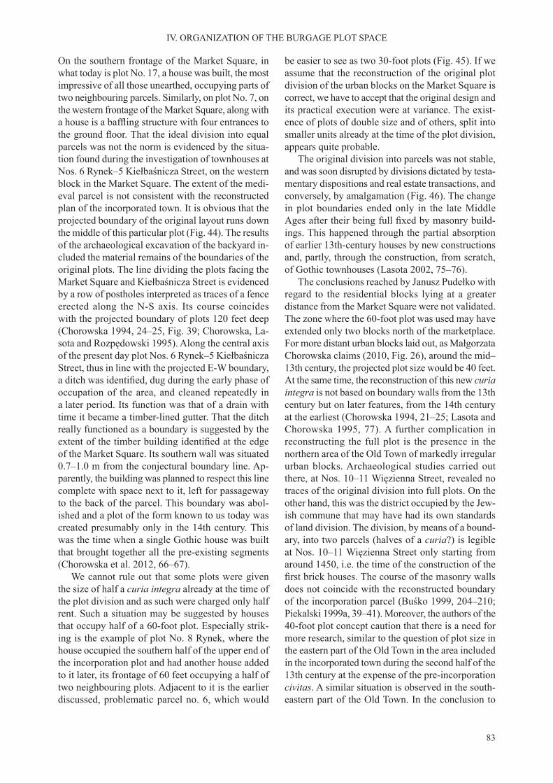
83
IV. ORGANIZATION OF THE BURGAGE PLOT SPACE
On the southern frontage of the Market Square, in what today is plot No. 17, a house was built, the most impressive of all those unearthed, occupying parts of two neighbouring parcels. Similarly, on plot No. 7, on the western frontage of the Market Square, along with a house is a baffling structure with four entrances tothe ground floor. That the ideal division into equalparcels was not the norm is evidenced by the situa-tion found during the investigation of townhouses at Nos. 6 Rynek–5 Kiełbaśnicza Street, on the western block in the Market Square. The extent of the medi-eval parcel is not consistent with the reconstructed plan of the incorporated town. It is obvious that the projected boundary of the original layout runs down the middle of this particular plot (Fig. 44). The results of the archaeological excavation of the backyard in-cluded the material remains of the boundaries of the original plots. The line dividing the plots facing the Market Square and Kiełbaśnicza Street is evidenced by a row of postholes interpreted as traces of a fence erected along the N-S axis. Its course coincides with the projected boundary of plots 120 feet deep (Chorowska 1994, 24–25, Fig. 39; Chorowska, La-sota and Rozpędowski 1995). Along the central axis of the present day plot Nos. 6 Rynek–5 Kiełbaśnicza Street, thus in line with the projected E-W boundary, a ditch was identified, dug during the early phase ofoccupation of the area, and cleaned repeatedly in a later period. Its function was that of a drain with time it became a timber-lined gutter. That the ditch really functioned as a boundary is suggested by the extent of the timber building identified at the edgeof the Market Square. Its southern wall was situated 0.7–1.0 m from the conjectural boundary line. Ap-parently, the building was planned to respect this line complete with space next to it, left for passageway to the back of the parcel. This boundary was abol-ished and a plot of the form known to us today was created presumably only in the 14th century. This was the time when a single Gothic house was built that brought together all the pre-existing segments (Chorowska et al. 2012, 66–67).
We cannot rule out that some plots were given the size of half a curia integra already at the time of the plot division and as such were charged only half rent. Such a situation may be suggested by houses that occupy half of a 60-foot plot. Especially strik-ing is the example of plot No. 8 Rynek, where the house occupied the southern half of the upper end of the incorporation plot and had another house added to it later, its frontage of 60 feet occupying a half of two neighbouring plots. Adjacent to it is the earlier discussed, problematic parcel no. 6, which would
be easier to see as two 30-foot plots (Fig. 45). If we assume that the reconstruction of the original plot division of the urban blocks on the Market Square is correct, we have to accept that the original design and its practical execution were at variance. The exist-ence of plots of double size and of others, split into smaller units already at the time of the plot division, appears quite probable.
The original division into parcels was not stable, and was soon disrupted by divisions dictated by testa-mentary dispositions and real estate transactions, and conversely, by amalgamation (Fig. 46). The change in plot boundaries ended only in the late Middle Ages after their being full fixed by masonry build-ings. This happened through the partial absorption of earlier 13th-century houses by new constructions and, partly, through the construction, from scratch, of Gothic townhouses (Lasota 2002, 75–76).
The conclusions reached by Janusz Pudełko with regard to the residential blocks lying at a greater distance from the Market Square were not validated. The zone where the 60-foot plot was used may have extended only two blocks north of the marketplace. For more distant urban blocks laid out, as Małgorzata Chorowska claims (2010, Fig. 26), around the mid–13th century, the projected plot size would be 40 feet. At the same time, the reconstruction of this new curia integra is not based on boundary walls from the 13th century but on later features, from the 14th century at the earliest (Chorowska 1994, 21–25; Lasota and Chorowska 1995, 77). A further complication in reconstructing the full plot is the presence in the northern area of the Old Town of markedly irregular urban blocks. Archaeological studies carried out there, at Nos. 10–11 Więzienna Street, revealed no traces of the original division into full plots. On the other hand, this was the district occupied by the Jew-ish commune that may have had its own standards of land division. The division, by means of a bound-ary, into two parcels (halves of a curia?) is legible at Nos. 10–11 Więzienna Street only starting from around 1450, i.e. the time of the construction of the first brick houses. The course of the masonry wallsdoes not coincide with the reconstructed boundary of the incorporation parcel (Buśko 1999, 204–210; Piekalski 1999a, 39–41). Moreover, the authors of the 40-foot plot concept caution that there is a need for more research, similar to the question of plot size in the eastern part of the Old Town in the area included in the incorporated town during the second half of the 13th century at the expense of the pre-incorporation civitas. A similar situation is observed in the south-eastern part of the Old Town. In the conclusion to

84
IV. ORGANIZATION OF THE BURGAGE PLOT SPACE
Fig. 45. Wrocław, Market Square. Earliest building phase in the western block. A – plan at the ground level: a – area with timber buildings; b – masonry laid in double-stretcher courses. B – reconstruction. Chorowska and Lasota 2010

85
IV. ORGANIZATION OF THE BURGAGE PLOT SPACE
his analysis of plots in this part of the town Paweł Konczewski noted that ‘the possibility that proper-ties were laid out according to the parcellation model known from the area around the Market Square was negligible (…) most of the investigated parcels were much smaller’ (2007, 99).
Organization of the inner space of a Wrocław parcel was described by Cezary Buśko (1995, 1995a, 1995b) and by Paweł Konczewski (2007), who made a detailed analysis of a plot in the south-eastern part of the medieval town. The scheme proposed by Ce-zary Buśko was a model, outlining general tenden-cies in the process of the formation of the structure of the plot, and was not just typical for Wrocław. This author distinguished five zones of the parceldepending on its use.
Zone I – the frontage end of the plot, described as formal. Occupied by a trader or craftsman’s house, usually cellared or with a sunken feature. Its con-struction could be of timber, masonry or a combina-tion of the two. At first, the house filled only part ofthe plot front and occupied its entire width only with time, but there was always a passage, for vehicles or pedestrians to the back of the plot.
Zone II – behind the urban domestic house, usual-ly with outbuildings, a kitchen or production hearths, storage pits and craft workshops. In Wrocław, this zone usually extended 5–7 m.
Zone III – with rear buildings (Mulczhäuser, Hinterhäuser). Their function was economic or residential. Some were rented out to people of the plebeian order, sometimes as charity.
Zone IV – sanitary with wells and cesspits and assorted pits many of them of obscure function.
Zone V – garden, found in more sparsely settled districts of larger towns or in smaller settlement centres.
The zones named above, but not always all of them, were a stable feature in Wrocław’s burgage plots. Their boundaries were not too clear and in-dividual elements were interchangeable. This led Paweł Konczewski to conclude that the character of the internal division of parcels is better reflected bya simplified division into three zones: (1) the front-age building, (2) zone immediately behind the house and (3) the economic-storage zone (Konczewski 2007, 100). Analysis of specific examples revealsthat the individual traits of plots were dependent on the material status and occupation of their owner, its location within the town and, presumably, other private circumstances. In practice, their stable ele-ment is the position of the main residential house in line with the street.
Plots at Nos. 6 Rynek and 5 Kiełbaśnicza Street were investigated comprehensively and were discov-ered to be part of the elite, patrician part of the town. They lay in a single line that cut across the western urban block on the Market Square (Chorowska et al. 2012, 49–53). At the front end of each plot, a high quality brick house was built during the 13th century (Fig. 47). Behind a multi-phase building in the Mar-ket Square, the remains of a smokehouse consisting of a two pits with a roof over them were discovered. The smoking pit was fed with smoke through a fluefrom a hearth with a pit attached to it. The siting of the smokehouse confirms the phenomenon observedin Wrocław during a later period where at least some of the kitchen activities took place outdoors. The presence of similar facilities in plots on the Market Square was noted by M. Chorowska (1994, 65–66). The smokehouse was accompanied by several pits of undetermined function, some filled with fire debris.A part of the area behind the house was paved with poorly fired, warped bricks. An amenity shared byfour (?) neighbouring plots was a timber-lined gut-ter, running the length of the boundary dating from the incorporation plot division project (Fig. 48). Its starting point was some 25 m from the edge of the Market Square, behind the back wall of a house. The slight slope of the terrain helped drain the wastewater to Kiełbaśnicza Street where there was a municipal gutter, which drained sewage to the Odra River. The deposit in the yard was mainly sand and contained no litter. A readily observable feature of the backyard was its cleanliness, which set it apart from other plots investigated in Wrocław. There was no evidence for the intentional storage of waste. During the 14th century, concern for sanitation in the Market Square plot is confirmed by the construction of a brick-linedcesspit, the first in Wrocław. Around 1350 the plotunderwent a major transformation, both the house and the yard. The ditch was filled in and the entiresurface covered with a walkway of rough planks. Similar walkways were identified in other plots, bothin the Market Square and other parts of the town. They usually covered a part of the yard or only the paths, facilitating movement over a muddy surface (Piekalski, Płonka and Wiśniewski 1991, 235–236; Guszpit and Wiśniewski 2002, 187–189, 202–203, Fig. 167; Konczewski et al. 2010, Fig. 3).
Much more consistent with the ‘zone’ model is plots at Nos. 10–11 Więzienna Street, so far the most fully analysed and published of the Wrocław parcels (Buśko and Piekalski 1999). At the back of a timber urban domestic building evidence of production activity was discovered, mainly tanning, but also
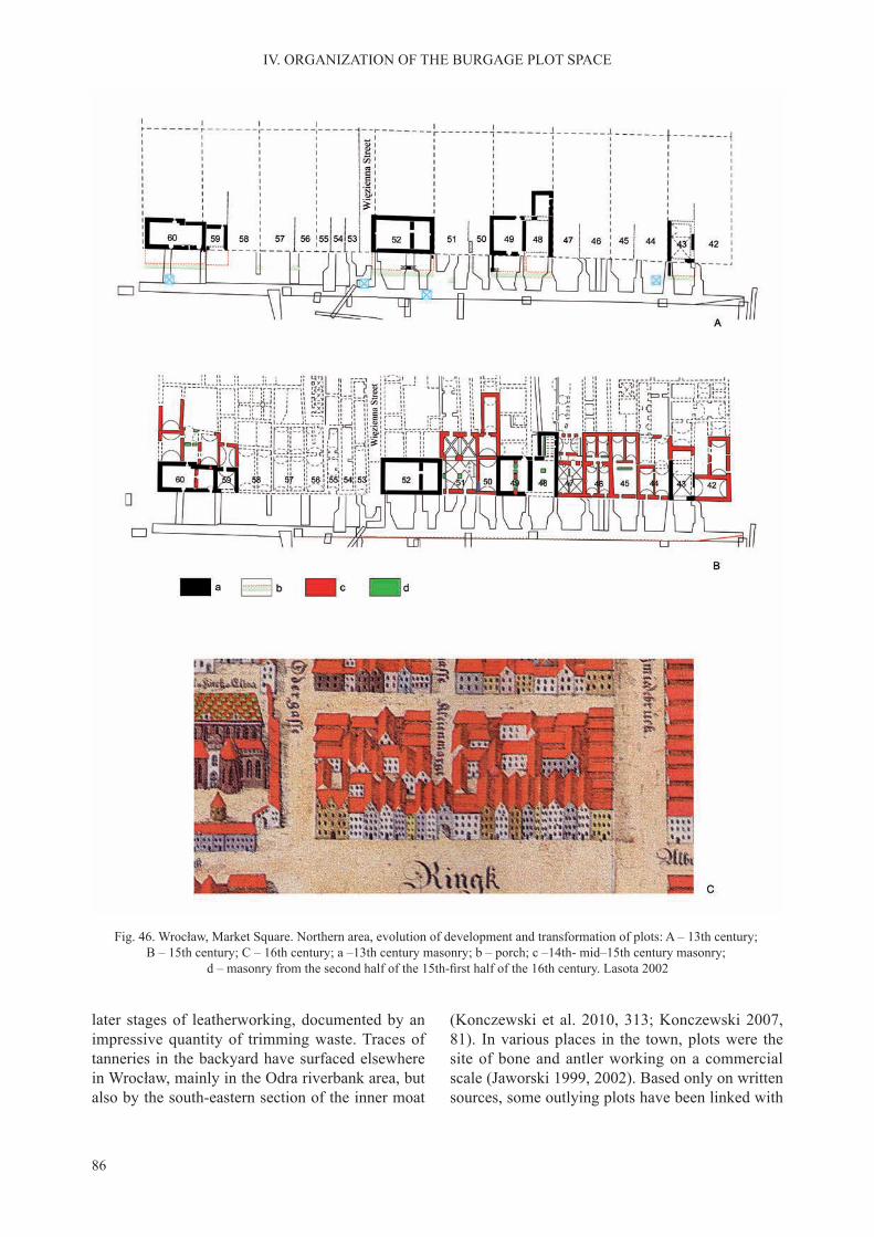
86
IV. ORGANIZATION OF THE BURGAGE PLOT SPACE
Fig. 46. Wrocław, Market Square. Northern area, evolution of development and transformation of plots: A – 13th century; B – 15th century; C – 16th century; a –13th century masonry; b – porch; c –14th- mid–15th century masonry;
d – masonry from the second half of the 15th-first half of the 16th century. Lasota 2002
later stages of leatherworking, documented by an impressive quantity of trimming waste. Traces of tanneries in the backyard have surfaced elsewhere in Wrocław, mainly in the Odra riverbank area, but also by the south-eastern section of the inner moat
(Konczewski et al. 2010, 313; Konczewski 2007, 81). In various places in the town, plots were the site of bone and antler working on a commercial scale (Jaworski 1999, 2002). Based only on written sources, some outlying plots have been linked with
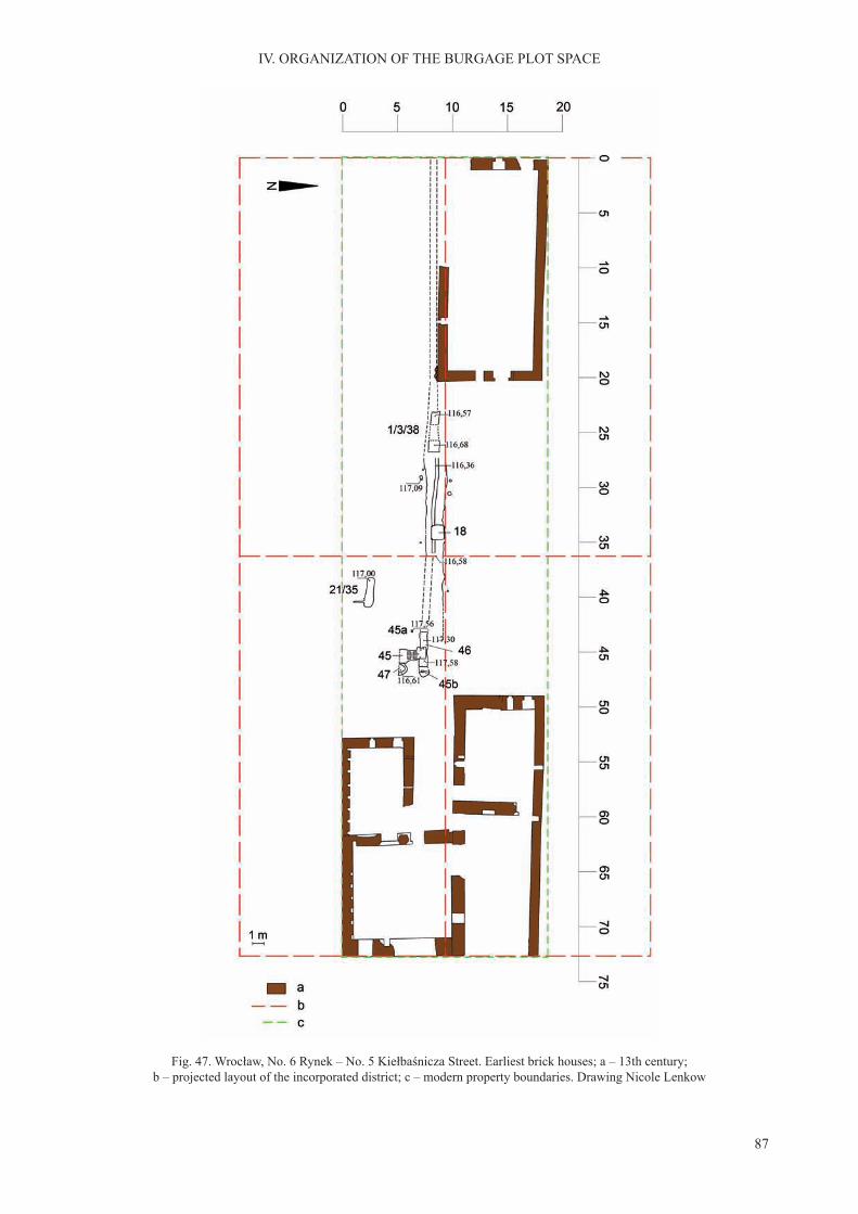
87
IV. ORGANIZATION OF THE BURGAGE PLOT SPACE
Fig. 47. Wrocław, No. 6 Rynek – No. 5 Kiełbaśnicza Street. Earliest brick houses; a – 13th century; b – projected layout of the incorporated district; c – modern property boundaries. Drawing Nicole Lenkow

88
IV. ORGANIZATION OF THE BURGAGE PLOT SPACE
weavers who dried their wares by spreading them over a large surface (Goliński 1997, 409; Jastrzębski, Piekalski and Wysocka 2001, 335–341). In almost all of the investigated plots evidence was found of various sanitary constructions ranging from unlined pits to well made, periodically emptied, cesspits with walls lined with rough planks. They appear during the late 13th century indicating the increasingly marked sanitary function of the backyards. Apart from the cesspits, this is evidenced by the accumulation of rubbish deposits. Presumably, with the increasing pollution of the backyards the sinking of wells in this area was discontinued. During the 14th cen-tury, the water supply function was taken over by the municipal water mains (Buśko 1995; Piekalski 2004, 347–348). Rear buildings were an infrequent feature during the 13th century. To-date they are best confirmed at Nos. 10–11 Więzienna Street, and with
a lower frequency, in the south-eastern district of the town (Konczewski 2007, 57–58). New elements observed during the 14th century are buildings that we can describe as the back wings of urban domes-tic buildings, or outbuildings (Chorowska 1994, 30–33; Chorowska et al. 2012, 70–71). To-date, one zone of the Wrocław plot from the list proposed by researchers not confirmed by the archaeologicalmethod is gardens or areas of greenery (zone V). This, however, does not mean that they did not ex-ist. Using the Weiner’s plan from 1562, we can say that also during the early modern period when the urban environment had become more crowded, we find small areas of greenery in the regularly plannedinner town, and everywhere between the inner and the outer line of fortifications.
The study of burgage plots in Krakow is condi-tioned by the nature of source evidence. Firstly, we
Fig. 48. Wrocław, No. 6 Rynek 6 – No. 5 Kiełbaśnicza Street. Gutter in the yard. Photo. Witold Wierzbicki

89
IV. ORGANIZATION OF THE BURGAGE PLOT SPACE
know that plots were definitely laid out in the wakeof the incorporation privilege of 1257. The size of a full plot (ganzen hof) in Krakow was 36 × 72 ells (72 × 144 feet), reconstructed by Władysław Grab-ski as 21.1 × 42.2 m (Grabski 1961, 99). We also know the amount of rent charged for a full plot by the decision of the city council of 1385, thus from a period when plot size was anything but uniform (KD Krakowa, no. 277). The full plot was used at this time as a calculation module. Full rent was collected from plots in the Main Market Square, plots situated between the square and the first street intersectionwere taxed at 2/3’s of this rate, while those found even farther away – a half of the rate. It should be stressed that these zones dictated the tax rate but not the plot size. The actual amount of the payment was calculated depending on the size of the parcel (Grabski 1968, 190; Jamroz 1983, 40–42; Schich 1993, 99–100).
The highly speculative concept, established in older publications on the division of urban blocks into twelve plots, seems no longer tenable (Borowiejska-Birkenmajerowa 1975, 113). Progress made over recent decades in archaeological-architectural studies of townhouse interiors has led to the conclusion that each block contained eight full plots (Łukacz 1999, 2010, 79). The distribution of plots within residential blocks varied depending on their position in the struc-ture of the town. The established rule was to arrange the plots with their narrow side to the marketplace or the main street. Marek Łukacz distinguished not less than six possible patterns of incorporation plots within a residential block (1999, 97, 2010, 79).
A small number of full plots had their boundaries fixed during the late 13th or early 14th century bymasonry houses that occupied their entire front end. This is most evident in town houses at Nos. 47 Rynek and 35 Rynek on the main Market Square, on the corner with Szczepańska Street where the palace ‘Pod Krzysztofory’ is today (Łukacz 2010, 79; Sławiński 2010, 85). In newer reference publications, parcels of this type are viewed as elite, therefore non-typical, indicating the very early splitting of the incorpora-tion period ganzen hof. The division of plots into two was, from the outset, sufficiently widespreadto prompt some researchers to treat half a parcel as the most frequently used module (Łukacz 2010, 77; Sławiński 2010, 85–86). This is supported by the results of the investigation of townhouse cellars as well as by the written record. From 1302, we have a reference to the division of a ganzen hof into two. From later documentary evidence, we know of divi-sion into quarters, and irregular parts too. Property
Fig. 49. Krakow, 24 Gołębia Street, trial reconstruction of a cesspit. Niemiec 2007
divisions do not always find reflection in the actualstructure of the built-up area. We know, for instance, of a room that was divided into two (Grabski 1961, 92, 1968, 190).
The example of Krakow shows that it is not safe to assume, as is now common practice that plots laid out following the incorporation were of equal size. This assumption disregards social and financial dif-ferences among the colonists. It is with good reason that researchers of Krakow have described the full plot as modular thus, the tool of the surveyor, but also
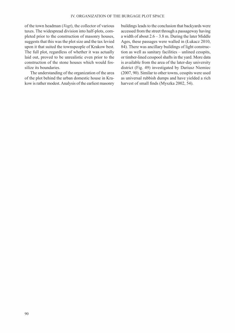
90
IV. ORGANIZATION OF THE BURGAGE PLOT SPACE
of the town headman (Vogt), the collector of various taxes. The widespread division into half-plots, com-pleted prior to the construction of masonry houses, suggests that this was the plot size and the tax levied upon it that suited the townspeople of Krakow best. The full plot, regardless of whether it was actually laid out, proved to be unrealistic even prior to the construction of the stone houses which would fos-silize its boundaries.
The understanding of the organization of the area of the plot behind the urban domestic house in Kra-kow is rather modest. Analysis of the earliest masonry
buildings leads to the conclusion that backyards were accessed from the street through a passageway having a width of about 2.6 – 3.8 m. During the later Middle Ages, these passages were walled in (Łukacz 2010, 84). There was ancillary buildings of light construc-tion as well as sanitary facilities – unlined cesspits, or timber-lined cesspool shafts in the yard. More data is available from the area of the later-day university district (Fig. 49) investigated by Dariusz Niemiec (2007, 90). Similar to other towns, cesspits were used as universal rubbish dumps and have yielded a rich harvest of small finds (Myszka 2002, 54).
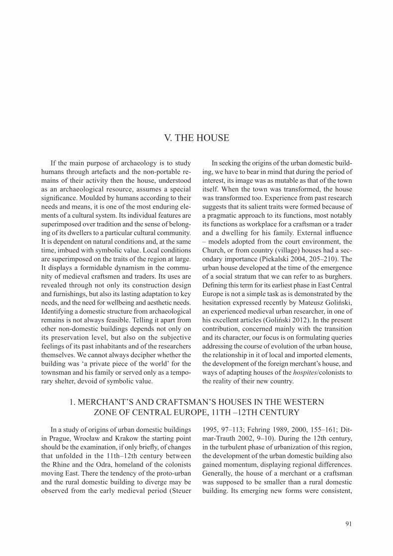
91
If the main purpose of archaeology is to study humans through artefacts and the non-portable re-mains of their activity then the house, understood as an archaeological resource, assumes a special significance. Moulded by humans according to theirneeds and means, it is one of the most enduring ele-ments of a cultural system. Its individual features are superimposed over tradition and the sense of belong-ing of its dwellers to a particular cultural community. It is dependent on natural conditions and, at the same time, imbued with symbolic value. Local conditions are superimposed on the traits of the region at large. It displays a formidable dynamism in the commu-nity of medieval craftsmen and traders. Its uses are revealed through not only its construction design and furnishings, but also its lasting adaptation to key needs, and the need for wellbeing and aesthetic needs. Identifying a domestic structure from archaeological remains is not always feasible. Telling it apart from other non-domestic buildings depends not only on its preservation level, but also on the subjective feelings of its past inhabitants and of the researchers themselves. We cannot always decipher whether the building was ‘a private piece of the world’ for the townsman and his family or served only as a tempo-rary shelter, devoid of symbolic value.
In seeking the origins of the urban domestic build-ing, we have to bear in mind that during the period of interest, its image was as mutable as that of the town itself. When the town was transformed, the house was transformed too. Experience from past research suggests that its salient traits were formed because of a pragmatic approach to its functions, most notably its functions as workplace for a craftsman or a trader and a dwelling for his family. External influence– models adopted from the court environment, the Church, or from country (village) houses had a sec-ondary importance (Piekalski 2004, 205–210). The urban house developed at the time of the emergence of a social stratum that we can refer to as burghers. Defining this term for its earliest phase in East CentralEurope is not a simple task as is demonstrated by the hesitation expressed recently by Mateusz Goliński, an experienced medieval urban researcher, in one of his excellent articles (Goliński 2012). In the present contribution, concerned mainly with the transition and its character, our focus is on formulating queries addressing the course of evolution of the urban house, the relationship in it of local and imported elements, the development of the foreign merchant’s house, and ways of adapting houses of the hospites/colonists to the reality of their new country.
V. THE HOUSE
1. MERCHANT’S AND CRAFTSMAN’S HOUSES IN THE WESTERN ZONE OF CENTRAL EUROPE, 11TH –12TH CENTURY
In a study of origins of urban domestic buildings in Prague, Wrocław and Krakow the starting point should be the examination, if only briefly, of changesthat unfolded in the 11th–12th century between the Rhine and the Odra, homeland of the colonists moving East. There the tendency of the proto-urban and the rural domestic building to diverge may be observed from the early medieval period (Steuer
1995, 97–113; Fehring 1989, 2000, 155–161; Dit-mar-Trauth 2002, 9–10). During the 12th century, in the turbulent phase of urbanization of this region, the development of the urban domestic building also gained momentum, displaying regional differences. Generally, the house of a merchant or a craftsman was supposed to be smaller than a rural domestic building. Its emerging new forms were consistent,

92
V. THE HOUSE
on the one hand, with local differences and traditions and, on the other hand, with advancing social and economic stratification (Roesdahl and Scholkmann2007, 166–169). The main directions of change of domestic buildings in proto-towns resulted from the reduction of agrarian functions and the need to make room for a craft workshop or storage and for separate living quarters. This could be achieved in two ways: one was by using the space on the ground floor by dividing it into zones and assigning it variousfunctions; the other was by constructing functionally separate storeys. Both involved the introduction of new building structures and a trend towards increas-ing the comfort of living standards. In traditional ref-erence publications, it has been emphasized that these methods were clearly separated territorially (Büttner and Meissner 1980). The main feature of the northern European hall house, known in its urban version as Dielenhaus, was its spacious ground floor. This wasdifferent to the proto-towns of the High German zone where the preferred form was a house of two storeys. At the same time, archaeological research proves that this classification is rather general as there is strongoverlapping in these two zones. Moreover, we shall find numerous exceptions and a wide assortment ofhouse forms. What is important is that in both zones new methods of construction were used to meet the new requirement for more room and a different house plan.
Analysis of a series of remains of 9th–12th-cen-tury buildings identified in the monastery settlementof Münsterhof in Zurich demonstrates a development aimed at adding an upper storey. This improve-ment could be achieved by introducing new build-ing designs – timber-framed and masonry walls. The replacement of the post-in-ground system by framework construction was facilitated by the Ro-man provincial tradition. Apparently, the method of house construction using sill beams was known in the northern provinces of the Empire, and used in low status buildings. We find its description inthe treatise on architecture by Vitruvius, and some confirmation in the archaeological record (Vitruvius1912, Lib. II, 20; Helmig 1982). Stone dressing and masonry technology were not unknown in the Al-pine cultural zone, and were commonly used in elite and ecclesiastical architecture. Therefore, next to one-storeyed houses on sill beams that were known from earlier times, the 11th century brought the firststoreyed houses in which the ground floor is builtof stone, the upper storey of timber (Fig. 50). The entrance to the upper floor was by an external stair-way. This new type of building could have existed
side by side with a traditional one-storeyed that was an elongated rectangle in plan. Analysis of House III in Münsterhof showed that the storeyed building served residential purposes and the timber building with a sill beam that was attached to it was used as utility space (Schneider et al. 1982, 113–120). The same tendencies were confirmed in Zurich outside themonastery settlement in the urban zone. There, timber buildings were gradually supplanted by masonry con-structions. Admittedly, the former continued in use during the 12th–13th century but increasingly often in an ancillary role. Timber was used to build the upper storeys of stone houses and utility extensions. There was a marked dynamism in the spatial development of the houses. It involved the addition of a succession of new segments to an existing building. The complex created in this manner stood within a single plot and formed a functional whole (Fig. 51). The finer pointsin the rhythm of evolution of the house are not clear to us although it was confirmed in Zurich by manyexamples (Schneider 1986, 24–27; Schneider et al. 1982, 79). We can only surmise that the main aim of this activity was to create living quarters for a new generation in a family of two or three generations. The same system is observed during a later period in towns of East Central Europe, e.g. Wrocław.
Generally, the direction of change at work in 11th–12th-century Zurich was consistent with tendencies observed in the High German zone. Adjusting to the limitations of the plot the practice was to build houses that occupied a smaller area, had more than a single storey and were open to continued development and obtaining more separate inner spaces (Schneider et al. 1982, 104–114; Gutscher 1984, 212–214; Schneider and Gutscher 1991). At the same time, we find in thesame region also other, even if similar tendencies, and spatial solutions aimed at creating an optimum model of an urban domestic building.
Distinctive solutions are documented for the parallel chronological horizon in Basel. Remnants of houses recorded in the settlement of craftsmen engaged in the leather, bone-and antler-working and textile trades on Petersberg terrace were mostly of timber and were an elongated rectangular shape in plan (Fig. 52), and in them, the supporting posts were inserted into mortise holes in the sill beam that was placed over a stone foundation wall. Their interiors were partitioned by means of installing wattle walls into several smaller spaces serving different pur-poses. A large, 8 × 12 m building had been partitioned into as many as five rooms. Another building’s layoutresulted from a process in which a succession of new segments was added to the original core (Berger

93
V. THE HOUSE
Fig. 50. Zurich, Münsterhof. Building III, horizontal projection and reconstruction. Schneider and Gutscher 1991

94
V. THE HOUSE
Fig. 51. Zurich, Nos. 57 Storchengasse/1 In Gassen: a – horizontal projection of a building consisting of elements A-B-C in chronological order; b – reconstruction. Schneider 1986
1963, 2002). On Petersberg’s terrace, extra space and internal divisions, needed to separate the functions of production, storage and residence, were created on the same level without adding an upper storey. The remains of timber buildings were overlain by
remnants of masonry walls – of the foundations or walls of the ground floor. Their appearance in the set-tlement is interpreted as the result of the progressing economic stratification of its inhabitants (Matt 1997,277–283). A different part of Basel, lying on the left

95
V. THE HOUSE
bank terrace of the Rhine and the Birsig, known as Untere Talstadt, had timber buildings set in line with the street during the 11th century. They were too poorly preserved to document internal partitioning, if any. What we do know is that around 1100 stone buildings were erected at the back of the plots behind the timber houses and the courtyards (Matt, Lavicka and, d´Aujourdhui 1984; Matt 1997, 283). Their chronological sequence suggests that they were the result of several projects in which a new segment was built against an earlier building, using the existing wall. The first to be constructed was the house on plotNo. 2 Schneidergasse; subsequently, on its south side a house with a ground floor of two rooms was builtagainst it to stand on plot Nos. 4/6 and it in turn, had another house built against its wall (Fig. 53). In this way, six buildings were constructed, linked by their construction but standing on separate plots. They had at least one upper floor and the surviving walls of oneof these structures confirm that it was a three-storeybuilding with substantial scope for internal partition-ing. This strategy, present also in other districts of Basel, has been described as the ‘domino’ method. Also typical for the town are masonry houses sited at the back of the plot; it is unclear whether they were always behind the timber building at the upper end (Lavicka 1993; Lavicka and Rippmann 1985, 110–114). At Nos. 4–12 Stadthausgasse the remnants of similar structures were discovered, square in plan, suggesting they had the form of a tower. At the same time, the thickness of their walls, typical also for
houses built to a different plan, does not indicate their military function (Hartmann et al. 1991).
The process in which timber buildings were re-placed by masonry ones may be followed in Freiburg im Breisgau (Galioto et al. 2002, 33–77). The earli-est merchants’ houses built during the phase when the town was being organized around 1100 were of post-in-ground or a timber-framed construction. They were constructed in line with the street but with a wide passage left for access to the rear of the plot, as was the case in, e.g. the parcel at No. 20 Salzstrasse. A 5 × 9 m timber domestic building with a cellar was set with its narrower side to the street in the eastern part of the plot. Another timber structure was built against its back wall and three smaller ones occupied the opposite end of the plot as far as the back street, Grünewaelderstrasse (Fig. 54). After 1127, a single-storey stone house was built next to it, its area 6.3 × 9.2 m, set with the gable to the street. After 1183, a cellar about 4 m deep was dug making the building a three-storey structure. Access to the upper floor was by an external stairway. Thetimber house fronting Salzstrasse was pulled down around 1170 and replaced with a stone building. Subsequent development involved the building of back ranges against its wall, and around 1300 the whole house was redeveloped and covered with a single roof, set with its ridgepole at right angles to the street (Fig. 55).
In proto-urban Ulm, the semi-dugouts built in post construction method, dominant during the earli-
Fig. 52. Basel, Petersberg. 11th century built-up area: a – extent of trench; b-c – reconstruction lines; I-VI – building numbers. Berger 1963

96
V. THE HOUSE
est phase, were succeeded by timber-framed houses of at least two storeys (Oexle 1993, 172–178). It is notable that two- or three-storey timber-framed build-ings, varied substantially regionally, became during the Late Middle Ages it was the principal form of a house in many small and medium-sized towns of Central and Northwestern Europe (Binding, Mainzer and Wiedenau 1989; Binding 1999).
The southern region is thought to be the area where the system of the heating of domestic interi-ors was improved by venting the smoke outside. In prehistoric and early medieval houses smoke from open hearths and dome stoves remained indoors and escaped only through openings in the roof. In reference publications, more notably in contributions from art historians and architectural historians but also from ethnologists, it is accepted, not without
justification, that the High German region is wherethe development of the residential function of the house first manifested itself as the introduction ofa separate chamber, understood as a room screened off by walls, which had a ceiling, and it was heated and smoke-free. In this way, the cubic capacity of the room had been reduced to correspond to the actual capacity of the heating device. The heated room is regarded as one of the most essential inventions in the history of the domestic building (Weiss 1959, 125–131, 141–155; Hähnel 1975, 335). In written medieval sources, this room is referred to in Latin as caumata, estuarium or pirale. In addition, in general use were Old German names – stupa, stube, stofa, türnitz, or dornse (Heyne 1899, 45; Moser 1980, 208–212; Griep 1985, 257–261). The Polish term biała izba (white izba, because it was smokefree)
Fig. 53. Basel, Stadthausgasse/Schneidergasse. Building layout from the 12th century: a – masonry building; b – timber building; c – hearth. Matt 1997

97
V. THE HOUSE
is used in post-medieval folk culture (Rutkowska-Płachcińska 1978, 315). Researchers of different disciplines identify the stube consistently with the capabilities of their methods. It is viewed as a static phenomenon by historians. For architectural histo-
rians and for archaeologists this understanding of stube seems an oversimplification. They are moreready to view the stube as a phenomenon that was subject to evolution over time. The form of this smokefree room was conditioned by regional so-
Fig. 54. Freiburg im Breisgau, Nos. 20 Salzstrasse/16–18 Grünewälderstrasse. Phase I/Ia – timber building. Galioto et al. 2002

98
V. THE HOUSE
cio-economic differences as well as by the level of construction technology. The distribution range and the time of partitioning off the smoke-free room in medieval houses in towns may be studied based on the written sources. These refer to their presence in 12th-century houses, at first in castles and monaster-ies, and later, in towns and the countryside (Moser 1980, 213–217). On the other hand, they rarely of-fer more details about the construction of its walls, floor and ceiling. Moreover, it is only in exceptionalcircumstances that the stube has been the main focus of archaeological investigation (Grimm 1971). It is mentioned and discussed in publications mostly on the margin of broader analyses of construction or heating systems (Tauber 1980, 1986; Schneider
1986, 33; Dumitrache 1993, 281–282; Lohrum 1993, 261–265; Untermann 1993, 229–230, 233–234), viz. domestic structures of Zurich and Basle and the foundations of early tile stove variants or hearths with a canopy for venting smoke in Petersberg in Basel (Berger 1963; Schneider et al. 1982, 113–120). This is no solid evidence on the use of the stube in its full sense but more information on the introduction of various technical means needed for its construction. It confirms that venting smoke from a heated interiorwas possible not so much due to a single invention as to the progress of technology over time.
Evidently, in the Low German zone there was more attachment to the tradition of the hall house known from prehistory. This model was continued
Fig. 55. Freiburg im Breisgau, Nos. 20 Salzstrasse/16–18 Grünewälderstrasse: a – reconstruction for ca. 1130; b – ca. 1170; c – ca.1302. Galioto et al. 2002

99
V. THE HOUSE
in part by the houses of Dorestad, Haithabu or, the youngest of them, of Schleswig (Schultze 2012). The origins of proto-urban settlement in Schleswig are dated only to the second half of the 11th century, its intensive development usually attributed to the takeover of economic functions from the declining Haithabu (Vogel 1991, 263). This continuity is also documented by domestic building forms. They were built of timber in a post-in-ground construction with interrupted sill beams that had been also recorded earlier in Haithabu. However, in Schleswig they were the work of much more advanced craftsmanship (Fig. 56). They were one-storey, an elongated rectangle in plan, some, usually larger, had transverse partition walls. Buildings of this form were typical for Schles-wig and evolved in the direction of a typical hall house (Low Saxon hall house) and were widespread during a later period, not only in the North but also in the South German zone, and in East Central Europe. During the 12th century, we find them in Lübeck asthe dominant type of urban domestic building (Gläser 2001a). Here they were placed at the front of the
plot with their gable wall in line with the street. In the archaeological record they are most identifiablein the commercial district, in the area of Alfstrasse, Fischstrasse and Schüsselbuden, between the parish church and the port on the Trawe River. They occu-pied much of the width of the plot with room left for passage to the backyard. Their surface area was in the range of 90–140 m2, and they varied in the details of their construction. The earliest houses were also the most primitive in form. The building discovered at No. 12 Fischstrasse had an area of 140 m2 and an interior divided by rows of posts into four aisles (Legant-Karau 1993, 209–210). Inside were a large hearth and a separate recessed area for working the weaving loom. It is unclear to what extent the divi-sion into aisles and its large inner space is evidence that livestock was kept inside the building. It was dated to around 1159. The house that succeeded it in the same plot, built around 1175, had a single aisle and a smaller surface of 105 m2, mainly because the side aisles, traditionally used as a cattle byre, had been dispensed with. During the next phase the back
Fig. 56. Schleswig. Proposed reconstruction of a timber house built after 1071. Vogel 1991
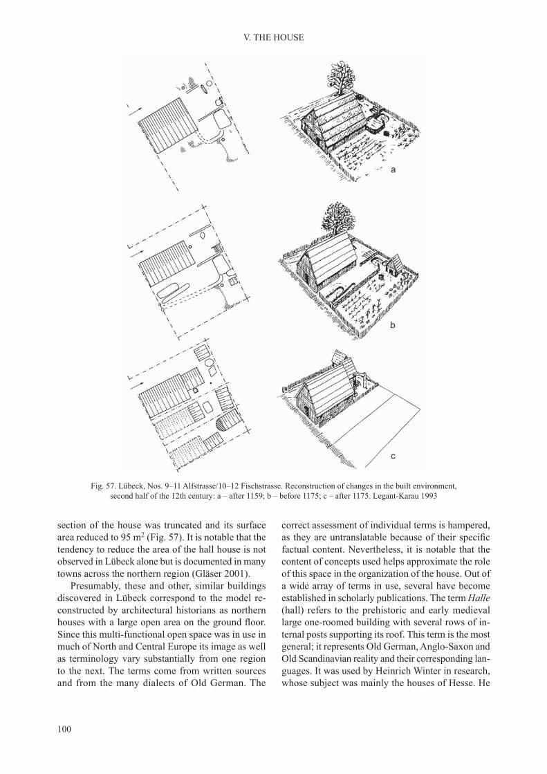
100
V. THE HOUSE
section of the house was truncated and its surface area reduced to 95 m2 (Fig. 57). It is notable that the tendency to reduce the area of the hall house is not observed in Lübeck alone but is documented in many towns across the northern region (Gläser 2001).
Presumably, these and other, similar buildings discovered in Lübeck correspond to the model re-constructed by architectural historians as northern houses with a large open area on the ground floor.Since this multi-functional open space was in use in much of North and Central Europe its image as well as terminology vary substantially from one region to the next. The terms come from written sources and from the many dialects of Old German. The
correct assessment of individual terms is hampered, as they are untranslatable because of their specificfactual content. Nevertheless, it is notable that the content of concepts used helps approximate the role of this space in the organization of the house. Out of a wide array of terms in use, several have become established in scholarly publications. The term Halle (hall) refers to the prehistoric and early medieval large one-roomed building with several rows of in-ternal posts supporting its roof. This term is the most general; it represents Old German, Anglo-Saxon and Old Scandinavian reality and their corresponding lan-guages. It was used by Heinrich Winter in research, whose subject was mainly the houses of Hesse. He
Fig. 57. Lübeck, Nos. 9–11 Alfstrasse/10–12 Fischstrasse. Reconstruction of changes in the built environment, second half of the 12th century: a – after 1159; b – before 1175; c – after 1175. Legant-Karau 1993

101
V. THE HOUSE
referred to the space which in a more evolved urban domestic building, continued from the ground floorto the upper floor as hohe Halle (Winter 1956/1957, 1963). A term with a meaning convergent with that of Halle is Saal, proposed by Josef Schepers who felt that it describes very well buildings distinctive for Westphalia, typically provided with a single entrance to their interior (Schepers 1965). The most general term, one conveying the original nature and multi-functionality of the utility area on the floor space, issimply Haus, derived from medieval written sources. Hans-Georg Lippert expanded it to the form Bin-nenhaus, emphasizing in this way the fundamental significance of the phenomenon and its functionaldomination over the entire building (Lippert 1992). Out of many other terms Diele may be worth invok-ing, used mainly on the coast of the North Sea and the Baltic, denoting a space provided with a solid timber floor (Hübler 1968, 18–22). Starting from theMiddle Ages this name was in use in Low German with reference not only to the space of the house, but also to the planks of its floor. It seems that Diele may be an umbrella term, even though in Lübeck, the town central to the study of domestic buildings, separate terms Dielenhaus and Saalgeschoss are in use (Gläser 2001a, 296–302).
Putting aside the complexities of terminology, we may claim that in its original form the Dielenhaus (hall house) had a single storey with a high gable, open inside (Lippert 1992, 187–202; Kaspar 1998, 214). The main space encompassed the entire house or a large part of it, accessible both from the street and from the yard. Its internal divisions into func-tional areas were implicit, less frequently fixed bymeans of light partition walls. At the rear of the Diele, on its longer axis, was the hearth. It designated the functional centre of the house where meals were pre-pared and eaten directly next to it or at a table close by. This was originally where places for resting and sleeping were, the bedding folded and put away dur-ing the daytime. The use of a hearth of this descrip-tion during the High and the Late Middle Ages was a conservative feature in an age when more advanced heating systems were already known. Nonetheless, it had a major symbolic significance. The front partof the Diele, near to the street, was for work and open to people who had come on business. Taking our cue from the conclusions of Hans-Georg Lippert (1992) and Fred Kaspar (1998), we can say that in the Dielenhaus there was a well-organized hierarchy of utility areas that reflected the social relations ofits inhabitants. The internal organization of the great central space (Diele) was the result of having the
living quarters and the work area occupy the same space. It is treated as a compromise of sorts between private and public life by Hans-Georg Lippert and Fred Kaspar. This compromise was not sustained and the results of the study of Late Medieval houses document an evolution leading to the separation of these two main spheres of life and, at the same time, the separation of zones in the urban space. The Diele served the residential functions increasingly rarely. Residential interiors proper – the kitchen, rooms and unheated chamber – were separated within the Diele or organized outside it at the back of the ground flooror on the upper floors.
Similar to the South, the subsequent development of the house referred to here as ‘northern’ was deter-mined by the need to vary the function of its interiors. The development of its space was also conditioned by the introduction of new building structures. Con-sequently, the post-in-ground construction was sup-planted by the framework construction and, later still, by stone or brick walls. With time, the masonry house in particular would evolve into a number of related forms in the towns of East Central Europe, not only on the northern Baltic seaboard.
The tendency to separate the utility area from the living quarters was expressed by the introduc-tion of an upper floor or, alternately, of an extensionbehind its back wall. The extension is more notable as the predecessor of the rear wing of the house. This signified the expansion of the area given over in thetraditional Dielenhaus model to cooking and sleep-ing. It is best to use the case of Lübeck again when seeking examples of such extensions. In Alfstrasse and Fischstrasse mentioned earlier behind the late 12th-century Dielenhäuser a new development were cellared buildings approximately square in plan (Fig. 58). Their construction was of posts with interrupted sills or timber-framed. The timber-framed structures were more sturdy, built of oak beams with a diameter of as much as 0.38 m. These buildings were sunken to the depth of as much as 2.60 m, their surface area 63 m2 (7.80 × 8.10 m). Access to the cellars was by an outer ramp with stairs. Entrances were near one of the corners at the front side of the plot, outside the front building. Only the earliest cellar was entered directly from the Diele. The recurring presence of cellars behind the front building leads us to interpret these two elements as a functional unit. Information about the form and purpose of the back segment is only partly available to us. The substantial thickness of the sill beams and carrier posts coupled with the overall sturdiness of the construction forms the basis for the conclusion that above the cellars, there was

102
V. THE HOUSE
Fig. 58. Lübeck, Nos. 9–11 Alfstrasse/10–12 Fischstrasse; a – garden; b – posthole; c – hearth; d – cellar wall; e – projected cellar wall; f – late medieval plot boundary; g – extent of trench. Legant-Karau 1994

103
V. THE HOUSE
always a ground storey, and possibly, also an upper floor (Fig. 59). The presence of the ground floor wasconfirmed in the better-preserved cellars by finds ofextant rough floorboards. The aboveground storeyswere lit by windows protected by wooden shutters with metal fittings (Fehring 1989; Legant-Karau1993; Gläser 2001a, 287). The discovery in Lübeck of a larger number of similar structures suggests that during the second half of the 12th century they were a standard part of the urban domestic building (Schalies 1999, 2012, 115; Rieger 2012, 132–138). Starting from the early 13th century, the timber exten-sions were replaced by masonry ones while the main house fronting the street continued to be of timber. The described phenomenon is relevant because it occurred in much of Central Europe: from the mouth of the Rhine in the west, through the inland region, as far as the eastern Baltic coast. They are most frequent in Westphalia and Lower Saxony, both in
towns and in the countryside. The plan of the cellared extension, the construction methods and material used, all varied. The most widespread solution was to build a masonry extension against the side of a timber-framed house (Isenberg 1977, 434–440, 1988, 1990, 110; Plate 1996; Rötting 2001, 409; Stephan 2000, 118–125).
In earlier references, one finds an interpretationaccording to which the back extensions of Dielen-häuser had the form of a tower (Schepers 1967, 17–18; Isenberg 1977, 437). This view is no longer held. The archaeological record now available does not permit a reliable reconstruction of the aboveground structures; especially as their stone constructions were usually erected without using mortar. What are recorded in many cases are the remains of only cellars or cellared one-storey buildings. It is assumed, at the same time, that the extensions combined the function of a windowless storage room in the cellar or on the
Fig. 59. Lübeck, Alfstrasse. Reconstruction of a rear annex of a Dielenhaus building. Legant-Karau 1994

104
V. THE HOUSE
low ground floor, and of living quarters (bedroom?)and a dry granary on the ground floor and, possi-bly, on the upper floor. Presumably, because of itsfunction as a granary, the timber construction was not adopted forever. In the 13th century, a typical house of two parts consisted of a timber building with a large space inside used as a multifunctional Diele, and a fireproof stone granary. Thomas Küntzel(2005) presented a number of potential solutions to the spatial relationship of the extension and the main house as an afterthought of his analysis of cel-lars identified in Nienover, a deserted 13th-centurytown on the border of Lower Saxony and Westphalia (Fig. 60).
A related issue is that of the interpretation of dugouts dated to the 12th–13th centuries. In many cases, their preservation is too poor to distinguish them from cellars of aboveground houses. It is not always possible to determine their function. Not in-frequently, their architectural and spatial relationship to the house’s superstructure remains unclear. The field for interpretation is rather wide in this respect– these could be self-sufficient buildings, their mainfunction residential, or craftsmen’s workshops; they may have served as sunken ground floors or cellarsof two-storey houses or finally, as presented earlier,as extensions erected behind an aboveground timber house (Baumhauer 2001).
Fig. 60. Spatial configuration of a Dielenhaus and cellared annex: 1 – classic form of a double house; 2 – annex integrated with the house set with its gable to the street; 3 – cellar integrated with a house set with its ridgepole to the street;
4 – annex built to the back wall of a house set with its ridgepole to the street. Küntzel 2005
2. TIMBER AND STONE HOUSES OF PRAGUE
One-room log or wattle-and-daub houses that were traditional in early medieval East Central Eu-rope were not suited to meet the standards of the urban lifestyle. Nonetheless, archaeological sources confirm their widespread presence in Prague as wellas in Wrocław and Krakow. After a long-term inves-tigation of the suburbium by Prague Castle, Jarmila Čiháková concluded that the dominant form there
were log houses with a sunken feature with an inner space of about 4 × 4 m. She estimated that at one time there might have been about 360 such houses. These houses differed from buildings recorded in open set-tlements by their orderly arrangement and substantial density within the confined space of the suburbium(Čiháková 1999, 19; Čiháková and Zavřel 1998). One reason for the harsh decision of King Ottokar II to

105
V. THE HOUSE
have them demolished in 1257 was presumably that they were found to be of no use for fulfilling urbanfunctions.
Another type of building in evidence in Prague during the proto-urban phase was timber structures with a sunken feature that were different in character. They were larger and their load-bearing structure usually consisted of posts. Some of the sunken fea-tures had stone-lined walls. From around 1200, these structures were an element of functional complexes built around Romanesque stone houses that were constructed at that time; no longer the main domestic building they now served ancillary functions. This relationship may be confirmed by the discoveriesmade in Husová Street (Hrdlička 1983, 622). At the same time, the position of some of these buildings in line with the street suggests their role was significant.They are recorded in the north-eastern district of proto-urban Prague. The remains of several build-ings of this type, dated also to around 1200, were identified at the rear of the earlier discussed plots nos.553–555, the area where Celetná Street leads off from the main square of the Old Town (Bureš, Kašpar and Vařeka 1997, 205). With a rectilinear outline, 5–7 × 6–7 m, they had a relatively large area of 30–40 m2. There were also smaller structures with a wall length of approximately 2 m. These were interpreted by their excavators as the remains of cellars of larger houses, granaries or workshops.
In the north-eastern area of proto-urban Prague, by the church of St Clement, two timber houses with sunken features were recorded. These had load-bear-ing posts placed in the corners and along the walls. Their interiors had a relatively large area of 35 and 42 m2. Their excavator, Petr Juřina (2005), interpreted them as two-storey buildings – with an undercroft and a residential ground floor. They are dated to the 12thcentury. Somewhat more to the east, by the church of St Peter, was a complex of 21 houses with sunken features, dated to the first half of the 13th century,which were entered by a remarkable external ramp. Their preservation, and consequently, potential for in-terpretation, varies (Bureš, Kašpar and Vařeka 1994, 208–210; Bureš, Kašpar and Vařeka 1997, 9–12). It is possible to distinguish them into two groups: one that includes 15 larger structures with an area of 16–33 m2 (Fig. 61 a, b, d) and a group of 6 smaller houses not more than 5.3–8.6 m2. The walls of some of the larger buildings were faced with stone or were built of rough stone bonded with clay. Traces of structural timbers were detected in some buildings. However, they are too residual to yield any detailed informa-
tion. Some buildings may have had a framework construction, others – a post-in-ground construc-tion. No evidence of indoor hearths was discovered to substantiate the domestic purpose of this group. An alternate interpretation is that these were cellars of houses, their size and design poorly understood. A point relevant for determining their function is also their position within the plot. If by this time the area of the settlement had been divided into parcels then these buildings were more likely to stand in the back area of the plot, their walls aligned with the line of the street. Their position at some distance from the street suggests that their role was not that of the main building on the plot, and that there was enough room in front of them to erect an aboveground domestic building. Consequently, they may be the cellared part of larger front buildings or their rear annexes – cellars or cellared buildings of light construction used for storage which would conform with the building tradi-tion of the western zone of Central Europe discussed earlier (e.g. Küntzel 2005).
In the same part of Prague, near to the church of St Benedict (in Republic Square) the pre-incorporation timber buildings were similar in character. Neverthe-less, some of them were evidently larger. A building with a sunken feature in a post construction had an area of 6 × 6.5 m and was sunk some 2 m below the ground level of the day. Its excavators interpreted it as having two storeys – an undercroft and a residential ground floor. Its walls were timber and clay (Fig. 62).The external entrance to the undercroft was placed by the north-east corner (Juřina, Kašpar and Podliska 2009, 49–51).
In Prague, it is not always feasible to separate houses from the proto-urban phase and later struc-tures associated with the incorporated town. This is true of high status stone buildings but also for some timber houses as well. In Gallus Town, two struc-tures with sunken features discovered by Václav Huml (1992, 65–76) in the Fruit Market presumably were in use after incorporation. One of them was 5 × 6 m and had a depth of 1.60 m. Its load-bearing construction is documented by traces of corner posts and its bottom was compacted clay. The building was entered from the west by an external passage. The other building, stratigraphically younger, was slightly smaller (4 × 5 m) but had the same depth. Its construction combined load-bearing posts and walls faced with vertically placed rough planks. There was a compacted clay floor with traces of a hearth. Thetwo buildings were interpreted by their excavator as being domestic in nature.
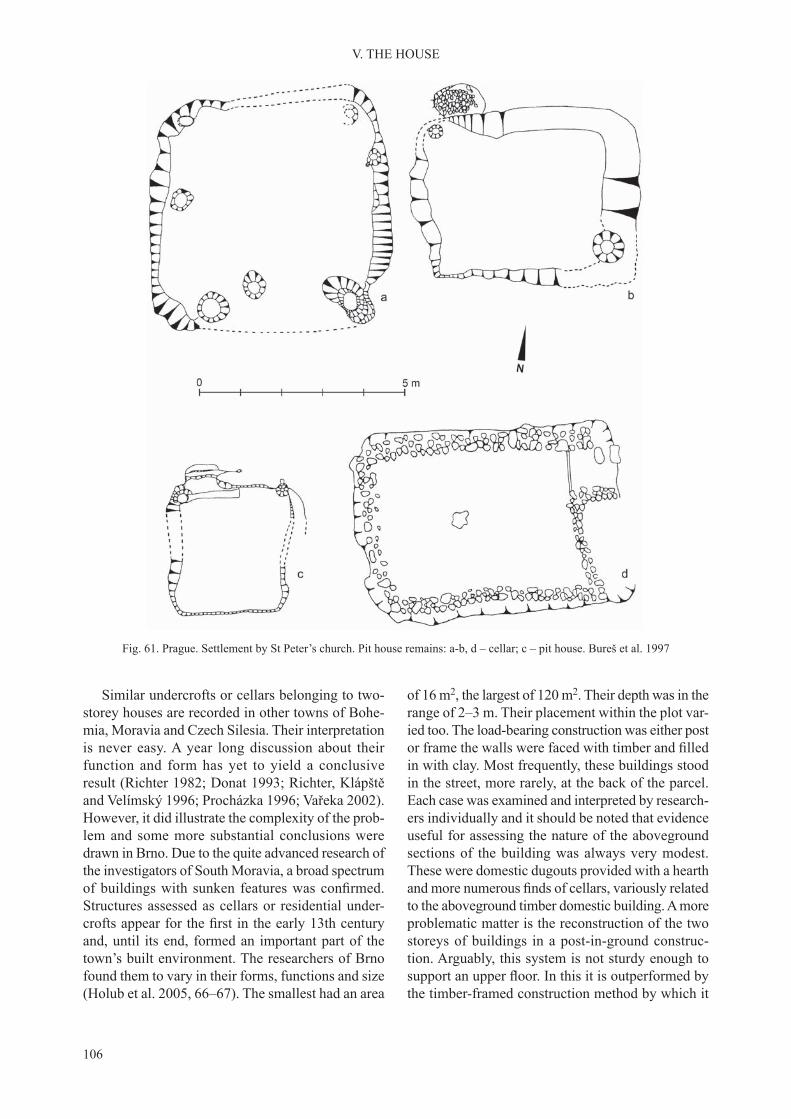
106
V. THE HOUSE
Similar undercrofts or cellars belonging to two-storey houses are recorded in other towns of Bohe-mia, Moravia and Czech Silesia. Their interpretation is never easy. A year long discussion about their function and form has yet to yield a conclusive result (Richter 1982; Donat 1993; Richter, Klápště and Velímský 1996; Procházka 1996; Vařeka 2002). However, it did illustrate the complexity of the prob-lem and some more substantial conclusions were drawn in Brno. Due to the quite advanced research of the investigators of South Moravia, a broad spectrum of buildings with sunken features was confirmed.Structures assessed as cellars or residential under-crofts appear for the first in the early 13th centuryand, until its end, formed an important part of the town’s built environment. The researchers of Brno found them to vary in their forms, functions and size (Holub et al. 2005, 66–67). The smallest had an area
of 16 m2, the largest of 120 m2. Their depth was in the range of 2–3 m. Their placement within the plot var-ied too. The load-bearing construction was either post or frame the walls were faced with timber and filledin with clay. Most frequently, these buildings stood in the street, more rarely, at the back of the parcel. Each case was examined and interpreted by research-ers individually and it should be noted that evidence useful for assessing the nature of the aboveground sections of the building was always very modest. These were domestic dugouts provided with a hearth and more numerous finds of cellars, variously relatedto the aboveground timber domestic building. A more problematic matter is the reconstruction of the two storeys of buildings in a post-in-ground construc-tion. Arguably, this system is not sturdy enough to support an upper floor. In this it is outperformed bythe timber-framed construction method by which it
Fig. 61. Prague. Settlement by St Peter’s church. Pit house remains: a-b, d – cellar; c – pit house. Bureš et al. 1997

107
V. THE HOUSE
was supplanted everywhere in Western and Central Europe. Interpretations that suggest the existence of buildings built in a post construction that have two-storeys should be discarded.
The decline of timber buildings with a sunken feature was associated with the introduction of stone houses during the 14th century. These were cellared too but the interpretation of their cellars is not prob-lematic at all. This applies to most towns that were built during the 13th century, not only on the terri-tory of today’s Czech Republic, but across much of Central Europe. Their appearance may be attributed to colonisation, although an ethnic attribution of individual structures is not possible.
Similar to other timber buildings there is no way to separate the pre-incorporation from the post-incorporation stone houses in Prague. Presumably, they appeared at the latest around 1200, although there is no hard evidence to support this claim. As noted earlier they were built as the town’s structure was developing, fixing the street plan and the plotboundaries. They form a characteristic group of elite Romanesque buildings, currently numbering 90. They are found mostly in the earliest settled part of the right bank town between the Vltava and the central marketplace (Líbal and Muk 1996, 46–63; Dragoun et al. 2003). Elsewhere in the Old Town
they are less frequent, their eastern range defined bybuildings discovered in Republic Square, in the area outside the incorporated town (Juřina 2006; Juřina, Kašpar and Podliska 2009).
Written sources provide no information about the owners of the Romanesque houses in Prague and the discussion on this subject is based on indirect evi-dence. The character and prospects of this discussion are conveyed by the turn of phrase used by Jindřich Tomas: ‘the social stratum of stone house owners (Tomas 1984a) and one that brings to mind the condi-tions of prehistoric rather than medieval archaeology. Nevertheless, it aptly reflects the limited scope forinterpretation. The result of this is the diversity of views presented in literature.
According to one concept, Romanesque stone houses were residences of the nobility associated with the principal centre of state authority. This view is parallel to another, which ascribes numerous Romanesque churches in the Prague agglomeration to endowment activity on the part of the nobility (Richter and Smetánka 1987, 73; Huml, Dragoun and Nový 1990/1991, 40–44; Fiala and Hrdlička 1997, 16; Dragoun 1997). Arguments opposed to this concept were presented by Martin Ježek (2011) who links the churches with ducal and episcopal founda-tions. It needs to be added that the distribution of
Fig. 62. Prague, Republic Square, reconstruction of a timber house. Juřina, Kašpar and Podliska 2009

108
V. THE HOUSE
Romanesque houses and churches does not overlap and this is in support of the concept put forward by Martin Ježek. The clustering of the houses in the market part of the town adds validity to another concept, presented in the 1940s, according to which the Romanesque houses belonged, in their majority, to merchants engaged in long-distance trade (Čarek 1947, 412–423). The early chronology of these buildings had led some authors to surmise that the core of this group were Jewish merchants, present in Prague from the 10th–11th centuries (Radová-Štiková 1974; Tomas 1984a; Čiháková, Dragoun and Podliska 2000, 141). A point in support of this line of analysis seems to be the find of a finger ringwith a Hebrew inscription in Republic Square (Zavřel and Žegklitz 2007; Kašpar and Žegklitz 2009, 56). Nevertheless, in the northern area of the Old Town, occupied after the incorporation by the Ashkenazi commune, such houses are few. On the other hand, there is evidence that from the 1170s at the latest, Prague had a permanent community of traders from the Romance language region, and even more so, Germans, who are addressed by the document of Duke Soběslav (Tomas 1984, 47). Let us add also, although this is not a binding argument, that wealthy German townspeople are indicated as owners of the Romanesque houses in much later written sources from the 16th century (Richter and Smetánka 1987, 73; Dragoun et al. 2003, 356–357).
To conclude the discussion on the ownership of stone houses in Prague of the first half of the 13thcentury, most likely in their majority they belonged to wealthy merchants. What is less clear is at what point in time we can refer to them as townspeople, es-pecially as the process of the emergence of the town commune on the right bank of the Vltava apparently was a process stretched over time. The incorporation contract of 1234 was sooner a legal and a fiscal regu-lation of an already existing situation (Nový 1984, 30). That the commune was not internally uniform is indicated by the fact that its houses varied in size and living comfort. The largest group are buildings of several rooms situated in the streets. A few larger and more complex buildings may be described as palaces, and a separate category are structures of unipartite plan at the rear of the plots.
A feature common to all the Romanesque houses of Prague was their building technique and mate-rial, which suggests the same workmanship and the same time. Their walls were built of limestone that was available locally. The wall faces were of dressed stone, the core of rubble in a system described as opus emplectum. Blocks of dressed limestone were
used in vaults, door and window frames and niches. The material of pillars and columns supporting the vaults was limestone or sandstone.
All these buildings had a sunken storey, some-times partly, in a few cases, completely, to a depth of around 1–2 meters below the level of the terrain at the time of construction. The researchers of Prague usually describe this storey as a sunken ground flooror an undercroft (Richter and Smetánka 1987, 73–74; Dragoun et al. 2003, 332–333). The buildings with the most architecturally sophisticated design are not a category sharply separate from the other Ro-manesque houses of Prague. Usually placed in this group are several buildings, variously preserved, their distinguishing feature – an elongated rectangular plan reminiscent of the form of the early medieval palatium. Their position in relation to the street is hard to describe. It may be even said that these houses were sited independently of the access routes. This feature set them apart from other stone houses during this phase of the development of Prague. Moreover, they were not affected by the division into parcels that fronted on to the streets. What presumably mat-tered in their siting was their position in relation to the cardinal points. This is suggested by their being aligned with their narrower wall to the north or west. We are led to interpret the buildings in Řetĕzová Street as palaces, marked in the house number-ing system used in the Old Town as No. 222/1, on Husová Street (No. 240/I), Karlová (No. 165/I), on Mary’s Square [Mariánské náměsti] (No. 102/I), in Tyn Court (No. 641/I) and, the last of the identified,in Republic Square (Líbal and Muk 1996, 60; Dra-goun et al. 2003, 146–165, 173–178, 298–300; Juřina 2006, 171–174). The house on Řetĕzová Street is the best preserved. It was a relatively large rectangle in plan with outer dimensions of 7 × 26.5 m. The street, irregular at this point, ran by its narrower, south wall. The surviving fragments of the northern gable show that the building had two storeys with each level divided into three rooms (Fig. 63). The spacious central hallway of each storey had a cross vault of two bays. The elite character of the lower storey was emphasized by the vault being supported by two columns. On both sides of the hallway were smaller rooms with vaults supported by a centrally placed pillar. These interiors were locked from the inside with a wooden bolt that fixed into the wall. Theresidential function of the rooms is confirmed by theirhaving been heated, documented on both storeys. The interiors were heated by four fireplaces connected totwo chimneys in the northwest and southwest corner of the building. Their hearths had the plan of a quarter

109
V. THE HOUSE
Fig. 63. Prague, Řetĕzová Street. Building of palatium type: a – reconstruction of interior; b: 1 – plan of lower floor, Romanesque phase I; 2 – plan of lower floor, Romanesque phase II; 3 – plan of upper floor. Dragoun et al. 2003

110
V. THE HOUSE
circle. Smoke was vented through a smoke canopy in the form of a section of a dome, built of dressed blocks of limestone. The entrance to the house was in the middle of the western wall, the one where the fireplaces were. The difference of level between thecourtyard and the ground floor, sunken more than 1 mdeep, was negotiated by means of a ramp or stairs set in an external walkway, similar to those in the timber houses. Access to the rooms on the upper floor waspresumably by an external wooden stairway placed by the same wall (Dragoun et al. 2003, 162–163).
An attempt to make a reconstruction for the less well-preserved palace in Republic Square was undertaken (Fig. 64). This building was rectilinear in plan, 8 × 25 m, similar to that of the palace on Řetĕzová Street. Aligned N-S the palace had two storeys – a cellar and a ground floor, or, alternately,a sunken ground floor and an upper floor (Juřina2006; Juřina, Kašpar and Podliska 2009, 44–46).
The surviving remains of the lower storey suggest that the interior was divided into two main parts, ac-cessed from the outside by two separate walkways placed on the eastern side of the building. The larger chamber was in the southern part of the palace and had inner dimensions of 5.5 × 14.5 m. It had a cross vault resting on three columns. The smaller interior, in the northern part of the building, was 5.5 × 6 m. It had a cross vault supported by a centrally placed column. Additionally, there was a sanitary annex placed at the back of the northern wall, by the north-west corner. Its outer dimensions were identified as1.8 × 1.8 m; its interior was sunken 2.5 m below the level of the interior of the first storey. Fragments ofstained window glass discovered in the latrine sug-gest that the palace may have had glazed windows. It was built using techniques comparable to the rest of the Romanesque houses of Prague. The walls were in opus emplectum of ashlar and rubble. A column base
Fig. 64. Prague, Republic Square. Romanesque palace, horizontal projection and reconstruction. Juřina, Kašpar and Podliska 2009

111
V. THE HOUSE
discovered inside the building was also Romanesque in style. Thus, when determining the chronology the researchers had at their disposal the same features as in other structures of this type, but also small findsfrom the neighbouring structures and from the palace latrine. The origin of the palace building is dated by them to the last quarter of the 12th century, its end to the incorporation of 1234.
The second, compact group of Romanesque hous-es of Prague are smaller than the palaces and were sited in the street. They were the most numerous which suggests that they were typical residences of rich merchants. They stood at the front end of the plot with room left for access to the backyard. They were quite varied in form with a large number of archi-tectural designs produced by several alterations and improvements, recorded during fieldwork as severalphases. Most of these houses survived only up to their first storey making it hard to determine their originalheight. Our understanding of the vertical layout of buildings, and thus, of the number of rooms, is based on analysis of isolated, better preserved structures or on the written documentation made of buildings de-molished in the early 20th century. Zdeněk Dragoun and his colleagues nevertheless, concluded, using the results of analysis of vaults and sections of stonework surviving above them, that most of these buildings had two storeys (Fig. 65); and rarely, there were also houses of three storeys as at No. 16/I U Radnice (Fig. 66; Dragoun et al. 2003, 42–58, 333). The research-ers of Prague, in contrast to Anita Wiedenau (1983, 13), have argued that three-storey houses did not have the form of towers. With a sunken ground floor,the height of the building did not exceed its width, and if so, only slightly. The pitch of the roofs was gentle, consistent with the Romanesque convention, continuing the Mediterranean model.
The layout of the ground floor and the upper floorwas usually similar even if these storeys served dif-ferent functions. A stable feature was the presence on both levels of one room larger than the others were. Next to it was another smaller room, or pos-sibly more. It is unclear what the placement of the possible wooden partitions was. A standard feature on the ground floor was a barrel or a cross vault.Presumably, the ground floor of the house served, ina general sense, as the merchant’s utility area. The main chamber was the elegant area where customers were received and where the wares were stored (Dra-goun et al. 2003, 356–358). Thus, the rooms on this storey were a semi-private space accessible not only to the family members, but also to the merchant’s as-sistants and the buyers of his wares. The residential
upper floor consisted of a large room that was avail-able to all the members of the household and smaller rooms or closets found next to it. The fact that the rooms on the two storeys were similar in their form need not mean that they served the same functions. At least some of the living quarters were heated by a fireplace (Dragoun et al. 2003, 342–343).
A remarkable feature of Prague stone houses was that their access means were installed from the side of the backyard. The entrance to the sunken ground floor was contained by an external walkway. In mostcases, it was placed by the corner of the house, per-pendicular to the wall. The walkways were covered by their own barrel vault. We have no evidence on how the entry to the walkways was closed, if at all. Doorways to upper storeys were accessed from exter-nal, wooden stairs, sometimes installed on a masonry structure. Marks observed on the outer face of the walls suggest that at least some of the stairways had wooden roofing. Less frequently, access between thestoreys was indoors, via stairs embedded in the wall (Dragoun et al. 2003, 337–338).
The next group of stone houses of Prague are smaller buildings set at the rear of the plot. Most ap-pear to be the rear extension of the timber buildings standing in the street and are described as kemenate or steinwerk (Dragoun et al. 2003, 361). Generally, they had two storeys with one room on each level sometimes with a segment screened off or added later (Líbal and Muk 1996, 49). At present around twenty such structures have been recorded (Fig. 67). Even if more modest in their construction and furnishings than the house in the street, it was a standard for them to have a vault on their lower storey. The inner space of the individual storeys of these buildings was on average 5 × 7 m, and the distance from the street was
Fig. 65. Prague, Karlova Street, plot no. 146/I. Reconstruction of the building interior. Dragoun et al. 2003

112
V. THE HOUSE
in the range of 15–17 m. The sunken interior was en-tered by an external ramp, usually from the direction of the street that is, installed inside the front timber building. In earlier publications, similar buildings used to be interpreted as detached houses standing at the back of the plot, possibly having the form of a tower (Čarek 1947; Hlubinka 1947; Líbal and Muk 1996, 49). Their complex analysis, complete with the assessment of their position within the plot and
a comparison with similar structures across East Cen-tral Europe, led Zdenek Dragoun and his colleagues to interpret them as annexes. In such cases, the stone buildings at the rear of plots would continue the tradi-tion that was especially visible in the Low German zone (Piekalski 2004, 103–121; Rötting 1995, 1996; Küntzel 2005). What is unexpected however is the high quality of the kemenate of Prague, which rarely finds analogy in historical Saxony.
Fig. 66. Prague, U Radnice, No. 16/I: 1 – sections of the house before the demolition of its elevated part in 1911 (drawing K. Hilbert); 2 – part of the cellar (present-day state, photo. F. Malý). Ježek 2011
1
2
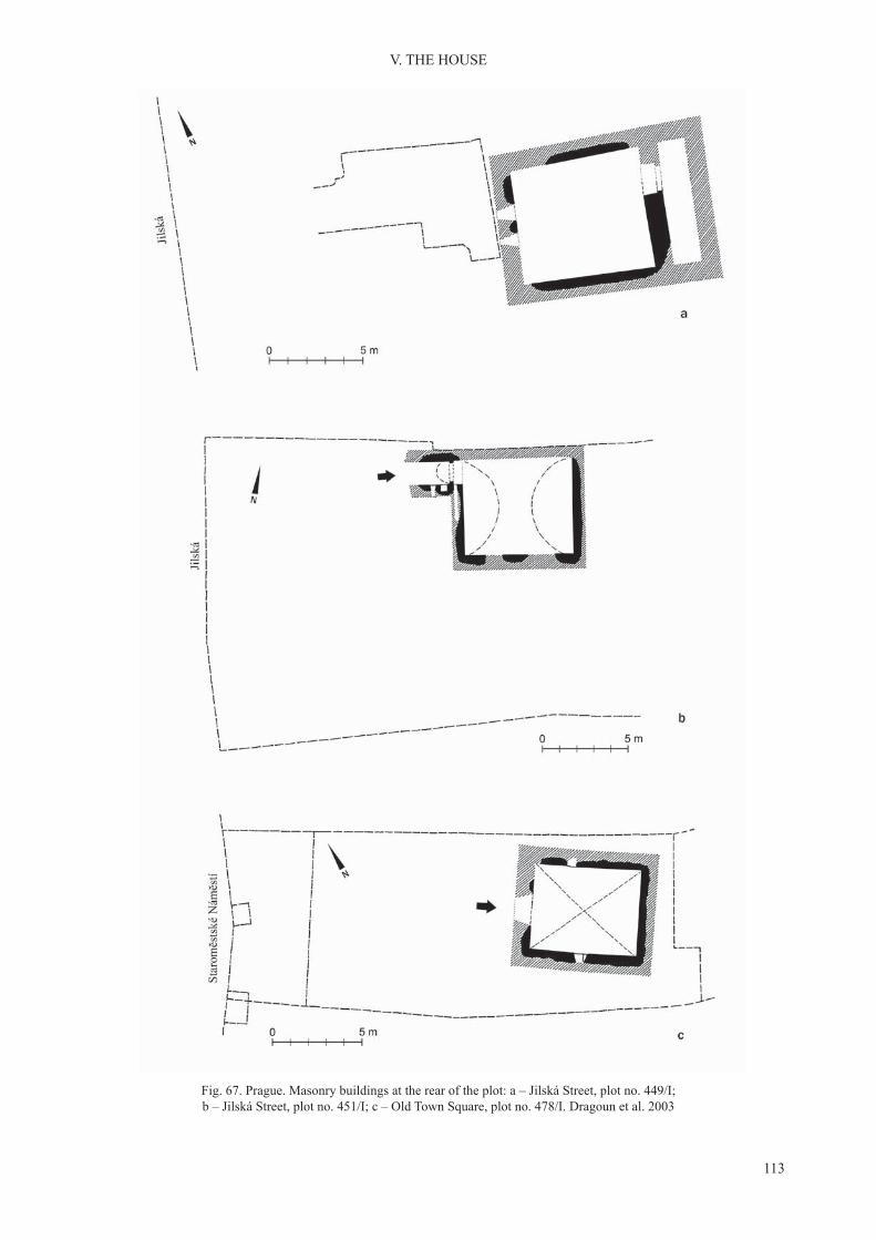
113
V. THE HOUSE
Fig. 67. Prague. Masonry buildings at the rear of the plot: a – Jilská Street, plot no. 449/I; b – Jilská Street, plot no. 451/I; c – Old Town Square, plot no. 478/I. Dragoun et al. 2003

114
V. THE HOUSE
To accept the claim that the small stone struc-tures belong to the no longer extant front houses is to admit that their purpose need not have been residential. They could have served as granaries or possibly, combined the two functions. However, this concept is hard to verify since the upper, presum-ably, domestic storeys of the small stone structures no longer survive.
The comfort of living in the Romanesque Prague merchants’ houses owed much to the arrangement, form and fittings of their doors, windows and inte-riors. Entrances, as noted earlier, were usually in one wall, from the side of the yard, separately for each storey. Doorways inside the house were mostly topped with a semi-circular arch with care taken to keep to the style in use and to a regular design. They were built of stone blocks, the same as those used in the walls, only exceptionally larger. In an alternative design the doorways and window openings, smaller ones especially, were bridged by a solid stone lintel. In both designs, decorative details were avoided, and only exceptionally was some restrained ornamental detail included. No traces of the mounts for the wooden doors survive.
Our understanding of the form of window open-ings is constrained by the fact that almost invariably, only the lower storeys are available for study. These, partly sunken as a rule, received no daylight. Win-dows were placed in the back or in the sidewalls. Only in the marketplace of the Old Town did they
open onto the public space. The small numbers of recorded ground floor windows have a stepped sillon the inside, the jamb splayed inwards with the rectangular window opening on the outer wall face smaller then on the inside. It was rare for the ground floor to have small round-arched windows (Dragounet al. 2003, 339–41). All of the few surviving win-dows of the upper storey are of a different form. In the house at No. 102/I Marianske Square [Mariánské náměsti], demolished during the early 20th century, the upper floor window, set high under the vault, hada noticeably diagonal sill, similar to the windows on the ground floor. The third storey of that house pre-sumably had a triforium window with gently splayed jambs decorated with polychrome figurative designs.In the western wall of the palace in Řetĕzová Street there was a window topped with a semi-circular arch, in true Romanesque fashion. On the third storey of the house at No. 16/I U Radnice, the window above the entrance was circular. Thus, typical Romanesque round-arched windows were not likely to be the dominant form in most of the Prague houses.
Recesses in the walls varied in size, form and use. They were built in the inner face of the wall of the main room, less frequently in smaller rooms on every storey and in the hallways. The largest were topped with a semi-circular arch, similar to doorways. Less frequently, they were square-topped, covered by a block of stone in the shape of a beam. Stepped recesses are also recorded – an outer, topped with
Fig. 68. Prague. Malé náměstí, plot no. 459/I. Bi-partite building with access from the courtyard. Dragoun et al. 2003

115
V. THE HOUSE
a semi-circular arch, and an inner, of the same form, but smaller (Dragoun et al. 2003, 341–342). On a few occasions, the recesses were found to have been framed or lined with wood, and some with wooden doors, appear to be wardrobes built into the wall. Other, smaller recesses had an approximately square opening, their walls formed by the edges of the blocks of stone of the wall. They were installed about 1.20 m above the floor level, for easier access.These recesses were used as shelves or cubby holes (Fig. 68). Some of them retain traces of a timber-lin-ing made of planks that were fitted together. Somesmall recesses were cubbyhole like and were let into the wall parallel to its face. In such cases, the recess was small and, presumably closed in some way. Traces of soot discovered on the walls of other, open recesses suggest that candles or lamps were placed in them. This was typical especially for recesses found in hallways.
Romanesque houses of Prague are a unique phe-nomenon in Central Europe. They are so numerous, clustering in a small area, sophisticated technologi-cally and high in aesthetic merit, well investigated and widely published. They are a source for the study of building construction, art, residential culture and lifestyle, social development and stratification proc-esses, and information exchange on a regional scale. Unlike the timber houses, they offer substantial in-sight into the life of their inhabitants. Their division into storeys is documented rather than conjectural, identifiable in the functional differences of their inte-riors and access systems. We are in a position to trace the improvements that added to the comfort of living. Their high quality made them elite not only during the first half of the 13th century, when most of themwere built, but also during the later Middle Ages. We know only approximately when the construction of Romanesque houses ceased, the high level of the stonemason’s craft was dispensed with and Gothic styles in construction were adopted. The number of recorded stone houses is over 80 but it is unlikely that all buildings, which were erected, survived and were identified. Thus, their original number remainsunknown. However, it may be said that they largely determined the view of the town during the 13th century. They reflected its dynamism, the financialpotential of its merchants and the level of their cul-tural awareness. Their social role also was that they were the mainstay and, at the same time, the effect of the activity of merchants who were changing the face of Prague, independently of legal changes introduced by the rulers through incorporation.
The excellent quality of Romanesque houses in Prague continues to perplex researchers about their origins. A comparison of these edifices withchronologically related buildings in other towns of Central Europe reveals their singular character; and they differ too from residential buildings in defensive establishments and monasteries in their region. Although houses of ‘palace type’ discovered in Prague display a similarity of plan and layout of storeys with corresponding courtly buildings upon closer analysis we find numerous differences (Pia-nowski 1994; Graham-Campbell and Untermann 2007, 348–350). In comparison to the palace and the chapter house in Prague Castle built after 1135, the palace of the Přemyslids in Olomouc or the imperial establishment at Cheb (Eger), they have different inner divisions with smaller rooms and were heated differently (Michna and Pojsl 1988). Other houses of Prague, those that are the most numerous, i.e. with two rooms on the ground floor, have no paral-lel in residential architecture at all. Many common features, especially in the stonework and masonry, may be recognized as typical of Prague Romanesque architecture in general, rather than of its separate class, as merchant houses are recognized by us to be. It seems ill-advised to pursue a model for Prague houses in distant towns in the south and the west of the continent (Dragoun et al. 2003, 366–367). The buildings known from Cluny in Burgundy and Cahors in Aquitaine referenced in this discussion admittedly are houses sunken features, built of stone with a ru-dimentary division of their interiors. Nevertheless, these towns lay far from Central European trade routes and as they do not belong among centres with a decisive, more than local economic significance,their connections with Prague are difficult to prove.The Romanesque houses of Prague are too late to associate with the lucrative trade in Slav slaves. This traffic, central to Prague in the 10th–12th cen-turies, could explain close contacts with the towns of Spain and with Venice (Le Goff 1994, 161; Brather 1995/1996, 114–115). In the 13th century, the trade was in decline due to progressing Christianisation, reduced opportunities for Jewish merchants in West-ern Europe and the flagging trade with the Islamicworld because of the Crusades (Haverkampf 1999; McCormick 2007, 700–777; Ježek 2011, 637). It is plausible also that the difficulty in linking the Praguehouses with their western counterparts may result from insufficient investigation of some south Germantowns such as Regensburg or Nuremberg. Neverthe-less, one is tempted to claim that the stone houses

116
V. THE HOUSE
of Prague, given their sheer number and admirable quality, are simply an original phenomenon.
The evolution of urban domestic buildings after the town’s incorporation unfolded in several direc-tions. In Gallus Town but in the main marketplace of the Old Town too, several elite tower houses were built that were set at the upper end of the plots. There were also front houses occupying a wide parcel with a central passageway and Dielehäuser set with their
gables to the street. Not infrequently, the irregular plan of the plots made it necessary to adjust the house’s form. There was also a steady development of the back area of the plots with new ranges added to the existing buildings, rear wings and outhouses (Radová 1992; Hauserová 1995; Líbal and Muk 1996, 91–99, 113–116).
3. EARLY HOUSES OF WROCŁAW
The earliest phase of domestic buildings in Wrocław was small, usually oval-shaped semi-dug-outs, rarely more than 3 × 4 m. This is true both of the castle on Ostrów Tumski and the settlement on the left bank of the Odra River. Their construction is un-clear, they could be the sunken features of a building or, as suggested by Józef Kaźmierczyk, their only superstructure was in the form of a hut-like roof (Kaźmierczyk 1966–1970, part 2, 33, Fig. 6). Based on the analysis of small finds the same author inter-preted the semi-dugouts of the left bank settlement as craftsmen’s. The next phase was aboveground houses built with wattle-and-daub or in the log construction method with a surface of 15–20 m2. In East Central Europe, the log house is traditionally attributed to the Slav ethnos (Rębkowski 2001, 27–32; Brather 2001, 98–109; Šalkovský 2001, 57–59). As regards the comfort of living in a log house, its strong point was the good insulation of its solid timber walls; but the horizontally tied beams and load-bearing walls were an impediment to the construction of upper storeys (Fig. 69). Certainly, despite these drawbacks, log houses of two storeys continue in evidence from the Middle Ages through to the modern period in Rus and in the Alpine region. Accepting the cultural con-nection of the log house construction with the Slav ethnos, we must also bear in mind the association of this effective construction design with the conifer-ous forest zone of Europe, its usefulness in a rural environment and cool climate zone (Sorokin 2001; Klein 2012, 10–11).
The role of domestic wattle-and-daub buildings in early medieval Wrocław, which are sometimes treated by researchers as of secondary importance, was at least as important as that of log houses. They are recorded in similar number, had a similar surface area, flooring of rough planks or compacted clay andwalls made weather-tight with clay or moss. There was an open hearth in the one-room space of wat-tle-and-daub and log houses alike. Indoor clay dome
stoves in pre-incorporation Wrocław are infrequent. The two traditional house types of the proto-town were not a good starting point for the development of the multi-space urban domestic building. Conse-quently, during the 13th century, decisively for the town, they were removed. Very few survived in the late medieval town. During the 14th century, they could have been incorporated in ancillary buildings at the rear of the burgage plots (Piekalski 1996a, 1999a). Their presence has not been confirmed to-date in the later period.
Houses in a post-in-ground construction datable to the first half of the 13th century are confirmedsporadically for pre-incorporation Wrocław. Some had palisade walls; others represent the variant with interrupted sill-beams. This type of house is more in evidence in the eastern part of the Old Town (Kaźmierczyk 1966–1970, part 2, 470–471; Piekalski 2004, 174–176). These houses played no essential role in the evolution of urban architecture in Wrocław. Neither is there evidence in this town for buildings in a post construction with sunken features, typical for Prague and other towns in Bohemia and Moravia.
Timber-framed buildings with a sill-beam foun-dation are another matter. At the present stage of re-search, it may be concluded that this design appeared in Wrocław around 1200, before the incorporation of the town. Its earliest traces are known from Ostrów Tumski. On the left bank of the Odra, in the crafts-and-market settlement, the earliest and best preserved remnants of timber-framed houses were identified inNew Market Square within the settlement ad sanctum Adalbertum, included in the incorporated town during the 1260s. Even prior to this development, the design had become dominant (Kaźmierczyk 1966–1970; Jaworski 1999a; Niegoda 2005). Buildings erected by this method also appeared in the incorporated town around the present day Market Square where they

117
V. THE HOUSE
mark the earliest phase of urban domestic buildings (Piekalski 1996b; Chorowska et al. 2012, 50–55).
Timber-framed houses are the first, which maywithout reservation, be said to introduce a new qual-ity to housing in medieval Wrocław, an essential ele-ment in the transformation of the urban lifestyle and the townscape. Their average area was between 35 and 45 m2, although larger buildings are also docu-mented, such as the house in New Market Square of more than 60 m2 (recorded as stratigraphical unit – s.u. 541). It was rectangular in plan, 4.99 × 12.80 m; the longer walls aligned approximately E-W (Fig. 70). It was dug into the ground to a depth of 1.20 m, consequently it may be said to have had a sunken ground floor. The construction was set directly onthe ground without a foundation. The sill-beam of the northern wall was of three trimmed timbers, 15 × 25 cm. Inserted into it were 11 load-bearing posts spaced unevenly, between 1.02 and 1.34 m. The south wall sill-beam was a single 20 × 26 cm timber. It supported 11 posts spaced similarly to those in the northern wall. The cross-sections of the sill-beams of the gable walls were dissimilar – at 21 x 13 and 15 x 24 cm. Each of these walls had a single post in the middle. The load-bearing structure was completed by three
posts set onto sleepers and supporting the roof, placed on the longer axis of the building. Walls were of rough planks up to 5 cm thick and up to 30 cm wide. In the gable walls, they were placed horizontally, in the front walls – vertically. In the sunken part of the building, the planks were stabilized by banking up with earth. Lumps of daub discovered in the layer representing its destruction confirm that the upperpart of the walls was coated with clay.
Fig. 69. Wrocław. Reconstruction of a log house building from the left bank settlement. Kaźmierczyk 1966–1970
Fig. 70. Wrocław, New Market Square, frame building (stratigraphical unit 541). Drawing Maksym Mackiewicz

118
V. THE HOUSE
Entrance to the building was in the northern wall by the northeast corner. Its width of 1.34 m was equal to the distance between the corner post and the firstwall post. One of the corner posts retained a hook for attaching the hinge, and next to it, two iron hinges and a padlock. In front of the doorway lay two rough planks 1.02 and 1.05 m long with a width of 24 and 25 cm, to facilitate access to the interior. Inside was a central open hearth laid of bricks. In the southeast corner, screened off by partition walls was a rec-tangular space, 2.47 × 2.80 m, heated with a dome stove made of clay. This area may be interpreted as a separate room (stube). The floor was of compactedclay. No evidence was found that this particular build-ing had an upper floor. The relatively large size ofits interior had potential for organizing the space to suit the needs of its inhabitants. In this respect, the building may be said to continue the tradition of the ‘northern’ model.
There is indirect evidence that some houses small-er in area, approximately sub-square in plan, had two storeys. The lower storey was usually recessed to a varying extent, at most, 1.80 m lower than the ground level as it was at the time of construction. This makes it difficult to interpret these sunken features as
a sunken ground floor or cellar. The latter interpreta-tion was used by the investigator of one of the firstfeatures to be discovered – two timber-framed houses at the former Drewniana Street – sunk 1.70 m below the level of the medieval street surface (Kaźmierczyk 1966–1970, part 1, 164–168). In several houses ex-posed in 2010–2011 in the southern area of the later New Market Square, the presence of two storeys was confirmed beyond any doubt.
One of them is the building recorded as strati-graphic unit 322 identified in the south-west area ofNew Market Square. The length of its walls was in the range of 4.98–5.21 m, thus it was approximately sub-square in plan, different to the plan of the house discussed earlier (s.u. 541). It was sunk some 98 cm below the ground level as it was at the time of its construction. All the sill-beams were trimmed to 25 × 25 cm. The load-bearing posts set in the middle of each wall were less uniform in size with cross-sec-tions ranging from 14 × 26 to 25 × 25 cm, regardless of their position in the structure. The load-bearing system was completed by a post, 32 × 34 cm in cross-section, driven into the ground at the centre of the building (Fig. 71). The wall shorings were rough planks placed vertically over the outer edges of the
Fig. 71. Wrocław, New Market Square, two-storey wooden framed house (stratigraphical unit 322). Drawing Maksym Mackiewicz

119
V. THE HOUSE
sill-beam, the free part of the foundation trench filledin with sand. The width of the rough planks stabi-lized in this manner was 36–42 cm. Entrance to the sunken interior was placed in the western wall, 78 cm from the north-west corner and was 1.20 m across. It was accessed through an external passage, 3.30 m long and 1.57 m wide. The interior was entered by five steps carved in the ground, hardened by cover-ing them with compacted clay and stabilized with planks. The depth of the steps was 16 cm. A similar compacted clay floor was discovered inside thebuilding. Over it lay charred joists and rough planks of the upper storey floor, fallen there at the time ofa fire. The planks were massive – with a width ofmore than 40 cm. The total area of both storeys was around 50 m2, thus, not much smaller than that of s.u. 541 interpreted as a one-storey structure, described earlier. Nevertheless, the organization of this par-ticular house, if we wished to determine its origin, is different and belongs in the tradition of the High German zone.
In other houses unearthed in New Market Square, the function of their sunken ground floor or cellarcould be determined. This is best illustrated by the remnants of a timber-framed house destroyed by
fire (recorded as s.u. 332 and 334) with some ob-jects left behind by its inhabitants and these were: several staved containers with a base diameter of 50 cm, a wicker basket with a lid of similar diameter, 3 wooden bowls, a wooden spoon, fragments of pottery vessels, two cylindrical bark containers with a diameter of 30 and 40 cm and a height of 15 cm, some assorted wooden objects of obscure function and a metal oil lamp for lighting the interior. The set of utensils suggests that the lower storey was used mainly as a food storeroom. Access to it was through an external entrance with a passage, the door locked with a key (Fig. 72). An upper storey with living quarters is confirmed by debris from a stove built ofclay, bricks and stone, destroyed in the fire, discov-ered in a residual context in the north-west corner of the interior. The rest of the surface of the house interior was covered by a layer of clay mixed with cut straw, presumably the fill of the ceiling.
Especially noteworthy are timber-framed build-ings discovered in the area around the Market Square and recognised as significant for the character of thebuilt environment of the early incorporated town. Several were identified at the upper end of plotsfronting onto the Market Square, indicating their
Fig. 72. Wrocław, New Market Square, food storage area on the lower storey of a wooden framed house (stratigraphical unit 332, 334). Drawing Maksym Mackiewicz

120
V. THE HOUSE
status of primary domestic buildings. It was so in the corner plot at Nos. 12 Rynek/20 Salt Square. It was occupied by a domestic building sunk about 2 m lower than the level of the natural humus. The wall of the house fronting the Market Square was more than 7 m long. Elements of its structure charred by fire were interpreted as the remnants of wooden floor-ing. There was another timber house in the same plot. About 3 m to the east of it, also fronting the Market Square, another less well-preserved building was identified (Lasota, Król and Piekalski 2005). Duringthe 13th century, the timber buildings at the front were replaced by brick houses.
Somewhat better preservation was displayed by a timber house discovered at the upper end of the par-cel at No. 6 Rynek, in the western area of the square (Chorowska et al. 2012, 52–54). Its timber-framed construction is confirmed by the charred remains ofthe back wall sill-beam. The front wall was over 5.50 m, the sidewall a little over 4.80 m. This places it in the group of houses sub-square in plan. Its floor wasat the level of 1.25 m below the top of the natural hu-mus, and was lined with compacted clay. The interior was divided, at right angles to the edge of the square, into two parts 1.6 and over 3.2 m wide. There were traces of a dome stove built of clay over a frame of 4–5 cm thick woody stems located centrally inside the building. The relatively large stove was the domi-nant element of the interior. The layer of destruction debris from the burnt building yielded no evidence for the presence of a second storey.
The architecture in the Market Square is comple-mented by remains discovered in a linear water mains trench in Kurzy Targ Street, which leads off from the Market Square in the middle of its eastern edge (Mruczek 2000). The street was expanded, presum-ably already during the 13th century, encroaching on the buildings in the square. Samples of timber from their frame construction yielded dates from the firstdecades of the 13th century. That the timber buildings in the square could be of two storeys is confirmedby the structure discovered at No. 8 Igielna Street, the second block of buildings spreading north from the square (Piekalski 2004, 178–181). The building with an area of about 30 m had a ground floor thatwas sunk to a depth of 1.30 m and an upper storey accessed by an external stairway. The presence of a second storey is evidenced by the remnants of a stove discovered in a residual context in the debris of the fire-destroyed house that was originally in useon the upper floor.
The recurrence of timber-framed houses, sub-square in plan, usually with two storeys, suggests that
they were the type of merchant and trader’s house prevalent in 13th-century Wrocław. This is true both of the incorporated town around the Market Square and the earlier settlement ad sanctum Adalbertum included in the area covered by the Magdeburg law during the second half of the same century. Less frequent were houses of an elongated rectangular plan with an open hearth in the tradition of northern domestic buildings. Accepting that timber buildings were compatible with the needs of the early towns-people we need to accept too that brick houses from that period belong in the sphere of luxury (Piekalski 2008; Piekalski and Wachowski 2009, 78–79). They were a manifestation of differences in the material status of the townspeople and a tool for displaying hierarchy. Their construction attested to, and at the same time, reinforced the economic prosperity of the town.
Similar to the Romanesque stone houses of Prague the earliest brick houses of Wrocław are an outstand-ing group in the architecture of the medieval town. They are known mainly from the research of Ta-deusz Kozaczewski, Czesław Lasota and Małgorzata Chorowska (Kozaczewski 1995; Chorowska and Lasota 1997, 2010, 162–167). At present, this group numbers some 35 or so structures, variously pre-served. Were they all houses of townsmen? Infor-mation relevant for attributing these buildings to a specific social class is their location in the town(Fig. 73). Thirty or so cluster in the neighbourhood of the Market Square, a zone singled out in a topo-graphical sense. We may expect to find houses of therapidly growing rich town oligarchy especially in the residential blocks on the south and western side of the Market Square (Goliński 2011b, 20–147). We do not know the names of the first owners and usersof these earliest urban domestic buildings. Analysis of written sources from a later period leads to the conclusion that they were wealthy members of the town commune (Goliński 1991; 1995; 1997, 15). It is also feasible that some of the obviously elite buildings may have had owners from outside the burgher class (Chorowska and Lasota 2010, 167). These could be, firstly, the house at No. 17 Rynekin the southern frontage of the Market Square, set apart by its elite architectural detail and the house at No. 33 Rynek, which, it has been suggested, had the form of a tower. Similarly ambiguous are houses with multiple entrances that suggest their commer-cial purpose (mainly at No. 41 Rynek). In the legal situation of Wrocław during the 13th century, their builder and first owner could have been the lord ofthe town, therefore, the duke.

121
V. THE HOUSE
While the social attribution of brick houses in the Market Square and its neighbourhood does not raise serious problems, buildings found at a greater distance from it appear more ambiguous. Four of them cluster in the north-eastern part of the Old Town, in residential blocks adjacent to the present day bishop Nanker Square. This corresponds to the northern zone of the early crafts-and-market settle-ment, and at the same time, the outlying area of the ducal estates on the Odra River not covered by the incorporation. According to Mateusz Goliński, at that time the ducal property covered not only the area on the river, which was soon given over to ecclesiastical institutions, but also residential blocks laid out more to the south (Goliński 1997, 124). During the later Middle Ages, these districts continued as the elite zone of Wrocław, occupied mainly by residences of outstanding secular and ecclesiastical dignitaries. Among them were the dukes of Opole and Brzeg, the bishops of Lubusz and Opole, and abbots of large monasteries outside Wrocław. Nevertheless, we have no direct records from the time of the construction of the houses. The easternmost townhouse, at today’s
No. 15 Piaskowa Street, is dated by its discoverer, Tadeusz Kozaczewski, to the first quarter of the 13thcentury (Kozaczewski 1995, 15, 42–44). However, the reason for such early and precise dating is unclear. No architectural detail or stratigraphical context is available to argue in its favour. A broader dating would be more justified, one also covering the secondhalf of the same century. We are able to identify the house’s owner for the time around 1300. He may have been Peter, parson at the Holy Cross collegiate church, who in 1302 offered this house to the bishop of Wrocław (Goliński 1997, 125). Chronological elements at hand are not in contradiction with the argument that the same Piotr could have been the first owner of the house. On the other hand, the houseon the corner of Szewska Street and bishop Nanker Square, definitely was the property of a townsman, atleast briefly based on the strength of the documentaryevidence that the abbot of the Cistercians of Lubiąż bought it from the widow of apothecary Henry in 1331 (Goliński 1997, 119–121). However, the late date of this record gives no guarantee that the house originated as an investment project of a townsman.
Fig. 73. Wrocław. 13th century brick houses. Chorowska and Lasota 1997 and 2010

122
V. THE HOUSE
For a few decades of its existence, it could have been the object of commercial transactions. It remains open to question as to how often the property of the clergy passed into the hands of townspeople. The other brick buildings in this part of the town, at No. 33 Szewska Street and at No. 8 bishop Nanker Square (Fig. 74), later associated with the Cistercian nuns of Trzebnica can be attributed only implicitly to the group of residences of secular or ecclesiastical notables. Małgorzata Chorowska and Czesław La-sota (2010, 162) noted with some caution that these houses stood ‘in urban blocks which contain monastic buildings’. Altogether separate in character is a brick building on the corner of Wita Stwosza and św. Wita streets. This is indicated by a discovery made in a linear trench during a rescue excavation, of a stretch of 13th-century brick masonry of a thickness much greater than is customary for typical houses of the time. Moreover, its location is also outside the range of such buildings and it does concur with a residential tower (?) represented on Weyner’s panoramic map from 1562. According to Mateusz Goliński (1997, 104) this building could have originated as a project of a townsman, bought in 1364 by Duke Louis I of Brzeg-Legnica.
The ambiguity which surrounds the ownership of five houses found outside the narrow urban centredoes not appear to be particularly unusual. It also applies to other towns across the region if only, to Prague and Vienna. In Vienna, the function of elite houses was served by small residential towers scat-tered across the earliest part of the town. Aiding their better understanding, written sources inform us that in 1275 three out of six such buildings belonged to the
clergy, and three to knights, of which one was used by a Jewish merchant. This pattern was not stable as prior to 1360 the records mention thirteen towers, of which five belonged to knights and townspeople, oneto a member of the clergy, one to the Teutonic Order, the ownership of yet one more was not established (Perger 1992). This warns us against an over hasty attribution of elite houses to a single category of users only. Nevertheless, in the case of Wrocław they do not alter the conclusion too much that the majority of brick houses in the Market Square belonged to townspeople, or soon became their property.
The use of brick as material in building the houses of Wrocław followed from their prior familiarity from ecclesiastical and court architecture. In Silesia, brick was used for the first time in the Cistercian Abbeyat Lubiąż in the 1170s and subsequently, rapidly gained popularity (Łużyniecka 1995). It was used in the early 13th century by the Cistercian nuns of the abbey in Trzebnica and by the Premonstratensians in Wrocław (Rozpędowski 1987; Piekalski 1991, 41, Fig. VIII). In court architecture it was used in the ducal palaces in Wrocław and Legnica (Rozpędowski 1965; Małachowicz and Lasota 1987). Researchers of the brick architecture of Wrocław have noted the similarity of the brickwork of 13th-century town-houses with that of the court and ecclesiastical ar-chitecture. Furthermore, they have argued that the double-stretcher bond was used in the latter within the same chronological confines, i.e. only until theend of the 13th century (Chorowska and Lasota 1997, 287). As early as during the 1280s the tech-nologically superior single-stretcher bond was used in the construction of Wrocław’s churches (Fig. 75).
Fig. 74. Wrocław, the house at No. 8 bishop Nanker Square. Projection of W and N elevation. Kozaczewski 1995

123
V. THE HOUSE
Let us add that the new technique required the use of a larger quantity of good quality brick and this made it more expensive. Especially in a time prior to the setting up of specialist urban brickyards with highly efficient kilns, the difference in the cost musthave been substantial. The watershed of the late 13th century is used in this case arbitrarily without sufficient substantiation by the sources. In Wrocławresearch practice, all brickwork in a double-stretcher bond is dated automatically to the 13th century, even when this is the only diagnostic feature. Thus, it is feasible that the older technique of bonding the wall face continued into the first half of the 14th century,in some urban domestic buildings at least.
All of these early brick houses, defined in Wrocławas phase I townhouses, occupied the plot frontages (Chorowska 1994, 27–38; Chorowska and Lasota 2010, 162–167). There is no record of masonry struc-tures placed at the rear of the plot as was typical for Prague and for Krakow too, consequently, in a tradi-tion which continued the model of the double house, or a house with a stonebuilt rear extension that was known from the western region of Central Europe. Neither was there a set rule to site the building with its gable or front to the street. Soon, the orientation of the house was adjusted with greater flexibly, tothe width of the plot, usually with some room left for access to the rear of the parcel. The growing congestion of urban development and the evolution of the houses caused with time, the elimination of the passageway and the filling in of the frontagesin the square or the street (Chorowska and Lasota 2010, 168–169). The size, the form of the house plan and the internal layout of the house also have to be assessed as highly variable, dictated by plot size, the decision to leave room for access to the back or alternately, to remove it quickly, the owner’s means and needs, and by progressing development, the replacement of timber buildings by masonry ones, alterations and repairs, evident in research as stages and phases of construction. An observable feature of the early urban domestic buildings was thus their diversity (Fig. 76). During the 13th century, there was no dominant, consistently reproduced type of urban domestic building. The earliest buildings, regard-less of their surface area, usually had a one-room ground floor (Kozaczewski 1995, 14). The largestof them, set with their ridgepole to the street, fillingthe entire front end of the plot of 60 feet, had an area of around 200 m2. Examples of such structures are the houses in plots Nos. 7 Rynek, 52 Rynek and 57 Wita Stwosza Street. Some houses of similar size were set with their gable wall to the street and
with large buildings of elongated rectangular plan at Nos. 5 and 7 Kiełbaśnicza Street, possibly in the tradition of the northern European Dielenhaus. The orientation with the narrower wall to the street is also seen in smaller houses, of less than 100 m2 with a one-roomed ground floor as at Nos. 8 and 17Rynek and No. 57 Kuźnicza Street. Nevertheless, the largest group are houses with a relatively small area of 30–40 m2 were sub-square in plan, or less frequently, rectilinear, e.g. the house at No. 6 Rynek and also the first buildings in plots Nos. 4, 48 and59 Rynek. Consequently, the smallest brick houses had a surface area approximately the same as the one given during the 13th century to timber-framed houses. It may be safe to assume that they also share a similarity of function.
Houses with a one-roomed ground floor openedthe spatial evolution of Wrocław townhouses. The largest buildings were partitioned to obtain several rooms. Smaller ones had back or side extensions built on to them. Both methods resulted in producing a more complex house-plan: one-section two-room,
Fig. 75. Wrocław. Medieval brickwork bonds: a – double stretcher bond; b – single stretcher bond.
Photo. Jerzy Piekalski

124
V. THE HOUSE
two-section two-room units or ones of two wings. It was less common to build houses that from the first had a composite ground floor. One of these isa two-section one-room building at No. 8 Rynek, another, a two-section house with two rooms in the back section at No. 3 Rynek.
An example of the multi-stage evolution of a house over time is the situation at No. 6 Rynek. By the edge of the street, in the northern area of the plot there was a brick house with an interior of 6.3–6.5 × ca. 11 m.
This meant at least the doubling of the area occupied by its predecessor, a timber building destroyed by fire. It is notable that the new brick building fromthe outset had three storeys (Chorowska et al. 1995, 141–148; Chorowska et al. 2012, 56–60). The next stage in its development was having a second unit of the same size built against its wall, 8.8 m long, which gave it a back section of rooms. The house, now with two sections of rooms, had the length of ca. 22.30 m. As a next step the remaining width of the plot
Fig. 76. Wrocław. Plans of 13th-century buildings: A – in 60-feet wide plots; B – in 40-feet wide plots; C – in 20-feet wide plots. 1 – No. 52 Rynek; 2 – No. 7 Rynek; 3 – No. 60 Rynek; 4 – No. 57 Wita Stwosza Street; 5 – No. 7 Rynek; 6 – No. 26–27 Kotlarska Street; 7 – No. 57 Kuźnicza Street; 8 – No. 17 Rynek; 9 – No. 48 Rynek; 10 – No. 4 Rynek; 11 – No. 24 Rynek; 12 – No. 3 Rynek;
13 – No. 59 Rynek; 14 – No. 8 Rynek; 15 – No. 43 Rynek; 16 – No. 7 Kotlarska Street; 17 – No. 23 Rynek; 18 – No. 8 bishop Nanker Square. Chorowska and Lasota 1997

125
V. THE HOUSE
was developed at No. 6 Rynek (which presumably at that time belonged to the neighbouring incorporation plot), for a building with an interior of 8.9 × 9.5 m. It too subsequently had a segment built against its back wall, but narrower with an interior of 4.3 × 7.35 m, forming a house with two wings. All the added seg-ments had three storeys. Entrances to the house were from the square, but also from the yard. Upper storeys were accessed from the yard by an external stairway. That the evolution of the house was spread over time is documented by the difference in the occupation levels on the lower storeys, the height of the thresh-olds in the entrances and the different styles used in the window openings and doorways, e.g. there was one topped with a Romanesque half-round arch and one with a pointed Gothic arch.
It would be going too far to say that the develop-ment of the house at No. 6 Rynek or others similar to it in Wrocław is an exact replica of the situation presented earlier when discussing the development of burgage plots in the High German zone. Never-theless, it is difficult to ignore the parallel with thestrategy used by the owners of houses, e.g. in Zurich at No. 5 Storchengasse/No. 1 In Gassen (Fig. 51), or in Freiburg at No. 20 Salzstrasse (Figs. 54, 55). They appear to reflect a similar organization of the house-hold, the system of inheritance and, consequently, similar cultural characteristics.
The height of the first storeys in the earliest ofWrocław’s brick houses ranged between 2.6 and 3.2 m most of them had a ceiling. Squared joists, up to 0.30-0.40 m in thickness, were set into the walls in various ways. Most often, they were placed in sockets left in the masonry, or onto a wall plate, more infre-quently, on a cornice or on jettied stone cantilevers (Chorowska 1994, 51–52; Kozaczewski 1995, 16). Vaults were even more rare. The finest of them werediscovered on the ground floor of the house at No. 17Rynek. It was built from six ribless cross vaults sup-ported on two pillars. Traces of similar, more modest superstructures, also crossvaults, were discovered in two rooms of the southern house in No. 8 Rynek and at No. 43 Rynek in the Market Square (Chorowska 1994, 54).
The function of the first storeys of early Wrocław’sbrick houses is interpreted more by analogy with their function in the towns in the South and the West than based on the local database. The general conclusion is that they served as utility areas on merchant or craftsmen’s premises. They received little daylight, had no heating fixtures and consequently, were oflittle use for residential purposes (Chorowska et al. 1995, 147; Piekalski 2004, 40–86). Referencing the
case of two-storeyed timber houses of Wrocław, most notably, houses recorded during the archaeological excavation in New Market Square as stratigraphical units 322 and 332 (Figs. 71, 72), it might be possi-ble to assign the function of cellar for storage to the sunken ground floor. However, the different sizes ofthe interiors, their layout, and especially the elite, formal characteristics of some of them, suggest that the umbrella term ‘utility purposes’ covers an array of individual functions and solutions resulting from differences in financial standing, status within the
Fig. 77. Wrocław, Nos. 49–50 Rynek. Porch: a – wall of build-ing; 13th century; b – wall of porch built to the 13th-century
building; c – masonry, second half of the 14th century – second third of the 15th century; d – masonry from the
19th–20th century; e – trench boundary. Bresch et al. 2002

126
V. THE HOUSE
hierarchy of the commune and practiced occupation. More notable are interiors with multiple entrances from the Market Square. The ground floor on thecorner of the Rynek and Wita Stwosza Street with a surface area of more than 200 m2 was accessed by a single entrance from the Market Square and not less than six from the street. A house of similar size at No. 7 Rynek had four entranceways from the Market Square and two from the backyard, the house at Nos. 48–49 Rynek had three front entrances. The most plausible interpretation is that these door-ways correspond to the divisions of the interior by means of wooden partitions into separate chambers (Chorowska 1994, 28; Chorowska and Lasota 2010, 164). This makes it difficult to interpret their functionas anything other than commercial. This conclusion in turn leads us to the question raised earlier as to the legal principle of operation and ownership of these houses. In a situation when retail trade was not al-lowed by the regulations their first owner appears tobe the duke (Goliński 1997, 21). Less problematic in terms of interpretation are one-, two- or even three-room interiors accessible by a single entrance from the front or from the side, and one from the courtyard. They could have served as merchants’ counting houses or as warehouses of a size suited to a particular line of trade.
Similar to other towns of Central Europe the houses of Wrocław had their first storey dug into theground to a quarter to one third of its height. The dra-matic rise in the ground level in town squares, streets and plot yards, caused their further rapid sinking, blurring the difference between the ground floor andcellar. Already at the end of the 13th century, phase I houses could have sunk to the level of the ceiling of the original ground floor (Bresch et al. 2001, 15–165;Bresch et al. 2002, 13–69). The final segments of thehouse at No. 6 Rynek were built from the first as cel-lars, lit with small windows set just below the ceiling. This situation had a significant effect on the use, andmore notably, on the accessibility of the counting houses, warehouses and workshops. We do not know the original design of entrances to the sunken ground floors and cellars. We can only surmise that similarto Prague, they had the form of external passages, set perpendicular to the wall of the house with a ramp or stairs leading to the interior. What we do know is that soon they were replaced by roomy porches that occupied the entire space in front of the house (Figs. 26, 46, 77). They were built in front of brick townhouses and in front of some houses of unknown design, occupying modern plots Nos. 53, 56–57 and 58 in the Market Square (Lasota 2002, 72–74). The
character of the stratigraphical sequence investigated there suggests that these were timber houses. It was also confirmed that porches did not occupy the entirefrontage in Market Square. There was no evidence for them in the northern frontage in front of houses in plot No. 42, on the corner with Kuźnicza Street. The lowest storey must have been accessible from the yard. Porches were built of brick, more rarely, timber. Very likely, some of them combined carpen-try and masonry techniques. Wooden porches were built in the timber-framed system not only in front of timber buildings but also in front of brick houses as well. The walls of the recessed part of the porch were made of planks placed over the outer edge of the sill-beam. Evidence was found also for the daub-ing of timber walls with clay. Brick porches were identified only in front of brick houses. This type ofporch is reconstructed tentatively as rectangular in outline, its longer side corresponding to the front of the townhouse. The shorter sides, extending from the boundary walls of the townhouses had the form of a continuous footing and the wall parallel to the wall of the house formed an arcade. The interior of the porch had a mortared floor, as in front of housesat Nos. 3 and 8 Rynek. The sunken porch projected in front of the townhouse 4–5 m, but the construc-tion trench was larger. From the side of the Market Square, between the wall and the edge of the trench, there was a free space of up to 1.5 m. Here the entrance was installed with stairs carved into the ground and lined with timber. It is also notable that every porch was individually joined to a house. They did not form straight line and may have projected outwards by as much as 3 m.
A dendrochronologically dated post identified ina construction trench for the porch of the house at No. 3 Rynek places its origins after 1250 (Bresch et al. 2001, 24–25, 71–72). A comparison of the strati-graphical position of this tree-ring dated trench with others investigated in the frontages of the Market Square attests that porches became widespread during the second half of the 13th century. In plot No. 60 Rynek, on the corner of Odrzańska Street, the porch was contemporary with the house, thus suggesting its late dating (Bresch et al. 2002, 66–69).
The 13th-century upper, residential storeys of a few buildings have survived. We know that a house of several storeys was the standard. It was confirmedthat the west frontage of the Market Square had houses of two storeys. The height of their interiors varied, the most reliable data in this regard was obtained from the house at No. 6 Rynek. If we take into account its division into segments, constructed at

127
V. THE HOUSE
different times, we arrive at the following conclusion; in the northern front part, the sunken ground floor,first floor and second floor had the heights, respec-tively, of 2.7 m, 2.6 m and 2.4 m. Thus, with each level the height became less. Similarly in the back section of rooms, the first storey had a height of 3.7m, the second was lower by 0.5 m (the height of the third is unknown). In the southern part, the situation was different. The front segment had a ground floorof 3.3 m, the first floor was lower by 0.80 m, but thesecond had a height of as much as 4.5 m. A similar tendency was observed in the back section of rooms, where the height of the first and the second storeywas the same, about 2.60 m, but the third was nearly higher by almost a metre, at 3.50 m (Chorowska et al. 1995, 143–144).
The layout of the living interiors of the second and third storey was conditioned mainly by the fact that it replicated the floor plan of the cellar orof the sunken ground floor. Next to interiors witha single room there were ones divided into two or three rooms. With no actual traces of partitioning structures available, the division of interiors using light wooden walls is only implicit. Upper floorinteriors had ceilings (Fig. 78). In one case only at No. 8 bishop Nanker Square was there evidence for a vault in a room on the ground floor (Kozaczewski1995, 16). Access to upper floors was by externalstairways built to the back wall of the house and leading directly to the doorways (Chorowska 1994, 30, 55). The comfort of the rooms is confirmed bytraces of heating fixtures which vented the smoke out-side. These were fireplaces or hearths with a smokecanopy. Surviving remnants of these structures show
that they were installed in the back corner, by the wall with the doorway. In the house at No. 6 Rynek traces of a fireplace were identified on its fine secondfloor (Kozaczewski 1995, 18–19; Chorowska 1994,
Fig. 78. Wrocław, No. 6 Rynek. Reconstruction of the third floor interior of a 13th-century building. Chorowska 1994
Fig. 79. Wrocław, No. 8 Rynek. Entrance to the sunken ground floor from the Market Square. Masonry: a-c – 13th century;
d-e – Gothic; f – Baroque; g – 19th–20th century. Bresch et al. 2001. Drawing J. Burnita

128
V. THE HOUSE
68–69; Chorowska et al. 1995, 143; Chorowska and Lasota 1997, 268). Phase I brick houses produced no evidence for separate kitchens. While the use of fireplaces or canopied hearths is not ruled out there isevidence that at least a part of the kitchen work was carried out outside, behind the back wall of the house as confirmed by finds of hearths and smokehousesin the backyard of the plots (Chorowska et al. 2012, 63–65). Outdoor kitchens with a large raised hearth are confirmed in Wrocław only for the final stages ofthe Middle Ages (Chorowska 1994, 65).
The furnishing of residential interiors rarely in-cluded purely decorative elements. The doorways, ranging in height between 1.15 and 2.5 m, lacked ornamental portals. The doorframes were of brick with jambs that had semi-circular, and later, pointed arches (Figs. 79–80). Individual ashlars were set in the wall for attaching the door. On the ground floor,there was one, less frequently, two slit-like windows up to 0.20 m wide and with a height of up to 0.50 m. Some windows were simple rectangular openings fit-ted with a grille (Fig. 81). Rooms on the upper floors
had better lighting. Their splayed windows topped with a Romanesque arch were 0.65 m wide and up to 1.30 m high (Fig. 82). Some variety was introduced by small circular widows, like an oculus on the firstfloor of the townhouse at No. 7 Rynek (Chorowska1994, 55; Chorowska and Lasota 1997, 286). The brick walls of the interiors were unplastered. Their ornament was moulded mortar joints, sometimes painted white to provide contrast with the cinnabar red of the bricks.
The general trends in spatial layout and residential uses of interiors that evolved during the 13th century were continued in later decades, until around 1350 (Lasota 2002, 75). Progress was manifested by brick architecture spreading beyond the narrow zone around the Market Square. Moreover, houses of four storeys appeared – with a cellar, ground floor and twoupper floors (Chorowska and Lasota 2010, 167–169).The functional division of the first two storeys is notfully clear as access to the cellar entrances in the Market Square continued to be through the porches. The growing volume of the interiors and their divi-
Fig. 80. Wrocław, No. 6 Rynek. Entrance to the sunken ground floor from the yard. Photo. P. Konczewski,
Chorowska et al. 2012
Fig. 81. Wrocław, No. 6 Rynek. Window with bars in the back wall of the second row of rooms in the northern house
in plot No. 6 Rynek. Photo. Paweł Konczewski

129
V. THE HOUSE
Fig. 82. Wrocław, No. 6 Rynek. Windows on the upper floor of a 13th-century building. Chorowska 1994
sions on the upper floors eased the way for changein living conditions.
A technical improvement in the bricklaying tech-nique was the introduction, presumably gradually,
of the single-stretcher bond. However, a parallel tendency seems to have been deterioration in the quality of mortar with reduced calcium carbonate content.
4. HOUSES OF KRAKOW
Domestic buildings identified in the fortified set-tlement of Okół to the north of the castle in Wawel were poorly preserved in general, their investigation often incomplete. Nevertheless, on the strength of published evidence in the period 9th–13th century the area may be said to have had a development of one-room sunken or aboveground buildings with an indoor hearth. The length of the dugout and semi dugout walls was less than 3.5 m. The aboveground houses were larger, as much as 5 × 5 m (Żaki 1974; Radwański 1975, 62–93). No evidence for internal divisions was recovered. As in Prague and Wrocław, this type of built environment is attributed, presum-ably without much risk or error, to an indigenous Slav population. There is evidence, at the same time of the presence in pre-incorporation Krakow, start-ing from the 1220s at the latest, of a commune of hospites represented by a headman. We are unable to identify the houses of these people who presumably
were merchants and craftsmen from the German or Romance language zone. Buildings identified in frontof the Blessed Virgin Mary’s church, thought to be associated with this commune, were traditional log houses (Buśko and Głowa 2010, 146–147). Their layout was orderly, a surface area of up to 25 m2, the depth of their wooden or compacted clay floors notmore than 0.40 m lower than the ground level. Within them were stone hearths or dome stoves built of clay. Finds of keys confirm that the buildings were locked.Traces of iron metallurgy found nearby suggest that these were craftsmen’s houses. The status of these craftsmen is obscure. They may have been the duke’s men working on his behalf or free hospites whose production was for the market. As noted earlier, these building were destroyed at the time of the Mongol invasion of 1241.
More recent publications on the urban domestic buildings of Krakow dated to after the incorpora-
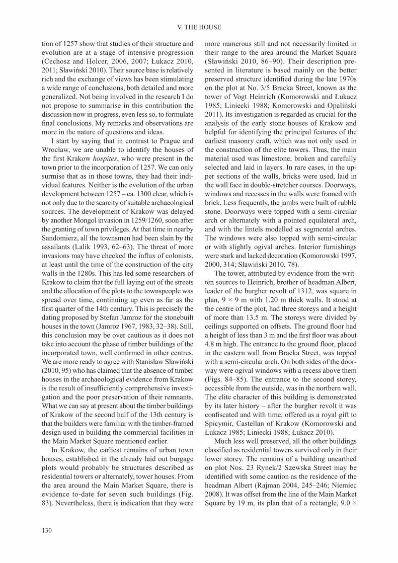
130
V. THE HOUSE
tion of 1257 show that studies of their structure and evolution are at a stage of intensive progression (Cechosz and Holcer, 2006, 2007; Łukacz 2010, 2011; Sławiński 2010). Their source base is relatively rich and the exchange of views has been stimulating a wide range of conclusions, both detailed and more generalized. Not being involved in the research I do not propose to summarise in this contribution the discussion now in progress, even less so, to formulate final conclusions. My remarks and observations aremore in the nature of questions and ideas.
I start by saying that in contrast to Prague and Wrocław, we are unable to identify the houses of the first Krakow hospites, who were present in the town prior to the incorporation of 1257. We can only surmise that as in those towns, they had their indi-vidual features. Neither is the evolution of the urban development between 1257 – ca. 1300 clear, which is not only due to the scarcity of suitable archaeological sources. The development of Krakow was delayed by another Mongol invasion in 1259/1260, soon after the granting of town privileges. At that time in nearby Sandomierz, all the townsmen had been slain by the assailants (Lalik 1993, 62–63). The threat of more invasions may have checked the influx of colonists,at least until the time of the construction of the city walls in the 1280s. This has led some researchers of Krakow to claim that the full laying out of the streets and the allocation of the plots to the townspeople was spread over time, continuing up even as far as the first quarter of the 14th century. This is precisely thedating proposed by Stefan Jamroz for the stonebuilt houses in the town (Jamroz 1967, 1983, 32–38). Still, this conclusion may be over cautious as it does not take into account the phase of timber buildings of the incorporated town, well confirmed in other centres.We are more ready to agree with Stanisław Sławiński (2010, 95) who has claimed that the absence of timber houses in the archaeological evidence from Krakow is the result of insufficiently comprehensive investi-gation and the poor preservation of their remnants. What we can say at present about the timber buildings of Krakow of the second half of the 13th century is that the builders were familiar with the timber-framed design used in building the commercial facilities in the Main Market Square mentioned earlier.
In Krakow, the earliest remains of urban town houses, established in the already laid out burgage plots would probably be structures described as residential towers or alternately, tower houses. From the area around the Main Market Square, there is evidence to-date for seven such buildings (Fig. 83). Nevertheless, there is indication that they were
more numerous still and not necessarily limited in their range to the area around the Market Square (Sławiński 2010, 86–90). Their description pre-sented in literature is based mainly on the better preserved structure identified during the late 1970son the plot at No. 3/5 Bracka Street, known as the tower of Vogt Heinrich (Komorowski and Łukacz 1985; Liniecki 1988; Komorowski and Opaliński 2011). Its investigation is regarded as crucial for the analysis of the early stone houses of Krakow and helpful for identifying the principal features of the earliest masonry craft, which was not only used in the construction of the elite towers. Thus, the main material used was limestone, broken and carefully selected and laid in layers. In rare cases, in the up-per sections of the walls, bricks were used, laid in the wall face in double-stretcher courses. Doorways, windows and recesses in the walls were framed with brick. Less frequently, the jambs were built of rubble stone. Doorways were topped with a semi-circular arch or alternately with a pointed equilateral arch, and with the lintels modelled as segmental arches. The windows were also topped with semi-circular or with slightly ogival arches. Interior furnishings were stark and lacked decoration (Komorowski 1997, 2000, 314; Sławiński 2010, 78).
The tower, attributed by evidence from the writ-ten sources to Heinrich, brother of headman Albert, leader of the burgher revolt of 1312, was square in plan, 9 × 9 m with 1.20 m thick walls. It stood at the centre of the plot, had three storeys and a height of more than 13.5 m. The storeys were divided by ceilings supported on offsets. The ground floor hada height of less than 3 m and the first floor was about4.8 m high. The entrance to the ground floor, placedin the eastern wall from Bracka Street, was topped with a semi-circular arch. On both sides of the door-way were ogival windows with a recess above them (Figs. 84–85). The entrance to the second storey, accessible from the outside, was in the northern wall. The elite character of this building is demonstrated by its later history – after the burgher revolt it was confiscated and with time, offered as a royal gift toSpicymir, Castellan of Krakow (Komorowski and Łukacz 1985; Liniecki 1988; Łukacz 2010).
Much less well preserved, all the other buildings classified as residential towers survived only in theirlower storey. The remains of a building unearthed on plot Nos. 23 Rynek/2 Szewska Street may be identified with some caution as the residence of theheadman Albert (Rajman 2004, 245–246; Niemiec 2008). It was offset from the line of the Main Market Square by 19 m, its plan that of a rectangle, 9.0 ×

131
V. THE HOUSE
Fig. 83. Krakow. Buildings on the Market Square, 14th century: 1– St Wojciech/Adalbert’s church; 2 – Blessed Virgin Mary’s church; 3 – Town Hall; 4a – Rich Stalls; 4b – Cloth Hall; 5 – the Great Scales (Wielka Waga). a – 13th-century tower house;
b – pre mid–14th century development; c – pre 1400 development; d – residential buildings; e – porches; f – communication routes confirmed by archaeology. Komorowski 2000 and Łukacz 2010
11.7 m with ca.1.85 m thick walls, thus much greater than in the tower on Bracka Street. The masonry sur-vived to a height of 5 m indicating that the structure used to have at least two storeys. The features of its
masonry work link it with the residential tower of Henryk, Albert’s brother (Dagnan-Ginter and Zając 2006; Komorowski and Sudacka 2008, 25–29).

132
V. THE HOUSE
There is no evidence about the name of the owner of the next building in the same group. It was iden-tified at the rear of plot No. 35 Rynek Główny inPalace Pod Krzysztofory. Square in plan, 9.1 × 9.1 m with 1.19 m thick walls, this structure had an en-trance to the ground floor in its eastern wall fromthe Main Market Square. The doorway was 1.60 m high, which makes it lower than others were, some of which could be as high as 2.50 m (Cechosz and Holcer 2006, 7–8; Sławiński 2010, 84–85). The next structure was found in the corner plot No. 36 Rynek Główny/Sławkowska Street. Other than the recurring features of the masonry work the buildings placement within the plot and its square plan are similar. The same may be said about another corner plot building at Nos. 42–43 Rynek/św. Jana Street. Its quite thick walls suggest that it was a tower of three storeys. Two other, poorly preserved buildings were confirmed atthe rear of plots Nos. 7 and 30 Rynek Główny.
While the interpretation of the tower of headman Henryk in Bracka Street is not open to doubt, the ownership of all others is open to discussion. Marek Łukacz, one of the excavators of the best preserved tower, claims that the owners belonged to a social order outside the burgher class. He refers to the struc-tures in question as lords’ houses claiming that they combine residential functions with representation and defence (Łukacz 2010, 85–87). At the same time, he admits, in the same work, that the dividing line between a tower of three storeys and a storeyed house is ambiguous; especially if our basis for interpretation are the remnants of structures which now survive only at the level of their ground floor. Łukacz goes onto assert that the interpretation of residential towers of Krakow has the nature of a theoretical reconstruction. In this regard, he alludes to analogies from Prague and Wrocław. On the other hand, the views of Wal-demar Komorowski, another experienced researcher of the urban architecture of Krakow, are more firm ashe accepts that towers were widespread in medieval towns (Komorowski and Opaliński 2011). Even if the researchers of Prague have retreated from their interpretation of Romanesque urban towers situated at the back of the plot (Líbal and Muk 1996, 66–67; Dragoun et al. 2003, 365), they have come to regard them more likely to be stonebuilt rear extensions of timber houses occupying the upper end of the plot. As for Wrocław, no towers at the back of the plot have been identified to-date. We may have evidence fora few such structures, not more than 2 or 3, fronting the street. Their counterpart in Krakow would be the tower house on the corner of Jagiellońska and św. Anny streets (Sławiński 2010, 87).
In trying to take a position on the phenomenon of the earliest stone buildings set at the rear of the plot in Krakow, it should be said that the tower interpretation cannot be negated outright. This is because across the High German zone we find examples of towersin towns, if only in those of Vienna, Nuremberg and Regensburg (Perger 1992; Schnieringer 1996, 1997; Codrenau-Windauer et al. 2000, 1042–1043; Schwemmer 1972, 26–27; Wiedenau 1983, 193–195; Piekalski 2011b, 173–185). At the same time, we are aware that towers in that region were not the projects of townspeople. They belonged to the clergy and knights and only passed into the ownership of the urban class during the later Middle Ages, through special privileges granted by the ruler. In the medi-eval ideological system, the tower had a symbolic significance; its construction was subject to legalrestrictions not only dictated by the need for state control over defensive structures, but also to sustain the desired social structure. Examining only the area of origin of the hospites it is possible to identify in the Low German zone, examples of solutions that were a compromise between the law controlling the number and ownership of towers, and the ambitions of affluent burghers. In centres such as Brunswick,Goslar, Osnabrück and a number of others, the rear annexes of Dielenhäuser tended mostly to assume the form of not more than a stone cellar or a one-storeyed building (Küntzel 2005). Nevertheless, they may have had a vertical disposition and still be no higher than three storeys. The first of these was always partlysunken, served for storage and was referred to as a cellar. The part of the building above it served as a dry granary, possibly, used also as living quarters. If fitted with a stove or a fireplace, it gained the appella-tion of kemenate, caminata (Piekalski 2004, 99–120). If only by the reason of legal restrictions formulated in the Sachsenspiegel, they were not referred to as towers even if they had three storeys (Koolmann, Gäßler and Scheele 1995, 1, no. 144–145). Neverthe-less, some researchers try to bring the term ‘tower’ into the discussion recognizing, quite reasonably, that its value was more than material.
In this context it is understandable that Stanisław Sławiński (2010, 95) is cautious in formulating the final conclusions as to the appearance and function ofKrakow structures described as ‘towers’. With great circumspection, he formulates questions for future discussion and some of them are worth emphasizing and developing here.
Do structures described here by us as towers represent the earliest group of stone buildings in the burgage plots of Krakow? The key argument in
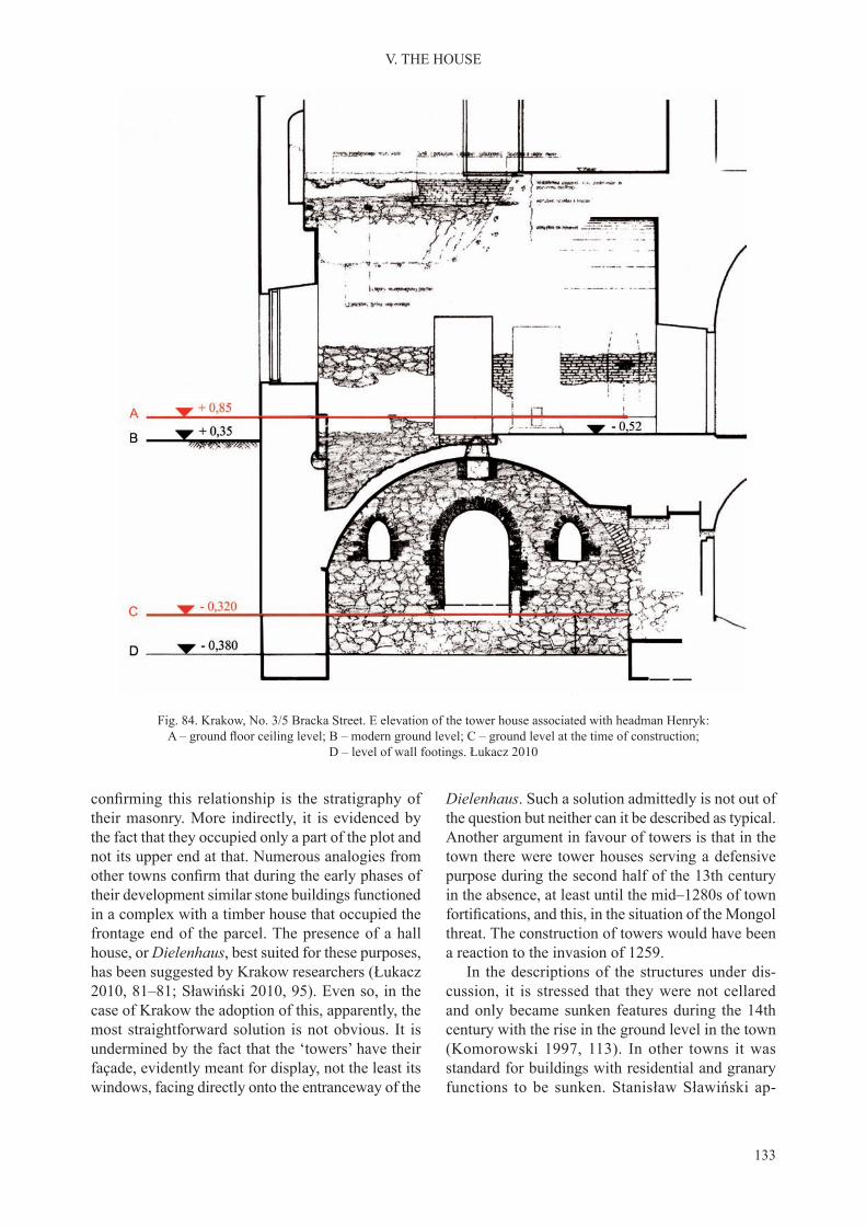
133
V. THE HOUSE
Fig. 84. Krakow, No. 3/5 Bracka Street. E elevation of the tower house associated with headman Henryk: A – ground floor ceiling level; B – modern ground level; C – ground level at the time of construction;
D – level of wall footings. Łukacz 2010
confirming this relationship is the stratigraphy oftheir masonry. More indirectly, it is evidenced by the fact that they occupied only a part of the plot and not its upper end at that. Numerous analogies from other towns confirm that during the early phases oftheir development similar stone buildings functioned in a complex with a timber house that occupied the frontage end of the parcel. The presence of a hall house, or Dielenhaus, best suited for these purposes, has been suggested by Krakow researchers (Łukacz 2010, 81–81; Sławiński 2010, 95). Even so, in the case of Krakow the adoption of this, apparently, the most straightforward solution is not obvious. It is undermined by the fact that the ‘towers’ have their façade, evidently meant for display, not the least its windows, facing directly onto the entranceway of the
Dielenhaus. Such a solution admittedly is not out of the question but neither can it be described as typical. Another argument in favour of towers is that in the town there were tower houses serving a defensive purpose during the second half of the 13th century in the absence, at least until the mid–1280s of town fortifications, and this, in the situation of the Mongolthreat. The construction of towers would have been a reaction to the invasion of 1259.
In the descriptions of the structures under dis-cussion, it is stressed that they were not cellared and only became sunken features during the 14th century with the rise in the ground level in the town (Komorowski 1997, 113). In other towns it was standard for buildings with residential and granary functions to be sunken. Stanisław Sławiński ap-
134
V. THE HOUSE
proaches this detail with caution admitting that the first storey could have been slightly sunken, at themost, to the level of the windowsills and that access to that first storey was ‘down the stairs’ (Sławiński2010, 78, footnote 12). However, in his more recent work Waldemar Komorowski is inclined to accept that these buildings were sunken even as much as to a 1/3 of their height (Komorowski and Sudacka 2008, 27). Certainly, there is need to confirm whetherthe Krakow buildings were actually built as fully aboveground structures without having a sunken feature. This can be clarified only by archaeologicalresearch through recording the elevation of the origi-nal ground level, the thickness of the cultural deposit during the construction, elevations of the threshold and the occupation level inside the building. Let us also add, for example, that in Wrocław the earliest brick houses were built when the ground levels in the town had risen due to the accumulation of the cultural deposit. At No. 6 Rynek its thickness at that time had exceeded 1 m, and the house’s interior had been dug to about 1 m lower than the natural ground level. Thus, from the very first, this earliest brick hadbeen sunken by about 2 m. This value was confirmed
only through archaeological excavation, carried out both outside the building and within it. The compre-hensive architectural analysis of the masonry carried out on the cellar of this townhouse failed to reveal the depth of its original occupation level (Bresch et al. 2001, 47; Chorowska et al. 2012, 57–58). In the case of the houses of Krakow, an indirect piece of evidence that confirms that the earliest houses hadsunken features is a reference to a cellar built by the scribe Fritshe in 1302. This record is in contradiction to the claim that there were no cellars in Krakow at this time (Najstarsze księgi 1878, part 1; L; Sławiński 2010, 78). We can confidently say that the authorof the reference to the cellar had in mind mainly its function and not the fact that the building had one of it storeys fully below ground level. A valuable clue in this regard may be the observation made by Dariusz Niemiec when investigating the earliest townhouse within the later Collegium minus in the University quarter, where the level of the interior was at least 0.50 m below the top level of the natural (Niemiec 2006, 252–268).
As to the question of social attribution of the stone buildings at the rear of the plot, we may assume that
Fig. 85. Krakow, No. 3/5 Bracka Street. Digital reconstruction of the tower house associated with headman Henryk. Opaliński 2010

135
V. THE HOUSE
Fig. 86. Krakow. Panorama of the Main Market Square during the early 14th century. Łukacz 2010. Digital model after Opaliński 2010
two of them belonged to town headmen: the tower in Bracka Street – to Heinrich, the tower on the cor-ner of the Main Market Square and Szewska Street, presumably to his famous brother, Albert. However, what about the others if we assume that they also had the status of elite towers? The ducal regale controlling the construction of defensive structures was quite strictly enforced by the Piast, is this true of the Přemyslids too? Were not the officials of KingWenceslaus, to whose reign we are inclined to date the towers, privileged at this time? Krakow’s writ-ten sources do not fully illuminate the rules of the use of the elite plots but the general atmosphere of the Czech monarch’s reign does not militate against such an interpretation. In Nuremberg, the plots with residential towers were occupied by royal ministe-riales. In Vienna, they functioned as royal property granted to knights. Whatever may have been the case, the likely privileges became extinct at the latest after the brutal quelling of the burgher revolt of 1312 and the confiscation of the property of the headmenand members of the town oligarchy. From that time onwards, for at least a few decades, the owners of the towers could only be representatives of the feudal elite and clergy.
Also classified to the earliest phase of the stoneb-uilt architecture of Krakow are houses found at the front end of the plots. They are dated to the late 13th
– mid–14th century and thought to have replaced the earlier timber buildings. Their number is significantlyhigher than that of the towers and is estimated even as 120 with only some of them subjected to archi-tectural studies (Komorowski 1997, 2000; Łukacz 2011). They are a dominant element in the recently proposed reconstructions of the townscape of that period (Fig. 86). The crucial element for their iden-tification is the masonry technique used, similar towhat was used to date/identify the towers. Thus, the key material was limestone rubble supplemented with bricks. Wall thickness was less than in the tower houses; in the range of 0.8–1.2 m, presumably this measurement is sufficient to deduce the existence oftwo storeys. Most of these houses stood with their gable to the street, their one-room ground floor hada multifunctional entranceway (Diele). There were two entrances – one from the square or from the street, centrally in the gable wall, the other by the edge of the back wall. There may have been two windows in the wall fronting the street, comparable to those in the tower belonging to headman Henryk. Marek Łukacz (2010, 81), suggested the relationship of this model of a house with the northern European Diele. What remains an open question is the function of the second storeys of these buildings, which is still poorly understood. Access to them was by an external timber stairway. No traces of these structures were

136
V. THE HOUSE
identified but, based on analogies from Wrocław, isit accepted that they were placed against the back wall of the house. Less frequently as in No. 6 Rynek Główny, the upper floor was accessed by an externalstairway set within the thickness of the wall.
The entranceway (Diele) had a ceiling. The joists rested on offsets left in the walls or, alternately, on stone cantilevers, as in houses at Nos. 13 Rynek, 17 św. Tomasza Street and 6 Sławkowska Street. The construction of the doorways was similar to those in the towers – the door opening was topped with an undecorated semi-circular portal made of brick, the lintel was topped with a segmented arch (Fig. 87). The windows of the ground floor had a brick frame.Less frequently, as in the house at No. 23 Rynek Główny, carefully dressed sandstone was used for this purpose. Brick was also used to form the wall recesses. These, most often, were approximately 55 × 55 cm and were covered with a thick oaken board. Impressions of their wooden lining were observed inside some of the recesses. Some smaller recesses were topped with a triangular element made of brick. Smoke openings were identified in some of theback and side (neighbouring) walls, as were vertical smudges left by escaping smoke. Thus, we know that the interiors were heated by a hearth with a canopy
or by a fireplace. Walls were plastered and paintedwhite (Łukacz 2010, 81–82).
Prior to 1350, the one-roomed interiors of the first storeys were divided into smaller areas. Wallswere installed along the axis of the Diele, but trans-versely as well (Fig. 88). Soon afterwards, around the mid–14th century, another section of rooms was added. Increasingly often, the main material in build-ing the walls was brick, and ceilings were replaced successively with vaults (Łukacz 2010, 87). The end effect of the development of the domestic building during the 14th century was the Gothic townhouse, a structure with several sections of rooms, in two or three courses, and three storeys – the cellar, the utility or representative ground floor, and the residential up-per storey. Communication between the ground and the upper floor was now inside the townhouse.
We do not know what the original arrangement of the access to the ground floor storeys was in a situa-tion of steadily rising levels in the town. We can only guess that similar to Prague, entrances to the sunken interiors were accessible through an external passage with a ramp or stairs. During the 14th century, the original ground floor was converted into a cellar, therole of the former taken over by the second storey. The problem of access was solved as in Wrocław by
Fig. 87. Krakow, house at No. 23 Rynek Główny. Back wall viewed from the inside. Łukacz 2010

137
V. THE HOUSE
Fig. 88. Krakow, No. 6 Rynek Główny. Masonry buildings during the 14th century: A – two separate houses from the earliest phase; B – partitioning and expansion (second row of rooms); C – houses are joined together, the passageway to the rear
of the plot is abolished; floor plan of cellars, second half of the 14th century; D – ground floor, second half of the 14th century. a – late 13th century; b – early 14th century; c – mid–14th century; d – second half of the 14th century. Łukacz 2010

138
V. THE HOUSE
building porches. In contrast to Wrocław, the porches in Krakow were stable, vaulted structures designed as a permanent element of a house. They had the form of small cellars jutting out before the front of the house, raised above the ground level and forming a sort of a roofed over terrace covered with a single-sloped roof (Cechosz and Holcer 2006; Łukacz 2010, 94). The cellar was accessed by stairs placed inside the porch. To get to the ground floor one had to walkup the stairs to the terrace of the porch. Only some townhouses in the Main Market Square had a porch (Nos. 4–11, 17–20, 25, 31, 35–46 Rynek Główny). In a similar vein to Wrocław, porches were built as a separate project, individually for each house, hence their individualized forms and sizes (Fig. 89). They did not form a single linear line on the square, projecting between 3 and 5 m from the walls of the townhouses. The ground levels in the town continued to build up for a very long time, until the 16th cen-tury, and the thickness of the cultural deposit reached 4.5 m, burying the medieval porches, which then lost their original function.
Fig. 89. Krakow, No. 35 Rynek Główny, interior of porch, second half of the 14th century. Łukacz 2010
139
Successful urban development, something that the three towns analysed here evidently enjoyed, was a cause of serious disturbance to the natural ecosys-tem. The density of the urban population, their life needs, increased water usage and intensification ofproduction meant that there was an accumulation of all kinds of waste. The growing demand for timber, for construction and for fuel, and the intensifica-tion of agriculture resulted in deforestation and the destruction of the area surrounding the town. The level of sanitary hazard, problems with water supply, tightly packed buildings, transport and communica-tion depended on numerous factors, which in each centre evolved over successive stages of their devel-opment. On the one hand, these were natural condi-tions such as the town’s topography, hydrographical pattern, soils, on the other hand, manmade factors – the town’s size, its economic potential and the na-ture of its trades, industries and commerce. With the townspeople of individual towns of Central Europe keeping in touch and exchanging information meth-ods of combating pollution were similar everywhere, although every town retained its own character in this regard. While fascination with nature was not unknown to the people of the Middle Ages, actions taken by them were not dictated by their awareness of the need to protect the environment (Barros 1998, 287–300). Rather, their purpose was to control the side effects of civilization’s development.
The sanitary status of a town depended largely on natural factors. The groundwater level, soil conditions and the relief had a significant impact on cleanlinesslevels in town squares, streets and burgage plots. On light soils over a dry substrate, on land with good permeability or lying on a slope, the processes of decomposition of organic waste left on the ground surface were relatively rapid.
These were the natural conditions of medieval Prague, especially its left bank area – the Lesser
Town below Prague Castle. The slope of the ground towards the river with groundwater at a low level and flowing over a rocky substrate, prevented organicwaste from remaining permanently on the site. On the right bank of the Vltava, the situation was similar despite much smaller differences in elevation. The natural substrate of the Old Town terrace is formed by thick deposits of gravel, washed in by water flowing downwards from a higher level. The deepgroundwater table did not block the access of oxygen. This found reflection in the structure of deposits ac-cumulated in the town prior to the laying of stable pavements and the organising of the regular cleaning of street surfaces (Hrdlička 2000; Zavřel 2001). The thickness of the cultural deposit that has accumulated in Prague since the early medieval period until the present varies, ranging between 3.5 and 4.5 m but as much as 6 m in the area bordering the river (Havrda and Tryml 2011, 197). Organic waste deposited in the streets and yards mostly decomposed. Studying the stratigraphy of the main marketplace of Prague’s Old Town, Ladislav Hrdlička (2000, 200) distinguished a lower complex of deposits formed in a spontane-ous manner without the control of the inhabitants. Slightly over 1 m thick, this sequence was found to contain some organic matter but the frequency of waste is relatively small. There was no evidence for organic content in the upper part of the stratigraphi-cal sequence.
Similarly situated on a large river, Wrocław had natural conditions different from those in Prague. The differences in elevation in the town and its surrounding area were small. Much of the town’s area, especially in its northern zone, was marshy and subject to flooding. We have to assume that theearth-and-timber ramparts on Ostrów Tumski served a double function, defensive, but also one of floodcontrol. The shallow groundwater table, generally unfavourable for health conditions, inhibited the
VI. SANITATION AND STREET SURFACE CONSTRUCTION

140
VI. SANITATION AND STREET SURFACE CONSTRUCTION
decomposition of organic waste. Action to improve this situation was taken during the 13th century, after the town’s incorporation. Much of the town’s surface was spread with layers of sand, which raised its level by about 50 cm. One side effect of human occupa-tion that soon made an impact was the unrestrained build-up of layers of waste, which raised the ground level by as much as 4 m but at the same time, was detrimental for the sanitation level in the town and for communication. Regulation of the river and the construction of structures for damming up water for economic use had the less welcome effect of raising the groundwater table (Badura 2010, 40–44; Konczewski and Piekalski 2010, 91–151; Sowina 2009, 52–65).
In this regard, the inhabitants of medieval Krakow were a little better off. The distinctly shaped high terrace of the Vistula – the Prądnik Cone – offered an elevated tract of ground with a steep slope, raised several metres above the floodplain. Sloping gentlysouthwards it had a sunny aspect. A sandy substrate offered good conditions for building construction. The groundwater level was at a comfortable depth of 5–6 m. On the evidence from geological analyses it would appear that contrary to earlier surmises, there were no wetlands or natural watercourses on the southern part of the Prądnik Cone. Neither was there any more substantial variation in eleva-tion. Rather, the terrace was a level, sandy upland separated from the floodplain. The cultural depositaccumulated during the Middle Ages does not contain as much organic material as the one in Wrocław. It is composed of various dumped layers of sand from levelling and from construction, but also, muck and slippery humus, showing that the streets and squares were in need of regular maintenance by the townspeople (Kmietowicz-Drahtowa 1971, 1974; Wierzbicki 2010, 177; Zaitz 2010, 216–226; Niemiec 2007, 2011). The thickness of the stratigraphical layers was in the range of 3.5–4.5 m as in Prague and Wrocław.
The problems with maintaining the proper sani-tary levels of the town were compounded by the density of urban development. In earlier relevant publications especially, the accepted view was that medieval towns were largely overcrowded (Gruber 1942; Beresford 1967). Today we know that this view was the result of a retrospective analysis of late medieval and post-medieval source. Archaeological research of earlier phases of development is in need of a separate analysis in this regard and the actual density of urban development tended to be lower than previously thought. In most towns, at least from the
late Middle Ages onwards, there was a reserve of land for construction. In the western region of Central Eu-rope, the 14th-century economic crisis and epidemics resulted in a major reduction of the population. In Prague, Wrocław and in Krakow, the opposite was the case; this was a century of intensive growth. At the same, there is no evidence to conclude that there was overpopulation. The development of all plots laid out earlier and the exhaustion of the reserves of land, thus, obtaining profit from them in the form ofrent, usually caused the territorial lord to allot the commune additional land or to organize a new town (Maschke and Sydow 1969; Słoń 2010). In Prague, this presumably prompted the incorporation in 1348 of the spacious New Town, not fully built over by the end of the Middle Ages. Thus, presumably in the Old Town, at least according to the view of its inhabitants, there was no drastic overpopulation. In Wrocław the area of the original Old Town was surrounded from the south and west by a zone granted to the townspeo-ple additionally during the 1260s. Until the modern period, plots laid out in this zone continued to have an area of green space not occupied by development. In addition, the poorly developed New Town continued to have timber buildings (Młynarska and Eysymontt 2001, Plates 4, 13). The burgage plots in Krakow were developed with some delay, and apparently, by the end of the 13th century there was still a shortage in population. Despite this, three new towns were incorporated during the 14th century giving rise to the large late medieval agglomeration composed of several segments. Apart from the Old Town, it included the reorganized former suburbium of Okół and the new towns of Kazimierz and Florencja – the latter now known as Kleparz. Thus, it is hard to ac-cept that the consequences of the sanitary levels due to the increased density of urban development in the towns of interest, at least during the developmental phase under investigation, were higher than the norm adopted by the owners of the towns and by the townspeople themselves. They are no different in this regard from many other towns across Central Europe (Piekalski 2001, 207–216).
The quality of air, water and soil were definitelyaffected by the economic activity carried on in the town. The most affected in this regard were min-ing towns and settlements (Schwabenicky 1993; Stolarczyk 2010; Hrubý 2011). The extraction and pre-treatment of ores – cleaning, washing, roasting and smelting – caused changes in the environment both in the town and in its neighbourhood. Other towns were not immune to this nuisance. In Prague, there is evidence from earlier occupation phases

141
VI. SANITATION AND STREET SURFACE CONSTRUCTION
that confirms the intensive metallurgical activity– extraction of iron ore and smelting on the Old Town terrace (Podliska 2008). Bog ores were also present in the Odra valley in Wrocław, e.g. by the northern stretch of the Szewska and along Więzienna streets (Konczewski et al. 2010, 311–313). The smelting of iron in the area between Więzienna and Odrzańska streets is confirmed for the 13th century(evidence from the research of Aleksander Limisie-wicz 1996–1997). Several tons of iron slag from the 14th century was discovered by the outer section of św. Mikołaja Street and smaller amounts in the regularly laid out area of the town at Malarska Street (Buśko and Piekalski 1994; Jastrzębski, Piekalski and Wysocka 2001, 339–340). In Krakow too, inten-sive and varied metallurgical activity was pursued. During the investigation of the Main Market Square, it was confirmed for the pre-incorporation phase,prior to the laying out of the square and for the later Middle Ages as well. During the proto-urban phase, bloomery iron was treated as a preparatory product to forging, and there is evidence for the casting of copper and silver (Radwański 1975, 157–158; Buśko and Głowa 2010, 147–148). During the 14th century, mass and retail trade in lead, copper and iron as-sumed a major scale, confirmed by both the writtenand the archaeological sources. The excavation of the area next to the Great Scales, (the weighing and measuring area known as ‘Wielka Waga’), dating from the early 14th century at the latest, identifieda significant series of metal finds ranging from dustthrough assorted fragments, to a fully moulded and marked lump of lead weighing 693 kg within the medieval deposit (Wyrozumski 1992, 391; Szejbal-Dereń and Garbacz-Klempka 2010, 34–38). The metals were hacked into pieces but also melted down close to the Great Scales. Long-term contamination of the soil by heavy metals was also confirmed nextto not only the Great Scales but also elsewhere in the Market Square, in the Cloth Hall and near the rows of stalls. If the soil was affected, then the groundwater must have been too (Pawlikowski et al. 2010; Wardas-Lasoń and Głowa 2010; Wardas-Lasoń, Zaitz and Such 2010).
Air and water pollution was caused also by other trades that were present in each of the discussed towns. Of these, the most widespread was tanning with its smell of decomposing hides and its use of a significant quantity of water. To reduce the nuisancecaused by tanneries an effort was made to group them on the outskirts of the town. At the same time, tanners needed to have good access to water, in practice, to a river or a moat. Districts settled by tanners, also due
to the low social status of this group of tradespeo-ple, were often regarded as inferior (Cramer 1981; Ruckstuhl 1993; Buśko 1999b). The technological necessity for water was sufficiently strong to dictatethe location of this production to the extent that in Wrocław, the tanners’ district was next to the castle, where they drew the water from the nearby Odra River. In Krakow during the 14th century, tanners occupied plots by the north-western stretch of the city moat, fed by the waters of the Rudawa, a left tribu-tary of the Vistula. While discussing the significanceand uses of water in the town, Urszula Sowina noted briefly that the economic importance of tannery pro-duction was sufficiently high for its inconvenience tobe disregarded in the decision regarding its location (Sowina 2009, 81–82). In any case, unlike the perma-nent environmental pollution caused by metallurgy, tanneries only caused temporary inconvenience. Less of a threat to the sanitary levels were slaughterhouses and dyers’ workshops, found in a small concentration or relegated to outside the town’s limits.
The main elements of public space in medieval towns were its squares and streets. The technical quality of their surface had a significant impact onthe conditions of everyday communication, and less directly, on economic life too. It is hard to ignore their significance for the general atmosphere in the town,including the relationship of the commune members, municipal government and the town’s territorial lord. Presumably, in large towns on a river with climatic conditions typical for Central Europe, where the au-tumn-winter season lasted six months, maintaining the streets in a proper condition was a real challenge. The rapid build-up of layers of organic waste and the muddy condition of the streets and squares, especially during the wet season of the year, made it necessary to develop methods of metalling and managing street surfaces. Systems developed in each of the discussed towns differed in some ways.
From proto-urban Prague, the suburbium below the castle, there is evidence that street surfaces were lined with timber. This was so both on the streets and in the area inside the walls and on at least some stretches of access roads. As noted earlier, the sur-vival of organic substances, including timber, was poor in the Prague suburbium. There is evidence nevertheless, that the road leading from its centre to the Vltava crossing was lined with timber. Traces of similar street surfaces were confirmed in otherlocations within the suburbium, indicating that the method of lining the surface with timber was gener-ally accepted in early medieval, left bank Prague (Čiháková 1997; Čiháková and Dobry 1999, 339;

142
VI. SANITATION AND STREET SURFACE CONSTRUCTION
Čiháková and Müller 2008; Čiháková and Zavřel 1998). The details of construction were furnished by fieldwork carried out in the area off the south-westerncorner of the town’s principal square (Lesser Town Square). Here a junction of streets was discovered with five levels of street surfaces of oak wood (Figs.90, 91). Their preservation level varied, especially the timber from the younger layers was heavily de-composed. It is evident, nevertheless that this system of road construction was used repeatedly (Cymbalak and Podliska 2011, 303–305). It consisted of solid sleepers and rough planks laid over them transversely to the direction of the traffic. Some of the sleepersrested on stakes driven into the ground. The whole structure thus formed a sort of a causeway over marshy ground. The lowest street phase rested over a layer of trampled natural subsoil and was overlaid by a succession of later street levels. The earliest of them, running east-west, had a width of 2.4 m. Its successors were wider; up to 3.2–3.4 m. A timber-lined ditch was recorded by the edge of the youngest street surface level. The whole structure was dated by small finds to the 10th–11th century.
Different methods of surfacing streets were used on the opposite bank of the Vltava, in the crafts-and-market settlement that subsequently evolved into the communal town. Apparently, there many of the access roads and streets in the built-up area were not
surfaced at all, especially during the earlier phases of settlement (Havrda and Tryml 2011, 195). This did not apply to the main thoroughfares. In their case, the metalling of their surface is confirmed by sourceevidence sufficiently rich to describe the techniquesand their evolution. The use of dirt roads by wheeled traffic resulted in the destruction of the natural humuslayer and even their cutting into the sandy substrate. Discovered in 1975 during construction work on the Prague Metro, the road between the marketplace and the Vltava crossing had a width of 4.20 m and had the form of a sunken road with a depth of about 40 cm and observable ruts (Šírová 1977). Sometime later, the y was filled in with a layer of river pebblesover a foundation of clay. The stone was spread in a random fashion and compacted, forming a metalled surface (Fig. 92). During subsequent use, the road surface was repaired repeatedly by spreading it with more pebbles (Havrda and Tryml 2011, 195–197). It is broadly dated to the 12th century with the pos-sibility of moving this dating to an earlier as well as a later time.
A similar system was recorded in two spots on Platneřská Street. There also the earliest phase of the road was unsurfaced. After the dirt surface was churned up and compacted by traffic to the formof a sunken road it was banked up with a layer of pebbles with an average diameter of 10 cm, sup-
Fig. 90. Prague, Lesser Town Square. Street level stratigraphy. Cymbalak and Podliska 2011

143
VI. SANITATION AND STREET SURFACE CONSTRUCTION
plemented with marl. This road phase was dated by pottery finds to the 12th–13th century, therefore, tothe pre-incorporation period. The remains of later
pavements, attributed to the communal town were recorded over it. The stones used in them were larger with a diameter of as much as 40, even 60 cm. These
Fig. 91. Prague, Lesser Town Square. Road surface construction. Cymbalak and Podliska 2011
Fig. 92. Prague, Kaprova Street. A section through the road: yellow – subsoil, grey – phases of road construction. Havrda and Tryml 2011

144
VI. SANITATION AND STREET SURFACE CONSTRUCTION
were river pebbles set in a grey-black cultural de-posit, which also accumulated after the road surface was put in place. The width of this street was around 5.5 m, thus, significantly wider than the road from thepre-incorporation period (Podliska 2004, 372–273; Havrda and Tryml 2011, 197–198).
More constructions of this sort were identifiedin Prague Old Town, most notably, under the Jesuit college, the Clementinum (Fig. 93), on Benediktská, Masná, Královodvorská, Dušni, and Rytiřská streets, and in the eastern area of the Old Town marketplace (Hrdlička 1984a, 151; Havrda and Tryml 2011). Our aim is not their detailed description but they may be useful for formulating more general conclusions on the methods of metalling road surfaces in Prague dur-ing the High Middle Ages. Apparently, the material used in road construction was sourced in the town and around – mostly being pebbles, gravel and sand from the Vltava. Limestone in the form of lumps and rubble was sourced in large quantities at Petřin and Strahov on the left bank part of the agglomeration. Also used was limestone from shallow lying deposits on the river terrace in the right bank town; it was dug
up during the construction of fortifications and cel-lars. This material was used throughout the Middle Ages, both prior to and after incorporation. During the High and Late Middle Ages, coarse quartzite gravel was also used. Less frequently used was slate, which was also available in the Prague Basin (Rybařík 1999, 15; Zavřel 2007, 247). Observing the evolution of road surface construction on the right bank of the Vltava it may be said that different to the Lesser Town, timber causeways were not used a great deal. From the beginning roads metalled with stone prevailed but their technical quality was varied. During the pre-incorporation phase pebbles or limestone rubble were spread on the road without any subbase. This material was unsorted and ranged in diameter usually from 5 to 13 cm. Street surfaces of this type easily became damaged and mixed with the soil. In such cases, they required repair, carried out in a makeshift manner by spreading a new layer of pebbles or limestone rubble. The thickness of these repeatedly applied layers reached a few dozen centimetres. They did not prevent the accumulation of the layer while the street continued in use and were
Fig. 93. Prague, Clementinum. A section through the medieval portion of the stratigraphy (pavements highlighted): the road, dated to the 10th–11th centuries (grey; nos. 102–105); rests on a marked settlement horizon (orange; layers nos. 101, 75, 76). The road
becomes completely silted and loses its function at the latest in the 12th century (layer no. 74a). Cymbalak and Podliska 2011
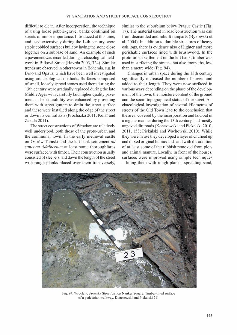
145
VI. SANITATION AND STREET SURFACE CONSTRUCTION
difficult to clean. After incorporation, the techniqueof using loose pebble-gravel banks continued on streets of minor importance. Introduced at this time, and used extensively during the 14th century, were stable cobbled surfaces built by laying the stone close together on a subbase of sand. An example of such a pavement was recorded during archaeological field-work in Bilková Street (Havrda 2003, 324). Similar trends are observed in other towns in Bohemia, e.g. in Brno and Opava, which have been well investigated using archaeological methods. Surfaces composed of small, loosely spread stones used there during the 13th century were gradually replaced during the late Middle Ages with carefully laid higher quality pave-ments. Their durability was enhanced by providing them with street gutters to drain the street surface and these were installed along the edge of the street or down its central axis (Procházka 2011; Kolář and Zezula 2011).
The street constructions of Wrocław are relatively well understood, both those of the proto-urban and the communal town. In the early medieval castle on Ostrów Tumski and the left bank settlement ad sanctum Adalbertum at least some thoroughfares were surfaced with timber. Their construction usually consisted of sleepers laid down the length of the street with rough planks placed over them transversely,
similar to the suburbium below Prague Castle (Fig. 17). The material used in road construction was oak from dismantled and rebuilt ramparts (Bykowski et al. 2004). In addition to durable structures of heavy oak logs, there is evidence also of lighter and more perishable surfaces lined with brushwood. In the proto-urban settlement on the left bank, timber was used in surfacing the streets, but also footpaths, less than a metre wide (Fig. 94).
Changes in urban space during the 13th century significantly increased the number of streets andadded to their length. They were now surfaced in various ways depending on the phase of the develop-ment of the town, the moisture content of the ground and the socio-topographical status of the street. Ar-chaeological investigation of several kilometres of streets of the Old Town lead to the conclusion that the area, covered by the incorporation and laid out in a regular manner during the 13th century, had mostly unpaved dirt roads (Konczewski and Piekalski 2010, 2011, 158; Piekalski and Wachowski 2010). While they were in use they developed a layer of churned up and mixed original humus and sand with the addition of at least some of the rubbish removed from plots and animal manure. Locally, in front of the houses, surfaces were improved using simple techniques – lining them with rough planks, spreading sand,
Fig. 94. Wrocław, Szewska Street/bishop Nanker Square. Timber-lined surface of a pedestrian walkway. Konczewski and Piekalski 211

146
VI. SANITATION AND STREET SURFACE CONSTRUCTION
wood shavings, ashes and wattle-and-daub debris from burnt timber-framed houses.
There is no evidence to confirm the earlier view,one also shared by the author of this study, on the early construction of permanent timber street sur-faces in the town directly after its incorporation (Kaźmierczyk 1966–1970, part 2, 60–67; Buśko 1997, 126; Piekalski 2004, 355). It used to be ac-cepted that based on dendrochronological dates that they were introduced already during the 1240s. How-ever, analysis of a larger quantity of better preserved timber from street levels carried out more recently proved that the oak used in the street surfaces was recycled, mostly from dismantled timber-framed houses. While in the written sources the sale of old timber is mentioned only infrequently (Goliński 2011, 152) archaeological evidence is fairly unam-biguous on this subject.
On the other hand, stable timber street surfaces are documented during the first half of the 13th centuryin the area in Wrocław not covered by incorporation in the earlier left bank settlement. Several series of such timber-lined streets were confirmed duringarchaeological fieldwork in New Market Square in2010–2011. In the newly laid out streets of the incor-porated town timber surfaces were very likely only introduced starting from the early 14th century.
Timber surfaced streets in the form of a causeway were the most technologically advanced (Fig. 95). Their construction started with the driving of vertical uprights into the unstable substrate. Onto them posts, transversely to the line of the street, supporting beams
were laid spaced every 3–4 m. Next sleepers were placed onto them down the length of the street. Over this stable base, the rough planks of the street surface were laid transversely (Kaźmierczyk 1966–1970, part 1, 63–64, Fig. 14; Mruczek 2000, 263–271). These were installed in the principal streets in the richer districts of Wrocław (Pańska [now Kiełbaśnicza], Junkierska [now Ofiar Oświęcimskich], Oławska,Kurzy Targ and Kotlarska), and in the northern, lower-lying area of the town and in streets inhabited by less affluent tradespeople (Szewska, Łaciarska,Malarska and Drewniana streets). The causeways covered a 2–2.5 m wide strip down the centre of a street. It was also so in marketplaces where only the thoroughfares set aside for traffic were secured– around the square and between the stalls (Fig. 96). The presence of timber causeways, especially in the northern part of the town, is recalled by street names known from the 14th century that are characteristic for Wrocław – Schmiedebrücke, Schuebrücke and Oderbrücke (Markgraf 1896, 143–144, 184–190; Stein 1995, 20, 66).
The high standard of raised rough plank street surfaces offered the best conditions for foot trafficand transport. At the same time, findings from fieldresearch confirm the use of less sophisticated systemsas described by Józef Kaźmierczyk (1966–1970, part 2, 60–63) separated into three groups. These were documented in particular on the street margin bor-dering the plots but also on repaired or provisionally improved surfaces of thoroughfares. Some elements of the causeway were dispensed with (Fig. 97). If
Fig. 95. Wrocław. Graphic reconstruction of a street walkway. Drawing Nicole Lenkow

147
VI. SANITATION AND STREET SURFACE CONSTRUCTION
the ground was not susceptible to compression, no stabilizing uprights were used; in which case the construction was of transverse supporting beams, sleepers laid lengthwise and rough planks laid trans-versely over them. A further step in simplifying the construction was to dispense with the supporting beams and to lay the sleepers immediately over the organic layer or on a subbase of sand. An example of a simplified method of street surface maintenanceis a succession of alternating layers of humus mixed with animal manure and layers of sand. Spreading the streets with sand was a regular method of draining, cleaning and making them level. The layer of sand was secured by covering it with loosely placed rough planks. Evidence of similar practices was identifiedon a number of occasions (Buśko 1997).
The most advanced method of street surfacing was to lay a layer of cobbles over a subbase of sand. In Wrocław the typical material were postglacial pebbles that were typical for the European Lowland and were easily available in the fields around thetown. The surfaces with the best cobbled layer were laid over a subbase of clean sand spread to level and
Fig. 96. Wrocław. Timber-lined streets confirmed by archaeological research. Description N. Lenkow and J. Piekalski
drain the underlying ground, forming a stable subbase for the stone pavement. This resulted in the raising of the ground level by 20–40 cm, at times, up to 80 cm. The diameter of the cobblestones was on average 15 cm, at the most, about 20 cm. They were laid close together forming surfaces bordered by sequences of larger stones or vertically placed rough planks. The earliest cobbled surfaces in Wrocław in its main mar-ketplace date to the end of the 13th century (Buśko 1997, 118; Płonka and Wiśniewski 2000, 248; Bresch et al. 2002, 14). Their distribution in the square was local. They covered the transit ways through the square and access to some stalls. In the streets cob-bled surfaces were introduced during the 14th and 15th century they became the most common method of surfacing a street. In most streets, they replaced timber causeways. Damaged cobbled surfaces were dismantled and built anew, reusing the cobbles. As a result of this practice, archaeological investigations in Wrocław did not discover well-preserved cobbled street surfaces.
Krakow, similar to Prague, and in contrast to Wrocław, lies in an area with good access to lime-

148
VI. SANITATION AND STREET SURFACE CONSTRUCTION
Fig. 97. Wrocław. Medieval street construction methods. Kaźmierczyk 1966–1970, part 1 with author’s additions
faced several times using the same method during the 14th century and later. It has been suggested that this was the paving of the surface of the marketplace of Nova civitas in Okol constituted during the 1330s (Niewalda and Krasnowolski 1981, 76; Krasnowolski 2008, 55; Niemiec 2011, 276–277).
The discovery of an early cobbled surface in Okół does not contradict the fact that at least some of the streets of incorporated Krakow were surfaced with timber. Data on this subject collected by Dariusz Niemiec (2011, 275–276, with reference literature), is from past research and does not have the advan-tage of up-to-date archaeological documentation. Nevertheless, its shows clearly that some of the construction methods used were similar to those of Wrocław, and others are peculiar to Krakow. In the late 19th century, at the time of the installation of the sewage system in św. Jana Street, a timber causeway was discovered, described as built of pinewood. The rough planks of this surface rested on sleepers stabi-lized with stakes driven vertically into the ground. Similar constructions were recorded in Szpitalna and św. Józefa streets (Łuszczkiewicz 1899, 19). We do not know their dating, only that they rested under a layer of cobbles. Medieval dating of similar structures is confirmed by Gabriel Leńczyk who isfamiliar with similar causeways from other stretches of św. Jana Street identified within an organic layerat a depth of 2.95 m below a 20th century surface. By the north-western corner of Cloth Hall, the same researcher recorded a causeway resting on oaken piles that were driven into the natural subsoil. At the same time from the area in the north-eastern corner of the Main Market Square comes the find of structuresof a different character. They were described as three levels of paving of 2–3 logs laid side by side and stabilized with pegs (Leńczyk 1959, 31–46). They rested within a homogeneous organic layer dated by the coins of King Wenceslaus II (1300–1305), but also of Louis I of Hungary (1370–1382). On the opposite, southern side of the Main Market Square, timber structures of a street surface were confirmedin 1962 by Kazimierz Radwański (1964, 232; cf. Zaitz 2010, 203–209).
References to timber surfaces are accompanied by similar, rather general information about cobbled surfaces discovered in the streets and in the Main Market Square. Of greater value for our purpose are results of research of more recent decades supported by stratigraphical analysis and more accurate dat-ing. On their basis, we are able to confirm the use inKrakow of two principal methods of paving the street surfaces with stone.
stone. This was the material that during the 12th–14th century was the mainstay of Krakow’s stone-based construction, including the construction of street sur-faces. Jurassic limestone in the form of fine-grainedcrushed stone was used in metalling the earliest street surface known to us from Krakow, in the marketplace of the pre-incorporation suburbium of Okół, to the north-west of the church of St Andrew and on the site of the later church of St Mary Magdalene (Len-kiewicz 1959; Radwański 1975, 105). The technique used there was not too sophisticated, broken stone was spread and rammed into the ground without any prior preparation of the subsurface. This street surface dated to the 12th– mid–13th century and was not the last of those installed on this site, which was resur-

149
VI. SANITATION AND STREET SURFACE CONSTRUCTION
The first involved spreading the road surface withfinely broken limestone rubble and then compactingit. Individual stones were not laid in any planned way only pressed into the ground by the wheels while the road was in use. This technique, used during the pre-incorporation period in Okół, continued in use at
least into the early phases of the incorporated town (Niemiec 2011, 275; cf. Rosset 1974, 33). It was con-firmed in the northern area of the town by the defen-sive wall that was erected in the early 14th century. The difference in relation to the street surfaces of the pre-incorporation period was that the broken stone
Fig. 98. Krakow, Cloth Hall, trench 31. Stratigraphy. Zaitz 2010
Fig. 99. Krakow, Town Hall, trench 31. Cobbled surface, early 14th century. Zaitz 2010

150
VI. SANITATION AND STREET SURFACE CONSTRUCTION
Fig. 100. Krakow, Main Market Square, cobbled surface to the north of the Cloth Hall. Dryja et al. 2010. Photo. Wojciech Głowa
Fig. 101. Krakow, Main Market Square, cobbled surface between stalls. Dryja et al. 2010. Photo. T. Kalarus
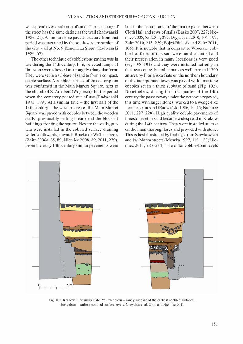
151
VI. SANITATION AND STREET SURFACE CONSTRUCTION
was spread over a subbase of sand. The surfacing of the street has the same dating as the wall (Radwański 1986, 21). A similar stone paved structure from that period was unearthed by the south-western section of the city wall at No. 9 Kanonicza Street (Radwański 1986, 67).
The other technique of cobblestone paving was in use during the 14th century. In it, selected lumps of limestone were dressed to a roughly triangular form. They were set in a subbase of sand to form a compact, stable surface. A cobbled surface of this description was confirmed in the Main Market Square, next tothe church of St Adalbert (Wojciech), for the period when the cemetery passed out of use (Radwański 1975, 189). At a similar time – the first half of the14th century – the western area of the Main Market Square was paved with cobbles between the wooden stalls (presumably selling bread) and the block of buildings fronting the square. Next to the stalls, gut-ters were installed in the cobbled surface draining water southwards, towards Bracka or Wiślna streets (Zaitz 2006a, 85, 89; Niemiec 2008, 89, 2011, 279). From the early 14th century similar pavements were
laid in the central area of the marketplace, between Cloth Hall and rows of stalls (Buśko 2007, 227; Nie-miec 2008, 85, 2011, 279; Dryja et al. 2010, 104–197; Zaitz 2010, 213–239; Bojęś-Białasik and Zaitz 2011, 106). It is notable that in contrast to Wrocław, cob-bled surfaces of this sort were not dismantled and their preservation in many locations is very good (Figs. 98–101) and they were installed not only in the town centre, but other parts as well. Around 1300 an area by Floriańska Gate on the northern boundary of the incorporated town was paved with limestone cobbles set in a thick subbase of sand (Fig. 102). Nonetheless, during the first quarter of the 14thcentury the passageway under the gate was repaved, this time with larger stones, worked to a wedge-like form or set in sand (Radwański 1986, 10, 15; Niemiec 2011, 227–228). High quality cobble pavements of limestone set in sand became widespread in Krakow during the 14th century. They were installed at least on the main thoroughfares and provided with stone. This is best illustrated by findings from Sławkowskaand św. Marka streets (Myszka 1997, 119–120; Nie-miec 2011, 283–284). The older cobblestone levels
Fig. 102. Krakow, Floriańska Gate. Yellow colour – sandy subbase of the earliest cobbled surfaces, blue colour – earliest cobbled surface levels. Niewalda et al. 2001 and Niemiec 2011

152
VI. SANITATION AND STREET SURFACE CONSTRUCTION
were overlaid by a layer accumulated when the street in use, subsequently spread with sand and surfaced with a new layer of cobblestones. More widescale paving projects were made possible by the involve-ment in their financing by the town council and theready supply of limestone from the municipal quarry at the nearby Krzemionki Hills.
During the first centuries in the development ofincorporated towns, there was a marked rise in the ground level. In each town under discussion, it ex-ceeded 3 m, in places even reaching 5–6 m. Waste was not removed outside the town. Refuse from activities within the plots was dumped into the street and in-cluded sand from the excavation of cellars, foundation trenches and cess pits, clay left after the construction of wattle-and-daub buildings, ashes from stoves and hearths. In addition, the destruction of houses – by fire or by deliberate demolition – is at times evidentin the stratigraphy of the street surfaces. The content of the layers in individual sections, at least to some extent, was the result of the activity of the owners and residents of individual houses, who treated the area in front of their property in an individual manner. A quantitatively significant proportion of the culturaldeposit was animal faeces. In conditions favouring the survival of organic material, manure mixed with wood shavings, straw, animal bone and sand was the main component of the cultural deposit investigated archaeologically. The animal species easiest to rear and feed in the town was the pig. Advantages from having a stock of meat, important in times when crop failure, natural disasters and wars were com-mon, were too soon, in the 14th century, offset by the side effects, mostly filth accumulating in thestreets and erosion of their surfaces and the reaction of the town government was to restrict the number of livestock in the town. From written sources, we know the nature of these regulations: the privilege of keeping livestock was given only to some groups of tradespeople, mainly bakers and maltsters; there was a law against setting animals loose in the street, or this was allowed only at night. Livestock breed-ing was permitted only in some districts of the town and there were regulations as to where and in what manner the disposal and transport of manure could take place (Dirlmeier 1981, 146; Gechter 1987, 255; Wyrozumski 2010).
During the first centuries after incorporation, theestablished method of reducing the nuisance associ-ated with the build-up of layers was to successively spread and drain them with sand, ashes or rubble, which with time, was trampled into the ground. The construction of street and yard surfaces did not slow
down the accumulation of the cultural deposit. This was so with both timber causeways and early cob-bled surfaces. As noted earlier, after a century at the latest, the ground floors of buildings had to turn intocellars and access to them required installing new construction solutions. There was need to delay this process already by the 14th century and appropriate steps were taken by the municipal government. One of the main actions was to regulate for the disposal of waste outside the town, householders were re-quired to keep the street in front of their plot tidy and lay them with cobblestones. Regulations on sanitation introduced around the mid–14th century were clear-cut and non-compliance was punished by fines (Wyrozumski 1992, 462; Goliński 2011).It transpired to be especially beneficial to combineinvestment into good quality cobblestone pavements with the requirement of keeping the street surfaces clean. In Prague and in Wrocław these actions, rela-tively successfully, curbed the build-up of the cultural deposit. In Prague this occurred already at the end of the 13th century (Hrdlička 2000). In Wrocław, the ground level stabilized during the second half of the 14th century. Later layers occur only locally and did not achieve any greater thickness (Bresch et al. 2001, 15–108; Bresch et al. 2002, 11–69; Konczewski and Piekalski 2010, 91–151). They consist mostly of sand that remained from the replacement and repairs of the cobblestone paving.
In Krakow on the other hand, there is evidence that the ground level continued to build up until the 16th century, proving that sanitation efforts made in the town were less successful. Relatively well con-structed cobbled surfaces datable to the 14th–15th century recorded during archaeological investigation rested under a layer of waste and dirt, which was interpreted as humus or muck. Poor conditions for communication in the town during the Late Middle Ages and the early modern period are documented by written records assembled by Dariusz Niemiec (2011, 287).
While sanitation level in the streets and squares, understood as public spaces, was the object of con-cern and of variously successful activity by the municipal government, the interference of town authorities into the situation inside private yards was limited (Goliński 2011a). This is where all manner of waste was removed to, including the most offensive. Cesspits in the backyard were the receptacle for, next to night soil, wastewater and a wide assortment of discarded or damaged objects –portable items of ur-ban culture. This makes them an important resource for medieval urban archaeology. So much so that
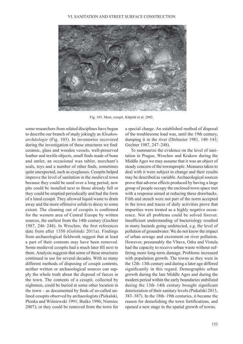
153
VI. SANITATION AND STREET SURFACE CONSTRUCTION
Fig. 103. Most, cesspit. Klápště et al. 2002.
some researchers from related disciplines have begun to describe our branch of study jokingly as Kloaken-archäologie (Fig. 103). In inventories recovered during the investigation of these structures we find:ceramic, glass and wooden vessels, well-preserved leather and textile objects, small finds made of boneand antler, an occasional wax tablet, merchant’s seals, toys and a number of other finds, sometimesquite unexpected, such as eyeglasses. Cesspits helped improve the level of sanitation in the medieval town because they could be used over a long period, new pits could be installed next to those already full or they could be emptied periodically and had the form of a lined cesspit. They allowed liquid waste to drain away and the more offensive solids to decay to some extent. The cleaning out of cesspits is confirmedfor the western area of Central Europe by written sources, the earliest from the 14th century (Gechter 1987, 246–248). In Wrocław, the first referencesdate from after 1350 (Goliński 2011a). Findings from archaeological fieldwork suggest that at leasta part of their contents may have been removed. Some medieval cesspits had a much later fill next tothem. Analysis suggests that some of these structures continued in use for several decades. With so many different methods of disposing of cesspit contents, neither written or archaeological sources can sup-ply the whole truth about the disposal of faeces in the town. The contents of a cesspit, collected by nightmen, could be buried at some other location in the town – as documented by finds of so-called un-lined cesspits observed by archaeologists (Piekalski, Płonka and Wiśniewski 1991; Buśko 1996; Niemiec 2007); or they could be removed from the town for
a special charge. An established method of disposal of the troublesome load was, until the 19th century, dumping it in the river (Dirlmeier 1981, 140–143; Gechter 1987, 247–248).
To summarize the evidence on the level of sani-tation in Prague, Wrocław and Krakow during the Middle Ages we may assume that it was an object of steady concern of the townspeople. Measures taken to deal with it were subject to change and their results may be described as variable. Archaeological sources prove that adverse effects produced by having a large group of people occupy the enclosed town space met with a response aimed at reducing these drawbacks. Filth and stench were not part of the norm accepted in the town and traces of daily activities prove that impurities were treated as a highly negative occur-rence. Not all problems could be solved forever. Insufficient understanding of bacteriology resultedin many hazards going undetected, e.g. the level of pollution of groundwater. We do not know the impact of urban sewage and excrement on river pollution. However, presumably the Vltava, Odra and Vistula had the capacity to receive urban waste without suf-fering more long-term damage. Problems increased with population growth. The towns as they were in the 12th–13th century and during a later age differed significantly in this regard. Demographic urbangrowth during the late Middle Ages and during the modern period within the early boundaries stabilized during the 13th–14th century brought significantdeterioration of their sanitary levels (Piekalski 2013, 383–387). In the 18th–19th centuries, it became the reason for demolishing the town fortifications, andopened a new stage in the spatial growth of towns.


155
An important factor shared during the period of interest by Prague, Wrocław and Krakow were political conditions that mainly resulted from the rivalry between the Přemyslid and Piast rulers. It was particularly strong during the stage of the formation of the states in the 10th century but in a later period as well, until the final incorporation of Wrocław andthe duchies of Silesia into the Kingdom of Bohemia. Of significance in the development of Krakow, in-cluding its domestic and defensive architecture was the brief reign in the city of King Wenceslaus II of Bohemia (1291–1305). The impact of these political developments and events on processes examined in the present study is only signalled here as their more extensive discussion is given elsewhere (Zientara 1975; Łowmiański 1985; Žemlička 2002). The politi-cal developments apart, the territories of Bohemia, Silesia and Lesser Poland gradually grew closer in their culture, mostly independently of the intentions of their rulers, through economic ties and the use of similar organizational solutions.
Features shared by Prague, Wrocław and Krakow during their proto-urban phase included the presence of a secular power centre, a cathedral and the resi-dence of a bishop as well as a settlement with a non-agrarian economy and some other settlement foci. The whole formed a loose-knit, polycentric agglom-eration with a topographical layout that depended on natural conditions. With this, the list of key similari-ties ends and features distinctive for each town need to be recalled. Each centre had its proper rhythm of development and scale. Prague, the central hub of the Přemyslid state was the first to rise to the level ofa supraregional commercial centre as early as during the 10th century. Its economic prosperity is reflectedby the expansion of the suburbium by Prague Castle. Less clear is the economic role of Krakow during the same period. Its important economic position is
confirmed to-date only by the discovery in the areaof the suburbium of Okół of a great deposit of raw iron weighing close to 4 tons. This find is definitelyimpressive but only one of a kind. In the case of Wrocław, the matter seems more unambiguous. We know that during the 10th–11th century its castle had no substantial crafts-and-market hinterland.
The 12th century was a time of significant ac-celeration in the development of Prague, marked by the shift of the point of gravity of crafts-and-market settlement to the right bank of the Vltava across the river from Prague Castle. Around the middle of that century, it already had a community of foreign mer-chants. The success of their economic activity would be confirmed most notably by elite stonebuilt houseserected from around 1200. Most of them stood in the large marketplace and the streets which originated next to it in an irregular pattern. The economic sig-nificance of the right bank-settlement from the pointof view of the interests of Prague Castle is supported by the construction of a bridge over the Vltava, at first timber, and starting from the 1170s, stonebuilt– the first of its kind in East Central Europe. InWrocław there was a settlement of craftsmen on the left bank of the Odra during the 11th century but it increased in importance not earlier than during the second half of the 12th century, more precisely, start-ing from around 1200. Nevertheless, its subsequent development was dynamic, and at least some of its inhabitants were hospites from the West and as in Prague, they were Germans, Jews and immigrants from the Romance languages’ zone. In Krakow, the acceleration of development came even later, during the first half of the 13th century. This is evidenced bythe development of the crafts settlement to the north of Okół. Ethnically foreign hospites appeared there by the 1220s. In each of the discussed centres, they gained juridical autonomy but without having their
VII. PRAGUE, WROCŁAW AND KRAKOW – THE TOWNS OF NEW EUROPE. CONCLUSION

156
VII. PRAGUE, WROCŁAW AND KRAKOW – THE TOWNS OF NEW EUROPE. CONCLUSION
community incorporated as a town in the new law. The accepted view is that the major setback in the development of Krakow was the Mongol invasion of 1241. On the other hand, there is no evidence that this event caused lasting damage in Wrocław. Cur-rently, the identification of traces of this invasion inthis town continues to be unresolved.
The transformation of Prague, Wrocław and Krakow to a form regulated by the new law should be viewed as an element of the major economic and social transformation which swept across Europe dur-ing the High Middle Ages. It was largely the effect of the dynamic development of the region lying to the west of the Elbe, where an economic boom resulted in intense demographic growth. Colonisation of East Central Europe was one of its consequences, and the processes of incorporation of villages and towns are understood as a form of organization and fiscal con-trol of this movement. The network of proto-urban centres in East Central Europe was not intensively developed. Nevertheless, we may observe the begin-nings of their transformation during the period pre-dating incorporation, understood as a legal act. The first stage of transformation was the already notedacceleration in their development from the mid–12th century onwards. It took place at a time when, in the west of Europe, the urban process was already at an advanced stage and the compromise between territorial lords and the emerging town communes ushered in new legal solutions. The rapid growth of towns in the region promoted commercial exchange and expanded its geographical range. Partners or intermediaries in this activity in the East were none other than the proto-urban centres, mainly Prague but also Wrocław and Krakow. They already had their communities of foreign merchants. In addition, we have no evidence that the legal situation of the time posed any obstacles to their activity.
In each of the three towns, the watershed of in-corporation had a slightly different character. The intensive and successful – in settlement terms – de-velopment of the proto-town limited the extent of the incorporation transformation. Where there was a lack of stability during the pre-incorporation phase the impact of incorporation on the structure of the town was greater. The spatial structure of proto-urban right bank Prague in 1234 was sufficiently formed and use-ful that when concluded, the incorporation contract caused no drastic change to the layout of the settle-ment. The pre-existing stonebuilt architecture fossil-ized at least some of the plots, reducing the scope of the incorporation activity to fiscal regulations only.Much of the older settlement was integrated into the
future intramural town. A different fate was met by the suburbium near Prague Castle, on the left river-bank, which was not regarded by the territorial lord as worth sustaining or further developing. In Wrocław, we have to recognize the new settlement hub as the first incorporated town which was added to the pre-existing agglomeration. Its regular street plan, centred on the marketplace, became one of three structures soon enclosed by fortifications. The other two are thepre-incorporation settlement and the strip of ducal land on the Odra River. The dynamic development of the new entity soon resulted in the absorption of the earlier settlement and further expansion. In Krakow, too the pre-existing suburbium of Okół was not included in the incorporation. The new town was laid out in a zone adjacent to it from the north, on the site of the ironworking settlement destroyed by the Mongols. The regular town plan was developed there in its full form, dictated by fiscal targets, adjusted toeconomic objectives and also testifying to the high skill of the surveyors. From today’s point of view, the layout of Krakow from the 13th/14th century may be regarded as an artful piece of town planning. A common feature of the incorporation watershed was an obvious reduction in the size of the earlier settlement structure. The place of a loosely organized agglomeration of several elements was replaced by a more focused urban centre with a visibly empha-sized multi-functional central district. In each town of interest, it was a market square, already in place in the older settlement in Prague and newly laid out in Wrocław and in Krakow.
The principle, used in Krakow and presumably in Wrocław also, of the legal segregation of the in-digenous and immigrant population is explained in literature as motivated by the wish to retain the earlier settlements whose indigenous inhabitants were bound by traditional obligations towards the ruler (Piskorski 1990/91, 225; Rajman 2004, 346; Moździoch 1996, 33). Due to the need to keep these obligations in force, the duke’s people were debarred from joining the town commune. Quite soon, this precipitated the material decline of the pre-existing settlements, and subsequently, their deterioration, or alternately, absorption into the incorporated town. Some attempts were made to have them incorporated separately, but these failed to bring the expected results. Still insuf-ficiently understood is the later fate of the inhabitantsof pre-incorporation settlements who remained in the traditional system of feudal obligations. Did they add to the number of the urban lower class deprived of town rights? Were they relocated to ducal villages? Written sources are silent on their subject. Thus, the
157
VII. PRAGUE, WROCŁAW AND KRAKOW – THE TOWNS OF NEW EUROPE. CONCLUSION
demographic base of the transformed towns were the hospites – mostly German speaking colonists – some of them already present in the East prior to incor-poration but most arrived in its wake. As Mateusz Goliński noted (2012, 22–27) it was for them that the new town law was introduced, to provide for their status and to safeguard the interests of the duke.
Was the model of the burgage plot transplanted to East Central Europe as a ‘readymade product’, fully formed in its legal, fiscal and spatial detail inthe towns of the West? This is something most urban researchers wish to see, especially those working with the method of measurement analysis. In the light of the knowledge we have today, we need to assume that in the towns of Western Europe the plot was not the result of a single invention. Its form evolved over time and its appearance was not uniform. In most towns of the 12th and early 13th century, plots had a variety of plans, conditioned mostly by the ir-regular street layout. In many centres that functioned from the Early Middle Ages such plots, soon fixedby masonry buildings, survive until today. This is the reality reflected in the Old Town in Prague. Heremost plots have an irregular form and the measure-ment method is not applicable. One might say that the model of a regular plot, an elongated rectangle in plan with an evidently fiscal function, was late inarriving to Prague. The town had already taken form prior to any legal regulations.
Rectilinear plots of equal sizes are known from early medieval proto-urban centres in Northern and North-western Europe. Even so, there is no proof that they were the direct model for the founders of towns such as Freiburg im Breisgau and others similar to it, where at least some plots of regular size were laid out. The idea itself resulted more from the choice of the most simple and, at the same time, the universal option. Their popularity in many cultures far removed geographically and chronologically from each other was the result of just this simplicity and practical advantages without ruling out, at the same time, their aesthetic value. The plot on a plan of an elongated rectangle had an area easy to calculate that was helpful in fairly determining the amount of payment charged from it. It was the layout most compatible with the urban mode of life, where the workplace and the dwelling were in the same location. The front of the plot, which doubled as the street edge, marked the boundary between private and public space. At the same time, in the spirit of European cultures and in contrast to Middle Eastern ones, it lent emphasis to the open character and representative nature of the house.
A typical urban domestic building is situated ex-actly on the boundary with the public space. Other situations where it is found at the rear of the plot il-lustrate the way of life of those who in social terms were foreigners in the urban community. Thus, these might be houses of members of the feudal or Church elite, in which case they usually had the form of a tower, or, just the opposite, rear buildings of inferior status, leased out to people who had no town rights. This second phenomenon, illustrating the way of life of the urban lower class, was widespread in the town. Aspiration to social advancement could, even if infrequently, result in a residential tower being occupied by a townsman.
For all of the stated reasons, the regulation of the plot plan became a progressive tendency in the 12th–13th centuries, where this was possible. It was easiest to apply in new town districts, or in centres founded a novo in an area with no pre-existing de-velopment. This was possible also in Wrocław and in Krakow. In the former, plots were laid out in an area free of development, outside the pre-existing settle-ment, and in the latter, in the place of the settlement destroyed by warfare. The decisions on plot sizes in both towns were taken independently, adjusting them to local needs.
If we accept that urban civilization spread to East Central Europe in an already established form then the houses built in Prague, Wrocław and Krakow would have to correspond to patterns used earlier in centres of Western Europe, but it is not so. In each of these towns we can find local solutions and thepool of potential prototypes is quite large but at the same time, misleading. We cannot hope to link with any certainty the urban domestic houses of Prague, Wrocław and Krakow with those known in Northern Europe or the High German region. Instead, we have to assume a high flexibility in the spatial solutionsused which, nevertheless, fit the broader concept ofa merchant or a craftsman’s house. The indigenous model of the log house was not continued either.
Timber buildings in post-in-ground construction houses appear for the first time in the built environ-ment of Prague during the 12th–13th centuries. They had a larger surface area than indigenous log houses and were partly sunken. The true harbinger of new times in Prague is the Romanesque stonebuilt houses. The lack of close analogies and, at the same time, their obvious concentration on the right bank of the Vltava lead to the conclusion that their model was developed locally to meet the needs of the financialelite, i.e. prosperous merchants engaged in lucrative long-distance trade.

158
VII. PRAGUE, WROCŁAW AND KRAKOW – THE TOWNS OF NEW EUROPE. CONCLUSION
Timber post buildings introduced into Prague and other towns of Bohemia and Moravia prior to the incorporation were not typical for Wrocław and Krakow. Studies of Wrocław in particular show that starting from the early decades of the 13th century the technologically advanced frame system had come into use and houses usually had two storeys, one of them partly sunken. The stone Prague houses, on the other hand, have no counterparts in Wrocław or Krakow. Here a different system was used, apparently more suited to the local needs, and even more so to the local means. Whereas in Prague a stone house resulting from a single building project tended to rep-resent a complete and functional whole, in Wrocław the process of construction unfolded in stages. The norm was to start from simple forms and add other segments in succession, or to divide the interiors into smaller ones. The size of the area occupied by a house varied, ranging from small buildings, square in plan, to larger ones in the shape of an elongated rectangle. The position of the latter in relation to the street could also vary – more frequently they were set with the ridgepole to the street but some houses stood with their gable end to the line of the plot frontage. The earliest houses tended to have two, sometimes, three storeys and the ground floor usually partly sunken.
Masonry houses of Wrocław were slightly later compared to those of Prague, but antedate those of Krakow. In the central town of Lesser Poland, the first stonebuilt houses appear during the final dec-ades of the 13th century. There a special feature is the presence of residential towers (alternately, tower houses) set at the rear of the plot presumably form-ing a functional whole with the timber house. There is reason to believe that they originated at the stage of the development of this town when it still had no regular fortifications. Houses of later date, fromaround 1350 assumed the form of a typical urban townhouse set in line with the street.
In each town, the building material and strategies were adjusted to local conditions and stylistic conven-tions. In Prague, locally sourced limestone was used, carefully dressed to the form of Romanesque ashlar. In lowland Wrocław, where there were no nearby outcrops of building stone, brick was used. The style of buildings erected mainly during the second half of the 13th century combines Late Romanesque and Early Gothic elements. The builders of Krakow, similar to those of Prague, had at their disposal the locally available building stone – Jurassic limestone but in contrast to Prague the masonry walls were built in keeping with the local Gothic convention by laying broken stone in layers.
Town squares and streets were essential elements of the public space of medieval towns and the way they were used differed from that proper to the plot and the house. They brought together technical, so-cial and symbolic functions. They were the site of economic activity but also a place to display one’s membership in the community and one’s proper place in its internal hierarchy. They served as a place of assembly and transfer of information; behaviour in them was subject to control. The usefulness of squares and streets for daily communication depended on maintaining them in a proper condition. In each town, methods used in the metalling of its street surfaces were different. There were some common tendencies however, mainly the evolution from casual methods, unsophisticated in terms of construction, to the laying of permanent cobbled surfaces by way of municipal projects. In each town, the structure of street surfaces investigated archaeologically is a reflection of increas-ing public problems and the ways of solving them that were undertaken in response. The condition of the street surface was improved to the level required by the current function of the street, one that could be achieved with the technological and financial potentialof the townspeople then available. During the early stage of the development of towns, when the level of disturbance to the natural environment was not too great, projects of road construction, improvement and maintenance were not extensive. Mounting unfavour-able changes resulted in an organized intervention by the community and the reduction of nuisance. The policy of the town council, at first liberal, changedwith time into an active one, even restrictive in rela-tion to the owners of plots fronting the street.
Steps taken to maintain proper sanitation in the town may be described in a similar manner. These now more regular measures were aimed at the elimi-nation of emerging hazards as the regulatory and controlling role of the town government increased. The build-up of deep layers of refuse in the squares and streets of Prague, Wrocław and Krakow led to the introduction of regulations on the cleaning and removal of waste outside these towns. As the town population grew so did problems with sanitation. Apparently, until the 14th century the period of most interest to us here, efforts made by the townspeople to keep their town clean produced results satisfactory for them. However, by the end of the Middle Ages and beyond the situation deteriorated and continued to do so until the disastrous conditions of 17th–18th centuries.
The transformation of Prague, Wrocław and Kra-kow in the 12th–14th century was a part of a more
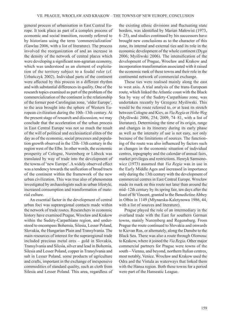
159
VII. PRAGUE, WROCŁAW AND KRAKOW – THE TOWNS OF NEW EUROPE. CONCLUSION
general process of urbanisation in East Central Eu-rope. It took place as part of a complex process of economic and social transition, recently referred to by historians using the term ‘commercialization’ (Gawlas 2006, with a list of literature). The process involved the reorganization of and an increase in the density of the network of central places which were developing a significant non-agrarian economy,which was understood as an element of exploita-tion of the territory subject to a feudal ruler (cf. Urbańczyk 2002). Individual parts of the continent were affected by this process in a different rhythm and with substantial differences in quality. One of the research topics examined as part of the problem of the commercialization of the continent is the relationship of the former post-Carolingian zone, ‘older Europe’, to the area brought into the sphere of Western Eu-ropean civilization during the 10th–13th century. At the present stage of research and discussion, we may conclude that the acceleration of the urban process in East Central Europe was not so much the result of the will of political and ecclesiastical elites of the day as of the economic, social processes and popula-tion growth observed in the 12th–13th century in the region west of the Elbe. In other words, the economic prosperity of Cologne, Nuremberg or Lübeck was translated by way of trade into the development of the towns of ‘new Europe’. A widely observed effect was a tendency towards the unification of broad tractsof the continent within the framework of the new urban civilization. This was true also of phenomena investigated by archaeologists such as urban lifestyle, increased consumption and transformation of mate-rial culture.
An essential factor in the development of central urban foci was supraregional contacts made within the network of trade routes. Researchers in economic history have examined Prague, Wrocław and Krakow within the Sudety-Carpathians region, and under-stood to encompass Bohemia, Silesia, Lesser Poland, Slovakia, the Hungarian Plain and Transylvania. The main resources of interest for the supraregional trade included precious metal ores – gold in Slovakia, Transylvania and Silesia, silver and lead in Bohemia, Silesia and Lesser Poland, copper in Transylvania and salt in Lesser Poland, some products of agriculture and crafts, important in the exchange of inexpensive commodities of standard quality, such as cloth from Silesia and Lesser Poland. This area, regardless of
the existing ethnic divisions and fluctuating stateborders, was identified by Marian Małowist (1973,6–25), and studies continued by his successors have brought new conclusions as to the character of this zone, its internal and external ties and its role in the economic development of the whole continent (Dygo 2006; Myśliwski 2006). The intensification of thedevelopment of Prague, Wrocław and Krakow and incorporation transformation associated with it raised the economic rank of these towns and their role in the continental network of commercial exchange.
These ties were realised mainly along the east to west axis. A trial analysis of the trans-European route, which linked the Atlantic coast with the Black Sea by way of the Sudety-Carpathians zone, was undertaken recently by Grzegorz Myśliwski. This would be the route referred to, or at least its stretch between Cologne and Kiev, as Via Regia or Hohe Weg (Myśliwski 2006, 254, 2009, 74–81, with a list of literature). Determining the time of its origin, range and changes in its itinerary during its early phase as well as the intensity of use is not easy, not only because of the limitations of sources. The function-ing of the route was also influenced by factors suchas changes in the economic situation of individual centres, topography and the calendar of annual fairs, market privileges and restrictions. Henryk Samsono-wicz (1973) assumed that Via Regia was in use in the Early Middle Ages and increased in importance only during the 13th century with the development of commercial centres in East Central Europe. Wrocław made its mark on this route not later than around the mid–12th century by its spring fair, ten days after the feast of St Vincent, granted to the Benedictine Abbey in Ołbin in 1149 (Młynarska-Kaletynowa 1986, 44, with a list of sources and literature).
Prague played the role of an intermediary in the overland trade with the East for southern German towns, mainly Nuremberg and Regensburg. From Prague the route continued to Slovakia and onwards to Kievan Rus, or alternately, along the Danube to the Black Sea. There was also a route through Olomouc to Krakow, where it joined the Via Regia. Other major commercial partners for Prague were towns of the south – Vienna, and beyond, northern Italian centres, most notably, Venice. Wrocław and Krakow used the Odra and the Vistula as waterways that linked them with the Hansa region. Both these towns for a period were part of the Hanseatic League.


161
Badura, Janusz 2010 Geomorfologiczne uwarunkowania lokalizacji le-
wobrzeżnego Wrocławia, [in:] Jerzy Piekalski and Krzysztof Wachowski (eds.), Ulice średniowiecz-nego Wrocławia, Wratislavia Antiqua, 11, Wrocław, 15–45.
Badura, Janusz, Tomasz Kastek, Roland Mruczek, Michał Stefanowicz
2010 Z nowszych badań obwarowań i fortyfikacji Wrocła-wia. Część 1. Pas południowy w rejonie obecnego placu Wolności, Śląskie Sprawozdania Archeolo-giczne, 52, 365–425.
Barros, Carlos 1998 Die „Vermenschlichung” der Natur im Mittelalter,
[in:] Konrad Spindler (ed.), Mensch und Natur im mittelalterlichen Europa. Archäologische, histori-sche und naturwissenschaftliche Befunde, Klagen-furt, 281–310.
Bartlett, Robert 2003 Tworzenie Europy. Podbój, kolonizacja i przemiany
kulturowe 950–1350, Wydawnictwo Poznańskiego Towarzystwa Przyjaciół Nauk, Poznań.
Baumhauer, Matthias 2001 „Grubenhaus oder Keller?” Bemerkungen zu ihrer
Unterscheidbarkeit anhang ausgewählter mittelal-terlicher Befunde, [in:] Jochem Pfrommer and Rainer Schreg (eds.), Zwischen den Zeiten. Archäologische Beiträge zur Geschichte des Mittelalters in Mittel-europa. Festschrift für Barbara Scholkmann, Verlag Marie Leidorf GmbH. Rahden/Westf, 349–362.
von Below, Georg 1887–1888 Zur Entstehung der deutschen Stadtverfassung,
Historische Zeitschrift, vol. 58 (1887), 193–244, vol. 59 (1888), 193–247.
Benevolo, Leonardo 1971 Die sozialen Ursprünge des Städtebaus, Wiesbaden. 2000 Die Geschichte der Stadt. Frankfurt. New York
(Storia della cittá, Roma. Bari 1975).Beranová, Magdalena 1979 Kováři ve vyšehradském podhradí v 11.–13. století,
Archeologické rozhledy, 31, 300–304.Beresford, Maurice Warwick 1967 New Towns of the Middle Ages, Lutterworth Press,
London. Berger, Ludwig 1963 Die Ausgrabungen am Petersberg in Basel, Basel.
2002 Die Ausgrabungen am Petersberg in Basel 1937–1939. Rückblick und Ausblick, [in:] Guido Helmig, Barbara Scholkmann and Mathias Untermann (eds.), Medieval Europe. Basel 2002. Centre. Region. Peri-phery, Hertingen, 3, 138–144.
Bicz-Suknarowska, Maria, Waldemar Niewalda, Halina Roj-kowska
1996 Zabudowa ulicy Kanoniczej na tle urbanistyki śred-niowiecznego Okołu, [in:] Teresa Hrankowska (ed.), Sztuka około 1400. Materiały Sesji Stowarzyszenia Historyków Sztuki. Poznań, listopad 1995, Warsza-wa, 1, 87–104.
Biddle, Martin 1976 Towns, [in:] David M. Wilson (ed.), The Archaeology
of Anglo-Saxon England, Meuthen&Co Ltd, Cam-bridge, 99–150.
Binding, Günter 1999 Bürgerhaus, [in:] Lexikon des Mittelalters, 2, Stutt-
gart. Weimar, 1043–1046. Binding, Günter, Udo Mainzer, Anita Wiedenau 1989 Kleine Kunstgeschichte des deutschen Fachwerk-
baus, Darmstadt.Biszkont, Jadwiga 2005 Późnośredniowieczne szklarstwo na Śląsku, Wrati-
slavia Antiqua, 7, Wrocław.Blaschke, Karl-Heinz 1987 Kirchenorganisation und Kirchenpatrozinien als
Hilfsmittel der Stadtkernforschung, [in:] Helmut Jäger (ed.), Stadtkernforschung, Städteforschung, A, vol. 27, Köln-Wien, 24–57.
1997 Stadtgrundriss und Stadtentwicklung, Städtefor-schung, A, vol. 44, Köln 1997.
Blattmann, Marita 1986 Das Berner Hofstättensystem, [in:] Hans Schadek,
Karl Schmidt (eds.), Die Zähringer. Anstoß und Wirkung, Sigmaringen, 250–265.
Bober, Monika 2008 Architektura przedromańska i romańska w Krakowie.
Badania i interpretacje, Rzeszów. Boháčová, Ivana 1998 review: Jan Frolík and Zdeněk Smetánka. 1997,
Archeologie na Pražském Hradě, Praha – Litomyšl, Archeologické rozhledy, 50, 291–293.
1998a Zum Befestigungssystem der Přemyslidenburgen (am Beispiel der archäologischen Untersuchungen in der Prager Burg und in Stará Boleslav), [in:] Joachim Hennig and Alexander T. Ruttkay (eds.), Frühmittel-
BIBLIOGRAPHY

162
BIBLIOGRAPHY
alterlicher Burgenbau in Mittel- und Osteuropa, Bonn, 37–47.
2001 Pražský Hrad a jeho nejstarši opevnonaci systémy, [in:] Martin Ježek and Jan Klápště (eds.), Pražský Hrad a Malá Strana, Medievalia Archaeologica, 3, Praha.
Boháčová, Ivana and Iva Herichová 2008 Raně stredověký sídelní areál v západní části hrad-
čanského ostrohu, Archaeologia Pragensia, 19, 257–308.
Boháčová, Ivana, Jan Frolík, Zdeněk Smetánka, Bořivoj Ne-chvátal and Ladislav Hrdlička
1994 Prague Castle, Vyšehrad Castle and the Prague Agglomeration, [in:] 25 Years of Archaeological Research in Bohemia, Památky archeologické, Sup-plementum 1, Praha, 153–184.
Bojęś-Białasik, Anna and Dariusz Niemiec 2013 Kościół i klasztor dominikanów w Krakowie
w świetle badań archeologiczno-architektonicznych w latach 2010–2012, [in:] Anna Markiewicz, Marcin Szyma and Marek Walczak (eds.), Sztuka w kręgu krakowskich dominikanów, Wydawnictwo Esprit s.c, Kraków, 257–313.
Bojęś-Białasik, Anna and Michał Zaitz 2011 Kramy drewniane odkryte w 2004 roku po zachodniej
stronie Sukiennic na Rynku Głownym w Krakowie, [in:] Klaudia Stala (ed.), II Forum Architecturae Po-loniae Medievalis, Architektura. Czasopismo Tech-niczne. Architecture. Technical Transactions, Wyd. Politechniki Krakowskiej, 7-A/2011/23, 99–118.
Borkovský, Ivan 1948 Pohřebiště obchodníků z doby knížecí v Praze, Slavia
Antiqua, 1, 460–484. 1953 Kostel P. Marie na Pražském hradě (L’église de la
Ste Viérge au château de Praque), Památky archeo-logické, 44, 129–200.
1955 Klášter bl. Anežky Přemyslovny v Praze, Časo-pis Společnosti přatel starožitností českých, 63, 24–35.
1956 Výzkum v klášteře bl. Anežky v Praze, Archeologické rozhledy, 8, 194–204.
1957 Objev rotundy a tempalářského kostela sv. Vavřince, výzkum v kostele sv. Anny v Praze 1, Časopis Národ-ního Musea, 126, 74.
1962 Opyš Pražskeho hradu, Památky archeologické, 53, 129–200.
1969 Pražský hrad v době přemyslovských knížat, Praha.Borowiejska-Birkenmajerowa, Maria 1975 Kształt średniowiecznego Krakowa, Kraków.Borst, Otto 1983 Alltagsleben im Mittelalter, Frankfurt a. M.Brachmann, Hansjürgen (ed.) 1995 Burg – Burgstadt – Stadt. Zur Genese mittelalterli-
cher nichtagrarischer Zentren in Ostmitteleuropa, Berlin.
1997 Kontinuität und Diskontinuität in der Geschichte der ostmitteleuropäischen frühen Stadt und der „Faktor der Macht”, [in:] Jana Kubková, Jan Klápště, Martin Ježek, Petr Meduna et al. (eds.), Život v archeologii středověku. Sborník příspěvků věnovaných Miroslavu Richterovi a Zdeňku Smetánkovi, Praha, 53–66.
Brather, Sebastian 1995/1996 Frühmittelalterliche Dirham-Schatzfunde in
Europa. Probleme ihrer wirtschaftlichen Interpre-
tation aus archäologischer Perspektive, Zeitschrift für Archäologie des Mittelalter, 23/24, 73–153.
1996 „Germanische”, „slawische” und „deutsche” Sach-kultur des Mittelalters – Probleme ethnischer In-terpretation, Ethnographisch-Archäologische Zeit-schrift, 37, 177–216.
2001 Archäologie der westlichen Slawen. Siedlung, Wirt-schaft und Gesellschaft im früh- und hochmittelal-terlichen Ostmitteleuropa, Berlin, New York.
2004 Ethnische interpretationen in der frühgeschichtlichen Archaeologie: Geschichte, Grundlagen und Alterna-tiven, Berlin, de Gruyter.
Braudel, Fernand 1992 Kultura materialna, gospodarka i kapitalizm XV–
–XVIII wiek, t. 1, Struktury codzienności, Warszawa. (1979, Civilissation matérielle, économie et capitalis-me, XV–XVIII siécle. Les structures de quotidien, Paris).
Brázdil, Rudolf and Oldřich Kotyza 1997 Kolísání klimatu v českých zemích v první polovi-
ně našeho tisíciletí, Archeologické rozhledy, 49, 663–700.
Bresch, Jolanta, Cezary Buśko and Czesław Lasota 2001 Zachodnia pierzeja Rynku, [in:] Cezary Buśko (ed.),
Rynek wrocławski w świetle badań archeologicznych, part 1, Wratislavia Antiqua, 3, Wrocław, 15–72.
Bresch, Jolanta, Czesław Lasota and Jerzy Piekalski 2002 Północna pierzeja Rynku. Stratygrafia nawarstwień
kulturowych, [in:] Jerzy Piekalski (ed.), Rynek wroc-ławski w świetle badań archeologicznych, part 2, Wratislavia Antiqua, 5, Wrocław, 11–69.
Broniewski, Tadeusz and Tadeusz Kozaczewski 1967 Pierwotny kościół św. Marii Magdaleny we Wroc-
ławiu. Wyniki badań, Kwartalnik Architektury i Urbanistyki, 12, 3–4, 3–121.
Bureš, Michal, Kateřina Finkova, Vojtěch Kašpar, Jitka Petři-čkova and Pavel Vařeka
1998 Výzkum parcel domu U Sixtů cp. 553/1 na Sta-rém Měste pražském, Archeologické rozhledy, 50, 603–618.
Bureš, Michal,Vojtěch Kašpar, Ladislav Špaček and Pavel Vařeka
1997 The 13th century pre-urban settlement complex near St. Peter’s church in Prague, [in:] Guy De Boe and Frans Verhaeghe (eds.), Urbanism in Medieval Eu-rope. Papers of the ‘Medieval Europe Brugge 1997’ Conference, 1, Zelik, 7–17.
Bureš, Michal,Vojtěch Kašpar and Pavel Vařeka 1994 Preliminary Report on the 1992–1993 excavations at
the medieval site near to St Peter´s church, Prague, [in:] Mediaevalia Archaeologica Bohemica 1993, Památky archeologické, Suplementum 2, Praha, 205–214.
1997 The Formation of the High Medieval Tenements along the Old Town Square in Prague, [in:] Guy De Boe, Frans Verhaeghe (eds.), Urbanism in Medieval Europe. Papers of the ‘Medieval Europe Brugge 1997’ Conference, 1, Zelik, 205–210.
Burian, Jiři and Jiři Svoboda 1973 Prague Castle, Olympia, Prague.Buśko, Cezary 1995 Zaplecze gospodarcze średniowiecznej i nowożyt-
nej kamienicy wrocławskiej. Zaopatrzenie w wodę i urządzenia sanitarne, [in:] Jerzy Rozpędowski

163
BIBLIOGRAPHY
(ed.), Architektura Wrocławia, 1, Dom, Wrocław, 89–104.
1995a Z badań wewnętrznego rozplanowania działki miesz-czańskiej na Śląsku, [in:] Krzysztof Wachowski (ed.), Kultura średniowiecznego Śląska i Czech. Miasto, Wrocław, 91–98.
1995b Stan badań nad parcelą mieszczańską w średnio-wiecznych miastach śląskich, Kwartalnik Historii Kultury Materialnej, 43, No 3, 344–350.
1996 Urządzenia wodno-kanalizacyjne w średniowiecz-nych miastach śląskich, Archaeologia Historica Polona, 3, 93–121.
1997 Nawierzchnie ulic średniowiecznego Wrocławia, Archaeologia Historica Polona, 5, 117–132.
1999 Rozplanowanie parceli i struktura zawodowa jej mieszkańców, [in:] Cezary Buśko and Jerzy Pie-kalski (eds.), Ze studiów nad życiem codziennym w średniowiecznym mieście. Parcele przy ulicy Wię-ziennej 10–11 we Wrocławiu, Wratislavia Antiqua, 1, Wrocław, 203–215.
1999a Badania archeologiczne ulic wrocławskich, Kwar-talnik Historii Kultury Materialnej, 47, No 1–2, 39–50.
1999b Pracownia garbarska, [in:] Cezary Buśko and Jerzy Piekalski (eds.), Ze studiów nad życiem codziennym w średniowiecznym mieście. Parcele przy ulicy Wię-ziennej 10–11 we Wrocławiu, Wratislavia Antiqua, 1, Wrocław, 92–95.
(ed.) 2005 Wschodnia strefa Starego Miasta we Wrocławiu w XII-XIII wieku. Badania na placu Nowy Targ, Wrocław.
2005a Wrocław u progu lokacji, [in:] Cezary Buśko (ed.), Wschodnia strefa Starego Miasta we Wrocławiu w XII-XIII wieku. Badania na placu Nowy Targ, Wrocław, 177–194.
2007 Z badań archeologicznych nad miastami południowej Polski. Rynek Główny w Krakowie w świetle prac przeprowadzonych w latach 2005–2007, Archaeolo-gia historica, 32, 225–235.
Buśko, Cezary, Barbara Czerska and Józef Kaźmierczyk 1985 Wrocławskie zagrody z XI–XII w. odkryte na Ostrowie
Tumskim w 1983 r, Śląskie Sprawozdania Archeolo-giczne, 26, 62–70.
Buśko, Cezary and Wojciech Głowa 2010 Osada przedlokacyjna na Rynku krakowskim (Pre-
-Charter Settlement in the Main Market Square in Kraków), Krzysztofory. Zeszyty Naukowe Mu-zeum Historycznego Miasta Krakowa, 28, part 1, 145–152.
Buśko, Cezary and Jerzy Piekalski 1994 Relikty średniowiecznej pracowni metalurgicznej
przy ul. Malarskiej we Wrocławiu, Śląskie Sprawo-zdania Archeologiczne, 35, 401–410.
(eds.) 1999 Ze studiów nad życiem codziennym w średnio-wiecznym mieście. Parcele przy ulicy Więziennej 10–11 we Wrocławiu, Wratislavia Antiqua, 1, Wroc-ław.
Buśko, Cezary, Jerzy Piekalski and Paweł Rzeźnik 1995 Wrocław/Breslau – eine mittelalterliche Agglomera-
tion, Slavia Antiqua, 36, 105–119.Büttner, Horst and Günter Meissner 1980 Bürgerhäuser in Europa, Leipzig.
Bykowski, Karol, Magdalena Konczewska, Paweł Konczewski, Czesław Lasota, Marcin Paternoga, Jerzy Piekalski and Paweł Rzeźnik
2004 Sprawozdanie z badań wykopaliskowych przy ul. Ka-pitulnej 4 na Ostrowie Tumskim we Wrocławiu, Ślą-skie Sprawozdania Archeologiczne, 46, 113–150.
Čarek, Jiři 1947 Románská Praha, Praha.CD Bohemiae, Codex diplomaticus et epistolaris regni Bohemiae,
vol. 1, ed. Gustav Friedrich, Pragae 1904–1907; vol. 2, ed. Gustav Friedrich, Pragae 1912; vol. 3, eds. Jindřich. Šebánek and Sáša Dušková, Pragae 1974.
CDS Maleczyński, Karol Maleczyński, (ed.). Codex diploma-ticus nec non epistolaris Silesiae, 1–3, Wrocław 1951–1964.
Cechosz, Stanisław and Łukasz Holcer 2006 O początkach pałacu Pod Krzysztofory w świetle naj-
nowszych badań architektonicznych, Krzysztofory. Zeszyty Naukowe Muzeum Historycznego Miasta Krakowa, 24, 7–20.
2007 Średniowieczne przedproże przed pałacem Pod Krzysztofory – najnowsze odkrycia, Krzysztofory. Zeszyty Naukowe Muzeum Historycznego Miasta Krakowa, Kraków, 25, 7–24.
Cembrzyński, Paweł 2011 Zaopatrzenie w wodę i usuwanie nieczystości
w miastach stref bałtyckiej i sudecko-karpackiej w XIII–XVI wieku, Wratislavia Antiqua, 14, Wroc-ław.
Choroschev, Alesandr 2001 Die Grundstücke im mittelalterlichen Novgorod, [in:]
Michael Müller-Wille, Valentin Janin, Evgenij Nosov and Elena Rybina (eds.), Novgorod. Das mittelalterli-che Zentrum und sein Umland im Norden Russlands. Studien zur Siedlungsgeschichte und Architektur der Ostseegebiete, Neumünster, 149–166.
Chorowska, Małgorzata 1994 Średniowieczna kamienica mieszczańska we Wroc-
ławiu, Wrocław. 2001 Wrocław około roku 1300. Relikty zabudowy śre-
dniowiecznej na tle schematu parcelacji i stosun-ków własnościowych w mieście (Breslau um 1300. Ueberreste der mittelalterlichen Bebauung auf dem Hintergrund des Parzellierungsschemas und der Be-sitzverhaeltnisse in der Stadt, [in:] Młynarska, Marta and Rafał Eysymontt (eds.) , Atlas historyczny miast polskich, IV, Śląsk, 1, Wrocław [Historical Atlas of Polish Towns, IV, Silesia, 1. Wrocław]. Wydawnictwo Via Nova, Wrocław.
2003 Rezydencje średniowieczne na Śląsku. Zamki, pałace, wieże mieszkalne, Wrocław.
2005 Rozplanowanie średniowiecznego Poznania na tle miast śląskich, [in:] Zofia Kurnatowska and TomaszJurek (eds.), Civitas Posnaniensis. Studia z dziejów średniowiecznego Poznania, Poznań, 207–224.
2010 Regularna sieć ulic. Powstanie i przemiana do początku XIV w, [in:] Jerzy Piekalski and Krzysztof Wachowski (eds.), Ulice średniowiecznego Wrocła-wia, Wratislavia Antiqua, 11, Wrocław, 67–89.
Chorowska, Małgorzata, Paweł Konczewski, Czesław Lasota and Jerzy Piekalski
2012 Rynek 6 – ul. Kiełbaśnicza 5 we Wrocławiu. Rozwój zabudowy i infrastruktury elitarnej działki miesz-
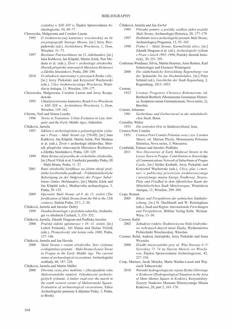
164
BIBLIOGRAPHY
czańskiej w XIII–XIV w, Śląskie Sprawozdania Ar-cheologiczne, 54, 49–77.
Chorowska, Małgorzata and Czesław Lasota 1995 O średniowiecznej kamienicy wrocławskiej na tle
socjotopografii Starego Miasta, [in:] Jerzy Roz-pędowski (ed.), Architektura Wrocławia, 1, Dom, Wrocław, 51–73.
1997 Breslauer Patrizierhäuser im 13. Jahrhundert, [in:] Jana Kubková, Jan Klápště, Martin Ježek, Petr Me-duna et al. (eds.), Život v archeologii středověku. Sborník přispěvků věnovaných Miroslavu Richterovi a Zdeňku Smetánkovi, Praha, 280–290.
2010 O zabudowie murowanej w pierzejach Rynku i ulic, [in:] Jerzy Piekalski and Krzysztof Wachowski (eds.), Ulice średniowiecznego Wrocławia, Wrati-slavia Antiqua, 11, Wrocław, 159–177.
Chorowska, Małgorzata, Czesław Lasota and Jerzy Rozpę-dowski
1995 Układ przestrzenny kamienicy Rynek 6 we Wrocławiu w XIII–XIX w., Architektura Wrocławia, 1, Dom, Wrocław, 139–162.
Christie, Neil and Simon Loseby 1996 Towns in Transition. Urban Evolution in Late Anti-
quity and the Early Middle Ages, Aldershot. Čiháková, Jarmila 1997 Sdělení o archeologickém a palynologickém výzku-
mu v Praze – Malé Straně (cp 259/III), [in:] Jana Kubková, Jan Klápště, Martin Ježek, Petr Meduna et al. (eds.), Život v archeologii středověku. Sbor-ník přispěvků věnovaných Miroslavu Richterovi a Zdeňku Smetánkovi, Praha, 120–129.
1999 Malá Strana od pravěku do vrcholného středověku, [in:] Pavel Vlček et al. Umělecké památky Prahy, III – Malá Strana, Praha, 11–27.
2001 Raně středověké fortifikace na jižnim okraji praž-ského levobřežního podhradí – Frühmittelalterliche Befestigung an der Südgrenze des Prager Subur-biums (linkes Moldauufer), [in:] Martin Ježek and Jan Klápště (eds.), Mediaevalia archaeologica, 3, Praha, 29–135.
2009 Opevněni Malé Strany od 9. do 13. stoleti (The fortification of Malá Strana from the 9th to the 13th century), Staletá Praha, 25/1, 2–30.
Čiháková, Jarmila and Jaroslav Dobrý 1999 Dendrochronologie v pražském suburbiu, Archeolo-
gie ve střednich Čechach, 3, 333–352.Čiháková, Jarmila, Zdeněk Dragoun and Podliska Jaroslav 2000 Pražská sídelní aglomerace v 10.–11. století, [in:]
Luboš Polanský, Jiři Sláma and Dušan Třeštík (eds.), Přemyslovský stát kolem roku 1000, Praha, 127–146.
Čiháková, Jarmila and Jan Havrda 2008 Malá Strana v raném středověku. Stav výzkumu
a rekapitulace poznání – Malá Strana (Lesser Town) in Prague in the Early Middle Age. The current status of archaeological excavations, Archeologické rozhledy, 60, 187–228.
Čiháková, Jarmila and Martin Müller 2008 Dřevěná cesta přes mokřinu v jihozápadním rohu
Malostranského náměstí. Vyhodnocení archeolo-gických výzkumů. A timber road over the marsh in the south western corner of Malostranské Square, Evaluation of archaeological excavations, Edice Archeologické prameny k dějinám Prahy, 3, Praha, (e-Book).
Čiháková, Jarmila and Jan Zavřel 1995 Přírodní poměry a počátky osídlení jádra pražské
Malé Strany, Archaeologia Historica, 20, 177–179. 1997 Ibráhimův text a archeologické poznání Malé Strany,
Archaeologica Pragensia, 13, 93–103. 1998 Praha I – Malá Strana, Karmelitská ulice, [in:]
Zdeněk Dragoun et al. (ed.), Archeologický výzkum v Praze v letech 1995–1996, Pražský sbornik histo-rický, 30, 251–291.
Codrenau-Windauer, Silvia, Martin Hoernes, Arno Rettner, Karl Schnieringer and Eleonore Wintergerst
2000 Die städtebauliche Entwicklung Regensburgs von der Spätantike bis ins Hochmittelalter, [in:] Peter Schmid (ed.), Geschichte der Stadt Regensburg, 2, Regensburg, 1013–1053.
Cosmas 1923 Cosmae Pragensis Chronica Bohemorum, ed.
Berthold Bretholz (Monumenta Germaniae Histori-ca, Scriptores rerum Germanicarum, Nova series, 2), Berolini.
Cramer, Johannes 1981 Gerberhaus und Gerberviertel in der mittelalterli-
chen Stadt, Bonn.Cristaller, Walter 1933 Die zentralen Orte in Süddeutschland, Jena.Cronica Petri Comitis 1951 Cronica Petri Comitis Poloniae wraz z tzw. Carmen
Mauri, ed. Marian Plezia, Monumenta Poloniae Historica, Nova series, 3, Warszawa.
Cymbalak, Tomasz and Jaroslav Podliska 2011 New Discoveries of Early Medieval Streets in the
Lesser Town in Prague. Contribution to Knowledge of Communications Network of Suburbium of Prague Castle, [in:] Stefan Krabath, Jerzy Piekalski and Krzysztof Wachowski (eds.), Ulica, plac i cmen-tarz w publicznej przestrzeni średniowiecznego i nowożytnego miasta Europy Środkowej. Strasse, Platz und Friedhof in dem öffentlichen Raum der Mittelalterlichen Stadt Mitteleuropas, Wratislavia Antiqua, 13, Wrocław, 299–309.
Czaja, Roman 2005 Bilanz und Perspektiven der polnischen Städtefor-
schung, [in:] H. Duchhardt and W. Reininghaus (eds.), Stadt und Region. Internationale Forschungen und Perspektiven, Böhlau Verlag Köln. Weimar. Wien, 13–30.
Czerner, Rafał 2002 Zabudowy rynków. Średniowieczne bloki śródrynko-
we wybranych dużych miast Śląska, Wydawnictwo Politechniki Wrocławskiej. Wrocław.
Czerner, Rafał, Andrzej Jastrzębski, Jerzy Piekalski and Irena Wysocka
2000 Działki mieszczańskie przy ul. Wita Stwosza 4–5/Szewskiej 71–74 na Starym Mieście we Wrocła-wiu, Śląskie Sprawozdania Archeologiczne, 42, 227–236.
Czop, Mariusz, Jacek Motyka, Marta Wardas-Lasoń and Woj-ciech Tabaszewski
2010 Warunki hydrogeologiczne rejonu Rynku Głównego w Krakowie (Hydrogeological Situation in the Area of Main Market Square in Kraków), Krzysztofory. Zeszyty Naukowe Muzeum Historycznego Miasta Krakowa, 28, part 2, 163–176.

165
BIBLIOGRAPHY
Czopek, Barbara 1995 Das frühmittelalterliche Kraków als städtisches Zen-
trum der Fürstenmacht – im Lichte der Ortsnamen, [in:] Hansjürgen Brachmann (ed.), Burg. Burgstadt. Stadt. Zur Genese mittelalterlicher nichtagrarischer Zentren [in:] Ostmitteleuropa, Berlin, 176–182.
Dagnan-Ginter, Anna and Mirosław Zając 2006 The Prehistory and Early Middle Ages of Little
Poland. Guide. Krakow.Dębowski, Teofil 1996 Archeologiczny ślad najstarszych umocnień Krakowa
lokacyjnego, Sprawozdania Archeologiczne, 48, 199–207.
Dirlmeier, Ulf 1981 Die kommunalpolitischen Zuständigkeiten und
Leistungen süddeutscher Städte im Mittelalter, [in:] Jürgen von Sydow (ed.), Städtische Versorgung und Entsorgung im Wandel der Geschichte, Sigmaringen, 113–150.
Ditmar-Trauth, Gösta 2002 Die Entstehung des deutschen Bürgerhauses. Eine
Bestandsaufnahme bisheriger Erkenntnisse auf der Basis archäologischer und bauhistorischer Befunde, Wald-Michelbach.
Donat, Peter 1993 Zehn Keller von Gebesee, Kr. Erfurt. Studien zu
hochmittelalterlichen Kelleranlagen, Alt-Thüringen, 27, 207–264.
Dragoun, Zdeněk 1979 Záchranný výzkum v kostele sv. Martina ve Zdi na
Starém Měste pražském, Archaeologia historica, 4, 33–43.
1988 Praha II – Nové Město, Vyšehradská ulice, Pražský sborník historický, 21, 199.
1988a Archeologický výzkum rotundy sv. Jana Křtitele pod Pražským hradem v r. 1986 a 1987, Archaeologia historica, 13, 403–416.
1989 K otázce pilářů Juditina mostu, Archaeologia Pra-gensia, 10, 113–131.
1997 Zur Frage der frühmittelalterlichen Kirchen auf dem Gebiet der Prager Altstadt, [in:] Jana Kubková, Jan Klápště, Martin Ježek, Petr Meduna et al. (eds.), Život v archeologii středověku. Sborník přípěvků věnovaných Miroslavu Richterovi a Zděnku Smetán-kovi, Praha, 149–159.
Dragoun, Zdeněk, Petr Juřina and Vojtěch Kašpar 2009 „Město tří kostelů” (Petrská ctvrt‘ a její role v ro-
mánské Praze), [in:] Juřina et al, Náměsti Republiky, výzkum století, Archaia, Praha, 54–65.
Dragoun, Zdeněk, Jiři Škabrada and Michal Tryml 1997 Verfassung des Katalogs der romanischen Häuser
in Prag, [in:] Guy De Boe and Frans Verhaeghe (eds.), Urbanism in Medieval Europe. Papers of the ‘Medieval Europe. Brugge 1997’ Conference, Zelik, 1, 211–218.
2003 Romanesque Houses in Prague, Paseka.Dryja, Sławomir, Wojciech Głowa, Waldemar Niewalda and
Stanisław Sławiński 2010 Rynek krakowski po lokacji – główne kierunki roz-
woju bloku śródrynkowego (Main Market Square in Kraków in the Post-Charter Era – the Major Directions of Development of the Centrally Located Block of the Plaza), Krzysztofory. Zeszyty Naukowe
Muzeum Historycznego Miasta Krakowa, 28, part 1, 99–112.
2010a Przemiany architektoniczne Kramów Bogatych i Kra-mów Bolesławowych (Architectural Alterations of the Rich Stalls and the Boleslaus’ Stalls), Krzysztofory. Zeszyty Naukowe Muzeum Historycznego Miasta Krakowa, 28, part 1, 153–172.
2010b Sukiennice krakowskie – fazy budowy (The Cloth Hall in Kraków- the Stages of Development), Krzysztofo-ry. Zeszyty Naukowe Muzeum Historycznego Miasta Krakowa, 28, part 1, 173–198.
Duchhardt, Heinz and Wilfried Reininghaus (eds.) 2005 Stadt und Region. Internationale Forschungen und
Perspektiven, Böhlau Verlag Köln, Weimar, Wien.Dumitrache, Marianne 1993 Heizanlagen im Bürgerhaus, [in:] Landesdenkmalamt
Baden-Württemberg und der Stadt Zürich (eds.), Stadtluft, Hirsebrei und Bettelmönch, Zürich. Stutt-gart, 280–287.
Dunin-Wąsowicz, Teresa 1974 Zmiany w topografii osadnictwa wielkich dolin na
Niżu Środkowoeuropejskim w XIII wieku, Wroc-ław.
Durdík, Tomas, Petr Chotěbor and Jan Muk 1984 Klášter kostela pražského na Pražském hradě, Ar-
chaeologica Pragensia, 5, 113–124.Dygo, Marian 2006 Wschód i zachód: gospodarka Europy w XIV–XV
wieku, [in:] Roman Czaja, Marian Dygo, Sławomir Gawlas, Grzegorz Myśliwski, Krzysztof Ożóg, Zie-mie polskie wobec Zachodu. Studia nad rozwojem średniowiecznej Europy, Warszawa, 117–194.
Dzikówna, Janina 1932 Kleparz do 1528 r, Biblioteka Krakowska, 74, Kra-
ków. 1938 Dzieje kościoła św. Mikołaja na Wesołej, Rocznik
Krakowski, 30, 133–172.Elsner, Hildegard 1994 Wikinger Museum Haithabu: Schaufenster einer
frühen Stadt, Neumünster. Engel, Evamaria 1993 Die deutsche Stadt des Mittelalter, München. 1995 Wege zur mittelalterlichen Stadt, [in:] Hansjürgen
Brachmann (ed.), Burg – Burgstadt – Stadt. Zur Genese mittelalterlicher nichtagrarischer Zentren in Ostmitteleuropa, Berlin, 9–26.
Ennen, Edith 1953 Frühgeschichte der europäischen Stadt, Bonn. 1987 Die europäische Stadt des Mittelalters, Göttingen. 1988 Stadtrechtsorte und Freiheiten im mittelalterlichen
Europa, [in:] Nils-Arvid Bringeus (ed.), Wandel der Volkskultur in Europa, 2, Münster, 637–650.
Eysymontt, Rafał 2009 Kod genetyczny miasta. Średniowieczne miasta loka-
cyjne Dolnego Śląska na tle urbanistyki europejskiej. Wrocław.
Fehring, Günter 1989 Domus lignea cum caminata – Hölzerne, turmartige
Kemenaten des späten 12. Jahrhunderts in Lübeck und ihre Stellung in der Architekturgeschichte, Ham-maburg NF, 9, 271–283.
2000 Die Archäologie des Mittelalters. Eine Einführung, (Theiss) Darmstadt.

166
BIBLIOGRAPHY
Fernandez-Armesto, Felipe and James Muldoon (eds.) 2008 Internal Colonisation in Medieval Europe. Ashgate
Publishing Limited. Fiala, Michal and Hrdlička Ladislav 1997 Řídící vrstva v počátcích českých měst na přkladu
pražské aglomerace, Documenta Pragensia, 15, 13–24.
Firlet, Elżbieta (ed.) 2010 Krzysztofory. Zeszyty Naukowe Muzeum Historycz-
nego Miasta Krakowa, 28, part 1–2, Kraków.Firlet, Janusz 1994 Wyniki nowych badań nad konstrukcją i chronologią
wałów obronnych na Wawelu, Archaeologica Histo-rica, 19, 273–281.
Firlet, Janusz, Andrzej Kadłuczka and Zbigniew Pianowski 2011 Kościół Mariacki w Krakowie. Problem początków
i przekształceń architektonicznych w średniowieczu (preliminaria badawcze), [in:] Klaudia Stala (ed.), II Forum Architecturae Poloniae Medievalis (Ar-chitektura. Czasopismo Techniczne. Architecture. Technical Transactions), Wydawnictwo Politechniki Krakowskiej, 7A/2011/23), 331–356.
Firlet, Janusz and Zbigniew Pianowski 1989 Z nowych badań nad wczesnośredniowieczną ar-
chitekturą murowaną w Krakowie, Krzysztofory. Zeszyty Naukowe Muzeum Historycznego Miasta Krakowa, 16, 55–65.
2007 Wawel do roku 1300, [in:] Jerzy Wyrozumski (ed.), Kraków. Nowe studia nad rozwojem miasta, Kraków, 45–66.
2009 Nowe odkrycia i interpretacje architektury przed-romańskiej i romańskiej na Wawelu, [in:] Tomasz Janiak (ed.) Architektura romańska w Polsce. Nowe odkrycia i interpretacje, Gniezno, 251–278.
Frolík, Jan and Jan Klápšté 1991 Praha a Pražský hrad v 11. a 12. stoleti, [in:] Lech
Leciejewicz (ed.) Miasto zachodniosłowiańskie w XI–XII wieku. Społeczeństwo – kultura, Wrocław, 193–118.
Frolík, Jan and Zdeněk Smetánka 1997 Archeologie na Pražském Hradě, Praha. Litomyšl. 1998 K archeologickemu studiu Pražského hradu, Archeo-
logické rozhledy, 50, 295–307. FUMA 2004–2012 Forum Urbes Medii Aevi, vol. 1–6, Archaia
Brno.Galioto, Luisa, Frank Löbbecke and Matthias Untermann 2002 Das Haus „Zum roten Basler Stab“ (Salzstraße 20)
in Freiburg im Breisgau, Stuttgart: Theiss (Forschun-gen und Berichte der Archäologie des Mittelalters in Baden-Württemberg, 25).
Gawlas, Sławomir 2000 O kształt zjednoczonego królestwa, (2nd. edition),
DiG, Warszawa. 2003 Znaczenie kolonizacji niemieckiej dla rozwoju
gospodarczego Śląska, [in:] Antoni Barciak (ed.), Korzenie środkowoeuropejskiej i górnośląskiej kul-tury gospodarczej, Katowice, 22–46.
2005 Przełom lokacyjny w dziejach miast środkowoeu-ropejskich, [in:] Zofia Kurnatowska and TomaszJurek (eds.), Civitas Posnaniensis. Studia z dziejów średniowiecznego Poznania. Poznań, 134–162.
2006 Komercjalizacja jako mechanizm europeizacji pery-ferii na przykladzie Polski, [in:] Roman Czaja, Ma-
rian Dygo, Sławomir Gawlas, Grzegorz Myśliwski, and Krzysztof Ożóg, Ziemie polskie wobec Zachodu. Studia nad rozwojem średniowiecznej Europy, War-szawa, 25–94.
Gechter, Marianne 1987 Wasserversorgung und Entsorgung in Köln vom
Mittelalter bis zur frühen Neuzeit, Kölner Jahrbuch für Vor- und Frühgeschichte, 20, 219–270.
Génicot, Léopold 2008 On the Evidence of Growth of Population in the
West from the Eleventh to the Thirteenth Century, [in:] Felipe Fernandez-Armesto and James Muldoon (eds.), Internal Colonisation in Medieval Europe, Ashgate Publishing Limited, 29–44.
Gläser, Manfred (ed.) 2001 Lübecker Kolloquium zur Stadtarchäologie im Han-
seraum, III. Der Hausbau, Lübeck. 2001a Archäologisch erfaßte mittelalterliche Hausbauten
in Lübeck, [in:] Manfred Gläser (ed.), Lübecker Kolloquium zur Stadtarchäologie im Hanseraum, III. Der Hausbau, Lübeck, 277–305.
Głowa, Wojciech 2010 Wczesnośredniowieczne cmentarzysko szkieletowe
na Rynku Głownym w Krakowie (Early Medieval Skeletal Burial Ground in the Main Market Square in Kraków), Krzysztofory. Zeszyty Naukowe Mu-zeum Historycznego Miasta Krakowa, 28, part 1, 129–144.
Goehrke, Carsten 1980 Die Anfänge des mittelalterlichen Städtewesens in
eurasischer Perspektive, Saeculum, 31, 194–239.Goerlitz, Theodor 1936 Die Breslauer Wollwebersiedlung, Beiträge zur
Geschichte der Stadt Breslau, 2, 110–123. Golachowski, Stanisław 1956 Głos w dyskusji nad rozplanowaniem średniowiecz-
nego Wrocławia, Kwartalnik Architektury i Urbani-styki, 1, 67–78.
Golachowski, Stanisław and Janusz Pudełko 1963 O analizie metrologiczno-geometrycznej planów
osiedli średniowiecznych, Kwartalnik Architektury i Urbanistyki, 8, 287–298.
Goliński, Mateusz 1991 Podstawy gospodarcze mieszczaństwa wrocławskiego
w XIII wieku, Wrocław. 1995 Wokół przemian przestrzennych polokacyjnego Wroc-
ławia, [in:] Jerzy Rozpędowski (ed.), Architektura Wrocławia, 2, Urbanistyka do roku 1945, Wrocław, 29–40.
1997 Socjotopografia późnośredniowiecznego Wrocławia (przestrzeń – podatnicy – rzemiosło), Acta Uni-versitatis Wratislaviensis, No 2010, Historia, 134, Wrocław.
2007 W poszukiwaniu korzeni mieszkańców ulicy Galijskiej w XIV i na początku XV w, [in:] Rościsław Żerelik (ed.), Dzieje parafii św. Maurycego na Przedmie-ściu Oławskim we Wrocławiu. Od początków osady walońskiej – poprzez czas Festung Breslau – do współczesności, Wrocław, 31–38.
2011 Die Strassen Breslaus im Lichte spätmittelalter-licher Schriftquellen, [in:] Stefan Krabath, Jerzy Piekalski and Krzysztof Wachowski (eds.), Ulica, plac i cmentarz w publicznej przestrzeni średnio-wiecznego i nowożytnego miasta Europy Środkowej.

167
BIBLIOGRAPHY
Strasse, Platz und Friedhof in dem öffentlichen Raum der mittelalterlichen und frühneuzeitlichen Stadt Mitteleuropas, Wratislavia Antiqua, 13, Wrocław, 143–154.
2011a Ustępy w świetle najstarszych wrocławskich ksiąg ławniczych, [in:] Antoni Barciak (ed.), Realia życia codziennego w Europie Środkowej ze szczególnym uwzględnieniem Śląska, Katowice-Zabrze 2011, 183–196.
2011b Przy wrocławskim Rynku. Rekonstrukcja dziejów własności posesji, Część 1: 1345–1420, Chronicon, Wrocław.
2012 Wokół problematyki formowania się stanu mieszczań-skiego w Polsce (Zur Herausbildung des bürgerli-chen Standes in Polen), Scripta Historia Medievalia, 2, Studia z Historii Społecznej, Wrocław, 7–76.
Grabski, Władysław 1961 Wybrane zagadnienia z urbanistyki średniowiecznego
Krakowa, Biuletyn Krakowski, 3, 80–110. 1968 Ze studiów nad zabudową mieszkalną średnio-
wiecznego Krakowa, Teka Komisji Urbanistyki i Architektury, 2, 187–206.
Graham-Campbell, James and Matthias Untermann 2007 Display of secular Power, [in:] James Graham-Camp-
bell and Magdalena Valor (eds.), The Archaeology of Medieval Europe, 1. Eight to Twelfth Centuries AD, Aarhus University Press, 342–365.
Griep, Hans-Georg 1985 Kleine Kunstgeschichte des deutschen Bürgerhauses,
Darmstadt. Grimm, Paul 1971 Zum Ofen in der frühmittelalterlicher Archäologie.
Archäologisch zu niederdeutsch Döns, bairisch Türnic, Ausgrabungen und Funde, 16, 280–282.
Gruber, Karl 1942 Die Gestalt der deutschen Stadt. Ihr Wandel aus der
geistigen Ordnung der Zeiten, München.Grünhagen, Colmar 1861 Breslau unter den Piasten als deutsches Gemeinwe-
sen, Breslau.Guszpit, Przemysław and Andrzej Wiśniewski 2002 Działka mieszczańska Rynek 50 – Igielna 18, [in:]
Jerzy Piekalski (ed.), Rynek wrocławski w świetle badań archeologicznych, part II, Wratislavia Anti-qua, 5, Wrocław, 183–203.
Gutscher, Daniel 1984 Karolingische Holzbau im Norden der Frauenmüns-
ter-Abtei. Bericht über die Rettungsgrabungen 1981–1983 auf dem Zürcher Münsterhof, Zeitschrift für Schweizerische Archäologie und Kulturgeschichte, 41, 201–224.
1993 Fragen zur zähringischen Gründungsstadt. Der Modelfall Burgdorf, [in:] Manfred Gläser (ed.), Archäologie des Mittelalters und Bauforschung im Hanseraum, Rostock, 137–142.
1997 Typologische Fragen zur Stadtgenese im 13. Jahr-hundert zwischen Hochrhein und Alpen: Burgdorf – Unterseen – Lufen, [in:] Guy De Boe and Frans Verhaeghe (eds.), Urbanism in Medieval Europe. Papers of the ´Medieval Europe Brugge 1997´ Conference, 1, Zellik, 259–270.
Haase, Carl 1976 Die Entstehung der westfälischen Städte, Münster. 1978 Stadtbegriff und Stadtentstehungsschichten in Westfa-
len, [in:] Carl Haase (ed.), Die Stadt des Mitttelalters.
Erster Band. Begriff, Entstehung und Ausbreitung, Darmstadt, 67–101.
Hähnel, Joachim 1975 Stube. Wort- und sachgeschichtliche Beiträge zur
historischen Hausforschung, Münster.Hardt-Friedrichs, Friedrun 1980 Markt, Münze und Zoll im ostfränkischen Reich bis
zum Ende der Ottonen, Blätter für Deutsche Landes-geschichte, 116, 1–31.
Hartmann, Fanny, Pavel Lavicka, Dorothee Rippmann and Jürg Tauber
1991 Die salische Stadt – ein Idealbild, entworfen nach ar-chäologischen Befunden vornehmlich in Basel, [in:] Horst W. Böhme (ed.), Siedlungen und Landesaus-bau zur Salierzeit, 2: In den südlichen Landschaften des Reiches, Sigmaringen, 177–194.
Hásková, Jarmila 1975 Vyšehradská mincovna na přelomu 10. a 11. stol,
Sborník Národního musea, 29, No. 3. Hauserová, Milena 1995 Středověký městský dům na široké parcele se středním
vjezdem, Archaeologia historica, 20, 35–52.Haverkampf, Eva (ed.) 1999 Juden und Christen zur Zeit der Kreuzzüge. Vorträge
und Forschungen, XLVII, SigmaringenHavrda, Jan 1996 Příspěvek k osídlení jihozápadního předpolí Praž-
ského hradu v 9.–10. stoleti, Archaeologica Pragen-sia, 12, 141–152.
2003 Praha I – Stare Město, Bílíkova čp. 863/1a čp. 855/I, [in:] Zdeněk Dragoun et al, Archeologický výzkum v Praze v letech 1999–2000, Pražský sbornik histo-rický, 32, 324.
Havrda, Jan, Jaroslav Podliska and Jan Zavřel 2001 Surovinové zdroje, výroba a zpracování železa v raně
středověké Praze (historie, současný stav a další perspektivy bádání)– Sources of raw materials, the production and working of iron in Early Medieval Prague (the history, present state and future per-spectives of research), Archeologické rozhledy, 53, 91–118.
Havrda, Jan and Michal Tryml 2011 Medieval Pavements in the Old Town of Prague. An
Archaeological Contribution to the Knowledge of the History of Communications, [in:] Stefan Krabath, Jerzy Piekalski and Krzysztof Wachowski (eds.), Ulica, plac i cmentarz w publicznej przestrzeni śre-dniowiecznego i wczesnonowożytnego miasta. Stras-se, Platz und Friedhof in dem oeffentlichen Raum der mittelalterlichen und fruehneuzeitlichen Stadt Mitteleuropas, Wratislavia Antiqua, 13, Wrocław, 195–204.
Hegel, Karl 1898 Die Entstehung des deutschen Städtewesens, Leip-
zig.Helmig, Guido 1982 Die Grabungen an der Rittergasse 4, Jahresbericht
Basel, Basel, 323–340.Hendel, Zenon and Sławomir Moździoch 1996 Die frühstädtischen Siedlungskomplekse und Loka-
tionsstädte in Schlesien im 12.–13. Jh. (Änderungen der Rauhstruktur im Lichte der archäologischen Quellen), [in:] Hansjürgen Brachmann and Jan Klápště (eds.), Hausbau und Raumstruktur früher

168
BIBLIOGRAPHY
Städte in Ostmitteleuropa, Památky archeologicke, Suplementum 6, Praha, 87–100.
Hensel, Witold 1963 Archeologia o początkach miast słowiańskich, War-
szawa.Herichová, Iva 1996 Rekonstrukce původniho reliéfu jižního svahu v cen-
trální části Pražského hradu, Archaeologica Pragen-sia, 12, 339–345.
Herteig, Asbiörn 2002 Ergebnisse der Ausgrabungen im mittelalterlichen
Hafenviertel von Bergen mit Stadtgruendungsproble-matik, [in:] Klaus Brandt and Michael Müller-Willer, Christian Radke (eds.), Haithabu und die frühe Stadtentwicklung im nördlichen Europa, Wachholz, Hamburg, Neumünster, 359–378.
Heyne, Moritz 1899 Fünf Bücher der deutschen Hausaltertümer, 1:
Das deutsche Wohnungswessen von den ältesten geschichtlichen Zeiten bis zum 16. Jahrhundert, Leipzig (reprint 1985).
Higounet, Charles 1990 Die deutsche Ostsiedlung im Mittelalter, Mün-
chen.Hlubinka, Rudolf 1947 Románské domy na Starém Městě Pražském, Zprávy
památkové pěče, 7, 25–46.Hoffmann, František 1980 Mincmistr Eberhard, Pražský sborník historický, 12,
70–84. 1992 České město ve středověku, Praha.Holub, Petr, Václav Kolařik, David Merta, Marek Peška, Dana
Zapletalová and Antonin Zůbek 2005 Ke stavu poznáni nezděné měštanské architektury
vrcholně středověkého Brna, Forum Urbes Medii Aevi, Archaia Brno, 44–101.
Hołubowicz, Włodzimierz 1956 Opole w wiekach X-XII, Wydawnictwo Śląsk. Kato-
wice.Hrdlička, Ladislav 1972 Předběžné výsledky výzkumu v Praze 1 na Klárově,
Archeologické Rozhledy, 24, 644–663. 1977 Předběžné výsledky výzkumu v paláci Kinských
v Praze na Starém Městě, [in:] Miroslav Richter (ed.), Středoveká archeologie a studium počátků měst, Praha, 199–215.
1983 Strategie a taktika současného archeologického výzkumu v historickém jádru Prahy, Archeologické Rozhledy, 35, 609–638.
1984 Nástin vývoje reliéfu historického jádra Prahy ve středověku – Abriß der Entwicklung des historischen Prager Stadtkernreliefs im Mittelalter, Archaeologi-ca Pragensia, 5/2, 197–209.
1984a Praha I – Staré Město, Staroměstské náměsti, Pražský sbornik historycký, 17, 151–152.
1996 K procesu osídlování staroměstských teras. Výzkum v čp. 432/I, Archaeologica Pragensia, 12, 163–183.
1996a O ksztaltowaniu się terenu Starego Miasta w Pra-dze, Kwartalnik Historii Kultury Materialnej, 44, 13–18.
1997 K výpovědi stratigrafického vývoje Pražského hradu, Archeologické rozhledy, 49, 649–662.
2000 Centrum raně středověké Prahy, [in:] J. Piekalski and K. Wachowski (eds.), Centrum średniowiecznego
miasta. Wrocław a Europa Środkowa, Wratislavia Antiqua, 2, 191–214.
2001 Jak se měnila a rostla středověká Praha, [in:] Jiři Kovanda et al. Neživá příroda Prahy, Praha, 201–212.
2005 Týnský dvůr a středověká Praha. Archeologický výzkum 1976–1986, Praha.
Hrdlička, Ladislav, Zdeněk Dragoun and Julie Richterová 1981 Praha 1 – Staré Město, Ungelt, Pražský sborník
historický, 13, 165–174. Hrubý, Petr 2011 Jihlava – Steré Hory. Archeologický výzkum středo-
věkého důlniho, upravnického a obytného arealu v letech 2002–2006. Přispěvek ke studiu středověkého rudného hornictvi (Dissertationes Archaeologicae Brunensis/Pragensesque, 9), Praha – Brno.
Hübler, Hans 1968 Das Bürgerhaus in Lübeck, Tübingen.Huml, Václav 1978 K počátkům kostela sv. Klimenta na Novém Městě
pražském, Archaeologia historica, 3, 83–93. 1981 K osídlení vltavského břehu Starého a Nového Města
pražského ve 12. a 13. stoleti, Pražský sborník histo-rický, 14, 50.
1987 Kostel sv. Klimenta na Novém Městě pražském, ve světle historickoarcheologického výzkumu, Archaeo-logica Pragensia, 8, 157–254.
1992 K počátkům Havelského města. Předběžná zpráva o výzkumu na Ovocném trhu v letech 1985–1988, Archaeologia historica, 17, 63–82.
1996 K osídlení Ovocného trhu na Starém Městě pražském. Na základě archeologického výzkumu v l. 1984–85, Archaeologica Pragensia, 12, 247–272.
Huml, Vaclav, Zdeněk Dragoun and Rostislav Nový 1990/91 Der archäologische Beitrag zur Problematik der
Entwicklung Prags in der Zeit vom 9. bis zur Mitte des 13. Jahrhunderts und die Erfassung der Ergeb-nisse der historisch-archäologischen Erforschung Prags, Zeitschrift für Archäologie des Mittelalters, 18/19, 33–69.
Humpert, Klaus and Martin Schenk 2001 Entdeckung der mittelalterlichen Stadtplanung.
Das Ende vom Mythos der gewachsenen Stadt, Stuttgart.
Irsigler, Franz 1983 Stadtwirtschaft im Spätmittelalter: Struktur – Funk-
tion – Leistung, Jahrbuch der Wittheit zu Bremen, 27, 81–100.
Isenberg, Gabrielle 1977 Die Ausgrabungen an der Bäckerstraße in Minden
1973–1976. Ein Vorbericht, Westfalen, 55, 427–449.
1988 Mittelalterlicher Holzwohnbau des Mittelalters in Westfalen, [in:] G. Wiegelmann and Fred Kaspar (eds.), Beiträge zum städtischen Bauen und Wohnen in Nordwestdeutschland, Münster, 17–26.
1990 Archäologische Beobachtung zur Ausbildung der Parzellenstrukturen und zur Baulichen Nutzung der Grundstücke in mittelalterlichen Städten Westfalens, Lübecker Schriften zur Archäologie und Kulturge-schichte, 20, 109–118.
Isenmann, Eberhard 1988 Die deutsche Stadt im Spätmittelalter 1250–1500.
Stadtgestalt, Recht, Stadtregiment, Kirche, Gesel-schaft, Wirtschaft, Stuttgart.

169
BIBLIOGRAPHY
Jamroz, Józef 1960 Układ przestrzenny miasta Krakowa sprzed lokacji
1257 r. Stan dotychczasowych badań nad miastem, Biuletyn Krakowski, 2, 10–25.
1967 Układ przestrzenny miasta Krakowa przed i po lo-kacji 1257 r., Kwartalnik Architektury i Urbanistyki, 12, No. 1, 17–49.
1983 Mieszczańska kamienica krakowska, Kraków.Jankuhn, Herbert 1986 Haithabu. Ein Handelsplatz der Wikingerzeit, Neu-
münster. Jankuhn, Herbert, Walter Schlesinger and Heiko Steuer (eds.) 1974–1975 Vor- und Frühformen der europäischen Stadt
im Mittelalter, part 1–2, Göttingen.Jastrzębski, Andrzej, Jerzy Piekalski and Irena Wysocka 2001 Badania dawnych działek mieszczańskich przy
ulicach św. Mikołaja 19–25 i Nowy Świat 38–40 we Wrocławiu, Śląskie Sprawozdania Archeologiczne, 43, 2001, 333–344.
Jaworski, Krzysztof 1999 Późnośredniowieczne budownictwo drewniane we
Wrocławiu, Medievalia Archaeologica, 1, Praha--Wrocław, Praha, 57–87.
1999a Ślady obróbki surowca kościanego i rogowego, [in:] Cezary Buśko and Jerzy Piekalski (eds.), Ze studiów nad życiem codziennym w średniowiecznym mieście. Parcele przy ulicy Więziennej 10–11 we Wrocławiu, Wratislavia Antiqua, 1, Wrocław, 70–91.
2002 Pracownie rogownicze, [in:] J. Piekalski (ed.), Ry-nek wrocławski w świetle badań archeologicznych, part 2, Wratislavia Antiqua, 5, Wrocław, 213–235.
Ječný, Hubert, Jarmila Čiháková, Světlana Kršaková, Helena Olmerová, Dana Stehlíková, Ladislav Špaček and Michal Tryml
1984 Praha v raném středověku. Jeden ze současných po-hledů na vývoj přemyslovského města, Archaeologica Pragensia, 5/2, 211–288.
Ježek, Martin 2011 A Mass for the Slaves: from Early Medieval Prague,
[in:] Jiři Machaček and Šimon Ungerman (eds.), Frühgeschichtliche Zentralorte in Mitteleuropa, (Studien zur Archäologie Europas, 14), Verlag Dr. Rudolf Habelt GmbH, Bonn 2011, 623–642.
Ježek, Martin, Miloslav Chytráček, Tomáš Lojek and Anna Prokopová
2009 K prehistorii dvou Měst pražských – On the prehi-story of the two Towns of Prague, Archeologické rozhledy, 61, 118–138.
Ježek, Martin and Jan Klápště (ed.) 2001 Mediaevalia archaeologica, 3, Pražský hrad a Malá
Strana, Praha, 29–135.Johanek, Peter and Franz-Joseph Post 2004 Vielerlei Städte. Der Stadtbegrief, Böhlau Verlag.
Köln. Weimar. Wien.Junghanns, Kurt 1959 Die deutsche Stadt im Frühfeudalismus, Berlin.Juřina, Petr 2005 Předlokačni zástavba v Klimentské ulici na Novém
Městě Pražském, Forum Urbes Medii Aevi II, Ed. Archaia Brno, 148–157.
2006 Objev kamenného románského paláce na Novém Městě pražském – Entdeckung eines steinernen romanischen Palastes in der Prager Neustadt, [in:] Forum Urbes Medii Aevi III, Brno, 170–177.
Juřina, Petr et al. 2009 Náměstí Republiky, výzkum století, Archaia, Praha.Juřina, Petr, Vojtěch Kašpar and Jaroslav Podliska 2009 Proměna v rezidenční čtvrt, [in:] Juřina et al. Náměsti
Republiky, výzkum století, Archaia, Praha, 43–51.Kašak, Karel, Jiři Valkony and Jiři Militký 2009 Kupci či řemeslníci? (nejstarší sidlištní horizont),
[in:] Petr Juřina et al., Náměstí Republiky, výzkum století, Archaia, Praha, 35–38.
Kašička, František 1992 Půdorysné změny struktury Starého Města pražského
ve fázi gotiky, Archaeologia historica, 93, 255–262.
1995 U bývalé Dolní Strahovské brány pražské Malé Strany, Archaeologia historica, 20, 125–132.
Kašička, František and Bořivoj Nechvátal 1976 Otonská architektura na Vyšehradě a její rekonstruk-
ce, Umění, 24, 429–435. 1976a Přispěvek archeologie k poznání zaniklého Vyšehradu
(basilika sv. Petra a Pavla), Památky a příroda, 3, 583–592.
1976b Výzkum středověkého Vyšehradu, kostel sv. Jana Stětí, Památky a příroda, 3, 193–198.
1984 K nejstaršímu vývoji kapitulního okrsku na Vyše-hradě, Archaeologica Pragensia, 5, 81–96.
Kaspar, Fred 1998 Das mittelalterliche Haus als öffentlicher und pri-
vater Raum, [in:] Helmut Hundsbichler, Gerhard Jaritz and Thomas Kühtreiber (eds.), Die Vielfalt der Dinge. Neue Wege zur Analyse mittelalterlicher Sachkultur, Wien, 207–235.
Kašpar, Vojtěch and Jaromir Žegklitz 2009 O prstenu žida Mojžíše, syna Šalamounova, [in:]
Petr Juřina et al., Náměstí Republiky, výzkum století, Archaia, Praha, 52–53.
Kavka, František 1963 Die Städte Böhmens und Mährens zur Zeit des
Přemysliden-Staates, [in:] W. Rausch (ed.), Die Städte Mitteleuropas im 12. und 13. Jahrhundert, Linz, 137–153.
Kaźmierczyk, Józef 1959 Wyniki badań wykopaliskowych na dziedzińcu uni-
wersyteckim we Wrocławiu, Archeologia Śląska, 2, 223–245.
1966–1970 Wrocław lewobrzeżny we wczesnym średnio-wieczu, part 1–2, Wrocław.
1991–95 Ku początkom Wrocławia, part 1.: Warsztat bu-dowlany i kultura mieszkalna Ostrowa Tumskiego od X do połowy XI wieku, part 2.: Warsztat budowlany i kultura mieszkalna Ostrowa Tumskiego od połowy XI do połowy XIII wieku, part 3.: Gród na Ostrowie Tumskim w X–XIII wieku, Wrocław. Warszawa.
Kaźmierczyk, Józef, Janusz Kramarek and Czesław Lasota 1980 Badania na Ostrowie Tumskim we Wrocławiu w 1978
r, Silesia Antiqua, 22, 71–158.KD Krakowa Kodeks dyplomatyczny miasta Krakowa, part 1–4,
ed. Franciszek Piekosinski, [in:] Monumenta medii aevi historica res gestas poloniae ilustrantia, vols. 5, 7, Kraków 1879, 1882.
Kejř, Jiři 1969 K privilegiu knížete Soběslava II, Právně historické
studie, 15, 241–258.

170
BIBLIOGRAPHY
1975 K interpretaci práv měštánů svatohavelského města pražského, Pražský sborník historický, 9, 5–17.
1998 Vznik městského zřizení v českých zemích, Praha.Kiryk, Feliks 1980 Lokacje miejskie nieudane, translacje miast i miasta
zanikłe w Malopolsce do połowy XVI w, Kwartalnik Historii Kultury Materialnej, 28, No 3, 373–384.
Klápště, Jan 1994 Změna – středověká transformace a její předpoklady,
Medievalia archaeologica bohemica 1993, Památky archeologické, Suplementum 2, 9–59.
1996 Urbanizace středni Evropy jako archeologický pro-blém, [in:] Zofia Kurnatowska (ed.), Słowiańszczyzna w Europie średniowiecznej, Wrocław, 2, 23–30.
2002 Archeologie středověkého domu v Mostě (čp. 226), Medievalia archaeologica, 4, Praha-Most.
2005 Proměna v českych zemí v středověku, Praha. 2012 The Czech Lands in Medieval Transformation, (Brill)
Leiden. Boston.Klápště, Jan, Zdeněk Smetánka and Zdeněk Dragoun 1983 Přispěvek ke studiu zemědělského zázemí středovéké
Prahy, Archeologické rozhledy, 35, 387–426.Klein, Ulrich 2012 Zum aktuellen Forschungsstand des hoch- und
spätmittelalterlichen Holzbaus in Deutschland, [in:] Holzbau in Mittelalter und Neuzeit, Mitteilungen der Deutschen Gesellschaft für Archäologie des Mittelalters und der Neuzeit, 24, 9–38.
Kmietowicz-Drahtowa, Irena 1971 Geologiczne podstawy odtwarzania pierwotnej
topografii Krakowa, Materiały Archeologiczne, 12, 41–50.
1974 Wstępna rekonstrukcja naturalnej topografii centrumKrakowa, Materiały Archeologiczne, 15, 151–159.
Kóčka, Wojciech and Elżbieta Ostrowska 1955 Prace wykopaliskowe we Wrocławiu w latach
1949–1951, Studia Wczesnośredniowieczne, 3, 271–275.
Kolář, Frantisek and Zezula Michal 2011 Die Strassen und Ringe im mittelalterlichen und
Frühneuzeitlichen Opava/Tropau aus der archaeo-logischen Sicht, [in:] Stefan Krabath, Jerzy Piekalski and Krzysztof Wachowski (eds.), Ulica, plac i cmen-tarz w publicznej przestrzeni średniowiecznego i nowożytnego miasta Europy Środkowej. Strasse, Platz und Friedhof in dem öffentlichen Raum der Mittelalterlichen Stadt Mitteleuropas, Wratislavia Antiqua, 13, Wrocław, 219–247.
Komorowski, Waldemar 1997 Najstarsze kamienice krakowskie, Kwartalnik Archi-
tektury i Urbanistyki, 42, No. 2, 107–119. 2000 Kamienice i pałace Rynku krakowskiego w średnio-
wieczu, [in:] Jerzy Piekalski and Krzysztof Wa-chowski (eds.), Centrum średniowiecznego miasta. Wrocław, a Europa Środkowa, Wratislavia Antiqua, 2, Wrocław, 312–329.
Komorowski, Waldemar and Marek Łukacz 1985 Bursa węgierska w Krakowie w okresie średniowie-
cza i renesansu, Teka Komisji Urbanistyki i Archi-tektury, 19, 175–183.
Komorowski, Waldemar and Piotr Opaliński 2011 O wieży wójta krakowskiego raz jeszcze. Komunikat,
[in:] Klaudia Stala (ed.), II Forum Architecturae Poloniae Medievalis, (Architektura. Czasopismo
Techniczne. Architecture. Technical Transactions, Wyd. Politechniki Krakowskiej, 7-A/2011/2), Kra-ków, 119–129.
Komorowski, Waldemar and Aldona Sudacka 2008 Rynek Główny w Krakowie, Kraków.Konczewska, Magdalena and Jerzy Piekalski 2008 Problem lokalizacji średniowiecznej osady Walonów
we Wrocławiu w świetle ostatnich badań archeolo-gicznych, Śląskie Sprawozdania Archeologiczne, 50, 241–258.
Konczewski, Paweł 2007 Działki mieszczańskie w południowo-wschodniej
części średniowiecznego i nowożytnego Wrocławia, Wratislavia Antiqua, 9, Wrocław.
Konczewski, Paweł, Czesław Lasota, Joanna Nastaszyc and Jerzy Piekalski
2010 Pierwsze wyniki badań kwartału między zamkiem lewobrzeżnym a komandorią krzyżowców z gwiazdą we Wrocławiu (ul. Szewska/pl. Uniwersytecki), Ślą-skie Sprawozdania Archeologiczne, 52, 309–327.
Konczewski, Paweł, Roland Mruczek and Jerzy Piekalski 2010 Mittelalterliche und frühneuzeitliche Stadtbefesti-
gung in Breslau, [in:] Manfred Gläser (ed.), Lübecker Kolloquium zur Stadtarchaeologie im Hanseraum VII. Die Befestigungen, Lübeck, 597–614.
Konczewski, Paweł and Jerzy Piekalski 2010 Stratygrafia nawarstwień i konstrukcje ulic, [in:]
Jerzy Piekalski and Krzysztof Wachowski (eds.), Ulice średniowiecznego Wrocławia, Wratislavia Antiqua, 11, Wrocław, 91–157.
2011 The streets of medieval Wrocław – methods of con-struction and functions, [in:] Stefan Krabath, Jerzy Piekalski and Krzysztof Wachowski (eds.), Ulica, plac i cmentarz w publicznej przestrzeni średnio-wiecznego i nowożytnego miasta Europy Środkowej. Strasse, Platz und Friedhof in dem öffentlichen Raum der mittelalterlichen und frühneuzeitlichen Stadt Mitteleuropas, Wratislavia Antiqua, 13, Wrocław, 155–162.
Koolmann, Egbert, Ewald Gäßler and Friedrich Scheele (eds.) 1995 Der sassen speyghel: Sachsenspiegel – Recht – Alltag
(Veröffentlichungen des Stadtmuseums Oldenburg, 21), 1–2, Oldenburg.
Körmendy, Adrienne 1995 Melioratio terrae. Vergleichende Untersuchungen
über die Siedlungsbewegung im östlichen Mittel-europa im 13.–14. Jahrhundert, Poznań.
Kozaczewski, Tadeusz 1972 Wielkość i program budowy miasta średniowieczne-
go, Wrocław. 1973 Rozplanowanie, układ przestrzenny i rozwój miasta
średniowiecznego, Wrocław. 1995 Murowane domy z XIII wieku we Wrocławiu, [in:]
Jerzy Rozpędowski (ed.), Architektura Wrocławia, 1, Dom, Wrocław, 9–50.
Krasnowolski, Bogusław 2004 Lokacyjne układy urbanistyczne na obszarze ziemi
krakowskiej w XIII i XIV w, Kraków. 2007 Lokacje i rozwój Krakowa, Kazimierza i Okołu.
Problematyka rozwiązań urbanistycznych, [in:] Jerzy Wyrozumski (ed.), Kraków. Nowe studia nad rozwojem miasta, Kraków, 355–426.
2008 Lokacje na prawie niemieckim a układy urbani-styczne i architektura Krakowa w wiekach XIII i

171
BIBLIOGRAPHY
XIV, [in:] Andrzej Grzybkowski, Zdzisław Żygulski and Teresa Grzybkowska (eds.), Urbs celeberrima. Księga pamiątkowa na 700-lecie lokacji Krakowa, Kraków, 23–82.
2010 Rynek Główny w Krakowie – kompozycja i funkcja na tle regularnych układów urbanistycznych średnio-wiecznej Europy, Krzysztofory. Zeszyty Naukowe Muzem Historycznego Miasta Krakowa, 28, part 1, 53–74.
Kroeschell, Karl 1985 Stadtrecht und Stadtverfassung, [in:] Cord Meckseper
(ed.), Stadt im Wandel. Kunst und Kultur des Bür-gertums in Norddeutschland 1150–1650, Stuttgart – Bad Cannstadt, 4, 11–25.
Kršáková, Světlana 1983 Z dějin svatopetrské osady, Zpravodaj pražského
střediska státní památkové péče a ochrany přírody, 20, 10–16.
Krüger, Kersten 1991 Diskusion und Resümee, [in:] Antoni Mączak and
Christopher Smout (eds.), Gründungen und Bedeu-tung kleinerer Städte im nördlicher Europa der frü-hen Neuzeit, Wiesbaden, Harraswowitz, 171–174.
Krumphanzlová, Zdenka 1966 Mladohradištní sídliště v Praze-Podolí, Archeolo-
gické rozhledy, 18, 554–562.Küntzel, Thomas 2005 Keller des 13. Jahrhunderts in der Stadtwüstung
Nienover, Forum Urbes Medii Aevi II, Archaia Brno, 184–200.
Kukliński, Andrzej 1995 Pierwsze odkrycie wału wczesnopiastowskiego na
Wawelu datowanego dendrochronologicznie, Spra-wozdania Archeologiczne, 47, 237–254.
2005 Forschungsstand zur Besiedlung und mittelaltrlichen Wehranlagen in in süd-westlichen Teil Wawels (Stan badań nad osadnictwem i umocnieniami średnio-wiecznymi w południowo-zachodniej części Wawelu), Sprawozdania Archeologiczne, 57, 215–318.
Kutzner, Marian 1970 Głogów, [in:] Zdzisław Kaczmarczyk and Andrzej
Wędzki (eds.), Studia nad początkami i rozplano-waniem miast nad środkową Odrą i dolną Wartą (województwo zielonogórskie), vol. 2, Zielona Góra, 135–210.
Lalik, Tadeusz 1968 Odbudowa państwa i kościoła w XI w, [in:] Tadeusz
Manteuffel (ed.), Polska pierwszych Piastów, War-szawa.
1976 Geneza sieci miasteczek w Polsce średniowiecznej, [in:] Aleksander Gieysztor and Tadeusz Rosłanowski (eds.), Miasta doby feudalnej w Europie środkowo--wschodniej. Przemiany społeczne a układy prze-strzenne, Warszawa, 113–136.
1993 Sandomierz w świetle źródeł pisanych, [in:] Stanisław Tabaczyński (ed.), Sandomierz. Badania 1969–1973, 1, Warszawa, 49–72.
Lasota, Czesław 2002 Rozwój zbudowy murowanej w średniowieczu, [in:]
Jerzy Piekalski (ed.), Rynek wrocławski w świetle badań archeologicznych, part 2, Wratislavia Antiqua, 5, Wrocław, 69–77.
Lasota, Czesław and Małgorzata Chorowska
1995 Działka lokacyjna we Wrocławiu, [in:] Jerzy Rozpę-dowski (ed.), Architektura Wrocławia, 2. Urbanisty-ka do roku 1945, Wrocław, 65–85.
Lasota, Czesław, Paweł Konczewski and Jerzy Piekalski 2007 Zamek książęcy na lewym brzegu Odry we Wrocławiu
w świetle badań z lat 2005–2006, Śląskie Sprawo-zdania Archeologiczne, 49, 225–254.
Lasota, Czesław, Łukasz Król and Jerzy Piekalski 2005 Sprawozdanie z ratowniczych badań wykopalisko-
wych w obrębie piwnic kamienicy przy pl. Solnym 20 we Wrocławiu, manuscript, Institute of Archaeology, University of Wrocław.
Lasota, Czesław and Jerzy Piekalski 1990/91 Der Bauplatz der romanischen Benediktinerabtei
in Wrocław-Ołbin (Breslau-Elbing), Zeitschrift für Archäologie des Mittelalters, 18/19, 117–134.
1997 St. Elizabeth zu Breslau (Wrocław) – die Pfarrkirche der mittelalterlichen Stadt im Lichte der archäolo-gischen Untersuchungen, [in:] Jana Kubková, Jan Klápště, Martin Ježek, Petr Meduna et al. (eds.), Život v archeologii středověku. Sborník přispěvků věnovaných Miroslavu Richterovi a Zdeňku Sme-tánkovi, Praha, 408–415.
Lasota, Czesław and Jerzy Rozpędowski 1980 Pierwotny kościół parafialny św. Wawrzyńca i św.
Elżbiety w świetle dotychczasowych badań archeolo-gicznych, Prace Naukowe Instytutu Historii Archi-tektury, Sztuki i Techniki Politechniki Wrocławskiej, 13, 61–65.
1981 Rozwój przestrzenny kościoła franciszkanów we Wrocławiu, Prace Naukowe Instytutu Historii Archi-tektury, Sztuki i Techniki Politechniki Wrocławskiej, 14, 16–21.
Lavedan, Pierre and Jeanne Hugueney 1974 L’Urbanism au moyen age, Droz – Genéve.Lavicka, Pavel 1983 Hauptphasen der baulichen Entwicklung an der
Stadthausgasse 14–20. Von den mittelalterlichen Kernhäusern bis in 20. Jahrhundert, Basler Zeit-schrift für Geschichte und Altertumskunde, 83, 365–373.
Lavicka, Pavel and Dorothee Rippmann 1985 Hochmittelalterliche Bürgerhäuser in Basel, Archäo-
logie der Schweiz, 8, 2, 109–116.Le Goff, Jaques 1990 Neue Geschichtswissenschaft, [in:] Jaques Le Goff,
R. Chartier and J. Reval (eds.), Die Rückeroberung des historischen Denkens. Grundlagen der neuen Geschichtswissenschaft, Frankfurt/M, 11–61.
1994 Kultura średniowiecznej Europy, (2nd. edition), Warszawa.
Leciejewicz, Lech 1968 Die Anfänge der westslawischen Städte im Rahmen
der Urbanisationsprozesse Europas im frühen Mittel-alter, [in:] I Międzynarodowy Kongres Archeologii Słowiańskiej, 4, Wrocław, 263–271.
1989 Słowianie Zachodni. Z dziejów tworzenia się śred-niowiecznej Europy, Wrocław.
Legant-Karau, Gabriele 1993 Vom Großgrundstück zur Kleinparzelle. Ein Beitrag
der Archäologie zur Grundstücks- und Bauentwic-klung Lübecks um 1200, [in:] M. Gläser (ed.), Ar-chäologie des Mittelalters und Bauforschung im

172
BIBLIOGRAPHY
Hanseraum. Eine Festschrift für Günter Fehring, Rostock, 207–215.
1994 Mittelalterlicher Holzbau in Lübeck an der Schwelle vom ländlichen zum städtischen Siedlungsgefüge, Ar-chäologisches Korrespodnenzblatt, 24, 333–345.
Lenkiewicz, Teresa 1959 Kościół św. Marii Magdaleny w Krakowie w świetle
ostatnich odkryć archeologicznych, Biuletyn Kra-kowski, 2, 78–98.
Leńczyk, Gabriel 1959 Pod brukiem Rynku Głównego w Krakowie, Biuletyn
Krakowski, 1, 31–48.Leonhard, Richard 1901 Die Entwicklung der Stromlage der Oder bei Bres-
lau, [in:] Breslau. Lage, Natur und Entwicklung. Eine Festgabe dem XIII. Deutsche Geographentage, Breslau, 39–47.
Letopisy české 1898 Letopisy české – Annales Bohemiae, ed. Josef Emler,
Praha.Lewicki, Tadeusz 1971 Opis Pragi w arabskim słowniku geograficznym
al-Himjariego (XV w.), Archeologia Polski, 16, 695–700.
Líbal, Dobroslav 1998 review, Jan Frolík and Zdeněk Smetánka 1997,
Archeologie na Pražském hradě, Archeologické rozhledy, 50, 293–295.
Líbal, Dobroslav and Jan Muk 1996 Staré Město pražské. Architektonický a urbanistický
vývoj, Praha.Líbal, Dobroslav, Jan Muk and Pavlík Milan 1966 Raně gotické Havelské město, Pražský sborník hi-
storický, 1966, 44–55.Limisiewicz, Aleksander and Roland Mruczek 2010 Fara św. Marii Magdaleny na tle przemian prze-
strzennych wczesnego Wrocławia, [in:] Bogusław Czechowicz (ed.), Śródmiejska katedra. Kościół św. Marii Magdaleny w dziejach i kulturze Wrocławia. Dom der Innenstadt, Magdalenenkirche in Breslaus Kultur und Geschichte, Wrocław, 55–136.
Liniecki, Tomasz 1988 Dom wójta Henryka z wieku XIII w Krakowie,
Kwartalnik Architektury i Urbanistyki, 33, No. 4, 289–297.
Lippert, Hans-Georg 1992 Das Haus in der Stadt und das Haus im Hause,
München.Lohrum, Burghard 1993 Fachwerkbau, [in:] Landesdenkmalamt Baden-Würt-
temberg und der Stadt Zürich (eds.), Stadtluft, Hirse-brei und Bettelmönch, Zürich. Stuttgart, 248–266.
Łowmiański, Henryk 1985 Początki Polski, vol. VI. Polityczne i społeczne
procesy kształtowania się narodu do początku wieku XIV, Warszawa.
Lübke, Christian 1995 Multietnizität und Stadt als Faktoren geselschaft-
licher und staatlicher Entwicklung im östlichen Europa, [in:] Hansjürgen Brachmann (ed.), Burg – Burgstadt – Stadt. Zur Genese mittelalterlicher nichtagrarischer Zentren in Ostmitteleuropa, Berlin, 36–50.
Łukacz, Marek 1999 Metrologia i pierwsza faza zabudowy staromiejskich
domów lokacyjnego Krakowa, [in:] Międzynarodowa Konferencja Konserwatorska. Kraków 2000. Mate-riały konferencyjne, 3, Kraków, 92–101.
2010 Zabudowa pierzei Rynku Głównego w Krakowie w okresie średniowiecza (Buildings along the Fron-tages on the Main Market Square in Kraków in the Middle Ages), Krzysztofory. Zeszyty Naukowe Muzeum Historycznego Miasta Krakowa, 28, part 1, 75–98.
2011 Średniowieczne domy lokacyjnego Krakowa, [in:] Klaudia Stala (ed.), II Forum Architecturae Poloniae Medievalis, Architektura. Czasopismo Techniczne. Architecture. Technical Transactions, Wyd. Politech-niki Krakowskiej, 7-A/2011/23, 67–98.
Łuszczkiewicz, Władysław 1999 Najstarszy Kraków na podstawie badania dawnej
topografii, Rocznik Krakowski, 2, 1–28.Łużyniecka, Ewa 1995 Architektura średniowiecznych klasztorów cyster-
skich filiacji lubiąskiej, Wrocław Małachowicz, Edmund 1993 Wrocławski zamek książęcy i kolegiata św. Krzyża na
Ostrowie, Wydawnictwo Politechniki Wrocławskiej, Wrocław.
Małachowicz, Edmund and Czesław Lasota 1987 Pierwsza kaplica zamku wrocławskiego na Ostrowie,
Kwartalnik Architektury i Urbanistyki, 32, 3–11.Małowist, Marian 1973 Wschód a Zachód Europy w XIII–XVI wieku. Kon-
frontacja struktur społeczno-gospodarczych, War-szawa.
Manikowska, Halina 2000 Princeps fundator w przedlokacyjnym Wrocławiu.
Od Piotra Włostowica do Henryka Brodatego, [in:] Edward Opaliński, Tomasz Wiślicz (ed.), Fundacje i fundatorzy w średniowieczu i epoce nowożytnej, Warszawa, 37–57.
2001 Miasta i mieszczaństwo na ziemiach Polski w śre-dniowieczu – postulaty i perspektywy badawcze, [in:] W. Fałkowski (ed.), Pytania o średniowiecze, Warszawa, 99–128.
Marek, Lech 2008 Broń biała na Śląsku. XIV–XVI wiek, Wratislavia
Antiqua, 10, Wrocław.Markgraf, Herrmann 1881 Breslau als deutsche Stadt vor dem Mongolenbrande
von 1241, Breslau. 1896 Die Strassen Breslaus nach ihrer Geschichte und
ihren Namen, Breslau.Maschke, Erich and Jürgen Sydow 1969 Stadterweiterung und Vorstadt. Protokol über die
VI Arbeitstagung des Arbeitskreises für südwest-deutsche Stadtgeschichtsforschung, Konstanz 1967, Veröffentlichung der Kommision für geschichtli-che Landeskunde in Baden-Württemberg, Stuttgart 1969.
Matt, Christian 1997 Zur Parzellenstruktur der Stadt Basel vor 1300, [in:]
Guy De Boe, and Frans Verhaeghe (eds.), Urbanism in Medieval Europe. Papers of the ́ Medieval Europe Brugge 1997´ Conference, Vol. 1, Zellik, 277–290.

173
BIBLIOGRAPHY
Matt, Christian, Pavel Lavicka and Rolf d´Aujourdhui 1984 Zur baugeschichtlichen Entwicklung eines hoch-
mittelalterlichen Siedlungskerns. Vorbericht über die Grabungen an der Schneidergasse 4–12, Basler Zeitschrift für Geschichte und Altertumskunde, 84, 329–344.
McCormick, Michael 2007 Origins of the European economy, Cambridge (5th
edition).Merhautová, Anežka 1971 Raně středověká architektura v Čechách, Praha
1971. Merhautová-Livorová, Anežka 1966 Basilika sv. Jiří na Pražském hradě, Praha. 1983 Nejstarši dosud známý kostel na Pražském hradě,
Folia historica Bohemica, 5, 81–93.Měřinský, Zdeněk 1988 Kosočtverečné olověné křížky a jeich chronologické
postavení v rámci hmotné kultury střední doby hra-dištni, [in:] Vaclav Frolec (ed.), Rodna zemé, Brno, 122–145.
Meynen, Emil 1979 Zentralität als Problem der mittelalterlichen Stadt-
geschichtsforschung, Köln – Wien.Michałowski, Roman 1993 Princeps fundator. Studium z dziejów kultury poli-
tycznej w Polsce X–XIII wieku, Warszawa.Michna, Pavel and Miloslav Pojsl 1988 Románský palác na olomouckém hradě, Brno.Młynarska-Kaletynowa, Marta 1980 Rozwój sieci miejskiej na Śląsku na przełomie XII/
XIII i w XIII w, Kwartalnik Historii Kultury Mate-rialnej, 28, No 3, 394–361.
1986 Wrocław w XII–XIII wieku. Przemiany społeczne i osadnicze, Wrocław.
1992 Najdawniejszy Wrocław, Wrocław. 2006 O procesach lokacyjnych miast w Europie Środkowo-
-Wschodniej, [in:] Cezary Buśko, Mateusz Goliński, Barbara Krukiewicz (eds.), Procesy lokacyjne miast w Europie Środkowo-wschodniej, Wydawnictwo Uniwersytetu Wrocławskiego, 9–17.
Młynarska, Marta and Rafał Eysymontt 2001 Atlas historyczny miast polskich, IV, Śląsk, 1, Wroc-
ław (Historical Atlas of Polish Towns, IV, Silesia, 1. Wrocław). Wydawnictwo Via Nova, Wrocław.
Moorman, John R. 1968 A History of Franciscan Order from the Origins to
the year 1517, Oxford.Moser, Oscar 1980 Zum Aufkommen der „Stube” im Bürgerhaus des
Spätmittelalters, [in:] Das Leben in der Stadt des Spätmittelalters, Veröffentlichungen des Instituts für Mittelalterliche Realienkunde Österreichs, 2, Wien, 207–228.
Moździoch, Sławomir 1991 Wczesnomiejskie zespoły osadnicze na Śląsku
w XI–XII wieku, [in:] Lech Leciejewicz (ed.), Miasto zachodniosłowiańskie w XI-XII wieku. Społeczeń-stwo – Kultura, Wrocław, 85–102.
1996 Dwa wielkie plany. Wczesnomiejskie zespoły osad-nicze a miasta lokacyjne na Śląsku, [in:] ZofiaKurnatowska (ed.), Słowiańszczyzna w Europie średniowiecznej, 2, Miasta i rzemiosła, Wrocław, 31–42.
1997 Problemy badań nad początkami miast i wsią wczes-nośredniowieczną w Polsce, Slavia Antiqua, 37, 39–63.
2004 Wrocław-Ostrów Tumski in the Early Middle Ages, [in:] Przemysław Urbańczyk (ed.), Polish Lands at the Turn of the first and the second Millenia, Warsaw, 319–338.
Mruczek, Roland 2000 Kurzy Targ we Wrocławiu. Uwagi o pierwotnym
planie miasta, [in:] Jerzy Piekalski and Krzysztof Wachowski (eds.), Średniowieczny Śląsk i Czechy. Centrum średniowiecznego miasta. Wrocław a Euro-pa Środkowa, Wratislavia Antiqua, 2, Wrocław, 259–278.
Muk, Jan 1964 Příspěvek k poznání památkové hodnoty Havelského
města v Praze, Památky a příroda, 24, 65–72.Müller-Wille, Michael 2002 Ribe-Reric-Haithabu. Zur frühen Urbanisierung im
südskandinavischen und westslawischen Gebiet, [in:] Klaus Brandt, Michael Müller-Wille and Christian Radke (eds.), Haithabu und die frühe Stadtentwic-klung im nördlichen Europa, 321–337.
Münch, Henryk 1958 Kraków do roku 1257 włącznie, Kwartalnik Archi-
tektury i Urbanistyki, 3, 1–40.Myszka, Marian 1997 Bruki odkryte przy kościele św. Marka w Krakowie,
Wiadomości Konserwatorskie Województwa Kra-kowskiego, 6, 117–134.
2003 Dawne cmentarze Krakowa w świetle badań ar-cheologicznych, Krakowska Teka Konserwator-ska, 3, Cmentarz Rakowicki w Krakowie, Kraków, 121–144.
Myszka, Radosław 2002 Późnośredniowieczne dzbanki znalezione w dołach
chłonnych na terenie Starego Miasta w Krakowie, Materiały Archeologiczne, 33, Kraków, 53–75.
Myśliwski, Grzegorz 2006 Strefa sudecko-karpacka i Lwów. Miejsce Sląska,
Małopolski i Rusi Czerwonej w gospodarce Europy Zachodniej (połowa XIII – początek XVI wieku), [in:] Roman Czaja, Marian Dygo, Sławomir Gawlas, Grzegorz Myśliwski and Krzysztof Ożóg, Ziemie polskie wobec Zachodu. Studia nad rozwojem śred-niowiecznej Europy, Warszawa, 247–319.
2009 Wrocław w przestrzeni gospodarczej Europy (XIII-XV wiek). Centrum czy peryferie?, Wrocław.
Najstarsze księgi 1878 Najstarsze księgi i rachunki miasta Krakowa od r.
1300 do 1400, Franciszek Piekosiński and Józef Szujski (eds.), Monumenta medii aevi historia res gest as Poloniae illustrantia, 4, Kraków.
Nechvátal, Bořivoj 1973 Archeologický výzkum Vyšehradu, Pražský sborník
historický, 8, 5–28. 2004 Kapitulni chrám sv. Petra a Pavla na Vyšehradě.
Archeologický výzkum, Praha. Nechvátal, Bořivoj et al. 2009 Rotunda sv. Martina a bazilika sv. Vavřince na Vy-
šehradě. Archeologický výzkum, Praha. Niegoda, Jerzy 1999 Zmiany w strukturze przestrzennej lokacyjnego
Wrocławia, [in:] Medievalia Archaeologica, 1. Pra-ha-Wrocław, Praha, 51–55.

174
BIBLIOGRAPHY
2005 Zmiany w zagospodarowaniu przestrzeni w rejonie placu Nowy Targ w XII–XIV w, [in:] Cezary Buśko (ed.), Wschodnia strefa Starego Miasta we Wrocła-wiu w XII-XIV wieku. Badania na placu Nowy Targ, Wrocław, 69–84.
Niemiec, Dariusz 2006 Gotisches Gebäude des Krakauer Collegium Mi-
nus im Lichte der archäologisch-architektonischen Forschungen, Recherches Archéologiques de 1999–2003, Kraków, 252–268.
2007 Krakowski kwartał uniwersytecki w krajobrazie urbanistycznym średniowiecznego miasta lokacyj-nego, [in:] Grażyna Lichończak-Nurek (ed.), Kra-ków – europejskie miasto prawa magdeburskiego 1257–1791, Kraków, 69–70.
2008 Średniowieczny Rynek krakowski, Alma Mater, 109, 84–90.
2011 Bruki na placach i ulicach średniowiecznego zespołu miejskiego Kraków – Kazimierz – Kleparz, [in:] Stefan Krabath, Jerzy Piekalski and Krzysztof Wa-chowski (eds.), Ulica, plac i cmentarz w publicznej przestrzeni średniowiecznego i wczesnonowożytnego miasta. Strasse, Platz und Friedhof in dem öffentli-chen Raum der mittelalterlichen und frhüneuzeitli-chen Stadt Mitteleuropas, Wratislavia Antiqua, 13, Wrocław, 275–289.
Niemiec, Dariusz and Marcin Szyma 2009 review: Monika Bober, Architektura przedromańska
i romańska w Krakowie. Badania i interpretacje, Biuletyn Historii Sztuki, LXXI, Nr 4, 590–595.
Niemiec, Dariusz, Przemysław Nocuń, Kajetan Nowak, Agata Sztyber and Michał Wojenka
2011 Stratigraphy of cultural deposits in western part of the Jagiellonian University’s Ogród Profesorski in Kraków, Recherches Archéologiques. Nouvelle Serie, 3, 241–257.
Niewalda, Waldemar and Bogusław Krasnowolski 1981 Układy urbanistyczne Okołu – próba rekonstruk-
cji, Teka Komisji Urbanistyki i Architektury, 15, 69–83.-
Niewalda, Waldemar and Halina Rojkowska 2008 Średniowieczny kościół franciszkanów w świetle
ostatnich badań, [in:] Krzysztof Ożóg, Tomasz Gałuszka and Anna Zajchowska (eds.), Mendykanci w średniowiecznym Krakowie, Kraków, 271–298.
Niewalda, Waldemar, Halina Rojkowska and Emil Zaiz 2001 Średniowieczne fortyfikacje Krakowa. Odcinek
północny, (Krakowska Teka Konserwatorska, 2), Kraków.
Nový, Rostislav 1984 K počátkům středověké Prahy, Documenta Pragensia,
4, Stadtarchiv, 27–42.Oexle, Judith 1993 Ulm, [in:] Landesdenkmalamt Baden-Württemberg
und der Stadt Zürich (eds.), Stadtluft, Hirsebrei und Bettelmönch, Zürich. Stuttgart, 165–181.
Opaliński, Piotr 2010 Rekonstrukcja cyfrowa infrastruktury architektonicz-
nej Rynku krakowskiego w XIV i XV wieku, Krzysz-tofory. Zeszyty Naukowe Muzeum Historycznego Miasta Krakowa, 28, part 1, 113–128.
Pavlů, Irena 1970/71 K otázce osídlení vyšehradského podhradí, Sbor-
ník Československé společnosti archeologické, 4, 133–144.
Pawlikowski, Maciej, Marta Wardas-Lasoń, Tadeusz Sokołowski and Wojciech Głowa
2010 Skład mineralny osadów calca i gruntów poziomów użytkowych Rynku Głównego w Krakowie jako od-zwierciedlenie jego zmian funkcjonalnych, Krzysz-tofory. Zeszyty Naukowe Muzeum Historycznego Miasta Krakowa, 28, part 2, 201–208.
Perger, Richard 1992 Wohntürme in mittelalterlichen Wien, Beiträge zur
Mittelalterarchäologie in Österreich, 8, 103–116.Pianowski, Zbigniew 1991 Wawel obronny. Zarys przemian fortyfikacji grodu i
zamku krakowskiego w X-XIX w, Kraków. 1994 Sedes regni principales. Wawel i inne rezydencje
piastowskie do połowy XIII w. na tle europejskim, Kraków.
Piekalski, Jerzy 1991 Wrocław średniowieczny. Studium kompleksu osad-
niczego na Ołbinie w wiekach VII-XIII, Wrocław. 1995 Ze studiów nad drewnianą zabudową Wrocławia
w późnym średniowieczu, [in:] Jerzy Rozpędowski (ed.), Architektura Wrocławia, 1, Dom, Wydawnic-two Politechniki Wrocławskiej, Wrocław, 75–87.
1996 Alte und neue Holzbauten in den mittelalterlichen Rechtsstädten Schlesiens, [in:] Hausbau und Raum-struktur früher Städte in Ostmitteleuropa, Pamat-ky archeologicke. Supplementum 6, Praha 1996, 101–112.
1996a Z badań drewnianej zabudowy średniowiecznej działki mieszczańskiej na Śląsku, Kwartalnik Historii Kultury Materialnej, 44, No 1, 5–12.
1996b Holzbauten im spätmittelalterlichen Breslau, Archäo-logisches Korrespondenzblatt, 26, No. 3, 363–375.
1997 Topographische Struktur Breslaus (Wrocław): Zwei Typen der mittelalterlichen Stadt im mitteleuropä-ischen Binnenland, [in:] Guy De Boe and Frans Verhaeghe (eds.), Urbanism in Medieval Europe. ‘Papers of the Medieval Europe. Brugge 1997 Con-ference’, Zelik, 1, 219–226.
1999 Od Kolonii do Krakowa. Przemiana topografiiwczesnych miast, Wrocław.
1999a Forma i konstrukcja budynków, [in:] C. Buśko and J. Piekalski (eds.), Ze studiów nad życiem codziennym w średniowiecznym mieście. Parcele przy ulicy Wię-ziennej 10–11 we Wrocławiu, Wratislavia Antiqua, 1, Wrocław, 37–42.
2001 Von Köln nach Krakau. Der topographische Wandel früher Städte, (Zeitschrift für Archäologie des Mit-telalters, Beiheft 13), Bonn.
2002 Städtebildende Funktion der religiösen Zentren im binnenländischen Teil Mitteleuropas bis zum 14. Jahrhundert, Siedlungsforschung. Archaeologie – Geschichte – Geographie, 20, 133–150.
2002a Lokacja Wrocławia jako problem badawczy ar-cheologa, [in:] Cezary Buśko, Jan Klápště, Lech Leciejewicz and Sławomir Moździoch (eds.), Civitas et Villa. Miasto i wieś w średniowiecznej Europie Środkowej, Wrocław-Praha, 49–62.
2004 Wczesne domy mieszczan w Europie środkowej, Wrocław.
2004a Die Infrastruktur der mittelalterlichen und frühneu-zeitlichen Stadt Breslau, [in:] Manfred Gläser (ed.), Lübecker Kolloquium zur Stadtarchäologie im Han-seraum, IV, Die Infrastruktur, Lübeck, 343–358.

175
BIBLIOGRAPHY
2005 Problem datowania początków Rynku we Wrocła-wiu, [in:] Ewa Różycka-Rozpędowska, Małgorzata Chorowska (eds.), Nie tylko zamki. Szkice ofiarowaneprofesorowi Jerzemu Rozpędowskiemu, Wrocław, 343–351.
2006 Das Handwerk in Breslau im Mittelalter und in früher Neuzeit, [in:] Manfred Gläser (ed.), Lübecker Kolloquium zur Stadtarchäologie im Hanseraum, V, Das Handwerk, Lübeck, 437–448.
2008 Wohlstand und Luxus in der mittelalterlichen Stadt Breslau, [in:] M. Gläser (ed.), Lübecker Kolloquium zur Stadtarchäologie im Hanseraum VI. Luxus und Lifestyle, Lübeck, Verlag Schmidt-Roemhild Lübeck, 545–556.
2010 Struktura osadnicza i drogi Wrocławia przed wyty-czeniem regularnej sieci ulic, [in:] J. Piekalski and K. Wachowski (eds.), Ulice średniowiecznego Wroc-ławia, Wratislavia Antiqua, 11, Wrocław, 47–55.
2011 Die Lokation Breslaus als archäologisches For-schungsproblem, [in:] Eduard Mühle (ed.), Rechts-stadtgründungen im mittelalterlichen Polen, Köln. Weimar. Wien (Böhlau Verlag), 139–155.
2011a The Final Period of Proto-Urban Settlement in East Central Europe. The Cases of Wrocław and Cracow, [in:] Jiři Machaček and Šimon Ungerman (eds.), Frühgeschichtliche Zentralorte in Mitteleuropa, (Studien zur Archäologie Europas Band 14, Habelt-Verlag, Bonn), 653–661.
2011b Die Rolle der Wohntürme bei der Entwicklung städ-tischen Wohnens im 12. ud 13. Jahrhundert in Mit-teleuropa, Offa, 63/64, 2006/07 (2011), 173–196.
2013 The Environment and Living Conditions in Wrocław (Breslau) in the 16th–18th Centuries, [in:] Natascha Mehler (ed.), Historical Archaeology in Central Europe, Special Publication Number 10, The Society For Historical Archaeology, Rockville, 379–394.
Piekalski, Jerzy, Tomasz Płonka and Andrzej Wiśniewski 1991 Badania średniowiecznej posesji przy ul. Nożow-
niczej 13 we Wrocławiu, Śląskie Sprawozdania Archeologiczne, 32, 207–238.
Piekalski, Jerzy and Krzysztof Wachowski 2009 Standard i luksus w średniowiecznym Wrocławiu.
Możliwości identyfikacji, Śląskie Sprawozdania Archeologiczne, 51, 77–95.
2010 (eds.) Ulice średniowiecznego Wrocławia, Wratislavia Antiqua, 11, Wrocław.
2012 Kindheit und Jugend, Ausbildung und Freizeit im mittelalterlichen und frühneuzeitlichen Wrocław (Breslau), [in:] Manfred Gläser (ed.), Lübecker Kolloquium zur Stadtarchäologie im Hanseraum: Kindheit und Jugend, Ausbildung und Freizeit, Lübeck, Verlag Schmidt-Roemhild Lübeck 2008, 335–348.
Píša, Vladimir 1960 O staroměstském opevnění Juditina mostu, „Ochrana
památek”, 1960, 67.Piskorski, Jan 1987 Miasta księstwa szczecińskiego do połowy XIV wieku,
Warszawa. Poznań. 1990/1991 Kolonizacja wiejska Pomorza Zachodniego
w XIII i w początkach XIV wieku na tle procesów osdniczych w średniowiecznej Europie, Poznań.
Pitz, Ernst 1991 Europäisches Städtewesen und Bürgertum: von der
Spätantike bis zum hohen Mittelalter, Darmstadt.Planitz, Hans 1954 Die deutsche Stadt im Mittelalter, Graz – Köln.Plate, Christa 1996 Kelleranlagen des 13. bis 15. Jahrhunderts in branden-
burgischen Städten, [in:] Hausbau und Raumstruktur früher Städte in Ostmitteleuropa, Památky archeo-logické, Supplementum 6, Praha, 63–71.
Plezia, Marian 1984 Słownik łaciny średniowiecznej w Polsce, Wrocław,
5, No. 2.10 (44).Płonka, Tomasz and Andrzej Wiśniewski 2000 Badania przed zachodnią pierzeją bloku śródrynko-
wego, [in:] Jerzy Piekalski (ed.), Rynek wrocławski w świetle badań archeologicznych, 2, Wratislavia Antiqua, 5, Wrocław, 121–172.
Podliska, Jaroslav 2002 Nové poznatky o kostele sv. Jana Křtitele na Zábradli
na Starém Městě pražském, Průzkumy památek, 9/1, 83–100.
2004 Praha I – Staré Město, Platnéřská ulice, [in:] Zde-něk Dragoun et al, Archeologický výzkum v Praze v letech 2001–2002, Pražský sbornik historický, 33, 372–373.
2008 Herstellung und Bearbeitung von Eisen in der vor-lokationszeitlichen Siedlungsagglomeration von Prag. Ein archäologischer Beitrag zur Erkenntnis der nichtagrarischen Produktion des 9.–13. Jahr-hunderts, [in:] Lumir Poláček (ed.), Das wirtschaft-liche Hinterland der frühmittelalterlichen Zentren. Internationale Tagungen in Mikulčice VI, Brno, 165–178.
Podliska, Jaroslav and Michaela Wallisová 1999 Záchranný archeologický výzkum na parcele domu
čp. 125/II v Ostrovní ulici na Novém Městě pražském, [in:] Zprávy České archeologické společnosti – Sup-plément 38, Praha, 12–13.
Podliska, Jaroslav and Jan Zavřel 2006 K problematice identifikace a interpretace archeome-
talurgického materiálu na příkladu raně středověké Prahy – Identifikation und Interpretation des archäo-logischen Materials auf dem Beispiel des frühmit-telalterlichen Prags, Archaeologia historica, 31, 389–402.
Poleski, Jacek 2004 Wczesnośredniowieczne grody w dorzeczu Dunajca,
Kraków. 2005 Grody państwowe na terenie Małopolski od IX
do połowy XIII wieku, [in:] Jerzy Gadomski (ed.), LAPIDES VIVIENTES. Zaginiony Kraków wieków średnich. Księga dedykowana Profesor Klementynie Żurowskiej, Kraków, 29–50.
2010 Vor der Burg zur Stadt – zur Genese der städtischen Zentren in Kleinpolen, Acta Praehistorica et Archaeo-logica, 42, 71–83.
2013 Małopolska w VI–X wieku. Studium archeologiczne, Kraków
Procházka, Rudolf 1996 Zur Frage der ältesten Bebauung in den südmähri-
schen Städten, [in:] Hausbau und Raumstruktur früher Städte in Ostmitteleuropa, Památky archeo-logické, Supplementum 6, Praha, 120–141.

176
BIBLIOGRAPHY
2000 Zrod středověkého města na přikladu Brna (K otázce obrazu společenské změny v archeologických pra-menech), [in:] Martin Ježek and Jan Klápstě (eds.), Medievalia archaeologica, 2, 7–158.
2007 Area … sive parva, sive magna… Parcela ve vývoji raného a komunálniho města, Forum Urbes Medii Aevi IV, Parcelace a uliční sít’ ve vrholně stře-dověkých městech středni Evropy, Archaia Brno, 6–39.
2011 Ulice a náměstí Brna ve 13. stoleti, [in:] Stefan Krabath, Jerzy Piekalski and Krzysztof Wachowski (eds.), Ulica, plac i cmentarz w publicznej prze-strzeni średniowiecznego i nowożytnego miasta Europy Środkowej. Strasse, Platz und Friedhof in dem öffentlichen Raum der Mittelalterlichen Stadt Mitteleuropas, Wratislavia Antiqua, 13, Wrocław, 179–194.
Pudełko, Janusz 1964 Próba pomiarowej metody badania planów niektó-
rych miast średniowiecznych w oparciu o zagadnie-nie działki, Kwartalnik Architektury i Urbanistyki, 9, No. 1, 3–26.
1964a Działka lokacyjna w strukturze przestrzennej śred-niowiecznych miast śląskich XIII wieku, Kwartalnik Architektury i Urbanistyki, 9, No. 2, 115–136.
1967 Zagadnienie wielkości powierzchni średniowiecznych miast Śląska, Wrocław.
Rabęcka-Brykczyńska, Irena 1984 Jatki rzeźnicze w Polsce w XIII-XIV w, [in:] Ire-
na Rabęcka-Brykczyńska and Tadeusz Sobczak, Z problematyki badań nad produkcją i konsumpcją żywności w Polsce, Wrocław, 7–130.
Radová, Milada 1992 Síňový dům, Archaeologia historica, 17, 99–113.Radová-Štiková, Milada 1974 Zděné domy v raném středověku a kupci, Acta poly-
technica – Práce Českého wysokého učeni technic-kého v Praze, 1, No 1, 109–116.
Radwańska, Teresa 1993 Krakowski kościół Najśw. Salwatora po badaniach
archeologicznych w latach osiemdziesiątych, Mate-riały Archeologiczne, 27, z. 1, Kraków.
Radwański, Kazimierz 1964 Prace badawcze prowadzone w 1962 roku na terenie
Krakowa, Materiały Archeologiczne, 5, 229–234. 1975 Kraków przedlokacyjny. Rozwój przestrzenny, Kra-
ków. 1986 Mury obronne Krakowa i Kazimierza w badaniach
archeologicznych, Materiały Archeologiczne, 23, 5–87.
1991 Główne miasta Małopolski XI i XII wieku ze szcze-gólnym uwzględnieniem Krakowa, [in:] Lech Lecie-jewicz (ed.), Miasto zachodniosłowiańskie w XI-XII wieku. Społeczeństwo-kultura, Wrocław, 55–83.
1995 40 lat istnienia archeologicznej służby konserwator-skiej oraz 40 lat badań archeologicznych w Krako-wie, Materiały Archeologiczne, 28, 5–35.
Rajman, Jerzy 2004 Kraków. Zespół osadniczy, proces lokacji, mieszcza-
nie do roku 1333, Kraków. 2012 Krakowska civitas sołtysów Piotra i Salomona, [in:]
Sławomir Górzyński (ed.), Społeczeństwo Polski śre-dniowiecznej. Zbiór studiów, 12, Warszawa (DiG), 47–68.
Rębkowski, Marian 2001 Pierwsze lokacje miast w Księstwie Zachodnio-
pomorskim. Przemiany przestrzenne i kulturowe, Kołobrzeg.
Richter, Miroslav 1982 Hradištko u Davle, městečko ostrovského kláštera
– Hradištko bei Davle, eine Kleinstadt des Ostrover Klosters, Praha.
Richter, Miroslav, Jan Klápště and Tomas Velímský 1996 Hausbau früher Lokationsstädte in Böhmen, [in:]
Hausbau und Raumstruktur früüher Städte in Ostmit-teleuropa, Památky archeologické, Supplementum 6, Praha, 148–165.
Richter, Miroslav and Zdeněk Smetánka 1987 Archäologische Untersuchungen zum städtischen
Wohnhaus des Mittelalters in Böhmen, unter be-sonderer Berücksichtigung von Prag, Siedlungsfor-schung. Archäologie – Geschichte – Geographie, 5, 67–95.
Richterová, Julie 1977 Záchranný výzkum v Klimentské ulici, Praha 1 – Nové
Město, Archeologické rozhledy, 29, 417–427.Rieger, Dirk 2012 Zeitliche Tendenzen und Konstruktionskontinuitäten.
Aktualle befunde zur Holzaarchitektur der Grossgra-bung im Lübecker Gründungsviertel, [in:] Andreas Diener, Joachim Müller, Matthias Untermann (eds.), Holzbau in Mittelalter und Neuzeit, Mitteilungen der Deutschen Gesellschaft für Archaeologie des Mittelalters und der Neuzeit, 24, 131–140.
Rocznik Kapituły 1978 Rocznik Kapituły Krakowskiej, [in:] Najdawniejsze
roczniki krakowskie i kalendarz, ed. Z. Kozłowska--Budkowa, Monumenta Poloniae Historica, n.s., 5, Warszawa, pages XXX–XLII, 19–105.
Rocznik Krakowski 1872 Rocznik Krakowski, Rocznik Traski, Ed. A. Bie-
lowski, Monumenta Poloniae Historica, 2, Lwów, 826–861.
Roesdahl, Else and Barbara Scholkmann 2007 Housing culture, [in:] James Graham-Campbell
and Magdalena Valor (eds.), The Archaeology of Medieval Europe, 1. Eight to Twelfth Centuries AD, Aarhus University Press, 154–180.
Rogalanka, Anna 1977 Ze studiów nad rozplanowaniem Poznania lewo-
brzeżnego. O układzie i wielkości parcel w średnio-wiecznym Poznaniu, [in:] Włodzimierz Błaszczyk (ed.), Początki i rozwój Starego Miasta w Poznaniu, Poznań, 323–376.
1988 Wytyczenie miasta lewobrzeżnego, [in:] Jerzy To-polski (ed.), Dzieje Poznania, 1, Warszawa-Poznań, 193–208.
Romanow, Małgorzata and Jerzy Romanow 2011 Szpital Ducha Świętego we Wrocławiu w świetle
badań archeologicznych, [in:] Krzysztof Wachowski (ed.), Średniowieczne i nowożytne nekropole Wroc-ławia, part 1, Wratislavia Antiqua, 12, Wrocław, 171–180.
Rosik, Stanisław 2002 Wrocławskie Nowe Miasto: przegrany konkurent,
zbuntowany satelita czy – intratna posada dla Ger-harda z Gogowa, [in:] Cezary Buśko, Jan Klápště, Lech Leciejewicz and Sławomir Moździoch (eds.),

177
BIBLIOGRAPHY
Civitas et Villa. Miasto i wieś w średniowiecznej Europie Środkowej, Wrocław-Praha, 123–134.
Rosset, Adriana 1974 Drogi i mosty w średniowieczu i w czasach odrodze-
nia, Warszawa. Rossignol, Sébastien 2009 The central European early town as an issue of
interdisciplinary studies, Przedgąd Archeologiczny, 57, 133–141.
Rötting, Hartmut 1995 Die Braunschweiger Kemenate im hohen Mittelalter.
Grundzüge ihrer Baugeschichte nach archäologisch-rechtshistorischer Quellenlage, [in:] Jochen Luck-hardt and Franz Niehoff (eds.), Heinrich der Löwe und seine Zeit. Herschaft und Representation der Welfen 1125–1235, Esseys. München, 2, 395–400.
1996 Das ostsächsische Doppelhaus des hohen Mittelalters im archäologisch-rechtshistorischen Befund von Braunschweig, [in:] Hansjürgen Brachmann and Jan Klápště (eds.), Hausbau und Raumstruktur früher Städte in Ostmitteleuropa, Památky archeologické, Suplementum 6, Praha, 40–54.
2001 Zu Hausbau und Grundstücksbebauung in der hochmittelalterlichen Altstadt von Braunschweig, [in:] Manfred Gläser (ed.), Lübecker Kolloquium zur Stadtarchäologie im Hanseraum III. Der Hausbau, Lübeck, 403–420.
Rozpędowski, Jerzy 1965 Początki zamków w Polsce w świetle badań warowni
legnickiej, Kwartalnik Architektury i Urbanistyki, 10, 149–179.
1987 Opactwo Pań Cysterek w Trzebnicy, [in:] Jerzy Strzel-czyk (ed.), Historia i kultura cystersów w dawnej Polsce i ich europejskie związki, Poznań, 263–281.
1995 Wrocław pierwszej lokacji, [in:] Jerzy Rozpędowski (ed.), Architektura Wrocławia, 2, Urbanistyka do roku 1945, Wrocław, 41–51.
2011 Breslau zur Zeit der ersten Lokation, [in:] Eduard Mühle (ed.), Rechtsstadtgründungen im mittelalter-lichen Polen, Köln. Weimar. Wien (Böhlau Verlag), 127–138.
Ruckstuhl, Beatrix 1993 Die Gerber im mittelalterlichen Schaffhausen, [in:]
Stadtluft, Hirsebrei und Bettelmönch. Die Stadt um 1300, Zürich, Konrad Theis, 418–420.
Rutkowska-Płachcińska, Anna 1978 Mieszkanie, higiena, [in:] Anna Rutkowska-Płach-
cińska (ed.), Historia kultury materialnej Polski w zarysie, Wrocław, 2, 312–357.
Rybařík,Václav 1999 Kámen v historii Nového Města Pražského, Kámen,
5, 13–19.Rzeźnik, Paweł 1998 Przemiany wytwórczości garncarskiej średniowiecz-
nego Wrocławia w czasie wielkiej reformy miejskiej, [in:] Krzysztof Wachowski, Kultura średniowiecz-nego Śląska i Czech. „Rewolucja XIII” wieku, Wroc-ław, 121–153.
1999 Lokalne i ponadregionalne akcenty przemian ce-ramiki w XIII-wiecznym Wrocławiu, Medievalia archaeologica, 1, Praga-Wrocław, 125–136.
Šalkovský, Peter 2001 Häuser in der frühmittelalterlichen slavischen Welt,
Nitra.
Samsonowicz, Henryk 1973 Przemiany osi drożnych w Polsce późnego średnio-
wiecza, Przegląd Historyczny, 64, 697–716. 1986 Dzieje miast i mieszczaństwa do schyłku XV wieku,
[in:] Maria Bogucka and Henryk Samsonowicz, Dzieje miast i mieszczaństwa w Polsce przedrozbio-rowej, Wrocław, 5–317.
2002 Wiejskość osad miejskich w późnym średniowieczu, [in:] Cezary Buśko, Jan Klápště, Lech Leciejewicz and Sławomir Moździoch (eds.), Civitas & Villa. Miasto i wieś w średniowiecznej Europie Środkowej, Wrocław-Praha, 13–16.
Schadek, Hans 1995 Bürger und Kommune. Die sozial- und verfassungs-
geschichtliche Entwicklung Freiburgs von der Grün-dung bis in die Zeit um 1250, [in:] Hans Schadek and Thomas Zotz (eds.), Freiburg 1091–1120. Neue Forschungen zu den Anfängen der Stadt, Sigmarin-gen, 231–267.
Schalies, Ingrid 1999 Neue Befunde hochmittelalterlicher Holzbauten
im Lübecker Gründungsviertel, Archäologisches Korrespondenzblatt, 29, 125–141.
2012 Gebäude und topographische Strukturen im hoch- und spätmittelalterlichen Lübeck, [in:] Holzbau in Mittelalter und Neuzeit, Mitteilungen der Deutschen Gesellschaft für Archäologie des Mittelalters und der Neuzeit, 24, 111–122.
Schepers, Josef 1965 Westfalen in der Geschichte des Nordwestdeut-
schen Bürger- und Bauernhauses, [in:] H. Aubin et al. (eds.), Der Raum Westfalen, IV/2, Münster, 125–230.
1967 Mittelmeerländische Einflüsse in der Bau- und Wohn-kultur des westlichen Mitteleuropa, [in:] Europäische Kulturverflechtungen im Bereich volkstümlicher Überlieferung. Festschrift für Bruno Schier, Göttin-gen, 1–27. (reprint [in:] S. Baumeier and A. Hüser (eds.), Vier Jahrzehnte Hausforschung. Beiträge zur Baugeschichte in Nordwest-Europa, Sennestadt 1972, 121–135).
Schich, Winfried 1993 Zur Grösse der area in den Gründungsstädten
im östlichen Mitteleuropa nach den Aussagen der schriftlichen Quellen, [in:] Stuart Jenks, Jurgen Sarnowsky and Marie-Luise Laudage (eds.), Vera Lex Historiae. Studien zu mittelalterlichen Quellen. Festschrift für Dietrich Kurze, Köln. Wien. Weimar, 81–115.
Schlesinger, Walter 1973 Der Markt als Frühform der deutschen Stadt, [in:]
Herbert Jankuhn, Walter Schlesinger and Heiko Steuer (eds.), Vor- und Frühformen der europäischen Stadt im Mittelalter, Göttingen, 1, 262–293.
1975 (ed.) Die deutsche Ostsiedlung als Problem der eu-ropäischen Geschichte. Reichenau Vortrage 1970–1972, Vorträge und Forschungen, 18, Sigmaringen.
Schlüter, Wolfgang 2002 Archäologische Zeugnisse zur Entstehung der Stadt
Osnabrück, [in:] Heiko Steuer and Gerd Biegel (eds.), Stadtarchäologie in Norddeutschland westlich der Elbe, Zeitschrift für Archäologie des Mittelal-ters, Beiheft 14, Dr. Rudolf Habelt Verlag Bonn, 37–103.

178
BIBLIOGRAPHY
Schneider, Jürg 1986 Der Städtische Hausbau im südwestdeutsch-schwei-
zerischen Raum, [in:] H. Steuer (ed.), Zur Lebens-weise in der Stadt um 1200. Ergebnisse der Mittel-alter-Archäologie, Dr Rudolf Habelt GmbH, Bonn, 17–38.
Schneider, Jürg and Daniel Gutscher 1991 Holz- und Steinbauten aus dem 9./10. bis 12. Jh. in
Zürich. Ergebnisse der Retungsgrabungen 1977–1983 auf dem Zürcher Münsterhof, [in:] Horst W. Böhme (ed.), Siedlungen und Landesausbau zur Salierzeit, part. 2. In den südlichen Landschaften des Reiches, Sigmaringen, 195–215.
Schneider, Jürg, Daniel Gutscher, Hansueli Etter and Jürg Hanser
1982 Die Münsterhof in Zürich. Bericht über die Stadt-kernforschungen 1977/78, part 1, Schweizer Beitrage zur Kulturgeschte und Archäologie des Mittelalters, 9, Olten.
Schnieringer, Karl 1996 Romanische Profanarchitektur in Regensburg. Bür-
gerlicher Wohnbau, [in:] Helmut-Eberhard Paulus (ed.), Romanik in Regensburg, Regensburg, 41–49.
1997 Das mittelalterliche Bürgerhaus in Regensburg, [in:] Anke Borgmeyer, Achim Hubel, Andreas Tillman and Angelika Wellnhofer (eds.), Stadt Regensburg. Ensembles – Baudenkmäler – Archäologische Denk-mäler in Bayern, III, 37, Regensburg, LXXXVII-CXII.
Schofield, John and Heiko Steuer 2007 Urban settlement, [in:] James Graham-Campbell and
Magdalena Valor, (eds.), The Archaeology of Medie-val Europe, Aarhus University Press, 111–153.
Schreg, Rainer 2001 Dorfgenese und histoire totale. Zur Bedeutung der
histoire totale für die Archäologie des Mittelalters, [in:] Jochem Pfrommer and Rainer Schreg (eds.), Zwischen den Zeiten. Archäologische Beiträge zur Geschichte des Mittelalters in Mitteleuropa. Fest-schrift für Barbara Scholkmann, Verlag Marie Lei-dorf GmbH. Rahden/Westf, 333–348
2002 review, Klaus Humpert, Martin Schenk, Entdeckung der mittelalterlichen Stadtplanung. Das Ende des Mythos der gewachsenen Stadt, Stuttgart 2001, Zeitschrift für Archäologie des Mittelalters, 30, 226–228.
Schultze, Joachim 2012 Zur konstruktiven Entwicklung des frühstädtischen
Hausbaus in Haithabu und Schleswig, [in:] Holzbau in Mittelater und Neuzeit, Mitteilungen der Deu-tschen Geselllschaft für Archäologie des Mittelalters und der Neuzeit, 24, 99–110.
Schwabenicky, Wolfgang 1993 Die frühen Bergstädte des 13. Jahrhunderts, [in:]
Heiko Steuer and Ulrich Zimmermann (eds.), Alter Bergbau in Deutschland, Archäologie in Deutsch-land, Sonderheft, Stuttgart, 92–98.
Schwemmer, Wilhelm 1972 Das Bürgerhaus in Nürnberg (Das deutsche Bürger-
haus, 16), Tübingen.Šírová, Marie 1977 Předbězná zpráva o archeologickém výzkumu v Pra-
ze I, Kaprova ul, trasa metra, staveniště stanice Staroměstská – Verbericht über die archäologische
Ausgrabung in Prag I, Gasse Kaprova, Trase der Untergrundbahn, Station: Staroměstská, [in:] Miros-lav Richter (ed.), Středověká archeologie a studium počatků měst, Praga, 216–219.
Sławiński, Stanisław 2010 Przyczynek do stanu badań nad zagadnieniem naj-
starszych kamienic krakowskich i ich lokalizacji na dziełce modularnej, Krzysztofory. Zeszyty Naukowe Muzeum Historycznego Miasta Krakowa, 28, part 2, 77–97.
Słoń, Marek 2000 Szpitale średniowiecznego Wrocławia, Warszawa. 2002 Brama Świdnicka w cieniu kościołów. Rada miasta
wobec topografii sakralnej późnośredniowiecznego Wrocławia, [in:] Cezary Buśko, Jan Klápště, Lech Leciejewicz and Sławomir Moździoch (eds.), Civitas et Villa. Miasto i wieś w średniowiecznej Europie Środkowej, Wrocław-Praha, 135–141.
2007 Początki osady walońskiej i kościoła Św. Maurycego we Wrocławiu, [in:] Rościsław Żerelik (ed.), Dzieje parafii Św. Maurycego na Przedmieściu Oławskim we Wrocławiu, Wrocław, 11–20.
2010 Miasta podwójne i wielokrotne w średniowiecznej Europie Środkowej, Wrocław 2010.
Smetánka, Zdeněk 1982 Počátky Pražkého hradu a jeho postavení v raném
středověku, Věda a život, 27, 21–25.Smetánka, Zdeněk, Tomaš Durdík and Ladislav Hrdlička 1980 Archeologické výzkumy na Pražském hradě od r.
1971, Staletá Praha, 10, 94–107.Sombart, Werner 1907 Der Begriff der Stadt, Archiv für Sozialwissenschaft
und Sozialpolitik, 25, 1–9.Sommer, Petr 1984 K začátkům premonstrátské kanonie v Praze na
Strahově, Archaeologica Pragensia, 5, 97–102.Sorokin, Aleksandre 2001 Domestic Architecture in Medieval Novgorod, [in:]
Manfred Gläser (ed.), Lübecker Kolloquium zur Stadtarchäologie im Hanseraum III. Der Hausbau, Lübeck, 605–626.
Sowina, Urszula 2009 Woda i ludzie w mieście średniowiecznym i wczesno-
nowożytnym. Ziemie polskie z Europą w tle [Water and People in a Late Medieval and Early Modern Town. Polish Lands on the European Background]. Instytut Archeologii i Etnologii PAN, Warsaw.
Špaček, Ladislav 1983 Archeologický výzkum Petrské čtvrti, Zpravodaj
pražského střediska státní památkové péče a ochrany přírody, 20, 1–9.
Stein, Barthel 1995 Bartłomieja Steina renesansowe opisanie Wrocławia
(Die Beschreibung der Stadt Breslau der Renais-sancezeit durch Bartholomäus Stein), ed. Rościsław Żerelik, Wrocław.
Stephan, Hans-Georg 1990 Archäologie und Stadtgeschichte. Reflexionen zu
Möglichkeiten, Grenzen und Nutzen archäologischer Stadtforschung in der Bundesrepublik Deutschland, [in:] Frank Andraschko and Wolf-Rüdiger Teegen (eds.), Gedenkschrift für Jürgen Driehaus, Mainz, 287–325.

179
BIBLIOGRAPHY
1997 Stadtwüstungen in Mitteleuropa. Ein erster Über-blick, [in:] Guy De Boe and Frans Verhaeghe (eds.), Urbanism in Medieval Europe. Papers of the ‘Me-dieval Europe Brugge 1997’Conference, Zelik, 1, 329–360.
2000 Studien zur Siedlungsentwicklung und-struktur von Stadt und Reichskloster Corvey (800–1670). Eine Gesamtdarstellung auf der Grundlage archäologi-scher und historischer Quellen, Neumünster.
Steuer, Heiko 1995 Freiburg und das Bild der Städte um 1100 im Spiegel
der Archäologie, [in:] Hans Schadek and Thomas Zotz (eds.), Freiburg 1091–1120. Neue Forschungen zu den Anfängen der Stadt, Sigmaringen, 78–123.
2004 Überlegungen zum Stadtbegrief aus der Sicht der Archäologie des Mittelalters, [in:] Peter Johanek and Franz-Josef Post (eds.), Vielerlei Städte. Der Stadtbegrief, Böhlau Verlag. Köln. Weimar. Wien, 31–51.
Stolarczyk, Tomasz 2010 Der Buntmetallbergbau in Niederschlesien vom 13.
bis zum Anfang des 17. Jahrhunderts, [in:] Inter-nationale Fachtagung Dippoldiswalde in Dresden, Forschungsberichte zur sächsischen Bodendenk-malpflege, Beiheft 22, 200–214.
Stoob, Heinz 1956/1970 Kartographische Möglichkeiten zur Darstellung
der Stadtentstehung in Mitteleuropa, besonders zwischen 1450 und 1800, [in:] Hainz Stoob (ed.), Forschungen zum Städtewesen in Europa, 1, Räu-me, Formen und Schichten der mitteleuropäischen Städte. Eine Aufsatzfolge, Köln-Wien, 15–42.
1961 Die Ausbreitung der abendländischen Stadt im östli-chen Mitteleuropa, Zeitschrift für Ostforschung, 10, No. 1, 25–48.
1970 (ed.) Forschungen zum Städtewesen in Europa, 1, Räume, Formen und Schichten der mitteleuropäi-schen Städte. Eine Aufsatzfolge, Köln – Wien.
Strahm, Hans 1945 Die Area in den Städten, Schweizer Beiträge zur
Allgemeinen Geschichte, 3, 22–61. 1950 Zur Verfassungstopographie der mittelalterlichen
Stadt mit besonderer Berüchsichtigung des Grün-dungsplanes der Stadt Bern, Zeitschrift für Schwei-zerische Geschichte, 30, 372–410.
Stüdeli, Bernhard 1969 Minoritenniederlasungen und mittelalterliche Stadt,
Werl.SUB Schlesisches Urkundenbuch, Ed. Heinrich Appelt, vol. 1,
Wien-Köln-Graz 1963–1971, Ed. Winfried Irgang, vol. 2, Wien-Köln-Graz 1977, vol. 3–4, Köln-Wien 1984–1988, vol. 5, Köln-Weimar-Wien 1993.
Szejbal-Dereń, Katarzyna and Aldona Garbacz-Klempka 2010 Działalność krakowskiej Wielkiej Wagi w kontekście
badań metaloznawczych, Krzysztofory. Zeszyty Naukowe Muzeum Historycznego Miasta Krakowa, 28, part 2, 31–50.
Szyma, Marcin 2004 Kościół i klasztor dominikanów w Krakowie. Archi-
tektura zespołu klasztornego do lat dwudziestych XIV wieku, Kraków.
2005 Relikty kamiennej budowli pod zachodnim skrzydłem klasztoru Franciszkanów w Krakowie, [in:] Jerzy
Gadomski (ed.), LAPIDES VIVIENTES. Zaginiony Kraków wieków średnich. Księga dedykowana Profe-sor Klementynie Żurowskiej, Kraków, 149–157.
Tauber, Jürg 1980 Herd und Ofen im Mittelalter, Schweizer Beiträge zur
Kulturgeschichte und Archäologie des Mittelalters, 7, Olten. Freiburg im Br.
1986 Herd, Ofen und Kamin. Zur Heizung im romanischen Haus, [in:] H. Steuer (ed.), Zur Lebensweise in der Stadt um 1200. Ergebnisse der Mittelalter-Archäo-logie, Köln-Bonn, 93–110.
Tesch, Sten 2001 Houses, Town Yards and Town Planning in Late Vi-
king Age and Medieval Sigtuna, [in:] Manfred Gläser (ed.), Lübecker Kolloquium zur Stadtarchäologie im Hanseraum III. Der Hausbau, Lübeck, 723–741.
Tomas, Jindřich 1984 Vztahy původních osad na pražském území za
raného feudalismu k feudálním městům konstituo-vaným ve 13. Století a postavení tzv. Postranních práv, Documenta Pragensia, 4, 43–58 (reprint [in:] Jindřich Tomas 1999, Od raně středověké aglomera-ce k právnímu městu a městskému stavu, Litoměřice, 67–71).
1984a Problematika studia dějin Prahy v období raného feudalismu. Vývoj pražské raně feudální městské aglomerace, Archaeologica Pragensia, 5, 35–56 (re-print [in:] Jindřich Tomas 1999, Od raně středověké aglomerace k právnímu městu a městskému stavu, Litoměřice, 59–66).
Třeštik, Dušan 1995 Die Gründung Prags, [in:] Hansjürgen Brachmann
(ed.), Burg – Burgstadt – Stadt. Zur Genese mittel-alterlicher nichtagrarischer Zentren in Ostmitteleu-ropa, Berlin, 229–240.
Trojak, Barbara 1980 Szpital św. Ducha we Wrocławiu, Prace Naukowe
Instytutu Historii Architektury, Sztuki i Techniki Politechniki Wrocławskiej, 13, 129–141.
Tymieniecki, Kazimierz 1919 Zagadnienie początków miast w Polsce, Przegląd
Historyczny, 21, 319–345.Universallexikon 1774 Grosses vollständiges Universallexikon aller Wis-
senschaften und Künste, 39, Leipzig-Halle.Untermann, Matthias 1993 Der steinerne Wohnbau in Südwestdeutschland,
[in:] Landesdenkmalamt Baden-Württemberg und de Stadt Zürich (eds.), Stadtluft, Hirsebrei und Bettelmönch. Die Stadt um 1300, Zürich. Stuttgart, 225–239.
2000 Archäologie in der Stadt. Zum Dialog der Mittel-alterarchäologie mit der südwestdeutschen Stadt-geschichtsforschung, [in:] Bernhard Kirchgässner (ed.), Stadt und Archäologie, Sigmaringen, 9–44.
2004 Planstadt, Gründungsstadt, Parzelle. Archäologische Forschung im Spannungsfeld von Urbanistik und Geschichte, [in:] Matthias Untermann and Alfred Falk (eds.), Die vermessene Stadt. Mittelalterliche Stadtplanung zwischen Mythos und Befund, Pader-born, 9–16.
Untermann, Matthias and Alfred Falk (eds.) 2004 Die vermessene Stadt. Mittelalterliche Stadtplanung
zwischen Mythos und Befund, Paderborn.
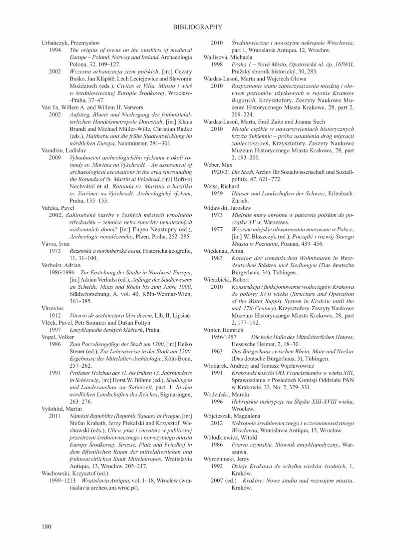
180
BIBLIOGRAPHY
Urbańczyk, Przemysław 1994 The origins of towns on the outskirts of medieval
Europe – Poland, Norway and Ireland, Archaeologia Polona, 32, 109–127.
2002 Wczesna urbanizacja ziem polskich, [in:] Cezary Buśko, Jan Klápště, Lech Leciejewicz and Sławomir Moździoch (eds.), Civitas et Villa. Miasto i wieś w średniowiecznej Europie Środkowej, Wrocław--Praha, 37–47.
Van Es, Willem A. and Willem H. Verwers 2002 Aufstieg, Bluete und Niedergang der frühmittelal-
terlichen Handelsmetropole Dorestadt, [in:] Klaus Brandt and Michael Müller-Wille, Christian Radke (eds.), Haithabu und die frühe Stadtentwicklung im nördlichen Europa, Neumünster, 281–301.
Varadzin, Ladislav 2009 Vyhodnocení archeologického výzkumu v okolí ro-
tundy sv. Martina na Vyšehradě – An assessment of archaeological excavations in the area surrounding the Rotunda of St. Martin at Vyšehrad, [in:] Bořivoj Nechvátal et al. Rotunda sv. Martina a bazilika sv. Vavřince na Vyšehradě. Archeologický výzkum, Praha, 135–153.
Vařeka, Pavel 2002, Zahloubené stavby v českých městech vrholného
středověku – zemnice nebo suterény nenalezených nadzemních domů? [in:] Eugen Neustupny (ed.), Archeologie nenalézeného, Plzen. Praha, 252–285.
Vávra, Ivan 1973 Řezenská a norimberská cesta, Historická geografie,
11, 31–100.Verhulst, Adrian 1986/1996 Zur Enstehung der Städte in Nordwest-Europa,
[in:] Adrian Verhulst (ed.), Anfänge des Städtewesens an Schelde, Maas und Rhein bis zum Jahre 1000, Städteforschung, A, vol. 40, Köln-Weimar-Wien, 361–385.
Vitruvius 1912 Vitruvii de architectura libri decem, Lib. II, Lipsiae.Vlček, Pavel, Petr Sommer and Dušan Foltyn 1997 Encyklopedie českých klášterů, Praha.Vogel, Volker 1986 Zum Parzellengefüge der Stadt um 1200, [in:] Heiko
Steuer (ed.), Zur Lebensweise in der Stadt um 1200. Ergebnisse der Mittelalter-Archäologie, Köln-Bonn, 257–262.
1991 Profaner Holzbau des 11. bis frühen 13. Jahrhunderts in Schleswig, [in:] Horst W. Böhme (ed.), Siedlungen und Landesausbau zur Salierzeit, part. 1: In den nördlichen Landschaften des Reiches, Sigmaringen, 263–276.
Vyšohlid, Martin 2011 Náměsti Republiky (Republic Square) in Prague, [in:]
Stefan Krabath, Jerzy Piekalski and Krzysztof. Wa-chowski (eds.), Ulica, plac i cmentarz w publicznej przestrzeni średniowiecznego i nowożytnego miasta Europy Środkowej. Strasse, Platz und Friedhof in dem öffentlichen Raum der mittelalterlichen und frühneuzeitlichen Stadt Mitteleuropas, Wratislavia Antiqua, 13, Wrocław, 205–217.
Wachowski, Krzysztof (ed.) 1999–1213 Wratislavia Antiqua, vol. 1–18, Wrocław (wra-
tisalavia archeo.uni.wroc.pl).
2010 Średniowieczne i nowożytne nekropole Wrocławia, part 1, Wratislavia Antiqua, 12, Wrocław.
Wallisová, Michaela 1998 Praha 1 – Nové Město, Opatovická ul. čp. 1659/II,
Pražský sborník historický, 30, 283. Wardas-Lasoń, Marta and Wojciech Głowa 2010 Rozpoznanie stanu zanieczyszczenia miedzią i oło-
wiem poziomów użytkowych w rejonie Kramów Bogatych, Krzysztofory. Zeszyty Naukowe Mu-zeum Historycznego Miasta Krakowa, 28, part 2, 209–224.
Wardas-Lasoń, Marta, Emil Zaitz and Joanna Such 2010 Metale ciężkie w nawarstwieniach historycznych
krzyża Sukiennic – próba ustanienia dróg migracji zanieczyszczeń, Krzysztofory. Zeszyty Naukowe Muzeum Historycznego Miasta Krakowa, 28, part 2, 193–200.
Weber, Max 1920/21 Die Stadt, Archiv für Sozialwissenschaft und Soziall-
politik, 47, 621–772.Weiss, Richard 1959 Häuser und Landschaften der Schweiz, Erlenbach.
Zürich.Widawski, Jarosław 1973 Miejskie mury obronne w państwie polskim do po-
czątku XV w, Warszawa. 1977 Wczesne miejskie obwarowania murowane w Polsce,
[in:] W. Błaszczyk (ed.), Początki i rozwój Starego Miasta w Poznaniu, Poznań, 439–456.
Wiedenau, Anita 1983 Katalog der romanischen Wohnbauten in West-
deutschen Städten und Siedlungen (Das deutsche Bürgerhaus, 34), Tübingen.
Wierzbicki, Robert 2010 Konstrukcja i funkcjonowanie wodociągów Krakowa
do połowy XVII wieku (Structure and Operation of the Water Supply System in Kraków until the mid–17th Century), Krzysztofory. Zeszyty Naukowe Muzeum Historycznego Miasta Krakowa, 28, part 2, 177–192.
Winter, Heinrich 1956/1957 Die hohe Halle des Mittelalterlichen Hauses,
Hessische Heimat, 2, 18–30. 1963 Das Bürgerhaus zwischen Rhein, Main und Neckar
(Das deutsche Bürgerhaus, 3), Tübingen. Włodarek, Andrzej and Tomasz Węcławowicz 1991 Krakowski kościół OO. Franciszkanów w wieku XIII,
Sprawozdania z Posiedzeń Komisji Oddziału PAN w Krakowie, 33, No. 2, 329–331.
Wodziński, Marcin 1996 Hebrajskie inskrypcje na Śląsku XIII-XVIII wieku,
Wrocław. Wojcieszak, Magdalena 2012 Nekropole średniowiecznego i wczesnonowożytnego
Wrocławia, Wratislavia Antiqua, 15, Wrocław.Wołodkiewicz, Witold 1986 Prawo rzymskie. Słownik encyklopedyczny, War-
szawa.Wyrozumski, Jerzy 1992 Dzieje Krakowa do schyłku wieków średnich, 1,
Kraków. 2007 (ed.) Kraków: Nowe studia nad rozwojem miasta.
Kraków.

181
BIBLIOGRAPHY
2007a Lokacja czy lokacje Krakowa na prawie niemieckim, [in:] Jerzy Wyrozumski (ed.), Kraków. Nowe studia nad rozwojem miasta, Kraków, 121–152.
2010 Hodowla w średniowiecznym Krakowie, [in:] Jerzy Wyrozumski (ed.), Cracovia maedievalis, Avalon, Kraków, 404–410.
Zaitz, Emil 1990 Wczesnośredniowieczne grzywny siekieropodob-
ne z Małopolski, Materiały Archeologiczne, 25, 142–178.
2006 Early Slavic and Vistulian tribal settlements on the left bank of Krakow, [in:] Elżbieta Firlet (ed.) Kraków w chrześcijańskiej Europie X–XIII w. Kata-log wystawy (Krakow in Christian Europe, 10th – 13th c. Cataloque of the exhibition), Muzeum Historyczne Miasta Krakowa, Kraków, 221–272.
2006a Sprawozdanie z badań archeologicznych prowa-dzonych w Krakowie w 2004 r. przy przebudowie nawierzchni płyty Rynku Głównego po zachodniej stronie Sukiennic, Materiały Archeologiczne, 36, 79–142.
2010 Badania archeologiczne w Sukiennicach i na Rynku Głównym w Krakowie (Archaeological Survey at the Hall and in Main Market Square in Kraków), Krzysztofory. Zeszyty Naukowe Muzeum Histo-rycznego w Krakowie, 28, part 1, 199–254.
Żaki, Andrzej 1974 Archeologia Małopolski wczesnośredniowiecznej,
Wrocław.Zaremska, Hanna 2011 Żydzi w średniowiecznej Polsce. Gmina krakowska,
Warszawa.Zavřel, Jan 2001 Geologie, morfologie a osidlování malostranské
kotliny – Geological and morphological conditions
of the Prague Lesser Town basin and their influenceon the beginnings of settlement in this area, [in:] Martin Ježek and Jan Klápště (eds.), Pražský Hrad a Malá Strana, Mediaevalia Archaeologica, 3, Praha, 7–27.
2007 Geologická problematyka archeologického poznáni Nového Města pražského – The geological Aspects of the archaeological knowledge on the Prague New Town, Archaeologica Pragensia, 18/2006, 245–261.
Zavřel, Jan and Jaromír Žegklitz 2007 Zlatý prsten s gemou, [in:] Kámen, 13, No. 3,
7–11.Žemlička, Josef 1978 Přemyslovská hradská centra a počátky měst
v Čechách, Československý časopis historický, 26, 559–586.
2002 Počátky Čech královských. 1198–1253. Proměna státu a společnosti, Nakladitelstvi Lidove Noviny, Praha
Zientara, Benedykt 1975 Henryk Brodaty i jego czasy, Warszawa. 1976 Przemiany społeczno-gospodarcze i przestrzenne
miast w dobie lokacji, [in:] Aleksander Gieysztor and Tadeusz Rosłanowski (eds.), Miasta doby feudalnej w Europie środkowo-wschodniej. Przemiany spo-łeczne a układy przestrzenne, Warszawa, 67–97.
Zin, Wiktor and Władysław Grabski 1996 Wczesnośredniowieczne budowle Krakowa w świetle
ostatnich badań, Rocznik Krakowski, 38, 33–73.Żurek, Adam 1996 Wrocławska kaplica św. Marcina w średniowieczu,
Wrocław.