Planning Committee - Brighton & Hove City Council
510
Planning Committee Date: 10 July 2019 Time: 1.00pm Venue Council Chamber, Hove Town Hall Members: Councillors:Hill (Chair), Williams (Deputy Chair), Littman (Opposition Spokesperson), C Theobald (Group Spokesperson), Fishleigh, Mac Cafferty, Miller, Shanks, Simson, Yates, CAG Representative Contact: Penny Jennings Democratic Services Officer 01273 291065 [email protected] Agendas and minutes are published on the council’s website www.brighton-hove.gov.uk. Agendas are available to view five working days prior to the meeting date. Electronic agendas can also be accessed through our meetings app available through ModernGov: iOS/Windows/Android This agenda and all accompanying reports are printed on recycled paper
-
Upload
khangminh22 -
Category
Documents
-
view
4 -
download
0
Transcript of Planning Committee - Brighton & Hove City Council

Planning Committee
Date: 10 July 2019
Time: 1.00pm
Venue Council Chamber, Hove Town Hall
Members: Councillors:Hill (Chair), Williams (Deputy Chair), Littman (Opposition Spokesperson), C Theobald (Group Spokesperson), Fishleigh, Mac Cafferty, Miller, Shanks, Simson, Yates, CAG Representative
Contact: Penny Jennings Democratic Services Officer 01273 291065 [email protected]
Agendas and minutes are published on the council’s website www.brighton-hove.gov.uk. Agendas are available to view five working days prior to the meeting date. Electronic agendas can also be accessed through our meetings app available through ModernGov: iOS/Windows/Android This agenda and all accompanying reports are printed on recycled paper

AGENDA
PART ONE Page
11 PROCEDURAL BUSINESS
(a) Declaration of Substitutes: Where Councillors are unable to attend a meeting, a substitute Member from the same Political Group may attend, speak and vote in their place for that meeting.
(b) Declarations of Interest or Lobbying
(a) Disclosable pecuniary interests; (b) Any other interests required to be registered under the local
code; (c) Any other general interest as a result of which a decision on the
matter might reasonably be regarded as affecting you or a partner more than a majority of other people or businesses in the ward/s affected by the decision.
In each case, you need to declare (i) the item on the agenda the interest relates to; (ii) the nature of the interest; and (iii) whether it is a disclosable pecuniary interest or some other
interest.
If unsure, Members should seek advice from the committee lawyer or administrator preferably before the meeting.
(d) All Members present to declare any instances of lobbying they
have encountered regarding items on the agenda. (c) Exclusion of Press and Public: To consider whether, in view of the
nature of the business to be transacted, or the nature of the proceedings, the press and public should be excluded from the meeting when any of the following items are under consideration.
NOTE: Any item appearing in Part 2 of the Agenda states in its heading the category under which the information disclosed in the report is exempt from disclosure and therefore not available to the public.
A list and description of the exempt categories is available for public inspection at Brighton and Hove Town Halls.
12 MINUTES OF THE PREVIOUS MEETING
Minutes of the meeting held on 12 June 2019 (copy to be circulated separately)
13 CHAIR'S COMMUNICATIONS

14 PUBLIC QUESTIONS
Written Questions: to receive any questions submitted by the due date of 12 noon on 4 July 2019.
15 TO AGREE THOSE APPLICATIONS TO BE THE SUBJECT OF SITE VISITS
16 TO CONSIDER AND DETERMINE PLANNING APPLICATIONS
Please note that the published order of the agenda may be changed; major applications will always be heard first; however, the order of the minor applications may be amended to allow those applications with registered speakers to be heard first.
MAJOR APPLICATIONS
A BH2018/03697- Sackville Trading Estate and Hove Goods Yard, Hove - Full Planning
Demolition and redevelopment of Sackville Trading Estate and Hove Goods Yard, with erection of buildings ranging from 2 to 15 storeys comprising 581no residential units (C3) and 10no live/work units (Sui Generis) with associated amenity provision; a care community comprising 260no units (C2) together with associated communal facilities; 3899m2 of flexible office accommodation (B1); 671m2 of flexible retail floorspace (A1 and/or A3) and community facilities including a multi-functional health and wellbeing centre (946m2) (D1/D2). Associated landscaping, car and cycle parking, public realm and vehicular access via existing entrance from Sackville Road. RECOMMENDATION – MINDED TO GRANT Ward Affected:
B BH2018/03541- Land to the East of Coldean Lane, North of Varley Halls, South of the A27, Brighton - Full Planning
137 - 240
Erection of 2no seven storey buildings and 4no six storey buildings (including lift overruns) to provide 242no residential dwellings (C3), 162 car parking spaces, 365 cycle parking spaces, new access from Coldean Lane; associated landscaping incorporating areas of play/amenity space/active learning and substations. RECOMMENDATION – MINDED TO GRANT Ward Affected: Hollingdean and Stanmer
C BH20188/03798 - 35-39 The Droveway, Hove - Full Planning 241 - 272
Change of use from former Dairy Crest depot (B8) to a Mixed-use flexible commercial development of 1435sqm (Flexible between use classes B1(a), A1, A2, A3, D1) incorporating alterations including removal of northern extension and erection of a new wing with 14no residential units (C3). Erection of a new central wing to court yard, onsite car parking, cycle storage and areas for storage of waste and recycling. RECOMMENDATION – MINDED TO GRANT Ward Affected: Hove Park

D BH2018/00937 - 239 - 243 Kingsway Hove - Full Planning 273 - 314
Demolition of existing buildings and erection of an eight storey building to provide 37no residential dwellings (C3) with associated access, parking and landscaping RECOMMENDATION – MINDED TO GRANT Ward Affected: Wish
E BH2019/00199 - The Astoria, 10 Gloucester Place, Brighton - Removal or Variation of a Condition
315 - 334
Application for variation of condition 1 of application BH2017/04022 (Construction of a new part 3/part 7 storey building (plus basement) to form 70 no. one, two, three and four bedroom self-contained residential units (C3) and incorporating commercial units (A1/A2/B1) in the basement and on the ground floor fronting Gloucester Place, a community room (D1) on the ground floor fronting Blenheim Place together with refuse/recycling facilities, cycle storage and other associated works) to make amendments to the lower ground floor and front and rear elevation. RECOMMENDATION – MINDED TO GRANT Ward Affected: St Peter’s & North Laine
MINOR APPLICATIONS
F BH2019/01385- Varndean College, Surrenden Road, Brighton -Full Planning
335 - 348
Retention of existing 8no temporary classrooms for a further temporary period of five years. RECOMMENDATION – GRANT Ward Affected: Withdean
G BH2018/02440,Foredown Woods,Foredown Allotments,Thornbush Crescent, Portslade - Full Planning
349 - 364
Change of use from an area of land at Foredown Woods to an Education Facility (D1) to operate as a pre-school, with associated structures and operations (Part Retrospective). RECOMMENDATION – GRANT Ward Affected: North Portslade
H BH2018/02667-Land to the rear of 17 Springfield Road, Brighton- Full Planning
365 - 382
Erection of 1no two bedroom single storey detached dwelling (C3). RECOMMENDATION – GRANT Ward Affectted – Preston Park
I BH2018/02703-2 Old Shoreham Road, Hove- Full Planning 383 - 400
Erection of a single storey side extension and conversion of existing building to create 4no flats (C3), including loft conversion and alterations to fenestration. RECOMMENDATION – GRANT Ward Affected: Goldsmid
J BH2018/00995-5B Station Road, Portslade -Full Planning 401 - 420
Demolition of warehouse/workshop and erection of three storey building comprising 4no flats incorporating parking, access form

Vale Road and associated works. RECOMMENDATION – GRANT Ward Affected: South Portslade
K BH2019/00656- 15 Norwich Drive, Brighton - Full Planning 421 - 432
Change of use from a single dwelling house (C3) to 6 bedroom small house in multiple occupation (C4) incorporating conversion of integral garage to habitable space, provision of cycle storage, removal of chimney and revised fenestration. RECOMMENDATION – GRANT Ward Affected: Moulsecoomb & Bevendean
L BH2019/0105- 26 Brentwood Crescent, Brighton- Full Planning Consent
433 - 446
Change of use from (C3) dwellinghouse to (C4) small house in multiple occupation. RECOMMENDATION – GRANT Ward Affected: Hollingdean & Stanmer
M BH2018/02579 - Patcham Service Station, Patcham By Pass, London Road, Brighton - Removal or Variation of Condition
447 - 462
Variation of condition 7 of application BN83/386 (Demolition of existing service station and the construction of a new self-service petrol filling station with canopy and 32,000 gallons of fuel storage) to extend trading hours in addition to the erection of a 3m high fence to the southern boundary of the site. Current approved hours are 07.00 to 23.00, hours now proposed 06.00 to midnight. RECOMMENDATION – GRANT Ward Affected: Patcham
N BH2019/01136- 24 Montpelier Street, Brighton-Householder Planning Consent
463 - 474
Removal of existing butterfly roof and construction of roof terrace and sunroom. RECOMMENDATION – REFUSE Ward Affected: Regency
O BH2019/00908- Flat 1, 9-10 Carlton Terrace, Portslade- Full Planning
475 - 482
Removal of existing side and rear extensions, associated canopy and outbuilding and erection of single storey extensions to side and rear. RECOMMENDATION – GRANT Ward Affected: South Portslade
P BH2019/0031-126 Wolseley Road, Brighton - Full Planning 483 - 494
Change of use from existing single dwelling (C3) to a six bedroom small house in multiple occupation (C4) including installation of rear decking and alterations to fenestration. RECOMMENDATION – WOULD HAVE GRANTED Ward Affected: Hollingdean & Stanmer

17 TO CONSIDER ANY FURTHER APPLICATIONS IT HAS BEEN DECIDED SHOULD BE THE SUBJECT OF SITE VISITS FOLLOWING CONSIDERATION AND DISCUSSION OF PLANNING APPLICATIONS
INFORMATION ITEMS
18 LIST OF NEW APPEALS LODGED WITH THE PLANNING INSPECTORATE
495 - 500
(copy attached).
19 INFORMATION ON INFORMAL HEARINGS/PUBLIC INQUIRIES 501 - 502
(copy attached). Members are asked to note that plans for any planning application listed on the agenda are now available on the website at: http://www.brighton-hove.gov.uk

The City Council actively welcomes members of the public and the press to attend its meetings and holds as many of its meetings as possible in public. Provision is also made on the agendas for public questions to committees and details of how questions can be raised can be found on the website and/or on agendas for the meetings. The closing date for receipt of public questions and deputations for the next meeting is 12 noon on the fourth working day before the meeting. Meeting papers can be provided, on request, in large print, in Braille, on audio tape or on disc, or translated into any other language as requested. Infra-red hearing aids are available for use during the meeting. If you require any further information or assistance, please contact the receptionist on arrival. FURTHER INFORMATION For further details and general enquiries about this meeting contact Penny Jennings, (01273 291065, email [email protected]) or email [email protected] WEBCASTING NOTICE This meeting may be filmed for live or subsequent broadcast via the Council’s website. At the start of the meeting the Chair will confirm if all or part of the meeting is being filmed. You should be aware that the Council is a Data Controller under the Data Protection Act 1998. Data collected during this web cast will be retained in accordance with the Council’s published policy. ACCESS NOTICE The lift cannot be used in an emergency. Evac Chairs are available for self-transfer and you are requested to inform Reception prior to going up to the Public Gallery. For your own safety please do not go beyond the Ground Floor if you are unable to use the stairs. Please inform staff on Reception of this affects you so that you can be directed to the Council Chamber where you can watch the meeting or if you need to take part in the proceedings e.g. because you have submitted a public question. FIRE / EMERGENCY EVACUATION PROCEDURE If the fire alarm sounds continuously, or if you are instructed to do so, you must leave the building by the nearest available exit. You will be directed to the nearest exit by council staff. It is vital that you follow their instructions:
You should proceed calmly; do not run and do not use the lifts;
Do not stop to collect personal belongings;
Once you are outside, please do not wait immediately next to the building, but move some distance away and await further instructions; and
Do not re-enter the building until told that it is safe to do so.
Date of Publication - Tuesday, 2 July 2019


DATE OF COMMITTEE: 10th
July 2019
ITEM A
Sackville Trading Estate BH2018/03697 Full Planning
1

2

Estate
The Courtyard
DW
El
Yard
Coal Yard
SP
WB
CR
City Car Pound
GVC
NEWTOWN ROAD
SA
CK
VIL
LE
RO
AD
ESS
Ward
Bd
y
MP 1.75
El Sub Sta
ESS
1
2
34
Goldstone Retail Park
Works
89
Bus Depot
SA
Depot
Clarks
Estate
Woods
Club
11
37
60
25
98
5785
6947
14
12
6775
35
73
88
Studios
111114
11
6
157
124
168
134
125
176
140
138
132
121
158
101
99a
15
0
12
2
133
178
14
2
130
160
The
PCs
3 to
41
to 2
1 to
29
Shelter
10
to 1
1
Hoppers
144 to 154
2
Shelter
1
14
2
2
132
2
Club
142
1
34
Works
1
140
1
1
Works
2
1
(c) Crown Copyright. All rights reserved. Licence: 100020999, Brighton & Hove City Council. 2018.
BH2018_03697 Sackville Trading Estate
1:2,000Scale: ̄
3

4

No: BH2018/03697 Ward: Hove Park Ward
App Type: Full Planning
Address: Sackville Trading Estate And Hove Goods Yard Sackville Road Hove BN3 7AN
Proposal: Demolition and redevelopment of Sackville Trading Estate and Hove Goods Yard, with erection of buildings ranging from 2 to 15 storeys comprising 581no residential units (C3) and 10no live/work units (Sui Generis) with associated amenity provision; a care community comprising 260no units (C2) together with associated communal facilities; 3899m2 of flexible office accommodation (B1); 671m2 of flexible retail floorspace (A1 and/or A3) and community facilities including a multi-functional health and wellbeing centre (946m2) (D1/D2). Associated landscaping, car and cycle parking, public realm and vehicular access via existing entrance from Sackville Road.
Officer: Chris Swain, tel: 292178 Valid Date: 06.12.2018
Con Area: N/A Expiry Date: 25.04.2019
Listed Building Grade: N/A EOT:
Agent: Iceni Projects Ltd 44 Saffron Hill London EC1N 8FH
Applicant: Coal Pension Properties Limited & Moda Living Limited C/O Iceni Projects Ltd 44 Saffron Hill London EC1N 8FH
1. RECOMMENDATION
1.1. That the Committee has taken into consideration and agrees with the
reasons for the recommendation set out below and resolves to be MINDED
TO GRANT planning permission subject to a s106 agreement on the Heads
of Terms set out below and the following Conditions and Informatives as set
out hereunder, SAVE THAT should the s106 Planning Obligation not be
completed on or before the 30 October 2019 the Head of Planning is hereby
authorised to refuse planning permission for the reasons set out in section
10.1 of this report:
Section 106 Head of Terms:
Build to Rent Housing:
A restriction that all homes are held as ‘Build to Rent’ under a covenant for at least 15 years
Inclusion of a ‘clawback’ arrangement to fund the consequent affordable housing requirement in the event of any private rented housing being sold or taken out of the Build to Rent sector based on values of units at
5

that particular time (as assessed for viability) within the 15 year covenant period.
All units to be self-contained and let separately under unified ownership and management
Submission of a Management and Servicing Agreement
Submission of a Marketing Agreement
Submission of a Tenancy Agreement, for example of at least 3 years available to all tenants (unless tenants agree a lesser period) with a break clause of 1 month after initial 6m months. No upfront fees of any kind except deposits and rent in advance
A minimum of 5% of all residential units to be built to wheelchair accessible standard and evidenced before first occupation. Marketing Agreement to include provision that all reasonable endeavours will be used to ensure wheelchair units are matched with disabled tenants.
Affordable housing:
Provision of 10% affordable housing units on site based on rent levels 75% of market level
Provision of 9 x studios, 20 x 1-bed, 26 x 2-bed and 3 x 3-bed affordable housing mix. The location of these affordable units may vary over time within the scheme however the reduced rent levels and overall mix of sizes shall remain the same. At least 6 of the affordable units will be to wheelchair accessible standard (initially - as location may change over time)
Affordable housing units to be secured in perpetuity and inclusion of a ‘clawback’ mechanism arrangement to contribute to alternative affordable housing provision based on values of the specific units at that particular time,
Provision of Affordable Housing Management Plan and Marketing and Lettings Plan, with eligibility criteria for occupants to be agreed with council with priority for local people/essential local workers/wheelchair or disabled users
Restriction of a set service charge for affordable tenants (for example to secure as a percentage maximum ceiling on gross income of affordable housing tenants)
Provision of Annual Statement, confirming approach to letting of affordable units and identifying how overall 10% level, range of sizes, rent levels are maintained and other relevant information
Viability Review mechanism (including funds for providing specialist re-assessment of viability) after a certain time period. Review would allow for an update to costs and values initially assessed at application stage once additional details regarding actual rents and other costs have been established. This could review the proportion of affordable private rent units, and the discount offered on them over time (but would not allow for a decrease from 10% provision, or allow higher rents than 75% of market levels).
Sustainable Transport and Highways:
6

Sustainable Transport Contribution
A contribution of £457,550 to be allocated towards the following works and initiatives. o A scheme to introduce early start facilities for cyclists at the junction
of Neville Rd, Old Shoreham Rd and Sackville Rd, as well as related minor changes to traffic islands to improve safety for cyclists and reduce capacity issues.
o A scheme to declutter and resurface/upgrade footways and introduce seating within the areas surrounding the above junction, to improve its attractive as the nearest local centre for residents of the development and thereby reduce the need for travel; and/or
o A scheme to improve signalised junctions south of the development on Sackville Rd, including amongst other things the potential implementation of a SCOOT or other linked control system, to improve journey times by public transport and sustainable modes.
o A scheme to improve pedestrian amenity and accessibility along Clarendon Rd, to enhance connection between the development and Hove Station; and/or
o A scheme to improve child pedestrian and cyclist safety to one or more local schools from the development; and/or
o A scheme to improve pedestrian accessibility and amenity from the development to local shopping centres on New Church Rd and Portland Rd and cyclist safety to one or more local schools from the development; and/or
o Introducing additional BTN Bike Share stations in the wider area around the development; and/or
o Providing on-street cycle parking hangars to streets within the Artists Corner and Clarendon Rd areas; and/or
o A lighting and amenity/appearance improvement scheme for the railway bridge over Sackville Rd south of its junction with Prinsep Rd to improve pedestrian comfort and amenity. This may also be partly funded by artistic contributions
Note that this is a reduced figure from the £617,550 that would otherwise be
due as £160,000 worth may be provided as S278 highways works in lieu –
though note that that does not represent a cap on the value of those highway
works.
S278 Highway Works
No development to occur above slab level until a scheme setting out the following highway works has been submitted to the Council as Local Highway Authority and been approved by them. Development not to be occupied until the approved works have been implemented.
7

o Relocating existing bus stops on Sackville Rd to be closer to the site (and/or providing additional stops close to the site)
o Improving facilities at nearby bus stops on Sackville Rd and Old Shoreham Rd through the introduction of new shelters, accessible kerbs and real time information displays.
o Providing a crossing between bus stops on Sackville Rd to improve access from the development
o Amending the site access junction at Sackville Rd/Poynter Rd to tie in with proposed internal changes and increase suitability for use by cyclists, including by providing improved right-turn facilities for cyclists approaching the site from the south and better conditions for cyclists passing through the junction from the north – the latter to be achieved by removing or revising the existing left turn slip lane.
o Alterations to Sackville Rd to improve traffic flow to the junction with Old Shoreham Rd and to address related comfort and journey delay issues for cyclists and buses.
o Resurfacing/upgrading the eastern footway of Sackville Rd between the junctions with Old Shoreham Rd and Clarendon Rd, and introducing seating opportunities, to improve pedestrian accessibility and amenity.
o Resurfacing/upgrading of footways and pedestrian accessibility improvements to the western side of Sackville Rd and associated junctions between the closest bus stop to the development and the related new crossing, including to the area of the bus stop itself.
o (If the stop is retained in its existing position) introducing a bus border build-out with accessible kerb to the existing bus stop on the eastern footway of Sackville Rd outside the Young People’s Hall, and relocating the existing bus shelter and real time information display to this, to reduce the obstruction to pedestrian access posed by those items of street furniture whilst reducing delay to bus services.
o AiP for any changes to the retaining wall and structure abutting the eastern footway of Sackville Rd.
Other
3 no. serviced off-site car clubs bays to be provided in the following streets before first occupation of the development: o 2 bays to be provided on one or more of: Leighton Rd, Frith Rd,
Poynter Rd, Landseer Rd or Prinsep Rd. o 1 to be provided on one or more of: Park View Rd, Orchard
Gardens, Orchard Ave, Orchard Rd.
2 no. serviced on-site car club bays and vehicles to be provided prior to first occupation of the development.
Provision of a BTN bike share hub for 20 cycles within the development site along the Sackville Rd frontage, for use by occupants and the public.
A Permissive Path Agreement to permit public access to all publically accessible areas of the site, including street facing thresholds, residential core entrances and public amenity areas.
A Walkways Agreement to permit public access and use of the external lift in the south-west corner of the site, abutting Sackville Rd.
8

Fees for the Highway Authority’s time checking the conditioned Street Design proposals for internal streets and spaces and related actions like road safety audit.
Travel Plans
(The following measures are applicable across all individual uses)
Establishing a Bicycle User Group (to meet every 2 months) for residents and employees which can cover the entire site. This should be subsidised for the duration of the Plan to provide – o ‘Bike buddy’ services to other residents/workers thinking of taking
up cycling o To hold several social rides per year, including an allowance for
refreshments. o 2 or more ‘Doctor Bike’ sessions per year with both a direct repair
and a teaching element. The Bicycle User Group should also be consulted when reviewing the Travel
Plan and in relation to ongoing operational management of cycle parking
facilities. The latter role should continue beyond the life span of the Plan.
Providing maintenance stands together with pumps and basic maintenance and repair tools within the cycle stores for resident and employee use.
Providing formal cyclist training to residents and employees on request, to be marketed throughout the development.
Providing and maintaining a notice board in a prominent communal location containing information on the following: o road safety o local sustainable travel options, o Travel Plan objectives, targets, measures and progress o Bicycle User Group o initiatives being promoted by residents and employees, the Travel
Plan Coordinator and the Bicycle User Group relating to any of the above
o initiatives being promoted by Brighton & Hove City Council relating to any of the above, as may be sent by the City Council from time to time.
(For the C2 Care Home Travel Plan)
Providing a Travel Pack to each new resident (or their lead family member/carer), which shall include information on local options for sustainable transport, the other measures and offers below, and road safety.
Providing residents (or their lead family member/carer) with 1 or more years of free or heavily subsidised tickets/memberships for each of the following local public and shared transport services
9

o Local buses and/or train services; o BTN Bike Share; and o Enterprise Car Club (due to the residential nature of the C2 use on
this site)
Providing residents (or their lead family member/carer) with a voucher of ≥£150 to go towards the cost of purchasing a bicycle, which may be an electric bicycle.
Providing information on sustainable transport options and the other measures and offers above in all marketing material (including any on-line).
(For the C3 Residential Travel Plan)
Providing a Travel Pack to each new resident, which shall include information on local options for sustainable transport, the other measures and offers below, and road safety.
Providing residents with 1 or more years of free or heavily subsidised tickets/memberships for each of the following local public and shared transport services - o Local buses and/or train services; o BTN Bike Share; and o Enterprise Car Club (due to the residential nature of the C2 use on
this site)
Providing residents a voucher of ≥£150 to go towards the cost of purchasing a bicycle, which may be an e-bicycle.
Providing information on sustainable transport options and the other measures and offers above in all marketing material (including any on-line).
Providing information packs to each resident including information on local options for sustainable transport, the other measures and offers above, and road safety.
Providing a Travel Pack to each new employee, which shall include information on local options for sustainable transport for travel to work and work-related travel, the other measures and offers below, and road safety.
(For the A1-3 Retail, D1/2 and MODA Management Suite Travel Plan)
Providing a Travel Pack to each new employee, which shall include information on local options for sustainable transport for travel to work and work-related travel, the other measures and offers below, and road safety.
Providing interest-free loans to employees for the purchase of bus and rail season tickets and bicycle purchase. This may be in the format of a salary advance.
Offering annually to each employee and where accepted providing a personalised travel planning service.
Offering annually to each employee and where accepted providing formal cycle training.
(For the B1 Office Travel Plan)
10
Providing a Travel Pack to each new employee, which shall include information on local options for sustainable transport for travel to work and work-related travel, the other measures and offers below, and road safety.
Providing interest-free loans to employees for the purchase of bus and rail season tickets and bicycle purchase. This may be in the format of a salary advance.
Offering annually to each employee and where accepted providing a personalised travel planning service.
Offering annually to each employee and where accepted providing formal cycle training
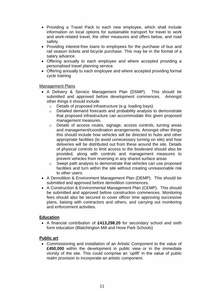
Management Plans
A Delivery & Service Management Plan (DSMP). This should be submitted and approved before development commences. Amongst other things it should include o Details of proposed infrastructure (e.g. loading bays) o Detailed demand forecasts and probability analysis to demonstrate
that proposed infrastructure can accommodate this given proposed management measures.
o Details of access routes, signage, access controls, turning areas and management/coordination arrangements. Amongst other things this should include how vehicles will be directed to hubs and other appropriate facilities (to avoid unnecessary turning on site) and how deliveries will be distributed out from these around the site. Details of physical controls to limit access to the boulevard should also be provided, along with controls and management measures to prevent vehicles from reversing in any shared surface areas
o Swept path analysis to demonstrate that vehicles can use proposed facilities and turn within the site without creating unreasonable risk to other users.
A Demolition & Environment Management Plan (DEMP). This should be submitted and approved before demolition commences.
A Construction & Environmental Management Plan (CEMP). This should be submitted and approved before construction commences. Monitoring fees should also be secured to cover officer time approving successive plans, liaising with contractors and others, and carrying out monitoring and enforcement activities.
Education
A financial contribution of £413,298.20 for secondary school and sixth form education (Blatchington Mill and Hove Park Schools)
Public art
Commissioning and installation of an Artistic Component to the value of £450,000 within the development in public view or in the immediate vicinity of the site. This could comprise an ‘uplift’ in the value of public realm provision to incorporate an artistic component.
11

Open space and recreation/sports:
Provision of a financial contribution of £1,696,849.97 towards enhancement of outdoor/indoor sports, parks and gardens, children’s playspace, allotments, amenity greenspace and semi-natural space at the following locations: o Outdoor sport (£416, 260.34) - Kingsways / Hove Seafront, Knoll
Park, Aldrington Recreation Ground, Wish Park, Hove Park, Neville Recreation Ground
o Indoor sport (£273,714) - Withdean Sports Complex and / or King Alfred Leisure Centre
o Children’s Play (£32, 218.46) - Hove Park, Stoneham Park o Parks and Gardens (£609,242.68) - Hove Park and Stoneham Park o Allotments (£59,742.27) - The Weald and / or St Louis and /or North
Nevill Allotments o Amenity Green Space - (£48,847.06) - Hove Park and Stoneham
Park and / or Three Cornered Copse o Natural and semi-natural - (£272,931.96) Hove Park and Stoneham
Park and / or Three Cornered Copse
Employment:
Submission of an Employment & Training Strategy to secure the use of at least 20% local construction labour
A financial contribution of £291,500 towards the Local Employment Scheme
Care Community
Eligibility criteria based on age / care needs,
Minimum package of care
Communal facility access for the local residents
Phasing
To include a phasing plan and details of the phasing of the scheme.
Conditions
1. List of approved plans.
2. Development hereby permitted shall be commenced before the expiration of three years from the date of this permission. Reason: To ensure that the Local Planning Authority retains the right to
review unimplemented permissions.
3. No development above ground floor slab level of any individual parcel of the
development hereby permitted shall take place until samples of all materials to be used in the construction of the external surfaces of that parcel of the development have been submitted to and approved in writing by the Local Planning Authority, including (where applicable): a) samples of all brick, render and tiling (including details of the colour of
render/paintwork to be used)
12

b) samples of all cladding to be used,
c) samples of all hard surfacing materials,
d) details of the proposed window, door and balcony treatments,
e) details of all other materials to be used externally,
Development shall be carried out in accordance with the approved details.
Reason: To ensure a satisfactory appearance to the development and to
comply with policies CP12 and CP13 of the Brighton & Hove City Plan Part
One.
4. No parcel of the development hereby permitted shall be occupied until a
scheme for the storage of refuse and recycling has been submitted to and approved in writing by the Local Planning Authority. The scheme shall be carried out and provided in full in accordance with the approved details prior to first occupation of that parcel and the refuse and recycling storage facilities shall thereafter be retained for use at all times. Reason: To ensure the provision of satisfactory facilities for the storage of
refuse and to comply with policy QD27 of the Brighton & Hove Local Plan,
policy CP8 of the Brighton & Hove City Plan Part One and Policy WMP3e of
the East Sussex, South Downs and Brighton & Hove Waste and Minerals
Local Plan Waste and Minerals Plan.
5. No cables, wires, aerials, pipework (except rainwater downpipes as shown
on the approved plans), meter boxes or flues shall be fixed to any elevation facing a highway. Reason: To safeguard the appearance of the building and the visual
amenities of the locality and to comply with policy CP12 of the Brighton &
Hove City Plan Part One.
6. The office floorspace (B1) hereby permitted shall be used solely as an office
(Use Class B1(a))and for no other purpose (including any other purpose in Class B of the Schedule to the Town and Country Planning (Use Classes) Order 1987 (or in any provision equivalent to that Class in any statutory instrument revoking and re-enacting that Order with or without modification). Notwithstanding the provisions of the Town and Country Planning (General Permitted Development) (England) Order 2015, as amended (or any order revoking and re-enacting that Order with or without modification), no change of use shall occur without planning permission obtained from the Local Planning Authority. Reason: The Local Planning Authority would wish to retain control over any
subsequent change of use of these premises in the interests of safeguarding
the supply of office floorspace in the city given the identified shortage, to
comply with policies CP3 and DA6 of Brighton & Hove City Plan Part One.
7. No tree shown as retained on the approved drawings shall be cut down, uprooted, destroyed, pruned, cut or damaged in any manner during the development phase and thereafter within 5 years from the date of occupation
13

of the building for its permitted use, other than in accordance with the approved plans and particulars or as may be permitted by prior approval in writing from the local planning authority. Any trees or plants which within a period of 5 years from the completion of the development die, are removed or become seriously damaged or diseased shall be replaced in the next planting season with others of similar size and species. Reason: To enhance the appearance of the development in the interest of
the visual amenities of the area, to provide ecological, environmental and bio-
diversity benefits and to maximise the quality and usability of open spaces
within the development in compliance with policies QD15 of the Brighton &
Hove Local Plan and CP12 and CP13 of the Brighton & Hove City Plan Part
One.
8. Notwithstanding the submitted drawings prior to occupation of any parcel of
the development hereby permitted, a scheme for landscaping shall be submitted to and approved in writing by the Local Planning Authority. The approved landscaping for that parcel shall be implemented in accordance with the approved details in the first planting season after completion or first occupation of the development, whichever is the sooner. The scheme shall include the following: a. details of all hard and soft surfacing to include type, position, design,
dimensions and materials and any sustainable drainage system used;
b. a schedule detailing sizes and numbers/densities of all proposed
trees/plants which shall include details of appropriate shade tolerant
species and including details of tree pit design, use of guards or other
protective measures and confirmation of location, species and sizes,
nursery stock type, supplier and defect period;
c. Shade-tolerant species of a mixture of native and exotic origin that are
capable of thriving on the specific soil type found on the site should be
included where planting locations receive low levels of annual sunlight,
d. Measures to promote healthy root growth such as mulching and shared
root trenches between planted specimens shall be included in the
landscaping proposals to maximise the survival rate of replacement
trees;
e. The planting of long-living and large-growing species of both native and
exotic broad-leafed species in prominent locations within the site,
particularly near the entrance of the site from Sackville Road to the
west;
f. details of all existing and proposed boundary treatments to include type,
position, design, dimensions and materials;
Any trees or plants which within a period of 5 years from the completion of
the development die, are removed or become seriously damaged or
diseased shall be replaced in the next planting season with others of similar
size and species.
14

Reason: To enhance the appearance of the development in the interest of
the visual amenities of the area and to comply with policies QD15 of the
Brighton & Hove Local Plan and CP12 and CP13 of the Brighton & Hove City
Plan Part One.
9. Prior to the commencement of the development hereby approved (including
demolition and all preparatory work), a scheme for the protection of the retained trees, in accordance with BS 5837:2012, including a tree protection plan(s) (TPP) and an arboricultural method statement (AMS) including details of all tree protection monitoring and site supervision by a suitably qualified tree specialist (where arboricultural expertise is required) shall be submitted to and approved in writing by the Local Planning Authority. The development thereafter shall be implemented in strict accordance with the approved details. Reason: As this matter is fundamental to protecting the trees which are to be
retained on the site during construction works in the interest of the visual
amenities of the area and to comply with policies QD16 of the Brighton &
Hove Local Plan and CP12 and CP13 of the Brighton & Hove City Plan Part
One and SPD06:Trees and Development Sites.
10. The development of any land parcel hereby permitted shall not be
commenced (including demolition and all preparatory work) until a pre-commencement meeting is held on site and attended by the developers appointed arboricultural consultant, the site manager/foreman and a representative from the Local Planning Authority (LPA) to discuss details of the working procedures and agree either the precise position of the approved tree protection measures to be installed OR that all tree protection measures have been installed in accordance with the approved tree protection plan. The development of each land parcel shall thereafter be carried out in accordance with the approved details or any variation as may subsequently be agreed in writing by the LPA. Reason: As this matter is fundamental to protecting the trees which are to be
retained on the site during construction works in the interest of the visual
amenities of the area and to comply with policies QD16 of the Brighton &
Hove Local Plan and CP12 and CP13 of the Brighton & Hove City Plan Part
One and SPD06:Trees and Development Sites.
11. Prior to the occupation of any land parcel in the development hereby
approved details of the proposed Access Facilitation Pruning (see BS5837:2012) shall be submitted to and approved in writing by the Local Planning Authority. The approved tree pruning works within that land parcel shall be carried out in accordance with BS3998:2010. Due to the importance of elm trees to the City of Brighton and Hove (Brighton and Hove City Plan - Policy QD16 3.70) and home to the National Elm Collection, and to help elm disease management in the City, elm trees must be pruned between the dates 1st October to 31st May.
15

Reason: To avoid any irreversible damage to retained trees pursuant to
section 197 of the Town and Country Planning Act 1990 and to protect and
enhance the appearance and character of the site and locality, in accordance
with SPD 06, QD 16 (Trees and Hedgerows).
12. Prior to first occupation of the development hereby permitted, a scheme shall
have been submitted to and approved in writing by the Local Planning Authority to provide that
the residents of both the C2 and C3 uses have no entitlement to a resident's parking permit;
the entitlement to visitor permits for the C3 use shall be 25 permits per unit per year; and
the entitlement to visitor permits for the C2 use shall be removed. Reason: To ensure that the development does not result in overspill parking
and to comply with policies TR7 & QD27 of the Brighton & Hove Local Plan
and CP9 of the City Plan Part One.
13. Notwithstanding the plans hereby permitted, the parking areas for motor vehicles set out in the tables below shall be available for use prior to occupation of the development and the number of car parking spaces within these shall not be above or below any stated maximums and minimums, as applicable. Details of spaces (including numbers and types), allocations (to uses and users), circulation, signing and lining including the marking out of disabled bays, car club bays and electric charging bays and pedestrian and vehicular access ways shall have been submitted to the Local Planning Authority and approved by them prior to the car parks and parking areas being brought into use, and the number, type and allocation of spaces in the submission shall be in accordance with the tables below.
Parking Area within Development
Number of motor vehicle parking spaces
Minimum (where relevant)
Maximum (where relevant)
Plot A ground floor undercroft 19 N/A
Northern Plot level 1 undercroft
36 141
On-site surface parking 56 132
Total within whole development
107 292
The minimum figures shall be as follows:
Land-use and user
Number of motor vehicle parking across all parking areas in the table above
Minimum, all spaces (where relevant)
Minimum, disabled user spaces (where relevant)
Minimum, motorcycle parking spaces (where relevant)
16

C2 Residents 5 5% of total
C2 Staff 25
C2 Visitors
C3 Residents As SPD14 5% of total
C3 Visitors 23
B1 Staff & Visitors
44 2 5% of total
A1/A2/A3 Staff & Visitors
9 3 5% of total
D1/2 Staff & Visitors
4 3 5% of total
Car club 2
Reason: To ensure that adequate parking provision is retained and prevent
excess overspill onto surrounding streets, and to comply with policies TR7
and TR18 of Brighton & Hove Local Plan policy, policies QD27 and CP9 of
the Brighton and Hove City Council City Plan Part One, and SPD14 Parking
Standards.
14. Notwithstanding the plans hereby approved, prior to first occupation, a car
parking management plan shall be submitted to and approved by the Local Planning Authority, such plan to include details of the following
The allocation of car parking spaces between land-uses, users, bay types and locations within the development
A scheme for conveying allocations to occupiers of the development
A scheme to bring spaces with passive electric car charging points into active service
Controls to limit access to and within parking areas
A scheme to provide security for users of parking areas. The approved Car Parking Management Plan shall be fully implemented prior
to first occupation of the development and thereafter maintained.
Reason: To ensure that adequate parking provision is retained for all types
of users, To encourage travel by more sustainable means and seek
measures which reduce fuel use and greenhouse gas emissions and prevent
excess overspill onto surrounding streets, and to comply with policy TR18 of
Brighton & Hove Local Plan policy TR18 of the Brighton & Hove City Council
Local Plan, CP9 of the Brighton and Hove City Council City Plan Part One
and SPD14 Parking Standards.
15. Notwithstanding the plans hereby permitted and prior to first occupation/use
of the development hereby permitted, details of secure, inclusive and accessible cycle parking facilities for the occupants of, and visitors to, the development shall have been submitted to and approved in writing by the Local Planning Authority. The approved facilities shall be fully implemented and made available for use prior to the first occupation of the development and shall thereafter be retained for use at all times.
17

Reason: To ensure that satisfactory facilities for the parking of cycles are
provided and to encourage travel by means other than private motor vehicles
and to comply with policy TR14 of the Brighton & Hove Local Plan.
16. Prior to first occupation/use of the development hereby permitted, details of
secure cycle parking facilities for the occupants of, and visitors to, the B1 office space hereby permitted shall have been submitted to and approved in writing by the Local Planning Authority. The approved facilities shall be fully implemented and made available for use prior to the first occupation of the B1 office floorspace and shall thereafter be retained for use at all times. Reason: To ensure that satisfactory facilities for the parking of cycles are
provided and to encourage travel by means other than private motor vehicles
and to comply with policy TR14 of the Brighton & Hove Local Plan.
17. Prior to the first use/occupation of the development hereby approved a
Waste & Recycling Management Plan, which includes, inter alia, details of the types of storage of waste and recycling, types of vehicles used to collect these materials, how collections will take place and the frequency of collections shall be submitted to and approved in writing by the Local Planning Authority. All waste, recycling and their storage and collection activities shall thereafter be carried out in accordance with the approved plan. Reason: In order to ensure that the safe operation of the development and to
protection of the amenities of nearby residents, in accordance with polices
SU10, QD27 and TR7 of the Brighton & Hove Local Plan and the Waste and
Minerals Plan for East Sussex, South Downs and Brighton & Hove.
18. Notwithstanding the plans hereby permitted, prior to commencement of the
proposed development above ground floor slab level, full details of electric vehicle charging points within the proposed car park hereby approved have been submitted to and approved in writing by the Local Planning Authority. These facilities shall be fully implemented and made available for use prior to the occupation of the development hereby permitted and shall thereafter be retained for use at all times. Reason: To encourage travel by more sustainable means and seek
measures which reduce fuel use and greenhouse gas emissions and to
comply with policies SA6, CP7, CP9, CP12, CP13 and CP15 of the City Plan
Part One and SPD14 Parking Standards.
19. Notwithstanding the plans hereby permitted, no development above ground
floor slab level shall commence until details of the design of internal streets and spaces have been submitted to and approved in writing by the Local Planning Authority. The submitted scheme shall -
Include full details, of the following -
18

o Geometry and layout, including dimensions and visibility splays o Pavement constructions and surfacing, kerbs and edge restraints o Levels and gradients o Lighting o Drainage o Street furniture o Trees and planting o Traffic signs and road markings;
Have been developed through engagement with disabled user groups and others who may be negatively impacted by any shared surface and/or level surface proposals;
Be supported by a statement detailing that engagement and steps taken in response, as well as an equality impact assessment; and
Have completed a road safety audit up to stage 2, with the Highway Authority acting as Overseeing Organisation.
Prior to first occupation of the development -
the scheme shall be implemented in full as approved; and
a stage 3 road safety audit, with the Highway Authority acting as overseeing organisation, shall be completed and any actions from this shall be implemented, such actions may include amendments to the approved scheme
Thereafter the approved scheme (as may be amended owing to stage 3 road
safety audit actions) shall be retained for use at all times.
Reason: In the interest of highway safety, sustainability, quality design, the
and public amenity and to comply with policies TR7, TR14 and QD27 of the
Brighton & Hove Local Plan and SA6, CP7, CP9, CP12 and CP13 of the City
Plan Part One.
20. Notwithstanding the plans hereby permitted, no external doors within any building shall open outwards, other than as an emergency means of escape. Reason: In the interests of pedestrian safety and equality and to ensure
compliance with Brighton & Hove Local Plan policy TR7 and Brighton & Hove
City Plan Part One policy CP12.
21. The wheelchair accessible dwelling(s) hereby permitted as detailed on the
approved drawings shall be completed in compliance with Building Regulations Optional Requirement M4(3)(2b) (wheelchair user dwellings) prior to first occupation and shall be retained as such thereafter. All other dwelling(s) hereby permitted shall be completed in compliance with Building Regulations Optional Requirement M4(2) (accessible and adaptable dwellings) prior to first occupation and shall be retained as such thereafter. Evidence of compliance shall be notified to the building control body appointed for the development in the appropriate Full Plans Application, or Building Notice, or Initial Notice to enable the building control body to check compliance. Reason: To ensure satisfactory provision of homes for people with
disabilities and to meet the changing needs of households and to comply with
policy HO13 of the Brighton & Hove Local Plan.
19

22. None of the new residential units (C2/C3) within each development parcel
hereby approved shall be occupied until each residential unit within that development parcel has achieved an energy efficiency standard of a minimum of 19% CO2 improvement over Building Regulations requirements Part L 2013 (TER Baseline). Reason: To ensure that the development is sustainable and makes efficient
use of energy to comply with policy CP8 of the Brighton & Hove City Plan
Part One.
23. None of the residential units within each development parcel hereby
approved shall be occupied until each residential unit within that development parcel has achieved as a minimum, a water efficiency standard of not more than 110 litres per person per day maximum indoor water consumption. Reason: To ensure that the development is sustainable and makes efficient
use of water to comply with policy CP8 of the Brighton & Hove City Plan Part
One.
24. Within 4 months of first occupation of each A1/A3/B1/D1/D2 unit hereby
permitted a BREEAM Building Research Establishment Post Construction Review Certificate must be issued confirming that the non-residential development built has achieved a minimum BREEAM New Construction rating of ‘Excellent’ and such certificate shall have been submitted to, and approved in writing by, the Local Planning Authority. Reason: To ensure that the development is sustainable and makes efficient
use of energy, water and materials and to comply with policy CP8 of the
Brighton & Hove City Plan Part One.
25. Prior to the commencement of development (other than demolition works and
works to trees) evidence should be submitted to demonstrate that the energy plant/room(s) have capacity to connect to a future district heat network in the area. Evidence should demonstrate the following: a) Energy centre size and location with facility for expansion for
connection to a future district heat network: for example physical space
to be allotted for installation of heat exchangers and any other
equipment required to connection.
b) A route onto and through site: space on site for the pipework
connecting the point at which primary piping enters the site with the on-
site heat exchanger/ plant room/ energy centre. Proposals must
demonstrate a plausible route for heat piping and demonstrate how
suitable access could be gained to the piping and that the route is
protected throughout all planned phases of development.
c) Metering: installed to record flow volumes and energy delivered on the
primary circuit.
20

Reason: To ensure that the development is sustainable and makes efficient
use of energy to comply with policies DA6 and CP8 of the Brighton & Hove
City Plan Part One.
26. Prior to first occupation of the development hereby approved, details of the
photovoltaic array referred to in the Energy Statement shall be submitted to and approved in writing by the Local Planning Authority. The photovoltaic array shall then be installed in accordance with the approved details. Reason: To ensure that the development is sustainable and makes efficient
use of energy, water and materials and has an acceptable appearance and
to comply with policies CP8 and CP12 of the Brighton & Hove City Plan Part
One.
27. No customers of the hereby permitted commercial units (A1/A3/D1/D2) shall
remain on the premises outside the hours of 07.00 to 23.00. No activity within the site shall take place between the hours of 23.00 and 07.00 daily. Reason: To safeguard the amenities of the locality and to comply with
policies SU10 and QD27 of the Brighton & Hove Local Plan.
28. The commercial uses (A1/A3/D1/D2) hereby permitted shall not be in use
except between the hours of 07:00 and 23:00 on Mondays to Sundays, including Bank or Public Holidays. Reason: To safeguard the amenities of the locality and to comply with
policies SU10 and QD27 of the Brighton & Hove Local Plan.
29. No machinery and/or plant (excluding chiller/freezer condensers) shall be used
at the premises except between the hours of 7.00 and 23.00. Reason: To safeguard the amenities of the occupiers of adjoining properties and to comply with policies SU10 and QD27 of the Brighton & Hove Local Plan.
30. No servicing (i.e. deliveries to or from the premises) to the retail unit (A1)
hereby permitted shall occur except between the hours of 07.00 and 21.00 Monday to Saturday, and 09.00 to 17.00 on Sundays, Bank or Public Holidays. Reason: To safeguard the amenities of the occupiers of neighbouring
properties and to comply with policies SU10 and QD27 of the Brighton &
Hove Local Plan.
31. All separating walls and floors between the residential units and commercial
floorspace, plant rooms, recycling and refuse stores and vehicle and cycle parking areas shall be designed to achieve a sound insulation value of 5dB greater than that required by Approved Document E of the building regulations performance standard for airborne sound insulation for purpose built dwelling-houses and flats. Written details of the scheme, including calculations/specification of how this standard will be achieved, shall be submitted to and agreed by the Local Planning Authority prior to occupation.
21

Reason: To safeguard the amenities of the future occupiers and to comply
with policies SU10 and QD27 of the Brighton & Hove Local Plan.
32. No parcel of the development hereby permitted containing either A3 or C2
uses with a commercial kitchen shall be first occupied until a scheme for the fitting of odour control equipment to the specific unit(s) has been submitted to and approved in writing by the Local Planning Authority. The measures shall be implemented in strict accordance with the approved details prior to the first occupation of the development and shall thereafter be retained as such. Reason: To safeguard the amenities of the occupiers of adjoining properties
and to comply with policy QD27 of the Brighton & Hove Local Plan.
33. No development unit hereby permitted which includes odour control
equipment shall be first occupied until a scheme for the sound insulation of the odour control equipment referred to in the condition set out above has been submitted to and approved in writing by the Local Planning Authority. The measures shall be implemented in strict accordance with the approved details prior to the first occupation of the development unit and shall thereafter be retained as such. Reason: To safeguard the amenities of the occupiers of adjoining properties
and to comply with policies SU10 and QD27 of the Brighton & Hove Local
Plan.
34. No development above ground floor slab level in any development parcel
hereby permitted shall take place until a scheme for the suitable treatment of all plant and machinery against the transmission of sound and/or vibration for the development parcel has been submitted to and approved in writing by the Local Planning Authority. The measures shall be implemented in strict accordance with the approved details prior to the first occupation of the development and shall thereafter be retained as such. Reason: To safeguard the amenities of the occupiers of adjoining properties
and to comply with policies SU10 and QD27 of the Brighton & Hove Local
Plan.
35. No parcel of the development hereby permitted shall be first occupied until
i) details of external lighting for that parcel, which shall include details of;
levels of luminance, hours of use, siting, predictions of both horizontal
illuminance across the site and vertical illuminance affecting
immediately adjacent receptors, hours of operation and details of
maintenance have been submitted to and approved in writing by the
Local Planning Authority.
ii) the predicted illuminance levels have been tested by a competent
person to ensure that the illuminance levels agreed in part1 are
achieved. Where these levels have not been met, a report shall
demonstrate what measures have been taken to reduce the levels to
those agreed in part i).
22

iii) The submitted details should clearly demonstrate that areas to be lit will
not disturb or prevent sensitive species using their territory or having
access to their breeding sites and resting places.
The external lighting shall be installed, operated and maintained in
accordance with the approved details and thereafter retained.
Reason: To safeguard the amenities of the occupiers of adjoining properties
and to protect light sensitive bio-diversity and to comply with policies QD25
and QD27 of the Brighton & Hove Local Plan and policy CP10 of the Brighton
and Hove City Plan.
36. The commercial element of the live/work units hereby permitted shall only be used for a use that would be compatible with Class B1 of the Schedule to the Town and Country Planning (Use Classes) Order 1987 (or in any provision equivalent to that Class in any statutory instrument revoking and re-enacting that Order with or without modification) and no other purpose and shall be retained as such in perpetuity. Reason: The Local Planning Authority would wish to retain control over any
subsequent change of use of these premises in the interests of safeguarding
the supply of commercial floorspace in the city given the identified shortage
and also to safeguard the amenities of the area and to comply with policies
CP3 and DA6 of Brighton & Hove City Plan Part One and policy QD27 of the
Brighton and Hove Local Plan.
37. No development, including demolition and excavation, shall commence until
a Site Waste Management Plan has been submitted to and approved in writing by the Local Planning Authority. The development shall be carried out in accordance with the details approved. Reason: To maximise the sustainable management of waste and to minimise
the need for landfill capacity and to comply with policy WMP3d of the East
Sussex, South Downs and Brighton & Hove Waste and Minerals Local Plan.
38. The development hereby permitted shall not exceed ground floor slab level in
any development parcel until a written scheme has been submitted to the local planning authority for approval which demonstrates how and where ventilation will be provided to each residential unit within the development parcel, including specifics of where the clean air is drawn from and that sufficient acoustic protection is built into the system to protect end users of the development. The approved scheme for each development parcel shall ensure compliance with Building Regulations as well as suitable protection in terms of air quality and shall be implemented prior to occupation and thereafter retained. Reason: To safeguard the amenities of the occupiers of the development
and to comply with policies SU10 and QD27 of the Brighton & Hove Local
Plan.
39.
23

(1) No works pursuant to this permission shall commence until there has
been submitted to and approved in writing by the local planning
authority:
(a) A desk top study documenting all the previous and existing land
uses of the site and adjacent land in accordance with national
guidance as set out in Contaminated Land Research Report Nos.
2 and 3 and BS 10175:2011+A1:2013 - Investigation of Potentially
Contaminated Sites - Code of Practice;
And if notified in writing by the local planning authority that the
desk top study identifies potentially contaminant linkages that
require further investigation then,
(b) a site investigation report documenting the ground conditions of
the site and incorporating chemical and gas analysis identified as
appropriate by the desk top study in accordance with BS
10175:2011+A1:2013;
And if notified in writing by the local planning authority that the
results of the site investigation are such that site remediation is
required then,
(c) a detailed scheme for remedial works and measures to be
undertaken to avoid risk from contaminants and/or gases when the
site is developed and proposals for future maintenance and
monitoring. Such a scheme shall include nomination of a
competent person to oversee the implementation of the
works.
(2) The development hereby permitted shall not be occupied or brought
into use until there has been submitted to, and approved in writing by,
the local planning authority a written verification report by a competent
person approved under the provisions of condition (1)c that any
remediation scheme required and approved under the provisions of
condition (1)c has been implemented fully in accordance with the
approved details (unless varied with the written agreement of the local
planning authority in advance of implementation). Unless otherwise
agreed in writing by the local planning authority the verification report
shall comprise:
a) built drawings of the implemented scheme;
b) photographs of the remediation works in progress;
c) certificates demonstrating that imported and/or material left in situ
is free from contamination.
40. If during development, contamination not previously identified is found to be present at the site then no further development (unless otherwise agreed in writing by the Local Planning Authority), shall be carried out until a method statement identifying and assessing the risk and proposing remediation
24

measures, together with a programme for such works, shall be submitted to and approved in writing by the Local Planning Authority. The remediation measures shall be carried out as approved and in accordance with the approved programme. Reason: To safeguard the health of future residents or occupiers of the site
from unidentified contamination and to ensure that the development does not
contribute to, is not put at unacceptable risk from, or adversely affected by,
unacceptable levels of water pollution from previously unidentified
contamination sources at the development site and to comply with policies
and SU3 and SU11 of the Brighton & Hove Local Plan and the terms of
paragraph 170 of the National Planning Policy Framework.
41. Prior to the commencement of development, other than demolition and works
to trees, within any land parcel hereby permitted an Acoustic Design Statement shall be submitted to and approved in writing by the Local Planning Authority. The mitigation measures and design features required for the users of the site and those living and working nearby are to be outlined in detail, in accordance with BS8233. WHO standards and ProPG guidance should be used to design acceptable internal noise levels in habitable rooms for both day and night. The approved scheme for each land parcel shall be implemented prior to occupation of any of the development within that land parcel and shall be permanently retained thereafter. Prior to occupation the developer shall certify to the local planning authority that the noise mitigation measures agreed have been installed.
42. Prior to completion and occupation of each development parcel, details of all
plant and machinery incorporated within that development parcel and the noise associated with it shall be submitted to and approved in writing by the Local Planning Authority. Noise associated with plant and machinery shall be controlled such that the Rating Level, measured or calculated at 1-metre from the façade of the nearest existing noise sensitive premises, shall not exceed the representative background noise level. Rating Level and existing representative background noise levels to be determined as per the guidance provided in BS 4142:2014. In addition, there should be no significant low frequency tones present. Reason: To safeguard the health of future residents or occupiers of the site
and to comply with policy SU11 of the Brighton & Hove Local Plan.
43. Prior to the first occupation of parcel 1 hereby permitted a Noise
Management Plan shall be submitted to and approved in writing by the Local Planning Authority. The plan shall set out how noise will be managed throughout the site, including details of the management of the communal external amenity spaces, including roof terraces, smoking arrangements for commercial operations and management of on-site events. Reason: To protect the amenity of future residential and commercial
occupiers of the development and also to protect the amenity nearby
residents, in accordance with polices SU10 and QD27 of the Brighton & Hove
Local Plan.
25

44. Prior to the first occupation of parcels 2 and 3 hereby permitted a Noise
Management Plan shall be submitted to and approved in writing by the Local Planning Authority. The plan shall set out how noise will be managed throughout the site, including details of the management of the communal external amenity spaces, including roof terraces, smoking arrangements for commercial operations and management of on-site events. Reason: To protect the amenity of future residential and commercial
occupiers of the development and also to protect the amenity nearby
residents, in accordance with polices SU10 and QD27 of the Brighton & Hove
Local Plan.
45. No development within any development parcel hereby permitted shall be
commenced (other than demolition works, site clearance, remediation and works to trees) until a detailed design and associated management and maintenance plan of surface water drainage and disposal for that development parcel using sustainable drainage methods as per the recommendations of the Drainage Impact Assessment Report, and Flood Risk Assessment dated 28th November 2018 has been submitted to and approved in writing by the Local Planning Authority. The plan shall include full details of an appropriate soakaway test in accordance with BRE 365 to determine whether the former coalyard currently infiltrates to the ground or discharges off site. The approved drainage system shall be implemented in accordance with the approved detailed design. Reason: To ensure that the principles of sustainable drainage are
incorporated into this proposal and to comply with policies SU3 and SU4 of
the Brighton & Hove Local Plan and CP11 of the Brighton and Hove City Plan
Part One.
46. No development above ground floor slab level of any part of the development
hereby permitted shall take place until a drainage strategy detailing the proposed means of foul water disposal and an implementation timetable, has been submitted to and approved in writing by, the Local Planning Authority in consultation with the sewerage undertaker. The development shall be carried out in accordance with the approved scheme and timetable. Reason: To ensure adequate foul sewage drainage/treatment is available
prior to development commencing and to comply with policy SU5 of the
Brighton & Hove Local Plan.
47. No development to any parcel hereby permitted shall commence until a
remediation strategy to deal with the risks associated with contamination of the site in respect of the development parcel hereby permitted, has been submitted to, and approved in writing by, the local planning authority. This strategy will include the following components: 1. A preliminary risk assessment which has identified:
26

o all previous uses, o potential contaminants associated with those uses, o a conceptual model of the site indicating sources, pathways and
receptors, o potentially unacceptable risks arising from contamination at the site
2. A site investigation scheme, based on (1) to provide information for a
detailed assessment of the risk to all receptors that may be affected,
including those off-site.
3. The results of the site investigation and the detailed risk assessment
referred to in (2) and, based on these, an options appraisal and
remediation strategy giving full details of the remediation measures
required and how they are to be undertaken.
4. A verification plan providing details of the data that will be collected in
order to demonstrate that the works set out in the remediation strategy
in (3) are complete and identifying any requirements for longer-term
monitoring of pollutant linkages, maintenance and arrangements for
contingency action.
5. A verification report demonstrating the completion of works set out in
the approved remediation strategy and the effectiveness of the
remediation shall be submitted to, and approved in writing, by the local
planning authority. The report shall include results of sampling and
monitoring carried out in accordance with the approved verification plan
to demonstrate that the site remediation criteria have been met.
Any changes to these components require the written consent of the local
planning authority. The scheme shall be implemented as approved.
Reason: As this matter is fundamental to the acceptable delivery of the
permission and to prevent pollution of controlled waters by ensuring the
provision of a satisfactory means of surface water disposal and to comply
with policy SU3 of the Brighton & Hove Local Plan and paragraph 170 of the
National Planning Policy Framework
48. The development hereby permitted shall not commence until a monitoring
and maintenance plan in respect of contamination, including a timetable of monitoring and submission of reports to the local planning authority, has been submitted to, and approved in writing by, the local planning authority. Reports as specified in the approved plan, including details of any necessary contingency action arising from the monitoring, shall be submitted to, and approved in writing by, the local planning authority. Reason: To ensure that the site does not pose any further risk to human
health or the water environment by managing any ongoing contamination
issues and completing all necessary long-term remediation measures. This is
in line with paragraph 170 of the National Planning Policy Framework and to
comply with policy SU3 of the Brighton & Hove Local Plan.
49. No drainage systems for the infiltration of surface water to the ground are
permitted other than with the written consent of the local planning authority.
27

Any proposals for such systems must be supported by an assessment of the risks to controlled waters. The development shall be carried out in accordance with the approved details. Reason: To ensure that the development does not contribute to, is not put at
unacceptable risk from, or adversely affected by, unacceptable levels of
water pollution caused by mobilised contaminants. This is in line with
paragraph 170 of the National Planning Policy Framework and to comply with
policy SU3 of the Brighton & Hove Local Plan.
50. Piling using penetrative methods shall not be carried out other than with the
written consent of the local planning authority. The development shall be carried out in accordance with the approved details. Reason: To ensure that the proposed development, does not harm
groundwater resources in line with paragraph 170 of the National Planning
Policy Framework and Position Statement of the ‘The Environment Agency’s
approach to groundwater protection’ and to comply with policy SU3 of the
Brighton & Hove Local Plan.
51. A scheme for managing any borehole installed for the investigation of soils,
groundwater or geotechnical purposes shall be submitted to and approved in writing by the local planning authority. The scheme shall provide details of how redundant boreholes are to be decommissioned and how any boreholes that require retention post-development, for monitoring purposes will be secured, protected and inspected. The scheme as approved shall be implemented prior to the occupation. Reason: To ensure that the proposed development, does not harm
groundwater resources in line with paragraph 170 of the National Planning
Policy Framework and Position Statement of the ‘The Environment Agency’s
approach to groundwater protection’ and to comply with policy SU3 of the
Brighton & Hove Local Plan.
52. No development shall take place for any development parcel until an
ecological design strategy (EDS) addressing measures for the protection of biodiversity and enhancement of that development parcel for biodiversity has been submitted to and approved in writing by the local planning authority. The EDS shall include the following: a. purpose and conservation objectives for the proposed works;
b. review of site potential and constraints;
c. detailed design(s) and/or working method(s) to achieve stated
objectives;
d. extent and location /area of proposed works on appropriate scale maps
and plans;
e. type and source of materials to be used where appropriate, e.g. native
species of local provenance;
f. timetable for implementation demonstrating that works are aligned with
the proposed phasing of development;
28

g. persons responsible for implementing the works;
h. details of initial aftercare and long-term maintenance;
i. details for monitoring and remedial measures;
j. details for disposal of any wastes arising from works.
The EDS shall be implemented in accordance with the approved details and
all features shall be retained in that manner thereafter.
Reason: To ensure that any adverse environmental impacts of development
activities can be mitigated, compensated and restored and that the proposed
design, specification and implementation can demonstrate this.
53. The development within each parcel hereby permitted shall not be occupied
until details showing the type, number, location and timescale for implementation of the compensatory bird, bat and insect bricks / boxes has been submitted to and approved in writing by the Local Planning Authority. The scheme for each parcel shall then be carried out in strict accordance with the approved details prior to occupation and thereafter retained. Reason: To safeguard these protected species from the impact of the
development and ensure appropriate integration of new nature conservation
and enhancement features in accordance with policies QD18 of the Brighton
& Hove Local Plan and CP10 of the Brighton & Hove City Plan Part One and
SPD11: Nature Conservation and Development.
54. No development above ground floor slab for any parcel shall take place until
an example bay study showing full details of window(s) and their reveals and cills and the commercial ground floor frontages including 1:20 scale elevational drawings and sections for the development hereby permitted in that parcel have been submitted to and approved in writing by the Local Planning Authority. The works shall be carried out and completed fully in accordance with the approved details for each parcel and shall be retained as such thereafter. Reason: To ensure a satisfactory appearance to the development and to
comply with policy CP12 of the Brighton & Hove City Plan Part One.
55. Any Ultralow NOx boilers within the development shall have NOx emission
rates of less than 30 mg/kwh. Reason: To safeguard the amenities of the local residents and minimise air pollution and to comply with policies SU9 and QD27 of the Brighton & Hove Local Plan and policy CP8 of the Brighton & Hove City Plan Part One.
56. All boiler flues shall have vertical termination above roof. Reason for better
dispersion of emissions avoiding the lee of buildings. Reason: To safeguard the amenities of the local residents and minimise air pollution and to comply with policies SU9 and QD27 of the Brighton & Hove Local Plan and policy CP8 of the Brighton & Hove City Plan Part One.
57. No more than 50 percent of the residential units hereby permitted shall be
occupied prior to the completion of all of the B1 floorspace and the 10 and the live/work units.
29

Reason: To safeguard the supply of office floorspace in the city given the
identified shortage and to comply with policies CP3 and DA6 of Brighton &
Hove City Plan Part One.
58. Prior to occupation of any parcel of the development a wind mitigation
scheme, outlining specific landscaping and screening to ensure a safe and comfortable use of the public realm and the external amenity areas shall be submitted to and approved in writing by the Local Planning Authority. Reason: To ensure the safety and amenity of future occupiers and comply
with policy QD27 of the Brighton and Hove Local Plan.
59. The development hereby permitted within any parcel shall not be first
occupied until a Scheme for Crime Prevention Measures for the development within that parcel has been submitted to and approved in writing by the Local Planning Authority. The agreed crime prevention measures shall be implemented and retained within the development thereafter. Reason: In the interests of crime prevention, to comply with policy CP12 of
the Brighton and Hove City Plan Part One.
60. The glazed frontages to the ground floor non-residential uses on Sackville
Road shall be fitted with clear glass which shall be retained and kept unobstructed at all times. Reason: To ensure an active frontage is maintained and to comply with
policy CP12 of the Brighton and Hove City Plan Part One.
Informatives.
1. In accordance with the National Planning Policy Framework and Policy SS1 of the Brighton & Hove City Plan Part One the approach to making a decision on this planning application has been to apply the presumption in favour of sustainable development. The Local Planning Authority seeks to approve planning applications which are for sustainable development where possible.
2. Crime prevention measures could be evidenced by a Secure By Design
Developers Award Certificate or equivalent.
3. The applicant is advised that the scheme required to be submitted by Condition 12 shall include the registered address of the completed development; an invitation to the Council as Highway Authority (copied to the Council’s Parking Team) to amend the Traffic Regulation Order; and details of arrangements to notify potential purchasers, purchasers and occupiers of the restrictions upon the issuing of resident parking permits.
4. The applicant is advised that the scheme submitted for approval under
condition 13 shall be expected to comply with SPD14 parking standards – including amongst others things in respect to any C2 provision (noting that SPD14 does not permit any parking for residents of such uses). Officers have also noted that the amount of on-site surface parking is likely to need to reduce by at least 10 spaces to provide adequate pedestrian access around the site. The maximum permissible figure stated in the table for that area
30

does not take account of that potential reduction. As such that maximum may not necessarily be achievable.
5. Due to the desirability of cut elm branches and timber to adult elm bark
beetles the Council seeks that all pruned elm material is correctly disposed of. In addition, all elm logs/timber is removed from the Brighton and Hove area or are taken to the Water Hall elm disposal site to be disposed of free of charge. Please call the Arboricultural team on 01273 292929 in advance to arrange this. Under any circumstances do not sell or give away cut elm timber as firewood to residents with the Brighton and Hove area as this situation has been responsible for many outbreaks of Dutch elm disease in the city. A pile of logs such as this will be an ideal breeding site for beetles which are responsible for spreading Elm Disease.
6. The applicant is advised that accredited energy assessors are those licensed
under accreditation schemes approved by the Secretary of State (see Gov.uk website); two bodies currently operate in England: National Energy Services Ltd; and Northgate Public Services. The production of this information is a requirement under Part L1A 2013, paragraph 2.13.
7. The water efficiency standard required under condition XX is the ‘optional
requirement’ detailed in Building Regulations Part G Approved Document (AD) Building Regulations (2015), at Appendix A paragraph A1. The applicant is advised this standard can be achieved through either: (a) using the ‘fittings approach’ where water fittings are installed as per the table at 2.2, page 7, with a maximum specification of 4/2.6 litre dual flush WC; 8L/min shower, 17L bath, 5L/min basin taps, 6L/min sink taps, 1.25L/place setting dishwasher, 8.17 L/kg washing machine; or (b) using the water efficiency calculation methodology detailed in the AD Part G Appendix A.
8. The applicant is advised that the details of external lighting required by the
condition above should comply with the recommendations of the Institution of Lighting Engineers (ILE) ‘Guidance Notes for the Reduction of Light Pollution (2011)’ or similar guidance recognised by the council. A certificate of compliance signed by a competent person (such as a member of the Institution of Lighting Engineers) should be submitted with the details. Please contact the council’s Pollution Team for further details. Their address is Environmental Health & Licensing, Bartholomew House, Bartholomew Square, Brighton, BN1 1JP (telephone 01273 294490 email: [email protected] website: www.brighton-hove.gov.uk).
9. The applicant is advised that under Part 1 of the Wildlife and Countryside Act
1981 disturbance to nesting wild birds, their nests and eggs is a criminal offence. The nesting season is normally taken as being from 1st March – 30th September. The developer should take appropriate steps to ensure nesting birds, their nests and eggs are not disturbed and are protected until such time as they have left the nest.
10. The applicant is advised that a formal application for connection to the public
sewerage system is required in order to service this development. To initiate
31

a sewer capacity check to identify the appropriate connection point for the development, please contact Southern Water, Southern House, Sparrowgrove, Otterbourne, Hampshire, SO21 2SW (tel 0330 303 0119), or www.southernwater.co.uk
11. Planning permission is no defence against a statutory noise nuisance
investigation. The council is required to investigate under the provisions of the Environmental Protection Act 1990 to determine whether or not a statutory nuisance is occurring and if any action is appropriate. The applicant should also note that any grant of planning permission does
not confer override the need to obtain any licenses under the Licensing Act
2003 or the Regulation (EC) No. 852/2004 on the Hygiene of Foodstuffs,
Article 6(2). Note that where there is a difference between the operating
hours allowed for licensable activities and the hours granted under planning
permission the shorter of the two periods will apply.
12. For the avoidance of doubt the specific land parcels outlined in the conditions
above are set out in the Indicative Implementation Drawing Plan, drawing No. 170294-SK132 Rev A received on 19 June 2019.
2. SITE LOCATION & APPLICATION DESCRIPTION
2.1. The application relates to Sackville Trading Estate and Hove Goods Yard.
The 3.59 hectares (8.8 acres) site is located on the east side of Sackville
Road, approximately 50 metres south of the junction with Old Shoreham
Road. The trading estate is located to the northern part of the site and
currently contains a collection of double height commercial sheds, which
comprise of a mix of industrial, warehouse with trade counter and retail uses.
Many of the units are currently vacant due to the anticipated redevelopment
of the site.
2.2. The southern part of the site contains a collection of lower density uses
including the coal depot, open scaffolding storage and the Council car pound.
2.3. The site abuts existing commercial and retail uses to the northern and
eastern boundaries of the site. The west of the site flanks Sackville Road with
a single access opposite Pointer Road. The boundary treatment on Sackville
Road consists of a retaining wall and relatively mature vegetation. The
railway line is located to the south of the site. The gradient of the land slopes
down gently from the north to south. The Southern part of the site is raised
significantly above the ground level of Sackville Road with the height
differential reducing northwards along Sackville Road.
2.4. The proposal is for the demolition and the redevelopment of Sackville
Trading Estate and Hove Goods Yard for a mixed use scheme, with buildings
ranging from 2 to 15 storeys comprising the following:
32

581no Build to Rent (BTR) residential units (C3) and 10no live/work units (Sui Generis), with a combined mix of 114 studios, 203 one bedroom units, 241 two bedroom units and 33 three bed units,
Care community comprising 260no units (C2), with a mix of 29 one bedroom units and 231 two bedroom units together with associated communal facilities;
3899m2 of flexible office accommodation (B1);
671m2 of flexible retail floorspace (A1 and/or A3)
Community / leisure facilities including a multi-functional health and wellbeing centre (946m2) (D1/D2).
Associated landscaping and public realm,
Vehicle and cycle parking,
Vehicular access via existing entrance from Sackville Road,
New pedestrian access off Sackville Road to the south of the site. 2.5. There have been a number of revisions to the scheme during the life of the
application. The key alterations include:
Increase in height of Block E from 13 to 15 storeys with a slimmer termination of the tower,
Reduction in height and mass of elements of blocks C and F,
Alterations to materials, design and detailing across the development,
Reduction in number of residential units (C3) from 604 to 581,
Alterations to the housing mix to include an increased number of larger 2 bedroom units (and a reduction of 1 bedroom units),
Increased private amenity provision for the BTR residential units,
Increase in office floorspace (B1) from 3574m2 to 3899m2,
Additional storey on the main office block,
Design changes to the care community increasing the maximum height from 8 to 10 storeys, whilst breaking up the massing, reducing the overall bulk of the scheme,
Reduction in care community units from 265 to 260,
Reallocation of parking spaces throughout the site,
Alterations to cycle parking provision. 3. RELEVANT HISTORY
Pre-Application History and Design South East Review Panel:
3.1. The site owner, Coal Pension Properties Limited entered pre-application
discussions with the council in 2016 for a large scale mixed use
redevelopment of the site after concluding that a scheme based on a large
scale retail redevelopment was unlikely to be viable with changing consumer
trends. The site owner entered into a Planning Performance Agreement
(PPA) with the Local Planning Authority in Spring 2017 with various meetings
scheduled on relevant topics.
3.2. There were two previous design review panels on the site (prior to Moda and
Audley becoming involved) for schemes for between 600-650 residential
33
units and approximately 6000sqm of employment floorspace in 2016 and
2017. These helped inform initial proposals for the site.
3.3. The current joint applicant Moda Living Ltd became involved late in 2017 with
a new design team. A new scheme was presented to the design review panel
in August 2018 which included 625 built to rent residential units, a 275 home
care community and 4200sqm of office floor space and some retail,
community uses.
A summary of the Design Review is set out below.
3.4. This proposal has the potential to create a vibrant new neighbourhood, and
many positive steps have been taken so far to achieve this. The mix of uses,
including Build to Rent apartments, a care community, co-working space and
crèche, could help create active and diverse public/communal spaces.
However, the success of the scheme will depend to a large degree on how
well it can connect to the surrounding area, and key issues relating to this
remain unresolved. Clear east/ west connections towards Hove station must
be achieved, and providing the necessary links should focus on creating
pedestrian and cycle access to Newtown Road, rather than the construction
of a pedestrian bridge over the railway. Providing these connections will
depend on surrounding land owners, and a masterplan should be produced
to show how in the long term neighbouring sites to the north and east could
be developed, ensuring wider connectivity.
3.5. Across the site, a clearer hierarchy of public and private spaces should be
established, and a sustainable drainage strategy incorporated. The way the
scheme addresses Sackville Road requires further consideration, to create a
more typical city street condition that better relates to the Victorian houses
and other buildings opposite.
3.6. The introduction of a care community to establish cross-generational living
could be a strength, but this use should be better integrated into the wider
scheme. Within the residential part of the care community, the length of
access corridors is a particular concern. The character is largely anonymous,
and this requires addressing. The proportion of single aspect units is also
problematic.
3.7. The lack of architectural propositions makes specific comments about the
heights and the distribution of massing challenging. A further design review
at a later stage to look at these issues more specifically would be invaluable.
3.8. The scheme continued to be revised, with the quantum of development
slightly reduced overall up until the original submission at the end of 2018.
Councillor pre-app presentation feedback in August 2018
34
(This was a very similar scheme to that presented in the August DRP set out
above)
3.9. Overall, Councillors welcomed the re-development of the site and the positive
impact this would potentially have in regenerating this area of Hove.
3.10. Councillors were however concerned with the scale of the development
proposed for the site. The overall density of development seemed high and
this was particularly evident towards the southern end of the site where the
development creates something of a canyon effect. As a consequence,
Councillors felt that the overall layout erred more towards maximising the
scale of development at the expense of place making.
3.11. The north/south boulevard and particularly the southern end did not convince
them that the development would result in a welcoming environment. In
addition, councillors were concerned about the proposed height of the
buildings fronting Sackville Road and the likely visual impact they will have
on the area. Whilst the City Plan sets minimum requirements in terms of
residential units, the councillors felt that the overall number of units proposed
(rental and care) exceeded the capacity of the site.
3.12. In terms of the overall approach towards the design of the buildings, the
Councillors welcomed the use of high quality and contemporary materials.
However, the indicative drawings suggested the buildings would not offer
much visual interest if they are all rectangular or square blocks at 90º to one
another. Again, this underlined the concerns regarding the site layout seeking
to maximise density and overall scale of development at the expense of
visual interest and contemporary design and layout.
3.13. Permeability and connectivity of the site will be important elements in
integrating the site with its surroundings. However, Councillors would like to
see more detail as to what is proposed regarding the connectivity of the site
particularly through to Newton Road and what in practical terms can actually
be achieved. Although Councillors recognised the challenge presented by the
site levels, they will wish to understand how pedestrian access and in
particular access for less able bodied individuals will be achieved from the
southern end of the Sackville Road frontage, as this was not entirely clear
from the presentation and Councillors were not particularly encouraged by
the lift which was being suggested.
3.14. With regard to the care element of the scheme the councillors noted the long
corridors and single aspect accommodation shown on the layout drawings
and again were concerned that this was a manifestation of an over-
development of the site. The Councillors remained concerned that this
element of the development would only be available to those who already
35

owned property and would not necessarily offer a local or affordable
dimension.
3.15. Councillors will require further clarification with regard to the retail element of
the scheme. It was not clear whether this will be solely Class A1 or whether
the proposal involves a wider range of ‘retail’ uses.
3.16. Councillors were clear that the scheme needs to meet City Plan policy with
regard to the employment provision and will wish to see a clear breakdown of
the various jobs/functions proposed and how this would meet the policy.
3.17. The Councillors remained unconvinced about the live/work units and would
prefer to see them as either completely residential or employment units
rather than as flexible units.
3.18. Car parking provision and access will be an important issue and although the
car parking standards identify a maximum, the Councillors are keen to
ensure that the development strikes the right balance between not
overloading the existing access.
3.19. Whilst Councillors expressed a keen interest in seeing the site being re-
developed the overriding view was that they have strong reservations about
the overall scale and form of development being proposed for the site at this
stage.
Previous planning applications
3.20. There are a number of applications relating to the use of the site as a goods
yard in connection with the railway station.
3.21. BH2012/03734 - Application to extend time limit for implementation of
previous approval BH2009/00761 for Demolition of existing buildings with
construction of new comprehensive development providing a mix of uses
focusing around a new public square, including: an A1 food store, A1 non-
food retailing, associated A2-A5 retailing, residential apartments, offices,
underground car parking, associated infrastructure works including improved
access, servicing and public realm improvements. Approved 28 March 2013.
This planning permission expired in March 2016.
3.22. BH2009/00761 - Demolition of existing buildings with construction of new
comprehensive development providing a mix of uses focusing around a new
public square, including: an A1 food store, A1 non-food retailing, associated
A2-A5 retailing, residential apartments, offices, underground car parking,
associated infrastructure works including improved access, servicing and
public realm improvements. Approved 2 March 2013.
36

3.23. BH2008/01554 - Demolition of existing buildings with construction of new
comprehensive development providing a mix of uses focusing around a new
public square, including: an A1 food store, A1 non-food retailing, associated
A2-A5 retailing, residential apartments, offices, underground car parking,
associated infrastructure works including improved access, servicing and
public realm improvements. Refused on 7 August 2008 for 19 reasons which
included design and appearance, residential amenity and standard of
accommodation, loss of employment, transport impacts, accessibility and
sustainability
3.24. Outline planning permission was granted in July 1983 for light industrial,
office and retail buildings (ref: 3/82/0614). A further application was
approved in October 1983 for light industrial, warehouse and retail units with
ancillary office accommodation in October 1983 (ref: 3/83/0435). There have
been a number of changes of use, advertisement applications and variation
of conditions in relation to the units.
4. REPRESENTATIONS
4.1. One hundred and eighty five letters has been received throughout the
application process objecting to the proposed development (as originally
submitted and in respect of the revised scheme) for the following reasons:
4.2. Design / Appearance
A lower density scheme no more than 4 storeys should be considered,
High rise buildings much taller than any other buildings north of the railway line,
Proposal taller than the Clarendon Road blocks to the south,
Utilitarian design,
Appears as an office development,
Proposal is too dense and too high to the detriment of the local community,
Out of character with the surrounding area,
The 13 storey towers are overly dominant and too tall for the area,
Detrimental impact on the skyline,
Uninspiring design,
Overdevelopment of the site,
Over-scaled for the site,
13 storey towers an eyesore,
The visual impact assessment shows this proposal to be a massive over development, from many key local viewpoints. The buildings are also closely spaced with a risk of generating a canyon-type feel. The designers should provide a scale model or 3D "walk-through" visualisation to help the consultation and planning approval process,
Whilst the building shapes have improved in the current design, in response to the consultation sessions, the development still gives the
37

impression of a generic urban office block style, rather than acknowledging the architecture of this part of Hove,
Density of development at odds with the surrounding Victorian and Georgian terraces,
Revisions should be sought during the application to reduce the scale of the buildings,
13 storey tower blocks is not the direction that design should be heading in the City,
The buildings' height is going to create a very urban space, without enough green space to rebalance this,
The blocks should not be higher than the existing residential towers south of the railway line,
Whilst the redevelopment of the site is welcomed in principle the proposal is just too big for the site,
Appearance and size of development is inappropriate,
Scheme is too intensive and too dominant,
The proposal is almost twice as high as the recent New Wave development and is out of keeping,
Towers should not be higher than 5 storeys,
15 storeys is too high,
Density of the scheme is significantly too high,
Lower level housing would be more appropriate in this location,
Revised scheme does not address earlier concerns in relation to height and density,
The proposal will dominant the skyline,
The heritage harm to the listed station and Dubarry Building is not outweighed by significant public benefits
4.3. Amenity
Flats are too small for future occupiers and provide a poor standard of accommodation,
The height of the buildings will result in overshadowing to homes on Sackville Road,
Loss of light and sunlight to neighbouring properties,
Overlooking and loss of privacy to surrounding properties,
Increased noise and disturbance,
Will negatively impact on the quality of life of neighbouring residents,
Insufficient amenities to be provided for future residents,
Proposal would be overbearing on neighbouring houses,
Would result in an oppressive and intrusive impact on neighbouring properties,
High rise living has been shown to result in detrimental social impacts,
The amended plans worsen the development with an increase in dominance and scale,
The amenity spaces consist of shaded areas at ground floor level or windy high level roof gardens,
Lack of decent green amenity spaces in the development,
38

The spaces between the buildings will be impacted by strong winds and will not make them pleasant places to reside,
Concerns with dust and noise from the site during construction.
4.4. Transport
Increased traffic congestion on surrounding area,
Sackville Road junction already at capacity,
The Transport Assessment is commissioned by the applicant and is not an independent assessment,
The cumulative transport impact of other proposed major developments (eg, Newtown Road, Hove Station and Toads Hole Valley) has not been assessed,
Historically the council has received many petitions and complaints about the dangerous Sackville Rd/Old Shoreham Rd junction. This scheme can only add to the risks,
Sackville Road already dangerous for cyclists and pedestrians,
Single vehicular access into site is inadequate,
No cycle lane proposed outside site,
Residents parking is already oversubscribed,
Proposal will result in increased parking pressure in the wider area,
An independent traffic analysis study should be commissioned,
Increased accident risks,
Further vehicular access points are needed,
Sackville Road already dangerous to cross,
Design with single access point unfit for purpose,
Roundabout or traffic lights on Sackville junction should be considered,
Crossing Sackville Road a safety issue at peak times,
On-site parking provision is inadequate,
No meaningful support of sustainable transport modes,
Increased part time workers may result in increased trips,
The 2011 census which has been used is out of date,
Currently very difficult to find parking spaces even for permit holders in the evenings on surrounding streets,
Parking provision on the surrounding streets is already oversubscribed, especially in the evenings,
Transport implications of the scheme have not been adequately assessed,
There is already insufficient public transport in the area, during peak times buses and trains are oversubscribed, infrequent and unreliable. Such a dramatic increase in population density will only make the problem worse,
No provision of vehicular and pedestrian access points to the east linking to the station,
Trains are already oversubscribed,
Proposal will increase the use of short cuts and will also result in bottlenecks,
The developer should provide additional underground parking,
Parking permits should be prohibited for all future occupiers,
39

Issue of parking has not been properly addressed in the amended scheme,
The applicant’s parking survey has not correctly following the Lambeth Method and as such overestimates the available parking capacity in the immediate vicinity of the site,
Scheme is significantly deficient in parking spaces,
Parking space provision is below the standards sets out in SPD14,
Public transport facilities insufficient in the local area to support the low level parking provision proposed,
The access to the site has been poorly considered – there need to be at least 2 or 3 access points,
The bus network will become overloaded and will result in delays for existing and future users of the buses,
Taxi use has increased a lot since last census,
A new parking zone should be created. 4.5. Housing
The solely ‘rented’ accommodation will attract a transient population dominated by commuters and a lack of permanence and commitment to the area,
Designed to fit maximum housing in smallest space,
Housing is not likely to benefit local people and will attract those from outside the City,
Elderly provision not exclusively for locals and will easily be an overspill from surrounding areas/London adding external high dependency patients with associated costs to local area, and not releasing local housing,
Lack of diversity in the housing units proposed with predominantly smaller units and a lack of units suitable for family accommodation,
The proposed housing types are out of character with the local area,
A greater mix of units sizes and tenures should be provided,
Inadequate affordable housing,
The provision of 114 studios (nearly 20% of the total number of housing units) appears to be skewed towards maximising profit rather than providing appropriate housing for the local community,
The ‘rental only’ model is inappropriate for this area,
High-rise housing creates a disconnect with the local community,
Whilst additional housing is required in the City it is not considered that the proposal is an acceptable solution,
Lack of larger units,
It has not been demonstrated that the BTR model is appropriate in this location,
Concerns that the development would not serve the needs of the existing local population and would attract occupiers from outside the city,
The proposal may be attractive to air b&b / holiday lets 4.6. Other considerations
40

Increased pollution: this proposal will exacerbate this is an area where many school children walk to school,
Whilst the site needs developing a scheme on a smaller scale is needed to give a better outcome for the community,
The greed of the developer has been put before the benefit of the community,
Demand for increased retail capacity is unrealistic,
Further pressure on infrastructure, eg. schools, dentists and GP’s in the area which are already overstretched,
Will result in a loss of jobs and security on the existing trading estate,
Existing residents needs have not been consulted,
House prices will be negatively impacted,
No publically available green space,
Does not meet the needs of existing local residents,
Minimal economic gain for the City,
A GP surgery should be a requirement,
Scheme completely inconsiderate to local residents,
Applicant has not listened to surrounding residents who have consistently stated that the proposal includes too much development for the site to satisfactorily accommodate,
Timing of the consultation of the application over Christmas when residents are busy is a concern,
Concern that planning officials do not seriously consider the cumulative impact of numerous proposed development on the surrounding area,
Proposal will result in increased greenhouse gases,
Proposal would be better suited to the outskirts of the City which could handle the increase in traffic,
Would result in over population of the surrounding area,
Residents to the west of the site in Artists and Poets corner do not have a neighbourhood plan and as such have less influence on the scheme than residents to the west,
Scheme will impact residents views of the sea,
Applicant has not taken on views of local residents when designing the scheme,
Proposal will harm Hove for future generations,
The council’s motivation for this development is to increase council tax receipts,
Additional office space is not required,
Concern about the way the information has been presented to local residents which is very difficult to understand for the lay person,
Concern that existing commercial tenants are to be forced out,
Incomplete documentation / lack of revised application form,
The amenities in Hove Park are already significantly overstretched,
Planning for the past, not the future,
Another lost commercial / trading estate will impact negatively on local businesses, tradesman and customers,
41

The care community is likely to attract occupiers from outside the city releasing little local housing. These occupiers may have greater health needs than the average population and add to stress on local services,
The proposed development does not hit the highest sustainability / environmental standards,
Scheme does not improve community, medical or social facilities in the area,
Concern that the proposal will negatively impact and potentially threaten the operation of the adjoining Newtown Road Trade Park which currently operates unrestricted B1/B2 uses
4.7. Hove Park Neighbourhood Forum objects to the scheme on the following
grounds:
We are supportive of seeing this derelict site being developed and believe a
mixed use development incorporating a care village is good use of the land.
4.8. Our major concern is that it is an overdevelopment of the site. The tall blocks
that are proposed are very different in scale to the residential areas
surrounding the site. The proposal, although having being reduced, is still for
blocks 11 to 13 storeys high and we believe these will be very dominant and
have a detrimental effect on the character of the area, particularly on the
terraced houses in Artists Corner which is directly opposite the site.
4.9. Another grave concern is the low level of car parking spaces. With the rental
accommodation and the care village there will be nearly 900 homes. The
mixed use commercial element provides 455 full time equivalent jobs. With
only approximately 307 car parking spaces overall this will inevitably lead to
cars parking in the surrounding roads which are already full to capacity. The
residents of Artists Corner are particularly concerned as they are already
experiencing difficulties in parking in the vicinity of their homes.
4.10. The extra traffic that is bound to be generated by the scheme will cause
further problems at the Sackville Road/Old Shoreham Road junction. This is
already full to capacity at peak times with long tailbacks in all directions.
4.11. The traffic implications need to be considered in relation to the other major
projects that are in the pipeline, particularly the large Hove Station
development that has just received consent, Toads Hole Valley and the
Peugeot Garage in Newtown Road.
4.12. A further cause for concern, particularly for the residents of Artists Corner, is
that the only vehicular entrance and exit is directly opposite them. It is
already extremely difficult to exit these roads at busy times due to the
tailbacks from the traffic lights at the Sackville Road/ Old Shoreham Road
junction. There is no eastern footway link to Hove Station although it is stated
42

that this is an aspiration for the future. We think this link is vital to help reduce
vehicular activity to and from the site.
4.13. The views to the sea from Hove Park will be compromised by these tall
towers yet these views are a locally listed heritage asset.
4.14. The Brighton Society objects to the proposal.
There are three important issues raised by this proposal:
4.15. Firstly – the effect on the local Heritage assets – Hove Station and locally
listed assets, such as the railway footbridge and nearby Ralli Hall and views
from the locally listed Hove Park;
4.16. Secondly – its effect on the surrounding residential areas of Hove including
the nearby conservation areas – which is a question of how well or badly this
proposal responds to a general planning requirement to create polite and
appropriate relationships;
4.17. Thirdly – the most important – the effect that a conglomeration of tall,
massive buildings such as are proposed, together with the 11-storey KAP
development on the adjacent site in Newtown Road, will have on the
character – not just of Hove and its surrounding residential areas – but on the
character of the city as a whole.
4.18. There are some aspects of the proposal which are excellent. We find the
design of the Sackville Road elements, although of a larger scale than the
two-storey houses on the opposite side of Sackville Road, are reasonably
scaled and on the whole well designed – in some ways similar to No.1 Hove
Park which is an excellent building not far away on the Old Shoreham Road.
4.19. We also are in favour of the provision of housing and care facilities for the
elderly which are included in the proposals
4.20. We are less convinced by the higher buildings behind – the elegant design
disciplines demonstrated by the buildings facing Sackville Road are not
carried through into the taller elements of the proposals and the high
buildings in the central part of the site are domineering, extremely boxy in
appearance and lack the well-mannered quality of the lower buildings fronting
Sackville Road. The overall impression is of a very large conglomeration of
tall blocks which is very different from the relatively low-rise pattern of the
residential areas – including conservation areas – to be found in the
surrounding residential areas of that part of Hove.
4.21. The Brighton Society makes the following objections to this proposal:
43

Visual impact
4.22. The impact of such a conglomeration of closely packed tall buildings will have
a major effect on the existing character of this part of the city as a whole. It is
perhaps a little unkind to say that it is Croydon come to Hove, but that
description shows how different this ‘city within a city’ development will be
from virtually all the surrounding areas of Hove. It is way out of character with
all the important heritage areas of the city. The central historic areas of
Brighton & Hove, containing 34 Conservation Areas, could be described as
effectively one big conservation area with a few holes in it. Unfortunately this
is one of them.
Another massive conglomeration
4.23. We have previously expressed our concerns that the massive scale and
height of recently approved or proposed developments in the city – Preston
Barracks, Anston House, Circus Street, former Amex site in Edward Street,
the Longley Industrial Estate etc., is changing the character of the city’s built
environment in a significant and detrimental way. If all the buildings proposed
for this site were of similar scale, height and standard of design as the ones
fronting Sackville Road, a very significant number of the additional homes
required in the city could still be provided. We would support such a proposal
which would be much more polite and lower scaled yet could still make a
major contribution to the city’s housing problems. It doesn’t have to be as big,
as high and as dominant as is being proposed by this application.
Views from locally listed Hove Park
4.24. There is also the question of views from Hove Park – a locally listed Heritage
asset. As we suspected and pointed out during the public consultation stage,
the existing remaining views of the sea seem to have been completely
blocked – Hove Park might as well be 100 miles from the sea. This is clearly
shown in the images provided by the developers. The Heritage Statement
makes no reference to the fact that there are views of the sea to the south
from Hove Park, and the fact that those views of the sea would be lost from
that Heritage asset.
4.25. We also note that the public consultations and indeed the presentation to
CAG, held out the carrot of a footbridge over the railway linking the
development with Hove Station. There is no mention of or provision for this
useful public facility as far as we can see in the actual proposal.
Conclusion
4.26. For all these reasons, but primarily because of scale, massing and height of
the development, the Brighton Society cannot support this proposal and
objects to it.
44

Revised scheme
4.27. We have reviewed the revised plans for the above planning application. In no
way do the revised plans improve this proposal. Several of the tall buildings
are even higher than they were in the first proposal, and are even more
overbearing as a result. It is argued that the resulting variation in building
heights will improve the skyline. No - it will do just the opposite.
4.28. Sixteen (16) letters have been received supporting the proposed
development (as originally submitted and in respect of the revised scheme)
for the following reasons:
Design / appearance
Well considered and thoughtful design,
Excellent design,
Sensitive design,
Existing site is an eyesore,
High quality development,
Housing
Provides much needed housing for local residents given the critical shortage in the City,
Community housing for the elderly is an excellent idea,
Will increase housing options in the area,
The proposal supports the private rented sector and housing for the elderly which are under-represented in the City,
Transport
Will bring new connections between the site and the local community,
Site easily assessable to transport hubs so car use will not always be necessary,
Low car parking provision will ensure limited impact on road network,
Other considerations
Site is vastly underdeveloped in a prime location and needs redeveloping,
Will provide much needed employment and amenities for the area,
Will support start-ups and small business’s,
Provides a good mix of uses,
The proposal can be the springboard for other unattractive and underused commercial units along Newtown Road, creating a new district of the City,
The economic benefits of the scheme are welcomed as are the benefits to the local community,
4.29. Hove Station Neighbourhood Forum supports the proposal.
The Hove Station Neighbourhood Forum supports this application, subject to
the satisfactory resolution of issues about which the Forum has significant
45

reservations, particularly the very limited provision of ‘affordable’ rental
housing and the potentially adverse impacts on the local road network of the
very high density development proposed.
4.30. The MODA team has worked positively with the Forum since July 2018, in a
series of workshops and discussions on a wide range of issues. Their
approach to engagement with the local community from the earliest stages in
the development of a major project is a very welcome innovation. This
dialogue has resulted in the submitted proposal embracing the Plan’s vision
of a Hove Station Urban Quarter and incorporating the strategic design
principles of the Draft Neighbourhood Plan.
4.31. The Forum welcomes the mixed use approach which combines 581 new
build to rent homes and 260 extra care homes with accommodation for 480
jobs and a range of community facilities. But the initial offer of 8% affordable
homes remained unchanged pending the outcome of MODA negotiations
with the Council. Local residents want to see a higher proportion and the
Forum urges the Council to achieve a significant improvement.
4.32. However, MODA responded creatively to the Forum’s view that there should
be maximum public access to the community facilities and high quality public
realm (including play spaces and squares which are not gated) which would
benefit residents in adjacent neighbourhoods.
4.33. Similarly MODA supports the allocation of significant S106 funds to the local
priorities established in the Neighbourhood Plan: enhancing existing
community facilities (which will be used by both MODA tenants and existing
residents) in areas adjacent to the development, together with tree-planting
and investment in public art. This support is very welcome as it will be seen
by the local community as bringing important benefits to the area. Thus the
Forum urges the Council to secure significant local S106 investment.
4.34. The mix of development will minimise the vehicular traffic generated by the
very high density development of a major brownfield site. The projected low
level of car ownership of renters (compared to home owners) combined with
no access to off-site parking in neighbourhood streets are key features of the
proposal. Nonetheless, the potentially negative traffic impact of the
development is the major concern of local residents.
4.35. Thus it is vital that the Council ensures that there will be no overspill parking
by securing developer contributions to modifying the Car Parking Zones in
the immediate area and to the ‘green travel plan’ measures to minimise the
use and impact of private cars by residents and workers. It is also essential
that the Council ensures that the project will not cause an unacceptable
46

increase in delays and associated air pollution at the Sackville Road-
Shoreham Road junction.
Conclusion
4.36. This major and strategic brownfield site with its excellent access to public
transport should be redeveloped to the highest density which is consistent
with the creation of a sustainable 21st century neighbourhood which has
minimum dependency on car transport and which provides an acceptable
balance of neighbourhood impacts.
4.37. This proposal will make a major contribution to city’s housing supply when
compared with other possible development scenarios led by the construction
of owner-occupied housing. In doing so it will make a major contribution to
realizing the overall vision and strategic objectives of the Hove Station
Neighbourhood Plan, with MODA as a stakeholder in the ongoing process of
creating a 21st century neighbourhood as an important component of a
diverse Hove Station Quarter.
4.38. However, it is important for the proportion of ‘affordable’ new homes to be as
high as possible, notwithstanding the fact that this may mean some reduction
in the financial returns to the landowner and the developers. Therefore the
Council must secure a substantial increase in the current offer of 8%, given
recent government guidelines of 20%.
4.39. Moreover, it is equally important that the parking and traffic movement issues
should be resolved to the satisfaction of both the city’s transport planners and
local residents.
4.40. Thus the Forum urges the Council and MODA to strike a balance between
public and commercial benefits which will enable this innovative project to be
approved.
Additional comments
4.41. The HSNF would object to the amended scheme if it does not provide for any
affordable housing. HSNF urges the Council and MODA to further revise the
scheme with the objective of increasing the level of affordable housing above
8% rather than decreasing it to zero.
4.42. The Brighton and Hove Economic Partnership supports the proposal.
The proposals fall within the Hove Station Area (DA6) set out within the
Brighton & Hove City Plan which encourages mixed use regeneration and
enhancements to the public realm. Both benefits can be attributed to these
proposals.
47

4.43. The proposals also contribute towards the city’s newly adopted Economic
Strategy, through actions commensurate with the Growing City, Open City
and Talented City pillars.
4.44. Hove Civic Society supports the proposal.
Their general summary sets out;
The committee welcomes the proposed build to rent housing and older persons’ accommodation that will meet an important housing need for the city. The committee also believes that the proposed employment uses including the work live units will be a major local asset,
The committee appreciates the general layout of the scheme and how it is designed to allow adjoining areas to the east to be connected once developed. This reflects the ambitions of the draft Hove Station Neighbourhood forum Plan which aims to create an integrated Hove Station Quarter.
The committee also appreciates the low car parking ratio proposed, which, with supporting car parking management measures, will substantially limit the impact on surrounding areas,
The committee considers the proposed landscaping to be of the highest quality and sees this as an essential component of the scheme, which needs to be nurtured and maintained for the lifetime of the proposed development,
The committee believes that planning agreement funds need to be spent in the vicinity of the development to ameliorate environmental and community impacts.
5. CONSULTATIONS
5.1. Conservation Advisory Group (CAG) Objection
Comments on originally submitted scheme
The Group recommended refusal (8 voting for refusal, 2 supporting, 1
abstention) after a lengthy debate focusing on the affect on local listed
buildings, Conservation Areas, locally listed assets and vistas the Groups
comments are as follows;
Welcomed the reduction in the originally proposed high rise building and its re-siting away from the Hove Station CA to the centre of the proposed development,
Concerned about the impact on the long views from Hove Park,
Massing, density and height of the development and its relationship to the housing stock on the west of Sackville Road were of concern,
It seems to be yet another mass development now being seen in the city, which could have no soul in the future,
Recommendation that a footbridge to the station from the site be installed
Recommendation that Sackville Road railway bridge is smartened as it will visually introduce the traveller to the drop off point to its north,
Concern that the drop off point might create traffic issues,
Choice of materials is also paramount which were not fully illustrated.
Revised scheme
48

5.2. The proposals will still have a major impact on the residential roads nearby,
particularly to the west, and views from Hove Park. Also because of the
massing effect the views from Hove Station CA west and the locally listed Du
Barry complex will not be enhanced
5.3. The design seems to not have been improved, with a “brutalist” feel still
existing, perhaps something softer in appearance and higher quality would
help to allay the fears of massing. The proposals give the impression of a
1980’s commercial development, a depressing environment for future
residents.
5.4. The Group also considers that the altered plans actually are more oppressive
and have greater massing than previously. Massing, quality of design, and
scale are all concerns.
5.5. Ecology: Comment
Surveys were carried out in accordance with best practice and are sufficient
to inform appropriate mitigation and compensation. However, the ecological
report (Extended Phase 1 Habitat Survey Report, SK Environmental
Solutions Ltd, November 2018) does not include any recommendations for
biodiversity enhancement.
5.6. The site is not subject to any nature conservation designations. Given the
nature, scale and location of the proposed development, there are unlikely to
be any impacts on sites designated for their nature conservation interest.
5.7. The site is dominated by buildings and hardstanding with scrub, introduced
shrub, scattered trees and amenity grassland. In general, habitats on site are
of relatively low ecological value. However, scattered trees on site, especially
those along the boundaries should be retained and protected, in particular
the street trees along Sackville Road.
5.8. In addition to the recommended mitigation measures, the site offers
opportunities for enhancement that will help the Council address its duties
and responsibilities under the NERC Act and NPPF. Opportunities include,
but are not limited to, the provision of green (biodiverse not sedum) roofs and
walls, bird, bat and insect boxes and wildlife friendly planting.
5.9. It is noted from the Design and Access Statement that a woodland garden
will be created on site; this and other green spaces within the site should use
locally native species of local provenance and species of known wildlife
value. Advice on suitable species is provided in Annex 7 of SPD11. Bird,
insect and potentially bat boxes should also be provided. Bird boxes should
target species of local conservation concern including swift, starling and
house sparrow.
49

5.10. It is also recommended that a biodiverse green roof should be provided (in
addition to the proposed roof garden). The sustainability checklist (within the
Sustainability Action Plan) states that the roof will be designed to
accommodate the installation of mounted solar technologies. Green roofs are
known to improve the efficiency of photovoltaics, as well as providing other
benefits including water management, reduction of heat island effect and
biodiversity. To help meet Biosphere targets, the green roof should use chalk
grassland species.
5.11. The information provided is satisfactory and enables the LPA to determine
that whilst the proposed development is likely to have an impact on
biodiversity, those impacts can be mitigated through the application of
suitable planning conditions.
5.12. Scottish Gas Networks: No objection
5.13. UK Power Networks: No objection
5.14. Education: Comment
In this instance we will not be seeking a contribution in respect of primary
education as we have sufficient primary places in this area of the city for the
foreseeable future. We will however be seeking a contribution in respect of
secondary and sixth form education of £413,298.20 if this development was
to proceed. The development is in the catchment area for Blatchington Mill
and Hove Park Schools. Both of these schools are currently full and
therefore it is entirely appropriate to seek a contribution in this respect.
5.15. Private Sector Housing: Comment
It appears that in all of the plots from the first floor upwards the majority flats
on each level have inner bedrooms, with a means of escape through the
living area/kitchen. A concern has been identified with the Means Of Escape
in case of fire, It is unclear from the plans or Design and Access Statements
if there is adequate fire suppressions system in place to alleviate these
concerns.
Additional comments
5.16. The Private Sector Housing Team is now satisfied with the proposed
development after receiving details of the proposed sprinkler system.
5.17. Sustainability: Comment
Comments on the original application.
The overall presentation of the energy requirements for the site as a whole
and each individual building (particularly the non-residential elements) could
50
have been clearer. This reflects comments made at pre-app stage and has
made evaluating the application more difficult.
5.18. Overall, the residential parts of the application meet the requirements under
CP8 and the BREEAM Pre-assessment indicates that the “B1 office space”
and “MODA Works flexible office space” meets the BREEAM Excellent
requirement, albeit only just (71.67%). The applicant may wish to consider a
greater contingency (i.e. higher target BREEAM score) as the post-
construction scores are often slightly lower than during design phase.
5.19. Whilst the omission of a site-wide district energy network is disappointing, the
proposals are well adapted for a future heat network connection. However,
the application would benefit from clarity over a safeguarded pipe-run and
adequate plant room space, as well as a guarantee that the system will be
metered and monitored appropriately.
5.20. It does not state what BREEAM certification is sought for the other non-
domestic areas. It notes that seeking this will limit fit out flexibility for potential
operators. Whilst this is arguable, the Major Application status of the
development necessitates that all non-domestic space meets BREEAM
Excellent requirements and clear, reasoned justification has not been
provided on a block-by-block basis for noncompliance with policy CP8. As
such, a Condition should be secured that ensures that these fit outs are
completed to BREEAM Excellent standards, as have been applied
elsewhere. The applicant can facilitate this where appropriate (e.g. by
providing offtakes to the communal heating/hot water systems). It is unclear
as to where the spaces that fall outside the definition of ‘B1 office’ or ‘MODA
Works flexible office space’ are.
5.21. The One Planet Living approach to the development is welcomed. Highlights
of this approach include (where appropriate, other statutory comments
should be taken ahead of these):
Retention of some trees,
Green infrastructure corridor,
Residential water consumption at less than 105 litres per person per day,
Food growing provision included on site,
Significant cycle parking provision
Comments on the revised scheme
5.22. Based on the documents submitted and revised scheme the following
information is required:
Qualification of ASHP plant room size, location and size of system (a plant room was noticed on a roof top but no further detail is given),
51

Reassurance that the communal plant room drawn on ground floor of one of the blocks is big enough to house the communal gas CHP system, water tanks and heat exchange substation required to be ‘network ready’,
Identification of a pipe route to allow connection to the highway or identified network route,
Route for the required gas flue(s) for the communal heating system,
Improvements to the building fabric by including triple glazing, a better wall U value than the suggested 0.2 in the Mayfield village. The applicant is encouraged to refer to the principles of Passivhaus design to inform the building fabric,
Improved airtightness to < 1.5 to make the proposed mechanical ventilation with heat recovery effective in cost and carbon terms. With the airtightness proposed of 3 the MVHR will have to work hard and residents are likely to have high electricity bills,
A strategy is required to prevent overheating in residential and commercial units e.g. shading, overhangs, thermal mass, green walls, green roofs and ventilation. There are some balconies that provide solar shading, but many glazed areas are not shaded which may cause overheating in summer months. It is noted that high performance solar control glazing is proposed to control overheating, but this may not be adequate to prevent overheating especially as there is no cross ventilation in the residential units. The sustainability checklist suggests all rooms have natural light and cross ventilation. The plans do not show this to be true. An overheating analysis is required to back up the proposed strategy,
Clear evidence why green roofs or walls have not been included to reduce the heat island effect, moderate internal temperatures as well as improving biodiversity and minimise the visual impact of the sight. The applicant should note that green roofs are known to improve the efficiency of PV, help with water management and improve wellbeing of occupants,
A plan position of PV panels on the roof tops on plans,
Construction type proposed for all units and proposed materials,
The communal raised beds are welcomed. Where possible it would be good to see rainwater collection for watering and a tool shed near each collection of raised beds.
5.23. Sussex Police: Comment
The development does have a considerably high level of permeability with
the developer stating the intention is to introduce a series of publicly
accessible streets and squares connecting within and throughout the site.
Where there are high levels of permeability designed into a development
there should also be additional security measures factored in as well to
counterbalance this. These measures may reflect or incorporate the
following: Clear demarcation lines between residential and retail areas,
private space and public space, these can take the form of physical or
psychological barriers.
52

5.24. Places that include necessary, well designed security features. High levels of
natural surveillance, clear lines of sight where all publicly accessible spaces
are overlooked places with well-defined routes, spaces and entrances that
provide for convenient movement without compromising security. Places that
are structured so that different uses do not cause conflict. Places that
promote a sense of ownership, respect, territorial responsibility and
community. Places where the level of human activity is appropriate to the
location and creates a reduced risk of crime and a sense of safety at all
times.
5.25. Places that are designed with management and maintenance in mind, to
discourage crime in the present and the future. The applicant is advised to
ensure Secured by Design (SBD) principles are used throughout.
5.26. Sussex Police and Crime Commissioner: Comment
Our office have undertaken an assessment of the implications of growth and
the delivery of housing upon the policing of Brighton & Hove and in particular
the areas of these district where new development is being directed towards.
We have established that in order to maintain the current level of policing,
developer contributions towards the provision of capital infrastructure will be
required. This information is disclosed to secure essential developer
contributions and is a fundamental requirement to the sound planning of the
districts. In the absence of developer contributions towards the provision of
essential policing infrastructure the additional strain placed on our resources
would have a negative impact on policing of both the development and force
wide policing implications within the district.
5.27. A contribution of £72,642.00 has been requested for for infrastructure
contributions relating to this development.
5.28. Archaeology: Comment
Although this application is situated within an Archaeological Notification
Area, based on the information supplied, it is not considered that any
significant archaeological remains are likely to be affected by these
proposals. For this reason there are no further recommendations to make in
this instance.
5.29. Heritage: Objection
Comments on originally submitted application
The site falls within the Hove Station tall building node as set out on policy
CP12 of City Plan Part 1 and SPGBH15 and is therefore suitable for
development of over 6 storeys in height, although SPGBH15 states that tall
buildings here “may represent an opportunity to contribute to the delivery of
the council’s employment policies”. The proposed density of development
53

substantially exceeds the minimum density required by policy CP14 and the
amount of residential development proposed substantially exceeds that set
out as a minimum in draft policy SSA4 of the draft City Plan Part 2, with less
employment space proposed. The overall scale and massing of the
development proposed is notably greater than it immediate context, as
apparent in a number of the views in the submitted TVIA. The long unbroken
rooflines, notably of Block C and the Mayfield Blocks, are particularly
uncharacteristic in this respect. The disposition of heights and the topography
result in blocks merging in longer views (especially from the east and west) to
create a large mass of built development with long flat rooflines and little
visual permeability. Taller elements are quite wide and do not distinguish
markedly from the lower elements except in views from south of the railway
line. This effect is a heightened by the repeated grid-like elevations and lack
of variation in modelling, as well as the absence of any distinct ‘signature’ or
‘marker’ building. It is noted that the TVIA has regrettably not included any
long views.
5.30. As identified above, the site itself does not contain any heritage assets and
little evidence of its historic use as a railway goods yard now remains. The
original high brick walls to Sackville Road do remain and would be largely
lost as part of this development but it is accepted that such loss would be
inevitable in order to achieve a residential development of an appropriate
urban design approach.
5.31. With regard to impacts on the settings of designated and non-designated
heritage impacts, these have been well covered in the submitted Heritage
Statement but some of the conclusions of that Statement are disputed with
regard to the nature of the impacts on the assets’ settings, in respect of the
grade II listed Hove Station, the Hove Station conservation area and the
Dubarry Building in Fonthill Road, for the reasons set out below.
5.32. The most notable impacts would be on the designated heritage assets of the
listed building of Hove Station and the Hove Station conservation area, as
seen particularly in View 5 in the TVIA from Station Approach. The
development would directly impinge upon the outline of the 1879 Station
building and the adjacent Edwardian forecourt canopy, which together
present a distinctive silhouette of hipped and gabled roof forms against the
sky, with a new long flat roofline either side of the ridge of the Station roof. It
is agreed, as the submitted Heritage Statement notes, that the view from
Station Approach is part of a kinetic sequence but this is the first sight of the
station that the viewer has when approaching from Denmark Villas. The
Station is, by it nature, scale and design, intended to be a highly legible and
architecturally distinct building in the street scene and this is part of its
significance. It is therefore considered that there would be clear harm to the
54

Station’s setting. There would also be an impact on the setting of Hove
Station in the view westwards from the bridge over The Drive (view 14 in the
TVIA), from where the listed footbridge is currently a notable feature with its
strong horizontal line and pattern of ironwork. The scale of the new
development would be very apparent in this view and the skyline would be
dramatically changed. Whilst this would draw the viewer’s eye away from the
footbridge, it would not reduce its horizontal emphasis. In this respect there
would be no harm. Overall, though it is considered that the proposed
development would harm the setting of the listed Hove Station.
5.33. This harmful impact extends not just to the listed building itself but to the
conservation area after which it is named. The area is predominantly low rise
and the view of the historic grouping of the Station and the locally listed
public house in this corner has a traditional intimacy. It is acknowledged that
the setting has already been harmed by the late-1960s Cliftonville Court and
the petrol filling station, but the NPPG states that “when assessing any
application for development which may affect the setting of a heritage asset,
local planning authorities may need to consider the implications of cumulative
change“. Moreover, the development would demonstrably change the way in
which these heritage assets are experienced. The Station, the public house
and the adjacent Victorian terrace have a very clear historic relationship and
the Station has historically been the dominant architectural element in the
area, as befits its use and status, It remains a key focal point, both visually
and functionally, in the approaches, especially from the east along Station
Approach. It is therefore considered that there would be clear harm to the
setting of the Hove Station conservation area.
5.34. With regard to the Dubarry building, its architectural significance and
townscape interest lies largely in its southern elevation and roofline,
particularly as viewed from within Hove Station and from the Station’s car
park but also as seen, looking westwards, from the bridge over The Drive
(View 14 in the TVIA). In current views it acts a local landmark due to its
scale and distinctive mosaic panels. Whilst it is noted, as set out the
submitted Heritage Statement, that the new development would not directly
impinge on views of this elevation or the roofline, the great scale of the new
development would to some degree diminish the scale of the Dubarry
building and its role as a local landmark There would, therefore, be some
harm to the building’s setting.
5.35. In respect of the settings of the other designated and non-designated
heritage assets, as set out in the submitted Heritage Statement, it is agreed
that there would be no harmful impact arising from the development. With
regard to the impact on the locally designated Hove Park, the conclusions of
the Heritage Statement are considered to be sound and, based upon Views 1
55

and 2 of the TVIA, it can be seen that the development would sit within the
height of the tree canopy and respect the shallow bowl of the park at its
southern end. However, it should be noted that the tree screening referred to
in the Heritage Statement would not apply to the same degree in winter views
and the new buildings would be more prominent. In this respect the long
horizontal massing and roofline of the Mayfield Blocks, together with the
rather bland regularity of the elevations, would make them an unduly
assertive and uncharacteristic presence.
5.36. The identified harm to the settings of the designated heritage assets referred
to above would be demonstrable but would be less than substantial in each
case under the terms of the NPPF. It must nevertheless be given great
weight in the decision-making process, as the legislation and paragraph 193
of the NPPF require. There are no heritage benefits to the proposal that may
be weighed against that harm.
5.37. The harm to the setting of the locally listed Dubarry Building would be
comparatively minor but must be taken into account in weighing the
application as required by paragraph 197 of the NPPF.
Mitigations
5.38. With regard to the settings of Hove Station and the Hove Station
conservation area, a reduction in height of Blocks C, E and F by between 2
and 3 storeys would result in the avoidance of harm and the preservation of
these settings. It is therefore recommended that amendments be sought to
address this.
Comments on revised application
5.39. In terms of the impact on the setting of the designated heritage assets of
Hove Station and the Hove Station conservation area, as most clearly
illustrated in the revised TVIA view from Station Approach, the amendments
would result in greater harm to both heritage assets than the original
submission. In the original submission the buildings did not exceed the ridge
height of the red brick 1879 station building (though this would have changed
as the viewer approached), whereas the revised scheme now significantly
rises above the ridge height and overall would be significantly more intrusive
on the setting of the listed building and much more obviously of greater scale.
This is primarily as result of a 2 storey increase in the height of Block E. The
massing amendments to Block C and Block F do not make any significant
difference to the impacts in this view. The amendments have moved the
scheme more in the direction of the pre-application submission, where the
tallest blocks were located in the south-east corner. The Heritage Statement
Addendum notes that it was suggested that a reduction in storey height of
buildings C, E and F would eliminate the harm identified in the Heritage
56

comments, but goes on to say that the revised scheme takes an alternative
approach, proposing a re-distribution of heights and other measures to
increase variation in appearance. This approach, as noted above, has
however only served to make the development more intrusive and the
building heights inappropriately step up to the south, rather than stepping
down to reflect the gentle fall of the land in this view.
5.40. The identified harm to the settings of the designated heritage assets referred
to above would be demonstrable but would be less than substantial in each
case under the terms of the NPPF. It must nevertheless be given great
weight in the decision-making process, as the legislation and paragraph 193
of the NPPF both require. There are no heritage benefits to the proposed
development that may be weighed against that harm.
5.41. With regard to the views from the locally listed Hove Park, the previous
Heritage comments noted that the tree screening referred to in the Heritage
Statement would not apply to the same degree in winter so the new buildings
would be more prominent. The amended design and massing of the Mayfield
Blocks is a notable improvement in this respect, in particular through the
variation in height and roofline. The amended scheme would overall still sit
acceptably within the confines of the tree canopy, but the varied roofline
would respond better to the undulations of the tree canopy and the greater
articulation of the facades would result in buildings of greater visual interest
in these views, including in the winter view now provided in the revised TVIA.
5.42. The previously identified harm to the setting of the locally listed Dubarry
Building is unaffected by the amendments. As before, it would be
comparatively minor but must be taken into account in weighing the
application, as required by paragraph 197 of the NPPF.
5.43. The additional long distance view from Three Cornered Copse included in the
revised TVIA, from within the Woodland Drive conservation area, shows that
the development would be similar to the existing large scale 20th century
development that breaks the skyline in an undulating manner and would not
detract from the foreground of the copse. There would be no harm to the
setting of the Woodland Drive conservation area.
Further response to the applicants supplementary Heritage Review
5.44. Overall it does not alter the assessment that there would be some harm to
the settings of the listed building of Hove Station, the Hove Station
conservation area and the locally listed Dubarry building, as set out in
previous comments.
57

5.45. It is noted that Chris Miele states that “I understand that the configuration of
the buildings and the distribution of mass has been revised in response to
consultation feedback received from the Council’s heritage team.” This is
inaccurate. The changes made ignored my recommendations with regard to
the impact on the view from Station Approach and took a different design
option.
5.46. I would disagree that the road bridge over The Drive is “a low quality viewing
area”. It is a viewpoint from just outside a conservation area (Willet Estate)
and from a Victorian bridge built around the same time as the original Hove
Station building, which affords a good view of the listed footbridge to the
Station as well as the Dubarry building in their wider context.
5.47. Arboriculture: Comment
Comments on originally submitted application
The proposed development site is a large area of retail and industrial land,
the vast majority is of hard surfacing and this has left little room for planting.
The most prominent is upon the western boundary including a large area of
hedging and trees above a high retaining wall, an important line of street
trees, and some rowan trees to the north-west boundary. The two most
prominent trees along this section are to be retained and this is to be
welcomed.
5.48. The remainder are single trees, the majority of which have been planted
within pits in hard surfaces. Two elm trees of significant visual amenity grow
upon the eastern boundary just outside of the site are proposed for removal
but could easily be retained. At present there are no tree preservation orders
at the site and a total of 25 trees are to be removed, the vast majority of
these not worthy of further protection.
5.49. Two council street trees have been proposed for removal within Sackville
Road to enable the development, opposite Prinsep Road. One is a small
dead elm sapling T30 and the other is a London Plane T31 and I am in
agreement that this tree is in decline and could be removed provided
replacement street trees can be planted within hard surfaces close to the site
or within the ward if this is not possible.
5.50. A landscape public realm general arrangement and DAAS has been supplied
with the application and appears to include over 250 trees to be planted at
ground level, in addition to other planting at ground and at various altitudes,
including roof levels.
5.51. Whilst I accept the majority of the tree losses and welcome the much
improved potential tree cover, I still have concerns that a large number of
58

trees will find it difficult to establish and thrive due to sunlight depravation for
long periods of the day caused by the proposed high-sided buildings. This
can be alleviated by a change in building design including gaps between
buildings, lower building heights and greater space between tree planting and
buildings.
5.52. If these issues can be addressed, and further detail is submitted to the
council, the arboricultural team can provide further comment to the proposal.
Comments on revised application
5.53. Landscaping - The overriding concern raised previously was the potential for
heavy shading cast by the proposed high-rise style buildings and poor rooting
environments for the 250 (approx.) replacement trees, which may lead to
them failing to establish. The locations of the proposed trees are shown at
Appendix 1 of the Sun Hours on Ground report, where a simulation of direct
sunlight has been made for 21st March and 21st June. Unsurprisingly this has
confirmed that large areas of the site will be shaded for significant portions of
the day and will have direct sunlight for less than 2 hours per day in March
when the sun sits lower in the sky. There are around 55 individual trees
within these areas.
5.54. As well as affecting the amount of time the trees can effectively
photosynthesise to produce resources, the shade may have an impact on soil
quality by reducing its temperature. Root growth rarely takes place when the
soil temperature drops below 5 degrees, and the so the shade could reduce
the effective growing season of these trees considerably, and the their
growth rates may be adversely affected. However, mulching new trees can
help regulate soil temperatures during periods of prolonged hot/cold/wet or
dry conditions. Waterlogging may also become a problem in time if drainage
is poor as might be expected for a heavy chalk/clay soil such as this, so the
planting specification should provide suitable mitigation.
5.55. With these factors in mind, it must be remembered that an element of
shading is inevitable around high-rise structures such as the proposed. The
proposed amendments by reducing the height of some of the blocks helps
mitigate this issue, but a detailed landscape proposal indicating the planting
method, planter details, species composition and future management should
be supplied. Suitable shade and drought-tolerant species with a range of
ultimate growing sizes include but are not limited to: Japanese pagoda tree
(Styphnolobium japonicum), black mulberry (Morus nigra) London plane
(Platanus x hispanica), oriental plane (Platanus orientalis), bird cherry
(Prunus padus) and holm oak (Quercus ilex). As mentioned previously, a
variety of species and taxonomic families should be included to ensure a
59

monoculture that may become susceptible to current and emerging pests and
diseases is not created to avoid the potential for extensive tree loss.
5.56. The scheme should also incorporate additional replacement trees of large-
growing species in prominent locations, as mitigation for the two street trees
proposed for removal.
5.57. Tree loss - The amended block plan (ref: 170294-WCA-00-00-DR-A-PL909-
P02) now shows the two off-site elm trees (T5-T6) as retained, which is an
improvement, however the removal of existing hard surfacing and the
proposed construction within these RPAs will need to be undertaken under
the control and supervision of the retained arboricultural consultant.
5.58. Recommendation: The amendments are positive and go some way to
mitigating the previous concerns. However, further detail with regards to
proposed species, planting specifications and aftercare are still required to
satisfy the arboricultural team as the concerns regarding the establishment of
55 (approximately) trees remain. It is anticipated that a written document
would be best suited to relieve these concerns.
5.59. Environment Agency: Comment
Comments on original application
The previous use of the proposed development site as a railway yard and
industrial site presents a high risk of contamination that could be mobilised
during construction to pollute controlled waters. Controlled waters are
particularly sensitive in this location because the proposed development site
is within a source protection zone 1 and 2, as well as being located upon a
principal aquifer.
5.60. The site rests upon superficial head deposits (Secondary A Aquifer) which
are underlain by the Tarrant Chalk Member (Principal Aquifer). The site is
located within an SPZ 1 and 2 associated with the Goldstone Public Water
Abstraction. This Abstraction is located 640m North of the site. The
supporting document assumes that groundwater flow (within Principal
Aquifer) is southerly, however, the Abstraction will have a significant
influence on groundwater flow. Additionally, given the unpredictable and
heterogeneous secondary porosity and permeability of Chalk Aquifers we
feel that there is an appreciable risk to the Goldstone Abstraction.
5.61. The supporting document references previous intrusive investigations and
uses the information to build a conceptual side model. Previous
investigations state that groundwater was not encountered within most of the
boreholes; when water was encountered it was attributed to inflow from
rainfall events (this also represents a proven pathway). The conceptual
60

model assumes that groundwater will be at a depth greater than 25 m,
however our records indicate that groundwater can rise to 15m beneath the
site. We would expect that the applicant would re-evaluate the Chalk Aquifer
groundwater regime.
5.62. Similarly, the assumption that the Superficial Head Deposits that are dry is
inherently faulty.
The Head deposits are extremely responsive to recharge events and after rainfall the 5.63. Superficial Deposits could hold perched or groundwater. This will have a
significant effect on the conceptual understanding of vertical and lateral
migration.
5.64. We have no objection to the proposed development as submitted, subject to
the inclusion of the 7 conditions set out in the full response, in any permission
granted.
5.65. Without these conditions, the proposed development on this site poses an
unacceptable risk to the environment and we would object to the application.
Comments on revised scheme
5.66. We have reviewed additional documents regarding the drainage strategy for
the development. With regard to the consideration of the necessity of the
current conditions, we are of the following opinion. Whilst we have reviewed
the phase 2 investigation, we would not be willing to alter the originally
proposed conditions. Particularly those pertaining to the creation of new
pathways for potential contamination to controlled groundwater bodies. We
feel any such alteration would be premature until remediation and verification
data have been submitted.
5.67. Highways England: Comment
Highways England has been appointed by the Secretary of State for
Transport as strategic highway company under the provisions of the
Infrastructure Act 2015 and is the highway authority, traffic authority and
street authority for the strategic road network (SRN). The SRN is a critical
national asset and, as such, Highways England works to ensure that it
operates and is managed in the public interest, both in respect of its current
activities and needs, as well as in providing effective stewardship of its long-
term operation and integrity. We will therefore be concerned with proposals
that have the potential to impact the safe and efficient operation of the SRN,
in this case the A23 and A27.
5.68. Having examined the above application, while we do not entirely agree with
the Transport Assessment, we do not offer any objections on the basis that
Brighton and Hove City Council obtains an appropriate contribution towards
61
the agreed highway mitigations associated with the A23 and A27 required by
the Brighton and Hove City Plan (BHCP), and that such mitigations are
delivered in a timely fashion well ahead of the end of BHCP term.
5.69. Southern Water: Comment
Southern Water has recently undertaken more detailed network modelling as
part of a network growth review. The results of this assessment to our current
modelling procedures and criteria, indicates that the additional foul sewerage
flows from the proposed development will not increase the risk of flooding in
the existing public sewerage network. Southern Water can hence facilitate
foul sewerage disposal to service the proposed development. Southern
Water requires a formal application for a connection to the public sewer to be
made by the applicant.
5.70. Southern water sets out that they would object to the layout of any new
development that blocked access to existing water infrastructure.
5.71. If the planning permission were to be granted conditions would be required to
satisfy Southern Water in respect of foul and surface water run-off disposal.
5.72. Sustainable Drainage: Comment
Comments on original application
The Lead Local Flood Authority (LLFA) agree with flood risks associated with
the development with the exception to groundwater flood risk given the
presence of what appears to be a new sub-asset. The applicant should also
be made aware the closest flooding incident recorded was in 2014 and
~160m east of the side boundary.
5.73. Drainage Impact Assessment states there are no surface water sewers
locally, applicant should be made aware that our records and the sewer
records they provide in an appendix show otherwise.
5.74. The applicant should also be made aware that the nearest soakaway we
have on our GIS system is ~50m east of the site boundary on Fonthill Road.
Although the applicant has assumed the south area is infiltrated via gullies to
individual soakaways, given an extensive sewer network was not identified in
the coal yard and given combined sewers are in close proximity to the site,
the applicant should consider the southern area (coal yard) does not
currently infiltrate. A site investigation at a later design stage should look to
confirm runoff method.
5.75. Microdrainage calculations are acceptable, however it is strongly suggested
the applicant re-run the network with a 40% CC to observe the impact of the
flood, in particular to the depths of flooding which may be temporarily present
on site.
62

Comments on revised application
5.76. Further investigation required to determine whether the coal yard currently
infiltrates to the ground or discharges off site. We ask that you conduct the
appropriate soakaway test in accordance to BRE 365, where the details of
the result will need to be provided to us. We are satisfied that all other
comments have been addressed.
5.77. Public Health: Comment
We are providing the following comments on behalf of public health having
reviewed the Health Impact Assessment. Our comments are made on the
basis of the content of this assessment alone. We have not reviewed other
assessments that are potentially relevant to the health impacts. We also
recognise that you may receive more detailed specialist comments on some
aspects related to health e.g. air quality, housing, sustainability,
environmental health, safety. While we have read the “care community needs
assessment” carried out by Carterwood Chartered Surveyors on behalf of
MODA, we are not commenting on the need for extra care housing in
Brighton & Hove. Finally we have not considered any aspects related to
affordability of the accommodation.
5.78. Having reviewed this HIA we’d like to make the following observations:
Developers have clearly reflected City Plan CP18 Healthy City in the design.
A recognised methodology and appraisal tool has been used to conduct this HIA; as a result, the different dimensions that we’d expect in a HIA have been included.
Based on the evidence submitted, we note the potential beneficial effects with regards to active travel including cycling facilities for residents and visitors, intergenerational connections and interactions, and opportunities for social cohesion, opportunities for food growing and the employment opportunities the proposed development may create.
It is noted that Transport Planning have submitted a detailed response which provides comments with regard to sustainable and active travel.
It is noted that the CCG have been consulted with and responded regarding the impact on primary care demand.
5.79. City Clean: no Objection
5.80. Housing Strategy: Comment
Comments on original application
The application is for a Build to Rent scheme which means that all the units
provided will be rented out privately by or on behalf of the owner, in this case
Moda. The scheme proposes 48 affordable private rent homes to be provided
which represents 8% of the overall residential units.
63
5.81. Affordable Private Rent is the tenure applied to Build to Rent schemes. It is a
new tenure introduced in the updated National Planning Policy Framework
(NPPF) 2018.
5.82. The council’s policy CP20 requires 40% of housing to be affordable at
schemes that develop more than 15 homes – to be provided as affordable
rent and low cost home ownership with a preferred 55%/45% split, through
an agreed Registered Provider partner. Rent levels for the affordable rent
homes are currently capped at Local Housing Allowance levels.
5.83. National Planning Policy Guidance (NPPG) suggests 20% of housing on
Build to Rent schemes could be provided as affordable homes.
5.84. At 40% - BHCC compliant – this scheme would provide 242 affordable
homes (with a tenure split of 133 as Affordable Rent and 109 as Shared
Ownership).
5.85. At 20% - NPPF Guidance – this scheme would provide 121 homes for
Affordable Private Rent.
5.86. The applicant has offered 8% - 48 homes.
5.87. A Financial Viability report has been provided to support the proposed
position. This will now be independently assessed.
5.88. Policy HO13 requires and 10% of any affordable housing (and 5% of all the
housing) to be provided as fully wheelchair accessible from the outset. The
planning documents state that 5% of 613 flats (604 plus 9 live work units) will
meet this requirement which equates to 31 homes. The number of wheelchair
accessible within the affordable housing element is not specified.
5.89. Not supported by Housing unless/until:
Provision of Affordable Housing to be increased, subject to an independent assessment of the viability position.
Unit sizes of 1 beds to be reviewed.
Rent levels to be confirmed.
Provision of affordable wheelchair accessible housing confirmed.
Comments on revised application
5.90. The applicants Viability Assessment sets out that the proposed scheme is
unable to viably provide any affordable housing and this has been verified
independently for the council by the DVS based on current practice.
However, the developer has decided to provide an element of affordable
housing at the scheme and this is welcomed.
64

5.91. This development proposes 10% of the housing – 58 homes - to be provided
as affordable private rent to be let at 75% of the local market rent with no
formal nominations agreement. Affordable private rent homes are required to
remain affordable in perpetuity, so a ‘clawback’ provision will be in place to
ensure that, any change of tenure or sale of such units will not result in a loss
of community benefit of the affordable units. Housing expects the
development to be subject to a Review Mechanism which reassesses the
viability post completion.
5.92. Assessment of affordable housing needs shows that the greatest need
(numerically) is for smaller one and two bedroom properties, although there
is also significant need for family sized homes. The council’s affordable
housing brief sets out a scheme mix based on meeting need across unit
sizes stated as: 30% 1 beds; 45% 2 beds and 25% 3 beds where possible.
The proportion of units in this development are: 114 studios / 203 1 beds –
total 1 bed units 317 (53%) / 201 2 beds (41%) and 33 x 3 beds (6%) and the
affordable housing units offered reflect this in an acceptable way as shown
below.
5.93. The Housing Team would expect the affordable private rent homes to be
provided alongside the private rented units on a phase by phase basis.
5.94. Overall the proposal is supported by Housing in the context of an emerging
procedure around build to rent / affordable private rent schemes. It is noted
that criteria used to allocate the affordable private rent homes to be agreed
5.95. Sustainable Transport: Comment
Response to revised application
This application has been subject to extensive consideration and
development in respect of transport-related matters. As the Local Highway
Authority we advised the applicant at the pre-application stage on
requirements for their Transport Assessment, as well as wider policy and
design considerations. Following submission of the application the LHA has
provided further comment into successive iterations of their proposals and
the related Transport Assessment. These iterations have sought to response
to various concerns raised about a number of matters. These included –
The quantity and quality of cycle parking provision,
The compliance of the proposed care-village component with SPD14 maximum car parking standards,
The potential for parking overspill from the development and the impact of this on surrounding areas,
The layout of the new streets and spaces within the site. Particular concerns have included how to accommodate the needs of all users
65

given the predominantly shared space proposals, and suitable arrangements for parking and deliveries/servicing.
5.96. Some significant improvements have resulted. Whilst not all matters have yet
been addressed entirely satisfactory, we are able to recommend ways of
doing so through conditions/obligations. Key instances are summarised
below along with our consideration.
Public realm
5.97. The design of the proposed internal streets and spaces has improved
substantially and now goes some way to satisfying our concerns about the
‘shared surface’ intentions within some areas. However, ‘shared surface’
design approaches do need to be considered carefully and the applicant is
still to complete an EqIA or undertake necessary design engagement with
disability groups and others (as recommended in ‘Manual for Streets’ and
other government guidance). A road safety audit is also yet to be attempted.
Similarly, despite some improvements, footpath provision remains
inconsistent in some of the more conventionally designed areas. There are
also a few locations where improvements to highway visibility may be
required. For these reasons and others, the internal landscaping proposals
cannot yet be secured. However, the available external space is substantial
and we are satisfied that it should be possible to achieve an acceptable
people-focused scheme of some format following these outstanding
exercises. As such, we have recommended that this be addressed through a
street design condition – albeit in a “Notwithstanding the plans hereby
permitted…” format since the layout will inevitably change somewhat as a
result of the process. This is also likely to require a small reduction in the
proposed amount of surface-level parking.
Sackville Road and site access
5.98. We have a number of concerns about access to the site from Sackville Rd for
sustainable modes. Amongst other things, bus stops are not close enough
and a crossing is required to make getting to/from these safe and convenient,
along with associated accessibility improvements to footways. Meanwhile the
existing road layout is unsuitable for the significantly increased number of
cyclists who will be accessing the site – particularly at the existing wide
access junction (which will be retained). This can be addressed by a highway
improvement scheme for Sackville Rd, which should be secured as a s106
obligation. Given the benefit to wider sustainable transport use in the area, a
proportion of this can be provided in lieu of some of the calculated
sustainable transport contribution, and we have reduced that accordingly.
Parking standards
66

5.99. Initial iterations of the proposals included a significant amount of parking for
residents of the C2 (Care Community) element of the scheme. This was
contrary to SPD14 maximum parking standards which do not permit any
parking for residents of such facilities (though parking for staff and visitors is
allowed). Further to discussions, parking for C2 residents has now been
removed from the scheme (except for necessary disabled parking provision).
This has being reallocated to other uses. Since it is possible that some care
village residents may apply for permits to park in nearby CPZ streets, and
these are already unacceptably stressed, we are also recommending a
condition to remove the rights of care village residents to permits.
Parking overspill into surrounding streets
5.100. Notwithstanding the above, we have consistently noted that the parking
demand profiles of individual uses (C3/C2/B1/A1/A3/D1/D2) and users
(staff/residents/visitors) within the site is not always matched to on-site
provision. This is an issue because not all over-spill can be prevented by
restricting permit/voucher eligibility. Meanwhile submitted parking surveys
show that overnight parking is already over-stressed in those local streets
most likely to be impacted. This includes streets in zone R around Artists
Corner and non-CPZ streets to the north around Orchard Rd. In the latter
case, parking is also over-stressed during the day-time too. For example:
We don’t consider it acceptable to entirely remove the entitlement of residents of new development to visitor permits for the relevant CPZ (R in this instance) if there is not a reasonable level of on-site visitor parking. In the case of the C2 Care-Community component, a good level of visitor parking is proposed so we can do so. However, no on-site visitor parking has been proposed for the C3 Build-to-Rent component.
Both residents of the C2/C3 residential components and staff/customers of the commercial components will still be able to use shared-use bays within nearby CPZ streets – even if the former have had their permit eligibility removed. Shared-use bays are those that may be used both by permit-holders (including people with visitor permits) and pay and display users. However, the extent of that overspill impact would be less since bays may often be occupied by permit holders.
Overspill from the commercial components may also impact on a few non-CPZ streets to the north of Old Shoreham Rd around Orchard Rd, as well as Newtown Rd to the east. This is because commercial staff/customers tend to be willing to park further from their destination than residents do from their homes.
5.101. Our consideration of this matter has resulted in extensive discussion with the
applicant. They are agreeable to conditions being imposed that would (1)
remove the entitlement of C2 and C3 residents to zone R permits and (2)
remove the entitlement of C2 visitors to visitor permits. This is an acceptable
means of managing overspill in both instances. However:
67

We can only reduce the visitor permit entitlement of the C3 use if no reasonable supply of visitor parking is provided on site. Whilst that reduction will prevent a good deal of overspill it will still leave related unmet demand for about 42 spaces.
Demand for the B1 commercial element (70 spaces) remains higher than the proposed on-site parking supply for that use (45 spaces). This is already 1 above the maximum level permitted under SPD14 (44 including also the live/work units). Applying the SPD14 maximum, this will result in further overspill of around 26 spaces.
Likewise there will be overspill of around 8 spaces from the flexible A class retail uses - though note that this based on a worst-case scenario in which all that floorspace is used for grocery purposes.
Lastly, the applicant has made several changes to their proposals for surface-level parking arrangements within the site (in response to our concerns about pedestrian access). The supply of spaces within the amended plan present in the TAA appendix (282) differs slightly from that stated in tables within the main TAA (289). Referring to the figures from the Plan, we still consider that at least a further 10 spaces will need to be lost in order to provide acceptable access (leaving 272). Depending upon which uses and users those spaces are taken from this could add further overspill to that forecast.
In conclusion overspill of 81 or 91 spaces might therefore occur in the absence of further mitigation.
5.102. Notwithstanding errors in the figures in the final TAA, the applicant has
acknowledged the likelihood of the overspill and has proposed a number of
means to address these. Some of these have been deemed unacceptable by
us in the format proposed and have since been dropped. Others include
introducing car club spaces to reduce existing parking demand in local
streets. This is acceptable in principle because car club bays are known to
reduce existing car ownership in their vicinity when they introduced to an
area (and there are none currently in the areas likely to be impacted).
However, our review of the latest available evidence suggests that that effect
is not as high as sometimes previously reported. Current industry estimates
place it at 10.5 spaces per vehicle. In addition, there is clearly a limit to that
effect and it does not follow that demand can be reduced endlessly by
introducing ever-greater numbers of car-club vehicles. Therefore, whilst the
applicant has suggested that 4 vehicles could be introduced to free-up
existing Zone J spaces within Artists Corner (2 on-street and 2 within their
site) and a further 2 to reduce existing demand in the non-CPZ streets
around Orchard Rd, we consider the reasonable limit of their effectiveness to
be equivalent to ~10% of the total parking supply in each area. That equates
to 2 vehicles serving Artists Corner and 1 serving the Orchard Rd area, which
we feel is reasonable. Those would serve to reduce existing parking demand
by around 19 and 9 spaces respectively (remembering that the car club
vehicles themselves will each take up a space). Whilst this will still leave a
68

significant amount of overspill we are confident that this can be discounted
for the following reasons.
TRICS data demonstrates that the B1 Office use will generate its peak parking demand during the day time. This will subside as demand from residents rises again in the late afternoon and evening. Whilst parking in Artists Corner is over-stressed at night, submitted parking survey data for the daytime shows that there are around 60 spaces available below the industry-standard acceptable stress threshold of 85% occupancy, compared with the predicted peak B1 overspill of 26 spaces. It should also be noted that approximately half of all parking bays in Artists Corner are shared-use and therefore available to B1 users on a pay-and-display basis). It is possible that some B1 users may seek to park in the non-CPZ Orchard Rd area or Newtown Rd instead (to avoid pay and display charges). Day time parking in both is already over-stressed. However, we are comfortable that this would be a minority - noting that this requires a more significant walk to the development and much of that overspill would likely relate to visitors rather than staff. As such, this will be mitigated by the 1 car club bay that we propose to secure in the Orchard Rd area.
Parking profiles for the flexible A-class retail uses show a similar pattern of day-time demand that declines in the late afternoon/early evening. There we are comfortable that demand would be local to Artists Corner and that shoppers/customers would not attempt to park in the more distant Orchard Rd area. Again, there is sufficient spare day-time capacity to accommodate the peak overspill demand of 8. Late-evening/night demand can be met by the supply on site.
5.103. As such the remaining overspill will come from the C3 visitor demand of 42.
This would accrue only to Artists Corner. As discussed above, 19 of that can
be off-set by securing the introduction of 2 car club bays there. Finally, this
leaves the unmet late-evening/overnight overspill in Artists Corner at 23
spaces - which could rise to 33 owing to public realm-led loses in on-site
parking supply. Either level of overspill would be unacceptable as parking
surveys show that stress is already unacceptably high in Artists Corner,
noting also the additional overspill is equivalent to ~10% of all capacity. For
this reason we are recommending a condition to ensure that (1) a minimum
of 23 C3 visitor parking spaces are provided on site and (2) that any
reduction in the total supply of surface-level on-site parking is not at the
expense of uses/users for which overspill cannot be fully mitigated. This will
resolve the last of the remaining overspill and our concerns. However, should
the LPA not take up our recommendation to apply this and other relevant
conditions/obligations then it must be assumed that we object to the
proposed development and recommend refusal owing to a severe residual
cumulative impact on the highway contrary to NPPF paragraph 108, as well
as related non-compliances with policy TR7 and QD27 due to the safety and
amenity impacts on local streets of excessively high parking stress.
69

Cycle parking
5.104. The proposals include a number of ground-level secure cycle stores for
occupiers of the development. However, initial layout proposals were poor –
especially in respect to the quality of provision. Supply consisted of far too
low a % of universally acceptable Sheffield stands with the overwhelming
majority of spaces being in hard-to-use two-tier racks. No significant
provision was included for adapted and oversize bikes. The individual stands
within those two-tier racks were unacceptably cramped together (making
loading and removing bikes difficult even for the able-bodied due to handle-
bars tangling) and access aisles widths within stores were too narrow,
meaning that users would need to wait to pass whilst people were loading
their bikes into racks. The proposals therefore failed to comply with various
policy TR14 criteria including “convenient” and “readily accessible”. The
applicant has made significant efforts to address this, producing several
rounds of detailed store layouts in the process. This has resulted in some
welcome improvements including increasing the spacing of stands within
two-tier racks, markedly increasing aisle widths (to the point that they are
now near-commendable) and providing 6% of spaces for adapted and over-
size bikes. The % of universally accessible Sheffield stands has also been
increased to ≥50%, albeit this has largely been achieved using a system that
allows them to be located below an upper-rack system. That is not ideal as
the overhanging rack is fairly low and will somewhat impair access to the
Sheffield stands for taller people and those with simple mobility difficulties
(e.g. back complaints). Moreover, the improvement in quality has been
achieved by reducing the overall supply of spaces which now lies slightly
below the minimum standard specified in SPD14. Whilst this is disappointing
for an application in such a sustainable location, after careful consideration
we stop short of deeming this a reason for refusal.
5.105. Given all the above we do not consider it necessary to recommend refusal on
transport grounds (subject to the caveat at the end of point 4).
5.106. Other transport matters and recommendations of note include the following.
The development will result in a significant net increase in trips compared with the existing use. Much of these relate to sustainable modes of transport like walking and cycling. Vehicle trips associated with the site are projected to reduce. Note that this forecast is based on the existing development being fully occupied as we accept that the significant number of existing vacant units could be quickly and lawfully occupied. The uplift in trips results in a sustainable transport contribution of ~£617K – which we have reduced to ~£485K to allow the difference to be used to fund highway improvements that can be undertaken by the developer alongside their site access works on Sackville Rd. The remaining sustainable transport contribution may be allocated to one or more of a
70

range of schemes to enhance sustainable movement associated with the site, including - o Introducing advanced signals and ‘early starts’ for cyclists to the
Neville Rd/Old Shoreham Rd/Sackville Rd junction. o Public realm enhancements to the local centre around the above,
including repaving and decluttering works. o Improving the signalised junctions south of the development by
introducing intelligent signal control equipment to improve journey times for sustainable modes.
o Improvements to pedestrian access and amenity en-route to Hove Station along Clarendon Rd.
o Improvements for pedestrians and cyclists to local schools and centres.
o Introducing BTN Bike Share Hubs and cycle parking hangars to other local streets in the vicinity of the development.
o A lighting and appearance scheme for the railway bridge over Sackville Rd (potentially in association with public art contributions).
The likely impacts of the development on various local road junctions has been modelled within the TA. This includes the existing site access junction (with proposed changes) and the junction of Neville Rd/Old Shoreham Rd/Sackville Rd, amongst others. Some of these are already over saturated and experience significant queues. They are expected to continue to do so in the future ‘without development’ scenario. This remains true whether or not the existing site is assumed to be fully occupied. The addition of the development traffic is not forecast to exacerbate this to any significant level (again, whether or not the existing site is considered as partly or fully occupied). However, we are nonetheless recommending that the developer be required to carry out a highway improvement scheme for Sackville Rd alongside their junction works. This is because it provides a poor environment for pedestrians, cyclists and public transport users and trips by all these modes are forecast to increase significantly.
No through-route has been proposed through the development to Newtown Rd. This is because the land to create such a route is outside the applicant’s control and such works could therefore not be reasonably expected from them. However, the proposals are future-proofed to allow an onwards connection from Poynter Rd, recognising DA6 requirements.
The developer is not proposing that the new internal streets and spaces be adopted, though we have recommended that a permissive path agreement be secured to achieve public access to most areas (including a proposed external lift – see below). Vehicular access to some internal streets will be restricted by mechanical bollards – most notably the mooted shared surface areas.
A ‘delivery hub’ has been proposed within the site. Whilst the exact details of how this and other delivery and servicing arrangements will operate will be determined in future through a Delivery & Service Management Plan, the applicant has noted that it is likely to be necessary for residential grocery deliveries to be made direct to the main entrances to residential blocks. This may require them to use the mooted shared surface areas, which would otherwise be restricted.
71

The developer has also agreed to provide 2 no. on site car club bays and a number of BTN Bike Share spaces. We consider this appropriate and necessary given that the overall parking supply for C3 residents will remain modest and the NPPF imperative to maximise the potential uptake of sustainable modes of travel (which is significant in this central location). These can be secured via a section 106 agreement to support their Travel Plans, along with other minimum measures like subsidised public transport season tickets, bike purchase vouchers and salary advances to staff for bike and season ticket loans.
In the south-east corner of the site a major pedestrian access will be introduced. This will consist of significant flights of ‘landscaped’ steps, leading up to an internal square. The overall level change far exceeds that within which national accessible design guidance (BS800) recommends ramps should be integrated with steps. Rather, for significant level changes of this scale it recommends providing alternative level access via nearby lifts. The applicant has proposed such a lift immediately beside the steps. This will be large enough to accommodate cyclists and their bikes alongside pedestrians. They have also agreed to maintain it for perpetuity and permit the public to use it which, can both be secured via a section 106 agreement. We consider this all to be acceptable.
5.107. Health and Adult Social Care: Comment
H&ASC is not in a position to comment on the overall planning application
itself as this is outside our remit; we are though providing our initial view on
the Extra Care provision within the application.
5.108. It is considered that the provision of this service would not meet the demand
for Extra Care that is/will be funded by Brighton and Hove City Council – the
cohort whose needs we are required to meet would not have the resource to
buy a property or maintain service charge payments in the Care Community
part of the scheme.
5.109. In addition we would have concerns that there would be insufficient demand
for the service from within the City, this could result in older age clients with
increasing health needs from outside the area moving into the City and
placing increased demand on health services.
5.110. Environmental Health: Comment
The construction period is likely to be prolonged and will require careful
project management to minimise noise, vibration, light and dust nuisance to
existing occupiers.
5.111. The east and south sides of the site has some history of contaminative use
and this is referenced in the RSK land contamination report of 4/8/17. This
72

forms a desktop and site study and further work is required when the cover is
removed during the demolition enabling further sampling and surveys.
5.112. The site is surrounded by transport and commercial noise. In the Vanguardia
acoustic report (28/11/18) mitigation is proposed using closed windows and
enhanced glazing to control noise in most units, most of the time. To avoid
overheating mechanical ventilation and heat recovery (MVHR) covering at
least 50% of the site (yet to be confirmed) will also be needed as well as
further design solutions e.g. non-solar gain glazing, smaller windows to
reduce solar gain, for example on south and west facades. Acoustic barriers
are not proposed, but landscaping and water features are mentioned as
possibilities.
5.113. A number of uses are proposed that are likely to disturb residents unless
carefully sited and designed with adequate sound insulation (beyond building
regulation standard). These include for example;
Outdoor amenity areas such as communal gardens, large scale roof terraces and balconies (making a noise management plan necessary),
Recycling / waste storage/collection areas,
Plant rooms and delivery depot,
retail, restaurant and the health centre uses. 5.114. Detail of all plant and equipment on the proposed units and buildings has not
yet been confirmed. This will have to be carefully selected, sited and installed
to protect amenity.
5.115. If the proposed residential units are not satisfactorily sound insulated there is
a risk of noise complaints from the future occupiers in relation to plant and
delivery noise from the existing commercial operators to the north and east of
site and this is not covered. The Care Community housing especially is sited
alongside existing commercial uses.
5.116. Artistic Component: Comment
To make sure the requirements of local planning policy are met at
implementation stage, it is recommended that an ‘Artistic Component’
schedule be included in the section 106 agreement. It is recommended that
an overall Artistic Component Strategy is sought to allow for phased delivery
of the Artistic Component elements where required which should consider
consistent principles across the whole site.
5.117. This is arrived at after the internal gross area of the development (in this
instance approximately 79,950 sqm) is multiplied by a baseline value per
square metre of construction arrived at from past records of Artistic
Component contributions for this type of development in this area. This
73

includes average construction values taking into account relative
infrastructure costs.
5.118. It is suggested that the Artistic Component element for this application is to
the value of £450,000. It is recommended that an overall Artistic Component
Strategy is sought allowing phased delivery of the Artistic Component
elements where required which should consider consistent principles across
the whole site.
5.119. Planning Policy: Comment
Comments on original application
The strategy for the development area is to secure the long term
regeneration opportunities around the Hove Station area and enable its
development as an attractive and sustainable mixed-use area focussed on
employment.
Housing Issues
5.120. In the context of Brighton & Hove, this is a very large scale C3 residential
development proposal. The provision of 604 C3 residential units plus a
further 9 live/work units represents almost one years’ annual housing supply
based on the city’s housing delivery target of 13,200 as set out in City Plan
Policy CP1. In this respect the proposal could make a valuable contribution to
the city’s housing supply and this is welcomed in principle.
5.121. There is no objection in principle to the inclusion of a build to rent element
within the proposed scheme. However the concentration of such a very large
amount of build to rent on this proposed strategic site does raise concerns
regarding the extent to which the proposal responds positively to the need for
a mix of housing types, size and tenures as required through CPP1 policies
and draft CPP2 policies. It is not considered that the applicant’s Planning
Statement sufficiently addresses these policy concerns.
5.122. The accommodation is significantly skewed towards smaller dwellings with
studios and one bedroom apartments comprising 61% of the total, and only
6% of units being of three or more bedrooms. The applicant does not explain
why the ‘nature’ of the BTR market justifies a significantly greater amount of
smaller properties compared to the overall housing mix requirements for the
city. The high proportion of studios and one bedroom apartments is a
particular concern. Ideally, the council would wish to see, as a minimum, a
much better balance between the studio/one and two bedroom units.
5.123. The application proposes onsite provision of 8% affordable units in blocks A-
C with rents proposed at 75% of market rent. This offer is based on a viability
appraisal which has been submitted alongside the application. As it stands,
74

this level of affordable housing proposed falls well short of the requirements
set in Policy CP20 and the Council’s Affordable Housing Brief (which
indicates a city-wide objective for 55% of the affordable element provided at
Local Housing Allowance rent levels), as well as the recommended level in
the NPPG. In accordance with the Council’s Viability Assessment Checklist,
an independent review of viability should be sought from the District Valuer.
5.124. Local Plan Policy HO5 requires the provision of private useable amenity
space in new residential development where appropriate to the scale of the
development. Of the 613 C3 and live/work dwellings proposed, only 111
(18%) will have dedicated private amenity space (87 apartments with private
balconies and 24 apartments with defensible private space at ground floor or
podium level). It is considered that the extremely low level of provision of
18% of units having private amenity space has not been adequately justified
and the applicant should consider incorporating a greater number of
balconies where possible.
5.125. The care community proposals should be assessed against saved Policy
HO11 of the 2005 Local Plan which relates to residential care and nursing
homes. This policy states that planning permission will be granted for new
residential care and nursing homes where it can be demonstrated that the
proposal meets four criteria. Compliance with these criteria should be
assessed by the case officer.
5.126. The applicant’s Needs Assessment indicates a substantial unmet demand for
private extra care accommodation in the city that this proposal would help to
address. Since ‘extra care’ is a relatively new category of accommodation, it
is perhaps not surprising that there is a limited existing supply of this type of
accommodation in the city, however there may be overlap with demand for
other types of older people’s accommodation. It would be helpful to seek the
views of the Commissioning & Contract team both on the applicant’s
assessment of need and also the proposed design of the proposed care
community scheme.
Employment Issues
5.127. It is recognised and welcomed that the proposed scheme would provide a
significant uplift in good quality, flexible B1 office floorspace and potentially
host a larger number of jobs compared to the existing potential of the site.
However the scale of the proposed development, with a significantly larger
quantum of residential development than was envisaged in Policy DA6 and
draft Policy SSA4, which is linked to the larger site area available for
development, means that the balance of uses skews away from the DA6
requirement for a mixed-use environment focussed on employment. Draft
Policy SSA4 also reflects the requirement for City Plan Part Two to provide
75

additional employment allocations in seeking to address the employment
floorspace shortfall in Part One, with the evidence indicating that the
constrained nature central Brighton means that significant employment
floorspace should be development in out-of-centre locations, particularly near
transport hubs. The expectation therefore is that the quantum of employment
floorspace on the site would be at least maintained at approximately 5,000m2
and preferably increased as a contribution towards the requirement for a
minimum additional 1,000m2 over the wider Development Area.
Retail
5.128. The proposed scheme includes 684m2 of flexible retail floorspace (A1 and/or
A3). The draft allocation through CPP2 Policy SSA4 has a requirement for
ancillary retail and food and drink outlets and no concerns are therefore
raised in this regard.
Community Facilities
5.129. Community facilities including a multi-functional health and wellbeing centre
(950m2) (D1/D2) are proposed. It should be clarified exactly what the
purpose and function of this facility is, and the views of the local CCG taken
into account in ensuring that it meets a need in the local area.
Open Space
5.130. The proposed development would generate a significant demand for all
public open space typologies. Some on-site provision has been made, in the
form of allotments some green areas and play areas however is unclear what
precise form these open spaces take. This should be clarified in order to
better understand the usability of the provision and its contribution towards
the overall requirement. At present there is significant concern regarding the
size, and therefore the usability, of the areas provided.
Comments on revised application
5.131. These additional comments relate solely to changes to the proposed
scheme, and should be read in conjunction with previously submitted
comments dated 28 January 2019.
Employment Provision
5.132. An additional storey is proposed to the stand-alone office block in Building A
resulting in an increase in B1 employment floorspace from 4,062 to 4,471
sqm.
5.133. There remains an overall net loss of employment floorspace of approximately
600sqm against the current level of 5,082m2 on the Trading Estate site.
Detailed analysis of the employment floorspace issue was set out in the
previously submitted planning policy comments and remains valid to the
76

consideration of the amended proposal. Whilst it is acknowledged that the
proposed scheme would provide a significant uplift in good quality, flexible B1
office floorspace and potentially host a larger number of jobs compared to the
existing potential of the site, the expectation remains that the quantum of
employment floorspace on the site would be at least maintained at
approximately 5,000m2 in order to meet the DA6 requirement for a mixed
use area “focussed on employment” and to take account of the extra land
available for development in the form of the current coal yard. The lower
provision continues to weigh against the proposal in the planning balance
considerations; however the additional floorspace is strongly welcomed as a
response by the applicant to the previously expressed concerns and provides
some mitigation by reducing the deficit against the existing level of B class
floorspace by approximately 40%.
Housing Mix
5.134. Concerns were raised in previous comments regarding the level of
compliance with City Plan Policy CP19 (Housing mix). The number of
residential units proposed in the revised scheme, including the live work
units, has reduced from 613 to 591 homes to facilitate changes to the
housing mix. A comparison of the original and new proposed mix is set out
below:
Original Scheme Revised Scheme
Studios 112 (18%) 114 (19%)
One bedroom 262 (43%) 198 (34%)
Two bedrooms 201 (33%) 237 (41%)
Three bedrooms 38 (6%) 32 (6%)
5.135. The significant increase in the number of two bedroom homes is welcomed,
although it is disappointing that there is a small increase in studios and a
decrease in the number of three bedroom units. Although the
accommodation remains skewed towards smaller dwellings, overall, the
changes are considered to represent an improvement due to the greater
number of larger homes suitable for families. Previously submitted comments
noted that further evidence or information to explain why the ‘nature’ of the
BTR market justifies a significantly greater amount of smaller properties
compared to the overall housing mix requirements for the city would be
helpful.
Private Amenity Space
5.136. The addition of extra balconies increasing the provision from 18% to 33% is
welcomed as a response to previously expressed concerns regarding
compliance with Local Plan Policy HO5 which requires private useable
amenity space in new residential development. It is regrettable that the level
of balcony provision remains relatively low, and it is further noted that the
77

level of balcony provision in the C2 care community element of the proposed
scheme has decreased although this is mitigated to some extent by the
additional of two further roof gardens (see below).
Open Space
5.137. Allotment beds moved west to sunnier side of the garden and are still
screened from Sackville Road via structural hedging. Two new roof gardens
have been added with additional tree and shrub planting to the care
community part of the development. These amendments are welcomed. The
proposed amendments respond to previously expressed concerns and are
welcome changes which improve the scheme from a planning policy
perspective, however concerns remain in a number of areas.
Recommendation is for the case officer to determine taking into account the
overall planning balance.
5.138. Economic Development: Comment
Comments on original application
City Regeneration welcomes in principle the proposal to redevelop this site
which would provide an increased provision of high quality B1 floorspace and
a greater diversity of employment floorspace providing opportunities for
better quality jobs compared to the existing arrangement. However we would
be concerned about the net loss of employment floorspace in a strategically
important area and that the redevelopment is not employment led, given the
comparative proposed amount of residential development. City Regeneration
considers on strategically important sites that employment floorspace should,
where feasible, be maximised.
5.139. Policy dictates that the area develops as an attractive and sustainable
employment-led mixed use area creating a high quality employment
environment that will attract investment and new employment opportunities
for the city and promote efficient use of land through mixed developments.
5.140. In addition the opportunities to provide high quality commercial space are
rare due to limited available land and therefore it is essential that advantage
is taken to secure the maximum square meterage possible on strategic sites,
such as Sackville.
5.141. These proposals would replace low density warehouse size buildings with
higher density flexible modern workspaces offering better employment
opportunities and density. City Regeneration therefore welcomes this
application in principle and its proposed redevelopment of this site but would
have preferred to see an increase in commercial floor space on the site.
78

5.142. Should this application be approved, there will be a requirement, detailed
through a S106 agreement, for the developer or designated contractors to
submit an Employment & Training Strategy to the Council in writing for
approval, at least one month before the intended date of Commencement of
Development.
5.143. In addition to the strategy and with reference to the council’s Technical
Guidance for Developer Contributions, there will be a requirement for a
contribution towards the delivery of the council’s Local Employment Scheme
for construction. The contribution will be for a sum of £299,200 based on the
composition of elements of the development. The contribution to be
submitted prior to commencement and will be included in the S106
agreement.
Comments on revised application
5.144. City Regeneration welcomes in principle the proposal to redevelop this site
which would provide an increased provision of high quality B1 floorspace and
a greater diversity of employment floorspace, providing opportunities for
better quality jobs, compared to the existing arrangement. However there
were initial concerns about the net loss of employment floorspace in a
strategically important area and that the redevelopment was not employment
led, given the comparative proposed amount of residential development. City
Regeneration considers on strategically important sites that employment
floorspace should, where feasible, be maximised.
5.145. This amended application goes some way to respond to the earlier concerns
put forward by Economic Development, with an increase, from the original
submission, in employment floorspace, whilst still failing to meet expectations
for a site of this size.
5.146. NHS Clinical Commissioning Group: Comment
Practices across the city are under considerable pressure and any increase
in the local population will increase this pressure, however marginally. The
CCG is unable to predict whether or not the proposed development will
negatively affect local practices, as they are independent businesses and will
be better placed to assess their current and future capacity.
5.147. Health and Adult Social Care: Comment
Comments on original application
H&ASC is not in a position to comment on the overall planning application
itself as this is outside our remit; we are though providing our initial view on
the Extra Care provision within the application.
79

5.148. It is considered that the provision of this service would not meet the demand
for Extra Care that is/will be funded by Brighton and Hove City Council – the
cohort whose needs we are required to meet would not have the resource to
buy a property or maintain service charge payments in the Care Community
part of the scheme.
5.149. In addition we would have concerns that there would be insufficient demand
for the service from within the City, this could result in older age clients with
increasing health needs from outside the area moving into the City and
placing increased demand on health services.
5.150. Air Quality: No objection
From 2018 Hove’s ambient air quality is within national limits and complies
with the Air Quality Assessment Levels (AQAL) for nitrogen dioxide (NO2)
and particulate matter (PM). This includes Hove Park Tavern and the
northern end of Sackville Road. Sustained improvement in NO2 levels at this
site is required in order to revoke the Air Quality Management Area (AQMA)
across Hove. The development’s contribution to local pollution has been
assessed at the worst case location in the vicinity.
5.151. Given the proposed size of the development with potential to introduce road
traffic emissions and residential in an extant AQMA, the applicant has
submitted an Air Quality Report with their planning application. Traffic
generation is relatively low given the number of residential units. The site is
close to public transport links and has a number of sustainable travel
initiatives.
5.152. The air quality report assesses air quality at the development site and
potential impacts on the nearest Air Quality Management Area (AQMA)
including along Sackville Road and the junction with Old Shoreham Road.
5.153. The air quality officer has requested the developer consider quality impacts
at Old Shoreham Road to the east which has been screened out.
5.154. The proposed accommodation is to be set back from Sackville Road.
5.155. Based on the traffic generation figures verified, the air quality consultant
predicts that the developments contribution to NO2 and particulate across the
local area are negligible.
5.156. Wind Microclimate Assessment: Comment
Comments on original application
The wind microclimate assessment is based on physical scale-model testing
of the proposed development in BMT’s boundary-layer wind tunnel. Several
80

test configurations have been analysed and presented in the report,
specifically: the existing site, the proposed development in existing context
(both with and without mitigation) and the proposed development in the
context of future surrounding buildings (with mitigation).
5.157. The data from the wind tunnel has been combined with historical weather
data for the region (corrected for local terrain), and classified according to the
Lawson Comfort Criteria. Recommendations for mitigation measures have
been made based on BMT’s interpretation of the assessment results, which
are detailed in their report.
5.158. Could BMT please elaborate on the implication of these exceedances for
occupants/users of the proposed development. Please could they also
suggest any further landscaping or mitigation measures that could provide
improvements to the wind microclimate in these areas,
5.159. We note that BMT has used data from the meteorological station at
Shoreham. In our experience, the Shoreham station is exposed to winds that
are funnelled through a gap in the South Downs to the north of the airport,
which is not representative of Brighton and Hove as a whole. This northerly
component of the wind is clearly visible in the “wind rose” diagrams in
Appendix A of BMT’s report.
5.160. We would ask BMT to elaborate on what impact this may have had on the
results of the assessment, and what steps they have taken to account for this
feature of the wind climate.
5.161. We would also ask that they compare the results with another nearby station,
for example Thorney Island. Overall, we are happy to confirm that BMT has
conducted their assessment in accordance with industry best practice.
5.162. We have made some requests for clarification on specific points, as detailed
in this document. We look forward to receiving BMT’s responses to these
points.
5.163. The main conclusions of BMT’s assessment are that despite a naturally
“windy” environment in Brighton, the wind microclimate around the Proposed
Development has been made safe and (for the most part) suitable for the
intended pedestrian uses. This has been achieved with the implementation of
specific landscaping and mitigation measures, as described in BMT’s report.
Comments on revised application
5.164. With reference to the Supplementary Statements (from February 2019 and
March 2019), we understand that amendments have been made to the
81

design of the proposed development since the completion of the wind
assessment. The changes that could affect the wind microclimate comprise:
A 2-storey increase to the height of one of the southern blocks [Feb 2019 statement]
Within the Gaunt Francis portion of the site, the two blocks running north-south either side of the podium have changed from simple 8 storey slabs to 2 “tower” elements at each end of each block, with the central portion lowered. [March 2019 statement]
5.165. Other changes were considered too minor to cause any material change in
wind conditions.
5.166. In the above cases, BMT suggest that although the changes to the local wind
microclimate are likely to be small, it may nevertheless be necessary to
revisit the landscaping scheme to ensure that conditions remain suitable.
They conclude in both statements that “detailed landscape design to be
secured through planning condition will provide further mitigation, as
needed.” We agree that this would be an appropriate way forward.
5.167. Exceedance of Comfort Thresholds: All noted with regard to BMT’s proposed
clarifications, which we accept as accurate. It remains the case that the
conditions are windier than desired in terms of pedestrian comfort. BMT
contends that the conditions are likely to be tolerable, albeit not ideal, and we
would agree with this conclusion.
5.168. For the Council’s benefit, we would restate our earlier point that it may be
possible to improve the wind microclimate conditions, but this would likely
require sacrificing other aspects of the design such as visibility and access
through the site. Whether this is a worthwhile compromise is a matter for
consideration by the Council, and we would be happy to advise further if
required.
5.169. Sunlight and Daylight: Comment
The Building Research Establishment (BRE) has reviewed the application for
the LPA.
Comments on original application
5.170. Existing even numbered houses in Sackville Road would face towards the
proposed development across the road. Numbers 126-138, 144 and 146
would have a moderate adverse impact on their daylight, and of these
numbers 126, 130 and 134 would also have a moderate adverse impact on
sunlight. Numbers 124, 140, 142, 148-156 and 162-176 would have a minor
adverse impact on daylight. Losses of daylight and sunlight to other houses
on Sackville Road would be within the BRE guidelines.
82

5.171. For many of the existing houses the residual levels of daylight would not be
far below the BRE recommendations. The windows are mostly fairly large,
and there are similar houses elsewhere in Brighton with higher levels of
obstruction.
5.172. Loss of daylight to nineteen windows at The Courtyard, a block of flats across
the railway line to the south, would be outside the BRE guidelines. This is
assessed as a minor adverse impact; in most cases the daylight levels with
the new development in place would be only just below the recommended
value. Loss of sunlight would not be an issue for these windows as they face
north.
5.173. There are no other existing dwellings that could be significantly affected.
5.174. Daylight provision to Plots A-F of the new development would be generally
good. Out of the 689 rooms they analysed, GIA identified 653 (95%) that
meet the BS average daylight factor (ADF) recommendations. Of the
remaining 36, 23 are living/kitchen/diners that would not meet the
recommended 2% ADF for a kitchen, but would meet the recommended
1.5% for a living room. Sunlight provision in Plots A-F is expected to be
reasonable.
5.175. However daylight provision in the Mayfield Retirement Village part of the
scheme is expected to be poor. Hoare Lea predict that 90% of rooms here
would meet the minimum recommendations for ADF. However, they used
unrealistically high reflectance’s for floors and walls and outdoor surfaces,
and omitted many of the kitchen areas located at the back of living areas. It is
likely that the actual compliance rate would be significantly lower, especially
in living rooms. Given the lack of site constraints and the particular need for
daylight provision in housing for the elderly, this is viewed as unsatisfactory.
5.176. Sunlight provision in the Mayfield Retirement Village is also expected to be
poor. It is likely that less than half of the units in the development would meet
the BS sunlight recommendations.
5.177. Sunlight analysis should be carried out for proposed open spaces forming
part of the new development.
Comments on revised application
5.178. The heights of the buildings on the Sackville Road frontage have not
changed significantly and therefore the impacts on existing dwellings across
Sackville Road should be similar. The massing of the westernmost block of
the care community has altered slightly in that there is now no setback at the
top floor on the side facing Sackville Road. This could give a slightly larger
83

reduction of daylight to 162-176 Sackville Road. The impact would still be
expected to be minor adverse.
5.179. Moda Scheme - In their letter, GIA mention the increased height of Block E.
Although they say it will make no meaningful difference, there could be a
small additional impact to existing dwellings in the Courtyard, and it is
possible that this could result in more windows not meeting the BRE daylight
guidelines, since with the previous massing a number of them had vertical
sky components close to 27%. However the impact is still expected to be
minor adverse.
5.180. GIA state that there is unlikely to be any difference to the potential daylight
and sunlight levels to Block A. However, according to the architect’s block
plan, the office element and the eastern residential part of Block A would be
a storey higher. This could result in reduced daylight and sunlight levels for
the small number of units in Block A that face eastwards into its internal
courtyard, and potentially for west facing units in Block C.
5.181. GIA’s other points about the lack of change to daylight and sunlight in Blocks
D and F are reasonable.
5.182. Mayfield care community - Hoare Lea do not appear to have modelled the
changes to the third floor of the westernmost part of the scheme. In their
model there is a setback at third floor level, which is not in the latest
drawings. This would affect the results for their unit 19 on the third floor, but it
would still be expected to comply with the guidelines.
5.183. There were problems with Hoare Lea’s original daylight prediction
methodology; they used unrealistically high reflectance’s for floors and walls
and outdoor surfaces. The latest report has more realistic internal
reflectances, but retains a 50% external reflectance for the Mayfield Village
blocks, which is over-optimistic; the design and access addendum shows a
light to mid coloured brick which would be expected to have a lower
reflectance once windows and recesses have been taken into account.
Accordingly, their predicted values of average daylight factor (ADF) would
still tend to overestimate the values actually obtained in the finished scheme.
5.184. Hoare Lea now state that they have omitted all kitchen areas from their
assessment (except for one on the lowest level) and consequently these are
now assumed to be non-daylit.
5.185. Based on their results, 81% of rooms in their analysed sample, and from their
extrapolation 84% of rooms in the whole Retirement Village Scheme, would
meet the minimum recommendations for ADF in the British Standard Code of
84

Practice for daylighting, BS8206 Part 2. The compliance rate in living rooms
in their sample would be 19/25, or 76%.
5.186. That would represent a poor level of daylight provision even in a standard
housing development, especially given the lack of site constraints (there are
no particularly tall existing buildings or other obstructions nearby) and the
non-daylit kitchens. In housing for the elderly, where daylight provision is
particularly important, it is especially unsatisfactory.
5.187. Hoare Lea have calculated sunlight provision in their sample rooms and then
extrapolated to the whole development. In their sample results table they
omitted the three north facing units. Including them, 11 of the 25 units in the
whole sample (44%) met the annual probable sunlight hours (APSH) target,
and 17/25 (68%) the winter target.
5.188. They suggest an ‘overall compliance’ rate for APSH of 131 out of 213 rooms
or 62%. However, there are 258 flats including the north facing units, so that
would imply an actual overall compliance rate of 131/258 or 51%, which is
not particularly good for a site like this with no large buildings to the south.
5.189. Amenity Spaces - GIA’s report has helpfully given sun hours on ground data
for the whole development. It appears that most of the spaces in the MODA
part of the scheme would receive some sunlight. The parts that receive less
than 2 hours on March 21st are mostly car parking and circulation, though
there is a small play area to the SE of the site (space A33 on GIA’s map)
which would receive little sunlight.
5.190. There are some ‘sun on the ground’ issues to the Mayfield Village part of the
scheme, on the northern boundary of the site. The lawns and treed areas
here would receive very little sun. The allotment beds originally planned for
this area have, in the latest public realm plan, been moved to the corner of
the site near Sackville Road, where they would receive afternoon sunlight.
Parts of the bar/restaurant outdoor seating area in the western courtyard
would also receive limited sunlight in March/September, but would be better
in summer.
Further comments on final revisions to the Care Community
5.191. The design changes will improve daylight in some of the bedrooms. However
they will not improve the poor levels of daylight provision in the living rooms.
5.192. In respect of borrowed light for some of the kitchens, if the living room is
brighter than the kitchen, light will flow the other way and make the kitchen
brighter and the living room dimmer. But the effect is usually small if both
rooms are daylit.
85

6. MATERIAL CONSIDERATIONS
6.1. In accordance with Section 38 (6) of the Planning and Compulsory Purchase
Act 2004, this decision has been taken having regard to the policies and
proposals in the National Planning Policy Framework, the Development Plan,
and all other material planning considerations identified in the
"Considerations and Assessment" section of the report
6.2. The development plan is:
Brighton & Hove City Plan Part One (adopted March 2016)
Brighton & Hove Local Plan 2005 (retained policies March 2016);
East Sussex, South Downs and Brighton & Hove Waste and Minerals Plan (adopted February 2013);
East Sussex and Brighton & Hove Waste Local Plan (February 2006); Saved Policies WLP 7 and WLP8 only - site allocations at Sackville Coalyard and Hangleton Bottom and Hollingdean Depot.
6.3. Due weight has been given to the relevant retained policies in the Brighton &
Hove Local Plan 2005 according to their degree of consistency with the
NPPF.
7. POLICIES
The National Planning Policy Framework (NPPF)
Brighton & Hove City Plan Part One
SS1 Presumption in Favour of Sustainable Development
SA6 Sustainable Neighbourhoods
DA6 Hove Station Area
CP1 Housing delivery
CP2 Sustainable economic development
CP3 Employment land
CP4 Retail provision
CP7 Infrastructure and developer contributions
CP8 Sustainable buildings
CP9 Sustainable transport
CP10 Biodiversity
CP11 Flood risk
CP12 Urban design
CP13 Public streets and spaces
CP14 Housing density
CP15 Heritage
CP16 Open space
CP17 Sports provision
CP18 Healthy city
86

CP19 Housing mix
CP20 Affordable housing
TR4 Travel plans
TR7 Safe Development
TR14 Cycle access and parking
SU9 Pollution and nuisance control
SU10 Noise Nuisance
QD5 Design - street frontages
QD14 Extensions and alterations
QD15 Landscape design
QD16 Trees and hedgerows
QD18 Species protection
QD25 External lighting
QD27 Protection of amenity
HO5 Provision of private amenity space in residential development
HO11 Residential care and nursing homes
HO13 Accessible housing and lifetime homes
HO21 Provision of community facilities in residential and mixed use
schemes
HE3 Development affecting the setting of a listed building
HE6 Development within or affecting the setting of conservation areas
HE12 Scheduled ancient monuments and other important
archaeological sites
SU3 Water resources and their quality
SU5 Surface water and foul sewage disposal infrastructure
SPGBH15 Tall Buildings
SPD03 Construction & Demolition Waste
SPD06 Trees & Development Sites
SPD11 Nature Conservation & Development
SPD14 Parking Standards
Affordable Housing Brief (December 2016)
Developer Contributions Technical Guidance (March 2017).
Brighton and Hove Local Plan (retained policies March 2016):
Supplementary Planning Guidance:
Supplementary Planning Documents:
Further Guidance:
87

8. CONSIDERATIONS & ASSESSMENT
8.1. The main considerations in the determination of this application relate to:
The principle of re-development of the site, and type and scale of uses proposed in this location,
Housing: layout, mix, viability and affordable housing provision,
Impact on the amenity of existing neighbouring occupiers,
Standard of accommodation including provision of private and communal amenity space,
Design: including scale, form, density, materiality and impact on the character and appearance of the locality, including the setting of heritage assets,
Sustainable transport: parking, access and highway safety,
Air Quality,
Sustainability, biodiversity, ecology and flood risk,
Accessibility,
Infrastructure and developer contributions.
Planning Policy Context and Principle of Development
8.2. The site is set within the DA6 Hove Station Area which consists
predominantly of land to the east of Hove Station and extends both to the
north and south of the railway line. DA6 is one of eight development areas
allocated in City Plan Part One adopted in March 2016 and contains a large
numbers of commercial uses. The regeneration and redevelopment of this
area of the City is strongly supported by policy and represents a prime
location to increase the density of development supported by the sustainable
transport hub of Hove Station.
DA6 Hove Station Area
8.3. The site is set within the Hove Station Development Area. The strategy for
the development area is to secure the long term regeneration opportunities
around the Hove Station area and enable its development as an attractive
and sustainable mixed-use area focussed on employment. The aim is to
secure the creation of a high quality employment environment that will attract
investment and new employment opportunities for the city and promote the
efficient use of land through, predominantly employment and residential,
mixed use developments. The policy sets out 10 local priorities to achieve
this strategy. Those most relevant to the application site include:
Ensure that development takes account of and improves the public realm and townscape of the industrial/retail frontages along Sackville Road, Old Shoreham Road,
ensure that development takes account of and contributes to the appropriate provision of public open space and essential community services and provides environmental, biodiversity, pedestrian and public safety improvements
Enhancing the sustainable transport interchange at Hove Station by improving the walking and cycling network in the wider area, improving
88

permeability within the area, encouraging accessibility improvements over the railway at the station, strengthening north-south connections across the railway and beyond the area and east-west connections along Old Shoreham Road;
Continuing to encourage more efficient use of under-used sites whilst retaining/replacing employment floorspace,
Maintaining and strengthening the creative industries business cluster in the area,
Creative use of development to integrate new green infrastructure including green space, accessible green roofs, green walls and other features which support Biosphere objectives;
consideration of low and zero carbon decentralised energy and in particular heat networks.
8.4. Over the plan period a minimum of 525 additional residential units are
sought. Outside the Conway Street Industrial Area the existing employment
floorspace shall be retained/replaced with an additional 1,000sqm
employment floorspace to be provided.
8.5. It is noted that the land at Sackville Trading Estate and Coal Yard site is also
a proposed allocation in the draft City Plan Part 2 (CPP2) under policy SSA4
for comprehensive mixed use development to include:
A minimum of 500 residential units (Use Class C3);
A minimum of 6000m2 B1 employment floorspace;
Ancillary retail and food and drink outlets;
High quality public realm including a public square;
Children’s playspace and/or an informal multi use sports area; and
Community facilities based on local need. 8.6. ‘Key requirements include improving transport links for vehicles, cyclists and
pedestrians through the site, improving permeability into the site, high quality
design and amenity and contribute to the key policy requirements of DA6 and
the future Hove Station Neighbourhood Plan.’
8.7. The Draft CPP2 was published for consultation under Regulation 18 of the
T&CPA for 8 weeks over the summer of 2018. Although CPP2 carries limited
weight at this stage of the planning process it does indicate the Council’s
aspirations and the direction of policy for the future development of the site
for comprehensive residential-led mixed use development.
8.8. The most up to date Strategic Housing Land Availability Assessment
(SHLAA) for the city is a material consideration and it identifies the site as
having potential for 500 residential units.
8.9. The southern half of the site, known as Hove Goods Yard was previously
allocated and safeguarded for waste management uses through a now
89

superseded policy in the East Sussex and Brighton & Hove Waste Local Plan
2006. This designation has since been removed.
Hove Station Neighbourhood Forum
8.10. The Site also sits within the designated Hove Station Neighbourhood Area,
which is the subject of an emerging Neighbourhood Plan being prepared by
the Hove Station Neighbourhood Forum (HSNF). A draft Neighbourhood Plan
is being prepared by HSNF which includes an intention to promote the site
for a mixed use redevelopment and a policy supporting comprehensive and
integrated approach to development in the DA6 area. The Regulation 14 Pre-
Submission Draft Hove Station Neighbourhood Plan was published for public
consultation from 23 March to 15 May 2019.
Employment provision
8.11. Policy DA6 states that the “strategy for the development area is to… enable
its development as an attractive and sustainable mixed-use area focussed on
employment.” Priority 5 of Policy DA6 also references the need to protect
employment sites, with Priority 6 noting the importance of “maintaining and
strengthening the creative industries business cluster in the area by seeking
to ensure a range of appropriate workshops, office space, studios, storage
and other premises remain affordable and available for use by this business
sector”. Outside of the Conway Street Strategic Allocation, provision is made
within the Development Area for the “retention/replacement of existing with
an additional 1,000sqm employment floorspace.”
8.12. The proposed scheme as originally submitted would have provided 3574m2
of office accommodation (B1), comprised of 3,042m2 B1(a) office and 532m2
flexible MODA works floorspace. The live/work units provide a further
488sqm and the overall total of B class employment provision is considered
to be 4062m2.
8.13. The revised scheme provides just over 400sqm of additional office floorspace
(made up of an additional storey on the main office block and increased
live/work unit provision) bringing the total of B Class employment to 4,471
sqm.
8.14. As existing, a footnote within Policy DA6 notes indicates that the Sackville
Trading Estate part of the site (i.e. excluding the Coal Yard) contains
5,080m2 B class uses, with that figure taken from the committee report for
the 2009 scheme for the development of the site. The application form for the
2009 application breaks this down as follows: 2600m2 B1(c) light industrial,
490m2 B8 storage/distribution and 2000m2 of ‘other’ trade counter use.
90

8.15. The applicant asserts in their Employment Statement that the trade counter
element should not be included in the employment floorspace as it was not
listed as a B class use on the application form for the 2009 application, and
because trade counters are not always considered by LPAs as employment
uses. However the 2009 Committee report clarified that “units with trade
counters are treated as B8 since the trade counters are ancillary to this
primary use“. It is considered that a trade counter use does generally fall
within use class B8 although it is recognised that there will be a proportion of
the total floor-space given over to retail sales. It can be assumed therefore
that not all of the 2,000m2 is strictly in B class use.
8.16. The Coalyard is currently occupied by a number of low density employment
generating uses.
8.17. The total of 4,471sqm B class office proposed is less than the circa 5000sqm
of B class employment on the Sackville Trading estate part of the site
(although this does include some ancillary trade counter floor space).
Considering the entire application site is roughly double the size of the
trading estate and also includes the former Coalyard it is disappointing that
there is not a higher level of employment provision overall and as such the
Policy Team sets out in their response that this weighs against the scheme.
8.18. Whilst the level of residential development has significantly increased above
what was envisaged in Policy DA6 and the draft Policy SSA6, the level of
employment space has not similarly increased and it cannot be argued that
the proposal is an ‘employment focussed’ scheme as set out in the aims for
Policy DA6. This is disappointing given the lack of large scale brownfield
sites in the City sited in highly sustainable locations such as this.
8.19. Whilst the overall B Class employment floorspace is less than the existing
provision on the trading estate and also does not provide an uplift to include
for the Coal Yard it is acknowledged that the modern, flexible floorspace to
be provided would be a significant upgrade in quality and usability in
comparison to the existing offer. The main office block, the Moda works
building and the live/work spaces all have the potential to cater for different
employment uses and as such this does accord with the DA6 criteria of
maintaining and strengthening the creative industries business cluster in the
area.
8.20. In addition, the proposed B class floorspace of 4471sqm could provide for
approximately 426 FTE jobs (based on 10.5m2 per job) which would be a
significant increase in the existing number of B class jobs on site (even if the
trading estate were to be fully occupied) and this is welcomed. It is further
noted that the applicant’s revised scheme does provide an additional circa
91

400m2 of B class employment space on the site and as such does move the
scheme closer to a policy aspirations for the site.
8.21. Whilst polices CP3 and DA6 relates solely to B class employment uses it is
acknowledged that the other uses to be provided (A1, A3, C2 and D1 or D2)
would also result in a range of other diverse employment generating uses
which also add to the economic benefits of the scheme overall. Some of
these uses will also include higher skilled jobs than the existing uses on the
site.
8.22. It is also acknowledged that a more employment focussed scheme would
likely further reduce the viability of the scheme with residential floorspace
generally more profitable and therefore impact upon the deliverability of the
scheme.
8.23. City Regeneration welcomes in principle the proposal to redevelop this site
which would provide an increased provision of high quality B1 floorspace and
a greater diversity of employment floorspace, providing opportunities for
better quality jobs, compared to the existing arrangement but do not consider
the site potential has been maximised in respect of employment provision.
8.24. Whilst it is disappointing that the employment potential of the site has not
been fully maximised the modern and flexible employment provision is
welcomed as is the increase in employment density.
8.25. Overall the under provision of B class employment is weighed against the
other positive benefits of the scheme, which include the need to provide a
deliverable redevelopment proposal with significant levels of housing and as
such the proposed employment provision is accepted.
Housing provision:
8.26. The City Plan Part 1 Inspector's Report was received in February 2016. The
Inspector's conclusions on housing were to agree the target of 13,200 new
homes for the city until 2030 as a minimum requirement. It is against this
minimum housing requirement that the City's five year housing land supply
position is assessed annually.
8.27. The Council’s most recent housing land supply position is published in the
SHLAA Update 2018 (February 2019). The figures presented in the SHLAA
reflect the results of the Government’s 2018 Housing Delivery Test which
was published in February 2019. The Housing Delivery Test shows that
housing delivery in Brighton & Hove over the past three years (2015-2018)
has totalled only 77% of the City Plan annualised housing target. Since
housing delivery has been below 85%, the NPPF requires that a 20% buffer
is applied to the five year housing supply figures. This results in a five year
92

housing shortfall of 576 net dwellings (4.5 years supply). In this situation,
when considering the planning balance in the determination of planning
applications, increased weight is given to housing delivery in line with the
presumption in favour of sustainable development set out in the NPPF
(paragraph 11).
8.28. In the context of Brighton & Hove, this is a very large scale C3 residential
development proposal. The provision of 581 C3 residential units plus a
further 10 live/work units represents almost one years’ annual housing supply
based on the city’s housing delivery target of 13,200 as set out in City Plan
Policy CP1. In this respect the proposal would make a valuable contribution
to the city’s housing supply and this is welcomed in principle. The proposed
amount of C3 development exceeds the requirement for 525 residential units
for the Policy DA6 Hove Station Development Area as a whole and the
requirement for a minimum of 500 dwellings on the site proposed through the
draft CPP2 Policy SSA4. A greater quantum of development (than set out in
SSA4 and in the SCHLAA) may be acceptable provided that other policies
and priorities in the development plan can be satisfied.
Build to Rent:
8.29. Build to rent (BTR) is an emerging sector in the housing market, comprising
large purpose-built developments for private rent. This type of housing is
associated with long term institutional funding/investment and is a growing
sector in major urban areas. The Government is promoting BTR as a means
of improving the supply, choice and quality of private rented accommodation.
BTR has been defined as a distinct housing category in the NPPF (July
2018) and is referred to in the NPPF Planning Practice Guidance (NPPG).
The NPPF defines build to rent as:
8.30. Purpose built housing that is typically 100% rented out. It can form part of a
wider multi-tenure development comprising either flats or houses, but should
be on the same site and/or contiguous with the main development. Schemes
will usually offer longer tenancy agreements of three years or more, and will
typically be professionally managed stock in single ownership and
management control.
8.31. Given the above, the council is in the process of formulating a local policy for
BTR in City Plan Part Two (draft policy DM6). The initial wording for DM6 is
outlined below for information, however, this is an evolving policy and the
council is in the process of commissioning further evidence looking at the
viability and deliverability of BTR in the city, so the policy may change as
planning policy and practice with regard to BTR evolve further. The wording
is largely based on current advice in the NPPF/NPPG:
93

Draft Policy DM6
8.32. Proposals for the development of Build to Rent housing will be required to
meet all of the following criteria:
a) the development will improve housing choice and make a positive
contribution to the achievement of mixed and sustainable communities
in accordance with City Plan Part One Policy CP19 Housing Mix;
b) the development will not lead to an over-concentration of build to rent
within sites designated as Strategic Allocations in the City Plan;
c) all of the dwellings are self-contained and let separately;
d) the homes are held as build to rent under a covenant for at least 15
years;
e) the build to rent housing is under unified ownership and will be subject
to common management;
f) the development will provide professional and on-site management;
g) the development will offer tenancies of at least 3 years available to all
tenants with defined in-tenancy rent reviews;
h) the development provides a high standard of accommodation that
complies with the requirements in Policy DM1 Housing Quality, Choice
and Mix; and
i) the provision of affordable housing complies with the requirements in
City Plan Part One Policy CP20 Affordable Housing, subject to the
criteria set out in part 2 of this policy.
8.33. Build to rent developments will be expected to contribute towards meeting
the city’s identified need for affordable housing. The council will negotiate to
achieve the following requirements:
a) a proportion of affordable housing based on the requirements of Policy
CP20 (40% on sites of 15 or more (net) dwellings), normally in the form
of affordable private rent;
b) the affordable homes to be offered at discounted rent levels to be
agreed with the council;
c) eligibility criteria for the occupants of the affordable homes to be agreed
with the council and included in the S106 agreement;
d) the size mix of affordable housing units to be agreed with the council in
accordance with Policy CP20; and
e) the affordable homes to be secured in perpetuity - the council will seek
inclusion within the S106 agreement of a ‘clawback’ arrangement in the
event of affordable units being sold or taken out of the build to rent
sector.
8.34. Whilst emerging policy DM6 holds limited weight at this stage, it does give
the direction of travel of local policy and does broadly accord with national
policy guidance, which is a material consideration of some weight.
94

8.35. In view of the above national policy context and emerging local policy, the
provision of BTR housing is accepted in principle. Policy CP20 promotes
mixed tenure as the most effective way of ensuring a balanced community.
The council considers that BTR can help to boost the supply of housing to
rent in the city by providing more choice of good quality rented
accommodation and secure longer term tenancies. The emerging policy aims
to facilitate the delivery of high quality BTR schemes that will contribute
towards meeting identified housing needs in the city. Provided appropriate
Heads of Terms are secured via S106 to accord with emerging policy DM6
and National Planning Policy, and the scheme is covenanted as a BTR
tenure, the proposal is considered acceptable in principle.
Affordable Housing and Viability:
8.36. City Plan Policy CP20 requires housing development of over 15 units to
provide 40% affordable housing. The 40% target may be applied more
flexibly where the council considers this to be justified, as set out in the
policy. Of consideration in particular is the financial viability of developing the
site (as demonstrated through the use of an approved viability model).
8.37. The NPPG recognises that the economics of BTR schemes differ from build
for sale in that they are based on a long term income stream and do not
generate an early capital sum. As a consequence, viability assessment
requires a different approach. The NPPG states that 20% affordable housing
is generally a suitable benchmark for the level of affordable private rent
homes to be provided (and maintained in perpetuity) in any BTR scheme.
Local authorities wishing to set a different proportion should justify this using
the evidence emerging from their local housing need assessment and set the
policy out in their local plan. Currently emerging policy DM6 in the City Plan
Part Two cites a 40% target.
8.38. The applicant provided a Viability Assessment with the originally submitted
application which set out that the proposal would be able to provide 8%
affordable housing (set at 75% of the market rate).
8.39. A subsequent Viability addendum was submitted to take into account the
revisions to the scheme and also altered some of the assumptions, including
the expected yield. This addendum set out that the scheme could not now
viably provide any affordable housing.
8.40. The council commissioned the District Valuer Service to assess the
applicant’s viability case. In respect of the final revised scheme the DVS did
not agree with all of the applicants assumptions with the main differences
being a lower bench land value for the site and a higher value for the care
community homes with the DVS considered what have a premium over
95

standard C3 housing. Notwithstanding some of the differences in
assumptions, whilst the DVS profit on cost at 13.8% was significantly higher
than the 5.98% profit in the applicants assessment it is still below the 15%
profit target. As such the DVS agreed with the applicant in the overall
assumption that the proposal could not viably provide any affordable housing.
8.41. Given the DVS conclusions it is therefore considered that a robust viability
case has been made that the scheme cannot provide affordable housing.
8.42. It is noted that in line with RICS guidance for assessing BTR schemes that
the DVS also provided an overall GDV figure for the scheme on the basis
that the units were sold as private sale as opposed to a BTR scheme. This
assessment provided a GDV of £211,400,000 for the Private Sale as
opposed to £185,780,313 for the BTR scheme.
8.43. Whilst the private sale assessment provided a higher figure the DVS has
concluded that with the information available, it is not possible to provide an
accurate comparison with the BTR scheme and thus it cannot be assumed
that a Private Sale scheme would be viably able to provide affordable
housing and if so, at what levels. A full and accurate appraisal would require
a complete reassessment of cost inputs and would very likely result in a
change of design and unit numbers. The DVS advises that BTR
developments are a very different product, offering different options to
investors and operators and cannot truly be compared like with like with a
traditional residential development, which are very much a single instance
income generator and have different risks associated with them. A private
sale scheme of this scale would likely need to be phased over a much longer
period to avoid supressing the developments own sales values, whereas
more BTR scheme units can realistically be released at once without
impacting on revenues. This is demonstrated by them being treated
differently by the NPPF and PPG. They advise it should be expected that the
unit mix and costs would change significantly were the scheme to be
converted to a private sale development. Overall, it is not possible to
conclude that a Private Sale scheme could viably deliver affordable housing
and if so, at what levels.
8.44. Notwithstanding the viability constraints of the scheme the applicant
subsequently submitted an offer whereby a commercial decision has been
made to offer 10% affordable housing at 75% of market rent, subject to there
not being a review mechanism.
8.45. The offer of affordable housing is strongly welcomed, although it is noted that
the LPA would still seek a review mechanism given the scale of the scheme
96

and the need to provide a consistent approach on developments across the
city.
8.46. The proposed offer would result in 58 affordable units with the following mix:
9 Studios (16%)
20 one beds (34%)
26 two beds (45%)
3 three beds (5%) 8.47. The Housing Strategy Team is satisfied with the proposed mix and would
welcome the opportunity to engage with the applicant in respect of the
eligibility criteria.
8.48. Overall, whilst it is disappointing that the proposed scheme is delivering
significantly below a policy compliant level of 40% affordable housing as set
in CP20 (and below the suggested levels of 20% for BTR in the national
guidance) given that the Viability Assessment has demonstrated that
affordable housing cannot be viably provided the offer of 10% affordable
housing is welcomed and weighs strongly in favour of the scheme.
Principle of Care Community
8.49. The proposed scheme includes a large 260 unit care community’ which falls
within the category of ‘extra care housing’ (Class C2). The dwellings would
be self-contained and sold to residents on a long lease, and there would be
substantial shared communal facilities and 24-hour onsite care and support.
89% of the proposed units are two bedroom units with the remainder one
bedroom. A care community element is not identified specifically in Policy
DA6 as a priority for this development area, nor is it included in draft CPP2
Policy SSA4. As a C2 use, the development would not be required to provide
for any affordable housing under Policy CP20.
8.50. Policy HO11 of the 2005 Local Plan relates to residential care and nursing
homes. This policy states that planning permission will be granted for new
residential care and nursing homes where it can be demonstrated that the
proposal meets four criteria.
a) will not adversely effect the locality or neighbouring properties by way of
noise or disturbance; or by way of size, bulk or overlooking;
b) provides adequate amenity space - (a minimum depth of 10m and not
less than 25m² per resident - although a lower standard may apply for
nursing homes where residents are less mobile);
c) is accessible to people with disabilities; and
d) provides for operational parking in accordance with the council's
standards
97

8.51. Whilst it is noted that a care community offer is a different model from a
standard residential care or nursing home development the proposal is
considered to be broadly in accordance with the criteria of HO11 and is
acceptable in this regard.
8.52. Whilst this policy does not set out that a specific need must be demonstrated
the applicant has provided a Needs Assessment study which indicates a
substantial unmet demand for private extra care accommodation in the city
that this proposal would help to address. The Policy Team have stated that
since ‘extra care’ is a relatively new category of accommodation, it is perhaps
not surprising that there is a limited existing supply of this type of
accommodation in the city, however there may be overlap with demand for
other types of older people’s accommodation.
8.53. The Adult and Social Care Team have outlined concerns that there may be
inadequate need within the City for the service and as such this could result
in older age clients with increasing health needs from outside the area
moving into the City and placing increased demand on health services.
8.54. The applicant has subsequently provided further information setting out that
due to the extensive facilities onsite that care community residents
statistically have a reduced reliance on local health services and as such are
not considered to result in a significant additional burden on local services.
8.55. Notwithstanding the above consultee comments and further information from
the applicant in respect of the likely need and impact on services there is no
current planning policy which sets out that a need for such housing provision
must be demonstrated. Furthermore the provision of the care community
development would accord with policy CP19 which sets out that residential
development should provide for a range of needs, age groups and tenures.
8.56. Overall the provision of a care community on this site is accepted and would
help to provide a more diverse housing offer for a wide range of age groups
across the site.
Community Facilities
8.57. Policy HO19 supports the provision of new community facilities. Specific
emphasis is put in ensuring facilities are assessable to all and ‘multi-
functional’. Draft Policy SSA4 sets out communal facilities should be provided
based on local need. Whilst this policy currently has limited weight it does
show the future direction of council policy.
8.58. The submission sets out that community facilities form part of the offer within
the scheme. These include a multi-functional health and wellbeing centre
(D1/D2) and also facilities within the proposed care community. Whilst it is
98

understood that a holistic gym / health centre with treatment rooms is
proposed in the unit fronting Sackville Road it is noted that any use falling
within the D1 or D2 use class would be permitted and as such other
community uses would not be precluded in the future.
8.59. The care community includes a space outlined as a ‘village hall’ which can be
used to host various social activities for the residents. The applicant has also
set out that this facility could be booked for use by local residents for specific
events / uses and as such would benefit the local community. A clause in the
legal agreement is proposed that would ensure that access to the local
community is maintained in perpetuity.
8.60. There have been a number of representations from local residents outlining
concerns that the proposed development would result in greater stress on
essential services in the immediate vicinity such as Doctors and Dentists.
The NHS Clinical Commissioning Group has commented that practices
across the city are under considerable pressure and any increase in the local
population will increase this pressure, however marginally. Notwithstanding
the above, they have set out that it is up to the local practises to assess their
current and future capacity and they do not object to the application.
Design, Scale and Appearance and impact on wider townscape:
8.61. National and local policies seek to secure good quality design which respects
general townscape and the setting of heritage assets. Taller and higher
density development than that is typically found in an area can be considered
appropriate in the right location. Policies DA6, CP12 and the Supplementary
Planning Guidance on Tall Buildings (SPGBH15) identify the application site
as within an area with the potential for development of higher density and tall
buildings (18m in height or approximately 6 storeys above existing ground
level).
8.62. Policy CP12 on Urban Design sets that development should hit certain
criteria. The keys points are set out below:
Raise the standard of architecture and design in the city;
Establish a strong sense of place by respecting the diverse character and urban grain of the city’s identified neighbourhoods;
Achieve excellence in sustainable building design and construction;
Conserve or enhance the city’s built and archaeological heritage and its settings;
Protect or enhance strategic views into, out of and within the city;
Be inclusive,
adaptable and accessible:
Ensure that the design of the external spaces is an integral element of the overall design approach, in a manner which provides a legible distinction between public and private realm;
99

8.63. SPGBH15 requires all new tall buildings to be of a high quality of design,
such that they can make a positive contribution to the city’s urban form and
skyline, support the city’s continued regeneration, and are generally well
received. The council will expect very tall developments in particular to be, at
least in part, accessible to the public. All tall buildings must be integrated into
the public realm, be responsive to environmental conditions and embrace
principles of sustainability. A full visual assessment is required to enable a
full appreciation of the likely resultant townscape.
8.64. The design of the current scheme has been progressed through a Design
Review Panel process, a significant number of pre-application meetings and
further revisions post submission.
8.65. The proposed scheme is made up of the BTR residential accommodation,
live/work units and the retail / commercial / business units to the south of the
vehicular access off Sackville Road and the care community to the north of
this access. A pedestrianised street running from north to south, described as
‘The Boulevard’ provides the main access through the site. The application
documentation has split the BTR / commercial into 6 main blocks (A-F
inclusive) and then the care community complex to the north of the site.
8.66. There have been significant alterations to the design, massing and materials
of the scheme throughout the life of the application through discussions
between the applicant and the LPA. The evolution of the scheme is
considered in detail later in this section.
8.67. The built form of the final revised scheme before committee consists of the
following as described below.
Blocks A and B
8.68. This includes the Sackville Road frontage to the west and the western side of
the buildings on the Boulevard, extending down to the Hub Square in the
south. The proposal has commercial at ground floor level with residential
above. The main office block is sited at the northern corner of the Boulevard.
The live / work units are sited on the Boulevard. The buildings range from 3
to 5 storeys with the exception of the office block which is 7 storeys.
Block C
8.69. This block extends along the boulevard and turns the corner to the east. It
includes a tower of 13 storeys and two lower adjoined elements either side.
There are live-work units and commercial at ground floor level with residential
above. This block also contains the main BTR energy / plant room and the
delivery hub.
100

Block D
8.70. This is located to the south west corner of the site and includes the 2 storey
Moda works office building which extends out to Sackville Road and a taller
residential tower which houses the main lettings and management offices for
the BTR development at ground floor level.
Block E
8.71. Block E is the tallest tower at 15 storeys and is sited to the east and parallel
to Block D. It is residential throughout and includes a lower element to the
south with roof terrace.
Block F
8.72. Block F is made up of two linked residential buildings, the first, a block sited
north / south, adjacent to Block E. The second building, lower in height is
angled away towards the narrowest part of the site and aligned to face Hove
Station to the south west.
Care community
8.73. The care community consists of a partially enclosed square to the western
half of the development, with 4 and 5 storeys elements fronting Sackville
Road. To the eastern half of the development there is a raised external
amenity area accessed from the south with residential blocks up to a
maximum of 8 to 10 storeys in height enclosing the amenity area. Undercroft
parking is provided accessed from the south.
8.74. A Townscape and Visual Impact Assessment (TVIA) was submitted with the
original application. In addition a TVIA addendum was also provided which
assessed the final revised scheme. The TVIA and associated Addendum set
out 15 keys views (short, medium and one long view) which were agreed with
the LPA at pre-application stage and provides photo montages of the
proposed development and analysis of the likely townscape impact. Two of
the views have been provided for both summer and winter. The Design and
Access Statement and subsequent addendums also provide detailed
assessment of the design approach of the scheme.
8.75. The character of the immediate area consists of traditional terraced housing
to the west on Sackville Road and predominantly low rise commercial,
industrial and retail buildings to the east of the site. Existing development on
Old Shoreham Road to the north is also predominantly a mix of low rise
residential and commercial buildings. Further to the east on Newtown Road
is a recently constructed 7 storey residential block and a number of
associated townhouses. To the south of the railway line there are four 10
storey residential towers which are currently the most prominent buildings in
close vicinity of the site.
101

8.76. The site itself has very limited townscape merit with modern commercial
sheds on the Trading Estate and more ad hoc development and open
storage on the Hove Goods Yard.
8.77. Whilst it is acknowledged that the application site, as set out in policies CP12
and DA6 is suitable for higher density development and tall buildings (over 6
storeys) the proposed built form is required to raise the standard of
architecture and design in the city and establish a strong sense of place by
respecting the diverse character and urban grain of the city’s identified
neighbourhoods.
8.78. In respect of the application scheme as originally submitted concerns were
expressed in respect of the overall design of the scheme and how it would
impact on a number of views as set out in the TVIA. The proposed
development has largely been designed on a rigid plan form, predominantly
set out north to south in a grid-like pattern. The facades are generally flush
throughout with the relief coming predominantly in the detailing and materials
of the elevations rather than the form, design and layout of the buildings.
8.79. The taller towers in the originally submitted scheme were deep (north to
south) and this coupled with the long horizontal emphasis of the lower
elements of the buildings with little in the way of breakages created a very
dense development and a lack of permeability. This was especially evident in
the more easterly and western views (including from Hove Park). The
predominance of the use of long flat roofs and the limited variation in the
height and general form of the buildings contributed to the overly dominant
impact of the development.
8.80. Blocks A and B fronting Sackville Road were generally considered to be of an
appropriate design and whilst of a greater scale than the existing terraced
housing opposite the site were not considered to be overly dominant and
would have an acceptable impact on then streetscene. In comparison to the
existing commercial buildings that turn their back on Sackville Road, the
element of the proposal would improve the public realm and townscape,
creating an active street frontage at ground floor level and as such is in
accordance with the respective local priority set out in policy DA6.
8.81. In respect of the BTR element of the scheme as originally submitted, Blocks
C-F when assessed together was considered to be the most problematic in
respect of their form, density and lack of visual permeability.
8.82. To the north of the site, whilst the care community development as originally
submitted was lower in height overall than much of the BTR scheme the
siting of this part of the scheme to the northern third of the site was such that
102

it has more prominence in views from the north of the site. The 8 storey
blocks appeared particularly dominant, and this in conjunction with Blocks C
and F of the BTR scheme was considered to result in a somewhat
impenetrable stretch of development, particularly in views from the north to
the west. In addition, the proposed materials of the care community,
consisting predominantly of a light grey cladding, with limited depth and
articulation were considered to result in largely bland, featureless facades
which emphasised the horizontal massing of this block.
8.83. It is noted that the Heritage Team have set out that the scheme results in a
negative impact on a number of existing heritage assets and this is set out in
further detail within the Heritage section of the report.
8.84. It is noted that the Design Review Panel response to the applicant’s pre-
application proposal in September 2018 set out that whilst the proposed
massing did not raise any obvious concerns that the lack of architectural
propositions made specific comments about the heights and the distribution
of massing challenging.
8.85. Whilst the applicant engaged fully in further pre-application discussions post
this DRP it would have been beneficial to have had a further design review
panel when the architectural design and detailing was at a more advanced
stage which could have helped inform the scheme before the submission of
the application.
8.86. During the application process itself the applicant has continued in
discussions with the LPA in an attempt to address concerns that have been
raised in respect of the design, massing and impact on the streetscape and a
number of amendments were tabled. The key aims of the revisions were to
help break up some of the massing of the built form to provide greater visual
permeability and provide greater variety in the form and heights of the
scheme overall. This was in conjunction with alterations to the materials and
detailing to enliven some of the facades. The main alterations are set out
below.
8.87. Block C has been altered significantly, with the tower reduced in width and
the two side elements of the block reduced in height to present themselves
as more of a mansion block typology. A zinc standing seam is used to
provide visual separation between the tower and the lower elements, whilst
increased façade articulation and detailing is proposed on the flank facades.
8.88. Block E has been increased in height from 13 to 15 storeys and as such is
clearly the tallest building on the site. The block has a slimmer profile with a
shoulder introduced that steps down 3 storeys from the top of the building
103

and the massing broken up with different colour brickwork and indents
proposed.
8.89. A shoulder has been introduced to the taller element of Block F reducing the
overall depth of the building, whilst a lighter brick has been used to soften the
overall impact of the building.
8.90. Alterations to Blocks A and B included an additional storey to the office block
and increased glazing to more clearly the signpost this commercial building
and differentiate its appearance from what is predominately a more
residential typology throughout the buildings.
8.91. An increased number of inset balconies have been added to the BTR
buildings throughout which has helped enliven the facades, create visual
interest and provide more of a residential feel.
8.92. The care community proposal has changed significantly with the two main 8
storey blocks broken up into 4 taller elements (8-10 storeys) with three lower
5 storey elements in between. The Sackville Road elevation has been altered
with the set-back top storey replaced with a flush brick façade with a metal
parapet termination. The materials have been revised throughout with the
proposal featuring predominantly masonry façades with some areas of
bronzed metal cladding.
8.93. The revisions outlined above, specifically alterations to the height and form
has added variety to the scheme. This is especially evident in longer views,
for example from Hove Park, where increased separation between elements
of the buildings and greater variation in height is sufficient to break down
some of the massing of the scheme. Whilst the proposal would still be very
prominent in views from Hove Park, especially in winter when there is less
tree cover the proposed alterations would respond better to the undulations
of the tree canopy and the greater articulation of the facades would result in
buildings of greater visual interest in these views.
8.94. When viewed from the east, the revisions have improved what was originally
a somewhat impenetrable stretch of continuous development. The alterations
to Block C specifically, with the lowering of the two horizontal elements
providing breathing space to this part of the site whilst the greater articulation
and detailing of the facades further differentiates this block from some of the
other proposed buildings.
8.95. Whilst the additional height to Block E will increase the prominence of this
building, the overall profile will appear slimmer and as such this is considered
to result in an improvement to the scheme.
104

8.96. The alterations to the care community building are considered to have
improved the overall appearance of this element of the scheme considerably.
The variation in heights has reduced the dominant, horizontal emphasis of
the scheme and has helped to break up the massing and provide some views
through the scheme. The change in materials to provide a predominantly
brick façade is a significant improvement over the previously proposed
cladding system which had little relief and gave the appearance of an
institutional feel. Further articulation and de-cluttering of the Sackville road
frontage by removing protruding balconies uplifts the quality of the scheme.
8.97. It is noted that the scheme only fronts the public domain on the western
boundary, with the other boundaries adjoining either the backs of existing
development or the railway line. Whilst the height and massing of the
development will make it highly visible in longer views, especially from the
north and south, the proposed development on Sackville Road will have
more of a lower rise character and provides an acceptable link between the
terraced housing on the western side of the road and the taller, more
dominant built form located further into the site. In more localised views from
Newtown Road and Old Shoreham Road the proposed development will be
screened to a degree by the existing buildings and as such this reduces the
dominance of the proposal on these street frontages.
8.98. Notwithstanding the revisions, which have significantly improved various
elements of the scheme it is still undoubtedly a very high density
development which exceeds the number of residential units and thus the
density envisaged for the site in policy SSA4 and within the SCHLAA.
8.99. Whilst the massing has been reduced in areas of the development these are
still buildings of significant scale that will inevitably alter the character of the
immediate locality. The three southernmost blocks especially are very deep
(from north to south) for buildings of this height and will have a dominant
presence in some views as seen in the TVIA from the west on Prinsep Road.
The care community element is also a very dense built form and overall the
development is still of an imposing scale in comparison to the general form of
development in the area. Whilst the improvements to the overall design of the
scheme are noted the general approach throughout the site of rectangular
blocks within a grid form has been retained and though materiality and
detailing add visual interest the overall effect is a built form that is still
somewhat regimented without significant variety in general form.
8.100. Assessing the design approach holistically the LPA is mindful that the site is
located within a specific development area that has been highlighted as
being able to accommodate tall buildings and as such it is expected that the
character of the area will undoubtedly change over time. It is also important
105

to note that the scheme would deliver a significant amount of much needed
new homes. Given the significant historic under delivery of housing within the
city in comparison to the Objective Assessed Need (OAN) the need to fully
maximise the potential of large brownfield sites like this is compelling. It is
acknowledged that further reductions in the built form would erode the limited
viability of the scheme further, or result in compromises on other important
aspects of the development and thus jeopardise the deliverability of the
scheme.
8.101. In summary, the design of the scheme has improved significantly throughout
the application process and whilst some concerns remain, including the
heritage impact outlined later in the report, considering the significant public
benefits of the scheme that will accrue with the redevelopment of the site, the
overall design, scale and appearance of the scheme and its impact on the
character of the surrounding area is considered acceptable and any concern
is not considered so significant as to warrant refusal.
8.102. Conditions requiring details / samples of materials and detailed large scale
drawings / sections of elevational details are proposed to ensure a high
quality build is maintained through to completion.
8.103. During the application process details were provided as to how potential
development could come forward on the north and eastern boundaries of the
site. Gaps have been left whereby routes through to the east to Newtown
Road could potentially be added in the future. Whilst the height and form of
future development on adjoining sites may be restricted to a degree it is
considered that there would be sufficient spacing to enable a satisfactory
level of built form on these sites without significant detriment to the amenity
of future occupiers and the application is acceptable in this regard.
Heritage
8.104. The site lies immediately to the north west of the Hove Station Conservation
Area and has a clear historic relationship with this area. The special
character of the Hove Station Conservation Area derives from the
relationship between the station itself and the surrounding late Victorian
buildings which connect the station with the main part of Hove along
Goldstone Villas. This is a busy, tree-lined road with terraced properties to
the north and more domestic, lower scale property to the south. The most
significant features of Goldstone Villas are two long terraces close to the
railway station and the public house at the north end. Around the corner in
Station Approach the space is defined to the north and west by the station
and to the south by the Ralli Memorial Hall.
106

8.105. The Heritage Team response set out that the scheme as originally submitted
would impact upon the designated heritage assets of the listed building of
Hove Station and the Hove Station Conservation Area, as seen from Station
Approach. The tallest elements of Blocks C, E and F would directly impinge
upon the outline of the 1879 Station building and the adjacent Edwardian
forecourt canopy, which together present a distinctive silhouette of hipped
and gabled roof forms against the sky, with a new long flat roofline either side
of the ridge of the Station roof. The Heritage Team state that the Station is,
by its nature, scale and design, intended to be a highly legible and
architecturally distinct building in the street scene and this is part of its
significance and it is therefore considered that there would be clear harm to
the Station’s setting.
8.106. The Heritage team response states that the Station, the public house and the
adjacent Victorian terrace have a very clear historic relationship and the
Station has historically been the dominant architectural element in the area,
as befits its use and status, It remains a key focal point, both visually and
functionally, in the approaches, especially from the east along Station
Approach. It is therefore considered that there would be clear harm to the
setting of the Hove Station conservation area.
8.107. The applicant’s Heritage addendum set out that the revised scheme provides
greater variety to the scheme in respect of height, widths and materials and
concludes that as per the originally submitted scheme that the significance of
the listed station and the Conservation Area would be sustained and the
significance of the Dubarry building would be preserved.
8.108. The amended scheme includes an additional two storeys on Block E, whilst
reducing some of the bulk on the tallest elements of Blocks C, E and F. In
terms of the impact on the setting of the designated heritage assets of Hove
Station and the Hove Station conservation area, as most clearly illustrated in
the revised TVIA view from Station Approach, the Heritage Team has set out
that the amendments would result in greater harm to both heritage assets
than the original submission. In the original submission the buildings did not
exceed the ridge height of the red brick 1879 station building in the view from
Station Approach, whereas the revised scheme now significantly rises above
the ridge height and overall would be significantly more intrusive on the
setting of the listed building and much more obviously of greater scale. This
is primarily as result of a two storey increase in the height of Block E. The
massing amendments to Block C and Block F do not make any significant
difference to the impacts in this view. The Heritage Team consider the
revised approach to be more intrusive and note that building heights fail to
step down appropriately to reflect the gentle fall of the land.
107

8.109. The Heritage Team consider that the scale of the proposal would also result
in some harm to the setting of the Dubarry building, to the north of the station
and would diminish its role as a local listed landmark.
8.110. The Heritage Team is satisfied that whilst the proposal will be highly visible in
views from the locally listed Hove Park that the built form would generally sit
within the existing tree canopy and that it would not result in harm in heritage
terms to the park.
8.111. A long distance view from Three Cornered Copse, included in the revised
TVIA, from within the Woodland Drive conservation area, shows that the
development would be similar to the existing large scale 20th century
development that breaks the skyline in an undulating manner and would not
detract from the foreground of the copse and as such the Heritage Team are
satisfied that there would be no harm to the setting of the Woodland Drive
Conservation Area.
8.112. The Heritage Team set out that the identified harm to the settings of the
designated heritage assets referred to above would be demonstrable but
would be less than substantial in each case under the terms of the NPPF. It
must nevertheless be given great weight in the decision-making process, as
the legislation and paragraph 193 of the NPPF both require. The Heritage
Team conclude that there are no heritage benefits to the proposed
development that may be weighed against that harm.
8.113. It is noted that the Conservation Advisory Group (CAG) has also objected to
the scheme, outlining concerns about the impact on views from the Hove
Station Conservation Area, the Dubarry Building and from the from Hove
Park.
8.114. The applicant’s Heritage Statement and addendum has considered each of
the heritage assets affected and the contribution that setting makes to their
significance. It is concluded that overall the proposed development will result
in change within the setting of the assets but overall that their significance will
be sustained.
8.115. In addition to the initial Heritage Statement and addendum by Turley Heritage
the applicant has submitted a further Heritage Review of the scheme by
Chris Miele, Montagu Evans LLP. This review is in agreement with the
applicant’s original Heritage Statement and sets out that in the respect of all
of the impacted heritage assets that their significance would not be harmed
and thus would meet the tests in the relevant paragraphs of the NPPF and
would not conflict with section 66 the Listed Buildings and Conservation Area
Act 1990.
108

8.116. The Heritage Team has considered the further Heritage Review and overall
has concluded that it does not alter the harm that has been identified in their
previous comments.
8.117. Whilst the heritage harm is acknowledged it is also recognised that the
southern part of the application site, adjacent to the railway has less
constraints in respect of residential amenity and localised streetscene
impacts than the north of the site and this has to be considered with a view to
maximising the potential capacity of the site. Given the proposed high density
of the scheme it is not considered that additional height or massing could
realistically be accommodated to the north and west of the site and it is
acknowledged that to solely reduce the heights significantly to blocks C, E
and F to mitigate heritage concerns would further reduce the viability and
deliverability of the scheme.
8.118. The Heritage harm which has been assessed as ‘less than substantial’ has to
be weighed against the public benefits of the scheme in line with Paragraph
196 of the NPPF.
8.119. In this instance there are considerable public benefits associated with the
redevelopment of key brownfield site which would deliver a significant level of
residential accommodation for a number of different user groups and
significant amount of employment, commercial and community floorspace.
This weighs strongly in favour of the scheme.
8.120. To conclude, it is considered that the proposal does result in clear harm to
the setting of the Grade II Listed Hove Station, the Hove Station
Conservation Area and the locally listed Dubarry Building, contrary to saved
polices HE3, HE6 and HE10 of the B&H Local Plan and this weighs against
the scheme. Whilst the proposed scheme does not result in any heritage
benefits the redevelopment of the site does bring wider public benefits and
when taking a holistic assessment of the overall scheme and the heritage
harm, which is assessed as ‘less than substantial’ in the terms set out in the
NPPF, the harm is not considered so significant as to warrant the refusal of
the application.
Landscaping / public realm
8.121. National and local plan policies place great emphasis on securing good
design and placemaking. City Plan Policy CP13 requires the quality, legibility
and accessibility of the city’s public urban realm to be improved in a
comprehensive manner through new development schemes, transport
schemes and regeneration schemes. Such proposals are required to produce
109

attractive and adaptable streets and public spaces that enrich people’s
quality of life and provide for the needs of all users by:
1. Positively contributing to the network of public streets and spaces in the
city;
2. Enhancing the local distinctiveness of the city’s neighbourhoods;
3. Conserving or enhancing the setting of the city’s built heritage;
4. Reducing the adverse impact of vehicular traffic and car parking;
5. Utilising high quality, robust and sustainable materials for all elements
of the street scene;
6. Incorporating street trees and biodiversity wherever possible;
7. Encouraging active living and healthier lifestyles;
8. Helping to create safe and inclusive public spaces;
9. Incorporating an appropriate and integral public art element; and
10. Reducing the clutter of street furniture and signage
8.122. The general layout of the site and public realm was progressed through the
pre-application process and the overall approach is generally supported.
There is a clear separation of the more public elements of the scheme,
including the main boulevard and the square to the south west with the more
private spaces to the far south of the site. Whilst the height and siting of the
built form will impact upon the sunlight penetration into much of the public
areas, especially in the winter months it is acknowledged that the nature of a
high density scheme will invariably result in some compromises in this
regard. Increasing separation distances between buildings to improve
sunlighting can also result in less defined spaces, which bleed into each
other and as such it is not necessarily the most appropriate design solution to
create high quality public spaces.
8.123. Earlier schemes at pre-application stage included either underground or
undercroft parking to the south of the site allowing a greater amount of
amenity space rather than the surface car parking in the application scheme.
The level of surface parking over more useable private amenity space is
disappointing and is discussed later in the amenity section of the report.
8.124. The applicant has set out that the complexity and cost of providing hidden
parking throughout was such that it was not possible to undertake whilst
achieving a viable scheme. Whilst the level of surface parking provided is
regrettable and has had an impact upon the quality of the spaces between
the buildings the landscaping, in the form of trees and planters is such that
the parking provision is not overly dominant and with the deliverability of the
scheme a significant consideration the overall approach is considered
acceptable.
110

8.125. The proposed pedestrian access to the site to the south, adjacent to the
railway bridge is considered to be successful in enlivening the Sackville
frontage and creating a sense of arrival to the site. The landscaped steps are
leading up to the main square provide both a functional and attractive
entrance to the site. The delivery of a public square is in accordance with the
council’s future aspirations of the site as set out in policy SSA4 of the draft
City Plan Part 2 and this is welcomed.
8.126. Whilst ideally the lay out of the site would have included a greater level of
public and private amenity space, the proposed high quality palette of
materials and the significant number of trees and planting proposed are
considered to provide a good quality public realm throughout the site.
Artistic Component
8.127. Contributions are sought from significant major schemes towards direct on-
site provision by the developer as part of a scheme or in the immediate
vicinity of the development. City Plan Policy CP5 Culture and Tourism
supports investment in public realm spaces suitable for outdoor events and
cultural activities and the enhancement and retention of existing public art
works. Policy CP7 Infrastructure and Developer Contributions seeks
development to contribute towards necessary social, environmental and
physical infrastructure including artistic components secured as public art
and public realm improvements; and policy CP13 Public Streets and Spaces
seeks to improve the quality and legibility of the city’s public realm by
incorporating an appropriate and integral public art element.
8.128. The artistic component is calculated via a standard formula linked to the
overall floorspace of the scheme and in this instance the value of the
contribution totals £450,000. This contribution is not a monetary payment to
be sought by the council but rather an uplift to the quality of the scheme to
the value of this amount and will be secured within the legal agreement.
8.129. It is recommended that an overall Artistic Component Strategy is sought
allowing phased delivery of the artistic component elements where required
which should consider consistent principles across the whole site.
8.130. Taking into consideration an approved Artistic Component Strategy for
suitable projects this may include street furniture, hard or soft landscaping,
internal or external murals or sculptures or uplift in materials that may also
include improvements to adjacent public realm. The objective is to bring an
individual identity to the scheme with an uplift to the public realm and the
development over and above proposed plans.
111

8.131. The applicant has indicated a keen willingness to involve ward councillors,
schools and the wider local community in the process of developing an
artistic uplift to the site and this is welcomed. It is considered that an Artistic
Component Strategy has the potential to offer significant design and public
realm benefits that can increase the distinctiveness of the scheme help and
ground the development within the local community.
Open Space and amenity / sports provision
8.132. Policy CP16 on Open space sets out a number of key criteria in respect of
open space. Developments will be required to optimise the provision of safe
onsite public open space with good passive surveillance and accord with
Biosphere Reserve principles and objectives. Where it is not practicable for
all or part of the open space requirements to be provided on site, an
appropriate alternative agreed provision and/or contributions towards off-site
provision will be required.
8.133. All new provision should optimise accessibility to all users (including the local
community and visitors), reflect the open space requirements, facilitate
sustainable means of access, provide measures to improve public safety
within and around the respective spaces and seek to improve the variety and
quality of safe provision in the city.
8.134. The scale of the proposed development generates a significant demand for
all of the open space typologies. These cannot all be feasibly accommodated
on site in most instances and as such contributions will be sought.
8.135. The 2011 Open Spaces study requires amenity green spaces to be able to
accommodate recreational function beyond acting as a visual amenity or a
landscape buffer. So a certain degree of informal activity is envisaged in
them and it should be of the size and scale to accommodate that activity. The
combined Hub Sun Lawn and Moda Works Hub and the Mounded
Sunbathing and Play Lawn appear to satisfy that. The main external amenity
area in the care community is also considered to satisfy the requirements.
These areas outlined above provide a total of 2680sqm and these have been
discounted from the overall open space contribution.
8.136. The children’s play areas on-site appear smaller than the minimum size 400
sqm (+ buffer) for formal provision. Whilst off site provision for older children
is acceptable, there is a concern over the accessibility of off-site provision for
0-5 year olds. Whilst it recognised that the proposed play areas provided do
still provide an amenity function a fully policy compliant children’s play area
would have been preferable. The proposed allotments provide some value to
the future occupiers but again are below the 500sqm required to make a
112

policy compliant contribution and as such an off-site contribution for
allotments and children’s play has been sought.
8.137. It is acknowledged that there is limited space on site for significant indoor or
outdoor sport provision and as such a full contribution has been sought.
8.138. It is welcomed that the applicant has agreed to fully meet the financial
contribution of £1,696,849.97 towards enhancement of outdoor/indoor sports,
parks and gardens, children’s playspace, allotments, amenity greenspace
and semi-natural space in accordance with the requirements of policies CP7,
CP16 and CP17 and the Developer Contributions Technical Guidance.
Impact on Neighbouring Amenity
Policy QD27 of the Brighton & Hove Local Plan states that planning
permission for any development or change of use will not be granted where it
would cause material nuisance and loss of amenity to the proposed, existing
and/or adjacent users, residents, occupiers or where it is liable to be
detrimental to human health.
8.139. The main impacts will be to the properties on the western side of Sackville
Road, directly opposite the site and also to the south of the site to properties
sited to the northern side of Conway Street.
8.140. A sunlight and daylight assessment by GIA was included with the original
application which assessed the impact of the scheme on neighbouring
residents. A further supplementary addendum was submitted in which took
into account later alterations to the scheme.
8.141. The Council has commissioned an independent review of this assessment
which was completed by the Building Research Establishment (BRE). In
respect of the impact on neighbouring properties the BRE stated,
8.142. “Even numbered houses in Sackville Road would face towards the proposed
development across the road. Numbers 126-138, 144 and 146 would have a
moderate adverse impact on their daylight, and of these numbers 126, 130
and 134 wold also have a moderate adverse impact on sunlight. Numbers
124, 140, 142, 148-156 and 162-176 would have a minor adverse impact on
daylight. Loss of daylight and sunlight to other houses on Sackville Road
would be within BRE guidelines.
8.143. For many of the houses the residual levels of daylight would not be far below
the BRE recommendations. The windows are mostly fairly large, and there
are similar houses elsewhere in Brighton with higher levels of obstruction.
113

8.144. Loss of daylight to nineteen windows at The Courtyard, a block of flats across
the railway line to the south, would be outside the BRE guidelines. This is
assessed as a minor adverse impact, in most cases the daylight levels with
the new development in place would be only just below the recommended
value. Loss of sunlight would not be an issue for these windows as they face
north.
8.145. There are no other dwellings that could be significantly affected.”
8.146. As set out above the BRE review indicates that the proposed development
will result in harm to the amenity of a number of properties on the western
side of Sackville Road in respect of a loss of daylight and sunlight. Of these
properties there are 9 specifically which would have a moderate adverse loss
of daylight and a further 16 with a minor adverse impact. Three properties
would have a moderate adverse loss of sunlight.
8.147. Whilst the loss of daylight and sunlight for the affected properties on Sackville
Road it is acknowledged these properties currently have very limited
impediments to light, with low rise buildings to the east across the highway.
They generally also have large windows and also benefit from rooms to the
rear with outlook onto gardens to the west. Whilst the loss of light will be
clearly noticeable for some properties the overall daylight and sunlight
provision would still be considered reasonable for an urban location and
overall the harm is not considered so significant as to warrant the refusal of
the application.
8.148. The Courtyard is a purpose built block of flats to the south of the railway line.
The majority of the flats in the building have aspects to the south with
communal corridors running to the north of the buildings. Loss of daylight to
the Courtyard would be relatively minimal and the application is considered to
be acceptable in this regard.
8.149. There would be a degree of overlooking from the proposed residential units
fronting Sackville Road towards the properties on the western side of the
road, opposite the site. There would though be sufficient separation from the
development and these properties across a busy public road and it is not
considered that the proposal would result in any significant loss of privacy to
the neighbouring occupiers. Similarly, whilst there would be views afforded
from Blocks D, E and F towards properties to the south of the site, the
separation distances involved, which also includes the railway line is such
that again, any loss of privacy to neighbouring occupiers would not be
considered significant and the application is acceptable in this regard.
114

8.150. The separation distances between the development and neighbouring
residential properties, both to the west over Sackville Road or across the
railway line to the south in conjunction with the spacing between the taller
blocks is such that the proposal is not considered to result in a detrimental
enclosing or overbearing impact or result in a loss of outlook to neighbouring
occupiers.
8.151. All other residential properties south of the railway and those to the north on
Old Shoreham Road are considered to be sited sufficient distance away for
there to be any significant loss of amenity as a result of the proposed
development.
8.152. Noise and disturbance from the proposed development, be it from future
occupiers or transport related impacts can be controlled via either a Servicing
and Delivery Plan and a Noise Management Plan to be secured via the legal
agreement or relevant condition and it is not considered that neighbouring
properties will be significantly impacted in this regard.
8.153. Noise and dust during the construction of the scheme will be controlled by a
Demolition and Environmental Management Plan (DEMP) and Construction
and Environmental Management Plan (CEMP).
8.154. Impacts in respect of the loss of daylight and sunlight to the neighbouring
commercial occupiers to the northern and eastern boundaries of the site
have not been assessed by the applicant. Due to the height and siting of the
built form adjacent to these boundaries there will be some degree of impact
in respect or loss of sunlight, daylight and outlook and in some cases a
somewhat overbearing impact. It is considered though that for commercial
premises, which have a lower level of protection than for residential
properties that any harm to amenity would not be so significant as to warrant
refusal.
8.155. Concerns have been raised by adjoining commercial operators that siting
residential development in close proximity to commercial uses could result in
noise complaints which could threaten the ongoing viability of their
businesses. It is considered that a condition for further acoustic testing will
identify which parts of the proposed development will require upgraded
sound insulation and as such this approach is considered to provide
mitigation in respect of this concern.
8.156. Notwithstanding the above, consideration must be given to the councils
future aspirations for the site, which includes a significant amount of
residential development. It is acknowledged that any redevelopment scheme
aiming to maximise the capacity of the site is likely to include residential
115

development in relatively close proximity to adjoining commercial occupiers
and as such the proposed arrangement is considered acceptable in this
regard.
Standard of accommodation
Built to rent
8.157. Whilst the Local Planning Authority does not have adopted space standards,
for comparative purposes the Government’s Technical Housing Standards –
National Described Space Standards March 2015 document sets out
recommended space standards for new dwellings.
8.158. The proposed units have been designed to accord with the Nationally
Described Space Standards other than the standard one bedroom units
which average 45.6sqm rather than the 50sqm set out in the standards. The
applicant submission sets out that these units have been designed to be
open plan, without a central hallway and set out that these units would have
a larger habitable space than a standard 52sqm one bedroom unit. The
proposed layout inevitably has led to some compromises, for example the
bathroom is only assessed from the bedroom. Overall this approach is
considered acceptable in this instance and the accommodation throughout all
of the units sizes provides acceptable standards in respect of size, layout and
circulation space.
8.159. The submitted a daylight and sunlight report (and a subsequent addendum
reviewing the amendments) for this element of the scheme sets out that there
are good levels of daylight and sunlight throughout. This includes 95% of the
scheme achieving the required Annual Daylight Factor (ADF). The built form
is generally orientated from north to south which minimises the number of
north facing units with the taller elements of the scheme especially are
largely uninterrupted from the impacts of adjoining buildings. The information
has been reviewed by the BRE who are satisfied that the modelling is robust
and that the scheme will provide good levels of daylighting for a high density
scheme of this type and also reasonable levels of sunlight throughout.
8.160. Concerns were raised with the application as originally submitted in respect
of compliance with Local Plan Policy HO5 which requires private useable
amenity space in new residential development. The revised scheme includes
additional private balconies increasing the provision from 18% to 33%
throughout and whilst these alterations are welcomed the overall level of
private amenity space is relatively low. It is acknowledged that amenity offer
also includes a number of communal roof terraces and other communal
amenity areas within the site that do add to the overall amenity offer. Overall
though, considering the scale and density of the scheme the level of private
amenity space provision in its totality (including balconies, communal roof
116

terraces and semi-private amenity areas) is disappointing and whilst the need
to maximise the potential of the site is acknowledged this does weigh against
the scheme.
8.161. There will be a significant level of mutual overlooking between the windows
and balconies of the respective blocks and the external communal areas.
Whilst this will impact the privacy of future residents there will inevitably a
certain degree of overlooking in a scheme of this density and overall the
scheme is considered to be acceptable in this regard. Whilst there are a
number of ground floor units and units adjacent to raised terraces / amenity
areas that have the potential to be compromised in respect of privacy and
noise disturbance there is sufficient space for acceptable boundary
treatments and or screening to ensure an acceptable standard of amenity will
be provided for and this will be secured via the landscaping condition.
Care Community
8.162. This element of the scheme as revised is made up of 260 units set around an
inner courtyard opening onto Sackville Road and containing the entrance to
the scheme and a larger amenity space enclosed on three sides. The units
all exceed the nationally described minimum space standards and are
considered acceptable in respect of size and circulation space.
8.163. The applicant submitted a daylight and sunlight report with the original
scheme which was assessed by the BRE. The BRE response set out
concerns with the applicant’s assessment which they stated overestimated
reflectance levels within the scheme and overall they considered that there
would be a poor level of daylight provision, especially given the relatively
limited site constraints.
8.164. The scheme has been revised significantly during the life of the application to
address design and amenity concerns. These alterations included a
reduction in units accessed via long corridors and an increase in the number
of dual aspect units throughout the scheme and this is welcomed.
8.165. A revised sunlight and daylight study was submitted taking into account the
revised scheme. In this study all the living areas were assessed against a
target ADF of 1.5 regardless of whether they contained a kitchen (which
would normally be assessed against an ADF of 2). The partially enclosed
kitchens were assumed to be non daylit for the purpose of assessment.
8.166. The submitted assessment set out that, extrapolated out across the scheme
84% of the rooms (and an estimate of 80-85% of the living areas) would meet
the British Standard target with the rooms failing the target situated on the
lower floors (0-3 inclusive). Whilst this is an improvement on the originally
117

submitted scheme the BRE still considered that this was poor standard of
daylighting, especially considering the scheme is for older people who are
likely to be spending more time indoors than occupiers of regular housing.
8.167. Further revisions to the design including altering windows to some of the
bedrooms have improved daylight in these rooms whilst a number of kitchens
have been revised to include windows into corridors to benefit from borrowed
light and these alterations are welcomed.
8.168. In respect of sunlight provision the relatively high number of single aspect
north facing units has impacted on the ‘overall compliance’ rate for Annual
Probable Sunlight Hours (APSH) which for the entire scheme stands at 51%.
This is not considered a particularly good level of sunlight provision
considering the limited existing constraints of the site.
8.169. Whilst residents of the care community are afforded a number of communal
facilities in which they can use the LPA do not consider that this adequately
mitigates the daylight and sunlight concerns outlined above.
8.170. The main external amenity will inevitably be overshadowed to some degree
due to the height of proposed built form, though from spring to autumn it is
considered to have reasonable levels of sunlight. The proposed woodland
amenity area to the northern boundary of the site, whilst providing a useful
buffer with the development to the north will be shaded for most of the year
and is considered to have limited amenity value.
8.171. It is noted that the level of balcony provision in the care community scheme
has decreased (in comparison to the original scheme) although this is
mitigated to some extent by the addition of two further roof terraces.
8.172. It is noted that the ground floor units on the west and south facing elevations
of the scheme are single aspect with frontages onto Sackville Road and the
entrance to the site. This is not ideal in respect of privacy and noise and
disturbance and landscaping / screening will have to be carefully considered
to ensure acceptable living conditions for future occupiers.
8.173. Similar to the certain elements of the BTR development there will be a level
of mutual overlooking and loss of privacy between some of the units. It has
been noted that some of the internal layouts of the units have been designed
to provide some mitigation in reducing direct views. Further details will be
required to be provided via the landscaping condition to ensure that there is
adequate screening built into amenity spaces (including the raised terraces)
to ensure that there is sufficient privacy afforded to future occupiers.
118

8.174. Overall, the attempt to maximise the quantum of development of the site has
resulted in some deficiencies in the amenity for future occupiers. This
includes a high quantum of single aspect units throughout and a relatively
low proportion of private amenity space. For the BTR scheme in particular
the high level of surface car parking has been at the expense of usable
private amenity areas for future occupiers.
8.175. For the care community specifically this has resulted in poor daylight and
sunlight levels for a number of the units (predominantly on the lower floors of
the scheme) and overall these concerns do weigh against the scheme.
8.176. Whilst the deficiencies in private amenity space and sunlight and daylighting
are noted they have to be considered in the context of the wider public
benefits and the need to provide a deliverable scheme and as such are not
so significant as to warrant the refusal of the application.
Noise Impacts for future occupiers
8.177. The site is surrounded with a number of potential noise sources. This
includes busy highways to the west and north (Sackville Road and Old
Shoreham Road), the railway line to the south and the commercial / industrial
units which abut the site to the north and to the east.
8.178. There will also be a number of potential noise sources from the proposed
development, eg. from plant, cycle and refuse stores, external terraces and
deliveries.
8.179. A Noise and Vibration Assessment (dated 28/11/18) has been submitted by
Vanguardia. This report outlines that in a number of locations in the proposed
development that enhanced glazing (over and above standard double
glazing) will be required to ensure satisfactory noise levels for future
occupiers.
8.180. A condition is recommended requiring further noise assessment of the
revised scheme and then a later assessment taking into account the potential
noise sources within the development along with necessary mitigation to
ensure acceptable noise conditions for future occupiers.
8.181. A condition requiring a noise management plan is proposed which would
clearly set out how the differing uses and related external amenity areas will
be effectively managed to ensure the amenity of future occupiers is
safeguarded.
8.182. Further conditions are required in respect of deliveries / servicing, hours of
use for specific commercial operations, soundproofing and noise and odour
measures for plant.
119

8.183. Subject to compliance with the suggested conditions it is not considered that
there will be any significant impact to future occupiers in respect of noise and
disturbance.
Housing Mix:
8.184. Policy CP19 relates to housing mix and states it should be demonstrated that
proposals have had regard to housing mix considerations and have been
informed by local assessments of housing demand and need.
8.185. The scheme as originally submitted for 604 residential units and 9 live/work
units had the following housing mix;
Studios: 112 (18.5%)
One bed: 262 (43.4%)
Two bed: 201 (33.3%)
Three bed: 38 (6.3%) 8.186. The applicant has set out that the nature of BTR schemes and flatted
developments in general are such that a mix more in favour of smaller units
is required.
8.187. Policy CP19 does not set specific requirements for housing mix, but expects
developments to provide an appropriate mix of housing type, size and tenure
informed by local assessments of housing demand and need, whilst having
regard to the characteristics of existing neighbourhoods and communities.
Compared to the overall pattern of need/demand across the city set out in
CPP1 (para 4.213) the proposed mix is strongly focused towards smaller 1
and 2 bed units.
8.188. A higher proportion of smaller units could be expected given the development
format and location. However it is regrettable that the scheme as original
submitted proposed only 5% 3-bed units (compared against the city-wide
requirement of 42% 3 and 4+ bed units in CPP1 para 4.213). Furthermore
CPP1 does not set out a specific need for studio flats. It is noted that a studio
lacks the flexibility of a one bed unit which can be used by a couple and
overall the proposed level of studio this provision is also disappointing and
there is potential conflict with Policies CP19 and SA6 which encourage
developments to provide a housing mix that will help create mixed and
sustainable communities.
8.189. The applicant sought to address some of the concerns in respect of housing
mix and the revised scheme which consists of 581 residential units and 10
live/work units is made up of the following;
114 x studio (19.3%)
203 x one bed (34.3%)
120

241 x two bed (40.8%)
33 x three bed (5.6%) 8.190. This is an improved mix over the originally submitted scheme and does
provide a higher number of two bed units (with a corresponding reduction of
one bed units) and whilst this is welcomed it is still heavily weighted to
smaller units with a high number of studios.
8.191. Notwithstanding the above, it is acknowledged that the location of the site,
close to transport hubs, and the nature of flatted developments do not lend
itself as well to larger family sized units. It is further noted that the addition of
the care community and live / work units does broaden the types of occupiers
that the overall development would support.
8.192. Within the care community the housing mix is as follows is made up of 241
two bedroom units and 33 three bed units. The proposed mix is
predominantly for two bedroom units and the applicant has set out that they
are expecting approximately 1.5 occupants per residential unit. The
additional bedroom allows for a future occupier with care needs living with a
spouse the flexibility to have separate bedrooms if care needs were such that
this was required or otherwise would allow for a guest bedroom so family and
friends were able to visit.
8.193. The LPA is satisfied that the mix in respect of the care community is
acceptable.
8.194. Whilst the proposed residential housing mix, which is overly skewed towards
smaller dwellings weighs against the scheme, when the proposal is assessed
in its totality, with the benefits of a significant provision of housing units and
consideration of the constraints on viability for this specific scheme which
would be compromised further with a higher percentage of larger units it is
not considered to be so significant as to warrant refusal of the scheme and
as such the proposed housing mix is considered acceptable.
Sustainable Transport:
8.195. City Plan policy CP9 seeks to promote sustainable modes of transport and
cycling and walking in particular, to reduce reliance on the private car. Local
plan policy TR4 promotes the use of Travel Plans. Policy TR7 seeks to
ensure highway safety. Development is expected to meet vehicular and cycle
parking standards set out in SPD14.
8.196. It is noted that there have been a significant number of objections from local
residents in the respect of increased parking pressures in the vicinity,
localised traffic congestion and highway safety concerns and all of these
issues have been thoroughly assessed by the Local Highway Authority.
121

8.197. The site is in a sustainable location close to services and is well located to
take advantage of existing public transport links, including Hove Station.
8.198. In accordance with the aims of DA6 the site layout has been designed to
enable future links to Newtown Road should development on the eastern
boundary of the site come forward in the future.
8.199. The existing vehicular access off Sackville Road has been retained whilst a
further pedestrian access has been added to the southern end of the site,
adjacent to the railway bridge. The gradient of the site is such that this
access is formed of a wide landscaped set of steps. It is not feasible to
provide a ramped access due to the land level changes and as such a lift
large enough to accommodate cyclists and pedestrians is proposed. This will
be operational on a 24 hour basis and will be secured for use by all in
perpetuity within the s106 agreement.
8.200. The initial transport comments raised a number of issues and asked for
further information in some key areas. The main concerns raised in respect
of the originally submitted application are set out below:
Further clarification required on trip generation, distribution and modelling,
The potential for parking overspill from the development and the impact of this on surrounding areas,
The layout of the new streets and spaces within the site. Particular concerns have included how to accommodate the needs of all users given the predominantly shared space proposals, and suitable arrangements for parking and deliveries/servicing,
The quantity and quality of cycle parking provision,
The compliance of the proposed care community component with SPD14 maximum car parking standards.
8.201. A Transport Assessment (TA) was submitted with the original application.
During the course of the application further information was submitted by the
applicant in respect of transport issues. These have been captured in a TA
addendum, a further document titled TA Addendum 2, revised landscape
proposals, an indicative parking plan and a number of cycle parking store
revisions.
8.202. The Transport Team are satisfied with the information submitted in respect of
the trip generation, distribution and modelling. Whilst the existing trading
estate is only partially in operation it is acknowledged that the site could be
lawfully, fully occupied at any point in the future and as such the applicant’s
approach of comparing the proposed scheme against a fully occupied trading
estate is accepted. A comparison between the proposed scheme and the
122

existing, under occupied site has also been carried out by the applicant for
information.
8.203. Overall the proposal is considered to result in a reduced number of vehicular
trips in comparison to the fully occupied site whilst there would be a
significant increase in trips by sustainable modes (pedestrians / cyclists /
public transport).
8.204. The likely impact of the development on various local road junctions has
been modelled within the TA (and subsequent addendums). This includes the
existing site access junction (with proposed changes) and the junction of
Neville Road/Old Shoreham Road/Sackville Road, amongst others. Some of
these are already over saturated and experience significant queues. This
remains true whether or not the existing site is assumed to be partly or fully
occupied. The addition of the development traffic is not forecast to
exacerbate this to any significant level (again, whether or not the existing site
is considered as partly or fully occupied). As such the proposal would not
result in an unacceptable impact on highway safety, or a severe impact on
the road network as set out in the terms of NPPF.
8.205. The uplift in trips (for sustainable modes) results in a sustainable transport
contribution of £617,550. This has been reduced to £457,550 to allow the
difference to be used to fund highway improvements that can be undertaken
by the developer alongside their site junction works on Sackville Road. The
remaining sustainable transport contribution may be allocated to one or more
of a range of schemes to enhance sustainable movement associated with the
site, including:
Introducing advanced signals and ‘early starts’ for cyclists to the Neville Rd/Old Shoreham Rd/Sackville Rd junction,
Public realm enhancements to the local centre around the above, including repaving and decluttering works,
Improving the signalised junctions south of the development by introducing intelligent signal control equipment to improve journey times for sustainable modes,
Improvements to pedestrian access and amenity en-route to Hove Station along Clarendon Rd,
Improvements for pedestrians and cyclists to local schools and centres,
Introducing BTN Bike Share Hubs and cycle parking hangars to other local streets in the vicinity of the development,
A lighting and appearance scheme for the railway bridge over Sackville Rd.
8.206. The Transport Team originally outlined a number of concerns about access
to the site from Sackville Road for pedestrians and cyclists. Amongst other
things, bus stops are not close enough and a crossing is required to make
123

getting to/from these safe and convenient, along with associated accessibility
improvements to footways. The existing road layout is unsuitable for the
significantly increased number of cyclists who will be accessing the site. This
can be addressed by a highway improvement scheme for Sackville Road,
which should be secured as a s106 obligation.
8.207. Whilst the roads within the site are not proposed to be adopted it is important
that the public realm is a safe place for all types of users. Some concerns
have been raised as to how the proposed shared surfaces would operate and
whether they would be safe for all users. Whilst some revisions have been
made to the internal site layouts to address these concerns the Transport
Team have set out that further alterations are required in a number of areas
and these will be secured via a street design condition.
8.208. The applicant has set out in the TA that the site is well connected to local
transport hubs and that future occupiers of the site will be encouraged to use
sustainable modes. To help achieve these ends specific Travel Plans are
proposed, along with two on-site car club bays and Bike share hubs. Further
car club bays are proposed in the surrounding streets.
8.209. The following parking provision, totalling 289 spaces is proposed on the site
as set out in the text within TA Addendum 2,
C2 retirement village: 74 (staff and visitor) spaces
A1/A3/D1 uses: 9 spaces (including 3 dual use loading area)
D1 use: 4 spaces
B1 Office: 45 spaces
C3 residential: 157 (resident) spaces 8.210. The Transport Team have noted that not all of the parking demand profiles
for all of the proposed uses is matched with appropriate on-site parking
provision. The application site sits within Controlled Parking Zone R. Parking
surveys indicate that neighbouring streets, including those within Zone R of
the CPZ are, as existing above over-stressed during the night time, whilst
streets to the north around Orchard Street are also over-stressed during the
day time as well. A number of mitigation measures are required to ensure
that there would not be unacceptable levels of overspill parking from the
scheme within neighbouring streets and these are discussed below.
8.211. The entitlement for parking permits can be removed from all of the future
occupiers within the care community and the BTR residences to control
overspill parking and in addition visitor parking permit entitlement removed
from the care community as sufficient visitor parking is provided on-site.
8.212. As there is no visitor parking for BTR units provided (and as such it is not
considered to be acceptable to remove visitor parking permit entitlement) it is
124

considered that there will be visitor overspill to a total of 42 vehicles in
association with this use. In addition whilst the scheme includes the
maximum provision parking for the B1 office permitted in SPD14 there is
considered to be a degree of overspill from this use. There would be further
low level overspill from the A1 units. Some of the overspill set out above can
be mitigated to a degree by introducing car clubs bays in the local vicinity as
these have been shown to reduce car ownership. Of the remaining overspill,
the commercial overspill can be discounted as it is considered that this would
be during the day time where there is sufficient capacity in neighbouring
streets within Zone R. The remaining overspill would come from visitors to
the BTR residential. This is considered by the transport team to be between
23-33 spaces and without mitigation would result in an unacceptable level of
overspill to the Artist’s Corner area which is already significantly overstressed
in the late evening / overnight.
8.213. Notwithstanding the above concern, the transport team is recommending a
condition whereby minimum and maximum motor vehicle parking spaces are
set, including the allocation of a number of on-site visitor parking spaces for
the BTR residential development. Subject to compliance with this condition it
is considered that the proposed scheme would not result in harmful overspill
parking within neighbouring streets and the application is acceptable in this
regard.
8.214. Disabled parking provision is in accordance with the standards set out in
SPD14.
8.215. Cycle parking provision has been provided for residents in stores either at
ground floor level or basement level with further visitor cycle parking
provision within the public realm. Concerns were raised during the application
by the Transport Team in respect of the quantum and quality of this
provision. Discussions between the applicant and the Council have resulted
in significant improvements to the cycle parking provision now the stores
contain predominantly Sheffield stands with an upper tier system of racks
above. Provision has also been made for oversized and adapted bikes and
increases in rack spacing and aisle widths in the stores has improved the
accessibility and convenience of the offer in line with the aims of Policy
TR14. Whilst it is noted that the low height of the upper tier of the racks will
make them somewhat awkward to use for some users overall the changes
are welcomed as significant improvements on the original proposal.
Notwithstanding the above, the improvements in quality have come at the
expense of the overall quantity of cycle parking provision which has now
dropped below the minimum standard set out in SPD14. Whilst this is
regrettable, the Transport Team have outlined that overall the quantity and
quality of the cycle parking provision is considered to be acceptable.
125

8.216. A delivery hub is proposed within the site to coordinate deliveries and this is
welcomed. The exact details of this and other servicing arrangement will be
secured within a Delivery and Service Management Plan.
8.217. A Demolition and Environment Management Plan (DEMP) and a
Construction and Environmental Management Plan (CEMP) will be required
as part of the Section 106 obligations to ensure the demolition and
construction of the scheme does not result in any adverse environmental
health or transport impacts.
8.218. Overall, in respect the transport impacts, the application is considered to be
in accordance with the development plan and in compliance with the terms of
the NPPF.
Sustainability:
8.219. City Plan policy CP8 requires that all developments incorporate sustainable
design features to avoid expansion of the City’s ecological footprint, achieve
significant reductions in greenhouse gas emissions and mitigate against and
adapt to climate change.
8.220. Relevant local priorities in policy DA6 include;
8.221. Creative use of development to integrate new green infrastructure including
green space, accessible green roofs, green walls and other features which
support Biosphere objectives and for development to consider low and zero
carbon decentralised energy and in particular heat networks.
8.222. Policy CP8 specifies the residential energy and water efficiency standards
required to be met, namely energy efficiency standards of 19% reduction in
carbon emissions over Part L Building Regulations requirements 2013 and
water efficiency standards of 110 litres per day and conditions are proposed
to secure these standards. A further condition is proposed to secure a
BREEAM rating of excellent for the commercial elements of the scheme.
8.223. Whilst the One Planning Living approach to the development is welcomed
the Sustainability Team are disappointed that green roofs and walls are not
included in the scheme as these can help mitigate against the heat island
effect, moderate internal temperatures as well as improve biodiversity.
8.224. The extensive soft landscaping, which includes a 250 trees and allotments to
the north west of the site are welcomed, improving the sustainability and
biodiversity credentials of the scheme.
126

8.225. Photovoltaic panels are proposed for a number of the flat roofs. The exact
quantum and siting will be secured via a proposed condition.
8.226. Ten percent of the parking spaces on-site will have active electric charging,
with a further ten percent having passive provision to allow for later
introduction.
8.227. The applicant has indicated that the proposed development is designed in
such a way that it will be able to integrate into a future district heating system
and these details will be conditioned.
8.228. Overall, subject to compliance with the suggested conditions the proposal is
considered to have an acceptable impact in respect of sustainability.
Ecology
8.229. There are no sites designated for their nature conservation interest that are
likely to be impacted by the proposed development.
8.230. The site is currently predominantly covered in buildings and hardstanding
and is of relatively low biodiversity value. The proposed scheme includes a
significant amount of soft landscaped areas, circa 250 trees and as such will
result in an uplift in respect of biodiversity.
8.231. An ecology plan has been submitted which includes details on bird and bat
boxes. Further details of these are required by the County Ecologist and as
such this will be conditioned. It is suggested that bird boxes, swift bricks, bat
boxes and also bee bricks / bug boxes are provided throughout the scheme.
8.232. Further nature enhancements to the scheme will be secured via an
Ecological Design Strategy condition and overall subject to compliance with
conditions the proposal is considered to be in accordance with development
plan policies in respect of ecology.
Arboriculture:
8.233. The existing development site is predominantly made up of hard surfacing
and this has left little room for planting. The most prominent is upon the
western boundary including a large area of hedging and trees above a high
retaining wall, an important line of street trees, and some rowan trees to the
north-west boundary. The two most prominent trees along this section, a
London Plane near the entrance and an ash, further to the south are to be
retained and this is to be welcomed.
8.234. Within the site itself there are 25 trees to be removed, none of these are
worthy of a tree protection order. A landscape public realm general
arrangement plan has been supplied with the application which includes over
127

250 trees to be planted at ground level, in addition to other planting at ground
and at various altitudes, including roof levels.
8.235. Two council street trees have been proposed for removal within Sackville
Road to enable the development, opposite Prinsep Road. One is a small
dead elm sapling T30 and the other is a London Plane T31. The arboriculture
team are satisfied with the removal of these two poor specimens subject to
the planting of replacement street trees within hard surfaces close to the site
or within the ward if this is not possible.
8.236. Whilst the Arboriculture Team welcome the much improved potential tree
cover over the existing situation there is a concern that a large number of
trees will find it difficult to establish difficult to establish and thrive due to
sunlight depravation for long periods of the day caused by the proposed high-
sided buildings. The most problematic areas are on the eastern and northern
boundaries of the site where trees will be shaded for large periods of time
during the year and directly to the north of blocks D, E and F.
8.237. Whilst the revised scheme provides increased variation in the height of the
buildings and reduces the total shading throughout the site the ‘Sun Hours on
Ground Report’ submitted with the revised drawings still sets out that 55
individual trees are sited in locations which receive less than 2 hours direct
sunlight during the day on 21 March.
8.238. The Arboriculture Team have recommended further information is required
by condition outlining specific trees species and planting specifications to
ensure those trees in the most shaded areas are able to survive given the
harsh conditions. Whilst the number of trees in shaded locations is
disappointing it is acknowledged that in order to achieve sufficient
development density to provide a viable scheme that this will inevitably
involve taller buildings and thus impacts in respect of shading.
8.239. Overall, notwithstanding the reservations in respect of the shading which will
impact a significant number of trees it is considered that the overall site
condition in respect of trees cover would be improved significantly and
subject to satisfactory conditions to ensure the trees become well established
in respect of arboriculture the application is considered to be acceptable.
Contaminated Land
8.240. The east and south sides of the site has some history of contaminative use
and this is referenced in the land contamination report by RSK of 4/8/17
submitted with the application. This report forms a desk-top study and further
work is required when the cover is removed during the demolition enabling
further sampling and surveys would be required to fully evaluate potential
128

contaminants. The Environmental Health Team is satisfied with the
information submitted at this stage. A full land contamination condition is
required should planning permission be granted.
Health Impact Assessment
8.241. A Health Impact Assessment has been submitted as required by City Plan
Policy CP18 for strategic scale developments. The HIA has used a
recognised methodology and as such the different dimensions expected to
be assessed have been included. Based on the evidence submitted, it is
noted that there are potential beneficial effects with regards to active travel
including cycling facilities for residents and visitors, intergenerational
connections and interactions, and opportunities for social cohesion,
opportunities for food growing and the employment opportunities the
proposed development may create. Overall it is considered the application
scheme adequately addresses policy CP18.
Sustainable Urban Drainage / Flood Risk
8.242. Policy CP11 in the City Plan Part One sets out that the council will seek to
manage and reduce flood risk and any potential adverse effects on people or
property in Brighton & Hove, in accordance with the findings of the Strategic
Flood Risk Assessment (SFRA). Saved policies SU3, SU5 and SU11 in the
B&H Local Plan relates to water resources and their quality, surface water
and foul sewage disposal infrastructure and Polluted land and buildings.
8.243. A Drainage Impact Assessment by Nolan Associates was submitted in
support of the application. In addition, further information was submitted
during the life of the application in response to consultation responses by
relevant internal and external consultees.
8.244. The Local Lead Flood Authority is satisfied that the proposal would not result
in an unacceptable flood risk and subject to the imposition of a condition
requiring a management and maintenance plan for surface water and further
information detailing how the coal yard currently infiltrates do not object to the
proposal.
8.245. Southern Water had initially raised concerns that the proposal would be built
over an existing public sewer and water main and that the proposal would
increase the risk of surface water flooding. The applicant has set out that the
existing sewerage system on the site will be divested and removed as part of
the scheme.
8.246. Southern Water has now confirmed that the additional foul sewerage flows
from the proposed development will not increase the risk of flooding in the
129

existing public sewerage network. Southern Water can hence facilitate foul
sewerage disposal to service the proposed development.
8.247. Southern Water do not object subject to the imposition of a number of
specific conditions.
8.248. The previous use of the proposed development site as a railway yard and
industrial site presents a high risk of contamination that could be mobilised
during construction to pollute controlled waters. Controlled waters are
particularly sensitive in this location because the proposed development site
is within a source protection zone 1 and, as well as being located upon a
principal aquifer.
8.249. The site rests upon superficial head deposits (Secondary A Aquifer) which
are underlain by the Tarrant Chalk Member (Principal Aquifer). The site is
located within Source Protection Zones 1 and 2 associated with the
Goldstone Public Water Abstraction. This abstraction is located 640m North
of the site. The Environment Agency sets out that the applicant’s submission
assumes that groundwater flow (within Principal Aquifer) is southerly,
however, the abstraction will have a significant influence on groundwater
flow. Furthermore the EA states that ‘given the unpredictable and
heterogeneous secondary porosity and permeability of chalk aquifers we feel
that there is an appreciable risk to the Goldstone Abstraction.’
8.250. The Environment Agency response sets out that further information is
required before they are satisfied that development can commence in order
to protect the integrity of the aquifer from potential contamination. The
Environment Agency has not objected to the proposed development subject
to this further information being submitted and agreed prior to
commencement and as such relevant condition are proposed to be attached
to any grant of planning permission.
Air Quality
8.251. Policy SU9 of the Local Plan relates to pollution and nuisance control. The
policy states that development that may be liable to cause pollution and/or
nuisance to land, air or water would only be permitted where human health
and safety, amenity and the ecological well-being of the natural and built
environment is not put as risk; when such development does not reduce the
Local Planning Authority’s ability to meet the Government’s air quality; and
other sustainability targets and development does not negatively impact upon
the existing pollution and nuisance situation.
130

8.252. Since 2013 an Air Quality Management Area (AQMA) has been designated
in Brighton Hove. The AQMA takes in Sackville Road and part of Old
Shoreham Road, including the junction between these roads.
8.253. Since 2018 Hove’s ambient air quality is within national limits and complies
with the Air Quality Assessment Levels (AQAL) for nitrogen dioxide (NO2)
and particulate matter (PM). This includes Hove Park Tavern and the
northern end of Sackville Road. Sustained improvement in NO2 levels at this
site is required in order to revoke the Air Quality Management Area (AQMA)
across Hove. The development’s contribution to local pollution has been
assessed at the worst case location in the vicinity.
8.254. Given the proposed size of the development with potential to introduce road
traffic emissions and residential in an extant AQMA, the applicant has
submitted an Air Quality Report with their planning application. Traffic
generation is relatively low given the number of residential units. The site is
close to public transport links and has a number of sustainable travel
initiatives.
8.255. The air quality report assesses air quality at the development site and
potential impacts on the nearest Air Quality Management Area (AQMA)
including along Sackville Road and the junction with Old Shoreham Road.
8.256. Based on the traffic generation figures verified, the air quality consultant
predicts that the developments contribution to NO2 and particulate across the
local area are negligible.
8.257. Subject to suggested conditions in regard to boiler emissions, electric
charging points for car parking and adequate flue termination / siting and a
CEMP that includes measures in relation to air quality the proposal is
considered to be acceptable in respect of air quality. CHECK
Wind Microclimate
8.258. The application includes a Wind Microclimate Study and a further
Supplementary Statement by BMT which takes into consideration later
revisions to the scheme.
8.259. The wind tunnel study has enabled the pedestrian level wind environment at
the site to be quantified and classified in terms of suitability for current and
planned usage, based on the industry standard Lawson criteria for pedestrian
comfort and safety. The study considers the proposed development in the
context of existing surrounds and approved future surrounds.
131

8.260. The study sets out that the proposed development without mitigation would
result in a deterioration of the wind microclimate, with several assessment
locations failing to meet the criteria for safety and comfort around the site.
8.261. The study set out that with the introduction of soft landscaping proposals and
wind mitigation measures in place the safety criteria and all met and comfort
levels improve considerably.
8.262. The council appointed an external consultant RWDI Consulting Engineers
and Scientists to independently assess the applicant’s Wind Microclimate
Study (and subsequent further information). It is considered that the impact of
the development in terms of wind speeds has been robustly assessed. RWDI
raised a number of questions in respect of the assessment which applicant
adequately responded to.
8.263. It is noted that whilst the proposed mitigation ensures a safe development
some of the outdoor amenity areas have relatively poor comfort levels for
occupiers wishing to spend longer periods sitting outside. Given the
importance of the outdoor amenity areas given the limited amenity space of
the site a condition is required to revisit the landscaping / screening with a
view of achieving higher comfort levels in some of the key areas within the
site.
Police Infrastructure
8.264. It has been noted that there has been a request from the Office for the Police
and Crime Commissioner (PCC) for Sussex for a contribution of £72,642.00.
The request sets out that these funds would be used for the future purchase
of infrastructure to serve the proposed development.
8.265. Currently there is no detailed policy basis and as such there is no evidence of
impacts generating an increased need for Police staff. The restrictions on
S.106 means it is not possible to place ad-hoc tariff charges on
developments simply for revenue costs to staff that do not exist. It remains
that s106 developer contributions may now only be secured for specific
infrastructure measures identified as being necessary to make development
acceptable in planning terms and being directly related to development.
8.266. For the present circumstances preventing crime through design is a current
policy objective successfully implemented through the use of appropriate
policy and planning conditions and there is established practice in seeking
any necessary contributions towards crime prevention measures through
design and community safety measures across the city. That continued aim
for designing out crime from advice from the Police Crime Prevention Design
Adviser could compensate and therefore mitigate on-site as part of the
132

development proposal. The current situation for Police staffing will continue
through local taxation. This has recently been demonstrated in a Police
press notice publicising new officers being recruited through increase in local
taxation secured through the growing population
8.267. For progressing matters in the longer term the council is progressing a
Community Infrastructure Levy (CIL) for funding strategic city wide
infrastructure. Identified in its Draft Charging Schedule that includes potential
for funding Police provision from future CIL receipts that I understand is
supported from the consultation responses as welcomed by the Police
Service. In progressing a CIL to adoption and in providing further justification
and evidence to the Police service that provision will be further detailed in the
next update of the Infrastructure Delivery Plan planned for this year 2019 and
a refreshed Developer Contributions Technical Guidance once a CIL is
adopted.
Conclusion and planning balance
8.268. Paragraph 11 of the NPPF makes it clear that planning application decisions
should apply a presumption in favour of sustainable development.
Furthermore, it sets out that where relevant development policies are out-of-
date planning permission should be granted unless any adverse impacts of
doing so would significantly and demonstrably outweigh the benefits.
8.269. As noted previously the Council is currently unable to demonstrate a 5 year
housing supply and as such the relevant planning policies relating to housing
delivery are considered to be out-of-date and the tilted balance of paragraph
11 much be applied.
8.270. When assessing the scheme before us, in applying the planning balance,
there are a number of factors which weigh both for and against the scheme.
8.271. As set out previously, whilst the application does provide for modern and
flexible office floorspace the proposed development is not an employment
focussed scheme which fully accords with the level of employment provision
set out in policy DA6. Notwithstanding this shortfall it is recognised that any
further increase in employment floorspace would likely have to come at the
expense of residential floorspace, thus further eroding the viability of the
scheme. Furthermore, it is noted the modern floorspace proposed is of a
significantly higher employment density and quality than existing whilst the
other non-residential uses proposed will increase the overall employment
offer and add variety and vitality to this mixed use scheme.
8.272. The proposed housing mix, which is still skewed towards smaller units,
including a high number of studios is also noted, whilst the deficiencies in the
133

standard of accommodation in respect of sunlight and daylight provision
within the care community and the somewhat limited private amenity space
throughout the scheme also weigh against the scheme. In addition, the
detrimental impact on neighbouring amenity in respect of the loss of light and
sunlight for a number of properties on Sackville Road has been highlighted
as another concern.
8.273. Whilst it is disappointing that the very high density of the scheme has
contributed in part to some deficiencies in amenity for future occupiers and
some harm to neighbouring residents the LPA is mindful of the need to
maximise this important brownfield site and achieve a viable and deliverable
scheme and these impacts must also be weighed against the positive
benefits of the scheme which are set out later in the conclusion. In respect of
the housing mix the provision of a greater proportion of larger flats would
again further negatively impact on the viability and thus the deliverability of
the scheme.
8.274. Whilst the heritage harm to the setting of the listed Hove Station, the Hove
Station Conservation Area and the locally listed Dubarry building also weighs
against the scheme, as set out earlier in the report the public benefits
associated with the redevelopment of this brownfield site, including a
significant delivery of housing are considered to outweigh the heritage harm
identified and the proposal is considered acceptable in this regard.
8.275. Outlining the positives of the scheme, the public benefits include the
contribution of 581 residential units towards the City’s housing target of
13,200 new homes over the plan period within a development area (DA6)
that has been allocated through CPP1 for higher density, mixed use
development. It is further acknowledged that the Council is currently unable
to demonstrate a 5 year housing land supply and as such the proposed
housing would make a very significant contribution towards this shortfall and
this weighs strongly in favour of the scheme. Notwithstanding that the
scheme has been independently assessed as being unable to viably provide
affordable housing the applicant has agreed to provide for 58 affordable
homes, equivalent to 10% of the total provision and this also weighs in favour
of the scheme. In addition to the 581 residential units the scheme provides
for 10 live/work units and 260 care community units, creating a total of 851
residences, catering for a range of different tenures, occupiers and age
groups.
8.276. The redevelopment of the site will also result in the creation of active
frontages along Sackville Road and within the site, improved public realm,
including a public square, significant tree planting and a number of
134

commercial and community uses all accessible to the public and this is
considered a further positive benefit of the scheme.
8.277. The design of the scheme has evolved positively during the application.
Whilst some design conflicts still remain, when the application is assessed
holistically, considering the need to maximise the potential of the site and the
significant public benefits of the proposed housing, the overall design
approach is found to be acceptable.
8.278. Subject to the proposed conditions and obligations the Local Highway
Authority are satisfied that the proposal will have an acceptable impact on the
local road network, would support the use of sustainable modes and would
not result in highway safety concerns or any significant parking stress within
the surrounding area.
8.279. Other factors including impacts relating to ecology, sustainability,
arboriculture, landscaping, flood risk, land contamination, wind and air quality
have been assessed and have been considered acceptable.
8.280. Overall it is considered that the public benefits of the scheme as a whole
which includes the provision of a significant amount of housing are such that
they outweigh the planning policy conflicts, heritage harm and the limited
harm to the amenity of neighbouring occupiers.
8.281. The proposed development will make a significant contribution towards
sustainable development in the City and thus complies with the NPPF and
contributes towards meeting the objectives of City Plan Part One Policy CP1
and approval of planning permission is therefore recommended subject to the
completion of a s106 planning legal agreement and to the conditions
recommended above.
9. EQUALITIES
9.1. Access to the site for disabled users and less mobile users has been
accommodated. This includes an accessible pedestrian / cyclist lift from the
southern end of Sackville Road. Wheelchair accessible housing (5%) and
disabled car parking is to be incorporated throughout.
10. S106 AGREEMENT
10.1 In the event that the S106 agreement has not been signed by all parties by
the date set out above, the application shall be refused for the following
reasons:
1. The viability of the scheme and subsequent level of affordable housing
has been based on the scheme being Build To Rent and in the absence
135

of any Section 106 Agreement mechanisms which covenant the
housing as Build to Rent only, and which secure an element of
affordable housing, the development fails to satisfactorily meet the
identified housing needs in the city or provide satisfactorily mixed
balanced housing scheme, contrary to policies CP7, CP19 and CP20 of
the Brighton and Hove City Plan Part One.
2. The proposed development fails to provide appropriate mitigation of the
transport impacts of the development or promote sustainable transport
modes contrary to policies TR7 of the Brighton & Hove Local Plan and
DA4, CP7 and CP9 of the Brighton and Hove City Plan Part One.
3. The proposed development does not include an appropriate artistic
element commensurate to the scale of the scheme and therefore fails to
address the requirements of CP5, CP7 and CP13 of the Brighton and
Hove City Plan Part One.
4. The proposed development fails to provide an Employment and
Training Strategy specifying how the developer or their main
contractors will provide opportunities for local people to gain
employment or training on the construction phase of the proposed
development contrary to policies DA4 and CP7 of the Brighton and
Hove City Plan Part 1 and the City Council’s Developer Contributions
Technical Guidance.
5. The proposed development fails provide a financial contribution towards
the City Council’s Local Employment Scheme secured via Section 106
Agreement to support local people to employment within the
construction industry contrary to policies DA4 and CP7 of the Brighton
and Hove City Plan Part 1 and the City Council’s Developer
Contributions Technical Guidance.
6. The proposed development fails to provide a financial contribution
towards the improvement and expansion of capacity of local schools
required to meet the demand for education created by the development,
contrary to policy CP7 of the Brighton and Hove City Plan Part 1 and
the City Council's Developer Contributions Technical Guidance.
7. The proposed development fails to provide a financial contribution
towards the enhancement of open space to meet the demand created
by the development contrary to policies CP7 and CP16 of the Brighton
and Hove City Plan Part One and the City Council's Developer
Contributions Technical Guidance.
8. The proposed development fails to provide a mechanism in the legal
agreement whereby a specified level of access to the identified
community resource with the care community is secured or fails to
provide for an acceptable eligibility criteria, or minimum care package to
ensure the care community operates in accordance with a C2 use
class, contrary to policy HO19 of the Brighton and Hove Local Plan and
policies CP19 and CP20 of the Brighton and Hove City Plan Part One.
136

DATE OF COMMITTEE: 10th
July 2019
ITEM B
Land to the East of Coldean Lane BH2018/03541 Full Planning
137

138

Cross Dyke
Pat
h (u
m)
KENWARDS
BEATTY AVENUE
7
1
9
Church of
Coldean Primary School
11
74
28
84
1413
38
11
5
113
120
115b
1 to 3
7 to 9
Shelters
10 to 12
18 to 20
15 to 17
Shelters
(c) Crown Copyright. All rights reserved. Licence: 100020999, Brighton & Hove City Council. 2018.
BH2018_03541 Land to the East of Coldean Lane
1:2,000Scale: ̄
139

140

No: BH2018/03541 Ward: Hollingdean And Stanmer Ward
App Type: Full Planning
Address: Land To The East Of Coldean Lane, North Of Varley Halls, South Of The A27
Proposal: Erection of 2no seven storey buildings, 3no six storey and 1no five storey buildings (including lift overruns) to provide 242no residential dwellings (C3), 162 car parking spaces, 365 cycle parking spaces, new access from Coldean Lane; associated landscaping incorporating areas of play/amenity space/active learning and substations.
Officer: Eimear Murphy, tel: 293335
Valid Date: 14.12.2018
Con Area: Expiry Date: 15.03.2019
Listed Building Grade: EOT:
Agent: Mr Guy Dixon 74 High Street Sevenoaks TN13 1JR
Applicant: City Of Brighton And Hove Design And Build Company C/o Mr Guy Dixon Savills 74 High Street Sevenoaks TN13 1JR
1. RECOMMDENDATION
1.1. That the Committee has taken into consideration and agrees with the reasons
for the recommendation set out below and resolves to be MINDED TO
GRANT planning permission subject to a s106 Agreement and the following
Conditions and Informatives as set out hereunder, SAVE THAT should the
s106 Planning Obligation not be completed on or before 30th October 2019
the Head of Planning is hereby authorised to refuse planning permission for
the reasons set out in Section 11 of this report.
S106 Heads of Terms
Securing a minimum of 40% of the development as Affordable Housing.
£252,021.00 toward the cost of secondary and sixth form education provision at Brighton Aldridge Community Academy.
Employment and Training Strategies for the provision of local employment opportunities with 20% of any new roles created from the demolition (where appropriate) and construction phases of the development,
£81,400 of a developer contribution toward the Council’s Local Employment Scheme
141

Construction Environmental Management Plan (CEMP) – To be submitted and agreed prior to the commencement of works on site to include site waste management.
An artistic component / element as part of the proposed scheme to the value of £100,000
A total contribution of £671,247.34 toward open space and indoor sport to be spent at: o Play – Stanmer Park and/or Wolseley Road, Woollards Field o Amenity – amenity land adjacent to and in the vicinity of Coldean
Lane, Wild Park and Hollingbury Park Golf Course o Parks and gardens – Stanmer Park and Wild Park o Natural/semi-natural – Hollingbury Park Golf Course, Stanmer Park,
Wild Park o Indoor Sports Facilities – Moulsecoomb Community Leisure Centre
and/or Wild Park; Stanmer Park o Outdoor Sports – Stanmer Park, Wild Park, Moulsecoomb Goodwood
Way or site to be agreed (skate potential) o Allotments – Charltons and/or Coldean, Roedale, Moulsecoomb
Estate, Old Water Works.
A Delivery & Service Management Plan (DSMP) including the long-term management for the space between and around buildings, the open grassland and woodlands
A £359,800.00 Sustainable Transport Contribution toward local works and initiatives in the vicinity of the development including movements to and from the site including: o A scheme to improve cycle routes to/from the applicant site and the
Lewes Rd cycling route to the south of the site; and/or o Supporting improvements to the frequency/hours of operation of bus
services using Coldean Lane; and/or o A scheme to resurface/upgrade footways and introduce wayfinding
where this is beneficial to the movement of pedestrians from the applicant site to local destinations and attractors including one primary and secondary school, and the local shopping centre; and/or
o A scheme to improve pedestrian accessibility and safety to/from the key bus stops on Hawkshurst Rd; and/or
o A scheme to improve the existing bus stops on Hawkshurst Rd, and the proposed bus stop(s) on Coldean Ln; and/or
o A scheme to provide tactile paving at the following locations: Saunders Hill and the top of Hawkhurst Road; Haig Road onto Beatty Avenue; Kenwoods; Selham Drive; Hawkhurst Road at Coldean Lane, on the southern arm; Woburn Place
Five Year Travel Plan & Monitoring Fees
142

o 1 or more years free or heavily subsidised tickets/memberships for local public and shared transport services, including
o Local buses and/or train services o Brighton & Hove Bike Share o Enterprise Car Club o Provision of formal cyclist training to residents on request o Provision of maintenance stands together with pumps and basic tools
within the cycle stores o Establishing a Bicycle User Group for residents and/or workers. This
should be subsidised for the duration of the Plan to provide – ‘Bike buddy’ services to other residents/workers thinking of taking
up cycling To hold several social rides per year, including an allowance for
refreshments. 2 or more ‘Doctor Bike’ sessions per year with both a direct repair
and a teaching element.
A S278 agreement for offsite Highway works including o Creation of a new site access bell mouth, including a right turn pocket
and pedestrian refuge islands; o Provision of raised height kerbs to existing bus stops and improved
shelters if required; o Provision of a new bus stop for the N25 service, in a location and
format to be agreed; o Provision of a pedestrian crossing at a currently unspecified location
on Sackville Rd to connect the site with local bus stops; o Tactile paving to dropped kerbs at junctions around the proposal site
where pedestrian flows are expected to increase. o Relocation of speed limit terminal signs to the north of Coldean Lane
and associated gateway entry treatments.
Conditions:
1. The development hereby permitted shall be carried out in accordance with the approved drawings listed below. Reason: For the avoidance of doubt and in the interests of proper planning. Plan Type Reference Version Date Received
Location Plan 18.003.001 16 November 2018
Existing Drawing 18.003.002 22 November 2018
Existing Drawing 18.003.003 22 November 2018
Proposed Drawing 18.003.100 A 10 June 2019
Proposed Drawing 18.003.101 B 10 June 2019
Proposed Drawing 18.003.102 A 10 June 2019
Proposed Drawing 18.003.103 A 10 June 2019
Proposed Drawing 18.003.104 A 10 June 2019
Proposed Drawing 18.003.105 A 10 June 2019
Proposed Drawing 18.003.106 A 10 June 2019
143

Proposed Drawing 18.003.107 A 10 June 2019
Proposed Drawing 18.003.108 A 10 June 2019
Proposed Drawing 18.003.109 A 10 June 2019
Proposed Drawing 18.003.110 22 November 2018
Proposed Drawing 18.003.111 22 November 2018
Proposed Drawing 18.003.111 22 November 2018
Proposed Drawing 18.003.112 22 November 2018
Proposed Drawing 18.003.113 22 November 2018
Proposed Drawing 18.003.114 22 November 2018
Proposed Drawing 18.003.115 22 November 2018
Proposed Drawing 18.003.116 22 November 2018
Proposed Drawing 18.003.117 22 November 2018
Proposed Drawing 18.003.120 22 November 2018
Proposed Drawing 18.003.121 22 November 2018
Proposed Drawing 18.003.122 22 November 2018
Proposed Drawing 18.003.123 22 November 2018
Proposed Drawing 18.003.124 22 November 2018
Proposed Drawing 18.003.125 22 November 2018
Proposed Drawing 18.003.126 22 November 2018
Proposed Drawing 18.003.127 22 November 2018
Proposed Drawing 18.003.130 22 November 2018
Proposed Drawing 18.003.131 22 November 2018
Proposed Drawing 18.003.132 22 November 2018
Proposed Drawing 18.003.133 22 November 2018
Proposed Drawing 18.003.134 22 November 2018
Proposed Drawing 18.003.135 22 November 2018
Proposed Drawing 18.003.136 22 November 2018
Proposed Drawing 18.003.137 22 November 2018
Proposed Drawing 18.003.140 22 November 2018
Proposed Drawing 18.003.141 22 November 2018
Proposed Drawing 18.003.142 22 November 2018
Proposed Drawing 18.003.143 22 November 2018
Proposed Drawing 18.003.144 22 November 2018
Proposed Drawing 18.003.145 22 November 2018
Proposed Drawing 18.003.146 22 November 2018
Proposed Drawing 18.003.147 22 November 2018
Proposed Drawing 18.003.150 A 10 June 2019
Proposed Drawing 18.003.151 A 10 June 2019
Proposed Drawing 18.003.152 A 10 June 2019
Proposed Drawing 18.003.153 22 November 2018
Proposed Drawing 18.003.154 A 10 June 2019
Proposed Drawing 18.003.155 A 10 June 2019
Proposed Drawing 18.003.156 A 10 June 2019
Proposed Drawing 18.003.160 22 November 2018
Proposed Drawing 18.003.161 22 November 2018
Proposed Drawing 18.003.162 22 November 2018
144

Proposed Drawing 18.003.163 22 November 2018
Report/Statement External Lighting Strategy CPW-180758-E-EXT-01
P3 22 November 2018
Report/Statement Landscape _ Open Space Strategy
Rev E 10 May 2019
Proposed Drawing Arboricultural Impact Assessment 3848AO/18/02
Rev 02 11 April 2019
Proposed Drawing Arboricultural Method Statement 3848AO/18/03
Rev 02 11 April 2019
Proposed Drawing Design Addendum 11 June 2019
2. The development hereby permitted shall be commenced before the expiration of three years from the date of this permission. Reason: To ensure that the Local Planning Authority retains the right to review unimplemented permissions.
3. No development above ground floor slab level of any part of the development
hereby permitted shall take place until samples of all materials to be used in the construction of the external surfaces of the development have been submitted to and approved in writing by the Local Planning Authority, including (where applicable): a) samples of all brick, render and tiling (including details of the colour of
render/paintwork to be used) b) samples of all cladding to be used, including details of their treatment to
protect against weathering c) samples of all hard surfacing materials d) samples of the proposed window, door and balcony treatments e) samples of all other materials to be used externally Development shall be carried out in accordance with the approved details. Reason: To ensure a satisfactory appearance to the development and to comply with policy QD14 of the Brighton & Hove Local Plan and CP12 of the Brighton & Hove City Plan Part One.
4. No development above ground floor slab shall take place until an example bay
study showing full details of window(s) and their reveals and cills including 1:20 scale elevational drawings and sections have been submitted to and approved in writing by the Local Planning Authority. The works shall be carried out and completed fully in accordance with the approved details and shall be retained as such thereafter. Reason: To ensure a satisfactory appearance to the development and to comply with policy CP12 of the Brighton & Hove City Plan Part One.
145

5. The development hereby approved shall not be occupied until the refuse and recycling storage facilities indicated on the approved plans have been fully implemented and made available for use. These facilities shall thereafter be retained for use at all times. Reason: To ensure the provision of satisfactory facilities for the storage of refuse and recycling and to comply with policy QD27 of the Brighton & Hove Local Plan, policy CP8 of the Brighton & Hove City Plan Part One and Policy WMP3e of the East Sussex, South Downs and Brighton & Hove Waste and Minerals Local Plan Waste and Minerals Plan.
6. The development hereby permitted shall not be commenced until a
programme of archaeological works in accordance with a written scheme of investigation which has been submitted to and approved by the Local Planning Authority. A written record of any archaeological works undertaken shall be submitted to the Local Planning Authority within 3 months of the completion of any archaeological investigation unless an alternative timescale for submission of the report is first agreed in writing with the Local Planning Authority. Reason: To ensure that the archaeological and historical interest of the site is safeguarded and recorded to comply with policy HE12 of the Brighton & Hove Local Plan and CP15 of the Brighton & Hove City Plan Part One.
7. No phase of the development hereby permitted shall be brought into use until
the archaeological site investigation and post-investigation assessment (including provision for analysis, publication and dissemination of results and archive deposit) for that phase has been completed and approved in writing by the local planning authority. Reason: To ensure that the archaeological and historical interest of the site is safeguarded and recorded to comply with policy HE12 of the Brighton & Hove Local Plan and CP15 of the Brighton & Hove City Plan Part One.
8. No cables, wires, aerials, pipework (except rainwater downpipes as shown on
the approved plans), meter boxes or flues shall be fixed to any elevation facing a highway. Reason: To safeguard the appearance of the building and the visual amenities of the locality and to comply with Policy CP12 of the Brighton & Hove City Plan Part One.
9. No tree shown as retained on the approved drawings shall be cut down,
uprooted, destroyed, pruned, cut or damaged in any manner during the development phase and thereafter within 5 years from the date of occupation of the building for its permitted use, other than in accordance with the approved plans and particulars or as may be permitted by prior approval in writing from the local planning authority. Any trees or plants which within a period of 5 years from the completion of the development die, are removed or become seriously damaged or diseased shall be replaced in the next planting
146

season with others of similar size and species. Reason: To enhance the appearance of the development in the interest of the visual amenities of the area, to provide ecological, environmental and bio-diversity benefits and to maximise the quality and usability of open spaces within the development in compliance with policies QD15 of the Brighton & Hove Local Plan and CP12 and CP13 of the Brighton & Hove City Plan Part One.
10. Prior to occupation of the development hereby permitted, a detailed
landscaping scheme shall be submitted to and approved in writing by the Local Planning Authority. The approved landscaping shall be implemented in accordance with the approved details in the first planting season after completion or first occupation of the development, whichever is the sooner. The scheme shall include the following: a. details of all hard and soft surfacing to include type, position, design,
dimensions and materials and any sustainable drainage system used; b. a schedule detailing sizes and numbers/densities of all proposed
trees/plants including details of tree pit design, use of guards or other protective measures and confirmation of location, species and sizes, nursery stock type, supplier and defect period;
c. details of all boundary treatments to include type, position, design, dimensions and materials;
d. details of all communal food production areas, bed and receptacles; e. details of locations for mulching and composting and/or the provision of
communal composting bins. Any trees or plants which within a period of 5 years from the completion of the development die, are removed or become seriously damaged or diseased shall be replaced in the next planting season with others of similar size and species. Reason: To enhance the appearance of the development in the interest of the visual amenities of the area and to comply with policies QD15 of the Brighton & Hove Local Plan and CP12 and CP13 of the Brighton & Hove City Plan Part One.
11. The hard surface hereby approved shall be made of porous materials and
retained thereafter or provision shall be made and retained thereafter to direct run-off water from the hard surface to a permeable or porous area or surface within the curtilage of the property. Reason: To reduce the risk of flooding and pollution and increase the level of sustainability of the development and to comply with policies CP8 & CP11 of the Brighton & Hove City Plan Part One.
12. Prior to the first occupation of the development hereby approved, precise
details for the formation of the woodland walk including no-dig construction, surface materials and containment shall be submitted to and approved in writing by the local planning authority. The works shall be carried out in
147

accordance with the approved details. Reason: As this matter is fundamental to protecting the trees which are to be retained on the site during construction works in the interest of the visual amenities of the area and to comply with policies QD16 of the Brighton & Hove Local Plan and CP12 and 13 of the Brighton & Hove City Plan Part One and SPD06: Trees and Development Sites.
13. The development hereby permitted shall not be commenced (including all
preparatory work) until the protection measures identified in the submitted Arboricultural Method Statement, Appendix One: Preliminary Tree Protection Plan, dated 11th April 2019 received on the 30 May 2019; are in place and retained throughout the construction process. The fences shall be erected in accordance with British Standard BS5837 (2012) Trees in relation to design, demolition and construction - Recommendations and shall be retained until the completion of the development and no vehicles, plant or materials shall be driven or placed within the areas enclosed by such fences. Reason: As this matter is fundamental to protecting the trees which are to be retained on the site during construction works in the interest of the visual amenities of the area and to comply with policies QD16 of the Brighton & Hove Local Plan and CP12 and 13 of the Brighton & Hove City Plan Part One and SPD06: Trees and Development Sites.
14. Prior to the commencement of the development hereby approved (including
any ground clearance, tree works, demolition or construction), details of all tree protection monitoring and site supervision by a suitably qualified tree specialist (where arboricultural expertise is required) shall be submitted to and approved in writing by the Local Planning Authority. The development thereafter shall be implemented in strict accordance with the approved details. Reason: As this matter is fundamental to protecting the trees which are to be retained on the site during construction works in the interest of the visual amenities of the area and to comply with policies QD16 of the Brighton & Hove Local Plan and of the Brighton & Hove City Plan Part One and SPD06:Trees and Development Sites.
15. Prior to first occupation/use of the development hereby permitted, details of
secure, inclusive and accessible cycle parking facilities for the occupants of, and visitors to, the development shall have been submitted to and approved in writing by the Local Planning Authority. The approved facilities shall be fully implemented and made available for use prior to the first occupation of the development and shall thereafter be retained for use at all times. Reason: To ensure that satisfactory facilities for the parking of cycles are provided and to encourage travel by means other than private motor vehicles and to comply with policy TR14 of the Brighton & Hove Local Plan and SPD14: Parking Standards.
16. Prior to the first use/occupation of the development hereby approved a Waste
148

& Recycling Management Plan, which includes, inter alia, details of the types of storage of waste and recycling, types of vehicles used to collect these materials, how collections will take place and the frequency of collections shall be submitted to and approved in writing by the Local Planning Authority. All waste, recycling and their storage and collection activities shall thereafter be carried out in accordance with the approved plan. Prior to the first use/occupation of the development hereby approved a Waste & Recycling Management Plan, which includes, inter alia, details of the types of storage of waste and recycling, types of vehicles used to collect these materials, how collections will take place and the frequency of collections shall be submitted to and approved in writing by the Local Planning Authority. All waste, recycling and their storage and collection activities shall thereafter be carried out in accordance with the approved plan. Reason: In order to ensure that the safe operation of the development and to protection of the amenities of nearby residents, in accordance with polices SU10, QD27 and TR7 of the Brighton & Hove Local Plan and the Waste and Minerals Plan for East Sussex, South Downs and Brighton & Hove.
17. The development hereby permitted shall not be occupied until a Delivery &
Service Management Plan, which includes details of the types of vehicles, how deliveries servicing and refuse collection will take place and the frequency of those vehicle movements has been submitted to and approved in writing by the Local Planning Authority. All deliveries servicing and refuse collection shall thereafter be carried out in accordance with the approved plan. Reason: In order to ensure that the safe operation of the development and to protection of the amenities of nearby residents, in accordance with polices SU10, QD27 and TR7 of the Brighton & Hove Local Plan.
18. Notwithstanding the plans hereby permitted, no development above ground
floor slab level shall commence until details of the design of internal streets and spaces have been submitted to and approved in writing by the Local Planning Authority and the Highway Authority. The submitted scheme shall - A. Include full details, of the following -
i. Geometry and layout, including dimensions and visibility splays ii. Pavement constructions and surfacing, kerbs and edge restraints iii. Levels and gradients iv. Lighting v. Drainage vi. Street furniture vii. Trees and planting viii. Traffic signs and road markings;
B. Have been developed through engagement with disabled user groups and others who may be negatively impacted by any shared surface and/or level surface proposals; xi. Be supported by a statement detailing that engagement and steps
taken in response, as well as an equality impact assessment; and
149

x. Have completed a road safety audit up to stage 2, with the Highway Authority acting as Overseeing Organisation. Prior to first occupation of the development the scheme shall be implemented in full as approved; and
xi. a stage 3 road safety audit, with the Highway Authority acting as overseeing organisation, shall be completed and any actions from this shall be implemented, such actions may include amendments to the approved scheme
Thereafter the approved scheme (as may be amended owing to stage 3 road safety audit actions) shall be retained for use at all times. Reason: In the interest of highway safety, sustainability, quality design, the historic environment and public amenity and to comply with policies TR7, TR11, TR12, TR14,TR15, TR18, SU3, SU5, QD1, QD2, QD3, QD14, QD20, QD25, QD26, QD27 and HE6 of the Brighton & Hove Local Plan and SA6, CP7, CP9, CP12, CP13 and CP15 of the Brighton & Hove City Plan Part One.
19. The development hereby permitted shall not be occupied until the pedestrian
crossing points and refuges islands on Coldean, associated dropped kerbs and tactile paving has been installed at the crossing points between Coldean Lane and within the site. Reason: To ensure that suitable footway provision is provided to and from the development and to comply with policies TR7 of the Brighton & Hove Local Plan and CP9 of the Brighton & Hove City Plan Part One.
20. Notwithstanding the plans hereby approved, prior to commencement of
development above ground floor slab level, a car parking management plan shall be submitted to and approved by the Local Planning Authority, such plan to include details of the following -
Allocation of spaces between different types including, motor-cycles, disabled, car club, and bays with passive and active electric vehicle charging points.
Allocation of spaces between residents and visitors.
A scheme for conveying allocations to occupiers of the development.
A scheme to bring spaces with passive electric car charging points into active service.
Controls to limit access to and within parking areas, particularly on 'Match Days'.
A scheme to provide security for users of parking areas.
A scheme to ensure the safety of pedestrians when vehicles of all kinds are maneuvering within the car park.
The approved Car Parking Management Plan shall be fully implemented prior to first occupation of the development and thereafter maintained. Reason: To ensure that adequate parking provision is retained and prevent excess overspill onto surrounding streets, and to comply with policy TR7 and TR18 of Brighton & Hove Local Plan policy, policy CP9 of the Brighton and Hove City Council City Plan Part One, and SPD14 Parking Standards.
150

21. Within three months of the date of first occupation a Travel Plan for the
development has been submitted to and approved in writing by the Local Planning Authority. The Travel Plan shall thereafter be fully implemented in accordance with the approved details. Reason: To ensure the promotion of safe, active and sustainable forms of travel and comply with policies TR4 of the Brighton & Hove Local Plan and CP9 of the Brighton & Hove City Plan Part One.
22. The development hereby permitted shall not be occupied until the hereby
permitted have been completed in compliance with Building Regulations Optional Requirement M4(2) (accessible and adaptable dwellings) and shall be retained in compliance with such requirement thereafter. Evidence of compliance shall be notified to the building control body appointed for the development in the appropriate Full Plans Application, or Building Notice, or Initial Notice to enable the building control body to check compliance. Reason: To ensure satisfactory provision of homes for people with disabilities and to meet the changing needs of households and to comply with policy HO13 of the Brighton & Hove Local Plan.
23. The wheelchair accessible dwelling(s) hereby permitted as detailed on the
plans hereby approved shall be completed in compliance with Building Regulations Optional Requirement M4(3)(2b) (wheelchair user dwellings) prior to first occupation and shall be retained as such thereafter. All other dwelling(s) hereby permitted shall be completed in compliance with Building Regulations Optional Requirement M4(2) (accessible and adaptable dwellings) prior to first occupation and shall be retained as such thereafter. Evidence of compliance shall be notified to the building control body appointed for the development in the appropriate Full Plans Application, or Building Notice, or Initial Notice to enable the building control body to check compliance. Reason: To ensure satisfactory provision of homes for people with disabilities and to meet the changing needs of households and to comply with policy HO13 of the Brighton & Hove Local Plan.
24. None of the residential units hereby approved shall be occupied until each
residential unit built has achieved an energy efficiency standard of a minimum of 19% CO2 improvement over Building Regulations requirements Part L 2013 (TER Baseline). Reason: To ensure that the development is sustainable and makes efficient use of energy to comply with policy CP8 of the Brighton & Hove City Plan Part One.
25. None of the residential units hereby approved shall be occupied until each
residential unit built has achieved as a minimum, a water efficiency standard of not more than 110 litres per person per day maximum indoor water
151

consumption. Reason: To ensure that the development is sustainable and makes efficient use of water to comply with policy CP8 of the Brighton & Hove City Plan Part One.
26. Prior to first occupation of the development hereby approved, details of the
photovoltaic array to the flat roofs of each block shall be submitted to and approved in writing by the Local Planning Authority. The photovoltaic array shall then be installed in accordance with the approved details. Reason: To ensure that the development is sustainable and makes efficient use of energy, water and materials and has an acceptable appearance and to comply with policies CP8 and CP12 of the Brighton & Hove City Plan Part One.
27. No development shall take place until a Construction Environmental
Management Plan (CEMP) has been submitted to and approved in writing by the Local Planning Authority. The CEMP shall include: (i) The phases of the Proposed Development including the forecasted
completion date(s) (ii) A commitment until such consent has been obtained (iii) A scheme of how the contractors will liaise with local residents to ensure
that residents are kept aware of site progress and how any complaints will be dealt with reviewed and recorded (including details of any considerate constructor or similar scheme)
(iv) A scheme of how the contractors will minimise disturbance to neighbours regarding issues such as noise and dust management vibration site traffic and deliveries to and from the site
(v) Details of hours of construction including all associated vehicular movements
(vi) Details of the construction compound (vii) A plan showing construction traffic routes The construction shall be carried out in accordance with the approved CEMP. Reason: As this matter is fundamental to the protection of amenity, highway safety and managing waste throughout development works and to comply with policies QD27, SU9, SU10 and TR7 of the Brighton & Hove Local Plan, policy CP8 of the Brighton & Hove City Plan Part One, and WMP3d of the East Sussex, South Downs and Brighton & Hove Waste and Minerals Local Plan 2013 and Supplementary Planning Document 03 Construction and Demolition Waste.
28. Access to the flat roofs of the buildings hereby approved shall be for
maintenance or emergency purposes only and shall not be accessed for any other purpose. Reason: In order to protect adjoining properties from overlooking and noise disturbance and to comply with policies QD14 and QD27 of the Brighton & Hove Local Plan.
152

29. Details of safety systems around the internal perimeter of the flat roof of the buildings hereby approved, shall be submitted to and approved in writing by the local planning authority. Reason: To ensure a satisfactory appearance to the development and to comply with policies HE6 and QD27 of the Brighton & Hove Local Plan and CP15 of the Brighton & Hove City Plan Part One.
30. No development shall commence until a Site Waste Management Plan has
been submitted to and approved in writing by the Local Planning Authority. The development shall be carried out in accordance with the details approved. Reason: To maximise the sustainable management of waste and to minimise the need for landfill capacity and to comply with policy WMP3d of the East Sussex, South Downs and Brighton & Hove Waste and Minerals Local Plan.
31. Prior to occupation, an updated "lighting design strategy for biodiversity"
which takes account of the revised layout hereby approved which includes security of occupants and visitors, shall be submitted to and approved in writing by the local planning authority. The strategy shall show how and where external lighting will be installed (through the provision of appropriate lighting contour plans and technical specifications) so that it can be clearly demonstrated that areas to be lit will not disturb or prevent sensitive species using their territory or having access to their breeding sites and resting places. All external lighting shall have: i. Zero upward light ratio street lamps that should be 0.0% when installed,
and the inclination fixed; ii. Colour temperatures of 3000K rather than 4000+; iii. Enable dimming options on curfews; iv. Follow the approach adopted by Hampshire and West Sussex County
Councils regarding part night lighting to reduce carbon emissions. All external lighting shall be installed in accordance with the specifications and locations set out in the strategy, and these shall be maintained thereafter in accordance with the strategy. Reason: Many species active at night (e.g. bats and badgers) are sensitive to light pollution. The introduction of artificial light might mean such species are disturbed and /or discouraged from using their breeding and resting places, established flyways or foraging areas. Such disturbance can constitute an offence under relevant wildlife.
32. No development shall commence until a scheme for the provision of affordable
housing as part of the development has been submitted to and approved in writing by the local planning authority. The affordable housing shall be provided in accordance with the approved scheme and shall meet the definition of affordable housing in Annex 2 of the National Planning Policy Framework or any future guidance that replaces it. The scheme shall include: a. the numbers, type, tenure and location on the site of the affordable
housing provision to be made which shall consist of not less than 40% of
153

housing units/bed spaces; b. the timing of the construction of the affordable housing and its phasing in
relation to the occupancy of the market housing; c. the arrangements for the transfer of the affordable housing to an
affordable housing provider, or the management of the affordable housing (if no RSL involved);
d. the arrangements to ensure that such provision is affordable for both first and subsequent occupiers of the affordable housing; and the occupancy criteria to be used for determining the identity of occupiers of the affordable housing and the means by which such occupancy criteria shall be enforced.
Reason: To ensure the development meets the housing needs of the city and to comply with policy CP20 of the Brighton & Hove City Plan Part One.
33. No development above ground floor slab level of any part of the development
hereby permitted shall take place until a drainage strategy detailing the proposed means of foul water disposal and an implementation timetable, has been submitted to and approved in writing by, the Local Planning Authority in consultation with the sewerage undertaker. The development shall be carried out in accordance with the approved scheme and timetable. Reason: To ensure adequate foul sewage drainage/treatment is available prior to development commencing and to comply with policy SU5 of the Brighton & Hove Local Plan.
34. The development hereby permitted shall not be commenced until a detailed
design and associated management and maintenance plan of surface water drainage for the site using sustainable drainage methods per the recommendations of the Sustainable Drainage Report and Flood Risk Assessment received on 22 November 2018 has been submitted to and approved in writing by the Local Planning Authority. The approved drainage system shall be implemented in accordance with the approved detailed design Reason: To ensure that the principles of sustainable drainage are incorporated into this proposal and to comply with policy SU3 of the Brighton & Hove Local Plan.
35. The development hereby permitted shall not be first occupied until a scheme to
enhance the nature conservation interest of the site has been submitted to and agreed in writing by the Local Planning Authority. The scheme shall accord with the standards described in Annex 6 of SPD 11 and shall be implemented in full prior to the first occupation of the development hereby approved and thereafter retained. Reason: To increase the biodiversity of the site, to mitigate any impact from the development hereby approved and to comply with Policy CP10 of the Brighton & Hove City Plan Part One and Supplementary Planning Document SPD11 Nature Conservation and Development.
154

36. The development hereby permitted shall not be occupied until details showing the type, number, location and timescale for implementation of the compensatory bird boxes has been submitted to and approved in writing by the Local Planning Authority. The scheme shall then be carried out in strict accordance with the approved details and thereafter retained. Reason: To safeguard these protected species from the impact of the development and ensure appropriate integration of new nature conservation and enhancement features in accordance with policies QD18 of the Brighton & Hove Local Plan and CP10 of the Brighton & Hove City Plan Part One and SPD11: Nature Conservation and Development.
37. Prior to the commencement of development, additional dormouse survey are
required to ascertain absence or presence and the extent to which they could be affected by the development hereby approved. The findings of the surveys shall be submitted to and approved in writing by the local planning authority and shall include suitable mitigation measures. Reason: The submitted surveys did not meet the minimum effort to have confidence in a negative result. The outcome of the surveys will determine if a license is required. To ensure that any adverse environmental impacts of development are mitigated and compensated and in accordance with Policy QD18 of the Brighton & Hove Local Plan and Policy CP10 of the Brighton & Hove City Plan Part One.
38. No development shall take place (including any demolition, ground works, site
clearance) until method statements for the protection of badgers, breeding birds, reptiles, retained hedgerows and woodland has been submitted to and approved in writing by the local planning authority. The content of the method statement shall include the: a) purpose and objectives for the proposed works; b) detailed design(s) and/or working method(s) necessary to achieve stated
objectives (including, where relevant, type and source of materials to be used);
c) extent and location of proposed works shown on appropriate scale maps and plans;
d) timetable for implementation, demonstrating that works are aligned with the proposed phasing of construction;
e) persons responsible for implementing the works; f) initial aftercare and long-term maintenance (where relevant); g) disposal of any wastes arising from the works. The works shall be carried out in accordance with the approved details and shall be retained in that manner thereafter. Reason: To protected habitats and species identified in the ecological surveys from adverse impacts during construction and in accordance with Policy QD16 and QD18 of the Brighton & Hove Local Plan and Policy CP10 of the Brighton & Hove City Plan Part One.
155

39. No development shall take place until an Ecological Design Strategy (EDS) addressing retention and protection of existing habitats during construction, enhancement of the site for biodiversity, and the provision of bird and bat boxes/bricks within the development, has been submitted toad approved in writing by the local planning authority. The EDS shall include the following: a) purpose and conservation objectives for the proposed works; b) review of site potential and constraints; c) detailed design(s) and/or working method(s) to achieve stated
objectives; d) extent and location /area of proposed works on appropriate scale maps
and plans; e) type and source of materials to be used where appropriate, e.g. native
species of local provenance; f) timetable for implementation demonstrating that works are aligned with
the proposed phasing of development; g) persons responsible for implementing the works; h) details of initial aftercare and long-term maintenance; i) details for monitoring and remedial measures; j) details for disposal of any wastes arising from works. The EDS shall be implemented in accordance with the approved details and all features shall be retained in that manner thereafter. Reason: To ensure that any adverse environmental impacts of development are mitigated and compensated and to provide a net gain for biodiversity in accordance with Policy QD18 of the Brighton & Hove Local Plan and Policy CP10 of the Brighton & Hove City Plan Part One.
40. A landscape and ecological management plan (LEMP) shall be submitted to, and approved in writing by, the local planning authority prior to the occupation of the development [or specified phase of development]. The content of the LEMP shall include the following: a) description and evaluation of features to be managed; b) ecological trends and constraints on site that might influence
management; c) aims and objectives of management; d) appropriate management options for achieving aims and objectives; e) prescriptions for management actions, together with a plan of
management compartments; f) preparation of a work schedule (including an annual work plan capable of
being rolled forward over a five-year period; g) details of the body or organisation responsible for implementation of the
plan; h) ongoing monitoring and remedial measures. The LEMP shall also include details of the legal and funding mechanism(s) by which the long-term implementation of the plan will be secured by the developer with the management body(ies) responsible for its delivery. The plans shall also set out (where the results from monitoring show that
156

conservation aims and objectives of the LEMP are not being met) how contingencies and/or remedial action will be identified, agreed and implemented so that the development still delivers the fully functioning biodiversity objectives of the originally approved scheme. The approved plan will be implemented in accordance with the approved details. Reason: Biological communities are constantly changing and require positive management to maintain their conservation value. The implementation of a LEMP will ensure the long term management of habitats, species and other biodiversity features and to accord with policies QD15, QD27, NC3 of the Brighton & Hove Local Plan and Policy CP10 of the Brighton & Hove City Plan Part One.
41. Prior to the commencement of development, excluding to slab level, details of
active play and learning equipment to be provided in the of the equipped area/s of play shall be submitted to and approved in writing by the local planning authority. The approved equipment shall be installed before the first occupation of the development or its completion, whichever is sooner. Reason: To ensure the provision of satisfactory equipped area/s of play and for the amenities of the development, in accordance with the provisions of policy HO5 the Brighton & Hove Local Plan and Policy CP10 of the Brighton & Hove City Plan Part One.
42. Construction work shall not begin until a scheme for protecting the proposed
dwellings from noise from the A27 and Coldean Lane has been submitted to and approved by the local planning authority. As per the recommendation contained within the Environmental Noise Survey and Acoustic Design Statement Report produced by Hann Tucker Associates (Reference: 25354/ADS1- Rev 3 and dated 13th November 2019), an alternative ventilation scheme which does not require the opening of windows to provide fresh air flow and background ventilation is required. Each unit shall utilise a whole dwelling ventilation scheme incorporating suitable acoustic attenuation. The specification of glazing units shall also be provided. Reason: To safeguard the amenities of the existing properties and future occupiers of the proposed development and to comply with policies SU10 and QD27 of the Brighton & Hove Local Plan.
43. If notified that the results of further intrusive site testing and site walk over by a
geotechnical engineer are such that site remediation is required, then: A detailed scheme for remedial works and measures to be undertaken to avoid risk from contaminants and/or gases when the site is developed and proposals for future maintenance and monitoring. Such a scheme shall include nomination of a competent person to oversee the implementation of the works. The development hereby permitted shall not be occupied or brought into use until there has been submitted to the local planning authority a written
157

verification report by a competent person that any remediation scheme required and approved under the provisions of condition 1. has been implemented fully in accordance with the approved details (unless varied with the written agreement of the local planning authority in advance of implementation). Unless otherwise agreed in writing by the local planning authority the verification report shall comprise: a) Built drawings of the implemented scheme; b) Photographs of the remediation works in progress; c) Certificates demonstrating that imported and/or material left in situ is free
from contamination. Reason: To safeguard the amenities of the future occupiers of the development and to comply with policies SU10 and QD27 of the Brighton & Hove Local Plan.
44. Prior to the commencement of the development hereby approved, full details
to provide a network ready development and to facilitate the future connection to a Communal Heating System or District Heating Network, including construction, plant room, housings, pipe routes internally and externally shall be submitted to and approved in writing by the Local Planning Authority. The approved system and infrastructure shall be provided as part of the ground and construction works. Reason: To ensure the site is network ready and to comply with the sustainability requirements of Policy CP8 of the Brighton & Hove City Plan Part One.
Informatives:
1. In accordance with the National Planning Policy Framework and Policy SS1 of the Brighton & Hove City Plan Part One the approach to making a decision on this planning application has been to apply the presumption in favour of sustainable development. The Local Planning Authority seeks to approve planning applications which are for sustainable development where possible.
2. The applicant is advised that advice regarding permeable and porous
hardsurfaces can be found in the Department of Communities and Local Government document 'Guidance on the permeable surfacing of front gardens' which can be accessed on the DCLG website (www.communities.gov.uk).
3. The applicant is advised to contact the Council's Streetworks Team
([email protected] 01273 290729) for necessary highway approval from the Highway Authority prior to any works commencing on the adopted highway to satisfy the requirements of the condition.
4. The applicant is advised that accredited energy assessors are those licensed
under accreditation schemes approved by the Secretary of State (see Gov.uk
158

website); two bodies currently operate in England: National Energy Services Ltd; and Northgate Public Services. The production of this information is a requirement under Part L1A 2013, paragraph 2.13.
5. The water efficiency standard required under condition is the 'optional
requirement' detailed in Building Regulations Part G Approved Document (AD) Building Regulations (2015), at Appendix A paragraph A1. The applicant is advised this standard can be achieved through either: (a) using the 'fittings approach' where water fittings are installed as per the table at 2.2, page 7, with a maximum specification of 4/2.6 litre dual flush WC; 8L/min shower, 17L bath, 5L/min basin taps, 6L/min sink taps, 1.25L/place setting dishwasher, 8.17 L/kg washing machine; or (b) using the water efficiency calculation methodology detailed in the AD Part G Appendix A.
6. The applicant is advised to contact the East Sussex County Archaeologist to
establish the scope for the Written Scheme of Archaeological Investigation as required by the archaeology condition(s).
7. The applicant is advised to consult with the sewerage undertaker to agree a
drainage strategy including the proposed means of foul water disposal and an implementation timetable. Please contact Southern Water, Southern House, Sparrowgrove, Otterbourne, Hampshire, SO21 2SW (tel 0330 303 0119), or www.southernwater.co.uk
8. The applicant is advised that a formal application for connection to the public
sewerage system is required in order to service this development. To initiate a sewer capacity check to identify the appropriate connection point for the development, please contact Southern Water, Southern House, Sparrowgrove, Otterbourne, Hampshire, SO21 2SW (tel 0330 303 0119), or www.southernwater.co.uk
9. The applicant is advised that an agreement with Southern Water, prior to
commencement of the development, the measures to be undertaken to divert/protect the public water supply main. Please contact Southern Water, Southern House, Sparrowgrove, Otterbourne, Hampshire, SO21 2SW (tel 0330 303 0119), or www.southernwater.co.uk
10. The applicants are advised that badgers may be present on site. Badgers and
their setts are protected under the Protection of Badgers Act 1992. It is a criminal offence to kill, injure or take badgers or to interfere with a badger sett. Should a sett be found on site during construction, work should stop immediately and Natural England should be contacted on 0300 060 0300.
11. Under section 1 of the Wildlife and Countryside Act 1981 any person who
intentionally injures a wild bird, or damages or destroys the nest of any bird while that nest is in use or being built is guilty of an offence. This means that
159
works to trees with nests in them should be timed to avoid the bird nesting season if possible, generally April to September.
The Wildlife and Countryside Act 1981 (as amended) states that all birds (except those listed in schedule 2 of the Act), their nests and eggs are protected by law. It is an offence to intentionally or recklessly kill, injure or take any wild bird, or damage or destroy the nest of any wild bird whilst it is in use or being built. For this reason tree work should not be undertaken during the nesting season (broadly March to August) unless a survey for nesting birds confirms their absence.
Please note that any approval given to by the Council does not give an exemption from the requirements to comply with the Wildlife and Countryside Act 1981 (as substituted by the Countryside and Rights of Way Act 2000) or any Acts offering protection to wildlife. Of particular note is the protection offered to bats, birds and their nests, whilst being built or in use. Should you require any further information on this subject please contact Natural England on 0300 060 3900 or [email protected]
12. Bats are protected under the Wildlife & Countryside Act 1981 and subsequent
legislation and it is an offence to deliberately or recklessly disturb them or damage their roosts. Trees should be inspected before any works commence and if the presence of bats is suspected advice will need to be sought from Natural England via the Bat Line on 0845 1300228. Further advice on bats is available from The Bat Conservation Trust (020 7627 2629).
You are advised that a tree has the potential to support roosting bats. Bats and their roosts are legally protected under the Wildlife and Countryside Act 1981 (as amended), the Countryside and Rights of Way Act 2000 and the Conservation (Natural Habitats etc.) Regulations 1994. It is an offence to disturb or harm a bat, or damage, destroy or obstruct any place used by bats for shelter, whether they are present or not. Further advice on bats can be obtained from Natural England (formerly English Nature) on 01476 584800.
13. Details of proposed species mixes, provenance, and the location of the
proposed works on site is required. The EDS is required to provide more information about the timetable for implementation and management. This should also include details of the management of hedges (which should be cut in late winter and on alternative sides not just simply managed outside the bird nesting season. Details should be included of the green including species of plants. The applicant is advised to review the proposed bird boxes as three bird boxes targeting common species is not supported and should target house sparrows, starlings and/or swifts. Consideration should be given to woodcrete boxes.
14. The applicant is advised that no mechanical excavation is allowed within 3
160

metres either side of the Southern Gas Networks pipeline. Vehicle crossings over the pipeline should be kept to a minimum and must be crossed at 90 degrees. The crossing will require the agreement of Southern Gas Networks (SGN) and may require design and calculations, as evidence to prove there is minimal added stress to the pipeline. Method statements must be agreed before works commence.
The pipeline is of prime importance to gas supplies of this area. It is essential that the applicant complies with the restrictions detailed below and in the SGN/W1/SW/2 in order to protect plant and equipment and for the safety of the applicant's operatives. A SGN representatives must contacted before any works commence. Further guidance/restrictions are detailed below: 1. No mechanical excavation is allowed within 3 metres each side of the
pipeline. 2. No plant or storage of equipment shall be made within any easement
strip. 3. If any metallic pipes or cables are being laid in proximity to gas pipelines
then interference testing will be required, the cost of which to be borne by the promoter of the works. A minimum clearance of 600mm is required.
4. All precautions stated in publication SGN/WI/SW2 (Safe Working in the Vicinity of High Pressure Gas Pipelines) shall be fully complied with in all respects. Acceptance of SGN/WI/SW2 shall be acknowledged by the responsible site person signing and returning the form Appendix A (back page) to the SGN representative contacted in (7).
5. No thrust boring shall take place within 3 meters of the pipeline. 6. All planting within the easement strip should comply with 'Notes for
Guidance on Tree Proximity'. 7. Before commencing work on site you must contact SGN's Pipeline
Maintenance Section on the number above at least three days before work commences. A Southern Gas Networks representative will then contact you to arrange to visit site. Details of working near to high-pressure gas pipelines can then be discussed.
8. Pipeline sections that are planned and agreed by SGN to be permanently covered (i.e. by road surface) will require a coating survey. SGN will repair any indicated coating defects free of charge. The survey costs will be borne by the promoter of the works. Prior to any surface cover cathodic protection coupons and reference cells will require installation at no cost to SGN.
9. This pipeline is cathodically protected and as such has test cables located in test posts, were these to be lost through this work we would look to you for remedial action at no cost to SGN.
10. Intrusive construction methods will require an agreed method statement prior to work starting.
11. Any extended period of SGN site supervision my incur charges to the applicant. These will be charged based on visiting times, materials and occurrences. The Applicant will be informed when these come into effect
161

and be invoiced direct. 12. Any piling or boreholes within 15 metres of the pipeline may require
vibration monitoring. No piling or boreholing must take place within 3 metres of the pipeline.
2. SITE LOCATION & APPLICATION DESCRIPTION
2.1. This triangular shaped site, covering an area of approximately 3.38 hectares,
is located outside the built up boundary of the city and within the countryside. It
sits to the north side of Coldean Lane and rises up the steep northern slopes of
the coombe toward the cutting of the A27 bypass. The topography of the site is
one of a noticeable slope, with an incline of approximately 25m from west
(Coldean Lane) to east (adjacent A27).
2.2. Part of the site is identified as ‘Urban Fringe’ in the Urban Fringe Assessment
(2014 and 2015) and exceeds the extent of UFA 21. The Urban Fringe
Assessment has informed the City Plan process and divides this part of the
Coldean Fringe into Sites 21, 21a, and 21c with development potential
indicated for the south western half.
2.3. Varley Halls, an existing student University Halls of Residence is located
downhill, to the to the southeast of the site. A Public Footpath runs between
the two sites linking Coldean Lane with the Great Wood of the Stanmer Park
Estate via a footbridge over the A27 bypass. Part of the Stanmer Estate is
within the designated Stanmer Village Conservation Area which contains a
number of listed buildings including the Grade I Stanmer House. In addition
and despite severance by the A27 bypass, the site remains parts of the Grade
II Stanmer Park Registered Historic Park and Garden. The site is contained by
mature trees, the remnants of former woodlands.
2.4. The site is designated as an ‘All Open Space Area’, an Archaeological
Notification Area; A Nature Improvement Area and Proposed Local Nature
Reserve (pLNR). The South Down National Park lies to the north side of the
A27 bypass, covers the Stanmer Park Estate, Conservation Area, the majority
of the Registered Historic Park & Garden and beyond and wraps around the
suburban Coldean Estate rising up the coombe to the Scheduled Ancient
Monument (SAM) of the Hollingbury Hill Fort and Hollingbury Golf Club. Views
from the SAM include the site and the surrounding South Downs Landscape.
2.5. To the west side of Coldean Lane and rising from lower ground along the
opposite coombe and forming part of the suburban downland fringe is the
postwar Coldean suburban residential estate which comprises predominantly
162

detached, semi-detached and terraced two storey dwellings nestled below the
rising lands to the north and west. The built form is generally set back from
Coldean Lane with wide green verges and open space which stretches down
to the boundary with St. Mary Magdalen Church, a locally listed
non-designated heritage asset. Within this ‘open space’ is Coldean Primary
School. This open space, when viewed in conjunction with the application
site and the countryside that wraps the area reinforces the semi-rural
character of the area and sylvan character of Coldean Lane.
2.6. Within the Coldean estate is a Doctor’s Surgery, Pharmacy and Library. A
small parade of shops is located on Park Road providing a Londis store,
takeaway and betting shop and facing Coldean Lane, a Public House/
Restaurant.
2.7. To the northwest of the site is the Hollingbury Retail Area which includes an
Asda Supermarket and other retail stores as well as a Fuel Station. Although
approximately 1.4 miles between the centre of the site and the stores, the walk
would be uphill and via poor footpath beyond the A27 bypass road bridge over
Coldean Lane.
2.8. The nearest bus stops to the application site are located in Hawkhurst Road
provide public transport links to local services and stores as well as
connections to Lewes Road and the city centre.
Summary of the Proposals - Original Submission
2.9. This application for full planning permission is lodged as a Joint Venture on
behalf of Homes for the City of Brighton & Hove Design and Build Company
Ltd. As originally submitted, it proposed a housing scheme of 250 units of
affordable accommodation, of which only 50% are formally classed as
‘affordable.’ This is in order to enable the Joint Venture to raise capital against
the site to assist the funding of the build costs.
2.10. The 250 units included a mix of 1, 2 and 3 bedroom units arranged in six (6)
flatted blocks of six (6) and (7) storeys in height, set on each side of the new
access road. Of the total, 125 units would be for affordable rent units and 125
for shared ownership. The proposed new homes would be let and sold on
sub-market terms with the rental units being affordable for residents earning
the new National Living Wage (with assumed delivery from 2019 onwards);
and the shared ownership homes being affordable to buy for residents on
lower incomes.
163

2.11. The housing mix focuses on smaller unit sizes in terms of unit mix with 37% x 1
bed units; 20% 2 bed unit and 13% x 3 bed units. Most of the units are
proposed to meet the minimum areas as set out in the Nationally Described
Technical Space and Accessibility standards and includes M4/2 units with 3
x M4/3 wheelchair accessible units at ground floor level.
Access and Parking
2.12. A new access road into the site would break through a group of trees rising
uphill and continuing in a southerly direction. It would only serve this site and
generally follows the natural topography of the site.
2.13. Parking would be provided on each side of the road, with one parking court. A
total of 162 car parking spaces would be provided on site. The parking spaces
are predominantly shown as being perpendicular to the access road with one
courtyard parking area. 10 visitor spaces would be provided. Overall this
represents a provision of approximately 65% with 6 disabled bays, 16 spaces
with electricity charging points and 2 car club spaces. 20 x Motorcycles are
accommodated at 4 per block.
2.14. 365 cycle parking spaces would be provided with 242 for residents, 1 for each
1 and 2 bed flats and 2 per 3 bed flats. 83 x visitor cycle parking spaces would
be provided at a 1 space per 3 dwellings. Provision would be both internal and
external, using stands and racks.
2.15. Pedestrian access is provided within the site and includes a ‘Forest Walk’ to
the western side between the trees. The existing informal path to the north and
east, which leads up to the Public Rights of Way and footbridge would be
retained. Additional crossing points are also shown from the west side of
Coldean Lane into the site.
General Design and Appearance
2.16. Due to the topography of the site, there is a variation in overall height of the
proposed blocks due to the topography of the site, building into the uphill levels
(Blocks A –C) and being partly at a lower level to the west where levels falls
toward Coldean Lane (Blocks D –E). The changes within the site also require
a degree of cut and fill.
2.17. Those to the eastern side would stand taller to the internal road access. Due
being partly built into the rising ground the rear elevations would not appear as
tall. The buildings would be diagrammatically opposed and staggered and
164

those to the west side, closest to Coldean Lane, would be built on the
downslope with some areas of infill. Blocks A, B and C were presented as 7
storeys high with Blocks D, E and F as 6 storeys. Each of the six (6) blocks
would accommodate a solar array to the flat roofs along with lift overruns,
concealed by the height of the parapets.
2.18. To the north east side of the access road, Block A would rise over up to 7
storeys with the ground and first floors being partly built into the hillside, at
approximately 18.57 to 18.87 metres to the internal road address and 13.7 –
14 metres to the rear.
2.19. Blocks B and C also of 7 storeys, would be of a similar arrangement to Block A
in terms of the number of floors; accommodation provision; appearance and
use of materials. Block B would stand to a height of approximately 21.5 –
21.8 metres facing the access road and approximately 17 metres to the rear
uphill side. Natural ground levels are also lowered to accommodate Block B.
Block C would stand at an approximate height of 21.8 metres to the road
address and approximately 16.6 metres to the rear upslope.
2.20. Blocks D, E and F are positioned to the west side and downslope of the access
road. The front elevations are noted as facing the access road and would sit
between varying distances from the back edge of Coldean Lane. The closest
being Block F would be set at a distance of approximately 14 – 22 metres. It
would stand to a height of approximately 16.5 to 16.87 metres addressing the
access road and approximately 21.5 metres to the downslope facing the
Forest Walk and Coldean Lane.
2.21. Block D would sit at approximately 40 - 56.5 metres into the site, angled away
from Coldean Lane and would be the closest to southern boundary with the
Public Right of Way at approximately 16 metres and closer to the crown
spread of the mature trees. Block D would stand to a height of approximately
16.95 to 17.8 metres addressing the access road and approximately 19.5 to
21.9 metres to the downslope.
2.22. Block E would be set back by approximately 26 – 31 metres. It would stand at
a height of approximately 17 metres to the main access and between 19.4 and
21.8 metres to the rear with a more parallel alignment with Coldean Lane.
Block E and F would be of a similar arrangement to Block D in terms of the
floor and balcony arrangements including the lower level to the downslope.
165

2.23. Section A-A demonstrates the distances of Block E from the back edge of
Coldean Lane and the woodland group, the distance from the front face of
Block E to Block B and the need for cut-and-fill to accommodate the storey
heights proposed as well as well a more level access road.
2.24. Apart from the ground floor of Blocks A-C and the lower ground floor of
Blocks D-F, each floor would generally include:
3 x 1b2p units
4 x 2b3p units
1 x 3b4p units
2.25. The six blocks are of a similar appearance but seeks to include variations to
the colour/ tone of the facing brickwork as well as alternating and wrap around
balconies. The buildings would present a clearly defined main entrance with
at grade units having their own separate front doors.
2.26. The approach seeks to clearly identify the main entrance to each block with a
denoting semi-public, semi-private and private space as well as functional
areas of each block utilising a mixture of low gabion walls and hedges. The
spacing between the blocks, apart from the parking court between Blocks D
and E, are designed as being semi-formal access areas to the green spaces
around whilst at the same time seeking to present a landscape-led design
approach.
Amenity and Open Space Provision
2.27. The Design and Access Statement indicates that the buildings are laid out as
six pavilions in a landscape setting that work with the site’s natural contours.
The hierarchy of three key spaces are indicating as consisting of:
1) a primary open space 2) intermediate public spaces between and around the buildings 3) semi-private and private spaces with defensible zones around doorways,
windows, terraces and balconies as well as landscaped buffers to screen parking areas.
2.28. Space between the blocks would be landscaped and terraced providing
access to the upper slopes and more natural areas. The space around
includes passive, natural and active play with formal and informal paths
around the site. Each unit is provided with private amenity space in the form of
balconies or a terrace. Within the site there are three designated areas of play
including natural play, imaginative and learning area and an active play and
learning area.
166

2.29. The covering supporting statement considered that the creation of links
between the buildings to the wider landscape and utilisation of the natural
topography to formulate the scheme has been the result of a landscape-led
approach that has driven the design of the final proposals.
Amendments
2.30. Following discussions and negotiations, the applicant submitted amended
plans to seek to improve the visual and physical relationship between the built
form and the landscape.
2.31. A Design Addendum explains that the proposed unit numbers have been
reduced by from 250 to 242 by removing a floor off Block E, comprising 3 x 1
bed units, 4 x 2 bed units and 1 x 3 bed unit. Three blocks are repositioned or
realigned to open up views to the downland landscape beyond. The unit
types are therefore revised to:
90 x 1 bed units = 37%
120 x 2 bed units = 50 %
32 x 3 bed units = 13%
2.32. The impact of these changes are shown in revised ‘illustrative’ views from a
number of the LVIA viewpoints. Discussions continue in respect of the palette
of materials and treatment of elevations and further amended plans are
anticipated.
2.33. The current amended plans show:
Repositioning of Blocks C and D
Some increase in gaps between the built form
Reduction in the height of Block E
Review the application of brick design to improve the elevation appearance
Updated illustrated views
Suggestion changes to facing bricks
Supporting Statements
2.34. The application was submitted with additional supporting statements. Where
supporting statements have been amended or updated, this is referred in the
relevant sections of the report.
3. RELEVANT HISTORY
No relevant planning history.
167

Pre-application Discussions / Advice
3.1. The applicant went through the pre-application consultation process,
beginning with the Design South East Review Panel followed by a
pre-application submission to Officers.
Design Review Panel Response (June 2018)
3.2. Pre-application proposals were reviewed by the Design SE Panel in June 2018
with a written response issued in July 2018. The proposals presented
approximately 184 affordable units. Design SE noted the characteristics of the
site; its location relative to existing roads, bus routes and pedestrian links;
landscape designations including the South Downs National Park; and the
pedestrian link to Stanmer Park.
3.3. The Design Panel response was, in summary, as follows:
Commended the ambition to develop a 100% affordable scheme
A proposal that increases the number of units on the site could be appropriate and potentially improve the viability
The ‘urban fringe development line’ placed on the site should not limit the developable area but the ridgeline should not be broken
Noted that highway issues and challenges due to the steep slope
Considered the exceptional / distinctive qualities of the site have the potential to inform a successful housing development leading to a landscape-led development approach but were not convinced that the block-form layout makes for a good relationship with the site
Three distinct character zones and public spaces were not convincing in terms of legibility, and suggested the creation of a single, more clearly defined public space along this route, with block layouts and parking adapted to reference this.
Undeveloped land to the north of the proposed housing is likely to feel left-over.
Concerned about single-aspect flats and some falling below the national space standards
The very urban approach to parking is at odds with the semi-rural setting. Should be more integrated throughout the site.
The unusual nature of the landscape makes applying relatively standard apartment block typologies with double banked corridors problematic
More bespoke approaches that better respond to the specific conditions of the site should be development
Cues should not be taken from the neighbouring Varley Park student housing
Suggest 1950s examples of development in more secluded environments such as New Ash Green (and further SPAN housing) an
168

German/Scandinavian examples could help inform the scheme or Mews-style living
Need for a clear energy strategy 3.4. Other comments related to drainage, concern about single-aspect family units,
some units falling below the national technical standards.
Officer Pre-application Response (July 2018)
3.5. Proposals for this site where presented in June 2018 under reference
PRE2018/00182 with a response issued in July 2018, post-dating the Design
Review Panel. A number of revisions were made with the result that the
number of units increasing from 184 to 240 then 324. There were also
revisions to the layout with larger areas between the blocks. The scheme
responded to proposed 240 units. In summary, the informal advice was that:
3.6. Principle
The principle could be supported with 100% affordable welcomed.
Concern expressed about the number of units as Urban Fringe Site 21 was assessed in combination with sites 21a and 21c and identified for 130 dwelling in UFA 2014. The potential developable area was reduced in UFA 2015. Policy H2 a of the draft City Plan Part 2 refers to an indicative 100 units
Policy H2 sets out a number of criteria including provision of 35% 3+ family sized dwellings; securing additional/improved public open space; green infrastructure and local food growing opportunities; improved linkages and access to the SDNP and other areas; appropriate regard to community facilities and renewable energy; provision of land for self/custom build serviced plots
Concerns expressed about the low proportion of family housing, lack of wheelchair accessible unit and size of units.
All units will be required to meet the Nationally Described Space Standards as per emerging Policy DM1 of CPP2.
Heritage designations were identified.
Design/Scale/Massing
Proposed density would make an effective / efficient use of the site but expressed concern about the number of units and need to balance against landscape visual amenity.
Support for the retention of the higher part of the site as open space but noted that the development exceeded the developable area for UFA 21
A Tall Buildings Statement would be required -not in an identified tall buildings node or corridor
Should not be of a height to break the skyline of the ridge located to the north side
Visual Analysis as part of a LVIA was required.
169

Requirements of Policies SA4 and SA5 drawing attention to the downland landscape, the National Park and setting.
Longer distance views (e.g from Hollingbury Hill) to be considered
Open space between the blocks needs to functional and not appear left over spaces.
Amenity spaces needs to be usable and appropriate in amount
Materials/detailing are very important with need to provide visual interest and break up the massing of the 6 blocks.
Design of proposed balconies should be reviewed to be either inset or semi-inset rather that add-on and supported by steel struts.
Residential amenities standards including sunlight/daylight is a concern
Sustainable Transport and Access to Community Facilities
The lack of public transport identified
Adequate car parking to be balanced against the visual impact of the development.
Community facilities needed
Need to contribute sustainable transport, off-site improvements to walking, cycling and public transport routes that link to local facilities in Coldean and further afield.
3.7. Ecology, Biodiversity & Arboriculture
Drew attention to the site’s designation as a Local Wildlife Site in CPP2.
Biodiversity across the site should be improved as a whole.
Commitment to retain and long term manage the majority of woodland on site, to incorporate large areas of semi-natural habitat within the development, welcomed.
Provision of green (biodiverse – chalk grassland) roofs strongly recommended to mitigate for loss of grassland within the Local Wildlife Site.
The impact of increased recreation pressure on habitats with the site and in the adjoining habitat including the ancient woodland at Stanmer Park was raised.
Open Space/Green Infrastructure
Requirement to improve linkages and access to the South Downs National Park and surrounding areas
A need to contribute to public open spaces; to sports facilities/provision both indoor and outdoor to meet the needs it generates in accordance with local standards.
3.8. Member Presentation & Response (October 2018)
Following a presentation to Councillors and Members of the Planning Committee, the applicants were advised of the comments made. Although welcoming a scheme of 100% affordable housing there was an expectation of a mix of shared ownership and rented units in each block as well as the need to understand the mechanics of the scheme. Members expressed similar
170

concerns about the height of the blocks, maintaining the tree line to the rear, minimising tree loss, the amount of safe amenity space for children; the palette of materials and balcony design; nature of the units including need for wheelchair accessible and having to meet the national space standards. The need for S106 contributions was noted.
4. REPRESENTATIONS:
4.1. Original submission: Eighty eight representations (88) and public comments
have been received. Of those eighty-four (84) object to the proposals and four
(4) in support. In addition, twenty (20) specific emails raising objections on
ecological wildlife grounds including protected species. The comments are
included in the summaries below:
Those Objecting raise the following points:
4.2. Principle
Contrary to policy.
Exceeds the original Urban Fringe Assessment (2014).
Accepts there is an overwhelming need for houses for families with local community facilities, not high-rise flats
Lack of access to services.
Will increase HMO’s.
Sets a precedent for high rise development bordering The Downs.
Green space should be retained, brownfield sites developed
Part buy part rent schemes does not make properties affordable.
4.3. Design / Scale
Support the concept of a landscape-led design
Unacceptable, poor, ugly, uninspiring and unattractive design of so-called ‘Pavilions’, reminiscent of 1950s Eastern Block prisons, inner city ghetto, characterless development
Unacceptable scale / rises above the tree line
Fails to respond to the topography and does not integrate into the landscape and National Park
Would overlook the school
Disregard for the semi-rural context on the edge of a national park and an historic estate.
Sustainable living should be promoted to create better communities.
Young families will become very isolated in these Stalinist style blocks.
Material choice, use of windows and balconies, form and scale are all inappropriate and overbearing for the site.
171

Trees are all already at their mature heights and any increase is only going to be minor so the build with not be shrouded by these.
Access road will be dominated by cars.
4.4. Heritage
Adverse affect and damage to Listed Building (Stanmer House), Stanmer Estate and Conservation Area.
Negative impact on Registered Historic Park and Garden
4.5. Residential Amenity
Loss of residential amenity
Overshadowing
Noise pollution
Lack of secure gardens and not family friendly.
Diminished amenity / walking areas for existing residents. 4.6. Transport / Traffic / Parking / Cycling / Movement
Safety concerns regarding crossings and junctions
Increased congestion at the junction/s.
Lack of parking for residents and visitors with the potential for overspill.
Insufficient vehicle/pedestrian segregation.
Lack of infrastructure with extra pressure on bus services
No cycle lanes and potentially none in the future. Cycle parking provision in unrealistic
Turning facilities do not appear to have been properly addressed,
Unsuitable for vehicles, pedestrians & cyclists to the Downs (footpath referred to runs through wooded area & is not suitable for all users re safety/accessibility or all times of day/night/weather).
No provision or consideration for when the village closes for events such as the London-Brighton and Albion Football matches.
Enforcing a parking scheme in the area would be strongly contested.
Will have a negative impact on the school’s ‘Park and Stride’ scheme.
4.7. Landscape / Ecology / Biodiversity
No justification for destruction / loss of green space and wildlife habitats.
Preliminary Ecological Survey does not identify the site as having any nature conservation designation when it is a ‘proposed local nature reserve’ (a statutory designation) and ‘Local Wildlife Site’ (a non-statutory designation). Therefore accuracy is questioned.
Considers there are more badger holes than recorded.
Badgers will be disturbed by vibrations and machinery could cause setts to collapse undergrounds affecting baby badger cubs
172

Will slice the linear woodland affecting movement of badgers leading to potential injury or being killed. A new under the road tunnel for badgers and badger proof fencing should be suggested.
No mention of hedgehogs or mitigation in the phase 2 surveys. Hedgehogs are a protected species, classified as a Species of Principal Importance (NERC 2006), a Sussex Priority Species but there is
A wildlife pond in the grounds of the school has potential to provide terrestrial habitat for great crested newt and is within the in Zone of Influence of the site.
Will have a negative impact on breeding birds.
The landscape assessment of harm is a joke
An important corridor for plants and wildlife next to the A27 would be lost.
Encroaches enormously on the dwindling beauty of the South Downs National Park with monolithic elevations displayed to views toward the site.
Will impact on the skyline, views to and from Coldean Woods.
Objects to any trees loss. Trees that border Coldean Lane should remain with the footpath running through the middle.
Better ecological design is needed (green roofs, green walls, ponds)
4.8. Refuse and Recycling
Should consider the use of below ground containers with hoppers for refuse/recycling, rather than wheelie bins, especially for new developments - successfully in other Cities in the UK and abroad.
4.9. Pollution / Noise
Sound and air pollution from A27 is a concern already.
Building homes for people with high levels of sound and air pollution is unacceptable.
A development which requires air conditioning to negate problems foreseen from open windows is not acceptable re health, wellbeing, increased energy consumption & running costs.
Will increase pollution, not reduce it.
Will have a negative impact on the School and childrens’ health.
4.10. Viability
Financial Viability Assessment needs to be robustly challenged by BHCC to ensure that BHCC are procuring construction efficiently and that developers are making appropriate developer contributions for the benefit of the community.
Other
Raises the issue of a conflict of interest if the applicant is investigating themselves in respect of activities on site in respect of Testing’ which has allegedly caused damage close to badger holes that are clearly inhabited,
173

breaching Natural England guidelines. This has been reported to the Wildlife Crime Police Officer and queried if the agent had a license.
Concerns of local residents have been completely ignored. This will be the final nail in the coffin for Coldean.
Devaluing of existing properties
A strain on social infrastructure with limited GP, no post office and no dentist with no additional offer.
S106 / Developer Contributions should be carefully allocated (and ring-fenced) to specifically local projects to serve existing and new Coldean residents.
Will add to current social problems.
Questions if the ground is viable to develop on as it was apparently used for the disposal of chalk spoil from the initial Varley Halls development during the 1970's.
Site is a water catchment area.
Disruption during building.
Understands that there is a covenant on the land restricting development unless it is of ‘educational value.’
Those in Support state:
4.11. Principle
Provision of affordable homes welcomed to remedy the chronic shortage of affordable housing, growing waiting lists and homelessness and an opportunity for stable and secure accommodation that would not have existed otherwise.
More affordable homes reduces competition for available properties and therefore reduces rents.
Reduced demand for the private rented sector decreases the incentive to convert family homes into HMOs.
Keyworkers need to be able to live in the communities they serve and contribute to the life of that community.
All incomes and of all social backgrounds should be able to live in Brighton, not just the wealthy or who have access to the bank of mum and dad.
There should be no possibility for housing to be bought and sold to developers who may turn it into student housing.
Current Coldean residents should be offered first rights of refusal on the opportunity to live in this housing.
Failure to build these homes would violate the NPPF. 4.12. Design/Scale/Massing/
Sensitively located to take good advantage of site.
Pleasant appearance
174

4.13. Transport / Traffic / Parking / Cycling / Movement
Would support the formation of a roundabout at the junction of Hawkhurst Road and Coldean Lane to easy traffic flow on a busy narrow road.
Welcome the preservation of the footpath into Stanmer woods 4.14. Landscape / Ecology / Biodiversity
Support the retention of existing mature trees and the provision of amenity and play spaces
4.15. Representation to Amended Proposals
As of 24th June 2019, twenty-four (24) further comments have been received objecting on similar grounds as previous and also include:
Objections have not been listened to
Do not mitigate the effects of this development
Does not address the major problems of additional traffic, increased parking problem and danger to school children
Coldean Lane – a death trap waiting to happen
Crossings to access Coldean Village and its services
Do not see many people hiring the bikes on site
This land was given to the people of Brighton and not be built on. Clarify?
A travesty. Should not happen at all
Destruction of the environment and loss of trees that absorb carbon dioxide
Remains a horrible, very ugly and an appalling design that imposes an urban ghetto, a human high-rise battery farm on the landscape, isolated by two busy roads
B and C buildings should be reduced also
No mention of how the impact of construction noise and dust will be minimised for the school grounds
Similar developments in Varndean and Moulsecoomb have been rejected, what makes it acceptable in Coldean
This area is a Water Catchment Area and should not in any circumstances be used for any type of building.
4.16. One of the objections received references an E-Petition and contains a link to
the same which carries the covering statement ‘Please refuse permission for
the proposed buildings, and protect wildlife at Coldean’. By 24/06/2019 the
petition had accumulated six hundred and fifty three (653) signatures. The
objections are similar to those already raised and summarised under the
neighbour comments received.
4.17. Additional objections include a request to remove this site from the list of
allocated site in the Urban Fringe allocations in City Plan Part 2, designate it as
a Local Nature Reserve and Local Green Space (as described in the National
175

Planning Policy Framework) so that it remains a protected wildlife habitat, now
and for future generations.
4.18. Attention is drawn to the ecological value of the site, the presence of protected
species, other species and wildlife as well as insects; the harm to the
woodland; loss of calcareous grassland with lowland calcareous grassland
being a Habitat of Principal Importance and classified as Priority Sussex
Habitat, increased vehicular movement; visual impact and harm arising from
the proposed buildings including impacts on views.
5. CONSULTATIONS
External
5.1. Brighton & Hove Archaeological Society: Comment.
The proposed development lies within an area of archaeological sensitivity, between two major Bronze Age settlements of Downsview and Varley Halls. Excavations occurred in 1993 and have been published, It is possible that the area between the two sites still retains vestiges of this ancient landscape. A number of ditches and houses dated to the Iron Age and Roman periods were also revealed when the Coldean Estate was built. Among the finds from these early excavations were coins including some of gold. The Brighton and Hove Archaeological Society would suggest that you contact the County Archaeologist for his recommendations prior to the approval of this planning application.
5.2. County Archaeologist: Comment.
The proposed development is within an Archaeological Notification Area defining an area of prehistoric activity, including a Middle and Late Bronze Age settlement. The field forming the proposed development area has been subject to surface artefact survey and intrusive investigation by the local archaeological society, the results of which identified a plough damaged field boundary and a spread of prehistoric and Roman finds, indicative of settlement. It is therefore highly likely the Bronze Age settlement excavated immediately to the south east in the 1990s, extends into the proposed development site. The application includes a comprehensive archaeological desk based assessment that concurs with this assessment.
5.3. In the light of the potential for impacts to heritage assets with archaeological
interest resulting from the proposed development, the area affected by the
proposals should be the subject of a programme of archaeological works. This
will enable any archaeological deposits and features that would be disturbed
176

by the proposed works, to be either preserved in situ or, where this cannot be
achieved, adequately recorded in advance of their loss.
5.4. The written scheme of investigation, referred to in the recommended condition
wording above, will set out the contracted archaeologist’s detailed approach to
undertake the programme of works and accord with the relevant sections of
the Sussex Archaeological Standards (2019).
5.5. County Ecologist: Comment.
Potential impacts on biodiversity: Identifies the site being within the Land at Coldean Lane as a proposed Local Wildlife Site (LWS or Site of Nature Conservation Importance). The development area comprising approximately 15% of the pLWS. Stanmer Par. Wild Park Local Nature Reserves (LNRs) lie to the northeast, separated by the A27. The Land at Coldean Lane LWS has been recommended for inclusion in the City Plan Part Two as it supports a mix of ancient woodland, ex-arable land and semi-improved chalk grassland. Ancient woodland within the proposed LWS lies c. 320 to the southeast of the proposed development and would not be directly impacted by the proposals.
5.6. The majority of the woodland will be retained, although c. 0.13ha will be lost to
create access to the site. This loss is acceptable given the commitment to
bring c. 0.94ha of woodland into positive management plus proposed
woodland planting. Any elms lost should be replaced with disease resistant
elms.
5.7. Although the proposed LWS citation (based on surveys carried out in 2011)
notes the presence of chalk grassland and the potential of the site if brought
into sympathetic conservation management, more recent surveys undertaken
for the current application (Phase 2 Surveys for Protected and Notable
Species and Habitats, The Ecology Consultancy, 13/11/18) reported
grassland communities that could not be classified as lowland calcareous
grassland, although localised areas have an affinity to chalk grassland.
5.8. Moreover, the proposed development includes the establishment of c. 1.6 ha
of species-rich calcareous grassland to compensate for the loss of c. 0.97ha of
mixed quality grassland; this is acceptable.
5.9. Badgers: Explains badgers are protected under the Protection of Badgers Act
1992. Notes that surveys recorded a number of setts on site, likely to be used
by one clan. Some setts were disused. The proposed development will require
the closure of two used outlier setts which must be done under license. The
proposal to close the disused outlier sett is supposed given its position but all
177

other setts should be retained and protected with sufficient buffer zone. The
10m and 5m minimum buffer zones are less than normally required but given
the topography of the site, are considered to the sufficient provided they are
robustly protected and extended wherever possible.
5.10. There will be a loss of foraging habitats with the loss of grassland but it not
considered to be significant given the retention of higher value habitat
(woodland) plus off-site habitat.
5.11. Given the highly mobile nature of badgers, it is recommended that a
pre-construction survey is carried out to assess whether badger use of the site
has changed and to adapt mitigation accordingly. Best practice working
methods should be employed to ensure protection of badgers during
construction.
5.12. Bats: All species of bats are fully protected under the Wildlife and Countryside
Act 1981, as amended, and the Conservation of Habitats and Species
Regulations 2010, making them European Protected Species (EPS). The
Preliminary Ecological Appraisal (PJC Consultancy, 02/05/18) assessed the
boundary habitats as offering high potential for foraging and commuting bats,
with some trees within the woodland having potential for roosting bats. It
appears as if the tree group identified as G1 in the PJC report may require
removal for access. G1 was identified as having low bat roost potential. No
further surveys are required, but a precautionary approach should be taken to
felling/pruning to avoid any potential impacts on bats.
5.13. Bat activity surveys were not carried out strictly in accordance with best
practice. However, they did identify that the site is used as a foraging resource
by at least two species, and is used by a further four species as a commuting
corridor and/or occasional foraging. Overall, foraging and commuting was at a
relatively low level, with the majority of activity recorded being common
pipistrelle, a relatively common species. The woodland edge is used more
than the open grassland. Artificial light can negatively impact on bats through
e.g. causing disturbance at the roost, affecting feeding behaviour, avoidance
of lit areas and increasing the chances of bats being preyed upon. It is
therefore recommended all lighting design should take account of national
guidance (http://www.bats.org.uk/pages/bats_and_lighting.html) and that light
spill onto the woodland should be avoided.
5.14. Breeding Birds: The site has the potential to support breeding birds. Under
Section 1 of the Wildlife and Countryside Act 1981 (as amended), wild birds
178

are protected from being killed, injured or captured, while their nests and eggs
are protected from being damaged, destroyed or taken.
5.15. To avoid disturbance to nesting birds, any removal of scrub/trees that could
provide nesting habitat should be carried out outside the breeding season
(generally March to August). If not reasonably practicable within the
timescales, a nesting bird check should be carried out prior to any
demolition/clearance works by an appropriately trained, qualified and
experienced ecologist, and if any nesting birds are found, advice should be
sought on appropriate mitigation.
5.16. Three notable species were recorded as breeding on site; tawny owl, dunnock
and song thrush. The retention of the majority of woodland and the proposed
tree planting and woodland management will benefit those species in the long
term.
5.17. Dormouse: The hazel dormouse is fully protected under Schedule 5 of the
Wildlife and Countryside Act 1981, as amended, and Schedule 2 of the
Conservation of Habitats and Species Regulations 2010, as amended, making
it a European Protected Species. The Preliminary Ecological Appraisal
assessed the site as supporting potential dormouse habitat, with good
connectivity to further areas of suitable habitat.
5.18. Surveys carried out in 2018 did not record dormice However, insufficient
surveys were conducted to give confidence in a negative result. Assumed
absence should not be based on a search effort score of less than 20; the
reported surveys achieved a score of 18. Furthermore, tubes were deployed in
June with surveys starting in July.
5.19. It is recommended that additional checks should be carried out in April and
May to inform the need for a licence. This information should be provided
before planning permission is granted to ensure all material considerations
have been addressed.
5.20. Reptiles: Slow worms, grass snakes, common lizards and adders are
protected against intentional killing or injuring under Schedule 5 of the Wildlife
and Countryside Act 1981, as amended. Low populations of slow worm and
common lizard were recorded on site, with juveniles of both species indicating
breeding populations. It is proposed that the populations can be maintained
on-site within retained habitat along the eastern boundary.
179

5.21. The mitigation strategy outlined in the Phase 2 Surveys report proposes a
trapping period of 30 suitable days within a minimum density of 100 traps per
hectare; this is less than the recommended 60 suitable days for low
populations of these species, but proposes a higher trap density. The proposal
is therefore acceptable, provided trapping continues after this period until there
have been five capture free days, followed by a destructive search.
5.22. Other species: The site has been assessed as being of District value for
invertebrates, with three notable species recorded in short grass beside the
path along the eastern boundary. The proposed landscape scheme is likely to
increase the value of the site for invertebrates.
5.23. The site is unlikely to support any other protected species. If any protected
species are encountered during development, works should stop and advice
should be sought on how to proceed from a suitably qualified and experienced
ecologist.
5.24. The recommendations for the landscape scheme made in the Phase 2
Species Survey report are supported and should be implemented, although
these relate largely to mitigation of the impacts of the development rather than
enhancements
5.25. The provision of green roofs is strongly recommended given the multiple
benefits they provide, not least of all to biodiversity. Green roofs should be
chalk grassland to help meet Biosphere targets. Bird boxes should target
species of local conservation concern such as swifts, starlings and house
sparrows.
5.26. If the Council is minded to approve the application, it is recommended that
Biodiversity Method Statements are required to protect biodiversity features on
site, including protected species, as well as an Ecological Design Strategy and
a Landscape and Ecology Management Plan.
Mitigation Measures/Enhancement Opportunities
5.27. Notwithstanding any mitigation that may be required for dormice should they
be present, in addition to mitigation measures outlined above, the site offers
opportunities for enhancement that will help the Council address its duties and
responsibilities under the NERC Act and NPPF.
180

5.28. Opportunities include, but are not limited to, the provision of green roofs and
walls, the provision of bird, bat and insect boxes, and the use of locally native
species of known wildlife value within the landscape scheme.
5.29. County Landscape: Support.
Considers the proposal could comply with NPPF Section 15, which provides for the conserving and enhancing of the natural environment and conserving and enhancing landscape and scenic beauty National Parks and other landscapes.
5.30. If permitted the proposed development would need to incorporate suitable
landscape mitigation measures to ensure that it would meet the design
requirements of the NPPF and this would include appropriate design details for
external works and planting schemes. It is noted that:
Various layouts and options have been considered during the evolution of the planning application.
Pre-application consultations have informed the proposed scale, massing and layout for the buildings.
The submitted scheme has been modified to take on board comments of the South East Design Review Panel.
Key landscape considerations were that the character and topography of the site needed a landscape led approach to the design. This would ensure that the development responds to the distinctive character and qualities of the site and that external spaces between the buildings are fully functional and do not appear as ‘left over’ space.
The Landscape and Open Space Strategy address concerns in relation to the functionality and quality of spaces between the buildings and proposing to create zones of distinct character across the development which should give areas a sense of place and local distinctiveness.
The strategy provides designs for open spaces in the wider landscape of the site and access across the site to the Stanmer Park
The proposed public open space on the northern part of the site would formalise the use of this by local people where access at the moment is permissive access only.
The landscape and open space strategy provides a landscape buffer between the buildings and the A27 and a treed buffer to Coldean Lane.
The LVIA sets out the iterative process that has led to the final design and layout for the buildings on the site.
The buildings would follow the natural contours of the site and be set into the slope which would help to reduce the potential impact of the development on local landscape character and views.
181
5.31. Although it was noted that the overall conclusions of the LVIA are that the
proposed development would not have an unacceptable impact on local
landscape character and views, concern was expressed about views from the
local residential area, part of the South Downs National park, and close views
from Wild Park Local Nature Reserve and Hollingbury Hill Fort. As the LVIA
indicates that the impact on these areas would neutral after 15 years when
mitigating planting has matured, the proposed height of the blocks would mean
that planting would not be a completely effective screen even in the long term.
5.32. It is further added that:
The buildings would be viewed within the context of the existing built up area and in particular Varley Hall.
A key mitigating factor is that the development would not break the skyline of wooded landscape which would form a background to the proposed flats from these sensitive viewpoints.
The photomontages provided in the LVIA clearly indicate that a muted colour scheme for the blocks would be important to mitigating the visual impact.
In this context the detailed design for the finished facades will need careful consideration. Consideration could also be given to the use of green roofs and green walls which would help to mitigate the development from more elevated views.
It is recommended that the application can be supported subject to full implementation of the landscape strategy and acceptable detailed design for built form and external spaces.
5.33. Natural England: Comment.
Landscape advice: The proposed development is for a site within or close to a nationally designated landscape namely the South Downs National Park. Natural England advises that the planning authority uses national and local policies, together with local landscape expertise and information to determine the proposal. The decision should be guided by paragraph 172 of the National Planning Policy Framework which gives the highest status of protection for the ‘landscape and scenic beauty’ of AONBs and National Parks. For major development proposals paragraph 172 sets out criteria to determine whether the development should exceptionally be permitted within the designated landscape.
5.34. It is advised that the South Downs National Park Authority will be best placed
to provide detailed advice about this development proposal. Where available,
a local Landscape Character Assessment can also be a helpful guide to the
landscape’s sensitivity to this type of development and its capacity to
accommodate the proposed development.
182

5.35. The statutory purposes of the National Park are to conserve and enhance the
natural beauty, wildlife and cultural heritage of the park; and to promote
opportunities for the understanding and enjoyment of the special qualities of
the park by the public. The application should be assessed carefully as to
whether the proposed development would have a significant impact on or
harm those statutory purposes. Relevant to this is the duty on public bodies to
‘have regard’ for those statutory purposes in carrying out their functions
(section 11 A(2) of the National Parks and Access to the Countryside Act 1949
(as amended)). The Planning Practice Guidance confirms that this duty also
applies to proposals outside the designated area but impacting on its natural
beauty.
5.36. Other advice: Sites of Special Scientific Interest Impact Risk Zones: The Town
and Country Planning (Development Management Procedure) (England)
Order 2015 requires local planning authorities to consult Natural England on
“Development in or likely to affect a Site of Special Scientific Interest”
(Schedule 4, w). Our SSSI Impact Risk Zones are a GIS dataset designed to
be used during the planning application validation process to help local
planning authorities decide when to consult Natural England on developments
likely to affect a SSSI. The dataset and user guidance can be accessed from
the data.gov.uk website.
5.37. Scottish Gas Networks: Comment.
There are no SGN assets registered within the site search area. Mapping shows Medium Pressure Mains Services to the south west side of Coldean Lane. A section of the road frontage to the east side of Coldean Lane opposite the junction of Beatty Avenue is present. There may be other services and supplies within the site search area that are not registered with ‘Linesearch before U Dig’. Advice is provided on safe digging practices and notifications that can be included in appropriate informatives.
5.38. South Downs National Park Authority (SDNPA): Object.
Comments in relation to the amended scheme will be reported on the late list. Initial comments drew attention to the fact that the site comprises steeply sloping undeveloped land forming part of the Grade II registered parkland associated with Stanmer House, severed by the A27; position relative to the SDNP but also visible from within it, notably the ridge (Wild Park LNR) between the A27 and Hollingbury Castle and from Falmer Hill above Moulsecoomb. Notes that the site is read as part of the wider rolling landscape with the SDNP. Also noted are the clear views across the site toward the SDNP from footpath FP63 that runs along the south-eastern boundary of the site.
183

5.39. Notes that the area containing the site was identified in City Plan Part One as
Urban Fringe where development would only be permitted subject to various
criteria and where a site has either been allocated for development in a DPD or
a countryside location can be justified. It is identified as a proposed Local
Nature Reserve which is proposed to be carried over as Policy DM37 in City
Plan Part Two. That plan identifies the site for a potential housing allocation
(H2) for 100 units with key considerations listed as ecology, heritage, open
space, landscape, aquifer and archaeology.
5.40. Although noting that the proposals is to deliver 50-100% as affordable
housing, objections include:
250 dwellings is a significantly larger number than the current draft allocation
the degree of development proposed would be a form of overdevelopment of an inappropriate scale and density for this hillside urban fringe location within the setting of the SDNP.
Conflicts with Policy SA4 of the City Plan Part One,
Conflicts with the proposed designation of the site as a Local Nature Reserve
5.41. If recommended for approval, it was suggested that conditions relating to dark
sky lighting control; access across Coldean Lane through the site via the
downland amenity open space to the rear; safer crossings to Footpath 63
would be welcomed. Improved access provision is encourage in draft Policy
H2(d).
5.42. Southern Water: Comment. (07/01/2019)
Foul Sewerage Disposal: Southern Water can provide foul sewage disposal to service the proposed development. Southern Water requires a formal application for a connection to the public sewer to be made by the applicant or developer. It is requested t that should this application receive planning approval an informative is attached to the consent.
5.43. Surface Water Sewers: Initial investigations indicate that there are no public
surface water sewers in the area to serve this development. Alternative means
of draining surface water from this development are required. This should not
involve disposal to a public foul sewer.
5.44. Sustainable Urban Drainage: The planning application form makes reference
to drainage using Drainage Systems (SUDS). Under current legislation and
guidance SUDS rely upon facilities which are not adoptable by sewerage
undertakers. Therefore, the applicant will need to ensure that arrangements
184

exist for the long-term maintenance of the SUDS facilities. It is critical that the
effectiveness of these systems is maintained in perpetuity. Good management
will avoid flooding from the proposed surface water system, which may result
in the inundation of the foul sewerage system. Thus, where a SUDS scheme is
to be implemented, the drainage details submitted to the Local Planning
Authority should:
Specify the responsibilities of each party for the implementation of the SUDS scheme.
Specify a timetable for implementation.
Provide a management and maintenance plan for the lifetime of the development. This should include the arrangements for adoption by any public authority or statutory undertaker and any other arrangements to secure the operation of the scheme throughout its lifetime.
5.45. The application details for this development indicate that the proposed means
of surface water drainage for the site is via a watercourse. The Council’s
technical staff and the relevant authority for land drainage consent should
comment on the adequacy of the proposals to discharge surface water to the
local watercourse. Land uses such as general hardstanding that may be
subject to oil/petrol spillages should be drained by means of oil trap gullies or
petrol/oil interceptors.
5.46. We request that should this application receive planning approval, a condition
should be attached to the consent to require details of proposed foul and
surface water sewerage disposal.
5.47. Water Supply: Southern Water can provide a water supply to the site.
Southern Water requires a formal application for connection and on-site mains
to be made by the applicant or developer. We request that should this
application receive planning approval, an informative recommended
5.48. Sussex Police: Comments.
Provide Secured by Design Advice on:
secure entry systems including door and window types as well as locking systems.
compartmentalisation to protect the amenity of residents within the communal flats.
lighting and types, need for sensors internally and externally.
recommends ‘dusk to dawn’ energy efficient LED switched lighting.
postal arrangements should be through the wall, external or lobby mounted secure post boxes.
185

cycle stores should be accessible to residents only, advises on locking mechanisms and internal dividers.
advises on bin store and plant room doors/locks.
permeability to kept to a minimum around the site where possible.
the hedgerow along the north east side of the site should be maintained to prevent general access by members of the public.
paths linking the Public footpath to the development meet at the far North East and South West extremities of the development, keeping them away from the dwellings.
boundary between public space and private areas should be clearly indicated.
desirable for dwelling frontages to be open to view with low walls, fences or hedges where provided.
Communal vehicle parking should be overlooked.
‘three’ areas of play and an area of amenity space which should be overlooked with good surveillance to ensure the safety of users and the protection of equipment.
Recommends that the eventual location is surrounded with railings with self-closing gates to provide a dog free environment.
The electricity substation must be securely enclosed by the authorised installers.
5.49. The Garden Trust: Comment.
The Trust has reservations about any major development of this site since it will result in the loss of an area of the Registered Park, even though the harm may be less than substantial. Moreover, the height and form of the present proposals seems out of place in the downland setting. It is just possible that these blocks at 7 storeys, on relatively high ground, will be viewed from pathways on the edge of Stanmer Great Wood and may be considered harmful to the setting and enjoyment of that rural walk.
5.50. UK Power Networks: Comment.
There are no networks within the site but there is a Low Voltage underground cable to the opposite site of Coldean Lane, A cable also exists to the east side of the road extending slightly beyond the existing public footpath. Advice is recommended.
Internal
5.51. Arboriculturist: Object.
The objection/comments were provided in relation to the originally submitted scheme. The applicants responded to the points raised and as a result, sought to minimise tree loss through proposed amendments.
186
5.52. The initial objection/s and comments were directed to the loss of trees and
buildings too close to woodland edge.
5.53. General
Site consists of an open grassland area and falls in altitude from north-east to south-west.
Dogwood and ash tree saplings grow within the three corner edges of the site, with more ash saplings on the southern section.
North-eastern boundary of the site follows the adjacent A27 Trunk road manged by Highways England.
A grass path desire line runs along this boundary fence with a shrub layer adjacent to the fence line, with semi-mature trees of native species grow upon a steep embankment towards the A27.
Western boundary contains of a large woodland strip running the entire length of the site, made up of native trees such as ash, sycamore and elm, is unmanaged, has been used for fly-tipping in some areas.
Majority of trees are semi-mature to mature, form an important screen and wildlife corridor between the busy road and field area of the site.
South-eastern boundary is another woodland section that provides an important separation between the existing Varley Halls of Residence site and the existing field area. There are some older trees within this section including some mature beech.
An existing public footpath is under the trees, and has been managed over the years as the surface has had a layer of stone aggregate although not in the recent past.
5.54. Impact and Method Statement:
The proposed entrance to the site will result in the loss of many trees primarily ash and sycamore trees, these are mainly semi-mature and early mature trees which in arboricultural terms this may be the best in terms of trees lost.
Individually are not the best trees on the site, collectively have more merit as a group.
Proposed block removal of the trees within W2 to facilitate the construction of Blocks E and F is of most concern, with mainly elm on the inside edge of the Western boundary woodland.
Would be detrimental to the woodland area as it will expose this area to the traffic in Coldean Lane.
The losses would include a large group of elm trees up to 20m tall, some of these trees are the best specimens within the site, from opposite the school pond in a southerly direction.
Ash dieback has been confirmed within Coldean Woods at the southern end of the road, and the ash trees within this section of woodland will be vulnerable to this disease and will be thinned-out over the years, making the other species of trees more important to the survival of the.
187

Whilst it suggested that the removal of these elm trees is for the betterment of the woodland, in reality it is to allow the construction of Blocks E and F.
There is a case for careful woodland thinning for the betterment of other trees, but no a block felling of trees.
Recommends that Blocks E and F are moved further away from the woodland boundary into the site to allow the majority of the trees proposed for removal in this section to be retained.
Light levels closer to the trees will be diminished the closer the buildings are to the trees, and more so in summer months when leaves will be on the trees, this will be less so.
The re-orientation of buildings may help with better light such as east –west.
5.55. Due to the importance of the woodland areas on two boundaries of the site,
coupled with the planning proposal and future occupation of the site, it is
considered that a tree preservation order to be made to protect the trees
during the planning process and future years.
5.56. Concern has been expressed about the installation of a shared footpath with a
hard does not like the idea of a hard surface path through a woodland area.
Permeable asphalt will not stay permeable for long as they often become
blocked with particles, especially below a continuous line of trees. In addition,
the asphalt or block paving proposed below trees will have leaves and debris
fall onto them from the trees and these will become slippery in times of wet
weather. The haunched kerbing at the sides of the path will have to be
connected to something and this is usually involves the use of concrete and/or
excavation. I would prefer a more traditional path through the site, with
untreated sleeper sides with pins holding the path sides in place rather than
concrete haunching. This is such a short stretch of path and I ask why there
the need for a shared cycle path too, bikes can easily use the adjacent road.
5.57. Car parking on the south east boundary also come to within the root protection
areas of the trees, this need to be moved back away from the trees to avoid the
conflicts the cause. Any tree planting should be within groups where possible
rather than single trees every four car parking spaces. We have seen the
results of these in the majority supermarket car parks, stunted sick looking
trees. Trees should have large shared rooting spaces rather than individual
enclosed tree pits as they will have greater rooting volumes to enable better
establishment and a better success to reach full maturity. If single trees are
proposed they must have a planting specification that allows them to reach full
maturity. These may require changes to the car parking proposals. Any
188

understorey planting should be under the guidance of the county ecologist to
improve biodiversity to the area. A woodland management plan, short and long
term should also be included in any proposals for the site.
5.58. City Clean: Comment.
Calculations based on the unit types generates a need for 54.23 bins at:
10 x1100 containers per refuse store.
5 x1100 general waste
4 x1100 Mixed recycling
1 x1100 Glass
5.59. This equates to a floor space need of 17.547 sqm.
5.60. City Regeneration: Support.
Consider the development will provide homes of mixed tenure for local people and make a substantial contribution to address the city’s challenging housing needs. The development should provide construction-related employment and training opportunities for local people. There will be a requirement, through a S106 agreement, for the submission of an employment & training strategy to demonstrate how the developer, through its main contractors and / or their sub-contractors, will deliver these opportunities. Contributions of £81,400 are required toward Local Employment Scheme.
Education Officer: Amended Comment
5.61. In this instance a contribution in respect of primary education will not be
required as there are sufficient primary places in this area of the city for the
foreseeable future. They will be seeking a contribution in respect of secondary
and sixth form education of £252,021.00 if this development was to proceed.
5.62. The development is in the catchment area for Brighton Aldridge Community
Academy which has some surplus capacity at the moment but the numbers of
pupils is increasing each year without the impact of this development and
therefore it is entirely appropriate to seek a contribution in this respect.
5.63. Environmental Health: Comment.
Conditions are recommended in relation to sound proofing, contaminated land, lighting, Construction Environmental Management Plan (CEMP).
5.64. Noise:
It is reasonable to assume that occupiers of the proposed dwelling could potentially be exposed to frequent, prolonged and varying levels of noise from the use of the road.
189

The Environmental Noise Survey and Acoustic Design Statement Report has made detailed reference to applicable standards and guidelines.
The methodology used, and calculations made in the noise assessment are recognised techniques in predicting noise levels and the impact of them.
While report states that attenuation is required, it does not specify the exact type, but as can be read above that “These are achievable using conventional mitigation measures”. Agrees with the findings, recommendations and guidance given in the report.
It will be necessary for each unit to utilises some form of whole-dwelling attenuated ventilation system.
5.65. Potentially Contaminated Land:
An appropriately worded condition needs to be attached to any permission to develop due to the fact that the Investigation Report identifies a potential for a very low risk of contamination.
The report recommended that an intrusive investigation was undertaken to confirm the ground conditions. Any subsequent intrusive investigation may reveal additional on-site sources of contamination that were not identified in the Preliminary Investigation and Site Walkover.
Any additional sources of contamination or unexpected ground conditions that may promote the migration of contamination will be included and assessed in terms of significance within an updated Conceptual Site Model.
As such, further intrusive testing and site walk over by a geotechnical engineer will be necessary before any ground works begin.
5.66. Demolition/Construction Noise, Vibration & Dust:
The proposal is a significant development and site activities could generate large amounts of noise, vibration and dust.
A detailed CEMP should be provided, clearly identifying how these issues will be managed so that the impact on neighbouring residents and businesses will be controlled as reasonably as possible.
5.67. Heritage: Object
Heritage Considerations:
The application site is of lower significance than the elements of the landscaped parkland which make up the vast majority of the registered park but it nevertheless has clear historic interest as an area of arable land that previously formed part of the Stanmer Estate; even more so given the previous loss of such land to development which means that this site is a remaining vestige of the original extent and varied functions of the Estate.
190

5.68. The site also importantly forms part of the setting of the designed landscape
and the Great Wood. The Park is currently on the Historic England ‘heritage at
risk’ register.
5.69. Views within the conservation area were important in developing the designed
landscape and form an integral part of its character and appearance and
include landmarks to provide orientation to visitors and inform the experience
of navigating the wider parkland, a key historical driver in the design of the
surrounding landscape.
5.70. Key views within the conservation area are noted within the Stanmer
Conservation Area Appraisal and are mostly inward looking, or found to the
centre and north of the park and directed along valleys. There are no identified
key views looking towards or incorporating the application site. The Great
Wood and the rise of topography at its heart prevent visual links from most of
the conservation area to the site.
5.71. The Church of St Mary Magdalen may have originally formed part of the
Stanmer Estate farmland and served New Barn Field. It was converted to
church use in 1955 to serve the post-war Coldean housing estate and is locally
listed.
5.72. Also of relevance to the site, with regard to long views, is the scheduled
monument c1.3km distant to the south west at Hollingbury Hillfort – a slight
univallate hillfort dating to the Early Iron Age together with three earlier bowl
barrows.
5.73. Objections include:
Out of character with the Coldean Neighbourhood and the suburban downland fringe
Does not “respect, reinforce or repair the character of the neighbourhood and contribute positively to its sense of place” as required by policy CP14.
Not identified as having the potential for tall buildings and not adequately justified particularly on this partly elevated, edge of downland site and not of the urban massing proposed.
This northwards extension in combination with the height and long, block-like massing of the residential blocks, results in a development that is far more intrusive in the countryside setting than envisaged by the UFA and the emerging policy that it has informed.
LVIAs including 4, 5, 6 and 7 show the development as being intrusive and incongruous, forming a continuous wall of development in the key views, with little or no visual permeability between the blocks, having the effect of
191

infilling the current open gap between Coldean suburb and the existing Varley Halls, resulting in a single, larger settlement area.
Fails to take account of the existing visible development (in the middle ground) is suburban in typology and form.
Would visually dwarf the tree line that fronts Coldean Lane, rising well above it in the key views from the south and west.
Does not appear that the verified views have accounted or the removal of trees necessary for the formation of the new access road.
The view from Hollingbury Hillfort would be clearly harmed by this development.
Disagrees with the Built Heritage Statement that the development proposed would cause “an extremely low level of harm” to the significance of the registered park and garden.
The Registered Historic Park and Garden was designated in 2000 – post-dating the A27 and suburban housing – and so must be assumed to have sufficient significance to have been included.
The site is the remaining vestige of the arable farmland associated with the Stanmer Estate, an important facet of the Estate’s history, provides a setting to the Great Wood and the designed landscape beyond, offering “extensive views from the woodland edges in all directions across the Downs.
Would cause clear harm to the registered park and garden.
Scale of the development proposed in this application, its increased footprint northwards and its high visibility in longer views, results in much more notable harm.
Site makes a marginal contribution to the significance of the Stanmer Conservation Area but the statement underplays the historic connection between the site as historic arable farmland and the farming history of Stanmer Village and Stanmer Estate.
The report overlooks the importance of the Great Wood, its serpentine paths to the significance of the conservation area and overlooks the importance of the visual relationship of the site to the Great Wood in views from the south west and west. In these views the introduction of large urban blocks immediately below the Great Wood would undermine the rural downland setting of Stanmer, which is part of its significance, and so would harm the setting of the conservation area.
It is accepted that the development would have very limited impact on views outward from within the conservation area, due to topography and the screening of the Great Wood.
The development would not impact on any of the key views identified within the Stanmer Conservation Area Appraisal and there would be no impact on the setting of the principle listed building, Stanmer House, or any of the other listed buildings within the conservation area.
The BHS notes that there are partial views of the site from the southmost boundary of the conservation area. This is assumed to correspond to the last receptor in table 6.3 of the LVIA, which notes that there would be
192

glimpsed, partial views towards the uppermost parts of buildings A, B and C. Regrettably no verified view has been provided of this in the LVIA so it is not possible to properly assess this impact and whether or not it would cause any harm.
Setting of Hollingbury Hillfort. Its elevated location within the downland is part of its significance and its setting is therefore quite extensive, with panoramic 360o views offered that form part of the way the heritage asset is experienced. The views north-eastwards, encompassing the application site, remain relatively rural in character, with the rolling downland and belts of woodland predominating.
The introduction of large urban block into the middle ground of these views (such as Viewpoint 4 in the LVIA) would have the effect of infilling the current open gap between Coldean suburb and the existing Varley Halls, resulting in a single, larger settlement area, so further diminishing the rural, downland setting of the Hillfort. This would harm its setting.
Impact on the setting of the locally listed Church of St Mary Magdalen. the original rural farmland setting of this group of former farm buildings has been partially retained by the school playing field to the north west and by the line of trees bordering the other side of Coldean Lane. This setting has visual and historic elements. It is acknowledged, as the BHS sets out, that the historic element is no longer clear from how one experiences the application site today. Nevertheless, the proposed urbanisation of the site would to some degree be evident from the Church and would cause minor harm to the vestiges of its rural setting.
The LVIA (section 4) identifies that there is an opportunity to respond to the vernacular of the remnant flint boundary wall in the north-west corner of the site, which extends along Coldean Lane. It is not apparent from the Landscape Strategy that this opportunity has been followed through.
The demonstrable harm to the three designated heritage assets identified above varies in degree but in each case is considered to be less than substantial under the terms of the NPPF which must be given great weight in the decision-making process, as the legislation and paragraph 193 of the NPPF require.
There are no heritage benefits to the proposal that may be weighed against that harm.
The harm to the setting of the locally listed Church of St Mary Magdalen would be comparatively minor but must be taken into account in weighing the application as required by paragraph 197 of the NPPF.
5.74. Planning Policy: Support.
Principle: Supported and recognised that it would make a valuable contribution to the requirements and to the city’s housing land supply position, particularly in light of the council’s housing shortfall (4.5 years) in the 5 Year Housing Land Supply and a 20% buffer when applying the NPPF (2019) Housing Delivery Test.
193

5.75. City Plan Part 1 policy CP1 makes provision for at least 13,200 homes over the
plan period, of which 8% homes are to be built on land in the ‘Urban Fringe’.
5.76. The site is located outside the city limits but it is identified development in the
emerging City Plan Part 2 with its suitability for residential development
examined in detail in the 2014 and 2015 Urban Fringe Assessments (UFA)
which constitute a material consideration when sites come forward in advance
of the adopted local plan.
5.77. The Draft CPP2 Policy H2 shows this site (Site 21) as having an allocation for
100 dwellings subject to a number of policy considerations including:
provision is made for 35% 3+ bed family sized dwellings (as indicated in CPP2 Table 7)
Opportunities to secure additional and/or improved public open space
Green infrastructure and local food growing opportunities
Improved linkages and access to SDNP and surrounding areas
Appropriate regard is given to local community facilities and renewable energy
5.78. The significant uplift in housing provision results in the height of the buildings
exceeding the tall building threshold, which makes it a high density scheme
with potential for issues around visual impact and amenity.
5.79. Affordable Housing: The intention is to deliver 100% affordable housing
comprising 50% shared ownership + 50% discounted market rent at living
wage level (at least 20% below market rent level). This would greatly
contribute to delivery of affordable housing to meet local housing needs over
and above requirements in Policy CP20. The Joint Venture Partnership of
which the City Council is a 50% stakeholder will help to ensure this.
5.80. Housing mix & standards: Policy CP20 seeks a preferred affordable housing
mix across the city as a whole of 30% 1-bed units; 45% 2-bed units and 25%
3+ bed units. Draft Policy H2 seeks an indicative figure of 35% 3+ bed units for
this specific site. The supporting text for draft CPP2 Policy H2 states that the
site allocations on the urban fringe are suitable locations to deliver a significant
amount of family-sized housing.
5.81. The unit mix for the proposed scheme is heavily skewed towards 1-2 bed units
with 92 1-bed units (37%); 125 2-bed units (50%); and 32 3 bed units (12.5%).
The Planning Statement claims the development intends to address the
needs for those housing applicants under Bands C & D of the housing register
194

as a priority for the JV. Accordingly a case for reduced number of 3-bed homes
has been made drawing from the housing register, which is roughly aligned
with the proposed mix.
5.82. In addition, the residential units fulfill the accessibility/ adaptability standards in
Building Reg M4(2) and provide 10% wheelchair adapted housing (which is
the Council’s general standard for affordable housing in accordance with
Building Reg M4(3).
5.83. The overall higher yield from the development has been achieved from high
density, which indicates efficient use of the site, however, residential units are
constrained in terms of space. This had been highlighted at pre-app stage.
5.84. The 1-bed flats (45 sq.m) fall below the minimum Nationally Described Space
Standards (50 sq. m). The 2-bed and 3-bed units would meet the minimum
NDSS levels, but there are no units proposed which are larger than 76 sq.m,
which is small for a family sized dwelling (given that the NDSS minimum for
3-bed units is 74 sq.m). There are three accessible units with 78sq m.
5.85. It is accepted that the proposed scheme would deliver a significantly higher
overall level of affordable housing on the site compared to the indicative figure
in Policy H2 (32 3-bed units would equate to over 30% of the indicative
housing figure of 100 dwellings in Policy H2). However, given the much
larger scale of this scheme and its location at the outer fringe of the city, the
low proportion of 3-bed units would be a missed opportunity.
5.86. Open Space: Saved Policy HO5 seeks the provision of private useable
amenity space in new residential development where appropriate to the scale
and character of the development. The site layout plan indicates a number of
play areas and green space created in between the buildings with the creation
of formal garden terraces around the building entrances. Open spaces are less
structured although make good linkages across the wider landscape. The
layout plan shows that the open/green space would be well-integrated within
the development, providing a series of green corridors, which would provide
for multi-functional open space, landscaping, habitat protection/ecological
mitigation, sustainable drainage/flood attenuation and pedestrian/cycle routes.
As a general approach the landscape-led strategy adopted by the scheme
consisting of hierarchy of spaces, network of footpaths, play areas and
ecological corridors is supported.
195

5.87. There is a requirement for a range of different types of open space and sports
provision. It is not clear from the application whether the requirement that
would be generated using Ready Reckoner has been satisfied. Therefore it
may be appropriate to seek an offsite contribution towards some (such as
outdoor sports facilities), together with any shortfall in open space provision on
site. A contribution towards indoor sports facilities may be required. It is noted
that a number of flats have been provided with balconies.
5.88. Landscape and Visual Impact: Policy SA4 allows development in urban
fringe sites subject to appropriate justification and where it can be clearly
demonstrated that the proposal has had c) regard to the downland landscape
setting of the city; d) any adverse impacts of development are minimised and
appropriately mitigated and/or compensated for; where appropriate the
proposal helps achieve the policy objectives set out in Policy SA4. Policy SA5
requires that new development within the setting of the National Park must be
consistent with and not prejudice National Park purposes and it must respect
and not significantly harm the National Park and its setting.
5.89. The proposed design, massing and layout broadly achieve the UFA 2015
requirements by way of condensing the effective foot print of the buildings and
by spacing buildings that helps to avoid undermining views. The layout
developed along the contour of the land helps significantly. In addition, Tall
Building Statement has been provided within Design and Access Statement.
The Statement draws from various parameters, however is short of detailed
analysis of distant views. The comments of the County Landscape officer
should be sought on the LVIA and potential landscape/visual impact of the
current application.
5.90. Ecology and Biodiversity Policy CP10 seeks to conserve, enhance and
restore biodiversity across the City. The site falls within a proposed Local
Wildlife Site (Land at Coldean Lane), therefore saved Policy NC4 applies. This
will require measures for preventing/minimising development impacts and
protecting, enhancing and managing the nature conservation features.
5.91. The scheme proposes to retain the existing perimeter woodland, provide new
planting, maintain, enhance and manage the chalk grassland on the upper
slopes of the hillside, and provide ‘eco-habitats’ within the site. The applicants
have undertaken a phase 1 ecology survey. The comments of the County
Ecologist should be sought on the PEA and potential impacts on ecology and
biodiversity.
196

5.92. Community facilities: Draft CPP2 Policy H2 includes a requirement that
appropriate regard is given to the need for local community facilities. The scale
of the proposed development is quite large at over 200 dwellings, however the
self-contained nature of the site and development does not lend itself to the
provision of facilities for wider public use. There is a good range of existing
local facilities in Coldean (local shops, primary school, doctor’s surgery etc),
but these are a significant walking distance (+500m) from the development.
5.93. In these circumstances, it will be important for the development to contribute
towards off-site improvements to walking, cycling and public transport routes
that link to these local facilities as well facilities further afield.
5.94. Waste management: Policy WMP3d of the Waste and Minerals Plan requires
development proposals to minimise and manage waste produced during
construction demolition and excavation. A fully completed Site Waste
Management Plan (SWMP) and on site waste management will need to be
required by condition to include sufficient information to demonstrate
compliance with Policy WMP3d and e.
5.95. Policy, Projects and Heritage: Comment.
Adopted City Plan Policy CP5 supports investment in public realm spaces suitable for outdoor events and cultural activities and the enhancement and retention of existing public art works; CP7 seeks development to contribute to necessary social, environmental and physical infrastructure including public art and public realm; and CP13 seeks to improve the quality and legibility of the city’s public realm by incorporating an appropriate and integral public art element.
5.96. To make sure that the requirements of Policies CP5, CP7 and CP13 are met at
implementation stage, it is recommended that an Artistic Component schedule
be included in a section 106 agreement. The contribution has been calculated
at £100,000. It is for the case officer to test the final contribution against
requirements for s106 contributions for the whole development in relation to
other identified contributions which may be necessary.
5.97. Private Sector Housing: Comments.
The bedrooms on level 0 in buildings A, B and C are all inner rooms, you have to go through the kitchen/ living room (high risk rooms) to escape should there be a fire. Ideally, there should be a means of escape from the bedrooms without going through high risk rooms, or escape windows on the bedrooms.
5.98. Sustainability Consultant: Comment.
197

Although meeting the standard requirements for energy and water targets set out in the Adopted Brighton & Hove City Plan Part One Policy CP8, unable to support due to:
Lack of site wide communal heating systems and proposals to be ready to connect to a planned or existing heat network and acceptable justification for being omitted
Does not demonstrate delivery of the One Planet Principles of Sustainability across the site
Does not demonstrate that the City’s UNESCO Biosphere Reserve Objectives successfully integrated across the site.
The applicant should commission an in-depth energy feasibility study of the different Low-Zero carbon technologies
An urban fringe site is expected to incorporate infrastructure to support LZC decentralized centres including future connection, given the proximity to DA3 Lewes Road
Combined Heat and Power and the raft of technologies need to be fully investigated to further reduce site wide carbon emission including site wide energy networks/communal heating options and be ‘network ready’ as a minimum and include space for a appropriate plant (plate heat exchangers)
The site must meet the sustainability requirements set out in CPP1 CP8 a – g, h – p, and the UNESCO Biosphere Objectives
It must build in greening of the site by using green roofs and green walls and methods to enhance the biodiversity of the site
Clear evidence of communal food growing on site to meet One Planet Living principles of sustainability and guidance in PAN 06 (Food Growing and Development)
Other requirements are listed including solar shading, overheating analysis, details of SuDs, site waste and water management strategy, building management control and monitoring, membership of the Considerate Constructors Scheme.
5.99. Concern was expressed about:
the use of Mechanical Ventilation with Heat recovery (MVHR) for each flat is exceptional, especially as many flats do not have cross-ventilation and natural light in all rooms. MVHR should only be used if the fabric is more airtight than suggested
proposed use of individual electric panel heaters in each unit which does not maximize opportunities to support the city’s sustainable objectives to use large scale low or zero carbon (LZC) energy technologies as stated in CP8, point 2c
CPP2 Policy DM44 stated that urban fringe housing should be reasonably expected to deliver more in regards to low carbon and sustainable design.
198

The use of PV on the roofs is welcomed but not clear if the electricity to be generated will be used to offset the use of electricity in each flat, and/or for communal area including electric vehicle charging.
5.100. Transport Planning: Object
Comments on Original Scheme
Although minded to approved, this was on the basis that additional information was presented to the authority and being of sufficient detail to be acceptable. If satisfactory information is not received by this time, and well in advance of determination, then the LHA may need to consider recommending refusal in a further response.
5.101. Notwithstanding this, the following points were made:
Review of the parking distribution between long-stay, short stay visitors, motorcycle and car club bay locations including the provision of appropriate locations for pedestrians to cross the access road;
An Equalities Impact Assessment and an Inclusive Design Participation Statement (IDP Statement) both in relation to the access road, if this is to be, or to have the appearance of, a shared surface with pedestrians and vehicular traffic at one level and for the pedestrian access routes. If there is to be clear distinction and delineation between the pedestrian and vehicular areas, then this will need to be presented in more detail with plans and a supporting statement at a minimum;
A full review of local bus stops and the presence of suitably accessible routes to these stops (identifying dropped kerbs and any necessary footway improvements). This should include a suitable proposal for the relocate N25 bus stop on the northbound side of Coldean Lane;
Undertake a scoping exercise for the possibility of a northbound cycle lane on Coldean Lane, between Lewes Road and the applicant site;
It is unclear if the applicant has included committed developments within their base and future models and clarification of which, if any, schemes are included is required prior to determination;
5.102. In addition, further concerns included:
providing protected and suitable pedestrian crossing ‘facilities’ along the access road as these are not currently present.
Personal Injury Accident Information does not identify the action or cause of each collision and is therefore not considered sufficient for the purposes of this application. Further detail is required.
unclear how visitors will access these bays and how they will be controlled. We expect that more details will be provided as part of a car parking management plan (CPMP) to be secured by Condition.
Number of proposed visitor parking spaces is significantly below the maximum standards; request that further spaces are sought or,
199

alternatively, unused residential long-stay spaces are reallocated to visitor use if it is demonstrated that residents do not require these spaces.
Due to the nature of Coldean Ln and the local topography, the applicant is requested to undertake further assessment of the proposed routes to the site access to ensure that there are routes for less confident and less experienced cyclists.
The applicant should also provide a plan indicating a suitable location for the relocated N25 bus stop, including any associated infrastructure to be provided such as bus stop flag and pole, hardstanding and accessible pedestrian route.
No assessment for construction traffic has been undertaken, and we would expect this to be included due to the location of the site and likely earth works required.
The Framework Travel Plan proposes a reduction in the car ownership levels of residents of the proposed development through soft and hard measures, including the provision of two car club bays and vehicles. Without this information, this is a potential reason for refusal.
Concerns about the safety of the proposed shared surface area which appears to run throughout the site. Confirmation of details, such as the kerb height between the footway and car parking / carriageway areas will be required to be stated in detail to avoid this being a potential reason for refusal.
Equality issues raised and need for an Inclusive Design Participation Statement.
S106 and S278 proposed.
Comments on Revised Scheme
5.103. Object but would consider any additional information that may be submitted
before committee and may update the recommendation. Should the
committee be minded to approve, conditions and s106 matters are
recommended to mitigate impacts as far as possible.
5.104. The main points are:
satisfied that the development will not generate overspill parking onto surrounding streets and that the allocation of spaces between residents and visitors can be secured by condition
concerns were raised about the proposed access junction design, noting the need to relocate an existing bus stop. The applicant has not responded satisfactorily
cannot secure their proposed design, we are satisfied that it will be possible to achieve a suitable access arrangement of some description but this matter can be addressed by a s106 obligation requiring a highway works scheme to be submitted for approval. The nature and arrange of those improvements can be agreed through the necessary related section 278 process.
200

There will be a requirement for a further Road Safety Audit
Works to move the existing 30mph speed limit on Coldean Lane slightly further to the north can be secured alongside the necessary changes to bus stops and crossing facilities
An Equality Impact Assessment to justify the design approach to the proposed new internal access road should be required through a street design condition in a “Notwithstanding the plans hereby permitted…” format.
A cycle parking condition is required to ensure the amount of cycles can be achieved.
The poor quality of existing cycle infrastructure on Coldean Lane and need for improvements to secure safe and convenient access to facilities around Falmer. None have been proposed can be addressed using part of the sustainable transport contribution for this site and include support for further improvements to the frequency of local bus services.
5.105. Matters outstanding / reason for objection:
The traffic assignment is insufficient to demonstrate whether all necessary junctions have been modelled and assessed. At the very least, the junction between Coldean Lane and Ditchling Rd would experience an increase in development related trips that necessitates modelling to demonstrate if the impact is acceptable. Given this omission we are unable to accept that the submitted TA is reasonable raising and objection and recommending refusal on highway grounds.
Coldean Lane / A270 on ramp: This has not been modelled. However, as this is an entry slip lane to the A27 for south bound traffic and right turns by north bond traffic is banned, we are satisfied that the development will not impact notably upon thus junction
The design of proposed pedestrian access route is to the west of the site broadly accords with BS8300
The design is based on DMRB visibility standards for a 40mph road.
6. MATERIAL CONSIDERATIONS
6.1. In accordance with Section 38 (6) of the Planning and Compulsory Purchase
Act 2004, this decision has been taken having regard to the policies and
proposals in the National Planning Policy Framework, the Development Plan,
and all other material planning considerations identified in the "Considerations
and Assessment" section of the report
6.2. The development plan is:
Brighton & Hove City Plan Part One (adopted March 2016);
Brighton & Hove Local Plan 2005 (retained policies March 2016);
201

East Sussex, South Downs and Brighton & Hove Waste and Minerals Plan (adopted February 2013);
East Sussex, South Downs and Brighton & Hove Waste and Minerals Sites Plan (adopted February 2017);
6.3. Due weight has been given to the relevant retained policies in the Brighton &
Hove Local Plan 2005 according to their degree of consistency with the NPPF
(2019).
7. POLICIES
The National Planning Policy Framework (NPPF, 2019)
Brighton & Hove City Plan Part One
SS1 Presumption in Favour of Sustainable Development CP1 Housing delivery CP7 Infrastructure and developer contributions CP8 Sustainable buildings CP9 Sustainable transport CP10 Biodiversity CP11 Flood risk CP12 Urban design CP13 Public Streets and Spaces CP14 Housing density CP15 Heritage CP16 Open space CP17 Sports Provision CP18 Healthy City CP19 Housing mix CP20 Affordable housing SA4 Urban Fringe SA5 The Setting of the South Downs National Park SA6 Sustainable Neighbourhoods
Brighton & Hove Local Plan 2005 (retained policies March 2016):
TR4 Travel plans TR7 Safe Development TR14 Cycle access and parking SU9 Pollution and nuisance control SU10 Noise Nuisance QD5 Design - street frontages QD15 Landscape design QD16 Trees and Hedgerows QD18 Species Protection QD25 External Lighting
202

QD27 Protection of amenity HO5 Provision of private amenity space in residential development HO13 Accessible housing and lifetime homes NC3 Local Nature Reserves (LNRs) HE3 Development affecting the setting of a listed building HE6 Development within or affecting the setting of conservation areas HE10 Building of local interest HE11 Historic parks and gardens HE12 Scheduled ancient monuments and other important
archaeological sites
Supplementary Planning Documents:
SPD03 Construction & Demolition Waste SPD06 Trees & Development Sites SPD11 Nature Conservation & Development SPD14 Parking Standards
Supplementary Planning Guidance:
SPGBH9 A Guide for Residential Developers on theProvision of Outdoor Recreation Space
SPG15 Tall Buildings
7.1. Other Documents:
Brighton & Hove Urban Fringe Assessment – June 2014
Further Assessment of Urban Fringe Site 2015 – Landscape and Ecological Assessments – December 2015
Brighton and Hove: Further Assessment of Urban Fringe Sites 2015: Archaeological Desk-Based Assessment
Open Space Study Update 2011
Urban Characterisation Study 2009
South Downs Integrated Landscape Character Assessment – December 2005 (Updated 2011)
Developer Contributions Technical Guidance – June 2016
East Sussex, South Downs and Brighton & Hove Waste and Minerals Plan – Policy WMP3d and WMP3e.
8. CONSIDERATIONS / ASSESSMENT
8.1. The main consideration in the determination of this application relate to the
principle of development of this site outside the city’s development limits, in the
countryside, carrying and falling within and/or adjacent to designated heritage
assets and landscapes and the impact thereon. The site is identified as an
Urban Fringe Site with the potential for residential development.
203

8.2. Considerations relate to the character and appearance, density, scale, mass
and form of the development; the relationship with its context and
surroundings including designated landscapes and heritage assets; standard
of accommodation; amenity for future occupiers’; housing mix; the proposed
access and related traffic implications, air quality and noise; loss of open
space; arboriculture ecology and sustainability impacts.
8.3. Concerns also relate to financial viability and affordable housing provision, as
well as the provision of s106 contributions that may be required as mitigation.
Principle of Development
8.4. The City Plan Part 1 Inspector's Report was received in February 2016. The
Inspector's conclusions on housing were to agree the target of 13,200 new
homes for the city until 2030 as a minimum requirement. It is against this
minimum housing requirement that the City's five-year housing land supply
position is assessed annually.
8.5. The Council's most recent housing land supply position is published in the
SHLAA Update 2018 (February 2019). The figures presented in the SHLAA
reflect the results of the Government's 2018 Housing Delivery Test which was
published in February 2019. The Housing Delivery Test shows that housing
delivery in Brighton & Hove over the past three years (2015-2018) has totalled
only 77% of the City Plan annualised housing target. Since housing delivery
has been below 85%, the NPPF requires that a 20% buffer is applied to the five
year housing supply figures. This results in a five year housing shortfall of 576
net dwellings (4.5 years supply).
8.6. In this situation, when considering the planning balance in the determination of
planning applications, increased weight should be given to housing delivery in
line with the presumption in favour of sustainable development set out in the
NPPF (paragraph 11).
8.7. Strategic Policy SO4 of City Plan Part one seeks to address the housing needs
of the city and to ensure the provision of appropriate housing that meets the
needs of all communities. Policy SS1 sets out the presumption in favour of
sustainable development indicating that planning applications that accord with
the policies of the Local Plan will be approved without delay, unless material
considerations indicate otherwise, taking account of any adverse impacts
being significantly and demonstrably outweighed by the benefits when
assessed against the NPPF taken as a whole. This position is supported by
204
Policy CP1 which promotes higher densities in appropriate locations and
where all new housing developments contribute to the creation and/or
maintenance of mixed and sustainable communities.
Urban Fringe
8.8. City Plan Policy SA4 relates to the City’s urban fringe. This policy seeks, where
appropriate, to promote and support the careful use and management of land
within the urban fringe to achieve 5 objectives in addition to stating that
development within the urban fringe will not be permitted except where:
a) A site has been allocated for development in a development plan document; or
b) A countryside location can be justified; and where it can be clearly demonstrated that:
c) The proposal has regard to the downland landscape setting of the city; d) Any adverse impacts of development are minimised and appropriately
mitigated and/or compensated for; and e) Where appropriate, the proposal helps to achieve the 5 objectives set out
in the policy.
8.9. Part 2 of the City Plan (CPP2) was the subject of a 10 week period of public
consultation during July to September 2018 and carries emerging weight. It
sets the direction of travel for urban fringe sites that have been identified as
having the potential to provide housing. Proposals which come forward in
advance of CPP2 will be judged on their own merits with the 2014 Urban
Fringe Assessment (UFA 2014): a material planning consideration in the
determination of such applications. Further Assessment (Further Assessment
of Urban Fringe Sites 2015 (UFA 2015)), not mentioned in CPP1, was
commissioned in Summer 2015, to undertake more detailed ecological,
landscape and, subsequently, archaeological assessments of some of the
urban fringe sites in order to inform preparation of CPP2. The UFA 2015 is
therefore also a material consideration in the determination of applications for
Urban Fringe Sites.
8.10. The Inspector’s report into CPP1 makes clear that decisions on whether
individual sites should be developed will be made through the CPP2 process
or through the development management process. Therefore whilst the UFA
2014 and UFA 2015 might indicate potential for housing on a given site they
are high level studies aimed at assessing the development potential of a
number of urban fringe sites. They do not firmly establish the principle of
development or allocate sites. However the Urban Fringe sites are identified in
the up-dated Strategic Housing Land Availability Assessment SHLAA Update
205

2018 (February 2019) as contributing towards the city’s five-year housing
supply.
8.11. Policy SA4 sets out policy objectives as well as development criteria and does
state that UFA 2014 is a material consideration in considering applications for
residential development in the urban fringe. The acceptability, or otherwise,
of residential development on the site is dependant primarily on how it meets
the policy objectives and satisfies development criteria together with
assessments of the impact on the wider landscape role, the setting of the
South Downs National Park, biodiversity and ecology, archaeology and
landscape/visual impact. Development which would cause harm is unlikely to
be supported.
Urban Fringe Assessment 2014
8.12. The Urban Fringe Assessment 2014 (UFA) is an independent study that was
commissioned by the Council in response to the Planning Inspector’s initial
conclusions on the City Plan. The assessment, published in June 2014,
provides an indication of the overall potential for housing within each of the
City’s identified urban fringe sites, 66 in total, against 5 key criteria (landscape,
open space, historic environment, ecology and environment) and considers
the scope for mitigation of any adverse impacts identified.
8.13. As stated within the assessment “Accommodating housing in the urban fringe
will contribute towards the objectively assessed need (OAN) for housing in the
city. It will also benefit the wider local economy and present opportunities for
investment and regeneration in the more outlying communities of the city, both
around the main urban area, and at the edges of the ‘satellite’ settlements to
the east”. The assessment goes on to state that “This investment has the
potential to result in wider economic, environmental and social (e.g. health and
wellbeing) benefits to the city and not just individual communities”.
8.14. The application site includes and extends beyond the identified UFA Site 21.
This site was deemed unsuitable for residential development in the
assessment dated September 2013. The UFA 2014 assessment noted there
were access difficulties, unless achieved via the Halls of Residence. It was
also identified as having potential for future food growing. It was also identified
as a proposed Local Nature Reserve with development to the lower western
edge of the site being considered as having less of a negative effect one
ecology.
206

8.15. The Heritage designations were noted and considered unlikely that
development on UFA Site 21 would have significant negative effects on the
setting of the Conservation Area due to the site being located on the lower part
of the slope facing away from the heritage designations but acknowledged the
designation and effects of development on the Registered Historic Park and
Garden. The majority of UFA Site 21 is noted as being 80% countryside and
20% accessible natural/semi natural greenspace.
8.16. Consideration of UFA Site 21 includes 21a, 21b, and 21 representing a cluster
with the potential for 154 dwellings across all sites and for UFA21 on the south
western half of the less exposed part of the slope.
Urban Fringe Assessment 2015
8.17. Utilising the results of the UFA 2014, the subsequent UFA 2015 was
undertaken to assist a reduction in the shortfall between the housing target
and the Objectively Assessed Need of 30,120 dwellings for the period 2010 to
2030. It identified Study Areas for further landscape and/or ecological
assessment in order to provide a more detailed basis to test previous
assumptions made in the UFA 2014 about principles and potential densities of
development.
8.18. Site 21 is considered along with 21a and 21c and saw a reduction in the
Potential Development Area to avoid impacts on woodland habitat and
screening, and to minimise impacts on grassland habitats. As a result, it
presented an indicative figure of 140 dwellings across Sites 21, 21a and 21c
(2.1 hectares overall). Part of the considerations including the need for
mitigation and enhancement options, retaining woodland and mature trees
where possible, maintaining habitat connectivity and screening, as well as
habitat for protected species including bats and badger. It was noted that this
would affect the amount of development that can be accommodated in the
potential development area within Site 21 which includes the woodland band
along Coldean Lane, with the suggested reduction in the potential
development area. where possible loss of semi-improved neutral grassland
should be minimised, and informed by detailed vegetation surveys which
would restrict development in Site 21.
8.19. Mitigation was identified as being dependent on the retention of some of the
grassland outside of the potential development area, allowing for its
enhancement (through habitat management) to mitigate for loss along with
translocation of notable species of flora and fauna, as well as reptiles,
207

enhanced retained habitats. Other mitigation or enhancement opportunities
was noted identifying the potential for green infrastructure within the
development to provide opportunities for wildlife, such as green roofs or walls,
SUDS, wildlife-friendly planting (native species or those providing known
benefits to wildlife, such as species of benefit for pollinators), and incorporation
of nesting/roosting opportunities for birds and bats.
8.20. The SHLAA Update 2018 (February 2019) indicates Site 21 of the cluster of
sites to have the potential to deliver 100 dwellings by 2022/23. This is reflected
in City Plan Part One Policy SA4. Draft City Plan Part Two refers to a ‘potential’
of 100 dwelling units across the Coldean cluster of sites with 12 dwellings on
Site 21a and at this stage is a material consideration being afforded due weight
with the development being acceptable in principle.
Amount of Development / Density
8.21. City Plan Part 1 Policy CP1 makes provision for at least 13,200 homes over
the plan period, of which 8% homes are to be built on land in the ‘Urban
Fringe’. Policy SA4 refers specifically to Urban Fringe Sites setting the criteria
for consideration. As stated above, the UFA, as well as the SHLAA do not
allocate land. The mechanisms for doing so fall under the remit of the
emerging City Plan Part 2 which in this case, sees emerging Policy H2 of City
Plan Part 2 (CPP2) identifying Site 21 as having an allocation of 100 units over
a lesser site area than the current proposal.
8.22. The proposal for a development of 242 dwellings represents a significant uplift
in development and with that, it would create a high density scheme at 63dph.
The 2014 Urban Fringe Assessment had proposed a higher indicative number
of dwellings of 130 over all three sites.
8.23. The 2015 Urban Fringe Assessment further reduced the developable area
taking It away from the southern edge to avoid impacts on woodland habitat
and screening. The UFA Site 21 is now shown as covering a lesser area of
3.36ha with an indicative allocation of 100 units, would amount to
approximately 29dph whereas Policy CP14 requires a minimum density of
50dph subject to meeting a number of criteria, which includes a requirement to
“respect, reinforce or repair the character of the neighbourhood and contribute
positively to its sense of place”.
8.24. As a result and subject to the consideration of other Development Plan
Policies and the NPPF taken as a whole, it is considered that the uplift would
208

represent an efficient use of the site. The NPPF at paragraph 123 indicates
that “where there is an existing or anticipated shortage of land for meeting
identified housing needs, it is especially important that planning policies and
decisions avoid homes being built at low densities, and ensure that
developments make optimal use of the potential of site.” At the same time the
NPPF advises that local planning authorities should refuse applications that
fail to make efficient use of land and support a flexible approach in the
application of policies or guidance where they would otherwise inhibit making
efficient use of a site.
8.25. It is therefore considered that the potential for the site to accommodate 242
units of accommodation is supported by policy national and local level.
8.26. City Plan Policy CP12 sets out the design objectives for development,
including raising the standard of architecture and design in the City and
establishing a strong sense of place by respecting the diverse character and
urban grain of the City’s identified neighbourhoods (which is set out in the
Urban Characterisation Study 2009).
8.27. The Urban Characterisation Study identifies the residential area of Coldean to
the west as ‘suburban downland fringe’ where built form is of a low scale and
low density as approximately 24dph. City Plan Policy CP12 ‘Urban Design’
does not identify the areas as being suitable for tall buildings. SPGBH15 ‘Tall
Building Study’ explains that a tall building is defined as in excess of 18 metres
(approximately 6 storeys) above existing ground level. The SPG was informed
by a Tall Building Study which was commissioned to set out clear design
guidance for considering tall buildings.
8.28. As originally submitted the scheme presented 6 buildings of 6 and 7 storeys in
height and therefore, in accordance with the guidance, a Tall Buildings
Statement has been included in the Design and Access Statement. The
scheme has since been amended with one building lowered to 5 storeys. The
impacts of the uplift in density and dwelling numbers achieved through the
introduction of tall buildings are assessed in more detail below including the
revision to the scheme which sees one of the blocks (Block E) reduced to 5
storeys.
Layout and Landscape / Design /Appearance
Layout and Landscape:
8.29. National and local policies seek to secure good quality design that respects the
characteristics of the site and its surroundings, the setting of heritage assets
209
and landscape designations as per the requirements of ‘saved’ Policy QD15;
City Plan Part One Policies CP12, CP14, CP15 and CP16 and emerging City
Plan Part Two Policies DM18 and DM22 seek to delivery quality developments
and residential environments where landscape is an integral part of the design.
8.30. This site has a strong landscape character, reflective of its downland position
and relationship with the South Downs National Park and the Stanmer Estate.
Its strong identity can be clearly seen and experienced as it has an incline of
approximately 25m from west to east across the site. It also dips toward the
lower half before rising again to the north and south. Although contained by
trees, due to the nature of its surroundings and the wider area, it is visible in
both immediate and extended views from Coldean Lane, within the Coldean
Estate and from various positions on higher ground such as Falmer Hill and
Hollingbury Fort.
8.31. Together with the characteristics of the site, its appearance and the
designations both within and adjacent, including the South Downs National
Park that envelopes the area, the development is presented on the basis of
being a landscape-led scheme that seeks to make the best use of the site
whilst having a limited impact on the landscape. The approach is explained in
the Design and Access Statement, the Planning Statement and the Landscape
and Open Space Strategy with wider visual impacts arising illustrated through
the Landscape Visual Impact Assessment (LVIA).
8.32. The Landscape Strategy explains the design concept which seeks to integrate
the proposals into the existing landscape whilst protecting the chalk grassland
habitat, the landscape setting and visual amenity, and wherever possible
enhancing the local landscape quality and character. It sets out the concept of
the individual blocks being ‘pavilions in the landscape’ with a soft green
setting. It is clearly indicated that the blocks / pavilions have been located
toward the western and lower part of the site attempting to integrate with the
topography of the site so as not to appear dominating or to impact on the South
Downs National park to the north and east. A hierarchy of spaces is proposed
to include an ‘active street’, open spaces and landscaped areas between the
buildings affording access to the downs grassland and woodland walk, to the
children’s play opportunities to the north, south and east of the buildings, the
informal path, Public Right of Way and connections beyond the site to the
Great Woods and Stanmer Estate.
8.33. The existing public rights of way and informal pathway along the north eastern
boundary of the site are to be retained and enhanced. The areas of open
210

space change from formal to informal with children’s play areas, landscaped
gardens close to the blocks with more informal public spaces as the site slopes
uphill towards the South Downs National Park and Stanmer Great Woods. The
more informal spaces are shown to include mown paths and informal
children’s play elements such as boulders and stepping stones, to enhance
the integration with the natural environment. Detailed plans and a planting
strategy are provided for the planting to each side of the entrance to each
‘pavilion’ and the areas between, including areas for the production of food.
8.34. The effectiveness of the approach will be experienced within the development
and largely the confines of the site. In its own right, the strategy is considered
to be positive, reinforcing the natural characteristics of the site and presents a
strong, supportable concept that would create a quality development with its
own strong identity. At the same time and although largely an inward facing
development, the Landscape and Open Space Strategy seeks to integrate the
built form into the landscape and through the LVIA seeks to demonstrate this
fact. It is agreed that the subtle changes to the siting of some of the blocks and
the reduction in the height of Block E, allows the soft, natural landscape to be
clearly seen. The ridge line to the north would not broken with the strategy
providing a landscape buffer between the buildings and the A27 and a treed
buffer to Coldean Lane. The updated illustrations also seek to demonstrate
how those change can reduce the impact of the proposed built form and
prevent significant trees loss to the inner line of trees to the west / Coldean
Lane side.
Design and Appearance
8.35. National and local policies seek to secure good quality design which respects
general townscape. Policies SS1 and CP12 of Brighton and Hove City Plan
Part One support the design of high quality sustainable buildings that respect
the surroundings, make a positive contribution to the streetscene and embrace
local distinctiveness through various means including the choice and use of
materials as well as articulation and detailing of the elevations.
8.36. The proposed development would be read in contrast to the low density
development of the Coldean Estate. This was intentional as it does not seek to
mimic the existing built form which nestles into the landscape and wash across
the downland fringe.
8.37. Despite changes to the facing materials and arrangement of balconies, the
blocks are generally of the same appearance, having the same plan form and
211

iterative stacking arrangement, a similar pattern of fenestration but variations
to the siting of balconies, some of which ‘wrap’ the corners at alternating floors.
Each of the blocks would accommodate a solar array to the flat roofs along
with lift overruns, concealed by the height of the parapets.
8.38. The projecting balconies would be supported on wooden posts with grey
coloured powder coated metal rails set against the respective facing brick to
the elevations. The main front elevations are shown to have a different colour
brick to the ground entrance level, accent detailing as well as expressed
strings and panels achieved the use of different colours and tones of bricks.
8.39. The design, reinforced by the landscape treatment, seeks to clearly identify the
main entrance to each block, denoting semi-public, semi-private and private
space as well as the functional areas. The spacing between the blocks, apart
from the parking court between Blocks D and E, are designed as being
semi-formal access areas to the green spaces around.
8.40. Although having subtle differences to the elevational treatment and a variation
in the colour and tone of the facing bricks, the scheme is visually unified and
reads as a place with a strong identity having a strong impact on the immediate
and wider landscape as explained above. Further work is underway to review
the use and arrangement of materials to lessen the appearance and scale of
the blocks / pavilions when viewed from locations along Coldean Lane, from
the Coldean Estate and Hollingbury Fort.
8.41. It is considered that the homogeneity of the scheme, the appearance of the
blocks and the integrated landscape approach, both hard and soft would be
more apparent from within in the site. From further afield, there is a clear
requirement to break up the mass and visual appearance of the blocks,
individually and cumulatively, to minimise their impression in the landscape,
including the setting of the SDNP. This concern is shared with the County
Landscape Architect and the South Downs National Park Authority. The issue
is also a matter of minimising the mass and softening the form avoiding the
appearance of a cumulative mass adversely harming the character and
appearance of the area. The County Landscape Architect recognises that
mitigation will be required but with the assessment indicating that it would take
15 years for the impact on be reach a neutral level, planting would not be
completely effective screen in the long term. Mitigation is also sought in
respect of the greening of the buildings as well as appearance and finish of the
finished façades.
212

Trees and Woodland
8.42. An Arboricultural Impact Assessment and Method Statement were submitted
with the original application and following up with revisions following the initial
comments of the council’s Arboriculturist who raised objections due to the loss
of trees and buildings being too close to the woodland.
8.43. Although the new access road would have resulted in the loss of a number of
trees, it was considered they are mainly semi-mature and early mature trees
and individually not the best on site. They had more group value. Concerns
and objections were raised in respect of the losses to the inside edge of the
western woodland boundary as a result of the position of blocks E and F and
harm arising from the woodland walk. His western belt contains limes and ash
trees. In addition the impact of potential ash dieback would thin out the
woodland group and reduce its effectiveness for screening and as indicated by
Environmental Health, its effectiveness for filtering noise and pollution.
8.44. The amended plans have not pulled the parking bays away from the Root
Protection Zones and Root Protection Areas of the trees to the south but
suggest mitigation and no-dig construction methods should be secured by
condition to safeguard the trees and their Root Protection Zones.
8.45. In response the Planning Agent and Arboriculturist indicates that on the basis
of ‘sound ongoing arboricultural management 26 category B trees, 14 category
C trees and 3 category U trees would be removed. As a direct result of the
revised proposals 40 trees are proposed for removal as a direct result of the
revised proposals. This includes 20 trees to facilitate the formation of the
access off Coldean Lane. The repositioning of Block E would see the
retention of trees. In addition, attention is drawn to the fact that the new tree
planting is proposed and would comprise Norway Maple, Field Maple, Beech
and Hazel. Mitigation is proposed at a ratio of two new trees for every Category
B tree removed and one new tree for every Category C tree removed, with the
aim of providing a net increase across the site as a whole. The specific areas
of planting include within the woodland edge to Coldean Lane to reinforce it as
an amenity buffer.
8.46. Comments are still awaited to the revisions and amendments from the
Council’s Arboriculturist. However, based on the content of the initial
consultation responses, it is considered that the trees to be removed are of
limited individual value. The approach to maintaining as many trees as
213

possible is supported by policy as well as the proposed mitigation which would
seek to maintain the ecology and biodiversity value of the site, and the amenity
value of the woodland belt along Coldean Lane.
8.47. In response to comments regarding the design of street trees, the landscape
strategy has been amended to address the concerns. Conditions are
nevertheless recommended to ensure the trees are provide with sufficient
space to allow them to grow to maturity.
8.48. Overall the approach to trees and landscaping including mitigation measures,
is considered to be acceptable. Appropriately worded conditions can be
imposed to safeguard existing trees, secure appropriate protection and
construction techniques, ensure the provision of the additional trees indicated
to the outer belt along Coldean Lane and appropriate shared rooting spaces
within the development itself.
Ecology/ Biodiversity
8.49. Policy CP10 of CPP1 seeks to conserve, enhance and restore biodiversity
across the city. The site is identified as being within the Land at Coldean
Lane Local proposed Wildlife Site (LWS or Site of Nature Conservation
Importance) and therefore emerging Policy NC4 of draft CCP2 is applicable.
The development area comprises approximately 15% of the proposed Local
Wildlife Site with Stanmer Park and Wild Park Local Nature Reserves (LNRs)
lying to the northeast.
8.50. The site supports a mix of ancient woodland, ex-arable land and
semi-improved chalk grassland. Ancient woodland within the proposed LWS
lies c. 320 to the southeast of the proposed development and would not be
directly impacted by the proposals.
8.51. The application was accompanied by a Preliminary Ecology Statement, a
Phase 2 Protected Species Statement and a Badger Survey. For confidential
reason, references to protected species within the main reports, in particular
badgers, are retained as ‘confidential’ matters.
8.52. The reports indicate that the site contains protected Species and Habitats
including Lowland Calcareous grassland Habitat of Principal Importance
(HPI), Deciduous Woodland HPI, Bats roosting within a number of trees within
the on-site woodland as well as foraging and commuting; Dormice; a high
potential for reptiles, nesting birds, invertebrates; the potential to support a
214

range of protected and notable plant species. Further studies revealed the
presence of badger both active and dormant setts as well as foraging and
snuffling areas.
8.53. The Phase 2 Protected Species Survey went into more specific detail and
considered that the presence of legally protected species were not of
significant population levels to cause a substantial constraint to development.
Bats appeared to be restricted to a generally low level of foraging and
commuting activity by individuals of up to five species which are known already
to be present in the local area.
8.54. The County Ecologist did not disagree with the content of the survey and
advised that no further surveys are required, concurring with the findings of the
report in respect of controlling lighting and light spill.
8.55. Breeding birds and wild birds are protected under Section 1 of the Wildlife and
Countryside Act 1981 (as amended). It was noted that although the site has
the potential to support breeding birds, the presence was considered to be
unremarkable and consistent with the habitat types present and the context of
the site in the surrounding landscape. Three notable species were recorded as
breeding on site; tawny owl, dunnock and song thrush. Although the loss of
trees required to create a vehicle entrance may have a minor impact, this
would be but is sufficiently off-set by the quantum of proposed new planting. It
is therefore considered that the majority of woodland ,the proposed tree
planting and woodland management will benefit those species in the long
term.
8.56. Dormouse were noted as not using the site but if present at a later date, the
loss of suitable habitat should be restricted to the clearance of trees to facilitate
the new entrance and to minimise shading on the new buildings. The loss
would likely be sufficiently compensated for through the proposed new tree
and scrub planting.
8.57. A Reptile survey indicates the presence of a low population of common lizard
and slow worm on-site. It is considered that ground works or vegetation
clearance has the potential to impact negatively on reptiles through habitat
loss and the killing or injury of individuals, which would contravene the relevant
legislation. Mitigation is advised and is based on removing reptiles from the
footprint of construction, both for the new buildings and soft-landscaping, and
containing them within a retained strip of habitat along the eastern boundary.
215

8.58. The Phase 2 Survey also indicates that the biodiversity value of the site is
increased significantly by the invertebrate assemblage. In visual terms it is
stated that the features of greatest likely value are considered to be the path
along the eastern boundary where pedestrian traffic has created short sward
conditions. The main area of grassland otherwise lacks specialist
microhabitats such as open sward conditions or mosaic structure. The
woodland is considered to lack over mature trees with scarce dead wood types
such as rotten heartwood, and the dead wood resources is rated as ‘poor’ for
the volume, diversity and continuity.
8.59. The grassland is deemed not to qualify as Lowland Calcareous Grassland
HPI, but localised areas (equivalent to 1ha in size) have an affinity to
calcareous grassland. The remaining area of grassland (including scattered
scrub) covers c.1.5ha and have no calcareous grassland characteristics.
There is evidence of under-grazing and previous disturbance that can alter
species/ habitats present and this can be restored. The potential to create
new areas of high-quality calcareous grassland as part of the soft landscaping
scheme was identified, but this does require the underlying chalk to be
exposed to form a nutrient-poor calcareous substrate onto which a native
chalk grassland seed mix can be sown.
8.60. There is a predicted approximate loss of 0.97ha of the 2.5ha combined of
species poor SI grassland and semi-improved grassland with calcareous
characteristics. The proposed landscaping strategy includes the
establishment of approximately 1.6ha of native species-rich calcareous
grassland in place of the species poor grassland and ruderal scrub habitats.
There is an approximate predicted loss of 0.13ha of woodland for the
construction of the entrance off Coldean Lane and this has been reduced
further as a result of the retention of more trees in the revised scheme.
8.61. Although presenting a position of ‘net gain’ for biodiversity, this needs to be
assessed against the fact that the measures and mitigation arises due to the
introduction of new residential development on a site over which a lesser area
has been identified as developable. Therefore the benefits of the provision of
much needed housing needs to be considered again the overall loss of habitat,
taking account of the net gain and improvement of the remaining grasslands,
habitats and woodland areas.
8.62. Badgers are protected under the Protection of Badgers Act 1992. The Badger
Survey, held confidentially, provides evidence of a number of setts present on
216

the site, indicating that the area is well used by badgers, with the woodland
providing a high value resource for foraging as well as for sett building. It is
stated that there are obvious and quantifiable differences between some of the
setts located on the site and it is likely that the classifications used are a
reasonably accurate summation of their function. Specific comments were
made about the location of the setts and the likelihood that they are used by a
single and distinct clan.
8.63. The conclusion of the report indicates that the proposed layout of the
development has the potential to directly impact two of the outlier setts during
enabling ground works and to impact on some subterranean workings. The
central grassland area would see a primary habitat loss but as the higher value
foraging habitat provided by the woodland and off-site resources would be
retained, the habitat loss was not considered to result in a significant impact.
8.64. The writer indicates that buffers need to be greater to avoid setts and
subterranean workings being directly impacted. There is an exception with
the planner closure of a disused outlier as it falls to the north of the proposed
access road and to the opposite side as the other setts. Closing this one would
minimise the incidence of badgers crossing over the entrance road and
associated risk of collision. Mitigation measures are recommended.
8.65. The County Ecologist is largely in agreement with the content of the various
reports but recommends additional pre-construction surveys to assess
whether badger use of the site has changed and to enable adaption of the
mitigation; dormouse as insufficient surveys were carried out and additional
checks are required during April and May; the trapping of reptiles albeit over a
short period is considered to be acceptable. The recommendations for the
landscape scheme made in the Phase 2 Species Survey report are supported
and should be implemented, although these relate largely to mitigation of the
impacts of the development rather than enhancements.
Landscape / Visual Amenity Impacts
8.66. As set out above, the site is located close to the boundaries of the South
Downs National Park, which is a landscape of national importance. Policy SA5
of CPP1 relates to the setting of the National Park and seeks to protect and
enhance the natural beauty of the Natural Park and is aligned with the
objectives of the NPPF, Section 11. Developments within the setting are
required to have regard to the impact on the National Park, in particular its
purpose and the ability to deliver its duty.
217
8.67. The South Downs National Park Authority have drawn attention to the
sensitivities of this site and are cognisant of the fact that a lesser area has
been identified as developable for approximately 100 units. Although
acknowledging the uplift and offer of a 100% affordable scheme, the view
expressed is that the scheme represents overdevelopment of an inappropriate
scale and density for this hillside urban fringe location within the setting of the
SDNP, in conflict with the provision of Policy SA4 and therefore Policy SA5.
8.68. Given the characteristics and topography of this part of the outer fringes of
Brighton, the site is visually exposed when viewed from various locations
within the Coldean Estate and the opposite coombe, Ditchling Road,
Hollingbury Fort (SAM) and Hollingbury Park and Golf Course which are within
the swathe of the South Downs National Park. In those views, the backdrop of
the site includes the SDNP, Stanmer Village Conservation Area and the Great
Wood as well as the Registered Historic Park and Garden that also covers the
site itself. The SDNP extends to the north and north east to include Falmer Hill
from where views back toward the site and SDNP are also achievable albeit
more distant. From the north, it is less exposed and not overly conspicuous. At
the same time, the site affords outward views of the surrounding suburban
area and the SDNP beyond. As a green site, it is considered that views to and
from the site reinforce its connection with the countryside and positive role that
in plays in retaining the rural / semi-rural character of this part of the Urban
Fringe.
8.69. It is acknowledged that the LVIA viewpoints were agreed with the County
Landscape Architect and provide acceptable locations for the assessment of
the ability of the landscape to accommodate change, the impacts arising and
the period of time over which the scale and magnitude of change would be
lessened.
8.70. The LVIA View Locations include:
1. Drove Avenue 2. Whitehawk / Race Hill Nature Reserve 3. Footpath 48 - East Moulsecoomb 4. Hollingbury Fort 5. Brighton Footpath 59 North of Hollingbury Fort 6. Footpath Wild Park Nature Reserve 7. Footpath Wild Park Nature Reserve West 8. Standean Close / Hawkhurst Road
8.71. These locations do not remove the fact that the experience of the site is not
static and can vary. It is a collective and moving experience where a series of
218

individual views are combined to create a sense of place, identity and
relationship with the surroundings which in this case, are designated
landscapes. They represent a ‘snapshot’ and a sample of the views
available.
8.72. The principle of a development on this site has been accepted in the UFA,
Policies CP1 and SA4 and emerging Policy H2. Any amount of built form will
clearly change the characteristic and appearance of the site. It would no longer
be a green site but a developed site and in this case, given the quantum of
development, will experience change, reading as a semi-urban/urban
environment. LVIA viewpoints 3, 4, 5, 6, 7, 8, clearly demonstrate the impact
that would arise from the original submission.
8.73. When within the development, it would read as having its own identity which
would be influenced largely by the landscape and open space strategy of
‘pavilions’ in the landscape. Internally the spacing of the buildings, the design
of hard and soft areas between and around the buildings, would afford views
outward toward the SDNP to the north west and west and therefore reinforces
that sense of being part of the natural landscape. The amendments to the
siting and positioning of Blocks C, D and E and the reduction in the height of
Block E would ensure that contoured landscape is clearly legible with ‘fingers
of landscape’ brought down through and into the development. With the fact
that the development would not break the skyline of the ridge to the north, nor
would it break the tree line of the Great Wood, it would appear to be more
nestled into than imposed onto the landscape with inter-visibilities with the
surrounding area – rural and semi-rural retained.
8.74. The applicants have engaged with the council to review the palette of facing
materials used for each block to ensure that they are of a more subtle warm
colouration, more appropriate for the semi-rural environment and being
mindful of the fact that the tonal variations should reflect the more typical
colourations of the locality. Generally red/brown multi stock bricks of perhaps
two colourations in the tonal range, with a darker base and accent detailing
would assist in reducing the visual impact of the ‘pavilions’ individually and
cumulatively, in immediate and extended views from further away. The Design
Addendum explains the review process and demonstrates the resultant
variations in height that would arise as well as the improvements to visual
separation and visual permeability through the scheme to the landscape
beyond.
219

8.75. The amended scheme is illustrated in the revised LVIA viewpoints 3 – 8 and
explained in the Design Addendum and Tall Buildings Statement. For
example, LVIA 3 – a long view from Moulsecoomb demonstrates that the
landscape, woodland planting and the Great Wood are the dominant features.
The mature tree belt and planting around the site, separates it from the Varley
Halls development.
8.76. LVIA 4 shows the drop in the height of Block E, the adjustment to Blocks B and
C and Blocks D moved away from Varley Halls towards Blocks E. The image
illustrates the wider gap and increased view to the natural grassland beyond,
between Blocks E and C. Similar results are shown in LVIAs 5 and 6. LVIA 7
still depicts the dominance of the blocks when viewed from the Wild Park Local
Nature Reserve but there would be a notable increase in the visibility of
grassland on the uphill eastern slope. Although still dominant, LVIA 8 taken
from the Coldean Estate but demonstrates that the reduction in the height of
Block E offers increased views through the development to the grass
chalkland and Great Wood.
The development covers a greater area then the developable area identified in the
8.77. UFA 2015 and proposes a greater number of units than envisaged in the UFA
2015 and emerging Policy H2. On balance, the introduction of a development
with its own identity within an integrated landscape approach with the
offsetting of the reduction in habitats, provision of appropriate safeguards and
appropriate additional planting and mitigation to compensate for and reinforce
the existing western woodland belt and an uplift in the appearance of the
buildings, leads to a supportable scheme.
8.78. Accepting that change will arise and that the development would be clearly
noticeable in the landscape, the inherent landscape quality of the SDNP would
not be harmed. Setting would change and with that inter-visibility. With that it is
recognised that it is the landscape-led approach that tilts the balance in favour
of the development, retaining a reasonable balance between built form and
open land by sympathetically reflecting the surrounding sweep of open land to
which this site contributes. This includes the setting of the Stanmer
Conservation Area and the larger area of the Grade II Historic Park and
Garden. The proposal is therefore considered to take account of the objectives
of Policies SA4 and SA5 of CPP1.
Lighting
220

8.79. Policy CP10 and saved policy QD25 both seek to ensure that external light
does not negatively impact upon either existing biodiversity but still strikes a
balance between over and under lighting an area and the need to provide safe
and secure developments but also to ensure that the ecology of the site and
area is protected and at the same time adhering to the Dark Skies
requirements of the South Downs National Park and Biosphere status.
8.80. An External Lighting Assessment was submitted with the application along
with a Lighting Strategy and associated plan. Overall it is considered that there
is a balance against the requirement to provide safety/security illumination and
the ecology of the site. The external lighting has been provided to the areas of
parking and vehicle turning within the development only. Conditions are
however recommended to secure suitable provision and to take account of the
revised siting of some of the buildings. The policy requirements are therefore
addressed.
Heritage
8.81. Section 16, NPPF and Policy CP15 of the City Plan Part One seeks to ensure
that heritage assets – designated and non-designated are conserved and
enhanced in accordance with identified levels of significance contained in the
NPPF. Policy CP14 requires proposals to “respect, reinforce or repair the
character of the neighbourhood and contribute positively to its sense of place”.
8.82. The site is agricultural land that lies within the Grade II registered park and
garden of Stanmer Park with lies to the south west of the Stanmer
conservation area which encompasses a number of listed buildings, including
the listed grade I Stanmer House. The conservation area and most of the
registered park and garden lie with the South Downs National Park. To the
south west of the site, on the other side of Coldean Lane, is the locally listed
Church of St Mary Magdalen. Most of the site lies within an Archaeological
Notification Area. Historically, it formed part of the Stanmer Estate but was
designated as farmland and so contrasted with the wider designed landscape
of the Stanmer Estate. The site also importantly forms part of the setting of the
designed landscape and the Great Wood. The Park is currently on the Historic
England ‘heritage at risk’ register.
8.83. The applicants provided archaeology and heritage statements. The County
Archaeologist raises no objections to the proposals and recommends
archaeological conditions. The setting of Hollingbury Fort Scheduled Ancient
Monument remains a considered along with and in particular, he setting of
221

the conservation area, the remainder Registered Historic Park and Garden
and its listed buildings as well as the locally listed Church of St Mary Magdalen
8.84. Setting is defined by the NPPF – it cannot be defined by drawing a line on a
map as it can vary day or night, and seasonally. It is an experience where one
does not need to see the heritage asset to be within its setting. Where seen,
and where there are views to and from, this reinforces the presence of the
asset and can increase its importance. At the same time it is recognised that
the NPPF does not place a complete bar on development within settings but
where harm arises, irrespective of level, it must be given great weight in the
decision making process, this needs to be considered against the public
benefits of the development.
8.85. The applicants are considered to have demonstrated an understanding of the
heritage assets and their significance, accepting that the site falls within the
respective heritage asset settings. It should be noted that the RHPG was
designated in 2000, post-dating the A27 and suburban housing and so must
be assumed to have sufficient significance to have been included in the first
instance.
8.86. However, it is accepted that this part of the RHPG which includes the site, is of
lower significance than the elements of the landscaped parkland which make
up the vast majority of the registered park. It may display attributes and
aspects of its past use as farmland but severance from the main body of the
estate and parkland, has weakened the values associated with significance. It
remains however, part of the setting of the conservation area and as with the
concerns expressed in relation to the setting of the SDNP, similar conclusions
can be arrived at. Contrary to the assessment by the applicants agent, the
sites historical associations and functions are well documented and recorded
and sufficient to yield evidence of past use and human activity. It is
acknowledged that the remnants of the woodland forming the boundaries of
the site are important features of the landscape and former use. Therefore and
having regard to the characteristics of the main RHPG, the impacts arising are
considered to be minimal with no harm arising.
8.87. Although there are LVIA views and other views that include both the site and
the Conservation Area, it is considered that the perception of the site, the
position of built form on the lower slopes, would have a less than substantial
impact on the wider conservation area to the east. The conservation area is
considered to be best experienced from within and from more immediate
222

views. There are no identified key views looking towards or incorporating the
application site. The Great Wood and the rise of topography at its heart
prevent visual links from most of the conservation area. The conservation area
is noted as having a number of listed buildings including the Grade I Stanmer
House. Their individual and collective presence extends beyond their
immediate settings and encompass a wider area but is not held as an
experience when in view or within the subject site. It is therefore considered
that no harm would arise to the listed heritage assets of the conservation area.
8.88. The Scheduled Ancient Monument of Hollingbury Hillfort – a slight univallate
hillfort dating to the Early Iron Age together with three earlier bowl barrows, is
located approximately 1.3km distant to the south west on high ground which
affords a wider panoramic view across the SDNP and Coldean valley to
include the site, the RHPG, the Great Wood and the Conservation Area
beyond. At present that the experience of setting is more rural in character and
appearance. Its elevated location within the downland is part of its significance
and its setting is therefore quite extensive, with panoramic 360o views offered
that form part of the way the heritage asset is experienced. The views
north-eastwards, encompassing the application site, remain relatively rural in
character, with the rolling downland and belts of woodland predominating. It is
also in these views that the site appears as a green beacon, in noticeable
contrast to the visible parts of the Coldean Estate and Varley Halls. As such, it
is considered that the development of this site would further diminish the rural,
downland setting of the Hillfort, harming its setting. The harm arising would
amount to less than substantial harm.
8.89. The harm to the setting of the locally listed Church of St Mary Magdalen would
be comparatively minor but must be taken into account in weighing the
application as required by paragraph 197 of the NPPF.
8.90. Cumulatively the Council’s Heritage Officer considers that demonstrable harm
would arise to the main heritage assets but to varying degrees but in each
case it is considered to be “less than substantial” under the terms of the NPPF.
8.91. This is in contrast to the assessment of the applicant’s built heritage advisor
who adopts different terminologies. Notwithstanding this it is clear that the
terminologies are akin to “less than substantial harm” which when considering
the terms of the NPPF, is not graded. Nevertheless any level of harm must
nevertheless be given great weight in the decision-making process, as the
legislation and paragraph 193 of the NPPF require.
223

8.92. The Council’s Heritage Officer considers that there are no heritage benefits to
the proposal that may be weighed against that harm. It has been pointed out
that there is an opportunity to respond to the vernacular of the remnant flint
boundary wall in the north-west corner of the site, which extends along
Coldean Lane. It is not apparent from the Landscape Strategy that this
opportunity has been followed through.
8.93. There are however other public benefits to be considered in this case,
including the provision of much needed affordable housing at a time when
there is a housing shortfall and a lack of a 5YHLS. It should be noted that
updated comments have not been received in respect of the revised scheme.
Accommodation Provision / Standard of Accommodation
8.94. It is already noted that the number of units proposed (242) is in well in excess
of the indicative amount in UFA 2015 and emerging Policy H2. It is however
considered that a higher density is considered to be consistent with the NPPF
and Policy CP1.
8.95. City Plan Part One Policy CP20 requires the provision of 40% (96.8 or 97)
on-site affordable housing for sites of 15 or more net dwellings. Although the
exact tenure split is a matter for negotiation and is informed by the
assessments of local housing need, the preferred mix is 30% 1 bed units, 45%
2 bed units and 25% 3 bed units. Draft Policy H2 seeks an indicative figure of
35% 3+ bed units for this specific site.
8.96. The supporting text for draft CPP2 Policy H2 states that the site allocations on
the urban fringe are suitable locations to deliver a significant amount of
family-sized housing. As this is a 100% Affordable Housing Scheme, no
breakdown of the 40% Policy Compliant units has been provided. Therefore
and assessing the case as a whole, the revised scheme would provide:
90 x 1 bed units = 37%
120 x 2 bed units = 50 %
32 x 3 bed units = 13%
8.97. The mix is skewed more toward smaller 1 and 2 bed units of accommodation
at 86.68%, with a lower percentage of 3 bed family units.
8.98. The Planning Agent explains that at 22 October 2018 the need for unit sizes on
the housing register (12,813 applicants in total) was split as follows:
1 bed units = 54.9%
224

2 bed units = 30.3%
3 bed units = 12.3%
4 bed units = 2.5%
8.99. However, the planning application itself is proposing that only 50% of the units
provided will be formally designated as affordable housing. This is necessary
to enable the joint venture to raise capital against the site to fund the significant
build costs. However the site will ultimately still be built out as a 100%
affordable scheme as required by the formal objectives of the joint venture with
50% shared ownership (intermediate housing) and 50% affordable rent, both
categories which are wholly accepted by the NPPF‘s definition of affordable
housing. The city council is a 50% stakeholder in the Joint Venture and
therefore is able to ensure that the homes remain 100% affordable through its
membership of the Board. Any changes from 100% affordable would need
separate Board ratification.
8.100. It is explained that the Joint Venture is specifically focused towards addressing
the needs of housing applicants under Bands C & D of the housing register,
which provides a focus to those who are in paid employment but on low wages
and therefore unable to access the regular housing ladder. This position is
accepted as a case for reduced number of 3-bed homes has been made
drawing from the housing register, which is roughly aligned with the proposed
mix. Taking this into account, it is considered that the proposed affordable
housing mix is acceptable in this case.
8.101. With reference to the 50% ‘formal’ affordable units, the tenure is proposed as
a preferred split of 55% rented and 45% intermediate. This is in accordance
with planning policy guidance contained within the Affordable Housing Brief
(December 2016). This sets out a preferred split of 55% rented and 45%
intermediate.
8.102. The proposed new homes will be let and sold on sub-market terms with the
rental units being affordable for residents earning the new National Living
Wage (with assumed delivery from 2019 onwards); and the shared ownership
homes affordable to buy for residents on lower incomes. The proposed new
homes will be let and sold on sub-market terms with the rental units being
affordable for residents earning the new National Living Wage (with assumed
delivery from 2019 onwards); and the shared ownership homes affordable to
buy for residents on lower incomes.
Standard of Accommodation:
225

8.103. Policy HO13 also requires those units that are not wheelchair accessible to be
built to LifetimeHomes standards whereby they can be adapted to meet the
needs of people with disabilities without major structural alterations. The
requirement to meet Lifetime Homes has now been superseded by the
accessibility and wheelchair housing standards within the National Optional
Technical Standards. Step-free access to the building is achievable.
Therefore in the event permission is granted conditions can be attached to
ensure the development complies with Requirement M4(3) of the optional
requirements in Part M of the Building Regulations for the wheelchair
accessible units, and Requirement M4(2) for all other units.
8.104. In this case the proposed development fulfill the accessibility/ adaptability
standards in Building Reg M4(2) and provides 10% wheelchair adapted
housing (which is the Council’s general standard for affordable housing in
accordance with Building Reg M4(3). Such provisions will be secured and
retained by recommended conditions.
8.105. The Council does not have adopted minimal space standards for new
dwellings, however it is appropriate to consider the Government's Technical
housing standards: nationally described space standard published in March
2015 as a benchmark for an acceptable level of living space for future
occupiers.
8.106. It is disappointing that the majority of the 1 bed units fall below the minimum
Nationally Described Space Standards as well as the premium 2 bed units.
This equates to 118 units (48%) of the 242 units being proposed.
8.107. It is accepted that the proposed scheme would deliver a significantly higher
overall level of affordable housing on the site compared to the indicative figure
in Policy H2 However, given the much larger scale of this scheme and its
location at the outer fringe of the city, the low proportion of 3-bed units would
be a missed opportunity. The lower Gross Internal Areas, particularly for a high
percentage of single aspect flats, is also disappointing.
Amenity, Open Space and Recreation
8.108. Saved Policy HO5 seeks the provision of private useable amenity space in
new residential development where appropriate to the scale and character of
the development. The site layout plan indicates a number of play areas and
green space created in between the buildings with the creation of formal
garden terraces around the building entrances.
226

8.109. Open spaces are less structured although make good linkages across the
wider landscape. The layout plan shows that the open/green space would be
well-integrated within the development, providing a series of green corridors,
which would provide for multi-functional open space, As a general approach
the landscape-led strategy adopted by the scheme consisting of hierarchy of
spaces, network of footpaths, play areas and ecological corridors is supported.
8.110. Policy CP16 seeks the retention of all existing open space (public and private)
and in this case, it is a strong material consideration that the site is designated
as an ‘All Open Space Area’. Although the landscape and open space strategy
explains the open space network, this does not compensate for the fact that
the site as a whole is permissively accessible. And despite being well planned,
this is effect an enclosed, contained development where the amenities are
more focussed on the future occupants as opposed to the wider population.
Therefore and overall, it is considered that the proposals would result in the
loss of 38 ha of existing ‘All Open Space.”
8.111. Although there are 3 designated play areas, only one is indicated as indicated
as being equipped. The details provided are vague and supporting information
is non-committal. It is important that a residential scheme of this scale provides
an on-site equipped are for children’s play. Provision of play equipment can be
secured by condition.
8.112. Given that the proposed development would result in a net loss of open space,
it is considered most important to secure appropriate mitigation for the loss.
There is a requirement for a range of different types of open space and sports
provision, indoor and outdoor. The 2014 Urban Fringe Assessment noted that
development could make provision for publicly accessible open space but key
to this this is the need to secure a funded maintenance plan to ensure the open
space is managed in perpetuity and for the applicants to enter into a
permissive path agreement to facilitate such access.
8.113. As such under Policies CP16 and CP17, where there is considered to be a
shortfall in the provision of open space on the site and/or additional pressure
arising from a new development on existing facilities, a financial contribution of
£671,247.34 which relates to the demand generated by the development itself
and toward off-site improvements is required. This can be secured through
a S106 agreement.
227

Impact on Amenity
8.114. Saved Policy QD27 indicates that planning permission for any development
will not be granted where it would cause material nuisance and loss of amenity
to the proposed, existing and/or adjacent users, residents, occupier or where it
is liable to be detrimental to human health.
8.115. It is noted that a number of objections refer to impact on and loss of views and
the loss of values of properties but such objections are not material planning
considerations in the determination of the application. Generally it is
considered that the proposed development would not detract from the
residential amenities of existing dwellings within the Coldean Estate in terms of
overlooking, loss of privacy or loss of daylight through overshadowing.
Similarly, due to orientation, juxtaposition, distance, and although elevated,
the woodland screen, no harm would be caused to the school or school
children.
Daylight/Sunlight
8.116. In terms of the units within the development itself, it is considered that the
revised scheme has sought to take account of the comments raised in relation
to daylight/sunlight within the development including the relationship between
those blocks to west side facing and within close proximity to the woodland
belt. This includes units to the lower ground floors of Blocks D – F. The
proposed blocks have been positioned and orientated to ensure that they do
not have a detrimental impact upon the daylight or sunlight received to other
parts of the proposed development. Generally and in its amended form, a very
limited number of units may receive lower levels of sunlight, the overall
standard is acceptable . Externally, the sufficient sunlight will reach the open
spaces around the blocks are various times of the day.
Noise
8.117. Environmental Health have expressed concern about noise from Coldean
Lane and the A27 which have the potential to generate a volume of noise that
could impact upon the living conditions of residents within the proposal. In
accordance with Saved Policy SU1- a noise survey was submitted, the
findings and recommendations of which are supported. Conditions are
recommended to secure the necessary and appropriate mitigation measures.
Air Quality
8.118. Saved Policy SU9 seeks to ensure that new residential occupiers will not be
affected by pollution. Environmental Health are satisfied that post
228

construction Air Quality for existing and future occupiers will be of an
acceptable standard.
Flood Risk / Sustainable Urban Drainage
8.119. The Flood Risk Assessment (FRA) recommends that sustainable urban
drainage systems be included in the design of any proposals, in order to
ensure the suitable management of surface water and avoidance of surface
water leaving the site in an uncontrolled manner. These recommendations
have been adopted in the design for the proposals, and the proposals
therefore accord with adopted policy CP11 and emerging policy DM43.
8.120. Drainage Statement has been prepared regarding the discharge of foul water
from the site and the utilisation of Sustainable Drainage Systems (SuDS). The
proposed method of disposing of surface water run-off from impermeable
surfaces will be to ground through infiltration. The porous-paving car parking
area will allow for further ground infiltration to occur, and an infiltration pond will
be located in the southernmost corner of the site to take surface water from
blocks D, E and F. Foul water will be routed via gravity into the existing public
and foul sewerage network in Coldean Lane.
Sustainability
8.121. City Plan Policy CP8 ‘Sustainable Buildings’ requires that all new
development achieves minimum standards for energy and water performance
as well as demonstrating how the proposal satisfies an exhaustive range of
criteria around sustainable design features. Emerging Policy DM46 seeks to
encourage the inclusion of integrated heat networks and/or communal heating
systems as per Policy CP8. The application was accompanied by a
Sustainability Checklist setting out the intention to achieve the required
reduction in carbon emissions against Part L of the Building Regulations and
would include Low and Zero Carbon technologies as well as Photovoltaics to
the flat roofs.
8.122. The Council’s Sustainability Consultant considers that the proposals do not
demonstrate the city’s UNESCO Biosphere Reserve Objectives; the delivery
of the One Planet Principles of Sustainability; fails to incorporate incorporate
infrastructure to support Low and Zero Carbon technologies decentralized
centres including future connection, given the proximity to DA3 Lewes Road;
does not fully investigate the raft of technologies need to be fully investigated
to further reduce site wide carbon emission including site wide energy
networks/communal heating options and be ‘network ready’ as a minimum and
229

include space for an appropriate plant; fails to accommodate greater greening
through the use of green roofs which can be provided on roofs with PVs, and
green walls to improve the biodiversity value of the site and clear evidence of
communal on-site food growing. The issue of green roofs is also referred to by
the County Landscape Architect and Ecologist.
8.123. The summary of the comments provided draw attention to the need for solar
shading, overheating analysis, details of SuDs, site waste and water
management strategy, building management control and monitoring,
membership of the Considerate Constructors Scheme.
8.124. As a result, the applicants have provided a revised Sustainability Assessment
in order to address all the points raised, including considering the proposals
against the One Planet principles of sustainability, and the added
requirements given the location within the UNESCO Biosphere Reserve.
Specifically it also focuses on the options which have been considered for
renewable energy sources to serve this site, and sets out details of how the
site could in the future be connected to a wider district heating network should
one become available. The Assessment includes a site plan demonstrating a
safe guard external energy centre for housing heat network connection
equipment. Pipe runs are indicative but would need to take account of the
proposed landscape strategy and tree planting to avoid future conflicts.
Provision and revised details can be secured by condition to ensure that the
infrastructure is provided at an early stage instead of a retrofit.
8.125. The Assessment indicates that the CHP is not an appropriate technology for
this development due to the overall low demand for heat, the regularity of peak
demand, the maintenance intensity and additional cost and space required
when aiming to deliver 100% affordable housing. However it does conclude
that the development has the capability of providing a ‘network ready’ system
for future connections to a heat network. Other technologies were considered
including solar thermals, Ground and Air Source Heat Pumps, Wind Turbine
stand alone and roof mounted were considered and ruled out due to site
constraints, limitations, practical and cost effectiveness.
8.126. Proposals for food growing have been reviewed and enhanced and include an
area of ‘forest gardening’ and raised beds, alongside the provision of edible
plant species with the ornamental beds on the grassland terrace areas.
Composting bins are to be considered. Based on the information provided, it
is considered that the proposals can be secured by way of an appropriately
230

worded condition which will also require the provision of composting bins or
composting areas.
8.127. It is indicated that the inclusion of green roofs has been considered but due to
the cost of installation and subsequent maintenance would be prohibitively
high for a 100% affordable housing scheme. It was also considered that a fully
integrated green wall would also be expensive. Offsetting is proposed with
climbing plants introduced over the gabion retaining walls as indicated in the
landscape strategy.
8.128. The fabric first approach along with the installation of Solar PVs would be
sufficient, in this case, to achieve the target CO2 reduction requirement.
Through sustainable design and construction measures including energy and
water savings and when considered alongside sustainable transport,
sustainable materials, responses to wildlife and ecology and the commitment
to onsite , the proposals works toward One Planet and UNESCO Biosphere
Objectives.
8.129. Although more greening and a greater use of LZC s would be encouraged, the
balance between the provision of a 100% affordable scheme and costs is a
consideration. As a result, it is considered that the measures proposed are
acceptable.
Construction Environmental Management Plan (CEMP)
8.130. A condition is recommended requiring a CEMP in order to protect the
amenities of local residents during the construction phase to mitigate the
construction phase highway impacts including measures to reduce deliveries
and vehicle movements and to minimise and manage waste produced during
the construction.
Sustainable Transport
8.131. City Plan policy CP9 seeks to promote sustainable modes of transport and
cycling and walking in particular, to reduce reliance on the private car. Local
plan policy TR4 promotes the use of Travel Plans. Policy TR7 seeks to ensure
highway safety. Development is expected to meet vehicular and cycle parking
standards set out in SPD14. Policies require development proposals to
provide for the demand for travel which they create and maximise the use of
public transport, walking and cycling.
8.132. The application site is identified as being within an Outer Area as per SPD14
and is served by an existing bus service that provides access by public
231

transport to the city via Lewes Road and Patcham. From Lewes Road or the
city centre, rail services can be accessed. Due to the topography there are
poor cycle links. Although the site would provide appropriate vehicular and
pedestrian access via Coldean Lane, it is recognised that the area would
benefit from sustainable transport improvements including to the footpath and
cycle network.
New Access Junction Design
8.133. Although the position of the main access into the site is considered acceptable,
the Transport Team raise concerns about the its design, noting amongst other
things the need to relocate an existing bus stop. As the access design is a
technical issue, it is advised that this can be secured through a s106
agreement requiring a highway works scheme to be submitted. This would
also include the requirement for a further road safety audit.
Traffic Impacts
8.134. The Transport Team consider that that the traffic assignment is limited.
Therefore and at the very least it is recommended that a TA and modelling is
provided for the junction between Coldean Lane and Ditchling Road.
Therefore, planning conditions and obligations are recommended to mitigate
the transport impacts so far as possible. This includes further design details, a
Safety Audit and moving the 30mph further uphill.
Parking and Cycle Provision
8.135. As explained, the proposal would provide 162 car parking spaces at surface
level, of which 10 are allocated as visitor spaces and 6 disabled parking
spaces. Overall this represents a ratio of 0.66 per unit. 10% of spaces with
electric vehicle charging points (16) and a minimum of 10% with passive
provision for future conversion; 20 x Motorcycles are accommodated at 4 per
block.
8.136. SPD14 states that a minimum of 1 cycle parking space per unit for 1 – 2 bed
units and a minimum of 2 cycle parking spaces per unit for 3 – 4+ bed units is
required. Whilst visitor cycle parking should be provided at a rate of 1 space
per 3 units. The exact layouts of the bike stores and stands can be secured by
condition.
8.137. The proposed layout, level of car parking and cycle parking for residents is
within the maximum standard and higher than expected for this location which
and according to the local census output layer data is 148 spaces. With the
232

reduction in unit numbers there is the option for the number of visitor spaces to
be increased as it is currently lower than the maximum standard.
Notwithstanding this and together with sustainable transport measures which
can be secured by condition and/or a S106 and S278 agreements, it is advised
that overspill to the surrounding residential area is not expected.
Travel Plan
8.138. It is recognised that the development will generate an increase in movement
and as such a Travel Plan has been included within the proposals. The
Transport Team are unable to agree with all the trigger points, targets, and
measures. There is a requirement to submit a suitable alternative Travel Plan
can be secured via a section 106 agreement.
Pedestrian Access
8.139. As described, the scheme includes the provision of additional places to cross
over Coldean Lane into and around the site, taking account of formal entry and
building on existing desire lines. Together with the proposed extension of the
speed limit of 30mph further uphill along Coldean Lane, it is considered that
crossing will be safer. However, it is recommended that new site access and
pedestrian refuge islands are revisited and reappraised in a further Safety
Audit. Part of the assessment is the potential to move the Night Bus Stop to a
position where pedestrians are not hidden from view of traffic travelling
downhill from the north.
8.140. Within the site and although the surface is intended to be ‘shared’ or have the
appearance of a shared surface, separate formal footpaths are provided with
kerb edge separation from the perpendicular parking bays. Shared surfaces
may be explored however the council will need to ensure it meets its Equality
Duty and ensure this does not disadvantage particular sectors of the
population.
8.141. Alternative informal paths are provided and linked to the Public Right of Way
that leads to the footbridge over the A27. In order that the network is publicly
accessible, it is recommended that a Permissive Path Agreement is secured.
Developer Contributions
8.142. Developer contributions are sought in accordance with policy objectives as set
out in the City Plan Part One and the remaining saved policies in the Brighton
& Hove Local Plan 2005. The contributions will go towards appropriate and
adequate social, environmental and physical infrastructure to mitigate the
233

impact of new development. Contributions are required where necessary in
accordance with City Plan Policy CP7 Infrastructure and Developer
Contributions.
8.143. The Affordable Housing Contribution is set out as per the policy wording of
Policy CP20 which advises that the target of 40% may be applied flexibly
where it is considered to be justified in light of various criteria including, among
others: the costs relating to the development; in particular the financial viability
of developing the site (using an approved viability model). In this particular
case, the applicant is proposing to provide a 50% formally designated
affordable housing scheme for funding purposes, albeit that the scheme would
be built out at 100%. This is above the level of a policy compliant scheme
percentage but with that and aside from some sustainable transport measures
and the provision of a travel plan, this is on the basis that no s106 contributions
would be offered.
8.144. The Viability Assessment that has been submitted illustrates the very
significant financial constraints posed when delivering a significant quantum of
affordable housing within a single scheme, particular so with the challenging
physical constraint this site poses. The agents indicated that the applicant will
not be able to afford all the S106 contributions which are likely to be requested
by the various statutory consultees.
8.145. An independent assessment was carried out by DVS to assess the viability of
a 40% policy compliant scheme and a 50% affordable housing scheme.
Whilst noting some variations in figures and making the appropriate
adjustments, a policy compliant scheme of 40% affordable housing would
generate a profit of £9,270,000 to the developer for proceeding with the
development. This includes an allowance of £1.9M for s106 contributions.
8.146. There are difference in the adopted profit levels, construction costs,
contingency and other factors. In any event changing the profit levels are
unlikely to result in the scheme becoming viable at 50% Affordable Housing
and will only be viable on a 40% basis if the appraisal itself is adopted as the
Benchmark Land Value.
8.147. Therefore and even when taking account of the agreed land purchase price
and the s106 requirements amounting to approximately £1,464,468.34, which
is approximately £435,531.66 less than the DVS allowed for. It should be
234

noted that the figure of £1.9M was presented in the applicant’s viability
appraisal.
8.148. The financial Planning Obligations set out above regarding education, open
space, sports provision, local employment scheme and transport have been
calculated based on the methodology set out in the Council’s Developer
Contributions Technical Guidance (March 2017) and are required in
accordance with policies of the Brighton & Hove Local Plan and Brighton &
Hove City Plan Part One.
8.149. The Heads of Terms and costs have been presented to the applicant’s agent.
A response is awaited and will be reported in the late list.
9. CONCLUSION
9.1. This application needs to be considered on a number of levels including the
fact that it would make a significant contribution to the affordable housing offer
in the city, when there is currently a shortage, a lack of a 5-Year Housing Land
Supply and the requirement to provide a buffer of 20% year-on-year. It also
needs to be considered in light of the acceptability of the principle of
development on this urban fringe site, over a larger site area that identified in
UFA 2015 and with a substantial uplift in the indicated units numbers as set out
in emerging Policy H2 of CPP2.
9.2. In this particular case and due to the fact that the site falls within the setting of
nationally designated South Downs National Park , the setting of designated
heritage assets including the Stanmer Village Conservation Area, the
Hollingbury Fort SAM and is both within and adjacent to a Grade II Registered
Historic Park and Garden and an Archaeological Notification Area, footnotes
6 and 63 of the NPPF (2019) which directs to the considerations and
planning balance to paragraphs 195 - 197 of the NPPF.
9.3. For heritage assets (designated and non-designated) which includes setting
and the setting of the nationally designated SDNP, where harm is considered
to arise, there is a requirement to demonstrate that the harm can be
outweighed by the public benefit.
9.4. The development of this green field site would cause “less than substantial
harm” to the settings of designated heritage assets (conservation areas and
SAM). It would change the relationship of the site with the remainder of the
235

Registered Historic Park and Garden and would cause less then substantial
harm to the setting of the SDNP. Nevertheless, any level of harm must be
given great weight in the decision making process.
9.5. Mitigation has been provided through the landscape strategy, amendments to
the siting of three blocks and realignments as well as the reduction in the
height of Block E by one floor resulting in the visual benefits of the landscape –
led concept and influence being more apparent in immediate and longer views
. The changes also assist in reducing the visual dominance of the built form.
It is also considered that the scheme seeks to provide a quality within the
residential development itself with a positive hard and soft landscape strategy
and spatial quality.
9.6. Overall the scheme would provide a range of unit types, the mix considered
acceptable and of varied tenures but 48% would be below the Nationally
Described Technical Space Standards and some provide the minimum
national space standards. This position is set against the significantly higher
level of affordable housing units on the site compared with the indicative figure
contained in Policy H2. Overall the standard of accommodation and the
development would be of an acceptable and indoor space would be
compensated for by the landscape quality of the site.
9.7. In the current climate, this scheme would make a significant contribution to the
housing shortfall and the provision of affordable housing for the city. There is a
realistic opportunity for its delivery through the Joint Venture and with funding
mechanisms that are in place. As a result and in applying the tilted balance,
giving great weight to the less than substantial harm arising, it is considered
that there is great public benefit to be gained from affordable housing
provision. This position would therefore demonstrably outweighs that harm.
9.8. The development generates the need for s106 contributions to offset and
mitigate against pressures and needs of the development. As a result. and
having regard to the independent assessment by DVS, the recommendation is
based on securing the financial contributions set out at the beginning of this
report. Not all issues have been resolved at this stage and some matters
require the submission of further details. Those matters are addressed /
mitigated through conditions/s106/s278.
236

9.9. The development of urban fringe sites such as this and the optimal viable use
of land needed if the city is to move forward and successfully meet its housing
units and greater densities required.
10. EQUALITIES
10.1. Conditions are proposed which would ensure all new build dwellings are in
compliance with Building Regulations Optional Requirement M4(2)
(accessible and adaptable dwellings). In addition 5% of the new dwellings are
to meet Wheelchair Accessible Standards.
10.2. Conditions are proposed which would ensure all new build dwellings are in
compliance with Building Regulations Optional Requirement M4(2)
(accessible and adaptable dwellings). In addition 5% of the new dwellings are
to meet Wheelchair Accessible Standards.
11. S106 Agreement:
11.1. In the event that the draft S106 agreement has not been signed by all parties
by the date set out above, the application shall be refused for the following
reasons:
1. The proposal fails to secure a minimum of 40% of the development as Affordable Housing contrary to Policy CP20 of City Plan Part 1.
2. The proposed development fails to provide a financial contribution
towards the improvement and expansion of capacity of local schools required as a result of this proposed development contrary to policy CP7 of the Brighton & Hove City Plan Part One and the City Council's Developer Contributions Technical Guidance.
3. The proposed development fails to provide an Employment and Training
Strategy specifying how the developer or their main contractors will provide opportunities for local people to gain employment or training on the construction phase of the proposed development contrary to policy CP7 of the Brighton & Hove City Plan Part One and the City Council's Developer Contributions Technical Guidance.
4. The proposed development fails provide a financial contribution towards
the City Council's Local Employment Scheme to support local people to employment within the construction industry contrary to policy CP7 of the Brighton & Hove City Plan Part One and the City Council's Developer Contributions Technical Guidance.
237

5. The proposal fails to deliver a Construction Environmental Management
Plan (CEMP) contrary to Policies CP7 and CP9 of the Brighton & Hove City Plan Part One and the City Council's Developer Contributions Technical Guidance.
6. The proposed development fails to provide a financial contribution
towards the improvement and expansion of open space and recreation in the vicinity of the site required as a result of this proposed development contrary to policies, CP7 and CP16 of the Brighton & Hove City Plan Part One and the City Council's Developer Contributions Technical Guidance.
7. The proposed development fails to provide a Delivery & Service
Management Plan (DEMP) contrary to Policy CP7 and CP9 of the Brighton & Hove City Plan Part One and the City Council's Developer Contributions Technical Guidance.
8. The proposed development fails to provide a financial contribution
towards sustainable transport measures contrary to policies CP7 and CP9 of the Brighton & Hove City Plan Part One and the City Council's Developer Contributions Technical Guidance.
9. The proposed development fails to provide a Travel Plan which is
fundamental to ensure the promotion of safe, active and sustainable forms of travel and comply with policies TR4 of the Brighton & Hove Local Plan and CP9 of the Brighton & Hove City Plan Part One.
10. The proposed development fails to provide a s278 Agreement for off-site
highway works contrary to and CP9 of the Brighton & Hove City Plan Part One and the City Council's Developer Contributions Technical Guidance.
11. The proposed development fails to provide a financial contribution
towards an onsite artistic component provision contrary to policies CP5, CP17 and CP3 of the Brighton & Hove City Plan Part One and the City Council's Developer Contributions Technical Guidance.
238

239

240

DATE OF COMMITTEE: 10th
July 2019
ITEM C
35 - 39 The Droveway BH2018/03798 Full Planning
241

242

TH
E P
AD
DO
CK
ONSLOW ROAD
MA
LL
OR
Y R
OA
D
ESS
El Sub Sta
ELR
ING
TO
N R
OA
D
6
1
9
2
11
6A
43
22
23
41
29
16
26
45
17
34
28
24
40
59
19
15
38
13
33
18
Depot
43
a
57
b5
7a
22a
9
1
22
17
28
(c) Crown Copyright. All rights reserved. Licence: 100020999, Brighton & Hove City Council. 2018.
BH2018_03798 35 - 39 The Droveway
1:1,250Scale: ̄
243

244

OFFRPT
No: BH2018/03798 Ward: Hove Park Ward
App Type: Full Planning
Address: 35 - 39 The Droveway Hove BN3 6LF
Proposal: Change of use from former Dairy Crest depot (B8) to a Mixed-use flexible commercial development of 1435sqm (Flexible between use classes B1(a), A1, A2, A3, D1) incorporating alterations including removal of northern extension and erection of a new wing with 14no residential units (C3). Erection of a new central wing to court yard, onsite car parking, cycle storage and areas for storage of waste and recycling.
Officer: Luke Austin, tel: 294495 Valid Date: 11.01.2019
Con Area: Expiry Date: 12.04.2019
Listed Building Grade: EOT:
Agent: Mr Pierre Dowsett 63A Ship Street Brighton BN1 1AE
Applicant: Mr S Taghan C/o Agent Dowsett Mayhew Planning Partnership 63A Ship Street Brighton BN1 1AE
1. RECOMMENDATION 1.1. That the Committee has taken into consideration and agrees with the
reasons for the recommendation set out below and resolves to be Minded to Grant planning permission subject to a s106 Planning Obligation and the Conditions and Informatives as set out hereunder, SAVE THAT should the s106 Planning Obligation not be completed on or before 2nd October 2019 the Head of Planning is hereby authorised to refuse planning permission for the reasons set out in section 11 of this report: S106 Heads of Terms
Affordable Housing: Provision of 4 units on site comprising 2 rent units and 2 shared ownership.
A contribution of £52,398 towards education.
A contribution of £59,282.19 towards open space and recreation provision.
A contribution of £20,150 to the Council’s Local Employment and Training Strategy and a Construction Training and Employment Strategy including a commitment to using 20% local employment during the demolition and construction phases of the development.
A contribution of £35,343 towards sustainable transport infrastructure in the vicinity of the site.
An artistic component / element as part of the proposed scheme to the value of £21,000.
Conditions:
245

OFFRPT
The development hereby permitted shall be carried out in accordance with 1.the approved drawings listed below. Reason: For the avoidance of doubt and in the interests of proper planning.
Plan Type Reference Version Date Received Block Plan TA 1045/10 10 December 2018 Existing Drawing TA 1045/03 10 December 2018 Existing Drawing TA 1045/04 10 December 2018 Existing Drawing TA 1045/05 10 December 2018 Existing Drawing TA 1045/06 10 December 2018 Proposed Drawing TA 1045/09 10 December 2018
Proposed Drawing TA 1045 /11 REV. G 10 December 2018 Proposed Drawing TA 1045 /12 REV. C 10 December 2018 Proposed Drawing TA 1045 /13 REV. C 10 December 2018
Proposed Drawing TA 1045 /14 REV. E 10 December 2018 Proposed Drawing TA 1045 /15 REV. D 10 December 2018 Proposed Drawing TA 1045 /16 REV. C 10 December 2018 Location Plan TA 1045/01 10 December 2018 Proposed Drawing TA 1045 /41 10 December 2018 Proposed Drawing TA 1045 /35 REV. B 19 December 2018 Proposed Drawing TA 1045 /36 10 December 2018 Proposed Drawing TA 1045 /40 10 December 2018 Proposed Drawing TA 1045 /42 REV. B 10 December 2018 Proposed Drawing TA 1045 /18 10 December 2018
Proposed Drawing TA 1045 /17 REV. E 10 December 2018 Proposed Drawing TA 1045 /20 10 December 2018 Proposed Drawing TA 1045 /19 REV. A 10 December 2018 Proposed Drawing TA 1045 /21 REV. A 10 December 2018 Proposed Drawing TA 1045 /22 REV. A 10 December 2018 Proposed Drawing TA 1045 /23 REV. B 10 December 2018 Proposed Drawing TA 1045 /24 REV. B 10 December 2018 Proposed Drawing TA 1045 /25 REV. B 10 December 2018 Proposed Drawing TA 1045 /26 REV. C 10 December 2018 Proposed Drawing TA 1045 /27 REV. B 10 December 2018 Proposed Drawing TA 1045 /28 REV. B 10 December 2018 Proposed Drawing TA 1045 /29 REV. C 10 December 2018 Proposed Drawing TA 1045 /30 A 19 December 2018 Proposed Drawing TA 1045 /31 REV. A 10 December 2018
Proposed Drawing TA 1045 /32 10 December 2018 Proposed Drawing TA 1045 /33 REV. A 10 December 2018 Proposed Drawing TA 1045 /34 REV. B 10 December 2018 Report/Statement TRANSPORT
ASSESSMENT 10 December 2018
Report/Statement AFFORDABLE HOUSING STATEMENT
11 January 2019
Report/Statement SUSTAINABLE DRAINAGE STATEMENT
7 January 2019
246

OFFRPT
Report/Statement SUSTAINABILITY CHECKLIST
10 December 2018
Report/Statement TRANSPORT ASSESSMENT PT 2
10 December 2018
Report/Statement SITE WASTE MANAGEMENT PLAN
10 December 2018
Report/Statement RETAIL IMPACT ASSESSMENT
10 December 2018
Report/Statement PLANNING STATEMENT
10 December 2018
Report/Statement HERITAGE STATEMENT
10 December 2018
Report/Statement BIODIVERSITY SURVEY AND REPORT
10 December 2018
The development hereby permitted shall be commenced before the 2.
expiration of three years from the date of this permission. Reason: To ensure that the Local Planning Authority retains the right to review unimplemented permissions.
The non-residential uses hereby approved shall accord with the layout shown 3.
on drawing no. TA1045/20 received 10 December 2018. The areas annotated as office (Use Class B1(a) shall be retained in office use and shall not be used for any other purpose. The areas annotated a mixed use shall only be used as uses within Classes B1(a) (office), A1 (retail), A2 (financial and professional services), A3 (café/restaurant) and D1 (non-residential institutions). Reason: To ensure that an adequate provision of B-Class employment is delivered, to ensure that an appropriate mix of uses is delivered, to protect neighbouring amenity and to comply with Policies CP3, retail of the Brighton and Hove City Plan Part One, and Policies SU10 and QD27 of the Brighton and Hove Local Plan.
No activities associated with the non-residential uses hereby approved, 4.
including servicing and deliveries, shall take place outside the hours of 07.00 to 23.00. Reason: To protect the amenity of neighbouring occupiers and to comply with policies SU10 and QD27 of the Brighton and Hove Local Plan.
The development hereby permitted shall not be occupied until a Delivery & 5.
Service Management Plan, which includes details of the types of vehicles, how deliveries servicing and refuse collection will take place and the frequency of those vehicle movements has been submitted to and approved in writing by the Local Planning Authority. All deliveries servicing and refuse collection shall thereafter be carried out in accordance with the approved plan. Reason: In order to ensure that the safe operation of the development and to protection of the amenities of nearby residents, in accordance with polices SU10, QD27 and TR7 of the Brighton & Hove Local Plan.
247

OFFRPT
Noise associated with plant and machinery throughout the development shall 6.be controlled such that the Rating Level, calculated at 1-metre from the façade of the nearest proposed residential unit, shall not exceed a level 5dB(A) below the existing LA90 background noise level. Rating Level and existing background noise levels to be determined as per the guidance provided in BS 4142:2014. Reason: To safeguard the amenities of the occupiers of neighbouring properties and to comply with policies SU10 and QD27 of the Brighton and Hove Local Plan.
Prior to first occupation of the development hereby approved, full details of a 7.proposed external lighting scheme shall be submitted for approval by the Local 7 OFFRPT Planning Authority. No external lighting other than that which forms part of the approved scheme shall be installed. Reason: To ensure the satisfactory preservation of this listed building, to protect neighbouring amenity, and to comply with policies QD25, QD27, HE1 and HE6 of the Brighton and Hove Local Plan and CP15 of the Brighton and Hove City Plan Part One.
No development shall take place until a Construction Environmental 8.
Management Plan (CEMP) has been submitted to and approved in writing by the Local Planning Authority. The CEMP shall include, inter alia,: (i) The phases of the Proposed Development including the forecasted
completion date(s); (ii) A commitment to apply to the Council for prior consent under the
Control of Pollution Act 1974 and not to Commence Development until such consent has been obtained;
(iii) A scheme of how the contractors will liaise with local residents, businesses and elected members to ensure that they are all kept aware of site progress and how any complaints will be dealt with reviewed and recorded (including details of any considerate constructor or similar scheme);
(iv) A scheme of how the contractors will minimise complaints from neighbours regarding issues such as noise, dust management, vibration, site traffic, parking by staff and contractors and deliveries to and from the site;
(v) Details of hours of construction including all associated vehicular movements;
(vi) Details of the construction compound, including the proposed location, design and construction of vehicular accesses to this from the highway, associated measures to manage local traffic movements around this (including those by pedestrians and cyclists) and any associated on-street restrictions and other measures necessary to minimise congestion on the highway and permit safe access by site vehicles;
(vii) A plan showing construction traffic routes; (viii) A scheme to minimise congestion, delays and disturbances to traffic
and public transport services in the vicinity of the site owing to staff and contractor car parking and site traffic. This will include the identification of areas for staff and contractor parking. The scheme shall be informed by 16 hour parking stress surveys of the streets and public car parks in
248

OFFRPT
the vicinity of the site. These shall be carried out in accordance with the Lambeth methodology and shall be conducted on one neutral weekday and one Saturday, with the survey extent, dates and times to be agreed in advance with the Council;
(ix) An audit of all waste generated during construction works. The construction shall be carried out in accordance with the approved CEMP. Reason: As this matter is fundamental to the protection of amenity, highway safety and managing waste throughout development works and to comply with policies QD27, SU9, SU10 and TR7 of the Brighton & Hove Local Plan, policy CP8 of the City Plan Part One, and WMP3d of the East Sussex, South Downs and Brighton & Hove Waste and Minerals Local Plan 2013 and Supplementary Planning Document 03 Construction and Demolition Waste.
The works of demolition hereby permitted shall not be begun until 9.
documentary evidence has been submitted to and approved in writing by the Local Planning Authority to show that contracts have been entered into by the developer to ensure that two new build blocks on the site hereby approved are commenced within a period of 6 months following commencement of demolition. Reason: As this matter is fundamental to the acceptable delivery of the permission to prevent premature demolition in the interests of the character and appearance of the Locally Listed Heritage Asset and to comply with policy HE10 of the Brighton and Hove Local Plan and policy CP15 of the Brighton and Hove City Plan Part One.
The development hereby permitted shall not commence until full details of 10.existing and proposed ground levels (referenced as Ordnance Datum) within the site and on land and buildings adjoining the site by means of spot heights and cross-sections, proposed siting and finished floor levels of all buildings and structures, have been submitted to and approved by the Local Planning Authority. The development shall then be implemented in accordance with the approved level details. Reason: As this matter is fundamental to the acceptable delivery of the permission to safeguard the amenities of nearby properties and to safeguard the character and appearance of the area, in addition to comply with policy QD27 of the Brighton and Hove Local Plan and policy CP12 of the Brighton and Hove City Plan Part One.
Prior to occupation of the development hereby permitted, a scheme for 11.landscaping shall be submitted to and approved in writing by the Local Planning Authority. The approved landscaping shall be implemented in accordance with the approved details in the first planting season after completion or first occupation of the development, whichever is the sooner. All boundary treatments shall be erected in accordance with the approved details prior to first occupation of the development and shall be retained as such thereafter. The scheme shall include the following: a) details of all hard and soft surfacing to include type, position, design,
dimensions and materials and any sustainable drainage system used; b) a schedule detailing sizes and numbers/densities of all proposed
trees/plants including details of tree pit design, use of guards or other
249

OFFRPT
protective measures and confirmation of location, species and sizes, nursery stock type, supplier and defect period;
c) details of all boundary treatments to include type, position, design, dimensions and materials;
Any trees or plants which within a period of 5 years from the completion of the development die, are removed or become seriously damaged or diseased shall be replaced in the next planting season with others of similar size and species. Reason: To enhance the appearance of the development in the interest of the visual amenities of the area and to comply with policies QD15 of the Brighton & Hove Local Plan and CP12 and CP13 of the Brighton & Hove City Plan Part One.
Prior to the commencement of the development hereby approved (including 12.demolition and all preparatory work), a scheme for the protection of the trees alongside the boundaries of the site, in accordance with BS 5837:2012, including a tree protection plan(s) (TPP) and an arboricultural method statement (AMS) shall be submitted to and approved in writing by the Local Planning Authority. The development thereafter shall be implemented in strict accordance with the approved details. Reason: As this matter is fundamental to protecting the trees which are to be retained on the site during construction works in the interest of the visual amenities of the area and to comply with policies QD16 of the Brighton & Hove Local Plan and CP12 of the Brighton & Hove City Plan Part One and SPD06:Trees and Development Sites.
All hard surfaces hereby approved shall be made of porous materials and 13.retained thereafter or provision shall be made and retained thereafter to direct run-off water from the hard surface to a permeable or porous area or surface within the curtilage of the property. Reason: To reduce the risk of flooding and pollution and increase the level of sustainability of the development and to comply with policies CP8 and CP11 of the Brighton and Hove City Plan Part One.
Other than demolition, no development shall take place until samples of all 14.materials to be used in the construction of the external surfaces of the development including: a) samples of all brick, render and tiling (including details of the colour of
render/paintwork to be used) b) samples of all cladding to be used, including details of their treatment to
protect against weathering c) samples of all hard surfacing materials d) samples of the proposed window, door and balcony treatments e) samples of all other materials to be used externally have been
submitted to and approved in writing by the Local Planning Authority. Reason: To ensure a satisfactory appearance to the development and to comply with policies QD14 and HE10 of the Brighton and Hove Local Plan and CP12 and CP15 of the Brighton and Hove City Plan Part One.
250

OFFRPT
No development above ground floor slab level of any part of the development 15.hereby permitted shall take place until a sample panel of flintwork has been constructed on the site and approved in writing by the Local Planning Authority. The flintwork comprised within the development shall be carried out and completed to match the approved sample flint panel prior to the development hereby permitted being occupied. Reason: To ensure a satisfactory appearance to the development and to comply with policies QD14 and HE10 of the Brighton and Hove Local Plan and CP12 and CP15 of the Brighton and Hove City Plan Part One.
The rooflight(s) hereby approved shall have steel or cast metal frames colour 16.finished black or dark grey, fitted flush with the adjoining roof surface and shall not project above the plane of the roof. Reason: To ensure a satisfactory appearance to the development and to comply with policies QD14 and HE10 of the Brighton and Hove Local Plan and CP12 and CP15 of the Brighton and Hove City Plan Part One.
Notwithstanding the plans hereby permitted, prior to first occupation of the 17.development hereby permitted, details of secure cycle parking facilities for the occupants of, and visitors to, the development shall have been submitted to and approved in writing by the Local Planning Authority. The approved facilities shall be fully implemented and made available for use prior to the first occupation of the development and shall thereafter be retained for use at all times. Reason: To ensure that satisfactory facilities for the parking of cycles are provided and to encourage travel by means other than private motor vehicles and to comply with policy TR14 of the Brighton & Hove Local Plan
The new/extended crossovers and accesses shall be constructed prior to the 18.first occupation of the development hereby permitted. Reason: In the interests of highway safety and to comply with policy TR7 of the Brighton & Hove Local Plan and CP9 of the Brighton and Hove City Plan Part One.
Prior to the first occupation of the development hereby permitted the 19.applicant shall reinstate the redundant vehicle crossover on The Droveway in front of the existing double garage (Building D) back to a footway by raising the existing kerb and footway. Reason: In the interests of highway safety and to comply with policies TR7 of the Brighton and Hove Local Plan and SA6, CP7, CP9, CP12, CP13 and CP15 of the Brighton and Hove City Plan Part One.
Notwithstanding the plans hereby permitted no development shall commence 20.on site until a Scheme of Management and Layout of the vehicle parking areas has been submitted to and approved in writing by the Local Planning Authority. The scheme must include the following measures:
Details of the layout of the bays and access within the basement car park, and any other motor vehicle parking areas
Details of how each car parking space will be allocated and managed.
251

OFFRPT
Details of measures to ensure that each car parking space is for the sole use of its allocated owner and/or those they permit to use said space.
Details of measure of control for vehicles entering and exiting the site.
Details of electric charging bays, inc arrangements to bring passive EVCB into active service.
Details of disabled parking bays. The approved layout and management arrangements shall be implemented prior to the occupation of the building and thereafter be retained and maintained. Reason: To ensure the development maintains a sustainable transport strategy and to comply with policies TR7, TR12, TR14 and TR18 of the Brighton & Hove Local Plan and CP9 of the City Plan Part One.
None of the new build residential units hereby approved shall be occupied 21.until each residential unit built has achieved a water efficiency standard using not more than 110 litres per person per day maximum indoor water consumption. Reason: To ensure that the development is sustainable and makes efficient use of water to comply with policy CP8 of the Brighton and Hove City Plan Part One.
None of the residential units hereby approved shall be occupied until each 22.residential unit built has achieved an energy efficiency standard of a minimum of 19% CO2 improvement over Building Regulations requirements Part L 2013 (TER Baseline). Reason: To ensure that the development is sustainable and makes efficient use of energy to comply with policy CP8 of the Brighton and Hove City Plan Part One.
Unless otherwise agreed in writing by the Local Planning Authority, within 3 23.months of first occupation of the non-residential development hereby permitted a BREEAM Building Research Establishment has issued a Post Construction Review Certificate confirming that the non-residential development built has achieved a minimum BREEAM New Construction rating of ‘Excellent’ and such certificate has been submitted to, and approved in writing by, the Local Planning Authority. Reason: To ensure that the development is sustainable and makes efficient use of energy, water and materials and to comply with policy CP8 of the Brighton & Hove City Plan Part One.
Other than demolition no development shall take place until a scheme has 24.been submitted to and approved in writing by the Local Planning Authority providing full details of one of the units which form part of the approved scheme, which shall be in compliance with Building Regulations Optional Requirement M4(3)(2b) (wheelchair user dwellings). This shall be completed in compliance with Building Regulations Optional Requirement M4(3)(2b) (wheelchair user dwellings) prior to first occupation and shall be retained as such thereafter. All other dwelling(s) hereby permitted shall be completed in
252

OFFRPT
compliance with Building Regulations Optional Requirement M4(2) (accessible and adaptable dwellings) prior to first occupation and shall be retained as such thereafter. Evidence of compliance shall be notified to the building control body appointed for the development in the appropriate Full Plans Application, or Building Notice, or Initial Notice to enable the building control body to check compliance. Reason: To ensure satisfactory provision of homes for people with disabilities and to meet the changing needs of households and to comply with policy HO13 of the Brighton and Hove Local Plan.
The development hereby permitted shall not be first occupied until a scheme 25.to enhance the nature conservation interest of the site has been submitted to and agreed in writing by the Local Planning Authority. The scheme shall accord with the standards described in Annex 6 of SPD 11 and shall be implemented in full prior to the first occupation of the development hereby approved and thereafter retained, other than any planting which shall be carried out in the first planting and seeding seasons following the first occupation of the building or the completion of the development, whichever is the sooner. Any plants which within a period of 5 years from the completion of the development die, are removed or become seriously damaged or diseased shall be replaced in the next planting season with others of similar size and species, unless the Local Planning Authority gives written consent to any variation. Reason: To increase the biodiversity of the site, to mitigate any impact from the development hereby approved and to comply with Policy CP10 of the Brighton and Hove City Plan Part One and Supplementary Planning Document SPD11 Nature Conservation and Development.
26.1. Further to the Preliminary Contamination Risk Assessment dated
October 2017 (Report Ref. TA/Redbull/Dairy/PCRA) produced by Environmental Assessment Servicers Ltd and information provided from Soil Environment Services Ltd, if notified that the results of the intrusive site investigation are such that site remediation is required then: (a) A detailed scheme for remedial works and measures to be
undertaken to avoid risk from contaminants and/or gases when the site is developed and proposals for future maintenance and monitoring. Such a scheme shall include nomination of a competent person to oversee the implementation of the works.
2. The development hereby permitted shall not be occupied or brought
into use until there has been submitted to the local planning authority a written verification report by a competent person approved under the provisions of condition 1.(a) that any remediation scheme required and approved under the provisions of condition 1.(a) has been implemented fully in accordance with the approved details (unless varied with the written agreement of the local planning authority in advance of implementation).
253

OFFRPT
3. Unless otherwise agreed in writing by the local planning authority the verification report shall comprise: a) Built drawings of the implemented scheme; b) Photographs of the remediation works in progress; c) Certificates demonstrating that imported and/or material left in situ
is free from contamination.
4. If during site investigation on construction any asbestos containing materials are found, which present significant risk/s to the end user/s then: a) A report shall be submitted to the local planning authority in writing, containing evidence to show that all asbestos containing materials have been removed from the premises and taken to a suitably licensed waste deposit site.
Reason: To safeguard the health of future residents or occupiers of the site and to comply with policy SU11 of the Brighton & Hove Local Plan.
The development hereby permitted shall not be occupied until a scheme for 27.the storage of refuse and recycling, for the residential and non-residential uses hereby approved, has been submitted to and approved in writing by the Local Planning Authority. The scheme shall be carried out and provided in full in accordance with the approved details prior to first occupation of the development and the refuse and recycling storage facilities shall thereafter be retained for use at all times. Reason: To ensure the provision of satisfactory facilities for the storage of refuse and to comply with policy QD27 of the Brighton & Hove Local Plan, policy CP8 of the Brighton & Hove City Plan Part One and Policy WMP3e of the East Sussex, South Downs and Brighton & Hove Waste and Minerals Local Plan Waste and Minerals Plan.
Other than demolition works the development hereby permitted shall not be 28.commenced until a surface water drainage scheme for the site, based on sustainable drainage principles and an assessment of the hydrological and hydro geological context of the development, has been submitted to and approved in writing by the Local Planning Authority. The scheme shall subsequently be implemented in accordance with the approved details before the development is completed. Reason: As this matter is fundamental to the acceptable delivery of the permission to prevent the increased risk of flooding and to prevent pollution of controlled waters by ensuring the provision of a satisfactory means of surface water disposal and to comply with policy SU3 of the Brighton & Hove Local Plan.
No development above ground floor slab level of any part of the development 29.hereby permitted shall take place until a drainage strategy detailing the proposed means of foul water disposal and an implementation timetable, has been submitted to and approved in writing by, the Local Planning Authority in consultation with the sewerage undertaker. The development shall be carried out in accordance with the approved scheme and timetable.
254

OFFRPT
Reason: To ensure adequate foul sewage drainage/treatment is available prior to development commencing and to comply with policy SU5 of the Brighton & Hove Local Plan.
The development hereby permitted shall not be commenced until a 30.programme of archaeological works in accordance with a written scheme of investigation which has been submitted to and approved by the Local Planning Authority. A written record of any archaeological works undertaken shall be submitted to the Local Planning Authority within 3 months of the completion of any archaeological investigation unless an alternative timescale for submission of the report is first agreed in writing with the Local Planning Authority. Reason: To ensure that the archaeological and historical interest of the site is safeguarded and recorded to comply with policy HE12 of the Brighton & Hove Local Plan and CP15 of the Brighton & Hove City Plan Part One.
Informatives:
In accordance with the National Planning Policy Framework and Policy SS1 1.of the Brighton & Hove City Plan Part One the approach to making a decision on this planning application has been to apply the presumption in favour of sustainable development. The Local Planning Authority seeks to approve planning applications which are for sustainable development where possible.
A formal application for connection to the public sewerage system is required 2.
in order to service this development. To initiate a sewer capacity check to identify the appropriate connection point for the development, please contact Southern Water, Southern House Southern Water Sparrowgrove House Otterbourne Winchester Hampshire SO21 2SW www.southernwater.co.uk Southern Water Services Ltd Registered Office: Southern House Yeoman Road Worthing BN13 3NX Registered in England No.2366670 Sparrowgrove, Otterbourne, Hampshire SO21 2SW (Tel: 0330 303 0119) or www.southernwater.co.uk.
The planning permission granted includes vehicle crossovers which require 3.
alterations and amendments to areas of the public highway. All necessary costs including any necessary amendments to a Traffic Regulation Order (TRO), the appropriate license and application fees for the crossing and any costs associated with the movement of any existing street furniture will have to be funded by the applicant. Although these works are approved in principle by the Highway Authority, no permission is hereby granted to carry out these works until all necessary and appropriate design details have been submitted and agreed. The crossover is required to be constructed under licence from the Highway Authority. The applicant must contact the Council’s Streetworks Team ([email protected] 01273 290729) for further information at their earliest convenience to avoid any delay and prior to any works commencing on the adopted (public) highway.
The applicant is advised that the disabled car parking spaces should be 4.
designed in accordance with Department for Transport produced Traffic
255

OFFRPT
Advisory Leaflet 5/95 Parking for Disabled People. This requires a 1.2m clear zone to both sides of the bay.
The applicant is advised that in order to provide policy compliant cycle 5.
parking the Highway Authority’s preference is for the use of Sheffield Stands spaced in line with the guidance contained within the Department for Transport’s Manual for Streets section 8.2.22.
The applicant is advised that whilst planning permission may be granted, 6.
should any complaints be received with regards to noise, dust, odour or smoke, this does not preclude this department from carrying out an investigation under the provisions of the Environmental Protection Act 1990. This applies both during construction and post completion of the development.
The applicant is advised to contact the East Sussex County Archaeologist to 7.
establish the scope for the Written Scheme of Archaeological Investigation as required by the archaeology condition.
2. SITE LOCATION & APPLICATION DESCRIPTION 2.1. The application relates to a vacant commercial site located to the north of
The Droveway, Hove. 2.2. This site is a locally listed heritage asset comprising single storey, early 19th
century outfarm buildings associated with a larger dairy farm, and was last used as a commercial dairy depot for many years. The site comprises a series of long, low buildings with half-hipped or gabled clay tile roofs and flint walls with brick dressings. The main barn building has semi-circular arched openings providing access to the rear
2.3. The Diary Depot use of the site continued in some form until 2016 when the
site was vacated and put up for sale. 2.4. The application seeks consent for the redevelopment and change of use of
the site including the following physical works-
The northern wing of the buildings would be demolished and replaced with a terrace of dwellings.
The covered courtyard, which is a modern addition, would be removed.
The western wing would be partially rebuilt to facilitate a residential conversion.
A central wing would be constructed; historic mapping indicates that there was a structure in this location in the past.
Restoration and alterations are proposed to the buildings which would be retained.
2.5. The uses proposed comprise fourteen residential dwellings, of which four
would be affordable units, and non-residential uses in the form of 659m2 of
256

OFFRPT
office space (Use Class B1(a)), and 776m2 of flexible / mixed use spaces which could be used as Classes B1(a) (office), A1 (retail), A2 (financial and professional services), A3 (café/restaurant) or D1 (non-residential institutions).
2.6. The application is a resubmission of a previous proposal (BH2017/04050) for
a similar development which is currently subject to an appeal against non-determination. The application was considered by the Planning Committee in January 2019 where it was agreed that the committee would have approved the application if an appeal had not been lodged.
2.7. The current proposal includes the same mixture of uses as the previous
application, the same number of dwellings and the same number of affordable units. The alterations relate to the layout of the terrace of dwellings to the rear of the site, including the removal of the garages from the scheme to facilitate additional living space at ground floor level.
3. RELEVANT HISTORY 3.1. BH2017/04050 - Change of use from former Dairy Crest depot (B8) to Mixed-
use flexible commercial development of 1383sqm (Flexible between use classes B1(a), A1, A2, A3, D1) incorporating alterations including removal of northern extension and erection of a new wing with 14no residential units (C3). Erection of a new central wing to court yard, onsite car parking, cycle storage and areas for storage of waste and recycling. Appeal Lodged.
3.2. There are a number of historic permissions for the 1940’s up to the 1980’s for
various alterations and changes of use within the site in association with the use of the property as a dairy distribution depot.
Pre-application advice
3.3. The previous application submission (BH2017/04050) followed the Applicant seeking and obtaining pre-application advice from Officers. This advice has informed the formulation of the application submission.
4. REPRESENTATIONS 4.1. Five (5) letters have been received, objecting to the proposed development
for the following reasons:
Noise disturbance
Overlooking
Access from Mallory Road should be restricted
Restriction of view
The screening to the rear boundary must be secured by condition
Construction hours should be restricted
Overdevelopment
The houses to the rear are too tall 5. CONSULTATIONS
257

OFFRPT
External 5.1. UK Power Networks: No objections. 5.2. Scotia Gas Networks: Comment:
On the mains record you may see the low/medium/intermediate pressure gas main near your site. There should be no mechanical excavations taking place above or within 0.5m of a low/medium pressure system or above or within 3.0m of an intermediate pressure system. You should, where required confirm the position using hand dug trial holes.
5.3. County Archaeologist: No objection:
Recommend a written scheme of Archaeological Investigation and its implementation be secured by planning condition, as recommended for the previous application (BH2017/04050).
5.4. Southern Water: Comment:
There is a water main through the site which will require diversion to facilitate the proposed development. Clearances from all water mains must be maintained. Details of surface water drainage measures should be submitted. A connection to the public sewerage system will be required.
5.5. County Ecology: Confirm that comments from previous application
BH2017/04050 still stand as set out below: The proposed development is unlikely to have a negative impact on biodiversity and can be supported from an ecological perspective. The site offers opportunities for enhancement that will help the Council address its duties and responsibilities under the NERC Act and NPPF. An Ecological Design Strategy should be required setting out how the site will be enhanced for biodiversity.
5.6. Environment Agency: Comment from previous application BH2017/04050
(updated comment requested): This site lies above Tarrant Chalk Member which is designated a Principal Aquifer. The site also lies in Source Protection Zone 2 for Goldstone Public Water Supply abstraction. Contamination may be present at the site as a result of its historical use(s). Any contamination present may pose a risk to groundwater underlying the site. We have no objection to the proposed development as submitted, subject to the inclusion of the following conditions:
Conditions to secure investigation and mitigation of potential land contamination.
Condition to secure scheme for surface water drainage. 5.7. Sussex Police: Do not support the application, for the following reasons:
The details within the application have been assessed and there is no material change that warrants additional crime prevention advice therefore my previous crime prevention comments within my correspondence of PE/B&H/17/098/A dated 22nd December 2017 in response to planning application BH2017/04050, remains extant as set out below:
258

OFFRPT
There is no definitive separation between the C3 element and the additional proposed usages. Too much permeability. [N.B. This point has been addressed through amendments to the scheme.]
The proposed development could cause harm to neighbouring amenity due to the potential commercial uses, lack of confirmation of opening hours, and potential additional parking.
5.8. Conservation Advisory Group: Recommend approval:
CAG welcome the lowered roof ridge on the commercial unit C3 but recommends that the roof lights on the elevations visible from the Droveway are removed or at least reconfigured.
Internal
5.9. Environmental Health: Comment: A land contamination assessment has been submitted and any required remediation measures can be secured by planning condition. A Construction Environmental Management Plan (CEMP) should be secured by condition to control disturbance during construction works. An external lighting scheme should be secured by condition, and hours of operation for the proposed commercial units should be controlled by condition.
5.10. Heritage: No objection
No objection subject to conditions securing the following:
Material samples
Conservation style rooflights
Cast iron rainwater goods. 5.11. Housing: Comment:
The proposed affordable housing provision is acceptable subject to an appropriate tenure mix of two shared ownership / two affordable rented.
5.12. Planning Policy: Comment
The differences in respect of this application from the previous application (BH2017/04050) largely relate to the design of the new terrace of housing to the north of the site. The applicant has indicated in the Planning Statement that the remaining uses and amount of development remains consistent between the currently appealed proposal and the current application. It is understood that the current applications will create 659sqm of dedicated B1 employment space with an additional 776 sqm of flexible use employment space (A1/A2/A3/B1/D1).
5.13. The original planning policy comments on the previous application
(BH2017/04050) and the further comments: 13th July and 29th August 2018 are therefore considered still appropriate as summarised below:
5.14. The retail use which is proposed has been justified. It has been stated that
some marketing for employment use took place in the past however no evidence of this has been provided. The proposed uses and office use have been clarified. In the absence of evidence of marketing and the results of such marketing Policy CP3 has not been fully addressed.
259

OFFRPT
5.15. Sustainable Drainage: Comment from previous application BH2017/04050
(updated comment requested): A full drainage strategy should be secured by planning condition.
5.16. Sustainable Transport: Comment:
The proposed pedestrian accesses and vehicular accesses are acceptable.
The new vehicular access on Mallory Road will require a vehicular crossover carried out under license.
The crossover in front of the garage building on The Droveway should be reinstated as a raised kerb.
39 Parking spaces are proposed which is considered to be an acceptable provision in this case.
Disabled parking provision should be secured by condition. 48 cycle parking spaces are proposed which exceeds the minimum standard required; full details of cycle storage should be secured by condition.
In regard to the commercial premises, a delivery and servicing management plan should be secured by condition.
The proposed development overall would result in a net increase in trip generation and therefore improvements to sustainable transport infrastructure are required which can be funded through a financial contribution of £35,343.
5.17. Sustainability: Comment (from previous application BH2017/04050):
The proposed residential units should meet optional building regulations standards for energy and water usage. The proposed non-residential development should meet a BREEAM rating of ‘Excellent’.
5.18. Economic Development: Comment
The scheme is supported. A contribution towards delivery of the Local Employment Scheme is required, and an Employment & Training Strategy should also be secured.
5.19. Public Art: Comment:
The proposed development should incorporate an artistic element to the value of £21,000.
5.20. Education: Comment
The proposed development would create an additional demand upon local schools; a financial contribution of £52,398 towards Blatchington Mill and Hove Park Schools.
6. MATERIAL CONSIDERATIONS
In accordance with Section 38 (6) of the Planning and Compulsory Purchase Act 2004, this decision has been taken having regard to the policies and proposals in the National Planning Policy Framework, the Development Plan, and all other material planning considerations identified in the "Considerations and Assessment" section of the report
260

OFFRPT
6.1. The development plan is:
Brighton & Hove City Plan Part One (adopted March 2016)
Brighton & Hove Local Plan 2005 (retained policies March 2016);
East Sussex, South Downs and Brighton & Hove Waste and Minerals Plan (adopted February 2013);
East Sussex, South Downs and Brighton & Hove Waste and Minerals Sites Plan (adopted February 2017);
6.2. Due weight has been given to the relevant retained policies in the Brighton &
Hove Local Plan 2005 according to their degree of consistency with the NPPF.
7. POLICIES
The National Planning Policy Framework (NPPF)
Brighton and Hove City Plan Part One SS1 Presumption in Favour of Sustainable Development CP1 Housing delivery CP2 Sustainable economic development CP3 Employment land CP7 Infrastructure and developer contributions CP8 Sustainable buildings CP9 Sustainable transport CP10 Biodiversity CP11 Flood risk CP12 Urban design CP14 Housing density CP15 Heritage CP16 Open space CP18 Healthy city CP19 Housing mix CP20 Affordable housing
Brighton and Hove Local Plan (retained policies March 2016): TR4 Travel plans TR7 Safe Development TR14 Cycle access and parking SU9 Pollution and nuisance control SU10 Noise Nuisance QD15 Landscape design QD27 Protection of amenity HO5 Provision of private amenity space in residential development HO13 Accessible housing and lifetime homes HE10 Buildings of Local Interest
Supplementary Planning Documents: SPD03 Construction and Demolition Waste SPD09 Architectural Features
261

OFFRPT
SPD11 Nature Conservation and Development SPD14 Parking Standards
8. CONSIDERATIONS & ASSESSMENT 8.1. The main considerations in the determination of this application relate to the
dilution of the existing B-Class employment use of the site, the impact of the proposed development upon the character and importance of the locally listed heritage asset, the proposed residential units including affordable units, the proposed commercial uses, impacts upon neighbouring amenity, transport, sustainability, landscaping, ecology and trees.
8.2. The City Plan Part 1 Inspector's Report was received in February 2016. The
Inspector's conclusions on housing were to agree the target of 13,200 new homes for the city until 2030 as a minimum requirement. It is against this minimum housing requirement that the City's five year housing land supply position is assessed annually.
8.3. The Council's most recent housing land supply position is published in the
SHLAA Update 2018 (February 2019). The figures presented in the SHLAA reflect the results of the Government's 2018 Housing Delivery Test which was published in February 2019. The Housing Delivery Test shows that housing delivery in Brighton & Hove over the past three years (2015-2018) has totalled only 77% of the City Plan annualised housing target. Since housing delivery has been below 85%, the NPPF requires that a 20% buffer is applied to the five year housing supply figures. This results in a five year housing shortfall of 576 net dwellings (4.5 years supply). In this situation, when considering the planning balance in the determination of planning applications, increased weight should be given to housing delivery in line with the presumption in favour of sustainable development set out in the NPPF (paragraph 11).
Principle of Development
8.4. As identified above, the current application is a re-submission of a previous application (BH2017/04050) for a similar development, which is currently subject to an appeal of non-determination. Within the assessment of the previous application it was agreed that the LPA would have approved the application had an appeal not been lodged, subject to a number of conditions and a legal agreement securing affordable housing provision in addition to a number of developer contributions, which forms a material consideration in the determination of this application.
8.5. The last known use of the site was storage / distribution (Use Class B8). The
current proposal comprises the same mixture of uses on site as the previous application including flexible commercial uses of B1(a), A1, A2, A3 and D1 in addition to 14 residential units. The proposed development would result in a net gain of commercial floorspace overall, however the level of employment (B1-B8) floorspace would be diluted.
262

OFFRPT
8.6. City Plan Part One Policy CP3 states that proposals resulting in a loss of non-allocated employment (B1-B8) floorspace will only be acceptable where it has been demonstrated that the site is redundant or incapable of meeting the needs of alternative employment generating uses. Policy CP3 states that documented evidence of a marketing strategy is required In order to demonstrate redundancy of employment uses.
8.7. In this case, whilst there are a number of factors in the proposal’s favour, no
evidence has been submitted to indicate that a period of marketing of the premises for employment took place. On this basis, the application fails to address policy CP3. As identified within the assessment of the previous application however, there are a number of benefits associated with the proposed development.
8.8. The site constitutes a locally listed heritage asset and a significant amount of
information has been presented regarding the condition of the existing buildings and their suitability for conversion to employment or alternative uses. Furthermore the proposed mix of uses would deliver a significant amount of modern office space alongside mixed uses which could include some further office space, and which would in themselves generate employment. Furthermore, whilst the dilution of B-Class employment space is regrettable, the provision of housing units including dwellings suitable for family occupation and affordable housing would be of benefit to the city. On balance therefore, it is considered that the proposed scheme can be supported in principle.
Design and Appearance/Heritage:
8.9. As detailed above, the application proposes a redevelopment of the former dairy depot which is a locally listed (non-designated) heritage asset comprising single storey, early 19th century outfarm buildings associated with a larger dairy farm. The site comprises a series of long, low buildings with half-hipped or gabled clay tile roofs and flint walls with brick dressings. The main barn building has semi-circular arched openings providing access to the rear yard.
8.10. The main barn is the most significant element, with its long unbroken roof but
the buildings have group value; the historic, functional inter-relationship of the buildings are important elements of their significance. There is particular visual interest provided by the two semi-circular headed openings and by the uniformly long and low form of the buildings. They are an unusually intact example of a group of former farm building in the local context of Brighton & Hove, despite significant 20th century alterations for commercial dairy use. The original rural setting has long been lost but the surrounding low-rise suburban development has not overwhelmed the site and the buildings remain an attractive and distinctive feature of the street scene with the open yard at the front.
8.11. This application is a resubmission of the previous application BH2017/04050
(subject to an appeal against non-determination). The differences in respect of this application largely relate to the internal layout and design of the new
263

OFFRPT
terrace of housing to the north of the site, including the removal of integral garages to a number of the properties to facilitate living accommodation at ground floor, thereby negating the need for first floor French windows and stepped access to the rear gardens.
8.12. As with the previous application, the principle of bringing this vacant heritage
asset back into active use is welcomed and a mixed use approach is considered appropriate. The proposal retains the most significant elements of the heritage asset however it would result in the loss of the late 19th century northern and part eastern ranges to the rear of the site. It is accepted that due to the poor condition and limited height of these ranges, a conversion scheme would not accommodate many residential units and therefore their demolition and redevelopment is accepted.
8.13. The proposals involve the partial demolition and rebuilding on a larger
footprint of Building B. This was originally an animal shelter and still retains its open frontage. It dates from the early part of the 19th century (though somewhat altered) and is again noted as being of medium significance in the Heritage Statement. Its existing steel truss roof structure would be demolished and it would be remodelled on a larger footprint with a higher roof. Acceptable justification for this approach has been provided.
8.14. The detached building to the west (marked Building D on the plans) is a late
19th century animal shelter with later infilling and is noted as being of medium significance in the submitted Heritage Statement. It would be partially retained and converted with a higher eaves and ridge line but retaining the gabled roof form. The detailing of this has been confirmed as acceptable by the Heritage team.
8.15. The original multi-purpose barn (Building A), would be converted to
commercial use with strip rooflights which is considered appropriate to its character. Similarly the eastern range (Building C) would also be retained and appropriately converted to commercial use with strip rooflights.
8.16. The proposal also includes the reinstatement of a central range to the front
courtyard which is consistent with the historic mapping of the site. The height of this range and its continuous ridge line are appropriate and this building would be appropriately subservient in scale to the main barn.
8.17. To the rear of the site, Building E, would be demolished and rhe central
canopy over the covered courtyard would be removed. A terrace of 10 dwellings set on a similar footprint is proposed in replacement of the building. The replacement terrace would be slightly taller than the existing building however as the site would be partially excavated and levelled, the new building would not be visible from The Droveway. It is therefore considered that the proposed new building would remain subservient to the main building and would be acceptable in terms of its impact on the setting of the locally listed heritage asset.
264

OFFRPT
8.18. Paragraph 197 of the NPPF states that “in weighing applications that affect directly or indirectly non designated heritage assets, a balanced judgement will be required having regard to the scale of any harm or loss and the significance of the heritage asset”.
8.19. In this case, the proposals would result in some harm to the heritage asset as
a whole through loss of historic fabric and features and a change in the character of the site. The loss of some parts would impact negatively on the significance of the retained elements by eroding the historic grouping and context. The most significant elements of the site would however be retained and the key public views from The Droveway would be conserved. Furthermore bringing the site back into long term sustainable use is a heritage benefit and the removal of the harmful 20th century additions would also be a welcome heritage benefit.
8.20. The overall development and arrangement proposed is considered to be
acceptable in design and heritage terms.
Proposed residential units / standard of accommodation / access 8.21. The proposed development would include 14 residential units comprising the
following mix:
Market Housing:
1x 4-bedroom house
7 x 3-bedroom house
2x 2-bedroom house
Affordable Housing:
2x 2-bedroom house
2x 1-bedroom houses 8.22. It is considered that the proposal represents a good mix of accommodation; a
number of units suitable for family accommodation would be provided in a sustainable location. The proposed affordable provision is policy compliant representing 30% of the overall number of units, which is required by Policy CP20 for schemes of 10-14 units. It is proposed that two of the units would be for rent and two would be for shared ownership, which is a policy compliant tenure mix.
8.23. All of the proposed residential units would provide an acceptable standard of
accommodation internally. The market housing units would all benefit from some private outdoor amenity space. The affordable units in the west wing would have access to a communal courtyard in front of the wing.
8.24. In regard to access, all of the units would be required to meet optional
Building Regulations access standards and it is a policy requirement that at least one of the proposed units be wheelchair accessible; it is recommended that this be secured by condition.
265

OFFRPT
8.25. Overall it is considered that the proposed development would provide a good standard and mix of residential accommodation and future occupiers would benefit from living in a characterful historic site in a sustainable location.
Impact on Amenity:
8.26. In terms of increased bulk and overlooking, the greatest potential impact would occur to the north of the site where the proposed terrace would be built facing the shared boundary with residential dwellings beyond. The current application includes living accommodation at ground floor level with bedrooms within the upper levels whereas the previous application included the living accommodation at first floor with French windows and stepped access to the garden.
8.27. Due to the site levels, in addition to the screening proposed along the
northern boundary, it is considered that the proposed development can be successfully accommodated on site whilst achieving an appropriate relationship with the residential property to the north.
8.28. The proposed commercial uses have the potential to cause disturbance
through activity and the use of plant and machinery. The Environmental Health Team have commented on the application and consider that the potential impacts of the proposed development could be appropriately controlled through the use of planning conditions and these are recommended to-
Restrict hours of all activities to 07.00 to 23.00
Restrict noise output from any plant / machinery
Secure a delivery / servicing / refuse collection Management Plan 8.29. It is also recommended that a Construction and Environmental Management
Plan be secured by condition to control noise and disturbance during the construction phase of the development.
8.30. Many of the representations received object to the scheme on the basis that
it would generate additional vehicular movements along The Droveway and in the surrounding area. It is not considered that the potential for vehicular movements would cause disturbance of a magnitude which would warrant the refusal of planning permission. As detailed above deliveries / servicing / refuse collections associated with the proposed commercial uses can be controlled through a Management Plan.
8.31. Subject to the application of appropriate conditions, overall it is considered
that the proposed development would not cause significant harm to neighbouring amenity.
Sustainable Transport:
8.32. The previous use of the site as a storage and distribution centre by its nature would have generated vehicular movements and trips. Since this use ceased the site has been dormant.
266

OFFRPT
8.33. The proposed uses would generate vehicular movements / trips from residents, workers and visitors to the site. It is acknowledged that there is a high demand for on street parking on The Droveway for various reasons. The introduction of a Controlled Parking Zone (CPZ) in the Hove Park Area may alleviate some of these problems in the future, the scheme has however been assessed in the current context that a CPZ is not in place.
8.34. Thirty nine parking spaces are proposed on site to serve the development.
The Transport Team have commented on the scheme and considered that the level of parking proposed on site would be acceptable and that harmful overspill parking would not result.
8.35. In regard to trip generation, a net increase would result and therefore a
contribution is required towards sustainable transport infrastructure in the vicinity of the site.
8.36. Other transport matters are detailed below:
The proposed pedestrian accesses and vehicular accesses are acceptable.
The new vehicular access on Mallory Road will require a vehicular crossover secured by condition and carried out under license.
The crossover in front of the garage building on The Droveway should be reinstated as a raised kerb, it recommended that this be secured by condition.
Retention of the proposed 39 Parking spaces for residents / workers and visitors to the site is recommended to be secure by condition.
Disabled parking provision is recommended to be secure by condition.
48 cycle parking spaces are proposed which exceeds the minimum standard required; full details of cycle storage is recommended to be secure by condition.
8.37. Overall, subject to appropriate conditions and s106 requirements, the
scheme is acceptable in transport terms.
Landscaping and trees 8.38. The proposed site layout indicates areas of lawn / planting. A fully detailed
landscaping scheme and planting schedule is recommended to be secured by condition. A scheme of nature conservation enhancements is required and again is recommended to be secured by condition. As detailed above the implementation and retention of the proposed boundary screening, of particular importance to the northern boundary of the site, is recommended to be secured by condition.
8.39. Whilst there are no trees within the site itself, a number of trees are located
within neighbouring sites alongside the boundaries of the site. It is recommended that a scheme of protection measures to ensure that these trees are not harmed during construction works be secured by condition.
Sustainability:
267

OFFRPT
8.40. Policy CP8 requires that new dwellings meet the Optional Building control Standards for Energy and Water usage and it is recommended that this be secured by condition. The proposed non-residential development should meet a BREEAM rating of ‘Excellent’. This may be challenging given that some conversion of historic buildings is involved, therefore the condition wording proposed allows some flexibility should an Excellent scoring not be achievable across all scoring categories.
Ecology:
8.41. The County Ecologist advises ecological harm and impact upon protected species unlikely. It is recommended that a scheme of nature conservation enhancements be secured by planning condition.
Environmental Health / Land contamination:
8.42. A desktop study has been submitted which indicates the need to for further on site investigation. This investigation and any works which are subsequently identified as necessary are recommended to be secured by condition.
Other matters:
8.43. Sussex Police raised concerns re the lack of formal separation between the proposed residential and non-residential uses. In response to this an amendment was made to the scheme introducing a secure gated entrance between the residential and non-residential uses (see drawing TA1045/15 Rev D).
8.44. The County Archaeologist recommends that a scheme of Archaeological
Investigation be secured, and it is recommended that this be achieved through a suitably worded condition.
9. CONCLUSION 9.1. The proposed development would provide a significant delivery of B Class
employment floorspace alongside mixed uses and 14 residential units including a provision of 4 affordable units with a policy compliant tenure mix. Furthermore the proposal would ensure the retention of much of the fabric and character of a locally listed heritage asset and would secure an active use of the site for the future.
9.2. The proposed development is acceptable in transport, sustainability and
ecological terms, and conditions / s106 requirements are recommended to secure
Disabled parking and cycle parking provision, and travel plan measures;
Details of materials and works to the historic buildings;
Compliance with energy and water consumption standards and access standards;
Ecological improvements;
Contributions towards educational provision, open space / sports provision, and the Council’s Local Employment Scheme.
268

OFFRPT
9.3. Overall, whilst the proposed scheme would result in some dilution of
employment use, and would have some impact upon neighbouring amenity, it is considered that the scheme would deliver genuine benefits in the form of new employment and mixed use spaces, residential units including affordable units, and would ensure an appropriate redevelopment of a locally listed heritage asset. Overall the scheme is considered acceptable and it is recommended for approval subject to the conditions and s106 requirements set out in sections 1 and 11.
10. EQUALITIES 10.1. The new build element of the scheme would be required to comply with
optional access standards by condition, and one wheelchair accessible unit would be provided.
11. DEVELOPER CONTRIBUTIONS
S.106 Agreement The contributions required would be allocated and spent as follows:
A contribution of £52,398 towards education (Aldrington CE Primary, Brighton and Hove Bilingual Primary, Cottesmore Primary School or Stanford Infant and Junior Schools, Blatchington Mill and Hove Park Schools).
A contribution of £59,282.19 towards open space and recreation provision. To be allocated as follows: o Children and Young People play space - £1, 512.46 towards
Hove Park and/or Dyke Road play area o Amenity Green Space - £1,678.95 towards Improvements to
planting areas and landscape/natural infrastructure in Hove Park and/or Dyke Road Park and/or Preston Park
o Outdoor sports facilities - £14,307.55 towards football/basketball facilities at Hove Park and/or Dyke Road Park and/or Nevill Recreation
o Parks and Gardens - £20,940.67 towards improvements to planting areas and landscape/natural infrastructure in Hove Park and/or Dyke Road Park and/or Preston Park
o Natural and Semi-Natural open space - £9,381.12 towards Improvements to planting areas and landscape/natural infrastructure in Hove Park and/or Dyke Road Park and/or Preston Park
o Allotments - £1,775 towards water/infrastructure improvements at The Weald allotments, Weald Avenue
o Indoor Sport - £9,408.00 towards Withdean Sports Complex.
A contribution of £20,150 to the Council’s Local Employment and Training Strategy.
269

OFFRPT
A sustainable transport of £35,343 is requested to be allocated to the following: o Shelter and/or accessible kerb and/or real time information at the
Droveway southbound stop on Shirely Drive; and/or o Accessible kerb and/or real time information at the Droveway
northbound stop on Shirley Drive; and/or o Accessible kerbs and/or real time information at the Droveway
northbound and Church of the Good Shepherd southbound stops on Dyke Road and/or
o Pedestrian footway and cycle route improvements to include, but not limited to, dropped kerbs and tactile paving, crossing and junction entry treatments on routes between the development site and local facilities including, but not limited to, the above bus stops.
An artistic component / element as part of the proposed scheme to the value of £21,000.
In the event that the draft S106 agreement has not been signed by all parties, the application shall be refused for the following reasons:
1. The proposed development fails provide a provision of affordable
housing which addresses the requirement of Policies CP1, CP19 and CP20 of the Brighton and Hove City Plan Part 1.
2. The proposed development fails to provide a financial contribution
towards the improvement and expansion of capacity of local schools required contrary to policy CP7 of the Brighton and Hove City Plan Part 1 and the City Council's Developer Contributions Technical Guidance.
3. The proposed development fails to provide a financial contribution
towards the improvement and expansion of open space and recreation in the vicinity of the site required contrary to policies DA5, CP7 and CP16 of the Brighton and Hove City Plan Part One and the City Council's Developer Contributions Technical Guidance.
4. The proposed development fails to provide necessary sustainable
transport infrastructure improvements in the vicinity of the site and therefore fails to address the requirements of Policies CP7 and CP9 of the Brighton and Hove City Plan Part One.
5. The proposed development fails provide a financial contribution towards
the City Council’s Local Employment Scheme to support local people to employment within the construction industry contrary to policy CP7 of the Brighton and Hove City Plan Part 1 and the City Council’s Developer Contributions Technical Guidance.
6. The proposed development fails to provide an Employment and
Training Strategy specifying how the developer or their main contractors
270

OFFRPT
will provide opportunities for local people to gain employment or training on the construction phase of the proposed development contrary to policy CP7 of the Brighton and Hove City Plan Part 1 and the City Council’s Developer Contributions Technical Guidance.
7. The proposed development does not include an appropriate artistic
element commensurate to the scale of the scheme and therefore fails to address the requirements of CP5, CP7 and CP13 of the Brighton and Hove City Plan Part One.
271

272

DATE OF COMMITTEE: 10th
July 2019
ITEM D
239 - 243 Kingsway Hove BH2018/00937 Full Planning
273

274

Western Lawns
Shingle
CR
2
5
3
4
1
6
(Pitch and Putt)
Braemore Court
Berriedale House
Pitch and Putt Course
12
23
18
13
22
28
16
227
239
249
Shelter
Shelter
13
Shelter
13
Shelter
(c) Crown Copyright. All rights reserved. Licence: 100020999, Brighton & Hove City Council. 2018.
BH2018_00937 239 - 243 Kingsway Hove
1:1,250Scale: ̄
275

276

OFFRPT
No: BH2018/00937 Ward: Wish Ward
App Type: Full Planning
Address: 239 - 243 Kingsway Hove
Proposal: Demolition of existing buildings and erection of an eight storey building to provide 37no residential dwellings (C3) with associated access, parking and landscaping.
Officer: Wayne Nee, tel: 292132 Valid Date: 28.03.2018
Con Area: Expiry Date: 27.06.2018
Listed Building Grade: EOT:
Agent: Mr Michael Wood Aldermary House 10-15 Queen Street London EC4N 1TX
Applicant: Agenda Homes Ltd C/o Mr Michael Wood Indigo Planning Ltd Aldermary House 10-15 Queen Street London EC4N 1TX
1. RECOMMENDATION 1.1. That the Committee has taken into consideration and agrees with the
reasons for the recommendation set out below and resolves to be MINDED TO GRANT planning permission subject to a s106 agreement and the following Conditions and Informatives as set out hereunder, SAVE THAT should the s106 Planning Obligation not be completed on or before the 30th October 2019 the Head of Planning is hereby authorised to refuse planning permission for the reasons set out in section 11 of this report. S106 Heads of Terms
Affordable Housing: On-site provision of 4 no. 2-bedroom units, of which all 4 will be Shared Ownership.
A Review Mechanism to reassess the viability of the scheme close to completion in order to, where possible, secure up to policy compliant level of affordable housing via an off-site financial contribution.
Recreation / open space contributions - £119,181 towards open space and indoor sport provision in the local area.
Sustainable transport contributions - £33,950 towards sustainable transport infrastructure improvements within the vicinity of the application site.
Artistic Component - A contribution of £19,250 towards an Artistic Component to be provided on site.
Education Contribution - £48,001 towards secondary and sixth form education, for Blatchington Mill and Hove Park Schools.
Local Employment Scheme contribution - £10,400 towards the Council's Local Employment Scheme.
277

OFFRPT
A Construction Training and Employment Strategy including a commitment to using 20% local employment during the demolition an construction phases of the development,
Five year Travel Plan including Travel Pack, subsidised public/shared transport services, cyclist training, £150 cycle voucher per household, and bicycle user group.
Construction Environmental Management Plan (CEMP)
S278 highway works to repair or make alteration as follows: o Removal of existing crossover on Kingsway and reinstatement of the
public footway o New crossover on Kingsway in line with proposed plans o Alteration to crossover on Braemore Road
Conditions:
1. The development hereby permitted shall be carried out in accordance with the approved drawings listed below. Reason: For the avoidance of doubt and in the interests of proper planning. Plan Type Reference Version Date Received Block Plan P_100 23 March 2018 Location Plan P_101 01 24 June 2019
Proposed Drawing P_111 23 March 2018 Proposed Drawing P_112 23 March 2018 Proposed Drawing P_113 23 March 2018 Proposed Drawing P_114 23 March 2018 Proposed Drawing P_202 23 March 2018 Proposed Drawing P_203 23 March 2018
Proposed Drawing P_204 23 March 2018 Proposed Drawing P_205 23 March 2018 Proposed Drawing P_211 23 March 2018 Proposed Drawing P_212 23 March 2018 Proposed Drawing P_221 23 March 2018 Proposed Drawing P_222 23 March 2018 Proposed Drawing P_301 01 24 June 2019
Proposed Drawing P_201 02 24 June 2019
Proposed Drawing P_302 01 13 June 2019
2. The development hereby permitted shall be commenced before the expiration of three years from the date of this permission. Reason: To ensure that the Local Planning Authority retains the right to review unimplemented permissions.
3. The development hereby permitted shall not commence until full details of
existing and proposed ground levels (referenced as Ordnance Datum) within the site and on land and buildings adjoining the site by means of spot heights and cross-sections, proposed siting and finished floor levels of all buildings and structures, have been submitted to and approved by the Local Planning Authority. The development shall then be implemented in accordance with the approved level details.
278

OFFRPT
Reason: As this matter is fundamental to the acceptable delivery of the permission to safeguard the amenities of nearby properties and to safeguard 28 the character and appearance of the area, in addition to comply with policy QD27 of the Brighton and Hove Local Plan and CP12 of the Brighton & Hove City Plan Part One.
4. Five per cent of the dwellings hereby permitted shall be completed in
compliance with Building Regulations Optional Requirement M4(3)(2b) (wheelchair user dwellings) prior to first occupation and shall be retained as such thereafter. All other dwelling(s) hereby permitted shall be completed in compliance with Building Regulations Optional Requirement M4(2) (accessible and adaptable dwellings) prior to first occupation and shall be retained as such thereafter. Evidence of compliance shall be notified to the building control body appointed for the development in the appropriate Full Plans Application, or Building Notice, or Initial Notice to enable the building control body to check compliance. Reason: To ensure satisfactory provision of homes for people with disabilities and to meet the changing needs of households and to comply with policy HO13 of the Brighton & Hove Local Plan.
5. The development hereby permitted shall not be occupied until a scheme for
the storage of refuse and recycling has been submitted to and approved in writing by the Local Planning Authority. The scheme shall be carried out and provided in full in accordance with the approved details prior to first occupation of the development and the refuse and recycling storage facilities shall thereafter be retained for use at all times. Reason: To ensure the provision of satisfactory facilities for the storage of refuse and to comply with policy QD27 of the Brighton & Hove Local Plan, policy CP8 of the Brighton & Hove City Plan Part One and Policy WMP3e of the East Sussex, South Downs and Brighton & Hove Waste and Minerals Local Plan Waste and Minerals Plan.
6. None of the new build residential units hereby approved shall be occupied
until each unit as built has achieved an energy efficiency standard of a minimum of 19% CO2 improvement over Building Regulations requirements Part L 2013 (TER Baseline). Reason: To ensure that the development is sustainable and makes efficient use of energy to comply with policy CP8 of the Brighton and Hove City Plan Part One.
7. None of the new build residential units hereby approved shall be occupied
until each new build residential unit built has achieved a water efficiency standard using not more than 110 litres per person per day maximum indoor water consumption. Reason: To ensure that the development is sustainable and makes efficient use of water to comply with policy CP8 of the Brighton and Hove City Plan Part One.
8. Prior to the occupation of the building hereby approved, a Car Park
Management Plan outlining the management of the parking areas shall be
279

OFFRPT
submitted to and approved in writing by the Local Planning Authority. The submitted scheme shall include the following measures:
Details of how each car parking space will be allocated and managed;
Details of measures to ensure that each car parking space is for the sole use of its allocation owner and/or those they permit to use said space.
The approved scheme shall be implemented prior to occupation of the building and thereafter retained at all times. Reason: To ensure that adequate parking provision is retained and to comply with policy CP9 of the Brighton & Hove City Plan Part One
9. The vehicle parking area shown on the approved plans shall not be used
otherwise than for the parking of private motor vehicles and motorcycles belonging to the occupants of and visitors to the development hereby approved. Reason: To ensure that adequate parking provision is retained and to comply with policy CP9 of the Brighton & Hove City Plan Part One.
10. Prior to first occupation of the development hereby permitted, details of
secure cycle parking facilities for the occupants of, and visitors to, the development shall have been submitted to and approved in writing by the Local Planning Authority. The approved facilities shall be fully implemented and made available for use prior to the first occupation of the development, shall thereafter be retained for use at all times and adhere to design guidance. Reason: To ensure that satisfactory facilities for the parking of cycles are provided and to encourage travel by means other than private motor vehicles and to comply with policy TR14 of the Brighton & Hove Local Plan.
11. Prior to first occupation of the development hereby permitted, full details of
electric vehicle charging points within the proposed car park hereby approved have been submitted to and approved in writing by the Local Planning Authority. These facilities shall be fully implemented and made available for use prior to the occupation of the development hereby permitted and shall thereafter be retained for use at all times. Reason: To encourage travel by more sustainable means and seek measures which reduce fuel use and greenhouse gas emissions and to comply with policies SA6, CP7, CP9, CP12, CP13 and CP15 of the Brighton & Hove City Plan Part One and SPD14 Parking Standards.
12. Prior to first occupation of the development hereby permitted, a scheme for
landscaping shall have been submitted to and approved in writing by the Local Planning Authority. The scheme shall include the following: a. details of all hard surfacing; b. details of all boundary treatments; c. details of all proposed planting, including numbers and species of plant,
and details of size and planting method of any trees. All hard landscaping and means of enclosure shall be completed in accordance with the approved scheme prior to first occupation of the development. All planting, seeding or turfing comprised in the approved scheme of landscaping shall be carried out in the first planting and seeding
280

OFFRPT
seasons following the first occupation of the building or the completion of the development, whichever is the sooner; and any trees or plants which within a period of 5 years from the completion of the development die, are removed or become seriously damaged or diseased shall be replaced in the next planting season with others of similar size and species, unless the Local Planning Authority gives written consent to any variation. Reason: To enhance the appearance of the development in the interest of the visual amenities of the area and to comply with policies QD15 of the Brighton & Hove Local Plan and CP12 of the Brighton & Hove City Plan Part One.
13. No development above ground floor slab level of any part of the development
hereby permitted shall take place until a detailed design and associated management and maintenance plan of surface water drainage for the site using sustainable drainage methods has been submitted to and approved in writing by the Local Planning Authority. The approved drainage system shall be implemented in accordance with the approved details. Reason: To ensure that the principles of sustainable drainage are incorporated into this proposal and to comply with policies SU4 of the Brighton & Hove Local Plan and CP11 of the Brighton & Hove City Plan Part One.
14. The development hereby permitted shall not be first occupied until a scheme
to enhance the nature conservation interest of the site has been submitted to and agreed in writing by the Local Planning Authority. The scheme shall accord with the standards described in Annex 6 of SPD 11 and shall be implemented in full prior to the first occupation of the development hereby approved and thereafter retained. Reason: To increase the biodiversity of the site, to mitigate any impact from the development hereby approved and to comply with Policy CP10 of the Brighton & Hove City Plan Part One and Supplementary Planning Document SPD11 Nature Conservation and Development.
15. Prior to first occupation of the development hereby permitted, details of the external lighting of the site shall have been submitted to and approved in writing by the Local Planning Authority. These details shall include the predictions of both horizontal illuminance across the site and vertical illuminance affecting immediately adjacent receptors. The lighting shall be installed prior to first occupation of the development hereby permitted, and maintained and operated in accordance with the approved details thereafter. Reason: To safeguard the amenities of the occupiers of adjoining properties and comply with policies QD25 and QD27 of the Brighton and Hove Local Plan.
16. No development above ground floor slab level of any part of the development
hereby permitted shall take place until samples of all materials to be used in the construction of the external surfaces of the development have been submitted to and approved in writing by the Local Planning Authority, including (where applicable):
281

OFFRPT
a) samples of all bricks, mortar and metal cladding, b) details of all hard surfacing materials, c) details of the proposed window, door and balcony treatments, d) details of all other materials to be used externally, e) a schedule outlining all of relevant materials and external details Reason: To ensure a satisfactory appearance to the development and to comply with policy QD14 of the Brighton & Hove Local Plan and CP12 of the Brighton and Hove City Plan Part One.
17. No development above ground floor slab shall take place until full details of
windows and their reveals and cills including 1:20 scale elevational drawings and sections have been submitted to and approved in writing by the Local Planning Authority. The works shall be carried out and completed fully in accordance with the approved details and shall be retained as such thereafter. Reason: To ensure a satisfactory appearance to the development and to comply with policy CP12 of the Brighton & Hove City Plan Part One.
18. Prior to first occupation of the development hereby approved, details of the
photovoltaic array referred to in the Energy Statement shall be submitted to and approved in writing by the Local Planning Authority. The photovoltaic array shall then be installed in accordance with the approved details. Reason: To ensure that the development is sustainable and makes efficient use of energy, water and materials and has an acceptable appearance and to comply with policies CP8 and CP12 of the Brighton & Hove City Plan Part One.
19. No cables, wires, aerials, pipework (except rainwater downpipes as shown
on the approved plans), meter boxes or flues shall be fixed to any external façade. Reason: To safeguard the appearance of the building and the visual amenities of the locality and to comply with policy CP12 of the Brighton & Hove City Plan Part One.
20. Other than the dedicated balconies to each flat, access to the flat roofs over
the building hereby approved shall be for maintenance or emergency purposes only and the flat roofs shall not be used as a roof garden, terrace, patio or similar amenity area. Reason: In order to protect adjoining properties from overlooking and noise disturbance and to comply with policies QD14 and QD27 of the Brighton & Hove Local Plan.
21. All hard surfaces hereby approved within the development site shall be made
of porous materials and retained thereafter or provision shall be made and retained thereafter to direct run-off water from the hard surface to a permeable or porous area or surface within the curtilage of the site. Reason: To reduce the risk of flooding and pollution and increase the level of sustainability of the development and to comply with policy SU4 of the Brighton & Hove Local Plan.
282

OFFRPT
22. If during construction, contamination not previously identified is found to be present at the site then no further development (unless otherwise agreed in writing by the Local Planning Authority), shall be carried out until a method statement identifying and assessing the risk and proposing remediation measures, together with a programme for such works, shall be submitted to the Local Planning Authority for approval in writing. The remediation measures shall be carried out as approved and in accordance with the approved programme. Reason: To safeguard the health of future residents or occupiers of the site and to comply with policy SU11 of the Brighton & Hove Local Plan.
23. Noise associated with plant and machinery incorporated within the
development shall be controlled such that the Rating Level measured or calculated at 1-metre from the façade of the nearest existing noise sensitive premises, shall not exceed a level 5dB below the existing LA90 background noise level. The Rating Level and existing background noise levels are to be determined as per the guidance provided in BS 4142:1997. Reason: To safeguard the amenities of the occupiers of neighbouring properties and to comply with policies SU10 and QD27 of the Brighton & Hove Local Plan.
24. The balcony louvres hereby permitted shall be installed prior to occupation of
the development, and thereafter permanently retained as such. Reason: To safeguard the privacy of the occupiers of the adjoining property and to comply with policies QD14 and QD27 of the Brighton & Hove Local Plan.
25. The development hereby permitted shall not be occupied until a plan
detailing the positions, height, design, materials and type of all existing and proposed boundary treatments shall has been submitted to and approved in writing by the Local Planning Authority. The boundary treatments shall be provided in accordance with the approved details prior to occupation of the development and shall thereafter be retained at all times. Reason: To enhance the appearance of the development in the interest of the visual and residential amenities of the area and to comply with policies QD15 and QD27 of the Brighton & Hove Local Plan, and CP12 and CP13 of the Brighton & Hove City Plan Part One.
26. The development hereby permitted shall not be occupied until details of a
method of privacy screening to the west elevation balconies shall be submitted to and approved in writing by the Local Planning Authority. The works shall be implemented in strict accordance with the agreed details prior to occupation, and the privacy screens shall thereafter be retained as such. Reason: As insufficient information has been submitted; to safeguard the privacy of the occupiers of the adjoining property and to comply with policies QD14 and QD27 of the Brighton & Hove Local Plan.
Informatives:
1. In accordance with the National Planning Policy Framework and Policy SS1 of the Brighton & Hove City Plan Part One the approach to making a decision
283

OFFRPT
on this planning application has been to apply the presumption in favour of sustainable development. The Local Planning Authority seeks to approve planning applications which are for sustainable development where possible.
2. The applicant is advised by Southern Water that a formal application for
connection to the public sewerage system is required in order to service this development, please contact Southern Water, Sparrowgrove House, Sparrowgrove, Otterbourne, Hampshire SO21 2SW (Tel: 0330 303 0119) or www.southernwater.co.uk. Please read our New Connections Services Charging Arrangements documents which has now been published and is available to read on our website via the following link https://beta.southernwater.co.uk/infrastructurecharges.
3. A formal application for connection to the water supply is required in order to service this development. Please contact Southern Water, Sparrowgrove House, Sparrowgrove, Otterbourne, Hampshire SO21 2SW (Tel: 0330 303 0119) or www.southernwater.co.uk.
4. The applicant is advised that the disabled car parking spaces should be designed in accordance with Department for Transport produced Traffic Advisory Leaflet 5/95 Parking for Disabled People. This requires a 1.2m clear zone to both sides of the bay.
5. The Highway Authority advises the applicant that in order to be in line with Policy TR14 Cycle Access and Parking of the Brighton & Hove Local Plan 2005 cycle parking must be secure, convenient (including not being blocked in a garage for cars and not being at the far end of a rear garden), accessible, well lit, well signed, near the main entrance, by a footpath/hardstanding/driveway and wherever practical, sheltered. It should also be noted that the Highway Authority would not approve vertical hanging racks as they are difficult for many people to use and therefore not considered to be policy and Equality Act 2010 compliant. Also, the Highway Authority approves of the use of covered, illuminated, secure 'Sheffield' type stands spaced in line with the guidance contained within the Manual for Streets section 8.2.22 or will consider other proprietary forms of covered, illuminated, secure cycle storage including cycle stores, "bunkers" and two-tier systems where appropriate.
2. SITE LOCATION & APPLICATION DESCRIPTION 2.1. The application relates to a plot of land containing 3 dwellings, situated on
the corner of Kingsway and Braemore Road. It is a prominent corner site on the main seafront route through Hove, and is visible from the Western Lawns and seafront area on the southern side of Kingsway.
2.2. The site comprises of 3 no. dwellings (C3 use), within a pair of semi-
detached houses and a detached house. The dwellings are two-storey in height.
284

OFFRPT
2.3. The character of the surrounding area is predominantly residential, with a mix of purpose built blocks of flats at the southern end of streets generally typified by semi-detached houses, as well as some detached properties.
2.4. To the north of the site, there are two-storey residential properties fronting
onto Braemore Road. To the west, the remaining properties on the block face onto Kingsway, comprising of a pair of semi-detached houses and a detached house on the corner of Kingsway and Berriedale Avenue. To the east is Braemore Court which is an 8 storey block of flats.
2.5. The properties on this part of Kingsway have substantial front garden areas
which mean the building line is set back from the street. The dwellings also have rear gardens. No. 239 has garages and hardstanding at the rear, which are accessed on Braemore Road.
2.6. The site is not in a conservation area and does not contain any listed
buildings. The Western Lawns opposite the site are identified on the Council's local list of heritage assets, and the historic shelters on Western Esplanade to the south are grade II listed. The nearest conservation area is the Sackville Gardens Conservation Area, visible from the site along Kingsway to the east.
2.7. Planning permission is sought for the demolition of existing buildings and
erection of an eight storey building to provide 37no residential dwellings (C3) with associated access, parking and landscaping.
2.8. The 37 flats comprise:
33 x 2-bedroom flats
4 x 3-bedroom flats 2.9. During the application, plans/supporting information was submitted to amend
the scheme as follows:
Alterations to front garden landscaping, including alterations to layout of vehicle and cycle parking;
Additional submission of light/daylight study;
Additional submission of financial viability evidence. 2.10. Pre-application advice: The development has been influenced by pre-
application feedback from officers. 3. RELEVANT HISTORY 3.1. BH2003/01330/FP Loft conversion including dormer extensions to front and
side - Approved 03/06/2003
3.2. BH2004/02127/FP Single storey rear extension with pitched roof - Approved 25/08/2004
3.3. BH2002/01331/FP Single storey rear extension - Approved 01/07/2002
285

OFFRPT
245 Kingsway: 3.4. BH2015/04405 Erection of rear extensions to ground and first floor levels -
Approved 16/02/2016 4. REPRESENTATIONS 4.1. Cllrs Robert Nemeth and Garry Peltzer Dunn object to the application, a
copy is attached to the report. 4.2. Former Cllr Denise Cobb objects to the application, a copy is attached to
the report.
4.3. MP Peter Kyle objects to the application, for the following reasons:
Concerns about the development’s impact on its neighbours. 4.4. Seventy One (71) letters of representation have been received objecting to
the proposed development for the following reasons:
Attempt to squeeze too much development onto the site
The need for housing does not outweigh the negative impacts of the proposal
Loss of light to windows and gardens of nos. 5, 6 and 8 Braemore Road, 245, 247 and 249 Kingsway, and no. 3 Berriedale Avenue
Overshadowing to properties on Braemore Road
Overlooking, loss of privacy and loss of outlook to properties on Braemore Road
Detrimental impact on neighbouring house prices due to loss of amenity
Proposal does not make a positive contribution to the neighbourhood
Inappropriate appearance and scale of development
Development set too close to two storey houses
Building not in harmony and out of character with adjacent buildings
Bulky appearance
Excessive height/too many storeys
Inappropriate position in relation to existing building line
Fenestration pattern inappropriate
Bland use of materials
Stepping out of development on corner would have detrimental impact on views along Braemore Road
New access point to site will add to danger of car movements in area
Inadequate level of onsite parking, most notably lack of visitor parking
Increased traffic congestion
Increase in noise and disturbance
Increase in pressure on local services such as schools and surgeries
Detrimental impact on water supply from 37 new residential flats
Creation of wind tunnel
Increase in pollution
Problems with waste disposal
Demolition of existing will cause structural damage to adjoining no. 245 Kingsway
286

OFFRPT
Neighbours will lose their sea view
Proposal does not positively contribute to affordable homes 4.5. Four (4) letters of representation have been received in support of the
proposed development for the following reasons:
Will improve Kingsway and seafront view
Modern design will fit in with some modernised houses in this area.
Limited impact on off street parking access in Braemore Road
Will provide housing opportunities including affordable housing
Neighbours are already overlooked by Braemore Court and properties on Kingsway
5. CONSULTATIONS 5.1. Planning Policy: Comment
Adopted City Plan Policy CP5 supports investment in public realm spaces suitable for outdoor events and cultural activities and the enhancement and retention of existing public art works; CP7 seeks development to contribute to necessary social, environmental and physical infrastructure including public art and public realm; and CP13 seeks to improve the quality and legibility of the city's public realm by incorporating an appropriate and integral public art element.
5.2. Type of contribution: To safeguard the implementation of these policies, it is
important that instances in which approval/sign off from the council is needed is clearly identified and secured.
5.3. Level of contribution: This is arrived at after the internal gross area of the
development (in this instance approximately 3,634 sqm) is multiplied by a baseline value per square metre of construction arrived at from past records of Artistic Component contributions for this type of development in this area. This includes average construction values taking into account relative infrastructure costs.
5.4. It is suggested that the Artistic Component element for this application is to
the value of £19,250. 5.5. As ever, the final contribution will be a matter for the case officer to test
against requirements for s106 contributions for the whole development in relation to other identified contributions which may be necessary.
5.6. To make sure that the requirements of Policies CP5, CP7 and CP13 are met
at implementation stage, it is recommended that an Artistic Component schedule be included in the section 106 agreement.
5.7. Children and Young Peoples Trust: Comment
In this instance the team will not be seeking a contribution in respect of primary education as we have sufficient primary places in this area of the city for the foreseeable future. The team will however be seeking a contribution in respect of secondary and sixth form education of £48,001.80 if this
287

OFFRPT
development was to proceed. The development is in the catchment area for Blatchington Mill and Hove Park Schools. Both of these schools are currently full and therefore it is entirely appropriate to seek a contribution in this respect.
5.8. County Archaeologist: No objection
Although this application is situated within an Archaeological Notification Area, based on the information supplied, It is not believed that any significant below ground archaeological remains are likely to be affected by these proposals. For this reason there are no further recommendations to make in this instance.
5.9. Sussex Police: No objection
To ensure a safe and secure environment it will be imperative that access control is to be implemented into this development. Sussex Police recommends that larger developments containing more than 25 dwellings or bedrooms shall have an access control system.
5.10. Large developments incorporating multiple flats, bedsits or bedrooms can
suffer adversely from Anti-Social Behaviour due to unrestricted access to all areas and floors of the building. Sussex Police therefore seeks to curtail unlawful free movement throughout the building through the use of an access control system and compartmentalisation. The application of such is a matter for the specifier, but may be achieved by either, or a combination, of the following: Controlled lift access - each resident is assigned access to the floor on which their dwelling is located via the use of a proximity reader, swipe card or key. Stairwells should also be controlled on each floor, from the stairwell into communal corridors, to reduce the risk of them being used for anti-social behaviour or criminal activities. Creating a controlled barrier between public space and residential space.
5.11. External communal doors are to conform to LPS 1175 SR2 or STS 202 BR2.
Flat entry doors along with ground floor and any easily accessible windows are to conform to PAS 024-2016. Door sets that are fitted with electronic locks or electronic staples must form part of the manufacturers certified range of door-sets.
5.12. Sussex Police recommend the postal arrangements for the flats is through
the wall, external or lobby mounted secure post boxes. Sussex Police strongly urge the applicant not to consider letter apertures within the flats' front doors. The absence of the letter aperture removes the opportunity for lock manipulation, fishing and arson attack and has the potential to reduce unnecessary access to the block.
5.13. Consideration may be given controlling entry to the parking facilities to
remove rogue parking from members of the public. Secure cycle stores have been made available, I am satisfied with the arrangement and quantities within each store.
288

OFFRPT
5.14. Lighting incorporated into the development should be present at the entrances as well as the parking and public areas.
5.15. Economic Development: No objection
City Regeneration has no adverse comments in respect of this application. 5.16. Due to the size of this development there will be a requirement for developer
contributions in line with the Planning Authority's Technical Guidance for Developer Contributions. The formula applied will be detailed in the Main Comments section of this response.
5.17. In addition, an Employment and Training Strategy is required detailing how
the developer or their contractors will provide opportunities for local residents wanting to work or train in the construction industry and how the said contractors will engage with the council's Local Employment Scheme Co-ordinator to achieve this.
5.18. Both requirements will be included in any S106 agreement relating to the
development. 5.19. Southern Water: No objection
Southern Water initial investigations indicate that there is currently adequate capacity in the local sewerage network to accommodate a foul flow of 0.6l/s at manhole reference TQ27044502 and surface water flow of 5l/s at manhole reference TQ27042650 to service the proposed development. Southern Water requires a formal application for a connection to the public sewer to be made by the applicant or developer.
5.20. There is a dedicated surface water sewer system in the vicinity of the site.
Southern Water would prefer that onsite surface water discharges to the dedicated public sewer system.
5.21. The planning application form makes reference to drainage using
Sustainable Urban Drainage Systems (SUDS). Under current legislation and guidance SUDS rely upon facilities which are not adoptable by sewerage undertakers. Therefore, the applicant will need to ensure that arrangements exist for the long term maintenance of the SUDS facilities. It is critical that the effectiveness of these systems is maintained in perpetuity. Good management will avoid flooding from the proposed surface water system, which may result in the inundation of the foul sewerage system.
5.22. Thus, where a SUDS scheme is to be implemented, the drainage details
submitted to the Local Planning Authority should:
Specify the responsibilities of each party for the implementation of the SUDS scheme
Specify a timetable for implementation
Provide a management and maintenance plan for the lifetime of the development.
289

OFFRPT
5.23. This should include the arrangements for adoption by any public authority or statutory undertaker and any other arrangements to secure the operation of the scheme throughout its lifetime. The Council's Building Control officers or technical staff should be asked to comment on the adequacy of soakaways to dispose of surface water from the proposed development.
5.24. It is the responsibility of the developer to make suitable provision for the
disposal of surface water. Part H3 of the Building Regulations prioritises the means of surface water disposal in the order a. Adequate soakaway or infiltration system b. Water course c. Where neither of the above is practicable sewer
5.25. Southern Water supports this stance and seeks through appropriate Planning
Conditions to ensure that appropriate means of surface water disposal are proposed for each development. It is important that discharge to sewer occurs only where this is necessary and where adequate capacity exists to serve the development. When it is proposed to connect to a public sewer the prior approval of Southern Water is required. The design of drainage should ensure that no land drainage or groundwater is to enter public sewers network.
5.26. Transport: No objection
Previously Revised Scheme
5.27. The Highway Authority are unable to recommend approval of these proposals. The Highway Authority have various concerns which may contribute to a case for refusal in combination with other non-transport concerns (if any). Key transport issues are as follows.
Most pedestrian links within the site need to be increased to 1.8 metres to ensure they comply with inclusive design standards. Currently some are as narrow as 1.0m.
Resident cycle parking area must be covered and secured but this is currently not the case. At least 50% of spaces should be universally accessible Sheffield stands but currently the proposals consist near entirely of two-tier 'Josta' racks (which are not universally accessible). The spacing of individual stands with the Josta racks and aisle widths in front of these are also too narrow for access and security purposes.
Alterations are recommended to both rear and front car parking area, including in respect to the proposals to relocate the existing vehicle crossover on Kingsway. Keeping this where it is would help reduce potentially delivery risks, noting that both TRO changes and a road safety audit will need to be completed before we will be able to enter into a Highway Agreement for the changes to be made. The audit is necessary as Kingsway is a strategic road.
Original scheme
5.28. The development is largely acceptable in transport terms subject to conditions and obligations required to ensure compliance with policies and to
290

OFFRPT
mitigate the impact of the development. Therefore the Highway Authority would not wish to object.
5.29. Housing Strategy: Comment
Original scheme The city-wide Housing Strategy adopted by Council in March 2015 has as Priority 1: Improving Housing Supply, with a commitment to prioritise support for new housing development that delivers a housing mix the city needs with a particular emphasis on family homes for Affordable Rent. The council has an Affordable Housing Brief based on evidenced housing needs in the city.
5.30. This response is provided by housing strategy to outline where the scheme
does and does not meet the Affordable Housing Brief and current policy CP20 regarding provision of affordable housing. CP20 requires 40% of properties to be developed as affordable housing on site in schemes of more than 15 units. Developers are required to prove where it is not viable for them to meet this policy provision. A viability report has been provided and is available on the Planning website in line with open information policy.
5.31. This application is for 37 properties. To meet policy position this scheme
would provide 40% of these as affordable which would provide 15 homes (8 for Affordable Rent and 7 for Shared Ownership sale).
5.32. This scheme currently proposes zero affordable housing stating that this is in
line with the Viability report which shows that the development produces insufficient profit levels to provide affordable housing. This will now be assessed by an independent valuer and further negotiation will follow the outcome of this assessment.
5.33. Environment Agency: No objection
The application form shows foul drainage is unknown but the 'Sustainable Urban Drainage (SUDS) Strategy' suggests foul drainage will be via existing mains connection. Environment Agency have no objection to this application providing foul drainage is through the mains network, please let me know if this is not the case.
5.34. Conservation Advisory Group: No objection
The Group recommends approval. The Group considered the effect of the proposed building on the setting of the locally listed Western Esplanade, Western Lawns and Hove Lagoon and concluded that the scale, massing and design of the proposed eight storeys building would preserve the character of the heritage asset. It is hoped that a developer contribution to the repair and maintenance of this local asset can be considered.
5.35. Heritage: Comment
Revised scheme It is appreciated that a balance has to be made between the requirements of both Transport and Heritage, and consider that at least some landscaping has been introduced in response to Heritage concerns.
291

OFFRPT
5.36. The impact of the proposed building alignment on the townscape remains a
concern, however it is also understood that the extent to which heritage assets will be affected is limited and therefore the weight afforded to this concern may be reduced accordingly.
Original scheme
5.37. Due to the distance between the development site and the identified heritage assets, and the presence of existing modern tall buildings of similar heights to that proposed on this frontage, it is considered that the impact of this proposal on the significance of the heritage assets would be minimal.
5.38. It is however considered that there is scope for amendments that would
improve its impact on its setting; firstly consideration of the frontage line which steps beyond the footprint of the existing development and would be set well forward of the neighbouring houses fronting Kingsway, thereby making the new development even more intrusive in the street scene. Secondly a higher priority should be given to the area in front of the building which is currently shown as barren car parking that would make no positive contribution to the public realm.
5.39. County Ecology: No objection
The site is not subject to any nature conservation designations. Given the nature, scale and location of the proposed development, there are unlikely to be any impacts on the LNR or any other sites designated for their nature conservation interest.
5.40. From an assessment of the information provided, plus maps, photographs
and local biodiversity records, the site currently comprises buildings and hard standing, shrubs and ornamental planting, and is of relatively low biodiversity value.
5.41. The site is unlikely to support any notable or protected species. If protected
species, or signs of their presence, are encountered during development, work should stop and advice should be sought on how to proceed from a suitably qualified and experienced ecologist.
5.42. The site offers opportunities for enhancement that will help the Council
address its duties and responsibilities under the NERC Act and the NPPF. Opportunities include, but are not limited to, the use of native species and species of wildlife value within the landscape scheme, the provision of bird, bat and/or insect boxes, and the provision of green walls and roofs. Advice on suitable species to be used within the planting scheme is available in Annex 7 of SPD11.
5.43. It is noted from the Design and Access Statement that climbing plants will be used to create a living wall; this is welcomed. A green (biodiverse) roof is also recommended. Solar photo voltaics are proposed on the roof. Green roofs are known to improve the efficiency of photo voltaics, as well as providing other benefits including water management, reduction of the heat
292

OFFRPT
island effect and biodiversity. To help meet Biosphere targets, the green roof should use chalk grassland species.
5.44. If the Council is minded to approve the application, it is recommended that a condition is applied requiring a scheme to enhance the nature conservation interest of the site.
5.45. In summary, the proposed development is unlikely to have any impacts on biodiversity and can be supported from an ecological perspective. A scheme to enhance the nature conservation value of the site should be required by condition.
6. MATERIAL CONSIDERATIONS 6.1. In accordance with Section 38 (6) of the Planning and Compulsory Purchase
Act 2004, this decision has been taken having regard to the policies and proposals in the National Planning Policy Framework, the Development Plan, and all other material planning considerations identified in the "Considerations and Assessment" section of the report
6.2. The development plan is:
Brighton & Hove City Plan Part One (adopted March 2016);
Brighton & Hove Local Plan 2005 (retained policies March 2016);
East Sussex, South Downs and Brighton & Hove Waste and Minerals Plan (adopted February 2013);
East Sussex, South Downs and Brighton & Hove Waste and Minerals Sites Plan (adopted February 2017);
6.3. Due weight has been given to the relevant retained policies in the Brighton &
Hove Local Plan 2005 according to their degree of consistency with the NPPF.
7. POLICIES
The National Planning Policy Framework (NPPF) Brighton & Hove City Plan Part One SS1 Presumption in Favour of Sustainable Development SA1 The Seafront SA6 Sustainable Neighbourhoods CP1 Housing delivery CP2 Sustainable economic development CP7 Infrastructure and developer contributions CP8 Sustainable buildings CP9 Sustainable transport CP10 Biodiversity CP11 Flood risk CP12 Urban design CP13 Public Streets and Spaces CP14 Housing density
293

OFFRPT
CP15 Heritage CP16 Open space CP17 Sports Provision CP18 Healthy City CP19 Housing mix CP20 Affordable housing Brighton & Hove Local Plan (retained policies March 2016): TR4 Travel plans TR7 Safe Development TR14 Cycle access and parking SU9 Pollution and nuisance control SU10 Noise Nuisance QD5 Design - street frontages QD15 Landscape design QD16 Trees and Hedgerows QD27 Protection of amenity HO5 Provision of private amenity space in residential development HO13 Accessible housing and lifetime homes HE6 Development within or affecting the setting of conservation areas
Supplementary Planning Documents: SPD03 Construction & Demolition Waste SPD11 Nature Conservation & Development SPD14 Parking Standards SPGBH9 Provision of Outdoor Recreation Space SPG15 Tall Buildings
8. CONSIDERATIONS & ASSESSMENT 8.1. The main considerations in the determination of this application relate to the
principle of development, financial viability and affordable housing provision, the impacts of the proposed development on the character and appearance of the site and surrounding area, the proposed access arrangements and related traffic implications, and impacts upon amenity of neighbouring properties
8.2. Standard of accommodation, housing mix and density, ecology, sustainable
drainage, arboriculture and sustainability impacts must also assessed.
Planning Policy: 8.3. The existing buildings are in residential use and so no objection is raised to
the principle of residential development on this site. 8.4. The City Plan Part 1 Inspector's Report was received in February 2016. The
Inspector's conclusions on housing were to agree the target of 13,200 new homes for the city until 2030 as a minimum requirement. It is against this minimum housing requirement that the City's five year housing land supply position is assessed annually.
294

OFFRPT
8.5. The Council's most recent housing land supply position is published in the SHLAA Update 2018 (February 2019). The figures presented in the SHLAA reflect the results of the Government's 2018 Housing Delivery Test which was published in February 2019. The Housing Delivery Test shows that housing delivery in Brighton & Hove over the past three years (2015-2018) has totalled only 77% of the City Plan annualised housing target. Since housing delivery has been below 85%, the NPPF requires that a 20% buffer is applied to the five year housing supply figures. This results in a five year housing shortfall of 576 net dwellings (4.5 years supply). In this situation, when considering the planning balance in the determination of planning applications, increased weight should be given to housing delivery in line with the presumption in favour of sustainable development set out in the NPPF (paragraph 11).
8.6. The council's own informal assessment is that housing delivery over the
2015-2018 period has been less than 80% of the required City Plan figure. Therefore, for planning policy purposes, it should be assumed that the council cannot demonstrate a five year housing land supply. In that situation, when considering the planning balance in the determination of planning applications, increased weight should be given to housing delivery in line with the presumption in favour of sustainable development set out in the NPPF (paragraph 11).
8.7. The site is well located for high density development, with good access to
local facilities and services, and well served by public transport. Given the city's housing requirement and the current supply position, the principle of development is supported in this case and detailed considerations of the proposed scheme are set out below.
Proposed Mix
8.8. City Plan policy CP19 seeks to improve housing choice and ensure that an appropriate mix of housing is achieved across the city. Part c of the policy states that sites coming forward as 'windfall' development, as in this case, will be required to demonstrate that proposals have had regard to housing mix considerations and have been informed by local assessments of housing demand and need.
8.9. Policy CP19 notes that it will be important to maximise opportunities to
secure additional family sized housing on suitable sites. Where appropriate (in terms of site suitability and with reference to the characteristics of existing communities/neighbourhoods), the intention will be to secure, through new development, a wider variety of housing types and sizes to meet the accommodation requirements of particular groups within the city.
8.10. The proposed accommodation schedule is 33 x two-bed units and 4 x three-
bed units. 8.11. Policy CP19 of the City Plan Part One requires development to demonstrate
regard to housing mix considerations and be informed by local assessments of housing demand and need. The Objective Assessment of Housing Need
295

OFFRPT
(GL Hearn, June 2015) indicates the strategic mix of homes to be delivered over the plan period which is 25% for 1 bedroom units, 35% for 2 bedroom units, 30% for 3 bedroom units, and 10% for 4-plus bedroom units. In terms of the demand for market housing, the greatest demand is likely to be for 2 and 3 bedroom properties (36% and 34% respectively).
8.12. This reflects continuing demand for housing from younger persons and
young families. Studio flats offer limited flexibility to changing household circumstances. On this basis, the proposed mix does reflect the greatest demand. There are no one-bed units proposed, however a city-wide preference for housing mix cannot be applied rigidly to each site. The majority 2-bed unit mix would still reflect demand for housing for younger persons and young families, and on balance it would not warrant the refusal of the application on this basis alone.
Affordable Housing
8.13. City Plan Part One Policy CP20 requires the provision of 40% on-site affordable housing for sites of 15 or more net dwellings. For this proposal of 37 dwellings this would equate to 15 affordable units. The Council's Affordable Housing Brief (2014) sets out a citywide objective to achieve a tenure mix of affordable housing of 55% social or affordable rented and 45% intermediate e.g. shared ownership. For the application scheme this would equate to approximately 8 rented units and 7 intermediate units.
8.14. The policy wording of CP20 advises that the target of 40% may be applied
flexibly where it is considered to be justified in light of various criteria including, among others: the costs relating to the development; in particular the financial viability of developing the site (using an approved viability model); the extent to which affordable housing would prejudice other planning objectives; and, the need to achieve a successful housing development.
8.15. A Financial Viability Assessment was submitted with the application in order
to assess whether or not the provision of 40% on site affordable housing would be viable. Officers requested the District Valuer Service (DVS) provide an independent review of this evidence. The review follows extensive discussion and adjustment of financial variables between the DVS and the applicant's Viability Consultant.
8.16. The DVS advised in the final review that the proposed scheme was not
capable of providing a fully policy compliant scheme of 40% affordable housing, but could be viable with up to 10% affordable housing whilst retaining a reasonable developer profit.
8.17. This follows the sentiment of Paragraph 64 of the National Planning Policy
Framework (NPPF) which states, 'Where major development involving the provision of housing is proposed, planning policies and decisions should expect at least 10% of the homes to be available for affordable home ownership'. The offer equates to 4 shared-ownership units (4x2-bed units).
296

OFFRPT
8.18. The highest need is for affordable rent rather than shared ownership affordable housing. However, given that the proposal offers the viable level of affordable units, that this equates to a relatively small number of units, it is considered that there is no objection to the mix in this instance. It is further noted that the proposed mix lacks any 1-bed and 3-bed units, however Policy CP20 only sets a preferred affordable housing mix, and given the overall mix of majority 2-bed units, it is considered acceptable in this instance.
8.19. Final details of the numbers, type, tenure and location on the site of the
affordable housing and its management by a suitable RSL are secured within the s106 heads of terms. A review mechanism is proposed to be included as an obligation in the legal agreement to ensure that the viability of the scheme is reappraised at a later date when actual costs and values are known and if there is any uplift in the development value, a proportion of this can be captured as a financial contribution.
Developer Contributions
8.20. Developer contributions are sought in accordance with policy objectives as set out in the City Plan Part One and the remaining saved policies in the Brighton & Hove Local Plan 2005. The contributions will go towards appropriate and adequate social, environmental and physical infrastructure to mitigate the impact of new development. Contributions are required where necessary in accordance with City Plan policy CP7 Infrastructure and Developer Contributions.
8.21. The Affordable Housing Contribution is set out above. Further Developer
Contributions are requested for the following:
Sustainable Transport: Based upon the current adopted Developer Contributions Technical Guidance and established formulae, a contribution of £33,950 to sustainable transport infrastructure to be allocated towards the following: o Real-time bus passenger information and accessible bus stop kerbs
for the eastbound and westbound bus stops on Kingsway close to Braemore Road.
o Provision of benches on the north side of Kingsway in the vicinity of the site and/or on the south side close to the bus stop.
Open space and indoor sport: £119,181 towards provision in the local area
Artistic component - commission and install on the property to the value of £19,250.
Education - a contribution in respect of secondary and sixth form education of £48,001. The development is in the catchment area for Blatchington Mill and Hove Park Schools, both of which are currently full.
Local Employment Scheme contribution - £10,400 towards the scheme to increase the employment and training opportunities for residents who wish to work in the construction industry;
Training and Employment Strategy using minimum 20% local labour during demolition (where appropriate) and construction phase,
Standard of Accommodation:
297

OFFRPT
8.22. There are 3 x 2-bed units located on the ground floor. On the first through to fourth floors, there are 6 x 2-bed units on each level, with a replication of the layouts throughout. On the fifth and sixth floors there are 3 x 2-bed units and 1 x 3-bed units on each level, again with a replication of the layouts. There are 2 x 3-bed units located on the seventh floor.
8.23. The size and layout of each unit is generally considered acceptable, with all rooms having good access to outlook and ventilation.
8.24. The Council does not have adopted minimal space standards for new
dwellings, however it is appropriate to consider the Government's Technical housing standards: nationally described space standard published in March 2015 as a benchmark for an acceptable level of living space for future occupiers.
8.25. The majority of the proposed units exceed the national minimal space
standards, and most have dual aspect outlook, thereby ensuring a good standard of accommodation throughout the building. The proposed units include private balconies (the ground floor units include private yards). Given the location of the site adjacent to the seafront and given the character of the area where numerous converted properties do not have access to private amenity space, the proposed private amenity space is considered acceptable in this instance.
8.26. Some of the 2-bed 3-person units are exactly the minimum standard or
slightly under (which is 61m2). However the proposed room sizes and layouts are not considered to be overly cramped or irregularly shaped, and in this instance are considered acceptable.
8.27. Policy HO13 requires all new residential units to be Lifetime Homes
compliant, with 5% of all units (including 10% of affordable units) in large scale schemes such as this to be wheelchair accessible. This would require 2 units (including 1 affordable unit) to be wheelchair accessible in this instance. Limited information has been submitted with the application to clarify that wheelchair accessible units will be provided in the scheme, however this can be addressed by condition in the event permission is granted.
8.28. The requirement to meet Lifetime Homes has now been superseded by the
accessibility and wheelchair housing standards within the national Optional Technical Standards. Step-free access to the building is achievable therefore in the event permission is granted conditions can be attached to ensure the development complies with Requirement M4(3) of the optional requirements in Part M of the Building Regulations for the wheelchair accessible units, and Requirement M4(2) for all other units.
8.29. The location of the site fronting onto Kingsway with its associated traffic noise
has the potential for noise impacts for future residents. The applicant has submitted an air quality assessment report which concludes that the air quality effects from the development are not considered to be significant. The
298

OFFRPT
proposed building is set back from the highway by more than seven metres which is a sufficient distance to alleviate significant air quality concerns.
Design and Appearance:
8.30. Kingsway, the A259, is a busy dual-carriageway and a main arterial route into the City from the west. Within the vicinity of the application site Kingsway is characterised by tall, often utilitarian, residential development on its north side and open lawns with sparse, low-rise sea-front structures on the south side. Many of the streets running north from Kingsway, including Braemore Road, are characterised by historic rows of smaller domestic buildings of two or three storeys, book-ended by taller buildings at the southern end on Kingsway.
8.31. Policy SA1 - The Seafront - states that proposals should complement the
historic setting and natural landscape value of the seafront. The aim is to promote high quality architecture, urban design and public art which complements the natural heritage of the seafront and preserves and enhances the character and appearance of the Conservation Areas, and the historic squares and lawns that adjoin the seafront.
8.32. Good design will take the opportunities available for improving the character
and quality of an area and respond to local character and history. City Plan Part One Poilcy CP14 requires development to make full, efficient and sustainable use of land.
Height/Form:
8.33. Policy CP12 identifies the site as being within the Western Seafront and Kingsway area, with potential for taller development. CP12 states that taller buildings on existing brownfield land can achieve sustainable growth subject to respecting identified local character and protecting built heritage.
8.34. City Plan Policy CP12 builds on evidence within Supplementary Planning
Guidance "BH15 Tall Buildings" (SPG15) which identifies the Western Seafront/Kingsway corridor as suitable for mid-rise buildings (6-8 storeys) to replace poor building stock, and a taller 'landmark development form' as an end-stop to Hove's Western Lawns. It is therefore considered that this site has potential for a substantially increased scale of development. However, as acknowledged within the guidance, the general scale and form of surrounding residential areas make introducing tall buildings challenging, requiring the submission of further analysis to support any application. The applicant has submitted a Design & Access Statement, and a Planning Statement that refer to how pre-application advice and public consultation shaped the scheme, as well as supporting information relating to the proposed height and massing.
8.35. The architectural variety and also the contrasting juxtaposition of taller,
south-facing Kingsway buildings and low-rise east- and west-facing houses is a key part of the local character and creates a strong sense of place.
299

OFFRPT
8.36. Braemore Road is a quiet residential, tree-lined street formed mostly of low-rise housing development between busy thoroughfares. The application site 'book-ends' Braemore Road as viewed from the north and the proposed building would be in contrast to the existing site where the existing 2 storey buildings provide a limited visual break before the views of Western Lawns and sea beyond. However, the overwhelming pattern of urban form and grain is for taller, varied Kingsway buildings sited south of the low-rise, ordered streets to the north.
8.37. The immediate area around the site contains buildings that range widely in
their scale from 2 storey semi-detached houses to 8 storey Braemore Court. The development would be eight storey in height, and steps down to five storeys nearer to the adjoin properties to the north and west. The five storey elements of the building help integrate the eight storey element with the lower neighbouring properties.
8.38. The nearest building to the north, 6 Braemore Road, is two storeys in height
with a separation distance of 6.3m from the proposed development. The bulk of the north elevation of the development, although still substantially larger than the houses along Braemore Road, sufficiently steps-down to a height that would not be overly dominant of the existing 2-storey houses given the surrounding context and separation distance.
8.39. This is a similar situation to that of Berriedale House to the west of the site,
which steps down at the north to help transition to the two-storey properties on Berriedale Avenue.
8.40. There are comparable buildings nearby on Kingsway that set a precedent for
8 storey buildings next to low-rise neighbouring buildings. The most immediate examples are Braemore Court to the east, and Berriedale House to the west. In both nearby examples, the neighbouring buildings are at odds in terms of their architectural styles and relative heights, but do not appear overly discordant in the streetscene because of the great variety of styles, heights and spacing that characterises this part of the Kingsway. Other nearby taller buildings next to lower-rise neighbouring properties to the east of the application site are Horizon (205 Kingsway) which is a modern 8-storey plus basement residential building alongside 4 storey historic terraces, Channings (8 storeys) and Langdale Court (6 storeys) sited on either side of Langdale Road, and Prince of Wales Court (8 storeys) set alongside 2 storey properties on Langdale Gardens.
8.41. The application building would stand 12m taller than its adjoining neighbour
at 245 Kingsway but this level of difference would not be out of keeping with the significant variety of heights, forms and styles along this part of Kingsway. As well as the transitioning of the building stepping down to five storeys, the dominance of the building would be reduced with the eighth storey designed to be set back and have an appearance as a penthouse style addition.
300

OFFRPT
8.42. Constraining new development to being no taller than all adjoining neighbours would not allow for variety and sustainable, higher density re-development of brownfield land as supported by City Plan Policy CP12. Kingsway is identified as a tall buildings corridor and Special Area in the City Plan and is likely to see further tall buildings in the future.
8.43. For these reasons it is now considered that the building maximises the
potential of the site whilst respecting the scale and massing of the adjacent buildings and the general rhythm and character of the street.
Positioning:
8.44. It is considered that the proposed footprint of the property would result in a building that is highly visible when viewed from Braemore Road. The building line of the proposed building would be set further forward than the existing building line and the immediate frontages of the neighbouring Kingsway buildings on the block.
8.45. It should be noted that at pre-application stage, the proposed development
was shown to step forward of the front building line to both Braemore Road and Kingsway. The building line of Braemore Road in this instance is considered to be particularly significant and development that disrupts this visual alignment would be unacceptable. In response to pre-application advice, the footprint of the proposed development is stepped back in order to align with 6 Braemore Road to the north. Closer to Kingsway, the building would step more forward due to the feature balconies that wrap around the south-east corner of the building. The building would still be set behind the existing building fronting onto Braemore Road. Given the acceptable footprint, it is considered that the protruding feature balconies are an appropriate strong corner design in this instance.
8.46. It is considered the building position of the Kingsway elevation beyond the
neighbouring properties to the west is acceptable in this instance, as there is not necessarily a consistent building line between each of the blocks along Kingsway. The applicant sets out in their supporting information that to the east of the site, the existing apartment blocks are averagely set approximately 7m back from the street. Also that the positioning along the line curve respects the positions of the existing apartment blocks, provides parking, and allows opportunity for green landscaping.
Impact on nearby Conservation Area and Locally Listed Assets:
8.47. The Western Lawns immediately to the south of the site are identified on the Council's local list of heritage assets, and the historic shelters to the south-east and south-west of the site on Western Esplanade are listed Grade II. The nearest conservation area is the Sackville Gardens Conservation Area to the east.
8.48. Due to the distance between the application site and these identified heritage assets, and given the presence of existing modern tall buildings of similar heights to that proposed, it is considered that the impact of this proposal on
301

OFFRPT
the significance of the heritage assets and the nearby conservation area would not be significant.
Detailing and Materials:
8.49. In the supporting information, the applicant states that the proposed design uses features to help achieve integration within the wider townscape, including a set-back top floor, horizontal banding, curved edges, steps and indentations, and large areas of glazing.
8.50. The design incorporates curved horizontal layers which include the projecting
balconies on the south-east corner of the building. The curved design feature to the south east corner is understood to have arisen from consultation with the community and provides visual interest and connectivity between the two most prominent elevations. This design is considered appropriate given its corner plot location and the mid-long range views that the building would be visible from.
8.51. The surrounding context of materials is a mix of brick and painted render,
although the taller buildings on Kingsway consist mostly of brick with cladded areas around windows. The exterior of the proposed development would consist of light coloured brickwork with stone cladding horizontal ribbons, and blue tiles. The set-back eighth floor would consist of zinc cladding.
8.52. The applicant has provided supporting information indicated that the
proposed materials were influenced by public consultation, including reasons as to why render would not be the most appropriate choice of material in the marine environment for maintenance reasons which are understood and supported in this instance. The use of brick has proven durable qualities for a building of this form and height, and unlike render, would require little in the way of future maintenance. Given the historic use of brick in the immediate area and the maintenance/weathering issues, the proposed materials are considered an acceptable solution. Although the other cladding materials would not match other buildings, the type and light colour would not appear obtrusive in mid and long distance views. Samples of all materials would be secured by condition.
8.53. Overall, the design details are considered to not appear discordant in the
street scene, especially due to a variety of styles, heights and spacing that characterises this part of Kingsway
landscaping:
8.54. The application site currently comprises buildings, hard standing, shrubs and garden planting, and is therefore considered to have relatively low biodiversity value.
8.55. The County Ecologist has stated that the proposed development is unlikely to
have any impacts on biodiversity and can be supported from an ecological perspective. The site is unlikely to support any notable or protected species. The Design and Access Statement states that climbing plants will be used to create a living wall. A green roof is not proposed but has been recommended
302

OFFRPT
by the County Ecologist. A scheme to enhance the nature conservation value of the site is required by condition.
8.56. During the course of the application, amendments were made to the
proposed car parking layout at the front of the site facing Kingsway to enable a greater provision of soft landscaping. This would be located behind a new 1.2m high boundary wall and 0.3m railings on top where the planting would be able to grow through.
8.57. To screen the parking from the north, pergolas are proposed with climer
planting on the walls and the roofs. As the proposed development is stepped back on the east side in order to align with 6 Braemore Road, the space enables two areas of communal amenity space to be proposed, with planting, visitor cycle parking, and a lower 0.6m boundary wall.
8.58. Overall, due to the proposed footprint of the building, and the layout of
parking provision, there is limited space for soft landscaping, however the green spaces and planting detailed in the submission would soften the appearance of the building from views along Kingsway and Braemore Road. For these reasons the proposal would accord with policies QD15 & QD16 of the Brighton & Hove Local Plan.
Impact on Amenity:
8.59. Policy QD27 of the Brighton & Hove Local Plan states that planning permission for any development or change of use will not be granted where it would cause material nuisance and loss of amenity to the proposed, existing and/or adjacent users, residents, occupiers or where it is liable to be detrimental to human health.
8.60. The nearest residential properties are the immediate properties on Braemore
Road to the north (nos. 5, 6 & 8), Braemore Court to the east, nos. 245-249 Kingsway to the west, and 3 Berriedale Avenue. Residents of these properties have raised objections, amongst others, over loss of amenity from the proposed building.
8.61. Whilst the proposal would generate a certain amount of noise from private
amenity areas within the development and the usual comings and goings including vehicular movements that you would expect from a residential development of this scale, it is not considered that any potential noise disturbance would be significant.
8.62. A sunlight and daylight assessment has been submitted with the application.
The Council has commissioned an independent review of this assessment which was completed by the Building Research Establishment (BRE).
Properties on Braemore Road
8.63. The immediate properties to the north, in particular no. 6 Braemore Road, would suffer to some extent from the overbearing nature of the height and proximity of the building, especially from within the rear garden.
303

OFFRPT
8.64. At pre-application stage, concerns were raised over the gap between the proposed development and the boundary of 6 Braemore Road immediately to the north of the site. In this application, the gap has been increased to 6m. The applicant provides details of similar examples of separation distances of taller buildings (5-7 storeys) with distances ranging between 2.3m-9.7m. Therefore the separation distance is not out of character in the area. It should also be noted that the 6m gap is the distance from the nearest five storey element of the development, and that the taller part of the building is set back a further 6.3m.
8.65. In terms of overlooking, the neighbouring properties on Braemore Road and
no. 3 Berriedale Avenue to the north already experience some overlooking from the existing rear windows of the properties on Kingsway. Although not providing new views, the north facing windows on the upper storeys of the proposed development would result in some heightened overlooking. The proposal has been designed to limit the opportunity for overlooking with north facing screening on balconies in the form of louvres. The balconies at fifth floor level and above would be sufficiently set back so as not to result in significant overlooking.
8.66. The side (south) elevation of no. 6 Braemore Road would face the
development. The windows on the side elevation consist of ground floor utlity room, kitchen/diner and toilet, first floor bathroom, staircase and toilet, and second floor landing and shower windows. The submitted sunlight and daylight assessment (reviewed by the BRE) concluded that the only side elevation habitable room window (the kitchen/diner) would have a substantial loss of daylight and sunlight. However, given it is a secondary window (the room is also lit by the rear conservatory), the impact here was considered to be minor adverse. The loss of daylight to the rear windows was considered to be within the guidelines. The loss of sunlight to the rear gardens of nos. 6 & 8 Braemore Road was considered to be within guidelines and would be a minor adverse impact. The rear windows and rear garden would retain unobstructed daylight from the west.
8.67. The impact on no. 6 Braemore Road in terms of overlooking and overbearing
impact should be considered in balance with the merits of the scheme. The proposed development would provide much needed housing including affordable units, and the applicant has committed to making the financial contributions and other measures set out in the s106 Heads of Terms within the report. It is therefore considered that in this instance, the identified harm would be outweighed by the public benefits that would be generated through the delivery of this development.
8.68. In relation to the impact on no. 5 Braemore Road, this house is set further
away and so the overbearing/loss of privacy impact is considered to not be significant. The daylight/sunlight was considered to be within guidelines and would have a negligible impact.
8.69. Residents of no. 8 Braemore Road and no. 3 Berriedale Road would feel the
impact of a greater number of north facing windows at upper storey level
304

OFFRPT
overlooking the rear gardens, however given the distances from the application site, this impact is not considered so significant as to warrant the refusal of the application on this basis. The impact of sunlight/daylight would also not be significant.
Properties on Kingsway/Berriedale Avenue:
8.70. No. 245 Kingsway to the west is attached to one of the existing application site properties that are proposed to be demolished. Given the position of the proposed development in line with the extended part of the rear of no. 245 Kingsway, there would be limited impact on daylight/sunlight to the rear windows of this neighbouring property. At the front of this neighbouring property, there are ground floor entrance doors lighting hallways and a bathroom window. On the first floor there are windows for stairs, a toilet and an ensuite/secondary bedroom window. In all instances it is considered that any loss of daylight/sunlight to these mostly non-habitable would not be so significant as to warrant the refusal of the application in this instance. The loss of sunlight to the rear gardens of no. 245 Kingsway was considered to be within guidelines and would be a minor adverse impact.
8.71. Nos. 245 & 247 Kingsway would suffer to some extent from the overbearing
nature of the height and proximity of the building, especially from within the rear gardens. However this impact is not considered so significant as to warrant the refusal of the application on this basis.
8.72. Residents of 245 Kingsway have raised concerns relating to the demolition
process, safety, legal issues, land ownership rights and details of the rebuild/making good. It is considered that these are issues are outside the parameters of the planning application and have not been considered further in relation to this recommendation.
8.73. Braemore Court is a block of flats on the opposite side of the street to the
east of the application site. The most impacted windows on this building would be the west facing windows on the side of the building. Due to their orientation, loss of sunlight would not be a significant issue here. The only window significantly affected by the proposal in terms of daylight are a ground floor kitchen window, upper floor kitchen windows, bathroom/toilet windows and secondary living room windows that are lit by other main windows to the front and rear. The impact here was therefore considered to be minor adverse.
Sustainable Transport:
8.74. Subject to the proposed conditions and developer contributions / obligations the scheme is considered to be in accordance with development plan policies in respect of the transport impacts.
Highway works:
8.75. In order to make alterations to the access to the site, minor changes are required to parking spaces on the public highway of Kingsway, as well as some other minor access arrangements. This must be secured via a Section 278 agreement
305

OFFRPT
Parking:
8.76. A total of 26 no. on-site car parking spaces are proposed as part of the development, 7 no. spaces are proposed to the front accessed via Kingsway, and 19 no. spaces would be located in a parking area to the rear accessed via Braemore Road. According to the application, approximately 20 no. spaces would be for residents, and 6 no. spaces for visitors. This is within the maximum level of 39 spaces set out in SPD14 (20.5 residents spaces and 18.5 visitor spaces). Two of the parking spaces would be usable for disabled residents, in accordance with SPD14.
8.77. The site is within a Controlled Parking Zone (CPZ) 'W' for which there is no
waiting list. CPZ 'R' is located nearby, which has a higher parking stress. 8.78. The applicant has submitted a Transport Assessment in support of the
proposal. It states that census car ownership data from 2011 provides estimation that there would be demand for 24 spaces (2 spaces under the proposed parking provision). However, given the potential for multi-car ownership and for demand of parking spaces for visitors to exceed supply, there is the possibility of overspill parking from the development.
8.79. In justification for the proposed use of residents permits by future occupiers
of the development, the Transport Assessment includes a parking survey which indicated that the maximum recorded occupancy in Zone W was 76% (160 of 210 spaces occupied).
8.80. Objections from neighbouring residents have been received in relation to
concern about parking levels. This is noted, however it appears that there is significant spare capacity within zone W to accommodate any overspill. Given that the overspill is predicted to be relatively low, in this instance it is considered appropriate to allow future occupiers to obtain residents' parking permits.
8.81. A car parking management plan would be required by condition to confirm
the allocation of parking spaces between residents and visitors, and how this would be managed on-site. Details of electric vehicle charging points are also required by condition.
Cycle parking:
8.82. The proposal includes the provision of 56 no. cycle parking spaces. Visitor spaces would be appropriately located to the front, and Sheffield stands would be used. At the rear, it is unclear how the cycle stores would be made secure. Two-tier racks are proposed, which would be acceptable if they are part of a mix of storage type along with Sheffield stands to allow accessibility for all. The provisions are considered acceptable however further detail is sought by condition to secure details of the final layout.
Trip generation:
8.83. It is noted that the submitted Transport Assessment concludes that there will be an overall small uplift in trips at the site following redevelopment. As such
306

OFFRPT
the Transport Team recommend a contribution towards improving sustainable modes of transport to address this impact equating to £33,900 and is proposed to be spent on matters including public transport improvements to include bus stop kerbs, real time information, and benches at stops on Kingsway.
8.84. In addition to the above, it is recommended that a Construction
Environmental Management Plan (CEMP), and Travel Plan are also secured via condition.
Sustainability:
8.85. City Plan policy CP8 requires that all developments incorporate sustainable design features to avoid expansion of the City's ecological footprint, radical reductions in greenhouse gas emissions and mitigate against and adapt to climate change. The policy specifies the residential energy and water efficiency standards required to be met, namely energy efficiency standards of 19% reduction in carbon emissions over Part L Building Regulations requirements 2013 and water efficiency standards of 110 litres per day, and conditions are proposed to secure these standards.
8.86. Solar photovoltaics are proposed on the roof however there are no details of
design and amount, details of which are therefore conditioned.
Other Considerations: 8.87. Whilst it is acknowledged that the proposed development will increase
pressure on local services the scale of the development is not such that the LPA could reasonably expect the provision of such services on site as part of the proposal.
Conclusion:
8.88. The proposed development is of a suitable scale and design that would make a more efficient and effective use of the site without harm to the surrounding townscape. The development would make a welcome contribution towards meeting the city's minimum housing requirement, and would include a provision of affordable housing. The development would also not result in an unacceptable increase in parking pressure.
8.89. Overall it is considered that the public benefits of the scheme as a whole
which includes the provision of a significant amount of housing are such that they outweigh the limited harm to the amenity of neighbouring occupiers. Approval of planning permission is therefore recommended subject to the completion of a s106 planning legal agreement and to the conditions within the report.
9. EQUALITIES 9.1. Conditions are proposed which would ensure all new build dwellings are in
compliance with Building Regulations Optional Requirement M4(2) (accessible and adaptable dwellings). In addition 5% of the new dwellings are to meet Wheelchair Accessible Standards.
307

OFFRPT
S106 Agreement: In the event that the draft S106 agreement has not been signed by all parties by the date set out above, the application shall be refused for the following reasons:
1. The proposed development fails to provide affordable housing contrary
to policy CP20 of the Brighton and Hove City Plan Part 1. 2. The proposed development fails provide a financial contribution towards
the City Council's Local Employment Scheme to support local people to employment within the construction industry contrary to policy CP7 of the Brighton & Hove City Plan Part One and the City Council's Developer Contributions Technical Guidance.
3. The proposed development fails to provide an Employment and
Training Strategy specifying how the developer or their main contractors will provide opportunities for local people to gain employment or training on the construction phase of the proposed development contrary to policy CP7 of the Brighton & Hove City Plan Part One and the City Council's Developer Contributions Technical Guidance.
4. The proposed development fails to provide a financial contribution
towards the improvement and expansion of capacity of local schools required as a result of this proposed development contrary to policy CP7 of the Brighton & Hove City Plan Part One and the City Council's Developer Contributions Technical Guidance.
5. The proposed development fails to provide a financial contribution
towards the improvement and expansion of open space and recreation in the vicinity of the site required as a result of this proposed development contrary to policies, CP7 and CP16 of the Brighton & Hove City Plan Part One and the City Council's Developer Contributions Technical Guidance.
6. The proposed development fails to provide a financial contribution
towards sustainable transport measures contrary to policies CP7 and CP9 of the Brighton & Hove City Plan Part One and the City Council's Developer Contributions Technical Guidance.
7. The proposed development fails to provide a financial contribution
towards an onsite artistic component provision contrary to policies CP5, CP17 and CP3 of the Brighton & Hove City Plan Part One and the City Council's Developer Contributions Technical Guidance.
8. The proposed development fails to provide a Travel Plan which is
fundamental to ensure the promotion of safe, active and sustainable
308

OFFRPT
forms of travel and comply with policies TR4 of the Brighton & Hove Local Plan and CP9 of the Brighton & Hove City Plan Part One.
9. The proposed development fails to provide a construction & Environmental Management Plan (CEMP) which is fundamental to the protection of amenity, highway safety and managing waste throughout development works and to comply with policies QD27, SU9, SU10 and TR7 of the Brighton & Hove Local Plan, policy CP8 of the Brighton & Hove City Plan Part One, and WMP3d of the East Sussex, South Downs and Brighton & Hove Waste and Minerals Local Plan 2013 and Supplementary Planning Document 03 Construction and Demolition Waste.
10. The proposed development fails to provide highway works to repair and
make improvements in the vicinity of the site, which are fundamental to the protection of amenity and highway safety and to comply with policies QD27 and TR7 of the Brighton & Hove Local Plan.
309

310

PLANNING COMMITTEE LIST 10th July 2019
COUNCILLOR REPRESENTATION
Cllr Denise Cobb and Ivan Lyons BH2018/00937 - 239-243 Kingsway Hove On behalf of Cllr Denise Cobb and myself we object to this application in its current form and wish the matter to proceed to committee in the event of an officer recommendation for approval.
311

312

PLANNING COMMITTEE LIST 10th July 2019
COUNCILLOR REPRESENTATION
Cllr Robert Nemeth and Cllr Garry Peltzer Dunn BH2018/00937 - 239-243 Kingsway Hove Cllr Peltzer Dunn and I object to this application in its current form and wish it to go to committee in the event of an officer recommendation for approval.
313

314

DATE OF COMMITTEE: 10th
July 2019
ITEM E
The Astoria, 10 - 14 Gloucester Place BH2019/00199
Removal or Variation of Condition
315

316

GLO
UC
ES
TE
R P
LA
CE
Pond
NO
RT
H P
LA
CE
CIR
CU
S S
TR
EE
TG
RA
ND
PA
RA
DE
BA
RR
AC
K Y
AR
D
Posts Play Area
PA
SS
AG
E
BLENHEIM PLACE
MA
RLB
OR
OU
GH
PL
VIN
E S
TR
EE
T
CH
ELT
EN
HA
M P
LA
CE
GLOUCESTER STREET
8
7
1
35
6
9
2
4
la
11
1a
24
21
17
16
39
45
25
18
10
30
19
37
12
14
22
41
99
4a
34
20
98
23
49
27
7a
26
35
38
36
44
13
15
40
8a9a
31
(PH)
Baths
Office
Brighton
The Old
112
134
126
10a
129
128
37d
14a
127
29h
125
16
a
102
29a
103104
PH
Gloucester Mews Gloucester Yard
1 to 3
1 to 6
1 to 4
1 to 9
22 2
3N
urs
ery
7 to 12
1 to
26
Shelter
Wilds
20 to 2
2
12 to 1413
to 1
6
Baptist Church
10
9
1 to 9
9
27
3
38
16
10
21
7
8
4
2
1
25
8
2
6
164
20
7
13
3
36
4
26
3
1 to 6
10
39
34
12
1
8
1
19
5
18
726
21
71 to 3
7a
20 to 2
2
19
(PH)
3
20
13
11
4
2
40
211
8
61
1
1a
1
3
9
4
45
17
27
5
6
18
11
12
1
49
(c) Crown Copyright. All rights reserved. Licence: 100020999, Brighton & Hove City Council. 2018.
BH2019_00199 The Astoria, 10 - 14 Gloucester Place
1:1,250Scale: ̄
317

318

OFFRPT
No: BH2019/00199 Ward: St. Peter's And North Laine Ward
App Type: Removal or Variation of Condition
Address: The Astoria 10 - 14 Gloucester Place Brighton BN1 4AA
Proposal: Application for variation of condition 1 of application BH2017/04022 (Construction of a new part 3/part 7 storey building (plus basement) to form 70 no. one, two, three and four bedroom self-contained residential units (C3) and incorporating commercial units (A1/A2/B1) in the basement and on the ground floor fronting Gloucester Place, a community room (D1) on the ground floor fronting Blenheim Place together with refuse/recycling facilities, cycle storage and other associated works) to make amendments to the lower ground floor and front and rear elevation.
Officer: Sonia Gillam, tel: 292265 Valid Date: 23.01.2019
Con Area: Expiry Date: 24.04.2019
Listed Building Grade: EOT: 03.10.2019
Agent: DMH Stallard Griffin House 135 High Street Crawley RH10 1DQ
Applicant: Astoria Brighton LLP C/o DMH Stallard Griffin House 135 High Street Crawley RH10 1DQ
1. RECOMMENDATION 1.1. That the Committee has taken into consideration and agrees with the
reasons for the recommendation set out below and resolves to be MINDED TO GRANT planning permission subject to a Deed of Variation to the s106 agreement dated 8th December 2016 and the following Conditions and Informatives, SAVE THAT should the s106 Deed of Variation Planning Obligation not be completed on or before the 2nd October 2019 the Head of Planning is hereby authorised to refuse planning permission for the reasons set out in section X of this report: Conditions:
1. The development hereby permitted shall be carried out in accordance with the approved drawings listed below. Reason: For the avoidance of doubt and in the interests of proper planning. Plan Type Reference Version Date Received Proposed Drawing 3137-DR-1009 P6 16 May 2019 Proposed Drawing 3137-DR-1220 P7 26 March 2019 Proposed Drawing 3137-DR-1223 P6 23 January 2019
319

OFFRPT
Proposed Drawing 3137-DR-1010 P6 16 May 2019
2. Not used - Development commenced
3. Unless otherwise agreed in writing by the Local Planning Authority, no cables, wires, aerials, pipework (except rainwater downpipes as shown on the approved plans), meter boxes or flues shall be fixed to any elevation facing a highway. Reason: To safeguard the appearance of the building and the visual amenities of the locality and to comply with policy QD14 and HE6 of the Brighton & Hove Local Plan and CP12 and CP15 of the Brighton & Hove City Plan Part One.
4. The development hereby approved shall not be occupied until the refuse and
recycling storage facilities indicated on the approved plans have been fully implemented and made available for use. These facilities shall thereafter be retained for use at all times. Reason: To ensure the provision of satisfactory facilities for the storage of refuse and recycling and to comply with policy QD27 of the Brighton & Hove Local Plan, policy CP8 of the Brighton & Hove City Plan Part One and Policy WMP3e of the East Sussex, South Downs and Brighton & Hove Waste and Minerals Local Plan Waste and Minerals Plan.
5. The flat roofs shall not be used as a roof garden, terrace, patio or similar
amenity area. Reason: In order to protect adjoining properties from overlooking and noise disturbance and to comply with policies QD14 and QD27 of the Brighton & Hove Local Plan.
6. The south facing windows to Bedroom 2 to Units 01-07, 02-01, 03-01, 04-01
and 05-01, the west facing first and second floor windows to Unit 00-01, and the second floor west facing windows of Units 01-03 and 01-06 shall be obscure glazed up to 1.7 metres above the floor of the room in which the window is installed, and thereafter permanently retained as such. The west facing window serving the corridors to the rear of units 01-03 shall be obscure glazed in their entirety and thereafter permanently retained as such. Reason: To safeguard the privacy of the occupiers of the adjoining property and to comply with policies QD14 and QD27 of the Brighton & Hove Local Plan.
7. The inner courtyard shall be used only for the purposes of gaining access to
the Flexible Space and Gymnasium, lower ground floor residential units, and for maintenance or emergency purposes. The inner courtyard shall not be used as a communal garden, patio or similar amenity area. Reason: To safeguard the privacy of the occupiers and to comply with policies QD14 and QD27 of the Brighton & Hove Local Plan.
320

OFFRPT
8. No loading or unloading of vehicles shall take place to the commercial premises except between the hours of 07.00 and 19.00 Mondays to Saturdays and 08.00 and 18.00 on Sundays, Bank and Public Holidays. Reason: In order to ensure that the safe operation of the development and to protection of the amenities of nearby residents, in accordance with polices SU10, QD27 and TR7 of the Brighton & Hove Local Plan.
9. Any noise from all plant or machinery shall be controlled such that the Rating
Level, measured or calculated at 1-metre from the façade of the nearest existing noise sensitive premises, shall not exceed a level 5dB(A) below the existing LA90 background noise level. Rating Level and existing background noise levels to be determined as per the guidance provided in BS 4142:1997. Reason: To safeguard the amenities of the occupiers of the development and of neighbouring properties and to comply with policies SU10 and QD27 of the Brighton & Hove Local Plan.
10. If, during development, contamination not previously identified is found to be
present at the site then no further development (unless otherwise agreed in writing with the Local Planning Authority) shall be carried out until the developer has submitted, and obtained written approval from the Local Planning Authority for, an amendment to the remediation strategy detailing how this unsuspected contamination shall be dealt with. Reason: To safeguard the health of future residents or occupiers of the site and to comply with policy SU11 of the Brighton & Hove Local Plan.
11. A minimum of four wheelchair accessible dwellings shall be provided to be
completed in compliance with Building Regulations Optional Requirement M4(3)(2b) (wheelchair user dwellings) prior to first occupation and shall be retained as such thereafter. All other dwelling(s) hereby permitted shall be completed in compliance with Building Regulations Optional Requirement M4(2) (accessible and adaptable dwellings) prior to first occupation and shall be retained as such thereafter. Evidence of compliance shall be notified to the building control body appointed for the development in the appropriate Full Plans Application, or Building Notice, or Initial Notice to enable the building control body to check compliance. Reason: To ensure satisfactory provision of homes for people with disabilities and to meet the changing needs of households and to comply with policy HO13 of the Brighton & Hove Local Plan.
12. Notwithstanding the plans hereby permitted, prior to first occupation of the
development, details of secure cycle parking facilities for the occupants of, and visitors to, the development shall have been submitted to and approved in writing by the Local Planning Authority. The approved facilities shall be fully implemented and made available for use prior to the first occupation of the development and shall thereafter be retained for use at all times. Reason: To ensure that satisfactory facilities for the parking of cycles are provided and to encourage travel by means other than private motor vehicles and to comply with policy TR14 of the Brighton & Hove Local Plan.
321

OFFRPT
13. The development hereby permitted shall not be first occupied until a scheme shall be submitted to the Local Planning Authority for approval to provide that the residents of the development, other than those residents with disabilities who are Blue Badge Holders, have no entitlement to a resident's parking permit. The approved scheme shall be implemented before occupation. Reason: This condition is imposed in order to allow the Traffic Regulation Order to be amended in a timely manner prior to first occupation to ensure that the development does not result in overspill parking and to comply with policies TR7 & QD27 of the Brighton & Hove Local Plan and CP9 of the Brighton & Hove City Plan Part One and SPD14: Parking Standards.
14. The development hereby permitted shall be implemented in full in
accordance with Acoustic Stage 4 Report, Document Ref. 101988-MLM-22-XX-RPU-0003, written by Mark Scaife and dated 05.04.18 approved under application ref: BH2018/02349 prior to the first occupation of the residential properties and retained as such thereafter. Reason: To safeguard the amenities of the occupiers of occupiers and adjoining properties and to comply with policies SU10 and QD27 of the Brighton & Hove Local Plan.
15. Notwithstanding the external lighting on the southern and western elevations,
no external lighting shall be installed without the prior approval of details that shall be submitted to and agreed by the Local Planning Authority. The external lighting shall be installed in accordance with the approved details and shall be retained as such thereafter. Reasons: To safeguard the amenities of the occupiers of adjoining properties and to comply with policies QD25 and QD27 of the Brighton and Hove Local Plan
16. The development hereby approved shall be implemented in accordance with
the scheme of landscaping approved under application ref: BH2018/02349. Reason: To enhance the appearance of the development in the interest of the visual amenities of the area and to comply with policies QD15 of the Brighton & Hove Local Plan and CP12 and CP13 of the Brighton & Hove City Plan Part One.
17. All planting, seeding or turfing comprised in the approved scheme of
landscaping shall be carried out in the first planting and seeding seasons following the occupation of the building or the completion of the development, whichever is the sooner; and any trees or plants which within a period of 5 years from the completion of the development die, are removed or become seriously damaged or diseased shall be replaced in the next planting season with others of similar size and species, unless the Local Planning Authority gives written consent to any variation. All hard landscaping and means of enclosure shall be completed before the development is occupied. Reason: To enhance the appearance of the development in the interest of the visual amenities of the area and to comply with policies QD15 of the Brighton & Hove Local Plan and CP12 and CP13 of the Brighton & Hove City Plan Part One.
322

OFFRPT
18. The development hereby permitted shall be implemented in accordance with the materials approved under application ref: BH2018/02349. Reason: To ensure a satisfactory appearance to the development and to comply with policies QD14 and HE6 of the Brighton & Hove Local Plan and CP12 and CP15 of the Brighton & Hove City Plan Part One.
19. The development hereby approved shall be implemented in strict accordance
with the large scale elevation drawings showing the architectural elements of each elevation of the development, approved under application ref: BH2018/02349. Reason: To ensure a satisfactory appearance to the development and to comply with policy HE6 of the Brighton & Hove Local Plan and CP15 of the Brighton & Hove City Plan Part One.
20. The development hereby permitted shall be implemented in accordance with
the Scheme to Enhance Nature Conservation approved under appliction ref: BH2018/02349, prior to the first occcupation of the development. Reason: To increase the biodiversity of the site, to mitigate any impact from the development hereby approved and to comply with Policy CP10 of the Brighton & Hove City Plan Part One and Supplementary Planning Document SPD11 Nature Conservation and Development.
21. The development hereby permitted shall be implemented in accordance with the Scheme for the the provision of surface water drainage works permitted under application ref: BH2018/02349. The drainage and sewerage works shall be completed in accordance with the details and timetable agreed. Reason: To ensure that the principles of sustainable drainage are incorporated into this proposal and to comply with policy SU3 of the Brighton & Hove Local Plan.
22. Prior to first occupation of the development a Travel Plan (a document setting
out a package of measures tailored to the needs of the site and aimed at promoting sustainable travel choices and reduce reliance on the car) for the development shall be submitted to and approved by the Local Planning Authority. The Travel Plan shall be approved in writing prior to first occupation of the development and shall be implemented as approved thereafter. The Travel Plan must be reviewed on an annual basis by undertaking a travel survey and updating the travel plan where appropriate. Reason: To ensure the promotion of safe, active and sustainable forms of travel and comply with policies TR4 of the Brighton & Hove Local Plan and CP9 of the Brighton & Hove City Plan Part One.
23. No photovoltaic panels shall be installed until full details have been submitted
to and approved in writing by the Local Planning Authority. The installation shall be carried out in accordance with the approved details and thereafter retained as such. Reason: To ensure that the development is sustainable and makes efficient use of energy, water and materials and has an acceptable appearance and
323

OFFRPT
to comply with policies CP8 and CP12 of the Brighton & Hove City Plan Part One.
24. Unless otherwise agreed in writing by the Local Planning Authority, the
nonresidential development hereby approved shall not be occupied until a BREEAM Building Research Establishment issued Post Construction Review Certificate confirming that the non-residential development built has achieved a minimum BREEAM New Construction rating of 'Very Good' has been submitted to, and approved in writing by, the Local Planning Authority. Reason: To ensure that the development is sustainable and makes efficient use of energy, water and materials and to comply with policy CP8 of the Brighton & Hove City Plan Part One.
25. None of the residential units hereby approved shall be occupied until each
residential unit built has achieved an energy efficiency standard of a minimum of 19% CO2 improvement over Building Regulations requirements Part L 2013 (TER Baseline). Reason: To ensure that the development is sustainable and makes efficient use of energy to comply with policy CP8 of the Brighton & Hove City Plan Part One.
26. None of the residential units hereby approved shall be occupied until each
residential unit built has achieved a water efficiency standard using not more than 110 litres per person per day maximum indoor water consumption. Reason: To ensure that the development is sustainable and makes efficient use of water to comply with policy CP8 of the Brighton & Hove City Plan Part One.
27. Notwithstanding the details shown on the approved drawings, none of the
residential units hereby approved shall be first occupied until details of the privacy screens on the southern elevation have been submitted to and approved in writing by the Local Planning Authority and implemented. The scheme shall be implemented fully in accordance with the approved details and thereafter retained in that form. Reason: To safeguard the privacy of the occupiers of the adjoining properties and to comply with policies QD14 and QD27 of the Brighton & Hove Local Plan.
28. No part of the development shall be first occupied until details of a security
gate and any associated fencing/railings which shall be constructed between the proposed building and No 4 Blenheim Place, have been submitted to and approved in writing by the local planning authority and implemented. The details shall include the mechanism for operating/locking/releasing the gate in normal use and in the case of an emergency. The scheme shall be implemented in full accordance with the agreed details and thereafter retained in that form. Reason: To ensure a satisfactory appearance to the development and to comply with policy HE6 of the Brighton & Hove Local Plan and CP15 of the Brighton & Hove City Plan Part One.
324

OFFRPT
29. Prior to first occupation of the development details of the external lighting for the southern and western elevations shall be submitted to and approved in writing by the Local Planning Authority. The scheme shall be implemented in accordance with the agreed details prior to first occupation and thereafter retained in that form. Reason: To safeguard the amenities of the occupiers of adjoining properties and to comply with policies QD25 and QD27 of the Brighton & Hove Local Plan.
30. The community use and commercial uses (retail, cafe) hereby approved shall
not be used except between the hours of 09:00hrs to 20:00hrs Mondays to Saturdays. Reason: To safeguard the amenities of the locality and to comply with policies SU10 and QD27 of the Brighton & Hove Local Plan.
31. The ground floor community/commercial units shown on Plan refs: 3137-DR-
1009-P6 and 3137-DR-1010-P4 shall be used in accordance with the uses stated on the plan (community; retail; reception/cafe; concierge/post room/retail; associated storage) and for no other purpose without prior written agreement from the Local Planning Authority, to ensure the appropriate provision of community use within the site and to protect the amenity of residents. Reason: To safeguard the amenities of the locality and to comply with policies SU10 and QD27 of the Brighton & Hove Local Plan.
32. No alcohol shall be sold or supplied in any café or restaurant which has a
public floorspace in excess of 150 square metres within the development hereby permitted except to persons who are taking meals on the premises and who are seated at tables. Reason: To prevent noise, nuisance, disturbance and public disorder, to protect the amenities of the occupants of residential accommodation within the development and within the vicinity of the site and to comply with policies QD27 and SR12 of the Brighton & Hove Local Plan.
Informatives:
1. In accordance with the National Planning Policy Framework and Policy SS1 of the Brighton & Hove City Plan Part One the approach to making a decision on this planning application has been to apply the presumption in favour of sustainable development. The Local Planning Authority seeks to approve planning applications which are for sustainable development where possible.
2. The applicant is advised that this planning permission does not override the
need to go through the Highway Authority's Approval in Principle (AIP) process for all necessary works adjacent to and within the highway and gain any appropriate licences, prior to the commencement of any construction works. The applicant is further advised that they must contact the Council's Civil Engineering team ([email protected] 01273 294570) and Streetworks team ([email protected] 01273 290729) for further information at their earliest convenience to avoid delay.
325

OFFRPT
3. The applicant is advised that the application of translucent film to clear glazed windows does not satisfy the requirements of this condition)
4. The applicant is advised that the scheme required to be submitted by
Condition 13 should include the registered address of the completed development; an invitation to the Council as Highway Authority (copied to the Council's Parking Team) to amend the Traffic Regulation Order; and details of arrangements to notify potential purchasers, purchasers and occupiers of the restrictions upon the issuing of resident parking permits.
5. The applicant is advised that accredited energy assessors are those licensed
under accreditation schemes approved by the Secretary of State (see Gov.uk website); two bodies currently operate in England: National Energy Services Ltd; and Northgate Public Services. The production of this information is a requirement under Part L1A 2013, paragraph 2.13.
6. The water efficiency standard is the 'optional requirement' detailed in Building
Regulations Part G Approved Document (AD) Building Regulations (2015), at Appendix A paragraph A1. The applicant is advised this standard can be achieved through either: (a) using the 'fittings approach' where water fittings are installed as per the table at 2.2, page 7, with a maximum specification of 4/2.6 litre dual flush WC; 8L/min shower, 17L bath, 5L/min basin taps, 6L/min sink taps, 1.25L/place setting dishwasher, 8.17 L/kg washing machine; or (b) using the water efficiency calculation methodology detailed in the AD Part G Appendix A.
7. The applicant is advised that details of the BREEAM assessment tools and a
list of approved assessors can be obtained from the BREEAM websites (www.breeam.org).
8. The applicant is advised that this planning permission does not override the
need to obtain a licence under the Licensing Act 2003. Please contact the Council's Licensing team for further information. Their address is Environmental Health & Licensing, Bartholomew House, Bartholomew Square, Brighton BN1 1JP (telephone: 01273 294429, email: [email protected], website: www.brighton-hove.gov.uk/licensing).
9. The applicant is advised that the details of external lighting required by the
condition above should comply with the recommendations of the Institution of Lighting Engineers (ILE) 'Guidance Notes for the Reduction of Light Pollution (2011)' for Zone E or similar guidance recognised by the council. A certificate of compliance signed by a competent person (such as a member of the Institution of Lighting Engineers) should be submitted with the details. Please contact the council's Pollution Team for further details. Their address is Environmental Health & Licensing, Bartholomew House, Bartholomew Square, Brighton, BN1 1JP (telephone 01273 294490 email: [email protected] website: www.brighton-hove.gov.uk).
326

OFFRPT
2. SITE LOCATION & APPLICATION DESCRIPTION 2.1. The Astoria site lies within the Valley Gardens Conservation Area and abuts
the North Laine Conservation Area. The Valley Gardens Conservation Area is characterised by mostly grand Regency and Victorian terraces fronting onto public gardens. Gloucester Place has been much more significantly redeveloped in the 20th century than other frontages in the area, with buildings of generally larger scale. The North Laine Conservation Area is characterised by contrastingly smaller scale, mixed-use buildings on a tight urban grain of mainly north-south streets.
2.2. The Grade II listed building has been recently demolished after lying vacant
since circa 1996/97 when the previous use as a Bingo Hall (D2) vacated. Prior to operating as a Bingo Hall the building operated as a cinema between 1933 and 1977.
2.3. The surrounding area is contained within a Controlled Parking Zone (CPZ).
Gloucester Place is a three lane one way road heading north and to the front of the building is an existing layby containing pay and display, disabled and taxi spaces. Blenheim Place is a narrow no through road with double yellow lines to either side.
2.4. BH2015/01471 sought consent for the demolition of the previous Grade II
listed building (approved under BH2013/03927) and construction of a new part 3/part 7 storey building (plus basement) to form 70no one, two, three and four bedroom self-contained residential units (C3) and incorporating commercial units (A1/A2/B1) in the basement and on the ground floor fronting Gloucester Place, a community room (D1) on the ground floor fronting Blenheim Place together with refuse/recycling facilities, cycle storage and other associated works.) The application was allowed under appeal.
2.5. A subsequent s73 (BH2017/04022) application was approved for a variation
of condition 2 of application BH2015/01471 to enable the substitution of plans to accommodate a revised design for the scheme.
2.6. This application seeks to vary condition 2 of application BH2017/04022 to
allow amendments to the lower ground floor and front and rear elevation. The basement area to the lower ground floor would be increased in size by some 200sqm to provide extra seating and storage areas for the approved ground retail/ café/ community uses.
2.7. Minor amendments to the design and clarification of layouts have been
received during the life of the application; there was no increase in height, massing or footprint.
3. RELEVANT HISTORY 3.1. BH2018/02349 Application for Approval of Details Reserved by Conditions
14,16,18 19,20 and 21 of BH2017/04022. Approved 06.12.2018.
327

OFFRPT
3.2. BH2017/04022 Application for variation of condition 2 of application BH2015/01471 (Demolition of existing Grade II listed building (approved under BH2013/03927) and construction of a new part 3/part 7 storey building (plus basement) to form 70no one, two, three and four bedroom self-contained residential units (C3) and incorporating commercial units (A1/A2/B1) in the basement and on the ground floor fronting Gloucester Place, a community room (D1) on the ground floor fronting Blenheim Place together with refuse/recycling facilities, cycle storage and other associated works.) to enable the substitution of plans to accommodate a revised design for the Scheme. Approved 23.02.2018
3.3. BH2015/01471 Demolition of existing Grade II listed building (approved
under BH2013/03927) and construction of a new part 3/part 7 storey building (plus basement) to form 70no one, two, three and four bedroom self-contained residential units (C3) and incorporating commercial units (A1/A2/B1) in the basement and on the ground floor fronting Gloucester Place, a community room (D1) on the ground floor fronting Blenheim Place together with refuse/recycling facilities, cycle storage and other associated works. Refused 28.01.2016 for the following reason:
3.4. The proposed development includes a significant number of single aspect
dwellings that would provide for a sub-standard form of accommodation by reason of insufficient access to natural light, an unduly enclosed outlook, potential noise disturbance from use of the inner courtyard, and lack of suitable privacy. The proposal therefore results in an unacceptable standard of residential accommodation for future occupiers, contrary to policy QD27 of the Brighton & Hove Local Plan.
3.5. Allowed under appeal 11.01.2017. 3.6. BH2015/01871 Application for Approval of Details Reserved by Condition 2
of application BH2013/03927. Approved 07.2015. 3.7. BH2013/03926 Demolition of existing Grade II listed building and
construction of new building consisting of 3no storeys in height at rear and 6no storeys in height at front (including basement) incorporating retail/café/restaurant (A1/A3) on the ground floor fronting Gloucester Place and community rooms (D1) on the ground floor fronting Blenheim Place with offices (B1) above and to the rear, together with 6no residential units (C3) on the fifth floor. Approved 05/03/2015.
3.8. BH2013/03927 Listed Building Consent for demolition of existing Grade II
listed building. Approved 05/03/2015. 3.9. BH2010/03760 Listed Building Consent for demolition of existing Grade II
listed building. Approved 15/05/2012. 3.10. BH2010/03759 Demolition of existing Grade II listed building and
construction of new office block consisting of 2no storeys at rear and 6no
328
OFFRPT
storeys at front incorporating café and community rooms on ground floor at front of development. Approved 14/05/2012.
3.11. BH1997/02007/FP Change of use from bingo hall (class D2) to music/dance
venue and public house (class A3) including internal alterations. Approved 13/03/1998.
3.12. BN75.2505 Change of use from Cinema to Cinema Class XVII and for indoor
games including bingo and ancillary social club. Approved 16/12/1975. 4. REPRESENTATIONS 4.1. Fourteen (14) letters of representation have been received objecting to the
proposed development for the following reasons:
Concerns re retail space - increased area, type, hours, noise, loading etc
Increase traffic
Parking issues
Design
Overdevelopment
Impact on surface water drainage and flood risk
Potential damage to properties from basement
Increased disruption from build
Impact on conservation area
Complaints about issues re ongoing build 5. CONSULTATIONS
Heritage: 5.1. 14/02/2019 - Comments The amendments to the front (east) elevation
introduce metal louvres to the outer panels of each glazed bay, in place of the glazing originally shown. In addition, the design and glazing proportions of the set-back top storey has been revised. There is no objection to these.
5.2. The submitted elevations also now show a handrail at roof level which was
not on the approved elevation. It is not clear how far back this handrail would be set from the street frontage, but a visible handrail should be avoided if possible, for example by using a Mansafe system instead.
5.3. The rear elevation has not been previously discussed but the top storey has
also been amended here. The omission of the dogtooth brick columns at this level is disappointing as the upper part of the building will be visible from Cheltenham Place.
5.4. There is no objection to the extended basement area. 5.5. 27/03/2019 following receipt of amendments. No objection The revised
elevation and supporting details for the mansafe type system have overcome the concern about the proposed handrail. The reason for omitting the brick
329

OFFRPT
columns at top floor level to the rear is noted. On balance approval is now recommended for this application.
5.6. Planning Policy: No objection The proposal is not considered to raise any
concerns in respect to adopted retail policy. 5.7. Sustainable Transport: No objection subject to condition re cycle parking
and a £10,300 contribution to be secured in addition to the original sustainable transport contribution re application BH2017/04022.
5.8. Ecology: No objection The proposed variation is unlikely to have any
impacts on biodiversity. 5.9. County Archaeologist: No objection No significant archaeological remains
are likely to be affected by these proposals. 5.10. Environmental Health: No objection subject to a contaminated land
condition. 5.11. Sussex Police: No Objection 5.12. Sustainable Drainage: No Objection 6. MATERIAL CONSIDERATIONS 6.1. In accordance with Section 38 (6) of the Planning and Compulsory Purchase
Act 2004, this decision has been taken having regard to the policies and proposals in the National Planning Policy Framework, the Development Plan, and all other material planning considerations identified in the "Considerations and Assessment" section of the report
6.2. The development plan is:
Brighton & Hove City Plan Part One (adopted March 2016);
Brighton & Hove Local Plan 2005 (retained policies March 2016);
East Sussex, South Downs and Brighton & Hove Waste and Minerals Plan (adopted February 2013);
East Sussex, South Downs and Brighton & Hove Waste and Minerals Sites Plan (adopted February 2017);
6.3. Due weight has been given to the relevant retained policies in the Brighton &
Hove Local Plan 2005 according to their degree of consistency with the NPPF.
7. POLICIES
The National Planning Policy Framework (NPPF)
Brighton & Hove City Plan Part One SS1 Presumption in Favour of Sustainable Development
330

OFFRPT
CP1 Housing delivery CP3 Employment land CP7 Infrastructure and developer contributions CP8 Sustainable buildings CP9 Sustainable transport CP10 Biodiversity CP12 Urban design CP13 Public streets and spaces CP14 Housing density CP15 Heritage CP19 Housing mix CP20 Affordable housing SA3 Valley Gardens
Brighton & Hove Local Plan (retained policies March 2016): TR4 Travel plans TR7 Safe Development TR14 Cycle access and parking SU3 Water resources and their quality SU9 Pollution and nuisance control SU10 Noise Nuisance SU11 Polluted land and buildings QD5 Design - street frontages QD14 Extensions and alterations QD15 Landscape design QD25 External Lighting QD27 Protection of amenity HO5 Provision of private amenity space in residential development HO13 Accessible housing and lifetime homes HO20 Retention of community facilities EM4 New business and industrial uses on unidentified sites SR7 Local parades SR12 Large Use Class A3 (food and drink) venues and Use Class A4
pubs and clubs) HE1 Listed buildings HE2 Demolition of a listed building HE3 Development affecting the setting of a listed building HE6 Development within or affecting the setting of conservation areas HE8 Demolition in conservation areas
Supplementary Planning Documents: SPD03 Construction & Demolition Waste SPD09 Architectural Features SPD11 Nature Conservation SPD14 Parking Standards
8. CONSIDERATIONS & ASSESSMENT
331

OFFRPT
8.1. This s73 application seeks permission to vary condition 2 of application BH2017/04022 to allow amendments to the lower ground floor and front and rear elevations.
8.2. The merits of the scheme have been substantially discussed as part of the
preceding applications. The principle of development and planning issues relating to design, footprint, scale, residential amenity, sustainability, highways issues, standard of accommodation, affordable housing and developer contributions have been previously considered at Appeal (BH2015/01471); the Inspector allowed the development and applied conditions and agreed the recommended S106 agreement obligations.
8.3. The quantum, siting and scale of the development have not been significantly
altered and the assessment of this application will therefore mainly relate to those aspects of the current scheme that differ from the previous applications.
8.4. The main considerations in the determination of this application therefore
relate to the minor design changes to the elevations and the re-instatement of a larger basement area to provide ancillary space to the approved retail/ café use at ground floor level.
Planning Policy:
8.5. There is no objection in principle to the enlargement of the basement area per se. The proposed size would be in line with the size of the floorpspace allowed at appeal.
8.6. Essentially it is considered that this amended floorspace is ancillary to the
overall residential development in creating an active ground floor use with ancillary space in the lower ground floor level. As such the proposal is not considered to raise any concerns in respect to adopted retail policy. The Council's Planning Policy officer has raised no concerns.
Appearance and Design:
8.7. Amendments to the design include:
Front elevation - Metal louvres to the outer panels of each glazed bay in place of the glazing originally shown; glazing proportions of the set-back top storey have been revised
Roof maintenance system - mansafe type with minimal visibility from the street.
Rear elevation - The omission of the dogtooth brick columns at top storey
8.8. The amendments are relatively minor in nature. Taking into account the design, scale and massing of the building previously approved, the Council's Heritage Officer has no objections to the scheme and it is considered that proposed building would remain appropriate to the character of the area.
Impact on residential amenity:
8.9. Policy QD27 of the Brighton & Hove Local Plan states that planning permission for any development or change of use will not be granted where it
332

OFFRPT
would cause material nuisance and loss of amenity to the proposed, existing and/or adjacent users, residents, occupiers or where it is liable to be detrimental to human health.
8.10. It is recognised that the increase in floorspace could potentially bring
additional customers to the site; however it is considered that as the additional basement seating and storage areas would be ancillary to the approved commercial uses at ground floor level, this would not lead to a significant increase in activity to warrant refusal of the application. It is recommended that, as per the previous permissions, the use is conditioned in respect of opening hours and delivery times to protect the amenity of adjoining residential properties.
8.11. The café use has the potential to be in excess of 150sqm of floorpsace and is
therefore subject to policy SR12 of the Brighton & Hove Local Plan 2005 which seeks to ensure that large a A3 space does not serve except to persons who are taking meals on the premises and who are seated at tables. This can be secured by condition.
Sustainable Transport:
8.12. Despite the proposed increase in active floorspace, no additional cycle parking provision for visitors and staff has been proposed. However this can be secured by condition.
8.13. Due to the potential increased trip generation the Council's Highways officer
has recommended that an additional Sustainable Transport Contribution of £10,300 will need to be added to the original amount set through the s106 agreement ref: BH2017/04022. This can be secured through a deed of variation.
8.14. It is recommended that previous conditions relating to 'car free' housing,
submission of a Travel Plan and loading/ delivery restrictions are applied to this permission.
Section 106:
8.15. The previous application was subject to a Section 106 agreement to secure:
Developer contributions: Affordable Housing, Education, Local Employment Scheme, Recreational facilities, Sustainable Transport
Construction Training and Employment Strategy
Construction Environmental Management Plan
Planting Scheme
Community Room
Records and restoration 8.16. These financial contributions as due under the agreement have been duly
provided. A Deed of Variation is proposed to the original Section 106 Agreement in terms of a further highways contribution of £10,300 (in addition to the £42,500 received in respect of application ref: BH2017/04022).
333

OFFRPT
In the event that the draft s106 agreement has not been signed by all parties, the application shall be refused for the following reasons:
8.17. The proposed development fails to address the additional impacts on sustainable transport infrastructure contrary to policies CP7 and CP9 of the City Plan Part 1 and the City Council’s Developer Contributions Technical Guidance.
9. EQUALITIES
None identified
334

DATE OF COMMITTEE: 10th
July 2019
ITEM F
Varndean College, Surrenden Road BH2019/01385 Full Planning
335

336

Varndean College
114
110
106
100
El Sub Sta
(c) Crown Copyright. All rights reserved. Licence: 100020999, Brighton & Hove City Council. 2018.
BH2019_01385 Varndean College, Surrenden Road
1:1,250Scale: ̄
337

338

OFFRPT
No: BH2019/01385 Ward: Withdean Ward
App Type: Full Planning
Address: Varndean College Surrenden Road Brighton BN1 6WQ
Proposal: Retention of existing 8no temporary classrooms for a further temporary period of five years.
Officer: Sonia Gillam, tel: 292265 Valid Date: 09.05.2019
Con Area: Expiry Date: 04.07.2019
Listed Building Grade: EOT: 24.07.2019
Agent: NTR Planning Clareville House 26-27 Oxendon Street London SW1Y 4EL
Applicant: Varndean College Varndean College Surrenden Road Brighton BN1 6WQ
1. RECOMMENDATION 1.1. That the Committee has taken into consideration and agrees with the
reasons for the recommendation set out below and resolves to GRANT planning permission subject to the following Conditions and Informatives:
Conditions:
1. The development hereby permitted shall be carried out in accordance with the approved drawings listed below. Reason: For the avoidance of doubt and in the interests of proper planning. Plan Type Reference Version Date Received Location Plan 957/18/01 Rev F 9 May 2019
2. The temporary classroom buildings hereby permitted shall be permanently
removed from the site within five (5) years of the date of this permission or when they are no longer required, whichever is the earlier. The land shall be restored to its condition immediately prior to the buildings being situated on the land within two months of removal of the buildings in accordance with a scheme of work to be submitted and approved in writing by the Local Planning Authority. Reason: The structures are not considered suitable as a permanent form of development and permission is therefore granted for a temporary period only to comply with policies CP12, CP16 and CP17 of the Brighton & Hove City Plan Part One.
Informatives:
1. In accordance with the National Planning Policy Framework and Policy SS1 of the Brighton & Hove City Plan Part One the approach to making a decision on this planning application has been to apply the presumption in favour of sustainable development. The Local Planning Authority seeks to approve planning applications which are for sustainable development where possible.
339

OFFRPT
2. SITE LOCATION & APPLICATION DESCRIPTION 2.1. The application relates to a further education college site located in the north-
west corner of the Surrenden campus, which it shares with Downsview Link College, Dorothy Stringer School, Varndean School and Balfour Primary School. The site is bounded by Surrenden Road to the north and west, Draxmont Way to the south and Friar Road and Friar Crescent to the east, all of which are residential streets.
2.2. The application seeks permission for the retention of the existing 8 no.
temporary classrooms for a further temporary period of five years. 7 no. buildings are to the north of the main College building and 1no building is to the front of the College; the current temporary permissions (refs: BH2014/02176 and BH2014/02172) expire on 16 December 2019 and 29 October 2019 respectively. No increase in student numbers or alterations to the blocks or site layout is proposed.
2.3. It is noted that two further temporary classrooms currently exist on site, as
part of the cluster of temporary buildings to the rear of the site but fall outside of the scope of this application. These are to be removed as part of the implementation of application (ref: BH2018/02404) for the STEM building. This is secured by way of planning condition 2 of the 2018 permission which requires for the classrooms to be removed within 18 months of the permission or within 3 months of commencement of use of the STEM building, whichever is sooner.
3. RELEVANT HISTORY 3.1. There is an extensive planning history for additional and replacement college
buildings and alterations on the site. Of greatest relevance to this application are the following:-
3.2. BH2018/02404 Relocation of 2no modular classroom blocks and erection of
a two storey Science, Technology, Engineering and Mathematics (STEM) centre with associated cycle parking and landscaping alterations (retrospective).
3.3. BH2015/01497 Erection of second floor extension to east attic to house fire
escape stairs with associated alterations. (Retrospective). Approved 02.10.2015.
3.4. BH2014/02176 Retention of existing temporary classrooms for a further
period of five years. (Retrospective). Approved 16.12.2014. 3.5. BH2014/02172 Retention of existing temporary classroom for a further
temporary period of five years. (Retrospective). Approved 29.10.2014
340

OFFRPT
3.6. BH2014/01793 Installation of new classroom accommodation within section of roof space to East side of East quadrangle with associated. Approved 10.11.2014
3.7. BH2013/03153 Erection of single storey extension to existing gymnasium.
Approved 20.12.2013 3.8. BH2012/00296 Installation of new classroom accommodation within the roof
of the North facing slope of the quadrangles. Approved 26/03/2012. 3.9. BH2011/03056 Installation of additional floor over existing hall incorporating
pitched to flat roof alterations and associated works. Approved 06/02/2012. 3.10. BH2009/02423 Provision of 7 No. temporary classroom blocks for 5 year
period. (Retrospective). Approved 08/02/2010. 3.11. BH2008/02854 Demolition of existing college with erection of replacement
college and nursery (D1) with associated car parking and landscaping. Approved 08/05/2009.
3.12. BH2007/02040 Erection of 2 temporary portacabins to the east of existing
mobile classrooms in connection with educational (D1) use for 3 years. Approved 16/08/2007.
3.13. BH2006/02084 Renewal of Planning Permission BH2003/02467/FP for
temporary classrooms 43-45. Approved 22/08/2006 (for 3-years). 3.14. BH2006/02082 Renewal of planning permission BH2003/02486/FP for
temporary classrooms 48-50. Approved 22/08/2006 (for 3-years). 3.15. BH2005/05154 Renewal of temporary planning consent for humanities hutted
classroom (Hut G). Approved 28/09/2005 (for 5-years). 4. REPRESENTATIONS 4.1. Eleven (11) letters have been received. The main grounds for objection to the
development are as follows:
Loss of open space
Loss of recreation/ teaching space
Overdevelopment
Unnecessary expansion
Increased traffic and impact on environment
Restriction of view
Design and appearance
Loss of biodiversity
Temp buildings not removed
Impact on property values
341

OFFRPT
5. CONSULTATIONS 5.1. Sport England: No objection to the temporary classrooms on the basis that
the area where they are sited is incapable of catering for a playing field. 5.2. Education: No objection Verbal comment:
Predicted peak demand for spaces at Sixth Form level will be in 2020/21 and 2021/22
5.3. Sustainable Transport: Verbal comments No objection 6. MATERIAL CONSIDERATIONS 6.1. In accordance with Section 38 (6) of the Planning and Compulsory Purchase
Act 2004, this decision has been taken having regard to the policies and proposals in the National Planning Policy Framework, the Development Plan, and all other material planning considerations identified in the "Considerations and Assessment" section of the report
6.2. The development plan is:
Brighton & Hove City Plan Part One (adopted March 2016)
Brighton & Hove Local Plan 2005 (retained policies March 2016);
East Sussex, South Downs and Brighton & Hove Waste and Minerals Plan (adopted February 2013);
East Sussex, South Downs and Brighton & Hove Waste and Minerals Sites Plan (adopted February 2017);
6.3. Due weight has been given to the relevant retained policies in the Brighton &
Hove Local Plan 2005 according to their degree of consistency with the NPPF.
7. POLICIES
The National Planning Policy Framework (NPPF) Brighton & Hove City Plan Part One SS1 Presumption in Favour of Sustainable Development CP9 Sustainable transport CP12 Urban design CP16 Open space CP17 Sports provision
Brighton and Hove Local Plan (retained policies March 2016): TR7 Safe Development TR14 Cycle access and parking SU9 Pollution and nuisance control SU10 Noise Nuisance QD27 Protection of amenity HO19 New community facilities HO20 Retention of community facilities
342

OFFRPT
Supplementary Planning Documents: SPD14 Parking Standards
8. CONSIDERATIONS & ASSESSMENT 8.1. The key issues of consideration in the determination of this application relate
to the need for the temporary classroom accommodation; the impact on residential and landscape amenity; and the loss of open space. A neighbour objection refers to the potential impact on property values from the development; this is however not a material planning consideration.
Background:
8.2. There have been numerous temporary consents for the initial construction of temporary classroom buildings and their subsequent retention (see relevant history). The existing buildings have been in situ for several years and provide valuable teaching accommodation for the college's current pupil numbers. The College is currently operating at capacity.
8.3. Planning Permission was granted by Planning Committee in 2009 for
demolition of the existing college building and construction of a replacement college and day nursery (ref: BH2008/02854). As part of this application it was considered that existing college buildings were not fit for purpose and there was an educational need for the development. This permission was not implemented due to the Learning and Skills Council (the main Government funding body for the Further Education Sector), being in financial deficit and all major further education schemes were halted.
8.4. Varndean College has therefore sought to effectively manage its existing buildings and estate since this time and has been forced to adopt an incremental approach in meeting its accommodation needs as and when funding becomes available. There have also been a number of recent developments, which provide more suitable and permanent accommodation for the College, such as the roof extensions to the main building, the extension to the gymnasium and the permission for a new STEM building (approved 2018).
8.5. As part of the application for the STEM Centre, an indicative masterplan was
provided to show a potential future development option involving the removal of all temporary accommodation to the rear of the site and its replacement with a permanent, horseshoe-shaped building which would provide all of the necessary teaching facilities to meet the College's needs.
8.6. The submission documents explain that this remains the College's long-term
goal, and indeed the completion of the STEM building will result in the removal of two of the existing temporary units on site to begin to deliver the gradual replacement of temporary with permanent facilities. However, in the absence of any funding for the design and delivery of the masterplan project in the short term, the remaining existing temporary accommodation remains
343

OFFRPT
crucial for the College to continue to provide the necessary teaching space for its students.
8.7. As a result of this uncertainty in delivering the replacement College facilities
this application has been submitted seeking the retention of 8 no. temporary classrooms. The applicant has advised that the temporary accommodation on site provides critical classroom floorspace for Varndean College to meet its basic educational needs and this application seeks the renewal of the existing temporary permission to safeguard its retention and continued use pending completion of the College's long term masterplan objectives.
Planning Policy:
8.8. The area within the campus comprises a grassed area in the centre of the school grounds which is of a sloping nature and is at a lower level than the adjoining playing field. The area is designated as open space of the "schools grounds and sports pitch" typology. Policy CP16 supports better, more effective and appropriate use of existing open space. Policy CP17 seeks the enhancement and more effective use of existing sports facilities and spaces.
8.9. The presence of the temporary classroom buildings has meant that this part
of the site has not served a visual or physical open space purpose for a significant number of years and is not required for open space use by the College.
8.10. The temporary classrooms are sited on sloping ground at an appreciably
lower level than the adjoining sports fields. This creates clear separation that ensures the classrooms do not impact or restrict the range of uses which can take place on the sports fields. Sport England raises no objection to the temporary classrooms on the basis that the area where they are sited is "incapable of catering for a playing field".
8.11. The provision of temporary classrooms is therefore accepted, on the basis
that, subject to funding, a permanent solution will eventually be secured which would allow for restoration of part of the land to an informal use.
Visual Impact:
8.12. The classroom buildings are constructed from powder-coated cladding and are of little architectural merit. By their nature they appear as detached incongruous elements of the site which do not make a positive contribution to the visual quality of the environment.
8.13. However it is noted that the land to the rear of the proposed building slopes
steeply up towards the College playing fields. Within the context of the adjoining permanent college buildings they are not overly dominant and in medium to long views from the north the visual impact is reduced by their siting and changes in ground level across the site.
8.14. Furthermore it is recognised that two temporary classrooms would be
removed on completion of the STEM building (ensured by condition relating
344

OFFRPT
to the 2018 permission), lessening the visual impact of these temporary structures, which would be welcomed.
8.15. The classroom buildings are not considered to be suitable permanent
solutions to the recognised shortage of teaching accommodation at the College. However in the immediate future, other than the STEM building, there is no likelihood of more permanent teaching accommodation coming forward and refusal of the application would result in a significant deficit at the College. This is a material planning consideration in itself. The visual impact of the classrooms is therefore considered to be acceptable on a temporary basis.
8.16. It is noted that there are objections from neighbours referencing that not all
the temporary buildings have been painted green as per a condition on a historic planning permission. The classrooms colours range from muted green and brown tones and are reasonably low key in colour terms. There was no requirement under the previous planning permissions granted in 2010 or 2015 for the classrooms to be painted green, and this would not warrant refusal of the planning application.
Impact on Amenity:
8.17. Policy QD27 of the Brighton & Hove Local Plan states that planning permission for any development or change of use will not be granted where it would cause material nuisance and loss of amenity to the proposed, existing and/or adjacent users, residents, occupiers or where it is liable to be detrimental to human health.
8.18. The classroom buildings are located in excess of 40 metres from the
boundaries of the rear gardens of the properties in Friar Walk and Friar Crescent, and 120 metres from the nearest houses in Surrenden Road. Given the distances involved no direct impact, with regard to overlooking, overshadowing, or loss of outlook, has resulted.
8.19. It is noted that the aim of the retention of the existing classrooms is not to
increase student numbers at the College and therefore would not cause a heightened nuisance in terms of increased activity and noise.
Sustainable Transport:
8.20. It is recognised that the College generates significant parking demands both on and off site, in addition to demand for public transport and cycling infrastructure.
8.21. It is noted that a travel plan and details of cycle parking are requested by
condition on completion, and prior to use, of the STEM building subject of application BH2018/02404.
8.22. However, retention of the existing temporary classrooms, as mentioned
previously, would not lead to an increase in student or staff numbers at the College and as such the application would not create any additional demand for travel. On this basis the Council's Sustainable Transport Team do not
345

OFFRPT
object to the application and it would not be necessary or reasonable to require contributions towards the provision of sustainable transport infrastructure. Other considerations:
8.23. Several of the letters of objection from neighbours refer to the re-opening of Mid-Sussex College, Haywards Heath in 2020 and the potential reduction in student numbers at Varndean College as a result of this.
8.24. The College currently operates at capacity and there is no intention to
increase student numbers at the present time, not until additional Government funding becomes available for the delivery of the masterplan.
8.25. The College does not consider that the re-opening of Mid Sussex College will
have a significant impact on enrolments at Varndean College. Prior to the closure of Mid Sussex College, 7-9% of enrolments at Varndean College originated from this area. This increased as Mid Sussex College deteriorated and then closed with Varndean College receiving a peak of 12% of their enrolments from the Haywards Heath area in 2015.
8.26. It is reasonable to expect that not all of these students will be diverted away
with the reopening of Mid Sussex College in 2020, although it is recognised that enrolments from this area could feasibly fall back to their base levels of 2012/13. The College estimate that they will lose no more than 20-30 students per year group as a result of the reopened Mid Sussex College.
8.27. Furthermore, this small loss is likely to be made up for by local demographic
changes, notably the increased number of students currently in attendance at Brighton High Schools. The Council's Schools Officer has advised that predicted peak demand for spaces at Sixth Form level will be in 2020/21 and 2021/22
Sustainability:
8.28. City Plan Part One Policy CP8 seeks to ensure that all new development incorporates sustainable design features to avoid expansion of the city's ecological footprint. The modular and temporary nature of the buildings means there is little that could reasonably be done to achieve full compliance with this policy, as would normally be sought. This is reflected by the pervious permissions for the buildings which have not sought any details in relation to sustainability. Whilst consent is now sought for a further 5-year period the same limitations are considered to apply and refusal of the application on sustainability grounds would not be warranted.
Conclusion:
8.29. The temporary classroom buildings provide essential teaching accommodation for Varndean College. It is acknowledged that they have been in situ for an extended period of time and are recognised as being an undesirable and temporary solution to a deficit of teaching accommodation. There is a proposed Masterplan in place to overcome the existing shortfall of
346

OFFRPT
teaching accommodation. However, there is uncertainty as to when funding will be available to deliver the next phase of the Masterplan.
8.30. The continued use of open space and resulting visual impact of the existing
classrooms is therefore considered acceptable on a temporary basis and would allow the continued provision of much needed teaching accommodation for students at the College whilst funding for permanent solutions are sought.
8.31. The classrooms do not have a detrimental impact on neighbouring amenity,
due to their siting in relation to neighbouring and will not result in an increased demand for travel. A further 5 year temporary planning permission for the existing classrooms is therefore recommended.
9. EQUALITIES 9.1. The classrooms benefit from either a front entrance ramp or level access
from the rear where the ground level is higher. These access arrangements are considered sufficient to allow access for those with limited mobility.
347

348

DATE OF COMMITTEE: 10th
July 2019
ITEM G
Foredown Woods, Foredown Allotments BH2018/02440 Full Planning
349

350

Allotment Gardens
BU
SH
CREST
WAY
ESS
El Sub Sta
CR
ES
T W
AY
6
1
5
8
7
2
11
29
17
33
63
58
61
71
66
27
22
51
15
79
53
54
47
46
32
37
41
45
57
89
18
21
87
55
19
77
14
Court
111
57
a
Elliott Court
7 to 3133 to 55
6
27
63
71
22
6
33
57
21
(c) Crown Copyright. All rights reserved. Licence: 100020999, Brighton & Hove City Council. 2018.
BH2018_02440 Foredown Woods, Foredown Allotments
1:1,250Scale: ̄
351

352

OFFRPT
No: BH2018/02440 Ward: North Portslade Ward
App Type: Full Planning
Address: Foredown Woods Foredown Allotments Portslade Thornbush Crescent BN41 2GW
Proposal: Change of use from an area of land at Foredown Woods to an Education Facility (D1) to operate as a pre-school, with associated structures and operations (Part Retrospective).
Officer: Joanne Doyle, tel: 292198 Valid Date: 18.10.2018
Con Area: Expiry Date: 13.12.2018
Listed Building Grade: EOT:
Agent:
Applicant: Bee In The Woods Kindergarten Foredown Woods Foredown Allotments Thornbush Crescent Portslade BN41 1DD
A representation has been received from an officer working in the City Development & Regeneration. 1. RECOMMENDATION 1.1. That the Committee has taken into consideration and agrees with the
reasons for the recommendation set out below and resolves to GRANT planning permission subject to the following Conditions and Informatives:
Conditions:
1. The development hereby permitted shall be carried out in accordance with the approved drawings listed below. Reason: For the avoidance of doubt and in the interests of proper planning. Plan Type Reference Version Date Received Block Plan 002 B 24 October 2018 Location Plan - - 23 November 2018 Proposed Drawing 003 A 24 October 2018 Proposed Drawing 004 A 24 October 2018 Proposed Drawing - - 20 June 2019
2. The use hereby permitted shall not be operational except between the hours
of 08:30 and 15.30 on Tuesdays to Fridays only. Reason: To safeguard the amenities of the locality and to comply with policies SU10 and QD27 of the Brighton & Hove Local Plan.
3. The number of children attending the pre school use hereby permitted shall
not exceed 16 at any time. Reason: To safeguard the amenities of the locality and to comply with policies SU10 and QD27 of the Brighton & Hove Local Plan.
4. No amplified music equipment shall be used in the premise hereby approved.
353
OFFRPT
Reason: To safeguard the amenities of the occupiers of adjoining properties and to comply with policies SU10 and QD27 of the Brighton & Hove Local Plan.
5. Within 3 months of the date of the permission hereby approved, a written
Management Plan should be produced showing how the area is managed, including details of staff supervision, layout of area showing types of play areas (e.g. quiet, wet, sand areas, planting, etc). The Management Plan must be submitted in writing to the Local Planning Authority. The agreed scheme shall be thereafter retained for the duration of the approval with any amendments made when necessary. The use hereby approved shall be in accordance with the Management Plan. Reason: To safeguard the amenities of the locality and to comply with policies SU10 and QD27 of the Brighton & Hove Local Plan.
6. Within 3 months of the date of the permission hereby approved, the
Developer or owner shall submit to the Local Planning Authority for approval in writing, a detailed Travel Plan (a document that sets out a package of measures and commitments tailored to the needs of the development, which is aimed at promoting safe, active and sustainable travel choices by its users (pupils, parents/carers, staff, visitors, suppliers, neighbours, other agencies, emergency services, interest groups and stake holders). The use hereby approved shall be in accordance with the submitted Travel Plan. Reason: To ensure the promotion of safe, active and sustainable forms of travel and comply with policies TR4 and TR7 of the Brighton & Hove Local Plan and SA6, CP7, CP9, CP12, CP13, CP15 and CP21 of the City Plan Part One.
7. Within 3 months of the date of the permission hereby approved, details of
buggy and scooter parking facilities for the use by the development hereby approved have been submitted to and approved in writing by the Local Planning Authority. These facilities shall be fully implemented and made available for use and shall thereafter be retained for use at all times. Reason: To ensure that satisfactory facilities for the parking of children's buggies and scooters are provided to comply with policies TR7 and HO26 of the Brighton & Hove Local Plan and SA6, CP7, CP9, CP12, CP13 and CP15 of the City Plan Part One.
8. Within 3 months of the date of the permission hereby approved, details of
secure cycle parking facilities for the occupants of, and visitors to, the development shall have been submitted to and approved in writing by the Local Planning Authority. The approved facilities shall be fully implemented and made available for use and shall thereafter be retained for use at all times. Reason: To ensure that satisfactory facilities for the parking of cycles are provided and to encourage travel by means other than private motor vehicles and to comply with policy TR14 of the Brighton & Hove Local Plan.
Informatives:
354

OFFRPT
1. In accordance with the National Planning Policy Framework and Policy SS1 of the Brighton & Hove City Plan Part One the approach to making a decision on this planning application has been to apply the presumption in favour of sustainable development. The Local Planning Authority seeks to approve planning applications which are for sustainable development where possible.
2. The applicant should contact the Highway Authority Access Team for advice
and information at their earliest convenience to avoid delay ([email protected] or telephone 01273 292233). The Travel Plan shall include such measures and commitments as are considered necessary to mitigate the expected travel impacts of the development and should include as a minimum the following initiatives and commitments: Schools, academies and nurseries i. Measures to promote and enable increased use of active and
sustainable transport modes, including walking, cycling, public transport use, car sharing and Park & Stride, as alternatives to individual motor vehicle use;
ii. Identification of a nominated member of staff to act as School Travel Plan Co-ordinator to become the individual contact for the council's School Travel Team relating to the School Travel Plan; to convene a School Travel Plan (STP) Working Group;
iii. Use of the BHCC STP guidance documents to produce and annually review the STP
iv. Production of a SMART action and monitoring plan, which shall include a commitment to undertake annual staff, parent/carer and pupil travel surveys to enable the STP to be reviewed and to update the SMART actions to address any issues identified;
v. A commitment to take part in the annual 'Hands Up' Mode of Travel Survey co-ordinated by the council's School Travel Team;
vi. Identification of mode-use targets focussed on reductions in the level of individual motor vehicle use by staff and parent/carers;
vii. A commitment to reduce carbon emissions associated with nursery and school travel;
viii. Initiatives to increase awareness of and improve road safety and personal security;
ix. Evidence of dialogue and consultation with neighbouring residents and businesses;
x. Submission of an annual STP review document, following the annual travel surveys, to the Council's School Travel Team to demonstrate progress towards the identified targets.
3. The applicant is advised to contact the Council's School Travel Team
([email protected] 01273 292357) at their earliest convenience to avoid delay and obtain all necessary free advice and information to help satisfy the requirements of condition 6.
2. SITE LOCATION & APPLICATION DESCRIPTION
355

OFFRPT
2.1. The application site relates to Foredown Woods in Portslade. The site is located in a woodland in North Portslade. The area of land is located at Foredown Allotments and Woods with the allotments to the north of the site and row of properties to the south. Access to the site is from one access point to the north eastern corner via a pathway.
2.2. Planning permission is sought for the change of use from an area of land at
Foredown Woods to an Education Facility (D1) to operate as a pre-school, with associated structures and operations (Part Retrospective).
2.3. During the course of the application the opening hours have been amended
and further reports have been submitted (Transport and Ecology). 3. RELEVANT HISTORY 3.1. PRE2018/00161- Pre-School in the woods- Closed 16.08.2018. 4. REPRESENTATIONS 4.1. Twenty nine (29) letters of representations have been received objecting to
the proposal for the following reasons:
Too close to boundary
Additional traffic and parking issue
Noise
No ecological survey
Affecting the wildlife
Disregard for residential amenity
Waste issue
Contamination risk 4.2. Ten (10) letters of representations have been received in support of the
proposal for the following reasons:
Improved the site
Sustainable
Learning through nature
Strengthen community
Outdoor learning and activities
Good for mental health
Perfect setting
The sky is the limit
Great teachers
The area would not cause disturbance
Noise levels low
Looking after our precious planet as a community
offering a safe, healthy and exploratory outside space for children
Positive education and learning experience 4.3. Councillor Atkinson supports the proposal, a copy of the letter is attached.
356

OFFRPT
4.4. Councillor Hamilton supports the proposal. It is noted that Councillor Hamilton is not the Ward Councillor.
5. CONSULTATIONS 5.1. Natural England:
Based on the plans submitted, Natural England considers that the proposed development will not have a significant adverse impact on statutorily protected sites.
5.2. Ecology:
The information provided is satisfactory and the proposals are unlikely to have a significant impact on biodiversity.
5.3. City Parks: No Comment 5.4. Sustainable Transport: Further Information- 5/11/2018
The Highway Authority recommends that further details are provided before the Highway Authority can make a final decision regarding this application. It is therefore recommended that the following information be provided prior to determination:
Details of proposed pedestrian and vehicular access arrangements
Details of the proposed car parking provision
A site plan showing the proposed buggy and scooter parking
No objection following further information- 11/02/2019 5.5. Following further information -no objection subject to conditions. 5.6. Arboriculture: No objection
The Arboricultural team does not object to the proposal as long any management of the woods, with regards to felling pruning or planting trees is with close co-operation of the ranger's service.
5.7. Environmental Health: No objection
The Environmental Protection Team has had a complaint from a neighbour objecting to the existing use in respect of the noise from the children on the site. The complainant also refers to other noise from the site such as wood chopping.
5.8. The application refers to 16 children between the ages of 3 and 7 attending. A yurt, which is the main accommodation, will provide only a limited level of sound insulation from the noise of children inside. A picket fence enclosing the active areas of the site is to be a distance in excess of 25m from the closest neighbours.
5.9. The recommended regime for a nursery is the free flow from inside to external play areas. It is therefore difficult to assess the numbers of children who will be outside playing at any time and the likely noise level they will create.
357

OFFRPT
5.10. I recommend that an acoustic/noise management plan prepared by a competent acoustic consultant is required. This may result in a recommendation that the overall numbers are restricted to avoid unreasonable disturbance to neighbours.
6. MATERIAL CONSIDERATIONS 6.1. In accordance with Section 38 (6) of the Planning and Compulsory Purchase
Act 2004, this decision has been taken having regard to the policies and proposals in the National Planning Policy Framework, the Development Plan, and all other material planning considerations identified in the "Considerations and Assessment" section of the report
6.2. The development plan is:
Brighton & Hove City Plan Part One (adopted March 2016)
Brighton & Hove Local Plan 2005 (retained policies March 2016);
East Sussex, South Downs and Brighton & Hove Waste and Minerals Plan (adopted February 2013);
East Sussex and Brighton & Hove Waste Local Plan (February 2006); Saved Policies WLP 7 and WLP8 only - site allocations at Sackville Coalyard and Hangleton Bottom and Hollingdean Depot.
6.3. Due weight has been given to the relevant retained policies in the Brighton &
Hove Local Plan 2005 according to their degree of consistency with the NPPF.
7. POLICIES
The National Planning Policy Framework (NPPF)
Brighton & Hove City Plan Part One SS1 Presumption in Favour of Sustainable Development SA4 Urban Fringe CP9 Sustainable transport CP10 Biodiversity CP11 Flood risk CP12 Urban design CP16 Open space
Brighton & Hove Local Plan (retained policies March 2016): TR4 Travel plans TR7 Safe Development TR14 Cycle access and parking SU9 Pollution and nuisance control SU10 Noise Nuisance QD15 Landscape design QD16 Trees and hedgerows QD27 Protection of amenity HO26 Day nurseries and child care facilities
358

OFFRPT
Supplementary Planning Documents: SPD11 Nature Conservation & Development SPD12 Design Guide for Extensions and Alterations SPD14 Parking Standards
8. CONSIDERATIONS & ASSESSMENT 8.1. The main considerations in the determination of this application relate to the
principle of the change of use, the impact on the character and appearance of the site and local area, the effect on residential amenity, and highways implications.
Principle of development Open Space
8.2. The application site at Foredown Woods is designated as open space. Policy CP16 (Open Space) of City Plan Part One seeks to safeguard, improve and improve access to the City's open spaces. The only permanent structure within the development is a shed and some fencing and therefore there would not be a significant loss of open space. The provision of a pre-school would ensure the open space is used effectively. The proposal would not result in the loss of open space and would make more effective use of the space in line with City Plan Policy CP16.
Urban Fringe
8.3. The only permanent structure within the development is a small shed and therefore no conflicts would be raised with City Plan Policy SA4. A forest school at this location would comply with objective 3 of the policy by "encouraging opportunities for multi-functional uses such as, appropriate recreation and cultural experience, new allotments and local food production and biodiversity conservation and enhancements".
Provision of pre-school
8.4. Local Plan Policy HO26 applies. This policy states that planning permission will be granted for day nurseries or other day care provision for children where five criteria are met, including provision of outside area, accessibility, adequate storage for buggys/ pushchairs, and not being of detriment to neighbour amenity or the local highway.
8.5. The application site would provide for sufficient outdoor space and the site would be accessible for its users. Transport and amenity impact are discussed below. No specific concerns are raised with regard to compliance with the policy criteria.
Design and Appearance
8.6. The site houses one shed which is used to store education materials, a compost toilet and a parachute shelter attached to trees, an event shelter and a bell-tent used for activities with some fencing. The shed has been sensitively installed within the woodland and is appropriate within the surroundings and the activity structures and compost wc are temporary.
359

OFFRPT
These structures, including the fencing raise no concerns and would not be significant or prominent within the surrounding woodland.
Impact on Amenity:
8.7. Policy QD27 of the Brighton & Hove Local Plan states that planning permission for any development or change of use will not be granted where it would cause material nuisance and loss of amenity to the proposed, existing and/or adjacent users, residents, occupiers or where it is liable to be detrimental to human health.
8.8. The application states that there would be a maximum of 16 children
between the ages of 3 and 7 years of age attending the pre-school and the proposed opening hours are Tuesday-Friday 8.30am to 3.30pm. A condition is recommended restricting the number of opening hours and numbers of children.
8.9. There have been objections from neighbouring residents with regards to
noise and disturbance and the environmental health team have recorded one complaint in respect of the noise from the children on the site.
8.10. The nearest residential properties are the properties of Warrior Close to the
south of the southern camp. These properties are in close proximity to this space which is used by the pre-school and therefore the use is likely to result in noise from the children playing. It is noted that the opening hours have been amended to exclude Saturday opening hours and the proposed opening hours noted above are expected of this type of use. Appropriate conditions have been attached to restrict the opening hours, the number of children and to restrict the omission of amplified music.
8.11. The Environmental Health officer has recommended an acoustic report to be
submitted, however given that the pre-school operates outside this is not considered to be reasonable or necessary. A condition has been attached to secure details in the form of a management plan to detail how the site will be managed and where the types of activities will be situated. This would ensure that the type of play which could produce noise is situated furthest from the residential properties. This condition will address the lack of an acoustic report and provide the assurance of amenity.
8.12. No amenity harm has been identified from the permanent shed/ fencing and
temporary structures. 8.13. The development is considered to be in accordance with Policy QD27 of the
Brighton and Hove Local Plan.
Arboriculture: 8.14. The change of use will have limited effect on the trees that grow within the
woodland area as very limited pruning/removal of any trees has occurred. The ambition is to manage a section of the wood to allow educational play and to enhance the woodland in biodiversity terms with only some minor pruning works having been carried out. Any future felling, pruning or tree
360

OFFRPT
planting should be with close co-operation of Brighton and Hove City Council Ranger's Service which should be encouraged.
Ecology:
8.15. Policy CP10 (Biodiversity) of City Plan Part One will apply to this proposal. The policy states that all development proposals; a) Provide adequate up-to-date information about the biodiversity which
may be affected; b) Conserve existing biodiversity, protecting it from the negative indirect
effects of development, including noise and light pollution; c) Provide net gains for biodiversity wherever possible, taking account of
the wider ecological context of the development and of local Biosphere objectives; and
d) Contribute positively to ecosystem services, by minimising any negative impacts and seeking to improve the delivery of ecosystem services by a development;
8.16. The proposed development lies within Foredown Allotments Local Wildlife
Site (LWS or Site of Nature Conservation Importance), designated for supporting a habitat mosaic of broadleaved woodland, rough grassland, scrub, hedgerows and pond. There are multiple records of protected and notable species from the site and surrounding area. However, given the nature, scale and location of the proposed development, there are unlikely to be any impacts on the LWS or on any notable or protected species. The site has installed bug hotels, bird boxes and stag beetle towers and the developer has been working closely with the City Parks Ranger on litter clearance and woodland management and a long term management plan is being created in partnership with the City parks department. The Council's Ecologist officer has no objection subject to the implementation of the of the management plan via condition.
Sustainable Transport:
8.17. There is not forecast to be a significant increase in vehicle trip generation as a result of these proposals therefore any impact on carriageways will be minimal and within their capacity. The application is not proposing changes to the existing vehicle access arrangements onto the adopted (public highway from the allotment.
8.18. The site is outside of a controlled parking zone so there is free on-street
parking available. The applicant is proposing 1 car parking space within the allotment car park. The proposed level of car parking (one space within the allotment car park) is in line with the maximum standards.
8.19. Most schools, academies and nurseries in Brighton and Hove have a School
Travel Plan that is a document that sets out a package of measures and commitments tailored to the needs of the development which is aimed at promoting safe, active and sustainable travel choices by its users (pupils, parents/carers, staff, visitors, suppliers, neighbours, other agencies, emergency services, interest groups and stake holders) to the benefit of all
361

OFFRPT
concerned. A condition is attached for a Standard Travel Plan to be submitted and the Children Buggy and Scooter Parking condition.
8.20. No cycle parking is proposed and to be policy compliant for this development
with 3 staff the minimum cycle parking standard is 1 parking spec in total (1 for staff and 0 for visitors). A condition is attached to the permission requesting this.
Conclusion:
8.21. The development would encourage opportunities for recreation, learning and cultural experiences for pre-school children within the community with the site providing a resource for a pre-school educational use.
8.22. The physical and temporary structures within the site have been sensitively
installed and would not be significant within the surrounding woodland with no identified amenity harm.
8.23. The development is acceptable in regards to transport, arboriculture and
ecology terms subject to recommended conditions. 8.24. It is noted that there are residential properties within close proximity to the
space which is used by the pre-school and therefore the use is likely to result in noise from the children. However, the opening hours have been amended to exclude Saturdays and the proposed opening hours are expected of this type of use and appropriate conditions have been attached to mitigate this.
8.25. Overall, it is considered that the scheme would deliver substantial benefits,
and with recommended conditions, the identified noise is not considered significant as to warrant refusal of the application. Approval is therefore recommended subject to the conditions set out in Section 1.
9. EQUALITIES
None identified
362

PLANNING COMMITTEE LIST 10th July 2019
COUNCILLOR REPRESENTATION
Cllr Les Hamilton BH2018/02440 - Foredown Woods, Foredown Allotments
363

364

DATE OF COMMITTEE: 10th
July 2019
ITEM H
Land to the rear of 17 Springfield Road BH2018/02667 Full Planning
365

366

El
Yard
SPRING
FIELD
RO
AD
(site of)
STA
NFO
RD
AVEN
UE
MP .5
El Sub S
ta
2
3
9
1
7
4
8
Garage
Workshops
Beaconsfie
ld P
ara
de
60
4a
15
13
14
68
48
52
24
83
56
87
30
46
2a
79
58
74
70
77
19
76
12
20
81
62
40
21
55
63
88
94
72
86
50
31
25
66
Cou
rt
76a
68a
72a
Welle
nd Villa
s
60a
Hall
1 to
8
1 to 4
Surgery
1 to
16
1 to 33
71 to
75
68 to 124
The Lodge
2
60
14
2
70
(c) Crown Copyright. All rights reserved. Licence: 100020999, Brighton & Hove City Council. 2018.
BH2018_02667 Land to the rear of 17 Springfield Road
1:1,250Scale: ̄
367

368

OFFRPT
No: BH2018/02667 Ward: Preston Park Ward
App Type: Full Planning
Address: Land To Rear Of 17 Springfield Road Brighton BN1 6DB
Proposal: Erection of 1no two bedroom single storey detached dwelling (C3).
Officer: Emily Stanbridge, tel: 293311
Valid Date: 10.09.2018
Con Area: Expiry Date: 05.11.2018
Listed Building Grade: EOT:
Agent: Mr Abe Mohsin 7 Hove Manor Parade Hove Street Hove BN3 2DF
Applicant: Mr Willis C/o Mohsin Cooper Limited 7 Hove Manor Parade Hove Street Hove BN3 2DF
1. RECOMMENDATION 1.1. That the Committee has taken into consideration and agrees with the
reasons for the recommendation set out below and resolves to GRANT planning permission subject to the following Conditions and Informatives:
Conditions:
The development hereby permitted shall be carried out in accordance with 1.the approved drawings listed below. Reason: For the avoidance of doubt and in the interests of proper planning. Plan Type Reference Version Date Received Location and block plan P001 B 24 June 2019 Proposed Drawing P002 B 13 May 2019 Proposed Drawing P003 A 13 May 2019 Proposed Drawing P004 A 13 May 2019 Proposed Drawing P005 A 13 May 2019 Proposed Drawing P006 13 May 2019
The development hereby permitted shall be commenced before the 2.
expiration of three years from the date of this permission. Reason: To ensure that the Local Planning Authority retains the right to review unimplemented permissions.
No extension, enlargement or other alteration of the dwellinghouse as 3.
provided for within Schedule 2, Part 1, Classes A-E of the Town and Country Planning (General Permitted Development) (England) Order 2015, as amended (or any order revoking and re-enacting that Order with or without modification) other than that expressly authorised by this permission shall be carried out without planning permission obtained from the Local Planning Authority.
369

OFFRPT
Reason: The Local Planning Authority considers that further development could cause detriment to the character of the area and for this reason would wish to control any future development to comply with policy QD14 of the Brighton & Hove Local Plan and policy CP12 of the Brighton & Hove City Plan Part One.
No development above ground floor slab level of any part of the development 4.
hereby permitted shall take place until samples of all materials to be used in the construction of the external surfaces of the development have been submitted to and approved in writing by the Local Planning Authority, including (where applicable): a) samples of all brick to be used b) samples of all cladding to be used, including details of their treatment to
protect against weathering c) samples of all hard surfacing materials d) details of the proposed window, door and balcony treatments e) samples of all other materials to be used externally Development shall be carried out in accordance with the approved details. Reason: To ensure a satisfactory appearance to the development and to comply with policies QD14 of the Brighton & Hove Local Plan and CP12 of the Brighton & Hove City Plan Part One.
Prior to the commencement of the development hereby approved (including 5.
demolition and all preparatory work), a scheme for the protection of the retained trees, in accordance with BS 5837:2012, including a tree protection plan(s) (TPP) and an arboricultural method statement (AMS) shall be submitted to and approved in writing by the Local Planning Authority. The development thereafter shall be implemented in strict accordance with the approved details. Reason: As this matter is fundamental to protecting the trees which are to be retained on the site during construction works in the interest of the visual amenities of the area and to comply with policies QD16 of the Brighton & Hove Local Plan and CP12/CP13 of the Brighton & Hove City Plan Part One and SPD06:Trees and Development Sites.
The development hereby permitted shall not be commenced (including 6.
demolition and all preparatory work) until a pre-commencement meeting is held on site and attended by the developers appointed arboricultural consultant, the site manager/foreman and a representative from the Local Planning Authority (LPA) to discuss details of the working procedures and agree either the precise position of the approved tree protection measures to be installed OR that all tree protection measures have been installed in accordance with the approved tree protection plan. The development shall thereafter be carried out in accordance with the approved details or any variation as may subsequently be agreed in writing by the LPA. Reason: As this matter is fundamental to protecting the trees which are to be retained on the site during construction works in the interest of the visual amenities of the area and to comply with policies QD16 of the Brighton & Hove Local Plan and CP12 / CP13 of the Brighton & Hove City Plan Part One and SPD06:Trees and Development Sites.
370

OFFRPT
7.
i. No development shall take place until the applicant has secured the implementation of a programme of archaeological works in accordance with a written scheme of investigation which has been submitted by the applicant and approved by the Local Planning Authority.
ii. A written record of any archaeological works undertaken shall be
submitted to the Local Planning Authority within 3 months of the completion of any archaeological investigation unless an alternative timescale for submission of the report is first agreed in writing with the Local Planning Authority.
Reason: To ensure that the archaeological and historical interest of the site is safeguarded and recorded to comply with policy HE12 of the Brighton & Hove Local Plan and CP15 of the Brighton & Hove City Plan Part One.
No development above ground floor slab level of any part of the development 8.
hereby permitted shall take place until details of the construction of the green roofs have been submitted to and approved in writing by the Local Planning Authority. The details shall include a cross section, construction method statement, the seed mix, and a maintenance and irrigation programme. The roofs shall then be constructed in accordance with the approved details and shall be retained as such thereafter. Reason: To ensure that the development contributes to ecological enhancement on the site and in accordance with policy CP10 of the Brighton & Hove City Plan Part One.
Within 6 months of commencement of the development hereby permitted or 9.
prior to occupation, whichever is the sooner, a scheme shall be submitted to the Local Planning Authority for approval to provide that the residents of the development, other than those residents with disabilities who are Blue Badge Holders, have no entitlement to a resident's parking permit. The approved scheme shall be implemented before occupation. Reason: This condition is imposed in order to allow the Traffic Regulation Order to be amended in a timely manner prior to first occupation to ensure that the development does not result in overspill parking and to comply with policies TR7 & QD27 of the Brighton & Hove Local Plan and CP9 of the Brighton & Hove City Plan Part One and SPD14: Parking Standards.
Prior to first occupation of the development hereby permitted, details of 10.
secure cycle parking facilities for the occupants of, and visitors to, the development shall have been submitted to and approved in writing by the Local Planning Authority. The approved facilities shall be fully implemented and made available for use prior to the first occupation of the development and shall thereafter be retained for use at all times. Reason: To ensure that satisfactory facilities for the parking of cycles are provided and to encourage travel by means other than private motor vehicles and to comply with policy TR14 of the Brighton & Hove Local Plan.
371

OFFRPT
The development hereby approved shall not be occupied until the refuse and 11.recycling storage facilities indicated on the approved plans have been fully implemented and made available for use. These facilities shall thereafter be retained for use at all times. Reason: To ensure the provision of satisfactory facilities for the storage of refuse and recycling and to comply with policy QD27 of the Brighton & Hove Local Plan, policy CP8 of the Brighton & Hove City Plan Part One and Policy WMP3e of the East Sussex, South Downs and Brighton & Hove Waste and Minerals Local Plan Waste and Minerals Plan.
The development hereby permitted shall not be occupied until the dwelling 12.
hereby permitted have been completed in compliance with Building Regulations Optional Requirement M4(2) (accessible and adaptable dwellings) and shall be retained in compliance with such requirement thereafter. Evidence of compliance shall be notified to the building control body appointed for the development in the appropriate Full Plans Application, or Building Notice, or Initial Notice to enable the building control body to check compliance. Reason: To ensure satisfactory provision of homes for people with disabilities and to meet the changing needs of households and to comply with policy HO13 of the Brighton & Hove Local Plan.
None of the residential units hereby approved shall be occupied until each 13.
residential unit built has achieved an energy efficiency standard of a minimum of 19% CO2 improvement over Building Regulations requirements Part L 2013 (TER Baseline). Reason: To ensure that the development is sustainable and makes efficient use of energy to comply with policy CP8 of the Brighton & Hove City Plan Part One.
None of the residential units hereby approved shall be occupied until each 14.
residential unit built has achieved as a minimum, a water efficiency standard of not more than 110 litres per person per day maximum indoor water consumption. Reason: To ensure that the development is sustainable and makes efficient use of water to comply with policy CP8 of the Brighton & Hove City Plan Part One.
Informatives:
1. In accordance with the National Planning Policy Framework and Policy SS1 of the Brighton & Hove City Plan Part One the approach to making a decision on this planning application has been to apply the presumption in favour of sustainable development. The Local Planning Authority seeks to approve planning applications which are for sustainable development where possible.
2. The applicant is advised to contact the East Sussex County Archaeologist to
establish the scope for the Written Scheme of Archaeological Investigation as required by the archaeology condition 7.
372

OFFRPT
3. The applicant is advised that the scheme required to be submitted by Condition 9 should include the registered address of the completed development; an invitation to the Council as Highway Authority (copied to the Council's Parking Team) to amend the Traffic Regulation Order; and details of arrangements to notify potential purchasers, purchasers and occupiers of the restrictions upon the issuing of resident parking permits.
4. The applicant is advised that in order to provide policy compliant cycle
parking the Highway Authority's preference is for the use of Sheffield Stands spaced in line with the guidance contained within the Department for Transport's Manual for Streets section 8.2.22.
2. SITE LOCATION & APPLICATION DESCRIPTION 2.1. The application relates to the rear garden space of 17 Springfield Road,
which forms part of a semi-detached pair of large four Victorian properties including accommodation at basement level. The application site is positioned to the north of Springfield Road close to the junction with Beaconsfield Road. No.17 Springfield Road has been subdivided into flats. Located on the northern boundary of the site are two large sycamore trees which are covered by a Tree Preservation Order. The site is not located with a Conservation Area.
2.2. Planning permission is sought for the erection of 1no two bedroom single
storey detached dwelling (C3). 3. RELEVENT HISTORY
17 Springfield
3.1. PRE2018/00121: Erection of 1no new dwelling. Written response issued July 2018.
3.2. BH2012/03434: Reconfiguration of existing flats and maisonette and erection
of a 4 storey side/rear extension (including semi basement level) to form 4no one bed flats and 3no two bed. Refused March 2013. Appeal Dismissed December 2013.
Land to the rear of 7-9 Springfield
3.3. BH2014/02684: Erection of a single storey three bed dwelling house with associated landscaping and pedestrian and cycle access. Approved October 2014.
4. CONSULTATIONS
External 4.1. County Archaeology: No objection subject to condition
The application site is situated within an Archaeological Notification Area defining the locale of Springfield Roman Villa and associated burials.
373

OFFRPT
Remains of the Roman villa comprising foundations, walls and pavements were found during building work in 1877.
4.2. Past finds indicate that this villa complex covered a large area focused on
Springfield Road and that as well as the main villa building(s) there were other areas of associated activity including human burial.
4.3. In light of the potential for impacts to heritage assets with archaeological
interest resulting from the proposed development, the area affected by the proposals should be the subject of a programme of archaeological works.
4.4. Arboriculture: Original Comments 10.10.2018
On the northern boundary there are two large mature sycamore trees, 18m and 20m respectively in height that grow behind the garages and are within No. 14 Stanford Avenue. These are protected by Tree Preservation Order No. 7 of 1973 and both of these are within 1m of a collapsed poorly constructed low boundary wall.
4.5. These trees will be affected by the development due to the proposed building
position, the size and age of the trees and the very old collapsed wall having minimal effect on restricting root access to the site. There root protection area of these trees will be within the building footprint and their crowns will overhang the site.
4.6. No tree survey or arboriculture implications assessment has been submitted
with the application and as these TPO trees will be affected by construction activities at the site. As these trees are protected by a TPO and have not been considered to be a constraint to the development at this stage, the arboriculture team recommends refusal for this application as it will lead to detrimental damage to protected trees roots and its close proximity will lead to future pressure to prune protected trees that the council will find difficult to resist.
Amended comments following the receipt of amended drawings
4.7. The submitted amendments show a revised footprint which no longer extends into the Root Protection Areas of the two sycamore trees in the adjacent garden. The RPA is a "layout design tool indicating the minimum area around a tree deemed to contain sufficient roots and rooting volume to maintain the tree's viability, and where the protection of the roots and soil structure is treated as a priority" (BS5837:2012). It is not a definitive indication of the location of all roots, and so it's likely that roots will be present at the periphery of the RPAs, where the amended footprint lies.
4.8. Therefore the amended scheme still has the potential to cause damage to
the rooting environments of these trees, which are subject to statutory protection and designation as T21 and T22 of a Tree Preservation Order (ref: 7/1973).
4.9. The arboriculture department do not consider the proposals to be significantly
damaging in principle, but would like to see a scheme of tree protection
374

OFFRPT
implemented during construction should consent be given. The arboriculture method statement should include details on foundation design and the extent of excavation required, the location of any underground services required within the vicinity of trees and a logical sequence of works affecting trees.
4.10. Sustainable Transport: No objection subject to condition
Cycle Parking
Car free housing 5. REPRESENTATIONS 5.1. Five (5) letters of representation have been received objecting to the
proposed development on the following grounds:
Additional traffic
Additional noise disturbance
Overdevelopment
Overshadowing
Restriction of view
Development to close to the boundary
Impact on trees
Loss of light
Loss of garden space
Loss of wildlife habitat 5.2. Following re-consultation of the revised plans, received on 13th May 2019,
two (2) further representations from residents in the vicinity of the site objecting to the revised proposal on the following grounds:
Additional traffic
Detrimental impact on property values
Overshadowing 6. MATERIAL CONSIDERATIONS 6.1. In accordance with Section 38 (6) of the Planning and Compulsory Purchase
Act 2004, this decision has been taken having regard to the policies and proposals in the National Planning Policy Framework, the Development Plan, and all other material planning considerations identified in the "Considerations and Assessment" section of the report
6.2. The development plan is:
Brighton & Hove City Plan Part One (adopted March 2016);
Brighton & Hove Local Plan 2005 (retained policies March 2016);
East Sussex, South Downs and Brighton & Hove Waste and Minerals Plan (adopted February 2013);
East Sussex, South Downs and Brighton & Hove Waste and Minerals Sites Plan (adopted February 2017);
375

OFFRPT
6.3. Due weight has been given to the relevant retained policies in the Brighton & Hove Local Plan 2005 according to their degree of consistency with the NPPF.
7. RELEVANT POLICIES
The National Planning Policy Framework (NPPF) The Town and Country Planning (General Permitted Development) Order 2015 (as amended) (GPDO)
Brighton & Hove City Plan Part One SS1 Presumption in Favour of Sustainable Development CP1 Housing delivery CP8 Sustainable buildings CP9 Sustainable transport CP10 Biodiversity CP14 Housing density CP19 Housing mix
Brighton & Hove Local Plan (retained policies March 2016) TR7 Safe Development TR14 Cycle access and parking QD15 Landscape design QD16 Trees and hedgerows QD18 Species protection QD27 Protection of amenity HO5 Provision of private amenity space in residential development HO13 Accessible housing and lifetime homes
Supplementary Planning Documents: SPD14 Parking Standards
8. CONSIDERATIONS & ASSESSMENT 8.1. The main considerations in the determination of this application relate to the
principle of development, the character and appearance of the development and its impact on the wider area, the standard of accommodation provided, potential amenity impact to neighbouring properties in addition to transport and sustainability issues.
8.2. The City Plan Part 1 Inspector's Report was received in February 2016. The
Inspector's conclusions on housing were to agree the target of 13,200 new homes for the city until 2030 as a minimum requirement. It is against this minimum housing requirement that the City's five year housing land supply position is assessed annually.
8.3. The Council's most recent housing land supply position is published in the
SHLAA Update 2018 (February 2019). The figures presented in the SHLAA reflect the results of the Government's 2018 Housing Delivery Test which was published in February 2019. The Housing Delivery Test shows that housing delivery in Brighton & Hove over the past three years (2015-2018)
376

OFFRPT
has totalled only 77% of the City Plan annualised housing target. Since housing delivery has been below 85%, the NPPF requires that a 20% buffer is applied to the five year housing supply figures. This results in a five year housing shortfall of 576 net dwellings (4.5 years supply). In this situation, when considering the planning balance in the determination of planning applications, increased weight should be given to housing delivery in line with the presumption in favour of sustainable development set out in the NPPF (paragraph 11).
Principle of development
8.4. This application seeks to erect a single dwelling. As a principle of development, residential development on a residential site would be appropriate, however the specific impacts of a dwelling on this plot must be considered as to whether the development is appropriate on the land and whether visual harm and/or harm to neighbouring amenity would occur. This detailed assessment is set out below.
Design and Appearance:
8.5. The proposal would result in the subdivision of the existing rear external amenity area for No.17 Springfield Road. In order to accommodate the proposed development excavation, of approximately 0.5m, would be required in order to reduce the height of the dwelling. The remainder of the site will remain at its current level. Pedestrian access to the site would be from Springfield Road via the eastern elevation of no. 17 Springfield Road.
8.6. The application site and immediate neighbouring properties (11-17)
Springfield Road comprise of Victorian style villas. These neighbouring properties comprise large rear garden areas which provide open space to the area and a break in urban development between Springfield Road and Stanford Avenue.
8.7. This application seeks the construction of a single dwelling to the rear of 17
Springfield. Amendments have been received during the lifetime of the application to rotate the property and reduce its overall footprint. As a result approximately 30% of the site would comprise the built form of the proposed dwelling. It is considered that the amendments results in a development that provides adequate space around the dwelling and as a result the proposed dwelling would not appear cramped within its plot.
8.8. This level of plot coverage is comparable with application BH2014/02684
which approved a dwelling to the rear of No's 7 and 9 Springfield Road. As a result of this development 36% of the plot proposed comprised of built form. It was considered that this left sufficient spacing from neighbouring boundaries. In addition the retained separation distance of the new dwelling to the rear elevation of the existing properties on Springfield Road is comparable.
8.9. Given the backland nature of the site and its relationship to other buildings in
the area, it is considered that a single storey building would not be of harm to the character and appearance of the area. The height of the new dwelling
377

OFFRPT
measures approximately 2.5m. As such it is not considered that the scale and height of the development would significantly impact upon the existing open character to the rear of Springfield Road. Amendments have been made during the lifetime of the application to remove the projecting roof lights and as such the dwelling is considered to have a low key appearance.
8.10. It is considered that sufficient space would be located around the proposed
dwelling so that open space would be retained at the rear of No. 17 Springfield Road, which helps contribute to the spacious character of the area.
8.11. The proposed new dwelling would feature vertical timber cladding to all
external walls with some brickwork visible to those areas of the building below the existing ground level. The property will feature powder coated aluminium windows and a green roof.
8.12. Whilst the materials proposed are not in keeping with the surrounding
architecture, they would distinguish an appropriate character to separate the main houses along Springfield Road and backland dwellings to the rear (such as the building approved to the rear of 7-9 Springfield Road), by virtue of its materials and single-storey, flat roof form. It is considered that the materials proposed are similar to that you would expect for an ancillary outbuilding.
8.13. It is considered that the proposed development would result in suitable
addition to the site and make a more efficient use of the site in accordance with Policy CP12 of the Brighton and Hove City Plan Part One.
Impact on Amenity:
8.14. Policy QD27 of the Brighton & Hove Local Plan states that planning permission for any development or change of use will not be granted where it would cause material nuisance and loss of amenity to the proposed, existing and/or adjacent users, residents, occupiers or where it is liable to be detrimental to human health.
8.15. It is not considered that the principle of additional residential accommodation
within the site would have a significant adverse impact upon the amenities of the neighbouring properties given the existing residential character of the area, especially given that no vehicular access to the site would be provided.
8.16. A distance of approximately 10m would be retained between the south
elevation of the development and the north facing elevation of No.17. Given this distance, the design of the proposal and setting down of the development within the site it is not considered that the proposal would have a significant adverse impact upon the amenities of those properties within No. 17 Springfield Road with regards to overlooking or loss of privacy.
8.17. The site as existing forms part of the private amenity space for the occupiers
of the basement flat. Whilst the development would result in the loss of a significant part of this rear amenity space, the proposals would retain external amenity space of approximately 93sqm to this property. Whilst it is
378

OFFRPT
acknowledged that properties to the northern side of Springfield Road feature large deep gardens, the retained private amenity space would be comparable to properties on the southern side of Springfield Road and as such the retained garden to No.17 would not be out of character with the wider area.
8.18. In addition no windows are proposed within the southern elevation of the site
towards No.17. Given the proposed height of 2.5m and the use of vertical timber cladding to the external walls of the property, it is considered that the views had from No.17 towards the proposed development would be similar to that of a typical garden boundary treatment.
8.19. Two windows serving habitable rooms would provide outlook towards No. 15
Springfield Road. However the existing boundary treatment to this property consists of a 2m high timber boarded fence and as such no views to the neighbouring garden would be had.
8.20. A single window is proposed to the eastern elevation of the proposed
dwelling. There is an existing flint wall of approximately 1.8m in height, when measured from the application site, to the boundary of the site and properties to the western side of Beaconsfield Road. As such this boundary treatment will largely obscure views to No. 19 Springfield Road and No's 1-4 Beaconsfield Parade. The properties that form Beaconsfield Parade are positioned at a higher land level than the application site, as such no loss of privacy or increased levels of overlooking are considered to result to these properties.
8.21. To the north of the site is a car parking area and a number of single storey
garages. The rear facing windows of properties fronting onto Stanford Avenue are positioned at a sufficient distance to the dwelling proposed and as such would not be impacted by the development.
8.22. As such the proposed development is not considered to result in a harmful
impact to the amenities of neighbouring properties in accordance with Policy QD27 of the Brighton and Hove Local Plan.
Standard of accommodation
8.23. The 'Nationally Described Space Standards' (NDSS) were introduced by the Department for Communities and Local Government in 2015 to establish acceptable minimum floor space for new build developments. Although these space standards have not been formally adopted into the Brighton and Hove City Plan, Draft City Plan Part 2 proposes to adopt them and indicates a direction of travel on behalf of the LPA. The NDSS provide a useful guideline on acceptable room sizes that would offer occupants useable floor space once the usual furniture has been installed. The NDSS identifies a minimum floor space that should be achieved for a single bedroom as measuring at least 7.5sqm and a double bedroom as measuring 11.5sqm.
8.24. The NDSS states that a single storey, two bedroom property providing three
bed spaces should have a gross internal floor area of 61sqm. The proposed new dwelling would comply with these standards with a floor area of
379

OFFRPT
61.6sqm. The proposed dwelling would allow for sufficient circulation space and useable floor areas. In addition both the bedrooms proposed would meet the national space standards with the double bedroom measuring 14.3sqm and the single bedroom measuring 9.1sqm.
8.25. The primary living area is dual aspect with fenestration to both the north and
west. Whilst the west facing window would have limited outlook towards the neighbouring boundary treatment, the patio doors towards the north would allow for acceptable light and outlook for future occupiers. The west facing window to bedroom window is positioned approximately 5m from the boundary fence and as such an acceptable level of outlook would be had, with views over the proposed courtyard. The second bedroom has a single east facing window which is positioned approximately 2m from the shared boundary with eastern neighbouring properties. This bedroom would have views across the entrance pathway to the property and to the flint boundary wall beyond. It is recognised that there is the potential for some overlooking for future occupiers from the rear gardens of Beaconsfield Road however given that this does not form the primary bedroom to the property, this is not considered so significant as to warrant the refusal of this application.
8.26. As such each habitable room proposed would benefit from sufficient light,
outlook and ventilation in accordance with QD27 of the Brighton and Hove Local Plan.
8.27. Policy HO5 requires the provision of private useable amenity space in new
residential development. The proposed dwelling would benefit from a sunken courtyard area, accessed from the main living area, with stepped access to further garden space to the north. The level of external amenity space proposed is considered to be commensurate to the number of future occupiers.
8.28. The proposed standard of accommodation provided is therefore considered
acceptable and in accordance with Policy QD27 of the Brighton and Hove Local Plan.
Impact on trees:
8.29. Amendments received during the lifetime of the application show a revised footprint and orientation to the new dwelling and as a result the new dwelling no longer extends into the Root Protection Areas of the two sycamore trees in the adjacent garden to the north.
8.30. Given that the new dwelling is located on the periphery of the RPA, it is
considered appropriate that a scheme of tree protection during construction and method statement on details of the foundation design, excavation and services required within the vicinity of the trees be secured by condition.
Biodiversity improvements:
380

OFFRPT
8.31. Policy CP10 seeks to conserve, restore and enhance biodiversity. The proposed drawings submitted include a Green Roof. This is a welcomed addition to the scheme. Full details of this are secured by condition.
Sustainable Transport: Car Parking
8.32. Spring Field Road is located within Controlled Parking Zone J. The proposed development has the potential to generate some additional on-street parking demand.
8.33. In lieu of a parking survey, the Highway Authority utilises permit uptake data
to assess parking occupancy levels within CPZs. Given the potential variance in uptake across a CPZ, where permit uptake is over 80% over the previous 12 months, no additional overspill parking is permitted without a supporting parking survey.
8.34. Permit uptake within Zone J over the 12 months averages 92%. Therefore, it
is recommended that future occupants are prohibited from obtaining parking permits.
Cycle Parking
8.35. SPD14 minimum cycle parking requirements for a development of this nature is one cycle parking space. A secure cycle storage facility for the new development is proposed on the boundary of the garden with 17 Springfield Road with enough space for up to 2 bikes. Further details of secure cycle parking are sought by condition.
Trip generation
8.36. The proposals are likely to lead to a slight uplift in trips to / from the site. However, it is not considered that this would amount to a severe impact upon the surrounding highway and transport networks.
Sustainability
8.37. Policy CP8 of the Brighton and Hove City Plan Part One require new development to demonstrate a high level of efficiency in the use of water and energy. Policy CP8 requires new development to achieve 19% above Part L for energy efficiency, and to meet the optional standard for water consumption. These measures can be secured via a suitably worded condition.
9. EQUALITIES 9.1. As level acess is to be provided, it is recommended that access standards as
required by Policy H013 be secured by planning condition.
381

382

DATE OF COMMITTEE: 10th
July 2019
ITEM I
2 Old Shoreham Road BH2018/02703 Full Planning
383

384

Playing Field
El
RO
AD
Post
CIS
SB
UR
Y R
OA
D
Posts
AV
ON
DA
LE
RO
AD
4
2
7 3 1
Memorial
11
61
21
22
32
18
13
12
29
5943
10
45
15
51
41
33
24
34
28
14
Shelter
Shelter
11 12
21
29
2
22
1
7
1
21
2
1
29
(c) Crown Copyright. All rights reserved. Licence: 100020999, Brighton & Hove City Council. 2018.
BH2018_02703 2 Old Shoreham Road
1:1,250Scale: ̄
385

386

No: BH2018/02703 Ward: Goldsmid Ward
App Type: Full Planning
Address: 2 Old Shoreham Road Hove BN3 6EQ
Proposal: Erection of a single storey side extension and conversion of existing building to create 4no flats (C3), including loft conversion and alterations to fenestration.
Officer: Charlotte Bush, tel: 292193
Valid Date: 14.09.2018
Con Area: Expiry Date: 09.11.2018
Listed Building Grade: EOT: 19.06.2018
Agent: Lewis And Co Planning SE Ltd 2 Port Hall Road Brighton BN1 5PD
Applicant: Mr John Robinson
1. RECOMMENDATION 1.1. That the Committee has taken into consideration and agrees with the
reasons for the recommendation set out below and resolves to GRANT planning permission subject to the following Conditions and Informatives:
Conditions:
1. The development hereby permitted shall be carried out in accordance with the approved drawings listed below. Reason: For the avoidance of doubt and in the interests of proper planning.
Plan Type Reference Version Date Received Location and block plan TA1128/01 E 8 March 2019 Proposed Drawing TA1128/10 G 19 March 2019 Proposed Drawing TA1128/11 K 19 March 2019 Proposed Drawing TA1128/12 L 19 March 2019 Proposed Drawing TA1128/13 K 19 March 2019 Proposed Drawing TA1128/14 E 19 March 2019 Proposed Drawing TA1128/15 E 19 March 2019 Proposed Drawing TA1128/16 E 19 March 2019
Proposed Drawing TA1128/17 H 19 March 2019
2. The external finishes of the single storey extension hereby permitted shall
match in material, colour, style, bonding and texture those of the existing building. Reason: To ensure a satisfactory appearance to the development and to comply with policy QD14 of the Brighton & Hove Local Plan.
3. Notwithstanding the proposed drawings, the dormers hereby permitted shall
be finished in hanging tiles to match the existing roof tiles.
387

Reason: To ensure a satisfactory appearance to the development and to comply with policy QD14 of the Brighton & Hove Local Plan.
4. Within 6 months of commencement of the development hereby permitted or
prior to occupation, whichever is the sooner, a scheme has been submitted to and approved in writing by the Local Planning Authority to provide that the residents of the new second floor flat, other than those residents with disabilities who are Blue Badge Holders, have no entitlement to a resident's parking permit. Reason: This pre-commencement condition is imposed in order to allow the Traffic Regulation Order to be amended in a timely manner prior to first occupation to ensure that the development does not result in overspill parking and to comply with policies TR7 & QD27 of the Brighton & Hove Local Plan and CP9 of the City Plan Part One.
5. Notwithstanding the approved drawings, within 3 months of commencement
of the development hereby permitted, details (including proposed location) of secure cycle parking facilities for the occupants of, and visitors to, the development shall have been submitted in writing to the Local Planning Authority. The approved facilities shall be fully implemented and made available for use prior to the first occupation of the second floor flat and shall thereafter be retained for use at all times. Reason: To ensure that satisfactory facilities for the parking of cycles are provided and to encourage travel by means other than private motor vehicles and to comply with policy TR14 of the Brighton & Hove Local Plan.
Informatives:
1. In accordance with the National Planning Policy Framework and Policy SS1 of the Brighton & Hove City Plan Part One the approach to making a decision on this planning application has been to apply the presumption in favour of sustainable development. The Local Planning Authority seeks to approve planning applications which are for sustainable development where possible.
2. The applicant is advised that the scheme required to be submitted by
Condition 4 should include the registered address of the completed development; an invitation to the Council as Highway Authority (copied to the Council's Parking) to amend the Traffic Regulation Order; and details of arrangements to notify potential purchasers, purchasers and occupiers that the development is car-free.
3. The applicant should note that the grant or consent of planning consent does not guarantee against the local authority taking action under the Environmental Protection Act 1990. Investigating a noise, odour or dust complaint should complaints be received.
2. SITE LOCATION & APPLICATION DESCRIPTION 2.1. The application site relates to a large semi-detached property on Old
Shoreham Road, on the junction with Montefiore Road. The building has a red brick finish, with gable features on each elevation and pitched roof
388

elements. The property is currently subdivided into 2no. one bedroom flats at ground floor level and 1 no. three bedroom flat at first floor level.
2.2. The scheme as originally submitted was to extend the existing building with a
two storey side extension in order to create additional living space comprised of two additional flats and an additional dwelling house.
2.3. The proposed extension and alterations were considered to be an
overdevelopment of the plot which would cause significant harm to neighbouring amenity. The proposed scheme has been amended, the revised plans submitted on the 19/03/2019. The revised scheme is for 4 flats and would not require a two storey side extension. The roof space will be altered and extended by the creation of 3 dormer windows and 4 roof lights to facilitate the extra accommodation. A small 3.8m2 single storey extension is also proposed on the eastern elevation.
3. RELEVANT HISTORY 3.1. PRE2018/00154 - Conversion and extension of existing property comprising
3 units to form 6 self-contained units in total. 4. REPRESENTATIONS 4.1. Twenty (20) letters has been received objecting to the proposed
development for the following reasons:
Inappropriate height
Size and bulk of the proposal
Overshadowing
Overlooking and loss of privacy
Increased noise and disturbance
Damage to a protected tree
Increased density of the building is out of keeping with the predominantly Edwardian terrace family homes established in the area
Lack of private amenity space for future residents
Increased likelihood of traffic accidents
The flats appear very small
The new extension is out of character with the scale of character of its surroundings
Increased sense of enclosure to the properties on Montefiore Road which is at a lower ground level than 2 Old Shoreham Road
Detrimental effect on property value
Restriction of view
The proposed new development would have the form of an additional three bedroom terrace house rather than an extension.
A similar scheme was refused on Cissbury Road in 2009
Greater pressure on parking
Poor design
Too close to the boundary
389

Lack of cycle path on the easterly track towards the 7 dials roundabout so cycling towards Brighton would be dangerous
The parking survey has been incorrect carried out
The extension has been reduced but it is still an unneighbourly form of development
Restrict natural light to neighbouring properties
Five (5) letters were received objecting to revised plans received on the 19/03/2019
Top heavy overdevelopment of the original building
The dormer windows are shown as light sources. These overlook the properties to the East and South thus affecting their privacy
An extra dwelling on the site will add to parking demand. There should be a new assessment of this by the Transport Department
Still out of keeping with the character of the area (due to higher occupancy)
The dormers are out of keeping with the character of the area and the dormers disrupt the roofline
Additional traffic when the area is already highly congested
Delivery trucks will be forced to park on the roads making congestion worse
Overshadowing
Poor design
Cramp living accommodation
Increased noise from so many people living in one building in close proximity to neighbours
Residential amenity
Damaging trees in neighbouring garden
Inappropriate height of development
RSPB 4.2. The RSPB have also commented on the scheme requesting the installation
of two swift bricks on the two storey extension. This element has now been removed from the scheme.
5. CONSULTATIONS 5.1. Environmental Health: No objection
Traffic flow on this part Old Shoreham Road is often moving. Air quality in the area opposite the park is good. On grounds of air quality we recommend approval.
Further comment received 12.04.2019 No contaminated land.
5.2. Below are the council guidelines for noisy works, please make sure a noise
disturbance is not caused to neighbouring residents outside of these hours.
Monday to Friday 8am -6pm
390

Saturday 9am -1pm
Sunday's & bank holidays - No works 5.3. ArboricuIture: As originally submitted - Objection
The existing property has a small narrow front garden that borders both Old Shoreham Road to the north and Montefiore Road to the west. A 1.5m high hedge grows within the western boundary and a semi-mature holly, now managed as a 3m high bush grows upon the corner of the two roads. A small lonicera shrub grows upon the Old Shoreham Road side adjacent to the eastern elevation of the property.
5.4. There is a small rear garden to the east of the property with small maintained
shrubs and a single garage with driveway forms the eastern boundary of the site.
5.5. An elm tree, 10m in height, grows to the north of the existing property. This is
a highway tree that is healthy, in good condition and is cyclically pruned by the council.
5.6. A large mature copper beech tree grows within the rear garden of number 61
Montefiore Road. This is 16m tall and has a crown spread of 10m approx. (5m radius approx.) and is in a healthy condition with no irredeemable defects. The tree is approximately 2m from the boundary wall shared between the two properties. This tree is protected by Tree Preservation Order 2 of 2009.
5.7. The beech tree does not appear to have been considered to be a constraint
to development at this site, branches overhang the site, and whilst there may be limited roots below the garage and the drive, there will be roots within the rear garden of number 2 due to the trees mature stature and low foundations of the adjacent garden wall. There will be roots around the driveway and concrete base of the garage and any removal of this base with mechanised machines or driving upon unprotected ground will cause damage to the roots of this important tree. This area of garden will be used for building activities and facilitation pruning will be required to enable a two storey development.
5.8. At present the tree is not imposing to the existing property. However, the
proposal brings the development closer to the tree, and as the tree will be to the south-east, this will cause shade to the property and rear garden until the middle of the day. The tree will be very imposing to the small outside spaces that are proposed. Future occupants of the property may cause unwanted pressure to the owner to heavily prune tree or remove this protected tree
5.9. It is for these reasons that the arboricultural team object to the proposals and
recommend refusal.
Further ArboricuIture comments received 09/01/2019 - No objection 5.10. Prefer soft landscaping around the new house- lawn most preferable. Works
should be done manually not with machinery. Remain very concerned about
391

the new extension in close proximity to the protected tree and the significant pressure to prune or remove the tree due to overshadowing, sense of enclosure etc.
5.11. The two storey extension element of the scheme, measuring 30m2, has now
been removed and a single storey 3.8m2 extensions is proposed instead. Due to its reduced size the single storey element is situated further away from the tree.
5.12. Private Sector Housing: Comment
Please note minimum room sizes are subject to each room being of a shape and floor to ceiling height offering adequate useable living space; only the floor area where the ceiling is 1.5m or higher will be counted.
5.13. Sustainable Transport: No objection
It would appear that the amended plans primarily remove the 1no three bedroom self-contained dwelling house (C3). The following Highway Authority comments are on this amended plans basis.
5.14. Four pedestrian accesses are now proposed in total. Two are as existing
from Old Shoreham Road. Also, a new pedestrian access is proposed from Montefiore Road and one more from Old Shoreham Road.
5.15. If the suggested cycle parking idea is taken up by the applicant then a
proposed new access on Old Shoreham Road (the one where the proposed gate clashes with the proposed 'French' doors) could be dropped and a gate created where 2 cycle parking spaces are proposed near the 'French' doors then the flat occupants can access the communal cycle parking and open space area without going out of the site (safer and more secure for children) and use the existing gate onto Old Shoreham Road as the flats rear access. The Highway Authority therefore seeks amendments to this application to that effect to avoid refusal (policy TR7 Safe Development).
5.16. Vehicle access is to remain as existing on the eastern edge of the site
providing access to an off-street parking space for the occupants of one of the flats on the site. The Highway Authority has no objections to this provision.
5.17. No new parking is proposed for the flats. 5.18. At the 2011 Census, car ownership for the Goldsmid ward (output area
E05002423) was an average of 0.73 vehicles per household. Therefore, the proposed development is likely to generate additional on-street parking demand, albeit a small increase.
5.19. SPD14 suggests the consideration of the implementation of car free housing
for developments where the impact of overspill parking is considered unacceptable. These impacts may include localised increases in demand for on-street parking which can cause highway safety risks and can have a
392

negative impact upon the amenity of existing residents in the vicinity of the site, as competition for on-street spaces in a particular area may increase.
5.20. Where there is potential for overspill parking (albeit limited in this case), a
parking survey is normally utilised to determine whether there is capacity on-street for the additional demand within close proximity to the development.
5.21. In lieu of a parking survey, the Highway Authority utilises permit uptake data
to assess parking occupancy levels within Controlled Parking Zone's (CPZ). Given the potential variance in uptake across a CPZ, where permit uptake is over 80% over the previous 12 months, no additional overspill parking is permitted without a supporting parking survey.
5.22. The site is located within CPZ O, permit uptake within this zone over the last
12 months is consistently over 91%. Therefore, it is recommended that the whole development be made car free and that this is secured by condition. Should the applicant wish to undertake a parking survey demonstrating there is sufficient capacity then the Highway Authority may reconsider.
5.23. A total of nine cycle parking spaces were originally proposed in accordance
with SPD14 minimum requirements. With the reduction in the size of the proposed development the minimum SPD14 requirements will now be 6 cycle parking spaces. Whilst the proposals indicate that the cycle parking shall be secure no further details are included.
5.24. In order to comply with Brighton & Hove Local Plan policy TR14, cycle
parking should be secure, convenient, covered and illuminated. There is now the possibility for the applicant to remove the proposed cycle parking in a flat and around the perimeter of the site (some of which is proposed on non-compliant grass and would be difficult and not safe to access and insecure next to a low boundary wall) and concentrate the cycles in one double height secure cycle parking facility where 3 cycle parking spaces are currently proposed next to the driveway. This type of facility is now commonly seen and used by the general public at railway stations for example and would replace the non-compliant proposed 'butterfly' type stands that can damage the front wheels of cycles. The Highway Authority therefore seeks amendments to this application to that effect to avoid refusal (policy TR7 Safe Development) and recommends that cycle parking is secured by condition and informative.
5.25. It is not anticipated that the proposals would lead to a significant impact on
the surrounding highways and transport network, therefore in this instance, the Highway Authority has no objections.
5.26. The proposals have been considered with reference to the Equality Act 2010.
It is noted that there is level access to the ground floor flats. On consideration, the Highway Authority had no objections.
6. MATERIAL CONSIDERATIONS
393

6.1. In accordance with Section 38 (6) of the Planning and Compulsory Purchase Act 2004, this decision has been taken having regard to the policies and proposals in the National Planning Policy Framework, the Development Plan, and all other material planning considerations identified in the "Considerations and Assessment" section of the report
6.2. The development plan is:
Brighton & Hove City Plan Part One (adopted March 2016)
Brighton & Hove Local Plan 2005 (retained policies March 2016);
East Sussex, South Downs and Brighton & Hove Waste and Minerals Plan (adopted February 2013);
East Sussex, South Downs and Brighton & Hove Waste and Minerals Sites Plan (adopted February 2017);
6.3. Due weight has been given to the relevant retained policies in the Brighton &
Hove Local Plan 2005 according to their degree of consistency with the NPPF.
7. POLICIES
The National Planning Policy Framework (NPPF) Brighton & Hove City Plan Part One SS1 Presumption in Favour of Sustainable Development CP1 Housing delivery CP7 Infrastructure and developer contributions CP8 Sustainable buildings CP9 Sustainable transport CP12 Urban design CP14 Housing density CP19 Housing mix
Brighton and Hove Local Plan (retained policies March 2016): TR4 Travel plans TR7 Safe Development TR14 Cycle access and parking SU9 Pollution and nuisance control SU10 Noise Nuisance QD5 Design - street frontages QD14 Extensions and alterations QD15 Landscape design QD16 Trees and hedgerows QD27 Protection of amenity HO5 Provision of private amenity space in residential development HO9 Residential conversions and the retention of smaller dwellings HO13 Accessible housing and lifetime homes
Supplementary Planning Documents: SPD03 Construction & Demolition Waste SPD06 Trees & Development Sites
394

SPD12 Design Guide for Extensions and Alterations SPD14 Parking Standards
8. CONSIDERATIONS & ASSESSMENT 8.1. The main considerations in the determination of this application relate to the
creation of an existing unit of accommodation and impact of the proposed alterations and extensions on the appearance of the streetscene and on the amenities of adjacent occupiers. Transport and sustainability issues will also be assessed.
8.2. The City Plan Part 1 Inspector's Report was received in February 2016. The
Inspector's conclusions on housing were to agree the target of 13,200 new homes for the city until 2030 as a minimum requirement. It is against this minimum housing requirement that the City's five year housing land supply position is assessed annually.
8.3. The Council's most recent housing land supply position is published in the
SHLAA Update 2018 (February 2019). The figures presented in the SHLAA reflect the results of the Government's 2018 Housing Delivery Test which was published in February 2019. The Housing Delivery Test shows that housing delivery in Brighton & Hove over the past three years (2015-2018) has totalled only 77% of the City Plan annualised housing target. Since housing delivery has been below 85%, the NPPF requires that a 20% buffer is applied to the five year housing supply figures. This results in a five year housing shortfall of 576 net dwellings (4.5 years supply). In this situation, when considering the planning balance in the determination of planning applications, increased weight should be given to housing delivery in line with the presumption in favour of sustainable development set out in the NPPF (paragraph 11).
8.4. The creation of 1 additional unit would make a minor contribution towards the
Councils housing targets, but will be given due weight in the determination of this scheme.
Planning Policy:
8.5. Local and City Plan policies seek to retain existing housing and encourage the provision of new units, including increasing density and a more efficient use of land and buildings where appropriate.
8.6. The application building has previously been converted into three flats
comprising a 1 bedroom unit measuring 54m2, a studio apartment measuring 34m2, and a 3 bedroom apartment measuring 101m2.
8.7. The proposed scheme is to extend into the roof space and create an
additional flat. There would be some internal reconfiguration to accommodate this but the existing 3 units would remain, with a proposed ground floor extension enabling both ground floor units to be slightly increased in size. Accordingly, the proposed scheme is considered acceptable in principle.
395

Design and Appearance: 8.8. Policy QD14 of the Brighton & Hove Local Plan states that planning
permission for extensions or alterations to existing buildings, including the formation of rooms in the roof, will only be granted if the proposed development: a) is well designed, sited and detailed in relation to the property to be
extended, adjoining properties and to the surrounding area; b) would not result in significant noise disturbance or loss of privacy,
outlook, daylight/sunlight or amenity to neighbouring properties; c) takes account of the existing space around buildings and the character
of the area and an appropriate gap is retained between the extension and the joint boundary to prevent a terracing effect where this would be detrimental to the character of the area; and
d) uses materials sympathetic to the parent building. 8.9. The proposed scheme has been significantly altered through the course of
the application, with a large two storey extension removed from the scheme. The proposed extensions now relate to a 3.8m² single storey extension which would adjoin an existing extension to the neighbouring property at No.61 Montefiore Road, and a loft conversion which includes the installation of three dormer windows (one each on the south, east and west roof slopes) and four roof lights. A first floor balcony facing onto Old Shoreham Road is also proposed.
8.10. The 3.8m² extension would extend the main living room of the ground floor
flat and create an access onto the patio area serving the flat. It would have a maximum height of 3.5m with a glazed roof lowering to 2.9m. This extension would not be visible from the road due to an existing configuration of the building. This small extension is considered to be appropriate in scale and design, and there is no objection to this element of the scheme.
8.11. The proposed dormers are small and the cladding surrounding the
fenestration has been kept to a minimum. The proposed dormers would also be suitably positioned away from the Old Shoreham Road elevation (although the side of the dormer on the eastern roof scape will be partially visible from the streetscene). The dormers would be finished in metal cladding in order to give them a more contemporary appearance. However, this material would appear incongruous in the streetscene and is not considered acceptable. Hanging tiles to match the existing roof tiles would reduce the profile of the dormers on the streetscene and is therefore secured by condition.
8.12. Two of the four proposed roof lights are on the north roof scape, facing Old
Shoreham Road. The proposed roof lights are appropriately scaled and positioned on the roof scape. The overall number of roof lights is considered acceptable in this instance due to the corner plot position of the property which means that only two roof lights will be visible from the Old Shoreham Road, and only one will be visible when viewed from Montefiore Road. It is also noted that there a numerous examples in the local vicinity of roof lights (No.51 Montefiore Road; Nos. 20, 22, 26 and 28 Cissbury Road).
396

8.13. A first floor balcony is proposed on the Old Shoreham Road elevation. This is
a feature of many houses with an elevation facing this road and accordingly, the current proposal would be in keeping with the streetscene.
Standard of Accommodation:
8.14. Policy QD27 of the Brighton and Hove Local Plan aims to secure a good standard of living accommodation for current and future occupiers.
8.15. The 'Nationally Described Space Standards' were introduced by the
Department for Communities and Local Government in 2015 to establish acceptable minimum floor space for new build developments. Although these space standards have not been formally adopted into the Brighton and Hove City Plan and relate to new build developments, they provide a useful guideline on acceptable room sizes that would offer occupants useable floor space once the usual furniture has been installed. The 'Nationally Described Space Standards' establishes the minimum floor space for a single bedroom as measuring at least 7.5m2, and a double bedroom should measure at least 11.5m2. The minimum floor space requires a head height of above 1.5m.
The ground floor would comprise:
8.16. A one bedroom flat measuring 58m². This flat would be slightly larger than the existing unit given the ground floor extension and this helps to improve the overall standard of accommodation in terms of living accommodation/circulation space. The extension also enables the flat to have direct access to a patio area for the flat. The bedroom would measure 12m² plus an en-suite shower room. The rooms all have good access to natural light and is considered to provide a good standard of living accommodation.
8.17. A studio flat measuring 40m². The internal reconfiguration allows this studio
to be increased in size by some 6m². A studio would normally comprise a single room containing the kitchen, lounge and bedroom area, with a separate bathroom. However, the kitchen for this studio is separated from the main living area but this replicates the existing situation which is due to a structural wall being in situ. This studio would have direct access out to a small garden area and overall is an improved offering over the existing studio.
The first floor accommodation would comprise:
8.18. A two bedroom flat measuring 91m². The existing three bedroom flat is slightly reduced in size (from 101m² to 91m²) to allow a new staircase to be introduced to access the loft space and new flat. The revised layout creates two large double bedrooms each with en-suite facilities. This flat would also have a new private balcony facing Old Shoreham Road. Whilst it is generally preferable if accommodation that might be suitable for families is on the ground floor and has access to a garden, given this is an existing three bedroom flat there is no objection in this instance given that the flat provides a good standard of living accommodation.
397

The second floor accommodation would comprise: 8.19. A one bedroom unit measuring approximately 50m². The total floor space
with a head height above 1.5m is 40m²; the bedroom area measures 10.6m² in total but 9m² with a head height above 1.5m. Assessed as a one bedroom/one person unit the flat would provide the minimum necessary to be considered acceptable, particularly given that the only outlook is from the dormer windows and rooflights and head height is compromised to some extent by the ceilings.
Impact on Amenity:
8.20. Policy QD27 of the Brighton & Hove Local Plan states that planning permission for any development or change of use will not be granted where it would cause material nuisance and loss of amenity to the proposed, existing and/or adjacent users, residents, occupiers or where it is liable to be detrimental to human health.
8.21. The properties most likely to be affected by the proposed development are
No.61 Montefiore Road, and the flats in Nos.31 and 33 Cissbury Road. 8.22. The proposed 3.8m² ground floor extension has a maximum height of 3.5m
lowering to 2.9m and would adjoin the existing extension to No.61. Given the position and height of the neighbour's extension the proposed ground floor extension would not have an impact on neighbouring amenity.
8.23. The proposed roof lights on the Old Shoreham Road and Montifiore Road
elevations would face onto the road and not cause any amenity issues. The rooflight on the south elevation would be positioned close to the main roof of the building and would therefore only offer views across the roofs of neighbouring properties and thus would have limited impact on neighbouring amenity.
8.24. The dormer on the western roof scape would face the Grace Eyre
Foundation building (the former United Methodist Church) but would have no impact on their amenity.
8.25. The proposed dormers on the south and east elevation roofs would have
views across the gardens of 61 Montefiore Road, and the flats in 31 and 33 Cissbury Road. However, the area is predominantly comprised of terrace properties with small gardens. The level of existing mutual overlooking in the area is consequently very high. Given the existing levels of overlooking, the position of the dormer and their size it is not considered that the impact would warrant the refusal of the application.
8.26. The balcony faces towards Old Shoreham Road and would not cause harm
to the amenity of any neighbours or occupiers of the existing property.
Sustainable Transport: 8.27. Vehicle access is to remain as existing, with the site continuing to provide
access to an off-street parking space for the occupants of one of the flats on the site. The Highway Authority has no objections to this provision.
398

8.28. No new parking is proposed for the flats. The proposed development is likely
to generate additional on-street parking demand, albeit a small increase. The Highways Authority has recommended that the whole development be made car free. However, the Local Planning Authority can't retrospectively take car parking away from an existing user/occupant. The additional flat could however be made car free by condition.
8.29. The minimum SPD14 requirements will now be 6 cycle parking spaces.
Whilst the proposals indicate that the cycle parking shall be secure no further details are included. Additionally, the proposed location of the cycle storage could cause conflict with pedestrian access to the site. Further details of a secure cycle scheme will therefore be secured by condition.
8.30. It is not anticipated that the proposals would lead to a significant impact on
the surrounding highways and transport network, therefore in this instance, the Highway Authority has no objections.
ArboricuIture:
8.31. The single storey extension is approximately 10m from the copper beech tree. As such, the proposed extension is not considered to result in harm to the copper beech tree. Other Considerations:
8.32. The proposed two storey extension has been removed. Therefore securing installation of swift bricks as requested by the RSPB would be considered onerous given the scale of the proposed development.
9. EQUALITIES
None identified.
399

400

DATE OF COMMITTEE: 10th
July 2019
ITEM J
5B Station Road BH2018/00995 Full Planning
401

402

SL
LC
CR
WO
RC
ES
TE
R V
ILLA
S
Subway
ESSs
MP 3Car Park
El Sub Sta
c
1
4
a
3
9
78
b
65
2
11
7a
86
92
84
87
60
18
24
48
19
79
16
69
17 7
374
36
47
67
41
10
66
68
14
72
35
9a
20
58
15
62
21c
434
21b
430
87a
66b
21e
71a
18d
Vale House
Panorama HouseT
he
Victoria Court
PCs
Bank
Works
Tavern
1 to 12
1 to 11
(PH
)
Shelter
Warehouse
Garage
224
86
Works
4
19
18
1
3
14
(c) Crown Copyright. All rights reserved. Licence: 100020999, Brighton & Hove City Council. 2018.
BH2018_00995 5B Station Road
1:1,250Scale: ̄
403

404

OFFRPT
No: BH2018/00995 Ward: South Portslade Ward
App Type: Full Planning
Address: 5B Station Road Portslade BN41 1GA
Proposal: Demolition of warehouse/workshop and erection of three storey building comprising 4no flats incorporating parking, access form Vale Road and associated works.
Officer: Joanne Doyle, tel: 292198 Valid Date: 17.04.2018
Con Area: Expiry Date: 12.06.2018
Listed Building Grade: EOT:
Agent: PLD Architects Wessex House Upper Market Street Eastleigh SO50 9FD
Applicant: Mr R Cook 375 Ditchling Road Brighton BN1 6JU
1. RECOMMENDATION 1.1. That the Committee has taken into consideration and agrees with the
reasons for the recommendation set out below and resolves to GRANT planning permission subject to the following Conditions and Informatives:
Conditions:
1. The development hereby permitted shall be carried out in accordance with the approved drawings listed below. Reason: For the avoidance of doubt and in the interests of proper planning. Plan Type Reference Version Date Received Location and block plan P401 - 12 April 2019 Proposed Drawing P4011 G 23 April 2019 Proposed Drawing P4012 C 23 April 2019 Proposed Drawing P4013 B 23 April 2019 Report/Statement (Daylight _
Sunlight Report) - 9 May 2019
Report/Statement (Preliminary Contaminated land Risk Assessment)
Part 01-08
4 May 2018
2. The development hereby permitted shall be commenced before the
expiration of three years from the date of this permission. Reason: To ensure that the Local Planning Authority retains the right to review unimplemented permissions.
3. The development hereby permitted shall not commence until full details of
existing and proposed ground levels (referenced as Ordnance Datum) within the site and on land and buildings adjoining the site by means of spot heights and cross-sections, proposed siting and finished floor levels of all buildings and structures, have been submitted to and approved by the Local Planning
405

OFFRPT
Authority. The development shall then be implemented in accordance with the approved level details. Reason: As this matter is fundamental to the acceptable delivery of the permission to safeguard the amenities of nearby properties and to safeguard the character and appearance of the area, in addition to comply with policy QD27 of the Brighton and Hove Local Plan and CP12 of the Brighton & Hove City Plan Part One.
4. The development hereby approved shall not be occupied until the refuse and
recycling storage facilities indicated on the approved plans have been fully implemented and made available for use. These facilities shall thereafter be retained for use at all times. Reason: To ensure the provision of satisfactory facilities for the storage of refuse and recycling and to comply with policy QD27 of the Brighton & Hove Local Plan.
5. None of the new build residential units hereby approved shall be occupied
until each unit as built has achieved an energy efficiency standard of a minimum of 19% CO2 improvement over Building Regulations requirements Part L 2013 (TER Baseline). Reason: To ensure that the development is sustainable and makes efficient use of energy to comply with policy CP8 of the Brighton and Hove City Plan Part One.
6. None of the new build residential units hereby approved shall be occupied until each new build residential unit built has achieved a water efficiency standard using not more than 110 litres per person per day maximum indoor water consumption. Reason: To ensure that the development is sustainable and makes efficient use of water to comply with policy CP8 of the Brighton and Hove City Plan Part One.
7. No development above ground floor slab level of any part of the development
hereby permitted shall take place until samples of all materials to be used in the construction of the external surfaces of the development have been submitted to and approved in writing by the Local Planning Authority, including (where applicable): a) samples of render and roof material b) details of all hard surfacing materials c) details of the proposed window, door and balcony treatments, d) details of all other materials to be used externally, e) a schedule outlining all of relevant materials and external details Reason: To ensure a satisfactory appearance to the development and to comply with policy QD14 of the Brighton & Hove Local Plan and CP12 of the Brighton and Hove City Plan Part One.
8. The ground floor unit hereby approved shall be completed in compliance with
Building Regulations Optional Requirement M4(3)(2b) (wheelchair user dwellings) prior to first occupation and shall be retained as such thereafter.
406

OFFRPT
Evidence of compliance shall be notified to the building control body appointed for the development in the appropriate Full Plans Application, or Building Notice, or Initial Notice to enable the building control body to check compliance. Reason: To ensure satisfactory provision of homes for people with disabilities and to meet the changing needs of households and to comply with policy HO13 of the Brighton & Hove Local Plan.
9. The windows in the eastern and western side elevations of the development
hereby permitted shall be obscure glazed and non-opening, unless the parts of the window(s) which can be opened are more than 1.7 metres above the floor of the room in which the window is installed, and thereafter permanently retained as such. Reason: To safeguard the privacy of the occupiers of the adjoining property and to comply with policies QD14 and QD27 of the Brighton & Hove Local Plan.
10. The hard surface hereby approved shall be made of porous materials and retained thereafter or provision shall be made and retained thereafter to direct run-off water from the hard surface to a permeable or porous area or surface within the curtilage of the property. Reason: To reduce the risk of flooding and pollution and increase the level of sustainability of the development and to comply with policies CP8 & CP11 of the Brighton & Hove City Plan Part One.
11. Access to the flat roofs of the development hereby approved shall be for
maintenance or emergency purposes only and the flat roofs shall not be used as a roof garden, terrace, patio or similar amenity area. Reason: In order to protect adjoining properties from overlooking and noise disturbance and to comply with policies QD14 and QD27 of the Brighton & Hove Local Plan policy CP12 of the Brighton & Hove City Plan Part One.
12. Prior to occupation of the development hereby permitted, a scheme for
landscaping shall be submitted to and approved in writing by the Local Planning Authority. The approved landscaping shall be implemented in accordance with the approved details in the first planting season after completion or first occupation of the development, whichever is the sooner. The scheme shall include the following: a. details of all hard and soft surfacing to include type, position, design,
dimensions and materials and any sustainable drainage system used; b. a schedule detailing sizes and numbers/densities of all proposed
trees/plants including details of tree pit design, use of guards or other protective measures and confirmation of location, species and sizes, nursery stock type, supplier and defect period;
c. details of all boundary treatments to include type, position, design, dimensions and materials;
407

OFFRPT
Any trees or plants which within a period of 5 years from the completion of the development die, are removed or become seriously damaged or diseased shall be replaced in the next planting season with others of similar size and species. Reason: To enhance the appearance of the development in the interest of the visual amenities of the area and to comply with policies QD15 of the Brighton & Hove Local Plan and CP12 and CP13 of the Brighton & Hove City Plan Part One.
13. Prior to first occupation of the development hereby permitted, double glazing
shall be installed throughout the new and converted buildings providing a minimum laboratory tested sound insulation performance of Rw 31dB +Ctr 27dB to provide a comfortable noise environment within the buildings. Reason: to protect the amenity of nearby and adjacent occupiers in accordance with Policy QD27 of the Brighton and Hove Local Plan.
14. If during construction, contamination not previously identified is found to be
present at the site then no further development (unless otherwise agreed in writing by the Local Planning Authority), shall be carried out until a method statement identifying and assessing the risk and proposing remediation measures, together with a programme for such works, shall be submitted to the Local Planning Authority for approval in writing. The remediation measures shall be carried out as approved and in accordance with the approved programme. Reason: To safeguard the health of future residents or occupiers of the site and to comply with policy SU11 of the Brighton & Hove Local Plan.
15. Prior to first occupation of the development hereby permitted, a footpath /
footway layout plan shall have been submitted to and approved in writing by the Local Planning Authority. This should include details of materials, dimensions, gradients, length of gradients, lighting and provision for the mobility and visually impaired (for example turning circles, radius dimensions and tactile paving). The layout plan should also include justification for any steps proposed. The approved scheme shall be fully implemented and made available for use prior to the first occupation of the development and shall thereafter be retained for use at all times. Reason: To ensure the development provides for the needs of all occupants and visitors to the site and to ensure the provision of satisfactory facilities for pedestrians and the mobility and visually impaired to comply with policies TR7 of the Brighton & Hove Local Plan and CP9 of the City Plan Part One.
16. The vehicle parking area shown on the approved plans shall not be used
otherwise than for the parking of private motor vehicles and motorcycles belonging to the occupants of and visitors to the development hereby approved. Reason: To ensure that adequate parking provision is retained and to comply with policy CP9 of the City Plan Part One.
17. Prior to first occupation of the development hereby permitted, details of
external lighting shall have been submitted to and approved in writing by the
408

OFFRPT
Local Planning Authority. The external lighting shall be installed in accordance with the approved details and thereby retained as such unless a variation is subsequently submitted to and approved in writing by the Local Planning Authority. Reason: To safeguard the amenities of the occupiers of adjoining properties and to comply with policies QD25 and QD27 of the Brighton & Hove Local Plan.
18. Prior to commencement of the development hereby permitted a plan detailing
the positions, height, design, materials, type and construction method including of any mechanisms that might make them temporary and movable or temporary and removable of all existing and proposed boundary treatments shall have been submitted to and approved in writing by the Local Planning Authority. The boundary treatments shall be provided in accordance with the approved details prior to first occupation of the development and shall thereafter be retained at all times. Reason: In the interests of highway safety and to enhance the appearance of the development in the interest of the visual and residential amenities of the area and to comply with policies TR7 the Brighton & Hove Local Plan and CP9 of the City Plan Part One and 1980 Highways Act.
19. Prior to first occupation of the development hereby permitted, details of
secure cycle parking facilities for the occupants of, and visitors to, the development shall have been submitted to and approved in writing by the Local Planning Authority. The approved facilities shall be fully implemented and made available for use prior to the first occupation of the development and shall thereafter be retained for use at all times. Reason: To ensure that satisfactory facilities for the parking of cycles are provided and to encourage travel by means other than private motor vehicles and to comply with policy TR14 of the Brighton & Hove Local Plan.
20. Prior to first occupation of the development hereby permitted, the removal of
asbestos containing materials shall be carried out. Reason: As this matter is fundamental to the acceptable delivery of the permission to safeguard the health of future residents or occupiers of the site and to comply with policy SU11 of the Brighton & Hove Local Plan.
21.
1. No works pursuant to this permission shall commence until there has been submitted to and approved in writing by the local planning authority: (a) a detailed scheme for remedial works and measures to be
undertaken to avoid risk from contaminants and/or gases when the site is developed and proposals for future maintenance and monitoring. Such a scheme shall include nomination of a competent person to oversee the implementation of the works.
2. The development hereby permitted shall not be occupied or brought into use until there has been submitted to, and approved in writing by, the local planning authority a written verification report by a competent person approved under the provisions of condition (1)c that any
409

OFFRPT
remediation scheme required and approved under the provisions of condition (1)c has been implemented fully in accordance with the approved details (unless varied with the written agreement of the local planning authority in advance of implementation). Unless otherwise agreed in writing by the local planning authority the verification report shall comprise: a) built drawings of the implemented scheme; b) photographs of the remediation works in progress; c) certificates demonstrating that imported and/or material left in
situ is free from contamination. Reason: To safeguard the health of future residents or occupiers of the site and to comply with policy SU11 of the Brighton & Hove Local Plan.
Informatives:
1. In accordance with the National Planning Policy Framework and Policy SS1 of the Brighton & Hove City Plan Part One the approach to making a decision on this planning application has been to apply the presumption in favour of sustainable development. The Local Planning Authority seeks to approve planning applications which are for sustainable development where possible.
2. In order to be in line with Policy HO13 Accessible Housing and Lifetime
Homes of the Brighton & Hove Local Plan 2005 and CP9 Sustainable Transport of City Plan Part One footpaths / footways must be safe, convenient (minimum of 1.2m wide), have gradients in preference to steps for the impaired and waste disposal operatives (the steeper the gradient the shorter its length should be), have handrails where appropriate (average height 900mm to 1000mm and a lower rail if necessary set at 550mm to 650mm to aid and stop children and anyone else from falling through), be made of appropriate materials to appropriate methods and standards, well-lit and where appropriate well signed. It should also be noted that if steps are proposed then the 'going' should preferably be 300mm and the 'rising' should preferably be 100mm. For further information consult the Department for Transport Inclusive Mobility and Manual for Streets documents. Also if footways are proposed to be adopted, to adoptable standards and/or are on the adopted (public) highway then they will need to be designed and constructed to a licence from the Highway Authority. The applicant must contact the Council's Streetworks Team ([email protected] 01273 290729) at their earliest convenience to avoid any delay and prior to any works commencing on the adopted (public) highway.
3. The applicant is advised that the details of external lighting required by the
condition above should comply with the recommendations of the Institution of Lighting Engineers (ILE) 'Guidance Notes for the Reduction of Light Pollution (2011)' for Zone E or similar guidance recognised by the council. A certificate of compliance signed by a competent person (such as a member of the Institution of Lighting Engineers) should be submitted with the details. Please contact the Case Officer named above at your earliest convenience to avoid delay for the contact details of who in the Council now advises and deals with this issue.
410

OFFRPT
2. SITE LOCATION & APPLICATION DESCRIPTION 2.1. The application site relates to a disused warehouse and garages to the
northern end of a yard located behind no's 5 - 7A Station Road. The yard is bordered by the rear properties of Boundary Road to the east and Panorama House to the west. Panorama House to the west comprises a complex of mixed residential flats and to the east the properties no's 3-9 Station Road consisting of commercial at ground floor and residential above. The northern boundary abuts the garden behind no. 4 Station road. The site is occupied by three garages, a disused warehouse/workshop on the northern boundary and an outbuilding on the south-eastern corner. The garages on the southern boundary are located outside the site. Access to the site is from a ramped access drive from Vale Road to the south.
2.2. Planning permission is sought for demolition of warehouse/workshop and
erection of three storey building comprising 4no flats incorporating parking, access from Vale Road and associated works.
2.3. During the course of the application the balconies have been removed from
the scheme and replaced with Juliet balconies and a Daylight/Sunlight report has been submitted.
3. RELEVANT HISTORY
Application Site 3.1. PRE2017/00232- Demolition of a warehouse and three garages.
Construction of five flats on one and two storeys above undercroft parking. Conversion of an outbuilding to secure cycle and refuse storage. Closed 09.01.2018.
3.2. BH2015/01299- (5 and 5A Station Road) Removal of existing external metal
staircase and alterations to ground floor retail unit to facilitate new entrance door and enclosed staircase to flat above. Approved 18/08/2015.
3.3. BH2012/02475- (5B Station Road) Conversion of existing storage premises
(B8) to form 3no two bedroom flats with associated alterations including raising the ridge height with a hip to mansard roof extension to facilitate the creation of an additional floor and erection of a three storey extension incorporating balconies. Withdrawn.
3.4. BH2007/00390- Conversion of first floor of building at rear of no. 5 Station
Road to selfcontained flat, including raised roof, and ground floor extension with first floor roof terrace above. Refused 19/04/2007.
3.5. BH2002/02192/FP- Formation of flat at first floor level in building at rear of
no. 5 Station Road, to include raised roof. Approved 23/01/2003.
Panorama House
411

OFFRPT
3.6. BH2013/03840 Prior approval for change of use of offices (B1) to residential (C3) to form 42 units - Prior Approval Required Refused 07/01/2014.
4. REPRESENTATIONS 4.1. One (1) letter of representation has been received commenting that:
Support the regeneration and development of South Portslade
Concern over possible overshadowing and loss of privacy
Concern over potential loss of sunlight
Possible damage to Panorama House during the construction phase
Increased traffic
Plans unclear on the reality of the development 4.2. Eleven (11) letters of representation have been received objecting to the
proposal for the following reasons:
Overdevelopment
Cramped form of development
Overshadowing
Loss of light and sunlight
Loss of sky view
Overlooking and loss of privacy
Noise and disturbance
Traffic issues
Disturbance from access
Damage to Panorama House
Asbestos disturbance
The plans are inaccurate
Emergency vehicles would be restricted
Building work disruption
Reduce property value
The access road is inadequate
Dangerous access road
No disabled access
Refuse issues
Demand for commercial properties within area is high 5. CONSULTATIONS 5.1. Sustainable Transport:
Following receipt of further information No objection subject to conditions 5.2. Policy: Comment
Further marketing information is required to demonstrate the premises have been marketed for a continuous period of 12 months. The provision of four residential units would be a windfall development and would make a useful contribution to the housing figures.
5.3. Economic Development: No objection
412

OFFRPT
There will be a loss of 77sq m of B1c light industrial which City Regeneration finds regrettable. However it is understood that the building is in a state of disrepair without its own electricity and water supply and will therefore take considerable investment to make good. Under permitted development the City is losing a lot of B1-8 light industrial/office space to housing, whilst City Regeneration understand there is a need for more housing it is becoming at the expense of losing employment land which may cause issues for the future.
5.4. Environmental Health Comment- 20.04.2018
The land is potentially contaminated and an expert report is required. There is a busy road and railway line and station nearby. There are existing commercial units that will contribute to the challenging noise climate in terms of plant, machinery and deliveries.
No objection- 09.08.2019
5.5. The contaminated land information reveals that the preliminary desk top is complete and the SHA report concludes that further work is required. A condition is required for a remedial scheme.
6. MATERIAL CONSIDERATIONS 6.1. In accordance with Section 38 (6) of the Planning and Compulsory Purchase
Act 2004, this decision has been taken having regard to the policies and proposals in the National Planning Policy Framework, the Development Plan, and all other material planning considerations identified in the "Considerations and Assessment" section of the report
6.2. The development plan is:
Brighton & Hove City Plan Part One (adopted March 2016)
Brighton & Hove Local Plan 2005 (retained policies March 2016);
East Sussex, South Downs and Brighton & Hove Waste and Minerals Plan (adopted February 2013);
East Sussex and Brighton & Hove Waste Local Plan (February 2006); Saved Policies WLP 7 and WLP8 only - site allocations at Sackville Coalyard and Hangleton Bottom and Hollingdean Depot.
6.3. Due weight has been given to the relevant retained policies in the Brighton &
Hove Local Plan 2005 according to their degree of consistency with the NPPF.
7. POLICIES
The National Planning Policy Framework (NPPF) Brighton & Hove City Plan Part One SS1 Presumption in Favour of Sustainable Development CP1 Housing delivery CP3 Employment Land CP7 Infrastructure and developer contributions
413
OFFRPT
CP8 Sustainable buildings CP9 Sustainable transport CP10 Biodiversity CP11 Flood risk CP12 Urban design CP14 Housing density CP16 Open space CP19 Housing mix
Brighton & Hove Local Plan (retained policies March 2016): TR4 Travel plans TR7 Safe Development TR14 Cycle access and parking SU9 Pollution and nuisance control SU10 Noise Nuisance QD5 Design - street frontages QD15 Landscape design QD27 Protection of amenity HO5 Provision of private amenity space in residential development HO13 Accessible housing and lifetime homes
Supplementary Planning Documents: SPD03 Construction & Demolition Waste SPD06 Trees & Development Sites SPD11 Nature Conservation & Development SPD12 Design Guide for Extensions and Alterations SPD14 Parking Standards
8. CONSIDERATIONS & ASSESSMENT 8.1. The main considerations in the determination of this application relate to the
principle of the development, the design and appearance of the building and wider streetscene, the effect on the amenity of neighbouring residential occupiers, the standard of proposed accommodation, and transport and sustainability issues.
8.2. The City Plan Part 1 Inspector's Report was received in February 2016. The
Inspector's conclusions on housing were to agree the target of 13,200 new homes for the city until 2030 as a minimum requirement. It is against this minimum housing requirement that the City's five year housing land supply position is assessed annually.
8.3. The Council's most recent housing land supply position is published in the
SHLAA Update 2018 (February 2019). The figures presented in the SHLAA reflect the results of the Government's 2018 Housing Delivery Test which was published in February 2019. The Housing Delivery Test shows that housing delivery in Brighton & Hove over the past three years (2015-2018) has totalled only 77% of the City Plan annualised housing target. Since housing delivery has been below 85%, the NPPF requires that a 20% buffer is applied to the five year housing supply figures. This results in a five year
414

OFFRPT
housing shortfall of 576 net dwellings (4.5 years supply). In this situation, when considering the planning balance in the determination of planning applications, increased weight should be given to housing delivery in line with the presumption in favour of sustainable development set out in the NPPF (paragraph 11).
Principle of development
8.4. The provision of four residential units would constitute a windfall development and would make a small but useful contribution towards the city's housing supply as set out in City Plan Policy CP1. The proposed housing mix is considered appropriate for the location in compliance with City Plan Policy CP19.
Loss of Existing Use
8.5. Policy CP3 of the City Plan Part One sets out criteria for the consideration of loss of unallocated employment sites. The policy states that the loss of unallocated sites or premises in, or whose last use was, employment use (Use Classes B1-B8) will only be permitted where the site or premises can be demonstrated to be redundant and incapable of meeting the needs of alternative employment uses (Use Classes B1-B8).
8.6. The existing warehouse/workshop set to be demolished has been vacant for
a number of years. It appears that part of the existing warehouse/workshop on site was previously in use for furniture removal and storage (B8 use). Therefore policy CP3 of the City Plan One would apply. Marketing information has been provided from Oakley Estate Agents, in the form of marketing activities, advertisements and a timeline log, which confirms that a flexible marketing campaign has been undertaken between July 2013 and August 2015. Whilst it is regrettable the premise has not been marketed up to the current year and this is not in accordance with policy. The current state of the building is also a consideration. The building is in a state of disrepair without its own electricity and water supply and to bring the building to a suitable standard would require substantial investment. Paragraph 4.30 of the supporting text states: 'redundancy and unsuitability for modern employment uses of unallocated sites or premises in employment uses will be determined by considering' a number of criteria including quality of the buildings; cost of demolition/refurbishment set against its future value for employment uses. Given this, whilst the marketing information is dated, it is considered acceptable in this instance and the loss of employment on this site for these reasons is supported.
Design and appearance
8.7. Good design will take the opportunities available for improving the character and quality of an area and respond to local character and history. City Plan Part One Poilcy CP14 requires development to make full, efficient and sustainable use of land.
8.8. The site is currently occupied by three garages, a disused
warehouse/workshop and is bounded by commercial/residential development and in close proximity to a railway line. The site is accessed by a ramped
415

OFFRPT
access drive from Vale Road to the south. The proposal seeks to demolish the garages and disused warehouse/workshop and erect a part two part three storey block consisting of 4no flats.
8.9. The site is used for access to existing neighbouring residential flats and other
commercial garages. The proposed development provides suitable shared space access arrangements of these uses which are outside of the application site boundary.
8.10. The building proposed would be of block form with flat roof and varying
heights and projections. The footprint would be L-shaped with the first floor level protruding toward the east of the site, with the ground and second floor more central toward the western boundary. The footprint and scale of the development has been reduced following the pre-application advice and this has shaped the design of the proposed building.
8.11. The external appearance of the building lacks architectural merit and with
expanses of rendered walls however the placement of fenestration, Juliet balcony detailing and the staggered massing provides visual interest. Given the location of the building with the constraints of the site the building would not be readily visible in streetscene views, with only glimpsing views via the access road from Vale Road to the south. The building is comparable to the design and appearance to the larger scale Panorama House to the west. In respect of materials the building would consist of white rendered walls with aluminium and timber fenestration. This palette of materials would be appropriate within the context of the site, which sits adjacent Panorama House which exhibits white render and aluminium fenestration.
8.12. Whilst the design lacks architetural merity, given the backland nature of the
site, the comparable development adjacent, the design of the scheme is acceptable within this setting.
Landscaping
8.13. Soft landscaping is proposed to the south eastern corner of the site adjacent the pedestrian footpath. No detailed plans have been submitted and therefore landscaping plans will be sought via condition.
Standard of accommodation:
8.14. The 'Nationally Described Space Standards' (NDSS) were introduced by the Department for Communities and Local Government in 2015 to establish acceptable minimum floor space for new build developments. Although these space standards have not been formally adopted into the Brighton and Hove City Plan, Draft City Plan Part 2 proposes to adopt them and indicates a direction of travel on behalf of the LPA. The NDSS provide a useful guideline on acceptable room sizes that would offer occupants useable floor space once the usual furniture has been installed. The NDSS identifies a minimum floor space that should be achieved for a single bedroom as measuring at least 7.5sqm and a double bedroom as measuring 11.5sqm. All units meet or exceed this guidance with functional layouts and adequate light and outlook.
416

OFFRPT
8.15. Policy HO5 requires the provision of private useable amenity space for occupiers, appropriate to the scale and character of the development. The ground floor flat has access to a small walled garden space which is considered sufficient to serve the flat. Whilst the upper flats do not benefit from outdoor amenity space, of which two are larger units, this is acceptable given the close proximity to accessible open spaces.
8.16. Policy HO13 requires all new residential dwellings to be built to Lifetime
Homes standards whereby they can be adapted to meet people with disabilities without major structural alterations. In terms of Building Regulations Optional Requirement M4(2) (accessible and adaptable dwellings) the upper floor flats have stepped access and therefore only the ground floor flat will be conditioned to comply with requirement M4(2).
Impact on Amenity:
8.17. Policy QD27 of the Brighton & Hove Local Plan states that planning permission for any development or change of use will not be granted where it would cause material nuisance and loss of amenity to the proposed, existing and/or adjacent users, residents, occupiers or where it is liable to be detrimental to human health.
8.18. To the north of the site is the rear garden of no. 4 Station Road. To the east
of the development lies the rear elevations of no's no's 3-9 Station Road consisting of commercial at ground floor and residential above. To the west of the site is the residential housing development Panorama House.
8.19. The application site has single storey garages and warehouse located
adjacent the western boundary of the site. The development would broadly sit upon the footprint of the existing warehouse which is proposed to be demolished.
8.20. The proposed building would be approximately 1.1m higher that the existing
warehouse and therefore overshadowing toward the garden space of no. 4 Station Road would be minimal given this marginal difference to the existing arrangement.
8.21. The windows to the western side elevation are proposed to be obscure glazed and this will be secured via condition. The windows to the eastern elevation serve non-habitable rooms and therefore these windows will also be obscured and fixed shut via condition. The northern windows are high level and therefore it is not considered necessary to obscure these windows via condition. Any views from the high level kitchen window on the northern elevation serving the studio flat would not be direct given the kitchen furnishings within the room.
8.22. Given the constraints of the site in close proximity with surrounding
development the proposed balconies have been omitted from the scheme and replaced with Juliet balconies.
417

OFFRPT
8.23. Direct views would not be achievable toward the properties of Station Road to the east from the windows upon the southern elevation of the building. There would be some views from the upper floor windows on the southern elevation toward a courtyard area of Panorama House and ground floor window openings facing north toward the courtyard, however these views would be oblique and not direct and therefore no significant harm would result.
8.24. As part of the application a Daylight and Sunlight Report has been submitted
which assesses the impact of the proposal on Panorama House and no's 4-8 Station Road.
8.25. In terms of the impact on 4- 8 Station Road, the analysis concludes that the
habitable rooms would be fully compliant with the BRE guidelines. The report identifies that none of the windows assessed would achieve less than 27% Vertical Sky Component (VSC).
8.26. In terms of the impact on Panorama House, the analysis concludes that the
habitable rooms would be fully compliant with the BRE guidelines. The report identifies that none of the windows assessed would achieve less than 27% Vertical Sky Component (VSC). The results show that the rooms would receive more than 25% Annual Probable Sunlight Hours (APSH). The BRE impact criteria for the Annual Probable Sunlight Hours has been met.
Sustainability:
8.27. City Plan Part One policy CP8 requires new residential development demonstrate efficiency in the use of water and energy, setting standards that mirror the national technical standard for water and energy consumption. Therefore conditions will be attached to ensure the development meets the standards set out in policy CP8.
8.28. Two bins per flat will provide for refuse and recycling which is considered
sufficient and this will be secured via condition.
Sustainable Transport: 8.29. There is not forecast to be a significant increase in vehicle trip generation as
a result of these proposals therefore any impact on carriageways will be minimal and within their capacity.
8.30. The application is proposing changes to pedestrian and vehicle access
arrangements onto the adopted (public) highway which is acceptable. A Boundary Treatment condition is attached to seek remotely operated gates in the access road that open into the site approximately a metre or two from the location of and as a replacement for the proposed speed ramp feature. This should make the access road safer and with pedestrians and cyclists having their own access to the site.
8.31. The proposed level of car parking of 4 spaces is in line with the maximum
standards. The proposal will reduce in number the amount of legal and illegal parking on site with the removal of three garages and informal parking area.
418

OFFRPT
8.32. The Highway Authority seeks to include appropriate lighting of the access
road, hardstanding and cycle parking area to enhance personal safety and security. The External Lighting condition is attached.
8.33. For this development a minimum cycle parking standards is 4 cycle spaces.
Cycle parking is proposed in the form of a shelter however full details of this have not been included. There is also concern that the some proposed cycle parking does not meet the accessible and convenient requirements as set out in policy TR14. Therefore, a condition will be attached to secure details of secure cycle parking in line with policy TR14 as considered within the Highways Authority consultation response.
Land Contamination:
8.34. The land is potentially contaminated. A Preliminary Contaminated Land Report has been submitted which concludes that further work is required. A condition is attached for a remedial scheme.
Other Matters:
8.35. The submitted plans detail a lightwell situated at Panorama House. This is a courtyard used by some of the ground floor flats at Panorama House. This has not affected the full assessment of the application.
9. EQUALITIES 9.1. The ground floor flat can provide for wheelchair accessible homes.
419

420

DATE OF COMMITTEE: 10th
July 2019
ITEM K
15 Norwich Drive Brighton BH2019/00656 Full Planning
421

422

Tra
ck
KN
EPP C
LOSE
1
2
8
Church of the
12
14
44
22
13
27
119
123
12
1
Barn
Hall
1
2
(c) Crown Copyright. All rights reserved. Licence: 100020999, Brighton & Hove City Council. 2018.
BH2019_00656 15 Norwich Drive Brighton
1:1,250Scale: ̄
423

424

OFFRPT
No: BH2019/00656 Ward: Moulsecoomb And Bevendean Ward
App Type: Full Planning
Address: 15 Norwich Drive Brighton BN2 4LA
Proposal: Change of use from a single dwelling house (C3) to 6 bedroom small house in multiple occupation (C4) incorporating conversion of integral garage to habitable space, provision of cycle storage, removal of chimney and revised fenestration.
Officer: Joanne Doyle, tel: 292198 Valid Date: 06.03.2019
Con Area: Expiry Date: 01.05.2019
Listed Building Grade: EOT:
Agent: Mr Paul Joyce 2 Port Hall Road Brighton BN1 5PD
Applicant: RIB Ltd C/O Lewis & Co Planning 2 Port Hall Road Brighton BN1 5PD
1. RECOMMENDATION 1.1. That the Committee has taken into consideration and agrees with the
reasons for the recommendation set out below and resolves to GRANT planning permission subject to the following Conditions and Informatives:
Conditions:
1. The development hereby permitted shall be carried out in accordance with the approved drawings listed below. Reason: For the avoidance of doubt and in the interests of proper planning. Plan Type Reference Version Date Received Location Plan 01 6 March 2019 Proposed Drawing 02 6 March 2019
2. The development hereby permitted shall be commenced before the
expiration of three years from the date of this permission. Reason: To ensure that the Local Planning Authority retains the right to review unimplemented permissions.
3. The development hereby approved shall be implemented in accordance with
the proposed layout detailed on the proposed floorplans, drawing no. 0130.02 received on 6th March 2019, and shall be retained as such thereafter. The layout of the kitchen/dining room and living room shall be retained as communal space at all times and shall not be used as bedrooms. Reason: To ensure a suitable standard of accommodation for occupiers and to comply with policy QD27 of the Brighton & Hove Local Plan.
4. The development hereby permitted shall not be occupied until the cycle
parking facilities shown on the approved plans have been fully implemented and made available for use. The cycle parking facilities shall thereafter be
425

OFFRPT
retained for use by the occupants of, and visitors to, the development at all times. Reason: To ensure that satisfactory facilities for the parking of cycles are provided and to encourage travel by means other than private motor vehicles and to comply with policy TR14 of the Brighton & Hove Local Plan and SPD14: Parking Standards.
5. The external finishes of the development hereby permitted shall match in
material, colour, style, bonding and texture those of the existing building. Reason: To ensure a satisfactory appearance to the development in the interests of the visual amenities of the area and to comply with policies QD14 of the Brighton & Hove Local Plan and CP12 of the Brighton & Hove City Plan Part One.
Informatives:
1. In accordance with the National Planning Policy Framework and Policy SS1 of the Brighton & Hove City Plan Part One the approach to making a decision on this planning application has been to apply the presumption in favour of sustainable development. The Local Planning Authority seeks to approve planning applications which are for sustainable development where possible.
2. SITE LOCATION & APPLICATION DESCRIPTION 2.1. The application site relates to a two storey semi-detached property located
on the west side of Norwich Drive. 2.2. The property is not located in a conservation area, but there is an Article Four
Directive in place restricting the conversion of single dwelling houses to houses of multiple occupation (C4 or sui generis use class).
2.3. This application seeks consent for the change of use from a single dwelling
house (C3) to 6 bedroom small house in multiple occupation (C4) incorporating conversion of integral garage to habitable space, provision of cycle storage, removal of chimney and revised fenestration.
3. RELEVANT HISTORY
None 4. REPRESENTATIONS 4.1. Fifteen (15) letters of representation have been received objecting to the
proposal for the following reasons:
Noise nuisance and anti-social behaviour
Litter problems
Overdevelopment
Already too many HMO's in the area
Extra strain on services and parking
Area needs more family homes
426

OFFRPT
4.2. Councillor Yates objects to the proposal. Copy of the objection is attached. 5. CONSULTATIONS 5.1. Transport:
No comment 5.2. Private Sector Housing:
The applicant should apply for a HMO license. 6. MATERIAL CONSIDERATIONS 6.1. In accordance with Section 38 (6) of the Planning and Compulsory Purchase
Act 2004, this decision has been taken having regard to the policies and proposals in the National Planning Policy Framework, the Development Plan, and all other material planning considerations identified in the "Considerations and Assessment" section of the report
6.2. The development plan is:
Brighton & Hove City Plan Part One (adopted March 2016)
Brighton & Hove Local Plan 2005 (retained policies March 2016);
East Sussex, South Downs and Brighton & Hove Waste and Minerals Plan (adopted February 2013);
The East Sussex, South Downs and Brighton & Hove Waste and Minerals Sites Plan (adopted February 2017);
6.3. Due weight has been given to the relevant retained policies in the Brighton &
Hove Local Plan 2005 according to their degree of consistency with the NPPF.
7. POLICIES
The National Planning Policy Framework (NPPF)
Brighton & Hove City Plan Part One SS1 Presumption in Favour of Sustainable Development CP9 Sustainable transport CP19 Housing mix CP21 Student housing and Housing in Multiple Occupation
Brighton & Hove Local Plan (retained policies March 2016) TR7 Safe Development TR14 Cycle access and parking SU10 Noise Nuisance QD27 Protection of amenity HO5 Provision of private amenity space in residential development
Supplementary Planning Documents SPD14 Parking Standards
427

OFFRPT
8. CONSIDERATIONS & ASSESSMENT 8.1. The main considerations in the determination of this application relates to the
principle of the change of use, impact upon neighbouring amenity, the standard of accommodation which the use would provide and transport issues.
Principle of Development:
8.2. This application seeks consent for change of use of existing single dwelling house (C3) to 6 bedroom small house in multiple occupation (C4).
8.3. Policy CP21 of the Brighton and Hove Draft City Plan Part One specifically
addresses the issue of changes of use to either class C4, a mixed C3/C4 use or to a sui generis House in Multiple Occupation and states that:
8.4. In order to support mixed and balanced communities and to ensure that a
range of housing needs continue to be accommodated throughout the city, applications for the change of use to a Class C4 (Houses in multiple occupation) use, a mixed C3/C4 use or to a sui generis House in Multiple Occupation use (more than six people sharing) will not be permitted where:
More than 10 per cent of dwellings within a radius of 50 metres of the application site are already in use as Class C4, mixed C3/C4 or other types of HMO in a sui generis use.
8.5. A mapping exercise has taken place which indicates that there are 14
neighbouring properties within a 50m radius of the application property; 2 other properties have been identified as potentially being in use as a HMO.
8.6. One of the properties, 12 Norwich Drive, however, appears to have been in
an unauthorised use as a HMO. A Lawful Development Certificate was refused in 2016 (2016/05003) for a single storey rear extension and loft conversion. A HMO licence 2013/06537/HMOADD/PS for four individual occupants was granted on the 13/03/2014. No planning permission has been granted for this use. The reason for the refusal of the application was that 'the proposed works are intended to enable a change of use to a large House in Multiple Occupation (use class Sui Generis HMO) which represents development that requires planning consent'. A subsequent application BH2017/00605 (Change of use from a small HMO (C4) to 4no 2 bedroom dwellings (C3) including erection of 2 storey building next to existing building and side extension and associated alterations) was approved on 18.09.2017. Whilst the description details a change of use from a HMO, the report made it clear that use of the property as a HMO was unlawful and the lawful use is as a (C3) dwellinghouse. The report prepared for this application stated, 'it was noted on the site inspection on the 11/04/2017 that the property is currently occupied as a HMO. No planning consent has been sought for the conversion, and the matter will be referred to the Planning Enforcement Team.' This is currently been looked into. Given the status of this property, this does not count towards the existing proportion of properties in HMO use.
8.7. On this basis, only 1 other property has been identified as being in use as a
HMO and the percentage of HMOs within the designated area is thus 7.14%.
428

OFFRPT
Based upon this percentage, which is less than 10%, the proposal to change to a HMO would be in accordance with policy CP21.
Design and Appearance:
8.8. The proposed external alterations to the property, including the widening of a ground floor rear window, the removal of the first floor front bay window, the replacement of the existing garage door opening with a window and the removal of the chimney are considered acceptable in design terms.
Standard of Accommodation:
8.9. The 'Nationally Described Space Standards' (NDSS) were introduced by the Department for Communities and Local Government in 2015 to establish acceptable minimum floor space for new build developments. Although these space standards have not been formally adopted into the Brighton and Hove City Plan, Draft City Plan Part 2 proposes to adopt them and indicates a direction of travel on behalf of the LPA. The NDSS provide a useful guideline on acceptable room sizes that would offer occupants useable floor space once the usual furniture has been installed. The NDSS identifies a minimum floor space that should be achieved for a single bedroom as measuring at least 7.5sqm, and a double bedroom should measure at least 11.5sqm.
8.10. The changes to the internal layout of the property, including the conversion of
the garage to habitable space would result in 2no bedrooms, shower room and wc and kitchen/dining room and separate living room at ground floor level and 4no bedrooms at first floor level.
8.11. The bedrooms meet the government minimum national space standards and
are adequate in terms of size, circulation space and layout to cater for the furniture needed and with good levels of natural light and outlook within the unit.
8.12. The communal area, consisting of a kitchen and dining area and separate
living room, measuring approximately 32.8sqm combined would be overly sufficient for a 6 person property. The space would be functional with good levels of circulation space, light and outlook and would provide an acceptable standard of accommodation.
8.13. The kitchen/dining room, measuring approximately 21.8sqm, would in itself
be adequate to provide an acceptable level of communal space for the number of occupants, particularly given the functioning layout, the adequate size and circulation space of the bedrooms and the property benefiting from a rear garden space. Notwithstanding this, a condition is recommended restricting the use of the living room to communal use only to ensure that alterations to the layout are not made at a later date that reduces the amount of communal space provide for future occupiers.
8.14. The accommodation proposed is considered acceptable, in accordance with
policy QD27 of the Brighton and Hove Local Plan.
Impact on Amenity:
429

OFFRPT
8.15. Policy QD27 of the Brighton & Hove Local Plan states that planning permission for any development or change of use will not be granted where it would cause material nuisance and loss of amenity to the proposed, existing and/or adjacent users, residents, occupiers or where it is liable to be detrimental to human health.
8.16. The property most likely to be affected by this development is the adjoining properties no's 13 and 17 Norwich Drive.
8.17. The proposed change of use from a C3 dwellinghouse to a six bedroom C4
HMO would result in a more intensive use of the property and a greater impact on the immediate and surrounding area. It is considered that the increased impact likely to be caused in this case would not be of a magnitude which would cause demonstrable harm to neighbouring amenity and would not warrant the refusal of planning permission.
8.18. The proposed external works would not result in amenity harm. 8.19. Given that there is a maximum occupancy of 6 persons and an increase in
occupancy would amount to a change of use to a Sui-Generis use which would require planning permission, it is not considered necessary to restrict 'permitted development rights' by way of a condition. Furthermore, it is not considered that further extensions to the property under permitted development would have an adverse impact on the character of the property or surrounding area or cause detriment to the amenities of occupiers of nearby properties
Sustainable Transport:
8.20. An uplift in the number of trips could be expected as a result of the proposals. However, it is not considered that this would be substantial or amount to a severe impact upon surrounding highway and transport networks.
8.21. Cycle parking is proposed in the form Sheffield stands to the front of the
property which is considered adequate for the type of development. The provision of these will be secured via condition.
9. EQUALITIES
None identified
430

PLANNING COMMITTEE LIST 10th July 2019
COUNCILLOR REPRESENTATION
Cllr Dan Yates BH2019/00656 - 15 Norwich Drive Brighton Comment Reasons:
Because of the Additional Traffic
Noise
Residential Amenity
Traffic or Highways Comment: Reasons for objection: The impact of this HMO on the surrounding residents, community and properties could be significant due to the nature and intensification of occupation on this site:
Potential for noise and other environmental disturbance including waste management issues
Inadequate provision of parking and consequential impact to on street parking.
Impact on community resources such as schools and health facilities due to the loss of family accommodation
It would also be helpful if the officer report could outline the impact of this being granted would have on the councils ability to meet its commitments within city plan part one, especially the requirements and the council's ability to meet its housing needs assessment. I would ask that officers check the current and previously held licensing registers to check their impact on the 10% rule is properly taken into consideration. I also note that in the recent appeal determination regarding 25 Wheatfield Way applying to increase from a 6 person HMO to a nine person HMO the inspector stated that "the increase in noise and general disturbance arising from the occupation by a maximum of 3 additional tenants would lead to significant harm. " Should the recommendation on this application be to approve I would like this application to come to committee please. Should the committee be minded to approve this application I would ask them to consider the removal of permitted development rights to ensure that any subsequent enlargement of alteration be fully considered before being approved for development on this site.
431

432

DATE OF COMMITTEE: 10th
July 2019
ITEM L
26 Brentwood Crescent BH2019/01050 Full Planning
433

434

Allotment GardensRO
AD
CRESCENT
SH
EN
FIE
LD
WA
Y
Path
El Sub Sta
BR
EN
TW
OO
D C
LO
SE
12
8
5
11
40
25
32
70
91
35
47
74
15
10
88
61
52
63
81
71
21
82
51
46
76
77
12
57
20
89
22
93
11
4
1 to 12
Shelter
14 to 2
5
Framroze Court
10
11
15
1
(c) Crown Copyright. All rights reserved. Licence: 100020999, Brighton & Hove City Council. 2018.
BH2019_01050 26 Brentwood Crescent
1:1,250Scale: ̄
435

436

OFFRPT
No: BH2019/01050 Ward: Hollingdean And Stanmer Ward
App Type: Full Planning
Address: 26 Brentwood Crescent Brighton BN1 7EU
Proposal: Change of use from (C3) dwellinghouse to (C4) small house in multiple occupation.
Officer: Emily Stanbridge, tel: 293311
Valid Date: 08.04.2019
Con Area: Expiry Date: 03.06.2019
Listed Building Grade: EOT:
Agent: Lewis And Co Planning SE Ltd Lewis & Co Planning 2 Port Hall Road Brighton BN1 5PD
Applicant: Mr G Birtwell
1. RECOMMENDATION 1.1. That the Committee has taken into consideration and agrees with the
reasons for the recommendation set out below and resolves to GRANT planning permission subject to the following Conditions and Informatives: Conditions:
1. The development hereby permitted shall be carried out in accordance with the approved drawings listed below. Reason: For the avoidance of doubt and in the interests of proper planning.
Plan Type Reference Version Date Received Proposed Drawing 01 B 21 June 2019 Location and block plan 01 21 June 2019
2. The development hereby permitted shall be commenced before the
expiration of three years from the date of this permission. Reason: To ensure that the Local Planning Authority retains the right to review unimplemented permissions.
3. The ground floor rooms annotated as lounge and kitchen/diner as set out on
drawing 01 B received 21st June 2019, shall be retained as communal space and shall not be used as a bedroom at any time. Reason: To ensure a suitable standard of accommodation for occupiers and to comply with policy QD27 of the Brighton & Hove Local Plan.
4. The development hereby permitted shall not be occupied until the cycle
parking facilities shown on the approved plans have been fully implemented and made available for use. The cycle parking facilities shall thereafter be retained for use by the occupants of, and visitors to, the development at all times.
437

OFFRPT
Reason: To ensure that satisfactory facilities for the parking of cycles are provided and to encourage travel by means other than private motor vehicles and to comply with policy TR14 of the Brighton & Hove Local Plan and SPD14: Parking Standards.
Informatives:
1. In accordance with the National Planning Policy Framework and Policy SS1 of the Brighton & Hove City Plan Part One the approach to making a decision on this planning application has been to apply the presumption in favour of sustainable development. The Local Planning Authority seeks to approve planning applications which are for sustainable development where possible.
2. SITE LOCATION & APPLICATION DESCRIPTION 2.1. This application relates to a two storey property situated on the southern side
of Brentwood Crescent that is residential in character. 2.2. The property is not located in a conservation area. However, there is an
Article Four Direction present which removes permitted development rights to change from C3 single dwelling house to C4 small house of multiple occupation and Sui Generis (large HMO) without planning permission.
2.3. Planning permission is sought for the change of use from a dwellinghouse
(C3) to provide a 6 person small house in multple occupation (C4). 3. RELEVENT HISTORY
None identified. 4. CONSULTATIONS 4.1. Sustainable Transport: No objection 5. REPRESENTATIONS 5.1. Twenty Six (26) letters of representation have been received objecting to the
scheme on the following grounds:
Additional cars and traffic
Noise disturbance
Overdevelopment
Detrimental impact on neighbouring amenity
Detrimental impact on property value
There is sufficient student housing already within the city
There are existing HMO's nearby
Increased number of HMO's will change the feel of the area
The proposed soundproofing would have limited affect
Poor internal layout
Impact on health
The HMO would have insufficient bathroom and kitchen space
438

OFFRPT
The conversion to and HMO means the loss of a much needed family home
Increase in rubbish
Increased coming and goings
Not enough provision of family homes in the area
The application has the potential to lead to a greater number of students in the future
5.2. Councillor Tracey Hill objects to the proposed development. A copy of the
objection is attached. 5.3. Councillor Theresa Fowler objects to the proposed development. A copy of
the objection is attached. 6. MATERIAL CONSIDERATIONS 6.1. In accordance with Section 38 (6) of the Planning and Compulsory Purchase
Act 2004, this decision has been taken having regard to the policies and proposals in the National Planning Policy Framework, the Development Plan, and all other material planning considerations identified in the "Considerations and Assessment" section of the report
6.2. The development plan is:
Brighton & Hove City Plan Part One (adopted March 2016);
Brighton & Hove Local Plan 2005 (retained policies March 2016);
East Sussex, South Downs and Brighton & Hove Waste and Minerals Plan (adopted February 2013);
East Sussex, South Downs and Brighton & Hove Waste and Minerals Sites Plan (adopted February 2017);
6.3. Due weight has been given to the relevant retained policies in the Brighton &
Hove Local Plan 2005 according to their degree of consistency with the NPPF.
7. RELEVANT POLICIES
The National Planning Policy Framework (NPPF) The Town and Country Planning (General Permitted Development) Order 2015 (as amended) (GPDO)
Brighton & Hove City Plan Part One SS1 Presumption in Favour of Sustainable Development CP1 Housing delivery CP8 Sustainable buildings CP9 Sustainable transport CP12 Urban design CP19 Housing mix CP21 Student housing and Housing in Multiple Occupation
Brighton & Hove Local Plan (retained policies March 2016)
439

OFFRPT
TR7 Safe Development TR14 Cycle access and parking SU10 Noise Nuisance QD14 Extensions and alterations QD27 Protection of amenity HO5 Provision of private amenity space in residential development
8. CONSIDERATIONS & ASSESSMENT 8.1. The main considerations in the determination of this application relate to the
principle of the change of use, impact upon neighbouring amenity, the standard of accommodation which the use would provide, transport issues and the impact upon the character and appearance of the property and the surrounding area.
Principle of development:
8.2. Policy CP21 of the Brighton and Hove City Plan Part One specifically addresses the issue of changes of use to either class C4, a mixed C3/C4 use or to a sui generis House in Multiple Occupation and states that:
8.3. 'In order to support mixed and balanced communities and to ensure that a
range of housing needs continue to be accommodated throughout the city, applications for the change of use to a Class C4 (Houses in multiple occupation) use, a mixed C3/C4 use or to a sui generis House in Multiple Occupation use (more than six people sharing) will not be permitted where:
More than 10 per cent of dwellings within a radius of 50 metres of the application site are already in use as Class C4, mixed C3/C4 or other types of HMO in a sui generis use.'
8.4. The over-concentration of HMOs in certain parts of Brighton & Hove, as
expressed through the Council's Student Housing Strategy, led to the issuing of article 4 directions in five of the city's electoral wards, Brentwood Crescent, is located in Hollingdean and Stanmer ward. Policy CP21 seeks to address the potential impact of concentrations of HMOs upon their surroundings and to ensure that healthy and inclusive communities are maintained across the city.
8.5. A mapping exercise has taken place which indicates that there are 32
neighbouring residential properties within a 50m radius of the application property. One (1) neighbouring property has been identified as being in HMO use within the 50m radius. The percentage of neighbouring properties in HMO use within the radius area is thus 3.125 %.
8.6. Based upon the existing percentage of neighbouring properties in HMO use,
which is less than 10%, the proposal to change to a C4 HMO would be in accordance with policy CP21.
8.7. It is noted that neighbours have raised concerns with regards to 3 properties
within the 50m radius that they consider to be occupied as a C4 Use. The
440

OFFRPT
Council has looked into these addresses and no HMO Licence or planning history can be found for any of the properties identified.
Design and Appearance:
8.8. No external changes are proposed to the property.
Standard of accommodation: 8.9. The proposed layout includes, 6 bedrooms, an open plan living/kitchen dining
area, rear conservatory and two shower rooms. There is also a garage and garden to the rear of the property.
8.10. The 'Nationally Described Space Standards' (NDSS) were introduced by the
Department for Communities and Local Government in 2015 to establish acceptable minimum floor space for new build developments. Although these space standards have not been formally adopted into the Brighton and Hove City Plan, Draft City Plan Part 2 proposes to adopt them and indicates a direction of travel on behalf of the LPA. The NDSS provide a useful guideline on acceptable room sizes that would offer occupants useable floor space once the usual furniture has been installed. The NDSS identifies a minimum floor space that should be achieved for a single bedroom as measuring at least 7.5sqm.
8.11. The proposed bedrooms vary in size between 7.8sqm and 10sqm. Each
single bedroom is therefore in accordance with national space standards. The proposed floor plan demonstrates the furniture layout of each room and it is considered that after the placing of such items there is still sufficient circulation space in each room. Furthermore each habitable room proposed benefits from acceptable levels of light, outlook and ventilation.
8.12. The two bedrooms on the ground floor of the property are located adjacent to
the communal space for future occupiers. In order to minimise noise disturbance to these bedrooms, additional soundproofing measures are proposed which will mitigate any potential noise impact to these occupiers.
8.13. At ground floor the property comprises of an open plan kitchen/dining/living
area with a rear conservatory beyond. This living space would provide a total of 33sqm of communal space. This space is considered to be sufficient for future occupiers to cook, eat and socialise together.
8.14. On this basis the proposed layout is considered to represent an acceptable
level of accommodation for future occupants contrary to Policy QD27 of the Brighton & Hove Local Plan.
Impact on Amenity:
8.15. Policy QD27 of the Brighton & Hove Local Plan states that planning permission for any development or change of use will not be granted where it would cause material nuisance and loss of amenity to the proposed, existing and/or adjacent users, residents, occupiers or where it is liable to be detrimental to human health.
441

OFFRPT
8.16. The proposed change of use would result in an increase in occupancy and intensity in comparison to the existing use, due to more frequent comings and goings in addition to general movements and disturbance within the dwelling. Given the low proportion of other HMOs in the immediate vicinity of the property, the level of additional activity is considered to be acceptable and would not result in significant harm to the amenity of neighbouring occupiers.
8.17. The application site comprises a semi-detached house, soundproofing has
been proposed by the applicant along the party wall with (No28. Brentwood Crescent). The mitigation is not secured by condition as it is not considered necessary to secure to make the scheme acceptable.
8.18. Whilst the development could result in up to 6 unrelated persons residing
within the property, any direct increased impact to adjoining occupiers in regards to noise and disturbance is unlikely to be of a magnitude which would warrant the refusal of planning permission.
8.19. Given that the maximum occupancy is restricted by the C4 Use Class, in this
instance it is not necessary to restrict the number of occupiers or 'permitted development rights' by condition as well. Furthermore it is not considered that further extensions to the property under permitted development would have an adverse impact on the character of the property or surrounding area or cause detriment to the amenities of occupiers of nearby properties. Any extension that would faciltitate a change of use to a sui generis HMO would require planning permission.
Sustainable Transport:
8.20. Amendments have been received during the lifetime of the application to remove the proposed cycle storage from the garage to a store within the rear garden. This is to retain the existing garage for car parking.
8.21. The proposed cycle parking, consisting of 3 Sheffield stands within a timber
enclosure, located within the rear garden to the rear of the existing garage, would allow for the storage of 6 cycles. This is considered appropriate and retention of these facilities will be secured by condition.
8.22. It is considered that if overspill of car parking were to occur it is unlikely that
this would be significant enough to warrant the refusal of the application. Furthermore the requested amendments allow for one parking space to be retained within the existing garage to accommodate parking if required.
9. EQUALITIES
None identified
442

PLANNING COMMITTEE LIST 10th July 2019
COUNCILLOR REPRESENTATION
Cllr Tracey Hill BH2019/01050 - 26 Brentwood Crescent Comment Reasons: - Overdevelopment - Residential Amenity Comment: Six adults living independently in a house of this size is overdevelopment. The house was designed for family use, a single household not six households. I take issue with the "general assumption" that HMOs will have fewer vehicles. That's not the general assumption and people living in student HMO-heavy areas know that they bring a lot of cars and make parking difficult. They know this because the cars disappear during university vacations! Although this application is only for six people, we can expect building works to start straight away with a loft conversion and single storey extension to enable up to 9 occupants. Possibly the garage as well. And then a planning application will follow some time afterwards. This is immensely frustrating for local residents. The developer should apply up front for what they want to do with the site and not do it piecemeal. If this does go through I hope we will condition the number of occupants down to 4 or 5, and remove permitted development rights. Some clarification regarding use of garage for residential would be useful as well.
443

444

PLANNING COMMITTEE LIST 10th July 2019
COUNCILLOR REPRESENTATION
Cllr Theresa Fowler BH2019/01050 - 26 Brentwood Crescent Comment Reasons: - Overdevelopment Comment:I object to the change of use from a family home to a HMO. 6 Adults living independently is overdevelopment. This house was designed for a family and not 6 adults living independently. I think we have enough student accommodation in residential areas and we need to keep these houses as homes for families. Students usually all bring cars to the area and this road cannot accommodate this.
445

446

DATE OF COMMITTEE: 10th
July 2019
ITEM M
Patcham Service Station, Patcham By Pass BH2018/02579 Full Planning
447

448

PA
TC
HA
M B
Y P
AS
S
MEWS
OL
D L
ON
DO
N R
OA
D
OLD PATCHAM
Path
(um
)
El Sub Sta
BRANGWYN CRESCENT
Path
(um
)
8
3
1 5
4
9
7
2
6
to
10
12
14
17
20
23
21
18
13
25
47
7680
88
19
57
54
16
53
96
45
37
72
84
51
74
94
43
66
90
House
Court
116114
110
118
138
124
132
102
106
108
104
128
PO
Gre
ath
am
Co
urt
Mews
1 t
o 4
5 t
o 8
Lodge
Flints
1 to 21
Shelter
Garage
30
El Sub Sta
15
Shelter
19
4
2
6
14
1
1
1
19
1
21
2
2
1
(c) Crown Copyright. All rights reserved. Licence: 100020999, Brighton & Hove City Council. 2018.
BH2018_02579 Patcham Service Station, Patcham By Pass
1:1,250Scale: ̄
449

450

OFFRPT
No: BH2018/02579 Ward: Patcham Ward
App Type: Removal or Variation of Condition
Address: Patcham Service Station Patcham By Pass London Road Brighton BN1 8YB
Proposal: Variation of condition 7 of application BN83/386 (Demolition of existing service station and the construction of a new self-service petrol filling station with canopy and 32,000 gallons of fuel storage) to extend trading hours in addition to the erection of a 3m high fence to the southern boundary of the site. Current approved hours are 07.00 to 23.00, hours now proposed 06.00 to midnight.
Officer: Luke Austin, tel: 294495 Valid Date: 15.08.2018
Con Area: Expiry Date: 10.10.2018
Listed Building Grade: EOT:
Agent: Richard Baker 23 Magister Drive Lee On The Solent Portsamouth PO13 8GE
Applicant: Highway Stops Retail Ltd Unit 11 Metro Trading Centre Second Way Wembley HA9 0YJ
1. RECOMMENDATION 1.1. That the Committee has taken into consideration and agrees with the
reasons for the recommendation set out below and resolves to GRANT planning permission subject to the following Conditions and Informatives:
Conditions:
1. The development hereby permitted shall be carried out in accordance with the approved drawings listed below. Reason: For the avoidance of doubt and in the interests of proper planning.
Plan Type Reference Version Date Received Location Plan 15 August 2018
Proposed Drawing QTPD-11420-001 REV B
23 January 2019
Report/Statement Qt11420-002 Rev. 001
Noise Assessment
15 August 2018
Other FENCE DETAILS 22 January 2019
2. The development hereby permitted shall not be carried out except between the hours of 06:00 and 00:00 on Mondays to Sundays, including Bank or Public Holidays. Reason: To safeguard the amenities of the locality and to comply with policies SU10 and QD27 of the Brighton & Hove Local Plan.
451

OFFRPT
3. No motor vehicles shall be displayed for sale on site. Reason: In the interests of highway safety and to comply with policies TR7 of the Brighton & Hove Local Plan and CP9 of the Brighton & Hove City Plan Part One.
4. The additional opening hours hereby approved shall not commence until the
fence to the southern boundary as set out on drawing QTPD-11420-001 Rev. B received 23.01.2019 has been erected. The fence shall be not less than 5kg/m2 density and shall be retained as such thereafter. Reason: To safeguard the amenities of the locality and to comply with policies SU10 and QD27 of the Brighton & Hove Local Plan.
Informatives:
1. In accordance with the National Planning Policy Framework and Policy SS1 of the Brighton & Hove City Plan Part One the approach to making a decision on this planning application has been to apply the presumption in favour of sustainable development. The Local Planning Authority seeks to approve planning applications which are for sustainable development where possible.
2. SITE LOCATION & APPLICATION DESCRIPTION 2.1. The application relates to Patcham Service Station located to the east of
Patcham Bypass adjacent to the Patcham Conservation Area. The existing site comprises a single storey retail unit with associated petrol pumps with a canopy over the forecourt.
2.2. The application seeks permission for the variation of opening hours stipulated
by condition 7 within the original permission, in addition to the erection of a 3m fence on the southern boundary of the site. The original submission included reference to a 3m boundary fence to be installed to the southern boundary of the site however no such wall was included within the submission. At the request of the council, the application was varied in order to include the boundary fence.
3. RELEVANT HISTORY 3.1. BH2016/02797: Installation of two car wash bays. Approved 14/07/2017.
3.2. BH2015/03594: Application for Approval of Details Reserved by Condition 7
of application BH2014/03788. Approved 03/12/2015. 3.3. BH2015/02226: Application for variation of condition 7 of BH2014/03788
(Removal of existing underground fuel pipework and dispensers, including vent stack and offset fills. Installation of new underground fuel tanks, pipework, fuel dispensers, vent stack and offset fills and new concrete and hard forecourt paving) to state that within 3 months of completion of works a verification report demonstrating completion of works set out in the approved remediation strategy and the effectiveness of the remediation shall be submitted to and approved, in writing, by the local planning authority. Approved 16/10/2015.
452

OFFRPT
3.4. BH2015/01458: Application for Approval of Details Reserved by Conditions 5
and 6 of application BH2014/03788. Approved 26/06/2015. 3.5. BH2014/04094: Display of externally illuminated freestanding information
signs and externally illuminated and non illuminated projecting signs. Approved 06/03/2015.
3.6. BH2014/03788: Removal of existing underground fuel pipework and
dispensers, including vent stack and offset fills. Installation of new underground fuel tanks, pipework, fuel dispensers, vent stack and offset fills and new concrete and hard forecourt paving. Approved 21/04/2015.
3.7. BH2014/01327: Display of 2no internally illuminated and 3no non-illuminated
canopy signs and 1no internally illuminated site identification sign. Approved 03/07/2014.
3.8. BH2007/03876: Installation of ATM cash machine and bollards. Approved
10/12/2007. 3.9. BN83/386: Demolition of existing service station and the construction of a
new self-service petrol filling station with canopy and 32,000 gallons of fuel storage. Refused 14/12/1983. Appeal Allowed 14/08/84
4. REPRESENTATIONS 4.1. Seven (7) letters have been received, objecting to the proposed development
for the following reasons:
Inappropriate Height
Noise
Overshadowing
Restriction of view
Adversely affects Conservation Area
Additional Traffic
Too close to the boundary
Contrary to previous appeal decision
Flawed noise assessment
The existing garage is intrusive to neighbours
No inclusion of 3m boundary wall 4.2. Following the inclusion of the 3m boundary fence within the submission and
the re-consultation of neighbouring occupiers, a further six (6) letters have been received objecting to the proposal on the following grounds:
Overshadowing
Noise
Restriction of view
Inappropriate Height
Adversely affects Conservation Area
Impact on neighbouring amenity
453

OFFRPT
The fence would not be sufficient
Flawed noise assessment
There is existing light pollution
It will block out sunlight
Anti-social behaviour
Other 24hr petrol stations nearby
Contrary to previous appeal decision 4.3. Councillor Lee Wares and former Councillor Geoffrey Theobald object to
the proposed development. A copy of the objection is attached. 5. CONSULTATIONS 5.1. Environmental Health: Final Comment:
The latest amendment to the application includes the design of a 3000 mm high fence providing an acoustic barrier which if implemented and maintained in good condition will provide acoustic protection from the proposed activities on the site.
Initial Comment - 13/11/18
5.2. The conclusions of the acoustic report are predicated on the provision of a 3000mm high barrier, which does not yet exist, on the southern boundary of the site.
5.3. A barrier of that height would require planning consent and that has not been
sought. It would be unsafe to recommend approval of the proposal without knowing that the barrier can and will be provided.
5.4. Southern Water: No objection
Southern Water has no objections to the above variation of condition 7. 5.5. Sussex Police: Comment
No objections however the applicant is advised that there must be sufficient security measures in place to ensure the safety of the staff and for cash handling whilst trading during the extended later hours. This should include CCTV internally to monitor the shop entrance, the retail floor and counter areas, together with a monitored intruder alarm system with remote panic button near the till area or carried by the on duty staff member.
5.6. Police records indicate that there are a number which are motor vehicle
related, including fuel bilking, none refer to any alcohol related incidents. The local Policing Team for the area and also the Police Alcohol Licensing officers have no concerns regarding the extended hours.
6. MATERIAL CONSIDERATIONS 6.1. In accordance with Section 38 (6) of the Planning and Compulsory Purchase
Act 2004, this decision has been taken having regard to the policies and proposals in the National Planning Policy Framework, the Development Plan,
454

OFFRPT
and all other material planning considerations identified in the "Considerations and Assessment" section of the report
6.2. The development plan is:
Brighton & Hove City Plan Part One (adopted March 2016)
Brighton & Hove Local Plan 2005 (retained policies March 2016);
East Sussex, South Downs and Brighton & Hove Waste and Minerals Plan (adopted February 2013);
East Sussex, South Downs and Brighton & Hove Waste and Minerals Sites Plan (adopted February 2017);
6.3. Due weight has been given to the relevant retained policies in the Brighton &
Hove Local Plan 2005 according to their degree of consistency with the NPPF.
7. POLICIES
The National Planning Policy Framework (NPPF)
Brighton & Hove City Plan Part One SS1 Presumption in Favour of Sustainable Development CP2 Sustainable economic development CP4 Retail provision CP7 Infrastructure and developer contributions CP9 Sustainable transport CP15 Heritage CP18 Healthy city
Brighton and Hove Local Plan (retained policies March 2016): TR7 Safe Development SU9 Pollution and nuisance control SU10 Noise Nuisance QD27 Protection of amenity HE3 Development affecting the setting of a listed building HE6 Development within or affecting the setting of conservation areas
8. CONSIDERATIONS & ASSESSMENT 8.1. The main consideration in the determination of this application relates to the
impact of the additional opening hours on the amenity of neighbouring residents in addition to the impact of the proposed 3m boundary fence on the design and appearance of the local area and its impact on neighbouring amenity.
Background Information:
8.2. The original approved scheme (BN83/386) was granted at appeal. The Inspector concluded that the proposal was acceptable in all regards and secured various details and measures by planning conditions. Most notably the Inspector stated that;
455

OFFRPT
8.3. 'It is my opinion that not only would the proposal improve the appearance of the site, but that on balance the scale of the proposal is not significantly different to the development which exists', and;
8.4. 'I don't do not feel that the proposal, insofar as the new sales building and
style of operation are concerned, would be as such to impose unduly on the residential amenities that the occupiers of neighbouring dwellings might reasonably expect to enjoy'.
8.5. Furthermore the Inspector concluded that; 8.6. 'it is my opinion that the canopy would not detract from the residential
amenities of the neighbouring properties to an unacceptable degree', and;
8.7. 'I conclude that the proposal would not devalue the appearance and character of the Patcham Conservation area'.
8.8. The Inspector also acknowledged that there would be noise and disturbance
to local occupiers associated with the day-to-day operations of the premises and secured conditions to ensure this would be to an acceptable level, stating;
8.9. 'I further recognise that the site abuts residential properties and I accept that
trading on a 24 hours basis could result in some degree of nuisance to their occupiers, in which case I restrict hours of trading and levels of illumination'.
8.10. On this basis, the Inspector allowed the appeal including the following
condition relating to opening hours:
7. The development hereby permitted shall only be open for the purpose of retail trading between the hours of 07:00 and 23:00.
The proposed variation of condition 7:
8.11. This application seeks to vary condition 7 in order to allow the premises to operate for an additional two hours per day; between the hours of 06:00 and 00:00. A variation of the licence to sell alcohol was also sought to this effect where the licensing panel concluded that; '[t]he location of the premises itself was some distance from the nearest residential premises and the panel considered that the level of activity caused by the extra hour of opening was unlikely to impact negatively on residents'. The licence (ref: 2016/05706/LAPREV) was approved on this basis.
8.12. The existing service station is located within a prominent location adjacent to
a number of residential properties and therefore impact of the proposed variation of the opening hours on neighbouring amenity is a main consideration in the determination of this application. The site borders a number of gardens of residential properties to the north/east (rear) which front onto Old London Road and are set considerably lower than the forecourt of the service station. To the east there is a commercial garage, a
456

OFFRPT
supermarket with flats above and also a block of 8 flats to the south (Greatham Court).
8.13. Given the nature of the existing use with many comings and goings, vehicle
movements and general noise, the additional opening hours have the potential to cause additional disturbance to neighbouring amenity. An acoustic report was submitted in support of the application. The report carried out an assessment of the existing noise levels on site and then calculated predicted noise levels associated within the additional opening hours in order to establish whether there would be a significant increase in noise levels during the additional opening hours.
8.14. The report identifies that the service station does not operate fast fill diesel
pumps and as such refuelling activities are generally limited to cars and vans with no trade to heavy goods vehicles. Furthermore the report states that servicing and deliveries will not be a source of additional noise during the extended opening hours as all deliveries will take place during the existing operational hours.
8.15. Furthermore the report indicates that general noise associated with the shop
/ transactions is considered to be low as all transactions will take place within the sales building as there would be no night pay window.
8.16. The report identifies that the extension of trading hours will generate
additional activities from the following operations and as such each were monitored as part of the survey:
Fuel pump noise
Vehicle movement noise
Vehicle engine noise at start up and idle
Transaction associated noise
Air/water machine noise 8.17. The report concludes that the noise emission associated with the activities
listed above would be less than the existing background noise levels and is therefore considered to result in a low impact and would accord with the relevant industry standards. The acceptable noise levels would however be subject to the erection of a 3m fence to the southern boundary of the site. The noise assessment methodology used and the results produced have been verified and agreed by the Environmental Health team as acceptable.
8.18. It has been noted that a number of objections have raised concerns relating
to potential impact from matters other than just noise impact, including anti-social behaviour and additional light pollution. As indicated above, a licence variation to allow the sale of alcohol between the extended opening hours proposed under this application has been approved. During the assessment of the licence variation it was concluded that the additional opening hours were unlikely to impact negatively on this basis.
8.19. The Environmental Health team have confirmed that no complaints have
been received in relation to impact from lighting to the existing garage.
457

OFFRPT
Additionally it should be acknowledged that granting of this permission does not preclude Environmental Health from carrying out future investigations into noise/light nuisance under the Environmental Protection Act, should any complaints be received.
8.20. It is acknowledged that the additional opening hours would result in additional
activity within the early morning and late evening hours, however given the noise assessment produced, the location of the site next to a busy road in addition to the mitigation methods proposed it is considered that the level of activity and associated disturbance would not amount to a level warranting refusal of planning permission. As noted above however, the acceptability of the proposal is subject to the installation of a 3m fence to the southern boundary of the site. The impact of the fence on neighbouring amenity and the character of the areas must therefore be considered.
Design and appearance of the proposed fence:
8.21. The proposed fence would be located on the southern boundary of the site and would replace an existing timber fence in the same location. The fence would be tongue and groove timber and would follow the line of the existing fence, adjoining the southern elevation of the sales building and extending parallel to the southern boundary to the front of the site. The site is not within a conservation area; however a section of the boundary does border the Patcham Conservation Area and there are several listed buildings adjacent to the eastern boundary.
8.22. In comparison to the existing fence, the proposal would be more evident due
to the additional height. The fence would also be highly visible from the street due to the prominent setting within close proximity to the highway. The site does however include a 2.5-3m brick wall running around the remaining perimeter of the site, and tall fencing set on the perimeter of a forecourt of a petrol station such as this is not uncommon. The fence would be partially visible from several vantage points within the adjacent conservation area however it is not considered that it would affect the setting of it. Furthermore, as the fence would not adjoin the boundaries of the adjacent listed buildings, it is not considered that the fence would impact on their setting.
8.23. On this basis it is considered that the proposed 3m fence can be
accommodated on site without resulting in significant harm to the visual amenity of the area or the adjacent heritage assets.
Impact on amenity of the proposed fence:
8.24. As identified above, an acoustic report has been submitted which addresses the impact of the extended opening hours on neighbouring amenity in terms noise and disturbance. The report however relies on the installation of a 3m fence in order to act as a sound barrier to neighbouring dwellings. As the fence is located adjacent to the residential properties, the impact of the physical structure on the amenity of neighbouring properties must be assessed.
458

OFFRPT
8.25. The proposed fence would be located parallel to the southern boundary of the site which is shared with a two storey block of flats; Greatham Court. The adjacent block of flats faces onto London Road however it is accessed from Old London Road to the rear. The block is three storeys in height and has two forward projecting hipped sections, one of which is set parallel to the shared boundary with the application site. This particular section of the building contains two flats with windows serving habitable rooms which face towards the site of the proposed fence. The ground floor level of Greatham Court is set approximately one storey lower than the forecourt of the service station.
8.26. The proposed fence would be visible from adjacent windows due to the
additional height and the relative site levels. The fence would however replace and existing fence which ranges from 1.3-2m in height. The proposed fence would therefore measure between 1 and 1.7m taller than the existing fence. The site of fence would be set approximately 9-10m away from neighbouring windows. It is acknowledged that the additional height would be evident compared to the existing situation, particularly due to the difference in levels, however the distance of separation is considered sufficient to alleviate any significant harm in terms of loss of light or outlook. The flats would also retain outlook from windows facing towards the (front) of the site.
8.27. Furthermore the fence would assist in alleviating the day-to-day impact of the
service station within the existing opening hours by blocking noise and impact from vehicle headlights. On this basis it is considered that the fence is acceptable in terms of neighbouring amenity and its implementation prior to commencement of the additional opening hours shall be secured by condition.
8.28. Due to the location of the fence, it is not considered that any harm to
neighbouring amenity would arise to properties to the east of the site fronting onto Old London Road or to the west
Other Matters:
8.29. The original application (BN83/386) was allowed at appeal by the Planning Inspectorate where a number of conditions were issued requiring details to be submitted to the council for approval prior to commencement in addition to several regulatory conditions.
8.30. As the required details have been approved and proposed development was
implemented a number of years ago, several of the conditions are no longer required. Conditions 1-6 are not required and shall be marked as 'not used'. Condition 7 shall be updated in order to reflect the additional opening hours, condition 8 which restricts the sale of motor vehicles on site shall be retained and an additional condition shall be added securing implementation of the fence prior to implementing the additional opening hours. Furthermore an additional condition 1 has been added including the proposed drawings.
9. EQUALITIES
459

OFFRPT
None identified.
460

PLANNING COMMITTEE LIST 10th July 2019
COUNCILLOR REPRESENTATION
Cllr Lee Wares and Cllr Geoffrey Theobald BH2018/02579 – Patcham Service Station, Patcham By Pass Please accept this letter as our OBJECTION to the above application. The applicant has submitted with their application the notification letter (NL) from Brighton and Hove City Council confirming the extension of the hours to sell alcohol and late night refreshment. As Ward Councillors we objected to the licence application and made representations at the hearing. This application seeks to extend the trading hours of the premises to match the times of the alcohol and late night refreshment licence. The NL refers to the Licensing Panel’s view that they did not think the extended hours had the potential to adversely affect residents. As Ward Councillors we remain of the opinion that the Licensing Panel were wrong in their judgement and that their determination was not made in any context or with due consideration of Planning legislation and Policy. As such, there should be no weight attached to the Licensing Panel’s views and especially should not take precedence over the opinion of the Planning Inspector. In 1984 the site was granted Planning Permission only after an appeal and subject to various conditions. The Planning Inspector made clear that the opening hours must be restricted to 0700-2300 hours (condition 7) due to the noise and light pollution the development would cause to neighbouring properties and the Conservation Area. The applicant seeks to vary this specific condition. Further, we do not feel it appropriate that the Local Planning Authority should over-ride the Planning Inspector’s decision that it will do if this application is granted Planning Permission. The applicant has provided a Noise Impact Assessment (NIA) but the NIA fails to address two key issues. It does not provide any evidence or narrative to address the Planning Inspector’s opinion and ruling and fails to take account that extending the hours to enable the sale of alcohol and late night refreshment there will be pedestrian movement and activity; the applicant assumes there will only be a few additional vehicle movements. We believe it disingenuous and misleading to purport the application as to just enable refuelling of vehicles. The service station will become an additional source of late night activity generated by alcohol and refreshment sales that has the potential to generate greater activity, noise and anti-social behaviour. The service station has every potential to become nothing more than an off-licence. There have been no positive changes to the area that could possibly mitigate the concerns of the Planning Inspector. Traffic and pedestrian movements have increased and by extending the trading hours noise and light pollution will only increase. It is impossible to suggest that by opening longer, noise and light pollution will decrease and thus satisfy the Planning Inspector’s concerns.
461

PLANNING COMMITTEE LIST 10th July 2019
COUNCILLOR REPRESENTATION
We are also concerned at the apparent attempt in the NIA to understate the noise impact. It is incorrect to state that residential properties in Old London Road and Greatham Court are nominally 30m from the forecourt. Residential properties are significantly closer and nearer to 5m. Equally, from our understanding of the NIA, noise monitoring positions were not close to properties in Greatham Court so it cannot even be possible to give an assessment either evidenced by readings or by extrapolation. The NIA also contains a comment that notwithstanding the erroneous and impossible noise assessments made, that those assessments included are based on the adoption of a new 3m high boundary wall with a 5kg/m2 surface density. Essentially, the NIA concludes that the noise levels will only be achieved if a new acoustics barrier is erected. The application itself makes no reference to a new wall that in its self would be subject to Planning Permission particularly in a Conservation Area. The applicant themselves therefore void this application if for no other reason than they seek to vary a condition when in fact to achieve this, the applicant needs to secure permission to erect a new 3m boundary acoustic screen in a Conservation Area. In summary, we reiterate our objection to this application for the following reasons:-
1. The data upon which the noise assessment is made are erroneous and misleading;
2. Changing the trading hours merely serves to create an off-licence with refreshments;
3. It is impossible to remotely consider varying condition 7 unless permission is secured for a new acoustic boundary wall;
4. That no evidence has been provided to compel or allow the Local Planning Authority to over-turn the Planning Inspector’s opinion and thus vary the condition attached to the original permission; and
5. Extending the trading hours will cause material nuisance, loss of amenity and disturbance as a result of increased traffic volume, noise, artificial lighting and offsales of alcohol and refreshment that will be contrary to Policy QD 27.
Should the Local Planning Authority consider granting this application, we request that it is brought to Planning Committee for determination where we reserve our right to speak to our letter and the application.
462

DATE OF COMMITTEE: 10th
July 2019
ITEM N
24 Montpelier Street BH2019/01136 Full Planning
463

464

PO
WIS
RO
AD
CLIF
TO
N
TE
RR
AC
E
CLIF
TO
N P
LA
CE
POWIS SQUAREM
ON
TP
ELIE
R S
TR
EE
T
VICTORIA PLACE
VICTORIA ROAD
ST
MIC
HA
EL'S
PLA
CE
ESS
MO
NT
PE
LIE
R V
ILLA
S
El Sub Sta
MONTPELIER TERRACE
3
1
5
7
8
2
46
9
and
The Parish
The
11
14
21
35
12
32
31
23
29
16
13
22
39
25
24
19
38
42
27
26
8a
15
33
36
20
46
45
70
28
5b
10
63
Gard
en H
ouse
House
Surgery
1 to 1
2
Community Centre
32
12
13
5
15
33
11
1232
1
2
14
1
8
23
1
120
24
8
28
4
86
12
1
13
24
7
2
15
7
1
1
14
13
1
35
13
14
14
22
8
8
1
11
12
14
8
2
12
11
32
5
16
19
(c) Crown Copyright. All rights reserved. Licence: 100020999, Brighton & Hove City Council. 2018.
BH2019_01136 24 Montpelier Street
1:1,250Scale: ̄
465

466

OFFRPT
No: BH2019/01136 Ward: Regency Ward
App Type: Householder Planning Consent
Address: 24 Montpelier Street Brighton BN1 3DL
Proposal: Removal of existing butterfly roof and construction of roof terrace and sunroom.
Officer: Jack Summers, tel: 296744
Valid Date: 16.04.2019
Con Area: Expiry Date: 11.06.2019
Listed Building Grade: EOT:
Agent: Archangels ARCHITECTS Ltd 3 Dorset Place Brighton BN2 1ST
Applicant: Mr David Nassif-Farah 28 Montpelier Street Brighton BN1 3DL
1. RECOMMENDATION 1.1. That the Committee has taken into consideration and agrees with the
reasons for the recommendation set out below and resolves to REFUSE planning permission for the following reasons:
1. The proposed alterations, by virtue of the loss of the historic roof-form and
addition of an incongruous and visually prominent extension would detract from and cause harm to the character and appearance of the host building, wider Montpelier & Clifton Hill conservation area and the setting of the Grade I listed Church of St Michael & All Angels. This harm is considered contrary to policies QD14, HE3 and HE6 of the Brighton and Hove Local Plan and CP12 and CP15 of the Brighton and Hove City Plan Part One.
2. The proposed terrace, by reason of it having the potential to create activity
and visual clutter at rooftop level in a historically sensitive location, would appear as an unsympathetic feature that detracts from the historic character and appearance of the wider streetscene within the Montpelier & Clifton Hill conservation area. This harm is considered contrary to policies QD14, HE3 and HE6 of the Brighton and Hove Local Plan and CP12 and CP15 of the Brighton and Hove City Plan Part One.
Informatives:
1. In accordance with the National Planning Policy Framework and Policy SS1 of the Brighton & Hove City Plan Part One the approach to making a decision on this planning application has been to apply the presumption in favour of sustainable development. The Local Planning Authority seeks to approve planning applications which are for sustainable development where possible.
2. This decision is based on the drawings received listed below:
Plan Type Reference Version Date Received Location and block plan 19009-P-001 - 16 April 2019 Proposed Drawing 19009-P-010 - 16 April 2019
467

OFFRPT
Proposed Drawing 19009-P-011 - 16 April 2019 Proposed Drawing 19009-P-012 - 16 April 2019 Proposed Drawing 19009-P-013 - 16 April 2019
2. SITE LOCATION & APPLICATION DESCRIPTION 2.1. The application site is a three-storey over basement historic terraced
dwellinghouse on the east side of Montpelier Street. This property lies within the Montpelier and Clifton Hill conservation area, which was developed from the 1830s and is a mix of detached and semi-detached villas, set-piece developments of grand townhouses and narrower streets of smaller terraced houses; it is notable for its hilly siting. Montpelier Street is one of the terraced streets leading uphill from south to north. The west side is consistently 2 storey houses in Regency style, all Grade II listed. The east side is mix of two storey to the lower part and 3 storey Victorian style houses with canted bays to the upper part above Victoria Place. They are unified by the use of white painted stucco, bays with sash windows, classically-derived mouldings and cast iron front railings. The whole street contributes very positively to the appearance and character of the conservation area.
2.2. Number 24 is part of the 3 storey terrace on the east side and forms the end
house of this coherent group. These houses have roofs hidden behind parapets from the front but with the characteristic V shape at the rear. Adjoining number 24 to the north is the 2 storey number 2 Victoria Road, which elegantly turns the corner with a corner entrance below a segmental curved recess. This makes the parapeted roofline of number 24 prominent from Victoria Road and Powis Road looking downhill. Adjacent here is the imposing, reed brick Church of St Michael and All Angels of 1861-62 by George F Bodley, which is listed grade I and local landmark.
2.3. Planning permission is sought to replace the original butterfly-style rooftop
with a flat-roofed extension to be used as a sun room. 3. RELEVENT HISTORY 3.1. There is no relevant planning history specific to the application site but there
are a number of properties in the vicinity which have been the subjects of proposals for similar works to their roofs.
3.2. BH2018/02998 & BH2018/02999 - No.45 Norfolk Square Installation of
railings to form roof terrace. Refused - Appeal in Progress Reason for Refusal : The proposed balustrading, by reason of it creating visual clutter at rooftop level within the Grade II listed terrace, would appear as an unsympathetic addition that detracts from the historic character and appearance of the host property and wider streetscene within the Regency Square conservation area. This harm causes the proposal to be contrary to policies HE1, HE3 and HE6 of the Brighton and Hove Local Plan and CP15 of the City Plan Part One.
468

OFFRPT
3.3. BH2015/01594 - No.44 Victoria Street Removal of existing pitched roof and creation of roof terrace with glass balustrading to front and rear. Refused - Appeal Dismissed Reason for Refusal : The creation of a roof terrace with associated glass balustrading and green roofs, at main roof level would be a prominent, inappropriate and incongruous addition to the roofscape of the historic property and associated terrace. As such the proposal would be of detriment to the visual amenities of the parent property, the Victoria Street streetscene and the wider area including the surrounding Conservation Area and the setting of the listed Buildings located to the south of the site. The proposal is therefore contrary to policies QD14, HE3 and HE6 of the Brighton and Hove Local Plan, and Supplementary Planning Document 12 'Design Guide for Extensions and Alterations'.
3.4. BH2013/02321 - No.22A Victoria Road Construction of mansard roof to
facilitate creation of third floor. Approved 3.5. BH2010/00346 & BH2010/00347 - No.7 Victoria Road Alterations to roof to
form a hidden sunken external roof space incorporating removal and replacement of external features. Refused - Appeal Dismissed Reason for Refusal : The property is a Grade II listed building located within the Montpelier and Clifton Hill Conservation area. The proposal would result in a significantly altered roof form which would not be sympathetic to the existing building and harm the historic character of the listed building. The inappropriate roof form would be visible from the neighbouring properties and would detract from the character of the Conservation Area when viewed from these properties. As such, the proposal would be contrary to policies QD14, HE1 and HE6 of the Brighton & Hove Local Plan, the Council's Supplementary Planning Guidance on Roof Alterations and Extensions (SPGBH1).
4. REPRESENTATIONS 4.1. Two (2) letters have been received, objecting to the proposal on the following
grounds:
Application BH2013/02321, offered as a precedent, has little relevance to the current proposal
Loss of light due to the added bulk of the proposal
Loss of privacy due to additional windows
Additional noise
Loss of historic roof-scape 4.2. Ten (10) letters have been received, supporting the proposal on the following
grounds:
Design is sympathetic to the character of the original building and considerate to neighbours
Will not adversely affect the conservation area or the nearby listed building
Home-owners should be able to enhance their homes
469

OFFRPT
5. CONSULTATIONS 5.1. Heritage: Objection
SPD09 Architectural Features provides supporting policy guidance to policy HE6, which expects proposals within conservation areas to show no harmful impact on the townscape and roofscape of the area. The SPD makes clear that the form of a roof to a historic building is an integral part of its design. It notes that many historic buildings in Brighton & Hove have a double pitched roof with a central valley, often referred to as a 'butterfly' roof. That is the roof form at 24 Montpelier Street and is indeed typical roof form of this coherent terrace, where its characteristic V shape can be seen at the rear. SPD09 goes on to state that the main pitched roof of a building must not be removed to create a flat roof and that where a roof is visible from the street, its form and shape must not be altered.
5.2. It is therefore considered that the proposal to wholly remove the original
pitched roof form and structure is contrary to policy. The proposal would result in the loss of the distinctive V shaped roof form to the rear, which is common to this historic terrace. The proposed sun room would partially raise the height of the already tall parapet, highly visible above 2 Victoria Road in views from the north and northwest and would result in an uncharacteristic stepped parapet line in these views. The existing chimney stack would no longer be the tallest feature on this elevation, which would diminish its visual and historic importance. Overall the proposal would cause clear harm to the appearance and character of the conservation area. This harm would be less than substantial under the terms of the NPPF but must nevertheless be given great weight. There are no heritage benefits to the proposal that may be weighed against the harm.
5.3. Conservation Advisory Group: Objection
The Group unanimously recommended Refusal to this application whilst noting that it seems that no pre-application advice was sought. It comments are as follows;
Montpelier and Clifton Hill CA is the most intact CA in the city with 351 listed buildings within its 76 acres, this proposal does not enhance this part of that.
It is noted that previous applications for roof terraces nearby in the CA have been refused, 8 Montpelier Terrace, 44 Victoria Street BH2015/01594, and 7 Victoria Road, there should be no exception given to this application
The present north side of this unusual butterfly roof can be seen from the raised ground at the east side of Grade I St Michael's Church, and the alteration of this to a roof terrace would not enhance the view at the junction of Montpelier Street and Victoria Road.
This is an end of terrace building on the east side of Montpelier Street all of similar design, none of which have roof terraces
The proposals would further dwarf the smaller building adjacent being 2 Victoria Road.
The uniformity of rooflines on the east side of Montpelier Street, where there are many listed buildings opposite, would be compromised.
470

OFFRPT
Refer to SPD12 6. MATERIAL CONSIDERATIONS 6.1. In accordance with Section 38 (6) of the Planning and Compulsory Purchase
Act 2004, this decision has been taken having regard to the policies and proposals in the National Planning Policy Framework, the Development Plan, and all other material planning considerations identified in the "Considerations and Assessment" section of the report
6.2. The development plan is:
Brighton & Hove City Plan Part One (adopted March 2016);
Brighton & Hove Local Plan 2005 (retained policies March 2016);
East Sussex, South Downs and Brighton & Hove Waste and Minerals Plan (adopted February 2013);
East Sussex, South Downs and Brighton & Hove Waste and Minerals Sites Plan (adopted February 2017);
6.3. Due weight has been given to the relevant retained policies in the Brighton &
Hove Local Plan 2005 according to their degree of consistency with the NPPF.
7. RELEVANT POLICIES
The National Planning Policy Framework (NPPF) Brighton & Hove City Plan Part One SS1 Presumption in Favour of Sustainable Development CP12 Urban design CP15 Heritage
Brighton & Hove Local Plan (retained policies March 2016) TR7 Safe Development QD14 Extensions and alterations QD27 Protection of amenity HE3 Development affecting the setting of a listed building HE6 Development within or affecting the setting of conservation areas
8. CONSIDERATIONS & ASSESSMENT 8.1. The main consideration in the determination of this application relate to the
impact of the proposed development on the character and appearance of not only the host building but also the wider Montpelier and Clifton Hill conservation area, which is also the setting for the nearby grade I listed Church of St Michael and All Angels. Also of consideration is the potential impact the proposal could have on the amenities of local residents.
Design and Appearance:
8.2. Policies QD14 and HE6 of the Brighton and Hove Local Plan and SPD12 seek to ensure that roof extensions are well designed and sited in relation to
471

OFFRPT
the host property and that they preserve and enhance the character or appearance of the area, including showing no harmful impact on its roofscape. This approach is supported in City Plan Part One, in which policies CP12 (urban design) and CP15 (Heritage) seek to ensure that new development respects the character of the area and conserves the City's built heritage.
8.3. This is encapsulated in Supplementary Planning Document 09: Architectural
Features, which notes that with regard to roof form and structure, the Local Planning Authority's policy approach within conservation areas is:
8.4. "The main pitched roof(s) of a building must not be removed to create a flat
roof. Where a roof is visible from the street, its form and shape must not be altered. Where a roof has a group or street value its ridge height must not be raised."
8.5. The proposal would result in the loss of the original butterfly roof-form of this
historic building and introduce a taller flat-roof form that would be highly visible from the north and northwest.
8.6. In support of the application it has been suggested that the extension would
not be visible from the street. Whilst this is disputed and it is considered that it will be visible from certain vantage points within the public realm, it is also noted that the alterations will be visible from the rear windows and gardens of nearby properties, especially those on Victoria Street directly the east of the application site. Although these are private views that would not successfully diminish the harm that would occur. Notwithstanding this, the roof is a distinctive feature of this and other properties in the area. The loss of such a feature would adversely affect the quality of the heritage asset particularly as the proposal would erode the character and appearance of the house and wider area. In view of the above the proposal is considered to be contrary to policies QD14 and HE6 of the Local Plan and CP15 of the Brighton and Hove City Plan Part One and the guidance in SPD09 and SPD12.
8.7. The creation of a roof-terrace at the front of the property also creates the risk
of additional clutter and activity at rooftop level that would be highly visible from the streetscene, causing further harm to the local area. Although the proposed plans show that the front parapet wall would conceal anything up to a height of approximately 1.7m, paraphernalia such as sun umbrellas or tall plants that might be kept on the balcony, would reach above the parapet wall. Such items would not constitute development and so could not be satisfactorily controlled with the implementation of planning conditions. Recent proposals at Cavendish House and 45 Norfolk Square (in the neighbouring Regency Square conservation area) to create a roof terrace, were refused, due to the harm the activity and paraphernalia would have on the host property and wider conservation area.
8.8. The grade I listed Church of St Michael and All Angels sits just to the
northwest of the application site, and the grade II listed terrace of 1-22 Montpelier Street lies across the road from it. It is considered that the
472

OFFRPT
proposal (which as aforementioned would be visible from the north and northwest) would also cause harm to the setting of these listed buildings, reducing both their historic value and that of the wider conservation area, contrary to policy HE3 of the Brighton and Hove Local Plan.
8.9. The proposal would not preserve the existing roof form or the appearance of
the existing dwelling, contrary to guidance and would fail to comply with policies QD14, HE3, HE6, CP12 and CP15. As such the proposal would erode the appearance and character of the building and wider conservation area. Although this harm would be less than substantial harm, the loss of original features would adversely affect both the appearance and character of the conservation area. It is acknowledged that there has been support for the development, including the assertion that owners should be able to extend their properties to meet their living requirements. Attention has also been drawn to an extension at 22A Victoria Street (granted planning permission under application BH2013/02321) but these matters do not constitute a public benefit to be weighed in favour of the scheme and accordingly the application should be refused.
Impact on Amenity:
8.10. The increased roof height would lead to a slight additional loss of light to the front elevations of properties on north side of Victoria Road, but this is not considered significant enough to warrant refusal in itself.
8.11. It is noted there are no rear or side-facing windows in the proposal that might
compromise the privacy of local private gardens. 8.12. It is considered that the additional increase in noise due to the increased
floor-space and creation of a balcony is not great enough to warrant refusal. 9. EQUALITIES
None identified.
473

474

DATE OF COMMITTEE: 10th
July 2019
ITEM O
Flat 1 9-10 Carlton Terrace Portslade BH2019/00908 Full Planning
475

476

SL
LIN
KS
LC
CR
LIN
KS
CLO
SE
CA
RLT
ON
TE
RR
AC
E
Subway
ESSs
MP 3Car Park
El Sub Sta
5
3
2
1
4
9
11
22
20
92
87
94
32
17
15
23
44
19
9110
14
29
49
28
93 114
434
100
428
413
399
14a
424430
87a
104
101
The
Boundary House
Victoria Court
102a
PCs
Works
Tavern
Depot
1 to 12
(PH
)
Shelter
Exchange
102d
Shelter
22
4
Shelter
3
15
3
20
32
3
Shelter
(c) Crown Copyright. All rights reserved. Licence: 100020999, Brighton & Hove City Council. 2018.
BH2019_00908 Flat 1 9-10 Carlton Terrace Portslade
1:1,250Scale: ̄
477

478

No: BH2019/00908 Ward: South Portslade Ward
App Type: Full Planning
Address: Flat 1 9-10 Carlton Terrace Portslade BN41 1XF
Proposal: Removal of existing side and rear extensions, associated canopy and outbuilding and erection of single storey extensions to side and rear.
Officer: Sam Bethwaite, tel: 292138
Valid Date: 03.04.2019
Con Area: Expiry Date: 29.05.2019
Listed Building Grade: EOT:
Agent: Mr Robert Saunders 1 Westbourne Grove Westbourne Gardens BN3 5PJ
Applicant: Mrs Vicky Kerison & Chris Swain 36 Portland Avenue Hove BN3 5NG
This proposal is being determined by Planning Committee as it is an officer application. 1. RECOMMENDATION 1.1. That the Committee has taken into consideration and agrees with the
reasons for the recommendation set out below and resolves to GRANT planning permission subject to the following Conditions and Informatives:
Conditions:
1. The development hereby permitted shall be carried out in accordance with the approved drawings listed below. Reason: For the avoidance of doubt and in the interests of proper planning. Plan Type Reference Version Date Received Proposed Drawing 01 Rev A 3 April 2019
2. The development hereby permitted shall be commenced before the
expiration of three years from the date of this permission. Reason: To ensure that the Local Planning Authority retains the right to review unimplemented permissions.
Informatives:
1. In accordance with the National Planning Policy Framework and Policy SS1 of the Brighton & Hove City Plan Part One the approach to making a decision on this planning application has been to apply the presumption in favour of sustainable development. The Local Planning Authority seeks to approve planning applications which are for sustainable development where possible.
479

2. SITE LOCATION & APPLICATION DESCRIPTION 2.1. The site is a ground floor flat within a pair of converted terraced properties
sited to the western side of Carlton Terrace in Portslade. It is not within a conservation area or covered by an article four direction. The terrace extends to the north of the site with commercial units at ground floor level and residential accommodation above. The Aldi supermarket is located to the south of the site with the associated car parking for the supermarket abutting the rear of the site, directly to the west.
2.2. The flat, which is accessed via an entrance from Carlton Terrace occupies
the rear, ground floor portion of No.10. A commercial unit occupies the remaining space at ground floor level of No.10. The entire ground floor at the southern half of the pair of terraced properties (No.9) is solely in commercial occupation.
2.3. The proposal is for the erection of two single storey flat roofed rear
extensions, one to the West elevation and one to the North elevation. These will replace a previous extension and a timber canopy and shed structure.
3. RELEVANT HISTORY
None
4. CONSULTATIONS
None 5. REPRESENTATIONS
None 6. RELEVANT POLICIES
The National Planning Policy Framework (NPPF) Brighton & Hove City Plan Part One SS1 Presumption in Favour of Sustainable Development Brighton & Hove Local Plan (retained policies March 2016): QD14 Extensions and alterations QD27 Protection of Amenity Supplementary Planning Documents: SPD12 Design Guide for Extensions and Alterations
7. CONSIDERATIONS & ASSESSMENT
480

7.1. The main considerations in assessing this application are the design/appearance of the proposed extensions and whether there is an impact upon the amenity of neighbours or that of future occupiers.
Appearance
7.2. The existing unit largely comprises single storey flat roof additions to the rear of the building. An extension beyond the outrigger, which accommodates the flat’s bedroom, is of poor quality construction and because it is not as wide as the building’s original outrigger it appears somewhat out of proportion with the building. An existing timber canopy and shed, to the side of the existing lounge and which provides storage, adds to the awkward and contrived appearance of the existing arrangements.
7.3. The application proposes to replace the existing extension that
accommodates the flat’s bedroom with a new extension which although it will be wider than the existing extension will not extend beyond the side of the original two storey outrigger and so is considered to be more proportionate and sympathetic to the original plan form of the building. It will be finished in render to match the existing building so will not appear incongruous.
7.4. To the West, the existing shed will be replaced by a new extension that will
enlarge the main living area of the flat. This extension will be subservient in scale and finished in render to match the main building. The canopy which extends beyond the shed will also be removed thereby giving the flat a better amenity area.
7.5. The overall impact of the proposed extensions when taken in conjunction
with the removal of the existing canopy structure and the rear extension would be a significant improvement in terms of the overall appearance of the building. The extensions represent a more consistent and less ad hoc approach than the existing structures and accordingly the proposal is considered to be in accordance with policy QD14 of the Brighton & Hove Local Plan and SPD12 guidance.
Amenity
7.6. The impact on the adjacent properties at 11-12 Carlton Terrace has been fully considered in terms of daylight, sunlight, outlook and privacy following a site visit and no significant harm has been identified. The proposed side extension at approximately 2.7m in height would not be significantly higher than the existing boundary fence, which is approximately 2.2m in height. The application site is also at a lower ground level than the adjoining site and the proposal is not considered to result in any significant detrimental impact by way of loss of light, overshadowing or an enclosing or overbearing impact to this property. It is further noted that the adjoining ground floor property is in a commercial use and any amenity impact would be of less significance than for a similar residential property.
7.7. The impact on the adjacent properties at 9 Carlton Terrace has been fully
considered in terms of daylight, sunlight, outlook and privacy following a site
481

visit and no significant harm has been identified. The proposed extension does not project beyond an existing extension at no.9
7.8. The existing flat including the shed and canopy has a floor area of
approximately 91 square metres. Although the enlarged flat would only have a floor area of some 75 square metres the standard of accommodation being offered would be an improvement over the existing situation. The flat would receive more natural light as a result of the removal of the canopy and additional windows and occupants would benefit from an improved layout and usability.
7.9. In view of the above circumstances, it is considered that the proposal
accords with policy QD27 in terms of protecting the amenity of neighbours and future occupiers of the development.
8. EQUALITIES
None identified.
482

DATE OF COMMITTEE: 10th
July 2019
ITEM P
126 Wolseley Road BH2019/00315 Full Planning
483

484

CR
AW
LE
Y R
OA
D
Play Area
12
40
56
74
63
91
52
44
62
29
77
70
32
14
50
54
15
64
11
8
13
0
13
4
10
5
10
313
2
10
6
Shelter
Sh
elte
r
(c) Crown Copyright. All rights reserved. Licence: 100020999, Brighton & Hove City Council. 2018.
BH2019_00315 126 Wolseley Road
1:1,250Scale: ̄
485

486

OFFRPT
No: BH2019/00315 Ward: Hollingdean And Stanmer Ward
App Type: Full Planning
Address: 126 Wolseley Road Brighton BN1 9ET
Proposal: Change of use from existing single dwelling (C3) to a six bedroom small house in multiple occupation (C4) including installation of rear decking and alterations to fenestration.
Officer: Joanne Doyle, tel: 292198 Valid Date: 05.02.2019
Con Area: N / A Expiry Date: 02.04.2019
Listed Building Grade: EOT:
Agent:
Applicant: Mr Thomas Booker 126 Wolseley Road Brighton BN1 9ET
1. RECOMMENDATION 1.1. That had the Council determined the application prior to an appeal being
lodged, the council Would Have Granted planning permission subject to the following Conditions and Informatives:
Conditions:
1. The development hereby permitted shall be carried out in accordance with the approved drawings listed below. Reason: For the avoidance of doubt and in the interests of proper planning. Plan Type Reference Version Date Received Proposed Drawing 110 5 February 2019 Proposed Drawing 120 5 February 2019 Location and block plan 010 5 February 2019
2. The development hereby permitted shall be commenced before the
expiration of three years from the date of this permission. Reason: To ensure that the Local Planning Authority retains the right to review unimplemented permissions.
3. The development hereby approved shall be implemented in accordance with
the proposed layout detailed on the proposed floorplans, drawing no. PP/110 received on 5th February 2019, and shall be retained as such thereafter. The layout of the kitchen/dining room and living room shall be retained as communal space at all times and shall not be used as bedrooms. Reason: To ensure a suitable standard of accommodation for occupiers and to comply with policy QD27 of the Brighton & Hove Local Plan.
4. The development hereby permitted shall not be occupied until the cycle
parking facilities shown on the approved plans have been fully implemented and made available for use. The cycle parking facilities shall thereafter be
487

OFFRPT
retained for use by the occupants of, and visitors to, the development at all times. Reason: To ensure that satisfactory facilities for the parking of cycles are provided and to encourage travel by means other than private motor vehicles and to comply with policy TR14 of the Brighton & Hove Local Plan and SPD14: Parking Standards.
Informatives:
1. In accordance with the National Planning Policy Framework and Policy SS1 of the Brighton & Hove City Plan Part One the approach to making a decision on this planning application has been to apply the presumption in favour of sustainable development. The Local Planning Authority seeks to approve planning applications which are for sustainable development where possible.
2. SITE LOCATION & APPLICATION DESCRIPTION 2.1. The application site relates to a two storey mid terrace property, located on
the east side of Wolseley Road. The area is residential in nature. 2.2. The property is not located in a conservation area, but there is an Article Four
Direction in place restricting the conversion of single dwelling houses to houses of multiple occupation (C4 or sui generis use class).
2.3. Planning permission is sought for the change of use from existing single
dwelling (C3) to a six bedroom small house in multiple occupation (C4) including installation of rear decking and alterations to fenestration.
3. RELEVANT HISTORY 3.1. BH2019/00029- Change of use from existing single dwelling (C3) to a seven
bedroom large house in multiple occupation (sui generis) including raised decking with balustrade & cycle store to rear. Under Consideration.
3.2. BH2018/00916- Change of use from three bedroom residential dwelling (C3)
to eight bedroom large house in multiple occupation (sui generis). Roof alterations incorporating rear dormer and 4no front rooflights, erection of front porch, rear decking with cycle storage and revised fenestration. Refused 18.05.2018. The reasons for the refusal were as follows: 1. The external alterations to the roof would be carried out as part of the
wider operation which includes the change of use and requires permission. The proposed front rooflights are considered excessive and would add significant clutter to the front roofslope to the detriment of the character and appearance of the host building and group of terraces. The proposed rear dormer, by reason of its excessive scale represents a visually dominant addition to the roof of the building that appears as an additional storey rather than a subservient addition. The works are of detriment of the appearance of the building and wider area, contrary to policy QD14 of the Brighton and Hove Local Plan and guidance within Supplementary Planning Document 12 Design Guide for Extensions and Alterations.
488

OFFRPT
2. The communal area measuring approximately 25sqm, provides insufficient communal amenity space for the proposed number of occupants. In addition, one small bathroom and a small showeroom would be insufficient to cater for the proposed number of occupants. Further, the resultant level of activity and associated disturbance, including noise, to the adjoining properties from 8 unconnected adults would be detrimental to neighbouring amenity. The proposed change of use to provide 8 bedrooms as a sui generis House of Multiple Occupation is therefore detrimental to the residential amenity of the occupiers of the property and neighbouring properties, contrary to policies QD27 and SU10 of the Brighton and Hove Local Plan.
3.3. BH2018/00915- Change of use from three bedroom residential dwelling (C3)
to six bedroom small house in multiple occupation (C4). Roof alterations incorporating rear dormer and 4no front rooflights, erection of rear decking with cycle storage and revised fenestration. Refused 18.05.2018. The reason for the refusal was as follows: 1. The external alterations to the roof would be carried out as part of the
wider operation which includes the change of use and requires permission. The proposed front rooflights are considered excessive and would add significant clutter to the front roofslope to the detriment of the character and appearance of the host building and group of terraces. The proposed rear dormer, by reason of its excessive scale represents a visually dominant addition to the roof of the building that appears as an additional storey rather than a subservient addition. The works are of detriment of the appearance of the building and wider area, contrary to policy QD14 of the Brighton and Hove Local Plan and guidance within Supplementary Planning Document 12 Design Guide for Extensions and Alterations.
3.4. BH2018/00705- Certificate of lawfulness for proposed roof alterations
incorporating installation of a rear dormer and rooflights to the front elevation. Erection of porch to front elevation. Approved 17.05.2018.
4. REPRESENTATIONS 4.1. Eight (8) letters of representation have been received objecting to the
proposal for the following reasons:
Scheme already refused
Loss of privacy / overlooking
Noise nuisance and anti-social behaviour
Litter problems
Already too many HMO's in the area
Extra strain on services and parking
Plans look inadequate to cater for a HMO
Area needs more family homes 4.2. Councillor Tracey Hill objects to the proposal. Copy of the objection is
attached.
489
OFFRPT
4.3. Two (2) letters of representation have been received in support of the application for the following reasons:
More student house are needed
The house is ideal for a student house
The design and space is good 5. CONSULTATIONS
5.1. Transport: No Comment 5.2. Private Sector Housing: Comment
Should the application be granted an HMO licence would need to be applied for. Minimum room sizes are subject to each room being of a shape and floor to ceiling height offering adequate useable living space.
6. MATERIAL CONSIDERATIONS 6.1. In accordance with Section 38 (6) of the Planning and Compulsory Purchase
Act 2004, this decision has been taken having regard to the policies and proposals in the National Planning Policy Framework, the Development Plan, and all other material planning considerations identified in the "Considerations and Assessment" section of the report
6.2. The development plan is:
Brighton & Hove City Plan Part One (adopted March 2016)
Brighton & Hove Local Plan 2005 (retained policies March 2016);
East Sussex, South Downs and Brighton & Hove Waste and Minerals Plan (adopted February 2013);
The East Sussex, South Downs and Brighton & Hove Waste and Minerals Sites Plan (adopted February 2017);
6.3. Due weight has been given to the relevant retained policies in the Brighton &
Hove Local Plan 2005 according to their degree of consistency with the NPPF.
7. POLICIES
The National Planning Policy Framework (NPPF) Brighton & Hove City Plan Part One SS1 Presumption in Favour of Sustainable Development CP9 Sustainable transport CP19 Housing mix CP21 Student housing and Housing in Multiple Occupation
Brighton & Hove Local Plan (retained policies March 2016) TR7 Safe Development TR14 Cycle access and parking SU10 Noise Nuisance
490

OFFRPT
QD27 Protection of amenity HO5 Provision of private amenity space in residential development
Supplementary Planning Documents SPD14 Parking Standards
8. CONSIDERATIONS & ASSESSMENT 8.1. The main considerations in the determination of this application relates to the
principle of the change of use, the standard of accommodation which the use would provide, impact upon neighbouring amenity and transport issues.
8.2. The application has been appealed to the Planning Inspectorate on the basis
of non-determination. The application had an original determination date of 2nd April 2019. An appeal was lodged to the Inspectorate on 21st May 2019. As this application is recommended for approval, notwithstanding the appeal, the application is required to be presented to the Planning Committee members for an endorsement of the officers recommendation prior to representations being made to the Planning Inspectorate.
Principle of Development:
8.3. The development is a change of use from a C3 dwelling to a use which would allow occupation of the property as a C4 HMO providing accommodation by up to 6 unrelated individuals who share basic amenities including a kitchen and bathrooms.
8.4. Policy CP21 of the Brighton and Hove Draft City Plan Part One specifically addresses the issue of changes of use to either class C4, a mixed C3/C4 use or to a sui generis House in Multiple Occupation and states that:
8.5. In order to support mixed and balanced communities and to ensure that a
range of housing needs continue to be accommodated throughout the city, applications for the change of use to a Class C4 (Houses in multiple occupation) use, a mixed C3/C4 use or to a sui generis House in Multiple Occupation use (more than six people sharing) will not be permitted where:
More than 10 per cent of dwellings within a radius of 50 metres of the application site are already in use as Class C4, mixed C3/C4 or other types of HMO in a sui generis use.
8.6. A mapping exercise has taken place which indicates that there are 17
neighbouring properties within a 50m radius of the application property; 1 other property has been identified as being in HMO use within the 50m radius. The percentage of neighbouring properties in HMO use within the radius area is therefore 5.8%.
8.7. Based upon the existing percentage of neighbouring properties in HMO use,
which is less than 10%, the proposal to change to a C4 HMO complies with policy CP21.
Design and Appearance:
491

OFFRPT
8.8. The existing plans detail the works that have taken place:- roof alteration incorporating rear dormer and 4no front rooflights, erection of front porch, rear decking and revised fenestration.
8.9. Council tax records detail that the property has been in C3 use from at least
2017 (appendix 1). There is no evidence to show that the property has been in a HMO use. Dwellinghouses (C3) benefit from permitted development rights and the external works shown on the existing plans are works which may have been constructed under permitted development.
8.10. There is no objection to the rear decking or the alterations to fenestration
which would be acceptable in design terms.
Standard of Accommodation: 8.11. Whilst the Local Planning Authority does not have adopted space standards
for comparative purposes the Government's recent Technical Housing Standards - National Described Space Standards March 2015 document states that "in order to provide one bedspace, a single bedroom has a floor area of at least 7.5m² and is at least 2.15m wide" and with respect of a double bed "has a floor area of at least 11.5m²" and "one double (or twin bedroom) is at least 2.75m wide and every other double (or twin) bedroom is at least 2.55m wide".
8.12. The changes to the internal layout of the property would result in a study at
ground floor level with lounge/dining room and separate kitchen and wc, 4no bedrooms and a bathroom at first floor level with a bathroom and 2no bedrooms within the roofspace with shower room.
8.13. The communal area, consisting of a lounge/dining room and separate
kitchen, measuring approximately 33sqm in total, provides an adequate amount of amenity space for a 6 person property, with a functioning layout. The bedrooms meet the minimum national space standards and are adequate in terms of size to cater for the furniture needed. There are good levels of natural light and outlook within the property.
8.14. If however the living space was converted to a bedroom in future, this would
restrict the level of shared space available to the occupants. Therefore a condition will be applied restricting the use of this room to communal use only and to ensure that alterations to the layout are not made at a later date.
8.15. The accommodation proposed is considered acceptable, in accordance with
policy QD27 of the Brighton and Hove Local Plan.
Impact on Amenity: 8.16. Policy QD27 of the Brighton & Hove Local Plan states that planning
permission for any development or change of use will not be granted where it would cause material nuisance and loss of amenity to the proposed, existing and/or adjacent users, residents, occupiers or where it is liable to be detrimental to human health.
492

OFFRPT
8.17. The proposed change of use from a C3 dwellinghouse to six bedroom C4 HMO would result in a more intensive use of the property and a greater impact on the immediate and surrounding area. It is considered that the increased impact likely to be caused in this case would not be of a magnitude which would cause demonstrable harm to neighbouring amenity and would not warrant the refusal of planning permission.
8.18. The proposed external works would not result in amenity harm. The
proposed rear decking, measuring 1.3m in height and 2.3m in depth would be sited to the northern side of the rear elevation. Views toward no. 128 to the north would be unachievable due to a large rear addition to this property which extends a similar depth as the decking. Views toward no. 124 to the south would be unachievable due to a rear addition to no. 126 located to the south of the decking.
8.19. Given that there is a maximum occupancy of 6 persons and an increase in
occupancy would amount to a change of use to a Sui-Generis use which would require planning permission, it is not considered necessary to restrict 'permitted development rights' by way of a condition.
Sustainable Transport:
8.20. Uplift in the number of trips could be expected as a result of the proposals. However, it is not considered that this would be substantial or amount to a severe impact upon surrounding highway and transport networks.
8.21. Cycle parking is proposed in the form of a store for 6 bicycles in the rear
garden which is considered acceptable. The provision of these will be secured via condition.
9. EQUALITIES
None identified
493

494

PLANNING COMMITTEE
Agenda Item 18 Brighton & Hove City Council
NEW APPEALS RECEIVED
WARD CENTRAL HOVE
APPEALAPPNUMBER BH2018/02950
ADDRESS 28 St Aubyns Hove BN3 2TD
DEVELOPMENT DESCRIPTION Erection of 1no three bedroom house (C3) to rear of existing building.
APPEAL STATUS APPEAL IN PROGRESS
APPEAL RECEIVED DATE 22/05/2019
APPLICATION DECISION LEVEL Not Assigned
WARD CENTRAL HOVE
APPEALAPPNUMBER BH2019/00569
ADDRESS 48 Tisbury Road Hove BN3 3BB
DEVELOPMENT DESCRIPTION Installation of gas pipes to front elevation.
APPEAL STATUS APPEAL IN PROGRESS
APPEAL RECEIVED DATE 07/06/2019
APPLICATION DECISION LEVEL Delegated
WARD CENTRAL HOVE
APPEALAPPNUMBER BH2019/00582
ADDRESS 29 Brooker Street Hove BN3 3YX
DEVELOPMENT DESCRIPTION Erection of proposed single-storey ground floor infill extension and associated alterations.
APPEAL STATUS APPEAL IN PROGRESS
APPEAL RECEIVED DATE 20/05/2019
APPLICATION DECISION LEVEL Delegated
WARD GOLDSMID
APPEALAPPNUMBER BH2018/01653
ADDRESS Land Adjacent To 2 Osmond Road Hove BN3 1TE
DEVELOPMENT DESCRIPTION Erection of 1no two bedroom dwelling house (C3).
APPEAL STATUS APPEAL IN PROGRESS
APPEAL RECEIVED DATE 03/06/2019
APPLICATION DECISION LEVEL Delegated
WARD HANGLETON AND KNOLL
APPEALAPPNUMBER BH2018/01581
ADDRESS 4A The Parade Hangleton Road Hove BN3 7LU
495

DEVELOPMENT DESCRIPTION
Erection of a two storey side extension and alterations to existing building to form 2no two bed flats and 1no 1 bed flat with associated landscaping alterations.
APPEAL STATUS APPEAL IN PROGRESS
APPEAL RECEIVED DATE 16/05/2019
APPLICATION DECISION LEVEL Delegated
WARD HANOVER AND ELM GROVE
APPEALAPPNUMBER BH2017/01402
ADDRESS 97 Whippingham Road Brighton BN2 3PF
DEVELOPMENT DESCRIPTION
Change of use from a five bedroom small house in multiple occupation (C4) to a seven bedroom house in multiple occupation (Sui Generis) (Retrospective).
APPEAL STATUS APPEAL IN PROGRESS
APPEAL RECEIVED DATE 10/06/2019
APPLICATION DECISION LEVEL Delegated
WARD HANOVER AND ELM GROVE
APPEALAPPNUMBER BH2018/01880
ADDRESS 44B Whippingham Street Brighton BN2 3LL
DEVELOPMENT DESCRIPTION
Roof alterations incorporating 2no rear dormers and 1no front rooflight, rear single storey extension at first floor level with french doors and metal staircase connecting to rear garden.
APPEAL STATUS APPEAL IN PROGRESS
APPEAL RECEIVED DATE 16/05/2019
APPLICATION DECISION LEVEL Delegated
WARD HOLLINGDEAN AND STANMER
APPEALAPPNUMBER BH2018/01817
ADDRESS 14 Haig Avenue Brighton BN1 9EQ
DEVELOPMENT DESCRIPTION Demolition of existing garage and erection a two storey, three bedroom dwelling (C3) including parking & new crossover.
APPEAL STATUS APPEAL IN PROGRESS
APPEAL RECEIVED DATE 22/05/2019
APPLICATION DECISION LEVEL Delegated
WARD HOLLINGDEAN AND STANMER
APPEALAPPNUMBER BH2019/00029
ADDRESS 126 Wolseley Road Brighton BN1 9ET
496

DEVELOPMENT DESCRIPTION
Change of use from existing single dwelling (C3) to a seven bedroom large house in multiple occupation (sui generis) including raised decking with balustrade & cycle store to rear.
APPEAL STATUS APPEAL IN PROGRESS
APPEAL RECEIVED DATE 21/05/2019
APPLICATION DECISION LEVEL Not Assigned
WARD HOLLINGDEAN AND STANMER
APPEALAPPNUMBER BH2019/00315
ADDRESS 126 Wolseley Road Brighton BN1 9ET
DEVELOPMENT DESCRIPTION
Change of use from existing single dwelling (C3) to a six bedroom small house in multiple occupation (C4) including raised decking with balustrade & cycle store to rear.
APPEAL STATUS APPEAL IN PROGRESS
APPEAL RECEIVED DATE 21/05/2019
APPLICATION DECISION LEVEL Not Assigned
WARD HOVE PARK
APPEALAPPNUMBER BH2019/00125
ADDRESS 8 Lloyd Road Hove BN3 6NL
DEVELOPMENT DESCRIPTION Alterations to rear extension incorporating replacement of glazed roof with pitched incorporating bi-fold doors and rooflights.
APPEAL STATUS APPEAL IN PROGRESS
APPEAL RECEIVED DATE 21/05/2019
APPLICATION DECISION LEVEL Delegated
WARD PATCHAM
APPEALAPPNUMBER BH2018/01517
ADDRESS Rear Of 23 & 25 Stoneleigh Avenue Brighton BN1 8NP
DEVELOPMENT DESCRIPTION Outline application with all matters reserved for the erection of 2no single storey dwellings (C3)
APPEAL STATUS APPEAL IN PROGRESS
APPEAL RECEIVED DATE 16/05/2019
APPLICATION DECISION LEVEL Delegated
WARD PATCHAM
APPEALAPPNUMBER BH2019/00418
ADDRESS Dental Surgery 74 Old London Road Brighton BN1 8XQ
DEVELOPMENT DESCRIPTION Erection of single storey detached outbuilding to the rear. (Retrospective)
APPEAL STATUS APPEAL IN PROGRESS
497

APPEAL RECEIVED DATE 28/05/2019
APPLICATION DECISION LEVEL Delegated
WARD PRESTON PARK
APPEALAPPNUMBER BH2018/03873
ADDRESS 1A Park View Terrace Brighton BN1 5PW
DEVELOPMENT DESCRIPTION Erection of a rear dormer, and 3no. roof lights to the front slope.
APPEAL STATUS APPEAL IN PROGRESS
APPEAL RECEIVED DATE 24/05/2019
APPLICATION DECISION LEVEL Delegated
WARD REGENCY
APPEALAPPNUMBER BH2018/01019
ADDRESS Basement Flat 3 Vernon Terrace Brighton BN1 3JG
DEVELOPMENT DESCRIPTION Replacement of existing timber door with new timber door and associated works.
APPEAL STATUS APPEAL IN PROGRESS
APPEAL RECEIVED DATE 05/06/2019
APPLICATION DECISION LEVEL Delegated
WARD REGENCY
APPEALAPPNUMBER BH2018/01020
ADDRESS Basement Flat 3 Vernon Terrace Brighton BN1 3JG
DEVELOPMENT DESCRIPTION External alterations incorporating replacement of existing timber front door with new timber front door and associated works.
APPEAL STATUS APPEAL IN PROGRESS
APPEAL RECEIVED DATE 05/06/2019
APPLICATION DECISION LEVEL Delegated
WARD REGENCY
APPEALAPPNUMBER BH2018/02999
ADDRESS Second Floor Flat 45 Norfolk Square Brighton BN1 2PE
DEVELOPMENT DESCRIPTION Installation of railings to form roof terrace.
APPEAL STATUS APPEAL IN PROGRESS
APPEAL RECEIVED DATE 03/06/2019
APPLICATION DECISION LEVEL Delegated
WARD REGENCY
APPEALAPPNUMBER BH2018/03469
498

ADDRESS Flat 31 Cavendish House 138 Kings Road Brighton BN1 2JH
DEVELOPMENT DESCRIPTION
Alterations to flat roof to form roof terrace incorporating replacement of existing window with access door and installation of glass balustrading to replace railings.
APPEAL STATUS APPEAL IN PROGRESS
APPEAL RECEIVED DATE 21/05/2019
APPLICATION DECISION LEVEL Delegated
WARD ROTTINGDEAN COASTAL
APPEALAPPNUMBER BH2017/03360
ADDRESS Arundel Court Arundel Road Brighton BN2 5TX
DEVELOPMENT DESCRIPTION Roof alterations to form 1no two bedroom flat (C3).
APPEAL STATUS APPEAL IN PROGRESS
APPEAL RECEIVED DATE 07/06/2019
APPLICATION DECISION LEVEL Delegated
WARD ROTTINGDEAN COASTAL
APPEALAPPNUMBER BH2018/03810
ADDRESS 3 The Ridings Ovingdean Brighton BN2 7AE
DEVELOPMENT DESCRIPTION Erection of single storey rear extension, creation of front entrance and porch, conversion of garage into habitable space and associated works.
APPEAL STATUS APPEAL IN PROGRESS
APPEAL RECEIVED DATE 22/05/2019
APPLICATION DECISION LEVEL Delegated
WARD WESTBOURNE
APPEALAPPNUMBER BH2018/00169
ADDRESS Garages Rear Of 148 To 166 Portland Road Fronting Raphael Road Hove
DEVELOPMENT DESCRIPTION Demolition of garages and the erection of 1no two storey, two bedroom dwelling house with associated parking.
APPEAL STATUS APPEAL IN PROGRESS
APPEAL RECEIVED DATE 07/06/2019
APPLICATION DECISION LEVEL Delegated
WARD WESTBOURNE
APPEALAPPNUMBER BH2019/00695
ADDRESS 51A Coleridge Street Hove BN3 5AB
DEVELOPMENT DESCRIPTION Display of 1no non-illuminated advertising hoarding.
APPEAL STATUS APPEAL IN PROGRESS
499
APPEAL RECEIVED DATE 11/06/2019
APPLICATION DECISION LEVEL Delegated
WARD WITHDEAN
APPEALAPPNUMBER BH2019/00509
ADDRESS Glenside Wincombe Road Brighton BN1 5AR
DEVELOPMENT DESCRIPTION
Conversion of existing single dwelling (C3) to form 2no. one bedroom flats, 2no. two bedroom flats & 1no. three bedroom flat (C3). External alterations include raising the roof ridge height, insertion of front, side & rear rooflights, conversion of garages to habitable space, new first floor front balcony & side terrace, new front boundary wall & revised fenestration.
APPEAL STATUS APPEAL IN PROGRESS
APPEAL RECEIVED DATE 16/05/2019
APPLICATION DECISION LEVEL Delegated
WARD WOODINGDEAN
APPEALAPPNUMBER BH2019/00388
ADDRESS 91A Crescent Drive North Brighton BN2 6SL
DEVELOPMENT DESCRIPTION Erection of two storey front extension incorporating sun room with glazed roof and associated works.
APPEAL STATUS APPEAL IN PROGRESS
APPEAL RECEIVED DATE 22/05/2019
APPLICATION DECISION LEVEL Delegated
500

INFORMATION ON HEARINGS / PUBLIC INQUIRIES
- - - - - - - - - - - - - - - - - - - - - - - - - - - - - - - - - - - - - - - - - - - - - - - - - - - - - - - - - - - - - - - - - - - - - -
This is a note of the current position regarding Planning Inquiries and Hearings ___________________________________________________________________________
Planning Application no:
ENF2017/00329
Description: Change of Use from wholesale/retail to takeaway. Decision: Enforcement application Type of Appeal Public Inquiry against material change of use Date: 07/08/2019 Site Location: Unit 1 Saxon Works, 22 Olive Road, Hove, BN3 5LE
PLANNING COMMITTEE Agenda Item 19 Brighton & Hove City Council
501

502