Lambrou, Marina (2020) The pedagogy of stylistics - Kingston ...
Upload
khangminh22Category
view
1download
0
KN9\TVA\Dredge\Final_Dredge Plan.doc\Rev01_02042009
Phase 1 Emory River Dredging Plan
Kingston Fossil Plant Ash Recovery Project
Tennessee Department of Environment and Conservation
Commissioner’s Order, Case No. OGC09-0001
Tennessee Valley Authority Kingston Fossil Plant
Contract No. 00028244-00014
Prepared by:
Shaw Environmental, Inc. 312 Director’s Drive
Knoxville, Tennessee 37923
February 2009

KN9\TVA\Dredge\Final_Dredge Plan.doc\Rev01_02042009
Phase 1 Emory River Dredging Plan Kingston Fossil Plant Ash Recovery Project
Tennessee Valley Authority Kingston Fossil Plant
February 2009
Prepared By: ___________________________ Date:___________________ Mark Maki, Task Manager Under the Direction Of: _________________________________ Date:__________________ Stephen LaMonica, P.E., P.L.S. ________________________________ Date:__________________ Steve Downey, Project Manager

KN9\TVA\Dredge\Final_Dredge Plan.doc\Rev01_02042009 i
Table of Contents
Page List of Tables ................................................................................................................................. iii List of Figures ................................................................................................................................ iii List of Attachments........................................................................................................................ iii List of Acronyms ........................................................................................................................... iv 1.0 Phase 1 Dredging Plan Scope and Objectives ................................................................. 1-1 1.1 Objectives of the Phase 1 Dredging Plan............................................................. 1-1 1.2 Scope of Work ..................................................................................................... 1-2 1.3 Organization of the Dredging Plan ...................................................................... 1-2 1.4 Project Organization ............................................................................................ 1-3 1.5 Project Schedule................................................................................................... 1-3 2.0 Site Background............................................................................................................... 2-1 2.1 Description of the Area and Location.................................................................. 2-1 2.2 Description of the Ash Release............................................................................ 2-1 3.0 Phase 1 Dredging Operation ............................................................................................ 3-1 3.1 Mobilization and Site Preparation ....................................................................... 3-1 3.2 Dredging .............................................................................................................. 3-2 3.2.1 Segment 1................................................................................................. 3-3 3.2.2 Segment 2................................................................................................. 3-3 3.2.3 Segment 4................................................................................................. 3-3 3.2.4 Segment 3................................................................................................. 3-3 3.2.5 Segment 5................................................................................................. 3-3 3.3 Hydraulic Dredging ............................................................................................. 3-4 3.4 Mechanical Dredging........................................................................................... 3-5 3.5 Hydraulic Dredge Material Dewatering and Material Handling ......................... 3-6 3.6 Demobilization and Site Restoration ................................................................... 3-6 4.0 Monitoring of Construction Activities............................................................................. 4-1 4.1 Utility Clearance Survey...................................................................................... 4-1 4.2 Bathymetric Surveying ........................................................................................ 4-1 4.3 Water Quality Monitoring.................................................................................... 4-2 4.3.1 In-Stream Turbidity Monitoring .............................................................. 4-2 4.4 Daily Dredging Operations Reporting ................................................................. 4-3

KN9\TVA\Dredge\Final_Dredge Plan.doc\Rev01_02042009 ii
Table of Contents (Continued)
Page 5.0 Surface Water Monitoring Plan ....................................................................................... 5-1 5.1 Location of Sampling and Monitoring Stations................................................... 5-1 5.2 Water Quality Monitoring Methods and Analytical Parameters ......................... 5-2 5.3 Material Dewatering Best Management Practices............................................... 5-3 5.3 Water Quality Results and Action Levels............................................................ 5-4 5.5 Draft and Final Water Quality Monitoring Reports............................................. 5-5 6.0 Health and Safety Plan..................................................................................................... 6-1 7.0 References........................................................................................................................ 7-1

KN9\TVA\Dredge\Final_Dredge Plan.doc\Rev01_02042009 iii
List of Tables Table Title Page
1 Continuous Hydrolab® Monitoring Locations................................................................ 5-1 2 Routine Surface Water Sampling Locations.................................................................... 5-2 3 Requested Laboratory Analyses ...................................................................................... 5-3 4 Analytes and Target MDL ............................................................................................... 5-5
List of Figures
Figure Title Follows Text
1 Site Location Map 2 Emory River Before Ash Slide in 2008 3 Ash Slide Extent in Emory River, December 30, 2008 4 Ash Slide Extent in Emory River, January 17, 2009 5 Ash Thickness and Known Extent in Emory River 6 Proposed Emory River Segments for Dredging Sequence 7 Proposed Emory River Segment 1 Block Cuts 8 Proposed Ash Treatment Area 9 Proposed Water Sampling Locations
Attachments
Attachment 1 Hydraulic Dredge Specifications Attachment 2 Mechanical Dredge Examples Attachment 3 KIF Dredging Material Flow Analysis Summary Attachment 4 TDEC Submittal

KN9\TVA\Dredge\Final_Dredge Plan.doc\Rev01_02042009 iv
List of Acronyms
BMP best management practices CFR Code of Federal Regulations CY cubic yard DGPS differential global positioning system DO dissolved oxygen EPA U.S. Environmental Protection Agency ERM Emory River Mile GPS Global Positioning System HDPE high density polyethylene KIF Kingston Fossil Plant msl mean sea level NTU nephelometric turbidity unit PA(E) program administrator (environmental) PAH polynuclear aromatic hydrocarbons PCB polychlorinated biphenyl ppm parts per million RCRA Resource Conservation and Recovery Act RPM revolutions per minute Shaw Shaw Environmental, Inc. SOP standard operating procedure TDEC Tennessee Department of Environment and Conservation TVA Tennessee Valley Authority USACE U.S. Army Corps of Engineers USCG U.S. Coast Guard

KN9\TVA\Dredge\Final_Dredge Plan.doc\Rev01_02042009 1-1
1.0 Phase 1 Dredging Plan Scope and Objectives Shaw Environmental, Inc. (Shaw) has been contracted by the Tennessee Valley Authority (TVA) to prepare a Dredging Plan for ash released into the Emory River, Roane County, Tennessee. Shaw will execute Work Order 00028244-00014, issued on January 27, 2009, for Emergency Response services at the TVA Kingston Fossil Plant (KIF).
1.1 Objectives of the Phase 1 Dredging Plan The Phase 1 Dredging Plan provides the methods and objectives for dredging operations in the Emory River to remove ash and debris in the main channel and focus on getting the original Emory River channel reopened for flow. Currently, part of the river channel is blocked by ash and the river is diverting around the blockage. In Phase 1, the river channel will be cleared to a design elevation of 710 feet mean sea level (msl) utilizing hydraulic and mechanical dredging. As part of Phase 1, the recently constructed underwater weir (referred to as Weir 1) will be lowered to the depth of the dredge cut. Dredging to the depth of 710 feet msl will restore flow to the original channel without disturbing legacy, native river sediments. Ash recovery and disposal and water treatment will be addressed under a separate plan to be provided by TVA.
Future work not addressed in this plan includes Phase 2 dredging that will focus on returning the river channel back to its original depths while minimizing disturbance of legacy sediment. Additionally, Phase 2 will include removing Weir 1 completely. Both channel clearing and weir removal are on-water operations. Proposed future work not addressed in this plan includes Phase 3 dredging that will focus on removal of ash deposits that are outside of the Emory River channel.
During dredging operations the material being dredged is disturbed and is re-suspended in the water column. (Not dredging in the sediments.) During dredging operations, river sediment could be entrained with the fly ash such that a mixture of fly ash and river sediment could be re-suspended in the water column. Turbidity will increase in the immediate area of the dredging and contaminants from the dredged material could be released to the water column. Suspended solids control practices and construction quality monitoring are presented in this plan to minimize suspended solids re-suspension during the dredging operations. Best management practices (BMPs) could include turbidity curtains and/or other engineering controls. Also, administrative controls would be used to reduce turbidity beyond the immediate dredging area. BMPs will be developed as part of this plan to minimize impacts to the river.

KN9\TVA\Dredge\Final_Dredge Plan.doc\Rev01_02042009 1-2
Water quality monitoring procedures are presented as part of this plan. TVA will continue to collect routine water samples (e.g., metals, hardness, pH, temperature) from various sampling locations as described in the sampling plans provided to the Tennessee Department of Environment and Conservation (TDEC). In addition, TVA and/or its contractors will collect additional field data upstream and downstream of the dredging/removal operations to characterize mobilization of particulate from dredging activities. This additional sampling is described in Section 4.3.
1.2 Scope of Work The scope of the Emory River Phase 1 Dredging Plan is to accomplish the following:
• Develop a Dredging Plan to provide the methods and quality criteria for the Phase 1 river dredging.
• Develop dredging methods that will clear the impacted river channel to an elevation of 710 feet msl primarily utilizing hydraulic dredging and limited mechanical dredging.
• Dredge the Emory River to restore flow in the channel without further impacting legacy, native river sediment.
• Describe BMPs to control effects on water quality from dredging operations.
• Develop a construction quality plan that will provide confirmatory surveys and monitoring to be performed to confirm that the project objectives and regulatory criteria have been met.
• Provide guidance for sampling, monitoring, and analysis of river water during dredging operations in the Emory River.
• Develop a Health and Safety Accident Prevention Plan for dredging operations.
1.3 Organization of the Dredging Plan The Phase 1 Dredging Plan describes the work elements for the dredging of the Emory River that are required to open the main river channel for navigation. The plan provides the basic proposed methods for conducting the work, monitoring the completion of the work and monitoring the water quality during dredging operations. Management of ash and water discharge from dredging operations will be provided in a separate document.
Organization of the Phase I Dredging Plan is as follows:
Section 1: Plan Scope and Objectives Section 2: Site Background

KN9\TVA\Dredge\Final_Dredge Plan.doc\Rev01_02042009 1-3
Section 3: Phase 1 Dredging Methods Section 4: Construction Quality Monitoring Plan Section 5: Water Quality Monitoring Plan
1.4 Project Organization TVA (and/or its contractor(s)) will be responsible for the dredging operations and implementation of sampling and monitoring activities during dredging. TVA or its contractor will share the monitoring and analytical results with Tennessee Department Environment and Conservation (TDEC) and Environmental Protection Agency (EPA).
Key Personnel:
• Tim Hope—TVA Kingston Ash Recovery Project Manager
• Mike Scott—TVA Kingston Assistant Ash Recovery Project Manager
• Neil Carriker—TVA Environmental Project Manager
• Cynthia Anderson—TVA Environmental Compliance and Liaison with TDEC, EPA, and other regulators
• Rob Crawford—TVA Sampling and Monitoring Coordinator
• Jonathan Walker – TVA Field Crew Coordinator
• Bill Rogers—TVA Data Management and Verification
1.5 Project Schedule The project schedule for the Phase 1 Emory River dredging plan preparation, dredging plan regulatory review, and dredging operations is provided on the following page.

KN9\TVA\Dredge\Final_Dredge Plan.doc\Rev01_02042009 1-4

KN9\TVA\Dredge\Final_Dredge Plan.doc\Rev01_02042009 2-1
2.0 Site Background This section provides background information for the Kingston Fossil Plant (KIF) and the Emory River. Figure 1 shows the location of the KIF in the vicinity of Kingston, Tennessee and the Emory and Clinch Rivers.
2.1 Description of the Area and Location The KIF is located at the confluence of the Emory and Clinch Rivers on Watts Bar Reservoir near Kingston, Tennessee. Kingston is one of TVA’s larger fossil plants. It generates 10 billion kilowatt-hours of electricity a year, enough to supply the needs of about 670,000 homes in the Tennessee Valley. Plant construction began in 1951 and was completed in 1955. Kingston has nine coal-fired generating units. The winter net dependable generating capacity is 1,456 megawatts. The plant consumes some 14,000 tons of coal a day.
The KIF is located on the Emory River arm of Watts Bar Reservoir, which feeds into the Clinch River. (Figure 2). The Emory River borders the KIF ash cells to the east. The Emory River rises on the Cumberland Plateau in Morgan County, Tennessee and crosses into Roane County near Harriman, Tennessee. Flow on the Emory River in the vicinity of KIF is not controlled upstream by flood control or navigation structures, but the river elevation is controlled by Watts Bar Dam located downstream of KIF. Summer pool elevation for the Emory River at KIF is approximately 740 to741 feet msl and winter pool elevation is 735 to 740 feet msl based on Watts Bar headwater. The Watts Bar annual spring reservoir fill period is from March 15 to May 15.
2.2 Description of the Ash Release On Monday, December 22, 2008, just before 1 a.m., a coal fly ash spill occurred at TVA’s Kingston Fossil Plant, allowing a large amount of fly ash to escape into the adjacent waters of the Emory River. Ash, a by-product of a coal-fired power plant, is stored in containment areas. Failure of the dredge cell dike caused about 60 acres of ash in the 84-acre containment area to be displaced. At the time of the slide, the area contained about 9.4 million cubic yards of ash. The dike failure released about 5.4 million cubic yards (cy) of coal ash that now covers about 275 acres and affected about 40 area homes (Figures 3 and 4).
Fly ash filled the Swan Pond Embayment on the north side of the KIF property adjacent to the failed dredge cell. A dike is being constructed in the eastern portion of the Swan Pond Embayment to contain that fly ash while a remedial action plan is developed by TVA and approved by TDEC, USACE, and EPA. The final disposition of that fly ash is completed. Fly

KN9\TVA\Dredge\Final_Dredge Plan.doc\Rev01_02042009 2-2
ash also entered the channel and overbank areas of the riverine section of the Emory River. TVA is planning to recover the material outside of the Swan Pond Embayment by use of dredging operations.
The fly ash that was released to the Emory River originates from the coal burned in boilers for power production at KIF. The coal, in its natural state, contains various metals that can be retained with the ash after burning. The ash itself is primarily composed of fine silica particles very similar to sand. Trace amounts of arsenic, selenium, cadmium, boron, thallium, and other metals which occur naturally in the coal remain in the ash after coal combustion. These metals are typically bound to the ash. In addition, the Emory River is listed in TDEC’s Final Year 2008 303(d) List as not fully meeting designated uses due to chlordane and PCBs in the sediment.
The U.S. Coast Guard has issued an advisory that the Emory River is not navigable from mile marker zero through mile marker 4. Work is complete on an underwater rock weir (Weir 1) built on the Emory River, just north of the existing plant intake skimmer wall. Weir 1 will allow water to continue flowing and retain the ash at the bottom of the river channel. Weir 1 is about 615 feet long. Figure 5 shows the known thickness of ash in the Emory River.

KN9\TVA\Dredge\Final_Dredge Plan.doc\Rev01_02042009 3-1
3.0 Phase 1 Dredging Operation The Phase 1 dredging operation includes four major components, along with a monitoring component. These four major components include:
• Mobilization and site preparation, including erosion control features for the processing area
• Dredging (including installation of controls to minimize mobilization of material)
• Hydraulic dredge material dewatering and material handling
• Demobilization and site restoration
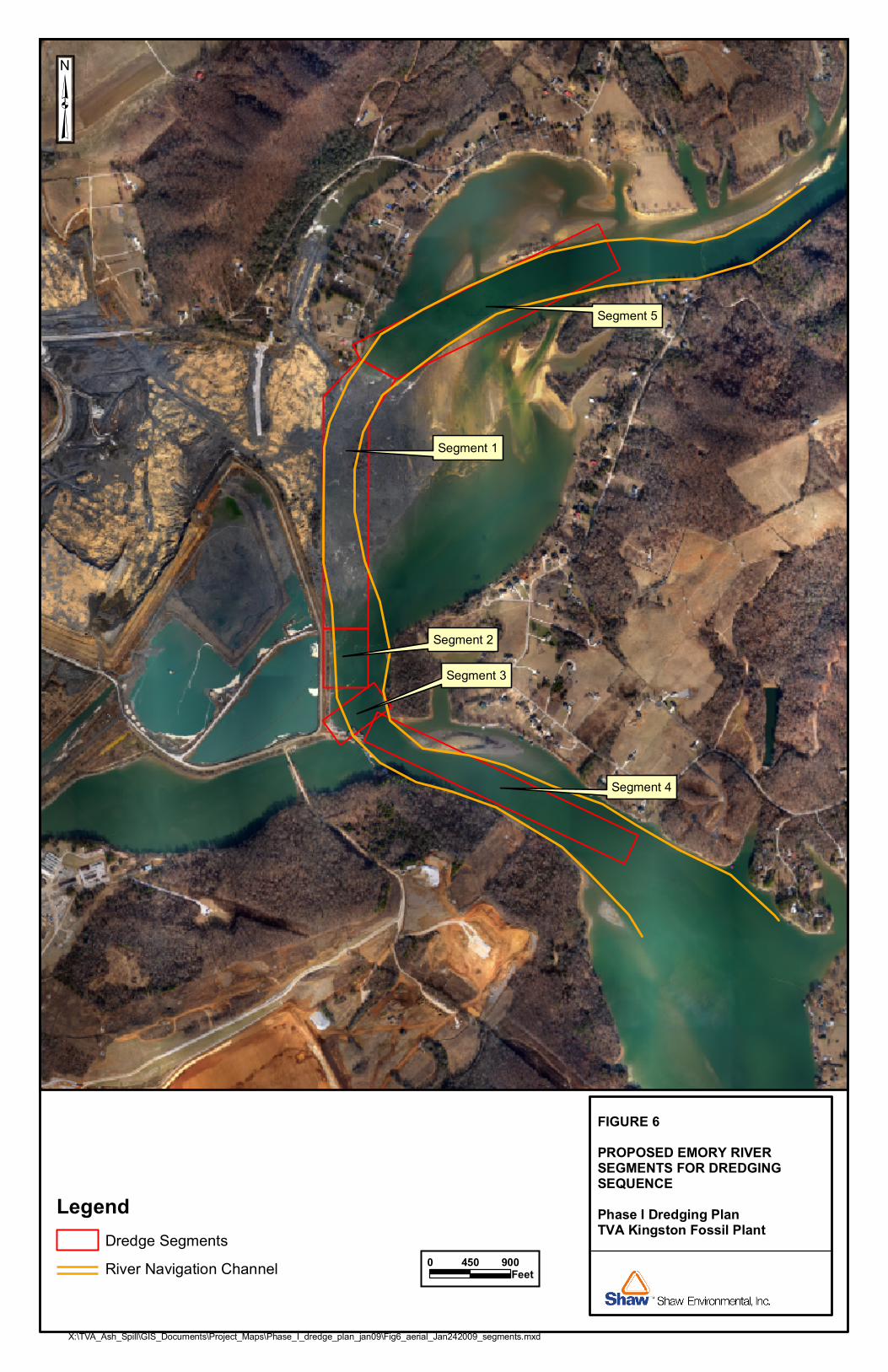
The objectives of Phase 1 dredging are two fold. One objective is to remove the ash from the Emory River while not disturbing the native sediments. The second will be to restore the Emory River navigation channel flow to an elevation of 710 feet msl. This will be accomplished by using conventional dredging equipment and methods to remove the ash and debris down to a nominal elevation of 710 feet msl. The horizontal limits of Emory River reach of Phase 1 dredging are depicted in Figure 6.
3.1 Mobilization and Site Preparation The dredging contractor will mobilize to the Phase 1 Project site and prepare the upland staging area for the Project. In general, mobilization and site preparation activities include the following:
• Installation of erosion control features on the material processing site
• Clearing and grubbing, grading, and surfacing of the staging area
• Delivery of the heavy equipment including excavators, dozers, loaders, forklifts, pumps, and tanks (as required)
• Delivery and installation of office, break, storage, and tool trailers (as required)
• Delivery of all remaining equipment
• Final dewatering and ash processing area construction
• Installation of ash pond or other processing pond controls (as needed)
• Installation of silt curtain containment system for dredging area
• Installation of turbidity monitoring system in dredged area

KN9\TVA\Dredge\Final_Dredge Plan.doc\Rev01_02042009 3-2
• Identification of lay down areas for equipment
• Launch of marine equipment into project area
The overall site plan showing the dewatering and ash processing areas for Phase 1 of the Project is shown on Figure 8. The processing and staging areas will be adjusted and/or added as necessary as the dredging proceeds.
The entire dewatering and processing areas will be sloped to drain into the existing plant Ash Pond. High density polyethylene pipe (HDPE) will convey the dredged material from the dredge overland to the dredge sluice channel constructed beside the existing plant fly ash and bottom ash channel. In the event of a dredge effluent overflow or a line rupture, the dredged material will drain into the Ash Pond. All recovered water from the dredged material will be conveyed to the Ash Pond via constructed channels. The Ash Pond discharges directly into the plant intake channel via a diffuser. The controls to be used at the ash pond are described below.
All work performed and equipment utilized will conform to the Environmental Health and Safety Plan. All marine equipment including hydraulic dredges, mechanical dredge equipment on barges, debris barges and work boats will all conform to the Project Marine Safety and Transportation Plan.
3.2 Dredging The Phase 1 dredging operation will be segmented in a manner to minimize the continuing downstream migration of ash material and debris and to maximize the immediate effect of the dredging. The Phase 1 dredging segments are delineated on Figure 6. The proposed order of Phase 1 dredging segments are:
• Segment 1 – approximately 2,994 feet long by 600 feet wide directly east of the ash spill event running north-south along the Emory River navigation channel.
• Segment 2 – approximately 650 feet long by 600 feet wide immediately south or downstream of Segment 1 also running north-south along the Emory River navigation channel up to Weir 1 or Segment 3.
• Segment 4 – approximately one mile long by 500 feet wide running northwest to southeast along the Emory River navigation channel immediately south or downstream of Segment 3.
• Segment 3 – Weir 1 partial removal to elevation 710 msl.
• Segment 5 – approximately 3,050 feet long by 600 feet wide running northeast to southwest along the Emory River navigation channel immediately north or upstream of Segment 1.

KN9\TVA\Dredge\Final_Dredge Plan.doc\Rev01_02042009 3-3
3.2.1 Segment 1
Segment 1 will be further divided into approximately 200-feet long by 60-foot wide blocks as shown on Figure 7. To minimize the downstream migration of ash and siltation due to the dredging, the Phase 1 dredging operation will begin on the southeastern most block of Segment 1. The dredging will process the first block from south to north.
Upon satisfactory completion of the first block the dredging will then process the next block immediately to the north of the first block. This pattern will continue until the entire eastern row of Segment 1 blocks is satisfactorily dredged.
In this manner, ash from subsequent dredging of Segment 1 will tend to settle into the initial dredged area. Constant monitoring of the dredged blocks as they are completed and removal of any settled ash in these blocks will insure the satisfactory completion of the dredging operation.
The Segment 1 dredging will continue in a pattern of processing the blocks row by row from east to west beginning with the southern most row. Only when a row is satisfactorily processed may the next row to the north be dredged. All blocks will be dredged from east to west, downstream to upstream.
3.2.2 Segment 2
Segment 2 will be dredged in the same block pattern as Segment 1 beginning at the southeasterly most block. Phase 1 dredging in Segment 2 will begin either after the completion of the dredging for Segment 1 or concurrently based upon the availability of the dredging equipment and the ability to proceed safely and adequately handle the return water from the second dredge.
3.2.3 Segment 4 Sampling will evaluate the extent of ash presence downstream to determine the appropriate point for Segment 4 Phase 1 dredging. Segment 4 will be dredged in the same block pattern as Segment 1 and Segment 2 beginning at the southeastern most block. Phase 1 dredging in Segment 4 will begin only after the completion of the dredging for Segment 1 and Segment 2.
3.2.4 Segment 3
Part of segment 3 or Weir 1 will be removed as part of Phase 1 dredging only after the satisfactory completion of Segment 1, Segment 2 and Segment 4.
3.2.5 Segment 5
Segment 5 will be dredged in the same block pattern as Segment 1 and Segment 2 beginning at the southeastern most block. Phase 1 dredging in Segment 5 will begin after the completion of

KN9\TVA\Dredge\Final_Dredge Plan.doc\Rev01_02042009 3-4
the dredging for Segment 1 and Segment 2. Phase 1 dredging will begin either after the completion of Segment 4 dredging or concurrently based upon the availability of the dredging equipment and the ability to proceed safely and adequately handle the return water from the second dredge. Sampling will evaluate the extent of ash presence upstream to determine the appropriate end point for Segment 5 Phase 1 dredging.
3.3 Hydraulic Dredging The primary equipment selected for the Phase 1 dredging will be Ellicott 370HP dredge. The dredgers will be capable of performing the work in a safe, orderly, and environmentally acceptable manner. The dredge will be delivered to the Project site on over the road vehicles and launched from the KIF docking facilities. The dredge will meet the requirements defined in the Marine Safety and Transportation Plan. The maximum draft for the dredge is 2.67 feet.
The dredge will utilize a 31.5-inch diameter cutter head which operates to a maximum of 39-RPM. The excavation depth of the Ellicot Model 370HP dredge with a 50-foot ladder (suction boom) will allow dredging to the planned depth of 710 feet msl, regardless of river stage elevation. The design specifications of the hydraulic dredge are provided in Attachment 1. The cutter head dredging will be controlled with a global positioning system (GPS) operated onboard in order to maintain dredging with the Project limits. The dredge discharge will be a 10-inch diameter HDPE pipe that is fusion welded in segments to convey the dredge discharge to the dewatering and processing area shown on Figure 8.
Unaffected areas in the Emory River navigation channel containing navigable depths will not be impaired except as allowed by applicable laws or regulations. Dredge discharge pipes in these areas may be submerged and at no time will the depth and width of the existing navigation channel be reduced. Management of the dredge discharge lines will conform to appropriate Federal and State regulations. When the submerged line is placed in shallow water, outside the navigable channel, where the possibility exists for small outboard powered skiffs to cross over the submerged pipeline, the pipeline will be marked with fluorescent orange buoys and signs stating "DANGER SUBMERGED PIPELINE" every 150-feet throughout the length of the submerged pipeline.
Dredge discharge pipes that are floating or supported on trestles will display appropriate lights at night and in periods of restricted visibility in accordance with USCG regulation and "33 CFR 88.15." Floating discharge pipes are any pipelines that are not laid along the bottom and include rubber discharge hoses.

KN9\TVA\Dredge\Final_Dredge Plan.doc\Rev01_02042009 3-5
Each dredge utilized will have the capacity to pump 4,000 to 5,000-GPM containing 15 to 20 percent solids a distance up to 6,000-feet with booster pumps. Additional pumping capacity will be added as required in order to convey the dredge discharge to the dewatering and processing areas shown on Figure 8. Each dredge will displace an average of approximately 3,000 cy of material during 24-hours of operation. Flow meters will be utilized to monitor and record the dredge discharge conveyed to the processing area.
The hydraulic dredging will be staffed and operated 24 hours per day, 7 days per week. The dewatering and process equipment will also be staffed 24 hours per day, 7 days per week, as needed to meet the needs of dredging. It is expected that the overall operation of the dredging, dewatering, and processing area will be approximately 20 hours of the 24 hour day. Light plants will be installed on land and on barges in the work area as necessary to provide lighting required for dredging work performed at night.
Targeted ash deposits from the Phase 1 dredging area will be removed using two hydraulic dredges to perform production dredging or cleanup pass dredging. A third dredge will be available on site in the event that either of the two primary dredges experiences mechanical problems.
The dredge will advance on a straight course by way of a winch and cable system, the ends of which will be secured to sheet pile anchors and/or spud barges. The dredges are capable of making a cut width of up to 60-feet down to the design dredging depth of 710 feet msl.
In low water conditions that prevent unrestricted access to the Phase 1 Project area, the dredger will either begin dredging in offshore portions of the Project area first, working towards the shore, or mechanically excavate an access hole near shore of sufficient size for the dredge to begin dredging. In both cases, removal of ash within the hole will provide the necessary draft for the equipment to access the shallow areas.
Material encountered that is too large or too dense to be dredged hydraulically will be identified and the location recorded for subsequent removal by means of mechanical dredging as described below. After the material has been removed by mechanical dredging these areas shall be inspected and re-dredged with the hydraulic dredge to insure the required depth is obtained.
3.4 Mechanical Dredging It is anticipated that debris (e.g., trees, debris from demolished structures, boulders, large rocks, and any other dense or large objects that would hinder dredging operations) will be encountered within the Phase 1 Project area. Therefore, prior to and during hydraulic dredging operations, a debris survey and removal operations by means of mechanical dredging will be performed as

KN9\TVA\Dredge\Final_Dredge Plan.doc\Rev01_02042009 3-6
needed or as directed by TVA or TVA’s designee. Mechanical dredging will be a 7-day week operation typically limited to daylight hours.
An excavator with a clam shell bucket on a barge will be used to perform debris removal activities. The clam shell bucket will allow ash and water to pass through the bucket while the oversized materials will remain in the bucket for removal. A specially designed rake and grapple may also be utilized as required during debris removal operations, depending upon the nature and size of the debris encountered. The debris will be transferred to an on-site debris processing area.
The floating silt curtain containment systems, described in Attachment 2, will be deployed prior to initiation of mechanical dredging operations in all Phase 1 dredging areas. The top of the silt curtain will float with the curtain hanging in the water stopping the movement of suspended ash that has reached the surface from moving out of the immediate area that is being mechanically dredged.
3.5 Hydraulic Dredge Material Dewatering and Material Handling The hydraulic dredge material dewatering and material handling will be performed in the dewatering and processing areas on Figure 8. The extent and definition of this activity is outside the Phase 1 scope of the Project and is defined elsewhere. The mass balance summary for managing dredged solids and water is included in Attachment 3 of this document.
3.6 Demobilization and Site Restoration Upon completing all work for the Emory River dredging activities, the Project site will be demobilized. Demobilization will include the following:
• Removal of office, break, storage, and tool trailers • Removal of all heavy equipment used for the Project • Breakdown and removal of the dredge discharge piping and any markers • Removal all debris, trash, and garbage resulting from construction activities • Site restoration
Site restoration activities will involve restoring all disturbed areas to conditions specified in the Solid Waste Closure Plan or “clean closure” conditions.

KN9\TVA\Dredge\Final_Dredge Plan.doc\Rev01_02042009 4-1
4.0 Monitoring of Construction Activities This section provides a general overview of monitoring activities for Phase 1 of the Emory River ash dredging.
4.1 Utility Clearance Survey Dredging activities may cause significant property damage to utilities, structures, and operational equipment, which can result in electrocution from damaged electrical lines, fires from broken fuel/gas lines, and disruption of telephone service. Underground/underwater utilities have been found in areas that have been properly investigated and thought not to have utilities present. Before dredging activities can start in a designated area, an underground utility clearance survey will be conducted to determine if the area contains underground utilities or overhead hazards. The utility clearance survey will identify and protect underground utilities or indicate that none exists. The survey will consist of the following procedures:
• Prepare a map indicating the area(s) where dredging activity is planned to occur and perform the necessary KIF department and utility company reviews.
• Contact the utility notification service, where available. This notification is to be made a minimum of two working days prior to the initiation of intrusive activity (excluding Saturdays, Sundays, and Holidays). The contact information to locate utilities for the project site is as follows.
Tennessee One Call System www.tnonecall.com/
(800) 351-1111 or (615) 367-1110
• Contact the utility companies, landowners, or responsible authorities to locate and mark the locations of the underground installations and, if they so desire, direct or assist with protecting the underground installations.
• Verify that all underground installations have been located, physically marked, and then noted on the map.
• Mark all overhead utilities with kilovolts rating on the map (work with heavy equipment should not be performed directly below overhead utilities).
• Recall utility location service for utility mark outs that have been removed, covered, or destroyed during site activities.
4.2 Bathymetric Surveying Bathymetric surveys will be performed covering the area of Phase 1 of the Project area (Figure 2) at critical stages of the work to track dredging progress. These surveys will also be the basis for determining removal quantities throughout Phase 1 dredging of the Project. Trans Ash will

KN9\TVA\Dredge\Final_Dredge Plan.doc\Rev01_02042009 4-2
utilize a combination of surveying equipment to ensure that the dredging in the river at the Kingston power plant is in the required areas and to the design depths. All dredges will be outfitted with GPS position devices that allow the operator to track the location of the dredge to ensure that cutting is within the main channel. Mechanical indicators provide cutting depth control to limit cutting to the 710 foot msl elevation.
Hydrographic surveys will be utilized on a monthly basis, or more often as needed, to verify progress of ash removal. The hydrographic surveys will utilize RTK GPS equipment for location and elevation, an echo sounder for depth, and other associated computer programs and equipment to coordinate the data. These surveys will be conducted from a dedicated survey boat set up for this task.
A third dredge used for final cut to grade applications will utilize an onboard RTK GPS system for both position and elevation of the cutter head. This system will ensure that the cutter head cuts to the design depth of 710 feet msl elevation. This is accomplished by a graphical representation provided to the dredge operator in real time that shows the depth of the cuter head, and the design cut depth at any location. In addition the program will provide the operator with a plan view of the project that shows which areas have been completed, are currently being worked, and with areas are still remaining. Upon completion of the dredge work a hydrographic survey as-built will be completed utilizing the above listed equipment.
4.3 Water Quality Monitoring
4.3.1 In-Stream Turbidity Monitoring
Turbidity monitoring systems both upstream and downstream of the Phase 1 Project area will be set up to monitor the potential impacts of the dredging operations. Five continuous monitoring stations will be established to support environmental monitoring during dredging operations at ERM 0.5, ERM 4.0, ¼ mile north of the dredging operations, ¼ mile south of the dredging operations, and in the KIF intake channel. The Emory River flow reverses at times due to TVA reservoir operations or when the Emory River flow is less than the KIF intake flow. The Emory River flow direction can be very transient. Water can be flowing down the Emory River and passing into the KIF intake and into the Clinch River. Water can also be flowing from the Clinch River up the Emory River and into the KIF intake due to the suction of the plant intake under low flow conditions. Lastly, water can be flowing down the Emory and up from the Clinch River into the KIF intake at the same time under moderate flow conditions on the Emory. Therefore monitoring stations to establish the background flow will be placed ¼ mile upstream of the dredging operations, both north and south of the operations. To monitor the change in river turbidity, a downstream station located at ERM 0.5, ERM 4.0, or in the KIF intake channel

KN9\TVA\Dredge\Final_Dredge Plan.doc\Rev01_02042009 4-3
will be utilized depending on the Emory River flow direction. The monitor in use would vary with the direction of the mass of stream flow—up the Emory River (ERM 4.0), into the Clinch River (ERM 0.5), or into the KIF intake channel. The measured difference between stations would be the change in turbidity. Each monitor will be outfitted with a Hydrolab® water quality meter and will transmit through telemetry 15 minute data on turbidity, temperature, dissolved oxygen, conductivity and pH, and the monitors located at ERM 0.5 and ERM 4.0 will have velocity meters to determine the direction of flow on the Emory River. The Hydrolab® depth at each site will be approximately six feet where possible. Calibration of the Hydrolab® will occur as needed to ensure water quality measurements are accurate. The turbidity readings will be monitored with real-time readings and will be reviewed on the one- hour interval. The turbidity readings will be averaged during dredging operations on a twenty four-hour rolling average. The downstream twenty four-hour turbidity rolling average will be used to determine if the downstream turbidity measurement is 200 NTU or greater than the background turbidity measurement. If the difference between the background and downstream turbidity twenty four-hour rolling average is 200 NTU or greater, dredging operations will be adapted and other BMPs will be evaluated and modified as needed to reduce the downstream turbidity. Velocity meters installed on the permanent upstream and downstream turbidity monitors will determine the flow direction in the river. A negative reading will indicate a northward flow in the Emory River.
The dredger will adjust dredging activities if turbidity measurement triggers are exceeded or when visual observations indicate excessive turbidity and recommence when adjustments are implemented.
4.4 Daily Dredging Operations Reporting A project-specific electronic document transmittal site for the Phase 1 dredging operation will be used to transfer data and reports relative to the Project. The electronic document transmittal site will be updated on a daily basis (working days only) and will include, at a minimum the following information:
• Contractor’s daily production reports including a summary of volumes dredged, etc.
• Environmental monitoring data (turbidity)
• Survey information (as available)
• Post dredging survey results (as available).
Access to the electronic document transmittal site will be provided to registered users with username and password.

KN9\TVA\Dredge\Final_Dredge Plan.doc\Rev01_02042009 5-1
5.0 Surface Water Monitoring Plan The water quality monitoring plan specifically addresses the Phase 1 dredging operations. This plan will be amended or updated, as needed, for each subsequent phase of dredging, if dredging plans for any phase are modified, or as other changes warrant. This section contains the information on the reporting requirements for this investigation.
The objectives of this water quality monitoring plan are to:
• Provide guidance for sampling, monitoring, and analysis of river water during dredging operations in the Emory River;
• Assure that the water sampling, monitoring, and analysis is in compliance with the overall quality assurance project plan (QAPP) developed for soil, surface water, sediment, and groundwater sampling efforts; and
• State the technical rationale for the monitoring and analytes prescribed for each phase of dredging.
5.1 Location of Sampling and Monitoring Stations As described in section 4.3 of this plan, five continuous monitoring stations will be established to support environmental monitoring during dredging operations. See Table 1 for station location and identification. Each monitor will be outfitted with a Hydrolab® and will transmit 15 minute data on turbidity, temperature, dissolved oxygen, conductivity and pH. The Hydrolab® depth at each site will be approximately six feet where possible.
Table 1 Continuous Hydrolab® Monitoring Locations
Identifier Location Depth (ft)
Turbidity Difference between Upstream and Downstream
Emory River Station 1 (ERS1)
ERM 0.5 6.0 If Emory River is flowing toward Clinch River: ERS1-ERS2
Emory River Station 2 (ERS2)
1/4 mile upstreamnorth of dredging
6.0 Background Station
Emory River Station 3 (ERS3)
1/4 mile upstreamsouth of dredging
6.0 Background Station
Emory River Station 4 (ERS4)
ERM 4.0 6.0 If Emory River is flowing away from Clinch River: ERS4-ERS3
Emory River Station 5 (ERS5)
KIF Intake Channel
6.0 If all flow is towards KIF intake channel: ERS5-ERS2
The locations of the proposed water quality monitoring stations are shown in Figure 9.

KN9\TVA\Dredge\Final_Dredge Plan.doc\Rev01_02042009 5-2
5.2 Water Quality Monitoring Methods and Analytical Parameters TVA will continue its routine sampling of surface water three times per week at five locations on the Emory River, four locations on the Clinch River, and one (or two) locations on the Tennessee River (see Table 2). These sites will also be sampled after every 0.5” or greater (24 hour total) rain event.
Each sample will be collected using an ISCO peristaltic pump or a Kemmer sampler. Samples will be collected from the water column fifteen feet below surface or at mid-depth (if total depth is <15’). Appropriate sample bottles and cooler(s) with ice shall be used for proper collection and storage of samples. Crews will collect samples in two-one liter unpreserved sample bottles and one-one liter sample bottle preserved with nitric acid from each location. Surface water samples will be analyzed for total metals, dissolved metals, total suspended solids, dissolved silica, total hardness, and total alkalinity (see Table 3). Concurrent field parameters will be measured using a Hydrolab®. Parameters of interest include turbidity, temperature, dissolved oxygen, conductivity, and pH. Turbidity at Clinch River mile 0.0 will be used as a trigger for additional sampling. If the turbidity reading at Clinch River mile 0.0 is equal to or greater than 20.0 NTU, crews will sample at Tennessee River mile 563.5 and the Watts Bar Nuclear Plant process water intake. (At the Watts Bar Nuclear Plant process water intake no field parameters are taken.)
Standard Operation Procedures for field sampling will be followed and field logs will be kept to document all sampling activities. Pending the results of ongoing sediment sampling, additional constituents may be added, such as PCBs and/or chlordane.
Duplicate turbidity, temperature, dissolved oxygen, conductivity, and pH field samples will be conducted on a 1/10 sample frequency. Duplicate samples will also be collected on a 1/10 frequency for total suspended solids, total metals, dissolved metals, total hardness, dissolved silica, and alkalinity. Additionally, a matrix spike/matrix spike duplicate sample (MS/MSDS) will be taken on a 1/10 frequency and submitted to the lab.
Table 2 Routine Surface Water Sampling Locations
Sample Number Location RM Site Label
Sample Type Depth (ft) Latitude Longitude
1 Clinch River 0.0 KIF-CRM0.0-Date Grab 15 N35.86364 W84.53181 2 Clinch River 2.0 KIF-CRM2.0-Date Grab 15 N35.88621 W84.52778 3 Clinch River 4.0 KIF-CRM4.0-Date Grab 15 N35.88956 W84.49892 4 Clinch River 5.5 KIF-CRM5.5-Date Grab 15 N35.89274 W84.48142 5 Emory River 0.1 KIF-ERM0.1-Date Grab 15 N35.88986 W84.48778 6 Emory River 1.75 KIF-ERM1.75-Date Grab 15 N35.90305 W84.49708 7 Emory River 2.1 KIF-ERM2.1-Date Grab mid-depth N35.90925 W84.50055

KN9\TVA\Dredge\Final_Dredge Plan.doc\Rev01_02042009 5-3
Table 2 Routine Surface Water Sampling Locations
Sample Number Location RM Site Label
Sample Type Depth (ft) Latitude Longitude
8 Emory River 4.0 KIF-ERM4.0-Date Grab 15 N35.92416 W84.48255 9 Emory River 12.2 KIF-ERM12.2-Date Grab 0.5 N35.92899 W84.55450
10 Tennessee
River 563.5 KIF-TRM563.5-
Date Grab 15 N35.83941 W84.58283
11 Tennessee
River 568.5 KIF-TRM568.5-
Date Grab 15 N35.85539 W84.53068
Table 3 Requested Laboratory Analyses
Analysis Method Units Container Preservation Technique
Holding Time
Alkalinity EPA 310.1/SM 2320B mg/L Poly None 28 days Dissolved Silica EPA 200.7/200.8 mg/L Poly Nitric Acid, < pH 2 6 months Total and Dissolved Metals EPA 200.7/200.8 mg/L Poly Nitric Acid, < pH 2 6 months
Hardness EPA 200.7/200.8, SM 2340B mg/L Poly Nitric Acid, < pH 2 6 months
Total and Dissolved Mercury EPA 245.1 mg/L Poly Nitric Acid, < pH 2 28 days Total Suspended Solids (TSS) EPA 160.2/SM 2540D mg/L Poly < 6o C 7 days
5.3 Material Dewatering Best Management Practices Facility Ash Pond TVA is planning to implement various best management practices for the return water from the dredge processing area in the ball field area. Return water flow from the dredged material will be directed to the ash sluice channel that eventually flows to the ash pond. This is similar to normal ash sluicing operations and it is expected that some ash will settle out in the channels. A turbidity curtain will be deployed in the main ash pond to increase retention time there. The curtain will be installed prior to commencing dredged material dewatering activities.
TVA will increase visual observations of final stilling pond to daily, observing the pond for increased turbidity. This will be included with the Ash Release Program Administrator’s (Environmental) or PA(E)'s inspection responsibilities. Objectionable turbidity will be communicated to dredging personnel to investigate and/or decrease dredging rate. The Ash Release PA(E)’s route will also include observations about collected cenospheres in the main ash pond and stilling pond. Notification to TVA’s By-Products Marketing Staff for increased collection will be made if excessive cenospheres are observed.
TVA is also investigating the use of polymers for a variety of applications related to the release. There is a request for proposals being sent to certain water treatment vendors. Initial tests for efficacy and toxicity will be performed to determine the best product that may be used for this

KN9\TVA\Dredge\Final_Dredge Plan.doc\Rev01_02042009 5-4
purpose in the ash pond to promote settling. TVA will continue to monitor free water volume in the ash pond to promote effective treatment.
TVA is investigating possible modifications to the frequency of sluicing ash to the ash pond. There may be other ash sluicing schedules from the routine handling of ash that can be used to avoid overwhelming the treatment capacity of the ash pond. (See Attachment 3 for material flow analysis information.) The presence of diffusers on the ash pond discharge pipes (except for the emergency overflow) will minimize the likelihood of objectionable color contrast in the receiving stream as the discharge is extremely well mixed. In addition, total suspended solids monitoring currently occurs on a monthly basis at the ash pond discharge (IMP 001). This monitoring frequency will be increased to weekly for the duration of the dredging operations that provide dredge return water to the ash pond, or until a reliable trend may be observed that does not violate NPDES permit limitations.
Other Dredge Return Water Locations TVA is also pursuing development of an area near the gypsum pond for handling dredged material and return water. If this area is also allowed by the Division of Solid Waste for ash processing, similar inspections of the discharge area would be conducted by the Ash Release PA(E). As the gypsum disposal areas is a new disposal area, TVA does not anticipate that curtains or polymers will need to be added. However, if settling in the gypsum pond proves to be ineffective, those BMPs will be utilized upon approval by TDEC and/or EPA.
5.4 Water Quality Results and Action Levels As stated in section 4.3, if the downstream turbidity measurement is 200 NTU or greater than the background turbidity measurement over a twenty-four hour rolling average, dredging operations will be adapted and other BMPs will be evaluated and modified as needed to reduce the downstream turbidity.
The water quality data will be routinely assessed and compared to TDEC Fish and Aquatic Life Use Classification. The data results will be shared with TDEC. TVA management decisions based on the data will be made in coordination with TDEC. The laboratory MDLs requested for each analyte are listed in Table 4.

KN9\TVA\Dredge\Final_Dredge Plan.doc\Rev01_02042009 5-5
Table 4 Analytes and Target MDL
Constituent Laboratory MDLs
(mg/L) Constituent Laboratory MDLs
(mg/L) mercury 0.0002 manganese 0.002 aluminum 0.1 molybdenum 0.002 antimony 0.001 nickel 0.001 arsenic 0.001 selenium 0.001 barium 0.002 silver 0.0005 beryllium 0.001 thallium 0.001 boron 0.2 tin 0.001 cadmium 0.0005 titanium 0.01 chromium 0.001 zinc 0.01 cobalt 0.01 alkalinity 20 copper 0.001 hardness 30 iron 0.1 total suspended solids 1.0 lead 0.001 dissolved solids 10 magnesium 0.1
5.5 Draft And Final Water Quality Monitoring Reports At the end of the Phase 1 water quality monitoring effort for dredging, TVA will prepare a draft report that will compile the data and findings of the water quality monitoring during dredging operations and present the report to TDEC, the USACE, and EPA. Regulatory comments generated by this review will be incorporated into the final water quality monitoring report.

KN9\TVA\Dredge\Final_Dredge Plan.doc\Rev01_02042009 6-1
6.0 Health and Safety Plan A site-specific health and safety accident prevention plan has been prepared to supplement Shaw’s Phase 1 Dredging Plan to identify, evaluate, and provide control measures for safety and health hazards associated with this project. All site operations will be performed in accordance with applicable state, local, TVA, Shaw corporate regulations and procedures, and Occupational Safety and Health Administration requirements, specifically 29 CFR 1926. All Shaw employees and Shaw subcontractors must comply with the requirements of this site specific health and safety plan and be familiar with the requirements established in the Health and Safety Accident Prevention Plan, Emory River Dredging health and safety accident prevention plan.

KN9\TVA\Dredge\Final_Dredge Plan.doc\Rev01_02042009 7-1
7.0 References
Dredging Research Institute Ltd., HR Wallingford, 2003, Protocol for the field Measurement of Sediment Release from Dredgers. http://el/erdc.usace.army.mil/dots/accord/index.html
Francingues, N. R., and M.R. Palermo, 2005, Silt Curtains as a Dredging Project Management Practice. DOER Technical Notes Collection. ERDC TN-DOER-E21. Vicksburg, MS: U.S. Army Engineer Research and Development Center. http://el.erdc.usace.army.mil/dots/doer/doer.html
U.S. Army Corps of Engineers (USCOE), 2008, The Four Rs of Environmental Dredging: Re-suspension, Release, Residual, and Risk, DOER Technical Notes Collection. ERDC/EL TR-08-04. Vicksburg, MS: U.S. Army Engineer Research and Development Center, February.
U.S. Army Corps of Engineers (USCOE), 2000, EM 385-1-1, EM 385-1-1 (Current Revision) Safety - Safety and Health Requirements Manual.
U.S. Army Corps of Engineers (USCOE), 1983, Dredging and Dredged Material Disposal, Engineer Manual No. 1110-2-5025. Washington, D.C. Department of the Army, Corps of Engineers, Office of the Chief of Engineers, March.
U.S. Army Corps of Engineers (USCOE), USACE Navigation Data Center, http://www.iwr.usace.army.mil/ndc/
U.S. Army Corps of Engineers (USCOE), USACE Navigation Regulations (Reporting), http://www.iwr.usace.army.mil/ndc/navchart/navregs.htm
U.S. Department of Homeland Security, U.S Coast Guard, 1999, Navigation Rules, International-Inland, COMDTINST M16672.2D.

KN9\TVA\Dredge\Final_Dredge Plan.doc\Rev01_02042009
FIGURES

FIGURE 1SITE LOCATION MAPPhase I Dredging Plan TVA Kingston Fossil Plant
0 1,500750Feet
0 2Miles
X:\TVA_Ash_Spill\GIS_Documents\Project_Maps\Phase_I_dredge_plan_jan09\Figure_1_site_location_map.mxd
Kingston Fossil Plant

ASH POND
TVA Kingston Fossil Plant
FIGURE 2EMORY RIVER BEFORE ASH SLIDE IN 2008Phase I Dredging PlanTVA Kingston Fossil Plant
0 1,000500Feet
X:\TVA_Ash_Spill\GIS_Documents\Project_Maps\Phase_I_dredge_plan_jan09\Fig2_RiverContour_BeforeSlide2008.mxd
Legend:Five Foot Underwater Contoursalong Emory River nearKingston Fossil Plant

FIGURE 3ASH SLIDE EXTENT IN EMORYRIVER DECEMBER 30, 2008Phase I Dredging PlanTVA Kingston Fossil Plant
X:\TVA_Ash_Spill\GIS_Documents\Project_Maps\Phase_I_dredge_plan_jan09\Fig3_aerial_Dec302008.mxd
0 800400Feet
LegendRiver Navigation Channel

FIGURE 4ASH SLIDE EXTENT IN EMORYRIVER JANUARY 17, 2009Phase I Dredging PlanTVA Kingston Fossil Plant
X:\TVA_Ash_Spill\GIS_Documents\Project_Maps\Phase_I_dredge_plan_jan09\Fig4_aerial_Jan172009.mxd
0 800400Feet
LegendRiver Navigation Channel

0'
2'7'
9'6'
5'5'
18'
23'
26'
27'
25'
21'11'
0'
FIGURE 5ASH THICKNESS AND KNOWNEXTENT IN EMORY RIVER Phase I Dredging PlanTVA Kingston Fossil Plant
X:\TVA_Ash_Spill\GIS_Documents\Project_Maps\Phase_I_dredge_plan_jan09\Fig5_depth_underwater_ash.mxd
0 900450Feet
LegendRiver Navigation Channel
Underwater Ash Depth (feet)Underwater Ash Depth 01/15/2008USACE sounding difference 9/27/2007 vs 12/29-30/200825'
26'
Segment 5
Segment 4
Segment 2
Segment 1
Segment 3
FIGURE 6PROPOSED EMORY RIVER SEGMENTS FOR DREDGINGSEQUENCEPhase I Dredging PlanTVA Kingston Fossil Plant
X:\TVA_Ash_Spill\GIS_Documents\Project_Maps\Phase_I_dredge_plan_jan09\Fig6_aerial_Jan242009_segments.mxd
0 900450Feet
LegendDredge SegmentsRiver Navigation Channel

Segment 5
Segment 4
Segment 2
Segment 1
Segment 3
FIGURE 7PROPOSED EMORY RIVER SEGMENT 1 BLOCK CUTSPhase I Dredging PlanTVA Kingston Fossil Plant
X:\TVA_Ash_Spill\GIS_Documents\Project_Maps\Phase_I_dredge_plan_jan09\Fig7_blockcuts.mxd
0 400200Feet
LegendApproximate Segment 1 Block CutsDredge SegmentsRiver Navigation Channel

Ash Recovery Area
Temporary Operational Ash Storage Area
FIGURE 8PROPOSED DISPOSAL AREASFOR DREDGED SLIDE MATERIALPhase I Dredging PlanTVA Kingston Fossil Plant
X:\TVA_Ash_Spill\GIS_Documents\Project_Maps\Phase_I_dredge_plan_jan09\Fig8_proposed_disposal_areas.mxd
0 400200Feet
LegendAsh Recovery AreaTemporary Operational Ash Storage Area

TRM 568.5
CRM 0
CRM 2
CRM 4 ERM 0.1
CRM 5.5
ERM 1.75
ERM 2.1
ERM 12.2
KIF Intake
EMR 0.5
ERM 4EMR 4
FIGURE 9TVA SAMPLING AND MONITORING STATIONS NEAR PHASE 1 DREDGINGPhase I Dredging PlanTVA Kingston Fossil Plant
X:\TVA_Ash_Spill\GIS_Documents\Project_Maps\Phase_I_dredge_plan_jan09\Fig9_proposed_sample_locs.mxd
0 2,5001,250Feet
LegendContinuous Sampling LocationRiver Sampling LocationRiver and Continuous Sampling Location

KN9\TVA\Dredge\Final_Dredge Plan.doc\Rev01_02042009
ATTACHMENT 1
HYDRAULIC DREDGE SPECIFICATIONS

KN9\TVA\Dredge\Final_Dredge Plan.doc\Rev01_02042009
TECHNICAL DATA AND SPECIFICATIONS 370HP Series "DRAGON" Model Specifications Portable Dredge for any standard 10" or 12" (245-305 mm) pipeline. Nominal pump capacity range = up to 320 yds3/hr (245 m3/hr)
ELLICOTT DREDGES, POWER-PACKED PORTABILITY This portable dredge represents a revolutionary breakthrough in dredge design and construction. Adaptation of the hull, ladder, and spud extensions for various digging depths added to the modular design concept of the "DRAGON" Series provides the most efficient and flexible dredging equipment on the market. Tailored to suit your company's requirements, this dredge will give the greatest return on your investment dollar.

KN9\TVA\Dredge\Final_Dredge Plan.doc\Rev01_02042009
Representative digging depths and dimensions for average dredging service. Configurations for deeper digging readily available - consult Ellicott.
370HP Principal Dimensions and Particulars Metric English
Hull Length 10.98 m 36 ft.
Hull Width 3.66 m 12 ft.
Hull Depth 1.22 m 4 ft.
Length Overall 17.53 m 57.5 ft.
Height Overall (spuds installed and elevated) 8.88 m 29.13 ft.
Height Overall (Spuds, spud hoists, and muffler removed) 3.2 m 10.7 ft.
Draft - Max. with spuds and ladder raised .81 m 2.67 ft.
Fuel Storage Capacity 3050 L 800 gals.
GENERAL
Approximate Weight - Lt. and Dry 25,396 kg 56,000 lbs.
Maximum (*) 6.10 m 20 ft.DIGGING DEPTH Minimum 0.9 m 3 ft.
@Min. Digging Depth 22.25 m 73 ft.Maximum @ 40' Swing each side CL @ Max. Digging Depth 18.29 m 60 ft.CHANNEL
WIDTH Minimum @ Minimum Digging Depth (Hull Grounded) 9.3 m 30.5 ft.
PRIME MOVER Diesel Engine CAT 3406 306 kw 410 HP
Shaft Power 30 kw 40 SHP
Cutting Force 1,815 kg 4000 lbs
Cutting Force per Linear Inch of Edge 29 kg 64 lbs.
Cutter Speed 0 - 39 RPM CUTTER
Cutter Diameter 800 mm 31.5 in
Shaft Power 15.4 kw 20.6 HP
Line Pull - First Layer 3,629 kg 8000 lbs
Line Speed - First Layer 0-22.8 m/min 0-75 ft/min
Wire Size 12.7 mm 1/2 in
SWING WINCHES
Drum Capacity 61 m 200 ft.

KN9\TVA\Dredge\Final_Dredge Plan.doc\Rev01_02042009
(*) Deeper digging depths available upon request. Please consult Ellicott.
OPTIONAL EQUIPMENT Choice of cutters, pump handling equipment, air conditioning or heating, anchor booms, production measuring equipment, and pipeline components.
ELLICOTT reserves the right to modify equipment in order to provide for engineering improvements.
SPECIFICATIONS - "DRAGON" MODEL SERIES 370HP
HULL - One piece welded steel construction with ladder well forward. Built in fuel, hydraulic oil and ballast tanks. Hull shell plate and stiffeners designed to ABS river rules. MAIN DREDGE PUMP UNIT - V belt driven by radiator cooled Caterpillar diesel engine with electric starter. Totally enclosed anti-friction radial and thrust bearings with impeller mounted on Acme threads. All wearing parts 500 BHN minimum chrome alloy cast iron. Choice of 10" or 12" (254 mm or 304 mm) discharge pipeline diameters. HYDRAULIC POWER PACKAGE - Triple section hydraulic gear pump direct driven off the main engine. Hydraulic system includes three independent operating circuits; one for swing winch, one for cutter, and one for spud and ladder hoist. EXCAVATING MODULE AND LADDER - Cutter direct driven by gear type hydraulic motor. Spline connected to planetary reduction gear. Maximum cutter force available at all speeds. Underwater excavating module features short drive shaft with weight concentrated at the cutter for efficiency. LADDER HOIST - Double acting hydraulic cylinder. Ram cylinder operation provides crowding action for tough digging. POWER SWING WINCHES - Individual single direct line winches direct-driven by gear-type hydraulic motors through planetary reduction gear. Speed and reverse controls at operator's console. Heavy-duty hydraulic system provides constant line pull at variable speeds. ELECTRICAL SYSTEM - 24 volt DC internal/external lighting and electrical system is powered by main diesel engine. SPUDS AND SPUD HOIST - Heavy wall, cylindrical steel spuds mounted in spud keepers at stern. Spuds are hoisted by vertical hydraulic cylinder and choker sling arrangement. ASSEMBLY AND TRANSPORTATION - Can be accomplished in 1 day provided all tools, site preparations and personnel are available. The assembled Series 370HP can be transported on one truck with the spuds stowed on deck. WARRANTY - Ellicott warrants its equipment only in accordance with the printed warranty conditions which are normally included in our sales proposals, the latest copy of which will be forwarded promptly on written request. No other warranties are provided.
Calculated Output Curve - " DRAGON" Model Series 370HP Using 12" Floating Pipeline (enlargement)
Note: Calculated output curves indicate pumping capability only. In actual practice the material varies from free flowing, easily excavated material to compacted and/or difficult excavations. When used for estimating actual outputs, the nature of the material must be considered. Consult Ellicott for other dredging conditions outside these curves.

KN9\TVA\Dredge\Final_Dredge Plan.doc\Rev01_02042009
BASED UPON MATERIAL IN-SITU S.G. 2.10 SUCTION PIPE I.D. 12 in. (305 mm) HULL DISCHARGE PIPE I.D. 10 in. (245 mm) FLOATING DISCHARGE PIPE I.D. 12 in. (305 mm) PUMP IMPELLER 27 in. (686mm) MAX. RPM 845 RPM MAX. PUMP POWER (320SHP/239kW)TERMINAL ELEV. 10 ft. (3.05 M)
For material in-situ values other than 2.1, see conversion below.
CONVERSION FOR VARIOUS IN-SITU S.G.
S.G. MULTIPLIER 2.10 1.00 2.00 1.10 1.95 1.158 1.90 1.222 1.85 1.294 1.80 1.375
Ellicott Dredges, LLC Baltimore, Maryland U.S.A. 21230
Voice: (410) 625-0808 - Fax: (410) 545-0200 Email: Sales Department
www.dredge.com

KN9\TVA\Dredge\Final_Dredge Plan.doc\Rev01_02042009
ATTACHMENT 2
MECHANICAL DREDGE EXAMPLES

KN9\TVA\Dredge\Final_Dredge Plan.doc\Rev01_02042009
Mechanical Dredging [Sequence is mechanically excavate (dredge) - load into barges - barge offsite away from Kingston - unload - dewater - truck to disposal site] The purpose is to use this method simultaneously with other methods of dredging by others (Hydraulic dredging by TransAsh) in the same vicinity. Mechanical dredging will be concentrated in areas of mixed ash/debris. Recovery of ash and debris will be in areas as directed onsite by TVA or TVA’s designee. The material excavated will be a mixture of ash and other items (trees, rocks, clay, vegetation, debris from destroyed houses, etc.). Mechanical dredging will be seven day operations during daylight hours. There will be other dredging operations being performed in the same area by other contractors. Material will be excavated mechanically from the Emory River using a crane barge with a clamshell bucket (typically) or a hydraulic hoe or similar equipment loading material directly into a barge (Typically a 1,500 ton capacity standard jumbo hopper barge.) A floating silt curtain will be deployed around the area being mechanically dredged. The top of the silt curtain floats with the curtain hanging in the water stopping the movement of suspended ash that has reached the surface from moving out of the immediate area. Accumulated decanted water from the hopper barge will be placed into holding tanks and/or TVA ash ponds, no decant water will be returned to the river. Holding tanks will be pumped to TVA’s ash ponds when required. Loaded barges will be transported to an unloading area away from Kingston Fossil Plant at an unloading point convenient to further transit to a Class I landfill or other approved disposal area. Barge covers are not anticipated because the material will be wet during barge transit. Rainwater, if any, will be treated as decant water. Barges taken out of service will be washed internally with water that will also be treated as decant water for disposal. Barge fleeting will be at designated areas only. TVA will provide an appropriate fleeting area at a nearby location to be determined. (Emory River near Kingston Fossil Plant). Tows utilizing Ft. Loudoun lock will need to do so during regular hours of lock operation. There is a need to do this on as regular a schedule as possible so as to not disrupt existing lock traffic. At the barge unloading site the material will then be unloaded with clamshell crane and/or track hoe (or similar equipment) and carried to an engineered drying area. Depending on the extent of drying required, and the weather, drying will be accomplished by drainage, evaporation, material stirring, and/or the introduction of a drying agent. Once the material has dried sufficiently to pass the requirements at the landfill, it will be loaded into trucks and transported to the final disposal area. Trucks will be covered and meet all legal requirements for hauling this material.

KN9\TVA\Dredge\Final_Dredge Plan.doc\Rev01_02042009

KN9\TVA\Dredge\Final_Dredge Plan.doc\Rev01_02042009

KN9\TVA\Dredge\Final_Dredge Plan.doc\Rev01_02042009

KN9\TVA\Dredge\Final_Dredge Plan.doc\Rev01_02042009

KN9\TVA\Dredge\Final_Dredge Plan.doc\Rev01_02042009

KN9\TVA\Dredge\Final_Dredge Plan.doc\Rev01_02042009
KN9\TVA\Dredge\Final_Dredge Plan.doc\Rev01_02042009
ATTACHMENT 3
KIF DREDGING MATERIAL FLOW ANALYSIS SUMMARY

KN9\TVA\Dredge\Final_Dredge Plan.doc\Rev01_02042009 Final – February 4, 2009 - Page 1 of 5
KIF Dredging Material Flow Analysis Summary Phase 1
February 2009 Two parts to material flow analysis:
1. Solids flow questions a. What are the possible solids removal rates? b. How much dredge supernatant water produced? c. Does total combined flow of supernatant water & plant production exceed ash
pond capacity/diffuser capacity? d. Will adding dredge water cause short-circuiting or other problems in pond?
2. Metals mass questions
a. Which metals are of concern? b. Will they have an unacceptable/unmanageable impact on the environment?
Information required: 1. Solids mass balance
a. Daily solids recovery production rates (# Dredges, dredge volume rates, daily duration of dredging, % solids pumped, % solids dipped, drying time, % solids in dried ash for disposal; specific gravity of 15%, and 70% ash slurries)
b. Water flows (plant flows--by category, volume per dredge operated) c. Rate of plant ash production.
2. Metals mass balance
a. Concentrations of metals of interest in materials to be dredged b. Concentrations of metals expected in water in contact with materials to be stacked
(Settled material supernatant dissolved results) Assumptions:
1. 4000 gpm dredge rate 2. 20 hr/day dredging 3. Specific gravities: fly ash = 2.6, 15% slurry = 1.24, 70% = 2.12 4. Dipped material will be 30% solids, “Dried” material to move will be 20% moisture
Analysis:
1. Dredged solids production mass balance a. Solids production @ 4000 gpm dredge rate, average 15% solids
i. Per Joe Kalmo, this will be 3000 cu yd/day ii. Calculation to verify - daily basis:
(4000 gal/min)(60 min/hr)(20 hr/day) = 4.8 MGD of 15% solids slurry
(4.8 MGD)(1.24 sp gr)(8.35 lb/gal) = 49.70 Mlb/day 15% slurry
(49.70 Mlb/day)(0.15) = 7.46 Mlb dry solids/day

KN9\TVA\Dredge\Final_Dredge Plan.doc\Rev01_02042009 Final – February 4, 2009 - Page 2 of 5
(7.46 Mlb/day dry)(1/0.7)(1gal/8.35 lb)(1/2.12 spgr)(1 cu yd/202 gal) = 2,978 cu yd/day @ 70% solids
b. Supernatant volume from 4.8 MGD is 4.8 MGD, less water removed with 70%
slurry ((3000 cu yd)(.3)(202 gal/cu yd) = 0.18 MGD) = 4.6 MGD Because the processing area will be adjacent to the ash sluice channel, we estimate that all of the supernatant volume will drain into the ash sluice channel and go through the ash pond and be discharged into the plant intake.
c. Solids to be moved to temporary storage:
i. Assuming 15% shrinkage to 20% moisture yields 2550 cu yd/day @ 20%
moisture 1. Flow analysis:
Current ash pond flow is 40.512 MGD, of which ~7.7 MGD is station sump Capacity of diffusers is 88 MGD Diverting station sump flow directly to ash pond and combining fly ash & bottom ash sluice flows will give 32.0 MGD through large sluice ditch. Each dredge will add 4.6 MGD to the flow # Dredges Flow through ash ditch Station Sump Total flow 0 32.0 MGD 7.7 MGD 39.7 MGD 1 36.6 7.7 44.3 2 41.2 7.7 48.9 3 45.8 7.7 53.5 So, adding 3 dredges would result in a total flow 34.5 MGD (38%) less than the design capacity of the ash pond diffusers.
2. Metals Balance The metals are primarily bound in the solids matrix as metallic oxides and other compounds, so the metals in the solids processing area will be related to the solids amounts. The earlier solids mass balance calculations indicated that each 3,000 cu. yard per day dredge would produce 7.46 Mlb dry solids/day. The ash processing is estimated to capture 90% of the dredged solids with approximately 10% of the solids (0.746 Mlb/day) entering the ash sluice system. Those same calculations showed that each dredge would produce 4.6 MGD of supernatant. Three dredges would produce 22.4 Mlb/day. The amount entering the ash sluice system is calculated to be 2.24 Mlb/day (10%) of dry solids and 13.8 MGD of supernatant. . KIF usually produces 390,000 dry tons of ash per year, which is 2.14 Mlb/day. The current plan includes dredging from the ash pond itself to ensure capacity is maintained, so ultimately the 10% solids from the external dredging (5.578 Mlb/day) plus a portion of 2.14 Mlb/day normal ash production will be removed routinely from the ash pond. This will be processed together with the material dredged from the river, then temporarily stored for ultimate disposal. Because the metals are primarily in the solids, the planned dredging from within the ash pond should remove these metal loadings such that they aren’t available to impact the ash pond discharge. The calculations

KN9\TVA\Dredge\Final_Dredge Plan.doc\Rev01_02042009 Final – February 4, 2009 - Page 3 of 5
in Part 1 show that these solids and flow should not cause any problems in the ash pond. Therefore, the total metals are not considered again in the following mass balance. The TDEC Water Quality Standards for Fish & Aquatic Life are stated as dissolved metals. A quantity of ash was thoroughly mixed with river water and then allowed to settle for 1 hour to simulate dredging followed by minimum time in the ash pond system. Then a sample was taken of the liquid above the settled ash. The table below lists the dissolved metals concentrations in that supernatant.
Analyte
Dissolved fraction (mg/l)
Aluminum 0.989 Arsenic 0.127 Barium 0.147 Beryllium 0.001 < Cadmium 0.001 < Chromium 0.02 < Copper 0.02 < Iron 0.309 Lead 0.02 < Mercury 0.0002 < Magnesium 2.66 Manganese 0.077 Nickel 0.02 < Selenium 0.01 Silver 0.01 < Thallium 0.107 Tin 0.01 < Titanium 0.039 Zinc 0.02
Based on the concentrations above and estimated flows of 4.6 MGD per dredge or 0.746 Mlb/dredge/day, the estimated metals loadings from the supernatant should be those listed in the table below.
Loadings from Supernatant from Dredged Liquid to the Ash Pond, Dissolved Analyte Normal Ash Pond
Loading, lb/day 1 dredge loading,
lb/day 3 dredges loading,
lb/day Aluminum 270 38 114Arsenic 7.43 4.9 14.6Barium 128 5.6 16.9Beryllium 0.34 <0.04 <0.12Cadmium 0.17 <0.04 <0.12Chromium 4.06 <0.77 <2.3Copper 0.88 <0.77 <2.3Iron 40.6 11.9 35.6Lead 0.34 <0.77 <2.3Mercury 0.07 <0.0077 <0.023Manganese 5.41 2.96 8.87

KN9\TVA\Dredge\Final_Dredge Plan.doc\Rev01_02042009 Final – February 4, 2009 - Page 4 of 5
Loadings from Supernatant from Dredged Liquid to the Ash Pond, Dissolved Analyte Normal Ash Pond
Loading, lb/day 1 dredge loading,
lb/day 3 dredges loading,
lb/day Nickel 1.79 <0.77 <2.3Selenium 2.84 0.38 1.15Silver 0.17 <0.38 <1.15Thallium 0.34 4.1 12.3Zinc 6.08 0.77 2.3
Adding the estimated loadings from the dredged supernatant above to the normal ash pond loadings results in the estimated total ash pond loadings in the table below. The normal ash pond discharge concentrations were obtained from the NPDES permit application. The estimated total combined ash pond discharge loadings in pounds per day are maximum probable loadings because some of the dissolved metals in the original supernatant would probably precipitate and be removed in the ash pond. Therefore, the combined loadings below should be conservative.
Combined Dredging & Normal Ash Pond Discharge Loadings Indicator
Metal Normal Ash
Pond Dischargemg/L
Normal Ash Pond Discharge
lb/day
3 dredge toAsh Pond
lb/day
Total Ash Pond Discharge
lb/day Aluminum 0.8 270 114 384 Arsenic 0.022 7.43 14.6 22 Barium 0.38 128 16.9 145 Beryllium <0.001 <0.34 <0.12 <0.45 Cadmium <0.0005 <0.17 <0.12 <0.29 Chromium 0.012 4.06 <2.3 <6.36 Copper 0.0026 0.88 <2.3 <3.18 Iron 0.12 40.6 35.6 76.1 Lead <0.001 <0.34 <2.3 <2.64 Mercury <0.0002 <0.07 <0.023 <0.093 Manganese 0.016 5.14 8.87 14.27 Nickel 0.0053 1.79 <2.3 <4.09 Selenium 0.0084 2.84 1.15 3.99 Silver <0.0005 <0.17 <1.15 <1.32 Thallium <0.001 0.34 12.3 <12.66 Zinc 0.018 6.08 2.3 8.39
The Kingston ash pond (NPDES Internal Monitoring Point 001) discharges to the plant intake. The Kingston plant intake flow is 1,297 MGD and the intake concentrations from the NPDES permit application are listed in the table below together with the calculated loadings. When combined with the calculated ash pond discharge loadings, we can calculate the mixed concentrations in the Kingston mixed condenser cooling water (CCW) NPDES Discharge 002 discharge and compare them to the TDEC criteria. Because most of the intake concentrations are routinely below the minimum detection limits, we used half of the intake concentration in these calculations.

KN9\TVA\Dredge\Final_Dredge Plan.doc\Rev01_02042009 Final – February 4, 2009 - Page 5 of 5
Mixed Ash Pond & CCW concentrations & TDEC Criteria Analyte Intake
Conc. mg/L
River* Loadings
lb/day
Total Ash Pond + CCW
lb/day
Total Ash Pond + CCW
mg/L
TDEC’s Lowest
Criteria** mg/L
Aluminum 0.5 5411 5795 0.51 0.2Arsenic <0.001 5.41 27.5 0.0024 0.01Barium 0.041 444 589 0.052 2Beryllium <0.001 5.41 5.64 0.0005 0.004Cadmium <0.0005 2.71 2.85 0.0003 0.00025Chromium <0.001 5.41 10.6 0.0009 0.011Copper 0.0013 14.07 16.1 0.0014 0.009Iron 0.3 3247 3323 0.295 0.3Lead <0.001 5.41 6.73 0.0006 0.0025Mercury <0.0002 1.08 1.13 0.0001 0.00077Manganese 0.049 530 545 0.048 0.05Nickel <0.002 10.82 13.8 0.0012 0.052Selenium <0.001 5.41 9.4 0.0008 0.005Silver <0.0005 2.71 3.37 0.0003 0.0032Thallium <0.001 5.41 17.9 0.0016 0.002Zinc <0.01 54.1 62.5 0.0055 0.12
*River Loadings were calculated using 0.5 the MDL. **TDEC Criteria, Rule 1200-4-3-.03 The table above shows that even using conservative assumptions, such as no removal in the ash pond, all of the estimated mixed discharge concentrations should meet the lowest most stringent TDEC limits except for aluminum and cadmium. Aluminum is primarily part of the ash matrix and probably associated with fine particulate which should have significant removal in the ash pond system. The aluminum level is also a secondary drinking water standard and should not cause any significant impact to aquatic life downstream. The cadmium exception is primarily because the TDEC level of 0.00025 mg/L is below the detection limit of 0.005. Because no measurements above the MDL have been seen in the plant intake, if one-fourth the MDL is used then the apparent estimated level in Discharge 002 would be below the TDEC standard. Therefore, the proposed dredging and processing operations should have no significant impact on the final discharges from the KIF ash pond and CCW discharges (NPDES Discharges 001 and 002).

KN9\TVA\Dredge\Final_Dredge Plan.doc\Rev01_02042009
ATTACHMENT 4
TDEC SUBMITTAL


Copyright © 2022 FDOKUMEN