Groundwater quality zonation in a shallow weathered rock aquifer using GIS
Quaternary Science Reviews 22 (2003) 703–723
Peatlands of the Western Siberian lowlands: current knowledge onzonation, carbon content and Late Quaternary history
K.V. Kremenetskia,b,*, A.A. Velichkoa, O.K. Borisovaa, G.M. MacDonaldb, L.C. Smithb,K.E. Freyb, L.A. Orlovac
aLaboratory of Evolutionary Geography, Russian Academy of Sciences, Moscow 109017, RussiabDepartment of Geography, UCLA, Los Angeles, CA 90095-1524, USA
c Institute of Geology and Geophysics, Russian Academy of Sciences, Novosibirsk, Russia
Received 11 March 2000; accepted 11 October 2002
Abstract
The Western Siberian lowlands (WSL) are the world’s largest high-latitude wetland, and possess over 900,000 km2 of peatlands.
The peatlands of the WSL are of major importance to high-latitude hydrology, carbon storage and environmental history. Analysis
of the existing Russian data suggests that the mean depth of peat accumulation in the WSL is 256 cm and the total amount of carbon
stored there may exceed 53,836 million metric tons. A synthesis of published and unpublished radiocarbon dates indicates that the
peatlands first developed at the end of the Last Glacial, with a rapid phase of initiation between 11,000 and 10,000 cal yr BP.
Initiation slowed after 8000 cal yr BP and reached a nadir at 4000 cal yr BP. There has been renewed initiation, particularly south of
621N, following 4000 cal yr BP. The initial development of peatlands in the WSL corresponds with the warming at the close of the
Pleistocene. Cooling after 4000Cal yr BP has likely led to increased permafrost and increased peatland development particularly in
central and southern regions. Cold and dry conditions in the far north may have inhibited peatland formation in the late Holocene.
r 2002 Elsevier Science Ltd. All rights reserved.
1. Introduction
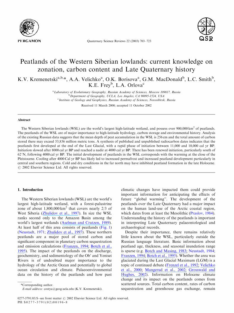
The Western Siberian lowlands (WSL) are the world’slargest high-latitude wetland, with a forest-palustrinezone of about 1,800,000 km2 that covers nearly 2/3 ofWest Siberia (Zhulidov et al., 1997). In size the WSLranks second only to the Amazon Basin among theworld’s largest wetlands (Aselman and Crutzen, 1989).At least half of this area consists of peatlands (Fig. 1)(Neustadt, 1971; Zhulidov et al., 1997). These northernpeatlands are a major pool of stored carbon andsignificant component in planetary carbon sequestrationand emission calculations (Franzen, 1994; Botch et al.,1995). The impact of the peatlands on the discharge,geochemistry, and sedimentology of the Ob’ and YeniseiRivers is of undoubted major importance to thehydrology of the Arctic Ocean and potentially to globalocean circulation and climate. Palaeoenvironmentaldata on the history of the peatlands and how past
climatic changes have impacted them could provideimportant information for anticipating the effects offuture ‘‘global warming’’. The development of thepeatlands over the Late Quaternary had a major impacton the human land-use of the Arctic coastal region,which dates from at least the Mesolithic (Praslov, 1984).Understanding the history of the peatlands is importantin interpreting Late Quaternary palaeontological andarchaeological records.Despite their importance, there remains relatively
little known about the WSL, particularly outside theRussian language literature. Basic information aboutpeatland age, thickness, and seasonal inundation rangeis sparse (e.g. Botch and Masing, 1983; Neustadt, 1984;Franzen, 1994; Botch et al., 1995). Whether the area wasglaciated during the Last Glacial Maximum (LGM) is atopic of continued debate (Frenzel et al., 1992; Velichkoet al., 2000; Mangerud et al., 2002; Grosswald andHughes, 2002). Information on Holocene climatechange and its impact on the peatlands comes fromscattered sources. Total carbon content, rates of carbonsequestration and greenhouse gas exchange, remain
*Corresponding author.
E-mail address: [email protected] (K.V. Kremenetski).
0277-3791/03/$ - see front matter r 2002 Elsevier Science Ltd. All rights reserved.
PII: S 0 2 7 7 - 3 7 9 1 ( 0 2 ) 0 0 1 9 6 - 8
poorly known and have only been coarsely estimated(Botch and Masing, 1983, Franzen, 1994; Botch et al.,1995). In discussing carbon reservoirs in the FormerSoviet Union, Botch et al. (1995, p. 42) state ‘‘the mainsources of uncertainty in the estimates presented hereinare associated with the areal extent of FSU peatlandsand depth of peat deposits’’.In this paper we review the Russian literature
pertaining to the modern environment and phytohy-drologic zonation of the WSL, current estimates ofcarbon volume in terms of peat storage, and LateQuaternary history of the peatlands. The goal of thisreview is to provide as comprehensive a synthesis aspossible of Russian literature regarding the current stateof the Western Siberian peatlands, their Late Quatern-ary development and sensitivity to Holocene climatic
changes. Such a synthesis is essential for understandingthe relationship between the peatlands and climatechange, and for planning further investigations of thiscritical region.
2. Regional setting
2.1. Geology
Extensive peatland cover and flat relief make itdifficult to study the geology of the WSL region. Theigneous basement of the West Siberian platform isformed by Palaeozoic rocks that are mainly Herzine andCaledonian in age. These rocks are overlain byMesozoic and Cenozoic sedimentary deposits. The
Fig. 1. The Western Siberian Lowlands and general extent of peatland cover (black areas) (after Ivanov and Novikov, 1976).
K.V. Kremenetski et al. / Quaternary Science Reviews 22 (2003) 703–723704
Meso–Cenozoic sediments can range up to 3000–6000min thickness. Quaternary deposits with depths of up to200–250m cover the West Siberian lowland (Volkov andOliunin, 1993). The geographic extent of the glacialcover over West Siberia during the Quaternary remainspoorly documented. Where exposed, the Quaternarysediments often consist of sands and other aeolianand fluvial deposits. It appears unlikely that any ofthe region was glaciated in the LGM. Earlier in theQuaternary ice may have been present along the Arcticcoast (Arkhipov, 1984; Velichko et al., 1984; Frenzelet al., 1992). However, the exact extent of LateQuaternary glaciation remains debated (e.g. Velichkoet al., 1984, 2000; Grosswald, 1998; Grosswald andHughes, 2002; Faustova and Velichko, 1992).
2.2. Physiography
The topography of the WSL is generally flat. Totaltopographic relief ranges from sea level along the Arcticcoast to maximum elevations of approximately 200m inthe interior. A gently rising, broad upland, the SibirskieUvaly Hills, runs from west to east across the WSL atabout 631N latitude. A small amount of local relief isprovided by raised peatland hills of several metres heightthat are found in permafrost regions. Local relief is mostpronounced in the river valleys. The valleys of the Ob’and Irtysh rivers achieve widths as large as 20–120 km.The modern floodplains on these large, lowgradient rivers are only 3–8m above the mean riverlevel. A well documented set of Quaternary riverterraces is observed at higher levels and reach heightsof over 60m above the modern floodplain. In the valleysof big rivers, such as the Ob’ and Irtysh, at B100mdepth there are at least four early and mid-Quaternaryalluvial complexes overlain by younger alluvial sedi-ments (Baulin et al., 1967; Arkhipov et al., 1999).Although histosols dominate the WSL, sands and
loams are common where mineral soil is exposed. TheSibirskie Uvaly Hills contain relatively large areas ofexposed sand and loams. Sands and loams are also themost common material underlying peatlands. Thoseareas that are not dominated by peatland histosols aretypified by forested spodosols in south and centralregions, and tundra regosols, gleysols, and cryosols inthe far north.Continuous permafrost extends southward from the
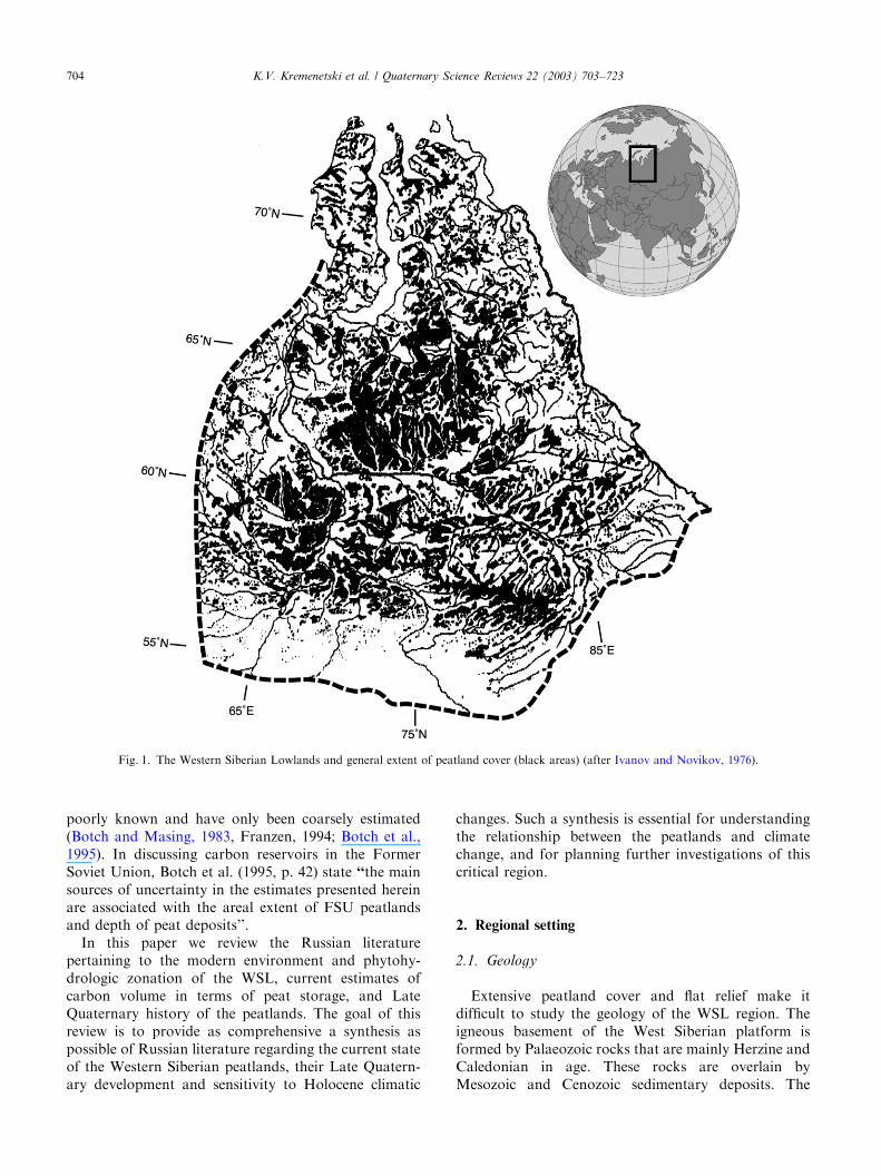
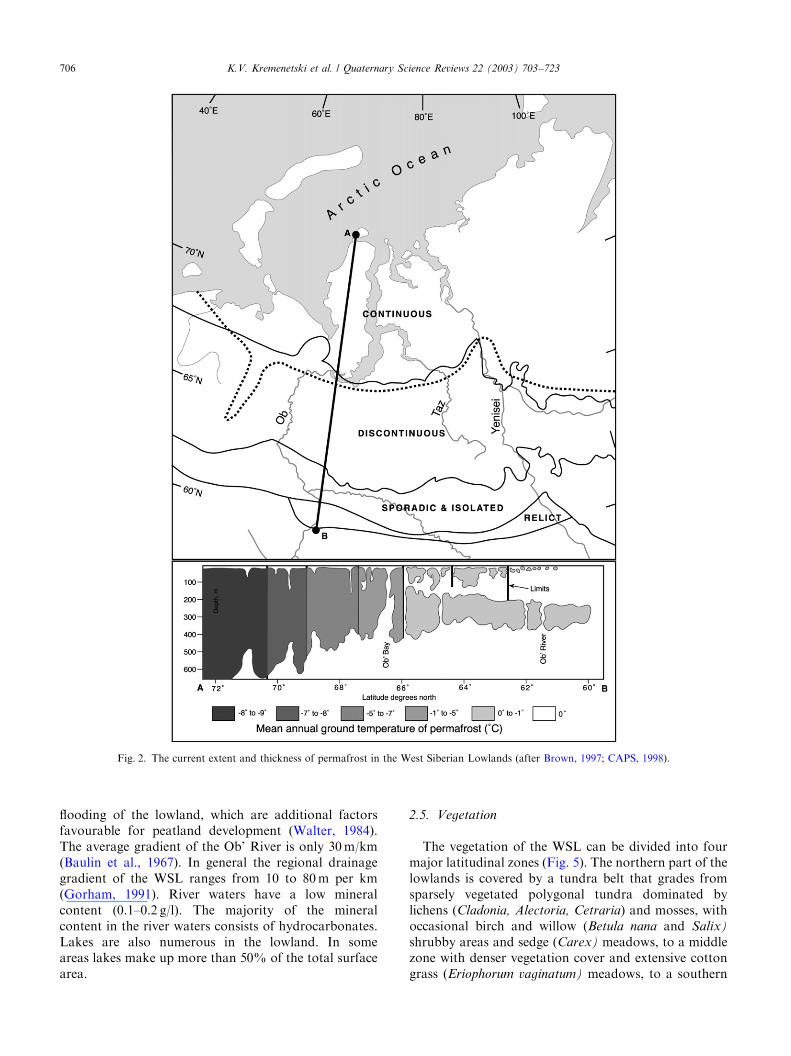
Arctic coast to approximately 641N latitude (Fig. 2).Cryogenic features such as peat polygons are commonin the far north. Discontinuous permafrost is found toabout 601N latitude, with sporadic permafrost occurringsouth of that. The impact of widespread permafrost inrestricting soil drainage contributes to the extensivedevelopment of peatlands in the WSL. North of theArctic Circle the thickness of the permafrost varies from300 to 600m. The depth of the active layer ranges here
from 20 to 200 cm. Southward to about 641N thethickness of the permafrost ranges from 200 to 400mwith the active layer being 30 – 400 cm deep. Near thesouthern limit of continuous permafrost its thicknessvaries from 50 to 300m (Baulin et al., 1967, 1984). Thetemperature of the permafrost is as low as �91C in thenorth and increases in a relatively consistent mannersouthward (Fig. 2). The development of permafrostwas initiated in the Early Pleistocene and reachedits maximum extent during the Last Glacial epoch(Velichko and Nechaev, 1984). During the early andmid-Holocene the limit of continuous permafrost mayhave retreated to 681N in the west and at 701N in theeast. Climatic deterioration in the late Holocene appearsto have triggered a new phase of permafrost expansion(Velichko and Nechaev, 1984). Thus, south of 661N anupper permafrost layer is separated from a lowerlayer of permafrost by a zone of thawed sedimentsthat are relicts of deep melting during the mid Holocene(Fig. 2).
2.3. Climate
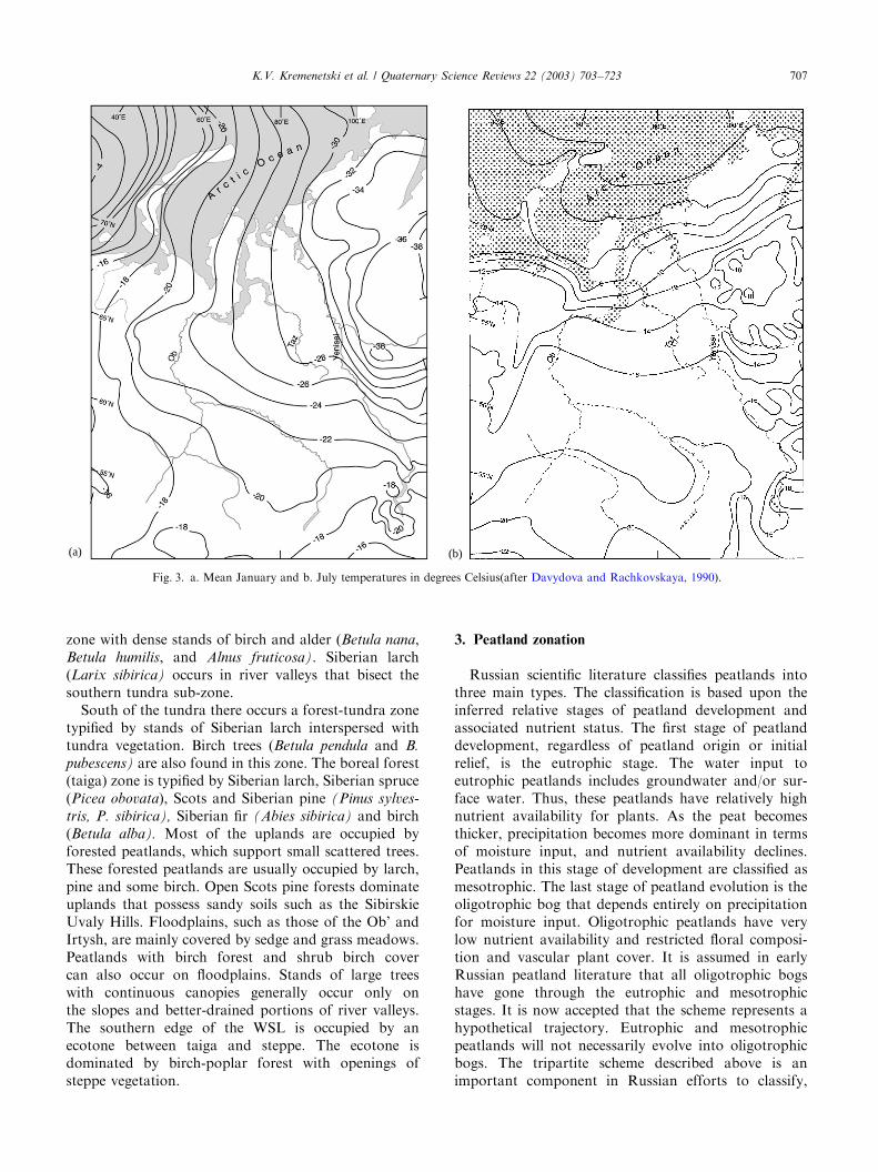
Climate in West Siberia is cold and continental. MeanJanuary temperature in the northern half of the WSL is�141C to �281C, and �14 to �201C in the southernhalf (Fig. 3a). The summer is warm with mean Julytemperature being 171C to 181C in the forest beltand declining to 101C to 121C near the Arctic coastline(Fig 3b). The duration of the frost-free period is twomonths in the far north and up to four months in thesouth.The annual precipitation is up to 590mm in the
northern portion of the WSL, up to 510mm in thecentral portion, and up to 400mm in the south (Fig. 4).The mean depth of snow cover reaches its maximum inthe central portions (up to 80 cm) and then decreases tothe south and north. For the most part, precipitation isgreater than potential evaporation over the lowlands(Fig. 4). At the southern fringe of the lowlandsprecipitation and evaporation are in equilibrium andfurther south in the forest-steppe and steppe belts ofSiberia there is less precipitation than evaporation. Thegenerally short summers and positive moisture balancehelp to promote peatland development in the WSL.
2.4. Hydrology
Rivers and streams are numerous in the WSL. Thelargest rivers include the Ob’ and Irtysh in the west andthe Yenisey in the east. The total annual discharge andmean discharge of the Ob’ areB400 km3 and 12,400m3/s, respectively. For the Yenisey the total annualdischarge is B625 km3 and the mean discharge is19,800m3/s, (Davydova and Rachkovskaya, 1990). Flatrelief contributes to the poor drainage and localized
K.V. Kremenetski et al. / Quaternary Science Reviews 22 (2003) 703–723 705
flooding of the lowland, which are additional factorsfavourable for peatland development (Walter, 1984).The average gradient of the Ob’ River is only 30m/km(Baulin et al., 1967). In general the regional drainagegradient of the WSL ranges from 10 to 80m per km(Gorham, 1991). River waters have a low mineralcontent (0.1–0.2 g/l). The majority of the mineralcontent in the river waters consists of hydrocarbonates.Lakes are also numerous in the lowland. In someareas lakes make up more than 50% of the total surfacearea.
2.5. Vegetation
The vegetation of the WSL can be divided into fourmajor latitudinal zones (Fig. 5). The northern part of thelowlands is covered by a tundra belt that grades fromsparsely vegetated polygonal tundra dominated bylichens (Cladonia, Alectoria, Cetraria) and mosses, withoccasional birch and willow (Betula nana and Salix)
shrubby areas and sedge (Carex) meadows, to a middlezone with denser vegetation cover and extensive cottongrass (Eriophorum vaginatum) meadows, to a southern
Fig. 2. The current extent and thickness of permafrost in the West Siberian Lowlands (after Brown, 1997; CAPS, 1998).
K.V. Kremenetski et al. / Quaternary Science Reviews 22 (2003) 703–723706
zone with dense stands of birch and alder (Betula nana,Betula humilis, and Alnus fruticosa). Siberian larch(Larix sibirica) occurs in river valleys that bisect thesouthern tundra sub-zone.South of the tundra there occurs a forest-tundra zone
typified by stands of Siberian larch interspersed withtundra vegetation. Birch trees (Betula pendula and B.
pubescens) are also found in this zone. The boreal forest(taiga) zone is typified by Siberian larch, Siberian spruce(Picea obovata), Scots and Siberian pine (Pinus sylves-
tris, P. sibirica), Siberian fir (Abies sibirica) and birch(Betula alba). Most of the uplands are occupied byforested peatlands, which support small scattered trees.These forested peatlands are usually occupied by larch,pine and some birch. Open Scots pine forests dominateuplands that possess sandy soils such as the SibirskieUvaly Hills. Floodplains, such as those of the Ob’ andIrtysh, are mainly covered by sedge and grass meadows.Peatlands with birch forest and shrub birch covercan also occur on floodplains. Stands of large treeswith continuous canopies generally occur only onthe slopes and better-drained portions of river valleys.The southern edge of the WSL is occupied by anecotone between taiga and steppe. The ecotone isdominated by birch-poplar forest with openings ofsteppe vegetation.
3. Peatland zonation
Russian scientific literature classifies peatlands intothree main types. The classification is based upon theinferred relative stages of peatland development andassociated nutrient status. The first stage of peatlanddevelopment, regardless of peatland origin or initialrelief, is the eutrophic stage. The water input toeutrophic peatlands includes groundwater and/or sur-face water. Thus, these peatlands have relatively highnutrient availability for plants. As the peat becomesthicker, precipitation becomes more dominant in termsof moisture input, and nutrient availability declines.Peatlands in this stage of development are classified asmesotrophic. The last stage of peatland evolution is theoligotrophic bog that depends entirely on precipitationfor moisture input. Oligotrophic peatlands have verylow nutrient availability and restricted floral composi-tion and vascular plant cover. It is assumed in earlyRussian peatland literature that all oligotrophic bogshave gone through the eutrophic and mesotrophicstages. It is now accepted that the scheme represents ahypothetical trajectory. Eutrophic and mesotrophicpeatlands will not necessarily evolve into oligotrophicbogs. The tripartite scheme described above is animportant component in Russian efforts to classify,
(b)(a)
Fig. 3. a. Mean January and b. July temperatures in degrees Celsius(after Davydova and Rachkovskaya, 1990).
K.V. Kremenetski et al. / Quaternary Science Reviews 22 (2003) 703–723 707

map and interpret the history of the peatlands of theWSL.The first scientific descriptions of the peatlands of the
southern portions of the WSL were made in the early20th century as a part of government sponsoredbotanical and pedological investigations (Gordiagin,1901; Zhilinsky, 1907; Dranitsyn, 1914). The firstdetailed studies that focused on the southern peatlandscommenced in the 1920s (Baryshnikov 1929; Bronzov,1930). Botanical research on the Yamal and Gydanpeninsulas in the 1930s provided the first scientific dataon peatlands in the arctic part of the WSL (Gorodkov,1932; Govorukhin, 1933). Following the discovery of oilin the 1950s intensive study of peatlands in the centralWSL commenced. Most of these studies were concernedwith producing information on peatland distributionand thickness that would be useful for developing roadsand infrastructure needed for oil exploration anddevelopment. In the 1960s and 1970s investigationscontinued on the spatial distribution of peatlands, peatthickness, hydrology and vegetation cover (Neustadt,1971, 1982; Ivanov and Novikov, 1976; Liss andBerezina, 1981). More recently, studies have beenconducted on the plant ecology of peatland forests(Glebov, 1988).
During the second half of the 20th century a numberof peatland maps were developed for the WSL. Forexample, Geoltorfrazvedka (a specialized branch of theRussian geological survey that focuses on peat studies)developed a map of peatland distribution in the forestand forest-steppe zones (Karta bolot Zapadnoi Sibiri,1970, 1996). This map was produced largely from airphotographs and so mainly portrayed the geographicdistribution of treeless or sparsely forested peatlands.The most useful map for the general zonation ofpeatlands in the WSL remains the work of Romanova(Ivanov and Novikov, 1976). She established a latitu-dinal zonation of Eurasian peatlands based on visualdifferences in the structure and relief of bogs (Fig. 6).We describe the Romanova peatland zones below andalso provide some very general information on thethickness of peats within each latitudinal zone.
3.1. Polygonal bog zone
Polygonal peatlands are mainly restricted to tundraareas on the Yamal, Tazovski and Gydan peninsulas.Peatlands in this zone occupy approximately 20–50% ofthe local landscape. Frost wedges that are 20–100 cmlong and 5–80 cm deep form the polygonal structure of
Fig. 5. Major vegetation zones of the West Siberian Lowlands (after
Davydova and Rachkovskaya, 1990).Fig. 4. Average annual precipitation and precipitation minus evapora-
tion (after Davydova and Rachkovskaya, 1990).
K.V. Kremenetski et al. / Quaternary Science Reviews 22 (2003) 703–723708

the surface of the peatlands. These faults definepolygons with sides up to 25m long. Peatlands in thiszone are dominated by Sphagnum-Hypnum and Grami-
neae-Hypnum bogs, but include some eutrophic bogsdominated by Carex. The peatland cover is discontin-uous. Peatlands are often formed in depressions and aresurrounded by tundra vegetation developed on mineralsoils. Reported peat thickness in polygonal peatlandsgenerally ranges from 20 to 150 cm (Andreev, 1935;Botch et al., 1971). Peat is thickest in the southernportions of the zone (Botch et al., 1971) and may reachdepths of 3 to 4m on the southern Yamal Peninsula(Piavchenko, 1955; Vasilchuk et al., 1983). Depths ofpeat on the Tazovski Peninsula vary from 1.0 to 5.3m(Ivanov and Novikov, 1976).
3.2. Flat mound-bog zone
Flat mound-bogs (small mound-bogs according toGorodkov, 1935) are found mainly in the forest-tundrabelt, but also occur in northern part of taiga belt inthe zones of discontinuous and sporadic permafrost. Inthe southern part of the zone they occur together withlarge hill bogs. Flat mound-bogs represent about 40%of the land cover in the zone. The structure of these bogsis complex. Flat frozen mounds (‘‘bugry’’) with lichenand Sphagnum vegetation cover are distributed amongst
non-frozen depressions (‘‘mochazhiny’’) with Carex-
Hypnum cover. The difference in elevation between themounds and depressions is generally less than 4m. Therelative area occupied by mounds and depressions isvariable, in general the area occupied by mounds issmaller than that occupied by depressions. The peatdepth beneath the mounds may be only 25–30 cm and indepressions the peats are typically 100–150 cm thick(Ivanov and Novikov, 1976). In the Ob’ valley near thetown of Salekhard peat depths of 0.9–1.2m have beenmeasured (Katz and Katz, 1948; Piavchenko, 1955). Inthe Taz–Yenisei watershed peat depths 1–3m arereported (Piavchenko and Fedotov, 1967). The moundportions of these peatlands are oligotrophic, whiledepressions are mesotrophic or eutrophic.
3.3. Large mound-bog zone
Large mound-bogs are found in the northern taigavegetation belt. The southern limit of this zonecorresponds to the southern limit of sporadic perma-frost. Permafrost in this zone occurs only in peat bogs.Peatlands cover about 25% of the total landscape.Frozen peat mound, of up to 6m in height, aresurrounded by non-frozen depressions. Work by theState Hydrological Institute in Saint Petersburg(Ivanov and Novikov, 1976; Novikov and Usova,
Fig. 6. Major peatland zones of the West Siberian Lowlands (after Ivanov and Novikov, 1976).
K.V. Kremenetski et al. / Quaternary Science Reviews 22 (2003) 703–723 709
1983; Malyasova et al., 1991; Novikov et al., 1999)established the important role of permafrost in theformation of northern peatland mound. Studies of peatsections showed that under frozen mound-bogs the levelof mineral soil is 1–2m higher than under adjacentunfrozen depressions. However, the composition ofbasal peat layers is the same under the mounds anddepressions. The rise of the mineral soil under the peatmounds indicates that permafrost heaving is responsiblefor the topography. In some cases the mounds exhibitevidence of erosion and associated degradation of theunderlying permafrost (Piavchenko, 1955; Tyrtikov,1969). The peatland vegetation cover is similar to theFlat Mound-Bog Zone. Coniferous trees often grow onthe larger mounds. The mound portions of these bogsare oligotrophic (mainly Sphagnum dominated), whiledepressions may be mesotrophic or eutrophic. Thethickness of peat beneath the frozen mounds is often100–250 cm. Peat thickness in the depressions oftenranges up to 300 cm (Tyrtikov, 1969; Ivanov andNovikov, 1976). In rare cases, peat thickness can beup to 3–5m beneath large mounds (Piavchenko andFedotov, 1967).
3.4. Oligotrophic (sphagnum) bog zone
This is the largest peatland zone in the WSL. Itcorresponds with the portion of the taiga vegetationzone that lies south of the limits of permafrost.Peatlands cover about 40% of the total area and insome regions peatlands comprise 70% of the totallandcover. Peatland relief in this zone is complex.Elevated portions can stand several metres above thesurrounding landscape and they support pine stands.The elevated areas are generally surrounded by wetdepressions. Lakes of different size and shape are verycommon in the landscape. The different sizes and shapesof the rises, depressions and lakes create a large varietyof oligotrophic bogs. Sphagnum dominates in elevatedportions of the peatlands, while Carex and Hypnum
mosses dominate in the depressions. Oligotrophicconditions dominate in this zone. Eutrophic peat occurslargely on floodplains. Mean peat depth north of theOb’ River near the town of Surgut is reported to beabout 1.8m. South from the Ob’ valley the mean peatdepth is estimated to be 2.5–3.2m, with some depthsreaching over 5m (Ivanov and Novikov, 1976).
3.5. Flat eutrophic and mesotrophic (carex-hypnum and
forest) bog zone
This zone occurs in the southern part of the taigaforest belt. Peatlands occupy about 20% of the land-scape. The most common types of bogs here are Carex-
Hypnum, Carex, Sphagnum, Carex-Sphagnum, Phrag-
mites and forest bogs. Forest cover on peatlands
generally consists of pine and birch. Oligotropic bogsare less common. Peat accumulation in this zone isvariable, but generally the unforested bogs average1.5m and can reach 4.0m in depth. However, depths ofthe forested bogs are very poorly known (Ivanov andNovikov, 1976).
3.6. Eutrophic (phragmites) and brackish bog zone
This peatland zone is found in the forest-steppe andsteppe belts of West Siberia. Peatlands are common onlyin the northern part of the zone where they mainly occurin valleys. In the southern part of the zone peatlandsonly occur as swamps near lakes or in topographicdepressions. Phragmites bogs occur in the northeast partof the zone (Baraba forest-steppe). Small Phragmites
and Carex-Phragmites swamps occur in depressions andin river valleys up to the northern part of Kazakhstan(Kremenetski et al., 1997). In most cases the depth ofpeat does not exceed 1–2m. In rare cases the depthcan reach up to 3–4m (Novikov, 1976; Orlova, 1990;Kremenetski et al., 1997). Depth of peat in swampscan reach up to 2.5m (Orlova, 1990; Kremenetskiet al., 1997).
4. Synthesis of existing data on peatland depths
Providing a database for accurate estimates of peat-land depths in the WSL is problematic for severalreasons. Some depth measurements have been obtainedfor the WSL during detailed geological prospecting inthe forest belt and in one instance there are reported tobe about 4000 peat depth measurements for peatlands inthis zone (Ivanov and Novikov, 1976). However, inmost cases the exact georeferenced position of thesemeasurement points is not available. Many of theavailable measurements of peatland thickness wereobtained from exposed sections, particularly along rivervalleys. These data may overestimate regional peatdepths as peat deposits in river valleys tend to berelatively thick compared to adjacent uplands. Many ofthe available peat depth measurements come fromgeobotanical studies of peatland vegetation history.With such paleobotanic studies there is a bias towardssampling the deepest part of the peatland. In general,peat depths from sites with less than 50–70 cm are notreported by most studies, even when such shallowdeposits are encountered. Very few measurements ofpeat depth have been taken from peatlands containingpermafrost, and those that are available are not properlygeoreferenced (Novikov and Usova, 1983).The available georeferenced data (Table 1) on peat
depths show that the majority of sites possess less than5m of peat accumulation (Figs. 7 and 8). Accumulationsdeeper than this are found south of 601N, with the
K.V. Kremenetski et al. / Quaternary Science Reviews 22 (2003) 703–723710
Table 1
Peat depth measurements available from specific sites in the West Siberian Lowland
Site Number Latitude N Longitude E Peat depth, cm Reference
1 611 350 731 200 250 Liss and Berezina (1981)
2 601 500 761 500 400 Liss and Berezina (1981)
3 611 100 761 350 270 Liss and Kulikova (1967)
4 591 070 771 300 170 Liss and Berezina (1981)
5 601 100 721 500 600 Liss and Berezina (1981)
6 601 100 721 500 480 Liss and Berezina (1981)
7 581 000 731 300 425 Liss and Berezina (1981)
8 591 220 681 570 300 Neustadt (1967)
9 581 460 681 450 550 Volkov, Gurtovaya et al. (1973)
10 601 200 781 240 345 Glebov et al. (1974); Glebov (1988)
11 581 400 811 300 575 Liss and Berezina (1981)
12 561 150 841 000 500 Liss and Berezina (1981)
13 561 150 841 000 150 Liss and Berezina (1981)
14 561 150 841 000 120 Liss and Berezina (1981)
15 581 350 761 300 220 Liss and Berezina (1981)
16 561 300 831 300 375 Liss and Berezina (1981)
17 561 300 831 300 445 Liss and Berezina (1981)
18 561 300 831 300 275 Liss and Berezina (1981)
19 561 300 831 300 200 Liss and Berezina (1981)
20 561 300 831 300 40 Liss and Berezina (1981)
21 551 200 791 400 310 Liss and Berezina (1981)
22 551 200 791 400 135 Liss and Berezina (1981)
23 571 841400 320 Firsov et al. (1985)
24 601550 761350 400 Firsov et al. (1985) Neustadt, Zelikson (1971)
25 601370 751200 200 Firsov et al. (1985) Neustadt et al. (1974)
26 561490 841350 250 Firsov et al. (1985); Arkhipov and Votakh (1980)
27 581200 831300 175 Firsov et al. (1985)
28 581200 831300 375 Khotinsky (1977)
29 561520 831050 400 Khotinsky (1977)
30 561520 831050 275 Khotinsky (1977)
31 651410 641250 140 Firsov et al. (1985)
32 611300 761550 325 Neustadt et al. (1974)
33 631350 651150 380 Firsov et al. (1985)
34 691570 831350 174 Firsov et al. (1974, 1985)
35 671030 851590 220 Levina and Sukhorukova, 1976
36 661420 791440 340 Peteet et al. (1998)
37 661480 651460 150 Koshkarova et al. (1999)
38 601300 861400 425 Karpenko, (1996)
39 601400 891300 400 Karpenko, (1996)
40 591230 761540 550 Glebov et al. (1997)
41 671260 861350 190 Koshkarova et al. (1975); Starikov and Zhidovlenko (1975)
42 671260 861350 150 Kind, 1974; Levkovskayaa et al. (1970)
43 581490 921070 158 Koshkarova, (1975, 1981)
44 691300 861 80 Starikov and Zhidovlenko, 1975
45 621520 881080 125 Koshkarova, (1981)
46 621400 89110 279 Koshkarova, (1981); Starikov and Zhidovlenko (1981)
47 571430 931160 243 Koshkarova (1981); Starikov and Zhidovlenko (1981)
48 601230 901000 180 Starikov and Zhidovlenko (1981)
49 541500 831010 568 Firsov et al. (1982)
50 601200 781070 170 Arkhipov et al. (1980)
51 631400 651500 105 Arkhipov et al. (1980)
52 561200 841340 780 Piavchenko et al. (1973); Piavchenko (1985)
53 541560 811000 305 Levina et al. (1987); Orlova (1990)
54 601310 771400 195 Glebov (1988)
55 681200 711200 430 Vasilchuk et al. (1983)
56 691230 72133 510 Vasilchuk et al. (1983)
57 731400 701050 250 Vasilchuk et al. (1983)
58 671050 681300 400 Vasilchuk et al. (1983)
59 681400 711400 460 Vasilchuk et al. (1983)
60 681250 711000 150 Vasilchuk et al. (1983)
61 681210 711530 150 Vasilchuk et al. (1983)
62 681210 711530 350 Vasilchuk et al. (1983)
K.V. Kremenetski et al. / Quaternary Science Reviews 22 (2003) 703–723 711

Table 1 (continued)
Site Number Latitude N Longitude E Peat depth, cm Reference
63 631400 711000 350 Khotinsky and Klimanov (1985)
Chichagova and Cherkinsky (1988)
64 611400 711200 380 Karavaeva, (1982); Chichagova and Cherkinsky (1988)
65 611400 711200 100 Karavaeva, (1982); Chichagova and Cherkinsky (1988)
66 611400 711200 175 Karavaeva, (1982) Chichagova and Cherkinsky (1988)
67 611400 711200 25 Karavaeva, (1982) Chichagova and Cherkinsky (1988)
68 611400 711200 155 Karavaeva, (1982) Chichagova and Cherkinsky (1988)
69 611400 711200 200 Karavaeva, (1982) Chichagova and Cherkinsky (1988)
70 611400 711200 75 Karavaeva, (1982) Chichagova and Cherkinsky (1988)
71 601400 801300 350 Karavaeva, (1982) Chichagova and Cherkinsky (1988)
72 601400 801300 230 Chichagova and Cherkinsky (1988)
73 601400 801300 120 Karavaeva, (1982) Chichagova and Cherkinsky (1988)
74 601400 801300 100 Chichagova and Cherkinsky (1988)
75 601400 801300 37 Chichagova and Cherkinsky (1988)
76 601400 801300 180 Chichagova and Cherkinsky (1988)
77 591 691 475 Chichagova and Cherkinsky (1988)
78 581200 841 600 Glebov (1988)
79 591020 771240 355 Firsov et al. (1985); Neustadt et al. (1974)
80 601370 691120 170 Krivonogov (1988)
81 581050 691590 380 Krivonogov et al. (1985)
82 591360 681170 350 Krivonogov, (1988)
83 591430 691320 450 Krivonogov (1988)
84 601010 781550 320 Krivonogov (1988)
85 551080 801510 822 Orlova, L.A. (this paper)
86 571420 851160 250 Krivonogov, (1988)
87 59137’ 891330 260 Orlova, L.A. (this paper)
88 591370 891330 300 Orlova, L.A. (this paper)
89 631020 881530 500 Orlova, L.A. (this paper)
90 581160 911090 140 Orlova, L.A. (this paper)
92 551020 821270 380 Orlova, 1990
94 541480 811070 238 Orlova, 1990; Klimanov et al. (1987)
95 541180 841150 420 Orlova, L.A. (this paper)
96 581150 851200 640 Blyakharchuk and Sulerzhitsky (1999)
97 671400 731000 30 Novikov et al. (1999)
98 651450 741350 280 Novikov et al. (1999)
99 651450 741350 325 Novikov et al. (1999)
100 651450 741350 70 Novikov et al. (1999)
101 641450 701400 140 Malyasova et al. (1991)
102 641450 701400 60 Novikov et al. (1999)
103 641450 701400 40 Novikov et al. (1999)
104 641450 701400 50 Novikov et al. (1999)
105 641450 701400 65 Novikov et al. (1999)
106 641450 701400 120 Novikov et al. (1999)
107 641450 701400 50 Novikov et al. (1999)
108 641450 701400 60 Novikov et al. (1999)
109 651100 771000 35 Novikov et al. (1999)
110 651100 771000 30 Novikov et al. (1999)
111 651100 771000 40 Novikov et al. (1999)
112 651100 771000 160 Novikov et al. (1999)
113 651100 771000 40 Novikov et al. (1999)
114 651100 771000 60 Novikov et al. (1999)
115 651100 771000 25 Novikov et al. (1999)
116 651100 771000 90 Novikov et al. (1999)
117 651100 771000 65 Novikov et al. (1999)
118 651100 771000 380 Novikov et al. (1999)
119 651100 771000 180 Novikov et al. (1999)
120 641400 761400 160 Novikov et al. (1999)
121 641400 761400 85 Novikov et al. (1999)
122 641400 761400 140 Novikov et al. (1999)
123 641400 761400 100 Novikov et al. (1999)
124 641400 761400 215 Novikov et al. (1999)
125 641400 761400 135 Novikov et al. (1999)
126 641400 761400 160 Novikov et al. (1999)
K.V. Kremenetski et al. / Quaternary Science Reviews 22 (2003) 703–723712

deepest reported peatland (>800 cm) occurring at a sitelocated near 55o N. The mean, median and modal peatdepths in the WSL as calculated from the available dataare 256, 207 cm and 150 cm, respectively. The standarddeviation of the peat depths is 166 cm. There is nostatistically significant latitudinal trend in peatlanddepths across the WSL (Fig. 8). Nor are there significantdifferences in average depths between different peatland
zones except in the case of the Flat Eutrophic andMesotrophic (Carex-Hypnum and forest) Bog Zone andthe Eutrophic (Phragmites) and Brackish Bog Zone inthe south, which have deeper deposits than morenortherly zones.
5. Estimates of peat volume and potential carbon storage
in West Siberia today
Neustadt (1971) published the first estimation of thetotal volume of peat stored in West Siberia (Table 2).His estimate was limited to the forest and forest-steppebelt. According to Neustadt, the forest and forest-steppepeatlands of West Siberia contain 60% of the peat stockof the USSR and 30% of the world peat stock. Totalpeat area in the forest and forest-steppe belts of the WestSiberia was estimated 325,380 km2 (98% within theforest belt). The volume of peat was estimated to be93,077 million metric tons (98.8% within the forest belt).That estimation was based upon data of the Geoltorfor-azvedka (1970) as summarized on the map of WestSiberian peatlands. The estimate is of somewhat limited
Table 1 (continued)
Site Number Latitude N Longitude E Peat depth, cm Reference
127 641400 761400 60 Novikov et al. (1999)
128 631100 711300 150 Novikov et al. (1999)
129 631100 711300 280 Novikov et al. (1999)
130 611300 741000 100 Novikov et al. (1999)
131 611300 741000 230 Novikov et al. (1999)
132 611300 741000 300 Novikov et al. (1999)
133 611000 771000 350 Novikov et al. (1999)
134 611000 771000 390 Novikov et al. (1999)
135 571150 661400 160 Novikov et al. (1999)
136 571150 661400 300 Novikov et al. (1999)
137 601100 721500 500 Pitk.anen et al. (2002)
138 601100 721500 454 Pitk.anen et al. (2002)
139 601100 721500 340 Pitk.anen et al. (2002)
Fig. 7. Locations and general depths of available peatland depth
measurements.
0
100
200
300
400
500
600
700
800
900
55 60 65 70 75
Latitude, ° N
Dep
th, c
m
Fig. 8. Relationship between latitude and peatland depth.
K.V. Kremenetski et al. / Quaternary Science Reviews 22 (2003) 703–723 713

value because it does not include the peatlands inthe tundra regions of the WSL. In addition, data onpeat depth in areas with permafrost were scarce owingto the difficulty of coring frozen peat. Another sourceof uncertainty in the estimate was resolution of thetotal area and average depth of forested peatlands. Thistype of peatland is quite common in southern andcentral portions of the WSL and was likely under-represented in the Geoltorforazvedka (1970) mapping.According to the criteria applied by Geoltorforazvedka,only peatlands deeper than 50 cm were included intheir maps. This does not pose a serious problem forsouthern regions of West Siberia where bogs arenormally deeper than 1m, but this in an importantsource of underestimation of the peatland area innorthern regions.All later estimations of the area and volume of
peatland areas in the WSL (including the most recentpublished in World Peat Resources, 1996) were largelybased upon the data published by Neustadt with minorcorrections, and upon a revised peatlands map pub-lished by the State Hydrological Institute (1976). Theseprimary data form the foundation for estimations of thepeat and carbon store of the entire former USSR andRussian Federation. Tiuremnov (1976), Kivinen andPakarinen (1981), Markov and Olenin (1984), Botchet al. (1994, 1995), Efremov et al. (1994) and Vomperskyet al. (1994, 1999) have all published such estimates andinclude the peatlands of the WSL in calculating totalpeatland cover and volume for the former USSR orRussian Federation.Estimates of the total carbon contained in the
peatlands of the WSL vary considerably dependingupon the methods used and exact geographic areasincluded. All calculations, except those of Efremov et al.(1994), were mainly concerned with estimating thepeatland carbon storage for all of Russia without anyspecial reference to the amount in West Siberia alone.Efremov et al. (1994) estimated the total carbon storageof the peatlands to be 53,836 million metric tons. It iswidely recognized that given the problems with theprimary data discussed above, this estimate is extremelytentative (Botch et al., 1995).
6. West Siberian peatland history
The history of peatland development and environ-mental change in the WSL has long been an object ofresearch by Russian paleoecologists. The first paleoeco-logical data on the history of peat bogs from the WSLappeared in the early 20th century. Neustadt (1967)provides a detailed overview of previously publishedfossil pollen and peat stratigraphic records for WestSiberia. Early investigations were concentrated in rivervalleys and most data come from natural outcropsexposed along riverbanks. The stratigraphic evidencedemonstrated two main pathways for peat bog initia-tion: (1) peatlands formed on mineral ground (silt orsand), suggesting paludification; and (2) peat growthinitiated on gyttja suggesting a lacustrine environmentprior to a peatland emergence and terrestrialization.Botanical analysis of plant fossils from the peatssuggested that eutrophic bogs were present in the earlyHolocene and preceded development of oligotrophicbogs.With the development of radiocarbon dating it
became possible to determine how old West Siberianpeat deposits were. The first radiocarbon dates for thepeatlands were obtained in the late 1960s (Liss andKulikova, 1967; Neustadt, 1967). Subsequently, radio-carbon-dated peat pollen sequences obtained from peatsections appeared in the literature (Levkovskaya et al.,1970; Volkov et al., 1973; Glebov et al., 1974). Several ofother pollen diagrams were produced with chronologiesprovided by correlating pollen stratigraphies with radio-carbon-dated sequences from other peatlands.Soon after the first radiocarbon dates were obtained,
hypotheses regarding the initiation and spatial develop-ment of the peatlands, and the rate of the peataccumulation in the WSL were formulated. Basalradiocarbon dates from the peats suggested that peat-lands did not form until the end of the Pleistocene. Onehypothesis was that during the last glaciation, north-western Siberia was covered with ice. This ice kept riversfrom discharging to the Arctic Ocean, leading to theformation of a huge lake south of the ice. Whenthe glacial ice had melted, normal discharge of rivers to
Table 2
Estimates of peatland area, peat mass (volume) and carbon mass for the West Siberian Lowland.
Peatland area (km2) Peat mass Carbon mass, tons References
325,380 (depth >0.5m) 93,077,000,000 tons 53,984,660,000 Neustadt, (1971)
341,000 (depth >0.5m) 109,700,000,000 tons 63,626,000,000 Tiuremnov, (1976)
1,000,000 (in non-permafrost area) 95,000,000,000 m3 Liss and Beresina, (1981)
319,000 (depth >0.5m) 457,000 (depth 0-0.5m) Sabo et al. (1981)
400,000 90,000,000,000 tons 52,200,000,000 Davydova and Rachkovskaya, (1990)
464,000(depth >0.5m) 624,000 (depth 0-0.5m) 99,740,000,000 tons 51,713,000,000 Efremov and Efremova, (2001)
583,000(depth >0.3m) 408,000 (depth 0-0.3m) 84,262,800,000 tons 44,658,600,000 Vompersky et al. (1999)
K.V. Kremenetski et al. / Quaternary Science Reviews 22 (2003) 703–723714
the ocean was re-established, the lake drained and peatbogs formed on the former lake bed. Piavchenko (1955)and more recently Grosswald (1998) supported thismodel of peatland initiation, but it remains virtuallywithout solid evidence in its favour. Velichko et al.(1984, 2000) and Faustova and Velichko (1992) arguedthat there is no evidence of continuous ice cover in WestSiberia during the LGM. Thus, there was no blockage ofriver flow, and no proglacial lake. They suggest thatexceptionally dry and cold climatic conditions andextensive permafrost dominated the region (Velichkoand Nechaev, 1984). In this case, the aridity of the fullglacial environment promoted aeolian activity andprecluded peatland development.Neustadt (1976) proposed the first detailed model of
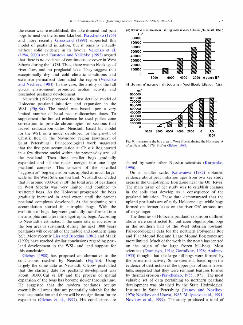
Holocene peatland initiation and expansion in theWSL (Fig. 9a). The model was based upon a verylimited number of basal peat radiocarbon dates. Tosupplement the limited evidence he used pollen zonecorrelation to provide chronologies for sections thatlacked radiocarbon dates. Neustadt based his modelfor the WSL on a model developed for the growth ofChistik Bog in the Novgorod region (southeast ofSaint Petersburg). Palaeoecological work suggestedthat the first peat accumulation at Chistik Bog startedin a few discrete nuclei within the present-day area ofthe peatland. Then these smaller bogs graduallyexpanded and all the nuclei merged into one largepeatland complex. This concept of the so-called‘‘aggressive’’ bog expansion was applied at much largerscale for the West Siberian lowland. Neustadt concludedthat at around 9000 cal yr BP the total area of peatlandsin West Siberia was very limited and confined toscattered bogs. As the Holocene progressed the bogsgradually increased in areal extent until the presentpeatland complexes developed. At the beginning peataccumulation started in eutrophic bogs. With theevolution of bogs they were gradually transformed intomesotrophic and later into oligotrophic bogs. Accordingto Neustadt’s estimates, if the same rate of increase inthe bog area is sustained, during the next 1000 yearspeatlands will cover all of the middle and southern taigabelt. More recently Liss and Berezina (1981) and Malik(1992) have reached similar conclusions regarding peat-land development in the WSL and lend support forthis conclusion.Glebov (1988) has proposed an alternative to the
conclusions reached by Neustadt (Fig. 9b). Usinglargely the same data as Neustadt, Glebov postulatedthat the starting date for peatland development wasabout 10,000Cal yr BP and the process of spatialexpansion of the bogs has become slower through time.He suggested that the modern peatlands occupyessentially all areas that are potentially suitable for thepeat accumulation and there will be no significant futureexpansion (Glebov et al., 1997). His conclusions are
shared by some other Russian scientists (Karpenko,1996).On a smaller scale, Karavaeva (1982) obtained
evidence about peat initiation ages from two key studyareas in the Oligotrophic Bog Zone near the Ob’ River.The main target of her study was to establish changesin the soils that develop as a consequence of thepeatland initiation. These data demonstrated that theupland peatlands are of early Holocene age, while bogsformed on former lakes on the river Ob’ terraces areoften younger.The theories of Holocene peatland expansion outlined
above were constructed for unfrozen oligotrophic bogsin the southern half of the West Siberian lowland.Palaeoecological data for the northern Polygonal Bogand Flat Mound Bog and Large Mound Bog zones aremore limited. Much of the work in the north has centredon the origin of the large frozen hill-bogs. Mostscientists (Dranitsyn, 1914; Gorodkov, 1928; Andreev,1935) thought that the large hill-bogs were formed bythe permafrost activity. Some scientists, based upon theevidence of destruction of the upper part of some frozenhills, suggested that they were remnant features formedby thermal erosion (Piavchenko, 1955, 1971). The mostvaluable set of data pertaining to northern peatlanddevelopment was obtained by the State HydrologicalInstitute in Saint Petersburg (Ivanov and Novikov,1976; Novikov and Usova, 1983; Malyasova et al., 1991;Novikov et al., 1999). The study produced a total of
Fig. 9. Increase in the bog area in West Siberia during the Holocene. A
after Neustadt, 1976; B after Glebov, 1988.
K.V. Kremenetski et al. / Quaternary Science Reviews 22 (2003) 703–723 715
41 radiocarbon dates from large frozen hill-bogs andunfrozen depressions in the northern part of the WSL.Basal dates of peat from the hill-bogs range from 10,300to 6000 cal yr BP. Basal dates from unfrozen depressionsrange from 5400 cal yr BP to 3000 yr BP. The age of theuppermost peat layer on hills is between 100 and 500 calyr BP. The oldest of these radiocarbon dates show thatthe peat accumulation started in the northern part of theWest Siberian Lowland at the same time as in thesouthern part. It is also clear that basal peat in unfrozendepressions is younger than basal peat in the frozenhills. It was concluded that maximum bog developmentand peat accumulation occurred between B9000 and5300 yr BP. Then climate became colder and peataccumulation slowed. During the last 2500 years therate of peatland expansion and peat accumulation hasbeen very low. It was also suggested that larger mound-bogs were formed earlier than the flat mound-bogs,which only date to the last 2500 years.
7. Synthesis of existing peatland radiocarbon dates
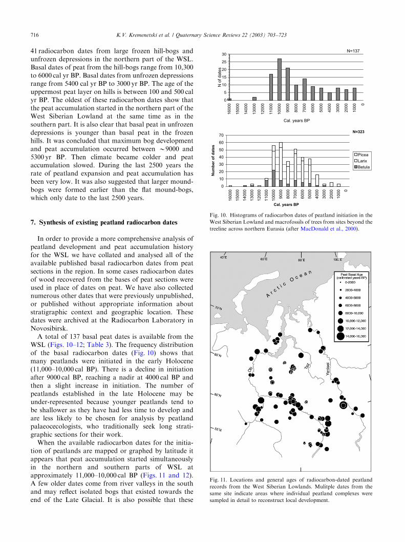
In order to provide a more comprehensive analysis ofpeatland development and peat accumulation historyfor the WSL we have collated and analysed all of theavailable published basal radiocarbon dates from peatsections in the region. In some cases radiocarbon datesof wood recovered from the bases of peat sections wereused in place of dates on peat. We have also collectednumerous other dates that were previously unpublished,or published without appropriate information aboutstratigraphic context and geographic location. Thesedates were archived at the Radiocarbon Laboratory inNovosibirsk.A total of 137 basal peat dates is available from the
WSL (Figs. 10–12; Table 3). The frequency distributionof the basal radiocarbon dates (Fig. 10) shows thatmany peatlands were initiated in the early Holocene(11,000–10,000 cal BP). There is a decline in initiationafter 9000 cal BP, reaching a nadir at 4000 cal BP andthen a slight increase in initiation. The number ofpeatlands established in the late Holocene may beunder-represented because younger peatlands tend tobe shallower as they have had less time to develop andare less likely to be chosen for analysis by peatlandpalaeocecologists, who traditionally seek long strati-graphic sections for their work.When the available radiocarbon dates for the initia-
tion of peatlands are mapped or graphed by latitude itappears that peat accumulation started simultaneouslyin the northern and southern parts of WSL atapproximately 11,000–10,000 cal BP (Figs. 11 and 12).A few older dates come from river valleys in the southand may reflect isolated bogs that existed towards theend of the Late Glacial. It is also possible that these
0
5
10
15
20
25
30
16
00
0
15
00
0
14
00
0
13
00
0
12
00
0
11
00
0
10000
90
00
80
00
70
00
60
00
50
00
40
00
30
00
20
00
10
00 0
N=137
N o
f date
s
Cal. years BP
0
10
20
30
40
50
60
70
16
00
0
15
00
0
14
00
0
13
00
0
12
00
0
11
00
0
10
00
0
90
00
80
00
70
00
60
00
50
00
40
00
30
00
20
00
10
00 0
Picea
Larix
Betula
N=323
Nu
mb
er
of
da
tes
Cal. years BP
Fig. 10. Histograms of radiocarbon dates of peatland initiation in the
West Siberian Lowland and macrofossils of trees from sites beyond the
treeline across northern Eurasia (after MacDonald et al., 2000).
Fig. 11. Locations and general ages of radiocarbon-dated peatland
records from the West Siberian Lowlands. Mulitple dates from the
same site indicate areas where individual peatland complexes were
sampled in detail to reconstruct local development.
K.V. Kremenetski et al. / Quaternary Science Reviews 22 (2003) 703–723716
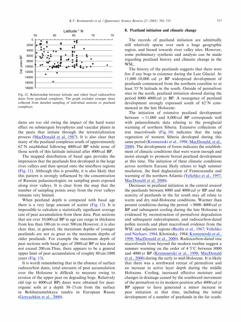
dates are too old owing the impact of the hard watereffect on submergent bryophytes and vascular plants inthe peats that initiate through the terrestrializationprocess (MacDonald et al. 1987). It is also clear thatmany of the peatland complexes south of approximately621N established following 4000 cal BP while none ofthose north of this latitude initiated after 4000 cal BP.The mapped distribution of basal ages provides the
impression that the peatlands first developed in the largeriver valleys and then spread onto the interfluve regions(Fig. 11). Although this is possible, it is also likely thatthis pattern is strongly influenced by the concentrationof Russian palaeoecologists on sampling peats exposedalong river valleys. It is clear from the map that thenumber of sampling points away from the river valleysremains very limited.When peatland depth is compared with basal age
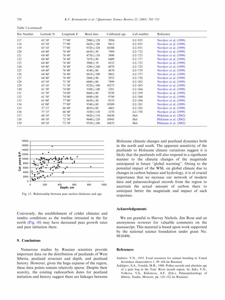
there is a very large amount of scatter (Fig. 13). It isimpossible to calculate a statistically significant averagerate of peat accumulation from these data. Peat sectionsthat are over 10,000 cal BP in age can range in thicknessfrom less than 100 cm to over 500 cm.However, it is alsoclear that, in general, the maximum depths of youngerpeatlands are not as great as the maximum depths ofolder peatlands. For example the maximum depth ofpeat sections with basal ages of 2000 cal BP or less doesnot exceed 200 cm.Thus, there appears to be a generalupper limit of peat accumulation of roughly 80 cm/1000years (Fig. 13).It is worth remembering that in the absence of surface
radiocarbon dates, total amounts of peat accumulationover the Holocene is difficult to measure owing toerosion of the upper peat on degrading bogs. Relativelyold (up to 4000 cal BP) dates were obtained for peat-organic soils at a depth 30–15 cm from the surfacein Bolshsezemelskaya tundra in European Russia(Goryachkin et al., 2000).
8. Peatland initiation and climatic change
The records of peatland initiation are admittedlystill relatively sparse over such a huge geographicregion, and biased towards river valley sites. However,some preliminary synthesis and analysis can be maderegarding peatland history and climatic change in theWSL.The history of the peatlands suggests that there were
few if any bogs in existence during the Late Glacial. At11,000–10,000 cal yr BP widespread development ofpeatlands commenced from the northern coastline to atleast 551N latitude in the south. Outside of permafrostsites in the north, peatland initiation slowed during theperiod 8000–4000 cal yr BP. A resurgence of peatlanddevelopment strongly expressed south of 621N com-menced in the late Holocene.The initiation of extensive peatland development
between B11,000 and 8,000 cal BP corresponds wellwith palaeoclimatic data relating to the postglacialwarming of northern Siberia. Extensive collections oftree macrofossils (Fig. 10) indicates that the taigavegetation of western Siberia developed during thissame period (Krementski et al., 1998; MacDonald, et al.,2000). The development of forest indicates the establish-ment of climatic conditions that were warm enough andmoist enough to promote boreal peatland developmentat this time. The initiation of these climatic conditionsacross northern Eurasia likely relates to high summerinsolation, the final deglaciation of Fennoscandia andwarming of the northern Atlantic (Velichko et al., 1997;MacDonald et al, 2000).Decreases in peatland initiation in the central areasof
the peatlands between 8000 and 4000 cal yr BP and thescarcity of peatlands in the far south may all relate towarm and dry mid-Holocene conditions. Warmer thanpresent conditions during the period B9000–4000 cal yrBP and subsequent cooling during the late Holocene isevidenced by reconstruction of permafrost degradationand subsequent redevelopment, and radiocarbon-datedpollen records and plant macrofossil evidence from theWSL and adjacent regions (Baulin et al., 1967; Velichkoand Nechaev, 1984; Khotinsky, 1984; Kremenetski et al.,1998; MacDonald et al., 2000). Radiocarbon-dated treemacrofossils from beyond the modern treeline suggest asummer warming on the order of 4–51C between 8000and 4000 yr BP (Kremenetski et al., 1998; MacDonaldet al., 2000) during the early to mid-Holocene. It is likelythat there was a northward retreat of permafrost andan increase in active layer depth during the middleHolocene. Cooling, increased effective moisture andchanges in drainage caused by the southward movementof the permafrost to its modern position after 4000 cal yrBP appear to have generated a minor increase inpeat initiation at that time, including the initialdevelopment of a number of peatlands in the far south.
0
2000
4000
6000
8000
10000
12000
14000
16000
18000
55 60 65 70 75
Latitude ° N
Ca
l. y
ea
rs B
P
Fig. 12. Relationship between latitude and oldest basal radiocarbon
dates from peatland complexes. The graph excludes younger dates
collected from detailed sampling of individual sections or peatland
complexes.
K.V. Kremenetski et al. / Quaternary Science Reviews 22 (2003) 703–723 717

Table 3
Published and unpublished radiocarbon dates of peatland intitiation from the West Siberian Lowland
Site Number Latitude N Longitude E Basal date Calibrated age Lab number Reference
1 611 350 731 200 7870760 8572 TA-521 Liss and Berezina (1981)
2 601 500 761 500 7860770 8566 TA-520 Liss and Berezina (1981)
5 601 100 721 500 8140780 8994 TA-933 Liss and Berezina (1981)
6 601 100 721 500 8900790 9912 TA-934 Liss and Berezina (1981)
7 581 000 731 300 7740770 8460 TA-506 Liss and Berezina (1981)
8 591 220 681 570 92807200 10247 Neustadt, (1967)
9 581 460 681 450 90007100 9979 SOAN-395 Volkov, Gurtovaya et al. (1973)
10 601 200 781 240 92007100 10177 KRIL-88 Glebov et al. (1974); Glebov (1988)
11 581 400 811 300 7260760 8030 TA-666 Liss and Berezina (1981)
12 561 150 841 000 5660780 6417 TA-911 Liss and Berezina (1981)
13 561 150 841 000 1930760 1870 TA-910 Liss and Berezina (1981)
14 561 150 841 000 1580760 1457 TA-909 Liss and Berezina (1981)
15 581 350 761 300 6120780 7000 TA-618 Liss and Berezina (1981)
16 561 300 831 300 6070790 6895 TA-598 Liss and Berezina (1981)
17 561 300 831 300 3380780 3626 TA-907 Liss and Berezina (1981)
18 561 300 831 300 2610770 2748 TA-906 Liss and Berezina (1981)
19 561 300 831 300 1640770 1531 TA-905 Liss and Berezina (1981)
20 561 300 831 300 440780 504 TA-904 Liss and Berezina (1981)
21 551 200 791 400 4350770 4868 TA-596 Liss and Berezina (1981)
22 551 200 791 400 2140780 2122 TA-597 Liss and Berezina (1981)
23 571 841400 50407115 5796 SOAN-77 Firsov et al. (1985)
24 601550 761350 8780735 9740 SOAN-173 Firsov et al. (1985)
Neustadt and Selikson, (1971)
25 601370 751200 8600795 9521 SOAN-186 Firsov et al. (1985)
Neustadt et al. (1974)
26 561490 841350 8370765 9300 SOAN-337-T Firsov et al. (1985)
Arkhipov and Votakh, (1980)
27 581200 831300 7890790 8594 SOAN-351 Firsov et al. (1985)
28 581200 831300 51507120 5914 Mo-467 Khotinsky, (1977)
29 561520 831050 57607130 6544 Mo-434 Khotinsky, (1977)
30 561520 831050 45707170 5295 Mo-433 Khotinsky, (1977)
31 651410 641250 84007100 9410 SOAN-654 Firsov et al. (1985)
32 611300 761550 8010740 8853 SOAN-777 Neustadt et al. (1974)
33 631350 651150 66007100 7450 SOAN-687 Firsov et al. (1985)
34 691570 831350 80207105 8954 SOAN-62 Firsov et al. (1974, 1985)
35 671030 851590 8720785 9720 SOAN-611 Levina and Sukhorukova, (1976)
Firsov et al. (1985)
36 661420 791440 9200760 10167 CAMS-2428 Peteet et al. (1998)
37 661480 651460 9370740 10359 SOAN-3105 Koshkarova et al. (1999)
38 601300 861400 87657120 9745 KRIL-717 Karpenko, (1996)
39 601400 891300 90257180 9985 KRIL-719 Karpenko, (1996)
40 591230 761540 95107140 10576 KRIL-430 Glebov et al. (1997)
42 671260 861350 94807120 10550 GIN- Kind, (1974)
Levkovskaya et al. (1970)
44 691300 861 6280770 7195 KRIL-132 Starikov and Zhidovlenko, (1975)
45 621520 881080 4925745 5649 KRIL-290 Koshkarova (1981)
48 601230 901000 39507300 4410 KRIL-240 Starikov and Zhidovlenko (1981)
49 541500 831010 87107105 9700 SOAN-1860 Firsov et al. (1982)
50 601200 781070 2480730 2585 SOAN-1183 Arkhipov et al. (1980)
51 631400 651500 6300750 7205 SOAN-968 Arkhipov et al. (1980)
52 561200 841340 96257100 10720 TA-1137 Piavchenko et al. (1973)
Piavchenko, (1985)
53 541560 811000 5490740 6291 SOAN-2176 Levina et al. (1987); Orlova, (1990)
54 601310 771400 9255720 10246 KRIL-325 Glebov, (1988)
55 681200 711200 9230750 10172 GIN-2479 Vasilchuk et al. (1983)
56 691230 72133 89607140 9967 MGU-816 Vasilchuk et al. (1983)
57 731400 701050 85007120 9460 LU-1151 Vasilchuk et al. (1983)
58 671050 681300 76907110 8414 LU-1081 Vasilchuk et al. (1983)
60 681250 711000 55507150 6309 BasgGI-63 Vasilchuk et al. (1983)
61 681210 711530 49907250 5726 BasgGI-62 Vasilchuk et al. (1983)
62 681210 711530 49007250 5630 BasgGI-67 Vasilchuk et al. (1983)
K.V. Kremenetski et al. / Quaternary Science Reviews 22 (2003) 703–723718
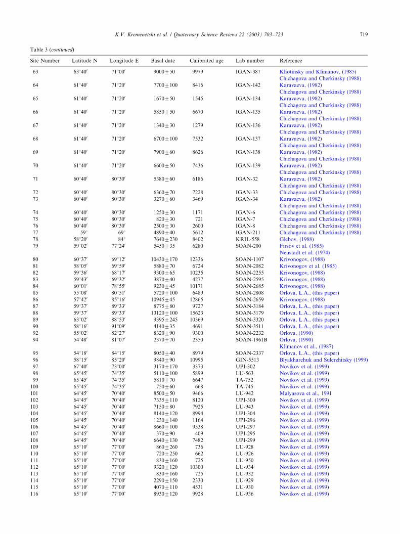
Table 3 (continued)
Site Number Latitude N Longitude E Basal date Calibrated age Lab number Reference
63 631400 711000 9000750 9979 IGAN-387 Khotinsky and Klimanov, (1985)
Chichagova and Cherkinsky (1988)
64 611400 711200 77007100 8416 IGAN-142 Karavaeva, (1982)
Chichagova and Cherkinsky (1988)
65 611400 711200 1670750 1545 IGAN-134 Karavaeva, (1982)
Chichagova and Cherkinsky (1988)
66 611400 711200 5850750 6670 IGAN-135 Karavaeva, (1982)
Chichagova and Cherkinsky (1988)
67 611400 711200 1340730 1279 IGAN-136 Karavaeva, (1982)
Chichagova and Cherkinsky (1988)
68 611400 711200 67007100 7532 IGAN-137 Karavaeva, (1982)
Chichagova and Cherkinsky (1988)
69 611400 711200 7900760 8626 IGAN-138 Karavaeva, (1982)
Chichagova and Cherkinsky (1988)
70 611400 711200 6600750 7436 IGAN-139 Karavaeva, (1982)
Chichagova and Cherkinsky (1988)
71 601400 801300 5380760 6186 IGAN-32 Karavaeva, (1982)
Chichagova and Cherkinsky (1988)
72 601400 801300 6360770 7228 IGAN-33 Chichagova and Cherkinsky (1988)
73 601400 801300 3270760 3469 IGAN-34 Karavaeva, (1982)
Chichagova and Cherkinsky (1988)
74 601400 801300 1250730 1171 IGAN-6 Chichagova and Cherkinsky (1988)
75 601400 801300 820730 721 IGAN-7 Chichagova and Cherkinsky (1988)
76 601400 801300 2500730 2600 IGAN-8 Chichagova and Cherkinsky (1988)
77 591 691 4890740 5612 IGAN-211 Chichagova and Cherkinsky (1988)
78 581200 841 76407230 8402 KRIL-558 Glebov, (1988)
79 591020 771240 5450735 6280 SOAN-200 Firsov et al. (1985)
Neustadt et al. (1974)
80 601370 691120 104307170 12336 SOAN-1107 Krivonogov, (1988)
81 581050 691590 5880770 6724 SOAN-2082 Krivonogov et al. (1985)
82 591360 681170 9300765 10235 SOAN-2255 Krivonogov, (1988)
83 591430 691320 3870740 4277 SOAN-2595 Krivonogov, (1988)
84 601010 781550 9230745 10171 SOAN-2685 Krivonogov, (1988)
85 551080 801510 57207100 6489 SOAN-2808 Orlova, L.A., (this paper)
86 571420 851160 10945745 12865 SOAN-2659 Krivonogov, (1988)
87 591370 891330 8775780 9727 SOAN-3184 Orlova, L.A., (this paper)
88 591370 891330 131207100 15623 SOAN-3179 Orlova, L.A., (this paper)
89 631020 881530 93957245 10369 SOAN-3320 Orlova, L.A., (this paper)
90 581160 911090 4140735 4691 SOAN-3511 Orlova, L.A., (this paper)
92 551020 821270 8320790 9300 SOAN-2232 Orlova, (1990)
94 541480 811070 2370770 2350 SOAN-1961B Orlova, (1990)
Klimanov et al., (1987)
95 541180 841150 8050740 8979 SOAN-2337 Orlova, L.A., (this paper)
96 581150 851200 9840790 10995 GIN-5513 Blyakharchuk and Sulerzhitsky (1999)
97 671400 731000 31707170 3373 UPI-302 Novikov et al. (1999)
98 651450 741350 51107100 5899 LU-563 Novikov et al. (1999)
99 651450 741350 5810770 6647 TA-752 Novikov et al. (1999)
100 651450 741350 750760 668 TA-745 Novikov et al. (1999)
101 641450 701400 8500750 9466 LU-942 Malyasova et al., 1991
102 641450 701400 73357110 8120 UPI-300 Novikov et al. (1999)
103 641450 701400 7150780 7925 LU-943 Novikov et al. (1999)
104 641450 701400 81407120 8994 UPI-304 Novikov et al. (1999)
105 641450 701400 12307140 1164 UPI-296 Novikov et al. (1999)
106 641450 701400 86607100 9538 UPI-297 Novikov et al. (1999)
107 641450 701400 370790 409 UPI-295 Novikov et al. (1999)
108 641450 701400 66407130 7482 UPI-299 Novikov et al. (1999)
109 651100 771000 8607260 736 LU-928 Novikov et al. (1999)
110 651100 771000 7207250 662 LU-926 Novikov et al. (1999)
111 651100 771000 8307160 725 LU-950 Novikov et al. (1999)
112 651100 771000 93207120 10300 LU-934 Novikov et al. (1999)
113 651100 771000 8307160 725 LU-932 Novikov et al. (1999)
114 651100 771000 22907150 2330 LU-929 Novikov et al. (1999)
115 651100 771000 40707110 4531 LU-930 Novikov et al. (1999)
116 651100 77100’ 89307120 9928 LU-936 Novikov et al. (1999)
K.V. Kremenetski et al. / Quaternary Science Reviews 22 (2003) 703–723 719
Conversely, the establishment of colder climates andtundra conditions as the treeline retreated in the farnorth (Fig. 10) may have decreased peat growth ratesand peat initiation there.
9. Conclusions
Numerous studies by Russian scientists provideimportant data on the distribution of peatlands of WestSiberia, peatland structure and depth, and peatlandhistory. However, given the huge expanse of the region,these data points remain relatively sparse. Despite theirscarcity, the existing radiocarbon dates for peatlandinitiation and history suggest there are linkages between
Holocene climatic changes and peatland dynamics bothin the north and south. The apparent sensitivity of thepeatlands to Holocene climate variations suggest it islikely that the peatlands will also respond in a significantmanner to the climatic changes of the magnitudeanticipated in future ‘‘global warming’’. Owing to thepotential impact of the WSL on global climate due tochanges in carbon balance and hydrology, it is of crucialimportance that we increase our network of moderndata and palaeoecological records from the region toascertain the actual amount of carbon there toanticipate better the magnitude and impact of suchresponses.
Acknowledgements
We are grateful to Harvey Nichols, Jim Rose and ananonymous reviewer for valuable comments on themanuscript. This material is based upon work supportedby the national science foundation under grant No.9818496.
References
Andreev, V.N., 1935. Food resources for animal breeding in Yamal
Sovetskoe olenevodstvo 1, 99–164 (in Russian)
Arkhipov, S.A., Votakh, M.R., 1980. Pollen records and absolute age
of a peat bog in the Tom’ River mouth region. In: Saks, V.N.,
Volkova, V.S., Khlonova, A.F. (Eds.), Palaeopalynology of
Siberia. Nauka, Moscow, pp. 118–122 (in Russian).
Table 3 (continued)
Site Number Latitude N Longitude E Basal date Calibrated age Lab number Reference
117 651100 771000 29007120 2994 LU-935 Novikov et al. (1999)
118 651100 771000 84207180 9415 LU-933 Novikov et al. (1999)
119 651100 77100’ 93207320 10300 LU-931 Novikov et al. (1999)
120 641400 761400 6630750 7494 LU-732 Novikov et al. (1999)
121 641400 761400 47507110 5490 LU-723 Novikov et al. (1999)
122 641400 761400 7670790 8409 LU-717 Novikov et al. (1999)
123 64140’ 761400 3900770 4323 LU-722 Novikov et al. (1999)
124 64140’ 761400 52807240 6070 LU-725 Novikov et al. (1999)
125 641400 761400 4140780 4670 LU-719 Novikov et al. (1999)
126 641400 761400 88107100 9862 LU-737 Novikov et al. (1999)
127 641400 761400 2860790 2953 LU-736 Novikov et al. (1999)
128 631100 711300 6680780 7499 LU-562 Novikov et al. (1999)
129 631100 711300 92207100 10275 LU-583 Novikov et al. (1999)
130 611300 741000 31007140 3281 LU-564 Novikov et al. (1999)
131 611300 741000 8660780 9538 LU-559 Novikov et al. (1999)
132 611300 741000 8800780 9749 LU-560 Novikov et al. (1999)
133 611000 771000 8650750 9535 LU-584 Novikov et al. (1999)
134 611000 771000 9340780 10309 LU-581 Novikov et al. (1999)
135 571150 661400 4010780 4465 LU-582 Novikov et al. (1999)
136 571150 661400 31807110 3378 LU-738 Novikov et al. (1999)
137 601100 721500 94207110 10430 Hel- Pitk.anen et al. (2002)
138 601100 721500 96407120 10945 Hel- Pitk.anen et al. (2002)
139 601100 721500 95307100 10835 Hel- Pitk.anen et al. (2002)
0
2000
4000
6000
8000
10000
12000
14000
16000
18000
0 200 400 600 800 1000
Depth, cm
Cal. y
ears
B.P
.
Fig. 13. Relationship between peat section thickness and age.
K.V. Kremenetski et al. / Quaternary Science Reviews 22 (2003) 703–723720
Arkhipov, S.A., Levina, T.P., Panychev, V.A., 1980. Pollen records
from two Holocene peat bogs from the Ob’ River valley Middle
and Lower parts. In: Saks, V.N., Volkova, V.S., Khlonova, A.F.
(Eds.), Palaeopalynology of Siberia. Nauka, Moscow, pp. 123–127
(in Russian).
Arkhipov, S.A., Zolnikov, I.D., Volkova, V.S., Krukover, A.A., 1999.
West Siberia. Eopleistocene and Pleistocene. In: Velichko, A.A.
(Ed.), Climate and Environment changes for the last 65,000,000
years. Geos, Moscow, pp. 94–105 (in Russian).
Aselman, I., Crutzen, P.J., 1989. Global distribution of natural
freshwater wetlands and rice paddies, their net primary productiv-
ity, seasonality and possible methane emissions. Journal of
Atmospheric Chemistry 8, 307–358.
Baryshnikov, M.K., 1929. Carex-Hypnum Bogs of the West Vasuga-
nye. Moscow, 37pp. (in Russian).
Baulin, V.V., Belopukhova, E.B., Dubikov, G.I., Shmelev, A.M.,
1967. Geocryology of West Siberian plain. Nauka, Moscow,
214pp. (in Russian).
Baulin, V.V., Velichko, A.A., Danilova, M.S., 1984. Features in the
distribution and formation of permafrost rocks during the
Quaternary. Reports of the 27th International Geological Con-
gress. Vol. 17, Engineering Geology. Nauka, Moscow, pp. 122–129
(in Russian).
Blyakharchuk, T.A., Sulerzhitsky, L.D., 1999. Holocene vegetational
and climatic changes in the forest zone of Western Siberia
according to pollen records from the extrazonal palsa bog
Bugristoye. The Holocene 9, 621–628.
Botch, M.S., Masing, V.V., 1983. Mire ecosystems in the USSR. In:
Gore, A.J.P. (Ed.), Ecosystems of the World, 4B. Mires: Swamp,
Bog, Fen and Moor. Elsevier, Amsterdam, pp. 95–152.
Botch, M.S., Gerasimenko, T.V., Tolchelnikov, Yu, S., 1971. Bogs of
the Yamal Peninsula. Botanicheski Zhurnal 56, 1421–1435.
Botch, M.S., Kobak, K.I., Vinson, T.S., Kolchugina, T.P., 1995.
Carbon pools and accumulation in peatlands of the former Soviet
Union. Global Biogeochemical Cycles 9, 37–46.
Bronzov, A.Y., 1930. Raised bogs of the Narymski Krai (Vasugan
basin) Proceedings of the Peat Institute, Vol. 3, Moscow, 92pp.
(in Russian).
Brown, J., Ferrians, O.J.J., Heginbottom, J.A., Melnikov, E.S., 1997.
International Permafrost Association Circum Arctic Map of
Permafrost and Ground Ice Conditions. US Geological Survey
CircumPacific Map Series, Map CP 45, Scale 1:10,000,000,
Washington, DC, USA.
CAPS, 1998. International Permafrost Association, Data and Infor-
mation Working Group, comp. 1998. Circumpolar Active-Layer
Permafrost System (CAPS), version 1.0. CD ROM. National
Snow and Ice Data Center/World Data Center for Glaciology,
Boulder, CO.
Chichagova, O.A., Cherkinsky, A.E., 1988. Radiocarbon investiga-
tions in geography. Moscow, 79pp. (in Russian)
Davydova, M.I., Rachkovskaya, E.M., 1990. Physical Geography of
the USSR. Vol. 2. Prosveschenie, Moscow, 304pp. (in Russian)
Dranitsyn, D.A., 1914. Secondary podzols and the shift in the podzol
zone in the northern part of the Ob’-Irtysh watershed. Proceedings
of the Dokuchaev Soil Committee, Vol. 2, pp. 33-93. (in Russian).
Efremov, S.P., Efremova, T.T., Melentieva, N.V., 1994. Carbon pool
in bogs. In: Efremov, S.P. (Ed.) Carbon in Forest and Bog
Ecosystems in Russia. Krasnoyarsk. pp. 128–139 (in Russian)
Efremov, S.P., Efremova, T.T., 2001. Present stocks of peat
and organic carbon in bog ecosystems of West Siberia. In: Bleuten,
W., Lapshina, E.D. (Eds.), Carbon Storage and Atmospheric
Exchange by West Siberian Peatlands. Utrecht University, Utrecht,
pp. 73–78.
Faustova, M.A., Velichko, A.A., 1992. Dynamics of the last glaciation
in northern Eurasia. Sveriges Geologiska Unders .okning, Seria Ca
81, 113–118.
Firsov, L.V., Troitski, S.L., Levina, T.P., Panychev, V.A., 1974.
Absolute age and first for the north Siberia standard pollen
diagram of the Holocene peat bog. Bulletin of the Commission for
Quaternary Studies 41, 121–127 (in Russian).
Firsov, L.V., Volkova, V.S., Levina, T.P., Nikolaeva, I.V., Orlova,
L.A., Panychev, V.A., Volkov, I.A., 1982. Stratigraphy, geochro-
nology and a standard spore-pollen diagram of the Holocene
peatbog Gladkoye in Novosibirsk City (Pravye Chemy). In:
Arkhipov, S.A. (Ed.), Problems of the Siberian Pleistocene
Stratigraphy and Palaeogeography. Transactions of the Institute
of Geology and Geophysics, Vol. 521, Novosibirsk, Nauka,
pp. 96–107 (in Russian)
Firsov, L.V., Panychev, V.A., Orlova, L.A., 1985. List of radiocarbon
dates. Novosibirsk, Institute of Geology and Geophysics USSR
Academy of Sciences, 88pp. (in Russian).
Franzen, L.G., 1994. Are wetlands the key to ice-age cycle enigma?
Ambio 23, 300–308.
Frenzel, B., P!ecsi, M.,Velichko, A.A., 1992. Atlas of Paleoclimates and
Paleoenvironments of the Northern Hemisphere, Late Pleisto-
cene—Holocene. Geographical Research Institute, Hungarian
Academy of Sciences, Budapest. Gustav Fischer Verlag, Buda-
pest-Stuttgart, 153pp.
Glebov, F.Z., 1988. Relations of Forest and Bog in the Taiga Belt.
Nauka, Novosibirsk, 183 pp. (in Russian).
Glebov, F.Z., Toleyko, L.S., Starikov, E.V., Zhidovlenko, V.A., 1974.
Palynology and 14C dating of a peat bog from the Aleksandrovsk
district of Tomsk region (middle taiga sub-belt). In: Lavrenko,
E.M. (Ed.), Types of the USSR Bogs and Principles of their
Classification. Nauka, Leningrad, pp. 194–199 (in Russian).
Glebov, F.Z., Karpenko, L.V., Klimanov, V.A., Mindeeva, T.N.,
1997. The Holocene palaeoecology on the Ob’-Vasiugan watershed
after studies of the peat section ‘Vodorazdel’. Ekologya [Ecology]
6, 412–418 (in Russian).
Gordiagin, A.Y., 1901. Data to know about soils and vegetation of
West Siberia. Trudy obschestva estestvoispytatelei pri Kazanskom
Universitete (Proceedings of the Natural Society of the Kazan
University) 34(3), 222 (in Russian).
Gorham, E., 1991. Northern peatlands: role in the carbon cycle and
probable responses to climatic warming. Ecological Applications 1,
182–195.
Gorodkov, B.N., 1928. Large hill bogs and their geographic
distribution. Priroda 6, 599–601 (in Russian).
Gorodkov, B.N., 1932. Permafrost in the Northern Area. Leningrad,
109pp. (Trudy SOPS AN SSSR, Ser. severnaya, vyp. 1)
(in Russian)
Gorodkov, B.N., 1935. Vegetation of the tundra belt of the USSR. In:
Vegetation cover of the USSR. Vol. 1. Izdatelstvo Akademii Nauk
SSSR, Moscow, Leningrad, pp. 297–354. (in Russian)
Goryachkin, S.V., Cherkinsky, A.E., Chichagova, O.A., 2000. The soil
organic carbon dynamics in high latitudes of Eurasia using 14C
data and the impact of potential climate change. In: Lal, R.,
Kimble, J.M., Stewart, B.A. (Eds.), Global Climate Change and
Cold Regions Ecosystems. Advances in Soil Sciences. Lewis
Publishers, Boca Raton, London, New York, Washington,
pp. 145–161.
Govorukhin, V.S., 1933. Vegetation of the summer pasture area of
reindeer. Zemlevedenie 35, 68–92 (in Russian).
Grosswald, M.G., 1998. Late-Weichselian ice sheets in Arctic and
Pacific Siberia. Quaternary International 45/46, 3–18.
Grosswald, M.G., Hughes, T.J., 2002. The Russian component of an
Arctic ice sheet during the Last Glacial Maximum. Quaternary
Science Reviews 21, 121–146.
Ivanov, K.E., Novikov, S.M. (Eds), 1976. Bolota Zapadnoi Sibiri, ikh
stroenie i gidrologicheskiy rezhim. Leningrad, Gidrometeoizdat,
447pp. [Bogs of West Siberia, their structure and hydrology]
(in Russian).
K.V. Kremenetski et al. / Quaternary Science Reviews 22 (2003) 703–723 721
Karavaeva, N.A., 1982. Evolution of Soils and Bog Development.
Moscow, Nauka, 296 pp. (in Russian)
Karpenko, L.V., 1996. Vegetation, peat and carbon accumulation
dynamics in the Toughen basin. Geografia i Prirodnye Resursy 3,
74–81 (in Russian).
Karta bolot Zapadnoi Sibiri, 1970. Moscow Glavnoe Upravlenie
geodesii i Kartografii 1970 [Map of West Siberian wetlands]
(in Russian)
Karta bolot Zapadnoi Sibiri, 1996. Omsk, 1996 [Map of West Siberian
wetlands] (in Russian)
Katz, N.Ya., Katz, S.V., 1948. Stratigraphy of peatlands in the north
of Ob’ valley. Trudy komissii po izucheniu chetvertichnogo perioda
[Proceedings of the Commission for Quaternary Studies] 7 (1),
15–54 (in Russian).
Khotinsky, N.A., 1977. Golotsen severnoi Evrazii [Holocene of
Northern Eurasia]. Moscow, Nauka, 200 pp. (in Russian).
Khotinsky, N.A., Klimanov, V.A., 1985. Radiocarbon age and climate
of the development of peat hills in the Nadym-Kazym watershed in
the Holocene. In: Lopatin, V.D., Yudina, V.F. (Eds.) Voprosy
ekologii rasteni bolot, bolotnykh mestoobitanii i torfianykh
zalezhei [About Ecology of Bog Vegetation, Bog Habitats and
Peatlands] Petrozavodsk, Institute of biology Karelian Branch of
the USSR Academy of Sciences. pp. 132–140. (in Russian)
Kind, N.V., 1974. Geochronology of the Late Antropogene based on
isotope data (Transactions of the Geological Institute of the USSR
Academy of Sciences, Vol. 257). Moscow, Nauka, 255pp.
(in Russian)
Kivinen, E., Pakarinen, P., 1981. Geographical distribution of peat
resources and major peatland complex types in the world. Ann.
Acad. Sci. Fennicae A. III 132, 1–28.
Klimanov, V.A., Levina, T.P., Orlova, L.A., Panychev, V.A., 1987.
Climate of Barabinskaya plain in Subatlantic period as indicated
by investigation of Suminskoe zaimische bog. Regional Chronol-
ogy of Siberia and far East. Nauka, Novosibirsk, pp. 143–149 (in
Russian)
Koshkarova, V.L., 1975. Holocene flora of south taiga in Middle
Siberia. In: Savina, L.N. (Ed.), Holocene History of Siberian
Forests Krasnoyarsk, pp. 96–101 (in Russian).
Koshkarova, V.L., 1981. History of taiga forests evolution in the
Yenissey River basin (based on macrofossils studies). In: Savina,
L.N. (Ed.), Palaeobotanic Investigations in Forests of Northern
Asia. Novosibirsk, Nauka, pp. 5–30 (in Russian).
Koshkarova, V.L., Kutafieva, T.K., Zhidovlenko, V.A., Starikov,
E.V., 1975. Investigation of a peatland in the surrounding of
Igarka. In: Savina, L.N. (Ed.) Holocene history of Siberian forests
Krasnoyarsk, pp. 60–71 (in Russian).
Koshkarova, V.L., Karpenko, L.V., Orlova, L.A., 1999. Vegetation
and upper tree-line dynamics in Holocene on the Polar Ural.
Ekologya 6, 121–125 (in Russian).
Kremenetski, C.V., Tarasov, P.E., Cherkinsky, A.E., 1997. Postglacial
development of Kazakhstan pine forests. Geographie Physique et
Quaternaire 51, 395–409.
Kremenetski, C., Vaschalova, T., Goriachkin, S., Cherkinsky, A.,
Sulerzhitsky, L., 1997. Holocene pollen stratigraphy and bog
development in the western part of the Kola Peninsula, Russia.
Boreas 26, 91–102.
Kremenetski, C.V., Sulerzhitsky, L.D., Hantemirov, R., 1998.
Holocene history of the northern range limits of some trees and
shrubs in Russia. Arctic and Alpine Research 30, 317–333.
Krivonogov, S.K., 1988. Stratigraphy and paleogegraphy of lower
Irtysh area during last glacial time after results of palaeobotanic
analysis. Nauka, Novosibirsk, 232 pp. (in Russian)
Krivonogov, S.K., Orlova, L.A., Panychev, V.A., 1985. Seed Flora
and Absolute Age of I Irtysh River Terrace Mesozoic and Cenozoic
Palynostratigraphy of Siberia. Nauka, Novosibirsk, pp. 99–115.
(in Russian)
Levina, T.P., Sukhorukova, S.S., 1976. Palynology of the Holocene
peat bog near Karasino settlement on the Yenisei River. In:
Khlonova, A.F. (Ed.) Studies of the paleophytology of Siberia
(Transactions of the Institute of Geology and Geophysics, v. 322)
Nauka, Moscow, pp. 102–107. (in Russian)
Levina, T.P., Orlova, L.A., Panychev, V.A., Ponomareva, E.A., 1987.
Radiochronometry and pollen stratigraphy of the Holocene peat
bog Kayakskoye zaimische (Barabinskaya forest-steppe). Regional
Geochronology of Siberia and Far East (Transactions of the
Institute of Geology and Geophysics. Vol. 690). Nauka, Novosi-
birsk, pp. 136–143 (in Russian).
Levkovskaya, G.M., Kind, N.V., Zavelsky, F.C., Forova, V.S., 1970.
Absolute age of peat bogs of the Igarka City region and the
division of the West Siberia Holocene. Bulletin of the Commission
for Quaternary Studies 37, 94–101 (in Russian)
Liss, O.L., Berezina, N.A., 1981. Bogs of the West Siberian Lowland.
Moscow University publishing, Moscow, 206pp. (in Russian)
Liss, O.L., Kulikova, G.G., 1967. About the regional classification of
bogs in Tomsk region. Vestnik Moskovskogo Universiteta 4, 87–91
(in Russian).
MacDonald, G.M., Beukens, R.P., Kieser, W.E., Vitt, D.H., 1987.
Comparative radiocarbon dating of terrestrial plant macrofossils
and aquatic moss from the ‘‘ice-free corridor’’ of Western Canada.
Geology 15, 837–840.
MacDonald, G.M., Velichko, A.A., Kremenetski, C.V., Borisova,
O.K., Goleva, A.A., Andreev, A.A., Cwynar, L.C., Riding, R.T.,
Forman, S.T., Edwards, T.W.D., Aravena, R., Hammarlund, D.,
Szeicz, J.M., Gataullin, V.N., 2000. Holocene treeline history and
climate change across Northern Eurasia. Quaternary Research 53,
302–311.
Malyasova, E.S., Novikov, S.M., Usova, LI., 1991. Dynamics of peat
accumulation and the formation of palsa mires in the Western
Siberia. Botanicheski zhurnal 9, 1227–1238 (in Russian).
Mangerud, J., Astakhov, V., Svendsen, J.-I., 2002. The extent of the
Barents-Kara ice sheet during the Last Glacial Maximum.
Quaternary Science Reviews 21, 111–119.
Markov, V.D., Olenin, A.S., 1984. (Eds.), The World Peat Resources.
Nedra, Moscow (in Russian).
Neustadt, M.I., 1967. On absolute age of peat bogs of Western Siberia.
Revue roumaine de biologie, serie de botanique 12 (2-3), 181–186
(in Russian).
Neustadt, M.I., 1971. The world natural phenomenon - bogs of
the west Siberian lowland. Izvestia AN SSSR, Seria Geografia 1,
21–34.
Neustadt, M.I., 1984. Holocene peatland development. In: Velichko,
A.A. (Ed.), Late Quaternary Environments of the Soviet Union.
University of Minnesota Press, Minneapolis, pp. 201–206.
Neustadt, M.I., Selikson, E.M., 1971. Neue Angaben zur Stratigraphie
der Torfmoore Westsibiriens. Acta Agralia Fennica 123, 27–32.
Neustadt, M.I., Firsov, L.V., Panychev, V.A., Orlova, L.A., 1974.
Some peculiarities of Holocene processes in Western Siberia.
Geoforum, Oxford 24, 17–25.
Novikov, S.M., Usova, L.I., 1983. Origins of large hill bogs in West
Siberia. Trudy gosudarstvennogo gidrologicheskogo instituta,
Leningrad 303, 11–16 (in Russian).
Novikov, S.M., Usova, L.I., Malyasova, E.S., 1999. Age and dynamics
of bogs in west Siberia. In: Vompersky, S.E, Sirin, A.A. (Eds.),
Bolota i zabolochennye lesa v svete zadach ustoichivogo prirodo-
polzovaniya. GEOS, Moscow, pp. 72–76 (in Russian).
Orlova, L.A., 1990. Golotsen Baraby. Nauka, Novosibirsk, 127pp.
(in Russian).
Peteet, D., Andreev, A., Bardeen, W., Mistretta, F., 1998. Long-term
arctic peatland dynamics, vegetation and climate history of the
Pur-taz region, western Siberia. Boreas 27, 575–586.
Piavchenko, N.I., 1955. Bugristye torfianiki. Izdatelstvo Akademii
Nauk SSSR, Moscow, 280 pp. (in Russian).
K.V. Kremenetski et al. / Quaternary Science Reviews 22 (2003) 703–723722
Piavchenko, N.I., 1985. On age of peatbogs and sequences of the
vegetation in the south of West Siberia. Bulletin of the Commission
for Quaternary Studies 52, 164–170 (in Russian).
Piavchenko, N.I., Fedotov, S.S., 1967. Environment of the forest-
tundra in Taz-Yenisei watershed. In: Rastitelnost lesotundry i ee
osvoenie. Nauka, Leningrad, pp. 15–37 (in Russian).
Piavchenko, N.I., Meteltseva, E.P., Kozlovskaya, L.S., Gorlova, R.N.,
1973. Holocene palaeogeography in the south of West Siberia after
the complex studies of peatlands. In: Tikhomirov, B.A. (Ed.),
Problemy biogeotsenologii, geobotaniki i botanicheskoi geografii.
Nauka, Leningrad, pp. 207–218 (in Russian).
Pitk.anen, A., Turunen, J., Tahvanainen, T., Tolonen, K., 2002.
Holocene vegetation history from the Salym-Yugan Mire Area,
West Siberia. The Holocene 12, 353–362.
Praslov, N.D., 1984. Paleolithic cultures in the Late Pleistocene. In:
Velichko, A.A. (Ed.), Late Quaternary Environments of the Soviet
Union. University of Minnesota Press, Mineapolis, pp. 313–318.
Sabo, E.D., Ivanov, Yu.N., Shatillo, D.A., 1981. Handbook of a
specialist in Hydromelioration of Forest. Lesnaya Promyshlennost,
Moscow, 200pp. (in Russian).
Starikov, E.V., Zhidovlenko, V.A., 1975. Radiocarbon dates of the
laboratory of the history of forests in Siberia and Far East In:
Savina, L.N. (Ed.), Istoria lesov Sibiri v golotsene Krasnoyarsk,
pp. 178–182 (in Russian).
Starikov, E.V., Zhidovlenko, V.A., 1981. Radiocarbon dates of
Holocene samples from Central and East Siberia (index KRIL).
In: Savina, L.N. (Ed.), Paleobotanicheskie issledovania v lesakh
Severnoi Asii. Nauka, Novosibirsk, pp. 178-182 (in Russian).
Tiuremnov, S.N., 1976. Peat Deposits. Nedra, Moscow, 487pp. (in
Russian)
Tyrtikov, A.P., 1969. The influence of the vegetation on the land
frosting and melting. Izdatelstvo Moskovskogo Universiteta,
Moscow, 192pp. (in Russian).
Vasilchuk, YUK, Petrova, E.A., Serova, A.K., 1983. Some features of
the Yamal paleogeography in Holocene. Bulletin of the Commis-
sion for Quaternary Studies 52, 73–89 (in Russian).
Velichko, A.A., Isaeva, L.L., Makeyev, V.M., Matishov, G.G.,
Faustova, M.A., 1984. Late Pleistocene Glaciation of the Arctic
Shelf, and the Reconstruction of Eurasian Ice Sheets. In: Velichko,
A.A. (Ed.), Late Quaternary environments of the Soviet Union.
University of Minnesota Press, Minneapolis, pp. 35–41.
Velichko, A.A., Nechaev, V.P., 1984. Late Pleistocene Permafrost in
European USSR. In: Velichko, A.A. (Ed.), Late Quaternary
Environments of the Soviet Union. University of Minnesota Press,
Minneapolis, pp. 79–86.
Velichko, A.A., Andreev, A.A., Klimanov, V.A., 1997. Climate
and vegetation dynamics in the tundra and forest zone during
the Late Glacial and Holocene. Quaternary International 41/42,
71–96.
Velichko, A.A., Kononov, Yu.M., Faustova, M.A., 2000. Geochro-
nology, distribution and ice volume on the earth during the Last
Glacial Maximum: inferences from new data. Stratigraphy,
Geological Correlation 8, 1–12.
Volkov, V.S., Gurtovaya, Ye.Ye., Firsov, L.V., Panychev, V.A.,
Orlova, L.A., 1973. Structure, age and history of development of
the Holocene peat-bog near Gorno-Slinkino village on the Irtysh
River. In: Sachs, V.N. (Ed.), Pleistotsen Sibiri i smezhnykh
oblastei. Nauka, Moscow, pp. 34–39 (in Russian).
Volkov, I.A., Oliunin, V.N., 1993. West Siberia Introduction. In:
Velichko, A.A. (Ed.), Evolution of Environment and Climate in
Northern Eurasia Part 1. Regional paleogeography, Nauka,
Moscow, pp. 27–28 (in Russian).
Vompersky, S.E., Ivanova, A.I., Tsyganova, O.P., Valiaeva, N.A.,
Glukhova, T.V., Dubinin, F.I., Markelova, L.G., 1994. Boggy soils
and bogs in Russia and their carbon pool. Pochvovedenie 12, 17–25
(in Russian).
Vompersky, S.E., Tsyganova, O.P., Kovalev, A.G., Glukhova, T.V.,
Valiaeva, N.A., 1999. Wetlands in Russia as a carbon sink In:
Zavarzin, G.A. (Ed.), Global Changes of Environment and
Climate, Moscow, pp. 124–145. (in Russian)
Walter, H., 1984. Vegetation of the Earth and Ecological Systems of
the Geo-biosphere, 3rd edition. Springer-Verlag, New York,
318pp.
Zhilinsky, I.I., 1907. Description of hydrotechnical works in the
area of the Siberian railroad to insure water supply for settlements
in the Ishim steppe and to drain bogs in the Baraba forest-steppe
(1895–1904). Saait-Petersburg, 829pp. (in Russian)
Zhulidov, A.V., Headley, J.V., Robarts, R.D., Nikanorov,
A.M.,Ischenko, A.A., 1997. Atlas of Russian Wetlwnds -
Biogeography and Metal Concentrations. National Water Re-
search Institute, Environment Canada, Saskatoon, SK, Canada,
309pp.
K.V. Kremenetski et al. / Quaternary Science Reviews 22 (2003) 703–723 723
Copyright © 2022 FDOKUMEN