pd 26-92-2 rev 2 (F I) e.pdf
163
- -- :.. -.' - . - -' - -' - - - - . - . . - - '-> , • - - - - - - - - - • - : - - ____ - - - •• " - .- - - - - - - ,-' __ 0" - _ .. - -- :.. -.' - . - -' - -' - - - - . - . . - - '-> , • - - - - - - - - - • - : - - ____ - - - •• " - .- - - - - - - ,-' __ 0" - _ ..
-
Upload
khangminh22 -
Category
Documents
-
view
2 -
download
0
Transcript of pd 26-92-2 rev 2 (F I) e.pdf

---
:..
-.'
-.
--'
~ -
~.
-' ~
--
--
. -
. .
--
'-> ,
• -
--
-
~ -
-~
--
-•
-~ :
--
__
__
-
--•• "
-.-
--
--
--
,-'
__
0
" -
_ ~_ .. _~
---
:..
-.'
-.
--'
~ -
~.
-' ~
--
--
. -
. .
--
'-> ,
• -
--
-
~ -
-~
--
-•
-~ :
--
__
__
-
--•• "
-.-
--
--
--
,-'
__
0
" -
_ ~_ .. _~

Landscape ecological survey (1: 100,000) of the Bipindi - Akom II - Lolodorf region, Southwest Cameroon
Landscape ecological survey (1: 100,000) of the Bipindi - Akom II - Lolodorf region, Southwest Cameroon


LANDSCAPE ECOLOGICAL SURVEY (1:100,000) OF THE BIPINDI -AKOM 11 - LOLODORF REGION, SOUTHWEST CAMEROON
B. S. van Gemerden G.W. Hazeu
Tropenbos-Cameroon Documents 1
The Tropenbos-Cameroon Programme, Kribi (Cameroon) DLO Winand Staring Centre, Wageningen (The Netherlands)
1999
LANDSCAPE ECOLOGICAL SURVEY (1:100,000) OF THE BIPINDI -AKOM 11 - LOLODORF REGION, SOUTHWEST CAMEROON
B.S. van Gemerden G.W. Hazeu
Tropenbos-Cameroon Documents 1
The Tropenbos-Cameroon Programme, Kribi (Cameroon) DLO Winand Staring Centre, Wageningen (The Netherlands)
1999

ABSTRACT
Gemerden, van, B.S, G.W. Hazeu, 1999. Landscape Ecological Survey (1:100,000) o/the Bipindi-Akom lI-Lolodorf region, Southwest Cameroon. Wageningen (The Netherlands), Tropenbos-Cameroon Documents 1,212 pp.; 13 Figs; 14 Tables; 81 Refs; 6 Annexes.
In Southwest Cameroon a reconnaissance scale survey of landforms, soils and vegetation was carried out. The survey area covered some 167,000 ha. The altitudinal range was 40 to 1,000 m.a.s.1. Landforms discerned are: mountains, complexes of hills, isolated hills, hilly and rolling uplands, dissected erosional plains, and floodplains. Four soil types were described, ranging from well drained very clayey soils (in the mountain area) to very poorly to poorly drained soils (on valley bottoms). The seven main vegetation types include four types of primary to old secondary rain forest (bound to different altitudinal zones), young secondary forest, swamp forest, and secondary shrubland. The patterns of landforms, soil types, and vegetation types are integrated into one 'landscape ecological' map (scale 1: 100,000). The legend has a hierarchical structure. It is based primarily on a subdivision in four altitudinal zones, secondly on landform, and finally on the degree of disturbance of the natural vegetation by shifting cultivation.
Keywords: Africa, reconnaissance survey, rain forest, landforms, tropical soils, vegetation, altitudinal zonation.
(1)1999 DLO Winand Staring Centre for Integrated Land, Soil and Water Research (SC-DLO) and the Tropenbos Foundation
ISSN: 1566-2152
No part of this publication may be reproduced or published in any form or by any means, or stored in a data base or retrieval system, without the written permission of the DLO Winand Staring Centre or the Tropenbos Foundation.
The Tropenbos Foundation and SC-DLO assume no liability for any loss resulting from the use of this report.

CONTENTS page
PREFACE .................................................... 9
SUMMARy .................................................. 11
1. INTRODUCTION ............................................ 13 1.1 Forest Land Inventory and Land Evaluation Project (Lul) ............... 13 1.2 Research objectives ........................................ 13 1. 3 Course of the study ........................................ 13 1.4 Report outline . . . . . . . . . . . . . . . . . . . . . . . . . . . . . . . . . . . . . . . . . . .. 14
2. STUDY AREA. . . . . . . . . . . . . . . . . . . . . . . . . . . . . . . . . . . . . . . . . . . . . .. 15 2.1 Location and infrastructure ................................... 15 2.2 Climate ................................................ 15 2.3 Hydrology ... . . . . . . . . . . . . . . . . . . . . . . . . . . . . . . . . . . . . . . . . . .. 17 2.4 Geology................................................ 18 2.5 Geomorphology ........................................... 20 2.6 Soils ....... . . . . . . . . . . . . . . . . . . . . . . . . . . . . . . . . . . . . . . . . . .. 20 2.7 Vegetation .............................................. 21 2.8 Wildlife ................................................ 23 2.9 Population .............................................. 23 2.10 Land-use ............................................... 24
3. METHODOLOGY . . . . . . . . . . . . . . . . . . . . . . . . . . . . . . . . . . . . . . . . . . .. 27 3.1 Landscape ecological approach . . . . . . . . . . . . . . . . . . . . . . . . . . . . . . . .. 27 3.2 Aerial photo interpretation .................................... 27 3.3 Fieldwork............................................... 28
3.3.1 General ............................................ 28 3.3.2 Landform and soil ..................................... 29 3.3.3 Vegetation .......................................... 30
3.4 Classification .. ............................. ,............. 32 3.5 Legend and map compilation .................................. 33
4. LANDFORMS . . . . . . . . . . . . . . . . . . . . . . . . . . . . . . . . . . . . . . . . . . . . . .. 35 4.1 Literature review .......................................... 35 4.2 Landform classification 35
4.2.1 Dissected erosional plains (pd) ............................. 36 4.2.2 Uplands (ul and u2) . . . . . . . . . . . . . . . . . . . . . . . . . . . . . . . . . . .. 36 4.2.3 Hills (hI and h2) ...................................... 37 4.2.4 Mountains (m) . . . . . . . . . . . . . . . . . . . . . . . . . . . . . . . . . . . . . . .. 37 4.2.5 Valley Bottoms (v) ..................................... 38
5. SOILS .................................................... 39 5.1 Literature review . . . . . . . . . . . . . . . . . . . . . . . . . . . . . . . . . . . . . . . . . . 39 5.2 Soil types and classification ., ................................. 40
5.2.1 Nyangong soils ....................................... 41 5.2.2 Ebom soils .......................................... 41 5.2.3 Ebimimbang soils .................... -.................. 42
5
CONTENTS page
PREFACE .................................................... 9
SUMMARy .................................................. 11
1. INTRODUCTION ............................................ 13 1.1 Forest Land Inventory and Land Evaluation Project (Lul) ............... 13 1.2 Research objectives ........................................ 13 1. 3 Course of the study ........................................ 13 1.4 Report outline . . . . . . . . . . . . . . . . . . . . . . . . . . . . . . . . . . . . . . . . . . .. 14
2. STUDY AREA. . . . . . . . . . . . . . . . . . . . . . . . . . . . . . . . . . . . . . . . . . . . . .. 15 2.1 Location and infrastructure ................................... 15 2.2 Climate ................................................ 15 2.3 Hydrology ... . . . . . . . . . . . . . . . . . . . . . . . . . . . . . . . . . . . . . . . . . .. 17 2.4 Geology................................................ 18 2.5 Geomorphology ........................................... 20 2.6 Soils ....... . . . . . . . . . . . . . . . . . . . . . . . . . . . . . . . . . . . . . . . . . .. 20 2.7 Vegetation .............................................. 21 2.8 Wildlife ................................................ 23 2.9 Population .............................................. 23 2.10 Land-use ............................................... 24
3. METHODOLOGY . . . . . . . . . . . . . . . . . . . . . . . . . . . . . . . . . . . . . . . . . . .. 27 3.1 Landscape ecological approach . . . . . . . . . . . . . . . . . . . . . . . . . . . . . . . .. 27 3.2 Aerial photo interpretation .................................... 27 3.3 Fieldwork............................................... 28
3.3.1 General ............................................ 28 3.3.2 Landform and soil ..................................... 29 3.3.3 Vegetation .......................................... 30
3.4 Classification ...............................,............. 32 3.5 Legend and map compilation .................................. 33
4. LANDFORMS . . . . . . . . . . . . . . . . . . . . . . . . . . . . . . . . . . . . . . . . . . . . . .. 35 4.1 Literature review .......................................... 35 4.2 Landform classification 35
4.2.1 Dissected erosional plains (pd) ............................. 36 4.2.2 Uplands (ul and u2) . . . . . . . . . . . . . . . . . . . . . . . . . . . . . . . . . . .. 36 4.2.3 Hills (hI and h2) ...................................... 37 4.2.4 Mountains (m) . . . . . . . . . . . . . . . . . . . . . . . . . . . . . . . . . . . . . . .. 37 4.2.5 Valley Bottoms (v) . . . . . . . . . . . . . . . . . . . . . . . . . . . . . . . . . . . .. 38
5. SOILS .................................................... 39 5.1 Literature review . . . . . . . . . . . . . . . . . . . . . . . . . . . . . . . . . . . . . . . . .. 39 5.2 Soil types and classification ., ................................. 40
5.2.1 Nyangong soils ....................................... 41 5.2.2 Ebom soils .......................................... 41 5.2.3 Ebimimbang soils .................... -.................. 42
5

5.2.4 Valley Bottom soils .................................... 42 5.2.5 Soil classification ...................................... 43
5.3 Soil physical characteristics ................................... 45 5.3.1 Texture ............................................ 45 5.3.2 Bulk density ......................................... 46 5.3.3 Water retention ....................................... 47
5.4 Soil chemical characteristics . . . . . . . . . . . . . . . . . . . . . . . . . . . . . . . . . . . 47 5.4.1 pH and exchangeable acidity .............................. 47 5.4.2 Organic carbon and total nitrogen ........................... 48 5.4.3 Available and total phosphorous ............................ 50 5.4.4 Cation exchange capacity and exchangeable bases ................. 50 5.4.5 Clay mineralogy ...................................... 51 5.4.6 Nutrient contents ...................................... 52 5.4.7 Conclusions ......................................... 53
5.5 Soil-Iandform relationships and soil genesis ......................... 53 5.5.1 Soil and landform relations ............................... 53 5.5.2 Soil genesis .......................................... 55
6. VEGETATION .............................................. 57 6.1 Literature review . . . . . . . . . . . . . . . . . . . . . . . . . . . . . . . . . . . . . . . . .. 57 6.2 Botanical diversity . . . . . . . . . . . . . . . . . . . . . . . . . . . . . . . . . . . . . . . .. 59 6.3 Vegetation classification ..................................... 59 6.4 Plant communities ......................................... 62
6.4.1 Maranthes - Anisophyllea community (I) . . . . . . . . . . . . . . . . . . . . . .. 62 6.4.2 Podococcus - Polyalthia community (IIa) ...................... 64 6.4.3 Strombosia - Polyalthia community (lib) ....................... 64 6.4.4 Diospyros - Polyalthia community (IIc) ........................ 65 6.4.5 Carapa - Mitragyna community (Ill) ......................... 66 6.4.6 Xylopia - Musanga community (IV) . . . . . . . . . . . . . . . . . . . . . . . . .. 67 6.4.7 Macaranga - Chromolaena community (V) ..................... 67
7. LANDSCAPE ECOLOGICAL MAP. . . . . . . . . . . . . . . . . . . . . . . . . . . . . . .. 69 7.1 Legend ................................................ 69 7.2 Land use ............................................... 69 7.3 Land mapping units ........................................ 70
7.3.1 Am: mountains above 700 m asl, well drained soils ............... 70 7.3.2 Ahl: isolated hills above 700 m asl, well drained soils .............. 71 7.3.3 Bh2: complex of hills between 500 and 700 m asl, well drain soils ...... 71 7.3.4 Bh 1: isolated hills between 500 and 700 m asl, well drained soils . . . . . .. 71 7.3.5 Bu2: hilly uplands between 500 and 700 m asl; well drained soils ...... 71 7.3.6 Bul: rolling uplands between 500 and 700 m asl; well drained soils ..... 71 7.3.7 ChI: isolated hills between 350 and 500 m asl, well drained soils ...... 72 7.3.8 Cu2: hilly uplands between 350 and 500 m asl; well drained soils ...... 72 7.3.9 CuI: rolling uplands between 350 and 500 m asl; well drained soils ..... 72 7.3.10 Dhl: isolated hills below 350 m asl, moderately well drained soils . . . .. 73 7.3. 11 Du2: hilly uplands below 350 m asl; moderately well drained soils . . . .. 73 7.3.12 DuI: rolling uplands below 350 m asl; moderately well drained soils ... 73 7.3.13 Dpd: dissected erosional plains below 350 m asl; moderately well drained
soils .............................................. 74 7.3.14 Ev: valley bottom; poorly to very poorly drained soils ............. 74
6

REFERENCES . ............................................... 75
ANNEXES . .................................................. 79 I Landscape ecological map of the Bipindi - Akom rr -Lolodorf region, southwest
Cameroon (1: 100,000) (separate) rr List of aerial photographs 1983 - 1985, 1:20,000 series covering the TCP
research area (Photo sur Inc.) .................................. 81 III Methods for chemical and physical soil analysis . . . . . . . . . . . . . . . . . . . . .. 83 IV Soil profile descriptions and data of analysis ........................ 89 V Vegetation data ......... . . . . . . . . . . . . . . . . . . . . . . . . . . . . . . . .. 139 VI List of bird species observed in the TCP research area. . . . . . . . . . . . . . . .. 161
7

PREFACE
ABOUT TROPENBOS
The Tropenbos Foundation was established in 1988 by the Government of The Netherlands with the objectives to contribute to the conservation and wise use of tropical rain forest by generating knowledge and developing methodologies, and to involve and strengthen local research institutions and capacity in relation to tropical rain forests.
The Tropenbos Programme carries out research on moist tropical forest land at various locations around the world. At present (semi-) permanent research sites are located in Colombia, Guyana, Indonesia, Cote d'Ivoire and Cameroon. At the different locations, research programmes follow an interdisciplinary and common overall approach, with the aim to exchange data and make results mutually comparable.
ABOUT THE TROPENBOS-CAMEROON PROGRAMME AND ITTO PROJECT PD 26/92
The present publication has been produced in the framework of ITTO Project PD 26/92, which is an integral part of the Tropenbos-Cameroon Programme (TCP). The research on which this publication is based, was financed by the International Tropical Timber Organization (ITTO), the Common Fund for Commodities (CFC), the Directorate General for International Cooperation of The Netherlands' Ministry of Foreign Affairs (DGIS), the Tropenbos Foundation and the implementing agencies mentioned below.
The Tropenbos-Cameroon 'Programme was established in 1992 by the Cameroonian Ministry of Environment and Forests (MINEF) and the Tropenbos Foundation. The general objective of TCP is to develop methods and strategies for natural forest management directed at sustainable production of timber and other forest products and services. These methods have to be ecologically sound, socially acceptable and economically viable (Foahom and Jonkers, 1992). TCP consists of fourteen interrelated projects in the fields of ecology, forestry, economy, social sciences, agronomy and soil science. In 1994, ITTO and CFC decided to co-finance six of these projects, which together form ITTO project PD 26/92. The 'Office National de Developpement des Forets' (ONADEF) is the agency responsible towards ITTO and CFC for the implementation of the Project PD 26/92.
The implementing agencies involved in the present study are the Winand Staring Centre for Integrated land, Soil and Water Research (SC-DLO), the 'Institut de la Recherche Agricole pour le Developpement' (lRAD) and Wageningen Agricultural University (WAU).
ACKNOWLEDGEMENTS
The authors wish to thank those who have contributed to the overall land inventory of the TCP research area. We gratefully acknowledge the assistance of the Cameroonian Ministry of Environment and Forests, the Tropenbos Foundation, the 'Office National de Developpement des Forets', the 'Institut de la Recherche Agricole pour le Developpement', the International Tropical Timber Organization, the Common Fund for Commodities, the Winand Staring Centre for
9

Integrated Land, Soil and Water Research, Wageningen Agricultural University and the Directorate General for International Cooperation of The Netherlands' Ministry of Foreign Affairs.
Moreover, we could not go on without mentioning the following persons for their undisputed efforts. First of all we like to thank our supervisors Patrick Hommel and Arie van Kekem of scDLO for their support, encouragement and valuable comments in the different stages of the project.
Messrs. Wim van Driel, Oscar Eyog Matig, Bernard Foahom, Wyb Jonkers and Jean-Paul Mendouga Tsimi of the TCP management team are acknowledged for their administrative, logistic and scientific support.
Maurice Elad, Joseph Ohandza Minkoulou, Dieudonne 'Clindor' Ndoum, Prospere Mefane and Benjamin Nkolo formed the field crew without whom these pages would have been empty. We are greatly indebted to Tom Bakkum and Arnold Bregt (SC-DLO) for successfully initiating the GIS in Kribi. Ms. A. Stoffers is specially mentioned for surveying the northern part of the area. 'Our' students Albert Abana, Bernard Tionjock, Martijn van Gilst, Nienke van Berkum and Fokke de Jong have helped to advance the project in many ways. All TCP researchers, technicians, drivers and administrative personnel are thanked for their cordial collaboration. Martin Zogo should be mentioned twice for dealing with all administrative problems that would have kept us busy for years.
The National Herbarium of Cameroon (Dr. Onana, Dr. Achoungdong, Dr. Sonke Asongonyi and Mr. Mezili), the Limbe Botanic Garden (Mr. Peguy Mbatchou), the Department of Plant Taxonomy of the Wageningen Agricultural University (Dr. Breteler and Dr. Jongkind) and Dr. Duncan Thomas have helped with plant species identification. Mr. Tchuenteu of the IRAD Ekona soil laboratory has conducted the majority of soil analyses. Mr. van Reeuwijk of the International Soil Reference and Information Centre (ISRIC) carried out the clay mineralogy and reference analyses.
10

SUMMARY
This report presents the results of the reconnaissance scale landscape ecological survey of the Tropenbos-Cameroon Programme (TCP) research area in Southwest Cameroon conducted by the Forest Land Inventory and Land Evaluation project (Lul). The main objective of the Lul project is to provide a scientific framework for sustainable land use planning in the TCP research area. Moreover, the Lul project provides a basis for all ecologically oriented research activities within the TCP area and allows for the extrapolation of the research results from sample areas to larger areas in South Cameroon.
In its first phase a survey of landforms, soils and vegetation is conducted at scale 1: 100,000 of the Bipindi - Akom 11- Lolodorf region (167,000 ha). Some 250 soil augerings, 45 soil pits and 125 vegetation releves have been described, covering the most important landscapes. The results of the analysis of landform, soil and vegetation data are presented in this report and on the landscape ecological map. The second phase of the project entails the development of a land evaluation methodology for tropical moist forests in South Cameroon.
Landforms discerned in the TCP research area are mountains, complexes of hills, isolated hills, hilly and rolling uplands, dissected erosional plains, and floodplains. They are classified on basis of slope steepness, slope length, relief intensity and number of interfluves. The mountains, complexes of hills and isolated hills have very steep slopes and high relief intensities, whereas both the uplands and the dissected erosional plains have gentle to moderately steep slopes and low relief intensities. The first landform group is therefore more vulnerable to erosion than the latter.
, The following four soil types are dominating in the research area: well drained very clayey soils: Nyangong soils; well drained clayey soils: the Ebom soils;
- moderately well to well drained sandy loam to sandy clay soils: the Ebimimbang soils; - very poorly to poorly drained soils: the Valley Bottom soils.
The Nyangong and Ebom soils are deeply weathered yellowish brown to strong brown tropical clay soils, low in weatherable minerals and with cation exchange capacities in the (ferralic) B-horizons of less than 16 mell 00 g clay. Their dominant clay minerals are kaolinite. The Nyangong soils have 50-80% clay in the subsoils; the Ebom soils are less heavy with 35-60% clay. Moreover, topsoils of the latter are lighter (20-50% clay) than the subsoils. The Nyangong soils classify as Xanthic Ferralsols, the Ebom soils as Acri-xanthic Ferralsols. The Ebimimbang soils are moderately deep to very deep, yellowish brown, sandy clay loams to sandy clays with lighter textured topsoils. They are classified as Plinthudults and typic Paleudults. The very poorly to poorly drained soils are developed in unconsolidated, stratified, recent alluvium. They are characterized by high groundwater tables, periodic flooding and locally greyish colours. In the FAO-Unesco classification they are classified as Dystric Fluvisols and Gleyic Cambisols.
All soils in the TCP research area have low pHs and are chemically poor. Their physical characteristics are good. Removal of the forest vegetation, e.g. by intensive logging or agriculture, will result in the physical degradation of the soil (decrease in organic matter) and the loss of nutrients stored in the forest vegetation.
Seven distinct 'plant communities' have been identified using a phytosociological approach; the analysis of plot data was carried out with the computer programme TWINSPAN. All vegetation
11
SUMMARY
This report presents the results of the reconnaissance scale landscape ecological survey of the Tropenbos-Cameroon Programme (TCP) research area in Southwest Cameroon conducted by the Forest Land Inventory and Land Evaluation project (Lul). The main objective of the Lul project is to provide a scientific framework for sustainable land use planning in the TCP research area. Moreover, the Lul project provides a basis for all ecologically oriented research activities within the TCP area and allows for the extrapolation of the research results from sample areas to larger areas in South Cameroon.
In its first phase a survey of landforms, soils and vegetation is conducted at scale 1: 100,000 of the Bipindi - Akom 11 - Lolodorf region (167,000 ha). Some 250 soil augerings, 45 soil pits and 125 vegetation releves have been described, covering the most important landscapes. The results of the analysis of landform, soil and vegetation data are presented in this report and on the landscape ecological map. The second phase of the project entails the development of a land evaluation methodology for tropical moist forests in South Cameroon.
Landforms discerned in the TCP research area are mountains, complexes of hills, isolated hills, hilly and rolling uplands, dissected erosional plains, and floodplains. They are classified on basis of slope steepness, slope length, relief intensity and number of interfluves. The mountains, complexes of hills and isolated hills have very steep slopes and high relief intensities, whereas both the uplands and the dissected erosional plains have gentle to moderately steep slopes and low relief intensities. The first landform group is therefore more vulnerable to erosion than the latter.
, The following four soil types are dominating in the research area: well drained very clayey soils: Nyangong soils; well drained clayey soils: the Ebom soils;
- moderately well to well drained sandy loam to sandy clay soils: the Ebimimbang soils; - very poorly to poorly drained soils: the Valley Bottom soils.
The Nyangong and Ebom soils are deeply weathered yellowish brown to strong brown tropical clay soils, low in weatherable minerals and with cation exchange capacities in the (ferralic) B-horizons of less than 16 mell 00 g clay. Their dominant clay minerals are kaolinite. The Nyangong soils have 50-80% clay in the subsoils; the Ebom soils are less heavy with 35-60% clay. Moreover, topsoils of the latter are lighter (20-50% clay) than the subsoils. The Nyangong soils classify as Xanthic Ferralsols, the Ebom soils as Acri-xanthic Ferralsols. The Ebimimbang soils are moderately deep to very deep, yellowish brown, sandy clay loams to sandy clays with lighter textured topsoils. They are classified as Plinthudults and typic Paleudults. The very poorly to poorly drained soils are developed in unconsolidated, stratified, recent alluvium. They are characterized by high groundwater tables, periodic flooding and locally greyish colours. In the FAO-Unesco classification they are classified as Dystric Fluvisols and Gleyic Cambisols.
All soils in the TCP research area have low pHs and are chemically poor. Their physical characteristics are good. Removal of the forest vegetation, e.g. by intensive logging or agriculture, will result in the physical degradation of the soil (decrease in organic matter) and the loss of nutrients stored in the forest vegetation.
Seven distinct 'plant communities' have been identified using a phytosociological approach; the analysis of plot data was carried out with the computer programme TWINSPAN. All vegetation
11

types are defined by floristic composition and the (external) foliage coverage of the species. Interpretation of successional status, overall physiognomy and general site descriptors reveals a strong correlation of the plant communities with altitude and disturbance. The communities discerned are: submontane forest (altitude> 700 m asl), three types of lowland evergreen forest « 350 m asl; 350-500 m asl; 500-700 m asl), swamp forest, young secondary forest and thicket on recently abandoned agricultural fields.
The legend of the 1: 100,000 landscape ecological map is based on altitude, landform, soil and vegetation, and has a hierarchical structure. A total of 14 main mapping units has been discerned. These 14 units have been further subdivided according to vegetation characteristics brought about by human influences (shifting cultivation) into 34 units. The landscape ecological map presents the landscape in its complexity of landforms, soils and vegetation. Cross reference of the inventory data reveals a strong relationship between vegetation, altitude and soils. This supports the notion that natural vegetation can be seen as a response variable to environmental factors such as climate and soil. Since vegetation proves to be correlated with altitude, which is assumed to be related to climatic factors, the latter has been taken as the highest entry of the map' legend. On this basis, the TCP research area is divided into five ecological zones (A-E).
The overall orientation of the ecological zones is NNE-SSW and follows the general orientation of the geological structures in Southwest Cameroon. The landscape of the TCP research area changes considerably from west to east. Altitude rises from approximately 40 to over 1000 m as!. Dissected erosional plains, hilly and rolling uplands dominate the western part of the area whereas complexes of hills and mountains are found solely in the east. Going from west to east the soils change from Ebimimbang to Ebom and Nyangong thereby increasing in clay content. Valley bottoms are found throughout the area but are more frequent and wider in the west. The natural vegetation changes from low altitude evergreen forest with many littoral species to a submontane vegetation with characteristics of cloud forest. Human activities have influenced this gradient by logging and shifting cultivation. Along the main access roads and in the vicinity of villages mosaics are found of actual fields, thickets on recently abandoned fields, young secondary forest and residual patches of tropical moist forest.
12
types are defined by floristic composition and the (external) foliage coverage of the species. Interpretation of successional status, overall physiognomy and general site descriptors reveals a strong correlation of the plant communities with altitude and disturbance. The communities discerned are: submontane forest (altitude> 700 m asl), three types of lowland evergreen forest « 350 m asl; 350-500 m asl; 500-700 m asl), swamp forest, young secondary forest and thicket on recently abandoned agricultural fields.
The legend of the 1: 100,000 landscape ecological map is based on altitude, landform, soil and vegetation, and has a hierarchical structure. A total of 14 main mapping units has been discerned. These 14 units have been further subdivided according to vegetation characteristics brought about by human influences (shifting cultivation) into 34 units. The landscape ecological map presents the landscape in its complexity of landforms, soils and vegetation. Cross reference of the inventory data reveals a strong relationship between vegetation, altitude and soils. This supports the notion that natural vegetation can be seen as a response variable to environmental factors such as climate and soil. Since vegetation proves to be correlated with altitude, which is assumed to be related to climatic factors, the latter has been taken as the highest entry of the map' legend. On this basis, the TCP research area is divided into five ecological zones (A-E).
The overall orientation of the ecological zones is NNE-SSW and follows the general orientation of the geological structures in Southwest Cameroon. The landscape of the TCP research area changes considerably from west to east. Altitude rises from approximately 40 to over 1000 m asl. Dissected erosional plains, hilly and rolling uplands dominate the western part of the area whereas complexes of hills and mountains are found solely in the east. Going from west to east the soils change from Ebimimbang to Ebom and Nyangong thereby increasing in clay content. Valley bottoms are found throughout the area but are more frequent and wider in the west. The natural vegetation changes from low altitude evergreen forest with many littoral species to a submontane vegetation with characteristics of cloud forest. Human activities have influenced this gradient by logging and shifting cultivation. Along the main access roads and in the vicinity of villages mosaics are found of actual fields, thickets on recently abandoned fields, young secondary forest and residual patches of tropical moist forest.
12

1. INTRODUCTION
1.1 FOREST LAND INVENTORY AND LAND EVALUATION PROJECT (LUl)
The Tropenbos Cameroon Programme (TCP) coordinates fourteen interrelated projects in the fields of ecology, forestry, economy, social sciences, agronomy and soil science. This report presents the results of the reconnaissance scale land inventory carried out in the first phase of the research project Lu1, titled 'Forest Land Inventory and Land Evaluation'.
1.2 RESEARCH OBJECTIVES
Detailed and up-to-date information on the abiotic and biotic environment of the TCP research area is a prerequisite for the formulation of a management plan. This information, however, is either non-existent (e.g. hydrology and erosion aspects) or not detailed enough for the present needs (e.g. climate, landforms, soils, land use, vegetation, and wildlife). The Lu 1 project is aimed at filling those gaps, which is essential for sound land use planning.
The general objective of Lu1 is to provide a scientific framework for sustainable land use planning for the TCP research area. This will be realized through the development of a land evaluation methodology for tropical moist forests. Moreover, the Lul project provides a basis for all ecologically oriented research activities within the TCP and permits the extrapolation of the results of TCP research to other areas in South Cameroon.
The first phase of the Lul project entails an integrated reconnaissance scale (1: 100,000) survey on landforms, soils and vegetation. The present report is the result of this integrated survey, delimitating and describing the major landscape ecological units of the TCP area. In the second phase of the Lu1 project a qualitative ecological land evaluation will be conducted, investigating the suitability of each of the landscape ecological units for a number of relevant land-uses.
1.3 COURSE OF THE STUDY
Preliminary work on the interpretation of aerial photographs, including a five-week mission to the study area, was carried out by Mr. Luc Touber of the DLO- Winand Staring Centre for Integrated Land, Soil and Water Research (SC-DLO) (Touber, 1993a; 1993b).
The Directorate General for International Cooperation of The Netherlands' Ministry of Foreign Affairs (DGIS) contracted two associate experts for the Lul project. Mr. G.W. Hazeu, soil scientist, started his work in Cameroon in March 1995. His contract expired in September 1997. In March 1995, DGIS appointed Mr. Barend S. van Gemerden as vegetation surveyor whose contract expired in December 1997. The fieldwork for the landform, soil and vegetation survey was carried out between March 1995 and May 1996. Ms. A. Stoffels carried out the field survey of the northern part in the period April-October 1997.
Overall supervision of the Lu 1 project was provided by senior soil and vegetation experts of SCDLO. Additional assistance was given by a senior GIS expert of the same institute. A total of
13
1. INTRODUCTION
1.1 FOREST LAND INVENTORY AND LAND EVALUATION PROJECT (LUl)
The Tropenbos Cameroon Programme (TCP) coordinates fourteen interrelated projects in the fields of ecology, forestry, economy, social sciences, agronomy and soil science. This report presents the results of the reconnaissance scale land inventory carried out in the first phase of the research project Lu1, titled 'Forest Land Inventory and Land Evaluation'.
1.2 RESEARCH OBJECTIVES
Detailed and up-to-date information on the abiotic and biotic environment of the TCP research area is a prerequisite for the formulation of a management plan. This information, however, is either non-existent (e.g. hydrology and erosion aspects) or not detailed enough for the present needs (e.g. climate, landforms, soils, land use, vegetation, and wildlife). The Lu1 project is aimed at filling those gaps, which is essential for sound land use planning.
The general objective of Lu1 is to provide a scientific framework for sustainable land use planning for the TCP research area. This will be realized through the development of a land evaluation methodology for tropical moist forests. Moreover, the Lul project provides a basis for all ecologically oriented research activities within the TCP and permits the extrapolation of the results of TCP research to other areas in South Cameroon.
The first phase of the Lul project entails an integrated reconnaissance scale (1: 100,000) survey on landforms, soils and vegetation. The present report is the result of this integrated survey, delimitating and describing the major landscape ecological units of the TCP area. In the second phase of the Lu1 project a qualitative ecological land evaluation will be conducted, investigating the suitability of each of the landscape ecological units for a number of relevant land-uses.
1.3 COURSE OF THE STUDY
Preliminary work on the interpretation of aerial photographs, including a five-week mission to the study area, was carried out by Mr. Luc Touber of the DLO- Winand Staring Centre for Integrated Land, Soil and Water Research (SC-DLO) (Touber, 1993a; 1993b).
The Directorate General for International Cooperation of The Netherlands' Ministry of Foreign Affairs (DGIS) contracted two associate experts for the Lul project. Mr. G.W. Hazeu, soil scientist, started his work in Cameroon in March 1995. His contract expired in September 1997. In March 1995, DGIS appointed Mr. Barend S. van Gemerden as vegetation surveyor whose contract expired in December 1997. The fieldwork for the landform, soil and vegetation survey was carried out between March 1995 and May 1996. Ms. A. Stoffels carried out the field survey of the northern part in the period April-October 1997.
Overall supervision of the Lu 1 project was provided by senior soil and vegetation experts of SCDLO. Additional assistance was given by a senior GIS expert of the same institute. A total of
13

four backstopping missions were carried out by SC-DLO during the first phase of the project (Bregt and van Kekem, 1995, Hommel, 1995; Hommel and van Kekem, 1996, 1997).
100 40" E
1 Lolodorf ! •
Bipindi
--')---:----+----''---t1-3° 00" N
AlcomII
10 20lIm I !
Figure 1.1 Location of TCP research area in Southwest Cameroon
1.4 REPORT OUTLINE
The climate, hydrology, geology, geomorphology, soils, vegetation and land use in South-West Cameroon are described in Chapter 2. The inforn.1ation presented is mostly derived from national or regional studies and merely gives a general overview of the physical environment of the TCP area.
To meet the needs of the qualitative ecological land evaluation more detailed information on landforms, soils and vegetation in the TCP area has been collected. Chapter 3 describes the methods used. Special emphasis is placed on the integration of the landform, soil and vegetation survey into what can be described as a broad landscape ecological approach (e.g. Zonneveld, 1995). In Chapters 4,5 and 6 the results of respectively the landform, soil and vegetation survey are presented.
In Chapter 7 the landscape ecological map of the TCP research area (Annex I) is discussed and its units are described as characteristic combinations of landforms, soils and vegetation types.
14
four backstopping missions were carried out by SC-DLO during the first phase of the project (Bregt and van Kekem, 1995, Hommel, 1995; Hommel and van Kekem, 1996, 1997).
10° 40° E I I Lolodorf ! •
Bipindi
--)----:----t---'--1-3° oooN
AlcomII
10 20lIm I !
Figure 1.1 Location of TCP research area in Southwest Cameroon
1.4 REPORT OUTLINE
The climate, hydrology, geology, geomorphology, soils, vegetation and land use in South-West Cameroon are described in Chapter 2. The inforn.1ation presented is mostly derived from national or regional studies and merely gives a general overview of the physical environment of the TCP area.
To meet the needs of the qualitative ecological land evaluation more detailed information on landforms, soils and vegetation in the TCP area has been collected. Chapter 3 describes the methods used. Special emphasis is placed on the integration of the landform, soil and vegetation survey into what can be described as a broad landscape ecological approach (e.g. Zonneveld, 1995). In Chapters 4, 5 and 6 the results of respectively the landform, soil and vegetation survey are presented.
In Chapter 7 the landscape ecological map of the TCP research area (Annex I) is discussed and its units are described as characteristic combinations of landforms, soils and vegetation types.
14

2. STUDY AREA
2.1 LOCATION AND INFRASTRUCTURE
The TCP research area is situated in Southwest Cameroon at approximately 80 km East of Kribi, between r47'-3°14' N, 10°24'-10°51' E. The area is delimitated by the villages of Bipindi, Akom II and Lolodorf (Fig. 1.1). From an administrative point of view the TCP research area is part of the South Province of the Republic of Cameroon and is subdivided into the Departments Ocean and Ntem. The TCP area covers about 1700 km2 which to a large extent coincides with a concession of the Dutch logging company ofWijma-Douala S.A.R.L. (GWZ).
All roads leading to and within the TCP area are dirt roads. Two governmental roads delimit the TCP research area, the Kribi-Bipindi-Lolodorf-Ebolowa road in the northwest and the KribiAkom II-Ebolowa road in the south. Within the area three principal roads are present, two of which having approximately a W-E direction and one a SW-NE direction. In addition many smaller exploitation roads have been constructed. Accessibility of these, however, is variable as maintenance is carried out by the logging companies and ceases once their activities are transferred to other regions. Footpaths connecting villages are found throughout the area. Transport by boat over the rivers is not possible due to the presence of rapids and waterfalls.
2.2 CLIMATE
The climate of Southwest Cameroon is equatorial. Although rainfall occurs throughout the year, two distinct minima and maxima can be distinguished in the annual pattern which are associated with the N-S movements of the Intertropical Convergence Zone over the area. The humid seasons extend from September to November and from April to May, whereas the drier seasons extend from December to March and from June to August. According to the classification system ofK6ppen (1936), the climate of the area is classified as humid tropical (Aw). Such a climate has a mean temperature in the coldest month above 18°C, an average annual temperature of around 25 ° C with little variation between years, and at least one distinct dry season.
Table 2.1 Summary of climatic data for selected stations in Southwest Cameroon (Olivry, 1986)
Climatic data Weather station Kribi Lolodorf Ebolowa
Altitude (m as!) 13 440 609
Mean annual temperature Cc) 26.4 24.6 24.0 Mean annual relative humidity (%) 73-94 n.a. 68-97 Mean annual vapour pressure (mbar) 29.3 n.a. 24.6 Mean annual rainfall (mm) 2836 (±393) 2096 (±286) 1719 (±195) Wind speed below 4 m S·I (% of time) 98 n.a. n.a. Main wind direction SW n.a. W
Kribi n= 45 years; Lolodorf n= 25 years; Ebolowa n= 48 years; n.a. = data not available.
A summary of climatic data of selected stations in the region is presented in Table 2.1. The long term annual mean temperature decreases from West to East, corresponding with an increase in altitude (Olivry, 1986).
15
2. STUDY AREA
2.1 LOCATION AND INFRASTRUCTURE
The TCP research area is situated in Southwest Cameroon at approximately 80 km East of Kribi, between r47'-3 ° 14' N, 10°24'-10°51' E. The area is delimitated by the villages of Bipindi, Akom II and Lolodorf (Fig. 1.1). From an administrative point of view the TCP research area is part of the South Province of the Republic of Cameroon and is subdivided into the Departments Ocean and Ntem. The TCP area covers about 1700 km2 which to a large extent coincides with a concession of the Dutch logging company ofWijma-Douala S.A.R.L. (GWZ).
All roads leading to and within the TCP area are dirt roads. Two governmental roads delimit the TCP research area, the Kribi-Bipindi-Lolodorf-Ebolowa road in the northwest and the KribiAkom II-Ebolowa road in the south. Within the area three principal roads are present, two of which having approximately a W-E direction and one a SW-NE direction. In addition many smaller exploitation roads have been constructed. Accessibility of these, however, is variable as maintenance is carried out by the logging companies and ceases once their activities are transferred to other regions. Footpaths connecting villages are found throughout the area. Transport by boat over the rivers is not possible due to the presence of rapids and waterfalls.
2.2 CLIMATE
The climate of Southwest Cameroon is equatorial. Although rainfall occurs throughout the year, two distinct minima and maxima can be distinguished in the annual pattern which are associated with the N-S movements of the Intertropical Convergence Zone over the area. The humid seasons extend from September to November and from April to May, whereas the drier seasons extend from December to March and from June to August. According to the classification system ofK6ppen (1936), the climate of the area is classified as humid tropical (Aw). Such a climate has a mean temperature in the coldest month above 18°C, an average annual temperature of around 25°C with little variation between years, and at least one distinct dry season.
Table 2.1 Summary of climatic data for selected stations in Southwest Cameroon (Olivry, 1986)
Climatic data Weather station Kribi Lolodorf Ebolowa
Altitude (m asl) 13 440 609
Mean annual temperature Cc) 26.4 24.6 24.0 Mean annual relative humidity (%) 73-94 n.a. 68-97 Mean annual vapour pressure (mbar) 29.3 n.a. 24.6 Mean annual rainfall (mm) 2836 (±393) 2096 (±286) 1719 (±195) Wind speed below 4 m S·I (% of time) 98 n.a. n.a. Main wind direction SW n.a. W
Kribi n= 45 years; Lolodorf n= 25 years; Ebolowa n= 48 years; n.a. = data not available.
A summary of climatic data of selected stations in the region is presented in Table 2.1. The long term annual mean temperature decreases from West to East, corresponding with an increase in altitude (Olivry, 1986).
15

Long-tenn monthly averages of the minimum relative humidity values show little variation, ranging from 70% (March) to 78% (September) at Kribi and from 62% (February) to 74% (August) at Ebolowa (Olivry, 1986).
/ ~ ~ ~ ~ '" 1 I I I
Q) I I
"Cl
.~ § E Q)
.J:: 1:: 0 Z
/ / ~/ " ~ I 0/ ,.,.p---------- \ r ( / /D' ~OIOdoZ "00
I I(/~~\ ~ ~ \ 1: 8i indi+ § Ebom+ M.?oool ~
~imim~~ ean
~ \'?fil M' r.-:. ~-~ofE)) I
Akom II-j- \ #' r;;
10.00 10.20 10.40 10.60 10.80 11.00 11 ~20
Eastern Longitude (0)
Figure 2.1 Rainfall distribution in Southwest Cameroon in the September 1995-August 1996 period (Waterloo et al., 1997).
Annual rainfall totals tend to decrease with increasing distance from the coast. In Fig. 2.1 the results of one year (September 1995-August 1996) observations by the TCP hydrology team are summarized (Waterloo et at., 1997). Observed mean maximum daily rainfall totals decrease correspondingly from 205 mm (n = 33 years) at Kribi to 115 mm (n = 9 years) and 113 mm (n = 34 years) at Lolodorf and Ebolowa, respectively (Franqueville, 1973; Olivry, 1986).
E E .~
ro C .~
600 I ==-k:::: , 27.5
500
400
300
200
100
0
I 1-27
::I······r,i······/·············· f..26. 5 . t:t ..
··············r·l:
26 0 o
25.5 .~ ID .... :J 10 25 ....
24.5 ~
24
23.5
23
E ID ...
[H! In 1::1 11:11::1 11:1 m I j:J H,IIH I Ifm I IITIII:II::I I 1:1 m 11:1 H 11:11:1 122.5 J FMAMJ JASOND
months
\;::>1 Ebolowa 0 Lolodorf j:::>}>1 Kribi
-:ak- Ebolowa -+- Kribi
Figure 2.2 :Vlonthly rainfall and temperature averages for Kribi. Loiodorf and Ebolowa (after Olivry. 1986). Kribi n= -1-5 years; Lolodorfn= 25: Ebolowa n= 48
16
Long-tenn monthly averages of the minimum relative humidity values show little variation, ranging from 70% (March) to 78% (September) at Kribi and from 62% (February) to 74% (August) at Ebolowa (Olivry, 1986).
_ 3.2 ~ Q)
"Cl
.~ § E Q)
.J:: 1:: o Z
10.00 10.20 10.40 10.60 10.80 11.00 11 ~20
Eastern Longitude (0)
Figure 2.1 Rainfall distribution in Southwest Cameroon in the September 1995-August 1996 period (Waterloo et al., 1997).
Annual rainfall totals tend to decrease with increasing distance from the coast. In Fig. 2.1 the results of one year (September 1995-August 1996) observations by the TCP hydrology team are summarized (Waterloo et aI., 1997). Observed mean maximum daily rainfall totals decrease correspondingly from 205 mm (n = 33 years) at Kribi to 115 mm (n = 9 years) and 113 mm (n = 34 years) at Lolodorf and Ebolowa, respectively (Franqueville, 1973; Olivry, 1986).
E E
600 27.5
............................. . ...... : ...... /.1............. 27 26.5
500 ............................................ .
400 .......................................................................... . 26
25.5
............. __ ............ 25 .~ ro 300 .................... ...................... .................... .. .... .
c .~
200 ............................. . ............ : .. . . .
1 00 .............. : ...... ~ .... :
J FMAMJ JASOND months
\:=:>1 Ebolowa 0 Lolodorf j:::>}>1 Kribi
-:ak- Ebolowa -+- Kribi
24.5
24
23.5
23
22.5
0 0
.~ ID .... :J ..... co .... ID 0. E ID .....
Figure 2.2 :Vlonthly rainfall and temperature averages for Kribi. Loiodorf and Ebolowa (after Olivry. 1986). Kribi n= -1-5 years: Lolodorf n= 25: Ebolowa n= 48
16

Long-term averages of monthly rainfall totals of the Kribi, Lolodorf and Ebolowa stations are presented in Fig. 2.2. Due to the geographic position of the TCP research area, the rainfall pattern in the area is likely to resemble those at Lolodorf and Ebolowa, rather than that at Kribi.
Wind speeds are generally low and the direction is predominantly W-SW throughout the year (Dolman and Waterloo, 1995).
The duration of bright sunshine has not been measured at any of the weather stations in South Cameroon. However, the mean daily value of 3.4 h day-! observed at the weather station in Douala is a fair approximation (Dolman and Waterloo, 1995).
2.3 HYDROLOGY
The hydrography of Southwest Cameroon is characterized by a high drainage density as a result of a humid climate and the low permeability of the crystalline rock formations (Franqueville, 1973). The main rivers draining the TCP research area are the Lokoundje, Tchangue, Kienke, Moungue, Biwome, Sonkwe and Messambe. Their flow direction is generally NNE-SSW, following the regional pattern of faulting. Smaller streams have a flow direction essentially perpendicular to the main rivers, resulting in a drainage pattern that has both dendritic and trellised characteristics.
Swampy areas are commonly found in the valleys of the smaller rivers. The soils in these areas , remain waterlogged even during dry periods due to a continuous supply of groundwater from the hill slopes and due to relatively thin valley soils underlain by massive rock of low permeability.
;: Prior to 1995, hydrological studies have not been carried out at any location within the TCP research area. Hydrometric stations of the 'Centre de Recherches Hydrologiques' of the 'Institute de Recherche Geologique et Miniere' (CRH-IRGM) were located in Lolodorf in the Lokoundje river (draining the area north of the TCP research area) and in the Kienke river (partly draining the TCP research area) and the Lobe river (draining the area south of the TCP research area) at Kribi. However, all stations in South Cameroon have been abandoned since 1987 (pers. comm. J.C. Ntonga, 1996).
The discharge patterns of the rivers correspond to the seasonal rainfall pattern with maxima in October and May and minima in August and February (Olivry, 1986). Fig. 2.2 shows the monthly discharges of the Lokoundje, Kienke and Lobe rivers for the 1953 -1977 period.
The average annual discharge of the Lokoundje river (at Lolodorf) amounted to 773 mm, whereas those of the Kienke and Lobe rivers amounted to 1082 mm and 1397 mm, respectively. Rainfall on the Lokoundje basin and the Kienke and Lobe basins could be estimated at 1880 mm and 2425 mm, respectively, resulting in runoff coefficients varying between 41 % for the Lokoundje basin and 45% and 58% for the Kienke and Lobe basins (Olivry, 1986).
Annual evaporation rates obtained with the water balance method varied between 1107 mm for the Lokoundje basin and 1345 mm and 1025 mm for the Kienke and Lobe basins (Olivry, 1986).
The electric conductivity of stream water in the TCP research area is extremely low and varies between 13 IlS cm-! and 28 IlS cm-! in the dry season (Dolman and Waterloo, 1995). On the basis of data collected in one rainy season two EC zones can be discerned, the eastern part of
17
Long-term averages of monthly rainfall totals of the Kribi, Lolodorf and Ebolowa stations are presented in Fig. 2.2. Due to the geographic position of the TCP research area, the rainfall pattern in the area is likely to resemble those at Lolodorf and Ebolowa, rather than that at Kribi.
Wind speeds are generally low and the direction is predominantly W-SW throughout the year (Dolman and Waterloo, 1995).
The duration of bright sunshine has not been measured at any of the weather stations in South Cameroon. However, the mean daily value of 3.4 h day-! observed at the weather station in Douala is a fair approximation (Dolman and Waterloo, 1995).
2.3 HYDROLOGY
The hydrography of Southwest Cameroon is characterized by a high drainage density as a result of a humid climate and the low permeability of the crystalline rock formations (Franqueville, 1973). The main rivers draining the TCP research area are the Lokoundje, Tchangue, Kienke, Moungue, Biwome, Sonkwe and Messambe. Their flow direction is generally NNE-SSW, following the regional pattern of faulting. Smaller streams have a flow direction essentially perpendicular to the main rivers, resulting in a drainage pattern that has both dendritic and trellised characteristics.
Swampy areas are commonly found in the valleys of the smaller rivers. The soils in these areas , remain waterlogged even during dry periods due to a continuous supply of groundwater from the hill slopes and due to relatively thin valley soils underlain by massive rock of low permeability.
;:Prior to 1995, hydrological studies have not been carried out at any location within the TCP research area. Hydrometric stations of the 'Centre de Recherches Hydrologiques' of the 'Institute de Recherche Geologique et Miniere' (CRH-IRGM) were located in Lolodorf in the Lokoundje river (draining the area north of the TCP research area) and in the Kienke river (partly draining the TCP research area) and the Lobe river (draining the area south of the TCP research area) at Kribi. However, all stations in South Cameroon have been abandoned since 1987 (pers. comm. J.c. Ntonga, 1996).
The discharge patterns of the rivers correspond to the seasonal rainfall pattern with maxima in October and May and minima in August and February (Olivry, 1986). Fig. 2.2 shows the monthly discharges of the Lokoundje, Kienke and Lobe rivers for the 1953 -1977 period.
The average annual discharge of the Lokoundje river (at Lolodorf) amounted to 773 mm, whereas those of the Kienke and Lobe rivers amounted to 1082 mm and 1397 mm, respectively. Rainfall on the Lokoundje basin and the Kienke and Lobe basins could be estimated at 1880 mm and 2425 mm, respectively, resulting in runoff coefficients varying between 41 % for the Lokoundje basin and 45% and 58% for the Kienke and Lobe basins (Olivry, 1986).
Annual evaporation rates obtained with the water balance method varied between 1107 mm for the Lokoundje basin and 1345 mm and 1025 mm for the Kienke and Lobe basins (Olivry, 1986).
The electric conductivity of stream water in the TCP research area is extremely low and varies between 13 IlS cm-! and 28 IlS cm-! in the dry season (Dolman and Waterloo, 1995). On the basis of data collected in one rainy season two EC zones can be discerned, the eastern part of
17

the area with low EC values, i.e. 15-30 IlS cm-I, and slightly higher EC values, i.e. 30-50 IlS cm-I, in the west (M.J. Waterloo, pers. comm., 1996). The low EC values may be an indication for low soil nutrient levels in the area.
300~--------------------------------------------~
250 - - - . - - - - - -
~ 200 et)
E i
~ 150 -+ ~ !
c
...c i () I
.~ i -0 100 ' ,
I r
50 I
.,~;
~;:-
1 '.'1
':~ ;.f, ~h) -
;;4
1 :" 11 ~ o ~ • : I' :~
, !
}~
J F M A M J J A S 0 months (average of period 1953 - 1977)
[0 :~koUndje D Kienke Q}J Lobe 1
N D
Figure 2.3 Mean monthly discharge patterns of the Lobe, Kienke and Lokoundje rivers for the period 1953 - 1977 (after OIivry, 1986)
2.4 GEOLOGY
The most detailed information on the geology of Southwest Cameroon is provided by the 'Carte Geologique de Reconnaissance' at a scale of 1 :500,000 (Champetier de Ribes, 1953; sheet Yaounde East). Later publications, e.g. Franqueville (1973), seem to have been derived from the former without significant additional ground surveys (Touber, 1993a). More recent geological research in the region was carried out by the IRGM to establish a possible relation between Cameroon, the western part of the Congo craton and the Sao Francisco craton of Brazil (Toteu et ai., 1994). A geological map of South Cameroon was published recently but does not cover the TCP research area (MINREST and ORSTOM, 1995).
The Precambrian shield is the most important geological structure in Cameroon, and consists for a large part of metamorphic and old volcanic rocks (Franqueville, 1973). The metamorphic rocks consist mainly of gneisses, migmatites, schists and quartzites. Rocks formed in the period
18
the area with low EC values, i.e. 15-30 IlS cm-I, and slightly higher EC values, i.e. 30-50 IlS cm-I, in the west (M.l. Waterloo, pers. comm., 1996). The low EC values may be an indication for low soil nutrient levels in the area.
300 ------------------------------------------------------
250 - - - . - - - - - - - - - - - - - - - - - - - - - - - - - - - - - - - - - - - - - --
~ 200 et)
E C
Q) 150 0) ..... al
...c () Cl)
""0 100
50
0
! i I
i J ! i I
! i I I
I I
1 I I
I J F M A M J J A S 0
months (average of period 1953 - 1977)
I D Lokoundje D Kienke 1};~i:1 Lobe
N D
Figure 2.3 Mean monthly discharge patterns of the Lobe, Kienke and Lokoundje rivers for the period 1953 - 1977 (after OIivry, 1986)
2.4 GEOLOGY
The most detailed information on the geology of Southwest Cameroon is provided by the 'Carte Geologique de Reconnaissance' at a scale of 1:500,000 (Champetier de Ribes, 1953; sheet Yaounde East). Later publications, e.g. Franqueville (1973), seem to have been derived from the former without significant additional ground surveys (Touber, 1993a). More recent geological research in the region was carried out by the IRGM to establish a possible relation between Cameroon, the western part of the Congo craton and the Sao Francisco craton of Brazil (Toteu et ai., 1994). A geological map of South Cameroon was published recently but does not cover the TCP research area (MINREST and ORSTOM, 1995).
The Precambrian shield is the most important geological structure in Cameroon, and consists for a large part of metamorphic and old volcanic rocks (Franqueville, 1973). The metamorphic rocks consist mainly of gneisses, migmatites, schists and quartzites. Rocks formed in the period
18

between Precambrian and Cretaceous are not found. Sedimentary rocks of Cretaceous or Tertiary-Quaternary age can be found in the Douala basin and alongside the Benoue river in North Cameroon. Tertiary-quaternary volcanic activity is restricted to West and Central Cameroon. In these regions basalts and andesites are present (Franqueville, 1973).
Geologicol period Rock type
Precambrian
-, .. ': .. ·1
I..,.' Cretaceous
~
Granites
Migmatites
Ectinites
Calcium· magnesium complex
Schists
Marls, sandstones, with additional limestones ond conglomerates in the Campo basin
Eocene/MiocenelPliocene
III""III"""~ Cioystones, sondstones and morls
Tertiary/Quartemary
_ Basalts
Quarternary
~ Alluvial sediments
Figure 2.4 Geology of Southwest Cameroon; scale I :200,000 (after FranqueviIIe, 1973)
The rocks in the TCP area are all belonging to the Precambrian Basement complex (Franqueville, 1973). In the northeastern part gneisses and granites with high pyroxene contents occur. These rocks belong to the Calcium-Magnesium complex (BHong, 1992 after Champetier de Ribes, 1956). In the northwestern part, ectinites (including gneisses, micaschist and quartzites) are found. In the western and central part of the area migmatites occur and granites are present in the southeast (see Fig. 2.4).
More recent studies on the geology of southwest Cameroon (Toteu et al., 1994; Bilong 1992) discern two rock suites within the TCP research area: the Ntem complex and the Nyong series.
19
between Precambrian and Cretaceous are not found. Sedimentary rocks of Cretaceous or Tertiary-Quaternary age can be found in the Douala basin and alongside the Benoue river in North Cameroon. Tertiary-quaternary volcanic activity is restricted to West and Central Cameroon. In these regions basalts and andesites are present (Franqueville, 1973).
Geologicol period Rock type
Precambrian
-I.-I
I Cretaceous
Granites
Migmatites
Ectinites
Calcium· magnesium complex
Schists
Marls, sandstones, with additional limestones ond conglomerates in the Campo basin
Eocene/MiocenelPliocene
111111111111111111 Cioystones, sondstones and morls
Tertiary/Quartemary
_ Basalts
Quarternary
Alluvial sediments
Figure 2.4 Geology of Southwest Cameroon; scale I :200,000 (after FranqueviIIe, 1973)
The rocks in the TCP area are all belonging to the Precambrian Basement complex (Franqueville, 1973). In the northeastern part gneisses and granites with high pyroxene contents occur. These rocks belong to the Calcium-Magnesium complex (Bilong, 1992 after Champetier de Ribes, 1956). In the northwestern part, ectinites (including gneisses, micaschist and quartzites) are found. In the western and central part of the area migmatites occur and granites are present in the southeast (see Fig. 2.4).
More recent studies on the geology of southwest Cameroon (Toteu et al., 1994; Bilong 1992) discern two rock suites within the TCP research area: the Ntem complex and the Nyong series.
19

The Ntem complex is comparable to the Calcium-magnesium complex. The Nyong series consist of meta-sedimentary rocks which are composed of migmitates, gneiss, quartzites and amphibolites. In addition, in the Lolodorf region, some small lenses of ferro-magnesian rocks are found, such as amphibolites, diorites and gabbros, forming discontinuous bands with a general NE-SW direction.
During the present survey, mainly gneisses of various composition were found, as well as locally granites, migmatites, amphibolites, diorites and gabbros. Soils developed under a humid tropical climate on these metamorphic and igneous rocks will be composed of clay minerals (mainly kaolinite) with quartz sand and iron(hydr)oxides. These soils are acid and have low nutrient contents.
The overall tectonic direction in the Basement complex is NNE-SSW. Two synclinal zones and one anticlinal zone can be distinguished in South Cameroon. The first synclinal zone coincides essentially with the Sanaga valley, the second occupies Cameroon's southern border and disappears under the coastal basins. The anticlinal structure is composed of the metamorphic complex ofNtem which forms an extension of the Ebolowa-Ambam granite zone (Franqueville, 1973).
Mineral resources of the geological formations in this part of the country are not economically exploitable (Franqueville, 1973).
2.5 GEOMORPHOLOGY
The Atlantic coast of Southwest Cameroon is characterized by large swampy areas in the Douala basin while southwards a rocky coastline is present. Going eastward, the landscape changes from low altitude sedimentary plains to erosional plains and plateaus of the Precambrian shield with altitudes between 600 and 1000 m as!. The interface between the sedimentary plain and the Precambrian shield is only revealed by a few rapids in the larger rivers. Within the Precambrian shield four erosional plateaus, corresponding with 100, 200-300, 400-500 and 600-800 m asl, can be distinguished. The plateaus at 200-300 and 600-800 m asl respectively, correspond with the erosion surfaces African II and I (Franqueville, 1973).
Fluvial processes have shaped the landforms in the recent past. Eolian, glacial or periglacial processes did not affect the Cameroonian Precambrian shield.
The TCP research area is on the transition between the coastal plain and the Precambrian shield forming the interior plateau (Segalen, 1967). As a result the TCP research area is geomorphologically diverse. In the western part plains dominate whereas the eastern part is mountainous. The altitude ranges from 40 m asl in the western part to more than 1000 m asl in the eastern part. The central area is intermediate in both landform and altitude. A more elaborate literature review on landforms in the TCP research area is presented in section 4.1.
2.6 SOILS
The soils of Southwest Cameroon have been described and mapped at scale 1 :2,000,000 and 1: 1,000,000 (Segalen, 1957; Martin and Segalen, 1966). Three major soil types are distinguished. The deep, moderately well to well drained, yellowish brown tropical clay soils; 'les sols ferrallitiquesjaunes sur les roches acides (gneiss)' in the original French denomination,
20

are the most widespread. These soils have high contents of sesquioxides (iron and aluminum) and are low in exchangeable bases.
The deep, well drained, reddish brown tropical clay soils; 'les sols ferrallitiques rouges sur les roches acides' are restricted to the eastern part of Southwest Cameroon. The gneisses and granites of the 'Complexe Calco-magnesien' coincide with this soil type (Touber, 1993a). The chemical properties are similar to the yellowish brown tropical clay soils.
The third soil type are the alluvial soils which are restricted to alluvial plains and valley bottoms. Although not covering large surfaces, this soil type is very distinct. It is often mapped in association with the yellowish brown and reddish brown tropical clay soils. The alluvial soils are characterized by greyish colours or mottling due to permanently high or variable groundwater levels. Texture varies with depth.
The soils in Southwest Cameroon are generally acid, have no weatherable minerals and the cation retention by the mineral soil fraction is low, leading to chemically poor soils. The soil fertility mainly depends on the organic matter that is concentrated in the upper SO cm of the profile. Removal of the biomass and erosion of the topsoil seriously reduces the fertility (Driessen and Dudal, 1989). The soils are prone to strong phosphorus fixation and aluminum toxicity.
The physical properties of the soils are favourable for agriculture: deep soils with high permeability and a stable microstructure. With exception of the shallow and sandy soil types the soils are hardly susceptible to erosion. Their friable consistence under most conditions makes them easy to work. The well-drained tropical clay soils may in times be droughty because of their low water storage capacity (Driessen and Dudal, 1989). The physical characteristics, i.e. soil structure, permeability and infiltration, deteriorate by forest exploitation (e.g. on account of the use of heavy
;'i'- machinery) . . ;~
A more elaborate literature review on soils in the TCP research area is presented in section S .1.
2.7 VEGETATION
Southwest Cameroon forms part of the Guineo-Congolian domain which consists of dense humid evergreen forests. The area forms a belt along the Bay of Biafra. The width of the belt increases from lOO-ISO km in the north to 200-2S0 km in the south (Letouzey, 1985). The Guineo-Congolian domain is divided by altitude in a submontane zone (altitudes between 800 and 2200 m asl) and a zone with low and medium altitudes (between sea level and 800 m asl).
The submontane part of the Guineo-Congolian domain is almost completely restricted to the Mount Cameroon area and only very small surfaces are found scattered throughout Southwest Cameroon on individual upheavals surpassing 800 m as!. Most submontane forests have been degraded as a result of shifting cultivation and logging activities.
In Southwest Cameroon, the lower part of the Guineo-Congolian domain can be divided into four districts; the Littoral Atlantic district, the Biafran Atlantic district and the Central-oriental Atlantic district with humid evergreen forests, and one district with semi-deciduous humid forests (Letouzey 1968; 1985). In Fig. 2.S the location of the different districts is roughly indicated.
21
are the most widespread. These soils have high contents of sesquioxides (iron and aluminum) and are low in exchangeable bases.
The deep, well drained, reddish brown tropical clay soils; 'les sols ferrallitiques rouges sur les roches acides' are restricted to the eastern part of Southwest Cameroon. The gneisses and granites of the 'Complexe Calco-magnesien' coincide with this soil type (Touber, 1993a). The chemical properties are similar to the yellowish brown tropical clay soils.
The third soil type are the alluvial soils which are restricted to alluvial plains and valley bottoms. Although not covering large surfaces, this soil type is very distinct. It is often mapped in association with the yellowish brown and reddish brown tropical clay soils. The alluvial soils are characterized by greyish colours or mottling due to permanently high or variable groundwater levels. Texture varies with depth.
The soils in Southwest Cameroon are generally acid, have no weatherable minerals and the cation retention by the mineral soil fraction is low, leading to chemically poor soils. The soil fertility mainly depends on the organic matter that is concentrated in the upper SO cm of the profile. Removal of the biomass and erosion of the topsoil seriously reduces the fertility (Driessen and Dudal, 1989). The soils are prone to strong phosphorus fixation and aluminum toxicity.
The physical properties of the soils are favourable for agriculture: deep soils with high permeability and a stable microstructure. With exception of the shallow and sandy soil types the soils are hardly susceptible to erosion. Their friable consistence under most conditions makes them easy to work. The well-drained tropical clay soils may in times be droughty because of their low water storage capacity (Driessen and Dudal, 1989). The physical characteristics, i.e. soil structure, permeability and infiltration, deteriorate by forest exploitation (e.g. on account of the use of heavy
;'i'- machinery).
A more elaborate literature review on soils in the TCP research area is presented in section S .1.
2.7 VEGETATION
Southwest Cameroon forms part of the Guineo-Congolian domain which consists of dense humid evergreen forests. The area forms a belt along the Bay of Biafra. The width of the belt increases from lOO-ISO km in the north to 200-2S0 km in the south (Letouzey, 1985). The Guineo-Congolian domain is divided by altitude in a submontane zone (altitudes between 800 and 2200 m asl) and a zone with low and medium altitudes (between sea level and 800 m asl).
The submontane part of the Guineo-Congolian domain is almost completely restricted to the Mount Cameroon area and only very small surfaces are found scattered throughout Southwest Cameroon on individual upheavals surpassing 800 m as!. Most submontane forests have been degraded as a result of shifting cultivation and logging activities.
In Southwest Cameroon, the lower part of the Guineo-Congolian domain can be divided into four districts; the Littoral Atlantic district, the Biafran Atlantic district and the Central-oriental Atlantic district with humid evergreen forests, and one district with semi-deciduous humid forests (Letouzey 1968; 1985). In Fig. 2.S the location of the different districts is roughly indicated.
21

r==:=,i
~-
U~oral AHannc District (Saccoglo~is gabonensis and Lopihira alata)
Biafron Atlantic District (rich in Caesalpinioceoe)
--Central-Oriental District (Caesalpiniaceae rare)
Semj·decidiaus forests (rich in Sterculioceoe and Ulmoceoe)
Figure 2_5 Phytogeographica! map of Southwest Cameroon (after Letouzey, 1985)
The Littoral Atlantic district is restricted to a zone of 50 -100 km along the coast and altitudes are between 50-100 m asl. Annual rainfall in this region is generally well above 2000 mm. The Littoral Atlantic forest with Lophira alala and Saccoglottis gabonensis is the most important forest type in this district (Letouzey, 1985). Although the general appearance of the forest is that of a primary vegetation, Letouzey (1968) and others state that these forests were established after extensive forest clearing for human occupation by probably the Bassa in the eighteenth century. Their view is based on historical research and the ecological characteristics of Lophira alala. Nearly all the vegetation in this district has recently been subject to degradation due to human activities such as shifting cultivation, industrial plantations of oil palm, rubber and bananas, commercial logging, road construction and urbanization (Letouzey, 1985).
The Biafran Atlantic district is found at altitudes between (100) 200-500 m asl, and is located between the Littoral Atlantic district along the coast, and the Central-oriental Atlantic district and the semi-deciduous forests in the East. The climate is moist with annual rainfall figures of about 2000 mm. The vegetation in this district is (co-)dominated by species of the Caesalpiniaceae family. The forests of the Biafran Atlantic district are suffering degradation due to human activities (Letouzey, 1968; 1985).
The Central-oriental Atlantic district is found to the east of the Biafran Atlantic district. The vegetation is essentially an evergreen forest poor in Caesalpiniaceae. This district gradually merges towards the Northeast in the semi-deciduous forests with many members of the Sterculiaceae and Ulmaceae. The boundaries of both districts with the Biafran Atlantic district are gradual.
22
';,1
~-
U~oral AHannc District (Saccoglo~is gabonensis and Lopihira 010 to)
Biafron Atlantic District (rich in Caesolpinioceoe)
--Central-Oriental District (Caesalpiniaceae rare)
Semi·decidious forests (rich in Sterculioceoe and Ulmoceoe)
Figure 2_5 Phytogeographica! map of Southwest Cameroon (after Letouzey, 1985)
The Littoral Atlantic district is restricted to a zone of 50 -100 km along the coast and altitudes are between 50-100 m asl. Annual rainfall in this region is generally well above 2000 mm. The Littoral Atlantic forest with Lophira alala and Saccoglottis gabonensis is the most important forest type in this district (Letouzey, 1985). Although the general appearance of the forest is that of a primary vegetation, Letouzey (1968) and others state that these forests were established after extensive forest clearing for human occupation by probably the Bassa in the eighteenth century. Their view is based on historical research and the ecological characteristics of Lophira alala. Nearly all the vegetation in this district has recently been subject to degradation due to human activities such as shifting cultivation, industrial plantations of oil palm, rubber and bananas, commercial logging, road construction and urbanization (Letouzey, 1985).
The Biafran Atlantic district is found at altitudes between (100) 200-500 m asl, and is located between the Littoral Atlantic district along the coast, and the Central-oriental Atlantic district and the semi-deciduous forests in the East. The climate is moist with annual rainfall figures of about 2000 mm. The vegetation in this district is (co-)dominated by species of the Caesalpiniaceae family. The forests of the Biafran Atlantic district are suffering degradation due to human activities (Letouzey, 1968; 1985).
The Central-oriental Atlantic district is found to the east of the Biafran Atlantic district. The vegetation is essentially an evergreen forest poor in Caesalpiniaceae. This district gradually merges towards the Northeast in the semi-deciduous forests with many members of the Sterculiaceae and Ulmaceae. The boundaries of both districts with the Biafran Atlantic district are gradual.
22

Because of the various human activities mentioned above, the vegetation in large parts of Southwest Cameroon has changed drastically. Forests in different stages of degradation are found close to towns and villages, along access roads, and in logged forest. The floristic composition of the secondary vegetation is very distinct and incorporates many species which can be characterized as 'pioneer species' and which are found in disturbed vegetation throughout the Guineo-Congolian domain, e.g. Musanga cecropioides, Myrianthus arboreus and Homalium species. Large recent clearings are typically overgrown with the stout herb Chromolaena odorata. Moreover, depending on the intensity of clearing, many relicts of the previous forests are found reflecting the characteristics of each of the phytogeographic districts.
A more elaborate literature review on vegetation in the TCP research area is given in section 6.1.
2.8 WILDLIFE
The tropical moist forest area of Cameroon possesses high levels of endemic fauna and flora. The Lower Guinea centre of endemism (Gartlan, 1989) stretches from SE Nigeria in the north to Gabon in the south. A subdivision is made into the Cameroon refuge, centring around Mount Cameroon, and the West Equatorial refuge south of the Sanaga river. The two refuges are important with respect to the conservation of biodiversity.
Approximately 132 species of mammals are found in the humid forests of Cameroon (Vivien, 1991), among which endangered species like elephant (Loxodonta africana cyc/otis), western lowland gorilla (Gorilla gorilla gorilla), chimpanzee (Pan-troglodytes troglodytes), mandrill (Mandrillus sphinx), African leopard (Panthera pardus), forest buffalo (Synceras caffer nanus) and bongo (Tragelaphus eurycerus) (IUCN, 1988). No systematic census of the mammals of the ;;rCP area has taken place. Van Dijk (1997), in her study on non-timber forest products, . interviewed villagers on the use and presence of' bush meat'. Her survey reveals that, although the elephant has become extinct, the TCP research area still harbours gorillas, chimpanzees and mandrills. Bekhuis (1997) studied, within the framework of the Lu 1 project, the habitat :requirements of some larger mammal species.
Some 849 species of birds are found in Cameroon (Louette, 1981). A total of390 bird species are known to occur in the Korup National park and its surroundings in the South-West Province, Cameroon. Although the avifauna of this area is still incompletely known, it is already among the ornithologically most diverse lowland forest sites in Africa (Rodewald et al., 1994). Some 48 of these species are considered globally threatened or near-threatened. The avifauna of the TCP research area has neither been studied intensively nor systematically. The legacy of a few individuals has resulted in the drafting of a preliminary species list of the TCP research area. The total of identified species is at present 96. In Annex VI all recorded species are listed.
2.9 POPULATION
The human population of Southwest Cameroon is concentrated in a few urban centres like Edea, Kribi and Ebolowa, and in numerous villages along the main access roads. Population density in the rural forest areas averages 5 habitants per km2 (Foahom and Jonkers, 1992).
The ethnic composition of the population of the TCP research area is diverse. Approximately 90% of the population are Bantus, belonging to the Bulu, Fang, Bassa and Ngumba tribes. They live in villages along the roads. The Bantus practice shifting cultivation, but other activities such
23
Because of the various human activities mentioned above, the vegetation in large parts of Southwest Cameroon has changed drastically. Forests in different stages of degradation are found close to towns and villages, along access roads, and in logged forest. The floristic composition of the secondary vegetation is very distinct and incorporates many species which can be characterized as 'pioneer species' and which are found in disturbed vegetation throughout the Guineo-Congolian domain, e.g. Musanga cecropioides, Myrianthus arboreus and Homalium species. Large recent clearings are typically overgrown with the stout herb Chromolaena odorata. Moreover, depending on the intensity of clearing, many relicts of the previous forests are found reflecting the characteristics of each of the phytogeographic districts.
A more elaborate literature review on vegetation in the TCP research area is given in section 6.1.
2.8 WILDLIFE
The tropical moist forest area of Cameroon possesses high levels of endemic fauna and flora. The Lower Guinea centre of endemism (Gartlan, 1989) stretches from SE Nigeria in the north to Gabon in the south. A subdivision is made into the Cameroon refuge, centring around Mount Cameroon, and the West Equatorial refuge south of the Sanaga river. The two refuges are important with respect to the conservation of biodiversity.
Approximately 132 species of mammals are found in the humid forests ofCameroon (Vivien, 1991), among which endangered species like elephant (Loxodonta africana cyclotis), western lowland gorilla (Gorilla gorilla gorilla), chimpanzee (Pan-troglodytes troglodytes), mandrill (Mandrillus sphinx), African leopard (Panthera pardus), forest buffalo (Synceras caffer nanus) and bongo (Tragelaphus eurycerus) (IUCN, 1988). No systematic census of the mammals of the ;;rCP area has taken place. Van Dijk (1997), in her study on non-timber forest products, interviewed villagers on the use and presence of 'bush meat'. Her survey reveals that, although the elephant has become extinct, the TCP research area still harbours gorillas, chimpanzees and mandrills. Bekhuis (1997) studied, within the framework of the Lu 1 project, the habitat :requirements of some larger mammal species.
Some 849 species of birds are found in Cameroon (Louette, 1981). A total of390 bird species are known to occur in the Korup National park and its surroundings in the South-West Province, Cameroon. Although the avifauna of this area is still incompletely known, it is already among the ornithologically most diverse lowland forest sites in Africa (Rodewald et al., 1994). Some 48 of these species are considered globally threatened or near-threatened. The avifauna of the TCP research area has neither been studied intensively nor systematically. The legacy of a few individuals has resulted in the drafting of a preliminary species list of the TCP research area. The total of identified species is at present 96. In Annex VI all recorded species are listed.
2.9 POPULATION
The human population of Southwest Cameroon is concentrated in a few urban centres like Edea, Kribi and Ebolowa, and in numerous villages along the main access roads. Population density in the rural forest areas averages 5 habitants per km2 (Foahom and Jonkers, 1992).
The ethnic composition of the population of the TCP research area is diverse. Approximately 90% of the population are Bantus, belonging to the Bulu, Fang, Bassa and Ngumba tribes. They live in villages along the roads. The Bantus practice shifting cultivation, but other activities such
23

as hunting, fishing and gathering of Non Timber Forest Products (NTFPs) are also important. Approximately five percent of the population are Bakola (or Bagyeli) pygmies. They are mainly forest dwelling hunters and gatherers, although they seem to be in the process of sedentarization. Shifting cultivation is practised by Bakola but is not widespread. The life style of the Bakola is seriously threatened by the ongoing logging and shifting cultivation activities in the area.
Traditionally Bantu and Bakola have all sorts of socio-economic relationships. Bakola groups have kinship ties with certain villages which arranges the mutual use of forest areas and protects it from outsiders. Bakola provide agricultural labour and bush meat to the Bantu farmers in return for agricultural products, like cassava and bananas, and increasingly for money. Bakola traditional doctors are regularly consulted by the Bantu villagers. In recent years the relation of the Bakola with their Bantu kin is becoming less exclusive and Bakola are now known to sell NTFPs directly to traders outside the region (pers. comm., F. Tiayon, 1996).
Traditionally men and women of rural communities of Southwest Cameroon have specific tasks with regard to land use. In Bantu villages, the women are responsible for the cultivation of crops, the preparation of food and the general housekeeping. Men are responsible for the clearing of forest and old forest fallow for agricultural fields, hunting and the cultivation of cash crops. Labour provision to logging and other companies is restricted to men. The collection of NTFPs in the vicinity of the village and fields is done by women, whereas those from the virgin forest are gathered by men.
A gradual transformation of the rural communities from subsistence to (partially) market oriented economy, is taking place in the last decade and is strongly influenced by the improved infrastructure. This will trigger changes in the relation between men and women and as a result the dynamics of land utilization by the local population may change (pers. comm., I. Hijman, 1996).
2.10 LAND USE
The main economic activity in the area is timber exploitation. Most of the forest within the TCP research area has at least twice been selectively logged by national and international companies, among them the Dutch GWZ. Logging concessions are granted for a one to three year period. The logging of the forest involves the construction of logging roads with bulldozers and graders. Log extraction from the forest is done by wheeled skidders and crawler tractors. Present logging activities focus on three species; Azobe (Lophira alata), 60% of the extracted volume), Tali (Erythrophleum ivorense) and Padouk (Pterocarpus soyauxii). Only trees with diameters at breast height (dbh) z 80 cm and straight boles of at least six meters are considered worthwhile. The resulting average logging intensity is low, i.e. 10 m3 ha- l representing 0.7 trees, compared with regions like Malaysia where on average 15 trees per hectare are removed. The felling and extraction of the logs from the stand are estimated to affect less than 15% of the surface (pers. comm. G.J.R. van Leersum, 1996).
Agriculture is an important land use in the TCP research area. The traditional shifting cultivation system involves the clearing and burning of primary and old secondary forest just before the rainy season and the planting of cucumber, maize, cassava, coco-yam and plantain. With decreasing soil fertility, the tending and harvesting of a field gradually stops and the land is left fallow after a maximum of five years. The former agricultural fields are then colonized by a forest vegetation. The biomass accumulation of the secondary vegetation restores soil fertility. The traditional shifting cultivation cycle is gradually being transformed by the introduction of
24
as hunting, fishing and gathering of Non Timber Forest Products (NTFPs) are also important. Approximately five percent ofthe population are Bakola (or Bagyeli) pygmies. They are mainly forest dwelling hunters and gatherers, although they seem to be in the process of sedentarization. Shifting cultivation is practised by Bakola but is not widespread. The life style of the Bakola is seriously threatened by the ongoing logging and shifting cultivation activities in the area.
Traditionally Bantu and Bakola have all sorts of socio-economic relationships. Bakola groups have kinship ties with certain villages which arranges the mutual use of forest areas and protects it from outsiders. Bakola provide agricultural labour and bush meat to the Bantu farmers in return for agricultural products, like cassava and bananas, and increasingly for money. Bakola traditional doctors are regularly consulted by the Bantu villagers. In recent years the relation of the Bakola with their Bantu kin is becoming less exclusive and Bakola are now known to sell NTFPs directly to traders outside the region (pers. comm., F. Tiayon, 1996).
Traditionally men and women of rural communities of Southwest Cameroon have specific tasks with regard to land use. In Bantu villages, the women are responsible for the cultivation of crops, the preparation of food and the general housekeeping. Men are responsible for the clearing of forest and old forest fallow for agricultural fields, hunting and the cultivation of cash crops. Labour provision to logging and other companies is restricted to men. The collection of NTFPs in the vicinity of the village and fields is done by women, whereas those from the virgin forest are gathered by men.
A gradual transformation of the rural communities from subsistence to (partially) market oriented economy, is taking place in the last decade and is strongly influenced by the improved infrastructure. This will trigger changes in the relation between men and women and as a result the dynamics of land utilization by the local population may change (pers. comm., I. Hijman, 1996).
2.10 LAND USE
The main economic activity in the area is timber exploitation. Most of the forest within the TCP research area has at least twice been selectively logged by national and international companies, among them the Dutch GWZ. Logging concessions are granted for a one to three year period. The logging of the forest involves the construction of logging roads with bulldozers and graders. Log extraction from the forest is done by wheeled skidders and crawler tractors. Present logging activities focus on three species; Azobe (Lophira alata), 60% of the extracted volume), Tali (Erythrophleum ivorense) and Padouk (Pterocarpus soyauxii). Only trees with diameters at breast height (dbh) z 80 cm and straight boles of at least six meters are considered worthwhile. The resulting average logging intensity is low, i.e. 10 m3 ha- l representing 0.7 trees, compared with regions like Malaysia where on average 15 trees per hectare are removed. The felling and extraction of the logs from the stand are estimated to affect less than 15 % of the surface (pers. comm. G.J.R. van Leersum, 1996).
Agriculture is an important land use in the TCP research area. The traditional shifting cultivation system involves the clearing and burning of primary and old secondary forest just before the rainy season and the planting of cucumber, maize, cassava, coco-yam and plantain. With decreasing soil fertility, the tending and harvesting of a field gradually stops and the land is left fallow after a maximum of five years. The former agricultural fields are then colonized by a forest vegetation. The biomass accumulation of the secondary vegetation restores soil fertility. The traditional shifting cultivation cycle is gradually being transformed by the introduction of
24

the chain saw, the limited amount of available labour and the scarcity of new land within reach of the village. More and more farmers are clearing young fallows for agricultural fields. They plant groundnut and cucumber in association with coco-yam, cassava and maize. The total surface of this rotational fallow system is less than ten hectares per farmer (pers. comm., M. Yemefack, 1996).
NTFPs are a major source of food, construction materials, agricultural and household utensils, medicines and cash for the local population of Southwest Cameroon. The gathering ofNTFPs is for the Bantu population supplementary to agriculture. For Bakola it is the mainstay. Surveys on NTFP collection have been carried out in the neighbouring Campo-Ma'an area and in the TCP research area. Some 500 plant species were recorded in the TCP area alone that provided a total of nearly 1200 different uses. The trade in NTFPs is an important source of income for the local population. The most traded NTFPs in the TCP area are for the Bantu population: oil palm (Elaeis guineensis), bush mango (Irvingia gabonensis) and the almond-like 'Njansang' (Ricinodendron heudelotti). The Bakola collect and trade the fruits of the liana (Strophanthus gratus), honey and several oil containing nuts (e.g. Panda oleosa and Poga oleosa) (Dounias, 1993; pers. comm. J.F.W. van Dijk, 1996).
Next to subsistence agriculture, cacao is cultivated for cash revenues by mainly Bantu farmers and small cacao plantations are found throughout the area. In general these plantations are not well maintained due to continuing low world market prices. The devaluation of the Franc CFA in 1994 was an incentive for the production but still more than 50% of the cacao plantations remain abandoned. Recently, industrial size oil palm, pineapple and banana plantations have been created in the TCP area. Villagers who work and live in surrounding towns, appear to be the initiators of this development.
25

3. METHODOLOGY
3.1 LANDSCAPE ECOLOGICAL APPROACH
The Tropenbos-Cameroon Programme aims at the development of sustainable forms of land use in Southwest Cameroon. The specific objective of the first phase of the Lul project is to provide base line information on the biotic and abiotic environment of the TCP area. This information will be used for land evaluation and planning procedures and for more detailed ecological research in the area. Based on the size of the area and the need for detail for land evaluation, a landscape ecological survey at scale 1: 100,000 (reconnaissance scale) was carried out.
Zonneveld (1995; after Schroevers, 1982) defines landscapes as 'a complex of relationships systems, together forming ( ... ) a recognizable part of the earth's surface, which is formed and maintained by the mutual action of abiotic and biotic forces as well as human action'. The landscape can thus be seen, as is done in the present study, as a fully integrated entity that can and should be studied as a whole (e.g. Breimer et al., 1986; Hommel, 1987; Kiichler and Zonneveld, 1988; Zonneveld, 1995).
Tropenbos has developed a Common Methodology for Land Inventory and Land Evaluation to contribute to a systematic and interdisciplinary research approach and subsequently sound land use planning (Touber et al., 1989). This methodology focuses on the integrated description of the environment and was used for the land unit surveys conducted in the Tropenbos sites in Cote d'Ivoire (de Rouw et al., 1990; de Rouw, 1991) and Colombia (Duivenvoorden and Lips, 1993; 1995). The holistic nature of the landscape approach requires a multidisciplinary team of surveyors.
An almost indispensable tool in all landscape oriented studies is the use of remote sensing materials. Depending on the scale of the study and the objects to be mapped, satellite images and aerial photographs can be used. For the present reconnaissance survey black & white aerial photographs have been used. These images reveal the identity of the landscape and their systematic interpretation enables the delineation of the different land units. A land unit is 'a tract of land that is ecologically relatively homogeneous at the scale level concerned' (Zonneveld, 1995). Aerial photo interpretation provides a basis for stratified sampling in the field.
The aim of the fieldwork is to collect accurate and reliable materials to describe the photo interpretation units. In addition, the relevance of the boundaries of the photo interpretation units is studied. Ecological relevant data on soil, vegetation, geomorphology and land use, as well as geological, hydrological, zoological and other appropriate land attribute information are collected in selected sample sites. The land attributes are classified and a legend is compiled. The resulting landscape ecological map is an important tool for land evaluation. In the following sections, the methodological aspects of the present survey are treated in more detail.
3.2 AERIAL PHOTO INTERPRETATION
Topographical base maps at scale 1 :50,000 were supplied by the CENADEFOR (1987) and are in fact enlargements of the 1 :200,000 topographic maps of the Institute Geographie Nationale (C6N, 1976). The sheets Edea NA-32-XXIII lb, 2a and 2b and Nyabessan NA-32-XVII 3d, 4c
27
3. METHODOLOGY
3.1 LANDSCAPE ECOLOGICAL APPROACH
The Tropenbos-Cameroon Programme aims at the development of sustainable forms of land use in Southwest Cameroon. The specific objective of the first phase of the Lul project is to provide base line information on the biotic and abiotic environment of the TCP area. This information will be used for land evaluation and planning procedures and for more detailed ecological research in the area. Based on the size of the area and the need for detail for land evaluation, a landscape ecological survey at scale 1: 100,000 (reconnaissance scale) was carried out.
Zonneveld (1995; after Schroevers, 1982) defines landscapes as 'a complex of relationships systems, together forming ( ... ) a recognizable part of the earth's surface, which is formed and maintained by the mutual action of abiotic and biotic forces as well as human action'. The landscape can thus be seen, as is done in the present study, as a fully integrated entity that can and should be studied as a whole (e.g. Breimer et al., 1986; Hommel, 1987; Kiichler and Zonneveld, 1988; Zonneveld, 1995).
Tropenbos has developed a Common Methodology for Land Inventory and Land Evaluation to contribute to a systematic and interdisciplinary research approach and subsequently sound land use planning (Touber et al., 1989). This methodology focuses on the integrated description of the environment and was used for the land unit surveys conducted in the Tropenbos sites in Cote d'Ivoire (de Rouw et al., 1990; de Rouw, 1991) and Colombia (Duivenvoorden and Lips, 1993; 1995). The holistic nature of the landscape approach requires a multidisciplinary team of surveyors.
An almost indispensable tool in all landscape oriented studies is the use of remote sensing materials. Depending on the scale of the study and the objects to be mapped, satellite images and aerial photographs can be used. For the present reconnaissance survey black & white aerial photographs have been used. These images reveal the identity of the landscape and their systematic interpretation enables the delineation of the different land units. A land unit is 'a tract of land that is ecologically relatively homogeneous at the scale level concerned' (Zonneveld, 1995). Aerial photo interpretation provides a basis for stratified sampling in the field.
The aim of the fieldwork is to collect accurate and reliable materials to describe the photo interpretation units. In addition, the relevance of the boundaries of the photo interpretation units is studied. Ecological relevant data on soil, vegetation, geomorphology and land use, as well as geological, hydrological, zoological and other appropriate land attribute information are collected in selected sample sites. The land attributes are classified and a legend is compiled. The resulting landscape ecological map is an important tool for land evaluation. In the following sections, the methodological aspects of the present survey are treated in more detail.
3.2 AERIAL PHOTO INTERPRETATION
Topographical base maps at scale 1 :50,000 were supplied by the CENADEFOR (1987) and are in fact enlargements of the 1 :200,000 topographic maps of the Institute Geographie Nationale (C6N, 1976). The sheets Edea NA-32-XXIII 1 b, 2a and 2b and Nyabessan NA-32-XVII 3d, 4c
27

and 4d were joint to make a single topographic map of the TCP area. The topographic map was updated as for the location of logging roads with the aid of a Global Positioning System (GPS).
Black & white aerial photographs of the TCP area were taken in 1963-66 at a scale of 1 :50,000 and in 1983-85 at a scale of 1 :20,000. The 1963-66 series has insufficient contrast to allow for stereoscopic vision. The much better quality photographs of the 1983-85 series have therefore been used for photo interpretation in the present survey. A list of the photographs is presented in Annex Ill.
The interpretation of the aerial photographs resulted in the drafting of preliminary maps on landforms and vegetation at a scale 1 :50,000 (Touber, 1993a). The maps have hierarchical legends and discern a total of 49 and 25 legends units, respectively. A five week mission to the TCP research area was carried out in 1993 and sites were selected for the efficient sampling of the most important land units in the area (Touber, 1993b).
3.3 FIELDWORK
3.3.1 General Observation sites were selected on the basis of the photo interpretation maps. Fieldwork involved the description of the attributes of the units discerned by photo-interpretation. Fieldwork was not merely a check to verify the photo interpretation as it largely entailed the collection of new information.
The land units sampled were considered the most important and widespread in the TCP area. The actual sample sites were selected on the basis of representativeness and accessibility. Transects, or transverses, of one to two kilometres with a general orientation perpendicular to the contour lines, have been laid out. These transects provided access to the land units to be described and enabled the detection of possible catenas or toposequential processes. Within the transect three to seven observation points were selected for detailed description. The locations of the observation points were determined by both the soil surveyor and the vegetation specialist. At each sampled locality, landform, soil and vegetation characteristics were described. In Fig. 3.1 the distribution of observation points in the TCP research area is given.
During the field work the survey team consisted of a soil surveyor, a vegetation surveyor, a field botanist (part-time), a local tree spotter and a local soil survey assistant. The transects were laid out by a 'compass man' and two line cutters recruited from the nearest village. The distance along the transects was measured with a 'Topofyl' and each hundred meter was (temporarily) marked with a pole. The survey team covered approximately one kilometre per day for normal sampling procedures. One or two days extra were needed to dig and describe soil pits.
All transects and observation points have geographical coordinates and can be retraced on the base map and the aerial photographs. Photo interpretation and fieldwork were not strictly separated in time; efforts have been made to study the aerial photographs after each period of fieldwork and to adjust the preliminary legends and maps to the insights gained.
The sampling procedures for landform, soil and vegetation aspects are discussed in the sections 3.3.2 and 3.3.3.
28

I . i ;-L~! ~ ........... "
v---~ \ ,
" \ 1.... (!
® Soil pits and vegetation releves (5) Soil augerings and vegetation releves @ Soil augerings
Figure 3.1 Distribution of observation sites of the landscape ecological survey. At each site 4 -7 observation points have been described.
3.3.2 Landform and soil The landfonn and soil survey entails the collection of infonnation on the geomorphology and the soils of the various land units. Geomorphological characteristics are often the most striking features of a stereoscopic image of aerial photographs. The relief is an important characteristic of landscape and a main guide for delineation of land unit boundaries (Zonneveld, 1995). The study of soils supplies data for land evaluation and helps to understand patterns in the vegetation.
The selection of observation points in the landfonn and soil survey was based on the photo interpretation study (Touber, 1993a). As soil fonning processes differ in nature and in intensity in relation to the slope position (Embleton and Thomes, 1979; de Rouw et al., 1990), observations are made at different topographical positions, e.g. the summit, upper, middle and lower slope and valley, to detect possible repetitive sequences in soil types, so-called catenas.
29

The described land and soil related attributes are based on Touber et al. (1989), FAO (1990) and Touber et al. (1993), and include: altitude, slope length, slope steepness, slope form, exposition, landform, stone and rock coverage, erosion and stability characteristics, drainage characteristics, groundwater level, biological activity and, humus form. Soil characteristics, described per horizon, are: colour, mottling, texture, structure, consistency, cutans, rooting characteristics and pores. Additionally, schematic sketches of the transects were made, showing the variation in slope percentage, slope direction, slope length, and exposition within each land unit.
At least three auger hole observations per transect were made. The auger holes were made with a standard type Edelman auger and range in depth from 1.2 to 2.0 m. A total of 207 soil and landform observations were made. In Fig. 3.1 the distribution of observation points in the TCP area is presented.
After a first survey of the transects, about 60 sites representing the different landforms and soil types of the TCP area were selected, soil pits were dug and soil characteristics were described in more detail. All soil pits have a minimum depth of 1.50 m. Samples of horizons were collected for chemical and physical analysis.
Soil samples were chemically and physically analyzed at the IRA soil laboratory in Ekona. Duplicates of some 40 samples were analyzed as control at ISRIC, Wageningen. Chemical soil properties determined are organic carbon, total nitrogen, available and total phosphorous, pH H20 and KCI, exchangeable bases (Na, K, Mg and Ca), aluminum and hydrogen, and cation exchange capacity (CEC). Physical parameters determined are texture, water retention characteristics (pF) and bulk density. Additionally, the clay mineralogy of some twenty-five samples were analyzed by ISRIC. The methods used for chemical and physical analyses are described in Annex IV.
All field data concerning the site and soil characteristics of the augerings and soil profile descriptions were compiled in the TROFOLIN Database (Touber et al., 1993). Data of chemical and physical analysis are stored in QUATTRO PRO.
3.3.3 Vegetation The distribution of plant species in tropical forests is not random but reflects environmental conditions (Whitmore, 1984 and Zonneveld, 1995). Species which can successfully compete with one another within the limits of a particular combination of environmental features can be considered as a plant community. The mosaic of plant communities forms the vegetation in an area (Kuchler and Zonneveld, 1988). Moreover, the pattern of vegetation types, defined as plantcommunities, may be used to assess the distribution patterns of distinct plant species.
In the present survey the vegetation was described on the basis of its structure and floristic composition, in the sense of the French-Swiss school (phytosociological approach; BraunBlanquet, 1964). The method implies a classification of vegetation types by tabular comparison of plot data, which leads to the identification of communities, characterized by phytosociological groups (Touber et at., 1989).
The localities described in the vegetation survey lie within the most common and widespread photo interpretation units in the TCP research area (see 3.3.1). The stratification of sample points is based on the hypothesis that altitude (Fig. 2.1) and disturbance (both anthropogenic and natural) cause most of the variation in the vegetation in the TCP research area. The observation points are therefore evenly spread along these two environmental gradients (Table 3.1). Additionally, in relatively undisturbed forest vegetation efforts have been made to describe the vegetation along the toposequence, comparable to the study of catena's in the soil survey.
30

At each selected locality a detailed description of the vegetation, a 'releve', was made. As far as possible all growth forms, excluding mosses, ferns, epiphytes and small seedlings (due to difficulties in field identification), have been recorded in a plot of 100 m2. In addition, all trees with diameter at breast height (dbh) 2::20 cm were recorded in the surrounding 1000 to 2500 m2. Though not approaching the minimal area of tropical rain forest communities, this plot size is sufficiently large for classification purposes if all terrestrial growth forms of flowering plants and all size classes are included (Hommel, 1987; 1990; de Rouw, 1991).
The vegetation within each sample plot was homogeneous with respect to its structure, and representative for the surrounding area (Kent and Coker, 1992; Hommel, 1995). The intention was to describe the characteristic vegetation type(s) within each photo interpretation unit and therefore a-typical situations were omitted from sampling.
A total of 125 vegetation releves has been described in the reconnaissance scale survey and is used for the classification of the vegetation in the TCP research area. Table 3.1 gives the distribution of the vegetation releves over the environmental gradients altitude and disturbance.
The recording of plant species was carried out according to guidelines given by Touber et al. (1989), i.e. separate records per stratum and with cover! abundance estimation in 14 classes CITC approach'). However, a complete recording of vegetation characteristics according to the TROFOLIN procedure (Touber et al., 1993) was considered too time-consuming for a reconnaissance survey (Hommel, 1995).
Table 3.1 Stratification of vegetation releves along the environmental gradients altitude and disturbance
Disturbance Altitude 40-180 m asl 180-340 m asl 340-540 m asl > 540 m asl Vegetation on thicket ** * ** ** (former) agricultural secondary *** *** *** * fields forest **
plantations Logged-over forest * ** *** Dynamic forest on steep slopes ** ** ***
valley bottoms ** *** ** ** Primary forest slopes/plateau ** ** *** ***
x * ** *** summit areas
Number of observations: - = not found; * = 1 releve; * * = 2-5 releves; * * *= 6-10 rei eves
Plant identification was done in the field with the help of a field botanist (part time) and a local tree spotter. Plant material of unknown species and for verification purposes has been collected in 'Quick Herbarium' style (Klichler and Zonneveld, 1988). The 'Herbier National du Cameroun' (HNC), the Limbe Botanic Garden and the Herbarium Vadense were consulted for identification. Under the prevailing conditions the field identification is not to be regarded equal to the botanical identification. Each field 'species' often consists a cluster of botanical species with a similar general appearance. Efforts have been made to limit the size of these groups as much as was deemed appropriate in light of reliability. In the analyses of the vegetation data these groups have been used as entity.
31
At each selected locality a detailed description of the vegetation, a 'releve', was made. As far as possible all growth forms, excluding mosses, ferns, epiphytes and small seedlings (due to difficulties in field identification), have been recorded in a plot of 100 m2. In addition, all trees with diameter at breast height (dbh) ~O cm were recorded in the surrounding 1000 to 2500 m2. Though not approaching the minimal area of tropical rain forest communities, this plot size is sufficiently large for classification purposes if all terrestrial growth forms of flowering plants and all size classes are included (Hommel, 1987; 1990; de Rouw, 1991).
The vegetation within each sample plot was homogeneous with respect to its structure, and representative for the surrounding area (Kent and Coker, 1992; Hommel, 1995). The intention was to describe the characteristic vegetation type(s) within each photo interpretation unit and therefore a-typical situations were omitted from sampling.
A total of 125 vegetation releves has been described in the reconnaissance scale survey and is used for the classification of the vegetation in the TCP research area. Table 3.1 gives the distribution of the vegetation releves over the environmental gradients altitude and disturbance.
The recording of plant species was carried out according to guidelines given by Touber et al. (1989), i.e. separate records per stratum and with cover/ abundance estimation in 14 classes CITC approach'). However, a complete recording of vegetation characteristics according to the TROFOLIN procedure (Touber et al., 1993) was considered too time-consuming for a reconnaissance survey (Hommel, 1995).
Table 3.1 Stratification of vegetation releves along the environmental gradients altitude and disturbance
Disturbance Altitude 40-180 m asl 180-340 m asl 340-540 m asl > 540 m asl Vegetation on thicket ** * ** ** (former) agricultural secondary *** *** *** * fields forest **
plantations Logged-over forest * ** *** Dynamic forest on steep slopes ** ** ***
valley bottoms ** *** ** ** Primary forest slopes/plateau ** ** *** ***
x * ** *** summit areas
Number of observations: - = not found; * = 1 rei eve; * * = 2-5 releves; * * *= 6-10 rei eves
Plant identification was done in the field with the help of a field botanist (part time) and a local tree spotter. Plant material of unknown species and for verification purposes has been collected in 'Quick Herbarium' style (Klichler and Zonneveld, 1988). The 'Herbier National du Cameroun' (HNC), the Limbe Botanic Garden and the Herbarium Vadense were consulted for identification. Under the prevailing conditions the field identification is not to be regarded equal to the botanical identification. Each field 'species' often consists a cluster of botanical species with a similar general appearance. Efforts have been made to limit the size of these groups as much as was deemed appropriate in light of reliability. In the analyses of the vegetation data these groups have been used as entity.
31

Next to the detailed description of the sample points, the vegetation structure and land use along the transects was indicated on drawings. These drawings give insight in the mosaic of the vegetation in the different mapping units. In the second phase of the Lul project, will study these mosaics are studied in more detail. Also some 20 incomplete or so-called 'quick releves' were described. These incomplete descriptions do not support the classification of the vegetation, but help to investigate the relations between vegetation and abiotic factors. Moreover, they are of cartographic importance.
All vegetation data have been stored in TURBOVEG, a software package for input, processing and presentation ofphytosociological data (Hennekens, 1995). The output of this package is, in contrast to TROFOLIN (Touber et al., 1993), compatible with vegetation classification programmes like TWINSPAN (Hill, 1979a), SHAKE (Tongeren, unpubl.), DECORANA (Hill, 1979b) and CANOCO (ter Braak, 1988).
3.4 CLASSIFICATION
Based on the variation observed within the TCP research area, preliminary classifications were drafted for landforms, soils and vegetation. To describe the landscape as a complex of these attributes, the relations between landforms, soils and vegetation types were studied by means of cross-tables. The aim of this exercise was to trace the parameters of the abiotic environment which may best explain the variation in vegetation types. Based on these analysis, the landforms, soils and vegetation classifications were slightly modified to attain an optimal 'ecological' fit.
The classification of landforms is based on differences in relief characteristics, i.e. slope length, slope steepness, relief intensity, and the number of interfluves. These characteristics are important in the light of land utilization.
The classification of soils in the TCP research area is primarily based on soil drainage and soil texture. Soil depth and stoniness are other differentiating criteria but could not be used at this scale. Soil drainage and texture are found to have a correlation with vegetation in the TCP research area. As soil texture and soil drainage are indicators for moisture availability, they are two of the functional soil parameters for land evaluation as well.
The classification of the vegetation of the area was done by means of 'tabular comparison' of the releve data using the computer programme TWINSP AN (Hill, 1979a). The programme performs a multi-variate analysis of vegetation data and produces a hierarchical classification of both sample points and species. Manual refinement of this classification included the reallotment of a limited number of borderline releves. Also some 11 releves were excluded from analysis because they proved to represent either intermediate situations on the highest level of classification, or represented ecologically aberrant situations that were not considered relevant to the reconnaissance survey.
The cover values of the three structural layers, i.e. tree, shrub and herb layer, have been combined into one value for each species. Four coverage classes were used, 0-5%, > 5-25%, > 25-50% and > 50-100% cover, regardless of the abundance of the species. For classification of vegetation on a reconnaissance scale, this is considered sufficiently detailed.
The classification by TWINSPAN is primarily based on the floristic composition of the sample plots. Next, a synecological interpretation of the vegetation types discerned has been carried out on the basis of the environmental data collected at the different plot sites.
32

3.5 LEGEND AND MAP COMPILATION
The final legend ofthe landscape ecological map is based on the classification systems for the individual attributes (landform, soil and vegetation), the study of correlations between these attributes and the annotated preliminary photo interpretation maps (Hommel, 1987; Kiichler and Zonneveld, 1988).
The landscape ecological map (l: 100,000) is thus based on 256 landform and soil observations and 125 vegetation releves, and covers a total surface of 167,350 ha. Consequently, the observation density for landform and soil attributes is one per 650 ha and one per 1150 ha for the vegetation attributes. These observation densities are theoretically just sufficient (Landon, 1991).
The representation of the identified vegetation, soil and landform types on a map depends largely on mapping scale. In the present reconnaissance survey (scale 1: 100,000) most of the units of the present landscape ecological map contain mosaics of soil and vegetation types.
Map compilation has been facilitated by the GIS package Arclnfo (ESRI, 1990; 1994). Digitized topographic base maps have been made compatible with the land attribute classification systems, enabling spatial analysis and the compilation of land attribute and evaluation maps (Bakkum, 1996).
33
3.5 LEGEND AND MAP COMPILATION
The final legend ofthe landscape ecological map is based on the classification systems for the individual attributes (landform, soil and vegetation), the study of correlations between these attributes and the annotated preliminary photo interpretation maps (Hommel, 1987; Kiichler and Zonneveld, 1988).
The landscape ecological map (l: 100,000) is thus based on 256 landform and soil observations and 125 vegetation releves, and covers a total surface of 167,350 ha. Consequently, the observation density for landform and soil attributes is one per 650 ha and one per 1150 ha for the vegetation attributes. These observation densities are theoretically just sufficient (Landon, 1991).
The representation of the identified vegetation, soil and landform types on a map depends largely on mapping scale. In the present reconnaissance survey (scale 1: 100,000) most of the units of the present landscape ecological map contain mosaics of soil and vegetation types.
Map compilation has been facilitated by the GIS package ArcInfo (ESRI, 1990; 1994). Digitized topographic base maps have been made compatible with the land attribute classification systems, enabling spatial analysis and the compilation of land attribute and evaluation maps (Bakkum, 1996).
33

4. LANDFORMS
4.1 LITERATURE REVIEW
The geomorphology of Southwest Cameroon is described by Martin and Segalen (1966) and by Franqueville (1973) at a scale of 1:1,000,000. The western part of the TCP area belongs to the coastal lowland of late Tertiary-Quaternary age, whereas the eastern part belongs to the interior plateau of Eocene age. At the boundary of these two zones a transitional complex is found (Segalen, 1967). At this transition different planation levels are present. The planation levels at 200 to 300 m and 600 to 800 m correspond with the erosion surfaces Africa II and I (Martin and Segalen, 1966; Franqueville, 1973). The two erosion surfaces have a well pronounced relief. They are characterized by hills and dissected uplands with numerous small streams. The slopes of the hills and uplands have convex upper parts and concave lower parts. Laterite banks are of minor importance and the tropical clay soils are generally deep.
We have subdivided the area into four altitude classes which party coincide with the mentioned erosion surfaces. The altitude classes are < 350 m, 350-500 m, 500-700 m and> 700 m.
Important processes leading to the formation of today's landforms have been tectonic movements of parts of the Precambrian shield, e.g. block faulting along NE - SW lines, climatic changes and erosion processes related to rapid changes of the erosion basis. These processes resulted in different planation levels or erosion surfaces (Martin and Segalen, 1966; Buckle, 1978; Embleton and Thornes, 1979). The physiognomy of the landscape is still being 'reformed'. The most important process is water erosion resulting in the dissection of the area. The intensity of this dissection is determined by the relative differences in erodibility of both soil cover and underlying rock, and by the amount of rainfall. Differences in erodibility of the rock are caused by differences in density of fractures and/or its mineral composition.
Table 4.1 Relief characteristics of the different landforms
Landform units Slope length Slope (%) Relief No. of Altitude Surface area (m) intensity (m) interfluves range (m) (km2)
perkm2
Dissected erosional 50-200 5-15 20- 30 3-4 40-280 110 plains (pd) Uplands (ul) 100-200 10-20 10- 40 3-4 120-700 480 Uplands (u2) 150-300 10-30 30- 80 2-3 120-700 690 Isolated hills (hi) 250-500 > 30 120-300 200-900 116 Complex of hills (h2) 200-350 20-40 80-200 350-700 139
Mountains (m) - outside slopes > 400 > 30 >250 >500 100 - inside slopes 250-400 30-60 120-250
Valley bottoms (v) 0-2 <10 40-700 15
4.2 LANDFORM CLASSIFICATION
At reconnaissance scale seven different landforms are distinguished in the TCP research area. These are characterized by relief intensity, slope steepness, slope length and drainage density. The landforms are: dissected erosional plains, moderately dissected uplands with rolling relief, strongly dissected uplands with hilly relief, isolated hills, complex of hills, mountains, and valley bottoms.
35
4. LANDFORMS
4.1 LITERATURE REVIEW
The geomorphology of Southwest Cameroon is described by Martin and Segalen (1966) and by Franqueville (1973) at a scale of 1:1,000,000. The western part of the TCP area belongs to the coastal lowland of late Tertiary-Quaternary age, whereas the eastern part belongs to the interior plateau of Eocene age. At the boundary of these two zones a transitional complex is found (Segalen, 1967). At this transition different planation levels are present. The planation levels at 200 to 300 m and 600 to 800 m correspond with the erosion surfaces Africa II and I (Martin and Segalen, 1966; Franqueville, 1973). The two erosion surfaces have a well pronounced relief. They are characterized by hills and dissected uplands with numerous small streams. The slopes of the hills and uplands have convex upper parts and concave lower parts. Laterite banks are of minor importance and the tropical clay soils are generally deep.
We have subdivided the area into four altitude classes which party coincide with the mentioned erosion surfaces. The altitude classes are < 350 m, 350-500 m, 500-700 m and> 700 m.
Important processes leading to the formation of today's landforms have been tectonic movements of parts of the Precambrian shield, e.g. block faulting along NE - SW lines, climatic changes and erosion processes related to rapid changes of the erosion basis. These processes resulted in different planation levels or erosion surfaces (Martin and Segalen, 1966; Buckle, 1978; Embleton and Thornes, 1979). The physiognomy of the landscape is still being 'reformed'. The most important process is water erosion resulting in the dissection of the area. The intensity of this dissection is determined by the relative differences in erodibility of both soil cover and underlying rock, and by the amount of rainfall. Differences in erodibility of the rock are caused by differences in density of fractures and/or its mineral composition.
Table 4.1 Relief characteristics of the different landforms
Landform units Slope length Slope (%) Relief No. of Altitude Surface area (m) intensity (m) interfluves range (m) (km2)
perkm2
Dissected erosional 50-200 5-15 20- 30 3-4 40-280 110 plains (pd) Uplands (uI) 100-200 10-20 10- 40 3-4 120-700 480 Uplands (u2) 150-300 10-30 30- 80 2-3 120-700 690 Isolated hills (hI) 250-500 > 30 120-300 200-900 116 Complex of hills (h2) 200-350 20-40 80-200 350-700 139 Mountains (m)
- outside slopes > 400 > 30 >250 >500 100 - inside slopes 250-400 30-60 120-250
Valley bottoms (v) 0-2 <10 40-700 15
4.2 LANDFORM CLASSIFICATION
At reconnaissance scale seven different landforms are distinguished in the TCP research area. These are characterized by relief intensity, slope steepness, slope length and drainage density. The landforms are: dissected erosional plains, moderately dissected uplands with rolling relief, strongly dissected uplands with hilly relief, isolated hills, complex of hills, mountains, and valley bottoms.
35

In the following sections the different landforms are discussed. In Table 4.1 and Fig. 4.1 a summary of the landform characteristics is presented.
Mountain (m) ~ 400 .§. c o 300 ~ > ill 200
100
I1 0 2 3 4 5
Distance (x 500 m)
Complex of hills (h2)
~
~. o 2 3 4 5
Distance (x 500 m) o
Isolated hill (h1)
§ ~
2 3 4 5 Distance (x 500 m)
Strongly dissected upland Moderately dissected upland Dissected erosional plain (pd)
r:~ ~ wfthrolllog,elief("') ~ _
2 1 /::),,~~I ~7 J" 'I
UJ 0 200 400 600 800 1000 0 200 400 600 800 1000 0 200 400 600 800 1000
Distance (m) Distance (m) Distance (m)
Figure 4.1 Schematic cross sections of six different landforms of the Bipindi - Lolodorf -Akom II region
4.2.1 Dissected erosional plains (pd) The dissected erosional plains are relatively flat and lack prominent elevations or depressions. Within the TCP research area, they are found at altitudes below 280 m as!. Sedimentation is absent. The overall slopes of the dissected erosional plains are towards the main rivers running through them. River tributaries and creeks have dissected the erosional plains giving them an undulating to rolling relief. Most slopes are short (50-200 m) and have inclinations in the range of 5-15%. The relief intensities are between 20 and 30 meters. The main rivers draining the TCP research area, i.e. the Lokoundje, Tchangue and Moungue, are located within the erosional plains.
The erosional plains are mainly restricted to the west of the TCP area and the interfluves have altitudes between 40 and 280 m as!. The dissected erosional plains bordering the Moungue are small as a consequence of the surrounding hills and mountains. In the case of the Tchangue river, only the western part of the river basin is classified as dissected erosional plain. Generally, the dissected erosional plains gradually merge into the moderately dissected uplands with rolling relief and the strongly dissected uplands with hilly relief. Sharp transitions occur between the dissected plains and the isolated hills. The dissected erosional plains cover about 8% of the TCP area.
4.2.2 Uplands (u1 and u2) Two types are distinguished: u 1 - moderately dissected uplands with rolling relief, and u2 -strongly dissected uplands with hilly relief. Field observations show that the strongly dissected uplands with hilly relief have narrower valley bottoms, poorer drainage, and more swamp characteristics than those with a rolling relief. A detailed study is needed to confirm these differentiating criteria.
36
In the following sections the different landforms are discussed. In Table 4.1 and Fig. 4.1 a summary of the landform characteristics is presented.
Mountain (m) ~ 400 .§. c
.Q 300 1ii > ill 200
100
0 2 3 4 5
Distance (x 500 m)
Strongly dissected upland
Complex of hills (h2)
o 2 3 4 5 Distance (x 500 m)
o
Isolated hill (h1)
2 3 4 5 Distance (x 500 m)
Dissected erosional plain (pd)
~200~ o 100
~ ~ I
Moderately dissected upland with rolling relief (Ul)
L~~L UJ o 200 400 600 800 1000 0 200 400
Distance (m) 600 800 1000 0
Distance (m) 200 400 600 800 1000
Distance (m)
Figure 4.1 Schematic cross sections of six different landforms of the Bipindi - Lolodorf -Akom II region
4.2.1 Dissected erosional plains (pd) The dissected erosional plains are relatively flat and lack prominent elevations or depressions. Within the TCP research area, they are found at altitudes below 280 m asl. Sedimentation is absent. The overall slopes of the dissected erosional plains are towards the main rivers running through them. River tributaries and creeks have dissected the erosional plains giving them an undulating to rolling relief. Most slopes are short (50-200 m) and have inclinations in the range of 5-15%. The relief intensities are between 20 and 30 meters. The main rivers draining the TCP research area, i.e. the Lokoundje, Tchangue and Moungue, are located within the erosional plains.
The erosional plains are mainly restricted to the west of the TCP area and the interfluves have altitudes between 40 and 280 m as!. The dissected erosional plains bordering the Moungue are small as a consequence of the surrounding hills and mountains. In the case of the Tchangue river, only the western part of the river basin is classified as dissected erosional plain. Generally, the dissected erosional plains gradually merge into the moderately dissected uplands with rolling relief and the strongly dissected uplands with hilly relief. Sharp transitions occur between the dissected plains and the isolated hills. The dissected erosional plains cover about 8% of the TCP area.
4.2.2 Uplands (u1 and u2) Two types are distinguished: u 1 - moderately dissected uplands with rolling relief, and u2 -strongly dissected uplands with hilly relief. Field observations show that the strongly dissected uplands with hilly relief have narrower valley bottoms, poorer drainage, and more swamp characteristics than those with a rolling relief. A detailed study is needed to confirm these differentiating criteria.
36

The moderately dissected uplands with rolling relief have slopes of 100 to 200 meters long; these slopes are moderately steep (10-20%). The number of interfluves per kilometre ranges from three to four and the relief intensities are between 10 and 40 meters. This landform covers large surfaces in the central and northern parts of the TCP area, has altitudes between 350 and 500 m asl, and has a general NE-SW direction. It has gradual boundaries with the dissected erosional plains and the strongly dissected uplands with hilly relief. Sharp transitions are found with the hills and the mountains. The 'rolling uplands' cover about 27% of the TCP research area.
The strongly dissected uplands with hilly relief have two to three interfluves per kilometre, slopes of 150-300 meter long which are moderately steep (10-30%), and relief intensities of30-80 meter. The overall relief is hilly. The 'hilly uplands' with an extent of 39% of the survey area are the most predominant landform in the TCP research area. They are confined to the 120-700 meter altitude range. They have relatively sharp boundaries with the mountains, hills and complexes of hills, and gradual boundaries with the rolling uplands.
4.2.3 Hills (hI and h2) Hills are natural elevations of the earth's surface. Hills occupy smaller areas, are lower and/or have lower relief intensities than the mountains. Two types of hills are discerned in the present reconnaissance survey: isolated hills (hI) and complexes of hills (h2). Both landforms are characterized by erosion, particularly sheet erosion (creep) and rockfalls.
The isolated hills are characterized by steep (> 30%) long slopes (250-500 m) and relief intensities of 120-300 meters. Rock outcrops are common and they are frequently encountered at the convex upper slopes. The isolated hills are steep-sided, isolated, residual and circumdenudated like inselbergs. They are scattered throughout the TCP area and are a characteristic aspect of the landscape, especially in the uplands of the central region. The isolated hills are conspicuously present in the landscape, even though they cover only 9% of the total TCP area.
The landform h2 is a complex of moderately steep to steep (20-40%) hills which are strongly dissected. The slopes are relatively short (200-350 m) and the relief intensities (80-200 m) are relatively low, when compared to the isolated hills and mountains. The complex of hills are characterized by a large variation in summit and valley bottom levels. Complexes of hills are mainly situated in the transition zone between the uplands of the central region and the mountains in the eastern part of the TCP area. They have a general NE-SW direction. Altitudes vary between 500 and 700 m asl. They are absent in the northwest of the TCP research area. The complexes of hills cover a surface of about 130 km2, which is 9% of the TCP research area.
4.2.4 Mountains (m) Mountains are complex dissected plateaus or massifs which are isolated and rising above the surrounding landscape. This landform is characterized by an abrupt rise in altitude to a higher level. Sheet erosion (creep) and rockfalls also occur in this landform. The outside slopes of the mountains blocks are very long (> 400 m), very steep (30 to over 60%) with a relief intensity higher than 250 meters. The inside slopes are moderately long (250-400 m), steep (30-60%) and have a relief intensity of 120-250 meters. Rock outcrops are common and mainly occur on the convex upper slopes. The mountains are restricted to the eastern part of the TCP area with altitudes above 500 m asl where they cover about 100 km2, i.e. some 7% of the TCP research area.
37

4.2.5 Valley Bottoms (v) Valley bottoms are poorly to very poorly drained, nearly flat to flat depressions between interfluves. They occupy extensive areas within the uplands and dissected erosional plains. Their widths are mainly 50-150 meters and are thus in general too small to be mapped separately at 1: 100,000 scale. The slope percentages are between 0 and 2%. Stagnation of water is also an important characteristic. Soils are developed in unconsolidated, unspecified, stratified alluvium, which recently has been deposited.
The valley bottoms are found predominantly in the southeast of the TCP research and in the western lowlands. Large valley bottoms, i.e. wider than 250 m, are separately mapped in the present reconnaissance survey. These large valley bottoms cover approximately one percent of the TCP research area. However, this does not reflect the importance of the landform as the majority of valley bottoms are part of the dissected erosional plains, and uplands.
38

5. SOILS
5.1 LITERATURE REVIEW
The' Atlas du Cameroun' (1 :2,000,000) and the 'Carte Pedologique du Cameroun Oriental' (1:1,000,000) provide information on the soils in the TCP research area. The scales of these soil maps differ greatly from this reconnaissance inventory (1: 100,000). These maps with their explanatory notes (Segalen, 1957; Martin and Segalen, 1966), together with the' Atlas Regional, Sud-ouest I' by Franqueville (1973) give a good indication of the main soils of Southwest Cameroon. The three main soil types of Southwest Cameroon, according to the above mentioned studies, are' les sols ferrallitiques jaunes sur roches acides (gneiss)', 'les sols ferrallitiques rouges sur roches acides' and 'les sols alluviaux' (see also section 2.6).
According to the' Atlas du Sud Cameroon, scale 1 :500,000 (MINREST and ORSTOM, 1995), the'sols ferralitiques fortement desaturees typiques jaunes ou rajeuni jaunes cl ocres' and 'les sols peu evolues ou bruts' are found around the city of Ebolowa east of the TCP study area.
South of the line Ebemvok and Akom 11, a detailed soil study of 65 hectares has been carried out by Roubain who paid special attention to the genesis of soils. He reports that well drained yellowish brown clay soils dominate on gneisses, whereas the reddish brown soils occur on basaltic rocks. Laterite banks are exceptional in this region (ORSTOM - Roubain, pers. comm., 1995).
Soil studies in the Mbalmayo area, situated northeast of the TCP research area, were carried out on inventory scale by Yemefack and Moukam (1995) and on detailed scale by Ndjib (1987) and Ngeh et al. (1995). The soils in this area have been developed on (mica)schists, gneisses and granites of Precambrian age. Yemefack and Moukam (1995) classify the dominating well drained yellowish brown clay soils as Xanthic Ferralsols (low cation exchange capacity, low base saturation) with or without textural differentiation.
Ndjib (1987) differentiates the strongly weathered soils on the basis of texture, coarse fragment content and colour. He relates these differences to parent material (soils on schists have more coarse fragments than the ones on gneiss) and physiographic positions (development of argic properties on top positions and mid-slopes).
Bilong (1992) reports that around Akongo, which is also east of the TCP research area, well drained yellowish brown clay soils are formed on all kinds of parent materials. He relates the yellowish colour to goethite, an iron hydroxide. Goethite, which can be formed under a soil climate with sufficient moisture in the dry seasons, gives a yellowish brown colour to the soil (Bilong, 1992).
According to Touber (1993b) the soils in the TCP research are remarkably uniform throughout the area. They are well to moderately well drained, very deep, yellowish brown clay loams to light clays. Variations in depth, internal drainage, texture and gravel content occur. Some patches of redder soils may occur and an altogether different soil type is found in the valleys.
39
5. SOILS
5.1 LITERATURE REVIEW
The' Atlas du Cameroun' (1 :2,000,000) and the 'Carte Pedologique du Cameroun Oriental' (1: 1 ,000,000) provide information on the soils in the TCP research area. The scales of these soil maps differ greatly from this reconnaissance inventory (1: 100,000). These maps with their explanatory notes (Segalen, 1957; Martin and Segalen, 1966), together with the' Atlas Regional, Sud-ouest I' by Franqueville (1973) give a good indication of the main soils of Southwest Cameroon. The three main soil types of Southwest Cameroon, according to the above mentioned studies, are 'les sols ferrallitiques jaunes sur roches acides (gneiss)', 'les sols ferrallitiques rouges sur roches acides' and 'les sols alluviaux' (see also section 2.6).
According to the' Atlas du Sud Cameroon, scale 1 :500,000 (MINREST and ORSTOM, 1995), the'sols ferralitiques fortement desaturees typiques jaunes ou rajeuni jaunes cl ocres' and 'les sols peu evolues ou bruts' are found around the city of Ebolowa east of the TCP study area.
South of the line Ebemvok and Akom 11, a detailed soil study of 65 hectares has been carried out by Roubain who paid special attention to the genesis of soils. He reports that well drained yellowish brown clay soils dominate on gneisses, whereas the reddish brown soils occur on basaltic rocks. Laterite banks are exceptional in this region (ORSTOM - Roubain, pers. comm., 1995).
Soil studies in the Mbalmayo area, situated northeast of the TCP research area, were carried out on inventory scale by Yemefack and Moukam (1995) and on detailed scale by Ndjib (1987) and Ngeh et al. (1995). The soils in this area have been developed on (mica)schists, gneisses and granites of Precambrian age. Yemefack and Moukam (1995) classify the dominating well drained yellowish brown clay soils as Xanthic Ferralsols (low cation exchange capacity, low base saturation) with or without textural differentiation.
Ndjib (1987) differentiates the strongly weathered soils on the basis of texture, coarse fragment content and colour. He relates these differences to parent material (soils on schists have more coarse fragments than the ones on gneiss) and physiographic positions (development of argic properties on top positions and mid-slopes).
Bilong (1992) reports that around Akongo, which is also east of the TCP research area, well drained yellowish brown clay soils are formed on all kinds of parent materials. He relates the yellowish colour to goethite, an iron hydroxide. Goethite, which can be formed under a soil climate with sufficient moisture in the dry seasons, gives a yellowish brown colour to the soil (Bilong, 1992).
According to Touber (1993b) the soils in the TCP research are remarkably uniform throughout the area. They are well to moderately well drained, very deep, yellowish brown clay loams to light clays. Variations in depth, internal drainage, texture and gravel content occur. Some patches of redder soils may occur and an altogether different soil type is found in the valleys.
39

The present study confirms that deep, moderately well to well drained yellowish brown tropical clay soils predominate in the TCP research area. These soils also described as 'les sols ferrallitiques jaunes sur les roches acides (gneiss)' are characterized by Martin and Segalen (1966) as follows:
topsoil (3-10 cm): 15 to 20% clay, ± 3.5% organic matter (CIN = 15), CEC < 8 meqllOO g, base saturation between 12 and 20% and pH < 4.5;
subsoil (> 10 cm): 35-50% clay, low in organic matter « 3.5%), CEC between 5 and 7 meq/l00 g and base saturation < 10%.
Vertical clay movement is described. The mineralogical composition of the clay is: 50-60% kaolinite, 35-45% goethite and < 10% gibbsite and the Si02/Al203 ratio is between 1.1 and 1.6.
5.2 SOIL TYPES AND CLASSIFICATION
The soils in the Bipindi - Lolodorf - Akom II area have been subdivided into four main soil types. This subdivision is based on soil drainage and texture in both topsoil and subsoil (table 5.1).
Well drained, deep to very deep 1, yellowish brown to strong brown clay soils, classified according to FAO-Unesco (1990) as Xanthic Ferralsols, are dominant in the area. These well drained soils are further subdivided according to the clay content in topsoil and subsoil into:
Nyangong soils which are very clayey soils with no or only a gradual increase in clay content with depth. The clay contents of the subsoils range between 50 and 80%.
- Ebom soils which are clay soils with a gradual to strong differentiation in clay content between topsoils and subsoils. The clay contents of the subsoils range between 35 and 60%.
The moderately well drained soils are: Ebimimbang soils which are moderately deep to very deep clay soils with sandy topsoils. The clay contents of the subsoils range between 20 and 45%.
The poorly to very poorly drained soils are: - Valley Bottom soils which are moderately deep to very deep soils, locally stratified and with
variable textures in topsoils and subsoils.
The first three soil types are named after villages in the TCP area in which regions these corresponding soil types dominate. The Valley Bottom soils are, as the name implies, restricted to the valleys and occur all over the area.
Soil depth, soil stoniness and the occurrence of plinthite in the subsoils are other criteria for further subdivision of the soils. During the present reconnaissance survey it has, however, not been possible to find systematic relationships between these factors and positions in the landscape. Therefore, these criteria have not been used to further subdivide the four main soil types mentioned above.
Soil depths classes are as follows: shallow 0-50 cm; moderately deep 50-100 cm; deep 100-150 cm and very deep >150 cm.
40
The present study confirms that deep, moderately well to well drained yellowish brown tropical clay soils predominate in the TCP research area. These soils also described as 'les sols ferrallitiques jaunes sur les roches acides (gneiss)' are characterized by Martin and Segalen (1966) as follows:
topsoil (3-10 cm): 15 to 20% clay, ± 3.5% organic matter (CIN = 15), CEC < 8 meqllOO g, base saturation between 12 and 20% and pH < 4.5;
subsoil (> 10 cm): 35-50% clay, low in organic matter « 3.5%), CEC between 5 and 7 meq/l00 g and base saturation < 10%.
Vertical clay movement is described. The mineralogical composition of the clay is: 50-60% kaolinite, 35-45% goethite and < 10% gibbsite and the Si02/Al203 ratio is between 1.1 and 1.6.
5.2 SOIL TYPES AND CLASSIFICATION
The soils in the Bipindi - Lolodorf - Akom II area have been subdivided into four main soil types. This subdivision is based on soil drainage and texture in both topsoil and subsoil (table 5.1).
Well drained, deep to very deep1, yellowish brown to strong brown clay soils, classified according to FAO-Unesco (1990) as Xanthic Ferralsols, are dominant in the area. These well drained soils are further subdivided according to the clay content in topsoil and subsoil into:
Nyangong soils which are very clayey soils with no or only a gradual increase in clay content with depth. The clay contents ofthe subsoils range between 50 and 80%.
- Ebom soils which are clay soils with a gradual to strong differentiation in clay content between topsoils and subsoils. The clay contents of the subsoils range between 35 and 60%.
The moderately well drained soils are: Ebimimbang soils which are moderately deep to very deep clay soils with sandy topsoils. The clay contents of the subsoils range between 20 and 45%.
The poorly to very poorly drained soils are: - Valley Bottom soils which are moderately deep to very deep soils, locally stratified and with
variable textures in topsoils and subsoils.
The first three soil types are named after villages in the TCP area in which regions these corresponding soil types dominate. The Valley Bottom soils are, as the name implies, restricted to the valleys and occur all over the area.
Soil depth, soil stoniness and the occurrence of plinthite in the subsoils are other criteria for further subdivision of the soils. During the present reconnaissance survey it has, however, not been possible to find systematic relationships between these factors and positions in the landscape. Therefore, these criteria have not been used to further subdivide the four main soil types mentioned above.
Soil depths classes are as follows: shallow 0-50 cm; moderately deep 50-100 cm; deep 100-150 cm and very deep >150 cm.
40

Table 5.1 Soil types of the TCP research area and their diagnostic criteria
Soil type
Nyangong Ebom
Drainage
Well drained Well drained
Ebimimbang Moderately well drained Valley Bottom Poorly to very poorly drained
Topsoil = 0-10 cm; subsoil = 20-60 cm
5.2.1 Nyangong soils
Texture (% clay topsoil) 35-70%, very clayey 20-50%, clayey 0-25%, sandy variable
Texture (% clay subsoil) 50-80% 35-60% 20-45% variable
The Nyangong soils are deep to very deep, well drained, yellowish brown to strong brown, clays with dark yellowish brown to dark brown clay topsoils. They are developed on fine grained, pyroxene rich gneisses and granites, or other igneous rocks. Soil depth of the deep soils (100 -150cm) is limited by the occurrence of ferruginated gravel, stones, boulders or weathering bedrock. Nyangong soils are characterised by a high clay content which can reach 80% in the subsoils. The topsoils are none to slightly less clayey than the subsoils whereby the increase in clay content with depth is gradual.
The topsoils are 10 to 20 cm thick with the first 5 to 10 cm having the darkest colours. They have dark yellowish brown to dark brown colours and 40 to 70% clay. The subsoils have yellowish brown to strong brown colours and clay contents of 50 to 80%. In places few reddish mottles and/or laterite gravel is found in the deeper subsoils.
Locally on summits, upper slopes or very steep mountain slopes, moderately deep to very deep, gravelly and stony soils occur as inclusions within the Nyangong soils. These have clay contents in the subsoils of 40 to 50% and are less deeply and less intensively weathered than the typical Nyangong soils. At the present scale of the survey, these soils could not be mapped separately.
The Nyangong soils are characteristic for altitudes above 500 m asl and are therefore found in the mountains and hills in the eastern part of the TCP area. The complexes of hills and isolated hills at altitudes above 500 m are also mainly covered with the Nyangong soils. The soils of the eastern uplands form complexes ofNyangong and Ebom soils.
Full profile descriptions with analytical data of the Nyangong soils are given in Annex IV.
5.2.2 Ebom soils The Ebom soils are deep to very deep, well drained brownish yellow to strong brown, clays with yellowish brown to dark brown sandy loam to sandy clay topsoils. They are developed on gneisses and migmatites. Soil depth of the deep soils (100-150 cm) is limited by plinthite, laterite and/or quartz gravel or bedrock. A relationship between the occurrence of plinthite or limited soil depth within 150 cm and topographical position, could not be detected and therefore not mapped at the scale on the survey. The Ebom soils are characterized by their clayey subsoils with less clayey topsoils whereby an increase in clay content with depth of about 10% generally occurs within 20 to 25 cm of the surface.
The topsoils are 10 to 20 cm thick, have yellowish brown to dark brown colours (with the first 5 cm having the darkest colours), and have 20 to 40% clay (sandy loam to sandy clay). The subsoils generally have 40 to 50% clay with an observed range of35 to 60% and have brownish yellow to strong brown colours, with yellowish brown dominating. In a majority of the soils
41
Table 5.1 Soil types of the TCP research area and their diagnostic criteria
Soil type
Nyangong Ebom Ebimimbang Valley Bottom
Drainage
Well drained Well drained Moderately well drained Poorly to very poorly drained
Topsoil = 0-10 cm; subsoil = 20-60 cm
5.2.1 Nyangong soils
Texture (% clay topsoil) 35-70%, very clayey 20-50%, clayey 0-25%, sandy variable
Texture (% clay subsoil) 50-80% 35-60% 20-45% variable
The Nyangong soils are deep to very deep, well drained, yellowish brown to strong brown, clays with dark yellowish brown to dark brown clay topsoils. They are developed on fine grained, pyroxene rich gneisses and granites, or other igneous rocks. Soil depth of the deep soils (100 -150cm) is limited by the occurrence of ferruginated gravel, stones, boulders or weathering bedrock. Nyangong soils are characterised by a high clay content which can reach 80% in the subsoils. The topsoils are none to slightly less clayey than the subsoils whereby the increase in clay content with depth is gradual.
The topsoils are 10 to 20 cm thick with the first 5 to 10 cm having the darkest colours. They have dark yellowish brown to dark brown colours and 40 to 70% clay. The subsoils have yellowish brown to strong brown colours and clay contents of 50 to 80%. In places few reddish mottles and/or laterite gravel is found in the deeper subsoils.
Locally on summits, upper slopes or very steep mountain slopes, moderately deep to very deep, gravelly and stony soils occur as inclusions within the Nyangong soils. These have clay contents in the subsoils of 40 to 50% and are less deeply and less intensively weathered than the typical Nyangong soils. At the present scale of the survey, these soils could not be mapped separately.
The Nyangong soils are characteristic for altitudes above 500 m asl and are therefore found in the mountains and hills in the eastern part of the TCP area. The complexes of hills and isolated hills at altitudes above 500 m are also mainly covered with the Nyangong soils. The soils of the eastern uplands form complexes ofNyangong and Ebom soils.
Full profile descriptions with analytical data of the Nyangong soils are given in Annex IV.
5.2.2 Ebom soils The Ebom soils are deep to very deep, well drained brownish yellow to strong brown, clays with yellowish brown to dark brown sandy loam to sandy clay topsoils. They are developed on gneisses and migmatites. Soil depth of the deep soils (100-150 cm) is limited by plinthite, laterite and/or quartz gravel or bedrock. A relationship between the occurrence of plinthite or limited soil depth within 150 cm and topographical position, could not be detected and therefore not mapped at the scale on the survey. The Ebom soils are characterized by their clayey subsoils with less clayey topsoils whereby an increase in clay content with depth of about 10% generally occurs within 20 to 25 cm of the surface.
The topsoils are 10 to 20 cm thick, have yellowish brown to dark brown colours (with the first 5 cm having the darkest colours), and have 20 to 40% clay (sandy loam to sandy clay). The subsoils generally have 40 to 50% clay with an observed range of35 to 60% and have brownish yellow to strong brown colours, with yellowish brown dominating. In a majority of the soils
41

reddish mottles occur, starting between 20 and 50 cm depth. Iron concretions occur in the deeper subsoils, starting between 50 to 100 cm depth.
Locally on summits, steep upper slopes or very steep hill slopes, moderately deep to very deep, gravelly and stony soils occur as inclusions within the Ebom soils. These have clay contents in the subsoils of 40 to 50% and are less deeply and less intensively weathered than the typical Ebom soils. At the present scale of the survey, these soils could not be mapped separately.
The Ebom soils are typically found in the uplands and isolated hills in the central and northern regions of the TCP area at altitudes between 350 and 500 m asl. Complexes of the Ebom with Nyangong soils are found in the uplands above 500 m.
Full profile descriptions with analytical data of the Ebom soils are given in Annex IV.
5.2.3 Ehimimhang soils The Ebimimbang soils are moderately deep to very deep, moderately well to well drained, yellowish brown sandy clay loams to sandy clays with sand to sandy loam topsoils and with gravelly subsoils. They are developed on coarse grained gneisses and migmatites. They are characterized by sandy topsoils and a clay increase with depth of 15 to 20% which generally occurs within 20 cm of the surface. The depth of the moderately deep soils (50-100 cm) is limited by weathering bedrock, plinthite or high concentrations of gravel (both iron concretions or quartz gravel).
The topsoils are 5 to 10 cm thick, with colours in the range of dark greyish brown to black and generally with about 20% clay but clay percentages as low as 9% occur as well. The subsurface horizons are 5 to 10 cm thick, have yellowish brown to dark brown colours and have clay percentages of 16 to 25 %, but in places less. As silt contents are low, sand contents of tops oils and subsurface horizons are high.
Subsoils have yellowish brown colours with a range from light yellowish brown to strong brown and commonly have about 40% clay. Clay contents ranges between 30 and 64%. Reddish mottles start to appear between about 15 and 40 cm depth. In places plinthite occurs with in 150 cm, starting between 75 and 140 cm depth. Iron concretions occur in the deeper subsoils, starting at irregular depths, appearing between 15 and 140 cm from the surface downwards. Next to these concretions, quartz gravel and pieces of rotten rock occur in the deeper subsoils giving them a texture of slightly gravelly to gravelly sandy clay loams to sandy clays.
In the survey area, the Ebimimbang soils typically occur at altitudes below 350 m and are thus found on the dissected erosional plains, uplands and isolated hills in this altitude zone. Valley bottom soils occupy up to 15% of these areas but could usually not be mapped separately as most valley bottoms are narrow « 250 m).
Annex IV gives full profiles descriptions with analytical data of the Ebimimbang soils.
5.2.4 Valley Bottom soils The valley bottoms are dominated by moderately deep to very deep, poorly to very poorly drained soils developed in unconsolidated recent alluvium. The soil profiles are stratified showing alternations of sand, loam and clay layers. Sand, however, is dominant. Flooding, high ground water levels and locally greyish colours are characteristics of this soil type. Depth of groundwater level and soil texture could be used for further subdivision of these soils, although at reconnaissance scale this is not feasible.
42
reddish mottles occur, starting between 20 and 50 cm depth. Iron concretions occur in the deeper subsoils, starting between 50 to 100 cm depth.
Locally on summits, steep upper slopes or very steep hill slopes, moderately deep to very deep, gravelly and stony soils occur as inclusions within the Ebom soils. These have clay contents in the subsoils of 40 to 50% and are less deeply and less intensively weathered than the typical Ebom soils. At the present scale of the survey, these soils could not be mapped separately.
The Ebom soils are typically found in the uplands and isolated hills in the central and northern regions of the TCP area at altitudes between 350 and 500 m asl. Complexes of the Ebom with Nyangong soils are found in the uplands above 500 m.
Full profile descriptions with analytical data of the Ebom soils are given in Annex IV.
5.2.3 Ebimimbang soils The Ebimimbang soils are moderately deep to very deep, moderately well to well drained, yellowish brown sandy clay loams to sandy clays with sand to sandy loam topsoils and with gravelly subsoils. They are developed on coarse grained gneisses and migmatites. They are characterized by sandy topsoils and a clay increase with depth of 15 to 20% which generally occurs within 20 cm of the surface. The depth of the moderately deep soils (50-100 cm) is limited by weathering bedrock, plinthite or high concentrations of gravel (both iron concretions or quartz gravel).
The topsoils are 5 to 10 cm thick, with colours in the range of dark greyish brown to black and generally with about 20% clay but clay percentages as low as 9% occur as well. The subsurface horizons are 5 to 10 cm thick, have yellowish brown to dark brown colours and have clay percentages of 16 to 25 %, but in places less. As silt contents are low, sand contents of tops oils and subsurface horizons are high.
Subsoils have yellowish brown colours with a range from light yellowish brown to strong brown and commonly have about 40% clay. Clay contents ranges between 30 and 64%. Reddish mottles start to appear between about 15 and 40 cm depth. In places plinthite occurs with in 150 cm, starting between 75 and 140 cm depth. Iron concretions occur in the deeper subsoils, starting at irregular depths, appearing between 15 and 140 cm from the surface downwards. Next to these concretions, quartz gravel and pieces of rotten rock occur in the deeper subsoils giving them a texture of slightly gravelly to gravelly sandy clay loams to sandy clays.
In the survey area, the Ebimimbang soils typically occur at altitudes below 350 m and are thus found on the dissected erosional plains, uplands and isolated hills in this altitude zone. Valley bottom soils occupy up to 15% of these areas but could usually not be mapped separately as most valley bottoms are narrow « 250 m).
Annex IV gives full profiles descriptions with analytical data of the Ebimimbang soils.
5.2.4 Valley Bottom soils The valley bottoms are dominated by moderately deep to very deep, poorly to very poorly drained soils developed in unconsolidated recent alluvium. The soil profiles are stratified showing alternations of sand, loam and clay layers. Sand, however, is dominant. Flooding, high ground water levels and locally greyish colours are characteristics of this soil type. Depth of groundwater level and soil texture could be used for further subdivision of these soils, although at reconnaissance scale this is not feasible.
42

The topsoils are thin « 5cm) very dark brown loamy sand, to sandy clay loams which locally are peaty. Where the groundwater level is relatively deep (> 50 cm), subsoils are light yellowish brown to dark brown, loamy sands to sandy clay loams with oxidation-reduction mottles. Subsoils have light grey to blue colours.
In all valley bottoms in the TCP research area, the soils described above are found regardless of altitude. The majority of valley bottom soils, however, could not be mapped individually at scale 1: 100,000. Valley Bottom soils occupy up to 15% of the area of the dissected erosional plains and rolling uplands. They occupy up to 10% of the hilly uplands. The complexes of hills and mountains are only sparsely covered with the Valley Bottom soils « 5%).
Soil profile descriptions with analytical data of the Valley Bottom soils are given in Annex IV.
5.2.5 Soil classification All profile descriptions of which complete sets of field and laboratory data are available are presented in Annex IV. These soils are classified according to three international systems of soil classification. These classification systems are: the FAO-Unesco system (FAO, 1988; ISRIC 1994), the Soil Taxonomy of the United States Department of Agriculture (Soil Survey Staff, 1992), and th~ French system of the 'Commission de Pedologie et de Cartographie des so Is ' (CPCS, 1967).
Table 5.2 presents the classification of the main soil types occurring in the TCP area according to three international soil classification systems. The soils which are most typical for a certain main soil type are heading the list of the soil classification in Table 5.2.
FAO-Unesco The major. part of the Nyangong, Ebom, and Ebimimbang soils classify as Ferralsols in the FAO-Unesco system (FAO, 1988). The Xanthic Ferralsols are most typical for the Nyangong soils. The Acri-xanthic Ferralsols are the most characteristic ones for the Ebom soils. The typical Ebimimbang soils classify as Acri-plinthic Ferralsols and Raplic Acrisols. The poorly drained Valley bottom soils classify as Dystric Fluvisols, the better drained ones classify as Gleyic Cambisols.
Ferralsols are deeply weathered soils, low in weatherable minerals with a CEC in the (ferralic) B-horizon ofless than 16 mellOO g clay. The high degree of weathering is expressed by silt/clay ratios of 0.2 or less. In classifying the soils of the area silt/clay ratios of 0.3 were permitted, provided that the CEC-clay was clearly below 16 me/lOOg. The clay content of the ferralic-B horizon is over 8%. The Xanthic Ferralsols have a yellow to pale yellow B-horizon (hues of 7.5YR or yellower with a moist value of 4 or more and a moist chroma of 5 or more) caused by the presence of goethite. The Acri-xanthic Ferralsols are the yellow coloured Ferralsols with an increase in clay content with depth.
Ferralsols which have plinthite within 125 cm from the surface are the Plinthic Ferralsols. The Plinthic Ferralsols which show an increase in clay content with depth are classified as Acriplinthic Ferralsols.
Acrisols are soils with a CEC clay of less than 24 mell 00 g and/or with silt-clay ratios of over 0.2 and with base saturations of less than 50%. Moreover, they show a clay increase with depth which is more than 8% when the clay content of the topsoil is over 40% and more than 20% (relative) if the clay content of the topsoil is between 15 and 40%. Ferric Acrisols have many coarse red mottles or discrete lateritic nodules. Plinthic Acrisols have plinthite within 125 cm
43

from the surface. Ferrali-ferric Acrisols are Acrisols with a CEC clay of less than 16 mellOO g. Haplic Acrisols are the normal ones, without additional characteristics.
Table 5.2 Soils of the TCP research area and their classification according to three international classification systems
Soil type Nyangong
Ebom
Ebimimbang
Valley Bottom
FAO~UNESCO
Xanthic Ferralsol Acri-xanthic Ferralsol Ferralic Cambisol Ferric Acrisol
Acri-xanthic Ferralsol Xanthic Ferralsol Haplic Acrisol Plinthic Acrisol
Acri-plinthic Ferralsol Haplic Acrisol Acri-xanthic Ferralsol Ferrali-ferric Acrisol
Dystric Fluvisol Gleyic Cambisol
Soil Taxonomy Typic Hapludox Typic Kandiudox Oxic Dystropept Typic Hapludult
Typic Kandiudult Typic Hapludox Typic Paleudult Plinthudult
Plinthudult Typic Paleudult Typic Kandiudult Typic Kandiudult
PsammaquentlFluvaquent Lithic Endoaquent Aquic Dystropept
CPCS Sols ferrallitiques fortement desatures Sols ferrallitiques moyennement desatures rajeunis/remanies
Sols ferrallitiques fortement ou moyennement desatures
Sols ferrallitiques moyennement desatures
Sols hydromorphes peu humiferes
Cambisols are soils that have yellowish to reddish subsoils and have more than 8% clay. Generally these are relatively young soils with little profile differentiation and not intensively leached. Ferralic Cambisols are soils with CEC-clay ofless than 24 mellOO g. Gleyic Cambisols show signs of water stagnation within 100 cm from the surface.
Fluvisols are young soils usually developed on alluvial sediments. They are stratified or have an irregular decrease of organic carbon contents with depth and have no diagnostic B horizon. Dystric Fluvisols have base saturations of less than 50%.
Soil Taxonomy - USDA The major part of the Nyangong and some of the Ebom soils are classified as Oxisols in the Soil Taxonomy (Soil Survey Staff, 1992). The typical Nyangong soils classify as Typic Hapludox. The characteristic Ebom soils classify as Typic Kandiudults. Both Plintudults and Typic Paleudults represent the typical Ebimimbang soils.
Oxisols are deeply weathered soils with a CEC clay in the (oxic) B-horizon of less than 16 mell 00 g and no or only limited clay increase with depth. Clay content of the subsoil is over 8%. The Oxisols in the TCP area are classified at great group level as Hapludox or Kandiudox. These soils have an udic moisture regime. The udic soil moisture regime is common to soils of the humid climates. Here, rainfall plus stored soil moisture exceeds the amount of evapotranspiration in such a way that the soils at about 20 cm depth are not dry for more than 90 cumulative days per year. The Hapludox are the most typical, normal Oxisols. The Kandiudox have 40% or more clay in the first 18 cm and a clay increase of over 8% between topsoil and subsoil (kandic horizon).
The Ebimimbang soils and most of the Ebom soils are classified as Ultisols. Ultisols are soils with a clay increase with depth and a base saturation of <35% in the subsoils. All the Ultisols in the area
44
from the surface. Ferrali-ferric Acrisols are Acrisols with a CEC clay of less than 16 mellOO g. Haplic Acrisols are the normal ones, without additional characteristics.
Table 5.2 Soils of the TCP research area and their classification according to three international classification systems
Soil type Nyangong
Ebom
Ebimimbang
Valley Bottom
FAO-UNESCO Xanthic Ferralsol Acri-xanthic Ferralsol Ferralic Cambisol Ferric Acrisol
Acri-xanthic Ferralsol Xanthic Ferralsol Haplic Acrisol Plinthic Acrisol
Acri-plinthic Ferralsol Haplic Acrisol Acri-xanthic Ferralsol Ferrali-ferric Acrisol
Dystric Fluvisol Gleyic Cambisol
Soil Taxonomy Typic Hapludox Typic Kandiudox Oxic Dystropept Typic Hapludult
Typic Kandiudult Typic Hapludox Typic Paleudult Plinthudult
Plinthudult Typic Paleudult Typic Kandiudult Typic Kandiudult
PsammaquentlFluvaquent Lithic Endoaquent Aquic Dystropept
CPCS Sols ferrallitiques fortement desatures Sols ferrallitiques moyennement desatures rajeunis/remanies
Sols ferrallitiques fortement ou moyennement desatures
Sols ferrallitiques moyennement desatures
Sols hydromorphes peu humiferes
Cambisols are soils that have yellowish to reddish subsoils and have more than 8% clay. Generally these are relatively young soils with little profile differentiation and not intensively leached. Ferralic Cambisols are soils with CEC-clay ofless than 24 mellOO g. Gleyic Cambisols show signs of water stagnation within 100 cm from the surface.
Fluvisols are young soils usually developed on alluvial sediments. They are stratified or have an irregular decrease of organic carbon contents with depth and have no diagnostic B horizon. Dystric Fluvisols have base saturations of less than 50%.
Soil Taxonomy - USDA The major part of the Nyangong and some of the Ebom soils are classified as Oxisols in the Soil Taxonomy (Soil Survey Staff, 1992). The typical Nyangong soils classify as Typic Hapludox. The characteristic Ebom soils classify as Typic Kandiudults. Both Plintudults and Typic Paleudults represent the typical Ebimimbang soils.
Oxisols are deeply weathered soils with a CEC clay in the (oxic) B-horizon of less than 16 me/1 00 g and no or only limited clay increase with depth. Clay content of the subsoil is over 8%. The Oxisols in the TCP area are classified at great group level as Hapludox or Kandiudox. These soils have an udic moisture regime. The udic soil moisture regime is common to soils of the humid climates. Here, rainfall plus stored soil moisture exceeds the amount of evapotranspiration in such a way that the soils at about 20 cm depth are not dry for more than 90 cumulative days per year. The Hapludox are the most typical, normal Oxisols. The Kandiudox have 40% or more clay in the first 18 cm and a clay increase of over 8% between topsoil and subsoil (kandic horizon).
The Ebimimbang soils and most of the Ebom soils are classified as Ultisols. Ultisols are soils with a clay increase with depth and a base saturation of <35% in the subsoils. All the Ultisols in the area
44

have an udic moisture regime as explained above for the Oxisols. The Hapludults are the normal Udults. Ultisols with a kandic horizon have less that 40% clay in the top 18 cm and have a CEC clay in the subsoil of less than 16 meq/1 00 g: Kandiudults. The Paleudults are deeper than 150 cm and do not have a clay decrease with depth of more than 20%. Plintudults have 50% or more plinthite within 150 cm.
The young Valley Bottom soils with high groundwater levels are classified as Aquents. The sandy ones are the Psammaquents and the loamy and clayey ones with irregular decrease in clay contents with depth are the Fluvaquents. Lithic Endoquents are shallower than 50 cm. The valley bottom soils which are somewhat better drained are classified as Inceptisols. The Inceptisols of the tropics are the Tropepts and Dystropepts if they have a base saturation of less than 50% in the subsoil. The Aquic Dystropepts have reduction and oxidation mottles within 100 cm.
CPCS The three main soil types in the TCP research area can be placed in the 'Classe des Sols FerralIitiques'. These 'sols ferralIitiques' are developed in the humid tropics and are characterized by high contents of the minerals kaolinite, gibbsite, goethite and hematite.
The 'Classe des Sols Hydromorphes' is also found in the TCP research area. These soils are characterized by a zone of alternating oxidation-reduction conditions and/or a permanent reduction zone (gley).
The Nyangong soils and the majority of the Ebom soils meet the requirements for the 'sous-classe des so Is ferrallitiques fortement desatures en (B)" which are soils with pH lower than 5 and base saturation lower than 20%. The Ebimimbang soils and some of the Ebom soils meet the requirements for the 'sous-classe des sols ferraIIitiques moyennement desatui'es en (B)" which are soils with pH around 5 and base saturation between 20 and 40%. The majority of the Nyangong, Ebom and Ebimimbang profiles can be placed in the group 'groupe typique' and'sous-groupe jaune' of the system. In places they are in the 'groupe remanie or rajeuni'. They are all developed on 'roches metamorphique' (Segalen, 1957).
The Valley Bottom soils belong to the 'sous-classe des so Is hydromorphes mineraux ou peu humiferes' and the' groupes des so Is hydromorphes peu humiferes it gley'. The depth of the gley horizon determines the subgroup.
5.3 SOIL PHYSICAL CHARACTERISTICS
Several physical characteristics were measured to characterize the soils. In Annex III the different methods used for texture, bulk density and water retention (physical) analysis are presented. Annex IV gives the analytical data of the sampled soil profiles. Table 5.3 presents the ranges of clay, silt sand contents and the average values of bulk densities and water retentions of the three main soil types.
5.3.1 Texture In Table 5.3 textures of the topsoils and subsoils of the most common soils are presented. Clear clusters are present: (i) Nyangong soils with topsoil clay contents of about 45%, (ii) Ebom soils with intermediate clay and sand contents of about 35% and 45% respectively in the topsoils and (iii) Ebimimbang soils with topsoil clay contents of only 10%. Clay contents increase with depth for all three soil types. The deeper subsoils (BC, CB or C horizons) show slightly lower clay contents compared to the horizons directly above.
45
have an udic moisture regime as explained above for the Oxisols. The Hapludults are the normal Udults. Ultisols with a kandic horizon have less that 40% clay in the top 18 cm and have a CEC clay in the subsoil of less than 16 meq/1 00 g: Kandiudults. The Paleudults are deeper than 150 cm and do not have a clay decrease with depth of more than 20%. Plintudults have 50% or more plinthite within 150 cm.
The young Valley Bottom soils with high groundwater levels are classified as Aquents. The sandy ones are the Psammaquents and the loamy and clayey ones with irregular decrease in clay contents with depth are the Fluvaquents. Lithic Endoquents are shallower than 50 cm. The valley bottom soils which are somewhat better drained are classified as Inceptisols. The Inceptisols of the tropics are the Tropepts and Dystropepts if they have a base saturation of less than 50% in the subsoil. The Aquic Dystropepts have reduction and oxidation mottles within 100 cm.
CPCS The three main soil types in the TCP research area can be placed in the 'Classe des Sols FerralIitiques'. These 'sols ferralIitiques' are developed in the humid tropics and are characterized by high contents of the minerals kaolinite, gibbsite, goethite and hematite.
The 'Classe des Sols Hydromorphes' is also found in the TCP research area. These soils are characterized by a zone of alternating oxidation-reduction conditions and/or a permanent reduction zone (gley).
The Nyangong soils and the majority of the Ebom soils meet the requirements for the 'sous-classe des so Is ferrallitiques fortement desatures en (B)" which are soils with pH lower than 5 and base saturation lower than 20%. The Ebimimbang soils and some of the Ebom soils meet the requirements for the 'sous-classe des sols ferraIIitiques moyennement desatui'es en (B)" which are soils with pH around 5 and base saturation between 20 and 40%. The majority of the Nyangong, Ebom and Ebimimbang profiles can be placed in the group 'groupe typique' and 'sous-groupe jaune' of the system. In places they are in the 'groupe remanie or rajeuni'. They are all developed on 'roches metamorphique' (Segalen, 1957).
The Valley Bottom soils belong to the 'sous-classe des so Is hydromorphes mineraux ou peu humiferes' and the' groupes des so Is hydromorphes peu humiferes it gley'. The depth of the gley horizon determines the subgroup.
5.3 SOIL PHYSICAL CHARACTERISTICS
Several physical characteristics were measured to characterize the soils. In Annex III the different methods used for texture, bulk density and water retention (physical) analysis are presented. Annex IV gives the analytical data of the sampled soil profiles. Table 5.3 presents the ranges of clay, silt sand contents and the average values of bulk densities and water retentions of the three main soil types.
5.3.1 Texture In Table 5.3 textures of the topsoils and subsoils of the most common soils are presented. Clear clusters are present: (i) Nyangong soils with topsoil clay contents of about 45%, (ii) Ebom soils with intermediate clay and sand contents of about 35% and 45% respectively in the topsoils and (iii) Ebimimbang soils with topsoil clay contents of only 10%. Clay contents increase with depth for all three soil types. The deeper subsoils (BC, CB or C horizons) show slightly lower clay contents compared to the horizons directly above.
45

Table 5.3 Soil physical characteristics of the Nyangong, Ebom and Ebimimbang soils
Soil type Depth Texture Texture Texture Bulk density AWe (clay%) (silt%) (sand%) (g/cm3) (%)
Nyangong I 35-70 10-20 10-40 1.03 10 2 50-80 5-15 10-40 1.21 12 3 1.26 7
Ebom I 20-50 5-20 40-60 1.22 17 2 35-60 5-15 30-50 1.37 16 3 1.4 12
Ebimimbang I 0-25 5-15 60-90 1.3 11 2 20-45 5-15 40-80 1.55 15 3 1.63 n.a.
Soil depth classes: I = 0-20cm; 2 = 20-60 cm; 3 = 60-90cm. Bulk density values are the average of at least 4 observations. A WC= Available Water Content (one or two observations per soil depth class).
The Valley Bottom soils are dominated by a sandy texture, but in fact all texture classes may occur in all possible sequences. Stratification is characteristic for these soils. In general, the Valley Bottom soils have 5-30% clay and 40-90% sand in the topsoil. The subsurface horizons generally are more sandy.
5.3.2 Bulk density The ranges in bulk densities of the soils in the TCP research area are 0.8 to lA g/cm3 in the topsoils (0-10 cm) and 1.0 to 1.7 g/cm3 in the subsoils (20-90 cm) (Table 5.3). The bulk densities of all three main soil types increase strongly with depth, as effects of cultivation and organic matter content decrease. The increase of the bulk densities with depth take place 'within 25 cm from the surface. The bulk densities of the Nyangong/Ebom soils and the Ebimimbang soils are within the normal range of 1.0 to 1.6 g/cm3 and 1.2 to 1.8 g/cm 3 as given by Landon (1991) for clayey and sandy soils, respectively.
Average values of bulk densities for the Nyangong, Ebom and Ebimimbang soils at three depths (0-20 cm, 20-60 cm and 60-90cm) are given in Table 5.3. The Nyangong topsoils have bulk densities of around 1.0 g/cm3, and below 20 cm the bulk densities increase to values of 1.2 to 1.3 g/cm3. The topsoils and subsurface horizons of the Ebom soils have bulk densities around 1.2 and lA g/cm3
, respectively. Bulk densities of the Ebimimbang soils are the highest of the TCP research area, i.e. 1.3 g/cm3 for the topsoils and 1.5 to 1.7 g/cm3 for the subsoils. There is thus an increasing bulk density with a decreasing clay content.
The Ebimimbang soils have less stable aggregates than the Ebom and Nyangong soils (Waterloo et al., 1997), resulting in vertical clay movement and lower permeability of the Ebimimbang soils. The higher bulk densities of the Ebimimbang soils are explained by the lower aggregate stability and higher sand contents of these soils.
Topsoils under agriculture have decreased organic matter contents and less roots resulting in higher bulk densities compared to identical soils under forest (pers. comm. Yemefack, 1996).
46
Table 5.3 Soil physical characteristics of the Nyangong, Ebom and Ebimimbang soils
Soil type Depth Texture Texture Texture Bulk density AWe (clay%) (silt%) (sand%) (g/cm3) (%)
Nyangong I 35-70 10-20 10-40 1.03 10 2 50-80 5-15 10-40 1.21 12 3 1.26 7
Ebom I 20-50 5-20 40-60 1.22 17 2 35-60 5-15 30-50 1.37 16 3 1.4 12
Ebimimbang I 0-25 5-15 60-90 1.3 11 2 20-45 5-15 40-80 1.55 15 3 1.63 n.a.
Soil depth classes: I = 0-20cm; 2 = 20-60 cm; 3 = 60-90cm. Bulk density values are the average of at least 4 observations. AWC= Available Water Content (one or two observations per soil depth class).
The Valley Bottom soils are dominated by a sandy texture, but in fact all texture classes may occur in all possible sequences. Stratification is characteristic for these soils. In general, the Valley Bottom soils have 5-30% clay and 40-90% sand in the topsoil. The subsurface horizons generally are more sandy.
5.3.2 Bulk density The ranges in bulk densities of the soils in the TCP research area are 0.8 to lA g/cm3 in the topsoils (0-10 cm) and 1.0 to 1.7 g/cm3 in the subsoils (20-90 cm) (Table 5.3). The bulk densities of all three main soil types increase strongly with depth, as effects of cultivation and organic matter content decrease. The increase of the bulk densities with depth take place 'within 25 cm from the surface. The bulk densities of the Nyangong/Ebom soils and the Ebimimbang soils are within the normal range of 1.0 to 1.6 g/cm3 and 1.2 to 1.8 g/cm3 as given by Landon (1991) for clayey and sandy soils, respectively.
Average values of bulk densities for the Nyangong, Ebom and Ebimimbang soils at three depths (0-20 cm, 20-60 cm and 60-90cm) are given in Table 5.3. The Nyangong topsoils have bulk densities of around 1.0 g/cm3, and below 20 cm the bulk densities increase to values of 1.2 to 1.3 g/cm3
• The topsoils and subsurface horizons of the Ebom soils have bulk densities around 1.2 and 1.4 g/cm3
, respectively. Bulk densities of the Ebimimbang soils are the highest of the TCP research area, i.e. 1.3 g/cm3 for the topsoils and 1.5 to 1.7 g/cm3 for the subsoils. There is thus an increasing bulk density with a decreasing clay content.
The Ebimimbang soils have less stable aggregates than the Ebom and Nyangong soils (Waterloo et al., 1997), resulting in vertical clay movement and lower permeability of the Ebimimbang soils. The higher bulk densities of the Ebimimbang soils are explained by the lower aggregate stability and higher sand contents of these soils.
Topsoils under agriculture have decreased organic matter contents and less roots resulting in higher bulk densities compared to identical soils under forest (pers. comm. Yemefack, 1996).
46

5.3.3 Water retention The available water content (A WC) of a soil is the difference in water content between field capacity (pF 2) and permanent wilting point (pF 4.2). The range in available water contents in the soils of the area is 7.5 to 17.5%. The AWC's of the Nyangong, Ebom and Ebimimbang soils are within the commonly found range for clayey and sandy soils given by Landon (1991). Bulk density and A WC data are not available for the Valley Bottom soils.
In spite of the limited number of observations, some trends in AWC are apparent. The Nyangong soils have the lowest A WC s despite their high clay contents. Driessen and Dudal (1989) state that Ferralsols have good physical properties: stable microstructure, excellent porosity and high permeability. They have low 'available' water storage capacity as they behave like sandy soils with regard to some physical properties. The A WC of the Ebimimbang soils increases with depth as a consequence of the higher clay content at depth. The A WC s of the subsoils of the Ebimimbang and Ebom soils are related to their clay contents.
5.4 SOIL CHEMICAL CHARACTERISTICS
The chemical status of the soils in the TCP region is generally poor. They are strongly acid, have low levels of nutrient reserves and very low cation exchange capacities. Nevertheless, there are differences within this overall low chemical fertility between the four soil types.
The complete set of chemical data is presented in Annex IV. In Annex III the different methods used for chemical analyses are described. The results of the chemical analyses are summarized in Tables 5.4a and 5.4b and will be discussed in the following sections.
5.4.1 pH and exchangeable acidity ~":l'The soils in the TCP research area are very strongly to extremely acidic (pH(H20) 3.5-5). The
relation between pH (H20) and pH (KC I) of all soil samples is linear (Fig. 5.1). The pH (HP) generally is about 0.5 to 1 unit higher than pH (KCI), indicating that the clay exchange complex is also occupied by H+.
7,,-----------------------------------------------------.
6:: ',;Z 1 1
5.51················ .. ·· .... · .. · ...... ····· .. ······· .. ··· .. ·· .........
o -1 I I 11 l 1 ljXrt .... ·
C\J ::J ............ 1 I 1 1 1 1
I
.............................. 1 ... 1. I I I 11 • 1 I I 1· .... t··I .... , 1
III I 11111/ Q. 4.5 .......................... I III Lkri
I .... ·:···I··t;t:1·1·1t ............ · .......... •· .. · .. · .... · .. · .. · ........ .. 4+ ....................... 1..... I III I
1 : frt'l t .. :· ............. · ........ · ...... · .... · ........ · .. · .. ·
3.5+ ......... :,;;/.1 ... 1.1 I III I I I r l .... ··· .. ·· .. ····I ······I · .. · .. ··· .. · ...... . ............ .
3
25! i i i •
25 3 3S ~ 45 5 55 6 ;::~-KCI
Figure 5. I Relation between pH (H,0l and pH (KCI). Regression: y = I.Ix + 0.3 (R2 = 0.63: n = 249)
47
5.3.3 Water retention The available water content (A WC) of a soil is the difference in water content between field capacity (pF 2) and permanent wilting point (pF 4.2). The range in available water contents in the soils of the area is 7.5 to 17.5%. The A WC's of the Nyangong, Ebom and Ebimimbang soils are within the commonly found range for clayey and sandy soils given by Landon (1991). Bulk density and A WC data are not available for the Valley Bottom soils.
In spite of the limited number of observations, some trends in AWC are apparent. The Nyangong soils have the lowest A WC s despite their high clay contents. Driessen and Dudal (1989) state that Ferralsols have good physical properties: stable microstructure, excellent porosity and high permeability. They have low 'available' water storage capacity as they behave like sandy soils with regard to some physical properties. The A WC of the Ebimimbang soils increases with depth as a consequence of the higher clay content at depth. The A WC s of the subsoils of the Ebimimbang and Ebom soils are related to their clay contents.
5.4 SOIL CHEMICAL CHARACTERISTICS
The chemical status of the soils in the TCP region is generally poor. They are strongly acid, have low levels of nutrient reserves and very low cation exchange capacities. Nevertheless, there are differences within this overall low chemical fertility between the four soil types.
The complete set of chemical data is presented in Annex IV. In Annex III the different methods used for chemical analyses are described. The results of the chemical analyses are summarized in Tables 5.4a and 5.4b and will be discussed in the following sections.
5.4.1 pH and exchangeable acidity ~":l'The soils in the TCP research area are very strongly to extremely acidic (pH(H20) 3.5-5). The
relation between pH (H20) and pH (KC I) of all soil samples is linear (Fig. 5.1). The pH (HP) generally is about 0.5 to 1 unit higher than pH (KCI), indicating that the clay exchange complex is also occupied by H+.
7~-----------------------------------------. 6:,Z I I
I I I 5 5 .................................................................. +........ . ...... ! .................................. .
. I I I I I I I I I I I
I I I I I I I ~ 5 ..... ···.·.· .......................... ~ .. I ... I .•• ~ .. +.'I .. ~. I ......... ~ •••••••.••••.•.•••.•••••.•.•••.•.•..•••....••••..
J;: 1 :: : I : !/ =t. 4 5 .......... ~ .......... ' .......... ~ ... : .. L.!..Lkr.~ .................................................................. .
. 1 I L-n I :
1 1 I I
4 ························1·· .. · ... I .. ~ .. :.lt .. : ......................................................................... . 1 I I I I
1 1 1 I I I 1 I I 1 I I
~ 1 1 I I I 3.0 ............. ··I····r'·· .. · .. ··········'······'
······················ ................................................... .
I 3 ........................................................................................................................... . I
25+.------.-----------------~-----,------.-----~ 25 3 3S ~ 45 5 55 6
;::~-KCI
Figure 5. I Relation between pH (H,0l and pH (KCI). Regression: y = I. Ix + 0.3 (R2 = 0.63: n = 249)
47
The pH2 of the Nyangong topsoils and subsoils is in the range of 3.5 to 4.5 (extremely acid). Khanna and Ulrich (1984) define the pH range 3.8-4.2 as the aluminum buffer range, which means that aluminum is exchanged against hydrogen with decreasing pH.
The pH of the Ebom soils is 3.5-5 in the topsoils and 4-5 in the subsurface horizons (very strongly to extremely acid). The pH values of the Ebom soils are only slightly higher than those of the Nyangong soils, and they are intermediate between the Nyangong and Ebimimbang soils.
The pH values of the Ebimimbang topsoils are 1-1.5 units higher than those of the Nyangong and Ebom soils. The topsoil pH is 5-6 (medium to strongly acidic), and the subsurface soil pH is 4.5-5.5 (strongly to very strongly acid). This marked gradient in pH with depth is characteristic for soils in the cation exchange capacity buffer (4.2-5). Cations are exchanged against hydrogen to buffer changes in pH. Soils with pH values within this range are characterized by sharp differences in chemical characteristics (Khanna and Ulrich, 1984), which is confirmed by the base saturation data of Ebimimbang topsoils and subsurface horizons.
The Valley Bottom soil has pH values that resemble those of the Ebimimbang soil. The topsoil pH is between 5 and 6 and the subsurface pH is between 4.5 and 5.5.
All subsoils have pH values between 3.5 and 5.5. In these pH ranges manganese (Mn), aluminum (AI), iron (Fe) and trace elements as copper (Cu), zinc (Zn) and borium (B) are available for plant growth (Euroconsult, 1989; Landon, 1991). In general the aluminum concentrations of the soils in the TCP research area are high and exchangeable potassium (K), magnesium (Mg) and calcium (Ca) concentrations are very low in the soil solution (see Table 5.4b.). Crops grown on these soils may experience nutrient deficiencies. High aluminum concentrations in the soil solution are toxic to many crops. Low pH values as found in the Nyangong soils, facilitate the formation of iron and phosphate aluminium compounds. This phosphate is not available to plants. The somewhat higher topsoil pH values might be explained by recent agricultural activities which include the burning of vegetation by which alkaline ashes are formed.
5.4.2 Organic carbon and total nitrogen The organic carbon and related total nitrogen contents of the topsoils differ significantly between the four soil types. The observed organic carbon range within the survey area is 2%-9% and the total nitrogen contents range from 0.15%-0.5%. The topsoils have significantly higher organic carbon and total nitrogen contents than the subsoils. Fig. 5.2. shows the relation between organic carbon and total nitrogen concentrations for all samples. The CIN value calculated with regression analysis on all data is 13 (R2 = 0.94).
The Nyangong topsoils have organic carbon contents between 4% and 9% and total nitrogen contents between 0.25% and 0.4%. The CIN values of the topsoils are between 12 and 18. The subsurface horizons have organic carbon contents between 1% and 3% and total nitrogen contents between 0.1 % and 0.15% (Table 5.4a.). In the subsoils the organic carbon content drops rapidly to below 0.5%. The CIN values of the subsurface horizons are in the range of 10 to 14.
2 With pH, we mean pH(H20), unless otherwise indicated.
48
The pH2 of the Nyangong topsoils and subsoils is in the range of 3.5 to 4.5 (extremely acid). Khanna and Ulrich (I 984) define the pH range 3.8-4.2 as the aluminum buffer range, which means that aluminum is exchanged against hydrogen with decreasing pH.
The pH of the Ebom soils is 3.5-5 in the topsoils and 4-5 in the subsurface horizons (very strongly to extremely acid). The pH values of the Ebom soils are only slightly higher than those of the Nyangong soils, and they are intermediate between the Nyangong and Ebimimbang soils.
The pH values of the Ebimimbang topsoils are 1-1.5 units higher than those of the Nyangong and Ebom soils. The topsoil pH is 5-6 (medium to strongly acidic), and the subsurface soil pH is 4.5-5.5 (strongly to very strongly acid). This marked gradient in pH with depth is characteristic for soils in the cation exchange capacity buffer (4.2-5). Cations are exchanged against hydrogen to buffer changes in pH. Soils with pH values within this range are characterized by sharp differences in chemical characteristics (Khanna and Ulrich, 1984), which is confirmed by the base saturation data of Ebimimbang topsoils and subsurface horizons.
The Valley Bottom soil has pH values that resemble those of the Ebimimbang soil. The topsoil pH is between 5 and 6 and the subsurface pH is between 4.5 and 5.5.
All subsoils have pH values between 3.5 and 5.5. In these pH ranges manganese (Mn), aluminum (AI), iron (Fe) and trace elements as copper (Cu), zinc (Zn) and borium (B) are available for plant growth (Euroconsult, 1989; Landon, 1991). In general the aluminum concentrations of the soils in the TCP research area are high and exchangeable potassium (K), magnesium (Mg) and calcium (Ca) concentrations are very low in the soil solution (see Table 5.4b.). Crops grown on these soils may experience nutrient deficiencies. High aluminum concentrations in the soil solution are toxic to many crops. Low pH values as found in the Nyangong soils, facilitate the formation of iron and phosphate aluminium compounds. This phosphate is not available to plants. The somewhat higher topsoil pH values might be explained by recent agricultural activities which include the burning of vegetation by which alkaline ashes are formed.
5.4.2 Organic carbon and total nitrogen The organic carbon and related total nitrogen contents of the topsoils differ significantly between the four soil types. The observed organic carbon range within the survey area is 2%-9% and the total nitrogen contents range from 0.15%-0.5%. The topsoils have significantly higher organic carbon and total nitrogen contents than the subsoils. Fig. 5.2. shows the relation between organic carbon and total nitrogen concentrations for all samples. The CIN value calculated with regression analysis on all data is 13 (R2 = 0.94).
The Nyangong topsoils have organic carbon contents between 4% and 9% and total nitrogen contents between 0.25% and 0.4%. The CIN values of the topsoils are between 12 and 18. The subsurface horizons have organic carbon contents between 1 % and 3 % and total nitrogen contents between 0.1 % and 0.15% (Table 5.4a.). In the subsoils the organic carbon content drops rapidly to below 0.5%. The CIN values of the subsurface horizons are in the range of 10 to 14.
2 With pH, we mean pH(H20), unless otherwise indicated.
48

12~,--------------------------------------------~
10 ···········1·········
8
'rft c 6 u
2
0.1 0.2 0.3 0.4 0.5 0.6 0.7 0.8 o.g Nin%
Figure 5.2 Relation between organic carbon and total nitrogen. Regression: y = 13.4x (R2 = 0.94; n = 249)
The organic carbon and total nitrogen concentrations of the Ebom soils are similar to those of the Nyangong soils. Only the organic carbon concentrations of the Ebom subsurface horizons are lower, resulting in CIN values around 10. ~.
Table 5.4a Ranges in some chemical characteristics of the four soil types in the TCP research area
Soil type Depth pH(HP) Total N O.C.% Available (%) (%) phosphorous
(ppm)
Nyangong I 3.5-4.5 0.25-0.4 4 -9 4-11 2 4 -5 0.1 -0.15 I -3 0- 3
Ebom I 3.5-5 0.25-0.5 4 -8 12-26 2 4 -5 0.05-0.15 0.5- !.5 1- 4
Ebimimbang 5 -6 0.15-0.35 2 -3.5 10-24 2 4.5-5.5 0.02-0.06 0.2-0.6 1- 4
Valley Bottom 5 -6 0.25-0.4 2.5-6.5 30-60 2 4.5-5.5 0.05-0.2 0.1-0.7 2-10
Soil depth: I = topsoil. generally 0-10 cm: 2 = subsurface horizon of about 20-60 cm depth. O.C. = Organic carbon
The Ebimimbang soils have organic carbon contents in the topsoils of 2% to 3.5% which go down to 0.2 to 0.6% in the subsurface horizons. The Nyangong and Ebom soils have higher organic carbon concentrations than the Ebimimbang soils. This may be explained by the lower soil pH of the Nyangong and Ebom soils which reduces the mineralization rate of organic matter.
49
12~----------------------------------------------~
1 0 ................................................................................................ j ...... ···········1·········
1
8 ..................................................................... j ........... . 1
1 1 c 6 ............................................. j .... j ...................................................................... .
1 u h
1
4 ···························r····· .. i ··· 11
1 1
2
0.1 0.2 0.3 0.4 0.5 0.6 0.7 0.8 0.9 Nin%
Figure 5.2 Relation between organic carbon and total nitrogen. Regression: y = 13.4x (R2 = 0.94; n = 249)
The organic carbon and total nitrogen concentrations of the Ebom soils are similar to those of the Nyangong soils. Only the organic carbon concentrations of the Ebom subsurface horizons are lower, resulting in CIN values around 10. ~ ...
Table 5.4a Ranges in some chemical characteristics of the four soil types in the TCP research area
Soil type Depth pH(H2O) Total N O.C.% Available (%) (%) phosphorous
(ppm)
Nyangong I 3.5-4.5 0.25-0.4 4 -9 4-11 2 4 -5 0.1 -0.15 I -3 0- 3
Ebom I 3.5-5 0.25-0.5 4 -8 12-26 2 4 -5 0.05-0.15 0.5-1.5 1- 4
Ebimimbang 5 -6 0.15-0.35 2 -3.5 10-24 2 4.5-5.5 0.02-0.06 0.2-0.6 1- 4
Valley Bottom 5 -6 0.25-0.4 2.5-6.5 30-60 2 4.5-5.5 0.05-0.2 0.1-0.7 2-10
Soil depth: I = topsoil. generally 0-10 cm: 2 = subsurface horizon of about 20-60 cm depth. O.C. = Organic carbon
The Ebimimbang soils have organic carbon contents in the topsoils of 2% to 3.5% which go down to 0.2 to 0.6% in the subsurface horizons. The Nyangong and Ebom soils have higher organic carbon concentrations than the Ebimimbang soils. This may be explained by the lower soil pH of the Nyangong and Ebom soils which reduces the mineralization rate of organic matter.
49

The Valley Bottom soils have organic carbon contents of 2.5-6.5% in the topsoils. The total nitrogen contents of the topsoil are comparable with the other soils. The subsurface horizons show organic carbon and total nitrogen contents similar to those of the Ebom and Ebimimbang soils.
5.4.3 Available and total phosphorous The available phosphorous content in the topsoils of the Nyangong soils ranges between 4 and 11 ppm (low), in the Ebom and Ebimimbang soils between 10 and 26 ppm (moderate) and in the Valley Bottom soils between 30 and 60 ppm (moderate to high). With depth, available phosphorous contents drop rapidly to values below 5 ppm and are invariably approaching 0 in all subsoils.
Total phosphorous contents of the topsoils are high in the Nyangong soils and range between 400 and 600 ppm. With depth, these values go down to 50-250 ppm. The Ebom and Ebimimbang soils have 150-400 ppm total phosphorous in the topsoils and 50-250 ppm in their subsoils. Total phosphorous contents of the Valley Bottom soils are not available.
Higher available phosphorous contents coincide with higher pH values as at higher pH values phosphorous is less fixed in aluminium and iron complexes than at lower pH ranges. The higher available phosphorous contents of the Valley Bottoms are explained by colluvial enrichment.
Table 5.4b Ranges in some chemical characteristics of the four soil types in the TCP research area
Soil type Depth K+ Mg++ Ca++ TEB Al+++ ECEC CEC BS (%)
Nyangong 1 0.1-0.5 0.2-0.8 1-2 1.5-3.5 4-9 6-10 10-20 10-20 2 0-0.1 0-0.5 0.2-0.6 0.5-1.2 2-6 5-7 6-9 5-15
Ebom 1 0.1-0.9 0.4-1.6 0.5-4 2-5 0.5-6 4-9 12-25 10-50 2 0-0.2 0-0.5 0-0.5 0.3-1 2-5 3-6 5-8 5-20
Ebimimbang 1 0.1-0.7 0-1.5 1-8 3-7 0-3 3-10 4-12 50-100 2 0-0.2 0-0.5 0-2 0.2-1.5 1-2.5 1.5-1 2-6 10-70
Valley 0-0.5 0.3-1.5 0.5-4 4.5-6 0-3 5-7.5 7-17 15-50 Bottom 2 0-0.1 0-0.2 0-0.5 0.5-0.8 0-1.5 0.5-2 1-8 20-40
Soil depth: 1 = topsoil, generally 0-10 cm; 2 = subsurface horizon of about 20-60 cm depth. TEB = Total Exchangeable Bases. ECEC = Effective Cation Exchange Capacity. CEC = Cation Exchange Capacity. BS = Base Saturation. All values, except BS, in meq per 100 g.
5.4.4 Cation exchange capacity and exchangeable bases The cation exchange capacities (CEC) of the topsoils in the study area are low to moderate with CEC values of 4-20 mellOO gr soil. With depth the CECs drop rapidly to low levels of 1 to 9 me/lOO gr in the subsurface horizons to even lower levels in the subsoils. The relatively higher CEC values occur in the topsoils of the Nyangong and Ebom soils and are between 10 and 25 me/lOO g soil. These higher values are directly related to the higher organic matter levels of these soils.
The exchange complex is dominated by aluminium (AI) and Al saturation percentages of 30 to 80% are common. The highest saturation values occur in the soils with the lowest pH values,
50
The Valley Bottom soils have organic carbon contents of 2.5-6.5% in the topsoils. The total nitrogen contents of the topsoil are comparable with the other soils. The subsurface horizons show organic carbon and total nitrogen contents similar to those of the Ebom and Ebimimbang soils.
5.4.3 Available and total phosphorous The available phosphorous content in the topsoils of the Nyangong soils ranges between 4 and 11 ppm (low), in the Ebom and Ebimimbang soils between 10 and 26 ppm (moderate) and in the Valley Bottom soils between 30 and 60 ppm (moderate to high). With depth, available phosphorous contents drop rapidly to values below 5 ppm and are invariably approaching 0 in all subsoils.
Total phosphorous contents of the topsoils are high in the Nyangong soils and range between 400 and 600 ppm. With depth, these values go down to 50-250 ppm. The Ebom and Ebimimbang soils have 150-400 ppm total phosphorous in the topsoils and 50-250 ppm in their subsoils. Total phosphorous contents of the Valley Bottom soils are not available.
Higher available phosphorous contents coincide with higher pH values as at higher pH values phosphorous is less fixed in aluminium and iron complexes than at lower pH ranges. The higher available phosphorous contents of the Valley Bottoms are explained by colluvial enrichment.
Table 5.4b Ranges in some chemical characteristics of the four soil types in the TCP research area
Soil type Depth K+ Mg++ Ca++ TEB Al+++ ECEC CEC BS (%)
Nyangong 1 0.1-0.5 0.2-0.8 1-2 1.5-3.5 4-9 6-10 10-20 10-20 2 0-0.1 0-0.5 0.2-0.6 0.5-1.2 2-6 5-7 6-9 5-15
Ebom 1 0.1-0.9 0.4-1.6 0.5-4 2-5 0.5-6 4-9 12-25 10-50 2 0-0.2 0-0.5 0-0.5 0.3-1 2-5 3-6 5-8 5-20
Ebimimbang 1 0.1-0.7 0-1.5 1-8 3-7 0-3 3-10 4-12 50-100 2 0-0.2 0-0.5 0-2 0.2-1.5 1-2.5 1.5-1 2-6 10-70
Valley 0-0.5 0.3-1.5 0.5-4 4.5-6 0-3 5-7.5 7-17 15-50 Bottom 2 0-0.1 0-0.2 0-0.5 0.5-0.8 0-1.5 0.5-2 1-8 20-40
Soil depth: 1 = topsoil, generally 0-10 cm; 2 = subsurface horizon of about 20-60 cm depth. TEB = Total Exchangeable Bases. ECEC = Effective Cation Exchange Capacity. CEC = Cation Exchange Capacity. BS = Base Saturation. All values, except BS, in meq per 100 g.
5.4.4 Cation exchange capacity and exchangeable bases The cation exchange capacities (CEC) of the topsoils in the study area are low to moderate with CEC values of 4-20 mellOO gr soil. With depth the CECs drop rapidly to low levels of 1 to 9 me/lOO gr in the subsurface horizons to even lower levels in the subsoils. The relatively higher CEC values occur in the topsoils of the Nyangong and Ebom soils and are between 10 and 25 mell 00 g soil. These higher values are directly related to the higher organic matter levels of these soils.
The exchange complex is dominated by aluminium (AI) and Al saturation percentages of 30 to 80% are common. The highest saturation values occur in the soils with the lowest pH values,
50

i.e. the Nyangong and Ebom soils. High aluminium saturation levels are toxic to many cultivated plants.
The amounts of exchangeable bases (mainly calcium, magnesium and some potassium) are low to moderate in the topsoils of the Nyangong and Ebom soils with totals of 1.5 to 5 mellOO g soil. With depth, the level of exchangeable bases drops rapidly to very low values of less than 1 me/lOO g, whereby hardly any potassium remains. The topsoils of the Ebimimbang and Valley Bottom soils have moderate amounts of total exchangeable bases (3 to 7 m ell 00 g soil) but with depth also drop to very low values.
The low CEC values of the soils are indicative for kaolinite as the dominating clay mineral (Euroconsult, 1989) which is confirmed by the clay mineralogical analysis (see section 5.4.5). The CEC values calculated for the clay fraction, when corrected for the CEC of the organic matter, are in most profiles, regardless of the soil type, 10 mellOO g or lower. If, in addition, one considers that the CEC of the organic matter is about 200 me/lOO g (Landon, 1991), it follows clearly that the total CEC in the soils of the TCP area is mainly determined by the organic matter content of the soils. This strong relationship between the CEC and the organic matter content of the soils in the area is shown in Fig. 5.3.
40~------------------------------------------~
35
30""1---------------------------------------------------------------------------------------------------------------------r------
Ol J 1 1 8 25 --------------------------------------------------.-----------------------------------------------1------------------------,.--0-Q) . E 20-1----------'------------------------------------------------------------I-------I--~---------------------------------T--
1 -~ o w o
5
o fo 2
1-·-1------'I 1
I1 1
3 4
1 ........... 1 ~ __________________ l. _______________________________________ _
5 Cin%
6 7 8 9 10
Figure 5.3 Relation between organic carbon content (C) and cation exchange capacity (CEC). Regression: y = 2.3x + 4.0 (R2 = 0.71: n = 249).
5.4.5 Clay mineralogy A selected number of soil samples was used for determination of the clay mineralogy at ISRIC in Wageningen, The Netherlands. Annex III gives the details of the methods used, for the results see Annex IV.
The dominant clay mineral in the Nyangong, Ebom and Ebimimbang soils is kaolinite. The dominance of kaolinite in all soils in the TCP area is an indication of strong weathering and therefore low nutrient reserves (Euroconsult, 1989; Landon, 1991).
51
i.e. the Nyangong and Ebom soils. High aluminium saturation levels are toxic to many cultivated plants.
The amounts of exchangeable bases (mainly calcium, magnesium and some potassium) are low to moderate in the topsoils of the Nyangong and Ebom soils with totals of 1.5 to 5 mellOO g soil. With depth, the level of exchangeable bases drops rapidly to very low values of less than 1 me/lOO g, whereby hardly any potassium remains. The topsoils of the Ebimimbang and Valley Bottom soils have moderate amounts of total exchangeable bases (3 to 7 m ell 00 g soil) but with depth also drop to very low values.
The low CEC values of the soils are indicative for kaolinite as the dominating clay mineral (Euroconsult, 1989) which is confirmed by the clay mineralogical analysis (see section 5.4.5). The CEC values calculated for the clay fraction, when corrected for the CEC of the organic matter, are in most profiles, regardless of the soil type, 10 mellOO g or lower. If, in addition, one considers that the CEC of the organic matter is about 200 me/lOO g (Landon, 1991), it follows clearly that the total CEC in the soils of the TCP area is mainly determined by the organic matter content of the soils. This strong relationship between the CEC and the organic matter content of the soils in the area is shown in Fig. 5.3.
40~----------------------------------------------~
35 -----------------------------------------------------------------------------------------------------------------------------
30 ---------------------------------------------------------------------------------------------------------------------r------
8 25 --------------------------------------------------.----------------------------~----------~-------I------------- ----------,.--0-Q) E 20 ----------,------------------------------------------------------------1-------1----- ---------------------------------T--
I
o w o
5 L..-_ .........
I I I ____________________ 1. __________________________________ _____ _
I
- -1-- ____ L ------ --- ----- ------ --- ---- -- --- --- ----- --- ---- ----- --------- -- --- --- ---- ----1 1 1 11 1
O+----.----.----.----._---,~--._--_.----_r--~r_--~
o 2 3 4 5 Cin%
6 7 8 9 10
Figure 5.3 Relation between organic carbon content (C) and cation exchange capacity (eEC)_ Regression: y = 2.3x + 4_0 (R2 = 0_71: n = 249)_
5.4.5 Clay mineralogy A selected number of soil samples was used for determination of the clay mineralogy at ISRIC in Wageningen, The Netherlands. Annex III gives the details of the methods used, for the results see Annex IV_
The dominant clay mineral in the Nyangong, Ebom and Ebimimbang soils is kaolinite. The dominance of kaolinite in all soils in the TCP area is an indication of strong weathering and therefore low nutrient reserves (Euroconsult, 1989; Landon, 1991).
51

Next to kaolinite, the aluminum hydroxide gibbsite, is moderately abundant in the Nyangong and Ebom soils. Gibbsite forms in richer parent material (Driessen and Dudal, 1989; Mohr et al., 1972; van Kekem et al., 1997). The drainage conditions of the Ebimimbang soils, are less good when compared to the two other soil types. This might be the explanation for the difference in gibbsite contents of the different soil types.
Vermiculite, chlorite and smectite are clay minerals which are absent or only present in relatively small amounts in the TCP research area. Micas (illite) are moderately abundant in some soil samples, but no relation is found with the different soil types. Feldspars and quartz are absent or only present in small amounts the clay fractions.
The iron hydroxide goethite is moderately abundant in all soils, whereas the iron oxide hematite is absent in the three main soil types of the TCP area. Goethite is formed under a soil climate with sufficient moisture in the dry season even if the soils are well drained. It gives the soil a yellowish brown colour (Bilong, 1992). Driessen and Dudal (1989) state that goethite is formed when the iron concentration is low, the organic matter content is high, the temperature is low and/or soil pH is lower than 4.0.
5.4.6 Nutrient contents Combining bulk density data and chemical data makes it possible to calculate the total amounts of nutrients potentially available for plant growth. The data give an indication of the fertility of the different soils. The calculated nutrient contents for the three main soil types are averages of four to six profiles. Table 5.5. shows the nutrient contents in kg/ha for a soil column of 1 meter deep. The majority of these nutrients, however, are concentrated in the upper 20 cm of the soil profile.
The Nyangong soil has a relatively high nitrogen content (12.5 ton/ha), whereas available phosphorous and potassium are present in relatively small amounts of 8 and 360 kg respectively (Table 5.5.). Magnesium and calcium amounts are 195 and 1065 kg/ha, respectively. The Ebom soil has less total nitrogen (8900 kg/ha), but a moderate amount of phosphorous (28 kg/ha). The Ebimimbang soil also has a moderate amount of available phosphorous (24 kg/ha) but the total nitrogen amount is low (7000 kg/ha). The potentially available K, Mg and Ca amounts are in the same order of magnitude for all three soils.
Table 5.5 Average nutrient contents of the Nyangong, Ebom and Ebimimbang soils in kg/ha (soil column of 1m)
Soil type Total N Available P K Mg Ca
Nyangong soil (n=6) 12500 8 360 195 1065 (7371-24338) (3-16) (168-805) (86-336) (607-1876)
Ebom soil (n=4) 8900 28 755 175 1785 (5616-13022) (5-59) (361-1601) (60-306) (867-3558)
Ebimimbang soil (n=6) 7000 24 370 165 1810 ( 4963-8757) (11-42) (176-395) (27-535) ( 1295-2088)
The nutrient contents of the soils in the TCP research area are comparable with data from other studies on humid tropical forest soils (Anderson and Spencer, 1991; Gillman et al., 1985).
52
Next to kaolinite, the aluminum hydroxide gibbsite, is moderately abundant in the Nyangong and Ebom soils. Gibbsite forms in richer parent material (Driessen and Dudal, 1989; Mohr et al., 1972; van Kekem et al., 1997). The drainage conditions of the Ebimimbang soils, are less good when compared to the two other soil types. This might be the explanation for the difference in gibbsite contents of the different soil types.
Vermiculite, chlorite and smectite are clay minerals which are absent or only present in relatively small amounts in the TCP research area. Micas (illite) are moderately abundant in some soil samples, but no relation is found with the different soil types. Feldspars and quartz are absent or only present in small amounts the clay fractions.
The iron hydroxide goethite is moderately abundant in all soils, whereas the iron oxide hematite is absent in the three main soil types of the TCP area. Goethite is formed under a soil climate with sufficient moisture in the dry season even if the soils are well drained. It gives the soil a yellowish brown colour (Bilong, 1992). Driessen and Dudal (1989) state that goethite is formed when the iron concentration is low, the organic matter content is high, the temperature is low and/or soil pH is lower than 4.0.
5.4.6 Nutrient contents Combining bulk density data and chemical data makes it possible to calculate the total amounts of nutrients potentially available for plant growth. The data give an indication of the fertility of the different soils. The calculated nutrient contents for the three main soil types are averages of four to six profiles. Table 5.5. shows the nutrient contents in kg/ha for a soil column of 1 meter deep. The majority of these nutrients, however, are concentrated in the upper 20 cm of the soil profile.
The Nyangong soil has a relatively high nitrogen content (12.5 ton/ha), whereas available phosphorous and potassium are present in relatively small amounts of 8 and 360 kg respectively (Table 5.5.). Magnesium and calcium amounts are 195 and 1065 kg/ha, respectively. The Ebom soil has less total nitrogen (8900 kg/ha), but a moderate amount of phosphorous (28 kg/ha). The Ebimimbang soil also has a moderate amount of available phosphorous (24 kg/ha) but the total nitrogen amount is low (7000 kg/ha). The potentially available K, Mg and Ca amounts are in the same order of magnitude for all three soils.
Table 5.5 Average nutrient contents of the Nyangong, Ebom and Ebimimbang soils in kg/ha (soil column of 1m)
Soil type Total N Available P K Mg Ca
Nyangong soil (n=6) 12500 8 360 195 1065 (7371-24338) (3-16) (168-805) (86-336) (607-1876)
Ebom soil (n=4) 8900 28 755 175 1785 (5616-13022) (5-59) (361-1601) (60-306) (867-3558)
Ebimimbang soil (n=6) 7000 24 370 165 1810 ( 4963-8757) (11-42) (176-395) (27-535) (1295-2088)
The nutrient contents of the soils in the TCP research area are comparable with data from other studies on humid tropical forest soils (Anderson and Spencer, 1991; Gillman et al., 1985).
52

~l.; ..
The nutrients from the soil are taken up by the crops grown. For instance, maize takes up an average of 16 kg N, 1.5 kg P and 13 kg K per ton harvested grain. With groundnuts an average of 33 kg N, 2 kg P and 17 kg K is removed per 1000 kg of product. With 10 tons of cassava tubers 120 kg N, 7 kg P and 80 kg ofK disappears from the field.
The nitrogen is mainly contained in the organic matter fraction of the soil. Assuming a 2% mineralization rate and an availability of 50%, gives for the Ebom soils a potential supply of 89 kg N per ha per year. This means that in the first year after clearing, N will not be a limiting factor. Only if the soil is left bare and organic matter decomposes rapidly, N may become in limited supply. The phosphorous stock, however, will be depleted fast with cultivation and already after one year deficiencies may occur, especially in Nyangong soils. The potassium stock will last a few years but with continuous cultivation would become depleted within 4 to 5 year, depending on the cropping intensity.
5.4.7 Conclusions The soils in the TCP area have low (chemical) fertility levels. Especially the Nyangong and the Ebom soils are very acid. The cation exchange capacities, which determine the capacities of the soils to retain and subsequently release nutrients, are low to moderate but will drop rapidly with declining organic matter levels. This is because the contribution of the clay fraction to the CEC is very limited as the dominating clay mineral is kaolinite.
A large part of the nutrients is stored in the biomass of the vegetation. Through recycling in a stable environment, these nutrient stocks remain in tact. Removal of the vegetation severely interrupts the nutrient cycle and trough leaching and erosion part of the nutrients may disappear out of the system.
5.5 SOIL-LAND FORM RELATIONS AND SOIL GENESIS
5.5.1 Soil and landform relations The TCP research area can be divided into three broad areas: (i) the mountainous and hilly eastern region with deep to very deep, well drained, yellowish brown to strong brown clay soils (Nyangong soils); (ii) the rolling and hilly uplands with scattered hills in the transitional or central and northern regions covered with deep to very deep, well drained, brownish yellow to strong brown clay soils (Ebom soils) and (iii) the dissected erosional plains and rolling and hilly uplands in the western lowlands with moderately deep to deep, moderately well to well drained, yellowish brown sandy clay loams to sandy clay soils with sand to sandy loam topsoils (Ebimimbang soils). A fourth category are the valley bottoms with moderately deep to very deep, poorly to very poorly drained soils formed in stratified unconsolidated recent alluvium showing alternating layers of sand, loam and clay (Valley Bottom soils). These Valley Bottom soils are found all over the TCP research area, the majority of which could not be mapped individually.
The major part of rocks in the TCP research area do not differ much from each other. In the eastern part, fine textured gneisses dominate and diorites and/or granites rich in pyroxene are present as well, whereas in the western lowlands, coarse grained gneisses dominate and migmatites occur locally. These relatively uniform mixtures of metamorphic rocks (mainly gneisses) and igneous rocks are not decisive in differentiating landforms and soils in the area. The relatively small variations in mineralogy and density of fracturing of the parent material, result in only small differences in erodibility and soil fertility. Normally, litho logical differences largely contribute to the formation of today's landscape (Embleton and Thornes, 1979).
53
The nutrients from the soil are taken up by the crops grown. For instance, maize takes up an average of 16 kg N, 1.5 kg P and 13 kg K per ton harvested grain. With groundnuts an average of 33 kg N, 2 kg P and 17 kg K is removed per 1000 kg of product. With 10 tons of cassava tubers 120 kg N, 7 kg P and 80 kg of K disappears from the field.
The nitrogen is mainly contained in the organic matter fraction of the soil. Assuming a 2% mineralization rate and an availability of 50%, gives for the Ebom soils a potential supply of 89 kg N per ha per year. This means that in the first year after clearing, N will not be a limiting factor. Only if the soil is left bare and organic matter decomposes rapidly, N may become in limited supply. The phosphorous stock, however, will be depleted fast with cultivation and already after one year deficiencies may occur, especially in Nyangong soils. The potassium stock will last a few years but with continuous cultivation would become depleted within 4 to 5 year, depending on the cropping intensity.
5.4.7 Conclusions The soils in the TCP area have low (chemical) fertility levels. Especially the Nyangong and the Ebom soils are very acid. The cation exchange capacities, which determine the capacities of the soils to retain and subsequently release nutrients, are low to moderate but will drop rapidly with declining organic matter levels. This is because the contribution of the clay fraction to the CEC is very limited as the dominating clay mineral is kaolinite.
A large part of the nutrients is stored in the biomass of the vegetation. Through recycling in a stable environment, these nutrient stocks remain in tact. Removal of the vegetation severely interrupts the nutrient cycle and trough leaching and erosion part of the nutrients may disappear out of the system.
5.5 SOIL-LAND FORM RELATIONS AND SOIL GENESIS
5.5.1 Soil and landform relations The TCP research area can be divided into three broad areas: (i) the mountainous and hilly eastern region with deep to very deep, well drained, yellowish brown to strong brown clay soils (Nyangong soils); (ii) the rolling and hilly uplands with scattered hills in the transitional or central and northern regions covered with deep to very deep, well drained, brownish yellow to strong brown clay soils (Ebom soils) and (iii) the dissected erosional plains and rolling and hilly uplands in the western lowlands with moderately deep to deep, moderately well to well drained, yellowish brown sandy clay loams to sandy clay soils with sand to sandy loam topsoils (Ebimimbang soils). A fourth category are the valley bottoms with moderately deep to very deep, poorly to very poorly drained soils formed in stratified unconsolidated recent alluvium showing alternating layers of sand, loam and clay (Valley Bottom soils). These Valley Bottom soils are found all over the TCP research area, the majority of which could not be mapped individually.
The major part of rocks in the TCP research area do not differ much from each other. In the eastern part, fine textured gneisses dominate and diorites and/or granites rich in pyroxene are present as well, whereas in the western lowlands, coarse grained gneisses dominate and migmatites occur locally. These relatively uniform mixtures of metamorphic rocks (mainly gneisses) and igneous rocks are not decisive in differentiating landforms and soils in the area. The relatively small variations in mineralogy and density of fracturing of the parent material, result in only small differences in erodibility and soil fertility. Normally, litho logical differences largely contribute to the formation of today's landscape (Embleton and Thornes, 1979).
53

The combination of block faulting and the process of denudation (mechanical and chemical erosion) have resulted in planation or erosion levels of different age, which might be the explanation for the differences encountered in the landforms and soils in the TCP research area. The eastern region of the TCP region has been lifted upwards in relation to the western lowlands along NE-SW orientated faults. The denudation, which can be called (valley floor) pedimentation (Zonneveld, 1981; Embrechts and Dapper, 1987), has resulted in almost flat erosional plains with inselbergs in the western lowlands and in a very dissected landscape in the mountainous eastern region. This dissected landscape has been developed originally from an old erosional plain. The progressive erosion (slope retreat) from West to East has resulted in very small differences in altitude (Iow relief intensity) between the western part of the TCP research area and the Atlantic Ocean, i.e. the erosion basis. It is concluded that the landscape in the western part of the TCP research area is younger than the eastern one.
The soil forming processes, which are mentioned in section 5.5.2., may have been causing spatial variations. A downward trend from West to East in rainfall and temperature may have caused differences in intensity and nature of the soil forming processes. This trend, however, is locally disturbed by the topography. Lower amounts of rain are observed around Bipindi (Waterloo et al., 1997) and can be an additional explanation for richer and less deep soils in these western lowlands.
Additionally, the age of the landscapes within the TCP research area varies and as a result, the soil forming processes differ in their periods of activity. Hydrolysis in the western lowlands is not in as advanced state as in the eastern region. Moreover, the importance of soil forming processes such as plinthite formation and clay illuviation decreases from West to East. Besides the variation in rainfall and temperature and the different ages of the landscapes in the research area, the spatial distribution of the soil forming processes is also influenced by topographical position. All these factors result in differences in soil drainage, texture and soil depth.
The soils are relatively uniform in colour but differ in texture, depth or drainage. The variation in texture seems to be related to differences in the age of the landscape. Perhaps small, during the survey not noticed, differences in texture and mineralogical composition of parent material could also be important. Younger areas like the western lowlands have less weathered soils, resulting in coarser textured soils (Ebimimbang soils), whereas the deeply weathered soils in the eastern region have a predominant clayey texture. The less weathered soils are richer in nutrients, have higher pHs and clear clay cutans (evidence of active clay movement to the subsoils) and are less deep than the clayey textured Nyangong soils formed in an older landscape.
Drainage differences are especially related to topographical positions. The valleys have poorly to very poorly drained soils, whereas on the other topographical positions, moderately well to well drained soils occur.
The variability in soil depth may be large at small distances for which relative resistance to weathering of the parent rock and the degree of fracturing may be an explanation.
Further research (e.g. clay mineralogy, geomorphological processes, geology) is needed to elaborate these theories. Also, research on the variation of soil depth with topographic position (catena) will be very useful for a better understanding of processes which are active in the TCP research area.
54

5.5.2 Soil genesis The following soil forming processes have been contributing to soil formation in the TCP research area: formation A-horizon, hydrolysis, ferralitization, kaolinitization, plinthite and laterite formation, eluvation and illuvation of clay and oxidation/reduction processes.
Accumulation of litter which is decomposed by soil flora and fauna in the mineral topsoils results in the formation of an A-horizon. Mineralization of organic matter releases nutrients which can be taken up by the surrounding vegetation. The process of decomposition, mineralization and uptake by the vegetation is relatively quick, therefore A-horizons are thin. Low pH levels, however, will retard the decomposition and organic matter may accumulate (Mohr et al., 1972). The chemical fertility of the tropical soil is strongly related to the presence of organic matter in the topsoil because of its storage and release capacity of nutrients. In the TCP area there are significant differences in organic carbon contents between the different topsoils (section 5.4.2.).
The main soil forming process in the TCP area has been hydrolysis (cations in the primary silicate structures of minerals are exchanged against H+-ions). The hydrogen ion weakens the mineral structure, facilitating the dissolution of Si and Al from the clay lattices. Ferralitization or desilication is hydrolysis in an advanced stage. A combination of slow release and subsequent leaching of cations and silica keeps the concentration in the soil solution low. If the soil temperature is high and percolation is intense, ultimately all weatherable primary minerals will be removed from the soil mass. Less soluble compounds such as iron and aluminum oxides and hydroxides, as well as coarse quartz grains, remain behind (Driessen and Dudal, 1989; Mohr et al., 1972). A low pH, low concentrations of dissolved weathering products in the soil solution (low EC - values) and geomorphic stability over prolonged periods of time are conditions which accelerate the process of ferralitization (Driessen and Dudal, 1989). All these conditions are present in the TCP area. Due to the presence of gneiss (acid rock) with few easily weatherable minerals and much quartz, ferralitization proceeds much slower. Although much silica disappears through leaching (desilication), silica contents remain higher than in soils formed on basic material. This silica combines with aluminum to the 1: 1 clay mineral kaolinite, which is called the kaolinitization process. Gibbsite is normally absent. It is however, formed under freely drained conditions and from richer rocks. The dominant minerals in the soils in the TCP research area are kaolinite, goethite (FEO(OH» and gibbsite (AI(OH)3)' The colour of the soils, orange to yellowish brown, is determined mainly by the presence of goethite (section 5.4.5.). Hematite (Fe20 3), which gives the soil a bright-red colour, is not observed in the TCP research area.
Plinthite is an iron-rich, humus-poor mixture of clay and quartz. It is formed by the (relative and/or absolute) accumulation of sesquioxides (i.e. removal of silica and bases by ferralitization and/or enrichment from outside) and the segregation of iron mottles (alternating reduction and oxidation). In the TCP research area plinthite is regularly found on the lower slopes between 40 and 500 meters altitude (uplands and dissected erosional plains). Within the Ebimimbang soils, a subtype can be distinguished with plinthite in the upper 125 cm. Laterite formation is the hardening of plinthite to laterite. The main processes are the crystallization of amorphous iron compounds to aggregates of iron oxide minerals and the dehydration of goethite to hematite and of gibbsite to boehmite (Aleva, 1994; Driessen and Dudal, 1989). Laterite gravels are present in limited amounts in the TCP research area. The laterite gravels are remnants of old eroded surfaces. Ferruginated rock fragments are more common.
55
5.5.2 Soil genesis The following soil forming processes have been contributing to soil formation in the TCP research area: formation A-horizon, hydrolysis, ferralitization, kaolinitization, plinthite and laterite formation, eluvation and illuvation of clay and oxidation/reduction processes.
Accumulation of litter which is decomposed by soil flora and fauna in the mineral topsoils results in the formation of an A-horizon. Mineralization of organic matter releases nutrients which can be taken up by the surrounding vegetation. The process of decomposition, mineralization and uptake by the vegetation is relatively quick, therefore A-horizons are thin. Low pH levels, however, will retard the decomposition and organic matter may accumulate (Mohr et al., 1972). The chemical fertility of the tropical soil is strongly related to the presence of organic matter in the topsoil because of its storage and release capacity of nutrients. In the TCP area there are significant differences in organic carbon contents between the different topsoils (section 5.4.2.).
The main soil forming process in the TCP area has been hydrolysis (cations in the primary silicate structures of minerals are exchanged against H+-ions). The hydrogen ion weakens the mineral structure, facilitating the dissolution of Si and Al from the clay lattices. Ferralitization or desilication is hydrolysis in an advanced stage. A combination of slow release and subsequent leaching of cations and silica keeps the concentration in the soil solution low. If the soil temperature is high and percolation is intense, ultimately all weatherable primary minerals will be removed from the soil mass. Less soluble compounds such as iron and aluminum oxides and hydroxides, as well as coarse quartz grains, remain behind (Driessen and Dudal, 1989; Mohr et al., 1972). A low pH, low concentrations of dissolved weathering products in the soil solution (low EC - values) and geomorphic stability over prolonged periods of time are conditions which accelerate the process of ferralitization (Driessen and Dudal, 1989). All these conditions are present in the TCP area. Due to the presence of gneiss (acid rock) with few easily weatherable minerals and much quartz, ferralitization proceeds much slower. Although much silica disappears through leaching (desilication), silica contents remain higher than in soils formed on basic material. This silica combines with aluminum to the 1: 1 clay mineral kaolinite, which is called the kaolinitization process. Gibbsite is normally absent. It is however, formed under freely drained conditions and from richer rocks. The dominant minerals in the soils in the TCP research area are kaolinite, goethite (FEO(OH» and gibbsite (AI(OH)3)' The colour of the soils, orange to yellowish brown, is determined mainly by the presence of goethite (section 5.4.5.). Hematite (FeP3)' which gives the soil a bright-red colour, is not observed in the TCP research area.
Plinthite is an iron-rich, humus-poor mixture of clay and quartz. It is formed by the (relative and/or absolute) accumulation of sesquioxides (i.e. removal of silica and bases by ferralitization and/or enrichment from outside) and the segregation of iron mottles (alternating reduction and oxidation). In the TCP research area plinthite is regularly found on the lower slopes between 40 and 500 meters altitude (uplands and dissected erosional plains). Within the Ebimimbang soils, a subtype can be distinguished with plinthite in the upper 125 cm. Laterite formation is the hardening of plinthite to laterite. The main processes are the crystallization of amorphous iron compounds to aggregates of iron oxide minerals and the dehydration of goethite to hematite and of gibbsite to boehmite (Aleva, 1994; Driessen and Dudal, 1989). Laterite gravels are present in limited amounts in the TCP research area. The laterite gravels are remnants of old eroded surfaces. Ferruginated rock fragments are more common.
55

Clay eluviationlilluviation is the redistribution of clay in the profile, resulting in an increase in clay content with depth. Mobilized clay is transported downward and deeper in the profile where it is immobilized (Driessen and Dudal, 1989). Cutans of clay on the structural elements in the subsoil are evidence for recent illuviation. Biological activity may destruct these clay cutans. These cutans are mainly found in the Ebimimbang soils in the western lowlands in the TCP research area (40-350 m as!). All soils in the TCP research area have a clay increase with depth, but cutans are rarely found in the eastern part. Clay movement is probably related to the past when the soil was still less weathered and soil pH was somewhat higher than at present (van Kekem et al., 1997).
In the oxidation phase, the presence of oxygen leads to the transformation of soluble ferrous compounds to ferric compounds. These precipitate on soil particles, giving the soil its reddish colour. The reverse occurs during the reduction phase. The lack of oxygen causes dissolution of ferric compounds, giving the soil the colour of non-ferrous minerals, forming its matrix (grey, olive or blue matrix colours). This soil forming process of oxidation-reduction is associated with the fluctuation of the groundwater table. In the zone with alternating oxidizing and reducing conditions, mottles are often formed (Driessen and Dudal, 1989). This soil forming process is important in the Valley Bottom soils.
56

6. VEGETATION
6.1 LITERATURE REVIEW
Flora and vegetation of Cameroon are relatively well known. The most relevant studies for the present vegetation inventory are Letouzey's 'Etude Phytogeographique du Cameroun' (1968) and his 'Carte Phytogeographique du Cameroun au 1 :500,000' (1985).
The TCP research area is part of the Guineo-Congolian domain of dense humid evergreen forests (see 2.7) and for the greater part belongs to the Biafran Atlantic district (low and medium altitude). Only along the fringes elements of the low and medium altitude Littoral Atlantic district may be found. Individual small summit areas belong to the submontane zone of the Guineo-Congolian domain (Letouzey, 1968, 1985).
In Table 6.1, the original french denominations of the districts are presented, together with the in the TCP area represented formations. In Figure 6.1 the area relevant to the present survey of Letouzey's (1985) phytogeographical map is reproduced. In the following a brief description of the different vegetational zones is given.
Table 6.1 Forest types of the TCP research area and its surrounding; 1 :500,000 phytogeographical map (Letouzey, 1985)
Region Guineo-Congolaise Etage submontagnard (800-2 200 m)
Forets submontagnardes 800-2 200 m (n° 117)
Etage de basse et moyenne altitude (0 - 800 m) District atlantique biajreen
Forets atlantiques biafreennes a Caesalpiniaceae (nO 228) Forets atJantiques biafreennes a Caesalpiniaceae encore abondantes, avec Saccoglottis gabonensis et autres indices Iittoraux (nO 231) Forets mixtes, toujours vertes atlantiques et semi-caducifoliees, avec predominance d'elements de forets toujours vertes atlantiques (nO 233) Facies de degradation prononcee des forets toujours vertes (n° 234 = n° 251)
District atlantique littoral Forets atlantiques littorales a Caesalpiniaceae relativement rares, avec Saccoglottis gabonensis (nO 247) Facies de degradation prononcee des forets toujours vertes (n° 251 = n° 234)
The majority of the TCP research area lies within the Atlantic Biafran forests zone rich in Caesa/piniaceae (n° 228 in Letouzey, 1985). The vegetation can be characterized as evergreen tropical moist forest with many species of the Caesalpiniaceae family. Of the total of 130-140 species of shrubs and trees of this family recorded in Cameroon, more than half appear to be concentrated in the Biafran Atlantic forests. Many Caesa/piniaceae species are gregariously distributed. The range in altitude of this forest type is (100) 200-500 m as!.
The mixed evergreen Atlantic and semi-deciduous forest (n° 233) is restricted to the mountainous region in the East of the TCP research area. This vegetation type is a transition between the evergreen forests of the Biafran district and the semi-deciduous forest of the Central/Oriental Atlantic district. Characteristic families are Caesa/piniaceae, Sterculiaceae and Ulmaceae. The zone is confined to altitudes higher than 500 m as!.
57
6. VEGETATION
6.1 LITERATURE REVIEW
Flora and vegetation of Cameroon are relatively well known. The most relevant studies for the present vegetation inventory are Letouzey's 'Etude Phytogeographique du Cameroun' (1968) and his 'Carte Phytogeographique du Cameroun au 1 :500,000' (1985).
The TCP research area is part of the Guineo-Congolian domain of dense humid evergreen forests (see 2.7) and for the greater part belongs to the Biafran Atlantic district (low and medium altitude). Only along the fringes elements of the low and medium altitude Littoral Atlantic district may be found. Individual small summit areas belong to the submontane zone of the Guineo-Congolian domain (Letouzey, 1968, 1985).
In Table 6.1, the original french denominations of the districts are presented, together with the in the TCP area represented formations. In Figure 6.1 the area relevant to the present survey of Letouzey's (1985) phytogeographical map is reproduced. In the following a brief description of the different vegetational zones is given.
Table 6.1 Forest types of the TCP research area and its surrounding; 1 :500,000 phytogeographical map (Letouzey, 1985)
Region Guineo-Congolaise Etage submontagnard (800-2 200 m)
Forets submontagnardes 800-2 200 m (n° 117)
Etage de basse et moyenne altitude (0 - 800 m) District atlantique biajreen
Forets atlantiques biafreennes a Caesalpiniaceae (nO 228) Forets atIantiques biafreennes it Caesalpiniaceae encore abondantes, avec Saccoglottis gabonensis et autres indices Iittoraux (nO 231) Forets mixtes, toujours vertes atlantiques et semi-caducifoliees, avec predominance d'elements de forets toujours vertes atlantiques (nO 233) Facies de degradation prononcee des forets toujours vertes (n° 234 = n° 251)
District atlantique littoral Forets atlantiques littorales a Caesalpiniaceae relativement rares, avec Saccoglottis gabonensis (nO 247) Facies de degradation prononcee des forets toujours vertes (n° 251 = n° 234)
The majority of the TCP research area lies within the Atlantic Biafran forests zone rich in Caesa/piniaceae (n° 228 in Letouzey, 1985). The vegetation can be characterized as evergreen tropical moist forest with many species of the Caesalpiniaceae family. Of the total of 130-140 species of shrubs and trees of this family recorded in Cameroon, more than half appear to be concentrated in the Biafran Atlantic forests. Many Caesa/piniaceae species are gregariously distributed. The range in altitude of this forest type is (100) 200-500 m as!.
The mixed evergreen Atlantic and semi-deciduous forest (n° 233) is restricted to the mountainous region in the East of the TCP research area. This vegetation type is a transition between the evergreen forests of the Biafran district and the semi-deciduous forest of the Central/Oriental Atlantic district. Characteristic families are Caesa/piniaceae, Sterculiaceae and Ulmaceae. The zone is confined to altitudes higher than 500 m as!.
57

-FE 1
mmmnm
Forets montagnardes (na. 117)
Forets atlantiques biafreennes Cl Caesalpiniaceae (no. 228)
Forets atlantiques biafreennes Cl Caesalpiniaceae encore abondantes, avec Saccoglottis gabonensis et autres indices littoraux (no. 231)
ffilIlJIg illl
r=-.=l =l
Forets mixtes, toujours vertes atlantiques et semi-caducifoliees, avec predominance d'elements de forets toujours vertes atlantiques (no. 233)
Forets atlantiques littor.ales a Caesalpiniaceae relativement rares, avec Saccoglottis gabonensis (no. 247)
Facies de degradation prononcee des forets toujours vertes (no. 251, no. 234)
Figure 6.1 Phytogeographica1 map of the TCP research area and its direct surroundings (after Letouzey. 1985)
To the west, and including the most western tip of the TCP research area near the village of Ebimimbang, Atlantic Biafran forest with Caesalpiniaceae and Saccoglottis gabonensis (n° 231) is found. Other characteristic 'littoral' species found in this forest type are Cynometra hankei, Coula edulis, Glossocalyx brevi pes and Scyphocephalium mannii. This forest predominantly occupies valleys with altitudes between 20 and 200 m as!.
In the west the Atlantic littoral forest zone (n° 247) intermingles with the Biafran Atlantic forest zone (n° 231). A fringe of the littoral forests can be found just north of the TCP area, near the village ofBipindi. The importance of the Caesalpiniaceae family is greatly reduced as compared to the forests directly to the East and many of the littoral species mentioned above occur. In general, forests of this type cover on altitudes between 50 and 80 m as!.
The summit areas of the mountain range in the southeastern part of the TCP research area belong to the Guineo-Congolian domain of submontane forest (n° 117). The altitude surpasses 800 m asl
58
-Ilillllllllllll
Forets montagnardes (no. 117)
Forets atlantiques biafnlennes Cl Caesalpiniaceae (no. 228)
Forets atlantiques biafreennes Cl Caesalpiniaceae encore abondantes, avec Saccoglottis gabonensis et autres indices littoraux (no. 231)
~ 1111111111111111111 Forets mixtes, toujours vertes atlantiques et semi-caducifoliees, avec predominance d' elements de forets toujours vertes atlantiques (no. 233)
Forets atlantiques littor.ales a Caesalpiniaceae relativement rares, avec Saccoglottis gabonensis (no. 247)
Fades de degradation prononcee des forets toujours vertes (no. 251, no. 234)
Figure 6.1 Phytogeographica1 map of the TCP research area and its direct surroundings (after Letouzey. 1985)
To the west, and including the most western tip of the TCP research area near the village of Ebimimbang, Atlantic Biafran forest with Caesalpiniaceae and Saccoglottis gabonensis (n° 231) is found. Other characteristic 'littoral' species found in this forest type are Cynometra hankei, Coula edulis, Glossocalyx brevi pes and Scyphocephalium mannii. This forest predominantly occupies valleys with altitudes between 20 and 200 m as!.
In the west the Atlantic littoral forest zone (n° 247) intermingles with the Biafran Atlantic forest zone (n° 231). A fringe of the littoral forests can be found just north of the TCP area, near the village ofBipindi. The importance of the Caesalpiniaceae family is greatly reduced as compared to the forests directly to the East and many of the littoral species mentioned above occur. In general, forests of this type cover on altitudes between 50 and 80 m as!.
The summit areas of the mountain range in the southeastern part of the TCP research area belong to the Guineo-Congolian domain of submontane forest (n° 117). The altitude surpasses 800 m asl
58

and the vegetation resembles 'cloud forests' with many epiphytes and a canopy that reaches only 20-30 m. Another striking characteristic is the near complete absence of members of the Caesalpiniaceae family, apart from typical mountain species like Monopetalanthus spp., Plagiosiphon sp., Hymenostegia sp. and Anthonotha cf. cladantha.
Along the main access routes and in the vicinity of the larger villages strongly degraded remnants of evergreen forests (nOS 234 and 251) are found. In general the degraded vegetation is characterized by the absence of a tree layer, except for a few residual forest trees, and the abundance of pioneer species such as Haumania danckelmanniana, Harungana madagascariensis, Megaphrynium macrostachyum, Xylopia aethiopica, and Musanga cecropioides. According to Letouzey's map, the degraded areas are not differentiated by phytogeographical zone, i.e. littoral Atlantic district and Biafran Atlantic district.
6.2 BOTANICAL DIVERSITY
A total surface of approximately 20 ha was inventoried during the present vegetation survey. A total of 490 taxa have been identified to the species level, be longing to 76 families. The most species rich families are: Euphorbiaceae (47 species), Caesalpiniaceae (43 species), Rubiaceae (29 species) and Annonaceae (18 species). All identified species are listed in Annex Va.
Identification in the field proved to distinguish some 530 'species', including several (small) 0" .groups of botanical species. The basis for the vegetation classification is the field identification.
The number of plant species encountered will surely increase with time when collecting is continued and the skill of the collectors grows. It is therefore difficult to indicate the plant diversity of the TCP area on the basis of these results. A large and species rich area like ours, needs intensive collection to properly reveal species number, rarity and endemics. The second phase of the Lul project will give some indications in this respect, while the forthcoming Ecoll project is will be properly equipped to address the question of plant diversity.
6.3 VEGETATION CLASSIFICATION
The vegetation of the TCP research area can be divided into seven distinct plant communities. Information gathered during the reconnaissance vegetation survey clearly indicates that within each of the plant communities two or three variants can be distinguished.
A dendrogram representing the hierarchical vegetation classification is presented in Figure 6.2. The hierarchy is based on similarities in species composition as given by the TWINSPAN analysis. A division at a high level coincides with major differences in floristic composition. A division at a lower level coincides with more subtle differences in species composition.
Not surprisingly, a distinction is made on the highest level between the floristic composition of forest and shrub land. Of more interest is the distinction at the second level between the forest at low altitudes and those on high altitudes. The flora of mountain forests (> 700 m above sea level) proves to deviate strongly from that of lowland forests, apparently regardless of soil type and former disturbances.
In Table 6.2 an overview of the vegetation types is presented. Each community is named after a characteristic combination of occurring genera.
59
and the vegetation resembles 'cloud forests' with many epiphytes and a canopy that reaches only 20-30 m. Another striking characteristic is the near complete absence of members of the Caesalpiniaceae family, apart from typical mountain species like Monopetalanthus spp., Plagiosiphon sp., Hymenostegia sp. and Anthonotha cf. cladantha.
Along the main access routes and in the vicinity of the larger villages strongly degraded remnants of evergreen forests (nOS 234 and 251) are found. In general the degraded vegetation is characterized by the absence of a tree layer, except for a few residual forest trees, and the abundance of pioneer species such as Haumania danckelmanniana, Harungana madagascariensis, Megaphrynium macrostachyum, Xylopia aethiopica, and Musanga cecropioides. According to Letouzey's map, the degraded areas are not differentiated by phytogeographical zone, i.e. littoral Atlantic district and Biafran Atlantic district.
6.2 BOTANICAL DIVERSITY
A total surface of approximately 20 ha was inventoried during the present vegetation survey. A total of 490 taxa have been identified to the species level, be longing to 76 families. The most species rich families are: Euphorbiaceae (47 species), Caesalpiniaceae (43 species), Rubiaceae (29 species) and Annonaceae (18 species). All identified species are listed in Annex Va.
Identification in the field proved to distinguish some 530 'species', including several (small) /. ,groups of botanical species. The basis for the vegetation classification is the field identification.
The number of plant species encountered will surely increase with time when collecting is continued and the skill of the collectors grows. It is therefore difficult to indicate the plant diversity of the TCP area on the basis of these results. A large and species rich area like ours, needs intensive collection to properly reveal species number, rarity and endemics. The second phase of the Lul project will give some indications in this respect, while the forthcoming Ecoll project is will be properly equipped to address the question of plant diversity.
6.3 VEGETATION CLASSIFICATION
The vegetation of the TCP research area can be divided into seven distinct plant communities. Information gathered during the reconnaissance vegetation survey clearly indicates that within each of the plant communities two or three variants can be distinguished.
A dendrogram representing the hierarchical vegetation classification is presented in Figure 6.2. The hierarchy is based on similarities in species composition as given by the TWINSPAN analysis. A division at a high level coincides with major differences in floristic composition. A division at a lower level coincides with more subtle differences in species composition.
Not surprisingly, a distinction is made on the highest level between the floristic composition of forest and shrub land. Of more interest is the distinction at the second level between the forest at low altitudes and those on high altitudes. The flora of mountain forests (> 700 m above sea level) proves to deviate strongly from that of lowland forests, apparently regardless of soil type and former disturbances.
In Table 6.2 an overview of the vegetation types is presented. Each community is named after a characteristic combination of occurring genera.
59

Table 6.2 Vegetation types of the TCP research area
Denominations 1. Maranthes-Anisophyllea community group
1I. Polyalthia community group
lIa. Podococcus - Polyalthia community
lIb. Strombosia - Polyalthia community
lIe. Diospyros - Polyalthia community
Ill. Carapa-Mitragyna community group
IV. Xylopia-Musanga community
V. Macaranga-Chromolaena community
Interpretation Submontane primary and old secondary forest; altitude> 700 m asl; well drained soils
Primary and old secondary lowland forest; altitude < 700 m asl;
altitude 500 - 700 m asl; well drained soils
altitude 350 - 500 m asl; well drained soils
altitude < 350 m asl; moderately well drained soils
Swamp forest; most common on low altitudes; valley bottoms
Young secondary forest; throughout area but most common on low altitudes
Thicket on recently abandoned fields and Cacao plantations; throughout the area but most common on low altitudes
Additional sampling is required in order to describe the various variants of each plant community in more detail. In the second phase of the Lul project four representative sample areas are inventoried at a 1 :20,000 scale. The present document describes the vegetation on the level of plant communities only.
vegetation TCP
--_ ..
submontane forest I I young forest
lowland forest swamp forest
S0Cl-7oom I 35 ),'00 J <350 m
I IIa lIb lIe ill IV V
-- -- -- -
Figure 6.2 Hierarchy of the TCP vegetation classification. I = .\,faranthes-Anisophyllea community (n=ll releves); Ha = PodococclIs-Polyalthia (n= 13); Hb = Strombosia-Polyalthia (n=13); Hc = Diospyros-Polyalthia (n=11); III = Carapa-J,fitragyna (n=11); IV = Xylopia-ivlusanga (n=16) and V = .Hacaranga-Chromolaena (n = 18).
Each community is defined by its species composition. For practical reasons the occurring species are clustered in 'sociological groups'. The species within a sociological group have a similar distribution over the plant communities. Therefore, they are supposed to have, within the boundaries of the TCP area, similar ecological requirements and thus indicative value. A total of 20 sociological species groups have been identified for the TCP research area. The composition
60
Table 6.2 Vegetation types of the TCP research area
Denominations 1. Maranthes-Anisophyllea community group
1I. Polyalthia community group
lIa. Podococcus - Polyalthia community
lIb. Strombosia - Polyaithia community
lIe. Diospyros - Polyalthia community
Ill. Carapa-Mitragyna community group
IV. Xylopia-Musanga community
V. Macaranga-Chromolaena community
Interpretation Submontane primary and old secondary forest; altitude> 700 m asl; well drained soils
Primary and old secondary lowland forest; altitude < 700 m asl;
altitude 500 - 700 m asl; well drained soils
altitude 350 - 500 m asl; well drained soils
altitude < 350 m asl; moderately well drained soils
Swamp forest; most common on low altitudes; valley bottoms
Young secondary forest; throughout area but most common on low altitudes
Thicket on recently abandoned fields and Cacao plantations; throughout the area but most common on low altitudes
Additional sampling is required in order to describe the various variants of each plant community in more detail. In the second phase of the Lul project four representative sample areas are inventoried at a 1 :20,000 scale. The present document describes the vegetation on the level of plant communities only.
vegetation TCP
I thicket
submontane forest I young forest
lowland forest swamp forest
SOCJ.700m I 35 ~500 J <350 m
I IIa lIb lIe ill IV V
Figure 6.2 Hierarchy of the TCP vegetation classification. I = Jfaranthes-Anisophyllea community (n=11 releves): Ha = PodococclIs-Polyalthia (n= 13); Hb = Strombosia-Polyalthia (n=23); Hc = Diospyros-Polyalthia (n=21); III = Carapa-J,fitragyna (n= 12): IV = Xylopia-ivlusanga (n=16) and V = .Hacaranga-Chromolaena (n = 18).
Each community is defined by its species composition. For practical reasons the occurring species are clustered in 'sociological groups'. The species within a sociological group have a similar distribution over the plant communities. Therefore, they are supposed to have, within the boundaries of the TCP area, similar ecological requirements and thus indicative value. A total of 20 sociological species groups have been identified for the TCP research area. The composition
60

boundaries of the TCP area, similar ecological requirements and thus indicative value. A total of 20 sociological species groups have been identified for the TCP research area. The composition of these groups is presented in Annex Vb. Table 6.3 is a concise 'summary table' presenting the most important differentiating species for the vegetation of the TCP research area.
Table 6.3 Concise summary table of plant communities in the TCP research area listing the most important differentiating species, clustered in 'sociological species groups'
Plant communities IIa lIb lie m IV v
Differentiating Maranthes - Podococcus Strombosia - Diospyros ~ Carapa - Xylopiac Macaranga-species: AnisophyUea - Polyalthia Polyalthia Polyalthia Mitragyna Musanga Chromolaena
community community community community community ·community .· ••.• community
Drypetes 'group I' V 1I + + Anisophyllea polyneura V. 1I 11 + + Maranthes glabra IV Scorodophloeus zenkeri IV II + + + +
Monop. 'group l' IV HI II 11 + Raphia 'species l' IV IV + + Geophila'species I' 11 II +
Hymenostegia afzelii IV
Podococcus barteri + HI + Crotonogyne preussii + n Treculia obovoidea V III V + + Calpocalyx 'group I' Il f I
Ptychop. petiolatum III IV <HI ··1II + 11 Sorindeia 'species l' 11 II +
Polyalthia suaveolens IV ···lV IV 11 Grossera 'group l' II IV ··IV IV III + Scaphopetalum blackii II IV IV III 11 + Plagiostyles africana 11 IV IV iv III + Dialium 'group l' 11 III IV IV 11 + Diospyros bipindensis II If 11 +
Carpolobia 'group I' + II II + + Erythrop. ivorense "
III .. + +
Grewia coriacea + II + Saccoglottis gabonensis + +
Calpocalyx dinklagei III .. III + Rinorea kamerunensis II IJI IV +
Diospyros suaveolens + 1I IV IJI + Dracaena 'group I' + + II
Picralina nitida + II
Strombosia pustulata I II IV m n· Halopegia 'group l' III IV IV III IV
Santiria trimera III III III II II +
Calamus deerratus III IV IV nr III III Palisota mannii III IV IV II IV 1I Strombosia 'group I' III IV 11 III III Il
Scaphopetalum thonneri II IV m II II I
Uapaca guineensis III IV m II III 11 II Coelocaryon preussii III '" IV V V IV II Haumania danckelm. I IV IV V 1II V III Pycnanthus angolensis IV II IV III IV III
Cercestis ivorensis + II II lIT III III Lophira alata I If 11 II II III
61
boundaries of the TCP area, similar ecological requirements and thus indicative value. A total of 20 sociological species groups have been identified for the TCP research area. The composition of these groups is presented in Annex Vb. Table 6.3 is a concise 'summary table' presenting the most important differentiating species for the vegetation of the TCP research area.
Table 6.3 Concise summary table of plant communities in the TCP research area listing the most important differentiating species, clustered in 'sociological species groups'
Plant communities IIa lIb lie m IV v
Differentiating Maranthes - Podococcus Strombosia - Diospyros~ Carapa - Xylopiac Macaranga-species: AnisophyUea - Polyalthia Polyalthia Polyalthia Mitragyna Musanga Chromolaena
community community community community community . community .· ••.• community
Drypetes 'group I' V 1I + + Anisophyllea polyneura V 1I 11 + + Maranthes glabra IV Scorodophloeus zenkeri IV II + + + +
Monop. 'group l' IV HI II 11 + Raphia 'species l' IV IV + + Geophila'species I' 11 II +
Hymenostegia afzelii IV Podococcus barteri + HI + Crotonogyne preussii + n Treculia obovoidea V III V + + Calpocalyx 'group I' Il f I
Ptychop. petiolatum III IV <HI ··1II + 11 Sorindeia 'species l' 11 II 11 +
Polyalthia suaveolens IV ··lV IV 11 Grossera 'group l' II IV ··IV IV III + Scaphopetalum blackii II IV IV III 11 + Plagiostyles africana 11 IV IV iv III + Dialium 'group l' 11 III IV IV 11 + Diospyros bipindensis II If 11 +
Carpolobia 'group I' + II II + + Erythrop. ivorense "
III .. + +
Grewia coriacea + II + Saccoglottis gabonensis + +
Calpocalyx dinklagei III .. III + Rinorea kamerunensis II IJI IV +
Diospyros suaveolens + 1I IV IJI + Dracaena 'group I' + + II
Picralina nitida + II
Strombosia pustulata I II IV III n· Halopegia 'group l' III IV IV III IV Santiria trimera III III III II II +
Calamus deerratus III IV IV nr III III Palisota mannii III IV IV II IV 1I Strombosia 'group I' III IV II III III Il Scaphopetalum thonneri II IV m II II I
Uapaca guineensis III IV m II III 11 II Coelocaryon preussii III III IV V V IV II Haumania danckelm. I IV IV V 1II V III Pycnanthus angolensis IV II IV III IV III
Cercestis ivorensis + II II lIT III III Lophira alata I If 11 II II III
61

Plant communities Ha lIb lIe III IV ·V··
Differentiating Maranthes - Podococcus Strombosia -Diospyros " Carapa- Xylopia- Macaranga-species: AnisophyUea - PolyalthiaPolyalthia Polyalthia . MitragynaMusangaChroni.OI!iena
community community community community • commullity ..• community cOmmunity
Elaeis guineensis + III ... 11 III
Mitragyna stipulosa
Carapa 'species I' III Trichillia heudelotii + + III
Xylopia 'group l' + 11 II IV 11 Fagara macrophylla + 11 11 11 IV III Thaumantoc. 'group l' I IV 11
Eribroma 'group l' + .IlI + II Terminalia superba 11 + Myrianthus arboreus n II
Musanga cecropioides + + 11 Funtumia elastica
Rauvolfia macrophylla +
Macaranga 'group l' II IV····· Chromolaena odorata + IV·· Milicia excelsa n.I.<· Rauvolfia vomitoria III •
Ceiba pentandra + + ·WI··· Trifolium 'species l' (Ill) ..
Anchom. 'species l' + In Manihot esculenta + UIl)·· ••.
Frequency classes: . = absent; r = occurring once; + = present in 1-9% of the releves; 1= 10-19%; 11 = 20-39%; III = 40-59%; IV = 60-79% and V = 80-100% () = cultivated.
6.4 PLANT COMMUNITIES
In this section the floristic composition, the physiognomy and the distribution of the seven plant communities are described. A tentative comparison with the vegetation types described by Letouzey (1968, 1985) and UNESCO (1981), and an ecological interpretation is included.
6.4.1 Marantbes - Anisopbyllea community (I) The Maranthes-Anisophyllea community includes submontane primary and old secondary forests; its distribution within the TCP research area is restricted to hill and mountain tops surpassing 700 m asl. Differentiating species of this community are Drypetes 'group 1', Anisophyllea polyneura, Maranthes glabra, Scorodophloeus zenkeri, Gambeya 'group l' Cola attiensis, Garcinia lucida and Diospyros hoyleana.
In general, the physiognomy of this forest is characterized by the absence of emergents. Three structural layers can be distinguished. The tree layer forms an irregular canopy at a height of 15-20 m, occasionally reaching 35 m, with an external foliage cover of 70-80 %. The canopy is often climber infested and the presence of epiphytic mosses is characteristic. The broad-leaved trees, probable both evergreen and deciduous, are branched at low heights and may have a crooked form. Stilt roots are common. Scorodophloeus zenkeri, Carapa 'group 1', Monopethalanthus spp., Uapaca guineensis, Santira trim era, Allanblackia kisonghi, Anisophyllea polyneura, Baphia lepitobotryx, Coelycaryon preussi, Maranthes glabra and Tetraberlinia bifoliata are relatively common in the canopy. In some localities palms (Raphia 'species 1 ') are present. The shrub layer (3-7 m), sometimes replacing the tree layer as canopy, varies from closed to very open. The shrub layer is mainly composed of saplings of forest trees. Only a few shrub species are present.
62
Plant communities
Differentiating species:
Elaeis guineensis
Mitragyna stipulosa Carapa 'species I'
Trichillia heudelotii
Xylopia 'group l'
Maranthes -AnisophyUea community
Fagara macrophylla + Thaumantoc. 'group l'
Eribroma 'group l' Terminalia superba
Myrianthus arboreus
Musanga cecropioides + Funtumia elastica
Rauvolfia macrophylla
Macaranga 'group l'
Chromolaena odorata
Milicia excelsa Rauvolfia vomitoria
Ceiba pentandra Trifolium 'species l'
Anchom. 'species l' Manihot esculenta
Ha
Podococcus - Polyalthia community
+
+ 11
+
+
+
lIb
Strombosia -Polyalthia community
11 11 I
lIe
Diospyros" Polyalthia community
+
+
.IlI 11 n
III
Carapa-Mitragyna commUllity
III
III III
II II
+ +
II
+
IV
Xylopia-Musanga
, community ,.
... 11
IV IV IV
II 11 II
IV III U'
II
+
+
+ +
·V·'
Macaranga-Chroni.ol!iena cOmmunity
III
II III II
IV···'··
IY' Ill"· III .
.111>·.· .. (II1) .. '.
m· (!HY .. i
Frequency classes: . = absent; r = occurring once; + = present in 1-9% of the releves; 1= 10-19%; II = 20-39%; III = 40-59%; IV = 60-79% and V = 80-100% () = cultivated.
6.4 PLANT COMMUNITIES
In this section the floristic composition, the physiognomy and the distribution of the seven plant communities are described. A tentative comparison with the vegetation types described by Letouzey (1968, 1985) and UNESCO (1981), and an ecological interpretation is included.
6.4.1 Marantbes - Anisopbyllea community (I) The Maranthes-Anisophyllea community includes submontane primary and old secondary forests; its distribution within the TCP research area is restricted to hill and mountain tops surpassing 700 m asl. Differentiating species of this community are Drypetes 'group 1', Anisophyllea polyneura, Maranthes glabra, Scorodophloeus zenkeri, Gambeya 'group l' Cola attiensis, Garcinia lucida and Diospyros hoyleana.
In general, the physiognomy of this forest is characterized by the absence of emergents. Three structural layers can be distinguished. The tree layer forms an irregular canopy at a height of 15-20 m, occasionally reaching 35 m, with an external foliage cover of 70-80 %. The canopy is often climber infested and the presence of epiphytic mosses is characteristic. The broad-leaved trees, probable both evergreen and deciduous, are branched at low heights and may have a crooked form. Stilt roots are common. Scorodophloeus zenkeri, Carapa 'group 1', Monopethalanthus spp., Uapaca guineensis, Santira trim era, Allanblackia kisonghi, Anisophyllea polyneura, Baphia lepitobotryx, Coelycaryon preussi, Maranthes glabra and Tetraberlinia bifoliata are relatively common in the canopy. In some localities palms (Raphia 'species 1 ') are present. The shrub layer (3-7 m), sometimes replacing the tree layer as canopy, varies from closed to very open. The shrub layer is mainly composed of saplings of forest trees. Only a few shrub species are present.
62

Climbers such as Haumania danckelmanniana and Ancistrophyllium secundijlorum are frequently found. Treculia obovoides, Scorodophloeus zenkeri, Baphia lepitobotryx, Garcinia lucida, Garcinia mannii, Mammea africana and Drypetes 'group I '. are the most common species of the shrub layer. The herb layer is closed and may reach a height of one meter. This layer is dominated either by seedlings of forest trees or by herbs. Diospyros hoyleana, Scaphopetalum thonneri, Halopegia spp, Mapania amplivaginata and Palisotha mannii are frequently found.
The forests of this type appear to be highly dynamic. Many traces of uprooted and broken trees are found. The gaps thus created are often infested by climbers that may reach down to the herb layer. Pioneer species like Musanga cecropioides are found in the larger gaps. Possible explanations for the dynamic nature of this vegetation are exposure to wind and instable steep slopes, often with rock outcrops.
The submontane forest of the Maranthes - Anisophyllea community covers major parts of the Bingalanda mountain range in the southeastern part of the TCP area. The predominating landforms are mountains and isolated hills. The soils of these areas belong to the Nyangong type, i.e. very clayey soils with 40 to 80% clay in the B horizon.
The structure of this forest type resembles 'cloud forests'. As the elevation surpasses the average height of the cloud layer, the vegetation is regularly engulfed in mist and drizzle (Hommel, 1985). A characteristic growth form of such forests is beard moss. In the UNESCO classification of vegetation (1981), this vegetation can be typified as Tropical ombrophilous submontane forest.
'The distribution of this community coincides with the forest types n° 117, n° 233 and partly with n° 228 of the phytogeographic map of Letouzey (1985, see Figure 6.1). Structurally, it resembles Letouzey's Forets submontagnardes (nO 117) although species composition is distinctly different. Quite a number of species characteristic for the Maranthes - Anisophyllea community are typical for Letouzey's Semi-deciduous forest with Sterculiaceae and Ulmaceae (nOS 160 and 161). Also many representatives of the Atlantic Biafran forest with Caesalpiniaceae (n° 228) are found. The Maranthes - Anisophyllea community apparently is a transitional vegetation between the moist Atlantic forest zone and the drier Guineo-Congolian semi-deciduous forest zone.
Mbatchou (1995) studied the vegetation of the proposed Etinde Rainforest reserve on the slopes ofMt Cameroon (4095 m asl) in the South-West Province ofCameroon.
The submontane forest described by Mbatchou is divided in closed canopy submontane forest, discontinuous canopy submontane forest and submontane scrub. It is found between 800 and 1,700 m as!.. The submontane forests appears to be the transition between the lowland forest and the lower montane forest, and the species composition is a mixture of Guineo-Congolian and afromontane species. In structure and floristic composition, the Maranthes-Anisophyllea community resembles the closed canopy submontane forest of Mount Cameroon, although it is found in the TCP research area at much lower altitudes. The 'telescope-effect', i.e. the vegetation of the highest summits in a given area more or less imitates the physiognomy and species composition of forest types generally bound to far higher altitudes elsewhere (Hommel, 1987), could possibly be an explanation for the difference in altitude range.
63

6.4.2 Podococcus - Polyalthia community (lIa) The Podococcus - Polyalthia community is a primary and old secondary lowland forest type; it is found at altitudes between 500 and 700 m as!. Differentiating species are Hymenostegia ajzeilii, Podococcus barteri, Crotonogyne preussii, Tabernaemontana 'species 1', Culcasia dinklagei, Duboscia macrocarpa and Petersianthus africana.
At least four principal strata characterize the physiognomy of the Podococcus - Polyalthia community, although their boundaries are often difficult to establish. Large trees, often surpassing 55 meters in height, form the open (20 -30% cover) emergent layer. Klainedoxa microphylla and Monopethalanthus spp. frequently dominate this stratum. The tree layer forms a canopy at 25 to 40 meters. The external foliage coverage is 60-80 %. Large trees are the most common growth form and lianas appear to be restricted to the canopy and larger gaps. In general the trees have a smooth bark and only few have buttresses surpassing one meter in height. The most common species are Pycnanthus angolensis, Uapaca guineensis, Strombosia 'group 1', Dichostemma glaucescens, Plagiostyles africana, Santira trim era, Alstonia congensis, Hymenostegia ajzeilii, Desbordensia glaucescens and Scyphocephalium mannii. The shrub layer is relatively open, covering 40-60% and between two and ten meters high. Shrubs and saplings of forest trees are most common. Palms (Raphia 'species 1 ' and Podococcus barteri) are frequently present but never dominate. Frequently found species of the shrub layer are Ptycopetalum petiolanum, Polyalthia suaveolens, Scaphopetalum thonneri, Scaphopetalum blackii, Plagiostyles africana, Voacanga 'group 1', Dialium 'group 1', Coffea 'group l' and Grossera 'group 1'. The herb layer is relatively open, covering 40-50%, and often low. Broad leaved herbs, seedlings of trees, palms and lianas are the major components. Frequently occurring species include Haumania danckelmannia, Palisota mannii, Halopegia 'group 1', Calamus deeratus, Scaphopetalum thonneri, Rektophyllium 'group 1', Cercestis ivorensis, Trachyprhrynium braunianum and Podococcus barteri.
The Podococcus - Polyalthia community is found at altitudes between 500 and 700 m as!. It is found mainly in the southeastern zone of the TCP research area covering the slopes of the Bingalanda mountain range. The soils are mostly of the Nyangong type, i.e. very clayey soils with 40 to 80% clay in the B horizon. Land forms encountered are, in descending order of importance: hilly uplands, complexes of hills, rolling uplands and isolated hills.
According to the UNESCO classification (1981) this community is a Tropical ombrophilous lowland forest. The distribution of Podococcus - Polyalthia community in the TCP area coincides with the eastern part of Letouzey's Atlantic Biafran forest with Caesalpiniaceae (no. 228) of which the physiognomy and species composition indeed resemble the Podococcus - Polyalthia community.
6.4.3 Strombosia - Polyalthia community (lib) The primary and old secondary lowland forest of the Strombosia - Polyalthia community is found between 350 and 500 m as!. On the basis of the present vegetation survey only two (weakly) differentiating species have been identified, i.e. Grewia coriacea and Saccoglottis gabonensis. The community is intermediate in both altitude and floristic composition between the two other primary to old secondary lowland forest communities: the Podococcus - Polyalthia community (Ha) and the Diospyros - Polyalthia community (IIc).
The physiognomy of the Strombosia - Polyalthia community is similar to that of the PodococcusPolyalthia community. The complex structure of the forest has four principal strata, including an emergent layer, a tree layer, a shrub layer and a herb layer. The height of the different strata varies and the boundaries are often difficult to establish. The emergent layer is open (external foliage cover < 20%) and reaches a height of 45-55 meters. The floristic composition is heterogeneous
64
6.4.2 Podococcus - Polyalthia community (lIa) The Podococcus - Polyalthia community is a primary and old secondary lowland forest type; it is found at altitudes between 500 and 700 m as!. Differentiating species are Hymenostegia ajzeilii, Podococcus barteri, Crotonogyne preussii, Tabernaemontana 'species 1', Culcasia dinklagei, Duboscia macrocarpa and Petersianthus africana.
At least four principal strata characterize the physiognomy of the Podococcus - Polyalthia community, although their boundaries are often difficult to establish. Large trees, often surpassing 55 meters in height, form the open (20 -30% cover) emergent layer. Klainedoxa microphylla and Monopethalanthus spp. frequently dominate this stratum. The tree layer forms a canopy at 25 to 40 meters. The external foliage coverage is 60-80 %. Large trees are the most common growth form and lianas appear to be restricted to the canopy and larger gaps. In general the trees have a smooth bark and only few have buttresses surpassing one meter in height. The most common species are Pycnanthus angolensis, Uapaca guineensis, Strombosia 'group 1', Dichostemma glaucescens, Plagiostyles africana, Santira trim era, Alstonia congensis, Hymenostegia ajzeilii, Desbordensia glaucescens and Scyphocephalium mannii. The shrub layer is relatively open, covering 40-60% and between two and ten meters high. Shrubs and saplings of forest trees are most common. Palms (Raphia 'species 1 ' and Podococcus barteri) are frequently present but never dominate. Frequently found species of the shrub layer are Ptycopetalum petiolanum, Polyalthia suaveolens, Scaphopetalum thonneri, Scaphopetalum blackii, Plagiostyles africana, Voacanga 'group 1', Dialium 'group 1', Coffea 'group 1 ' and Grossera 'group 1'. The herb layer is relatively open, covering 40-50%, and often low. Broad leaved herbs, seedlings of trees, palms and lianas are the major components. Frequently occurring species include Haumania danckelmannia, Palisota mannii, Halopegia 'group 1', Calamus deeratus, Scaphopetalum thonneri, Rektophyllium 'group 1', Cercestis ivorensis, Trachyprhrynium braunianum and Podococcus barteri.
The Podococcus - Polyalthia community is found at altitudes between 500 and 700 m as!. It is found mainly in the southeastern zone of the TCP research area covering the slopes of the Bingalanda mountain range. The soils are mostly of the Nyangong type, i.e. very clayey soils with 40 to 80% clay in the B horizon. Land forms encountered are, in descending order of importance: hilly uplands, complexes of hills, rolling uplands and isolated hills.
According to the UNESCO classification (1981) this community is a Tropical ombrophilous lowland forest. The distribution of Podococcus - Polyalthia community in the TCP area coincides with the eastern part of Letouzey's Atlantic Biafran forest with Caesalpiniaceae (no. 228) of which the physiognomy and species composition indeed resemble the Podococcus - Polyalthia community.
6.4.3 Strombosia - Polyalthia community (lib) The primary and old secondary lowland forest of the Strombosia - Polyalthia community is found between 350 and 500 m as!. On the basis of the present vegetation survey only two (weakly) differentiating species have been identified, i.e. Grewia coriacea and Saccoglottis gabonensis. The community is intermediate in both altitude and floristic composition between the two other primary to old secondary lowland forest communities: the Podococcus - Polyalthia community (Ha) and the Diospyros - Polyalthia community (IIc).
The physiognomy of the Strombosia - Polyalthia community is similar to that of the PodococcusPolyalthia community. The complex structure of the forest has four principal strata, including an emergent layer, a tree layer, a shrub layer and a herb layer. The height of the different strata varies and the boundaries are often difficult to establish. The emergent layer is open (external foliage cover < 20%) and reaches a height of 45-55 meters. The floristic composition is heterogeneous
64

although Erythrophleum ivorensis appears to be the most common species. The external foliage cover of the tree layer is generally 60 - 70 %. The tree layer is found at the height of 25 to 35 meters. Broad-leaved evergreen trees are the dominant growth form Lianas are relatively rare and no palms have been observed. The most common species are Plagiostyles africana, Coula edulis, Staudtia kamerunensis, Treculia obovoides, Coelecaryon preussii, Polyalthia suaveolens, Strombosia pistulata and Erythrophleum ivorensis. The shrub layer is dense (70-80%) and variable in height. In general it reaches from three to eight meters. It consists mainly of saplings of trees and shrubs. Lianas are scarce. The floristic composition of the shrub layer is heterogenous. The most frequently observed species are Treculia obovoides, Scaphopetaleum blackii, Ptycopetalum petiolanum, Carapa 'group 1', Dialium 'group 1', Grossera 'group 1', Polyalthia suaveolens, Strombosia pistulata, Coelocaryon preussii, Staudtia kamerunensis and Calpocalyx dinklagei. The herb layer is relatively open (40%) and is in general 0.4 to 0.7 meters high. Broad leaved herbs (e.g. Rektophyllium 'group 1', Palisota mannii, Halopegia 'group 1', Cercestis ivorensis, Stylochiton zenkeri), seedlings of shrubs and trees (e.g. Pentaclethra macrophylla, Treculia obovoides, Dialium 'group 1', Scaphopetaleum blackii, Scaphopetalum thonneri) and thorny lianas (e.g. Calamus deeratus, Haumannia danckelmanniana) are the most important components.
The Strombosia - Polyalthia community is found in the central part of the TCP area forming a band of 10 to 15 km wide with a general southwest to northeast direction. The altitude range is 350 to 500 m as!. Rolling and hilly uplands are the most important land forms in this zone. The soils are classified as 'Ebom', i.e. clayey soils with 30 to 60% clay in the B horizon.
According to the UNESCO classification (1981) this community is a tropical ombrophilous . lowland forest. The distribution of the Strombosia - Polyalthia community is strictly confined to Letouzey's Atlantic Biafran forest with Caesalpiniaceae (n° 228, 1985, see Figure 6.1). Letouzey's description of the physiognomy and floristic composition of the Atlantic Biafran forest with Caesalpiniaceae corresponds with the Strombosia - Polyalthia community.
6.4.4 Diospyros - Polyalthia community (lIe) The Diospyros - Polyalthia community is a primary to old secondary forest of altitudes below 350 m as!. Differentiating species of this community are Diospyros suaveolens, Draceana 'group l' and Picralima nitida.
The physiognomy of the vegetation again is very similar to the structure of the other two communities of the Polyalthia community group. The forest structure is characterized by four principal strata. The emergent stratum is very irregular and its coverage varies between 0 and 30%. The average height of this layer is 45 meters. Among the most common species are Desbordensia glaucescens, Klainendoxa gabonensis and Distamonanthus benthamianus. The tree layer is dense (70-80%) and is, in general, 20 to 35 meters in height. Trees are the sole important growth form in the canopy, except for the numerous gaps which are infested with thorny lianas. The most frequently occurring species of the tree layer are Plagiostyles africana, Coelocaryon preussii, Staudtia kamerunensis, Pycnanthus angolensis, Desbordensia glaucescens, Eribroma 'group 1', Hylodendron 'group l' and Distamonanthus benthamianus. The shrub layer is relatively open where the canopy is closed, but can be very dense in the vicinity of gaps. Its height is variable but generally ranges from three to eight meters. Shrubs, small trees and saplings are the most important components. The most common species are Rinorea kamerunensis, Diospyros suaveolens, Calpocalyx dinklagei, Scaphopetaleum blackii, Anthonotha macrophylla, Grossera 'group 1', Ptycopetaleum petiolanum, Polyalthia suaveolens and Tabernaemontana crassa. The herb layer is relatively open (40%), again with the exception of gaps where it is very dense. The average height is 0.5 meters and it consists of broad leaved herbs, lianas, ferns, grasses and tree seedlings.
65

Most common species in the herb layer are Haumannia danckelmanniana, Rektophyllium 'group I', Gauduella spp., Cercestis ivorensis, Stylochiton zenkeri and Palisota ambigua.
The Diospyros - Polyalthia community is found at low altitudes « 3 50 m asl) in the northwest of the TCP area. The most important land forms are dissected plains, rolling uplands and hilly uplands. The soils in these regions are classified as 'Ebimimbang' type, i.e. moderately well drained soils with sandy top soils and less than 40% clay in the sub soil.
The dissected plains in the northwest are relatively intensively used for shifting cultivation practices. Moreover, the area has been repeatedly logged. As a result the vegetation in this area is a mosaic of agricultural fields and more or less secondary forest and only small patches of relatively undisturbed forest of the Diospyros - Polyalthia community.
According to the UNESCO classification (1981) this community is a tropical ombrophilous lowland forest. The distribution of the Diospyros - Polyalthia community within the TCP area includes the area designated by Letouzey (1985, see Figure 6.1) for the Biafran Atlantic forest rich in Caesalpiniaceae (n° 228) and Biafran Atlantic forest with Caesalpiniaceae still abundant (n° 231). Although the physiognomy is similar, the species composition of the tree and shrub layer of the Diospyros - Polyalthia community is quite different from the two Letouzey types. In fact, none of the Letouzey forest types is similar to this community neither in physiognomy nor in species composition. A possible explanation could be that the floristic composition of the forest has changed quite recently due to repetitive logging operations, while Letouzey bases his classification on more or less primary vegetation.
6.4.5 Carapa - Mitragyna community (Ill) The Carapa - Mitragyna community is a swamp forest. Differentiating species for this community are Mitragyna stipulosa, Carapa 'species I', Trichillia heudelotii, Diospyros preussii Cyathea 'species I' and Curcuma longa.
The Carapa - Mitragyna community has three principal structural layers. The tree layer forms an open (60% cover) canopy at 35-40 m. Lianas like Ancistrophrynium secundiflorum, Haumania danckelmaniana and Calamus deeratus are abundant. The trees are often stilt rooted, crooked and branching at low heights. Mosses and epiphytes are found all along the stems. Common species of the tree layer are Coelycaryon preussi, Mitragyna stipulosa, Strombosia 'group 1', Uapaca guineensis, Uapaca venhussii, Carapa 'species I' ('engang osoe') and Raphia 'species 2'. The shrub layer (2-7 m) is often open and is composed of saplings, lianas, palms, shrubs and tree ferns. Anthonotha macrophylla, Elaeis guineensis, Carapa 'species 1', Diospyros preussii, Trichillia heudelotii and Raphia 'species 2' are the most common species. In some localities the abundance of Draceana spp. is remarkable. The distribution of herbaceous plants is very irregular. Very dense patches alternate with stretches with virtually no terrestrial plants. Palisotha mannii, Ha/opegia azurea and Sarcophrynium prionogonium grow gregariously and often dominate the herb layer. Other frequently occurring species are Curcuma longa, Stylochiton zenkeri, Draceana phrynioides and Rektophylium m irabiles.
The community is found in valley bottoms and along creeks and rivers throughout the TCP research area. It covers fair surfaces of the dissected plains ofthe western part of the study area. Forests of the Carapa - Mitragyna community are found between 40-700 m asl. The vegetation is restricted to the soil type 'valley bottoms', which are poorly to imperfectly drained soils which tend to be shallow and having a thin organic layer.
66

The vegetation of this community group are broad-leaved tropical ombrophilous swamp forests and broad-leaved tropical ombrophilous alluvial forests (UNESCO, 1981). Due to the small scale of Letouzey' s phytogeographic map, i.e. I :500,000, the small areas covered by swamp vegetation have not been accounted for individually. They appear as complexes with the surrounding forest types.
6.4.6 Xylopia - Musanga community (IV) The Xylopia - Musanga community is a young secondary forest. Differentiating species of this community are Xylopia 'group 1', Fagara macrophylla, Palisota ambigua, Thaumantococcus 'group 1', Megaphrynium secundiflorum and Ancistrophyllum 'group 1'.
In general, the vegetation consists of three distinct strata: tree, shrub and herb layer. Often relics of the undisturbed forest are presents. In general the external foliage cover of these emergents is less than ten percent. The tree layer is open (40-50%) and is only 15-25 m high. Dominant growth forms are evergreen broad-leaved trees and palms. The most common species are Musanga cecropioides, Pycnanthus angolensis, Coelocaryum preussii, Funtumia elastica, Xylopia 'group I', Tabernaemontana crassa, Rauvolfia macrophylla and Ricinodendron heudelotti. Other frequently occurring species are Fagara macrophylla, Vitex grandifolia and Macaranga 'group I'. The shrub layer is 2-7 m high and often merges into the tree layer. It is closed and infested with thorny Iianas such as Ancistrophrynium secundiflorum and Haumania danckelmanniana. The trees in this layer often have thorns, e.g. Fagara macrophylla. Stilt roots are abundant. Xylopia 'group I " Alchornea floribunda, Anthonotha macrophylla, Megaphrynium secundiflorum and Ouratea
flava are the most common species. The herb layer is rather open and has an average height of 50 cm. Broad-leaved herbs tend to dominate. Characteristic species are Stylochiton zenkeri, Thaumantococcus 'group I', Haumannia danckelmanniana, Palisotha ambigua, Rektophylium 'group I' and Stipularia africana.
This community is the typical fallow vegetation in shifting cultivation areas and is found near villages and along the main access roads, throughout the TCP area. To a lesser extent it is found in logged-over forests. It is induced by human activity and appears to be rather insensitive to soil
, and landform variation. The Xylopia - Musanga community forms a transitional stage between the Macaranga - Chromolaena community (V) and old secondary forest types (IIa, llb, IIc and Ill; all p.p.). It develops some five years after fallow.
The vegetation can be typified as evergreen broad-leaved woodland in the UNESCO classification of vegetation (UNESCO, 1981). The distribution of the Xylopia - Musanga community within the TCP research area coincides with Letouzey's type n° 251, i.e. remnants of strongly degraded evergreen forests. Physiognomy and species composition is also comparable although some elements of Letouzey's 'strongly degraded remnants of semi-deciduous forest' (type nO 169) are also present.
6.4.7 Macaranga - Chromolaena community (V) The Macaranga - Chromolaena community forms thickets on recently abandoned fields and in cacao plantations. The differentiating species of this community are Macaranga 'group I', Chromolaena odorata, Albyzia zygia, Costus violaceus, Milicia excelsa, Rauvolfia vomitoria and Ceiba pentandra. In addition, some cultivated species are still present, e.g. Trifolium 'species I' (groundnut), Manihot esculenta (cassava), Colocasia 'species l' (coco-yam) and Musa 'species I' (plantain).
67
The vegetation of this community group are broad-leaved tropical ombrophilous swamp forests and broad-leaved tropical ombrophilous alluvial forests (UNESCO, 1981). Due to the small scale of Letouzey's phytogeographic map, i.e. 1:500,000, the small areas covered by swamp vegetation have not been accounted for individually. They appear as complexes with the surrounding forest types.
6.4.6 Xylopia - Musanga community (IV) The Xylopia - Musanga community is a young secondary forest. Differentiating species of this community are Xylopia 'group 1', Fagara macrophylla, Palisota ambigua, Thaumantococcus 'group 1', Megaphrynium secundiflorum and Ancistrophyllum 'group 1'.
In general, the vegetation consists of three distinct strata: tree, shrub and herb layer. Often relics of the undisturbed forest are presents. In general the external foliage cover of these emergents is less than ten percent. The tree layer is open (40-50%) and is only 15-25 m high. Dominant growth forms are evergreen broad-leaved trees and palms. The most common species are Musanga cecropioides, Pycnanthus angolensis, Coelocaryum preussii, Funtumia elastica, Xylopia 'group I', Tabernaemontana crassa, Rauvolfia macrophylla and Ricinodendron heudelotti. Other frequently occurring species are Fagara macrophylla, Vitex grandifolia and Macaranga 'group I'. The shrub layer is 2-7 m high and often merges into the tree layer. It is closed and infested with thorny Iianas such as Ancistrophrynium secundiflorum and Haumania danckelmanniana. The trees in this layer often have thorns, e.g. Fagara macrophylla. Stilt roots are abundant. Xylopia 'group I " Alchornea floribunda, Anthonotha macrophylla, Megaphrynium secundiflorum and Ouratea
flava are the most common species. The herb layer is rather open and has an average height of 50 cm. Broad-leaved herbs tend to dominate. Characteristic species are Stylochiton zenkeri, Thaumantococcus 'group I', Haumannia danckelmanniana, Palisotha ambigua, Rektophylium 'group I' and Stipularia africana.
This community is the typical fallow vegetation in shifting cultivation areas and is found near villages and along the main access roads, throughout the TCP area. To a lesser extent it is found in logged-over forests. It is induced by human activity and appears to be rather insensitive to soil
, and landform variation. The Xylopia - Musanga community forms a transitional stage between the Macaranga - Chromolaena community (V) and old secondary forest types (IIa, llb, IIc and Ill; all p.p.). It develops some five years after fallow.
The vegetation can be typified as evergreen broad-leaved woodland in the UNESCO classification of vegetation (UNESCO, 1981). The distribution of the Xylopia - Musanga community within the TCP research area coincides with Letouzey's type n° 251, i.e. remnants of strongly degraded evergreen forests. Physiognomy and species composition is also comparable although some elements of Letouzey's 'strongly degraded remnants of semi-deciduous forest' (type nO 169) are also present.
6.4.7 Macaranga - Chromolaena community (V) The Macaranga - Chromolaena community forms thickets on recently abandoned fields and in cacao plantations. The differentiating species of this community are Macaranga 'group I', Chromolaena odorata, Albyzia zygia, Costus violaceus, Milicia excelsa, Rauvolfia vomitoria and Ceiba pentandra. In addition, some cultivated species are still present, e.g. Trifolium 'species I' (groundnut), Manihot esculenta (cassava), Colocasia 'species l' (coco-yam) and Musa 'species I' (plantain).
67

In the shrub like vegetation of the Macaranga - Chromolaena community three (sometimes only two) structural layers can be discerned. The tree layer is very open (20-40%) and is very low (8-15 m). The canopy is formed by trees and palms. The most frequent species are, in descending order, Musanga cecropioides, Albyzia zygia, Pycnanthus angolensis, Antocleista vogelii and Elaeis guineensis. The most characteristic feature of the vegetation of this community is the very dense and high shrub layer (up to five meters) in which broad-leaved robust herbs are by far the dominant growth form. Additionally, broad-leaved trees, palms, lianas are also present. The vegetation is literally overgrown by Chromolaena odorata. Other non-woody species are Costus violaceus, Aframomum alboviolaceum, Megaphrynium secundiflorum, Thaumantococcus daniellii and Palisota ambigua. Characteristic woody species of the shrub layer are Funtumia elastica, Macaranga 'group 1', Rauvolfia macrophylla, Eleais guienens is and F agara macrophylla. Also many residual agricultural crops are present, e.g. Musa parodisiaca, Manihot esculenta, Colocasia sp. and Carica papaya. Underneath the dense shrub layer, a very open (20%) and low herb layer (20-40 cm) can be distinguished. Here, herbs, ferns and seedlings form the majority of the plant life encountered. Often Trifolium sp. is abundant.
The Macaranga - Chromolaena community is found in the vicinity of villages and roads and is strongly related to recent agricultural activities. It is most common on the dissected plains in the western part of the TCP area, and in the surroundings of Akom H. It does not occur (yet) at altitudes above 600 m asl..
The vegetation is typical for recently abandoned fields, approximately between one and five years after cultivation. Also Cacao (Theobroma cacao) plantations with a lush understorey of broadleaved herbs are part of this community group. Many transitions between this community and young secondary forests (community IV) are found.
The Macaranga-Chromolaena community can be classified as an evergreen broad-leaved thicket according to the UNESCO vegetation classification (1981). Because of the small scale of his phytogeographic map, Letouzey (1985, see Figure 6.1) incorporates these recently abandoned agricultural fields in type n° 251, i.e. remnants of strongly degraded evergreen forest. Physiognomy and species composition correspond closely to what he describes as 'ultimate degraded remnants of evergreen and semi-deciduous forest' (type nO 170).
68

7. LANDSCAPE ECOLOGICAL MAP
7.1 LEGEND
Four altitude zones, seven different landforms, four main soil types and seven broadly defined plant communities form the basis of the reconnaissance landscape ecological map of the TCP research area (Annex I.) The legend of the landscape ecological map is based on altitude, landform, soil and vegetation, and has a hierarchical structure. A total of 14 main land mapping units is discerned. These units are further subdivided based on vegetation characteristics, resulting in 34 mapping units. Each mapping unit is represented by a code, which is a combination of the ecological zone (A to E) and the predominant landform (v, pd, ul, u2, hI, h2 and m). The legend is presented on the landscape ecological map (Annex 1).
Five ecological zones are identified and form the highest level of division of the legend. Soil drainage and altitude are the differentiating criteria on this level. Four of the ecological zones have well to moderately well drained soils. The altitude ranges of these four ecological zones are: > 700 m asl (zone A), 500-700 m asl (zone B), 350-500 m asl (zone C) and < 350 m asl (zone D). The fifth ecological zone (zone E) comprises swamp forests on poorly to very poorly drained soils. Altitude is not differentiating for this zone. Although swamp environments are found locally throughout the study area, only those of sufficient size to be mapped individually on reconnaissance scale are considered part of this ecological zone. Small swamp areas occur as part of the vegetation and soil complexes within the zones B, C and D.
Landform has been introduced at the second level of the legend. Seven landforms are discerned: valley bottom (v), dissected erosional plain (pd), rolling upland (ul), hilly upland (u2), isolated hill (hI), complex of hills (h2) and mountain (m). Their characteristics are discussed in chapter 4.
At the third level of the legend the characteristics of soils and vegetation of each landform unit within a particular ecological zone are given. These aspects are described in the chapters 5 and 6.
7.2 LANDUSE
The aerial photographs, on which the present landscape ecological map is based, were taken in 1983-1985. Recent changes in vegetation cover can therefore not be accounted for. Field observations suggest that especially dynamic forms of land use such as shifting cultivation and commercial logging have affected the vegetation to a considerable extent during the last ten years.
The natural vegetation of the above described landscape ecological units has been affected by agricultural practices. Based on the 1983-1985 aerial photographs a subdivision of the land mapping units into 'relatively undisturbed areas', 'Iow intensity shifting cultivation areas' and 'high intensity shifting cultivation areas' is made. The degree of disturbance in each unit determines the composition of the vegetation. Relatively undisturbed areas are characterized by the (near complete) absence of agricultural fields. These areas cover about 70% of the TCP area or 116,170 ha. Within the Iow intensity shifting cultivation areas actual and recently abandoned agricultural fields cover less than 20% of the unit. Young secondary vegetation accounts for another 20%. The Iow intensity shifting cultivation covers about 18% or 29,800 ha. In the high intensity shifting cultivation areas actual fields and recently abandoned agricultural fields cover more than 40% Additionally, more than 20% of the unit is young secondary forest. The high
69

intensity shifting cultivation takes up about 13% ofthe TCP area or 21,360 ha. Within the shifting cultivation areas patches of forest are found, both undisturbed and disturbed.
Unlike shifting cultivation activities, which are strongly concentrated in specific areas, the impact of logging on the forest vegetation could not be mapped accurately. This is primarily due to scale problems. Moreover, with time the differences between extensively logged-over forest and 'virgin' forest stands become quite subtle, whereas the seven plant communities given in the legend are broadly defined. Each of the five types of relatively undisturbed forest (1, lIa, llb, lIc and Ill) in fact comprise both virgin stands and various regeneration stages of old secondary forest. During the second phase ofthe LUl-project the distribution and floristic composition of these 'variants' are studied in more detail.
7.3 LAND MAPPING UNITS
The characteristics of the fourteen main land mapping units of the landscape ecological map are presented in the following section. For more elaborate descriptions of the landforms, soil types and plant communities reference is made to the chapters 4,5 and 6. The two table below summarize the spatial coverages of each main mapping unit.
Table 7.1a Surface areas in ha of the main land mapping units
Main mapping unit Surface area in ha.
Ahl 880 Am 10,060 Bhl 3,820 Bh2 13,890 Bul 5,400 Bu2 19,700 ChI 4,520 CuI 31,270 Cu2 25,070 Dhl 3,310 Dpd 11,260 DuI 12,620 Du2 23,950 Ev 1,600
Total TCP 167,350
Table 7.1b Extent of the areas influenced by shifting cultivation
Intensity of shifting cultivation
No to hardly any (u) Low intensity (I) High intensity (h)
Extent (ha)
116,170 29,820 21,360
7.3.1 Am: mountains above 700 m as), well drained soils
% of total
0.5 6.0 2.3 8.3 3.2
11.8 2.7
18.7 15.0 2.0 6.7 7.5
14.3 1.0
100.0
% of total
69.4 17.8 12.8
The Am land mapping units coincide with the Bingalanda mountain range in the eastern part of the TCP area, with altitudes between 700 and 1,000 m asl. They cover a surface area of 10,000 ha. The mountainous area is strongly dissected and has steep outer slopes. Valley bottoms are narrow and cover only very limited surfaces. The soils are very clayey and belong to the
70

Nyangong type. The predominant forest type is the submontane Maranthes-Anisophyllea community (I). In general, the vegetation is not affected by human activity.
7.3.2 Ah1: isolated hills above 700 m asl, well drained soils These mapping units are found along the fringes of the Bingalanda massive in the eastern part of the TCP area where they cover some 880 ha. The altitude of the isolated hills vary from 700 to 900 m as!. Valley bottoms are not included in this unit. The soils are very clayey (Nyangong). The predominant forest type is the submontane Maranthes - Anisophyllea community (I). Human activities have not altered the vegetation in these units.
7.3.3 Bh2: complex of hills between 500 and 700 m asl, well drained soils Mapping units Bh2 are complexes of hills between 500 and 700 m asl, and are found in the strongly dissected eastern part of the TCP research area. They cover large surfaces just west of the Bingalanda mountain range and have a general SW-NE orientation. In addition, Bh2 units are found in the southwestern part of the TCP research area, where they form the foothills of the mountain range that is situated west of the TCP research area. The total surface area of these mapping units is some 13,890 ha. The dominant soils are very clayey (Nyangong). Valley bottoms are narrow and cover only limited surfaces. The vegetation is predominantly primary and old secondary lowland forest of the Podococcus-Polyalthia community (Ha). Human activities have not altered the vegetation of these units.
7.3.4 Bh1: isolated hills between 500 and 700 m asl, well drained soils These mapping units are found scattered as small patches in the eastern part of the TCP area. Although their total area does not cover more than 3,820 ha, the isolated hills form a characteristic aspect of the landscape. The elevation of the hills is between 500 to 700 m as!. The soils are very clayey and belong to the Nyangong type. Valley bottoms are almost completely absent. The vegetation is predominantly primary and old secondary lowland forest of the Podococcus-Polyalthia community (Ha). Human activities have not altered the vegetation of these units.
7.3.5 Bu2: hilly uplands between 500 and 700 m asl; well drained soils The hilly uplands of the Bu2 units cover some 19,700 ha. They are located at the foot of the Bingalanda mountain range in the eastern part of the TCP area and in the northeastern part of the area. The uplands are strongly dissected and valley bottoms are estimated to cover between 5 and 10% of their surface. The soils are an association of very clayey Nyangong soils and the clayey Ebom ones. The predominant vegetation type of these units is the primary and old secondary lowland forest of the Podococcus - Polyalthia community (Ha). The valley bottoms are characterized by poorly drained soils and by the swamp forest of the Carapa - Mitragyna community (III).
The units are to a limited extent affected by agricultural practices. Only along the roads some low intensity encroachment is visible on the 1984-1985 air photo's. In these areas, especially near the villages Nyangong and Ebemvok, the composition of the vegetation has gradually been changing into a mosaic of thicket of the Macaranga - Chromolaena community (V), young secondary forest of the Xylopia - Musanga community (IV), and lowland forest of the Podococcus - Polyalthia community (Ha).
7.3.6 Bu1: rolling uplands between 500 and 700 m asl; well drained soils Rolling uplands between 500 and 700 m asl are only found in the most eastern part of the TCP area, where they cover a total surface area of 5,400 ha. The rolling uplands are moderately dissected and valley bottoms are estimated to cover 10 to 15% of these mapping units. In places,
71
Nyangong type. The predominant forest type is the submontane Maranthes-Anisophyllea community (I). In general, the vegetation is not affected by human activity.
7.3.2 Ah1: isolated hills above 700 m asl, well drained soils These mapping units are found along the fringes of the Bingalanda massive in the eastern part of the TCP area where they cover some 880 ha. The altitude of the isolated hills vary from 700 to 900 m as!. Valley bottoms are not included in this unit. The soils are very clayey (Nyangong). The predominant forest type is the submontane Maranthes - Anisophyllea community (I). Human activities have not altered the vegetation in these units.
7.3.3 Bh2: complex of hills between 500 and 700 m asl, well drained soils Mapping units Bh2 are complexes of hills between 500 and 700 m asl, and are found in the strongly dissected eastern part of the TCP research area. They cover large surfaces just west of the Bingalanda mountain range and have a general SW-NE orientation. In addition, Bh2 units are found in the southwestern part of the TCP research area, where they form the foothills of the mountain range that is situated west of the TCP research area. The total surface area of these mapping units is some 13,890 ha. The dominant soils are very clayey (Nyangong). Valley bottoms are narrow and cover only limited surfaces. The vegetation is predominantly primary and old secondary lowland forest of the Podococcus-Polyalthia community (Ha). Human activities have not altered the vegetation of these units.
7.3.4 Bh1: isolated hills between 500 and 700 m asl, well drained soils These mapping units are found scattered as small patches in the eastern part of the TCP area. Although their total area does not cover more than 3,820 ha, the isolated hills form a characteristic aspect of the landscape. The elevation of the hills is between 500 to 700 m as!. The soils are very clayey and belong to the Nyangong type. Valley bottoms are almost completely absent. The vegetation is predominantly primary and old secondary lowland forest of the Podococcus-Polyalthia community (Ha). Human activities have not altered the vegetation of these units.
7.3.5 Bu2: hilly uplands between 500 and 700 m asl; well drained soils The hilly uplands of the Bu2 units cover some 19,700 ha. They are located at the foot of the Bingalanda mountain range in the eastern part of the TCP area and in the northeastern part of the area. The uplands are strongly dissected and valley bottoms are estimated to cover between 5 and 10% of their surface. The soils are an association of very clayey Nyangong soils and the clayey Ebom ones. The predominant vegetation type of these units is the primary and old secondary lowland forest of the Podococcus - Polyalthia community (Ha). The valley bottoms are characterized by poorly drained soils and by the swamp forest of the Carapa - Mitragyna community (III).
The units are to a limited extent affected by agricultural practices. Only along the roads some low intensity encroachment is visible on the 1984-1985 air photo'S. In these areas, especially near the villages Nyangong and Ebemvok, the composition of the vegetation has gradually been changing into a mosaic of thicket of the Macaranga - Chromolaena community (V), young secondary forest of the Xylopia - Musanga community (IV), and lowland forest of the Podococcus - Polyalthia community (Ha).
7.3.6 Bu1: rolling uplands between 500 and 700 m asl; well drained soils Rolling uplands between 500 and 700 m asl are only found in the most eastern part of the TCP area, where they cover a total surface area of 5,400 ha. The rolling uplands are moderately dissected and valley bottoms are estimated to cover 10 to 15% of these mapping units. In places,
71

these valley bottoms are sufficiently large to be mapped individually. The soils form an association ofNyangong and Ebom types. The valley bottoms are typically poorly to very poorly drained and are occupied by swam forest of the Carapa - Mitragyna community (Ill).
The Bul units are affected by human activities especially near the village ofNyangong a large area with low intensity shifting cultivation area has been discerned. Primary and old secondary lowland forest of the Podococcus-Polyalthia (lIa) community is the predominant vegetation of the relatively undisturbed areas. The shifting cultivation areas are characterized by a vegetation mosaic that contains obviously disturbed lowland forest of the Podococcus -Polyalthia community, young secondary forest of the Xylopia - Musanga community (IV) and thicket of the Macaranga - Chromolaena community (V).
7.3.7 ChI: isolated hills between 350 and 500 m asl, well drained soils The isolated hills form a characteristic aspect of the central and northern region of the TCP area, which is mainly composed of uplands. The characteristically scattered hills cover a total surface area of 4,520 ha. Within the Ch 1 units no valley bottoms are found. The soils are predominantly clayey and are classified as Ebom soils. The vegetation is primary and old secondary forest of the Strombosia - Polyalthia community (lIb). Human activities have not affected the vegetation of these units, most likely because of the steep slopes,
7.3.8 Cu2: hilly uplands between 350 and 500 m asl; well drained soils These mapping units occupy considerable surface areas, i.e., 25,070 ha, in the central and northern regions of the TCP area. The general orientation of these mapping units is SW-NE. The uplands are strongly dissected and an estimated 5 to 10% of their surface are covered by valley bottoms. The soils of the higher parts are clayey (Ebom type) and those of the valley bottoms are typically poorly to very poorly drained. The vegetation of the well drained part of the Cu2 units is primary and old secondary lowland of the Strombosia - Polyalthia community (lIb). Swamp forest of the Carapa - Mitragyna community (Ill) covers the valley bottoms.
Shifting cultivation is restricted to the southern edge of the unit near the villages of Adjab and Akom 1I and to the northern parts and is generally of low intensity. The vegetation in these areas is a mosaic of obviously disturbed lowland forest of the Strombosia - Polyalthia community (lIb), and young secondary vegetation of the Xylopia - Musanga community (IV), and the Macaranga - Chromolaena community (V). Furthermore it is observed that most of the forest has been logged in the recent past.
7.3.9 CuI: rolling uplands between 350 and 500 m asl; well drained soils The rolling uplands between 350 and 500 m asl also occupy considerable surface areas, i.e. 31,270 ha, in the central and northern regions of the TCP area. With the mapping units Cu2 (hilly uplands) they form the major land mapping units of this regions. Both units have a similar SW to NE direction and are found to alternate. Some 10 to 15% of the rolling uplands are occupied by valley bottoms. The dominating soils of the slope and summit areas are clayey Ebom soils, whereas the soils of the valley bottoms are typically poorly to very poorly drained. The well drained areas are covered by primary and old secondary lowland forest of the Strombosia - Polyalthia community (lIb), whereas the vegetation of the valley bottoms belongs to the Carapa - Mitragyna community (Ill).
Near villages and roads considerable parts of the Cu rolling uplands are occupied by high intensity shifting cultivation. The vegetation in these areas is characterized by patches of obviously disturbed lowland forest of the Strombosia - Polyalthia community (lIb) and by a mosaic of young secondary vegetation: the Xylopia - Musanga community (IV), and the
72
these valley bottoms are sufficiently large to be mapped individually. The soils form an association ofNyangong and Ebom types. The valley bottoms are typically poorly to very poorly drained and are occupied by swam forest of the Carapa - Mitragyna community (Ill).
The Bul units are affected by human activities especially near the village ofNyangong a large area with low intensity shifting cultivation area has been discerned. Primary and old secondary lowland forest of the Podococcus-Polyalthia (lIa) community is the predominant vegetation of the relatively undisturbed areas. The shifting cultivation areas are characterized by a vegetation mosaic that contains obviously disturbed lowland forest of the Podococcus -Polyalthia community, young secondary forest of the Xylopia - Musanga community (IV) and thicket of the Macaranga - Chromolaena community (V).
7.3.7 ChI: isolated hills between 350 and 500 m asl, well drained soils The isolated hills form a characteristic aspect of the central and northern region of the TCP area, which is mainly composed of uplands. The characteristically scattered hills cover a total surface area of 4,520 ha. Within the Ch 1 units no valley bottoms are found. The soils are predominantly clayey and are classified as Ebom soils. The vegetation is primary and old secondary forest of the Strombosia - Polyalthia community (lIb). Human activities have not affected the vegetation of these units, most likely because of the steep slopes,
7.3.8 Cu2: hilly uplands between 350 and 500 m asl; well drained soils These mapping units occupy considerable surface areas, i.e., 25,070 ha, in the central and northern regions of the TCP area. The general orientation of these mapping units is SW-NE. The uplands are strongly dissected and an estimated 5 to 10% of their surface are covered by valley bottoms. The soils of the higher parts are clayey (Ebom type) and those of the valley bottoms are typically poorly to very poorly drained. The vegetation of the well drained part of the Cu2 units is primary and old secondary lowland of the Strombosia - Polyalthia community (lIb). Swamp forest of the Carapa - Mitragyna community (Ill) covers the valley bottoms.
Shifting cultivation is restricted to the southern edge of the unit near the villages of Adjab and Akom II and to the northern parts and is generally of low intensity. The vegetation in these areas is a mosaic of obviously disturbed lowland forest of the Strombosia - Polyalthia community (lIb), and young secondary vegetation of the Xylopia - Musanga community (IV), and the Macaranga - Chromolaena community (V). Furthermore it is observed that most of the forest has been logged in the recent past.
7.3.9 CuI: rolling uplands between 350 and 500 m asl; well drained soils The rolling uplands between 350 and 500 m asl also occupy considerable surface areas, i.e. 31,270 ha, in the central and northern regions of the TCP area. With the mapping units Cu2 (hilly uplands) they form the major land mapping units of this regions. Both units have a similar SW to NE direction and are found to alternate. Some 10 to 15% of the rolling uplands are occupied by valley bottoms. The dominating soils of the slope and summit areas are clayey Ebom soils, whereas the soils of the valley bottoms are typically poorly to very poorly drained. The well drained areas are covered by primary and old secondary lowland forest of the Strombosia - Polyalthia community (lIb), whereas the vegetation of the valley bottoms belongs to the Carapa - Mitragyna community (Ill).
Near villages and roads considerable parts of the Cu rolling uplands are occupied by high intensity shifting cultivation. The vegetation in these areas is characterized by patches of obviously disturbed lowland forest of the Strombosia - Polyalthia community (lIb) and by a mosaic of young secondary vegetation: the Xylopia - Musanga community (IV), and the
72

Macaranga - Chromolaena community (V). According to the aerial photographs, the vegetation outside the shifting cultivation areas units is relatively undisturbed. Field observations, however, suggest that considerable parts of the forest have been exploited for timber. Due to the lack of recent remote sensing material the extent of logging could not be mapped.
7.3.10 Dh1: isolated hills below 350 m asl, moderately well drained soils Isolated hills below 350 m asl are restricted to the western part of the TCP area, where they are sparsely scattered. They form although their a total surface area (3,310 ha), small but characteristic aspects of the landscape. Within the units no valley bottoms are found. The predominant soils are moderately well drained, have sandy topsoils and up to 40% clay in the subsoils and are classified as Ebimimbang soils in the TCP soil classification. The predominant vegetation of these units is primary and old secondary lowland forest of the Diospyros -Polyalthia community (lIc). The vegetation of the isolated hills with their steep slopes has not been affected by shifting cultivation practices.
7.3.11 Du2: hilly uplands below 350 m asl; moderately well drained soils The western lowlands of the TCP area are predominately covered by hilly uplands, which cover a total area of23,950 ha. The uplands are strongly dissected and an estimated 5 to 10% of them is covered by valley bottoms. The predominating soils of the slope and summit areas are of the Ebimimbang type, i.e. moderately well drained with sandy topsoils and less than 40% clay in the subsoils. The valley bottoms are typically poorly to very poorly drained. The vegetation of the moderately well drained parts of the units is Diospyros - Polyalthia forest (lIc). The swamp fQrest of the Carapa -Mitragyna community (III) covers the valley bottoms.
Shifting cultivation has affected the hilly uplands only to a limited extent and appears to be re~tricted to those areas bordering the high intensity shifting cultivation areas of the rolling uplands and dissected erosional plains units. The vegetation in the shifting cultivation areas is a mosaic of forest of the Diospyros - Polyalthia community (lIc), with young secondary vegetation of the Xylopia - Musanga community (IV), and the Macaranga - Chromolaena community (V). Field observations suggest that most of the forest in these units have suffered commercial logging activities in the recent past.
7.3.12 DuI: rolling uplands below 350 m asl; moderately well drained soils Rolling uplands below 350 m asl are restricted to the western part of the TCP area, where they cover a surface area of 11,620 ha. Some 10 to 15% of the rolling uplands are occupied by valley bottoms. The slope and summit areas of the rolling uplands have predominately Ebimimbang soils, whereas those of the valley bottoms are typically poorly to very poorly drained. The vegetation in the moderately well drained areas is primary and old secondary lowland forest of the Diospyros - Polyalthia community (lIc), whereas the vegetation of the valley bottoms belongs to the Carapa - Mitragyna community (III).
The units DuI and Dpd contain the main shifting cultivation areas of the TCP area. Favorable soils and landforms have resulted in a long tradition of agricultural practice, especially near the village ofBipindi. Moreover, repeated logging for commercial timber has taken place in the last decennia. As a result the primary forest vegetation in these units is mostly disturbed, leaving only small patches of relatively undisturbed forest. Based on the air photographs of 1984-1985 and field observations both high and low intensity shifting cultivation areas have been designated. Field observations, however, show that neither the surface of these areas nor their boundaries are static.
73
Macaranga - Chromolaena community (V). According to the aerial photographs, the vegetation outside the shifting cultivation areas units is relatively undisturbed. Field observations, however, suggest that considerable parts of the forest have been exploited for timber. Due to the lack of recent remote sensing material the extent of logging could not be mapped.
7.3.10 Dh1: isolated hills below 350 m asl, moderately well drained soils Isolated hills below 350 m asl are restricted to the western part of the TCP area, where they are sparsely scattered. They form although their a total surface area (3,310 ha), small but characteristic aspects of the landscape. Within the units no valley bottoms are found. The predominant soils are moderately well drained, have sandy topsoils and up to 40% clay in the subsoils and are classified as Ebimimbang soils in the TCP soil classification. The predominant vegetation of these units is primary and old secondary lowland forest of the Diospyros -Polyalthia community (lIc). The vegetation of the isolated hills with their steep slopes has not been affected by shifting cultivation practices.
7.3.11 Du2: hilly uplands below 350 m asl; moderately well drained soils The western lowlands of the TCP area are predominately covered by hilly uplands, which cover a total area of23,950 ha. The uplands are strongly dissected and an estimated 5 to 10% of them is covered by valley bottoms. The predominating soils of the slope and summit areas are of the Ebimimbang type, i.e. moderatelywell drained with sandy topsoils and less than 40% clay in the subsoils. The valley bottoms are typically poorly to very poorly drained. The vegetation of the moderately well drained parts of the units is Diospyros - Polyalthia forest (lIc). The swamp fQrest of the Carapa -Mitragyna community (III) covers the valley bottoms.
Shifting cultivation has affected the hilly uplands only to a limited extent and appears to be re~tricted to those areas bordering the high intensity shifting cultivation areas of the rolling uplands and dissected erosional plains units. The vegetation in the shifting cultivation areas is a mosaic of forest of the Diospyros - Polyalthia community (lIc), with young secondary vegetation of the Xylopia - Musanga community (IV), and the Macaranga - Chromolaena community (V). Field observations suggest that most of the forest in these units have suffered commercial logging activities in the recent past.
7.3.12 DuI: rolling uplands below 350 m asl; moderately well drained soils Rolling uplands below 350 m asl are restricted to the western part of the TCP area, where they cover a surface area of 11,620 ha. Some 10 to 15% of the rolling uplands are occupied by valley bottoms. The slope and summit areas of the rolling uplands have predominately Ebimimbang soils, whereas those of the valley bottoms are typically poorly to very poorly drained. The vegetation in the moderately well drained areas is primary and old secondary lowland forest of the Diospyros - Polyalthia community (lIc), whereas the vegetation of the valley bottoms belongs to the Carapa - Mitragyna community (III).
The units DuI and Dpd contain the main shifting cultivation areas of the TCP area. Favorable soils and landforms have resulted in a long tradition of agricultural practice, especially near the village ofBipindi. Moreover, repeated logging for commercial timber has taken place in the last decennia. As a result the primary forest vegetation in these units is mostly disturbed, leaving only small patches of relatively undisturbed forest. Based on the air photographs of 1984-1985 and field observations both high and low intensity shifting cultivation areas have been designated. Field observations, however, show that neither the surface of these areas nor their boundaries are static.
73

Within the shifting cultivation areas the vegetation is a mosaic of actual fields, thickets of the Macaranga - Chromolaena community CV) on recently abandoned fields, young secondary forest of the Xylopia - Musanga community (IV), and patches of lowland forest of the Diospyros - Polyalthia community (IIc).
7.3.13 Dpd: dissected erosional plains below 350 m asl; moderately well drained soils The dissected erosional plains are found in the northwest of the TCP area. The low relief intensity and low altitude (40 to 200 m asl) are a characteristic features of the landscape. These units cover a surface area of 11,260 ha and an estimated 10-15% of them are valley bottoms. The soils are an association of Ebimimbang and Valley Bottom soils.
No significant stretch of natural forest is found within these units which are the core of the shifting cultivation area of the TCP area. These units have at least three times been logged for commercial timber. The units have been identified as high intensity shifting cultivation areas and the vegetation is a mosaic of actual fields, recently abandoned fields with the Macaranga -Chromolaena community (V), young secondary forest (Xylopia - Musanga community (IV» and obviously disturbed lowland forest (Diospyros - Polyalthia community (IIc».
7.3.14 Ev: valley bottom; poorly to very poorly drained soils Valley bottoms occur throughout the TCP area. The majority however is too small to be mapped individually at reconnaissance scale and appears as inclusions in other mapping units. Some large valley bottom areas, however, do exist throughout of the TCP research area. The total surface of these units is only 1,600 ha. Because of the high ground water table and water stagnation, the vegetation structure and composition are very distinct. The soils are typically poorly to very poorly drained, are shallow to moderately deep and stratified, i.e. alternation of sand and clay. The swamp forest is characterized by the Carapa - Mitragyna (Ill) community. The Ev units appear not to be affected by human activity.
74

REFERENCES
Aleva, G.J.J. (ed.). (1994). Laterites. Concepts, geology, morphology and chemistry. ISRIC, Wageningen, the Netherlands.
Anderson, J .M. and Spencer, T. (1991). Carbon, nutrient and water balances of tropical rain forest ecosystems subject to disturbance. Management implications and research proposals. MAB Digest UNESCO, Paris, France.
Bakkum, A.W.G. (1996). GIS and computer maintenance mission to the Tropenbos-Cameroon Programme. SC-DLO mission report. SC-DLO, Wageningen, the Netherlands.
Bekhuis, P. (1997). Habitat requirements and potential distribution of some large mammals in Southwest Cameroon. MSc thesis. Dept. Terrestrial Ecology and Nature Conservation, Wageningen Agricultural University, the Netherlands.
Bilong. (1992). Caracteres des sols ferrallitiques it plinthite et it petroplinthite developpes sur roches acides dans la zone forestiere du sud du Cameroun. Cah. Orstom, ser. Pedol., vol. XXVII, No.2: 203-224.
Braak, C.J.F. ter. (1988). CANOCO - a FORTRAN program for canonical community ordination by [partial} [detrendedJ [canonical} correspondence analysis (version 2.0). TNO Institute of Applied Computer Science, Wageningen, the Netherlands.
Braun-Blanquet, J. (1964). Planzensoziologie. 3rd ed. Springer Verlag, Vienna, Austria. Bregt, A.K. and Kekem, A.J. van. (1995). Land inventory and GIS mission to Tropenbos
Cameroon. International Activities Report 43, SC-DLO, Wageningen, the Netherlands. Breimer, R.F., Kekem, A.J. van and Reuler, H. van. (1986). Guidelines for soil survey and land
evaluation in ecological research. MAB Technical Notes 17. UNESCO, Paris, France. Buckle, C. (1978). Land/orms in Africa. An introduction to geomorphology. Longman, Harlow,
United Kingdom. 249 pp. CENADEFOR. (1987). Carteforestiere, 1:50,000,feuilles Edea 1B, 2A, 2B, Nyabessan 3D, 4A,
4B. CENADEFOR, Yaounde, Cameroon. CGN. (1976). Carte du Cameroun. Feuilles Edea NA 32-XVIII sur l'echelle 1 :200,000. Centre
Geographique Nationale, Yaounde, Cameroon. Champetier de Ribes, G. (1956). Carte geologique de reconnaissance 1:500,000 - Notice
explicative sur la feuille Yaounde-Est. Direction de Mines et de la Geologie, Yaounde, Cameroon.
CPCS. (1967). Classification des sols. Travaux Commission de Pedologie et de Cartographie des Sols (CPCS) 1963-1969.
Dijk, J.F.W. van. (1997). Ecological and economical assessment of non-timber forest products in the Bipindi - Akom 11 area, Cameroon. Final report of the first phase (draft). The Tropenbos-Cameroon programme, Kribi, Cameroon.
Dolman, A.J. and Waterloo, M.J. (1995). Hydrology mission Tropenbos-Cameroon Programme. International Activities Report 49, SC-DLO, Wageningen, the Netherlands.
Dounias, E. (1993). Dynamique et gestion differentielles du systeme de production a dominante agricole des Mvae du Sud-Cameroun forestier. These de Doctorat Academie de Montpelier, Universite de Montpelier II, France.
Driessen, P.M. and Dudal, R. (eds.). (1989). Lecture notes on the major soils of the world. Geography, formation properties and use. Wageningen Agricultural U niversitylKatholieke Universiteit Leuven, Wageningen, the Netherlands/Leuven, Belgium.
Duivenvoorden, J.F. and Lips, J.M. (1993). Ecologia del paisaje del Medio Caqueta -Landscape ecology of the Middle Caqueta Bassin. Estudios en la Amazonia Colombiana IIIa+b. Tropenbos-Colombia, Santa Fe de Bogota, Colombia. 301 pp. + maps.
75
REFERENCES
Aleva, G.J.J. (ed.). (1994). Laterites. Concepts, geology, morphology and chemistry. ISRIC, Wageningen, the Netherlands.
Anderson, J .M. and Spencer, T. (1991). Carbon, nutrient and water balances of tropical rain forest ecosystems subject to disturbance. Management implications and research proposals. MAB Digest UNESCO, Paris, France.
Bakkum, A.W.G. (1996). GIS and computer maintenance mission to the Tropenbos-Cameroon Programme. SC-DLO mission report. SC-DLO, Wageningen, the Netherlands.
Bekhuis, P. (1997). Habitat requirements and potential distribution of some large mammals in Southwest Cameroon. MSc thesis. Dept. Terrestrial Ecology and Nature Conservation, Wageningen Agricultural University, the Netherlands.
Bilong. (1992). Caracteres des sols ferrallitiques it plinthite et it petroplinthite developpes sur roches acides dans la zone forestiere du sud du Cameroun. Cah. Orstom, ser. Pedol., vol. XXVII, No.2: 203-224.
Braak, C.J.F. ter. (1988). CANOCO - a FORTRAN program for canonical community ordination by [partial} [detrendedJ [canonical} correspondence analysis (version 2.0). TNO Institute of Applied Computer Science, Wageningen, the Netherlands.
Braun-Blanquet, J. (1964). Planzensoziologie. 3rd ed. Springer Verlag, Vienna, Austria. Bregt, A.K. and Kekem, A.J. van. (1995). Land inventory and GIS mission to Tropenbos
Cameroon. International Activities Report 43, SC-DLO, Wageningen, the Netherlands. Breimer, R.F., Kekem, A.J. van and Reuler, H. van. (1986). Guidelines for soil survey and land
evaluation in ecological research. MAB Technical Notes 17. UNESCO, Paris, France. Buckle, C. (1978). Land/orms in Africa. An introduction to geomorphology. Longman, Harlow,
United Kingdom. 249 pp. CENADEFOR. (1987). Carteforestiere, 1:50,000,feuilles Edea 1B, 2A, 2B, Nyabessan 3D, 4A,
4B. CENADEFOR, Yaounde, Cameroon. CGN. (1976). Carte du Cameroun. Feuilles Edea NA 32-XVIII sur l'echelle 1 :200,000. Centre
Geographique Nationale, Yaounde, Cameroon. Champetier de Ribes, G. (1956). Carte geologique de reconnaissance 1:500,000 - Notice
explicative sur la feuille Yaounde-Est. Direction de Mines et de la Geologie, Yaounde, Cameroon.
CPCS. (1967). Classification des sols. Travaux Commission de Pedologie et de Cartographie des Sols (CPCS) 1963-1969.
Dijk, J.F.W. van. (1997). Ecological and economical assessment of non-timber forest products in the Bipindi - Akom 11 area, Cameroon. Final report of the first phase (draft). The Tropenbos-Cameroon programme, Kribi, Cameroon.
Dolman, A.J. and Waterloo, M.J. (1995). Hydrology mission Tropenbos-Cameroon Programme. International Activities Report 49, SC-DLO, Wageningen, the Netherlands.
Dounias, E. (1993). Dynamique et gestion differentielles du systeme de production a dominante agricole des Mvae du Sud-Cameroun forestier. These de Doctorat Academie de Montpelier, Universite de Montpelier II, France.
Driessen, P.M. and Dudal, R. (eds.). (1989). Lecture notes on the major soils of the world. Geography, formation properties and use. Wageningen Agricultural UniversitylKatholieke Universiteit Leuven, Wageningen, the Netherlands/Leuven, Belgium.
Duivenvoorden, J.F. and Lips, J.M. (1993). Ecologia del paisaje del Medio Caqueta -Landscape ecology of the Middle Caqueta Bassin. Estudios en la Amazonia Colombiana IIIa+b. Tropenbos-Colombia, Santa Fe de Bogota, Colombia. 301 pp. + maps.
75

Duivenvoorden, IF. and Lips, J.M. (1995). A land - ecological study of soils, vegetation, and plant diversity in Colombian Amazonia. Tropenbos Series 12. The Tropenbos Foundation, Wageningen, the Netherlands.
Embleton, C. and Thornes, J. (eds.). (1979). Process in Geomorpholgy. Edward Arnold (Publishers) Ltd., London, United Kingdom.
Embrechts, 1. and Dapper, M. de. (1987). Morphology and genesis of hillslope pediments in the Febe area (South-Cameroon). Catena Vol. 14: 31-43.
ESRI. (1990). PC ARC/INFO Environmental Systems Research Institute, California, USA. ESRI. (1994). Arc View. Environmental Systems Research Institute, California, USA. Euroconsult (ed.). (1989). Agricultural Compendium. For rural development in the tropics and
subtropics. Elsevier Science Publishers, Amsterdam, the Netherlands. FAO. (1988). FAO-Unesco Soil map of the world. World Soil Resources Report 60. FAO, Rome,
Italy. FAO. (1990). Guidelinesfor soil description. 3rd Edition (Revised). FAO, Rome, Italy. Foahom, B. and Jonkers, W.B.J. (1992). A programme for Tropenbos Research in Cameroon.
The Tropenbos Foundation, Wageningen, the Netherlands. Franqueville, A. (1973). Atlas Regional Sud-Ouest 1. Republique du Cameroun. ORSTOM,
Yaounde, Cameroon. Gartlan, J.S. (1989). La conservation des ecosystemesforestiers du Cameroun. IUCN, Gland,
Switzerland & Cambridge, United Kingdom. Gillman, G.P., Sinclair, D.F., Knowlton, R. and Keys, M.G. (1985). The effect on some soil
chemical properties of selective logging of a North Queensland rainforest. Forest Ecology and Management 12: 195-214.
Hennekens, S.M. (1995). TURBO(VEG} - Software package for input, processing, and presentation of phytosociological data. IBN-DLO, Wageningen, the Netherlands & University of Lancaster, Lancaster, United Kingdom.
Hesse, P.R. (1971). A textbook of soil chemical analysis. John Murry, London, United Kingdom. Hill, M.D. (1979a). TWINSPAN, a Fortran program for arranging multivariate data in an
ordered two-way table by classification of the individuals and attributes. Ecology and Systematics. Cornell University, Ithaca, New York, USA.
Hill, M.D. (1979b). DECORANA, a Fortran program for detrended correspondance analysis and reciprocal averaging. Ecology and Systematics. Cornell University, Ithaca, New York, USA.
Hommel, P.W.F.M. (1987). Landscape-ecology of Ujung Kulon (West Java, Indonesia). Doctoral thesis, Wageningen Agricultural University, Wageningen, the Netherlands.
Hommel, P.W.F.M. (1990). A phyto-sociological study of a forest area in the humid tropics (Ujung Kulon, West Java, Indonesia). Vegetatio 89: 39-54.
Hommel, P. W.F.M. (1995). Vegetation survey on a reconnaissance scale, Tropenbos Cameroon. International Activities Report 48. SC-DLO, Wageningen, the Netherlands.
Hommel, P.W.F.M. and Kekem, AJ. van. (1996). Forest land evaluation and land inventory project of Tropenbos Cameroon Programme. International Activities Report 60. SC-DLO, Wageningen, the Netherlands.
Houba, V.J.G., Lee, J.J., Novozamsky, 1. and Wallinga, 1. (1989). Soil and Plant analysis, a series of syllabi. Part 5, Soil Analysis Procedures (5th edition). Wageningen Agricultural University, Wageningen, the Netherlands.
ISRIC. (1994). FAO-Unesco Soil map of the world. Revised legend with corrections. ISRIC, Wageningen, the Netherlands.
IUCN. (1988). IUCN Red list of threatened animals. mCN, Gland, Switzerland. Kekem, A.J. van and P.W.F.M. Hommel. (1997). Land evaluation approachfor the Tropenbos
Cameroon Programme. Mission April 1997. SC-DLO International Activities Report 68. SCDLO, Wageningen, the Netherlands.
76
Duivenvoorden, IF. and Lips, J.M. (1995). A land - ecological study of soils, vegetation, and plant diversity in Colombian Amazonia. Tropenbos Series 12. The Tropenbos Foundation, Wageningen, the Netherlands.
Embleton, C. and Thornes, J. (eds.). (1979). Process in Geomorpholgy. Edward Arnold (Publishers) Ltd., London, United Kingdom.
Embrechts, J. and Dapper, M. de. (1987). Morphology and genesis of hills lope pediments in the Febe area (South-Cameroon). Catena Vol. 14: 31-43.
ESRI. (1990). PC ARCIINFO Environmental Systems Research Institute, California, USA. ESRI. (1994). Arc View. Environmental Systems Research Institute, California, USA. Euroconsult (ed.). (1989). Agricultural Compendium. For rural development in the tropics and
subtropics. Elsevier Science Publishers, Amsterdam, the Netherlands. FAO. (1988). FAO-Unesco Soil map of the world World Soil Resources Report 60. FAO, Rome,
Italy. FAO. (1990). Guidelines for soil description. 3rd Edition (Revised). FAO, Rome, Italy. Foahom, B. and Jonkers, W.B.J. (1992). A programme for Tropenbos Research in Cameroon.
The Tropenbos Foundation, Wageningen, the Netherlands. Franqueville, A. (1973). Atlas Regional Sud-Ouest 1. Republique du Cameroun. ORSTOM,
Yaounde, Cameroon. Gartlan, J.S. (1989). La conservation des ecosystemesforestiers du Cameroun. IUCN, Gland,
Switzerland & Cambridge, United Kingdom. Gillman, G.P., Sinclair, D.F., Knowlton, R. and Keys, M.G. (1985). The effect on some soil
chemical properties of selective logging of a North Queensland rainforest. Forest Ecology and Management 12: 195-214.
Hennekens, S.M. (1995). TURBO(VEG} - Software package for input, processing, and presentation of phytosociological data. IBN-DLO, Wageningen, the Netherlands & University of Lancaster, Lancaster, United Kingdom.
Hesse, P.R. (1971). A textbook of soil chemical analysis. John Murry, London, United Kingdom. Hill, M.D. (1979a). TWINSPAN, a Fortran program for arranging multivariate data in an
ordered two-way table by classification of the individuals and attributes. Ecology and Systematics. Cornell University, Ithaca, New York, USA.
Hill, M.D. (1979b). DECORANA, a Fortran programfor detrended correspondance analysis and reciprocal averaging. Ecology and Systematics. Cornell University, Ithaca, New York, USA.
Hommel, P.W.F.M. (1987). Landscape-ecology of Ujung Kulon (West Java, Indonesia). Doctoral thesis, Wageningen Agricultural University, Wageningen, the Netherlands.
Hommel, P.W.F.M. (1990). A phyto-sociological study of a forest area in the humid tropics (Ujung Kulon, West Java, Indonesia). Vegetatio 89: 39-54.
Hommel, P. W.F.M. (1995). Vegetation survey on a reconnaissance scale, Tropenbos Cameroon. International Activities Report 48. SC-DLO, Wageningen, the Netherlands.
Hommel, P.W.F.M. and Kekem, A.J. van. (1996). Forest land evaluation and land inventory project of Tropenbos Cameroon Programme. International Activities Report 60. SC-DLO, Wageningen, the Netherlands.
Houba, V.J.G., Lee, J.J., Novozamsky, 1. and Wallinga, 1. (1989). Soil and Plant analysis, a series of syllabi. Part 5, Soil Analysis Procedures (5th edition). Wageningen Agricultural University, Wageningen, the Netherlands.
ISRIC. (1994). FAO-Unesco Soil map of the world Revised legend with corrections. ISRIC, Wageningen, the Netherlands.
IUCN. (1988). IUCN Red list of threatened animals. mCN, Gland, Switzerland. Kekem, A.J. van and P.W.F.M. Hommel. (1997). Land evaluation approachfor the Tropenbos
Cameroon Programme. Mission April 1997. SC-DLO International Activities Report 68. SCDLO, Wageningen, the Netherlands.
76

Kekem, A.J. van, Pulles, J.H.M. and Khan, Z. (1997). Soils of the rainforest in Central Guyana. Tropenbos-Guyana Series 2, the Tropenbos-Guyana Programme, Georgetown, Guyana.
Kent, M. and Coker, P. (1992). Vegetation description and analysis: a practical approach. CRC Press, Boca Raton, Florida & Belhaven Press, London, United Kingdom.
Khanna, P.H. and Ulrich, B. (1984). Soil characteristics influencing nutrient supply in forest soils, in: G.D. Bowen and E.K.S. Nambiar (eds.), Nutrient of forest trees in plantations. Academic Press Inc., London, United Kingdom.
Koppen, W. (1936). Das geographische System der Klimate, in: W. Koppen and R. Geiger (eds.), Handbuch der Klimatologie. Verlag von Gebriider Borntrager, Berlin, Germany.
Kiichler, A.W. and Zonneveld, I.S. (1988). Vegetation mapping. Handbook of Vegetation Science Vol. 10. Kluwer Academic Publishers, Dordrecht, the Netherlands.
Landon, J.R. (ed.). (1991). Booker Tropical Soil Manual. A handbook for soil survey and agricultural land evaluation in the tropics and sub tropics. Longman Scientific & Technical, Harlow, United Kingdom.
Letouzey, R. (1968). Etude phytogeographique de Cameroun. Ed. P. Lechevalier, Paris, France. Letouzey, R. (1985). Notice de la carte phytogeographique du Cameroun au 1:500,000. Institut
de la Carte Internationale de la Vegetation, Toulouse, France. Louette, M. (1981). The birds of Cameroon: an annotated checklist. Verhandeling
wetenschappen. Jaargang 43, no. 163. Brussels, Belgium. Martin, D. and Segalen, P. (1966). Notice explicative. Carte Pedologique du Cameroun Oriental
au 111,000,000. ORSTOM, Yaounde, Cameroon. Mbatchou, G.P.T. (1995). The vegetation of the proposed Etinde Rainforest Reserve, Mount
Cameroon and its conservation. MSc thesis, University of Edinburgh, Royal Botanic Garden, Edinburgh, United Kingdom.
Mohr, E.C.J., Baren, F.A. van and Schuylenborgh, J. van. (1972). Tropical Soils. A comprehensive study of their genesis. 3rd ed. Geuze, Dordrecht, the Netherlands.
MINREST and ORSTOM (1995). Atlas du Sud Cameroun. MINREST/ORSTOM, Yaounde, Cameroon.
Ndjib, G. (1987). Catenary relationships in tropical forest soils (Mbalmayo area, south Cameroon). ITC, Enschede, the Netherlands.
Ngeh, P., Furley, P.A. and Grace, J. (1995). Effect of land clearing methods on soil physical and chemical properties in a lowland tropical rainforest at Mbalmayo, Cameroon.
Olivry, J.C. (1986). Fleuves et Rivieres du Cameroun. Collection Monographies Hydrologiques d'ORSTOM No. 9. MESRES-ORSTOM, Paris, France.
Reeuwijk, L.P. (1995). Procedures for soil analysis. Technical Paper no. 9 (5th edition). International Soil Reference and Information Centre (ISRIC), Wageningen, the Netherlands.
Reuler, H. van. (1996). Nutrient management over extended cropping periods in the shifting cultivation system of south-west Cote d'Ivoire. PhD thesis. Wageningen Agricultural University, Wageningen, the Netherlands.
Rodewald, P.G., Dejaifve, P.-A. and Green, A.A. (1994). The birds of Korup national park and Korup project area, Southwest Province, Cameroon. Bird Conservation International 4: 1-68.
Rouw, A. de. (1991). Rice, weeds and shifting cultivation in a tropical rainforest. A study of vegetation dynamics. PhD thesis. Wageningen Agricultural University, Wageningen, the Netherlands.
Rouw, A. de, Vellema, H.C. and Blokhuis, W.A. (1990). Land Unit Survey of the Tal region, southwest Cote d'Ivoire. Tropenbos Technical Series 7. The Tropenbos Foundation, Wageningen, the Netherlands.
Schroevers, P.J. (ed.). (1982). Landschapstaal. Een stelsel van basisbegrippen voor landschapsecologie. Reeks Landschaps Studies. Centrum voor Landbouw publikaties en Landbouw Documentatie, Wageningen, the Netherlands.
77
Kekem, A.J. van, Pulles, J.H.M. and Khan, Z. (1997). Soils of the rainforest in Central Guyana. Tropenbos-Guyana Series 2, the Tropenbos-Guyana Programme, Georgetown, Guyana.
Kent, M. and Coker, P. (1992). Vegetation description and analysis: a practical approach. CRC Press, Boca Raton, Florida & Belhaven Press, London, United Kingdom.
Khanna, P.H. and Ulrich, B. (1984). Soil characteristics influencing nutrient supply in forest soils, in: G.D. Bowen and E.K.S. Nambiar (eds.), Nutrient of forest trees in plantations. Academic Press Inc., London, United Kingdom.
Koppen, W. (1936). Das geographische System der Klimate, in: W. Koppen and R. Geiger (eds.), Handbuch der Klimatologie. Verlag von GebrUder Borntrager, Berlin, Germany.
KUchler, A.W. and Zonneveld, I.S. (1988). Vegetation mapping. Handbook of Vegetation Science Vol. 10. Kluwer Academic Publishers, Dordrecht, the Netherlands.
Landon, J.R. (ed.). (1991). Booker Tropical Soil Manual. A handbook for soil survey and agricultural land evaluation in the tropics and sub tropics. Longman Scientific & Technical, Harlow, United Kingdom.
Letouzey, R. (1968). Etude phytogeographique de Cameroun. Ed. P. Lechevalier, Paris, France. Letouzey, R. (1985). Notice de la carte phytogeographique du Cameroun au 1:500,000. Institut
de la Carte Internationale de la Vegetation, Toulouse, France. Louette, M. (1981). The birds of Cameroon: an annotated checklist. Verhandeling
wetenschappen. Jaargang 43, no. 163. Brussels, Belgium. Martin, D. and Segalen, P. (1966). Notice explicative. Carte Pedologique du Cameroun Oriental
au 111,000,000. ORSTOM, Yaounde, Cameroon. Mbatchou, G.P.T. (1995). The vegetation of the proposed Etinde Rainforest Reserve, Mount
Cameroon and its conservation. MSc thesis, University of Edinburgh, Royal Botanic Garden, Edinburgh, United Kingdom.
Mohr, E.C.J., Baren, F.A. van and Schuylenborgh, J. van. (1972). Tropical Soils. A comprehensive study of their genesis. 3rd ed. Geuze, Dordrecht, the Netherlands.
MINREST and ORSTOM (1995). Atlas du Sud Cameroun. MINREST/ORSTOM, Yaounde, Cameroon.
Ndjib, G. (1987). Catenary relationships in tropical forest soils (Mbalmayo area, south Cameroon). ITC, Enschede, the Netherlands.
Ngeh, P., Furley, P.A. and Grace, J. (1995). Effect of land clearing methods on soil physical and chemical properties in a lowland tropical rainforest at Mbalmayo, Cameroon.
Olivry, J.C. (1986). Fleuves et Rivieres du Cameroun. Collection Monographies Hydrologiques d'ORSTOM No. 9. MESRES-ORSTOM, Paris, France.
Reeuwijk, L.P. (1995). Procedures for soil analysis. Technical Paper no. 9 (5th edition). International Soil Reference and Information Centre (ISRIC), Wageningen, the Netherlands.
Reuler, H. van. (1996). Nutrient management over extended cropping periods in the shifting cultivation system of south-west Cote d'Ivoire. PhD thesis. Wageningen Agricultural University, Wageningen, the Netherlands.
Rodewald, P.G., Dejaifve, P.-A. and Green, A.A. (1994). The birds of Korup national park and Korup project area, Southwest Province, Cameroon. Bird Conservation International 4: 1-68.
Rouw, A. de. (1991). Rice, weeds and shifting cultivation in a tropical rainforest. A study of vegetation dynamics. PhD thesis. Wageningen Agricultural University, Wageningen, the Netherlands.
Rouw, A. de, Vellema, H.C. and Blokhuis, W.A. (1990). Land Unit Survey of the Tal region, southwest Cote d'Ivoire. Tropenbos Technical Series 7. The Tropenbos Foundation, Wageningen, the Netherlands.
Schroevers, P.J. (ed.). (1982). Landschapstaal. Een stelsel van basisbegrippen voor landschapsecologie. Reeks Landschaps Studies. Centrum voor Landbouw publikaties en Landbouw Documentatie, Wageningen, the Netherlands.
77

Segalen, P. (1957). Atlas du Cameroun. Notice explicative sur les sols du Cameroun. Carte au 1:2,000,000. ORSTOM, Yaounde, Cameroon.
Segalen, P. (1967). Les sols et geomorphologie du Cameroun. Cahiers ORSTOM, Serie Pedologie: 137-187. ORSTOM, Paris, France.
Serle, W. and Morel, G.l (1977). Afield guide to the birds of West Africa. Willam CoUins Sons & Co. Ltd. London, United Kingdom.
Soil Survey Staff. (1992). Keys to Soil Taxonomy. SMSS Technical Monograph No. 19, 5th ed., Blacksburg, Virginia, USA.
Toteu, S.F., Schmus, W.R. van, Penaye, J. and Nyobe, lB. (1994). U-Pb and Sm-Nd evidence for Eburnian and Pan-African high-grade metamorphism in cratonic rocks of southern Cameroon. Precambrian Research 67: 321-347.
Touber, L. (1993a). Air photo interpretation for overall land inventory of the research area (TCP, LUJ). Explanatory note. Internal document, SC-DLO, Wageningen, the Netherlands.
Touber, L. (1993b). Report on a mission in support of the Land Inventory Project in the Tropenbos Cameroon Programme. International Activities Report 32. SC-DLO, Wageningen, the Netherlands.
Touber, L., Randen, Y. van and Gijsen, N. (1993). Trofolin database. User manual. Tropenbos Documents 4. The Tropenbos Foundation, Wageningen, the Netherlands.
Touber, L., Smaling, E.M.A., Andriesse, W. and Hakkeling, R.T.A. (1989). Inventory and evaluation of tropical forest land. Guidelines for a common methodology. Tropenbos Technical Series 4. The Tropenbos Foundation, Ede, the Netherlands.
UNESCO. (1981). Carte de la vegetation d'Amerique du Sud. Recherches sur les resources natureUes N. 17. Unesco, Paris, France.
Vivien, J. (1991). Faune du Cameroun: guide des mammiflres et poissons. GlCAM & Ministere de la Cooperation et du Developpement, Yaounde, Cameroon.
Waterloo, M.J., Ntonga, J.C., Dolman, A.J. and Ayangma, A.B. (1997). Studies on the impact of land use on the hydrology and erosion of rain forest land in South Cameroon. DLO Winand Staring Centre Report 134. SC-DLO, Wageningen, the Netherlands.
Whitmore, T.C. (1984). Tropical rainforests of the far east. Clarendon Press, Oxford, United Kingdom.
Yemefack, M. and Moukam, A. (1995). Biophysical Land Resources Inventory and Characterization of ASB Forest Margin Benchmark sites ofCameroon. Report of the field tour carried out from 13 to 18 November 1995. IRA/ ASB Project, Yaounde, Cameroon.
Zonneveld, J.I.S. (1981). Vormen in het landschap. Hoofdlijnen van de geomorfologie. Het Spectrum, Utrecht/ Antwerpen, the Netherlands/Belgium.
Zonneveld, I.S. (1995). Land Ecology. An introduction to landscape ecology as a base for land evaluation, land management and conservation. SPB Academic Publishing, Amsterdam, the Netherlands.
78


o 00
o 0
0

ANNEX II List of aerial photographs 1983-1985, 1 :20,000 series covering the TCP research area (Photo sur Inc.)
Line Line number Photo numbers
40 CAM - 84040 L-40 58- 60 38 CAM- 84044 L-38 46- 53 37 CAM- 84040 L-37 33- 42 36 CAM - 84039 L-36 74- 87 35 CAM- 84040 L-35 05- 11 35 CAM - 84039 L-35 49- 68 34 CAM - 84039 L-34 171-198 33 CAM - 85007 L-33 112-137 32 CAM- 84029 L-32 34- 44 32 CAM - 85019 L-32 58- 65 32 CAM- 84046 L-32 65- 75 31 CAM- 84046 L-31 88- 96 31 CAM - 85023 L-31 57- 62 31 CAM - 84046 L-31 99-101 30 CAM - 85023 L-30 141-150 30 CAM - 85025 L-30 142-154 29 CAM - 85023 L-29 126-139 29 CAM - 85023 L-29 63- 75 29 CAM - 85025 L-29 163-167 28 CAM - 85008 L-28 203-217 27 CAM - 84041 L-27 99-118 26 CAM - 84041 L-26 163-180 24 CAM - 85010 L-24 23- 26
81
ANNEX II List of aerial photographs 1983-1985, 1 :20,000 series covering the TCP research area (Photo sur Inc.)
Line Line number Photo numbers
40 CAM - 84040 L-40 58- 60 38 CAM- 84044 L-38 46- 53 37 CAM - 84040 L-37 33- 42 36 CAM - 84039 L-36 74- 87 35 CAM- 84040 L-35 05- 11 35 CAM - 84039 L-35 49- 68 34 CAM - 84039 L-34 171-198 33 CAM - 85007 L-33 112-137 32 CAM- 84029 L-32 34- 44 32 CAM - 85019 L-32 58- 65 32 CAM- 84046 L-32 65- 75 31 CAM- 84046 L-31 88- 96 31 CAM - 85023 L-31 57- 62 31 CAM - 84046 L-31 99-101 30 CAM - 85023 L-30 141-150 30 CAM - 85025 L-30 142-154 29 CAM - 85023 L-29 126-139 29 CAM - 85023 L-29 63- 75 29 CAM - 85025 L-29 163-167 28 CAM - 85008 L-28 203-217 27 CAM - 84041 L-27 99-118 26 CAM - 84041 L-26 163-180 24 CAM - 85010 L-24 23- 26
81


ANNEX III METHODS FOR CHEMICAL AND PHYSICAL SOIL ANALYSIS
IlIA Laboratory of 'Institute de la Recherche Agricole pour le D6veloppement', station Ekona
IlIB Comparison of soil data analysed in duplo (IRAD, Ekona, Cameroon and ISRIC, Wageningen, The Netherlands)
83
ANNEX III METHODS FOR CHEMICAL AND PHYSICAL SOIL ANALYSIS
IlIA Laboratory of 'Institute de la Recherche Agricole pour le Developpement', station Ekona
IlIB Comparison of soil data analysed in duplo (IRAD, Ekona, Cameroon and ISRIC, Wageningen, The Netherlands)
83

IlIA Laboratory of 'Institut de la Recherche Agricole pour le Developpement', station Ekona
The analytical methods used are essentially those described in 'Soil and Plant Analysis, a series of syllabi. Part 5, Soil Analysis Procedures', published by the Department of Soil Science and Plant Nutrition (Houba et al., 1989) and in 'Procedures for soil analysis'. Techn. Pap. No. 9 (5th ed.), published by Int. Soil Ref. and Info. Centre (ISRIC) (Reeuwijk, 1995).
Texture Air-dry samples are sieved through a 2 mm sieve, and the material retained is crushed and sieved again. The material> 2 mm is indicated as coarse fraction.
The soil material finer than 2 mm is used for particle size analysis by the sieve and pipette method after treatment with H20 2 to destroy organic matter, and HCI to dissolve carbonates, if present, and other cementing agents. The fractions obtained were < 2 Ilm (clay), 2-20 Ilm and 20-50 Ilm (silt), and 50-100 Ilm, 100-250 Ilm, 250-500 Ilm and 500-2000 Ilm. These fractions represent the USDA classes of very fine, fine, medium + coarse and very coarse sand respectively.
Moisture content (105 C) Air-dry samples are dried 24 hrs at 105°C to give the moisture content.
pH H 20 and KCl The pH is measured potentiometrically in the soil suspension after equilibrium on 24 hours. The soil to liquid ratio was 1:2.5. The liquid was either distilled water (pH-HP) or 1 M potassium chloride (pH-KCI).
Organic carbon (Walkley-Black) % After the carbonization of soil organic matter with conc. H2S04, carbon was oxidized by dichromate. The green chromium solution is read colorimetrically on Technicon Auto-Analyzer H. The method had a recovery of 75% of the total organic C, which is about 58% of the total organic matter.
Total N (Kjeldahl) % Catalytic oxidation of organic and chemically combined N and subsequent alteration to NH4 (except N03 + N02) by the Kjeldahl process (Hesse, 1971). Nitrogen is measured on Technicon AAH.
Available P (Bray-II) ppm The soil is extracted by a solution of 0.03 M NH4F and 0.1 M HCI. In this way, acid-soluble P, a major part of the calcium phosphates, and part of the aluminium and iron phosphates are extracted. NH4F dissolves aluminium and iron phosphates by formation of complexes with these metal ions in acid solutions, then measured on Technicon AA II (Ascorbic-Molybdate blue coloration).
Total P (with H 2S04 and HN03)
The soil sample is treated with a 1: 1 mixture of H2S04 and RN03 • The catalyzer is CuS04 -Se mixture (10: 1). In this step the larger part of the organic matter is oxidized. After decomposition of the excess and evaporation of water (boiling at 360°C for 3-5 hours), the digestion is finished by conc. H2S04• The molybdenum blue method is used to measure spectrophotometrically the concentration of phosphates.
84
IlIA Laboratory of 'Institut de la Recherche Agricole pour le Developpement', station Ekona
The analytical methods used are essentially those described in 'Soil and Plant Analysis, a series of syllabi. Part 5, Soil Analysis Procedures', published by the Department of Soil Science and Plant Nutrition (Houba et al., 1989) and in 'Procedures for soil analysis'. Techn. Pap. No. 9 (5th ed.), published by Int. Soil Ref. and Info. Centre (ISRIC) (Reeuwijk, 1995).
Texture Air-dry samples are sieved through a 2 mm sieve, and the material retained is crushed and sieved again. The material> 2 mm is indicated as coarse fraction.
The soil material finer than 2 mm is used for particle size analysis by the sieve and pipette method after treatment with H20 2 to destroy organic matter, and HCI to dissolve carbonates, if present, and other cementing agents. The fractions obtained were < 2 Ilm (clay), 2-20 Ilm and 20-50 Ilm (silt), and 50-100 Ilm, 100-250 Ilm, 250-500 Ilm and 500-2000 Ilm. These fractions represent the USDA classes of very fine, fine, medium + coarse and very coarse sand respectively.
Moisture content (105 C) Air-dry samples are dried 24 hrs at 105°C to give the moisture content.
pH H 20 and KCl The pH is measured potentiometrically in the soil suspension after equilibrium on 24 hours. The soil to liquid ratio was 1:2.5. The liquid was either distilled water (pH-HP) or 1 M potassium chloride (pH-KCI).
Organic carbon (Walkley-Black) % After the carbonization of soil organic matter with conc. H2S04, carbon was oxidized by dichromate. The green chromium solution is read colorimetrically on Technicon Auto-Analyzer H. The method had a recovery of 75% of the total organic C, which is about 58% of the total organic matter.
Total N (Kjeldahl) % Catalytic oxidation of organic and chemically combined N and subsequent alteration to NH4 (except N03 + N02) by the Kjeldahl process (Hesse, 1971). Nitrogen is measured on Technicon AAH.
Available P (Bray-II) ppm The soil is extracted by a solution of 0.03 M NH4F and 0.1 M HCI. In this way, acid-soluble P, a major part of the calcium phosphates, and part of the aluminium and iron phosphates are extracted. NH4F dissolves aluminium and iron phosphates by formation of complexes with these metal ions in acid solutions, then measured on Technicon AA II (Ascorbic-Molybdate blue coloration).
Total P (with H 2S04 and HN03)
The soil sample is treated with a 1: 1 mixture of H2S04 and RN03• The catalyzer is CuS04 -Se mixture (10: 1). In this step the larger part of the organic matter is oxidized. After decomposition of the excess and evaporation of water (boiling at 360°C for 3-5 hours), the digestion is finished by conc. H2S04• The molybdenum blue method is used to measure spectrophotometrically the concentration of phosphates.
84

CEC and exchangeable bases (with 1 M NH40Ac pH 7) The soil is leached with a 1 M ammonium acetate solution (pH 7). The total amount of ammonium retained by the soil after washing it free of excess ammonium acetate is an estimate of the cation exchange capacity. The absorbed ammonium is released by leaching with acidified potassium chloride solution (pH 2.5) and subsequently determined colorimetrically on Technicon AA H. In the first leachate Na, K, Ca and Mg are determined by spectrophotometry (Na, K and Ca with the flame photometer and Mg colorimetrically by titan yellow method).
AP+ and H+ (with KCI) Leaching with 1 M KCI and titration of exchangeable Al + H by 0.1 M NaOH.
Moisture retention (pF) The pF is measured with the help of moisture plates. pF is measured at 0 / 0.1,0.3,1 and 15 bar (respectively pF 0/2,2.5,3.5 and 4.2).
Bulk density Soil samples taken with the 100 cc pF rings are dried for 24 hours at 105 QC. The dry weight divided by 100 gives the bulk density (g/cm3).
X-ray diffraction of clay The clay fraction was separated from the fine-earth and deposited in an orientated fashion on porous ceramic plates to be analyzed on an X-ray diffractometer (Philips PW 182011710 assembly). Various treatments (e.g. glycerol, K-saturation, heating) were applied for identification oqhe various clay mineral species.
85
CEC and exchangeable bases (with 1 M NH40Ac pH 7) The soil is leached with a 1 M ammonium acetate solution (pH 7). The total amount of ammonium retained by the soil after washing it free of excess ammonium acetate is an estimate of the cation exchange capacity. The absorbed ammonium is released by leaching with acidified potassium chloride solution (pH 2.5) and subsequently determined colorimetrically on Technicon AA H. In the first leachate Na, K, Ca and Mg are determined by spectrophotometry (Na, K and Ca with the flame photometer and Mg colorimetrically by titan yellow method).
AP+ and H+ (with KCI) Leaching with 1 M KCI and titration of exchangeable Al + H by 0.1 M NaOH.
Moisture retention (pF) The pF is measured with the help of moisture plates. pF is measured at 0 I 0.1,0.3,1 and 15 bar (respectively pF 0 I 2,2.5,3.5 and 4.2).
Bulk density Soil samples taken with the 100 cc pF rings are dried for 24 hours at 105 QC. The dry weight divided by 100 gives the bulk density (g/cm3
).
X-ray diffraction of clay The clay fraction was separated from the fine-earth and deposited in an orientated fashion on porous ceramic plates to be analyzed on an X-ray diffractometer (Philips PW 182011710 assembly). Various treatments (e.g. glycerol, K-saturation, heating) were applied for identification oqhe various clay mineral species.
85

IIIB Comparison of soil data analyses in duplo (IRA, Ekona, Cameroon and ISRIC, Wageningen, The Netherlands)
The comparison of soil data analyses at IRA, Ekona and ISRIC, Wageningen, The Netherlands is based on Hommel & van Kekem's mission report (1996).
Conditions All soil samples were analyses at IRA Ekona. Some samples were analyses in duplo. Also a selected set of soil samples were analysed at ISRIC, Wageningen, The Netherlands.
Interpretation First of all the course with depth of all elements analyses were interpreted. The original data were compared with the duplo analysis of Ekona and ISRIC.
Results Texture analysis do not show large variation comparing the data sets of Ekona and ISRIC. The texture with depth is becoming more clayey. The Ekona gravel data are higher as consequence of their method of sieving.
The pH H20 and pH KCI are in general a little higher in the Ekona case. However the differences between the two data sets are always smaller than 0.5 unit.
Organic matter concentration is sometimes a little higher in the surface horizons of the Ekona data set. The different nitrogen concentrations (Ekona and ISRIC) are comparable. C/N values are therefore higher, in the surface horizons of the Ekona data. The nitrogen and organic carbon concentrations decrease with depth.
Available and total phosphorous can not be compared as consequence of different methods used. Both data sets decrease also with depth.
The exchangeable bases sodium (Na) and potassium (K) are exchangeable within the data sets. The data do not differ more than 0.2 unit.
Magnesium and calcium have sometimes large differences (> 0.2 unit). The methods used in Ekona are susceptible to errors if the concentrations of magnesium and calcium in the soil samples are low. Two third of the Ekona data is more than 0.2 unit (mainly) too high. Nevertheless the differences in total exchangeable bases between the data sets are mostly smaller than 1 unit (in meq/lOO g).
Aluminium (AP+) and hydrogen (H+) data differ not more than 1.5 and 0.4 unit, respectively. The hydrogen data have proportional large differences (> 20%). Nevertheless the differences in effective cation exchangeable capacity between the data sets are in majority smaller than 2 units. In general the Ekona data are higher than the ISRIC data.
The Cation Exchange Capacity (CEC) is largely of the same order for the data sets « 2 units). Differences occur mainly in the surface horizons. The surface horizon CEC values of Ekona are mainly lower than those oflSRIC.
86

Conclusions The majority of original Ekona data I can be trusted as real values. The difference between the original datal and the duplos and/or ISRIC data were small. Sometimes differences were larger, but they are ambiguous. Nevertheless this differences were not that big that chemical characteristics of the profiles differ really between the data sets of Ekona and ISRIC.
The data used in the description of chemical and physical properties of the different soil profiles were original Ekona datal. Exceptions were noted down in the descriptions of the analysis data.
Original Ekona data concerning a certain sample are data of that sample which was first analysed.
87

00
0
0
00
0
0

ANNEX IV Soil profile descriptions and data of analysis
IV.A Nyangong soil type
IV.B Ebom soil type
IV.C Ebimimbang soil type
IV.D Valley bottom soil type
89
ANNEX IV Soil profile descriptions and data of analysis
IV.A Nyangong soil type
IV.B Ebom soil type
IV.C Ebimimbang soil type
IV.D Valley bottom soil type
89

-..0 o
IV.A Nyangong soil type
PROFILE 21
Legend unit: Bu2 Soil classification: Xanthic Ferralsol (FAO)
Description: Location: Elevation:
Typic Hapludox (Soil Taxonomy) On 22-03-95 by Gerard Hazeu and Arie van Kekem About 2 km E ofNko'Adjap village; 600 m
Landform and slope: Rolling to hilly uplands; upper slope 25% Gneisses of the Precambrian shield Parent material:
Vegetation: Drainage: Soil:
Depth (cm)
0- 10
10- 2S
25- 57
57-160
160-230
Forest Well drained Very deep, yellowish brown to strong brown clay
Hor. Description
Ah dark brown (7.5YR3/4); clay; strong fine to medium, granular to subangular blocky; friable, slightly sticky and slightly plastic; few to abundant, fine to coarse roots; clear and smooth transition to
BA brown (7.5YR4/5); clay; moderate fine to medium subangular blocky; friable, slightly sticky and slightly plastic; patchy thin clay cutans; very few to common, fine to coarse roots; gradual and smooth transition to
Bwsl strong brown (7.5YR4/6); clay; weak very fine to fine subangular blocky; friable, slightly sticky and slightly plastic; patchy thin clay cutans; very few to few, fine to medium roots; diffuse and smooth transition to
Bws2 strong brown (7.5YR417); clay; weak very fine to fine subangular blocky; friable, slightly sticky and slightly plastic; patchy thin clay cutans; very few fine to medium roots; diffuse and smooth transition to
Bws3 strong brown (7.5YR417); clay; very few «5%) small hard spherical iron concretions; weak fine to medium subangular blocky; friable, slightly stid.), and slightly plastic; patchy thin clay cutans; very few fine roots.
Horizon
Ah
BA
Bwsl
Bws2
Bws3
Horizon
Ah
BA
Bwsl
Bws2
Bws3
Horizon
Ah
BA
Bwsl
Bws2
Bws3
Profile 21
Depth (cm) Particle size distribution % of fine earth; in ~m pH
<2 2-50 50-2000 I: 2.5 KCI
0-10 72 13 14 4.1 3.7
10-25 74 12 14 4.3 3.8
25-57 78 9 12 4.8 4.0
57-160 77 11 12 4.9 4.0
160-230 76 12 12 5.0 4.2
Exchangeable bases(NH.oAc, pH7), % ppm meq/lOO g CIN
Na K Mg Ca TEB Org. C Ntotal Available P Total P
0.1 02 0.6 0.5 1.4 5.5 0.31 18 4
0.1 0.1 0.3 0.5 1.0 3.1 0.2 16 I
0.0 0.0 0.0 0.4 0.4 1.5 0.12 12 0
0.1 0.0 0.0 0.4 0.6 0.7 0.07 10 0
0.1 0.1 0.3 0.4 0.9 0.6 0.07 9 0
meqllOO g soil ECEC in CEC in meqll 00 g % meqllOO g
,
AI H fine clay fine clay C SS AI Sat. RAS earth earth
6.8 0.6 8.8 12 13.6 19 250 10 50 78
6.3 0.6 7.9 11 10.1 14 326 10 62 80
3.5 0.5 4.4 6 7.1 9 n.a. 6 49 79
3.1 0.4 4.1 5 5.3 7 n.a. 11 60 77
2.7 0.9 4.5 6 4.9 6 n.a. 19 56 61 .-
IV.A Nyangong soil type
PROFILE 21
Legend unit: Bu2 Soil classification: Xanthic Ferralsol (FAO)
Description: Location: Elevation:
Typic Hapludox (Soil Taxonomy) On 22-03-95 by Gerard Hazeu and Arie van Kekem About 2 km E ofNko'Adjap village; 600 m
Landform and slope: Rolling to hilly uplands; upper slope 25% Gneisses of the Precambrian shield Parent material:
Vegetation: Drainage: Soil:
Depth (cm)
0- 10
10- 2S
25- 57
57-160
160-230
Forest Well drained Very deep, yellowish brown to strong brown clay
Hor. Description
Ah dark brown (7.5YR3/4); clay; strong fine to medium, granular to subangular blocky; friable, slightly sticky and slightly plastic; few to abundant, fine to coarse roots; clear and smooth transition to
BA brown (7.5YR4/5); clay; moderate fine to medium subangular blocky; friable, slightly sticky and slightly plastic; patchy thin clay cutans; very few to common, fine to coarse roots; gradual and smooth transition to
Bwsl strong brown (7.5YR4/6); clay; weak very fine to fine subangular blocky; friable, slightly sticky and slightly plastic; patchy thin clay cutans; very few to few, fine to medium roots; diffuse and smooth transition to
Bws2 strong brown (7.5YR417); clay; weak very fine to fine subangular blocky; friable, slightly sticky and slightly plastic; patchy thin clay cutans; very few fine to medium roots; diffuse and smooth transition to
Bws3 strong brown (7.5YR417); clay; very few «5%) small hard spherical iron concretions; weak fine to medium subangular blocky; friable, slightly stid:y and slightly plastic; patchy thin clay cutans; very few fine roolS.
Horizon
Ah
BA
Bwsl
Bws2
Bws3
Horizon
Ah
BA
Bwsl
Bws2
Bws3
Horizon
Ah
BA
Bwsl
Bws2
Bws3
Profile 21
Depth (cm) Particle size distribution % of fine earth; in ~m pH
<2 2-50 50-2000 I: 2.5 KCI
0-10 72 13 14 4.1 3.7
10-25 74 12 14 4.3 3.8
25-57 78 9 12 4.8 4.0
57-160 77 11 12 4.9 4.0
160-230 76 12 12 5.0 4.2
Exchangeable bases(NH.oAc, pH7), % ppm meq/lOO g CIN
Na K Mg Ca TEB Org. C Ntotal Available P Total P
0.1 02 0.6 0.5 1.4 5.5 0.31 18 4
0.1 0.1 0.3 0.5 1.0 3.1 0.2 16 I
0.0 0.0 0.0 0.4 0.4 1.5 0.12 12 0
0.1 0.0 0.0 0.4 0.6 0.7 0.07 10 0
0.1 0.1 0.3 0.4 0.9 0.6 0.07 9 0
meqll 00 g soil ECEC in CEC in meqll 00 g % meqllOO g
AI H fine clay fine clay C SS AI Sat. RAS earth earth
6.8 0.6 8.8 12 13.6 19 250 10 50 78
6.3 0.6 7.9 11 10.1 14 326 10 62 80
3.5 0.5 4.4 6 7.1 9 n.a. 6 49 79
3.1 0.4 4.1 5 5.3 7 n.a. 11 60 77
2.7 0.9 4.5 6 4.9 6 n.a. 19 56 61

PROFILE 22
Legend unit: Soil classification:
Description: Location: Elevation: Landform and slope: Parent material: Vegetation: Drainage: Soil:
Depth (cm) Hor.
0- 6 Ah
6- 29 BA
'" 29- 60 Bwsl
60-170 Bws2
Bu2 Xanthic Ferralsol (FAO) Typic Hapludox (Soil Taxonomy) On 22-03-95 by Gerard Hazeu and Arie van Kekem About 2 km E of Nko'Adjap village 590 m Rolling to hilly uplands; middle slope 15% Gneisses of the Precambrian shield Secondary forest Well drained Very deep, yellowish brown to strong brown clay
Description
brown to dark brown (7.5YR4/4); clay; strong, fme granular to subangular blocky; friable, slightly sticky and slightly plastic; abundant very fine to medium roots; clear and smooth transition to
strong brown (7.5YR4/6); clay; moderate fine subangular blocky; friable, slightly sticky and slightly plastic; few to common, fine to medium roots; diffuse and smooth transition to
strong brown (7.5YR5/6); clay; weak to moderate, fme subangular blocky; friable, slightly sticky and slightly plastic; patchy thin clay cutans; very few to few, fine to medium roots; diffuse and smooth transition to strong brown (7.5YR5!7); clay; weak fine subangular blocky; friable, slightly sticky and slightly plastic; patchy thin clay cutans; few very fine to fine roots.
Horizon
Ah
BA
Bwsl
Bws2
Bws2
Horizon
Ah
BA
BwsI
Bws2
Bws2
Horizon
Ah
BA
Bwsl
Bws2
Bws2
Protile 22
Depth (cm) Particle size distribution % of fine earth; in J.lm pH
<2 2-50 50-2000 I : 2.5 KCI
0-6 68 9 24 4.5 3.7
6-29 75 10 15 4.5 3.9
29-60 80 7 13 4.4 4.0
60-170 (100) 77 10 13 4.7 4.1
60-170 (170) 77 10 13 4.7 4.1
Exchangeable bases (NH,OAc, pH7), % ppm meq/100 g
Na K Mg Ca TEB Org. C Ntotal CIN AvailableP Total P
0.1 0.3 0.3 1.6 2.3 4.2 0.35 12 5
0.1 0.1 0.2 0.5 1.0 1.7 0.16 11 0
0.1 0.1 0.0 0.4 0.6 1.0 0.11 9 0
0.1 0.1 0.4 0.4 0.9 0.9 0.11 8 0
0.1 0.1 0.0 0.4 0.6 0.8 0.08 9 0
meqlIOO g soil ECECin CEC in meq/IOO g % meq/IOO g
AI H fine clay fine clay C BS AI Sat. RAS earth earth
4.4 0.9 7.5 n.a. 15.5 n.a. 371 15 28 58
5.0 0.9 6.9 9 8.2 11 486 12 61 73
5.8 0.4 6.7 8 7.4 9 n.a. 8 78 86
4.1 0.8 5.8 8 6.7 9 n.a. 14 61 71
4.1 0.6 5.3 7 6.4 8 n.a. 9 63 77

PROFILE 70
Legend unit: Soil classification:
Description: Location: Elevation: Landform and slope: Parent material: Vegetation: Drainage: Soil:
Depth (cm) Hor.
0- 4 Ah
-.0 4- II BA N
11- 26 Bwsl
26- 72 Bws2
72-102 Bc
102-135 BC
Am Xanthic Ferralsol (FAO) Typic Hapludox (Soil Taxonomy) On 26-04-95 by Gerard Hazeu About 4 km SE of Bityili village; 2°56'06 Nand 10°49'55 E 800 m Mountains; upper slope 30% Gneisses and/or diorite of the Precambrian shield Forest Well drained Very deep, yellowish brown to strong brown clay
Description
dark brown (IOYR3/3); clay; moderate to strong, fine to medium crumb to subangular blocky; friable, slightly sticky and slightly plastic; few to abundant, very fine to fine roots; clear and smooth transition to dark yellowish brown (IOYR3/6); clay; moderate, fine to medium subangular blocky; friable, slightly sticky and slightly plastic; few to common, very fine to fine roots; clear and smooth transition to strong brown (7.5YR5/6); clay; weak to moderate, fine to medium subangular blocky; friable, slightly sticky and slightly plastic; few to common, fine to coarse roots; gradual and smooth transition to strong brown (7.5YR5/8); clay; weak fine to medium subangular blocky; firm, slightly sticky and slightly plastic; patchy thin clay cutans; few fine to coarse roots; gradual and wavy transition to strong brown (7.5YR5/8); gravelly, slightly stony clay; very few to frequent, small to large, hard irregular to angular iron concretions; weak fine to medium subangular block],; firm, slightly sticky and slightly plastic; patchy thin clay cutans; few fine to medium roots; diffuse and irregular transition to strong brown (7.5YR5/8); slightly stony clay with many boulders; weak fine to medium subangular blocky; few fine roots.
Horizon
Ah
BA
Bwsl
Bws2
BC
Horizon
Ah
BA
Bwsl
Bws2
BC
Horizon
Ah
BA
Bwsl
Bws2
BC
Profile 70
Depth (cm) Particle size distribution % of fine earth; in pm pH
<2 2-50 50-2000 I: 2.5 KCI
0-4 61 21 18 4.4 3.7
4-11 61 16 23 4.0 3.7
11-26 59 18 23 4.1 3.7
26-72 66 16 18 4.2 3.7
72-102 47 28 25 4.7 4.0
Exchangeable bases (Nll.OAc, pH7), % C/N ppm rneq/lOO
Na K Mg Ca TEB Org. C N total Available P Total P
0.1 0.4 0.1 1.0 1.7 8.9 0.65 14 7
0.1 0.2 0.1 0.5 0.8 5.7 0.36 16 3
0.1 0.1 0.0 0.4 0.6 2.4 0.17 14 I
0.1 0.1 0.0 0.3 0.5 1.3 0.12 11 0
0.1 0.1 0.6 0.6 1.4 1.0 0.08 12 0
meq/lOO g soil ECECin CEC in meqllOO g % i me /100 g
Al H fine clay fine clay C BS Al Sat. RAS earth earth
7.8 0.9 10.3 n.a. 27.8 n.a. 311 6 28 75
8.5 0.7 10.1 n.a. 17.7 n.a. 311 5 48 84
6.0 0.8 7.4 13 10.2 17 424 6 59 81
5.9 0.9 7.3 11 6.6 10 n.a. 7 91 81
3.3 0.8 5.5 12 6.8 ~4 n.a. 20 48 60
PROFILE 70
Legend unit: Soil classification:
Description: Location: Elevation: Landform and slope: Parent material: Vegetation: Drainage: Soil:
Depth (cm) Hor.
0- 4 Ah
-.0 4- II BA N
11- 26 Bwsl
26- 72 Bws2
72-102 Bc
102-135 BC
Am Xanthic Ferralsol (FAO) Typic Hapludox (Soil Taxonomy) On 26-04-95 by Gerard Hazeu About 4 km SE of Bityili village; 2°56'06 Nand 10°49'55 E 800 m Mountains; upper slope 30% Gneisses and/or diorite of the Precambrian shield Forest Well drained Very deep, yellowish brown to strong brown clay
Description
dark brown (IOYR3/3); clay; moderate to strong, fine to medium crumb to subangular blocky; friable, slightly sticky and slightly plastic; few to abundant, very fine to fine roots; clear and smooth transition to dark yellowish brown (IOYR3/6); clay; moderate, fine to medium subangular blocky; friable, slightly sticky and slightly plastic; few to common, very fine to fine roots; clear and smooth transition to strong brown (7.5YR5/6); clay; weak to moderate, fine to medium subangular blocky; friable, slightly sticky and slightly plastic; few to common, fine to coarse roots; gradual and smooth transition to strong brown (7.5YR5/8); clay; weak fine to medium subangular blocky; firm, slightly sticky and slightly plastic; patchy thin clay cutans; few fine to coarse roots; gradual and wavy transition to strong brown (7.5YR5/8); gravelly, slightly stony clay; very few to frequent, small to large, hard irregular to angular iron concretions; weak fine to medium subangular block]'; firm, slightly sticky and slightly plastic; patchy thin clay cutans; few fine to medium roots; diffuse and irregular transition to strong brown (7.5YR5/8); slightly stony clay with many boulders; weak fine to medium subangular blocky; few fine roots.
Horizon
Ah
BA
Bwsl
Bws2
BC
Horizon
Ah
BA
Bwsl
Bws2
BC
Horizon
Ah
BA
Bwsl
Bws2
BC
Profile 70
Depth (cm) Particle size distribution % of fine earth; in pm pH
<2 2-50 50-2000 I: 2.5 KCl
0-4 61 21 18 4.4 3.7
4-11 61 16 23 4.0 3.7
11-26 59 18 23 4.1 3.7
26-72 66 16 18 4.2 3.7
72-102 47 28 25 4.7 4.0
Exchangeable bases (Nll.OAc, pH7), % C/N ppm rneg/lOO
Na K Mg Ca TEB Org. C N total Available P Total P
0.1 0.4 0.1 1.0 1.7 8.9 0.65 14 7
0.1 0.2 0.1 0.5 0.8 5.7 0.36 16 3
0.1 0.1 0.0 0.4 0.6 2.4 0.17 14 I
0.1 0.1 0.0 0.3 0.5 1.3 0.12 11 0
0.1 0.1 0.6 0.6 1.4 1.0 0.08 12 0
meq/lOO g soil ECECin CEC in meqllOO g % mee/lOO g
Al H fine clay fine clay C BS Al Sat. RAS earth earth
7.8 0.9 10.3 n.a. 27.8 n.a. 311 6 28 75
8.5 0.7 10.1 n.a. 17.7 n.a. 311 5 48 84
6.0 0.8 7.4 13 10.2 17 424 6 59 81
5.9 0.9 7.3 11 6.6 10 n.a. 7 91 81
3.3 0.8 5.5 12 6.8 14 n.a. 20 48 60

PROFILE 71
Legend unit: Soil classification:
Description: Location: Elevation: Landform and slope: Parem material: Vegetation: Drainage: Soil:
Depth (cm) Hor.
0- 3 Ah
3- 8 BA -..0 w
8- 42 Bwsl
42- 135 Bcl
135- 195 Bc2
Am Xanthic Ferralsol (FAO) Typic Hapludox (Soil Taxonomy) On 26-04-95 by Gerard Hazeu About 4 km SE ofBityili village; 2"56'06 Nand 10°49'55 E 720 m Mountains; middle slope 30% Gneisses and/or diorite of the Precambrian shield Forest Well drained Very deep, yellowish brown to strong brown clay
Description
dark yellowish brown (IOYR3/6); clay; weak to moderate, very fine to fine crumb to subangular blocky; friable, slightly sticky and slightly plastic; common to many, very fine to fine roots; clear and smooth transition to dark yellowish brown (IOYR4/6); clay; weak to moderate, fine subangular blocky; friable, slightly sticky and slightly plastic; few to common, very fine to fine roots; clear and smooth transition to yellowish brown (IOYR5/6); clay; weak fine to medium subangular blod:y; fim1, slightly sticky and slightly plastic; few to common, very fine to fine roots; clear and wavy transition to yellowish brown (IOYR5/6); very gravelly, slightly stony clay; few to frequent, small to large, hard irregular to spherical iron concretions; weak fine to medium subangular blocky; firm, slightly sticky and slightly plastic; few to many, fine to medium roots; gradual and smooth transition to strong brown (7.5YR5/8); very gravelly, slightly stony clay; few (5%) medium faint diffuse 5YR5/8 monies; few to very frequent, small to large, hard irregular to angular iron concretions; weak fine subangular blocky; firm, slightly sticky and slightly plastic; no roots.
Horizon
Ah
BA
Bws
Bel
Bel
Be2
Horizon
Ah
BA
Bws
Bel
Bel
Be2
Horizon
Ah
BA
Bws
Bel
Bel
Be2
Profile 71
Depth (cm) Particle size distribution % of fine earth; in I'm
pH
<2 2-50 50-2000 I: 2.5 KCI
0-3 50 12 38 4.0 3.2
3-8 55 11 34 3.9 3.7
8-42 62 12 26 4.3 3.7
42-90 60 14 26 4.9 4.0
90-135 65 12 23 4.9 4.0
135-195 62 20 18 5.2 4.3
Exchangeable bases NH,OAe, pH7), meq/lOO g C/N ppm
Na K Mg Ca TEB Org. C N total Available P Total P
0.2 0.3 0.4 1.1 1.9 4.8 0.31 16 5
0.1 0.1 0.4 0.4 1.1 2.9 0.21 14 2
0.1 0.1 0.2 0.3 0.6 1.5 0.14 10 I
0.2 0.2 0.5 1.0 1.9 0.9 0.1 9 I
0.2 0.1 0.1 0.5 0.9 0.6 0.08 8 I
0.1 0.1 0.2 0.5 0.9 0.7 0.07 10 I
meq/lOO g soil ECEC in meq/lOO CEC in meq/lOO g % g
Al H fine clay fine clay C BS Al Sat. RAS earth earth
6.0 0.4 8.4 fl.a. 16.0 n.a. 332 12 38 72
6.1 0.7 7.8 14 10.3 19 357 10 59 78
5.1 0.7 6.4 10 8.4 14 n.a. 7 61 80
3.9 0.8 6.6 11 7.5 12 n.a. 25 52 59
3.6 0.7 5.2 8 6.2 10 n.a. 14 58 70
2.4 0.8 4.1 7 6.0 10 n.a. 14 40 60

PROFILE 74
Legend unit: Soil classification:
Description: Location: Elevation: Landform and slope: Parent material: Vegetation: Drainage: Soil:
Depth (cm) Hor.
0- 5 Ah
5- 12 BA
\0 12- 32 Bwsl ~
32- 76 Bcl
76-113 Bc2
\13-170 BC
Am Acri-xanthic Ferr.lsol (FAO) Typic Kandiudox (Soil Taxonomy) On 26-04-95 by Gerard Hazeu About 4 km SE of Bityili village; 2"56'06 Nand 10°49'55 E 660 m Mountains; lower slope 25 % Gneisses and/or diorite of the Precambrian shield Forest Well drained Deep, yellowish brown to strong brown clay
Description
dark yellowish brown (lOYR3/4); clay; moderate to strong, fine granular to sub.ngular blocky; friable, slightly sticky and slightlY plastic; few to common, very fine lO fine roots; clear and smooth transition lO
dark yellowish brown (IOYR3/6); clay; moderate, fine to medium subangular blocky; friable, Slightly sticky and slightly plastic; few to common, fine to medium roots; clear and smooth transition to yellowish brown (iOYR5/6); slightly gravelly clay; very few «5%) small hard spherical iron concretions; weak to moderate, fine to medium subangular blocky; friable to firm, slighlly sticky and slightly plastic; few to common, fine to medium roolS; clear and smooth transition to yellowish brown (lOYR5/8); gravelly, slightly stony clay; very few «5%) fine faint diffuse SYR5/8 mottles; few to frequent, small to large, hard irregular to spherical iron concretions; weak to moderate, fine angular to subangular blocky; firm, slightly sticky and slightly plastic; few to common, very fine to fine roots; diffuse and wavy transition lO
strong brown (7.SYR5/8); gravelly stony clay; very few «S%) fine faint diffuse SYRS/8 mottles; few to frequent, small to large, hard irregular to spherical iron concretions; weak lO moderate, fine subangular blocky; firm, slightly sticky and slightly plastic; few very fine to fine roots; diffuse and wavy transition to strong brown (7.5YR5/8); slightly gravelly, very stony clay; very few «S%) fine faint diffuse SYR5/8 mottles; very few to few, small to large, hard irregular to spherical iron concretions; weak to moderate, fine subangular blocky; firm, slightly sticky and slightly plastic; very few fine roolS.
Horizon
Ah
BA
Bws
Bcl
Bc2
BC
Horizon
Ah
BA
Bws
Bcl
Bc2
BC
Horizon
Ah
BA
Bws
Bel
Bc2
BC
Profile 74
Depth (cm) Particle size distribution % of fine earth; in Jlm pH
<2 2-S0 50-2000 I : 2.5 KCI
0-5 45 16 39 4.4 3.6
5-12 48 12 40 4.2 3.7 I
12-32 56 12 33 4.3 3.8 !
32-76 53 15 32 4.4 4.0
76-1 \3 60 12 28 4.6 4.0
1\3-170 46 29 26 5.2 4.4
Exchangeable bases (NH,OAc, pH7), meq/IOO g 0' 70 CIN ppm
Na K Mg Ca TEB Org.C N total Available P Total P
0.1 0.6 0.8 2.0 3.5 6.3 0.4 16 7
0.0 0.1 0.6 0.3 1.1 2.5 0.18 14 3
0.1 0.1 0.6 0.5 1.3 1.2 0.11 11 I
0.1 0.1 0.0 0.5 0.7 0.8 0.1 8 I
0.1 0.1 0.2 0.4 0.8 0.9 0.1 9 I
0.1 0.1 0.5 0.3 1.0 0.6 0.09 6 I
meq/l 00 g soil ECEC in meq/lOO CEC in meq/IOO g % g
AI H fine clay fine clay C BS AI Sat. RAS earth earth
4.9 0.6 9.0 n.3. 19.5 n.3. 308 18 25 55
6.0 0.6 7.7 n.a. 10.3 n.a. 415 11 58 77
5.5 0.5 7.3 13 9.2 16 n.a. 14 60 75
4.6 0.9 6.2 12 8.5 16 n.a. 8 54 74
4.8 0.5 6.1 10 8.7 15 n.a. 9 55 78
2.7 0.6 4.3 9 7.2 16 n.3. 13 38 63
PROFILE 74
Legend unit: Soil classification:
Description: Location: Elevation: Landform and slope: Parent material: Vegetation: Drainage: Soil:
Depth (cm) Hor.
0- 5 Ah
5- 12 BA
\0 12- 32 Bwsl ~
32- 76 Bel
76-113 Bc2
113-170 BC
Am Acri-xanthic Ferr.lsol (FAO) Typic Kandiudox (Soil Taxonomy) On 26-04-95 by Gerard Hazeu About 4 km SE of Bityili village; 2°56'06 Nand 10°49'55 E 660 m Mountains; lower slope 25 % Gneisses and/or diorite of the Precambrian shield Forest Well drained Deep, yellowish brown to strong brown clay
Description
dark yellowish brown (lOYR3/4); clay; moderate to strong, fine granular to sub.ngular blocky; friable, slightly sticky and slightly plastic; few to common, very fine lO fine roots; clear and smooth transition lO
dark yellowish brown (IOYR3/6); clay; moderate, fine to medium subangular blocky; friable, Slightly sticky and slightly plastic; few to common, fine to medium roots; clear and smooth transition to yellowish brown (iOYR5/6); slighlly gravelly clay; very few «5%) small hard spherical iron concretions; weak to moderate, fine to medium subangular blocky; friable to firm, slighlly sticky and slightly plastic; few to common, fine to medium roots; clear and smooth transition to yellowish brown (lOYR5/8); gravelly, slightly stony clay; very few «5%) fine faint diffuse 5YR5/8 mottles; few to frequent, small to large, hard irregular to spherical iron concretions; weak to moderate, fine angular to subangular blocky; firm, slightly sticky and slightly plastic; few lO common, very fine to fine roots; diffuse and wavy transition lO
strong brown (7.5YR5/8); gravelly stony clay; very few «5%) fine faint diffuse 5YR5/8 mottles; few to frequent, small to large, hard irregular to spherical iron concretions; weak lO moderate, fine subangular blocky; firm, Slightly sticky and slightly plastic; few very fine lO fine roots; diffuse and wavy transition to strong brown (7.5YR5/8); slightly gravelly, very stony clay; very few «5%) fine faint diffuse 5YR5/8 mottles; very few to few, small to large, hard irregular to spherical iron concretions; weak to moderate, fine subangular blocky; firm, slightly sticky and slightly plastic; very few fine roots.
Horizon
Ah
BA
Bws
Bcl
Bc2
BC
Horizon
Ah
BA
Bws
Bcl
Bc2
BC
Horizon
Ah
BA
Bws
Bel
Bc2
BC
Profile 74
Depth (cm) Particle size distribution % of fine earth; in Jlm pH
<2 2-50 50-2000 I : 2.5 KCI
0-5 45 16 39 4.4 3.6
5-12 48 12 40 4.2 3.7
12-32 56 12 33 4.3 3.8
32-76 53 15 32 4.4 4.0
76-113 60 12 28 4.6 4.0
113-170 46 29 26 5.2 4.4
Exchangeable bases (NH,OAc, pH?), meq/IOO g .' 7. CIN ppm
Na K Mg Ca TEB Org.C N total Available P Total P
0.1 0.6 0.8 2.0 3.5 6.3 0.4 16 7
0.0 0.1 0.6 0.3 1.1 2.5 0.18 14 3
0.1 0.1 0.6 0.5 1.3 1.2 0.11 11 I
0.1 0.1 0.0 0.5 0.7 0.8 0.1 8 I
0.1 0.1 0.2 0.4 0.8 0.9 0.1 9 I
0.1 0.1 0.5 0.3 1.0 0.6 0.09 6 I
meq/l 00 g soil ECEC in meq/lOO CEC in meq/IOO g % g
AI H fine clay fine clay C BS AI Sat. RAS earth earth
4.9 0.6 9.0 n.3. 19.5 n.3. 308 18 25 55
6.0 0.6 7.7 n.a. 10.3 n.a. 415 11 58 77
5.5 0.5 7.3 13 9.2 16 n.a. 14 60 75
4.6 0.9 6.2 12 8.5 16 n.a. 8 54 74
4.8 0.5 6.1 10 8.7 15 n.a. 9 55 78
2.7 0.6 4.3 9 7.2 16 n.3. 13 38 63

PROFILE 76
Legend unit: Soil classification:
Description: Location: Elevation: Landform and slope: Parent material: Vegetation: Drainage: Soil:
Depth (cm)
0- 7
7- 16
16- 42
42-250
Am Xanthic Ferralsol (FAO) Typic Hapludox (Soil Taxonomy) On 27-04-95 by Gerard Hazeu About 4 km SE of Bityili village; 2°56'06 Nand 10°49'55 E 800 m Mountains; upper slope 30% Gneisses and/or diorite of the Precambrian shield Forest Well drained Very deep, yellowish brown to strong brown clay
Hor.
Ah
BA
Bwsl
Bws2
Description
dark brown (7.5YRJ/3); clay; strong fine granular to subangular bloc!,:y; friable, slightly sticky and slightly plastic; common very fine to fine roots; clear and smooth transition to dark brown to brown (7.5YR4/3); clay; strong fine granular to subangular blocky; friable, slightly sticky and slightly plastic; common fine to medium roots; clear and smooth transition to strong brown (7.5YR5/6); clay; moderate fine to medium subangular bloc!,:y; friable, slightly stick), and slightly plastic; few to common, fine to medium roots; diffuse and smooth transition to strong brown (7.5YR517); clay; very few «5%) fine faint diffuse 5YR5/8 mottles; moderate, fine to medium subangular blocky; friable, slightly sticky and slightly plastic; few very fine to fine roots.
Horizon
Ah
BA
Bwsl
Bws2
Bws2
Horizon
Ah
BA
Bwsl
Bws2
Bws2
Horizon
Ah
BA
Bwsl
Bws2
Bws2
Profile 76
Particle size distribution Depth (cm) % of fine earth; in J.lm pH
<2 2-50 50-2000 1:2.5 KCI
0-7 48 16 36 4.6 3.7
7-16 50 15 35 4.2 3.8
1642 57 17 26 4.4 3.6
42-250 58 16 26 4.8 4.0 (80)
42-250 57 15 28 4.5 3.9 (160)
Exchangeable bases (NH,OAc, pH7), % ppm meq/IOO g CIN
Na K Mg Ca TEB Org.C Ntotal Available P Total P
0.1 0.4 0.2 1.3 2.0 5.7 0.36 16 10
0.1 0.2 0.4 0.6 1.2 4.4 0.25 18 6
0.1 0.1 0.1 0.4 0.7 1.4 0.12 12 I
0.0 0.1 0.5 0.3 0.9 0.6 0.05 12 I
0.1 0.1 0.3 0.2 0.6 0.3 0.05 7 0
meqll 00 g soil ECECin CEC in meq/l 00 g % meqllOO g
AI H fine clay fine clay C BS AI Sat. RAS earth earth
4.0 0.6 6.6 n.a. 19.8 n.a. 345 10 20 61
5.9 0.8 7.9 n.a. 14.4 n.a. 326 8 41 74
5.2 0.6 6.5 1I 7.4 !3 n.a. 9 70 80
4.0 0.6 5.5 10 4.5 8 n.a. 21 87 72
4.0 0.7 5.3 9 5.4 10 n.a. 12 74 75

PROFILE 122
Legend unit: Soil classification:
Description: Location: Elevation: Landform and slope: Parent material: Vegetation: Drainage: Soil:
Depth (cm) 1I0r.
0- 5 Ah
-0 5- 13 I3A 0\
13- 31 I3wsl
31- 84 I3ws2
84-190 I3ws3
I3h2 Xanthic Ferralsol (FAO) Typic lIapludox (Soil Taxonomy) On 16-06-95 by Gerard Hazeu About 600 m N of Mebanga village; 2°48'64 Nand 10°37'87 E 620 m Complex of hills; summit, upper slope 10% Gneisses of the Precambrian shield Forest Well drained Very deep, yellowish brown to strong brown clay
Description
dark yellowish brown (IOYR3/6); sandy clay; moderate to strong, very line subangular blocky; friable, slightly sticky and slightly plastic; common to many, very line to medium roots; clear and smooth transition to yellowish brown (IOYR5/6); clay; weak to moderate, very line to line subangular blocky; friable, slightly sticky and slightly plastic; few to common, line to medium roots; gradual and smooth transition to strong brown (7.5YR5/6); clay; weak to moderate, very line to line sub angular blocky; friable, slightly sticky and slightly plastic; patchy thin clay cutans; few line to medium roots; gradual and smooth transition to strong brown (7.5YR517); clay; weak to moderate, very line to line subangular blocky; friable, slightly sticky and slightly plastic; few very line to line roots; diffuse and smooth transition to strong brown (7.5YRS/8); clay; very few «5%) small hard spherical iron concretions; weak to moderate, very line to line subangular blocl.:y; friable, slightly sticky and slightly plastic; few very line to fine roots.
Horizon
Ah
BA
Bwsl
Bws2
Bws3
Bws3
Horizon
Ah
BA
Bwsl
Bws2
Bws3
Bws3
Horizon
Ah
BA
Bwsl
Bws2
Bws3
Bws~
Profile 122
Particle size distribution Depth (cm) % of fine earth; in J.lm pH
<2 2-50 50-2000 I : 2.5 KCI
0-5 62 17 20 3.5 3.2
5-13 64 15 21 3.4 3
13-31 67 15 18 3.5 3.2
31-84 70 14 16 4.4 3.2
84-190 (105) 68 14 18 4.4 3.6
84-190 (160) 69 12 19 4.3 3.6
Exchangeable bases (NH,OAc, pH7), % ppm meq/IOO g CIN
Na K Mg Ca TEI3 Org. C N total Available P Total P
0.1 0.2 0.8 0.7 1.8 5.9 0.45 13 10 628
0.2 0.0 0.1 0.0 0.3 3.2 0.24 13 3 255
0.1 0.0 0.1 0.1 0.3 1.7 0.14 12 I 412
0.1 0.0 0.0 0.0 0.1 1.2 0.11 11 0 398
0.1 0.0 0.0 0.0 0.2 0.8 0.09 8 0 198
0.0 0.0 0.0 0.0 0.1 0.6 0.08 7 0 261
meq/IOO g soil ECEC in CEC in meq/IOO g % meq/IOO g
AI H fine clay line clay C BS AI Sat. RAS earth earth
6.7 0.6 9.1 n.a. 18.6 n.a. 314 \0 36 73
7.6 0.5 8.5 n.a. 11.2 n.a. 354 3 68 90
6.2 0.4 6.9 10 5.7 8 330 5 \08 90
3.1 0.5 3.7 5 5.4 8 436 2 57 83
3.0 0.3 3.4 5 3.0 4 407 6 97 86
3.0 0.5 3.6 5 4.1 6 n.a. 1 74 83
PROFILE 122
Legend unit: Soil classification:
Description: Location: Elevation: Landform and slope: Parent material: Vegetation: Drainage: Soil:
Depth (cm) 1I0r.
o- S Ah
-0 5- 13 I3A 0\
13- 31 I3wsl
31- 84 I3ws2
84-190 I3ws3
I3h2 Xanthic Ferralsol (FAO) Typic lIapludox (Soil Taxonomy) On 16-06-95 by Gerard Hazeu About 600 m N of Mebanga village; 2°48'64 Nand 10°37'87 E 620 m Complex of hills; summit, upper slope 10% Gneisses of the Precambrian shield Forest Well drained Very deep, yellowish brown to strong brown clay
Description
dark yellowish brown (IOYR3/6); sandy clay; moderate to strong, very line subangular blocky; friable, slightly sticky and slightly plastic; common to many, very line to medium roots; clear and smooth transition to yellowish brown (lOYR5/6); clay; weak to moderate, very line to line subangular blocky; friable, slightly sticky and slightly plastic; few to common, line to medium roots; gradual and smooth transition to strong brown (7.5YR5/6); clay; weak to moderate, very line to line subangular bloc(..-y; friable, slightly sticky and slightly plastic; patchy thin clay cutans; few line to medium roots; gradual and smooth transition to strong brown (7.5YR5/7); clay; weak to moderate, very line to line subangular blocky; friable, slightly sticky and slightly plastic; few very line to line roots; diffuse and smooth transition to strong brown (7.5YRS/8); clay; very few «5%) small hard spherical iron concretions; weak to moderate, very line to line subangular bloc(..-y; friable, slightly sticky and slightly plastic; few very line to fine roots.
Horizon
Ah
BA
Bwsl
Bws2
Bws3
Bws3
Horizon
Ah
BA
Bwsl
Bws2
Bws3
Bws3
Horizon
Ah
BA
Bwsl
Bws2
Bws3
Bws3
Profile 122
Particle size distribution Depth (cm) % of fine earth; in J.lm pH
<2 2-50 50-2000 I : 2.5 KCI
0-5 62 17 20 3.5 3.2
5-13 64 15 21 3.4 3
13-31 67 15 18 3.5 3.2
31-84 70 14 16 4.4 3.2
84-190 (105) 68 14 18 4.4 3.6
84-190 (160) 69 12 19 4.3 3.6
Exchangeable bases (NH,OAc, pH7), % ppm meq/IOO g CIN
Na K Mg Ca TEI3 Org. C N total Available P Total P
0.1 0.2 0.8 0.7 1.8 5.9 0.45 13 10 628
0.2 0.0 0.1 0.0 0.3 3.2 0.24 13 3 255
0.1 0.0 0.1 0.1 0.3 1.7 0.14 12 I 412
0.1 0.0 0.0 0.0 0.1 1.2 0.11 11 0 398
0.1 0.0 0.0 0.0 0.2 0.8 0.09 8 0 198
0.0 0.0 0.0 0.0 0.1 0.6 0.08 7 0 261
meq/IOO g soil ECEC in CEC in meq/IOO g % meq/IOO g
AI H fine clay line clay C BS AI Sat. RAS earth earth
6.7 0.6 9.1 n.a. 18.6 n.a. 314 \0 36 73
7.6 0.5 8.5 n.a. 11.2 n.a. 354 3 68 90
6.2 0.4 6.9 10 5.7 8 330 5 \08 90
3.1 0.5 3.7 5 5.4 8 436 2 57 83
3.0 0.3 3.4 5 3.0 4 407 6 97 86
3.0 0.5 3.6 5 4.1 6 n.a. 1 74 83

PROFILE 123
Legend unit: Bh2 Soil classification: Xanthic Ferralsol (FAO)
Description: Location: Elevation:
Typic lIapludox (Soil Taxonomy) On 16-06-95 by Gerard Hazeu About 400 m N of Mebanga village; 2°48'64 Nand 10°37'87 E 590 m
Landforrn and slope: Complex of hills; upper slope 40% Gneisses of the Precambrian shield Secondary forest
Parent material: Vegetation: Drainage: Soil:
Depth (cm)
0- S
5- 16
16- 54
54-119
119-210
Hor.
Ah
BA
Well drained Very deep, yellowish brown to strong brown clay
Description
dark yellowish brown (I OYR3/4); clay; strong, very fine to fine crumb to subangular blocky; friable, slightly sticky and slightly plastic; common very fine to fine roots; clear and smooth transition to dark yellowish brown (I OYR4/6); clay; strong very fine to fine subangular blocky; friable, slightly sticky and slightly plastic; patchy thick clay cutans; few to common, very fine to medium roots; gradual and smooth transition to
Bwsl strong brown (7.SYR5/6); clay; moderate very fine to fine subangular blocky; friable, slightly sticky and slightly plastic; patchy thick clay cutans; few to common, fine to medium roots; gradual and smooth transition to
Bws2 strong brown (7.SYRS/8); clay; weak to moderate, very fine to fine subangular blocky; friable, slightly sticky and slightly plastic; very few to few, fine to medium roots; diffuse and smooth transition to
Bws3 strong brown (7.SYRS/8); clay; very few «2%) very fine fresh gravels; weak to moderate, very fine to fine subangular blocky; friable, slightly sticky and slightly plastic; very few fine to medium roots.
Horizon
Ah
BA
Bwsl
Bws2
Bws3
Bws3
Horizon
Ah
BA
Bwsl
Bws2
Bws3
Bws3
Horizon
Ab
BA
Bwsl
Bws2
Bws3
Bws3
Profile 123
Particle size distribution
Depth (cm) % of fine earth; in flm
pH
<2 2-50 50-2000 I : 2.5 KCI
0-5 56 15 29 3.8 3
5 - 16 62 12 26 3.6 3.1
16 - 54 72 9 19 3.7 3.3
54 - 119 68 11 21 3.8 3.6
119 - 170 67 12 21 3.7 3.5
170 - 210 66 12 21 3.9 3.6
Exchangeable bases (NH.,OAc, pH7), % ppm meq/lOO g CIN
Na K Mg Ca TEB Org.C N total Available P Total P
0.2 0.3 0.3 1.8 2.4 7.5 0.44 17 11 403
0.1 0.0 0.3 0.5 0.9 1.5 0.17 9 2 226
0.1 0.0 0.4 0.2 0.7 2.3 0.12 19 0 176
0.1 0.1 0.4 0.5 1.0 0.7 0.07 9 0 209
0.1 0.0 0.0 0.2 0.3 0.6 0.06 9 0 208
0.1 0.0 0.3 0.6 0.9 0.6 0.06 9 I 192
meq/lOO g soil ECECin CEC in meq/lOO g % meq/lOO g
AI H fine clay fine clay C BS AI Sat. RAS earth earth
3.1 0.5 6.0 n.a. 22.0 n.a. 293 11 14 51
5.7 0.6 7.3 12 7.1 II 487 12 81 79
5.1 0.4 6.2 9 7.0 10 308 10 72 82
4.0 0.5 5.6 8 6.8 10 n.a. 15 60 72
3.8 0.3 4.4 6 3.3 5 n.a. 8 lOO 88
3.9 0.4 5.3 8 5.5 8 n.a. 17 70 74

-.0 00
PROFILE 132
Legend unit: Bh2 Soil classification: Acri-xanthic Ferralsol (FAO)
Typic Kandiudox (Soil Taxonomy) On 16-06-95 by Gerard Hazeu Description:
Location: Elevation:
About 300 m N of Mebanga village; Z048'64 Nand 10°37'87 E 540 m
Landfoml and slope: Complex of hills; middle slope 25% Gneisses of the Precambrian shield Secondary forest
Parent material: Vegetation: Drainage: Soil:
Depth (cm)
0- 5
5- 12
12- 27
27- 84
84-122
122-190
Ilor.
Ah
BA
Bwsl
Bws2
Well drained Very deep, yellowish brown to strong brown clay
Description
dark yellowish brown (lOYR3/4); sandy clay; weak to moderate, very fine to fine crumb to subangular blocky; friable, slightly sticky and slightly plastic; many very fine to fine roots; clear and smooth transition to dark yellowish brown (lOYR3/6); clay; weak to moderate, very fine to fine sub angular blocky; friable, slightly sticky and slightly plastic; few to many, very fine to fine roots; clear and smooth transition to strong brown (7.5YR517); clay; weak to moderate, very fine to fine sub angular blocky; friable, slightly stick), and slightly plastic; patchy thick clay cutans; few fine to medium roots; gradual and smooth transition to strong brown (7.5YR5/8); clay; weak to moderate, very fine to fine subangular blocky; friable, slightly sticky and slightly plastic; patchy thick clay cutans; very few to few, very fine to fine roots; diffuse and smooth transition to
Bws3 strong brown (7.5YR5/8); clay; very few «5%) fine faint diffuse 5YR5/6 mottles; weak very fine to fine subangular blocky; friable, slightly sticky and slightly plastic; patchy thick clay cutans; very few very fine to fine roots; diffuse and smooth transition to
Bws4 strong brown (7.5YR5/8); clay; many fine faint diffuse 2.5YR5/6 mottles; very few «2%) very fine fresh gravels; weak very fine to fine subangular blocky; friable, slightly sticky and slightly plastic; very few very fine to fine roots.
Horizon
Ah
BA
Bwsl
Bws2
Bws3
Bws4
Horizon
Ah
BA
Bwsl
Bws2
Bws3
Bws4
Horizon
Ah
BA
Bwsl
Bws2
Bws3
Bws4
Profile 132
Particle size distribution Depth (cm) % of fine earth; in Ilm
pH
<2 2-50 50-2000 I : 2.5 KCI
0-5 44 14 42 3.9 3.6
5-12 48 13 39 3.8 3.5
12-27 58 13 30 3.8 3.4
27-84 70 8 22 3.5 3.3
84-122 69 10 21 3.6 3.4
122-190 67 11 21 3.8 3.4
Exchangeable bases (NH,OAc, pH7), meq/lOO g % ppm
Na K Mg Ca TEB Org.C N total CIN
Available P Total P
0.1 0.1 0.5 1.2 1.8 3.0 0.23 13 9 400
0.1 0.0 0.7 0.6 1.3 1.6 0.15 10 2 251
0.0 0.0 0.0 0.6 0.6 1.3 0.13 10 I 245
0.0 0.0 0.4 0.2 0.6 0.9 0.11 8 I 239
0.0 0.0 0.3 0.2 0.5 0.6 0.09 7 I 260
0.1 0.0 0.3 0.6 1.0 0.5 0.Q7 7 I 198
meq/lOO g soil ECEC in CEC in meqll 00 g % meq/lOO g
Al H fine clay fine clay C BS AI Sal. RAS earth earth
2.8 0.5 5.2 0,3. 9.0 0.3. 299 20 31 55
3.7 0.4 5.3 n.a. 6.7 n.a. 431 19 54 69
4.4 0.5 5.4 9 5.5 10 422 II 79 80
4.5 0.4 5.6 8 4.5 7 516 14 lOO 81
4.5 0.1 5.2 8 4.8 7 n.a. II 95 88
3.9 0.2 5.0 8 6.5 10 n.a. 15 60 78
-.0 00
PROFILE 132
Legend unit: Bh2 Soil classification: Acri-xanthic Ferralsol (FAO)
Typic Kandiudox (Soil Taxonomy) On 16-06-95 by Gerard Hazeu Description:
Location: Elevation:
About 300 m N of Mebanga village; Z048'64 Nand 10°37'87 E 540 m
Landfoml and slope: Complex of hills; middle slope 25% Gneisses of the Precambrian shield Secondary forest
Parent material: Vegetation: Drainage: Soil:
Depth (cm)
0- 5
5- 12
12- 27
27- 84
84-122
122-190
Ilor.
Ah
BA
Bwsl
Bws2
Well drained Very deep, yellowish brown to strong brown clay
Description
dark yellowish brown (lOYR3/4); sandy clay; weak to moderate, very fine to fine crumb to subangular blocky; friable, slightly sticky and slightly plastic; many very fine to fine roots; clear and smooth transition to dark yellowish brown (lOYR3/6); clay; weak to moderate, very fine to fine sub angular blocky; friable, slightly sticky and slightly plastic; few to many, very fine to line roots; clear and smooth transition to strong brown (7.5YR517); clay; weak to moderate, very fine to fine sub angular blocky; friable, slightly stick), and slightly plastic; patchy thick clay cutans; few fine to medium roots; gradual and smooth transition to strong brown (7.5YR5/8); clay; weak to moderate, very fine to fine subangular blocky; friable, slightly sticky and slightly plastic; patchy thick clay cutans; very few to few, very fine to fine roots; diffuse and smooth transition to
Bws3 strong brown (7.5YR5/8); clay; very few «5%) fine faint diffuse 5YR5/6 mottles; weak very fine to fine subangular blocky; friable, slightly sticky and slightly plastic; patchy thick clay cutans; very few very fine to fine roots; diffuse and smooth transition to
Bws4 strong brown (7.5YR5/8); clay; many fine faint diffuse 2.5YR5/6 mottles; very few «2%) very fine fresh gravels; weak very fine to fine subangular blocky; friable, slightly sticky and slightly plastic; very few very fine to fine roots.
Horizon
Ah
BA
Bwsl
Bws2
Bws3
Bws4
Horizon
Ah
BA
Bwsl
Bws2
Bws3
Bws4
Horizon
Ah
BA
Bwsl
Bws2
Bws3
Bws4
Profile 132
Particle size distribution Depth (cm) % of fine earth; in Ilm
pH
<2 2-50 50-2000 I : 2.5 KCI
0-5 44 14 42 3.9 3.6
5-12 48 13 39 3.8 3.5
12-27 58 13 30 3.8 3.4
27-84 70 8 22 3.5 3.3
84-122 69 10 21 3.6 3.4
122-190 67 11 21 3.8 3.4
Exchangeable bases (NH,OAc, pH7), meq/lOO g % ppm
Na K Mg Ca TEB Org.C N tOlal CIN
Available P TOlal P
0.1 0.1 0.5 1.2 1.8 3.0 0.23 13 9 400
0.1 0.0 0.7 0.6 1.3 1.6 0.15 10 2 251
0.0 0.0 0.0 0.6 0.6 1.3 0.13 10 I 245
0.0 0.0 0.4 0.2 0.6 0.9 0.11 8 I 239
0.0 0.0 0.3 0.2 0.5 0.6 0.09 7 I 260
0.1 0.0 0.3 0.6 1.0 0.5 0.Q7 7 I 198
meq/lOO g soil ECEC in CEC in meqll 00 g % meq/lOO g
Al H fine clay fine clay C BS AI Sal. RAS earth earth
2.8 0.5 5.2 0,3. 9.0 0.3. 299 20 31 55
3.7 0.4 5.3 n.a. 6.7 n.a. 431 19 54 69
4.4 0.5 5.4 9 5.5 10 422 II 79 80
4.5 0.4 5.6 8 4.5 7 516 14 lOO 81
4.5 0.1 5.2 8 4.8 7 n.a. II 95 88
3.9 0.2 5.0 8 6.5 10 n.a. 15 60 78

PROFILE 134
Legend unit: Soil classification:
Description: Location: Elevation: Landfonn and slope: Parent material: Vegetation: Drainage: Soil:
Depth (cm) Hor.
0- 6 Ah
\0 6- 14 BA \0
14- 50 Bwsl
50- 651120 Bws2
65/120-175 BC
Bhl Ferralic Cambisol (FAO) Oxic Dystropept (Soil Taxonomy) On 24-06-95 by Gerard Hazeu About 3 km N of Esseng village; 2°49'75 N and 10°39'53 E 690 m Isolated hill; summit 0-5% Gneisses of the Precambrian shield Forest Well drained Very yellowish brown to strong brown clay
Description
dark brown (7.5YR3/4); clay; moderate to strong, fine crumb to subangular blocJ.,;y; very friable, slightly stid.), and slightly plastic; abundant very fine to fine roots; clear and smooth transition to strong brown (7.5YR5/6); clay; moderate to strong, fine crumb to subangular block)'; friable, slightly sticky and slightly plastic; common to many, fine to medium roots; gradual and smooth transition to strong brown (10-7 .5YR5/8); clay; weak to moderate, fine subangular blocky; friable, slightly sticky and slightly plastic; very few to common, fine to medium roots; gradual and smooth transition to strong brown (1O-7.5YR5/8); very gravelly, stony clay; frequent small hard angular to spherical iron concretions; weak to moderate, fine to medium subangular blocky; friable, slightly sticky and slightly plastic; very few to common, very fine to fine roots; gradual and broken transition to strong brown (1O-7.SYRS/8); stony, very bouldery clay; weak fine subangular blocky; friable, slightly sticky and slightly plastic; no roots.
Horizon
Ab
BA
Bwsl
Bws2
BC
Horizon
Ah
BA
Bwsl
Bws2
BC
Horizon
Ab
BA
Bwsl
Bws2
BC
Profile 134
Particle size distribution Depth (cm) % of fine earth; in I'm pH
<2 2-50 50-2000 I : 2.5 KCI
0-6 60 18 22 4 3.2
6-14 65 14 22 3.9 3.4
14-50 62 20 18 4.1 3.8
50-651120 44 19 37 4.5 3.9
651120-175 40 21 38 4.5 4.7
Exchangeable bases (NH.oAc, pH7), meq/l 00 % ppm g CIN
Na K Mg Ca TEB Org.C Ntotal Available P Total P
0.2 0.5 1.7 1.9 4.4 9.7 0.69 14 21 674
0.1 0.2 0.4 0.3 0.9 3.8 0.26 15 3 363
0.1 0.1 0.4 0.6 1.1 1.7 0.13 13 I 271
0.0 0.2 0.3 0.0 0.4 0.8 0.06 14 I 178
0.1 0.0 0.3 0.0 0.4 0.6 0.04 14 I 229
meq/l 00 g soil ECECin CEC in meq/lOO g % meq/lOO g
Al H fine clay fine clay C BS Al Sat. RAS earth earth
2.7 0.3 7.4 n.a. 19.6 n.a. 202 22 14 36
6.8 0.6 8.3 13 7.9 12 207 12 86 81
5.8 0.4 7.3 12 6.0 10 360 18 97 80
3.0 0.7 4.1 9 4.5 10 n.a. 10 66 72
2.1 0.8 3.3 8 2.5 6 n.a. 15 86 65

o o
PROFILE 214
Legend unit: Bh2 Soil classification: Ferralic Cambisol (FAO)
Description: Location: Elevation:
Oxic Dystropept (Soil Taxonomy) On 12-08-95 by Gerard Hazeu About I km S ofMa'amenyin village; 3°03'58 Nand 10°46'42 E 580 m
Landforrn and slope: Complex of hills; summit, upper slope 25 - 30% Gneisses of the Precambrian shield Parent material:
Vegetation: Drainage: Soil:
Depth (cm)
0- 6
6-17
17-55/63
Hor.
Forest Well drained Moderately deep, yellowish brown clay with sandy clay loam to sandy clay topsoil
Description
Ah dark brown (lOYR3/3); sandy clay; moderate to strong, very fine to fine crumb to subangular blocky; very friable, slightly sticky and slightly plastic; common to many, fine to medium roots; clear and smooth transition to
BA dark yellowish brown (lOYRJ/6); clay; moderate to strong, very fine subangular blocky; friable, slightly sticky and slightly plastic; few to common, very fine to fine roots; clear and smooth transition to
Bws yellowish brown (lOYR5/6); clay; moderate very fine to fine subangular blocky; friable, slightly sticky and slightly plastic; common very fine to fine roots.
Horizon
Ah
BA
Bws
C
Horizon
Ah
BA
Bws
C
Horizon
Ah
BA
Bws
C
Profile 214
Particle size distribution Depth (cm) % of fine earth; in J.lm pH
<2 2-50 50-2000 I : 2.5 KCI
0-6 43 15 42 3.6 3.1
6-17 47 12 41 3.45 3.15
17-55/63 51 13 36 3.7 3.6
55/63
Exchangeable bases (NH,OAc, pH7), % ppm meq/lOO g CIN
Na K Mg Ca TEB Org.C N total Available P Total P
0.2 0.4 l.l 1.7 3.3 6.8 0.42 16 20 267
0.1 0.1 0.4 0.7 1.2 2.3 0.19 12 4.00 207
0.1 0.1 0.0 0.6 0.7 l.l 0.12 9 I 220
meq/lOO g soil ECEC in CEC in meq/lOO g % meq/lOO g
AI H fine clay fine clay C BS AI Sat. RAS earth earth
5.2 0.6 9.1 n.a. 19.4 n.a. 287 17 27 58
6.2 0.4 7.8 17 10.4 22 447 12 59 79
5.1 0.4 6.2 12 6.5 13 n.a. I1 79 83

o
PROFILE 215
Legend unit: Bh2 Soil classification: Acri·xanthic Ferralsol (FAO)
Typic Kandiudox (Soil Taxonomy) On 12·08·95 by Gerard Hazeu Description:
Location: Elevation:
About I km S of Ma'amenyin village; 3°03'58 Nand 10°46'42 E 545 m
Landfonn and slope: Complex of hills; upper slope 35 ·40% Gneisses of the Precambrian shield Forest
Parent material: Vegetation: Drainage: Soil:
Depth (cm)
o· 7
7· 22
22· 98
98·200
Hor.
Well drained Very deep, yellowish brown clay with sandy clay loam to sandy clay topsoil
Description
Ah dark yellowish brown (lOYRJ/4); sandy clay; moderate very fine crumb to sub angular block)'; very friable, slightly sticky and slightly plastic; very few to many, tine to coarse roots; clear and smooth transition to
BA dark yellowish brown (IOYR4/6); sandy clay; moderate very fine to fine subangular blocky; friable, slightly sticky and slightly plastic; few to common, very fine to medium roots; clear and smooth transition to
Bwsl yellowish brown (lOYR5/7); clay; many (20%) fine to medium, distinct diffuse 5YR5/8 mottles; weak to moderate, very fine to fine subangular blocky; friable, slightly sticky and slightly plastic; few to common, very fine to fine roots; gradual and smooth transition to
Bws2 yellowish brown (IOYR5/8); clay; many (50%) fine to medium, distinct diffuse 5YR5/8 mottles; weak to moderate, very fine subangular blocky; friable, slightly sticky and slightly plastic; few very fine roots.
Horizon
Ah
BA
Bws1
Bws2
Horizon
Ah
BA
Bwsl
Bws2
Horizon
Ah
BA
Bwsl
Bws2
Profile 215
Particle size distribution
Depth (cm) % of fine earth; in Ilm pH
<2 2·50 50·2000 I : 2.5 KCI
0·7 32 12 56 3.8 3.2
7·22 45 11 43 3.8 3.6
22·98 55 9 36 3.9 3.6
98·200 53 12 35 4 3.8
Exchangeable bases (NH.OAc, pH7), % ppm
meq/IOO g CIN
Na K Mg Ca TEB Org.C Ntotal Available P Total P
0.2 0.2 0.6 0.6 1.5 4.9 0.32 15 12 245
0.1 0.1 0.2 0.5 0.8 lA 0.14 10 2 192
0.0 0.0 0.2 0.6 0.9 004 0.1 4 1 144
0.1 0.0 0.7 1.2 2.1 004 0.09 4 1 220
meq/l00 g soil ECEC in
CEC in meq/l00 g % meq/lOO g
AI H fine
clay fine
clay C BS AI Sat. RAS earth earth
4.3 004 6.2 n.a. 15.5 n.a. 320 10 27 69
4.9 004 6.1 13 5.5 12 395 15 88 80
4.2 0.5 5.6 10 5.8 11 n.a. 16 72 75
3.8 0.5 604 12 5.5 10 n.a. 37 68 59

o N
PROFILE 253
Legend unit: Am Soil classification: Ferralic Cambisol (FAO)
Description: Location: Elevation:
Oxic Dystropept (Soil Taxonomy) On 11-01-96 by Gerard Hazeu About 8 km S of Meka'all village; 2°56'91 Nand 10°41'59 E Unknown
Landforrn and slope: Mountains; summit, upper slope 10% Parent material: Vegetation: Drainage: Soil:
Depth (cm)
0- 5
5- 13
13- 55
55-185
1I0r.
Gneisses and/or diorite of the Precambrian shield Forest Well drained Very deep, yellowish brown to strong brown clay
Description
Ah dark brown dark yellowish brown (IOYRJ/6); clay loam; moderate to strong, very fine to fine crumb to subangular blod:y; loose, friable, slightly stid.,), and slightly plastic; many to abundant, very fine to fine roots; clear and smooth transition to
BA dark yellowish brown (IOYR4/6); sandy clay; moderate to strong, very fine to fine crumb to subangular blocky; soft, friable, slightly sticky and slightly plastic; common to many, fine to medium roots; clear and smooth transition to
Bwsl yellowish brown (lOYR5/8); clay; very few «5%) small hard spherical iron concretions; moderate to strong, very fine to fine subangular blocky; friable, slightly sticky and slightly plastic; few, medium to coarse roots; gradual and smooth transition to
Bws2 strong brown (7.5YR5/8); clay; moderate to strong, very fine to fine subangular blocky; friable, slightly sticky and slightly plastic; few very fine to fine roots.
Horizon
Ah
BA
Bwsl
Bws2
Bws2
Horizon
Ah
BA
Bwsl
Bws2
Bws2
Horizon
Ah
BA
Bwsl
Bws2
Bws2
Profile 253
Particle size distribution Depth (cm) % of fine earth; in pm pH
<2 2-50 50-2000 1 : 2.5 KCI
0-5 50 23 27 3.5 3
5-15 45 22 33 3.8 3.6
15-55 54 19 27 4.2 3.8
55-120 48 24 28 4 3.9
120-185 51 18 31 3.9 3.8
Exchangeable bases (NH.,OAc, pH7), % ppm meq/l00 C/N
Na K Mg Ca TEB Org. C N total Available P Total P
0.1 0.6 1.0 2.2 3.9 9.4 0.49 19 7
0.1 0.1 0.2 0.5 0.9 2.6 0.17 15 I
0.0 0.0 0.2 0.5 0.7 0.8 0.07 11 0
0.0 0.0 0.1 0.2 0.4 0.2 0.04 6 0
0.0 0.1 0.1 0.5 0.7 0.4 0.05 8 0
meq/l00 g soil ECEC in CEC in meqllOO g % me( 1100 g
Al H fine clay fine clay C BS Al Sat. RAS earth earth
2.3 2.1 8.2 n.a. 29.5 n.a. 314 13 27 8
3.6 2.6 7.1 n.a. 17.0 n.a. n.a. 5 51 21
2.8 1.8 5.2 10 10.8 20 n.a. 6 53 26
2.6 1.1 4.1 9 9.1 19 n.a. 4 64 29
2.8 1.8 5.3 10 11.3 22 n.a. 6 53 25
o N
PROFILE 253
Legend unit: Am Soil classification: Ferralic Cambisol (FAO)
Description: Location: Elevation:
Oxic Dystropept (Soil Taxonomy) On 11-01-96 by Gerard Hazeu About 8 km S of Meka'all village; 2°56'91 Nand 10°41'59 E Unknown
Landforrn and slope: Mountains; summit, upper slope 10% Parent material: Vegetation: Drainage: Soil:
Depth (cm)
0- 5
5- 13
13- 55
55-185
1I0r.
Ah
BA
Gneisses and/or diorite of the Precambrian shield Forest Well drained Very deep, yellowish brown to strong brown clay
Description
dark brown dark yellowish brown (IOYRJ/6); clay loam; moderate to strong, very fine to fine crumb to subangular blod:y; loose, friable, slightly stid.,), and slightly plastic; many to abundant, very fine to fine roots; clear and smooth transition to dark yellowish brown (I OYR4/6); sandy clay; moderate to strong, very fine to fine crumb to subangular blocky; soft, friable, slightly sticky and slightly plastic; common to many, fine to medium roots; clear and smooth transition to
Bwsl yellowish brown (lOYR5/8); clay; very few «5%) small hard spherical iron concretions; moderate to strong, very fine to fine subangular blocky; friable, slightly sticky and slightly plastic; few, medium to coarse roots; gradual and smooth transition to
Bws2 strong brown (7.5YR5/8); clay; moderate to strong, very fine to fine subangular blocky; friable, slightly sticky and slightly plastic; few very fine to fine roots.
Horizon
Ah
BA
Bwsl
Bws2
Bws2
Horizon
Ah
BA
Bwsl
Bws2
Bws2
Horizon
Ah
BA
Bwsl
Bws2
Bws2
Profile 253
Particle size distribution Depth (cm) % of fine earth; in pm pH
<2 2-50 50-2000 1 : 2.5 KCI
0-5 50 23 27 3.5 3
5-15 45 22 33 3.8 3.6
15-55 54 19 27 4.2 3.8
55-120 48 24 28 4 3.9
120-185 51 18 31 3.9 3.8
Exchangeable bases (NH.,OAc, pH7), % ppm meq/l00 C/N
Na K Mg Ca TEB Org. C N total Available P Total P
0.1 0.6 1.0 2.2 3.9 9.4 0.49 19 7
0.1 0.1 0.2 0.5 0.9 2.6 0.17 15 I
0.0 0.0 0.2 0.5 0.7 0.8 0.07 11 0
0.0 0.0 0.1 0.2 0.4 0.2 0.04 6 0
0.0 0.1 0.1 0.5 0.7 0.4 0.05 8 0
meq/l00 g soil ECEC in CEC in meqllOO g % mec/l00 g
Al H fine clay fine clay C BS Al Sat. RAS earth earth
2.3 2.1 8.2 n.a. 29.5 n.a. 314 13 27 8
3.6 2.6 7.1 n.a. 17.0 n.a. n.a. 5 51 21
2.8 1.8 5.2 10 10.8 20 n.a. 6 53 26
2.6 1.1 4.1 9 9.1 19 n.a. 4 64 29
2.8 1.8 5.3 10 11.3 22 n.a. 6 53 25

PROFILE 254
Legend unit: Soil classification:
Description: Location: Elevation: Landform and slope: Parent material: Vegetation: Drainage: Soil:
Depth (cm) /lor.
0- 7 Ah
0 7- 44 BA w
44-132 Bwsl
132- 210 Bws2
Am Ferralic Cambisol (FAO) Oxic Dystropept (Soil Taxonomy) On 11-01-96 by Gerard Hazeu About 8 km S of Meka'all village; r56'91 Nand 10°41'59 E Unknown Mountains; upper slope 70 - 80% Gneisses and/or diorite of the Precambrian shield Forest Well drained Very deep, yellowish brown to strong brown sandy clay
Description
strong brown (7.5YR4/6); sandy clay loam; moderate to strong, medium crumb to granular; loose, friable, slightly sticky and slightly plastic; common to abundant, fine to medium roots; clear and smooth transition to strong brown (7.5YR516); sandy clay; moderate to strong, medium crumb to subangular block],; loose, friable, slightly stick], and slightly plastic; few to common, fine to coarse roots; gradual and irregular transition to strong brown (7.5YR5/8); sandy clay; moderate fine to medium crumb to subangular blocky; friable, slightly sticky and slightly plastic; few, very fine to fine roots; gradual and smooth transition to strong brown (7.5YR5/8); siightly gravelly clay; few small hard spherical iron concretions; moderate fine to medium subangular blocky; friable, slightly sticky and slightly plastic; few very fine to fine roots.
Horizon
Ah
BA
Bwsl
Bws2
Horizon
Ah
BA
Bwsl
Bws2
Horizon
Ah
BA
Bwsl
Bws2
Profile 254
Particle size distribution Depth (cm) % of fine earth; in pm pH
<2 2-50 50-2000 I : 2.5 KCI
0-7 25 13 63 4.2 3.8
7-44 35 IS 51 3.6 3.7
44-132 36 10 54 3.5 3.7
132-210 46 18 36 4 3.8
Exchangeable bases (Nll,OAc, pH7), % ppm meq/l00 C/N
Na K Mg Ca TEB Org. C N total Available P Total P
0.1 0.6 1.8 3.1 5.5 3.8 0.27 14 12
0.0 0.1 0.2 0.5 0.8 1.2 0.09 14 I
0.0 0.1 0.2 0.2 0.5 0.7 0.07 10 0
0.0 0.1 0.2 0.5 0.8 0.6 0.06 10 0
meq/l00 g soil ECEC in CECin % me /100 g meq/l00 g
Al H fine clay fine clay C BS AI Sat. RAS earth earth
0.8 0.3 6.6 n.a. 14.7 n.a. 386 38 II 5
2.6 1.6 5.0 14 9.7 28 n.a. 8 52 27
3.3 1.4 5.3 IS 11.8 33 n.a. 5 63 28
2.8 1.9 5.4 12 12.3 27 n.a. 6 51 22

o +>-
PROFILE 255
Legend unit: Am Soil classification: Ferric Acrisol (FAO)
Description: Location: Elevation:
Typic Hapludult (Soil Taxonomy) On 11-01-96 by Gerard Hazeu About 8 km S of Meka'all village; 2"S6'91 Nand 10041'S9 E Unknown
Landforrn and slope: Mountains; middle slope 30 - 40% Parent material: Vegetation: Drainage: Soil:
Depth (cm)
0- 7
7-18
18-40
40-60/80
60/80-125
Hor.
Gneisses and/or diorite of the Precambrian shield Forest Moderately well drained Deep, yellowish brown to strong brown
Description
All dark yellowish brown (IOYR3/6); slightly gravelly loam; moderate fine crumb to angular blocky; loose, friable, slightly sticky and slightly plastic; lew to common, fine to medium roots; clear and smooth transition to
BA dark yellowish brown (IOYR4/6); clay loam; weak to moderate, fine angular to subangular blocky; friable, slightly sticky and slightly plastic; few fine to medium roots; gradual and smooth transition to
Bwsl yellowish brown (IOYRS/6); slightly gravelly clay loam; few small hard spherical iron concretions; weak to moderate fine angular to subangular bloc).,.]'; friable, slightly sticky and slightly plastic; very few to few, fine to coarse roots; gradual and smooth transition to
Bc yellowish brown (IOYRS/6); gravelly clay loam; few to frequent, small to large, soft to hard, irregular to spherical iron concretions; weak to moderate fine angular to sub angular blocky; friable, slightly sticky and slightly plastic; very few very fine roots; gradual and irregular transition to
BC yellowish brown (IOYRS/8); gravelly, slightly stony, slightly bouldery clay loam; few (S%) fine distinct clear SYRS/8 mottles; frequent small soft irregular to angular iron concretions; weak fine angular to subangular blocky; friable, slightly sticky and slightly plastic; no roots.
Horizon
Ah
BA
Bws
Bc
BC
Horizon
Ah
BA
Bws
Bc
BC
Horizon
Ah
BA
Bws
Bc
BC
Profile 255
Particle size distribution Depth (cm) % of fine earth; in I'm pH
<2 2-50 50-2000 1: 25 KCI
0-7 20 40 40 4.7 3.8
7-18 27 21 53 4.1 3.9
18-40 33 23 44 3.7 3.8
40-60/80 36 24 41 3.5 3.9
60/80-125 29 34 37 3.7 3.9
Exchangeable bases (NH.,OAc, pH7), % ppm meq/100 C/N
Na K Mg Ca TEB Org. C N total Available P Total P
0.1 0.3 0.7 1.7 2.7 2.4 0.15 16 7
0.0 0.1 0.1 0.7 1.0 0.9 0.G7 12 1
0.0 0.1 0.1 0.5 0.7 0.6 0.05 11 0
0.0 0.1 0.2 0.5 0.7 0.3 0.04 9 0
0.0 0.1 0.1 0.5 0.6 0.2 0.02 9 0
meq/100 g soil ECECin CEC in meq/IOO g % me /100 g
AI H fine clay fine clay C BS Al Sat. RAS earth earth
0.5 0.4 3.6 n.a. 9.7 n.a. 409 28 15 6
1.8 1.4 4.2 16 6.5 24 n.a. 15 44 28
1.9 1.6 4.2 13 7.7 24 n.a. 9 46 25
1.7 1.5 4.0 11 9.2 26 n.a. 8 44 19
2.2 1.3 4.2 14 7.2 24 n.a. 9 53 31
PROFILE 255
Legend unit: Am Soil classification: Ferric Acrisol (FAO)
Description: Location: Elevation:
Typic Hapludult (Soil Taxonomy) On 11-01-96 by Gerard Hazeu About 8 km S of Meka'all village; 2"S6'91 Nand 10041'S9 E Unknown
Landforrn and slope: Mountains; middle slope 30 - 40% Parent material: Vegetation: Drainage: Soil:
Depth (cm)
0- 7
7-18
18-40
40-60/80
60/80-125
Hor.
Gneisses and/or diorite of the Precambrian shield Forest Moderately well drained Deep, yellowish brown to strong brown
Description
All dark yellowish brown (I0YR3/6); slightly gravelly loam; moderate fine crumb to angular blocky; loose, friable, slightly sticky and slightly plastic; few to common, fine to medium roots; clear and smooth transition to
BA dark yellowish brown (IOYR4/6); clay loam; weak to moderate, fine angular to subangular blocky; friable, slightly sticky and slightly plastic; few fine to medium roots; gradual and smooth transition to
Bwsl yellowish brown (I0YRS/6); slightly gravelly clay loam; few small hard spherical iron concretions; weak to moderate fine angular to subangular blod:y; friable, slightly sticky and slightly plastic; very few to few, fine to coarse roots; gradual and smooth transition to
Bc yellowish brown (IOYRS/6); gravelly clay loam; few to frequent, small to large, soft to hard, irregular to spherical iron concretions; weak to moderate fine angular to sub angular blocky; friable, slightly sticky and slightly plastic; very few very fine roots; gradual and irregular transition to
BC yellowish brown (IOYRS/8); gravelly, slightly stony, slightly bouldery clay loam; few (S%) fine distinct clear SYRS/8 mottles; frequent small soft irregular to angular iron concretions; weak fine angular to subangular blocky; friable, slightly sticky and slightly plastic; no roots.
Horizon
Ah
BA
Bws
Bc
BC
Horizon
Ah
BA
Bws
Bc
BC
Horizon
Ah
BA
Bws
Bc
BC
Profile 255
Particle size distribution Depth (cm) % of fine earth; in I'm pH
<2 2-50 50-2000 I: 25 KCI
0-7 20 40 40 4.7 3.8
7-18 27 21 53 4.1 3.9
18-40 33 23 44 3.7 3.8
40-60/80 36 24 41 3.5 3.9
60/80-125 29 34 37 3.7 3.9
Exchangeable bases (NH.,OAc, pH7), % ppm meq/lOO C/N
Na K Mg Ca TEB Org. C N total Available P Total P
0.1 0.3 0.7 1.7 2.7 2.4 0.15 16 7
0.0 0.1 0.1 0.7 1.0 0.9 0.07 12 I
0.0 0.1 0.1 0.5 0.7 0.6 0.05 11 0
0.0 0.1 0.2 0.5 0.7 0.3 0.04 9 0
0.0 0.1 0.1 0.5 0.6 0.2 0.02 9 0
meq/lOO g soil ECECin CEC in meq/lOO g % me IIOO_g
AI H fine clay fine clay C BS Al Sat. RAS earth earth
0.5 0.4 3.6 n.a. 9.7 n.a. 409 28 15 6
1.8 1.4 4.2 16 6.5 24 n.a. 15 44 28
1.9 1.6 4.2 13 7.7 24 n.a. 9 46 25
1.7 1.5 4.0 11 9.2 26 n.a. 8 44 19
2.2 1.3 4.2 14 7.2 24 n.a. 9 53 31

PROFILE 256
Legend unit: Soil classification:
Description: Location: Elevation: Landforrn and slope: Parent material: Vegetation: Drainage: Soil:
Depth (cm) Hor.
0- 2 Ah
0 2- 9 BA VI
9- 32 Bwsl
32-118 Bws2
118-200 BC
Am Xanthic Ferralsol (FAO) Typic Hapludox (Soil Taxonomy) On 11-01-96 by Gerard Hazeu About 8 km S of Meka'alI village; 2°56'91 Nand 10°41'59 E Unknown Mountains; lower slope 40 - 50% Gneisses and/or diorite of the Precambrian shield Forest Well drained Very deep, yellowish brown to strong brown clay
Description
strong brown (7.5YR4/6); sandy clay; weak to moderate fine granular to subangular blocky; soft, friable, slightly sticky and slightly plastic; very few to few, very fine to fine roots; clear and smooth transition to strong brown (7.5YR5/6); clay; moderate, fine angular to subangular blod:y; friable, slightly sticky and slightly plastic; very few to few, fine to medium roots; clear and smooth transition to strong brown (7.5YR5/8); slightly gravelly clay; few small hard spherical iron concretions; moderate fine angular to subangular blocky; friable, slightly sticky and slightly plastic; very few to few, fine to medium roots; gradual and smooth transition to strong brown (7.5YR5/8); very gravelly clay; many (25%) fine faint diffuse 2.5yr5/8 mottles; frequent small hard angular iron concretions; weak to moderate fine angular to subangular blocky; friable, slightly sticky and slightly plastic; very few very fine to fine roots; gradual and smooth transition to strong brown (7.5YR5/8); gravelly clay; many (50%) fine faint diffuse 2.5YR5/8 mottles; frequent small hard angular iron concretions; weak to moderate, fine angular to subangular blocky; friable, slightly sticky and slightly plastic; very few very fine roots.
Horizon
Ah
BA
Bwsl
Bws2
BC
Horizon
Ah
BA
Bwsl
Bws2
BC
Horizon
Ah
BA
Bwsl
Bws2
BC
Profile 256
Particle size distribution Depth (cm) % of fine earth; in ~mpH pH
<2 2-50 50-2000 I: 2.5 KCI
0-2 55 21 24 3.4 3
2-9 50 14 36 3.6 3.6
9-32 59 14 27 4 4
32-118 58 15 26 3.8 3.9
118-200 58 IS 27 3.8 3.9
Exchangeable bases (N~OAc, pH7), % ppm me !lOO ~
Na K Mg Ca TEB Org. C N total C/N Available P Total P
0.1 0.6 0.5 2.5 3.7 10.0 0.83 12 13
0.0 0.2 0.2 0.7 1.1 3.3 0.23 14 2
0.0 0.2 0.0 0.7 0.9 1.1 0.08 14 0
0.0 0.0 0.0 0.2 0.3 0.7 0.06 11 0
0.0 0.0 0.2 0.2 0.4 0.5 0.05 10 0
meq/l00 g soil ECEC in CEC in meq/loo g % me 1100 g
AI H fine clay fine clay C BS Al Sat. RAS earth earth
2.8 2.2 8.6 n.a. 39.1 n.a. 393 9 32 7
3.5 2.3 6.9 n.a. 15.0 n.a. 455 7 51 23
3.2 1.3 5.4 9 10.3 18 n.a. 9 58 31
2.5 1.2 4.0 7 7.8 13 n.a. 4 62 32
2.5 1.1 4.0 7 7.5 13 n.a. 6 62 33

e> 0\
IV.B Ebom soil type
PROFILE 133
Legend unit: Soil classification:
Description: Location: Elevation: Landfonn and slope: Parent material: Vegetation: Drainage: Soil:
Depth (cm) Hor.
0- 10 Ah
10- 21 BA
21- 50 Bwsl
50- 78 Bws2
78-114 BC
Cui Acri-xanthic Ferralsol (FAO) Typic Kandiudult (Soil Taxonomy) On 16-06-95 by Gerard Hazeu About 100 m N of Mebanga village; r48'64 Nand 10°37'87 E 500 m Undulating to rolling uplands; lower slope 5% Gneisses of the Precambrian shield Agricultural field Well drained Deep, yellowish brown clay with sandy loam topsoil
Description
dark yellowish brown (IOYR3/4); sandy loam; weak very fine crumb; loose, non sticky and slightly plastic; many very fine to fine roots; clear and smooth transition to dark yellowish brown (IOYR4/6); sandy clay; weak to moderate, very fine to fine sub angular blocky; friable, slightly sticky and slightly plastic; common very fine to fine roots; gradual and smooth transition to yellowish brown (IOYR5/6); slightly gravelly clay; weak to moderate, very fine to fine subangular blocky; friable, slightly sticky and slightly plastic; few very fine to fine roots; clear and smooth transition to yellowish brown (I0YRS/6); gravelly clay; few small to large, hard irregular iron concretions; weak to moderate, very fine to fine subangular blocky; friable, slightly sticky and slightly plastic; no roots; gradual and smooth transition to yellowish brown (IOYR5/6); gravelly to very gravelly clay; frequent small to large, soft to hard irregular iron concretions; weak to moderate, very fine to fine subangular blocky; friable, slightly sticky and slightly plastic; no roots.
Horizon
Ah
BA
Bwsl
Bws2
BC
Horizon
Ah
BA
Bwsl
Bws2
BC
Horizon
Ah
BA
Bwsl
Bws2
BC
Profile 133
Particle size distribution Depth (cm) % of fine earth; in I'm
pH
<2 2-50 50-2000 I: 2.5 KCI
0-10 20 13 67 4.4 3.5
10-21 39 13 49 3.8 3.5
21-50 43 13 44 3.8 3.5
50-78 44 13 44 3.8 3.6
78-114 44 19 37 4.3 3.6
Exchangeable bases (NH..OAc, pH7), % ppm meq/loo g C/N
Na K Mg Ca TEB Org. C N total Available P Total P
0.1 0.1 0.7 2.2 3.2 2.6 0.21 12 13 269
0.1 0.0 0.3 0.5 0.9 0.9 0.11 8 2 206
0.1 0.0 0.6 0.1 0.8 0.7 0.1 7 1 212
0.1 0.0 0.2 0.1 0.4 0.6 0.08 8 1 274
0.1 0.0 0.3 0.3 0.6 0.5 0.07 7 1 537
meq/loo g soil ECECin CEC in meq/l00 g % meq/loo g
AI H fine clay fine clay C BS AI Sat. RAS earth earth
0.6 0.3 4.1 n.a. 5.9 n.a. 227 54 10 14
3.4 0.2 4.5 12 3.5 9 n.a. 26 97 75
3.7 0.5 4.9 11 3.8 9 n.a. 21 99 75
3.1 0.4 3.9 9 2.3 5 n.a. 16 100 80
2.0 0.5 3.1 7 1.3 3 n.a. 48 100 64
e> 0\
IV.B Ebom soil type
PROFILE 133
Legend unit: Soil classification:
Description: Location: Elevation: Landfonn and slope: Parent material: Vegetation: Drainage: Soil:
Depth (cm) Hor.
0- 10 Ah
10- 21 BA
21- 50 Bwsl
50- 78 Bws2
78-114 BC
Cui Acri-xanthic Ferralsol (FAO) Typic Kandiudult (Soil Taxonomy) On 16-06-95 by Gerard Hazeu About 100 m N of Mebanga village; r48'64 Nand 10°37'87 E 500 m Undulating to rolling uplands; lower slope 5% Gneisses of the Precambrian shield Agricultural field Well drained Deep, yellowish brown clay with sandy loam topsoil
Description
dark yellowish brown (IOYR3/4); sandy loam; weak very fine crumb; loose, non sticky and slightly plastic; many very fine to fine roots; clear and smooth transition to dark yellowish brown (IOYR4/6); sandy clay; weak to moderate, very fine to fine sub angular blocky; friable, slightly sticky and slightly plastic; common very fine to fine roots; gradual and smooth transition to yellowish brown (IOYR5/6); slightly gravelly clay; weak to moderate, very fine to fine subangular blocky; friable, slightly sticky and slightly plastic; few very fine to fine roots; clear and smooth transition to yellowish brown (I0YRS/6); gravelly clay; few small to large, hard irregular iron concretions; weak to moderate, very fine to fine subangular blocky; friable, slightly sticky and slightly plastic; no roots; gradual and smooth transition to yellowish brown (I OYR5/6); gravelly to very gravelly clay; frequent small to large, soft to hard irregular iron concretions; weak to moderate, very fine to fine subangular blocky; friable, slightly sticky and slightly plastic; no roots.
Horizon
Ah
BA
Bwsl
Bws2
BC
Horizon
Ah
BA
Bwsl
Bws2
BC
Horizon
Ah
BA
Bwsl
Bws2
BC
Profile 133
Particle size distribution Depth (cm) % of fine earth; in I'm
pH
<2 2-50 50-2000 I: 2.5 KCI
0-10 20 13 67 4.4 3.5
10-21 39 13 49 3.8 3.5
21-50 43 13 44 3.8 3.5
50-78 44 13 44 3.8 3.6
78-114 44 19 37 4.3 3.6
Exchangeable bases (NH..OAc, pH7), % ppm meq/loo g C/N
Na K Mg Ca TEB Org. C N total Available P Total P
0.1 0.1 0.7 2.2 3.2 2.6 0.21 12 13 269
0.1 0.0 0.3 0.5 0.9 0.9 0.11 8 2 206
0.1 0.0 0.6 0.1 0.8 0.7 0.1 7 1 212
0.1 0.0 0.2 0.1 0.4 0.6 0.08 8 1 274
0.1 0.0 0.3 0.3 0.6 0.5 0.07 7 1 537
meq/loo g soil ECECin CEC in meq/l00 g % meq/loo g
AI H fine clay fine clay C BS AI Sat. RAS earth earth
0.6 0.3 4.1 n.a. 5.9 n.a. 227 54 10 14
3.4 0.2 4.5 12 3.5 9 n.a. 26 97 75
3.7 0.5 4.9 11 3.8 9 n.a. 21 99 75
3.1 0.4 3.9 9 2.3 5 n.a. 16 100 80
2.0 0.5 3.1 7 1.3 3 n.a. 48 100 64

PROFILE 135
Legend unit: Soil classification:
Description: Location: Elevation: Landform and slope: Parent material: Vegetation: Drainage: Soil:
Depth (cm) Bor.
0- 7 Ah
0 -...l 7- 25 BA
25-40/130 BwsI
40-130 Bws2
Bhl Acri-xanthic Ferralsol (FAO) Typic Kandiudult (Soil Taxonomy) On 24-06-95 by Gerard Hazeu About 3 km N ofEsseng village; 2°49'75 Nand 10°39'53 E 5S0 m Isolated hill; lower slope 25% Gneisses of the Precambrian shield Forest Well drained Moderately deep to deep, yellowish brown to strong brown clay with sandy clay loam to sandy clay topsoil
Description
dark yellowish brown (I OYR4/4); sandy clay loam; strongly coherent; very friable, slightly sticky and slightly plastic; few very fine roots; clear and smooth transition to yellowish brown (I0YR4/6); clay; weak to moderate, fine subangular block)'; friable, slightly sticky and slightly plastic; common to many, very fine to fine roots; clear and smooth transition to yellowish brown (IOYR5/S); clay; weak, fine subangular blocky; friable, slightly stick), and slightly plastic; very few to few, fine to medium roots; abrupt and broken transition to C and gradual and smooth to Bws2 yellowish brown (IOYR5/S); slightly gravelly clay; few (5%) fine distinct clear 7.5YR5/S mottles; weak fine subangular blocky; friable, slightly sticky and slightly plastic; very few to few, fine to medium roots.
Horizon
Ah
BA
Bwsl
Bws2
C(B)
Horizon
Ah
BA
Bwsl
Bws2
C(B)
Horizon
Ah
BA
Bwsl
Bws2
C(B)
Profile 135
Particle size distribution Depth (cm) % of fine earth; in i'm pH
<2 2-50 50-2000 1:2.5 KCI
0-7 29 17 55 5.6 4.8
7-25 43 15 42 4.4 3.5
25-40/130 51 15 34 4.2 3.5
40-130 61 13 26 4.2 3.5
40/130
Exchangeable bases (NI-l,OAc, pH7), % ppm meq/lOO C/N
Na K Mg Ca TEB Org. C N total Available P Total P
0.1 0.4 2.1 4.9 7.5 3.3 0.21 16 8 374
0.1 0.0 0.4 0.6 1.2 1.7 0.12 14 3 257
0.1 0.0 0.6 0.6 1.3 1.1 0.11 10 I 215
0.1 0.0 0.3 0.1 0.4 0.9 0.09 10 1 221
meq/l00 g soil ECECin CEC in meq/lOO g % me 1100 g
Al H fine clay fine C C BS Al Sat. RAS earth earth
0.0 0.4 7.9 n.a. 8.9 n.a. 270 84 0 0
2.2 0.7 4.0 9 2.5 6 151 47 87 54
3.1 0.4 4.8 10 3.2 6 290 41 96 64
2.9 0.5 3.S 6 2.0 3 216 22 100 76

o 00
PROFILE 140
Legend unit: Soil classification:
Description: Location: Elevation:
DuI Plinthic Axrisol (FAO) Typic PlinthuduIt (Soil Taxonomy) On 27-06-95 by Gerard Hazeu About S km NE of Adjap village; 2°55'99 Nand 10°37'29 E 350m
Landform and slope: Undulating to rolling uplands; upper slope 5 - 10% Gneisses and/or migmatites of the Precambrian shield Forest
Parent material: Vegetation: Drainage: Soil:
Depth (cm)
0- 7
7- 17
17- 35
35- 72
72-170
Hor.
Ah
Moderately well drained Very deep, yellowish brown sandy clay to clay with sandy loam to sandy clay loam topsoil
Description
dark brown to brown (IOYR4/3); sandy loam; weak to moderate, very fine to fine crumb to subangular blocky; very friable, slightly sticky and slightly plastic; few to common, fine to coarse roots; clear and smooth transition to
BA dark yellowish brown (IOYR4/6); sandy clay loam; weak fine subangular blod:y; friable, slightly stick]' and slightly plastic; few to common, fine to medium roots; clear and smooth transition to
Bwsl yellowish brown (IOYR5/6); slightly gravelly sandy clay loam; very few small hard spherical iron concretions; weak to moderate, very fine to fine subangular blocky; friable, slightly sticky and slightly plastic; few to common, very fine to fine roots; gradual and smooth transition to
Bws2 brownish yellow (I OYR6/6); gravelly sandy clay; very few to few, small to large, hard angular to spherical iron concretions; weak to moderate, very fine to fine subangular blocky; friable, slightly stick], and slightly plastic; few very fine to fine roots; gradual and irregular transition to
Bv yellow (2.5Y7/S); very gravelly sandy clay; many (25%) medium prominent diffuse IOYR4/S and IOYR7/S mottles; few small to large, soft to hard, angular to spherical iron concretions; weak very fine subangular blocky and moderately coherent structure; friable, slightly sticky and slightly plastic; few very fine to fine roots.
Horizon
Ah
BA
Bws1
Bws2
Bv
Bv
Horizon
Ah
BA
Bws1
Bws2
Bv
Bv
Horizon
Ah
BA
Bws1
Bws2
Bv
Bv
Profile 140 Particle size distribution
Depth (cm) % of fine earth; in J.lm pH <2 2-50 50-2000 1 : 2.5 KCI
0-7 19 8 73 4.1 3.8 7-17 26 9 65 3.7 3.6 17-35 30 9 61 5.1 3.9 35-72
72-150 38 17 45 4.5 3.9 150-170 37 21 41 4.5 4
Exchangeable bases (Nfl.OAc, pH7), % ppm me 1100 I C/N
Na K MI( Ca TEB Orl(. C N total Available P Total P 0.1 0.3 1.0 2.7 4.0 3.6 0.20 18 17 0.1 0.3 0.0 1.0 1.4 1.2 0.09 13 8 0.0 0.1 0.0 0.4 0.5 0.8 0.09 8 3
0.1 0.1 0.0 0.4 0.5 0.5 0.05 9 1 0.1 0.1 0.0 0.7 0.9 0.2 0.Q3 6 3
meq/lOO g soil ECEC in CEC in meq/lOO g % me 1100 I(
AI H fine clay fine clay C BS AI Sat. RAS earth earth
0.5 0.5 4.9 n.a. 8.1 n.a. 224 51 6 9 2.7 0.4 4.6 17 4.8 18 396 29 57
I 60
2.4 0.6 3.6 12 4.6 15 n.a. 11 53 68
1.7 0.9 3.1 8 5.7 15 n.a. 9 29 54 0.5 1.0 2.4 6 4.5 12 n.a. 20 11 21
o 00
PROFILE 140
Legend unit: DuI Soil classification: Plinthic Axrisol (FAO)
Description: Location: Elevation:
Typic PlinthuduIt (Soil Taxonomy) On 27-06-95 by Gerard Hazeu About 8 km NE of Adjap village; 2°55'99 Nand 10°37'29 E 350m
Landform and slope: Undulating to rolling uplands; upper slope 5 - 10% Gneisses and/or migmatites of the Precambrian shield Forest
Parent material: Vegetation: Drainage: Soil:
Depth (cm)
0- 7
7- 17
17- 35
35- 72
72-170
Hor.
Ah
Moderately well drained Very deep, yellowish brown sandy clay to clay with sandy loam to sandy clay loam topsoil
Description
dark brown to brown (IOYR4/3); sandy loam; weak to moderate, very fine to fine crumb to subangular blocky; very friable, slightly sticky and slightly plastic; few to common, fine to coarse roots; clear and smooth transition to
BA dark yellowish brown (I0YR4/6); sandy clay loam; weak fine subangular bloc!,.-y; friable, slightly stic!"-y and slightly plastic; few to common, fine to medium roots; clear and smooth transition to
Bwsl yellowish brown (I0YR5/6); slightly gravelly sandy clay loam; very few small hard spherical iron concretions; weak to moderate, very fine to fine subangular blocky; friable, slightly sticky and slightly plastic; few to common, very fine to fine roots; gradual and smooth transition to
Bws2 brownish yellow (I OYR6/6); gravelly sandy clay; very few to few, small to large, hard angular to spherical iron concretions; weak to moderate, very fine to fine subangular blocky; friable, slightly stic!,.-y and slightly plastic; few very fine to fine roots; gradual and irregular transition to
Bv yellow (2.5Y7/8); very gravelly sandy clay; many (25%) medium prominent diffuse IOYR4/8 and I OYR 7 18 mottles; few small to large, soft to hard, angular to spherical iron concretions; weak very fine subangular blocky and moderately coherent structure; friable, slightly sticky and slightly plastic; few very fine to fine roots.
Horizon
Ah
BA
Bws1
Bws2
Bv
Bv
Horizon
Ah
BA
Bws1
Bws2
Bv
Bv
Horizon
Ah
BA
Bws1
Bws2
Bv
Bv
Profile 140
Particle size distribution Depth (cm) % of fine earth; in J.lm pH
<2 2-50 50-2000 1 : 2.5 KCI 0-7 19 8 73 4.1 3.8
7-17 26 9 65 3.7 3.6 17-35 30 9 61 5.1 3.9 35-72
72-150 38 17 45 4.5 3.9 150-170 37 21 41 4.5 4
Exchangeable bases (Nfl.OAc, pH7), % ppm me l1oo! C/N
Na K Mg Ca TEB Org. C N total Available P Total P 0.1 0.3 1.0 2.7 4.0 3.6 0.20 18 17 0.1 0.3 0.0 1.0 1.4 1.2 0.09 13 8 0.0 0.1 0.0 0.4 0.5 0.8 0.09 8 3
0.1 0.1 0.0 0.4 0.5 0.5 0.05 9 I 0.1 0.1 0.0 0.7 0.9 0.2 0.03 6 3
meq/100 g soil ECEC in CEC in meq/lOO g % me 1100 g
AI H fine clay fine clay C BS AI Sat. RAS earth earth
0.5 0.5 4.9 n.a. 8.1 n.a. 224 51 6 9 2.7 0.4 4.6 17 4.8 18 396 29 57 60 2.4 0.6 3.6 12 4.6 15 n.a. 11 53 68
1.7 0.9 3.1 8 5.7 15 n.a. 9 29 54 0.5 1.0 2.4 6 4.5 12 n.a. 20 11 21

0 \0
PROFILE 141
Legend unit: DuI Soil classification: Acri-xanthic Ferralsol (FAO)
Typic Kandiudult (Soil Taxonomy) On 27-06-95 by Gerard Hazeu Description:
Location: Elevation:
About S km NE of Adjap village; 2°55'99 Nand 10°37'29 E 350 m
Landform and slope: Undulating to rolling uplands; lower slope 10 - 15% Gneisses and/or migmatites of the Precambrian shield Forest
Parent material: Vegetation: Drainage: Soil:
Depth (cm)
0- 5
5- 15
15- 55
55-136
136-167
167-185
Hor.
Ah
BA
Bwsl
Bws2
Well drained Very deep, yellowish brown sandy clay to clay with loamy sand to sandy clay loam topsoil
Description
dark yellowish brown (IOYRJ/4); sandy loam; weak fine crumb; very friable, non sticky and slightly plastic; common to many, very fine to medium roots; clear and smooth transition to dark yellowish brown (I OYRJ/6); sandy clay loam; weak to moderate, very fine to fine crumb to subangular blocky; friable, slightly sticky and slightly plastic; few very fine to fine roots; gradual and smooth transition to yellowish brown (I OYR5/6); sandy clay; moderate very fine to fine subangular blocky; friable, slightly sticky and slightly plastic; common fine to medium roots; gradual and smooth transition to yellowish brown (IOYR5/S); slightly gravelly sandy clay; very few (2%) fine faint diffuse 7.5YR5/S mottles; moderate very fine to fine subangular blocky; friable, slightly sticky and slightly plastic; few to common, fine to medium roots; gradual and irregular transition to
Bws3 yellowish brown (IOYR5/S); gravelly sandy clay; few (10%) fine faint diffuse 7.5YR5/S mottles; few small hard spherical iron concretions; weak to moderate, very fine to fine subangular blocky; friable, slightly sticky and slightly plastic; few fme to medium roots; clear and smooth transition to
Bv yellowish brown (IOYR5/8); gravelly sandy clay; many (15%) fine distinct clear 2.5YR4/S mottles; frequent small to large, hard angular to spherical iron concretions; weak to moderate, very fine to fine subangular blocky; friable, slightly sticky and slightly plastic; very few very fine to fine roots.
Horizon
Ah
BA
Bwsl
Bws2
Bws3
Bv
Horizon
Ah
BA
Bwsl
Bws2
Bws3
Bv
Horizon
Ah
BA
Bwsl
Bws2
Bws3
Bv
Profile 141
Particle size distribution Depth (cm) % of fme earth; in pm
pH
<2 2-50 50-2000 I : 2.5 KCI
0-7 12 8 79 3.9 3.5
7-17 31 9 60 3.9 3.5
17-35 37 9 53 4.1 3.8
35-72 42 10 48 4.1 3.7
72-150 42 9 49 4.3 3.8
150-170 44 11 45 4A 3.8
Exchangeable bases (NH,OAc, pH7), meq/loo g % ppm C/N
Na K Mg Ca TEB Org. C N total Available P TotalP
0.1 0.3 0.0 lA 1.7 2.0 0.14 14 10 106
0.0 0.1 0.0 0.7 0.9 1.2 0.08 15 4 143
0.0 0.1 0.0 OA 0.5 0.8 0.07 I1 2 116
0.0 0.0 0.0 OA 0.5 0.6 0.05 13 2 135
0.1 0.1 0.0 0.1 0.3 0.5 0.03 17 I 148
0.0 0.1 0.0 0.0 0.1 0.3 0.04 7 I 134
meq/loo g soil ECEC in meq/loo g CEC in meq/loo g %
AI H fme clay fme clay C BS AI Sat. RAS earth earth
2.1 0.3 4.1 n.3. 7.8 n.3. 402 22 26 50
2.7 0.5 4.1 13 6.7 22 574 13 41 67
2.0 0.5 3.0 8 4.3 12 568 12 47 67
2.6 1.0 4.1 10 5.3 12 o.a. 9 50 64
2.5 0.7 3A 8 7.7 18 o.a. 3 32 73
1.1 0.6 1.8 4 6.6 15 o.a. 2 17 62

o
PROFILE 147
Legend unit: Cui Soil classification: Acri-xanthic Ferralsol (FAO)
Typic Kandiudult (Soil Taxonomy) On 28-06-95 by Gerard Hazeu Description:
Location: Elevation:
About 8 km NE of Adjap village; 2°55'99 Nand 10°37'29 E 380 m
Landform and slope: Undulating to rolling uplands; summit 0 - 5% Gneisses of the Precambrian shield Parent material:
Vegetation: Drainage: Soil:
Depth (cm)
0- 10
10- 21
21- 87
87-160
160-220
Forest Well drained Very deep, yellowish brown clay with sandy clay loam topsoil
Bor. Description
Ah dark yellowish brown (IOYR3/4); sandy clay loam; weak to moderate, very fine to fine subangular blocky; very friable, slightly sticky and slightly plastic; very few to many, very fine to coarse roots; clear and smooth transition to
BA dark yellowish brown (IOYR3/6); sandy clay loam; weak very fine to fine subangular block}'; friable, slightly stick}' and slightly plastic; few to many, very fine to fine roots; gradual and smooth transition to
Bwsl yellowish brown (I0YR5/8); sandy clay; moderate very fine to fine crumb to subangular blocky; friable, slightly sticky and slightly plastic; few to common, very fine to fine roots; gradual and smooth transition to
Bws2 brownish yellow (IOYR6/8); sandy clay; weak to moderate, very fine to fine crumb to sub angular blocky; friable, slightly sticky and slightly plastic; few to common, fine to medium roots; gradual and smooth transition to
Bws3 brownish yellow (I0YR6/8); slightly gravelly sandy clay; weak very fine to fine crumb to subangular blocky; friable, slightly sticky and slightly plastic; few very fine to fine roots.
Horizon
Ah
BA
Bwsl
Bws2
Bws3
Horizon
Ah
BA
Bwsl
Bws2
Bws3
Horizon
Ah
BA
Bwsl
Bws2
Bws3
Profile 147
Particle size distribution Depth (cm) % of fine earth; in I'm
pH
<2 2-50 50-2000 1:2.5 KCI
0-0 26 10 63 4 3.5
10-21 24 8 68 4.1 3.6
21-87 41 8 51 4.1 3.7
87-160 42 8 49 4.4 3.9
160-220 40 10 49 4.6 4.0
Exchangeable bases (NH,.OAc, pH7), % ppm i meq/lOO g C/N
Na K Mg Ca TEB Org. C N total Available P Total P
0.1 0.9 0.4 3.5 4.8 3.7 0.25 IS 23
0.1 0.2 0.0 0.4 0.6 1.4 0.1 14 6
0.0 0.1 0.0 0.1 0.2 0.9 0.05 18 2
0.1 0.1 0.0 0.1 0.2 0.5 0.04 14 2
0.0 0.0 0.0 0.0 0.1 0.4 0.04 10 2
meq/lOO g soil ECEC in CEC in meq/lOO g % meq/lOO g
Al H fine clay fine clay C BS AI Sat. RAS earth earth
1.4 0.4 6.7 n.a. 13.0 n.a. 351 37 11 21
2.7 0.4 3.8 n.a. 6.7 n.a. 465 10 41 72
2.1 0.5 2.8 7 5.8 14 n.a. 3 36 74
1.2 0.4 1.8 4 5.8 14 n.a. 4 20 63
1.9 0.5 2.5 6 5.5 14 n.a. 2 33 70
o
PROFILE 147
Legend unit: Cui Soil classification: Acri-xanthic Ferralsol (FAO)
Typic Kandiudult (Soil Taxonomy) On 28-06-95 by Gerard Hazeu Description:
Location: Elevation:
About 8 km NE of Adjap village; 2°55'99 Nand 10°37'29 E 380 m
Landform and slope: Undulating to rolling uplands; summit 0 - 5% Gneisses of the Precambrian shield Parent material:
Vegetation: Drainage: Soil:
Depth (cm)
0- 10
10- 21
21- 87
87-160
160-220
Forest Well drained Very deep, yellowish brown clay with sandy clay loam topsoil
Bor. Description
Ah dark yellowish brown (IOYR3/4); sandy clay loam; weak to moderate, very fine to fine subangular blocky; very friable, slightly sticky and slightly plastic; very few to many, very fine to coarse roots; clear and smooth transition to
BA dark yellowish brown (IOYR3/6); sandy clay loam; weak very fine to fine subangular block}'; friable, slightly stick}' and slightly plastic; few to many, very fine to fine roots; gradual and smooth transition to
Bwsl yellowish brown (I0YR5/8); sandy clay; moderate very fine to fine crumb to subangular blocky; friable, slightly sticky and slightly plastic; few to common, very fine to fine roots; gradual and smooth transition to
Bws2 brownish yellow (IOYR6/8); sandy clay; weak to moderate, very fine to fine crumb to sub angular blocky; friable, slightly sticky and slightly plastic; few to common, fine to medium roots; gradual and smooth transition to
Bws3 brownish yellow (I0YR6/8); slightly gravelly sandy clay; weak very fine to fine crumb to subangular blocky; friable, slightly sticky and slightly plastic; few very fine to fine roots.
Horizon
Ah
BA
Bwsl
Bws2
Bws3
Horizon
Ah
BA
Bwsl
Bws2
Bws3
Horizon
Ah
BA
Bwsl
Bws2
Bws3
Profile 147
Particle size distribution Depth (cm) % of fine earth; in I'm
pH
<2 2-50 50-2000 1:2.5 KCI
0-0 26 10 63 4 3.5
10-21 24 8 68 4.1 3.6
21-87 41 8 51 4.1 3.7
87-160 42 8 49 4.4 3.9
160-220 40 10 49 4.6 4.0
Exchangeable bases (NH,.OAc, pH7), % ppm meq/lOO g C/N
Na K Mg Ca TEB Org. C N total Available P Total P
0.1 0.9 0.4 3.5 4.8 3.7 0.25 IS 23
0.1 0.2 0.0 0.4 0.6 1.4 0.1 14 6
0.0 0.1 0.0 0.1 0.2 0.9 0.05 18 2
0.1 0.1 0.0 0.1 0.2 0.5 0.04 14 2
0.0 0.0 0.0 0.0 0.1 0.4 0.04 10 2
meq/lOO g soil ECEC in CEC in meq/lOO g % meq/lOO g
Al H fine clay fine clay C BS AI Sat. RAS earth earth
1.4 0.4 6.7 n.a. 13.0 n.a. 351 37 11 21
2.7 0.4 3.8 n.a. 6.7 n.a. 465 10 41 72
2.1 0.5 2.8 7 5.8 14 n.a. 3 36 74
1.2 0.4 1.8 4 5.8 14 n.a. 4 20 63
1.9 0.5 2.5 6 5.5 14 n.a. 2 33 70

PROFILE 152
Legend unit: Du2 Soil classification: Acri-xanthic Ferralsol (FAO)
Typic Kandiudult (Soil Taxonomy) On 12-07-95 by Gerard Hazeu Description:
Location: Elevation:
About 900 m SW ofMelen village; 3°02'80 Nand 10°31'64 E 900 m
Landform and slope: Rolling uplands; summit 5% Gneisses of the Precambrian shield Secondary forest
Parent material: Vegetation: Drainage: Soil:
Depth (cm)
0-3
3-16
16-45/65
45/65-101
101-130
Well drained Deep, yellowish brown to strong brown clay with sandy clay loam to sandy clay topsoil
1I0r. Description
Ah dark yellowish brown (IOYR4/4); sandy clay loam; strong to moderate, fine crumb to subangular blocky; slightly hard, friable, slightly sticky and slightly plastic; common very fine to fine roots; abrupt and smooth transition to
BA yellowish brown (I0YR5/6); sandy clay; moderate fine subangular blocky; hard, friable, slightly sticky and slightly plastic; few to common, very fine to medium roots; gradual and smooth transition to
Bwsl strong brown (7.5YR5/8); slightly gravelly clay; few (2%) fine distinct diffuse 2.5YR5/8 mottles; very few small soft irregular iron concretions; weak to moderate, fine to medium subangular blocky; slightly hard, friable, slightly sticky and slightly plastic; very few to few, very fine to coarse roots; gradual and wavy transition to
Bws2 strong brown (7.5YR5/8); gravelly clay; few (10%) fine distinct diffuse 2.5YR5/8 mottles; few small hard spherical iron concretions; weak to moderate, fine angular to subangular blocky; friable, slightly sticky and slightly plastic; very few very fine roots; gradual and broken transition to
BC yellow (I0YR7/8); gravelly, bouldery clay; many (25%) medium distinct diffuse 2.5YR5/8 mottIes; few small soft to hard, irregular to spherical iron concretions; weak to moderate, medium angular to subangular blocky; firm, slightly sticky and slightly plastic; very few very fine roots.
Horizon
."
Ah
BA
Bwsl
Bws2
BC
Horizon
Ah
BA
Bwsl
Bws2
BC
Horizon
Ab
BA
Bwsl
Bws2
BC
Profile 152
Particle size dislribulion Depth (cm) % of fine earth; in ,"m
pH
<2 2-50 50-2000 1:2.5 KCI
0-3 31 27 42 5.7 4.8
3-16 41 14 45 4.9 4
16-45165 54 12 34 4.5 3.8
45165-101 53 17 30 5 3.7
101-130 65 16 19 5.1 3.8
Exchangeable bases (NH.oAc, pH7), meq/lOO % ppm g C/N
Na K Mg Ca TEB Org. C N IOlal Available P TOlal P
0.2 0.3 4.7 5.8 11.0 4.8 0.39 12 9 282
0.1 0.1 0.8 1.9 2.9 0.8 0.1 8 I 139
0.1 0.1 0.8 0.9 1.8 0.5 0.05 9 0 127
0.2 0.1 1.0 0.6 1.8 0.3 0.03 11 0 107
0.2 0.1 1.5 3.3 5.0 0.2 0.05 4 0 85
meqll 00 g soil ECEC in CEC in meqllOO g % meqllOO g
Al H fine clay fine clay C BS AI Sal. RAS earth earth
0.0 0.5 11.5 n.a. 15.2 n.a. 314 73 0 0
1.9 0.4 5.2 13 5.7 14 n.a. 50 32 36
3.3 0.5 5.6 10 5.5 10 n.a. 33 60 58
1.6 0.3 3.7 7 5.9 11 n.a. 31 27 43
1.5 0.4 6.9 11 9.2 14 n.a. 55 16 22

PROFILE 153
Legend unit: Soil classification:
Description: Location: Elevation: Landform and slope: Parent material: Vegetation: Drainage: Soil:
Depth (cm) 1I0r.
0- 7 Ah
N 7- 32 BA
32-112 Bwsl
112-150 Bws2
ISO-ISO BC
Du2 Haplic Acrisol (FAO) Typic Kandiudult (Soil Taxonomy) On 12-07-95 by Gerard Hazeu About 900 m SW of Melen village; 3 °02'80 N and 10°31 '64 E 700 m Rolling uplands; middle slope 70% Gneisses of the Precambrian shield Secondary forest Well drained Very deep, yellowish brown clay with sandy clay loam to sandy clay topsoil
Description
dark brown (lOYR3/3); clay loam; strong to moderate, fine crumb to subangular blocky; friable, slightly sticky and slightly plastic; common fine to medium roots; clear and smooth transition to dark yellowish brown (IOYR4/6); clay loam; moderate to strong, fine to medium, angular to subangular blocky; firm, slightly sticky and slightly plastic; few to many, fine to medium roots; gradual and wavy transition to yellowish brown (lOY5/8); slightly gravelly clay; moderate fine to medium angular to subangular blocky; firm, slightly sticky and slightly plastic; common very fine to fine roots; gradual and smooth transition to brownish yellow (IOYR6/8); slightly gravelly clay loam; weak very fine to fine, angular to subangular block)' and strongly coherent porous massive structure; friable, slightly sticky and slightly plastic; very few to few, very fine to fine roots; gradual and smooth transition to brownish yellow (IOYR6/S); sandy clay loam; weak fine subangular blocky and strongly coherent porous massive; friable, slightly sticky and slightly plastic; no roots.
Horizon
Ah
BA
Bwsl
Bws2
BC
Horizon
Ah
BA
Bwsl
Bws2
BC
Horizon
Ah
BA
Bwsl
Bws2
BC
Profile 153
Particle size distribution Depth (cm) % of fine earth; in I'm
pH
<2 2-50 50-2000 1:2.5 KCI
0-7 30 31 39 6.2 5.9
7-32 35 24 41 5.3 4.5
32-112 48 25 27 5.1 3.6
112-150 32 26 42 5.4 3.8
150-180 26 31 43 5.5 4.4
Exchangeable bases (NH.oAc, pH7), meqllOO g % ppm C/N
Na K Mg Ca TEB Org. C N total Available P TOlal P
0.2 0.6 10.7 9.1 20.5 6.3 0.44 14 II 432
0.2 0.1 3.1 1.5 4.8 0.7 0.05 14 I 130
0.2 0.0 3.4 1.5 5.1 0.4 0.04 9 0 III
0.3 0.0 3.3 1.5 5.1 0.3 0.04 9 I 71
0.4 0.0 3.3 1.5 5.2 0.0 0.03 I 0 75
meqllOO g soil ECEC in meq/lOO CEC in meq/lOO g % g !
AI H fine clay fine clay C BS AI Sat. RAS earth earth
0.0 0.2 20.7 n.a. 26.5 n.a. 418 78 0 0
0.3 0.3 5.4 16 5.2 IS n.a. 94 6 5
1.2 0.5 6.8 14 6.4 13 n.a. 80 18 17
0.8 0.7 6.5 20 5.4 17 n.a. 95 14 12
0.4 0.4 5.9 23 4.0 15 n.a. lOO 11 7
PROFILE 153
Legend unit: Soil classification:
Description: Location: Elevation: Landform and slope: Parent material: Vegetation: Drainage: Soil:
Depth (cm) 1I0r.
0- 7 Ah
N 7- 32 BA
32-112 Bwsl
112-150 Bws2
ISO-ISO BC
Du2 Haplic Acrisol (FAO) Typic Kandiudult (Soil Taxonomy) On 12-07-95 by Gerard Hazeu About 900 m SW of Melen village; 3 °02'80 N and 10°31 '64 E 700 m Rolling uplands; middle slope 70% Gneisses of the Precambrian shield Secondary forest Well drained Very deep, yellowish brown clay with sandy clay loam to sandy clay topsoil
Description
dark brown (lOYR3/3); clay loam; strong to moderate, fine crumb to subangular blocky; friable, slightly sticky and slightly plastic; common fine to medium roots; clear and smooth transition to dark yellowish brown (IOYR4/6); clay loam; moderate to strong, fine to medium, angular to subangular blocky; firm, slightly sticky and slightly plastic; few to many, fine to medium roots; gradual and wavy transition to yellowish brown (lOY5/8); slightly gravelly clay; moderate fine to medium angular to subangular blocky; firm, slightly sticky and slightly plastic; common very fine to fine roots; gradual and smooth transition to brownish yellow (IOYR6/8); slightly gravelly clay loam; weak very fine to fine, angular to subangular block)' and strongly coherent porous massive structure; friable, slightly sticky and slightly plastic; very few to few, very fine to fine roots; gradual and smooth transition to brownish yellow (IOYR6/S); sandy clay loam; weak fine subangular blocky and strongly coherent porous massive; friable, slightly sticky and slightly plastic; no roots.
Horizon
Ah
BA
Bwsl
Bws2
BC
Horizon
Ah
BA
Bwsl
Bws2
BC
Horizon
Ah
BA
Bwsl
Bws2
BC
Profile 153
Particle size distribution Depth (cm) % of fine earth; in I'm
pH
<2 2-50 50-2000 1:2.5 KCI
0-7 30 31 39 6.2 5.9
7-32 35 24 41 5.3 4.5
32-112 48 25 27 5.1 3.6
112-150 32 26 42 5.4 3.8
150-180 26 31 43 5.5 4.4
Exchangeable bases (NH.oAc, pH7), meqllOO g % ppm C/N
Na K Mg Ca TEB Org. C N total Available P TOlal P
0.2 0.6 10.7 9.1 20.5 6.3 0.44 14 II 432
0.2 0.1 3.1 1.5 4.8 0.7 0.05 14 I 130
0.2 0.0 3.4 1.5 5.1 0.4 0.04 9 0 III
0.3 0.0 3.3 1.5 5.1 0.3 0.04 9 I 71
0.4 0.0 3.3 1.5 5.2 0.0 0.03 I 0 75
meqllOO g soil ECEC in meq/lOO CEC in meq/lOO g % g
AI H fine clay fine clay C BS AI Sat. RAS earth earth
0.0 0.2 20.7 n.a. 26.5 n.a. 418 78 0 0
0.3 0.3 5.4 16 5.2 15 n.a. 94 6 5
1.2 0.5 6.8 14 6.4 13 n.a. 80 18 17
0.8 0.7 6.5 20 5.4 17 n.a. 95 14 12
0.4 0.4 5.9 23 4.0 15 n.a. lOO 11 7

PROFILE 166
Legend unit: Soil classification:
Description: Location: Elevation: Landform and slope: Parent material: Vegetation: Drainage: Soil:
Depth (cm) Hor.
0- 4 Ah
4- 10 BA w
10- 23 Bwsl
23- 60 Bws2
60-200 Bws3
Cui Xanthic Ferralsol (FAO) Typic Hapludox (Soil Taxonomy) On 22-07-95 by Gerard Hazeu About I km S ofEbom 11 village; 3°04'OS Nand 10042'S9 E 390 m Undulating to rolling uplands; summit, upper slope 10 - IS% Gneisses of the Precambrian shidd Forest Well drained Very deep, yellowish brown clay with clayey topsoil
Description
brown (7.5YR4/3); clay; moderate to strong, very fine crumb; loose, very friable, slightly sticky and slightly plastic; common to many, very fine to fine roots; clear and smooth transition to strong brown (7.SYR4/6); clay; moderate to strong, fine subangular blocky; friable, slightly stid.), and slightly plastic; few to common, fine to medium roots; clear and smooth transition to strong brown (7.SYRS/6); clay; moderate to strong, fine to medium subangular blocky; friable, slightly sticky and slightly plastic; few to common, fine to medium roots; gradual and smooth transition to strong brown (7.SYRS/8); clay; moderate fine subangular blocky; friable, slightly stick), and slightly plastic; common very fine to fine roots; diffuse and smooth transition to strong brown (7.SYRS/8); clay; few (S%) fine faint diffuse SYRS/8 mottles; moderate very fine to fine subangular blocky; friable, slightly sticky and slightly plastic; few very fine to fine roots.
Horizon
Ah
BA
Bwsl
Bws2
Bws3
Bws3
Horizon
Ah
BA
Bwsl
Bws2
Bws3
Bws3
Horizon
Ah
BA
Bwsl
Bws2
Bws3
Bws3
Profile 166
Particle size distribution Depth (cm) % of fine earth; in pm pH
<2 2-S0 SO-2000 1:2.S KCI 0-4 48 16 35 4.9 3.8
4-10 50 12 38 3.4 3 10-23 52 14 34 3.6 3.2 23-60 56 13 32 3.6 3.4
60-200(100) 60 11 30 4 3.6 60-200(150) 59 13 29 4 3.6
Exchangeable bases (Ng,OAc, pH7), % ppm meq/loo ~ CIN
Na K Mg Ca TEB Org. C N total Available P Total P
0.2 0.2 1.3 0.5 2.2 7.2 0.59 12 26 498 0.0 0.0 0.2 0.0 0.3 2.4 0.2 12 7 352 0.1 0.0 0.2 0.0 0.3 1.6 0.15 II 2 353 0.1 0.0 0.1 0.0 0.2 1.0 O.ll 9 I 317 0.1 0.0 0.0 0.4 0.5 0.7 0.07 9 I 431 0.1 0.0 0.1 0.0 0.1 0.6 0.06 9 I 345
meq/loo g soil ECEC in CEC in meq/loo g % meq/loo g
AI H fine clay fine clay C BS Al Sal. RAS earth earth
1.5 0.6 4.4 n.a. 26.1 n.a. 364 8 6 35 6.1 0.5 6.8 n.a. 12.3 n.a. 511 2 50 89 5.5 0.5 6.2 n.a. 13.6 n.a. 853 2 40 88 4.9 0.5 5.6 10 9.3 17 n.a. 2 53 87 2.8 0.4 3.7 6 7.2 12 n.a. 7 39 77 2.2 0.4 2.7 5 11.7 20 n.a. I 19 80

PROFILE 167
Legend unit: Soil classification:
Description: Location: Elevation: Landform and slope: Parent material: Vegetation: Drainage: Soil:
Depth (cm) Hor.
0- 6 Ah
.j::>. 6- IS AB
15- 28 BA
28-118 Bwsl
118-200 Bws2
Cui Xanthic Ferralsol (FAO)
Typic Hapludox (Soil Taxonomy)
On 22-07-95 by Gerard Hazeu
About I km S of Ebom 11 village; 3°04'05 Nand 10°42'59 E
370 m Undulating to rolling uplands; lower slope 10 - 15%
Gneisses of the Precambrian shield
Forest Well drained Very deep, yellowish brown clay with sandy clay topsoil
Description
dark yellowish brown (IOYRYR4/4); sandy clay; moderate to strong, very
fine crumb to subangular blocky; loose, very friable, slightly sticky and
slightly plastic; common to abundant, fine to medium roots; clear and
smooth transition to dark yellowish brown (I OYR4/6); sandy clay; moderate very fine to fine
subangular blocky; friable, slightly sticky and slightly plastic; few to
common, fine to medium roots; gradual and smooth transition to
yellowish brown (IOYRs/6); clay; moderate very fine to fine subangular
blocky; friable, slightly sticky and slightly plastic; few to many, fine to
coarse roots; gradual and smooth transition to
yellowish brown (IOYRs/8); clay; weak to moderate, very fine to fine
subangular blocky; friable, slightly sticky and slightly plastic; few to many,
very fine to fine roots; gradual and smooth transition to
yellowish brown (IOYR5/8); clay; few (15%) fine faint diffuse 2.sYR4/8
mottles; weak to moderate, very fine to fine subangular blocky; friable,
slightly sticky and slightly plastic; few very fine to fine roots.
Horizon
Ah
AB
BA
Bwsl
Bws2
Horizon
Ah
AB
BA
Bwsl
Bws2
Horizon
Ah
AB
BA
Bwsl
Bws2
Profile 167
Particle size distribution
Depth (cm) % of fine earth; in J.lm pH
<2 2-50 50-2000 1:2.5 KCI
0-6 38 16 46 4.1 3.9
6-15 36 12 52 4 3.2
15-28 40 16 44 4.2 3.4
28-118 45 16 39 4 3.7
118-200 47 16 37 4 3.4
Exchangeable bases (Nll,OAc, pH7), % ppm
meq/l00 g C/N
Na K Mg Ca TEB Org. C N total Available P Total PI
0.1 0.2 1.1 2.0 3.4 7.9 0.55 14 28 489 I
0.1 0.0 0.2 0.0 0.3 2.7 0.2 13 7 284 !
0.1 0.0 0.0 0.2 0.3 1.3 0.11 11 2 226 !
0.1 0.0 0.0 0.0 0.1 0.9 0.06 14 1 207
0.1 0.0 0.2 0.0 0.3 0.9 0.07 12 1 260
meq/l00 g soil ECEC in CEC in meq/l00 g %
meq/l00 g
Al H fine clay fine clay C BS Al Sat. RAS earth earth
1.6 0.2 5.2 n.a. 25.3 n.a. 321 14 6 30
4.4 0.4 5.0 n.a. 9.1 n.a. 342 3 48 88
3.9 0.5 4.7 12 3.7 9 296 7 100 84
3.1 0.4 3.7 8 5.0 11 n.a. 3 63 84
2.7 0.3 3.3 7 3.4 7 n.a. 8 79 82 - - - -
PROFILE 167
Legend unit: Soil classification:
Description: Location: Elevation: Landform and slope: Parent material: Vegetation: Drainage: Soil:
Depth (cm) Hor.
0- 6 Ah
.j::>. 6- IS AB
15- 28 BA
28-118 Bwsl
118-200 Bws2
Cui Xanthic Ferralsol (FAO)
Typic Hapludox (Soil Taxonomy)
On 22-07-95 by Gerard Hazeu
About I km S of Ebom 11 village; 3"04'05 Nand 10°42'59 E
370 m Undulating to rolling uplands; lower slope 10 - 15%
Gneisses of the Precambrian shield
Forest Well drained Very deep, yellowish brown clay with sandy clay topsoil
Description
dark yellowish brown (lOYRYR4/4); sandy clay; moderate to strong, very
fine crumb to subangular blocky; loose, very friable, slightly sticky and
slightly plastic; common to abundant, fine to medium roots; clear and
smooth transition to dark yellowish brown (IOYR4/6); sandy clay; moderate very fine to fine
subangular blocky; friable, slightly sticky and slightly plastic; few to
common, fine to medium roots; gradual and smooth transition to
yellowish brown (lOYRs/6); clay; moderate very fine to fine subangular
blocky; friable, slightly sticky and slightly plastic; few to many, fine to
coarse roots; gradual and smooth transition to
yellowish brown (lOYR5/8); clay; weak to moderate, very fine to fine
subangular blocky; friable, slightly sticky and slightly plastic; few to many,
very fine to fine roots; gradual and smooth transition to
yellowish brown (IOYR5/8); clay; few (15%) fine faint diffuse 2.5YR4/8
mottles; weak to moderate, very fine to fine subangular blocky; friable,
slightly sticky and slightly plastic; few very fine to fine roots.
Horizon
Ah
AB
BA
Bwsl
Bws2
Horizon
Ah
AB
BA
Bwsl
Bws2
Horizon
Ah
AB
BA
Bwsl
Bws2
Profile 167
Particle size distribution
Depth (cm) % of fine earth; in J.lm pH
<2 2-50 50-2000 1:2.5 KCI
0-6 38 16 46 4.1 3.9
6-15 36 12 52 4 3.2
15-28 40 16 44 4.2 3.4
28-118 45 16 39 4 3.7
118-200 47 16 37 4 3.4
Exchangeable bases (Nll,OAc, pH7), % ppm
meq/l00 g C/N
Na K Mg Ca TEB Org. C N total Available P Total P
0.1 0.2 1.1 2.0 3.4 7.9 0.55 14 28 489
0.1 0.0 0.2 0.0 0.3 2.7 0.2 13 7 284
0.1 0.0 0.0 0.2 0.3 1.3 0.11 11 2 226
0.1 0.0 0.0 0.0 0.1 0.9 0.06 14 1 207
0.1 0.0 0.2 0.0 0.3 0.9 0.07 12 1 260
meq/l00 g soil ECEC in CEC in meq/l00 g %
meq/l00 g
Al H fine clay fine clay C BS Al Sat. RAS earth earth
1.6 0.2 5.2 n.a. 25.3 n.a. 321 14 6 30
4.4 0.4 5.0 n.a. 9.1 n.a. 342 3 48 88
3.9 0.5 4.7 12 3.7 9 296 7 100 84
3.1 0.4 3.7 8 5.0 11 n.a. 3 63 84
2.7 0.3 3.3 7 3.4 7 n.a. 8 79 82

PROFILE 181
Legend unit: Soil classification:
Description: Location: Elevation: Landform and slope: Parent material: Vegetation: Drainage: Soil:
Depth (cm) Hor.
0- 3 Ah
3- 15 BA VI
15- 30 Bwsl
30- 71 Bws2
71-145 Bws3
145-175 Bv
Cu2IDul Acri-xanthic Ferralsol (FAO) Typic Kandiudult (Soil Taxonomy) On 26-07-95 by Gerard Hazeu About 2 km NE ofObo'otomba village; 3°04'11 Nand 10°35'68 E Unknown Rolling uplands; summit, upper slope 10% Gneisses and/or migmatites of the Precambrian shield Forest Well drained Deep, yellowish brown clay with sandy clay loam to sandy clay topsoil
Description
dark brown (IOYR3/3); sandy clay loam; moderate very fine to fine crumb to subangular blod:y; very friable, slightly sticky and slightly plastic; few to abundant, very fine to medium roots; abrupt and smooth transition to dark yellowish brown (IOYR4/6); sandy clay loam; weak to moderate, fine angular to sub angular blocky; friable, slightly sticky and slightly plastic; very few to common, fine to medium roots; gradual and wavy transition to yellowish brown (IOYR5/6); sandy clay to clay; moderate fine subangular blod:y; firm, slightly sticky and slightly plastic; very few to common, fine to medium roots; gradual and smooth transition to yellowish brown (I0YR5/8); slightly gravelly clay; very few small soft irregular iron concretions; weak to moderate, fine subangular blocky; firm, slightly sticky and slightly plastic; few to common, fine to medium roots; gradual and smooth transition to yellowish brown (IOYR5/8); gravelly to very gravelly, slightly stony clay; few (5%) fine faint diffuse 7.5YR5/8 mottles; very few to few, small soft to hard, irregular to spherical iron concretions; weak very fine to fine sub angular blocky; friable, slightly sticky and slightly plastic; few very fine roots; diffuse and smooth transition to yellowish brown (I OYR5/8); gravelly clay; few to frequent, small soft to hard, irregular to spherical iron concretions; weak very fine to fine subangular blocky; friable, slightly sticky and slightly plastic; few very
Horizon
Ah
BA
Bwsl
Bws2
Bws3
Bv
Horizon
Ah
BA
Bwsl
Bws2
Bws3
Bv
Horizon
Ah
BA
Bwsl
Bws2
Bws3
Bv
Profile 181
Particle size distribution Depth (cm) % of fine earth; in I'm
pH
<2 2-50 50-2000 1:2.5 KCI 0-3 31 20 49 4.6 3.8 3-15 30 16 54 4.5 3.7 15-30 41 14 45 3.9 3.6 30-71 43 14 44 4.3 3.8
71-145 46 15 39 4.8 3.8 145-175 49 16 34 4.7 3.9
Exchangeable bases (NH,OAc, pH7), meqllOO g % ppm Na K Mg Ca TEB C/N Org. C N IOtal Available P Total P
0.1 0.9 1.6 4.0 6.5 6.6 0.46 14 14 161 0.1 0.3 0.1 1.0 1.4 1.3 0.11 11 4 85 0.0 0.2 0.0 0.4 0.6 0.6 0.07 9 2 86 0.0 0.1 0.0 0.4 0.6 0.6 0.08 7 3 105 0.0 0.0 0.0 0.1 0.2 0.1 0.06 2 I 71 0.1 0.1 0.0 0.4 0.6 0.2 0.06 3 5 74
meq/lOO g soil ECEC in CEC in meqllOO g % meqllOO g
Al H fine clay fine clay C BS Al Sat. RAS earth earth
1.0 0.6 8.1 n.a. 18.0 n.a. 274 36 6 13 2.6 0.4 4.4 n.a. 6.5 n.a. 513 22 40 58 2.9 0.3 3.7 9 5.8 14 n.a. 10 50 77 2.7 0.5 3.8 9 5.3 12 n.a. 12 51 71 1.6 0.6 2.4 5 5.8 13 n.a. 3 28 68 2.2 0.4 3.1 6 10.6 21 n.a. S 20 70

0\
PROFILE 182
Legend unit: Cu2/Dul
Soil classification: Haplic Acrisol (FAO)
Description: Location: Elevation:
Typic Paleudult (Soil Taxonomy)
On 26-07-95 by Gerard Hazeu
About 2 km NE ofObo'otomba village; 3°04'11 Nand 10°35'68 E
Unknown
Landform and slope: Undulating to rolling uplands; middle slope 20 - 25%
Gneisses and/or migmatites of the Precambrian shield
Forest Parent material: Vegetation: Drainage: Soil:
Depth (cm)
0- 2
2- 12
12- 32
32-130
130-170
Hor.
Moderately well drained Very deep, yellowish brown clay with sandy clay loam to sandy clay
topsoil
Description
Ah brown (I OYR5/3); 10anlY sand; weakly coherent single grain; loose to very
friable, non sticky and slightly plastic; few fine to medium roots; clear and
smooth transition to
BA yellowish brown (lOYR5/6); sandy clay loam; weak very fine to fine
subangular blocky; very friable, slightly sticky and slightly plastic; few
fine to medium roots; clear and smooth transition to
Bwsl brownish yellow (lOYR6/8); very gravelly sandy clay; many (15%) fine
faint diffuse 7.5YR5/8 mottles; frequent small to large, hard irregular to
angular iron concretions; weak very fine to fine subangular blocky; friable,
slightly sticky and slightly plastic; few fine to medium roots; diffuse and
irregular transition to
Bv brownish yellow (IOYR6/8); gravelly, slightly stony clay; many (25%) fine
distinct diffuse 7.5.YR5/8 mottles; few to frequent, small to large, soft to
hard, irregular to angular iron concretions; weak very fine to fine
subangular block)'; friable, slightly sticky and slightly plastic; few very
fine to fine roots; gradual and smooth transition to
BC brownish yellow (lOYR6/8); gravelly, slightly stony clay; many (25%)
medium distinct diffuse 7.5YR5/8 mottles; few to frequent, small to large,
soft to hard, irregular to angular iron concretions; weak very fine
subangular blocky and strongly coherent porous massive structure; friable,
slightly sticky and slightly plastic; few very fine to fine roots.
Horizon
Ah
BA
Bws
Bv
Bv
Bc
Horizon
Ah
BA
Bws
Bv
Bv
Bc
Horizon
Ah
BA
Bws
Bv
Bv
Bc
Profile 182
Particle size distribution
Depth (cm) % of fine earth; in I'm pH
<2 2-50 50-2000 1:2.5 KCI
0-2 6 13 82 4.5 3.8
2-12 29 14 57 4.7 3.8
12-32 37 15 48 4.5 3.8
32-100 52 15 33 4.2 3.8
100-130 54 17 28 4.7 4
130-170 55 18 27 4.6 3.9
I
Exchangeable bases (NH,OAc, pH7), meq/lOO % ppm
g C/N
Na K Mg Ca TEB Org. C N total Available P Total P
0.1 0.6 \.2 3.7 5.5 2.8 0.21 13 22
0.0 0.1 0.0 0.1 0.2 0.6 0.07 9 4
0.0 0.0 0.0 0.1 0.2 0.5 0.06 8 2
0.1 0.1 0.1 0.5 0.7 0.5 0.08 6 2
0.1 0.1 0.1 0.4 0.7 0.2 0.08 2 I
0.1 0.2 0.0 0.7 \.0 0.2 0.05 4 2
meq/lOO g soil ECECin CEC in meq/lOO g %
meq/lOO g
AI H fine clay fine clay C BS AI Sat. RAS
earth earth
0.1 0.2 5.8 n.a. 10.0 n.a. 355 55 I 2
0.9 0.5 1.5 5 3.8 13 608 6 22 56
\.6 0.3 2.1 6 5.8 15 n.a. 3 28 78
2.0 0.5 3.3 6 13.9 27 n.a. 5 15 62
1.7 0.5 2.9 5 12.3 23 n.a. 5 14 60
1.5 0.3 2.8 5 9.3 17 n.a. 10 16 54
PROFILE 182
Legend unit: Cu2/Dul
Soil classification: Haplic Acrisol (FAO)
Description: Location: Elevation:
Typic Paleudult (Soil Taxonomy)
On 26-07-95 by Gerard Hazeu
About 2 km NE ofObo'otomba village; 3°04'11 Nand 10°35'68 E
Unknown
Landform and slope: Undulating to rolling uplands; middle slope 20 - 25%
Gneisses and/or migmatites of the Precambrian shield
Forest Parent material: Vegetation: Drainage: Soil:
Depth (cm)
0- 2
2- 12
12- 32
32-130
130-170
Hor.
Moderately well drained Very deep, yellowish brown clay with sandy clay loam to sandy clay
topsoil
Description
Ah brown (I OYR5/3); 10anlY sand; weakly coherent single grain; loose to very
friable, non sticky and slightly plastic; few fine to medium roots; clear and
smooth transition to BA yellowish brown (IOYR5/6); sandy clay loam; weak very fine to fine
subangular blocky; very friable, slightly sticky and slightly plastic; few
fine to medium roots; clear and smooth transition to
Bwsl brownish yellow (lOYR6/8); very gravelly sandy clay; many (15%) fine
faint diffuse 7.5YR5/8 mottles; frequent small to large, hard irregular to
angular iron concretions; weak very fine to fine subangular blocky; friable,
slightly sticky and slightly plastic; few fine to medium roots; diffuse and
irregular transition to Bv brownish yellow (lOYR6/8); gravelly, slightly stony clay; many (25%) fine
distinct diffuse 7.5.YR5/8 monies; few to frequent, small to large, soft to
hard, irregular to angular iron concretions; weak very fine to fine
subangular blocky; friable, slightly sticky and slightly plastic; few very
fine to fine roots; gradual and smooth transition to
BC brownish yellow (IOYR6/8); gravelly, slightly stony clay; many (25%)
medium distinct diffuse 7.5YR5/8 monies; few to frequent, small to large,
soft to hard, irregular to angular iron concretions; weak very fine
subangular blocky and strongly coherent porous massive structure; friable,
slightly sticky and slightly plastic; few very fine to fine roots.
Horizon
Ah
BA
Bws
Bv
Bv
Bc
Horizon
Ah
BA
Bws
Bv
Bv
Bc
Horizon
Ah
BA
Bws
Bv
Bv
Bc
Profile 182
Particle size distribution Depth (cm) % of fine earth; in "m
pH
<2 2-50 50-2000 1:2.5 KCI
0-2 6 13 82 4.5 3.8
2-12 29 14 57 4.7 3.8
12-32 37 15 48 4.5 3.8
32-100 52 15 33 4.2 3.8
100-130 54 17 28 4.7 4
130-170 55 18 27 4.6 3.9
Exchangeable bases (NH,OAc, pH7), meqll 00 % pplll g C/N
Na K Mg Ca TEB Org. C N total Available P Total P
0.1 0.6 1.2 3.7 5.5 2.8 0.21 13 22
0.0 0.1 0.0 0.1 0.2 0.6 0.D7 9 4
0.0 0.0 0.0 0.1 0.2 0.5 0.06 8 2
0.1 0.1 0.1 0.5 0.7 0.5 0.08 6 2
0.1 0.1 0.1 0.4 0.7 0.2 0.08 2 I
0.1 0.2 0.0 0.7 1.0 0.2 0.05 4 2
meq/lOO g soil ECECin CEC in meq/lOO g %
meq/lOO g
AI H fine clay fine clay C BS AI Sat. RAS
earth earth
0.1 0.2 5.8 n.a. 10.0 n.a. 355 55 I 2
0.9 0.5 1.5 5 3.8 13 608 6 22 56
1.6 0.3 2.1 6 5.8 15 n.a. 3 28 78
2.0 0.5 3.3 6 13.9 27 n.a. 5 15 62
1.7 0.5 2.9 5 12.3 23 n.a. 5 14 60
1.5 0.3 2.8 5 9.3 17 n.a. 10 16 54

PROFILE 201
Legend unit: Cu2 Soil classification: Acri-xanthic Ferralsol (FAO)
Typic Kandiudox (Soil Taxonomy) On 10-08-95 by Gerard Hazeu Description:
Location: Elevation:
About 1.5 km S ofEngomba village; 3°04'84 Nand 10°39'45 E 390m
Landforrn and slope: Rolling uplands; summit, upper slope 10 - 15% Gneisses of the Prccambrian shield Parent material:
Vegetation: Drainage: Soil:
Depth (cm)
0- 5
5- 18
18- 61
61- 95
95-152
152-185
Hor.
Forest Well drained Very deep, yellowish brown clay with sandy clay loam to sandy clay topsoil
Description
Ah very dark brown (7.5YR2.5/3); sandy clay loam; moderate to strong, very fine to fine crumb to subangular blocky; very friable, slightly sticky and slightly plastic; common to many, very fine to fine roots; clear and smooth transition to
BA dark yellowish brown (I OYR4/6); sandy clay to clay; moderate to strong, very fine to fine crumb to subangular blocky; friable, slightly sticky and slightly plastic; few to common, fine to coarse roots; clear and smooth transition to
Bws I yellowish brown (IOYR5/6); clay; moderate very fine to fine subangular blod;y; friable, slightly stick), and slightly plastic; few to common, fine to medium roots; gradual and wavy transition to
Bws2 yellowish brown (IOYR5/8); slightly gravelly clay; few small hard spherical iron concretions; weak to moderate, fine to medium subangular blocky; friable, slightly sticky and slightly plastic; very few to few, very fine to fine roots; gradual and wavy transition to
Bws3 yellowish brown (IOYR5/8); slightly gravelly clay; very few «5%) fine distinct diffuse 2.5YR4/8 mottles; few small hard spherical iron concretions; weak fine to medium subangular blocky; friable, slightly stick), and slightly plastic; very few to few, fine to medium roots; gradual and smooth transition to
Bws4 yellowish brown (I0YR5/8); gravelly clay; many (25%) fine to medium, distinct diffuse 2.5YR4/8 mottles; few small to large, hard irregular to spherical iron concretions; weak fine to medium subangular blocky; friable, slightly sticky and slightly plastic; very few very fine to fine roots.
Horizon
Ah
BA
Bwsl
Bws2
Bws3
Bws4
Horizoo
Ab
BA
Bwsl
Bws2
Bws3
Bws4
Horizoo
Ab
BA
Bwsl
Bws2
Bws3
Bws4
Profile 201
Particle size distribution Depth (cm) % of fine earth; in I'm
pH
<2 2-50 50-2000 1:2.5 KCI 0-5 33 16 51 3.8 3.3 5-18 42 15 43 3.7 3.4 18-61 55 11 34 4.1 3.5 61-95 39 9 52 4.2 3.9
95-152 52 15 33 4 3.6 152-185 45 15 40 2.9 3.6
Exchangeable bases (NH,OAc, pH7), Oleq/lOO % ppm g C/N
Na K Mg Ca TEB Org. C N total Available P Total P 0.1 0.9 1.2 4.5 6.7 6.6 0.53 12 23 221 0.1 0.2 0.0 0.7 1.0 1.5 0.11 14 6 105 0.0 0.1 0.0 0.4 0.5 0.5 0.05 11 2 90 0.0 0.1 0.0 0.4 0.5 0.8 0.05 16 3 144 0.0 0.1 0.0 0.1 0.2 0.7 0.07 10 3 93 0.0 0.1 0.0 0.1 0.2 0.5 0.04 II I 82
meq/lOO g soil ECEC in CEC in meq/lOO g % meq/lOO g
Al H fine clay fine clay C BS AI Sat. RAS earth earth
1.9 0.8 9.3 n.a. 12.8 o.a. 193 52 14 20 4.3 0.6 5.9 n.a. 8.7 o.a. 563 12 50 74 3.5 0.7 4.7 9 9.2 17 o.a. 5 38 74 1.8 0.3 2.6 7 7.2 19 o.a. 7 25 69 3.0 0.5 3.7 7 8.2 16 o.a. 3 36 81 2.7 0.4 3.2 7 8.2 18 n.a. 2 33 84

00
PROFILE 202
Legend unit: Cu2
Soil classification: Acri-xanthic Ferralsol (FAO)
Typic Kandiudult (Soil Taxonomy)
On 10-08-95 by Gerard Hazeu Description: Location: Elevation:
About 1.5 km S of Engomba village; 3°04'84 Nand 10°39'45 E
360 m
Landform and slope: Rolling uplands; lower slope 15 - 20%
Gneisses of the Precambrian shield
Forest Parent material:
Vegetation: Drainage: Soil:
Depth (cm)
0- 9
9- 20
20- 57
57-160
160-200
Well drained Very deep, yellowish brown clay with sandy clay loam to sandy clay
topsoil
Hor. Description
Ah dark brown (lOYR3/3); sandy clay loam; moderate fine crumb to
subangular blocky; very friable, slightly sticky and slightly plastic;
common fine to medium roots; clear and smooth transition to
BA dark yellowish brown (lOYR4/4); sandy clay loam; moderate fine
subangular blocky; friable, slightly sticky and slightly plastic; very few to
common, fine to medium roots; clear and wavy transition to
Bwsl yellowish brown (lOYR5/6); sandy clay; few (5%) medium faint to
distinct, diffuse 5YR5/8 mottles; weak to moderate, very fine to fine
subangular blocky; friable, slightly sticky and slightly plastic; patchy thin
clay and humus cutanS; very few to common, fme to coarse roots; gradual
and wavy transition to
Bws2 yellowish brown (lOYR5/8); slightly gravelly clay; few medium faint
diffuse 5YR5/8 mottles; very few « 5 %) small hard spherical iron
concretions; weak very fine to fine subangular blocky; friable, slightly
sticky and slightly plastic; patchy thin clay and humus cutans; few to
common, very fine to fine roots; gradual and smooth transition to
Bv yellowish brown (lOYR5/8); gravelly clay; many (35%) medium faint
diffuse 2.5YR4/8 mottles; frequent small soft irregular iron concretions;
weak very fine to fine subangular blocky; friable, slightly sticky and
slightly plastic; very few to common, very fine to medium roots.
Horizon
Ah
BA
Bwsl
Bws2
Bv
Horizon
Ah
BA
Bwsl
Bws2
Bv
Horizon
Ah
BA
Bwsl
Bws2
Bv
Profile 202
Particle size distribution
Depth (cm) % offine earth; in J.lm pH
<2 2-50 50-2000 1:2.5 KCI I
0-9 22 5 73 4 3.5 I
9-20 28 13 60 4.2 3.6
20-57 38 14. 48 4.2 3.7
57-160 43 13 44 4.5 3.9
160-200 47 13 39 4.9 3.8
Exchangeable bases (NHPAc, pH7), % ppm
meq/lOO g CIN
Na K Mg Ca TEB Org. C N total Available P Total P
0.1 0.7 0.5 2.9 4.2 5.0 0.31 16 15
0.0 0.2 0.0 0.7 0.9 1.3 0.09 14 4
0.0 0.2 0.0 1.0 1.3 0.8 0.08 10 2
0.1 0.4 0.0 1.6 2.1 0.6 0.09 7 9 I
0.0 0.2 0.0 0.7 0.9 0.3 0.02 16 I I
meq/lOO g soil ECEC in CEC in meq/l 00 g %
meq/lOO g
Al H fine clay fine clay C BS Al Sat. RAS
earth earth
1.0 0.9 6.0 n.a. 15.4 n.a. 305 27 6 16
1.7 0.6 3.1 11 5.7 21 456 15 29 54
1.7 0.7 3.7 10 6.2 17 n.a. 20 27 47
1.8 0.3 4.2 10 6.2 IS n.a. 33 28 42
1.5 0.4 2.8 6 5.8 12 n.a. 16 26 54
00
PROFILE 202
Legend unit: Cu2
Soil classification: Acri-xanthic Ferralsol (FAO)
Typic Kandiudult (Soil Taxonomy)
On 10-08-95 by Gerard Hazeu Description: Location: Elevation:
About 1.5 km S of Engomba village; 3°04'84 Nand 10°39'45 E
360 m Landform and slope: Rolling uplands; lower slope 15 - 20%
Gneisses of the Precambrian shield
Forest Parent material: Vegetation: Drainage: Soil:
Depth (cm)
0- 9
9- 20
20- 57
57-160
160-200
Well drained Very deep, yellowish brown clay with sandy clay loam to sandy clay
topsoil
Hor. Description
Ah dark brown (lOYR3/3); sandy clay loam; moderate fine crumb to
subangular blocky; very friable, slightly sticky and slightly plastic;
common fine to medium roots; clear and smooth transition to
BA dark yellowish brown (lOYR4/4); sandy clay loam; moderate fine
subangular blocky; friable, slightly sticky and slightly plastic; very few to
common, fine to medium roots; clear and wavy transition to
Bwsl yellowish brown (IOYR5/6); sandy clay; few (5%) medium faint to
distinct, diffuse 5YR5/8 mottles; weak to moderate, very fine to fine
subangular blocky; friable, slightly sticky and slightly plastic; patchy thin
clay and humus cutanS; very few to common, fme to coarse roots; gradual
and wavy transition to
Bws2 yellowish brown (lOYR5/8); slightly gravelly clay; few medium faint
diffuse 5YR5/8 mottles; very few « 5 %) small hard spherical iron
concretions; weak very fine to fine subangular blocky; friable, slightly
sticky and slightly plastic; patchy thin clay and humus cutans; few to
common, very fine to fine roots; gradual and smooth transition to
Bv yellowish brown (IOYR5/8); gravelly clay; many (35%) medium faint
diffuse 2.5YR4/8 mottles; frequent small soft irregular iron concretions;
weak very fine to fine subangular blocky; friable, slightly sticky and
slightly plastic; very few to common, very fine to medium roots.
Horizon
Ah
BA
Bwsl
Bws2
Bv
Horizon
Ah
BA
Bwsl
Bws2
Bv
Horizon
Ah
BA
Bwsl
Bws2
Bv
Profile 202
Particle size distribution
Depth (cm) % offine earth; in J.lm pH
<2 2-50 50-2000 1:2.5 KCI
0-9 22 5 73 4 3.5
9-20 28 13 60 4.2 3.6
20-57 38 14. 48 4.2 3.7
57-160 43 13 44 4.5 3.9
160-200 47 13 39 4.9 3.8
Exchangeable bases (NH"OAc, pH7), % ppm
meq/lOO g CfN
Na K Mg Ca TEB Org. C N total Available P Total P
0.1 0.7 0.5 2.9 4.2 5.0 0.31 16 15
0.0 0.2 0.0 0.7 0.9 1.3 0.09 14 4
0.0 0.2 0.0 1.0 1.3 0.8 0.08 10 2
0.1 0.4 0.0 1.6 2.1 0.6 0.09 7 9
0.0 0.2 0.0 0.7 0.9 0.3 0.02 16 I
meq/lOO g soil ECEC in CEC in meq/l 00 g %
meq/lOO g
Al H fine clay fine clay C BS Al Sat. RAS
earth earth
1.0 0.9 6.0 n.a. 15.4 n.a. 305 27 6 16
1.7 0.6 3.1 1\ 5.7 21 456 15 29 54
1.7 0.7 3.7 10 6.2 17 n.a. 20 27 47
1.8 0.3 4.2 10 6.2 IS n.a. 33 28 42
1.5 0.4 2.8 6 5.8 12 n.a. 16 26 54

PROFILE 204
Legend unit: Cu2 Soil classification: Acri-xanthic Ferralsol (FAO)
Typic kandiudult (Soil Taxonomy) On 10-08-95 by Gerard Hazeu Description:
Location: Elevation:
About I km S of Engomba village; 3°04'84 Nand 10°39'45 E 390 m
Landform and slope: Rolling uplands; upper slope 10- 15% Gneisses of the Precambrian shield Forest
Parent material: Vegetation: Drainage: Soil:
Depth (cm)
0- 6
6- 16
16- 47
47-200
Well drained Very deep, yellowish brown clay with sandy clay loam to sandy clay topsoil
1I0r. Descri ption
Ah dark yellowish brown (IOYR3/4); sandy clay loam; moderate to strong, very fine crumb to subangular blocky; very friable, slightly sticky and slightly plastic; common to many, very fine to fine roots; clear and smooth transition to
BA yellowish brown (lOYR5/6); sandy clay; weak to moderate, very fine to fine subangular blocky; friable, slightly stick,), and slightly plastic; few to common, very fine to fine roots; clear and smooth transition to
Bwsl yellowish brown (lOYR5/8); clay; few (5%) fine to medium, faint, diffuse 7.5YR6/8 mottles; weak very fine to fine subangular blocky; friable, slightly sticky and slightly plastic; patchy thin clay cutans; few to common, fine to coarse roots; diffuse and smooth transition to
Bws2 yellowish brown (lOYR5/8); clay; few (10%) medium distinct diffuse 7.5YR6/8 mottles; weak very fine to fine subangular blocky; friable, slightly sticky and slightly plastic; few very fine to fine roots.
Horizon
Ah
BA
Bwsl
Bws2
Bws2
Horizon
Ah
BA
Bwsl
Bws2
Bws2
Horizon
Ah
BA
Bwsl
Bws2
Bws2
Profile 204
Particle size distribution Depth (cm) % of fine earth; in J.Im pH
<2 2-50 50-2000 1:2.5 KCI 0-6 23 16 61 4 3.2
6-16 33 13 54 4 3.4 16-47 46 12 42 4.6 3.9
47-150 48 14 39 4.7 2.8 150-200 50 13 37 4.3 3.8
Exchangeable bases (NH.oAc, pH7), % ppm meq/IOO g CIN
Na K Mg Ca TEB Org. C N total Available P Total P 0.1 0.4 0.6 2.0 3.0 5.7 0.33 17 22 0.0 0.2 0.0 0.7 0.9 I.I 0.1 II 4 0.1 0.1 0.0 0.7 0.9 0.5 0.05 9 I 0.0 0.1 0.0 0.4 0.5 0.4 0.05 7 I 0.1 0.2 0.0 1.0 1.3 0.3 0.05 6 2
meq/IOO g soil ECEC in CEC in meqlI 00 g % meqlIOO g
AI H fine clay fine clay C BS AI Sat. RAS earth earth
2.6 0.5 6.1 n.a. 16.5 n.a. 288 18 16 42 2.7 0.5 4.1 13 6.8 21 625 I3 40 66 2.2 0.6 3.7 8 6.7 15 n.a. 13 33 61 2.2 0.6 3.3 7 5.3 11 n.a. 10 41 66 2.1 0.3 3.6 7 5.5 11 n.a. 23 37 57

PROFILE 213
Legend unit:
Soil classification:
Description: Location: Elevation: Landfoml and slope:
Parent material:
Vegetation: Drainage: Soil:
Depth (cm) Hor.
0- 4 Ah
N 0
4 - 17 BA
17 - 73 Bwsl
73-108/120 Bws2
108/120-145 BC
Bh2 Acri-xanthic Ferralsol (FAO)
Typic Kandiudult (Soil Taxonomy)
On 12-08-95 by Gerard Hazeu
About I km S of Ma'amenyin village; 3°03'58 Nand 10°46'42 E
520 m Complex of hills; middle slope 20 - 25%
Gneisses of the Precambrian shield
Forest Well drained Deep, yellowish brown sandy clay to clay with sandy loam to sandy clay
loam topsoil
Description
dark yellowish brown (lOYR3/6); sandy loam; weak very fine subangular
blocky and moderately coherent single grain; very friable, slightly sticky
and slightly plastic; few to common, very fine to medium roots; clear and
smooth transition to yellowish brown (lOYR5/6); sandy clay; weak very fine subangular
blocky; friable, slightly sticky and slightly plastic; patchy thin clay cutans;
few very fine to line roots; gradual and smooth transition to
yellowish brown (lOYR5/8); clay; weak to moderate, very fine to fine
subangular block},; friable, slightly sticky and slightly plastic; very few to
few, fine to coarse roots; clear and smooth transition to
yellowish brown (IOYR5/8); very gravelly sandy clay; few small to large,
hard angular to spherical iron concretions; weak to moderate, very fine to
fine subangular blocky; friable, slightly sticky and slightly plastic; few
very fine roots; gradual and wavy transition to
yellowish brown (lOYR5/8); gravelly clay; many (15%) fine to medium,
distinct diffuse 5YR6/8 mottles; very few small to large, soft to hard,
irregular to angular iron concretions; weak very fine to fine subangular
block}'; friable, slightly sticky and slightly plastic; very few very fine roots.
Horizon
Ah
BA
Bwsl
Bws2
BC
Horizon
Ah
BA
Bwsl
Bws2
BC
Horizon
Ah
BA
Bws1
Bws2
BC
Profile 213
Particle size distribution
Depth (cm) % of fine earth; in Jlm pH
<2 2-50 50-2000 1:2.5 KCI
0-4 13 8 79 5.8 4.9
4-17 40 12 48 4.5 3.5
17-73 48 12 40 4 3.5
73-108/120 37 18 45 4.5 3.5
108/120-145 48 14 39 4.6 3.6
Exchangeable bases (NH,OAc, pH7), % ppm
meq/IOO g CIN
Na K Mg Ca TEB Org. C N total Available P Total P,
0.1 0.5 1.7 5.1 7.4 3.5 0.29 12 15 320
0.2 0.1 0.4 0.6 1.3 l.l 0.11 10 2 222
0.1 0.1 0.4 0.5 1.0 0.7 0.08 8 I 84
0.0 0.1 0.1 0.3 0.5 0.5 0.09 5 I 97
0.1 0.1 0.0 0.9 1.0 0.7 0.07 10 I 100
meq/IOO g soil ECEC in CEC in l11eq/IOO g %
meq/IOO g
AI H fine clay fine clay C SS Al Sat. RAS
eart earth h
0.0 0.4 7.8 n.a. 8.4 n.a. 237 88 0 0
2.0 0.5 3.7 9 2.3 6 202 55 87 53 :
2.6 0.5 4.1 9 3.8 8 n.a. 26 70 64
1.8 0.4 2.7 7 3.5 10 n.a. 14 51 66
l.5 __ 0.4 ~O_ -~- 5.2_ ll_ n.a. 19 29 52
PROFILE 213
Legend unit: Soil classification:
Description: Location: Elevation: Landfoml and slope: Parent material: Vegetation: Drainage: Soil:
Depth (cm) Har.
0- 4 Ah
N 0
4 - 17 BA
17 - 73 Bwsl
73-108/120 Bws2
108/120-145 BC
Bh2 Acri-xanthic Ferralsol (FAO) Typic Kandiudult (Soil Taxonomy)
On 12-08-95 by Gerard Hazeu About I km S of Ma'amenyin village; 3°03'58 Nand 10°46'42 E
520 m Complex of hills; middle slope 20 - 25%
Gneisses of the Precambrian shield
Forest Well drained Deep, yellowish brown sandy clay to clay with sandy loam to sandy clay
loam topsoil
Description
dark yellowish brown (lOYR3/6); sandy loam; weak very fine subangular
blocky and moderately coherent single grain; very friable, slightly sticky
and slightly plastic; few to common, very fine to medium roots; clear and
smooth transition to yellowish brown (lOYR5/6); sandy clay; weak very fine subangular
block}'; friable, slightly sticky and slightly plastic; patchy thin clay cutans;
few very fine to line roots; gradual and smooth transition to
yellowish brown (lOYR5/8); clay; weak to moderate, very fine to fine
subangular block}'; friable, slightly sticky and slightly plastic; very few to
few, fine to coarse roots; clear and smooth transition to
yellowish brown (IOYR5/8); very gravelly sandy clay; few small to large,
hard angular to spherical iron concretions; weak to moderate, very fine to
fine subangular blocky; friable, slightly sticky and slightly plastic; few
very fine roots; gradual and wavy transition to
yellowish brown (IOYRS/8); gravelly clay; many (15%) fine to medium,
distinct diffuse SYR6/8 mottles; very few small to large, soft to hard,
irregular to angular iron concretions; weak very fine to fine subangular
block}'; friable, slightly sticky and slightly plastic; very few very fine roots.
Horizon
Ah
BA
Bwsl
Bws2
BC
Horizon
Ah
BA
Bwsl
Bws2
BC
Horizon
Ah
BA
Bwsl
Bws2
BC
Profile 213
Particle size distribution
Depth (cm) % of fine earth; in Jlm pH
<2 2-50 50-2000 1:2.5 KCI
0-4 13 8 79 5.8 4.9
4-17 40 12 48 4.5 3.5
17-73 48 12 40 4 3.5
73-108/120 37 18 45 4.5 3.5
108/120-145 48 14 39 4.6 3.6
Exchangeable bases (NH,OAc, pH7), % ppm
meq/IOO g CIN
Na K Mg Ca TEB Org. C N total Available P Total P
0.1 0.5 1.7 5.1 7.4 3.5 0.29 12 15 320
0.2 0.1 0.4 0.6 1.3 l.l 0.11 10 2 222
0.1 0.1 0.4 0.5 1.0 0.7 0.08 8 I 84
0.0 0.1 0.1 0.3 0.5 0.5 0.09 5 I 97
0.1 0.1 0.0 0.9 1.0 0.7 0.07 10 I 100
meq/IOO g soil ECEC in CEC in l11eq/IOO g %
meq/IOO g
AI H fine clay fine clay C SS Al Sat. RAS
eart earth h
0.0 0.4 7.8 n.a. 8.4 n.a. 237 88 0 0
2.0 0.5 3.7 9 2.3 6 202 55 87 53
2.6 0.5 4.1 9 3.8 8 n.a. 26 70 64
1.8 0.4 2.7 7 3.5 10 n.a. 14 51 66
1.5 0.4 3.0 6 5.2 II n.a. 19 29 52

PROFILE 216
Legend unit: Soil classification:
Description: Location: Elevation: Landform and slope: Parent material: Vegetation: Drainage: Soil:
Depth (cm) 1I0r.
0- 6 Ah
N
6- 20 BA
20- 45 Bwsl
45-120 Bws2
120-200 BC
Bh2 Acri-xanthic Ferralsol (FAO) Typic Kandiudult (Soil Taxonomy) On 12-08-95 by Gerard Hazeu About I km S of Ma'amenyin village; 3°03'58 Nand 10°46'42 E 450m Complex of hills; lower slope 25 - 35% Gneisses of the Precambrian shield Forest Well drained Very deep, yellowish brown clay with sandy clay loam to sandy clay topsoil
Description
very dark brown (7.5YR2.5/3); sandy clay loam to sandy clay; moderate very fine to fine crumb to subangular blocky; friable, slightly sticky and slightly plastic; few to many, fine to coarse roots; clear and smooth transition to dark yellowish brown (IOYR4/6); sandy clay; moderate very fine to fine subangular blocky; friable, slightly stick), and slightly plastic; few to many, fine to medium roots; gradual and smooth transition to yellowish brown (I OYR5/6); clay; weak to moderate, very fine subangular block)'; friable, slightly sticky and slightly plastic; very few to many, fine to coarse roots; clear and smooth transition to yellowish brown (IOYR5/8); clay; very few (2%) fine faint diffuse 5YR5/8 mottles; weak to moderate, very fine subangular blocky; friable, slightly sticky and slightly plastic; few to common, very fine to fine roots; clear and wavy transition to yellowish brown (IOYR5/8); gravelly, slightly stony clay; many (15%) fine faint diffuse 5YR5/8 mottles; few small to large, hard irregular to angular iron concretions; weak very fine subangular blocky; friable, slightly sticky and slightly plastic; very few very fine to fine roots.
Horizon
Ah
BA
Bwsl
Bws2
BC
Horizon
Ah
BA
Bwsl
Bws2
BC
Horizon
Ah
BA
Bwsl
Bws2
BC
Profile 216
Particle size distribution Depth % of fine earth; in J.lnI pH (cm)
<2 2-50 50-2000 1:2.5 KCI 0-6 35 12 53 4 3.4
6-20 37 14 49 3.9 3.6 20-45 47 13 40 3.9 3.4
45-120 49 12 39 4 3.7 120-200 46 12 41 4.7 3.9
Exchangeable bases (NHPAc, pH7), % ppm meqllOO g CIN
Na K Mg Ca TEB Org.C N total Availablt: P Total P 0.2 0.3 1.0 0.6 2.1 7.7 0.5 15 16 338 0.1 0.1 0.1 0.5 0.8 1.7 0.11 15 3 209 0.0 0.0 0.0 0.2 0.3 l.l 0.08 14 I 146 0.0 0.0 0.4 0.4 0.9 0.7 0.05 15 0 203 0.0 0.0 0.0 0.6 0.6 0.4 0.03 14 0 227
meq/IOO g soil ECEC in CEC in meqll 00 g % meqllOO g
AI H fine clay fine clay C BS AI Sat. RAS earth earth
3.4 0.5 6.0 n.a. 16.9 n.a. 218 13 20 57 4.3 0.5 5.6 n.a. 8.2 n.a. 487 10 53 77 4.4 0.5 5.1 11 9.3 20 n.a. 3 47 85 3.3 0.5 4.6 9 9.4 19 n.a. 9 35 72 1.7 0.4 2.6 6 11.4 24 n.a. 5 15 64

N tJ
IV.C Ebimimbang soil type
PROFILE 23
Legend unit: Soil classification:
Description:
Location: Elevation: Landfonn and slope:
Parent material: Vegetation: Drainage: Soil:
Dpd Acri-plinthic Ferralsol (FAO)
Plinthudult (Soil Taxonomy)
On 23-03-95 by Gerard Hazeu and Arie van Kekem
About 4 km W of Ebimimbang village; 3°03'20 Nand 10°26'26 E
1l0m Undulating to rolling dissected erosional plain; upper slope 15%
Gneisses and migmatites of the Precambrian shield
Agricultural fields
Moderately well drained
Doep, yellowish brown sandy clay to clay with sandy loam to loamy sand topsoil
Depth (cm) Hor. Description
0-5/10
5/10-17
17-34/44
34/44-50n5
SOns-lIS
115-150
Ah
BA
Bwsl
Bws2
Bc
Bv
black (IOYR2/I); sandy loam; weak medium granular; very friable, non sticky and
slightly plastic; few to many, fine to medium roots; clear and irregular transition to
dark brown to brown (IOYR4/3); sandy clay loam; weak fine to medium subangular
blocky; friable, slightly sticky and slightly plastic; few to common, fine to medium
roots; gradual and smooth transition to
yellowish brown (IOYRS/6); sandy clay; weak to moderate, fine to medium subangular
blocky; friable, slightly sticky and slightly plastic; patchy thin clay cutans; common
very fine to fine roots; diffuse and irregular transition to
yellowish brown (IOYR5/8); slightly gravelly sandy clay; very few «5%) small hard
irregular iron concretions; weak fine to medium subangular blocky; friable, slightly
sticky and slightly plastic; patchy to broken thin clay cutans; few very fine to fine
roots; clear and irregular transition to
yellowish brown (I0YR5/8); very gravelly sandy clay; many (20%) medium faint
diffuse 5YRS/6 mottles; few small hard irregular iron concretions; weak fine
subangular blocky; friable, slightly sticky and slightly plastic; broken thin clay cutans;
few very fine to fine roots; gradual and irregular transition to
yellowish brown (I OYRS/6); very gravelly sandy clay; abundant (60%) coarse diffuse
clear 5YRS/6 mottles; few small hard irregular to spherical iron concretions;
moderately coherent massive structure; firm, slightly sticky and slightly plastic; very
few very fine to fine roots.
Horizon
Ah
BA
Bwsl
Bws2
Bc
Bv
Horizon
Ab
BA
Bwsl
Bws2
Bc
Bv
Horizon
Ab
BA
Bwsl
Bws2
Bc
Bv
Profile 23
Particle size distribution
Depth (cm) % of fine earth; in flm pH
<2 2-50 SO-2000 1:2.S KCI
0-5/10 19 8 73 5.8 5.0
S/lO-17 22 8 70 5.7 5.1
17-34/44 38 8 S4 5.2 4.5
34/44-50/75 46 8 46 5.3 4.4
SOI75-115 44 8 49 5.4 4.4
liS-ISO 40 12 49 5.5 4.5
Exchangeable bases (NH,OAc, pH7), meq/lOO g % ppm
Na K Mg Ca TEB Org.C Ntotal CIN Available P Total P
0.1 0.7 0.5 8.6 9.9 2.5 0.17 15 4
0.1 0.2 0.0 2.5 2.8 0.6 0.06 II I
0.1 0.1 0.1 1.0 1.2 0.6 0.06 9 I
0.1 0.2 0.0 0.8 1.1 0.6 0.06 10 I
0.1 0.1 0.0 0.6 0.8 0.3 0.05 6 I
0.1 0.1 0.1 0.4 0.7 0.2 0.05 4 I
meq/lOO g soil ECEC in meq/lOO CEC in meq/lOO g %
g
Al H fine clay fine clay C BS Al Sat. RAS
earth earth
0.0 0.2 10.1 n.a. 9.9 n.a. 400 100 0 0
0.0 0.1 2.9 n.a. 3.6 n.a. 555 78 0 0
2.8 0.7 4.7 12 4.3 11 n.a. 28 67 60
2.0 0.5 3.6 8 3.5 8 n.a. 30 58 56
1.9 0.5 3.2 7 2.6 6 n.a. 30 75 61
1.4 ~6_ 2.8 _ 7 __ 3.5 __ '--~ n.a. 21 40 51 --~
-
N tJ
IV.C Ebimimbang soil type
PROFILE 23
Legend unit:
Soil classification:
Description:
Location: Elevation: Landfonn and slope:
Parent material: Vegetation: Drainage: Soil:
Dpd Acri-plinthic Ferralsol (FAO)
Plinthudult (Soil Taxonomy)
On 23-03-95 by Gerard Hazeu and Ane van Kekem
About 4 km W of Ebimimbang village; 3 °03'20 Nand 10°26'26 E
1l0m Undulating to rolling dissected erosional plain; upper slope 15%
Gneisses and migmatites of the Precambrian shield
Agricultural fields
Moderately well drained
Doep, yellowish brown sandy clay to clay with sandy loam to loamy sand topsoil
Depth (cm) Hor. Description
0-5/10
5/10-17
17-34/44
34/44-50n5
SOns-liS
115-150
Ah
BA
Bwsl
Bws2
Bc
Bv
black (IOYR2/I); sandy loam; weak medium granular; very friable, non sticky and
slightly plastic; few to many, fine to medium roots; clear and irregular transition to
dark brown to brown (IOYR4/3); sandy clay loam; weak fine to medium subangular
blocky; friable, slightly sticky and slightly plastic; few to common, fine to medium
roots; gradual and smooth transition to
yellowish brown (IOYRS/6); sandy clay; weak to moderate, fine to medium subangular
blocky; friable, slightly sticky and slightly plastic; patchy thin clay cutans; common
very fine to fine roots; diffuse and irregular transition to
yellowish brown (IOYR5/8); slightly gravelly sandy clay; very few «5%) small hard
irregular iron concretions; weak fine to medium subangular blocky; friable, slightly
sticky and slightly plastic; patchy to broken thin clay cutans; few very fine to fine
roots; clear and irregular transition to
yellowish brown (IOYR5/8); very gravelly sandy clay; many (20%) medium faint
diffuse 5YRS/6 mottles; few small hard irregular iron concretions; weak fine
subangular blocky; friable, slightly sticky and slightly plastic; broken thin clay cutans;
rew very fine to fine roots; gradual and irregular transition to
yellowish brown (I OYRS/6); very gravelly sandy clay; abundant (60%) coarse diffuse
clear 5YRS/6 mottles; few small hard irregular to spherical iron concretions;
moderately coherent massive structure; firm, slightly sticky and slightly plastic; very
rew very fine to fine roots.
Horizon
Ah
BA
Bwsl
Bws2
Bc
Bv
Horizon
Ab
BA
Bwsl
Bws2
Bc
Bv
Horizon
Ab
BA
Bwsl
Bws2
Bc
Bv
Profile 23
Particle size distribution
Depth (cm) % or fine earth; in flm pH
<2 2-50 50-2000 1:2.5 KCI
0-5/10 19 8 73 5.8 5.0
5/10-17 22 8 70 5.7 5.1
17-34/44 38 8 54 5.2 4.5
34/44-50n5 46 8 46 5.3 4.4
50175-115 44 8 49 504 404
liS-ISO 40 12 49 5.5 4.5
Exchangeable bases (NH,OAc, pH7), meq/lOO g % ppm
Na K Mg Ca TEB Org.C Ntotal CIN Available P Total P
0.1 0.7 0.5 8.6 9.9 2.5 0.17 15 4
0.1 0.2 0.0 2.5 2.8 0.6 0.06 II I
0.1 0.1 0.1 1.0 1.2 0.6 0.06 9 I
0.1 0.2 0.0 0.8 1.1 0.6 0.06 10 I
0.1 0.1 0.0 0.6 0.8 0.3 0.05 6 I
0.1 0.1 0.1 004 0.7 0.2 0.05 4 I
meq/lOO g soil ECEC in meq/lOO CEC in meq/lOO g %
g
AI H fine clay fine clay C BS Al Sat. RAS
earth earth
0.0 0.2 10.1 n.a. 9.9 n.a. 400 100 0 0
0.0 0.1 2.9 n.a. 3.6 n.a. 555 78 0 0
2.8 0.7 4.7 \2 4.3 1\ n.a. 28 67 60
2.0 0.5 3.6 8 3.5 8 n.a. 30 58 56
1.9 0.5 3.2 7 2.6 6 n.a. 30 75 61
1.4 0.6 2.8 7 3.5 9 n.a. 21 40 51

N W
PROFILE 24
Legend unit: Soil classification:
Description: Location: Elevation: Landfoml and slope: Parent material: Vegetation: Drainage: Soil:
Dpd Acri-plinthic Ferralsol (FAO) Plinthudult (Soil Taxonomy) On 23-03-95 by Gerard Hazeu and Arie van Kekem About 4 km W ofEbimimbang village; 3°03'20 Nand 10°26'26 E 90 m Undulating to rolling dissected erosional plain; upper slope 5% Gneisses and migmatites of the Precambrian shield Agricultural fields Moderately well drained Very deep, yellowish brown sandy clay to clay with sandy loam to loamy sand topsoil
Depth (cm) Hor. Description
0- 6
6- 17
17- 62
62-140
140-165
Ah
AE
Btl
Bt2
Bv
dark grey (lOYR4/1); loamy sand; weak fine granular; very friable, non sticky and non plastic; many fine to medium roots; clear and smooth transition to pale brown (IOYR6/3); loamy sand to sand; weak fine subangular blocky and weakly coherent single grain; very friable, non sticky and non plastic; few to common, fine to coarse roots; clear and smooth transition to brownish yellow (lOYR6/5); sandy clay loam; weak to moderate, fine angular to subangular blocky; friable, slightly sticky and slightly plastic; continuous moderate clay cutans; few very fine to fine roots; diffuse and smooth transition to brownish yellow (lOYR6/6); sandy clay; many (20%) fine faint diffuse 7.5YR5/6 mOllles; weak to moderate, fine angular to subangular blocky; friable, slightly sticky and slightly plastic; continuous thin clay cutans; few very fine to fine roots; clear and smooth transition to brownish yellow (IOYR6/6); slightly gravelly sandy clay; many (30%) medium distinct clear 2.5YR4/8 mottles; few small hard spherical iron concretions; weak fine subangular blocky; friable, slightly sticky and slightly plastic; patchy thin clay cutans; very few very fine roots.
Horizon
Ah
AE
Bt!
Bt2
Bv
Horizon
Ah
AE
Btl
Bt2
Bv
Horizon
Ah
AE
Bt!
Bt2
Bv
Profile 24
Particle size distribution Depth (cm) % of fine earth; in ).Im pH
<2 2-50 50-2000 1:2.5 KCI 0-6 10 22 68 5.7 4.8
6-17 9 9 82 5.8 4.8 17-62 31 7 62 5.3 4.4
62-140 41 6 54 5.1 4.2 140-165 39 9 51 5.4 4.3
Exchangeable bases (NH~OAc, pH7), % ppm meqllOO g CIN
Na K Mg Ca TEB Org.C N total Available P Total P 0.1 0.1 0.0 3.4 3.7 1.7 0.16 I1 5 0.1 0.1 0.2 1.4 1.8 0.8 0.07 1I 3 0.1 0.1 0.0 0.8 1.0 0.6 0.05 11 I 0.1 0.1 0.0 0.5 0.6 0.4 0.05 8 I 0.1 0.1 0.0 0.6 0.8 0.3 0.05 5 I
meq/IOO g soil ECECin CEC in meq/IOO g % meq/100 g
AI H fine clay tine clay C SS AI Sal. RAS earth earth
0.0 0.1 3.7 n.a. 3.9 n.a. 231 94 0 0 0.0 0.2 2.0 22 1.6 18 212 100 0 0 1.8 0.6 3.3 11 2.3 7 420 41 77 54 2.2 0.7 3.5 9 2.8 7 n.a. 23 78 62 2.4 0.5 3.6 9 2.3 6 n.a. 33 100 65

PROFILE 136
Legend unit: Soil classification:
Description: Location: Elevation: Landform and slope!: Parent material: Vegetation: Drainage: Soil:
Depth (cm) Hor.
0- 5 Ah
10 ~
5- 12 BA
12- 23 Bwsl
23- 47 Bws2
47-160 BC
Dui Haplic Acrisol (FAO) Typic Paleudult (Soil Taxonomy)
On 26-06-95 by Gerard Hazeu
About 2 km NW ofToko village; 2 °57'28 Nand 10°29'02 E
120m Undulating to rolling uplands; summit 0 - 2%
Gneisses of the Precambrian shield
Forest Well drained Deep, yellowish brown sandy clay to clay with sandy loam to sandy clay
loam topsoil
Description
very dark brown (7.5YR2.512); sandy loam to sandy clay loam; moderate
to strong, very tine to fine crumb to subangular blocky; very friable,
slightly sticky and slightly plastic; few to common, very fine to medium
roots; clear and smooth transition to
dark brown to brown (7.5YR4/3); sandy clay loam; weak to moderate, fine
subangular blocky; friable, slightly sticky and slightly plastic; few to
common, fine to medium roots; gradual and smooth transition to
strong brown (7.5YR5/6); sandy clay loam; weak to moderate, very fine to
fine subangular blocky; friable, slightly sticky and slightly plastic; very
few to common, fine to medium roots; gradual and smooth transition to
strong brown (7.5YR5/8); gravelly clay loam; few (10%) fine faint diffuse
5YR5/8 mottles; few small hard angular iron concretions; weak fine
subangular blocJ..:y; friable, slightly sticky and slightly plastic; very few to
few, fine to medium roots; diffuse and smooth transition to
strong brown (7.5YR5/8); slightly gravelly clay loam; few (IO%) fine faint
diffuse 5YR5/8 monies; very few small hard angular iron concretions;
weak fine subangular blocky; friable, slightly sticky and slightly plastic;
very few to few, fine to medium roots.
Horizon
Ah
BA
Bwsl
Bws2
BC
BC
Horizon
Ah
BA
Bwsl
Bws2
BC
BC
Horizon
Ah
BA
Bwsl
Bws2
BC
BC
Profile 136
Particle size distribution
Depth (cm) % of fine earth; in I1m pH
<2 2-50 50-2000 1:2.5 KCI
0-5 20 \3 67 5 4.4
5-12 26 12 62 3.8 3.4
12-23 28 12 60 4 3.5
23-47 34 18 47 5 4.5
47-100 39 30 31 5.1 4.6
100-160 33 39 28 5.4 4.5 ,
I
Exchangeable bases (NH,OAc, pH7), % ppm !
meq/lOO g CIN
Na K Mg Ca TEB Org. C N Available P Total P
total
0.0 0.4 2.1 5.2 7.7 4.7 0.28 17 13 246
0.0 0.1 0.4 0.5 1.0 1.9 0.12 16 6 174
0.0 0.1 0.0 0.5 0.6 1.0 0.06 16 2 149
0.1 0.0 0.0 0.5 0.6 0.7 0.06 II I 144
0.1 0.0 0.0 0.5 0.6 0.3 0.03 ID 0 150
0.1 0.0 0.1 0.4 0.7 0.1 0.02 7 0 155
meq/lOO g soil ECEC in CEC in meq/lOO g %
meq/lOO g
AI H fine clay fine clay C BS AI Sat. RAS
earth earth
0.2 0.2 8.1 na. \3.8 n.a. 298 56 I 2
3.2 0.5 4.8 18 7.5 29 387 \3 43 68
2.5 0.4 3.5 12 7.3 26 n.a. 8 35 72
2.0 0.5 3.1 9 4.9 14 n.a. 12 40 64
2.0 0.5 3.1 8 9.8 25 n.a. 6 20 64
0.5 0.7 1.9 6 10.8 33 n.a. 6 5 26
PROFILE 136
Legend unit: Soil classification:
Description: Location: Elevation: Landform and slope:
Parent material: Vegetation: Drainage: Soil:
Depth (cm) Hor.
o- S Ah
to ~
5- 12 BA
12- 23 Bwsl
23- 47 Bws2
47-160 BC
Dui Haplic Acrisol (FAO)
Typic Paleudult (Soil Taxonomy)
On 26-06-95 by Gerard Hazeu
About 2 km NW ofToko village; r57'28 Nand 10°29'02 E
120m Undulating to rolling uplands; summit 0 - 2%
Gneisses of the Precambrian shield
Forest Well drained Deep, yellowish brown sandy clay to clay with sandy loam to sandy clay
loam topsoil
Description
very dark brown (7.5YR2.5/2); sandy loam to sandy clay loam; moderate
to strong, very tine to fine crumb to subangular blocky; very friable,
slightly sticky and slightly plastic; few to common, very fine to medium
roots; clear and smooth transition to
dark brown to brown (7.5YR4/3); sandy clay loam; weak to moderate, fine
subangular blocky; friable, slightly sticky and slightly plastic; few to
common, fine to medium roots; gradual and smooth transition to
strong brown (7.5YR5/6); sandy clay loam; weak to moderate, very fine to
fine subangular blocky; friable, slightly sticky and slightly plastic; very
few to common, fine to medium roots; gradual and smooth transition to
strong brown (7.5YR5/8); gravelly clay loam; few (10%) fine faint diffuse
5YR5/8 mottles; few small hard angular iron concretions; weak fine
subangular blocJ..:y; friable, slightly sticky and slightly plastic; very few to
few, fine to medium roots; diffuse and smooth transition to
strong brown (7.5YR5/8); slightly gravelly clay loam; few (10%) fine faint
diffuse 5YR5/8 monies; very few small hard angular iron concretions;
weak fine subangular blocky; friable, slightly sticky and slightly plastic;
very few to few, fine to medium roots.
Horizon
Ah
BA
Bwsl
Bws2
BC
BC
Horizon
Ah
BA
Bwsl
Bws2
BC
BC
Horizon
Ah
BA
Bwsl
Bws2
BC
BC
Profile 136
Particle size distribution
Depth (cm) % of fine earth; in I1m pH
<2 2-50 50-2000 1:2.5 KCI
0-5 20 13 67 5 4.4
5-12 26 12 62 3.8 3.4
12-23 28 12 60 4 3.5
23-47 34 18 47 5 4.5
47-100 39 30 31 5.1 4.6
100-160 33 39 28 5.4 4.5
Exchangeable bases (NH,OAc, pH7), % ppm
meq/IOO g CIN
Na K Mg Ca TEB Org. C N Available P Total P
total
0.0 0.4 2.1 5.2 7.7 4.7 0.28 17 13 246
0.0 0.1 0.4 0.5 1.0 1.9 0.12 16 6 174
0.0 0.1 0.0 0.5 0.6 1.0 0.06 16 2 149
0.1 0.0 0.0 0.5 0.6 0.7 0.06 II I 144
0.1 0.0 0.0 0.5 0.6 0.3 om 10 0 150
0.1 0.0 0.1 0.4 0.7 0.1 0.02 7 0 155
meq/IOO g soil ECEC in CEC in meq/IOO g %
meq/IOO g
AI H fine clay fine clay C BS AI Sat. RAS
earth earth
0.2 0.2 8.1 na. 13.8 n.a. 298 56 I 2
3.2 0.5 4.8 18 7.5 29 387 13 43 68
2.5 0.4 3.5 12 7.3 26 n.a. 8 35 72
2.0 0.5 3.1 9 4.9 14 n.a. 12 40 64
2.0 0.5 3.1 8 9.8 25 n.a. 6 20 64
0.5 0.7 1.9 6 10.8 33 n.a. 6 5 26

PROFILE 137
Legend unit: Soil classification:
Description: Location: Elevation: Landform and slope: Parent material: Vegetation: Drainage: Soil:
Depth (cm) Hor.
0- 6 Ah
6- 22 BA
IV 22- 74 Bwsl VI
74-127 Bws2
127-170 Bvl
170-200 Bv2
DuI Ferrali ferric Acrisol (FAO) Typic Kandiudult (Soil Taxonomy) On 26-06-95 by Gerard Hazeu About 2 km NW ofToko village; 2°57'28 Nand 10°29'02 E II0m Undulating to rolling uplands; middle slope 5 - 10% Gneisses of the Precambrian shield Forest Moderately well drained Vel)' deep, yellowish brown sandy clay to clay with loamy sand to sandy loam topsoil
Description
dark yellowish brown (I OYR4/4); loamy sand to sandy loam; weak vel)' fine granular and weakly coherent slructure; loose 10 vel)' friable, non slicky and slighlly plastic; common, vel)' fine 10 fine roots; clear and smooth Iransition to yellowish brown (IOYR5/6); sandy clay loam; weak to moderate, vel)' fine 10 fine subangular bloc).:y; friable, slighlly slicky and slighlly plastic; few 10 common, fine to coarse rools; gradual and smoolh Iransilion 10 yellowish brown (IOYR518); sandy clay loam; few (10%) fine faint diffuse 7.5YR518 mOllles; weak to moderate, vel)' fine to fine subangular blocky; friable, slighlly sticky and slightly plastic; few to many, fine to medium roots; gradual and smooth transition to yellowish brown (IOYR5/8); vel)' gravelly, stony sandy clay loam; few (15%) fine faint diffuse 7.5YR5/8 monIes; few to frequenl, small to large, soft 10 hard, irregular to spherical iron concretions; weak to moderate, vel)' fine to fine subangular blocky; friable, slightly sticky and slightly plastic; few, vel)' fine to fine roots; gradual and smooth transition to yellowish brown (I OYR518); slightly gravelly clay loam; many (20%) medium prominenl clear 5YR5/8 monIes; vel)' few 10 few, small soft to hard, spherical iron concretions; weak fine subangular blocky; friable, slightly slicky and slightly plastic; vel)' few vel)' fine 10 fine roots; gradual and smooth transition to yellowish brown (IOYRS/8); gravelly clay loam; many (35%) medium prominent clear 2.5YR4/8 monIes; vel)' few to frequent, small soft to hard, irregular to spherical iron concretions; weak fine subangular blocky; friable, slightly sticky and slighlly plastic; no roots.
Horizon
Ah
BA
Bwsl
Bws2
Bvl
Bv2
Horizon
Ah
BA
Bwsl
Bws2
Bvl
Bv2
Horizon
Ah
BA
Bwsl
Bws2
Bvl
Bv2
Profile 137
Particle size distribulion Deplh (cm) % of fine earth; in !lm
pH
<2 2-50 50-2000 1:2.5 KCI 0-6 12 12 76 5.7 4.8
6-22 23 12 66 5.3 4.2 22-74 32 13 55 5.3 4.4
74-127 33 29 38 5.5 4.7 127-170 42 27 32 4.9 3.7 170-200 38 33 29 5.2 4.5
Exchangeable bases (NH..OAc, pH7), meqll 00 g % ppm Na K Mg Ca TEB Org.C Ntotal CIN Available P Total P
0.2 0.3 1.1 3.1 4.6 3.0 0.28 11 21 208 0.1 0.2 0.0 1.1 1.4 0.7 0.05 14 3 107 0.1 0.0 0.0 0.4 0.6 0.4 0.03 13 I 83 0.2 0.1 0.0 1.0 1.3 0.3 0.03 9 I 79 0.0 0.0 0.0 0.7 0.7 0.2 0.03 8 I 75 0.1 0.0 0.9 0.7 1.7 0.2 0.02 11 I 83
meqll 00 g soil ECEC in meqll 00 CEC in meqll 00 g % g
Al H fine clay fine clay C BS AI Sat. RAS earth earth
0.0 0.3 4.9 n.3. 5.6 n.a. 187 82 0 0 1.3 0.4 3.0 13 2.2 9 304 64 58 41 1.0 0.5 2.1 6 2.7 8 n.a. 21 39 50 0.5 0.6 2.3 7 4.1 12 n.a. 31 12 21 0.5 0.6 1.9 5 3.0 7 n.3. 24 17 28 0.9 0.7 3.2 8 4.9 13 n.a. 34 18 27

t-.J 0\
PROFILE 139
Legend unit: DuI Soil classification: Acri-xanthic Ferralsol (FAO)
Typic Kandiudult (Soil Taxonomy) On 26-06-95 by Gerard Hazeu Description:
Location: Elevation:
About I km NW ofToko village; Z056'59 Nand 10°29'84 E 140m
Landform and slope: Undulating to rolling uplands; lower slope 10% Gneisses of the Precambrian shield Parent material:
Vegetation: Drainage: Soil:
Depth (cm)
0- 7
7- 17
17- 42
42- 82
82-157
157-205
1I0r.
Ah
BA
Bwsl
Bws2
Forest Moderately well to well drained Very deep, yellowish brown sandy clay to clay with loamy sand to sandy loam topsoil
Description
dark brown (lOYR3/3); sandy loam; moderate very fine to fine crumb to subangular blocky; very friable, non sticky, slightly plastic and weakly smeary; common to many, very fine to fine roots; clear and smooth transition to dark yellowish brown (IOYR4/6); sandy clay loam; weak to moderate, very fine to fine subangular blocky; friable, slightly sticky and slightly plastic; very few, fine to medium roots; clear and smooth transition to yellowish brown (IOYR5/6); sandy clay loam; moderate very fine to fine sub angular block]'; friable, slightly sticky and slightly plastic; very few to few, very fine to fine roots; gradual and smooth transition to yellowish brown (lOYR5/8); sandy clay; few (2-5%) fine faint diffuse 7.5YR5/8 monies; weak to moderate, very fine to fine subangular blocky; friable, slightly sticky and slightly plastic; few very fine to fine roots; gradual and smooth transition to
Bws3 yellowish brown (IOYR5/8); sandy clay to clay; few (10%) fine faint diffuse 5YR5/8 monies; weak to moderate, very fine to fine subangular block]'; friable, slightly stick], and slightly plastic; very few very fine roots; gradual and smooth transition to
Bv yellowish brown (lOYR5/8); slightly gravelly sandy clay to clay; many (25%) medium distinct clear 2.5YR4/8 monies; very few to few, small soft to hard, spherical to irregular iron concretions; weak fine subangular blocky; friable, slightly sticky and slightly plastic; no roots.
Horizon
Ah
BA
Bwsl
Bws2
Bws3
Bv
Horizon
Ah
BA
Bwsl
Bws2
Bws3
Bv
Horizon
Ah
BA
Bws1
Bws2
Bws3
Bv -- --
Profile 139
Particle size distribution Depth (cm) % of fine earth; in J.lm pH
<2 2-50 50-2000 1:2.5 KCI
0-7 18 19 63 4.8 3.7
7-17 27 12 61 4 3.4
17-42 32 13 55 4 3.5
42-82 35 12 53 4.8 3.5
82-157 39 13 48 5.0 4.0
157-205 41 14 45 5.2 4.7
Exchangeable bases (NH,OAc, pH7), % ppm meq/lOO g CIN
Na K Mg Ca TEB Org.C N total Available P Total P
0.2 0.3 0.9 3.3 4.7 4.0 0.32 12 29 244
0.1 0.1 0.3 1.0 1.5 1.0 0.06 16 3 128
0.1 0.0 0.0 1.6 J.7 0.6 0.04 16 2 108
0.1 0.0 0.0 1.2 1.3 0.5 0.03 18 I III
0.1 0.0 0.2 0.6 1.0 0.2 0.02 II 1 106
0.1 0.0 0.5 0.6 1.2 0.1 0.03 4 I 109
meq/lOO g soil ECEC in CEC in meq/l 00 g % meq/lOO g
Al H fine clay fine clay C BS AI Sat. RAS earth earth !
0.7 0.3 5.7 n.a. 12.0 n.a. 301 39 6 13
2.6 0.3 4.3 n.a. 5.5 n.a. 571 26 46 59
2.2 0.0 3.9 12 3.4 11 n.a. 51 64 55
1.3 0.7 3.3 9 3.2 9 n.a. 40 42 40
1.2 0.7 2.9 7 3.4 9 n.a. 28 36 43
1.3 0.5 3.0 7 2.3 6 n.a. 52 59 44 --
t-.J 0\
PROFILE 139
Legend unit: DuI Soil classification: Acri-xanthic Ferralsol (FAO)
Typic Kandiudult (Soil Taxonomy) On 26-06-95 by Gerard Hazeu Description:
Location: Elevation:
About I km NW ofToko village; Z056'59 Nand 10°29'84 E 140m
Landform and slope: Undulating to rolling uplands; lower slope 10% Gneisses of the Precambrian shield Parent material:
Vegetation: Drainage: Soil:
Depth (cm)
0- 7
7- 17
17- 42
42- 82
82-157
157-205
1I0r.
Ah
BA
Bwsl
Bws2
Forest Moderately well to well drained Very deep, yellowish brown sandy clay to clay with loamy sand to sandy loam topsoil
Description
dark brown (lOYR3/3); sandy loam; moderate very fine to fine crumb to subangular blocky; very friable, non sticky, slightly plastic and weakly smeary; common to many, very fine to fine roots; clear and smooth transition to dark yellowish brown (lOYR4/6); sandy clay loam; weak to moderate, very fine to fine subangular blocky; friable, slightly sticky and slightly plastic; very few, fine to medium roots; clear and smooth transition to yellowish brown (IOYR5/6); sandy clay loam; moderate very fine to fine sub angular block],; friable, slightly sticky and slightly plastic; very few to few, very fine to fine roots; gradual and smooth transition to yellowish brown (lOYR5/8); sandy clay; few (2-5%) fine faint diffuse 7.5YR5/8 monies; weak to moderate, very fine to fine subangular blocky; friable, slightly sticky and slightly plastic; few very fine to fine roots; gradual and smooth transition to
Bws3 yellowish brown (IOYR5/8); sandy clay to clay; few (10%) fine faint diffuse 5YR5/8 monies; weak to moderate, very fine to fine subangular block],; friable, slightly stick], and slightly plastic; very few very fine roots; gradual and smooth transition to
Bv yellowish brown (lOYR5/8); slightly gravelly sandy clay to clay; many (25%) medium distinct clear 2.5YR4/8 monies; very few to few, small soft to hard, spherical to irregular iron concretions; weak fine subangular blocky; friable, slightly sticky and slightly plastic; no roots.
Horizon
Ah
BA
Bwsl
Bws2
Bws3
Bv
Horizon
Ah
BA
Bwsl
Bws2
Bws3
Bv
Horizon
Ah
BA
Bwsl
Bws2
Bws3
Bv
Profile 139
Particle size distribution Depth (cm) % of fine earth; in J.lm pH
<2 2-50 50-2000 1:2.5 KCI
0-7 18 19 63 4.8 3.7
7-17 27 12 61 4 3.4
17-42 32 I3 55 4 3.5
42-82 35 12 53 4.8 3.5
82-157 39 I3 48 5.0 4.0
157-205 41 14 45 5.2 4.7
Exchangeable bases (NH,OAc, pH7), % ppm meq/lOO g CIN
Na K Mg Ca TEB Org.C N total Available P Total P
0.2 0.3 0.9 3.3 4.7 4.0 0.32 12 29 244
0.1 0.1 0.3 1.0 1.5 1.0 0.06 16 3 128
0.1 0.0 0.0 1.6 1.7 0.6 0.04 16 2 108
0.1 0.0 0.0 1.2 1.3 0.5 0.03 18 I I11
0.1 0.0 0.2 0.6 1.0 0.2 0.02 1I I 106
0.1 0.0 0.5 0.6 1.2 0.1 0.03 4 I 109
meq/lOO g soil ECEC in CEC in meqll 00 g % meqllOO g
Al H fine clay fine clay C BS AI Sat. RAS earth earth
0.7 0.3 5.7 n.a. 12.0 n.a. 301 39 6 13
2.6 0.3 4.3 n.a. 5.5 n.a. 571 26 46 59
2.2 0.0 3.9 12 3.4 11 n.a. 51 64 55
1.3 0.7 3.3 9 3.2 9 n.a. 40 42 40
1.2 0.7 2.9 7 3.4 9 n.a. 28 36 43
1.3 0.5 3.0 7 2.3 6 n.a. 52 59 44

PROFILE ISO
Legend unit: Dpd Soil classification: Acri-plinthic Ferralsol (FAO)
Plinthudult (Soil Taxonomy) On 11-07-95 by Gerard Ilazeu Description:
Location: Elevation:
About 300 m NE of Melen village; 3 °02'80 Nand 10°31'64 E 120m
Landfarm and slupe: Undulating dissech:d erosional plain; lower slope 0 - 5% Gneisses and/or migmatites of the Precambrian shield Cacao plantation
Parent material: Vegetation: Drainage: Soil:
Depth (cm)
0- 6
6- 17
17- 48
48- 78
78-160
Hor.
Ah
BA
Moderately well drained Deep, yellowish brown sandy clay to clay with loamy sand to sandy loam topsoil
Description
dark greyish brown (lOYR4/1); loamy sand; weakly coherent single grain; loose, loose, non sticky and non plastic; very few to few, fine to medium roots; abrupt and smooth transition to very pale brown (IOYR8/3); slightly gravelly loamy sand to sandy loam; moderately coherent single grain and porous massive; loose, loose, non sticky and non plastic; few very fine to fine roots; clear and smooth transition to
Bws yellow (lOYR7/8); very gravelly sandy clay; many (20%) fine faint diffuse 5YR5/8 mottles; few small hard spherical iron concretions; weak fine subangular blocky and strongly coherent porous massive; friable, slightly sticky and slightly plastic; very few very fine to fine roots; gradual and smooth transition to
Bv I yellow (I OYR 7/6); very gravelly clay; many (20%) medium distinct diffuse 2.5YR4/8 mottles; very few to frequent, small to large, soft to hard, irregular to spherical iron concretions; weak very fine to fine subangular blocky; friable, slightly sticky and slightly plastic; very few fine roots; diffuse and smooth transition to
Bv2 light yellowish brown (IOYR6/4); gravelly clay; many (20%) medium prominent diffuse 2.5YR4/8 mottles; few to frequent, small to large, soft to hard, irregular to spherical iron concretions; weak very fine to fine subangular blocky; friable, slightly sticky and slightly plastic; very few fine roots.
Horizon
Ah
BA
Bws
Bvl
Bv2
Bv2
Horizon
Ah
BA
Bws
Bvl
Bv2
Bv2
Horizon
Ah
BA
Bws
Bvl
Bv2
Bv2
Profile 150
Particle size distribution Depth (cm) % of fine earth; inllm pH
<2 2-S0 SO-2000 1:2.5 KCI 0-6 II 9 80 5.7 4.7
6-17 16 3 82 5.6 4.8 17-48 39 13 48 5.2 4.6 48-78 49 13 38 4.9 3.5
78-160(100) 64 10 26 4.5 3.6 78-160(130) 52 13 35 4.6 3.S
Exchangeable bases (NHPAc, pH7), % ppm meq/IOO g CIN
Na K Mg Ca TEB Org.C N total Available Total P P
0.1 0.2 1.4 5.1 6.8 1.9 0.17 II 13 187 0.1 0.1 0.5 1.9 2.6 0.4 0.04 9 2 61 0.1 0.1 0.6 1.4 2.2 0.2 0.03 7 I 84 0.0 0.1 0.6 1.2 2.0 0.2 0.03 6 0 98 0.2 0.1 0.5 1.8 2.6 0.1 0.04 3 I IS9 0.1 0.0 0.1 1.5 1.7 0.0 0.03 n.a. 0 141
meqlI 00 g soil ECECin CEC in meq/100 g % meq/IOO g
AI H fine clay fine clay C BS AI Sat. RAS earth eart
h 0.0 0.2 7.1 n.a. 5.7 n.a. 301 100 0 0 0.0 0.2 2.8 n.a. 3.5 n.a. 941 74 0 0 0.4 0.4 3.0 8 3.0 8 n.a. 72 12 12 1.3 0.4 3.6 7 4.5 9 n.a. 44 28 35 2.6 0.4 S.6 9 9.4 15 n.a. 27 27 46 2.2 0.4 4.3 8 6.1 12 n.a. 28 36 51

10 00
PROFILE ISI
Legend unit: Dpd
Soil classification: Ferrali haplic Acrisol (FAO)
Description: Location: Elevation:
Typic Kandiudult (Soil Taxonomy)
On 11-07-95 by Gerard Hazeu
About 200 m SW of Melen village; 3 °02'80 Nand 10°31 '64 E
120m
Landform and slope: Undulating dissected erosional plain; lower slope 0 - 5%
Gneisses and/or migmatites of the Precambrian shield
Secondary forest Parent material: Vegetation: Drainage: Soil:
Depth (cm)
0- 7
7- 15
15- 38
38- 80
80-\20
Well drained Deep, yellowish brown sandy clay loam with loamy sand to sand topsoil
1I0r. Description
Ah dark greyish brown (IOYR4/1); loamy sand; weakly coherent single grain;
loose, loose, non sticky and non plastic; many very fine to fine roots; clear
and smooth transition to
AB brown (IOYR5/3); sand; moderately coherent porous massive; loose, non
sticky and slightly plastic; few to common, fine to medium roots; clear and
smooth transition to
BA pale yellow (2.5Y7/4); 10anlY sand; weak very fine subangular blocky and
moderately coherent porous massive; very friable, non sticky and non
plastic; few to common, fine to medium roots; gradual and smooth
transition to Bwsl brownish yellow (lOYR6/6); slightly gravelly sandy clay loam; few (2%)
fine faint diffuse 5YR5/8 mottles; weak very fine to fine subangular
blocky; very friable, slightly sticky and slightly plastic; few very fine to
fine roots; clear and wavy transition to
Bws2 brownish yellow (I0YR6/6); very gravelly, stony sandy clay loam; few
(5%) fine faint diffuse 5YR5/8 mottles; few small to large, hard irregular
iron concretions; weak fine subangular blocky; friable, slightly sticky and
slightly plastic; few very fine to fine roots.
Horizon
Ah
AB
BA
Bwsl
Bws2
Horizon
Ah
AB
BA
Bwsl
Bws2
Horizon
Ah
AB
BA
Bwsl
Bws2
Profile 151
Particle size distribution
Depth (cm) % offine earth; in ).101 pH
<2 2-50 50-2000 1:2.5 KCI
0-7 II 12 77 5.7 4.8
7-15 6 8 86 5 4
15-38 9 10 80 5 4
38-80 25 9 66 4.8 2.9
80-120 29 10 61 4.7 3.1
Exchangeable bases (NH.OAc, pH7), % ppm
meq/IOO g C/N
Na K Mg Ca TEB Org. C N total Availabk P Total P
0.2 0.2 1.4 2.9 4.6 2.9 0.24 12 20 188
0.1 0.1 0.0 0.7 0.9 0.6 0.05 12 12 49
0.1 0.0 0.1 0.7 1.0 0.2 0.02 II 4 41
0.1 0.0 0.4 0.2 0.7 0.2 0.02 8 2 54
0.2 0.1 0.1 1.4 1.8 0.2 0.02 8 2 62
meq/IOO g soil ECEC in CEC in meq/1 00 g %
meq/IOO g
AI H fine clay fine clay C BS Al Sat. RAS
earth earth
0.0 0.3 5.0 n.a. 9.8 n.a. 333 48 0 0
0.3 0.2 1.4 n.a. 2.7 n.a. 453 34 10 19
0.4 0.1 1.5 16 2.0 21 n.a. 49 19 26
0.9 0.6 2.2 9 l.l 4 n.a. 69 80 401
1.0 0.8 3.6 12 1.2 4 n.a. lOO 89 29 1
10 00
PROFILE ISI
Legend unit: Dpd
Soil classification: Ferrali haplic Acrisol (FAO)
Description: Location: Elevation:
Typic Kandiudult (Soil Taxonomy)
On 11-07-95 by Gerard Hazeu
About 200 m SW of Melen village; 3 °02'80 Nand 10°31 '64 E
120m
Landform and slope: Undulating dissected erosional plain; lower slope 0 - 5%
Gneisses and/or migmatites of the Precambrian shield
Secondary lorest Parent material: Vegetation: Drainage: Soil:
Depth (cm)
0- 7
7- 15
15- 38
38- 80
80-\20
Well drained Deep, yellowish brown sandy clay loam with loamy sand to sand topsoil
1I0r. Description
Ah dark greyish brown (IOYR4/I); loamy sand; weakly coherent single grain;
loose, loose, non sticky and non plastic; many very fine to fine roots; clear
and smooth transition to
AB brown (IOYR5/3); sand; moderately coherent porous massive; loose, non
sticky and slightly plastic; few to common, fine to medium roots; clear and
smooth transition to BA pale yellow (2.5Y7/4); 10anlY sand; weak very fine subangular blocky and
moderately coherent porous massive; very friable, non sticky and non
plastic; few to common, fine to medium roots; gradual and smooth
transition to Bwsl brownish yellow (iOYR6/6); slightly gravelly sandy clay loam; few (2%)
fine faint diffuse 5YR5/8 mottles; weak very fine to fine subangular
blocky; very friable, slightly sticky and slightly plastic; few very fine to
fine roots; clear and wavy transition to
Bws2 brownish yellow (IOYR6/6); very gravelly, stony sandy clay loam; few
(5%) fine faint diffuse 5YR5/8 mottles; few small to large, hard irregular
iron concretions; weak fine subangular blocky; friable, slightly sticky and
slightly plastic; few very fine to fine roots.
Horizon
Ah
AB
BA
Bwsl
Bws2
Horizon
Ah
AB
BA
Bwsl
Bws2
Horizon
Ah
AB
BA
Bwsl
Bws2
Profile 151
Particle size distribution
Depth (cm) % offine earth; in J.Im pH
<2 2-50 50-2000 1:2.5 KCI
0-7 II 12 77 5.7 4.8
7-15 6 8 86 5 4
15-38 9 10 80 5 4
38-80 25 9 66 4.8 2.9
80-120 29 10 61 4.7 3.1
Exchangeable bases (NH.OAc, pH7), % ppm
meq/IOO g C/N
Na K Mg Ca TEB Org. C N total Availabk P Total P
0.2 0.2 1.4 2.9 4.6 2.9 0.24 12 20 188
0.1 0.1 0.0 0.7 0.9 0.6 0.05 12 12 49
0.1 0.0 0.1 0.7 1.0 0.2 0.02 II 4 41
0.1 0.0 0.4 0.2 0.7 0.2 0.02 8 2 54
0.2 0.1 0.1 1.4 1.8 0.2 0.02 8 2 62
meq/IOO g soil ECEC in CEC in meq/ I 00 g %
meq/IOO g
AI H fine clay fine clay C BS AI Sat. RAS
earth earth
0.0 0.3 5.0 n.a. 9.8 n.a. 333 48 0 0
0.3 0.2 1.4 n.a. 2.7 n.a. 453 34 10 19
0.4 0.1 1.5 16 2.0 21 n.a. 49 19 26
0.9 0.6 2.2 9 1.1 4 n.a. 69 80 40
1.0 0.8 3.6 12 1.2 4 n.a. 100 89 29

PROFILE 217
Legend unit: Du2 Soil classification: lIaplic Acrisol (FAO)
Description: Location: Elevation:
Typic Paleudult (Soil Taxonomy) On 14-08-95 by Gerard Hazeu About2.S km SW ofMelen village; 3°02'80 Nand 10°31'64 E 170m
Landform and slope: Rolling uplands; lower slope 20% Parent material: Vegetation: Drainage: Soil:
Depth (cm)
0- 4
4- 16
16- 36
36-100
100-160
Hor.
Gneisses and/or migmatites of the Precambrian shield Forest Moderately well drained Very deep, yellowish brown sandy clay to clay with sandy loam to loamy sand topsoil
Description
Ah very dark brown (lOYR2/2); sandy loam; weak very fine crumb and weakly coherent single grain; loose, non sticky and slightly plastic; common to many, fine to medium roots; clear and smooth transition to
AE yellowish brown (lOYRS/4); loamy sand; weak very fine subangular blocky and weakly coherent single grain; very friable, non sticky and non plastic; few to common, very fine to fine roots; gradual and smooth transition to
Bwsl yellowish brown (IOYRS/6); sandy loam; few (5 -10%) fine distinct diffuse 7.5YR5/8 moUles; weak fine subangular blocky and weakly coherent single grain; very friable, non sticky and slightly plastic; few very fine to fine roots; gradual and wavy transition to
Bws2 yellowish brown (lOYRS/8); gravelly sandy clay loam; few (10%) fine to medium, distinct diffuse 7.SYR5/8 mottles; few small hard spherical iron concretions; weak to moderate, very fine to fine angular to subangular blocky; friable, slightly sticky and slightly plastic; very few very fine to fine roots; gradual and wavy transition to
Bv yellowish brown (lOYR5/8); gravelly clay; many (30%) medium distinct to prominent, clear IOYR7/8 moUles; few to frequent, small soft to hard, irregular to spherical iron concretions; weak to moderate, very fine to fine subangular blocky; friable, slightly sticky and slightly plastic; very few very fine to fine roots.
Horizon
Ah
AE
Bwsl
Bws2
Bv
Horizon
Ah
AE
Bwsl
Bws2
Bv
Horizon
Ah
AE
BwsI
Bws2
Bv
Profile 217
Particle size distribution Depth (cm) % of fine earth; in Ilm pH
<2 2-50 50-2000 1:2.5 KCI 0-4 20 10 70 5.6 S
4-16 8 13 80 6.4 4.5 16-36 15 12 72 S 4
36-100 32 13 55 4.8 3.8 100-160 46 15 39 4.8 3.8
Exchangeable bases (NH.OAc, pH7), % ppm meq/IOO g C/
Na K Mg Ca TEB Org. C N total N Available P Total P
0.2 0.2 3.6 13.3 17.3 4.5 0.33 14 17 255 0.1 0.0 0.5 0.5 1.1 0.5 O.OS II 2 412 0.2 0.0 0.3 0.4 0.9 0.3 0.03 II I 398 0.5 0.0 0.4 0.0 0.9 0.4 0.04 10 I 198 0.3 0.0 0.2 0.0 0.5 0.3 0.04 9 0 IS9
meq/IOO g soil ECEC in CEC in meq/IOO g % meq/100 g
Al H fine clay fine clay C BS AI Sat. RAS earth earth
0.0 0.2 17.5 n.a. 17.6 n.a. 392 98 0 0 0.0 0.3 1.4 19 3.3 44 61S 33 I 3 0.1 0.1 l.l 7 7.2 47 n.a. 12 2 1I 0.9 0.6 2.5 8 7.5 24 n.a. 12 12 38 1.4 0.8 2.7 6 6.1 13 n.a. 9 22 51

PROFILE 218
Legend unit: Soil classification:
Description: Location: Elevation: Landform and slope: Parent material: Vegetation: Drainage: Soil:
Depth (cm) 1I0r.
0-3 Ah
w 0 3-16125 AE
16125-S0 Bwsl
80-lIS Bv
118-130 BC
Du2 Ferralic plinthic Acrisol (FAO) Plinthudult (Soil Taxonomy) On 14-08-95 by Gerard Hazeu About 2.5 km SW of Melen village; 3 °02'80 Nand 10°31 '64 E 220 m Rolling uplands; upper slope 15% Gneisses and/or migmatites of the Precambrian shield Forest Moderately well drained Deep, yellowish brown, sandy clay to clay with sandy loam to loamy sand topsoil
Description
very dark greyish brown (IOYR3/2); 10anlY sand; weak very fine crumb and weakly coherent single grain; loose, non sticky and non plastic; common to many, very fine to fine roots; clear and smooth transition to yellowish brown (IOYR5/4); sandy loam; weak very fine subangular block-y and moderately coherent single grain; very friable, non sticky and slightly plastic; few to common, fine to medium roots; gradual and wavy transition to brownish yellow (IOYR6/S); gravelly sandy clay loam; many (15 - 25%) medium faint to distinct, diffuse 7.5YR5/S mottles; few small hard spherical iron concretions; weak to moderate, very fine to fine subangular blocky; friable, slightly sticky and slightly plastic; very few to common, fine to medium roots; gradual and smooth transition to light yellowish brown (IOYR6/4); very gravelly sandy clay; many (25 -40%) medium distinct diffuse 7.5YR6/8 mottles; frequent small hard spherical iron concretions; weak to moderate, very fine to fine subangular blocky; friable, slightly sticky and slightly plastic; very few very fine to fine roots; gradual and smooth transition to light yellowish brown (IOYR6/4); very gravelly sandy clay; many (25 -40%) medium distinct diffuse 7.5YR6/8 mottles; few small to large, soft irregular to angular iron concretions; weak very fine subangular blocky and moderately coherent massive; friable, slightly sticky and slightly plastic; no roots.
Horizon
Ah
Ae
Bwsl
Bv
BC
Horizon
Ah
Ae
Bwsl
Bv
BC
Horizon
Ah
Ae
Bwsl
Bv
BC --
Profile 218
Particle size distribution Depth (cm) % of fine earth; in flm pH
<2 2-50 50-2000 1:2.5 KCI
0-3 9 6 85 4.9 4.2
3-16/25 18 11 71 4.6 3.6
16/25-80 33 13 54 4.7 3.6
80-118 40 12 48 4.7 3.9 I
118-130 40 12 47 4.4 3.8 I
Exchangeable bases (NH,OAc, pH7), % ppm i
meq/lOO g CIN ,
Na K Mg Ca TEB Org. C N total Available: P Total P,
0.1 0.3 I 2.8 4.2 2.9 0.21 14 13
0.1 0.1 0.0 0.1 0.3 0.4 0.04 9 3
0.0 0.1 0.0 0.1 0.2 0.2 0.05 4 2 I
0.1 0.2 0.0 0.7 0.9 0.1 0.04 2 I I
0.1 0.1 0.0 0.4 0.6 0.1 0.04 2 1
meq/l0 g soil ECEC in CEC in meq/l00 g % meq/lOO g
Al H fine clay fine clay C BS AI Sat. RAS earth earth
0.2 0.2 4.6 n.a. 9.8 n.a. 341 43 2 4
0.7 0.4 1.4 8 3.4 19 n.a. 8 21 52
1.7 0.6 2.5 8 4.3 13 n.a. 5 40 69
1.1 0.7 2.7 7 7.2 18 n.a. 13 15 40
1.5 0.6 2.7 7 5.3 13 n.a. 11 29 56
PROFILE 218
Legend unit: Soil classification:
Description: Location: Elevation: Landform and slope: Parent material: Vegetation: Drainage: Soil:
Depth (cm) 1I0r.
0-3 Ah
w 0 3-16125 AE
16125-S0 Bwsl
80-11S Bv
118-130 BC
Du2 Ferralic plinthic Acrisol (FAO) Plinthudult (Soil Taxonomy) On 14-08-95 by Gerard Hazeu About 2.5 km SW of Melen village; 3 °02'80 Nand 10°31 '64 E 220 m Rolling uplands; upper slope 15% Gneisses and/or migmatites of the Precambrian shield Forest Moderately well drained Deep, yellowish brown, sandy clay to clay with sandy loam to loamy sand topsoil
Description
very dark greyish brown (IOYR3/2); 10anlY sand; weak very fine crumb and weakly coherent single grain; loose, non sticky and non plastic; common to many, very fine to fine roots; clear and smooth transition to yellowish brown (IOYR5/4); sandy loam; weak very fine subangular block-y and moderately coherent single grain; very friable, non sticky and slightly plastic; few to common, fine to medium roots; gradual and wavy transition to brownish yellow (IOYR6/S); gravelly sandy clay loam; many (15 - 25%) medium faint to distinct, diffuse 7.5YR5/S mottles; few small hard spherical iron concretions; weak to moderate, very fine to fine subangular blocky; friable, slightly sticky and slightly plastic; very few to common, fine to medium roots; gradual and smooth transition to light yellowish brown (IOYR6/4); very gravelly sandy clay; many (25 -40%) medium distinct diffuse 7.5YR6/8 mottles; frequent small hard spherical iron concretions; weak to moderate, very fine to fine subangular blocky; friable, slightly sticky and slightly plastic; very few very fine to fine roots; gradual and smooth transition to light yellowish brown (IOYR6/4); very gravelly sandy clay; many (25 -40%) medium distinct diffuse 7.5YR6/8 mottles; few small to large, soft irregular to angular iron concretions; weak very fine subangular blocky and moderately coherent massive; friable, slightly sticky and slightly plastic; no roots.
Horizon
Ah
Ae
Bwsl
Bv
BC
Horizon
Ah
Ae
Bwsl
Bv
BC
Horizon
Ah
Ae
Bwsl
Bv
BC
Profile 218
Particle size distribution Depth (cm) % of fine earth; in flm pH
<2 2-50 50-2000 1:2.5 KCI
0-3 9 6 85 4.9 4.2
3-16/25 18 11 71 4.6 3.6
16/25-80 33 13 54 4.7 3.6
80-118 40 12 48 4.7 3.9
118-130 40 12 47 4.4 3.8
Exchangeable bases (NH,OAc, pH7), % ppm meq/lOO g CIN
Na K Mg Ca TEB Org. C N total Available: P Total P
0.\ 0.3 I 2.8 4.2 2.9 0.21 14 13
0.\ 0.\ 0.0 0.1 0.3 0.4 0.04 9 3
0.0 0.\ 0.0 0.1 0.2 0.2 0.05 4 2
0.1 0.2 0.0 0.7 0.9 0.1 0.04 2 I
0.\ 0.1 0.0 004 0.6 0.1 0.04 2 I
meq/lO gsoil ECEC in CEC in meq/lOO g % meq/lOO g
Al H fine clay fine clay C BS AI Sat. RAS earth earth
0.2 0.2 4.6 n.a. 9.8 n.a. 341 43 2 4
0.7 004 1.4 8 3.4 19 n.a. 8 21 52
1.7 0.6 2.5 8 4.3 13 n.a. 5 40 69
1.1 0.7 2.7 7 7.2 18 n.a. 13 15 40
1.5 0.6 2.7 7 5.3 13 n.a. 11 29 56

PROFILE 219
Legend unit: Soil classification:
Description: Location: Elevation: Landfonn and slope: Parent material: Vegetation: Drainage: Soil:
Depth (cm) Hor.
0- 3 Ah
w 3 - 14 BA
14-79 Bws
Du2 Acri-xanthic Ferralsol (FAO) Typic Kandiudult (Soil Taxonomy) On 14-08-95 by Gerard Hazeu About 2.5 km SW ofMelen village; 3 °02'80 Nand 10°31 '64 E 220 m Rolling uplands; upper slope 15% Gm:isses and/or migmatites of the Precambrian shield Forest Well drained Moderately deep, yellowish brown sandy clay to clay with sandy loam to loamy sand topsoil
Description
dark brown (lOYR3/3); sandy loam; weak very fine crumb to subangular blocky; very friable, slightly stick), and slightly plastic; common to many, very fine to fine roots; clear and smooth transition dark yellowish brown (IOYR4/6); sandy clay loam; weak very fine to fine subangular blocky; very friable, slightly sticky and slightly plastic; few to many, fine to medium roots; gradual and smooth transition to yellowish brown (lOYR5/8); clay; moderate fine subangular blocky; friable, slightly sticky and slightly plastic; few to common, very fine to fine roots.
Horizon
Ah
BA
Bws
CB
Horizon
Ah
BA
Bws
CB
Horizon
Ah
BA
Bws
CB
Profile 219
Particle size distribution Depth (cm) % of fine earth; in j.lm
pH
<2 2-50 50-2000 1:2.5 KCI
0-3 19 11 70 5.7 4.8
3-14 24 IS 64 5.4 4.7
14-79 48 14 38 5.2 4
79
Exchangeable bases (NH.OAc, pH7), % ppm meqllOO g CIN
Na K Mg Ca TEB Org.C N total Available P Total P 0.2 0.2 0.8 2.1 3.2 2.6 0.21 13 ID 421 0.1 0.0 0.2 0.6 0.9 0.7 0.07 10 3 438 0.1 0.0 0.4 0.0 0.5 0.5 0.05 9 I 488
meqll 00 g soil ECEC in CEC in meqllOO g % meq/lOO g
Al H fine clay fine clay C BS AI Sat. RAS -earth earth
0.0 0.2 3.4 n.a. 5.6 n.a. 213 57 0 0 0.3 0.2 1.5 6 3.1 13 442 29 11 22 0.7 0.9 2.0 4 4.9 10 n.a. ID 13 33

W t-->
IV.D Valley bottom soil type
PROFILE 20
Legend unit: Soil classification:
Description: Location: Elevation: Landform and slope: Parent material: Vegetation: Drainage: Soil:
Depth (cm) lIor.
0- 4 Ah
4-16 Cri
16-60 Cr2
E in Dpd Dystric fluvisol (FAO) Psammaquent (Soil Taxonomy) On 23-03-95 by Gerard Hazeu and Arie van Kekem About 4 km W of Ebimimbang village; 3°03'20 Nand 10°26'26 E 70m Undulating to rolling dissected erosional plain; valley bottom Alluvial deposits derived from gneisses of the Precambrian shield forest Poorly drained Deep, white sand with humic topsoil
Description
reddish black (5YR2.5/l); sandy clay loam; non sticky, non plastic and moderately smeary; few to abundant, very fine to medium roots; abrupt and smooth transition to light grey (lOYR7/2); slightly gravelly medium to coarse sand; weakly coherent single grain; loose to very friable, non stick}' and non plastic; very few fine roots; clear and smooth transition to white (2.5Y8/1); slightly gravelly medium to coarse sand; weakly coherent single grain; loose, non sticky and non plastic; no roots.
Horizon
Ah
Cri
Cr2
Horizon
Ah
Cri
Cr2
Horizon
Ah
Cri
Cr2
Profile 20
Particle size distribution Depth (cm) % of fine earth; in ~m pH
<2 2-50 50-2000 1:2.5 KCI
0-4 25 33 42 5.3 4.4
4-16 3 2 95 5.7 4.8
16-60 2 5 93 5.6 4.8
Exchangeable bases (NHPAc, pH7), % ppm meq/lOO g CIN
Na K Mg Ca TEB Org. C Ntotal Available P Total P
0.3 0.5 0.6 2.9 4.4 3.7 0.29 13 30
0.1 0.1 0.1 0.4 0.7 0.3 0.02 14 I
0.1 0.0 0.1 0.3 0.4 0.1 0.01 8 I
meq/lOO g soil ECEC in CEC in meq/lOO g % meq/lOO g
Al H fine clay fine clay C BS Al Sat. RAS earth earth
0.3 0.7 5.4 22 10.4 42 285 43 3 6
0.0 0.1 0.8 29 1.2 45 414 54 0 0
0.0 0.1 0.6 36 1.2 78 n.a. 37 0 0
IV.D Valley bottom soil type
PROFILE 20
Legend unit: Soil classification:
Description: Location: Elevation: Landform and slope: Parent material: Vegetation: Drainage: Soil:
Depth (cm) lIor.
0- 4 Ah
4-16 Cri
16-60 Cr2
E in Dpd Dystric Fluvisol (FAO) Psammaquent (Soil Taxonomy) On 23-03-95 by Gerard Hazeu and Arie van Kekem About 4 km W of Ebimimbang village; 3°03'20 Nand 10°26'26 E 70m Undulating to rolling dissected erosional plain; valley bottom Alluvial deposits derived from gneisses of the Precambrian shield Forest Poorly drained Deep, white sand with humic topsoil
Description
reddish black (5YR2.5/l); sandy clay loam; non sticky, non plastic and moderately smeary; few to abundant, very fine to medium roots; abrupt and smooth transition to light grey (lOYR7/2); slightly gravelly medium to coarse sand; weakly coherent single grain; loose to very friable, non stick}' and non plastic; very few fine roots; clear and smooth transition to white (2.5Y8/1); slightly gravelly medium to coarse sand; weakly coherent single grain; loose, non sticky and non plastic; no roots.
Horizon
Ah
Cri
Cr2
Horizon
Ah
Cri
Cr2
Horizon
Ah
Cri
Cr2
Profile 20
Particle size distribution Depth (cm) % of fine earth; in ~m pH
<2 2-50 50-2000 1:2.5 KCI
0-4 25 33 42 5.3 4.4
4-16 3 2 95 5.7 4.8
16-60 2 5 93 5.6 4.8
Exchangeable bases (NHPAc, pH7), % ppm meq/lOO g CIN
Na K Mg Ca TEB Org. C Ntotal Available P Total P
0.3 0.5 0.6 2.9 4.4 3.7 0.29 13 30
0.1 0.1 0.1 0.4 0.7 0.3 0.Q2 14 I
0.1 0.0 0.1 0.3 0.4 0.1 0.01 8 I
meq/l 00 g soil ECEC in CEC in meq/lOO g % meq/lOO g
Al H fine clay fine clay C BS Al Sat. RAS earth earth
0.3 0.7 5.4 22 \0.4 42 285 43 3 6
0.0 0.1 0.8 29 1.2 45 414 54 0 0
0.0 0.1 0.6 36 1.2 78 n.a. 37 0 0

PROFILE 138
Legend unit: Soil classification:
Description: Location: Elevation: Landforrn and slope: Parent material: Vegetation: Drainage: Soil:
Depth (cm) Hor.
0- 5 Ah
w w 5- 12 BA
12- 75 Bws
75-100 Bo/r
100-135 Cr
E in Dui Ferrali-gleyic Cambisol (FAO) Oxyaquic Dystropept (Soil Taxonomy) On 26-06-95 by Gerard Hazeu About 2 km NW ofToko village; 2° 57'28 Nand 10°29'02 E lOOm Undulating to rolling uplands; valley bottom Alluvial deposists derived from gneisses of the Precambrian shield Forest Poorly to imperfectly drained Moderately deep, yellow loamy sand to sandy loam with humic topsoil
Description
very dark brown (IOYR2/2); loamy sand; weakly coherent structure and weak very fine to fine crumb to subangular blocky; loose, non sticky, slightly plastic; many, very fine to fine roots; clear and smooth transition to yellowish brown (IOYR5/4); loamy sand; weak very fine to fine subangular blocky; non sticky and slightly plastic; few to many, fine to medium roots; gradual and smooth transition to yellow (IOYR7/8); sandy loam; weak very fine to fine subangular blocky; slightly sticky and slightly plastic; very few to few, fine to medium roots; clear and smooth transition to yellow (2.5Y7/6); gravelly loamy sand; few (I 5%) medium prominent clear 7.5YR5/8 mottles; moderately coherent structure; few fine roots; gradual and smooth transition to grey (IG6/5GY); fine sand; few (5%) medium distinct diffuse 7.5YR5/8 mottles; weakly to moderately coherent structure; few fine roots.
Horizon
Ah
BA
Bws
Bo/r
Cr
Horizon
Ah
BA
Bws
Bolr
Cr
Horizon
Ah
BA
Bws
Bo/r
Cr
Profile 138
Particle size distribution Depth (cm) % of fine earth; in).lm pH
<2 2-50 50-2000 1:2.5 KCI 0-5 12 18 71 5.3 4.3
5-12 12 10 79 4.8 3.8 12-75 18 10 72 5 4.1
75-100 8 12 80 5.4 4 100-135 I 47 52 5.2 3.9
Exchangeable bases (NH,OAc, pH7), % ppm meq/lOO g C/N
Na K Mg Ca TEB Org.C N total Available P Total P 0.6 0.5 0.3 4.7 6.0 4.9 0.39 13 43 341 0.1 0.0 0.2 0.9 1.2 1.0 0.05 19 7 74 0.1 0.0 0.3 0.4 0.7 0.3 0.03 10 I 26 0.1 0.0 0.0 0.5 0.6 0.2 0.02 II 2 26 0.1 0.0 0.0 0.3 0.4 0.0 0.01 2 2 41
meq/lOO g soil ECECin CEC in meq/lOO g % meq/IOO g
AI H fine clay fine clay C BS AI Sat. RAS earth earth
0.2 0.3 6.4 n.a. 16.9 n.a. 344 36 I 3 0.9 0.4 2.5 21 4.6 40 478 26 19 36 0.7 0.1 1.5 8 2.1 12 714 33 33 46 0.4 0.1 1.I 14 1.0 12 452 64 42 35 0.6 0.5 1.4 n.a. 1.0 n.a. n.a. 37 58 41

w ..,.
PROFILE 165
Legend unit: E in Cui
Soil classification: Gleyic Cambisol (FAO)
Description: Location: Elevation:
Aquic Dystropcpt (Soil Taxonomy)
On 22-07-95 by Gerard Hazeu
About I km S ofEbom \1 village; 3°04'05 Nand 10°42'59 E
370 m
Landform and slope: Undulating to rolling uplands; valley bottom
Parent material:
Vegetation: Drainage: Soil:
Depth (cm)
0- 5
5- 9
9- 27
27- 51
51- 66
66-100
1I0r.
Alluvial deposits derived from gneisses of the Precambrian shield
Forest Poorly drained Deep, yellow to white sandy loam to loamy sand with very dark brown
topsoil
Description
Ah very dark brown (7.5YR2.5/2); sandy loam; very friable, non
sticky, slightly plastic and weakly smeary; few fine to medium
roots; clear and smooth transition to
BA dark brown to brown (IOYR4/3); sandy loam; weak very fine
subangular blocky and moderately coherent single grain; very
friable, slightly sticky and slightly plastic; few fine to medium
roots; clear and wavy transition to
Bws light olive brown (2.5Y5/6); sandy loam; few (10%) medium distinct
diffuse 5YR5/8 mottles; weak very fine to fine subangular blocky; very
friable, slightly sticky and slightly plastic; very few to few, very fine to
fine roots; clear and smooth transition to
Bo/r light yellowish brown (2.5Y6/4); slightly gravelly sandy loam; many
(20%) medium prominent diffuse 5YR5/8 mottles; weak very fine
subangular block)'; friable, slightly sticky and slightly plastic; very few to
few, very fine to fine roots; gradual and smooth transition to
Bcr greyish brown (I0YR5/2); slightly gravelly coarse sand; few (5%) fine
faint diffuse 5YR5/8 mottles; weakly coherent single grain; loose, non
sticky and slightly plastic; very few to few, very fine to fine roots; clear
and smooth transition to
Cr white (IOYR8/1); gravelly sandy clay loam; moderately coherent massive;
friable, slightly sticky and slightly plastic; no roots.
Horizon
Ah
BA
Bws
Bo/r
BCr
Cr
Horizon
Ah
BA
Bws
Bo/r
BCr
Cr
Horizon
Ah
BA
Bws
Bo/r
BCr
_ 9" _
Profile 165
Particle size distribution
Depth (cm) % of fine earth; in Ilm pH
<2 2-50 50-2000 1:2.5 KCI
0-5 I3 14 73 4 3.3
5-9 \1 I3 75 4.7 3.7
9-27 18 14 67 4J 4
27-51 17 13 69 4.6 3.7
51-66 7 8 85 4.7 4
66-100 31 30 39 3.1 2.8 ,
I
Exchangeable bases (NH,OAc, pH7), % ppm
meq/lOO g CIN
Na K Mg Ca TEB Org. C N total Available P Total P
0.2 0.2 1.5 1.5 3.5 3.8 0.29 13 55 309
0.1 0.1 0.0 1.\ 1.3 2.4 0.19 I3 49 389
0.0 0.0 0.0 0.2 0.2 0.7 0.07 10 40 369
0.1 0.0 0.0 0.1 0.1 0.4 0.05 8 16 315
0.\ 0.0 0.0 0.0 0.1 0.5 0.04 12 33 136
0.0 0.0 0.1 0.0 0.1 0.5 0.03 18 IS 95
meq/lOO g soil ECEC in CEC in meq/l 00 g %
meq/lOO g
AI H fine clay fine clay C BS AI Sat. RAS
eart earth
h
2.6 0.2 6.3 n.a. 16.6 n.a. 442 21 16 42
1.3 0.4 2.9 n.a. 10.4 n.a. 433 12 12 45
0.8 0.4 1.4 8 8.9 49 n.a. 3 9 55
0.7 0.4 1.2 7 5.2 30 n.a. 3 14 60
0.4 0.2 0.7 10 1.8 24 391 4 24 61
_ 3.~_ OJ 4.2 13_ 3.6 1\ 667 3 100 90
PROFILE 165
Legend unit: E in Cui
Soil classification: Gleyic Cambisol (FAO)
Description: Location: Elevation:
Aquic Dystropcpt (Soil Taxonomy)
On 22-07-95 by Gerard Hazeu About I km S ofEbom \1 village; 3°04'05 Nand 10°42'59 E
370 m
Landform and slope: Undulating to rolling uplands; valley bottom
Parent material: Vegetation: Drainage: Soil:
Depth (cm)
0- 5
5- 9
9- 27
27- 51
51- 66
66-100
1I0r.
Alluvial deposits derived from gneisses of the Precambrian shield
Forest Poorly drained Deep, yellow to white sandy loam to loamy sand with very dark brown
topsoil
Description
Ah very dark brown (7.5YR2.5/2); sandy loam; very friable, non
sticky, slightly plastic and weakly smeary; few fine to medium
roots; clear and smooth transition to
BA dark brown to brown (IOYR4/3); sandy loam; weak very fine
subangular blocky and moderately coherent single grain; very
friable, slightly sticky and slightly plastic; few fine to medium
roots; clear and wavy transition to
Bws light olive brown (2.5Y5/6); sandy loam; few (10%) medium distinct
diffuse 5YR5/8 mottles; weak very fine to fine subangular blocky; very
friable, slightly sticky and slightly plastic; very few to few, very fine to
fine roots; clear and smooth transition to
Bo/r light yellowish brown (2.5Y6/4); slightly gravelly sandy loam; many
(20%) medium prominent diffuse 5YR5/8 mottles; weak very fine
subangular block)'; friable, slightly sticky and slightly plastic; very few to
few, very fine to fine roots; gradual and smooth transition to
Bcr greyish brown (I0YR5/2); slightly gravelly coarse sand; few (5%) fine
faint diffuse 5YR5/8 monies; weakly coherent single grain; loose, non
sticky and slightly plastic; very few to few, very fine to fine roots; clear
and smooth transition to Cr white (IOYR8/1); gravelly sandy clay loam; moderately coherent massive;
friable, slightly sticky and slightly plastic; no roots.
Horizon
Ah
BA
Bws
Bo/r
BCr
Cr
Horizon
Ah
BA
Bws
Bo/r
BCr
Cr
Horizon
Ah
BA
Bws
Bo/r
BCr
Cr
Profile 165
Particle size distribution
Depth (cm) % of fine earth; in Ilm pH
<2 2-50 50-2000 1:2.5 KCI
0-5 13 14 73 4 3.3
5-9 11 13 75 4.7 3.7
9-27 18 14 67 4.3 4
27-51 17 13 69 4.6 3.7
51-66 7 8 85 4.7 4
66-100 31 30 39 3.1 2.8
Exchangeable bases (NH,OAc, pH7), % ppm
meq/lOO g CIN
Na K Mg Ca TEB Org. C N total Available P Total P
0.2 0.2 1.5 1.5 3.5 3.8 0.29 13 55 309
0.1 0.1 0.0 1.1 1.3 2.4 0.19 13 49 389
0.0 0.0 0.0 0.2 0.2 0.7 0.07 10 40 369
0.1 0.0 0.0 0.1 0.1 0.4 0.05 8 16 315
0.1 0.0 0.0 0.0 0.1 0.5 0.04 12 33 136
0.0 0.0 0.1 0.0 0.1 0.5 0.03 18 IS 95
meq/lOO g soil ECEC in CEC in meq/l 00 g %
meq/lOO g
AI H fine clay fine clay C BS AI Sat. RAS
eart earth h
2.6 0.2 6.3 n.a. 16.6 n.a. 442 21 16 42
1.3 0.4 2.9 n.a. 10.4 n.a. 433 12 12 45
0.8 0.4 1.4 8 8.9 49 n.a. 3 9 55
0.7 0.4 1.2 7 5.2 30 n.a. 3 14 60
0.4 0.2 0.7 10 1.8 24 391 4 24 61
3.8 0.3 4.2 13 3.6 11 667 3 lOO 90

PROFILE 183
Legend unit: Soil classification:
Description: Location: Elevation: Landforrn and slope: Parent material:
Vegetation: Drainage: Soil:
Depth (cm) Hor.
0- 3 Ah
w Vl 3-15 BA
15-47 C
47-70 er
E in Dpd Dystric Fluvisol (FAO) Fluvaquent (Soil Taxonomy) On 26-07-95 by Gerard Hazeu About 2 km NE ofObo'otomba village; 3°04'11 Nand 10°35'68 E Unknown Undulating dissected erosional plain; valley bottom Alluvial deposits derived from gneisses and/or migmatites of the Precambrian shield Forest Poorly drained Moderately deep, grey to white sand with very dark brown topsoil
Description
very dark brown (I OYR2/2); sandy clay loam; moderately coherent; very friable, non stid:y, slightly plastic and weakly smeary; few fine to medium roots; clear and smooth transition to light yellowish grey (IOYR6/2); slightly gravelly coarse sand; weakly coherent single grain; loose, non sticky and non plastic; few very fine to fine roots; clear and smooth transition to dark yellowish brown (IOYR3/4); slightly gravelly loamy sand; moderately coherent; very friable, slightly sticky and slightly plastic; no roots; abrupt and smooth transition to (IG7/5GY); slightly gravelly, slightly stony sandy loam; strongly coherent porous massive structure; friable, slightly sticky and slightly plastic; no roots.
Horizon
Ah
BA
H
Cr
Horizon
Ah
BA
H
Cr
Horizon
Ah
BA
H
Cr
Profile 183
Particle size distribution Depth (cm) % of fine earth; in Ilm pH
<2 2-50 50-2000 1:2.5 KCI 0-3 23 20 58 4.9 4.1
3-15 2 3 96 5.1 4.3 15-47 5 11 84 4.6 3.9 47-70 12 37 60 5.4 3.9
Exchangeable bases (NH.OAc, pH7), % ppm meq/IOO g CIN
Na K Mg Ca TEB Org. C N total Available P Total P 0.1 0.7 1.9 4.7 7.4 4.5 0.35 13 39 0.0 0.1 0.0 0.4 0.5 0.9 0.06 15 6 0.0 0.1 0.6 0.7 1.4 3.9 0.2 19 2 0.0 0.3 0.3 1.3 2.0 0.5 0.03 18 29
meq/IOO g soil ECEC in CEC in meq/IOO g % meq/IOO g
AI H fine clay fine clay C BS AI Sat. RAS earth earth
0.0 0.4 7.8 34 14.5 64 320 51 0 0 0.0 0.2 0.7 42 1.4 87 160 35 0 0 0.1 0.3 1.8 41 5.8 128 149 24 2 7 0.0 0.2 2.2 19 4.8 41 n.a. 41 0 0

w 0\
PROFILE 184
Legend unit: Soil classification:
Description: Location: Elevation: Landform and slope: Parent material:
Vegetation: Drainage: Soil:
Depth (cm) 1I0r.
0- 3 Ah
3-13 Acr
13-43 Cri
43-66 Cr2
E in Dpd Dystric Fluvisol (FAO) Psammaquent (Soil Taxonomy) On 26-07-95 by Gerard lIazeu About 2 km NE ofObo'otomba village; 3°04'11 Nand 10°35'68 E Unknown Undulating dissected erosional plain; valley bottom Alluvial deposits derived from gneisses and/or migmatites of the Precambrian shield Forest Poorly drained Deep, grey to white sand with very dark brown topsoil
Description
very dark brown (IOYR2/2); sandy loam; moderately coherent; slightly stick)" slightly plastic and weakly smeary; many to abundant, very fine to fine roots; clear and smooth transition to grey (I OYR5/1); loamy fine sand; weakly coherent single grain; very friable, non sticky and slightly plastic; very few to few, very fine to fine roots; gradual and wavy transition to white (lOYR8/1); slightly gravelly loamy medium sand; weakly coherent single grain; very friable, non sticky and non plastic; no roots; gradual and smooth transition to light grey (IOYR 7 /I); slightly gravelly, slightly stony loamy coarse sand; weakly coherent single grain; very friable, non sticky and slightly plastic; no roots.
Horizon
Ah
ACr
Cri
Cr2
Horizon
Ah
ACr
Cri
Cr2
Horizon
Ah
ACr
CrI
L.......Cr2
Profile 184
Particle size distribution Depth (cm) % of fine earth; in urn pH
<2 2-50 50-2000 1:2.5 KCI
0-3 17 36 47 5 3.6
3-13 5 27 69 5.2 3.7
13-43 9 22 70 5.3 3.4
43-66 0 0 0 4.7 3.4
Exchangeable bases (NH,OAc, pH7), % ppm meq/lOO g CIN i
Na K Mg Ca TEB Org. C N total Available P Totall'J
0.1 0.2 0.0 4.2 4.5 6.7 0.67 10 90
0.0 0.1 0.0 0.4 0.6 0.6 0.08 8 8 I
0.1 0.1 0.2 0.7 l.l 0.1 0.03 4 2 I
0.0 0.1 0.1 0.4 0.6 0.4 0.07 5 2
meq/l 00 g soil ECEC in CEC in meq/IOO g % ,
meqllOO g I
Al H fine clay fine clay C SS Al Sat. RAS earth earth
0.9 0.3 5.7 n.a. 15.4 n.a. 231 29 6 15
0.3 0.3 l.l 24 3.3 71 535 17 8 23
0.0 0.3 1.4 15 2.6 30 n.a. 40 0 0
0.5 0.5 1.6 n.a. 2.9 n.a. n.a. 21 17 31
PROFILE 184
Legend unit: Soil classification:
Description: Location: Elevation: Landform and slope: Parent material:
Vegetation: Drainage: Soil:
Depth (cm) 1I0r.
0- 3 Ah
3-13 Acr
13-43 Cri
43-66 Cr2
E in Dpd Dystric Fluvisol (FAO) Psammaquent (Soil Taxonomy) On 26-07-95 by Gerard lIazeu About 2 km NE ofObo'otomba village; 3°04'11 Nand 10°35'68 E Unknown Undulating dissected erosional plain; valley bottom Alluvial deposits derived from gneisses and/or migmatites of the Precambrian shield Forest Poorly drained Deep, grey to white sand with very dark brown topsoil
Description
very dark brown (IOYR2/2); sandy loam; moderately coherent; slightly stick)" slightly plastic and weakly smeary; many to abundant, very fine to fine roots; clear and smooth transition to grey (I OYR5/1); loamy fine sand; weakly coherent single grain; very friable, non sticky and slightly plastic; very few to few, very fine to fine roots; gradual and wavy transition to white (lOYR8/1); slightly gravelly loamy medium sand; weakly coherent single grain; very friable, non sticky and non plastic; no roots; gradual and smooth transition to light grey (IOYR 7 /I); slightly gravelly, slightly stony loamy coarse sand; weakly coherent single grain; very friable, non sticky and slightly plastic; no roots.
Horizon
Ah
ACr
Cri
Cr2
Horizon
Ah
ACr
Cri
Cr2
Horizon
Ah
ACr
CrI
Cr2
Profile 184
Particle size distribution Depth (cm) % of fine earth; in um pH
<2 2-50 50-2000 1:2.5 KCI
0-3 17 36 47 5 3.6
3-13 5 27 69 5.2 3.7
13-43 9 22 70 5.3 3.4
43-66 0 0 0 4.7 3.4
Exchangeable bases (NH,OAc, pH7), % ppm meq/lOO g CIN
Na K Mg Ca TEB Org. C N total Available P Total P
0.1 0.2 0.0 4.2 4.5 6.7 0.67 10 90
0.0 0.1 0.0 0.4 0.6 0.6 0.08 8 8
0.1 0.1 0.2 0.7 l.l 0.1 0.03 4 2
0.0 0.1 0.1 0.4 0.6 0.4 0.07 5 2
meq/l 00 g soil ECEC in CEC in meq/IOO g % meqllOO g
Al H fine clay fine clay C SS Al Sat. RAS earth earth
0.9 0.3 5.7 n.a. 15.4 n.a. 231 29 6 15
0.3 0.3 l.l 24 3.3 71 535 17 8 23
0.0 0.3 1.4 15 2.6 30 n.a. 40 0 0
0.5 0.5 1.6 n.a. 2.9 n.a. n.a. 21 17 31

PROFILE 203
Legend unit E in Cu2 Soil classification: Dystric Fluvisol (FAO)
Description: Location: Elevation:
Lythic Endoaquent (Soil Taxonomy) On 10-08-95 by Gerard Ilazeu About 1.5 km S of Engomba village; 3 °04'84 Nand 10°39'45 E 340 m
Landform and slope: Rolling uplands; valley bottom Parent material: Vegetation: Drainage: Soil:
Depth (cm)
0- 4
4-15
15-43
43-68
Hor.
Alluvial deposits derived from gneisses of the Precambrian shield Forest Poorly drained Moderately deep, grey sandy loam with very dark brown topsoil
Description
Ah very dark brown (IOYR2/2); sand; moderately coherent; very friable, slightly stick)', slightly plastic and weakly smeary; common to many, very fine to fine roots; clear and smooth transition to
BA light yellowish brown (2.5Y6/4); slightly gravelly sandy loam; weak very fine subangular blocky; friable, slightly sticky and slightly plastic; few to common, very fine to coarse roots; clear and smooth transition to
Bolr light yellowish brown (2.5Y6/3); gravelly and slightly stony sandy loam; few {I 0%) fine to medium, distinct clear 7.5YR6/8 mottles; weak very fine subangular blocky; friable, slightly sticky and slightly plastic; few to common, very fine to coarse roots; abrupt and irregular transition to
CB grey (2.5Y6/1); gravelly, sandy loam and rock boulders; many (25%) medium distinct clear 7.5YR5/8 mottles; moderately coherent porous massive structure; no roots.
Horizon
Ah
BA
Bolr
CB
Horizon
Ah
BA
Bolr
CB
Horizon
Ah
BA
Bolr
CB
Profile 203
Particle size distribution Depth (cm) % offine earth; in).lm pH
<2 2-50 50-2000 1:2.5 KCI 0-4 4 9 87 5.8 4.8
4-15 14 16 69 4.6 3.9 15-43 15 17 69 4.8 3.9
Profile 203
Exchangeable bases (NH,OAc, pH7), % ppm meq/lOO g CIN
Na K Mg Ca TEB Org.C Ntotal Available P Total P 0.0 0.1 0.3 0.5 0.9 1.0 0.1 10 3 0.1 0.1 0.1 0.7 1.0 1.0 0.09 II 6 0.0 0.1 0.1 0.4 0.7 0.4 0.05 8 10 0.1 0.1 0.2 0.4 0.7 0.3 0.02 14 7
meql 100 g soil ECEC in CEC in meq/lOO g % meq/lOO g
AI H fine clay fine clay C BS AI Sat. RAS earth earth
0.0 0.1 0.9 n.a. 4.9 n.a. 486 17 0 0 0.7 DJ 2.0 14 5.0 35 487 21 13 33 0.2 0.1 1.0 7 3.8 26 n.a. 18 5 19 0.1 0.1 0.9 7 4.3 32 n.a. 17 2 9

00
M
0
0
M

ANNEX V Vegetation data
V.A List of identified plant species recorded in the TCP research area
V.B Summary table of the plant communities in the TCP research area
139
ANNEX V Vegetation data
V.A List of identified plant species recorded in the TCP research area
V.B Summary table of the plant communities in the TCP research area
139

V.A List of identified plant species recorded in the TCP research area
Families, and genera and species within each family, are listed in alphabetical order. Nomenclature
follows Flore du Cameroun (1963-1991), Flore du Gabon (1961-1992), and Flora of West Tropical
Africa (1954-1972). Of species indicated with '+' plant material has been collected. Collected
material is stored in the Tropenbos field herbarium in Kribi, Cameroon.
Famil~ Genus S~ecies -Author - --- - - - -Collection
Acanthacaea Asystasia macrophylla (T. Anders) Lindau +
Brachystephanus jaundensis Lindau +
Justicia extensa T. Anders +
Thomandersia congolana De Wild. & Th. Dur. +
Agavaceae Dracaena camerooniana Bak. +
Dracaena phrynioides Hook. +
Draceana aubryana Brongn. ex C.1. Morren +
Draceana cerasifera Hua +
Anacardiaceae Antrocaryon klaineanum Pierre
Lannea welwitschii (Hiern.) Engl.
Mangifera indica Linn.
Pseudospondias macrocera (A. Rich.) Engl. +
Pseudospondias microcarpa (Engl.) Keay
Sorindeia grandifolia Engl.
Sorindeia jllglandifolia (A. Rich.) Planch ex Oliv. +
Spondias cytherea Sonner.
Trichoscypha acuminata Engl.
Trichoscypha arborea (A. Chev.) A. Chev.
Trichoscypha jerrllginea Engl.
Annonaceae Anonidium mannii (Oliv.) Engl. & Diels
Cleistopholis glallca Pierre ex Engl. & Diels
Cleistopholis patens (Benth.) Engl. & Diels
Enantia chlorantha Oliv. +
Hexalobus crispijlorlls A. Rich.
lsolona hexaloba (Pierre) Engl. & Diels
Meiocarpidillm lepidotllm (Oliv.) Engl. & Diels +
Monodora myristica (Gaertn.) Dunal +
Pachypondanthillm barteri (Benth.) Hutch. & Dalz.
Pachypondanthillm stalldtii Engl. & Diels
Piptostigma prellssii Engl. & diels
Polyalthia sllaveolens Engl. & Diels
Polyceratocarplls parviflorus (Bak. f.) Ghesq. +
Uvariastrllm pierreanllm Engl.
Xylopia aethiopica (Dunal) A. Rich.
Xylopia parvijlora (A. Rich.) Benth.
Xylopia quintasii Engl. & Diels
Xylopia stalldtii Engl. & Diels +
Apocynaceae Alstonia boonei De Wild.
Alstonia congensis Engl.
Fllntllmia elastica (Preuss) Stapf +
HlInteria lImbellata (K. Schum.) Hallier f. +
Picralima nitida (Stapt) Th. & H. Dur.
Rallvoljia macrophylla Stapf
Rauvoljia vomitoria Afzel. +
Stropizantlls gratlls (Hook.) Franch.
Tabernaemontana crassa Benth.
Tabernaemontana pachysiphon Stapf.
Voacanga africana Stapf
Voacanga thollarsii Roem. & Schult.
140
V.A List of identified plant species recorded in the TCP research area
Families, and genera and species within each family, are listed in alphabetical order. Nomenclature
follows Flore du Cameroun (1963-1991), Flore du Gabon (1961-1992), and Flora of West Tropical
Africa (1954-1972). Of species indicated with '+' plant material has been collected. Collected
material is stored in the Tropenbos field herbarium in Kribi, Cameroon.
Fa m ill: Genus S~ecies Author Collection
Acanthacaea Asystasia macrophylla (T. Anders) Lindau +
Brachystephanus jaundensis Lindau +
Justicia extensa T. Anders +
Thomandersia congolana De Wild. & Th. Dur. +
Agavaceae Dracaena camerooniana Bak. +
Dracaena phrynioides Hook. +
Draceana aubryana Brongn. ex C.J. Morren +
Draceana cerasifera Hua +
Anacardiaceae Antrocaryon klaineanum Pierre
Lannea welwitschii (Hiern.) Engl.
Mangifera indica Linn.
Pseudospondias macrocera (A. Rich.) Engl. +
Pseudospondias microcarpa (Engl.) Keay
Sorindeia grandifolia Engl.
Sorindeia juglandifolia (A. Rich.) Planch ex Oliv. +
Spondias cytherea Sonner.
Trichoscypha acuminata Engl.
Trichoscypha arborea (A. Chev.) A. Chev.
Trichoscypha ferruginea Engl.
Annonaceae Anonidium mannii (Oliv.) Engl. & Diels
Cleistopholis glauca Pierre ex Engl. & Diels
Cleistopholis patens (Benth.) Engl. & Diels
Enantia chlorantha Oliv. +
Hexalobus crispiflorus A. Rich.
lsolona hexaloba (Pierre) Engl. & Diels
Meiocarpidium lepidotum (Oliv.) Engl. & Diels +
Monodora myristica (Gaertn.) Dunal +
Pachypondanthium barteri (Benth.) Hutch. & Dalz.
Pachypondanthium staudtii Engl. & Diels
Piptostigma preussii Engl. & diels
Polyalthia suaveolens Engl. & Diels
Polyceratocarpus parviflorus (Bak. f.) Ghesq. +
Uvariastrum pierreanum Engl.
Xylopia aethiopica (Dunal) A. Rich.
Xylopia parviflora (A. Rich.) Benth.
Xylopia quintasii Engl. & Diels
Xylopia staudtii Engl. & Diels +
Apocynaceae Alstonia boonei De Wild.
Alstonia congensis Engl.
Funtllmia elastica (Preuss) Stapf +
HlInteria lImbellata (K. Schum.) Hallier f. +
Picralima nitida (Stapt) Th. & H. Dur.
Rallvolfia macrophylla Stapf
Rallvolfia vomitoria Afzel. +
Stropizantlls gratus (Hook.) Franch.
Tabernaemontana crassa Benth.
Tabernaemontana pachysiphon Stapf.
Voacanga alricana Stapf
Voacanga thouarsii Roem. & Schult.
140

Fltmil~- Geri-us -Seecies --- Author--- ------coIlection Araceae Anchomanes difJormis (Blume) Engler Anubias hastifolia Eng!. + Cercestis congoensis Eng!. + Cercestis ivorensis A. Chev. + Cercestis kamerunianus (Eng!.) N.E.Br. + ClIlcasia barombensis N. E. Br. + Culcasia dinklagei Eng!. + Rhektophylium mirabile N. E. Br. + Stylochiton zenkeri Eng!. + Colocasia esculenta (Linn.) Schott & Endlicher Asclepiadaceae Tylophora cameroonica N. E. Br. + Begoniaceae Begonia elatostemmoides Hook. f. + Begonia macrocarpa Warb. + Begonia sciaphila Gilg ex Eng!. + Bignoniaceae Markhamia tomentosa (Benth.) K. Schum. ex Eng!. + Newbouldia laevis (P.Beauv.) Seemann ex Bureau
Spathodea campanulata P. Beauv. Bombacaceae Ceiba pentandra (Linn.) Gaertn. Boraginaceae Cordia plathythyrsa Bak. Burseraceae Canarillm schwe in/lIrthii Eng!.
Dacryodes edulis (G. Don) HJ. Lam. + Dacryodes klaineana (Pierre) Lam Dacryodes macrophylla (Oliv.) Lam Santiria trim era (Oliv.) Aubrev. + <:aesalpiniaceae Aftelia pachyloba Harms Amphimas pterocarpoides Harms Anthonotha /erruginea (Harms) J. Leonard Anthonotha fragrans (Bak. f.) Exell & HiIlcoat + Anthonotha macrophylla P. Beauv. + Aphanocalyx margininervatus J. Leonard + Baikiea insignis Benth. + Berlinia bracteosa Benth. Berlinia con/usa Hoyle Brachystegia cynometroides Harms + Brachystegia eurycoma Harms Brachystegia mildbraedii Harms Cynometra hankei Harms Detarium macrocarpum Harms Dialillm bipendense Harms + DiaUum dinklagei Harms + DiaUum guineense Willd. DiaUum tessmannii Harms + Didelotia brevipaniculata 1. Leonard Didelotia unifoliata 1. Leonard Distemonanthlls benthamianus Baill. Duparqlletia orchidacea Bail!. + Erythrophlellm ivorense A. Chev. Erythroxylum mannii Oliv. + Gilbertiodendron brachystegioides (Harms) J. Leonard Gilbertiodendron dewevrei (De Wild.) J. Leonard + Gil bertiodendron grandiflorum (De Wild.) J. Leonard Gilbertiodendron ogoollense (Pellegr.) 1. Leonard Gossweilerodendron balsamiferum (Verm.) Harms Gossweilerodendron jOlleri Norm ex Aubr. Guibollrtia tessmannii (Harms) 1. Leonard Hylodendron gabunense Toub. + Hymenostegia aftelii (Oliv.) Harms Hymenostegia breteleri Aubr. + Monopetalanthus letestui Pellegr. ll-Ionopetalanthus microphyllus Harms + Plagiosiphon gabonensis (A. Chev.) J. Leonard +
141
Famil~ Genus Seecies Author Collection Araceae Anchomanes difJormis (Blume) Engler Anubias hastifolia Eng!. + Cercestis congoensis Eng!. + Cercestis ivorensis A. Chey. + Cercestis kamerunianus (Eng!.) N.E.Br. + ClIlcasia barombensis N. E. Br. + Culcasia dinklagei Eng!. + Rhektophylium mirabile N. E. Br. + Stylochiton zenkeri Eng!. + Colocasia esculenta (Linn.) Sehott & Endlieher Asclepiadaceae Tylophora cameroonica N. E. Br. + Begoniaeeae Begonia elatostemmoides Hook. f. + Begonia macrocarpa Warb. + Begonia sciaphila Gilg ex Eng!. + Bignoniaceae Markhamia tomentosa (Benth.) K. Sehum. ex Eng!. + Newbouldia laevis (P.Beauy.) Seemann ex Bureau
Spathodea campanulata P. Beauy. Bombacaceae Ceiba pentandra (Linn.) Gaertn. Boraginaceae Cordia plathythyrsa Bak. Burseraceae Canarillm schwe in/lIrthii Eng!.
Dacryodes edulis (G. Don) H.J. Lam. + Dacryodes klaineana (Pierre) Lam Dacryodes macrophylla (Oliy.) Lam Santiria trim era (Oliy.) Aubrey. + Caesalpiniaceae A/zelia pachyloba Harms Amphimas pterocarpoides Harms Anthonotha /erruginea (Harms) J. Leonard Anthonotha fragrans (Bak. f.) Exell & HiIleoat + Anthonotha macrophylla P. Beauy. + Aphanocalyx margininervatus J. Leonard + Baikiea insignis Benth. + Berlinia bracteosa Benth. Berlinia con/usa Hoyle Brachystegia cynometroides Harms + Brachystegia eurycoma Harms Brachystegia mildbraedii Harms Cynometra hankei Harms Detarium macrocarpum Harms Dialillm bipendense Harms + DiaUum dinklagei Harms + DiaUum guineense Willd. Dialium tessmannii Harms + Didelotia brevipaniculata 1. Leonard Didelotia unifoliata 1. Leonard Distemonanthlls benthamianus SaiIl. Duparqlletia orchidacea Bail!. + Erythrophlellm ivorense A. Chey. Erythroxylllm mannii Oliy. + Gilbertiodendron brachystegioides (Harms) J. Leonard Gilbertiodendron dewevrei (De Wild.) J. Leonard + Gil bertiodendron grandiflorum (De Wild.) J. Leonard Gilbertiodendron ogoollense (PelIegr.) 1. Leonard Gossweilerodendron balsamiferum (Verm.) Harms Gossweilerodendron jOlleri Norm ex Aubr. Guibollrtia tessmannii (Harms) 1. Leonard Hylodendron gabunense Toub. + Hymenostegia aftelii (Oliy.) Harms Hymenostegia breteleri Aubr. + Monopetalanthlls letestui PelIegr. ll-[onopetalanthus microphylllls Harms + Plagiosiphon gabonensis (A. Chey.) J. Leonard +
141

Famil~ Genus Sl!ecies Author - Collection
Caesalpiniaceae Plagiosiphon longitllblls (Harms) J. Leonard +
Plagiosiphon mlllt{jllglls (Harms) J. Leonard +
Scorodophloells zenkeri Harms +
Swartzia fistllloides Harms
Tetraberlinia bifoliata (Harms) Hauman +
TOllbaouate brevipaniculata (1. Leonard) Aubr. & Pellegr.
Capperidaceae Buchholzia coriacea Engl. +
Caricaceae Carica papaya Linn.
Celastraceae Salacia longipes (Oliv.) Halle
Salacia stalldtiana Loes.
Chrysobalanaceae Acioa staudtii Engl. +
Maranthes chrysophylla (Oliv.) Prance
Maranthes glabra (Oliv.) Prance
Combretaceae Pteleopsis hylodendron Mildbr.
Terminalia superba Engl. & Diels
Commelinaceae Aneilema umbrosum (Vahl) Kunth
Commelina cameroonensis J.K. Morton +
Palisota ambigua (P. Beauv.) C.B.CI. +
Palisota hirsuta (Thunb.) K. Sehum. +
Palisota mannii C.B.CI. +
Pollia condensata C.B.CI. +
Standfieldiella imperJorata (C. B. Cl.) Brenan +
Compositae Aspillia aJricana (Pers.) C.D. Adams +
Chromolaena odorata (Linn.) R. King & H. Robinson
Vernonia conJerta Benth. +
Conneraceae Ageleae hirsuta De Wild. +
Cnestis grisea Bak. +
Jollydora duparquetiana (Baill.) Pierre +
Cyperaceae Cyperus dijJusus Vahl. +
Mapania amplivaginata K. Sehum. +
Mapania macrantha (Bak.) Pfeiffer +
Mapania mannii C.B.CI. +
Scleria barteri Boeek. +
Dichapetalaceae Tapura aJricana Oliv.
Dioscoraceae Dioscorea bulbifera Linn. +
Dioscorea burkilliana J. Miege +
Ebenaceae Diospyros bipindensis Gurke +
Diospyros canaliculata De Wild. +
Diospyros cinnabarina (Gurke) F. White +
Diospyros conocarpa Gurke & K. Sehum. +
Diospyros crassiflora Hiern.
Diospyros den do Welw. ex Hiern +
Diospyros hoyleana F. White +
Diospyros kamerunensis Gurke +
Diospyros mimfiensis Gurke +
Diospyros obliguifolia (Hiern. ex Gurke) F. White +
Diospyros physocalycina Gurke +
Diospyros prellssii Gurke +
Diospyros simlllans F. White +
Diospyros suaveolens Gurke +
Euphorbiaceae Alchornea cordifolia (Sehum. & Thonn.) Mull. Arg.
Alchornea floribunda Mull. Arg. +
Alchornea hirtella Benth. +
Antidesma laciantllm Mull. Arg. +
Antidesma venosum Tul.
Bridelia micrantha (Hoehst.) Baill.
Crotonogyne manniana Mull. Arg. +
Crotonogyne prellssii Pax +
Dichostemma glallcescens Pierre
Discoglypremna caloneura (Pax) Prain +
Drypetes gabonensis (Pierre) Hutch. +
142
Famil~ Genus S(!ecies Author Collection
Caesalpiniaceae Plagiosiphon longitubus (Harms) 1. Leonard +
Plagiosiphon multijugus (Harms) J. Leonard +
Scorodophloeus zenkeri Harms +
Swartzia fistuloides Harms
Tetraberlinia bifoliata (Harms) Hauman +
Toubaouate brevipaniculata (1. Leonard) Aubr. & Pellegr.
Capperidaceae Buchholzia coriacea Engl. +
Caricaceae Carica papaya Linn.
Celastraceae Salacia longipes (Oliv.) Halle
Salacia staudtiana Loes.
Chrysobalanaceae Acioa staudtii Engl. +
Maranthes chrysophylla (Oliv.) Prance
Maranthes glabra (Oliv.) Prance
Combretaceae Pteleopsis hylodendron Mildbr.
Terminalia superba Engl. & Diels
Commelinaceae Aneilema umbrosum (Vahl) Kunth
Commelina cameroonensis J.K. Morton +
Palisota ambigua (P. Beauv.) C.B.CI. +
Palisota hirsuta (Thunb.) K. Schum. +
Palisota mannii C.B.CI. +
Pollia condensata C.B.CI. +
Standfieldiella imperJorata (C. B. Cl.) Brenan +
Compositae Aspillia aJricana (Pers.) C.D. Adams +
Chromolaena odorata (Linn.) R. King & H. Robinson
Vernonia conJerta Benth. +
Conneraceae Ageleae hirsuta De Wild. +
Cnestis grisea Bak. +
Jollydora duparquetiana (Baill.) Pierre +
Cyperaceae Cyperus dijJusus Vahl. +
Mapania amplivaginata K. Sehum. +
Mapania macrantha (Bak.) Pfeiffer +
Mapania mannii C.B.CI. +
Scleria barteri Boeek. +
Dichapetalaceae Tapura aJricana Oliv.
Dioscoraceae Dioscorea bulbifera Linn. +
Dioscorea burkilliana J. Miege +
Ebenaceae Diospyros bipindensis Gurke +
Diospyros canaliculata De Wild. +
Diospyros cinnabarina (Gurke) F. White +
Diospyros conocarpa Gurke & K. Sehum. +
Diospyros crassiflora Hiern.
Diospyros dendo Welw. ex Hiern +
Diospyros hoyleana F. White +
Diospyros kamerunensis Gurke +
Diospyros mimfiensis Gurke +
Diospyros obliguifolia (Hiern. ex Gurke) F. White +
Diospyros physocalycina Gurke +
Diospyros preussii Gurke +
Diospyros simulans F. White +
Diospyros suaveolens Gurke +
Euphorbiaceae Alchornea cordifolia (Sehum. & Thonn.) Mull. Arg.
Alchornea floribunda Mull. Arg. +
Alchornea hirtella Benth. +
Antidesma laciantum Mull. Arg. +
Antidesma venosum Tu!.
Bridelia micrantha (Hoehst.) Bail!.
Crotonogyne manniana Mull. Arg. +
Crotonogyne prellssii Pax +
Dichostemma glaucescens Pierre
Discoglypremna ca/oneura (Pax) Prain +
Drypetes gabonensis (Pierre) Hutch. +
142

Famill Genus ------- S~eCles-- Author Collection Euphorbiaceae Drypetes gossweileri S. Moore Drypetes leonensis Pax + Drypetes molunduana Pax & K. Hoffm. + Drypetes preussii (Pax) Hutch. + Drypetes principum (Mull. Arg.) Hutch. + Drypetes similis Hutch. Drypetes staudtii (Pax) Hutch. Grossera macrantha Pax + Grossera paniculata Pax + Hamikoa zenkeri (Pax) Prain + Hymenocardia heudelottii Mull. Arg. Macaranga barteri Mull. Arg. Macaranga heudelotii Baill. Macaranga hllrifolia Beille Macaranga occidentalis (Mull. Arg.) Mull. Arg. Macaranga saccifera Pax Macaranga spinosa Mull. Arg. Maesobotrya barteri (Bail!.) Hutch. + Maesobotrya dllsenii (Pax) Hutch. Maesobotrya staudtii (Pax) Hutch. + Manihot esculenta Crantz Mareya brevi pes Pax + Mareyopsis longifolia (Pax) Pax & K. Hoffm. + Oldjieldia africana Benth. & Hook. f. Phyllanthus discoideus (Baill.) Mull. Phyllanthus muellerianus (0. Ktze.) Exell + Plagiostyles africana (Mull. Arg.) Prain Protomegabaria stapjiana (Beille) Hutch. + Pycnocoma macrophylla Benth. + Ricinodendron helldelotii (Baill.) Pierre ex Pax Sapium ellipticum (Hochst.) Pax + Tetrorchidium didymostemon (Baill.) Pax & K. Hoffm. + Uapaca acuminata (Hutch.) Pax & K. Hoffm. Uapaca guineensis Mull. Arg. + Uapaca staudtii Pax Uapaca vanhouttei De Wild. + Flacourtiaceae Caloncoba brevi pes (Stapf.) Gilg Caloncoba gilgiana (Sprague) Gilg Caloncoba glauca (P. Beauv.) Gilg Caloncoba welwitschii (Oliv.) Gilg + Homalium dolichophyllum Gilg + Scottellia mimfiensis Gilg
Gramineae Acroceras zizanioides (Kunth) Dandy + Bambusa vulgaris Schrad. ex Wende!. + Centotheca lappacea (Linn.) Desv. + Gauduella densiflora Pilg. + Gauduella ledermannii Pilg. + Leptaspis cochleata Thwaites + Microcalamus barbinoides Franch. + Olyra latifolia Linn. + Pseudochinolaena polystachya (Kunth) Stapf + Puelia schumanniana Pilg. + Setaria megaphylla (Steud.) Th. Dur. & Schinz + Guttiferae Allanblackia jioribunda Oliv. AlIanblackia kisonghi Vermoesen AlIanblackia monitcola Mildbr. ex Engl. Garcinia kola Heckel Garcinia lucida Vesque + Garcinia mannii Oliv. + Garcinia polyantha Oliv. Garcinia staudtii Eng/.
143
Famill: Genus Seecies Author Collection Euphorbiaceae Drypetes gossweileri S. Moore Drypetes leonensis Pax + Drypetes molunduana Pax & K. Hoffm. + Drypetes preussii (Pax) Hutch. + Drypetes principum (Mull. Arg.) Hutch. + Drypetes similis Hutch. Drypetes staudtii (Pax) Hutch. Grossera macrantha Pax + Grossera paniculata Pax + Hamikoa zenkeri (Pax) Prain + Hymenocardia heudelottii Mull. Arg. Macaranga barteri Mull. Arg. Macaranga heudelotii Baill. Macaranga hurifolia Beille Macaranga occidentalis (Mull. Arg.) Mull. Arg. Macaranga saccifera Pax Macaranga spinosa Mull. Arg. Maesobotrya barteri (Baill.) Hutch. + Maesobotrya dusenii (Pax) Hutch. Maesobotrya staudtii (Pax) Hutch. + Manihot esculenta Crantz Mareya brevi pes Pax + Mareyopsis longifolia (Pax) Pax & K. Hoffm. + Oldjieldia africana Benth. & Hook. f. Phyllanthus discoideus (Baill.) Mull. Phyllanthus muellerianus (0. Ktze.) Exell + Plagiostyles africana (Mull. Arg.) Prain Protomegabaria stapjiana (Beille) Hutch. + Pycnocoma macrophylla Benth. + Ricinodendron heudelotii (Baill.) Pierre ex Pax Sapium ellipticum (Hochst.) Pax + Tetrorchidium didymostemon (Baill.) Pax & K. Hoffm. + Uapaca acuminata (Hutch.) Pax & K. Hoffm. Uapaca guineensis Mull. Arg. + Uapaca staudtii Pax Uapaca vanhouttei De Wild. + Flacourtiaceae Caloncoba brevipes (Stapf.) Gilg Caloncoba gilgiana (Sprague) Gilg Caloncoba glauca (P. Beauv.) Gilg Caloncoba welwitschii (Oliv.) Gilg + Homalium dolichophyllum Gilg + Scottellia mimfiensis Gilg
Gramineae Acroceras zizanioides (Kunth) Dandy + Bambusa vulgaris Schrad. ex Wendel. + Centotheca lappacea (Linn.) Desv. + Gauduel/a densif/ora Pilg. + Gauduella ledermannii Pilg. + Leptaspis cochleata Thwaites + Microcalamus barbinoides Franch. + Olyra latifolia Linn. + Pseudochinolaena polystachya (Kunth) Stapf + Puelia schumanniana Pilg. + Setaria megaphylla (Steud.) Th. Dur. & Schinz + Guttiferae Allanblackia floribunda Oliv. Al/anblackia kisonghi Vermoesen Al/anblackia monitcola Mildbr. ex Engl. Garcinia kola Heckel Garcinia lucida Vesque + Garcinia mannii Oliv. + Garcinia polyantha Oliv. Garcinia staudtii Eng/.
143

Famil~ - Cen-us -S~eCies- - - - -Author Collection
Guttiferae lvfammea aji-icana Sabine +
Pentadesma butyracea Sabine +
Symphonia globultfera Linn. f.
Huaceae Afrostyra:r: kamerunensis Perkins & Gilg
Humiriaceae Sacoglottis gabonensis (Baill.) Urb. +
Hypericaceae Harungana madagascariensis Lam. ex Poir.
Icacinaceae Desmostachys tenuifolius Oliv. +
Jodes kamerunensis Engl.
Lasianthera africana P. Beauv. +
Lavigeria macrocarpa (Oliv.) Pierre +
Leptaulus daphnoides Benth.
Leptaulus zenkeri Engl. +
Irvingiaceae Desbordesia glaucescens (Engl.) Van Tiegh.
Jrvingia gabonensis (Aubry-Leeonte ex O'Rorke) Baill. +
Jrvingia grandlfolia (Engl.) Engl.
frvingia robur Mildbr.
Klainedoxa gabonensis Pierre ex Engl. +
Klainedoxa microphylla (Pellegr.) A.H. Gentry
Lauraceae Beilschmiedia anacardioides (Engl. & Krause) Robyns & + Wilezek
Beilschmiedia gabonensis (Meisn.) Benth. & Hook. f +
Beilschmiedia obscura (Stapf) Engl. ex Chevalier +
Hypodaphnis zenkeri (Engl.) Stapf
Persea americana Miller +
Lecythidaceae Petersianthus africanus (Welw. ex Benth. & Hook. f)
Merrill
Petersianthus macrocarpus (P. Beauv.) Liben
Leeaceae Leea guineensis G.Don +
Loganiaceae Anthocleista schweinfurthii Gilg.
Anthocleista vogelii Planeh.
Mostllea brunonis Didr. +
Strychnos aculeata Solered.
Strychnos congolana Gilg +
Strychnos dolichothyrsa Gilg ex Onoehie & Hepper +
Strychnos elaeocarpa Gilg ex Leeuwenb. +
StJychnos phaeothricha Gilg +
Soychnos stalldtii Gilg. +
Marantaceae Halopegia aZllrea (K. Sehum.) K. Sehum. +
Hallmania danckelmanniana (J. Braun & K. Sehum.) Milne- + Redh.
Marantochloa leucantha (K. Sehum.) M.-Redh. +
Megaphrynium macrostachyum (Benth.) Milne-Redh. +
Sarcophrynium prionogonius (K. Sehum.) K. Sehum. +
Thaumantococcus danielii (Bennet) Benth. +
Trachyphrynium braunianum (K. Sehum.) Bak. +
Medusandraceae Soyauxia gabunensis Oliv. +
Soyauxia talbottii Bak.f +
Melastomataceae Dinophora spenneroides Benth. +
Dissotis erecta (Guill. & Perr.) Dandy +
Medinilla mirabilis (Gilg) Jaeq.-Fel. +
Sakersia aji-icana Hook. f +
Meliaceae Carapa grandiflora Sprague
Carapa procera DC. +
Entandophragma angolense (Welw.) C. DC.
Entandophragma candollei Harms
Entandophragma cylindricum (Sprague) Sprague
Entandrophragma utile (Dave & Sprague) Sprague
GUGI"ea cedrata (A. Chev.) Pellegr. +
GUGI"ea glomerulata Harms +
Guarea thompsonii Sprague & Hutch. +
144
Famil~ Genus S~ecies Author Collection
Guttiferae lvfammea aji-icana Sabine +
Pentadesma butyracea Sabine +
Symphonia globultfera Linn. f.
Huaceae Afrostyra:r: kamerunensis Perkins & Gilg
Humiriaceae Sacoglottis gabonensis (Baill.) Urb. +
Hypericaceae Harungana madagascariensis Lam. ex Poir.
Icacinaceae Desmostachys tenuifolius Oliv. +
Jodes kamerunensis Engl.
Lasianthera africana P. Beauv. +
Lavigeria macrocarpa (Oliv.) Pierre +
Leptaulus daphnoides Benth.
Leptaulus zenkeri Engl. +
Irvingiaceae Desbordesia glaucescens (Engl.) Van Tiegh.
Jrvingia gabonensis (Aubry-Leeonte ex O'Rorke) Baill. +
Jrvingia grandlfolia (Engl.) Engl.
frvingia robur Mildbr.
Klainedoxa gabonensis Pierre ex Engl. +
Klainedoxa microphylla (Pellegr.) A.H. Gentry
Lauraceae Beilschmiedia anacardioides (Engl. & Krause) Robyns & + Wilezek
Beilschmiedia gabonensis (Meisn.) Benth. & Hook. f. +
Beilschmiedia obscura (Stapf) Engl. ex Chevalier +
Hypodaphnis zenkeri (Engl.) Stapf
Persea americana Miller +
Lecythidaceae Petersianthus africanus (Welw. ex Benth. & Hook. f.)
Merrill
Petersianthus macrocarpus (P. Beauv.) Liben
Leeaceae Leea guineensis G.Don +
Loganiaceae Anthocleista schweinfurthii Gilg.
Anthocleista vogelii Planeh.
Mostuea brunonis Didr. +
Strychnos aculeata Solered.
Strychnos congolana Gilg +
Strychnos dolichothyrsa Gilg ex Onoehie & Hepper +
Strychnos elaeocarpa Gilg ex Leeuwenb. +
StJychnos phaeothricha Gilg +
Soychnos staudtii Gilg. +
Marantaceae Halopegia azurea (K. Sehum.) K. Sehum. +
Haumania danckelmanniana (J. Braun & K. Sehum.) Milne- + Redh.
Marantochloa leucantha (K. Sehum.) M.-Redh. +
Megaphrynium macrostachyum (Benth.) Milne-Redh. +
Sarcophrynium prionogonius (K. Sehum.) K. Sehum. +
Thaumantococcus danielii (Bennet) Benth. +
Trachyphrynium braunianum (K. Sehum.) Bak. +
Medusandraceae Soyauxia gabunensis Oliv. +
Soyauxia talbottii Bak.f. +
Melastomataceae Dinophora spenneroides Benth. +
Dissotis erecta (Guill. & Perr.) Dandy +
Medinilla mirabilis (Gilg) Jaeq.-Fel. +
Sakersia africana Hook. f. +
Meliaceae Carapa grandijlora Sprague
Carapa procera DC. +
Entandophragma angolense (Welw.) C. DC.
Entandophragma candollei Harms
Entandophragma cylindricum (Sprague) Sprague
Entandrophragma utile (Dave & Sprague) Sprague
GUGI"ea cedrata (A. Chev.) Pellegr. +
GUGI'ea glomerulata Harms +
Guarea thompsonii Sprague & Hutch. +
144

Famil~ Genus S~ecies Author Collection Meliaceae Khaya ivorensis A. Chev. Lovoa trichilioides Harms Trichilia emetica Vahl Trichilia heudelotii Planeh. ex Oliv. + Trichilia rubescens Oliv. Trichilia welwitschii C.DC. Turraeanthlls africanlls (Welw. ex C.DC.) Pellegr. + Menispermaceae Jateorhiza macrantha (Hook. f.) Exeell & Medonea + Penianthus longifolius Miers + Mimosaceae Acacia pennata (Linn.) Willd. Albizia adianthifolia (Sehum.) W.F. Wight Albizia glaberrima (Sehum. & Thonn.) Benth. Albizia zygia (DC.) J.F. Maebr. + Calpocalyx dinklagei Harms + Cylicodiscus gabunensis Harms Entada gigas (Linn.) Faweett & Rendle + Fillaeopsis discophora Harms Newtonia grifJoniana (Baill.) E. D. Bak. Parkia bicolor A. Chev. + Parkia filicoidea Welw. ex Oliv. Pentaclethra eetveldeana De Wild. Th. Dur. + Pentaclethra macrophylla Benth. Piptadeniastrum africanum (Hook.f.) Brenan + Tetrapleura tetraptera (Sehum & Thonn.) Toub.
Monimiaceae Glossocalyx brevipes Bentham ex Bentham & Hook. f. + Moraceae Bosqueia angolensis Fiealho + Dorstenia barteri Bureau + Dorstenia picta Bureau + Dorstenia sllbtrianglllaris Engl. + Dorstenia tllrbinata Engl. + Ficus exasperata Vahl. + Ficus mucuso Fiealho + Milicia excelsa (Welw.) C.c. Berg Musanga cecropioides R.Brown ex Tedlie Myrianthus arboreus P. Beauv. + Myrianthus serratus (Treeul) Benth. + Treculia africana Deeue Treculia obovoidea N.E.Br. + Musaceae Musa paradisiaca Linn. Musa sapientium Linn.
Myristicaceae Coelocaryon preussii Warb. + Pycnanthus angolensis (Welw.) Warb. Scyphocephalium mannii (Benth.) Warb. Staudtia kamerunensis Warb.
Myrtaceae Syzigium guineense (Willd.) DC. + Syzigium rowlandii Sprague Ochnaceae Lophira alata Banks ex Gaertn. F. + Ochna calodendron Gilg & Mildbr.
Ochna membranacea Oliv. + Ouratea flava (Sehum. & Thonn.) Hutch. & + Dalz. ex Stapf
Octoknemaceae Octoknema affinis Pierre Olacaceae Aptandra zenkeri Engl.
Coula edulis Baill. + Olax gambecola Baill. + O/ax latifolia Engl. + Olax mannii Oliv. + Ola:r: staudtii Engl. + Olax subscorpioidea Oliv. + Ongokea gore (Hua) Pierre Ptychopetalum petiolatum Oliv.
145
Famil~ Genus S~ecies Author Collection Meliaceae Khaya ivorensis A. Chev. Lovoa trichilioides Harms Trichilia emetica Vahl Trichilia heudelotii Planeh. ex Oliv. + Trichilia rubescens Oliv. Trichilia welwitschii C.DC. Turraeanthus africanus (Welw. ex C.DC.) Pellegr. + Menispermaceae Jateorhiza macrantha (Hook. f.) Exeell & Medonea + Penianthus longifolius Miers + Mimosaceae Acacia pennata (Linn.) Willd. Albizia adianthifolia (Sehum.) W.F. Wight Albizia glaberrima (Sehum. & Thonn.) Benth. Albizia zygia (Dc.) J.F. Maebr. + Calpocalyx dinklagei Harms + Cylicodiscus gabunensis Harms Entada gigas (Linn.) Faweett & Rendle + FiIlaeopsis discophora Harms Newtonia grifJoniana (Baill.) E. D. Bak. Parkia bicolor A. Chev. + Parkia filicoidea Welw. ex Oliv. Pentaclethra eetveldeana De Wild. Th. Dur. + Pentaclethra macrophylla Benth. Piptadeniastrum africanum (Hook.f.) Brenan + Tetrapleura tetraptera (Sehum & Thonn.) Toub. Monimiaceae Glossocalyx brevipes Bentham ex Bentham & Hook. f. + Moraceae Bosqueia angolensis Fiealho + Dorstenia barteri Bureau + Dorstenia picta Bureau + Dorstenia subtriangularis Engl. + Dorstenia turbinata Engl. + Fiats exasperata Vahl. + Ficus mucuso Fiealho + Milicia excelsa (Welw.) C.c. Berg Musanga cecropioides R.Brown ex Tedlie Myrianthus arboreus P. Beauv. + Myrianthus serratus (Treeul) Benth. + Treculia africana Deeue Treculia obovoidea N.E.Br. + Musaceae Musa paradisiaca Linn. Musa sapientium Linn.
Myristicaceae Coelocaryon preussii Warb. + Pycnanthus angolensis (Welw.) Warb. Scyphocephalium mannii (Benth.) Warb. Staudtia kamerllnensis Warb.
Myrtaceae Syzigillm guineense (Willd.) DC. + Syzigium rowlandii Sprague Ochnaceae Lophira alata Banks ex Gaertn. F. + Ochna calodendron Gilg & Mildbr.
Ochna membranacea Oliv. + Ouratea flava (Sehum. & Thonn.) Hutch. & + Dalz. ex Stapf
Octoknemaceae Octoknema affinis Pierre Olacaceae Aptandra zenkeri Engl.
Coula edulis Baill. + Olax gambecola Baill. + Olax latifolia Engl. + Olax mannii Oliv. + Ola:r: staudtii Engl. + Olax subscorpioidea Oliv. + Ongokea gore (Hua) Pierre Ptychopetalum petiolatum Oliv.
145

Famil~ Genus S[!ecies Author - - - - ----CoUecuon
Olacaceae Strombosia grandifolia Hook. f. ex Benth. +
Strombosia pustulata Oliv. +
Strombosia schefJleri Eng\. +
Strombosia zenkeri Eng\.
Strombosiopsis tetandra Eng\. +
Palmae Ancistrophyllum secundifl orum (P. Beauv.) Wend\.
Calamus deeratus Mann& Wend\. +
Elaeis guineensis Jacq.
Podococcus barteri Mann& Wend\.
Raphia regalis Becc. +
Sclerosperma mannii Wend\.
Pandaceae Panda oleosa Pierre
Pandanus candelabrum P. Beauv.
Papilionaceae Angylocalyx oligophyllus (Bak.) Bak. f. +
Angylocalyx zenkeri Harms
Baphia laurifolia Baill.
Baphia leptobotrys Harms +
MilleUia macrophylla Benth. +
Mucuna jlageUipes Hook. f. +
Pterocarpus soyauxii Taub.
Passifloraceae Barteria jistulosa Mast. +
Piperaceae Piper umbellatum Linn. +
Polygalaceae Carpolobia lutea G.Don. +
Pteridophyta Cyathea manniana Hook.
Rhamnaceae Maesopsis eminii Eng\.
Rhizophoraceae Anisophyllea polyneura Floret +
Anopyxis klaineana (Pierre) Eng\.
Poga oleosa Pierre
Rubiaceae Aida micrantha (K. Schum.) Bullock +
Aulacocalyx caudata (Hiem.) Keay +
Aulacocalyx talbotii (Wemh.) Keay +
Bertiera aethiopica Hiem. +
Bertiera batesii Wemh. +
Bertiera laxa Benth. +
Brenania brieyi (De Wild.) Petit
Canthium arnoldianum (De Wild. & Th. Our.) Hepper
Canthium palma (K. Schum.) Good
Chassalia coffeosperma (K. Schum.) Verdc. +
Chassalia domatiicola (De Wild.) Petit & Verdc. +
Chassalia zenkeri K. Schum. & K. Kr. +
Craterispermum cerinanthum Hiem +
Craterispermum laurinum (Poir.) Benth. +
Lasianthus batangensis K. Schum. +
Lasianthus repens Hepper. +
Massularia acuminata (G. Don) Bullock ex Hoyle +
Mitragyna stipulosa (DC) O. Ktze. +
Nauclea diderrichii (De Wild. & Th. Our.) Merrill +
Oxyanthus suppllnctatus (Hiem) Keay +
Pausinystalia johimbe (K. Schum.) Pierre ex Beille
Pavetta rigida Hiem +
Poecilocalyx schllmannii Bremek. +
Porterandia cladantha (K. Schum.) Keay
Pselldosabicea medllsela (Wernh.) N. Halle +
Rothmannia lujae (De Wild.) Keay
Sabicea calycina Benth. +
Schllmanniophyton magnijicum (K. Schum.) Harms
Stiplllaria aJricana P. de Beauv. +
Rutaceae Araliopsis soyallxii Eng\.
Oricia lecomteana Pierre
Oricia trifoliolata (Eng\.) Verdoom
Zanthoxylum gilletii (De Wild.) Waterman
146
Famil~ Genus S~ecies Author Collection
Olacaceae Strombosia grandifolia Hook. f. ex Benth. +
Strombosia pustulata Oliv. +
Strombosia schefJleri Eng\. +
Strombosia zenkeri Eng\.
Strombosiopsis tetandra Eng\. +
Palmae Ancistrophyllum secundifl orum (P. Beauv.) Wend\.
Calamus deeratus Mann& Wend\. +
Elaeis guineensis Jacq.
Podococcus barteri Mann& Wend\.
Raphia regalis Becc. +
Sclerosperma mannii Wend\.
Pandaceae Panda oleosa Pierre
Pandanus candelabrum P. Beauv.
Papilionaceae Angylocalyx oligophyllus (Bak.) Bak. f. +
Angylocalyx zenkeri Harms
Baphia laurifolia Baill.
Baphia leptobotrys Harms +
Millettia macrophylla Benth. +
Mucuna jlagellipes Hook. f. +
Pterocarpus soyauxii Taub.
Passifloraceae Barteria fistulosa Mast. +
Piperaceae Piper umbellatum Linn. +
Polygalaceae Carpolobia lutea G.Don. +
Pteridophyta Cyathea manniana Hook.
Rhamnaceae Maesopsis eminii Eng\.
Rhizophoraceae Anisophyllea polyneura Floret +
Anopyxis klaineana (Pierre) Eng\.
Poga oleosa Pierre
Rubiaceae Aida micrantha (K. Schum.) Bullock +
Aulacocalyx caudata (Hiem.) Keay +
Aulacocalyx talbotii (Wemh.) Keay +
Bertiera aethiopica Hiem. +
Bertiera batesii Wemh. +
Bertiera laxa Benth. +
Brenania brieyi (De Wild.) Petit
Canthium arnoldianum (De Wild. & Th. Our.) Hepper
Canthium palma (K. Schum.) Good
Chassalia coffeosperma (K. Schum.) Verdc. +
Chassalia domatiicola (De Wild.) Petit & Verdc. +
Chassalia zenkeri K. Schum. & K. Kr. +
Craterispermum cerinanthum Hiem +
Craterispermum laurinum (Poir.) Benth. +
Lasianthus batangensis K. Schum. +
Lasianthus repens Hepper. +
Massularia acuminata (G. Don) Bullock ex Hoyle +
Mitragyna stipulosa (DC) O. Ktze. +
Nauclea diderrichii (De Wild. & Th. Our.) Merrill +
Oxyanthus suppllnctatus (Hiem) Keay +
Pausinystalia johimbe (K. Schum.) Pierre ex Beille
Pavetta rigida Hiem +
Poecilocalyx schllmannii Bremek. +
Porterandia cladantha (K. Schum.) Keay
Pseudosabicea medusela (Wemh.) N. Halle +
Rothmannia lujae (De Wild.) Keay
Sabicea calycina Benth. +
Schllmanniophyton magnificum (K. Schum.) Harms
Stipularia africana P. de Beauv. +
Rutaceae Araliopsis soyauxii Eng\.
Oricia lecomteana Pierre
Oricia trifoliolata (Eng\.) Verdoom
Zanthoxylum giUetii (De Wild.) Waterman
146

Famill::- Genus- - ---Sl!ecies-----Author- -- - ---- - TiiJlectlon Rutaceae Zanthoxylum heitzii (Aubr. & PeIlegr.) Waterman +
Zanthoxylum tessmannii (Engl.) R. Let. Sapindaceae Allophyllls africanus P.B.
Blighia sapida Koenig + Blighia welwitschii (Hiem) Radlk. + Chytranthlls mortelhanii (De Wild.) De VoId. ex Houman + Chytranthus talbottii (Bak. f.) Keay + Eriocoelum macrocarpum Gilg + Laccodiscus ferrugineus (Bak.) Radlk. + Lecaniodiscus cupanioides Planeh. ex Benth. + Majidea fosteri (Sprague) Radlk.
Sapotaceae Afrosersalisia cerasiftra (Welw.) Aubr. Aningeria robusta (A. Chev.) Aubr. & PeIlegr. Baillonella toxisperma Pierre Gambeya africana (Bak.) Pierre + Gambeya beguei (Aubr. & Pellegr.) Aubr. &
Pellegr. Gambeya perpulchra (Mildbr.) Aubr. & Pellegr.
Scytopetalaceae Brazzeia soyauxii (Oliv.) Van Tiegh. Oubangia africana Baillon Oubanguia alata Bak. f. + Scytopetalum klaineanum Pierre ex Engl.
Simaroubaceae Nonthospondias staudtii Engl. Sterculiaceae Cola acuminata (P. Beauv.) Sehott & Endl. +
Cola attiensis (Pellegr.) N. Halle + Cola brevi pes (Pellegr.) N. Halle + Cola cauliflora Mast. Cola cordifolia (Cav.) R. Br. + Cola jicifolia Mast. + Cola lepidota K. Sehum. Cola marsupium K. Sehum. + Cola nitida (Vent.) Sehott & Endl. Cola rostrata K. Sehum. + Cola verticilata (Thonn.) Stapf ex A. Chev. + Eribroma oblonga (Mast.) Bodard. + Octolobus angustatus Hutch. + Scaphopetalum blackii Masters + Sterculia subviolacea K. Sehum. Sterculia tragacantha Lindl. Theobroma cacao Linn.
Thymelaceae Craterosiphon scandens Engl. & Gilg + Dicranolepis buchholzii Engl. & Gilg + Tiliaceae Duboscia macrocarpa Boeq. Glyphaea brevis (Spreng.) Monaehino + Grewia coriacea Mast. + Trillmfetta cordifolia A. Rich. + Ulmaceae Celtis mildbraedii Engl. Celtis tessmannii Rendle Celtis zenkeri Engl. + Trema orientalis (Linn.) Blume
Urticaceae Urera cameroonensis Wedd. Verbenaceae Vitex ciliata Pierre ex Pellegr. +
Vitex grandifolia Gurke Vitex rivlllaris Gurke
Violaceae Rinorea dentata (P. Beauv.) O. Ktze + Rinorea exappendiculata Engl. + Rinorea kamerunensis Engl. + Vitaceae Cisslls aralioides (Welw. ex Bak.) Planch. + Cissus qlladrangularis Linn. +
147
Famil~ Genus S~ecies Author Collection Rutaceae Zanthoxylum heitzii (Aubr. & Pellegr.) Waterman + Zanthoxylum tessmannii (Engl.) R. Let. Sapindaceae Allophyllls africanus P.B.
Blighia sapida Koenig + Blighia welwitschii (Hiem) Radlk. + Chytranthlls mortelhanii (De Wild.) De VoId. ex Houman + Chytranthlls talbottii (Bak. f.) Keay + Eriocoelllm macrocarpllm Gilg + Laccodiscus ferrugineus (Bak.) Radlk. + Lecaniodiscus cupanioides Planeh. ex Benth. + Majidea fosteri (Sprague) Radlk.
Sapotaceae Afrosersalisia cerasifora (Welw.) Aubr. Aningeria robusta (A. Chev.) Aubr. & Pellegr. Baillonella toxisperma Pierre Gambeya africana (Bak.) Pierre + Gambeya begllei (Aubr. & Pellegr.) Aubr. &
Pellegr. Gambeya perplllchra (Mildbr.) Aubr. & Pellegr. Scytopetalaceae Brazzeia soyauxii (Oliv.) Van Tiegh. Oubangia africana Baillon Oubanguia alata Bak. f. + Scytopetalllm klaineanum Pierre ex Engl.
Simaroubaceae Nonthospondias staudtii Engl. Sterculiaceae Cola acuminata (P. Beauv.) Sehott & End!. + Cola attiensis (Pellegr.) N. Halle +
Cola brevi pes (Pellegr.) N. Halle + Cola caulif!ora Mast. Cola cordifolia (Cav.) R. Br. + Cola jicifolia Mast. + Cola lepidota K. Sehum. Cola marsupium K. Sehum. + Cola nitida (Vent.) Sehott & Endl. Cola rostrata K. Sehum. + Cola verticilata (Thonn.) Stapf ex A. Chev. + Eribroma oblonga (Mast.) Bodard. + OctolobllS angllstatus Hutch. + Scaphopetalllm blackii Masters + Sterculia sllbviolacea K. Sehum. Sterculia tragacantha Lindl. Theobroma cacao Linn.
Thymelaceae Craterosiphon scandens Engl. & Gilg + Dicranolepis buchholzii Eng!. & Gilg + Tiliaceae Duboscia macrocarpa Boeq. Glyphaea brevis (Spreng.) Monaehino + Grewia coriacea Mast. + Trillmfetta cordifolia A. Rich. + Ulmaceae Celtis mildbraedii Eng!. Celtis tessmannii Rendle Celtis zenkeri Engl. + Trema orientalis (Linn.) Blume
Urticaceae Urera cameroonensis Wedd. Verbenaceae ntex ciliata Pierre ex Pellegr. +
Vitex grandifolia Gurke Vitex rivlllaris Gurke
Violaceae Rinorea dentata (P. Beauv.) O. Ktze + Rinorea exappendiculata Engl. + Rinorea kamerllnensis Engl. + Vitaceae CiSSIlS aralioides (Welw. ex Bak.) Planch. + Cissus qlladrangularis Linn. +
147

Famili - - - - -Genus - - --
-Seecies Author Collection
Zingiberaceae Aji-amomllm al bo-violaceum K. Sehum. +
Costus a/er Ker Gawler +
Costus dinklagei K. Sehum. +
CoStllS engleranus K. Sehum. +
CoStllS phaeotrichus Loes. +
Costus violaceus Koeehl. +
Curcuma longa Linn. +
Renealmia cincinnata (K. Sehum.) Bak. +
Zingiber ojJicinale Rose 0
148
Famil~ Genus S~ecies Author Collection
Zingiberaceae Aji-amomum al bo-violaceum K. Sehum. +
Costus a/er Ker Gawler +
Costus dinklagei K. Sehum. +
CoStllS engleranus K. Sehum. +
Costus phaeotrichus Loes. +
Costus violaceus Koeehl. +
Curcuma longa Linn. +
Renealmia cincinnata (K. Sehum.) Bak. +
Zing.iber o[licinale Rose 0
148
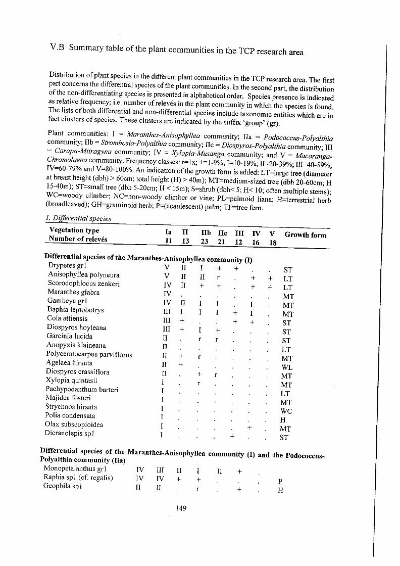
V.B Summary table of the plant communities in the TCP research area
Distribution of plant species in the different plant communities in the TCP research area. The first part concerns the differential species of the plant communities. In the second part, the distribution of the non-differentiating species is presented in alphabetical order. Species presence is indicated as relative frequency; i.e. number of releves in the plant community in which the species is found. The lists of both differential and non-differential species include taxonomic entities which are in fact clusters of species. These clusters are indicated by the suffix 'group' (gr).
Plant communities: I = Maranthes-Anisophyllea community; IIa = Podococcus-Polyalthia community; lIb = Strombosia-Polyalthia community; IIc = Diospyros-Polyalthia community; III = Carapa-Mitragyna community; IV = Xylopia-Musanga community; and V = MacarangaChromolaena community. Frequency classes: r= Ix; += 1-9%; 1= 10-19%; II=20-39%; III=40-59%; IV=60-79% and V=80-1 00%. An indication of the growth form is added: LT=large tree (diameter at breast height (dbh) > 60cm; total height (H) > 40m); MT=medium-sized tree (dbh 20-60cm; H 15-40m); ST=smaII tree (dbh 5-20cm; H < 15m); S=shrub (dbh< 5; H< 10; often multiple stems); WC=woody climber; NC=non-woody climber or vine; PL=palmoid liana; H=terrestrial herb (broad leaved); GH=graminoid herb; P=(acaulescent) palm; TF=tree fern.
1. Differential species
Vegetation type Nnmber of releves
la 11
11 13
lIb IIc III IV 23 21 12 16
Differential species of the Maranthes-Anisophyllea community (I) Drypetes gr 1 V II I + + AnisophyIIea polyneura V II II r + Scorodophloeus zenkeri IV II + + + Maranthes glabra IV Gambeya grl IV II I I I Baphia leptobotrys HI I I I + I Cola attiensis HI + + + Diospyros hoyleana III + I + Garcinia lucida II r r Anopyxis klaineana II Polyceratocarpus parviflorus II + r Agelaea hirsuta II + Diospyros crassiflora II + r Xylopia quintasii I r Pachypodanthum barteri I Majidea fosteri I Strychnos hirsuta I Pol ia condensata I Olax subscopioidea I + Dicranolepis sp I I +
V Growth form 18
ST + LT + LT
MT MT MT ST ST ST LT MT WL MT MT LT MT WC H MT ST
Differential species of the Maranthes-Anisophyllea community (I) and the PodococcusPolyalthia community (Iia) Monopetalanthus grl IV III II I II + Raphia spI (cf. regalis) IV IV + + P Geophila sp I II II r + H
149
V.B Summary table of the plant communities in the TCP research area
Distribution of plant species in the different plant communities in the TCP research area. The first part concerns the differential species of the plant communities. In the second part, the distribution of the non-differentiating species is presented in alphabetical order. Species presence is indicated as relative frequency; i.e. number of reI eves in the plant community in which the species is found. The lists of both differential and non-differential species include taxonomic entities which are in fact clusters of species. These clusters are indicated by the suffix 'group' (gr).
Plant communities: I = Maranthes-Anisophyllea community; IIa = Podococcus-Polyalthia community; lIb = Strombosia-Polyalthia community; IIc = Diospyros-Polyalthia community; III = Carapa-Mitragyna community; IV = Xylopia-Musanga community; and V = MacarangaChromolaena community. Frequency classes: FIx; +=1-9%; 1=10-19%; II=20-39%; III=40-59%; IV=60-79% and V=80-1 00%. An indication of the growth form is added: LT=large tree (diameter at breast height (dbh) > 60cm; total height (H) > 40m); MT=medium-sized tree (dbh 20-60cm; H I5-40m); ST=small tree (dbh 5-20cm; H < 15m); S=shrub (dbh< 5; H< 10; often multiple stems); WC=woody climber; NC=non-woody climber or vine; PL=palmoid liana; H=terrestrial herb (broadleaved); GH=graminoid herb; P=(acaulescent) palm; TF=tree fern.
1. Differential species
Vegetation type N nmber of rei eves
la 11
11 13
lIb IIc III IV 23 21 12 16
Differential species of the Maranthes-Anisophyllea community (I) Drypetes gr 1 V II I + + AnisophylIea polyneura V II II r + Scorodophloeus zenkeri IV II + + + Maranthes glabra IV Gambeya grI IV II I I I Baphia leptobotrys HI I I I + I Cola attiensis HI + + + Diospyros hoyleana III + I + Garcinia lucida II r r Anopyxis klaineana II Polyceratocarpus parviflorus II + r Agelaea hirsuta II + Diospyros crassiflora II + r Xylopia quintasii I r Pachypodanthum barteri I Majidea fosteri I Strychnos hirsuta I Polia condensata I Olax subscopioidea I + Dicranolepis spI I +
V Growth form 18
ST + LT + LT
MT MT MT ST ST ST LT MT WL MT MT LT MT WC H MT ST
Differential species of the Maranthes-Anisophyllea community (I) and the PodococcusPolyalthia community (Iia) Monopetalanthus gr I IV III II I II + Raphia spl (cf. regalis) IV IV + + P Geophila sp I II II r + H
149

Vegetation type la U lIb lIe III IV V Growth form
Number of releves 11 13 23 21 12 16 18
Acioa staudtii Il r MT
Drypetes leonensis Il ST
Mapania amplivaginata II GH
Toubaouate brevipaniculata I I + LT
Begonia grl I I r + H
Differential species of the Podococcus-Polyalthi community (IIa)
Hymenostegia afzelii IV I r MT
Podococcus barteri + III I + I P
Crotonogyne preussii + II r S
Tabernaemontana sp 1 + 11 r + ST
Culcasia dinklagei + II H
Duboscia macrocarpa + II r r + LT
Petersianthus africanus II r r + LT
Rhaptopetalum sp 1 I ST
Differential species of the Maranthes-Anisophyllea community (I), the Podococcus-Polyalthia
community (Ua), and the Strombosia-Polyalthia community (lIb)
Treculia obovoidea V III V + I + MT
Cal pocal yx gr 1 II I I r
Differential species of the Maranthes-Anisophyllea community (I), and the Polyalthia
community group (11)
Ptychopetalum petiolatum III IV III III + 11 I MT
Sorindeia sp 1 II II 11 II +
Symphonia globulifera I I + I MT
Dichostemma glaucescens I III 11 I + MT
Differential species of the Polyalthia community group (11)
Polyalthia suaveolens IV IV IV II I MT
Grossera gr 1 II IV IV IV I III +
Scaphopetalum blackii II IV IV III II + I ST
Plagiostyles africana II IV IV IV III I + MT
DiaIium grl II III IV IV II +
Agelaea sp 1 11 II III + +
Tricalysia grl 1II I III + + S
Desbordesia glaucescens II III + + + LT
Diospyros bipindensis II II II +
Diospyros obliquifolia + Il II I + ST
Guarea grl II
Carpolobia grl + Il II + + I ST
Antidesma laciantum 11 + MT
Erythrophleum ivorense II III + + LT
150
Vegetation type la 11 lIb lIe III IV V Growth form
Number of rei eves 11 13 23 21 12 16 18
Acioa staudtii Il r MT
Drypetes leonensis Il ST
Mapania amplivaginata II GH
Toubaouate brevipaniculata + LT
Begonia grI r + H
Differential species of the Podococcus-Polyalthi community (IIa)
Hymenostegia afzelii IV I r MT
Podococcus barteri + III I + I P
Crotonogyne preussii + II r S
Tabernaemontana sp 1 + II r + ST
Culcasia dinklagei + II H
Duboscia macrocarpa + II r r + LT
Petersianthus africanus II r r + LT
Rhaptopetalum sp I I ST
Differential species of the Maranthes-Anisophyllea community (I), the Podococcus-Polyalthia
community (IIa), and the Strombosia-Polyalthia community (lIb)
TrecuIia obovoidea V III V + I + MT
Calpocalyx gr 1 II I I r
Differential species of the Maranthes-Anisophyllea community (I), and the Polyalthia
community group (11)
Ptychopetalum petiolatum III IV III III + 11 I MT
Sorindeia sp I II II 11 II +
Symphonia globulifera I I + I MT
Dichostemma glaucescens I III 11 I + MT
Differential species of the Polyalthia community group (11)
Polyalthia suaveolens IV IV IV 11 I MT
Grossera gr 1 II IV IV IV I III +
Scaphopetalum blackii II IV IV III 11 + I ST
PIagiostyles africana II IV IV IV III I + MT
DiaIium grl II III IV IV II +
Agelaea spI II II III + +
Tricalysia gr I III I III + + S
Desbordesia glaucescens II III + + + LT
Diospyros bipindensis II II II +
Diospyros obliquifolia + II 11 I + ST
Guarea grl Il
Carpolobia grl + II II + + I ST
Antidesma laciantum II + MT
Erythrophleum ivorense II III + + LT
150

Vegetation type la 11
11 13
lIb IIc III IV V Growth form N umber of rei eves 23 21 12 16 18
Differential species of the Strombosia-Polylthia community (lIb) Grewia coriacea + II r + I MT Saccoglottis gabonensis I r + + LT
Differential species of the Strombosia-Polyalthia community (lIb) and the Diospyros-PolyaIthia community (lIc) Calpocalyx dinklagei I HI HI I I Rinorea kamerunensis II I HI IV + I Olax staudtii + II I + + Chrytranthus talbotii II n I + Klainedoxa gabonensis I II Lasianthera africana + II III I I
Differential species of the Diospyros-Polyalthia community (lIc) Diospyros suaveolens + II I IV HI I Dracaena grl + + II I Picralina nitida + I II Lasianthera sp2 + r I Marantaceae sp 1 I Pycnocoma macrophylla I +
+
+ I +
+
MT ST ST MT LT S
MT
MT
H S
Differential species of the Maranthes-Anisophyllea community (I), the Polyalthia community group (11), and the Carapa-Mitragyna community (Ill) Cola ficifolia I + II I I MT Strombosia pustulata I II IV III II MT Mammea africana II + II r I LT Halopegia grl HI IV IV HI IV H Beilschmiedia gr2 I II II II II + Aphanocalyx grl I II I II I + Santiria trimera III III HI II II + MT
Differential species of all forest communities (I, 11, III and IV) Calamus deeratus HI IV IV HI III HI PL Palisota mannii HI IV IV II IV II H Strombosia grl III IV II III III II Scaphopetalum thonneri II IV III II II I S Staudtia kamerunensis II III IV V I IV + LT Coula edulis II n III II + I MT Rubiaceae spl III III II II I Beilschmiedia grl I I I II II I Rubiaceae gr2 III IV II II I II + TetraberIinia bifoliata III + II II II LT Dracaena phrynioides II I + II + Glossocalyx brevipes II + III II + ST Dacryodes gr 1 II II II + I V oacanga gr 1 II III II + + I Diospyros gr2 II HI II + II Blighia welwitschii + II I I + II LT
151
Vegetation type Number of releves
la 11
11 13
lIb IIc III IV V Growth form 23 21 12 16 18
Differential species of the Strombosia-Polylthia community (lIb) Grewia coriacea + II r + I MT Saccoglottis gabonensis I r + + LT
Differential species of the Strombosia-Polyalthia community (lIb) and the Diospyros-PolyaIthia community (lIc) Calpocalyx dinklagei I HI HI I I Rinorea kamerunensis n I HI IV + I Olax staudtii + II I + + Chrytranthus talbotii II II I + Klainedoxa gabonensis I n Lasianthera africana + II III I I
Differential species of the Diospyros-Polyalthia community (lIc) Diospyros suaveolens + II I IV III I Dracaena gr 1 + + n I Picralina nitida + I II Lasianthera sp2 + r I Marantaceae sp 1 I Pycnocoma macrophylla I +
+
+ I +
+
MT ST ST MT LT S
MT
MT
H S
Differential species of the Maranthes-Anisophyllea community (I), the PolyaIthia community group (11), and the Carapa-Mitragyna community (Ill) Cola ficifolia I + n I I MT Strombosia pustulata I n IV III II MT Mammea africana n + n r I LT Halopegia gr I III IV IV III IV H Beilschmiedia gr2 I II n n II + Aphanocalyx grl I II I n I + Santiria trimera III III III II II + MT
Differential species of all forest communities (I, 11, III and IV) Calamus deeratus HI IV IV HI III HI PL Palisota mannii III IV IV II IV II H Strombosia grl III IV n III III II Scaphopetalum thonneri n IV III II II I S Staudtia kamerunensis n III IV V I IV + LT Coula edulis If If III n + I MT Rubiaceae sp I III HI If n I Beilschmiedia grl I I I n II I Rubiaceae gr2 III IV n n I II + TetraberIinia bifoliata III + II n II LT Dracaena phrynioides If I + II + Glossocalyx brevipes II + III II + ST Dacryodes gr 1 II II II + I Voacanga gr 1 II III II + + Diospyros gr2 II HI II + II Blighia welwitschii + II I I + n LT
151

Vegetation type la II lIb IIc III IV V Growth form
Number of releves 11 13 23 21 12 16 18
Diospyros gr 1 II III I I + II
Costus engleranus I I + + + H
Stipularia africana + + II r I II H
Differential species of all plant communities except the Maranthes - Anisophyllea community
(I) Scyphocephalium mannii II I II I LT
Piptadeniastrum africanum I II III II III + LT
Pterocarpus gr 1 II II II I I
Nephthytis sp 1 + 1I II + II I I H
Lophira alata I II Il II II III LT
Differential species of the Carapa - Mitragyna community (Ill), the Xylopia - Musanga
community (IV), and the Macaranga - Chromolaena community (V)
Sterculia tragacantha I I
Leea guineensis + II I
PaIisota hirsuta + I I
Elaeis guineensis + III II
Caloncoba welwitschii + r r I I
Raphia sp2 + + III II
Differential species of the Carapa - Mytragyna community (Ill)
Mitragyna stipulosa r V +
Carapa sp 1 III
Trichilia heudelotii . + I + III I
Diospyros preussii + r II
Rubiaceae sp2 II
Cyathea manniana II
Curcuma longa II
Differential species of the Xylopia - Musanga community (IV)
Palisota ambigua I + II II III IV
Xylopia grl + II I II IV
Zanthoxylum gillettii + II II I II IV
Thaumatococcus danielii I I I IV
Megaphrynium r I III
macrostachyum?
Ancistrophyllum 0 r II III
secundiflorum
Phyllanthus discoideus II I III
Ricinodendron heudelotti + + II
Massularia acuminata + + I
Caloncoba brevipes
152
II II I III II II
+
I
+
II II III II II
I +
MT S H P MT P
MT MT ST MT
TF GH
H
MT H H
PL
MT LT ST MT
Vegetation type la II lIb IIc III IV V Growth form
Number of rei eves 11 13 23 21 12 16 18
Diospyros gr I II III I I + II
Costus engleranus I I + + + H
Stipularia africana + + II r I II H
Differential species of all plant communities except the Maranthes - Anisophyllea community
(I) Scyphocephalium mannii II I II I LT
Piptadeniastrum africanum I II III II III + LT
Pterocarpus gr I II II II I I
Nephthytis sp I + 1I II + II I I H
Lophira alata I II II II II III LT
Differential species of the Carapa - Mitragyna community (Ill), the Xylopia - Musanga
community (IV), and the Macaranga - Chromolaena community (V)
Sterculia tragacantha I I II MT
Leea guineensis + II I II S
Palisota hirsuta + I I I H
Elaeis guineensis + III II III P
Caloncoba welwitschii + r r I I II MT
Raphia sp2 + + III II II P
Differential species of the Carapa - Mytragyna community (UI)
Mitragyna stipulosa r V + + MT
Carapa spl III MT
Trichilia heudelotii . + I + III I I ST
Diospyros preussii + r II MT
Rubiaceae sp2 II
Cyathea manniana II + TF
Curcuma longa II GH
Differential species of the Xylopia - Musanga community (IV)
Palisota ambigua I + II II III IV II H
Xylopia grl + II I II IV II
Zanthoxylum gillettii + II II I II IV III MT
Thaumatococcus danielii I I I IV II H
Megaphrynium r I III II H
macrostachyum?
Ancistrophyllum 0 r II III PL
secundiflorum
Phyllanthus discoideus II I III I MT
Ricinodendron heudelotti + + II + LT
Massularia acuminata + + I ST
Caloncoba brevipes MT
152

Vegetation type Number of rei eves
la 11
11 13
lib IIc III IV 23 21 12 16
V Growth form 18
Differential species of the Diospyros - PolyaIthia community (lIc), the Xylopia - Musanga community (IV), and the Macaranga - Chromolaena community (V) Hylodendron gr 1 II III II IV + IV I Ouratea flava + If + III + ST Eribroma gr 1 + nr + n HI Terminalia superba II + n I LT Myrianthus arboreus r II n I MT
Differential species of the Xylopia - Musanga community (IV) and the Macaranga -Chromolaena community (V)
Musanga cecropioides + + r n IV IV MT Funtumia elastica I r r nr HI MT Rauvolfia macrophylla r + n n MT Vernonia conferta n I ST Macaranga gr2 I n ST Anthoc1eista schweinfurthii I I MT Hamikoa grl r + InS Mareya brevipes r I + Melastomataceae gr2 r r I n Anthoc1eista vogelii I n MT
Differential species of the Macaranga - Chromolaena community (V) Macaranga grl n IV ST Chromolaena odorata + IV H Fern grl I II n + n IV H Costus violaceus 11 nr H Trifolium spl (cultivated) nr H Milicia excelsa r III LT Manihot esculenta (cult.) + HI S Anchomanes spl (cult.) + nr H Ceiba pentandra + r + HI LT Rauvolfia vomitoria I HI ST Albizia zygia I + I I n nr LT Dioscorea bulbifera 11 NL Trema orientalis Sc1eria barteri Dioscorea burkeliana Colocasia esculenta (cult.) Musa gr I (cultivated) Jateorhiza macrantha Trifolium sp I (cult.) Brucea spl Millettia macrophylla r Tetrorchidium didymost. r Harungana madagasc. r Theobroma cacao (cult.)
153
+ r + r +
+
11 11 11 n 11 11 n n n n I I
ST GH WC H HIS NL
MT
MT ST
Vegetation type Number of rei eves
la 11
11 13
lib IIc III IV 23 21 12 16
V Growth form 18
Differential species of the Diospyros - PolyaIthia community (lIc), the Xylopia - Musanga community (IV), and the Macaranga - Chromolaena community (V) Hylodendron gr 1 II III II IV + IV I Ouratea flava + If + nr + ST Eribroma gr 1 + HI + n HI Terminalia superba If + n I LT Myrianthus arboreus r If n I MT
Differential species of the Xylopia - Musanga community (IV) and the Macaranga -Chromolaena community (V) Musanga cecropioides + + r n IV IV MT Funtumia elastica I r r nr HI MT Rauvolfia macrophylla r + n n MT Vernonia conferta n I ST Macaranga gr2 I n ST Anthoc1eista schweinfurthii I I MT Hamikoa grl r + I II S Mareya brevipes r I + Melastomataceae gr2 r r I II Anthoc1eista vogelii I n MT
Differential species of the Macaranga - Chromolaena community (V) Macaranga grl n IV ST Chromolaena odorata + IV H Fern grl I 11 n + n IV H Costus violaceus 11 HI H Trifolium spl (cultivated) HI H Milicia excelsa r HI LT Manihot esculenta (cult.) + III S Anchomanes spl (cult.) + III H Ceiba pentandra + r + III LT Rauvolfia vomitoria I III ST Albizia zygia I + I I n III LT Dioscorea bulbifera n NL Trema orientalis Sc1eria barteri Dioscorea burkeliana Colocasia esculenta (cult.) Musa gr I (cultivated) Jateorhiza macrantha Trifolium sp I (cult.) Brucea spl Millettia macrophylla r Tetrorchidium didymost. r Harungana madagasc. r Theobroma cacao (cult.)
153
+ r + r +
+
n II n n n 11 II n II n I I
ST GH WC H HIS NL
MT
MT ST

2. Non-differential species
Vegetation type la lIa lIb lIe Illa IVa Va Growth form
Carapa grl III II III II II II I
Uapaca guineensis 1II IV III 11 III 11 11 LT
Coelocaryon preussii III III IV V V IV 11 LT
Pentaclethra macrophylla II III IV I 11 III I MT
Cercestis ivorensis II II III IV II III II H
Tabernaemontana crassa II III III IV I IV I MT
Rubiaceae gr3 II III III 11 III III I S
Trachyphrynium spl 11 II I 11 11 III 11
Haumania danckelmanniana I IV IV V III V III PL
Pycnanthus angolensis IV II IV III IV III LT
Rhektophyllum grl II V IV IV V 11 H
Enantia chlorantha II II I I I I MT
Anthonotha macrophylla + II II IV III III II MT
Homalium delicophyllus III II I I I I 11 LT
Guaduella grl III I II III I I I GH
Alchornea floribunda I II I I + III I WC
Acacia pennata + I + + I I WC
Acroceras zizanioides I
Aframomum grl + I I II II H
Afrosersalisia cerasifera +
Dracaena sp 1 + r I H
Vegetation type la lIa lIb lie llla IVa Va Growth form
Albizia adianthifolia + r I + LT
Albizia glaberrima + LT
Alchornea cordifolia I + WC
Alchornea hirtella + r r S
Allanblackia floribunda + r MT
Allanblackia kisongui III + III II I II + MT
Allanblackia montana + LT
Allophyllus africanus r + ST
Alstonia boonei + + LT
Alstonia congensis + II I + I II II LT
Angylocalyx oligophyllus + MT
Angylocalyx zenkeri + + + MT
Antidesma venosum + + r MT
Antrocaryon klaineanum + r r 11 + LT
Anllbias hastifolia + H
Aptandra zenkeri ST
Araliopsis soyallxii + + LT
Aspilia africana I + I H
Asystasia macrophylla r
Bambusa arundinacea + GH
Baphia laurifolia r MT
Barteria fistlllosa + r I I MT
154
2. Non-differential species
Vegetation type la IIa lIb lIe Illa IVa Va Growth form
Carapa grl III II III II II II I
Uapaca guineensis 1II IV III 11 III 11 11 LT
Coelocaryon preussii III III IV V V IV 11 LT
Pentaclethra macrophylla II III IV I 11 III I MT
Cercestis ivorensis II II III IV II III II H
Tabernaemontana crassa II III III IV I IV I MT
Rubiaceae gr3 II III III II III III I S
Trachyphrynium spl II II I II II III II
Haumania danckelmanniana IV IV V III V III PL
Pycnanthus angolensis IV II IV III IV III LT
Rhektophyllum grl II V IV IV V II H
Enantia chlorantha II II I I I I MT
Anthonotha macrophylla + II II IV III III II MT
Homalium delicophyllus III II I I I I II LT
Guaduella grl III I 11 III I I I GH
Alchornea floribunda I II I I + III I WC
Acacia pennata + I + + I I WC
Acroceras zizanioides I
Aframomum grl + I I 11 II H
Afrosersalisia cerasifera +
Dracaena sp 1 + r I H
Vegetation type la IIa lIb lIe llla IVa Va Growth form
Albizia adianthifolia + r I + LT
Albizia glaberrima + LT
Alchornea cordifolia I + WC
Alchornea hirtella + r r S
Allanblackia floribunda + r MT
Allanblackia kisongui III + III II I II + MT
Allanblackia montana + LT
Allophyllus africanus r + ST
Alstonia boonei + + LT
Alstonia congensis + 11 I + I II 11 LT
Angylocalyx oligophyllus + MT
Angylocalyx zenkeri + + + MT
Antidesma venosum + + r MT
Antrocaryon klaineanum + r r 11 + LT
Anubias hastifolia + H
Aptandra zenkeri ST
Araliopsis soyauxii + + LT
Aspilia africana I + I H
Asystasia macrophylla r
Bambusa arundinacea + GH
Baphia laurifolia r MT
Barteria fistulosa + r I I MT
154

Vegetation type la IIa lIb lIe IlIa IVa Va Growth form Begonia macrocarpa + H Begonia sciaphila + H Berlinia bracteosa + I II I LT Berlinia confusa + LT Blighia sapida + r MT Bosqueia angolensis + I Brachystegia cynometroides + r LT Brachystegia eurycoma r LT Brachystegia mildbraedii r LT Brachystephanus jaundensis + + I H Brenania Brieyi + MT Bridelia micrantha + MT Buchholzia coriacea I + r MT Caloncoba gilgiana + I MT Caloncoba glauca + I I I MT Caloncoba zygas + MT Canarium schweinfurthii + + + I I I LT Canthium arnoldianum + MT Canthium palma + + MT Carica papaya I S Celtis grl + II I I + I MT Celtis tessmannii + r LT Cephaelis sp 1 I + r I + H Cercestis congoensis + H Cercestis kamerunianus I II I + H Chrytranthus seressii + r MT Chrytranthus sp 1 r ST Cleistopholis glauca + LT Cleistopholis patens + + + + II I LT Cnestis grisea r r + Coelocaryon sp 1 + Cola cauliflora r ST Cola cordifolia II + I MT Cola grl I II II + I Cola gr2 + + + Cola lepidota + + + ST Cola marsupium + + r + S Cola rostrata I I + + MT Commelina cameroonensis H Commelinaceae grl r + + H Agelaea grl + + Cnestis grl r Cordia plathythyrsa + LT Costus afer I + H Costus dinklagei I H Costus phaeotrichus r H Costus spl r I H Craterispermum laurinum r r + ST
155
Vegetation type la IIa lIb lIe IlIa IVa Va Growth form Begonia macrocarpa + H Begonia sciaphila + H Berlinia bracteosa + I II I LT Berlinia confusa + LT Blighia sapida + r MT Bosqueia angolensis + I Brachystegia cynometroides + r LT Brachystegia eurycoma r LT Brachystegia mildbraedii r LT Brachystephanus jaundensis + + I H Brenania Brieyi + MT Bridelia micrantha + MT Buchholzia coriacea I + r MT Caloncoba gilgiana + I MT Caloncoba glauca + I I I MT Caloncoba zygas + MT Canarium schweinfurthii + + + I I I LT Canthium arnoldianum + MT Canthium palma + + MT Carica papaya I S Celtis grl + II I I + I MT Celtis tessmannii + r LT Cephaelis sp 1 I + r I + H Cercestis congoensis + H Cercestis kamerunianus I II I + H Chrytranthus seressii + r MT Chrytranthus sp 1 r ST Cleistopholis glauca + LT Cleistopholis patens + + + + II I LT Cnestis grisea r r + Coelocaryon spl + Cola cauliflora r ST Cola cordifolia II + I MT Cola grl I II II + I Cola gr2 + + + Cola lepidota + + + ST Cola marsupium + + r + S Cola rostrata I I + + MT Commelina cameroonensis H Commelinaceae grl r + + H Agelaea grl + + Cnestis grl r Cordia plathythyrsa + LT Costus afer I + H Costus dinklagei I H Costus phaeotrichus r H Costus spl r I H Craterispermum laurinum r r + ST
155

Vegetation type la lIa lib ne Ilia IVa Va Growth form
Craterispermum longifolium r ST
Craterosiphon scandens + Crotonogyne manniana + S
Cyliodiscus gabunensis + r + LT
Mapania grl I I + GH
Cyperus diffusus + GH
Dacryodes edulis II II II II I MT
Dacryodes klaineana r MT
Detarium macrocarpllm + LT
Didelotia brevipaniculata r + LT
Didelotia unifoliolata + LT
Diospyros conocarpa + r + ST
Diospyros dendo + MT
Discoglypremna caloneura + + r I + LT
Distemonanthus bentham. + II II + II II LT
Dorstenia picta + + H
Dorstenia subtriangularis + H
Dorstenia turbinata r H
Dracaena cerasifera + HIS
Dracaena sp 1 Drypetes gabonensis ST
Drypetes gossweileri + r LT
Drypetes molunduana r MT
Drypetes sp 1 I r MT
Duparquetia orchidacea + WC
Entandrophragma angolense + LT
Entandrophragma utile + + LT
Eriocoelum macrocarpum + + MT
Erytroxylum mannii + I LT
Eugenia spl r
Euphorbiaceae gr 1 + +
Euphorbiaceae sp 1 +
Ficlls exasperata r I LT
Fillaeopsis discophora r LT
Flacollrtiaceae sp 1 + II II + II
Gambeya perpulchra + MT
Garcinia kola MT
Garcinia mannii II III II II I + ST
Garcinia polyantha r r MT
Garcinia staudtii + + MT
Gardenia sp I + Gilbertiodendron brachyst. r LT
Gilbertiodendron dewevrei I + I LT
Gilbertiodendron grandifl. r LT
Gilbertiodendron ogoouense + LT
Glyphaea brevis + I ST
Gossweilerodendron balsam. + LT
Gossweilerodendron jOlleri + LT
156
Vegetation type la lIa lib lie Ilia IVa Va Growth form
Craterispermum longifolium r ST
Craterosiphol1 scandens + Crotonogyne manniana + S
Cyliodiscus gabunensis + r + LT
Mapania grl I I + GH
Cyperus diffusus + GH
Dacryodes edulis II II II II I MT
Dacryodes klaineana r MT
Detarium macrocarpum + LT
Didelotia brevipaniculata r + LT
Didelotia unifoliolata + LT
Diospyros conocarpa + r + ST
Diospyros dendo + MT
Discoglypremna caloneura + + r I + LT
Distemonanthus bentham. + II II + II II LT
Dorstenia picta + + H
Dorstenia subtriangularis + H
Dorstenia turbinata r H
Dracaena cerasifera + HIS
Dracaena sp 1 Drypetes gabonensis ST
Drypetes gossweileri + r LT
Drypetes molunduana r MT
Drypetes sp 1 I r MT
Duparquetia orchidacea + WC
Entandrophragma angolense + LT
Entandrophragma utile + + LT
Eriocoelum macrocarpum + + MT
Erytroxylum mannii + I LT
Eugenia spl r
Euphorbiaceae gr 1 + +
Euphorbiaceae sp 1 +
Ficus exasperata r I LT
Fillaeopsis discophora r LT
Flacourtiaceae sp 1 + II 11 + II
Gambeya perpulchra + MT
Garcinia kola MT
Garcinia mannii II III 11 11 I + ST
Garcinia polyantha r r MT
Garcinia staudtii + + MT
Gardenia sp I + Gilbertiodendron brachyst. r LT
Gilbertiodendron dewevrei I + I LT
Gilbertiodendron grandifl. r LT
Gilbertiodendron ogoouense + LT
Glyphaea brevis + I ST
Gossweilerodendron balsam. + LT
Gossweilerodendron joueri + LT
156

Vegetation type la Ha lIb lIe IlIa IVa Va Growth form Grossera macrantha I I r + MT Grossera paniculata r MT Guarea cedrata + + I + + LT Guibourtia tessmannii + LT Heckeldora spec. (HNC 49157) + ST Heisteria parvifolia + + I + ST Hexalobus crispiflorus + I r I MT Hunteria umbellata + r S Hymenocardia heudelotii ST Hymenostegia breteleri + MT Hypodaphnis zenkeri + I II II MT Hypselodelphys spl r + H lodes kamerunensis + + WC Irvingia gabonensis + II II I + + LT Irvingia grandifolia + + r + LT Irvingia robur + + r I LT Isolona hexaloba + + MT Justica extensa + H Khaya ivorensis + r LT Klainedoxa microphylla + I + r + LT Laccodiscus ferrugineus + r MT Landolphia spl II + r + NC Lasiodiscus spl r ST Lavigeria grJ I I II III I II WC Lecaniodiscus cupanioides + MT Leptaulus daphnoides + ST Leptaulus zenkeri + + r ST Leptonychia sp I ST Lovoa trichilioides I r + + + LT Macarangahurifolia + MT Macaranga occidentalis + WC Macaranga saccifera + WC Maesobotrya acuminata r ST Maesobotrya barteri + r MT Maesobotrya dusenii + r r ST Maesobotrya staudtii I I r + I MT Maesopsis eminii + + + MT Mangifera indica + MT Mapania macrantha I + GH Maranthes chrysophylla + MT Marantochloa leucantha I + + H Mareyopsis longifolia 11 II 11 I I I MT Meiocarpidium grJ + + II 11 I + Melastomataceae grl + + + + Microcalamus barbinodis + + GH Microdesmis HNC 49201 + + ST Millettia spl r Monodora myristica + + r MT
157
Vegetation type la Ha lib lie Ilia IVa Va Growth form Grossera macrantha I I r + MT Grossera paniculata r MT Guarea cedrata + + I + + LT Guibourtia tessmannii + LT Heckeldora spec. (HNC 49157) + ST Heisteria parvifolia + + I + ST Hexalobus crispiflorus + I r I MT Hunteria umbellata + r S Hymenocardia heudelotii ST Hymenostegia breteleri + MT Hypodaphnis zenkeri + I II II MT Hypselodelphys sp I r + H lodes kamerunensis + + WC Irvingia gabonensis + II II I + + LT Irvingia grandifolia + + r + LT Irvingia robur + + r I LT Isolona hexaloba + + MT Justica extensa + H Khaya ivorensis + r LT Klainedoxa microphylla + I + r + LT Laccodiscus ferrugineus + r MT Landolphia spl II + r + NC Lasiodiscus sp 1 r ST Lavigeria grl I I II III I II WC Lecaniodiscus cupanioides + MT Leptaulus daphnoides + ST Leptaulus zenkeri + + r ST Leptonychia spI ST Lovoa trichilioides I r + + + LT Macaranga hurifolia + MT Macaranga occidentalis + WC Macaranga saccifera + WC Maesobotrya acuminata r ST Maesobotrya barteri + r MT Maesobotrya dusenii + r r ST Maesobotrya staudtii I I r + I MT Maesopsis eminii + + + MT Mangifera indica + MT Mapania macrantha I + GH Maranthes chrysophylla + MT Marantochloa leucantha I + + H Mareyopsis longifolia 11 II 11 I I I MT Meiocarpidium grl + + II 11 I + Melastomataceae gr 1 + + + + Microcalamus barbinodis + + GH Microdesmis HNC 49201 + + ST Millettia sp 1 r Monodora myristica + + r MT
157

Vegetation type la lIa lib lie Ilia IVa Va Growth form
Monodora sp 1 r
Mostuea brunoniste NC
Mucuna flagellipes +
Mussaenda sp 1 +
Myrianthus serratus + + MT
Napoleonaea sp 1 + ST
Nauclea diderrichii + + LT
Newbouldia laevis I I I 11
Newtonia griffoniana + LT
Nonthospondias cf. staudtii + + MT
Ochna calodendron r MT
Ochna membranacaea + I ST
Octoknema grl + r ST
Octo lobus angustatus + I MT
Olacaceae sp 1 + Olax gambecola r ST
Olax latifolia + ST
Olax mannii + ST
Olax suaveolens r ST
Oldfieldia africana LT
Olyra latifolia +
Ongokea gore + r I LT
Oricia lecontiana I + S
Oricia trifoliata + MT
Ormocarpum sp 1 + Oubanguia africana + I r I MT
OUbanguia alata + I r MT
Ouratea spec. (HNC 40350) + r S
Pachypodanthum staudtii I I I + LT
Panda oleosa + r + + ST
Pandanus candelabrum + ST
Papilionaceae sp 1 +
Papilionaceae sp2 r
Parinari sp I + r
Parkia bicolor I 11 11 r I I + LT
Parkia filicoidea + r LT
Paullinia sapinda + WC
Pausinystalia johimbe I MT
Penianthus longifolius + + S
Pentaclethra eetveldeana r + MT
Pentadesma blltyracea r MT
Pentas spI 11 I + 11 11 H
Persea americana I + MT
Petersianthlls macrocarplls r r + LT
Piper 11mbellatum r + H
Piptostigma prellssii + r MT
Plagiosiphon grl + + r LT
Plagiosiphon mllltijuglls r LT
158
Vegetation type la lIa lib lie Ilia IVa Va Growth form
Monodora sp 1 r
Mostuea brunoniste NC
Mucuna flagellipes +
Mussaenda sp 1 +
Myrianthus serratus + + MT
Napoleonaea sp 1 + ST
Nauclea diderrichii + + LT
Newbouldia laevis I I I 11
Newtonia griffoniana + LT
Nonthospondias cf. staudtii + + MT
Ochna calodendron r MT
Ochna membranacaea + I ST
Octoknema grl + r ST
Octo lobus angustatus + I MT
Olacaceae sp 1 + Olax gambecola r ST
Olax latifolia + ST
Olax mannii + ST
Olax suaveolens r ST
Oldfieldia africana LT
Olyra latifolia +
Ongokea gore + r I LT
Oricia lecontiana I + S
Oricia trifoliata + MT
Ormocarpum sp 1 + Oubanguia africana + I r I MT
Oubanguia alata + I r MT
Ouratea spec. (HNC 40350) + r S
Pachypodanthum staudtii I I I + LT
Panda oleosa + r + + ST
Pandanus candelabrum + ST
Papilionaceae sp 1 +
Papilionaceae sp2 r
Parinari sp 1 + r
Parkia bicolor I 11 11 r I I + LT
Parkia filicoidea + r LT
Paullinia sapinda + WC
Pausinystalia johimbe I MT
Penianthus longifolius + + S
Pentaclethra eetveldeana r + MT
Pentadesma blltyracea r MT
Pentas sp 1 11 I + 11 11 H
Persea americana I + MT
Petersianthlls macrocarplls r r + LT
Piper 11mbellatum r + H
Piptostigma preussii + r MT
Plagiosiphon grl + + r LT
Plagiosiphon multijugus r LT
158

Vegetation type la lIa lib lie llla IVa Va Growth form Poga oleosa r LT Protomegabaria stapfiana + ST Pseudospondias cf. macrocera + + + r + LT Pseudospondias microcarpa r r + II + LT Pteleopsis hylodendron r r + LT Ptychopetalum cf. rudentessi + WC RhabdophylIum spI + Rinorea caudata + r r S Rinorea dentata II 11 + I ST Rinorea exappendiculata + + S Rinorea spI + S Rothmannia sp I Sabicea calycina + Salacia longipes + WC Salacia spI r Salacia spI II II I I + Salacia staudtiana I + + + WC Sapindaceae sp I + I + II + Sapium elIipticum + MT Sapotaceae sp I Schumanniophyton magnificum + ST Sclerosperma mannii r P Scottellia mimfiensis r MT Scytopetalaceae sp I + ST Scytopetalum klaineanum + + MT Setaria megaphylIa I GH Sorindeia grandifolia HI II II I I MT Sorindeia juglandifolia + ST Soyauxia gabonensis r MT Soyauxia talbotii + + MT Spathodea campanulata + LT Spondias cytherea + ST Standfieldiella imperforata + Sterculia subviolacea r I + MT Strombosia scheftleri + + MT Strombosia zenkeri + ST Strophanthus gratus + r + WC Strychnos aculeata + WC Strychnos congolana + WC Strychnos eleocarpa + + r WC Strychnos phaeotricha + WC Strychnos staudtii II + r I WC Swartzia fistuloides r LT Syzygium guineense r MT Syzygium rowlandii + MT Syzygium spI + + Tabernaemontana pachys. + ST
159
Vegetation type la lIa lib lie llla IVa Va Growth form Poga oleosa r LT Protomegabaria stapfiana + ST Pseudospondias cf. macrocera + + + r + LT Pseudospondias microcarpa r r + II + LT Pteleopsis hylodendron r r + LT Ptychopetalum cf. rudentessi + WC Rhabdophyllum sp I + Rinorea caudata + r r S Rinorea dentata II 11 + I ST Rinorea exappendiculata + + S Rinorea spI + S Rothmannia sp I Sabicea calycina + Salacia longipes + WC Salacia spI r Salacia spI II II I I + Salacia staudtiana I + + + WC Sapindaceae sp I + I + II + Sapium ellipticum + MT Sapotaceae sp I Schumanniophyton magnificum + ST Sclerosperma mannii r P Scottellia mimfiensis r MT Scytopetalaceae sp I + ST Scytopetalum klaineanum + + MT Setaria megaphylla I GH Sorindeia grandifolia HI II II I I MT Sorindeia juglandifolia + ST Soyauxia gabonensis r MT Soyauxia talbotii + + MT Spathodea campanulata + LT Spondias cytherea + ST Standfieldiella imperforata + Sterculia subviolacea r I + MT Strombosia scheftleri + + MT Strombosia zenkeri + ST Strophanthus gratus + r + WC Strychnos aculeata + WC Strychnos congolana + WC Strychnos eleocarpa + + r WC Strychnos phaeotricha + WC Strychnos staudtii II + r I WC Swartzia fistuloides r LT Syzygium guineense r MT Syzygium rowlandii + MT Syzygium sp I + + Tabernaemontana pachys. + ST
159

Vegetation type la lIa lib lie Ilia IVa Va Growth form
Tapura africana + + + LT
Tetraplaura tetraptera + I + MT
Thomandersia congolana + + + S
Trachyphrynium braunianum + II
Treculia africana r MT
Treculia spec. (HNC 30012) r
Trichilia emetica + ST
Trichilia rubescens + ST
Trichilia welwitschii r I + MT
Trichoscypha acuminata + + r MT
Trichoscypha arborea + + r r + LT
Trichoscypha ferruginia + I r + ST
Turraeanthus africanus I + Il + I MT
Tylophora cameroonica + NC
Uapaca acuminata + + LT
Uapaca staudtii + + + I MT
Uapaca vanhouttei + II 1I MT
Urera cameroonensis + NC
Uvariastrum pierreanum r r ST
Uvariodendron sp 1 + Il r + Il + ST
Vitex ciliata + LT
Vitex grandifolia Il + + I II I LT
Vitex rivularis + I MT
Vitis aralioides + NC
Vitis quadricularia + NC
Vitis spl + I + + + NC
Voacanga thouarsii r ST
Xylopia parviflora r r + MT
Zanthoxylum heitzii r + 11 + LT
Zanthoxylum tessmannii + r I LT
Zingiber officinale + H
Zingiberaceae sp 1 + H
160
Vegetation type la lIa lib lie Ilia IVa Va Growth form
Tapura africana + + + LT
Tetraplaura tetraptera + I + MT
Thomandersia congolana + + I + S
Trachyphrynium braunianum + I II
Treculia africana r MT
Treculia spec. (HNC 30012) r
Trichilia emetica + ST
Trichilia rubescens + ST
Trichilia welwitschii r I + MT
Trichoscypha acuminata + + r MT
Trichoscypha arborea + + r r + LT
Trichoscypha ferruginia + I r + ST
Turraeanthus africanus I + II + I MT
Tylophora cameroonica + NC
Uapaca acuminata + + LT
Uapaca staudtii + + + I MT
Uapaca vanhouttei + 1I II MT
Urera cameroonensis + NC
Uvariastrum pierreanum r r ST
Uvariodendron sp 1 + II r + 1I + ST
Vitex ciliata + LT
Vitex grandifolia II + + I II I LT
Vitex rivularis + I MT
Vitis aralioides + NC
Vitis quadricularia + NC
Vitis spl + I + + + NC
Voacanga thouarsii r ST
Xylopia parviflora r r + MT
Zanthoxylum heitzii r + II + LT
Zanthoxylum tessmannii + r I LT
Zingiber officinale + H
Zingiberaceae se 1 + H
160

ANNEX VI List of bird species observed in the TCP research area
The listed species were recorded in the period May 1995 to November 1997. As no systematic bird survey has started yet, the list is a mere compilation of the species lists of Jan Jansen (WAU), Patrick Hommel (SC-DLO; 1995; 1996), Thorn Kuyper (WAU) and Barend van Gemerden. Nomenclature follows Serle & Morel (1997).
Accipitridae Accipiter toussenelii Dryotriorchis spectabilis Gyphohierax angolensis Kaupifalco monogrammicus Macheirhamphus alcinus Milvus migrans Polyboroides radiatus Urotriorchis macrourus Circaetus gallicus?' Stephanoaetus coronatus?'
Alcedinidae Alcedo quadribrachys Ceyxpicta Halycon badia Halycon senegalensis
Apodidae Apus apus
Ardeidae Ardeola ibis
Bucerotidae Bycanistes cylindricus cylindricus Bycanistes jistulator Bycanistes subcylindricus Ceratogymna atrata Tockus camurus Tockus fasciatus semifasciatus
Capitonidae Buccanodon duchaillui Gymnobucco bonapartei Pogoniulus atrojlavus Pogoniulus bilineatus Trachyphonus pupuratus
(?) Identification uncertain
161
West african goshawk Congo Serpent-eagle Palm-nut vulture Lizard buzzard Bathawk Black kite Harrier hawk Long-tailed hawk Short-toed eagle Crowned hawk-eagle
Shining-blue kingfisher Pygmy kingfisher Chocolate-backed kingfisher Senegal kingfisher
European swift
Cattle egret
Brown-cheeked hornbill Piping hornbill Black-and-white-casqued hornbill Black-casqued hornbill Red-billed dwarf hornbill Black-and-white-tailed hornbill
Duchaillu's yellow-spotted barbet Grey-throated barbet Red-rumped tinker-bird Lemon-rumped tinker-bird Yellow-billed barb et
ANNEX VI List of bird species observed in the TCP research area
The listed species were recorded in the period May 1995 to November 1997. As no systematic bird survey has started yet, the list is a mere compilation of the species lists of Jan Jansen (WAU), Patrick Hommel (SC-DLO; 1995; 1996), Thorn Kuyper (WAU) and Barend van Gemerden. Nomenclature follows Serle & Morel (1997).
Accipitridae Accipiter toussenelii Dryotriorchis spectabilis Gyphohierax angolensis Kaupifalco monogrammicus Macheirhamphus alcinus Milvus migrans Polyboroides radiatus Urotriorchis macrourus Circaetus gallicus?' Stephanoaetus coronatus?'
Alcedinidae Alcedo quadribrachys Ceyxpicta Halycon badia Halycon senegalensis
Apodidae Apus apus
Ardeidae Ardeola ibis
Bucerotidae Bycanistes cylindric us cylindricus Bycanistes fistulator Bycanistes subcylindricus Ceratogymna atrata Tockus camurus Tockus Jasciatus semifasciatus
Capitonidae Buccanodon duchaillui Gymnobucco bonapartei Pogoniulus atrojlavus Pogoniulus bilineatus Trachyphonus pupuratus
I (?) Identification uncertain
161
West african goshawk Congo Serpent-eagle Palm-nut vulture Lizard buzzard Bathawk Black kite Harrier hawk Long-tailed hawk Short-toed eagle Crowned hawk-eagle
Shining-blue kingfisher Pygmy kingfisher Chocolate-backed kingfisher Senegal kingfisher
European swift
Cattle egret
Brown-cheeked hornbill Piping hornbill Black-and-white-casqued hornbill Black-casqued hornbill Red-billed dwarf hornbill Black-and-white-tailed hornbill
Duchaillu's yellow-spotted barbet Grey-throated barbet Red-rumped tinker-bird Lemon-rumped tinker-bird Yellow-billed barbet

Columbidae Treron australis
Turtur aJer Turtur brehmeri Turtur tympanistria
Coraciidae Eurostomus gular is
Corvidae Corvus albus
Cuculidae Ceuthmochares aereus
Chrysococcyx cupreus
Cuculus solitarius
Dicruridae Dicrurus adsimilis
Estrildidae Estrilda melpoda Estrilda nonnula
Lonchura bicolor Nigrita canicapilla
Nigrita Jusconota Spermophaga haematin a
Hirundinidae Hirundo nigrita Hirundo rustica Psalidoprocne pristoptera
Riparia paludicola
Meropidae Merops albicoWs
Monatchidae Terpsiphone rufiventer neumanni
Terpsiphone viridis
Motacillidae Motacilla aguimp
Muscicapidae Artomyias juliginosa
Erythrocerus mccali Muscicapa striata Platysteira castanea
Platysteira tonsa
162
Green fruit-pigeon
Red-billed wood dove
Blue-headed dove Tambourine dove
Broad-billed roller
Pied crow
Yellowbill coucal
Emerald cuckoo Red-chested cuckoo
Glossy-backed drongo
Orange-cheeked waxbill
Black-crowned waxbill
Black-and-white mannikin
Grey-crowned negro-finch
White-breasted negro-finch
Blue-billed weaver
White-throated blue swallow
European swallow
Black saw-wing
African sand martin
White-throated bee-eater
Red-bellied paradise-flycatcher
African paradise-flycatcher
African pied wagtail
Dusky flycatcher Chestnut-capped flycathcer
Cassin's grey flycatcher
Chestnut wattle-eye
White-spotted wattle-eye
Columbidae Treron australis
Turtur aJer Turtur brehmeri Turtur tympanistria
Coraciidae Eurostomus gular is
Corvidae Corvus albus
Cuculidae Ceuthmochares aereus
Chrysococcyx cupreus
Cuculus solitarius
Dicruridae Dicrurus adsimilis
Estrildidae Estrilda melpoda Estrilda nonnula Lonchura bicolor
Nigrita canicapilla
Nigrita Jusconota Spermophaga haematin a
Hirundinidae Hirundo nigrita Hirundo rustica Psalidoprocne pristoptera
Riparia paludicola
Meropidae Merops albicollis
Monatchidae Terpsiphone rufiventer neumanni
Terpsiphone viridis
Motacillidae Motacilla aguimp
Muscicapidae Artomyias fuliginosa
Erythrocerus mccali
Muscicapa striata Platysteira castanea Platysteira tonsa
162
Green fruit-pigeon
Red-billed wood dove
Blue-headed dove Tambourine dove
Broad-billed roller
Pied crow
Yellowbill coucal
Emerald cuckoo Red-chested cuckoo
Glossy-backed drongo
Orange-cheeked waxbill
Black-crowned waxbill
Black-and-white mannikin
Grey-crowned negro-finch
White-breasted negro-finch
Blue-billed weaver
White-throated blue swallow
European swallow
Black saw-wing
African sand martin
White-throated bee-eater
Red-bellied paradise-flycatcher
African paradise-flycatcher
African pied wagtail
Dusky flycatcher
Chestnut-capped flycathcer
Cassin's grey flycatcher
Chestnut wattle-eye
White-spotted wattle-eye

Musophagidae Corythaeola cristata Tauraco persa
N ectariniidae Anthreptes gabonicus Nectarinia chloropygia Nectarinia olivaceae Nectarinia superba
Oriolidae Griolus brachyrhynchus
Phasianidae Francolinus lathami Francolinus squamatus
Picidae Campethera caillautii Campethera nivosa Dendropicos gabonensis Mesopicos xantholophus Verreauxia ajricana
Ploceidae Malimbus nitens Malimbus rubicollis Malimbus scutatus Pirenestes ostrinus Ploceus cucullatus
Psittacidae Psittacus erythacus
Pycnonotidae Andropadus virens Baeopopgon indicator Chlorocichla simplex Cringiger calurus Ixonotus guttatus Nicator chloris Phyllastrephus icterinus Pycnonotus barbatus Thescelocichla leucopleurus
Strigidae Ciccaba woodfordi
Sturnidae Lamprotornis splendidus Peoptera lugubris
163
Blue plantain-eater Green-crested touraco
Mouse-brown sunbird Olive-bellied sunbird Olive sunbird Superb sunbird
Black-headed oriole
Latham's francolin Scaly francolin
Green-backed woodpecker Buff-spotted woodpecker Gaboon woodpecker Golden-crowned woodpecker Pigmy woodpecker
Blue-billed malimbe Red-headed malimbe Red-vented malimbe Seed-cracker Village weaver
Grey parrot
Little greenbul Honey guide greenbul Simple leaf-love White-bearded bulbul Spotted bulbul West african nicitator Lesser icterine greenbul Common garden bulbul Swamp bulbul
West African wood-owl
Splendid glossy starling Narrow-tailed starling

Sylviidae Bathmocercus rufus
Hylia prasina Prinia bairdii Sylvietta virens
Turdidae Alethe diademata Cossypha niveicapilla
Stiphrornis erythrothorax
Zosteropidae Zosterops senegalensis
164
Black-faced rufous warbler
Green hyla Banded prinia
Green crombec
Fire-crest alethe
Snowy-crowned robin-chat
Forest robin
Yellow white-eye