PC-I - KP Internship Portal - Government of Khyber ...
40
GOVERNMENT OF KHYBER PAKHTUNKHWA REVENUE & ESTATE DEPARTMENT PC-I SETTLEMENT AND LAND RECORD / DIGITIZATION OF LAND RECORDS (FOR 7 DISTRICTS) / CREATION OF RECORD OF PROPERTY RIGHTS AIP-201920- G067 ESTIMATED COST: 1,188.71 Million PK
-
Upload
khangminh22 -
Category
Documents
-
view
4 -
download
0
Transcript of PC-I - KP Internship Portal - Government of Khyber ...
GOVERNMENT OF KHYBER PAKHTUNKHWA
REVENUE & ESTATE DEPARTMENT
PC-I
SETTLEMENT AND LAND RECORD / DIGITIZATION OF LAND RECORDS (FOR
7 DISTRICTS) / CREATION OF RECORD OF PROPERTY RIGHTS
AIP-201920- G067
ESTIMATED COST: 1,188.71 Million PK
2 | P a g e 76
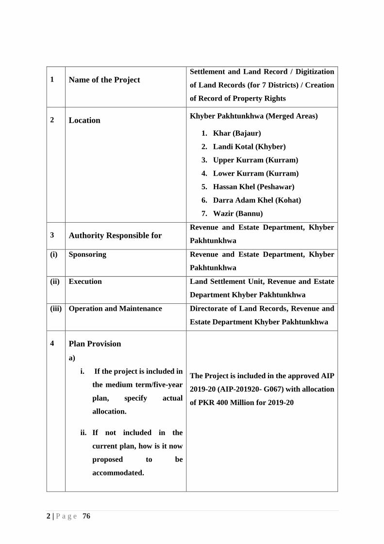
1 Name of the Project Settlement and Land Record / Digitization
of Land Records (for 7 Districts) / Creation
of Record of Property Rights
2 Location Khyber Pakhtunkhwa (Merged Areas)
1. Khar (Bajaur)
2. Landi Kotal (Khyber)
3. Upper Kurram (Kurram)
4. Lower Kurram (Kurram)
5. Hassan Khel (Peshawar)
6. Darra Adam Khel (Kohat)
7. Wazir (Bannu)
3 Authority Responsible for Revenue and Estate Department, Khyber
Pakhtunkhwa
(i) Sponsoring Revenue and Estate Department, Khyber
Pakhtunkhwa
(ii) Execution Land Settlement Unit, Revenue and Estate
Department Khyber Pakhtunkhwa
(iii) Operation and Maintenance Directorate of Land Records, Revenue and
Estate Department Khyber Pakhtunkhwa
4 Plan Provision
a)
i. If the project is included in
the medium term/five-year
plan, specify actual
allocation.
ii. If not included in the
current plan, how is it now
proposed to be
accommodated.
The Project is included in the approved AIP
2019-20 (AIP-201920- G067) with allocation
of PKR 400 Million for 2019-20

3 | P a g e 76
iii. If the project is proposed to
be financed out of block
provision, indicate,
Total Block provision
Amount already committed
Amount proposed for the
project.
b) If the project is not the
plan, what warrants its
inclusion in the plan?
5. Background:
The Project envisions establishment of a system of accurate, transparent and secure land
records linked to geospatial information system for the Merged Areas (MAs) of Khyber
Pakhtunkhwa.
Exploring land records management requires understanding the concept of land and
significance of records management in the development process of urban/rural areas. The
development in these areas requires a coordinated work between committed governments at all
levels, honest government officials, open legislative and transparent regulatory system.
Unlike rest of the province, the MAs do not have an official system of land and property rights
with the exception of only a few pockets of land in Kurram and North Waziristan that have
land records prepared and maintained. The current state of property rights is characterized by
two main features: (a) the ownership of land is undocumented; and (ii) most of the rights of
usufruct are communal in nature. The latter means that the ownership of most of the land rests
with the tribe.
In the absence of formal records and any institutional mechanisms for record keeping, disputes
regarding land are resolved through the Jirga, community bodies, whilst the sale and purchase
of land also remains cumbersome. Land is not taxed and the government has therefore no

4 | P a g e 76
database of land titles, occupancy and rights of passage and use. Unlike other areas of Pakistan,
the usufruct of the land in MAs remains undocumented.
Government of Khyber Pakhtunkhwa has recently approved a Tribal Decade Strategy (TDS)
to address developmental lags of Merged Areas (MAs). It accords high priority to economic
development of this region. An important endeavor in this regard is creation of accurate,
transparent and secure system of land records providing ease of access of land information to
its owners. In addition to this, a system of legal institutions will be required for efficient and
affordable dispute resolution. This effort will draw upon the systems, skill sets and manual
procedures currently in practice in Khyber Pakhtunkhwa and the rest of Pakistan while also
reaching out to benefit from IT based information and innovations in system designs to provide
higher level of service delivery to residents and businesses in MAs.
6. Project Objectives and Its Relationship with Sectoral Objectives:
The project has mainly two objectives:
1. Complete settlement operation using GIS based technology
2. Provide computerized transactional services to land owners.
The first objective is to create a series of documents related to land, land owners and its tenants.
This step includes survey of the entire area. Boundaries are determined of the basic revenue
unit called Mouza, Deh or Revenue Estate. Following are some of the important documents
created during this process along with some other auxiliary records.
a. Shajra e Nasab (Pedigree/Family Tree)
b. Khatoni (Records of Tenancy)
c. Field Book (Measurement dimensions)
d. Massavi (Cadastral Map)
e. Record of Rights (Misl e Haqiat)
f. Wajib ul Araz (Document of Customs) of mouza/village.
The second objective is to operationalize Service Delivery Center (SDC) to provide services to
the public as soon as records of a mouza is completed. It will reduce the cost of computerization
of manual records which is usually done in already settled districts.
Secondary objectives of the project are:
Initiation of GIS based land settlement operation.
Survey entire project area using advanced surveying equipment i.e. embedded with
RTK and GNSS technology
5 | P a g e 76
Data entry of records of rights and all other related data in the existing LRMIS software.
Creation of digital Massavi Maps
Creation of spatial database to store all GIS related data.
Integration of MIS and GIS data in the existing LRMIS software.
Provide scalable database solution to accommodate land transaction data both in spatial
and non-spatial formats.
The major Long Term goals of the project:
To maintain and update the existing digital records and prepare digitized Jamabandis
from the computerized records.
To mitigate land disputes on instant update of land records.
To prepare scalable digital maps for multi sector and multipurpose uses.
To determine the type of land, crop etc. from satellite imagery of the digitized Mauzas.
To increase revenue from Fard and Mutation services
To reduce litigation by accurately maintaining the digital records of rights.
To facilitate land owners and farmers for acquisition of bank loans.
Relationship with Sectoral Objectives:
The development of Information Technology Sector in the public sector is integral to
government initiatives. Strengthening back-office operations and effective public service
delivery is part of the objective to help the government achieve its vision of providing quality
services to citizens efficaciously and efficiently. This includes providing hassle-free service to
citizens which is an important objective of the government and this project would play a vital
role in achievement of such objectives.
The wealth of a nation and its economic development are dependent on the state land and its
usage. Digitalizing fresh land record through GIS technologies, will reduce potential disputes
and will enable the government to efficiently generate revenue from land transactions. One of
the key elements of this project is to improve the revenue record system by creating land
records in seven selected sub-divisions of Merged Areas (MAs). There is political commitment
in making hassle-free services available to the citizens and, at the same time, diminishing the
scope for litigation and land-related disputes.
This project would, therefore, help government for implementing the IT policy and good
governance.

6 | P a g e 76
The Board of Revenue (BoR), Khyber Pakhtunkhwa, Government has in principle agreed to
making use of the modern technology and incorporating international practices for Land
Administration. The government intends to strengthen its available resources and provide
capacity building support for existing staff and hire experienced staff for the project.
7. Key Performance Indicators:
The Key Performance Indicators (KPIs) for measuring project success are:
Establishment of Settlement Offices
Parcel survey of entire area using digital surveying equipment and/or satellite imagery.
Creation of computerized records of rights and other related documents.
Preparation of both digital and paper based Massavi Maps.
Providing computerized land transaction services to public.
Establishment of Service Delivery Centers (SDCs).
Result Based Matrix
Result Based Matrix of the project is given in below table.
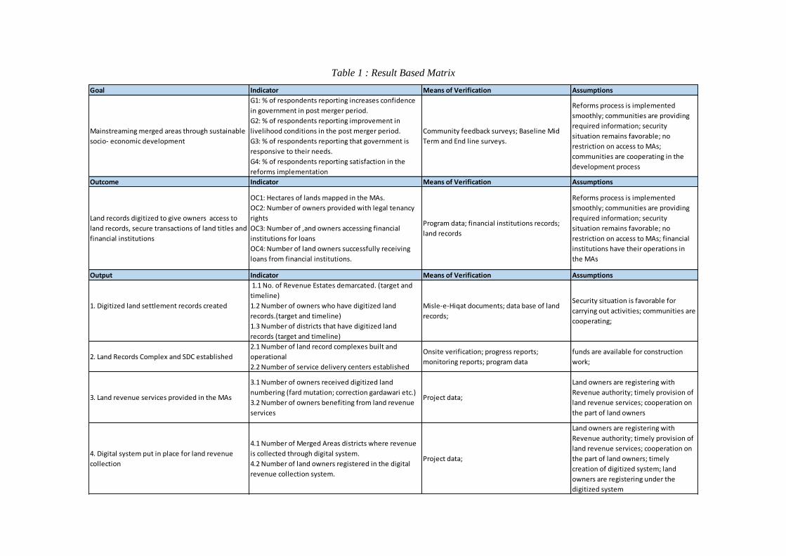
Table 1 : Result Based Matrix
Goal Indicator Means of Verification Assumptions
Mainstreaming merged areas through sustainable
socio- economic development
G1: % of respondents reporting increases confidence
in government in post merger period.
G2: % of respondents reporting improvement in
livelihood conditions in the post merger period.
G3: % of respondents reporting that government is
responsive to their needs.
G4: % of respondents reporting satisfaction in the
reforms implementation
Community feedback surveys; Baseline Mid
Term and End line surveys.
Reforms process is implemented
smoothly; communities are providing
required information; security
situation remains favorable; no
restriction on access to MAs;
communities are cooperating in the
development process
Outcome Indicator Means of Verification Assumptions
Land records digitized to give owners access to
land records, secure transactions of land titles and
financial institutions
OC1: Hectares of lands mapped in the MAs.
OC2: Number of owners provided with legal tenancy
rights
OC3: Number of ,and owners accessing financial
institutions for loans
OC4: Number of land owners successfully receiving
loans from financial institutions.
Program data; financial institutions records;
land records
Reforms process is implemented
smoothly; communities are providing
required information; security
situation remains favorable; no
restriction on access to MAs; financial
institutions have their operations in
the MAs
Output Indicator Means of Verification Assumptions
1. Digitized land settlement records created
1.1 No. of Revenue Estates demarcated. (target and
timeline)
1.2 Number of owners who have digitized land
records.(target and timeline)
1.3 Number of districts that have digitized land
records (target and timeline)
Misle-e-Hiqat documents; data base of land
records;
Security situation is favorable for
carrying out activities; communities are
cooperating;
2. Land Records Complex and SDC established
2.1 Number of land record complexes built and
operational
2.2 Number of service delivery centers established
Onsite verification; progress reports;
monitoring reports; program data
funds are available for construction
work;
3. Land revenue services provided in the MAs
3.1 Number of owners received digitized land
numbering (fard mutation; correction gardawari etc.)
3.2 Number of owners benefiting from land revenue
services
Project data;
Land owners are registering with
Revenue authority; timely provision of
land revenue services; cooperation on
the part of land owners
4. Digital system put in place for land revenue
collection
4.1 Number of Merged Areas districts where revenue
is collected through digital system.
4.2 Number of land owners registered in the digital
revenue collection system.
Project data;
Land owners are registering with
Revenue authority; timely provision of
land revenue services; cooperation on
the part of land owners; timely
creation of digitized system; land
owners are registering under the
digitized system
8 | P a g e 76
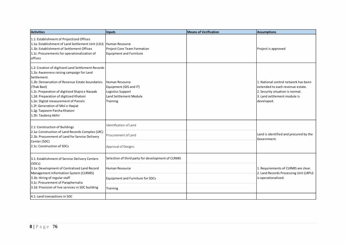
Activities Inputs Means of Verification Assumptions
1.1: Establishment of Projectized Offices
1.1a: Establishment of Land Settlement Unit (LSU)
1.1b: Establishment of Settlement Offices
1.1c: Procurements for operationalization of
offices
Human Resource
Project Core Team Formation
Equipment and Furniture
Project is approved
1.2: Creation of digitized Land Settlement Records
1.2a: Awareness raising campaign for Land
Settlement.
1.2b: Demarcation of Revenue Estate boundaries
(Thak Bast)
1.2c: Preparation of digitized Shajra e Nasaab
1.2d: Preparation of digitized Khatoni
1.2e: Digital measurement of Parcels
1.2f: Generation of Misl e Haqiat
1.2g: Taqseem Parcha Khatoni
1.2h: Tasdeeq Akhir
Human Resource
Equipment (GIS and IT)
Logistics Support
Land Settlement Module
Training
1. National control network has been
extended to each revenue estate.
2. Security situation is normal.
3. Land settlement module is
developed.
Identification of Land
Procurement of Land
Approval of Designs
Selection of third party for development of CLRMIS
Human Resource
Equipment and Furniture for SDCs
Training
4.1: Land transactions in SDC
Land is identified and procured by the
Government.
1. Requirements of CLRMIS are clear.
2. Land Records Processing Unit (LRPU)
is operationalized.
2.1: Construction of Buildings
2.1a: Construction of Land Records Complex (LRC)
2.1b: Procurement of Land for Service Delivery
Center (SDC)
2.1c: Construction of SDCs
3.1: Establishment of Service Delivery Centers
(SDCs)
3.1a: Development of Centralized Land Record
Management Information System (CLRMIS)
3.1b: Hiring of regular staff
3.1c: Procurement of Paraphernalia
3.1d: Provision of live services in SDC building

9 | P a g e 76
8. Map of the Project of Merged Areas of Khyber Pakhtunkhwa
Figure 1: Map of sub-divisions of Merged Areas planned for Settlement Operation.
9. Area Statistics:
Table 2 : Area Statistics
S.No. District Name Sub-Division Population
(2017)
No. of
Households
Area (Sq.
Km)
1 Bajaur Khar Bajaur 247,510 27,044 276
2 Bannu Wazir 43,114 4,188 824
3 Khyber Landi Kotal 274,409 29,472 771
4 Kohat Darra Adam Khel 118,578 14,339 469
5 Kurrum Lower Kurram 136,719 14,030 949
Upper Kurram 253,478 25,924 986
6 Peshawar Hassan Khel 64,691 7,065 260
Estimated Total 1,138,499 122,062 4,535
10 | P a g e 76
9. Description and Justification of the Project:
The most salient output of this project is the creation of new land records and protection of
property rights of the citizens as guaranteed in the Constitution of Islamic Republic of Pakistan.
This project will also ensure security of records by using a central database as well as safeguard
its integrity by preventing fraudulent entries.
The overall objectives of the proposed project are aimed to revolutionize record keeping and
land related transactions under the umbrella of a wholesome land management information
system in all Merged Areas of Khyber Pakhtunkhwa. This initiative will reduce land related
disputes and litigations through the introduction of an authentic recording and mapping system.
Land rights would be ensured in a transparent and timely manner. The project would ensure
that to provide streamlined services, better public-sector efficiency and citizen satisfaction.
The project intends to make all transactions related to land as transparent, credible, and
efficient. The aim of this project is to create GIS based digital fresh land records in merged
areas, which would be maintained by the land revenue technical staff in their respective Service
Delivery Centers (SDCs). The main theme is to prepare fresh land records in MAs, which is
easily accessible as a single electronic database where,
Efficient record of rights is maintained
Efficient mutation process is executed
People can access their records easily
The following specific objectives would be achieved through this project:
• Creation of computerized land records
• Accurate delineation of digital boundaries at various administrative levels
• Transparency in creation and management of record of rights (ownership title)
• Accurate demarcation of land parcels along with their individual dimensions and land
record keeping
• Integration of spatial and non-spatial data
• Resolution of land dispute as well as ensuring individual property rights
• Sharing of information electronically among the authorized stakeholders and provision
of prescribed information on website

11 | P a g e 76
• Support agriculture credit system and provide investment opportunities to Banking
Sector
• Institutional development and capacity building of existing staff.
• Better land use planning and providing the opportunity of access to capital for
landowners and cultivators.
Justification of the Project:
The use of GIS in land administration system has considerable potential to support society’s
evolving humankind/land relationship by providing information for decision makers that will
enable them to make decisions favorable to sustainable development in the context of land
administration and management. GIS is a valuable tool and powerful decision support system
for the Computerization of land records for the following reasons:
• Effective land administration
• Efficient resource allocation for land administration
• Sustainable land development and planning
• Improved physical storage facilities for land related matters
• Automation of indexes to provide quicker document retrieval
• Computerization of title documents to provide quicker access to land information
Majority of Merged Areas lack any settlement process and therefore, have no proper land
records. As a consequence, updating of records has suffered and they no longer represent the
ground realities relating to ownership and possession. For citizens, land records form the basis
for assignment and settlement of land titles that determine ownership claims. These records
also provide the administration with all the statistical information required for the purpose of
development planning, social reforms, rational use and conservation of resources. These are
also important as they form a component of Merged Areas revenue from taxes on agriculture
income, the transactions of rents, revenues, rates, cases among each of the land titleholders.
10. Implementation Modalities of the Project:
There are two projects of Land Records Computerization ongoing in Board of Revenue.
Another ADP approved scheme (ADP No. 190183) of Land Settlement in Dir Lower, Dir
Upper and Tehsil Kalam is also planned to be initiated this year (PC-I already submitted). One
more project is planned for ADP 2020-2021 to complete the GIS component of current
Computerization of Land Records Project. Moreover, Land Records Management Information
System (Turn Key Solution) which was approved ADP scheme (ADP No. 17043) will now be
the part of this PC-I.
12 | P a g e 76
Keeping in view the importance of these projects and space requirements for staff offices,
conference rooms and GIS lab a separate building is proposed to be constructed within
premises of existing Revenue Academy, Phase-III Chowk Hayatabad, Peshawar. This building
will be named as Land Records Complex (LRC).
All the above mentioned projects are technology based and requires a proper infrastructure for
storage and centralization. Land Records Processing Unit (LRPU) is planned to be established
under this PC-I. LRPU will not only facilitate the storage for these projects but will also host
the Centralized Land Records Management Information System (CLRMIS) which is the future
software application to be used in Service Delivery Centers (SDCs).
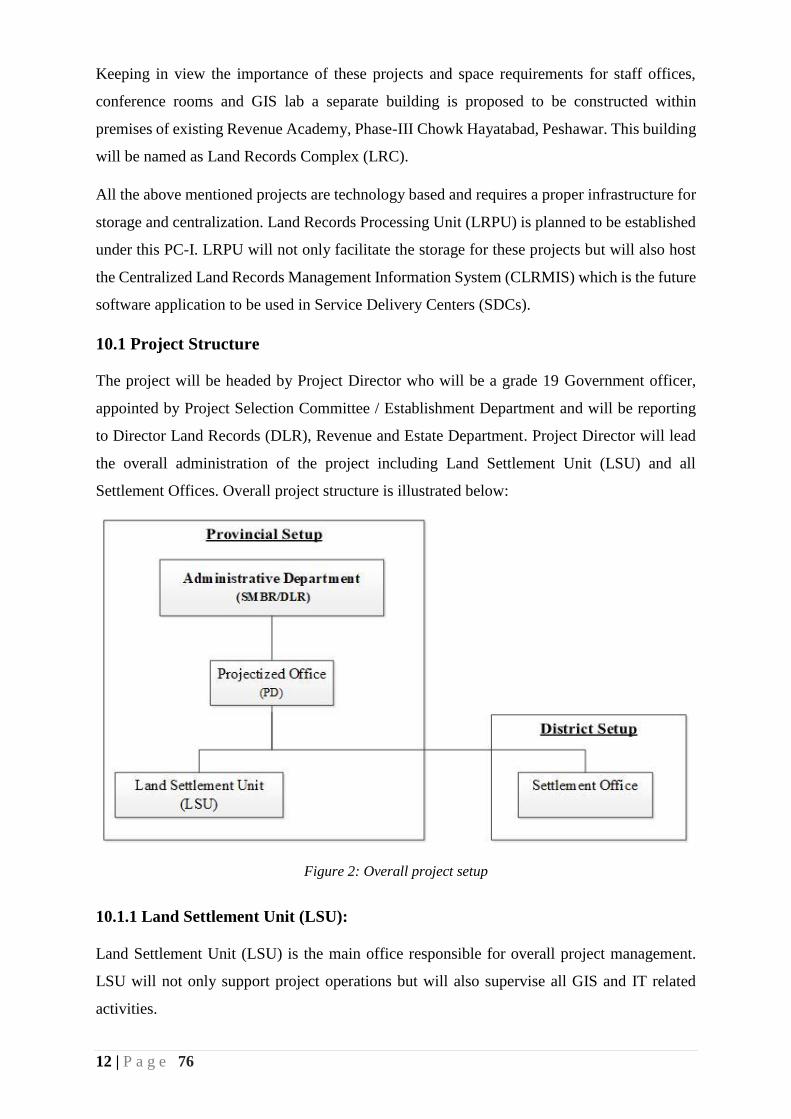
10.1 Project Structure
The project will be headed by Project Director who will be a grade 19 Government officer,
appointed by Project Selection Committee / Establishment Department and will be reporting
to Director Land Records (DLR), Revenue and Estate Department. Project Director will lead
the overall administration of the project including Land Settlement Unit (LSU) and all
Settlement Offices. Overall project structure is illustrated below:
Figure 2: Overall project setup
10.1.1 Land Settlement Unit (LSU):
Land Settlement Unit (LSU) is the main office responsible for overall project management.
LSU will not only support project operations but will also supervise all GIS and IT related
activities.

13 | P a g e 76
Project Director will be supported by three Senior Managers i.e. Senior Manager (Operations),
Senior Manager (Technical) and Senior Manager (GIS). These officers will be heading
operations and technical wings of IT and GIS throughout the project life. These posts will be
filled by existing resources of the department.
In order to support the planning, finance and accounts sections of the project, Senior Planning
Officer and Account Officer will be posted from Planning and Development Department and
Finance Department/Account General Office respectively. List of staff of Land Settlement Unit
(LSU) is given in the following table.
Table 3: List of Staff of Land Settlement Unit
S.No. Designation BPS Mode of Engagement No. of
Posts
1 Project Director (PD) 19 Transfer posting/New Hiring 1
2 Senior Manager (Operations) 19 Transfer posting/New Hiring 1
3 Senior Manager (IT) 19 Transfer posting/New Hiring 1
4 Senior Manager (GIS) 19 Transfer posting/New Hiring 1
5 Manager Database 18 Transfer posting/New Hiring 1
6 Manager Networks 18 Transfer posting/New Hiring 1
7 Senior Planning Officer 17/18 Transfer posting/New Hiring 1
8 Account Officer 17 Transfer posting/New Hiring 1
Sub Total (Government Officers) 8
9 Assistant Manager (Database) Fixed Pay New Hiring 1
10 Assistant Manager (GIS) Fixed Pay New Hiring 1
11 GIS Associate Fixed Pay New Hiring 1
12 Network Support Engineer Fixed Pay New Hiring 1
13 Accountant Fixed Pay New Hiring 1
14 Assistant Fixed Pay New Hiring 1
15 Computer Operator Fixed Pay New Hiring 2
16 Driver Fixed Pay New Hiring 4
17 Naib Qasid/Office Boy Fixed Pay New Hiring 4
18 Sweeper Fixed Pay New Hiring 2
Sub Total (Contract basis) 18
Total Staff of Land Settlement Unit (LSU) 26
Organogram of Land Settlement Unit (LSU) is shown below.
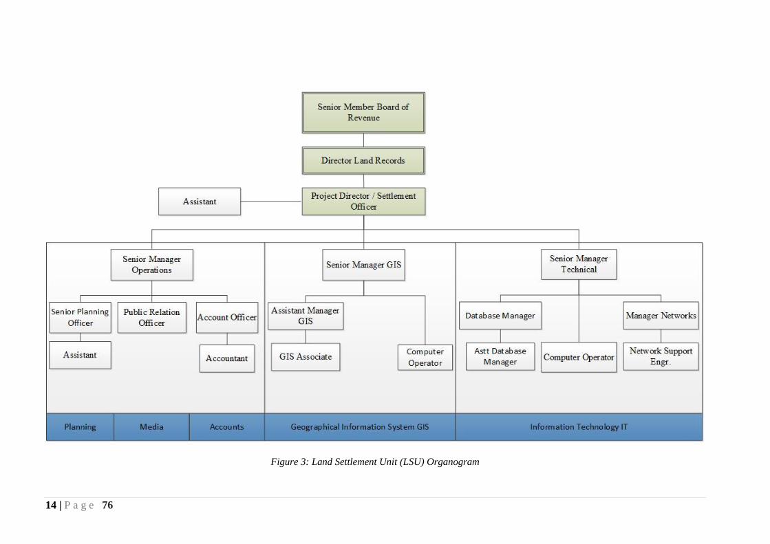
14 | P a g e 76
Figure 3: Land Settlement Unit (LSU) Organogram
15 | P a g e 76
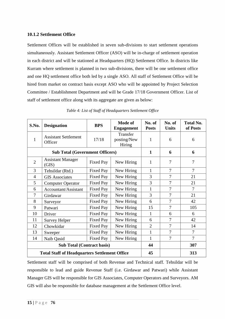
10.1.2 Settlement Office
Settlement Offices will be established in seven sub-divisions to start settlement operations
simultaneously. Assistant Settlement Officer (ASO) will be in-charge of settlement operation
in each district and will be stationed at Headquarters (HQ) Settlement Office. In districts like
Kurram where settlement is planned in two sub-divisions, there will be one settlement office
and one HQ settlement office both led by a single ASO. All staff of Settlement Office will be
hired from market on contract basis except ASO who will be appointed by Project Selection
Committee / Establishment Department and will be Grade 17/18 Government Officer. List of
staff of settlement office along with its aggregate are given as below:
Table 4: List of Staff of Headquarters Settlement Office
S.No. Designation BPS Mode of
Engagement
No. of
Posts
No. of
Units
Total No.
of Posts
1 Assistant Settlement
Officer 17/18
Transfer
posting/New
Hiring
1 6 6
Sub Total (Government Officers) 1 6 6
2 Assistant Manager
(GIS) Fixed Pay New Hiring 1 7 7
3 Tehsildar (Rtd.) Fixed Pay New Hiring 1 7 7
4 GIS Associates Fixed Pay New Hiring 3 7 21
5 Computer Operator Fixed Pay New Hiring 3 7 21
6 Accountant/Assistant Fixed Pay New Hiring 1 7 7
7 Girdawar Fixed Pay New Hiring 3 7 21
8 Surveyor Fixed Pay New Hiring 6 7 42
9 Patwari Fixed Pay New Hiring 15 7 105
10 Driver Fixed Pay New Hiring 1 6 6
11 Survey Helper Fixed Pay New Hiring 6 7 42
12 Chowkidar Fixed Pay New Hiring 2 7 14
13 Sweeper Fixed Pay New Hiring 1 7 7
14 Naib Qasid Fixed Pay New Hiring 1 7 7
Sub Total (Contract basis) 44 307
Total Staff of Headquarters Settlement Office 45 313
Settlement staff will be comprised of both Revenue and Technical staff. Tehsildar will be
responsible to lead and guide Revenue Staff (i.e. Girdawar and Patwari) while Assistant
Manager GIS will be responsible for GIS Associates, Computer Operators and Surveyors. AM
GIS will also be responsible for database management at the Settlement Office level.
16 | P a g e 76
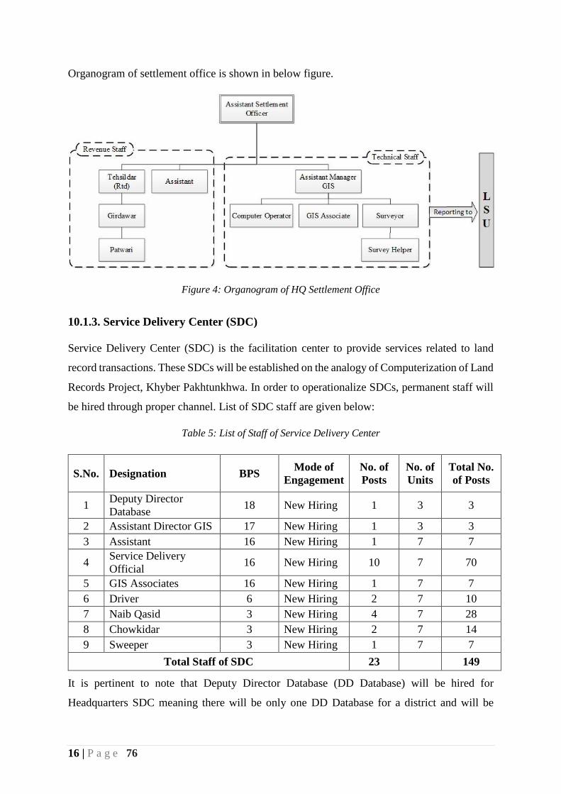
Organogram of settlement office is shown in below figure.
Figure 4: Organogram of HQ Settlement Office
10.1.3. Service Delivery Center (SDC)
Service Delivery Center (SDC) is the facilitation center to provide services related to land
record transactions. These SDCs will be established on the analogy of Computerization of Land
Records Project, Khyber Pakhtunkhwa. In order to operationalize SDCs, permanent staff will
be hired through proper channel. List of SDC staff are given below:
Table 5: List of Staff of Service Delivery Center
S.No. Designation BPS Mode of
Engagement
No. of
Posts
No. of
Units
Total No.
of Posts
1 Deputy Director
Database 18 New Hiring 1 3 3
2 Assistant Director GIS 17 New Hiring 1 3 3
3 Assistant 16 New Hiring 1 7 7
4 Service Delivery
Official 16 New Hiring 10 7 70
5 GIS Associates 16 New Hiring 1 7 7
6 Driver 6 New Hiring 2 7 10
7 Naib Qasid 3 New Hiring 4 7 28
8 Chowkidar 3 New Hiring 2 7 14
9 Sweeper 3 New Hiring 1 7 7
Total Staff of SDC 23 149
It is pertinent to note that Deputy Director Database (DD Database) will be hired for
Headquarters SDC meaning there will be only one DD Database for a district and will be

17 | P a g e 76
looking after multiple SDCs. In seven sub-divisions of this project, three sub-divisions i.e.
Hassan Khel, Darra Adam Khel and Wazir (erstwhile FR) will be looked after by DD Database
of Peshawar, Kohat and Bannu respectively.
Procurement of land and construction of SDCs are also included in this project. From the
experience of Computerization of Land Records Project, Khyber Pakhtunkhwa, it has been
noted that construction work takes more time than expected. That’s why during the project’s
life, provision of rented building for SDCs have been allocated.
Service Delivery Centers will be able to provide services to the public as soon as settlement
operation is completed in a mouza.
10.1.4. Project Review Board (PRB)
Overall supervision and keeping the project on track will be ensured by Project Review Board
(PRB). Project Review Board will consist of the following members:
Table 6 : Project review Board Structure
S.No. Designation Status
1 Senior Member Board of Revenue Chairman
2 Representative of Finance Department Member
3 Representative of P&D Department Member
4 Director Land Records (DLR) Member
5 Project Director Member/Secretary
6 Representative of ST&IT Department Member
Frequency of Meeting: The Project Review Board (PRB) meeting will be organized
at least once in a quarter to review the progress as per the project goals.
Justification for PRB: The Project of land settlement in Merged Areas (MAs), will
require consistent guidance and supervision as for the first-time land settlement will be
created through GIS Technology. PRB will act as major forum to give directions after
carefully monitoring the progress of the project and help to solve the administrative and
legal matters during project implementation.
18 | P a g e 76
Terms of Reference (TORs) of PRB
Review and coordinate over-all progress and provide strategic direction to
project implementation.
Performance overview and consistency with the project goals.
Support and solve the project objectives with the administrative and line
departments for legal matters.
Guidance for the KPIs progress and support any higher support to the project;
Any other action / decision for smooth implementation of the project and
achieving the objectives.
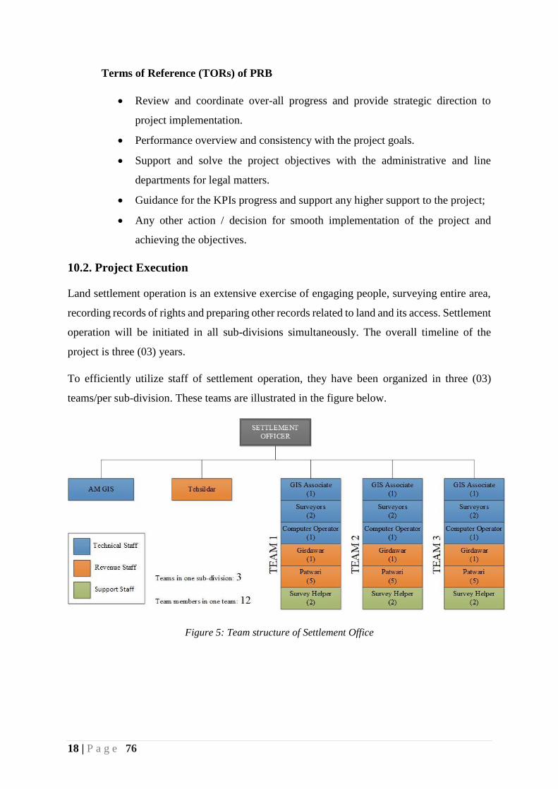
10.2. Project Execution
Land settlement operation is an extensive exercise of engaging people, surveying entire area,
recording records of rights and preparing other records related to land and its access. Settlement
operation will be initiated in all sub-divisions simultaneously. The overall timeline of the
project is three (03) years.
To efficiently utilize staff of settlement operation, they have been organized in three (03)
teams/per sub-division. These teams are illustrated in the figure below.
Figure 5: Team structure of Settlement Office
19 | P a g e 76
Each team will be comprised of both Revenue and Technical staff. Team composition is shown
in below table.
Table 7 : Team Composition
S.No. Designation No.
1 GIS Associate 1
2 Surveyors 2
3 Computer Operator 1
4 Girdawar 1
5 Patwari 5
6 Survey Helper 2
No. of Staff in a team 12
Each team will be working in five mouzas simultaneously i.e. at a single time settlement
operation will be ongoing in 15 mouzas in a sub-division. After completing five mouzas by a
single team, another group of five mouzas will be assigned to them by the Assistant Settlement
Officer.
There will be five Patwaris working in a team. They will be preparing Shajra e Nasb, writing
Khatoni, verifying field measurements, verifying field book, preparation of Misl e Haqiat and
verification of all other revenue documents. He will be supervised and guided by Girdawar.
Patwari will be working closely with Computer Operator to ensure data has been entered and
with GIS staff to make sure measurements of parcels are correct.
As soon as the Patwari starts writing Shajra e Nasb and Khatoni, Surveyors with the help of
GIS Associate will start Khasra Measurement. GIS Associate will be extending GIS support to
the team and will be primarily responsible to demarcate mouza boundaries, manage and verify
survey data, finalize Massavis and perform ground truthing where required.
Surveyors will be supporting GIS Associate and Patwari in field data collection and field
verification. He will also be responsible to handle and use GNSS/RTK equipment. Computer
Operator will perform the scanning and data entry of Shajra e Nasb and Khatoni received from
Patwari on daily basis. Computer Operator will be a trained personnel to use Land Settlement
Module and support the Revenue staff and Assistant Settlement Officer in performing
verification of the data entered. Surveyors will be assisted by Survey Helpers in handling
survey equipment and do the duty of attendants where Base (DGPS) is fixed.
Field work will be conducted by Patwari and Surveyors where GIS Associate and Computer
Operator will do the desk work. In case of any verification needed, both the staff members will

20 | P a g e 76
move with the field team. In order to facilitate the field staff i.e. Patwari, Surveyors and Survey
Helpers, each team will be provided with a vehicle.
Once the record is finalized by Patwari, it will be verified by Girdawar, Tehsildar, Assistant
Settlement Officer and finally by the Settlement Officer. After signing off the records, data will
be available for live services.
10.3 Implementation Methodology
Settlement operation will be carried out in two different modalities i.e.
a. Fresh Settlement
b. Re-settlement
Both the processes are explained in detail as below.
10.3.1 Fresh Settlement
Most of the areas of Merged Areas (MAs) are lacking proper record of rights that’s why Fresh
Settlement process will be adopted. The use of GIS and IT has been illustrated in the figure
below. Land Records Management Information System (LRMIS) which is already in use in
Service Delivery Centers (SDCs) of District Peshawar, Mardan and Abbotabad. Land
Settlement Module will be developed and integrated with current LRMIS software. Initial data
entry of Shajra e Nasab and Khatoni will be stored in Settlement Module which after
verification (Parthal) from concerned revenue staff will be updated to LRMIS database.
Khasra measurement and Field Book preparation will be done using GIS technology as
illustrated in Figure 5. All the Khasra measurement will be done by using Very High Resolution
Satellite Stereo Imagery and using advanced surveying equipment i.e. DGPS + GNSS. This
data will be stored in a Geo-database and then after verification from concerned revenue staff
will be integrated with LRMIS database. After completing all the required processes of
Settlement Operation, the data will be ready for live services.
The detail process is discussed below and is shown in Figure 6.

21 | P a g e 76
Figure 6: Settlement Methodology
1. Public Awareness
The department will initiate and coordinate mass awareness campaigns before the settlement
process begins in each area separately. A range of tools and techniques will be developed to
foster participation through elders and mass awareness campaigns. It will include posters and
leaflets, mass media campaigns (radio, television), mobile display/announcements, public
meetings, using social media campaigns, and school/college class awareness with the help of
local administration. Keeping in view the importance of the project, the awareness campaign
will be focused to develop a clear perception, understanding, and familiarity of how the target
masses will get benefits out of the settlement operation. Assistant Settlement Officer will be
looking after and coordinating this activity.
Objectives of Public awareness campaign are:
Establishing the fact that settlement operation and land record management
information system will offer services that will advantage land owners.
Familiarizing the audiences with the use, and ease of the system.
22 | P a g e 76
Educating the target audience on how to use the offered Services.
Minimizing resistance among the target audience against the change of operation.
To ensure that awareness campaign is reached to the maximum audience.
Public support and understanding are essential to educate potential landowners and other
stakeholders. The campaign would involve information about benefits and obligations of
registering title transactions, title alterations and the risks associated with unregistered interests.
Reach: The mass awareness campaign will be launched through village-based
meetings, print and electronic media and also by arranging sessions in school and
colleges.
Printing: Special awareness poster will be printed for describing land settlement
process step by step and will be shared with local community and stakeholders etc.
Frequency: The message reaching the audiences should be received more than once.
This ensures attendance and improves recall.
2. Thak Bast
Thak Bast is the first practical step of settlement operation. It is the process of drawing a sketch
of revenue estate or in other words we can say it is the process of determining boundary line
of that revenue estate. It is precisely determined with the help of community elders and land
owners.
Role of Technology: This process will be supported by GIS by printing high resolution
satellite imagery on paper. These maps will be presented and discussed in the
community to determine boundary line of that revenue estate. If the boundary line is a
natural feature like river, stream or hill/mountain or it’s a manmade feature like road,
canal etc. then physical survey may not be needed. But if the boundary line is within
parcels and is not clear in satellite imagery then physical survey using advanced
surveying equipment will be carried out.
In this process a number of staff will be involved. GIS Associate will be responsible to
print satellite imagery on paper maps of that area on suitable scale. Tehsildar/Patwari
will be responsible to determine the boundary line with the help of community and land
owners while Surveyors will be responsible to survey that area if required. At the end
GIS Associate will produce the final boundary of that revenue estate.
23 | P a g e 76
3. Chatta Shajra Nasb writing
Shajra Nasb writing (Pedigree/Family Tree) is the process of noting down list of all owners
along with their ancestors. Owner list is written in the form of a tree through which relation
between owners can be determined. It also provides the list of different tribes and clans residing
in that area.
Writing Shajra Nasb is an ongoing process and it is usually not completed in a single sitting. It
is completed towards record finalization stage. Shajra Nasb will be written by Patwari on
prescribed form and that form will be handed over to Computer Operator.
Role of Technology: Computer Operator will scan the hand written Shajra e Nasb and
will do data entry in settlement module of existing LRMIS software. Scanned record
and data entry will be compared for verification purposes.
4. Khatoni Writing
Khatoni is the primary document to record information of cultivator of a piece of land. This
information is collected for each and every parcel in a given revenue estate.
Role of Technology: Patwari will be responsible to write Khatoni in the field and then
deliver it to respective Computer Operator. Computer Operator will scan it and will
enter the data in exiting LRMIS software. At the completion of Khatoni writing, both
the hand written and printed out records will be compared for verification and in case
of any inconsistency, will be corrected at the field level.
5. Chanda Bandi/Establishment of Ground Control Points (GCPs)
In manual settlement process Chanda bandi is the process of setting base for measurement. In
this process, points of equal distance are lay down in all over revenue estate. These points can
be referred to as reference points. Khasra measurement is taken place using reference from
these points and are used as a source of triangulation.
Role of Technology: In GIS based settlement Chanda Bandi will be replaced by using
Ground Control Points (GCPs). GCPs are termed as permanent locations on ground
which do not change over time. These points are very important for referencing location
of land features. GCPs are usually established and managed by the National Surveying
Agency i.e. Survey of Pakistan (SOP). SOP has already established network of
GCPs/Benchmarks in all over Pakistan and they might be engaged to further increase
the density of these points by traversing it, so that it may cover all the areas.
24 | P a g e 76
In revenue system “Seh Hada” which acts as GCP and are marked at the
common/junction point of three Mouzas. A small rock is placed or cemented block is
constructed at that point and its location is also marked on Massavi Map with a Red
Dot. Seh Hada will also be referenced with GCPs of Survey of Pakistan.
6. Khasra Measurement
Khasra measurement is the most time taking process of manual settlement operation. In this
process dimensions of each and every Khasra is measured.
Role of Technology: Khasra measurement will be done using GIS technology. A
hybrid approach of both satellite imagery and surveying equipment will be used. Very
High Resolution (VHR) satellite imagery will be used to digitize the entire area. As the
settlement operation is going to take place mostly in hilly areas, it will be difficult to
conduct survey in rough terrain, deep valleys and inaccessible areas. Such areas will be
digitized and measured using VHR satellite imagery. Areas which are congested, will
be surveyed using advanced surveying equipment.
In this process GIS Associates and Surveyors will play the vital role under the guidance
of Assistant Manager GIS of each district. GIS Associates will be digitizing the areas
while Surveyors will be doing ground survey where required.
7. Field Book preparation
Field Book is also one of the most important record regarding Khasra measurement. This record
is prepared while measurement is ongoing. Each of the Khasra is given a unique ID and lengths
of each dimension is noted down in it. Area of each Khasra is also determined in Field Book.
Khatoni No. of each Khasra is also recorded.
Role of Technology: Using GIS based technology, Field Book preparation will be
much easier. Measurement of each dimension of a Khasra will be determined from
VHR satellite imagery or advanced survey equipment (as discussed in the previous
step). Area of each Khasra will also be determined automatically. Only Khatoni No.
will be recorded from the field by Patwari which will provide the basis for cross
verification of the data. Field Book and Khatoni will be verified by relevant revenue
staff after its completion.

25 | P a g e 76
8. Massavi preparation
Plotting of Massavi using manual methods requires very high degree of skills. In manual
system, it is plotted using Plane Table technique which is obsolete now in this era of
technology.
Role of Technology: All the Khasra measurements of a given revenue estate will be
organized in the form of Massavi. This Massavi will have the same scale which is used
for manual one i.e. 1inch = 40 Karam or 220 feet. It will also have the 4x4 grid each of
200x200 Karam. This grid will initially be extended from settled districts to avoid any
inconsistency on the borders of its neighboring districts.
GIS Associates will be responsible to create these Massavis. Massavis will be verified
on ground by concerned revenue officials before it is finalized.
9. Writing of Misl e Haqiat
Misl e Haqiat is the primary document and final deliverable for records of rights. It is the
combination of multiple documents which is written at the end of settlement operation.
Role of Technology: As Misl e Haqiat is written from multiple documents like Shajra
e Nasab, Khatoni and Field Book, it will be generated automatically from the land
settlement module of existing LRMIS software. After it is generated, it will be handed
over to revenue staff for verification.
Computer Operator will be responsible to generate it from the system.
20
0 k
aram
200 karam

26 | P a g e 76
10. Wajib ul Araz
Wajib ul Araz is the document of common lands, its customs, accessibility for different
tribes/clans and distribution of resources. This document is written by Patwari of the concern
revenue estate.
Role of Technology: Once Patwari is finished writing it, it will be handed over to
Computer Operator to scan and incorporate it with Misl e Haqiat in to the system.
11. Taqseem Parcha Khatoni
Taqseem Parcha Khatoni is the process of distributing owner’s land information to respective
owners to find out if there is any discrepancy in the data.
Role of Technology: Parcha Khatoni of each owner will be generated from the system
by Computer Operator on its prescribed format and will be distributed by concerned
Patwari. In case of any issues reported by the owner will be corrected accordingly.
12. Tasdeeq Akhir
Tasdeeq Akhir is the final process of verification done by the Assistant Settlement Officer
(ASO). All the required documents will be generated from the system which will be verified
by respective ASO. In case of any discrepancy found in data will be corrected accordingly.
After the completion of Tasdeeq Akhir, data will be handed over to District Administration and
will be ready to get live on Service Delivery Center (SDC).
10.3.2 Re-settlement
There are a few pockets in Merged Areas (MAs) where settlement has previously been done
like Kurram and North Waziristan. In these areas Re-settlement operation will be carried out
which has a few different steps from Fresh Settlement process which are explained below.
Figure 6 shows the methodology of Re-settlement process.
27 | P a g e 76
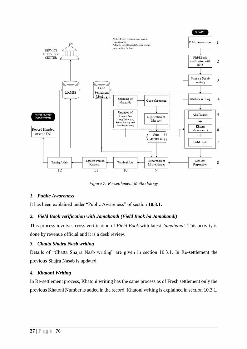
Figure 7: Re-settlement Methodology
1. Public Awareness
It has been explained under “Public Awareness” of section 10.3.1.
2. Field Book verification with Jamabandi (Field Book ba Jamabandi)
This process involves cross verification of Field Book with latest Jamabandi. This activity is
done by revenue official and it is a desk review.
3. Chatta Shajra Nasb writing
Details of “Chatta Shajra Nasb writing” are given in section 10.3.1. In Re-settlement the
previous Shajra Nasab is updated.
4. Khatoni Writing
In Re-settlement process, Khatoni writing has the same process as of Fresh settlement only the
previous Khatoni Number is added in the record. Khatoni writing is explained in section 10.3.1.

28 | P a g e 76
5. Aks Patangi
Aks Patangi is the process of photocopying original Massavi manually. This process is carried
out by placing tracing paper on Massavi and draw each and every Khasra on it. Aks Patangi is
then plotted on new sheet and then is updated in the field by Patwari.
Role of Technology: This step will be skipped in GIS based land settlement as
Massavis will be digitized from old ones. Once the digital copy is prepared, it can be
printed as many times as required.
6. Khasra Measurement
Once the previous Massavi of a mouza is digitized, it will be printed out and the relevant
Patwari will start updating it. Surveyor will conduct field surveys where required and the
changes will be recorded accordingly including Khasra divisions, new features addition like
roads, schools, health facilities and change in type of land.
Role of Technology: In digital mode, the previous Massavis will be scanned, geo-
referenced, digitized and then will be updated according to the ground situation. This
updation will be done using satellite imagery and mostly by ground survey. Updated
Massavis will be prepared by GIS Associates and will be shared with concern Revenue
officials for verification.
7. Field Book preparation
Field Book will also be prepared in parallel with Khasra measurement. Details of Field Book
preparation is already discussed in section 10.3.1.
8. Massavi preparation
Massavi preparation is also discussed in section 10.3.1.
9. Writing of Misl e Haqiat
Preparation of Misl e Haqiat is discussed in section 10.3.1
10. Wajib ul Araz
Writing of Wajib ul Araz is discussed in section 10.3.1.
11. Taqseem Parcha Khatoni
Taqseem Parcha Khatoni is discussed in section 10.3.1.
12. Tasdeeq Akhir
Tasdeeq Akhir is discussed in section 10.3.1.
29 | P a g e 76
After the completion of Tasdeeq Akhir, data will be handed over to District Administration and
will be ready to get live on Service Delivery Center (SDC).
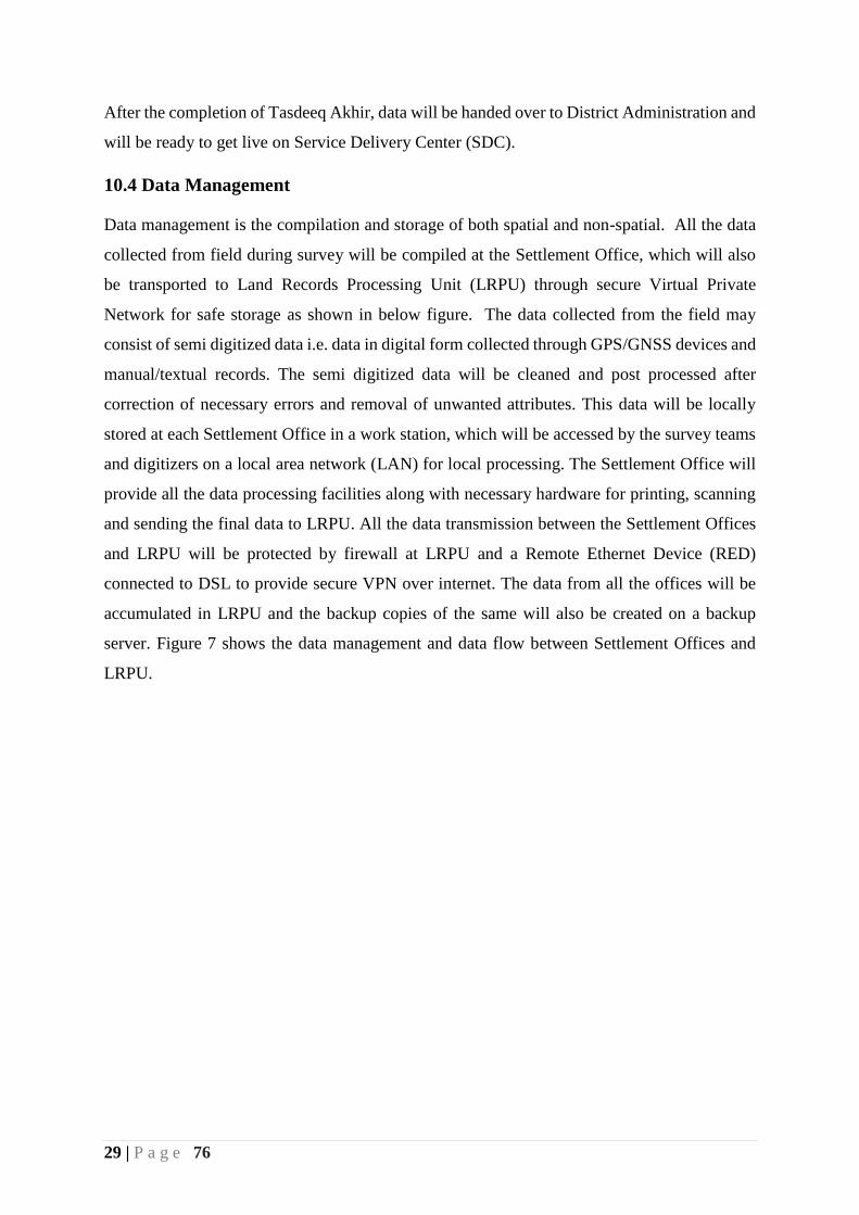
10.4 Data Management
Data management is the compilation and storage of both spatial and non-spatial. All the data
collected from field during survey will be compiled at the Settlement Office, which will also
be transported to Land Records Processing Unit (LRPU) through secure Virtual Private
Network for safe storage as shown in below figure. The data collected from the field may
consist of semi digitized data i.e. data in digital form collected through GPS/GNSS devices and
manual/textual records. The semi digitized data will be cleaned and post processed after
correction of necessary errors and removal of unwanted attributes. This data will be locally
stored at each Settlement Office in a work station, which will be accessed by the survey teams
and digitizers on a local area network (LAN) for local processing. The Settlement Office will
provide all the data processing facilities along with necessary hardware for printing, scanning
and sending the final data to LRPU. All the data transmission between the Settlement Offices
and LRPU will be protected by firewall at LRPU and a Remote Ethernet Device (RED)
connected to DSL to provide secure VPN over internet. The data from all the offices will be
accumulated in LRPU and the backup copies of the same will also be created on a backup
server. Figure 7 shows the data management and data flow between Settlement Offices and
LRPU.
30 | P a g e 76
Figure 8: Data Management and Data Flow Diagram.
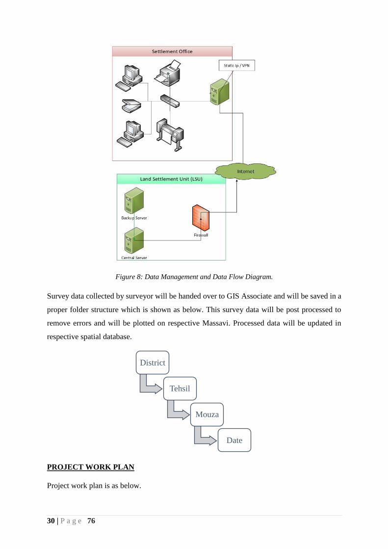
Survey data collected by surveyor will be handed over to GIS Associate and will be saved in a
proper folder structure which is shown as below. This survey data will be post processed to
remove errors and will be plotted on respective Massavi. Processed data will be updated in
respective spatial database.
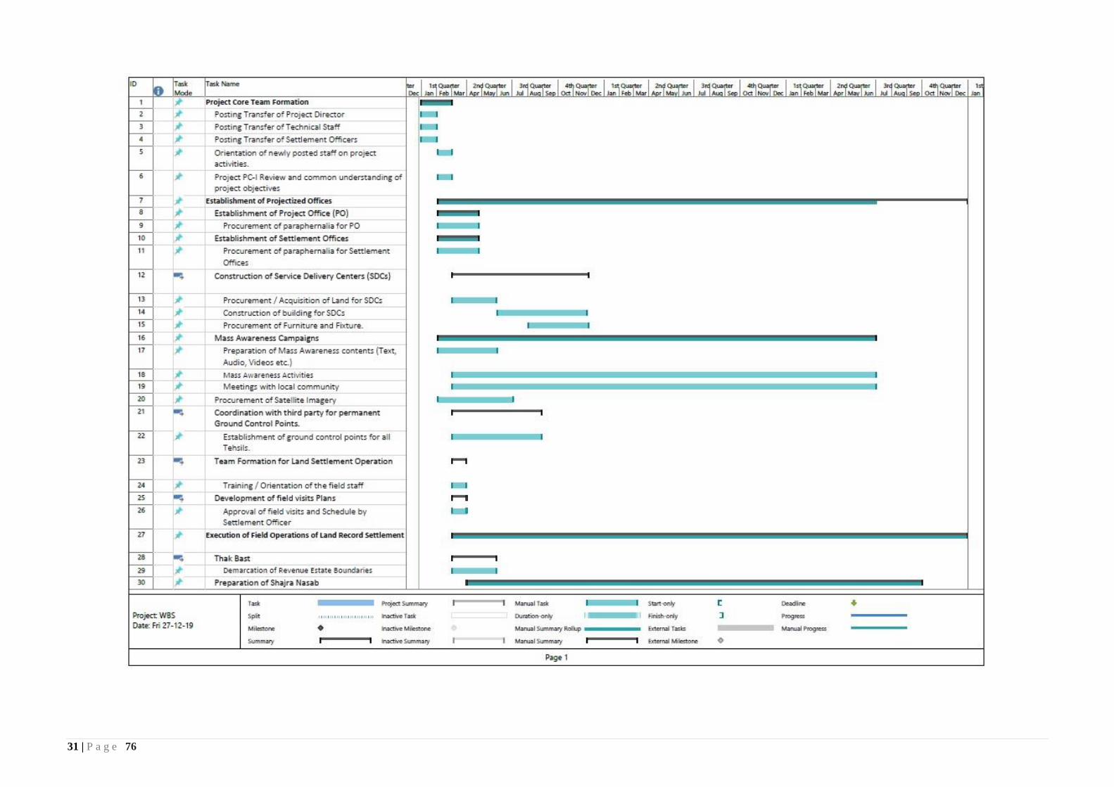
PROJECT WORK PLAN
Project work plan is as below.
District
Tehsil
Mouza
Date
31 | P a g e 76

32 | P a g e 76
Figure 9: Project Work plan

33 | P a g e 76
In case of availability of additional resources, better level of accessibility of the local
population and preparedness at the project and departmental level, the project can be
initiated in other sub-divisions of the Merged Areas during this project life.
14. Project Benefit and Analysis:
Secure land tenancy and property rights are fundamental to shelter and livelihoods and serve
as solid foundation for the realization of human rights and poverty reduction. It enables people
in rural and urban areas to invest in improved livelihoods. Secure land rights are particularly
important in helping reverse gender discrimination, social exclusion of vulnerable groups and
wider social and economic inequalities linked to inequitable and insecure access to land. They
also help to promote good environmental management, improve revenue collection, improve
food security, and assist directly in the realization of human rights, including the elimination
of discrimination against women, the vulnerable, indigenous groups and minorities. It is vital
for good governance at all levels as it promotes transparency and accountability in its service
delivery in unequivocal terms.
The project is to improve the land records service delivery of the Merged Areas of Khyber
Pakhtunkhwa, contributing to long-lasting tenure security and more efficient functioning of
land markets, and to establish a basis for comprehensive integration of information associated
with rights in land. Parcel information is comprised of the documents, maps, attribute and
attribute information that represent rights and interests in land. It includes ownership, legal
description, location, and nature and extent of a particular piece of land. Parcel information
plays an important role in the economic development of individuals and communities. Parcel
information provides a public record of who owns what, where and how much.
Merged Areas needs secure, accessible and authoritative land information to build a successful
cadastral system. The benefits of land information systems (cadastral and geographic
information systems) are many and varied. In analyzing the benefits, it is best to look at urban
and rural areas separately, both of which have economic, social and environmental benefits.
Economic Benefits:
To reduce time and cost of transaction
To utilize digital land records data mining for planning and taxation.
34 | P a g e 76
System will support government, private, commercial and civil departments in land
revenue, land titles, land holdings, land mortgage and land leasing.
Social Benefits:
Public access to records through Service Deliver Centre (SDC’s) and eventually, the
internet via web for basic information.
Increased access to land records at lower transaction cost for the beneficiary, through a
client-responsive service.
Increased level of tenancy security of land-right holders.
Definite and secure transactions at mutation.
Central maintenance of electronic land records and instantly update and backup in
secure terminal.
E-Pass Book and Computerize Fard, Jamabandi and Massavi.
Efficient and easy searching facilities.
Land transfer within in a one window operation.
Get “FARD” instantly without any delays.
Environmental:
Provide basis for integrated spatial decision support systems. (SDSS)
Geospatial data created during the project will help in Environmental Impact
Assessments (EIA)
Will help in identification and demarcation of forests, mines and other features.
The overall benefits of modern technology in Land Administration is to design a land system,
which will facilitate the land administration process such as:
Land Valuation
Determining values, objectives and the legal framework in relation to management of
land as a legal, economic, and physical object.
Basis for building sound land administration infrastructures.
Cadastral Systems
Identification of land parcels and securing land rights.
Facilitate land registration, land valuation, and land-use control.
Underpin Sound Land Administration

35 | P a g e 76
Land Administration Systems
Administration of land tenure, land value, land-use, and land development.
Facilitate efficient land markets and effective land-use management.
Underpin Sound Land Management
Land Management
Management of processes by which land resources are put into good effect.
Facilitates economic, social, environmental sustainability.
Underpins and implements sound Land Policies
36 | P a g e 76
Justification for Land Settlement Special Allowance
Manual procedure of Land Settlement Operations and land records creation is a very complex
and time consuming activity, which is going on in District Chitral for the last two decades
incurring more than 703 million cost. Utilizing the lessons learnt from settlement operations,
Board of Revenue, Khyber Pakhtunkhwa for the first time in history of Pakistan is proposing
to execute digital land settlement with latest surveying equipment having GNSS/RTK
technology. The overall project methodology has been designed in such a way to maximum
utilization of latest technology and Satellite Imagery thus reducing completion time by
approximately six folds. The department has completed a dry run of the proposed methodology
in a sample Mouza in District Malakand as a pilot with outstanding results having accuracy up
to centimeters in Khasra measurement.
The Project needs multi-dimensional Professionals having sound understanding of the latest
technology and settlement methodology to execute the project activities in hard and far-flung
areas of Merged Areas having volatile law and order situations. In order to attract good human
resource and keep them motivated “Land Settlement Special Allowance” is proposed in
addition to the project salary on the analogy of Independent Monitoring Unit (IMU) and
Performance Monitoring and Reform Unit (PMRU). The overall financial implications of the
proposed allowance for seven Settlement Offices and Land Settlement Unit for complete
project life (3-Years) is 58.32 million. Justification for each post is given as below.
S# Role / Designation Justification
1 Project Director The GIS based settlement is out of the box and
innovative solution never done in Pakistan before.
The project is specialized, unique and significant for
Government, donor partner as well as general public
to create GIS based settlement records including
accurate measurement using GNSS / RTK technology
and Satellite Imagery. UNDP proposed salary @
600,000 per month whereas, this project proposes
‘Land Settlement Special Allowance’ @ 160,000
per month in addition to his own salary to attract
qualified, professional and experienced officer as per
Project Policy.

37 | P a g e 76
2 Sr. Manager Operations The project needs a seasoned officer in the capacity of
Sr. Manager Operations having unique
multidimensional and multi-sectorial experience to
manage the operations of GIS based land settlement
project encompassing Planning, Audit & Accounts
and Mass Awareness. The said post with specialized
knowledge of land settlement and project operations
management have high market demand. This project
proposes ‘Land Settlement Special Allowance’ @
140,000 per month in addition to his own salary to
attract qualified, professional and experienced officer
as per Project Policy.
3 Sr. Manager Technical Designing, developing and installation of centralized
Land Records Management Information System
(CLRMIS) and ICT Infrastructure for Land Record
Processing Unit, needs the services of a senior
technical veteran having expertise in similar nature
work.
The job nature of Sr. Manager Technical is extremely
technical, specialized, unique and having very high
market value. UNDP proposed salary @ 550,000 per
month for similar nature post whereas, this project
proposes ‘Land Settlement Special Allowance’ @
140,000 per month in addition to his own salary to
attract qualified, professional and experienced officer
as per Project Policy.
4 Sr. Manager GIS GIS is the major operational component of the project
which needs a GIS specialist having practical
expertise in the use of satellite imagery, GNSS / RTK
technology based survey for creation of digitized
Massavis (cadastral maps). The expertise in this
specialized field are very rare and have very high
market value in Pakistan as well as abroad. UNDP

38 | P a g e 76
proposed salary @ 550,000 per month whereas, this
project proposes ‘Land Settlement Special
Allowance’ @ 140,000 per month in addition to his
own salary to attract qualified, professional and
experienced officer as per Project Policy.
5 Manager Networks The deployment of state of the art IT infrastructure in
Land Records Processing Unit (LRPU) needs a
dynamic, passionate and market oriented IT
Infrastructure specialist. The market value of IT
Professional with such expertise is approximately
250K to 300K. This project proposes ‘Settlement
Special Allowance’ @ 100,000 per month in addition
to his own salary to attract qualified, professional and
experienced officer as per Project Policy.
6 Manager Database The designing, deployment and maintenance of
Centralized
Land Records Management Information System is a
very complex and specialized task, which needs
expertise in database as well as Revenue domain. A
manager database without expertise in Revenue
domain cannot comprehend the complexities involved
in the old and manual records of Patwari. Such
specialty is very rare and have high demand in market.
The market value of IT Professional with such
expertise is approximately 250K to 300K. This
project proposes ‘Land Settlement Special
Allowance’ @ 100,000 per month in addition to his
own salary to attract qualified, professional and
experienced officer as per Project Policy.
7 Senior Planning Officer Detailed and comprehensive planning is the guarantee
for successful project completion. Planning and
executing Land records settlement project in merged
areas is a very challenging job and needs a dynamic
39 | P a g e 76
and market oriented professional having proficiency in
planning, scheduling, budgeting, execution,
monitoring and risk management. Such multi-
dimensional officers need good compensation to keep
them motivated. This project proposes ‘Land
Settlement Special Allowance’ @ 100,000 per month
in addition to his own salary to attract qualified
experienced officer as per Project Policy.
8 Account Officer Sound communication/correspondence between
Finance Department, Accountant General office and
Project offices is the guarantee for smooth operations
of the project. A competent and dynamic AO is
required to pursue the project cases at finance for
timely releases and AG office for timely expenditure.
This will ensure timely expenditure and progress in the
project. Therefore, this project proposes ‘Land
Settlement Special Allowance’ @ 70,000 per month
in addition to his own salary to attract qualified and
experienced officer as per Project Policy.
9 Assistant Settlement Officer. Assistant Settlement officer (ASO) is the in charge of
settlement operations in each district, who has to
mobilize Tehsildars, Girdawars, Patwaris, Surveyors,
AM GIS and AM Database for field activities. He also
has to monitor and supervise the field staff progress.
A revenue knowing officer, who have sound
understanding of settlement operations and project
management can ensure timely completion of the
project. The ASO has a specialized nature job in the
hard and remote areas of MAs and therefore this
project proposes ‘Land Settlement Special
Allowance’ @ 100,000 per month in addition to his
own salary to attract qualified, professional and
experienced officer as per Project Policy.
15. Certified that the project proposal has been prepared on the basis of instructions
provided by the Planning Commission for the preparation of PC-I for Social Sector
projects.
Prepared by:
_____________________________
Aftab Ahmad
Deputy Director (GIS)
Revenue and Estate Department
Government of Khyber Pakhtunkhwa
Checked by:
_____________________________
Muhammad Akbar Zaman
Director IT - II
Revenue and Estate Department
Government of Khyber Pakhtunkhwa
Verified by:
_____________________________
Fazal Akbar
Director Land Records
Board of Revenue
Government of Khyber Pakhtunkhwa
Recommended by:
_____________________________
Muhammad Akbar Khan
Senior Member Board of Revenue
Revenue and Estate Department
Government of Khyber Pakhtunkhwa